ELECTRONIC DETERMINATION
BUSINESS PAPER
Local Planning Panel meeting
Wednesday 16 December 2020
at 6:30PM
ELECTRONIC DETERMINATION
BUSINESS PAPER
Local Planning Panel meeting
Wednesday 16 December 2020
at 6:30PM
Hornsby Shire Council Table of Contents
Page 1
ITEMS
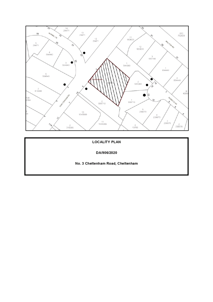
Item 3 LPP38/20 ELECTRONIC - Development Application - Alterations and Additions to a Dwelling House - 20A Amaroo Avenue, Mount Colah. 1
Item 4 LPP39/20 ELECTRONIC - Development Application - Alterations and Additions to a Dwelling house - 3 Cheltenham Road, Cheltenham... 69
Item 5 LPP41/20 ELECTRONIC - Reporting Development Applications for Determination by the Hornsby Local Planning Panel over 180 Days................................................................................................. 111
LPP Report No. LPP38/20
Local Planning Panel
Date of Meeting: 16/12/2020
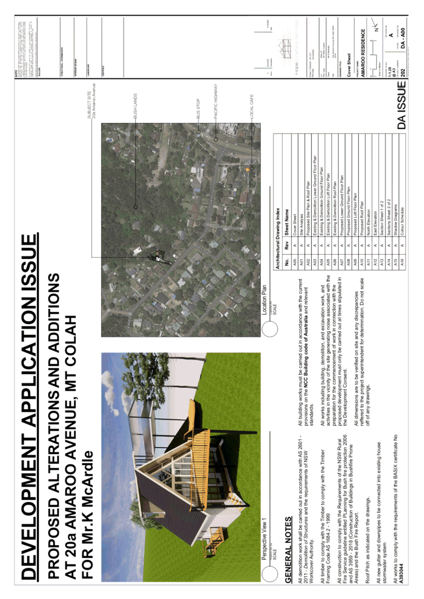
3 ELECTRONIC - DEVELOPMENT APPLICATION - ALTERATIONS AND ADDITIONS TO A DWELLING HOUSE - 20A AMAROO AVENUE, MOUNT COLAH
EXECUTIVE SUMMARY
|
DA/950/2020 (Lodged on 5 November 2020) |
|
|
Description: |
Alterations and additions to a dwelling house comprising installation of a lift and amendment of front entry |
|
Property: |
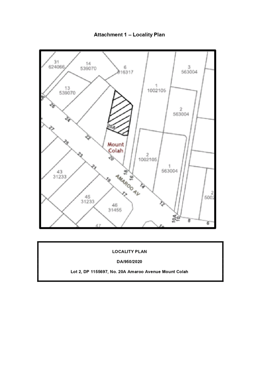
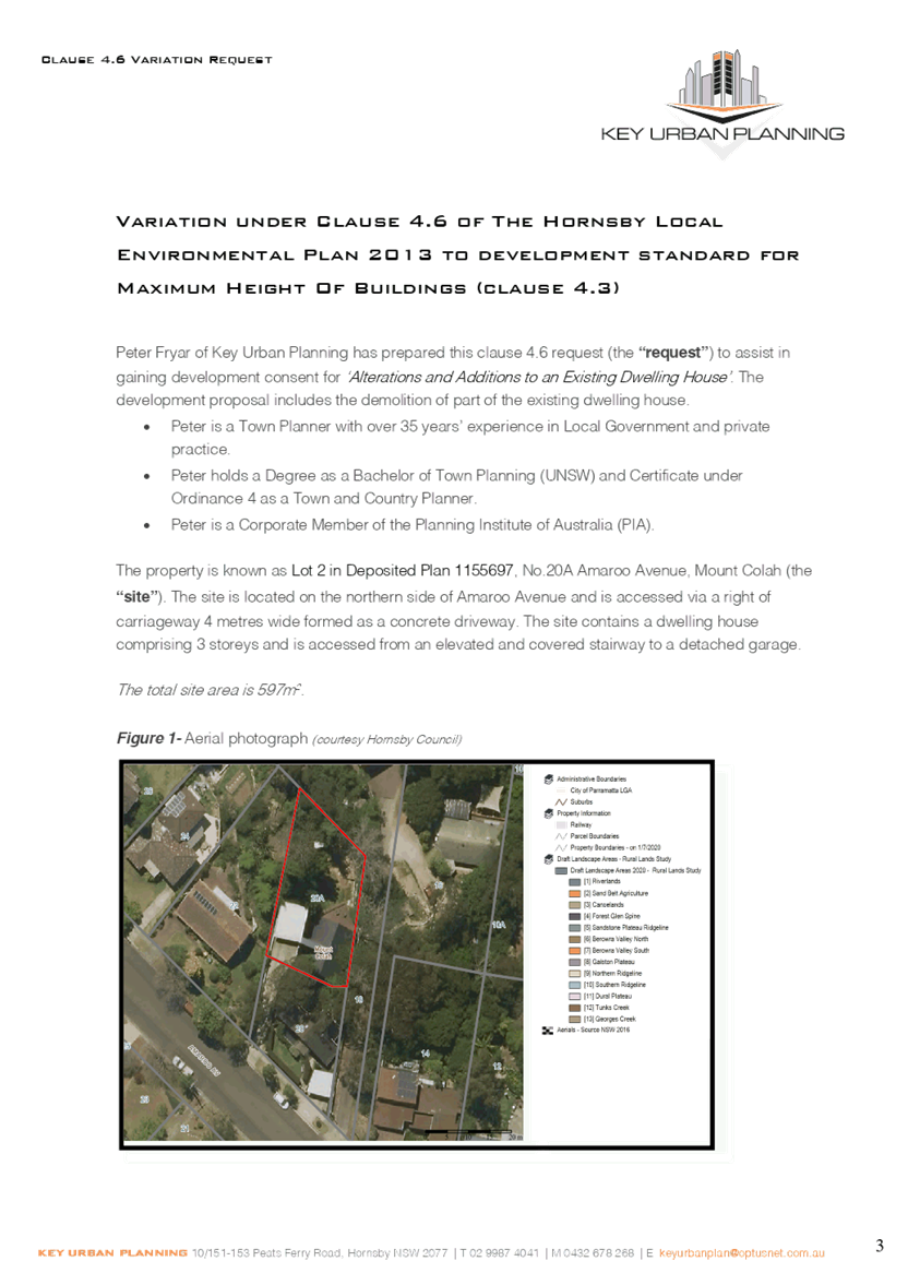
Lot 2 DP 1155697, No. 20A Amaroo Avenue, Mount Colah |
|
Applicant: |
Mr Kieran Samuel McArdle |
|
Owner: |
Mr Kieran Samuel McArdle Ms Donna Marie Bovis |
|
Estimated Value: |
$133,000 |
|
Ward: |
A |
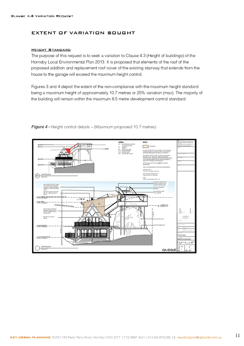
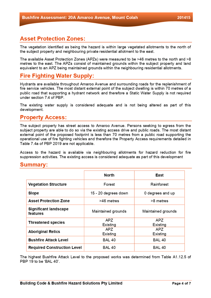
· The proposal does not comply with Clause 4.3 ‘Height of Buildings’ of the Hornsby Local Environmental Plan 2013. The applicant has made a submission in accordance with Clause 4.6 ‘Exceptions to development standards’ of the Hornsby Local Environmental Plan 2013 to vary building height. The submission is considered well founded and is supported.
· The application is required to be determined by the Hornsby Council Local Planning Panel as the proposed development would contravene the ‘Height of Buildings’ development standard by more than 10%.
· The proposal generally complies with the Hornsby Development Control Plan 2013.
· No submissions have been received in respect of the application.
· It is recommended that the application be approved.
|
THAT the Hornsby Shire Local Planning Panel assume the concurrence of the Secretary of the Department of Planning and Environment pursuant to Clause 4.6 of the Hornsby Local Environmental Plan 2013 and approve Development Application No. DA/950/2020 for alterations and additions to a dwelling house comprising installation of a lift and amendment of front entry at Lot 2 DP 1155697, No. 20A Amaroo Avenue, Mount Colah, subject to the conditions of consent detailed in Schedule 1 of LPP Report No 38/20. |
BACKGROUND
On 7 February 1989, Council approved DA/592/98 for the erection of a two-bedroom second dwelling between the existing dwelling and the street frontage.
On 18 May 1998 Council refused DA/48/1998 for Torrens title subdivision of an approved dual occupancy, on the following grounds:
“1. The State Environmental Planning Policy No. 1 Objection is unsatisfactory as it has not adequately addressed the grounds as to why the performance standard is unreasonable or unnecessary.
2. The proposal is unsatisfactory as proposed Lot 31 does not comply with the minimum site area pursuant to Clause 14 of the Hornsby Shire Local Environmental Plan 1994.
3. The proposal is unsatisfactory as the existing dwelling on proposed Lot 31 does not comply with Council’s requirement in respect of private open space and car parking.”
On 2 July 2010, Council approved DA/293/2010 for Torrens title subdivision of one allotment comprising an existing multi-unit housing development, into two allotments, the demolition of a carport and stairs and deck and the erection of an elevated concrete carparking and access way structure, subject to conditions.
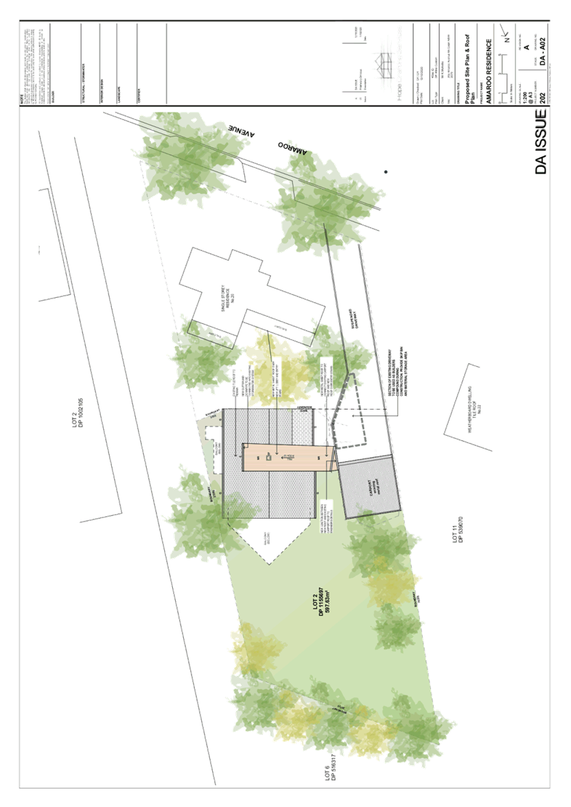
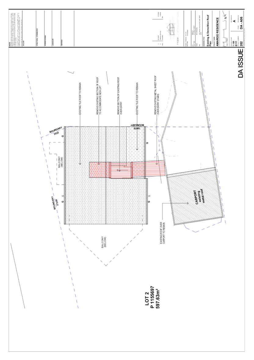
SITE
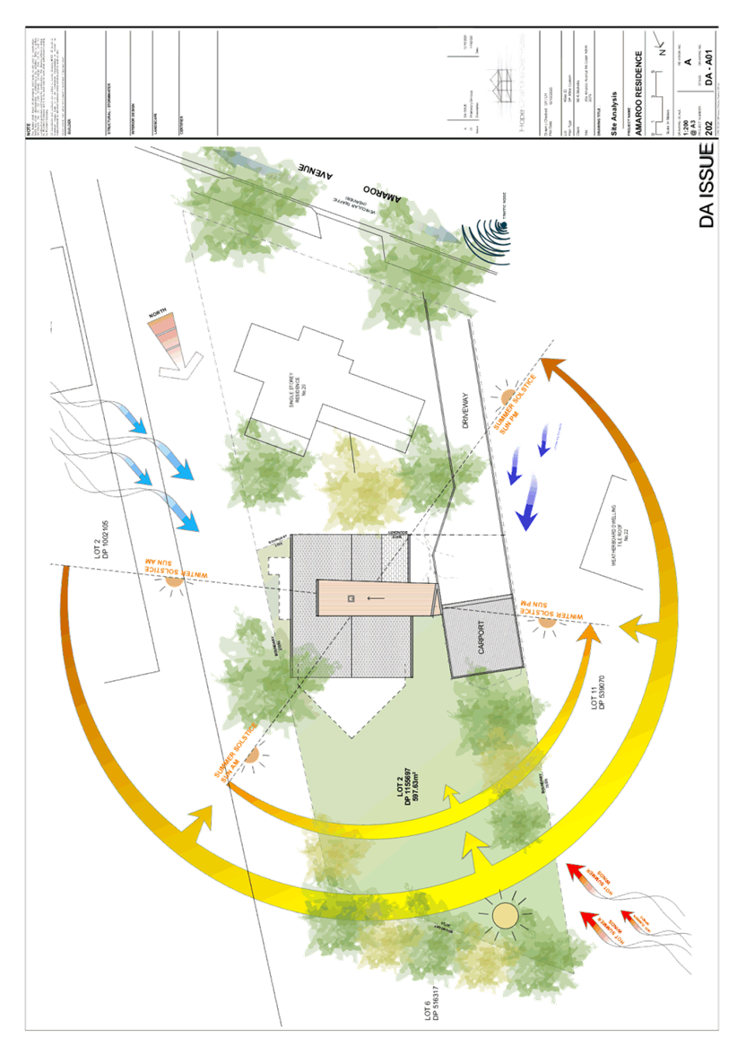
The 587.63m2 site is located on the northern side of Amaroo Avenue, Mount Colah and contains a two-storey dwelling house. The site is accessed via a Right of Carriageway which burdens the adjoining property No. 20 Amaroo Avenue and vehicular access is provided via a suspended driveway and elevated carport within the south western corner of the site.
The site has a fall of 10 metres from the south western corner to the north eastern corner which equates to a gradient of 33%.
The site is bushfire prone and burdened by the following:
· A positive covenant requiring an on-site stormwater detention system within the rear yard of the site.
· An easement to drain water variable width and an easement to drain water over existing line of pipes which transects the front south eastern corner to the on-site detention system.
PROPOSAL
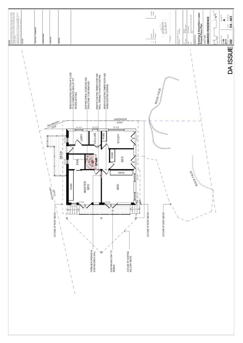
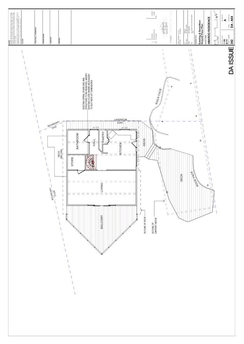
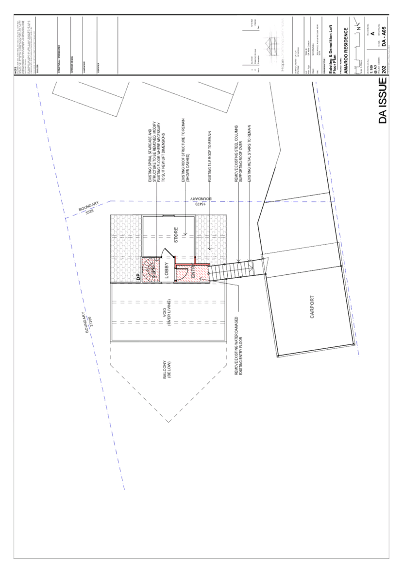
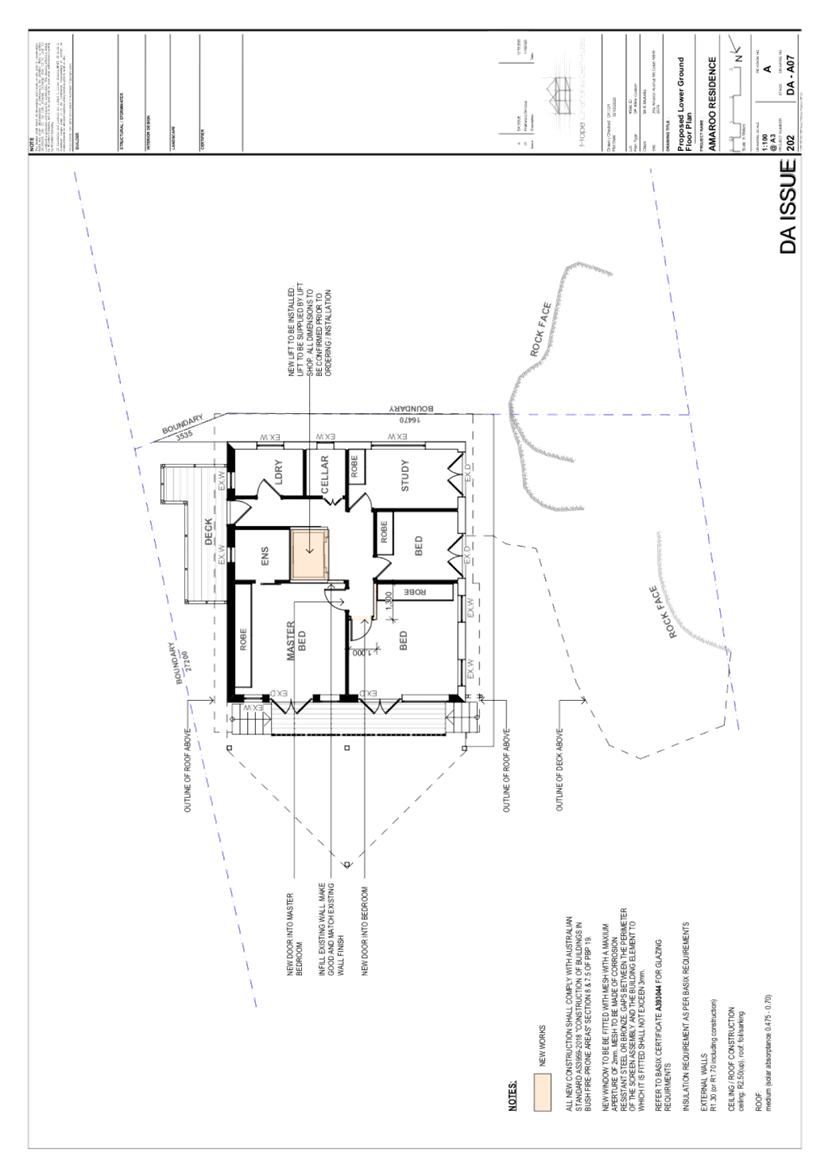
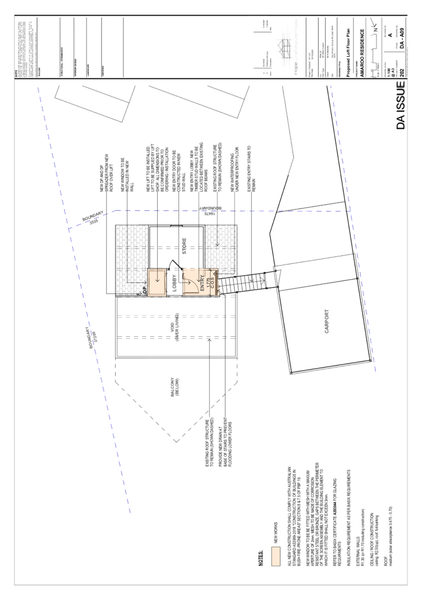
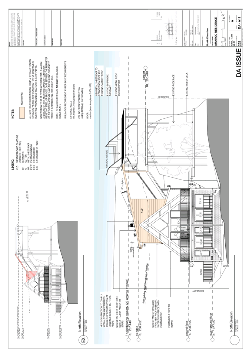
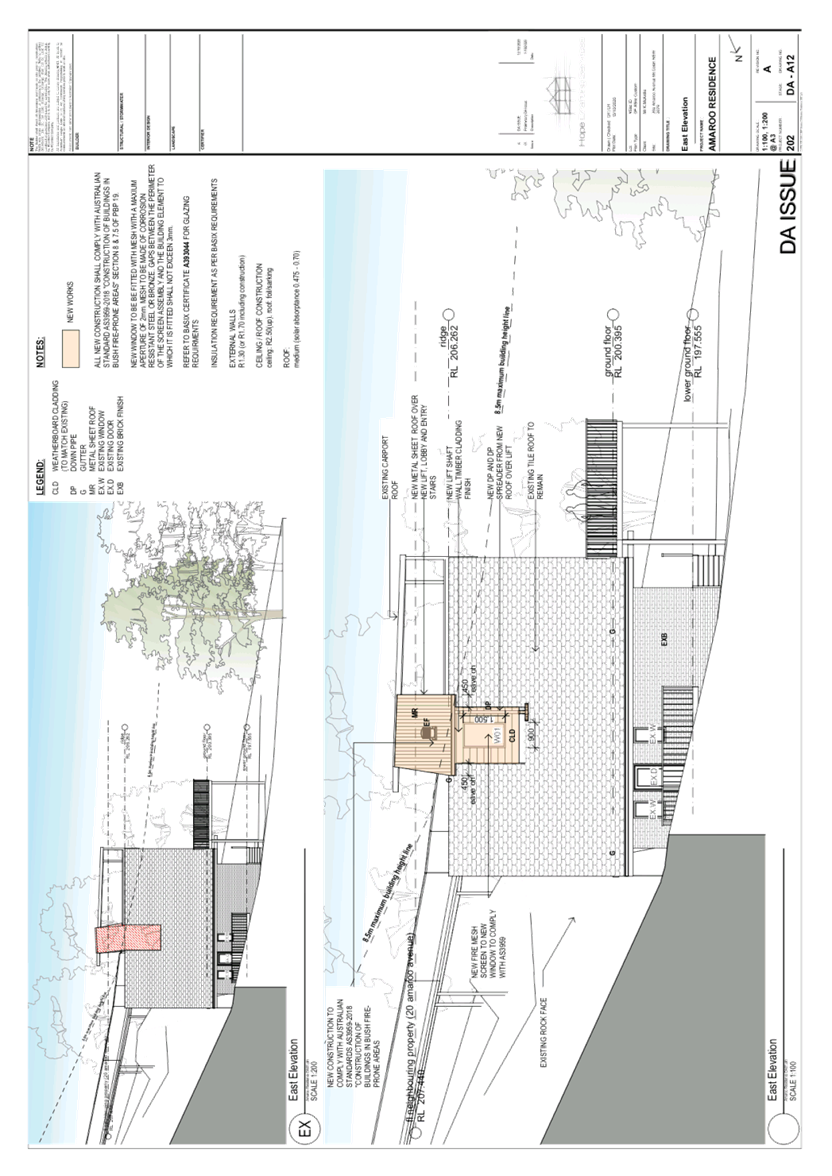
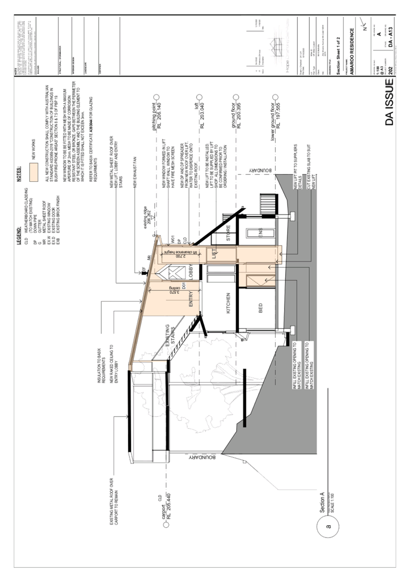
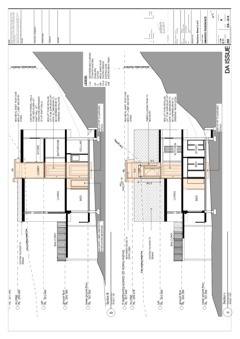
The application proposes alterations and additions to a dwelling house as follows:
· Demolition of the existing entryway and covered outdoor stairwell connecting the dwelling house within the suspended driveway.
· Demolition of the existing internal stairwell.
· Installation of an internal lift to connect the lower ground floor with the ground floor level and the loft to replace the internal stairs.
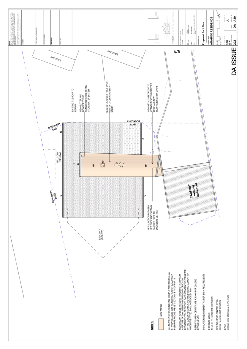
· Construction of a new covered outdoor stairwell connecting the dwelling house with the suspended driveway.
· Construction of a new entryway into the loft from the new covered outdoor stairwell.
No trees would be removed or impacted by the development.
ASSESSMENT
The development application has been assessed having regard to the Greater Sydney Region Plan - A Metropolis of Three Cities, the North District Plan and the matters for consideration prescribed under Section 4.15 of the Environmental Planning and Assessment Act 1979 (the Act). The following issues have been identified for further consideration.
1. STRATEGIC CONTEXT
1.1 Greater Sydney Region Plan - A Metropolis of Three Cities and North District Plan
The Greater Sydney Region Plan - A Metropolis of Three Cities has been prepared by the NSW State Government to guide land use planning decisions for the next 40 years (to 2056). The Plan sets a strategy and actions for accommodating Sydney’s future population growth and identifies dwelling targets to ensure supply meets demand. The Plan also identifies that the most suitable areas for new housing are in locations close to jobs, public transport, community facilities and services.
The NSW Government will use the subregional planning process to define objectives and set goals for job creation, housing supply and choice in each subregion. Hornsby Shire has been grouped with Hunters Hill, Ku-ring-gai, Lane Cove, Mosman, North Sydney, Ryde, Northern Beaches and Willoughby to form the North District. The Greater Sydney Commission has released the North District Plan which includes priorities and actions for Northern District for the next 20 years. The identified challenge for Hornsby Shire will be to provide an additional 4,350 dwellings by 2021 with further strategic supply targets to be identified to deliver 97,000 additional dwellings in the North District by 2036.
The proposed development would be consistent with the Greater Sydney Region Plan - A Metropolis of Three Cities and the North District Plan.
2. STATUTORY CONTROLS
Section 4.15(1)(a) requires Council to consider “any relevant environmental planning instruments, draft environmental planning instruments, development control plans, planning agreements and regulations”.
2.1 Hornsby Local Environmental Plan 2013
The proposed development has been assessed having regard to the provisions of the Hornsby Local Environmental Plan 2013 (HLEP).
2.1.1 Zoning of Land and Permissibility
The subject land is zoned R2 Low density residential under the HLEP. The objectives of the R2 zone are:
· To provide for the housing needs of the community within a low-density residential environment; and
· To enable other land uses that provide facilities or services to meet the day to day needs of residents.
The proposed development is defined as a ‘dwelling house’ and is permissible with Council’s consent. The proposed development meets the objectives of the R2 zone.
2.1.2 Height of Buildings
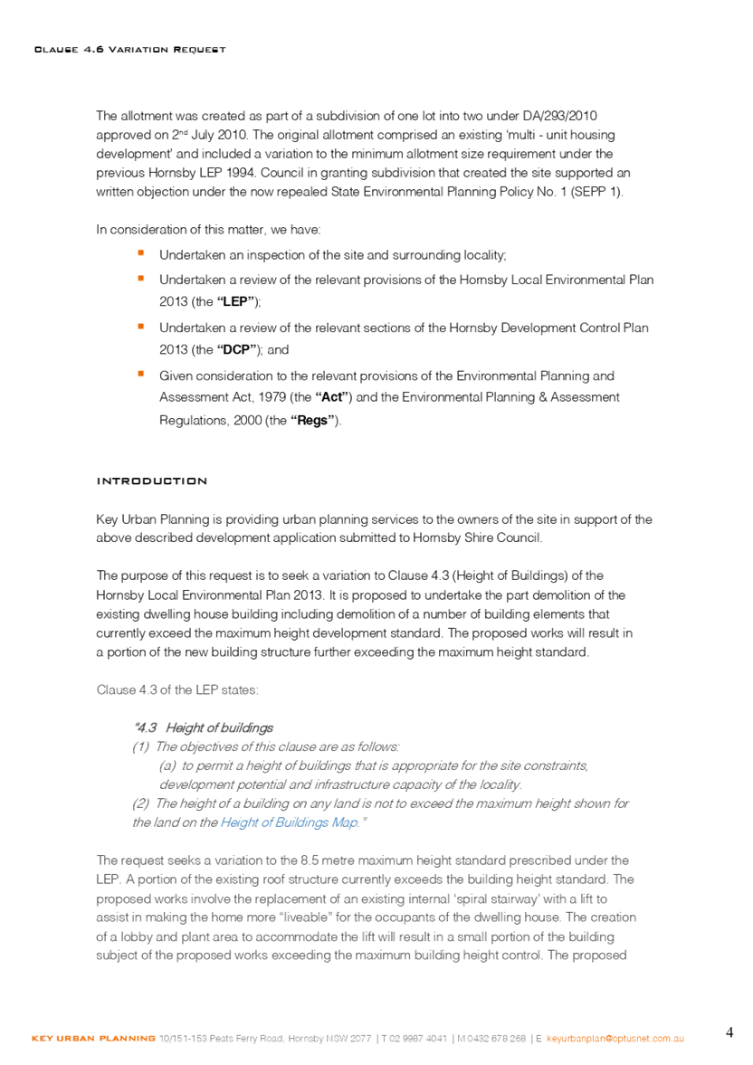
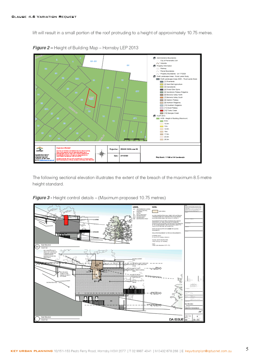
Clause 4.3 of the HLEP provides that the height of a building on any land should not exceed the maximum height show for the land on the Height of Buildings Map. The maximum permissible height for the subject site is 8.5 metres. The proposal has a maximum height of 10.7 metres and does not comply with the maximum height development standard.
The applicant has submitted justification for the non-compliance in accordance with Clause 4.6 of the HLEP as discussed in Section 2.1.3.
2.1.3 Exceptions to Development Standards
The application has been assessed against the requirements of Clause 4.6 of the HLEP. This clause provides flexibility in the application of the development standards in circumstances where strict compliance with those standards would, in any particular case, be unreasonable or unnecessary or tender to hinder the attainment of the objectives of the zone.
The proposal exceeds the Height of Buildings development standard for the R2 Low density residential zone which is 8.5 metres as prescribed under Clause 4.3 ‘Height of Buildings’ of the HLEP.
The objective of the Height of Buildings control is to permit building heights that are appropriate for the site constraints; development potential and infrastructure capacity of the locality.
The applicant has made a submission in support of a variation to the development standard in accordance with Clause 4.6 of the HLEP. The development application seeks to vary the development standard by 25% to 10.7 metres. The applicant states the proposed variation is considered to be consistent with the objectives of the control and is justified as follows:
· The shape and locality of the site and the opportunities and constraints that arise for its redevelopment (in part) as a result.
· The potential for negative town planning and urban outcomes that may arise from strict compliance with the requirement are negligible when considering the context of the site with surrounding development.
· The unique qualities of the site and the proposed alterations and additions will maintain and enhance these and the character of the locality.
· The character, operation and appearance of the current development will not be substantially altered by the height.
· The shape and locality of the site and the opportunities and constraints that arise for its development as a result - specifically the opportunity to provide substantial benefits for the occupants of the dwelling house.
· The extent of the non-compliance is minor (max. 25%) with the majority of the building less than the maximum development standard. The extent of works that cause the protrusion of the building roof form above the height standard is minor. The new roof material to the existing covered stairway is essentially a "replacement" of the existing roof cladding.
· There is limited opportunity to 'step' the design due to the site constraints and the existing built form of the house.
State Government Guidelines on varying development standards recommend considering the provisions of Clause 4.6 of the LEP and the ‘five-part test’ established by the Land and Environment Court as follows:
1. The objectives of the standard are achieved notwithstanding noncompliance with the standard.
2. The underlying objective or purpose of the standard is not relevant to the development and therefore compliance is unnecessary.
3. The underlying object of purpose would be defeated or thwarted if compliance was required and therefore compliance is unreasonable.
4. The development standard has been virtually abandoned or destroyed by the council’s own actions in granting consents departing from the standard and hence compliance with the standard is unnecessary and unreasonable.
5. The compliance with development standard is unreasonable or inappropriate due to existing use of land and current environmental character of the particular parcel of land. That is, the particular parcel of land should not have been included in the zone.
The applicant’s submission to vary the 8.5 metre development standard is considered well founded for the following reasons:
· The proposal is consistent with the objectives of the height standard which are to manage form and scale and to protect amenity and area character.
· The site is significantly constrained by the existing structures on the site with the only access to the dwelling house though the roof of the loft floor level.
· The proposed addition would not be visible from the streetscape of Amaroo Avenue.
· The proposed addition would not create any adverse amenity impacts to adjoining properties in regard to sunlight access or privacy as discussed below in the body of this report.
· Strict numeric compliance would not materially change the development or improve the residential living amenity of the house. It would unduly constrain the only entrance for the existing dwelling house without reasonable cause.
· Strict numeric compliance would result in the detrimental changes and is not considered necessary as the proposal will not change the appearance or scale of the site within the local context and the dwelling is consistent with the relevant planning objectives.
· The application provides for the orderly and economic development of land, improvement of living conditions of the existing low-density residence and adequate protection of the environment and public interest.
· The proposed development generally meets the objectives of Clause 4.3 Height of Buildings of the HLEP by way of being appropriate with respect to the constraints of the site and in regard to the development potential of the site.
Based on this assessment, it is considered that compliance with the development standard would be unreasonable and unnecessary in the circumstances of the case. Accordingly, the Clause 4.6 submission is supported.
2.1.4 Heritage Conservation
Clause 5.10 of the HLEP sets out heritage conservation provisions for Hornsby Shire. The site does not include a heritage item and is not located in a heritage conservation area. Accordingly, no further assessment regarding heritage is necessary.
2.1.5 Earthworks
Clause 6.2 of the HLEP states that consent is required for proposed earthworks on site. Before granting consent for earthworks, Council is required to assess the impacts of the works on adjoining properties, drainage patterns and soil stability of the locality.
Council’s assessment of the proposed works and excavation concludes that that impacts would be minimal. The proposed lift shaft would require minor excavation if any. No cut or fill is required to construct the development. The proposal is assessed as satisfactory with regards to Clause 6.2 of the HLEP.
2.2 State Environmental Planning Policy (Exempt and Complying Development Codes) 2008 - NSW Housing Code
The application has been considered against the requirements of State Environmental Planning Policy (Exempt and Complying Development Codes) 2008 (NSW Housing Code). The Policy provides exempt and complying development codes that have State-wide application. The Policy also identifies types of development that are of minimal environmental impact that may be carried out without the need for development consent and types of Complying Development (including dwelling houses) that may be carried out in accordance with a Complying Development Certificate.
The site is subject to bushfire risk and is in exceedance of the maximum building height which precludes the development from being approved as Complying Development. The proposed dwelling house additions would otherwise comply with the numerical standards for Complying Development contained within the SEPP.
2.3 State Environmental Planning Policy No. 55 Remediation of Land
The policy provides guidelines for the remediation of contaminated land for the purpose of reducing the risk of harm to human health or any other aspect of the environment. Clause 7 requires Council to consider whether land is contaminated prior to granting consent to the carrying out of any development on that land.
Should the land be contaminated, Council must be satisfied that the land is suitable in a contaminated state for the proposed use. If the land requires remediation to be undertaken to make the land suitable for the proposed use, Council must be satisfied that the land will be remediated before the land is used for that purpose.
A review of Council’s records and aerial photographs indicate that the site has been historically used for residential purposes. It is not likely that the site has experienced any significant contamination, and further assessment under SEPP 55 is not required.
2.4 SEPP (Building Sustainability Index: BASIX) 2004
2.5 State Environmental Planning Policy (Vegetation in non-rural areas) 2017
The application has been assessed against the requirements of State Environmental Planning Policy (Vegetation in Non-Rural Areas) 2017 (Vegetation SEPP). This Policy seeks to protect the biodiversity values of trees and other vegetation in non-rural areas of the State, and to preserve the amenity of non-rural areas of the State through the preservation of trees and other vegetation.
Part 3 of the Vegetation SEPP states that a development control plan may make a declaration in any manner relating to species, size, location and presence of vegetation. Accordingly, Part 1B.6.1 of the Hornsby Development Control Plan 2013 (HDCP) prescribes works that can be undertaken with or without consent to trees.
It is noted that no trees are proposed to be removed as a part of this application. Accordingly, a further assessment against Part 1B.6.1 of the HDCP was not required.
2.6 Sydney Regional Environmental Plan No. 20 Hawkesbury-Nepean River
The site is located within the catchment of the Hawkesbury Nepean River. Part 2 of this Plan contains general planning considerations and strategies requiring Council to consider the impacts of development on water quality, aquaculture, recreation and tourism.
Subject to the implementation of sediment and erosion control measures and stormwater management to protect water quality, the proposal would comply with the requirements of the Policy.
2.7 Section 3.42 Environmental Planning and Assessment Act 1979 - Purpose and Status of Development Control Plans
Section 3.42 of the Environmental Planning and Assessment Act 1979 states that a DCP provision will have no effect if it prevents or unreasonably restricts development that is otherwise permitted and complies with the development standards in relevant Local Environmental Plans and State Environmental Planning Policies.
The principal purpose of a development control plan is to provide guidance on the aims of any environmental planning instrument that applies to the development; facilitate development that is permissible under any such instrument; and achieve the objectives of land zones. The provisions contained in a DCP are not statutory requirements and are for guidance purposes only. Consent authorities have flexibility to consider innovative solutions when assessing development proposals, to assist achieve good planning outcomes.
2.8 Hornsby Development Control Plan 2013
The proposed development has been assessed having regard to the relevant desired outcomes and prescriptive requirements within the Hornsby Development Control Plan 2013 (HDCP). The following table sets out the proposal’s compliance with the prescriptive requirements of the Plan:
|
HDCP - Part 3.1 Dwelling Houses |
|||
|
Control |
Proposal |
Requirement |
Complies |
|
Site Area |
597.63m2 |
N/A |
N/A |
|
Building Height |
10.7m |
8.5m |
No |
|
No. storeys |
3 (existing) |
max. 2 + attic |
Yes |
|
Site Coverage |
No change |
max. 50% |
N/A |
|
Floor Area |
No change |
max. 330m2 |
N/A |
|
|
|
|
|
|
- Side (south) |
3.6m |
1.5m |
N/A |
|
- Side (east) |
3.5m |
1.5m |
Yes |
|
- Side (west) |
5.9m |
1.5m |
Yes |
|
- Rear (north) |
21.4m |
8m |
Yes |
|
Landscaped Area (% of lot size) |
No change |
min. 119.5m2 |
Yes |
|
Private Open Space |
|
|
|
|
- minimum area |
24m2 |
24m2 |
Yes |
|
- minimum dimension |
3m |
3m |
Yes |
|
Car Parking |
2 spaces |
2 spaces |
Yes |
As detailed in the above table, the proposed development generally complies with the prescriptive measures within the HDCP with the exception of the building height control. A brief discussion on this non-compliance is provided below, along with a discussion on the relevant performance requirements and Part 1C General Controls.
2.8.1 Scale
The desired outcome of Part 3.1.1 Scale of the HDCP is for ‘development with a height, bulk and scale that is compatible with a low-density residential environment’.
This is supported by the prescriptive measures which state that ‘sites with the maximum building heights under Clause 4.3 of the HLEP should comply with the maximum number of storeys in Table 3.1.1(a).’
In addition, it is stated that ‘buildings should respond to the topography of the site by:
· Minimising earthworks (cut and fill).
· Siting the floor level of the lowest residential storey a maximum of 1.5 metres above natural ground level’.
The proposed roof is situated 10.7 metres above natural ground level which does not comply with Part 3.1.1 Scale of the HDCP and Clause 4.3 of HLEP.
In support of this non-compliance, it is noted that the slope of the site is a significant constraint for any development on the site. It is also noted that the proposed addition has been designed to provide an internal lift for the occupants of the dwelling.
The applicant has submitted a variation pursuant to Clause 4.6 of the HLEP which has adequately addressed this non-compliance which is discussed in detail above under Section 2.1.3.
The proposal would be of a height, bulk and scale that is compatible within the low-density residential zone. The location of the proposed development would result in the addition not being visible from the streetscape. It is further noted that the existing dwelling house is three storeys and the proposed addition would not alter the number of storeys within the existing dwelling house. As a result, it is considered that despite the non-compliance of the entryway and roof addition for the installation of the deck, the proposal is generally consistent with the desired outcomes of Part 3.1.1 Scale and as discussed above in Section 2.1.3 with Clause 4.3 Height of Buildings of the HLEP. Accordingly, no objections are raised to the proposal on planning grounds.
The proposal meets the desired outcomes of Part 3.1.1 Scale of the HDCP and is considered acceptable.
2.8.2 Privacy
The desired outcome of Part 3.1.6 Privacy of the HDCP is to encourage “development that is designed to provide reasonable privacy to adjacent properties.”
The application proposes alterations and additions to a dwelling house which would demolish the existing entryway and internal stairwell and replace the entryway and include the installation of an internal lift.
The application proposes one window within the eastern elevation of the loft floor level located behind the proposed lift. This window would allow overlooking to the existing roof form of the dwelling house on the subject site and the driveways of adjacent properties No. 16 and 18 Amaroo Avenue.
As the application does not include any windows that would overlook the private open space (POS) of adjoining properties, no objections are raised to the proposed development on planning grounds and is considered acceptable.
The proposal meets the desired outcome of Part 3.1.6 Privacy of the HDCP and is considered acceptable.
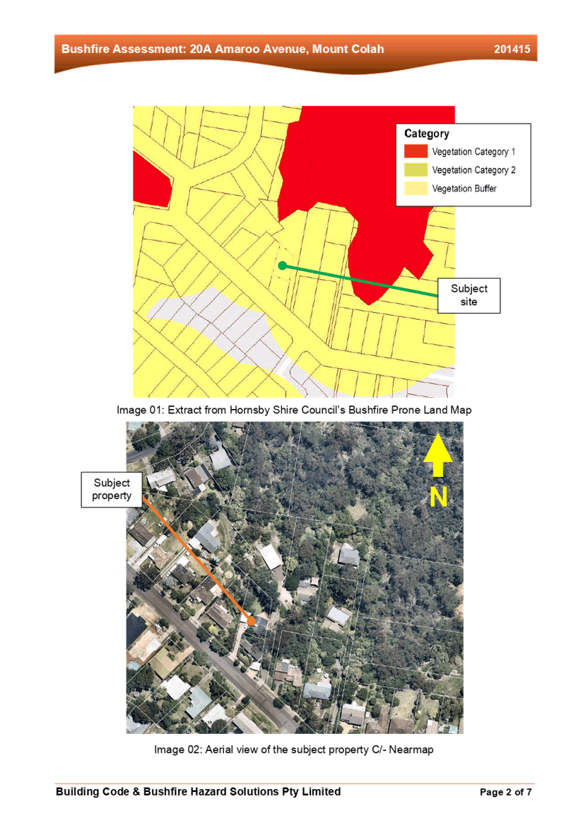
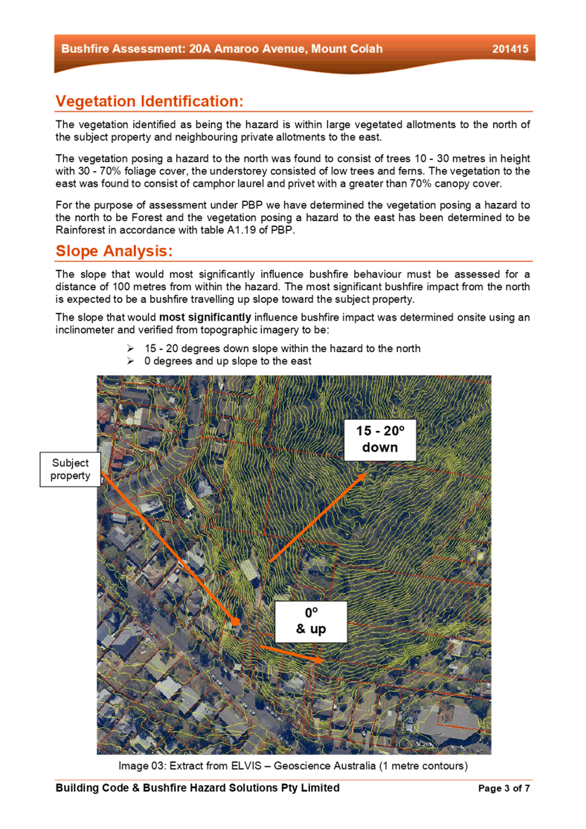
2.8.3 Bushfire
The desired outcomes of Part 1C.3.1 Bushfire of the HDCP are to encourage ‘development that is located and designed to minimise the risk to life and property from bushfire’ and to encourage ‘development that balances the conservation of native vegetation and bushfire protection’.
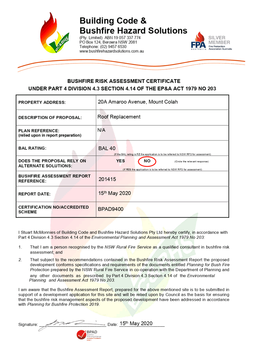
The application has provided a Bushfire Assessment Report prepared by Building Code & Bushfire Hazard Solutions dated 15 May 2020.
The Bushfire Hazard Assessment Report recommended that any development on the site be built to the requirements of AS 3959-2018 Construction of buildings in bushfire-prone areas in accordance with the requirements for Bushfire Attack Level (BAL) 40 and the relevant sections of Planning for Bushfire Protection 2019.
In accordance with Council’s assessment protocol for development in BAL-40, the application was referred to the NSW Rural Fire Service (RFS) for review. The NSW RFS raised no objections to the proposal subject to conditions.
Conditions reflecting the NSW RFS requirements have been recommended under Schedule 1 of this report with regard to the utilisation of BAL-40 fire retardant construction materials and the maintenance of the entire property as an Inner Protection Area (IPA) in perpetuity.
The proposal meets the desired outcomes of Part 1C.3.1 Bushfire of the HDCP and is considered acceptable, subject to conditions.
2.8.4 Sunlight Access
The desired outcomes of Part 3.1.5 Sunlight Access of the HDCP is to encourage “dwelling houses designed to provide solar access to open space areas” and “development designed to provide reasonable sunlight to adjacent properties”.
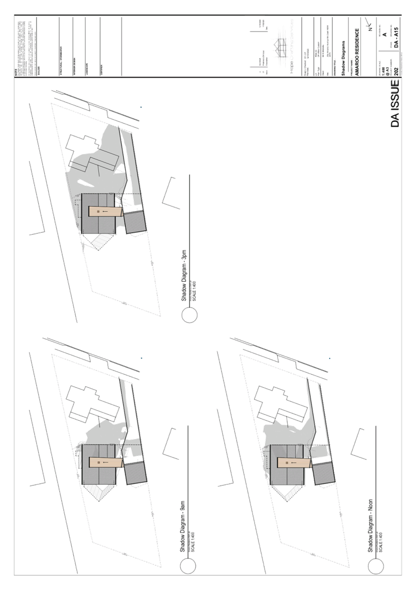
This is supported by the prescriptive measure 3.1.5(a) requiring “50 per cent of the principal private open space of the subject site to receive at least 3 hours of unobstructed sunlight access between 9am and 3pm” during the day of the winter solstice and prescriptive measure 3.1.5(b) requiring “50 per cent of the principal private open space on any adjoining property to receive at least 3 hours of unobstructed sunlight access between 9am and 3pm.”
An assessment of the shadow diagrams provided by the applicant illustrate that the subject site and the southern adjacent neighbour, No. 20 Amaroo Avenue, would still receive at least 3 hours of unobstructed sunlight access to 50 per cent of their private open space between 9am and 3pm on the day of the winter solstice.
The proposal meets the desired outcomes of Part 3.1.5 Sunlight Access of the HDCP and is considered acceptable.
2.9 Section 7.12 Contributions Plans
Hornsby Shire Council Section 7.12 Contributions Plan 2019-2029 applies to the development as the estimated costs of works is greater than $100,000. Should the application be approved, an appropriate condition of consent is recommended requiring the payment of a contribution in accordance with the Plan.
3. ENVIRONMENTAL IMPACTS
Section 4.15(1)(b) of the Act requires Council to consider “the likely impacts of that development, including environmental impacts on both the natural and built environments, and social and economic impacts in the locality”.
3.1 Natural Environment
3.1.1 Tree and Vegetation Preservation
The proposed development does not require the removal or impact to existing trees.
3.1.2 Stormwater Management
Stormwater from the development will be directed to the existing stormwater system which drains to an on-site stormwater absorption system within the rear yard. As the application does not propose to increase the roof area of the dwelling house, this is considered acceptable.
3.2 Built Environment
3.2.1 Built Form
The proposal would generally be consistent with the built form of the surrounding low-density residential area which consists of dwelling houses ranging from single storey, split level, two storey and three storeys with excavated garages.
3.3 Social Impacts
The proposed development would have a positive social impact for the occupants of the dwelling by improving accessibility within the dwelling. This is consistent with Council’s Housing Strategy which identifies the need to provide a mix of housing options to meet future demographic needs in Hornsby Shire.
3.4 Economic Impacts
The proposal would have a minor positive impact on the local economy in conjunction with other new low-density residential development in the locality by generating an increase in demand for local services.
4. SITE SUITABILITY
Section 4.15(1)(c) of the Act requires Council to consider “the suitability of the site for the development”.
4.1 Bushfire Risk
As noted in Section 2.8.3 Bushfire of this report, the subject site is identified as bushfire prone and the application was referred to the NSW Rural Fire Service for comment.
Conditions of concurrence provided by the RFS have been recommended under Schedule 1 of this report with regard to the utilisation of BAL 40 fire retardant construction materials and the maintenance of the entire property as an Inner Protection Area (IPA) in perpetuity.
5. PUBLIC PARTICIPATION
Section 4.15(1)(d) of the Act requires Council to consider “any submissions made in accordance with this Act”.
5.1 Community Consultation
The proposed development was placed on public exhibition and was notified to adjoining and nearby landowners between 6 November 2020 and 1 December 2020 in accordance with the Hornsby Community Participation Plan. During this period, Council did not receive any submissions. The map below illustrates the location of those nearby landowners who made a submission that are in close proximity to the development site.

|
NOTIFICATION PLAN |
|||
|
• PROPERTIES NOTIFIED |
X SUBMISSIONS RECEIVED |
|
|
5.2 Public Agencies
As discussed in Section 4.1, the development application was referred to NSW Rural Fire Service for comment and no objections were raised to the proposed development subject to the conditions recommended in Schedule 1.
6. THE PUBLIC INTEREST
Section 4.15(1)(e) of the Act requires Council to consider “the public interest”.
The public interest is an overarching requirement, which includes the consideration of the matters discussed in this report. Implicit to the public interest is the achievement of future built outcomes adequately responding to and respecting the future desired outcomes expressed in environmental planning instruments and development control plans.
The application is considered to have satisfactorily addressed Council’s and relevant agencies’ criteria and would provide a development outcome that, on balance, would result in a positive impact for the community. Accordingly, it is considered that the approval of the proposed development would be in the public interest.
CONCLUSION
The application proposes alterations and additions to a dwelling house comprising installation of a lift and amendment of the front entry.
The development generally meets the desired outcomes of Council’s planning controls and is satisfactory having regard to the matters for consideration under Section 4.15 of the Environmental Planning and Assessment Act 1979.
Having regard to the circumstances of the case, approval of the application is recommended.
The reasons for this decision are:
· The proposed development generally complies with the requirements of the relevant environmental planning instruments and the Hornsby Development Control Plan 2013 other than height.
· The request under Clause 4.6 of Hornsby Local Environmental Plan 2013 to vary the ‘Height of Buildings’ Development Standard is well founded. Strict compliance with the development standard is unreasonable and unnecessary in the circumstances of the case and there are sufficient environmental planning grounds to justify the variation to the development standards.
· The proposed development does not create unreasonable environmental impacts to adjoining development with regard to visual bulk, overshadowing, solar access, amenity or privacy.
Note: At the time of the completion of this planning report, no persons have made a Political Donations Disclosure Statement pursuant to Section 10.4 of the Environmental Planning and Assessment Act 1979 in respect of the subject planning application.
RESPONSIBLE OFFICER
The officer responsible for the preparation of this report is Tim Buwalda.
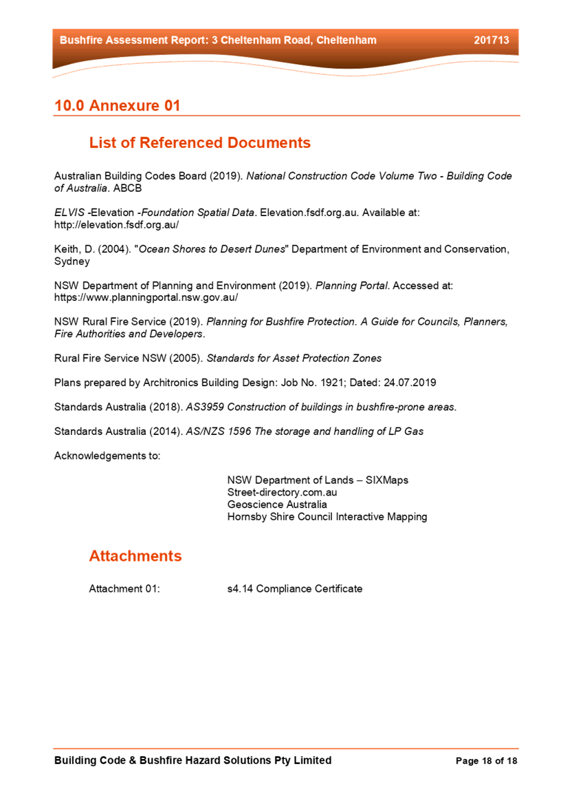
Attachments:
2. Architectural Plans
3. Clause 4.6 Variation
4. Bushfire Report
|
Cassandra Williams Major Development Manager - Development Assessments Planning and Compliance Division |
Rod Pickles Manager - Development Assessments Planning and Compliance Division |
|
1.⇩ |
Locality Plan |
|
|
|
2.⇩ |
Architectural Plans |
|
|
|
3.⇩ |
Clause 4.6 Variation |
|
|
|
4.⇩ |
Bushfire Report |
|
|
File Reference: DA/950/2020
Document Number: D08050213
SCHEDULE 1
GENERAL CONDITIONS
The conditions of consent within this notice of determination have been applied to ensure that the use of the land and/or building is carried out in such a manner that is consistent with the aims and objectives of the relevant legislation, planning instruments and council policies affecting the land and does not disrupt the amenity of the neighbourhood or impact upon the environment.
Note: For the purpose of this consent, the term ‘applicant’ means any person who has the authority to act on or the benefit of the development consent.
Note: For the purpose of this consent, any reference to an Act, Regulation, Australian Standard or publication by a public authority shall be taken to mean the gazetted Act or Regulation or adopted Australian Standard or publication as in force on the date that the application for a construction certificate is made.
1. Approved Plans and Supporting Documentation
The development must be carried out in accordance with the plans and documentation listed below and endorsed with Council’s stamp, except where amended by Council and/or other conditions of this consent:
Approved Plans:
|
Plan No. |
Plan Title |
Drawn by |
Dated |
Council Reference |
|
DA-A02 Rev. A |
Proposed Site Plan & Roof Plan |
Hope Drafting Services |
13/10/2020 |
D08072094 |
|
DA-A03 Rev. A |
Existing & Demolition Lower Ground Floor Plan |
Hope Drafting Services |
13/10/2020 |
D08072094 |
|
DA-A04 Rev. A |
Existing & Demolition Ground Floor Plan |
Hope Drafting Services |
13/10/2020 |
D08072094 |
|
DA-A05 Rev. A |
Existing & Demolition Loft Floor Plan |
Hope Drafting Services |
13/10/2020 |
D08072094 |
|
DA-A06 Rev. A |
Existing & Demolition Roof Plan |
Hope Drafting Services |
13/10/2020 |
D08072094 |
|
DA-A07 Rev. A |
Proposed Lower Ground Floor Plan |
Hope Drafting Services |
13/10/2020 |
D08072094 |
|
DA-A08 Rev. A |
Proposed Ground Floor Plan |
Hope Drafting Services |
13/10/2020 |
D08072094 |
|
DA-A09 Rev. A |
Proposed Loft Floor Plan |
Hope Drafting Services |
13/10/2020 |
D08072094 |
|
DA-A10 Rev. A |
Proposed Roof Plan |
Hope Drafting Services |
13/10/2020 |
D08072094 |
|
DA-A11 Rev. A |
North Elevation |
Hope Drafting Services |
13/10/2020 |
D08072094 |
|
DA-A12 Rev. A |
East Elevation |
Hope Drafting Services |
13/10/2020 |
D08072094 |
|
DA-A13 Rev. A |
Section Sheet 2 of 2 |
Hope Drafting Services |
13/10/2020 |
D08072094 |
|
DA-A14 Rev. A |
Section Sheet 2 of 2 |
Hope Drafting Services |
13/10/2020 |
D08072094 |
Supporting Documentation:
|
Document Title |
Prepared by |
Dated |
Council Reference |
|
Bushfire Assessment Report |
Building Code & Bushfire Hazard Solutions |
15/05/2020 |
D08042996 |
|
BASIX Certificate: A393044 |
Lee Hope |
12/10/ 2020 |
D08042991 |
|
RFS concurrence letter Ref: DA20201116004244 – Original -1 |
NSW Rural Fire Service |
10/12/2020 |
D08068196 |
|
Waste Management Plan |
Mr Kieran McArdle |
unknown |
D08043009 |
|
Colour Schedule DA-A16 |
Hope Drafting Services |
13/10/2020 |
D08043000 |
2. Construction Certificate
a) A Construction Certificate is required to be approved by Council or a Private Certifying Authority prior to the commencement of any construction works under this consent.
b) The Construction Certificate plans must include all requirements imposed by the NSW Rural Fire.
c) The Construction Certificate plans must be consistent with the Development Consent plans.
REQUIREMENTS PRIOR TO THE ISSUE OF A CONSTRUCTION CERTIFICATE
All approved building work must be carried out in accordance with the relevant requirements of the Building Code of Australia.
4. Contract of Insurance (Residential Building Work)
Where residential building work for which the Home Building Act 1989 requires there to be a contract of insurance in force in accordance with Part 6 of that Act, this contract of insurance must be in force before any building work authorised to be carried out by the consent commences.
5. Notification of Home Building Act 1989 Requirements
Residential building work within the meaning of the Home Building Act 1989 must not be carried out unless the principal certifying authority for the development to which the work relates (not being Council) has given Council written notice of the following information:
a) In the case of work for which a principal contractor is required to be appointed:
i) The name and licence number of the principal contractor.
ii) The name of the insurer by which the work is insured under Part 6 of that Act.
b) In the case of work to be done by an owner-builder:
i) The name of the owner-builder.
ii) If the owner-builder is required to hold an owner-builder’s permit under that Act, the number of the owner-builder’s permit.
Note: If arrangements for doing the residential building work are changed while the work is in progress so that the information notified becomes out of date, further work must not be carried out unless the principal certifying authority for the development to which the work relates (not being Council) has given Council written notification of the updated information.
6. Stormwater Drainage
The stormwater drainage system for the development must be designed for an average recurrence interval (ARI) of 20 years and be gravity drained and connected to the existing internal drainage system.
REQUIREMENTS PRIOR TO THE COMMENCEMENT OF ANY WORKS
7. Erection of Construction Sign
a) A sign must be erected in a prominent position on any site on which any approved work is being carried out:
i) Showing the name, address and telephone number of the principal certifying authority for the work.
ii) Showing the name of the principal contractor (if any) for any demolition or building work and a telephone number on which that person may be contacted outside working hours.
iii) Stating that unauthorised entry to the work site is prohibited.
b) The sign is to be maintained while the approved work is being carried out and must be removed when the work has been completed.
8. Protection of Adjoining Areas
A temporary hoarding, fence or awning must be erected between the work site and adjoining lands before the works begin and must be kept in place until after the completion of the works if the works:
a) Could cause a danger, obstruction or inconvenience to pedestrian or vehicular traffic.
b) Could cause damage to adjoining lands by falling objects.
c) Involve the enclosure of a public place or part of a public place.
d) Have been identified as requiring a temporary hoarding, fence or awning within the Council approved Construction Management Plan (CMP).
Note: Notwithstanding the above, Council’s separate written approval is required prior to the erection of any structure or other obstruction on public land.
a) To provide a safe and hygienic workplace, toilet facilities must be available or be installed at the works site before works begin and must be maintained until the works are completed at a ratio of one toilet for every 20 persons employed at the site.
b) Each toilet must:
i) Be a standard flushing toilet connected to a public sewer; or
ii) Be a temporary chemical closet approved under the Local Government Act 1993.
10. Erosion and Sediment Control
To protect the water quality of the downstream environment, erosion and sediment control measures must be provided and maintained throughout the construction period in accordance with the manual ‘Soils and Construction 2004 (Bluebook)’, the approved plans, Council specifications and to the satisfaction of the principal certifying authority. The erosion and sediment control devices must remain in place until the site has been stabilised and revegetated.
Note: On the spot penalties may be issued for any non-compliance with this requirement without any further notification or warning.
REQUIREMENTS DURING DEMOLITION AND CONSTRUCTION
All works on site, including demolition and earth works, must only occur between 7am and 5pm Monday to Saturday.
No work is to be undertaken on Sundays or public holidays.
12. Demolition
To protect the surrounding environment, all demolition work must be carried out in accordance with Australian Standard AS2601-2001 Demolition of structures and the following requirements:
a) Demolition material must be disposed of to an authorised recycling and/or waste disposal site and/or in accordance with an approved waste management plan.
b) Demolition works, where asbestos material is being removed, must be undertaken by a contractor that holds an appropriate licence issued by SafeWork NSW in accordance with the Work Health and Safety Regulation 2017 and be appropriately transported and disposed of in accordance with the Protection of the Environment Operations (Waste) Regulation 2014.
c) On construction sites where any building contains asbestos material, a standard commercially manufactured sign containing the words ‘DANGER ASBESTOS REMOVAL IN PROGRESS’ and measuring not less than 400mm x 300mm must be displayed in a prominent position visible from the street.
13. Environmental Management
To prevent sediment run-off, excessive dust, noise or odour emanating from the site during the construction, the site must be managed in accordance with the publication ‘Managing Urban Stormwater - Landcom (March 2004) and the Protection of the Environment Operations Act 1997.
To ensure that the public reserve is kept in a clean, tidy and safe condition during construction works, no building materials, waste, machinery or related matter is to be stored on the road or footpath.
15. Disturbance of Existing Site
During construction works, the existing ground levels of open space areas and natural landscape features, including natural rock-outcrops, vegetation, soil and watercourses must not be altered unless otherwise nominated on the approved plans.
REQUIREMENTS PRIOR TO THE ISSUE OF AN OCCUPATION CERTIFICATE
16. Fulfilment of BASIX Commitments
The applicant must demonstrate the fulfilment of BASIX commitments pertaining to the development.
17. Damage to Council Assets
To protect public property and infrastructure, any damage caused to Council’s assets as a result of the construction or demolition of the development must be rectified by the applicant in accordance with AUS-SPEC Specifications (www.hornsby.nsw.gov.au/property/build/aus-spec-terms-and-conditions. Rectification works must be undertaken prior to the issue of an Occupation Certificate, or sooner, as directed by Council.
Certification of compliance with all NSW Rural Fire Service requirements from a suitably qualified Bushfire Consultant must be submitted to the Principal Certifying Authority prior to issue of the Occupation Corticate.
CONDITIONS OF CONCURRENCE - NSW RURAL FIRE SERVICE
The following conditions of consent are from the nominated State Agency pursuant to Section 4.13 of the Environmental Planning and Assessment Act 1979 and must be complied with to the satisfaction of that Agency.
19. Asset Protection Zones
The intent of measures is to minimise the risk of bush fire attack and provide protection for emergency services personnel, residents and others assisting firefighting activities. To achieve this, the following conditions shall apply:
a) From the start of building works, and in perpetuity to ensure ongoing protection from the impact of bush fires, the entire property must be managed as an inner protection area (IPA) in accordance with the requirements of Appendix 4 of Planning for Bush Fire Protection 2019. When establishing and maintaining an IPA the following requirements apply:
i) Tree canopy cover should be less than 15% at maturity.
ii) Tees at maturity should not touch or overhang the building.
iii) Lower limbs should be removed up to a height of 2m above the ground.
iv) Tree canopies should be separated by 2 to 5m.
v) Preference should be given to smooth barked and evergreen trees.
vi) Large discontinuities or gaps in vegetation should be provided to slow down or break the progress of fire towards buildings.
vii) Shrubs should not be located under trees.
viii) Shrubs should not form more than 10% ground cover.
ix) Clumps of shrubs should be separated from exposed windows and doors by a distance of at least twice the height of the vegetation.
x) Grass should be kept mown (as a guide grass should be kept to no more than 100mm in height).
xi) Leaves and vegetation debris should be removed.
20. Construction Standards
The intent of measures is that buildings are designed and constructed to withstand the potential impacts of bush fire attack. To achieve this, the following conditions shall apply:
a) New construction must comply with Sections 3 and 8 (BAL 40) Australian Standard AS3959-2018 Construction of buildings in bush fire-prone areas or NASH Standard (1.7.14 updated) National Standard Steel Framed Construction in Bushfire Areas - 2014 as appropriate and Section 7.5 of Planning for Bush Fire Protection 2019.
21. Water and Utility Services
The intent of measures is to minimise the risk of bush fire attack and provide protection for emergency services personnel, residents and others assisting firefighting activities. To achieve this, the following conditions shall apply:
a) The provision of water, electricity and gas must comply the following in accordance with Table 7.4a of Planning for Bush Fire Protection 2019:
i) Reticulated water is to be provided to the development where available.
ii) All above-ground water service pipes external to the building are metal, including and up to any taps.
iii) Where practicable, electrical transmission lines are underground.
iv) Where overhead, electrical transmission lines are proposed as follows:
a) Lines are installed with short pole spacing (30m), unless crossing gullies, gorges or riparian areas.
b) No part of a tree is closer to a power line than the distance set out in accordance with the specifications in ISSC3 Guideline for Managing Vegetation Near Power Lines.
i) Reticulated or bottled gas is installed and maintained in accordance with AS/NZS 1596:2014 and the requirements of relevant authorities, and metal piping is used.
ii) All fixed gas cylinders are kept clear of all flammable materials to a distance of 10m and shielded on the hazard side.
iii) Connections to and from gas cylinders are metal.
iv) Polymer sheathed flexible gas supply ‐ lines are not used.
v) Above-ground gas service pipes are metal, including and up to any outlets.
OPERATIONAL CONDITIONS
22. Bushfire Protection Zones
The required bushfire protection zones around the buildings, as required by Condition No. 19 must be maintained in perpetuity.
- END OF CONDITIONS -
ADVISORY NOTES
The following information is provided for your assistance to ensure compliance with the Environmental Planning and Assessment Act, 1979, Environmental Planning and Assessment Regulation 2000, other relevant legislation and Council’s policies and specifications. This information does not form part of the conditions of development consent pursuant to Section 4.17 of the Act.
Environmental Planning and Assessment Act 1979 Requirements
The Environmental Planning and Assessment Act 1979 requires:
· The issue of a construction certificate prior to the commencement of any works. Enquiries can be made to Council’s Customer Services Branch on 9847 6760.
· A principal certifying authority to be nominated and Council notified of that appointment prior to the commencement of any works.
· Council to be given at least two days written notice prior to the commencement of any works.
· Mandatory inspections of nominated stages of the construction inspected.
· An occupation certificate to be issued before occupying any building or commencing the use of the land.
Long Service Levy
In accordance with Section 34 of the Building and Construction Industry Long Service Payments Act 1986, a ‘Long Service Levy’ must be paid to the Long Service Payments Corporation or Hornsby Council.
Note: The rate of the Long Service Levy is 0.35% of the total cost of the work.
Note: Hornsby Council requires the payment of the Long Service Levy prior to the issue of a construction certificate.
Tree and Vegetation Preservation
Hornsby Development Control Plan 2013 Tree and Vegetation Preservation provisions have been developed under Council’s authorities contained in State Environmental Planning Policy (Vegetation in Non-Rural Areas) 2017 and the Environmental Planning and Assessment Act 1979.
In accordance with these provisions a person must not cut down, fell, uproot, kill, poison, ringbark, burn or otherwise destroy the vegetation, lop or otherwise remove a substantial part of the trees or vegetation to which any such development control plan applies without the authority conferred by a development consent or a permit granted by Council.
Fines may be imposed for non-compliance with the Hornsby Development Control Plan 2013.
Note: A tree is defined as a long lived, woody perennial plant with one or relatively few main stems with the potential to grow to a height greater than three metres (3m). (HDCP 1B.6.1.c).
Covenants
The land upon which the subject building is to be constructed may be affected by restrictive covenants. Council issues this approval without enquiry as to whether any restrictive covenant affecting the land would be breached by the construction of the building, the subject of this consent. Applicants must rely on their own enquiries as to whether or not the building breaches any such covenant.
Dial Before You Dig
Prior to commencing any works, the applicant is encouraged to contact Dial Before You Dig on 1100 or www.dialbeforeyoudig.com.au for free information on potential underground pipes and cables within the vicinity of the development site.
Telecommunications Act 1997 (Commonwealth)
If you are aware of any works or proposed works which may affect or impact on Telstra’s assets in any way, you are required to contact: Telstra’s Network Integrity Team on Phone Number 1800810443.
Asbestos Warning
Should asbestos or asbestos products be encountered during demolition or construction works, you are advised to seek advice and information prior to disturbing this material. It is recommended that a contractor holding an asbestos-handling permit (issued by SafeWork NSW) be engaged to manage the proper handling of this material. Further information regarding the safe handling and removal of asbestos can be found at:
Alternatively, telephone the SafeWork NSW on 13 10 50.
LPP Report No. LPP39/20
Local Planning Panel
Date of Meeting: 16/12/2020
4 ELECTRONIC - DEVELOPMENT APPLICATION - ALTERATIONS AND ADDTIONS TO A DWELLING HOUSE - 3 CHELTENHAM ROAD, CHELTENHAM
EXECUTIVE SUMMARY
|
DA No: |
DA/906/2020 (Lodged on 26 October 2020) |
|
Description: |
Alterations and additions to a dwelling house |
|
Property: |
Lot 1 DP 535516, No. 3 Cheltenham Road, Cheltenham |
|
Applicant: |
Mrs Shailaja Divakarla |
|
Owner: |
Mr Eric Christopher Heyde Mrs Emma Charlotte Heyde |
|
Estimated Value: |
$30, 937 |
|
Ward: |
C |
· The proposal is for alterations and additions to a dwelling house.
· The proposal complies with the relevant environmental planning instruments and the desired outcomes and prescriptive requirements within the Hornsby Development Control Plan 2013 (HDCP).
· The application is required to be determined by the Hornsby Council Local Planning Panel as development involves land owned by a Councillor.
· No submissions have been received in respect of the application.
· It is recommended that the application be approved.
|
THAT Development Application No. DA/906/2020 for alterations and additions to a dwelling house at Lot 1 DP 535516, No. 3 Cheltenham Road, Cheltenham be approved subject to the conditions of consent detailed in Schedule 1 of LPP Report No. LPP 39/20. |
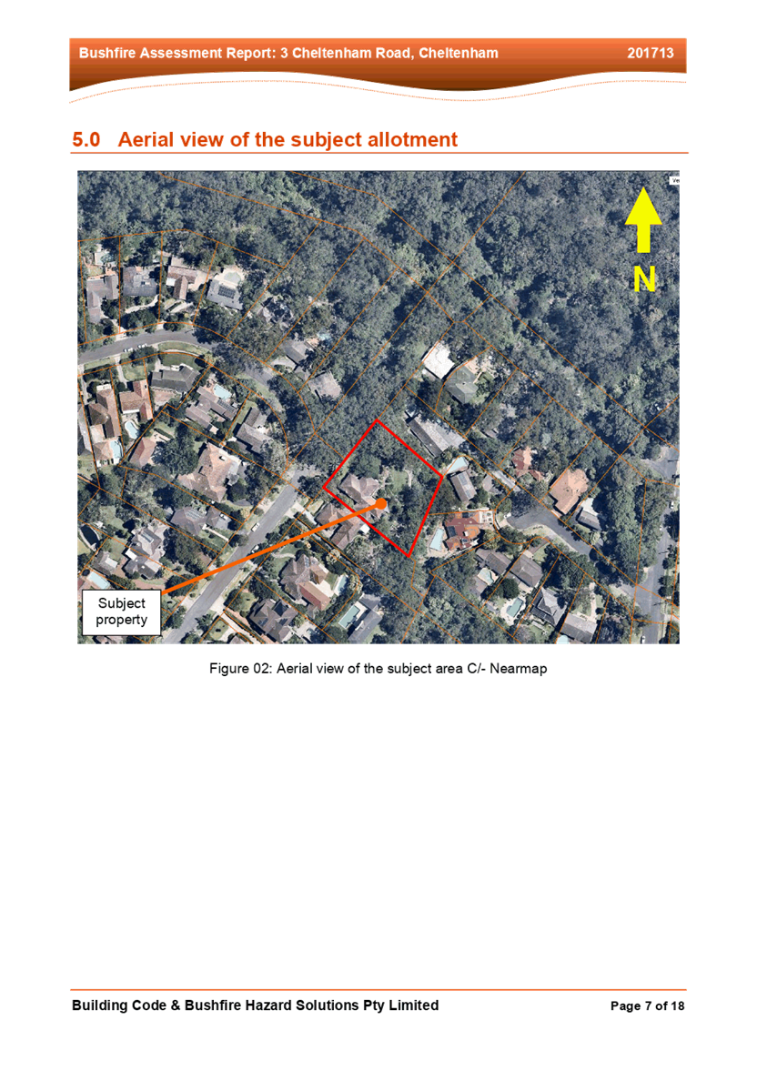
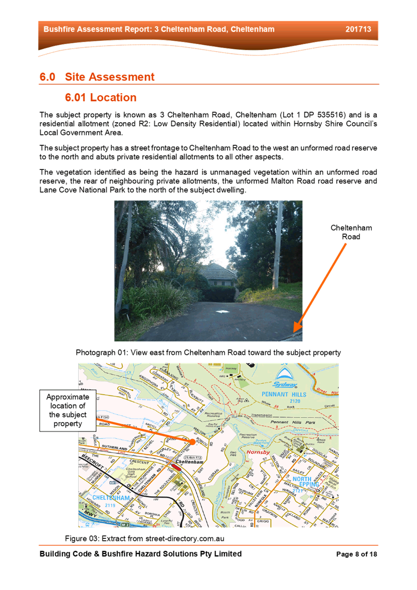
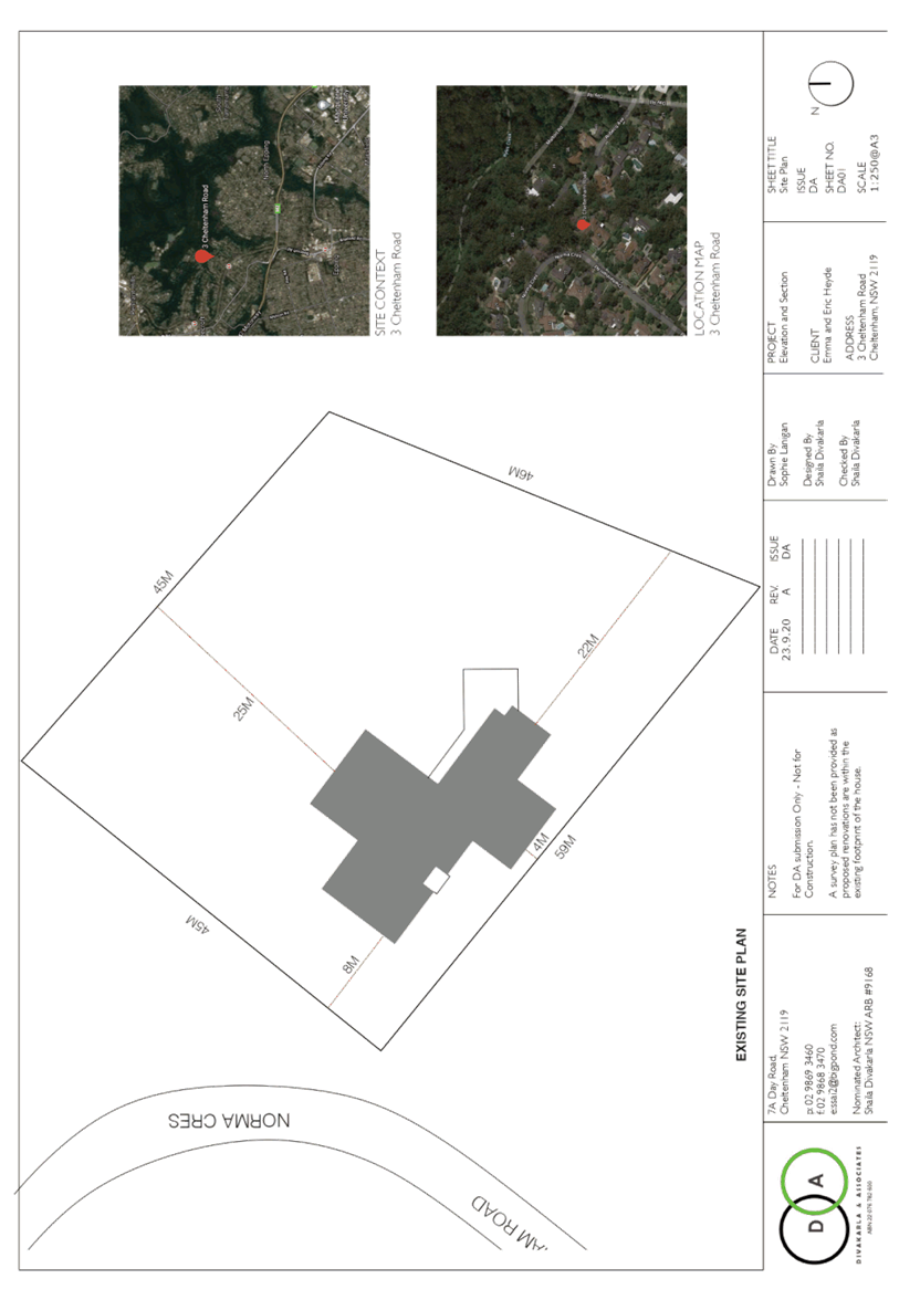
SITE
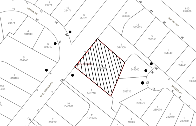
The 2,340m2 site is located on the eastern side of Cheltenham Road Cheltenham and contains a dwelling house.
The site experiences 12 metres of fall towards the rear, north eastern corner.
The site is bushfire prone land and is not flood prone.
The site is not burdened by any easements or restrictions.
Whilst the site is not heritage listed and is not in the immediate vicinity of a heritage-listed item it is located within the Beecroft/Cheltenham Heritage Conservation Area.
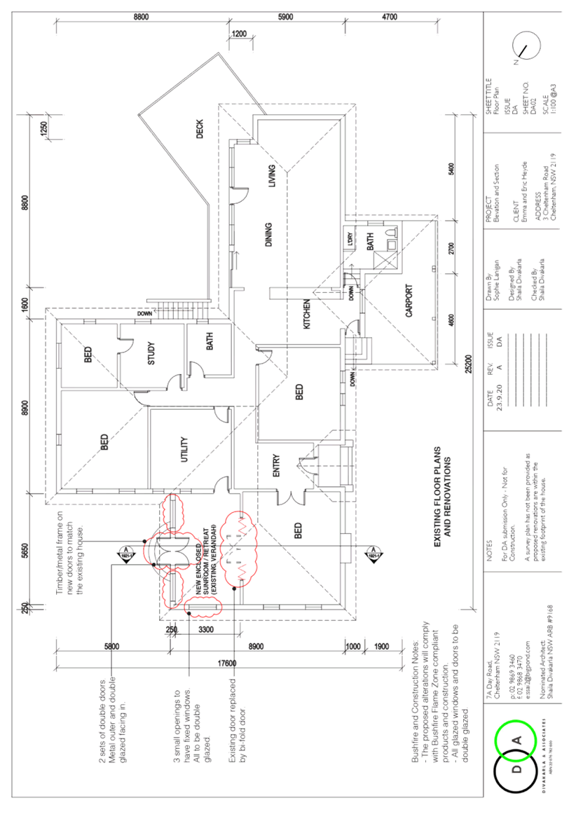
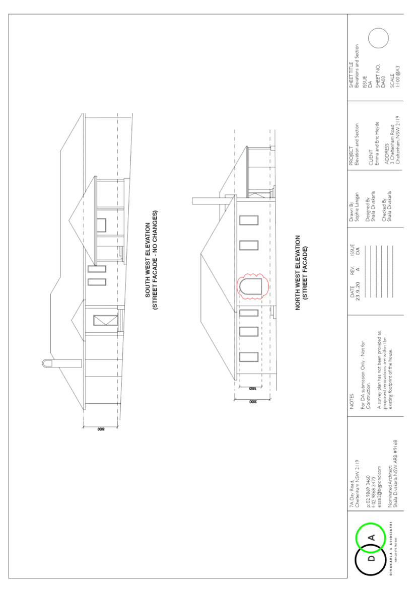
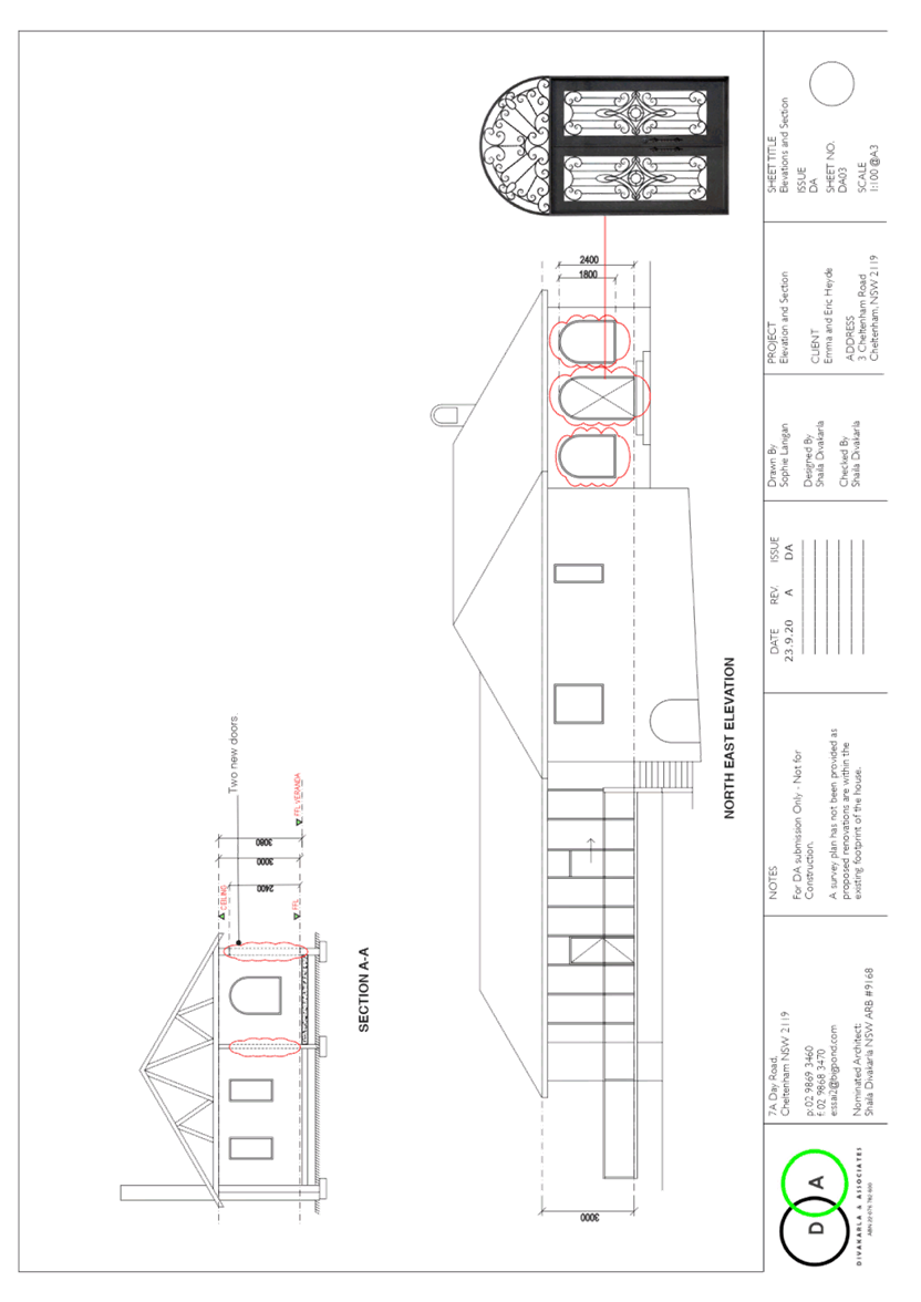
PROPOSAL
The application proposes minor alterations and additions to the dwelling house as follows:
· The enclosing of the existing verandah with windows and a door and the replacement of the existing arched openings; and
· The existing door in the bedroom to be replaced by bi fold doors.
No trees would be removed or impacted by the development.
ASSESSMENT
The development application has been assessed having regard to the Greater Sydney Region Plan – A Metropolis of Three Cities, the North District Plan and the matters for consideration prescribed under Section 4.15 of the Environmental Planning and Assessment Act 1979 (the Act). The following issues have been identified for further consideration.
1. STRATEGIC CONTEXT
1.1 Greater Sydney Region Plan - A Metropolis of Three Cities and North District Plan
The Greater Sydney Region Plan - A Metropolis of Three Cities has been prepared by the NSW State Government to guide land use planning decisions for the next 40 years (to 2056). The Plan sets a strategy and actions for accommodating Sydney’s future population growth and identifies dwelling targets to ensure supply meets demand. The Plan also identifies that the most suitable areas for new housing are in locations close to jobs, public transport, community facilities and services.
The NSW Government will use the subregional planning process to define objectives and set goals for job creation, housing supply and choice in each subregion. Hornsby Shire has been grouped with Hunters Hill, Ku-ring-gai, Lane Cove, Mosman, North Sydney, Ryde, Northern Beaches and Willoughby to form the North District. The Greater Sydney Commission has released the North District Plan which includes priorities and actions for Northern District for the next 20 years. The identified challenge for Hornsby Shire will be to provide an additional 4,350 dwellings by 2021 with further strategic supply targets to be identified to deliver 97,000 additional dwellings in the North District by 2036.
The proposed development would be consistent with the Greater Sydney Region Plan - A Metropolis of Three Cities and the North District Plan.
2. STATUTORY CONTROLS
Section 4.15(1)(a) requires Council to consider “any relevant environmental planning instruments, draft environmental planning instruments, development control plans, planning agreements and regulations”.
2.1 Hornsby Local Environmental Plan 2013
The proposed development has been assessed having regard to the provisions of the Hornsby Local Environmental Plan 2013 (HLEP).
2.1.1 Zoning of Land and Permissibility
The subject land is zoned R2 Low Density Residential under the HLEP. The objectives of the R2 zone are:
· To provide for the housing needs of the community within a low-density residential environment; and
· To enable other land uses that provide facilities or services to meet the day to day needs of residents.
The proposed development is defined as a dwelling house and is permissible with Council’s consent. The proposed development meets the objectives of the R2 Low Density Residential zone.
2.1.2 Height of Buildings
Clause 4.3 of the HLEP provides that the height of a building on any land should not exceed the maximum height show for the land on the Height of Buildings Map. The maximum permissible height for the subject site is 8.5 metres. No changes are proposed to the existing height of the dwelling and the proposal complies with this provision.
2.1.3 Heritage Conservation
Clause 5.10 of the HLEP sets out heritage conservation provisions for Hornsby Shire. The site does not include a heritage item; however, the site is located in a heritage conservation area. Accordingly, an assessment regarding heritage has been made in Section 2.6.1 Heritage of this report.
2.1.4 Earthworks
Clause 6.2 of the HLEP states that consent is required for proposed earthworks on site. Before granting consent for earthworks, Council is required to assess the impacts of the works on adjoining properties, drainage patterns and soil stability of the locality.
Council’s assessment of the proposed works and excavation concludes that no earthworks are required for the proposed development.
2.2 State Environmental Planning Policy (Exempt and Complying Development Codes) 2008 – NSW Housing Code
State Environmental Planning Policy (Exempt and Complying Development Codes) 2008 (NSW Housing Code) provides exempt and complying development codes that have State-wide application.
The Policy also identifies types of development that are of minimal environmental impact that may be carried out without the need for development consent and types of complying development (including dwelling houses) that may be carried out in accordance with a complying development certificate.
The proposal in this application may not be approved as complying development as the site is located on bushfire prone land and is located within a heritage conservation area.
2.3 State Environmental Planning Policy No. 55 Remediation of Land
Should the land be contaminated Council must be satisfied that the land is suitable in a contaminated state for the proposed use. If the land requires remediation to be undertaken to make the land suitable for the proposed use, Council must be satisfied that the land will be remediated before the land is used for that purpose.
The site has been historically used for residential purposes. It is not likely that the site has experienced any significant contamination, and further assessment under SEPP 55 is not required.
2.4 Sydney Regional Environmental Policy (Sydney Harbour Catchment) 2005
The site is located with the catchment of Sydney Harbour. Part 2 of this Plan aims to ensure that the catchment, foreshores, waterways and islands of Sydney Harbour are recognized, protected, enhanced and maintained. These aims require Council to consider the impacts of development on biodiversity, ecology and environment protection.
Noting that the development does not require excavations on the site to establish supporting footings, the implementation of sediment and erosion control measures is not required. As a consequence, the development raises no issues with respect to the aims of the Policy.
2.5 Section 3.42 Environmental Planning and Assessment Act 1979 - Purpose and Status of Development Control Plans
Section 3.42 of the Environmental Planning and Assessment Act 1979 states that a DCP provision will have no effect if it prevents or unreasonably restricts development that is otherwise permitted and complies with the development standards in relevant Local Environmental Plans and State Environmental Planning Policies.
The principal purpose of a development control plan is to provide guidance on the aims of any environmental planning instrument that applies to the development; facilitate development that is permissible under any such instrument; and achieve the objectives of land zones. The provisions contained in a DCP are not statutory requirements and are for guidance purposes only. Consent authorities have flexibility to consider innovative solutions when assessing development proposals, to assist achieve good planning outcomes.
2.6 Hornsby Development Control Plan 2013
The proposed development has been assessed having regard to the relevant desired outcomes and prescriptive requirements within the Hornsby Development Control Plan 2013 (HDCP). The following table sets out the proposal’s compliance with the prescriptive requirements of the Plan:
|
HDCP – Part 3.1 Dwelling Houses |
|||
|
Control |
Proposal |
Requirement |
Complies |
|
Site Area |
2340m2 |
N/A |
N/A |
|
Building Height |
Unchanged |
8.5m |
Yes |
|
No. storeys |
1 |
max. 2 + attic |
Yes |
|
Site Coverage |
11% |
max. 30% |
Yes |
|
Floor Area |
278m2 |
430m2 |
Yes |
|
Setbacks |
|
|
|
|
- Front |
8m |
6m |
Yes |
|
- Side |
25m |
900mm |
Yes |
|
- Side |
4m |
900mm |
Yes |
|
- Rear |
22m |
3m |
Yes |
|
Landscaped Area (% of lot size) |
88% |
45% |
Yes |
|
Private Open Space |
|
|
|
|
- minimum area |
50m2 |
24m2 |
Yes |
|
- minimum dimension |
5m |
3m |
Yes |
|
Car Parking |
2 spaces |
2 spaces |
Yes |
As detailed in the above table, the proposed development complies with the prescriptive measures within the HDCP. A brief discussion on compliance with relevant performance requirements and Part 1C General Controls is provided below.
2.6.1 Heritage
The desired outcomes of Part 9.3.1 General Design Provisions for development within a Heritage Conservation Areas of the HDCP are to encourage “development that complements and is sympathetic to the existing character of the conservation area and the elements that are significant to that character.”
The site is located within the Beecroft/Cheltenham Heritage Conservation Area, which is listed under Schedule 5 of the HLEP.
The proposed window within the north western elevation faces the street. In addressing the visual impact of this proposal to enclose the verandah on the streetscape character of the surrounding conservation area, it is noted that this work would be effectively obscured by well-established vegetation growing in the front yard. It is also noted that the materials and colours of the proposed development would be consistent with the colours and architectural style of the existing dwelling.
The proposal to replace the existing (internal) door to the eastern-most bedroom with bi fold doors would have no heritage impacts.
The location, design and appearance of the proposed development would have no adverse impacts on the streetscape character of the HCA or on heritage items in the vicinity.
The proposal meets the desired outcomes of Part 9.3.1 General Design Provisions for development within a Heritage Conservation Areas of the HDCP and is considered acceptable.
2.6.2 Privacy
The desired outcome of Part 3.1.6 Privacy of the HDCP is to encourage “development that is designed to provide reasonable privacy to adjacent properties.”
This is supported by the prescriptive measures that state that:
a) A proposed window in a dwelling house should have a privacy screen if:
· It is a window to a habitable room, other than a bedroom, that has a floor level of more than 1 metre above existing ground level.
· The window is setback less than 3 metres from a side or rear boundary, and
· The window has a sill height of less than 1.5 metres.
The proposed enclose sunroom would have windows that are setback more than 3 metres from all boundaries. The windows would not overlook the neighbouring properties due to the setbacks and screen planting.
The proposal meets the desired outcome of Part 3.1.6 Privacy of the HDCP and is considered acceptable.
2.6.3 Solar access
This is supported by the prescriptive measures that state “on 22 June, 50 percent of the required principal private open space area should receive 3 hours of unobstructed sunlight access between 9am and 3pm” and “on 22 June, 50 percent of the required principal private open space on any adjoining property should receive 3 hours of unobstructed sunlight access between 9am and 3pm.”
In assessing this application, it is noted that the proposed alterations to the dwelling house will not create additional overshadowing impacts to the principal private open space or adjoining properties. The overall visual bulk and scale of the dwelling house will be unchanged and would not result in loss of amenity for adjoining neighbours.
The proposal meets the desired outcomes and prescriptive measures of Part 3.1.5 Sunlight Access of the HDCP and is considered acceptable.
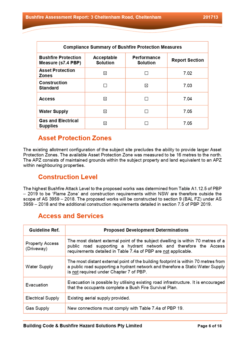
2.6.4 Bushfire
The desired outcomes of Part 1C.3.1 Bushfire of the HDCP are to encourage “development that is located and designed to minimise the risk to life and property from bushfires” and to encourage “development that balances the conservation of native vegetation and bushfire protection.”
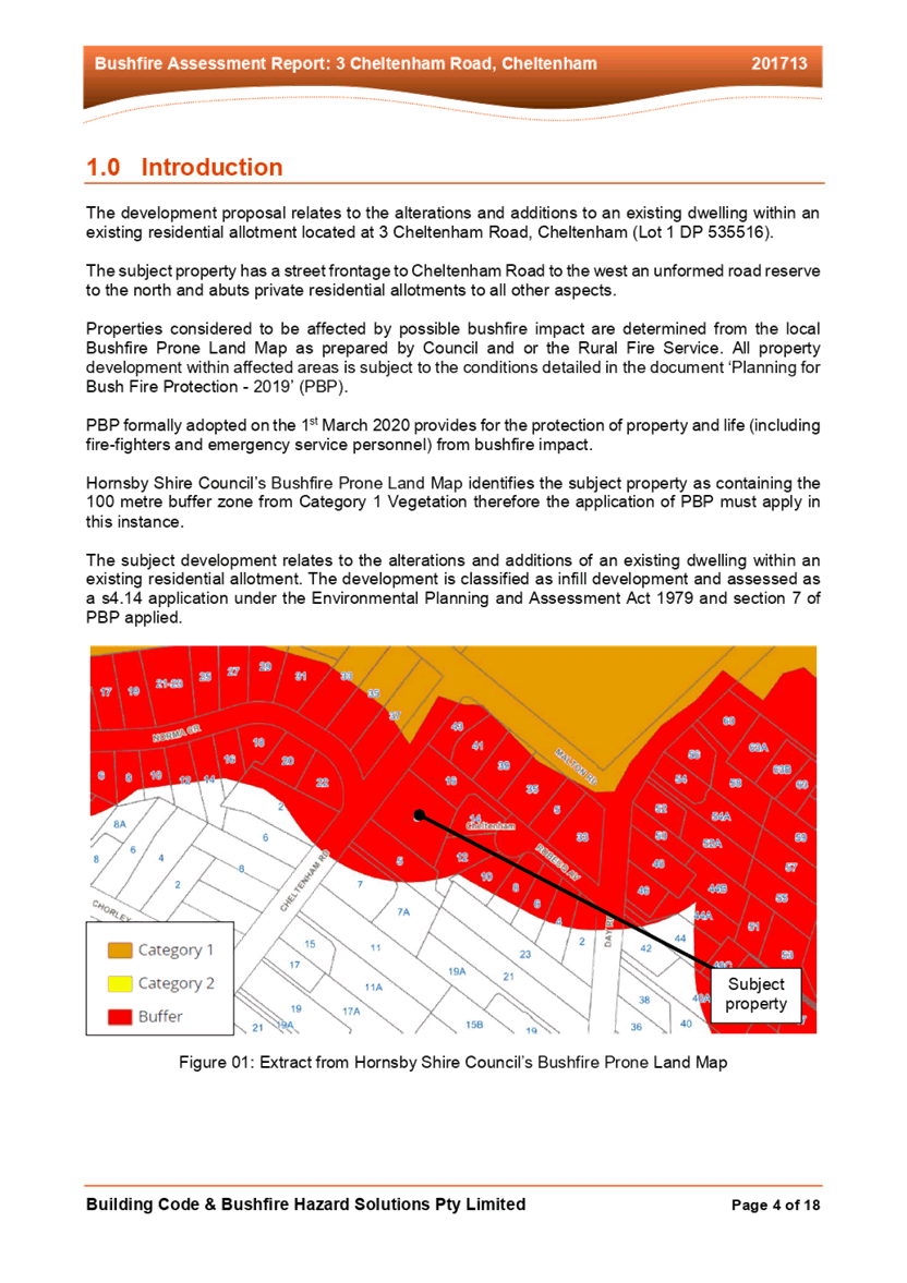
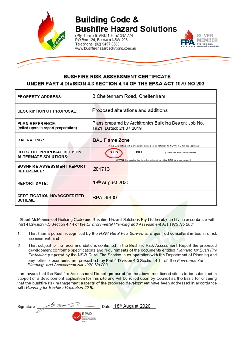
As outlined in the Bushfire Assessment Report prepared by Building Code & Bushfire Hazard Solutions Pty Ltd dated 18 August 2020, the property is located in an area with a Bushfire Attack Level (BAL) rating of BAL-FZ.
The application was referred to the NSW Rural Fire Service (RFS) in accordance with Section 4.14 (1A) of the Environmental Planning and Assessment Act 1979 for comment.
The RFS raised no objections to the development, subject to the conditions recommended in Schedule 1 of this report.
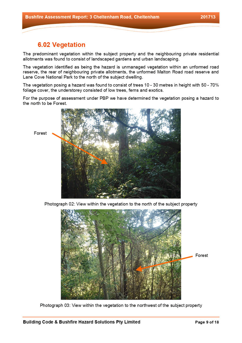
The vegetation predominant within the subject property and neighbouring properties was found to consist of landscaped gardens and urban landscaping. Therefore, no trees within the property are proposed to be removed. All grounds within the subject property are to be maintained in accordance with an Inner Protection Area as detailed Schedule 1 of this report.
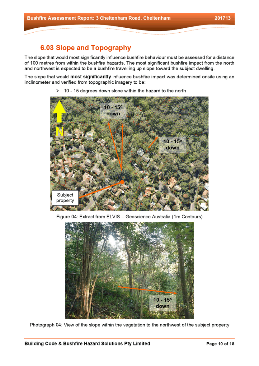
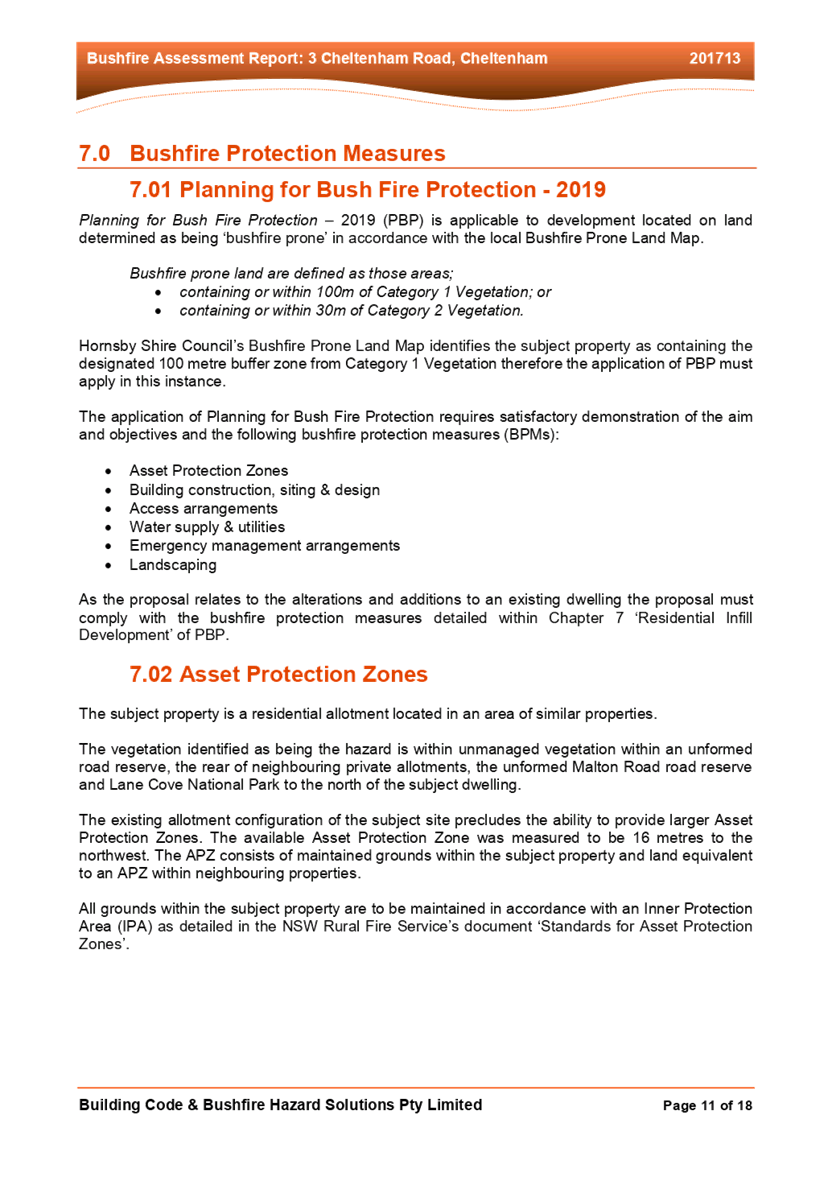
The vegetation identified as being hazard is located within the unmanaged Malton Road reserve and Lane Cove National Park to the north of the subject site.
The proposal meets the desired outcomes of Part 1C.3.1 Bushfire of the HDCP and is considered acceptable.
3. ENVIRONMENTAL IMPACTS
Section 4.15(1)(b) of the Act requires Council to consider “the likely impacts of that development, including environmental impacts on both the natural and built environments, and social and economic impacts in the locality”.
3.1 Natural Environment
3.1.1 Tree and Vegetation Preservation
The proposed development would not result in any tree removal.
3.1.2 Stormwater Management
The stormwater would be directed to the existing stormwater system.
3.2 Built Environment
3.2.1 Built Form
The proposal would generally be consistent with the built form of the surrounding low-density residential area which consists of dwelling houses ranging from single storey, split level, two storey and three storeys with excavated garages.
3.3 Social Impacts
The residential development would improve housing choice in the locality by providing a range of house hold types. This is consistent with Council’s Housing Strategy which identifies the need to provide a mix of housing options to meet future demographic needs in Hornsby Shire.
3.4 Economic Impacts
The proposal would have a minor positive impact on the local economy in conjunction with other new low-density residential development in the locality by generating an increase in demand for local services.
4. SITE SUITABILITY
Section 4.15(1)(c) of the Act requires Council to consider “the suitability of the site for the development”.
4.1 Bushfire Risk
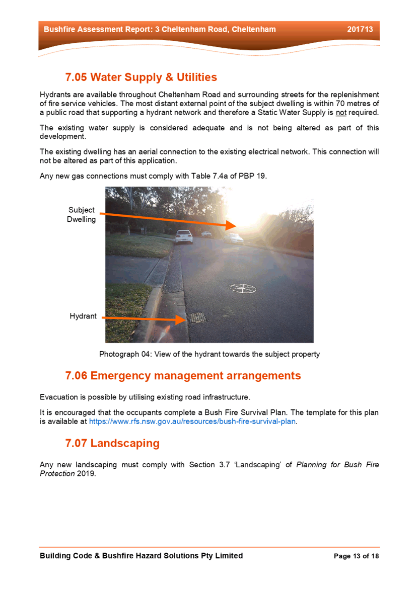
As noted in Section 2.6.2 Bushfire of this report, the subject site is identified as being bushfire prone, the application was referred to the NSW Rural Fire Service for comment.
Conditions of consent provided by the RFS have been recommended in Schedule 1 of this report with regard to the utilisation of BAL Flame Zone fire retardant construction materials and the maintenance of the entire property as an Inner Protection Area (IPA) in perpetuity.
5. PUBLIC PARTICIPATION
Section 4.15(1)(d) of the Act requires Council to consider “any submissions made in accordance with this Act”.
5.1 Community Consultation
The proposed development was placed on public exhibition and was notified to adjoining and nearby landowners between 27 October 2020 and 19 November 2020 in accordance with the Hornsby Community Participation Plan. During this period, Council received no submissions. The map below illustrates the location of those nearby landowners who made a submission that are in close proximity to the development site.
|
NOTIFICATION PLAN |
|||
|
• PROPERTIES NOTIFIED |
X SUBMISSIONS RECEIVED |
|
|
6. THE PUBLIC INTEREST
Section 4.15(1)(e) of the Act requires Council to consider “the public interest”.
The public interest is an overarching requirement, which includes the consideration of the matters discussed in this report. Implicit to the public interest is the achievement of future built outcomes adequately responding to and respecting the future desired outcomes expressed in environmental planning instruments and development control plans.
The application is considered to have satisfactorily addressed Council’s and relevant agencies’ criteria and would provide a development outcome that, on balance, would result in a positive impact for the community. Accordingly, it is considered that the approval of the proposed development would be in the public interest.
CONCLUSION
The application proposes alterations and additions to a dwelling house.
The development generally meets the desired outcomes of Council’s planning controls and is satisfactory having regard to the matters for consideration under Section 4.15 of the Environmental Planning and Assessment Act 1979.
Conditions are recommended to minimise disruption to residential amenity.
Having regard to the circumstances of the case, approval of the application is recommended.
The reasons for this decision are:
· The proposed development complies with the requirements of the relevant environmental planning instruments and the Hornsby Development Control Plan 2013.
· The proposed development does not create unreasonable environmental impacts to adjoining development with regard to visual bulk, overshadowing, solar access, amenity or privacy.
Note: At the time of the completion of this planning report, no persons have made a Political Donations Disclosure Statement pursuant to Section 10.4 of the Environmental Planning and Assessment Act 1979 in respect of the subject planning application.
RESPONSIBLE OFFICER
The officer responsible for the preparation of this report is Charley Wells.
|
Cassandra Williams Major Development Manager - Development Assessments Planning and Compliance Division |
Rod Pickles Manager - Development Assessments Planning and Compliance Division |
|
1.⇩ |
Locality Map |
|
|
|
2.⇩ |
Bushfire Report |
|
|
|
3.⇩ |
Architectural Plans |
|
|
File Reference: DA/906/2020
Document Number: D08052874
SCHEDULE 1
GENERAL CONDITIONS
The conditions of consent within this notice of determination have been applied to ensure that the use of the land and/or building is carried out in such a manner that is consistent with the aims and objectives of the relevant legislation, planning instruments and council policies affecting the land and does not disrupt the amenity of the neighbourhood or impact upon the environment.
Note: For the purpose of this consent, the term ‘applicant’ means any person who has the authority to act on or the benefit of the development consent.
Note: For the purpose of this consent, any reference to an Act, Regulation, Australian Standard or publication by a public authority shall be taken to mean the gazetted Act or Regulation, or adopted Australian Standard or publication as in force on the date that the application for a construction certificate is made.
1. Approved Plans and Supporting Documentation
The development must be carried out in accordance with the plans and documentation listed below and endorsed with Council’s stamp, except where amended by Council and/or other conditions of this consent:
Approved Plans
|
Plan No. |
Plan Title |
Drawn by |
Dated |
Council Reference |
|
DA01 |
Site Plan |
Divakarla and Associates |
23/09/2020 |
|
|
DA02 |
Floor Plan |
Divakarla and Associates |
23/09/2020 |
|
|
DA03 |
South West and North West Elevations |
Divakarla and Associates |
23/09/2020 |
|
|
DA03 |
North East elevation and Section A-A |
Divakarla and Associates |
23/09/2020 |
|
Supporting Documentation
|
Document Title |
Prepared by |
Dated |
Council Reference |
|
Waste Management Plan |
Divakarla and Associates |
16/10/2020 |
D08035465 |
|
Bushfire Assessment Report Ref. No. 201713 |
Building Code & Bushfire Hazard Solutions Pty Limited |
18/08/2020 |
D08035465 |
|
NSW RFS letter ref: DA20201028004004-Original-1 |
NSW Rural Fir Service |
06/11/2020 |
D08044315 |
2. Construction Certificate
a) A Construction Certificate is required to be approved by Council or a Private Certifying Authority prior to the commencement of any construction works under this consent.
b) The Construction Certificate plans must be consistent with the Development Consent plans.
REQUIREMENTS PRIOR TO THE ISSUE OF A CONSTRUCTION CERTIFICATE
3. Building Code of Australia
All approved building work must be carried out in accordance with the relevant requirements of the Building Code of Australia.
4. Notification of Home Building Act 1989 Requirements
Residential building work within the meaning of the Home Building Act 1989 must not be carried out unless the principal certifying authority for the development to which the work relates (not being Council) has given Council written notice of the following information:
a) In the case of work for which a principal contractor is required to be appointed:
i) The name and licence number of the principal contractor; and
ii) The name of the insurer by which the work is insured under Part 6 of that Act.
b) In the case of work to be done by an owner-builder:
i) The name of the owner-builder; and
ii) If the owner-builder is required to hold an owner-builder’s permit under that Act, the number of the owner-builder’s permit.
Note: If arrangements for doing the residential building work are changed while the work is in progress so that the information notified becomes out of date, further work must not be carried out unless the principal certifying authority for the development to which the work relates (not being Council) has given Council written notification of the updated information.
5. NSW Rural Fire Service Requirements
The Construction Certificate plans must address the requirements of the NSW Rural Fire Service conditions of concurrence.
REQUIREMENTS PRIOR TO THE COMMENCEMENT OF ANY WORKS
6. Erection of Construction Sign
a) A sign must be erected in a prominent position on any site on which any approved work is being carried out:
i) Showing the name, address and telephone number of the principal certifying authority for the work;
ii) Showing the name of the principal contractor (if any) for any demolition or building work and a telephone number on which that person may be contacted outside working hours; and
iii) Stating that unauthorised entry to the work site is prohibited.
b) The sign is to be maintained while the approved work is being carried out and must be removed when the work has been completed.
7. Toilet Facilities
a) To provide a safe and hygienic workplace, toilet facilities must be available or be installed at the works site before works begin and must be maintained until the works are completed at a ratio of one toilet for every 20 persons employed at the site.
b) Each toilet must:
i) Be a standard flushing toilet connected to a public sewer; or
ii) Be a temporary chemical closet approved under the Local Government Act 1993.
REQUIREMENTS DURING DEMOLITION AND CONSTRUCTION
8. Construction Work Hours
All works on site, including demolition and earth works, must only occur between 7am and 5pm Monday to Saturday.
No work is to be undertaken on Sundays or public holidays.
9. Demolition
To protect the surrounding environment, all demolition work must be carried out in accordance with Australian Standard AS2601-2001 – The Demolition of Structures and the following requirements:
a) Demolition material must be disposed of to an authorised recycling and/or waste disposal site and/or in accordance with an approved waste management plan; and
b) Demolition works, where asbestos material is being removed, must be undertaken by a contractor that holds an appropriate licence issued by SafeWork NSW in accordance with the Work Health and Safety Regulation 2017 and be appropriately transported and disposed of in accordance with the Protection of the Environment Operations (Waste) Regulation 2014; and
c) On construction sites where any building contains asbestos material, a standard commercially manufactured sign containing the words ‘DANGER ASBESTOS REMOVAL IN PROGRESS’ and measuring not less than 400mm x 300mm must be displayed in a prominent position visible from the street.
REQUIREMENTS PRIOR TO THE ISSUE OF AN OCCUPATION CERTIFICATE
10. Bushfire Certification
Certification of compliance with all of the NSW Rural Fire Service requirements from a suitably qualified Bushfire Consultant must be submitted to the Principal Certifying Authority prior to issue of the Occupation Corticate.
CONDITIONS OF CONCURRENCE - NSW RURAL FIRE SERVICE
The following conditions of consent are from the nominated State Agency pursuant to Section 4.13 of the Environmental Planning and Assessment Act 1979 and must be complied with to the satisfaction of that Agency.
11. Asset Protection Zones
Intent of measures: to minimise the risk of bush fire attack and provide protection for emergency services personnel, residents and others assisting firefighting activities.
From the start of building works, and in perpetuity to ensure ongoing protection from the impact of bush fires, the entire property must be managed as an inner protection area (IPA) in accordance with the requirements of Appendix 4 of Planning for Bush Fire Protection 2019. When establishing and maintaining an IPA the following requirements apply:
a) Tree canopy cover should be less than 15% at maturity.
b) Trees at maturity should not touch or overhang the building.
c) Lower limbs should be removed up to a height of 2m above the ground.
d) Tree canopies should be separated by 2 to 5m.
e) Preference should be given to smooth barked and evergreen trees.
f) Large discontinuities or gaps in vegetation should be provided to slow down or break the progress of fire.
g) Towards buildings.
h) Shrubs should not be located under trees.
i) Shrubs should not form more than 10% ground cover.
j) Clumps of shrubs should be separated from exposed windows and doors by a distance of at least twice.
k) The height of the vegetation.
l) Grass should be kept mown (as a guide grass should be kept to no more than 100mm in height).
m) Leaves and vegetation debris should be removed.
12. Construction Standards
Intent of measures: to minimise the risk of bush fire attack and provide protection for emergency services personnel, residents and others assisting firefighting activities.
New construction must comply with Section 3 (excluding section 3.5) and Section 9 (BAL FZ) of Australian Standard AS3959-2018 Construction of buildings in bushfire-prone areas or the relevant BAL-FZ requirements of the NASH Standard - Steel Framed Construction in Bushfire Areas (incorporating amendment A - 2015). New construction must also comply with the construction requirements in Section 7.5 of Planning for Bush Fire Protection 2019.
13. Water and Utility Services
Intent of measures: to minimise the risk of bush fire attack and provide protection for emergency services personnel, residents and others assisting firefighting activities.
The provision of water, electricity and gas must comply the following in accordance with Table 7.4a of Planning for Bush Fire Protection 2019:
a) Reticulated water is to be provided to the development where available;
b) All above-ground water service pipes external to the building are metal, including and up to any taps;
c) Where practicable, electrical transmission lines are underground;
d) Where overhead, electrical transmission lines are proposed as follows:
i) Lines are installed with short pole spacing (30m), unless crossing gullies, gorges or riparian areas; and
ii) No part of a tree is closer to a power line than the distance set out in accordance with the specifications in ISSC3 Guideline for Managing Vegetation Near Power Lines;
e) Reticulated or bottled gas is installed and maintained in accordance with AS/NZS 1596:2014 and the requirements of relevant authorities, and metal piping is used;
f) All fixed gas cylinders are kept clear of all flammable materials to a distance of 10m and shielded on the hazard side;
g) Connections to and from gas cylinders are metal;
h) Polymer sheathed flexible gas supply ‐ lines are not used; and
i) Above-ground gas service pipes are metal, including and up to any outlets.
14. Landscaping Assessment
Intent of measures: to minimise the risk of bush fire attack and provide protection for emergency services personnel, residents and others assisting firefighting activities.
Landscaping within the required asset protection zone must comply with Appendix 4 of Planning for Bush Fire Protection 2019. In this regard, the following principles are to be incorporated:
a) A minimum 1 metre wide area, suitable for pedestrian traffic, must be provided around the immediate curtilage of the building.
b) Planting is limited in the immediate vicinity of the building.
c) Planting does not provide a continuous canopy to the building (i.e. trees or shrubs are isolated or located in small clusters).
d) Landscape species are chosen to ensure tree canopy cover is less than 15% (IPA), and less than 30% (OPA) at maturity and trees do no touch or overhang buildings.
e) Avoid species with rough fibrous bark, or which retain/shed bark in long strips or retain dead material in their canopies.
f) Use smooth bark species of trees species which generally do not carry a fire up the bark into the crown.
g) Avoid planting of deciduous species that may increase fuel at surface/ ground level (i.e. leaf litter).
h) Avoid climbing species to walls and pergolas.
i) Locate combustible materials such as woodchips/mulch, flammable fuel stores away from the building.
j) Locate combustible structures such as garden sheds, pergolas and materials such as timber garden furniture away from the building.
k) Low flammability vegetation species are used.
- END OF CONDITIONS -
ADVISORY NOTES
The following information is provided for your assistance to ensure compliance with the Environmental Planning and Assessment Act 1979, Environmental Planning and Assessment Regulation 2000, other relevant legislation and Council’s policies and specifications. This information does not form part of the conditions of development consent pursuant to Section 4.17 of the Act.
Environmental Planning and Assessment Act 1979 Requirements
The Environmental Planning and Assessment Act 1979 requires:
· The issue of a construction certificate prior to the commencement of any works. Enquiries can be made to Council’s Customer Services Branch on 9847 6760.
· A principal certifying authority to be nominated and Council notified of that appointment prior to the commencement of any works.
· Council to be given at least two days written notice prior to the commencement of any works.
· Mandatory inspections of nominated stages of the construction inspected.
· An occupation certificate to be issued before occupying any building or commencing the use of the land.
Long Service Levy
In accordance with Section 34 of the Building and Construction Industry Long Service Payments Act 1986, a ‘Long Service Levy’ must be paid to the Long Service Payments Corporation or Hornsby Council.
Note: The rate of the Long Service Levy is 0.35% of the total cost of the work.
Note: Hornsby Council requires the payment of the Long Service Levy prior to the issue of a construction certificate.
Tree and Vegetation Preservation
A person must not ringbark, cut down, top, lop, remove, injure or wilfully destroy any tree or other vegetation protected under the Hornsby Development Control Plan 2013 without the authority conferred by a development consent or a permit granted by Council.
Notes: A tree is defined as a long lived, woody perennial plant with one or relatively few main stems with the potential to grow to a height greater than three metres (3M). (HDCP 1B.6.1.c)
Tree protection measures and distances are determined using the Australian Standard AS 4970:2009, “Protection of Trees on Development Sites”.
Fines may be imposed for non-compliance with the Hornsby Development Control Plan 2013.
The land upon which the subject building is to be constructed may be affected by restrictive covenants. Council issues this approval without enquiry as to whether any restrictive covenant affecting the land would be breached by the construction of the building, the subject of this consent. Applicants must rely on their own enquiries as to whether or not the building breaches any such covenant.
Prior to commencing any works, the applicant is encouraged to contact Dial Before You Dig on 1100 or www.dialbeforeyoudig.com.au for free information on potential underground pipes and cables within the vicinity of the development site.
Should asbestos or asbestos products be encountered during demolition or construction works, you are advised to seek advice and information prior to disturbing this material. It is recommended that a contractor holding an asbestos-handling permit (issued by SafeWork NSW) be engaged to manage the proper handling of this material. Further information regarding the safe handling and removal of asbestos can be found at:
Alternatively, telephone the SafeWork NSW Asbestos and Demolition Team on 8260 5885.
RFS General Advice
The NSW RFS recognises that the site is constrained and that the proposed development falls within the Flame Zone. Flame Zone development is high risk development; consequently, in situations such as this, the NSW RFS seeks to improve the overall fire safety of the existing development. This requires greater emphasis on construction standards, landscaping, siting, and vegetation management practices to ensure improved levels of protection are afforded to the development, its occupants and fire fighters. The NSW RFS has undertaken a merit-based assessment of the proposal and provides the above advice in accordance with Planning for Bush Fire Protection 2019.
LPP Report No. LPP41/20
Local Planning Panel
Date of Meeting: 16/12/2020
5 ELECTRONIC - REPORTING DEVELOPMENT APPLICATIONS FOR DETERMINATION BY THE HORNSBY LOCAL PLANNING PANEL OVER 180 DAYS
EXECUTIVE SUMMARY
· In accordance with the Local Planning Panels Directions - Operational Procedures, Council is required to monitor development applications to be determined by the Panel that may be experiencing unreasonable delays of over 180 days from lodgement.
· A list of out outstanding development applications in excess of 180 calendar days from lodgement is attached for the Hornsby Local Planning Panel’s advice.
|
THAT the contents of LPP Report No. LPP41/20 be received and noted. |
PURPOSE
The purpose of this report is to advise the Hornsby Local Planning Panel of development applications required to be determined by the Panel that are over 180 calendar days from lodgement.
DISCUSSION
In 2019 the NSW Productivity Commission conducted a review of the Independent Planning Commission (IPC). The review recommended several actions to streamline processes to optimise efficiency, output and performance.
The planning panel changes were implemented on 1 August 2020 to incorporate a number of the NSW Productivity Commission ‘s recommendations to the way Local Planning Panels work to make them more efficient and to improve the assessment and determination times of development applications and maintain panel oversight of sensitive and contentious applications.
These changes were made as part of the Planning Acceleration Program to support the State’s immediate and long-term economic recovery from the COVID-19 crisis.
The changes will speed up panel determinations by:
1. Reducing the need to conduct public panel meetings for non-contentious matters by applying a ‘10-or-more’ objection trigger for public meetings.
2. Reducing the amount of modifications going to panels.
3. Obliging panel chairs to more actively manage development applications (DAs) coming to the panels to reduce panel deferrals and assessment timeframes.
4. Allowing chairs to bring forward determination on DAs that are experiencing unreasonable delays of over 180 days from lodgement.
5. Introducing panel performance measures.
The Local Planning Panels Directions - Operational Procedures has been amended to:
· Require panels to make determinations within two weeks of being provided an assessment report.
· Require panels to hold a public meeting only where the Development Application has attracted 10 or more unique submissions by way of objection.
· Allow, at the Chair’s discretion, applicants to attend a briefing, along with council staff, to explain complex matters or present confidential or commercially sensitive material.
· Oblige panel chairs to work with council to ensure key issues are addressed during assessment in order to minimise deferrals by the panels at determination stage.
· Require the panels to provide reasons for deferring a decision and set timeframes in which any additional information must be provided in order to finalise the determination.
· Give panel chairs the ability to require council to report a DA to the panel within four weeks for determination if the application has experienced unreasonable delays in excess of 180 calendar days from lodgement.
In accordance with Point 6 of the Local Planning Panels Directions - Operational Procedures, attached is a list of development applications required to be determined by the Panel that are over 180 calendar days from lodgement.
CONCLUSION
Council is required to monitor development applications to be determined by the Panel that are over 180 calendar days from lodgement. This report provides advice to the Local Planning Panel on DAs that are experiencing unreasonable delays of over 180 days from lodgement.
RESPONSIBLE OFFICER
The officer responsible for the preparation of this report is the Major Development Manager, Cassandra Williams.
|
Rod Pickles Manager - Development Assessments Planning and Compliance Division |
James Farrington Director - Planning and Compliance Planning and Compliance Division |
|
1.⇩ |
DAs over 180 days |
|
|
File Reference: F2013/00295-002
Document Number: D08059046