|
Hornsby Shire Council
|
Attachment to Report No. WK63/08 Page 3
|
Report Summary
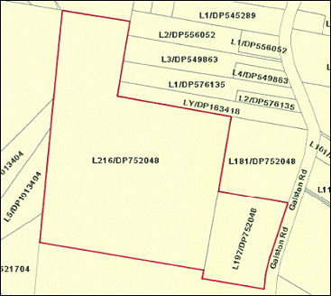
PROPERTY Lot
197 and Lot 216 in Deposited Plan 752048 Galston Road, Galston.
OWNER The
Crown and managed by Hornsby Shire Council.
DATE OF
ASSESSMENT 25
August 2008.
BASIS
OF
ASSESSMENT In accordance with Section 55 of the Land Acquisition (Just
Terms Compensation) Act, 1991 ‑ all heads of compensation to be
considered.
COMMENTS The subject property is located on the western side of Galston
Road Galston just to the south of the intersection with Mid–Dural Road. The property forms part of a public open
space area known as Galston
Park. Galston
neighbourhood shopping centre is situated about a kilometre to the north of the
property. The property is situated some
36 kilometres north west of the Sydney CBD.
The property is traversed by some existing transmission lines and the
property also includes existing unsealed fire trails. The surrounding
development predominantly comprises rural-residential properties as well as
Galston high school opposite and Sydney North Electricity Substation to the
rear.
The land is zoned Open
Space A (Public Recreation – Local) Zone under the Hornsby Shire Local
Environmental Plan 1994 (as amended).
The
property has a total land area of some 25.987 hectares.
PROPOSED
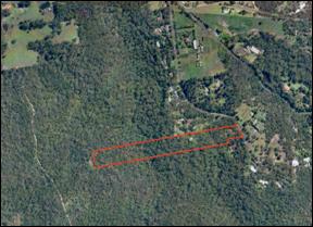
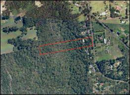
EASEMENT The proposed Easement for the 132kV Underground Cable to be
created upon the subject property will traverse that part of the property as
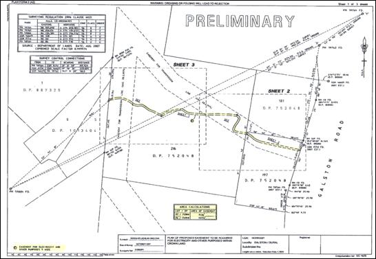
shown on the appended plan in an east to west direction. The total length of the easement is
approximately 707.8 metres.
We are advised that the proposed easement will be five (5)
metres wide and that it will be in accordance with the terms and conditions
of Energy Australia’s standard Easement Memorandum, as outlined within this
report. The
total area of land affected by the easement is shown on the Preliminary Easement
Plan as being approximately 3,539 square metres (subject to a final survey).
Report Summary
(Cont’d)
ASSESSMENT OF
COMPENSATION In assessing compensation for the acquisition of easements,
the Courts consider the limitations and restrictions imposed by the Easement
Memorandum rather than the intended use by the Acquiring Authority (see Besmaw
Pty Ltd v Sydney Water Corporation (2001) NSWLEC 15).
In
accordance with the Easement Memorandum, we note that Energy Australia in
summary has the right to construct and operate facilities and structures for
the transmission of electricity and telecommunications, access through the
easement with vehicles, plant and equipment, cutting and lopping of trees and
vegetation.
The
more significant impacts of these rights on the landowner include –
* Limitations on the landowner’s use of
the land, access with vehicles and services,
* Potential Visual impact,
* Loss of trees and vegetation,
* Potential Noise impact,
* Energy Australia’s access to the easement,
and
* Perceived physical danger from failed
equipment.
In determining our assessment of
compensation we have taken these matters into consideration and in particular
have prepared a table Injurious
Affectation Potential Impact Matrix on page 16 which summarises the
possible level of impact that the Easement Memorandum will impose on the lots
burdened.
COMPENSATION Section 55(a) Market Value $ 14,000
Section 55(f) Injurious Affectation $ 21,000
Total Compensation $ 35,000
The above Compensation Summary
forms part of our complete report and assessment of compensation and should not
be acted upon independently of reading our complete report and assessment of
compensation.
Lot 197 and Lot 216 in
Deposited Plan 752048 Galston Road, Galston.
2.0 INSTRUCTING
PARTY
Mr Peter Thompson
Manger, Property
Development
Works Division
Hornsby Shire Council
296 Pacific Highway
Hornsby NSW 2077
3.0 INSTRUCTIONS
In accordance
with recent instructions from Mr Peter Thompson, for and on behalf of Hornsby
Shire Council, we have been requested to carry out a valuation assignment to
establish the fair amount of compensation to be paid for a proposed Easement
for a 132kV Underground Cable over the abovementioned property. We understand that the assessment of
compensation is to be in accordance with Section 55 of the Land Acquisition
(Just Terms Compensation) Act, 1991.
4.0 INTEREST TO BE
VALUED
Freehold
interest.
5.0 PURPOSE OF
ASSESSMENT OF COMPENSATION
We understand
our report and assessment of compensation is required by Hornsby Shire Council
for the purpose of assisting in negotiations with Energy Australia to
determine the rightful amount of compensation to be paid for creation of an
Easement for a 132kV Underground Cable over the abovementioned property.
6.0 EASEMENT
DESCRIPTION AND CABLE DETAILS
The easement
to be acquired will be 5 metres in width and carry an Underground 132kV Cable.
Whilst we have
not been provided with precise specifications for proposed cable we would note
that from our investigations it would appear that Underground 132kV Cables are
usually laid at minimum depths ranging between 0.9 to 1.2 metres as illustrated
in the following diagram –

We note that the proposed
easement will follow (as much as possible) the existing fire trails.
7.0 DATE OF
INSPECTION
25 August 2008.
8.0 DATE OF
ASSESSMENT OF COMPENSATION
25 August
2008.
9.0 LOCAL
GOVERNMENT AREA
Hornsby Shire
Council.
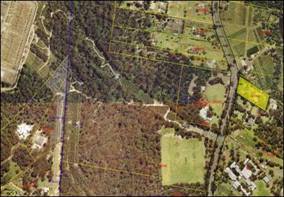
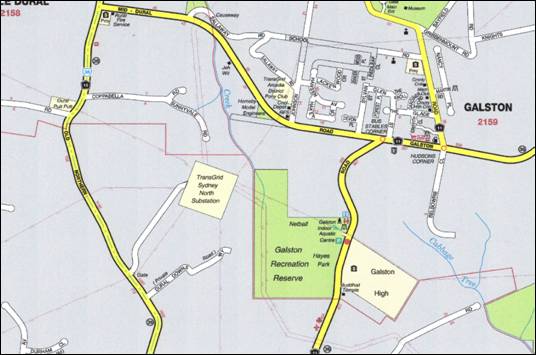
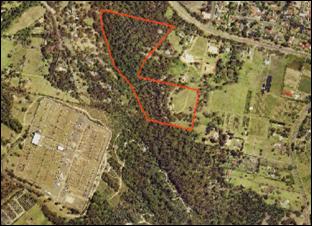
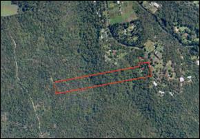
10.0 LOCATION
The property which is the subject of this report and
assessment of compensation is located on the western side of Galston Road
Galston just to the south of the intersection with Mid–Dural Road as indicated
by red arrow on the following Locality Map –

and shown
by red outline on the Site Plan in 14.1
Description.
The property
forms part of a public open space area known as Galston Park.
Galston neighbourhood shopping centre is situated about a kilometre to the
north of the property. The property is
situated some 36 kilometres north west of the Sydney CBD.
The
surrounding development predominantly comprises rural-residential properties as
well as Galston high school opposite and Sydney North Electricity Substation to
the rear.
11.0 TITLE DETAILS
The
NSW Land Titles Office does not hold Title Documents for the subject properties
due to the fact that the properties are Crown Land. However, we would note that the subject
parcels are described in Hornsby Shire Council records as being Lots 197 and
216 in Deposited Plan 752048 at Galston, in the Local Government Area of Hornsby,
Parish of North Colah and County of Cumberland.
12.0 OWNERSHIP
The subject
properties are in ownership of the Crown.
We understand that Hornsby Shire Council manage the properties on behalf
of the Crown.
13.1 Description
The properties
comprise land known as Galston
Park. The park comprises a sporting field as well
as a significant tract of native bushland.
The properties are traversed by several existing power lines. The land is relatively level over that part
used as a sporting field whilst the bushland area provides an undulating
topography. We note that the properties
also include existing unsealed fire trails.
13.2 Area
The total land
area as calculated from an extract of the Parish Map is some 25.987 hectares.
14.0 ENVIRONMENTAL
PLANNING
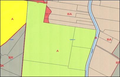
14.1 Current Zoning
We are advised
by the Environmental Services Department of Hornsby Shire Council that the
subject property is zoned Open Space A
(Public Recreation – Local) Zone under the Hornsby Shire Local
Environmental Plan 1994 (as amended).
–
A certificate
issued under Section 149 of the Environmental Planning and Assessment Act, 1979
would need to be obtained to confirm the Town Planning information outlined
above.
14.2 Zone Objectives
The objectives of the Open Space A
(Public Recreation – Local) Zone are
as follows -
(a) to ensure there is provision of
adequate open space to meet the needs of the community and to enhance the
environmental quality of the Hornsby area.
(b) to encourage a diversity
of recreational settings and facilities.
(c) to protect and preserve areas of urban bushland
which are considered valuable in terms of their ecology.
14.0 ENVIRONMENTAL PLANNING (cont’d)
14.3 Underlying
Zoning
In determining
our assessment of compensation we have given due consideration to what the
likely zoning of the subject property would have been had it not been zoned Open Space A (Public Recreation – Local)
Zone.
Based on the
physical nature of the subject property and the surrounding zonings we believe
that the subject property would in all likelihood have been zoned part Environmental Protection B (River Catchment)
Zone and part Rural BR (Small
Holdings-Rural Landscapes) Zone.
We note that
from our reading of the Hornsby Shire Local Environmental Plan 1994 (as
amended), subdivision is prohibited under both these zonings.
16.0 IMPROVEMENTS AND
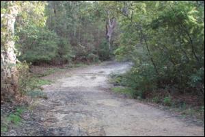
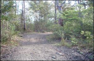
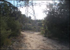
PHOTOGRAPHIC STUDY
There are no
structural improvements erected along the route of the proposed easement.
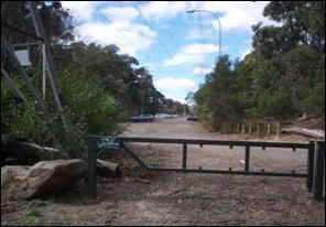
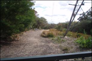


Various views over the subject land
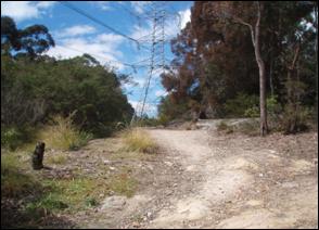
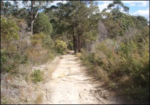
16.0 IMPROVEMENTS AND PHOTOGRAPHIC STUDY (CONT’D)
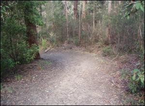
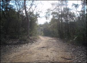
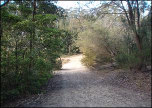
Various views over the subject land
17.0 SERVICES
Water,
sewer, electricity and telephone services are available in the general vicinity
of the subject property.
Galston Road is a bitumen sealed carriageway with both concrete and earth
formed kerb and gutters in the general vicinity of the subject property.
18.0 CONTAMINATION RISK
The current
use of the property as public open space land is not included within the list
of Potentially Contaminating Activities,
Industries and Land Uses contained within the Australian Property Institute
(API) Professional Practice 2006 as
published in May 2006.
Our inspection of the subject property did not
reveal any areas of concern sofaras we are able to identify, however, we are
not experts in such issues. Nor have we
sought any formal advice from the an appropriate expert as to whether the
existing use of the subject property has brought about a real concern in
respect of any site or building contamination.
Our valuation
is made on the basis of a satisfactory current date environmental report
indicating the subject property to be free of contamination, however, we
reserve the right to review our assessment of value if it is found that some
contamination exists and remediation is required.
19.0 PROPOSED eASEMENT
The
proposed Easement for the 132kV Underground Cable to be created upon the
subject property will traverse that part of the property as shown on the
appended plan in an east to west direction.
The total length of the easement is
approximately 707.8 metres.
We are advised that the proposed easement will be five (5)
metres wide and that it will be in accordance with the terms and conditions
of Energy Australia’s
standard Easement Memorandum, as outlined within this report.
The total area
of land affected by the easement is shown on the Preliminary Easement Plan as
being approximately 3,539 square metres (subject to a final survey).
20.0 EASEMENT CONDITIONS
The following
conditions and restrictions are required by Energy Australia to be placed on the
portion of the land subject to the easement in order to protect the underground
electricity cable and rights of access.
ENERGY AUSTRALIA -
EASEMENT MEMORANDUM
Part A – Definitions and Interpretation
(1)
(a) The
following terms have the following meanings:
ancillary works means works
ancillary to the functions performed by electricity
works, including structures below the ground, equipment for signals,
service cables, connecting cables.
easement area means that part
of the land shown as the site of an
“easement for electricity and other purposes” on any plan registered with the
New South Wales Department of Lands.
electricity works means any
electricity power lines or associated equipment or electricity structures
(below the ground other than pits which may be above or on the ground) that
form part of Energy Australia’s
transmission or distribution network and includes mains, wires, cables
(including optic fibre cables), pipes or conduits, fuses, control equipment,
pits ducts and ancillary works.
land means the land over
which this easement is granted (being the land burdened by this easement).
landowner means the owner of
the land and any person having an
estate or interest in the land.
person includes a body
corporate.
signals includes data or
signals of any kind.
(b) A reference to a person includes its
successors and assigns.
20.0 EASEMENT CONDITIONS (cont’d)
Part B – Easement for Electricty Works
(2) Energy Australia and all persons which it authorises
may:
(a) construct, place, alter, extend, repair,
renew, replace, maintain, remove and use, on, to and from the easement area, any electricity works for conveying electricity or signals (or both); and
(b) convey, or permit the conveyance of,
electricity or signals (or both)
through the electricity works.
Part C – General Provisions of Easements
(3) For the purpose of exercising its
rights under the easement for electricity works, Energy Australia and all persons which it authorises may:
(a) enter the land
at any time, with or without vehicles, plant and equipment, for any purposes
within the terms of the easement; and
(b) do anything reasonably necessary to obtain
access to the easement area; and
(c) cut fences and walls in or on the land and install gates in them; and
(d) on any part of the easement area, cut, trim or remove any
trees, vegetation, undergrowth or anything that may interfere with the exercise
of Energy Australia’s rights under
the easement; and
(e) do anything reasonably necessary for
the exercise of Energy Australia’s
rights under the easement.
(4) The
landowner acknowledges that ownership of all electricity works remains with Energy Australia.
20.0 EASEMENT CONDITIONS (cont’d)
(5) Energy Australia covenants with the landowner that:
(a) it will endeavour to keep the electricity works in good repair; and
(b) in exercising its rights under
the easement, it will do as little damage as practicable to the land; and
(c) it will repair any damage it
causes to the land, except that if
after this easement is granted the landowner
installs paving or other works to the surface of the easement area Energy Australia will not be obliged to
restore the paving or those works; and
(d) subject to its rights under
the easement, it will not unreasonably impede the landowner’s reasonable use of the land.
(6)
The landowner covenants with Energy Australia that it will not:
(a) do or allow anything that may interfere with, damage or destroy the electricity works or interfere with the
effective operation of electricity works;
or
(b) obstruct Energy Australia in
the exercise of its rights under the easement; or
(c) alter or
permit to be altered the existing ground level within the easement area, or place or allow to be placed on the easement area any building, structure,
driveway, paving, plant or item without Energy
Australia’s prior written permission, such permission not be unreasonably
withheld.
20.0 EASEMENT
CONDITIONS (Cont’d)
Use of the easement
may be adverse to the landowner in a variety of ways.
The following is a
brief overview of some likely impacts on the use of the property burdened by an
easement for underground electricity cables.
Underground Electricity Cables –
i Loss of the free use the land within
the easement area.
ii Visual impact from any above ground
ancillary improvements.
iii Loss of trees and vegetation within the
easement area.
iv Restrictions imposed regarding altering
the surface of the land within the easement
v Restrictions imposed regarding any
excavation of the land within the easement area.
vi Some noise may emanate from any above
ground ancillary improvements.
vii Potential danger from any failed
electrical equipment.
Access and
access tracks
i Energy Australia vehicles, staff and
equipment may periodically travel within the easement for maintenance or
contractor work.
ii Energy Australia may alter fences and
walls on the property and install gates
iii Use of access tracks by Energy Australia
may result in off easement occupation from time to time.
Limitations
Imposed on the landowner:
i Cannot place or install anything on the
land without written permission,
ii Cannot obstruct the easement area under
any circumstances,
The Table ‘Injurious Affectation Potential Impact Matrix’ below summarises
the possible levels of impact that the various land uses permitted by the
Memorandum may impose on the land burdened by the easement. The rate adopted
for injurious affectation should reflect an allowance for the burden imposed by
the Memorandum on the land and improvements. In arriving at the appropriate level of
affectation, the following table have been considered for this property.
Injurious Affectation Potential
Impact Matrix
|
Landowner Rights being burdened
|
Assessed Burden
|
|
|
Cable Easement
|
Access and Access Tracks
|
|
Landowner’s
access with vehicles
|
medium
|
medium
|
|
Use of
the land within the easement
|
high
|
medium
|
|
Development
or subdivision of the land
|
medium
|
medium
|
|
Prohibition
on excavation
|
high
|
medium
|
|
Removal
of trees and vegetation
|
medium
|
low
|
|
Visual
Impact
|
low
|
low
|
|
Noise
|
low
|
low
|
|
Energy
Australia’s access to the easement
|
high
|
medium
|
|
Perceived
danger from failed equipment
|
medium
|
low
|
21.0 ASSESSMENT OF
COMPENSATION
21.1 Instructions and
Purpose
In accordance
with recent instructions from Mr Peter Thompson, for and on behalf of Hornsby
Shire Council, we have been requested to carry out a valuation assignment to
establish the fair amount of compensation to be paid for a proposed Easement
for a 132kV Underground Cable over the abovementioned property.
Our report and
assessment of compensation has been prepared in accordance with Section 55 of
the Land Acquisition (Just Terms Compensation) Act, 1991 and is required by
Hornsby Shire Council for the purpose of assisting in negotiations with Energy
Australia to determine the
rightful
amount of compensation to be paid for creation of an Easement for a 132kV Underground
Cable over the abovementioned property.
21.2 Definition of
Market Value
Market
value may be defined as –
The
estimated amount for which an asset should exchange on the date of valuation
between a willing buyer and a willing seller in arms length transaction after
proper marketing wherein the parties had each acted knowledgeably, prudently
and without compulsion given a reasonable time frame of up to six months.
21.0 ASSESSMENT OF
COMPENSATION (cont’d)
21.3 Legislative
Powers
The
relevant sections under the Land Acquisition (Just Terms Compensation) Act 1991
in respect to this acquisition are Sections 55 and 56 as outlined below –
Section
55:
In determining the amount of
compensation to which a person is entitled, regard must be had to the following
matters only (as assessed in accordance with this Division):
a) the market value of the land on the date of
its acquisition
b) any special value of the land to the person
on the date of its acquisition
c) any loss attributable to severance
d) any loss attributable to disturbance
e) solatium
f) any increase or decrease in the value of any other land of
the person at the date of acquisition which adjoins or is severed from the
acquired land by reason of the carrying out of, or the proposal to carry out,
the public purpose for which the land was acquired
Section 56:
1) In
this Act: (1) ‘market value’ of land at any time means the amount that would be
paid for the land if it had been sold at that time by a willing but not anxious
seller to a willing but not anxious buyer, disregarding (for the purpose of
determining the amount that would have been paid):
a) any increase or decrease in the value of the
land caused by the carrying out of, or the proposal to carry out, the public
purpose for which the land was acquired, and
b) any increase in the value of the land caused
by the carrying out by the authority of the State, before the land is acquired,
of improvements for the purpose for which the land is to be acquired, and
c) any increase in the value of the land caused
by its use in a manner or for a purpose contrary to law
2) When
assessing the market value of the land for the purpose of paying compensation
to a number of former owners of the land, the sum of the market values of each
interest in the land must not (except with the approval of the Minister
responsible for the authority of the State) exceed the market value of the land
at the date of acquisition
21.0 ASSESSMENT OF COMPENSATION (cont’d)
21.4 Basis of
Assessment
As
previously outlined, the proposed Easement for the 132kV Underground Cable to
be created upon the subject property will traverse that part of the property as
shown on the appended plan in an east to west direction.
The total length of the easement is
approximately 707.8 metres.
We are advised that the proposed easement will be five (5)
metres wide and that it will be in accordance with the terms and conditions
of Energy Australia’s
standard Easement Memorandum, as outlined within this report.
The total area
of land affected by the easement is shown on the Preliminary Easement Plan as
being approximately 3,539 square metres (subject to a final survey).
We have assessed the amount of compensation, in the
first instance, by establishing the unaffected market value of the land by
analysis and comparison of recent market transactions, briefly as follows –
Lot 200 in
Deposited Plan 1110440 Mid-Dural Road, Galston – sold May 2007 for $800,000.
This property comprises a rural holding of some 7.29
hectares consisting primarily of undulating bushland and in part a cleared area
adjacent to its most eastern boundary.
The property is zoned predominantly Environmental
Protection B (River Catchment) Zone and in part Rural BR (Small Holdings-Rural Landscapes) Zone.
The property is located off the southern side of Mid-Dural
Road being about a kilometre west of the Galston neighbourhood shopping centre. The property is traversed by a Transmission
Line Easement. We note that the property
shares a common boundary with the subject property.
Analysis of the purchase price indicates a rate of
about $109,739/hectare of land area.
21.0 ASSESSMENT OF COMPENSATION (cont’d)
34 Calderwood
Road, Galston – sold April 2007 for $910,000.
This property comprises a rural–residential holding of
some 3.97 hectares consisting of almost
completely undulating bushland with the exception of cleared area towards the
road frontage where the residence is located. The property is located on the western
side of Calderwood Road
and is approximately 3 kilometres east of the Galston neighbourhood shopping
centre. The property is zoned
predominantly Environmental
Protection B (River Catchment) Zone and in part Rural BR (Small Holdings-Rural Landscapes) Zone.
Analysis of the purchase price indicates a rate of
about $176,322/hectare of land area after an allowance for the building
improvements.
32 Calderwood
Road, Galston – sold January 2008 for $870,000.
This property comprises a rural–residential holding of
some 3.44 hectares consisting of almost
completely undulating bushland with the exception of cleared area towards the
road frontage where the residence is located. The property is located on the western
side of Calderwood Road
and is approximately 3 kilometres east of the Galston neighbourhood shopping
centre. The property is zoned
predominantly Environmental
Protection B (River Catchment) Zone and in part Rural BR (Small Holdings-Rural Landscapes) Zone.
Analysis of the purchase price indicates a rate of
about $188,953/hectare of land area after an allowance for the building
improvements.
21.0 ASSESSMENT OF
COMPENSATION (cont’d)
20 Calderwood
Road, Galston – sold April 2007 for $665,000.
This property comprises a rural–residential holding of
some 2.023 hectares consisting of almost
completely undulating bushland with the exception of cleared area towards the
road frontage where the residence is located. The property is located on the western
side of Calderwood Road
and is approximately 2.5 kilometres east of the Galston neighbourhood shopping
centre. The property is zoned
predominantly Environmental
Protection B (River Catchment) Zone and in part Rural BR (Small Holdings-Rural Landscapes) Zone.
Analysis of the purchase price indicates a rate of
about $247,158/hectare of land area after an allowance for the building
improvements.

16 Calderwood
Road, Galston – sold September 2007 for $890,000.
This property comprises a rural–residential holding of
some 2.023 hectares consisting of almost
completely undulating bushland with the exception of cleared area towards the
road frontage where the residence is located. The property is located on the western
side of Calderwood Road
and is approximately 2.5 kilometres east of the Galston neighbourhood shopping
centre. The property is zoned
predominantly Environmental
Protection B (River Catchment) Zone and in part Rural BR (Small Holdings-Rural Landscapes) Zone.
Analysis of the purchase price indicates a rate of
about $296,589/hectare of land area after an allowance for the building
improvements.
21.0 ASSESSMENT OF COMPENSATION (cont’d)
In determining
our compensation we have also had regard to Court precedents laid down in the
following cases –
1) Longerong Pty Ltd – v – Electricity
Trust of South Australia
(Supreme Court of South Australia Land & Valuation Division)
· Assessment of Electricity Easement
· Assessment of easement area as percentage of freehold value
2) William Henry Kater – v – Electricity
Transmission Authority of NSW
· Appropriate
method of assessing compensation
· ‘Piecemeal’ method
· Comparable
sales ‘Before’ and ‘After’
3) Besmaw – v – Sydney Water Corporation
· Assessment
of Compensation
· Appropriate
method of assessment
· Compensation
to reflect Acquiring Authorities Rights
Having regard
to the nature of the Underground Cable and the Court precedents outlined, we
have undertaken our assessments on a ‘Piecemeal
Basis’.
We have
adopted the ‘piecemeal’ approach to
facilitate the individual assessment of
the components of compensation arising from the acquisition of the easement.
In order to
determine a percentage diminution in value for the property on an ‘as unaffected’ or ‘Before’ basis, we have carried out a valuation of the property as
unaffected and compared our piecemeal assessment of compensation as a
percentage of the freehold value.
In determining
the ‘before’ value, we have had
regard to the available market evidence with adjustments for economy of scale,
location, topography, existing encumbrances, etc. When taking all the inherent features of the
property into account we have concluded that the property would attract a
market value rate of about $80,000 per hectare. Our calculations determining the value of the
property on a ‘before’ basis are
summarised below –
Value on ‘Before’ Basis
Land 25.987 ha @ $80,000/ha (as) $2,100,000
21.0 ASSESSMENT OF COMPENSATION (cont’d)
The discount for an easement can vary between fractions of
the freehold value, up to almost total freehold value, depending on the
impositions created by the easement. For
the site of a pole, tower or pad mounted transformer, full land value is
normally allowed. For the balance of the
easement the limitations imposed by Energy Australia’s Easement Memorandum,
could range between 35% and 65% of freehold value for the site of the easement,
depending on existing use. In this
instance we have adopted a rate of 50% when considering the location of the
affected land.
Section 55 (f) of the Land Acquisition (Just Terms
Compensation) Act, 1991 provides that the landowner can claim compensation for
the decrease in value of any other land which adjoins the acquired land. This is usually termed compensation for
injurious affectation. Depending on the
impositions caused to the adjoining land, the compensation can be assessed as a
percentage of loss in value of the adjoining land. The percentage decrease in value should be
assessed having regard to the potential loss of value; this is often a
difficult sum to determine based on market evidence and most often is a
subjective interpretation of the loss determined by the valuer. In considering the likely level of impact the
assessment can be either a ‘piecemeal’ approach and/or an overall level of
impact shown by ‘before’ and ‘after’ assessment. The level of compensation potentially paid
for an easement like the one proposed, could be in the range of nominal through
to 50% of land value in our opinion.
Each case needs to be assessed on its own merits.
Compensation arising from the
proposed acquisition is calculated as follows –
Compensation
Assessment Calculations
a) Market
Value of Land Affected
Value of
Easement - Land 0.3539ha @ $80,000/ha @ 50% (as) $14,000
b) Injurious Affectation (as) $21,000
Total $35,000
Fair
Compensation (as) $35,000
The assessment calculates on a ‘piecemeal’ basis the
individual value of the land to be acquired and also the Injurious Affectation
(decrease in the value of the remaining land owned by the owner). The Injurious Affectation to the remainder of
the land is considered to be nominal in this instance and we have adopted a
rate of 1%of the Market Value to accommodate the potential of any ‘off
easement’ access requirements as permitted under the Easement Memorandum.
The injurious affectation allowance on subject land is
calculated as follows –
Component Value Injurious
Affectation
Land
25.987ha @ $80,000/ha (as) $2,100,000 @ 1% (as) $
21,000
21.0 ASSESSMENT OF COMPENSATION (cont’d)
The rate adopted for injurious affectation reflects an
allowance for the fact that under the proposed Easement Memorandum, Energy Australia has specific
rights over the Lots burdened
The value of an ‘After’
basis and the percentage diminution in the value of the property is shown as
follows –
Value on ‘After’
Basis
‘Before’ Value as Assessed $2,100,000
Compensation
Assessment $ 35,000
‘After’ Value $2,065,000
Percentage
Diminution on ‘Before’ Basis 1.67%
The percentage diminution in value is considered appropriate
based on the anticipated impact of the proposed underground power line on the
property.
22.0 COMPENSATION
We are of the opinion that the fair amount of compensation
for an Easement for a 132kV Underground Cable created over the subject property
known as Lot 197 and Lot 216 in Deposited Plan 752048 Galston Road,
Galston as at 25
August 2008 and on the basis outlined is $35,000
apportioned as –
Section
55(a) Market Value $
14,000
Section
55(f) Injurious Affectation $
21,000
This
assessment of compensation has been prepared on specific instructions from Mr Peter
Thompson on behalf of Hornsby Shire Council and for no other purpose. The
report is not to be relied upon by any other person or for any other
purpose. We accept no liability to third
parties nor do we contemplate that this report will be relied upon by third
parties. We invite other parties who may
come into possession of this report to seek our written consent to them relying
on this report. We reserve our right to
withhold consent or to review the contents of this report in the event that our
consent is sought.
We hereby
certify that we do not have any direct, indirect or financial interest in the
property described herein.
This report
does not address infestation by pests or contamination of the site. Enquiries in these regards should be directed
to appropriately qualified parties.
We have
presumed that there are no defects in the Title of the land; there are no
notices served with regard to statutory acquisitions or resumptions; there are
no encroachments of any improvements and that the property conforms with all
Local Government regulations and those of other Public Authorities.
JONES LANG LASALLE
In association with CREER PROPERTY
Trevor Good FAPI (Certified Practising Valuer) Christopher Drew FAPI
AREI
Registered Valuer No. 2346
(Without
Limitation) Master of Urban Studies (Macq)
Senior Property Consultant Director
Infrastructure Property Advisory Services
The counter
signatory verifies that this report is genuine and endorsed by Jones Lang
LaSalle in association
with Creer Property. The opinion of value expressed in this report
has been arrived at by the prime signatory alone.