HORNSBY SHIRE COUNCIL
ESTUARY MANAGEMENT ANNUAL REPORT
2007/2008
The 2007/2008 Estuary Management
Annual Report was produced by Peter Coad and Kristy Guise under the direction
of Ross McPherson Manager, Water Catchments, Hornsby Shire Council. Comments, assistance with programs and report
contributions were provided by staff from Council’s Water Catchments Team.
For
further information contact:
PETER COAD
Team Leader – Estuary Management
Water Catchments
Environment Division
Tel: 02 9847
6766
Fax: 02 9847 6598
Email: pcoad@hornsby.nsw.gov.au
Web: www.estuary.hornsby.nsw.gov.au
|
Hornsby Shire Council |
Attachment to Report No. EN38/08
Page !Undefined Bookmark, V |
Acknowledgements
List
of Figures
Executive
Summary
1 Lower Hawkesbury
Estuary
2 Estuary Management
Plans
2.1 NSW Estuary
Management Program
2.2 Berowra Creek
Estuary Management Plan
2.3 Brooklyn
Estuary Management Plan
2.4 Draft Lower
Hawkesbury Estuary Management Plan
3 Estuary Management
Projects
3.1 Brooklyn and
Dangar Island STP Water Quality Monitoring. 6
3.2 Calabash Bay
Remote Chlorophyll Monitoring Probe
3.3 Crosslands
Masterplan
3.4 Dangar Island
Seagrass Protection and Education
3.5 Impacts of
Nutrients on Ecosystem Integrity
3.6 Integrated
Catchment Model
3.7 Kangaroo Point
Vessel Pumpout Facility
3.8 Predictive
Modelling for Algal Blooms
3.9 QX Disease and
the oyster industry
3.10 Recreational
Fishing Infrastructure
3.11 Removal of
Derelict boats from Sandbrook Inlet
3.12 River
Settlements and Foreshores Review
4 Estuary Management
Budget
5 Acronyms
6 References
Figure 1 The Lower Hawkesbury Estuary
Figure 2 Data collected by the probe for the period 29
January to 13 February 2008
Figure 3 Artwork from
Figure 4 Community workshop 2 on
Figure 5 Deploying/collecting and processing control
oysters
Figure 6 QX disease cells at 400x magnification
Figure 7 Old concrete fish cleaning table
Figure 8 New stainless steel fish cleaning table
Figure 9 Derelict boats to be removed from Sandbrook
Inlet,
|
Attachment to Report
No. EN38/08 Page 5 |
Executive Summary
The
management of estuarine areas in NSW is a joint partnership established as part
of the NSW Government’s (1992) Estuary Management Policy. In accordance with this policy, local
government bodies facilitate Estuary Management Committees to oversee the
development and implementation of Estuary Management Plans. These plans identify and prioritise management
recommendations for individual estuaries, to achieve the integrated, balanced,
responsible and ecologically sustainable use of NSW estuaries.
The
Estuary Management Annual Report for 2007/08, provides information on Hornsby
Shire Council’s Estuary Management Program.
The majority of projects undertaken as part of this program are funded
50:50 by state and local government, with alternate grant funding sought as it
becomes available.
During
2007/08 Hornsby Shire Council was responsible for implementing both the Berowra
Creek (2000) and
Council’s
Estuary Management Program is coordinated by the Water Catchments Team, who are
also responsible for water quality improvement and conservation, catchment
remediation and total water cycle management.
Various other divisions within Council undertake work that has an
influence on estuarine health and amenity and the estuary management program
works in partnership with these sections including Bushland and Biodiversity,
Environmental Sustainability and Health, Waste Management, Planning and Works.
Collaboration
with other local and state government bodies, universities, local industry and
the community are primary to the success of many estuary management
projects. Of particular note are the
partnerships that have been established with universities to address research
and information requirements, including;
Projects undertaken as part of
Council’s Estuary Management Program during the 2007/08 financial year include:
- Continued maintenance and upgrades to the Calabash
Bay remote chlorophyll monitoring probe
- Continued maintenance and upgrades to the Kangaroo
Point vessel pumpout facility
- Dangar Island Seagrass Protection and Education
program
- Installation of a new fish cleaning table at
Parsley Bay
- Monitoring of QX disease in Sydney Rock oysters
- Precommissioning monitoring of the Brooklyn and
Dangar Island Sewerage Treatment Plant
- Removal of derelict boats from Sandbrook Inlet
|
Attachment to Report
No. EN38/08 Page 6 |
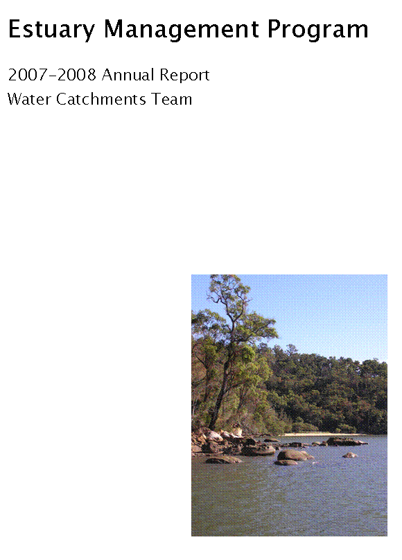
1 Lower Hawkesbury Estuary
The
Lower Hawkesbury River Estuary is a drowned river valley, which was incised
into Hawkesbury sandstone bedrock during the historical ice ages, when ocean
levels were much lower then present (WBM 2006).
The estuarine areas of the Hornsby Shire extend from the ocean entrance
at
Estuaries
are influenced by both fresh and salt water inputs, making them unique natural
areas. They provide a variety of
habitats that support plants and animals in a rich, diverse and highly
interrelated web of aquatic and terrestrial ecosystems (NSW Government,
1992). The ecology of the
The
catchment is unique in that the foreshore areas contain significant forested
areas with relatively little foreshore development. The majority of the foreshore and adjacent
land is national park (Kimmerikong, 2005).
The drowned river valley morphology, with steep sandstone slopes and
incised gorges has meant foreshore areas are largely only accessible by
boat. Those foreshores that are
relatively flat are mostly occupied by private development or natural mangrove
barriers. The large extents of national
park and the rivers steep topography have limited access and development of
foreshores, preserving the natural character and beauty of the estuary (BMT WBM
2008).
With its
tall, highly weathered vertical sandstone cliffs and gorges, open waterways,
secluded bays and expanse of natural vegetation the Lower Hawkesbury is on the
of the most visually spectacular waterways in NSW. The area is rich in both Aboriginal and
European heritage and its accessibility to the population of
The most
pressing issues facing the estuary as identified by the Berowra Creek and
Brooklyn Estuary Management Plans are: catchment runoff; discharge from boats,
sewage disposal; boating and tourism pursuits; aquaculture and fishing; marine
and catchment ecology and diversity; heritage and cultural values; the effects
of marina management; and wharf, jetty and shoreline development.
|
Hornsby Shire Council |
Attachment to Report No. EN38/08
Page 7 |
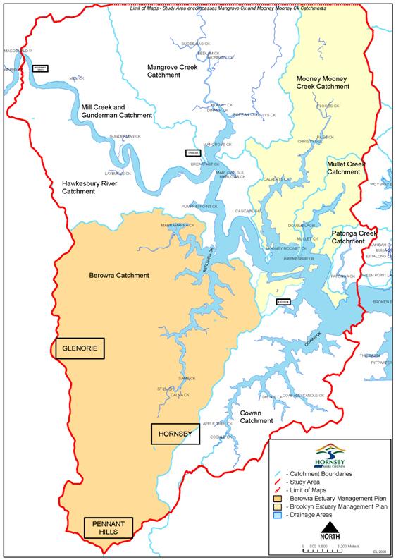
Figure 1: The Lower Hawkesbury Estuary
|
Attachment to Report
No. EN38/08 Page 8 |
2 Estuary Management Plans
2.1 NSW
Estuary Management Program
In
response to a growing concern for the state of
Estuary
program decisions and activities are carried out by individual EMCs consisting
of representatives from local and state government, residents, academic
institutions, industry and other estuary user-groups. Council currently facilitates the Lower
Hawkesbury EMC formed in March 2008 through the amalgamation of the former
Berowra Creek and Brooklyn EMCs. This
committee is responsible for overseeing the development and implementation of
the Lower Hawkesbury EMP, currently in draft form.
2.2 Berowra
Creek Estuary Management Plan
Implementation
of the Berowra Creek EMP began in 2002 following its adoption by Council. In 2007 the EMP was completed and a review
undertaken by consultants BMT WBM.
Outcomes
of the review show that of the 139 actions outlined in the Berowra Creek
EMP, an impressive 112 were implemented fully. Only 13 actions were not
implemented, of which a few were no longer relevant. In some cases the
implementation of the action has resolved the problem, and no further work is
required. More often, however, the actions require on-going commitment and
maintenance. Despite close to 100%
implementation of proposed actions, some issues still pose a threat to the health
and sustainability of Berowra Creek. Further, new aspects to some issues have
become apparent. (BMT WBM 2008)
There are many issues identified within Berowra Creek that are
relevant to the entire
2.3 Brooklyn
Estuary Management Plan
Implementation
of the Brooklyn EMP began in 2006 following its adoption by Council. The plan contains a list of recommended
strategies that have been designed and prioritised according to the goals and
objectives for the future of the Brooklyn Estuary, as agreed by the Brooklyn
EMC.
Goals
and objectives for the future management of the
1. for the Brooklyn estuary to contain healthy, diverse and viable
ecosystems
2. for the Brooklyn estuary to provide opportunity for a range of
ecologically and commercially sustainable estuary based industries
3. for the Brooklyn estuary to be a place of great recreational
value, with minimum impacts on the natural environment
4. for the Brooklyn estuary to have good sediment and water quality
which is compatible with aquaculture, ecosystem and human health requirements
5. for the riverside village atmosphere, scenic beauty and character
of the Brooklyn estuary to be enjoyed by residents and visitors now and in the
future
6. for the existing and future regulations and policies to be known,
understood and adhered to by visitors and residents of the Brooklyn estuary.
For each
goal, a series of specific objectives have been defined which describe
requirements necessary to achieve the goals for specific aspects of the
estuary. Associated strategies and
actions are implemented subject to available funding and resources. All projects reported on in this report are
outcomes of the Brooklyn EMP with relevant objective stated for each project
report.
2.4 Draft
Lower Hawkesbury Estuary Management Plan
A draft
Lower Hawkesbury EMP was developed during 2007/08. At the time of writing this report the plan
was open for public exhibition with the expectation that the plan be adopted by
Council in late 2008.
To
address the disparate nature of management on the
A series
of workshops were undertaken to engage the community and relevant stakeholders
in the development of the Lower Hawkesbury EMP.
During these workshops stakeholders were involved in:
- identifying stakeholder values
(assets) and issues related to the estuary
- identifying overarching goals,
visions, and objectives for the estuary
- assessing estuarine health risks
(related to defined issues) for their consequences on the assets and the
associated likelihood of these impacts
- evaluating and prioritising the
identified risks
- defining strategies and their
associated actions to treat priority risks
- determining target stakes of
risk reduction the actions are to achieve.
|
Attachment to Report
No. EN38/08 Page 10 |
3 Estuary Management Projects
3.1 Brooklyn
and Dangar Island STP Water Quality Monitoring
Objective 4.3 – Assess temporal trends and
variability in water and sediment quality in the estuary (WBM 2006).
The
Brooklyn &
In order
to detect potential impacts from the STP Council commenced a water quality
monitoring program in June 2006 collecting baseline water quality data prior to
the commencement of discharge from the STP outfall, located under
3.2 Calabash
Bay Remote Chlorophyll Monitoring Probe
Objective 1.3 – Develop a better understanding of
ecological indicators through monitoring and research to help guide management
decisions (WBM 2006).
Algal
blooms have historically been a problem in Berowra Creek, often causing
discolouration of the water and on occasion fish kills, especially around the
deeper waters at
During
periods of algal blooms, Council works in collaboration with the Regional Algal
Coordinating Committee (RACC), administered by the NSW Department of
Environment and Climate Change (DECC), to monitor the bloom and inform the
community of possible risks or estuary closures.
In
response to the issue of algal blooms in Berowra Creek, Council engaged the
Department of Commerce Manly Hydraulics Laboratory (MHL) in 2002 to deploy a
remote chlorophyll monitoring probe (YSI 6820 Sonde) at
Chlorophyll
levels in excess of 20µg/L are used as an indicator of a potential algal
bloom. If this level is exceeded a
warning is sent via email to Council officers who then follow the procedures
stipulated by the RACC. The last RACC notified, significantly elevated algae
concentrations in the area occurred in January 2007, there were no harmful
impacts from the minor bloom.
During
2007/08 the monitoring probe and buoy were upgraded to incorporate a
Photosynthetically Active Radiation (PAR) sensor to measure the amount of
sunlight entering the water and a thermistor chain to measure the water
temperature at 1m intervals from the surface of the water to the bottom of the
14m deep basin. An Acoustic Doppler
Current Profiler (ADCP) was also deployed from the buoy for a number of months
to collect current velocities in the area.
Data
collected by the probe is supplemented by monthly sampling of phytoplankton
species density and diversity and a range of other biological and
physico-chemical data. Maintenance of
the probe is undertaken every three weeks during the warmer months and every
four weeks during the cooler months by Council’s Water Catchments Team and MHL.
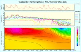
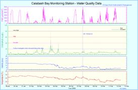
Figure 2:
Temperature, PAR, chlorophyll, and salinity data collected by the probe
for the period 29 January to 13 February 2008
Objective 3.4 – Provide adequate infrastructure for
passive recreational activities (WBM 2006).
In 2006
Council developed a Masterplan that provides direction to the future character,
use, development and management of the landscaped recreation areas of Crosslands
Reserve within the
The
Masterplan proposes a number of key improvements to the recreational and
environmental amenity and the management of pedestrian and vehicular
circulation on the site. Principle
improvements the Masterplan proposed include:
- Entry area improvements
- New riverside interpretation
walk
- Existing vehicular track removal
- Reorganisation and refurbishment
of the central carparking area
- Reorganisation of boat launching
ramp area
- Riverbank improvement works
- Improvement to visitor
amenities, including toilets, picnic and BBQ shelters
- Tree planting
Council completed detailed design, community
consultation and construction of the new electric BBQs, shelters,
riverside walk and improvements. Implementation of other stage 1 works has
commenced and should be completed by mid 2009. Funding has been derived
from a number of sources including the Hawkesbury Nepean Catchment Management
Authority (HNCMA), Sate Government Greenspace Grant and Council's Section
94 funds.
3.4 Dangar
Island Seagrass Protection and Education
Objective 3.1 – Conserve, and where possible
increase, the total areas of estuarine habitat (beyond natural variability) (WBM
2006).
This
program, funded by the HNCMA, has provided an opportunity for Council to engage
in community consultation and to work with government and community
stakeholders to address attitudes and behaviours which lead to potential damage
of the
The
seagrass bed south of
Activities
undertaken during this program included successful negotiations between the NSW
Maritime Authority and the NSW Water Ski Federation resulting in the 2008
Bridge to Bridge Ski Classic being undertaken with no detrimental impacts on
the seagrass beds. An education program
and art competition were held for students at Brooklyn Public School and two
community workshops were held on Dangar Island to inform the community of the
importance of healthy seagrass communities and provide ideas on how boating
activities can be carried out with minimal impact on seagrasses.
Recommendations
for future seagrass protection and education activities arising from the
program include:
1. Ensure future seagrass protection activities incorporate the Lower
Hawkesbury River as defined by the Lower Hawkesbury EMP
2. Establish a Seagrass Protection Partnership to facilitate future
seagrass protection in the Lower Hawkesbury River
3. Continue pro-active communication regarding the ecology of the
Lower Hawkesbury River
4. Establish an on-going community monitoring program for seagrass in
the Lower Hawkesbury River
The success of this program was
attributed to the exceptional community and agency support, in particular the
HNCMA, the NSW Maritime Authority, the NSW Water Ski Federation, the Central
Coast Community Environment Network and recreational fishing and boating clubs.
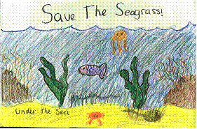
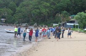
Figure 3: Artwork
from Brooklyn Public School Students Figure
4: Community workshop 2 on
3.5 Impacts
of Nutrients on Ecosystem Integrity
Objective 1.3 – Develop a better understanding of
ecological indicators through monitoring and research to help guide management
decisions (WBM 2006).
The
conservation of seagrasses and sustainability of fisheries is of major social
and economic concern in
Investigation
of trophic cascade effects that link nutrient pollution to the growth and
survivorship of seagrass and commercially important species will provide
knowledge crucial for improved future management of seagrass habitats. The primary outcome of this study will be a
model that can predict how changes in nutrient concentrations will influence
population dynamics of commercially important fish species supported by
seagrasses. This information has
therefore, direct relevance to managers of estuarine and coastal environments.
The
outcomes of the project will enable the accurate predication of impacts of
future nutrient loads on the growth and survivorship of seagrasses and
associated fish species. This
information will be invaluable for developing policy for water quality
guidelines, conserving seagrass and managing near-shore fisheries.
3.6 Integrated
Catchment Model
Objective 1.3 – Develop a better understanding of
ecological indicators through monitoring and research to help guide management
decisions (WBM 2006).
Council
has been monitoring water quality since October 1994 in order to measure long
term water quality trends as well as the impact of catchment activities and
remediation devices. To progress the catchment
modelling that was undertaken to support the implementation and assessment of
the Total Water Cycle Management Plan, Council has engaged Cardno Willing and
the
It is
envisaged that this modelling system will assist environmental managers in
making proactive management decisions by being able to predict environmental,
social and economic consequences and implications of the current management
strategies and decisions. This model
aims to address the relationship between policy decisions, environmental flows,
aquatic processes and ecological health.
The
intent of this project is to embed the processes that ultimately impact on the
estuary within policy/decision frameworks that lead to alteration of
environmental flows and pollutant loads.
Accordingly, for the management of these flows and loads an
appropriately constructed model is required to assist Council in identifying
sources, pathways, interactions and impacts of pollutants through the catchment
landscape and its waterways.
This
project is intended to add further knowledge to our understanding of catchment
and estuarine behaviour in response to human activities. Specifically, this model will provide
managers with an innovative tool whereby impacts to waterway health are
considered and internalised when natural resource, social and economic
decisions are being made.
3.7 Kangaroo
Point Vessel Pumpout Facility
Objective 3.1 – Ensure there is sufficient sold and
liquid waste management facilities for the volume of users of the
The
Kangaroo Point pumpout facility, funded by the (then) NSW Department of Land
and Water Conservation, was officially opened in November 2002. The facility was installed to enable boat
users to dispose of effluent in an environmentally acceptable manner and as a
practical solution to help restore water quality within the
To date,
the facility has collected over 1.1 million litres of effluent from both
commercial and recreational vessels operating on the
During
2007/08 the facility underwent major upgrades to increase the reliability of
the system and make it more user friendly.
Initially the facility required user codes to operate, this allowed
council to collect data on the volumes of effluent being collected and identify
commercial and recreational users. Since
the upgrades the system is operating on a start/stop operation and is free to
all users. The facility was connected to
the new
3.8 Predictive
Modelling for Algal Blooms
Objective 1.3 – Develop a better understanding of
ecological indicators through monitoring and research to help guide management
decisions (WBM 2006).
The
occurrence of algal blooms in the Berowra Creek estuary threatens both
recreational and commercial pursuits, as such and early warning algal bloom
program has been established. The
project will determine whether the issue of algal blooms can be addressed by
predicting blooms in advance using an Artificial Neural Network (ANN). The ANN will utilise data from an onsite real
time chlorophyll a probe and data from the Bureau of Meteorology (BOM). This project is the result of collaboration
between Hornsby Shire Council, Manly Hydraulics Laboratory and the
This
project will fill knowledge gaps for Council with regard to understanding algal
bloom processes and mitigation. In
addition, it will provide managers with an opportunity to undertake proactive
management strategies by being forewarned of an impending algal bloom, rather
than reactive management, by responding to algal blooms only when they
occur. In being able to forecast algal
bloom concentrations it is envisaged that Hornsby Council will apply the
information to:
- Improve monitoring efficiency,
by monitoring only when problematic concentrations occur
- Inform recreational users of
potential public health risks
- Inform oyster growers of
potential bloom concentrations
- Determine which environmental
conditions are most dominant in causing problematic algal concentrations.
3.9 QX
Disease and the oyster industry
Objective 2.2 – Provide support to the commercial
fishing and oyster industry to help ensure their long term viability (WBM 2006).
QX
disease, named after the state in which it was thought to originate, is a
parasitic infection specific to Sydney Rock oysters cause by the protozoan
parasite Marteilia sydneyi. In 2004 QX disease decimated both cultivated and
natural populations of
Since
this time, Council and Broken Bay Oysters farmers have collaborated to
undertake monitoring identifying the time of year that oysters become infected
with QX disease in the
![]()
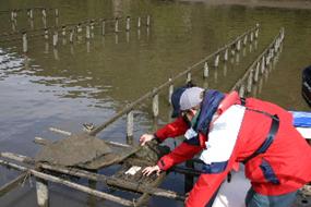
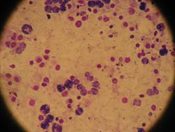
Figure 5: Deploying/collecting and processing control
oysters Figure 6: QX
disease cell at 400x magnification
![]()
Every
three weeks a basket of control (QX free) oysters from the Shoal Haven are
deployed in the
Data
collected during the 2007/08 monitoring period indicates that oysters were
infected with QX during a 15 week period, from 9th January to 3rd April
2008. This is earlier in the year and
approximately 3 weeks longer than the 2006/07 Window of Infection period (22nd
February to 26th April 2007).
|
PERIOD |
DATE DEPLOYED |
PERCENTAGE OF CONTROL OYSTERS
INFECTED (%) |
|||||||
|
1 |
28-Nov-07 |
0 |
|
|
|
|
|
|
|
|
2 |
19-Dec-07 |
18 |
|
|
|
|
|
|
|
|
|
09-Jan-08 |
|
70 |
|
|
|
|
|
|
|
4 |
30-Jan-08 |
|
|
60 |
|
|
|
|
|
|
5 |
20-Feb-08 |
|
|
|
1 |
|
|
|
|
|
6 |
13-Mar-08 |
|
|
|
|
52 |
|
|
|
|
7 |
03-Apr-08 |
|
|
|
|
|
0 |
|
|
|
8 |
24-Apr-08 |
|
|
|
|
|
|
To be analysed |
|
|
9 |
14-May-08 |
|
|
|
|
|
|
|
|
|
|
|
|
|
|
|
|
|
|
|
|
|
Window of infection period for 2007/2008 |
||||||||
3.10 Recreational
Fishing Infrastructure
Objective 2.3 – Provide appropriate infrastructure
for the boating and tourism industry (WBM 2006).
To
improve visual amenity, hygiene and functionality Council obtained funding from
the NSW DPI to upgrade the fish cleaning table located at
TAngler bins have also been installed at
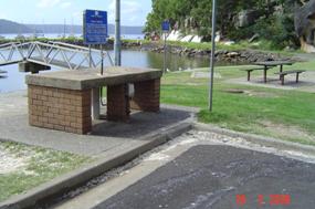
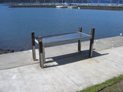
Figure 7:
The old concrete fish cleaning table Figure 8: The new stainless steel fish cleaning table
3.11 Removal
of Derelict boats from Sandbrook Inlet
Objective 3.7 – Remove abandoned and derelict
vessels from the
Council
is working in collaboration with the HNCMA on an estuary clean up program,
removing a number of derelict boats from within Sandbrook Inlet. The NSW
Maritime Authority, DPI and DECC are also partaking in the project, funded by
the National Heritage Trust and the NSW Estuary Program.
Vessels
abandoned on our foreshores potentially threaten local river health by
restricting the connectivity of estuarine habitats including mangrove stands,
saltmarsh communities and mudflats. The
vessels are also a source of pollution, releasing residual fuel, contaminated
bilge water, rust, heavy metals and other toxicants to the waterway as the
vessels perish. Removal of these vessels
will aid in restoring the scenic amenity of this area, particularly along the
foreshore of Long Island Nature Reserve.
To
acknowledge the historical significance of the vessels, in particular MV
Surprise II, Council will salvage part of the vessel to display in the
area. MV Surprise was one of the last
vessels to be used to transport fruit and vegetables along the
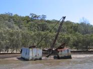
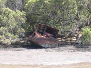
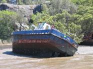
Figure 9: Derelict boats to be removed form
Sandbrook Inlet,
3.12 River
Settlements and Foreshores Review
Objective 5.1 –
Insure that future development is consistent with the nature, scale and scenic
quality guidelines in SREP 20 (WBM 2006).
The purpose of the River Settlements and Foreshores
Review was to examine the suitability of current planning controls for
maintaining the qualities of the river settlements and foreshores of Hornsby
Shire, with regard to emerging issues (
The Review makes recommendations concerning
amendments to the planning controls which apply to the river settlements. The recommendations include rezoning
residential properties on
To assist in minimising impacts on the natural and
built environment, the Review recommends that additional planning controls be
drafted. These include requirements for the
design of roof forms, undercrofts, landscaping, boatsheds, seawalls, stairs and
fencing, as well as identification of acceptable colours, materials and
finishes.
The Review was on public exhibition from May to
August 2007. In June 2008, after consideration
of submissions, Council resolved to prepare amendments to planning controls
which would:
- Permit, with development
consent, short term accommodation and bed and breakfast accommodation across
all river settlements;
- Rezone residential
properties on Dangar Island to the Environmental Protection E (River
Settlement) zone;
- Reduce the floor space
ratio in the Environmental Protection E zone from 0.4:1 to 0.3:1; and
- Specify a minimum
Foreshore Building Line for Dangar Island.
Council has forwarded the proposed amendments to
planning controls to the Department of Planning for certification for
exhibition. Once certified, the proposed amendments will be placed on public
exhibition.
Council also resolved to prepare a new River
Settlements Development Control Plan (DCP), consolidating the existing DCPs
applying to the river settlements and incorporating additional planning
controls to assist in minimising impacts on the natural and built environment.
The new DCP is currently being prepared and will be presented to Council for
endorsement for exhibition.
The remaining recommendations of the River
Settlements Review will be considered as part of a longer term review of
Council’s planning controls, in the preparation of Council’s Comprehensive
Local Environmental Plan, required to be finalised by 2011.
Council was successful in
obtaining over $170 000 in grant monies during the 2007/08 financial year from
various state and federal government agencies.
The primary sources of funding for the Estuary Management Program are
the NSW DECC and the HNCMA who are responsible for distributing National
Heritage Trust (NHT) funds.
Council will continue to seek
grant funding to continue the implementation of the Brooklyn EMP and the
proposed Lower Hawkesbury EMP as the opportunities arise.
|
Attachment to Report
No. EN38/08 Page 19 |
5 Acronyms
ADCP Acoustic Doppler Current Profiler
ANN Artificial Neural Network
BOM Bureau of Meteorology
DCP Development Control Plan
DECC NSW Department of Environment and Climate Change
DPI NSW Department of Primary Industries
EMC Estuary Management Committee
EMP Estuary Management Plan
HNCMA Hawkesbury Nepean Catchment Management Authority
MHL NSW Department of Commerce Manly Hydraulics
Laboratory
NHT National Heritage Trust
NHT National Heritage Trust
PAR Photosynthetically Active Radiation
RACC Regional Algal Coordinating Committee
STP Sewerage Treatment Plant
UTS
BMT WBM, 2008.
Draft Lower Hawkesbury Estuary
Management Plan. BMT WBM
Hornsby Shire Council (HSC), 2008. Water
Quality Monitoring Program Annual Report. Hornsby Shire Council,
Kimmerikong, 2005. Scoping Study:
NSW Government, 1992. Estuary
Management Manual. Crown Copyright,
WBM Oceanics