BUSINESS PAPER
Planning Meeting
Wednesday, 17 December, 2008
at 6:30 pm
|
Hornsby
Shire Council
|
Table of Contents
|
|
Page
1
|
|
|
|
|
TABLE OF CONTENTS
AGENDA AND SUMMARY OF RECOMMENDATIONS
Mayoral Minutes
Notices of Motion
Rescission Motions
MATTERS OF URGENCY
ITEMS PASSED BY
EXCEPTION / CALL FOR SPEAKERS ON AGENDA ITEMS
DEVELOPMENT
APPLICATIONS
A Ward Deferred
A Ward
Item 1 PLN241/08 Development Application - Aged or
Differently Abled Persons Housing
2A Manor Road,
Hornsby
Item 2 PLN244/08 Construction of a Scout/Guide
Hall
Lot 50 DP 739713, No. 1X Mountside
Avenue, Mount
Colah
Item 3 PLN248/08 Development Application - Retirement Village (Glenhaven Green)
599 - 607 Old Northern Road Glenhaven
B Ward Deferred
Item 4 PLN247/08 Development Application -
Alterations and additions to an existing community facility and use by the
'Hornsby Woodworking Men's shed'
Headen Park 3X Sinclair Avenue, Thornleigh
B Ward
C Ward Deferred
C Ward
Item 5 PLN237/08 Development Application -
Multi-unit housing development comprising two dwellings and subdivision
23 Hills Avenue, Epping
Item 6 PLN239/08 Erection of a Dwelling-house on a
Battle-axe
Allotment Proposed Lot 11, 66 & 68
Castle Howard Road Beecroft
Item 7 PLN240/08 Erection of a dwelling-house on a
battle-axe allotment
Proposed Lot 12, 66-68 Castle Howard Road, Beecroft
General Business
Item 8 PLN245/08 Consideration of Draft
Environmental Planning Instruments - Department of Planning Circular
Item 9 PLN246/08 Strategic Planning Programme
Review - 2009
SUPPLEMENTARY AGENDA
Question of Which Notice Has Been Given
QUESTIONS WITHOUT
NOTICE
|
Hornsby Shire Council
|
Agenda and Summary of
Recommendations
|
|
Page
1
|
|
|
|
|
AGENDA
AND SUMMARY OF RECOMMENDATIONS
PRESENT
NATIONAL ANTHEM
OPENING PRAYER/S
Acknowledgement of RELIGIOUS DIVERSITY
Statement by the Chairperson
“We
Recognise our
Shire's rich cultural and religious diversity and we acknowledge and pay
respect to the beliefs of all members of our community, regardless of creed or
faith."
ABORIGINAL RECOGNITION
Statement by the
Chairperson:
"We recognise the
traditional inhabitants of the land we are meeting on tonight, the Darug and
Guringai Aboriginal people, and respect is paid to their elders and their
heritage."
AUDIO RECORDING OF COUNCIL MEETING
Statement by the Chairperson:
"I advise all present that tonight's meeting
is being audio recorded for the purpose of assisting in the accuracy of the
Minutes. The recordings may be accessed
by members of the public once the Minutes have been finalised and speakers are
requested to ensure their comments are relevant to the issue at hand and
refrain from making personal comments or criticisms."
APOLOGIES
declarations of interest
Clause 52 of Council’s
Code of Meeting Practice (Section 451 of the Local Government Act, 1993)
requires that a councillor or a member of a Council committee who has a
pecuniary interest in a matter which is before the Council or committee and who
is present at a meeting of the Council or committee at which the matter is
being considered must disclose the nature of the interest to the meeting as
soon as practicable. The disclosure is
also to be submitted in writing (on the form titled “Declaration of Interest”).
The Councillor or
member of a Council committee must not be present at, or in sight of, the
meeting of the Council or committee:
(a) at
any time during which the matter is being considered or discussed by the
Council or committee.
(b) at
any time during which the Council or committee
is voting on any question in relation to the matter.
Clause 51A of
Council’s Code of Meeting Practice provides that a Councillor, Council officer,
or a member of a Council committee who has a non pecuniary interest in any
matter with which the Council is concerned and who is present at a meeting of
the Council or committee at which the matter is being considered must disclose
the nature of the interest to the meeting as soon as practicable. The disclosure is also to be submitted in
writing (on the form titled “Declaration of Interest”).
If the non-pecuniary
interest is significant, the Councillor must:
a) remove
the source of conflict, by relinquishing or divesting the interest that creates
the conflict, or reallocating the conflicting duties to another Council
official.
OR
b) have
no involvement in the matter by absenting themself from and not taking part in
any debate or voting on the issue as if the provisions of Section 451(2) of the
Act apply.
If
the non-pecuniary interest is non-significant, the Councillor must provide an
explanation of why they consider that the interest does not require further
action in the circumstances.
Political
Donations Disclosure
Statement by the Chairperson:
“I advise all present that a Political Donations
Disclosure Statement pursuant to Section 147(3) of the Environmental Planning
and Assessment Act 1979 must be made in the event that a person has made or a
Councillor or political party has received a gift or political donation
from any person or organisation, including a person or organisation making a submission
to an application or other planning matter, listed on the Planning Meeting
agenda.”
confirmation of minutes
THAT the Minutes of
the Planning Meeting held on 3 December, 2008 be confirmed, a copy having been
distributed to all Councillors.
petitions
Mayoral Minutes
Notices of Motion
Rescission Motions
MATTERS
OF URGENCY
ITEMS
PASSED BY EXCEPTION / CALL FOR SPEAKERS ON AGENDA ITEMS
Note:
Persons
wishing to address Council on matters which are on the Agenda are permitted to
speak, prior to the item being discussed, and their names will be recorded in
the Minutes in respect of that particular item.
DEVELOPMENT
APPLICATIONS
A
Ward Deferred
A
Ward
Page Number
Item 1 PLN241/08 Development Application - Aged or Differently
Abled Persons Housing
2A Manor Road,
Hornsby
THAT development
application DA/928/2007 at Lot 12 DP 1079875 (No. 2A) Manor Road,
Hornsby be approved subject to the conditions of consent detailed in Schedule 1 of this report.
Page Number
Item 2 PLN244/08 Construction of a Scout/Guide Hall
Lot 50 DP 739713, No. 1X Mountside
Avenue, Mount
Colah
THAT Development Application No.
1320/2008 for construction of a Scout/Guide Hall at Lot 50 DP 739713, No. 1X Mountside Avenue, Mount Colah
be approved subject to conditions of consent detailed in Schedule 1 of the
independent town planning consultant’s report – Nexus Environmental Planning
Pty Ltd.
Page Number
Item 3 PLN248/08 Development Application - Retirement Village
(Glenhaven Green)
599 - 607 Old Northern Road Glenhaven
THAT
Development Application No. 1709/2007 for the construction of a Retirement Village (Glenhaven Green) comprising 154
independent living units, community facility and ancillary works at Lot 2 DP
1123753 (No. 599 – 607) Old
Northern Road, Glenhaven be approved subject to
the conditions of consent detailed in Schedule 1 of this report.
B
Ward Deferred
Page Number
Item 4 PLN247/08 Development Application - Alterations and
additions to an existing community facility and use by the 'Hornsby Woodworking
Men's shed'
Headen Park 3X Sinclair Avenue, Thornleigh
THAT Development Application No.
542/2008 for alterations and additions to an existing community facility and
use of that facility by the ‘Hornsby Woodworking Men's Shed’ at Lot 47, DP
35569, No. 3X, Sinclair Avenue,
Thornleigh (Headen
Park) be approved subject
to conditions of consent detailed in Schedule 1 of this report.
B
Ward
C
Ward Deferred
C
Ward
Page Number
Item 5 PLN237/08 Development Application - Multi-unit housing
development comprising two dwellings and subdivision
23 Hills Avenue, Epping
THAT Development Application No.
DA/1201/2008 for the erection of a two storey multi-unit development comprising
two attached dwellings and subdivision of one lot into two lots at lot 19 DP
30584 (No. 23) Hills Avenue Epping be approved subject to conditions of consent
detailed in Schedule 1 of this report.
Page Number
Item 6 PLN239/08 ERECTION OF A DWELLING-HOUSE ON A BATTLE-AXE
ALLOTMENT
PROPOSED LOT 11, 66 & 68 CASTLE HOWARD ROAD BEECROFT
THAT Development Application No.
585/2008 at Lot Z DP 385117, Lot B DP 363878,
66-68 Castle Howard Road, Beecroft be
approved, subject to the conditions of consent detailed in Schedules A and B of
this report.
Page Number
Item 7 PLN240/08 Erection of a dwelling-house on a battle-axe
allotment
Proposed Lot 12, 66-68 Castle
Howard Road, Beecroft
THAT
Development Application No. 585/2008 at Lot Z DP 385117, Lot B DP 363878, 66-68 Castle Howard Road,
Beecroft be approved, subject to the conditions of consent detailed in
Schedules A and B of this report.
GENERAL BUSINESS
·
Items for
which there is a Public Forum Speaker
·
Public
Forum for non agenda items
·
Balance
of General Business items
Page Number
Item 8 PLN245/08 Consideration of Draft Environmental Planning
Instruments - Department of Planning Circular
THAT Council make representations to the Department of Planning:
A. Raising
concerns that the implementation of planning circular PS 08-013 will undermine
Council’s strategic framework for the establishment of heritage conservation
areas.
B. Requesting
that draft LEPs for proposed heritage conservation areas at East Epping and Essex Street
(Amendment No. 76), Mount
Errington (Amendment No.
84) and Rosebank Avenue
(Amendment No. 86) be gazetted as a matter of urgency.
Page Number
Item 9 PLN246/08 Strategic Planning Programme Review - 2009
THAT:
1. The 2009/2010 Strategic Planning Programme
attached to Executive Manager’s Report No. PLN246/08 be adopted.
2. A
six monthly report be prepared for Councillors providing an update on the
Strategic Planning Programme.
3. A
Workshop with Councillors be conducted to discuss the 2009/2010 Strategic
Planning Programme and Council priorities for strategic planning over the
current Council term.
SUPPLEMENTARY
AGENDA
CONFIDENTIAL
ITEMS
QUESTIONS
OF WHICH NOTICE HAS BEEN GIVEN
QUESTIONS
WITHOUT NOTICE
Planning Report No. PLN241/08
Date of Meeting: 17/12/2008
1 DEVELOPMENT APPLICATION - AGED OR DIFFERENTLY
ABLED PERSONS HOUSING
2A MANOR ROAD,
HORNSBY
|
Development
Application No:
|
928/2007
|
|
Description
of Proposal:
|
Construction of an aged or
differently abled persons housing development comprising 91 units with
basement car parking and alterations and additions to Mount Wilga House
(heritage item) for use as ancillary communal facilities
|
|
Property
Description:
|
Lot 12 DP 1079875 Manor Road,
Hornsby
|
|
Applicant:
|
Austcorp Project No 1 Pty Ltd
|
|
Owner:
|
Austcorp Project No 1 Pty Ltd
|
|
Statutory Provisions:
|
Hornsby Shire LEP 1994 (Special Uses A (Community
Purposes))
SEPP (Housing for Seniors or People with a Disability)
2004
SEPP 65 Design Quality of Residential Flat Development
|
|
Estimated
Value:
|
$38,126,617
|
|
Ward:
|
A
|
RECOMMENDATION
THAT development
application DA/928/2007 at Lot 12 DP 1079875 (No. 2A) Manor Road,
Hornsby be approved subject to the conditions of consent detailed in Schedule 1 of this report.
EXECUTIVE SUMMARY
1. The application
proposes the staged construction of housing
for aged or differently abled persons comprising five buildings ranging in
height from 2 to 4 storeys incorporating 91 self care units and alterations and
additions to Mt Wilga House and its use as an ancillary communal facility.
2. The application was
previously considered by Council at its Planning Meetings of 15 October 2008
and 5 November 2008.
3. The property was
previously approved for 79 self care aged housing units in five buildings
ranging in height from 2 to 5 storeys, under SEPP No. 5 pursuant to
DA/2355/1999. The approved development
has physically commenced.
4. The proposal complies
with the provisions of the Hornsby Shire Local Environmental Plan that permits ‘housing for aged or differently abled
persons’ on the property. The proposal
also generally complies with SEPP (Housing for Seniors or People with a
Disability) 2004 and SEPP 65 Design Quality of Residential Flat Development.
5. It is recommended that
the application be approved.
HISTORY OF THE
APPLICATION
On 15 October 2008 Council refused Development Application
No.928/2007 on the grounds that the applicant has failed to demonstrate that it would not have an
adverse traffic, parking, bushfire hazard and amenity impact on the
neighbouring residents. A
recision motion was subsequently lodged.
Council at its Planning Meeting of 5 November 2008 adopted
the rescission motion and subsequently resolved to defer the determination of
the Development Application No.928/2007 to
allow Council to convene a meeting, chaired by the Mayor, involving the
Applicant, Councillors and concerned residents, to address the following
issues: traffic, parking, bushfire
hazard, amenity, number of units, density and FSR of the development on the
allotted space, height of the buildings (especially the perceived height and topography of the ridge on which
the development is to take place), set back, and aesthetic impact of the
buildings in relation to other surrounding properties.
On 20 November 2008 a meeting was
held with Councillors, the applicant and two representatives of the Mount Wilga
Neighbourhood Group. There was no
agreement reached between the applicant and the residents at this meeting. Ultimately, Council has a statutory
obligation to determine the development application. The Mayor subsequently wrote to all residents
previously notified and those objecting to the application advising them of the
outcome of the meeting. (Refer to
Attachment 7).
HISTORY OF THE SITE
The site was used as a residential property between
1907-1952, as a Commonwealth Government rehabilitation hospital between
1952-1987, a private rehabilitation hospital between 1987-1990 and as a Buddist Temple and administration centre between
1990-1999.
On 24 February
2000, Council approved Development Application No. 2355/1999 for a “Five stage development comprising housing
for older people or people with a disability (retirement village consisting of
81 residential units), parking for 127 vehicles, an associated recreation
facility, refurbishment and ancillary use of the existing Mt Wilga Heritage
building, and the demolition of other existing buildings”. Thereafter in 2003, the application was
amended to delete two approved units.
In 2004
demolition work was undertaken on the property pursuant to DA No.
2355/1999. A letter from Council’s
Executive Manager Planning Division to Austcorp dated 2 July 2004 confirmed in
relation to DA No. 2355/1999 that “in
view of the demolition works completed on the site it is considered the
development consent has been physically commenced.”
On 11 July
2007 the current development application No. 928/2007 was submitted to the
Council. On 12 November 2007 the
application was amended. The amendments
included reduction of the building bulk on Buildings A, C and E adjacent to Manor Road and the
erection of an additional storey on Building D adjacent to Mt Wilga Private Hospital. This resulted in an overall increase in the
total number of units from 88 to 91.
THE SITE
Description
The 2.31
hectare site at 2A Manor Road Hornsby is an irregular shaped property, bounded
by Manor Road
and Rosamond Street
to the south and east, and by Mt Wilga private hospital to the north. The property is located approximately 1.6 km
to the north-west of the Hornsby Town Centre and train station, within a predominantly
low density residential area.
The site has a frontage of 420
metres to Manor Road
and Rosamond Street,
a variable common northern boundary of 285 metres with Mt Wilga Private Hospital
and an 85 metre western boundary with a private residential access
road/driveway. Primary access to the
site is via a driveway from Rosamond
Street, adjacent to Mt Wilga Hospital. There are currently two other vehicular entry
points from Manor Road
in the south of the site.
The property
is sited on the apex of a long ridge with views to the surrounding area. Mt Wilga House is located near the centre of
the site in an elevated position. From
this central position, the site’s topography falls down towards the eastern,
southern and western property boundaries with an average gradient of 12% to
18%.
The property contains Mt Wilga
House which is a heritage item of regional significance. This building comprises a two storey masonry
and tile building with a hipped and pitched roof and a ground floor balcony. In September 1987 a Permanent Conservation
Order under the Heritage Act was established in respect of the property. The heritage listing identifies a curtilage
around Mt Wilga House of approximately 1.2 hectares, which is located over the
eastern half of the site.
Part of the adjacent Mt Wilga
Hospital buildings encroach over the common northern boundary. The encroachments include a disused waiting
room, a covered pedestrian walkway and eaves/awnings to a rehabilitation building.
The grounds
around Mt Wilga House are landscaped with grassed lawns, interspersed with
mature trees and lower vegetation. A
significant stand of trees is located on the southern side of the site
adjoining Manor Road. The property’s landscaped grounds also
include a disused tennis court in the south-eastern corner.
The area to be developed drains
to the south towards Manor Road. From Manor Road stormwater drains to the south
via an existing drainage easement between Nos. 25 and 27 Manor Road or alternatively via an
easement between Nos. 37 and 39
Manor Road. The site is burdened by a number of
drainage easements that benefit Mt
Wilga Private Hospital. These drainage easements also discharge to
the south over Manor Road. These drainage easements are no longer in
use. In this regard DA No.1225/2003 for
the expansion of Mt Wilga Hospital included an on-site detention system that
discharges stormwater to the north.
Approximately 30% of the site is
identified as bushfire prone in the south of the site.
Mt Wilga Private Hospital
to the north comprises a series of one and two storey masonry buildings. The
site’s western boundary adjoins a 6 to 9 metre wide residential
driveway/s. To the west of the driveway
is four detached 1 to 2 storey residential dwellings. The site is surrounded by
a low-density residential neighbourhood.
The area contains detached residential dwellings generally ranging in
height from one to two storeys.
THE PROPOSAL
The proposal
seeks consent for the staged construction of housing
for aged or differently abled persons comprising five residential flat
buildings ranging in height from 2 to 4 storeys including 3 x 1 bedroom units, 76 x 2 bedroom units and 12 x 3
bedroom units (total of 91 units). In
addition, alterations and additions are proposed to Mr Wilga House and
use of the heritage item for communal facilities ancillary to the aged housing
development. A total of 184 parking
spaces are provided and accessed via the site’s primary driveway from Rosamond Street and
a secondary driveway from Manor
Road.
The Development Components are summarised in the following:
|
Development Component
|
Description
|
|
Basement
|
182 car parking spaces comprising:
* 71
double residential spaces,
* 20
single residential spaces,
* 19
visitor/ staff spaces, and
* 1
caretaker’s space.
1 community
bus bay,
1 double car
wash bay, and
garbage
storage rooms.
|
|
Building A
- storeys
- ceiling height
- unit mix
- floor area
|
- 3 storeys
- 6 to 10.6 metres
- 14 x 2-bed units, 2 x 3-bed units (Total 16 units)
- 1945sqm
|
|
Building B
- storeys
- ceiling height
- unit mix
- floor area
|
- 3 storeys
- 9 metres
- 12 x 2-bed units, 2 x 3-bed units. (Total 14 units)
- 1709sqm
|
|
Building C
- storeys
- ceiling height
- unit mix
- floor area
|
- 3 storeys
- 7.3 to 10 metres
-14 x 2-bed units, 2 x 3-bed units. (Total 16 units)
- 1911sqm
|
|
Building D
- storeys
- ceiling height
- unit mix
- floor area
|
- 4 storeys
- 11.9 metres
-20 x 2-bed units, 2 x 3-bed units. (Total 22 units)
- 2602sqm
|
|
Building E
- storeys
- ceiling height
- unit mix
- floor area
|
- 2 to 4 storeys
- 4.2 to 11.5 metres
- 3 x 1-bed units, 16 x
2-bed units, 4 x 3-bed units. (Total 23
units)
- 2899sqm
|
|
Mt Wilga House
|
multi-purpose recreation facility for the residents,
meeting rooms,
Doctors rooms,
a one bedroom caretakers residence and
2 car parking spaces (at grade).
|
|
Total gross floor area
|
11659sqm
|
|
Site Coverage
|
24%
|
|
Total Communal landscaping
|
68%
|
|
Deep Soil Zone
|
58%
|
|
Private Open Space per unit
|
12
to 62sqm (average 25sqm)
|
The
development is proposed to be constructed in five stages as follows:
Stage A:
· Alterations and additions to Mt Wilga House;
· Upgrade vehicular and pedestrian links from Rosamond Street to
Mt Wilga House;
· Construct Building A and associated basement parking (7 double
and 9 single spaces);
· Two temporary visitor parking spaces are on
land to be developed as stage C;
· Vehicular access to the Building A basement
via the secondary access to Manor
Road;
· Waste collection is to occur from the new
waste collection area near Mt Wilga House.
The caretaker is to transfer bins from the basement waste rooms. Waste vehicles are to collect from the
internal round-a-bout;
· Stage
A stormwater management is to include the permanent downstream system through
Stage B and E onto and down Manor
Road.
Stormwater is to drain in a westerly direction along Manor Road, and
thereafter flow to the existing drainage channel easement between Nos. 37 and
39 Manor Road; and
· Bulk earthworks for Stages A to E.
Stage B:
· Construct Building B, the basement ramp and
part of the basement parking (17 double and 1 single residential spaces, 12
visitor spaces, 1 caretakers space); and
· Landscaping of the rear yard (west) of Mt
Wilga House including the loop path.
Stage C:
· Construct Building C;
· Expansion of the basement, incorporating an
internal driveway linking the Rosamond
Street and Manor Road driveways; and
· Additional basement parking (21 double and 3
single residential spaces, 7 staff/visitor spaces and 1 vehicle car wash-bay).
Stage D:
· Construct Building D; and
· Additional basement parking (14 double and 2
single residential spaces).
Stage E:
· Construct Building E; and
· Completion of the basement parking (15 double
and 1 single residential spaces).
A comparison of the approved and proposed development is
summarised in the table below:
|
Development
Component
|
Approved (DA/2355/99/A)
|
Proposed
(DA/928/07)
|
Net Change
|
|
Total Units
|
79
|
91
(+ 1 caretaker unit)
|
+ 12units
|
|
Aged Housing
Unit Mix
|
13 * 2 bed
66 * 3 bed
|
3 * 1 bed
76 * 2 bed
12 * 3 bed
|
+ 3 * 1 bed
+ 63 * 2 bed
- 54 * 3 bed
|
|
Total Bedrooms
(including studies)
|
224
|
191
|
15% reduction
|
|
On-site parking
|
115 residential
23 visitor/staff
138 total
|
162 residential
22 visitor/staff
184 total
|
33% increase
|
|
FSR
|
0.52:1
|
0.504:1
|
Similar
|
|
Site Coverage
|
24%
|
24%
|
Similar
|
ASSESSMENT
The development application has been assessed having regard
to the ‘2005 City of Cities Metropolitan Strategy’, the ‘North Subregion (Draft) Subregional
Strategy’ and the matters for consideration prescribed under Section 79C of
the Environmental Planning and Assessment
Act 1979 (the Act). Subsequently,
the following issues have been identified for further consideration.
1. STRATEGIC CONTEXT
1.1 Metropolitan Strategy – (Draft) North
Subregional Strategy
The Metropolitan Strategy is a broad framework to secure Sydney’s place in the
global economy by promoting and managing growth. It outlines a vision for Sydney to 2031; the challenges faced, and the
directions to follow to address these challenges and achieve the vision. The draft North Subregional Strategy acts as
a framework for Council in the preparation of a new Principal LEP by 2011.
The draft Subregional Strategy sets the following targets
for the Hornsby LGA by 2031:
· Employment capacity to increase
by 9,000 jobs; and
· Housing stock to increase by
11,000 dwellings.
The proposed development would be consistent with the draft
Strategy by providing an additional 91 aged care dwellings and would improve
housing choice in the locality.
2. STATUTORY CONTROLS
Section 79C(1)(a) requires Council to consider any relevant
environmental planning instruments, draft environmental planning instruments,
development control plans, planning agreements and other prescribed matters.
2.1 Hornsby Local Environmental Plan 1994
The subject land is zoned Special Uses A (Community
Purposes) Zone under Hornsby Local Environmental Plan 1994 (HSLEP). The objectives of the Special Uses zone are:
(a) to provide for the cultural needs of the community,
(b) to identify land for the provision of
community services and facilities,
(c) to ensure that community
uses are compatible with the amenity of the area in which they are located.
The proposed development is not inconsistent
with the zone objectives.
The proposed development is defined as ‘housing for aged or differently abled persons’ under HSLEP and is
permissible in the zone with Council’s consent.
There is no floor space ratio (FSR) development standard in Clause 15 for the
Special Uses A zone.
Clause 18 of HSLEP sets out
heritage conservation provisions within the Hornsby area. The property at 2A Manor Road is
identified on Schedule D of the LEP as a heritage item of regional
significance. Pursuant to Clause 18(6)
the Council must not determine a development application until it has
considered a conservation plan for the item.
A conservation plan was prepared by Godden Mackay Logan dated June
2006. The development application was
referred to the NSW Heritage Council and Council’s Heritage Committee that
raised no objection to the proposal.
2.2 State Environmental Planning Policy (Housing for
Seniors or People with a Disability) 2004
The application was lodged with
the Council on 11 July 2007 and seeks consent for the use of the premises for “multi-unit access for life residential
dwelling complex for independent aged persons of all mobility levels.” At the time the application was lodged, the
provisions of SEPP (Seniors Living) 2004 did not apply to the site as Clause 4
of the Policy did not apply to properties identified as bushfire prone land or
properties listed on the State Heritage register. Rather, Council was able to consider the
application under the provisions of the Hornsby Shire LEP 1994 that permits ‘housing
for aged or differently abled persons’ with consent in the Special Uses A
zone.
Amendment No. 2
to SEPP (Seniors Living) commenced on 14 October 2007. At that time the SEPP was modified and
renamed SEPP (Housing for
Seniors or People with a Disability) 2004.
The modified SEPP now applies to land identified as bushfire prone and
listed on the State Heritage register.
However, the savings provisions in Clause 53 of the SEPP (Housing for
Seniors) are not applicable to the application as this only relates to a development
application made pursuant to chapter 3.
The applicant submitted modified plans in November
2007 and clarified that the application was not being lodged pursuant to SEPP
(Housing for Seniors) 2004.
The SEPP (Housing for Seniors or People with a Disability)
2004 only applies to a development application made pursuant to the policy
itself. This is reflected in chapter 3
of the Policy where most of the clauses contained within that chapter are
worded as follows:
“A consent authority must not consent to a development application made
pursuant to this chapter…”
The application is required to be assessed having
regard to the relevant provisions contained with Hornsby Shire LEP 1994
relating to development for ‘housing for
aged or differently abled persons’ within the meaning of the definition in
HSLEP. The Housing for Seniors SEPP is a
relevant consideration as part of the assessment and must be taken into
consideration pursuant to section 79C of The Act. However, as the development application is
not being made pursuant to the SEPP, any non compliances with the standards
contained in the Policy do not give rise to the need for the lodgement of a
SEPP 1 objection. The SEPP is a matter
for consideration and some weight needs to be given to the Seniors Policy in
the determination of the application.
The
assessment of the proposal in accordance with the relevant requirements of SEPP
(Housing for Seniors), is commented on as follows:
· Clause 26 Location
and access to facilities
The
Policy requires a public transport service to be available within 400 metres of
the site, with suitable gradients along the access route.
Shorelink Bus Service ‘Route 595’ (Mills Avenue and Pacific Highway to Hornsby Station)
services the area. The closest bus stop
is located on the south side of Carrington
Road near the Rosamond Street intersection, 200 metres
from the site’s main entrance driveway.
The bus stop on the northern side of Carrington Road is 250 metres from the
site. This pedestrian route is a
relatively flat footpath 1.2 metres wide along most of the route along Rosamond Street. The gradient of the footpath to the bus stop
along Carrington Road
is 6%, which is accessible. Appropriate
conditions are proposed to require upgrading works to the footpath where necessary.
The
application also proposes to provide a dedicated ‘shuttle bus’ for the use of
residents in addition to the existing public bus service. The shuttle bus would be used for trips for
residents between the site and local services (i.e. shops and medical
facilities) and for special day trip outings.
Appropriate conditions are proposed to ensure compliance with this
proposal.
The
access arrangements for the development are appropriate.
· Clause 27 Bush
fire prone land
The
development is on bushfire prone land.
The SEPP requires the development to comply with the document ‘Planning for Bushfire Protection’. The application was referred to the RFS as Integrated Development under the Rural Fires
Act. The RFS
has considered the proposal and does not object to the application and has
provided a ‘consolidated bush fire safety authority’ as required under section
100B of the Rural Fires Act 1997. The
fire safety authority applies to the entire property.
· Clause 28 Water
and sewer
The
property is serviced by reticulated water and sewerage.
· Clause 29 Consider
site compatibility criteria for applications to which clause 24 does not apply
The
proposed use of the site for housing for aged or differently abled persons,
that is permissible pursuant to the HSLEP.
The proposed use of the land is permissible with consent, is compatible
with the natural environment, and the services and infrastructure are able to
meet the demands arising from the development with appropriate consent
conditions. The impact of the building
bulk, scale, built form and character on the locality is assessed in this
report.
· Clause 30 Site
Analysis
The
application plans, Statement of Environmental Effects and accompanying
documents provide details on the existing site and locality.
· Clause 31 Design
of in-fill self-care housing
The
Policy requires Council to take into consideration the provisions of the ‘Seniors Living Policy: Urban Design
Guideline for Infill Development’ when considering applications lodged
pursuant to the SEPP. The design
principles in this guideline are considered in the assessment of the
application.
· Clause 33
Neighbourhood amenity and streetscape
The
proposed development contributes to the quality and identity of the area and
has been designed to harmonise with the heritage significance of the site. The development maintains satisfactory
neighbourhood amenity by:
* providing building setbacks to reduce bulk and
overshadowing;
* using building form and siting that relates to the site’s
land form;
* stepping the building height along the Manor Road frontage to be compatible with
the scale of adjacent developments;
* considering the impact of building walls on neighbours by
providing appropriate setbacks;
* establishing a suitable front setback that provides a
landscape setting for the development; and
* retention of significant trees where reasonable.
· Clause 34 Visual
and acoustic privacy
The
separation of the buildings from neighbouring residential properties complies
with the Residential Flat Design Code (SEPP 65), as detailed in this report.
· Clause 35 Solar
access and design for climate
The
siting and orientation of the proposed units generally complies with the the
Residential Flat Design Code as discussed under the heading of SEPP 65 in this
report. Furthermore, a BASIX certificate
has been submitted with the application to ensure the design minimises energy
use.
· Clause 36
Stormwater
Adequate
on-site stormwater detention is proposed.
· Clause 37 Crime
Prevention
The
applicant submitted a report addressing the principles set out in CPTED (Crime
Prevention Through Environmental Design).
The development would achieve passive and active surveillance, access
control, territorial reinforcement, and space management.
· Clause 38
Accessibility
The
proposed development has obvious and safe pedestrian links from the site to
public transport services. Adequate
access and parking is provided for residents and visitors.
· Clause 39 Waste
Management
Adequate
waste storage and collection facilities are available.
· Clause 40
Development Standards
The
site area of 23,130sqm exceeds the minimum area of 1,000sqm under the Policy.
The
property has a frontage of approximately 420 metres to the street, in excess of
the minimum 20 metres under the Policy.
The
Policy prescribes maximum height controls of 8 metres and 2 storeys for
developments in residential zones where residential flat buildings are not
permitted. This clause does not apply as
the site is zoned Special Uses A, not residential. Furthermore, the clause does not apply as a
residential flat building is not prohibited on this site given that multi-unit
housing and strata subdivision are permissible land uses with consent.
· Clause 41
Standards for hostels and self contained dwellings
This
clause provides development standards to ensure an adequate level of access for
people with disabilities. The application
includes a Disability Access Assessment report by Access Associates Sydney that
addresses the controls in SEPP (Seniors Living).
|
Clause
|
Provision
|
Compliance
|
|
2(1)&(3)
|
Wheelchair
access:
100%
of the units must have wheelchair access by a continuous path of travel to an
adjoining public road and to common areas
|
Yes
The
levels are designed to provide a continuous accessible path from the units to
Mt Wilga House.
From
Mt Wilga house a 1.5m wide pathway is provided to Rosamond Street with a gradient of
around 5%.
|
|
2(3)
|
Security:
Pathway
lighting
|
Yes
Condition
of consent.
|
|
2(4)
|
Letterboxes:
Pathway
lighting
|
Yes
Condition
of consent.
|
|
2(5)
|
Private
car accommodation
If
car parking (not being car parking for employees) is provided:
(a) car
paces must comply with AS2890, and
(b) 5%
of total number must be designed to enable width to be increased to 3.8
metres,
|
Yes
AS2890.1-1993
requires spaces 3.2m (wide) by 5.4m (long). Each of the units is provided
with one resident space that complies
with these dimensions. This does not
include the additional visitor/staff spaces.
78%
of the spaces are designed to enable the width to be increased to 3.8metres+
|
|
2(6)
|
Accessible
entry
Every
entry must comply with AS4299.
|
Yes
The
Access report advises that the majority of units comply.
Compliance
is achievable via a condition of consent.
|
|
2(7)
|
Interior:
general
Widths
of internal corridors and circulation at internal doorways must comply with
AS1428.1.
|
Yes
The
Access report advises that the units appear to comply with AS1428.1.
Compliance
via condition of consent.
|
|
2(8)
|
Bedroom
One
bedroom to accommodate a wardrobe and queen-size bed and a clear area of at
least 1200mm at the foot of the bed and 1000mm wide beside the bed and the
wall.
|
No
This
requires a clear space of 3530mm (w) by 3230mm (l) excluding the
wardrobe. The dimensions provided on
the plan indicate that some of the main bedrooms are under sized - for
example some units are 3100 by 3200mm.
Compliance is achievable via condition of consent, that may require
some minor internal modifications.
|
|
2(9)
|
Bathroom
At least 1 bathroom to comply with AS1428.1
|
Yes
The
Access report advises that the units can comply with AS1428.1. Compliance via
condition of consent.
|
|
2(10)
|
Toilet
Provide a visitable toilet per AS4299.
|
Yes
The
Access report advises that the units can comply with this provision.
Compliance via condition of consent.
|
|
2(11)
|
Surface
finishes
Slip resistance surfaces.
|
Yes
Compliance
via condition of consent
|
|
2(12)
|
Door
hardware
|
Compliance
via condition of consent.
|
|
2(13)
|
Ancillary
items
|
Compliance
via condition of consent.
|
|
2(15)
|
Living
room and dining room
Circulation space per AS4299
|
Yes
The
DA plans are annotated to show a circulation space with a 2250mm diameter.
Compliance via condition of consent
|
|
2(16)
|
Kitchen
Circulation space per Cl.4.5.2 of AS4299
Width of door approaches of 1200mm
|
Yes
Access
report advises that a clear space between benches of 1450mm is
acceptable. Compliance via condition
of consent.
|
|
2(17)
|
Access
to kitchen, main bedroom, bathroom and toilet
|
N/A
Only
applies to multi-storey self contained dwellings.
|
|
2(18)
|
Lifts
in multistorey buildings
|
Yes
Lift
access provided. Condition of consent
to require compliance with clause E3.6 of the BCA
|
|
2(19)
|
Laundry
Width of door approach to be 1200mm
Clear space in front of applicances of 1300mm
|
Yes
Access
report advises that all units have provision for a washing machine and dryer
with a clearance of 1300mm.
|
|
2(20)
|
Storage
for Linen
Linen cupboard per AS4299
|
Yes
Linen
cupboards provided. Condition of
consent to require compliance.
|
|
2(21)
|
Garbage
A garbage storage area must be provided in an
accessible location
|
Yes
An
accessible path of travel is provided to the garbage storage rooms in the
basement. Caretaker to transfer bins
to the collection area.
|
· Part 7 - Development standards that can not be used as
grounds to refuse consent
This part of the Policy provides
controls that can not be used as grounds to refuse consent. However, pursuant to clause 47, this part
does not apply to development applications relating to land to which a listing
under the Heritage Act 1977 applies.
2.3 State Environmental Planning Policy No. 65: Design
Quality of Residential Flat Development
State Environmental Planning
Policy No. 65 (SEPP65) establishes design criteria for the assessment of
residential flat developments and for residential components of mixed
developments. The primary aim of SEPP 65 is to “improve the design quality
of residential flat development in New
South Wales”. Part 2 of SEPP 65 requires that consideration
be given to 10 principles. The following section of the report includes an
assessment of the proposed development against these principles.
Principle 1: Context.
The
site contains the State heritage listed Mt Wilga House and grounds and is bounded
by Mt Wilga Private Hospital to the north, Manor Road to the south, Rosamond
Street to the east and low density residential properties to the west.
The
Hospital precinct to the north comprises a mixture of 1 to 2 storey buildings
with large building footprints characteristic of ‘institutional’
structures. The subject property
comprises Mt Wilga House that is predominantly a 1 to 2 storey building. The surrounding residential area comprises
detached dwelling houses of 1 to 2 storeys.
Therefore the current character of the locality comprises buildings of
varying bulk positioned in a landscaped setting, with a maximum building height
of up to 2 storeys.
The
proposed development comprises five residential flat buildings within a
landscaped setting, with a building height ranging from 2 to 4 storeys and a
predominant height of 3 storeys. The
siting of the proposed buildings respond to the site constraints, provide for
the retention of Mt Wilga House and its curtilage and establishes a landscaped
setting around the development. A
concern raised as part of the community consultation process is that the
building height would be inconsistent with the existing character of the
locality. The bulk and height of the
development is discussed further under ‘Scale’ below.
Principle 2:
Scale.
The
appropriateness of a development’s height and bulk is most usefully assessed
against planning controls related to these attributes, such as maximum height,
floor space ratio, site coverage and setbacks, as established by the planning
principles established by the Land & Environment Court.
There
is an absence of planning controls related to bulk and height for development
of housing for aged or differently abled
persons within the Special Uses A zone.
The planning controls indicate that the intent is to maintain the
existing character of the area. However,
in this assessment it is also relevant to take into account the form of the
(then) SEPP 5 scheme for the site for which development consent already exists
(DA/2355/99).
· Height
The
surrounding residential area has a predominant building height of up to 2
storeys. The approved development has
building heights ranging from 2 to 5 storeys whereas the current proposal has
building heights ranging from 2 to 4 storeys, with a predominant height of 3
storeys. Planning principles indicate
that buildings do not have to be the same height to be compatible with the locality. Where there are significant differences in
height, it is easier to achieve compatibility when the change is gradual rather
than abrupt. To address this planning
principle, the plans were modified to step back the 3rd floor of the
buildings adjacent to Manor Road
and minimise the extent of basement projecting above ground. In addition, the building height along the
western interface with the adjacent Residential A zone steps back at the upper
levels to provide for a transition in the building height.
Floor Space Ratio
The
proposed FSR of 0.504:1 is
consistent with the approved development (DA/2355/99) that had an FSR of 0.52:1.
It is not appropriate to delete the heritage curtilage area from the FSR calculation as suggested within a resident
submission as the land forms part of the DA site and furthermore the
redevelopment provides for the long term use and conservation of the heritage
property. The difference between the
existing and proposed schemes is that the bulk has been resited, improving
views to and open space around the heritage item. The Council’s Heritage Committee has advised
that “the proposal presents better
to the heritage item than the approved proposal”.
Site Coverage
There
is no site coverage control guideline in SEPP (Housing for Seniors). A site coverage of 24% is achieved which is
consistent with the existing development consent (DA/2355/99). The extent of total communal landscaping of
68% exceeds the minimum development standard of 30% in SEPP (Housing for
Seniors). Similarly a deep soil zone of
58% is achieved which exceeds the minimum of 15% prescribed in SEPP (Housing
for Seniors). In summary, this scheme
has significantly minimised site coverage, resulting in additional building
height, in order to establish a generous landscape setting for the proposal and
Mt Wilga House.
Setbacks
Front setbacks and the way they are treated
are an important element of urban character.
Buildings A, C and E adjacent to Manor Road have a variable setback
ranging from 5 to 15 metres, with an average setback of 9 metres. This facilitates the stepping of the building
bulk and provides for the retention of the majority of established trees along
the Manor Road
streetscape. The planning controls for
the adjacent Residential A zone establishes a minimum front building setback of
7.6 metres (for 2 storey buildings).
Furthermore the existing approved development on the site had a
predominant 6 metre setback to Manor
Road.
Therefore the building setbacks proposed are not inconsistent with the
desired future character of the area.
Setbacks from side
boundaries determine the rhythm of building and void. The siting of buildings A, C and E adjacent
to Manor Road
comply with the building separation controls in the Residential Flat Design
Code (RFDC). Furthermore the siting of
the proposed buildings provides for greater separation between the proposed buildings,
and between the proposed buildings and Mt Wilga House, as compared to the
existing consent (DA/2355/99) enhancing the open setting of the house. For example, the proposed siting incorporates
a break between Buildings A and C that allows for the preservation of a view of
high historic significance to Mt Wilga House, that was previously removed with
the approved SEPP 5 development.
The
development is setback 5.5 to 7 metres from the western property boundary with
the adjacent Residential A (Low Density) properties. The top floor (level 3) is set back 12 metres
from the side boundary. The proposed
setback provides for the retention of landscaping along the boundary, is consistent
with that achieved with the existing consent, and achieves building separation
in accordance with the RFDC.
In
summary, the above analysis of the height, floor space, site coverage and
building setbacks of the development indicates that the scale of the proposed
development provides a considered response to the scale of the existing and
approved developments in the locality.
Principle 3:
Built Form.
The proposal is an appropriate
built form in that it provides a considered response
to the scale of the existing and approved developments in the locality; the
built form is articulated to minimise incongruous visual impacts on the
streetscape; and the development responds to the heritage objectives for the
site. (See further discussion under ‘Scale’ above.)
The materials
of the proposed apartment buildings are compatible with the locality and
include a mix of materials including rendered brickwork on the lower two levels
and recessed weatherboard cladding on the upper floor to visually reduce the
bulk of the building. The roof pitch and
charcoal coloured tiles are compatible with the streetscape. The balconies have rendered up-stands. Aluminium louvered sliding screens are
provided to some of the balconies, notably those facing west in Building E. A natural earth colour scheme is proposed to
the elevations including beige, browns and greys. This colour scheme is generally consistent
with the area.
The built form provides for good
internal amenity and outlook as the units are consistent with the provisions of
the RFDC. The development provides for
an extensive landscape setting, well in excess of the minimum standards
indicated in Part 7 of SEPP (Housing for Seniors).
Principle 4:
Density.
There is no maximum FSR for the site prescribed in the HSLEP. The proposed FSR
of 0.504:1 does not exceed the FSR
of 0.52:1 approved with the previous application DA/2355/99. Furthermore the FSR
is similar to the
densities anticipated for aged housing developments pursuant to the development
standards in SEPP (Housing for Seniors).
(Also see
previous discussion under ‘Scale’ above.)
Principle 5:
Resource, energy and water efficiency.
The design of the development is
consistent with the provisions of the RFDC that provides guidelines for passive
energy efficient design. In addition a
BASIX certificate has been submitted which demonstrates
that the development would achieve the objectives of water conservation and
energy efficiency. A waste management
plan has been submitted for the construction phase.
Principle 6:
Landscape.
The development application
provides an adequate landscaped area in accordance with the RFDC and the
standards in SEPP (Housing for Seniors), resulting in a compatible landscape
setting for the building.
Principle 7: Amenity.
The
development achieves an acceptable level of amenity for the existing and future
residents of the locality as the scheme generally complies with the design
practice rules of thumb in the RFDC as summarised below:-
|
Issue
|
Rule of Thumb
|
Compliance
|
|
Building Depth
|
Developments
that propose wider than 18m must demonstrate how satisfactory day lighting
and natural ventilation is achieved.
|
No
Building
depths of 25m proposed, therefore the applicant has provided a solar access
analysis. ( See discussion below under Solar Access.)
|
|
Building Separation
|
Within
a development and between adjoining sites, min building separation of:
· 12m
between habitable rooms/ balconies
· 9m between habitable rooms and non-habitable rooms
· 6m between non-habitable rooms
|
Yes
Compliance
with the intent of the controls achieved.
(See
discussion below under ‘Privacy.)
|
|
Communal Open Space and
Deep Soil Zones
|
Min 25-30% of the site
area to be communal open space.
Min
25% of the open space area to be a deep soil zone.
|
Yes
68%
of the site is common open space, with 85% of that area being a deep soil
zone (no basement underneath).
The siting of deep soil zones
provides for tree and shrub planting along the property’s boundaries to
create a suitable setting for the development.
|
|
Daylight Access
|
3 hrs of direct sunlight
in mid winter to 70% of units living rooms and balconies.
|
No
Living
rooms – 54% (3hrs)
Balconies
– 69% (3hrs)
(See
discussion below under Solar Access.)
|
|
Single Aspect Units
|
Max
20% units single aspect.
Limit
single aspect units with a southerly (SW to SE) aspect to a maximum of 10% of
the total units.
|
No
Total
24% single aspect units. 11% single
aspect units with a southerly aspect.
(See
discussion below under Solar Access.)
|
|
Cross-ventilated units:
|
60%
units (min)
|
Yes
78%
dual aspect units provide for cross ventilation.
|
|
Back of kitchen to window
|
8m
(max)
|
No
Extent
of variation limited. Majority of
apartments comply.
|
|
Balcony depth
|
2m
(min)
|
Yes
All
units have a useable balcony area with a minimum dimension of 2m.
|
|
Ceiling height
|
2.7m
(min)
|
Yes
Complies.
|
|
Unit storage
|
8m3/
unit (2 bed units)
10m3/
unit (3 bed units)
|
Yes
Majority
of units comply. Address via condition
of consent.
|
As detailed in the above table,
the proposed development does not comply with a number of the prescriptive
standards within the RFDC. The matters
of non-compliance are detailed below, as well as a brief discussion on
compliance with relevant performance standards.
(a) Solar Access
The RFDC and
SEPP (Housing for Seniors) 2004 prescribe that developments should aim for 3
hours of direct sunlight in mid winter to living
rooms and private open space areas for 70% of units. This control is reinforced in the
prescriptive control for building depths.
The development
does not comply with the above, and provides the following:
Living rooms –
54% of units (3hrs), 72% of units (2 hrs)
Balconies –
69% of units (3hrs), 85% of units (2 hrs)
The RFDC prescribes that a
reduction to 2 hours of direct sunlight to units is acceptable in higher
density areas. While the property is not
sited within a high density area, relaxation of the sunlight access controls to
the units is supported as it minimises the length of the building footprints
which has a positive outcome for the setting of the heritage item. The buildings are designed to ensure that
cross ventilation is achieved. Furthermore,
the design of the proposal is more energy efficient than the existing consent,
and is therefore consistent with the objectives of ESD. Accordingly, it is
considered that a departure from the development standard is appropriate in the
circumstances of the case.
(b) Overshadowing
The siting of the
buildings does not result in excessive overshadowing of neighbouring
residential buildings or private open space areas. As a guide, the Council’s Low-Density
Multi-Unit Housing Development Control Plan requires dwellings to be designed
to allow at least 4 hours of sunshine to the private open space required and 3
hours to north facing windows of adjacent dwellings in mid winter between 9am
and 3pm. The shadow diagrams submitted
with the application demonstrate compliance with the above guideline. Furthermore as the shadow diagrams relate to
the original (bulkier) buildings, the extent of overshadowing that would occur
would be even less than described below:
Residential Properties to the West – In
mid-winter the buildings would overshadow a small portion of the side boundary
at 9am, with no overshadowing occurring by 10am. This complies with the above guideline.
Residential Properties
to the South – In mid-winter the buildings would overshadow the front yard
and façade of buildings to the south of Manor Road at 9am, with overshadowing
reducing significantly by 10am to a small portion of the front garden
area. There is also limited
overshadowing in the afternoon on the front garden at 3pm. This
indicates that there would be no overshadowing between 10.30am and 2.30pm in midwinter.
This complies with the above controls.
(c) Privacy
The ‘Privacy’ element in the Council’s
Residential DCPs prescribes that where windows or balconies of dwellings are
within 12m of windows or balconies of other dwellings, some form of screening
should be provided to ensure visual privacy.
The RFDC (SEPP 65) also prescribes a similar 12 metre separation between
habitable rooms and residential balconies to provide visual and acoustic
privacy for existing and new residents.
The separation between buildings
on site generally complies with the building separation provisions above. Some minor non compliances occur
between some of the ground floor terrace areas, which is addressed by 1500mm
high fences around the courtyards, as indicated on the landscape plans.
The siting and
design of the buildings complies with the above privacy controls as discussed
in the following:
Building B to Hospital –
balconies are located within 5 metres of the hospital buildings to the
north. The adjacent hospital building is
a covered outdoor lunch area that has a privacy screen erected along the
southern elevation. No privacy impacts.
Building D to Hospital –
balconies are located 10 metres from the ward bedroom windows. Fencing and landscaping is proposed along the
boundary. Furthermore a site inspection
found that these ward bedrooms have tinted glass so that privacy conflicts are
limited.
Building E to Hospital – complies
with building separation standards. The
ward bedroom windows are setback 15 metres from the unit balconies.
Building E to No. 6, 8 &10 Manor Rd – the terraces and balconies
are located more than 12 metres from these properties. Privacy along this boundary is enhanced with
the retention of existing substantial trees.
Principle 8:
Safety and security.
The
applicant submitted a crime risk assessment report with the application, as
recommended by the RFDC for developments with more than 20 dwellings. The design of the development considers
safety by enabling casual surveillance, reinforcing territory, controlling
access and managing space.
Principle 9: Social dimensions.
The
development provides for a mix of units including 4 × 1 bed, 76 × 2 bed,
and 12 × 3 bed units, including the 1-bed caretakers unit.
The RFDC recommends the following
minimum apartment sizes can contribute to housing affordability (2 bed units of
70sqm, and 3 bed units of 95sqm). In
comparison the majority of the units are well above the minimum areas
prescribed above. The larger units have
partly resulted from the need to provide adequate circulation for disabled
access to satisfy the intent of the development to provide for aged or
differently abled persons.
The Council has not adopted any
unit mix controls for housing for aged persons.
Principle 10:
Aesthetics.
In accordance with the Court’s
planning principles on aesthetics, the weight
given by the Court to expert opinion on architectural style, form or character
should be tested against two main criteria, ie: whether the opinion is mandated
by a design code, such as the Residential Flat Design Code or the Burra
Charter, or alternatively reflects the subjective preferences of a local
community expressed in a local policy, such as a development control plan,
and/or whether the opinion is a widely
accepted professional view, or at least a view held by a sizable group of
professionals, rather than one individual opinion.
The proposal is generally
consistent with the design principles in the RFDC. There are no prescriptive DCP controls that
prescribe the aesthetics desired for aged housing on the site. The buildings have a clear base, middle and
top and materials that are appropriate for the setting. Both the NSW Heritage Office and Council’s
Heritage Committee support the development.
2.4 State Environmental Planning Policy No. 11: Traffic
Generating Development
The application was not required
to be referred to the Roads and Traffic Authority pursuant to Clause 7 of SEPP
No. 11 as the property is more than 500 metres from Galston Road and accommodates less than
200 vehicles. Notwithstanding this, the
application was referred to the RTA for comment as discussed later in this
report.
The provisions of SEPP
(Infrastructure) 2007 (which repeals SEPP
No.11) does not apply pursuant to the Savings provisions in Clause 11 as
this development application was lodged prior to the commencement of SEPP
(Infrastructure) 2007 in January 2008.
2.5 State Environmental Planning Policy No. 32: Urban Consolidation (Redevelopment of
Urban Land)
This SEPP requires the Council
to implement the aims and objectives of this Policy to the fullest extent
practicable when considering development applications relating to urban
land. The objectives include to
implement a policy of urban consolidation to promote the social and economic
welfare of the State. There are no
prescriptive controls within this policy.
2.6 State Environmental Planning
Policy No. 44: Koala Habitat Protection
This policy aims to encourage the proper
conservation and management of areas of native vegetation that provide habitat
for koalas. Council’s mapping indicates
that the site may be potential koala habitat.
The environmental assessment of the application demonstrates that the
development would have no impact regarding koala habitat.
2.7 State Environmental Planning
Policy No. 55: Remediation of Land
SEPP 55 requires that Council must not consent to
the carrying out of any development on land unless it has considered whether
the land is contaminated or requires remediation for the proposed use. The applicant has submitted a Contamination
Assessment report. The report concluded
that the site is suitable for residential development.
2.8 Sydney Regional Environmental
Plan 20: Hawkesbury
Nepean River
The site is located within the catchment of
the Hawkesbury – Nepean Rivers. As such,
the land is subject to the SREP No. 20.
Part 2 of this Plan contains general planning consideration and
strategies requiring Council to consider the impacts of this proposal on water
quality, scenic quality, aquaculture, recreation and tourism. The aim of the Plan is to protect the
environment of the Hawkesbury – Nepean Rivers system including its water
quality. The proposed development would have minimal potential to impact on the
water quality of the catchment, with the implementation of management measures
for the construction and operational phases of the development. Appropriate conditions are recommended with
respect to installation of sediment and erosion control measures prior to and
during construction.
2.9 Heritage Development Control Plan
The primary purpose of the DCP is to manage
heritage in Hornsby Shire and to provide guidance and outline specific controls
for development relating to heritage items.
This application proposes alterations and
additions to Mt Wilga House and its use as a communal facility to support the
aged housing development. The
application was accompanied by a Conservation Management Plan and Heritage Impact
Statement by Godden Mackay Logan heritage consultants. The application has been considered by the
NSW Heritage Council and the Council’s Heritage Committee and no objections
have been raised to the development on heritage grounds.
2.10 Car Parking Development
Control Plan
The primary purpose of this DCP is to provide
car parking controls for development.
The proposal complies with the prescriptive parking rates for housing
for aged or differently abled persons.
The DCP requires a total of 91 spaces designed for people with
disabilities. In comparison the
application provides a total of 94 spaces designed for people with
disabilities, plus an additional 19 visitor/staff spaces in compliance with
conventional minimum dimensions.
2.11 Access
and Mobility Development Control Plan
The primary
purpose of this DCP is to assist proponents and Council in ensuring the
requirements for equitable access are satisfied when building work is
proposed. The development is designed to
provide suitable access for people with disabilities. (See previous discussion under SEPP (Housing
for Aged or Differently Abled Persons).)
2.12 Waste
Minimisation and Management Development Control Plan
A
waste management plan has been provided and is to be implemented in accordance
with recommended conditions consistent with this DCP.
2.13 Sustainable Water Development Control Plan
The DCP aims to achieve the
implementation of sustainable water practices into the management of
development in the Hornsby Shire. (See
discussion under SREP No. 20 above.)
3. ENVIRONMENTAL IMPACTS
Section 79C(1)(b) of the Act requires Council to consider “the likely impacts of that development,
including environmental impacts on both the natural and built environments, and
social and economic impacts in the locality”.
3.1 Natural Environment
· Threatened Species
The south-western corner of the
site has been mapped by Hornsby Shire Council as containing Sydney Turpentine Ironbark Forest
(STIF), an Endangered Ecological Community as listed under the Threatened
Species Conservation Act 1995. The
applicant has submitted a Vegetation Management Plan to address the retention
and maintenance of this remnant population.
The ecological assessment undertaken by Council has found that the
proposal is unlikely to have a significant impact on threatened species,
populations, communities and their habitat as listed under the Threatened
Species Conservation Act 1995, subject to the implementation of appropriate
measures.
· Tree
Preservation
There are approximately 40 trees
on this site near the proposed works comprising of a variety of species
including native Angophora, Eucalyptus,
Lophostemon and introduced species such as Cinnamomum. 26 trees are
identified as significant.
There are 23 trees located
between the new aged housing buildings and Manor Road. These trees are predominantly Lophostemon
confertus (brush box) ranging in height from 8 to 20 metres, 13 of
which are significant. The application
proposes the removal of 8 trees, 1 of which is significant and in good
condition. In addition, 2 significant
brush box trees that are proposed to be retained may be impacted by the works
as they are located less than 4 metres from the proposed buildings. The other trees proposed to be removed are in
poor condition.
There are 10 trees located
between proposed Building E and the western (side) boundary. These are brush box trees ranging in height
from 14 to 18 metres, 8 of which are significant. The application proposes the removal of 2
trees, 1 of which is significant. In
addition, 3 significant brush box trees that are proposed to be retained may be
impacted by the works as they are located less than 4 metres from the proposed
buildings.
In summary, the application proposes
the removal of 2 significant trees that are in good condition (Trees No.6, 16)
and potentially may impact on 5 significant trees that are proposed to be
retained (Tree No. 3,7,8,11,17).
Council’s tree assessment concludes that the development would be
satisfactory subject to the imposition of appropriate consent conditions that
includes replacement planting. The potential impact of the development on trees proposed
to remain is addressed by consent conditions that may require excavation for
the basement to be undertaken by piering the foundations rather than earth
battering. With the imposition of the
recommended conditions, a suitable landscape screen and setting to the new
buildings along Manor Road
and the western boundary would be achieved.
The landscape plan also indicates
the removal of a number of other trees through the site, that were not
addressed by the applicant’s arborist report.
The removal of these trees is not essential to facilitate the current
application and the recommended conditions of consent do not support their
removal. A subsequent application to
remove these trees would be necessary to be lodged with appropriate supporting
documentation for Council’s separate consideration.
3.2 Built Environment
An assessment of the setting,
siting and design of the building has been previously undertaken in Section 2.0
of this report ‘Statutory Controls’.
Other built environment matters not previously addressed in detail are
discussed below.
· Heritage
Council’s Heritage Committee
raised no objection to the development and provided the following comments in
August 2007:
“The proposal is for alterations and
additions to the heritage listed house, demolition of minor structures on the
site and construction of a multi-unit housing development comprising 88 units.
The property is listed as a heritage item (“Mount Wilga”
and grounds) of regional significance under the provisions of Schedule D
(Heritage Items) of the HSLEP 1994. The property is also located in the
vicinity of property No. 45 Rosamond Street (house) and No. 5 Manor Road,
Hornsby (suspension bridge) which are listed as heritage items of local
significance under the provisions of Schedule D (Heritage Items).
At its meeting on 6 August 2007, the Heritage Advisory Committee
compared the approved redevelopment plans to the current Development
Application for the Mount
Wilga site. The Committee
commented that the proposal provides improved view corridors to the heritage
house from Manor Road
and a more open setting for the heritage house in view of the layout of
buildings and the central axis through the site. The Committee noted that the
facilitation of multiple vehicle entrances directs vehicles away from the
heritage item. Also, that the design of the proposed addition to the rear of Mount Wilga
House is improved by its alignment to the existing house. The Committee
generally agreed that the proposal presents better to the heritage item than
the approved proposal. Accordingly, the Committee resolved that no objection be
raised to the proposal on heritage grounds.”
The amended
application plans received in November 2007 were referred to the Council’s
Heritage Committee. The Committee raised no objection to the amended design and
provided the following additional comments:
At its meeting on 4 February 2008, the Heritage Advisory
Committee discussed the proposed amendments and commented that the proposed
setting back of upper floor units would improve the presentation of the
development to Manor Road. It was further noted that the amendments do
not alter the siting of proposed multi-storey buildings or the extensions to Mount Wilga
House. As such, the Committee reiterated
its earlier comments that the proposal provides improved view corridors to the
heritage house from Manor Road and a more open setting for the heritage house
in view of the layout of buildings and the central axis through the site (as
compared to the earlier approved plans).
Also, the design of the proposed addition to the rear of Mount Wilga
House is improved by its alignment to the existing house, as opposed to the
approved plans. Accordingly, the Committee resolved that no objection be raised
to the proposal on heritage grounds.”
· Views
The
Conservation Management Plan (CMP) prepared for the site, and approved by the
Heritage Council, identifies a number of significant views from the public
domain towards Mt Wilga House. All the
significant views are over the permanent conservation order land (in the east
of the property) are retained as part of this application. The one significant view from the public
domain to Mt Wilga in the west of the site is over the existing service
driveway. The siting of the proposed
buildings allows for the vista over the existing service driveway between
proposed buildings A and C, to be retained.
In comparison, the existing approved consent for the property included
buildings that extended along the frontage of Manor Road (outside the permanent conservation
area boundary), eliminating the view along the service driveway.
One community submission objected to tree
planting along the Rosamond Street
frontage as it would block vistas to Mt Wilga House. The proposal would not block all views from
the public domain to the property.
Rather the landscape plan includes tree planting at 12 to 15 metre
centres in the vicinity of Rosamond
Street and the establishment of a low 1.2 metre
tall hedge along the boundary.
· Traffic
The proposed development would
generate 182 additional vehicular movements per day with peak movements of 18
vehicles per hour (based on the RTA’s Guide to Traffic Generating Development).
While the site
is currently vacant, the last lawful use was as a Buddist Temple
and Administration Centre. The traffic
report prepared in 1993 for the Buddist
Temple (DA No.689/93)
identified that the peak traffic generation of the site was in the order of 30
vehicles on a Sunday and 18 vehicles on a week night. There are no intersection works required as a
consent condition for the existing aged housing approval DA No.2355/1999.
The RTA’s
recommendation for the current application is to close right turn movements
from Carrington Road
into Galston Road. This intersection is located 500 metres to
the north-east of the property. The RTA
argued that this was necessary because of the deficient sight distance and the
declined gap selection ability of elderly drivers and the increase in traffic.
A recommended condition of consent has been included that requires the
applicant to undertake the necessary intersection works.
The applicant’s traffic report of
23 January 2008
advises that “if Council proceeds with
banning right turn movements at Carrington
Road to address an existing safety concern then
upgrading works will be required at the Galston Road/ Clarinda Street intersection.” The traffic modelling of the road network shows that as a
result of the proposed development and the need to limit traffic movements at
Carrington Road to left in and left out movements, the level of service at the
intersection with Galston Road / Clarinda Street would degrade from existing
level of service D to level of service F.
This is considered to be unsatisfactory and would result in excessive
queuing for residents if another control mode is not implemented at this
intersection.
Having regard to the necessary intersection works at Carrington
and Galston Roads as a result of the development, it may be necessary for
Council’s Traffic & Road Safety Branch to liaise with the RTA regarding the
possible upgrade of Clarinda
Street and Galston Road to a signalised
intersection.
· Parking
The parking
rates in SEPP (Housing for Seniors) require a minimum of 0.5 car spaces for each
bedroom. These controls prescribe a total minimum amount of parking for the
development and does not differentiate between resident, visitor and staff spaces. The development provides 191 bedrooms which
requires 96 parking spaces in accordance with the SEPP. The proposal provides 94 spaces (designed for
disabilities) plus an additional 19 visitor/ staff spaces with conventional
minimum dimensions, equating to a total provision of 113 spaces.
Council’s Car Parking DCP
prescribes the following parking rates for housing for aged or differently
abled persons:
Dwellings < 55sqm = 0.5 spaces
Dwellings 55 to 85sqm = 0.85 spaces
Dwellings > 85sqm = 1 space
The above rates
require 91 parking spaces to be provided for the 91 aged units, plus one space
for the caretakers unit. The proposed
development exceeds this minimum requirement.
Therefore the number of parking spaces provided complies with the Council’s
DCP controls. Furthermore the majority
of these parking spaces (some 71 spaces) are designed to be 5.4 metres wide so
that the residents also have the option to use the single disabled parking
space as a ‘double’ space if appropriate.
There is no rate
prescribed for visitor or employee parking within the car parking DCP. If a visitor rate of 1 space per 5 dwellings
for multi-unit housing was applied, an additional 18 visitor spaces would be
necessary. The proposed development can
provide 21 visitor/staff spaces (19 spaces in the basement and 2 spaces at
grade). To address concerns within a
community submission that visitor parking would be monopolised by staff in the
Mt Wilga communal facility, consent conditions limit staff numbers to address
potential external impacts. Furthermore
consent conditions limit the activity within the communal facility to uses
ancillary to the aged housing development only.
In
summary, the development exceeds the minimum carparking required on the site in
accordance with the Council’s Car Parking DCP and SEPP (Housing for
Seniors). Therefore it is considered
that there are no grounds for refusal on the basis of inadequate on-site
parking.
· Impact
on Existing Easements
The
proposed driveway works near the northern boundary are located within a
right-of-way and easement for services benefiting the adjacent Mt Wilga
Hospital. The driveway requires the
removal of an existing east-west pedestrian link to the rear of the
Hospital. The Council raised concerns
regarding the impact on the Hospital’s access and egress in the event of
emergencies as a result of removing this walkway. In response, the applicant proposes to
replace the existing pedestrian walkway, with a new structure/ramp located
immediately adjacent to the rehabilitation building. A letter was provided from Mt Wilga Hospital
raising no concerns with the proposed solution.
Pursuant to Clause 13 of HSLEP for the purposes of enabling development
to be carried out in accordance with that Plan, any covenant that would
otherwise restrict the development does not apply. The variation to the existing covenants is
addressed by recommended consent conditions.
· Acoustic
Impact
Whilst it is recognised that there would be some
increase in noise associated with an increase in development on site, it is
considered that the noise increase would not be significant as to warrant a
refusal of the application in itself.
Any unreasonable or excessive noise is governed by the Protection of the Environment Operations Act
1997. Appropriate conditions are
recommended, including a limit on the activities within the communal facility
to minimise disturbance to the neighbourhood.
3.3 Social Impacts
The proposal would provide additional housing stock
for seniors, in an area with an aging population and a need for such
housing. This housing facilitates local
residents’ aging in place and continuing their social ties with the community.
3.4 Economic Impacts
The economic impact of the proposed development on
the locality is considered minimal and the provision of accommodation for older
people would have a positive effect on the local economy.
4. SITE
SUITABILITY
Section 79C(1)(c) of the Act requires Council to consider “the suitability of the site for the
development”.
4.1 Bushfire Risk
Approximately
a third of the site is identified as bushfire prone in the south of the
site. The main driveway into the
property from Rosamond Street
is outside the area identified as bushfire prone on Council’s maps.
The application was referred to the Rural
Fire Service (RFS) as Integrated
Development requiring a bushfire safety authority pursuant to the Rural Fires
Act 1997. A number of resident
submissions received were concerned about the impact of the development on
bushfire safety in the locality. A copy
of the submissions received were sent to the RFS
on 21 August 2007 and on 25 February 2008.
The final submission from the RFS raises no objection to the application.
A
number of residents were concerned that a bushfire evacuation plan should be
developed for the area and were concerned that the aged housing development
would create a traffic bottle-neck during emergencies. The Hornsby Ku-ring-gai Local Disaster Plan (DISPLAN), prepared by The
Hornsby Ku-ring-gai Local Emergency Management Committee, currently details the
arrangements for the prevention of, preparation for, response to and initial
recovery from emergencies within the local government areas of Hornsby and
Ku-ring-gai. The consent
conditions recommended by the RFS also requires a site specific bushfire
evacuation plan to be prepared for the property.
5. PUBLIC
PARTICIPATION
Section 79C(1)(d) of the Act requires Council to consider “any submissions made in accordance with
this Act”.
5.1 Community Consultation
The
proposed development was placed on public exhibition and was notified to
adjoining and nearby landowners between 26 July 2007 to 16 August 2007. A supplementary notification was undertaken
from 27 August 2007
to 6 October 2007. During this period, Council received 63
submissions. In addition one petition
with 163 signatures was received.
Amended plans were received in November and
placed on public exhibition until 15 February 2008. During this period Council received an
additional 42 submissions. This includes
a submission from the ‘Mt Wilga
Neighbourhood Group’. In
addition an additional petition with 177
signatures was received.
The map below illustrates the location of those nearby
landowners who made a submission that are in close proximity to the development
site.
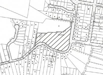
|
SUBMISSIONS
PLAN
|
|
|
• PROPERTIES
NOTIFIED
|
X SUBMISSION RECEIVED
|

PROPERTY SUBJECT OF DEVELOPMENT
|

|
|
37 SUBMISSIONS RECEIVED OUT OF MAP RANGE
|
|
|
|
|
The submissions objected to the development, generally on
the following grounds that the development would result in:
· Development
that is excessive in building bulk, height and site coverage;
· Excessive
residential density;
· Overflow
parking to the surrounding roads;
· Unacceptable
traffic on local streets;
· Traffic
hazards as the surrounding local streets do not provide for 2 way flow given
existing overflow parking from Mt Wilga Hospital;
· An
increase in traffic accidents, particularly at the Carrington Road/ Galston Road intersection and the Roper Lane link to Bridge Road;
· A
traffic bottleneck during a bushfire from evacuating elderly residents;
· An
inadequate landscape setting due to inadequate open space and setbacks;
· The
removal of local vistas and views across the property;
· The
application failing to provide a site compatibility certificate from the
Department of Planning;
· Overlooking
residential properties to the west;
· Overshadowing
on Manor Road
and over properties to the south and west;
· Unacceptable
noise from the additional units, traffic and use of the communal/ recreational
facility;
· Unacceptable
stormwater drainage impacts;
· A
scheme that does not adequately provide for aged persons and/or development not
being occupied by aged persons;
· An
inadequately serviced development with poor sewerage, water etc;
· Removal
of the potential for public access to the house and grounds;
· An
increase in crime from construction activity and additional residents;
· Pollution
from traffic fumes and garbage odours;
· Noise,
dust and traffic impacts during an extended construction phase;
· Structural
damage to neighbouring properties;
· A
precedent for other high-density high rise in Manor Road;
· A
decrease in local property values;
The merits of the matters raised
in community submissions have been addressed in the body of the report with the
exception of the following:
5.1.1 Existing Parking conflicts
Many submissions raised concerns
that Mt Wilga Hospital is not complying with its development consent, resulting
in an existing overflow parking problem.
Mt Wilga Hospital is not the subject of the current development
application and concerns raised are separately being investigated by Council.
5.1.2 Site Compatibility Certificate
Some submissions
have argued that the applicant requires a site compatibility certificate from
the Department of Planning pursuant to Clause 24 of SEPP (Housing for
Seniors). This clause does not apply because a hospital is a permissible landuse
within the Special Uses A zone.
Furthermore, this clause only applies to development applications made
pursuant to this Chapter. As detailed in
the report, the application is not lodged pursuant to SEPP (Housing for
Seniors) 2004. Rather the proposed use
is permissible with consent pursuant to the provisions of the HSLEP.
5.1.3 Drainage
Council’s engineering assessment
of the stormwater impacts of the development concludes that the proposal would
comply with Council’s requirements in relation to onsite detention and
stormwater management. Appropriate
consent conditions are recommended. This
includes conditions to upgrade the existing drainage system in Manor Road and
associated drainage easements.
5.1.4 Occupation of the Units
The
assessment and consent conditions would ensure that the units are suitably
designed for the elderly or people with disabilities. Some submissions are concerned that the
proposed units would be occupied by residents other than those that are aged or
disabled. Appropriate conditions are
proposed, including a restriction as to user in accordance with section 88E of
the Conveyancing Act 1919, to ensure that only seniors and people with a
disability are residents.
5.1.5 Inadequate Local Utility Services
Local utilities services such as
sewerage, water and electricity are available to the site.
5.1.6 Public Access to the Property
Some submissions argue that Council should
purchase this site and that the proposal should provide for public access to
the house and grounds. The property was
sold by the Commonwealth Government 20 years ago. The property is not zoned for public open
space. This is not a valid planning
reason to refuse the current development application.
5.1.7 Garbage Odours
The waste from the development is to be stored
in the basement. The temporary
collection area is located 100 metres from the closest neighbouring residential
property.
5.1.8 Construction Impacts
Conditions of consent are recommended to
address the impacts of the development during the construction phase.
5.1.9 Structural damage to neighbouring properties
Consent
conditions are recommended including a requirement for a dilapidation report to
be prepared by a chartered professional structural engineer at the applicant’s
expense, detailing the structural condition of adjoining properties, including
Council’s property, and their ability to withstand the proposed excavation.
5.1.10 Precedent
All development applications are
required to be assessed on their individual merits, taking into account the
applicable planning controls. This
property is unique in that it is zoned Special Uses A, unlike much of the
surrounding area that is zoned Residential A.
The surrounding Residential A area is subject to different planning
controls. In this respect, approval of the development would not create a
precedent in the locality.
5.1.11 Property Values
Concerns were raised that the
development would adversely effect the property values of the dwellings in the
locality. This is not a relevant matter
for consideration under Section 79C of the Act.
5.2 Public Agencies
The development application is Integrated Development under
the Act. Accordingly, the application
was referred to the following Agencies for comment:
5.2.1 Roads and Traffic Authority
The
application does not require referral to the Roads and Traffic Authority (RTA)
pursuant to SEPP No.11 – Traffic Generating Development nor does it require
referral pursuant to the provisions of SEPP (Infrastructure) 2007. However, the application was referred to the
RTA for its advice given potential traffic impacts.
The RTA raised no objection to the
application and provided recommendations including that the Galston Road/ Carrington Road intersection be converted
into one-way in, or left in/ left out.
This is necessary because of deficient sight distances and an increasing
accident history that would further increase with increased volumes of
traffic. The RTA advised that these
roadworks were necessary due to the declined gap selection ability of elderly
drivers and the increase in traffic.
In response to the above recommendation,
Council enquired with the RTA whether it would agree to the implementation of a
round-a-bout at the intersection of Galston
Road/ Clarinda
Street. The
RTA advised that it does
not support the construction of a roundabout at the intersection of Galston Road and Clarinda Street as
roundabouts are unsuitable at intersections with highly unbalanced traffic
flows, such as the subject intersection.
If any works are to occur at this intersection the RTA would prefer
traffic signals to be installed as they provide a better level of service and
with spare capacity. The RTA did not
recommend the installation of any works at the Galston/ Clarinda intersection
as part of this consent. As the subject development would not have any
significant impact upon that intersection, it is not considered appropriate
that the cost of these works be burdened upon the applicant.
The RTA’s
recommendations are addressed in the consent conditions at Schedule 1.
5.2.2 Rural Fire Service
The application was referred to the Rural Fire Service (RFS) as Integrated Development requiring a bushfire
safety authority pursuant to the Rural
Fires Act 1997. A number of
submissions received were concerned about the impact of the development on
bushfire safety in the locality. A copy
of the submissions received were forwarded to the RFS.
Initially, concerns were raised
by the RFS regarding the proximity of Building A to the bushfire hazard. The applicant submitted additional
information for consideration, including radiant heat modelling. The final response from the RFS has raised no
objection to the application. The
consent conditions recommended by the RFS are included in Schedule 1.
5.2.3 NSW Heritage Council
An application was submitted under Section 60
of the Heritage Act 1977 to the NSW
Heritage Council for multi-unit housing on the site in July 2006. The NSW Heritage Council approved the
application pursuant to Section 63 of the Heritage Act on 2 March 2007. A development application was subsequently
submitted to Council in July 2007, incorporating plans for aged housing similar
to the plans approved by the Heritage Council in March 2007. This is the subject of the current report.
Council referred the current development application to the Heritage
Council as Integrated Development under the Heritage Act 1977. A number of resident submissions
received were concerned about the impact of the development on the heritage
significance of the property. A copy of
the submissions received were sent to the Heritage Office on 21 August 2007 and
25 February 2008. The Heritage Office
has advised Council that the Heritage Council has raised no objection to the
development application.
The Heritage Council’s response dated 29 August 2007 advised the
following:
“The
Heritage Council received a set of preliminary documents for S60 Application No
.2006/S60/114 on 27 July 2006. The
Heritage Council determined that the scheme could be supported if the façade of
the new buildings was redesigned to fit more easily with the Mt Wilga
house. This scheme was revised into the
form described by the following documents which is very similar to the revised
documents referred to the Heritage Council by Hornsby Shire Council…
Hornsby
Shire Council referred un updated but very similar scheme to the Heritage
Council for comment on 20 July 2007, received on 24 July 2007.
The Heritage Council advices that the roof pitch in the drawings sent by
Hornsby Shire Council is in accordance with Heritage Council conditions. The schemes are not significantly different
from a heritage point of view in other respects, and the Heritage Council has
no objection to the scheme described in the following drawings as sent by
Council…”
Amended plans were submitted to Council in
November 2007 and referred to the Heritage Office for comment. Further minor amendments to the plans were
sent in February 2008 and May 2008. This
involved shifting some building bulk away from Manor Road and providing details on works
required to the property’s Rosamond
Street driveway.
The Heritage Council raised no objections to these further
amendments.
The Heritage Council’s General Terms of
Approval (GTAs) are addressed in the recommended consent conditions at Schedule
1.
6. THE
PUBLIC INTEREST
Section 79C(1)(e) of the Act
requires Council to consider “the public
interest”.
The public interest is an
overarching requirement, which includes the consideration of the matters
discussed in this report. Implicit to
the public interest is the achievement of future built outcomes adequately
responding to and respecting the future desired outcomes expressed in
environmental planning instruments and development control plans.
The application is considered to
have satisfactorily addressed Council’s and relevant agencies’ criteria and
would provide a development outcome that, on balance, would result in a
positive impact for the community.
Accordingly, it is considered that the approval of the proposed housing
for aged or differently abled persons would be in the public interest.
7. CONCLUSION
The application proposes erection of a development
for Aged or Differently Abled Persons.
This application has been assessed having regard to
the Heads of Consideration under Section 79C(1) of the Act, Hornsby Local
Environmental Plan and the provisions of the relevant State Environmental
Planning Policies. Council does not have a specific Development Control Plan
for the proposed use as “housing for aged or differently abled persons” or for
the subject zone or area, however, the proposal complies with the general
controls in SEPP (Housing for Seniors) and the SEPP 65 Residential Flat Design
Code.
The design provides for variable building setbacks
to the side and rear property boundaries and the proposal is considered to
provide a reasonable outcome for the subject site and surrounding land uses
through consideration of height, design and landscaping provided.
Approval of
the application is recommended.
SCHEDULE 1
PART 1 –
DEFERRED COMMENCEMENT
THE CONSENT SHALL NOT BECOME EFFECTIVE OR OPERATIVE UNTIL
THE FOLLOWING INFORMATION IS SUBMITTED TO THE SATISFACTION OF THE COUNCIL. ALL DEFERRED COMMENCEMENT CONDITIONS ARE TO
BE COMPLIED WITH WITHIN 1 YEAR FROM THE DATE OF THIS CONSENT.
A. The
Right of Way and Easement for Services, burdening the subject property and
benefitting the adjoining property to the north shall be either extinguished or
modified in such a manner that its modified form will enable the development to
proceed without contravening the terms of the Right of Way or the Easement for
Services. The right of way is to ensure
unencumbered access along the approved pedestrian link to the south of the
Hospital’s rehabilitation building for all emergency services at all times and
for the egress of the occupants of the rehabilitation building in a fire
or emergency situation.
B. The
Restriction as to User, burdening the subject property and benefitting the
adjoining property to the north shall be either extinguished or modified in
such a manner that its modified form will enable the development to proceed
without contravening the terms of the Restriction as to User.
C. The
easements for drainage, burdening the subject property and benefitting the
adjoining property to the north shall be either extinguished or modified in
such a manner that its modified form will enable the development to proceed
without contravening the terms of the Restriction as to User.
All Section 88B restrictions and covenants created as part
of this consent are to contain a provision that they cannot be extinguished or
altered except with the consent of Hornsby Shire Council.
PART 2
UPON SATISFACTION OF THE DEFERRED
COMMENCEMENT CONDITIONS IN PART 1, THIS CONSENT SHALL OPERATE IN ACCORDANCE
WITH THE FOLLOWING CONDITIONS
General Conditions Applying to All Stages
Approved Plans and Supporting
Documentation
1. The development must be carried out in
accordance with the following plans as amended in red and documentation listed
below and endorsed with Council’s stamp, except where amended by other
conditions of this consent:
Architectural Plans – Aged Housing Apartments
|
Plan
No.
|
Rev
|
Drawn
by
|
Dated
|
|
Site Analysis Plan
05009/DA001
|
C
|
Giles Tribe
Architects
|
19-03-07
|
|
Site Plan 05009/DA002
|
G
|
Giles Tribe
Architects
|
11-04-08
|
|
Basement Plan
05009/DA100
|
J
|
Giles Tribe
Architects
|
05-04-08
|
|
Level One/ Site Plan
05009/DA101
|
J
|
Giles Tribe
Architects
|
18-01-08
|
|
Level Two Floor Plan
05009/DA102
|
G
|
Giles Tribe
Architects
|
18-01-08
|
|
Level Three Floor
Plan 05009/DA103
|
G
|
Giles Tribe
Architects
|
18-01-08
|
|
Roof Floor Plan
05009/DA104
|
G
|
Giles Tribe
Architects
|
18-01-08
|
|
Site Sections-1
05009/DA400
|
F
|
Giles Tribe
Architects
|
09-11-07
|
|
Site Sections-2
05009/DA401
|
F
|
Giles Tribe
Architects
|
09-11-07
|
|
Site Sections/ Elevations
05009/DA402
|
G
|
Giles Tribe
Architects
|
18-01-08
|
|
Elevations 05009/
DA403
|
B
|
Giles Tribe
Architects
|
24-01-08
|
|
Walkway for Hospital
Access SK100
|
C
|
Giles Tribe
Architects
|
July 2008
|
|
Section – Walkway
SK101
|
A
|
Giles Tribe
Architects
|
July 2008
|
Architectural Plans – Mount Wilga House
|
Plan
No.
|
Rev
|
Drawn
by
|
Dated
|
|
2050602/00 Drawing
Index and North Elevation
|
A
|
Robertson &
Hindmarsh
|
15.12.05
|
|
2050602/01 Ground
Floor Plan
|
E
|
Robertson &
Hindmarsh
|
Undated
(received 11.07.07)
|
|
2050602/02 Basement
Plan
|
A
|
Robertson &
Hindmarsh
|
Undated
(received 11.07.07)
|
|
2050602/03 Roof Plan
|
A
|
Robertson &
Hindmarsh
|
Undated
(received 11.07.07)
|
|
2050602/04 Elevation
|
F
|
Robertson &
Hindmarsh
|
Undated
(received 11.07.07)
|
|
2050602/05 Elevation
|
F
|
Robertson &
Hindmarsh
|
Undated
(received 11.07.07)
|
Civil Plans
|
Plan
No.
|
Rev
|
Drawn
by
|
Dated
|
|
Stormwater Layout
Catchment Plan C0101
|
08
|
Meinhardt
|
11.01.08
|
|
Stormwater Layout
Basement Level C0102
|
08
|
Meinhardt
|
11.01.08
|
|
Stormwater Layout
Level 1 C0103
|
08
|
Meinhardt
|
11.01.08
|
|
Stormwater Layout Manor Road Works C0104
|
08
|
Meinhardt
|
11.01.08
|
|
Stormwater Layout 39
Manor Road C0105
|
08
|
Meinhardt
|
11.01.08
|
|
Soil and Water
Management Stage 1 C0201
|
08
|
Meinhardt
|
11.01.08
|
|
Soil and Water
Management Stage 2 C0202
|
08
|
Meinhardt
|
11.01.08
|
|
Soil and Water
Management Stage 3 C0203
|
08
|
Meinhardt
|
11.01.08
|
|
Soil and Water
Management Stage 4 C0204
|
08
|
Meinhardt
|
11.01.08
|
|
Stormwater Detention
Details C0301
|
08
|
Meinhardt
|
11.01.08
|
Landscape Plans
|
Plan
No.
|
Rev
|
Drawn
by
|
Dated
|
|
Landscape Plan LA01
|
E
|
Taylor Brammer
|
18.01.08
|
|
Landscape Plan LA02
|
D
|
Taylor Brammer
|
18.01.08
|
|
Landscape Plan LA03
|
D
|
Taylor Brammer
|
18.01.08
|
|
Landscape Sections
LA04
|
B
|
Taylor Brammer
|
18.01.08
|
|
Landscape Details
LA05
|
A
|
Taylor Brammer
|
18.01.08
|
|
Document
No.
|
Prepared
by
|
Dated
|
|
Statement of
Environmental Effects
|
Deborah Sutherland
Planning
|
April 2007
|
|
Supplementary
Statement of Environmental Effects
|
Deborah Sutherland
Planning
|
November 2007
|
|
Shadow Diagrams
DA800 9am June 21
DA801 10am June 21
DA802 Noon June 21
DA803 3pm June 21
|
Giles Tribe
Architects
|
|
|
Solar Access Diagrams
Basement
05009/DA804 A
Level 1
05009/DA805 A
Level 2
05009/DA806 A
Level 3
05009/DA807 A
Level 4
05009/DA808 A
|
Giles Tribe
Architects
|
11.01.08
|
|
Photomontages
3D View – 1
05009/DA-V01
3D View – 2
05009/DA-V02
|
Giles Tribe
Architects
|
04-02-08
|
|
Basix Certificate
172211M
|
Unknown
|
29-01-08
|
|
Vegetation Management
Plan
|
Cumberland Ecology
|
January 2008
|
|
Bush Fire Safety
Compliance Report
|
Roger Fenwick
|
July 2007
|
|
Schedule of Materials
and Finishes
Plan: 05009/DAF01B
|
Giles Tribe
Architects
|
19-03-07
|
|
Stage 2 Environmental
Site Assessment
|
Consulting Earth
Scientists
|
5 December 2005
|
|
Disability Access
Assessment Report
|
Access Associates
|
February 2007
|
|
Landscape Sections
(D00898825)
|
Taylor Brammer
|
22 April 2008
|
Plans on Site
2. A copy of all approved
plans, specification and documents (including the construction certificate if
required for the work incorporating certification of conditions of approval)
shall be kept on site at all times so as to be readily available for perusal by
any officer of Council or the Principal Certifying Authority.
Use of the Premises
3. The
approved development must be occupied or used solely for the approved use.
No separate occupation or use of any part of the approved development
shall take place without prior development consent, (other than for exempt or
complying development).
4. All
activities within the communal facility (Mt Wilga House) are to be ancillary
and subsumed by the aged housing development.
Any Doctors rooms and the like are to provide services only to those
residents living on the property.
5. The use of
the communal facility (Mt Wilga House) is to be restricted to those times
listed below:
Monday to Sundays 8.00am 10.00pm
This does not include caretaker activities.
6. The
communal facility (Mt Wilga House) is to accommodate a maximum of five staff
on-site at any one time.
Use of Materials
7. The
finished surface materials, including colours and texture of any building
and/or hard paved areas, shall blend with the surrounding environment and shall
be non-glare.
8. The aluminium louvered
sliding screens illustrated on the building elevations are to be designed and
installed so that at least half (50%) of the elevation width remains opened at
any one time, at each of the balconies.
For example, this may require the 4 panelled sliding screen to be
reduced to 2 panels wide on Building E (west).
Access & Mobility
9. The development is to be designed and constructed to comply
with the standards concerning accessibility and useability for self contained
dwellings in Schedule 3 of State
Environmental Planning Policy (Housing for Seniors or People with a Disability) 2004. This may require minor internal modifications
to the plans only. A suitably qualified
access consultant is to certify compliance with this condition prior to the
issuance of a construction certificate.
10. Footpaths
from the site to bus stops in the vicinity of the site, shall be constructed on
Rosamond Street and Carrington Road in accordance with AS1428 and Austroads, to
ensure a continuous path of travel to bus services in accordance with the
requirements of State Environmental
Planning Policy (Housing for Seniors or People with a Disability) 2004.
11. The owner of the premises shall provide a
dedicated Village Bus Service for the use of the residents of the
development. The bus is to be
capable of carrying at least 10 passengers and shall operate at least 2 round
trips daily from the site to a local centre that provides residents with access
to the following:
(i) shops, bank service providers and other
retail and commercial services;
(ii) community services and recreation
facilities;
(iii) the practice of a general medical
practitioner
12. A restriction as to user is to be created
under Section 88B of the Conveyancing
Act 1919 that limits the occupants of the residential units to ‘housing for aged or differently abled
persons’, as defined in the following:
housing for aged or differently abled
persons means residential accommodation which may
take any building form and may be or include a hostel and which is, or is
intended to be used as, housing for the permanent accommodation of:
(a) persons over 55 years of
age, or
(b) persons of any age who,
as a result of having a mental, physical or sensory impairment, either
permanently or for an extended period, have substantially limited opportunities
to enjoy a full and active life.
The above restriction does not apply
to the caretakers’ unit.
Support for
Neighbouring Properties
13. A Dilapidation Report is to be prepared by a chartered
professional structural engineer at the applicant’s expense, detailing the
structural condition of adjoining properties, including Council’s property, and
their ability to withstand the proposed excavation. This report must include
any measures required to be incorporated to ensure that no damage will occur
during the course of works. The report shall be submitted to the principal
certifying authority prior to any
excavation works taking place. Such
works shall take place in accordance with the recommendations of the report.
14. If
an excavation extends below the level of the base of the footings of a building
on an adjoining allotment of land, the person causing the excavation to be made
must:
i) preserve
and protect the building from damage;
ii) if
necessary, underpin and support the building in an approved manner; and
iii) at
least 7 days before excavating, give notice of intention to do so to the
adjoining owner and furnish particulars to the owner of the proposed work.
Fencing
15. The
northern property boundary adjoining Mt Wilga Hospital shall be enclosed with a
1.5m fences/screens/walls to protect the privacy of future occupants as well as
adjoining owners. The fence/screen/wall
is to be erected prior to the occupation of the dwellings. The finished surface materials, including
colours and texture, shall blend with the surrounding environment and shall be
non-glare.
16. The
new sandstone entry gates indicated on landscape plan LA03D is not approved as
no elevation details were submitted with the application for assessment
purposes. Any such works is to be the
subject of a separate application to the Council.
Noise and Dust Control during Construction Phase
17. A Noise and Dust Management Plan
(NDMP) must be submitted to Council prior to the issuance of a construction
certificate to address noise and dust emission during the construction
phase. The NDMP must be prepared by a
suitably qualified environmental consultant.
The NDMP should address, but not be limited to, the following:
(a) Establishment
of maximum prescriptive noise emission and dust emission targets for the
construction phase. These targets are to
comply with the Protection of the Environment Operations Act and the NSW
Environment Protection Authority’s Environmental Noise Control Manual -
guidelines for construction sites,
(b) Recommend
management measures to be implemented to achieve the targets established in (a)
above,
(c) Recommend
monitoring equipment to be installed to measure noise and dust emissions,
(d) Propose
a regular monitoring and review programme by a suitably qualified environmental
consultant to ensure the construction complies with noise emission and dust
emission targets,
(e) Procedures
to record and address any complaints regarding noise and dust;
(f) Propose
a reporting system to certify the ongoing compliance of the development with
this condition.
Time to Complete Development
18. The
works set forth in the plans and specifications and approved under this
consent, once commenced, shall be completed within 5 years from the date of
commencement.
Building Code of Australia
19. All building work must
be carried out in accordance with the requirements of the Building Code of Australia.
Should there be any alternative solutions
listed as Category 2 Fire Safety Provisions and outlined in the Environmental
Planning and Assessment Regulation 2000, a fire engineering report should be
forwarded to the Brigades for comment under Clause 144 of the Environmental
Planning and Assessment Regulation 2000.
Hours of Construction
20. In order to maintain
the amenity of adjoining properties, site works shall be restricted to between
7.00 am and 6.00 pm, Monday to Friday and 8.00 am to 1.00 pm Saturday. No work shall be undertaken on Sundays or public
holidays. Plant, goods or materials
shall not be delivered to the site outside the approved hours of site works
unless otherwise approved by Council.
Long Service Levy
21. Under Section 34 of the
Building and Construction Industry Long Service Payments Act 1986 any work
costing $25,000 or more is subject to a Long Service Levy. The levy rate is 0.35% of the total cost of
the work and shall be paid to either the Long Service Payments Corporation or
Hornsby Shire Council. Under section
109F (1) of the Environmental Planning & Assessment Act, 1979 this payment
must be made prior to a construction certificate being issued.
Fire Safety Schedule
22. In accordance with clause 168 of the
Environmental Planning and Assessment Regulation 2000 fire safety measures
shall be implemented in the building. A
schedule of all proposed and existing Essential Fire Safety Measures to be
installed in the building (eg: hydrants, hose reels, exit signs, smoke control
systems) shall be submitted with the Construction Certificate application and
distinguish between the existing and proposed fire safety measures. Should the Construction Certificate involve
the use of an alternate solution, the application must also be accompanied by
details of the performance requirements that the alternate solution is intended
to meet and the assessment methods use to establish compliance with those
performance requirements.
Fire Safety Certificate –
Final
23. In accordance with Part 9, Division 4 of
the Environmental Planning & Assessment Regulation, 2000, the owner of the
building must, on completion of the building, provide Council with a
certificate in relation to each essential fire safety or other safety measure
implemented in the building.
Fire Safety Statement - Annual
24. In accordance with Part
9, Division 5 of the Environmental Planning & Assessment Regulation, 2000,
at least once in each period of 12 months after the date of the first fire
safety certificate, the owner shall provide Council with a further certificate
in relation to each essential service installed in the building.
Survey Reports
25. To ensure that the
building and any associated structures are correctly positioned on the site, a
report prepared by a registered surveyor is to be submitted to the principal
certifying authority at each level of construction of the building (prior to
the pouring of concrete) indicating that the finished floor level is in
accordance with the approved plans.
Fire Egress
26. A construction
management plan is to be submitted with the Construction certificate
application demonstrating that unimpeded egress can be provided from the
southern fire exit of the adjoining rehabilitation building in a fire or
emergency situation to an open space within the rehabilitation building
allotment during construction. Any
temporary measures are to remain in place until the permanent egress walkway is
constructed.
Construction
Certificate – Subdivision/Engineering Works
27. A construction certificate must be
obtained from either Council or an Accredited Certifier. Engineering design
plans and specifications are to be prepared by a chartered professional
engineer for any proposed works. The
plans and specifications are to be in accordance with development consent
conditions, appropriate Australian standards, and applicable Council standards,
in particular “Hornsby Shire Council Civil Works - Design and Construction
Specification”. The information that is required to be submitted with a
construction certificate is as follows:
(a) copies
of compliance certificates relied upon
(b) Four
(4) copies of the detailed engineering plans in accordance Hornsby Shire
Council's Civil Works - Design Specification 1999. The detailed plans may
include but are not limited to the earthworks, roadworks, road pavements, road
furnishings, stormwater drainage, landscaping and erosion control works.
(c) Hornsby Shire Council’s approval is
required for any works within the road reserve of Manor Rd or Rosamond Rd prior to the issuing of a
construction certificate for these works.
(d) Hornsby Shire Council’s approval is
required for any works within Council controlled drainage easements prior to
the issuing of a construction certificate for these works
Construction Management Plans
28. In order to enable
unencumbered movement of traffic in the public road during construction works,
a Construction Management Plan, including a Traffic Management Plan and scaled
construction plan prepared by a suitably Chartered and Qualified Chartered
Engineer and Qualified Worksite Traffic Controller shall be prepared and
submitted with the Construction Certificate. The Construction Management Plans
shall identify all works for each stage and how to effectively manage the
construction traffic for that stage. The plans shall address the following
requirements:-
(a) A copy of the plans shall
be submitted for consideration and written approval by Hornsby Shire Council’s Manager, Subdivisions prior to the release of the
Construction Certificate.
(b) The plans shall detail the
order of construction works and arrangement of all construction machines and
vehicles being used at the same time during all stages.
(c) In order to prevent
injury, accident and loss of property, no building materials, work sheds,
vehicles, machines or the like shall be allowed to remain in the road reserve
area without written consent of Hornsby
Shire Council.
(d) The Plan shall be
generally in compliance with the requirements of the Road and Traffic
Authority’s “Traffic Control at Worksites Manual 1998” and detailing:-
(i) Public notification of
proposed works;
(ii) Long term signage
requirements;
(iii) Short term (during
actual works) signage;
(iv) Vehicle Movement Plans,
where applicable;
(v) Traffic Management Plans;
(vi) Pedestrian and Cyclist
access and safety;
(e) The plans shall indicate
traffic controls including those used during non-working hours and shall
provide pedestrian access and two-way traffic in the public road to be
facilitated at all times.
(f) The Applicant and all
employees of contractors on the site must obey any direction or notice from the
Prescribed Certifying Authority or Hornsby
Shire Council in order to ensure the above.
29. Any damage caused to Council's assets in
the vicinity of the subject site as a result of construction works associated
with the approved development is to be repaired by the applicant/developer
prior to the issue of the Occupation Certificate.
30. All
service vehicles including garbage trucks, removalist trucks, emergency
vehicles and the like are only permitted to use the Rosamond Rd access. The Manor
Rd access is to be signposted to prohibit trucks
entering or exiting this driveway.
Works As
Executed
31. A
works-as-executed plan prepared by a chartered professional engineer or a
registered surveyor must be lodged with Hornsby Shire Council when the
engineering works are complete for each of the different stages, prior to the
release of the Occupation Certificate.
Traffic and
Access
32. A construction certificate is not to be issued until a left
turn only sign and associated infrastructure is erected at Carrington Road to prevent right turns
out into Galston Road. This shall be designed and installed to meet
the requirements of the Council’s Road and Traffic Safety Branch and the
requirements of the NSW Roads and Traffic Authority.
33. All deliveries shall be made within the site, under no
circumstances delivery vehicles to be loaded or unloaded upon the public road.
34. All off street carparking including the provision of
aisle, ramps and access driveways shall comply with Australian Standard AS
2890.1 - 1993 Off Street Car Parking and AS 2890.2 - 2002 Off Street Commercial
facilities.
Boundary Planting
Hedge
35. Planting along the boundary of the Mt
Wilga Heritage Estate (Rosamond
Avenue) shall be Photinia glabra ‘Rubens’ planted at 1 metre centres in mulched
planter beds. Shrubs to be installed at minimum pot size of 5 litres.
Screen Planting (Manor Road Building)
36. To ensure
adequate screen planting is provided to the carpark area adjacent to building
along the Manor Road
boundary, additional planting shall be provided.
Screen
planting to the on-grade landscape setback zone adjacent to Building C must
include Twenty (20) additional Syzigium
‘Royal Flame’ planted at 2 metre centres in mulched planter beds. Shrubs to be installed at minimum pot size of
5 litres.
Boundary Planting (Northern Boundary)
37. To ensure
adequate tree planting in scale with the proposed building is provided
additional planting shall be provided.
Boundary tree planting to
the on-grade landscape zone must include Five (5) additional Lophostemon confertus (brushbox)
capable of reaching a mature height of 10 metres planted in locations adjacent
to building B in mulched planter beds. Trees to be installed at minimum pot
size of 25 litres.
Existing Retaining wall to south
western Boundary
38. The existing retaining wall in the south
west corner of the site shall be retained and protected during construction.
Screen planting shall be placed along boundary in front of the wall.
Planter Boxes / On Slab Planting
39. To
ensure a sustainable landscape is achieved to on slab planter box areas, they
shall include automatic irrigation, subsoil drainage (proprietary drainage
cell, 50mm sand and filter fabric), and waterproofing. Soil depths additional
to the requirement of subsoil drainage shall be a minimum of 1000mm with a soil
volume of 35 cubic metres for trees and a minimum of 500mm for shrubs.
Landscape Works To All Areas – Plant
sizes and densities
40. Excepting
the above specific requirements, all landscape works shall also meet the
minimum construction standards identified in the Hornsby Shire Council
Landscape Code for Development Applications including the construction of
mulched planter beds, planting of trees in pot sizes as specified on approved
plans, shrubs in minimum 5 litre pot sizes and groundcovers in minimum 150mm
pot sizes in the densities identified in the submitted planting
specification.
Tree Fencing
41. Prior
to work commencing, tree protection fencing must be erected around the trees to
be retained along the western and southern boundaries at a 3m setback. The tree fencing
must be constructed of 1.8 metre cyclone chainmesh fence’. The tree protection
fencing must be maintained in good working order until the completion of all building
or development works. A statement of compliance from a qualified tree surgeon
or environmental consultant shall be submitted to Council prior to the issue of
the Construction Certificate.
Excavation
42. To prevent damage to
tree roots, parking (vehicles or plant) or placement of building materials
(including disposal of cement slurry and waste water) within 3m of all trees to be retained onsite, is
strictly forbidden. No tree roots located within the specified tree setback
shall be severed or injured in the process of any site works during the
construction or landscaping phases of the approved project.
Note: In order to achieve this condition, this may
require excavation for basement purposes to be undertaken by piering the
foundations (rather than earth battering).
43. Excavation
for the installation of any underground service within the specified tree
setbacks of all trees on the western and southern boundaries has been approved
by Council’s Parks and Landscape Team and shall be carried out by using the
thrust boring method only. [ Tunnel boring shall be carried out at least 1
metre beneath natural ground surface and at a setback radius of 3 metres to
minimise damage to tree root systems.]
The severance of tree roots greater than 50mm in diameter is not
permitted. If roots of such diameter are
revealed by hand excavation, the applicant must provide Council’s Parks and
Landscape team an assessment by a qualified arborist that outlines the likely
impact of severing the roots or an alternative location for the service
trenching.]
44. Any
works undertaken within the specified tree setbacks must be overseen by a
qualified and experienced arborist.
Tree
Preservation Order
45. A
Tree Preservation Order exists within the Hornsby Shire whereby the cutting
down, topping, lopping or wilful destruction of any tree exceeding 3.0 metres
in height (except where exempt as defined under Council’s Tree Preservation
Order ) or substantially altering the soil level around the trunk or within 3
metres of the trunk, without prior written consent is prohibited. Release of
the Construction Certificate gives automatic approval to the removal of those
trees located on the subject property within 3 metres of the foundation
footprint of an approved residential, commercial or community building, garage,
inground swimming pool or within the alignment of approved vehicular access or
parking area. Other trees shall not be
removed or damaged without approval being granted under Council’s Tree
Preservation Order. Penalties apply for
non-compliance.
Maintain Canopy Cover
46. This
application approves the removal of the following trees Nos.2, 6, 13, 13a, 14,
15, 16, 21, 23, and 39 only. To maintain
local tree canopy cover, the trees that are approved to be removed along the western
and southern boundaries are to be replaced with a Lophostemon confertus (Brush Box).
In addition any other tree that later dies or is damaged during or after
the development, is to be replaced with a Lophostemon
confertus (Brush Box). The planting
location shall be in the immediate location of where the tree is removed, but
not within 3 metres of the foundation walls of a dwelling or inground
pool. The pot size is to be a minimum
100 litres and the trees must be maintained and protected until they reach the
height of 5 metres.
Note:
The above condition does not exempt the property from the provisions of
Council’s Tree Preservation Order. The
purpose of the above is to ensure that if any trees decline in the future, they
are suitably replaced to maintain the approved landscape setting for the
development.
BUSHLAND AND
BIODIVERSITY MANAGEMENT TEAM
47. The
Landscape Plan prepared by Taylor Brammer,
Drawing No. LA01 Revision E, shall be amended and submitted for approval to the
Bushland and Biodiversity Team prior to the issuance of a construction
certificate. The Landscape Plan shall be
amended to remove the gravel maintenance path passing through the Sydney Turpentine
Ironbark Forest
community to be revegetated under the guidance of the Vegetation Management
Plan prepared by Cumberland Ecology,
January 2008.
48. The
maintenance, revegetation and future management of the Sydney Turpentine
Ironbark Forest (STIF), an Endangered Ecological Community as listed under the Threatened Species Conservation Act 1995,
shall be undertaken in accordance with the Vegetation Management Plan for 2a Manor Road,
Hornsby, prepared by Cumberland Ecology
dated January 2008.
49. All
erosion and sediment controls (i.e. geotextile sediment fence and straw bales)
shall be in place prior to commencement of works so as to protect the adjacent
bushland and native fauna habitat. Fencing should comply with the EPA
publication ‘Managing Urban Stormwater:
Soils & Construction’. Techniques used for erosion and sediment
control on building sites are to be adequately maintained at all times and must
be installed in accordance with Council guidelines. All techniques shall remain
in proper operation until all development activities have been completed and
the site fully stabilised. This condition must be complied with during
demolition and building work.
50. To protect the bushland
and retained trees from potential damage on the development site the
applicant is to ensure that a temporary fence shall be erected, prior to
commencement of works at 2a Manor Road, Hornsby, to protect the Sydney
Turpentine Ironbark Forest (STIF), an Endangered Ecological Community as listed
under the Threatened Species Conservation
Act 1995, from casual or inadvertent access. The fence shall be constructed from either
wire mesh or orange barrier mesh and remain in place until the completion of
site works.
WASTE MANAGEMENT
51. The
waste and recycling collection point at the roundabout, the waste vehicle
standing area and all other modifications to the roundabout must be completed
prior to issue of the Occupation Certificate for Stage One.
52. Bin
storage areas in the basements must be designed and constructed in accordance
with Council’s Waste Minimisation and
Management Development Control Plan.
53. The
caretaker is to transfer waste bins from the storage areas in the basement to
the waste collection area adjacent to the round-a-bout. The transfer of bins is to occur within the
site. At all stages of the development,
a suitable path of travel is to be provided, which does not include steps. Ramp(s) or roll curb must be used between the
different levels between the driveway/truck standing area, the bin collection
point and each bin room.
Note: The Stage A plans indicate that the route
between the Building A basement and waste collection area incorporates
steps. For this stage a suitable
temporary link is to be provided on-site outside of the permanent conservation
area to facilitate the transfer of waste bins.
54. To confirm compliance with approved Waste
Management Plans, prior to issue of the occupation certificate, submit to
Council a Report of actual destinations and quantities of waste generated by
the works carried out under this development consent. This Report is to be
based on Documentary evidence (ie. tipping dockets/receipts from
transfer stations and landfills) and be in the format
of the Waste Management Plan Section One – Demolition Stage and/or Section
Three – Construction Stage. If less than 60% waste was reused or
recycled, then this Report must include the reasons why the 60% target was not
achieved.
55. Waste from commercial activities on site
(including but not limited to medical services) must not be placed in the
residential bins and must be disposed of separately to the domestic/residential
waste.
56. An easement
entitling the Council, its servants and agents and persons authorised by it
to enter upon the property and to operate
equipment for the purpose of waste and recycling collection services. This easement must be granted in favour of
Council prior to the occupation of the development.
Note: An 88(b) instrument is an acceptable form of
easement subject to the area effected by the easement not requiring renewal
upon sale or transfer at any time.
ENVIRONMENTAL PROTECTION
57. Prior
to the release of the Construction Certificate a connection must be made to
Sydney Water’s sewerage system for all wastewater from the development.
58. The installation of
rainwater tanks and associated plumbing must be in accordance with Sydney
Water’s Guidelines for Rainwater Tanks on
Residential Properties: Plumbing Requirements, dated April 2003.
59. Any imported soils to the subject site
must be Virgin Excavated Natural Material (VENM) as defined in Schedule 1 of
the Protection of the Environment
Operations Act 1997.
60. All
excavated material removed from the site must be classified in accordance with
NSW EPA (1999) Environmental Guidelines: Assessment, Classification and
Management of Liquid and Non-Liquid Wastes prior to disposal. All excavated material must be disposed of to
an approved waste management facility.
61. Council
and the PCA must be notified immediately should the presence of asbestos or
soil contamination, not recognised during the original assessment process be
identified during demolition or construction works.
62. Prior
to the issue of an occupation certificate, all mechanical plant equipment must
have noise specifications, proposed locations and orientations reviewed prior
to installation on the site to ensure that they will not singularly or in total
emit noise levels which possess tonal, beating and similar characteristics or
which exceeds background noise levels by more than 5dB(A). Should the
calculated noise emissions from the mechanical plant equipment be in excess of
the set limits, appropriate acoustic treatment must be implemented by a
suitably qualified consultant.
63. The sediment basin/s
shall be provided and designed to contain 25mm runoff from the 75th percentile,
5-day rainfall event or a 5 year ARI
time of concentration storm event, with a volume capacity of water that will
enter in 6 minutes, one hour storm event with an additional 20% capacity
provided for storage of sediment. The overflow from the sediment basin/s shall
be directed into the onsite detention tank. The outlet discharge shall be a
slow control discharge (i.e.
riser or a sheet flow spillway) designed to discharge at peak flow of a 20 year
frequency storm. Trash collection screening filters should be installed at the
inlet of the basin.
64. Waters captured in the
sediment basin shall be flocculated to ensure that discharges contain no more
than 50 millilitres of suspended solids, turbidity is no more than 30 ntu’s and
the pH is between 6.5 – 7.5 before being discharged. Gypsum (calcium sulfate)
shall be used as the flocculant agent and applied within 48 hours following
rainfall events. The flocculant shall be evenly distributed over the surface
area of the sediment retention basin. Settled sediment shall be pumped out and
disposed of to an approved waste management facility. Approval must be sought from Council prior to
discharge into Council’s stormwater system.
65. All headwall outlets
shall incorporate flow velocity reduction controls (i.e. bedded boulders and
small stones) to minimise erosive and scouring impacts to the watercourse.
Accordingly, energy dissipator controls shall be landscaped to accommodate
outlet sheet flow (forced jump). No engineering works are permitted within the
bed of the watercourse.
66. Dust control measures must
be utilised to ensure airborne dust particulates are abated and airborne
movement of sediment blown from exposed disturbed areas is contained within the
site.
67. Geofabric sediment
fencing is to be installed 10 metres downslope running parallel to the proposed
works. The sediment fencing shall be secured by post at 2 metre intervals with
the geotextile fabric embedded at 200 mm in soil. Two metre returns shall be
included at both ends of the sediment fencing.
68. The sediment basin/s
primary outlet/s riser shall be designed to discharge at peak flow of a minimum
of a 20 year frequency storm. Trash collection devices and a geotextile filter
shall also be incorporated.
RURAL FIRE SERVICE
Asset
Protection Zone
69. At the commencement of building works and
in perpetuity the entire property shall be managed as an ‘Inner Protection Area’ as outlined within Planning for Bush Fire Protection 2006 and the Services document ‘Standards for asset protection zones.’
Water
and Utilities
70. Water, electricity and gas are to comply
with section 4.1.3 of Planning for Bush Fire Protection 2006.
Access
71. Public
Road
Access shall comply with section 4.1.3 (1) of Planning for Bush Fire Protection
2006.
Note: The Rural Fire Service clarified that this
condition relates to the internal
provisions of the future development only and in no way relates to the public
roads within the surrounding neighbourhood.
Evacuation
and Emergency Management
72. Arrangements for emergency and evacuation
are to comply with section 4.2.7 of Planning for Bush Fire Protection
2006.
Design
and Construction
73. New construction shall comply with
Australian Standard AS3959-1999 ‘Construction of buildings in bush-fire prone
areas’ Level 1.
74. Roofing shall be gutterless or have leafless
guttering and valleys to prevent the building up of flammable material. Any materials used shall have a Flammability
Index of greater than 5.
Landscaping
75. Landscaping to the site is to comply with
principles of Appendix 5 of Planning for Bush Fire Protection 2006. In this regard the following landscaping
principles are to be incorporated into the development:
(a) Suitable impervious areas being provided
immediately surrounding the building such as courtyards, paths and driveways;
(b) Grassed areas/ mowed lawns/ or ground
cover plantings being provided in close proximity to the building;
(c) Restrict planting in the immediate
vicinity of the building which may over time and if not properly maintained
come into contact with the building;
NSW HERITAGE COUNCIL
76. The garbage area must not be paved with
in situ concrete. Precast concrete
pavers may be used.
Note: this condition relates to the waste
collection area adjacent to the round-a-bout, not to the basement storage
areas.
77. An interpretation plan for the site,
proportional to the site’s significance, is to be prepared and submitted to
the Director of the Heritage Branch to be approved prior to the application for
the construction certificate. The interpretation plan shall
include relevant historical themes and propose appropriate media and signage,
its design and its location on the site.
The Plan shall include the management of any possible future acquisition
of moveable heritage items and relics with a provenance traceable to this
site. The interpretation plan shall be
developed in consultation with, and to the approval of, the nominated heritage
architect and archaeologist;
78. The Strata Management Statements (or any
buildings management documents) for the site are to include By-law(s) or other
measures to ensure that ownership of the Mt Wilga’s significant fabric
and interpretation signage is by the site’s body corporate, and that
significant fabric is protected and conserved in accordance with the
Conservation Management Plan, and adequate funds are provided in any building
maintenance fund for this work. This
information is to be is to be submitted to the Director of the Heritage Branch
to be approved prior to the application for an occupancy certificate;
79. A
heritage architect is to be nominated for the project. An archaeologist is also to be nominated for
the project The name and experience of
these heritage consultants shall be submitted to the Heritage Branch for
approval prior to the application for the construction certificate;
80. The
heritage consultants (as appropriate) shall advise on detail design resolution
of new elements fixed to Mt Wilga house, inspect the demolition work to ensure
no loss of significant fabric and elements, review the reuse of salvageable
material, construction of new elements, and impact of services (to minimise
impacts on significant fabric, openings and views) and conformity to the
conditions of approval;
81. A
report by the consultant shall be submitted to the Director of the Heritage
Branch for approval within 1 month of the completion of the works, which
describes the work, any impacts/damage and remedial works carried out;
82. The
building contract selected for the project shall ensure that the nominated
heritage architect has a contractual role as administrator of the contract for
works to Mt Wilga House and gardens, with the ability to issue instructions to
the contractor;
83. The
scope of archaeological work on the site beyond the State Heritage Register
boundary should be further discussed with the Heritage Council or its
delegate. An application under either
S140 or S139(4) shall be submitted and approved by the Heritage Council before
the site works may commence. An
archaeological Research Design may be required, depending upon the conclusion
of these discussions.
84. The monitoring
archaeologist shall make periodic inspections as required of the ground
disturbance associated with the proposed building and landscaping works in this
application affecting parts of the site identified as being of High
archaeological potential in the March 2006 Mt Wilga and Grounds Conservation
Management Plan.
85. The
Applicant must ensure that should any Aboriginal objects be uncovered,
excavation or disturbance of the area is to stop immediately and the Department
of Environment and Conservation is to be informed in accordance with section 91
of the National Parks and Wildlife Act,
1974.
86. The
Applicant must ensure that any excavation which reveals Aboriginal objects is
referred to Department of Environment and Climate Change.
87. Prior
to the commencement of the proposed works, all contractors and relevant
personnel involved are to be made aware of the existence of historical
archaeological remains at the site by way of an induction process undertaken by
the nominated archaeologist. The
induction shall also make the personnel aware of the possibility that more as
yet unidentified archaeological remains may still exist and of the requirements
of the NSW Heritage Act, 1977 in
relation to archaeological relics in the event that they are uncovered.
89. Suitable
clauses, prepared in consultation with the nominated heritage consultants, are
to be included in all contractor and subcontractor contracts to ensure that
on-site personnel are aware of their statutory obligations in relation to the
relics provisions of the NSW Heritage
Act, 1977 and the National Parks and
Wildlife Act, 1974 concerning Aboriginal archaeology in the event that any
material is disturbed or exposed during site works;
90. If
any unidentified historical archaeological remains or deposits are exposed
during the works other than remains of mid twentieth-century (or later)
buildings, excavation is to cease immediately in the affected areas and the
nominated archaeologist is to be notified to undertake an evaluation of the
potential extent and significance of such relics. The Heritage Branch is to be notified in
accordance with Section 146 of the Heritage
Act. Additional assessment and
approval may be required prior to works continuing in the affected area(s)
based on the nature of the discovery.
91. In
the event of archaeological relics being exposed on the site, the relics should
be appropriately documented according to the procedures outlined in the
investigation strategy accompanying the application for any excavation permit
or exception.
92. An
archival record of the elements of the house and garden to be opened up or
otherwise affected by these works, in accordance with Heritage Branch
guidelines for items of State significance, is to be submitted to the Executive
Director of the Heritage Branch for approval within 3 months of the completion
of the works. One copy of the archival
record shall be deposited with each of the Heritage Branch and Hornsby Shire
Council’s local studies collection.
93. Significant
building elements, features, fixtures, fittings and fragile materials shall be
adequately protected from potential damage during the works. Protection systems must ensure historic
fabric is not damaged or removed;
94. The
installation of new services to Mt Wilga house shall be carried out in such a
manner as to minimise damage to, or removal of historic fabric, and shall not
obscure historic features. Any
penetrations through heritage fabric for pipes and ducts should be
prevented. New services should avoid
significant spaces, views and fabric;
95. A
section 65A application (enclosed) under the NSW Heritage Act, 1977 must be forwarded to the Heritage Council
and be approved before these works may commence. One set of A3 size drawings must also be
included.
Rosamond Street Driveway
96. To retain the
significant setting and formal landscape qualities of the driveway and grounds
to Mt Wilga, a retaining wall is to be constructed between the Rosamond Street entry
to the property to the entry to the roundabout within the site. The retaining wall is to be constructed of
sandstone to match the existing character and materials of “Mt Wilga”. Construction details are to be submitted to
and approved by Hornsby Council prior to the issuance of a Construction
Certificate.
97. The driveway surface is
to be relaid in an appropriate material in the form of either black bitumen or
AC.
Note: this
condition relates to the Rosamond
Street driveway.
Condition No. 101 requires the driveway surface to be Asphaltic
concrete (AC).
DEVELOPER CONTRIBUTIONS
98. The payment of a
contribution towards the cost of transport and traffic management, open space
and recreation facilities, library and community facilities, bushland regeneration,
stormwater drainage, civic improvements and section 94 plan administration in
accordance with sections 94, 94A and 94C of the Environmental Planning and
Assessment Act, 1979 and the Hornsby Shire Council’s Development Contributions
Plan 2007-2011. The contributions for
the five (5) construction stages of the development shall be as follows:
Stage A: 17
dwellings @ $9,191.95 – Total $ 156,263.15;
Stage B: 14
dwellings @ $9,191.95 – Total $ 128,687.30;
Stage C: 16
dwellings @ $9,191.95 – Total $ 147,071.20;
Stage D: 22
dwellings @ $9,191.95 – Total $ 202,222.90;
Stage E: 23
dwellings @ $9,191.95 – Total $ 211,414.85;
The contribution is
to be paid by the end of the financial quarter in which the development
application was determined and prior to the issuing of a construction
certificate for each respective Stage, whichever occurs first. The contribution will be adjusted in
accordance with the underlying consumer price index for the subsequent
financial quarters.
Note 1: It
is recommended that you contact Council on 9847 6030 to ascertain the indexed
value of contributions prior to payment.
Note 2: Council’s Contribution Plan can be viewed at www.hornsby.nsw.gov.au/Building & Development, or a copy may be inspected during business
hours at the first floor of Hornsby Shire Council’s Administration Building
located at No. 296 Pacific
Highway, Hornsby.
Additional Conditions Applying to
Stage A
Access
Way/Driveway
99. A separate application under the Local Government Act 1993 and Roads
Act 1993 must be submitted to Council for approval for:-
(a) The
installation of a vehicular footway crossing servicing the development, and the
removal of any redundant crossings.
This application can only
be submitted by one of Council’s Authorised Vehicular Crossing
Contractors. You are advised to contact
Council’s Works Division on (02) 9847 6940 to obtain a list of Council’s
Authorised Vehicular Crossing contractors.
(b) The
undertaking of work within a public road (this includes laneways, public
pathways, footways).
100. The concrete vehicular crossing within Rosamond St shall
be a minimum of 200mm in depth reinforced with 2 layers of F72 steel
reinforcing fabric.
The vehicular crossing in Rosamond St shall
have a minimum width of 9m at the property boundary alignment in accordance
with AS 2890.2. The maximum grade across the footpath area and the first 6m
from the property boundary are to have a maximum grade of 1 in 20. The existing
footpath in Rosamond St
is to be removed and reconstructed so as to achieve a maximum grade across the
footpath of 4%.
101. Construction
of the proposed access driveway from Rosamond St in accordance with the
following requirements:-
(a) Construction of an
Asphaltic concrete (AC) sealed driveway from the property boundary to the entry
of the underground carpark. The AC seal shall also be extended through the
roundabout in front of the Mt Wilga house. The pavement shall be designed and
constructed in accordance with Council’s Civil Works Specification.
(b) The pavement width
shall be a minimum width of 6.5 metres in accordance with AS 2890.2 to allow
vehicles, including service vehicles, to pass.
(c) The pavement shall
have a kerb to one side and a one-way crossfall with a minimum gradient of 2%.
(d) Construction of
retaining walls, as required to support the carriageway and the compaction of
all filled batters to the requirements of a practising geotechnical engineer.
(e) The provision of a
safety rail at appropriate locations along the carriageway where there is a
level difference between the driveway and the adjoining ground level of more
than 300 mm or a 1:4 batter cannot be achieved.
102. The vehicular crossing within Manor Rd shall be
designed and constructed in accordance with Council’s Civil Works - Design and
Construction Specification 1999 and AS 2890.1.
103. The concrete vehicular crossing within Manor Rd shall be a
minimum of 150mm in depth reinforced with F72 steel reinforcing fabric.
104. The vehicular crossing shall have a minimum
width of 5.5m at the property boundary alignment.
105. Construction
of the access driveway in Manor Rd
in accordance with the following requirements:-
(a) Construction of 150mm
thick reinforced concrete pavement with 150/100 mm sub base.
(b) The pavement width
shall be a minimum width of 5.5 metres.
(c) The pavement shall
have a kerb to one side and a one-way crossfall with a minimum gradient of 2%.
106. Any redundant gutter and/or footway crossing
must be replaced with integral kerb and gutter.
The footway area must be restored by turfing. Works are to be completed prior to occupancy
or the issue of a subdivision certificate, whichever occurs first.
Access to Public
Transport - Footpath improvements for disabled access
107. A 1.2m wide footpath and pram ramp/s are to
be constructed to provide a continuous accessible path from the site to the bus
stop at the corner of Carrington
Street and Rosamond Street. This will require but is not limited to new
footpath works adjacent to No.50
Rosamond Street and No.35 Rosamond Street, and the extension
of the footpath to the kerb at Carrington
Street.
Detailed plans of the upgrading work are to be provided to Hornsby Shire
Council prior to the issuance of a construction certificate. This is to include certification from an
access consultant that the overall average gradients comply with Clause 26(3)
of SEPP (Housing for Seniors or People with a Disability) 2004. These works are to be designed and constructed
in accordance with Hornsby Shire Council’s Civil Works Specification. An occupation certificate is not to be issued
until these works are completed.
Drainage
108. Stormwater drainage from
the site shall be designed and constructed to satisfactorily drain rainfall
intensities for an average recurrence interval of 20 years. The design shall:-
(a) Be in accordance with Hornsby Shire
Council Civil Works – Design Specification 1999 and generally in accordance
with plans prepared by the Meinhardt Group Job No 9367 revision 08. The
designing engineer is to complete and submit to Hornsby Shire Council the
Design Certification Report as required in the Hornsby Shire Council Civil
Works – Design Specification 1999
(b) Provide for drainage discharge to the existing
drainage system in Manor Rd.
(c) Ensure that the development, either
during construction or upon completion, does not impede or divert natural
surface water runoff so as to cause a nuisance to adjoining properties.
(d) Ensure that the stormwater drainage
pipes are located under the existing kerb and gutter in accordance with
standard practise.
(e) Provide for a minimum pipe size of
375mm. The bedding material for the bed, haunch, overlay and side zones shall
be 20mm aggregate and covered with geotextile fabric.
(f) The existing kerb and gutter above the
proposed pipeline within Manor Rd is to be removed and reconstructed in
accordance with the Hornsby Shire Council’s Civil works Specification and all
areas, including private properties are to be restored to as near as
practicable to the pre construction condition following completion of the
works.
(g) All works within the open channel
section of the Drainage Easement are to be constructed in accordance with
Hornsby Shire Council’s Sustainable Water DCP.
(h) Adequate notice of the intention to
commence works is to be given to all affected residents. Details of this notice
are to be given to Hornsby Shire Council.
(i) All stormwater drainage works within
the public road reserve and private properties other than the subject property
are to be inspected by Hornsby Shire Council at the “Hold Points” as detailed
in the Hornsby Shire council’s Civil Works Specification.
(j) A Traffic Control Plan is to be
prepared and submitted with the engineering plans addressing traffic control
within Manor Rd.
(k) It should be noted that no works are to
commence within the road reserve of Manor
Rd or the Council’s drainage without the written
approval of Hornsby Shire Council.
109. The drainage system is to be constructed with
an on-site-detention system, having a capacity of not less than 250m3
and a maximum discharge, when full, of 520 l/s.
The system shall be designed by a chartered professional civil engineer
to the following requirements:
* A surcharge/inspection grate is to be
located directly above the outlet.
* Stormwater discharge from the
detention system is to be controlled via a one metre length of pipe not less
than 50mm diameter discharging into a larger diameter pipe capable of carrying
the design flow to Council's gutter/stormwater pit.
* Where the on-site detention system is
proposed under the vehicular driveway, the engineer is to certify that the
detention tank is structurally capable of withstanding the maximum anticipated
traffic loads.
* An overland flowpath is to be provided to allow undetained
flows to flow directly to Manor
Rd.
* A minimum height of 2.0m is to be provided above the
inspection grates to allow access into the detention tank for maintenance and
inspection purposes.
110. A compliance certificate
is to be submitted to Council which includes work-as-executed details of the
on-site-detention system prepared by a chartered professional
engineer/registered surveyor verifying that the required storage and discharge
volumes have been constructed in accordance with the design requirements. The
details are to show the invert levels of the on system as well as the pipe
sizes and grades. Any variations to
approved plans must be shown in red and supported by calculations.
Additional Conditions Applying to
Stage E
Roadworks
111. The
existing kerb, gutter and footpath across the frontage of the site in Manor Rd and Rosamond Rd are to
be removed and reconstructed. The footpath is to be lowered so that a uniform
grade of 4% from the top of kerb to the boundary is achieved. The existing road
pavement is to be saw cut a minimum of 300mm from the existing edge of bitumen
and reconstructed. The work is to be completed prior to the issue of the
Occupation Certificate for Stage E.
112. A
concrete median island is to be designed and constructed in Galston Road at the intersection with
Carrington St to prohibit right turn movements into and out of Carrington
St. The design of the median island is
to be carried out in accordance with the RTA’s Road design Guide and is to be
approved by the RTA prior to the issue of an approval by Hornsby Shire Council
under section 138 of the Roads Act and prior to the issue of a Construction
Certificate for this work. The work is to be completed prior to the issue of the
Occupation Certificate for Stage E.
Footpaths
113. A 1.2m
wide concrete footpath shall be designed and constructed across the frontage of
the site in manor Rd and Rosamond St in accordance with Hornsby Shire Council
Civil Works Design and Construction Specification 1999. The work is to be
completed prior to the issue of the Occupation Certificate for Stage E.
ADVICES
(i). There
is no new fencing proposed or approved along Manor Road or the western property
boundary. Any such works is to be the
subject of a separate application to the Council.
Note: Fencing
is not exempt development pursuant to Council’s Exempt and Complying
Development DCP as the property is a heritage item pursuant to Schedule D of
the Hornsby Shire LEP 1994.
|
Rod Pickles
Manager -
Assessment Team 2
Planning Division
|
Scott Phillips
Executive Manager
Planning Division
|
Attachments:
|
1.View
|
Locality
Plan
|
|
|
|
2.View
|
Site
Plan
|
|
|
|
3.View
|
Landscape
Plans
|
|
|
|
4.View
|
Floor
Plans
|
|
|
|
5.View
|
Shadow
Diagrams
|
|
|
|
6.View
|
Mt
Wilga House Plans
|
|
|
|
7.View
|
Letter
- Community Consultation
|
|
|
File Reference: DA/928/2007
Document Number: D01051742
Planning Report No. PLN244/08
Date of Meeting: 17/12/2008
2 CONSTRUCTION OF A SCOUT/GUIDE HALL
LOT 50 DP 739713, NO. 1X MOUNTSIDE
AVENUE, MOUNT
COLAH
|
Development
Application No:
|
1320/2008
|
|
Description
of Proposal:
|
Construction
of a Scout/Guide Hall
|
|
Property
Description:
|
Lot 50 DP 739713, No. 1X Mountside Avenue, Mount Colah
|
|
Applicant:
|
Mt Colah Scout & Guide
Reconstruction Committee
|
|
Owner:
|
Hornsby Shire Council
|
|
Statutory
Provisions:
|
Hornsby Shire Local Environmental
Plan 1994: Open Space A (Public Recreation - Local)
|
|
Estimated
Value:
|
$337,600
|
|
Ward:
|
A
|
|
RECOMMENDATION
THAT Development Application
No. 1320/2008 for construction of a Scout/Guide Hall at Lot 50 DP 739713, No. 1X Mountside Avenue, Mount Colah be approved subject to
conditions of consent detailed in Schedule 1 of the independent town planning
consultant’s report – Nexus Environmental Planning Pty Ltd.
|
1. The application
proposes the construction of a part one and part two storey Scout/ Guide Hall.
2. The development
involves land owned by Council. In accordance with Council’s adopted policy, an
independent assessment of the development application has been undertaken by Nexus
Environmental Planning Pty Ltd.
3. The
application complies with the
provisions of the Hornsby Shire Local Environmental Plan 1994 and Council’s
Community Uses Development Control Plan.
4. Two submissions have
been received in respect of the application.
5. It is recommended that Council
consider the attached report prepared by Nexus Environmental Planning Pty Ltd
and determine the application by approval.
ASSESSMENT
The development involves land
owned by Council. In accordance with Council’s adopted policy, an independent
assessment of the development application has been undertaken by Nexus
Environmental Planning Pty Ltd, which is held at Attachment 3.
CONCLUSION
The proposal seeks approval for construction of a Scout/ Guide Hall.
Two submissions have been received during the exhibition of the proposed
development comprising 1 objection and 1 submission in support of the
application.
Council has referred the application to an independent planning
consultancy to carry out an assessment of the application and to consider
public submissions. The assessment concludes that the application is worthy of
Council’s development consent subject to relevant conditions.
It is recommended that Council
approve the application in accordance with the recommended conditions of
consent prepared by Nexus Environmental Planning Pty Ltd and held at Schedule 1 of that
report.
|
Rod Pickles
Manager -
Assessment Team 2
Planning Division
|
Scott Phillips
Executive Manager
Planning Division
|
Attachments:
|
1.View
|
Locality
Plan
|
|
|
|
2.View
|
Architectural
Plans
|
|
|
|
3.View
|
Independent Town Planning Consultant's Report
|
|
|
File Reference: DA/1320/2008
Document Number: D01053910
Planning Report No. PLN248/08
Date of Meeting: 17/12/2008
3 DEVELOPMENT APPLICATION - RETIREMENT VILLAGE
(GLENHAVEN GREEN)
599 - 607 OLD NORTHERN ROAD GLENHAVEN
|
Development
Application No:
|
1709/2007
|
|
Description
of Proposal:
|
Retirement Village
(Glenhaven Green) comprising 154 independent living units, community facility
and ancillary works
|
|
Property
Description:
|
Lot 2 DP 1123753 (No.
599 – 607) Old Northern Road, Glenhaven
|
|
Applicant:
|
Anglican Retirement Villages
|
|
Owner:
|
Anglican Retirement Villages
|
|
Statutory
Provisions:
|
Hornsby Shire Local Environmental Plan 1994
Rural BA (Small Holdings – Agricultural Landscapes)
Zone
State Environmental Planning
Policy (Housing for Seniors or People with a Disability)
State Environmental Planning
Policy No. 11: Traffic Generating Development
Sydney Regional Environmental
Plan 20: Hawkesbury
Nepean River
|
|
Estimated
Value:
|
$57,724,099
|
|
Ward:
|
A
|
|
RECOMMENDATION
THAT Development Application No. 1709/2007 for the
construction of a Retirement
Village (Glenhaven
Green) comprising 154 independent living units, community facility and
ancillary works at Lot 2 DP 1123753 (No. 599 – 607) Old Northern Road, Glenhaven be
approved subject to the conditions of consent detailed in Schedule 1 of this
report.
|
EXECUTIVE SUMMARY
1. The application
proposes the staged construction of 154 aged housing units and ancillary
facilities at the Anglican
Retirement Village
(Glenhaven Green).
2. The property was
previously approved for 148 aged housing units under SEPP No. 5 pursuant to
DA/735/2002, DA/539/2003 and DA/2450/2003 (as amended).
3. The proposal complies
with the provisions of State Environmental Planning Policy (Housing for Seniors
or People with a Disability) 2004, with minor modification via the recommended
consent conditions.
4. One submission has been
received in respect of the application.
5. It is recommended that
the application be approved.
HISTORY OF THE SITE
The property is owned by the Anglican Retirement Village
and is subject to three (3) consents for self-care dwellings for the aged or
differently abled persons, known as DA No. 753/2002, DA No. 539/2003 and DA No.
2450/2003.
On 1 April 2003 the Land and Environment Court
approved Development Application No.753/2002 for ‘the erection of 130 self-care dwellings under SEPP No.5’ on No.599
- 601 Old Northern Road This application was subsequently amended
with Council consent on a number of occasions from 2005 to 2008. These modifications included alterations to
the unit design, a reduction to 122 units, removal of many trees impacted by
road widening works, and a consolidated driveway with traffic signals. The consent approved the staged construction
of the development, that has since commenced on the site.
On 15 October 2003, Council
approved Development Application No.539/2003 for the ‘demolition of existing buildings, construction of a SEPP 5 Development
comprising 38 (3-bed) self care dwellings, associated carparking and site
works’ on No.607 Old Northern Road.
On 29 October 2004 the Land and
Environment Court approved Development Application No.2450/2003 for “the construction of a SEPP 5 development
comprising 38 (3-bed) self care units, community centre with aged care
facilities’ at No.603-605 Old Northern Road.
In 2006 the Anglican Retirement
Village purchased the
three properties benefitting from the SEPP No.5 consents, seeking to
consolidate and re-masterplan the approved development. However a modification to SEPP (Seniors
Living) 2004, gazetted in November 2006 prohibited self-contained dwellings in
this locality, creating legal impediments to lodging a fresh masterplan
application.
SEPP (Seniors Living) has now
been amended. The purpose of the current
application is to rationalise and redesign the three
approved developments.
THE SITE
Lot 2 DP
1123753 is a 9.85 hectare site located on the north eastern side of Old Northern Road
at Glenhaven.
The property is an irregular shape with a
frontage of 344m to Old Northern
Road and a depth from Old Northern Road of up to 445m. The property is an undulating site bisected
by two watercourses. The first
watercourse is located approximately 150 metres from Old Northern Road, flowing
in a south-easterly direction from the Flower Power dam towards the side
(eastern) property boundary, surrounded by Blue Gum High Forest. The second watercourse is located in the rear
of the site, flowing from north to south.
This secondary watercourse is currently a grass swale.
The existing trees within the site consist of a mix of
exotic and local indigenous species. Dominant indigenous tree species within
the locality include Eucalyptus saligna (Sydney
Blue Gum), Eucalyptus pilularis (Blackbutt),
Syncarpia glomulifera (Turpentine)
and Eucalyptus
paniculata (Grey Ironbark).
The site
previously contained three single-storey dwelling-houses and a number of
outbuildings. Work has commenced on the
site for a retirement village in accordance with DA No. 753/2002. To date, an interim occupation certificate
has been issued for 50 units on site.
The site is
serviced with water and electricity. A
sewerage service is available on the opposite side of Old Northern Road within The Hills Shire
Council.
A retail nursery ‘Flower Power’ adjoins the site’s
western boundary, and rural-residential properties adjoin to the north and
east. The land to the southwest of Old Northern Road
comprises 1 to 2 storey residential development within The Hills Shire Council.
The rear north-eastern corner of
the property adjoins No.593 Old Northern Road which was approved by the Land
and Environment Court
for 83 aged housing units pursuant to SEPP No.5 under DA No.513/2004. This property is also currently owned by the Anglican Retirement Village,
however it is not part of this application.
THE PROPOSAL
The proposal seeks consent for:
· The phased construction of housing for aged or differently abled persons
comprising 154 self contained dwellings comprising 20 x 2-bed dwellings and 134
x 3-bed dwellings. These dwellings are
sited in 1 to 2 storey buildings.
· The construction of a central communal
building comprising administrative offices, café (96 seats), lounge/
multi-purpose room (56 seats), computer library room and games room, kiosk,
chapel (80 seats), hair & beauty salon, 3 consulting suites and an indoor
pool/gym. Three separate smaller meeting
rooms are distributed through the village.
· Provision of 278 on-site parking spaces
comprising:
Ø 154 resident car parking spaces (the scheme
includes some double garages which are 6m wide, hence these are calculated as a
single space pursuant to SEPPSL)
Ø 38 (private) on-street parking spaces
(including 14 spaces adjacent to the community centre) and
Ø 86 tandem (stacked) car parking spaces
(located in resident’s driveways).
· Ancillary works and landscaping.
The
development is proposed to be constructed in five phases as follows:
Stage 1: 50 dwellings have already been construction pursuant to DA/753/2002
(comprising 4 x 1-bed, 21 x 2-bed and 25 x 3-bed units). The current application involves some very
minor modifications to the approved ‘Stage 1’ works including the deletion of 6
on-street parking spaces and modification to the stormwater detention basin.
Stage 2: Construction of 54 dwellings, the
central community facility, ancillary roads and garbage/meeting rooms. This comprises 20 x 2-bed units and 34 x
3-bed units. Construction of 54 resident
parking spaces (garage), 19 on-street visitor spaces, 21 tandem resident/
visitor spaces, and 14 spaces adjacent to the community centre. Works to the riparian area (Blue Gum High Forest)
creek. The application also proposes
“site works” in part of Stages 3 and 5.
This includes the construction of the loop road (Blue Gum Drive) to ensure appropriate
access for service/ garbage vehicles and the like.
Stage 3:
Construction of 57 x
3-bed dwellings, ancillary roads and garbage/meeting rooms. Construction of 57 resident parking spaces
(garage), 3 on-street visitor spaces, 33 tandem resident/ visitor spaces. Works to the riparian area (creek to the
rear).
Stage 4:
Construction of 20 x
3-bed dwellings, ancillary roads and garbage/meeting rooms. Construction of 20 resident parking spaces
(garage), 17 tandem resident/ visitor spaces, and 2 on-street visitor spaces. Drainage from the Flower Power Dam to the
blue gum high forest creek is located within this stage.
Stage 5:
Construction of 23 x
3-bed dwellings, ancillary roads and
garbage/meeting rooms. Construction of
23 resident parking spaces and 15 tandem resident/ visitor spaces.
A comparison
of the approved development with the current scheme is summarised in the
following table:
|
TABLE:
Comparison of the Approved and Current Development Proposal
|
|
|
Approved Development
DA/753/02, DA/539/03
DA/2450/03
|
Proposal –
Stage 1 &
new Stages 2-5
|
Net Change
|
|
Unit Mix
1-bed
2-bed
3-bed
Total Units
|
4
83
111
198 units
|
4
41
159
204 units
|
0
-42
+48
+ 6 units
|
|
No. Bedrooms
|
503 beds
|
563 beds
|
+ 60 beds
|
|
Gross Floor Area (m2)
Stage 1 (DA753)
Stage 2 (DA753)
603 (DA2450)
607 (DA539)
|
5736 m2
9530 m2
5604 m2
5968 m2
|
5736 m2
7922 m2
7248 m2
6840 m2
|
|
|
Total Gross Floor
Area
|
26,838m2
|
27,746m2
|
+908m2
|
|
FSR
|
0.27:1
|
0.28:1
|
|
|
Community Facility (m2)
|
740 (DA753)
193 (DA2450)
187 (DA539)
1,120m2
|
1,405m2
|
+ 285m2
|
|
Total Parking
|
154 (DA/753) +
77 (DA/2450) +
84 (DA/539)
315 spaces
|
59 (Stage 1) +
278 (Stage 2-5)
337 spaces
|
+ 22 spaces
|
ASSESSMENT
The development application has
been assessed having regard to the ‘2005
City of Cities Metropolitan Strategy’,
the ‘North Subregion (Draft) Subregional
Strategy’ and the matters for consideration prescribed under Section 79C of
the Environmental Planning and Assessment
Act 1979 (the Act). Subsequently,
the following issues have been identified for further consideration.
1. STRATEGIC CONTEXT
1.1 Metropolitan Strategy – (Draft) North
Subregional Strategy
The Metropolitan Strategy is a
broad framework to secure Sydney’s
place in the global economy by promoting and managing growth. It outlines a vision for Sydney to 2031; the challenges faced, and the
directions to follow to address these challenges and achieve the vision. The draft North Subregional Strategy acts as
a framework for Council in the preparation of a new Principal LEP by 2011.
The draft Subregional Strategy
sets the following targets for the Hornsby LGA by 2031:
· Employment capacity to increase by
9,000 jobs; and
· Housing stock to increase by 11,000
dwellings.
The proposed development would be
consistent with the draft Strategy by providing an additional 154 dwellings and
would improve housing choice in the locality.
It would also provide for some local employment in support services for
the elderly residents.
2. STATUTORY CONTROLS
Section 79C(1)(a) requires
Council to consider “any relevant environmental
planning instruments, draft environmental planning instruments, development
control plans, planning agreements and other prescribed matters.”
2.1 Hornsby Local Environmental Plan 1994
The subject land is zoned Rural
BA (Small Holdings - Agricultural Landscapes) under Hornsby Local Environmental
Plan 1994 (HLEP). The objectives of the
zone are:
(a) to restrain population growth, maintain the
rural character of the area and ensure that existing or potentially productive
agricultural land is preserved.
(b) to promote agricultural use of land and
provide for a range of compatible land uses which maintain the agricultural and
rural environment of the area.
(c) to
ensure development is carried out in a manner that improves the environmental
qualities, and is within the servicing capacity, of the area.”
The proposed development is
defined as ‘housing for aged or
differently abled persons’ under the HSLEP and is prohibited in the
zone. The proposal is also inconsistent
with the zone objectives. However, the
land use is permissible if the development complies with SEPP (Seniors Living)
as discussed at section 2.2 of the report and to the extent of any
inconsistency between the LEP and the SEPP, the SEPP prevails.
Clause 18 of HSLEP sets out heritage
conservation provisions within the Hornsby area that identifies the property as
a heritage item of local significance (Pine Trees along Old Northern Road). Council’s heritage assessment concludes that
the proposal would not have any adverse heritage implications.
2.2 State Environmental Planning Policy (Housing for Seniors or People with a Disability) 2004
The application
has been assessed against the requirements of State Environmental Planning
Policy Housing for Seniors
or People with a Disability 2004, (SEPP Seniors Living). This Policy provides State-wide planning
controls for the development of housing for the aged and disabled.
In September 2007, SEPP Seniors
Living was amended to include savings and transitional provisions in Clause 53,
to permit the lodgement of a new masterplan DA for the site. Pursuant to Clause
17 and Clause 53, development of the site for ‘serviced self-care housing’ is now permissible with consent, which
is defined as follows:
“Serviced self-care housing is
seniors housing that consists of self-contained dwellings where the following
services are available on the site: meals, cleaning services, personal care,
nursing care.”
An
assessment of the development against the other relevant provisions of the SEPP
is provided below.
2.2.1 Clause 24 Site
compatibility certificate required for certain development applications
As the land is zoned ‘Rural’,
and adjoins land zoned primarily for urban purposes, the Council is not to
consent to the development application unless the Director-General Department
of Planning has issued a site compatibility certificate. A site compatibility certificate was issued
by the Director General on 25 November 2008.
2.2.2 Clause 26 Location and
access to facilities
The consent authority is to be
satisfied by written evidence that residents of the proposed development will
have access to:
(a) shops, bank service providers and other retail and commercial
services that residents may reasonably require, and
(b) community services and recreation facilities, and
(c) the practice of a general medical practitioner.
The
proposal complies with ‘Access’ requirements within this clause if a public
transport service (bus stop) that will take those residents to the above
facilities, is sited within 400 metres of the site.
Hills
Bus Service Route 642 and 654 provide daily bus services to Dural Round Corner
shops and the City. The traffic report
details other buses that travel past the site along Old Northern Road that would link to the
round corner shops. The applicant has
advised that there are no formalised footpaths at Old Northern Road, however, paths/
crossings are to be installed as part of Stage 1 building works. Consent conditions require all works to Old Northern Road
to be completed prior to occupation to ensure that the access arrangements
comply with the SEPP. This requires
upgrading of pedestrian footpaths to bus stops to satisfy the requirements of
SEPP Seniors. Access to the bus stop is
to be via a suitable access pathway.
The application
also proposes to provide a dedicated shuttle bus for the use of residents in
addition to the existing public bus service.
The shuttle bus would be used for trips for residents between the site
and local services, including access to ARV Castle Hill. Appropriate conditions are proposed to ensure
compliance with this proposal.
With
the application of these consent conditions, the access arrangements for the
development are appropriate.
2.2.3 Clause 28 Water and sewer
The
property is serviced by reticulated water.
Sewerage is to be provided by linking into the Sydney Water system on the southern side of Old Northern Road. Sydney Water has not requested any specific
conditions at this stage in the development process. This matter is addressed by consent
conditions as is typically the case.
Notwithstanding, it is noted that Sydney Water did not raise concerns
with the previous (approved) schemes.
2.2.4 Clause 30 Site analysis
The application plans, Statement
of Environmental Effects and accompanying documents provide details on the
existing site and locality consistent with the requirements of this Policy.
2.2.5 Clause 33 Neighbourhood
amenity and streetscape
The
development’s impact on neighbourhood amenity and streetscape would be comparable
to the three existing development consents for the property (with appropriate
consent conditions). The suitability of
the development’s design is assessed in detail elsewhere in this report.
2.2.6 Clause 34 Visual and
acoustic privacy
The
site is separated from neighbouring residential development by Old Northern Road
and landscape buffers are provided along the boundaries to facilitate privacy
to adjoining rural residential properties.
The boundary setbacks and unit design adjacent to Old Northern Road are comparable to the
existing development consents. An
acoustic report was submitted with the application which recommends acoustic
treatment to those units that would otherwise be affected by road noise. Acoustic treatment to the proposed units is
recommended as a condition of consent.
2.2.7 Clause 35 Solar access and design for climate
The
siting of the buildings would not result in excessive overshadowing of
neighbouring properties. The units are
designed and oriented to provide some solar access to private open space
areas. A BASIX certificate has been
submitted with the application to ensure the design minimises energy/ water
use.
2.2.8 Clause 36 Stormwater
Adequate
on-site stormwater detention is proposed.
The application addresses overland flow paths through the site. In addition, the application includes creek
restoration works to improve the environmental quality of the site and
downstream flows.
2.2.9 Clause 37 Crime Prevention
The
development would achieve appropriate passive and active surveillance, access
control, territorial reinforcement, and space management.
2.2.10 Clause 38 Accessibility
The
development as a whole has been designed to achieve 100% wheelchair
accessibility within units, between units, to the community facility and
village gardens. The proposed
development has obvious and safe pedestrian links from the site to public
transport services. Adequate access and
parking is provided for residents and visitors.
2.2.11 Clause 39 Waste Management
Adequate waste storage and
collection facilities are available.
2.2.12 Clause 40 Development
Standards
The site area of 9.96 hectares
exceeds the minimum area of 1,000sqm in cl.40(1)(2).
The property has a frontage of
344 metres, well in excess of the minimum of 20 metres in cl.40(1)(3).
Clause 40(4) prescribes maximum
height controls of 8 metres and 2 storeys for developments in residential zones
where residential flat buildings are not permitted. This clause does not apply because the site
is zoned Rural. Notwithstanding, the
development comprises a mixture of single and two storey units in conformity
with the standards.
2.2.13 Clause 41 Standards for
hostels and self contained dwellings
This clause provides development
standards to ensure an adequate level of access for people with
disabilities. The application includes a
Disability Access Assessment report by Access Associates Sydney that addresses
the controls in SEPP (Seniors Living).
Compliance with the controls is discussed below and reinforced by
conditions of consent.
|
Clause
|
Provision
|
Compliance
|
|
2(1)&(3)
|
Wheelchair
access:
100%
of the units must have wheelchair access by a continuous path of travel to an
adjoining public road and to common areas.
|
Yes
The
levels are designed to provide a continuous accessible path from the units to
the community facilities, internal driveway and public road.
|
|
2(3)
|
Security:
Pathway
lighting.
|
Yes
Condition
of consent.
|
|
2(4)
|
Letterboxes:
Pathway
lighting.
|
Yes
Condition
of consent.
|
|
2(5)
|
Private
car accommodation
If
car parking (not being car parking for employees) is provided:
(a) car
paces must comply with AS2890, and
(b) 5%
of total number must be designed to enable width to be increased to 3.8
metres.
|
Yes
AS2890.1-1993
requires spaces 3.2m (wide) by 5.4m (long).
Some of the on-street resident/ visitor parking spaces are slightly
too narrow. This is addressed by
condition of consent.
Complies.
|
|
2(6)
|
Accessible
entry
Every
entry must comply with AS4299.
|
Yes
The
SEE advises that the units comply.
Compliance
via condition of consent.
|
|
2(7)
|
Interior:
general
Widths
of internal corridors and circulation at internal doorways must comply with
AS1428.1.
|
Yes
The
SEE advises that the units appear to comply with AS1428.1.
Compliance
via condition of consent.
|
|
2(8)
|
Bedroom
One
bedroom to accommodate a wardrobe and queen-size bed and a clear area of at
least 1200mm at the foot of the bed and 1000mm wide beside the bed and the
wall.
|
Yes
The
SEE advises that the units appear to comply with AS1428.1.
Compliance
via condition of consent.
|
|
2(9)
|
Bathroom
At least 1 bathroom to comply with AS1428.1
|
Yes
The
SEE advises that the units comply with AS1428.1.
Compliance
via condition of consent.
|
|
2(10)
|
Toilet
Provide a visitable toilet per AS4299.
|
Yes
The
SEE advises that the units comply with this provision.
Compliance
via condition of consent.
|
|
2(11)
|
Surface
finishes
Slip resistance surfaces.
|
Yes
Compliance
via condition of consent.
|
|
2(12)
|
Door
hardware
|
As
above.
|
|
2(13)
|
Ancillary
items
|
As
above.
|
|
2(15)
|
Living
room and dining room
Circulation space per AS4299.
|
Yes
The
SEE advises that the units comply with this provision.
Compliance
via condition of consent.
|
|
2(16)
|
Kitchen
Circulation space per Cl.4.5.2 of AS4299.
Width of door approaches of 1200mm.
|
Yes
The
SEE advises that the units comply with this provision.
Compliance
via condition of consent.
|
|
2(17)
|
Access
to kitchen, main bedroom, bathroom and toilet
|
Complies
|
|
2(18)
|
Lifts
in multistorey buildings
|
N/A
|
|
2(19)
|
Laundry
Width of door approach to be 1200mm
Clear space in front of applicances of 1300mm.
|
Yes
The
SEE advises that the units comply with this provision.
Compliance
via condition of consent.
|
|
2(20)
|
Storage
for Linen
Linen cupboard per AS4299.
|
Yes
Linen
cupboards provided. Condition of consent
to require compliance.
|
|
2(21)
|
Garbage
A garbage storage area must be provided in an
accessible location.
|
Yes
An
accessible path of travel is provided to the garbage storage rooms.
|
2.2.14 Clause 42 Serviced
self-care housing
ARV is an established aged care
provider. All required on-site services
and facilities would be provided to the residents. This is addressed by conditions of consent.
2.2.15 Clause 43 Transport
Services to local centres
ARV would provide a regular 21
seat coaster mini-bus service. This is
required by conditions of consent.
2.2.16 Clause 44 Availability of
facilities and services
All necessary services required
are to be provided to residents prior to the occupation of the housing. This is required by conditions of consent.
2.2.17 Clause 50 - Standards that cannot be used to refuse
development consent for self contained dwellings
|
Clause
|
Provision
|
Compliance
|
|
50(a)
|
Building
Height
Maximum 8 metres from ceiling to pre-development
ground level.
|
No
The
community centre building exceeds the maximum height. See discussion below.
|
|
50(b)
|
Density
and Scale
Maximum FSR
0.5:1.
|
Yes
0.28:1
|
|
50(c)
|
Landscaped
Area
Min 30% of the site area.
|
Yes
50%
|
|
50(d)
|
Deep
Soil Zone
Min 15% of the site area.
|
Yes
40%
|
|
50(e)
|
Solar
Access.
70% of units’ living rooms and private open space
receive 3 hours of direct sunlight in mid-winter.
|
Yes
See
discussion below.
|
|
50(f)
|
Private
Open Space
Ground floor unit, min 15sqm with min dimensions
of 3 * 3.
All other units, min balcony area of 10sqm with dimension of 2m.
|
N/A
This
clause applies to infill self care housing, whereas this application is for
serviced self-care housing. The
development exceeds the minimum areas, with a small number of units with
dimensions less than those prescribed.
|
|
50(h)
|
Parking
Minimum of 0.5 car spaces for each bedroom.
|
Yes
For
this development, this clause requires at least 282 spaces. In
comparison, the DA proposes a total of 337
spaces (stages 1-5 inclusive).
|
A discussion of the compliance
with the above standards is discussed below:
Building Height – The aged care units do not exceed 2 storeys or 8
metres in height. The community facility
building presents to the internal road as single storey but is designed as a
two storey building on a slope. The
community building exceeds the 8m ceiling height standard. The building is sufficiently setback from the
boundary and from the neighbouring dwelling so that it would not result in
significant overshadowing or privacy impacts.
Solar Access – There are significant site constraints from this
sloping site and need to achieve disabled access through the development that
constrain the ability to maximise solar access to all of the units. However, the units are designed so that they
have a north/ north-east oriented living room and some solar access to their
private open spaces. The applicant
submitted a solar access plan of a sample area of the site demonstrating that
it achieves a minimum 3 hours sun penetration into the living room and adjacent
courtyard.
2.3 State Environmental Planning
Policy No. 11: Traffic Generating
Development
The application is required to be referred to the
Roads and Traffic Authority pursuant to Clause 7 of SEPP No.11 as the property
is adjacent to an arterial road and comprises development that accommodates
more than 50 vehicles. The RTA raised no
objection to the application and has recommended conditions. The provisions of SEPP (Infrastructure) do
not apply as the application was submitted prior to the commencement of the Policy.
2.4 State Environmental Planning
Policy No. 44: Koala Habitat Protection
This Policy aims to encourage the proper
conservation and management of areas of native vegetation that provide habitat
for koalas. Council’s mapping indicates
that the site may be potential koala habitat.
The Council’s Bushland and Biodiversity Management Team have inspected
the site and raise no objections to the development.
2.5 State Environmental Planning
Policy No. 55: Remediation of Land
SEPP 55 requires that the consent authority must
not consent to the carrying out of any development on land unless it has
considered whether the land is contaminated or requires remediation for the
proposed use.
The applicant has submitted a ‘Contamination
Assessment’ report. The report concluded
that the site is suitable for the proposed development. The environmental assessment of the
application has raised no concerns and subject to adherence to conditions of
development consent.
2.6 Sydney Regional Environmental
Plan 20: Hawkesbury
Nepean River
The site is located within the catchment of
the Hawkesbury – Nepean Rivers. As such, the land is subject to the SREP No.
20. Part 2 of this Plan contains general
planning consideration and strategies requiring Council to consider the impacts
of this proposal on water quality, scenic quality, aquaculture, recreation and
tourism. The aim of the Plan is to
protect the environment of the Hawkesbury – Nepean Rivers system including its
water quality. The proposed development would have minimal potential to impact
on the water quality of the catchment, with the implementation of management
measures for the construction and operational phases of the development. Appropriate conditions are recommended with
respect to installation of sediment and erosion control measures prior to and
during construction and a Creek Restoration plan for the riparian areas that
traverse the site.
2.7 Rural Lands Development Control Plan
The proposed development has been
assessed having regard to the relevant performance and prescriptive design
standards within Council’s Rural Lands Development Control Plan. There are no
specific planning provisions within the Rural Lands Development Control Plan
that apply to housing for aged or disabled persons within the Rural zone since
this landuse is not permissible in the zone pursuant to the HSLEP.
The
performance of the development against the generic controls in the Rural Lands
Development Control Plan are discussed
further below:
2.7.1 Rural Character and Visual Amenity
Rural character was a major issue in the Land and Environment Court
appeal for all of the SEPP 5 approvals in this locality. During the appeal for DA No.753/2002,
Council’s consultants argued that to fit the rural character, the proposal
should be in the form of clusters, ie small groups of buildings surrounded by
landscape. In response, the in M & R Civil Pty Ltd v Hornsby
Shire Council [2003] NSW LEC 437 for DA No.753/2002 Roseth SC and Moore C
commented:
“LEP 94, the Rural Lands
DCP and the Rural Lands Study contain objectives and principles relating the
Shire’s rural areas. These may be summed
up as the maintenance of rural character.
SEPP 5, under this application is made, permits medium density housing
on rural land that adjoins urban development, providing the occupants are old
or disabled people. Thus, while the
local controls permit two or three dwellings on this site, SEPP 5 permits about
150 dwellings. We do not think therefore
that it is valid to criticise a proposal under SEPP 5 on the basis that it is
not rural in character. If it had only
half as many dwellings as it does, it would still not appear rural.”
and:
“In
our opinion, the proposal achieves compatibility with the rural area around it.
First and foremost, it will be screened or filtered by vegetation that extends
around all sides. The buildings facing the road are single-storey, and about
the same length as the visually dominant two-storey houses that line a portion
of the western side of the road. There are sizeable gaps through the proposed
buildings and these give views of the rural lands beyond. While Mr Newbold is
right in saying that these views would not be apparent to someone driving past,
pedestrians would enjoy them.”
Since the Court
approvals, the majority of the trees adjacent to the Old Northern Road boundary have been
removed with the consent of Council as these were impacted by road
widening. Council subsequently imposed
new consent conditions to replant a vegetation screen along the front boundary.
The development
provides for very limited landscape setback adjacent to the front boundary,
which is almost identical to the Court approved plans. However, this application proposes to
construct more building ‘bulk’ adjacent to Old Northern Road than the existing
consent, which is not supported. The
judgement reproduced above argued that the building bulk near Old Northern Road
was acceptable because the buildings were single-storey and about the same
length as houses on the western side of the road. In this regard the approved plans provide for
two blocks of buildings in Stage 2, each with a width of 40-45 metres, within a
landscaped setting. In comparison the
amended plan provides for one building 46 metres wide and a second building 64
metres wide. This is inconsistent with
the character of the area. This is
addressed by recommended consent condition that deletes 4 units adjacent to Old Northern Road. This results in a building bulk adjacent to Old Northern Road
that is more consistent with the Court judgement for DA/753/2002.
2.7.2 Dwelling Design
The objective of the ‘Dwelling Design’ element in the Rural
Lands Development Control requires development to promote housing design that is compatible with the character of the
village and rural areas and has regard to the environmental constraints of
sites.
The aged care units range in
height from 1 to 2 storeys, arranged in terrace style groupings that step down
the undulating site.
The application plans received
and notified in November 2007 proposed buildings similar in form to those
approved in Stage 1, with the exception of the roofs which had a higher pitch
and gables. The applicant thereafter
submitted amended plans in April 2008 that amended the roof form to provide a
flatter, more square presentation that is similar to the dwelling design
elements in Stage 1. The building
elevation materials comprise painted fibre cement sheeting and face brickwork
with a metal/ colorbond roof. The
material colours comprise a grey roof, with the wall materials including
terracotta or brown brickwork, with grey or green fibre cement.
The proposed roof pitch and
building designs are not ‘rural’ in character as described in the design
elements in the Rural Lands DCP.
However, as discussed above under s.2.7.1, the Court previously
determined that it is not valid to
criticise a proposal under SEPP 5 on the basis that it is not rural in
character.
The building height, bulk and
setbacks are similar to those previously approved. The materials and finishes are not inconsistent
with the character of the area.
2.7.3 Setbacks
The objective of the ‘Setback’ element in the Rural Lands
Development Control requires setbacks to complement
the rural character, provide for landscaping and protect the privacy of
adjacent dwellings.
The DCP prescribes a minimum
setback to buildings and other structures of 30 metres from Old Northern Road and 15 metres from side
and rear boundaries. The development
does not comply with the prescriptive controls as discussed in the following:
Old Northern Road
Setback (Stage 2 area) – The buildings adjacent to Old Northern Road have a variable setback
of 12 to 15 metres. The setback
comprises a 2 to 4 metre wide landscape zone adjacent to Old Northern Road. The balance of the setback is predominantly
comprised of a communal road, footpath and driveways. While the development provides for limited
landscaping along the frontage, the alignment of the internal driveway and
building setbacks is similar to the Court approved plans. However, the extent of building bulk within
the 30 metre setback that exceeds the Court approval, is not supported and
addressed via a consent condition. In
addition a retaining wall is proposed within the front landscape setback which
is not supported given that this area is only 2 to 4 metres wide. This is also addressed by a consent
condition.
Old Northern Road Setback (Stage 4 area) – The Scenic Assessment undertaken as part of
DA/539/2003 concluded that the land adjacent to Old Northern Road has a high
scenic sensitivity and a low absorption capacity because it is level with the
road. The scenic assessment recommended
that the built form address the street with a 20 metre setback. In comparison, the buildings in Stage 4 have
a variable setback of 15 to 17 metres to the Old Northern Road frontage. This variation to the approved building
setback is supported, provided that the proposed driveway works in the front
setback are removed to improve the landscape setting of the development. This is addressed by consent condition.
East (side boundary) Setback – The setback treatment along the
eastern boundary in Stage 2 is an improvement on the existing approved
plans. The existing consent provides a
1.5 to 2.5 metre wide landscape buffer near the aged care units, whereas the
proposed plans include a 4 metre wide buffer.
The buildings in this location are mostly setback 15 metres from the
boundary, with the exception of Units 56A and 57A, which is similar to the
existing consent.
The community centre has a
variable setback to the eastern (side) boundary, with a minimum setback of 6
metres. This facility is setback more
than 150 metres from the neighbouring dwellings to the east. The application proposes some landscaping
between this facility and the side boundary.
The buildings in Stage 5 at the
rear of the site are setback 3 to 17 metres from the eastern (side)
boundary. This boundary adjoins No.593
Old Northern Road which is another property approved for SEPP 5 development under
DA/513/2004. The neighbouring consent
has a similar side boundary setback to that proposed on the subject site. Proposed unit No.138A is located near the
approved units on the adjoining property.
However the proposed unit is a single storey structure that has its main
living areas oriented to the north and south and would not conflict with the
adjacent approved units.
West (side boundary) Setback – This side boundary adjoins the
Flower Power nursery. The setbacks are
comparable to those previously approved under DA No.539/2003 and are considered
appropriate.
North (rear boundary) Setback -
This side boundary adjoins the rear boundary of rural residential
properties at Wayfield Road. The setbacks are comparable to those
previously approved under DA No.539/2003 and DA No.2450/2003. The setbacks in the north-eastern corner of
the property have been increased.
2.8 Heritage Development Control Plan
The property contains roadside trees which are listed as a
heritage item of local significance under the provisions of Schedule D
(Heritage Items) of the Hornsby Shire Local Environmental Plan 1994. The
heritage significant trees relate to a stand of Radiata Pines along Old Northern Road.
During assessment of an earlier proposal for DA/753/2002 (at
its meeting on 5 June 2006), the Heritage Advisory Committee noted that the
retention of most of the heritage listed Radiata Pines along Old Northern Road
has been compromised by the internal road network on the development plans
approved by the Land and Environment Court as well as future road widening of
Old Northern Road. The Committee also
noted the poor condition of the majority of the Radiata Pines within the
setback of the property, as supported by the assessment undertaken by Council’s
Tree Management Team. Accordingly, no
objections are raised to the proposal on heritage grounds.
2.9 Car Parking Development Control Plan
The primary purpose of this DCP is to provide
car parking controls. It prescribes a
parking rate of 1 parking space per dwelling >85sqm.
The proposal
complies with the prescriptive parking rates for housing for aged or
differently abled persons. The DCP
requires a total of 154 spaces
designed for people with disabilities whereas the application provides a total
of 248 spaces designed for people with disabilities, plus an additional 30
spaces with conventional minimum dimensions.
The parking provided exceeds the minimum required in the Car parking DCP
and SEPP (Seniors Housing).
2.10 Access and Mobility Development Control
Plan
The primary purpose of this DCP
is to assist proponents and Council in ensuring the requirements for equitable
access are satisfied when building work is proposed.
The development is designed to
provide suitable access for people with disabilities. See previous discussion under SEPP (Housing
for Aged or Differently Abled Persons).
Compliance is ensured via appropriate conditions of development consent.
2.11 Waste Minimisation and
Management Development Control Plan
The proposed retirement village is to have a shared bin
system, with 23 bin enclosures (4 designs). Each bin room is able to hold the
required number of bins. The distances
between each dwelling and the bin enclosure is less than 50 metres for all but
8 dwellings, though only 2 of these are over 60 metres and all are less than 75
metres. Village management are to provide support taking waste between
dwellings and bin enclosures where necessary. This is considered acceptable.
Internal roads have been designed to accommodate waste
collection vehicles (9.7 metres long) with a 22.5 metre diameter turning
circle. At the completion of each stage, the collection vehicles would be able
to enter the site, service the bins, turn around where necessary and exit in a
forward direction.
The Waste Management Plans for the demolition and construction
stages indicate that at least 60% waste would be reused or recycled as required
by the Waste Minimisation and Management Development Control Plan.
The requirement for adequate waste management is addressed
by consent conditions.
2.12 Sustainable Water Development
Control Plan
The DCP aims to
achieve the implementation of sustainable water practices into the management
of development in the Hornsby Shire.
The site contains
two creeks and the application proposes to establish native riparian area corridors
around these creeks. One of the creeks
is currently surrounded by Blue Gum High Forest which is proposed to be
retained. The application
includes water sensitive urban design elements including rain water harvesting
and re-use for garden irrigation and toilets.
3. ENVIRONMENTAL IMPACTS
Section 79C(1)(b) of the Act
requires Council to consider “the likely
impacts of that development, including environmental impacts on both the
natural and built environments, and social and economic impacts in the
locality”.
3.1 Natural Environment
· Threatened
Species
The site contains Blue Gum High
Forest (BGHF), a critically Endangered Ecological Community as listed under the
Threatened Species Conservation Act 1995.
This remnant is located near the centre of the site, in the vicinity of
the community centre and riparian corridor.
The applicant has submitted a Vegetation Management Plan and Creek
Restoration Plan to address the retention and maintenance of this remnant
vegetation. The ecological assessment
undertaken by Council officers has found that the proposal is unlikely to have
a significant impact on threatened species, populations, communities and their
habitat as listed under the Threatened Species Conservation Act 1995, with the
implementation of appropriate conditions of consent.
· Tree
Preservation
There are 255 trees on the site comprising of a variety of
species including locally native Eucalyptus
punctata, Eucalyptus saligna, Eucalyptus paniculata, Angophora floribunda,
Acacia sp., Pittosporum sp., Callistemon sp., Casuarina sp. and introduced
species such as Pinus radiata, Corymbia
sp., Eucalyptus sp., Salix sp., Celtis sp., Cupressus sp., Erythrina sp.,
Araucaria sp., Grevillea sp.
Ninety-one (91) trees would be remaining after the
development.
Of these, trees that are part of the Blue Gum High Forest,
referred to as Tree Group.A are considered to be a significant group of trees.
Trees numbered 221-218, 214, 213, 210, 208-204, 195, 194,
192, 191, 183-180, 177-172, 155-143, 141-132, 129-123, 139, 138, 137, 136,
133-128, 125-113, 111-107, 104-92, 90-82, 81-60, 54-51, 49-33, 29-1 would be
removed or adversely affected (ie. less than 4m from the proposed building,
vehicular access, parking, service trenches or soil level alterations).
Trees numbered 221, 220, 219, 214, 210, 208, 207, 206, 205,
204, 197, 196, 195, 194, 192, 191, 183, 182, 181, 180, 177 which would be
removed or adversely affected are considered to be part of a significant group
of trees, Tree Group.A.
Many of the trees were previously
approved to be removed under the existing development consents. The ecological and tree protection assessment
undertaken by the Council concludes that the proposed tree removals is
acceptable taking into account the existing development consents and the
extensive replacement planting proposed.
3.2 Built Environment
· Traffic and Access
Council’s engineering assessment
of the traffic impacts of the development concludes that the development is
acceptable. The traffic generated is
comparable to that would have occurred with the implementation of the existing
development consents. The assessment
recommends appropriate consent conditions including that the traffic
signals at the intersection of Old
Northern Road and access road be operational
before an occupation certificate is issued.
3.3 Social Impacts
The proposal would provide additional housing stock
for seniors, in an area with an aging population and a need for such
housing. This housing facilitates local
residents’ aging in place and continuing their social ties with the community.
3.4 Economic Impacts
The economic impact of the proposed development on
the locality is considered minimal and the provision of accommodation for older
people would have a positive effect on the local economy.
4. SITE SUITABILITY
Section 79C(1)(c) of the Act
requires Council to consider “the
suitability of the site for the development”.
4.1 Riparian Corridors/ Flooding
The application proposes to
maintain and improve the existing riparian corridors through the site. The Council’s engineering conditions require
that the aged care units be constructed above the 1:100 year flood level.
4.2 Bushfire Risk
The land is not identified as
being subject to bushfire risk.
4.3 Site Contamination
Site contamination assessments
have been undertaken. Appropriate
consent conditions ensure that the land would be suitable for the proposed use.
5. PUBLIC PARTICIPATION
Section 79C(1)(d) of the Act
requires Council to consider “any
submissions made in accordance with this Act”.
5.1 Community Consultation
The proposed development was placed
on public exhibition and was notified to adjoining and nearby landowners
between 16 November 2007 and 11 December 2007 in accordance with Council’s
Notification and Exhibition Development Control Plan. During this period, Council received 1
submission. The minor amendments to the
plans proposed subsequent to the public exhibition process did not require
re-notification to neighbours. The map
below illustrates the location of those nearby landowners who made a submission
that are in close proximity to the development site.
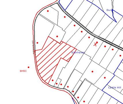
|
NOTIFICATION
PLAN
|
|
|
• PROPERTIES NOTIFIED
|
X SUBMISSIONS
RECEIVED
|

PROPERTY SUBJECT OF DEVELOPMENT
|

|
|
|
|
|
One submission objected to the
development, generally on the following grounds that the development would
result in traffic being directed through Wayfield Road at some future stage.
This matter is discussed below.
5.1.1 Future Work
The resident advised that they
were generally in favour of the proposal, however were concerned that the road
system in Orchard Drive
would allow for traffic to be directed through Wayfield Road at a future stage. There is no proposal currently before the
Council to expand the retirement village to the north, so that it adjoins Wayfield Road. Orchard Drive has been designed to enable
vehicles and garbage trucks to adequately manoeuvre.
5.2 Public Agencies
The development application is
Integrated Development under the Act.
Accordingly, the application was referred to the following Agencies for
comment:
5.2.1 Roads and Traffic Authority
The
application was required to be referred to the Roads and Traffic Authority
(RTA) pursuant to SEPP No.11 – Traffic Generating Development.
The RTA raised no objection to the
application and provided recommended consent conditions. The recommended conditions do not require any
external road works. Rather, there was a
presumption that the existing approved (uncompleted) roadworks required for
DA/753/2002 would be available for the enlarged retirement village. Consent conditions ensure that the approved
traffic signals and pedestrian footpaths are established prior to an occupation
certificate being issued for the additional aged care units.
5.2.2 Department of Water and Energy
The application was referred to the Department of Water and Energy (DWE)
as Integrated Development, requiring approval for works in proximity to a
watercourse under the Rivers and Foreshores Improvement Act 1948.
The DWE has raised no objections
to the development and has provided General Terms of Approval that are
incorporated into the conditions of consent.
5.2.3 Department of Primary Industries
The application was referred to the Department of Primary Industries
(DPI) as potentially Integrated Development under the Fisheries Act, given the
proposed works to the riparian corridors.
The DPI has raised no objections to the development. The comments provided are addressed by
recommended conditions.
5.2.4 Department of Planning
The Director-General of the
Department of Planning has issued a site compatibility certificate for the
property required pursuant to Clause 24 of SEPP (Housing for Seniors or People
with a Disability) 2004. The site
compatibility certificate issued on 25 November 2008 advises that the
development of 154 serviced self care dwellings is compatible with the
surrounding environment.
5.2.5 The Hills Shire Council
Hornsby Council referred the
application to The Hills Shire Council.
The Hills Shire Council provided details of 34 neighbouring residents to
be notified of the proposal. This
notification was undertaken by Hornsby Council.
No objections were received.
6. THE PUBLIC INTEREST
Section 79C(1)(e) of the Act
requires Council to consider “the public
interest”.
The public interest is an
overarching requirement, which includes the consideration of the matters
discussed in this report. Implicit to
the public interest is the achievement of future built outcomes adequately
responding to and respecting the future desired outcomes expressed in
environmental planning instruments and development control plans.
The application is considered to
have satisfactorily addressed Council’s and relevant agencies’ criteria and
would provide a development outcome that, on balance, would result in a
positive impact for the community. Accordingly,
it is considered that the approval of the proposed aged housing development
would be in the public interest.
7. CONCLUSION
The
application proposes the erection of a development for serviced self-care
housing for aged or differently abled people.
This application has been assessed having regard to
the Heads of Consideration under Section 79C(1) of the Environmental Planning
& Assessment Act 1979, the Hornsby Shire LEP 1994, State
Environmental Planning Policy (Housing for Seniors or People with a Disability) 2004 and the provisions
of the relevant State Environmental Planning Policies. The development complies with the provisions
of SEPP (Housing for Seniors or People with a Disability) and is similar to three
previous development consents approved for the property under SEPP No.5.
Approval of
the application is recommended.
Note: At the time of
the completion of this planning report, no persons have made a Political Donations Disclosure Statement pursuant
to Section 147(3) of the Environmental Planning and Assessment Act 1979 in
respect of the subject planning application.
|
Rod Pickles
Manager -
Assessment Team 2
Planning Division
|
Scott Phillips
Executive Manager
Planning Division
|
Attachments:
|
1.View
|
Locality
Plan
|
|
|
|
2.View
|
Site
Plan
|
|
|
|
3.View
|
Landscape
Plans
|
|
|
|
4.View
|
Site
Floor Plans
|
|
|
|
5.View
|
Unit
Floor Plans and Elevations
|
|
|
|
6.View
|
Sections,
Perspectives and Community Centre Plans
|
|
|
|
7.View
|
Creek
Restoration Plans
|
|
|
|
8.View
|
Staging
Plan
|
|
|
|
9.View
|
Comparison
of Approved and Proposed Site Plan
|
|
|
File Reference: DA/1709/2007
Document Number: D01055726
SCHEDULE 1
GENERAL MATTERS
Approved Plans and Supporting
Documentation
1. The development must be carried out in
accordance with the following plans as amended in red and documentation listed
below and endorsed with Council’s stamp, except where amended by other
conditions of this consent:
Survey Plan
|
Drawing
Number
|
Rev
|
Drawing
title
|
Drawn by
|
Dated
|
|
274-05
|
|
Survey drawing
|
Craig and Rhodes
|
12/2005
|
Architectural Plans
|
Drawing
Number
|
Rev
|
Drawing
title
|
Drawn by
|
Dated
|
|
DA01
|
E
|
Site plan
|
NRP Architecture
|
23.10.08
|
|
DA02
|
B
|
Site plan. Area A level 1
|
NRP Architecture
|
20.06.08
|
|
DA03
|
C
|
Site plan. Area A level 2
|
NRP Architecture
|
20.06.08
|
|
DA04
|
C
|
Site plan. Area A level 3
|
NRP Architecture
|
20.06.08
|
|
DA05
|
C
|
Site plan. Area A level 4
|
NRP Architecture
|
20.06.08
|
|
DA06
|
E
|
Site plan. Area A level 5
|
NRP Architecture
|
23.10.08
|
|
DA07
|
C
|
Site plan. Area B level 1
|
NRP Architecture
|
20.06.08
|
|
DA08
|
C
|
Site plan. Area C level 1
|
NRP Architecture
|
20.06.08
|
|
DA09
|
C
|
Site plan. Area C level 2
|
NRP Architecture
|
20.06.08
|
|
DA10
|
D
|
Site plan. Area D level 1
|
NRP Architecture
|
10.07.08
|
|
DA11
|
D
|
Site plan. Area D level 2
|
NRP Architecture
|
10.07.08
|
|
DA12
|
D
|
Site plan. Area D level 3
|
NRP Architecture
|
10.07.08
|
|
DA13
|
B
|
Site plan. Area E level 1
|
NRP Architecture
|
20.06.08
|
|
DA14
|
B
|
Site plan. Area E level 2
|
NRP Architecture
|
20.06.08
|
|
DA15
|
B
|
Site plan. Area E level 3
|
NRP Architecture
|
20.06.08
|
|
DA16
|
A
|
Unit type A and B. Plan
elevation and section
|
NRP Architecture
|
14.04.08
|
|
DA17
|
A
|
Unit type C. Plan elevation
and section
|
NRP Architecture
|
14.04.08
|
|
DA18
|
|
Unit type F. Plan elevation
and section
|
NRP Architecture
|
14.04.08
|
|
DA19
|
|
Unit type G and H. Plan
elevation and section
|
NRP Architecture
|
06.11.07
|
|
DA20
|
|
Unit type F94A / F95A and
G76A / G77A. Plan elevation and section
|
NRP Architecture
|
06.11.07
|
|
DA21
|
A
|
Unit type J and J1. Plan
elevation and section
|
NRP Architecture
|
14.04.08
|
|
DA22
|
|
Unit type L. Plan elevation
and section
|
NRP Architecture
|
06.11.07
|
|
DA23
|
|
Unit type M and M1.Plan
elevation and section
|
NRP Architecture
|
14.04.08
|
|
DA24
|
A
|
Unit type N. Plan elevation
and section
|
NRP Architecture
|
14.04.08
|
|
DA25
|
B
|
Site sections
|
NRP Architecture
|
30.06.08
|
|
DA26
|
B
|
Site sections
|
NRP Architecture
|
30.06.08
|
|
DA27
|
A
|
Site elevations
|
NRP Architecture
|
30.06.08
|
|
DA28
|
B
|
Community centre plans
elevations and section
|
NRP Architecture
|
30.06.08
|
|
DA29
|
|
Perspective unit type A and
C
|
NRP Architecture
|
06.11.07
|
|
DA30
|
|
Perspective unit type F –
Old orchard Drive
|
NRP Architecture
|
06.11.07
|
|
DA31
|
|
Perspective unit type L –
Spring Harvest Road
|
NRP Architecture
|
06.11.07
|
|
DA32
|
|
Perspective community
centre Blue Gum Drive
|
NRP Architecture
|
06.11.07
|
|
DA33
|
|
Meeting rooms plan
elevations and sections
|
NRP Architecture
|
14.04.08
|
|
DA34
|
|
Shadow diagrams – sheet 1
|
NRP Architecture
|
06.11.07
|
|
DA35
|
|
Shadow diagrams – sheet 2
|
NRP Architecture
|
06.11.07
|
|
Fig 2
|
|
Staging Plan
|
NRP Architecture
|
06.11.07
|
|
Fig 5
|
|
Garbage Enclosures
|
NRP Architecture
|
31.01.08
|
|
Fig 6
|
B
|
Garbage Enclosure Plan
|
NRP Architecture
|
14.04.08
|
|
Fig 5
|
|
Demolition Plan
|
NRP Architecture
|
July 2007
|
Landscape Plans
|
Drawing
Number
|
Rev
|
Drawing
title
|
Drawn by
|
Dated
|
|
LA01
|
G
|
Landscape Plan
|
Taylor Brammer
|
19.06.08
|
|
LA02
|
G
|
Landscape Plan
|
Taylor Brammer
|
19.06.08
|
|
LA03
|
G
|
Landscape Plan
|
Taylor Brammer
|
19.06.08
|
|
LA04
|
G
|
Landscape Plan
|
Taylor Brammer
|
19.06.08
|
|
LA05
|
G
|
Plant Schedule
|
Taylor Brammer
|
19.06.08
|
|
LA06
|
B
|
Landscape Sections
|
Taylor Brammer
|
02.05.08
|
|
LA07
|
B
|
Landscape Sections
|
Taylor Brammer
|
02.05.08
|
|
LA08
|
B
|
Landscape Sections
|
Taylor Brammer
|
02.05.08
|
|
TP01
|
P
|
Tree Removals Plan
|
Taylor Brammer
|
24.06.08
|
Stormwater, Erosion and Sediment Control Plans
|
Drawing
Number
|
Rev
|
Drawing
title
|
Drawn by
|
Dated
|
|
05P735-E1
|
B
|
Sediment and Erosion
Control Notes Legends and Details Sheet 1 of 5
|
Hughes Truman
|
22.08.08
|
|
05P735-E2
|
E
|
Sediment and Erosion
Control Plan Stage 2 Sheet 2 of 5
|
Hughes Truman
|
10.09.08
|
|
05P735-E3
|
D
|
Sediment and Erosion
Control Plan Stage 3 Sheet 3 of 5
|
Hughes Truman
|
09.09.08
|
|
05P735-E4
|
B
|
Sediment and Erosion
Control Plan Stage 4 Sheet 4 of 5
|
Hughes Truman
|
25.06.08
|
|
05P735-E5
|
B
|
Sediment and Erosion
Control Plan Stage 5 Sheet 5 of 5
|
Hughes Truman
|
25.06.08
|
|
05P735-D1
|
J
|
Site Plan Sheet 1 of 6
|
Hughes Truman
|
25.06.08
|
|
05P735-D2
|
E
|
Creek 1 Sections Sheet 2 of
6
|
Hughes Truman
|
28.05.08
|
|
05P735-D3
|
C
|
Creek 2 Sections Sheet 3 of
6
|
Hughes Truman
|
29.05.06
|
|
05P735-D6
|
A
|
Overflow Creek Sections
|
Hughes Truman
|
25.06.08
|
Vegetation Management and Creek
Restoration Plans
|
Drawing
Number
|
Rev
|
Drawing title
|
Drawn by
|
Dated
|
|
Schedule 1
|
S1
|
Vegetation Management Works
|
Travers Environmental
|
09.09.08
|
|
Schedule 2.1
|
S2
|
Creek and Blue Gum High Forest
Restoration Plan – Bluegum
High Forest
Conservation Area
|
Travers Environmental
|
10.09.08
|
|
Schedule 2.2
|
S12.2
|
Creek Restoration Plan –
Upper Riparian Corridor
|
Travers Environmental
|
10.09.08
|
|
Figure 7
|
-
|
Creek 1 Remedial Works Plan
|
Hughes Trueman
|
Sept 2008
|
Civil Services Plans
|
Drawing
Number
|
Rev
|
Drawing
title
|
Drawn by
|
Dated
|
|
MPH-01
|
P8
|
Masterplan – Sewer Services
|
GDK Hydraulics Consulting
|
23.06.08
|
|
MPH-02
|
P7
|
Masterplan – Landscape
Watering, Domestic Water, Fire Hydrant & Gas
|
GDK Hydraulics Consulting
|
23.06.08
|
|
MPH-03
|
P6
|
Masterplan – Rainwater
Harvesting Services
|
GDK Hydraulics Consulting
|
23.06.08
|
Supporting Reports and Information
|
Document No.
|
Prepared by
|
Dated
|
|
Statement of Environmental Effects Glenhaven Green
Stages 2-5
|
Smyth Planning
|
Nov 2007
|
|
Vegetation Management Plan (Ref:8039 VMP)
(D01004663)
|
Travers Environmental
|
Sept 08
|
|
Water Cycle Management Plan (D00953218)
|
Hughes Trueman
|
1.07.08
|
|
Glenhaven Green Village Rules (D01004650)
|
ARV
|
Oct 2002
|
|
Environment & Construction Management Plan
(D00953217)
|
Hughes Trueman
|
1.07.08
|
|
Tree Assessment – 599 Old Northern Road, 603 Old
Northern Road, 607 Old Northern Road (D00953215)
|
Stuart Pittendrigh
|
June 2008
|
|
Garbage Enclosure Schedule (D00962361)
|
Unknown
|
Received 14.07.08
|
|
Waste Management Plan (D00849085)
|
Smyth Planning
|
04.02.08
|
|
Sewer pump out calculations (D00852808)
|
Unknown
|
Received 01.02.08
|
|
Letter on Overland
Flow Path
|
Hughes Truman
|
9 July 2008
|
|
ARV Services Statement
|
ARV
|
Undated
|
|
Flora and Fauna Report
|
Conacher Travers
|
Nov 2006
|
|
Access for people with a disability
|
Access Associates Sydney
|
Nov 2007
|
|
Assessment of Traffic Noise Intrusion
|
Acoustic Logic Consultancy
|
07.11.07
|
|
Traffic, Parking and Access Report
|
GTA Consultants
|
07.11.07
|
|
Basix Certificate 151507M
|
|
02.08.07
|
|
Schedule of Finishes
|
|
Nov 07
|
|
Hazardous Materials Survey. 599 Old Northern Road
Glenhaven Report E523.1 AA
|
EI Australia
|
23.12.05
|
|
Hazardous Materials Survey. 601 Old Northern Road
Glenhaven Report E524.1 AA
|
EI Australia
|
22.12.05
|
|
Hazardous Materials Survey. 603 Old Northern Road
Glenhaven Report E525.1 AA
|
EI Australia
|
10.02.06
|
|
Hazardous Materials Survey. 607 Old Northern Road
Glenhaven Report E526.1AA
|
EI Australia
|
30.12.05
|
|
Environmental Site Assessment 599-601 Old Northern Road Glenhaven
|
EI Australia
|
28.02.06
|
|
Environmental Site Assessment 603 Old Northern Road Glenhaven
|
EI Australia
|
19.05.06
|
|
Environmental Site Assessment 607 Old Northern Road Glenhaven
|
EI Australia
|
07.08.06
|
|
Remediation Action Plan. 607 Old Northern Road
Glenhaven
|
EI Australia
|
20.10.06
|
Amendment of Plans
2 The approved plans are
to be further amended as follows:-
a) In
order to reduce the building bulk adjacent to Old Northern Road and improve the
landscape setting of the development, the plans are to delete unit Nos. 33A/33B
and 34A/34B and Unit Nos.32A/32B to
adjoin the western wall of unit No.35A/35B.
The adjacent block of units Nos.28 to 31 is to be relocated 5 metres to
the east.
b) In
order to improve the landscape setting of the development, the retaining wall
in the landscape setback adjacent to Old
Northern Road is not to be sited within 1.5 metres
of the front property boundary. This
applies where the retaining wall setback on the approved plans is less than 1.5
metres. Where the setback of the wall is
currently shown as being greater than 1.5 metres, it is not to be further
reduced.
c) Delete
the 2 carparking spaces and driveway located in the front setback area between
Units 86A/ 85A and the Old
Northern Road property boundary.
d) The retaining wall to
the rear of Unit No.59A is to be relocated outside the critical root zone of
Tree No.144 (on the adjacent property) and shall be no closer than 6.5m to the
trunk of Tree No.144.
Access and Mobility
3. The development is to be designed and constructed to comply
with the standards concerning accessibility and useability for self contained
dwellings (serviced self care housing) in Schedule 3 of State Environmental
Planning Policy (Housing for Seniors or People with a Disability) 2004. A suitably qualified access consultant is to
certify compliance with this condition prior to the issue of an Occupation
Certificate.
4. Resident
Services are to be provided in accordance with the Resident Services Statement
provided at Annexure 23 to the Statement of Environmental Effects and shall
include:-
a) home delivered meals, and
b) personal care and home nursing services,
and
c) assistance with housework and cleaning
services.
5. The
main community facility must be constructed in Stage 2 and is to be completed
prior to the issue of an Occupation Certificate for any serviced self-care
housing.
6. Footpaths
from the site to bus stops and pedestrian refuges, immediately adjacent and
opposite the site, shall be constructed on Old Northern Road in accordance with
AS1428 and Austroads Part 13, to ensure a continuous path of travel to bus
services in accordance with the requirements of SEPP (Housing for Seniors or
People with a Disability) Clause 26.
These works are to be completed prior to the issue of an occupation
certificate.
7. In accordance with Clause 43 of SEPP (Housing
for Seniors or People with a Disability) the owner of the premises shall provide a dedicated bus service for the
use of the residents of the development.
This bus is to be capable of carrying at least 10 passengers and is to
provide the following minimum service:
a) will drop off and pick up passengers at a
local centre that provides residents with access to the following:
i) shops, bank service providers and
other retail and commercial services that residents may reasonably require, and
ii) community services and recreation
facilities, and
iii) the practice of a general medical
practitioner, and
b) that is available both to and from the
proposed development to any such local centre at least once between 8am and
12pm each day and at least once between 12pm and 6pm each day.
8. A restriction as to user is to be
registered on the title of the property, in accordance with Section 88E of the
Conveyancing Act, limiting the use of any accommodation to which the
application relates to the kinds of people referred to in Clause 18(1) of SEPP
(Housing for Seniors or People with a Disability).
In this regard, accommodation is only to be
occupied by the following:
a) seniors, or people with a disability,
b) people who live within the same household
with seniors or people who have a disability,
c) staff employed to assist
in the administration of and provision of services to housing provided.
9. Any
easement(s) or restriction on Title required by this consent must nominate
Hornsby Shire Council as the authority to release, vary or modify the
easement(s) or restriction(s).
Acoustic Privacy
10. In
order to mitigate potential noise intrusion from Old Northern Road and the adjoining
nursery (Flower Power), all of the self contained dwellings are to be designed
and constructed to ensure that the following LAeq levels are not exceeded:
a) in any bedroom – 35dB(A)
at any time between 10pm and 7am, and
b) anywhere else in the
building (other than a garage, kitchen, bathroom or hallway) – 40 dB(A) at any time.
Utility Services
11. Electricity services within the public
road are to be provided underground.
Satisfactory arrangements are to be made with the electricity
authority.
12. A
Section 73 Compliance Certificate under the Sydney Water Act 1994 must
be obtained from Sydney Water Corporation.
Please refer to the Building Developing and
Plumbing section of the web site www.sydneywater.com.au or telephone 13 20 92
for assistance.
12A. Water
supply – Reticulated water supply is to be provided to the site. All requirements of Sydney Water are to be
complies with including those requirements outlined in Annexure 9 ‘Hydraulic
Services’ of the Statement of Environmental Effects.
13. Sewerage
services – The discharge of sewer from the proposed development shall connect
to Sydney Water’s sewerage system via a private pumping system. This is to be inaccordance with the
requirements of Sydney Water.
Building Code of Australia
14. All building work must
be carried out in accordance with the requirements of the Building Code of Australia.
Demolition
15. All demolition work is
to be carried out in accordance with the applicable provisions of Australian
Standard 2601-2001 ‘The Demolition of Structures’.
Note:
Applicants are reminded that WorkCover NSW requires all plant and equipment
used in demolition work must comply with the relevant Australian Standards and
manufacturer specifications.
Asbestos Removal
16. a) Prior to commencement of any work
involving the demolition, alteration or addition to any building on the
development site, a survey is to be conducted by a competent person to
ascertain whether any asbestos materials exist thereon. Asbestos material means any material that
contains asbestos.
b) Where asbestos material is found to
exist on the development site and that asbestos material is to be removed or
disturbed as a result of any proposed demolition, alteration or addition, then
all work involving removal and disposal of asbestos material must be undertaken
by persons who hold the appropriate licence issued by WorkCover NSW under
Chapter 10 of the Occupational Health and Safety Regulation 2001.
c) The collection, storage, transportation or
disposal of any type of asbestos waste is to comply with the requirements of
clause 29 of the Protection of the Environment Operations (Waste)
Regulation 1996.
d) Upon completion of
disposal operations, the applicant must lodge with the principal certifying
authority, within seven (7) days, all receipts (or certified photocopies)
issued by the receiving landfill site as evidence of proper disposal.
Note: The person
responsible for disposing of the asbestos material shall consult with the
Environment Protection Authority to determine the location of an approved
landfill site to receive asbestos material.
Hours of Construction
17. In order to maintain
the amenity of adjoining properties, site works (including demolition) shall be
restricted to between 7.00 am and 6.00 pm, Monday to Friday and 8.00 am to 1.00
pm Saturday. No work shall be undertaken
on Sundays or public holidays. Plant,
goods or materials shall not be delivered to the site outside the approved
hours of site works unless otherwise approved by Council.
Long Service Levy
18. Under Section 34 of the
Building and Construction Industry Long Service Payments Act 1986 any work
costing $25,000 or more is subject to a Long Service Levy. The levy rate is 0.35% of the total cost of
the work and shall be paid to either the Long Service Payments Corporation or
Hornsby Shire Council. Under section
109F (1) of the Environmental Planning & Assessment Act, 1979 this payment
must be made prior to a construction certificate being issued.
Home
Building Act 1989
19. The builder or person
who does the residential building work must comply with the applicable
requirements of Part 6 of the Home Building Act 1989 and must not contract to
do any residential building work unless a contract of insurance that complies
with that Act is in force in relation to the proposed work. A copy of the contract of insurance shall be
submitted to Hornsby Council before any works commence.
Fire Safety Schedule
20. In accordance with clause 168 of the
Environmental Planning and Assessment Regulation 2000 fire safety measures
shall be implemented in the building. A
schedule of all proposed and existing Essential Fire Safety Measures to be
installed in the building (eg: hydrants, hose reels, exit signs, smoke control
systems) shall be submitted with the Construction Certificate application and
distinguish between the existing and proposed fire safety measures. Should the Construction Certificate involve
the use of an alternate solution, the application must also be accompanied by
details of the performance requirements that the alternate solution is intended
to meet and the assessment methods use to establish compliance with those
performance requirements.
Fire Safety Certificate –
Final
21. In accordance with Part 9, Division 4 of
the Environmental Planning & Assessment Regulation, 2000, the owner of the
building must, on completion of the building, provide Council with a
certificate in relation to each essential fire safety or other safety measure
implemented in the building.
Fire Safety Statement - Annual
22. In accordance with Part
9, Division 5 of the Environmental Planning & Assessment Regulation, 2000,
at least once in each period of 12 months after the date of the first fire
safety certificate, the owner shall provide Council with a further certificate
in relation to each essential service installed in the building.
Retaining Walls
23. Retaining walls exceeding 600mm in height with associated
stormwater drainage measures, are to be designed and constructed by a chartered
Structural engineer of the institution of Engineers, Australia. Details are to be
included with plans and specifications to accompany any construction
certificate.
Engineering Works
24. All engineering works required by this consent must be
designed and undertaken in accordance with the relevant aspects of the
following documents, except as otherwise authorised by this consent. A
Construction Certificate is to be obtained prior to commencement of works.
a) Australian
Rainfall and Run-Off
b) Hornsby
Shire Council's Design and Construction Specifications 1999
Note: Any variation from these design requirements must be separately
approved by Council.
Road Network, Parking and
Loading
25. Parking and loading/unloading areas are to be designed in
accordance with Australian Standards AS 2890.1 and 2890.2 2004.
26. All driveways to the units from roads shall be designed to
comply with the maximum grade of 25% with maximum transition for changes of
grade of 8% per plan metre.
Drainage – On Site Detention
27. The drainage system to control all
collected roof and surface stormwater shall be designed with on-site-detention
systems. A construction certificate is to be obtained prior to commencement of
works.
28. The on-site-detention systems shall be
constructed to limit discharge from the development site to predevelopment
levels. On site detention storage volume shall be provided for up to 100 ARI storms. Detail calculations and plans showing
the controls for 5 year, 20 year and 100 ARI
pre development levels are to be provided (ensure that during a 5 year ARI storm, the flow from the development site does
not exceed 5 year pre development ARI
level, so on). The system shall be
designed by a Chartered Professional Civil/Hydraulic Engineer of the
Institution of Engineers Australia and constructed in accordance with
Council's Engineering specifications.
29. The on site detention systems are to be
located outside 100 year overland flowpath or riparian zones.
30. Suitable swimming pool standard fencing
is to be constructed around the perimeters of above ground OSD systems.
31. Where the banks of the ponding area
exceed a grade of 1 in 4 they are to be covered by a stable maintenance free
surface.
32. After completion of works, a certificate
confirming that the on site detention systems
have been constructed according to the Construction Certificate and will
function hydraulically in accordance with the approved design plans and shall
be submitted to the PCA.
33. The certificate (OSD) is to include
work-as-executed details of the on-site-detention systems prepared by a
Chartered Engineer/Registered Surveyor and verify that the storages have been
constructed in accordance with the design requirements. The details are to show
the invert levels of the OSD system as well as the pipe sizes and grades. Any
variations must be shown in red and supported by calculations.
34. An appropriate 88B restriction as to user
and a positive covenant are to be created over the constructed on-site
detention systems and outlet works in favour of Council to ensure continued
maintenance and performance of the
stormwater management system in
accordance with Council’s standard wording prior to occupation of the
premises.
Overland Flowpath and
Restriction as to User
35. The overland flow path from the “Flower
Power Dam” to the water course shall be constructed in accordance to the “Flood
Study Report”, prepared by Hughes Trueman Pty Ltd (Council’s record D00975207)
for a 100 year ARI storm event.
The floor levels of the units and garages abutting the flowpath (complying with
a minimum 500mm and 300mm above 100 year flow level) shall be constructed in
accordance with the levels contained in the report. Prior to works proceeding
beyond the floor level, a registered surveyor is to confirm that the floor
levels have been built to the requirements.
36. Prior to issue of an occupation
certificate, a restriction as to user shall be created on the area affected by
the overland flowpath prohibiting the alteration of the final floodway shape
and erection of any structure (including fencing) without the written
permission of Hornsby Shire Council.
Road Signs
37. All road signs to be erected shall comply
with Australian Standards AS 1743-2001
Bridges/Culverts
38. The
underside of the bridge slabs shall be a minimum 0.5m above the 100 year ARI flow level. Detail calculations are to be
provided with a construction certificate. The bridges/ culverts are to be
designed and constructed under the supervision of a Chartered Structural
Engineer of the Institution of Engineers, Australia.
Floor Levels of habitable rooms
and garage in the proximity of creeks
39. The
floor levels of habitable rooms and garages of units abutting creeks shall be a
minimum 500mm and 300mm above 100 year ARI
flow level.
Boundary screen
Planting (western boundary)
40. To ensure adequate screen planting is
provided to adjoining properties, additional planting is to be provided between
the proposed path and western boundary adjacent to units 85A and 84A. The
landscape area must include:
(i) 30 Syzigium australe
‘Aussie Southern’ planted at 1 metre centres in mulched planter beds. Shrubs to
be installed at minimum pot size of 5 litres.
Boundary Planting
(eastern Boundary)
41. To ensure adequate planting is provided
along the eastern boundary, additional planting is to be provided in the
landscape area between Blue Gum
Drive and site boundary opposite units 131 and
137. Tree planting to the landscape area must include:
(i) 10 Eucaltptus paniculata
planted at 5 metre centres in mulched planter beds. Trees to be installed at
minimum pot size of 25 litres.
Boundary screen Planting (Old Northern Road Boundary)
42. To ensure adequate screen planting is
provided additional planting shall be provided between car parking at end of Old Orchard Drive
and Old Northern Road.
The landscape area must include:
(i) 30 Syzigium australe
‘Aussie Southern’ planted at 1 metre centres in mulched planter beds. Shrubs to
be installed at minimum pot size of 5 litres.
Landscape Works To All Areas – Plant sizes and densities
43. All landscape works
shall meet the minimum construction standards identified in the Hornsby Shire
Council Landscape Code for Development Applications and be maintained into the future to ensure the
establishment and successful growth of plant material to meet the intent of the
landscape design.
Landscape Certification
44. Prior to the issuing of
any Occupancy Certificate, landscape works shall be inspected and certified by
experienced Landscape Architect/Designer as being completed in accordance with
the requirements of the Development Consent.
Waste Minimisation and Management
45. Blue Gum Drive
is to be constructed at Stage 2 to ensure adequate access for service vehicles.
46. Bin storage areas must be designed and constructed in
accordance with Council’s Waste
Minimisation and Management Development
Control Plan.
47. An easement shall be registered on the
title of the land entitling the Council, its servants and agents and persons
authorised by it to enter upon the property and to operate equipment for the
purpose of waste and recycling collection services. This easement must be granted in favour of
Council prior to the occupation of the development and prior to registration of
any plan of subdivision or strata subdivision of the land.
Environmental Sustainability
48. Waters captured in the
sediment basin shall be flocculated to ensure that discharges contain no more
than 50 mg/L of suspended solids, turbidity is no more than 30 ntu’s and the pH
is between 6.5 – 7.5 before being discharged. Gypsum (calcium sulfate) shall be
used as the flocculant agent and applied within 48 hours following rainfall
events. The flocculant shall be evenly distributed over the surface area of the
sediment retention basin. Settled sediment shall be pumped out and disposed of
to an approved waste management facility.
Approval must be sought from Council prior to discharge into Council’s
stormwater system.
49. Dust control measures
must be utilised to ensure airborne dust particulates are abated and airborne
movement of sediment blown from exposed disturbed areas is contained within the
site.
50. Any imported soils to the subject site must be Virgin
Excavated Natural Material (VENM) as defined in Schedule 1 of the Protection of the Environment Operations Act
1997 or a material as approved under the DECC general resource recovery
exemption.
51. All excavated material
removed from the site must be classified in accordance with NSW EPA (1999) Environmental
Guidelines: Assessment, Classification and Management of Liquid and Non-Liquid
Wastes prior to disposal. All
excavated material must be disposed of to an approved waste management
facility.
52. All wastewater and
stormwater treatment devices (including drainage systems, sumps and traps) must
be regularly maintained in order to remain effective. All solid and liquid
wastes collected from the device must be disposed of in accordance with the Protection
of the Environment Operations Act 1997.
53. All noise generated by
the proposed development is to be attenuated to prevent levels of noise being
emitted to adjacent premises which possess tonal, beating and similar
characteristics or which exceeds background noise levels by more than 5dB(A).
54. All headwall outlets
shall incorporate flow velocity reduction controls (i.e. bedded boulders and
small stones) to minimise erosive and scouring impacts to the watercourse.
Accordingly, energy dissipator controls shall be landscaped to accommodate
outlet sheet flow (forced jump). No engineering works are permitted within the
bed of the watercourse.
Designated Route - Blue Gum High Forest
(BGHF) Trees 159, 158, 157, 156
55. To prevent or minimize
soil compaction, designated routes for equipment and foot traffic by work crews
shall be determined prior to commencing construction activities. Written
approval must be given from both Council and the appointed project ecologist
for any works to occur within the area nominated as BGHF.
These routes
shall be clearly marked at the site, prior to commencement of construction,
with tree protection fencing and signage as specified in Tree Fencing paragraphs
of this section.
Compaction
56. Where fencing to prevent compaction of
the Critical Root Zone (CRZ) is not possible, the use of Trunk Protection (as
below) & temporary wood-chip mulch, gravel mulch or bridges to prevent soil
compaction around tree roots is permitted. Wood-chip or gravel mulch, 150mm –
300mm deep on top of a geotextile landscape fabric, will be placed over the
root zone of the trees to be protected.
Tree Trunk Protection
57. To avoid mechanical
injury or damage, trees numbered 176, 175, 166, 165, 159, 158, 157, 156, 43,
37, 34, 33, 49, 68, 70 ,71, 191, are to
have their trunks protected by 2m lengths of 75mm x 25mm (recycled) hardwood
timbers spaced at 80mm secured with galvanised wire (not fixed or nailed to the
tree in any way). Trunk protection is to be installed prior to the issue of a
construction certificate and maintained in good condition for the duration of
the construction period.
Tree Fencing
58. Prior to work commencing, tree protection
fencing must be erected around Tree Group.A, the Blue Gum High Forest (BGHF),
to be retained as specified in the Vegetation Management Plan.
59. Prior to work commencing, tree protection
fencing must be erected around the trees numbered 30 – 34 to be retained at a
4.5m setback.
60. Where Tree Protection
Fencing obstructs construction, the fencing shall be placed no closer than
2000mm from the edge of the trees trunk & Tree Trunk Protection &
Compaction techniques (per Condition Nos. 63 and 64) shall be emplaced for the
duration of the particular work inside the CRZ.
61. The tree fencing must be constructed of
1.8 metre ‘cyclone chainmesh fence’. The tree protection fencing must be
maintained in good working order until the completion of all building or
development works. A statement of compliance from a qualified tree surgeon or environmental consultant shall be
submitted to Council prior to the issue of the Construction Certificate.
Excavation – Trees 34, 33, 37, 49, 68, 70, 71, 43, 129, 144
62. To prevent damage to tree
roots, excavation (for services and other works), change of soil level (cut or
fill), parking (vehicles or plant), or placement of building materials
(including disposal of cement slurry and waste water) within the specified
tree protection setbacks, and within 4m of all other trees to be retained
onsite, is not permitted.
63. No tree roots located
within a 6m setback of any tree located in the specified Blue Gum High Forest
shall be severed or injured in the process of any site works during the
construction or landscaping phases of the approved project.
64. Excavation for the
installation of Fire Hydrants (DFH) within the specified setbacks of trees 34,
33, 68, 49 shall be carried out by hand excavation only.
65. Excavation for the
installation of Fire Hydrant (FH), Landscape (LW) & Cold Water (CW) piping
within the specified setbacks of trees 37, 34, 129, 68, 70, 71, 43 shall be
carried out by using the thrust boring method only.
66. Excavation for the
installation of Sewer Services within the specified setback of tree 68 has been
approved by Council’s Parks and Landscape Team and shall be carried out by
using either the thrust boring method or hand excavation.
Driveways/ Pathways – Trees 34, 37
67. The road, Harvest Crescent is
proposed to be located within the Critical Root Zone (CRZ) of trees 34 &
37. To ensure any work undertaken will
not adversely affect the longevity of the tree, pier and beam construction of
the road within the CRZ shall be used with piers being located no closer than 3
metres to the trunks of the trees. The
driveway edge shall be no closer than 2 metres to the edge of the trunk. The excavation for the piers within the
nominated restriction zone shall be hand dug to reveal the presence of any
roots. A qualified and experienced arborist
is to be on site overseeing the work to ensure no roots greater than 50mm in
diameter are severed, and root damage is minimised.
Tree Removals
68. The
removal of trees must be undertaken by a qualified and experienced
Arborist and must be undertaken in a manner that does not impact on the
surrounding vegetation.
69. Trees, 180, 181, 182,
183, 192, 194, 195 to be removed from the designated Blue Gum High Forest are
to be removed by hand only with no excavation/plant equipment entering the area
to minimise impacts on the surrounding vegetation. The stumps are to be cut to ground level only
with no stump grinding within 6m of any tree located inside the forest.
Maintain Canopy Cover
70. To maintain local tree canopy cover, a
minimum 120 medium to large trees, such as Eucalyptus
paniculata (Grey Ironbark), Angophora
floribunda ((Rough-bark Apple) or Syncarpia
glomulifera (Turpentine) are to be planted on the subject site. The
planting location shall not be within 4 metres of the foundation walls of a dwelling or in-ground pool. The pot size is to be a minimum 25 litres and
the trees must be maintained and protected until they reach the height of 3
metres. Trees must be locally
indigenous, from local plant stock (preferably), reach a mature height greater
than 12 metres and have a life span greater than 20 years.
Tree Removal Prohibited
71. To protect significant trees, the removal
of trees numbered Tree Group.A (nominated as BGHF) marked on the plan, Travers
Environmental, July 2008, REF:8039-VMP, Vegetation Management Plan, or
excavation or filling of soil or the placing of building materials or
associated works (ie water, sewer, telephone, drainage) within a 6 metre
setback is not permitted without written approval from Council.
72. The Village Management Plan and associated Village Rules
are to be amended to require on-going management and maintenance of the Blue
Gum High Forest Conservation Area. The
amendment to the village rules shall include a clause that states “on-going management and maintenance of the Blue Gum
High Forest
remnants is to be undertaken in perpetuity by either a fully qualified bush
regenerator or bush regeneration team every 6 months to undertake maintenance
weeding and supplementary planting. The
maintenance regime is to be enhanced if the level of weed infestation
deteriorates beyond the restoration targets as stated in the approved
Vegetation Management Plan. The bush
regeneration team is to remain under the direction of the Project Ecologist who
will carry out an inspection every 6 months to assess the condition of the Blue
Gum High Forest and submit a compliance report to Council once a year. To ensure relevance of the maintenance works
within the Blue Gum High Forest Conservation Area, the Village
Association may request a review or updated Vegetation Management Plan which
will need to be submitted to Hornsby Council for approval.”
Note: This condition has been
agreed by Applicant’s Ecological Consultant.
73. A “Construction Works Plan” shall be prepared that
takes into consideration any final conditions of approval in accordance with
the NSW Department of Water and Energy Guidelines for “Controlled Activities – Outlet Pipes, Laying Pipes and Cable in
Watercourses and In-stream Works”. This
Plan is to be approved and certified by the Project Ecologist and Council.
General
Bushland Conditions of Consent
74. A
Restriction-As-To-User shall be created under Section 88B of The Conveyancing Act 1919 to preserve
the remnant Blue Gum High Forest as mapped in the approved Vegetation
Management Plan. No building work
including paving, excavation or construction, no removal of native vegetation
(trees, shrubs and groundcovers), no stockpiles, no changes to soil aeration or
hydrological capacity, no open cut trenching, no placement of temporary
buildings, no parking or movement of machinery, no spillage/disposal of
building waste, no agricultural uses are to occur within this area is to be
considered the ‘Restricted Development Area’, except where approved by Council or
part of the approved Vegetation Management Plan. The ‘Restricted Development Area’ shall be
managed for the long term conservation of the Blue Gum High Forest.
75. A positive
covenant shall be created under Section 88E of The Conveyancing Act 1919 for the Blue Gum High Forest as mapped in
the approved Vegetation Management Plan.
This area is to be considered the ‘Restricted Development Area’. The covenant shall specify:
a) All landscaping and vegetation management including weed
control shall be in accordance with the approved Vegetation Management Plan
prepared by Travers Environmental
dated September 2008 (to include the amendments in accordance with the
Conditions of Consent) and the Village Management Plan.
b) Any approved tree removal within the ‘Restricted Development
Area’ shall be undertaken by a qualified Arborist and undertaken in a manner
that will have minimal impact on the Blue Gum High Forest remnant. Dead trees shall be left standing to provide
native fauna habitat, except if located on the edge of the remnant adjoining
any building, road or pedestrian path.
Any replacement tree must be a species associated with Blue Gum High Forest
and be grown from local provenance seed stock.
c) No
development shall encroach within the ‘Restricted Development Area’, nor any
clearing of indigenous vegetation, no on-site effluent disposal, nor any
vehicle assess, nor any stock or agricultural activities.
d) High
use open space areas shall be limited to land outside the ‘Restricted
Development Area’.
e) Trees
within the ‘Restricted Development Area’ shall be inspected annually by a
qualified Arborist, and treated to maintain tree health to ensure the stand of
trees will be preserved.
f) Landscaping
shall be only undertaken if determined by and under the supervision of a
qualified ecologist or bush regeneration consultant, using Blue Gum High Forest
species grown from local provenance seed stock.
76. Prior to the issue of the Construction Certificate the
applicant shall submit to Council documentation to show that a qualified and
experienced ecologist has been engaged to undertake all works within the
approved Vegetation Management Plan and ensure the compliance of all
environmental protection conditions of consent.
Traffic and Road Safety
77. To
ensure safe vehicle and pedestrian access is available to the site, traffic
signals, road widening works and pedestrian footpaths to bus stops at Old
Northern Road shall be completed in accordance with the requirements of
DA/753/2002 (as amended) and the NSW Roads and Traffic Authority prior to issue
of the occupation certificate for any building on site.
78. The kerb returns at intersections of 5.5 and 4.5 metre wide
roads are to be 6.0m radius minimum and be constructed with fully mountable
kerb.
79. Clear
zones near garages with frontage to 4.5m wide roads shall be provided as per
traffic report (GTA consultants 15 April 2008).
Developer Contributions
80. The payment of a
contribution towards the cost of transport and traffic management, open space and
recreation facilities, library and community facilities, bushland regeneration,
stormwater drainage, civic improvements and section 94 plan administration in
accordance with sections 94, 94A and 94C of the Environmental Planning and
Assessment Act, 1979 and the Hornsby Shire Council’s Development Contributions
Plan 2007-2011. The contributions for
the construction stages 2, 3, 4 and 5 shall be as follows:
Stage 2: 50
dwellings @ $9,293.25 – Total $ 464,662.50;
Stage 3: 57
dwellings @ $9,293.25 – Total $ 529,715.25;
Stage 4: 20
dwellings @ $9,293.25 – Total $ 185,865.00;
Stage 5: 23
dwellings @ $9,293.25 – Total $ 213,744.75;
Total 150
dwellings
The contribution is
to be paid by the end of the financial quarter in which the development application
was determined and prior to the issuing of a construction certificate for each
respective Stage, whichever occurs first.
The contribution will be adjusted in accordance with the underlying
consumer price index for the subsequent financial quarters.
Note 1: It
is recommended that you contact Council on 9847 6030 to ascertain the indexed
value of contributions prior to payment.
Note 2: Council’s Contribution Plan can be viewed at www.hornsby.nsw.gov.au/Building & Development, or a copy may be inspected during business
hours at the first floor of Hornsby Shire Council’s Administration Building
located at No. 296 Pacific
Highway, Hornsby.
Roads And Traffic Authority
81. The emergency access to
Old Northern Road
at the southern end of the development is to be limited to emergency use only.
82. Due to the proximity of
Acacia Drive
to the signalised intersection of Blue
Gum Drive and Old Northern Road, a no exit sign for
vehicles over 6 metres is to be posted at Acacia Drive at its intersection with Blue Gum Drive.
83. All pedestrian
crossings are to be clearly sign posted and marked on the road to ensure safety
for pedestrians.
84. Vegetation and proposed
landscaping/fencing must not hinder sight lines to and from the proposed access
driveways to motorists, pedestrians and cyclists.
85. Off street parking
associated with the proposed development, including grades, parking bay
dimensions, sight distance requirements, and turn paths are to be in accordance
with AS 2890.1-2004.
Department Of Water and Energy General Terms
of Approval
86. Before
any works are commenced within 40m of any watercourse on or near the site, a
Part 3A Permit must be obtained from the Department
of Water and Energy (the Department).
87. Works
are to be carried out in accordance with the plans and documents presented to
the Department for the subject Development Application and these conditions.
88. All
documentation and plans and bonds required as part of these conditions must be
prepared and provided to the Department prior to the issuing of the Part 3A
Permit.
89. All engineering,
other structural works or natural landscaping proposed must be designed,
constructed and operated by suitably qualified professionals, recognised in
that specialised field. For any VMP, this relates particularly to
bushland rehabilitation practices, and for any WP, this relates particularly in natural stream processes, design
and rehabilitation practices. The
designs and construction methods and activities are to result in NIL or minimal
harm to aquatic and riparian environments and do not cause erosion,
sedimentation, or increase flood levels of Protected Waters.
90. Erosion
and sediment control measures are to be implemented prior to any works
commencing at the site and must be maintained for as long as necessary after
the completion of works, to prevent sediment and dirty water entering the
watercourse/foreshore environment. These
control measures are to be in accordance with the requirements of Council, and
best to follow relevant management practices as outlined in the Landcom manual “Managing Urban Stormwater: Soils and
Construction – Volume 1” (4th Ed., 2004) - the “Blue Book”, or
other suitable control measures to mitigate erosion where conventional measures
are not adequate (such as within bed and banks of a watercourse).
91. The
Part 3A permit from the Department is issued for works on FREEHOLD land only
and is null and void for any works on Crown Land.
92. Evidence
of Owner’s Consent for all works over any lands within 40m of any watercourse
is required prior to the issue of the Part 3A permit.
93. In the event that
there is an inconsistency between the drawings, other documentation and the
conditions herein, the interpretation that will result in the best outcome for
the stabilisation of the Site and the subsequent rehabilitation and maintenance
of the Site and Protected
Land and Protected
Waters, is to prevail. Such
interpretation is to be applied in consultation with, and with the approval of,
the Department.
94. The
development is to satisfy all requirements of Council in relation to flooding,
drainage, stormwater detention and water quality, but in so doing, must not compromise in any way the form and
function of any works, on Protected Waters and in riparian zones required by
these conditions.
95. Works shall not commence for the
following, if a licence under the Water Act (1912) or the Water Management Act
(2000) is required:
· Install a pump for extraction of water
from a surface and/or ground water source. The temporary extraction of water
for establishment of vegetation in a VMP
does not require a licence.
· Construct a dam.
· Construct a levee.
· Divert any part of Protected Waters.
· Irrigate from any of the above.
96. Operations
shall not damage or interfere in any way with:
· Vegetation and habitat on Protected Land
on the Site outside the area approved.
· The stability of adjacent or nearby bed or banks of Protected
Waters.
· The stability of Protected Waters and their associated
environments.
· The flow of Protected Waters.
· The quality of Protected Waters.
· Any pumps or structures in the vicinity (that are licensed
under the Water Act 1912 or the Water Management Act 2000).
97. No
piping, for the placement of bulk earthworks (including roads), of any
watercourse is allowed.
98. Any permanent constructed basin/wetlands/flood
compensatory area and their associated disturbed areas are not to be located in
any riparian area in or on-line and
be consistent with the Departmental guide: Constructed
Wetlands (and Detention
Basins) – Keep Them
Off-line Guideline.
99. Any
flood study, are to take into account the effects of the vegetation required in
any VMP and any other vegetation within
the flood area.
100. The design of any stormwater outlets
(including from roads, buildings, constructed basin/wetlands, swales or other
drainage) and their spillways must be a “soft engineering solution” and be
consistent with the Departmental guide: Stormwater Outlet Structures to Streams (For
pipes, culverts, drains and spillways.
101. Points of
constriction or any other places where scour is likely within or near any
stream or any part of the riparian zones on the Site are to be suitably
protected against scour using permanent rock scour protection (rip rap) or any
other “soft engineering design solution.
In the event that scour protection works not described in the approved
plans are proposed, approval from the Department must be obtained prior to
their construction and may require a WP
and must be consistent with the Departmental guide: Works and Watercourse Design Guideline.
102. Wire mesh structures
(mattresses and baskets), concrete, spray concrete, concrete grouting, and
concrete grouting between rocks comprising rip-rap scour protection crib
walling, masonry, car tyres and the like are
not permitted.
103. Any
works that involve any change (including realignment, stabilisation,
naturalised enhancement etc) of any watercourse, must emulate a stable natural
watercourse system that behaves as, and has the appearance of a stable natural
stream system of the area (including floodplains, terraces and other typical
natural features). Part of the form of
the watercourse is to create meanders, suitable pool and riffle sequences, with
suitable aquatic and terrestrial habitat.
104. The extent of the
rehabilitation / restoration of Protected Land and/or Protected Waters are to
be as indicated by a WP for all works that involve any change (including
realignment, stabilisation, naturalised enhancement etc) of any
watercourse. Rehabilitation /
restoration, and watercourse form must be consistent with the Departmental
guide: Works and Watercourse Design
Guideline.
105. Following the
completion of the physical works associated with any watercourse at the Site
these works and all associated disturbed areas must be maintained for a period
of at least three (3) years after
practical completion, consistent with the Departmental guide: Works and Watercourse Design Guideline,
particularly the maintenance and reporting criteria.
106. Any crossing
structures, including utility crossings and associated works, must be located,
designed and constructed consistent with the Departmental guides: Watercourse Crossing Design &
Construction Guideline and Pipe and
Cable Laying Across Watercourses and
Riparian Area Guideline. The
Department may require a WP
depending upon the potential impact upon the watercourse and must be consistent
with the Departmental guide: Works and
Watercourse Design Guideline.
107. For any retaining
walls and sea walls, their location design and construction must be consistent
with the Departmental guide: Works and
Watercourse Design Guideline.
108. Any accessways,
(being roads, tracks, cycleways, pedestrian pathways or other form of
accessway) that may be proposed for the Site, are to be normally located beyond
the riparian zones and be consistent with the Departmental guide: Design and Construction of Paths and
Cycleways and Accessways along Watercourses and Riparian Areas Guideline.
109. A permanent physical
barrier, (such as a fence, pathway, road etc), to prevent inadvertent damage to
riparian zones, is to be placed at their landward extent in all locations and
be consistent with the Departmental guide: How
to Prepare a Vegetation Management Plan Guideline.
110. There is to be no
permanent or temporary excavation of, or placement of material on, protected
land, or anything done that may detrimentally affect the flow of protected
waters, and are not to be placed in any area that has existing native riparian
vegetation that is identified as part of any riparian zone in any VMP.
111. Documentation
that demonstrates a right of access to the site for a sufficient time to enable
the full implementation and maintenance of any works, including any VMP and WP, and inspections, is to be provided to the Department by the
owner. Such documentation is to be
legally binding upon the land and its present and future owners until such time
as the implementation and their maintenance of the works, including any VMP and WP are completed, and
inspected, as approved by the Department.
The instrument is to be in favour of the current owner or Council.
112. A
riparian zone consisting of local native plant species shall be established and
maintained in and adjacent to all Protected Waters, including beneath bridges,
for their entirety within the Site. The
extent of the riparian zones is to be:
· For watercourse A: at least 10
metres wide from the top of the bank on each side of the watercourse, measured
horizontally and at right angles in accordance with the plans approved by 3A
Permit issued for DA753/2003/B
· For
watercourse B: 10 metres wide on each side, measured horizontally and at right
angles from the centreline of the watercourse for the full length of the site
and in accordance with the plans approved by the 3A Permit issued for
DA753/2003/B
113. All riparian zones
at the site must be rehabilitated
where they are affected by, or located adjacent to, or located within 10m of,
any works on Protected Land that require a Part 3A permit, for the purposes of
aiming at naturalised bed and bank stabilisation and giving adequate space for
the natural functioning of the watercourse.
114. A VMP for Site rehabilitation that
demonstrates protection of any remnant local native riparian vegetation at the
Site and restore any riparian zones disturbed or otherwise affected by the
development to a state that is reasonably representative of the natural ecotone
of the protected waters system, to achieve sound naturalised watercourse and
long term riparian area stabilisation and management by the
enhancement/emulation of the native vegetation communities of the subject area
is to be prepared, and be consistent with the Departmental guide: How to Prepare a Vegetation Management Plan
Guideline.
115. Seed and propagule
sources are to be from local botanical
provenance (regarded as from as close as possible and from the same general
habitat (same soil type, distance from watercourse, exposure etc)) is required
consistent with the Departmental guide: How
to Prepare a Vegetation Management Plan Guideline.
116. The riparian zone
(and all areas and activities described in the VMP must be maintained for a period of at least two (2) years after final planting or
where other revegetation methods are used, two years after plants are at least
of tubestock size and are at the densities required by these conditions and
with species richness as described in the VMP,
and three (3) years minimum for
those areas required for access and maintenance relating to any WP and being consistent with the
Departmental guide: How to Prepare a Vegetation Management Plan
Guideline, particularly the maintenance and reporting requirements.
117. The Part 3A permit
holder must ensure that all works and activities at the Site do not compromise
the implementation of the VMP in any
way.
118. Any requirements for
bushfire asset protection zones, including fire trails, are not to compromise
in any way the extent, form or function of the riparian zones. Fuel reduced areas are to be located outside
of riparian zones.
119. Any property
boundary fence should generally be located beyond the riparian zones and be
consistent with the Departmental guide: How
to Prepare a Vegetation Management Plan Guideline.
120. As
a pre-condition to the granting of any Part 3A permit, the applicant for a Part
3A permit will be required to provide a security deposit (bank guarantee or
cash bond). The security deposit is to
cover the cost, as approved by the Department, of completing selected works and
activities listed in the previous GTA conditions in accordance with the
conditions of the Part 3A permit.
121. Any
bank guarantee is to be provided from a bank licensed pursuant to the Banking
Act 1959 (Cth) and is to be provided in favour of the Department and it must be
drawn up in the format required by the Department.
ADVISORY NOTES
The following information is
provided for your assistance to ensure compliance with the Environmental
Planning and Assessment Act 1979, Environmental Planning and Assessment
Regulation 2000, other relevant Council Policy/s and other relevant
requirements. This information does not
form part of the conditions of development consent pursuant to Section 80A of
the Act.
Principal Certifying
Authority
i. Before any
construction works commence, you are required to appoint a Principal Certifying
Authority as required by section 81A of the Environmental Planning &
Assessment Act, 1979. The Principal
Certifying Authority is responsible for ensuring that all the works are carried
out in accordance with the approved plans and specifications.
Notifying Council of
Commencement of Works
ii. It is a requirement
of the Environmental Planning and Assessment Act, section
81A(2)(c) that you notify Hornsby Council at least two (2) days prior to
the intention to commence works.
Signs for Construction Sites
iii. On-site signage is
required to clearly identify the PCA and the principal contractor (the
coordinator of the building work) pursuant to the Environmental Planning and Assessment Amendment (Quality of
Construction) Act 2003, s157(1)(c1), Cl 98A, 136C & 227A.
Signs for Demolition Sites
iv. On construction sites
where buildings contain asbestos material, a standard commercially manufactured
sign containing the words ‘DANGER ASBESTOS REMOVAL IN PROGRESS’ measuring not
less than 400mm x 300mm is to be erected on the site in a prominent position
visible from the street. The sign is to
be erected prior to any work commencing and is to remain in place until such
time as all asbestos material has been removed from the site to an approved
waste facility. This condition is
imposed for the purpose of worker and public safety and to ensure compliance
with Clause 259(2)(c) of the Occupational Health and Safety Regulation 2001.
v. A sign must be erected
in a prominent position on the premises, on which the demolition of a building
is being carried out, stating that unauthorised entry to the premises is
prohibited and showing the name of the builder or other person in control of
the premises and a telephone number at which the builder or other person may be
contacted during and outside work hours. The sign is to be removed when the
demolition of the building has been completed.
Signs for Construction Sites
vi. On-site signage is
required to clearly identify the PCA and the principal contractor (the
coordinator of the building work) pursuant to the Environmental Planning and Assessment Amendment (Quality of
Construction) Act 2003, s157(1)(c1), Cl 98A, 136C & 227A.
Construction Certificate –Engineering Works
vii. A construction certificate must be obtained from either
Council or an Accredited Certifier. Engineering design plans and specifications
are to be prepared by a chartered professional engineer for any proposed
works. The plans and specifications are
to be in accordance with development consent conditions, appropriate Australian
standards, and applicable Council standards, in particular “Hornsby Shire
Council Civil Works - Design and Construction Specification”. Information required to be submitted with a
construction certificate is as follows:
a) copies of compliance certificates relied
upon
b) Four (4) copies of the
detailed engineering plans in accordance Hornsby Shire Council's Civil Works -
Design Specification 1999. The detailed plans may include but are not limited
to the earthworks, roadworks, road pavements, road furnishings, stormwater
drainage, landscaping and erosion control works.
c) Hornsby Shire Council’s
approval for the existing roadworks and public drainage is required prior to
the issuing of a construction certificate for these works.
Inspections – Engineering
viii. All
engineering work required this consent must be inspected at the “hold points”
as nominated in the Hornsby Shire Council Civil Works Construction
Specifications 1999.
Rainwater tanks
ix. The installation of
the rainwater tank and associated plumbing must be in accordance with Sydney
Water’s Guidelines for Rainwater Tanks on
Residential Properties: Plumbing Requirements, dated April 2003.
Tree Preservation Order
x. A Tree Preservation
Order exists within the Hornsby Shire whereby the cutting down, topping,
lopping or wilful destruction of any tree exceeding 3.0 metres in height
(except where exempt as defined under Council’s Tree Preservation Order ) or
substantially altering the soil level around the trunk or within 3 metres of
the trunk, without prior written consent is prohibited. Release of the
Construction Certificate gives automatic approval to the removal of those trees
located on the subject property within 3 metres of the foundation footprint of
an approved residential, commercial or community building, garage, in-ground
swimming pool or within the alignment of approved vehicular access or parking
area. Other trees shall not be removed
or damaged without approval being granted under Council’s Tree Preservation
Order. Penalties apply for
non-compliance.
Threatened
Species Conservation Act 1995
xi. The
applicant should be advised that the restricted development area contains Blue Gum
High Forest
which is listed as an Endangered Ecological Community under the Threatened
Species Conservation Act 1995. The
TSC Act prohibits the disturbance to threatened species, endangered populations
and endangered ecological communities, or their habitat. Any actions that are outside this development
consent would qualify as illegally picking or disturbing the habitat of Blue Gum
High Forest
and could render any person who carried out this action as liable for
prosecution.'
NSW Department of Primary Industries
xii. Any dredging and reclamation works
approved by this application may require a permit from NSW DPI to authorise
such activities. This application is to
be obtained prior to such works being undertaken.
Note: It is an offence to dredge reclaim in any
waters and/or affect marine vegetation without permits from NSW Department of
Primary Industries.
Planning Report No. PLN247/08
Date of Meeting: 17/12/2008
4 DEVELOPMENT APPLICATION - ALTERATIONS AND
ADDITIONS TO AN EXISTING COMMUNITY FACILITY AND USE BY THE 'HORNSBY WOODWORKING
MEN'S SHED'
HEADEN PARK 3X SINCLAIR AVENUE, THORNLEIGH
|
Development
Application No:
|
542/2008
|
|
Description
of Proposal:
|
Alterations and
additions to existing community facility and use by the ‘Hornsby Woodworking
Men's Shed’
|
|
Property
Description:
|
Headen Park Lot 47, DP
35569, No. 3X, Sinclair
Avenue, Thornleigh
|
|
Applicant:
|
Hornsby Shire Council
|
|
Owner:
|
Hornsby Shire Council
|
|
Statutory
Provisions:
|
Open Space A (Public Recreation-Local)
|
|
Estimated
Value:
|
$120,000
|
|
Ward:
|
B
|
|
RECOMMENDATION
THAT Development Application
No. 542/2008 for alterations and additions to an existing community facility
and use of that facility by the ‘Hornsby Woodworking Men's Shed’ at Lot 47,
DP 35569, No. 3X, Sinclair Avenue,
Thornleigh (Headen
Park) be approved
subject to conditions of consent detailed in Schedule 1 of this report.
|
1. The application
proposes alterations and additions to the existing community facility at Headen Park
to better accommodate the existing use of that facility by the Hornsby Wood
Working Men's Shed.
2. Council at its Planning
Meeting held on 19 November 2008 considered Development Application
No. 542/08 and resolved to defer the matter to allow an investigation into
an alternative building design, lighting, landscaping, hours of operation and
the impact of stormwater on adjoining properties.
3. A Community, Cultural
and Recreational Facilities Taskforce meeting was held on 25 November 2008 to
consider the issues raised at the Council meeting. A copy of the Taskforce minutes is held at
Attachment 3 to this report.
4. It is recommended that
Council consider the minutes of the Taskforce Committee, the independent
planning report prepared by Nexus Environmental Planning Pty Ltd and approve
the application subject to the conditions held at Schedule 1.
HISTORY OF THE APPLICATION
On 19 November 2008, Council’s
Planning Meeting first considered the subject application and resolved:
“1. Consideration of Development Application No.
542/2008 for alterations and additions to an existing community facility and
use of that facility by the ‘Hornsby Woodworking Men's Shed’ at Lot 47, DP
35569, No. 3X, Sinclair Avenue, Thornleigh (Headen Park) be deferred to allow
investigation into:
a. An alternate building design that is of
a more regular rectangular shape.
b. The installation of lighting and
landscaping which reduces the opportunity for antisocial behaviour.
c. The hours of operation.
d. The potential impact of stormwater on
adjoining properties.
2. A
further report be prepared for Council’s consideration no later than the first
Planning Meeting in March 2009.”
On 25 November 2008, the
Taskforce considered the matter and provided comments in relation to the issues
raised by Council. These matters are discussed in the following section of this
report.
1. TASKFORCE DISCUSSION
A Community, Cultural and
Recreational Facilities Taskforce meeting was held on 25 November 2008 and the
following response was provided to the issues raised by Council:
“In
relation to the resolution associated with the above DA, the Task Force made
the following decisions/considerations last night.
a. (Whether) an alternate
building design that is of a more regular rectangular shape (would be more appropriate).
Decided to retain the current building design as described in
DA/542/2008.
b. (Whether) the
installation of lighting and landscaping which reduces the opportunity for
antisocial behaviour (would be more appropriate).
Supported the requirement install sensor lighting and suitable
landscaping as required.
Additional conditions beyond those contained in Planning Report No.
213/08 are recommended requiring sensor lighting to be installed.
With respect to suitable landscaping, the landscape plan prepared by
Council’s Parks and Landscape Team shows the provision of small native screen
trees along the southern boundary which are unlikely to provide opportunity for
crime.
c. (Clarification
of) the hours of operation.
Questioned why the DA, when lodged, nominated hours
of use as 8am to 10pm yet the consent nominated 10am to 3pm Tuesdays and
Fridays and the first and third Sundays of the month.
The recommended condition of consent with respect to the hours of
operation was based on advice contained within the application with regard to
the current hours of operation of the Men’s Shed. Upon clarification, the
application proposes hours of operation of 8am
to 10pm 7 days a week. Whilst the Acoustic Report recommended that woodworking
activities could take place between 7.00am to 10.00pm, it would not be
appropriate to allow the proposed hours of operation of 8.00am to 10.00pm based
on the site’s close proximity to residential properties. However, it is
considered appropriate that the previous recommended condition be modified to
read as follows:
“15. Hours of operation for wood working activities shall be
restricted to 9.00am to 5.00pm Monday to Friday and on no more than two
occasions each calendar month on a weekend or public holiday between the hours
of 10:00 am and 3:00 pm.”
d. The
potential impact of stormwater on adjoining properties.
Made no comment in relation to this issue.”
The potential impact of stormwater was
assessed as part of the original assessment of the application. Stormwater from the development would not
adversely impact upon neighbouring properties.
2. ASSESSMENT
An assessment of the merits of
the application was carried out by Nexus Environmental Planning Pty Ltd and is
held at Attachment 2 to this report.
3. CONCLUSION
The proposal seeks approval for alterations and additions to the existing community facility at Headen Park
to better accommodate the existing use of that facility by the Hornsby Wood
Working Men's Shed.
Council considered the application at its meeting held on 19 November
2008 and resolved to defer the matter for the applicant to investigate various
matters. The Taskforce considered the issues raised by Council and resolved to
install lighting and landscaping to reduce the opportunity for antisocial
behaviour.
It is recommended that Council
approve the application in accordance with the assessment and recommended
conditions of consent prepared by Nexus Environmental Planning Pty Ltd and
held at Schedule 1 of this report.
|
Rod Pickles
Manager -
Assessment Team 2
Planning Division
|
Scott Phillips
Executive Manager
Planning Division
|
Attachments:
|
1.View
|
Minutes
PLN213/08
|
|
|
|
2.View
|
Executive
Manager's Report No. PLN213/08
|
|
|
|
3.View
|
Independent Town Planning Consultancy Report by Nexus Environmental
Planning Pty Ltd
|
|
|
File Reference: DA/542/2008
Document Number: D01055673
SCHEDULE 1
Approved Plans and Supporting
Documentation
1. The development must be carried out in
accordance with the following plans and documentation listed below and endorsed
with Council’s stamp, except where amended by other conditions of this consent:
|
Plan
No.
|
Drawn
by
|
Dated
|
|
SK-01,
Issue B
SK-02,
Issue
B
|
Leech
Harmon Architects
Leech
Harmon Architects
|
August
2008
August
2008
|
|
Document
No.
|
Prepared
by
|
Dated
|
|
RV0241/DA/01/A
|
Shire
of Hornsby, Parks and Landscape
|
August
2008
|
Building
Code of Australia
2. All building work must
be carried out in accordance with the requirements of the Building Code of Australia.
Note: Should there be any alternative solutions listed as
Category 2 Fire Safety Provisions and outlined in the Environmental Planning
and Assessment Regulation 2000, a fire engineering report should be forwarded
to the Brigades for comment under Clause 144 of the Environmental Planning and
Assessment Regulation 2000.
Fire Upgrading
3. The existing building
is to be upgraded to bring it into compliance with Parts C, D and E of the
Building Code of Australia.
Council
Property
4. The land and adjoining
areas are to be kept in a clean and tidy condition at all times. Litter and rubbish shall be placed in
containers and removed from the site. A
waste storage container is to be provided at the commencement of the building
work.
5. The cost of repairing
any damage caused to Council's assets as a result of construction works
associated with the approved development is to be met in full by the
applicant/developer prior to the issue of a subdivision certificate.
Hours of
Construction
6. In order to maintain
the amenity of adjoining properties, site works shall be restricted to between
7.00 am and 6.00 pm, Monday to Friday and 8.00 am to 1.00 pm Saturday. No work shall be undertaken on Sundays or
public holidays. Plant, goods or
materials shall not be delivered to the site outside the approved hours of site
works unless otherwise approved by Council.
Fire
Safety Schedule
7. In accordance with
clause 168 of the Environmental Planning and Assessment Regulation 2000 fire
safety measures shall be implemented in the building. A schedule of all proposed and existing
Essential Fire Safety Measures to be installed in the building (eg: hydrants,
hose reels, exit signs, smoke control systems) shall be submitted with the
construction certificate application and distinguish between the existing and
proposed fire safety measures. Should
the construction certificate involve the use of an alternate solution, the
application must also be accompanied by details of the performance requirements
that the alternate solution is intended to meet and the assessment methods use
to establish compliance with those performance requirements.
Fire
Safety Certificate – Final
8. In accordance with Part
9, Division 4 of the Environmental Planning & Assessment Regulation, 2000,
the owner of the building must, on completion of the building, provide Council
with a certificate in relation to each essential fire safety or other safety
measure implemented in the building.
Fire
Safety Statement - Annual
9. In accordance with Part
9, Division 5 of the Environmental Planning & Assessment Regulation, 2000,
at least once in each period of 12 months after the date of the first fire
safety certificate, the owner shall provide Council with a further certificate
in relation to each essential service installed in the building.
Drainage
10. Stormwater drainage from
the site shall be designed and constructed to satisfactorily drain rainfall
intensities for an average recurrence interval of 20 years. The design shall:-
(a) Be in accordance with
Hornsby Shire Council Civil Works – Design Specification 1999.
(b) Provide for drainage
discharge to the existing drainage swale and be provided with a headwall and
energy dissipater.
(c) Ensure that the
development, either during construction or upon completion, does not impede or
divert natural surface water runoff so as to cause a nuisance to adjoining
properties.
11. Roof and Wall
construction of the proposed extension are to be constructed in accordance with
the recommendations made in the Noise Impact Assessment – Extension to Headen
Park Woodworking Men’s Shed prepared by Reverb Acoustics dated August 2008.
12. The applicant shall
protect overland flow paths, drains, adjoining land and downstream water
quality from sedimentation. Accordingly, sediment and erosion control measures
must be implemented in conjunction with the Site Plan prepared by Leech Harmon
Architects dated April 2008, prior to excavation, and maintained during
construction.
Operation of Centre
13. All noise generated by
the proposed development is to be attenuated to prevent levels of noise being
emitted to adjacent premises which possess tonal, beating and similar
characteristics or which exceeds background noise levels by more than 5dB(A).
14. In accordance with the
Noise Impact Assessment – Extension to Headen Park Woodworking Men’s Shed
prepared by Reverb Acoustics dated August 2008 automatic door closers are to be
fitted to the main doors to ensure they are not inadvertently left open.
15. Hours of operation for
wood working activities shall be restricted to 9.00am to 5.00pm Monday to
Friday and on no more than two occasions each calendar month on a weekend or
public holiday between the hours of 10:00 am and 3:00 pm.
Lighting
16. For the purpose of providing safe
pedestrian access, and to increase security of the premises, external motion
sensor lighting shall be provided at the front entry of the building
illuminating the pedestrian accessways.
Such lighting is to be installed prior to issue of the Occupation
Certificate.
17. All external lighting
shall comply with Australian Standard 4282 – 1997 ‘Control of the obtrusive
effects of outdoor lighting’.
- END OF CONDITIONS -
Planning Report No. PLN237/08
Date of Meeting: 17/12/2008
5 DEVELOPMENT APPLICATION - MULTI-UNIT HOUSING
DEVELOPMENT COMPRISING TWO DWELLINGS AND SUBDIVISION
23 HILLS AVENUE, EPPING
|
Development
Application No:
|
1201/2008
|
|
Description
of Proposal:
|
Erection of a two storey multi-unit
housing development comprising two attached dwellings and subdivision of one
lot into two lots.
|
|
Property
Description:
|
Lot 19 DP 30584 (No.
23) Hills Avenue
Epping
|
|
Applicant:
|
Residential Logistics
|
|
Owner:
|
Ms J H Shi
|
|
Statutory
Provisions:
|
Residential A (Low Density) Zone
|
|
Estimated
Value:
|
$498,950
|
|
Ward:
|
C
|
|
RECOMMENDATION
THAT Development Application
No. DA/1201/2008 for the erection of a two storey multi-unit development
comprising two attached dwellings and subdivision of one lot into two lots at
lot 19 DP 30584 (No. 23) Hills Avenue Epping be approved subject to
conditions of consent detailed in Schedule 1 of this report.
|
1. The application
proposes the demolition of the existing dwelling, the erection of a two storey
multi-unit housing development comprising two semi-detached dwellings and the
subdivision of one lot into two lots.
2. The proposed
development is in non-compliance with Clause 14 of Hornsby Shire LEP 1994 in
respect to the 500m2 minimum area lot size development standard. The
submitted objection to the standard is considered well founded, pursuant to
SEPP 1 – Development Standards.
3. The proposal generally
complies with the relevant prescriptive measures of the Low Density Multi-Unit
Housing DCP.
4. There were no
submissions received in respect of the application.
5. It is recommended that
the application be approved.
THE SITE
The site comprises an existing dwelling
house on an allotment on the eastern side of a cul-de-sac at the end of Hills
Avenue Epping. The lot is irregular in shape, has an area of 992.7sqm and is of
dimensions; 12.19m arc frontage, 44.875m northern side boundary, 53.405m
southern side boundary and 32.645m rear boundary. The central part of the site
has a width of 20m. The lot has an average fall of 6% to the western part of
the northern boundary.
The existing dwelling house is a
single storey weatherboard dwelling with a tiled roof. The surrounding
properties include single and two storey dwellings including more recent larger
brick and tile dwellings. A two storey semi-detached development opposite the
site has been constructed on the allotment.
The site does not include any
remnant bushland or significant trees.
A pedestrian pathway at the end
of Hills Avenue
provides access to a bus route on Carlingford
Road.
THE PROPOSAL
The proposed development is for
the demolition of the existing dwelling and erection of a 2 x two storey semi-detached
dwellings each containing 4 bedrooms.
The proposal includes the Torrens title subdivision of one lot into two lots.
Proposed lot 19A would have an area of 496.2m2 and proposed lot 19B
would have an area of 496.5m2. Access to proposed lot 19A would be
via right of way over proposed lot 19b.
ASSESSMENT
The development application has
been assessed having regard to the ‘2005
City of Cities Metropolitan Strategy’,
the ‘North Subregion (Draft) Subregional
Strategy’ and the matters for consideration prescribed under Section 79C of
the Environmental Planning and Assessment
Act 1979 (the Act). Subsequently,
the following issues have been identified for further consideration.
1. STRATEGIC CONTEXT
1.1 Metropolitan Strategy – (Draft) North
Subregional Strategy
The Metropolitan Strategy is a
broad framework to secure Sydney’s
place in the global economy by promoting and managing growth. It outlines a vision for Sydney to 2031; the challenges faced, and the
directions to follow to address these challenges and achieve the vision. The draft North Subregional Strategy acts as
a framework for Council in the preparation of a new Principal LEP by 2011.
The draft Subregional Strategy
sets the following targets for the Hornsby LGA by 2031:
· Employment capacity to increase by
9,000 jobs; and
· Housing stock to increase by 11,000
dwellings.
The proposed development would be
consistent with the draft Strategy by providing an one additional dwelling and
would improve housing choice in the locality.
2. STATUTORY CONTROLS
Section 79C(1)(a) requires
Council to consider “any relevant
environmental planning instruments, draft environmental planning instruments,
development control plans, planning agreements and other prescribed matters.”
2.1 Hornsby Shire Local Environmental Plan
1994
The subject land is zoned
Residential A (Low Density) under Hornsby Shire Local Environmental Plan 1994
(HSLEP). The objectives of the zone are:
(a) to provide for the housing needs of the
population of the Hornsby area.
(b) to promote a variety of housing types and
other land uses compatible with a low density residential environment.
(c) to provide for development that is within the
environmental capacity of a low density residential environment.
The proposed development is
defined as ‘demolition’, ‘multi-unit housing’ and ‘subdivision’ under HSLEP and
is permissible in the zone with Council’s consent.
Clause 14 of HSLEP prescribes
that the minimum lot size of development within the Residential A zone is 500m2.
The applicant has submitted an objection to the minimum lot size pursuant to
State Environmental Planning Policy No. 1 – Development Standards, in respect
to the proposed non-compliance of 496.2m2 for lot 19A and 496.5m2
for lot 19B. (Refer to discussion in Section 2.2 of this report).
Clause 15 of HSLEP prescribes
that the maximum floor space ratio (FSR) of development within the Residential
A zone is 0.4:1. The application satisfies this development standard.
2.2 State Environmental Planning Policy No. 1
– Development Standards
The applicant
submitted an objection against the 500m2 minimum lot size
development standard under Clause 14 of HSLEP.
The application has been assessed
against the requirements of SEPP 1. This
policy provides flexibility in the application of development standards in
circumstances where strict compliance with those standards would, in any
particular case, be unreasonable or unnecessary or tend to hinder the
attainment of the objectives of the Act.
The Land and Environment Court
has expressed the view that there are five different ways in which an objection
may be well founded and that approval of the objection may be consistent with
the aims of the policy:
1. the objectives of the standard are achieved notwithstanding
non-compliance with the standards;
2. the underlying objective or purpose of the standard is not
relevant to the development and therefore compliance is unnecessary;
3. the underlying object of purpose would be defeated or thwarted
if compliance was required and therefore compliance is unreasonable;
4. the development standard has been virtually abandoned or
destroyed by the Council’s own actions in granting consents departing from the
standard and hence compliance with the standard is unnecessary and unreasonable;
5. the zoning of the particular land is unreasonable or
inappropriate so that a development standard appropriate for that zoning is
also unreasonable and unnecessary as it applies to the land and compliance with
the standard would be unreasonable or unnecessary. That is, the particular parcel of land should
not have been included in the particular zone.
It is considered that the first
four of the above points are relevant matters to consider in respect to this
application.
The applicant’s
grounds for the objection are as follows:
· The
allotments are sufficient in size to accommodate the proposed dwellings with an
adequate level of residential amenity through the provision of private open
space, landscaping, car parking, drying areas and driveway, as prescribed for
low density residential development permissible in the zone.
· The
proposed development complies with all other development control requirements,
ie., site coverage, floor space ratio, landscaped area, private open space and
setbacks.
· The
proposed development provides adequate landscaping to provide screening between
adjoining properties and soften the visual impact of hard surface areas.
· The
variation to the minimum lot size is relatively minor (0.7%) and strict
compliance would be unreasonable and unnecessary given the proposal complies
with all other requirements for low density multi-unit housing.
· Refusal
of the application would hinder attainment of the objectives of the EP&A
Act for the orderly and economic use of land.
· No
purpose would be served in preventing the development due to the minor numeric
variation.
· The
proposed multi-unit housing development achieves the desired outcome for
development of the site and does not compromise the character of the locality
established by the existing subdivision pattern.
The proposed development complements the character of the area and is of
satisfactory design to achieve the required residential amenity within a low
density residential environment, having regard to the shape and size of the
site. The proposal results in a minor numerical departure from the minimum lot
standard (3.8m2 – lot 19A and 3.5m2 – lot 19B), which,
having regard to the subject site and the proposed semi-detached dwellings,
would not create an undesirable precedent. The submitted objection is
considered well founded in that strict compliance is unnecessary as the
objective of the standard has been achieved by the proposed development.
2.3 State Environmental Planning Policy
(Building Sustainability Index: BASIX) 2004
The proposed development has
received certification for sustainable residential development under
Certificate No. 2073305, pursuant to the SEPP.
2.4 Low Density Multi-Unit Housing
Development Control Plan
The proposed development has been
assessed having regard to the relevant performance and prescriptive design
standards within Council’s Low Density Multi-Unit Housing Development Control
Plan (Housing DCP). The following table
sets out the proposal’s compliance with the prescriptive standards of the Plan:
|
Low Density Multi-Unit Housing
Development Control Plan
|
|
Control
|
Proposal
|
Requirement
|
Compliance
|
|
Density
|
Lot
19A – 496.2m2
Lot
19B – 496.5m2
|
500m2
|
No
|
|
Floor Space Ratio
|
Lot
19A – 0.376:1
Lot
19B – 0.314:1
|
0.4:1
|
Yes
|
|
Site Cover
|
Lot
19A – 27%
Lot
19B – 25%
|
40%
|
Yes
|
|
Setbacks Lot 19A
|
Front – 12.0m
West
Side - >4.0m
Rear – 9.2m
|
Front – 6.0m
Side – 1.0m
Rear – 3.0m
|
Yes
|
|
Setbacks Lot 19B
|
Front – 22.0m
East
Side - >3.3m
Rear – 4.8m
|
Front – 6.0m
Side – 1.0m
Rear – 3.0m
|
Yes
|
|
Building Length
|
29m
|
24m
|
No
|
|
Wall Length
|
16.4m
|
10m
|
No
|
|
Height
|
7.5m
|
9m
|
Yes
|
|
Car parking
|
4 spaces
|
4 spaces
|
Yes
|
|
Private Open Space
|
Lot
19A – 206.3m2
Lot
19B – 194.8m2
|
120m2
|
Yes
|
|
Landscaping
|
Lot
19A – 65%
Lot
19B – 49%
|
45%
|
Yes
|
As noted in the above table, the
proposed development complies with the prescriptive development standards
within Council’s Low Density Multi-Unit Housing DCP other than ‘density’ and
the design prescriptive measures for ‘building length’ and ‘wall length’.
The DCP includes an erratum to
the density element requiring low density multi-unit housing development to
comply with the minimum lot size pursuant to Hornsby Shire LEP. The proposal
does not comply with the 500m2 minimum lot area size and the
applicant has submitted an objection pursuant to State Environmental Planning
Policy No. 1 – Development Standards. The objection is considered to be well
founded (refer to discussion in Section 2.2 of this report).
The merits of the proposal in
respect to the DCP are discussed as follows.
2.4.1 Design
Due to the siting of garages and
front entrances of each unit, the proposed multi-unit housing development has
the appearance of a two storey dwelling house in the streetscape and would not
detract from the characteristic built form of the locality.
The proposed building does not
comply with the design prescriptive measure not to exceed a total length of
24m. The non-compliance is considered satisfactory with regard to the shape and
size of the site and the stepped semi-detached design which addresses the
presentation of garaging in the streetscape and provides separation of private
open space between the two dwellings.
The proposed northern elevation
of the building does not comply with the prescriptive measure not to exceed a
wall length of 10 without a physical break. The non-compliance would not impact
on the streetscape and is considered acceptable in context with the overall
design of the building and minimal impact on the adjoining two storey dwelling.
It is considered that in this
instance, a development which does comply with the abovementioned development
standards would result in an inferior outcome.
2.4.2 Setbacks
Proposed dwelling 19A has a front
setback of 12.0m, a side setback of 4.0m to 6.5m and a rear setback of 9.2m.
Proposed dwelling 19B has a front
setback of 22.0m, a side setback of 3.3m to 8.0m and a rear setback >4.8m.
The proposed setbacks are
relatively large and include provision for private open space within the side
boundary setbacks. The setbacks allow good spatial separation with neighbouring
dwellings consistent with the low density character of the locality.
The proposed front setback
maintains the predominant building line.
2.4.3 Solar Access
The proposed building would
result in overshadowing of part of the adjoining single storey dwelling during
the morning during winter months, however, would not result in non-compliance
with the DCP requirement for 4 hours of sunlight to the courtyard on the
adjoining property between 9am and 3pm.
Proposed dwelling 19A is north
facing and complies with the DCP requirement for 3 hours of sunlight to living
room windows. Proposed dwelling 19B has predominately south facing windows,
however, the east facing family room window would have morning sun and the
private open space area off the family room would have 4 hours of sunlight
access during winter, which is in compliance with the DCP.
2.4.4 Privacy
The proposed two storey dwellings
are of design to minimise impact on privacy of neighbouring properties with
bedroom accommodation on the first floor and minimal placement of first floor
windows at the northern and southern elevation, limiting potential overlooking
of neighbouring properties.
A condition is recommended for
the front porch entry to Dwelling 19A to provide separation from the adjoining
garage.
2.4.5 Stormwater Drainage
The proposed stormwater drainage
on site drains to Council’s system in the street. A condition is recommended
that the system include stormwater detention to minimise runoff impacts on
downstream water quality.
2.4.6 Car Parking
The proposal satisfies Council’s
DCP in respect to the provision of off-street car parking. However, the site has frontage to a
cul-de-sac which provides limited on-street visitor car parking. Accordingly,
it is considered appropriate that additional off-street car parking be provided
to ensure that there are no parking conflicts.
There is sufficient space on site outside building setback areas to
provide a visitors space for each unit.
A condition is recommended for a suitable landscaped surface area for
one visitor parking space for each dwelling.
2.4.6 Residential Subdivision Development Control Plan
The proposed Torrens
title subdivision accommodates the two proposed dwellings on the respective
lots. The proposed lots satisfy the requirements of the DCP in providing for a
low density residential living environment.
The non-compliance with the
density prescriptive measures in respect to the minimum lot size of 500m2,
has been addressed in Section 2.2. of this report.
2.4.7 Waste Minimisation and Management Development Control Plan
The proposed demolition of the
existing dwelling is subject to a Waste Management Plan submitted by the
applicant, in accordance with the requirements of the DCP.
Conditions are recommended for
implementation of the Waste Management Plan and for the construction of the
development to be carried out in accordance with Council’s waste minimisation
and management guidelines.
3. ENVIRONMENTAL IMPACTS
Section 79C(1)(b) of the Act
requires Council to consider “the likely
impacts of that development, including environmental impacts on both the
natural and built environments, and social and economic impacts in the
locality”.
3.1 Natural Environment
The proposed development would
necessitate the removal of six trees from the site. None of the trees to be removed are
identified as ‘significant trees’ under Council’s Tree Management Plan. The application has been supported by a
horticulturalist survey that assesses the existing trees to be removed as in
fair to very poor condition. It is
considered removal of the nominated trees on the site is acceptable.
Council’s assessment of the
proposal included a detailed examination of the existing trees on site and
determined six trees would be remaining after the development. Of the six trees
retained, trees Nos. 4 and 11 are considered good and worthy of preservation
and conditions are recommended for their protection.
The proposed landscaping includes
appropriate screen planting for privacy and to complement the building.
It is considered removal of the
nominated trees on the site is acceptable.
3.2 Built Environment
The proposed building is of brick
construction with a tiled roof and includes fibre cement cladding to sections
of the first floor elevation. The proposed slab on ground construction involves
minor cut and fill works with excavation and fill less than 1m.
The proposed two storey building
is of a design that would compliment the streetscape and the built form of the
locality. The proposal is of similar scale to two x 2 storey semi-detached
dwellings in the street and opposite the site.
Notwithstanding the non-compliance with the minimum lot size pursuant to
Clause 14 of Hornsby Shire LEP, the proposed development would not detract from
the low density character of the area. The proposed development has adequate
regard to the shape and size of the site in providing an appropriate low
density residential living environment.
The proposal includes a single
driveway access minimising the extent of paved surface area and increasing the
area available for landscaping.
4. SITE SUITABILITY
Section 79C(1)(c) of the Act
requires Council to consider “the
suitability of the site for the development”.
The existing residential site is
relatively level and is suitable to accommodate the proposed development.
5. PUBLIC PARTICIPATION
Section 79C(1)(d) of the Act
requires Council to consider “any
submissions made in accordance with this Act”.
5.1 Community Consultation
The proposed development was
placed on public exhibition and was notified to adjoining and nearby landowners
between 17 September 2008 and 8 October 2008 in accordance with Council’s
Notification and Exhibition Development Control Plan. During this period, there were no submissions
received by Council. The map below illustrates the location of the properties
notified of the application.

|
NOTIFICATION PLAN
|
|
• PROPERTIES NOTIFIED
|
PROPERTY SUBJECT OF DEVELOPMENT
|
|
6. THE PUBLIC INTEREST
Section 79C(1)(e) of the Act
requires Council to consider “the public
interest”.
The public interest is an
overarching requirement, which includes the consideration of the matters
discussed in this report. Implicit to
the public interest is the achievement of future built outcomes adequately responding
to and respecting the future desired outcomes expressed in environmental
planning instruments and development control plans.
The application is considered to
have satisfactorily addressed Council’s criteria and would provide a
development outcome that, on balance, would result in a positive impact for the
community. Accordingly, it is considered
that the approval of the proposed multi-unit housing development would be in
the public interest.
7. CONCLUSION
Consent is sought to construct
two x 2 storey multi-unit dwellings on the subject site and the subsequent Torrens title subdivision of the land into two lots.
The proposed development is in
non-compliance with the minimum lot size area of 500sqm pursuant to Clause 14
of Hornsby Shire LEP. The submitted SEPP 1 objection to the minimum lot size
area is supported as compliance with the standard is considered unnecessary, as
the proposed design achieves the objective of the standard with regard to a low
density residential environment.
The proposed development generally
complies with the Low Density Multi-Unit Housing DCP, other than the design
prescriptive measure for building length and wall length. The non-compliance is
considered acceptable with regard to the stepped semi-detached design in
minimising the impact of garaging on the streetscape and in providing
separation for the private open space areas for each dwelling.
Having regard to the matters for
consideration under the Act, approval of the application is recommended.
Note: At the time of the completion of this
planning report, no persons have made a Political
Donations Disclosure Statement pursuant to Section 147(3) of the
Environmental Planning and Assessment Act 1979 in respect of the subject
planning application.
|
Scott Phillips
Executive Manager
Planning Division
|
|
Attachments:
|
1.View
|
Locality
Plan
|
|
|
|
2.View
|
Demolition
Plan
|
|
|
|
3.View
|
Site
Plan
|
|
|
|
4.View
|
Floor
Plan
|
|
|
|
5.View
|
Elevations
|
|
|
|
6.View
|
Landscape
Plan
|
|
|
|
7.View
|
Subdivision
Plan
|
|
|
|
8.View
|
Shadow
Diagram
|
|
|
File Reference: DA/1201/2008
Document Number: D01047594
SCHEDULE 1
Approved Plans and Supporting
Documentation
1. The development must be carried out in
accordance with the following plans and documentation listed below and endorsed
with Council’s stamp, except where amended by other conditions of this consent:
|
Plan
No.
|
Prepared
by
|
Dated
|
|
RL 1352 Demolition
Plan
|
Masterton Homes
|
17.07.08
|
|
RL 1352 Site Plan
|
Masterton Homes
|
12.11.08
|
|
RL 1352 Floor Plans
|
Masterton Homes
|
17.07.08
|
|
RL 1352 Elevations
|
Masterton Homes
|
17.07.08
|
|
LPDA 09-63974/1C Landscape Plan
|
Conzept Landscape
Architects
|
August 2008
|
|
RL 1352 Subdivision
Plan
|
Masterton Homes
|
17.07.08
|
|
RL 1352 Shadow
Diagram
|
Masterton Homes
|
17.07.08
|
|
RL 1352 Site
Management Plan
|
Masterton Homes
|
17.07.08
|
|
Document
No.
|
Prepared
by
|
Dated
|
|
BASIX CERTIFICATES
NOS. 207343S & 207330S
|
Luis Contigiani
|
28 July 2008
|
|
SCHEDULE OF FINISHES
JOB NO 63974
|
Masterton Homes
|
7 July 2008
|
2. The driveway shall be
constructed in coloured concrete or stencilled to minimise visual impact and to
complement the development.
3. All
boundaries behind the building line and courtyard areas shall be enclosed with
1.8m fences/screens/walls a the sole cost of the applicant. Provided that where an adjoining owner agrees
to the provision of an alternate fence/screen/wall that fence/screen/wall shall
be erected in lieu of the fence required by this condition. The fence/screen/wall is to be erected prior
to the occupation of the dwellings or prior to the issue of the subdivision
certificate, which ever occurs first.
Building Code of Australia
4. All building work must
be carried out in accordance with the requirements of the Building Code of Australia.
Hours of Demolition Works
5. In order to maintain
the amenity of adjoining properties, demolition works shall be restricted to
between 7.00 am and 6.00 pm. No
demolition works are to be undertaken on Saturdays, Sundays or Public
Holidays. Plant, goods or materials
shall not be delivered to the site outside the approved hours of site works
unless written Council gives consent.
Demolition
6. All demolition work is
to be carried out in accordance with the applicable provisions of Australian
Standard 2601-2001 ‘The Demolition of Structures’.
Note:
Applicants are reminded that WorkCover NSW requires all plant and equipment
used in demolition work must comply with the relevant Australian Standards and
manufacturer specifications.
Asbestos Removal
7. a) Prior to commencement of any work
involving the demolition, alteration or addition to any building on the
development site, a survey is to be conducted by a competent person to
ascertain whether any asbestos materials exist thereon. Asbestos material means any material that
contains asbestos.
b) Where asbestos material is found to
exist on the development site and that asbestos material is to be removed or
disturbed as a result of any proposed demolition, alteration or addition, then
all work involving removal and disposal of asbestos material must be undertaken
by persons who hold the appropriate licence issued by WorkCover NSW under
Chapter 10 of the Occupational Health and Safety Regulation 2001.
c) The collection, storage, transportation or
disposal of any type of asbestos waste is to comply with the requirements of
clause 29 of the Protection of the Environment Operations (Waste)
Regulation 1996.
d). Upon completion of
disposal operations, the applicant must lodge with the principal certifying
authority, within seven (7) days, all receipts (or certified photocopies)
issued by the receiving landfill site as evidence of proper disposal.
Note: The person
responsible for disposing of the asbestos material shall consult with the
Environment Protection Authority to determine the location of an approved
landfill site to receive asbestos material.
Excavation & Backfilling
8. Retaining walls or
other approved methods necessary to prevent the movement of excavated or filled
ground, are to be constructed together with associated stormwater drainage
measures prior to issue of an occupation certificate or before if site
conditions require.
Signs for Construction Sites
9. On-site signage is
required to clearly identify the PCA and the principal contractor (the
coordinator of the building work) pursuant to the Environmental Planning and Assessment Amendment (Quality of
Construction) Act 2003, s157(1)(c1), Cl 98A, 136C & 227A.
Hours of Construction
10. In order to maintain
the amenity of adjoining properties, site works shall be restricted to between
7.00 am and 6.00 pm, Monday to Friday and 8.00 am to 1.00 pm Saturday. No work shall be undertaken on Sundays or
public holidays. Plant, goods or
materials shall not be delivered to the site outside the approved hours of site
works unless otherwise approved by Council.
Sydney Water
11. The approved plans must
be submitted to a Sydney Water Quick Check agent or Customer Centre to
determine whether the development will affect Sydney Water’s sewer and water
mains, stormwater drains and/or easements, and if further requirements need to
be met.
Note: Refer to www.sydneywater.com.au
or telephone 13 20 92 for assistance.
Home Building
Act 1989
12. The builder or person
who does the residential building work must comply with the applicable
requirements of Part 6 of the Home Building Act 1989 and must not contract to
do any residential building work unless a contract of insurance that complies
with that Act is in force in relation to the proposed work. A copy of the contract of insurance shall be
submitted to Hornsby Council before any works commence.
Long Service Levy
13. Under Section 34 of the
Building and Construction Industry Long Service Payments Act 1986 any work
costing $25,000 or more is subject to a Long Service Levy. The levy rate is 0.2% of the total cost of
the work and shall be paid to either the Long Service Payments Corporation or
Hornsby Shire Council. Under section
109F (1) of the Environmental Planning & Assessment Act, 1979 this payment
must be made prior to a construction certificate being issued.
Dust Control
14. Measures
to prevent the emission of dust or other impurities into the surrounding
environment are to be implemented during demolition/excavation/construction
works.
Utility Services
15. (a) The applicant
shall consult with the relevant Public Authorities and meet all costs involved
in any alteration required to mains and services.
(b) The applicant shall ensure that all public utility service
pipes, mains and conduits for the supply of all relevant services are provided
to all allotments.
(c) The vehicular footway crossing and the driveway are to be
designed and constructed in accordance with Hornsby Shire Council Civil Works
Specifications and Australian Standard 3727.
(d) Construction at the property boundary, including fences and
driveways, must not be carried out until footpath levels have been determined
by Hornsby Council. The footpath levels must be obtained from Council prior to
issue of any related construction certificate.
Drainage
– On Site Stormwater Detention
16. Stormwater drainage pipe and OSD shall be
designed to Hornsby Shire Council’s Civil Works Specification and the following
requirements:
(a) The drainage system for
the proposed development shall be designed with an on-site-detention system
having a storage/ponding capacity of not less than 9.80 m3 and a
maximum discharge, when full, of 20.30 litres per second (the 9.80 m3
of storage is additional to BASIX’s requirement and is to be clearly indicated
in the design plan if combined with a rain water tank). The system shall be designed by a Chartered Professional Civil/ Hydraulic
Engineer to the following requirements.
(b) ensure that the
development, either during construction or upon completion, does not impede or
divert natural surface water runoff so as to cause a nuisance to adjoining properties.
(c) A surcharge/inspection grate is to be
located directly above the outlet.
(d) Where the OSD system is proposed under
the vehicular driveway, the engineer is to certify that the detention tank is
structurally capable of withstanding the maximum anticipated traffic load
(e) The on-site detention system within
private or common courtyard areas must be designed so they do not impact on the
amenity of the development or the use of such areas.
17. The certificate (OSD) is to include
work-as-executed details of the on-site-detention system prepared by a
Chartered Professional Engineer/Registered Surveyor and verify that the storage
has been constructed in accordance with the design requirements. The details
are to show the invert levels of the OSD system as well as the pipe sizes and
grades. Any variations must be shown in red and supported by calculations.
An appropriate 88B restriction as to
user and a positive covenant are to be created on the title of the land
describing the on-site detention system clearly and responsibilities for
maintenance and that they are not to be varied without the consent of the
Council. Evidence of creation shall be submitted prior to release of the
subdivision plan.
Easements
18. Each of the proposed lots serviced by an interallotment
drainage easement shall have burden and benefit created pursuant to Section 88B
of the Conveyancing Act 1919.
Right of Access
19. Reciprocal rights of access shall be created over the proposed
lots.
Works as Executed Plan
20. A works-as-executed plan prepared by a chartered engineer or a
registered surveyor must be lodged with Hornsby Shire Council when the
engineering works are complete, before the release of the Subdivision
Certificate.
Council Property
21. The cost of repairing any damage caused to Council's assets in
the vicinity of the subject site as a result of construction works associated
with the approved development is to be paid for by the applicant/developer
prior to release of the linen plan.
Trees
22. Prior to
work commencing, tree protection fencing must be erected around the trees
numbered 4 and 11 to be retained at a 3m
setback. The tree fencing must be constructed of 1.8 metre cyclone chainmesh
fence’. The tree protection fencing must be maintained in good working order
until the completion of all building or development works. A statement of
compliance from a qualified tree surgeon or environmental consultant shall be
submitted to Council prior to the issue of the Construction Certificate.
Penalties apply for non-compliance.
23. To prevent damage to tree
roots, excavation (for services and other works), change of soil level (cut or
fill), parking (vehicles or plant), or placement of building materials
(including disposal of cement slurry and waste water) within the specified
tree protection setbacks, and within 3m of all other trees to be retained
onsite, is strictly forbidden. No tree roots located within the specified tree
setbacks, shall be severed or injured in the process of any site works during
the construction or landscaping phases of the approved project. The applicant shall ensure that all
underground services (i.e. water, drainage, gas, and sewer) shall not be laid
within 3m of any tree located on the property protected under Council’s Tree
Preservation Order.
24. To protect good and
worthy trees, the removal of trees numbered (4, 5, 6, 7, 11 & 12) marked on
the plan (Tree Site Plan) or excavation or
filling of soil or the placing of building materials or associated works (ie
water, sewer, telephone, drainage) within 3 metre setback is forbidden without
written approval from Council.
CONTRIBUTIONS PLAN
25. The payment of a
contribution of $19,205.85, for one
additional dwelling, towards the cost of transport and traffic management, open
space and recreation facilities, library and community facilities, bushland
regeneration, stormwater drainage, civic improvements and section 94 plan
administration in accordance with sections 94, 94A and 94C of the Environmental
Planning and Assessment Act, 1979 and the Hornsby Shire Council’s Development
Contributions Plan 2007-2011. The
contribution is based on a rate of $19,205.85 per dwelling and it is to be paid
by the end of the financial quarter in which the development application was
determined and prior to the issuing of a construction certificate. The
contribution will be adjusted in accordance with the underlying consumer price
index for the subsequent financial quarters.
Note 1: It
is recommended that you contact Council on 9847 6030 to ascertain the indexed
value of contributions prior to payment.
Note 2: Council’s Contribution Plan can be viewed at www.hornsby.nsw.gov.au/Building & Development, or a copy may be inspected during business
hours at the first floor of Hornsby Shire Council’s Administration Building
located at No. 296 Pacific
Highway, Hornsby.
Car Parking
26. To ensure adequate car
parking one on-site visitor car parking space is to be provided for each
dwelling and is to be constructed to form a grass/paved hard stand area within
the landscaped area, as nominated in red on the approved plans.
Front Entry
27. To ensure an
appropriate level of privacy between the two dwellings a fin wall is to be
constructed providing separation between the porch entry of Dwelling 19A and
the garage of Dwelling 19B, as nominated in red on the approved plans.
ADVICE
A. Before any construction
works commence, you are required to
appoint a Principal Certifying Authority as required by section 81A of the
Environmental Planning & Assessment Act, 1979. The Principal Certifying Authority is
responsible for ensuring that all the works are carried out in accordance with
the approved plans and specifications.
B. A
construction certificate must be obtained from either Council or an Accredited
Certifier. Engineering design plans and specifications are to be prepared by a
chartered professional engineer for any proposed works. The plans and
specifications are to be in accordance with the development consent conditions,
appropriate Australian Standards, and applicable Council standards, in
particular “Hornsby Shire Council Civil Works - Design and Construction
Specification”. The information that is required to be submitted with a
construction certificate is as follows:
(a) Copies
of any compliance certificates to be relied upon
(b) Four
(4) copies of the detailed engineering plans in accordance with the current
Hornsby Shire Council's Civil Works - Design Specification. The detailed plans
may include but are not limited to the earthworks, roadworks, road pavements,
road furnishings, stormwater drainage, landscaping and erosion control works.
(c) The
submission of a “Notice of Requirements under Section 73 of the Water Board
(Corporation) Act 1994.
C. All
fees payable to Council as part of any Construction, Compliance or Subdivision
Certificate or inspection associated with the development (including the
registration of privately issued certificates) are to be paid in full.
Note: Any additional
Council inspections beyond the scope of any Compliance Certificate needed to
verify full compliance with the terms of this consent will be charged at the
individual inspection rate nominated in Council's Fees and Charges Schedule.
D. House numbering can only be authorised
by Hornsby Shire Council.
Before proceeding to number each lot/occupancy in the development, the
allocation of numbers must be obtained from Council's Planning Division.
E. A Tree Preservation
Order exists within the Hornsby Shire whereby the cutting down, topping,
lopping or wilful destruction of any tree exceeding 3.0 metres in height
(except where exempt as defined under Council’s Tree Preservation Order ) or
substantially altering the soil level around the trunk or within 3 metres of
the trunk, without prior written consent is prohibited. Release of the
Construction Certificate gives automatic approval to the removal of those trees
located on the subject property within 3 metres of the foundation footprint of
an approved residential, commercial or community building, garage, inground
swimming pool or within the alignment of approved vehicular access or parking
area. Other trees shall not be removed
or damaged without approval being granted under Council’s Tree Preservation
Order. Penalties apply for
non-compliance.
F Works
to be undertaken within, or connecting to, public infrastructure, are to be
designed and constructed in accordance with the current Hornsby Shire Council’s
Civil Works - Design and Construction Specification. Details are to be
submitted with the application for a construction certificate to Hornsby Shire
Council for approval.
G. A
separate application under the Local
Government Act 1993 and Roads Act 1993 shall
be submitted to Council for approval for the following:
(a) replacement/ widening/changing of surface of the existing
vehicular footway crossing servicing the proposed development.
(b) the levels provided by Council are to be used to
design the internal driveway.
(c) further, evidence of
Council's levels being incorporated into the longitudinal section is to be
submitted with a construction
certificate application.
(This application can only be
submitted by one of Council’s Authorised Vehicular Crossing Contractors. You are advised to contact Council’s Works
Division on (02) 9847 6940 to obtain a list of Council’s Authorised Vehicular
Crossing contractors).
H. Lodgement and approval of a subdivision
certificate is required to authorise the Plan of Subdivision.
- END OF CONDITIONS -
Planning Report No. PLN239/08
Date of Meeting: 17/12/2008
6 ERECTION OF A DWELLING-HOUSE ON A BATTLE-AXE
ALLOTMENT
PROPOSED LOT 11, 66 & 68 CASTLE HOWARD ROAD BEECROFT
|
Development
Application No:
|
585/2008
|
|
Description
of Proposal:
|
Erection of
a dwelling-house on a battle-axe allotment
|
|
Property
Description:
|
Lot Z DP 385117, Lot
B DP 363878
66-68
Castle Howard Road, Beecroft
|
|
Applicant:
|
Mr A Morison
|
|
Owner:
|
Mr A & Mrs J Morison
|
|
Statutory
Provisions:
|
Hornsby Shire Local Environmental
Plan, 1994
Residential AS (Low
Density-Sensitive Lands) Zone
|
|
Estimated
Value:
|
$398,800
|
|
Ward:
|
C
|
|
RECOMMENDATION
THAT Development Application
No. 585/2008 at Lot Z DP 385117, Lot B DP
363878,
66-68 Castle Howard Road, Beecroft be
approved, subject to the conditions of consent detailed in Schedules A and B
of this report.
|
1. The application
proposes the erection of a part one and two storey dwelling-house on a
battle-axe allotment yet to be registered with the NSW Department of Lands.
2. Council most recently
considered this application at its Planning Meeting on 5 November, 2008 and
resolved to defer consideration of the application to enable Council to assess
amended plans tabled by the applicant at that meeting.
3. The applicant has commenced Class 1 proceedings in the Land and Environment Court
against Council’s deemed refusal of the application. The matter has been set down for callover on
19 December, 2008.
4. The application
generally complies with the requirements of the Council’s Dwelling House DCP
and meets the objectives of the zone.
5. Seven submissions have
been received in respect of the application.
6. It is recommended that
the application be approved.
HISTORY OF THE APPLICATION
Council most recently considered
this application on 5 November 2008 and resolved:
“THAT:
1. Consideration of Development Application No. 585/2008 at Lot Z
DP 385117, Lot B DP 363878, 66-68 Castle Howard Road, Beecroft be deferred to
allow assessment of the amended plans which were tabled at the Planning Meeting
held on 5 November 2008.
2. Following such assessment the matter be re-submitted to Council
for further consideration.”
SUPPLEMENTARY ASSESSMENT
Following Council’s Planning
Meeting on 5 November 2008 amended plans were submitted showing alterations to
the proposed dwelling. These changes
involve a relocation of an upper ground floor lounge room window on the
south-eastern elevation, to be positioned on the south-west elevation.
The amendments do not result in
any material change in the design and would not result in a greater impact on
the neighbouring properties than the development as originally proposed.
A detailed assessment of the
merits of the application against the matters for consideration pursuant to
Section 79C of the Environmental Planning and Assessment Act, 1979, including Section
79C(1)(d) Public Consultation has
been undertaken in the Executive Manager’s previous reports to Council. The reports, together with supporting
information, are held at Attachments 2, 3 and 4 to this report.
CONCLUSION
As
detailed in the previous reports, the proposed dwelling-house is permissible
within the zone under the Hornsby Local Environmental Plan, 1994 and complies
with Council’s Dwelling House
Development Control Plan.
It
is considered that the objections received have been satisfactorily
addressed. The proposal is in keeping
with the established area with regard to its design and building setbacks, and
is not inconsistent with the height of the existing dwelling-houses on the adjoining
properties. The proposal would have minimal impacts on the amenity of the surrounding residential area
and satisfies the relevant objectives and requirements of the Dwelling House
DCP.
Having
regard to the circumstances of the case, it is recommended that Council approve
the application subject to the conditions of consent held at Schedule A and B.
|
Simon Evans
Manager -
Assessment Team 1
Planning Division
|
Scott Phillips
Executive Manager
Planning Division
|
Attachments:
|
1.View
|
Locality
Plan
|
|
|
|
2.View
|
Roof
Plan
|
|
|
|
3.View
|
Floor
Plans
|
|
|
|
4.View
|
Elevations
|
|
|
|
5.View
|
Shadow
Diagrams
|
|
|
|
6.View
|
Site
Plan
|
|
|
|
7.View
|
Minutes
to Executive Manager's Report PLN188/08
|
|
|
|
8.View
|
Executive
Manager's Report PLN188/08
|
|
|
|
9.
|
Minutes
to Executive Manager's Report PLN138/08
|
|
|
|
10.View
|
Executive
Manager's Report PLN138/08
|
|
|
File Reference: DA/585/2008
Document Number: D01050682
SCHEDULE 1
SCHEDULE A
DEFERRED COMMENCEMENT
i. This consent does not
operate until the following information is submitted to Council:
a) Evidence that the plan
of subdivision has been lodged with the NSW
Department of Lands creating the proposed lot, is submitted to Hornsby
Shire Council.
Upon Council’s written satisfaction of the above information, the
Conditions listed in Schedule B of development consent will apply:
SCHEDULE B
GENERAL
CONDITIONS
The conditions of consent within
this notice of determination have been applied to ensure that the use of the
land and/or building is carried out in such a manner that is consistent with
the aims and objectives of the planning instrument affecting the land.
Note: For the purpose of this
consent, the term ‘applicant’ means any person who has the authority to act on
or the benefit of the development consent.
Note: For the purpose of this
consent, any reference to an Act, Regulation, Australian Standard or
publication by a public authority must
be taken to mean the gazetted Act or Regulation, or adopted Australian
Standard or publication as in force on the date that the application for a
construction certificate is made.
Approved Plans and Supporting
Documentation
1. The development must
be carried out in accordance with the plans and documentation listed below and
endorsed with Council’s stamp, except where amended by Council and/or other
conditions of this consent:
|
Plan No.s
|
Drawn by
|
Dated
|
|
A-01/C to A-05/C, A-06/A (Lot
11)
|
Stephen Wu Architects P/L
|
7/11/08
|
|
S.14382 -Trees on plan of subdivision (Lot 11)
|
P. S Graham
|
12/09/06
|
Important Note: This development consent only permits the
removal of tree(s) 17, 30, 33 and 35 as identified on Plan No. S14382 prepared by P.S. Graham and Associates dated 12/9/2006. The removal of any other
trees requires separate approval under Council’s Tree Preservation Order.
REQUIREMENTS
PRIOR TO THE ISSUE OF A CONSTRUCTION CERTIFICATE
The following conditions of
consent must be complied with prior to the issue of a ‘Construction Certificate’ by either Hornsby Shire Council or an
accredited certifier. All necessary
information to demonstrate compliance with the following conditions of consent
must be submitted with the application for a construction certificate.
Bush Fire Protection
2. The development must
be designed and constructed in accordance with Australian Standard 3959 – Building in Bushfire Prone Areas, ‘Level
1 Construction’.
Note: Timbers treated with an applied intumescent
paint are no longer recognised by the Rural Fire Service as a fire retardant
treated timber or a performance option to increase fire resistance.
3. Roofing must have
leafless guttering and valleys must be screened with non corrosive mesh to
prevent the build up of flammable material.
Any material used should have a Flammability Index no greater than 5.
Building Code of Australia
4. All building work
must be carried out in accordance with the requirements of the Building Code of
Australia.
Contract of Insurance (Residential
Building Work)
5. In the case of
residential building work for which the Home Building Act 1989 requires
there to be a contract of insurance in force in accordance with Part 6 of that
Act, that such a contract of insurance is in force before any building work
authorised to be carried out by the consent commences.
Note: This condition does not apply to the extent
to which an exemption is in force under Clause 187 or 188 of the Act, subject
to the terms of any condition or requirement referred to in Clause 187(6) or
188(4) of the Act, or to the erection of a temporary building.
Notification of Home Building
Act 1989 Requirements
6. Residential building
work within the meaning of the Home
Building Act 1989 must
not be carried out unless the principal certifying authority for the
development to which the work relates (not being Council) has given Council
written notice of the following information:
a) In the case of work for which a principal contractor is
required to be appointed:
i) The name
and licence number of the principal contractor, and
ii) The name
of the insurer by which the work is insured under Part 6 of that Act.
b) In
the case of work to be done by an owner-builder:
i) The name
of the owner-builder, and
ii) If the
owner-builder is required to hold an owner-builder permit under that Act, the
number of the owner-builder permit
Note: If arrangements for doing the residential
building work are changed while the work is in progress so that the information
notified becomes out of date, further work must not be carried out unless the
principal certifying authority for the development to which the work relates
(not being Council) has given Council written notification of the updated
information.
Sydney
Water – Quick Check
7. The application must
be submitted to a Sydney Water ‘Quick
Check Agent’ or ‘Customer Centre’ for approval to determine whether the
development will affect any Sydney Water
infrastructure, and whether further requirements are required to be met.
Note: Refer to www.sydneywater.com.au or telephone 13 20 92 for assistance.
Internal Driveways/Accessway
8. The internal driveway and parking areas must be designed in accordance with Australian Standards 2890.1, 2890.2 and 3727
and the following requirements:-
a) The driveway must be a rigid pavement.
b) Grades in excess of 25% are not permitted and changes in
grades must not exceed 8%.
Stormwater Drainage
9. The stormwater drainage system must be
designed and constructed to the following requirements:
a) Satisfactorily drain rainfall intensities for an average
recurrence interval of 20 years.
b) Be gravity drained into Council's street drainage system,
piped drainage system or existing interallotment drainage system.
Drainage - On Site Detention
10. An on-site-detention system must be
designed and constructed with a capacity of not less than 5 cubic metres and a
maximum discharge, when full, of 8 litres/second. The system must be designed by a chartered
civil engineer to the following requirements:
a) A surcharge/inspection
grate is to be located directly above the outlet;
b) Stormwater discharge
from the detention system is to be controlled via a 1 metre length of pipe not
less than 50mm in diameter alternatively a stainless plate
with sharply drilled orifice to correct diameter bolted securely over the face
of the outlet discharging into a larger diameter pipe capable of carrying the
design flow to Council's gutter/stormwater pit;
c) Where the on-site detention system is proposed under the vehicular
driveway, the engineer is to certify that the detention tank is structurally
capable of withstanding the maximum anticipated traffic loads;
d) An on-site detention
system located within private or common courtyard areas must be designed so
that it does not impact on the amenity of the development or the use of such
areas.
REQUIREMENTS
PRIOR TO THE COMMENCEMENT OF ANY WORKS
The following conditions of
consent must be complied with prior to the commencement of any works on the
site. The conditions have been imposed
to ensure that the works are carried out in such a manner that complies with
relevant legislation and Council’s policies and does not disrupt the amenity of
the neighbourhood or impact upon the environment.
Sediment and Erosion
Control
11. Sedimentation and erosion barriers are to
be constructed to control the discharge of sediment from the site. The barriers are to be designed and installed
in accordance with the requirements of Landcom’s “Managing Urban Stormwater:
Soils and Construction”, Volume 1, 4th Edition, March 2004, (the
Blue Book), and Hornsby Shire Council’s “Sustainable Water Best Practices”
manual and must be effectively maintained at all times during the course of
construction and must not be removed until the site has been stabilised or
landscaped to the Principal Certifying Authority’s satisfaction.
Erection of Construction Sign
12. A sign must be erected in a prominent position on any site on
which building work, subdivision work or demolition work is being carried out:
a) showing the name,
address and telephone number of the principal certifying authority for the
work;
b) showing the name
of the principal contractor (if any) for any building work and a telephone
number on which that person may be contacted outside working hours; and
c) stating that
unauthorised entry to the work site is prohibited.
Note: Any such sign is to be maintained while the
building work, subdivision work or demolition work is being carried out, but
must be removed when the work has been completed.
Trees Protection Barriers
13. Trees
numbered 11 and 12 must be protected by the construction of 1.8m cyclone
chainmesh fencing erected around the trees at a distance of 3m from the trunk
of the tree.
14. Trees
numbered 19 and 20 must have their trunks protected by 2 metre lengths of 75
millimetres x 25 millimetres hardwood timbers spaced at 80 millimetres secured
with galvanised wire (not fixed or nailed to the tree in any way).
DEVELOPMENT
REQUIREMENTS DURING CONSTRUCTION
The following conditions of
consent have been imposed to ensure that the administration and amenities
relating to the proposed development comply with all relevant
requirements. These conditions are to be
complied with during the construction of the development on site.
Survey Reports
15. To
ensure that the building is being erected in accordance with the approval, a
registered surveyors report must to be submitted to the principal certifying
authority at each level of the building (prior to the pouring of concrete)
certifying that:
a) the building, retaining walls and the like have been
correctly positioned on the site;
b) the finished floor level(s) are in accordance with the
approved plans;
Tree Protection
16. Trees
protection barriers, installed around trees numbered 11, 12 19 and 20 must be
maintained throughout the course of construction.
17. Works within
3 metres from any trees required to be retained must be carried out under the
supervision of qualified level 5 arborist and a certificate submitted to the
Principal Certifying Authority certifying that the works would not impact on
the health of the tree(s).
Hours of Construction
18. In order to maintain the
amenity of adjoining properties, site works must be restricted to between 7.00
am and 6.00 pm, Monday to Friday and 8.00 am to 1.00 pm Saturday. Site works may extend to 4.00 pm on Saturdays
if inaudible on residential properties.
No work must be undertaken on Sundays or public holidays. Plant, goods or materials must not be
delivered to the site outside the approved hours of site works unless otherwise
approved by Council.
REQUIREMENTS PRIOR TO THE ISSUE OF AN
OCCUPATION
The following conditions of consent must be complied with prior to the ‘Principal Certifying Authority’ issuing
an ‘Occupation Certificate’.
Note: For the purpose of this
consent, any reference to ‘occupation certificate’ must also be taken to mean
‘interim occupation certificate’.
Fulfilment
of BASIX Commitments
19. The applicant must demonstrate the fulfilment of BASIX
commitments pertaining to the development. (Clause 97A(3) of the Environmental Planning
and Assessment Regulation 2000.)
Creation of Easements, Restrictions or
Covenants
20. A “Positive Covenant" and "Restriction
as to User" must be created in favour of Council over the completed
on-site detention system(s) in accordance with Council’s standard wording to
ensure the continued maintenance and performance of the stormwater management
system. The lodgement of the “Positive
Covenant" and "Restriction as to User” to Council must be accompanied
by a “Works-as-executed Plan” prepared by a registered surveyor and certified
by a design engineer.
Damage to
Council Assets
21. Prior
an Interim/Final Occupation Certificate being issued, a letter from Hornsby
Shire Council must be obtained confirming that no damage has been caused to
Council’s assets.
22. The
cost of repairing any damage caused to Council's assets in the vicinity of the
subject site as a result of construction works associated with the approved
development is to be repaired to Hornsby Shire Council requirements at no cost
to Council.
Landscaping
23. To
maintain local tree canopy cover, three medium to large locally native trees
are to be planted on the subject site.
The planting location must not be within 3 metres of the foundation
walls of the dwelling-house. The pot
size is to be a minimum 25 litres and the trees must be maintained and
protected until they reach the height of 3 metres. Trees must be locally indigenous, from local
plant stock (preferably), reach a mature height greater than 12 metres and have
a life span greater than 20 years.
24. To ensure that species
indigenous to the Hornsby Shire are planted to reflect the bushland character
of the area and enhance the local biodiversity, landscaping is to be primarily
composed of locally occurring native species, as listed in the Hornsby Council
planting guide, “Indigenous Plants for
the Bushland Shire”, available at Council or on Council’s web site:
www.hornsby.nsw.gov.au. Landscape
plants must be non-invasive and not have the potential to spread into the
surrounding bushland. Indigenous native trees proposed for replanting must be
located more than 4 metres from any building structure.
OPERATIONAL CONDITIONS
The following conditions have been applied to ensure that the ongoing
use of the land is carried out in such a manner that complies with relevant
legislation and Council’s policies and does not disrupt the amenity of the
neighbourhood or impact upon the environment.
Bushfire
Management
The following conditions have
been applied to ensure that the building(s) is constructed and the land is
managed in such a manner that is consistent with the aim and objectives of the NSW Rural Fire Service publication ‘Planning For Bush Fire Protection 2006’.
Note: Further information
concerning planning for bush fire protection can be found at: www.rfs.nsw.gov.au.
Inner Asset Protection Zone
25. The entire property
must be maintained as an ‘Inner Protection Area’ in accordance with the
following:
a) minimise
fine fuel at ground level;
b) only
retain vegetation that does not provide a continuous path to building(s) for
the transfer of fire;
c) only
retain shrubs and trees that do not form a continuous canopy and vegetation
planted/cleared into clumps rather than continuous rows;
d) do
not plant vegetation that retains dead material or deposits excessive
quantities of ground fuel;
e) shrubs
and trees are pruned or removed so they do not touch or overhang the
building/s; and
f) vegetation
be maintained at a sufficient setback from the building/s so plants will not
ignite the building/s by direct flame contact or radiant heat emission.
Bush Fire Access
26. Unrestricted access
must be available around the property for fire fighting personnel at all times.
Bush Fire Landscaping Requirements
27 Landscaping must comply
with the principles within Appendix 5 of Planning
for Bush Fire Protection 2006 and the following requirements:
a) use
of low flammability vegetation species comprising maximum tree cover of less
than 30%, and maximum shrub cover less than 20%;
b) courtyards/pathways/lawns/ and/or ground cover plantings
without flammable woodchips/mulch only to be provided in close proximity to the
building;
c) restrict planting in the immediate vicinity of the building
which may, over time, and if not properly maintained, come in contact with the
building;
d) planting not to provide a continuous canopy to the building
(i.e. trees or shrubs be isolated or located in small clusters);
e) use smooth bark species of trees species which generally do
not carry a fire up the bark into the crown and avoid deciduous species,
climbing species or species with rough fibrous bark, or which retain/shed bark
in long strips or retain dead material in their canopies;
f) locate combustible materials such as woodchips/mulch,
flammable fuel stores away from the building.
ADVISORY NOTES
The following information is
provided for your assistance to ensure compliance with the Environmental
Planning and Assessment Act 1979, Environmental Planning and Assessment
Regulation 2000, other relevant Council Policy/s and other relevant
requirements. This information does not
form part of the conditions of development consent pursuant to Section 80A of
the Act.
Environmental
Planning and Assessment Act 1979 Requirements
1 The Environmental
Planning and Assessment Act 1979 requires you to:
a) Obtain a construction
certificate prior to the commencement of any works. Enquiries regarding the issue of a
construction certificate can be made to Council’s Customer Service Centre on
4645 4608.
b) Nominate a principal
certifying authority and notify Council of that appointment prior to the
commencement of any works.
c) Give Council at least
two days notice prior to the commencement of any works.
d) Have mandatory
inspections of nominated stages of the construction inspected.
e) Obtain an occupation
certificate before occupying any building or commencing the use of the land.
Long Service Levy
2 Under Section 34 of the Building and
Construction Industry Long Service Payments Act 1986, any work costing $25,000
or more is subject to a Long Service Levy.
The levy rate is 0.35% of the total cost of the work and must be paid to
either the Long Service Payments Corporation or Hornsby Shire Council. Under Section 109F (1) of the Environmental
Planning & Assessment Act, 1979 this payment must be made prior to a construction
certificate being issued. (clause
98(1)(b) of the Environmental Planning and Assessment Regulation 2000.)
- END OF CONDITIONS -
Planning Report No. PLN240/08
Date of Meeting: 17/12/2008
7 ERECTION OF A DWELLING-HOUSE ON A BATTLE-AXE
ALLOTMENT
PROPOSED LOT 12, 66-68 CASTLE HOWARD ROAD, BEECROFT
|
Development
Application No:
|
586/2008
|
|
Description
of Proposal:
|
Erection of
a dwelling-house on a battle-axe allotment
|
|
Property
Description:
|
Lot Z DP 385117, Lot B DP 363878, 66-68 Castle Howard Road, Beecroft –
Proposed Lot 12
|
|
Applicant:
|
Mr A Morison
|
|
Owner:
|
Mr & Mrs J Morison
|
|
Statutory
Provisions:
|
Hornsby Shire Local Environmental
Plan, 1994
Residential AS (Low Density
Sensitive Lands) Zone
|
|
Estimated
Value:
|
$398,800
|
|
Ward:
|
C
|
|
RECOMMENDATION
THAT Development Application
No. 585/2008 at Lot Z DP 385117, Lot B DP 363878, 66-68 Castle Howard Road, Beecroft be
approved, subject to the conditions of consent detailed in Schedules A and B
of this report.
|
1. The application
proposes the erection of a part one and two storey dwelling-house on a
battle-axe allotment yet to be registered with the NSW Department of Lands.
2. Council most recently
considered this application at its Planning Meeting on 5 November, 2008 and
resolved to defer consideration of the application to enable Council to assess
amended plans tabled by the applicant at that meeting.
3. The applicant has commenced Class 1 proceedings in the Land and Environment Court
against Council’s deemed refusal of the application. The matter has been set down for callover on
19 December, 2008.
4. The application
generally complies with the requirements of the Council’s Dwelling House DCP
and meets the objectives of the zone.
5. Seven submissions have
been received in respect of the application.
6. It is recommended,
subject to conditions that the application be approved.
HISTORY OF THE
APPLICATION
Council most recently considered
this application on 5 November 2008 and resolved:
“THAT:
1. Consideration of Development Application No. 586/2008 at Lot Z
DP 385117, Lot B DP 363878, 66-68 Castle Howard Road, Beecroft be deferred to
allow assessment of the amended plans which were tabled at the Planning Meeting
held on 5 November 2008.
2. Following such assessment the matter be re-submitted to Council
for further consideration.”
SUPPLEMENTARY
ASSESSMENT
Following Council’s Planning
Meeting on 5 November 2008 amended plans were submitted showing alterations to
the proposed dwelling on lot 12. These
changes include:
a) Lowering of the
ridge line by 1.28m. This was achieved
by:
(i) Lowering the
floor height of the upper ground level to R.L. 116.10 from R.L. 116.50.
(ii) Lowering the
ceiling height of the upper ground floor to R.L. 118.7 from R.L. 119.2.
(iii) Altering the
pitch of roof from 30 degrees to 23 degrees.
b) Replacing the
glass balustrade on the terrace in front of the guest room above the garage
with a 750mm deep planter.
The amended plans do not result
in any material change in the design and would not result in a greater impact
on the neighbouring properties than the development as originally proposed.
A detailed assessment of the
merits of the application against the matters for consideration pursuant to
Section 79C of the Environmental Planning and Assessment Act, 1979, including Section
79C(1)(d) Public Consultation has
been undertaken in the Executive Manager’s previous reports to Council. The reports, together with supporting
information, are held at Attachments 2 and 3 to this report.
CONCLUSION
As
detailed in the previous reports, the proposed dwelling-house is permissible
within the zone under the Hornsby Local Environmental Plan, 1994 and complies
with Council’s Dwelling House
Development Control Plan.
Amended
plans recently submitted has reduced the height of the dwelling and provided a
privacy screen to the first floor balcony.
These changes further enhance the privacy and amenity of adjoining
properties. The proposal is in keeping
with the established area with regard to its design and building setbacks, and
is not inconsistent with the height of the existing dwelling-houses on the
adjoining properties. Subject to the
minor resiting of the dwelling, as required by condition No. 3 the proposal
would have minimal impact on the natural and built
environment and satisfies the relevant objectives and requirements of the
Dwelling House DCP.
Having regard to the circumstances of the case, it
is recommended that Council approve the application subject to the conditions
of consent held at Schedule A and B.
Note: At the time of the completion of this
planning report, no persons have made a Political
Donations Disclosure Statement pursuant to Section 147(3) of the
Environmental Planning and Assessment Act 1979 in respect of the subject
planning application.
|
Simon Evans
Manager -
Assessment Team 1
Planning Division
|
Scott Phillips
Executive Manager
Planning Division
|
Attachments:
|
1.View
|
Locality
Plan
|
|
|
|
2.View
|
Sections
|
|
|
|
3.View
|
Survey
Plan
|
|
|
|
4.View
|
Site
Plan
|
|
|
|
5.View
|
Elevations
|
|
|
|
6.View
|
Shadow
Diagrams
|
|
|
|
7.View
|
Floor
Plans
|
|
|
|
8.View
|
Minutes
Executive Manager's Report PLN210/2008
|
|
|
|
9.
|
Executive
Manager's Report PLN210/2008
|
|
|
|
10.View
|
Minutes and Executive Manager's Report PLN139/2008
|
|
|
File Reference: DA/586/2008
Document Number: D01050698
SCHEDULE A
DEFERRED COMMENCEMENT
i. This consent does not
operate until the following information is submitted to Council:
a) Evidence that the plan of subdivision
has been lodged with the NSW Department
of Lands creating the proposed lot, is submitted to Hornsby Shire Council.
Upon Council’s written satisfaction of the above information, the
Conditions listed in Schedule B of development consent will apply:
SCHEDULE B
GENERAL
CONDITIONS
The conditions of consent within
this notice of determination have been applied to ensure that the use of the
land and/or building is carried out in such a manner that is consistent with
the aims and objectives of the planning instrument affecting the land.
Note: For the purpose of this
consent, the term ‘applicant’ means any person who has the authority to act on
or the benefit of the development consent.
Note: For the purpose of this
consent, any reference to an Act, Regulation, Australian Standard or
publication by a public authority must
be taken to mean the gazetted Act or Regulation, or adopted Australian
Standard or publication as in force on the date that the application for a
construction certificate is made.
Approved Plans and Supporting
Documentation
1. The development must
be carried out in accordance with the plans and documentation listed below and
endorsed with Council’s stamp, except where amended by Council and/or other
conditions of this consent:
|
Plan No.s
|
Drawn by
|
Dated
|
|
A-01/C, A-02/C, A-03/D, A-04/C.
|
Stephen Wu Architects P/L
|
14/08/08
|
|
S.14382 -Trees on plan of subdivision
|
P. S Graham
|
12/09/06
|
Retention of trees
2. This development
consent only permits the removal of tree(s) 47, 48, 49, 50 and 51 as identified
on Plan No. S.14382 prepared by P.S. Graham and Associates dated 12/9/06. The removal of any other
trees requires separate approval under Council’s Tree Preservation Order.
Relocation of the proposed dwelling
house
3. To preserve tree No. 40
the proposed dwelling house must be resited to the north-west so that the
dwelling house stands 3.1 metres from this tree. The proposed height of the dwelling house and
finished floor levels must remain as indicated on plans No.’s A-01/C,
A-02/C, A-03/D, A-04/C prepared by Stephen Wu Architects P/L dated 14/8/2008.
REQUIREMENTS PRIOR TO THE ISSUE OF A CONSTRUCTION CERTIFICATE
The following conditions of
consent must be complied with prior to the issue of a ‘Construction Certificate’ by either Hornsby Shire Council or an
accredited certifier. All necessary
information to demonstrate compliance with the following conditions of consent
must be submitted with the application for a construction certificate.
Bush Fire Protection
4. The development must
be designed and constructed in accordance with Australian Standard 3959 – Building in Bushfire Prone Areas, ‘Level
1 Construction’.
Note: Timbers treated with an applied intumescent
paint are no longer recognised by the Rural Fire Service as a fire retardant
treated timber or a performance option to increase fire resistance.
5. Roofing must have
leafless guttering and valleys must be screened with non corrosive mesh to
prevent the build up of flammable material.
Any material used should have a Flammability Index no greater than 5.
Building Code of Australia
6. All building work
must be carried out in accordance with the requirements of the Building Code of
Australia.
Contract of Insurance (Residential
Building Work)
7. In the case of
residential building work for which the Home Building Act 1989 requires
there to be a contract of insurance in force in accordance with Part 6 of that
Act, that such a contract of insurance is in force before any building work
authorised to be carried out by the consent commences.
Note: This condition does not apply to the extent
to which an exemption is in force under Clause 187 or 188 of the Act, subject
to the terms of any condition or requirement referred to in Clause 187(6) or
188(4) of the Act, or to the erection of a temporary building.
Notification of Home Building
Act 1989 Requirements
8. Residential building
work within the meaning of the Home
Building Act 1989 must
not be carried out unless the principal certifying authority for the
development to which the work relates (not being Council) has given Council
written notice of the following information:
a) In the case of work for which a principal contractor is
required to be appointed:
i) The name
and licence number of the principal contractor, and
ii) The name
of the insurer by which the work is insured under Part 6 of that Act.
b) In
the case of work to be done by an owner-builder:
i) The name
of the owner-builder, and
ii) If the
owner-builder is required to hold an owner-builder permit under that Act, the
number of the owner-builder permit
Note: If arrangements for doing the residential
building work are changed while the work is in progress so that the information
notified becomes out of date, further work must not be carried out unless the
principal certifying authority for the development to which the work relates
(not being Council) has given Council written notification of the updated information.
Sydney Water – Quick
Check
9. The application must be submitted to a Sydney Water ‘Quick Check Agent’ or
‘Customer Centre’ for approval to determine whether the development will affect
any Sydney Water infrastructure, and
whether further requirements are required to be met.
Note: Refer to www.sydneywater.com.au or telephone 13 20 92 for assistance.
Internal Driveways/Accessway
10. The internal driveway and parking areas must be designed in accordance with Australian Standards 2890.1, 2890.2 and 3727
and the following requirements:-
a) The driveway must be a rigid pavement.
b) Grades in excess of 25% are not permitted and changes in
grades must not exceed 8%.
Stormwater Drainage
11. The stormwater drainage system must be
designed and constructed to the following requirements:
a) Satisfactorily drain rainfall intensities for an average
recurrence interval of 20 years.
b) Be gravity drained into Council's street drainage system,
piped drainage system or existing interallotment drainage system.
Drainage - On Site Detention
12. An on-site-detention system must be
designed and constructed with a capacity of not less than 5 cubic metres and a
maximum discharge, when full, of 8 litres/second. The system must be designed by a chartered
civil engineer to the following requirements:
a) A surcharge/inspection
grate is to be located directly above the outlet;
b) Stormwater discharge
from the detention system is to be controlled via a 1 metre length of pipe not
less than 50mm in diameter alternatively a stainless plate
with sharply drilled orifice to correct diameter bolted securely over the face
of the outlet discharging into a larger diameter pipe capable of carrying the
design flow to Council's gutter/stormwater pit;
c) Where the on-site detention system is proposed under the vehicular
driveway, the engineer is to certify that the detention tank is structurally
capable of withstanding the maximum anticipated traffic loads;
d) An on-site detention
system located within private or common courtyard areas must be designed so
that it does not impact on the amenity of the development or the use of such
areas.
REQUIREMENTS
PRIOR TO THE COMMENCEMENT OF ANY WORKS
The following conditions of
consent must be complied with prior to the commencement of any works on the
site. The conditions have been imposed
to ensure that the works are carried out in such a manner that complies with
relevant legislation and Council’s policies and does not disrupt the amenity of
the neighbourhood or impact upon the environment.
Sediment and Erosion Control
13. Sedimentation and erosion barriers are to
be constructed to control the discharge of sediment from the site. The barriers are to be designed and installed
in accordance with the requirements of Landcom’s “Managing Urban Stormwater:
Soils and Construction”, Volume 1, 4th Edition, March 2004, (the
Blue Book), and Hornsby Shire Council’s “Sustainable Water Best Practices”
manual and must be effectively maintained at all times during the course of
construction and must not be removed until the site has been stabilised or
landscaped to the Principal Certifying Authority’s satisfaction.
Erection of Construction Sign
14. A sign must be erected in a prominent position on any site on
which building work, subdivision work or demolition work is being carried out:
a) showing the name,
address and telephone number of the principal certifying authority for the
work;
b) showing the name
of the principal contractor (if any) for any building work and a telephone
number on which that person may be contacted outside working hours; and
c) stating that
unauthorised entry to the work site is prohibited.
Note: Any such sign is to be maintained while the
building work, subdivision work or demolition work is being carried out, but
must be removed when the work has been completed.
Trees Protection Barriers
15. Trees
numbered 40 must be protected by the construction of 1.8m cyclone chainmesh
fencing erected around the tree at a distance of 2.5 metres from the trunk of
the tree.
16. Trees
numbered 8, 10, 19, 20, 38 and 39 must have their trunks protected by 2m
lengths of 75 millimetres x 25 millimetres hardwood timbers spaced at 80
millimetres secured with galvanised wire (not fixed or nailed to the tree in
any way).
DEVELOPMENT REQUIREMENTS DURING CONSTRUCTION
The following conditions of
consent have been imposed to ensure that the administration and amenities
relating to the proposed development comply with all relevant
requirements. These conditions are to be
complied with during the construction of the development on site.
Survey Reports
17. To
ensure that the building is being erected in accordance with the approval, a
registered surveyors report must to be submitted to the principal certifying
authority at each level of the building (prior to the pouring of concrete)
certifying that:
a) the building, retaining walls and the like have been
correctly positioned on the site;
b) the finished floor level(s) are in accordance with the
approved plans;
Tree Protection
18. Trees
protection barriers, installed around trees numbered 8, 10, 19, 20, 38, 39 and
40 must be maintained throughout the course of construction.
19. Works within
3 metres from any trees required to be retained or located on an adjoining
property must be carried out under the supervision of AQF Level 5 consulting arborist,
horticulturalist or a landscape architect with arboricultural consulting
experience and a
certificate submitted to the Principal Certifying Authority detailing the
method(s) used to preserve the tree(s) and certificate certifying that the
works would not impact on the health of the tree(s).
Hours of Construction
20. In order to maintain the
amenity of adjoining properties, site works must be restricted to between 7.00
am and 6.00 pm, Monday to Friday and 8.00 am to 1.00 pm Saturday. Site works may extend to 4.00 pm on Saturdays
if inaudible on residential properties.
No work must be undertaken on Sundays or public holidays. Plant, goods or materials must not be
delivered to the site outside the approved hours of site works unless otherwise
approved by Council.
REQUIREMENTS PRIOR TO THE ISSUE
OF AN OCCUPATION
The following
conditions of consent must be complied with prior to the ‘Principal Certifying Authority’ issuing an ‘Occupation Certificate’.
Note: For the purpose of this
consent, any reference to ‘occupation certificate’ must also be taken to mean
‘interim occupation certificate’.
Fulfilment of BASIX
Commitments
21. The applicant must demonstrate the fulfilment of BASIX commitments
pertaining to the development. (Clause 97A(3) of the Environmental Planning
and Assessment Regulation 2000.)
Creation of Easements,
Restrictions or Covenants
22. A “Positive Covenant" and
"Restriction as to User" must be created in favour of Council over
the completed on-site detention system(s) in accordance with Council’s standard
wording to ensure the continued maintenance and performance of the stormwater
management system. The lodgement of the
“Positive Covenant" and "Restriction as to User” to Council must be
accompanied by a “Works-as-executed Plan” prepared by a registered surveyor and
certified by a design engineer.
Damage to Council Assets
23. Prior
an Interim/Final Occupation Certificate being issued, a letter from Hornsby
Shire Council must be obtained confirming that no damage has been caused to
Council’s assets.
24. The
cost of repairing any damage caused to Council's assets in the vicinity of the
subject site as a result of construction works associated with the approved
development is to be repaired to Hornsby Shire Council requirements at no cost
to Council.
Landscaping
25. To
maintain local tree canopy cover, three medium to large locally native trees
are to be planted on the subject site.
The planting location must not be within 3 metres of the foundation
walls of the dwelling-house. The pot
size is to be a minimum 25 litres and the trees must be maintained and
protected until they reach the height of 3 metres. Trees must be locally indigenous, from local
plant stock (preferably), reach a mature height greater than 12 metres and have
a life span greater than 20 years.
26. To ensure that species
indigenous to the Hornsby Shire are planted to reflect the bushland character
of the area and enhance the local biodiversity, landscaping is to be primarily
composed of locally occurring native species, as listed in the Hornsby Council
planting guide, “Indigenous Plants for
the Bushland Shire”, available at Council or on Council’s web site:
www.hornsby.nsw.gov.au. Landscape
plants must be non-invasive and not have the potential to spread into the
surrounding bushland. Indigenous native trees proposed for replanting must be
located more than 4 metres from any building structure.
OPERATIONAL CONDITIONS
The following conditions have been applied to ensure that the ongoing
use of the land is carried out in such a manner that complies with relevant
legislation and Council’s policies and does not disrupt the amenity of the
neighbourhood or impact upon the environment.
Bushfire
Management
The following conditions have
been applied to ensure that the building(s) is constructed and the land is
managed in such a manner that is consistent with the aim and objectives of the NSW Rural Fire Service publication ‘Planning For Bush Fire Protection 2006’.
Note: Further information
concerning planning for bush fire protection can be found at: www.rfs.nsw.gov.au.
Inner Asset Protection Zone
27. The entire property
must be maintained as an ‘Inner Protection Area’ in accordance with the
following:
a) minimise
fine fuel at ground level;
b) only
retain vegetation that does not provide a continuous path to building(s) for
the transfer of fire;
c) only
retain shrubs and trees that do not form a continuous canopy and vegetation
planted/cleared into clumps rather than continuous rows;
d) do
not plant vegetation that retains dead material or deposits excessive
quantities of ground fuel;
e) shrubs
and trees are pruned or removed so they do not touch or overhang the
building/s; and
f) vegetation
be maintained at a sufficient setback from the building/s so plants will not
ignite the building/s by direct flame contact or radiant heat emission.
Bush Fire Access
28. Unrestricted access
must be available around the property for fire fighting personnel at all times.
Bush Fire Landscaping Requirements
29 Landscaping must comply
with the principles within Appendix 5 of Planning
for Bush Fire Protection 2006 and the following requirements:
a) use
of low flammability vegetation species comprising maximum tree cover of less
than 30%, and maximum shrub cover less than 20%;
b) courtyards/pathways/lawns/ and/or ground cover plantings
without flammable woodchips/mulch only to be provided in close proximity to the
building;
c) restrict planting in the immediate vicinity of the building
which may, over time, and if not properly maintained, come in contact with the
building;
d) planting not to provide a continuous canopy to the building
(i.e. trees or shrubs be isolated or located in small clusters);
e) use smooth bark species of trees species which generally do
not carry a fire up the bark into the crown and avoid deciduous species,
climbing species or species with rough fibrous bark, or which retain/shed bark
in long strips or retain dead material in their canopies;
f) locate combustible materials such as woodchips/mulch,
flammable fuel stores away from the building.
- END OF CONDITIONS -
ADVISORY NOTES
The following information is
provided for your assistance to ensure compliance with the Environmental
Planning and Assessment Act 1979, Environmental Planning and Assessment
Regulation 2000, other relevant Council Policy/s and other relevant
requirements. This information does not
form part of the conditions of development consent pursuant to Section 80A of
the Act.
Environmental
Planning and Assessment Act 1979 Requirements
1 The Environmental
Planning and Assessment Act 1979 requires you to:
a) Obtain a construction
certificate prior to the commencement of any works. Enquiries regarding the issue of a
construction certificate can be made to Council’s Customer Service Centre on
4645 4608.
b) Nominate a principal
certifying authority and notify Council of that appointment prior to the
commencement of any works.
c) Give Council at least
two days notice prior to the commencement of any works.
d) Have mandatory
inspections of nominated stages of the construction inspected.
e) Obtain an occupation
certificate before occupying any building or commencing the use of the land.
Long Service Levy
2 Under Section 34 of the Building and
Construction Industry Long Service Payments Act 1986, any work costing $25,000
or more is subject to a Long Service Levy.
The levy rate is 0.35% of the total cost of the work and must be paid to
either the Long Service Payments Corporation or Hornsby Shire Council. Under Section 109F (1) of the Environmental
Planning & Assessment Act, 1979 this payment must be made prior to a
construction certificate being issued.
(clause 98(1)(b) of the Environmental Planning and Assessment Regulation 2000.)
- END OF ADVISORY NOTES-
Standard Report No. PLN245/08
Planning Division
Date of Meeting: 17/12/2008
8 CONSIDERATION OF DRAFT ENVIRONMENTAL PLANNING
INSTRUMENTS - DEPARTMENT OF PLANNING CIRCULAR
EXECUTIVE SUMMARY
On 13 November 2008, the
Department of Planning (DOP) issued a planning circular notifying consent
authorities that certain draft Environmental Planning Instruments (EPIs) are no
longer to be taken into consideration under Section 79C(1)(a)(ii) of the Environmental Planning and Assessment Act (1979) (EPA Act). The circular advises that draft State
Environmental Planning Policies (SEPPs), draft Regional Environmental Plans
(REPs) and draft Local Environmental Plans (LEPs) which have not been gazetted
within 3 years of exhibition are no longer to be taken into consideration when
determining development applications.
This direction is effective from 1 March 2009 and does not apply to
Comprehensive LEPs.
The circular has implications for Hornsby Shire with
respect to draft LEPs for proposed heritage conservation areas at East Epping
and Essex Street,
Mount Errington and Rosebank Avenue which were exhibited in
2002, 2003 and 2004 respectively and forwarded to the Department for
gazettal. In 2004, the DOP indicated its
unwillingness to gazette the draft LEPs until the Department had undertaken a
review of heritage conservation areas and determined its position in
consultation with the then NSW Heritage Office.
In 2008, the Department advised Council that it should progress the draft
LEPs as part of Council’s Comprehensive LEP.
Currently the heritage
significance of the draft heritage conservation areas is provided with a level
of protection through Section 79(C)(1)(a)(ii) of the EPA Act. From 1 March 2009,
Council will no longer be able to consider the draft LEPs for the proposed
conservation areas in the assessment of relevant development applications.
It is recommended that Council
forward a submission to the Department outlining concerns regarding the implementation
of the circular and requesting gazettal of Council’s draft LEPs as a matter of urgency.
PURPOSE
The purpose of this report is to
advise Council of a Department of Planning circular regarding draft EPIs and to
seek endorsement for a submission to be forwarded to the Department raising
concerns regarding the implementation of the circular and requesting the
gazettal of Council’s draft LEPs as a matter of urgency.
BACKGROUND
Council at its meeting on 15
December 2004, considered Executive Manager’s Report No. PLN357/04 concerning a
decision by the DOP not to progress draft LEPs for heritage conservation areas
pending a review of the conservation areas in conjunction with the then NSW
Heritage Office. The report discussed
the implications of the Department’s decision in view of the three (3) draft
LEPs for heritage conservation areas within the Shire currently awaiting
gazettal, including conservation areas at East Epping and Essex Street, Mount
Errington (Hornsby West Side) and Rosebank Ave (Epping) (copies attached).
Council at its meeting on 2
November 2005, considered Executive Manager’s Report No. PLN304/05 concerning a
direction from the Department that Council should investigate the progression
of the heritage conservation areas as part of its Comprehensive LEP instead of
progressing amendments to the existing Hornsby Shire Local Environmental Plan
(HSLEP) 1994.
In response to the DOP’s advice,
Council made representations to the Minister for Planning seeking progression
of the draft LEPs prior to gazettal of the Comprehensive LEP. In August 2006, the Department advised that
draft LEPs for heritage conservation areas would likely be progressed once
Council’s housing targets had been finalised as part of the Metropolitan
Strategy and preparation of the Subregional Strategy. Council’s targets were endorsed by Council on
16 August 2006.
In May 2008, Council wrote to the
DOP advising that should the Minister not gazette the draft LEPs prior to the
completion of Council’s Comprehensive LEP, it is Council’s intention to
incorporate the provisions of the draft LEPs into Council’s Comprehensive
LEP.
In October 2008, in the third and
final part of its Report investigating corruption allegations affecting
Wollongong City Council, the Independent Commission Against Corruption (ICAC)
recommended that the DOP limit the potential for misuse of draft LEPs and draft
DCPs. Recommendation 10 of the Report
requires that the Department consider issuing new advice to NSW councils in
relation to the legal status of draft and unadopted LEPs when considering
development applications.
On 13 November 2008, the DOP
issued Circular PS 08 – 013 (copy attached) advising consent authorities that
certain draft EPIs (including draft SEPPs, draft REPs and draft LEPs) not be
taken into consideration when determining development applications. From March 2009, draft EPIs that have not
been gazetted within three years of exhibition should not be considered in
determining development applications in terms of section 79C(1)(a)(ii) of the EPA Act.
DISCUSSION
This report discusses the DOP planning circular concerning
the status of draft EPIs and its implications for Hornsby Shire.
Circular PS 08 – 013 – Consideration of draft EPIs
The EPA Act permits draft EPIs to be taken into consideration when
determining development applications provided the draft has been placed on
public exhibition. The intent of ICAC’s
recommendation, and in turn the planning circular, is to prevent the misuse of
draft LEPs, where because of the expiration of time since exhibition, the draft
LEPs are no longer consistent with Council policy. In Wollongong Council’s example, various
versions of draft LEPs were still being used as matters for consideration and
subsequently determination, even though they were inconsistent with a new
policy which had been developed with the intention of superseding these drafts.
The circular informs consent
authorities that draft EPIs exhibited prior to 1 March 2006 and which have not
been gazetted, shall not be considered in relation to development applications
in terms of Section 79C(1)(a)(ii) of the EPA
Act. Additionally, the circular
notifies consent authorities that any draft instruments which have not been
made within three years of exhibition, have been deferred indefinitely or have
not been approved, and are no longer to be taken into consideration by consent
authorities when determining development applications. This direction is effective from 1 March
2009, but does not apply to Comprehensive LEPs.
Implications for Hornsby Shire
From March 2009, the following
draft EPIs will no longer be considered pursuant to Section 79C(1)(a)(ii), in
determining development applications within Hornsby Shire.
Draft SEPPs
Draft SEPP (Application of Development Standards) (2004): The draft SEPP was exhibited from 10 June to
18 July 2004. The draft SEPP proposes to
replace the current provisions contained within SEPP No.1 – Development
Standards. The draft SEPP was intended
to provide clearer and tighter criteria that development applicants must meet
if they wish to vary a development standard and placed further onus on the
applicant to justify variations.
When a Comprehensive LEP is
gazetted, the current SEPP will cease to apply to that local government
area. In its place the provisions of
Clause 4.6 of the State Government’s Template Instrument, “Exceptions to development standards” will provide clearer and
tighter criteria that development applicants must satisfy before a consent
authority can consider a variation to a standard.
Draft SEPP No. 66 –Integration of Land Use and Transport: The draft SEPP was exhibited from 14 September
to 14 December 2001. The draft SEPP
proposes to introduce in respect of EPI and DCP preparation and development
assessment, provisions aimed at improving accessibility and transport choice,
moderating growth in travel by car, supporting efficient and viable public
transport services and providing for the efficient movement of freight.
Similar principles will continue to be matters for
consideration by Council through a variety of mechanisms including the
Metropolitan Strategy, the draft North Subregional Strategy, the Department’s
Directions issued under Section 117 of the EPA
Act, SEPP Infrastructure (2007)
and Council’s Triple Bottom Line sustainability assessment.
There are no significant
implications for Hornsby Shire which result from the two (2) SEPPs no longer
being able to be considered under Section 79(c)(a) of the EPA Act.
Draft Regional Environmental Plan
There are no draft REPs affecting
Hornsby Shire.
Draft LEPs
Draft LEP
(Amendment No. 76) - East Epping and Essex Street
Heritage Conservation Area: The draft LEP was exhibited from 2 July to 30 August
2002 and was forwarded to the Department for gazettal in January 2003. The draft LEP proposes to two heritage
conservation areas in the vicinity of Chester,
Surrey, Oxford, Sussex and Essex Streets and Norfolk Road,
Epping. The draft LEP also proposes the
listing of 14 heritage items located within Dorset Street, Essex Street, Norfolk
Road, Oxford Street,
Surrey Street
and Norfolk Road.
The establishment of the
conservation area and the identification of heritage items was the
recommendation of an independent consultant review completed by Tropman and
Tropman Architects in 2001. The review
identifies two potential heritage conservation areas within the study area that
exhibit particular amenity values and historical significance. The review also identified a number of
contributory heritage items throughout the study area that are enhanced by
intact surrounding houses from the Federation and Inter-War periods.
Draft LEP
(Amendment No. 84) - Mount Errington (Hornsby West Side) Heritage
Conservation Area: The draft LEP was exhibited from 6 August to 12 September 2003 and was
forwarded to the Department for gazettal in April 2004. The draft LEP proposes an extension to the
existing Hornsby West Side Heritage Conservation Area.
The establishment of the extended
conservation area was the recommendation of an independent consultant review
completed by Tropman and Tropman Architects in 2002. The review concludes that most of the houses
have designs dating from the Federation and Inter-War periods, with features
that unify the character of the area and contribute to the heritage fabric for
which the area is significant. The
Review recommends that the boundaries of the existing conservation area be
adjusted to include all properties that contribute to the heritage significance
of the Hornsby West Side Conservation Area and is based on the original 1886
and 1987 subdivision surveys.
Draft LEP
(Amendment No. 86) - Rosebank
Avenue Heritage Conservation Area: The draft LEP was
exhibited from 4 February to 5 March 2004 and was forwarded to the Department
for gazettal in July 2004. The proposed
conservation area comprises property Nos. 1-21 and 2-18 Rosebank Avenue, Epping.
The establishment of the conservation area was the recommendation of an
independent consultant review undertaken by CPC Consulting in 2003. The review
found Rosebank Avenue
to be a fine representative example of an inter-war housing estate, largely
intact in terms of retaining its historical subdivision pattern, its natural
features, its built fabric and landscaping.
Given its level of intactness and integrity, the review determined Rosebank Avenue to
be of high local heritage significance.
The planning circular has the
effect of removing from the list of matters for consideration under Section
79(c)(a), the proposed draft heritage conservation areas. Each of these draft LEPs has been exhibited,
adopted by Council and forwarded to the DOP for gazettal. The gazettal of the draft LEPs has been
delayed by the Department since 2004 and more recently the Department has
advised that they should be progressed as part of Council’s Comprehensive LEP
which is anticipated to be gazetted in 2011.
Council has invested significant
resources, both financial and staff hours, into the studies that informed the
preparation of the draft LEPs. Extensive
community consultation has also been undertaken throughout the process. In the
period since Council has resolved to forward the draft LEPs to the DOP for
gazettal, Council has consistently applied the provisions of the draft Plans in
the assessment of relevant development applications. In the case of the draft East Epping Heritage
Conservation Area, Council has successfully defended the validity and integrity
of the draft LEP in the Land and Environment
Court.
Deferral of the consideration of
the heritage qualities of the draft conservation areas until such time as
Council prepares its Comprehensive LEP may enable proponents of development
within the subject areas to progress development applications which are
inconsistent with the identified heritage values and streetscape qualities of
the areas. Inappropriate development
within the proposed heritage conservation areas in the period prior to the
implementation of the Comprehensive LEP could impact on the long term objective
of conserving the heritage values and streetscape qualities of the areas. This may also create considerable angst in
the community which has been generally supportive of the establishment of the
heritage conservation areas.
Therefore, it would be
appropriate for Council to forward a submission to the DOP raising concerns
that the implementation of the planning circular will undermine Council’s
strategic framework for the establishment of heritage conservation areas. The submission should also request that the
draft LEPs be gazetted as a matter of urgency.
TRIPLE BOTTOM LINE SUMMARY
Triple bottom line is a framework
for improving Councillor decisions by ensuring accountability and transparency
of social, environmental and economic factors.
It does this by reporting upon councils strategic themes. As this report provides Council with
information and does not propose any actions which require a sustainability
assessment, no triple bottom line considerations apply.
POLICY IMPLICATIONS
Draft EPIs which have not been
gazetted within three years of their exhibition will no longer be able to be taken
into consideration by Council under Section 79C(1)(a)(ii) of the EPA Act.
CONCLUSION
The DOP has issued a planning circular that removes as
part of Council’s considerations under Section 79C(1)(a)(ii) of the EPA Act, draft LEPs which have been
exhibited more than three years ago and which have not yet been gazetted. This includes draft LEPs for proposed
conservation areas at East Epping and Essex
Street (Epping), Mount Errington
(Hornsby West Side) and Rosebank
Avenue (Epping).
Currently the conservation
significance of the draft heritage conservation areas is provided with a level
of protection through Section 79(C)(1)(a)(ii) of the EPA Act. From 1 March 2009
until the gazettal of Council’s Comprehensive LEP, Council will no longer be
able to rely upon Section 79(C) in respect of the protection of the proposed
conservation areas.
It is recommended that Council
make representations to the Department outlining concerns regarding the implementation
of the circular and requesting the gazettal of the draft LEPs as a matter of
urgency.
|
RECOMMENDATION
THAT Council make representations to the Department of
Planning:
A. Raising
concerns that the implementation of planning circular PS 08-013 will
undermine Council’s strategic framework for the establishment of heritage
conservation areas.
B. Requesting
that draft LEPs for proposed heritage conservation areas at East Epping and Essex Street
(Amendment No. 76), Mount
Errington (Amendment
No. 84) and Rosebank Avenue
(Amendment No. 86) be gazetted as a matter of urgency.
|
|
James Farrington
Manager - Town
Planning Services
Planning Division
|
Scott Phillips
Executive Manager
Planning Division
|
Attachments:
|
1.View
|
Planning
Circular PS 08-013
|
|
|
|
2.View
|
HSLEP
(Amendment No.76) - East Epping and Essex Street
Heritage Conservation Area
|
|
|
|
3.View
|
HSLEP
(Amendment No.84) - Mount Errington (Hornsby West Side)
Heritage Conservation Area
|
|
|
|
4.View
|
HSLEP
(Amendment No.86) - Rosebank
Avenue Heritage Conservation Area
|
|
|
File Reference: F2004/07218
Document Number: D01053938
Standard Report No. PLN246/08
Planning Division
Date of Meeting: 17/12/2008
9 STRATEGIC PLANNING PROGRAMME REVIEW - 2009
EXECUTIVE SUMMARY
At
its meeting on 19 December 2007, Council adopted the current Strategic Planning
Programme. The majority of projects
scheduled to be completed under the Programme by December 2008 have been
completed or are nearing completion.
An
annual review of the Programme is required to ensure it is consistent with
Council’s strategic planning priorities.
An amended Strategic Planning Programme is attached for Council’s
consideration.
PURPOSE
The
purpose of this report is to review the Strategic Planning Programme and seek
endorsement of a revised Programme for 2009.
BACKGROUND
The
Town Planning Services Branch within the Planning Division of Council is responsible
for strategic town planning initiatives in accordance with the Strategic
Planning Programme. The Programme is
adopted by Council and sets out the major projects of the Branch.
At
its meeting on 19 December 2007, Council considered Executive Manager’s Report
No. PLN318/07 on the Strategic Planning Programme and resolved that:
1. The
2008/2009 Strategic Planning Programme attached to Executive Manager’s Report
No. PLN318/07 be adopted.
2. A
six monthly report be prepared for Councillors providing an update on the
Strategic Planning Programme.
In accordance with Council’s
resolution, Executive Manager’s Report No. PLN179/08 was presented to Council
at its meeting on 20 August 2008. The
report provided Council with an update on the status of strategic planning
projects. Council resolved to:
1. Note the contents of Executive Manager’s
Report No. PLN179/08 concerning the status of Strategic Planning Projects
currently being undertaken by the Town Planning Services Branch in accordance
with the Strategic Planning Programme.
2. Consider
the priority of Strategic Planning Projects in the December review of the
Strategic Planning Programme.
A
copy of the adopted Programme is attached (Attachment A). A summary of the projects under the Programme
is also attached (Attachment B).
This
report enables Council to determine the priorities for strategic planning over
the current Council term. The Programme
is reviewed annually to enable Council to reconsider priorities as issues
evolve and to provide Council with an update on the achievements over the
preceding year. An update on the
progress of the Programme is presented to Council in the middle of the year.
DISCUSSION
The
remainder of this report considers the current Strategic Planning Programme,
other projects and a revised Programme.
2008 Strategic Planning Programme
The
current Strategic Planning Programme is divided into the following sections:
Local
Environmental Plans: Six LEP
projects were identified for completion in 2008. The preparation of a Comprehensive LEP for
Hornsby Shire is also identified to be progressed over the next three years.
Development
Control Plans: Five DCP
projects were identified for completion in 2007. The preparation of a
Comprehensive DCP for Hornsby Shire is also identified to be progressed over
the next three years.
Studies: Three studies were identified for completion in 2008, with
a further project scheduled for completion in 2009.
Miscellaneous: Four miscellaneous projects were identified for completion
in 2008. These projects are annual
projects, such as Heritage Week which occurs in April of each year.
Management
Plan Projects: The
Programme incorporates three projects identified in Council’s strategic intent
document. One project was identified for
completion in 2008.
New
Projects: Six new projects
were included on the Strategic Planning Programme to be commenced in 2008. However, no projects were identified for
completion in 2008.
Attachment
C summarises the status of the projects under the current Programme. The following projects have been completed:
· Heritage Review Stage 3 – Review of Items LEP;
· Kangaroo Point LEP;
· Acid Sulphate Soils LEP;
· 30-30A Edgeworth David Avenue LEP;
· Kangaroo Point DCP amendments;
· Acid Sulphate Soils DCP amendments;
· Community Uses DCP Review; and
· Foreshores
Planning Provisions Review.
The following project is nearing completion:
· Amendments
LEP (2007) which proposes to:
- rezone St
Judes car park;
- rezone
Landcom sites;
- permit a
pharmaceutical facility at Moores
Road; and
- rezone a
Department of Health site at Pennant Hills.
The LEP has been forwarded
to the DOP for gazettal.
The following projects have been adopted for
exhibition or have been exhibited:
· Heritage Review
Stage 4;
· Ku-ring-gai and
Hornsby Subregional Employment Study;
· Amendments
LEP (2008) which proposes to:
- rezoning property No.
5 Thornleigh Street, Thornleigh;
- implementing the recommendations of the Open Space Land
Acquisition Review;
- rezoning property No.
122X Berowra Waters Road, Berowra Heights;
- rezoning Lot 100 DP 1053594 Pennant Hills Road,
Normanhurst;
- rezoning properties Nos. 180-190 Pennant Hills Road,
Thornleigh; and
- implementing the recommendations of the Foreshores Planning
Provisions Review.
· Business Lands DCP
Amendments; and
· River Settlements DCP
Amendments.
The
other projects are in various states of preparation, exhibition or finalisation
as summarised in Attachment C.
Projects Outside the Strategic Planning Programme
The
Town Planning Services Branch has also undertaken a number of projects outside
the Strategic Planning Programme, including:
· Reporting on State legislation, including:
- SEPP (Infrastructure) 2007;
- Standard
Instrument (Local Environmental Plans) Amendment Order 2007;
- NSW Draft Codes for Exempt and Complying
Development; and
- Environmental
Planning and Assessment Amendment Act 2008 (the Amendment Act) to implement the
State Government’s Planning Reforms.
· Reporting
on the State Government’s Discussion Paper titled “Improving
the NSW Planning System” and the
Submissions Report;
· Reporting
on the project brief and terms of reference for the Epping
Town Centre Study 2008;
· Evaluating
the implications of draft Baulkham Hills LEP 2005
proposing to rezone lands at Carlingford;
· Reporting on the findings of
the Independent Expert Panel’s Review of the NSW Heritage Act;
· Evaluating a request from the
National Trust of Australia (NSW) for funding towards its operations and
projects;
· Reporting
on the outcome of proceedings in the NSW
Land and Environment Court
concerning Aboriginal land claims within Hornsby Shire;
· Providing
input, and assisting in, coordinating legal actions being progressed by Council
concerning the acquisition of Hornsby Quarry;
· Evaluating nominations for the vacant voluntary community representative
position on the Hornsby Shire Heritage Advisory Committee;
· Preparation of a submission for the Keep Australia Beautiful (NSW) 2008
Sustainable Cities Award for Heritage Management by a Metropolitan Council
for which Council was the winner.
The Branch has also assisted other Divisions in completing projects,
including:
· State of
the Environment Report - assist Environment Division;
· Climate
Change Adaptation Plan - assist Environment Division; and
· Estuary
Management Plan – assist Environment Division (on going project).
Other Projects
A
number of other projects have arisen as a result of Council resolutions,
consideration of development applications, requests from other Divisions or
State Government initiatives. These
projects should be incorporated into the Strategic Planning Programme and
include:
· Epping Town
Centre Study;
· Landcom sites LEP; and
· Amendments LEP (2009).
The
timing of these projects will be required to be determined having regard to the
priority of other projects.
Revised Strategic Planning Programme
A
Revised Strategic Planning Programme has been prepared on the basis of
this report and is attached for Council’s consideration (Attachment D). A larger scale colour copy of the Strategic
Planning Programme has been circulated to Councillors by memorandum.
The
Programme aims to prioritise projects that facilitate the preparation and
timely delivery of Council’s Comprehensive LEP and DCP in accordance with the
State Government’s Planning Reforms. In
addition to the translation of Council’s current planning controls into the
Standard LEP Template format, the major projects being progressed include the
Housing Strategy and Subregional Employment Study. These projects are essential to ensure that
Council demonstrates in the Comprehensive LEP that planning controls are in
place to address the dwelling and employment targets for the Shire under the Metropolitan Strategy and draft North Subregion Strategy. The major amendments to the current Programme
include:
· Incorporating the preparation
of the Epping Town Centre Study.
· Including the preparation of
an amendments LEP for 2009. In
accordance with the requirements of the State Government’s planning reforms,
Councils are encouraged to avoid progressing minor amendments to existing LEPs
and spot rezonings. Accordingly, Council
has prepared annual amending LEPs in 2007 and 2008. A further amendments LEP has been included
for progression in March 2009.
· Incorporating a review of
development controls for multi-unit housing and consolidation of controls for
the river settlements for inclusion in Council’s Comprehensive DCP.
· Incorporating the progression
of an LEP to rezone sites that were the subject of the Landcom Ecologically
Sustainable Development Study should
the Metropolitan Local Aboriginal Land Council receive title to the lands.
· Postponing the review of
controls for Wisemans
Ferry Village,
Cherrybrook and Environmental Management Plans to enable resources to be
allocated to the new projects.
Furthermore, the review of the Cherrybrook DCP was to focus on the
proposed location of the Franklin Road Station as part of the North West Metro
which has now been deferred.
The
timeline for each project provides an estimate of the time required to complete
the project. It is not possible, nor
appropriate, to pre-empt the findings of any study and the likely implications
prior to its preparation, nor can Council always accurately predict the likely
level of community interest in a project.
Accordingly, the Programme is dynamic as the timeline can be impacted
upon by additional consultation, the project being expanded or competing
priorities.
The
completion of some projects has been delayed as a consequence of input from the
State Government. For example, the
exhibition of the Ku-ring-gai and Hornsby Subregional Employment Study was
delayed as the DOP advised that it was concerned that the Study recommendations
for the Dural Service Centre may be contrary to State planning policy and
therefore, did not support exhibition of the Study. The Department subsequently endorsed the
Study for exhibition subject to an addendum
noting that the Study provides Strategic direction for the future role and
function of employment lands. Following
exhibition of the Study, Council will be appropriately placed to continue
discussions with the DOP concerning how the various business zones under the
Standard Instrument should be applied to centres with the Subregion.
The progression of the Amendments LEPs for 2007 and
2008 have also been delayed as a result of input by the DOP. At its meeting on 18 June 2008, Council
resolved to forward the Amendments LEP 2007 to the Department for Gazettal. However, Council is still awaiting legal advice
from the Department before the LEP can be forwarded to the Minister for
gazettal. At its meeting on 4 June 2008,
Council resolved to seek certification from the Department to enable exhibition
of the Amendments LEP 2008. Council is
still awaiting certification from the Department.
Considerable staff and financial
resources have been allocated to responding to Councillor and resident
questions concerning the acquisition and future use of Hornsby Quarry. Staff have also briefed Council's solicitor
and Senior Counsel to progress legal actions concerning the acquisition of the
Quarry. Staff have also reported to
Council providing updates on the legal proceedings.
In some instances, projects have
been delayed as a consequence of new projects being incorporated into the
Programme or competing priorities. For
example, the Town Planning Services Branch has been responsible for attending
project control group meetings and preparing a series of reports to Council
concerning the Epping Town Centre Study. The purpose of the Epping Study is to
explore the potential for the Centre to accommodate increased residential and
employment growth to fulfil its role as a Town Centre in the Metropolitan
context. The project has been delayed
until an application can be made for monies to progress the Study under the
next round of the Planning Reform Funds.
Additionally,
study projects often recommend the preparation of amendments to the HSLEP 1994
and Council’s DCPs. These
recommendations result in additional projects being incorporated into the
Programme to implement the findings of a study.
This can extend the overall timeframe of a project. For example, the Foreshores Planning
Provisions Review recommends the preparation of LEP amendments and DCP
amendments to implement the findings of the Review. These projects have been incorporated into
the revised Programme.
Projects identified for completion in 2009
The
revised Strategic Planning Programme identifies the following projects to be
completed in 2009.
|
Project
|
Completion Date
|
|
Local
Environmental Plans
|
|
|
Amendments LEP
(2007)
- St Judes car
park;
- Landcom sites;
- Pharmaceutical facility at Moores Road;
- Department of Health site, Pennant Hills.
|
May 2009
|
|
Amendments LEP (2008)
- 122X Berowra Waters Road;
- Lot 100 DP 1053594 Pennant Hills Road;
- 180-190 Pennant Hills Road; and
- Foreshores Planning Provisions
Review recommendations.
|
December 2009
|
|
Development Control Plans
|
|
|
Heritage DCP Review
|
December 2009
|
|
Studies
|
|
|
Heritage Review Stage 4
|
April 2009
|
|
Subregional Employment Study
|
July 2009
|
|
Housing Strategy
|
July 2009
|
|
Outdoor Advertising Review
|
December 2009
|
|
Miscellaneous
|
|
|
Heritage Week
|
April 2009
|
|
Local Heritage Assistance Fund
|
June 2009
|
|
Heritage Inventories
|
July 2009
|
|
Metropolitan Development
Program
|
April 2009
|
The
revised Strategic Planning Programme includes the following projects to be
progressed, or commenced, in 2009.
|
Project
|
Completion Date
|
|
Local
Environmental Plans
|
|
|
Hornsby Quarry LEP
|
May 2010
|
|
Galston Village LEP
|
May 2010
|
|
Comprehensive LEP
|
March 2011
|
|
Development
Control Plans
|
|
|
Business Lands DCP Amendments
|
February 2010
|
|
River Settlements DCP
Amendments
|
February 2010
|
|
Hornsby Quarry and Environs
DCP
|
June 2010
|
|
Galston Village Masterplan DCP Amendments
|
June 2010
|
|
Comprehensive DCP
|
March 2011
|
|
Multi-Unit Housing DCPs Review
|
July 2010
|
|
Access and Mobility DCP Review
|
July 2010
|
|
Tree Preservation Controls
Review
|
July 2010
|
|
Telecommunications Controls Review
|
July 2010
|
|
Consolidated River Settlements
DCP
|
July 2010
|
|
Studies
|
|
|
Epping
Town Centre Study
|
July 2010
|
|
Heritage Review Stage 5
|
July 2010
|
If
Council resolves to bring forward other projects, consideration should be given
to the deferral of projects of a similar scale.
It would be appropriate for a Workshop with Councillors to be conducted
to discuss the revised Strategic Planning Programme and Council priorities for
strategic planning over the current Council term.
Town Planning Services Branch Resources
The
Town Planning Services Branch comprises five Town Planners, a Heritage
Planner/Heritage Architect, a Cartographer, a Secretary and a Section 149
Certificate Coordinator. In addition to
providing town planning services to Council, the Branch is also responsible for
heritage conservation, production of 149 (zoning) certificates, cartography and
some aspects of the geographic and land information systems.
FINANCIAL
The
Strategic Planning Programme requires financial resources for staff in the Town
Planning Services Branch and for consultancy fees. The recommended Programme has been designed
in accordance with the typical Town Planning Services Branch budget allocation,
including salaries and consultant expenditure.
The Programme is considered in the preparation of Annual Operating
Plans. The Programme does not commit to
expenditure over that typically provided in the budget. The financial implications of the individual
projects are also reviewed and reported to Council as a component of the
project.
In
March 2007, the Minister for Planning announced the approval of a contribution
of $100,000 towards the Housing Strategy and $40,000 towards the Subregional
Employment Study. The grant monies for
the Employment Study have been expended.
The majority of the grant monies for the Housing Strategy have also been
expended. However, limited funds remain
to assist progress the exhibition of the draft Strategy.
TRIPLE BOTTOM LINE SUMMARY
Triple Bottom Line is a
framework for improving Council decisions by ensuring accountability and
transparency on social, environmental and economic factors. It does this by reporting upon Council’s
strategic themes. As this report
provides Council with information and does not propose any actions which
require a sustainability assessment, no Triple Bottom Line considerations
apply.
CONCLUSION
Council
at its meeting on 19 December 2007 adopted the current Strategic Planning
Programme. The majority of projects
scheduled to be completed under the Programme by December 2008 have been
completed or are nearing completion.
An
annual review of the Programme is required to ensure it is consistent with
Council’s strategic planning priorities.
An amended strategic planning Programme is attached for Council’s
consideration.
|
RECOMMENDATION
THAT:
1. The 2009/2010 Strategic Planning Programme
attached to Executive Manager’s Report No. PLN246/08 be adopted.
2. A
six monthly report be prepared for Councillors providing an update on the
Strategic Planning Programme.
3. A
Workshop with Councillors be conducted to discuss the 2009/2010 Strategic Planning
Programme and Council priorities for strategic planning over the current
Council term.
|
|
James Farrington
Manager - Town
Planning Services
Planning Division
|
Scott Phillips
Executive Manager
Planning Division
|
Attachments:
|
1.View
|
Attachment
A - Current Strategic Planning Programme
|
|
|
|
2.View
|
Attachment
B - Summary of Projects
|
|
|
|
3.View
|
Attachment
C - Status of Projects
|
|
|
|
4.View
|
Attachment
D - Proposed 2009/2010 Strategic Planning Programme
|
|
|
File Reference: F2004/10086
Document Number: D01055275