BUSINESS PAPER
Planning
Meeting
Wednesday, 4 February, 2009
at 6:30pm
|
Hornsby
Shire Council
|
Table of Contents
|
|
Page
1
|
|
|
|
|
TABLE OF CONTENTS
AGENDA AND SUMMARY OF RECOMMENDATIONS
Mayoral Minutes
Notices of Motion
Rescission Motions
MATTERS OF URGENCY
ITEMS PASSED BY EXCEPTION / CALL FOR
SPEAKERS ON AGENDA ITEMS
DEVELOPMENT APPLICATIONS
GENERAL BUSINESS
A Ward Deferred
Item 1 PLN4/09 Section 82A Review - Demolition
of outbuildings, alteration to the existing dwelling and subdivision of one
allotment into two allotments
20 Nyara Road Mt Kuring-gai
A Ward
Item 2 PLN3/09 Development Application -
Boundary adjustment between two allotments
Lots 20 & 21 DP 23821, Coba Point Berowra Creek
B Ward Deferred
B Ward
C Ward Deferred
C Ward
Item 3 PLN2/09 Development Application -
modification to Townhouse Development (Building D), Convert attic roof space
to bedrooms and modify fencing and strata plan
Lot 2 DP 555678 Nos 23-27 Ray Road, Epping
Item 4 PLN8/09 Section 82A Review - Subdivision
of one approved lot into two lots
68 - 86 Hull Road Beecroft
Item 5 PLN9/09 Development Application -
Subdivision of one approved lot into two and boundary adjustment
68 - 86 Hull Road, Beecroft
Item 6 PLN1/09 Development Application -
Demolition of an existing dwelling and subdivision of one lot into two - 8 Chorley Avenue Cheltenham
General Business
Item 7 PLN7/09 Inquiry - New South Wales
Planning Framework
SUPPLEMENTARY AGENDA
Confidential Items
Item 8 PLN5/09 Hornsby Shire Housing Strategy
Question of Which Notice Has Been Given
QUESTIONS WITHOUT NOTICE
|
Hornsby Shire Council
|
Agenda and Summary of
Recommendations
|
|
Page
1
|
|
|
|
|
AGENDA AND SUMMARY OF RECOMMENDATIONS
PRESENT
NATIONAL ANTHEM
OPENING PRAYER/S
Acknowledgement of RELIGIOUS DIVERSITY
Statement
by the Chairperson
“We recognise
our Shire's rich cultural and religious diversity and we acknowledge and pay
respect to the beliefs of all members of our community, regardless of creed or
faith."
ABORIGINAL RECOGNITION
Statement
by the Chairperson:
"We
recognise the traditional inhabitants of the land we are meeting on tonight, the
Darug and Guringai Aboriginal people, and respect is paid to their elders and
their heritage."
AUDIO RECORDING OF COUNCIL MEETING
Statement by the Chairperson:
"I advise all present that tonight's meeting is
being audio recorded for the purpose of assisting in the accuracy of the
Minutes. The recordings may be accessed by members of the public once the
Minutes have been finalised and speakers are requested to ensure their comments
are relevant to the issue at hand and refrain from making personal comments or
criticisms."
APOLOGIES
declarations of interest
Clause 52 of Council’s Code of Meeting Practice (Section
451 of the Local Government Act, 1993) requires that a councillor or a member
of a Council committee who has a pecuniary interest in a matter which is before
the Council or committee and who is present at a meeting of the Council or
committee at which the matter is being considered must disclose the nature of
the interest to the meeting as soon as practicable. The disclosure is also to
be submitted in writing (on the form titled “Declaration of Interest”).
The Councillor or member of a Council committee must not
be present at, or in sight of, the meeting of the Council or committee:
(a) at
any time during which the matter is being considered or discussed by the
Council or committee.
(b) at
any time during which the Council or committee is voting on any question in
relation to the matter.
Clause 51A of Council’s Code of Meeting Practice provides
that a Councillor, Council officer, or a member of a Council committee who has
a non pecuniary interest in any matter with which the Council is concerned and
who is present at a meeting of the Council or committee at which the matter is
being considered must disclose the nature of the interest to the meeting as
soon as practicable. The disclosure is also to be submitted in writing (on the
form titled “Declaration of Interest”).
If the non-pecuniary interest is significant, the
Councillor must:
a) remove the source of conflict, by relinquishing or divesting
the interest that creates the conflict, or reallocating the conflicting duties
to another Council official.
OR
b) have
no involvement in the matter by absenting themself from and not taking part in
any debate or voting on the issue as if the provisions of Section 451(2) of the
Act apply.
If the non-pecuniary interest is non-significant, the
Councillor must provide an explanation of why they consider that the interest
does not require further action in the circumstances.
Political
Donations Disclosure
Statement by the Chairperson:
“I advise all present that a Political
Donations Disclosure Statement pursuant to Section 147(3) of the Environmental
Planning and Assessment Act 1979 must be made in the event that a person has
made or a Councillor or political party has received a gift or political
donation from any person or organisation, including a person or organisation
making a submission to an application or other planning matter, listed on the
Planning Meeting agenda.”
confirmation of minutes
THAT
the Minutes of the Planning Meeting held on 17 December, 2008 be confirmed; a
copy having been distributed to all Councillors.
petitions
Mayoral Minutes
Notices of Motion
Rescission Motions
MATTERS OF URGENCY
ITEMS PASSED BY EXCEPTION / CALL FOR
SPEAKERS ON AGENDA ITEMS
Note:
Persons wishing to address Council on matters which are on
the Agenda are permitted to speak, prior to the item being discussed, and their
names will be recorded in the Minutes in respect of that particular item.
DEVELOPMENT
APPLICATIONS
A Ward Deferred
Page Number
Item 1 PLN4/09 Section
82A Review - Demolition of outbuildings, alteration to the existing dwelling
and subdivision of one allotment into two allotments - 20 Nyara Road Mt
Kuring-gai
THAT Development Application No.
552/2008 for the demolition of outbuildings, alteration to the existing
dwelling and subdivision of one allotment into two allotments at Lot 27 DP
6358, No. 20 Nyara Road, Mt Kuring-gai be approved subject to conditions of
consent as detailed in Schedule 1 of this report.
A Ward
Page Number
Item 2 PLN3/09 Development
Application - Boundary adjustment between two allotments
Lots 20 & 21 DP 23821, Coba Point Berowra Creek
THAT,
subject to the concurrence of the Director General of the NSW Department of
Planning, Development Application No. 1296/2008 for the boundary
adjustment between two allotments at Lots 20 & 21 DP 23821 Coba Point,
Berowra Creek, be approved subject to conditions of consent detailed in
Schedule 1 of this report.
B Ward Deferred
B Ward
C Ward Deferred
C Ward
Page Number
Item 3 PLN2/09 Development
Application - modification to Townhouse Development (Building D), Convert
attic roof space to bedrooms and modify fencing and strata plan
Lot 2 DP 555678 Nos 23-27 Ray Road, Epping
THAT Development Application No. 1688/2006/C to convert the
attic roof space of Building D to additional bedrooms for townhouses D2-D10,
change the fencing materials from masonry to timber (western boundary) and
modify the proposed strata plan to include basement storage at lot 2 DP 555678
Nos. 23-27 Ray Road Epping be approved subject to Schedule 1 of this report.
Page Number
Item 4 PLN8/09 Section
82A Review - Subdivision of one approved lot into two lots - 68 - 86 Hull Road Beecroft
THAT the Section 82A Review of
Development Application No. 1882/2007 for the subdivision of one approved lot
into two lots at lot 3 DP 1042630, Nos 68-82 Hull Road, Beecroft, be refused
for the reasons detailed in Schedule 1 of this report.
Page Number
Item 5 PLN9/09 Development
Application - Subdivision of one approved lot into two and boundary adjustment
- 68 - 86 Hull Road, Beecroft
THAT Development Application No.
1013/2008 for the subdivision of approved lot 5 into two lots and boundary
adjustment with approved lot 6 and lot 7 at lot 3 DP 1042630, Nos. 68‑86
Hull Road Beecroft be refused for the reasons detailed in Schedule 1 of this
report.
Page Number
Item 6 PLN1/09 Development
Application - Demolition of an existing dwelling and subdivision of one lot
into two - 8 Chorley Avenue Cheltenham
THAT Development Application No.
DA/1202/2008 for demolition of an existing dwelling and subdivision of one lot
into two at lot 144 DP 12364, No. 8 Chorley Avenue, Cheltenham be refused for
the reasons detailed in Schedule 1 of this report.
GENERAL BUSINESS
·
Items for which there is a Public Forum
Speaker
·
Public Forum for non agenda items
·
Balance of General Business items
Page Number
Item 7 PLN7/09 Inquiry
- New South Wales Planning Framework
THAT Council forward a submission to the NSW Legislative
Council’s Standing Committee on State Development indicating its general
support for the Inquiry into the NSW planning framework as outlined in the
Discussion Paper. The submission also request that the Inquiry address issues
concerning:
1. development of cohesive National/State planning objectives
and framework;
2. consolidation of legislation to address duplication and
inconsistency;
3. targeted public annual reviews of legislation;
4. improvements in the effectiveness of investigative and
enforcement powers in relation to principally certified development;
5. closure of gaps between development and building controls;
and
6. development of a planning and funding framework to support
councils to perform their role.
SUPPLEMENTARY
AGENDA
Confidential Items
Item 8 PLN5/09 Hornsby
Shire Housing Strategy
This report should be dealt with in confidential session, under
s10A (c) of the Local Government Act,1993. This report contains information
that would, if disclosed, confer a commercial advantage on a person with whom
the Council is conducting (or proposes to conduct) business. (This report
proposes the rezoning of land, where prior knowledge of the proposal could
confer an unfair financial advantage to any person )
Question of Which Notice Has Been Given
QUESTIONS WITHOUT
NOTICE
Planning Report No. PLN4/09
Date of Meeting:
4/02/2009
1 SECTION 82A REVIEW -
DEMOLITION OF OUTBUILDINGS, ALTERATION TO THE EXISTING DWELLING AND SUBDIVISION
OF ONE ALLOTMENT INTO TWO ALLOTMENTS - 20 NYARA ROAD MT KURING-GAI
|
Development Application No:
|
552/2008 – Section 82A Review (Further Report)
|
|
Description of Proposal:
|
Demolition of outbuildings, alteration to the existing
dwelling and subdivision of one allotment into two allotments.
|
|
Property Description:
|
Lot 27 DP 6358, No. 20 Nyara Road, Mt Kuring-gai
|
|
Applicant:
|
McKittrick Fry And O’Hagan
|
|
Owner:
|
Quantum Extracts Pty Ltd
|
|
Statutory Provisions:
|
Hornsby LEP 1994
Residential A (Low Density)
SREP 20 – Hawkesbury Nepean River
|
|
Estimated Value:
|
$60,000
|
|
Ward:
|
A
|
|
RECOMMENDATION
THAT Development Application
No. 552/2008 for the demolition of outbuildings, alteration to the existing
dwelling and subdivision of one allotment into two allotments at Lot 27 DP
6358, No. 20 Nyara Road, Mt Kuring-gai be approved subject to conditions of
consent as detailed in Schedule 1 of this report.
|
1. On
2 July 2008 Council refused DA/552/2008 for the demolition of outbuildings,
alteration to the existing dwelling and the subdivision of one allotment into
two allotments with the retention of the existing dwelling on proposed Lot 1.
2. Pursuant to Section 82A of the Environmental Planning and
Assessment Act, 1979 (the Act), a request has been made of the Council to
review its determination.
3. The
amended proposal complies with Hornsby Shire Local Environmental Plan 1994
(HSLEP) and Council’s Residential Subdivision Development Control Plan (RSDCP).
4. Sixteen
submissions have been received in respect of the application.
5. It
is recommended that the application be approved.
HISTORY OF THE APPLICATION
On 2 July 2008 Council’s Planning
Committee first considered the subject application and resolved:
“THAT Development Application No. 552/2008 for demolition of outbuildings, alteration to the existing
dwelling, subdivision of one lot into two and to retain the existing dwelling
on proposed Lot 1 be refused on the following grounds:
1. The
development does not comply with objective (c) of the Hornsby Shire Local
Environmental Plan 1994 as the development is not within the environmental
capacity of the site.
2. The
proposal does not comply with the “Drainage Control” element of the Residential
Subdivision Development Control Plan as it proposes to fill a portion of the
proposed rear allotment by 1.7m. This will result in landform modification and
any future dwelling house on the allotment will have adverse impact on the
privacy, views and solar access of the neighbouring properties.
3. The
proposed development fails to comply with the ‘Accessway Design’ element of the
Residential Subdivision Development Control Plan with the regard to the
effective width of the access handle.
4. The
proposal does not comply with the ‘Private Open Space’ element of the Dwelling
House Development Control Plan, as it fails to demonstrate that appropriate
private open space can be provided for the existing dwelling on Lot 1.
5. The
proposed development does not comply with the “Site Coverage” element of the
Dwelling House Development Control Plan.
6. The
proposed Lot 2 does not comply with the prescriptive measure of the Residential
Subdivision DCP in relation to the rear setback.
7. The
proposal is unsatisfactory as a landscape plan is not included for the
accessway design and the proposed private open space area in the front setback
of Lot 1.
8. Insufficient
information has been provided regarding the details of the covered patio and
any possible obstruction to the driveway due to the location of a post/column
supporting the roof of the patio.”
In response, the applicant
supplied amended plans and further information in support of the application
and requested Council to review its determination pursuant to section 82A of
the Act.
The subject development
application was again considered by Council at its Planning Meeting on 19
November 2008. At that meeting, Council resolved:
“THAT
Council adhere to its previous decision to refuse Development Application No.
552/08 for the demolition of outbuildings, alteration to the existing dwelling
and subdivision of one allotment into two allotments at Lot 27 DP 6358, No. 20
Nyara Road, Mt Kuring-gai due to concerns regarding the non-compliance of the
driveway access, the gum tree on the neighbouring property, solar access to the
neighbouring property at the rear of the block and drainage issues.”
Immediately following that
Planning Meeting, a Rescission Motion was lodged against Council’s resolution
in the following terms:
“THAT
consideration of Development Application No. 552/08 for the demolition of
outbuildings, alteration to the existing dwelling and subdivision of one
allotment into two allotments at Lot 27 DP 6358, No. 20 Nyara Road, Mt
Kuring-gai be deferred to enable the information provided by the applicant to
be reviewed and its accuracy verified.”
On 3 December 2008, Council’s
Planning Committee adopted the Rescission Motion and subsequently resolved the
following:
“THAT:
1. Council defer the decision on
the Section 82 Review to allow the Applicant to work with Council officers to
further address the objections raised by concerned residents.
2. An on-site meeting be arranged
between the relevant Council officers, the Applicant, residents and
Councillors.”
In accordance with Council’s most
recent resolution, an on-site meeting was held on 15 December 2008 involving
the applicant, neighbouring property owners, interested Councillors and Council
officers. The following design alternatives were discussed at the meeting:
· The applicant provide
amended plans to Council relocating the retaining wall within proposed Lot 2,
at least 1 metre from the western boundary and setback 4.5m – 7.4m from the
rear boundary of the allotment. This would result in no fill in the majority of
the section of the site adjoining No. 22 Nyara Road and would also reduce the
overall boundary fence height in future.
· A restriction as to
user be placed on proposed Lot 2 requiring any future dwelling house to be
contained within the proposed building envelope
Discussions also took place regarding
recommendation of conditions for screen planting along the western boundary and
deletion of any boundary fence in lieu of such screening to maintain the
amenity of both the allotments in future.
In response to the discussions
held at the meeting on 15 December 2008, the applicant submitted amended plans
to Council on 17 December 2008 (held at Attachment 2).
HISTORY OF THE SITE
On 15 August
2007 Council refused Development Application No.
245/07
for subdivision of one allotment into two
allotments and the retention of the existing dwelling on proposed Lot 1.
THE SITE
The site is rectangular in shape and has an area of 1,226
sqm. The property is located on the northern side of Nyara Road with an average
slope of 10% from east to west (across the property).
A
single storey brick veneer dwelling exists in the front portion of the site.
The dwelling accommodates a double garage which is accessed via a driveway off Nyara Road. The front setback is landscaped and partly screened from the road due to the
planting. There is an existing solid fencing along part of the western
boundary. A retaining wall is constructed along this boundary behind the front
building line with a wire mesh fence above it.
The
site accommodates 21 trees including locally native Scribbly Gum and introduces
Callistemon species.
The
surrounding area is characterised by low density single and two storey
dwellings. A few of the surrounding properties on Nyara Road and Alicia Road include battleaxe allotments with access via a 4 m wide driveway from the
street.
THE PROPOSAL
The
development application, as originally submitted to Council, involved the
demolition of the outbuildings at the rear, alterations to the existing
dwelling by removing a section of the eve and gutter and replacement with a
gable roof, and the Torrens title subdivision of one allotment into two
allotments, with an existing dwelling to be located on proposed Lot 1. Lot 2 would be a battleaxe allotment, access being provided by an access handle off Nyara Road.
· Site
area for Lot 1: 548 sqm
(564 m2 including right of way)
· Site area for Lot 2: 545 sqm
(662
m2 including access handle)
· FSR of existing dwelling on Lot 1: 0.3:1
Proposed Lot 1 would be a
rectangular allotment with a frontage to Nyara Road and would accommodate the
existing single storey brick dwelling retaining the access to the double
garage. The allotment would have a right of way over to accommodate an access
handle servicing Lot 2.
Proposed Lot 2 would
comprise a battleaxe allotment with access from Nyara Road via a 4m wide access
handle which reduces to 3.5m within the portion of the site adjoining the
existing dwelling. The allotment is capable of accommodating a building
envelope with an area of 200 m2. The proposed allotment would have a
right of way over a section of Lot 1 (16 sqm) along the eastern boundary of the
access handle to increase the width of the handle to 4m and provide
landscaping.
The applicant has submitted
additional information in support of the Section 82A application to address
Council’s previous reasons for refusal. In summary, the applicant submits that
the amended plans address the reasons of refusal as follows:
· The patio attached to the existing
dwelling on proposed Lot 1 is proposed to be demolished. The removal of the
patio would result in the reduction of the site coverage of the dwelling house
and would increase the amount of useable private open space area at the rear
and the side of the dwelling.
· The details of landscaping along
both sides of the access handle are provided in the submitted plan.
· The proposal involves filling a
section of the site within proposed Lot 2. The fill would require the construction
of a retaining wall set back at a distance of 1 metre from the western boundary
and then set at an angle to the northern and western boundary of the site at
the rear. The maximum depth of fill proposed is approximately 0.7 metres.
· The retaining wall is setback at a
distance of 5 metres from the gum tree located on the adjoining northern
property and is outside the critical root zone of the significant tree.
· The north-western section of the
site is not proposed to be filled to maintain the amenity of the neighbouring
property at No. 22 Nyara Road. The area is proposed to be landscaped in future.
· The proposed method of stormwater
disposal has been amended. The proposed wall along the western boundary would
intercept and direct overland flows (from rainfall) through a pit (to be
constructed with the interallotment drainage system) to Council’s drainage
system within Nyara Road.
· A catch drain and swale are
proposed along the eastern boundary to trap all overland flow.
As detailed above, on 2 July 2008,
Council refused DA/552/2008 (the original proposal). The following table sets
out a comparison of the original proposal and the amended proposal in respect
of each application’s compliance with the prescriptive measures of Council’s
Residential Subdivision Development Control Plan:
|
Control
|
Requirement
|
Original proposal
|
Compliance
|
Amended proposal
|
Compliance
|
|
Density
Lot 1
Lot 2
|
500m2
500m2
|
548m2
545m2
|
Yes
Yes
|
548m2
545m2
|
Yes
Yes
|
|
FSR
Lot 1
|
0.4:1
|
0.3:1
|
Yes
|
0.3:1
|
Yes
|
|
Site cover
Lot 1
|
40%
|
45%
|
No
|
38%
|
Yes
|
|
Building Envelope
Lot 2
|
200m2
|
200m2
|
Yes
|
218m2
|
Yes
|
|
Building Envelope minimum dimension
Lot 2
|
10m
|
12m
|
Yes
|
12m
|
Yes
|
|
Car parking
Lot 1
Lot 2
|
2 spaces
2 spaces
|
2 spaces
2 spaces
|
Yes
Yes
|
2 spaces
2 spaces
|
Yes
Yes
|
|
Private Open Space
Lot 1
Lot 2
|
120 m2
120 m2
|
82 m2
147 m2
|
No
Yes
|
140m2
147m2
|
Yes
Yes
|
|
Landscaping
Lot 1
Lot 2
|
45%
45%
|
48%
45%
|
Yes
Yes
|
48%
45%
|
Yes
Yes
|
|
Setbacks
Lot 1
Front
(Nyara Road)
Western
side
Eastern
side No Yes
Rear
Lot 2
Front
Western
side
Eastern
side No Yes
Rear
|
6m
1m
1m
5m
1m
1m
1m
5m
|
No change
0m
No change
5 m
4m
7.5m
1m
4.7m
|
Yes
No
Yes
Yes
Yes
Yes
Yes
Yes
|
No change
0m
No change
5 m
4m
7.5m
1m
5m
|
Yes
No
Yes
Yes
Yes
Yes
Yes
Yes
|
|
Cut and Fill
Lot 2
|
1m
|
1.7 m
|
Yes
|
0.8m
|
Yes
|
|
Width of Access Handle
|
4m
|
3.5m-4m
|
No
|
3.5m – 4m
|
No
|
ASSESSMENT
The development application has
been assessed having regard to the ‘2005 City of Cities Metropolitan
Strategy’, the ‘North Subregion (Draft) Subregional Strategy’ and
the matters for consideration prescribed under Section 79C of the Environmental
Planning and Assessment Act 1979 (the Act). Subsequently, the following
issues have been identified for further consideration.
1. STRATEGIC CONTEXT
1.1 Metropolitan Strategy – (Draft) North Subregional Strategy
The Metropolitan Strategy is a
broad framework to secure Sydney’s place in the global economy by promoting and
managing growth. It outlines a vision for Sydney to 2031; the challenges
faced, and the directions to follow to address these challenges and achieve the
vision. The draft North Subregional Strategy acts as a framework for Council
in the preparation of a new Principal LEP by 2011.
The draft Subregional Strategy
sets the following targets for the Hornsby LGA by 2031:
· Employment capacity
to increase by 9,000 jobs; and
· Housing stock to
increase by 11,000 dwellings.
The proposed development would be
consistent with the draft Strategy by providing an additional allotment and
would facilitate greater housing choice in the locality.
2. STATUTORY CONTROLS
Section 79C(1)(a) requires
Council to consider any relevant environmental planning instruments, draft
environmental planning instruments, development control plans, planning
agreements and other prescribed matters.
2.1 Hornsby Local Environmental Plan 1994
The subject land is zoned
Residential A (Low Density) under the Hornsby Local Environmental Plan 1994
(HSLEP). The objectives of the zone are:
a) to
provide for the housing needs of the population of the Hornsby area.
b) to
promote a variety of housing types and other land uses compatible with a low
density residential environment.
c) to
provide for development that is within the environmental capacity of a low
density residential environment.
The uses are defined as
‘demolition’ and ‘subdivision’ and are permissible within the zone pursuant to
Clause 7 of the HSLEP.
The
development would facilitate the provision of housing for the population of the
area and would be compatible with the low density residential environment. The
proposal complies with objectives (a) and (b) of the zone in this regard.
The proposal, as amended, would
provide a method of stormwater drainage that is considered suitable and would
improve the current drainage situation in the street. The proposed width of the
new access handle servicing the rear allotment is considered adequate, given
the landscaping opportunities. The proposed land fill is within the prescribed
measures of the RSDCP. The proposal therefore would result in a development
within the environmental capacity of the site and complies with objective (c)
of the zone. The amended proposal satisfactorily addresses reason No. 1 for
refusal of the original application.
Clause 14 of HSLEP prescribes
that the minimum size of allotments within the zone is 500 sqm. The proposal complies with Clause 14 in this regard.
Clause 15 of HSLEP prescribes
that the maximum floor space ratio (FSR) of development within the zone is
0.4:1. The proposed FSR for the existing dwelling on proposed Lot 1 is 0.3:1.
Therefore, the proposal complies with Clause 15 with regard to proposed FSR.
Having regard to the proposed size of Lot 2, a dwelling of 218 sqm could be
constructed within the FSR requirement.
2.2 State Regional Environmental Plan No. 20 – Hawkesbury Nepean River
The application has been assessed
against the requirements of Sydney Regional Environmental Plan No. 20. This
Policy provides controls to protect the environment of the Hawkesbury-Nepean
system, including its water quality. The plan addresses matters related to
water quality, significant vegetation habitats, extraction, environmental
heritage and scenic quality, recreation and tourism, and agriculture.
It is considered that the proposed development is not inconsistent
with the objectives of the Plan. The
matters in relation to “water quantity” are discussed in Section 2.3.7 of this
report.
2.3 Residential Subdivision Development Control Plan
The proposed development has been
assessed having regard to the relevant performance and prescriptive design standards
within Council’s Residential Subdivision Development Control Plan (RSDCP). The
following table sets out the proposal’s compliance with the prescriptive
measures of the Plan:
|
Residential
Subdivision Development Control Plan
|
|
Control
|
Proposal
|
Requirement
|
Compliance
|
|
Density
Lot 1
Lot 2
|
548 m2
545 m2
|
500 m2
500 m2
|
Yes
Yes
|
|
FSR
Lot 1
|
0.3:1
|
0.4:1
|
Yes
|
|
Site cover
Lot 1
|
38%
|
40%
|
Yes
|
|
Building Envelope
Lot 2
|
218 m2
|
200 m2
|
Yes
|
|
Building Envelope minimum dimension
Lot 2
|
12m
|
10m
|
Yes
|
|
Car parking
Lot 1
Lot 2
|
2 spaces
2 spaces
|
2 spaces
2 spaces
|
Yes
Yes
|
|
Private Open Space
Lot 1
Lot 2
|
140m2
147m2
|
120 m2
120 m2
|
Yes
Yes
|
|
Landscaping
Lot 1
Lot 2
|
48%
45%
|
45%
45%
|
Yes
Yes
|
|
Setbacks
Lot 1
Front
(Nyara Road)
Western
side
Eastern
side No Yes
Rear
Lot 2
Front
Western
side
Eastern
side No Yes
Rear
|
No change
0m
No change
5 m
4m
7.5m
1m
5m
|
1m
5m
1m
1m
1m
5m
|
No
Yes
Yes
Yes
Yes
Yes
|
|
Cut and Fill
Lot 2
|
0.7m
|
1m
|
Yes
|
|
Width of Access Handle
|
3.5m – 4m
|
4m
|
No
|
As detailed in the above table,
the proposed development does not comply with one prescriptive measure within
Council’s RSDCP. The matter of non-compliance is detailed below, as well as a
brief discussion on compliance with relevant performance criteria.
2.3.1 Design
The allotments are designed to
have a north-south orientation. The proposed allotment at the rear would be
capable of accommodating a building envelope exceeding the required 200 sqm
including adequate car parking and turning areas. The existing dwelling within
proposed Lot 1 would maintain an adequate setback from the rear boundary to
retain the privacy of any future dwelling house on proposed Lot 2. The design
of the allotments is considered appropriate.
2.3.2 Density
The amended plans include the
demolition of the covered patio. Therefore, proposed Lot 1 now complies with
the ‘Site Coverage’ control of Council’s Residential Subdivision DCP. The
Section 82A review application addresses reason No. 5 of refusal of the
original application and is considered satisfactory.
2.3.3 Setbacks
The dwelling on proposed Lot 1 currently exists on the site. The provision of the access handle along the western
boundary would result in a nil setback of a section of the dwelling house from
the boundary. This section of the dwelling house includes the western wall of
the garage with a window opening.
The effect of the nil setback of
the window from the boundary can be mitigated via a condition to protect the
opening in accordance with the fire separation requirements of the Building
Code of Australia. Given the above, the non-compliance with the prescriptive
measure regarding the setbacks is acceptable.
The building envelope on proposed
Lot 2 is setback at a distance of 3m from the rear boundary and complies with
Council’s RSDCP. The amended application therefore addresses reason No. 6 of
refusal of the original application.
2.3.4 Private Open Space
The amended proposal involves the
demolition of the patio attached to the existing dwelling. The private open
space area for proposed Lot 1 would be wholly contained behind the front
building line and is considered suitable. A condition is recommended for screen
planting along the eastern boundary of the access handle to retain the privacy
of the open space. A condition is also recommended that no fence be erected on
the front boundary of the allotment to avoid any detrimental impact on the
streetscape.
The
amended application addresses reason No. 4 for refusal of the original
application with regard to private open space areas and is considered
satisfactory.
2.3.5 Access Handle
The RSDCP requires the minimum
width of access handles to be 4m. The proposed access handle maintains an
effective width of 4m for the majority of its length. However, the width would
reduce to 3.5 m in the section of the site accommodating the existing dwelling.
Given that the dwelling house is existing and that 0.3m -0.5m of landscaping
can be provided between the driveway and the dwelling in addition to the 3m
wide driveway, the non-compliance is considered acceptable. The amended application
involves the removal of the post located within the driveway to comply with the
driveway width and addresses reason No. 8 for refusal of the original
application.
The application also provides
details of the landscaping along the eastern and western boundaries to ensure
that the privacy of the dwelling house at 22 Nyara Road is retained. The
application therefore adequately addresses reasons Nos. 3 and 7 of the original
application by providing details of landscaping opportunities on either side of
the driveway.
2.3.6 Car
Parking
The proposal would not have any
adverse impact on transport, traffic, access and parking within the site. The
existing dwelling accommodates two car spaces and is acceptable. The proposed
allotment at the rear is capable of accommodating two car spaces and a turning
area.
2.3.7 Drainage Control
The proposal would result in the
increase of the hard surface areas by creating an additional allotment and
therefore increasing the quantity of water runoff from the site. The original
application was refused due to non-compliance with the ‘drainage control’
element of the RSDCP.
The engineering assessment of the
proposal concludes that the amended proposal is acceptable as the amount of
stormwater generated currently due to rainfall, to downstream properties, would
be reduced by the proposed retaining wall at the rear. In absence of this wall,
the overland flows would normally enter the downstream properties. A positive
covenant would be created for provision of an onsite detention system with any
future dwelling within proposed Lot 2 in addition to an interallotment drainage
easement.
Stormwater is proposed to be
drained to Council’s drainage system within Nyara Road, which has adequate
capacity to accommodate the flow from any on-site detention system to be built
with any future dwelling house within proposed Lot 2. A section of the site at
the rear would be filled to achieve the stormwater drainage. The fill would
attain a maximum height of 700 mm adjacent to the western boundary and is
acceptable.
The applicant addresses reason
No. 2 for refusal by proposing a suitable method of stormwater disposal and
reducing the height of the proposed fill in the amended plans.
2.3.8 Soil and Water Management
The amended proposal reduced the
height of the proposed fill from 1.7m. By stepping in the proposed retaining
wall 1 metre from the western boundary, the height of the fill has been reduced
a further 100mm to 700mm. Further, the proposed fill on site would effectively
improve the stormwater management of the land and Nyara Road and is considered
suitable. The amended proposal addresses the matters of non-compliance in
relation to the proposed fill, raised in the original application and is
assessed as satisfactory.
2.4 Dwelling House Development Control Plan
The existing dwelling house on
proposed Lot 1 has been assessed having regard to the relevant performance and
prescriptive design requirements of Council’s Dwelling House Development
Control Plan. The proposal does not alter the height or design of the existing
dwelling. The compliance of the dwelling house with the relevant performance
criteria such as FSR, site cover, setbacks, private open space, car parking and
landscaping are discussed in Section 2.3 of this report.
A condition is recommended
requiring a restriction as to user to be placed on proposed Lot 2 so that a
future dwelling on site is contained within the proposed building envelope.
The other relevant issues are
discussed below.
2.4.1 Privacy
The
proposal would result in filling a section of the site at the rear from between
0 and 700mm (centre to the western boundary). The maximum height of the
retaining wall at the rear would be similar to the existing retaining wall in
the front section of the site. The increase in the level of this section of the
site complies with Council’s development standards.
Currently,
a dwelling house and an outbuilding (used as a habitable area) are located on
the neighbouring property to the west of the site. The dwelling house is
located at an angle to the western boundary of the site with the minimum
distance being 700 mm, which does not comply with the prescriptive measures of
Council’s Dwelling House Development Control Plan (minimum side setback
requirement is 1m). A bedroom of this dwelling house is located close to the
site and in absence of a fence it overlooks into the rear yard of the subject
property and has an impact on the privacy and views of the occupants of 20 Nyara Road. Similarly the windows of the rooms within the outbuilding at the rear also
overlook the rear yard of the site. It is further noted that the existing
dwelling on the property located to the west is sufficiently raised above the
ground level due to a pole construction design which increases the impact on
the privacy of the residents of the subject site. The current situation with
regard to the impact of the neighbouring property on the privacy of the site is
considered unacceptable having regard to contemporary development standards.
Should
the subdivision be approved and a future dwelling house be built on the rear
allotment, a boundary fence would be required to be constructed along the
western side boundary which would improve the current situation for both the
properties in relation to privacy and overlooking. Since the retaining wall is
setback at a sufficient distance form the western boundary, the fence would not
be required to be constructed over the retaining wall. This would mitigate any
adverse visual impact resulting from the height of the structure.
Further,
any future dwelling would likely be constructed generally within the footprint
of the proposed building envelope and would be located at a distance of
approximately 9.5m from the outbuilding at the rear. As detailed in this
report, landscaping opportunities have been provided along the length of the
access handle and on the north-western section of the site (not filled) to
reduce the negative impact on the privacy of the adjoining dwelling due to
proposed driveway. Therefore it is not considered that the current proposal for
subdivision and a future dwelling house on the battleaxe allotment would have
unacceptable privacy impacts on the neighbouring property located to the west.
2.4.2 Solar
Access
Council’s Dwelling House DCP
requires that dwellings should be designed to allow at least 4 hours of
sunshine to the private open space required for adjacent and proposed dwellings
between 9 am and 3 pm on 22nd June.
The
allotment is north-south orientated. A future dwelling house on the site would
likely be orientated in the north-south direction with a car turning area and
the private open space area located adjoining the western boundary. This would
provide an adequate distance of separation between a new dwelling house and the
existing dwelling to the west and therefore would reduce the opportunities for
overshadowing. Further, the private open space area for the adjoining western
dwelling is primarily north facing. Therefore it would be unlikely that the
yard would be overshadowed during winter solstice due to a future development
on the adjoining property.
It
is noted in this regard that Council’s Dwelling House DCP indicates that the
height of the dwelling house the battleaxe allotment should be single storey.
If a future dwelling house on proposed Lot 2 complies with this requirement, it
would have a negligible impact on the solar access received by the north-facing
rear yard and the east facing windows of the adjoining dwelling.
3. ENVIRONMENTAL IMPACTS
Section 79C(1)(b) of the Act requires
Council to consider “the likely impacts of that development, including
environmental impacts on both the natural and built environments, and social
and economic impacts in the locality”.
3.1 Natural Environment
The proposed development would
necessitate the removal of two trees on proposed Lot 2.
Council’s assessment of the
proposal included a detailed examination of the existing trees on site. No
trees within the site are identified as ‘significant trees’ apart from a street
tree within the frontage of the property. The proposal would not have an
adverse impact on the tree subject to compliance with relevant conditions.
A
gum tree is located on the adjoining northern property, at a distance of 3m
from the fence of the site at the rear. Council’s additional assessment
included a further examination of the tree and concludes that the tree is
significant and would require a minimum setback of 5m from any building or fill
to prevent damage to the critical root zone. The revised plans submitted after
the on-site meeting show the return of the retaining wall on the northern
elevation setback 4m - 5.5m from the rear boundary. This would ensure the long
term survival of the tree.
The development is considered
acceptable with regard to its impact on the natural environment.
3.2 Built Environment
The proposal involves alterations
to the existing dwelling by removing a section of the eve and gutter and
replacement with a gable roof and the removal of a patio attached to the
dwelling. The proposed alterations would have negligible impact on the
streetscape. The proposed allotments comply with the minimum allotment size
requirement.
The proposal, as amended includes
the demolition of a patio to reduce the overall building footprint of the
existing dwelling house.
The current proposal involves the
filling of a section of the site. However, no fill is to be placed on the
north-western section of the site as the retaining wall would be setback at a
sufficient distance from the boundary. This is considered acceptable as it
complies with the prescriptive measures of Council’s RSDCP and would improve
the overall drainage pattern on site. The provision of 1.8 m high boundary
fence on the western boundary would assist to retain the privacy of the
adjoining property at 22 Nyara Road. However, the impact of any future dwelling
house on the surrounding built environment would be assessed under a separate
development application.
Council’s assessment of the
traffic impacts of the development concludes that the proposal is acceptable
with regard to the driveway widths, accessway provisions and car spaces on
site. The proposal would not result in a detrimental impact on the built
environment of the area.
4. SITE SUITABILITY
Section 79C(1)(c) of the Act
requires Council to consider “the suitability of the site for the
development”.
The site is considered suitable
for the development as it would generate two allotments exceeding 500 sqm and
capable of accommodating two dwelling houses with minimal impact on the natural
and built environment.
5. PUBLIC PARTICIPATION
Section 79C(1)(d) of the Act
requires Council to consider “any submissions made in accordance with this
Act”.
5.1 Community Consultation
The proposed development was
placed on public exhibition and was notified to adjoining and nearby landowners
between 25 September 2008 and 9 October 2008 in accordance with Council’s
Notification and Exhibition Development Control Plan. During this period,
Council received sixteen submissions. The map below illustrates the location
of those nearby landowners who made a submission that are in close proximity to
the development site.
|
NOTIFICATION
PLAN
|
|
|
• PROPERTIES NOTIFIED
|
X SUBMISSIONS
RECEIVED
|

PROPERTY SUBJECT OF DEVELOPMENT
|

|
|
2 SUBMISSIONS
RECEIVED OUT OF MAP RANGE
|
|
|
|
|
Sixteen submissions objected to
the development. The concerns raised by the objectors and the merits of the
matters raised in community submissions have been addressed below:
· Any proposed
dwelling will have potential overlooking opportunities.
· The private open
space area for Lot 2 will not receive sufficient solar access due to the
north-west orientation.
· Any future dwelling
house on Lot 2 would intercept the existing overland flow from properties
further up the street. This would result in inconvenience to the downstream
properties.
· The level of the
rear allotment will be increased unacceptably due to the proposed fill. Any
future dwelling house on the proposed allotment will have adverse impact on the
surrounding properties with regard to privacy and views.
The proposed fill on site
complies with the requirements of Council’s Dwelling House DCP. The proposal
would result in an area of the site approximately (70m2) being
filled to a maximum depth of 0.7m. There would be no fill placed on the
north-western section of the site. As discussed in this report, the proposed
fill and the retaining wall would improve stormwater management on site. The
proposed fill is within the required 1m, thus minimizing the impact on privacy
and solar access to the adjoining dwelling houses. Any impacts on privacy can
be mitigated by the construction of a boundary fence. However, the matters in
relation to potential overlooking opportunities, solar access and overland
flows would be assessed in detail under a separate development application for
a dwelling house on proposed Lot 2.
· The materials
proposed for land fill and methods of preventing future erosion are not
specified.
A condition is recommended
requiring that all imported fill material be clean, that is, non-contaminated
excavated material (i.e. soil, rock or similar material) and not putrescible
and non-putrescible solid waste (including demolition material). All fill,
including existing fill, would be compacted in accordance with Council’s Civil
Works - Construction Specification 2005.
· The proposal is
only for the profit of the developer.
The proposal would result in the
creation of one additional allotment and therefore increase the housing choice
within the LGA.
· Construction of an
800mm high retaining wall, 1800mm high solid boundary fence and any future
development, being setback 1m from the boundary, would adversely impact on the
solar access to the existing dwelling at No. 22 Nyara Road.
The current proposal does not
include the construction of a dwelling house. In accordance with the Dwelling
house DCP, any future dwelling house on site should be limited to single storey
to have limited overshadowing impact on the adjoining western property.
However, this matter would be assessed in detail under a separate development
application. Furthermore, the proposed retaining wall has been set back 1
metre from the western boundary and has a maximum height of 700mm.
· The application
does not include a landscape plan for viewing by the neighbours.
The proposed subdivision plan
includes details of landscaping and is considered satisfactory.
· The proposed
demolition of the patio is not credible as the patio can be constructed after
the approval of the application.
The proposal includes the
demolition of the patio and the subdivision certificate would not be released without
the demolition of the patio and construction of the driveway providing access
to the battleaxe allotment.
· The proposed 375mm
diameter pipeline across Nyara Road is considered inadequate. The connection of
the pipeline to a pit on the northern side of the roadway and replacement of
the deep table drain by a kerb and gutter is preferred to the current system.
Council’s Engineering assessment
concludes that the proposed size of the pipe is in accordance with Council’s
specifications and is acceptable.
· The development
would result in the destruction of trees.
· The drainage on the
street is inadequate. The proposal would aggravate this problem.
· The proposal will
result in reduced amenity for the neighbouring properties due to lack of
privacy.
· Privacy of the open
space area for Lot 1 will be hampered due to the location of the access handle.
Location of the private open space area within the front setback is not
acceptable.
· The width of the
access handle is deficient due to the location of the retaining wall.
· The proposal does
not include details of the right-of-way.
· No satisfactory
overland flow path is available for the proposed on-site-detention system. If
the detention tank overflows due to a major storm event or a blockage due to
low maintenance, then the adjoining property at No. 22 Nyara Road would be
flooded.
· The development is
not within the environmental capacity of the land.
· The proposed
development does not comply with the site coverage element of the RSDCP.
· The building
envelope on proposed Lot 2 does not comply with RSDCP with regard to rear
setback.
The above matters have been
discussed in the body of this report under the relevant headings.
6. THE PUBLIC INTEREST
Section 79C(1)(e) of the Act
requires Council to consider “the public interest”.
The public interest is an
overarching requirement, which includes the consideration of the matters
discussed in this report. Implicit to the public interest is the achievement
of future built outcomes adequately responding to, and respecting, the future
desired outcomes expressed in environmental planning instruments and
development control plans.
The application is considered to
have satisfactorily addressed Council’s criteria and would provide a
development outcome that, on balance, would result in a positive impact for the
community. Accordingly, it is considered that the approval of the application,
would be in the public interest.
CONCLUSION
The
application proposes the demolition of outbuildings and patio, alterations to
existing dwelling and subdivision of one allotment into two allotments with the
retention of the existing dwelling on proposed Lot 1.
The
original application did not comply with the ‘site cover’, ‘private open space’
and ‘access handle’ elements within the RSDCP. Further, the application
proposed to fill a section of the site at the rear, to a height of 1.7m and did
not comply with the ‘soil and water management’ element and the ‘drainage
control’ element of the DCP.
The
Section 82A review application for DA/552/2008 has addressed the reasons for
refusal of the original application by addressing the issues of non-compliance
with the above provisions. The submitted additional information involves the
demolition of the patio and demonstrates compliance of proposed Lot 1 with the elements ‘site cover’ and ‘private open space’. Landscaping opportunities
are provided along the majority of the access handle and the non-compliance
with regard to the width for a section of the site is considered acceptable.
The amended application reduces the fill on site and proposes appropriate
drainage of the site to Nyara Road. Therefore, the amended proposal has
addressed the reason for refusal of the original application in relation to the
above matters.
An
assessment of the aerial photographs concludes that Nyara Road and the
adjoining streets such as Glenview Road and Alicia Road accommodate several
allotments that have been subdivided recently and historically creating
battleaxe allotments, similar to the proposed development. Given that a number
of nearby allotments function in a similar manner, it is considered the
proposal would not create an undesirable precedent for the area.
Having regard to the assessment of
the proposed development, it is recommended that Council approve the
application subject to the recommended conditions in Schedule 1 of this report.
|
Rod Pickles
Manager -
Assessment Team 2
Planning Division
|
Scott Phillips
Executive Manager
Planning Division
|
Attachments:
|
1.View
|
Locality Plan
|
|
|
|
2.View
|
Amended
Subdivision Plan
|
|
|
|
3.View
|
Floor Plan and
Elevation
|
|
|
File Reference: DA/552/2008
Document Number: D01070324
SCHEDULE 1
Approved
Plans and Supporting Documentation (applicable to all stages)
1. The
development must be carried out in accordance with the following plans and
documentation listed below and endorsed with Council’s stamp, except where
amended by other conditions of this consent:
|
Plan No.
|
Title
|
Prepared by
|
Dated
|
|
08/38A/1
|
Plan of Subdivision
|
McKittrick Fry and O’Hagan
|
16/12/2008
|
|
08/38A/2
|
Floor Plan
|
McKittrick Fry and O’Hagan
|
16/12/2008
|
|
08/38A/3
|
Landscape Concept Plan
|
McKittrick Fry and O’Hagan
|
09/09/2008
|
|
Plan No.
|
Drawn by
|
Dated
|
|
Waste Management Plan
|
McKittrick Fry and O’Hagan
|
9/09/2008
|
Building Code of Australia
2. All building work must be carried out in accordance with
the requirements of the Building Code of Australia.
Fencing
3. No
fencing shall be erected on the front boundary of proposed Lot 1.
Screen
planting
4. The
area adjoining the access handle, as indicated in the approved plan, shall be
provided with screen planting to retain the privacy of the open space area of
proposed Lot 1. The landscaping works shall be undertaken prior to the release
of the subdivision certificate.
Building Envelope
5. A
“Restriction As to User” is to be created over the proposed Lot 2 requiring
that any future dwelling house on site is to be contained within the concept
building envelope as indicated in the approved plans.
Fill
6. All
fill, including existing fill, must be compacted in accordance with the Hornsby
Shire Council Civil Works - Construction Specification 2005. The fill material
imported to the site is to consist of clean fill material only, that is,
non-contaminated excavated material (i.e. soil, rock or similar material). Putrescible
and non-putrescible solid waste (including demolition material) is not
permitted.
7. A
compaction certificate is to be obtained from a NAZA Registered geotechnical
engineer verifying that the correct compaction requirements have been met in
accordance with Hornsby Shire Council’s Civil Works specifications.
8. At
the completion of filling works, a certificate prepared by a registered
surveyor shall be submitted to Council certifying finished ground levels are in
accordance with the approved plans.
Sydney Water
9. A
Section 73 Compliance Certificate under the Sydney Water Act 1994 must be
obtained from Sydney Water Corporation.
Please refer to
the Building Developing and Plumbing section of the web site
www.sydneywater.com.au or telephone 13 20 92 for assistance.
10. The concrete vehicular crossing and Right-of-accessway shall
be a minimum of 150mm in depth reinforced with F72 steel reinforcing fabric.
The vehicular crossing and Right of access shall have a minimum width of 3.0m.
11. The driveway is to be
constructed with a turning area within the proposed Lot 2 to ensure that
vehicles can come out in a forward direction using Australian
Standard AS 2890.1-2004 85th percentile car turning template.
12. The
vehicular crossing and the internal driveways are to be designed and
constructed in accordance with Hornsby Shire Council Civil Works Specifications
and AS 3727 and shall comply with the following requirements:
a) Longitudinal
sections through the centrelines of the driveways from the street/road to the
proposed garages, showing proposed driveway grades and allowing or suitable
transition at changes of grades, are to be submitted for consideration with a
construction certificate application.
b) The
maximum grade is to be 25% with maximum transition for changes of grade to be
8% per plan meter.
Kerb and gutter
13. Construction
of a kerb, gutter and pavement along the full frontage of the development would
be in line with the adjoining property laybacks and gutters with footpath formation,
necessary drainage and sealing of road pavement between the existing pavement
and lip of the gutter. The existing road pavement is to be saw-cut, a minimum
of 300mm from the existing edge of bitumen and reconstructed. The work is to be
completed prior to the issue of the subdivision certificate. The footpath is to
be graded at 4% from the kerb to the property boundary.
Drainage
14. An
interallotment drainage system is to be constructed for drainage of any future
dwelling on the proposed Lot 2 and stormwater discharged to Council drainage
system generally in accordance with Plan No. 08/38A1, dated 16/12/2008,
prepared by McKittrick Fry and O’Hagan. The system is to be designed with a
provision for connection of a discharge pipe from a future on-site detention
facility. The drainage lines shall be designed to satisfactorily drain rainfall
intensities for an average recurrence interval of 20 years. The design shall
be:
a) be
in accordance with Hornsby Shire Council Civil Works – Design Specification
1999;
b) be
in accordance with Australian/New Zealand Standard 3500.3; and
c) ensure
that the development, either during construction or upon completion, does not
impede or divert natural surface water runoff so as to cause a nuisance
to
adjoining properties.
15. Each of the proposed lots serviced by the
proposed interallotment drainage easement shall have burden and benefit created
pursuant to Section 88B of the Conveyancing Act 1919.
Subdivision
Certificate
16. A surveyor’s certificate stating that no services, drainage
lines or access way encroach over the proposed boundary other than as provided
for by easements created by the final plan of subdivision shall be submitted to
Council at the completion of works.
Rights of Access and Easement for Services
17. Reciprocal rights of access
and easement for services are to be created over the common driveway (access
corridor) under Section 88B of the Conveyancing Act 1919.
Positive Covenant
18. A “Positive Covenant” is to be created over the proposed Lot 2 requiring that any future development is to provide an on-site detention system. The
on site detention system is to have a storage capacity of 5 cubic meters and a
maximum discharge of 8 litres per second into Council’s drainage system in
accordance with Council’s standard wording.
Works as Executed Plan
19. A works-as-executed plan prepared by a chartered
engineer or a registered surveyor must be lodged with Council when the
engineering works are complete with the Subdivision Certificate application.
The works–as executed plan shall clearly show the location of all public
utility service pipes, mains and conduits (provision of services).
Council Property
20. The cost of repairing any damage
caused to Council's assets in the vicinity of the subject site as a result of
construction works associated with the approved development is to be paid for
by the applicant/developer prior to release of the linen plan.
Fire
Upgrading
21. The window opening located in the western wall of the garage
is to be protected in accordance with the fire separation requirements of Part
3.7.1.5 of the Building Code of Australia.
Demolition Works
22. All demolition work is to be carried out in accordance with
the applicable provisions of Australian Standard 2601-2001 ‘The Demolition of
Structures’.
Dust Control
23. Measures to prevent the emission of dust or other impurities
into the surrounding environment are to be implemented during demolition works.
Asbestos
Removal
24. The collection, storage, transportation or disposal of
any type of asbestos waste is to comply with the requirements of clause 29 of
the Protection of the Environment Operations (Waste) Regulation 1996. Upon
completion of disposal operations, the applicant must lodge with the principal
certifying authority, within seven (7) days, all receipts (or certified
photocopies) issued by the receiving landfill site as evidence of proper
disposal.
Note:
The person responsible for disposing of the asbestos material shall consult
with the Environment Protection Authority to determine the location of an
approved landfill site to receive asbestos material.
Tree
Trunk Protection
25. To avoid
mechanical injury or damage, tree numbered 1 is to have its trunk protected by
2m lengths of 75mm x 25mm hardwood timbers spaced at 80mm secured with
galvanised wire (not fixed or nailed to the tree in any way). Trunk protection
is to be installed prior to the issue of a construction certificate and
maintained in good condition for the duration of the construction period.
Affixing signage to trees located on site or located on the nature strip is not
permitted.
Materials
26. The applicant
is to ensure that no building materials, stockpiles or fill encroaches upon
retained trees for the duration of the works. No underground services (i.e.
water, drainage, gas, and sewer) should be laid within 3m of any tree located
on the property protected under Council’s Tree Preservation Order.
Contribution
27. The payment of
a contribution of $19,205.85 for one (1) additional
allotment, towards the cost of transport and traffic management, open space and
recreation facilities, library and community facilities, bushland regeneration,
stormwater drainage, civic improvements and section 94 plan administration in
accordance with sections 94, 94A and 94C of the Environmental Planning and
Assessment Act, 1979 and the Hornsby Shire Council’s Development Contributions
Plan 2007-2011. The contribution is based on a rate of $19,205.85 per additional allotment and it is to be paid by the end of
the 31 March 2009 and prior to the issuing of the construction certificate or
the subdivision certificate, whichever occurs first. The contribution will be
adjusted in accordance with the underlying consumer price index for the
subsequent financial quarters.
Note
1: It is recommended that you
contact Council on 9847 6030 to ascertain the indexed value of contributions
prior to payment.
Erection
of Construction Sign
28. A sign must be erected in a prominent position on any site
on which building work, subdivision work or demolition work is being carried
out:
a) showing
the name, address and telephone number of the principal certifying authority
for the work;
b) showing
the name of the principal contractor (if any) for any building work and a
telephone number on which that person may be contacted outside working hours;
and
c) stating
that unauthorised entry to the work site is prohibited.
Hours of Construction and Demolition
29. In
order to maintain the amenity of adjoining properties, site works must be
restricted to between 7.00 am and 6.00 pm, Monday to Friday and 8.00 am to 1.00
pm Saturday. Site works may extend to 4.00 pm on Saturdays if inaudible on
residential properties. No work must be undertaken on Sundays or public
holidays. Plant, goods or materials must not be delivered to the site outside
the approved hours of site works unless otherwise approved by Council.
ADVISORY NOTES
The following information is
provided for your assistance to ensure compliance with the Environmental
Planning and Assessment Act 1979, Environmental Planning and Assessment
Regulation 2000, other relevant Council Policy/s and other relevant
requirements. This information does not form part of the conditions of
development consent pursuant to Section 80A of the Act.
Environmental
Planning and Assessment Act, 1979 Requirements
1. The Environmental Planning and Assessment Act, 1979
requires you to:
a) Obtain a construction certificate prior to the commencement
of any works. Engineering design plans and specifications are to be prepared by
a chartered professional engineer for any proposed works. The plans and
specifications are to be in accordance with development consent conditions,
appropriate Australian standards, and applicable Council standards, in particular
“Hornsby Shire Council Civil Works - Design and Construction Specification”.
The information that is required to be submitted with a construction
certificate is as follows:
· Copies of any
compliance certificates that are to be relied upon
· Four (4) copies
of the detailed engineering plans in accordance Hornsby Shire Council's
Civil Works - Design Specification 1999. The detailed plans may include but are
not limited to the earthworks, roadworks, road pavements, road furnishings;
stormwater drainage, landscaping and erosion control works.
· Hornsby Shire
Council’s approval is required for any works within the public road reserve of Nyara Road prior to the issuing of a construction certificate for these works.
Enquiries
regarding the issue of a construction certificate can be made to Council’s
Customer Service Centre on 9847 6760.
b) Nominate a principal certifying authority and notify Council
of that appointment prior to the commencement of any works;
c) Give Council at least two days notice prior to the
commencement of any works;
d) Have mandatory inspections of nominated stages of the
construction inspected;
e) Lodge separate applications under the Local Government Act
1993 and Roads Act 1993 to Council for approval for:-
§ The installation of
vehicular footway crossings servicing the proposed Lot 2 and the removal of any
redundant crossings.
Note: You are
advised to contact Council’s Works Division on (02) 9847 6940 to obtain a list
of Council’s Authorised Vehicular Crossing contractors.
§ The undertaking of work
within a public road (this includes laneways, public pathways, footways).
f) Obtain
a construction certificate from Council for approval of the kerb and gutter
works (Council is the only authority that can issue such a certificate for its
assets). Details are to be submitted by Chartered Professional Civil Engineer
of the Institution of Engineers, Australia.
Fire
Upgrading
2. Smoke
alarms are required in the existing dwelling building in accordance with the Building
Code of Australia. A certificate from a licensed electrician certifying that
the smoke alarms have been connected to the consumer mains power is to be
submitted to Hornsby Council
Long Service Levy
3. Under
Section 34 of the Building and Construction Industry Long Service Payments Act
1986, any work costing $25,000 or more is subject to a Long Service Levy. The
levy rate is 0.35% of the total cost of the work and must be paid to either the
Long Service Payments Corporation or Hornsby Shire Council. Under Section 109F
(1) of the Environmental Planning & Assessment Act, 1979 this payment must
be made prior to a construction certificate being issued. (Clause 98(1) (b)
of the Environmental Planning and Assessment Regulation 2000.)
Tree Preservation order
4. A
Tree Preservation Order exists within the Hornsby Shire whereby the cutting
down, topping, lopping, removing or wilful destruction of any tree exceeding
3.0 metres in height (except where exempt as defined under Council’s Tree
Preservation Order) without prior written consent of Council is prohibited.
- END OF
CONDITIONS -
Planning Report No. PLN3/09
Date of Meeting:
4/02/2009
2 DEVELOPMENT APPLICATION
- BOUNDARY ADJUSTMENT BETWEEN TWO ALLOTMENTS - LOTS 20 & 21 DP 23821, COBA
POINT BEROWRA CREEK
|
Development Application No:
|
1296/2008
|
|
Description of Proposal:
|
Boundary adjustment between two allotments
|
|
Property Description:
|
Lots 20 & 21 DP 23821, Coba Point Berowra Creek
|
|
Applicant:
|
Montgomery Planning Solutions
|
|
Owner:
|
Lot 20 DP 23821 - Mr. G Wright
Lot 21 DP 23821 - Mr. G Wright and Mr. SG Wright
|
|
Statutory Provisions:
|
Hornsby Shire Local Environmental
Plan 1994 (HSLEP 1994) – Environmental Protection E (River Settlement) Zone
|
|
Estimated Value:
|
Nil
|
|
Ward:
|
A
|
|
RECOMMENDATION
THAT,
subject to the concurrence of the Director General of the NSW Department of
Planning, Development Application No. 1296/2008 for the boundary
adjustment between two allotments at Lots 20 & 21 DP 23821 Coba Point,
Berowra Creek, be approved subject to conditions of consent detailed in
Schedule 1 of this report.
|
EXECUTIVE SUMMARY
1. The
application proposes a boundary adjustment between two existing allotments to
rectify a building encroachment.
2. The
proposal does not comply with Clause 14 of HSLEP 1994 with respect to the
minimum allotment size. The application is supported by an objection under
State Environmental Planning Policy No. 1 – Development Standards (SEPP 1)
3. No
submissions have been received in respect of the application.
4. It
is recommended that the application be approved.
HISTORY OF THE SITE
The current allotments and those
surrounding have been in existence since 1952 when the land was subdivided.
Dwellings were subsequently erected on each of the lots.
The land was zoned 2(a1)
Residential under the Hornsby Planning Scheme Ordinance (HPSO) 1977 which
required a minimum area of 690m2
to erect a dwelling. Upon gazettal of Hornsby Shire Local Environmental Plan
(HSLEP) 1994, the land was zoned Residential A with the minimum area per
allotment being 500 m2.
In 1996 the River Settlements
Study recommended that the zoning be changed to Environmental Protection B
(River Catchment).
On 7 February 2003, HSLEP
(Amendment No. 64) implemented the recommendations of the Berowra Waters Plan
of Management and rezoned the River Settlements – Berowra Waters, Dusthole
Point, Neverfail Bay, Calabash Point and Coba Point to Environmental Protection
E (River Settlement) zone. The minimum area per allotment for the
Environmental Protection E (River Settlement) zone is now 40ha.
THE SITE
The site comprises Lot 20 and Lot
21 DP 23821 located on the north-eastern side of Coba Point on Hawkesbury River. Both allotments comprise a relatively flat area adjoining the Berowra
Creek (extending up to 15 metres from the riverfront). The flat section of the
site terminates in a rock ledge and then slopes steeply up following an average
grade of 50 - 60%.
A second steep rock ledge exists
along the rear boundary of the site.
The front section of the site
includes reclaimed land below the Mean High Water Mark. A timber jetty and pontoon
provides access to the reclaimed area within existing lot 21. A concrete boat
ramp provides access to the reclaimed area fronting lot 20.
· Area of existing lot 20
- 910 sqm
· Area of existing lot 21
- 845 sqm
The current improvements on both
the allotments include two single storey dwellings with enclosed verandas
fronting the river. The western corner of the veranda in front of the dwelling
on lot 20 encroaches approximately 200mm over the boundary separating the two
allotments.
· FSR of existing
dwelling on lot 20 - 0.14:1
· FSR of existing
dwelling on lot 21 - 0.12:1
Two existing trees are located
within the front setback of the dwelling houses. The rear sections of both the
allotments comprise numerous native trees and remnant bushland.
There is no road network or
vehicular access to either lot. Residents access the site via boat on Berowra
Creek.
The surrounding developments
include modest residential developments screened by existing vegetation.
THE PROPOSAL
The proposal involves the boundary
adjustment between two existing allotments to remove the encroachment of
dwellings over allotment boundaries.
The site area of proposed lot 200
is 947 sqm (approximately 4% increase of existing site area)
The site area of proposed lot 201
is 808 sqm (approximately 4 % decrease of existing site area).
· FSR of dwelling on
proposed lot 200 - 0.13:1
· FSR of dwelling on
proposed lot 201 - 0.13:1
No alterations are proposed to
the existing dwellings on the site.
ASSESSMENT
The development application has
been assessed having regard to the ‘2005 City of Cities Metropolitan
Strategy’, the ‘North Subregion (Draft) Subregional Strategy’ and
the matters for consideration prescribed under Section 79C of the Environmental
Planning and Assessment Act 1979 (the Act). Subsequently, the following
issues have been identified for further consideration.
1. STRATEGIC CONTEXT
1.1 Metropolitan Strategy – (Draft) North Subregional
Strategy
The Metropolitan Strategy is a
broad framework to secure Sydney’s place in the global economy by promoting and
managing growth. It outlines a vision for Sydney to 2031; the challenges
faced, and the directions to follow to address these challenges and achieve the
vision. The draft North Subregional Strategy acts as a framework for Council
in the preparation of a new Principal LEP by 2011.
The draft Subregional Strategy
sets the following targets for the Hornsby LGA by 2031:
· Employment capacity to
increase by 9,000 jobs; and
· Housing stock to
increase by 11,000 dwellings.
The proposal would have no impact
on the Draft Strategy targets as it does not result in the net increase of the
housing stock in the Hornsby LGA.
2. STATUTORY CONTROLS
Section 79C(1)(a) requires
Council to consider “any relevant environmental planning instruments, draft
environmental planning instruments, development control plans, planning
agreements and other prescribed matters.”
2.1 Hornsby Shire Local Environmental Plan 1994
The site is zoned Environmental
Protection E (River Settlement). The use is defined as ‘subdivision’ and is
permissible with development consent, pursuant to Clause 7
The
zone objectives are:-
(a) To
protect the natural environment of sensitive areas within the catchment of the Hawkesbury River.
(b) To
accommodate low density housing that is consistent with the environmental
sensitivity, infrastructure limitations and access limitations of the area.
(c) To
protect the scenic quality and water quality of the area and promote
development that is within the environmental capacity of the area.
The proposal does not involve any
building works that would have adverse impact on the natural environment of the
sensitive areas, catchment of the Hawkesbury River or the riverine scenic
quality. The proposal would retain low density housing consistent with the
environmental sensitivity of the area. Therefore, the proposal complies with
the zone objectives.
Clause 14 (2) of the Hornsby Shire
LEP 1994 requires that the minimum allotment sizes within the zone to be 40 ha.
The proposed lots would be 947 sqm and 808 sqm in area respectively. The applicant seeks to create two undersized allotments and
consequently the proposal does not comply with the development standard
contained within Clause 14.
The application is supported by an
objection pursuant to SEPP 1, to support the proposed variation.
Clause 15 of HSLEP prescribes
that the maximum floor space ratio (FSR) of development within the zone is
0.4:1. The proposed FSR for dwellings on the allotments are as follows:
· Dwelling on Lot 200 0.13:1
· Dwelling on Lot 201 0.13:1.
As indicated above, the dwellings
on both the allotments would comply with the development standard under Clause
15.
2.2 State
Environmental Planning Policy No. 1 – Development Standards
The application has been assessed against the requirements of SEPP 1. This
Policy provides flexibility in the application of development standards in
circumstances where strict compliance with those standards would, in any
particular case, be unreasonable or unnecessary or tend to hinder the
attainment of the objectives of the Act.
The Land and Environment Court has expressed the view that
there are five different ways in which an objection may be well founded and
that approval of the objection may be consistent with the aims of the Policy:
1. The objectives of the standard
are achieved notwithstanding non-compliance with the standard;
2. The underlying objective or
purpose of the standard is not relevant to the development and therefore
compliance is unnecessary;
3. The underlying object of
purpose would be defeated or thwarted if compliance was required and therefore
compliance is unreasonable;
4. The development standard has
been virtually abandoned or destroyed by the Council's own actions in granting
consents departing from the standard and hence compliance with the standard is
unnecessary and unreasonable;
5. The zoning of the particular
land is unreasonable or inappropriate so that a development standard
appropriate for that zoning is also unreasonable and unnecessary as it applies
to the land and compliance with the standard would be unreasonable or
unnecessary. That is, the particular parcel of land should not have been
included in the particular zone.
It is
considered that the first four of the above points are relevant matters to
consider in respect of this application.
The
applicant has submitted an objection pursuant to SEPP 1 in support of the
proposal. The applicant’s submission has been summarised (in italics) below:
The current allotments and the surrounding properties have
been in existence since 1952 and do not comply with the minimum allotment size
as required under Clause 14(2) of the HSLEP 1994.
Each of the two allotments accommodates a dwelling house.
The current boundary adjustment would result in rectifying the encroachment of
the existing dwelling on Lot 20 over the boundary separating the two
allotments.
The proposed subdivision would not result in any additional
development or increase in density. The proposed development is essentially a
minor adjustment of the existing boundary which modifies the site areas by 4%
only. Therefore the proposal complies with the underlying objective of Clause
14(2) to regulate allotment sizes and prevent increase in density where it is
inappropriate to do so.
Due to the above reasons it is considered that the
objection is consistent with the aims of the Policy and that compliance with
the development standard is unreasonable and unnecessary in the circumstances.
The application involves two
existing allotments, both of which have areas less than 40 ha. Therefore, the
proposed boundary adjustment cannot result in the creation of new allotments
with areas greater than 40 ha. While unable to achieve the minimum allotment
area required by Clause 14(2) of the HSLEP, the proposal achieves the
objectives of the clause and the Environmental E Zone because it would not
increase the density of development on the site, would not create any new
allotments, would not alter demands on existing infrastructure, would result in
a minimal impact upon the riverscape and is within the environmental capacity
of the site. The proposal would rectify the encroachment of the dwelling on
proposed Lot 20 over the adjoining allotment boundary and improve the orderly
management of the land.
The development is consistent
with the objectives of the Environmental Planning & Assessment Act, 1979
and Hornsby Shire Local Environmental Plan 1994 as it would encourage the
improved management of land and promote the orderly use of that land.
The SEPP 1 objection prepared by
the applicant is well founded and it has been demonstrated that compliance with
the development standard is unreasonable and unnecessary in the circumstances of
this case.
In
accordance with Circular B1 issued 17 March 1989, by the Department of Planning
the application requires the concurrence of the Director General. This matter
is discussed further in Section 5.2.3 of this report.
2.3 Sydney Regional Environmental
Plan No. 20 – Hawkesbury - Nepean River
The proposed development has been
assessed having regard to the relevant performance and prescriptive design
standards within SREP 20.
The
proposal does not include any building works. The development would not have
any impact on the water quality or the riverine scenic quality of the Hawkesbury River. No further assessment in this regard is necessary.
2.4 River Settlements
Development Control Plan
The proposed development has been
assessed having regard to the relevant performance and prescriptive design
standards within Council’s River Settlements Development Control Plan. The
following table sets out the proposal’s compliance with the prescriptive
standards of the Plan:
|
River
Settlements Development Control Plan
|
|
Control
|
Proposal
|
Requirement
|
Compliance
|
|
SITE COVER
Proposed lot 200
Proposed lot 201
|
13%
13%
|
30%
30%
|
Yes
Yes
|
|
HEIGHT
|
Unchanged
|
|
|
|
SETBACKS
Proposed lot 200
Front
Side (west)
Side (east)
Rear
Proposed lot 201
Front
Side (west)
Side (east)
Rear
|
Unchanged
1.3m
Unchanged
Unchanged
Unchanged
Unchanged
0 m
Unchanged
|
1m
1m
|
Yes
No
|
As detailed in the above table,
the proposed development does not comply with the prescriptive standard of the
element “setbacks” within Council’s River Settlement DCP. The matters of
non-compliance are detailed below, as well as a brief discussion on compliance
with relevant performance standards.
2.4.1 Setbacks
The proposed boundary adjustment
would result in zero setback of the existing dwelling on proposed lot 201 from
the eastern boundary.
However, the section of the
dwelling house with a zero setback comprises a deck which is a non-habitable
structure. The non-compliance with the setback requirement would not result in
adverse impact on the neighbouring property as the structure is existing. The
proposal would be an improvement to the existing circumstances and is
acceptable in this regard.
3. ENVIRONMENTAL IMPACTS
Section 79C(1)(b) of the Act
requires Council to consider “the likely impacts of that development,
including environmental impacts on both the natural and built environments, and
social and economic impacts in the locality”.
3.1 Natural Environment
The proposal does not involve the
removal of any trees or other vegetation that would impact on the natural
environment.
3.2 Built Environment
The proposal would result in the
removal of the awning that encroached over the boundary separating the two
allotments. This would not impact upon the built environment.
4. SITE SUITABILITY
Section 79C(1)(c) of the Act
requires Council to consider “the suitability of the site for the
development”.
4.1 Bushfire Risk
The land is identified as being
subject to bushfire risk and constitutes integrated development under Section
100 B of the Rural Fires Act 1997. Accordingly, the proposal was referred to
the NSW Rural Fire Service for comments (Refer to discussion in Section 5.2 of
this report).
5. PUBLIC PARTICIPATION
Section 79C(1)(d) of the Act
requires Council to consider “any submissions made in accordance with this
Act”.
5.1 Community Consultation
The proposed development was
placed on public exhibition and was notified to adjoining and nearby landowners
between 2 October 2008 and 30 October 2008 in accordance with Council’s
Notification and Exhibition Development Control Plan. During this period,
Council received no submissions. The map below illustrates the location of the
site and the notified properties.
|
NOTIFICATION
PLAN
|
|
|
• PROPERTIES NOTIFIED
|
X SUBMISSIONS
RECEIVED
|

PROPERTY SUBJECT OF DEVELOPMENT
|
|
|
|
|
|
5.2 Public Agencies
The development application is
Integrated Development under the Act. Accordingly, the application was
referred to the following Agencies for comment:
5.2.1 Rural Fire Service
NSW Rural Fire Service reviewed
the application and raised no objections subject to the implementation of
recommended conditions regarding Asset Protection Zones. Given that each
dwelling is separated by a steep rocky escarpment from the rear portion of its
allotment the no trees would be required to be removed as part of this
application.
5.2.2 Department of Water and Energy
The proposal involves subdivision
and demolition of an awning within 40m of the Hawkesbury River. Therefore the
application requires Controlled Activity Approval under the Water Management
Act 2000 and was referred to the Department of Water and Energy.
The Department has advised that
due to the minor nature of the works, a Controlled Activity Approval would not
be necessary.
5.2.3 Department of Planning
The proposal requires concurrence
from the Director General of the NSW Department of Planning under SEPP 1 in
accordance with paragraph 12 of Circular B1, dated 17 March 1989 issued by the
Department of Planning which states:
“NOTIFICATION
OF ASSUMED CONCURRENCE
12. In pursuance of section 81(1) of the Act, Council may
assume the Director’s concurrence under S.E.P.P. No. 1 in respect of all
applications, subject to paragraph 13, except an application:
(a) to erect a dwelling on an allotment of land zoned rural
or non-urban or within the zones listed in Schedule A to this circular;
(b) to subdivide land which is zoned rural or non-urban or
within the zones listed in Schedule A to this circular:
when the
development the subject of the application does not comply with a development
standard specifying a minimum area of land.”
Schedule A of the circular lists
the following land which, under an environmental planning instrument, is within
one of the following zones:
(a) Environment protection
(b) Environmental protection
(c) Rural environment protection
(d) Rural environmental protection
(e) Coastal lands protection
(f) Coastal lands acquisition
(g) Special Uses (water catchment)
13. Council may assume the Director’s concurrence in respect
of a development application referred to in paragraph 12(a) or 12(b) but only
if:
(a) only one allotment does not comply with the minimum
area; and
(b) that allotment has an area equal to or greater than 90
percent of the minimum area specified in the development standard.
As the proposal is for
subdivision and the land is zoned Environment Protection E, in accordance with
paragraph 12 of Circular B1, Council is unable to assume the concurrence of the
Department of Planning under SEPP 1. Accordingly, the application is
recommended for approval subject to the concurrence of
the Director General of the Department of Planning.
6. THE PUBLIC INTEREST
Section 79C(1)(e) of the Act
requires Council to consider “the public interest”.
The public interest is an
overarching requirement, which includes the consideration of the matters
discussed in this report. Implicit to the public interest is the achievement
of future built outcomes adequately responding to and respecting the future
desired outcomes expressed in environmental planning instruments and
development control plans.
The application is considered to
have satisfactorily addressed Council’s and relevant agencies’ criteria and
would provide a development outcome that, on balance, would result in a
positive impact for the community. Accordingly, it is considered that the
approval of the proposed development would be in the public interest.
CONCLUSION
The proposal involves a minor boundary realignment of two
existing allotments which would not result in any additional allotments.
The
application does not comply with the Hornsby Shire Local Environmental Plan,
1994 in respect to clause 14 ‘Density’. The applicant has submitted an
objection pursuant to State Environmental Planning Policy No. 1 to support the
variation to the development standard. The SEPP 1 objection is well founded and
the proposal is acceptable in this regard.
The proposal
is also consistent with the objectives of Council’s River Settlements
Development Control Plan and Sustainable Water Development Control Plan.
Approval of
the application is recommended subject to the
concurrence of the Director General of the Department of Planning as the
proposal is located within an Environmental Protection area.
|
Rod Pickles
Manager -
Assessment Team 2
Planning Division
|
Scott Phillips
Executive Manager
Planning Division
|
Attachments:
File Reference: DA/1296/2008
Document Number: D01069455
SCHEDULE 1
Approved
Plans and Supporting Documentation
1. The development
must be carried out in accordance with the following plans and documentation
listed below and endorsed with Council’s stamp, except where amended by other
conditions of this consent:
|
Plan No.
|
Prepared by
|
Dated
|
|
07051-DA1 Plan of proposed
boundary adjustment
|
Monaghan Surveyors Pty Ltd
|
29/04/2008
|
Sydney Water
2. A
Section 73 Compliance Certificate under the Sydney Water Act 1994 must be
obtained from Sydney Water Corporation.
Please refer to the Building Developing and Plumbing
section of the web site www.sydneywater.com.au or telephone 13 20 92 for
assistance.
Subdivision Certificate
3. The following documentary evidence is to be obtained and
forwarded to the Principal Certifying Authority prior to the release of the
subdivision certificate:-
(a) Submission
of a surveyor’s certificate stating that all structures within the subject land
comply with the development consent in regard to clearance from proposed new
boundaries.
(b) The submission of a surveyor’s certificate stating that no
services, drainage lines or access way encroach over the proposed boundary
other than as provided for by easements created by the final plan of
subdivision.
Asset Protection Zones
4. The area around each existing dwelling for a distance of 10
metres or to the property boundary shall be managed as an Inner Protection Area
(IPA) as outlined within Section 4.1.3 or Appendix 5 of Planning for Bushfire
Protection 2006 and the NSW Rural Fire Service’s Document ‘Standards for Asset
Protection Zones’.
Water and Utilities
5. A minimum on-site water supply of 5000 litres with a 3KW 5
hp petrol or diesel powered pump shall be made available for fire fighting
purposes of each dwelling. A metal 65 mm Stortz outlet with Gate or Ball valve
and hose shall be provided.
ADVISORY NOTES
The following information is
provided for your assistance to ensure compliance with the Environmental
Planning and Assessment Act 1979, Environmental Planning and Assessment
Regulation 2000, other relevant Council Policy/s and other relevant
requirements. This information does not form part of the conditions of
development consent pursuant to Section 80A of the Act.
Environmental
Planning and Assessment Act 1979 Requirements
1. The Environmental Planning and Assessment Act 1979 requires
you to:
b) Lodge and obtain approval of a subdivision certificate to
authorise the Plan of Subdivision. Enquiries regarding the issue of a
construction certificate can be made to Council’s Customer Service Centre on
9847 6760.
b) Nominate a principal certifying authority and notify
Council of that appointment prior to the commencement of any works.
c) Give Council at least two days notice prior to the
commencement of any works.
Tree Preservation order
2. A Tree Preservation Order exists within the Hornsby Shire
whereby the cutting down, topping, lopping, removing or wilful destruction of
any tree exceeding 3.0 metres in height (except where exempt as defined under
Council’s Tree Preservation Order) without prior written consent of Council is
prohibited.
Planning Report No. PLN2/09
Date of Meeting:
4/02/2009
3 DEVELOPMENT APPLICATION
- MODIFICATION TO TOWNHOUSE DEVELOPMENT (BUILDING D), CONVERT ATTIC ROOF SPACE
TO BEDROOMS AND MODIFY FENCING AND STRATA PLAN
LOT 2 DP 555678 NOS 23-27 RAY ROAD, EPPING
|
Development Application No:
|
DA/1688/2006/C (Section 96(2))
|
|
Description of Proposal:
|
Section 96(2) application to convert the attic roof
space of Building D to additional bedrooms for townhouses D2-D10, change the
fencing materials from masonry to timber (western boundary) and modify the
proposed strata plan to include basement storage.
|
|
Property Description:
|
Lot 2 DP 555678 (Nos 23-27) Ray Road, Epping
|
|
Applicant:
|
Citiscape Developments (No. 2) Pty Ltd
|
|
Owner:
|
Citiscape Developments (No. 2) Pty Ltd
|
|
Statutory Provisions:
|
Hornsby Shire Local Environmental
Plan 1994
Residential A (Low Density) Zone,
Residential C (Medium/High Density) Zone and Special Uses A (Community
Purposes) Zone
|
|
Estimated Value:
|
$80,000 (additional to the
$10,000,000 original proposal).
|
|
Ward:
|
C
|
|
RECOMMENDATION
THAT Development Application
No. 1688/2006/C to convert the attic roof space of Building D to additional
bedrooms for townhouses D2-D10, change the fencing materials from masonry to
timber (western boundary) and modify the proposed strata plan to include
basement storage at lot 2 DP 555678 Nos. 23-27 Ray Road Epping be approved
subject to Schedule 1 of this report.
|
EXECUTIVE
SUMMARY
1. The
application proposes to convert the attic roof space to additional bedrooms for
townhouses D2-D10, change the fencing materials from masonry to timber (western
boundary) and modify the proposed strata plan to include basement storage.
2. The
proposal does not comply with the Medium Density Multi-Unit Housing DCP in
respect to height and floor space ratio. The non-compliances are considered
acceptable.
3. Eight
submissions including a petition with 87 signatories have been received in
respect of the application.
4. It
is recommended that the application be approved.
HISTORY OF THE SITE
On 1 August, 2007, Council
approved DA/1688/2006 for the demolition of existing buildings, the retention
and restoration of ‘Woodlands House’ for a medical centre, the erection of two,
4 storey residential flat buildings containing 40 dwellings, the erection of
two, 2 storey buildings containing 15 townhouses and the erection of a 2 storey
dwelling house, Torrens title subdivision into 3 lots and strata
subdivision.
The approved development is currently under construction.
THE SITE
The site has an area of 8,160sqm,
is located on the western side of Ray Road and experiences an average fall of
8% to the watercourse which flows west to east along the southern boundary of
the site.
The site formally comprised the Emmaus Bible College which included nine low scale buildings and a two storey building
with lower ground floor car parking. These buildings have been demolished in
the construction of the approved development.
The site includes “Woodlands
House” an item of environmental heritage.
Three storey walk-up residential flat
buildings front Ray Road south of the site and opposite the site on Edensor Street. To the north and west of the site are detached dwelling houses.
The site adjoins an item of
environmental heritage (dwelling house) at No. 10 Rosebank Avenue, west of the
site.
THE PROPOSAL
The proposed modifications include the following:
· The addition of a third bedroom
located within the attic space of townhouses D2-D10 (Building D). An increase
in floor area of units D2–D5 (32m2) and units D7–D10 (28m2),
resulting in a total 240m2 additional floor area.
· The addition of windows and ‘Juliet’
balconies to the east facing townhouses (units D2–D5).
· The addition of skylight windows to
the west facing townhouses (units D7–D10).
· Western boundary fence changed from
masonry to timber.
· Strata subdivision of the residential
storage facility within the basement carpark.
ASSESSMENT
The development application has
been assessed having regard to the ‘2005 City of Cities Metropolitan
Strategy’, the ‘North Subregion (Draft) Subregional Strategy’ and
the matters for consideration prescribed under Section 79C of the Environmental
Planning and Assessment Act 1979 (the Act). Subsequently, the following
issues have been identified for further consideration.
1. STRATEGIC CONTEXT
1.1 Metropolitan Strategy – (Draft) North Subregional
Strategy
The Metropolitan Strategy is a
broad framework to secure Sydney’s place in the global economy by promoting and
managing growth. It outlines a vision for Sydney to 2031; the challenges
faced, and the directions to follow to address these challenges and achieve the
vision. The draft North Subregional Strategy acts as a framework for Council
in the preparation of a new Principal LEP by 2011.
The draft Subregional Strategy sets the following targets
for the Hornsby LGA by 2031:
· Employment capacity
to increase by 9,000 jobs; and
· Housing stock to
increase by 11,000 dwellings.
The proposed development would be
consistent with the draft Strategy by providing for a greater mix of dwelling
type within the development and increases 3 bedroom housing choice in the
locality.
2. STATUTORY CONTROLS
Section 79C(1)(a) requires
Council to consider “any relevant environmental planning instruments, draft
environmental planning instruments, development control plans, planning
agreements and other prescribed matters.”
2.1 Environmental
Planning & Assessment Act, 1979 - Section 96
The application is lodged
pursuant to Section 96(2) of the Act which allows the modification of a
consent, where the proposal has been notified in accordance with regulatory
requirements, is substantially the same development as approved and Council
considers the application with regard to Section 79C of the Act and any
submissions.
The application was notified
pursuant to Council’s Notification & Exhibition DCP. There were eight
submissions including a petition with 87 signatories received in response to
the public exhibition of the proposal.
The proposed modification is
substantially the same development as approved.
2.2 Hornsby
Local Environmental Plan 1994
The subject land is zoned
Residential A (Low Density), Residential C (Medium/High Density) and Special
Uses A (Community Purposes) under Hornsby Local Environmental Plan 1994
(HSLEP). The objectives of the respective zones are:
Residential A (Low Density)
Zone
(a) to
provide for the housing needs of the population of the Hornsby area.
(b) to
promote a variety of housing types and other land uses compatible with a low
density residential environment.
(c) to
provide for development that is within the environmental capacity of a low
density residential environment.
Residential
C (Medium/High Density) Zone
(a) to
provide for the housing needs of the population of the Hornsby area.
(b) to
promote a variety of housing types and other land uses compatible with a medium
to high density residential environment.
(c) to
provide for development that is within the environmental capacity of a medium
to high density residential environment.
Special
Uses A (Community Purposes) Zone
(a) to
provide for the cultural needs of the community.
(b) to
identify land for the provision of community services and facilities.
(c) to
ensure that community uses are compatible with the amenity of the area in which
they are located.
The proposed development is
defined as ‘multi-unit housing’ under HSLEP and is permissible in the zones
with Council’s consent. The area of the site subject to the proposed increase
in floor space is within the Special Uses A (Community Purposes) Zone.
Clause 15 of HSLEP does not
prescribe a maximum floor space ratio (FSR) of development within the Special
Uses A (Community Purposes) zone. A floor space ratio of 0.6:1 is a density
prescriptive measure of the Medium Density Multi-Unit Housing DCP which applies
to the proposal.
Clause 18 of HSLEP sets out
heritage conservation provisions within the Hornsby LGA. The site includes an
item of environmental heritage ‘Woodlands House’. The heritage significance of
the item has been considered in the assessment of the application.
2.3 Medium Density Multi-Unit Housing Development Control
Plan
The proposed modification has
been assessed having regard to the relevant performance and prescriptive design
standards within Council’s Medium Density Multi-Unit Housing Development
Control Plan (Housing DCP). The DCP applies to medium density housing
development in Hornsby Shire. The following table sets out the proposal’s
compliance with the prescriptive standards of the Plan:
|
Medium Density
Multi-Unit Housing Development Control Plan
|
|
Control
|
Proposal
|
Requirement
|
Compliance
|
|
Site Area -Special Uses A zoned area of approved Lot 3
|
2,631m2
|
N/A
|
N/A
|
|
Approved floor space ratio
|
0.56:1
|
0.6:1
|
Yes
|
|
Proposed Floor Space Ratio
|
0.66:1
|
0.6:1
|
No
|
|
Site Coverage
|
31%
|
40%
|
Yes
|
|
Height
|
3 storey
|
2 storey
|
No
|
|
Ceiling Height
|
7.2 – 8.4m
|
7m
|
No
|
|
Carparking
Townhouses
|
30 spaces
|
29 spaces
|
Yes
|
|
Open Space
|
94.3-124.1m2
|
60-80m2
|
Yes
|
As detailed in the above table,
the proposed development does not comply with the density and height
prescriptive standards within Council’s Housing DCP. The matters of
non-compliance are detailed below, as well as a brief discussion on compliance
with relevant performance standards.
2.3.1 Floor Space Ratio
The addition of bedrooms within
the eight townhouses (Building D), results in an addition of 240m2
of floor area. The proposal increases the approved floor space ratio of the
Special Uses A (Community Purposes) Zone within Lot A from 0.56:1 to 0.66:1. A
maximum floor space of 0.6:1 is the DCP prescriptive measure for medium density
development. The proposed 0.66:1 floor space ratio exceeds the DCP requirement
by 154.9m2.
The proposed strata subdivision
of the basement storage areas involves approved space for residential storage
and does not contribute to floor space.
The proposed additional floor
area increases the size of dwellings D2, D3, D4 & D5 from 94.3m2
to 126.3m2 and dwellings D7, D8, D9 & D10 from 94.3m2
to 122.3m2. The approved dwellings and proposed dwellings are
considered ‘large dwellings’ generally within the range of 85-125m2
as described in the DCP and satisfy the site density prescriptive measure for
minimum site area per dwelling.
The proposed non-compliance with
the 0.6:1 floor space ratio is considered acceptable as the proposal does not
increase the number of approved dwellings on the site or the required car
parking provision, pursuant to the DCP criteria. The proposed additional floor
area is within the existing building envelope and does not alter the
landscaping or private open space provision. The proposal provides for a better
mix of dwelling type within the development and increases 3 bedroom housing
choice in the locality.
The non-compliance should also be
considered in context with the overall development of the Special Uses A zoned
land area of the redevelopment site. Approved lot 2 has an area of 1,527m2
and includes ‘Woodlands House’ approved for restoration for a medical centre.
The lot forms an integral part of the design of the approved development and
has a floor space ratio of 0.17:1.
2.3.2 Height
The approved development
comprises a mixture of 4 storey residential flat buildings and 2 storey
townhouses. The proposed use of the attics within the 8 townhouses of Building
D for habitable space effectively creates a third level and 3 storey
development.
The DCP includes the following
height prescriptive measure:
The maximum height of any
building should not exceed 7m to the ceiling of the topmost storey
The creation of habitable space
within the attic of the approved building effectively creates a third storey
and results in an increase in the height of the topmost ceiling from 6.0m to
7.2m-8.4m which is in non-compliance with the 7m height limit. The ridge height
of the townhouses remains unchanged as approved.
The non-compliance with the
height prescriptive measure is considered acceptable as the ridge height of the
building remains unchanged and the building would still be compatible with
surrounding approved and constructed development. The western elevation of
Building D remains the same as approved, other than the addition of skylights.
It is considered the amenity of adjoining properties in Rosebank Avenue would
not be altered in relation to the approved development. Further, the DCP
performance criteria are maintained in respect to a medium density environment
and solar access.
2.3.3 Privacy
The proposed conversion of the
attic space includes the addition of Juliet balconies with full length windows
on the eastern elevation and reconfiguration of sky lights on the western
elevation. The proposed openings for the additional bedroom accommodation are
considered satisfactory in respect to privacy for existing and future
residents.
The Juliet balconies within the
roof would not directly overlook the townhouse’s private open space areas. The
outlook would include the ‘Woodlands House’ medical centre, the approved
dwelling house at No. 27 Ray Road and the northern elevation of the approved 4
storey residential flat buildings A & B. The impact on privacy of the
approved dwelling is considered acceptable with regard to the separation
between the nearest proposed balcony and the dwelling (21.5m), the approved
landscape plan and the limited use of the balconies involving bedroom
accommodation. In respect to Building A and B the proposal is consistent with
the approved plans and the privacy impacts from unit balconies at the northern
elevation overlooking the open space areas of dwellings D2-D5.
The proposed skylights at the
western elevation are 2.4m above floor level and would not overlook residents
of existing dwellings fronting Rosebank Avenue Epping.
The applicant seeks to increase
the height of the western boundary fence to be not less than 1.8m in height
above natural ground level. The approved fencing condition No. 5 requires that:
5. The height of the masonry fence
along the western boundary of the site shall be not less than 1.3m above the
ground floor level of the townhouses at the western elevation.
To ensure an appropriate level of
privacy between the adjoining residences in Rosebank Avenue, a revised condition
is recommended to ensure the fence is not less than 1.8m in height.
2.4 Heritage Development Control Plan
The site includes ‘Woodlands
House’ an item of heritage of local significance and adjoins an item at No. 10
Rosebank Avenue Epping. The streetscape of Rosebank Avenue is identified as
representing the inter war housing period and has heritage significance.
The proposed modifications,
including the change in the material of the boundary fence from masonry to
timber, would not adversely impact on the heritage significance of the
streetscape. To complement the housing development and to improve the
appearance of the fence, a condition is recommended for the fence to include
masonry piers at each change in level.
2.5 Section 94 Development Contributions Plan 2007-2011
The proposal increases the size
of units D2-D10 within Building D from 2 bedroom to 3 bedroom units. A
contribution is applicable for the increase in the size of the units in
accordance with the Contributions Plan.
A condition is recommended for
the payment of the applicable rate of contribution for each additional bedroom.
3. ENVIRONMENTAL IMPACTS
Section 79C(1)(b) of the Act
requires Council to consider “the likely impacts of that development,
including environmental impacts on both the natural and built environments, and
social and economic impacts in the locality”.
3.1 Natural Environment
The proposed modification is
within the approved building envelope and would not impact on trees or
landscaping.
3.2 Built Environment
The proposed modification
includes Juliet balconies within the roof of Building D at the eastern
elevation. The balconies would not detract from the design of the approved
development.
The proposed modifications
include changes to the material of the western boundary fence from masonry to
timber. The applicant submits the change in material from masonry to timber is
more in keeping with the aesthetic nature of existing adjoining properties,
complements the landscape plan and minimises foundation work. The proposed
change is considered appropriate in this regard subject to condition for brick
piers to provide contrast and improve aesthetics.
The proposed attic conversion for
bedroom accommodation at the western elevation of Building D involves the use
of skylights for light and ventilation. In this regard the necessary compliance
with the Building Code of Australia is considered satisfactory in respect to
amenity.
4. SITE SUITABILITY
Section 79C(1)(c) of the Act
requires Council to consider “the suitability of the site for the
development”.
The site is approved for
medium/high density multi-unit housing.
5. PUBLIC PARTICIPATION
Section 79C(1)(d) of the Act
requires Council to consider “any submissions made in accordance with this
Act”.
5.1 Community Consultation
The proposed development was
placed on public exhibition and was notified to adjoining and nearby landowners
between 12 November, 2008 and 26 November, 2008 in accordance with Council’s
Notification and Exhibition Development Control Plan. During this period,
Council received eight submissions including a petition with 87 signatories.
The map below illustrates the location of those nearby landowners who made a
submission that are in close proximity to the development site.
|
NOTIFICATION
PLAN
|
|
|
• PROPERTIES NOTIFIED
|
X SUBMISSIONS
RECEIVED
|
PROPERTY SUBJECT OF DEVELOPMENT
|
|
|
The submitted petition
included signatories from residents of the mapped area and
neighbouring streets
including Cliff Road, Hazlewood Place, Kent Street and Patya Close.
|
|
|
|
|
The eight submissions including
the petition objected to the development, generally on the following grounds
that the development would result in:
· Low standard of
accommodation;
· Increased density;
· Non-compliance with
Medium Density DCP density, height limit and floor space ratio;
· A third storey and
loss of privacy;
· Heritage impact;
· Timber fence instead
of masonry;
· Adverse traffic &
parking impacts.
The merits of the matters raised
in community submissions have been addressed in the body of the report. It is
noted the submissions reflect the objectors’ previous level of concern raised
in response to the original development application.
6. THE PUBLIC INTEREST
Section 79C(1)(e) of the Act
requires Council to consider “the public interest”.
The public interest is an
overarching requirement, which includes the consideration of the matters
discussed in this report. Implicit to the public interest is the achievement
of future built outcomes adequately responding to and respecting the future
desired outcomes expressed in environmental planning instruments and
development control plans.
The application is considered to
have satisfactorily addressed Council’s criteria and would provide a
development outcome that, on balance, would result in a positive impact for the
community. Accordingly, it is considered that the approval of the proposed
modification would be in the public interest.
7. CONCLUSION
The application proposes to
convert the attic roof space to additional bedrooms for townhouses D2-D10,
change the fencing materials from masonry to timber (western boundary) and
modify the proposed strata plan to include basement storage.
The site incorporates three
zonings and the approved development is designed to conform to the requirements
for the respective zone. The Medium Density Multi-Unit Housing DCP applied to
the Special Uses A (Community Purposes) zoned area of the site. The proposed
attic conversion for bedrooms results in non-compliance with the DCP density
and ceiling height requirements. The non-compliance is considered acceptable as
the proposed modification involves the use of existing approved space.
The proposed modification is
therefore substantially the same development as approved and can be considered
pursuant to S96(2) of the Act.
The concerns raised by objectors
in response to the proposed modification reflect the previous level of concern
in response to the original development application. The concerns are
adequately addressed by the proposal subject to conditions. Accordingly, it is
recommended that the application be approved subject to the conditions held at
Schedule 1.
|
Rod Pickles
Manager -
Assessment Team 2
Planning Division
|
Scott Phillips
Executive Manager
Planning Division
|
Attachments:
|
1.View
|
Locality Plan
|
|
|
|
2.View
|
Modification Plans
|
|
|
|
3.View
|
Approved Plans
|
|
|
|
4.View
|
DA 1688/2006
Consent
|
|
|
File Reference: DA/1688/2006/C
Document Number: D01069374
SCHEDULE 1
THAT pursuant to Section 96(2) of
the Environmental Planning and Assessment Act, 1979, Development Consent No.
1688/2006 for demolition of existing buildings, retention and restoration of
‘Woodlands House’ for a medical centre, erection of 2 x 4 storey residential
flat buildings containing 40 dwellings, erection of 2 x 2 storey buildings
containing 15 townhouses and erection of a 2 storey dwelling house, Torrens
title subdivision into 3 lots and strata subdivision, be amended as follows:
1. Deletion
of condition No. 1A and replacement with a new condition 1A as follows:
1A. The
development must be carried out in accordance with the following plans and
documentation listed below and endorsed with Council’s stamp, except where
amended by other conditions of this consent:
|
Plan No.
|
Drawn by
|
Dated
|
|
DA03
Basement Plan
|
Cracknell
& Lonergan
|
30.05.2008
|
|
DA04
Ground Plan
|
Cracknell
& Lonergan
|
30.052008
|
|
DA05
First Floor Plan
|
Cracknell
& Lonergan
|
30.05.2008
|
|
DA06
Second Floor Plan
|
Cracknell
& Lonergan
|
30.05.2008
|
|
DA07
Third Floor Plan
|
Cracknell
& Lonergan
|
30.05.2008
|
|
DA08
Roof Plan
|
Cracknell
& Lonergan
|
30.05.2008
|
|
DA09
Sections / Elevations
|
Cracknell
& Lonergan
|
30.05.2008
|
|
DA10
Sections / Elevations
|
Cracknell
& Lonergan
|
30.05.2008
|
|
DA11
Sections / Elevations
|
Cracknell
& Lonergan
|
30.05.2008
|
|
DA12
Sections / Elevations
|
Cracknell
& Lonergan
|
30.05.2008
|
|
32902L2
Subdivision Plan
|
Craig
& Rhodes
|
30/05/08
|
|
S962
A05 Bldg D 2nd Flr
|
Cracknell
& Lonergan
|
August
2008
|
|
S962
A07 Bldg D Roof
|
Cracknell
& Lonergan
|
August
2008
|
|
S962
A11 Bldg D East Elvn
|
Cracknell
& Lonergan
|
August
2008
|
|
|
|
|
2. Addition
of a new condition No. 3A as follows:
3A. The
basement carpark shall include a residential storage facility which forms part
of the strata plan entitlement to nominated units within the development.
3. Deletion
of condition No. 5 and replacement with a new conditions Nos. 5A & 5B as
follows:
5A. The height of the timber fence
along the western boundary of the site shall be not less than 1.3m above the
ground floor level of the townhouses at the western elevation and not less than
1.8m above finished ground level.
5B. The
western boundary fence shall include brick piers in face brick matching the
development, at each change in level.
4. Addition of a new condition No. 116A as follows:
116A. The payment of a contribution of $24,781.60, for a
third bedroom for 8 dwellings, towards the cost of transport and traffic
management, open space and recreation facilities, library and community
facilities, bushland regeneration, stormwater drainage, civic improvements and
section 94 plan administration in accordance with sections 94, 94A and 94C of
the Environmental Planning and Assessment Act, 1979 and the Hornsby Shire
Council’s Development Contributions Plan 2007-2011. The contribution is based
on a rate of $3,097.70 per third bedroom and it is to be paid by the end of the
financial quarter in which the development application was determined and prior
to the issuing of a construction certificate. The contribution will be
adjusted in accordance with the underlying consumer price index for the subsequent
financial quarters.
Note 1: It
is recommended that you contact Council on 9847 6030 to ascertain the indexed
value of contributions prior to payment.
Note 2: Council’s
Contribution Plan can be viewed at www.hornsby.nsw.gov.au/Building & Development, or a copy may be
inspected during business hours at the first floor of Hornsby Shire Council’s Administration Building located at No. 296 Pacific Highway, Hornsby.
-
END OF CONDITIONS -
Planning Report No. PLN8/09
Date of Meeting:
4/02/2009
4 SECTION 82A REVIEW -
SUBDIVISION OF ONE APPROVED LOT INTO TWO LOTS - 68 - 86 HULL ROAD BEECROFT
|
Development Application No:
|
1882/2007 – Section 82A Review
|
|
Description of Proposal:
|
Subdivision of one approved
lot into two lots
|
|
Property Description:
|
Lot 3 DP 1042630 (Nos. 68-86) Hull Road, Beecroft
|
|
Applicant:
|
Vigor Master Pty Ltd
|
|
Owner:
|
Hopeway Development Pty Ltd
|
|
Statutory Provisions:
|
Hornsby Shire Local Environmental
Plan 1994
Special Uses A (Community Purposes) Zone
|
|
Estimated Value:
|
$3,000
|
|
Ward:
|
C
|
|
RECOMMENDATION
THAT the Section 82A Review of
Development Application No. 1882/2007 for the subdivision of one approved lot
into two lots at lot 3 DP 1042630, Nos 68-82 Hull Road, Beecroft, be refused
for the reasons detailed in Schedule 1 of this report.
|
1. The
Section 82A Review application is in respect to the proposed subdivision of one
approved lot into two lots within an approved community title subdivision.
2. The
proposal does not comply with the Residential Subdivision Development Control
Plan and is in conflict with the development consent conditions applicable to
the approved lot pursuant to DA/2457/2002.
3. Three
submissions have been received in respect of the application.
4. It
is recommended that the application be refused.
HISTORY OF THE APPLICATION
On 21 May 2008 Council’s Planning
Committee considered Executive Manager’s Report PLN97/08 concerning the subject
development application and resolved:
THAT Development
Application No. 1882/2007 for subdivision of one lot (approved lot 8) into two
lots (increasing the total number of lots to nine) be refused on the grounds
Nos. 1 to 5 in Executive Manager’s Report No. PLN97/08.
1. The
proposed subdivision is unsatisfactory in respect to Section 79C(c) of the
Environmental Planning and Assessment Act, 1979, as proposed lot 8B includes
uncompacted fill and is unsuitable for residential development.
2. The proposed subdivision is unsatisfactory in respect to
Section 79C(a)(iii) of the Environmental Planning and Assessment Act, 1979, as
the proposal does not comply with the Residential Subdivision Development
Control Plan.
3. Proposed lot 8B cannot accommodate a 200sqm building
envelope clear of the area of uncompacted fill and does not comply with the
allotment design prescriptive measures of the Residential Subdivision
Development Control Plan.
4. The proposal is in non-compliance with condition No. 11E of
Development Consent No. 2457/2002.
5. The proposal is not in the public interest.
On 18 July 2008, the applicant
submitted a request for Council to review its decision to refuse the
application (Section 82A review).
On 6 November 2008 the applicant
submitted development applications for proposed lot 8A and lot 8B, for a
dwelling house on each lot (DA/1526/2008 and DA/1527/2008). These applications
cannot be considered by Council unless the proposed lots are approved under the
subject application.
HISTORY OF THE SITE
The site previously formed part
of the grounds of the Mount Saint Benedict Convent School, and was surplus to
the requirements of the school.
The site is the subject of
Development Application No. 2457/2002 approved by Council on 17 December 2003
for the subdivision of the site into 8 lots together with a boundary adjustment
with adjoining residential properties Nos. 26, 28, 30 & 32 Spring Street
Beecroft. The development consent was subsequently modified to allow an amended
lot layout, to allow the use of fill on the site, the relocation of a
watercourse and a boundary adjustment between lot 7 and lot 8. The approved
subdivision is now nearing completion.
On 16 May 2007 Council refused
Development Application No. DA/1686/2005 for subdivision of two approved lots
(one of which included the subject lot 8) into four, on the following grounds:
1. The
proposal is unsatisfactory in respect to Section 79C(1)(a)(iii) of the
Environmental Planning and Assessment Act 1979, as the proposed Torrens title subdivision does not comply with the Residential Subdivision Development Control
Plan.
2. The proposal does not comply with the element of ‘Density’
contained within the Residential Subdivision Development Control Plan, in
regard to the requirement for a larger lot size on steep sites.
3. The proposed subdivision does not comply with the
Residential Subdivision DCP ‘Allotment Layout’ criteria to minimise disturbance
to existing natural vegetation.
4. The proposed subdivision does not comply with the
Residential Subdivision DCP ‘Allotment Design’ requirement to accommodation a
200sqm building envelope of minimum dimension of 10m set back 4m from
significant trees.
5. The proposal does not comply with the Residential
Subdivision DCP ‘Landscaping’ criteria to retain significant trees.
6. The proposed subdivision results in the loss of Sydney Blue
Gums which are identified as an endangered ecological community.
7. The
proposal does not comply with consent conditions Nos. 63 and 64 of
DA/2457/2002.
On 28 July 2008 the applicant
submitted Development Application No. DA/1013/2008 for the subdivision of one
allotment (lot 5) into two and a boundary adjustment between approved lots 6
and 7. This application is concurrently being reported to Council (Refer PLN9/08).
THE SITE
The site (lot 8) forms part of an
approved community title residential subdivision situated on a steeply sloping
site with a southerly aspect. The site has frontage to the western side of Hull Road and is located south of the Mount St Benedict Convent and Girls High School on Pennant Hills Road. The overall site includes an area of remnant bushland
identified as Blue Gum High Forest and is traversed by an intermittent
watercourse. The site forms the top part of the catchment of Devlins Creek.
The site, subject of the
application, comprises approved lot 8 which has an area of 1,393.5sqm of
general dimensions 35m width x 39m depth. The lot is located on the southern
side of the newly completed accessway and experiences an average fall of 20% to
the rear southern boundary.
The lot includes an area of
uncompacted fill used to fill and relocate the intermittent watercourse mainly
within lot 7 which adjoins the eastern boundary. Lot 8 and lot 7 are currently
subject to a Vegetation Management Plan for the restoration of Blue Gum High
Forest and the riparian zone. Part of the watercourse is across the lower
southern part of the lot. The watercourse is subject to an easement and a
riparian zone, pursuant to consent conditions for DA/2457/2002. The riparian
zone includes the south eastern part of the site (lot 8).
The rear of the site adjoins
residential property comprising a two storey dwelling house with frontage to
Spring Street Beecroft.
THE PROPOSAL
The proposal is for the
subdivision of approved lot 8 into two lots.
Proposed lot 8A is an irregular
shaped lot with an area of 698.12m2 and is of dimensions, 17.1m
frontage, 45.239m western side boundary, 38.943m eastern side boundary and rear
boundary 19.52m. The lot has an average fall of 20% to the rear boundary. The
lot includes Tree No. 110 identified as a Sydney Blue Gum.
Proposed lot 8B is rectangular in
shape with an area of 699.27m2 and is of dimensions, 17.9m frontage,
38.943m western side boundary, 39.101m eastern side boundary and rear boundary
17.9m. The lot has an average fall of 20% to the rear boundary. The lot
includes Tree No. 75 identified as a Sydney Blue Gum.
ASSESSMENT
Prior to Council’s determination,
the development application was assessed having regard to the ‘2005 City of Cities Metropolitan Strategy’, the ‘North Subregion (Draft) Subregional Strategy’
and the matters for consideration prescribed under Section 79C of the Environmental
Planning and Assessment Act 1979 (the Act).
1. STATUTORY CONTROLS
1.1 Section 82A - Environmental Planning and Assessment Act,
1979
The application for review of
Council’s refusal of DA/1882/2007 is made pursuant to Section 82A of the Act.
In accordance with the provisions under Section 82A, the applicant may make
amendments to the development. Council is to notify the application and to take
into consideration any submissions in carrying out the review.
The notification and assessment
of the application are in accordance with Section 82A.
2. APPLICATION FOR REVIEW
The submitted plan for the
proposed subdivision of approved lot 8 into two lots is the same plan as
previously considered by Council. The application includes additional
geotechnical information detailing the depth of fill on the site in relation to
the indicative building envelope on proposed lot 8B.
2.1 Reasons for Refusal
Development Application No.
1882/2007 was refused by Council on the following grounds:
1. The
proposed subdivision is unsatisfactory in respect to Section 79C(c) of the
Environmental Planning and Assessment Act, 1979, as proposed lot 8B includes
uncompacted fill and is unsuitable for residential development.
2. The proposed subdivision is unsatisfactory in respect to
Section 79C(a)(iii) of the Environmental Planning and Assessment Act, 1979, as
the proposal does not comply with the Residential Subdivision Development
Control Plan.
3. Proposed lot 8B cannot accommodate a 200sqm building
envelope clear of the area of uncompacted fill and does not comply with the
allotment design prescriptive measures of the Residential Subdivision
Development Control Plan.
4. The proposal is in non-compliance with condition No. 11E of
Development Consent No. 2457/2002.
5. The
proposal is not in the public interest.
The grounds for refusal of the
application are considered with regard to the additional information submitted
by the applicant under relevant headings as follows:
2.2 Uncompacted Fill
The eastern section of proposed
lot 8B includes uncompacted fill to a depth ranging from 0.3m to 1.5m and
>1.5m in the north eastern corner of the site. The filled area affects approximately
280m2 of the proposed lot. The indicative building envelope is
proposed to be located on land filled to a depth of 0.5m.
The filled area is subject to
condition No. 11E (DA/2457/2002) which seeks to exclude that part of the site
from future development.
The area of uncompacted fill
poses a constraint to residential development and was allowed to remain in
place subject to the construction of sub-soil drainage approved by Council
(DA/2457/2002/C). It is considered that the area should remain restricted from
development to allow the establishment of trees and vegetation to stabilise the
filled area in accordance with the Vegetation Management Plan and consent
conditions of DA/2457/2002.
The applicant submitted
geotechnical advice in respect to proposed lot 8B which indicates a depth of
fill up to a maximum of 0.5m within the 200m2 indicative building
envelope. The 0.5m depth of fill is considered not to be prohibitive for the
construction of a dwelling house on proposed lot 8B subject to a geotechnical
engineering design. The advice is acknowledged in respect to Item 3 of the
grounds of refusal.
2.3 Residential Subdivision DCP
Proposed lot 8A complies with the
allotment design prescriptive measures for accommodating a 200m2
indicative building envelope clear of setbacks to boundaries and trees to be
retained.
Proposed lot 8B includes an area
of uncompacted fill amounting to approximately 280m2 which is
subject to a ‘restriction as to user’ to prevent the erection of any building
or work within the filled area (Condition No. 11E of DA/2457/2002). The
restriction effectively reduces the useable area of the lot for residential use
to 419.27m2.
The proposed subdivision raises a
number of issues in respect to compliance with the requirements of the DCP as
follows:
2.3.1 Density
The restriction under Condition
11E of DA/2457/2002 effectively reduces the useable area of proposed lot 8B to
419.27m2. The useable area is insufficient to provide for
development in accordance with density performance criteria of the Residential
Subdivision DCP, i.e.;
Lot sizes
are required to enable dwellings and driveways to be sited to protect natural
or cultural features, and respond to site constraints including topography,
bushland, soil erosion, drainage, and bushfire risk.
Solar Access
The site occupies a south facing
slope and the proposed subdivision involves a north – south division of the
approved lot. The slope and orientation of the proposed lots would result in
relatively long narrow building with overshadowing of the private open space
areas at the rear southern elevation.
The proposed lots do not meet the
DCP performance criteria for solar access, that is;
Lots should
be orientated so that the long axis or length of the lot faces to the north to
maximise solar access to future private open space areas and promote the
development of energy efficient housing.
2.3.2 Private Open Space
The private open space area of
proposed lot 8B is affected by the riparian zone and watercourse easement which
reduces the useable area for active recreational use, clothes drying etc to 84m2
in non-compliance with the DCP requirement for a minimum private open space
area of 120sqm.
The proposed lot layout and
orientation would result in substantial overshadowing of the open space areas
from a future dwelling.
The proposed private open space
areas do not meet the DCP performance criteria, that is;
Private
open space areas should be located in areas which receive sunlight all year
round.
2.4 Development Consent DA/2457/2002
The site is subject to conditions
of development consent for DA/2457/2002 that apply to the site as follows:
11E. A
Restriction using terms available from Council shall be created on the proposed
community title to restrict building and development of the Lots and areas
affected by uncontrolled fill. The Restriction shall be created on the final
plan of subdivision and submitted to Council for consideration.
55A. The
relocation and restoration of the watercourse on the site shall be undertaken
generally in accordance with plans ref: Job No: 05-21 (06-11) prepared by
Landscape Architects International Pty Ltd.
55B. The
Vegetation Management and Landscape Plan – Amendment B dated 12/5/06 prepared
by Landscape Architects International Pty Ltd shall be amended prior to the
issue of the Construction Certificate to include the following:
(a) The riparian
zone is to be shown as 10 metres either side of the top of the watercourse
bank.
(b) The
Watercourse Restoration Section AA shall indicate that this is a non-scale
diagrammatic cross section or similar wording.
(c) In the
Vegetation Management Plan Summary of Council Conditions shall include any
conditions and plans relating to the section 96(2) DA/2457/2002/C application.
Copies of the final amended Vegetation
Management and Landscape Plan shall be submitted to Council prior to the issue
of the Construction Certificate.
55C. Prior to
issue of Construction Certificate a qualified and experienced bush regeneration
company shall prepare and implement a plan for creek restoration and
revegetation works following disturbance of the fill area and riparian zone due
to the installation of subsurface drainage. All disturbances shall be fully
rehabilitated in accordance to the approved plan. The plan is to provide
details on revegetation of the area disturbed for the sub-surface drainage
works, using Blue Gum High Forest species, considering there will be an area
excavated for the installation of the sub surface drainage. The plan is to
specify that all works are to be implemented and co-ordinated by a qualified
bush regeneration company. The Plan shall include the following details:
(a) Describe
planting densities of at least 4 plants per square metre.
(b) Details of
how plants will be sourced for revegetation works including from translocation
from site within the allotments approved for residential development. Plants
not sourced from site must be Blue Gum High Forest species and obtained from a
nursery which has local provenance stock of Blue Gum High Forest species.
(c) Details on
soil stabilisation, use of mulch, stockpiling of soil and plants, and
protection measures for adjoining areas containing remnant Blue Gum High
Forest.
(d) Details of
follow-up maintenance including on-going weeding and plant watering.
(e) A schedule of
works which includes at a minimum:
(i) Following
planting, six-weekly maintenance visits must be undertaken for the first year
to ensure watering, weed control and plant establishment.
(ii) In year 2,
maintenance shall occur at least every 3 months. Monitoring and reporting
within the maintenance period.
55D. All plants
that are planted in the revegetation area must be suitably maintained by a
qualified and experienced bush regeneration company and any plants that die
within the 2 years maintenance period as outlined in the approved plan shall be
replaced by a similar indigenous Blue Gum High Forest species.
55E. The
applicant shall submit to Council confirmation that a qualified and experienced
bush regeneration company has been engaged to carry out restoration works in
accordance with the approved plans.
The conditions do not limit
Council in determining the subject application on merit, however, the intent of
the conditions to address the environmental impacts of the approved
subdivision, in relocating the watercourse and the filling of the land, remain
current in respect to lot 8.
The conditions include a
restrictive covenant over the filled area of the site and the inclusion of part
of the site in a Vegetation Management Plan for restoration of the riparian
zone and Blue Gum High Forest.
The Vegetation Management Plan
referred to in condition No. 55B above, includes the eastern section of the
site for bushland restoration and restoration of the riparian zone. The
indicative building envelope for proposed lot 8B encroaches within the
restoration area. Indigenous vegetation has re-established on the site
following the relocation of the watercourse.
The eastern section of the site
(Lot 7 & Lot 8) is identified as supporting Blue Gum High Forest, which is listed as a critically endangered ecological community pursuant to the
Threatened Species Conservation Act, 1995. The approved Vegetation Management
Plan seeks to restore the ecological community on the site. The indicative
building envelope on proposed lot 8B encroaches on Council’s mapped area of
Blue Gum High Forest and the area subject to the Vegetation Management Plan.
Proposed lot 8B would result in the loss of the bushland restoration area on
approved lot 8.
2.5 The Public Interest
The public interest is an
overarching requirement, which includes the consideration of the matters
discussed in this report. Implicit to the public interest is the achievement
of future built outcomes adequately responding to and respecting the future
desired outcomes expressed in environmental planning instruments and
development control plans.
In the preparation of plans for
the approved subdivision the adjoining owners in Spring Street were party to
the subdivision in respect to the design involving relatively large lots, the
retention of significant trees, Blue Gum High Forest and the watercourse. In
being party to the subdivision design, the adjoining owners were included in
the development by way of the boundary adjustment which increased the size of
their adjoining land holdings.
The proposed subdivision of lot 8
would result in substantially smaller lots than originally approved, result in
further loss of Blue Gum High Forest habit and is contrary to the original design
involving the boundary adjustment with the adjoining owners.
The proposal is contrary to the
original subdivision design which included the adjoining owners and considered
not in the public interest.
3. PUBLIC SUBMISSIONS
The Section 82A Review Application
was placed on public exhibition and was notified to adjoining and nearby
landowners between 30 July 2008 and 13 August 2008 in accordance with Council’s
Notification and Exhibition Development Control Plan. During this period,
Council received three submissions. The map below illustrates the location of
those nearby landowners who made a submission that are in close proximity to
the development site.

|
NOTIFICATION
PLAN
|
|
|
• PROPERTIES NOTIFIED
|
X SUBMISSIONS
RECEIVED
|
PROPERTY SUBJECT OF DEVELOPMENT
|
|
|
1 SUBMISSION RECEIVED OUT OF MAP RANGE
|
|
|
|
|
The submissions objected to the
development, generally on the following grounds that the development would
result in:
· Development of land
involving uncompacted fill;
· Proximity of a future
dwelling to a watercourse;
· Approved lot 8 has
regard to the slope and the watercourse;
· Proposal is not
ecologically sustainable;
· Approved lot 8
designed in consultation with adjoining property owners that are party to the
approved boundary adjustment with properties in Spring Street.
The above matters raised in
community submissions are generally reiterated in the body of the report.
CONCLUSION
The applicant has requested that
Council review its decision to refuse DA/1882/2007 for the subdivision of one
lot (approved lot 8) into two lots.
The proposed subdivision of
approved lot 8 is inconsistent with the current development as approved by
Council. The approved lot is subject to consent conditions for the restoration
of the Blue Gum High Forest and for restriction of development within the area
of uncompacted fill. Proposed lot 8 is significantly constrained by the consent
conditions which limit the available area for residential development.
The proposed subdivision is
unsatisfactory in respect to the density, solar access and private open space
requirements of the Residential Subdivision DCP. The proposed subdivision is
contrary to the original subdivision design involving adjoining owners in a
boundary adjustment and is not in the public interest.
It is recommended that Council
confirms its previous decision to refuse the development application.
Note: At the time of the completion of this planning
report, no persons have made a Political Donations Disclosure Statement pursuant
to Section 147(3) of the Environmental Planning and Assessment Act 1979 in
respect of the subject planning application.
|
Rod Pickles
Manager -
Assessment Team 2
Planning Division
|
Scott Phillips
Executive Manager
Planning Division
|
Attachments:
|
1.View
|
Locality Plan
|
|
|
|
2.View
|
Site Plan
|
|
|
|
3.View
|
Subdivision Plan
|
|
|
File Reference: DA/1882/2007
Document Number: D01044046
SCHEDULE 1
1. The
proposed subdivision is unsatisfactory in respect to Section 79C(c) of the
Environmental Planning and Assessment Act, 1979, as proposed lot 8B includes
uncompacted fill and is unsuitable for residential development.
2. The proposed subdivision is unsatisfactory in respect to
Section 79C(a)(iii) of the Environmental Planning and Assessment Act, 1979, as
the proposal does not comply with the Residential Subdivision Development
Control Plan.
2.1 The proposal does not meet the density performance criteria.
2.2 The proposal does not meet the solar access performance
criteria.
2.3 The proposal does not meet the private open space performance
criteria.
3. Proposed lot 8B cannot accommodate a 200sqm building
envelope clear of the area of uncompacted fill and does not comply with the
allotment design prescriptive measures of the Residential Subdivision
Development Control Plan.
4. The proposal is in non-compliance with condition No. 11E of
Development Consent No. 2457/2002.
5. The proposal is in non-compliance with condition Nos. 55A,
55B, 55C and 55D of Development Consent No. 2457/2002 requiring the
implementation of a Vegetation Management Plan for the restoration of Blue Gum
High Forest.
6. The proposed subdivision is inconsistent with the original
subdivision design for a larger lot size with regard to topography, privacy
impacts and retention of Blue Gum High Forest and is not in the public
interest.
- END OF REASONS
FOR REFUSAL -
Planning Report No. PLN9/09
Date of Meeting:
4/02/2009
5 DEVELOPMENT APPLICATION
- SUBDIVISION OF ONE APPROVED LOT INTO TWO AND BOUNDARY ADJUSTMENT - 68 - 86 HULL ROAD, BEECROFT
|
Development Application No:
|
DA/1013/2008
|
|
Description of Proposal:
|
Subdivision of approved lot 5 into two lots and a
boundary adjustment with approved lots 6 and 7
|
|
Property Description:
|
Lot 3 DP 1042630 (Nos. 68-86) Hull Road Beecroft
|
|
Applicant:
|
Vigor Master Pty Ltd
|
|
Owner:
|
Hopeway Development Pty Ltd
|
|
Statutory Provisions:
|
Hornsby Shire Local Environmental
Plan 1994
Special Uses A (Community
Purposes) Zone
|
|
Estimated Value:
|
$3,000
|
|
Ward:
|
C
|
|
RECOMMENDATION
THAT Development Application
No. 1013/2008 for the subdivision of approved lot 5 into two lots and
boundary adjustment with approved lot 6 and lot 7 at lot 3 DP 1042630, Nos.
68‑86 Hull Road Beecroft be refused for the reasons detailed in
Schedule 1 of this report.
|
1. The
application proposes the subdivision of approved lot 5 into two lots and a
boundary adjustment with approved lots 6 and 7.
2. The
site was subject to a previous application (DA/1686/2005) for subdivision of
two lots into four lots which was refused by Council at its Planning Meeting on
16 May 2007.
3. The
proposal does not comply with the landscaping and allotment design element
objectives of Council’s Residential Subdivision Development Control Plan and
results in the loss of Blue Gum High Forest.
4. The
application is the subject of an appeal to the Land and Environment Court
against Council’s deemed refusal of the application (Proceedings No. 11156 of
2008)
5. Five
submissions have been received in respect of the application.
6. It
is recommended that the application be refused.
HISTORY OF THE SITE
The site previously formed part
of the grounds of the Mount Saint Benedict Convent School and was surplus to
the requirements of the school.
The site is the subject of
Development Application No. 2457/2002 approved by Council on 17 December 2003
for the subdivision of the site into 8 lots together with a boundary adjustment
with adjoining residential properties Nos. 26, 28, 30 & 32 Spring Street
Beecroft. The development consent was subsequently modified to allow an amended
lot layout, to allow the use of fill on the site, the relocation of a
watercourse and a boundary adjustment between lot 7 and lot 8. The approved
subdivision is now nearing completion.
On 16 May 2007 Council refused
Development Application No. DA/1686/2005 for the subdivision of two approved
lots (approved lot 5 & approved lot 8) into four lots on the following
grounds:
1. The
proposal is unsatisfactory in respect to Section 79C(1)(a)(iii) of the
Environmental Planning and Assessment Act 1979, as the proposed Torrens title subdivision does not comply with the Residential Subdivision Development
Control Plan.
2. The
proposal does not comply with the element of ‘Density’ contained within the
Residential Subdivision Development Control Plan, in regard to the requirement
for a larger lot size on steep sites.
3. The
proposed subdivision does not comply with the Residential Subdivision DCP
‘Allotment Layout’ criteria to minimise disturbance to existing natural
vegetation.
4. The
proposed subdivision does not comply with the Residential Subdivision DCP
‘Allotment Design’ requirement to accommodate a 200sqm building envelope of
minimum dimension of 10m set back 4m from significant trees.
5. The
proposal does not comply with the Residential Subdivision DCP ‘Landscaping’
criteria to retain significant trees.
6. The
proposed subdivision results in the loss of Sydney Blue Gums which are
identified as an endangered ecological community.
7. The
proposal does not comply with consent conditions Nos. 63 and 64 of
DA/2457/2002.
Approved lot 8 was subject to a
further development application DA/1882/2007 for subdivision into two lots.
That application was refused by Council on 21 May 2008 on the following
grounds:
1. The proposed subdivision is
unsatisfactory in respect to Section 79C(c) of the Environmental Planning and
Assessment Act, 1979, as proposed lot 8B includes uncompacted fill and is
unsuitable for residential development.
2. The proposed subdivision is
unsatisfactory in respect to Section 79C(a)(iii) of the Environmental Planning
and Assessment Act, 1979, as the proposal does not comply with the Residential
Subdivision Development Control Plan.
3. Proposed lot 8B cannot accommodate a
200sqm building envelope clear of the area of uncompacted fill and does not
comply with the allotment design prescriptive measures of the Residential
Subdivision Development Control Plan.
4. The proposal is in non-compliance
with condition No. 11E of Development Consent No. 2457/2002.
5. The proposal is not in the public
interest.
On 18 July 2008 the applicant
submitted a request for Council to review its decision to refuse DA/1882/2007
for the subdivision of one lot (approved lot 8) into two lots (Section 82A
review). The review of that application is concurrently being reported to
Council (Refer PLN8/09).
In Council’s previous assessment
of the subject application, compensatory planting of Sydney Blue Gums was
recommended within a restricted development area on lot 7, to replace the
removal of trees on proposed lots 5A & 5B. The applicant objected to the
proposed restricted development area, appealed to the Land and Environment Court and submitted a schematic proposal for a future subdivision of lot 7.
On 8 December 2008 Council issued
a Notice of Intention To Issue an Order to the applicant in respect to
non-compliance with DA/2457/2002 consent conditions for restoration of Blue Gum
High Forest on lot 7.
On 17 December 2008 the Land and Environment Court issued Orders for the proceedings to be listed for a Section 34 Conference
on 9 February 2009.
THE SITE
The site forms part of an approved
community title residential subdivision situated on a steeply sloping site with
a southerly aspect. The site has frontage to the eastern side of Hull Road and is located south of the Mount St. Benedict Convent & Girls High School on Pennant Hills Road. The site forms the top part of the catchment of Devlins Creek.
The site, subject of the
application, comprises approved lots 5, 6 & 7 with a total area of
6,242.4sqm. The site of the two proposed lots 5A and 5B is located on the
northern side of the accessway and experiences an average fall of 20% to the
frontage.
The site of the two proposed lots
includes a group of existing trees identified as remnant Blue Gum High Forest
(Refer Attachment 4 - Blue Gum High Forest Area).
The northern boundary of the site
adjoins the lower southern perimeter of the Mount St Benedict School grounds
which is not a school activity area and forms part of the landscaped area for
the school. The Mount St. Benedict Convent is located approximately 50m north
of the site.
THE PROPOSAL
The proposal involves a boundary
adjustment between approved lots 5, 6 and 7 and the subdivision of approved lot
5 into two lots.
Proposed lot 5A has an area of
656.09m2 and is of dimensions, 15.7m frontage and 42.09m depth. The
lot has an average fall of 19% to the frontage. The lot includes Tree Nos. 78
and 89 identified as Sydney Blue Gums.
Proposed lot 5B is an irregular
shaped lot with an area of 679.88m2 and is of dimensions, 17.3m
frontage, 41.249m western side boundary, 28.816m eastern side boundary and rear
boundary 17.5m. The lot has an average fall of 21% to the frontage. The lot
includes Trees Nos. 70 and 80 identified as Sydney Blue Gums.
Proposed lot 6 is an irregular
shaped lot with an area of 663.58m2 and is of dimensions 16m
frontage, 28.816m western side boundary, 31m eastern side boundary and 32.5m
rear boundary. The lot has an average fall of 23% to the frontage.
Proposed lot 7 is the residue lot
which includes remnant Blue Gum High Forest and has an area of 4,075.95m2.
ASSESSMENT
The development application has
been assessed having regard to the ‘2005 City of Cities Metropolitan
Strategy’, the ‘North Subregion (Draft) Subregional Strategy’ and
the matters for consideration prescribed under Section 79C of the Environmental
Planning and Assessment Act 1979 (the Act). Subsequently, the following
issues have been identified for further consideration.
1. STRATEGIC CONTEXT
1.1 Metropolitan Strategy – (Draft) North Subregional
Strategy
The Metropolitan Strategy is a
broad framework to secure Sydney’s place in the global economy by promoting and
managing growth. It outlines a vision for Sydney to 2031; the challenges
faced, and the directions to follow to address these challenges and achieve the
vision. The draft North Subregional Strategy acts as a framework for Council
in the preparation of a new Principal LEP by 2011.
The draft Subregional Strategy
sets the following targets for the Hornsby LGA by 2031:
· Employment capacity to
increase by 9,000 jobs; and
· Housing stock to
increase by 11,000 dwellings.
The proposed development would be
consistent with the draft Strategy by providing an additional lot which, when
developed would increase housing supply in the locality.
2. STATUTORY CONTROLS
Section 79C(1)(a) requires
Council to consider “any relevant environmental planning instruments, draft
environmental planning instruments, development control plans, planning
agreements and other prescribed matters”.
2.1 Hornsby Shire Local Environmental Plan 1994
The subject land is zoned Special
Uses A (Community Purposes) under Hornsby Shire Local Environmental Plan 1994
(HSLEP). The objectives of the zone are:
(a) to provide for the cultural needs of the community.
(b) to identify land for the provision of community services
and facilities.
(c) to ensure that community uses are compatible with the
amenity of the area in which they are located.
The proposed development is
defined as ‘subdivision’ under HSLEP and is permissible in the zone with
Council’s consent. A minimum lot area development standard is not applicable to
the Special Uses A (Community Purposes) zone under HSLEP. In this regard the
Residential Subdivision Development Control Plan applies to the Special Use
zones (refer to discussion in Section 2.3).
Clause 18 of HSLEP sets out
heritage conservation provisions within the Hornsby Shire local government
area. The site is in the vicinity of ‘Mount St. Benedict’s Convent and grounds’
identified in Schedule D as an item of environmental heritage. The site is
within the Beecroft-Cheltenham Heritage Conservation Area identified in
Schedule E of HSLEP (refer to discussion in Section 2.3.4).
2.2 Sydney Regional Environmental Plan (Sydney Harbour Catchment) 2005
The application has been assessed
against the requirements of the Sydney REP which includes planning principles
applicable to the site within the upper part of the catchment. The principles
incorporate measures to protect water quality, minimise urban runoff, conserve
water and to ensure the catchment watercourses, wetlands, riparian lands and
remnant vegetation are protected.
The site works for the approved
lot have been largely completed in accordance with consent conditions of
DA/2457/2002 for erosion and sediment control measures. The proposed
subdivision of the approved lot involves only minor service connection work and
would not adversely impact on the catchment or water quality subject to
appropriate controls being implemented at construction phase.
2.3 Residential Subdivision Development Control Plan
The proposed development has been
assessed having regard to the relevant performance and prescriptive design
standards within Council’s Residential Subdivision Development Control Plan
(DCP). The following table sets out the proposal’s compliance with the
prescriptive standards of the Plan:
|
Residential Subdivision Development Control Plan
|
|
Control
|
Proposal
|
Requirement
|
Compliance
|
|
Density
|
Lot 5A – 659.09m2
Lot 5B – 679.88m2
Lot 6 – 663.58m2
Lot 7 – 4,239.85m2
|
600m2
|
Yes
|
The proposed development complies
with the minimum lot area requirement and meets the prescriptive standard for
the preferred lot size on steeper sites, to minimise overshadowing and
overlooking of future dwellings.
The proposed indicative building
envelopes on proposed lots 5A & 5B involve the removal of trees Nos. 70,
79, 80 & 89 which are Sydney Blue Gums and identified as significant trees.
The proposed lots cannot accommodate a 200m2 indicative building
envelope clear of setbacks to boundaries and significant trees. The proposed
lots are in non-compliance with the DCP allotment design and landscaping
element objectives.
The resulting loss of trees from
residential development of proposed lot 5A and lot 5B has been considered with
regard to compensatory planting on approved lot 7 which forms part of the site
subject to the application. Approved lot 7 is the subject of a Vegetation
Management Plan for the restoration of Blue Gum High Forest. The lot includes
sufficient suitable area for compensatory planting in association with the
restoration of Blue Gum High Forest on the community title subdivision site.
The restoration of Blue Gum High
Forest on the site is currently provided for by the large lot areas and consent
conditions under DA/2457/2002. Notwithstanding, the proposed and any future
subdivision should only be considered by Council with regard to the protection
and restoration of Blue Gum High Forest within a community title lot (lot 7),
to ensure future management is the responsibility of all owners within the
community title scheme, in accordance with a Vegetation Management Plan.
To date, the applicant has
declined to enter into such negotiations with Council’s officers.
2.3.1 Heritage Development Control Plan
Council’s Heritage Committee
considered the proposal and advised that the proposed subdivision would not
detract from the significance of the Beecroft Heritage Conservation Area or the
significance of the heritage item in the vicinity of the site, namely, ‘Mount
St. Benedict’s Convent and grounds’.
3. ENVIRONMENTAL IMPACTS
Section 79C(1)(b) of the Act
requires Council to consider “the likely impacts of that development,
including environmental impacts on both the natural and built environments, and
social and economic impacts in the locality”.
3.1 Natural Environment
The trees located on approved lot
5 comprising trees Nos. 70, 78, 80 and 89 are identified as Sydney Blue Gums
which are located in the central part of the lot. Any future development of lot
5 would need to be of design to minimise impact on the trees.
The indicative building envelopes
for proposed lot 5A and lot 5B, would involve removal or adversely impact on
all of the trees.
Blue Gum High Forest is identified as a critically endangered ecological community under the Threatened
Species Conservation Act 1995. The approved subdivision is subject to a
Vegetation Management Plan for the restoration of Blue Gum High Forest
primarily on lot 7. The NSW Rural Fire Service has advised of approval for the
granting of a Bush Fire Safety Authority for the proposed development subject
to the following condition:
1. The entire property of the proposed lots shall continue to
be managed to inner protection area (IPA) requirements as outlined within
section 4.1.3 and appendix 5 of Planning For Bush Fire Protection 2006 and the
NSW Rural Fire Service’s document ‘Standards for asset protection zones’.
The condition is in conflict with
the current DA/2457/2002 consent conditions for the implementation of a
Vegetation Management Plan, as the density of plantings required under the plan
could not be achieved for an inner protection area.
The area of Blue Gum High Forest
subject to the Vegetation Management Plan has been recently been mowed. Council
has issued a Notice of Intention to Issue an Order was issued to the applicant
to fence and restore the Blue Gum High Forest area on the site, in accordance
with consent conditions for DA/2457/2002 (refer also to discussion in Section
5.2).
The application does not
demonstrate how the conflict between bushfire and environmental management can
be reconciled.
3.2 Built Environment
The proposed lots are elevated to
the accessway and provide opportunity for dwelling design for lower floor
garaging, reducing a building footprint. The position of the lots provides
opportunity for dwellings with north facing living areas and access to private
open space with minimal impacts on privacy and overshadowing of adjoining
residential property.
Other than for the site
constraint involving the existing trees, the proposed lots would provide
opportunity for sustainable housing design.
4. SITE SUITABILITY
Section 79C(1)(c) of the Act
requires Council to consider “the suitability of the site for the
development”.
Approved lot 5 includes a stand
of Sydney Blue Gums, a critically endangered ecological community, which would
be removed or adversely affected by the proposed subdivision into two lots.
The eastern part of the site is
within a bush fire prone area.
The site, including approved lots
5, 6 & 7 is suitable for residential development, subject to subdivision
design to enable the restoration of Blue Gum High Forest and to provide for
bush fire safety. Without appropriate offsets in place, namely community title
management of a portion of approved lot 7, it is considered that the site is
not suitable to accommodate two dwellings on the land. Consequently, the
subdivision of the land is not recommended.
5. PUBLIC PARTICIPATION
Section 79C(1)(d) of the Act
requires Council to consider “any submissions made in accordance with this
Act”.
5.1 Community Consultation
The proposed development was
placed on public exhibition and was notified to adjoining and nearby landowners
between 13 August 2008 and 3 September 2008 in accordance with Council’s
Notification and Exhibition Development Control Plan. During this period,
Council received five submissions. The map below illustrates the location of
those nearby landowners who made a submission that are in close proximity to
the development site.
|
NOTIFICATION
PLAN
|
|
|
• PROPERTIES NOTIFIED
|
X SUBMISSIONS
RECEIVED
|
PROPERTY SUBJECT OF DEVELOPMENT
|

|
|
1 SUBMISSION RECEIVED OUT OF MAP RANGE
1
SUBMISSION REPRESENTING THE SPRING ST CROFT HOME OWNERS ASSOC.
|
|
|
|
|
Five submissions objected to the
development, generally on the following grounds that the development would
result in:
· Loss of Sydney Blue
Gums on lot 5;
· Diminish the available
area of lot 7 for Sydney Blue Gums;
· Detract from the
character of the area;
· Lots subject to
environmental constraints.
The merits of the matters raised
in community submissions have been addressed in the body of the report.
5.2 Public Agencies
The development application is
Integrated Development under the Act and requires the approval of the NSW Rural
Fire Service for the issue of a Bush Fire Safety Authority.
The Rural Fire Service advised of
its concurrence to the application subject to conditions. The conditions
include the implementation of an inner protection zone, which is not a
requirement under the current DA/2457/2002 consent conditions and recognises
the proposed increase in residential density. The current bush fire safety
measures for the approved lots are provided for by the accessway design and
access to hydrants.
6. THE PUBLIC INTEREST
Section 79C(1)(e) of the Act
requires Council to consider “the public interest”.
The public interest is an
overarching requirement, which includes the consideration of the matters
discussed in this report. Implicit to the public interest is the achievement
of future built outcomes adequately responding to and respecting the future
desired outcomes expressed in environmental planning instruments and
development control plans.
Of note in this regard is the
approved subdivision plan, which included the involvement of the adjoining
owners in Spring Street who were party to the application and the approved
boundary adjustment for addition to their lands. The approved plan provides for
large residential lots to enable significant trees to be retained and to
restore Blue Gum High Forest on the site. However, the proposed subdivision is
contrary to the intent of the approved subdivision plan and in this regard is
considered to be not in the public interest.
CONCLUSION
The application proposes
subdivision of one lot into two lots and a boundary adjustment. The proposed
subdivision follows on a previous proposal involving the subdivision of lot 5
which was refused by Council particularly with regard to the loss of
significant trees on lot 5. The proposed lots cannot accommodate a 200m2
building envelope and retain the significant trees. The proposal does not
comply with the Residential Subdivision DCP landscaping and allotment design
element objectives.
The requirements of the NSW Rural
Fire Service for the proposed lots conflict with the current consent conditions
for restoration of Blue Gum High Forest.
It is recommended that the
development application be refused.
Note: At the time of the completion of this planning
report, no persons have made a Political Donations Disclosure Statement pursuant
to Section 147(3) of the Environmental Planning and Assessment Act 1979 in
respect of the subject planning application.
|
Scott Phillips
Executive Manager
Planning Division
|
|
Attachments:
|
1.View
|
Locality Plan
|
|
|
|
2.View
|
Subdivision Plans
|
|
|
|
3.View
|
Bushfire Prone
Area Plan
|
|
|
|
4.View
|
Blue Gum High Forest Area Plan
|
|
|
|
5.View
|
Approved
Subdivision Plan
|
|
|
File Reference: DA/1013/2008
Document Number: D01044968
SCHEDULE 1
1. The proposal is unsatisfactory in respect to Section
79C(1)(a)(iii) of the Environmental Planning and Assessment Act, 1979, as the
proposal does not comply with the Residential Subdivision Development Control
Plan.
1.1 The proposal does not comply with the allotment design
prescriptive measure to accommodate a 200m2 indicative building
envelope clear of setbacks to boundaries and significant trees.
1.2 The proposal does not comply with the landscaping
performance criteria to retain significant vegetation.
2. The proposal is unsatisfactory in respect to Section
79(1)(b) of the Environmental Planning and Assessment Act, 1979, as the
proposal adversely impacts on Sydney Blue Gum High Forest.
2.1 The proposal results in the loss of Sydney Blue Gums which are
identified as a critically endangered ecological community under the Threatened
Species Conservation Act 1995.
2.2 The requirements of the NSW Rural Fire Service for the
implementation of an inner protection zone for the proposed lots is in conflict
with consent conditions under DA/2457/2002 which require the implementation of
a Vegetation Management Plan for restoration of Blue Gum High Forest.
3. The proposal is unsatisfactory in respect to Section
79(1)(e) of the Environmental Planning and Assessment Act, 1979, as the
proposal is not in the public interest.
3.1 The proposal is contrary to the approved subdivision plan
for large residential lots to retain and restore Blue Gum High Forest on the
site.
- END OF REASONS
FOR REFUSAL -
Planning Report No. PLN1/09
Date of Meeting:
4/02/2009
6 DEVELOPMENT APPLICATION
- DEMOLITION OF AN EXISTING DWELLING AND SUBDIVISION OF ONE LOT INTO TWO - 8 CHORLEY AVENUE CHELTENHAM
|
Development Application No:
|
DA/1202/2008
|
|
Description of Proposal:
|
Demolition of an existing
dwelling and subdivision of one lot into two.
|
|
Property Description:
|
Lot 144 DP 12364, No. 8 Chorley Avenue, Cheltenham
|
|
Applicant:
|
P S Graham & Associates
|
|
Owner:
|
Mrs B L McDonald and Mr R G Rose
|
|
Statutory Provisions:
|
Hornsby Shire Local Environmental
Plan 1994
Residential AS (Low Density – Sensitive Lands)
|
|
Estimated Value:
|
$25,000
|
|
Ward:
|
C
|
|
RECOMMENDATION
THAT Development Application
No. DA/1202/2008 for demolition of an existing dwelling and subdivision of
one lot into two at lot 144 DP 12364, No. 8 Chorley Avenue, Cheltenham be refused
for the reasons detailed in Schedule 1 of this report.
|
1. The
application proposes the demolition of an existing dwelling and subdivision of
one lot into two.
2. The
proposal does not comply with the objectives of Council’s Heritage Development
Control Plan.
3. Eight
submissions have been received in respect of the application.
4. It
is recommended that the application be refused.
THE SITE
The site has frontage to the
northern side of Chorley Avenue and an area of 1,407m2. The site is
irregular in shape and is of dimensions; frontage 20.115m, western side
boundary 60.96m, eastern side boundary 81.08m and rear boundary 30.81m. The
site has a fall of 10% to the western side boundary.
The site includes an existing
single storey brick dwelling house with tiled roof which was constructed in
1937. The house has a lower floor single garage at the western side of the
house. The adjoining properties include dwelling houses of similar age and
construction.
The site includes several trees
including two large trees located on each side boundary.
The site is located 350m north
east of Cheltenham Railway Station.
THE PROPOSAL
The proposal is for the
demolition of the existing dwelling house and subdivision of one allotment into
two lots. The original proposal for the alteration of the existing dwelling and
the construction of an accessway along the western side boundary was amended
following concerns raised by Council regarding inadequate accessway width and
adverse impacts on existing trees.
Proposed lot 1 has an area of
622.9m2 and is of dimensions; frontage 16.055m, western side
boundary 4.905m, eastern side boundary 36.15m and rear boundary 13.81m.
Proposed lot 1 has direct road frontage along its entire front boundary.
Proposed lot 2 is a battleaxe lot
with an area of 784.1m2 (641m2 excluding handle). The
handle (4.06m x 36.1m) is along the eastern boundary of the site. The lot
dimensions are; common boundary 13.81m, western side boundary 20.055m, eastern
side boundary 81.08m and rear boundary 30.81m.
ASSESSMENT
The development application has
been assessed having regard to the ‘2005 City of Cities Metropolitan
Strategy’, the ‘North Subregion (Draft) Subregional Strategy’ and
the matters for consideration prescribed under Section 79C of the Environmental
Planning and Assessment Act 1979 (the Act). Subsequently, the following
issues have been identified for further consideration.
1. STRATEGIC CONTEXT
1.1 Metropolitan Strategy – (Draft) North Subregional
Strategy
The Metropolitan Strategy is a
broad framework to secure Sydney’s place in the global economy by promoting and
managing growth. It outlines a vision for Sydney to 2031; the challenges
faced, and the directions to follow to address these challenges and achieve the
vision. The draft North Subregional Strategy acts as a framework for Council
in the preparation of a new Principal LEP by 2011.
The draft Subregional Strategy
sets the following targets for the Hornsby LGA by 2031:
· Employment capacity to
increase by 9,000 jobs; and
· Housing stock to
increase by 11,000 dwellings.
The proposed development would be
consistent with the draft Strategy by providing an additional residential lot
and would improve housing opportunities in the locality.
2. STATUTORY CONTROLS
Section 79C(1)(a) requires
Council to consider “any relevant environmental planning instruments, draft
environmental planning instruments, development control plans, planning
agreements and other prescribed matters.”
2.1 Hornsby Shire Local Environmental Plan 1994
The subject land is zoned Residential AS (Low Density – Sensitive Lands) under Hornsby Shire Local Environmental
Plan 1994 (HSLEP). The objectives of the zone zone are:
(a) to provide for the housing needs of the population of the
Hornsby area.
(b) to promote a variety of housing types and other land uses
compatible with a low density residential environment and sensitive to the land
capability and established character of this environment.
(c) to provide for development that is within the
environmental capacity of a sensitive low density residential environment.
The proposed development is
defined as ‘demolition’ and ‘subdivision’ under HSLEP and is permissible in the
zone with Council’s consent.
Clause 14 of HSLEP prescribes
that the minimum lot area for subdivision within the zone zone is 600m2.
The applicant addresses this requirement by the proposed lots areas of 622.9m2
and 641m2.
Clause 18 of HSLEP sets out
heritage conservation provisions within the Hornsby LGA. The proposal involves
the demolition of an existing dwelling house within the Beecroft-Cheltenham
Heritage Conservation Area. The applicant submitted a Heritage Impact Assessment
for Council’s assessment pursuant to Clause 18(6).
2.2 Sydney Regional Environmental Plan (Sydney Harbour Catchment) 2005
The application has been assessed
against the requirements of the Sydney REP which includes planning principles
applicable to the site within the upper part of the catchment. The principles
incorporate measures to protect water quality, minimise urban runoff, conserve
water and to ensure the catchment watercourses, wetlands, riparian lands and
remnant vegetation are protected.
Subject to the implementation of
erosion and sediment control measures and stormwater detention measure, the
proposed subdivision would not adversely impact on the catchment or water
quality.
2.3 Residential Subdivision Development Control Plan
The proposed development has been
assessed having regard to the relevant performance and prescriptive design
standards within Council’s Residential Subdivision Development Control Plan
(RSDCP). The following table sets out the proposal’s compliance with the prescriptive
standards of the Plan:
|
Residential
Subdivision Development Control Plan
|
|
Control
|
Proposal
|
Requirement
|
Compliance
|
|
Lot Area
|
Lot 1 – 622.9m2
Lot 2 – 641m2
|
600m2
|
Yes
|
|
Width of Access
Handle
|
4m
|
4m
|
Yes
|
The proposed subdivision complies
with the density standards within Council’s RSDCP. The site includes two large
trees, Tree No. 30 and Tree No. 24 which are significant trees and limit the
available area for future residential development. The constraints to
residential development are detailed below, as well as a brief discussion on
compliance with relevant performance standards of the DCP.
2.3.1 Allotment Design
Proposed lot 1 is the site of the
existing dwelling to be demolished. The proposed lot can accommodate a 200m2
indicative building envelope clear of setbacks to boundaries and trees to be
retained. The proposed lot and indicative building envelope provide sufficient
area for private open space.
Proposed lot 2 can provide for a
200m2 indicative building envelope clear of setbacks to boundaries.
Council’s assessment recommends a setback of 6m from Tree No. 30 and a setback
of 4m from Tree No. 24. The proposed lot can accommodate a 200m2
indicative building envelope, in accordance with the prescriptive measure for a
minimum dimension of 10m and comply with the required setbacks from significant
trees. The proposed lot and indicative building envelope provide sufficient
area for private open space. Based on a 200m2 building envelope, it
is likely that at least a portion of any future dwelling on the site would be
two storeys in height.
2.3.2 Solar Access
The proposed lots are generally
advantaged in respect to solar access and comply with the DCP requirement for
open space areas to receive a minimum of 4 hours of sunlight on June 22nd.
2.3.3 Landscaping
The significant trees on the site
can be retained and protected for the proposed subdivision. The proposal would
result in the loss of six other trees, none of which are considered worthy of
retention.
Subject to appropriate measures
to protect the trees to be retained, the proposal is considered acceptable in
respect to the DCP landscaping element objective.
2.3.4 Drainage Control
The proposed stormwater drainage
system complies with the DCP requirements. The written consent of the downstream
property owner has been submitted for the granting of a stormwater drainage
easement.
2.3.5 Accessway Design
The proposed accessway for lot 2
along the eastern boundary of the site has a minimum width of 4m and complies
with the DCP accessway design criteria. The shared use of the accessway with
lot 1 would be recommended to minimise the number of driveways in the
streetscape and should Council be minded to approve the application, an
appropriate condition facilitating that outcome could be drafted.
2.3.6 Privacy
The site has a gradual slope to
the western side boundary and toward the rear boundary. It is considered a
future dwelling on proposed lot 2 could be designed to address privacy of
neighbouring residents.
2.4 Heritage Development
Control Plan
The demolition or partial
demolition of the existing dwelling house is required in order to achieve the
required access for the proposed battleaxe lot.
The applicant submitted a
Heritage Impact Assessment prepared by Andrew Starr and Associates, which
identified the existing dwelling house as ‘an interwar house with elements
of Georgian Revival style built in 1937’. Council’s Heritage Committee
considered the heritage impact assessment and raised objection to the proposed
demolition of the existing dwelling house.
The Heritage DCP includes a
Statement of Significance for the Beecroft Cheltenham Heritage Conservation
Area which includes the following statement:
The area
contains a fine collection of houses from the Victorian, Federation, Arts and
Crafts, Inter-War and Post-War eras. Some of which have been designed by
acknowledged Sydney Architects such as Charles Slayter, Nicholas Shells and
George Sydney Jones.
The
intactness of the early residential fabric and streetscapes within the area is
significant. There have been comparatively few demolitions within the area. The
resubdivision of rear land has permitted increased residential development to
occur with only moderate loss of the original built fabric along the major
street frontages.
The site is included in the
Heritage DCP - Beecroft Cheltenham Heritage Conservation Area - Precinct Area
C1, which is described as follows:
The
Precinct demonstrates a regular grid based subdivision with Inter-War
residential development, juxtaposed with a Post-War ‘contour related’ road and
subdivision pattern
The existing dwelling-house is
part of an intact collection of Inter-War houses within Chorley Avenue. The
property contributes to the Conservation Area in its scale, architectural
character and landscaping, including its stone paths, retaining walls and
street kerb.
The pattern of development within
this portion of the Conservation Area is significantly intact. The subdivision
would represent the first recent subdivision of allotments within this part of Chorley Avenue. The demolition of the dwelling-house and subsequent redevelopment as two
allotments would have an adverse impact upon the streetscape and integrity of
the historical subdivision pattern.
The applicant has investigated
the possibility of partial demolition of the dwelling to provide an accessway,
however that the cost of the proposed demolition and reconstruction works would
not be economically viable. Therefore the applicant requests that the entire
dwelling be demolished.
The existing dwelling-house is a
contributory element within the Conservation Area and the proposal is contrary
to the objectives of the Heritage DCP. Subdivision of the land is not supported
on heritage grounds.
3. ENVIRONMENTAL IMPACTS
Section 79C(1)(b) of the Act
requires Council to consider “the likely impacts of that development,
including environmental impacts on both the natural and built environments, and
social and economic impacts in the locality”.
3.1 Natural Environment
The rear area of the site including
proposed lot 2 is identified by Council’s vegetation 2008 mapping as containing
Blue Gum High Forest, which is listed as a critically endangered ecological
community under Schedule 1A of the Threatened Species Conservation Act 1995.
The proposal would not adversely
impact on Blue Gum High Forest subject to the significant trees being retained
and protected and the implementation of sediment and erosion control measures.
3.2 Built Environment
The existing dwelling house
contributes to the streetscape which features housing from the Inter-War
Period.
The proposed demolition of the
dwelling house would detract from the streetscape and the residential character
of the locality.
4. SITE SUITABILITY
Section 79C(1)(c) of the Act
requires Council to consider “the suitability of the site for the
development”.
The site is sufficiently large to
accommodate low density residential development with regard to the constraints
of the site and retain significant trees identified as an endangered ecological
community.
5. PUBLIC PARTICIPATION
Section 79C(1)(d) of the Act
requires Council to consider “any submissions made in accordance with this
Act”.
5.1 Community Consultation
The proposed development was
placed on public exhibition and was notified to adjoining and nearby landowners
between 17 September 2008 and 8 October 2008, in accordance with Council’s
Notification and Exhibition Development Control Plan. The amended plans were
notified between 6 November 2008 and 20 November 2008. Council received eight
submissions in response to the notification. The map below illustrates the
location of those nearby landowners who made a submission that are in close
proximity to the development site.
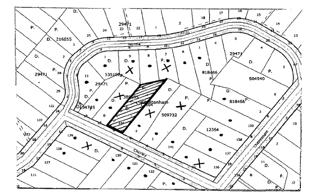
|
NOTIFICATION
PLAN
|
|
|
• PROPERTIES NOTIFIED
|
X SUBMISSIONS
RECEIVED
|
PROPERTY SUBJECT OF DEVELOPMENT
|
|
|
1 SUBMISSION RECEIVED OUT OF MAP RANGE
|
|
|
|
|
Eight submissions objected to the
development, generally on the following grounds that the development would
result in:
· Loss of trees;
· Adverse heritage
impact;
· Detract from the
streetscape;
· Adverse impacts on
Tree 24 and Tree 30;
· Adverse visual impact
with loss of trees;
· Loss of privacy;
· Impact on endangered
flora and fauna;
· Stormwater drainage
impacts.
The merits of the matters raised
in community submissions have been addressed in the body of the report.
6. THE PUBLIC INTEREST
Section 79C(1)(e) of the Act
requires Council to consider “the public interest”.
The public interest is an
overarching requirement, which includes the consideration of the matters
discussed in this report. Implicit to the public interest is the achievement
of future built outcomes adequately responding to and respecting the future
desired outcomes expressed in environmental planning instruments and
development control plans.
The proposed subdivision would
require demolition of the existing dwelling house which contributes to the
Beecroft Cheltenham Heritage Conservation Area.
The proposal is therefore not in
the public interest.
CONCLUSION
Consent is sought for demolition
of an existing dwelling and subdivision of one lot into two.
The site is sufficiently large to
accommodate low density residential development with regard to the constraints
of the site and retain significant trees. However, the existing dwelling house
would be required to be demolished to enable the provision of an access handle
for the proposed battleaxe lot. The existing dwelling house contributes to the
Beecroft Cheltenham Heritage Conservation Area and it’s demolition for the
proposed subdivision would detract from the heritage significance of the area.
The proposed development does not comply with the Heritage
DCP.
Having regard to the matters for
consideration under Section 79(c) of the Environmental Planning and Assessment
Act, it is recommended that the application be refused.
Note: At the time of the completion of this planning
report, no persons have made a Political Donations Disclosure Statement pursuant
to Section 147(3) of the Environmental Planning and Assessment Act 1979 in
respect of the subject planning application.
|
Rod Pickles
Manager -
Assessment Team 2
Planning Division
|
Scott Phillips
Executive Manager
Planning Division
|
Attachments:
|
1.View
|
Locality Plan
|
|
|
|
2.View
|
Subdivision Plan
|
|
|
File Reference: DA/1202/2008
Document Number: D01067886
SCHEDULE 1
Reasons for Refusal
1. The proposal is unsatisfactory in respect to Section
79C(1)(a)(iii) of the Environmental Planning and Assessment Act, 1979, as the
demolition of the existing dwelling house is contrary to the objectives of the
Heritage DCP to ensure development is consistent with the heritage character of
the Beecroft/Cheltenham Heritage Conservation Area.
2. The proposal is unsatisfactory in respect to Section 79C(1)(e)
of the Environmental Planning and Assessment Act, 1979, as the demolition of
the existing dwelling house is not in the public interest.
-
END OF REASONS FOR REFUSAL -
Standard Report No. PLN7/09
Planning Division
Date of Meeting:
4/02/2009
7 INQUIRY - NEW SOUTH WALES PLANNING FRAMEWORK
EXECUTIVE SUMMARY
The New South Wales (NSW)
Parliament is currently conducting a Legislative Council Inquiry into the NSW
planning framework. The Inquiry was established in June 2008, to report on the
planning framework in the context of national and international planning trends.
The Inquiry will consider the issue of whether there is a need for a systematic
review of the planning system having regard to the implications of the Council
of Australian Governments (COAG) reform agenda for planning in NSW, climate
change and natural resource issues in planning and development controls, and
the duplication of processes under relevant Commonwealth and NSW legislation.
It is recommended that Council
forward a submission to the Legislative Council indicating its general support
for the Inquiry into the NSW planning framework as outlined in the Discussion
Paper. The submission should also request that the Inquiry address issues
outlined in this report including the need for systematic reform of the
planning framework to address incohesive planning objectives and framework,
legislative duplication and inconsistency, improved investigative and
enforcement power, gaps between development and building controls and
inappropriate planning and funding frameworks to support councils to perform their
role.
PURPOSE
The purpose of this report is to
advise Council of the State Government’s Inquiry into the NSW planning
framework and seek endorsement of a submission to the Legislative Council.
BACKGROUND
In November 2007, the State
Government released a Discussion Paper titled “Improving the NSW Planning
System”. The Discussion Paper investigates the causes of problems in the
planning system and identifies options for making the system more efficient and
accountable, and easier for families and small business to navigate.
In February 2008, Council
considered a report outlining the contents of the Discussion Paper and resolved
to forward a submission to the DOP. In March 2008, the DOP released a report
by a consultant engaged to review submissions in response to the exhibition of
the Discussion Paper.
In June 2008, the NSW Parliament
passed the Environmental Planning and Assessment Amendment Bill, 2008 in
an attempt to “cut red tape and streamline the planning process”. There was
considerable debate in Parliament on the proposed reforms and whether there was
merit in making further amendments to the Environmental Planning and
Assessment Act, 1979. As a result, the former Minister for Planning
requested a formal Inquiry into whether there was a need for a systematic
review of the NSW planning system.
In August 2008, the State
Government wrote to Council advising that the NSW Legislative Council’s
Standing Committee on State Development was conducting an Inquiry into the NSW
planning framework. In November 2008, the State Government released a
Discussion Paper (copy attached) outlining the context for the Inquiry and
providing background information on each of the terms of reference. The State
Government is inviting submissions in relation to the Inquiry until 13 February
2009.
Following receipt of submissions,
the Standing Committee intends holding public hearings in early 2009. After
consideration of the submissions, evidence and its own research, the Committee
will prepare and table a report to the Legislative Council.
DISCUSSION
This report outlines the terms of
the Inquiry, the contents of the Discussion Paper and responds to issues
relevant to Hornsby Shire.
Planning Framework Inquiry -
Terms of Reference
The terms of reference for the
Inquiry include:
· The need for further
development of the NSW planning legislation;
· The implications of the
Council of Australian Governments (COAG) reform agenda for
planning in NSW;
· Duplication between
Federal and State planning, environmental and heritage legislation;
· Climate change and
natural resource issues in planning and development control;
· Appropriateness of
considering competition policy issues in land use planning;
· Regulation of land use
on, or adjacent to, airports;
· Inter-relationship of
planning and building controls; and
· Implications of the
planning system on housing affordability.
The terms of reference are
further detailed in the Discussion Paper.
Discussion Paper
The Discussion Paper outlines the
background and membership of the Legislative Council’s Standing Committee. The
Discussion Paper notes that the Committee is to inquire into, and report on,
matters concerned with policy directions to ensure that opportunities for sound
growth and wise development are pursued for the benefit of all people in NSW.
The Discussion Paper is
structured to outline some of the issues covered by the eight (8) terms of
reference. The Paper notes that it is not intended to be an exhaustive list of
all issues. A number of questions are contained in the Discussion Paper to
stimulate consideration of the issues and to assist councils respond to the
Inquiry.
Comments on the eight (8) terms of reference in the
Discussion Paper and their relevance to Hornsby Shire are addressed below.
Implications
for Hornsby Shire
The State Government identifies that there is a need for a
systematic review of the NSW planning system, to reduce its complexity and make
it more responsive and efficient. In particular, there is a need to make
changes that free planning professionals from unnecessary development
assessment processes and allow them to focus on strategic planning and
significant development affecting a local community. However, a number of
issues should be addressed in progressing a review of planning policy reform
that will assist in ensuring that the aim of streamlining the planning system
is appropriately balanced with the need to ensure development outcomes and
processes are consistent with local community expectations.
Term of reference 1(a): The
need, if any, for further development of the NSW planning legislation over the
next five years, and the principles that should guide such development
Is there a need for further
development of planning legislation in NSW?
What further changes to the
NSW Planning System is needed and supported?
What principles should guide
any further development of planning legislation in NSW?
The Environmental Planning and
Assessment Act 1979 (EPA Act), commenced as NSW’s first comprehensive
legislation “to encourage the proper management, development and
conservation of natural and artificial resources, including agricultural land,
natural areas, forests, minerals, water, cities, towns and villages for the
purpose of promoting the social and economic welfare of the community and a
better environment.” Over the last fifteen years there have been numerous
alterations to the EPA Act, all aimed at improving and making the
planning system more efficient. The reforms introduced over the past fifteen
years to simplify the system and reduce costs, have in many cases progressively
led to increased confusion, complexity and delay. Additional procedures and
processes introduced at both local and federal levels have added layers of
complexity for the judiciary, practitioners and members of the public.
In broad terms, major reform of
the NSW planning framework should be supported to adjust to current issues, be
responsive to changing issues in the future and improve overall outcomes.
However, the planning system does not need more complex layers to respond to
the shortcomings of the current system.
Any further development of
planning legislation within NSW should be done as part of a cohesive national
framework, with commonality in aims and objectives. Looking ahead to the
challenges that face our community, State and Local government will be less
effective if they are not coordinated in the urban and regional policy arena.
Key national objectives relating to population management, the setting of
greenhouse emission targets, sound economic management and affordable housing
cannot be delivered fully or efficiently without strong resource and policy
partnerships between Federal, State and Local government in urban and regional
policy. However, it also remains important that the future planning system for
NSW be responsive to the system of governance in NSW.
Any reform of the planning system
should recognise the competency of councils to effectively manage planning in
their local government area. Reforms in the planning system should ensure that
improved support is provided to councils to perform their roles by:
· Ensuring a sustainable
funding mechanism to allow councils to appropriately resource planning;
· Providing councils with
appropriate levels of autonomy in developing strategic policy and assessing
development applications; and
· Consolidating into one
Act, competing biodiversity, environmental, conservation, bushfire and like
provisions.
It is also important that any
reform to the planning framework embody a long term infrastructure framework,
with enforceable outcomes and guaranteed income streams. There should also be
improved opportunities for providers to seek complimentary funding for
infrastructure.
It is appropriate that any reform
embrace a system of targeted annual review of legislation. Priority areas for
further reform should be identified rather than reactionary legislative review
which results in a series of cursory amendments, catch-up in nature with little
forward thinking. Review of the legislation should be periodic and mandated,
rather than single issue review driven by interest groups.
Term of reference 1(b): The
implications of the COAG reform agenda for planning in NSW
Are the reforms and
discussions at the COAG of level important for future development of the NSW
planning framework?
What are the specific
implications of the work of the COAG on planning in NSW?
COAG is the peak
intergovernmental forum in Australia, comprising the Prime Minister, State
Premiers, Territory Chief Ministers and the President of the Australian Local
Government Association. COAG has recently committed to implement a new model
of cooperation between all levels of government. In March 2008, COAG committed
to a comprehensive new economic reform agenda for Australia, with a particular
focus on health care, water resources, regulatory and competition reform and
the broader productivity agenda.
A number of areas of focus will
have implications for the NSW planning framework including:
· An accelerated business
regulation reform agenda to enhance productivity, innovation and workforce
mobility, by cutting the costs of regulation including accelerating the
timetable for the reform of environmental assessment and approvals;
· Development of five key
housing initiatives to facilitate improved housing supply, provide incentives
to construct affordable rental housing and lower the burden of infrastructure
and regulatory costs of a new home;
· Creation of the National
Rental Affordability Scheme and the Housing Affordability Fund to encourage the
construction of affordable rental housing for households of limited means,
including the development of partnerships between councils and developers;
· Establishment of a
National Housing Supply Council to improve the evidence base for housing policy
and program development and to coordinate research at local, state and national
level;
· Adoption of a new
national Climate Change Plan of Action responding to the challenges of reducing
greenhouse emissions and responding to the environmental, social and economic
impacts that may result from climate change; and
· The establishment of a
fund committed to rolling out electronic development assessments to help speed
up planning approval processes.
Reform of environmental
assessment and development approval
As discussed previously under
Terms of Reference 1(a), any further reform of planning legislation within NSW
should be done as part of a cohesive national framework, with commonality in
aims and objectives. Any future framework should also be responsive to the
system of governance in NSW.
Housing Supply and
Affordability Initiatives
Although there is general support
for endeavours to reduce the affordability of housing, any scheme which seeks
to achieve savings in the delivery of a dwelling by reducing costs through a
reduction in the provision of facilities and services is not supported.
Ultimately the costs of such savings are borne by the new resident, through
reduced amenity and reduced access to appropriate services and facilities.
It is also appropriate that
robust mechanisms be implemented as part of any affordable housing initiative,
to ensure that any cost savings facilitated by the planning system are
ultimately passed onto the purchaser of a home rather than into the pocket of
the developer.
Coordinated Housing Research
The development of an Affordable
Housing Framework should be developed at a National level with consultation
with State and Local levels of government.
Climate Change Action Planning
A unified approach to the
development of a responsive climate change action planning framework at
a national level should be supported. Overarching principles for sustainable
urban and regional development and setting out measurable national targets
should also be supported and should include:
· energy consumption per
capita;
· water consumption per
capita;
· water quality standards;
· air quality standards;
and
· biodiversity retention
and protection.
The required response of the
planning system to climate change is discussed in detail in respect of Term of
Reference 1(d).
ePlanning
Council already supports
ePlanning as a tool through tracking of development applications, electronic S149
applications and masterview applications. The NSW and Federal Government
should be mindful of resource streams available to councils, councils’
investment to date and the ongoing costs of maintaining electronic data sources
and systems over time. Any further initiatives should be carried out in consultation
with councils.
Term of reference 1(c):
Duplication of processes under the Commonwealth Environment Protection and
Biodiversity Act 1999 and NSW planning, environmental and heritage legislation
What are your experiences
involving assessment processes under the NSW and Commonwealth environment
legislation for controlled actions?
Did the bilateral agreements
reduce duplication of approval procedures for controlled action?
Are there areas of duplication
that need to be addressed?
The ability to manage the
environment is hampered by structural problems between different areas and
levels of government. The Australian Federal system of government has resulted
in two distinct sources of environmental legislation, those from the
Commonwealth and the State Parliaments.
The New South Wales and
Commonwealth Governments both have laws to protect flora and fauna. Key laws
for the protection of species and ecological communities in New South Wales
include the Threatened Species Conservation Act 1995(TSC ACT), the National
Parks and Wildlife Act 1974 and the Fisheries Management Act 1994.
Federal protected species law operates in parallel to State protected species
law. A development or activity may require assessment or approval under State
and Federal protected species law. The Native Vegetation Act 2003,
through its focus on habitat protection, also has a key role in species
protection. It should be noted however that Hornsby Council is exempt from
this Act.
The key Federal legislation in
relation to protected species is the Environment Protection and Biodiversity
Conservation Act, which protects species and ecological communities by:
· creating a process for
the listing of protected species and ecological communities;
· requiring the assessment
and approval of proposals that are likely to have a significant impact upon a
threatened species, an ecological community or a migratory species; and
· requiring permits for
actions in a Commonwealth area that involve the killing, injuring or taking of
a listed threatened species, or ecological community.
New South Wales laws do not
protect threatened species as of right. Rather, the laws generally set up
principles and administrative procedures to assist decision-making in relation
to threatened species. Frequently, the State and Commonwealth governments’
debate environmental issues and local government is given limited jurisdiction to
participate in strategic environmental policy development. Although the
National Environment Protection Council was set up (in part) to address some of
these problems, little advancement has been made in this area since its
inception.
For example, the TSC Act enables
the Minister for Environment and Climate Change to certify Environmental
Planning Instruments (EPIs), if the Minister is satisfied they will bring an
overall improvement to, or maintain, biodiversity values. Biodiversity
certification enables local government, in areas with high development
pressure, to provide for the protection of biodiversity, including threatened
species at the strategic planning stage.
Certification can switch off the need for threatened species assessment under
the EPA Act, providing more certainty for local
government, applicants and other stakeholders. Overall, biodiversity must
be maintained or improved by the EPI for certification to be endorsed.
Certification may be granted for part of a Local Environmental Plan (LEP) or
individual species within an LEP, depending on the quality of the available
data.
Notwithstanding biodiversity
certification, the EPBC Act continues to apply in areas which are
subject to an EPI which has been certified by the State. This negates the
intent of biodiversity certification under the TSC Act. The EPBC Act
requires a similar level of investigation, survey and assessment as that which
is required to be undertaken under the TSC Act. Any reform should
address this inconsistency to ensure a consistent approach for the
environmental assessment of applications.
As there is no role for
assessment by Council under the EPBC Act, Council is generally unaware
of there being any parallel processes in place. Although there are advantages
to having parallel processes in place to ensure both Federal and State
conservation objectives are being considered, it is appropriate that there be
only one concurrence for these two actions and this concurrence be coordinated
by the State.
There is also duplication of
processes and areas of conflict between the EPA Act and numerous other
NSW and Commonwealth Acts which require additionally streamlining. This is not
limited to conflict between the EPA Act and the EPBC Act but
includes conflict within the Act itself, as well as various practises
established by NSW legislation. For example, Schedule 4 of the Environmental
Planning and Assessment Regulations requires councils, in respect of 149
certificates, to include advice in respect of whether an order has been made
under the Trees (Disputes Between Neighbours) Act
2006 to carry out work in relation to a tree on the land. No
procedure is in place for these notations to be removed when the Order is
satisfied. As such, reference to particular orders issued under the Trees (Disputes Between Neighbours) Act
2006, will continue to appear on S149 certificates long after
the terms of the order have been completed.
Although there is unnecessary
duplication under the EPBC Act and NSW legislation, the two levels of
legislation have a different strategic focus and this provides benefit in
respect of endeavours to protect flora and fauna at both the local and regional
levels. As such, the value in maintaining threatened entity protection systems
at both State and Federal level should be recognised.
The absence of a role for local
government in either the EPBC Act or the TSC Act should be
regarded with concern, particularly in respect of the consideration of offset
agreements at National and State level. Biodiversity offsets are increasingly
being considered by all levels of government as appropriate actions for
long-term management to improve biodiversity conservation to counterbalance
specific impacts on biodiversity. Unfortunately, Council has no role in the
certification of such agreements and evidence to date has shown that certified
agreements at the State level have often had no regard for local conservation
objectives. Councils should have a role in the consideration of any biodiversity
offset proposal, particularly councils seeking to develop their own
conservation/biobanking schemes such as Hornsby Shire.
Biobanking is a market-based
scheme that provides a streamlined biodiversity assessment process for
development, a rigorous and credible offsetting scheme as well as an
opportunity for rural landowners to generate income by managing land for
conservation. Biobanking enables 'biodiversity credits' to be generated by
landowners who commit to enhance and protect biodiversity values on their land
through a biobanking agreement.
Term of reference 1(d):
Climate change and natural resources issues in planning and development
controls
How should climate change be
addressed in the planning framework?
Is the current framework adequate
to consider the potential effects of climate change?
How should natural resource
issues be taken into account in the planning and development approval
framework?
Climate change represents some of
the community’s greatest economic and environmental challenges. The planning
system is in a unique position to assist the community in understanding and
adapting to the expected consequences of climate change. Adaption measures
assist to reduce the implications of the most serious consequence of climate change.
These changes include greater flood risk, more extreme weather conditions,
water shortages, and changes to ecosystems and micro-climates. Councils are in
a position to actively develop responses to mitigate impacts and guide changes
to environmental behaviour such as promoting energy and water efficiency,
sustainable land management practices, incorporating efficient energy use in
buildings, and including climate change information in environmental
assessments.
The following actions to ensure
planning can continue to implement adaptation and greenhouse abatement
strategies should be supported:
· Inclusion of climate
change in long term strategic planning to enable communities to better adapt to
future climate variability;
· Consolidation of
relevant, reliable and consistent information. Commonwealth and State Agencies
can assist with dissemination and compilation of climate change information to
planners and decision makers;
· Adoption of consistent
timeframes to provide planners with meaningful targets;
· Development of national
targets for governments, through policy and adaptation at all levels, including
the local/household level;
· Adoption of a national
framework for adaptation with scope for local adaption strategies; and
· Preparation of regional
and local assessments of climate change trends, vulnerabilities and adaptation
options. These findings should be readily accessible and relevant to affected
stakeholders.
Council in
August 2007, considered Executive Manager
Environment’s Report No. EN 33/07 regarding the setting
of a carbon neutral goal as an extension to Council’s current greenhouse gas
reduction goals. In endorsing the recommendations of the report, Council
concluded that to ensure that a holistic approach to climate change was being
undertaken, it should consider adaptation as well as mitigation. To progress
Council’s adaptation activities, it joined ICLEI’s pilot Cities for Climate
Protection Adaptation Initiative. The initiative seeks to identify the
projected risks of climate change to the local area and develop an Action Plan
to address those risks. To aid in the identification of the risks of climate
change, Council is working collaboratively with the Sydney Coastal Council’s
Group (SCCG) and CSIRO who have undertaken research on a regional systems
approach to managing climate vulnerability in the Hornsby region.
This research will identify risks
for Council to consider within an Adaptation Action Plan. A number of the
actions anticipated to be generated through this process will relate to
development of appropriate development controls responsive to climate change
scenarios. Accordingly, this will rely upon the ability of the planning system
to support these endeavours.
A National/State framework is
required to ensure that there is a unified approach to climate change adaption
initiatives and the development of appropriate standards. This is particularly
important to pre-empt anomalies which are likely to occur across boundaries, on
opposing sides of streets, within opposing sides of catchments and within
shared waterways. An authority may progress a climate change adaption scenario
and another authority may pursue an alternate scenario, possibly with different
aims and objectives.
Should a National or State
initiative not be progressed, it will be necessary for local provisions to be
investigated by each Council. The appropriate mechanism for implementing many
of these actions is through the planning process. There is currently no
opportunity within the planning framework to accommodate climate change
adaption initiatives at the local level. The Standard LEP template, prepared
to provide consistency in the application of development standards within the
State, does not accommodate opportunities for the development of standards
directed at climate change adaption. The inclusion of such initiatives should
be addressed in the next issue of the Standard Instrument.
Term of reference 1(e):
Appropriateness of considering competition policy issues in land use planning
and development approval processes in NSW
Should competition analysis be
a part of local planning decisions?
How competition should be
factored into the planning system, if at all?
As part of their commitments
under National Competition Policy,
all Commonwealth, State and Territory governments undertook to review and
change legislation that restricts competition, unless they were seen to be in
the public interest. The objective of the legislation review program is to
remove restrictions on competition that are found not to be in the interests of
the community. Legislation that restricts entry into markets or constrains
competitive behaviour with markets is an example of one such restriction.
Any requirement that seeks to
ensure that new regulations are subject to rigorous assessment, including an
analysis of alternatives should be supported. Support should also be given to
targeted public annual reviews of significant legislation by the State to
identify priority areas where reform would provide significant net benefits to
the community.
The stated objective of the
National Competition Policy, as it applies to the public sector, is to achieve
the most efficient provision of publicly provided goods and services through
reforms designed to minimise restrictions on competition. Although this
objective should be supported in general terms, the strategic development of
any polices targeting competition should be pursed at regional or state level,
within an appropriate national framework.
There has been considerable
debate in NSW in respect of competition versus Centres Policy. Increasing
competition is seen to be ultimately in the interest of the public. However,
care should be given in the development of any land use policy directed at
increasing competition, to ensure that ultimately the community does not pay
for the “public benefit” through loss of amenity, privacy, road
efficiency and safety etc. There is a need to create competitive retail
environments. However, at the same time there is a need to protect existing
centres to ensure they remain vibrant and active spaces that are integrated
with public transport systems.
If centres do not have the space
to accommodate retail demand, planning should be undertaken within a State Policy
context. A regional approach to retail planning policy should be undertaken
and councils provided with resources to fund local retail studies within the
State Policy context.
Term of reference 1(f):
Regulation of land use on or adjacent to airports
Is the current arrangement for
regulating use on or near airports appropriate?
Is there sufficient
involvement of the community within which the airport is located under the
current system?
Hornsby Shire is impacted upon by
the flight path of aeroplanes. However, the local government area does not
contain land set aside for airport development.
Term of reference 1(g):
Inter-relationship of planning and building controls
Is the current
inter-relationship between the planning system and the regulation of building
work appropriate?
The 1997 changes to the
development assessment system brought development, building and land
subdivision into one process under the EPA Act. These amendments also
introduced the role of private certifiers into the system. Subsequent
amendments to legislation have been designed to simplify and improve the
efficiency of the relationship between planning and building controls.
Any further reforms in the
planning system should ensure that there is continued security provided to the
community in respect of the role of certification by:
· Increasing accountability
of private certifiers;
· Increasing accountability
of development which is certified privately; and
· Increasing the
effectiveness of investigative and enforcement powers available to councils to
manage private certification in their area.
In particular, gaps in the
legislation between development and building controls should be closed.
Specifically, changes to the planning system should require that a Final
Occupation Certificate be obtained within 12 months of the issue of an Interim
Occupation Certificate. The reason for this request is that once an Interim
Occupation Certificate has been issued there is no obligation on either the
Principal Certifying Authority or the property owner to complete the
works. This has ongoing problems for the community and frequently negates
measures put in place through the development assessment process to mitigate a
range of potential impacts. It is appropriate that legislation impose
a penalty on any property owner that fails to obtain a Final Occupation
Certificate within 12 months of occupation.
Council should also support a
revision of current energy efficiency requirements under the EPA Act.
Legislation should require design certification of compliance with Part J of
the Building Code of Australia at development assessment. It would then
be appropriate that prior to the issue of an Occupation Certificate, an Energy
Validation Certificate be obtained from the accredited consultant. A
certificate would also be required to be submitted to Council in the same way
as the Act requires an annual fire safety certificate be submitted.
Term of reference 1(h):
Implications of the planning system on housing affordability?
What is the impact of the
planning system on housing affordability?
What changes, if any, need to
be made to the planning system to improve housing affordability?
The decline in housing is a
pressing issue for Australians and improving affordability is critical to
addressing financial stress and disadvantage within communities. Although
local government is in the business of creating liveable and sustainable
communities, it does not provide housing. Local government does however have
access to a number of indirect levers that enable it to have a role in
facilitating and encouraging the provision of housing by others. These
indirect levers include housing research and policy development, strategic and
land use planning, including identifying land for housing development, building
regulations and the application of planning and development controls. Although
local government may have a role in implementing affordable housing
initiatives, it is appropriate that the development of any initiatives be
within a national framework, with clearly articulated objectives and targets.
The draft Subregional Strategies
identify that the State Government will develop initiatives to provide for a
unified approach to affordable housing through the Affordable Housing
Framework. To date the State Government has been unable to provide Council
with a timetable for the delivery of this document. Although a number of
Comprehensive LEPs have been endorsed by the State Government, none have
included either broad reference to, or specific provisions in respect of
affordable housing. Indeed the Standard LEP continues to contain no reference
to affordable housing provisions, ensuring an absence of unified response to
the delivery of affordable housing provision.
In summary, the Discussion paper
outlines a number of issues and poses a number of questions to stimulate
discussion on the need for a systematic review of the planning system having
regard to the implications of the (COAG) reform agenda for planning in NSW,
climate change and natural resource issues in planning and development
controls, and the duplication of processes under relevant Commonwealth and NSW
legislation. It would be appropriate that Council forward a submission to the
Legislative Council indicating its support for the Inquiry and requesting that
issues outlined above be addressed by the Inquiry.
TRIPLE BOTTOM LINE SUMMARY
Triple Bottom Line is a framework
for improving Council decisions by ensuring accountability and transparency on
social, environmental and economic factors. It does this by reporting upon
Council’s strategic themes. As this report provides Council with information
and does not propose any actions which require a sustainability assessment, no
Triple Bottom Line considerations apply.
CONSULTATION
The Discussion Paper was released
by Standing Committee in November 2008 and is on exhibition until 13 February
2009. The Paper is available for inspection on the NSW Parliament website.
The Manager of Assessment Team 1
and the Strategy and Environment Divisions have been consulted in the
preparation of this report.
CONCLUSION
It is recommended that Council
forward a submission to the Legislative Council indicating its general support
for the Inquiry into the NSW planning framework as outlined in the Discussion
Paper. The submission should also request that the Inquiry address issues
concerning the development of a cohesive planning objectives and framework;
reducing legislative duplication and inconsistency; improved investigative and
enforcement powers; removing gaps between development and building controls;
and the need for a planning and funding framework to support councils perform
their role.
|
RECOMMENDATION
THAT Council forward a
submission to the NSW Legislative Council’s Standing Committee on State
Development indicating its general support for the Inquiry into the NSW
planning framework as outlined in the Discussion Paper. The submission also
request that the Inquiry address issues concerning:
1. development of cohesive National/State planning objectives and
framework;
2. consolidation of legislation to address duplication and
inconsistency;
3. targeted public annual reviews of legislation;
4. improvements in the effectiveness of investigative and
enforcement powers in relation to principally certified development;
5. closure of gaps between development and building controls; and
6. development of a planning and funding framework to support
councils to perform their role.
|
|
James Farrington
Manager - Town
Planning Services
Planning Division
|
Scott Phillips
Executive Manager
Planning Division
|
Attachments:
File Reference: F2008/00491
Document Number: D01040479