BUSINESS PAPER
Planning
Meeting
Wednesday, 3 June, 2009
at 6:30pm
|
Hornsby
Shire Council
|
Table of Contents
|
|
Page
1
|
|
|
|
|
TABLE OF CONTENTS
AGENDA
AND SUMMARY OF RECOMMENDATIONS
Mayoral Minutes
Notices of Motion
Rescission Motions
Item 1 RM1/09 Rescission Motion - Development
Application - Seniors Living Development 14A and 16 Murray Road Beecroft
MATTERS OF URGENCY
ITEMS PASSED BY EXCEPTION / CALL FOR SPEAKERS ON
AGENDA ITEMS
DEVELOPMENT APPLICATIONS
A
Ward Deferred
A
Ward
Item 2 PLN38/09 Development Application -
Residential - Alterations and Additions
44 Brooklyn Road Brooklyn
B
Ward Deferred
Item 3 PLN39/09 Development Application -
Erection of a dwelling-house
16B Osborn Road, Normanhurst
B
Ward
Item 4 PLN33/09 Development Application -
Erection of a 7 storey mixed use building
The Walk, 228 - 234 Pacific Highway Hornsby
Item 5 PLN34/09 Section 82A Review- Erection of a
Dwelling-House
16C Osborn Road, Normanhurst
Item 6 PLN35/09 Development Application -
Educational Establishment
Barker College, 91 Pacific Highway Hornsby
Item 7 PLN41/09 Development Application -
Section 96 (2) - Erection of an 11 Storey Mixed Use Building
135-137 Pacific Highway, Hornsby
C
Ward Deferred
C
Ward
Item 8 PLN36/09 Development Application -
Section 96(2) - Subdivision of one lot into two
8 Chorley Avenue Cheltenham
Item 9 PLN37/09 Development Application -
Registered Club - Alterations and additions
103 - 109 New Line Road Cherrybrook
General Business
Item 10 PLN22/09 Heritage Review Stage 4
Item 11 PLN43/09 Request for Local Nominations for
the Joint Regional Planning Panels
Item 12 PLN44/09 State Environmental Planning
Policy (Exempt and Complying Development Codes) 2008 - Local Exclusions and
Variations
Questions of Which Notice Has Been Given
SUPPLEMENTARY AGENDA
QUESTIONS WITHOUT NOTICE
|
Hornsby Shire Council
|
Agenda and Summary of
Recommendations
|
|
Page
1
|
|
|
|
|
AGENDA AND SUMMARY OF RECOMMENDATIONS
PRESENT
NATIONAL
ANTHEM
OPENING PRAYER/S
Rev. Neil Dawson
from Thornleigh Community Baptist Church will be opening the Meeting in prayer.
Acknowledgement
of RELIGIOUS DIVERSITY
Statement by the
Chairperson
“We recognise our Shire's rich
cultural and religious diversity and we acknowledge and pay respect to the
beliefs of all members of our community, regardless of creed or faith."
ABORIGINAL
RECOGNITION
Statement
by the Chairperson:
"We
recognise the traditional inhabitants of the land we are meeting on tonight,
the Darug and Guringai Aboriginal people, and respect is paid to their elders
and their heritage."
AUDIO
RECORDING OF COUNCIL MEETING
Statement by the Chairperson:
"I advise all present that tonight's meeting is
being audio recorded for the purpose of assisting in the accuracy of the
Minutes. The recordings may be accessed by members of the public once the
Minutes have been finalised and speakers are requested to ensure their comments
are relevant to the issue at hand and refrain from making personal comments or
criticisms."
APOLOGIES
declarations
of interest
Clause 52 of Council’s Code of Meeting Practice (Section
451 of the Local Government Act, 1993) requires that a councillor or a member
of a Council committee who has a pecuniary interest in a matter which is before
the Council or committee and who is present at a meeting of the Council or
committee at which the matter is being considered must disclose the nature of
the interest to the meeting as soon as practicable. The disclosure is also to
be submitted in writing (on the form titled “Declaration of Interest”).
The Councillor or member of a Council committee must not
be present at, or in sight of, the meeting of the Council or committee:
(a) at
any time during which the matter is being considered or discussed by the
Council or committee.
(b) at
any time during which the Council or committee is voting on any question in
relation to the matter.
Clause 51A of Council’s Code of Meeting Practice provides
that a Councillor, Council officer, or a member of a Council committee who has
a non pecuniary interest in any matter with which the Council is concerned and
who is present at a meeting of the Council or committee at which the matter is
being considered must disclose the nature of the interest to the meeting as
soon as practicable. The disclosure is also to be submitted in writing (on the
form titled “Declaration of Interest”).
If the non-pecuniary interest is significant, the
Councillor must:
a) remove
the source of conflict, by relinquishing or divesting the interest that creates
the conflict, or reallocating the conflicting duties to another Council
official.
OR
b) have
no involvement in the matter by absenting themself from and not taking part in
any debate or voting on the issue as if the provisions of Section 451(2) of the
Act apply.
If the non-pecuniary interest is less than significant,
the Councillor must provide an explanation of why they consider that the
interest does not require further action in the circumstances.
Political
Donations Disclosure
Statement by the Chairperson:
“I advise all present that a Political Donations
Disclosure Statement pursuant to Section 147(3) of the Environmental Planning
and Assessment Act 1979 must be made in the event that a person has made or a
Councillor or political party has received a gift or political donation
from any person or organisation, including a person or organisation making a
submission to an application or other planning matter, listed on the Planning
Meeting agenda.”
confirmation
of minutes
THAT
the Minutes of the Planning Meeting held on 6 May, 2009 be confirmed; a copy
having been distributed to all Councillors.
petitions
Mayoral Minutes
Notices of Motion
Rescission Motions
Page Number
Item 1 RM1/09 Rescission Motion
- Development Application - Seniors Living Development 14A and 16 Murray Road Beecroft
COUNCILLOR Martin TO MOVE
THAT the resolution adopted at the
Planning Meeting held on 6 May 2009 in respect of Item 4, Development Application - Seniors Living
Development 14A and 16 Murray Road, Beecroft,
namely:-
“THAT Development Application No.
1349/2008 for demolition of the existing rear dwelling and construction of a
Seniors Living development comprising 11 self-contained dwellings, including
refurbishment of the existing dwelling at the frontage, at Lot 115 DP 1136664
and Lot 1 DP 509627 (No. 14A & No. 16) Murray Road, Beecroft, be approved
subject to conditions of consent detailed in Schedule 1 attached to Report No.
PLN26/09 as amended by the following requirements:
1. Condition
9 be amended to read:
Dilapidation
Report
A
‘Dilapidation Report’ must be prepared by a ‘chartered structural engineer’
detailing the structural condition of the following adjoining properties:
a) No. 138A Beecroft Road, Beecroft.
b) Nos. 144-146 Beecroft Road
(Chesalon Nursing Home) Beecroft; and
c) No. 18A Murray Road, Beecroft.
2. Condition 34 - Boundary Fencing – be amended to allow an
additional privacy screen to be constructed on the fence which forms the common
boundary with 18A Murray Road, in the event that the owner of 18A Murray Road
is not satisfied that the original fence is sufficient to maintain privacy
between the properties”.
be, and is hereby rescinded.
NOTE: THE
ABOVE RESCISSION MOTION IS SUPPORTED BY
COUNCILLORS MCMURDO, BROWN AND HUTCHENCE.
NOTE: In the event of the proposed Rescission
Motion being adopted, the following motion is proposed.
"THAT consideration of
Development Application - Seniors
Living Development - 14A and 16 Murray Road, Beecroft be deferred to
enable:
1. The
comments from Council’s Bushland and Biodiversity Team to be provided.
2. Confirmation of the number of trees proposed to be removed and
identification of the intersection where the traffic lights are located.”
MATTERS OF URGENCY
ITEMS PASSED BY EXCEPTION / CALL
FOR SPEAKERS ON AGENDA ITEMS
Note:
Persons wishing to address Council on matters which are on
the Agenda are permitted to speak, prior to the item being discussed, and their
names will be recorded in the Minutes in respect of that particular item.
DEVELOPMENT APPLICATIONS
A Ward Deferred
A Ward
Page
Number
Item 2 PLN38/09 Development
Application - Residential - Alterations and ADDITIONS
44 Brooklyn Road Brooklyn
RECOMMENDATION
THAT Development Application No.
15/2009 for the erection of a double garage at Lot 1 Sec B DP 5527 – 44
Brooklyn Road Brooklyn be approved subject to the conditions of consent
detailed in Schedule 1 of this report.
B Ward Deferred
Page
Number
Item 3 PLN39/09 Development
Application - Erection of a dwelling-house
16B Osborn Road, NORMANHURST
RECOMMENDATION
THAT Development Application No.
DA/1641/2008 for the erection of a split level, one and two storey
dwelling-house at Lot 18, DP 1120186, No. 16B Osborn Road, Normanhurst be
approved subject to the conditions of consent detailed in Schedule 1 of this
report.
B Ward
Page
Number
Item 4 PLN33/09 Development
Application - Erection of A 7 storey mixed use building
The Walk, 228 - 234 Pacific Highway Hornsby
RECOMMENDATION
THAT Development Application No.
1564/2008 for the erection of a seven storey mixed use development
incorporating retail and commercial floor space and thirty two residential
units at Lot A and B DP 304557 (No. 228 – 234) Pacific Highway, Hornsby be
approved subject to conditions of consent detailed in Schedule 1 of this
report.
Page
Number
Item 5 PLN34/09 Section 82A
Review- Erection of a Dwelling-House
16C Osborn Road, Normanhurst
RECOMMENDATION
THAT Development Application No.
DA/432/2008, the subject of a Section 82A review for the erection of a one and
two storey dwelling-house at Lot 17, DP 1120186, No. 16C Osborn Road,
Normanhurst be approved subject to the conditions of consent detailed in
Schedule 1 of this report.
Page
Number
Item 6 PLN35/09 Development Application
- Educational Establishment
Barker College, 91 Pacific Highway Hornsby
RECOMMENDATION
THAT Development Application No. 81/2009 for alterations and
additions to the existing Barker College Junior School and construction of a
multi-purpose hall at No. 91 Pacific Highway Hornsby, Nos. 2-10 Unwin Road
Waitara & Nos. 1-11 The Avenue Waitara be approved subject to the
conditions of consent detailed in Schedule 1 of this report.
Page
Number
Item 7 PLN41/09 Development
Application - Section 96 (2) - Erection of an 11 Storey Mixed Use Building
135-137 Pacific Highway, Hornsby
RECOMMENDATION
THAT Section 96(2) Application to modify Development Consent No.
1586/2001 for the construction of a mixed use development comprising 70
residential units and three levels of commercial units at Lot 1 DP 606694, Lot
2 DP 606694 (Nos. 135-137) Pacific Highway and Pound Road Reserve, Hornsby be
refused for the reasons detailed in Schedule 1 of the independent town planning
consultant’s report – Nexus Environmental Planning Pty Ltd.
C Ward Deferred
C Ward
Page
Number
Item 8 PLN36/09 Development
Application - Section 96(2) - Subdivision of one lot into two
8 Chorley Avenue Cheltenham
RECOMMENDATION
THAT Council approve the
modification to Development Application No. 1202/2008/A for subdivision of one
lot into two by deleting condition No. 16(d) at lot 144 DP 12364 (No. 8)
Chorley Avenue Cheltenham as, detailed in Schedule 1 of this report.
Page
Number
Item 9 PLN37/09 Development
Application - Registered Club - Alterations and additions
103 - 109 New Line Road Cherrybrook
RECOMMENDATION
THAT Development Application No.
144/2009 for alterations and additions to an existing registered club at Lot 2
DP 367373, Nos. 103-109 New Line Road Dural be approved subject to conditions
of consent detailed in Schedule 1 of this report.
General Business
Page
Number
Item 10 PLN22/09 Heritage Review
Stage 4
THAT
1. Council endorse the
recommendations of Executive Manager’s Report No. PLN22/09 to include, remove
and amend items on the heritage list and progress as part of an Annual
Amending LEP.
2. Council investigate
inclusion of the following items for heritage listing as part of the next
Heritage Review:
2.1 Two
(2) Eucalypt trees within Hillcrest Road, Pennant Hills; and
2.2
Bottle Tree at No. 164 Ray Road, Epping.
3. All persons who made submissions and affected property owners
be advised of Council’s resolution.
Page
Number
Item 11 PLN43/09 Request for
Local Nominations for the Joint Regional Planning Panels
THAT
1. Council nominates the Mayor and the Executive Manager Planning as
local members and the General Manager as the alternative local member of the
Joint Regional Planning Panel for a period of up to three years.
2. Council receives a report twelve months following the
commencement of the Joint Regional Planning Panel outlining the implications of
the Panel in its first twelve months and options to expand community
involvement/membership of the Panel.
Page
Number
Item 12 PLN44/09 State
Environmental Planning Policy (Exempt and Complying Development Codes) 2008 -
Local Exclusions and Variations
THAT
1. Council not make a
submission for a local exclusion or variation from State Environmental
Planning Policy (Exempt and Complying Development Codes) 2008 at this
stage.
2. Council monitor and
evaluate the built form outcomes facilitated by the SEPP as part of the
review of Council’s residential controls to commence in the middle of the year
in accordance with the Strategic Planning Programme.
3. Council make further
representations to the Department of Planning requesting that the draft LEPs
for proposed heritage conservation areas at East Epping and Essex Street Amendment
No. 76), Mount Errington (Amendment No. 84) and Rosebank Avenue (Amendment
No. 86) be gazetted as a matter of urgency.
GENERAL
BUSINESS
·
Items for which there is a Public Forum Speaker
·
Public Forum for non agenda items
·
Balance of General Business items
Questions of Which Notice Has Been Given
SUPPLEMENTARY AGENDA
QUESTIONS WITHOUT NOTICE
Rescission Motion No. RM1/09
Date of Meeting:
3/06/2009
1 RESCISSION MOTION -
DEVELOPMENT APPLICATION - SENIORS LIVING DEVELOPMENT 14A AND 16 MURRAY ROAD BEECROFT
|
COUNCILLOR Martin
TO MOVE
THAT the resolution adopted at
the Planning Meeting held on 6 May 2009 in respect of Item 4, Development Application - Seniors Living
Development 14A and 16 Murray Road, Beecroft,
namely:-
“THAT Development Application No.
1349/2008 for demolition of the existing rear dwelling and construction of a
Seniors Living development comprising 11 self-contained dwellings, including
refurbishment of the existing dwelling at the frontage, at Lot 115 DP 1136664
and Lot 1 DP 509627 (No. 14A & No. 16) Murray Road, Beecroft, be approved
subject to conditions of consent detailed in Schedule 1 attached to Report
No. PLN26/09 as amended by the following requirements:
1. Condition
9 be amended to read:
Dilapidation
Report
A ‘Dilapidation
Report’ must be prepared by a ‘chartered structural engineer’ detailing the
structural condition of the following adjoining properties:
a) No. 138A Beecroft Road , Beecroft.
b) Nos. 144-146 Beecroft
Road (Chesalon Nursing Home) Beecroft; and
c) No. 18A Murray Road, Beecroft.
2. Condition 34 - Boundary Fencing – be amended to allow an
additional privacy screen to be constructed on the fence which forms the
common boundary with 18A Murray Road, in the event that the owner of 18A
Murray Road is not satisfied that the original fence is sufficient to
maintain privacy between the properties”.
be, and is hereby rescinded.
NOTE: THE
ABOVE RESCISSION MOTION IS SUPPORTED BY
COUNCILLORS MCMURDO, BROWN AND HUTCHENCE.
NOTE: In the event of the proposed Rescission
Motion being adopted, the following motion is proposed.
"THAT consideration
of Development Application - Seniors
Living Development - 14A and 16 Murray Road, Beecroft be deferred to
enable:
1. The
comments from Council’s Bushland and Biodiversity Team to be provided.
2. Confirmation of the number of trees proposed to
be removed and identification of the intersection where the traffic
lights are located.”
|
|
1.View
|
Planning Report No
PLN26/09 complete with attachments
|
|
|
File Reference: F2008/00135
Document Number: D01158730
Planning Report No. PLN38/09
Date of Meeting:
3/06/2009
2 DEVELOPMENT APPLICATION
- RESIDENTIAL - ALTERATIONS AND ADDITIONS
44 BROOKLYN ROAD BROOKLYN
|
Development Application No:
|
DA/15/2009
|
|
Description of Proposal:
|
Erection of a double garage.
|
|
Property Description:
|
44 Brooklyn Road, Brooklyn
|
|
Applicant:
|
Steel Modular Systems
|
|
Owner:
|
Mr T Coles
|
|
Statutory Provisions:
|
Hornsby Shire Local Environmental
Plan 1994
Environmental Protection B
(River Catchment) Zone
|
|
Estimated Value:
|
$17,750
|
|
Ward:
|
A
|
|
RECOMMENDATION
THAT Development Application
No. 15/2009 for the erection of a double garage at Lot 1 Sec B DP 5527 – 44
Brooklyn Road Brooklyn be approved subject to the conditions of consent
detailed in Schedule 1 of this report.
|
1. The
application proposes the erection of a double garage on an existing residential
property.
2. The
proposal complies with the provisions of the Hornsby Shire Local Environmental
Plan 1994.
3. The
proposal does not comply with the provisions of the Brooklyn Development
Control Plan in relation to the side setback.
4. Two
submissions have been received objecting to the proposal. Councillors have
placed a Red Sticker against the application.
5. It
is recommended that the application be approved.
THE SITE
The site has an area of 3642m2
and is located on the southern side of Brooklyn Road, approximately 60m from
the Hawkesbury River. The topography of the site is steep sloping and
experiences an average gradient of 28.8% to the north.
The site is trapezoidal in shape,
with a width of approximately 25m. The site currently contains a two storey
dwelling, located in a cleared area adjacent to Brooklyn Road. Vehicular access
is via a driveway located on the western side of the front property boundary
that curves around to the east, widening to provide 2 car parking spaces within
an unenclosed carport. To the rear of the dwelling lies dense native bushland,
occupying the remaining site area.
The site is bordered by Brooklyn Road to the north, residential dwellings to the west, a vacant lot to the east and
the Sydney to Newcastle rail line to the south.
THE PROPOSAL
The application proposes the
erection of a double garage on the site. The garage is proposed within the
footprint of the existing uncovered carport which is to be demolished under the
proposal. The garage is proposed to be rectangular in shape measuring 6m x 8m
for a total area of 48m2. The garage would be constructed from
horizontal steel cladding. Details of the colour of the cladding were not
specified by the applicant. Vehicular access to the site would remain
unchanged.
ASSESSMENT
The development application has
been assessed having regard to the matters for consideration prescribed under
Section 79C of the Environmental Planning and Assessment Act 1979 (the
Act). Subsequently, the following issues have been identified for further
consideration.
1. STRATEGIC CONTEXT
1.1 Metropolitan Strategy – (Draft) North Subregional
Strategy
The Metropolitan Strategy is a
broad framework to secure Sydney’s place in the global economy by promoting and
managing growth. It outlines a vision for Sydney to 2031; the challenges
faced, and the directions to follow to address these challenges and achieve the
vision. The draft North Subregional Strategy acts as a framework for Council
in the preparation of a new Principal LEP by 2011.
The draft Subregional Strategy sets the following targets
for the Hornsby LGA by 2031:
· Employment capacity to
increase by 9,000 jobs; and
· Housing stock to
increase by 11,000 dwellings.
The proposal is not inconsistent
with the aims and objectives of the strategy.
2. STATUTORY CONTROLS
Section 79C(1)(a) requires
Council to consider “any relevant environmental planning instruments, draft
environmental planning instruments, development control plans, planning
agreements and other prescribed matters”.
2.1 Hornsby Local Environmental Plan 1994
The subject land is zoned
Environmental Protection B (River Catchment) under the Hornsby Shire Local
Environmental Plan 1994 (HSLEP). The objectives of the Environmental
Protection B (River Catchment) zone are:
(a) To protect the natural environment of sensitive
areas within the catchment of the Hawkesbury River.
(b) To protect the valleys and escarpments within the
catchment of the Hawkesbury River and accommodate land uses, including housing,
that recognises the environmental sensitivity of the area.
(c) To protect the scenic quality of visually prominent
areas and water quality within the catchment of the Hawkesbury River.
The proposed development is
ancillary to a ‘dwelling house’ under the HSLEP and is permissible in the zone
with Council’s consent.
2.2 Sydney
Regional Environmental Plan No. 20 – Hawkesbury Nepean River
The site is located within the catchment of
the Hawkesbury-Nepean River and requires consideration against the provisions
of SREP No. 20. The aim of the plan is to protect the environment of the Hawkesbury-Nepean River system including its visual and aquatic quality.
The proposal is located approximately 85m from the
waterline and will be sympathetic to the natural character of the riverine
area. The garage would be constructed over the existing slab, with minimal land
area requiring excavation. As such, the proposal would not involve unnecessary
landform modification and would not impact upon the water quality of the area.
The
garage is proposed in an area of the site currently containing one tree and
would not impact upon the bushland to the south of the existing dwelling.
Council’s tree assessment concluded that the removal of the tree would not be
significant.
The proposal
is to be constructed with a horizontal cladding profile sympathetic with the
surrounding area. A condition is recommended that the proposed garage be
finished in a colour selected from Appendix C – Colour Pallete of the
Brooklyn Development Control Plan. The streetscape along Brooklyn Road shows no
clear consistency in character. As such, the scenic quality of the area would
not be compromised by the proposal as it does not represent an unusual or
extraordinary feature of the existing riverine corridor in the area. The
proposal would not affect any items of cultural significance.
2.3 Brooklyn Development Control Plan
The proposed development has been
assessed having regard to the relevant performance and prescriptive design
standards contained within Council’s Brooklyn Development Control.
The following table sets out the
proposal’s compliance with the prescriptive standards of the Plan:
|
Brooklyn
Development Control Plan
|
|
Control
|
Proposal
|
Requirement
|
Compliance
|
|
Floor Space Ratio
|
0.078:1
|
0.4:1
|
Yes
|
|
Height
|
3.229m
|
2 storeys
|
Yes
|
|
Car Parking
|
2 spaces
|
2 spaces
|
Yes
|
|
Site Cover
|
4.96%
|
40%
|
Yes
|
|
Setbacks
|
|
Front
(north)
|
4.14m
|
3m
|
Yes
|
|
Side (west)
|
4.5m
|
1m
|
Yes
|
|
Side (east)
|
0.5m
|
1m
|
No
|
|
Rear (south)
|
120m
|
3m
|
Yes
|
As detailed in the above table,
the proposed development does not comply with the prescriptive standards for
‘Setback’s within Council’s Brooklyn DCP. The matters of non-compliance are
detailed below, as well as a brief discussion on compliance with relevant
performance standards.
2.3.1 Setbacks
Under the Brooklyn Development
Control Plan the minimum permissible side setback is 1m. The proposed minimum
side (eastern) setback for the garage is 0.5m. This non-compliance is
considered acceptable as outlined below.
The northern elevation of the
garage would be situated a maximum of 1.38m from the side (eastern) boundary.
The proposed development decreases the side setback as the structure runs
south, with a minimum setback of 0.5m on the southern elevation. As such, the
setback non-compliance only applies to a small triangular section (measuring
1.25m2) of the proposed garage.
The setback non-compliance would
not impact on any adjoining properties as the site to the east is currently
vacant. The construction of a future dwelling on the adjoining site could be
undertaken in a manner that would overcome any adverse impacts.
It is considered that the
prescriptive non-compliance with the side setback control is acceptable in this
instance and would not result in any negative impacts.
2.3.2 Design
The garage is proposed to be
constructed with horizontal steel cladding, giving the structure a weatherboard
style appearance, with a pitched roof. This design is considered to be
appropriate to the maritime setting and the early waterfront buildings found in
the area. The colour is to be selected from the Appendix C – Colour Palette
contained within the Brooklyn Development Control Plan.
A submission was received raising
objections to the proposal on a number of grounds relating to the design of the
proposal. These objections are discussed further below.
The submission raised concerns
that the proposal would result in unacceptable glare on the adjoining
residence. A condition is recommended requiring the proposal to be finished in
a colour selected from Appendix C, Colour Pallete, of the Brooklyn
Development Control Plan. These colours are earthy, dull tones, intended to
allow buildings to complement the natural bushland and waterways of the Brooklyn area. It is considered that the use of these colours would remove the potential
for excessive reflection of light from the proposal to the adjoining property.
The submission raised concerns
that the proposal was of an excessive bulk and scale and would have a negative
visual impact. The proposal was subsequently amended in response to this
concern. The garage has been reduced by 2m in length and the floor area reduced
by 12m2. Additionally, the amended plans deleted an open sided
carport originally proposed to be attached to the western side of the enclosed
garage.
The amended design is
significantly below the numerical density control for the zone, and the
proposal is not considered to represent an overdevelopment of the site. It is
considered that the amendments have sufficiently addressed the potential
impacts of the development with regard to its bulk and scale and the proposal
would not have a negative impact on surrounding properties.
2.3.3 Height
The proposed garage would feature
a low pitched roof with a ridge height of 3.2m and a minimum height of 2.7m.
The height of the structure complies with the prescriptive measures contained
within the ‘height’ element of the Brooklyn Development Control Plan. The
proposed garage would be single storey and would not have any impacts with
regard to overshadowing.
A submission was received raising
objections to the proposal on grounds relating to the height of the proposal.
These objections are discussed further below.
The submission raised concerns
that the height and scale of the proposed garage would obscure the views to the
Brooklyn town centre to the east from the front balcony of the
property, located at No. 42 Brooklyn Road. The dwelling at No. 42 Brooklyn Road enjoys uninterrupted views to the
north and north east, due to a vacant lot located to the north across Brooklyn Road and the slope of the land. These views are of the Hawkesbury River and the surrounding bushland and are considered to be the primary views from the
property. The view to the east is limited by several large trees and a large
tourist facility situated at 55A Brooklyn Road. The amended plans have reduced
the height of the garage further, thereby reducing the potential impact. It is
considered that the proposal would not result in an unacceptable loss of views
for the adjacent dwelling.
2.4 Car Parking
Development Control Plan
Under Council’s Car Parking
Development Control Plan, dwellings with a floor area greater than 100m2
are required to provide a minimum of two car parking spaces. The proposal
provides two spaces, satisfying the prescriptive requirements.
3. ENVIRONMENTAL IMPACTS
Section 79C(1)(b) of the Act
requires Council to consider “the likely impacts of that development,
including environmental impacts on both the natural and built environments, and
social and economic impacts in the locality”.
3.1 Natural Environment
One tree is proposed to be removed
to accommodate the building. Council’s tree assessment concluded that the
removal of the tree would not be significant.
The garage is to be constructed
largely over the existing slab. As such, the application does not propose any
significant landform modification or soil movement. A condition is recommended
requiring the erection of erosion and sediment control measures prior to
construction works taking place. The proposal would not have a negative impact
on the soils of the area.
3.2 Built Environment
The proposed garage is to be
located adjacent to a vacant allotment and would not have any immediate impacts
with regard to privacy. The garage would have no windows on the eastern
elevation, ensuring that the privacy of any future dwelling on the adjacent lot
would not be compromised by the development.
The proposed garage is to be
located in an area currently occupied by an unenclosed carport and the concrete
driveway providing access from Brooklyn Road. As such, the proposal would not
have an impact on any existing private open space or landscaping.
3.3 Social Impacts
The proposal would not have any negative social impacts on
the locality.
3.4 Economic Impacts
The proposal would not have any negative economic impacts on
the locality.
4. SITE SUITABILITY
Section 79C(1)(c) of the Act
requires Council to consider “the suitability of the site for the
development”.
4.1 Bushfire Risk
The site is located within
bushfire prone land and was referred to the Hornsby Ku-Ring-Gai branch of the
Rural Fire Service (RFS) for comment. The RFS raised no objections to the
proposed development.
5. PUBLIC PARTICIPATION
Section 79C(1)(d) of the Act
requires Council to consider “any submissions made in accordance with this
Act”.
5.1 Community Consultation
The proposed development was
placed on public exhibition and was notified to adjoining and nearby landowners
between 29 January 2009 and 19 February 2009 in accordance with Council’s
Notification and Exhibition Development Control Plan. During this period, Council
received one submission. The plans were subsequently amended and the proposed
development re-notified to the objecting property between 15 April 2009 and 29
April 2009. During this period, Council received an additional submission from
the same land owner. The map below illustrates the location of those nearby
landowners who made a submission that are in close proximity to the development
site.
|
NOTIFICATION
PLAN
|
|
|
• PROPERTIES NOTIFIED
|
X SUBMISSIONS
RECEIVED
|
 PROPERTY SUBJECT OF DEVELOPMENT PROPERTY SUBJECT OF DEVELOPMENT
|

|
|
|
|
|
The submissions raised concerns
regarding the loss of views, reflection of light, the bulk and scale of the
proposal and the existing driveway access. These issues are discussed within
the body of the report with the exception of the following:
5.1.1 Driveway Access
One submission raised concerns
that the existing shared driveway access from Brooklyn Road to the properties
at Nos. 42 and 44 Brooklyn Road is unsafe and does not comply with RTA
guidelines. The objection is due to the fact that the two dwellings are
accessible from Brooklyn Road via a single driveway, which branches off within
the road reserve to service the two individual properties. It was suggested
within the submission that this arrangement is illegal and presents a traffic
safety issue.
The RTA guidelines referenced in
the submission are the Australian Road Rules (February 2008),
controlling the use of public roadways by vehicles. The guidelines do not apply
to vehicular access to private dwellings. Additionally, the shared access from Brooklyn Road is on Council land and is not the responsibility of the applicant.
Irrespective, Council’s engineering assessment concluded that the accessway is
sufficient for its intended use.
The application is to be
constructed over the footprint of the existing carport and does not alter the
existing driveway. As the proposed development is replacing an existing carport
it is considered that the proposal would not result in a change or
intensification of use.
6. PUBLIC INTEREST
Section 79C(1)(e) of the Act requires Council to consider “the
public interest”.
The public interest is an
overarching requirement, which includes the consideration of the matters
discussed in this report. Implicit to the public interest is the achievement
of future built outcomes adequately responding to and respecting the future
desired outcomes expressed in environmental planning instruments and
development control plans.
The application is considered to
have satisfactorily addressed Council’s and relevant agencies’ criteria and
would provide a development outcome that, on balance, would result in a
positive impact for the community. Accordingly, it is considered that the
approval of the proposed garage would be in the public interest.
CONCLUSION
Consent is sought for the
erection of a double garage measuring 6m x 8m, for a total area of 48m2,
at No. 44 Brooklyn Road, Brooklyn. The garage is proposed over the footprint of
the existing carport on the site, located to the north of the existing
dwelling, adjacent to the eastern property boundary.
The proposal has been assessed
against the Environmental Planning and Assessment Act 1979, the Hornsby Shire
Local Environmental Plan 1994, Sydney Regional Environmental Plan No. 20 – Hawkesbury Nepean River and the Brooklyn Development Control Plan. The proposal would not
result in any negative social, economic or environmental impacts.
The application originally
proposed a larger structure with a total area of 84m2. A submission
was received raising concerns generally in regards to the proposed bulk and
scale, potential
loss of views and potential
reflection of sunlight. In response to the submission and additional concerns
from Council, the application was amended, reducing the proposed floor area and
changing the construction
materials. The application was re-notified and another submission received,
re-iterating the concerns from the original letter. These concerns were
considered in the assessment of the application however it is considered that
the amendments satisfactorily address the potential for adverse impacts as a
result of the development.
Having regard to the above
assessment, it is considered that approval of the application would not
represent a negative impact on surrounding landowners or the broader community.
Accordingly, the application is recommended for approval.
|
Rod Pickles
Manager -
Assessment Team 2
Planning Division
|
Scott Phillips
Executive Manager
Planning Division
|
Attachments:
|
1.View
|
Locality Plan
|
|
|
|
2.View
|
DA Plan
|
|
|
|
3.View
|
Document from
Steel Modular Systems
|
|
|
File Reference: DA/15/2009
Document Number: D01149225
SCHEDULE 1
GENERAL CONDITIONS
The conditions of consent within this notice
of determination have been applied to ensure that the use of the land and/or
building is carried out in such a manner that is consistent with the aims and
objectives of the planning instrument affecting the land.
Note: For
the purpose of this consent, the term ‘applicant’ means any person who has the
authority to act on or the benefit of the development consent.
Note:
For the purpose of this consent, any reference to an Act, Regulation,
Australian Standard or publication by a public authority shall be taken to mean
the gazetted Act or Regulation, or adopted Australian Standard or publication
as in force on the date that the application for a construction certificate is
made.
1. Approved
Plans and Supporting Documentation
The
development must be carried out in accordance with the plans and documentation
listed below and endorsed with Council’s stamp, except where amended by Council
and/or other conditions of this consent:
|
Plan No.
|
Drawn by
|
Rev
|
Dated
|
|
Site
Plan and Elevations (as amended)
|
Steel
Modular Systems Australia Pty. Ltd.
|
A
|
24/3/2009
|
|
Document No.
|
Prepared by
|
Dated
|
|
Cover sheet for proposed garage located at 44 Brooklyn Road, Brooklyn
|
Steel Modular Systems Pty. Ltd.
|
24/3/2009
|
REQUIREMENTS PRIOR TO THE ISSUE OF A CONSTRUCTION
CERTIFICATE
The following conditions of consent must be
complied with prior to the issue of a ‘Construction Certificate’ by
either Hornsby Shire Council or an accredited certifier. All necessary
information to demonstrate compliance with the following conditions of consent
must be submitted with the application for a construction certificate.
2. Building
Code of Australia
All building
work must be carried out in accordance with the requirements of the Building
Code of Australia.
REQUIREMENTS PRIOR TO THE COMMENCEMENT OF ANY WORKS
The following conditions of consent must be
complied with prior to the commencement of any works on the site. The
conditions have been imposed to ensure that the works are carried out in such a
manner that complies with relevant legislation and Council’s policies and does
not disrupt the amenity of the neighbourhood or impact upon the environment.
3. Erection of
Construction Sign
A sign must
be erected in a prominent position on any site on which building work,
subdivision work or demolition work is being carried out:
a. Showing
the name, address and telephone number of the principal certifying authority
for the work.
b. Showing
the name of the principal contractor (if any) for any demolition or building
work and a telephone number on which that person may be contacted outside
working hours.
c. Stating
that unauthorised entry to the work site is prohibited.
Note: Any
such sign is to be maintained while the building work, subdivision work or
demolition work is being carried out, but must be removed when the work has
been completed.
4. Erosion and
Sediment Control
Erosion and
sediment control measures must be provided and maintained throughout the
construction period in accordance with the manual ‘Soils and Construction
2004 (Bluebook)’, the approved plans, Council specifications and to the
satisfaction of the principal certifying authority. The erosion and sediment
control devices must remain in place until the site has been stabilised and
revegetated.
Note: On
the spot penalties up to $1,500 may be issued for any on-compliance with this
requirement without any further notification or warning.
REQUIREMENTS DURING CONSTRUCTION
The following conditions of consent must be
complied with during the construction of the development. The conditions have
been imposed to ensure that the works are carried out in such a manner that complies
with relevant legislation and Council’s policies and does not disrupt the
amenity of the neighbourhood or impact upon the environment.
5. Construction
Work Hours
All work on site (including demolition and earth works)
must only occur between the following hours:
Monday to Saturday 7 am
to 5 pm
Sunday & Public Holidays No
work
6. Demolition
All
demolition work must be carried out in accordance with Australian Standard
2601-2001 – The Demolition of Structures and the following requirements:
a. Should
the presence of asbestos or soil contamination, not recognised during the
application process be identified during demolition, the applicant must
immediately notify the principal certifying authority and Council.
REQUIREMENTS PRIOR TO THE ISSUE OF AN OCCUPATION
CERTIFICATE
The following conditions of consent must be
complied with prior to the ‘Principal Certifying Authority’ issuing an ‘Occupation
Certificate’.
Note: For
the purpose of this consent, any reference to ‘occupation certificate’ shall also
be taken to mean ‘interim occupation certificate’ unless otherwise stated.
7. Stormwater
Drainage
The
stormwater drainage system for the development must be designed and constructed
for an average recurrence interval of 20 years and be gravity drained in
accordance with the following requirements:
a. Connected
to the existing internal drainage system.
8. Maintain canopy cover
To maintain
local tree canopy cover, one (1) tree such as Elaeocarpus reticulates (Blueberry
Ash) or Ceratopetalum gummiferum (Christmas Bush) is to be
planted on the subject site. The planting location must not be within 4 metres
of the foundation walls of the dwelling. The pot size is to be a minimum 25
litres and the tree must be maintained and protected until they reach the height
of 3 metres. The tree must be locally indigenous, from local plant stock
(preferably), reach a mature height greater than 8 metres and have a life span
greater than 20 years.
9. Use of materials
The fascias, roofing
sheeting, roller doors and external wall cladding must be painted, factory
pre-coloured or treated to prevent glare nuisance, in colours consistent with
the 'Hillside Colours ' listed in the Colour Palette’ contained within
the Brooklyn Development Control Plan (Appendix C). The profile of the external wall cladding must be
horizontal.
Note: The Brooklyn Development Control Plan can be found on Council's website
-
END OF CONDITIONS -
ADVISORY NOTES
The following information is provided for your
assistance to ensure compliance with the Environmental Planning and Assessment
Act 1979, Environmental Planning and Assessment Regulation 2000, other relevant
legislation and Council’s policies and specifications. This information does
not form part of the conditions of development consent pursuant to Section 80A
of the Act.
Environmental Planning and Assessment Act 1979
Requirements
The Environmental Planning and
Assessment Act 1979 requires you to:
a. Obtain a construction certificate prior to the
commencement of any works. Enquiries regarding the issue of a construction
certificate can be made to Council’s Customer Services Branch on 9847 6760.
b. Nominate a principal certifying authority and notify
Council of that appointment prior to the commencement of any works.
c. Give Council at least two days written notice prior to
the commencement of any works.
d. Obtain an occupation certificate before occupying any
building or commencing the use of the land.
Tree Preservation Order
To ensure the maintenance and
protection of the existing natural environment, you are not permitted to
ringbark, cut down, top, lop, remove, wilfully injure or destroy a tree outside
three metres of the approved building envelope without prior written consent
from Council. Fines may be imposed if you choose to contravene Council’s Tree
Preservation Order.
Note: A
tree is defined as a perennial plant with self supporting stems that are more
than 3 metres or has a trunk diameter more than 150mm measured 1 metre above
ground level, and excludes any tree declared under the Noxious Weeds Act (NSW).
Dial Before You Dig
Prior to commencing any works, the applicant is encouraged
to contact Dial Before You Dig on 1100 or www.dialbeforeyoudig.com.au for
free information on potential underground pipes and cables within the vicinity
of the development site.
Asbestos Warning
Should asbestos or asbestos products be encountered during
construction or demolition works you are advised to seek advice and information
should be prior to disturbing the material. It is recommended that a contractor
holding an asbestos-handling permit (issued by Work Cover NSW), be
engaged to manage the proper disposal and handling of the material. Further
information regarding the safe handling and removal of asbestos can be found
at:
www.environment.nsw.gov.au
www.nsw.gov.au/fibro
www.adfa.org.au
www.workcover.nsw.gov.au
Alternatively, telephone the Work
Cover Asbestos and Demolition Team on 8260 5885.
Planning Report No. PLN39/09
Date of Meeting:
3/06/2009
3 DEVELOPMENT APPLICATION
- ERECTION OF A DWELLING-HOUSE
16B OSBORN ROAD, NORMANHURST
|
Development Application No:
|
DA/641/2008
|
|
Description of Proposal:
|
Erection of a dwelling-house
|
|
Property Description:
|
Lot 18, DP 1120186, No. 16B Osborn Road, Normanhurst
|
|
Applicant:
|
Mr M N Gyler
|
|
Owners:
|
Mr M N and Mrs M L Gyler
|
|
Statutory Provisions:
|
Hornsby Shire Local Environmental
Plan, 1994
Residential A (Low Density)
Zone
|
|
Estimated Value:
|
$320,000
|
|
Ward:
|
B
|
|
RECOMMENDATION
THAT Development Application
No. DA/1641/2008 for the erection of a split level, one and two storey
dwelling-house at Lot 18, DP 1120186, No. 16B Osborn Road, Normanhurst be
approved subject to the conditions of consent detailed in Schedule 1 of this
report.
|
1. The
application proposes the erection of a split level, one and two storey
dwelling-house on a vacant, battle-axe allotment.
2. The proposal generally complies with the Hornsby Shire
Local Environmental Plan, 1994 and Council’s Dwelling House Development Control
Plan (DCP).
3. The
application was deferred by Council on 6 May 2009, to allow further
investigation of environmental issues relating to trees and an inspection of
the site by Councillors.
4. It
is recommended that the application be approved.
HISTORY OF THE SITE
On 6 March
2006, DA/70/2005 was approved for the demolition of a dwelling-house and the
subdivision of one allotment into three.
As part of
its approval of the application, Council required that part of the site be set
aside as a “Bushland Regeneration Area” to protect existing vegetation on
site. Council officers have been working with the land owner to obtain grants
to effectively manage this part of the site.
HISTORY OF THE APPLICATION
At Council’s Planning Committee
Meeting on 6 May 2009, Council considered the subject application and resolved:
“THAT
consideration of the application be deferred to allow further investigation of
environmental issues and an inspection of the site by interested Councillors.”
The resolution was based on a
late submission from an adjoining property owner, which raised concerns that
the recommendation to approve the dwelling-house did not take into
consideration the environmental value of tree No. 21 located on the subject
site. The matters raised in the late submission have been addressed in this
report.
At the time of the preparation of
this report, Councillors were scheduled to inspect the site on 3 June 2009.
THE SITE
The vacant site is located at the
south-western end of the right-of-way on the western side of Osborn Road, Normanhurst. The irregular shaped battle-axe allotment has an area of 1044m2,
with a western boundary of 12.5m, a southern boundary of 42.32m, an eastern
boundary of 35.42m and a northern boundary of approximately 25m.
The site has fall towards the
rear southern boundary of the property at a grade of 1 in 8 and is subject to
easements for access, services and drainage.
The site forms part of the Blue
Gum High Forest Critically Endangered Ecological Community listed under the Threatened
Species Conservation Act, 1995 and the Environment Protection and
Biodiversity Conservation Act, 1999. A bushland regeneration area occupies
the south western part of the site, with tree species that form part of the
Blue Gum High Forest Community including Blackbutt (Eucalyptus pilularis)
and Sydney Blue Gum (Eucalyptus saligna).
The site is primarily surrounded by post war style, weatherboard
and brick one and two storey dwelling-houses, surrounded by well established
trees and landscaped areas.
The site is within the
vicinity of Loreto College and Convent, located on the eastern side of Osborn Road, which is listed
as a heritage item of regional significance under Schedule D (Heritage Items)
of the Hornsby Shire Local Environmental Plan, 1994.
One and two storey
dwelling-houses are also located at premises No.s 20 and 22 Osborn Road and two
storey dwelling-houses are located at premises No.s 12, 15, 21 and 21A Nepean Avenue and 26 Osborn Road.
THE PROPOSAL
The application proposes the
construction of a split level, one and two storey dwelling-house. The ground
floor consists of a family room, kitchen, dining room, bedroom/office and
laundry. A deck is proposed off
the family room. Three bedrooms, a study/rumpus, bathroom and ensuite are
located on the first floor. An intermediate level is proposed, containing a
lounge room and double garage. The dwelling-house presents as single storey in
height when viewed from the front and two storeys in height when viewed from
the rear.
The setbacks would be 8.7m from
the northern boundary, 1.16m to 1.88m from the eastern boundary, 24m from the
western boundary and 9m from the southern boundary.
The overall
height would be 7.5m when measured from the natural ground directly below.
Vehicle
access is via a carriageway constructed as part of the subdivision that created
the allotment.
Trees No. 21
and 34 would be removed to accommodate the development.
ASSESSMENT
The development application has
been assessed having regard to the ‘2005 City of Cities Metropolitan
Strategy’, the ‘North Subregion (Draft) Subregional Strategy’ and
the matters for consideration prescribed under Section 79C of the Environmental
Planning and Assessment Act, 1979 (the Act). Subsequently, the following
issues have been identified for further consideration:
1. STRATEGIC CONTEXT
1.1 Metropolitan Strategy – (Draft) North Subregional
Strategy
The Metropolitan Strategy is a
broad framework to secure Sydney’s place in the global economy by promoting and
managing growth. It outlines a vision for Sydney to 2031, the challenges faced
and the directions to follow to address these challenges and achieve the
vision. The draft North Subregional Strategy acts as a framework for Council
in the preparation of a new Principal LEP by 2011.
The draft Subregional Strategy
sets the following targets for the Hornsby LGA by 2031:
· employment capacity to
increase by 9,000 jobs; and
· housing stock to
increase by 11,000 dwellings.
The proposed development would be
consistent with the draft Strategy insofar as providing an additional dwelling
and would increase the housing stock in the locality.
2. STATUTORY CONTROLS
Section 79C(1)(a) requires
Council to consider “any relevant environmental planning instruments, draft
environmental planning instruments, development control plans, planning
agreements and other prescribed matters.”
2.1 Hornsby Shire Local Environmental Plan, 1994
The subject land is zoned
Residential A (Low Density) under the Hornsby Shire Local Environmental Plan,
1994 (HSLEP). The objectives of the zone are:
(a) To
provide for the housing needs of the population of the Hornsby area;
(b) To
promote a variety of housing types and other land uses compatible with a low
density residential environment; and
(c) To
provide for development that is within the environmental capacity of a low
density residential environment.
The proposed development is defined
as a “dwelling-house” under the HSLEP and is permissible in the zone with
Council’s consent.
Clause 15 of the HSLEP prescribes
that the maximum floor space ratio (FSR) of development within the Residential
A zone is 0.4:1. The applicant addresses this requirement by proposing a floor
space ratio of 0.25:1.
2.2 Heritage Development
Control Plan
The
site is in the vicinity of a heritage item of regional significance, namely Loreto College and Convent at Nos. 91-93 Pennant Hills Road, Normanhurst.
The
objective of the Heritage element of the Dwelling House DCP requires “The
retention of heritage items and conservation of the heritage values in heritage
conservation areas to provide continuity with the past”.
It is considered that the
proposed development would not impact on the heritage item as the property is located on a battle-axe allotment, behind several existing
dwelling-houses at the street frontage, and would not be highly visible within
the streetscape.
The proposal
meets the objectives of the Heritage DCP.
2.3 Dwelling House Development Control Plan
The proposed development has been
assessed having regard to the relevant performance criteria and prescriptive
measures within Council’s Dwelling House DCP. The following table sets out the
proposal’s compliance with the prescriptive measures of the Plan:
|
Dwelling
House Development Control Plan
|
|
Control
|
Proposal
|
Requirement
|
Compliance
|
|
Floor Space Ratio
|
0.25:1
|
0.4:1
|
Yes
|
|
Site cover
|
21%
|
40%
|
Yes
|
|
Dwelling Height
|
7.5m
|
9m
|
Yes
|
|
No. of Storeys
|
1
and 2
|
1
|
No
|
|
Length of Building
|
14m
|
24m
|
Yes
|
|
Unbroken Wall Length
|
8m
|
10m
|
Yes
|
|
Private Open Space
|
600m2
|
120m2
|
Yes
|
|
Landscaping
|
74%
|
45%
|
Yes
|
|
Car parking
|
2
spaces
|
2
spaces
|
Yes
|
|
Cut and Fill
|
1.4m
|
1m
|
No
|
|
Solar access to neighbouring
properties
|
4
hrs
|
4
hrs
|
Yes
|
|
BASIX Certificate
|
221859S
|
BASIX
Certificate
|
Yes
|
|
Setbacks:
-Front
-Side
-Side
-Rear
|
8.7m
1.16m
24m
9m
|
6m
1m
1m
3m
|
Yes
Yes
Yes
Yes
|
As detailed in the above table,
the proposed development does not comply with the prescriptive measures of the
Height and Design elements of the Dwelling House DCP. These matters of
non-compliance are detailed below, together with a discussion on the proposal’s
compliance with relevant performance standards.
2.3.1 Design (Cut and Fill)
The
proposal complies with the objectives of the Design element of the Dwelling
House DCP.
To offset any privacy concerns
and visual impacts when viewed from adjoining properties, the dwelling-house
was designed with a maximum cut at one point, of 1.4m below natural ground
level. This minor variation from the 1m prescriptive measure is considered
acceptable with minimal detrimental environmental impacts and a desirable
outcome for adjoining properties in relation to privacy and visual impact.
2.3.2 Building Height
The
proposal has a maximum building height of 7.5m above ground level, which
complies with the maximum permissible 9m prescriptive measure of the Height
element. Whilst the two storey height of the proposed development is consistent with similar
dwelling-houses in the immediate area, the proposal does not comply with the
prescriptive measures of the Height element which states that “Dwelling-houses
on battle-axe allotments should not exceed single storey in height.”
The
aim of this single storey height control is to minimise the impact of any
development in terms of privacy, solar access and views enjoyed by adjacent
properties.
The proposed 7.5m high
dwelling-house would not impinge on any iconic or significant views from the
adjacent premises at Nos 15, 17, 19 Nepean Avenue and Nos 16, 21A and 26 Osborn Road. Having regard to the visual character of the surrounding residential zone,
which is typified by
dwelling-houses, trees and landscaped areas, it is unreasonable to expect that
a new dwelling-house would not partially obstruct any outlook over this typical
suburban environment.
The design of the building is
consistent with contemporary two storey dwelling-houses erected throughout the
immediate area.
The proposal would not have
detrimental amenity impacts on the adjacent allotments in terms of privacy,
solar access or views resulting from the non-compliance with the prescriptive
measures and meets the objectives of the Height element of the Dwelling House
DCP.
Under Council’s Dwelling House
DCP, a dwelling-house can be erected to a height of 9m. Under the NSW Housing
Code the maximum height is 7.9m. The proposal complies with both these codes.
The height of the proposed
dwelling-house takes advantage of the slope of the site towards the rear
boundary by incorporating a split level, one and two storey design. Whilst
this proposal departs from the prescriptive measures of the Height element of
the Dwelling House DCP which states that “dwelling-houses on battle axe
allotments should not exceed single storey in height”, the variation to the
development standard in this instance is considered to be acceptable for the
following reasons:
· the dwelling-house has been designed to
meet the overarching objective of the Height standard which requires “Building
height consistent with residential development in the local area and that
maximizes privacy, solar access and views”; and
· the two storey design allows for a
smaller building footprint and the retention of trees on a site that forms part
of the Blue Gum High Forest Endangered Ecological Community.
The design principle follows that
of a number of contemporary dwelling-houses on battle-axe allotments within B
and C Wards.
2.3.3 Privacy
The prescriptive measures of the
Privacy element states that “where the proposed dwelling-house is two
storeys, the living and entertaining areas should be located on the ground
floor level”. Given that the rear, southern façade is two storeys in
height, the application proposes the fitting of highlight style windows with a
1.5m sill height above finished floor level to the first floor level
study/rumpus room. This raised sill height, together with the 9m separation
from the rear boundary would effectively address any concerns regarding a loss
of privacy in relation to the adjacent premises No. 21A Nepean Avenue.
A deck, up to 1.3m above ground
level and 31m2 in area, is proposed off the family room. To address
privacy concerns from this active use area in relation to the adjacent premises
No. 21A Nepean Avenue, lattice screening up to 2m in height is proposed along
the southern side of the deck and a portion of the western side of the deck.
Whilst an objection was raised
with respect to a loss of privacy from this deck in relation to the property to
the west known as No. 19 Nepean Avenue, the 24m setback to the common boundary
between the properties and the additional screen planting recommended within
the bushland regeneration area is considered to be sufficient to provide
privacy through separation.
2.3.4 Solar Access
A submission has been received
from the owners of No. 21A Nepean Avenue raising concerns about the loss of
solar access to the principle private open space area located in the rear,
north-east corner of their property and to the northern and eastern facing
windows of the dwelling-house.
The shadow diagrams submitted
with the amended plans (that propose to relocate the house a further 500mm
towards the front of the site and a further 100mm lower) indicate that the
proposal would cast a shadow over the principle private open space of 21A
Nepean Avenue at 9am on 22 June (the winter solstice). However, by 11am, this
area, including the clothes line, would be no longer in a shadow cast by the
proposal.
The shadow diagrams indicate that
the proposed dwelling-house would cast a shadow over northern facing windows of
No. 21A Nepean Avenue on the morning of 22 June. However, by 11am, the
proposal would no longer cast any shadow over these windows. The extent of
this overshadowing complies with the prescriptive measures of the Solar Access
element which seeks development that allows “north facing windows to living
areas of adjacent dwellings to receive 3 hours of sunshine between 9am and 3pm
on 22 June”.
At Council’s request, further
plans were submitted on 22 March and 5 May 2009, showing the extent of the
vertical shadows cast on the winter solstice by the proposal on the northern
façade of 21A Nepean Avenue, together with the shadows cast by the existing
boundary fence along the boundary line in relation to the northern façade and
the intervening area of private open space.
These diagrams confirm that the
proposal is an acceptable development that meets the objectives of the Solar
Access element of the Dwelling House DCP.
As a guide, the newly enacted NSW
Housing Code – “Exempt and Complying Development for Detached Dwellings”, deals
with overshadowing by way of separation. In this regard, the proposed 9m
setback from 21A Nepean Avenue would exceed the requirement under the Housing
Code.
2.3.5 Bulk and Scale
Clause 15 of the HSLEP prescribes
that the maximum floor space ratio for development within the zone is 0.4:1.
The applicant addresses this requirement by proposing a floor space ratio of
0.25:1. In this regard, the proposal would not be excessive in bulk and scale.
3. ENVIRONMENTAL IMPACTS
Section 79C (1) (b) of the Act
requires Council to consider “the likely impacts of that development,
including environmental impacts on both the natural and built environments, and
social and economic impacts in the locality”.
3.1 Natural Environment
The proposed development would
necessitate the removal of two remnant Blue Gums (Eucalyptus saligna),
marked as T21 and T34 on the site plan.
As the site is part of a Blue Gum
High Forest being a Critically Endangered Ecological Community listed under the
Threatened Species Conservation Act, 1995 an ‘Assessment of
Significance’ was undertaken to determine if the subject development and in
particular the removal of the nominated trees would have a significant impact
on the Blue Gum High Forest, Gang-Gang Cockatoo, Powerful Owl or the five
vulnerable species of Micro-chiropteran bats.
Following each assessment of
significance for individual and groups of species on the site, it is Council’s
assessment that there is not likely to be any significant impacts on the status
of the above biota resulting from the development and therefore a Species
Impact Statement is not required for any of the individual or groups of species
as a result of either development.
It is recommended that the
removal of T21 and T34 be offset by compensatory planting of 4 Blue Gum High
Forest canopy species within the bushland regeneration area.
A copy of Council’s Threatened
Species Considerations Assessment Of Significance is held at Attachment 8
of this report.
3.2 Built Environment
The proposed dwelling-house is in
keeping with the established character of residential development in the area
and is consistent in terms of design, height and setbacks with the form of
development permitted in the locality.
The site is within the vicinity
of the Loreto Convent group, grounds, gates and cemetery, which are
heritage-listed items at 91-93 Pennant Hills Road. The development would not
detract from the heritage value of these items, as it is located on a
battle-axe lot and would not be visible from the street.
3.3 Social Impacts
There are no significant social
impacts resulting from the proposed development.
3.4 Economic Impacts
There are no significant economic
impacts resulting from the proposed development.
4. SITE SUITABILITY
Section 79C (1) (c) of the Act
requires Council to consider “the suitability of the site for the
development”.
The site is suitable for low
density residential development. It is not identified as flood prone or bush
fire prone. The proposed dwelling-house is in keeping with the low density
residential environment and its low density nature allows for the retention of
the Blue Gum High Forest Endangered Ecological Community found on the site.
5. PUBLIC PARTICIPATION
Section 79C (1) (d) of the Act
requires Council to consider “any submissions made in accordance with this
Act”.
5.1 Community Consultation
The plans submitted were notified
to adjoining and nearby landowners between 3 December and 17 December 2008, in
accordance with Council’s Notification and Exhibition DCP. During this period,
Council received two submissions raising concerns about loss of solar access
and privacy.
In response, the design of the
building was amended. The amended plans submitted addressed privacy, solar
access and visual impacts and were re-advertised to adjoining land owners
between 19 February and 5 March 2009.
The map below illustrates the
location of those nearby landowners who made a submission that are in close
proximity to the development site.
|
NOTIFICATION
PLAN
|
|
|
• PROPERTIES NOTIFIED
|
X SUBMISSIONS
RECEIVED
|

PROPERTY SUBJECT OF DEVELOPMENT
|

|
|
|
|
|
Two submissions objected to the
development, generally on the grounds that the development would result in:
· building height that
compromises the privacy of adjoining properties;
· unacceptable
overshadowing of adjoining properties;
· development that is
excessive in bulk and scale; and
· the loss of trees from
the development.
The merits of the matters raised
in community submissions have been addressed in the body of this report.
6. THE PUBLIC INTEREST
Section 79C (1) (e) of the Act
requires Council to consider “the public interest”.
The public interest is an
overarching requirement, which includes the consideration of the matters
discussed in this report. Implicit to the public interest is the achievement
of future built outcomes adequately responding to and respecting the future
desired outcomes expressed in environmental planning instruments and development
control plans.
The application is considered to
have satisfactorily addressed Council’s criteria and would provide a
development outcome that, on balance, would result in an acceptable impact.
Accordingly, it is considered that the approval of the proposed two storey
dwelling-house would not be contrary to the public interest.
CONCLUSION
Consent is sought to construct a
two storey dwelling-house on a battle-axe shaped allotment.
An ‘Assessment of Significance’
concluded that the subject development and in particular the removal of trees
No. T21 and T34 would not have a significant impact on the Blue Gum High Forest, Gang-gang Cockatoo, Powerful Owl or the five vulnerable species of
Micro-chiropteran bats.
The proposal complies with the
Metropolitan Strategy – (Draft) North Subregional Strategy, the
Hornsby Shire Local Environmental Plan 1994 and the requirements of the
Dwelling House DCP.
It is recommended that
Development Application No. 1641/2008 for the erection of a split level, one
and two storey dwelling-house at Lot 18, DP 1120186, No. 16B Osborn Road, Normanhurst be approved, subject to conditions of consent detailed in Schedule 1
of this report.
Note: At the time of the completion of this planning
report, no persons have made a Political Donations Disclosure Statement pursuant
to Section 147(3) of the Environmental Planning and Assessment Act, 1979
in respect of the subject planning application.
|
Simon Evans
Manager -
Assessment Team 1
Planning Division
|
Scott Phillips
Executive Manager
Planning Division
|
Attachments:
|
1.View
|
Locality Map
|
|
|
|
2.View
|
Site Plan
|
|
|
|
3.View
|
Landscape Plan
|
|
|
|
4.View
|
Floor Plan
|
|
|
|
5.View
|
Elevations
|
|
|
|
6.View
|
Shadow Diagrams
|
|
|
|
7.View
|
Drainage
|
|
|
|
8.View
|
Threatened Species
Assessment
|
|
|
File Reference: DA/641/2008
Document Number: D01154113
SCHEDULE 1
GENERAL CONDITIONS
The conditions of consent within this notice
of determination have been applied to ensure that the use of the land and/or
building is carried out in such a manner that is consistent with the aims and
objectives of the planning instrument affecting the land.
Note: For
the purpose of this consent, the term ‘applicant’ means any person who has the
authority to act on or the benefit of the development consent.
Note:
For the purpose of this consent, any reference to an Act, Regulation,
Australian Standard or publication by a public authority shall be taken to mean
the gazetted Act or Regulation, or adopted Australian Standard or publication
as in force on the date that the application for a construction certificate is
made.
1. Approved
Plans and Supporting Documentation
The development must be carried
out in accordance with the plans and documentation listed below and endorsed
with Council’s stamp, except where amended by Council and/or other conditions
of this consent:
|
Plan No.
|
Drawn by
|
Dated
|
|
Ver 1.1/A3
|
M. Gyler
|
8/2/2009
|
2. Retention
of Existing Trees
This
development consent only permits the removal of trees numbered 21 and 34 as
identified on Plan No. v1.0 A3 prepared by Michael and Michelle Gyler dated 3/11/08.
The removal of any other trees requires separate approval under Council’s Tree
Preservation Order.
3. Tree
Protection
To ensure any
work undertaken will not adversely affect the longevity of tree No. 25, design
plans shall be submitted showing the proposed driveway being of pier and beam
construction as follows:
a. piers are to be located no closer than 3m to the
trunk of this tree, and
b. the driveway edge shall be no closer than 1m to the
edge of the trunk.
REQUIREMENTS PRIOR TO THE ISSUE OF A CONSTRUCTION
CERTIFICATE
The following conditions of consent must be
complied with prior to the issue of a ‘Construction Certificate’ by
either Hornsby Shire Council or an accredited certifier. All necessary
information to demonstrate compliance with the following conditions of consent
must be submitted with the application for a construction certificate.
4. Building
Code of Australia
All building work must be
carried out in accordance with the requirements of the Building Code of
Australia.
5. Contract of Insurance (Residential Building
Work)
In the case
of residential building work for which the Home Building Act, 1989 requires
there to be a contract of insurance in force in accordance with Part 6 of that
Act, that such a contract of insurance is in force before any building work
authorised to be carried out by the consent commences.
Note:
This condition does not apply to the extent to which an exemption is in
force under Clause 187 or 188 of the Act, subject to the terms of any condition
or requirement referred to in Clause 187(6) or 188(4) of the Act, or to the
erection of a temporary building.
6. Notification
of Home Building Act, 1989 Requirements
Residential
building work within the meaning of the Home Building Act,
1989 must not be carried out unless the principal certifying authority for
the development to which the work relates (not being Council) has given Council
written notice of the following information:
a. In
the case of work for which a principal contractor is required to be appointed:
i. the
name and licence number of the principal contractor, and
ii. the
name of the insurer by which the work is insured under Part 6 of that Act.
b. In
the case of work to be done by an owner-builder:
i. the
name of the owner-builder, and
ii. if
the owner-builder is required to hold an owner-builder’s permit under that Act,
the number of the owner-builder’s permit.
Note:
If arrangements for doing the residential building work are changed while the
work is in progress so that the information notified becomes out of date,
further work must not be carried out unless the principal certifying authority
for the development to which the work relates (not being Council) has given
Council written notification of the updated information.
7. Sydney
Water – Quick Check
The
application must be submitted to a Sydney Water ‘Quick Check Agent’ or
‘Customer Centre’ for approval to determine whether the development will affect
any Sydney Water infrastructure, and whether further requirements are to
be met.
Note: Refer
to www.sydneywater.com.au or
telephone 13 20 92 for assistance.
REQUIREMENTS PRIOR TO THE COMMENCEMENT OF ANY WORKS
The following conditions of consent must be
complied with prior to the commencement of any works on the site. The
conditions have been imposed to ensure that the works are carried out in such a
manner that complies with relevant legislation and Council’s policies and does
not disrupt the amenity of the neighbourhood or impact upon the environment.
8. Erection
of Construction Sign
A sign must be erected in a
prominent position on the site showing:
a. the name,
address and telephone number of the principal certifying authority for the work;
b. the name of the
principal contractor (if any) for the building work and a telephone number on
which that person may be contacted outside working hours; and
c. that
unauthorised entry to the work site is prohibited.
Note:
Any such sign is to be maintained while the building work, subdivision
work or demolition work is being carried out, but must be removed when the work
has been completed.
9. Toilet
Facilities
Toilet
facilities must be available or provided at the works site before works begin
and must be maintained until the works are completed. Each toilet must:
a. be a standard
flushing toilet connected to a public sewer; or
b. have an on-site
effluent disposal system approved under the Local Government Act, 1993,
or
c. be a temporary
chemical closet approved under the Local Government Act, 1993.
10. Erosion
and Sediment Control
Erosion and
sediment control measures must be provided and maintained throughout the
construction period in accordance with the manual ‘Soils and Construction
2004 (Bluebook)’, the approved plans, Council specifications and to the satisfaction
of the principal certifying authority. The erosion and sediment control
devices must remain in place until the site has been stabilised and
revegetated.
Note: On
the spot penalties up to $1,500 may be issued for any non-compliance with this
requirement without any further notification or warning.
REQUIREMENTS DURING CONSTRUCTION
The following conditions of consent must be
complied with during the construction of the development. The conditions have
been imposed to ensure that the works are carried out in such a manner that
complies with relevant legislation and Council’s policies and does not disrupt
the amenity of the neighbourhood or impact upon the environment.
11. Protection
of Trees
A 1.8m high
chain wire fencing (or similar) must be installed 1m from significant trees
numbered 22 and 25 identified on the approved
plans.
All works
(including driveways and retaining walls) within 3m of any trees required to be
retained (whether or not on the land the subject of this consent), must be carried
out under the supervision of an ‘AQF Level 5 Arborist’ or equivalent and
a certificate submitted to the principal certifying authority detailing the
method(s) used to preserve the tree(s).
Note:
Except as provided above, the applicant is to ensure that no excavation,
filling or stockpiling of building materials is to occur within 4m of any tree
to be retained.
12. Construction
Work Hours
All work on site (including earth works) must only occur
between the hours of 7 am to 5 pm Monday to Saturday. No work is permitted on
Sundays or public holidays.
13. Council
Property
During
construction works, no building materials, waste, machinery or related matter
is to be stored on the road or footpath. The public reserve is to be kept in a
clean, tidy and safe condition at all times.
14. Disturbance
of Existing Site
During
construction works, the existing ground levels of open space areas and natural
landscape features, (including natural rock-outcrops, vegetation, soil and
watercourses) must not be altered unless otherwise nominated on the approved
plans.
15. Survey
Reports– Finished Floor Levels
Reports must
be prepared by a registered surveyor and submitted to the principal certifying
authority prior to the pouring of concrete at each level of the building certifying
that:
a. the building,
retaining walls and the like have been correctly positioned on the site;
b. the finished
floor level(s) are in accordance with the approved plans.
REQUIREMENTS PRIOR TO THE ISSUE OF AN OCCUPATION
CERTIFICATE
The following conditions of consent must be complied with
prior to the ‘Principal Certifying Authority’ issuing an ‘Occupation
Certificate’
Note: For
the purpose of this consent, any reference to ‘occupation certificate’ shall
also be taken to mean ‘interim occupation certificate’ unless otherwise stated.
16. Internal
Driveway/Vehicular Areas
The internal driveway and turning areas are to be
designed and constructed in accordance with Australian Standard 2890.1, and
3727. Removal and adjustment of the existing turning area right of access slab
to allow proper matching of the finished driveway level shall be undertaken, as
required.
17. Fulfilment
of BASIX Commitments
The applicant must demonstrate
the fulfilment of BASIX commitments pertaining to the development.
18. Damage
to Council Assets
Any damage
caused to Council’s assets as a result of the construction of the development
must be rectified in accordance with Council’s written requirements and at the
sole cost of the applicant.
19. Retaining
Walls
All required retaining walls
must be constructed as part of the development.
20. Replacement
Trees
The applicant
must plant 4 indigenous Blue Gum High Forest canopy species to compensate for
the removal of trees T21 and T34. Plants are to be tube stock, or larger and
grown from locally generic stock obtained from a recognised native plant
nursery. All saplings that die must be replaced within 1 calendar month.
Plants are to be located at a minimum distance of 4m from the building
envelope.
OPERATIONAL CONDITIONS
The following conditions have been applied to
ensure that the ongoing use of the land is carried out in such a manner that
complies with relevant legislation and Council’s policies and does not disrupt
the amenity of the neighbourhood or impact upon the environment.
21. Ongoing
Protection of Bushland
To
ensure that invasive plants identified as weed species are effectively removed
and not allowed to proliferate or interfere with a quality landscaping and
environmental outcome, the following conditions shall apply:
a. all
environmental and noxious weeds including Sida rhombifolia (Paddy’s Lucerne), Bromus carthaticus, Cobbler’s Pegs (Bidens pilosa), Small-leaved
Privet (Ligustrum sinense), Couch and Kikuyu (Pennisetum clandestinum)
that have the potential to spread into the “bushland regeneration area” are to
be removed and suppressed using an appropriate method as detailed on Council’s
web site under Environment/ Bushland and Biodiversity/Weeds: www.hornsby.nsw.gov.au .
b. the area is to be
fenced off with post and wire (or similar) fencing to prevent vehicular access;
c. the area is to be
kept free of environmental and noxious weeds using recognised bush regeneration
methods in accordance with ‘Recovering Bushland on the Cumberland Plain:
Best Practice Guidelines for the Management and Restoration of Bushland –
Department of Conservation 2005’;
d. machinery and
fertilizer not to be used in the bushland regeneration area for maintenance
purposes; and
e. a dividing fence
must not be erected within the 'bushland regeneration area' between properties
No. 16B and 16C Osborn Road without the written consent of Council.
-
END OF CONDITIONS -
ADVISORY NOTES
The following information is provided for your
assistance to ensure compliance with the Environmental Planning and Assessment
Act 1979, Environmental Planning and Assessment Regulation 2000, other relevant
legislation and Council’s policies and specifications. This information does
not form part of the conditions of development consent pursuant to Section 80A
of the Act.
Environmental Planning and Assessment Act, 1979
Requirements
The Environmental Planning and Assessment Act, 1979 requires
you to:
a. Obtain
a construction certificate prior to the commencement of any works. Enquiries
regarding the issue of a construction certificate can be made to Council’s
Customer Services Branch on 9847 6760.
b. Nominate
a principal certifying authority and notify Council of that appointment prior
to the commencement of any works.
c. Give Council at
least two days written notice prior to the commencement of any works.
d. Have mandatory
inspections of nominated stages of the construction inspected.
e. Obtain an
occupation certificate before occupying any building or commencing the use of
the land.
Long Service Levy
In accordance with Section 34 of
the Building and Construction Industry Long Service Payments Act 1986, a ‘Long Service Levy’ must be paid to the Long
Service Payments Corporation or Hornsby Council.
Note: The
rate of the Long Service Levy is 0.35% of the total cost of the work.
Note: Hornsby
Council requires the payment of the Long Service Levy prior to the issue of a
construction certificate.
Tree Preservation Order
To ensure the maintenance and
protection of the existing natural environment, you are not permitted to
ringbark, cut down, top, lop, remove, wilfully injure or destroy a tree outside
three metres of the approved building envelope without prior written consent
from Council. Fines may be imposed if you choose to contravene Council’s Tree
Preservation Order.
Note: A
tree is defined as a perennial plant with self supporting stems that are more
than 3 metres or has a trunk diameter more than 150mm measured 1 m above ground
level, and excludes any tree declared under the Noxious Weeds Act (NSW).
Dial Before You Dig
Prior to commencing any works,
the applicant is encouraged to contact Dial Before You Dig on 1100 or www.dialbeforeyoudig.com.au for
free information on potential underground pipes and cables within the vicinity
of the development site.
Asbestos Warning
Should asbestos or asbestos
products be encountered during construction works, advice and information
should be obtained prior to disturbing the material. It is recommended that a
contractor holding an asbestos-handling permit (issued by WorkCover NSW),
be engaged to manage the proper disposal and handling of the material. Further
information regarding the safe handling and removal of asbestos can be found
at:
www.environment.nsw.gov.au
www.nsw.gov.au/fibro
www.adfa.org.au
www.workcover.nsw.gov.au
Alternatively, telephone the WorkCover
Asbestos and Demolition Team on 8260 5885.
Planning Report No. PLN33/09
Date of Meeting:
3/06/2009
4 DEVELOPMENT APPLICATION
- ERECTION OF A 7 STOREY MIXED USE BUILDING
THE WALK, 228 - 234 PACIFIC HIGHWAY HORNSBY
|
Development Application No:
|
DA/1564/2008
|
|
Description of Proposal:
|
Erection of a seven storey mixed use development
incorporating retail and commercial floor space and thirty two residential
units
|
|
Property Description:
|
Lot A and B DP 304557 (No. 228 – 234) Pacific Highway, Hornsby
|
|
Applicant:
|
Api Property Service
|
|
Owner:
|
Lacetip Pty Ltd
|
|
Statutory Provisions:
|
Hornsby Shire Local Environmental
Plan 1994 (HSLEP)
Business F (Town Centre) Zone
|
|
Estimated Value:
|
$ 9,449,255
|
|
Ward:
|
B
|
|
RECOMMENDATION
THAT Development Application
No. 1564/2008 for the erection of a seven storey mixed use development
incorporating retail and commercial floor space and thirty two residential
units at Lot A and B DP 304557 (No. 228 – 234) Pacific Highway, Hornsby be
approved subject to conditions of consent detailed in Schedule 1 of this
report.
|
1. The
application proposes the demolition of an existing commercial building and the
erection of a seven storey mixed use development including retail premises on
the ground floor, two storeys of commercial premises and thirty two residential
units with basement parking.
2. The
proposal generally complies with the relevant provisions within the Hornsby
Shire Local Environmental Plan 1994, State Environmental Planning Policy No. 65
and the Hornsby Town Centre Development Control Plan.
3. Four
submissions have been received in respect of the application.
4. It
is recommended that the application be approved.
HISTORY OF THE SITE
On 17 November 2004, Council
approved DA/485/2004 for the erection of an eight
storey mixed use development comprising ground floor commercial and thirty
residential units on the subject property. That application will lapse
should the development not physically commence by 17 November 2009.
THE SITE
The subject site is located on the south-eastern corner of
the Pacific Highway and Edgeworth David Avenue and has an area of 1181.2 sq
metres. It is an irregular shaped allotment with frontages of 19.68m to the Pacific Highway, 36.57m to Edgeworth David Avenue and 39m to the Northshore Railway
corridor. The site falls approximately 2m from the north-western corner to the
south-eastern corner.
The access to the site is provided via a 3.05 metre wide
driveway located along the eastern boundary of the site with vehicular access
provided from Edgeworth David Avenue. This driveway also acts as the right of
carriageway providing access to No. 10 Edgeworth David Avenue, adjoining the
site to the east.
The current improvement on the site includes a two storey
commercial building, known as “The Walk” with at-grade parking provided at the
rear. The commercial building includes shops at the ground level fronting Pacific Highway and Edgeworth David Avenue. Nine commercial suites are located on the first
floor. The pedestrian access to the first floor level is provided off Edgeworth David Avenue.
The site is located in the Hornsby town centre, being
within 1 km of the Hornsby railway station and is surrounded by a mix of land
uses including commercial, residential and educational establishments. The
Westfield Shopping Centre is located to the north of the site on the opposite
side of Edgeworth David Avenue. The adjoining building to the east includes a
medical centre and retail premises. The development is located in close
proximity to a number of high-density residential and mixed use developments. A
ten storey high density residential development exists on the opposite side of
the rail corridor to the south of the site.
THE PROPOSAL
The proposal involves the
demolition of the existing commercial premises and the erection of a mixed use
development comprising the following:
· Five retail
premises on the ground floor to be accessed from Pacific Highway and Edgeworth David Avenue.
Three of the
units include a mezzanine level for storage of goods. The retail premises would
have a secondary internal entry to facilitate loading, unloading and service
entries. A disabled unisex toilet is located on the ground floor to cater for
the retail premises.
· Two storeys of
commercial premises (first and second floor).
The details of
uses and the number of tenancies are not proposed within this application. The
proposal includes the delineation of floor space to be dedicated for the
purpose of office or business premises in the future. The
commercial
floors would include a common lobby with toilets and other services being
located on each floor.
The details of
the proposed non-residential floor areas are described below:
|
Retail – Ground
Floor
|
|
|
Ground Floor
|
Mezzanine
|
Total
|
|
Retail 1
|
73 m2
|
42 m2
|
115 m2
|
|
Retail 2
|
110 m2
|
No mezzanine
|
110 m2
|
|
Retail 3
|
106 m2
|
No mezzanine
|
106 m2
|
|
Retail 4
|
68 m2
|
14 m2
|
82 m2
|
|
Retail 5
|
68 m2
|
28 m2
|
96 m2
|
|
Circulation
|
2582.91 m2
|
40.7 m2
|
28 m2
|
|
Ground Floor Area
for Retail
|
|
|
323.612 m2
|
|
Commercial – First
and Second Floors
|
|
|
Level 1
|
Level 2
|
Total
|
|
Gross Floor Area -
Commercial
|
1158 m2
|
1158 m2
|
2316 m2
|
|
Gross Leasable Floor
Area
|
1100 m2
|
1100 m2
|
2200m2
|
|
Gross Floor Area for Employment generating
development on three levels
|
|
3148 m2
|
|
· Four storeys of
residential development including thirty two units (third to seventh floor).
The
development includes the following mix of residential units:
· 4 x studio units
· 4 x 1 bedroom units
· 20 x 2 bedroom units
· 4 x 3 bedroom units
Eight units
are proposed to be located on each floor. The units at the third floor
(lowermost residential) level include courtyards for use as private open space
while all the units on the upper floors are provided with balconies. Part of
the roof terrace would be used as private open space for units located at the
top level of the development. Additional storage areas are proposed for all
units in the upper basement level. The development includes one adaptable unit
located on the third floor.
The details of
gross floor areas (GFA) of the residential units are described below:
|
Residential
Development gross floor areas
|
GFA per unit
|
Total GFA
|
|
Units 1, 9, 17 and 25
(3 bedroom units)
|
96 m2
|
384 m2
|
|
Units 2, 10, 18 and 26
(2 bedroom units)
|
78 m2
|
312 m2
|
|
Units 3, 11, 19 and 27
(studio units)
|
35 m2
|
140 m2
|
|
Units 4, 12, 20 and 28
(2 bedroom units)
|
73 m2
|
292 m2
|
|
Units 5, 13, 21 and 29
(2 bedroom units)
|
77 m2
|
308 m2
|
|
Units 6, 14, 22 and 30
(1 bedroom units)
|
52 m2
|
208 m2
|
|
Units 7, 15, 23 and 31
(2 bedroom units)
|
72 m2
|
288 m2
|
|
Units 8, 16, 24 and 32
(2 bedroom units)
|
74 m2
|
296 m2
|
|
Circulation
|
42 m2 /
Level
|
168 m2
|
|
Total GFA on all
floors
|
|
2396 m2
|
· Provision of a common
recreation area including BBQ facilities located on the terrace for residents
of the premises.
· Provision of four
levels of basement car parking.
The three
upper levels of the basement would include the on-site parking spaces for
retail, office premises and visitors to residential units. The lowermost level
of basement would be dedicated to parking for residents of the premises. The
basement also includes bicycle parking spaces and storage areas for residential
premises.
The details of
car parking provided on site are described below:
|
Location
|
No of spaces
provided
|
Comments
|
|
Residential
|
|
Basement Level 4
|
29 spaces
|
Includes 1 disabled
space
|
|
Basement Level 1
|
7 spaces
|
Provided for visitors
|
|
Total Residential
|
36 Spaces
|
|
Retail
|
|
Basement Level 2
|
10 spaces
|
|
|
Basement Level 1
|
11 spaces
|
Includes 10 retail
visitor spaces and 1 disabled space
|
|
Total retail
|
21 spaces
|
|
Commercial
|
|
Basement Level 3
|
27 spaces
|
|
|
Basement Level 2
|
16 spaces
|
Includes 1 disabled
space
|
|
Basement Level 1
|
8 spaces
|
All spaces are
dedicated for visitor parking
|
|
Total Commercial
|
51 spaces
|
|
Bicycle &
Motorcycle Parking
|
|
Basement Level 1
|
7 vertical bike racks
|
|
|
Basement Levels 2,
3 & 4
|
4 motorcycles spaces
|
|
· Provision of a
common driveway of variable width along the eastern boundary of the site
providing access to the development.
The loading and unloading area would be located at the
ground level on the western side of the main driveway. The pedestrian access to
the development is proposed from Edgeworth David Avenue. The pedestrian
entrance would lead to a common lobby providing access to all floors via lifts.
It is proposed that the new development would incorporate
the existing right-of-carriageway and continue providing access to the
adjoining development at No. 10 Edgeworth David Avenue. The
right-of-carriageway would, in future, include the entire width of the widened
driveway.
· Both commercial and
residential bin storage areas are proposed to be located at the ground level
adjoining the entrance driveway.
· The design of the
development is a contemporary style. The materials of construction would
include concrete columns, cement render, colourbond roofing, aluminium posts,
framed awning and highlight windows and fixed glazing. Bright coloured fin
walls and steel posts are proposed to act as landmark elements for the
development.
· Provision of a
continuous band of awning over the footpath along both frontages of the
development.
· Landscaping
proposed on the street to activate the street frontage and improve the
streetscape.
ASSESSMENT
The development application has
been assessed having regard to the ‘2005 City of Cities Metropolitan
Strategy’, the ‘North Subregion (Draft) Subregional Strategy’ and
the matters for consideration prescribed under Section 79C of the Environmental
Planning and Assessment Act 1979 (the Act). Subsequently, the following
issues have been identified for further consideration.
1. STRATEGIC CONTEXT
1.1 Metropolitan Strategy – (Draft) North Subregional Strategy
The Metropolitan Strategy is a
broad framework to secure Sydney’s place in the global economy by promoting and
managing growth. It outlines a vision for Sydney to 2031; the challenges
faced, and the directions to follow to address these challenges and achieve the
vision. The draft North Subregional Strategy acts as a framework for Council
in the preparation of a new Principal LEP by 2011.
The draft Subregional Strategy
sets the following targets for the Hornsby LGA by 2031:
· Employment capacity to
increase by 9,000 jobs; and
· Housing stock to
increase by 11,000 dwellings.
The proposed development would be
consistent with the draft Strategy by providing an additional thirty two
residential units and would improve housing choice in the locality. The
development also includes an employment generating component that would provide
additional jobs in the locality.
2. STATUTORY CONTROLS
Section 79C(1)(a) requires
Council to consider “any relevant environmental planning instruments, draft
environmental planning instruments, development control plans, planning
agreements and other prescribed matters.”
2.1 Hornsby Shire Local Environmental Plan 1994
The subject land is zoned
Business F (Town Centre) Zone under Hornsby Shire Local Environmental Plan 1994
(HSLEP). The objectives of the zone are:
(a) to encourage economic growth and
employment opportunities.
(b) to accommodate the retail,
commercial, housing and social needs of the local and regional community.
(c) to encourage development that
improves the health, vitality, cultural and social environment within the
Hornsby town Centre.
The proposed land uses are defined as “business premises”,
“office premises”, “shops” and “multi-unit housing” under the HSLEP and
are all permissible land uses in the zone with Council’s consent.
The proposed uses would encourage
economic growth and employment opportunities, accommodate various land uses,
maximise the yield of the land and improve the health and vitality of the town
centre. The development complies with the zone objectives.
Clause 15(2) of the HSLEP
prescribes that the maximum floor space ratio (FSR) for a site located within
the Business F Zone should be in accordance with Schedule B. A maximum FSR of
5:1 is permissible on the site provided that the FSR of the residential
component does not exceed 2:1. The bonus FSR should be utilised for employment
generating development only.
The applicant addresses this
requirement by proposing the following FSR:
· FSR for residential component: 2:1
· FSR for employment generating
development: 2.6:1
· Proposed FSR on site: 4.6:1
The proposal complies with the
FSR requirements for the site and is acceptable in this regard.
2.2 State Environmental
Planning Policy No. 55 – Remediation of Land
State Environmental Planning
Policy No. 55 requires that Council must not consent
to the carrying out of any development on land unless it has considered whether
the land is contaminated or requires remediation for the proposed use.
The
applicant has addressed this requirement by providing a Soil Contamination
Report. The report concludes that the site has been used in the past for
various uses and the original structure on site was demolished between 1951 and
1970. There is a low potential for contamination and therefore no further
assessment in this regard is necessary.
2.3 State Environmental Planning Policy
(Infrastructure) 2007
The
application has been assessed against the requirements of State Environmental
Planning Policy (Infrastructure) 2007. This Policy contains State-wide
planning controls for developments adjoining rail-corridors and busy roads.
2.3.1 Development in Rail Corridors
The
development is located immediately adjoining the Northern Rail Corridor and
would require excavation within 25 metres (measured horizontally) of the
corridor. Therefore the development requires concurrence of the RailCorp under
Clause 85 and 86 of the SEPP (Infrastructure). The following matters are
considered in this regard:
2.3.1.1
Impact of excavation
The
development would involve a bulk excavation to a depth of 10 to 11 metres below
the natural ground on land adjoining the Rail Corridor. The excavation would
extend to 4.5 metres below the level of the railway track at a lateral distance
of 17 metres from the railway lines. The structural pylons would require
anchoring with prestressed rock anchors.
The
applicant has submitted a Geotechnical Assessment Report assessing the impact
of the proposed excavation and the resultant vibration on the structural integrity
of the rail corridor. The report concludes that the proposed excavation and the
resultant vibration would not impact on the rail corridor due to the distance
from the tracks and the nature of rocks on the
site.
The report details the construction method for foundations and the basement
levels, and recommends further geotechnical investigation after the demolition
of the existing building including dilapidation surveys to be undertaken for
adjoining developments during the various stages of construction.
State
Rail has reviewed the application in this regard and raised no objections
subject to implementation of the recommended conditions.
2.3.1.2 Impact of Noise
Clause
87 of the SEPP (Infrastructure) applies to the development as it would be impacted
upon by the noise and vibration from the rail corridor and the Pacific Highway. In accordance with the requirements of the SEPP, the application has been
assessed against the noise related controls contained within the Department of
Planning’s publication “Development near Rail Corridors and Busy Roads –
Interim Guidelines”.
The
applicant has addressed this requirement by submitting a detailed Noise
Assessment Report and a separate report of assessment against the above
guidelines. The report details the construction techniques to attenuate rail
noise and vibration and concludes that the development would not exceed the
specified noise criteria and Leq levels within Clause 87 of the SEPP
(Infrastructure).
Council’s
assessment of the application with regard to noise included a detailed
examination of the Noise Assessment Report and is considered satisfactory.
State Rail has also reviewed the application with regard to noise and vibration
and raised no objections subject to implementation of the recommended
conditions.
2.3.1.3
Rail safety issues
The
document “Development near Rail Corridors and Busy Roads – Interim
Guidelines” prescribes guidelines and design elements to be incorporated
into a development adjoining a rail corridor to reduce vandalism and improve
safety of the infrastructure. State Rail has recommended the following
conditions in accordance with the guidelines:
· “Given the possibility of objects being thrown onto the
rail corridor from balconies the applicant is required to install adequate
measures or to enclose balconies that are within 20 metres of the rail
corridor. The measures to be utilised are to be endorsed by RailCorp prior to
the issue of the Construction Certificate.
· The Applicant is required to install mechanisms that limit
the opening of windows or provide awning windows to prevent the throwing of
objects onto the rail corridor. The measures to be utilised are to be endorsed
by RailCorp prior to the issue of the Construction Certificate.”
The
applicant has addressed the above requirements by providing awning windows
throughout the development and by proposing the following design measures:
· A 2 m high glass wall/balustrade provided along the
southern elevation at the courtyard levels of the residential units;
· Enclosure of all the upper level balconies located along
the southern elevation by providing adjustable glass louvers to a height of 2m
from the finished floor level.
The design of such louvers and
glass wall would not have an unacceptable impact on the streetscape and would
protect the rail infrastructure. The proposal is acceptable in this regard.
2.3.2 Development with frontage to a classified road
The proposal is assessed against
the requirements of Clause 101 of the SEPP (Infrastructure) as it fronts Pacific Highway. In accordance with the requirements of the Policy, the development does not
propose any vehicular access from Pacific Highway and includes a Noise
Assessment Report addressing the noise attenuation measures to mitigate the
noise from traffic on this road.
Council’s assessment of the
proposal considers that the development is satisfactory subject to the
implementation of recommended conditions.
2.3.3 Traffic Generating
Development
The development is classified as
a Traffic Generating Development in accordance with Clause 104 of the SEPP
(Infrastructure) as it is located on a site that has direct vehicular or
pedestrian access to a road that connects to a classified road, where the
access is located within 90m of the connection.
The proposed development involves
access from Edgeworth David Avenue via a common driveway for ingress and
egress. A loading dock is located immediately adjoining the driveway to the
west.
The development application
includes a Traffic Assessment Report. The report calculates the trip generation
for all components of the development in accordance with the Roads and Traffic
Authority (RTA) guidelines and concludes that the development would result in a
net increase of only 8 trips per hour during the PM peak period which is
considered negligible.
The application was referred to
the RTA for concurrence whereby concerns were initially raised regarding the
width of the driveway not complying with the required width for Category 3
driveways and the dimensions of the loading dock which were such that a 10.5
metre long vehicle standing on the dock would block the driveway. The RTA
recommended that a Delivery Management Plan for the site would resolve the
non-compliance with regard to the loading dock dimensions.
The applicant has addressed the
above issues by widening the width of the driveway at the entrance to provide
access for a HRV and a car at the same time. The swept path analysis
demonstrates that HRV access to the site can be maintained at all times from Edgeworth David Avenue.
A Delivery Management Plan has
been submitted to Council detailing the operations of the loading dock, the
truck management on site and the expected loading dock capacity, to
compensate the numerical
non-compliance with regard to dimensions of the bay. The report stipulates the
following delivery times to the retail and commercial premises:
· Monday to Friday; 8am –
8pm
· Weekends and Public
Holidays: 8 am – 5 pm with pre-arrangements.
Given the above, it is considered
that the application addresses the requirements in relation to a Traffic
Generating development and the vehicular access to the site satisfactorily. The
RTA has raised no further concerns subject to the implementation of recommended
conditions. The details in relation to parking are discussed in section 2.8 of
this report.
2.4 State Environmental Planning Policy No. 65 – Design
Quality of Residential Flat Development
The
application has been assessed against the requirements of the State
Environmental Planning Policy No. 65 (SEPP 65). This Policy provides
State-wide planning controls for establishing design
criteria for the assessment of residential flat developments and for
residential components of mixed use developments. The primary aim of SEPP 65 is to “improve the design
quality of residential flat development in New South Wales”.
The
following section of this report includes an assessment of the residential
component of the proposed development against the ten principles provided in
Part 2 of SEPP 65:
2.4.1 Principle 1: Context
The site is located within the Hornsby Town Centre which
may be described as an area undergoing transition featuring a variety of
examples of building forms including the Westfield Shopping Complex,
contemporary style high density residential and commercial developments and
older low scale commercial and industrial buildings. The desired future
character of the area is reflected in the requirements of the Hornsby Town
Centre Development Control Plan which are discussed in more detail under
Section 2.8 of this report. However, they may be generally summarised as being
the focus of retail and commercial activity within the Shire. The proposed
development comprising retail, commercial and residential floor space within a
distinctive, contemporary building form in the core area of the ‘Town Centre’
is considered to respond suitably to the ‘context’ principle of SEPP 65.
2.4.2 Principle 2: Scale
Council requires that buildings within the Hornsby Town
Centre be constructed with a podium level for the first two to three storeys
and any tower element be constructed above the podium level, setback from the
boundary to lessen the visual impact of the vertical mass.
The proposed development involves a seven storey building
with a three storey podium that extends along both frontages of the site.
Mixtures of materials provide horizontal separation of building components.
The design is in keeping with the desired character of the precinct and reduces
the overall scale of the development by stepping the building up.
2.4.3 Principle 3: Built Form
The proposed development presents a distinct architectural
design providing an attractive landmark building on this key ‘gateway’ site
within the Hornsby Town Centre.
The details of the elements of the built form have been
assessed against the development controls with the Hornsby Town Centre
Development Control Plan in Section 2.8 of this report.
2.4.4 Principle 4: Density
The proposed development complies
with the FSR requirement contained within the HSLEP and complies with the
density principle of SEPP 65.
2.4.5 Principle 5: Resource, energy and water efficiency
The proposed development includes
a BASIX certificate and complies with the requirements with regard to water,
thermal comfort and energy. The proposal also complies with the natural
ventilation and solar access requirements within the Residential Flat Design
Code (RFDC). The details of the above matters have been discussed in sections
2.4.11 and 2.5 of this report.
2.4.6 Principle 6: Landscape
The proposed development would not impact on any
significant landscaping element on site.
The application includes a landscape concept plan providing
landscaping along Council’s footpath on Pacific Highway and Edgeworth David
Avenue. Such planting would activate the street frontage and improve the
overall appearance of the area.
The proposed development, being located in a dense urban
area has no provision for deep soil planting at the ground level. This is in
line with the requirements of the Hornsby Town Centre Development Control Plan.
To compensate this, extensive landscaping would be provided within the common
recreational area at the roof level with associated amenity. The courtyards of
the ground level residential units would also incorporate sufficient
landscaping to soften the built form.
Given the above, the proposal satisfies the intent of the
‘Landscaping’ principle of SEPP 65.
2.4.7 Principle 7:
Amenity
The
application has been assessed against the ‘Building Amenity’ criteria within
the RFDC and is discussed in detail in section 2.4.11 of this report.
Generally,
the proposal would provide convenient and safe access to the residential
component of the development via a central lift connecting the basement and all
other levels. The development also proposes satisfactory noise attenuation
measures to mitigate the impact of noise from the rail corridor and adjoining
roads.
The
application is assessed as satisfactory against the ‘Amenity’ principle of SEPP
65.
2.4.8 Principle 8: Safety and security
The proposed development is located on the corner of a busy
intersection which experiences a high level of pedestrian movements from users
of surrounding shops, offices, schools, and residential apartments. The
development features the majority of the balconies and living areas addressing
the street frontages to increase the level of observation and ‘eyes on the
street’. The design has regard to the ‘Crime Prevention
through Environmental Design (CPTED)’ principles and does not include any
obvious unobserved areas.
The RFDC requires the preparation of a formal Crime
Assessment Report for development that comprises more than twenty residential
units. The proposal does not include such a report. This matter has been
discussed in section 5.2 of this report.
2.4.9 Principle 9: Social dimensions
The site is located in close proximity to the Hornsby train
station which services the Main Northern Line and the North Shore Line and
provides bus interchanges. The site is also located within close proximity to a
variety of shopping, recreation and educational facilities. A reasonable mix of
land uses, dwelling types and sizes has been proposed complying with the
requirements within the RFDC improving the housing choice in the locality.
The development is assessed as satisfactory with regard to
social dimensions.
2.4.10 Principle 10:
Aesthetics
The
proposal is generally consistent with the design principles contained within
the RFDC. It is considered that the aesthetic quality of the building
contributes to the desired future character of the Hornsby town centre.
There
are prescriptive design guidelines within the Hornsby Town Centre Development
Control Plan for such mixed use developments. The details of the assessment of
the built form and the aesthetics of the development against the DCP controls
are contained in section 2.8 of this report.
2.4.11 The Residential Flat
Design Code
Clause 30(2) of SEPP 65 requires
consent authorities to consider the design quality of the residential flat
development when evaluated in accordance with the design quality principles,
and the Department of Planning’s Residential Flat Design Code (RFDC). The
following is an assessment of the proposal against the requirements of the
RFDC:
|
Residential Flat
Design Code
|
|
Site Design
|
|
Issue
|
Rule of Thumb
|
Provided
|
Compliance & Comments
|
|
Building Depth
|
10-18 metres
|
27 metres for residential section
|
No
|
|
Building Separation
|
12m increased to 18m from fifth level
|
6 m from boundary
|
No
|
|
Deep Soil Zone
|
Min 25%
|
Not provided
|
No
|
|
Communal open space
|
25-30%
|
25 %
|
Yes. Communal open space is provided at the roof top.
|
|
Private Open Space (POS) for Ground floor units
|
Min 25 m2 for each unit
|
POS for all units in the lowest level of residential
use exceed 25 m2 except Unit 3 (23 m2).
|
No. Unit 3 is only a studio apartment with a GFA of 35
m2. Therefore the 23 m2 POS area is considered
sufficient for this unit.
|
|
Min Dimension for POS at Ground Level
|
4 m minimum in one direction
|
Primary courtyard area has 4 m minimum dimension for
all units
|
Yes
|
|
Pedestrian Access
|
20 % of the dwellings should have barrier free access
|
Continuous path of travel via lifts provided from
street to all units
|
Yes
|
|
Unit Depths
|
|
Issue
|
Rule of Thumb
|
Provided
|
Compliance
|
|
Single aspect
studio apartments
|
|
Depth - Unit 3, 11, 19, 27 (North facing
apartments)
|
8m maximum depth
|
6 m maximum depth
|
Yes
|
|
Distance of kitchen - Unit 3, 11, 19, 27
|
8m maximum from window
|
Back of kitchen 5 m from window
|
Yes
|
|
Single aspect
one bedroom apartments
|
|
Depth and Kitchen distance
(Single aspect east facing units. The living area
would have corner aspect)
|
8 m maximum depth and kitchen distance 8 m from
window
|
8 m maximum depth with kitchen located adjoining the
window.
|
Yes
Additionally the unit at the top
floor has an openable light well to provide extra ventilation and light.
|
|
Two bedroom
apartments
|
|
Dimensions for two bedroom units that are single
aspect with one section having corner aspect
|
Maximum
(14.3m X 6.3m)
And 8 m depth for single aspect areas
|
(14.2 - 11)m X( 6 – 10) m
8 m
|
Yes
Yes
|
|
Depth for single aspect two bedroom units
|
8 m maximum
|
( 7 – 10.5) m
|
No
The area exceeding the 8m depth
includes the bathroom and laundry which are non-habitable. The non-compliance
with regard to depth of these units is acceptable.
|
|
Three Bedroom
corner apartment
|
|
Dimensions
|
(16 X 8.6)m
And 8 m depth for single aspect areas
|
11 m X 5 m (living areas including kitchen)
Single aspect areas have a max depth 8 m
|
Yes.
Yes
|
|
Building Configuration
|
|
Issue
|
Rule of Thumb
|
Provided
|
Compliance
|
|
Balconies
|
One primary balcony/courtyard and secondary balconies
to bedrooms
Balconies with access from multiples rooms have been
provided to improve amenity.
|
One primary balcony/courtyard and secondary balconies
to bedrooms provided
Provided
|
Yes
Yes
|
|
Depth of balconies
|
Minimum depth 2m for primary balconies
|
> 2 m for primary balconies/courtyards
|
Yes
|
|
Ceiling heights - Residential floors
|
2.7 m min height
|
3 m
|
Yes
|
|
Ceiling heights - Retail/commercial ground floor
|
3.3 m
|
4.3 m for Ground floor retail and 3.3m for Commercial
floors
|
Yes
|
|
No. of units accessed from double corridors
|
Maximum 8
|
8
|
Yes
|
|
Corridors
|
Short and clear sights
Avoid tight corners
|
Corridors lengths are optimised with sufficient foyer
spaces
No corners provided
|
Yes
Yes
|
|
Separation of Uses
|
Separate residential uses from retail by providing
intermediate office space
|
Retail located in ground floor with two floors of
office areas separating the four levels of residential space above
|
Yes
|
|
Total Storage area - Studio Units
|
6 m3 (minimum) with 50 % accessible from
apartment
|
8.6 m3 with 50 % space accessible from
apartment
|
Yes
|
|
Total Storage area - One bedroom units
|
6 m3 (minimum) with 50% accessible from
apartments
|
7.43 m3 - 9.08 m3 with 50 %
space accessible from apartment
|
Yes
|
|
Total Storage area - Two bedroom units
|
8 m3 (minimum) with 50 % accessible from
apartment
|
9.08 m3 - 16.32 m3 with 50 %
space accessible from apartment
|
Yes
|
|
Total Storage area - Three bedroom units
|
10 m3 (minimum) with 50 % accessible from
apartment
|
10.49 m3-12.98 m3 with 50 %
space accessible from apartment
|
Yes
|
|
Building Amenity
|
|
Issue
|
Rule of Thumb
|
Provided
|
Compliance
|
|
Aspect
|
Optimise northern aspect
|
50 % have northern aspect
|
Yes
|
|
Solar access
|
70% receive 2 hrs direct sunlight
|
72 % receive 2 hrs direct sunlight
|
Yes
|
|
No of single aspect units with SW-SE aspect
|
10% maximum
|
There are no single aspect units that are located to
the south, SW or SE.
|
Yes
|
|
Cross ventilated units
|
60 %
|
65 %
|
Yes
|
|
Kitchen with access to natural ventilation
|
25 %
|
25 %
|
Yes
|
|
|
|
|
|
|
|
|
As
detailed in the above table, the proposed development does not comply with some
‘rules of thumb’ within the RFDC. The matters of non-compliance have been
discussed in the above table and/or below as well as a brief discussion on
compliance with relevant performance standards:
2.4.11.1 Building Depth
The proposal does not comply with
the required 10 to 18 metres maximum building depth for the residential
component. The proposed development would be located in a dense urban area with
zero setbacks to the boundaries resulting in numerical non-compliance with the
building depth.
The RFDC prescribes that the
control over the building depth is important as non-compliance with the above
could result in overshadowing and lack of cross-ventilation to the residential
units.
As indicated in the table above,
applicant has demonstrated that 65 % of the units are cross-ventilated and 72 %
of the units would receive 2 hours of direct solar access. Further, the
submitted shadow diagrams indicate that the building would not overshadow the
private open space areas and the living areas of any adjoining development due
to the building layout and separation by the rail corridor. Accordingly, it is
considered that the proposed development achieves the objective of the
‘Building Depth’ control within the RFDC and is acceptable in its current form.
2.4.11.2 Building Separation
The RFDC requires that the
building separation between two adjoining developments be 12 m and be increased
to 18 m from the fifth level to provide sufficient solar access and cross
ventilation to the upper level units.
The proposed development does not
directly adjoin a residential development on any elevation. Therefore this
control cannot be strictly applied to this development. The proposal includes a
6 metre separation of the residential component for the eastern boundary. The
applicant submits that such a separation would ensure a 12 m minimum separation
in the event that the adjoining property is similarly developed.
The proposal retains the 6 metres
setback throughout the four floors and does not increase the setback to 9
metres (to provide the required 18 metres separation) from the fifth level. The
applicant submits that the setback is not increased to 9 metres at the fifth
level as it would only result in the setting back of one floor (fifth floor) by
a further 3 metres and no discernable advantage would be achieved from the
amenity point of view.
An assessment of the proposal
with regard to the building amenity provisions has been conducted and it is
noted that the Council permits a maximum height of 24 m (or seven storeys) on
this site and on the adjoining property to the east. It is considered that
increasing the setback of the uppermost level of this building by a further 3
metres would not provide for significant additional solar access or natural
ventilation to any future development on the adjoining block of land.
The development is assessed as
satisfactory with regard to the ‘Building Separation’ provision.
2.4.11.3 Deep Soil Zone
The proposal does not provide for
any deep soil landscaping area within the site. This conforms to the desired
continuous urban wall on the streetscape of the eastern precinct of the town
centre area. The proposal includes sufficient landscaping opportunities as
discussed in section 2.4.6 of this report.
2.4.11.4 Solar Access and Natural Ventilation
The applicant has submitted a
detailed SEPP 65 compliance table indicating the compliance of individual units
with solar access and natural ventilation controls within the RFDC. As
indicated in the table, the units would comply with the above requirements and
the proposal is acceptable in this regard.
2.4.11.5 Acoustic Privacy
The
design of the internal layouts of the residential is designed such that noise
generating areas of majority of the units to adjoin each other. Storage or
circulation zones would act as a buffer between units. Bedrooms and service
areas such as kitchens, bathrooms and laundries are also proposed to be grouped
together wherever possible. Continuous walls are proposed to ground level
courtyards. Measures to reduce noise transmission from common corridors have
been provided within the unit layouts.
The
proposal complies with the ‘Acoustic Privacy’ requirements within the RFDC and
is assessed as satisfactory.
2.5 State Environmental Planning Policy (Building
Sustainability Index – BASIX) - 2004
The
application has been assessed against the requirements of State Environmental
Planning Policy (BASIX) 2004 which seeks to encourage sustainable residential
development.
The
proposal includes a BASIX certificate in accordance with the requirements of
the SEPP including the list of commitments to be complied with at the
construction stage and during the use of the premises. The BASIX certificate
achieves the minimum scores for thermal comfort, water and energy.
The
proposal is acceptable in this regard.
2.6 State
Environmental Planning Policy No. 32 -
Urban Consolidation (Redevelopment of Urban Land)
The
application has been assessed against the requirements of SEPP 32. The SEPP
requires Council to implement the aims and objectives of this Policy to
the fullest extent practicable when considering development applications
relating to redevelopment of urban land. The objectives include promotion of
the orderly and economic use of land and implementation of a policy of urban
consolidation which would promote the social and economic welfare of the State.
There are no prescriptive controls within this Policy.
The application complies with the
objectives of the Policy as it would promote social and economic welfare of the
locality and would result in the orderly and economic use of under utilised
land within the Town Centre.
2.7 Sydney Regional Environmental Plan No. 20: Hawkesbury Nepean River
The application has been assessed
against the requirements of Sydney Regional Environmental Plan No. 20. This
Policy provides general planning considerations and
strategies requiring Council to consider the impacts of this proposal on water
and scenic quality, aquaculture, recreation and tourism.
The proposed development would
have minimal potential to impact on the water quality of the catchment, with
the implementation of management measures for the construction and operational
phases of the development. A condition is recommended with respect to
installation of sediment and erosion control measures prior to and during
construction.
The proposal also includes
details of stormwater management of the site by providing an on-site detention
system. Council’s assessment of the proposal in this regard concludes that the
development is satisfactory.
2.8 Hornsby Town Centre Development Control Plan
The proposed development has been
assessed having regard to the relevant performance and prescriptive design
standards contained within Council’s Hornsby Town Centre Development Control
Plan (Town Centre DCP). The following table sets out the proposal’s compliance
with the prescriptive standards of the Plan:
|
Hornsby Town Centre Development Control Plan
|
|
Control
|
Proposal
|
Requirement
|
Compliance
|
|
Height
|
28 m
|
24 m
|
No
|
|
Setbacks
Pacific Highway
(west)
Edgeworth David
Avenue (north)
Railway
Corridor(south)
East
|
0m
0 m
3.05m
0 m
|
0m
0m
0m
0m
|
Yes
Yes
Yes
Yes
|
As detailed in the above table,
the proposed development does not comply with the prescriptive standard in
relation to height within Council’s Town Centre DCP. The matters of
non-compliance are detailed below, as well as a brief discussion on compliance
with relevant performance standards.
2.8.1 Town Centre Strategy
The proposed development is
consistent with the adopted strategies for ‘Eastern Precinct’ of the Town
Centre by providing retail and commercial facilities in additional to
increasing the housing choice within the locality.
2.8.2 Gateway Point
The corner of Pacific Highway and
Edgeworth David Avenue is identified as a ‘Gateway’ point due to its
prominent location. The building being located adjacent to the gateway,
incorporates landmark features including fin walls and steel posts on top. The
curvilinear corner at the ground level provides additional emphasis on the
structure and addresses the gateway point satisfactorily.
2.8.3 Views and Vistas
The proposed low rise curved
podium provides space in between the tall buildings and aligns with the vistas
along the northern axis of the Pacific Highway and east-west axis along Edgeworth David Avenue.
The design of the residential
developments on the upper floor would take advantage of views of the
surrounding bushland.
2.8.4 Street Trees
The proposal includes planting
along Edgeworth David Avenue in accordance with the prescriptive measures of
the Town Centre DCP and would maintain consistency with the established street
trees.
2.8.5 Traffic Management
The application includes a
Traffic Impact Statement. The Town Centre DCP requires applicants to conduct
additional traffic modelling within the Town Centre, should a development
exceed the floor space ratio of 4:1.
The development proposes a floor
space ratio of 4.6:1 and does not include additional traffic modelling for the
intersection adjacent to the site. However the proposed floor space ratio
exceeds the required threshold by a minor extent. The submitted Traffic Report
demonstrates that the proposal would not result in an unmanageable traffic
generation within the Town Centre. The RTA has reviewed the proposal and has
not raised any concerns with regard to
traffic generation. Given the
above, it is considered that additional traffic modelling would not be
necessary for the proposed development.
2.8.6 Solar Access
The development does not adjoin a
residential development or a public open space area. The adjoining footpath to
the north would receive sufficient sunlight between 12 noon and 2 pm on 22 June
in accordance with the Town Centre DCP. The applicant has demonstrated that the
adjoining eastern property would receive 2 hours of sunshine between 9 am and 3
pm on 22 June.
The proposal is acceptable with
regard to solar access.
2.8.7 Eastern Precinct
Development Controls
2.8.7.1 Building Design
The building design includes a
distinctive top, middle and base. The podium would incorporate retail and
commercial uses and minimise blank facades in the street wall. The upper floors
are proposed to be further set back. Thus the building would step up from the
ground ensuring solar access to pedestrian walkways and provide an appropriate
pedestrian interface with regard to the scale.
The upper level and roof is
proposed to be treated with additional elements and steel posts of distinctive
colour, the service elements being set back from the building edge and the
plant rooms screened by parapet treatment at roof level. The materials and colours
provide a balance between the horizontal and vertical elements.
The curtain wall for the
commercial podium and the use of the red colour in certain sections of the
building are considered to blend with the recent developments in the eastern
precinct of the Town Centre.
Given the above, it is considered
that the proposed development complies with the prescriptive measures in
relation to building design within the eastern precinct.
2.8.7.2 Height
The proposed development exceeds
the maximum building height of 24 metres prescribed by the Town Centre DCP. The
ceiling height of the topmost level of the development level would finish at a
height of 24 metres from ground level. However, the development would require
an additional 4 metres to accommodate the plant rooms and the lift room, to be
screened by parapet treatment.
The proposal includes a 4 metre
ceiling height for the retail premises and 3.2 metre ceiling height for each of
the two commercial floors. The additional ceiling-heights contribute to the
overall increase in height of the premises. The floor to ceiling heights of the
residences are proposed to be 3 metres instead of the required 2.7 metres
(RFDC) to improve the amenity of the premises.
The applicant has demonstrated
that the proposed increase in height would not result in overshadowing of the
adjoining premises or adversely impact on the streetscape. Further, due to the setbacks of the plant rooms from the
boundaries, the perceived building height when
viewed
from the street and surrounding areas would not be greater than 24 metres. The
development would maintain a maximum RL of 218.40 above ground level (top of
lift room) and would be less than the maximum RL of 220 for adjoining
multi-unit housing developments located south along the Pacific Highway and
with the Pound Road Precinct.
It is noted that Council
previously approved DA/485/2004 with a building height of 26 metres excluding
the height of the parapet and plant rooms. The proposed development would be
contained within this approved building envelope on site and also the existing
and desired future building envelope of the Hornsby Town Centre.
Given the above and that the
increase floor to ceiling height of each of the internal floors would result in
a better design outcome for the premises, the non-compliance with regard to
building height is considered acceptable.
2.9 High Density Multi Unit Housing Development Control Plan
The proposed development has been
assessed having regard to the relevant performance and prescriptive design
standards within Council’s High Density Multi Unit Housing Development Control
Plan High Density Housing DCP. The following table sets out the proposal’s
compliance with the relevant prescriptive standards of the Plan:
|
High Density
Multi Unit Housing Development Control Plan
|
|
Control
|
Proposal
|
Requirement
|
Compliance
|
|
Outdoor Areas – Small units
|
|
|
|
|
Units 3 & 6
|
22.6 m2
& 40 m2
|
20 m2
|
Yes
|
|
Units 11, 14, 19, 22, 27, 15 and 23
|
8.4 m2
|
6 m2
|
Yes
|
|
Unit 30
|
48 m2
|
6 m2
|
Yes
|
|
Outdoor Areas – Medium Units
|
|
|
|
|
Units 1, 2, 4, 5, 7
|
45 - 90 m2
|
30 m2
|
Yes
|
|
Units 9, 16, 17, 24, 25, 32
|
18.8 m2
|
8 m2
|
Yes
|
|
Units 10, 12, 13, 18, 20, 21, 26, 28, 29
|
10 m2
|
8 m2
|
Yes
|
|
Unit 31
|
48.4 m2
|
8 m2
|
Yes
|
|
Car Parking
Residential
Residential visitor
|
29 spaces
7 spaces
|
28 spaces
6.4 spaces
|
Yes
Yes
|
As detailed in the above table,
the proposed development complies with the prescriptive standards within
Council’s High Density Housing DCP. A brief discussion on compliance with the
relevant performance standards is discussed below.
2.9.1 Site Coverage and Setback
The ‘Site Coverage’ and ‘Setback’
provisions contained within the High Density Housing DCP would not apply to
this development as it is located within the Town Centre. The development
complies with the development controls prescribed by the Town Centre DCP.
2.9.2 Privacy
The High Density Housing DCP
prescribes that windows of habitable areas should not face directly onto the
windows, balconies of adjoining dwellings.
The development fronts two roads
and the North Shore rail corridor on the northern, western and the southern
sides. The units within the development would not front each other and would
not impact on each other’s privacy. The ground level courtyards include
continuous walls and only the extended section of these yards would be visible
from the upper floors.
The adjoining property to the
east comprises a commercial development and adequate building separation has
been provided between this and the subject site. The impact of the proposed
development on the site to the east, with regard to privacy would be considered
during the assessment of any future development application on that site.
2.10 Car Parking
Development Control Plan
The proposed development has been
assessed having regard to the relevant performance and prescriptive design
standards contained within Council’s Car Parking Development Control Plan (Car
Parking DCP). The following table sets out the proposal’s compliance with the
relevant prescriptive standards of the Plan:
|
Car Parking Development Control Plan
|
|
Control
|
Proposal
|
Requirement
|
Compliance
|
|
Car Parking
Residential
Residential visitor
Retail
Commercial
|
29 spaces
7 spaces
21 spaces
51 spaces
|
28 spaces
6.4 spaces
22.5 spaces
55 spaces
|
Yes
Yes
No
No
|
|
Total Car parking
|
108
|
112
|
No
|
|
Minimum dimension of car spaces
|
2.4 – 2.5 m x 5.5 m
|
2.5 x5.5 m
|
No
|
|
Min headroom for basement
|
2.3 m
|
2.3 m
|
Yes
|
As indicated in the table above,
the proposal does not comply with the car parking requirements within Council’s
Car Parking DCP. Council has conducted a detailed assessment of the proposal in
this regard.
The proposed development provides
for additional bike and motorcycle parking spaces to compensate for the loss of
car parking spaces. Given that the development would be located within the town
centre at a walking distance from the railway station, bus interchange and a
major shopping centre, the minor non-compliance with regard to car spaces is
acceptable. Notwithstanding that the proposed number of car parking spaces is
considered acceptable, it is considered appropriate that the applicant be
required to make a monetary contribution for the shortfall in car parking
spaces pursuant to Council’s Section 94 Plan. An appropriate condition has been
included in this regard within Schedule 1 of this report.
It is noted that whilst the
development complies with the prescribed number of residential spaces, there
would be less than one space per residential unit. It is suggested that the
applicant consider providing at least one space per residential unit by
reconfiguring car parking at the construction certificate stage.
A number of car spaces to be used
for commercial and retail purposes do not comply with the minimum dimensions
prescribed by the Town Centre DCP. The proposal includes sufficient aisle
widths in excess of the requirements of the Australian standards for
satisfactory manoeuvring of vehicles. Accordingly, the non-compliance with
regard to the width of the car spaces is acceptable.
The details regarding traffic
generation and the accessway to the site are discussed in Section 2.3.3 of this
report.
2.11 Access and Mobility
Development Control Plan
The proposed development has been
assessed having regard to the relevant performance and prescriptive design
standards within Council’s Access and Mobility Development Control Plan (the
Mobility DCP). The following table sets out the proposal’s compliance with the
relevant prescriptive standards of the Plan:
|
Access and Mobility Development Control Plan
|
|
Control
|
Proposal
|
Requirement
|
Compliance
|
|
Lift dimensions
|
1200 mm x 2000 mm
|
1000 X 1100 mm
|
Yes
|
|
Density
|
1 unit
|
1 per 10 – 49 units
|
Yes
|
|
Entrance door width
|
1000 mm
|
760 mm minimum
|
Yes
|
|
Walkway width
|
2 m
|
1350 mm minimum
|
Yes
|
|
Disabled car space width
|
(3.2 -3.9) m x 5.5 m
|
3.2 m X 5.5 m (minimum)
|
Yes
|
|
No of disabled car
spaces
|
4 spaces @ 1 at each level
|
2.16 @2% minimum rate
|
Yes
|
As detailed in the above table,
the proposed development complies with the prescriptive standards within
Council’s Mobility DCP.
The proposal includes an Access
Report which provides the details of compliance with the requirements of a
barrier free design. The proposed development would include a continuous path
of travel to all the retail areas on the ground floor. All other levels of the
development would be accessible via a central lift. Disabled unisex toilets are
proposed on the non-residential floors of the development.
Given the above, the proposal is
assessed as satisfactory with regard to access and mobility.
2.12 Waste Management and
Minimisation Development Control Plan
The proposal includes a waste
management plan and details of on-going waste management on site. The design of
the development incorporates a common waste disposal area at the ground level
in addition to temporary waste cupboards being provided for each unit.
The application complies with the
requirements of Council’s Waste Management and Minimisation Development Control
Plan.
2.13 Sustainable Water
Development Control Plan
Subject to sediment and erosion
control measures being implemented on site during construction, the proposal
would comply with the requirements contained within the Sustainable Water
Development Control Plan.
2.14 Section 94
Contributions Plan
Council’s Section 94 Plan applies
to the development as it would result in the generation of additional
commercial and residential floor space and car parking requirements beyond the
capacity of the development.
The requirement for a monetary
Section 94 contribution has been recommended as a condition of development
consent.
3. ENVIRONMENTAL IMPACTS
Section 79C(1)(b) of the Act
requires Council to consider “the likely impacts of that development,
including environmental impacts on both the natural and built environments, and
social and economic impacts in the locality”.
3.1 Natural Environment
The proposed development would
result in the removal of one tree on the site (Eucalyptus
saligna). The application includes a
detailed Tree Assessment Report.
Council’s
assessment of the application in this regard included a detailed examination of
the tree. The tree is not considered to be significant and therefore no
concerns are raised to the removal of the tree.
The
proposed development is located in a dense urban area and the construction of
the building would not result in a negative impact on the natural environment
subject to implementation of recommended conditions during construction.
3.2 Built Environment
3.2.1 Built Form
The building would be located in
a prominent location of the Town Centre. Being 28 metres high, the building
would be visible from a number of public and private places within the
locality. The design of the development attempts to reduce the visual impact
by stepping the building up and proposing a three storey high podium consistent
with Council’s Town Centre DCP.
The matters in relation to built
form and the impact on the streetscape are discussed in detail in sections 2.4
and 2.8 of this report. The site is surrounded by similar high density
developments which are 9 – 10 storeys high. The structure would blend with the
high density developments in the locality and is acceptable with regard to its
visual impact on the built environment.
3.2.2 Traffic
The proposal is categorised as a
traffic generating development. The details in relation to traffic are
discussed in section 2.3.3 of this report.
Council’s engineering assessment
of the traffic impacts of the development concludes that the development is
acceptable with regard to the level of traffic generated and the
non-compliances with regard to car parking is also acceptable given the close
proximity of the development to public transport.
The development is acceptable in
relation to traffic.
3.3 Social Impacts
The social impacts of the
development on the local and broader community have been considered with
specific reference to the potential employment generation within the complex.
It is estimated that the development would generate a significant number of
equivalent full time positions post construction. The details of employment
generation would be estimated during the assessment of future development
applications for the first use of each premise. This is consistent with the
North Subregion (Draft) Subregional Strategy that provides a target of 9,000
jobs within the Hornsby LGA by 2031.
The residential component of the
development would improve the housing choice in the locality by providing
thirty-two additional units that a range of sizes from studio to three bedroom
units. This is consistent with the North Subregion (Draft) Subregional
Strategy.
3.4 Economic Impacts
The proposed development would
result in 3148 sq metres of retail and commercial floor space within the
Hornsby town centre. Therefore, there would be a number of multiplier effects
that the development would provide throughout the local economy. These
multiplier effects would result from the sourcing of goods and services from
suppliers to businesses
within the complex as well as the
increased consumption generated by the increase of employment in the area. The
complex is likely to provide employment opportunities to younger age groups,
which typically have higher unemployment rates within the region.
The development would result in a
positive economic impact on the locality.
4. SITE SUITABILITY
Section 79C(1)(c) of the Act
requires Council to consider “the suitability of the site for the
development”.
The site is level, does not contain any significant
vegetation or natural watercourses and is not subject to bushfire risk. The
property, being a gateway site adjacent to a large commercial and residential
precinct, is considered appropriate in respect to the proposed land uses and is
suitable for the development.
5. PUBLIC PARTICIPATION
Section 79C(1)(d) of the Act
requires Council to consider “any submissions made in accordance with this
Act”.
5.1 Community Consultation
The proposed development was
placed on public exhibition and was notified to adjoining and nearby landowners
between 27 November 2008 and 9 January 2009 in accordance with Council’s
Notification and Exhibition Development Control Plan. During this period,
Council received four submissions. The map below illustrates the location of
those nearby landowners who made a submission that are in close proximity to
the development site.
|
 NOTIFICATION PLAN NOTIFICATION PLAN
|
|
|
• PROPERTIES NOTIFIED
|
X SUBMISSIONS
RECEIVED
|
PROPERTY SUBJECT OF DEVELOPMENT
|

|
|
Two submissions have been received from the same
address and one submission has been received from an existing tenant within
the site
|
|
|
|
|
Four submissions objected to the
development, generally on the following grounds that the development would
result in:
· Unacceptable noise
impacts during construction works;
· Unacceptable traffic
generation on the local streets;
· Alteration of the
right-of-way to the neighbouring property during construction works;
· Piles being anchored to
the footings of the neighbouring property to the east during construction
· Closure of the fire-exit
for the adjoining property to the east;
· Unacceptable impact on
the rail corridor due to the bore holes;
The objections also raised the
concerns that the development would:
· Include inadequate
parking spaces within the premises with inadequate dimensions and aisle widths;
· Include inadequate
turning path for delivery vehicles on the ground floor;
· Exceed the prescribed
height limit within the Town Centre;
· Have little architectural
merit;
· Overshadow the courtyards
of No. 10 Edgeworth David Avenue located east of the site;
· Provide no open space;
· Provide no landscaping;
· Provide no community
facilities;
· Provide no setbacks;
· Construction vehicles
reversing on to the site;
· Block the pedestrian
access to No. 10 Edgeworth David Avenue during the construction works and
therefore hamper the on-going medical practice within the premises.
· Restrict the use of the
ambulance bay within the premises.
· Restrict the access of
large vehicles like cranes for emergency railway maintenance due to the
presence of the building over the right-of-way;
· Propose works on the neighbouring
property to the east without owners’ consent;
· Provide no rear entries
to the shops at the ground level;
· Result in illegal parking
by the delivery vehicles on the streets as no separate entry to shops are
provided;
· Provide no parking for courier
vans in the basement;
· Provide no management of
traffic on site due to lack of space and therefore result in blockage of
Edgeworth David Avenue during peak periods;
· Provide no details of
softening the facades of the building via landscaping;
Additionally the objectors have
also indicated that the proposal does not provide the following details:
· Adequate information
about the lifts accessing the commercial and residential floors;
· Any details of the
proposed ventilation systems and any other anti-pollutant systems for
retail/business premises;
· Incorrect estimated cost
of works;
One objector has raised concerns
that the tenant of the existing commercial premises on site has not been
notified by Council.
The merits of the matters raised
in community submissions have been addressed in the body of the report with the
exception of the following:
5.1.1 Right-of-way during construction & works on
neighbouring property
The development initially
proposed works to the neighbouring property by filling the entrance driveway.
However owner’s consent was not obtained for the works and subsequently the
proposal has been amended to include no works within the adjoining premise.
The application includes a
detailed Construction Management Plan. The Construction Management Plan
provides the following details of staging of the construction works:
Stage 1 would involve works
within the section of the driveway adjacent to the entrance to the site. During
this period a temporary right-of-way would be operating to allow the car park
of the adjoining property to be fully operational.
The right-of-way location would
be altered temporarily during the construction works to enable the widening of
the driveway and the basement works. A temporary footbridge would be constructed
to provide pedestrian access to the medical centre from the subject site in the
existing location. The fire-exit would not be blocked at any time due to the
construction of this footbridge.
Stage 2 would involve works
within the section of the driveway adjoining the entrance to No. 10 Edgeworth David Avenue. During the construction of this section of the driveway, a
temporary car parking arrangement would be provided on the subject site for the
adjoining property users to park their cars including an ambulance bay.
It is considered that reasonable
provisions have been made by the applicant to assist the on-going activities
within the medical centre at No. 10 Edgeworth Avenue that currently utilises
the driveway within the subject site for access.
Following the completion of the
construction works for the driveway, the resultant right-of-way would be wider
and therefore would provide improved amenity to both the sites in lieu of a
temporary period of alterations to the driveway and car-parking arrangement.
The proposed development would not restrict the ambulance bay at any time.
Given the above, the application
is assessed as satisfactory with regard to the right-of-access provision. A
condition is recommended that a right-of-way to No. 10 Edgeworth Avenue be
maintained at all times during the construction works.
5.1.2 Restriction of emergency vehicle access
The site is a private property
and is not likely to be used for emergency vehicle access for works within the
rail corridor. Further, the site is not subject to bushfire risk. Therefore
emergency vehicle access by the Rural Fire Service is not required.
The driveway would have a height
clearance of 4.5 metres which would allow access to the HRVs, garbage trucks
and cars and also would facilitate ambulance access to the adjoining eastern
property.
The proposal is acceptable in
this regard.
5.1.3 Unacceptable noise
impacts during construction on site
The proposed construction works
would result in additional noise generation on the site for a temporary period
of time. A condition of consent has been recommended restricting the
construction hours to manage noise and maintain the amenity of the neighbouring
properties.
Given that there is a high level
of existing noise associated with the rail corridor and the two busy road
frontages, it is considered that the proposal would not generate unacceptable
noise impacts during construction works.
5.1.4 Piles to be anchored
to footing adjoining property
The applicant has specified that
no works would be undertaken on the neighbouring property to the east including
piles being anchored to the footing of the structure. Only one level of
basement would be located along the eastern boundary of the site under the
existing right-of-way. The depth of this basement level is similar to the
existing basement of the adjoining eastern property. Due to the presence of the
basement of the adjoining property, structural support is already available and
no further anchoring would be required.
The Basement levels 2, 3 and 4
would be setback 3.05 metres from the eastern boundary and would not need any
structural support of the neighbouring property.
5.1.5 Details of proposed
ventilation systems for retail premises
The proposal does not include the
first uses of the proposed retail premises. Therefore, assessment of the
details of proposed methods of ventilation would be considered under separate
development applications for first uses of the individual premises.
5.1.6 Cost of works
The applicant has submitted an
estimated cost of works signed by a Quantity Surveyor in accordance with
Council’s Policy. The application is acceptable in this regard.
5.1.7 Notification
One objector has raised concerns
that the existing users of the site have not been notified of the application
by Council.
The notification of the
application has been conducted in accordance with Council’s Notification and
Exhibition Development Control Plan which does not require Council to notify
the tenants of the subject site.
5.2 Public Agencies
The development application was
referred to the following agencies for comment:
5.2.1 Roads and Traffic Authority
The matter has been discussed in
detail in section 2.3.3 of this report.
5.2.2 State Rail
The matter has been discussed in
detail in section 2.2 of this report.
5.2.3 New South Wales Police Force
The development was referred to the NSW Police Force for
comments with regard to Crime Prevention. NSW Police indicated that a formal
Crime Assessment Report would not be required subject to the following measures
being incorporated in the design:
· Sufficient lighting of the service areas of the ground
floor including the bulk storage area besides the retail premises.
· A
convex mirror be installed on the wall adjacent to the doorway into the fire
stairwell at the ground level.
· A
small inspection window be installed in the stairwell door to allow viewing
from inside prior to exiting the building.
The applicant
has incorporated the above matters in the design of the proposal. No objections
are raised by the NSW Police.
6. THE
PUBLIC INTEREST
Section 79C(1)(e) of the Act
requires Council to consider “the public interest”.
The public interest is an
overarching requirement, which includes the consideration of the matters
discussed in this report. Implicit to the public interest is the achievement
of future built outcomes adequately responding to and respecting the future
desired outcomes expressed in environmental planning instruments and
development control plans.
The application is considered to
have satisfactorily addressed Council’s and relevant agencies’ criteria and
would provide a development outcome that, on balance, would result in a
positive impact for the community. Accordingly, it is considered that the
approval of the proposed development would be in the public interest.
CONCLUSION
The proposed development involves the demolition of an
existing commercial building and the erection a seven storey mixed use
development comprising 3148 sq. metres of commercial and retail floor space and
thirty two residential units.
The site is located within the Hornsby Town Centre which is
the major retail and commercial centre within Hornsby Shire and fulfils a
secondary role of economic activity within a metropolitan context. The proposed
development would promote employment opportunities in a location that is well
positioned to take advantage of nearby public transport nodes.
The site is identified as a visually prominent ‘gateway’
site within the Hornsby Town Centre. The proposed development would be eight
storeys in height and would present a visually interesting façade and
presentation to Edgeworth David Avenue and the Pacific Highway.
The development complies with Section 79(c) of the
Environmental Planning and Assessment Act 1979, the design principles within
SEPP 65, the standards within SEPP (Infrastructure) 2007, the Hornsby Shire
Local Environmental Plan 1994 and the objectives of the development controls
within Hornsby Town Centre DCP.
Approval of the proposal is
recommended.
|
Rod Pickles
Manager -
Assessment Team 2
Planning Division
|
Scott Phillips
Executive Manager
Planning Division
|
Attachments:
|
1.View
|
Locality Plan
|
|
|
|
2.View
|
Site Plan
|
|
|
|
3.View
|
Floor Plans
|
|
|
|
4.View
|
Elevation Plans
|
|
|
|
5.View
|
Section Plan
|
|
|
|
6.View
|
Shadow Plans
|
|
|
|
7.View
|
Landscape Plans
|
|
|
File Reference: DA/1564/2008
Document Number: D01141527
Note: At the time of the
completion of this planning report, no persons have made a Political
Donations Disclosure Statement pursuant to Section 147(3) of the Environmental
Planning and Assessment Act 1979 in respect of the subject planning
application.
SCHEDULE 1
GENERAL CONDITIONS
The conditions of consent within this notice of determination
have been applied to ensure that the use of the land and/or building is carried
out in such a manner that is consistent with the aims and objectives of the
planning instrument affecting the land.
Note: For
the purpose of this consent, the term ‘applicant’ means any person who has the
authority to act on or the benefit of the development consent.
Note:
For the purpose of this consent, any reference to an Act, Regulation,
Australian Standard or publication by a public authority shall be taken to mean
the gazetted Act or Regulation, or adopted Australian Standard or publication
as in force on the date that the application for a construction certificate is
made.
1. Approved
Plans and Supporting Documentation
The development must be carried
out in accordance with the plans and documentation listed below and endorsed
with Council’s stamp, except where amended by Council and/or other conditions
of this consent:
|
Plan No.
|
Drawn by
|
Dated
|
|
Site Plan, 7 – 39, Issue C
|
Innovative Plans
|
26/02/2009
|
|
Site Plan, 8 – 39, Issue C
|
Innovative Plans
|
26/02/2009
|
|
Basement Level 4, 9 – 39, Issue
C
|
Innovative Plans
|
26/02/2009
|
|
Basement Level 3, 10 – 39, Issue
C
|
Innovative Plans
|
26/02/2009
|
|
Basement Level 2, 11 – 39, Issue
C
|
Innovative Plans
|
26/02/2009
|
|
Basement Level 1, 12 – 39, Issue
C
|
Innovative Plans
|
26/02/2009
|
|
Ground Floor – Retail, 13 – 39,
Issue C
|
Innovative Plans
|
26/02/2009
|
|
Mezzanine Floor – Retail, 14 –
39, Issue C
|
Innovative Plans
|
26/02/2009
|
|
Level 1 – Commercial, 15 – 39,
Issue C
|
Innovative Plans
|
26/02/2009
|
|
Level 2 – Commercial, 16 – 39,
Issue C
|
Innovative Plans
|
26/02/2009
|
|
Level 3 –Residential, 17 – 39,
Issue D
|
Innovative Plans
|
23/04/2009
|
|
Level 4 – Residential, 18 – 39,
Issue D
|
Innovative Plans
|
23/04/2009
|
|
Level 5 – Residential, 19 – 39,
Issue D
|
Innovative Plans
|
23/04/2009
|
|
Level 6 – Residential, 20 – 39,
Issue D
|
Innovative Plans
|
23/04/2009
|
|
Roof Terrace Plan, 21 – 39,
Issue D
|
Innovative Plans
|
23/04/2009
|
|
North Elevation, 22 – 39, Issue
D
|
Innovative Plans
|
23/04/2009
|
|
South Elevation, 23 – 39, Issue
D
|
Innovative Plans
|
23/04/2009
|
|
East Elevation, 24 – 39, Issue D
|
Innovative Plans
|
23/04/2009
|
|
West Elevation, 25 – 39, Issue D
|
Innovative Plans
|
23/04/2009
|
|
Section AA and BASIX Notes, 26 –
39, Issue C
|
Innovative Plans
|
26/02/2009
|
|
Adaptable details, 27 – 39,
Issue C
|
Innovative Plans
|
26/02/2009
|
|
Landscape Concept Plan, Sheet
1/3 Rev – A
|
Vision Dynamics Pty Ltd
|
5/11/2008
|
|
Level 3 – Residential, Sheet 2/3
Rev – A
|
Vision Dynamics Pty Ltd
|
5/11/2008
|
|
Roof Terrace Plan, Sheet 3/3 Rev
– A
|
Vision Dynamics Pty Ltd
|
5/11/2008
|
|
Basement Stormwater Drainage
Plan and details Rev – D
|
Australian Consulting Engineers Pty Ltd
|
01/05/2009
|
|
Ground Floor Stormwater Drainage
Plan and details Rev – E
|
Australian Consulting Engineers Pty Ltd
|
01/05/2009
|
|
First Floor OSD Tank location
Rev – E
|
Australian Consulting Engineers Pty Ltd
|
01/05/2009
|
|
Erosion and Sediment Control
Plan and details –Issue B
|
Australian Consulting Engineers
|
04/11/2008
|
|
Document No.
|
Prepared by
|
Dated
|
|
Schedule of Colours and Finishes
|
Innovative Plans
|
11/11/2008
|
|
BASIX certificate No. 222748M
|
-
|
10/11/2008
|
|
Noise and Vibration Intrusion
Report & RailCorp Acoustic Requirements
|
Day Design Pty Ltd
|
6/11/2008 & 23/02/2009
|
|
Geotechnical Review & Assessment
of Geotechnical Affects on the RailCorp Corridor
|
Douglas Partners
|
28/10/2008 & 5/12/2008
|
|
Environmental Review of Site
Contamination
|
Douglas Partners
|
5/11/2008
|
|
Traffic Report
|
Traffix Traffic and Transport
Planners
|
7/11/2008
|
|
Access Compliance Report
|
PSE Access Consulting
|
20/10/2008
|
|
Construction Management Plan –
08AH3549
|
Australian Consulting Engineers
Pty Ltd
|
-
|
|
Design Verification Statement
|
Adriaan Winton Architects
|
November 2008
|
|
BCA Compliance Assessment &
BCA Compliance Report
|
Acro Cert
|
4/11/2008 & 24/10/2008
|
|
Operations Management Plan
|
API Property Services
|
March 2009
|
|
Stormwater Drainage Summary
Report Modelled on Drains
|
Australian Consulting Engineers
Pty Ltd
|
October 2008
|
2. Retention
of Existing Trees
This development consent only
permits the removal of tree numbered T1 as identified on the Site Plan dwg # 8
– 39 Issue C prepared by Innovative Plans dated 26 February 2009. The removal
of any other trees requires separate approval under Council’s Tree Preservation
Order.
REQUIREMENTS PRIOR TO THE ISSUE OF A CONSTRUCTION
CERTIFICATE
The following conditions of consent must be complied with
prior to the issue of a ‘Construction Certificate’ by either Hornsby
Shire Council or an accredited certifier. All necessary information to
demonstrate compliance with the following conditions of consent must be
submitted with the application for a construction certificate.
3. Building
Code of Australia
All building work must be
carried out in accordance with the requirements of the Building Code of
Australia.
4. Contract
of Insurance (Residential Building Work)
In the case of residential
building work for which the Home Building Act 1989 requires there to be
a contract of insurance in force in accordance with Part 6 of that Act, that
such a contract of insurance is in force before any building work authorised to
be carried out by the consent commences.
Note: This
condition does not apply to the extent to which an exemption is in force under
Clause 187 or 188 of the Act, subject to the terms of any condition or
requirement referred to in Clause 187(6) or 188(4) of the Act, or to the
erection of a temporary building.
5. Water/Electricity
Utility Services
The applicant must submit
written evidence of the following service provider requirements:
a. Energy
Australia – a letter of consent demonstrating that satisfactory
arrangements have been made to service the proposed development.
b. Sydney
Water – the submission of a ‘Notice of Requirements’ under s73 of the Sydney
Water Act 1994.
Note: Sydney
Water requires that s73 applications are to be made through an authorised
Sydney Water Servicing Coordinator. Refer to www.sydneywater.com.au or telephone
13 20 92 for assistance.
6. Dilapidation
Report
A
‘Dilapidation Report’ is to be prepared by a ‘chartered structural engineer’
detailing the structural condition of all adjoining properties.
REQUIREMENTS PRIOR TO THE COMMENCEMENT OF ANY WORKS
The following conditions of consent must be complied with
prior to the commencement of any works on the site. The conditions have been
imposed to ensure that the works are carried out in such a manner that complies
with relevant legislation and Council’s policies and does not disrupt the
amenity of the neighbourhood or impact upon the environment.
7. Erection
of Construction Sign
A sign must be erected in a
prominent position on any site on which building work, subdivision work or
demolition work is being carried out:
a. Showing
the name, address and telephone number of the principal certifying authority
for the work.
b. Showing
the name of the principal contractor (if any) for any demolition or building
work and a telephone number on which that person may be contacted outside
working hours.
c. Stating
that unauthorised entry to the work site is prohibited.
Note: Any
such sign is to be maintained while the building work, subdivision work or
demolition work is being carried out, but must be removed when the work has
been completed.
8. Protection
of Adjoining Areas
A temporary hoarding, fence or
awning must be erected between the work site and adjoining lands before the
works begin and must be kept in place until after the completion of the works
if the works:
a. Could
cause a danger, obstruction or inconvenience to pedestrian or vehicular
traffic.
b. Could
cause damage to adjoining lands by falling objects.
c. Involve
the enclosure of a public place or part of a public place.
Note: Notwithstanding
the above, Council’s separate written approval is required prior to the
erection of any structure or other obstruction on public land.
9. Toilet Facilities
Toilet facilities must be
available or provided at the works site before works begin and must be
maintained until the works are completed at a ratio of one toilet for every 20
persons employed at the site. Each toilet must:
a. be
a standard flushing toilet connected to a public sewer; or
b. have
an on-site effluent disposal system approved under the Local Government Act
1993; or
c. be
a temporary chemical closet approved under the Local Government Act 1993.
10. Erosion
and Sediment Control
Erosion and sediment control
measures must be provided and maintained throughout the construction period in
accordance with the manual ‘Soils and Construction 2004 (Bluebook)’, the
approved plans, Council specifications and to the satisfaction of the principal
certifying authority. The erosion and sediment control devices must remain in
place until the site has been stabilised and revegetated.
Note: On
the spot penalties up to $1,500 may be issued for any on-compliance with this
requirement without any further notification or warning.
REQUIREMENTS DURING CONSTRUCTION
The following conditions of consent must be complied with
during the construction of the development. The conditions have been imposed
to ensure that the works are carried out in such a manner that complies with
relevant legislation and Council’s policies and does not disrupt the amenity of
the neighbourhood or impact upon the environment.
11. Construction
Work Hours
All
work on site (including demolition and earth works) must only occur between the
following hours:
Monday to Saturday 7 am to 5 pm
Sunday & Public Holidays No work
12. Demolition
All demolition work must be
carried out in accordance with Australian Standard 2601-2001 – The
Demolition of Structures and the following requirements:
a. Demolition
material is to be disposed of to an authorised recycling and/or waste disposal
site and/or in accordance with an approved waste management plan.
13. Environmental Management
The site must
be managed in accordance with the publication ‘Managing Urban Stormwater –
Landcom (March 2004) and the Protection of the Environment Operations Act
1997 by way of implementing appropriate measures to prevent sediment
run-off, excessive dust, noise or odour emanating from the site during the
construction of the development.
14. Council
Property
During construction works, no building
materials, waste, machinery or related matter is to be stored on the road or
footpath.
15. Excavated
Material
All excavated
material removed from the site must be classified in accordance with the NSW
Environment Protection Authority’s Environmental Guidelines – Assessment,
Classification and Management of Liquid and Non-Liquid Wastes prior to
disposal to an approved waste management facility and reported to the principal
certifying authority.
16. Survey
Report – Finished Floor Level
Reports must
be prepared by a registered surveyor and submitted to the principal certifying
authority prior to the pouring of concrete at each level of the building
certifying that:
a. The
building, retaining walls and the like have been correctly positioned on the
site.
b. The
finished floor levels are in accordance with the approved plans.
17. Pile
Anchoring
Piles must not be anchored to the foundation or structure
of the adjoining property at No. 10 Edgeworth David Avenue.
18. Right
of Access
The right-of-access for the
adjoining property at No. 10 Edgeworth David Avenue must be maintained at all
times during the construction works on the site.
REQUIREMENTS PRIOR TO THE ISSUE OF AN OCCUPATION
CERTIFICATE
The following conditions of consent must be complied with
prior to the ‘Principal Certifying Authority’ issuing an ‘Occupation
Certificate’
Note: For
the purpose of this consent, any reference to ‘occupation certificate’ shall
also be taken to mean ‘interim occupation certificate’ unless otherwise stated.
19. Fulfilment
of BASIX Commitments
The applicant must demonstrate
the fulfilment of BASIX commitments pertaining to the development.
20. Sydney
Water – s73 Certificate
A s73 Certificate must be
obtained from Sydney Water.
21. Stormwater
Drainage
The
stormwater drainage system for the development must be designed and constructed
in accordance with Council’s Civil Works – Design and Construction
Specification 2005 and the following requirements:
a. Connected
directly to Council’s street drainage system in accordance with plans prepared
by Australian Consulting Engineers Job No 08AH349 Rev E.
Note: A
certificate from a chartered civil engineer together with a works as executed
design plan must be submitted to the principal certifying authority to
demonstrate the satisfaction of this condition.
22. On
Site Stormwater Detention
An on-site
stormwater detention system must be designed by a chartered civil engineer and
constructed in accordance with the following requirements:
a. Have
a capacity of not less than 32.6 cubic metres, and a maximum discharge (when
full) of 48 litres per second.
b. The
total site discharge not exceeding 48 litres per second.
c. Have
a surcharge/inspection grate located directly above the outlet.
d. Discharge
from the detention system to be controlled via 1 metre length of pipe, not less
than 50 millimetres diameter or via a stainless plate with sharply drilled
orifice bolted over the face of the outlet discharging into a larger diameter
pipe capable of carrying the design flow to an approved Council system.
23. Footpath
A concrete footpath must be
constructed along the full frontage of the subject site in accordance Council’s
Civil Works Design and Construction Specification, 2005 and the
following requirements:
a. The
existing footpath being removed.
b. The
footpath be constructed with Claypave “Monarch Tan” pavers laid on 125mm thick
20mpa concrete along the full width of the footway over the full frontage to
the site including the implementation of landscape plan.
c. Any
public utility adjustments to be carried out at the cost of the applicant and
to the requirements of the relevant public authority.
24. Road Works
All road
works approved under this consent must be constructed in accordance with
Council’s Civil Works Design and Construction Specification, 2005 and a
separate application under the Local Government Act 1993 and the Roads
Act 1993 must be submitted to Council. The engineering plans must address
the following requirements:
a. The
existing kerb and gutter be removed and a new kerb and gutter be constructed
across the frontage of site in Edgeworth David Avenue and the Pacific Highway.
b. The
works to include, where required, the construction of perambulator ramps, line
marking, signage and road furnishings.
c. A
new vehicular crossing be constructed.
d. The
existing road pavement to be saw cut a minimum of 300 mm from the existing edge
of the bitumen and reconstructed.
25. Damage
to Council Assets
Any damage
caused to Council’s assets as a result of the construction of the development must
be rectified in accordance with Council’s written requirements and at the sole
cost of the applicant.
26. Traffic
Control Plan
A Traffic
Control Plan (TCP) must be prepared by a qualified traffic controller in
accordance with the Roads & Traffic Authority’s Traffic Control at
Worksites Manual 1998 and Australian Standard 1742.3 for all work on
a public road and be submitted to Council. The TCP must detail the following:
a. Arrangements
for public notification of the works.
b. Temporary
construction signage.
c. Permanent
post-construction signage.
d. Vehicle
movement plans.
e. Traffic
management plans.
f. Pedestrian
and cyclist access/safety.
g. Details
of pedestrian and vehicular access to the property at No. 10 Edgeworth David
Avenue, in accordance with the construction management plan.
27. Creation
of Easements
The following matter(s) must be
nominated on the plan of subdivision under s88B of the Conveyancing Act 1919:
a. A
Right of Access to service No. 10 Edgeworth David Avenue.
b. The
creation of an appropriate "Positive Covenant" and "Restriction
as to User" over the constructed on-site detention/retention systems
(OSD) and outlet works, within the lots in favour of Council in accordance with
Council’s prescribed wording. The position of the on-site detention system is
to be clearly indicated on the title.
c. To
register the OSD easement, the restriction on the use of land “works-as-executed”
details of the on-site-detention system and an engineers certificate must be
submitted verifying that the required storage and discharge rates have been
constructed in accordance with the design requirements. The details must show
the invert levels of the on site system together with pipe sizes and grades.
Any variations to the approved plans must be shown in red on the “works-as-executed”
plan and supported by calculations.
Note: Council
must be nominated as the authority to release, vary or modify any easement,
restriction or covenant.
28. Works
as Executed Plan
A works-as-executed plan
must be prepared by a registered surveyor and submitted to Council for
completed road pavement, kerb & gutter, public drainage systems, driveways
and on-site detention system. The plan must be accompanied by a certificate
from a registered surveyor certifying that all pipelines and associated
structures lie wholly within any relevant easements.
29. Completion
of Landscaping
A certificate
must be provided by a practicing landscape architect, horticulturalist or
person with similar qualifications and experience certifying that all required
landscaping works have been satisfactorily completed in accordance with the
approved landscape plans, the minimum construction standards identified in the
Hornsby Shire Council Landscape Code for development applications and the following
additional requirements for works on the street frontages:
a. The
landscape planter verge be edged with bullnose brick header course raised to
match level of the kerb.
b. The
soil backfill mix around the rootball shall be an organic soil mix.
c. Street
tree planting to include two (2) Leptospermum conferta (Brushbox)
planted at a minimum pot size of 75 litres.
d. The
tree proposed adjacent to the Pacific Highway intersection be relocated to the
area identified in red on the approved Landscape Plan contained in Condition 1
of this development consent.
e. Planter
box areas to include automatic drip irrigation, subsoil drainage (proprietary
drainage cell, 50mm sand and filter fabric), and waterproofing.
f. 500 mm additional soil depths be provided for shrubs.
Note: Advice
on suitable species for landscaping can be obtained from Council’s planting
guide ‘Indigenous Plants for the Bushland Shire’, available at www.hornsby.nsw.gov.au.
30. External
Lighting
All external
lighting must be designed and installed in accordance with Australian
Standard AS 4282 – Control of the Obtrusive Effects of Outdoor Lighting.
Certification of compliance with the Standard must be obtained from a suitably
qualified person.
31. Garbage
Collection Easement
For the
purpose of waste collection, an easement entitling Council, its servants and
agents and persons authorised by it to enter upon the subject land and to
operate thereon, vehicles and other equipment for the purposes of garbage
collection must be granted to Council by the owner of the land.
Note: The
easement must be in a form prescribed by Council and must include covenants to
the effect that parties will not be liable for any damage caused to the subject
land or any part thereof or to any property located therein or thereon by
reason of the operation thereon of any vehicle or other equipment used in
connection with the collection of garbage and to the effect that the owner for
the time being of the subject land shall indemnify the Council, its servants,
agents and persons authorised by it to collect garbage against liability in
respect of any such claims made by any person whomsoever.
32. Cooling
Towers
All cooling towers must be
designed and installed in accordance with the Public Health Act 1991, the Public
Health (Microbial Control) Regulation 2000 and Australian/New Zealand Standard
AS/NZS 3666 – Air-Handling and Water Systems of Buildings. Certification of
compliance with the Standard must be obtained from a suitably qualified person.
Note:
Under clause 15 of the Public Health (Microbial Control) Regulation 2000 the
occupier of the part of premises where a regulated system is installed must
notify the Council of the following particulars:
a. Type of system.
b. The address of the premises on which the system is
installed.
c. The name, and the residential and business addresses, of
the owner of the premises.
d. If the operation area on the premises is occupied otherwise
than by the owner, those particulars in relation to the occupier the telephone numbers
at which, during business hours and after business hours, the person or persons
referred to in the above point may be contacted.
33. Car Park Management Plan
A Car Park Management Plan
must be submitted to Council for approval to ensure that long term parking by
motorists, not occupying or using the development for any purpose, is prevented
during operation of the site.
34. s94
Infrastructure Contributions
The payment to Council of a
contribution of $173,975.35* for 77 employees towards the cost of
infrastructure identified in Council’s Development Contributions Plan
2007-2011.
Note:
* The value of contribution is based on a rate of $2,259.35
per employee, derived from a rate of one employee per 30sqm commercial floor
area and is current as at 4 May 2009. The contribution will be
adjusted from this date in accordance with the underlying consumer price index
for subsequent financial-quarters.
It is recommended that you contact Council to ascertain the indexed value of
the contribution prior to payment.
35. s94
Infrastructure Contributions
The payment to Council of a
contribution of $ 35,4023.45* for thirty two additional dwellings towards the
cost of infrastructure identified in Council’s Development Contributions
Plan 2007-2011.
Note: * The value of contribution is current as at 4 May
2009. The contribution will be adjusted from
this date in accordance with the underlying consumer price index for subsequent
financial quarters.
It is recommended that you contact Council to ascertain the indexed value of
the contribution prior to payment.
36. s94
Infrastructure Contributions
The payment to Council of a
contribution of $ 88,000.00* for four car parking spaces not provided on
the site in accordance with Council’s Development Contributions Plan
2007-2011.
Note:
* The value of contribution is based on a rate of $22,000
per car parking space and is current as at4 May 2009. The
contribution will be adjusted from this date in accordance with the underlying
consumer price index for subsequent financial quarters.
It is recommended that you contact Council to ascertain the indexed value of the contribution prior to payment.
OPERATIONAL CONDITIONS
The following conditions have been applied to ensure that the
ongoing use of the land is carried out in such a manner that complies with
relevant legislation and Council’s policies and does not disrupt the amenity of
the neighbourhood or impact upon the environment.
37. Car
Parking and Deliveries
All car parking must be
constructed and operated in accordance with Australian Standard AS 2890.1 –
2004 – Off Street Car Parking and Australian Standard 2890.2 - 2002 –
Off Street Commercial, the submitted Delivery Management Plan and the
following requirements:
a. All
parking areas and driveways are to be sealed to an all weather standard, line
marked and signposted.
b. Car
parking, loading and manoeuvring areas to be used solely for nominated
purposes.
c. Vehicles
awaiting loading, unloading or servicing shall be parked on site and not on
adjacent or nearby public roads;
d. All
vehicular entry on to the site and egress from the site shall be made in a
forward direction.
38. Noise
All noise generated by the
proposed development must be attenuated to prevent levels of noise being
emitted to adjacent premises which possess tonal, beating and similar
characteristics or which exceeds background noise levels by more than 5dB(A).
39. Fire
Safety Statement - Annual
On at least one occasion in
every 12 month period following the date of the first ‘Fire Safety Certificate’
issued for the property, the owner must provide Council with an annual ‘Fire
Safety Certificate’ to each essential service installed in the building.
40. Dewatering
Following the expiry of the
dewatering licence (12 month period) the owner of the site must either:
a. Dispose
of all ground water and seepage by tanker to an approved liquid waste facility.
or
b. Enter
into a Trade Waste Agreement with Sydney Water for the disposal of all
groundwater.
Note:
Permanent dewatering is not approved by the Department of Water and Energy or
Hornsby Shire Council
41. Waste Storage area
The waste
management on site must be in accordance with the following requirements:
a. All commercial
and retail tenants to retain written evidence of a valid contract with a
licensed waste contractor for the regular collection and disposal of the waste
and recyclables
b. Each dwelling be
provided with an indoor waste/recycling cupboard for the interim storage of a
minimum one day’s segregated garbage and recycling generation.
c. Site security measures be implemented to prevent
access to the waste storage rooms by waste removal services.
d. No steps be located along any of the bin carting
routes.
CONDITIONS OF CONCURRENCE – STATE RAIL
The following conditions of consent are from
the nominated State Agency pursuant to Section 79B of the Environmental
Planning and Assessment Act 1979 and must be complied with to the
satisfaction of that Agency.
42. Construction
Certificate Plans
The following
requirements must be complied with prior to the issue of a Construction
Certificate:
a. A report be prepared by a qualified Electrolysis expert on
the Electrolysis Risk of the development from stray currents and the measures
to be incorporated to control that risk.
b. The recommended measures to control the electrolysis risks
be included in the construction certificate plans.
c. Details of mechanisms that limit the opening of windows or
provision of awning windows along the elevation fronting the southern boundary
of the development (rail corridor) be provided in the construction certificate
plans and be endorsed by RailCorp.
d. All methods to be followed for excavation and construction
works be detailed in the construction certificate plans and specifications, in
accordance with the methodology detailed in the approved Geotechnical Report
prepared by Douglas Partners dated December 2002, Douglas Partners Geotechnical
Review, dated 28 October 2008 and the Assessment of Geotechnical Affects on the
RailCorp Corridor, dated 5 December 2008 and be endorsed by RailCorp.
Note: The principal certifying authority must not issue the
Construction Certificate or Occupation Certificate prior to written
confirmation from RailCorp, should a condition of consent require endorsement
by RailCorp.
43. Additional Geotechnical Investigations
The results of
the additional geotechnical investigations on site, to be conducted prior to
commencing construction works and after demolition of the existing building, in
accordance with item 5.9 of the Geotechnical Report prepared by
Douglas Partners dated December 2002 must be provided to RailCorp for further
review. Additional requirements by RailCorp as a result of such investigations
must be complied with at the construction stage of the development.
44. Vibration
Monitoring System
A vibration
monitoring system must be installed on site to monitor the vibration levels on
the adjoining rail corridor for the duration of works. The plan of the proposed
method must be submitted to and be endorsed by RailCorp prior to commencement
of works on site.
45. Hoarding
Owner’s
consent must be obtained from RailCorp prior to installation of hoarding along
the southern boundary of the site.
46. Reflective
materials
Prior to the
installation of any light, sign or reflective material, whether temporary or
permanent, in the proximity of the rail corridor, approval must be obtained
from RailCorp.
47. Risk
Assessment Plan
A Risk
Assessment/Management Plan and detailed Safe Work Method Statement (SWMS) for
the proposed demolition, excavation and construction works are to be submitted
to RailCorp for endorsement prior to the commencement of works on site.
Note: RailCorp’s representatives may require further conditions to
be complies with regard to the above and require the provision of on-site Safe
Working supervision for certain aspects of the works.
48. Aerial
Operations
Plans and documentation must be
submitted to RailCorp incorporating details of all craneage and other aerial
operations prior to works commencing on site.
Note: No loads are to be
carried over RailCorp’s land.
CONDITIONS OF CONCURRENCE – ROADS AND
TRAFFIC AUTHORITY
The following conditions of consent are from
the nominated State Agency pursuant to Section 79B of the Environmental
Planning and Assessment Act 1979 and must be complied with to the
satisfaction of that Agency.
49. The layout of the access driveway to the
site must be in accordance with AS 2890.1 – 2004 and AS 2890.2 – 2002 for
heavy vehicle usage.
50. Prior
to commencement of any works, detailed design plans of the proposed gutter
crossing on Edgeworth David Avenue, must be submitted to Council for approval.
Note: All
works associated with the proposed development shall be at no cost to RTA
51. Prior
to the release of the Construction Certificate, details of the security gate
for the residential parking on Basement Level 4 and the means of opening must
be submitted to Council.
-
END OF CONDITIONS -
ADVISORY NOTES
The following information is provided for your
assistance to ensure compliance with the Environmental Planning and Assessment
Act 1979, Environmental Planning and Assessment Regulation 2000, other relevant
legislation and Council’s policies and specifications. This information does
not form part of the conditions of development consent pursuant to Section 80A
of the Act.
Environmental Planning and Assessment Act 1979
Requirements
· The Environmental Planning and
Assessment Act 1979 requires:
· A construction certificate prior
to the commencement of any works. Enquiries regarding the issue of a
construction certificate can be made to Council’s Customer Services Branch on
9847 6760.
· A principal certifying authority
to be nominated and Council notified of that appointment prior to the
commencement of any works.
· Council to be given at least two
days written notice prior to the commencement of any works.
· Mandatory inspections of nominated
stages of the construction inspected.
· An occupation certificate issued
before occupying any building or commencing the use of the land.
Long Service Levy
In accordance with Section 34 of the Building and
Construction Industry Long Service Payments Act 1986, a ‘Long Service Levy’ must be paid to the Long Service
Payments Corporation or Hornsby Council.
Note: The
rate of the Long Service Levy is 0.35% of the total cost of the work.
Note: Hornsby
Council requires the payment of the Long Service Levy prior to the issue of a
construction certificate.
Tree Preservation Order
To ensure the maintenance and protection of the existing
natural environment, it is an offence to ringbark, cut down, top, lop, remove,
wilfully injure or destroy a tree outside three metres of the approved building
envelope without prior written consent from Council. Fines may be imposed for
non-compliance with Council’s Tree Preservation Order.
Note: A
tree is defined as a single or multi-trunked wood perennial plant having a
height of not less than three (3) metres, and which develops many branches,
usually from a distance of not less than one (1) metre from the ground, but
excluding any plant which, in its particular location, is a noxious plant
declared as such pursuant to the Noxious Weeds Act 1993. This definition of
‘tree’ includes any and all types of Palm trees.
All
distances are determined British Standard BS 5837: 2005, “Trees in Relation to
Construction – Recommendations”.
Disability Discrimination Act
The applicant’s attention is
drawn to the existence of the Disability Discrimination Act. A
construction certificate is required to be obtained for the proposed building,
which will provide consideration under the Building Code of Australia,
however, the development may not comply with the requirements of the Disability
Discrimination Act. This is the sole responsibility of the applicant.
Tenancy Fit-Out – Separate DA Required
This consent does not permit the fit-out of individual
tenancies. A separate development application is required for the fit-out of
individual tenancies prior to the occupation of the building.
Advertising Signage – Separate DA Required
This consent does not permit the
erection or display of any advertising signs. Most advertising signs or
structures require development consent. Applicants should make separate
enquiries with Council prior to erecting or displaying any advertising signage.
Dial Before You Dig
Prior to commencing any works, the applicant is encouraged
to contact Dial Before You Dig on 1100 or www.dialbeforeyoudig.com.au for
free information on potential underground pipes and cables within the vicinity
of the development site.
Asbestos Warning
Should asbestos or asbestos
products be encountered during construction or demolition works you are advised
to seek advice and information should be prior to disturbing the material. It
is recommended that a contractor holding an asbestos-handling permit (issued by
Work Cover NSW), be engaged to manage the proper disposal and handling
of the material. Further information regarding the safe handling and removal of
asbestos can be found at:
www.environment.nsw.gov.au
www.nsw.gov.au/fibro
www.adfa.org.au
www.workcover.nsw.gov.au
Alternatively, telephone the Work Cover Asbestos and
Demolition Team on 8260 5885.
Planning Report No. PLN34/09
Date of Meeting: 3/06/2009
5 SECTION 82A REVIEW-
ERECTION OF A DWELLING-HOUSE
16C OSBORN ROAD, NORMANHURST
|
Development Application No:
|
DA/432/2008– Section 82A Review
|
|
Description of Proposal:
|
Erection of a dwelling-house
|
|
Property Description:
|
Lot 17, DP 1120186, (No. 16C) Osborn Road, Normanhurst
|
|
Applicant:
|
Clarendon Homes (NSW) Pty Ltd
|
|
Owners:
|
Mr J McLean Crerar and Mrs M.E. Crerar
|
|
Statutory Provisions:
|
Hornsby Shire Local Environmental
Plan, 1994
Residential A (Low Density)
zone
|
|
Estimated Value:
|
$242,385
|
|
Ward:
|
B
|
|
RECOMMENDATION
THAT Development Application
No. DA/432/2008, the subject of a Section 82A review for the erection of a
one and two storey dwelling-house at Lot 17, DP 1120186, No. 16C Osborn Road,
Normanhurst be approved subject to the conditions of consent detailed in
Schedule 1 of this report.
|
1. The
(Section 82A review) application is in respect to the proposed construction of
a two storey dwelling-house on a vacant, battle-axe allotment.
2. The
proposal generally complies with the Hornsby Shire Local Environmental Plan,
1994 (HSLEP) and Council’s Dwelling House Development Control Plan (DCP).
3. The
application has been referred to Council for determination as a consequence of
a decision of the Land and Environment Court which declared that Council’s
previous determination was invalid on the grounds that Council had no power to
determine the application made under S82A of the Act under delegated authority.
4. It
is recommended that the application be approved.
HISTORY OF THE SITE
On 6 March
2006, DA/70/2005 was approved for the demolition of a dwelling-house and the
subdivision of one allotment into three allotments.
As part of
its approval of the application, Council required that part of the site be set
aside as a “Bushland Regeneration Area” to protect existing vegetation on
site. Council officers have been working with the land owner to obtain grants
to effectively manage this part of the site.
HISTORY OF THE APPLICATION
On 4 June
2008, Council considered Executive Manager Planning Division Report No.
PLN112/08 and refused consent for DA/432/2008, which proposed the erection of a
one and two storey dwelling-house, as the development was deemed to fail to
comply with the objectives of the Setbacks and Flora and Fauna Protection
elements of the Dwelling House DCP.
On 10
November 2008, a request for Council to review its determination pursuant to
Section 82A of the Act was made. In support of the request, amended plans were
prepared to address the reasons for refusal of the original application. The
changes to the plans were as follows:
· The driveway was redesigned and
relocated to minimise disturbance to the designated bushland regeneration area
at the southern side of the site and two trees adjacent to the western
boundary.
· The waste material storage
area was relocated away from the designated
bushland
regeneration area to a position adjacent to the accessway.
· The stormwater dispersal trenches
originally located within the bushland regeneration area
was deleted and the stormwater is now piped to the drainage easement that
traverses the site.
· The alfresco area at the rear of the
dwelling-house (elevation 3) was relocated a further 3m away from western side
boundary and the adjacent premises Nos 15 and 17 Nepean Avenue.
· The roof pitch was lowered from 28
degrees to 25 degrees, lowering the overall height of the structure from 8.2m
to 7.9m.
· The first floor level window to bedroom
3 was relocated from the western wall (elevation 2) to the northern wall (elevation
3).
· The first floor level window serving the
bathroom (elevation 2) was proposed be fitted with obscure glazing.
· The setback
from the western side boundary adjoining premises No. 15 Nepean Avenue was
increased from 1.5m to 2m.
On 12
December 2008, the Section 82A application was initially approved under
delegated authority, subject to conditions.
On 15 April 2009, a third party
appeal was filed with the NSW Land and Environment Court against the validity
of Council’s determination of the application pursuant to Section 123 of the
Act. The appeal requested that the Section 82A review application that had
been approved under delegated authority be declared invalid, thereby allowing
the Section 82A
review application to be
determined at a future Council Planning Meeting. On 15 May 2009, the Court
upheld the appeal.
THE SITE
The irregular shaped,
battle-axe allotment has an area of 1418m², is located on the low, western side
of Osborn Road, Normanhurst between Pennant Hills Road and Currawong Road.
The allotment has an average fall of 10% towards the western side of the site.
The site is subject to an easement to drain water and a restriction-as-to-user
which precludes building works within the area known as the “Bushland
Regeneration Area”, identified as ‘W” on DP1120186 and the 88B Instrument.
The site is primarily
surrounded by post war style, weatherboard and brick one and two storey
dwelling-houses, surrounded by well established trees and landscaped areas.
The site forms part of the Blue
Gum High Forest Critically Endangered Ecological Community listed under the Threatened
Species Conservation Act, 1995 and the Environment Protection and
Biodiversity Conservation Act, 1999. A bushland regeneration area occupies
the south western part of the site, with tree species that form part of the
Blue Gum High Forest Community including Blackbutt (Eucalyptus pilularis)
and Sydney Blue Gum (Eucalyptus saligna).
The site is within the
vicinity of Loreto College and Convent, located on the eastern side of Osborn Road, which is listed
as a heritage item under Schedule D (Heritage Items) of the Hornsby Shire Local
Environmental Plan, 1994.
The adjoining properties to
the south-east are vacant. The adjoining property to the east, No. 16 Osborn Road, is occupied by a one and two storey dwelling-house.
One and two storey
dwelling-houses are also located at premises Nos 20 and 22 Osborn Road and two
storey dwelling-houses are located at premises Nos 12, 15, 21 and 21A Nepean Avenue and 26 Osborn Road.
THE PROPOSAL
The
application involves the erection of a one and two storey dwelling-house
incorporating a double garage, front porch, entry area, living room, kitchen,
meals room, family area, media room, home theatre, study, laundry, staircase,
powder room and outdoor alfresco area at the ground level. The first floor
contains four bedrooms, a bathroom, ensuite, staircase, walk-in-robe and a
den. A retaining wall is proposed along part of the western boundary.
The setbacks of the building are
proposed to be 17.5m from the southern boundary, 8.7m from the eastern
boundary, 2m to 2.45m from the western boundary and 3m from the northern
boundary. The overall height of the building is 7.9m when measured from the
natural ground directly below.
Vehicle access
is via a carriageway created at the time of the subdivision.
Trees
numbered T10, T11, T12, T13, T14, T15, T19, T20 and T22 would be removed to
accommodate the development. Trees numbered T1, T2, T4, T5, T6, T8, T9, T18 and
T21 would be retained.
ASSESSMENT
The development application has
been assessed having regard to the ‘2005 City of Cities Metropolitan
Strategy’, the ‘North Subregion (Draft) Subregional Strategy’ and
the matters for consideration prescribed under Section 79C of the Environmental
Planning and Assessment Act, 1979 (the Act). Subsequently, the following
issues have been identified for further consideration:
1. STRATEGIC CONTEXT
1.1 Metropolitan Strategy – (Draft) North Subregional
Strategy
The Metropolitan Strategy is a
broad framework to secure Sydney’s place in the global economy by promoting and
managing growth. It outlines a vision for Sydney to 2031, the challenges faced
and the directions to follow to address these challenges and achieve the
vision. The draft North Subregional Strategy acts as a framework for Council
in the preparation of a new Principal LEP by 2011.
The draft Subregional Strategy
sets the following targets for the Hornsby LGA by 2031:
· employment capacity to
increase by 9,000 jobs; and
· housing stock to
increase by 11,000 dwellings.
The proposed development would be
consistent with the draft Strategy insofar as providing an additional dwelling
and would increase the housing stock in the locality.
2. STATUTORY CONTROLS
Section 79C(1)(a) requires Council
to consider “any relevant environmental planning instruments, draft
environmental planning instruments, development control plans, planning
agreements and other prescribed matters.”
2.1 Section 82A - Environmental Planning and Assessment Act,
1979
The application for Council to
review its decision with respect to DA/432/2008 is made pursuant to Section 82A
of the Act. In accordance with the provisions of Section 82A, the applicant
may propose amendments to the development. Council is to notify the application
and to take into consideration any submissions in carrying out the review.
The notification and assessment
of the application are in accordance with Section 82A.
2.2 Hornsby Shire Local Environmental Plan, 1994
The subject land is zoned Residential
A (Low Density) under the Hornsby Shire Local Environmental Plan, 1994
(HSLEP). The objectives of the zone are:
(a) To
provide for the housing needs of the population of the Hornsby area;
(b) To
promote a variety of housing types and other land uses compatible with a low
density residential environment; and
(c) To
provide for development that is within the environmental capacity of a low
density residential environment.
The proposed development is
defined as a “dwelling-house” under the HSLEP and is permissible in the zone
with Council’s consent.
Clause 15 of the HSLEP prescribes
that the maximum floor space ratio (FSR) of development within the Residential
A zone is 0.4:1. The applicant addresses this requirement by proposing a floor
space ratio of 0.25:1.
2.3 Heritage Development Control Plan
The
site is in the vicinity of a heritage item of regional significance, namely Loreto College and Convent at Nos. 91-93 Pennant Hills Road, Normanhurst.
The
objective of the Heritage element of the Dwelling House DCP requires “The
retention of heritage items and conservation of the heritage values in heritage
conservation areas to provide continuity with the past”.
It is considered that the
proposed development would not impact on the heritage item as the property is located on a battle-axe allotment, behind several existing
dwelling-houses at the street frontage, and would not be highly visible within
the streetscape.
The proposal
meets the objectives of the Heritage DCP.
2.4 Dwelling House Development Control Plan
The proposed development has been
assessed having regard to the relevant performance criteria and prescriptive
measures within Council’s Dwelling House DCP. The following table sets out the
proposal’s compliance with the prescriptive measures of the Plan:
|
Dwelling
House Development Control Plan
|
|
Control
|
Proposal
|
Requirement
|
Compliance
|
|
Floor Space Ratio
|
0.28:1
|
0.4:1
|
Yes
|
|
Site cover
|
18%
|
40%
|
Yes
|
|
Dwelling Height
|
7.9m
|
9m
|
Yes
|
|
No. of Storeys
|
1
and 2
|
1
|
No
|
|
Length of Building
|
21.2m
|
24m
|
Yes
|
|
Unbroken Wall Length
|
10.18m
|
10m
|
No
|
|
Private Open Space
|
150m2
|
120m2
|
Yes
|
|
Landscaping
|
48%
|
45%
|
Yes
|
|
Car parking
|
2
spaces
|
2
spaces
|
Yes
|
|
Cut and Fill
|
0.8m
|
1m
|
Yes
|
|
Solar access to neighbouring
properties
|
4
hrs
|
4
hrs
|
Yes
|
|
BASIX Certificate
|
221096S
|
BASIX
Certificate
|
Yes
|
|
Setbacks:
-Front (south)
-Side (east)
-Side (west)
-Rear (north)
|
17.5m
8.7m
2m
- 2.45m
3m
|
6m
1m
1m
3m
|
Yes
Yes
Yes
Yes
|
As detailed in the above table,
the proposed development does not comply with the prescriptive measures of the
Height and Design elements of the Dwelling House DCP. These matters of
non-compliance are detailed below, together with a discussion on the proposal’s
compliance with relevant performance standards.
2.4.1 Design (Unbroken wall
length)
The
proposal complies with the objectives of the Design element of the Dwelling
House DCP.
The 10.18m
unbroken wall length along the western façade is a minor variation from the 10m
prescriptive measure of the Design element and would not have any detrimental
visual impacts. The 0.18m non-compliance is less than the size of a house
brick.
There is
sufficient detail in the western elevation by way of windows, a door, two
rainwater tanks and a varied roof form to effectively address any concerns
about a monotonous or symmetrical design. Accordingly the proposed variation
is acceptable.
2.4.2 Building Height
The
proposal has a maximum building height of 7.9m above ground level, which
complies with the maximum permissible 9m prescriptive measure of the Height
element. Whilst the two storey height of the proposed development is consistent with similar
dwelling-houses in the immediate area, the proposal does not comply with the
prescriptive measures of the Height element which states that “Dwelling-houses
on battle-axe allotments should not exceed single storey in height.”
The
aim of this single storey height control is to minimise the impact of any
development in terms of privacy, solar access and views enjoyed by adjacent
properties.
The proposed 7.9m high
dwelling-house would not impinge on any iconic or significant views from the
adjacent premises at Nos 15, 17, 19 Nepean Avenue and Nos 12B and 16 Osborn Road. Having regard to the visual character of the surrounding residential zone,
which is typified by dwelling-houses, trees and landscaped areas, it is
unreasonable to expect
that a new dwelling-house would
not partially obstruct any outlook over this typical suburban environment.
The design of the building is
consistent with contemporary two storey dwelling-houses erected throughout the
immediate area.
The proposal would not have
detrimental amenity impacts on the adjacent allotments in terms of privacy,
solar access or views resulting from the non-compliance with the prescriptive
measures and meets the objectives of the Height element of the Dwelling House
DCP.
Under Council’s Dwelling House
DCP, a dwelling-house can be erected to a height of 9m. Under the NSW Housing
Code the maximum height is 7.9m. The proposal complies with both these codes.
The height of the proposed
dwelling-house takes advantage of the slope of the site towards the rear
boundary by incorporating a split level, one and two storey design. Whilst
this proposal departs from the prescriptive measures of the Height element of
the Dwelling House DCP, which states that “dwelling-houses on battle axe
allotments should not exceed single storey in height”, the variation to the
development standard in this instance is considered to be acceptable for the
following reasons:
· the dwelling-house has
been designed to meet the overarching objective of the Height standard which
requires “Building height consistent with residential development in the
local area and that maximizes privacy, solar access and views”; and
· the two storey design
allows for a smaller building footprint and the retention of trees on a site
that forms part of the Blue Gum High Forest Endangered Ecological Community.
The design principle follows that
of a number of contemporary dwelling-houses on battle-axe allotments within B
and C Wards.
2.4.3 Privacy
The two first floor level windows
within the northern façade (Elevation 3) serving bedrooms No. 2 and 3 would be
set back 9m from the adjoining property at No. 12B Osborn Road.
The two first floor level windows
within the western façade (Elevation 2) are located between 2m and 2.5m from
the adjoining property boundary No. 17 Nepean Avenue and serve bedroom No. 4
and a bathroom. The bathroom window is fitted with frosted glazing.
The three narrow, first floor
level windows within the southern façade (Elevation 1) would serve the master
bedroom and an ensuite and are set back 25m from the southern boundary
alignment.
There are no first floor level
windows within the eastern façade (Elevation 4).
In terms of privacy impacts from
bedroom windows, it has been Council’s and the NSW Land and Environment Court’s
long standing assessment practice, more recently supported by the NSW Housing
Code – “Exempt and Complying Development for Detached Dwellings” and
AMCORD, that overlooking from bedroom windows is less intrusive than
overlooking
from highly active living areas
such as rumpus rooms, lounge rooms and kitchens. This is mainly due to
bedrooms being generally used for sleeping purposes and the windows usually
dressed with curtains and blinds.
In term of the living areas, all
rooms are located on the ground floor and, with the exception of the ground
floor study, the living room windows are located in excess of 6m from any
boundary.
In regard to the ground floor
study window that faces No. 17 Nepean Avenue, any impact would be negligible,
as this window would be screened by a 1.8m high dividing fence and the use of
this 9m2 study is not considered large enough for active living.
Using the privacy element contained under the NSW Housing Code as a guide,
privacy screens are generally only required if a window serves a habitable
room, other than a bedroom, that has a floor level more than 1m above the
existing ground level and the wall in which the window is located is set back
less than 3m from the side boundary.
In this instance, whist the study
window is set back 2.45m from the side boundary, the floor level of the room is
less than 1m from the existing ground level. As a consequence, no privacy
screen is necessary.
The
proposal would ensure that a reasonable level of privacy is available to the
private open spaces of adjacent properties and meets the objectives of the
Privacy element of the Dwelling House DCP.
2.4.4 Setbacks
On 4 June
2008, Council considered Executive Manager Planning Division Report PLN112/08
which noted that the proposal did not comply with the setback requirement of
the Dwelling House DCP in that the proposed dwelling-house was less than 3m
from the rear (western) boundary.
A re-assessment
of the proposal under the objectives of the Setbacks element of the Dwelling
House DCP has found that the rear boundary is not in relation to the western
alignment but to the northern boundary. This outcome was reached having regard
to the design of the dwelling-house, the location of active living rooms and
their nexus with the nearby private open space areas. As detailed above, the
setbacks comply with the Setbacks provisions of the Dwelling House DCP.
2.4.5 Solar Access
The shadow
diagrams prepared for 9 am, 12 noon and 3 pm on 22 June (the winter solstice)
indicate that the proposed two storey dwelling-house would create shadows that
allow at least 4 hours of sunshine to the private open space required for the
adjacent properties at No. 16 Osborn Road and No. 17 Nepean Avenue.
The diagrams
also indicate that the north facing windows to living areas of the adjacent
dwelling-houses on these properties would receive 3 hours of sunshine over a
portion of their surface on 22 June.
As established
by Pathburn v North Sydney [2005] NSWLEC 44, the proposal also needs to
be designed in such a way as to ensure that any impacts from the development
are commensurate with that of a single storey development.
The
dwelling-house has been designed and located on the site at setbacks for the
two storey component that range from 2m to 2.5m from the western boundary.
Even so, any shadow cast from the two storey component would not significantly
encroach over the private open space at the rear of the premises to the south,
namely No. 17 Nepean Avenue.
The proposal
would ensure that a reasonable amount of solar access is available to the
private open spaces and living areas of adjacent properties and meets the
objectives of the Solar Access element of the Dwelling House DCP.
2.4.6 Scale
The proposed
0.28:1 floor space ratio and 18% site cover comply with the prescriptive
measures of the Scale element. The proposal is consistent with the bulk and
scale of similar dwelling-houses in the immediate area and meets the objectives
of the Scale element of the Dwelling House DCP.
2.4.7 Vehicle Access and Parking
The proposal provides 2 car
parking spaces as required by the prescriptive measures and there is sufficient
area to allow for safe vehicular and pedestrian access to and from the property
in accordance with the objectives of the Vehicle Access and Parking element of
the Dwelling House DCP.
2.4.8 Drainage Control
All
the collected stormwater, with the exception of a small section of the
driveway, is proposed to be drained to the piped drainage easement serving the
subject property. Runoff from this driveway area is to be drained to a
dispersal trench designed to satisfactorily cope with rainfall intensities for
an average recurrence interval of 20 years.
The
proposal would have minimal impacts on the trees located in the bushland regeneration area and meets the objectives of the
Drainage Control element of the Dwelling House DCP.
2.4.9 Soil and Water Management
As significant site works would
be undertaken, sediment erosion controls are required to minimise any
sediment-laden water affecting downstream properties and water quality. The
location of these control measures would not be permitted to impact on the
environmental sensitivities of the land within the designated “bushland
regeneration area”.
3. ENVIRONMENTAL IMPACTS
Section 79C (1) (b) of the Act
requires Council to consider “the likely impacts of that development,
including environmental impacts on both the natural and built environments, and
social and economic impacts in the locality”.
3.1 Natural Environment
The proposed development would
necessitate the removal of nine trees, marked as T10, T11, T12, T13, T14, T15,
T19, T20 and T22 on the site plan.
As the site is part of a Blue Gum
High Forest being a Critically Endangered Ecological Community listed under the
Threatened Species Conservation Act, 1995 an ‘Assessment of Significance’ was
undertaken to determine if the subject development and in particular, the
removal of the nominated trees would have a significant impact on the Blue Gum
High Forest, Gang-gang Cockatoo, Powerful Owl or the five vulnerable species of
Micro-chiropteran bats.
Following each assessment of
significance for individual and groups of species on the site, it is Council
officers assessment that there is not likely to be any significant impacts on
the status of the above biota resulting from the development and therefore a
Species Impact Statement is not required for any of the individual or groups of
species as a result of either development.
It is Council officers assessment
that due to the effects of ‘Bracken Fungi’ and the negative long-term projected
health of the mature Blue Gum (tree 20), located in the middle of the
allotment, it would not be appropriate to require the application to be
redesigned to allow for the retention of this particular tree.
A copy of Council’s Threatened
Species Considerations Assessment Of Significance is held at Attachment 9
of this report.
3.2 Built Environment
The proposed dwelling-house is in
keeping with the established character of residential development in the area
and is consistent in terms of design, height and setbacks with the form of
development permitted in the locality.
The site is within the vicinity
of the Loreto Convent group, grounds, gates and cemetery, which are
heritage-listed items at 91-93 Pennant Hills Road. The development would not
detract from the heritage value of these items, as it is located on a
battle-axe lot and would not be visible from the heritage item or the street.
3.3 Social Impacts
There are no significant social
impacts resulting from the proposed development.
3.4 Economic Impacts
There are no significant economic
impacts resulting from the proposed development.
4. SITE SUITABILITY
Section 79C (1) (c) of the Act
requires Council to consider “the suitability of the site for the
development”.
The site is suitable for low
density residential development. It is not identified as flood prone or bush
fire prone. The proposed dwelling-house is in keeping with the low density
residential environment and its low density nature allows for the retention of
the existing Blue Gum High Forest Endangered Ecological Community found on the
site.
5. PUBLIC PARTICIPATION
Section 79C (1) (d) of the Act
requires Council to consider “any submissions made in accordance with this
Act”.
5.1 Community Consultation
The plans submitted with the
Section 82A application were placed on public exhibition and were notified to
adjoining and nearby landowners between 20 November and 4 December 2008, in
accordance with Council’s Notification and Exhibition DCP. During this period,
Council received eight submissions.
The map below illustrates the
location of those nearby landowners who made a submission that are in close
proximity to the development site.
|
NOTIFICATION
PLAN
|
|
|
• PROPERTIES NOTIFIED
|
X SUBMISSIONS
RECEIVED
|
PROPERTY SUBJECT OF DEVELOPMENT
|
|
|
|
|
|
|
|
Eight submissions objected to the
development on the grounds that the development would result in:
· loss of privacy;
· inadequate setbacks;
· excessive height;
· inadequate stormwater
drainage;
· inadequate soil and water
management;
· detrimental flora and fauna
impacts;
· inadequate vehicle access and
parking;
· loss of solar access; and
· development that is
excessive in bulk and scale, being contrary to the restriction on the use of
the land imposed as a condition of consent for the subdivision with respect to
bushland regeneration.
The merits of the matters raised
in these community submissions have been addressed in the body of the report.
6. THE PUBLIC INTEREST
Section 79C (1) (e) of the Act
requires Council to consider “the public interest”.
The public interest is an
overarching requirement, which includes the consideration of the matters
discussed in this report. Implicit to the public interest is the achievement
of future built outcomes adequately responding to and respecting the future
desired outcomes expressed in environmental planning instruments and development
control plans.
The application is considered to
have satisfactorily addressed Council’s criteria and would provide a
development outcome that, on balance, would result in an acceptable impact.
Accordingly, it is considered that the approval of the proposed erection of a
dwelling house would not be contrary to the public interest.
CONCLUSION
Consent
is sought to construct a two storey dwelling-house at the subject property.
The applicant has requested that Council reviews its earlier decision to refuse
DA/432/2008.
The proposal complies with the
Hornsby Shire Local Environmental Plan 1994 and satisfies the requirements of
the Dwelling House DCP.
An ‘Assessment of Significance’
concluded that the subject development, including the removal trees numbered.
T10, T11, T12, T13, T14, T15, T19, T20 and T22 would not have a significant
impact on the Blue Gum High Forest, Gang-gang Cockatoo, Powerful Owl or the
five vulnerable species of Micro-chiropteran bats.
Council
received eight submissions regarding the application. Issues raised within
submissions have been appropriately addressed in the design of the development.
Having
regard to the above, it is recommended that the development application be
approved, subject to conditions of consent detailed in Schedule 1 of this
report.
Note: At the time of the
completion of this planning report, no persons have made a Political
Donations Disclosure Statement pursuant to Section 147(3) of the
Environmental Planning and Assessment Act 1979 in respect of the subject
planning application.
|
Simon Evans
Manager -
Assessment Team 1
Planning Division
|
Scott Phillips
Executive Manager
Planning Division
|
Attachments:
|
1.View
|
Locality Plan
|
|
|
|
2.View
|
Site/Tree Plan
|
|
|
|
3.View
|
Landscape Plan
|
|
|
|
4.View
|
Floor Plans
|
|
|
|
5.View
|
Elevations
|
|
|
|
6.View
|
Shadow Plans
|
|
|
|
7.
|
Stormwater Plans
|
|
|
|
8.
|
Erosion &
Sediment Control Plan
|
|
|
|
9.
|
Threatened Species
Report
|
|
|
File Reference: DA/432/2008
Document Number: D01142639
SCHEDULE 1
CONDITIONS OF
APPROVAL
GENERAL CONDITIONS
The conditions of consent within this notice of determination
have been applied to ensure that the use of the land and/or building is carried
out in such a manner that is consistent with the aims and objectives of the
planning instrument affecting the land.
Note: For
the purpose of this consent, the term ‘applicant’ means any person who has the
authority to act on or the benefit of the development consent.
Note:
For the purpose of this consent, any reference to an Act, Regulation,
Australian Standard or publication by a public authority shall be taken to mean
the gazetted Act or Regulation, or adopted Australian Standard or publication
as in force on the date that the application for a construction certificate is
made.
1. Approved
Plans and Supporting Documentation
The
development must be carried out in accordance with the plans and documentation
listed below and endorsed with Council’s stamp, except where amended by Council
and/or other conditions of this consent:
|
Plan No.
|
Drawn by
|
Dated
|
|
299.03237/282373/2-7/F
|
Clarendon Homes P/L
|
13.02.08
|
|
Document No.
|
Prepared by
|
Dated
|
|
C1352-03237/1&2A
|
Ibrahim Stormwater Consultants
|
13.02.08
|
2. Amendment
of Plans
The plans
must be amended as follows:
a. The
batter slope at the rear of the dwelling-house and alfresco area must be
removed so that there is no excavation (including excavation for drainage)
within 4m from the outer face of tree No. 18, when measured 0.8m above the
natural ground level; and
b. The proposed
retaining wall and/or fill in the north western corner of the site must be
redesigned so that no works are undertaken within 4m of trees 16 and 17, when
measured 0.8m above the natural ground level.
3. Retention
of Existing Trees
This
development consent only permits the removal of trees numbered 10, 11, 12, 13,
14, 15, 19, 20 and 22 as identified on Plan No. 299.03237/282373 revision F prepared by Clarendon Homes P/L dated 13.02.08. The
removal of any other trees requires separate approval under Council’s Tree
Preservation Order.
REQUIREMENTS PRIOR TO THE ISSUE OF A CONSTRUCTION
CERTIFICATE
The following conditions of consent must be
complied with prior to the issue of a ‘Construction Certificate’ by
either Hornsby Shire Council or an accredited certifier. All necessary
information to demonstrate compliance with the following conditions of consent
must be submitted with the application for a construction certificate.
4. Building
Code of Australia
All building
work must be carried out in accordance with the requirements of the Building
Code of Australia.
5. Contract
of Insurance (Residential Building Work)
In the case
of residential building work for which the Home Building Act 1989 requires
there to be a contract of insurance in force in accordance with Part 6 of that
Act, that such a contract of insurance is in force before any building work
authorised to be carried out by the consent commences.
Note: This
condition does not apply to the extent to which an exemption is in force
under Clause 187 or 188 of the Act, subject to the terms of any condition or
requirement referred to in Clause 187(6) or 188(4) of the Act, or to the
erection of a temporary building.
6. Notification
of Home Building Act, 1989 Requirements
Residential
building work within the meaning of the Home Building Act,
1989 must not be carried out unless the principal certifying authority for
the development to which the work relates (not being Council) has given Council
written notice of the following information:
a. In
the case of work for which a principal contractor is required to be appointed:
i. The
name and licence number of the principal contractor.
ii. The
name of the insurer by which the work is insured under Part 6 of that Act.
b. In
the case of work to be done by an owner-builder:
i. The
name of the owner-builder.
ii. If
the owner-builder is required to hold an owner-builder’s permit under that Act,
the number of the owner-builder’s permit.
Note: If
arrangements for doing the residential building work are changed while the work
is in progress so that the information notified becomes out of date, further
work must not be carried out unless the principal certifying authority for the
development to which the work relates (not being Council) has given Council
written notification of the updated information.
7. Sydney
Water – Quick Check
The
application must be submitted to a Sydney Water ‘Quick Check Agent’ or
‘Customer Centre’ for approval to determine whether the development will affect
any Sydney Water infrastructure, and whether further requirements are to
be met.
Note: Refer
to www.sydneywater.com.au or
telephone 13 20 92 for assistance.
REQUIREMENTS
PRIOR TO THE COMMENCEMENT OF ANY WORKS
The following conditions of consent must be complied with prior to
the commencement of any works on the site. The conditions have been imposed to
ensure that the works are carried out in such a manner that complies with
relevant legislation and Council’s policies and does not disrupt the amenity of
the neighbourhood or impact upon the environment.
8. Tree
Protection Barriers
Tree
protection fencing must be erected around trees numbered 2, 4, 5, 6 and 18 to
be retained at a 2.5m setback. The tree fencing must be constructed of 1.8
metre ‘cyclone chainmesh fence’ or star pickets spaced at 2m intervals,
connected by a continuous high-visibility barrier/hazard mesh at a height of
1m.
To avoid
injury or damage, trees numbered 1, 8, 9 and 21 must
have trunks protected by 2m lengths of 75mm x 25mm hardwood timbers spaced at
80mm secured with galvanised wire (not fixed or nailed to the tree in any way.
To protect the
Bushland Regeneration Area and retained trees from potential damage on the
development site the applicant is to ensure that a temporary 1.8m high cyclone
mesh fence shall be erected, prior to commencement of works around the
Environmental Protection Zone.
9. Erection
of Construction Sign
A sign must
be erected in a prominent position on any site on which building work,
subdivision work or demolition work is being carried out:
a. Showing the
name, address and telephone number of the principal certifying authority for
the work.
b. Showing the name
of the principal contractor (if any) for any demolition or building work and a
telephone number on which that person may be contacted outside working hours.
c. Stating that
unauthorised entry to the work site is prohibited.
Note: Any
such sign is to be maintained while the building work, subdivision work or
demolition work is being carried out, but must be removed when the work has
been completed.
10. Toilet
Facilities
Toilet
facilities must be available or provided at the works site before works begin
and must be maintained until the works are completed. Each toilet must:
a. be a standard
flushing toilet connected to a public sewer; or
b. have an on-site
effluent disposal system approved under the Local Government Act, 1993,
or
c. be a temporary
chemical closet approved under the Local Government Act, 1993.
11. Erosion
and Sediment Control
Erosion and
sediment control measures must be provided and maintained throughout the
construction period in accordance with the manual ‘Soils and Construction
2004 (Bluebook)’, the approved plans, Council specifications and to the
satisfaction of the principal certifying authority. The erosion and sediment
control devices must remain in place until the site has been stabilised and
revegetated.
Note: On
the spot penalties up to $1,500 may be issued for any non-compliance with this
requirement without any further notification or warning.
REQUIREMENTS DURING CONSTRUCTION
The following conditions of consent must be
complied with during the construction of the development. The conditions have
been imposed to ensure that the works are carried out in such a manner that
complies with relevant legislation and Council’s policies and does not disrupt
the amenity of the neighbourhood or impact upon the environment.
12. Construction
Work Hours
All work on site (including earth works) must only occur
between the hours of 7 am to 5 pm Monday to Saturday. No work is permitted on
Sundays or public holidays.
13. Works
near Trees
No excavation or filling of
soil or placing of building materials is permitted within 4m of trees 16, 17
and 18.
No excavation or filling of
soil or placing of building materials is permitted within 3m of tree 21. Any
works within 4m of tree 21 must be undertaken under the supervision of an ‘AQF
Level 5 Arborist’ or equivalent arborist and a certificate submitted to the
principal certifying authority and a copy given to Council detailing the
method(s) used to preserve the tree. Tree roots between 10mm and 50mm
diameter, revealed during excavation, must be cut cleanly by a sharp hand saw.
The severance of tree roots greater than 50mm in diameter is not permitted.
14. Council
Property
During
construction works, no building materials, waste, machinery or related matter
is to be stored on the road or footpath. The public reserve is to be kept in a
clean, tidy and safe condition at all times.
Note:
This consent does not give right of access to the site via Council’s park or
reserve. Should such access be required, separate written approval is to be
obtained from Council.
15. Disturbance of Existing Site
During
construction works, the existing ground levels of open space areas and natural
landscape features, (including natural rock-outcrops, vegetation, soil and
watercourses) must not be altered unless otherwise nominated on the approved
plans.
16. Survey
Report – Finished Floor Levels
Reports must
be prepared by a registered surveyor and submitted to the principal certifying
authority prior to the pouring of concrete at each level of the building
certifying that:
a. the building,
retaining walls and the like have been correctly positioned on the site; and
b. the finished
floor levels are in accordance with the approved plans.
REQUIREMENTS PRIOR TO THE ISSUE OF AN OCCUPATION
CERTIFICATE
The following conditions of consent must be
complied with prior to the ‘Principal Certifying Authority’ issuing an ‘Occupation
Certificate’
Note: For
the purpose of this consent, any reference to ‘occupation certificate’ shall
also be taken to mean ‘interim occupation certificate’ unless otherwise stated.
17. Fulfilment
of BASIX Commitments
The applicant
must demonstrate the fulfilment of BASIX commitments pertaining to the
development.
18. Stormwater
Drainage
The stormwater drainage system for the
development must be completed for an average recurrence interval of 20 years in
accordance with the stormwater plan Job Number C1352 -03237 Revision A, dated
6- 11- 08.
19. Internal
Driveway/Vehicular Areas
The driveway
and parking areas on site must be designed in accordance with Australian
Standards 2890.1, 2890.2, 3727.
20. Damage
to Council Assets
Any damage
caused to Council’s assets as a result of the construction of the development
must be rectified in accordance with Council’s written requirements and at the
sole cost of the applicant.
21. Retaining
Walls
All required
retaining walls must be constructed as part of the development.
OPERATIONAL CONDITIONS
The following conditions have been applied to
ensure that the ongoing use of the land is carried out in such a manner that
complies with relevant legislation and Council’s policies and does not disrupt
the amenity of the neighbourhood or impact upon the environment.
22. Ongoing
Protection of Bushland
To
ensure that invasive plants identified as weed species are effectively removed
and not allowed to proliferate or interfere with a quality landscaping and
environmental outcome, the applicant must ensure that:
a. All
environmental and noxious weeds including Sida rhombifolia (Paddy’s
Lucerne), Bromus carthaticus, Cobbler’s Pegs (Bidens pilosa),
Small-leaved Privet (Ligustrum sinense), Couch and Kikuyu (Pennisetum
clandestinum) that have the potential to spread into the “bushland
regeneration area” are removed and suppressed using an appropriate method as
detailed on Council’s web site under Environment/ Bushland and
Biodiversity/Weeds: www.hornsby.nsw.gov.au
.
b. To ensure that species indigenous to the
“bushland regeneration area” are planted along the southern boundary of the
landscaped garden, only the Blue Gum High Forest species consistent with the ‘Bushland
Management Plan’ prepared by Ecohort Pty Ltd on the 13 March, 2007 (TRIM
Document No. D01054401) are to be planted in consultation with the bush
regeneration contractor responsible for implementing the Plan. The remainder
of the site north of the “bushland regeneration area” must be planted in
accordance with the ‘Proposed Landscape Plan No. 2’ prepared 4 November,
2008 by Keith Chapple.
c. A dividing fence must not be erected within the
“bushland regeneration area” between properties No. 16B and 16C Osborn Road without the separate written consent of Council.
-
END OF CONDITIONS -
ADVISORY NOTES
The following information is provided for your
assistance to ensure compliance with the Environmental Planning and Assessment
Act 1979, Environmental Planning and Assessment Regulation 2000, other relevant
legislation and Council’s policies and specifications. This information does
not form part of the conditions of development consent pursuant to Section 80A
of the Act.
Environmental Planning and
Assessment Act, 1979 Requirements
The Environmental Planning and
Assessment Act, 1979 requires:
· A construction certificate prior to the
commencement of any works. Enquiries regarding the issue of a construction
certificate can be made to Council’s Customer Services Branch on 9847 6760;
· A principal certifying authority to be
nominated and Council notified of that appointment prior to the commencement of
any works;
· Council to be given at least two days
written notice prior to the commencement of any works;
· Mandatory inspections of nominated
stages of the construction inspected;
· An occupation certificate issued before
occupying any building or commencing the use of the land.
Long Service Levy
In accordance with Section 34 of
the Building and Construction Industry Long Service Payments Act, 1986, a ‘Long Service Levy’ must be paid to the Long
Service Payments Corporation or Hornsby Council.
Note: The
rate of the Long Service Levy is 0.35% of the total cost of the work.
Note: Hornsby
Council requires the payment of the Long Service Levy prior to the issue of a
construction certificate.
Tree Preservation Order
To ensure the maintenance and
protection of the existing natural environment, it is an offence to ringbark,
cut down, top, lop, remove, wilfully injure or destroy a tree outside 3m of the
approved building envelope without prior written consent from Council. Fines
may be imposed if you choose to contravene Council’s Tree Preservation Order.
Note: A
tree is defined as a perennial plant with self supporting stems that are more
than 3 m or has a trunk diameter more than 150mm measured 1m above ground
level, and excludes any tree declared under the Noxious Weeds Act (NSW).
Dial Before You Dig
Prior to commencing any works,
the applicant is encouraged to contact Dial Before You Dig on 1100 or www.dialbeforeyoudig.com.au for
free information on potential underground pipes and cables within the vicinity
of the development site.
Asbestos Warning
Should asbestos or asbestos
products be encountered during construction or demolition works advice and
information should be obtained prior to disturbing the material. It is
recommended that a contractor holding an asbestos-handling permit (issued by WorkCover
NSW), be engaged to manage the proper disposal and handling of the
material. Further information regarding the safe handling and removal of
asbestos can be found at:
www.environment.nsw.gov.au
www.nsw.gov.au/fibro
www.adfa.org.au
www.workcover.nsw.gov.au
Alternatively, telephone the WorkCover
Asbestos & Demolition Team on 82605885.
Planning Report No. PLN35/09
Date of Meeting:
3/06/2009
6 DEVELOPMENT APPLICATION
- EDUCATIONAL ESTABLISHMENT
BARKER COLLEGE, 91 PACIFIC HIGHWAY HORNSBY
|
Development Application No:
|
DA/81/2009
|
|
Description of Proposal:
|
Alterations and additions to the existing Junior School and construction of a multi-purpose hall
|
|
Property Description:
|
Lot 1 DP 135493, Lot 1 DP 135492,
Lot 2 DP 135493, Lot C DP 383722, Lot 2 DP 3145, Lot 3 DP 3145, Lot 4 DP
3145, Lot A DP 376049, Lot A DP 382236, Lot C DP 376050, Lot D DP 376050, Lot
E DP 376050, Lot C DP 359927, Lot 14 DP 5650, Lot A DP 376048, Lot 2 DP
135494, Lot 1 DP 135494, Lot 6 DP 3152, Lot A DP 358926, Lot B DP
358926, Lease 1 DP 1027641, Lease 2 DP 1027641, Lot 1 DP 88154, Lot 9 DP
9545, Lot 10 DP 9545, Lot 11 DP 518327, Lot 8 DP 9545, Lot D DP 359927, Lot
13 DP 5650, Lot 1 DP 346334, Lot B DP 376048, Lot 1 DP 512987, Lot 1 DP 9545,
Lot 2 DP 9545, Lot 3 DP 9545, Lot 4 DP 9545, Lot 5 DP 9545,
Lot 6 DP 9545, Lot 7 DP 9545, Lot 1 DP 7463, Lot 3 DP 7463, Lot 5 DP
664328, Lot 6 DP 7463, Lot 7 DP 7463, Lot 1 DP 506849, Lot 2 DP 506849, Lot B
DP 382236, Lot 3 DP 3463634, Lot 6 DP 5650, Lot 7 DP 5650, Lot 21 DP 5650,
Lot 22 DP 5650, Lot 23 DP 5650, Lot 20 DP 5650, Lot 8 DP 5650, Lot 19 DP
5650, Lot 9 DP 5650, Lot 18 DP 5650, Lot 10 DP 5650, Lot 17 DP 5650, Lot 1 DP
771770, Lot B DP 405429, Lot 16 DP 5650, Lot 15 DP 662359 - Barker College -
No. 91 Pacific Highway Hornsby, Nos. 2-10 Unwin Road & Nos. 1-11 The
Avenue Waitara
|
|
Applicant:
|
The Council of Barker College
|
|
Owner:
|
The Council of Barker College
|
|
Statutory Provisions:
|
Hornsby Shire Local
Environmental Plan 1994: Special Uses A (Community Purposes), Residential A
(Low Density) and Business G (Town Centre Support) Zone
|
|
Estimated Value:
|
$10,665,000
|
|
Ward:
|
B
|
|
RECOMMENDATION
THAT Development Application No. 81/2009 for alterations
and additions to the existing Barker College Junior School and construction
of a multi-purpose hall at No. 91 Pacific Highway Hornsby, Nos. 2-10 Unwin
Road Waitara & Nos. 1-11 The Avenue Waitara be approved subject to the
conditions of consent detailed in Schedule 1 of this report.
|
EXECUTIVE
SUMMARY
1. The
application proposes alterations and additions to the existing Junior School and construction of a multi-purpose hall.
2. The
proposal complies with the requirements of Hornsby Shire Local Environmental
Plan 1994 and the relevant Development Control Plans.
3. Three
submissions have been received in respect of the application.
4. It
is recommended that the application be approved.
HISTORY OF THE SITE
The main campus of Baker College has been established on its present site at Hornsby for over 100 years.
On 7 November, 2007, Council
approved DA/322/2007 for the construction of a 5 storey classroom building.
The building is currently under construction.
THE SITE
Barker College has an area of
15.753 Ha, and is bounded by the Pacific Highway, Unwin Road, Clarke Road and College Crescent in Hornsby. The main educational campus to the north of Clarke Road comprises 60 lots with a total area of approximately 14 hectares, and the staff
residential area to the south of Clarke Road comprises 19 lots with a total
area of 1.7 hectares. The site experiences an average grade of 7.5% falling to
the south of the site.
Barker College comprises a Junior School, Middle School and Senior School with a variety of school buildings, playing
fields and other school facilities. The Junior School is located at the
southern end of the campus and is accessed from College Crescent and Clarke Road. The Middle and Senior School buildings are located towards the northern end of
the campus. They are accessed from the Pacific Highway, College Crescent and
The Avenue.
The proposed works are sited in
the Junior School grounds on land known as Lots 1, 3, 6 & 7 in DP 7463,
Lots C & D in DP 383722, Lots A & B in DP 382236, Lot 5 DP 664328, Lot
A DP 376049, Lots A, C & E in DP 376050 and Lot 1 DP 9545 which has a total
area of 13,515sqm.
The Barker College Junior School
is listed as a heritage item of Local Significance under the provisions of
Schedule D (Heritage Items) of the Hornsby Shire Local Environmental Plan 1994
(HSLEP). Furthermore, the property comprises the Barker College Heritage
Conservation Area, which is listed as a heritage item (“Barker College group of buildings, grounds and gate”) of State Significance under the provisions of
Schedule D (Heritage Items) of the HSLEP.
THE PROPOSAL
The development comprises a
combination of new structures, additions to existing structures and extensive
landscape works including the following main elements:
· New multi-purpose hall
with basement parking area for 22 vehicles;
· New stair and amenity
structure connecting the proposed hall to the existing Ward Hall building;
· Two-storey addition to
the north-western end of the Junior School building containing a canteen and
associated storage on ground floor and Learning Support room above;
· Reading room addition
on the northern side of the Library at the northern end of the Junior School Building;
· New stairs and lifts
inserted into Ward Hall and the Junior School Building;
· Matching two-storey
classroom ‘pods’ on each side of the southern end of the Junior School
Building, each pod containing 2 classrooms per floor (8 classrooms in total).
A shared Practical area between each pair of classrooms can be opened into
either or both classrooms by openable side walls;
· A new internal loop
road with visitor parking, drop off and pick up zones and a total of 20 parking
spaces;
· Landscape treatment of
the area between the new multi-purpose hall and Junior School Building as an outdoor learning, assembly and play area;
· Outdoor amphitheatre to
the south of the new assembly area;
· New landscaped areas
around the College Crescent and Clarke Road frontages including garden beds and
turfed recreation areas planted with a large number of new trees, shrubs and
ground covers.
Four of the eight new classrooms
that are to be added to the main building would enable the Junior School to accommodate up to 100 additional students and would require an additional 4
teachers. The development would also provide for upgraded facilities to cater
for the needs of existing students, however would not increase the number of
existing students or teachers within the school.
ASSESSMENT
The development application has
been assessed having regard to the ‘2005 City of Cities Metropolitan
Strategy’, the ‘North Subregion (Draft) Subregional Strategy’ and
the matters for consideration prescribed under Section 79C of the Environmental
Planning and Assessment Act 1979 (the Act). Subsequently, the following
issues have been identified for further consideration.
1. STRATEGIC CONTEXT
1.1 Metropolitan Strategy – (Draft) North Subregional
Strategy
The Metropolitan Strategy is a
broad framework to secure Sydney’s place in the global economy by promoting and
managing growth. It outlines a vision for Sydney to 2031; the challenges
faced, and the directions to follow to address these challenges and achieve the
vision. The draft North Subregional Strategy acts as a framework for Council
in the preparation of a new Principal LEP by 2011.
The draft Subregional Strategy
sets the following targets for the Hornsby LGA by 2031:
· Employment capacity to
increase by 9,000 jobs; and
· Housing stock to
increase by 11,000 dwellings.
The proposed development would be
consistent with the draft Strategy by providing an additional 4 post
constructions jobs in the locality.
2. STATUTORY CONTROLS
Section 79C(1)(a) requires
Council to consider “any relevant environmental planning instruments, draft
environmental planning instruments, development control plans, planning
agreements and other prescribed matters.”
2.1 Hornsby Shire Local Environmental Plan 1994
The subject land is part zoned
Special Uses A (Community Purposes), part Residential A (Low Density) and part
Business G (Town Centre Support) under the Hornsby Shire Local Environmental
Plan 1994 (HSLEP). The proposed works are located on that part of the site
zoned Special Uses A (Community Purposes) and Residential A (Low Density).
The objectives of the Special
Uses A (Community Purposes) zone are:
(a) to provide for the cultural needs of the community.
(b) to identify land for the provision of community services
and facilities.
(c) to ensure that community uses are compatible with the
amenity of the area in which they are located.
The objectives of the Residential
A (Low Density) zone are:
(a) to provide for the housing needs of the population of the
Hornsby area.
(b) to promote a variety of housing types and other land uses
compatible with a low density residential environment.
(c) to provide for development that is within the environmental
capacity of a low density residential environment.
The proposed development is
defined as an educational establishment under the HSLEP and is permissible in
both zones with Council’s consent.
Clause 15 of the HSLEP prescribes
that the maximum floor space ratio (FSR) of development within the Residential
A (Low Density) zone is 0.4:1. The proposed buildings are wholly located on
land zoned Special Uses A (Community Purposes) and there is no FSR prescribed
for development in the Special Uses A zone.
Clause 18 of the HSLEP sets out
heritage conservation provisions within the Hornsby area. The Barker College ( Senior School) group of buildings, grounds and gate, and the Barker College Junior School are listed as heritage items of State and local significance
respectively, under the provisions of Schedule D (Heritage Items) of the
HSLEP. The property is located within the Barker College Heritage Conservation
Area listed under the provisions of Schedule E (Heritage Conservation Areas) of
the HSLEP.
A heritage assessment has been
submitted with the application and the proposed development was referred to
Council’s Heritage Advisory Committee. The Heritage Advisory Committee raised
no objections to the proposed works to the Junior Campus of the School.
2.2 State Environmental Planning Policy (Infrastructure) 2007
Division 3 of Part 2 of the
Infrastructure SEPP applies to educational establishments in ‘prescribed zones’
in the Standard Instrument or zones in existing LEPs equivalent to those zones.
The provisions of the SEPP
prevail over any inconsistency between another environmental planning
instrument including the HSLEP.
The Infrastructure SEPP
provisions:
· Make educational
establishments a permissible use in zones equivalent to the Standard Instrument
R2 Low Density Residential zone. This would permit an educational
establishment in the Residential A (Low Density) zone applying to the site
under the HSLEP;
· Enable an educational
establishment to be used, with consent, for any community purpose, whether or
not it is a commercial use; and
· Identify certain types
of non-government school development as complying development, subject to
certain standards being met. This includes development for the purposes of a
library, administration building, classrooms, cafeteria, child care facilities
for students or staff and car parks.
The development does not meet all
of the complying development criteria. Therefore the application was submitted
as local development.
The application was referred to
the RTA pursuant to Clause 104 of the Infrastructure SEPP as Schedule 3 applies
to extensions to existing educational establishments that accommodate 50 or
more additional students. The application was considered by the Sydney
Regional Development Advisory Committee (SRDAC) on 11 March 2009 which raised
no objections to the proposed development.
2.3 State Environmental Planning Policy No. 44 – Koala
Habitat
State Environmental Planning
Policy No 44 (SEPP 44) applies to land that has, together with any adjoining
land in the same ownership, an area of more than 1 hectare, whether or not the
development application applies to the whole, or only part, of the land.
The subject site, together with
adjoining land owned by Barker College and making up the main campus, has an
area of approximately 15 hectares. Accordingly, Council is required to
consider whether the land is a potential core koala habitat.
The site has long been developed
for school purposes and is largely cleared with isolated remnant native forest
trees scattered amongst grassed and paved playing grounds, car parking areas
and school buildings. The site does not contain any potential habitat for
koalas and no further assessment is required under the provisions of SEPP 44.
2.4 State Environmental Planning Policy No. 55 – Remediation
of Land
The application has been assessed
against the requirements of State Environmental Planning Policy No. 55.
This Policy provides State-wide planning controls to promote the remediation of
contaminated land to reduce the risk of harm to human health and the
environment.
Historical information and an
inspection of the site and surrounding areas indicates that the site has been
used for school purposes and there is no known history of uses that might
result in soil contamination such as industry, commercial horticulture or
agricultural purposes.
2.5 Sydney Regional Environmental Plan No. 20 – Hawkesbury Nepean River
The site is located within the
catchment of the Hawkesbury River. Any development works associated with the
construction of the proposed development have the potential to impact on the
integrity of downstream watercourses. The proposal involves works that would
require specific conditions to be imposed regarding erosion and sediment
control measures. These are addressed in Schedule 1.
2.6 Community Uses Development Control Plan
The proposed development has been
assessed having regard to the relevant performance and prescriptive standards
contained within Council’s Community Uses Development Control Plan. The
following table sets out the proposal’s compliance with the prescriptive
standards of the Plan:
|
Community Uses
Development Control Plan
|
|
Control
|
Proposal
|
Requirement
|
Compliance
|
|
Site Area
Main Campus north of Clarke Road
|
14 ha
|
N/A
|
N/A
|
|
Site Area by Zone
- Special
Uses A
- Residential
A
- Business G
|
9.39 ha
4.38 ha
0.23 ha
|
N/A
N/A
N/A
|
N/A
N/A
N/A
|
|
Existing Gross Floor Area (includes DA/322/2007)
- Special
Uses A
- Residential
A
- Business G
- Total Area
|
31440 sqm
11835 sqm
2005 sqm
45280 sqm
|
N/A
N/A
N/A
N/A
|
N/A
N/A
N/A
N/A
|
|
New Works Gross Floor Area
(Special Uses A)
|
2832 sqm
|
N/A
|
N/A
|
|
Proposed FSR
- Special
Uses A
- Residential
A
- Business
G
- Total
|
0.36:1
0.27:1
0.87:1
0.34:1
|
0.4:1
0.4:1
1:1
N/A
|
Yes
Yes
Yes
N/A
|
|
Car parking
|
42 spaces
|
4 spaces
|
Yes
|
|
Setbacks - New Classrooms
- Clarke
Road
|
10 metres
|
6 metres
|
Yes
|
|
Setbacks - New Hall
- Clarke
Road
- College
Crescent
|
38.5 metres
30-50 metre
|
6 metres
6 metres
|
Yes
Yes
|
As detailed in the above table,
the proposed development complies with the prescriptive standards contained
within Council’s Community Uses DCP. A brief discussion on compliance with
relevant performance standards is provided below.
2.6.1 Floor Space Ratio
The main campus of Barker College comprises 60 individual allotments, with 3 separate zonings. To resolve
future problems with FSR calculation, condition No. 6 of Development Consent
No. 322/2007 requires the whole College main campus site to be consolidated
into a single allotment. This is currently being undertaken. Accordingly, the
FSR for the proposed development was calculated based on development on the
entire site, which complies with the requirements of the Community Uses DCP.
2.6.2 Site Cover
Under the DCP, site coverage
should not exceed 40% of the site area. The performance criteria states that
site coverage should allow adequate areas for access, car parking, landscaping
and useable outdoor recreation. Furthermore, the area of the site covered by
impervious surfaces (including roofed areas, paving, driveways etc) should be
minimised to reduce stormwater runoff from the site.
At least 50% of the college site
is currently used as open space, such as sporting ovals. Landscaping is also
provided throughout the existing campus. The development will not result in
the main college campus exceeding the maximum site coverage requirement of 40%.
2.6.3 Masterplan
The ‘density element’ of
the Community Uses DCP requires applications for special use developments to be
accompanied by a masterplan.
The school submitted a masterplan
in 1998 for consideration in the assessment of the Science Building DA/393/1998
and the masterplan was updated in 2005. The siting of the proposed classroom
building and multipurpose hall is generally consistent with the intent of the
masterplan to redevelop the land for classroom purposes in the Junior School and sporting and recreational facilities.
2.6.4 Site Selection
The ‘Site Selection’ element of the Community Uses DCP aims
to provide site selection criteria that will encourage the location of special
use developments on sites with the lowest potential social and environmental
impacts.
The site is currently utilised as an educational
establishment and is well served by train and bus services. The existing
campus is large enough to provide extensive recreation areas and adequate car
parking for the entire school population.
Accordingly, the site’s attributes are considered conducive
to the proposed development.
2.6.5 Parking and Access
Under the DCP, the proposed
development would require 4 car spaces. The application has been supported by a
Traffic and Parking Report and the proposal includes 42 spaces and provision for
a vehicle drop-off/pick up area located within the
site.
Submissions received raise
concerns with regards to the traffic impacts on College Crescent and Unwin Road with particular regard to traffic queuing and the implementation of an efficient
drop-off/ pick-up system for the Junior School.
The SIDRA analysis contained
within the submitted Traffic and Parking Report indicates that a right turn bay
is required for access to the drop–off /pick up area to prevent the right turn
entry queue extending back into the roundabout. It also demonstrates queuing
within the drop-off/pick up would not extend back to College Crescent.
Council’s assessment of the
proposal concluded that parking needs were currently met, and that traffic
generated by this development would not adversely affect the local road
network, subject to the exit from the driveway onto College Crescent to be
limited to left out only. Furthermore, the operation of the drop-off/pick up
arrangement would be monitored by Council to determine whether queues would
extend onto College Crescent. If this occurs, Council would consider the
provision of timed parking on the north side of Clarke Road to provide
additional drop-off and pick up.
Council’s assessment included a
review of the operation of the existing wombat crossing in the PM period when
the Junior School finishes. There is significant pick up in Clarke Road and Marillian Street. To minimise the impact of the proposed development and the proposed
future Early Learning Centre (subject of a separate development application) to
be constructed opposite, which could result in traffic queuing back to College
Crescent, a condition has been imposed requiring that the wombat crossing be
relocated to the new pedestrian access location on Clarke Road for the Junior
School.
Council’s assessment also
involved an investigation as to whether the footpath on Clarke Road should be
widened. However, it was determined that in the context of this application,
footpath widening is not necessary.
2.6.6 Design
The Community Uses DCP does not
prescribe a height control for the land zoned Residential A and Special Uses
A.
The proposed additions emulate
the overall bulk, height and scale of the existing Ward Hall and Junior School buildings, and employ the general design theme of red-brown banded brickwork,
white columns and portico elements and symmetrical fenestration with a
contemporary design. The proposal is in keeping with the heritage items
located on-site and complements existing structures.
2.6.7 Recreation Space
The objective of the ‘Recreation
Space’ element in the Community Uses DCP is “To ensure that sufficient
space is available for recreational pursuits”. The element requires 20m2 of recreation space per student which
includes internal sports facilities such as gymnasiums, swimming pools and the
like. For a proposed student body of 2090, this equates to 4.2 hectares of
space. The main Barker College campus provides in excess of 8 hectares of
recreation space and is well in excess of this standard.
2.6.8 Landscaping
The ‘landscaping’ element of the
Community Uses DCP requires 45% of the site to be landscaped. The main college
campus would achieve the minimum required landscape area. A landscape buffer
of at least 10 metres in width surrounds the development, which exceeds the
minimum of 2 metres prescribed in this element. The development aims to retain
a number of these existing large trees to provide a suitable landscape setting
for the building.
2.6.9 Acoustics
Whilst it is recognised that
there would be some increase in noise associated with an increase in
development on the site, it is considered that the noise increase would not be
significant as to warrant refusal of the application in itself. Noise
restrictions are set out in the Protection of the Environment Operations Act
1997 and noise generated by the development could be reasonably managed on
site.
The proposed additional
classrooms and hall are set well back from the boundaries and are located
within a long established school. They do not present any significant potential
to increase noise arising from operation of the school.
The applicant has advised that
the hall may also be used out of school hours for school plays, dinners, parent
evenings, parent/teacher nights and the like and that there would be functions
run by the school and community groups that would have amplified music being
played (including performances by school bands, musicals, singing and the
like). To ensure that the use of the multi-purpose hall would not have a
detrimental acoustic impact on adjoining residential development, a condition
has been imposed requiring the submission of an Acoustic Report prepared by a
suitably qualified consultant.
2.6.10 Solar Access
The development is centrally
positioned on the site and is set well back from private boundaries. The
two-three storey building height ensures that no overshadowing of neighbouring
properties would occur.
2.6.11 Crime Prevention
The proposed development has been
designed to minimise crime in accordance with Crime Prevention through
Environmental Design (CPTED) principles by way of clear sightlines, windows
that overlook the street, suitable pedestrian access of the users of the school
and clearly defined building entry and access.
The proposal complies with the
Community Uses DCP crime prevention element objective.
2.7 Car Parking Development Control Plan
The primary purpose of this
DCP is to provide parking controls for the development.
The proposed development
would increase the student numbers by 100 with an additional 4 full-time staff
employed. The car parking rate for schools is 1 car parking space per full
time teacher, accordingly, 4 car parking spaces are required. The proposed
development includes provision for a further 42 car parking spaces on-site
which well exceeds the minimum car parking requirements of the DCP.
2.8 Heritage Development Control Plan
The primary purpose of this DCP is
to manage the heritage in Hornsby Shire and to provide guidance and outline
specific controls for development relating to heritage items and heritage
conservation areas. The proposed alterations and additions to the existing Junior School are consistent with element objective of Council’s Heritage Development
Control Plan in promoting a design that complements the character and visual
amenity of the heritage significance of the heritage items and heritage
conservation area. The application was referred to the Heritage Advisory
Committee and it was generally agreed that the proposal is commensurate with
the use of the site as an educational establishment and would not have a
negative impact on the heritage significance of the Barker College group.
2.9 Access and Mobility Development Control Plan
The objective of this DCP is to
ensure that new development is accessible and usable by all people in Hornsby
Shire, including those people with disabilities. The applicant submitted an
Access Report prepared by ‘Morris-Goding Accessibility Consulting’. The
application proposes a continuous path of travel from the existing school
campus to the new building. The development also incorporates a lift between
floors and disabled toilets.
2.10 Waste Minimisation and Management Development Control Plan
The primary purpose of this
Development Control Plan is to provide planning strategies and controls to
promote waste minimisation and management. The applicant has submitted a waste
management plan in accordance with the requirements of the DCP.
Council’s waste assessment of the
proposal noted that the swept path analysis shows that for the 10.5m garbage
truck to be able to access the site the gate posts would need to be relocated
to provide a minimum of 4.5m width between pillars and that a 10.5 m heavy
rigid vehicle and medium rigid vehicle would need to drive over the landscaping
at the left hand corner of the intersection of the car park and the internal
road way.
The applicant has demonstrated
that it is not necessary for the Centenary Gates to be widened as the existing
waste collection vehicles are currently able to enter and exit through these
gates. As no changes are proposed to the current method of waste collection
and the waste generated by the operation of the proposed development would be
collected on-site by a commercial waste contractor as per the current
procedure, the widening of the Centenary Gates is not considered necessary at
this time.
Conditions are recommended for
implementation of the Waste Management Plan, for the construction of the
development to be carried out in accordance with Council’s waste minimisation
and management guidelines and for the internal layout of the driveway to be
redesigned so that waste vehicles do not encroach on landscaped areas.
2.11 Sustainable Water Development Control Plan
The objective of this DCP is to
ensure the sustainability of water as a renewable resource and adopt the
principles of Ecologically Sustainable Development to achieve this goal. The
development site is not located in close proximity to an existing creek. Recommended
conditions of consent address erosion and sediment control and stormwater
management.
3. ENVIRONMENTAL IMPACTS
Section 79C(1)(b) of the Act
requires Council to consider “the likely impacts of that development,
including environmental impacts on both the natural and built environments, and
social and economic impacts in the locality”.
3.1 Natural Environment
There is no known hazard/risk
associated with the site with respect to bushfire, landslip, subsidence and
flooding that would preclude approval of the proposed development.
The proposed development would
necessitate the removal of 30 trees from the site. The application has been
supported by an Arborist Report and Council’s assessment of the proposal
concluded that no trees which would be removed or adversely affected are
considered to be significant. Furthermore, the
proposed landscaping works would ensure that local tree canopy cover is
maintained after the completion of the works.
3.2 Built Environment
The development would not have an
adverse visual impact as the buildings are not in a visually sensitive location
and the view from land used for residential purposes would be moderated by
distance. The development would be of equivalent height to the existing
buildings on the campus and adjacent, and the buildings are otherwise
substantially separated from public places.
3.3 Social Impacts
The development would make a
positive social contribution to the local community by providing a modern
educational establishment with improved facilities to service the needs of the
school community.
3.4 Economic Impacts
The proposed development would not have a negative economic
impact on the locality
4. SITE SUITABILITY
Section 79C(1)(c) of the Act
requires Council to consider “the suitability of the site for the
development”.
The site is currently used as an
educational establishment and the attributes of the site are conducive to the
proposed development.
5. PUBLIC PARTICIPATION
Section 79C(1)(d) of the Act
requires Council to consider “any submissions made in accordance with this
Act”.
5.1 Community Consultation
The proposed development was
placed on public exhibition and was notified to adjoining and nearby landowners
between 12 February 2009 and 5 March 2009 in accordance with Council’s
Notification and Exhibition Development Control Plan. During this period,
Council received three submissions. The map below illustrates the location of
those nearby landowners who made a submission that are in close proximity to
the development site.
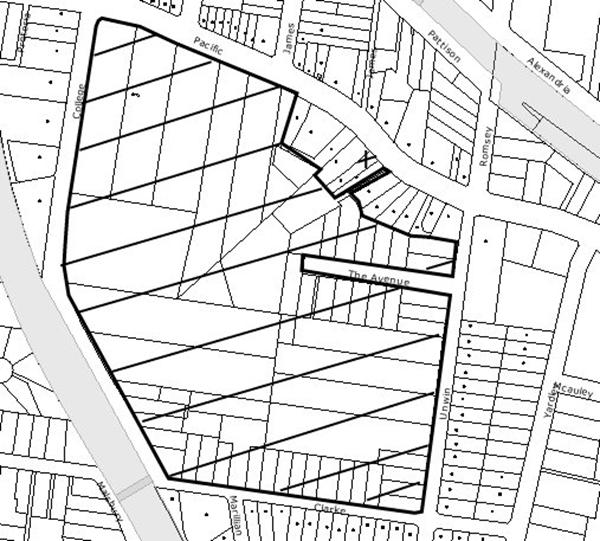
|
NOTIFICATION
PLAN
|
|
|
• PROPERTIES NOTIFIED
|
X SUBMISSIONS
RECEIVED
|
PROPERTY SUBJECT OF DEVELOPMENT
|
|
|
TWO SUBMISSIONS RECEIVED
OUT OF MAP RANGE
|
|
|
|
|
Three submissions objected to the
development, generally on the following grounds that the development would
result in:
· Unacceptable traffic
on local streets;
· Parking impacts;
· Privacy impacts;
· Littering.
The merits of the matters raised
in community submissions have been addressed in the body of the report with the
exception of the following:
5.1.1 Privacy Impacts
The submission raised concerns
that the privacy of adjoining residential properties would be impacted upon by
the loitering of parents and students for long periods of time. This matter is
addressed by the provision of an on-site drop-off and pick-up area and would
negate the need for parents to park in the surrounding streets to
drop-off/pick-up their children.
5.1.2 Littering
The submission raised concerns
that the proposed development would lead to an increase in littering by
students and parents within the surrounding streets. Whilst the development
includes the provision of an increase in student numbers within the Junior School by 100, the proposal includes provision of adequate waste areas and
management and the potential for littering by students could be managed by the
School and would not be significant as to warrant refusal of the application in
itself.
5.2 Public Agencies
As stated previously in the
report, the application was referred to the RTA pursuant to Clause 104 of the
Infrastructure SEPP. The application was considered by the Sydney Regional
Development Advisory Committee (SRDAC) and no objections were raised to the
proposed development.
6. THE PUBLIC INTEREST
Section 79C(1)(e) of the Act
requires Council to consider “the public interest”.
The public interest is an
overarching requirement, which includes the consideration of the matters
discussed in this report. Implicit to the public interest is the achievement
of future built outcomes adequately responding to and respecting the future
desired outcomes expressed in environmental planning instruments and
development control plans.
The application is considered to
have satisfactorily addressed Council’s criteria and would provide a
development outcome that, on balance, would result in a positive impact for the
community. Accordingly, it is considered that the approval of the proposed
school additions would be in the public interest.
CONCLUSION
The
application proposes alterations and additions to the existing Junior School and construction of a multi-purpose hall at Barker College.
The proposal
is consistent with the relevant aims and objectives contained within the
relevant State and Regional Environmental Planning Policies, the Hornsby Shire
Local Environmental Plan 1994, and the Development Control Plans which are
applicable to the site.
The
development is unlikely to result in any significant impacts upon the natural
or built environments, or have any negative social or economic impacts. The
development provides improved educational facilities for the school community.
Given this, and the recommended conditions, it is recommended that the
application be approved.
|
Rod Pickles
Manager -
Assessment Team 2
Planning Division
|
Scott Phillips
Executive Manager
Planning Division
|
Attachments:
|
1.View
|
Locality Plan
|
|
|
|
2.View
|
Staging Plan
|
|
|
|
3.View
|
Floor Plans
|
|
|
|
4.View
|
Elevations and
Sections
|
|
|
File Reference: DA/81/2009
Document Number: D01143739
SCHEDULE 1
GENERAL CONDITIONS
The conditions of consent within this notice of determination
have been applied to ensure that the use of the land and/or building is carried
out in such a manner that is consistent with the aims and objectives of the
planning instrument affecting the land.
Note: For
the purpose of this consent, the term ‘applicant’ means any person who has the
authority to act on or the benefit of the development consent.
Note:
For the purpose of this consent, any reference to an Act, Regulation,
Australian Standard or publication by a public authority shall be taken to mean
the gazetted Act or Regulation, or adopted Australian Standard or publication
as in force on the date that the application for a construction certificate is
made.
1. Approved
Plans and Supporting Documentation
The development must be carried
out in accordance with the plans and documentation listed below and endorsed
with Council’s stamp, except where amended by Council and/or other conditions
of this consent:
Architectural Plans prepared
by PMDL Architecture + Design Pty Ltd
|
Plan
No.
|
Title
|
Rev
|
Dated
|
|
DA J102
|
Level 1 Plan
|
E
|
17 April 2009
|
|
DA J103
|
Level 2 Plan
|
D
|
4 December 2008
|
|
DA J104
|
Level 3 Plan
|
C
|
26 November 2008
|
|
DA J105
|
Roof Plan
|
A
|
9 January 2009
|
|
DA J106
|
Separable Stages
|
A
|
9 January 2009
|
|
DA J107
|
Site Survey
|
A
|
5 December 2008
|
|
DA J201
|
Elevations & Sections
|
A
|
28 January 2009
|
Landscape Plans prepared
by DEM (Aust) Pty Ltd
|
Plan No.
|
Title
|
Rev
|
Dated
|
|
la JS 0501
|
Landscape Plan
|
a04
|
6 January 2009
|
|
la JS 2201
|
Landscape Sections
|
a03
|
6 January 2009
|
|
la JS 8901
|
Landscape Details
|
a03
|
6 January 2009
|
|
SKJS0001
|
Landscape Precedents & Material Images
|
a01
|
19 December 2008
|
Civil Engineering Plans
prepared by Hughes Trueman
|
Plan No.
|
Title
|
Rev
|
Dated
|
|
07P847-02-DAC110
|
Siteworks Plan
|
C
|
9 January 2009
|
|
07P847-02-DAC120
|
Typical Sections
|
C
|
9 January 2009
|
|
07P847-02-DAC130
|
Details
|
C
|
9 January 2009
|
|
07P847-02-DAC140
|
Erosion & Sediment Control Plan
|
B
|
9 January 2009
|
Supporting Documentation
|
Document Title
|
Prepared by
|
Dated
|
|
Statement of Environmental Effects
|
Mark Shanahan Planning Pty Ltd
|
12 January 2009
|
|
Traffic Report
|
Masson Wilson Twiney
|
21 January 2009
|
|
Heritage Impact Statement Project No. SYH-000334
|
HBO+EMTB Heritage Pty Ltd
|
21 November 2008
|
|
Civil Engineering Report
|
Hughes Trueman Pty Ltd
|
28 November 2008
|
|
Landscape Report Project No. 3999-01
|
DEM (Aust) Pty Ltd
|
6 January 2009
|
|
Tree Report
|
Treescan
|
January 2009
|
|
Accessibility Report
|
Morris-Goding Accessibility Consulting
|
11 December 2009
|
|
Waste Management Plan
|
Warren Marsh
|
4 December 2008
|
2. Removal
of Existing Trees
This
development consent only permits the removal of trees numbered 1-5 and 23-47 as
identified on Tree Location Plan – Junior School Site contained in the Tree
Report prepared by Treescan dated January 2009. The removal of any other trees
requires separate approval under Council’s Tree Preservation Order.
REQUIREMENTS PRIOR TO THE ISSUE OF A CONSTRUCTION
CERTIFICATE
The following conditions of consent must be
complied with prior to the issue of a ‘Construction Certificate’ by
either Hornsby Shire Council or an accredited certifier. All necessary
information to demonstrate compliance with the following conditions of consent
must be submitted with the application for a construction certificate.
3. Building
Code of Australia
All building
work must be carried out in accordance with the requirements of the Building
Code of Australia.
4. Fire
Safety Upgrade
To ensure the protection of persons using the existing building and to facilitate egress from this
building in the event of a fire, details must be submitted with the application for a construction certificate, detailing what works are necessary (if any) to
bring it into full compliance with Parts C, D and E of the Building Code of
Australia.
5. Sydney
Water – Quick Check
The application must be
submitted to a Sydney Water ‘Quick Check Agent’ or ‘Customer Centre’ for
approval to determine whether the development will affect any Sydney Water
infrastructure, and whether further requirements are to be met.
Note: Refer
to www.sydneywater.com.au or
telephone 13 20 92 for assistance.
6. Waste Bin Storage Areas
Bin storage
areas must be designed and constructed in accordance with Council’s Waste
Minimisation and Management Development Control Plan.
7. Waste
Vehicle Access
The internal
layout of the driveway must be designed so that waste vehicles do not encroach
on landscaped areas.
8. Right
Turn Lane
Design
details of the design for the right turn bay in College Crescent must be
approved by Council.
9. Wombat
Crossing
The existing
wombat crossing in Clarke Road must be removed and a new wombat crossing
constructed to align with the new pedestrian access to the Junior School. The wombat crossing is to be designed in accordance with relevant RTA
guidelines, technical directions and Australian Standards 1742.3-2002
- Manual of uniform traffic control devices - Traffic control devices for works
on roads and be approved by Council.
10. Acoustic
Report
The applicant
must submit an Acoustic Report, prepared by a suitably qualified
acoustic consultant, for Council’s approval. The report must detail
the current background noise level, predicted noise levels to be
emitted from the proposed development (including all uses such as ball
games with the use of whistles, amplified music, parties, PA systems etc),
the proposed uses (e.g. types of games, plays,
social events, public meetings etc) and any proposed noise
attenuation measures to be implemented so that background levels are not
exceeded by 5dB(A) when measured at the closest premises. The EPA’s NSW
Industrial Noise Policy (2000), Hornsby Shire Council Policy and
Guidelines for Noise and Vibration Generating Development (Acoustic Guidelines
V.5, 2000) and the DEC’s Noise Guide for Local Government (2004) must
be used to prepare the Acoustic Report.
REQUIREMENTS PRIOR TO THE COMMENCEMENT OF ANY WORKS
The following conditions of consent must be
complied with prior to the commencement of any works on the site. The
conditions have been imposed to ensure that the works are carried out in such a
manner that complies with relevant legislation and Council’s policies and does
not disrupt the amenity of the neighbourhood or impact upon the environment.
11. Erection
of Construction Sign
A sign must
be erected in a prominent position on any site on which building work,
subdivision work or demolition work is being carried out:
a. Showing
the name, address and telephone number of the principal certifying authority
for the work.
b. Showing
the name of the principal contractor (if any) for any demolition or building
work and a telephone number on which that person may be contacted outside
working hours.
c. Stating
that unauthorised entry to the work site is prohibited.
Note: Any
such sign is to be maintained while the building work, subdivision work or
demolition work is being carried out, but must be removed when the work has
been completed.
12. Erosion
and Sediment Control
Erosion and
sediment control measures must be provided and maintained throughout the
construction period in accordance with the manual ‘Soils and Construction
2004 (Bluebook)’, the approved plans, Council specifications and to the
satisfaction of the principal certifying authority. The erosion and sediment
control devices must remain in place until the site has been stabilised and
revegetated.
Note: On
the spot penalties up to $1,500 may be issued for any on-compliance with this
requirement without any further notification or warning.
13. Tree
Protection Barriers
Tree
protection fencing must be erected around trees numbered 6-22 to be retained at
a 3 metre setback. The tree fencing must be
constructed of 1.8 metre ‘cyclone chainmesh fence’ or star pickets spaced at 2
metre intervals, connected by a continuous high-visibility barrier/hazard mesh
at a height of 1 metre.
REQUIREMENTS DURING CONSTRUCTION
The following conditions of consent must be
complied with during the construction of the development. The conditions have
been imposed to ensure that the works are carried out in such a manner that
complies with relevant legislation and Council’s policies and does not disrupt
the amenity of the neighbourhood or impact upon the environment.
14. Construction
Work Hours
All work on site (including demolition and earth works)
must only occur between the following hours:
Monday to Saturday 7 am to 5 pm
Sunday & Public Holidays No work
15. Demolition
All
demolition work must be carried out in accordance with Australian Standard
2601-2001 – The Demolition of Structures and the following requirements:
a. Demolition
material is to be disposed of to an authorised recycling and/or waste disposal
site and/or in accordance with an approved waste management plan.
b. Demolition
works, where asbestos material is being removed, must be undertaken by a
contractor that holds an appropriate licence issued by WorkCover NSW in
accordance with Chapter 10 of the Occupational Health and Safety Regulation
2001 and Clause 29 of the Protection of the Environment Operations
(Waste) Regulation 1996.
c. On
construction sites where buildings contain asbestos material, a standard
commercially manufactured sign containing the words ‘DANGER ASBESTOS REMOVAL IN
PROGRESS’ measuring not less than 400mm x 300mm must be erected in a prominent
position visible from the street.
16. Environmental
Management
The site must
be managed in accordance with the publication ‘Managing Urban Stormwater –
Landcom (March 2004) and the Protection of the Environment Operations
Act 1997 by way of implementing appropriate measures to prevent sediment
run-off, excessive dust, noise or odour emanating from the site during the
construction of the development.
17. Works
near Trees
All required tree protection
measures must be maintained in good condition for the duration of the
construction period.
All works
(including driveways and retaining walls) within 3 metres of any trees required
to be retained (whether or not on the subject property, and pursuant to this
consent or the Tree Preservation Order), must be carried out under the
supervision of an ‘AQF Level 5 Arborist’ and a certificate submitted to
the principal certifying authority detailing the method(s) used to preserve the
tree(s).
Note: Except as provided
above, the applicant is to ensure that no excavation, filling or stockpiling of
building materials, parking of vehicles or plant, disposal of cement slurry,
waste water or other contaminants is to occur within 4 metres of any tree to be
retained.
18. Council
Property
During
construction works, no building materials, waste, machinery or related matter
is to be stored on the road or footpath. The public reserve is to be kept in a
clean, tidy and safe condition at all times.
19. Landfill
Landfill must
be constructed in accordance with Council’s ‘Construction Specification,
2005’ and the following requirements:
a. All
fill material imported to the site is to wholly consist of Virgin Excavated
Natural Material (VENM) as defined in Schedule 1 of the Protection of the
Environment Operations Act 1997 or a material approved under the Department
of Environment and Climate Change’s general resource recovery exemption.
20. Excavated
Material
All excavated
material removed from the site must be classified in accordance with the NSW
Environment Protection Authority’s Environmental Guidelines – Assessment,
Classification and Management of Liquid and Non-Liquid Wastes prior to
disposal to an approved waste management facility and reported to the principal
certifying authority.
21. Survey
Report – Finished Floor Level
A report must
be prepared by a registered surveyor and submitted to the principal certifying
authority prior to the pouring of concrete at each level of the building
certifying that:
a. The
building, retaining walls and the like have been correctly positioned on the
site.
b. The
finished floor levels are in accordance with the approved plans.
REQUIREMENTS PRIOR TO THE ISSUE OF AN OCCUPATION
The following conditions of consent must be complied with
prior to the ‘Principal Certifying Authority’ issuing an ‘Occupation
Certificate’.
Note: For
the purpose of this consent, any reference to ‘occupation certificate’ shall
also be taken to mean ‘interim occupation certificate’ unless otherwise stated.
22. Stormwater
Drainage
The
stormwater drainage system for the development must be designed and constructed
in accordance with Council’s Civil Works – Design and Construction
Specification 2005 and the following requirements:
a. Connected
to the existing drainage system located within the school oval via the onsite
detention tank.
23. On
Site Stormwater Detention
An on-site
stormwater detention system must be designed by a chartered civil engineer and
constructed in accordance with the following requirements:
a. Have
a capacity of not less than 86 cubic metres, and a maximum discharge (when
full) that is equal to the pre development 1 in 5 year ARI storm event.
b. Have
a surcharge/inspection grate located directly above the outlet.
c. Discharge
from the detention system to be controlled via 1 metre length of pipe, not less
than 50 millimetres diameter or via a stainless plate with sharply drilled orifice
bolted over the face of the outlet discharging into a larger diameter pipe
capable of carrying the design flow to an approved Council system.
d. Where
above ground and the average depth is greater than 0.3 metres, a ‘pool type’
safety fence and warning signs to be installed.
24. Internal
Driveway/Vehicular Areas
The driveway
and parking areas on site must be designed in accordance with Australian
Standards 2890.1, 2890.2, 3727 and the following requirements:
a. The
driveway be a rigid pavement.
b. The
driveway grade not exceed 25 percent and changes in grade not exceed 8 percent.
c. The
pavement have a kerb to one side and a one-way cross fall with a minimum
gradient of 2 percent and a lintel and pit provided at the low point.
25. Vehicular
Crossing
A separate
application under the Local Government Act 1993 and the Roads Act
1993 must be submitted to Council for the installation of a new vehicular
crossing and the removal of the redundant crossing. The vehicular crossing
must be constructed in accordance with Council’s Civil Works Design 2005
and the following requirements:
a. Any
redundant crossings to be replaced with integral kerb and gutter.
Note:
An application for a vehicular crossing can only be made to one of Council’s
Authorised Vehicular Crossing Contractors. You are advised to contact Council
on 02 9847 6940 to obtain a list of contractors.
26. Traffic
Control Plan
A Traffic
Control Plan (TCP) must be prepared by a qualified traffic controller in
accordance with the Roads & Traffic Authority’s Traffic Control at
Worksites Manual 1998 and Australian Standard 1742.3 for all work on
a public road and be submitted to Council. The TCP must detail the following:
a. Arrangements
for public notification of the works.
b. Temporary
construction signage.
c. Permanent
post-construction signage.
d. Vehicle
movement plans.
e. Construction
Traffic management plans.
f. Pedestrian
and cyclist access/safety.
27. Damage to Council Assets
Any damage
caused to Council’s assets as a result of the construction of the development
must be rectified in accordance with Council’s written requirements and at the
sole cost of the applicant.
28. Creation
of Easements
The following matters must be
nominated on the plan of subdivision under s88B of the Conveyancing Act 1919:
a. The
creation of an appropriate "Positive Covenant" and "Restriction
as to User" over the constructed on-site detention/retention systems
and outlet works, within the lots in favour of Council in accordance with
Council’s prescribed wording. The position of the on-site detention system is
to be clearly indicated on the title.
b. To
register the OSD easement, the restriction on the use of land “works-as-executed”
details of the on-site-detention system must be submitted verifying that the
required storage and discharge rates have been constructed in accordance with
the design requirements. The details must show the invert levels of the on
site system together with pipe sizes and grades. Any variations to the
approved plans must be shown in red on the “works-as-executed” plan and
supported by calculations.
Note: Council
must be nominated as the authority to release, vary or modify any easement,
restriction or covenant.
29. Completion
of Landscaping
A certificate
must be provided by a practicing landscape architect, horticulturalist or
person with similar qualifications and experience certifying that all required
landscaping works have been satisfactorily completed in accordance with the
approved landscape plans.
Note: Advice
on suitable species for landscaping can be obtained from Council’s planting
guide ‘Indigenous Plants for the Bushland Shire’, available at www.hornsby.nsw.gov.au.
30. Works
as Executed Plan
A works-as-executed plans must
be prepared by a registered surveyor and submitted to Council for completed
road pavement, kerb & gutter, public drainage systems, driveways and on
site detention system.
31. Consolidation
of Allotments
All allotments the subject
of this consent must be consolidated into one allotment.
Note: The applicant is recommended to submit the plan of
subdivision to consolidate allotments to the NSW Department of Lands at least
4-6 weeks prior to seeking an occupation certificate.
32. Right Turn Bay
The applicant
must construct a right turn bay in College Crescent for the Multi-purpose Hall
and car parking area. All works associated with the construction of the entry
arrangement must be carried out in accordance with a design approved by Council
and at no cost to Council.
33. Wombat
Crossing
The wombat
crossing must be constructed in accordance with the approved drawings. All
works associated with the construction of the wombat crossing must be carried
out at no cost to Council.
OPERATIONAL CONDITIONS
The following conditions have been applied to ensure that the
ongoing use of the land is carried out in such a manner that complies with
relevant legislation and Council’s policies and does not disrupt the amenity of
the neighbourhood or impact upon the environment.
34. Car
Parking and Deliveries
All car parking must be
constructed and operated in accordance with Australian Standard AS 2890.1 –
2004 – Off Street Car Parking and Australian Standard 2890.2 - 2002 –
Off Street Commercial and the following requirement:
a. All
parking areas and driveways are to be sealed to an all weather standard, line
marked and signposted.
b. Car
parking, loading and manoeuvring areas to be used solely for nominated
purposes.
c. Vehicles
awaiting loading, unloading or servicing shall be parked on site and not on
adjacent or nearby public roads;
d. All
vehicular entry on to the site and egress from the site shall be made in a
forward direction.
e. The College is
to monitor the operation of the drop-off/pick up arrangement to prevent
drop-off/pick up occurring in the visitor parking spaces.
f. The
exit from the driveway onto College Crescent is to be limited to left out only.
g. The waste
collection vehicle is not to enter the site during peak school periods, 8:00am
- 9:30am and 2:30pm - 4:00pm
35. Noise
All noise generated by the
proposed development must be attenuated to prevent levels of noise being
emitted to adjacent premises which possess tonal, beating and similar
characteristics or which exceeds background noise levels by more than 5dB(A).
An Acoustic Assessment
is to be undertaken by a suitably qualified environmental consultant within 60
days of occupying the site (or at the first available opportunity for
the proposed uses that fall within the first six months).
The Acoustic Assessment is to be undertaken in accordance with the Environment
NSW Industrial Noise Policy (2000), Council’s Policy and Guidelines for
Noise and Vibration Generating Development (Acoustic Guidelines V.5, 2000) and
the DECC’s Noise Guide for Local Government (2004). Should the
assessment find that noise from the premise exceeds 5dB(A), all operation
associated with the proposed development must cease until appropriate
measures are employed to rectify excessive noise so that noise levels emitted
do not exceed background levels by more than 5dB(A).
36. Fire
Safety Statement - Annual
On at least one occasion in
every 12 month period following the date of the first ‘Fire Safety Certificate’
issued for the property, the owner must provide Council with an annual ‘Fire
Safety Certificate’ to each essential service installed in the building.
37. Maintenance
of Wastewater Device
All wastewater and
stormwater treatment devices (including drainage systems, sumps and traps) must
be regularly maintained in order to remain effective. All solid and liquid
wastes collected from the device must be disposed of in accordance with the Protection
of the Environment Operations Act 1997.
38. Use
of Multi-Purpose Hall
All activities undertaken in
association with the multi purpose hall are to cease by 12 midnight.
39. Licensed
Waste Contractor
Written
evidence must be kept on site of a valid contract with a licensed waste
contractor for the regular collection and disposal of all the waste and
recyclables that are generated on site.
CONDITIONS OF CONCURRENCE – ROADS AND
TRAFFIC AUTHORITY
The following conditions of consent are from the nominated
State Agency pursuant to Section 79B of the Environmental Planning and
Assessment Act 1979 and must be complied with to the satisfaction of that
Agency.
40. Construction
Management Plan
A
Construction Management Plan is to be submitted covering traffic impact and
safety on the Pacific Highway and College Crescent for Council’s review and
approval.
41. Demolition/
Construction Vehicles
Suitable provision must be made
on-site to accommodate all demolition/ construction vehicles.
42. Cost of Works
All works associated with
the proposed development shall be at no cost to the RTA.
-
END OF CONDITIONS -
ADVISORY NOTES
The following information is provided for your
assistance to ensure compliance with the Environmental Planning and Assessment
Act 1979, Environmental Planning and Assessment Regulation 2000, other relevant
legislation and Council’s policies and specifications. This information does
not form part of the conditions of development consent pursuant to Section 80A
of the Act.
Environmental Planning and Assessment Act 1979
Requirements
· The Environmental Planning and
Assessment Act 1979 requires:
· A construction certificate prior to the
commencement of any works. Enquiries regarding the issue of a construction
certificate can be made to Council’s Customer Services Branch on 9847 6760.
· A principal certifying authority to be
nominated and Council notified of that appointment prior to the commencement of
any works.
· Council to be given at least two days
written notice prior to the commencement of any works.
· Mandatory inspections of nominated
stages of the construction inspected.
· An occupation certificate issued before
occupying any building or commencing the use of the land.
Long Service Levy
In accordance with Section 34 of the Building and
Construction Industry Long Service Payments Act 1986, a ‘Long Service Levy’ must be paid to the Long Service
Payments Corporation or Hornsby Council.
Note: The
rate of the Long Service Levy is 0.35% of the total cost of the work.
Note: Hornsby
Council requires the payment of the Long Service Levy prior to the issue of a
construction certificate.
Tree Preservation Order
To ensure the maintenance and
protection of the existing natural environment, it is an offence to ringbark,
cut down, top, lop, remove, wilfully injure or destroy a tree outside three
metres
of the approved building envelope
without prior written consent from Council. Fines may be imposed for
non-compliance with Council’s Tree Preservation Order.
Note: A
tree is defined as a single or multi-trunked wood perennial plant having a
height of not less than three (3) metres, and which develops many branches,
usually from a distance of not less than one (1) metre from the ground, but
excluding any plant which, in its particular location, is a noxious plant
declared as such pursuant to the Noxious Weeds Act 1993. This definition of
‘tree’ includes any and all types of Palm trees.
All
distances are determined British Standard BS 5837: 2005, “Trees in Relation to
Construction – Recommendations”.
Disability Discrimination Act
The applicant’s attention is drawn to the existence of the Disability
Discrimination Act. A construction certificate is required to be obtained
for the proposed building/s, which will provide consideration under the Building
Code of Australia, however, the development may not comply with the
requirements of the Disability Discrimination Act. This is the sole
responsibility of the applicant.
Dial Before You Dig
Prior to commencing any works, the applicant is encouraged
to contact Dial Before You Dig on 1100 or www.dialbeforeyoudig.com.au for
free information on potential underground pipes and cables within the vicinity
of the development site.
Asbestos Warning
Should asbestos or asbestos products be encountered during
construction or demolition works you are advised to seek advice and information
should be prior to disturbing the material. It is recommended that a contractor
holding an asbestos-handling permit (issued by Work Cover NSW), be
engaged to manage the proper disposal and handling of the material. Further
information regarding the safe handling and removal of asbestos can be found
at:
www.environment.nsw.gov.au
www.nsw.gov.au/fibro
www.adfa.org.au
www.workcover.nsw.gov.au
Alternatively, telephone the Work Cover Asbestos and
Demolition Team on 8260 5885.
Planning Report No. PLN41/09
Date of Meeting:
3/06/2009
7 DEVELOPMENT APPLICATION
- SECTION 96 (2) - ERECTION OF AN 11 STOREY MIXED USE BUILDING
135-137 PACIFIC HIGHWAY, HORNSBY
|
Development Application No:
|
DA/1586/2001/B
|
|
Description of Proposal:
|
Mixed use building comprising 70 residential units
and three levels of commercial units - Section 96 (2) Application
|
|
Property Description:
|
Lot 1 DP 606694, Lot 2 DP 606694 (Nos. 135-137) Pacific Highway and Pound Road Reserve, Hornsby
|
|
Applicant:
|
Mr Antonio Falcone
|
|
Owners:
|
FAL Management Group Pty Ltd and Hornsby Shire Council
(Pound Road)
|
|
Statutory Provisions:
|
Hornsby Shire Local Environmental
Plan 1994
Residential D (High Density)
|
|
Estimated Value:
|
$23,240,221
|
|
Ward:
|
B
|
|
RECOMMENDATION
THAT Section 96(2) Application to modify Development Consent No.
1586/2001 for the construction of a mixed use development comprising 70
residential units and three levels of commercial units at Lot 1 DP 606694,
Lot 2 DP 606694 (Nos. 135-137) Pacific Highway and Pound Road Reserve,
Hornsby be refused for the reasons detailed in Schedule 1 of the independent
town planning consultant’s report – Nexus Environmental Planning Pty Ltd.
|
1. The
application proposes modifications to an existing development consent resulting
in the construction of a mixed use development comprising 70 residential units
and three levels of commercial units.
2. A portion of the site is owned by Council. In accordance with
Council’s adopted Policy ‘PSA1 Proposed Council Developments’ and ‘Practice
Note No. 7 Assessment Practice’ an independent assessment of the
development application has been undertaken by Nexus Environmental Planning Pty
Ltd.
3. Thirty
nine individual submissions and a petition containing 21 signatures each
objecting to the development have been received in respect of the application.
4. The report by Nexus Environmental
Planning is attached to this report for Council’s consideration. The
independent consultant’s report recommends refusal of the application.
Note: At the time of the completion of this planning
report, no persons have made a Political Donations Disclosure Statement pursuant
to Section 147(3) of the Environmental Planning and Assessment Act 1979 in
respect of the subject planning application.
|
Rod Pickles
Manager -
Assessment Team 2
Planning Division
|
Scott Phillips
Executive Manager
Planning Division
|
Attachments:
|
1.View
|
Independent Town
Planning Consultant's Report
|
|
|
|
2.View
|
Locality Plan
|
|
|
|
3.View
|
Floor Plans
|
|
|
|
4.View
|
Elevations, Shadow
Plans, Floor Plans and Landscape Plan
|
|
|
File Reference: DA/1586/2001/B
Document Number: D01155818
Planning Report No. PLN36/09
Date of Meeting:
3/06/2009
8 DEVELOPMENT APPLICATION
- SECTION 96(2) - SUBDIVISION OF ONE LOT INTO TWO
8 CHORLEY AVENUE CHELTENHAM
|
Development Application No:
|
DA/1202/2008/A
|
|
Description of Proposal:
|
Section 96(2) - Modification of
conditions Nos. 13 and 16, to delete the requirement for a shared driveway
access and delete the requirement for a future dwelling to be designed by a
heritage architect.
|
|
Property Description:
|
Lot 144 DP 12364 (No. 8) Chorley Avenue, Cheltenham
|
|
Applicant:
|
P S Graham & Associates
|
|
Owner:
|
Mrs B L McDonald and Mr R G Rae
|
|
Statutory Provisions:
|
Hornsby Shire Local Environmental
Plan 1994
Residential AS (Low Density –
Sensitive Lands)
|
|
Estimated Value:
|
N/A
|
|
Ward:
|
C
|
|
RECOMMENDATION
THAT Council approve the
modification to Development Application No. 1202/2008/A for subdivision of
one lot into two by deleting condition No. 16(d) at lot 144 DP 12364 (No. 8)
Chorley Avenue Cheltenham as, detailed in Schedule 1 of this report.
|
1. The
application proposes modification of the consent in respect to conditions Nos.
13(e), 16(c) and 16(d) to delete the requirement for shared driveway access and
the requirement for a future dwelling to be designed by a heritage architect.
2. The
proposal does not comply with the Heritage Development Control Plan and the
Residential Subdivision Development Control Plan, in respect to the duplication
of the driveways in the streetscape. Deletion of condition No. 16(d) concerning
the requirements for a future dwelling to be designed by a heritage architect
is acceptable.
3. Four
submissions have been received in respect of the application.
4. It
is recommended that the application be modified by deleting condition No.
16(d). Deletion of condition No. 13(e) and 16(c) is not recommended.
HISTORY OF THE APPLICATION
On 4 February 2009 Council
approved Development Application No. 1202/2008 for the demolition of existing
dwelling and subdivision of one lot into two.
THE SITE
The site has an area of 1407m2
and frontage to the northern side of Chorley Avenue. The site is irregular in
shape and is of dimensions; frontage 20.115m, western side boundary 60.96m,
eastern side boundary 81.08m and rear boundary 30.81m. The site has a fall of
10% to the western side boundary.
The site includes an existing
single storey brick dwelling house with a tiled roof which was constructed in
1937. The house has a lower floor single garage located on the western side of
the house. The adjoining properties include dwelling houses of similar age and
construction. The site is located within the Beecroft Cheltenham Heritage Conservation
Area.
The site includes several trees
including two large trees located on each side boundary.
The site is located 350m north
east of Cheltenham Railway Station.
THE PROPOSAL
The proposal is for the
demolition of the existing dwelling house and subdivision of one allotment into
two lots. The original proposal for the alteration of the existing dwelling and
the construction of an accessway along the western side boundary was amended
following concerns raised by Council regarding inadequate accessway width and
adverse impacts on existing trees.
Proposed lot 1 has an area of
622.9m2 and is of dimensions; frontage 16.055m, western side
boundary 4.905m, eastern side boundary 36.15m and rear boundary 13.81m.
Proposed lot 1 has direct road frontage along its entire front boundary.
Proposed lot 2 is a battleaxe lot
with an area of 784.1m2 (641m2 excluding handle). The
handle (4.06m x 36.1m) is along the eastern boundary of the site. The lot
dimensions are; common boundary 13.81m, western side boundary 20.055m, eastern
side boundary 81.08m and rear boundary 30.81m.
PROPOSED MODIFICATION OF
DEVELOPMENT CONSENT
The proposal seeks to modify the
development consent by way of deleting conditions requiring the shared use of
the approved accessway along the eastern side boundary. The conditions in this
regard are as follows:
Condition 13(e)
(e) The existing driveway and vehicle crossing is to be removed
and the nature strip restored by turfing.
Condition 16(c) and (d)
(c) To
avoid duplication of driveways in the streetscape, appropriate Rights of Access
and Easement for Services benefiting lot 1 are to be created over the handle of
lot 2, under Section 88B of the Conveyancing Act 1919 and indicated on the
final plan of subdivision.
(d) A
positive covenant created over Lot 1 requiring that any future dwelling to be
designed by a qualified heritage architect in accordance with the Heritage
Development Control Plan and Precinct Character Statement, in a manner that
maintains the character of the area, with vehicular access from the adjoining
access handle.
The application includes the
following statements:
The condition to share the
access for both lots is unsound and unreasonable for the following reasons:
· The access to Lot 1 would require a left turn off the driveway and a minimum width in front of the garage
door of 6.0m to allow turning. This would reduce the potential efficiency of
the design for the ground floor and would increase the ground floor footprint.
· It would result in
a reduced outdoor yard area. With a 1m wide landscaping strip to the boundary,
the face of the garage door would be a minimum of 7m away from the boundary and
would require 66% of the width of the block for parking.
· The side access
garage will require a building design that is not typical and would result in a
design that does not address the street or restricts living areas access to the
rear yard.
· The access and
manoeuvring area to Lot 1 is likely to generate additional noise and glare at
night to the residents in No. 6 Chorley Avenue.
· The shared driveway
would increase the risk of congestion and collision and is less safe than
separate driveways.
· The shared driveway
requires joint insurance, shared maintenance, and relies on the neighbours to
be amenable for its effective operation.
The requirement for the design
to be undertaken by a qualified heritage architect is restrictive,
discriminatory and unnecessary for the following reasons:
· The limitation on
the use of architect would unnecessarily limit the opportunity of optimum
design for both lots.
· While the site is
in the Beecroft Heritage Conservation Area, and there are two heritage items in
the vicinity, neither requires the conservation and restoration skills of a
heritage architect to produce a design for both lots.
· The condition
restricts the legitimate practice of qualified professionals to undertake work
and is likely to be legally unenforceable.
ASSESSMENT
The development application has
been assessed having regard to the ‘2005 City of Cities Metropolitan
Strategy’, the ‘North Subregion (Draft) Subregional Strategy’ and
the matters for consideration prescribed under Section 79C of the Environmental
Planning and Assessment Act 1979 (the Act). Subsequently, the following
issues have been identified for further consideration.
1. STRATEGIC CONTEXT
1.1 Metropolitan Strategy – (Draft) North Subregional
Strategy
The Metropolitan Strategy is a
broad framework to secure Sydney’s place in the global economy by promoting and
managing growth. It outlines a vision for Sydney to 2031; the challenges
faced, and the directions to follow to address these challenges and achieve the
vision. The draft North Subregional Strategy acts as a framework for Council
in the preparation of a new Principal LEP by 2011.
The draft Subregional Strategy
sets the following targets for the Hornsby LGA by 2031:
· Employment capacity
to increase by 9,000 jobs; and
· Housing stock to
increase by 11,000 dwellings.
The proposed modification would
not result in any inconsistency with the draft Strategy.
2. STATUTORY CONTROLS
Section 79C(1)(a) requires
Council to consider “any relevant environmental planning instruments, draft
environmental planning instruments, development control plans, planning
agreements and other prescribed matters.”
2.1 Environmental
Planning & Assessment Act, 1979 - Section 96
The application is lodged
pursuant to Section 96(2) of the Act which allows the modification of a
consent, where the proposal has been notified in accordance with regulatory
requirements, is substantially the same development as approved and Council
considers the application with regard to Section 79C of the Act and any
submissions.
The proposed modification is
substantially the same development as approved.
The application was notified
pursuant to Council’s Notification & Exhibition DCP. There were four
submissions in response to the public exhibition of the proposal.
2.2 Hornsby Shire Local Environmental Plan 1994
The subject land is zoned Residential AS (Low Density – Sensitive Lands) under Hornsby Shire Local Environmental
Plan 1994 (HSLEP). The objectives of the zone are:
(a) to provide for the housing needs of the population of the
Hornsby area.
(b) to promote a variety of housing types and other land uses
compatible with a low density residential environment and sensitive to the land
capability and established character of this environment.
(c) to provide for development that is within the
environmental capacity of a sensitive low density residential environment.
The proposed development is
defined as ‘subdivision’ and ‘demolition’ under the HSLEP and is permissible in
the zone with Council’s consent.
Clause 14 of the HSLEP prescribes
that the minimum lot area for subdivision within the zone zone is 600m2.
The proposed modification does not alter the approved lots areas of 622.9m2
(Lot 1) and 641m2 (Lot 2).
Clause 18 of the HSLEP sets out
heritage conservation provisions within the Hornsby LGA. The proposed
modification involves development within the Beecroft-Cheltenham Heritage
Conservation Area.
2.3 Heritage Development Control Plan
The proposed modification to the
approved development has been assessed having regard to the Statement of
Significance for the Beecroft/Cheltenham Heritage Conservation Area and the
Precinct Character Statement – The Cheltenham Road/Norma Crescent Precinct –
Area C1.
The DCP requires that development
within the precinct to be consistent with the Precinct Character Statement.
The
application for modification involves the deletion and amendment of conditions
which require the provision of a shared accessway servicing the two allotments,
and the design of any future dwelling-house on Lot 1 to be undertaken by a
qualified heritage architect. The conditions have been placed upon the
development consent to ensure that “any future development on the front
allotment (Lot 1) be designed and constructed in such a manner that addresses
Council’s objective to maintain the character of the Heritage Conservation
Area, in accordance with Council’s resolution of 4 February 2009.
The Siting
element of the Heritage DCP encourages detached garages located to the rear of
a property. Similarly, the controls for Heritage Conservation Areas discourage
prominent double garages located at the building line as these dominate the
streetscape. The siting of garages at the rear is also an identified
characteristic of Chorley Avenue, as articulated within the Precinct Character
Statement of the Heritage DCP. A significant proportion of the existing
dwelling-houses in the portion of Chorley Avenue between Cheltenham Road and Norma Crescent feature detached garages at the rear of properties, including Nos. 2, 2A, 3,
4, 5 and 7-9 Chorley Avenue. Accordingly, the requirement for a shared
accessway reinforces the objectives of the Heritage DCP in achieving a garage
at the rear of Lot 1, which would be more in keeping with the surrounding
streetscape.
The Precinct
Character Statement also notes that driveways in Chorley Avenue generally
comprise unobtrusive materials and the street is notable for its informal swale
edges. The Heritage Conservation Areas element of the Heritage DCP states that
lot design should not result in an increase in the number of kerb crossings,
and instead, should facilitate shared access arrangements. Additional
accessways would affect the pattern of development within
this portion
of Chorley Avenue and have an adverse impact upon its character. Therefore,
limiting the number of accessways through a shared access is supported on
heritage grounds.
The
applicant’s letter asserts that the condition requiring a shared accessway is
unreasonable in view of the requirements for a vehicle turning area, with a
consequential reduction in open space and more restrictive dwelling design.
However, the provision of vehicle parking which is approached perpendicular to
the accessway with a turning area, would be no more restrictive upon the
development of Lot 1 than the similar parking arrangement provided within Lot 2 under the approved indicative building envelope.
The retention
of the conditions requiring a shared accessway act to encourage the provision
of a garage, potentially detached, within the rear of Lot 1. The alternative
siting of a garage need not compromise the scale, design or provision of
private open space, should the design of the future dwelling-house be
approached innovatively and with attention to the character of the surrounding
Conservation Area.
The proposed modification to
delete the conditions requiring shared use of the accessway, is inconsistent
with the Precinct Character Statement and would not comply with the Heritage
DCP.
At its meeting on 1 December
2008, the Heritage Advisory Committee commented that the pattern of development
within this portion of the Conservation Area is significantly intact. As such,
attention should be given to the design of development upon the site to
maintain the integrity of the historical subdivision pattern and streetscape.
It is reasonable to expect that any suitably qualified professional
(draftsperson, architect or the like) would be capable of designing an
appropriate dwelling-house on Lot 1 having regard to the controls within the
Heritage Development Control Plan. Accordingly, the proposed deletion of the
condition which requires the preparation of plans by a qualified heritage architect
is considered reasonable. However, it is recommended that the infill
development within a sensitive area be prepared by a suitably qualified
professional with experience in heritage matters.
The condition requiring plans to
be prepared by a heritage architect, is a matter subject to further
consideration by Council in the assessment of a future development application
for a dwelling house on lot 1, in accordance with the Heritage DCP. The
condition is addressed by the current development controls and requirements for
preparation of a development application. Any future dwelling within the
heritage conservation area is subject to assessment and determination by
Council. It is generally held by the Land and Environment Court that conditions
regarding matters subject to further approval in accordance with a development
control plan should not be attached to a consent.
2.4 Residential Subdivision Development Control Plan
The DCP includes the following
element objectives for accessway design and allotment design, respectively as
follows:
To ensure vehicular access to
all lots within the subdivision is simple, safe, direct and creates a pleasant
environment.
To provide useable allotments
which provide pleasant streetscapes, maximise energy efficiency and mitigate
environmental impacts.
Council has consistently required
the shared use of access handles for battleaxe subdivisions, to avoid the
negative impact of driveway duplication in the streetscape, to minimise the
extent of paved areas with
impacts from runoff and to encourage dwellings designed with less intrusive
garaging to minimise impacts on the streetscape. Recent examples include:
· No. 125 Copeland Road,
Beecroft (DA/1992/2006)
· No. 43 Surrey Street,
Epping (DA/1684/2005)
· No. 54 Day Road, Cheltenham (DA/929/2008)
It is considered that the
proposed modification to delete the conditions requiring the shared use of the
accessway would set an undesirable precedent and is therefore not supported.
3. ENVIRONMENTAL IMPACTS
Section 79C(1)(b) of the Act
requires Council to consider “the likely impacts of that development,
including environmental impacts on both the natural and built environments, and
social and economic impacts in the locality”.
3.1 Natural Environment
The proposed modification would
not adversely impact on the natural environmental other than the loss of
landscaped area as a consequence of the additional driveway.
3.2 Built Environment
The proposed modification would
result in a built form unsympathetic with the existing heritage streetscape.
(Refer to comments in Sections 2.3 and 2.4).
3.3 Social Impacts
The proposed modification would
not result in any social impact.
3.4 Economic Impacts
The proposed modification would
not result in an economic impact.
4. SITE SUITABILITY
Section 79C(1)(c) of the Act
requires Council to consider “the suitability of the site for the
development”.
The site is approved for
subdivision into two lots.
5. PUBLIC PARTICIPATION
Section 79C(1)(d) of the Act
requires Council to consider “any submissions made in accordance with this
Act”.
5.1 Community Consultation
The proposed development was
placed on public exhibition and was notified to adjoining and nearby landowners
between 22 April and 6 May 2009 in accordance with Council’s Notification and
Exhibition Development Control Plan. During this period, Council received
four submissions. The map below
illustrates the location of those nearby landowners who made a submission that
are in close proximity to the development site.
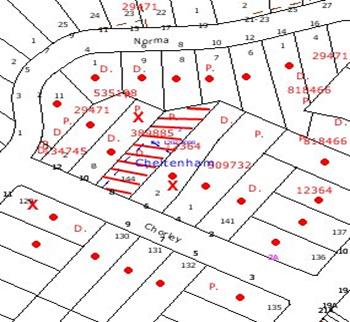
|
NOTIFICATION
PLAN
|
|
|
• PROPERTIES NOTIFIED
|
X SUBMISSIONS
RECEIVED
|
PROPERTY SUBJECT OF DEVELOPMENT
|
|
|
ONE SUBMISSIONS RECEIVED OUT
OF MAP RANGE
|
|
|
|
|
Three submissions objected to the
deletion of the conditions, generally on the following grounds:
· Two driveways on a
narrow frontage would be out of character with the streetscape;
· No details are provided of the future
dwelling design;
· A heritage architect should be
involved in the future dwelling design;
· The proposal
contravenes the Heritage DCP and Council’s landscaping requirements;
· Two driveways would result in a
reduction in the available on-street car parking.
One submission made the following
observations:
· The footpath should be
constructed in addition to the provision of kerb and gutter;
· The site’s aspect
favours a lower floor level garage located on the lower western side of the
front lot.
The merits of the matters raised
in the community submissions have been addressed in the body of this report
with the exception of the concerns regarding footpath and kerb and gutter
construction. These matters are subject to Council’s works program or are
outside the scope of this application.
6. THE PUBLIC INTEREST
Section 79C(1)(e) of the Act
requires Council to consider “the public interest”.
The public interest is an
overarching requirement, which includes the consideration of the matters
discussed in this report. Implicit to the public interest is the achievement
of future built outcomes adequately responding to and respecting the future
desired outcomes expressed in environmental planning instruments and
development control plans.
The proposed modification
concerning shared use of the approved accessway is not in the public interest
as the resulting duplication of driveways would be in inconsistent with the
requirements of the Heritage DCP and would set an undesirable precedent for
similar inappropriate development.
CONCLUSION
Consent is sought to modify
conditions Nos. 13 and 16 to delete the requirement for a shared driveway access
and delete the requirement for a future dwelling to be designed by a heritage
architect.
The application has been assessed
in accordance with the provisions under Section 96 of the Environmental
Planning and Assessment Act, 1979.
The proposed deletion of
condition Nos. 13(e) and 16(c) requiring the shared use of the approved
accessway, does not comply with the requirements of the Heritage DCP in respect
to the Precinct Character Statement, and the Residential Subdivision DCP in
respect to accessway design and allotment design. Deletion of these conditions
is not supported.
The proposed deletion of
condition No. 16(d) is considered acceptable in respect to the current planning
provisions which require a future dwelling house to be designed with regard to
the significance of the Beecroft Cheltenham Heritage Conservation Area.
Deletion of condition No. 16(d)
is recommended.
Note: At the time of the completion of this planning
report, no persons have made a Political Donations Disclosure Statement pursuant
to Section 147(3) of the Environmental Planning and Assessment Act 1979 in
respect of the subject planning application.
|
Scott Phillips
Executive Manager
Planning Division
|
Rod Pickles
Manager -
Assessment Team 2
Planning Division
|
|
Paul David
Manager -
Subdivision & Development Engineering Services
Planning Division
|
|
Attachments:
File Reference: DA/1202/2008/A
Document Number: D01144367
SCHEDULE 1
GENERAL
CONDITIONS
The conditions of consent within this notice of determination have
been applied to ensure that the use of the land and/or building is carried out
in such a manner that is consistent with the aims and objectives of the
planning instrument affecting the land.
Note: For the purpose
of this consent, the term ‘applicant’ means any person who has the authority to
act on or the benefit of the development consent.
Note: For the purpose of
this consent, any reference to an Act, Regulation, Australian Standard or
publication by a public authority shall be taken to mean the gazetted Act or
Regulation, or adopted Australian Standard or publication as in force on the
date that the application for a construction certificate is made.
1. Approved Plans
and Supporting Documentation
The development
must be carried out in accordance with the plans and documentation listed below
and endorsed with Council’s stamp, except where amended by Council and/or other
conditions of this consent:
|
Document No.
|
Prepared by
|
Dated
|
|
S.14547A.
|
P.S. Graham & Associates
|
28/10/08
|
2. Retention of
Existing Trees
This
development consent only permits the removal of tree numbered 8 as identified
on Plan No. S.14547A prepared by P.S. Graham & Associates dated 28/10/2008.
The removal of any other trees requires separate approval under Council’s Tree
Preservation Order.
3. Amendment of
Plans
The stormwater drainage easement must be repositioned to be
not less than 6 metres from Tree No. 30 as identified on Plan No. S.14547A.
REQUIREMENTS
PRIOR TO THE ISSUE OF A CONSTRUCTION CERTIFICATE
The following conditions of consent must be complied with prior to
the issue of a ‘Construction Certificate’ by either Hornsby Shire
Council or an accredited certifier. All necessary information to demonstrate
compliance with the following conditions of consent must be submitted with the
application for a construction certificate.
4. Water/Electricity
Utility Services
The applicant
must submit written evidence of the following service provider requirements:
a. Energy Australia – a letter of consent demonstrating that satisfactory arrangements have been
made to service the proposed development.
b. Sydney Water
– the submission of a ‘Notice of Requirements’ under s73 of the Sydney Water
Act 1994.
Note: Sydney
Water requires that s73 applications are to be made through an authorised
Sydney Water Servicing Coordinator. Refer to www.sydneywater.com.au or telephone
13 20 92 for assistance.
REQUIREMENTS
PRIOR TO THE COMMENCEMENT OF ANY WORKS
The following conditions of consent must be complied with prior to
the commencement of any works on the site. The conditions have been imposed to
ensure that the works are carried out in such a manner that complies with
relevant legislation and Council’s policies and does not disrupt the amenity of
the neighbourhood or impact upon the environment.
5. Erection of
Construction Sign
A sign must
be erected in a prominent position on any site on which building work,
subdivision work or demolition work is being carried out:
a. Showing the
name, address and telephone number of the principal certifying authority for
the work.
b. Showing the
name of the principal contractor (if any) for any demolition or building work
and a telephone number on which that person may be contacted outside working
hours.
c. Stating that
unauthorised entry to the work site is prohibited.
Note: Any
such sign is to be maintained while the building work, subdivision work or
demolition work is being carried out, but must be removed when the work has
been completed.
6. Toilet
Facilities
Toilet
facilities must be available or provided at the works site before works begin
and must be maintained until the works are completed at a ratio of one toilet
for every 20 persons employed at the site. Each toilet must:
a. be
a standard flushing toilet connected to a public sewer; or
b. have
an on-site effluent disposal system approved under the Local Government Act
1993; or
c. be
a temporary chemical closet approved under the Local Government Act 1993.
REQUIREMENTS
DURING CONSTRUCTION
The following conditions of consent must be complied with during
the construction of the development. The conditions have been imposed to
ensure that the works are carried out in such a manner that complies with relevant
legislation and Council’s policies and does not disrupt the amenity of the
neighbourhood or impact upon the environment.
7. Construction Work Hours
All work on site (including demolition and earth works)
must only occur between the following hours:
Monday to Saturday 7 am to 5 pm
Sunday & Public Holidays No work
8. Demolition
All
demolition work must be carried out in accordance with Australian Standard
2601-2001 – The Demolition of Structures and the following requirements:
a. Demolition
material is to be disposed of in accordance with the approved waste management
plan. Receipts from an authorised recycling and/or waste disposal site must be
submitted to the principal certifying authority within 14 days of the
completion of demolition works.
b. Demolition
works, where asbestos material is being removed, must be undertaken by a
contractor that holds an appropriate licence issued by WorkCover NSW in
accordance with Chapter 10 of the Occupational Health and Safety Regulation
2001 and Clause 29 of the Protection of the Environment Operations
(Waste) Regulation 1996.
c. On construction
sites where buildings contain asbestos material, a standard commercially
manufactured sign containing the words ‘DANGER ASBESTOS REMOVAL IN PROGRESS’
measuring not less than 400mm x 300mm must be erected in a prominent position
visible from the street.
d. Should the
presence of asbestos or soil contamination, not recognised during the
application process be identified during demolition, the applicant must
immediately notify the principal certifying authority and Council.
9. Works near
Trees
A 1.8 metre
high chain wire fencing (or similar) must be installed 4 metres from
significant trees numbered 24 and 30 identified on
the approved plans.
All works
(including driveways and retaining walls) within 3 metres of any trees required
to be retained (whether or not on the land the subject of this consent), must
be carried out under the supervision of an ‘AQF Level 5 Arborist’ or
equivalent and a certificate submitted to the principal certifying authority
detailing the method(s) used to preserve the tree(s).
Note: Except
as provided above, the applicant is to ensure that no excavation, filling or
stockpiling of building materials is to occur within 4 metres of any tree to be
retained.
10. Council
Property
During
construction works, no building materials, waste, machinery or related matter
is to be stored on the road or footpath. The public reserve is to be kept in a
clean, tidy and safe condition at all times.
Note:
This consent does not give right of access to the site via Council’s park or
reserve. Should such access be required, separate written approval is to be
obtained from Council.
REQUIREMENTS
PRIOR TO THE ISSUE OF A SUBDIVISION CERTIFICATE
The following conditions of consent must be complied with prior to
the ‘Principal Certifying Authority’ issuing a ‘Subdivision
Certificate’.
11. Sydney Water –
s73 Certificate
A s73
Certificate must be obtained from Sydney Water.
12. Road
Works
All road
works approved under this consent must be constructed in accordance with
Council’s Civil Works Design and Construction Specification, 2005 and
the following requirements:
a. A
kerb and gutter and pavement in line with the adjoining subdivision, together
with footpath formation, necessary drainage and sealing of road pavement
between the existing pavement and lip of the gutter.
b. The
existing road pavement to be saw cut a minimum of 300 mm from the existing edge
of the bitumen and reconstructed.
13. Internal
Driveway/Vehicular Areas
The driveway
and parking areas on site must be designed in accordance with Australian
Standards 2890.1, 2890.2, 3727 and the following requirements:
a. Design levels
at the front boundary be obtained from Council.
b. The driveway be
a rigid pavement.
c. The driveway
grade not exceed 25 percent and changes in grade not exceed 8 percent.
d. The driveway
pavement be a minimum 3 metres wide, 0.15 metres thick reinforced concrete with
F72 steel reinforcing fabric and a 0.15 metre sub-base.
e. The existing
driveway and vehicle crossing is to be removed and the nature strip restored by
turfing.
f. The pavement
have a kerb to one side and a one-way cross fall with a minimum gradient of 2
percent and a lintel and pit provided at the low point.
g. Retaining walls
required to support the carriageway and the compaction of all fill batters to
be in accordance with the requirements of a chartered structural engineer.
h. The provision
of safety rails where there is a level difference more than 0.3 metres and a
1:4 batter can not be achieved.
i. Planting of
landscaping strips 0.5 metres wide along both sides of the length of the
driveway.
j. The driveway for proposed Lot 2 shall be constructed with
a turning area to enable vehicles to exit the site in a forward direction in
accordance with the 85% Car Turning Temple of AS2989.1.
14. Vehicular
Crossing
A separate
application under the Local Government Act 1993 and the Roads Act
1993 must be submitted to Council for the installation of a new vehicular
crossing and the removal of the redundant crossing. The vehicular crossing
must be constructed in accordance with Council’s Civil Works Design 2005
and the following requirements:
a. Any redundant
crossings to be replaced with integral kerb and gutter.
b. The footway
area to be restored by turfing.
c. The road
shoulder adjacent to the crossing to be constructed with a minimum pavement
thickness 150mm DGB 20 and sealed with 25mm AC10.
d. Approval
obtained from all relevant utility providers that all necessary conduits be
provided and protected under the crossing.
Note:
An application for a vehicular crossing can only be made to one of Council’s
Authorised Vehicular Crossing Contractors. You are advised to contact Council
on 02 9847 6940 to obtain a list of contractors.
15. Damage
to Council Assets
Any damage
caused to Council’s assets as a result of the construction of the development
must be rectified in accordance with Council’s written requirements and at the
sole cost of the applicant.
16. Creation of
Easements
The following
matter(s) must be nominated on the plan of subdivision under s88B of the Conveyancing
Act 1919:
a. An
inter-allotment drainage easement(s) over each of the burdened lots.
b. The creation of
a “Positive Covenant” over the proposed Lot 2 requiring that any future
development is to provide an on-site detention system. The on-site detention
system is to have a storage capacity of 5 cubic metres and a maximum discharge
of 8 litres per second into Council’s drainage system in accordance with
Council’s prescribed wording.
c. To avoid duplication of driveways in the streetscape,
appropriate Rights of Access and Easement for Services benefiting lot 1 are to
be created over the handle of lot 2, under Section 88B of the Conveyancing Act
1919 and indicated on the final plan of subdivision.
d. Deleted
Note: Council
must be nominated as the authority to release, vary or modify any easement,
restriction or covenant.
17. Boundary
Fencing
To minimise
the noise impact on the adjoining property of the operation of the accessway, a
lapped and capped 1.8m high timber fence must be erected along the southern
boundary of the site behind the front boundary alignment.
Note:
Alternative fencing may be erected subject to the written consent of
the adjoining property owner(s).
18. Works
as Executed Plan
A works-as-executed plan(s) must be prepared by a
registered surveyor and submitted to Council for completed road pavement, kerb
& gutter, public drainage systems, driveways and on-site detention system.
The plan(s) must be accompanied by a certificate from a registered surveyor
certifying that all pipelines and associated structures lie wholly within any
relevant easements.
19. S94
Infrastructure Contributions
The payment to Council of a contribution of $19,167.45
for one (1) additional lot towards the cost of infrastructure identified in
Council’s Development Contributions Plan 2007-2011.
Note: * The
value of contribution is based on a rate of $ 19,167.45 per additional lot and
is current as at 23 February 2009. The contribution will be adjusted from this date in accordance with the
underlying consumer price index for subsequent financial quarters.
It is recommended that you contact Council to ascertain the indexed value of
the contribution prior to payment.
- END OF
CONDITIONS –
ADVISORY
NOTES
The following information is provided for your assistance to
ensure compliance with the Environmental Planning and Assessment Act 1979,
Environmental Planning and Assessment Regulation 2000, other relevant legislation
and Council’s policies and specifications. This information does not form part
of the conditions of development consent pursuant to Section 80A of the Act.
Environmental Planning and Assessment Act 1979
Requirements
The Environmental Planning and Assessment
Act 1979 requires:
a. A construction certificate prior to the commencement of
any works. Enquiries regarding the issue of a construction certificate can be
made to Council’s Customer Services Branch on 9847 6760.
b. A principal certifying authority to be nominated and
Council notified of that appointment prior to the commencement of any works.
c. Council to be given at least two days written notice
prior to the commencement of any works.
d. Mandatory inspections of nominated stages of the construction
inspected.
e. An occupation certificate issued before occupying any
building or commencing the use of the land.
Tree Preservation Order
To ensure the maintenance and
protection of the existing natural environment, it is an offence to ringbark,
cut down, top, lop, remove, wilfully injure or destroy a tree outside three
metres of the approved building envelope without prior written consent from
Council. Fines may be imposed if you choose to contravene Council’s Tree
Preservation Order.
Note: A
tree is defined as a perennial plant with self supporting stems that are more
than 3 metres or has a trunk diameter more than 150mm measured 1 metre above
ground level, and excludes any tree declared under the Noxious Weeds Act (NSW).
Subdivision Certificate Requirements
A subdivision certificate
application is required to be lodged with Council containing the following
information:
a. A surveyor’s
certificate certifying that all services, drainage lines or access are located
wholly within the property boundaries. Where services encroach over the new
boundaries, easements are to be created.
b. Certification
that the requirements of relevant utility authorities have been met.
Note: Council
will not issue a subdivision certificate until all conditions of the
development consent have been completed.
Dial Before You Dig
Prior to commencing any works,
the applicant is encouraged to contact Dial Before You Dig on 1100 or www.dialbeforeyoudig.com.au for
free information on potential underground pipes and cables within the vicinity
of the development site.
Asbestos Warning
Should asbestos or asbestos
products be encountered during construction or demolition works advice and
information should be obtained prior to disturbing the material. It is
recommended that a contractor holding an asbestos-handling permit (issued by Work
Cover NSW), be
engaged to manage the proper
disposal and handling of the material. Further information regarding the safe
handling and removal of asbestos can be found at:
www.environment.nsw.gov.au
www.nsw.gov.au/fibro
www.adfa.org.au
www.workcover.nsw.gov.au
Alternatively, telephone the Work
Cover Asbestos and Demolition Team on 8260 5885.
House Numbering
House numbering can only be
authorised by Council. Before proceeding to number each premise in the
development, the allocation of numbers is required to be obtained from
Council's Planning Division. The authorised numbers are required to be
displayed in a clear manner at or near the main entrance to each premise.
Planning Report No. PLN37/09
Date of Meeting:
3/06/2009
9 DEVELOPMENT APPLICATION
- REGISTERED CLUB - ALTERATIONS AND ADDITIONS
103 - 109 NEW LINE ROAD CHERRYBROOK
|
Development Application No:
|
DA/144/2009
|
|
Description of Proposal:
|
Alterations and additions to an existing registered
club comprising the removal of existing walls, construction of a new outdoor
gaming area and extension of an approved smoker’s deck
|
|
Property Description:
|
Lot 2 DP 367373, Nos. 103 – 109 New Line Road Dural
|
|
Applicant:
|
West Pennant Hills Sports Club Limited
|
|
Owner:
|
West Pennant Hills Sports Club Limited
|
|
Statutory Provisions:
|
Hornsby Shire Local Environmental
Plan 1994
Open Space C (Private
Recreation)
|
|
Estimated Value:
|
$78,000
|
|
Ward:
|
C
|
|
RECOMMENDATION
THAT Development Application
No. 144/2009 for alterations and additions to an existing registered club at
Lot 2 DP 367373, Nos. 103-109 New Line Road Dural be approved subject to
conditions of consent detailed in Schedule 1 of this report.
|
1. The
application proposes alterations and additions to an existing registered club
comprising the removal of existing walls, construction of a new outdoor gaming
area and extension of an approved smoker’s deck.
2. On
3 September 2008, Council approved a major redevelopment of the Club’s premises
(DA/1046/2007).
3. The
proposal complies with the provisions of the Hornsby Shire Local Environmental
Plan 1994 and the relevant Development Control Plans.
4. Forty-eight
submissions from twenty-five residences have been received in respect of the
application.
5. It
is recommended that the application be approved.
HISTORY OF THE SITE
On 29 April
1968, Certificate of Consent No. 68/63 for the construction of bowling greens,
licensed clubhouse, courts and pool was granted. Since that time numerous
applications have been granted for extensions to the Club.
Most recently, on 3 September
2008, Council approved Development Application No. 1046/2007 for major
alterations and additions to the West Pennant Hills Sports Club including a new
car park, relocation of bowling greens, tennis courts, cricket nets and the
erection of one sign. Works have not commenced under this application.
On 26 November 2008, Council
issued a Notice of Intention to serve an Order in response to unauthorised
works relating to internal alterations to the existing Club layout and
alterations to the existing smoker’s deck.
The subject application was
submitted to address the issues relating to the unauthorised works.
THE SITE
The site is rectangular in shape
with an area of 2.177 hectares, is located on the western side of New Line Road, 100m south of Cedarwood Drive and 150m north of Edward Bennett Drive,
Cherrybrook and experiences an average fall of 3% to the front of the site. A
tributary of Berowra Creek traverses the eastern and southern portions of the
site, with a bridge connecting the front landscaped area of the site to the
Sports Club and its facilities. Facilities on the site include two bowling
greens, three (3) all-weather tennis courts, ancillary outbuildings, and
cricket nets.
The existing building (1754.42
sqm) includes a main entry, gaming room, reception and administration areas,
auditorium, TAB and facilities such as toilets, bowls room, cool room, kitchen,
servery, coffee shop and bar. One hundred and fifty-four (154) line marked car
spaces are located around the building to the east, south and west. Vehicular
access to the site is available from New Line Road, via separate entry and exit
driveways.
Land to the north and south is
zoned Residential A (Low Density) and supports detached dwellings (along Bowerman Place) and two-storey townhouses, respectively. Edward Bennett Oval abuts the
western boundary of the site with pedestrian access available via a gate.
Across New Line Road to the east the land is zoned Residential A and
incorporates detached dwellings.
The alignment of New Line Road adjacent to the vehicular entry to the site narrows from two lanes in each
direction to two lanes northbound and one lane southbound.
THE PROPOSAL
The applicant has provided the
following information with respect to the proposed works:
Development approval is sought
for the following works:
· Demolition of the
existing verandah store room located on the northern elevation of the building
adjoining the existing bowling green;
· Conversion of part
of the existing outdoor covered verandah (adjacent to the bowling green) to
outdoor gaming area comprising 55m2
of floor area with floor to ceiling aluminium louvres. The verandah is an
existing outdoor seating area for patrons and therefore the conversion
to an outdoor gaming area constitutes only a change of activity. The proposal
provides for a new solid roof and a ventilated louvre enclosure to this area
which would significantly reduce potential noise and light spillage from this
currently open area towards the Club’s northern boundary;
· Conversion of the
existing indoor gaming floor area into two separate outdoor gaming areas (42m2 and 24m2) by relocating of the external walls
and replacement with floor to ceiling aluminium louvres;
· Extend the existing
approved outdoor smoking deck by 21.64m2 with new floor to
ceiling solid aluminium louvres and access provided from the outdoor gaming
area;
· Realign the existing
metal roof over the approved smoker’s deck to match the new roof over deck
extension;
· Install airlock
doors to separate the smoking zones from the internal gaming areas; and
· Provided suitable
acoustic insulation and absorption measures as outlined in the Noise Impact
Statement prepared by The Acoustic Group.
All areas created will be
nominated smoking zones and as such are required to satisfy the guidelines of
the Smoke-free Environment Act 2000.
The new outdoor deck and gaming
areas will stand a minimum 48m from the northern boundary beyond which
adjoining homes are set back a further distance of at least 11m.
The only additional outdoor floor
area created by the modifications is the outdoor smoking deck extension in the
north-west corner of the Club. All other areas involve conversion of existing
internal space to outdoor area, or in the case of the verandah, conversion from
open air seating to a partially enclosed outdoor gaming area.
ASSESSMENT
The development application has
been assessed having regard to the ‘2005 City of Cities Metropolitan
Strategy’, the ‘North Subregion (Draft) Subregional Strategy’ and
the matters for consideration prescribed under Section 79C of the Environmental
Planning and Assessment Act 1979 (the Act). Subsequently, the following
issues have been identified for further consideration.
1. STRATEGIC CONTEXT
1.1 Metropolitan Strategy – (Draft) North Subregional
Strategy
The Metropolitan Strategy is a
broad framework to secure Sydney’s place in the global economy by promoting and
managing growth. It outlines a vision for Sydney to 2031; the challenges
faced, and the directions to follow to address these challenges and achieve the
vision. The draft North
Subregional Strategy acts as a framework for Council in the preparation of a
new Principal LEP by 2011.
The draft Subregional Strategy
sets the following targets for the Hornsby LGA by 2031:
· Employment capacity to
increase by 9,000 jobs; and
· Housing stock to
increase by 11,000 dwellings.
The proposed development would be
consistent with the draft Strategy by providing jobs in the locality.
2. STATUTORY CONTROLS
Section 79C(1)(a) requires
Council to consider “any relevant environmental planning instruments, draft
environmental planning instruments, development control plans, planning
agreements and other prescribed matters.”
2.1 Hornsby Shire Local Environmental Plan 1994
The subject land is zoned Open
Space C (Private Recreation) under the Hornsby Shire Local Environmental Plan
1994 (HSLEP). The objectives of the zone are:
(a) to
ensure there is provision of adequate open space to meet the needs of the
community and to enhance the environmental quality of the Hornsby area.
(b) to
encourage a diversity of recreational settings and facilities.
(c)
to sustain the use of privately owned land for sporting activities.
The proposed development is
defined as ‘registered club’ under the HSLEP and is permissible in the zone
with Council’s consent.
The HSLEP contains no development
standards applicable to the Open Space C (Private Recreation) zone.
2.2 Sydney
Regional Environmental Plan No. 20 - Hawkesbury-Nepean River
The aim of the REP is for
consent authorities to protect the environment of the river system by
addressing the impacts of future land uses. The site is located within the
catchment of the Hawkesbury Nepean River. Part 2 of this Plan contains general
planning considerations and strategies requiring Council to consider the
impacts of the proposal on water quality, scenic quality, aquaculture,
recreation and tourism.
The proposed modification does not
involve any increase in floor space or major works that would require any
additional assessment under SREP 20.
2.3 State Environmental
Planning Policy (Infrastructure) 2007
The proposed development whilst
resulting in a minor increase to the total floor area would not alter the
approved patron numbers and would not require additional parking. Therefore
referral to the RTA under Schedule 3 of SEPP (Infrastructure) 2007 is not
required.
2.4 Cherrybrook Precinct Development Control Plan
The primary purpose of this DCP
is to provide controls for the Cherrybrook Precinct. The Plan has no
prescriptive development standards applicable to this site, or this form of
development. However, the objectives of the Cherrybrook Precinct Masterplan
include provisions requiring development to be designed to minimise noise to
the occupants of neighbouring dwellings, as discussed below:
2.4.1 Acoustics
The ‘acoustic’ element of the
Cherrybrook Precinct DCP requires development to provide a reasonable acoustic
environment for residents. Development should be designed to minimise noise and
vibration impacts on the occupants of surrounding dwellings or buildings by
complying with Council’s “Policy and Guidelines for Noise and Vibration
Generating Development (2000).”
The site is located in the
vicinity of low density residential development and a number of submissions
received raised concerns with regard to unacceptable noise from activities at
the Club.
The applicant submitted an
‘Acoustic Report’ prepared by The Acoustic Group. The report recommends
installation of acoustic absorption material on the underside of the roof for
the deck and acoustic ceilings for the gaming areas to maintain compliance with
the Office of Liquor, Gaming and Racing (OLGR) before midnight residential
boundary criterion.
Council’s environmental
assessment of the application has concluded that the acoustic impact of the
proposal is acceptable subject to the implementation of appropriate consent
conditions.
2.5 Car Parking Development Control Plan
The primary purpose of this DCP is
to provide parking controls for the development. Whilst the proposed partially
enclosed deck would result in a minor increase to the gross floor area of the
existing Club, there would not be an increase in the patronage of the Club and
the proposal would not alter traffic generation, vehicle access or parking on
the site.
2.6 Access and Mobility Development Control Plan
The primary purpose of this DCP is
to assist proponents and Council in ensuring the requirements for equitable
access are satisfied when building work is proposed.
The proposed internal
modifications do not raise any concerns regarding access for people with
disabilities. Consent conditions require compliance with the Building Code of
Australia and Australian Standard 1428.
3. ENVIRONMENTAL IMPACTS
Section 79C(1)(b) of the Act
requires Council to consider “the likely impacts of that development,
including environmental impacts on both the natural and built environments, and
social and economic impacts in the locality”.
3.1 Natural Environment
No significant impact arises from the modification to the
existing building.
3.2 Built Environment
There is no significant impact on
the built environment and acoustic matters are discussed under the Cherrybrook
Precinct DCP.
Submissions received raised
concerns regarding the bulk and scale of the proposed works and that no airlock
has been provided on the verandah gaming room.
The proposed works are single
storey with a maximum height 4.5m. The smoker’s deck extension is set back 46m
from the northern boundary and the verandah enclosure is setback 48m from the
northern boundary. Given the large setbacks and the low height of the
development, the bulk and scale of the proposal is in keeping with the
surrounding residential development in the locality.
An airlock has been provided from
the existing Club to the verandah outdoor gaming room as detailed in Drawing
No. ar-1201, Rev A01, dated 16/02/2009.
3.3 Social Impacts
The Smoke-free Environment Act
2000 banned indoor smoking from July 2007. The associated Smoke-free
Environment Regulation 2007 defines an enclosed public place as:
“A public place is considered
to be substantially enclosed if the total area of the ceiling and wall surfaces
(the total actual enclosed area) of the public place is more than 75 per
cent of its total notional ceiling and wall area.”
Submissions received raise
concerns that the proposal would be defined as an ‘enclosed public place’ and
therefore smoking would not be permitted in these areas. The applicant has
advised that the design of the development as submitted to Council satisfies
the criteria so as not to fall under the definition of an ‘enclosed public
place’, therefore permitting smoking in these areas. This is a matter for the
NSW Department of Health to inspect and regulate.
Submissions
received raise concerns regarding an expansion in the number of poker machines
provided in the Club. The application does not propose to expand the number of
gaming machines on the premises. Should the Club seek to increase the number
of gaming machines at its premises it will need to prepare a Social Impact
Assessment and lodge an application to the Office of Liquor Gaming and Racing.
The statement of environmental effects addresses the social impact of the
proposal and concludes that there are no adverse impacts envisaged.
3.4 Economic Impacts
The proposal would not have a
detrimental economic impact on the locality.
4. SITE SUITABILITY
Section 79C(1)(c) of the Act
requires Council to consider “the suitability of the site for the development”.
The site is not known to be
subject to subsidence, landslip or fire risk and the site has the capacity to support the proposed alterations and
additions.
5. PUBLIC PARTICIPATION
Section 79C(1)(d) of the Act
requires Council to consider “any submissions made in accordance with this
Act”.
5.1 Community Consultation
The proposed development was
placed on public exhibition and was notified to adjoining and nearby landowners
between 5 March 2009 and 26 March 2009 in accordance with Council’s Notification
and Exhibition Development Control Plan. During this period, Council received
forty-eight submissions from twenty-five residences. The map below illustrates
the location of those nearby landowners who made a submission that are in close
proximity to the development site.
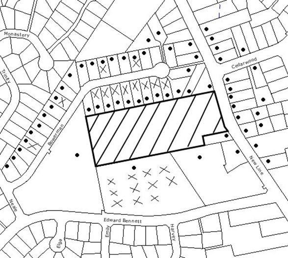
|
NOTIFICATION PLAN
|
|
|
• PROPERTIES NOTIFIED
|
X SUBMISSIONS
RECEIVED
|
PROPERTY SUBJECT OF DEVELOPMENT
|
|
|
TWO
SUBMISSIONS RECEIVED OUT OF MAP RANGE
|
|
|
|
|
Forty-eight submissions objected
to the development, on the grounds that the development would result in:
· Unacceptable
traffic on local streets;
· Unacceptable noise
from activities at the Club;
· Inadequate parking;
· Development that is
excessive in bulk and scale;
· Use of the existing
awning area at night should cease;
· Privacy impacts;
· Works undertaken
without development consent;
· No airlock has been
provided on the verandah games room;
· Louvres permit
visibility of gaming to the public/ tennis courts/ bowling greens, which is
contrary to the OLGR requirements.
The submissions also raised the
following concerns that are not directly related to the current application:
· The application is
contrary to the Masterplan approved in DA/1046/2007;
· Noise measures and
additional parking have not been provided in accordance with DA/1046/2007;
· When will works
commence for DA/1046/2007;
· Security Management
Plan approved in DA/1046/2007 has not been implemented;
· Unauthorised sign
on cricket nets;
· Expansion of gaming
should provide more parking;
· OLGR have increased
gaming machines which is detrimental to the community;
· Fix the existing
light nuisance;
· Close the back gate
after 9pm
The merits of the matters raised
in community submissions have been addressed in the body of the report with the
exception of the following:
5.1.1 Traffic and Parking
A number of submissions raised
concerns with regard to unacceptable traffic on local streets, inadequate
parking and people parking in adjoining residential streets.
The proposal would result in a
minor increase to the gross floor area of the existing Club, however, there
would not be an increase in the patronage of the Club and the proposal would
not alter traffic generation, vehicle access or parking on the site.
The Club has been requested to
ask its members to refrain from parking in the adjoining streets and to utilise
the car park on-site.
5.1.2 Privacy Impacts
Concerns have been raised with
regard to privacy impacts and that the proposed louvres permit visibility of
gaming to the public/ tennis courts/ bowling greens, which is contrary to the
Office of Liquor Gaming and Racing (OLGR) requirements.
The proposed works are single
storey and are set back a minimum of 46m from the northern boundary which would
minimise any overlooking concerns of adjoining neighbours. With regard to the
privacy impacts on the bowling green, the existing verandah is open and allows
for clear sightlines, whereas the proposed louvres would improve privacy to
users of the bowling greens. With regards to the smoker’s deck overlooking the
tennis courts, the existing deck and the deck extension would have a solid 1.8
metre high wall which would maintain privacy to the tennis court users.
Furthermore concerns have been
raised with regard to the noise and privacy impacts of the use of the existing
verandah area at night that is accessed from the existing lounge and is
adjacent to the proposed new outdoor gaming area and the bowling greens. To
address the concerns of adjoining residents, a condition is recommended that no
patrons are permitted to utilise the covered verandah area adjacent the bowling
greens after 9pm at night.
5.1.3 Development Consent No. 1046/2007
On 3 September 2008, Council
approved a major redevelopment of the Club’s premises (DA/1046/2007) which
included a masterplan and staging of the proposed works. The consent is valid
for 5 years and works have not yet commenced. Council is unable to impose a
timeframe for works to start, and until such time as the consent becomes
operative, the implementation of the Security Management Plan and the acoustic
measures and upgrading of the car parking on the site are not required to be
commenced.
5.1.4 Compliance Matters
A number of submissions raised
concerns with regard to the works being undertaken without development consent,
existing lights on the premises causing glare and reflection and that
unauthorised signs had been erected on the cricket nets.
These matters were investigated
by Council’s Compliance officers. With regard to the unauthorised signage on
the cricket nets and the glare from the tennis court lights, the Club has
removed the signage and the tennis court lights have been upgraded to comply
with the requirements of Development Consent No. 156/1982. The matter of the
unauthorised works has been resolved by the submission of this application.
5.2 Public Agencies
The application was referred to
the following agency for comment:
5.2.1 NSW Police
The NSW Police Force raised no
objections to the proposed development, subject to the recommendations of the
acoustic report being implemented to alleviate any concerns in relation to what
impact the noise from the outdoor gaming terrace and smoking area might have on
the residential area adjacent to the complex.
6. THE PUBLIC INTEREST
Section 79C(1)(e) of the Act
requires Council to consider “the public interest”.
The public interest is an
overarching requirement, which includes the consideration of the matters
discussed in this report. Implicit to the public interest is the achievement
of future
built outcomes adequately
responding to and respecting the future desired outcomes expressed in
environmental planning instruments and development control plans.
The application is considered to
have satisfactorily addressed Council’s and relevant agencies criteria and
would provide a development outcome that, on balance, would result in a
positive impact for the community. Accordingly, it is considered that the
approval of the proposed would be in the public interest.
CONCLUSION
The application proposes alterations
to West Pennant Hills Sports Club
involving internal modifications and the enclosure of part of the existing
verandah to create an outdoor gaming room and the extension of the existing
smoker’s deck.
The proposal is consistent with
the objectives of the Hornsby Shire Local Environmental Plan 1994 and Council’s
relevant Development Control Plans.
Matters raised in community
submissions can be addressed via appropriate conditions. The proposal
satisfies the requirements of the NSW Police Force.
Accordingly, the application is
recommended for approval.
Note: At the time of the
completion of this planning report, no persons have made a Political
Donations Disclosure Statement pursuant to Section 147(3) of the
Environmental Planning and Assessment Act 1979 in respect of the subject
planning application.
|
Rod Pickles
Manager -
Assessment Team 2
Planning Division
|
Scott Phillips
Executive Manager
Planning Division
|
Attachments:
File Reference: DA/144/2009
Document Number: D01145684
SCHEDULE 1
GENERAL CONDITIONS
The conditions of consent within this notice of determination
have been applied to ensure that the use of the land and/or building is carried
out in such a manner that is consistent with the aims and objectives of the
planning instrument affecting the land.
Note: For
the purpose of this consent, the term ‘applicant’ means any person who has the
authority to act on or the benefit of the development consent.
Note:
For the purpose of this consent, any reference to an Act, Regulation,
Australian Standard or publication by a public authority shall be taken to mean
the gazetted Act or Regulation, or adopted Australian Standard or publication
as in force on the date that the application for a construction certificate is
made.
1. Approved
Plans and Supporting Documentation
The development must be carried
out in accordance with the plans and documentation listed below and endorsed
with Council’s stamp, except where amended by Council and/or other conditions
of this consent:
Architectural Plans
prepared by DEM Pty Ltd
|
Plan No.
|
Plan Title
|
Rev
|
Dated
|
|
ar-0101
|
Site Plan
|
A01
|
16 February 2009
|
|
ar-1201
|
Ground Floor Plan
|
A01
|
16 February 2009
|
|
ar-1202
|
Roof Plan
|
A01
|
16 February 2009
|
|
ar-2101
|
Sections
|
A01
|
16 February 2009
|
|
ar-2601
|
East & West Elevation
|
A01
|
16 February 2009
|
|
ar-2602
|
North Elevation
|
A01
|
16 February 2009
|
Supporting Documentation
|
Document Title
|
Prepared by
|
Dated
|
|
Statement of Environmental Effects Project No.
4056-00
|
DEM
|
16 February 2009
|
|
Construction Waste Management Plan
|
DEM
|
16 February 2009
|
|
BCA Compliance Report Project No. 90004, Rev 2
|
Blackett Maguire & Goldsmith Pty Ltd
|
9 February 2009
|
|
Noise Impact Statement Report No. 39.3170.R12:ZSC
|
The Acoustic Group
|
6 February 2009
|
|
Noise Impact Statement Report No. 39.3170.R13:ZSC
|
The Acoustic Group
|
28 March 2009
|
REQUIREMENTS PRIOR TO THE ISSUE OF A CONSTRUCTION
CERTIFICATE
The following conditions of consent must be complied with
prior to the issue of a ‘Construction Certificate’ by either Hornsby
Shire Council or an accredited certifier. All necessary information to
demonstrate compliance with the following conditions of consent must be
submitted with the application for a construction certificate.
2. Building
Code of Australia
All building
work must be carried out in accordance with the requirements of the Building
Code of Australia.
3. Fire
Safety Upgrade
To ensure the protection of persons using the existing building and to facilitate egress from this
building in the event of a fire, details must be submitted for the works
necessary to bring the area indicated as “existing outdoor gaming area – not
approved” into full compliance with Parts C, D and E of the Building Code of
Australia.
4. Sydney
Water – Quick Check
The
application must be submitted to a Sydney Water ‘Quick Check Agent’ or
‘Customer Centre’ for approval to determine whether the development will affect
any Sydney Water infrastructure, and whether further requirements are to
be met.
Note: Refer
to www.sydneywater.com.au or
telephone 13 20 92 for assistance.
REQUIREMENTS PRIOR TO THE COMMENCEMENT OF ANY WORKS
The following conditions of consent must be complied with
prior to the commencement of any works on the site. The conditions have been
imposed to ensure that the works are carried out in such a manner that complies
with relevant legislation and Council’s policies and does not disrupt the
amenity of the neighbourhood or impact upon the environment.
5. Erection
of Construction Sign
A sign must
be erected in a prominent position on any site on which building work,
subdivision work or demolition work is being carried out:
e. Showing
the name, address and telephone number of the principal certifying authority
for the work.
f. Showing
the name of the principal contractor (if any) for any demolition or building
work and a telephone number on which that person may be contacted outside
working hours.
g. Stating
that unauthorised entry to the work site is prohibited.
Note: Any
such sign is to be maintained while the building work, subdivision work or
demolition work is being carried out, but must be removed when the work has
been completed.
6. Erosion and Sediment Control
Erosion and
sediment control measures must be provided and maintained throughout the
construction period in accordance with the manual ‘Soils and Construction
2004 (Bluebook)’, the approved plans, Council specifications and to the
satisfaction of the principal certifying authority. The erosion and sediment
control devices must remain in place until the site has been stabilised and
revegetated.
Note: On
the spot penalties up to $1,500 may be issued for any on-compliance with this
requirement without any further notification or warning.
REQUIREMENTS DURING CONSTRUCTION
The following conditions of consent must be complied with
during the construction of the development. The conditions have been imposed
to ensure that the works are carried out in such a manner that complies with
relevant legislation and Council’s policies and does not disrupt the amenity of
the neighbourhood or impact upon the environment.
7. Construction
Work Hours
All work on site (including demolition and earth works)
must only occur between the following hours:
Monday to Saturday 7 am to 5 pm
Sunday & Public Holidays No work
8. Demolition
All
demolition work must be carried out in accordance with Australian Standard
2601-2001 – The Demolition of Structures and the following requirements:
a. Demolition
material is to be disposed of to an authorised recycling and/or waste disposal
site and/or in accordance with an approved waste management plan.
b. Demolition
works, where asbestos material is being removed, must be undertaken by a
contractor that holds an appropriate licence issued by WorkCover NSW in
accordance with Chapter 10 of the Occupational Health and Safety Regulation
2001 and Clause 29 of the Protection of the Environment Operations
(Waste) Regulation 1996.
c. On
construction sites where buildings contain asbestos material, a standard
commercially manufactured sign containing the words ‘DANGER ASBESTOS REMOVAL IN
PROGRESS’ measuring not less than 400mm x 300mm must be erected in a prominent
position visible from the street.
9. Environmental
Management
The site must
be managed in accordance with the publication ‘Managing Urban Stormwater –
Landcom (March 2004) and the Protection of the Environment Operations
Act 1997 by way of implementing appropriate measures to prevent sediment
run-off, excessive dust, noise or odour emanating from the site during the
construction of the development.
10. Council Property
During
construction works, no building materials, waste, machinery or related matter
is to be stored on the road or footpath. The public reserve is to be kept in a
clean, tidy and safe condition at all times.
Note:
This consent does not give right of access to the site via Council’s park or
reserve. Should such access be required, separate written approval is to be
obtained from Council.
11. Excavated
Material
All excavated
material removed from the site must be classified in accordance with the NSW
Environment Protection Authority’s Environmental Guidelines – Assessment,
Classification and Management of Liquid and Non-Liquid Wastes prior to
disposal to an approved waste management facility and reported to the principal
certifying authority.
REQUIREMENTS PRIOR TO THE ISSUE OF AN OCCUPATION
The following conditions of consent must be complied with
prior to the ‘Principal Certifying Authority’ issuing an ‘Occupation
Certificate’.
Note: For
the purpose of this consent, any reference to ‘occupation certificate’ shall
also be taken to mean ‘interim occupation certificate’ unless otherwise stated.
12. Stormwater
Drainage
The stormwater
drainage system for the development must be designed and constructed in
accordance with Council’s Civil Works – Design and Construction
Specification 2005 and connected to the existing drainage system.
13. Cigarette
Butt Receptacle
Cigarette butt
receptacles must be provided on the smoker’s deck to minimise littering.
14. External
Lighting
All external
lighting must be designed and installed in accordance with Australian
Standard AS 4282 – Control of the Obtrusive Effects of Outdoor Lighting.
Certification of compliance with the Standard must be obtained from a suitably
qualified person.
15. Acoustic
absorption material
Acoustic absorption
material must be applied to the underside of the roof (of the deck) and
acoustic ceilings applied for all gaming areas in accordance with the
recommendations of the Noise Impact Statement Report No. 39.3170.R12:ZSC
prepared by The Acoustic Group, dated 6 February 2009. Certification of
compliance
with the recommendations of
Noise Impact Statement Report No. 39.3170.R12:ZSC must be obtained from
a suitably qualified person.
16. Air
Locks
Air locks
must be provided to doorways that lead to the outdoor smoking area to prevent
the entry of cigarette smoke into the Club.
OPERATIONAL CONDITIONS
The following conditions have been applied to ensure that the
ongoing use of the land is carried out in such a manner that complies with
relevant legislation and Council’s policies and does not disrupt the amenity of
the neighbourhood or impact upon the environment.
17. Patron
Numbers
This consent does not authorise
or approve an increase in patron numbers.
18. Fire
Safety Statement - Annual
On at least one occasion in
every 12 month period following the date of the first ‘Fire Safety Certificate’
issued for the property, the owner must provide Council with an annual ‘Fire
Safety Certificate’ to each essential service installed in the building.
19. Noise
– Plant and Machinery
a. Existing plant on the subject site must operate at levels
less than 40 dB(A) at the northern boundary.
b. Additional plant associated with the proposal must not to
exceed 37 dB(A) at the northern boundary.
20. Noise
– Acoustic Assessment
An acoustic assessment is
to be undertaken by a suitably qualified environmental consultant within 60
days of occupying the site in accordance with the Environment NSW Industrial
Noise Policy (2000), Council’s Policy and Guidelines for Noise and
Vibration Generating Development (Acoustic Guidelines V.5, 2000) and the DECC’s
Noise Guide for Local Government (2004). Should the assessment find that
noise from the premise exceeds 5dB(A) appropriate measures must be employed to
rectify excessive noise.
21. Use of Smoker’s Deck
The use of
the deck is subject to the following conditions to protect the acoustic amenity
of neighbouring residences:
a. The hours of operation of the
smoking deck are restricted to those times listed below:
Sunday -
Wednesday 10am - 11pm
Thursday - Saturday
10am - Midnight
Please note: This includes
Public Holidays and Special Events.
b. Alcohol must not to be consumed on the
deck between the hours of 10pm and Midnight.
c. Signs must be posted both at the exit to
the deck and on the deck stating: “CONSIDER OUR NEIGHBOURS. PLEASE KEEP NOISE
TO A MINIMUM.”
d. No music, entertainment, television monitors or amplified
music/announcements is permitted on the smoking deck area.
e. All noise complaints must be recorded by the Duty
Manager and must be dealt with immediately.
22. Management
The Club
Manager must take all steps necessary to ensure the orderly behaviour of
patrons and to ensure that no noise nuisance occurs from patrons entering,
using and leaving the smoking deck.
23. Use
of Verandah
No patrons
are to utilise the outdoor covered verandah accessed from the lounge area and
adjacent to the bowling green after 9pm.
-
END OF CONDITIONS -
ADVISORY NOTES
The following information is provided for your
assistance to ensure compliance with the Environmental Planning and Assessment
Act 1979, Environmental Planning and Assessment Regulation 2000, other relevant
legislation and Council’s policies and specifications. This information does
not form part of the conditions of development consent pursuant to Section 80A
of the Act.
Environmental Planning and Assessment Act 1979 Requirements
· The Environmental Planning and
Assessment Act 1979 requires:
· A construction certificate prior to the
commencement of any works. Enquiries regarding the issue of a construction
certificate can be made to Council’s Customer Services Branch on 9847 6760.
· A principal certifying authority to be
nominated and Council notified of that appointment prior to the commencement of
any works.
· Council to be given at least two days
written notice prior to the commencement of any works.
· Mandatory inspections of nominated
stages of the construction inspected.
· An occupation certificate issued before
occupying any building or commencing the use of the land.
Long Service Levy
In accordance with Section 34 of
the Building and Construction Industry Long Service Payments Act 1986, a ‘Long Service Levy’ must be paid to the Long
Service Payments Corporation or Hornsby Council.
Note: The
rate of the Long Service Levy is 0.35% of the total cost of the work.
Note: Hornsby
Council requires the payment of the Long Service Levy prior to the issue of a
construction certificate.
Disability Discrimination Act
The applicant’s attention is
drawn to the existence of the Disability Discrimination Act. A
construction certificate is required to be obtained for the proposed
building/s, which will provide consideration under the Building Code of
Australia, however, the development may not comply with the requirements of
the Disability Discrimination Act. This is the sole responsibility of
the applicant.
Dial Before You Dig
Prior to commencing any works,
the applicant is encouraged to contact Dial Before You Dig on 1100 or www.dialbeforeyoudig.com.au for
free information on potential underground pipes and cables within the vicinity
of the development site.
Asbestos Warning
Should asbestos or asbestos
products be encountered during construction or demolition works you are advised
to seek advice and information should be prior to disturbing the material. It
is recommended that a contractor holding an asbestos-handling permit (issued by
Work Cover NSW), be engaged to manage the proper disposal and handling
of the material. Further information regarding the safe handling and removal of
asbestos can be found at:
www.environment.nsw.gov.au
www.nsw.gov.au/fibro
www.adfa.org.au
www.workcover.nsw.gov.au
Alternatively, telephone the Work Cover Asbestos and
Demolition Team on 8260 5885.
The Smoke-free Environment Act 2000
This assessment does not confirm
that the outdoor gaming area and smoking deck is an unenclosed public place for
the purposes of The Smoke-free Environment Act 2000. This is a matter
for the NSW Department of Health.
Standard Report No. PLN22/09
Planning Division
Date of Meeting:
3/06/2009
10 HERITAGE REVIEW STAGE 4
EXECUTIVE SUMMARY
This
report reviews submissions received in response to the exhibition of Heritage
Review Stage 4, which relates to a review of existing heritage listed trees,
and other items proposed for inclusion or deletion from the heritage list.
At its meeting on 20 February 2008, Council resolved to exhibit Heritage Review
Stage 4 for a minimum period of three months. The Study was exhibited from 15
May 2008 to 15 August 2008. Twenty-nine (29) submissions concerning 18
properties have been received. Submission and the Study recommendations have
been reviewed by Council’s Heritage Advisory Committee. The issues raised in submissions
are addressed in this report.
It is recommended that Council progress the
recommendations of this report as part of an Annual Amendments Local
Environmental Plan (LEP).
PURPOSE/OBJECTIVE
The
purpose of this report is to review submissions received in response to the
exhibition of Heritage Review Stage 4 and seek Council’s endorsement for the
progression of the recommendations.
BACKGROUND
The
Hornsby Shire Local Environmental Plan 1994 includes heritage conservation
provisions and lists over 800 heritage items and five heritage conservation
areas. Heritage reviews have been conducted since 1995 to review requests
received for deletion or inclusion of items on the heritage list. Reviews have
also included a number of projects related to Council’s heritage provisions.
Three review stages have been completed to date, and this report concerns
Heritage Review Stage 4.
At its meeting on 7 February 2007, Council considered Executive Manager’s
Report No. PLN19/07, and endorsed the content and direction of Heritage Review
Stage 4 including:
· Review of items and review of heritage listed trees;
· Correction of anomalies within existing listings; and
· Heritage Inventory on Council’s Online Services Portal.
The focus of this report is on the review of items and heritage listed trees.
The correction of anomalies within existing listings and the heritage inventory
on Council’s Online Service Portal is being progressed by Council’s Town
Planning Services Branch and will be the subject of a further report to
Council.
Expressions
of interest were sought from six consultants to undertake the review of items and heritage listed trees. Following an
assessment of the expressions of interest, independent heritage consultant
LandArc Pty Ltd (with assistance from Patrick O’Carrigan and Partners Pty Ltd
concerning built items) was appointed as the
consultant for Heritage Review Stage 4.
The consultant’s study was submitted to Council in January 2008. Council at its
meeting on 20 February 2008 considered Executive Manager’s Report No. PLN32/08
concerning Heritage Review Stage 4 and resolved that:
1. Council
endorse Heritage Review Stage 4 for exhibition.
2. The Review be exhibited for a minimum period of three
months in accordance with the consultation strategy outlined in Executive
Manager’s Report No. PLN32/08.
3. At the conclusion of the exhibition period, a report on
submissions and advice from the Department of Planning concerning the process
to progress the recommendations of the Review be presented to Council.
In accordance with the Council’s
resolution, the Study was exhibited from 15 May 2008 to 15 August 2008.
Twenty-nine (29) submissions concerning 18 properties or items have been
received. The issues raised in submissions are addressed in this report.
DISCUSSION
This
report discusses Heritage Review Stage 4 and submissions received during the
exhibition period.
Heritage Review Stage 4 Study
The Study consists of four
volumes. Volumes 1 to 3 relate to a review of 102 existing heritage listed
trees. The review of heritage listed trees was undertaken in recognition that
tree groups may have been affected by natural attrition and spot removals since
their assessment as items of heritage significance as part of Council’s initial
Heritage Study in 1993. Volume 1 also contains a study background and summary
of recommendations. Volume 4 relates to a review of 48 items nominated for
addition to, or deletion from, the heritage list.
Exhibition and Review of
Submissions
In accordance with the Consultation Strategy adopted by Council the Study was
exhibited from 15 May 2008 to 15 August 2008. Advertisements were placed in
local newspapers and on the Council website. Letters were sent to affected
property owners, interested parties and relevant community groups. The Study
was also displayed at the Council Administration Centre and libraries.
Twenty-nine (29) submissions concerning 18 properties/items have been received
and the issues raised are addressed below. An identification number has been
given to each item reviewed. The identification number represents the order of
appearance the item is assessed within the Heritage Review.
Property Nos. 52-54 Crosslands Road, Galston (Identification No. 96)
Orchard trees are currently
listed as heritage item of local significance. During the progression of the
previous Heritage Review Stage 3, the owner advised that the trees had
been long since removed and
Council resolved to review the heritage listing. The
Study notes the presence of saplings which are regrowth of the earlier orchard
and recommends the heritage listing be retained on this basis.
Submission:
The property owner objects to the
continued heritage listing of the fruit trees on the basis that the trees no
longer exist and were removed by previous owners. The submission requests a
site inspection to verify the loss of the trees.
Comment: The Heritage Review recommends the continued listing of
the fruit trees on account of the presence of regrowth saplings of the former
orchard. The Heritage Committee acknowledges that although regrowth is present,
the original heritage listed trees have been removed. Therefore, the Committee
recommends deletion of the heritage listing as there is insufficient integrity
to warrant continued listing.
Resolve: It is recommended that the existing listing of the fruit
trees be deleted.
Property No. 109 Beecroft Road, Beecroft - Beecroft Fire Station (Identification No. B2)
The
Beecroft Fire Station was identified for further investigation as part of the
Beecroft Commercial Centre Masterplan Heritage Assessment (2004). The Study
recommends the Beecroft Fire Station be listed as a heritage item.
Submission:
The NSW Fire Brigades does not object
to the proposed listing of the Beecroft Fire Station, but comments that the
listing must not constrain Fire Station operations or future upgrades.
Comment: The Heritage Review identifies the occupation of the site
by the Fire Station since 1915. However, the Heritage Advisory Committee notes
that the existing building was constructed during the early 1970s and the
building does not have historical/social significance in itself. It was further
commented that the long-term requirements of the Fire Brigade should be
considered and there is insufficient justification to warrant heritage listing.
Furthermore, 1970s structures are not identified as contributory elements
within the surrounding Beecroft/Cheltenham Heritage Conservation Area, and
would not accord with the character of the locality.
Resolve: It is recommended that heritage listing of the Beecroft
Fire Station not be progressed.
Property Nos. 16-24 Hannah Street, Beecroft - Module Shopping Centre (Identification No. B5)
The
Module Shopping Centre was identified for further investigation under the
Beecroft Commercial Centre Masterplan Heritage Assessment (2004). The Study
recommends the shopping centre be listed as a heritage item.
Submission:
Paul Davies Pty Ltd (heritage
consultants), on behalf of the property owner, object to the proposed listing
of the Module Shopping Centre. The submission asserts that the property does
not have sufficient heritage significance to warrant listing and that the
justification for listing could equally apply to many other sites and shopping
centres. The submission states that no comparative analysis has been undertaken
to substantiate the heritage listing. The submission also comments that the
building has no association with an important designer or outstanding technical
achievement, nor is its modular approach rare.
Comment: The Heritage Advisory Committee does not support the
heritage listing of the Module Shopping Centre, commenting that 1970s
structures are not identified as contributory elements within the surrounding
Beecroft/Cheltenham Heritage Conservation Area. Furthermore, the heritage
listing of the shopping centre would conflict with the future revitalization
and redevelopment of the Beecroft Commercial Centre.
Resolve: It is recommended that heritage listing of the Module
Shopping Centre not be progressed.
Property No. 5 Chilcott Road, Berrilee - former Berrilee Public School (Identification No. B9)
The Berrilee Public School was nominated for heritage listing by the Berrilee Parents and
Citizen Association. The Study recommends the school building be listed as a
heritage item.
Submissions:
Five submissions have been received
concerning the former Berrilee Public School. The
property owner objects to the proposed listing of the original school building
on the basis of the limited developable area within the site. The school
building occupies the centre of the available space, thereby constraining
future development. The submission also claims that the single room school
building provides limited opportunities for re-use. It is also asserted that
the building is in poor structural condition and replacement of material is
required. The submission states that the building was relocated to the school
site and the owner would support its relocation off-site. The submission
comments that the heritage listing would be a financial burden upon the owner,
and notes that the building would not be publically accessible as it is no
longer in public ownership.
One
submission is from the Department of Education as owner of the site during the
study preparation. The Department reserves comment as the property was sold by
the Department of Education in June 2008. A further three submissions were
received from community members who support the relocation of the school
building to Fagan Park and conversion to a museum.
Comment: The school building is the subject of two recently
approved Development Applications (being DA/1086/2008 and DA/1094/2008) which
preclude demolition of the structure and permit its relocation within the
current site. The approved proposals ensure the building remains in its context
and permits the construction of a dwelling-house on the property. The recent
development approvals address the owner’s objection with respect to the
development potential of the property and feasibility for relocation. It is
envisaged that the building could be used as a studio or workshop ancillary to
the residential use of the property.
The
Heritage Advisory Committee considered the community support for conservation
of the school building and sites this level of public interest as further evidence
of the social significance of the school building. However, the Committee does
not support the proposal to relocate the building to Fagan Park and its presentation as a museum. Such a proposal would have significant resource and
policy implications for Council. The Committee also sited examples where
museums of this type experience poor patronage and are unsustainable in the
long-term.
Resolve: It is recommended that the former school building be
listed as a heritage item of local significance.
Property No. 76 Cheltenham Road, Cheltenham (Identification No. B10)
The
property was the subject of a community request for heritage listing. The Study
recommends the house be listed as a heritage item of State significance.
Submission:
Three submissions have been received
concerning the dwelling-house. The property
owner objects to the proposed listing of the dwelling-house. The submission
states that information was sought upon the purchase of the property verifying
that it was not heritage listed. The intention of the purchase was to demolish
the house and construct a replacement house. The owner states that she has
engaged an architect to design alterations to the existing building. The
submission asserts that the house is poorly designed and electrical and
plumbing is not up to standard. It is further commented that the roof leaks and
the building has concrete cancer. The submission also states that repair would
not be financially viable. The submission states that the original allotment
has been poorly subdivided and does not permit the use of the original garage.
A
further two submissions were received from community members who support the
heritage listing of the house. The submissions provide additional historical
information and note that the original features of the house are intact, highly
representative of the 1940s period and its builders, Allen George Brown and
Herbert Vincent Brown.
Comment: The Heritage Review identifies the dwelling-house as
having State significance. Accordingly, Council at its meeting on 19 December
2007 considered a Notice of Motion and resolved to nominate the property for
inclusion on the State Heritage Register. The nomination was subsequently
submitted to the Department of Planning (Heritage Branch). In September 2008,
the Department advised that the Heritage Council determined that the property
does not meet the threshold for the State Heritage Register, however, stated
that it was the Heritage Council’s opinion that the property was an item of
local heritage significance. The Heritage Advisory Committee supports the
heritage listing of the property, noting that the building is a good example of
a modernist concrete structure.
Resolve: It is recommended that the house be listed as a heritage
item of local significance.
Property No. 431 Galston Road, Dural (Identification No. B13)
The
barn was identified for further investigation by the Heritage Advisory
Committee in 2004. The Study recommends the barn be listed as a heritage item.
Submission:
The property owner objects to the
proposed listing of the barn. The submission comments that the dwelling-house
on the site is currently heritage listed, and a further heritage item would be
disadvantageous and restrictive. The submission also notes that the roof of the
barn has been replaced, having an amended pitch and no longer represents the
original structure.
Comment: The heritage significance of the barn was considered
during Heritage Review Stage 2 on account of a submission by the previous
property owners. At that stage, Council’s report acknowledged that the barn had
been substantially modified, including removal of one side, and noted that
original fabric accounts for less than 35 per cent of the structure. The
Heritage Advisory Committee recommends that heritage listing not be progressed
on the basis of the modifications to the barn.
Resolve: It is recommended that heritage listing of the barn not
be progressed.
Property No. 3 Pembroke Street, Epping - St Albans Anglican Church (Identification No. B16)
The
rectory was identified for further investigation by the Heritage Advisory
Committee in 2006 during the consideration of a redevelopment proposal for the
church site. The Study recommends the rectory be listed as a heritage item.
Submission:
Three submissions have been received
concerning the St Alban’s Rectory, as well as an Engineer’s Report commissioned
by the Anglican Parish which was submitted following the exhibition period.
Submissions
of objection have been received from both the Anglican Parish and Church
Diocese. The submission from the Anglican Parish comments that the heritage
consultant commissioned on behalf of the owners does not believe the rectory to
have heritage significance. The rectory is believed to be an adaption of an
English pattern book design, and as such is not an original design. The
submission also asserts that the building was constructed economically,
including the use of fibro, lack of underpinning and dampcourse. The submission
further advises that the building is in poor structural condition, subject to
subsidence and splayed walls. The submission also comments that the building
has had modification over time resulting in the loss of original elements. The
submission comments that there is no architectural relationship between the church
and rectory.
The
Engineer’s Report submitted in support of the Parish’s submission identifies
numerous defects, including cracks throughout, lateral movement of lintels,
settlement of the first floor porch, fallen cornice, windows sticking, eroded mortar
joints and poorly discharged stormwater. The Report advises that the repair of
cracks in 2004 has failed to prevent further cracking and that greatest concern
relates to the lintels which have moved from their bearing supports. The Report
finds that the building is in below average condition and would require
extensive structural rectification, which is determined not to be economically
viable. The rectification work outlined would include reinstatement of
stormwater discharge, underpinning of numerous walls, jacking up of the porch,
re-pointing mortar joints and replacing dislodged bricks.
A
further submission has been received from a community member who supports the
heritage listing of the rectory building as being of State significance. The
submission acknowledges that the rectory was built by renowned architect Leslie
Wilkinson and is representative of the houses he built for the middle classes
during the 1930s. The submission provides additional historical information.
Comment: The rectory was designed by eminent architect, Leslie
Wilkinson, while professor of architecture at Sydney University and responsible
for that institution’s most renowned buildings. Wilkinson was the first
professor of architecture at an Australian University and had a great influence
upon the development of the architectural profession. According to the University of Sydney, Wilkinson operated a private practice throughout much of his academic
career and designed in the order of thirty houses and flats in Sydney. The relatively small number of domestic-scale buildings provides the rectory with a
degree of rarity. However, the Engineer’s Report demonstrates that significant
structural rectification works would be required to ensure the longevity of the
building. The works required significantly compromise the viability of
retention of the building. Therefore, on balance progression of the listing of
the building is not supported.
Resolve: It is recommended that the heritage listing of the
rectory not be progressed.
Property No. 29 Hampden Road, Pennant Hills (Identification No. B25)
The
property was the subject of a community request for identification of a number
of houses within Hampden Road as a Heritage Conservation Area. The Department
of Planning does not support Heritage Conservation Areas outside of Council’s
Comprehensive LEP. Accordingly, the properties have been investigated for
individual heritage listing. The Study recommends the house at No. 20 Hampden Road be listed as a heritage item.
Submission:
The property owner objects to the
proposed listing of the dwelling-house. The submission asserts that the house
is in a poor structural condition and the external features have been modified
over time, including an in filled porch, the removal of chimneys, finials and
slate roof. The submission comments that the house is subject to subsidence and
major cracking. A Structural Engineer’s Report is provided which places the
cost of underpinning at $32-60,000. The submission also notes that the
inventory which forms part of the Stage 4 Study contains inaccuracies as to the
condition and integrity of the property.
Comment: The Heritage Advisory Committee does not support the
heritage listing of the property in view of the structural problems and limited
justification for heritage listing provided within the Study. The Committee
further comments that the integrity of the building is compromised and would
not warrant listing as a representative example of the Federation style.
Resolve: It is recommended that heritage listing of the house not
be progressed.
Property No. 30 Hampden Road, Pennant Hills (Identification No. B26)
The
property was the subject of a community request for identification of a number
of houses within Hampden Road as a Heritage Conservation Area. The Study
recommends the house at No.30 Hampden Road be listed as a heritage item.
Submission:
The property owner objects to the
proposed listing of the dwelling-house. The submission comments that the
inventory which forms part of the Stage 4 Study contains a number of
inaccuracies. The submission contests the statement that the house is one of
Pennant Hills’ earliest homes. The owner asserts that the house is not uncommon
within the locality and therefore, does not warrant heritage listing.
Comment: The Heritage Advisory Committee does not support the
heritage listing of the property. The Committee comments that the house is a
modest example of the style with limited period detail and there is
insufficient justification to warrant heritage listing.
Resolve: It is recommended that heritage listing of the house not
be progressed.
Property Nos. 32-34 Hampden Road, Pennant Hills (Identification No. B27)
The
property was the subject of a community request for identification of a number
of houses within Hampden Road as a Heritage Conservation Area. The Study
recommends the house at Nos. 32-34 Hampden Road be listed as a heritage item.
Submission:
The property owner objects to the
proposed listing of the dwelling-house. The submission comments that the inventory
which forms part of the Stage 4 Study contains a number of inaccuracies. The
submission comments that the property was derelict upon the purchase by the
owners and required the replacement of much original fabric. As such, extensive
renovation has been undertaken and a substantially sized extension and detached
garage constructed.
Comment: The Heritage Advisory Committee does not support the
heritage listing of the
house
in view of the recent additions. The additions are not in keeping with the scale
of the original house and detract from the original portion of the house.
Furthermore, much original detail has been replaced and, as such, the
historical integrity of the building has been compromised.
Resolve: It is recommended that heritage listing of the house not
be progressed.
Property No. 35 Hampden Road, Pennant Hills (Identification No. B28)
The
property was the subject of a community request for identification of a number
of houses within Hampden Road as a Heritage Conservation Area. The Study
recommends that the house at No. 35 Hampden Road be identified as a
contributory element within a future Heritage Conservation Area.
Submission:
The property owner advises that the
address provided within the Study inaccurately identifies the dwelling-house as
No. 35A Hampden Road, Pennant Hills. As such, the owner requested further
information concerning the proposed listing of the dwelling-house.
Comment: The Study has been updated to reflect the correct
property address being No. 35 Hampden Road, Pennant Hills. Also, a
representative of the Town Planning Services Branch contact the property owner
with the additional information as requested. No further submission has been
received.
The
Heritage Advisory Committee does not support the heritage listing of the house.
The Committee notes that the Study does not recommend the house as a heritage
item, but rather as a contributory element within a future Heritage
Conservation Area. As such, the Study acknowledges that the house would not
satisfy the criteria for individual listing.
Resolve: It is recommended that heritage listing of the house not
be progressed.
Property No. 36 Hampden Road, Pennant Hills (Identification No. B29)
The
property was the subject of a community request for identification of a number
of houses within Hampden Road as a Heritage Conservation Area. The Study
recommends the house at No. 36 Hampden Road be listed as a heritage item.
Submission:
The property owner objects to the
proposed listing of the dwelling-house. The submission comments that the owner
has been a long term resident of the property and does not want members of the
public to be encouraged to enter the property.
Comment: The heritage listing of a property would not confer
rights upon any member of the public to access the property without the owner’s
consent.
The
Heritage Advisory Committee supports the heritage listing of the house. The
Committee comments that house represents an intact and little altered example
of the Federation period. The house features an in filled verandah on the
eastern side. However, the modification is sympathetic and reasonably capable
of restoration.
Resolve: It is recommended that the house be listed as a heritage
item of local significance.
Property No. 89 Alexandria Parade, Wahroonga (Identification No. B39)
The
property was identified for further investigation under the Wahroonga (North)
Heritage Conservation Area Review (2005). The Study recommends the house be
listed as a heritage item.
Submission:
Two submissions have been received
concerning the property, comprising an objection from the property owner and a
further submission by a consultant prepared on the owner’s behalf. The submissions comment that the inventory which forms part
of the Study contains a number of inaccuracies. The submission notes that the
area has been the subject of much recent development and consequently, the
Inter-war character has been lost. The submission states that the property is
capable of subdivision in the future and the heritage listing would be a
financial burden to the owners. The submission further comments that the house
has been subject to substantial modifications over time and an approved
development application for alterations and additions. The submissions assert
that the house does not warrant heritage listing.
Comment: The Heritage Advisory Committee does not support the
heritage listing of the property. The Committee acknowledges that the house has
had substantial additions over time and therefore, its integrity compromised.
The Committee agrees that there is insufficient justification to warrant
heritage listing.
Resolve: It is recommended that heritage listing of the house not
be progressed.
Property No. 15 Ingalara Avenue, Wahroonga (Identification No. B43)
The
property was identified for further investigation under the Wahroonga (North)
Heritage Conservation Area Review (2005). The Study recommends the house be
listed as a heritage item.
Submission:
The property owner objects to the
proposed listing of the dwelling-house. The submission expresses concern that
the owners were alerted to the recommended heritage listing by an anonymous
letter left in a neighbour’s letterbox. The submission asserts that Council
should have made direct contact with the property owners.
Comment: The consultation strategy for the Study has included
multiple letters to affected property owners. The consultation has comprised a
letter in April 2007 to advise a Study would be undertaken and inviting
submissions, a letter in May 2008 to advise the Study was on exhibition, in
addition to four (4) letters in the preceding years concerning the
recommendations of the Wahroonga (North) Heritage Conservation Area Review. A
representative of the Town Planning Services Branch has reviewed the
notification letters and confirms that the consultation identified correct
names and postal address. The exhibition of the Study has also been advertised
in local newspapers, Council’s website, and has been on display at local
libraries. The submission provides no other justification for objection to the
heritage listing.
The
Heritage Advisory Committee supports the heritage listing of the house as it
represents a good example of a circa 1943-55 structure in the Modern style,
which is rare within the Shire. The house is an intact example and presents
well to the street.
Resolve: It is recommended that the house be listed as a heritage
item of local significance.
Property No. 22 Pacific Highway, Wahroonga (Identification No. B46)
The
property is currently heritage listed as locally significant and is the subject
of a request by the property owners to delete the heritage listing. The Study
recommends the house be retained as a heritage item.
Submission:
Two submissions have been received
concerning the property, comprising an objection from the property owner and a
further submission by a consultant prepared on the owner’s behalf. The
submissions comment that the context of the building has been diminished by
adjacent multi-unit housing development. It also states that the building is in
poor structural condition, including subsidence, termite damage and major
cracking. The submission asserts that the necessary underpinning would be cost
prohibitive. The submission states that the house has had substantial
modifications over time and much original material has been replaced. The consultant’s report asserts that comparable examples
of the style and period exist within the locality and the integrity and
intactness of the house has been compromised. The objections conclude that the
house does not warrant continued heritage listing.
Comment: The Heritage Advisory Committee does not support the
continued heritage listing of the house. The Committee comments that the
property has lost its context and its long term viability has been affected by
its location within a medium density zone. The Committee acknowledges
that the Pacific Highway/Ingram Road precinct was rezoned (Residential B) for
higher density development in 1999 under Council’s Housing Strategy and
subsequently removed from the Heritage Conservation Area in 2001. The poor
structural condition of the house and its modifications over time were also a
basis for the Committee’s recommendation.
Resolve: It is recommended that the house be deleted from the
heritage list.
Property No. 58 Woonona Avenue, Wahroonga (Identification No. B47)
The
property was identified for further investigation under the Wahroonga (North)
Heritage Conservation Area Review (2005). The Study recommends the house be
listed as a heritage item.
Submission:
The property owner objects to the
proposed heritage listing of the house. The submission advises that the
property is subject to an approved subdivision involving the excise of the
front garden of the parent property. The submission asserts that the house’s
setting of the house would be diminished by the future subdivision and the
house has had substantial additions over time, including a flat roofed garage
at the street frontage which restricts views to the house.
Comment: The Heritage Advisory Committee does not support the
heritage listing of the house. The Committee comments that the approved
subdivision would negatively affect the streetscape presentation and setting of
the property.
Resolve: It is recommended that heritage listing of the house not
be progressed.
Trees within the Locality
of Pennant Hills
The
submission relates to the review of a number of heritage listed trees, as well
as a stand of trees not addressed within the Study.
Submission:
A submission has been received from
the Pennant Hills District Civic Trust. The submission raises concern that the
two significant Eucalypts within Hillcrest Road at Pennant Hills are not
heritage listed. The Trust asserts that these trees contribute to the
environment of the Commercial Centre. Furthermore, the submission supports the
heritage listing of trees
within Lilla Road, Trebor Road and the Wongala Crescent rail corridor, as regionally significant.
Comment: The Eucalypts within Hillcrest Road were identified within Council’s initial Heritage
Study in 1993. However, they were not progressed to heritage listing. The
heritage significance of the Hillcrest Road trees has not been assessed, nor
consideration undertaken for inclusion of the item on the heritage list as part
of the Study. Accordingly, it is recommended that the heritage listing be
investigated for inclusion as part of the next Heritage Review.
In relation to the other tree
stands mentioned in the Trust’s letter, the trees within Lilla Road are
recommended for retention of local listing, as the regional level of
significance is no longer recognised by the Department of Planning. The trees
within Trebor Road are recommended for deletion because the stand contains a
mix of cultivated species and only highly fragmented specimens of Blue Gum High Forest. As such, the listing does not demonstrate sufficient integrity to
warrant continued heritage listing. Notwithstanding, the deletion does not
infer consent for the removal of the trees. Finally, the heritage listed
bushland conserved adjacent to Wongala Crescent, largely within the railway
corridor, does not form part of the Study. Accordingly, the heritage listing of
the bushland is not affected.
Resolve: It is recommended that the heritage listing of trees
within Lilla Road and along the rail corridor (Wongala Crescent) in Pennant
Hills be retained as locally significant. Trebor Road trees are recommended for
deletion as these no longer demonstrate sufficient integrity or significance to
warrant listing. It is also recommended that the Hillcrest Road trees be
investigated for inclusion as part of the next Heritage Review.
Property No. 164 Ray Road, Epping (Identification No. B)
The
property contains a Bottle Tree and is located adjacent to a heritage listed
house under the same ownership.
Submission:
The submission raises concern that the
Bottle Tree within the property is not heritage listed. The property owners
also own the adjacent property at No. 166 Ray Road, which is a heritage listed
house. The submission requests that the Bottle Tree be included within the
heritage listing.
Comment: The heritage significance of the Bottle Tree has
not been assessed, nor consideration undertaken for inclusion of the item on
the heritage list as part of the Study. Accordingly, it is recommended that the
heritage listing be investigated for inclusion as part of the next Heritage
Review.
Resolve: It is recommended that the Bottle Tree be
investigated for inclusion as part of the next Heritage Review.
Referral to Internal
Divisions/Branches
Council’s Development Assessment,
Subdivision, Parks and Landscape, Bushland and Biodiversity, and Property
Development Teams were consulted during the exhibition. The Parks and Landscape
and Bushland and Biodiversity Teams provided comment on the Study.
The Bushland and Biodiversity
Team support the recommendations of the Heritage Review as the trees form part
of remnant canopy Blue Gum High Forest and Sydney Turpentine Ironbark Forest. The Team also acknowledges that the regional level of heritage significance
is no longer recognised and, as
such, items would likely be attributed local significance where progressed. The
Team further supports the method of assessment for heritage significance, based
upon the generic values identified under the Burra Charter and the additional
values based criteria, as it allows an appropriate level of cross referencing
for biodiversity values such as those identified in the NSW Scientific
Committee listings of Blue Gum High Forest and Sydney Turpentine Ironbark
Forest.
The Parks and Landscape Team
individually addressed the Study recommendations in relation to each item. The
Team’s comments are summarised within the table (copy attached). The Team
raises concern with regard to a number of stands of street trees which have been
heavily lopped due to power lines, or otherwise affected. In some cases, the
recommendations of the Parks and Landscape Team differ from those of the
consultant or Council’s Heritage Advisory Committee. Where conflicting
recommendations occur, the recommendations of the Town Planning Services Branch
within this report attempt to balance the interests of conservation and
maintenance.
Summary of Recommendations
The following is a summary of
recommendations subsequent to the review of submissions, and consultation with
Council’s Heritage Advisory Committee, Parks and Landscape Team and Bushland
and Biodiversity Team. A more detailed outline may be found within the attached
table.
Existing Heritage Items for
Deletion:
Thirty-three (33) heritage
listings, comprising 26 tree listings and 7 built/cultural items are
recommended for deletion. The following table provides a summary of the
recommended deletions:
|
ID
|
Property
|
Description
|
Study
Recomm.
|
Comment
|
Recomm.
|
|
10
|
7 Mary Street, Beecroft
|
Two angophora trees
|
Delete heritage listing (include in expanded group
listing)
|
The two subject trees do not warrant individual
heritage listing. One of the two trees in poor condition. Aim of the review
is to strengthen listings by reducing number of tree stands, therefore expanded
listing not supported.
|
Delete heritage listing
|
|
12
|
67A Murray Farm Road, Beecroft
|
Oak tree
|
Retain as locally significant
|
Advised by owner that tree is dead (Sept 2008).
Confirmed by inspection and approved for removal.
|
Delete heritage listing
|
|
15
|
Mason Avenue, Cheltenham
|
Street trees
|
Delete heritage listing
|
Small group of trees have poor form and integrity;
health compromised; includes declared noxious weed; common cultivated species
and no significance.
|
Delete heritage listing
|
|
17
|
The Boulevarde, Cheltenham
|
Street trees
|
Retain as locally significant
|
The Study recognises that the integrity of the
plantation is compromised by the need for regular lopping of the canopies
under low overhead power lines, as well as supplementary plantings of other
species.
|
Delete heritage listing
|
|
19
|
The Crescent, Cheltenham
|
Street trees
|
Delete heritage listing
|
Fragmented group of trees; poor form and integrity.
|
Delete heritage listing
|
|
27
|
College Crescent, Hornsby
|
Street trees
|
Retain as regionally significant
|
The Study acknowledges that the cultural plantings
of Brush Box and Camphor Laurels (Group B) are not significant. It also
acknowledges that the remnant BGHF trees (Group A) is a small stand and
highly fragmented. Trees under stress from vehicle parking within root zones.
Group A predominately within rail corridor and therefore, Council has limited
management control.
|
Delete heritage listing
|
|
31
|
Hunter Street, Hornsby
|
Street trees
|
Delete heritage listing
|
Row of Brush Box highly compromised and fragmented;
integrity affected by replacement plantings of other species; heavy pruning
due to power lines.
|
Delete heritage listing
|
|
41
|
Denman Parade, Normanhurst
|
Street trees
|
Retain as locally significant
|
The Study acknowledges that integrity compromised by
losses over time, fragmentation and heavy pruning of canopies due to power
lines.
The existing listing relates only to the Brush Box,
and not the BGHF. The majority of BGHF is contained within Davidson Park, which is separately listed. The HAC comments that the Brush Box no longer
warrants listing.
|
Delete heritage listing
|
|
48
|
Beecroft Road (opp. Observatory Park), Pennant Hills
|
Street trees (listed under Beecroft)
|
Delete heritage listing
|
Row plantation of Silky Oak in poor condition and
overall decline; integrity compromised by infill planting of other species.
|
Delete heritage listing
|
|
49
|
Britannia Street, Pennant Hills
|
Street trees
|
Delete heritage listing
|
Small group planting of common trees; includes
noxious weed; varying condition.
|
Delete heritage listing
|
|
53
|
Trebor Road, Pennant Hills
|
Trees
|
Delete heritage listing (include in expanded group
listing)
|
Stand contains a mix of cultivated species and only
a few specimens of remnant BGHF. Trees do not warrant heritage listing. Aim
of the Review is to strengthen listings by reducing number of tree stands.
|
Delete heritage listing
|
|
54
|
Weemala Road, Pennant Hills
|
Street trees
|
Delete heritage listing
|
Numerous trees have poor condition, form and
integrity; majority are small and stunted specimens; heavy pruning due to
power lines; no heritage significance.
|
Delete heritage listing
|
|
55
|
Beresford Road, Thornleigh
|
Roadside trees (listed under Normanhurst
|
Delete heritage listing
|
Indigenous woodland species which are
well-represented in the locality; compromised by introduced natives; does not
warrant heritage listing.
|
Delete heritage listing
|
|
58
|
1A-1D Kentwell Avenue, Thornleigh
|
Trees
|
Delete heritage listing
|
Planting dating from the 1960s and
well-represented in the locality; integrity compromised by pruning and tree
removal.
|
Delete heritage listing
|
|
71
|
540 Pennant Hills Road, West Pennant Hills
|
Sydney Blue Gum
|
Delete heritage listing (include in expanded group
listing)
|
The tree is not significant as an individual
specimen and does not warrant heritage listing. Aim of the Review is to strengthen
listings by reducing number of tree stands.
|
Delete heritage listing
|
|
77
|
Royston Parade, Asquith
|
Street trees
|
Upgrade to regional significance
|
The Study acknowledges heavy pruning to some
canopies, and dominance of weeds with railway easement. The small tree stand
is located predominantly within private properties of Nos. 24 and 29 Royston
Parade, and accordingly, not protected by the existing listing.
|
Delete heritage listing
|
|
81
|
Pacific Highway, Berowra
|
Roadside trees
|
Delete heritage listing
|
Narrow, linear strip of fragmented and disturbed
bushland; common vegetation community in the Sydney Region and well
represented locally.
|
Delete heritage listing
|
|
82
|
Rawson Road, Berowra
|
Street trees
|
Delete heritage listing
|
Reduced to small number of scattered individuals;
common vegetation community and well represented locally.
|
Delete heritage listing
|
|
84
|
106-112 Berowra Waters Road, Berowra Heights
|
Street trees (listed under Berowra)
|
Delete heritage listing
|
Two Monterey Pines not considered fine
specimens; storm damaged and large amount of dead wood; other trees in group
removed over time.
|
Delete heritage listing
|
|
85
|
Turner Road, Berowra Heights
|
Trees
|
Delete heritage listing
|
Trees generally poor form and integrity; other trees
in group removed over time.
|
Delete heritage listing
|
|
86
|
Castle Hill Road, Castle Hill
|
Street trees
|
Delete heritage listing
|
The species composition and age structure of the
stand common within the region; some trees exhibit die-back.
|
Delete heritage listing
|
|
88
|
35 McCusker Road, Cherrybrook
|
Garden (listed under 163 New Line Road)
|
Delete heritage listing
|
Loss of context due to demolition of
associated house and subdivision; low visual impact; small scale and poor
condition.
|
Delete heritage listing
|
|
96
|
52-54 Crosslands Road,
Galston
|
Fruit trees
|
Retain as locally significant
|
Only regrowth saplings exist from original orchard;
insufficient integrity to warrant listing. HAC does not support listing.
|
Delete heritage listing
|
|
98
|
599-601 Old Northern Road, Glenhaven
|
Roadside trees
|
Delete heritage listing
|
Significant loss of trees due to redevelopment
(including road widening, services and access requirements); remaining trees
exhibit storm damage, heavy lopping and extensive dead wood; in decline.
|
Delete heritage listing
|
|
100
|
107-127 Somerville Road, Hornsby Heights
|
Street trees
|
Delete heritage listing
|
Stand of Monterey Pines removed over time; single
remaining tree in poor condition and exhibits dead wood.
|
Delete heritage listing
|
|
102
|
Belmont Parade, Mount Colah
|
Street trees
|
Retain as locally significant
|
The Study acknowledges the community is common and
well represented in local reserves. Also a highly fragmented and modified
group.
|
Delete heritage listing
|
|
B7
|
10 Berowra Waters Road, Berowra
|
House
|
Delete heritage listing
|
Significantly modified; historic photo verifies
degree of change; context diminished. HAC does not support continued heritage
listing.
|
Delete heritage listing
|
|
B8
|
36-38 Currawong Road, Berowra Heights
|
House
|
Delete heritage listing
|
Poor structural condition and substantially
deteriorated; property no longer inhabited; termite damage. HAC does not
support continued heritage listing.
|
Delete heritage listing
|
|
B14
|
16 Abuklea Road, Epping
|
Garden
|
Delete heritage listing
|
Garden elements lost due to redevelopment; context
diminished. HAC does not support heritage listing.
|
Delete heritage listing
|
|
B33
|
333B Pennant Hills Road, Pennant Hills
|
Former garden of 333A
|
Retain as locally significant
|
The two subject trees within the access handle are
protected under Council’s TPO. The property was subdivided from “Pomona” in 1982.
|
Delete heritage listing
|
|
B34
|
333C Pennant Hills Road, Pennant Hills
|
Former garden of 333A
|
Retain as locally significant
|
The two subject trees within the access handle are
protected under Council’s TPO. The property was subdivided from “Pomona” in 1982.
|
Delete heritage listing
|
|
B45
|
45 Myra Street, Wahroonga
|
Garden
|
Delete heritage listing
|
Garden in poor condition and loss of
context; Radiata Pines exhibit poor form and deadwood.
|
Delete heritage listing
|
|
B46
|
22 Pacific Highway, Wahroonga
|
House
|
Retain as locally significant
|
Poor structural condition; loss of context; within
medium density zone; ongoing viability compromised.
|
Delete heritage listing
|
New Heritage Items for
Inclusion:
Sixteen (16) additional heritage
listings, comprising 1 tree listing and 15 built/cultural items are recommended
for inclusion on Council’s heritage schedule. The following table provides a
summary of the recommended inclusions:
|
ID
|
Property
|
Description
|
Study
Recomm.
|
Comment
|
Recomm.
|
|
34
|
Palmerston Road, Hornsby
|
Street trees (not currently listed)
|
List as locally significant
|
The Study acknowledges the history of heavy pruning
and trees under stress. However, the formal Brush Box planting outside of the
hospital is significant in terms of its historic associations, visual,
aesthetic and representative values.
|
List as locally significant
|
|
B3
|
41 Chapman Avenue, Beecroft
|
House
|
Add item as locally significant
|
Good example of the inter-war style. Built in 1921,
side verandah added 1927 (also by Architect, William Laurie). Later
sympathetic rear additions and subdivision of rear lot in 2004. Setting
relatively intact.
|
List as locally
significant
|
|
B4
|
3-5 Hannah Street,
Beecroft
|
Retail Shops
|
Add item as locally significant
|
Early Beecroft shops, one of the pair has been
substantially modified. HAC supports listing.
|
List as locally
significant
|
|
B6
|
33 Wongala Crescent, Beecroft
|
Garden
|
Add item as locally significant
|
The Inter-War house is integral to the style of the
front garden. HAC supports heritage listing and agrees that the house
provides a context for the garden. Accordingly, both house and garden should
be listed. The property is included in a National Trust publication of
Inter-war gardens.
|
List as locally significant (house and front garden
i.e. fence, gateway and rockery)
|
|
B9
|
Berrilee School, 5 Chilcott Road, Berrilee
|
Berrilee School Building
|
Add item as locally significant
|
Early school building with social
significance. DA for on-site relocation approved subject to conditions.
Community support for conservation of building provided by public submissions.
|
List as locally
significant
|
|
B10
|
76 Cheltenham Road, Cheltenham
|
House
|
Add item as State significant
|
Good example of modernist concrete structure. State
nomination unsuccessful, however local listing supported by the Heritage
Council. HAC supports heritage listing. Community support for listing
provided by public submissions.
|
List as locally
significant
|
|
B15
|
17 Dorset Street, Epping
|
House
|
Add item as locally significant
|
Good example of Federation style and
provides context for other heritage-listed properties in the street.
|
List as locally significant
|
|
B19
|
Hornsby Park, Pacific Highway, Hornsby
|
CWA Building
|
Item to be added to existing listing
|
P&L Team raises concern that listing would
conflict with management of Hornsby Park and proposals for access to Quarry.
However, the building has social and cultural significance due to its use by
the CWA for an extended period.
|
List as locally
significant
|
|
B20
|
Hornsby Quarry, Old Mans Valley, Hornsby
|
Sandstone Steps
|
Add item as locally significant
|
Depression era sandstone steps and
publically accessible.
|
List as locally
significant
|
|
B29
|
36 Hampden Road, Pennant Hills
|
House
|
Add item as locally significant
|
Intact and little altered example of the Federation
period. Verandah infill on eastern side, but capable of restoration. HAC
supports heritage listing.
|
List as locally significant
|
|
B30
|
40 Hampden Road, Pennant Hills
|
House
|
Add item as locally significant
|
Good example of a quality Federation house. Sympathetic
extensions to the rear. HAC supports heritage listing.
|
List as locally significant
|
|
B38
|
79 Alexandria Parade, Wahroonga
|
House and Fence
|
Add item as locally significant
|
Intact example of two storey Inter-war
period house; highly intact on substantial allotment.
|
List as locally
significant
|
|
B40
|
58-60 Bundarra Avenue, Wahroonga
|
House and Garden
|
Add item as locally significant
|
Good example of 1930s dwelling.
Sympathetic rear addition, south wing and garage extension, but original form
clearly discernable. Retains setting on substantial allotment, although south
and rear subdivided.
|
List as locally
significant
|
|
B41
|
64 Bundarra Avenue, Wahroonga
|
House
|
Add item as locally significant
|
Circa 1937-43 dwelling. Intact example and prominent
corner position. Representative of quality development within “Wahroonga
Heights Estate”.
|
List as locally
significant
|
|
B43
|
15 Ingalara Avenue, Wahroonga
|
House and Garden
|
Add item as locally significant
|
Good example of the modern style, rare within the
Shire. Circa 1943-55. HAC supports heritage listing.
|
List as locally
significant
|
|
B44
|
22 Ingalara Avenue, Wahroonga
|
House
|
Add item as locally significant
|
Good example of architectural circa
1937-43 house (inventory incorrectly provides earlier date).
|
List as locally
significant
|
Existing Heritage Items for
Retention/No Change:
Of the 150 items reviewed within
the Study, it is recommended that 75 heritage listings be retained which are
currently identified as locally significant. As such, these listing do not
require amendment as part of a future amending LEP. The 75 heritage listings
comprise of 72 tree listings and 3 built/cultural items. The tree listing are
too numerous to summarise within the report. The following table provides a
summary of the built/cultural items recommended for retention:
|
ID
|
Property
|
Description
|
Study
Recomm.
|
Comment
|
Recomm.
|
|
B17
|
1523 Old Northern Road, Glenorie
|
House
|
Retain as locally significant
|
Maintains heritage significance. HAC supports
heritage listing.
|
Retain local listing
|
|
B21
|
352 Pacific Highway, Hornsby
|
House
|
Retain as locally significant
|
Maintains heritage significance and
sympathetic addition undertaken. Change of ownership since request for
delisting.
|
Retain local listing
|
|
B36
|
9 Station Street, Thornleigh
|
House
|
Retain as locally significant
|
Maintains heritage significance and
sympathetic addition undertaken. Change of ownership since request for
delisting.
|
Retain local listing
|
Items not to be Progressed
to Heritage Listing, or Deferral:
Of the items nominated for
inclusion as heritage items, it is recommended that 18 built/cultural items not
be progressed to heritage listing. The following table provides a summary of
the items recommended not to be progressed:
|
ID
|
Property
|
Description
|
Study
Recomm.
|
Comment
|
Recomm.
|
|
B1
|
23 Bay Road, Arcadia
|
Farmhouse
|
Add item as locally significant
|
Significantly modified; insufficient justification
to warrant heritage listing. Structure converted to storage area under
DA/261/2004 to provide for new dwelling-house. HAC does not support heritage
listing.
|
Do not list
|
|
B2
|
109 Beecroft Road,
Beecroft
|
Beecroft Fire Station
|
Add item as locally significant
|
Building not of historical/social significance in
itself; long-term requirements of RFS to be considered; insufficient
justification to warrant heritage listing. HAC does not support heritage
listing.
|
Do not list
|
|
B5
|
16-24 Hannah Street, Beecroft
|
Module Shopping Complex
|
Add item as locally significant
|
Does not accord with predominately Federation and
Inter-War character of the HCA. HAC does not support heritage listing.
|
Do not list
|
|
B12
|
51 Grantham Crescent, Dangar Island
|
House and Boatshed
|
Add item as locally significant
|
Substantially modified over time; poor presentation;
similar historical foundation to much of Dangar Island; insufficient
justification to warrant heritage listing. HAC does not support heritage
listing.
|
Do not list
|
|
B13
|
431 Galston Road, Dural
|
Barn/Stables
|
Item to be added to existing listing
|
Owner claims poor condition, roof modified and side
removed. Substantial modifications in 1970s and more recently. Previously
considered as Heritage Review Stage 2 and not progressed (wherein it was
noted that original construction accounts for less than 35% of structure).
|
Do not list
|
|
B16
|
3 Pembroke Street,
Epping
|
St. Albans Rectory
|
Add items as locally significant
|
Important design by architect, Leslie Wilkinson.
Also has social and cultural associations with local community. However,
poor structural condition.
|
Do not list
|
|
B25
|
29 Hampden Road,
Pennant Hills
|
House
|
Add item as locally significant
|
House in poor structural condition; integrity
compromised; potential for long term conservation cost prohibitive. It is not
prudent to list the item in view of its structural problems and the limited
justification provided within the Study.
|
Do not list
|
|
B26
|
30 Hampden Road,
Pennant Hills
|
House
|
Add item as locally significant
|
Modest example of the period; limited period detail;
insufficient justification to warrant heritage listing. HAC does not support
heritage listing.
|
Do not list
|
|
B27
|
32-34 Hampden Road, Pennant Hills
|
House
|
Add item as locally significant
|
Substantial additions, tennis court and
detached triple garage. Extensive renovation and much original detail
replaced.
|
Do not list
|
|
B28
|
35 Hampden Road, Pennant Hills
|
House
|
Contributory element of HCA
|
Representative example of the Inter-war period.
However, insufficient justification to warrant individual heritage listing.
|
Do not list
|
|
B31
|
43 Hampden Road, Pennant Hills
|
House
|
Add item as locally significant
|
Comparable examples common within the Shire.
Modifications such as in filled porch and extensive carport detract from
streetscape presentation.
|
Do not list
|
|
B37
|
32 The Esplanade (cnr. Goodlands Ave ), Thornleigh
|
House
|
Add item as locally significant
|
Substantially modified, including
concrete verandah, fibro in filled verandah (side) and later windows.
Connection with Mark Foy, prominent retailer, needs to be verified and likely
to be insufficient to warrant heritage listing. Study acknowledges poor
condition of structure.
|
Do not list
|
|
B39
|
89 Alexandria Parade, Wahroonga
|
House and Garden
|
Add item as locally significant
|
Substantial modifications over time; integrity
compromised; insufficient justification to warrant heritage listing. HAC does
not support heritage listing.
|
Do not list
|
|
B42
|
4 Highlands Avenue, Wahroonga
|
House
|
Do not list
|
Property no longer in existence;
demolished with Council consent.
|
Do not list
|
|
B47
|
58 Woonona Avenue,
Wahroonga
|
House
|
Add item as locally significant
|
Subject to approved subdivision; streetscape
presentation and heritage setting will be negatively affected.
|
Do not list
|
|
B48
|
60 Woonona Avenue, Wahroonga
|
House
|
Add item as locally significant
|
Garage/terrace addition forward of the
dwelling detracts from its streetscape presentation. The southern colonnade
has also been in filled. Approved subdivision adjacent (No. 58) may further
restrict sightlines to house.
|
Do not list
|
It is further recommended that
two built/cultural items be deferred to enable future assessment, as follows:
|
ID
|
Property
|
Description
|
Study
Recomm.
|
Comment
|
Recomm.
|
|
B23
|
80 Norfolk Road, North Epping
|
House and Garden
|
Add item as locally significant
|
DA approved for two storey addition at rear
(DA/433/2008) involving an amended roof form. Site constrained and setting
affected by subdivision of original allotment.
|
Defer listing pending completion of approved
additions
|
|
B24
|
108 Bellamy Street,
Pennant Hills
|
House and Garden
|
Add item as locally significant
|
The HAC supports the heritage listing of the 1970s
Petit and Sevitt house. The listing would represent the first of this style
and era within the Shire. Accordingly, it is recommended that the matter be
deferred pending a comparative analysis of other Pettit and Sevitt items, as
well as Cherrybrook Parade of Homes.
|
Defer listing pending comparative Pettit and Sevitt
study
|
Heritage Items Requiring
Amendment:
Eight (8) existing heritage
listings are recommended for amendment. The following table provides a summary
of the recommended amendments to existing listings:
|
ID
|
Property
|
Description
|
Study
Recomm.
|
Comment
|
TPS Recomm.
|
|
57
|
22-56 Hillmont Road,
Thornleigh
|
Trees (Nos. 40-56 listed)
|
Retain as locally significant and expand listing
|
Involves expanded listing of No. 22 onwards;
currently only Nos. 40-56 are listed. The stand occupies the rear of
properties along this portion of Hillmont Road.
|
Retain as locally significant and expand listing
|
|
90
|
Grantham Crescent, Dangar Island
|
Blackbutt trees
|
Retain as regionally significant
|
Regional level of significance is no
longer recognised.
|
Change listing to locally significant
|
|
92
|
1169-1171 Old Northern Road, Dural
|
“The Trees”
(the windbreak is listed under Middle Dural)
|
Retain as locally significant
|
The Study combines the separate listing for a
windbreak of Monterey Pines (within the road reserve) and the private
property featuring listed house and plantings. The Study confirms the pines
are in decline.
|
Delete heritage listed windbreak (retain heritage
listed house/garden)
|
|
B11
|
Muogamarra Nature Reserve Pacific Highway, Cowan
|
Peats Ferry Road Remains
|
Item to be added to existing listing.
|
Consultation undertaken with Local Studies
Coordinator, Geoff Ford and Tom Richmond in mapping the relics associated
with Peats Ferry Road. HAC supports revision of existing heritage listing to
include recently located relics.
|
Item to be added to existing listing
|
|
B18
|
Berowra Valley Regional Park, Hornsby
|
Depression Era Sites
|
Item to be added to existing listing
|
Map sites and consolidate known history
of the Berowra Valley Regional Park.
|
Item to be added to existing listing
|
|
B22
|
Old Telegraph Road, Maroota
|
Great North Road Relics
|
Item to be added to existing listing
|
Map site and consolidate known history. HAC supports
heritage listing.
|
Item to be added to existing listing
|
|
B32
|
19 Orchard Street, Pennant Hills
|
Baden Powell Scout Centre (buildings)
|
Item to be added to existing listing
|
Inventory revision would articulate which are the
earliest buildings/elements (particularly those from depression era, i.e. camping
flats, chapel, paths/gardens). HAC supports continued heritage listing.
|
Item to be added to existing listing
|
|
B35
|
De Saxe Close, Thornleigh
|
Quarry and Zigzag Railway Track
|
Item to be added to existing listing
|
Map site and consolidate known history.
|
Item to be added to existing listing.
|
Deletion of Trees from the
Heritage List
The review of heritage listed
trees was undertaken in recognition that tree groups may have been affected by
natural attrition and spot removals since their assessment as items of heritage
significance as part of Council’s initial Heritage Study in 1993. The review
also aims to enhance the integrity of the heritage schedule by listing the most
significant examples and reducing the number of tree stands listed.
The deletion of 26 tree listings
is recommended. However, deletion from the heritage list does not infer consent
for the removal of trees. The majority of these trees would continue to be
protected by Council’s Tree Preservation Order, wherein a tree application
would be required for any future removal.
Regional Level of Significance
The Department of Planning
(Heritage Branch) no longer recognises the regional level of significance for
heritage items. Assessments of heritage significance should identify items as
having local, state, national or international significance. Accordingly, where
the existing heritage list identifies an item as having regional significance,
or the Heritage Review recommends regional significance, this report recommends
the item be identified as locally significant.
Heritage Inventory Sheet
Revision
For each heritage item, Council
maintains a Heritage Inventory Sheet which identifies the significance of the
property or item. The Study contains draft Inventory Sheets for each item
reviewed. At is meeting on 2 February 2009, the Heritage Advisory Committee
reviewed submissions received during the exhibition and recommended the
revision of a number of Heritage Inventory Sheets.
The revision of Heritage
Inventory Sheets is currently being undertaken by the Town Planning Services
Branch with the assistance of the Local Studies Library. The revised Inventory
Sheets will be reported to Council upon consideration of the Annual Amending
LEP.
Department of Planning Advice
In accordance with the Council’s
resolution on 20 February 2008, advice from the Department of Planning
concerning progression of the recommendations of the Heritage Review has been
sought. In March 2009, representatives of the Department advised Council to
progress the recommendations of Heritage Review Stage 4 in an Annual Amendments
LEP. Should Council endorse the recommendations of this report, a further
report would be presented to Council concerning the Annual Amendments LEP.
Draft LEP Concerning East Epping and Essex Street Heritage Conservation Areas
In January 2003, draft LEP
(Amendment No. 76) for the establishment of the East Epping and Essex Street
Heritage Conservation Areas was forwarded to the Department of Planning for
gazettal. The Department has advised that the draft LEP would be unlikely to be
progressed on account of the perceived conflict between Heritage Conservation
Areas and urban consolidation principles, particularly in view of the
forthcoming Epping Town Centre Study.
The draft LEP also includes the
nomination of 14 properties for heritage listing. These properties were
assessed as part of the East Epping Conservation Evaluation and Review Study
(2001) and were subsequently endorsed by Council for heritage listing. The
properties are as follows:
|
Address
|
Suburb
|
Description
|
Significance
|
|
50 Dorset Street
|
Epping
|
House
|
Local
|
|
6 Essex Street
|
Epping
|
Boy Scout Hall
|
Local
|
|
42 Essex Street
|
Epping
|
“Wurundjer”
|
Local
|
|
86 Essex Street
|
Epping
|
House
|
Local
|
|
3 Norfolk Road
|
Epping
|
House
|
Local
|
|
39 Norfolk Road
|
Epping
|
House
|
Local
|
|
41 Norfolk Road
|
Epping
|
House
|
Local
|
|
43 Norfolk Road
|
Epping
|
“Montrose”
|
Local
|
|
83 Norfolk Road
|
North Epping
|
House
|
Local
|
|
85 Oxford Street
|
Epping
|
House
|
Local
|
|
91 Oxford Street
|
Epping
|
House
|
Local
|
|
8 Surrey Street
|
Epping
|
House
|
Local
|
|
18 Surrey Street
|
Epping
|
House
|
Local
|
|
33 Surrey Street
|
Epping
|
House
|
Local
|
In March 2009, representatives of
the Department of Planning advised Council to progress the 14 properties for
heritage listing as part of an Amendments LEP to implement the recommendations
of Heritage Review Stage 4. Accordingly, this report seeks Council’s
endorsement to progress the heritage items as part of an Annual Amending LEP.
CONSULTATION
In accordance with Council’s
resolution, the Study has been exhibited for a minimum period of three months
in accordance with the consultation strategy outlined in Executive Manager’s
Report No. PLN32/08. The Consultation Strategy included letters to property
owners and nominees advising of the exhibition. The exhibition also involved
advertisements in local newspapers, Council’s website, and displays at
Council’s Administration Centre and libraries.
Council’s Development Assessment, Subdivision, Parks and Landscape, Bushland
and Biodiversity, and Property Development Teams were consulted during the
exhibition. Parks and Landscape, Bushland and Biodiversity Teams provided
written comment concerning the Study.
Council’s Heritage Advisory
Committee was also consulted on numerous occasions in respect to the items to
be investigated as part of review, the findings of the Study, and a review of
submissions. The Committee’s recommendations are outlined within the summary
table (copy attached).
TRIPLE BOTTOM LINE SUMMARY
Triple
Bottom Line is a framework for improving Council decisions by ensuring
accountability and transparency on social, environmental and economic
factors. It does this by reporting upon Council’s strategic themes.
A Triple Bottom Line summary was
provided in the previous report to Council, Executive Manager's Report No.
PLN32/08, dated 20 February 2008.
RECOMMENDATION
|
THAT
1. Council endorse the
recommendations of Executive Manager’s Report No. PLN22/09 to include,
remove and amend items on the heritage list and progress as part of an Annual
Amending LEP.
2. Council investigate
inclusion of the following items for heritage listing as part of the next
Heritage Review:
2.1 Two
(2) Eucalypt trees within Hillcrest Road, Pennant Hills; and
2.2
Bottle Tree at No. 164 Ray Road, Epping.
3. All persons who made submissions and affected property
owners be advised of Council’s resolution.
|
|
James Farrington
Manager - Town Planning
Services
Planning Division
|
Scott Phillips
Executive Manager
Planning Division
|
Attachments:
|
1.View
|
Summary of
Heritage Review Stage 4 Recommendations
|
|
|
File Reference: F2007/00068
Document Number: D01107749
Standard Report No. PLN43/09
Planning Division
Date of Meeting:
3/06/2009
11 REQUEST FOR LOCAL
NOMINATIONS FOR THE JOINT REGIONAL PLANNING PANELS
EXECUTIVE SUMMARY
The NSW Government’s planning
reforms include the establishment of Joint Regional Planning Panels (JRPPs) to
determine development proposals of regional significance. The Government has announced
that the core objective of JRPPs is to provide stronger-decision making through
greater independence, to supplement councils’ expertise and draw on local and
regional knowledge.
The Minister for Planning has
written to Council requesting that it nominates local members of the JRPP by 5
June 2009 in readiness for JRPPs to commence operation on 1 July 2009.
PURPOSE
The purpose of this report is to
nominate local members of the JRPP as it affects the Hornsby local government
area.
DISCUSSION
About JRPPs
The NSW Government’s planning
reforms, reportedly aimed at delivering a more efficient and transparent
planning system, include the establishment of JRPPs. The objective of JRPPs is
to create a panel of people with appropriate expertise to determine development
proposals of regional significance providing stronger decision-making through
greater expertise, independence and regional knowledge.
Six regions are proposed to be
established covering metropolitan and regional areas of NSW. Hornsby local
government area will be in the Sydney West Region.
The Government is now requesting
councils to nominate two persons to become members of the relevant JRPP. Each
council is also requested to nominate an alternate member, who could replace a
council nominee if unavailable.
This process follows the
Government’s Expression of Interest (EOI) process for State members of JRPPs
until 27 May 2009. That matter was the subject of Mayoral Minute MM5/09, and
has since been actioned.
Functions of JRPPs
The functions of the JRPPs are
to:
1. Exercise certain consent authority functions for ‘regional
development’; and
2. where requested, advise the NSW Minister for Planning on planning
or development matters or environmental planning instruments in respect to the
JRPP’s region.
It is proposed that JRPPs will
determine ‘regionally significant’ development applications, including:
· Commercial, residential,
mixed use, retail and tourism development with a capital investment value more
than $10 million and less than $100 million.
· Community infrastructure
and ecotourism developments more than $5 million both public and private, such
as schools, community halls and child care facilities.
· Designated development.
· Development where the
council is the proponent with a capital investment value of more than $5
million or has a potential conflict of interest.
JRPPs will also have such other
functions as are conferred on them by the Environmental Planning and Assessment
Act 1979 (the Act). For example, JRPPs may have a role in relation to Local
Environmental Plans (LEPs). This may include being appointed as the Relevant
Planning Authority (RPA) for a LEP or, where requested by the Minister,
reviewing or providing advice in respect of a proposed LEP. Where a JRPP is appointed
as an RPA for a LEP, the Minister may also delegate plan making powers to the
JRPP. JRPPs may also, in limited circumstances, be appointed by the Minister
to exercise the functions of the planning assessment panels under s.118 of the
Act (such is presently the case in Ku-Ring-Gai Council).
The Department of Planning has
advised that it will conduct information sessions throughout the State for
council staff, stakeholders and the community.
Council’s role in relation to
matters under consideration by the JRPP
The assessment of applications to
be determined by the JRPPs is to be undertaken by the relevant council officers
in which the proposed development is located. The council officers are to
submit their assessment report and recommendations to the JRPP for
determination.
Whilst the council will not be
the determining body for JRPP matters, the council will have the opportunity to
provide its views about any matters that are to be considered by a JRPP. The
council’s view may be provided to a JRPP by way of a submission in the same way
that any other submissions about the matter are provided to a JRPP for its
consideration in determining a matter. The JRPP must consult the council prior
to determining a matter which is likely to have significant financial
implications for the council.
Membership of JRPPs
JRPPs are to consist of five
members as follows:
State Members:
Three State members appointed by the Minister, each having expertise in one or
more of the following: planning, architecture, heritage, the environment,
urban design, land economics, traffic and transport, law, engineering, tourism
or government and public administration. One of the State members will be
appointed as the Chairperson of the JRPP.
Council Members:
Two council members appointed by each council that is situated in a part of the
state for which a JRPP is appointed. At least one council nominee is required
to have expertise in one or more of the following: planning, architecture,
heritage, the environment, urban design, land economics, traffic and transport,
law, engineering or tourism.
The council nominees will
automatically become members of the JRPP for matters in that council’s local
government area. However, Council members will not sit on a JRPP for matters
that are within another local government area.
Nominations of Council members
to the JRPP
The NSW Government is requesting
councils to nominate two persons to become members of the relevant JRPP for the
council’s area. Each council should also nominate an alternate member, who
could replace a council nominee if unavailable.
All members of JRPPs will be
expected to act independently in reaching their decisions. Therefore, in
determining nominees, Council should consider the potential for conflicts of
interest, either real or perceived. Nominees should also declare any private
interests that may conflict with the public duties that they would be required
to perform if nominated to a JRPP. All JRPP members will be bound by a Code of
Conduct, based on the local government Model Code of Conduct.
The selection criteria of local
members include:
· Senior level
experience in dealing with multiple stakeholders;
· high level
communication skills;
· capability to drive
high profile outcomes in a credible and authoritative manner;
· high level analytical
skills; and
· knowledge of the
assessment of complex developments and planning matters.
In addition, at least one of the
two council nominees must have a high level of expertise in one or more of the
following fields:
· Planning
· Architecture
· Heritage
· The environment
· Urban design
· Land economics
· Traffic and transport
· Law
· Engineering
· Tourism
Nominations for council members
close this Friday (3 June 2009). Having regard to the selection criteria and
the tight timeframe in which to nominate, it is recommended that Council
initially nominates the Mayor and the Executive Manager Planning as council
members and that Council nominates the General Manager as the alternative
member for a temporary period (up to three years). It is considered that each
of the nominees satisfies the selection criteria and would provide an
appropriate balance between political and technical expertise.
If time had permitted, Council
may have sought to undertake a local EOI process to identify members of the
community who would also make suitable members of the JRPP. It is considered
appropriate that within twelve months of the commencement of the JRPP (1 July
2009), Council considers a further report that outlines the implications of the
JRPP in the first
year and opportunities for
expanding council membership to involve members of the community.
BUDGET
There are no budget implications.
POLICY
There are no policy implications.
CONSULTATION
The Acting General Manager, Max
Woodward, was consulted in the preparation of this report.
TRIPLE BOTTOM LINE SUMMARY
Triple Bottom Line is a framework
for improving Council decisions by ensuring accountability and transparency on
social, environmental and economic factors. It does this by reporting on
Council’s strategic themes.
RESPONSIBLE OFFICER
The responsible officer for this
report is the Executive Manager Planning, Mr Scott Phillips, telephone 9847
6751.
RECOMMENDATION
|
THAT:
1. Council nominates the Mayor and the Executive Manager Planning
as local members and the General Manager as the alternative local member of
the Joint Regional Planning Panel for a period of up to three years.
2. Council receives a report twelve months following the
commencement of the Joint Regional Planning Panel outlining the implications
of the Panel in its first twelve months and options to expand community
involvement/membership of the Panel.
|
|
Scott Phillips
Executive Manager
Planning Division
|
Maxwell Woodward
Acting General
Manager
|
Attachments:
There are no
attachments for this report.
File Reference: F2004/06261
Document Number: D01159359
Standard Report No. PLN44/09
Planning Division
Date of Meeting:
3/06/2009
12 STATE ENVIRONMENTAL
PLANNING POLICY (EXEMPT AND COMPLYING DEVELOPMENT CODES) 2008 - LOCAL
EXCLUSIONS AND VARIATIONS
EXECUTIVE SUMMARY
In February 2009, the Department of Planning (DOP) released
a circular outlining the process to seek local exclusions and variations from State
Environmental Planning Policy (Exempt and Complying Development Codes) 2008
(SEPP). Nominations for local exclusions and variations are being accepted
by the Department until 30 June 2009.
The SEPP includes general exclusions that apply
across NSW. Councils may nominate additional local exclusions which are either
zone based, contained within an environmental planning instrument or a precinct
identified in a policy or an environmental study. Local exclusions must have
demonstrated unique attributes requiring a merit-based assessment of any
development proposal through a development application.
Part 3 of the SEPP contains the first stage of the General
Housing Code and specifies how residential developments can proceed in
certain zones as complying development. Councils may apply for local
variations to specific development standards including landscaped area, front
setback and side setback on lots greater than 900 square metres.
The extent of matters that may be addressed through the
local variations and exclusions process is limited. It is recommended that the
built form outcomes facilitated by the SEPP and implications of having
two different sets of development control and processes (i.e. under the SEPP
and Council’s controls) be monitored and evaluated as part of the review
of Council’s residential controls to commence in the middle of the year in
accordance with the Strategic Planning Programme.
PURPOSE
The purpose of this report is to advise Council of the
process to seek local exclusions and variations from the Codes SEPP and
outline its implications for Hornsby Shire.
BACKGROUND
On 12 December 2008, State Environmental Planning Policy
(Exempt and Complying Development Codes) 2008 was gazetted implementing the
NSW Housing Code. The SEPP commenced on 27 February 2009 applying across the State and replacing exempt and complying
development policies of local councils.
At is meeting on 4 March 2009, Council considered Executive
Manager’s Report No. PLN13/09 advising Council
of the commencement of the SEPP and its implications for Hornsby Shire.
The report noted that the SEPP identifies general exclusions that apply
across NSW and that these exclusions are identified within a local, regional or
State environmental planning instrument or other legislation. Further, there
are additional exclusions applying to complying development and specific
exclusions that apply to certain exempt development.
Council resolved that a workshop with Councillors be
conducted to discuss the implication of the SEPP and that a further report be presented to Council concerning variations and
exclusions to the Policy. A workshop for Councillors was held on 10
March 2009. Nominations for local exclusions and variations are being accepted
by the Department until 30 June 2009.
DISCUSSION
This report outlines the local exclusions and variations
nomination process detailed in a Planning Circular prepared by the DOP (Circular
PS 09-004). A copy of the Circular is attached.
SEPP (Exempt and Complying Development Codes) 2008
The SEPP identifies detached single and double
storey dwellings, alterations and additions, and other ancillary residential
development on allotments greater than 450 square metres as complying
development. The SEPP also details 41 types of minor residential
developments that, if they meet the requirements of the SEPP, do not
require approval.
The DOP has advised that future amendments to the SEPP
will introduce other development types including single detached dwellings on
lots less than 450 square metres, attached dwellings, dwellings on rural lots
and commercial development.
Local Exclusion Nomination Process
The SEPP establishes standard exclusions that apply
across NSW where development under the Policy must not be carried out.
The general exclusions are usually identified within a local, regional or State
environmental planning instrument (SEPP, LEP or regional environmental
plan) or other legislation. For example, the SEPP is excluded from
operation in many environmentally sensitive areas. There are additional
exclusions applying to complying development and specific exclusions that apply
to certain exempt development types.
In addition to the standard exclusions, councils may seek
local exclusions through the nomination process outlined by the Department.
These may be either zone based, contained within an environmental planning
instrument or be a precinct identified in a policy or environmental study.
Local exclusions must have particular unique attributes requiring a merit-based
assessment of any development proposal through a development application.
Where there is an area that council would like to be
excluded from the application of complying development under the SEPP, a
council may nominate the area and seek approval from the Minister for Planning
for the exclusion. A zone-based exclusion will only be approved if there is a
provision in a local environmental planning instrument, an environmental study
or a development control plan that identifies the area as having particular
character attributes that require a merit assessment of any development
proposal.
Where the particular attributes can be accommodated within
a local variation to complying development standards for front setback, side
setback (on lots greater than 900 square metres) and the amount of landscaped
area, a nomination for a local variation is the Department’s preferred
approach. The general requirements for a local exclusion are:
· the area to be excluded must be identifiable by lot;
· any lot to be excluded must be mapped electronically; and
· any lot to be excluded must be identified within a LEP, an
environmental study or a DCP.
To make an application for a local exclusion, a council
must use the local exclusion nomination form provided by the Department.
All nominations for local exclusions will be reviewed by a
Local Exclusions and Variations Panel. If the exclusion is recommended for
approval, the council will be requested to map the nomination. The exclusion
then requires approved by the Minister for Planning.
Comment
The SEPP identifies exclusions for complying
development including heritage items, draft heritage items, heritage
conservation areas, draft heritage conservation areas, bush fire prone land and
environmentally sensitive areas (including coastal waters, wetlands, and
critical habitat). The DOP has advised that the exclusion of bushfire prone
land is an interim step, and it is anticipated that the SEPP will apply
to bushfire prone land following further consultation with the Rural Fire
Service concerning appropriate processes and controls.
Executive Manager’s Report No. PLN13/09 noted that it may
be appropriate that Council make a submission seeking a local exclusion for
draft heritage conservation areas. The definition of draft heritage items and
draft heritage conservation areas under the SEPP excludes items or areas
that form part of a draft LEP exhibited prior to 1 March 2006. The draft LEPs
for proposed heritage conservation areas and heritage items at East Epping and Essex Street, Mount Errington and Rosebank Avenue were exhibited in 2002, 2003 and 2004
respectively. Therefore, the draft LEPs are not exclusions for exempt and
complying development for the purposes of the SEPP. On 5 January 2009,
Council forwarded a submission to the DOP requesting that gazettal of the draft
LEPs be progressed as a matter of urgency. However, no response has been
received.
As detailed above, one of the requirements for a local
exclusion is that any lot to be excluded must be identified within a LEP, an
environmental study or a DCP. The areas subject to the draft LEPs do not
satisfy any of these requirements and as such, a nomination for a local
exclusion would not be a valid application. Although heritage reports have
been prepared in respect of each of the precincts, the reports do not satisfy
the requirement of being an environmental study.
Furthermore, should Council be successful in demonstrating
a case for a local exclusion, the approval of the exclusion by the Minister for
Planning would not provide heritage protection for the areas. The Department
has advised that draft LEPs that are more than 3 years old cannot be considered
in the assessment of development applications. Accordingly, the heritage
significance of the areas would be excluded as a matter for consideration in
the development assessment process under Section 79C(1)(a)(ii) of the Environmental
Planning and Assessment Act (1979). Therefore, it is recommended that Council not seek a local exclusion in
this instance and continue to pursue the protection of the proposed heritage
conservation areas through the local environmental plan making process.
Local Variations Nomination Process
The SEPP includes development standards including
different standards for varying lot sizes, requirements for minimum landscaped
area, minimum site coverage and setbacks. The main difference between the
controls under the SEPP and Council’s controls for dwelling-houses is
that the SEPP includes a maximum floor area control
to limit the size of dwelling-houses rather than prescribing a floor space
ratio as contained in the Hornsby Shire Local Environmental Plan 1994.
The DOP advises that the aim of the local variations is to
enable an area to maintain its local character. However, nominations for local
variations to the SEPP are limited to specific development standards,
namely:
· the amount of landscaped area;
· the size of the front setback; and
· the size of side setbacks on lots greater than 900 square
metres.
A nominated variation must be based on a provision in an
environmental planning instrument, DCP or other supporting planning document
that defines a local front or side setback or landscaped area unique to the
settlement type of the area.
All nominations for local variations will be reviewed by
the Local Exclusions and Variations Panel. If the variation is recommended for
approval, the council will be requested to map the nomination. The variation
then requires approved by the Minister for Planning.
Comment
As detailed in Executive Manager’s Report No. PLN13/09, the
introduction of the SEPP has potential implications for the development
assessment process within Hornsby Shire and resultant residential built form
outcomes. The requirements for landscaped area, site cover, setbacks, private
open space and dwelling size under the SEPP facilitate residential
development that varies from development permissible under Council controls.
Accordingly, residential areas may display dwellings-houses that depict an
alternative building form depending on whether the proposal was approved under
the SEPP or Council controls.
The Strategic Planning Programme includes a review of
Council controls for residential development to commence in the middle of the
year. The review will include consideration of the relationship between the SEPP
and Council controls including landscaped area, setbacks and car parking.
Following the review, Council will be appropriately placed to determine if
local variations are appropriate. The DOP advises that depending on the
implementation and successful take up of complying development, it may call for
additional nominations for local exclusions for consideration at a later date.
No date has been given at this time.
The variation process is discussed below in relation to
each of the specific development standards for which a nomination may be made.
Landscaped Area
Council’s Dwelling-House DCP states that a minimum
of 45% of the site, exclusive of building or driveway areas, should be
landscaped. The SEPP specifies that for smaller allotments, the
landscaped area may be 20% and up to 45% for larger lots. This may impact on
the landscaped quality of established residential areas.
Although the landscaped area controls may appear
numerical different, the difference between controls under the SEPP and
Council’s Dwelling-House DCP are less significant when the two landscaped
area definitions are considered. At 45%, Council’s Dwelling-
House DCP requirement
for landscaped area excludes buildings and driveway areas, but does not specify
the exclusion of footpaths or other hard paved areas. In comparison the
definition of landscaped area under the Codes SEPP means “… a
part of a site used for growing plants, grasses and trees, but does not include
any building, structure or hard paved area.”
The SEPP also sets a minimum width for landscaped
areas of 2.5m, whereas the Dwelling-House DCP contains no minimum width
requirement and allows the inclusion of narrow curtilage areas (such as side
setbacks) in landscaped area calculations. Therefore, although the numerical
requirement for landscaped area under the SEPP is lower, the quality and
useability of landscaped areas under the SEPP is likely to be higher,
with hard paving and narrow curtilages excluded.
Front Setback
Council’s Dwelling-House DCP provides a general
setback requirement from local roads of 6m, with a permitted encroachment to 4m
for a distance equal to 1/3 of the width of the property measured at the 4m
building line. Council’s Dwelling-House DCP also acknowledges that in
many areas in the Shire, a setback of 7.6m or greater exists and it may be
necessary to conform to this setback to maintain the streetscape character.
The DCP also provides different setback requirements for development
within the residential areas of Brooklyn, Cherrybrook, Dural, Castle Hill and
Westleigh.
The SEPP requires that where there are existing
neighbouring houses within 40m, a dwelling-house on a local road must be set
back an average of the front setback of the nearest two neighbouring houses
with the same primary road frontage. Where there are no neighbouring houses
within 40m, the minimum setback from local roads varies from 4.5m to 10m
depending on the lot size.
The majority of residential development in the low density
zones of Hornsby Shire is infill development. Furthermore, greenfield sites at
Cherrybrook/Castle Hill are largely developed. As such, there is limited
opportunity within the urban areas of the Shire for the development of new
housing which would be located at distances greater than 40m from neighbouring
dwellings. Accordingly, the majority of development under the SEPP will
be within 40m of neighbouring dwellings, requiring a front setback commensurate
with neighbouring dwellings. As a result, development under the SEPP would
result in front setbacks generally consistent with development under the Dwelling-House
DCP.
Council’s Dwelling-House DCP also provides setback
requirements for main roads in Cherrybrook, Dural and Castle Hill. The DCP
requires that two storey buildings fronting Old Northern Road, Hastings Road, New Line Road and Boundary Road should be set back 15m from the new property boundary. A
single storey encroachment is permitted to 9m from the new property boundary.
The SEPP requires a 9m setback from arterial roads for dwelling-houses
and ancillary development. This is generally consistent with Council’s Dwelling-House
DCP, which permits single storey development with a setback of 9m.
Therefore, a local variation for front setbacks is not recommended.
Side Setbacks on lots greater than 900 square meters
The SEPP requires a side setback of a minimum of
1.5m for dwelling-houses on allotments over 900 square metres in residential
zones. The setback requirement increases above 1.5m for larger allotments and
for dwelling-houses above 3.8m in height. The side setback
requirements under the SEPP are greater than the 1m
setback requirement under the Dwelling-House DCP.
The SEPP also requires a side setback of a minimum
of 10m for dwelling-houses in rural zones. This is less than the 15m setback
requirement contained in the Rural Lands DCP. However, would be
adequate to meet the objective of the Setback element to “provide setbacks
that complement the rural and village character, provide for landscaping and
protect the privacy of adjacent dwellings”. Therefore, a local variation
for side setbacks is not recommended.
Car Parking
The SEPP requires the provision of a minimum of 1
parking space behind the building line in association with the erection of a
new dwelling-house. Executive Manager’s Report No. PLN13/09 noted that the
parking requirement is less than the requirement of Council’s Car Parking
DCP, which requires that dwelling-houses greater than 100 square metres
provide 2 parking spaces behind the building line to ensure sufficient parking
for residents. The report noted that this may increase the demand for
on-street parking. However, the local variation nomination process is limited
to landscaped area, front and side setback and does not provide opportunity to
nominate parking as a local variation.
In summary, the extent of matters that may be addressed
through the Department’s local variations and exclusions process is limited.
It is recommended that the built form outcomes facilitated by the SEPP and
implications of having two different sets of development control and processes
(i.e. under the SEPP and Council’s controls) be monitored and
evaluated as part of the review of Council’s residential controls to commence
in the middle of the year in accordance with the Strategic Planning Programme.
Following the review, Council would be in an appropriate position to determine
if a local variation is appropriate.
POLICY
The SEPP supersedes the existing exempt and
complying development provisions within the HSLEP and Exempt and
Complying Development DCP. However, for the first 12 months from
commencement, proponents are able to choose between the SEPP or
Council’s controls for complying development for certain types of development.
The Strategic Planning Programme includes a review of
Council controls for residential development to commence in the middle of the
year. The review will include consideration of the relationship between the SEPP
and Council controls including landscape area, setbacks and car parking.
CONSULTATION
A workshop for Councillors was held on 10 March 2009 to
discuss the implication of SEPP.
The Managers of Assessment Teams 1 and 2 were consulted in
the preparation of this report.
TRIPLE BOTTOM LINE SUMMARY
Triple Bottom Line is a framework for improving Council
decisions by ensuring accountability and transparency on social, environmental
and economic factors. It does this by reporting upon Council’s strategic
themes. As this report provides Council with
information and does not propose any actions which require
a sustainability assessment, no Triple Bottom Line considerations apply.
CONCLUSION
The extent of matters that may be addressed through the
local variations and exclusions process is limited. It is recommended that the
built form outcomes facilitated by the SEPP and implications of having
two different sets of development control and processes (i.e. under the SEPP
and Council’s controls) be monitored and evaluated as part of the review
of Council’s residential controls to commence in the middle of the year in
accordance with the Strategic Planning Programme.
The Department has advised that depending on the
implementation and successful uptake of complying development, it may call for
additional nominations for local exclusions and variations at a later date.
Following the comprehensive review of Council’s residential controls, Council
would be appropriately placed to determine if a local variation is appropriate.
With
respect to the protection of areas nominated under the draft heritage
LEPs for proposed heritage conservation areas at East Epping and Essex Street, Mount Errington and Rosebank Avenue, the precincts do not satisfy the
nomination criteria. The appropriate mechanism for
the protection of the areas is the local environmental plan making process and
it is recommended that Council continue to request the gazettal of the
draft LEPs.
RECOMMENDATION
|
THAT
1. Council not make a
submission for a local exclusion or variation from State Environmental
Planning Policy (Exempt and Complying Development Codes) 2008 at this
stage.
2. Council monitor and
evaluate the built form outcomes facilitated by the SEPP as part of the
review of Council’s residential controls to commence in the middle of the
year in accordance with the Strategic Planning Programme.
3. Council make further
representations to the Department of Planning requesting that the draft
LEPs for proposed heritage conservation areas at East Epping and Essex Street
Amendment No. 76), Mount Errington (Amendment No. 84) and Rosebank Avenue
(Amendment No. 86) be gazetted as a matter of urgency.
|
|
James Farrington
Manager - Town
Planning Services
Planning Division
|
Scott Phillips
Executive Manager
Planning Division
|
Attachments:
|
1.View
|
SEPP (Exempt and
Complying Development Codes) 2008
|
|
|
File Reference: F2004/07218-02
Document Number: D01159821