BUSINESS PAPER
Planning
Meeting
Wednesday, 1 July, 2009
at 6:30pm
|
Hornsby
Shire Council
|
Table of Contents
|
|
Page
1
|
|
|
|
|
TABLE OF CONTENTS
AGENDA
AND SUMMARY OF RECOMMENDATIONS
Mayoral Minutes
Notices of Motion
Rescission Motions
MATTERS OF URGENCY
ITEMS PASSED BY EXCEPTION / CALL FOR SPEAKERS ON
AGENDA ITEMS
DEVELOPMENT APPLICATIONS
A
Ward Deferred
A
Ward
Item 1 PLN48/09 Development Application -
Boundary Adjustment
1070 and 1098 Singleton Road Laughtondale
B
Ward Deferred
B
Ward
C
Ward Deferred
Item 2 PLN50/09 Development Application -
Registered Club - Alterations & Additions
103-109 New Line Road, Cherrybrook
C
Ward
Item 3 PLN32/09 Development Application -
Subdivision of one lot into three
36 Chapman Avenue, Beecroft
General Business
Item 4 PLN51/09 Draft Amendments Local
Environmental Plan 2008 - Report on Submissions
Item 5 PLN52/09 Heritage Review Stage 4 - Property
No. 5 Chilcott Road, Berrilee
Questions of Which Notice Has Been Given
SUPPLEMENTARY AGENDA
QUESTIONS WITHOUT NOTICE
|
Hornsby Shire Council
|
Agenda and Summary of
Recommendations
|
|
Page
1
|
|
|
|
|
AGENDA AND SUMMARY OF RECOMMENDATIONS
PRESENT
NATIONAL
ANTHEM
OPENING
PRAYER/S
Acknowledgement
of RELIGIOUS DIVERSITY
Statement by the
Chairperson
“We recognise our Shire's rich
cultural and religious diversity and we acknowledge and pay respect to the
beliefs of all members of our community, regardless of creed or faith."
ABORIGINAL
RECOGNITION
Statement
by the Chairperson:
"We
recognise the traditional inhabitants of the land we are meeting on tonight,
the Darug and Guringai Aboriginal people, and respect is paid to their elders
and their heritage."
AUDIO
RECORDING OF COUNCIL MEETING
Statement by the Chairperson:
"I advise all present that tonight's meeting is
being audio recorded for the purpose of assisting in the accuracy of the
Minutes. The recordings may be accessed by members of the public once the
Minutes have been finalised and speakers are requested to ensure their comments
are relevant to the issue at hand and refrain from making personal comments or
criticisms."
APOLOGIES
declarations
of interest
Clause 52 of Council’s Code of Meeting Practice (Section
451 of the Local Government Act, 1993) requires that a councillor or a member
of a Council committee who has a pecuniary interest in a matter which is before
the Council or committee and who is present at a meeting of the Council or
committee at which the matter is being considered must disclose the nature of
the interest to the meeting as soon as practicable. The disclosure is also to
be submitted in writing (on the form titled “Declaration of Interest”).
The Councillor or member of a Council committee must not
be present at, or in sight of, the meeting of the Council or committee:
(a) at
any time during which the matter is being considered or discussed by the
Council or committee.
(b) at
any time during which the Council or committee is voting on any question in
relation to the matter.
Clause 51A of Council’s Code of Meeting Practice provides
that a Councillor, Council officer, or a member of a Council committee who has
a non pecuniary interest in any matter with which the Council is concerned and
who is present at a meeting of the Council or committee at which the matter is
being considered must disclose the nature of the interest to the meeting as
soon as practicable. The disclosure is also to be submitted in writing (on the
form titled “Declaration of Interest”).
If the non-pecuniary interest is significant, the
Councillor must:
a) remove
the source of conflict, by relinquishing or divesting the interest that creates
the conflict, or reallocating the conflicting duties to another Council
official.
OR
b) have
no involvement in the matter by absenting themself from and not taking part in
any debate or voting on the issue as if the provisions of Section 451(2) of the
Act apply.
If the non-pecuniary interest is less than significant,
the Councillor must provide an explanation of why they consider that the
interest does not require further action in the circumstances.
Political
Donations Disclosure
Statement by the Chairperson:
“I advise all present that a Political Donations
Disclosure Statement pursuant to Section 147(3) of the Environmental Planning
and Assessment Act 1979 must be made in the event that a person has made or a
Councillor or political party has received a gift or political donation
from any person or organisation, including a person or organisation making a
submission to an application or other planning matter, listed on the Planning
Meeting agenda.”
confirmation
of minutes
THAT
the Minutes of the Planning Meeting held on 3 June, 2009 be confirmed; a copy
having been distributed to all Councillors.
petitions
Mayoral Minutes
Notices of Motion
Rescission Motions
MATTERS OF URGENCY
ITEMS PASSED BY EXCEPTION / CALL
FOR SPEAKERS ON AGENDA ITEMS
Note:
Persons wishing to address Council on matters which are on
the Agenda are permitted to speak, prior to the item being discussed, and their
names will be recorded in the Minutes in respect of that particular item.
DEVELOPMENT APPLICATIONS
A Ward Deferred
A Ward
Page
Number
Item 1 PLN48/09 Development
Application - Boundary Adjustment
1070 and 1098 Singleton Road Laughtondale
RECOMMENDATION
THAT Council seeks the
concurrence of the Director-General of the NSW Department of Planning for the
approval of Development Application No. 370/2009 for a boundary adjustment
between two lots, Nos. 1070 and 1098 Singleton Road, Laughtondale, subject to
the conditions of consent detailed in Schedule 1 of this report.
B Ward Deferred
B Ward
C Ward Deferred
Page
Number
Item 2 PLN50/09 Development
Application - Registered Club - Alterations & Additions
103-109 New Line Road, Cherrybrook
RECOMMENDATION
THAT Development Application No.
144/2009 for alterations and additions to an existing registered club at Lot 2
DP 367373, Nos. 103-109 New Line Road Dural be approved subject to conditions
of consent detailed in Schedule 1 of this report.
C Ward
Page
Number
Item 3 PLN32/09 Development
Application - Subdivision of one lot into three
36 Chapman Avenue, Beecroft
RECOMMENDATION
THAT Development Application No.
DA/1432/2008 for demolition of existing dwelling and subdivision of one lot
into three at lot 6 DP 206721 (No. 36) Chapman Avenue, Beecroft be granted a
deferred commencement consent subject to the conditions detailed in Schedule 1
of this report.
General Business
Page
Number
Item 4 PLN51/09 Draft Amendments
Local Environmental Plan 2008 - Report on Submissions
THAT:-
1. Council adopt the Local Environmental Plan attached to
Executive Manager’s Report No. PLN51/09 to:
1.1 rezone
property No. 5 Thornleigh Street, Thornleigh;
1.2 implement the recommendations of the Open Space Land
Acquisition Review;
1.3 rezone property No. 122X Berowra Waters Road, Berowra Heights;
1.4 rezone Lot 100 DP 1053594 Pennant Hills Road, Normanhurst;
1.5 rezone properties Nos. 180-190 Pennant Hills Road,
Thornleigh; and
1.6 permit, with consent, bed and breakfast
accommodation across all river settlements and low density residential zoned
lands;
1.7 rezone properties currently zoned
Environmental Protection B (River Catchments) on Dangar Island to Environmental
Protection E (River Settlements);
1.8 amend Clause 15(1) to reduce the maximum
floor space ratio for the Environmental Protection E zone from 0.4:1 to 0.3:1;
and
1.9 amend the Hornsby Shire Local Environmental Plan 1994
(HSLEP) Map to include a Foreshore Building Line for Dangar Island.
2. Council
defer consideration of the inclusion of short-term accommodation as a permissible
land use in certain zones under the HSLEP until a review being
undertaken by the Department of Planning has been completed.
3. The
Local Environmental Plan be forwarded to the Department of Planning for
gazettal.
4. Council endorse the Development Control Plan Amendments
attached to Executive Manager’s Report No. PLN51/09 that:
4.1 insert a bed and breakfast element into
the Brooklyn, Dangar Island, River Settlements and Dwelling House DCPs;
4.2 amend the setbacks diagram for
Thornleigh in the Business Lands DCP as it relates to property No. 5 Thornleigh Street and properties Nos. 180-190 Pennant Hills Road, Thornleigh.
5. Council defer consideration of insertion of the short-term
accommodation element attached to Executive Manager’s Report No. PLN51/09 into
the Brooklyn, Dangar Island and Dwelling House Development Control Plan until
the short-term accommodation review being undertaken by the Department of
Planning has been completed.
6. A further report be presented to Council containing an
amendment to the Setbacks element of the Industrial Lands Development Control
Plan to protect the amenity of residential allotments adjoining industrial
properties in Asquith.
7. Council forward a submission to the Department of Planning
containing a copy of submissions commenting on the issues of short-term
accommodation for consideration by the Department in undertaking its review.
8. Submitters
be advised of Council’s resolution.
Page
Number
Item 5 PLN52/09 Heritage Review
Stage 4 - Property No. 5 Chilcott Road, Berrilee
THAT Council endorse the
recommendation of Heritage Review Stage 4 that the former school
building at property No. 5 Chilcott Road, Berrilee be listed as an item of
local heritage significance and that the listing be progress as part of an
Annual Amending Local Environmental Plan.
GENERAL
BUSINESS
·
Items for which there is a Public Forum Speaker
·
Public Forum for non agenda items
·
Balance of General Business items
Questions of Which Notice Has Been Given
SUPPLEMENTARY AGENDA
QUESTIONS WITHOUT NOTICE
Planning Report No. PLN48/09
Date of Meeting:
1/07/2009
1 DEVELOPMENT APPLICATION
- BOUNDARY ADJUSTMENT
1070 AND 1098 SINGLETON ROAD LAUGHTONDALE
|
Development Application No:
|
DA/370/2009
|
|
Description of Proposal:
|
Boundary Adjustment – Two
Lots
|
|
Property Description:
|
Lots 6 and 7 DP 771588 (Nos. 1070 and 1098) Singleton Road, Laughtondale
|
|
Applicant:
|
Daniel McNamara Planning Solutions
|
|
Owner:
|
Mr T B Watkins and Mrs J E Watkins
|
|
Statutory Provisions:
|
Hornsby Shire Local Environmental
Plan 1994
Environmental B (River
Catchment) Zone
|
|
Estimated Value:
|
Nil
|
|
Ward:
|
A
|
|
RECOMMENDATION
THAT Council seeks the
concurrence of the Director-General of the NSW Department of Planning for the
approval of Development Application No. 370/2009 for a boundary adjustment
between two lots, Nos. 1070 and 1098 Singleton Road, Laughtondale, subject to
the conditions of consent detailed in Schedule 1 of this report.
|
1. The
application proposes a boundary adjustment between two existing allotments
resulting in two undersized allotments.
2. The
proposal does not comply with Clause 14 of the Hornsby Shire Local
Environmental Plan (HSLEP) 1994 with respect to the minimum allotment size. The
application is supported by an objection under State Environmental Planning
Policy No. 1 – Development Standards (SEPP 1).
3. No
submissions have been received in respect of the application.
4. It
is recommended that the application be approved.
HISTORY OF THE SITE
The site was previously zoned
7(d) Environmental Protection – Scenic under the Hornsby Planning Scheme
Ordinance, which required a minimum allotment size of 40 hectares.
On 20 May 1987, Council approved
Development Application No. 66/1987 for the subdivision (boundary adjustment)
of four lots into four at Lot 1, DP 706162, Lots A and B, Folio Plan 386335 and
Portion 18, Singleton Road. The proposal involved the re-configuration of four
existing undersized allotments into four new undersized allotments.
The approved development resulted
in the re-configuration of the lots, to locate Lot 4 and Lot 5 on the northern
side of Singleton Road (adjoining the Hawkesbury River) and Lot 6 and Lot 7 on the southern side of Singleton Road.
THE SITE
The site comprises Lots 6 and 7
DP 771588, Singleton Road, Laughtondale. Both allotments are irregular in
shape, are located on the southern side of Singleton Road and approximately 60
metres south of the Hawkesbury River. The allotments are bordered by Marramarra National Park to the south. The site comprises of number of exotic trees,
native trees and locally indigenous specimens. The site slopes north to Singleton Road with an average fall of 20 – 30%.
· Area of existing lot 6: 4,961m2
· Area of existing lot 7: 20,135m2
Lot 7 has a frontage of 360
metres to Singleton Road and a depth of 75 metres. A creek is located along the
western boundary of the lot. A single fibro dwelling occupies the allotment.
Lot 6 has a frontage of 275
metres to Singleton Road. A single brick dwelling occupies Lot 6 which is
located within 1 metre of the western boundary that divides both allotments.
Ancillary structures located on the site include a shed and pool, which
encroach over the existing common boundary.
Both allotments are undersized.
THE PROPOSAL
The application proposes a
boundary adjustment between two existing allotments. The proposed boundary
adjustment would correct an existing encroachment of structures over the
allotment boundaries.
· Area of proposed lot
26: 10,672m2 (approximately 54% increase of the existing site area).
· Area of proposed lot
27: 14,424m2 (approximately 29% decrease of the existing site area).
Both proposed allotments would
remain undersized.
No alterations are proposed to
the existing dwellings on the site.
The application does not propose
the removal of vegetation from the site, however the NSW Rural Fire Service
(RFS) require that area around the dwellings be maintained as in Inner
Protection Area which is addressed in Section 3.1 of this report.
ASSESSMENT
The development application has
been assessed having regard to the ‘2005 City of Cities Metropolitan
Strategy’, the ‘North Subregion (Draft) Subregional Strategy’ and
the matters for consideration prescribed under Section 79C of the Environmental
Planning and Assessment Act 1979 (the Act). Subsequently, the following
issues have been identified for further consideration.
1. STRATEGIC CONTEXT
1.1 Metropolitan Strategy – (Draft) North Subregional
Strategy
The Metropolitan Strategy is a
broad framework to secure Sydney’s place in the global economy by promoting and
managing growth. It outlines a vision for Sydney to 2031; the challenges
faced, and the directions to follow to address these challenges and achieve the
vision. The draft North Subregional Strategy acts as a framework for Council
in the preparation of a new Principal LEP by 2011.
The draft Subregional Strategy
sets the following targets for the Hornsby LGA by 2031:
· Employment capacity to
increase by 9,000 jobs; and
· Housing stock to
increase by 11,000 dwellings.
The proposal would have no impact
on the Draft Strategy targets as it does not result in a net increase in the
housing stock in the Hornsby LGA.
2. STATUTORY CONTROLS
Section 79C(1)(a) requires
Council to consider “any relevant environmental planning instruments, draft
environmental planning instruments, development control plans, planning
agreements and other prescribed matters”.
2.1 Hornsby Shire Local Environmental Plan 1994
The subject land is zoned
Environmental B (River Catchment) under Hornsby Shire Local Environmental Plan
1994 (HSLEP). The objectives of the zone are:
(a) to
protect the natural environment of sensitive areas within the catchment of the Hawkesbury River.
(b) to
protect the valleys and escarpments within the catchment of the Hawkesbury River and accommodate land uses, including housing, that recognise environmental
sensitivity of the area.
(c) to
protect the scenic quality of visually prominent areas and water quality within
the catchment of the Hawkesbury River.
The proposed development is
defined as ‘subdivision’ under the HSLEP and is permissible in the zone with
Council’s consent.
There are no building works
proposed as part of this application and there would be no adverse impact on
the natural environment of sensitive areas, catchments of the Hawkesbury River or riverine scenic quality. The proposal complies with the objectives of the
zone.
Clause 14 of the HSLEP prescribes
that the minimum area per allotment created in the Environmental B (River
Settlements) zone is to be 40 hectares. The proposal does not comply with the
development standard contained within Clause 14 as the proposed lots are 1.446
hectares and 1.066 hectares in area respectively. The application includes an
objection pursuant to State Environmental Planning Policy No. 1 in support of
the proposed variation.
Clause 15 of the HSLEP does not
prescribe a maximum floor space ratio (FSR) of development within the
Environmental Protection B (River Catchments) zone. The boundary adjustment
would result in a FSR of 0.02:1 for proposed Lot 26 and FSR of 0.007:1 for
proposed Lot 27, which is considered acceptable in the locality.
2.2 State Environmental Planning Policy No. 1 – Development
Standards
The application has been assessed
against the requirements of State Environmental Planning Policy No. 1 –
Development Standards (SEPP 1). This Policy provides flexibility in the
application of development standards in circumstances where strict compliance
with those standards would, in any particular case, be unreasonable or
unnecessary or tend to hinder the attainment of the objectives of the Act.
The Land and Environment Court
has expressed the view that there are five different ways in which an objection
may be well founded and that approval of the objection may be consistent with
the aims of the Policy as follows:
1. The objectives of the standard are achieved
notwithstanding non-compliance with the standard;
2. The underlying objective or the purpose of the standard
is not relevant to the development and therefore compliance is unnecessary;
3. The underlying object of purpose would be defeated or
thwarted if compliance was required and therefore compliance is unreasonable;
4. The development standard has been virtually abandoned or
destroyed by the Council’s own actions in granting consents departing from the
standard and hence compliance with the standard would be unnecessary and
unreasonable.
5. The zoning of the particular land is unreasonable or
inappropriate so that a development standard appropriate for that zoning is
also unreasonable and unnecessary as it applies to the land and compliance with
the standard would be unreasonable or unnecessary. That is, a particular parcel
of land should not have been included in the particular zone.
It is considered that the first
three of the above points are relevant matters to consider in respect of this
application.
The applicant has submitted an
objection pursuant to SEPP 1 in support of the proposal. The applicant’s
submission has been summarised (in italics) below:
Compliance
with the development standard (minimum 40 hectares) is not possible as the
combined area of the existing allotments is only 2.52 hectares. It would
therefore be unreasonable and unnecessary to apply the development standard
strictly.
Owing to
the minor nature of the works to accommodate the boundary adjustment, the
proposed development would not be inconsistent with the zone’s objectives.
The
proposed boundary adjustment would not lead to the fragmentation of rural
holdings or the loss of agricultural land; would not impact on threatened flora
and fauna; protects the scenic quality of visually prominent areas and water
quality within the catchment of the Hawkesbury River, maintains appropriate
access to each property and would not generate any additional traffic; and
would not, for the reasons illustrated above, create an undesirable precedent
for development within the locality.
It is
considered the objection is consistent with the aims and objectives of SEPP 1
and that compliance with the development standard is unreasonable and
unnecessary in the circumstances.
The application involves two
existing allotments, both of which have areas less than 40 hectares. Therefore,
the proposed boundary adjustment cannot result in the creation of new
allotments with areas greater than 40 hectares. While unable to achieve the
minimum allotment area required by Clause 14(2) of the HSLEP, the proposal
achieves the objectives of the clause and the Environment B (River Catchment)
zone because it would not create any additional allotments, would not alter
demands on existing infrastructure, would not impact on the natural environment
and would protect the scenic quality of the site. The boundary adjustment
would not create any new dwelling entitlements. Further, the boundary
adjustment would rectify the encroachment of structures ancillary to the
dwelling-house on proposed Lot 26 that are located over the allotment boundary
and would improve the orderly development of the land.
The development is consistent
with the objectives of the Environmental Planning & Assessment Act, 1979
and the Hornsby Shire Local Environmental Plan 1994 as it would encourage the
improved management of land and promote the orderly use of that land.
The SEPP 1 objection prepared by
the applicant is well founded as it has been demonstrated that compliance with
the development standard is unreasonable and unnecessary in the circumstances
of this case.
In accordance with Circular B1
issued 17 March 1989 by the Department of Planning the application requires the
concurrence of the Director-General where more than one allotment does not
comply with the minimum area. That matter is discussed further in Section
5.2.3 of this report.
2.3 State Environmental Planning Policy No. 55 – Remediation
of Land
Clause 7 of the State
Environmental Planning Policy No. 55 – Remediation of Land requires Council to
consider whether land is contaminated prior to granting consent to the carrying
out of development on that land. The proposal does not involve any building
works and therefore no further assessment in this regard is necessary.
2.4 Sydney Regional Environmental Plan No. 20 – Hawkesbury –
Nepean River
The proposed development has been
assessed having regard to the relevant performance and prescriptive standards
within Sydney Regional Environmental Plan No. 20 – Hawkesbury – Nepean River.
No building works are proposed as
part of this development and there would be no impact on the water quality or
riverine scenic quality of the Hawkesbury River. No further assessment under
this Plan is required.
2.5 Rural Lands Development Control Plan
The proposed development has been
assessed having regard to the relevant performance and prescriptive design
standards contained within the Rural Lands Development Control Plan. The
following table sets out the proposal’s compliance with the prescriptive
standards of the Plan:
|
Rural Lands
Development Control Plan
|
|
Control
|
Proposal
|
Requirement
|
Compliance
|
|
Setbacks
|
|
|
|
|
Proposed Lot 26
Front
Side (east)
Side (west)
Rear
|
Unchanged
Unchanged
52m
Unchanged
|
15m
|
Yes
|
|
|
|
|
|
|
Proposed Lot 27
Front
Side (east)
Side (west)
Rear
|
Unchanged
50m
Unchanged
Unchanged
|
15m
|
Yes
|
The proposal’s compliance with
the relevant prescriptive measures within the Plan are discussed below.
2.5.1 Setbacks
The proposed boundary adjustment
would rectify the encroachment of structures ancillary to the dwelling-house
(shed and pool) on proposed Lot 26, which currently encroach into adjoining Lot 7. The proposal would be an improvement to the existing circumstances on the site and
would provide for setbacks in accordance with the prescriptive requirements of
the ‘setbacks’ element of the Rural Lands DCP.
3. ENVIRONMENTAL IMPACTS
Section 79C (1)(b) of the Act
requires Council to consider “the likely impacts of that development,
including environmental impacts on both the natural and built environments, and
social and economic impacts in the locality”.
3.1 Natural Environment
The application does not propose
the removal of any trees on the site.
The site is subject to bushfire
risk and was referred to the Rural Fire Service (RFS) for comment. The RFS
requires that a condition be applied requiring an Asset Protection Zone
resulting in land surrounding the existing dwellings on both allotments, to a
distance of 10 metres or to the property boundary, to be maintained as an Inner
Protection Area. The Inner Protection Area, as outlined in the RFS
document ‘Standards for asset protection zones’, requires maintenance of the
site to remove flammable material including removal of fine fuels (leaves,
twigs, bark) and pruning or removal of trees and shrubs to avoid a continuous
canopy to the building asset.
The bushfire assessment report
submitted with this application assessed the existing Asset Protection Zones on
the site. The report states that the dwellings on both proposed lots maintain
an existing Asset Protection Zone of 10 metres surrounding the dwellings or to
the property boundary. Therefore, apart from maintenance of this Asset
Protection Zone, clearance of vegetation would not be necessary on the site to
satisfy this requirement.
3.2 Built Environment
The proposed development does not
involve any alterations to the existing dwelling on the allotments and
therefore, the proposal would not have a detrimental impact on the built
environment surrounding the site.
3.3 Social Impacts
The proposal would not have any
social impact on the locality.
3.4 Economic Impacts
The proposal would not have any
economic impact on the locality.
4. SITE SUITABILITY
Section 79C (1)(c) of the Act
requires Council to consider “the suitability of the site for the
development”.
4.1 Bushfire Risk
The land is identified as being
subject to bushfire risk. The proposal was referred to the RFS for comment. The
RFS raised no objection to the proposal subject to conditions requiring an
Asset Protection Zone and fire upgrading to the existing dwellings located on
the proposed lots 26 and 27.
The requirement for the Asset
Protection Zone is addressed in Section 3.1 of this report.
5. PUBLIC PARTICIPATION
Section 79C (1)(d) of the Act
requires Council to consider “any submissions made in accordance with this
Act”.
5.1 Community Consultation
The proposed development was
placed on public exhibition and was notified to adjoining and nearby landowners
between 21 April 2009 and 12 May 2009, in accordance with Council’s
Notification and Exhibition Development Control Plan. During this period,
Council received no submissions.

|
NOTIFICATION
PLAN
|
|
|
• PROPERTIES NOTIFIED
|
X SUBMISSIONS
RECEIVED
|

PROPERTY SUBJECT OF DEVELOPMENT
|

|
|
|
|
|
5.2 Public Agencies
The development application is
Integrated Development under the Act, in that it requires approval under
Section 100B of the Rural Fires Act, 1997. Accordingly, the application was
referred to the following Agencies for comment:
5.2.1 Rural Fire Service
The RFS’s requirements are
addressed in Section 4.1 of this report.
5.2.2 Department of Planning
The proposal requires the
concurrence of the Director-General of the NSW Department of Planning (DOP)
under SEPP 1 in accordance with paragraph 12 of Circular B1, dated 17 March
1989 issued by the DOP, which states:
“NOTIFICATION OF ASSUMED CONCURRENCE
12. In pursuance of Section 81(1) of the Act, Council may
assume the Director’s concurrence under S.E.P.P. No. 1 in accordance with
paragraph 13, except an application:
(a) to erect a dwelling on an allotment of land zoned rural or
non-urban or within zones listed in Schedule A to this circular;
(b) to subdivide land which is zoned rural or non-urban or
within zones listed in Schedule A to this circular:
when the development
the subject of the application does not comply with a development standard
specifying a minimum area of land.’
Schedule A of this circular lists
the following land which, under an environmental planning instrument, is within
one of the following zones:
(a) Environment protection
(b) Environmental protection
(c) Rural environment protection
(d) Rural environmental protection
(e) Coastal lands protection
(f) Coastal lands acquisition
(g) Special Uses (water catchment)
13. Council may assume the Director’s concurrence in respect
of a development application referred to in paragraph 12(a) or 12(b) but only
if:
(a) only one allotment does not comply with the minimum
area; and
(b) that allotment has an area equal to or greater than 90
percent of the minimum area specified in the development standard.
The proposal is for subdivision
and the land is zoned Environmental Protection B, (i.e. non urban). In
accordance with paragraph 12 of Circular B1, Council is unable to assume the
concurrence of the Director-General pursuant to SEPP 1. Accordingly, the
application is recommended for approval subject to the concurrence of the
Director-General of the DOP.
5.2.3 Department of Water and Energy
The site is located within 40
metres of a watercourse. Subdivision proposals involving building works require
Controlled Activity Approval by the Department of Water and Energy in
accordance with the Water Management Act 2000. However, there are no building
works proposed as part of this development and therefore no further assessment
in this regard is necessary.
5. THE PUBLIC INTEREST
Section 79C (1)(e) of the Act
requires Council to consider “the public interest”.
The public interest is an
overarching requirement, which includes the consideration of the matters
discussed in this report. Implicit to the public interest is the achievement
of future built outcomes adequately responding to and respecting the future
desired outcomes expressed in environmental planning instruments and
development control plans.
The application is considered to
have satisfactorily addressed Council’s and relevant agencies’ criteria
(subject to consideration by the Director-General of the DOP), and would
provide a development outcome that, on balance, would result in a positive
impact for the community. Accordingly, it is considered that the approval of
the proposed boundary adjustment would be in the public interest.
CONCLUSION
The proposal involves a boundary
adjustment between two existing allotments which would not create any
additional allotments, but would remove the encroachment of structures on over
the existing allotment boundary.
The proposal is integrated
development and requires the concurrence of the Director-General of the DOP.
The proposal does not comply with
the HSLEP, 1994 in respect to minimum lot size. The applicant has submitted an
objection pursuant to SEPP 1 to support the variation to the development
standard. The SEPP 1 objection is well founded and the proposal is acceptable
in this regard.
The proposal is also consistent
with the objectives of Council’s Rural Lands Development Control Plan.
Approval of the application is
recommended subject to concurrence of the Director-General of the DOP.
|
Rod Pickles
Manager -
Assessment Team 2
Planning Division
|
Scott Phillips
Executive Manager
Planning Division
|
Attachments:
|
1.View
|
Locality Plan
|
|
|
|
2.View
|
Subdivision Plan
|
|
|
File Reference: DA/370/2009
Document Number: D01169315
SCHEDULE 1
GENERAL CONDITIONS
The conditions of consent within this notice of determination
have been applied to ensure that the use of the land and/or building is carried
out in such a manner that is consistent with the aims and objectives of the
planning instrument affecting the land.
Note: For
the purpose of this consent, the term ‘applicant’ means any person who has the
authority to act on or the benefit of the development consent.
Note:
For the purpose of this consent, any reference to an Act, Regulation,
Australian Standard or publication by a public authority shall be taken to mean
the gazetted Act or Regulation, or adopted Australian Standard or publication
as in force on the date that the application for a construction certificate is
made.
2. Approved
Plans and Supporting Documentation
The development must be carried
out in accordance with the plans and documentation listed below and endorsed
with Council’s stamp, except where amended by Council and/or other conditions
of this consent:
|
Plan No.
|
Drawn by
|
Dated
|
|
28147/D
|
Chadwick Cheng Consulting
Surveyors
|
26/02/2009
|
GENERAL TERMS OF APPROVAL – NSW RURAL FIRE
SERVICE
The following conditions of consent are
General Terms of Approval from the nominated State Agency pursuant to Section
91A of the Environmental Planning and Assessment Act 1979 and must be
complied with to the satisfaction of that Agency.
3. Asset
Protection Zone
At the issue of a subdivision certificate and in perpetuity, the land
surrounding the existing dwellings on proposed lots 26 and 27, to a distance of
10 metres or to the property boundary, shall be maintained as an Inner
Protection Area as outlined within Section 4.1.3 and Appendix 5 of ‘Planning
for Bush Fire Protection 2006’ and the NSW Rural Fire Service’s document
‘Standards for asset protection zones’.
4. Design
and Construction
Prior to the issue of a subdivision certificate, the existing dwellings
on proposed lots 26 and 27 are required to be upgraded to improve ember
protection. This is to be achieved by enclosing all openings (excluding roof
tile spaces) or covering openings with a non-corrosive metal screen. Where
applicable, this includes any sub floor areas, openable windows, doors, vents,
weepholes and eaves.
-
END OF CONDITIONS -
ADVISORY NOTES
The following information is provided for your
assistance to ensure compliance with the Environmental Planning and Assessment
Act 1979, Environmental Planning and Assessment Regulation 2000, other relevant
legislation and Council’s policies and specifications. This information does
not form part of the conditions of development consent pursuant to Section 80A
of the Act.
Tree Preservation Order
To ensure the maintenance and protection of the existing
natural environment, it is an offence to ringbark, cut down, top, lop, remove,
wilfully injure or destroy a tree outside three metres of the approved building
envelope without prior written consent from Council. Fines may be imposed for
non-compliance with Council’s Tree Preservation Order.
Note: A
tree is defined as a single or multi-trunked wood perennial plant having a
height of not less than three (3) metres, and which develops many branches,
usually from a distance of not less than one (1) metre from the ground, but
excluding any plant which, in its particular location, is a noxious plant
declared as such pursuant to the Noxious Weeds Act 1993. This definition of
‘tree’ includes any and all types of Palm trees.
All
distances are determined British Standard BS 5837: 2005, “Trees in Relation to
Construction – Recommendations”.
Subdivision Certificate Requirements
A subdivision certificate application is required to be
lodged with Council containing the following information:
a. A
surveyor’s certificate certifying that all structures within the subject land
comply with the development consent in regard to the setbacks from the new
boundaries.
b. A
surveyor’s certificate certifying that all services, drainage lines or access
are located wholly within the property boundaries. Where services encroach
over the new boundaries, easements are to be created.
c. Certification
that the requirements of relevant utility authorities have been met; and
Note: Council
will not issue a subdivision certificate until all conditions of the
development consent have been completed.
Fees and Charges – Subdivision
All fees payable to Council as part of any construction,
compliance or subdivision certificate or inspection associated with the
development (including the registration of privately issued certificates) are
required to be paid in full prior to the issue of the subdivision certificate.
Any additional Council inspections beyond the scope of any compliance
certificate required to verify compliance with the terms of this consent will
be charged at the individual inspection rate nominated in Council's Fees and
Charges Schedule.
Allotment Numbering
The allocation of allotment numbering
must be authorised by Council prior to the numbering of each allotment in the development.
Planning Report No. PLN50/09
Date of Meeting:
1/07/2009
2 DEVELOPMENT APPLICATION
- REGISTERED CLUB - ALTERATIONS & ADDITIONS
103-109 NEW LINE ROAD, CHERRYBROOK
|
Development Application No:
|
DA/144/2009
|
|
Description of Proposal:
|
Alterations and additions to an existing registered
club comprising the removal of existing walls, construction of a new outdoor
gaming area and extension of an approved smoker’s deck
|
|
Property Description:
|
Lot 2 DP 367373, Nos. 103 – 109 New Line Road Dural
|
|
Applicant:
|
West Pennant Hills Sports Club Limited
|
|
Owner:
|
West Pennant Hills Sports Club Limited
|
|
Statutory Provisions:
|
Hornsby Shire Local Environmental
Plan 1994
Open Space C (Private
Recreation)
|
|
Estimated Value:
|
$78,000
|
|
Ward:
|
C
|
|
RECOMMENDATION
THAT Development Application
No. 144/2009 for alterations and additions to an existing registered club at
Lot 2 DP 367373, Nos. 103-109 New Line Road Dural be approved subject to
conditions of consent detailed in Schedule 1 of this report.
|
1. The
application proposes alterations and additions to an existing registered club
comprising the removal of existing walls, construction of a new outdoor gaming
area and extension of an approved smoker’s deck.
2. On
3 June 2009 Council’s Planning Committee first considered the subject
application and resolved to defer consideration of the matter for a period of
one month to allow for Councillors to conduct an on-site meeting and, if
considered necessary, follow up with a workshop before this matter returns to
Council.
3. The
proposal complies with the provisions of the Hornsby Shire Local Environmental
Plan 1994 and the relevant Development Control Plans.
4. Forty-eight
submissions from twenty-five residences have been received in respect of the
application.
5. It
is recommended that the application be approved.
HISTORY OF THE APPLICATION
On 3 June 2009 Council’s Planning
Committee first considered the subject application and resolved:
“THAT
consideration of this matter be deferred for a period of one month to allow for
appropriate senior staff to conduct an on-site meeting with Councillors and, if
considered necessary, follow up at a workshop before this matter returns to
Council.”
Available Councillors attended the site inspection on 11
June 2009. At the conclusion of the inspection, it was agreed by attending
Councillors that it was not necessary for the proposed follow-up workshop to
take place.
The Councillors also suggested
that Council produce information for the distribution to adjoining and nearby
residents outlining relevant contact details if they feel that noise
disturbance at the Club is unreasonable. A draft Community Flyer is attached
to this report (held at Attachment 6).
HISTORY OF THE SITE
On 29 April
1968, Certificate of Consent No. 68/63 for the construction of bowling greens,
licensed clubhouse, courts and pool was granted. Since that time numerous
applications have been granted for extensions to the Club.
Most recently, on 3 September
2008, Council approved Development Application No. 1046/2007 for major
alterations and additions to the West Pennant Hills Sports Club including a new
car park, relocation of bowling greens, tennis courts, cricket nets and the
erection of one sign. Works have not commenced under this application.
On 26 November 2008, Council
issued a Notice of Intention to serve an Order in response to unauthorised
works relating to internal alterations to the existing Club layout and
alterations to the existing smoker’s deck.
The subject application was
submitted to address the issues relating to the unauthorised works.
THE SITE
The site is rectangular in shape
with an area of 2.177 hectares, is located on the western side of New Line Road, 100m south of Cedarwood Drive and 150m north of Edward Bennett Drive,
Cherrybrook and experiences an average fall of 3% to the front of the site. A
tributary of Berowra Creek traverses the eastern and southern portions of the
site, with a bridge connecting the front landscaped area of the site to the
Sports Club and its facilities. Facilities on the site include two bowling
greens, three (3) all-weather tennis courts, ancillary outbuildings, and
cricket nets.
The existing building (1754.42
sqm) includes a main entry, gaming room, reception and administration areas,
auditorium, TAB and facilities such as toilets, bowls room, cool room, kitchen,
servery, coffee shop and bar. One hundred and fifty-four (154) line marked car
spaces are located around the building to the east, south and west. Vehicular
access to the site is available from New Line Road, via separate entry and exit
driveways.
Land to the north and south is
zoned Residential A (Low Density) and supports detached dwellings (along Bowerman Place) and two-storey townhouses, respectively. Edward Bennett Oval abuts the
western boundary of the site with pedestrian access available via a gate.
Across New Line Road to the east the land is zoned Residential A and
incorporates detached dwellings.
The alignment of New Line Road adjacent to the vehicular entry to the site narrows from two lanes in each
direction to two lanes northbound and one lane southbound.
THE PROPOSAL
The applicant has provided the
following information with respect to the proposed works:
Development approval is sought
for the following works:
· Demolition of the
existing verandah store room located on the northern elevation of the building
adjoining the existing bowling green;
· Conversion of part
of the existing outdoor covered verandah (adjacent to the bowling green) to
outdoor gaming area comprising 55m2
of floor area with floor to ceiling aluminium louvres. The verandah is an
existing outdoor seating area for patrons and therefore the conversion
to an outdoor gaming area constitutes only a change of activity. The proposal
provides for a new solid roof and a ventilated louvre enclosure to this area
which would significantly reduce potential noise and light spillage from this
currently open area towards the Club’s northern boundary;
· Conversion of the
existing indoor gaming floor area into two separate outdoor gaming areas (42m2 and 24m2) by relocating of the external walls
and replacement with floor to ceiling aluminium louvres;
· Extend the existing
approved outdoor smoking deck by 21.64m2 with new floor to
ceiling solid aluminium louvres and access provided from the outdoor gaming
area;
· Realign the existing
metal roof over the approved smoker’s deck to match the new roof over deck
extension;
· Install airlock
doors to separate the smoking zones from the internal gaming areas; and
· Provided suitable
acoustic insulation and absorption measures as outlined in the Noise Impact
Statement prepared by The Acoustic Group.
All areas created will be
nominated smoking zones and as such are required to satisfy the guidelines of
the Smoke-free Environment Act 2000.
The new outdoor deck and gaming
areas will stand a minimum 48m from the northern boundary beyond which
adjoining homes are set back a further distance of at least 11m.
The only additional outdoor floor
area created by the modifications is the outdoor smoking deck extension in the
north-west corner of the Club. All other areas involve conversion of existing
internal space to outdoor area, or in the case of the verandah, conversion from
open air seating to a partially enclosed outdoor gaming area.
ASSESSMENT
The development application has
been assessed having regard to the ‘2005 City of Cities Metropolitan
Strategy’, the ‘North Subregion (Draft) Subregional Strategy’ and
the matters for consideration prescribed under Section 79C of the Environmental
Planning and Assessment Act 1979 (the Act). Subsequently, the following
issues have been identified for further consideration.
1. STRATEGIC CONTEXT
1.1 Metropolitan Strategy – (Draft) North Subregional
Strategy
The Metropolitan Strategy is a
broad framework to secure Sydney’s place in the global economy by promoting and
managing growth. It outlines a vision for Sydney to 2031; the challenges
faced, and the directions to follow to address these challenges and achieve the
vision. The draft North Subregional Strategy acts as a framework for Council
in the preparation of a new Principal LEP by 2011.
The draft Subregional Strategy
sets the following targets for the Hornsby LGA by 2031:
· Employment capacity to
increase by 9,000 jobs; and
· Housing stock to
increase by 11,000 dwellings.
The proposed development would be
consistent with the draft Strategy by providing jobs in the locality.
2. STATUTORY CONTROLS
Section 79C(1)(a) requires
Council to consider “any relevant environmental planning instruments, draft
environmental planning instruments, development control plans, planning
agreements and other prescribed matters.”
2.1 Hornsby Shire Local Environmental Plan 1994
The subject land is zoned Open
Space C (Private Recreation) under the Hornsby Shire Local Environmental Plan
1994 (HSLEP). The objectives of the zone are:
(a) to
ensure there is provision of adequate open space to meet the needs of the
community and to enhance the environmental quality of the Hornsby area.
(b) to
encourage a diversity of recreational settings and facilities.
(c)
to sustain the use of privately owned land for sporting activities.
The proposed development is
defined as ‘registered club’ under the HSLEP and is permissible in the zone
with Council’s consent.
The HSLEP contains no development
standards applicable to the Open Space C (Private Recreation) zone.
2.2 Sydney
Regional Environmental Plan No. 20 - Hawkesbury-Nepean River
The aim of the REP is for
consent authorities to protect the environment of the river system by
addressing the impacts of future land uses. The site is located within the
catchment of the Hawkesbury Nepean River. Part 2 of this Plan contains general
planning considerations and strategies requiring Council to consider the
impacts of the proposal on water quality, scenic quality, aquaculture,
recreation and tourism.
The proposed modification does not
involve any increase in floor space or major works that would require any
additional assessment under SREP 20.
2.3 State Environmental
Planning Policy (Infrastructure) 2007
The proposed development whilst
resulting in a minor increase to the total floor area would not alter the
approved patron numbers and would not require additional parking. Therefore
referral to the RTA under Schedule 3 of SEPP (Infrastructure) 2007 is not
required.
2.4 Cherrybrook Precinct Development Control Plan
The primary purpose of this DCP
is to provide controls for the Cherrybrook Precinct. The Plan has no
prescriptive development standards applicable to this site, or this form of
development. However, the objectives of the Cherrybrook Precinct Masterplan
include provisions requiring development to be designed to minimise noise to
the occupants of neighbouring dwellings, as discussed below:
2.4.1 Acoustics
The ‘acoustic’ element of the
Cherrybrook Precinct DCP requires development to provide a reasonable acoustic
environment for residents. Development should be designed to minimise noise and
vibration impacts on the occupants of surrounding dwellings or buildings by
complying with Council’s “Policy and Guidelines for Noise and Vibration
Generating Development (2000).”
The site is located in the
vicinity of low density residential development and a number of submissions
received raised concerns with regard to unacceptable noise from activities at
the Club.
The applicant submitted an
‘Acoustic Report’ prepared by The Acoustic Group. The report recommends
installation of acoustic absorption material on the underside of the roof for
the deck and acoustic ceilings for the gaming areas to maintain compliance with
the Office of Liquor, Gaming and Racing (OLGR) before midnight residential
boundary criterion.
Council’s environmental
assessment of the application has concluded that the acoustic impact of the
proposal is acceptable subject to the implementation of appropriate consent
conditions.
2.5 Car Parking Development Control Plan
The primary purpose of this DCP is
to provide parking controls for the development. Whilst the proposed partially
enclosed deck would result in a minor increase to the gross floor area
of the existing Club, there would
not be an increase in the patronage of the Club and the proposal would not
alter traffic generation, vehicle access or parking on the site.
2.6 Access and Mobility Development Control Plan
The primary purpose of this DCP is
to assist proponents and Council in ensuring the requirements for equitable
access are satisfied when building work is proposed.
The proposed internal
modifications do not raise any concerns regarding access for people with
disabilities. Consent conditions require compliance with the Building Code of
Australia and Australian Standard 1428.
3. ENVIRONMENTAL IMPACTS
Section 79C (1)(b) of the Act
requires Council to consider “the likely impacts of that development,
including environmental impacts on both the natural and built environments, and
social and economic impacts in the locality”.
3.1 Natural Environment
No significant impact arises from the modification to the
existing building.
3.2 Built Environment
There is no significant impact on
the built environment and acoustic matters are discussed under the Cherrybrook
Precinct DCP.
Submissions received raised
concerns regarding the bulk and scale of the proposed works and that no airlock
has been provided on the verandah gaming room.
The proposed works are single
storey with a maximum height 4.5m. The smoker’s deck extension is set back 46m
from the northern boundary and the verandah enclosure is setback 48m from the
northern boundary. Given the large setbacks and the low height of the
development, the bulk and scale of the proposal is in keeping with the
surrounding residential development in the locality.
An airlock has been provided from
the existing Club to the verandah outdoor gaming room as detailed in Drawing
No. ar-1201, Rev A01, dated 16/02/2009.
3.3 Social Impacts
The Smoke-free Environment Act
2000 banned indoor smoking from July 2007. The associated Smoke-free
Environment Regulation 2007 defines an enclosed public place as:
“A public place is considered
to be substantially enclosed if the total area of the ceiling and wall surfaces
(the total actual enclosed area) of the public place is more than 75 per
cent of its total notional ceiling and wall area.”
Submissions received raise
concerns that the proposal would be defined as an ‘enclosed public place’ and
therefore smoking would not be permitted in these areas. The applicant has
advised that the design of the development as submitted to Council satisfies
the criteria so as not to fall under the definition of an ‘enclosed public
place’, therefore permitting smoking in these areas. This is a matter for the
NSW Department of Health to inspect and regulate.
Submissions
received raise concerns regarding an expansion in the number of poker machines
provided in the Club. The application does not propose to expand the number of
gaming machines on the premises. Should the Club seek to increase the number
of gaming machines at its premises it will need to prepare a Social Impact
Assessment and lodge an application to the Office of Liquor Gaming and Racing.
The statement of environmental effects addresses the social impact of the
proposal and concludes that there are no adverse impacts envisaged.
3.4 Economic Impacts
The proposal would not have a
detrimental economic impact on the locality.
4. SITE SUITABILITY
Section 79C (1)(c) of the Act
requires Council to consider “the suitability of the site for the development”.
The site is not known to be
subject to subsidence, landslip or fire risk and the site has the capacity to support the proposed alterations and
additions.
5. PUBLIC PARTICIPATION
Section 79C (1)(d) of the Act
requires Council to consider “any submissions made in accordance with this
Act”.
5.1 Community Consultation
The proposed development was
placed on public exhibition and was notified to adjoining and nearby landowners
between 5 March 2009 and 26 March 2009 in accordance with Council’s Notification
and Exhibition Development Control Plan. During this period, Council received
forty-eight submissions from twenty-five residences. The map below illustrates
the location of those nearby landowners who made a submission that are in close
proximity to the development site.
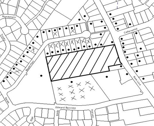
|
NOTIFICATION
PLAN
|
|
|
• PROPERTIES NOTIFIED
|
X SUBMISSIONS
RECEIVED
|
PROPERTY SUBJECT OF DEVELOPMENT
|
|
|
TWO SUBMISSIONS RECEIVED
OUT OF MAP RANGE
|
|
|
|
|
Forty-eight submissions objected
to the development, on the grounds that the development would result in:
· Unacceptable
traffic on local streets;
· Unacceptable noise
from activities at the Club;
· Inadequate parking;
· Development that is
excessive in bulk and scale;
· Use of the existing
awning area at night should cease;
· Privacy impacts;
· Works undertaken
without development consent;
· No airlock has been
provided on the verandah games room;
· Louvres permit
visibility of gaming to the public/ tennis courts/ bowling greens, which is
contrary to the OLGR requirements.
The submissions also raised the
following concerns that are not directly related to the current application:
· The application is
contrary to the Masterplan approved in DA/1046/2007;
· Noise measures and
additional parking have not been provided in accordance with DA/1046/2007;
· When will works
commence for DA/1046/2007;
· Security Management
Plan approved in DA/1046/2007 has not been implemented;
· Unauthorised sign
on cricket nets;
· Expansion of gaming
should provide more parking;
· OLGR have increased
gaming machines which is detrimental to the community;
· Fix the existing
light nuisance;
· Close the back gate
after 9pm
The merits of the matters raised
in community submissions have been addressed in the body of the report with the
exception of the following:
5.1.1 Traffic and Parking
A number of submissions raised
concerns with regard to unacceptable traffic on local streets, inadequate
parking and people parking in adjoining residential streets.
The proposal would result in a minor
increase to the gross floor area of the existing Club, however, there would not
be an increase in the patronage of the Club and the proposal would not alter
traffic generation, vehicle access or parking on the site.
The Club has been requested to
ask its members to refrain from parking in the adjoining streets and to utilise
the car park on-site.
5.1.2 Privacy Impacts
Concerns have been raised with
regard to privacy impacts and that the proposed louvres permit visibility of
gaming to the public/ tennis courts/ bowling greens, which is contrary to the
Office of Liquor Gaming and Racing (OLGR) requirements.
The proposed works are single
storey and are set back a minimum of 46m from the northern boundary which would
minimise any overlooking concerns of adjoining neighbours. With regard to the
privacy impacts on the bowling green, the existing verandah is open and allows
for clear sightlines, whereas the proposed louvres would improve privacy to
users of the bowling greens. With regards to the smoker’s deck overlooking the
tennis courts, the existing deck and the deck extension would have a solid 1.8
metre high wall which would maintain privacy to the tennis court users.
Furthermore concerns have been
raised with regard to the noise and privacy impacts of the use of the existing
verandah area at night that is accessed from the existing lounge and is
adjacent to the proposed new outdoor gaming area and the bowling greens. To
address the concerns of adjoining residents, a condition is recommended that no
patrons are permitted to utilise the covered verandah area adjacent the bowling
greens after 9pm at night.
5.1.3 Development Consent No. 1046/2007
On 3 September 2008, Council
approved a major redevelopment of the Club’s premises (DA/1046/2007) which included
a masterplan and staging of the proposed works. The consent is valid for 5
years and works have not yet commenced. Council is unable to impose a
timeframe for works to start, and until such time as the consent becomes
operative, the implementation of the Security Management Plan and the acoustic
measures and upgrading of the car parking on the site are not required to be
commenced.
5.1.4 Compliance Matters
A number of submissions raised
concerns with regard to the works being undertaken without development consent,
existing lights on the premises causing glare and reflection and that
unauthorised signs had been erected on the cricket nets.
These matters were investigated
by Council’s Compliance officers. With regard to the unauthorised signage on
the cricket nets and the glare from the tennis court lights, the Club has
removed the signage and the tennis court lights have been upgraded to comply
with the requirements of Development Consent No. 156/1982. The matter of the
unauthorised works has been resolved by the submission of this application.
5.2 Public Agencies
The application was referred to
the following agency for comment:
5.2.1 NSW Police
The NSW Police Force raised no
objections to the proposed development, subject to the recommendations of the
acoustic report being implemented to alleviate any concerns in relation to what
impact the noise from the outdoor gaming terrace and smoking area might have on
the residential area adjacent to the complex.
6. THE PUBLIC INTEREST
Section 79C (1)(e) of the Act
requires Council to consider “the public interest”.
The public interest is an
overarching requirement, which includes the consideration of the matters
discussed in this report. Implicit to the public interest is the achievement
of future built outcomes adequately responding to and respecting the future
desired outcomes expressed in environmental planning instruments and
development control plans.
The application is considered to
have satisfactorily addressed Council’s and relevant agencies’ criteria and
would provide a development outcome that, on balance, would result in a
positive impact for the community. Accordingly, it is considered that the
approval of the proposed description of the proposal would be in the public
interest.
CONCLUSION
The application proposes
alterations to West Pennant Hills Sports
Club involving internal modifications and the enclosure of part of the
existing verandah to create an outdoor gaming room and the extension of the
existing smoker’s deck.
The proposal is consistent with
the objectives of the Hornsby Shire Local Environmental Plan 1994 and Council’s
relevant Development Control Plans.
Matters raised in community
submissions can be addressed via appropriate conditions. The proposal
satisfies the requirements of the NSW Police Force.
Accordingly, the application is
recommended for approval.
Note: At the time of the
completion of this planning report, no persons have made a Political
Donations Disclosure Statement pursuant to Section 147(3) of the
Environmental Planning and Assessment Act 1979 in respect of the subject
planning application.
|
Rod Pickles
Manager -
Assessment Team 2
Planning Division
|
Scott Phillips
Executive Manager
Planning Division
|
Attachments:
File Reference: DA/144/2009
Document Number: D01177357
SCHEDULE 1
GENERAL CONDITIONS
The conditions of consent within this notice of determination
have been applied to ensure that the use of the land and/or building is carried
out in such a manner that is consistent with the aims and objectives of the
planning instrument affecting the land.
Note: For
the purpose of this consent, the term ‘applicant’ means any person who has the
authority to act on or the benefit of the development consent.
Note:
For the purpose of this consent, any reference to an Act, Regulation,
Australian Standard or publication by a public authority shall be taken to mean
the gazetted Act or Regulation, or adopted Australian Standard or publication
as in force on the date that the application for a construction certificate is
made.
1. Approved
Plans and Supporting Documentation
The development must be carried
out in accordance with the plans and documentation listed below and endorsed
with Council’s stamp, except where amended by Council and/or other conditions
of this consent:
Architectural Plans
prepared by DEM Pty Ltd
|
Plan No.
|
Plan Title
|
Rev
|
Dated
|
|
ar-0101
|
Site Plan
|
A01
|
16 February 2009
|
|
ar-1201
|
Ground Floor Plan
|
A01
|
16 February 2009
|
|
ar-1202
|
Roof Plan
|
A01
|
16 February 2009
|
|
ar-2101
|
Sections
|
A01
|
16 February 2009
|
|
ar-2601
|
East & West Elevation
|
A01
|
16 February 2009
|
|
ar-2602
|
North Elevation
|
A01
|
16 February 2009
|
Supporting Documentation
|
Document Title
|
Prepared by
|
Dated
|
|
Statement of Environmental Effects Project No.
4056-00
|
DEM
|
16 February 2009
|
|
Construction Waste Management Plan
|
DEM
|
16 February 2009
|
|
BCA Compliance Report Project No. 90004, Rev 2
|
Blackett Maguire & Goldsmith Pty Ltd
|
9 February 2009
|
|
Noise Impact Statement Report No. 39.3170.R12:ZSC
|
The Acoustic Group
|
6 February 2009
|
|
Noise Impact Statement Report No. 39.3170.R13:ZSC
|
The Acoustic Group
|
28 March 2009
|
REQUIREMENTS PRIOR TO THE ISSUE OF A CONSTRUCTION
CERTIFICATE
The following conditions of consent must be complied with
prior to the issue of a ‘Construction Certificate’ by either Hornsby
Shire Council or an accredited certifier. All necessary information to
demonstrate compliance with the following conditions of consent must be
submitted with the application for a construction certificate.
2. Building
Code of Australia
All building
work must be carried out in accordance with the requirements of the Building
Code of Australia.
3. Fire
Safety Upgrade
To ensure the protection of persons using the existing building and to facilitate egress from this
building in the event of a fire, details must be submitted for the works
necessary to bring the area indicated as “existing outdoor gaming area – not
approved” into full compliance with Parts C, D and E of the Building Code of
Australia.
4. Sydney
Water – Quick Check
The
application must be submitted to a Sydney Water ‘Quick Check Agent’ or
‘Customer Centre’ for approval to determine whether the development will affect
any Sydney Water infrastructure, and whether further requirements are to
be met.
Note: Refer
to www.sydneywater.com.au or
telephone 13 20 92 for assistance.
REQUIREMENTS PRIOR TO THE COMMENCEMENT OF ANY WORKS
The following conditions of consent must be complied with
prior to the commencement of any works on the site. The conditions have been
imposed to ensure that the works are carried out in such a manner that complies
with relevant legislation and Council’s policies and does not disrupt the
amenity of the neighbourhood or impact upon the environment.
5. Erection
of Construction Sign
A sign must
be erected in a prominent position on any site on which building work, subdivision
work or demolition work is being carried out:
a. Showing
the name, address and telephone number of the principal certifying authority
for the work.
b. Showing
the name of the principal contractor (if any) for any demolition or building
work and a telephone number on which that person may be contacted outside
working hours.
c. Stating
that unauthorised entry to the work site is prohibited.
Note: Any
such sign is to be maintained while the building work, subdivision work or
demolition work is being carried out, but must be removed when the work has
been completed.
6. Erosion
and Sediment Control
Erosion and
sediment control measures must be provided and maintained throughout the
construction period in accordance with the manual ‘Soils and Construction
2004 (Bluebook)’, the approved plans, Council specifications and to the
satisfaction of the principal certifying authority. The erosion and sediment
control devices must remain in place until the site has been stabilised and
revegetated.
Note: On
the spot penalties up to $1,500 may be issued for any on-compliance with this
requirement without any further notification or warning.
REQUIREMENTS DURING CONSTRUCTION
The following conditions of consent must be complied with
during the construction of the development. The conditions have been imposed
to ensure that the works are carried out in such a manner that complies with
relevant legislation and Council’s policies and does not disrupt the amenity of
the neighbourhood or impact upon the environment.
7. Construction
Work Hours
All work on site (including demolition and earth works)
must only occur between the following hours:
Monday to Saturday 7 am to 5 pm
Sunday & Public Holidays No work
8. Demolition
All
demolition work must be carried out in accordance with Australian Standard
2601-2001 – The Demolition of Structures and the following requirements:
a. Demolition
material is to be disposed of to an authorised recycling and/or waste disposal
site and/or in accordance with an approved waste management plan.
b. Demolition
works, where asbestos material is being removed, must be undertaken by a
contractor that holds an appropriate licence issued by WorkCover NSW in
accordance with Chapter 10 of the Occupational Health and Safety Regulation
2001 and Clause 29 of the Protection of the Environment Operations
(Waste) Regulation 1996.
c. On
construction sites where buildings contain asbestos material, a standard
commercially manufactured sign containing the words ‘DANGER ASBESTOS REMOVAL IN
PROGRESS’ measuring not less than 400mm x 300mm must be erected in a prominent
position visible from the street.
9. Environmental
Management
The site must
be managed in accordance with the publication ‘Managing Urban Stormwater –
Landcom (March 2004) and the Protection of the Environment Operations
Act 1997 by way of implementing appropriate measures to prevent sediment
run-off, excessive dust, noise or odour emanating from the site during the
construction of the development.
10. Council
Property
During
construction works, no building materials, waste, machinery or related matter
is to be stored on the road or footpath. The public reserve is to be kept in a
clean, tidy and safe condition at all times.
Note:
This consent does not give right of access to the site via Council’s park or
reserve. Should such access be required, separate written approval is to be
obtained from Council.
11. Excavated
Material
All excavated
material removed from the site must be classified in accordance with the NSW
Environment Protection Authority’s Environmental Guidelines – Assessment,
Classification and Management of Liquid and Non-Liquid Wastes prior to
disposal to an approved waste management facility and reported to the principal
certifying authority.
REQUIREMENTS PRIOR TO THE ISSUE OF AN OCCUPATION
CERTIFICATE
The following conditions of consent must be complied with
prior to the ‘Principal Certifying Authority’ issuing an ‘Occupation
Certificate’.
Note: For
the purpose of this consent, any reference to ‘occupation certificate’ shall
also be taken to mean ‘interim occupation certificate’ unless otherwise stated.
12. Stormwater
Drainage
The
stormwater drainage system for the development must be designed and constructed
in accordance with Council’s Civil Works – Design and Construction
Specification 2005 and connected to the existing drainage system.
13. Cigarette
Butt Receptacle
Cigarette butt
receptacles must be provided on the smoker’s deck to minimise littering.
14. External
Lighting
All external
lighting must be designed and installed in accordance with Australian
Standard AS 4282 – Control of the Obtrusive Effects of Outdoor Lighting.
Certification of compliance with the Standard must be obtained from a suitably
qualified person.
15. Acoustic
absorption material
Acoustic absorption
material must be applied to the underside of the roof (of the deck) and
acoustic ceilings applied for all gaming areas in accordance with the
recommendations of the Noise Impact Statement Report No. 39.3170.R12:ZSC
prepared by The Acoustic Group, dated 6 February 2009. Certification of
compliance with the recommendations of Noise Impact Statement Report No.
39.3170.R12:ZSC must be obtained from a suitably qualified person.
16. Air
Locks
Air locks
must be provided to doorways that lead to the outdoor smoking area to prevent
the entry of cigarette smoke into the Club.
OPERATIONAL CONDITIONS
The following conditions have been applied to ensure that the
ongoing use of the land is carried out in such a manner that complies with
relevant legislation and Council’s policies and does not disrupt the amenity of
the neighbourhood or impact upon the environment.
17. Patron
Numbers
This consent does not authorise
or approve an increase in patron numbers.
18. Fire
Safety Statement - Annual
On at least one occasion in
every 12 month period following the date of the first ‘Fire Safety Certificate’
issued for the property, the owner must provide Council with an annual ‘Fire
Safety Certificate’ to each essential service installed in the building.
19. Noise
– Plant and Machinery
a. Existing plant on the subject site must operate at levels
less than 40 dB(A) at the northern boundary.
b. Additional plant associated with the proposal must not to
exceed 37 dB(A) at the northern boundary.
20. Noise
– Acoustic Assessment
An acoustic
assessment is to be undertaken by a suitably qualified environmental
consultant, selected by Council and at the sole cost of the applicant,
within 60 days of the date of this consent in accordance with the Environment
NSW Industrial Noise Policy (2000), Council’s Policy and Guidelines for
Noise and Vibration Generating Development (Acoustic Guidelines V.5, 2000) and
the DECC’s Noise Guide for Local Government (2004). Measurements
must be taken from the common property boundary with Lot 2 DP 262492, Lot 4 DP
262492, Lot 7 DP 262492 and Lot 713 DP 260293, (Nos. 4, 8, 14 and 19) Bowerman
Place Cherrybrook. Should the assessment find that noise from the premise
exceeds 5dB(A) appropriate measures must be employed to rectify excessive noise.
21. Use of Smoker’s Deck
The use of
the deck is subject to the following conditions to protect the acoustic amenity
of neighbouring residences:
a. The hours of operation of the
smoking deck are restricted to those times listed below:
Sunday - Wednesday 10am
- 11pm
Thursday - Saturday 10am
- Midnight
Please note: This includes
Public Holidays and Special Events.
b. Alcohol must not to be consumed on the
deck between the hours of 10pm and Midnight.
c. Signs must be posted both at the exit to
the deck and on the deck stating: “CONSIDER OUR NEIGHBOURS. PLEASE KEEP NOISE
TO A MINIMUM.”
d. No music, entertainment, television monitors or amplified
music/announcements is permitted on the smoking deck area.
e. All noise complaints must be recorded by the Duty Manager
and must be dealt with immediately.
22. Management
The Club
Manager must take all steps necessary to ensure the orderly behaviour of
patrons and to ensure that no noise nuisance occurs from patrons entering,
using and leaving the outdoor gaming area, the verandah and/or smoking deck.
All resident complaints are to be recorded and if possible, responded to in
writing.
23. Use
of Verandah
No patrons
are to utilise the outdoor covered verandah accessed from the lounge area and
adjacent to the bowling green after 9pm.
-
END OF CONDITIONS -
ADVISORY NOTES
The following information is provided for your
assistance to ensure compliance with the Environmental Planning and Assessment
Act 1979, Environmental Planning and Assessment Regulation 2000, other relevant
legislation and Council’s policies and specifications. This information does
not form part of the conditions of development consent pursuant to Section 80A
of the Act.
Environmental Planning and Assessment Act 1979
Requirements
· The Environmental Planning and
Assessment Act 1979 requires:
· A construction certificate prior to the
commencement of any works. Enquiries regarding the issue of a construction
certificate can be made to Council’s Customer Services Branch on 9847 6760.
· A principal certifying authority to be
nominated and Council notified of that appointment prior to the commencement of
any works.
· Council to be given at least two days
written notice prior to the commencement of any works.
· Mandatory inspections of nominated stages
of the construction inspected.
· An occupation certificate issued before
occupying any building or commencing the use of the land.
Long Service Levy
In accordance with Section 34 of
the Building and Construction Industry Long Service Payments Act 1986, a ‘Long Service Levy’ must be paid to the Long
Service Payments Corporation or Hornsby Council.
Note: The
rate of the Long Service Levy is 0.35% of the total cost of the work.
Note: Hornsby
Council requires the payment of the Long Service Levy prior to the issue of a
construction certificate.
Disability Discrimination Act
The applicant’s attention is
drawn to the existence of the Disability Discrimination Act. A
construction certificate is required to be obtained for the proposed
building/s, which will provide consideration under the Building Code of
Australia, however, the development may not comply with the requirements of
the Disability Discrimination Act. This is the sole responsibility of
the applicant.
Dial Before You Dig
Prior to commencing any works,
the applicant is encouraged to contact Dial Before You Dig on 1100 or www.dialbeforeyoudig.com.au for
free information on potential underground pipes and cables within the vicinity
of the development site.
Asbestos Warning
Should asbestos or asbestos
products be encountered during construction or demolition works you are advised
to seek advice and information should be prior to disturbing the material. It
is recommended that a contractor holding an asbestos-handling permit (issued by
Work Cover NSW), be engaged to manage the proper disposal and handling
of the material. Further information regarding the safe handling and removal of
asbestos can be found at:
www.environment.nsw.gov.au
www.nsw.gov.au/fibro
www.adfa.org.au
www.workcover.nsw.gov.au
Alternatively, telephone the Work Cover Asbestos and
Demolition Team on 8260 5885.
The Smoke-free Environment Act 2000
This assessment does not confirm
that the outdoor gaming area and smoking deck is an unenclosed public place for
the purposes of The Smoke-free Environment Act 2000. This is a matter
for the NSW Department of Health.
Planning Report No. PLN32/09
Date of Meeting:
1/07/2009
3 DEVELOPMENT APPLICATION
- SUBDIVISION OF ONE LOT INTO THREE
36 CHAPMAN AVENUE, BEECROFT
|
Development Application No:
|
DA/1432/2008
|
|
Description of Proposal:
|
Demolition of existing dwelling and subdivision of one
lot into three
|
|
Property Description:
|
Lot 6 DP 206721 (No. 36) Chapman Avenue, Beecroft
|
|
Applicant:
|
Peter Anderson
|
|
Owner:
|
Schofields Garden & Floral Centre Pty Ltd
|
|
Statutory Provisions:
|
Hornsby Shire Local Environmental
Plan 1994
Residential AS (Low Density –
Sensitive Lands)
|
|
Estimated Value:
|
$18,000
|
|
Ward:
|
C
|
|
RECOMMENDATION
THAT Development Application
No. DA/1432/2008 for demolition of existing dwelling and subdivision of one
lot into three at lot 6 DP 206721 (No. 36) Chapman Avenue, Beecroft be
granted a deferred commencement consent subject to the conditions detailed in
Schedule 1 of this report.
|
1. The
application proposes the demolition of the existing dwelling and subdivision of
one lot into three.
2. The
proposal complies with the Hornsby Shire Local Environmental Plan 1994, the
Residential Subdivision Development Control Plan and the Heritage Development
Control Plan.
3. The
proposal is integrated development and the general terms of approval have been
received from the Department of Water and Energy.
4. Five
submissions have been received in respect of the application.
5. It
is recommended that the application be granted deferred commencement consent.
HISTORY OF THE SITE
The site was previously the
subject of DA/1122/2007 for the subdivision of one lot into four. That
application was to be considered by Council at its meeting on 21 November 2007,
however the application was withdrawn prior to the meeting.
On 26 May 2008 Council approved
tree assessment application No. TA/554/2008 for the removal of 12 trees from
the site. The subsequent removal of the trees was raised as a concern by
adjoining property owners and the NSW Department of Environment and Climate
Change. The concerns were in respect to an assessment of significance being
undertaken pursuant to Section 5A of the Environmental Planning and Assessment
Act, 1979. These concerns were addressed to the Department’s satisfaction by
Council’s response concerning the condition of the trees removed and the
applicant’s agreement to replacement tree planting.
THE SITE
The site comprises an existing
battleaxe lot, has an area of 3,205m2 (2,968m2 excluding
the access handle) and has an average fall of 10% to the western boundary. The
lot is one of three existing battleaxe lots with shared access (reciprocal
rights of carriageway) over their respective handles. The shared driveway is
over the handle of the subject site and the handle of the adjoining rear
property at No. 36A Chapman Avenue.
The subject site includes an
existing single storey rendered brick dwelling with tiled roof, a swimming pool
and several large remnant trees. A small watercourse, piped under the existing
driveway, flows east-west through a number of adjacent properties to Bangalow Avenue. The existing driveway consists of concrete strips. The handle of No. 36B Chapman Avenue is thickly vegetated with trees and shrubs and is not used for access.
The site is approximately 550m north west of Beecroft Railway Station and shops.
The site is located within a low
density residential area generally characterised by substantial dwellings on
large lots with formal gardens and large remnant trees. The site is in the
vicinity of recent subdivisions approved by Council:
Lloyd Wright Way – Site area 10,964m2 (11-11A Albert Road), DA/2781/2001 approved for 15 community title lots, average lot size 606m2.
Lloyd Wright Way - Site area 4,376m2 (38A Beecroft
Road), DA/1321/2003 approved for four lots, existing dwelling retained on
2,113m2 with Beecroft Road access, 3 lots of 756m2 with
access off Lloyd Wright Way.
Lloyd Wright Way - Site area 2,428m2 (34A Beecroft
Road), DA/104/2006 approved for 3 lots, existing dwelling retained on 1,300m2
with Beecroft Road access, 2 lots of 640.4m2 and 642.3m2
with access off Lloyd Wright Way.
Lloyd Wright Way - Site area 4,338m2 (40A Beecroft Road), DA/516/2007 approved for subdivision into 4 lots. Lot 1 of area 1,636.2m2
with Beecroft Road access. Lot 2 - 763.6m2, lot 3 - 709.2m2
and lot 4 area 822.9m2 with access off Lloyd Wright Way. The site
includes trees identified as an endangered ecological community.
The remnant trees on the subject
site are identified as an endangered ecological community. The site, together
with the adjoining properties (36A & 36B), is one of the last remaining
substantial holdings in the locality to be subject to redevelopment.
THE PROPOSAL
The proposal involves the
demolition of the existing dwelling house and subdivision of one lot into
three. The existing swimming pool is proposed to be retained. A central
accessway and turning area is proposed for vehicular access to the three lots
which would have the benefit of the existing right of carriageway.
The proposed stormwater drainage
system involves connection to the existing watercourse, where it crosses the
access handles. The site falls to the western boundary and the area below the
138m contour line cannot drain into the proposed stormwater drainage system. A
building line limit is proposed to restrict development to the area above this
line. The submitted landscape plan includes the revegetation of Blue Gum High
Forest for part of the area below the building line.
Proposed lot 1 has an area of
1,245m2 (763.2m2 excluding ROC). The lot is irregular in
shape of dimensions; northern boundary 30.87m, western boundary 26.365m,
southern boundary 47.72m and eastern boundary with access handle 27.0m/68.88m.
The access handle has an area of approximately 230.7m2. The central
right of carriageway over the lot and benefiting proposed lots 2 and 3, has an
area of approximately 251.1m2. The lot has an average fall of 9.5%.
The lot includes trees Nos. 110, 111, 185 and 180, identified as good and
worthy of preservation.
Proposed lot 2 is irregular in
shape and has an area of 1,009m2. The lot dimensions are; northern
boundary 26.09m, western boundary 39.62m, southern boundary 5.12m/5.02m and
eastern boundary 26.365/27.42m. The lot has an average fall of 8.4%. The lot
includes trees Nos. 170, 175, 203, 242 and 253, identified as good and worthy
of preservation.
Proposed lot 3 is regular in
shape and has an area of 950.3m2 (914.7m2 excluding ROC).
The lot dimensions are; northern boundary 28.165m, western boundary 27.42m,
southern boundary 30.87m and eastern boundary 40.06m. The lot includes the
existing swimming pool to be retained. The lot has an average fall of 10% to
the south western corner. The lot includes tree No. 236, identified as good and
worthy of preservation.
The existing access handle of the
subject site and the adjoining access handle for lot 7 DP 206721 (No. 36A)
Chapman Avenue, have a combined width of 6.7m and accommodate the proposed
right-of-accessway. The accessway over the two handles includes a 3m wide
driveway extending to 5m width for passing bays at the frontage and two passing
bays at 30m intervals along the driveway. The right of carriageway is existing
and includes access for lot 5 DP 206721 (No. 36B) Chapman Avenue. The proposed
development, however, does not involve works within the handle of lot 5 DP
206721.
The proposed accessway and the
adjoining handle of lot 5 DP 206721 include good and worthy trees Nos. 73, 433,
435, 437, 438, 440, 441, 442, 444, 445, 446, 448, 449, 450, 451, 453, 454, 455,
456, 457, 462, 463, 465, 466, 467, 477 and 478.
The proposed accessway involves
the removal of trees Nos. 434, 443, 447, 460, 461, 464, 468, 469 and 480.
ASSESSMENT
The development application has
been assessed having regard to the ‘2005 City of Cities Metropolitan
Strategy’, the ‘North Subregion (Draft) Subregional Strategy’ and
the matters for consideration prescribed under Section 79C of the Environmental
Planning and Assessment Act 1979 (the Act). Subsequently, the following
issues have been identified for further consideration.
1. STRATEGIC CONTEXT
1.1 Metropolitan Strategy – (Draft) North Subregional
Strategy
The Metropolitan Strategy is a
broad framework to secure Sydney’s place in the global economy by promoting and
managing growth. It outlines a vision for Sydney to 2031; the challenges
faced, and the directions to follow to address these challenges and achieve the
vision. The draft North Subregional Strategy acts as a framework for Council
in the preparation of a new Principal LEP by 2011.
The draft Subregional Strategy
sets the following targets for the Hornsby LGA by 2031:
· Employment capacity to
increase by 9,000 jobs; and
· Housing stock to
increase by 11,000 dwellings.
The proposed development would be
consistent with the draft Strategy by providing an additional two residential
lots and housing opportunities in the locality.
2. STATUTORY CONTROLS
Section 79C(1)(a) requires
Council to consider “any relevant environmental planning instruments, draft
environmental planning instruments, development control plans, planning
agreements and other prescribed matters”.
2.1 Hornsby Shire Local Environmental Plan 1994
The subject land is zoned Residential AS (Low Density – Sensitive Lands) under the Hornsby Shire Local
Environmental Plan 1994 (HSLEP). The objectives of the zone are:
(a) to provide for the housing needs of the population of the
Hornsby area.
(b) to promote a variety of housing types and other land uses
compatible with a low density residential environment and sensitive to the land
capability and established character of this environment.
(c) to provide for development that is within the
environmental capacity of a sensitive low density residential environment.
The proposed development is
defined as ‘demolition’ and ‘subdivision’ under the HSLEP and is
permissible in the zone with Council’s consent.
Clause 14 of the HSLEP prescribes
that the minimum area of an allotment within the Residential AS zone is 600m2,
excluding the area of any accessway. The proposed lots comply with this
requirement.
Clause 18 of the HSLEP sets out
heritage conservation provisions within the Hornsby area. The subject site is
located within the Beecroft/Cheltenham Heritage Conservation Area. The
applicant submitted a Statement of Heritage Impact in compliance with the
Clause, which is addressed in a later section of this report.
2.2 Water Management Act 2000
The site
includes a minor watercourse which flows to Devlins Creek.
The Water
Management Act 2000 includes provision for prescribed activities within 40
metres of a watercourse. Subdivision is a controlled activity under the Act and
requires the approval of the Department of Water and Energy. In this regard the
application is ‘integrated development’ and was referred to the Department for
assessment.
The Department
of Water and Energy has granted ‘General Terms of Approval’ for the proposed
development.
2.4 Residential Subdivision Development Control Plan
The proposed development has been
assessed having regard to the relevant performance and prescriptive design
standards within Council’s Residential Subdivision Development Control Plan
(DCP). The following table sets out the proposal’s compliance with the
prescriptive standards of the Plan:
|
Residential
Subdivision Development Control Plan
|
|
Control
|
Proposal
|
Requirement
|
Compliance
|
|
Lot Size (excl access)
|
Lot 1 – 763m2
Lot 2 – 995.8m2
Lot 3 – 926.6m2
|
600m2
|
Yes
|
|
Accessway Width
|
6.7m
|
4m
|
Yes
|
The proposed subdivision complies
with the prescriptive standards contained within Council’s DCP in respect to
density, setbacks, private open space and solar access. The merits of the proposal
with regard to the DCP’s other relevant performance standards, are discussed as
follows:
2.4.1 Allotment Layout and Design
Proposed lot 1 can accommodate a
200m2 indicative building envelope with a minimum dimension of 10m
clear of the drainage limit building line and trees to be retained, in
compliance with the DCP criteria. A condition is recommended for a ‘Restricted
Development Area’ to be created on the title of the lot, over that area that
cannot be drained to the stormwater drainage system.
The area recommended for
restriction for building on proposed lot 1, involves an area of 220m2,
thus reducing the useable residential area to 543.2m2. The resulting
area is considered acceptable in respect to the available area for siting a
dwelling with regard to setbacks, trees to be retained and the residential
character of the area.
The applicant’s proposed
indicative 200m2 building envelope on lot 2 is shaped to retain tree
No. 164. The building envelope does not comply with the DCP criteria for a minimum
dimension of 10m. The tree however is not identified as significant and the lot
could accommodate a 200sqm building envelope in compliance with the DCP if tree
No. 164 was removed.
As with lot 1, it is recommended
that a ‘Restrictive Development Area’ be created on the title of lot 2 over
that area that can not be drained to the stormwater drainage system. The
recommended restricted area for lot 2 reduces the residential useable area to
518.8 m2. The resulting area is considered acceptable in respect to
the available area for siting a dwelling with regard to setbacks, trees to be
retained and the residential character of the area (subject to the removal of
tree No. 164).
The area subject to the
‘Restricted Development Area’ on lots 1 and 2 is also the area recommended for
the restoration of the remnant bushland on the site. (Refer to discussion in
Section 3.1.)
Proposed lot 3 is relatively
large and accommodates a 200m2 building envelope in compliance with
the DCP allotment layout and design performance criteria. It is noted that lot
3 has been designed to retain the existing pool on site within that lot. It is
further noted that the pool is old and that if demolished, may make way for an
alternative allotment configuration that would increase the size of lot 2 and
possibly retain tree No. 164.
2.4.2 Landscaping
The proposed subdivision includes
adequate areas for landscaping to ensure privacy of future and existing
residents. The submitted landscape plan includes revegetation of Blue Gum High
Forest along the western boundary of the site, providing screening to the
adjoining property at 36B Chapman Avenue and the rear of adjacent properties
fronting Bangalow Avenue.
The proposed subdivision involves
the removal of 9 trees of which none are significant or good and worthy of
preservation. To accommodate a useable building envelope on lot 2, it is
recommended that a 10th tree (tree No. 164) also be removed.
Appropriate conditions are recommended to protect the trees to be retained
within the vicinity of the proposed accessway and stormwater drainage works.
The proposal complies with the
DCP landscaping performance criteria. (Refer also to discussion in Section
3.1.)
2.4.3 Drainage Control
The applicant has been unable to
secure easements over downstream properties for effective stormwater drainage
of all the development site. Consequently, the proposed stormwater drainage
system is to be piped to the existing watercourse where it crosses the
accessway. The proposed system involves excavation to achieve the necessary
fall and would drain 78% of lot 1, 53% of lot 2 and all of lot 3. The proposed
drainage system is satisfactory subject to a condition requiring the proposed
building restriction to be implemented on title to ensure all non-permeable surface
areas of lot 1 and lot 2 are able to be connected to the stormwater drainage
system.
A stormwater detention system is
recommended for the proposed subdivision. The detention system, together with
recommended conditions of the Department of Water and Energy, would ensure no
adverse impact on the watercourse and downstream properties as a result of the
proposed development.
2.4.4 Accessway Design
The proposed accessway has a
length of 70m, a driveway width of 3m extending to 5m for the proposed passing
bays and includes a common turning area, in compliance with the DCP design
criteria. The accessway provides for the three proposed lots and the two
existing adjoining lots. The proposed accessway would have capacity for a total
of six dwellings. Access for a waste collection vehicle is not required for the
proposal, in accordance with the Residential Subdivision DCP.
To minimise the impact of bin
storage on the streetscape and to cater for waste collection for the proposed
lots and the existing properties, a condition is recommended for the accessway
to include a waste bin storage facility at the Chapman Avenue frontage.
The accessway has a length of 70m
and connects with the access for No. 36A Chapman Avenue (which has a further
length of 104m). The applicant, in liaison with the adjoining owners, submitted
a Works Management Plan for construction of the accessway, to ensure that
access is able to be maintained to the existing adjoining properties during the
construction of the development. A condition is recommended for the
implementation of the Works Management Plan.
A condition is recommended for
the accessway to be designed and constructed in a manner that minimises impact
on trees to be retained. This would be achieved via pier and beam construction
in those locations where root damage could occur as a result of excavation.
The existing trees and vegetation provide an effective screen for the operation
of the proposed accessway, in respect to adjacent dwellings at No. 38 Chapman Avenue and No. 36B Chapman Avenue.
Without appropriate conditions,
the proposed accessway and recommended bin storage area could detract from the
amenity of the adjoining dwelling at No. 34 Chapman Avenue, given that the
common boundary is unfenced. Accordingly, a condition is recommended requiring
the construction of a solid lapped and capped timber fence along the eastern
common boundary with No. 34 Chapman Avenue.
The proposed development would
generate an additional 18 daily traffic movements in accordance with the RTA’s Guide
To Traffic Generating Developments. Subject to adherence with recommended
conditions, it is considered the proposed accessway would not adversely impact
on the existing acoustic environment.
A condition is recommended for
the accessway to be finished in coloured concrete, bitumen or stencilled to
minimise its visual impact.
2.4.5 Utility Services
The existing utilities are
provided by way of separate and shared service lines for the three existing
battleaxe lots. The proposed development involves joint trenching to combine
existing and proposed services including water, electricity and
telecommunications. An appropriate easement is recommended to facilitate joint
trenching for utility services.
2.5 Heritage Development Control Plan
The site is located within the
Beecroft-Cheltenham Heritage Conservation Area. The proposed subdivision is
consistent with recent infill subdivision and would not adversely impact on the
streetscape or the significance of the heritage conservation area.
The proposal includes demolition
of the existing dwelling. The dwelling does not have heritage significance, is
not visible in the streetscape and its demolition would not affect the
conservation area. (Refer to discussion under Section 3.2 of this report.)
2.6 Waste Minimisation and Management Development Control
Plan
In support of the application the
applicant submitted a Waste Management Plan for the demolition of the existing
dwelling house, in compliance with the DCP.
3. ENVIRONMENTAL IMPACTS
Section 79C (1)(b) of the Act
requires Council to consider “the likely impacts of that development,
including environmental impacts on both the natural and built environments, and
social and economic impacts in the locality”.
3.1 Natural Environment
There are 99 trees located on the
site, including trees in close proximity to adjoining properties. Of these
trees 46% are exotic species. The proposed subdivision involves the removal of
9 trees, being trees Nos. 434, 443, 447, 460, 461, 464, 468, 469 and 480, of
which 7 are exotic species. None of these trees are identified as significant
or good and worthy of preservation.
Council has identified that none
of the trees on site are individually significant, however, thirty-seven trees
are identified as good and worthy of preservation. These trees are numbered 73,
110, 111, 170, 175, 180, 185, 203, 236, 242, 253, 433, 435, 437, 438, 440, 441,
442, 444, 445, 446, 448, 449, 450, 451, 453, 454, 455, 456, 457, 462, 463, 465,
466, 467, 477 and 478. Appropriate conditions are recommended to protect
existing trees to be retained which are located within 4m of the driveway
construction, service pits and drainage works.
In support of the application,
the applicant has provided a ‘Revegetation Plan’ (prepared by Phil Packham Horticulture
dated 4/5/2009) and a ‘Landscaping and Revegetation Proposal’ (prepared by Phil
Packham Horticulture dated 30/4/2009) that includes the planting of twelve Blue
Gum High Forest canopy species within the proposed ‘Restricted Development
Area’ being:
· Eucalyptus pilularis
(Blackbutt)
· Eucalyptus saligna (Blue Gum)
· Eucalyptus resinifera
· Elaeocarpus reticulatus
· Allocasuarina torulosa
An additional 300 local
provenance Blue Gum High Forest tube stock including tall shrubs (25% density),
medium shrubs (25% density) and groundcover (50% density) for a diversity of 17
species has also been proposed in the understorey of Zone 3 as indicated
in the Plan. The density and diversity of planting with Blue Gum High Forest is
also intended to be a compensatory measure for the removal of twelve trees
previously approved by Council (TA/554/2008). A minimum of seven Blue Gum High
Forest canopy species would be retained and incorporated into Zone 3.
Zone 1 and 2 of the proposed Revegetation
Plan includes screen plantings between each of the three proposed
allotments comprising of some Blue Gum High Forest species (Breynia
obolgifolia and Rapanea variabilis) with the exception of Syzygium
luehmanii and Acmena smithii var. minor which are not
considered to be an invasive species.
It is considered that active
restoration efforts and the cessation of mowing would encourage natural
regeneration as there is likely to be a viable seedbank below the existing tree
canopy within Zone 3. However, it is recommended that supplementary planting
of native tubestock be undertaken to further provide suitable microclimate for
regeneration and help establish habitat structure. The planting of BGHF species
in a clump at Zone 3 of the ‘Restricted Development Area’ is considered a
realistically achievable arrangement for managing endangered native vegetation
whilst allowing turf for active use as part of the private open space
requirements for proposed residential lots 1 and 2. A condition is
recommended for the ‘Revegetation Pan’ to be amended for planting of an
additional six Blue Gum High Forest canopy trees within the grassed component
area of the ‘Restricted Development Area’ of lots 1 and 2.
It is considered the Seven Part
Test Assessment of Significance (prepared by Trevor Hawkeswood dated 22nd
June 2008) in support of the application is acceptable. Given the recent
proposition of compensatory plantings of Blue Gum High Forest species within a
‘Restricted Development Area’ which is specifically dedicated to the perpetual
protection and active maintenance of Blue Gum High Forest on the subject site,
the proposal is considered appropriate in respect to offsetting the loss of
trees previously removed on site and the trees to be removed by the current
proposal.
In summary, the proposed
development is considered acceptable in respect to impact on existing trees and
the revegetation of Blue Gum High Forest on the site.
3.2 Built Environment
3.2.1 Residential Character
The proposed subdivision retains
large remnant trees on the site which contribute to the visual quality of the
locality. The proposed lots are relatively large and would provide opportunity
for dwelling houses consistent with the character of the area.
The proposed indicative building
envelopes on lots 1 & 3 are of a sufficient size so as to provide some
flexibility in dwelling design at the time that development applications are
lodged for individual dwellings on those lots, without potentially impacting on
trees worthy of preservation. However, the proposed indicative building
envelope on lot 2 is irregular in shape and has been designed to retain tree
No. 164. Whilst tree No. 164 has not been identified as being worthy of
protection by Council officers, it is understood that the applicant proposes to
retain the tree following consultation with the neighbouring property owner at
36A Chapman Avenue.
It is Council’s experience that
it is not always possible for applicants to achieve compliance with smaller
building envelopes created at subdivision stage and it is envisaged that this
outcome might not be realised in respect of lot 2 based on the proposed
envelope. Accordingly, Council’s assessment of the likelihood that a future
dwelling could be accommodated on proposed lot 2 is based on tree No. 164 being
removed at a future date. An indicative building envelope with tree No. 164
removed is held at Attachment 5. It is considered that on this basis the
development satisfies the requirements of Council’s Subdivision DCP.
Alternatively, if the existing swimming pool is demolished, proposed lot 2
could be enlarged, which may create a complying building envelope that results
in the retention of tree No. 164.
3.2.2 Heritage
Council’s Heritage Committee
reviewed the submitted Heritage Impact Statement prepared by Rod Howard &
Associates, and made the following comments:
The
proposal is for demolition of the existing dwelling-house and subdivision of
one allotment into three allotments. The property is located within the
Beecroft/Cheltenham Heritage Conservation Area listed under the provisions of
Schedule E (Heritage Conservation Areas) of the HSLEP 1994.
At its
meeting on 1 December 2008, the Heritage Advisory Committee commented that the
existing Federation period dwelling-house has been substantially altered over
time and does not warrant retention as a contributory element of the Heritage
Conservation Area. Furthermore, the property does not contribute to the
streetscape presentation in view of its location on a battle-axe allotment.
The
Committee noted that the subject property has been cleared of the natural
understorey vegetation, but retains a number of established remnant forest
trees, particularly around the periphery of the property. The Statement of
Significance for the Beecroft/Cheltenham Heritage Conservation Area identifies
remnant forest trees as a characteristic element of the precinct.
The
Committee noted that the indicative building envelopes show that the majority
of established trees can be retained and provided with sufficient setbacks from
the future buildings to ensure ongoing viability. As such, the Committee raised
no objection to the proposed subdivision subject to appropriate conditions of
consent which require the protection of existing trees during the demolition
and subdivision stages.
The
Committee recommended that attention be given to the design of any subsequent
developments upon the subdivided allotments to ensure established trees are
retained as these contribute to the heritage significance of the Conservation
Area. Accordingly, the Committee resolved that no objections be raised to the
proposal on heritage grounds subject to an appropriate condition requiring the
protection of established trees during the demolition and subdivision stages.
Conditions are recommended for the
protection of existing trees to be retained and for the revegetation of Blue
Gum High Forest. The trees would be subject to further assessment in future
development applications for dwelling houses.
3.3 Social Impacts
The proposed subdivision provides
additional housing opportunities in the locality and would be of positive
social impact.
3.4 Economic Impacts
The proposed subdivision utilises
existing urban infrastructure and would be of positive economic benefit in
rationalising available land resources.
4. SITE SUITABILITY
Section 79C (1)(c) of the Act
requires Council to consider “the suitability of the site for the
development”.
The site includes large remnant
trees identified as part of a critically endangered ecological community. The
proposed subdivision layout results in the retention of the majority of trees
on the site and includes revegetation work to restore the Blue Gum High Forest.
The site includes a watercourse.
The proposed works including stormwater drainage and accessway construction are
subject to a Soil and Water Management Plan, to minimise impacts on the
watercourse and protect downstream water quality.
The site is located in close
proximity to public transport, shops, schools, sporting and community
facilities and is well located for residential development.
5. PUBLIC PARTICIPATION
Section 79C (1)(d) of the Act
requires Council to consider “any submissions made in accordance with this
Act”.
5.1 Community Consultation
The proposed development was
placed on public exhibition and was notified to adjoining and nearby landowners
between 5 November and 26 November 2008 in accordance with Council’s
Notification and Exhibition Development Control Plan. During this period,
Council received five submissions. Amended plans concerning stormwater
drainage and a construction management plan for the accessway were notified
between 9 January and 23 January 2009. No submissions were received in response
to the amended plans. The map below illustrates the location of those nearby
landowners who made a submission that are in close proximity to the development
site.
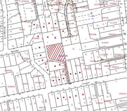
|
NOTIFICATION
PLAN
|
|
|
• PROPERTIES NOTIFIED
|
X SUBMISSIONS
RECEIVED
|
PROPERTY SUBJECT OF DEVELOPMENT
|
|
|
ONE SUBMISSION RECEIVED OUT
OF MAP RANGE
|
|
|
|
|
Five submissions objected to the
development, generally on the following grounds that the development would
result in:
· Disruption of access
and services;
· Loss of natural
habitat;
· Loss of privacy;
· Drainage problems and
flooding;
· Traffic and on-street
car parking;
· Accessway noise;
· Excessive bins at the
frontage;
· Loss of trees
comprising endangered vegetation community;
· Issue with owners
consent for driveway work; and
· Issue with covenant
for rail fencing.
The merits of the matters raised
in community submissions have been addressed in the body of the report with the
exception of the following:
5.1.1 Owners Consent
The consent of the owner of the
adjoining handle (No. 36A Chapman Avenue) is required for works within the
right of carriageway. At the time of writing this report consent had not been
obtained for the proposal.
The issue of adjoining owners
consent for associated works was the subject of consideration in the Land and
Environment Court in the appeal P S Graham & Associates v Hornsby Shire
Council 2005 NSWLEC 545. The case involved widening of a driveway over an
existing right of carriageway. Commissioner Bly granted deferred commencement
consent effectively for works associated with the development application.
A letter from the adjoining
owner’s legal representative, stating preparedness to give consent in principle
subject to conditions, has been submitted. The conditions are generally met by
the amended plans and construction management plan, other than in respect of the
neighbouring resident wishing to ensure that tree No. 164 is retained. A
deferred consent commencement condition is recommended in respect to owners
consent. Should the consent of the owner of the handle of No. 36A Chapman Avenue decline to grant owners consent based on doubts regarding the long term
survival of tree No. 164, the consent would lapse.
The consent of the owner of the
handle of No. 36B Chapman Avenue is not required for the proposed development
as the proposal does not require works to be constructed within that part of
the handle. The proposal would not adversely impact on existing trees within
the handle, subject to recommended conditions for tree protection.
5.1.2 Fencing
The existing site is mainly
fenced in timber rail fencing and wire mesh approximately 1m high. A 1.8m high
wire mesh fence with concrete posts has been constructed along the eastern
boundary of the site.
It is considered the requirement
for the majority of fencing would be addressed in development applications for
future dwellings on the site. A condition is recommended for the provision of a
solid timber fence along the eastern boundary with No. 34 Chapman Avenue, to
address privacy and amenity in respect to the operation of the driveway and the
recommended bin storage area.
In the submissions, concern was
raised regarding a covenant for rail fencing. In this regard, Clause 13 of
Hornsby Shire Local Environmental Plan enables Council to suspend the covenant
for the purpose of regulating development in accordance with the Plan.
Notwithstanding, replacement of the existing rail fencing is not required for
the subject proposal.
5.2 Public Agencies - Department of Water and Energy
The development application is
Integrated Development and requires the approval of the Department of Water and
Energy for works located within 40m of the watercourse, pursuant to the controlled
activities provision within the Water Management Act 2000.
The Department advised it’s
General Terms of Approval for works requiring ‘Controlled Activity Approval’.
The general terms of approval form recommended conditions of consent, subject
to Council’s approval of the application.
6. THE PUBLIC INTEREST
Section 79C (1)(e) of the Act
requires Council to consider “the public interest”.
The public interest is an
overarching requirement, which includes the consideration of the matters
discussed in this report. Implicit to the public interest is the achievement
of future built outcomes adequately responding to and respecting the future
desired outcomes expressed in environmental planning instruments and
development control plans.
The application is considered to
have satisfactorily addressed Council’s and relevant agencies’ criteria and
would provide a development outcome that, on balance, would result in a
positive impact for the community. Accordingly, it is considered that the
approval of the proposed subdivision would be in the public interest.
CONCLUSION
Consent is sought to subdivide 36 Chapman Avenue, Beecroft into three residential allotments. The site was the subject of a
previous application for four lots which was not supported by Council due to
the impact on existing trees.
The proposed subdivision into
three lots generally complies with the requirements of the Residential
Subdivision DCP in respect to density, lot layout, design, landscaping and
accessway design, and enables the revegetation of Blue Gum High Forest on the site. The area to be revegetated mainly involves the area of the site unable
to be connected to the proposed stormwater drainage system. This area is
subject to a recommended ‘Restricted Development Area’ to prevent any future
building or paved areas. The restriction is considered acceptable with regard
to the available area for residential development on the relatively large lots.
The proposal retains the majority
of trees on the site which enhances the visual quality of the locality and
contributes to the heritage significance of the Beecroft Cheltenham Heritage
Conservation Area. Appropriate conditions are recommended to protect the trees
to be retained.
The application is subject to the
consent of the adjoining property owner for works involving the proposed
accessway. The owner has advised preparedness to give consent ‘in principle’. A
deferred consent commencement condition is recommended in this regard.
Note: At the time of the completion of this planning
report, no persons have made a Political Donations Disclosure Statement pursuant
to Section 147(3) of the Environmental Planning and Assessment Act 1979 in
respect of the subject planning application.
|
Rod Pickles
Manager -
Assessment Team 2
Planning Division
|
Scott Phillips
Executive Manager
Planning Division
|
Attachments:
|
1.View
|
Locality Plan
|
|
|
|
2.View
|
Site Plan
|
|
|
|
3.View
|
Subdivision/Landscape
Plan
|
|
|
|
4.View
|
Stormwater
Management Plan
|
|
|
|
5.View
|
Subdivision Plan
illustrating alternative building envelope at proposed Lot 2 and buildable
area for each lot
|
|
|
File Reference: DA/1432/2008
Document Number: D01139989
SCHEDULE 1
1. Deferred Commencement – Owners Consent
Pursuant
to Section 95(6) of the Environmental Planning and Assessment Act 1979, this
consent does not operate until the following information is submitted to
Council:
a. The
written owner’s consent has been obtained to enable the construction of
driveway works within the existing Right of Carriageway as shown on the
approved plans which is not part of the site owned by the applicant.
Upon Council’s written
satisfaction of the above information, the following conditions of development
consent will apply:
GENERAL CONDITIONS
The conditions of consent within this notice of determination
have been applied to ensure that the use of the land and/or building is carried
out in such a manner that is consistent with the aims and objectives of the planning
instrument affecting the land.
Note: For
the purpose of this consent, the term ‘applicant’ means any person who has the
authority to act on or the benefit of the development consent.
Note:
For the purpose of this consent, any reference to an Act, Regulation,
Australian Standard or publication by a public authority shall be taken to mean
the gazetted Act or Regulation, or adopted Australian Standard or publication
as in force on the date that the application for a construction certificate is
made.
2. Approved
Plans and Supporting Documentation
The development must be carried
out in accordance with the plans and documentation listed below and endorsed
with Council’s stamp, except where amended by Council and/or other conditions
of this consent:
|
Plan No.
|
Drawn by
|
Dated
|
|
Ref 2486
|
Mepstead & Associates / Phil
Packham Horticulture
|
4-5-2009
|
|
Document No.
|
Prepared by
|
Dated
|
|
D01156299
|
Phil Packham Horticulture
(Landscaping & Revegetation Proposal)
|
30-4-09
|
|
|
|
|
|
D01077468
|
Mepstead & Associates (Works
Management Plan)
|
Undated
|
3. Removal
of Existing Trees
This development consent only
permits the removal of tree(s) numbered 164, 434, 443, 447, 460, 461, 464, 468,
469 and 480 as identified on Plan No. Ref 2486 prepared by Mepstead &
Associates / Phil Packham Horticulture dated 4-5-2009. The removal of any
other trees requires separate approval under Council’s Tree Preservation Order.
REQUIREMENTS PRIOR TO THE ISSUE OF A CONSTRUCTION
CERTIFICATE
The following conditions of consent must be complied with prior
to the issue of a ‘Construction Certificate’ by either Hornsby Shire
Council or an accredited certifier. All necessary information to demonstrate
compliance with the following conditions of consent must be submitted with the
application for a construction certificate.
4. Amendment
of Plans
The approved plans are to be
amended as follows:
a. The
accessway is to include a bin storage area to cater for the approved lots and
existing properties serviced by the accessway.
5. Water/Electricity
Utility Services
The applicant must submit
written evidence of the following service provider requirements:
a. Energy
Australia – a letter of consent demonstrating that satisfactory
arrangements have been made to service the proposed development.
b. Sydney
Water – the submission of a ‘Notice of Requirements’ under s73 of the Sydney
Water Act 1994.
Note: Sydney
Water requires that s73 applications are to be made through an authorised
Sydney Water Servicing Coordinator. Refer to www.sydneywater.com.au or telephone
13 20 92 for assistance.
REQUIREMENTS PRIOR TO THE COMMENCEMENT OF ANY WORKS
The following conditions of consent must be complied with
prior to the commencement of any works on the site. The conditions have been
imposed to ensure that the works are carried out in such a manner that complies
with relevant legislation and Council’s policies and does not disrupt the
amenity of the neighbourhood or impact upon the environment.
6. Erection
of Construction Sign
A sign must be erected in a
prominent position on any site on which building work, subdivision work or
demolition work is being carried out:
a. Showing
the name, address and telephone number of the principal certifying authority
for the work.
b. Showing
the name of the principal contractor (if any) for any demolition or building
work and a telephone number on which that person may be contacted outside
working hours.
c. Stating
that unauthorised entry to the work site is prohibited.
Note: Any
such sign is to be maintained while the building work, subdivision work or
demolition work is being carried out, but must be removed when the work has
been completed.
7. Erosion
and Sediment Control
Erosion and sediment control
measures must be provided and maintained throughout the construction period in
accordance with the manual ‘Soils and Construction 2004 (Bluebook)’, the
approved plans, Council specifications and to the satisfaction of the principal
certifying authority. The erosion and sediment control devices must remain in
place until the site has been stabilised and revegetated.
Note: On
the spot penalties up to $1,500 may be issued for any on-compliance with this
requirement without any further notification or warning.
8. Vehicular
Crossing
A separate application under the
Local Government Act 1993 and the Roads Act 1993 must be
submitted to Council for the installation of a new vehicular crossing and the
removal of the redundant crossing. The vehicular crossing must be constructed
in accordance with Council’s Civil Works Design 2005 and the following
requirements:
a. The
existing crossings shall be removed and reconstructed.
b. The
footway area to be restored by turfing.
c. Approval
obtained from all relevant utility providers that all necessary conduits be
provided and protected under the crossing.
Note:
An application for a vehicular crossing can only be made to one of Council’s
Authorised Vehicular Crossing Contractors. You are advised to contact Council
on 02 9847 6940 to obtain a list of contractors.
9. Traffic
Control Plan
A Traffic Control Plan (TCP)
must be prepared by a qualified traffic controller in accordance with the Roads
& Traffic Authority’s Traffic Control at Worksites Manual 1998 and Australian
Standard 1742.3 for all work on a public road and be submitted to Council.
The TCP must detail the following:
a. Arrangements
for public notification of the works.
b. Temporary
construction signage.
c. Permanent
post-construction signage.
d. Vehicle
movement plans.
e. Traffic
management plans.
f. Pedestrian
and cyclist access/safety.
10. Protection
of trees
a. To avoid mechanical injury or damage, trees numbered 73,
110, 433, 435, 450, 455 and 470 must have their trunks protected by 2m lengths
of 75mm x 25mm hardwood timbers spaces at 80mm secured with galvanised wire
(not fixed or nailed to the tree in any way). Trunk protection must be
maintained in good condition for the duration of the construction period.
b. A 1.8
metre high chain wire fencing (or similar) must be installed 4 metres from
significant trees number 170 and around the group of trees numbered 174, 175,
176, 179, 180, 181, 185, 203, 253.
c. All
works (including driveways and retaining walls) within 3 metres of any trees
required to be retained (whether or not on the land the subject of this
consent), must be carried out under the supervision of an ‘AQF Level 5
Arborist’ or equivalent and a certificate submitted to the principal
certifying authority detailing the methods used to preserve the trees.
Note: Except
as provided above, the applicant is to ensure that no excavation, filling or
stockpiling of building materials is to occur within 4 metres of any tree to be
retained.
REQUIREMENTS DURING CONSTRUCTION
The following conditions of consent must be complied with
during the construction of the development. The conditions have been imposed
to ensure that the works are carried out in such a manner that complies with
relevant legislation and Council’s policies and does not disrupt the amenity of
the neighbourhood or impact upon the environment.
11. Construction
Work Hours
All
work on site (including demolition and earth works) must only occur between the
following hours:
Monday to Saturday 7 am to 5 pm
Sunday & Public Holidays No work
12. Stormwater
Drainage
The stormwater drainage system
for the development must be designed and constructed in accordance with
Council’s Civil Works – Design and Construction Specification 2005 and
the following requirements:
a. Connected
to the existing natural watercourse generally in accordance with Drawing No
2486-SUBD-E-21 Sheet 1 of 3 Revision B Dated 29.07.08 by Mepstead &
Associates.
b. An
inter-allotment stormwater drainage system to service the proposed lots with
pits being constructed in situ.
c. A
piped culvert under the proposed access driveway together with headwall
construction on both sides.
13. On
Site Stormwater Detention
An on-site stormwater detention
system must be designed by a chartered civil engineer and constructed in
accordance with the following requirements:
a. Have
a capacity of not less than 25 cubic metres, and a maximum discharge (when
full) of 55 litres per second to service all lots in the subdivision.
b. Have
a surcharge/inspection grate located directly above the outlet.
c. Discharge
from the detention system to be controlled via 1 metre length of pipe, not less
than 50 millimetres diameter or via a stainless plate with sharply drilled
orifice bolted over the face of the outlet discharging into a larger diameter
pipe capable of carrying the design flow to an approved Council system.
d. Where
above ground and the average depth is greater than 0.3 metres, a ‘pool type’
safety fence and warning signs to be installed.
e. Not
be constructed in a location that would impact upon the visual or recreational
amenity of residents.
14. Internal
Driveway/Vehicular Areas
The driveway and parking areas
on site must be designed in accordance with Australian Standards 2890.1,
2890.2, 3727 and the following requirements:
a. The
driveway must be a rigid pavement.
b. The
driveway grade must not exceed 25 percent and changes in grade not exceed 8
percent.
c. Pedestrian
access to help prevent slip and fall must be designed and constructed with the
future access driveway. Pedestrian grades steeper than 12.5% must be provided with
surface texturing, brushing or cleats to satisfy Class V: R11 ramps according
to Australian Standards AS 4586-2004 Clause 5.2.
d. The
driveway pavement must be a minimum 3 metres wide, 0.15 metres thick reinforced
concrete with F72 steel reinforcing fabric and a 0.15 metre sub-base.
e. The
pavement must have a kerb to one side and a one-way cross fall with a minimum
gradient of 2 percent and a lintel and pit provided at the low point.
f. The
driveway width must be a minimum 5 metres at passing bays every 40 metres and
for 6 metres from the street boundary.
g. A
turning area at the end of the access driveway must be constructed in
accordance with Australian Standards AS 2890.1 – 85th percentile
turning templates to enable vehicles to enter and leave the site in a forward
direction.
h. Retaining
walls required to support the carriageway and the compaction of all fill
batters must be in accordance with the requirements of a chartered structural
engineer.
i. Planting
of landscaping strips 0.5 metres wide must be provided along both sides of the
length of the driveway.
j. Conduit
for utility services including electricity, water, gas and telephone must be
provided.
k. The
driveway must be finished in coloured concrete, bitumen or stencilled.
15. Excavation
In Vicinity of Trees
Excavation for the installation of a stormwater drainage line within 3m
of trees numbered 463, 465, 466, 467 and 477 must be carried out using the
thrust boring method or by hand excavation.
Note: Nothing in this
condition infers that the requirements of condition No. 10 should not be
complied with during construction works.
16. Driveway
Construction
To protect
existing trees to be retained, the driveway must be laid on or above the
existing grade with no excavation or fill. Where construction on existing grade
cannot be achieved, pier and beam construction of the driveway must be used
with piers being no closer than 3m to the trunks of the trees and the driveway
edge being no closer than 1m.
17. Bushland
Protection
To ensure the protection of
bushland during construction, the applicant must ensure the following:
a. All
machinery to be cleaned of soil and debris before entering the site to prevent
the spread of weeds and fungal pathogens.
Note: The
site contains Sydney Blue Gum High Forest which is listed as a ‘Critically Endangered Ecological Community’
under the ‘Threatened Species Conservation Act 1995’. The Act prohibits the
disturbance to threatened species, endangered populations and endangered
ecological communities, or their habitat, without the approval of the
‘Department of Environment and Climate Change’ where such activities are not
authorised by a development consent under the ‘Environmental Planning and
Assessment Act 1979’.
Actions such as tree removal, understorey slashing or mowing, removal of dead
trees within this vegetation would likely impact upon this endangered
ecological community. Such action would qualify as illegally picking or
disturbing the habitat and could render any person who carried out such action
as LIABLE FOR PROSECUTION.
18. Environmental
Management
The site must
be managed in accordance with the publication ‘Managing Urban Stormwater –
Landcom (March 2004) and the Protection of the Environment Operations
Act 1997 by way of implementing appropriate measures to prevent sediment
run-off, excessive dust, noise or odour emanating from the site during the
construction of the development.
19. Disturbance
of Existing Site
During
construction works, the existing ground levels of open space areas and natural
landscape features, (including natural rock-outcrops, vegetation, soil and
watercourses) must not be altered unless otherwise nominated on the approved
plans.
20. Landfill
Landfill must
be constructed in accordance with Council’s ‘Construction Specification,
2005’ and the following requirements:
a. All
fill material imported to the site is to wholly consist of Virgin Excavated
Natural Material (VENM) as defined in Schedule 1 of the Protection of the
Environment Operations Act 1997 or a material approved under the Department
of Environment and Climate Change’s general resource recovery exemption.
b. A
compaction certificate must be obtained from a geotechnical engineer verifying
that the specified compaction requirements have been met.
21. Excavated
Material
All excavated material removed
from the site must be classified in accordance with the NSW Environment
Protection Authority’s Environmental Guidelines – Assessment, Classification
and Management of Liquid and Non-Liquid Wastes prior to disposal to an
approved waste management facility and reported to the principal certifying
authority.
REQUIREMENTS PRIOR TO THE ISSUE OF A SUBDIVISION
CERTIFICATE
The following conditions of consent must be complied with
prior to the ‘Principal Certifying Authority’ issuing a ‘Subdivision
Certificate’
22. Regeneration
and Revegetation of Blue Gum High Forest
All
landscaping, revegetation and regeneration of Blue Gum High Forest on the site
must be undertaken in accordance with the approved Revegetation Plan (prepared
by Phil Packham Horticulture dated 4/5/2009) and Landscaping and
Revegetation Proposal (prepared by Phil Packham Horticulture dated
30/4/2009) and the following requirements:
a) The
proposed canopy plantings of 2 Allocasuarina torulosa (Forest Oak)
within Zone 3 must be replaced with 2 Sydney Turpentine (Syncarpia
glomulifera).
b) Continue
the planting of Zone 3 within the ‘Restricted Development Area’ to extend along
the entire western boundary by including the planting of six additional Blue Gum
High Forest canopy species at 4 metre centres within the grassed area component
of, the ‘Restricted Development Area’ located 4 metres from the building line
limit.
c) All
environmental and noxious weeds must be removed and suppressed using recognised
bush regeneration methods in accordance with ‘Recovering bushland on the
Cumberland Plain: Best practice guidelines for the management and restoration
of bushland – Department of Conservation 2005’;
Note: The
Guideline is available at: www.environment.nsw.gov.au,
publications.
d) All
planted indigenous native tubestock including trees, shrubs and groundcovers
must be sourced from a recognised native nursery that stock local provenance
species from the locality. Receipts confirming the source of the planted
tubestock must be retained to confirm the sources of planted stock.
e) All
planting and weeding must be undertaken by a qualified and experienced bush
regeneration company with appropriate licenses and experience within Blue Gum
High Forest.
f) All
planted stock must be established for a minimum period of 30 days.
g) All
failed planted stock must be replaced by similar Blue Gum High Forest species
within a minimum period of 30 days to the planting density specified in the
approved plans.
h) The
erection of a physical barrier (that extends a minimum 20mm below ground
surface and 80mm above ground surface) along the edge of all turf areas to
prevent the spread of exotic grasses or weeds into the native revegetation
area.
23. Restriction
as to User – Protection of Land from Future Development
To inform current and future
owners that the areas of Blue Gum High Forest on Lots 1 and 2 of the site are
to be protected from future development, a Restriction as to User must be
created under Section 88B of the Conveyancing Act 1919 identifying that
the area of the site identified on the approved plans is restricted from future
development or disturbance of any kind.
Note: The
wording of the Restriction as to User must be to Council’s satisfaction and Council
must be nominated as the authority to release, vary or modify the Restriction.
24. Placement
of a Positive Covenant – Maintenance of Blue Gum High Forest
A positive covenant must be
created under Section 88E of The Conveyancing Act 1919 for Lots 1 and 2
as marked in red diagonal lines on the approved plans. This area is deemed to
be the ‘Restricted Development Area’. The covenant must specify:
a. All
landscaping/vegetation management must be in accordance with the approved
Revegetation Plan (prepared by Phil Packham Horticulture dated 4/5/2009)
and Landscaping and Revegetation Proposal (prepared by Phil Packham
Horticulture dated 30/4/2009) except as modified by conditions of this consent.
b. Any
approved tree removal within the ‘Restricted Development Area’ must be replaced
within this defined area with local provenance advanced stock of the same
species, so a continual stand of Blue Gum High Forest trees will be preserved.
c. No
development shall encroach within the ‘Restricted Development Area’, nor any
removal of sandstone outcrops, nor any clearing of indigenous vegetation or
horticultural activities or keeping of poultry or livestock.
d. High
use open space areas must be limited to land outside the ‘Restricted
Development Area’.
25. Boundary
Fencing
Lapped and capped timber fencing
must be erected along the eastern boundary with No. 34 Chapman Avenue behind
the front building alignment to a height of 1.8 metres.
Note:
Alternative fencing may be erected subject to the written consent of
the adjoining property owner(s).
26. Sydney
Water – s73 Certificate
A s73 Certificate must be
obtained from Sydney Water.
27. Damage
to Council Assets
Any damage
caused to Council’s assets as a result of the construction of the development
must be rectified in accordance with Council’s written requirements and at the
sole cost of the applicant.
28. Creation
of Easements
The following matters must be
nominated on the plan of subdivision under s88B of the Conveyancing Act 1919:
a. A
right of access and easement for services over the access corridor.
b. An
inter-allotment drainage easement(s) over each of the burdened lots.
c. The
creation of an appropriate "Positive Covenant" and "Restriction
as to User" over the constructed on-site detention/retention systems
and outlet works, within the lots in favour of Council in accordance with
Council’s prescribed wording. The position of the on-site detention system is
to be clearly indicated on the title.
d. To
register the OSD easement, the restriction on the use of land “works-as-executed”
details of the on-site-detention system must be submitted verifying that the
required storage and discharge rates have been constructed in accordance with
the design requirements. The details must show the invert levels of the on
site system together with pipe sizes and grades. Any variations to the
approved plans must be shown in red on the “works-as-executed” plan and
supported by calculations.
e. The
creation of a restriction on the use of land over proposed lots 1 and 2 that no
structures or any paved areas shall be built on that part of the lot that
cannot be drained to the interallotment drainage system as shown on Drawing No.
2486-TREE Sheet 1 of 1 Revision A dated 18/2/2009 by Mepstead & Associates.
Note: Council
must be nominated as the authority to release, vary or modify any easement,
restriction or covenant.
29. Works
as Executed Plan
A works-as-executed plan(s)
must be prepared by a registered surveyor and submitted to Council for
completed drainage systems, service conduits, driveways and on-site detention
system. The plan(s) must be accompanied by a certificate from a registered
surveyor certifying that all pipelines and associated structures lie wholly
within any relevant easements.
30. s94
Infrastructure Contributions
The payment to Council of a
contribution of $38,373.05* for two additional lots towards the cost of
infrastructure identified in Council’s Development Contributions Plan
2007-2011.
Note: * The value of contribution is based on a rate of $19,186.65
per additional lot and is current as at 5 June
2009. The contribution will be adjusted from this date in accordance with the
underlying consumer price index for subsequent financial quarters.
It is recommended that you contact Council to ascertain the indexed value of
the contribution prior to payment.
OPERATIONAL CONDITIONS
The following conditions have been applied to ensure that the
ongoing use of the land is carried out in such a manner that complies with
relevant legislation and Council’s policies and does not disrupt the amenity of
the neighbourhood or impact upon the environment.
32. Revegetation
Monitoring Report
A
brief maintenance and monitoring report, prepared by a qualified and suitably experienced
horticulturalist, must be provided to Council’s Bushland and Biodiversity Team
every six months for a period of two years after the release of the subdivision
certificate to ensure the ecological objectives of the ‘Restricted Development
Area’ and maintenance of all planted stock are ensured in accordance with the
approved plans.
33. Trees
to be Inspected
Trees
within the ‘Restricted Development Area’ must be inspected annually by a
qualified Arborist for a period of two years, and treated to maintain tree
health to ensure the stand of Blue Gum High Forest canopy trees on proposed
Lots 1 and 2 will be preserved during the establishment period of the zone and
future development works. Arborist inspections and recommendations shall be
included in the maintenance and monitoring report referred to in condition No.
32.
GENERAL TERMS OF APPROVAL – Department of Water
& Energy
The following conditions of consent are
General Terms of Approval from the nominated State Agency pursuant to Section
91A of the Environmental Planning and Assessment Act 1979 and must be
complied with to the satisfaction of that Agency.
General
Terms of Approval – for works requiring a Controlled Activity Approval
under the Water Management Act 2000. Reference No. 10 ERM2008/1474. File No.
9050530
These
General Terms of Approval (GTA) only apply to the controlled activities
described in the plans and associated documentation relating to DA/1432/2008
and provided by Council
(i) Site plan, map and/or surveys
Any
amendments or modifications to the proposed controlled activities may render
these GTA invalid. If the proposed controlled activities are amended or
modified the Department of Water & Energy must be notified to determine if
any variations to these GTA will be required.
34. Prior to the commencement of
any controlled activity (works) on waterfront land, the consent holder must
obtain a Controlled Activity Approval (CAA) under the Water Management Act from
the Department of Water & Energy. Waterfront land for the purposes of this
DA is land and material in or within 40 metres of the top of the bank or shore
of the river identified.
35. The consent holder must
prepare or commission the preparation of:
(i) Rehabilitation Plan
(ii) Works Schedule
(iii) Erosion and Sediment Control Plan
36. All plans must be prepared by
a suitably qualified person and submitted to the Department of water &
Energy for approval prior to any controlled activity commencing. The following
plans must be prepared in accordance with Department of Water & Energy
guidelines located at
www.naturalresources.nsw.gov.au/water/controlled_activity.shtml.
(i) Outlet structures
37. The consent holder must (i)
carry out any controlled activity in accordance with approved plans and (ii)
construct and/or implement any controlled activity by or under the direct
supervision of a suitably qualified professional and (ii) when required,
provide a certificate of completion to the Department of water & Energy.
38. The consent holder must
reinstate waterfront land affected by the carrying out of any controlled
activity in accordance with a plan or design approved by the Department of
Water & Energy.
39. The consent holder must not
locate ramps, stairs, access ways, cycle paths, pedestrian paths or any other
non-vehicular form of access way in a riparian corridor other than in
accordance with a plan approved by the Department of Water & Energy.
40. The consent holder is to
ensure that all drainage works (i) capture and convey runoffs, discharges and
flood flows to low flow water level in accordance with a plan approved by the
Department of Water & Energy; and (ii) do not obstruct the flow of water
other than in accordance with a plan approved by the Department of Water &
Energy.
41. The consent holder must establish
all erosion and sediment control works and water diversion structures in
accordance with a plan approved by the Department of water & Energy. These
works and structures must be inspected and maintained throughout the working
period and must not be removed until the site has been fully stabilised.
42. The consent holder must ensure
that no excavation is undertaken on waterfront land other than in accordance
with a plan approved by the Department of water & Energy.
-
END OF CONDITIONS -
ADVISORY
NOTES
The
following information is provided for your assistance to ensure compliance with
the Environmental Planning and Assessment Act 1979, Environmental Planning and
Assessment Regulation 2000, other relevant legislation and Council’s policies
and specifications. This information does not form part of the conditions of
development consent pursuant to Section 80A of the Act.
Environmental Planning and Assessment Act 1979
Requirements
· The Environmental Planning and
Assessment Act 1979 requires:
· A construction certificate prior to the
commencement of any works. Enquiries regarding the issue of a construction
certificate can be made to Council’s Customer Services Branch on 9847 6760.
· A principal certifying authority to be
nominated and Council notified of that appointment prior to the commencement of
any works.
· Council to be given at least two days
written notice prior to the commencement of any works.
· Mandatory inspections of nominated
stages of the construction inspected.
· An occupation certificate issued before
occupying any building or commencing the use of the land.
Subdivision Certificate Requirements
A subdivision certificate application is required to be
lodged with Council containing the following information:
· A surveyor’s certificate certifying that
all structures within the subject land comply with the development consent in
regard to the setbacks from the new boundaries.
· A surveyor’s certificate certifying that
all services, drainage lines or access are located wholly within the property
boundaries. Where services encroach over the new boundaries, easements are to
be created.
· Certification that the requirements of
relevant utility authorities have been met; and
Note: Council
will not issue a subdivision certificate until all conditions of the
development consent have been completed.
Fees and Charges – Subdivision
All fees payable to Council as part of any construction,
compliance or subdivision certificate or inspection associated with the
development (including the registration of privately issued certificates) are
required to be paid in full prior to the issue of the subdivision certificate.
Any additional Council inspections beyond the scope of any compliance
certificate required to verify compliance with the terms of this consent will
be charged at the individual inspection rate nominated in Council's Fees and
Charges Schedule.
Dwelling
Numbering
The allocation of dwelling numbering must be authorised by
Council prior to the numbering of each dwelling in the development.
Tree Preservation Order
To ensure the maintenance and protection of the existing
natural environment, it is an offence to ringbark, cut down, top, lop, remove,
wilfully injure or destroy a tree outside three metres of the approved building
envelope without prior written consent from Council. Fines may be imposed for
non-compliance with Council’s Tree Preservation Order.
Note: A
tree is defined as a single or multi-trunked wood perennial plant having a
height of not less than three (3) metres, and which develops many branches,
usually from a distance of not less than one (1) metre from the ground, but
excluding any plant which, in its particular location, is a noxious plant declared
as such pursuant to the Noxious Weeds Act 1993. This definition of ‘tree’
includes any and all types of Palm trees.
All
distances are determined British Standard BS 5837: 2005, “Trees in Relation to
Construction – Recommendations”.
Dial Before You Dig
Prior to commencing any works, the applicant is encouraged
to contact Dial Before You Dig on 1100 or www.dialbeforeyoudig.com.au for
free information on potential underground pipes and cables within the vicinity
of the development site.
Asbestos Warning
Should asbestos or asbestos products be encountered during
construction or demolition works you are advised to seek advice and information
should be prior to disturbing the material. It is recommended that a contractor
holding an asbestos-handling permit (issued by Work Cover NSW), be
engaged to manage the proper disposal and handling of the material. Further
information regarding the safe handling and removal of asbestos can be found
at:
www.environment.nsw.gov.au
www.nsw.gov.au/fibro
www.adfa.org.au
www.workcover.nsw.gov.au
Alternatively, telephone the Work Cover Asbestos and
Demolition Team on 8260 5885.
Standard Report No. PLN51/09
Planning Division
Date of Meeting:
1/07/2009
4 DRAFT AMENDMENTS LOCAL
ENVIRONMENTAL PLAN 2008 - REPORT ON SUBMISSIONS
EXECUTIVE SUMMARY
In June 2008, Council considered
a report identifying a number of planning anomalies to be rectified and
amendments to be made to the Hornsby Shire Local Environmental Plan 1994
(HSLEP) as part of its annual Amendments Local Environmental Plan (LEP) for
2008. Council endorsed a draft LEP for consultation and public exhibition
proposing to rezone lands, address planning anomalies and make minor amendments
to the HSLEP.
The draft LEP has been prepared
in consultation with relevant Government agencies, adjoining councils and the
community. No unresolved objections were received from Government agencies and
adjoining councils.
The draft Plan was exhibited for
community comment in February and March 2009 along with supporting Development
Control Plan (DCP) amendments. Seventy-six submissions were received in
response to the exhibition of the draft LEP and DCP amendments. The key issues
raised in submissions are addressed in this report. The following amendments
to the draft LEP and DCP amendments are recommended:
● update property details for properties Nos. 180-190 Pennant
Hills Road Thornleigh;
● defer consideration of the inclusion of short-term
accommodation as a permissible land use in certain zones under the HSLEP
until a review being undertaken by the Department of Planning (DOP) has been
completed;
● defer consideration of insertion of the short-term
accommodation element into the Brooklyn, Dangar Island and Dwelling
House DCPs until a review being undertaken by the DOP has been completed;
and
● insert a prescriptive measure in the setbacks element of
the Industrial Lands DCP to protect the amenity of residential
allotments adjoining industrial properties in Asquith.
It is recommended that Council
adopt the amended draft Amendments LEP attached to this report and forward it
to the DOP for gazettal.
PURPOSE
The purpose of this report is to
review submissions received in response to the exhibition of the draft 2008
Annual Amendments LEP and associated draft DCP amendments.
BACKGROUND
At its meeting on 4 June 2008,
Council considered Executive Manager’s Report No. PLN115/08 concerning
Council’s annual amendments review. The report presented a draft LEP to rezone
lands, address planning anomalies and make minor amendments to the HSLEP.
Council resolved (in part) that:
1. The
draft Amendments Local Environmental Plan attached to Executive Manager’s
Report No. PLN115/08 to:
1.1 rezone
property No. 5 Thornleigh Street, Thornleigh;
1.2 implement
the recommendations of the Open Space Lands Acquisitions Review;
1.3
rezone property No. 122X Berowra Waters Road, Berowra Heights; and
1.4
rezone Lot 100 DP1053594 Pennant Hills Road, Normanhurst
be
prepared pursuant to Section 54(1) of the Environmental Planning and Assessment
Act, 1979 and be forwarded to the Department of Planning by Friday 13 June 2008.
2. Council
notify the Director General of the Department of Planning of Council’s
resolution to prepare a draft Amendments LEP in accordance with Section 54(4)
of the Environmental Planning and Assessment Act, 1979.
3. Council
make a submission to the Local Environmental Plan Review Panel in the form and
manner set out in the Department of Planning Circular PS 06-005 titled Local
Environmental Plan Review Panel.
4. The
Director General be requested to provide written advice in relation to issuing “Written
Authorisation to Exercise Delegation”, to allow Council to exercise delegation
under Sections 65 and 69 of the Environmental Planning and Assessment Act, 1979
in progressing the draft LEP.
5. The
Roads and Traffic Authority, the Commissioner of the NSW Rural Fire Service,
the Department of Environment and Climate Change, Sydney Water and the
Department of Lands be consulted pursuant to Section 62 of the Environmental
Planning and Assessment Act, 1979 in the preparation of the draft Amendments LEP.
6. Should
the Director General of the Department of Planning allow Council to exercise
delegation under Section 65 of the Environmental Planning and Assessment Act,
1979 and where no objections or comments warranting significant amendment to
the draft LEP, Council publicly exhibit the draft LEP for a minimum period of
28 days in accordance with the consultation strategy outlined in Executive
Manager’s Report No. PLN115/08.
7. Following
exhibition, a report on submissions be reported to Council for its
consideration.
8. Should
any substantive amendments be proposed during the public exhibition period
that, that matter be dealt with in isolation allowing all other matters to
progress unimpeded.
9. Council invite the
Metropolitan Local Aboriginal Land Council to submit a land capability
assessment for property No. 2C Chelmsford Road, Asquith and Lot 478 DP 48659
Pacific Highway, Berowra for consideration in progressing a rezoning of the
land from open space A as part of Council’s Comprehensive Local Environmental
Plan.
10. Council advise the Metropolitan Local Aboriginal Land Council of the timeframe for the preparation of
Council’s Comprehensive Local Environmental Plan and invite the submission of
any land capability assessment.
In accordance with parts 9 and 10
of Council’s resolution, a letter has been forwarded to the Metropolitan Local
Aboriginal Land Council inviting submission of a land capability assessment for
property No. 2C Chelmsford Road, Asquith and Lot 478 DP 48659 Pacific Highway, Berowra.
The letter also indicated the timeframe for the preparation of Council’s
Comprehensive LEP.
Also at its meeting on 4 June
2008, Council considered Executive Manager’s Report No. PLN114/08 concerning
the River Settlements and Foreshores Review. The report presented a
draft LEP to implement the recommendations of the River Settlements and
Foreshores Review. Council resolved that:
1. The
draft Local Environmental Plan to implement the recommendations of the River
Settlements and Foreshores Review attached to Executive Manager’s Report No.
PLN 114/08 be progressed as part of the Annual Amendments LEP 2008 and include:
- permitting,
with development consent, short-term accommodation and bed and breakfast
accommodation across all river settlements;
- rezoning
properties currently zoned Environmental Protection B (River Catchments) on Dangar Island to Environmental Protection E (River Settlements);
- amending
Clause 15(1) to reduce the maximum floor space ratio for the Environmental
Protection E zone from 0.4:1 to 0.3:1; and
- amending
the Hornsby Shire Local Environmental Plan 1994 Map to include a Foreshore Building Line for Dangar Island.
2. A
further report be presented to Council containing associated draft Development
Control Plan amendments including controls for short-term accommodation and bed
and breakfast accommodation across the river settlements.
3. A
new River Settlements DCP be prepared, consolidating the existing DCPs applying
to the river settlements and incorporating the recommendations of the Review,
subject to amendments as a result of submissions as detailed in Executive
Manager’s Report No. PLN70/08.
4. The
remaining recommendations of the River Settlements and Foreshores Review,
including a sliding scale floor space ratio and amendments to the Foreshore
Building Line Map, be considered as part of Council’s Comprehensive LEP.
5. Council
note that parking is an issue of high priority to river residents, despite
being outside the scope of the River Settlements and Foreshores Review.
6. Submitters
be advised of Council’s decision.
Also at its meeting on 4 June
2008, Council considered Executive Manager’s Report No. PLN116/08 concerning a
rezoning proposal for properties Nos. 180 – 190 Pennant Hills Road, Thornleigh.
The report presented a draft LEP to rezone the properties. Council resolved
that:
1. The draft
Local Environmental Plan attached to Executive Manager’s Report No. PLN116/08
be progressed as part of the Annual Amendments LEP 2008 to rezone Nos. 180 – 190 Pennant Hills Road, Thornleigh from Residential A (Low Density) to Business B
(Special).
2. The draft
amendments to the Business Lands Development Control Plan, attached to
Executive Manager’s Report No PLN116/08, be progressed concurrently with the
Annual Amendments LEP.
3. Submitters be
advised of Council’s resolution.
In accordance with Council’s resolutions, a consolidated
draft Amendments LEP was prepared. The draft Amendments LEP aims to:
● rezone
property No. 5 Thornleigh Street, Thornleigh;
● implement
the recommendations of the Open Space Land Acquisition Review;
● rezone
property No. 122X Berowra Waters Road, Berowra Heights;
● rezone Lot
100 DP 1053594 Pennant Hills Road, Normanhurst;
● rezone
properties Nos. 180-190 Pennant Hills Road, Thornleigh; and
● implementing
the recommendations of the River Settlements and Foreshores Review.
Draft DCP Amendments were prepared to be exhibited
concurrently with the draft LEP including:
● a
short-term accommodation element and a bed and breakfast accommodation element
for insertion into the Brooklyn, Dangar Island, River Settlements, Rural
Lands and Dwelling House DCPs to support the proposal to permit
short-term accommodation and bed and breakfast accommodation across all river
settlements with development consent in accordance with Executive Manager’s
Report No. PLN155/08;
● an
amended setbacks diagram for Thornleigh in the Business Lands DCP as it
relates to the rezoning of property No. 5 Thornleigh Street, Thornleigh in
accordance with Executive Manager’s Report No PLN23/08; and
● an amended
setback diagram for Thornleigh in the Business Lands DCP as it relates
to the rezoning of properties Nos. 180-190 Pennant Hills Road, Thornleigh in
accordance with Executive Manager’s Report No. PLN116/08.
On 13 June 2008, the DOP was advised of Council’s intention
to prepare a draft Amendments LEP pursuant to Section 54 of the Environmental
Planning and Assessment (EP&A) Act. A submission was made to
the LEP Review Panel requesting authorisation to exhibit the Plan and prepare
the final report to the Minister of Planning requesting the making of the Plan.
In August 2008, consultation was undertaken with relevant
public authorities and adjoining councils in accordance with Section 62 of the EP&A
Act. No unresolved objections were received.
In October 2008, Council forwarded a letter to the DOP
advising that consultation with relevant Government agencies and adjoining
councils had been undertaken. The letter noted that no unresolved objection
was received and further requested the issuing of a Section 65 certificate.
In December 2008, Council received “Written Authorisation
to Exercise Delegation” from the DOP to exhibit the Plan and prepare the report
to the Minister pursuant to Sections 65 and 69 of the EP&A Act.
The draft Amendments LEP and associated draft DCP
amendments were exhibited for community comment between 10 February and 20
March 2009 at Council’s Administration Centre, Council’s libraries and on the
Council website. Letters were sent to five community groups, relevant State
Government agencies and adjoining Councils. An advertisement was placed in the
paper on two occasions. Relevant Council branches were also invited to comment
on the draft LEP and DCP amendments.
DISCUSSION
This report outlines the draft Amendments LEP and
associated DCP amendments and reviews submissions received in response to the
exhibition of the Plans.
Seventy-six submissions were received in response to the
exhibition, twenty of which are form letters. Eighteen submissions are
generally supportive or raise no objection to the draft LEP and DCP
amendments. A summary of submissions is attached. The key issues raised in
submissions are outlined below as they relate to each component of the draft
LEP and associated DCP amendments.
Property No. 5 Thornleigh Street, Thornleigh
The draft LEP seeks to rezone property No. 5 Thornleigh
Street, Thornleigh from Residential A (Low Density) to Business A (General) and
includes an amendment to Schedule B of the HSLEP to allow a site
specific floor space ratio (FSR) maximum of 1.5:1. The associated draft DCP
amendment proposes to amend the setback element within the Business Lands
DCP to introduce a 6m setback from the front property boundary and a one
metre setback from the boundary with No. 7 Thornleigh Street to the east.
Submissions:
Five submissions comment on the rezoning of property No. 5 Thornleigh Street,
Thornleigh. Two submissions support the rezoning, with one requesting an
indication from Council that no further residential land is to be rezoned in Thornleigh Street for business purposes. Two submissions object to the rezoning of the
site. The issues raised in the submissions are addressed below.
Bulk and Scale
One submission raises concern about the bulk and scale
impacts likely as a result of a 1.5:1 FSR maximum for the site. The submission
states that there is no justification for such a FSR and that to achieve it,
development on the site would exceed two-storeys.
Comment: The HSLEP specifies a FSR for the Business A
(General) zone of 1:1. However, Council resolved that the draft LEP for
property No. 5 Thornleigh Street should permit a FSR of 1.5:1. It is
understood that the additional FSR was nominated to provide a control
consistent with the maximum FSR of 1.5:1 achievable (subject to bonus
provisions) under the HSLEP for the adjacent Thornleigh Commercial
Centre. Accordingly, the draft LEP proposes to amend Schedule B of the HSLEP
to allow a FSR of 1.5:1 for property No. 5 Thornleigh Street.
It is acknowledged that a FSR of 1.5:1 would likely result
in a development of greater than two storeys. A two storey height limit would
impede the achievement of the maximum FSR. An FSR of 1.5:1 would permit
development of a scale consistent with the adjacent development at property
Nos. 293–299 Pennant Hills Road, Thornleigh which was approved with an FSR of
1.4:1. The Business Lands DCP specifies that the height of buildings in
the Business A zone should be consistent with the height of adjacent
development and should not exceed three storeys. Any development proposal for
the site would be assessed against this criteria within the Business Lands
DCP.
Residential Amenity
Two submissions object to the rezoning of property No. 5 Thornleigh Street siting negative transition issues to the adjoining residential
property at No. 7 Thornleigh Street, Thornleigh. Transition issues raised in
the submissions include overshadowing, lack of width to provide adequate
landscaping and traffic. One submission rejects that the amenity of the
surrounding residential area would be maintained by the setback controls
outlined in the draft DCP amendment.
The Roads and Traffic Authority comment that vehicular
access should be provided to the property via Thornleigh Street.
Comment: The
draft amendments to the Business Lands DCP are aimed at minimising the
likely impacts of future commercial development on the adjoining residential
property. The DCP amendments propose a 6m setback from the front property
boundary and a 1m setback from the boundary of No. 7 Thornleigh Street. The
draft LEP does not identify any proposed future use of the site and
accordingly, does not address issues of overshadowing, landscaping and traffic
in detail. These issues would be addressed at development application stage.
Employment Lands Review and Sub-Regional Employment Study
One submission comments that the rezoning of property No. 5 Thornleigh Street, Thornleigh is contrary to the recommendations of the Employment
Lands Review (ELR). The submission also states and that the rezoning would
not significantly increase the provision of additional business land to satisfy
shortfalls identified in the Ku-ring-gai and Hornsby Sub-Regional Employment
Study.
Comment: The ELR
(1999) provides a comprehensive strategic plan and direction for employment
lands throughout Hornsby Shire. The ELR identifies that the Thornleigh
Commercial Centre should be consolidated and future expansion of the Centre
discouraged. However, in resolving to rezone property No. 5 Thornleigh Street,
it is understood that Council was of the view that the rezoning would align the
boundary of the Commercial Centre with the property at the rear of No. 8 Station Street, providing a logical boundary to the Centre.
The Ku-ring-gai and Hornsby Subregional Employment Study
includes key observations and recommendations concerning employment lands
within the North Subregion (Ku-ring-gai and Hornsby Local Government areas) and
provides strategic direction for the future role and function of employment
lands. The Study was exhibited from November 2008 to February 2009. A report
to Council on submissions received during the exhibition period is expected at
a later date in 2009.
The Subregional Employment Study identifies the
Thornleigh Commercial Centre as having a significant shortfall of employment
floorspace. The Study identifies that the demand supply gap within the Centre
may be met by increasing floor space ratios within the Centre. The Study does
not identify the expansion of the Centre as inappropriate as a means to address
the shortfall. Accordingly, the proposed rezoning of property No. 5 Thornleigh Street for business purposes is not inconsistent with the Subregional
Employment Study.
It is also noted that the land directly adjacent to
property No. 5 Thornleigh Street, Thornleigh, being Property No. 7 Thornleigh
Street is identified for inclusion in a precinct as part of Council’s Housing
Strategy. The precinct is identified as potentially suitable for the
development of five storey multi-unit housing. The Strategy is currently on
exhibition until 17 July 2009.
Resolve: It is recommended that no amendment be made to the draft
LEP and DCP amendments as a result of submissions commenting on property No. 5 Thornleigh Street, Thornleigh.
Open Space Land Acquisition Review Rezonings
The draft LEP seeks to rezone twenty-seven parcels of
privately owned land in the suburbs of Asquith, Berowra, Cowan, Carlingford,
Castle Hill, Cherrybrook, Hornsby and North Epping zoned Open Space A (Public
Recreation - Local). The twenty-seven sites were identified for rezoning as
part of the Open Space Land Acquisition Review which evaluated all land
in private ownership zoned Open Space A to ensure that only land that will meet
community needs for open space, or that preserves the environmental quality of
the Hornsby area is zoned Open Space A. Council is responsible for the
acquisition of these lands in accordance with Clause 17 – Land Acquisition of
the HSLEP. The location and proposed zonings for the twenty-seven
parcels are summarised as follows:
|
Street Address
|
Proposed Zone
|
|
3 Kelray Pl, Asquith
|
Industrial B (Light)
|
|
9 Kelray Pl, Asquith
|
Industrial B
|
|
11 Kelray Pl, Asquith
|
Industrial B
|
|
12 Kelray Pl, Asquith
|
Industrial B
|
|
48 Michigan Ave, Asquith
|
Industrial A
|
|
45-47a Salisbury Rd, Asquith
|
Industrial B
|
|
49-51 Salisbury Rd, Asquith
|
Industrial B
|
|
53 Salisbury Rd, Asquith
|
Industrial B
|
|
55 Salisbury Rd, Asquith
|
Industrial B
|
|
57 Salisbury Rd, Asquith
|
Industrial B
|
|
32 Koloona St, Berowra
|
Residential A
|
|
34 Koloona St, Berowra
|
Residential A
|
|
36 Koloona St, Berowra
|
Residential A
|
|
38 Koloona St, Berowra
|
Residential A
|
|
40 Koloona St, Berowra
|
Residential A
|
|
42 Koloona St, Berowra
|
Residential A
|
|
20 Kona Cl, Berowra
|
Residential A
|
|
22 Kona Cl, Berowra
|
Residential A
|
|
13 McCready Pl, Berowra
|
Residential A
|
|
14 McCready Pl, Berowra
|
Residential A
|
|
15 McCready Pl, Berowra
|
Residential A
|
|
1325 Pacific Highway, Brooklyn
|
Environmental Protection B (River Catchment)
|
|
19 Lyndelle Pl, Carlingford
|
Residential A
|
|
3 Elbana Cr, Castle Hill
|
Residential A
|
|
44 Parkhill Cr, Cherrybrook
|
Residential A
|
|
33 Clovelly Rd, Hornsby
|
Residential A
|
|
20 Downes St, North Epping
|
Residential A
|
The lands are proposed to be rezoned in accordance with the
zoning of the balance of each parcel of land and/or to provide a consistent
zoning with adjacent land.
Submissions:
Four submissions object to the rezoning of
Open Space A parcels in Salisbury Road, Asquith to Industrial B (Light).
Comment: The submissions relate to the
proposed rezoning of the strip of Open Space A zoned land between the Asquith
industrial area and adjoining residential properties. The findings of the
Open Space Land Acquisition Review conclude that the buffer strip should
not be acquired for open space purposes as its size and location would not
facilitate the provision of open space to meet recreational needs.
The
submissions raise concern that the removal of the buffer strip may allow the
adjoining industrial property owners opportunity to develop over the buffer
strip area, impacting on the residential amenity of the adjoining residential
properties. The Industrial Lands DCP states that generally buildings may
be built to the side or rear boundary on a zero building line except where a
setback is required to screen buildings from sensitive areas. Sensitive areas
include adjoining residential land uses. However, to provide greater certainty
concerning Council’s expectations for an appropriate setback to maintain
residential amenity, it would be appropriate that the Setback Element in the Industrial
Lands DCP be amended to include a setback requirement for properties in Salisbury Road. A setback of 15m would reflect the average width of the existing Open Space
A buffer strip.
Resolve: It is
recommended that the setback element within the Industrial Lands DCP be
amended to include a 15m rear setback requirement for industrial properties
fronting Salisbury Road that directly adjoin residential properties to the
rear.
Property No. 122X Berowra Waters Road, Berowra Heights
The draft LEP seeks to rezone property No. 122X Berowra
Waters Road, Berowra Heights from Special Uses B (Transport Corridor) to
Residential A (Low Density). Property No. 122X Berowra Waters Road is owned by
Council and is the only lot from an original road widening proposal remaining
in existence. The rezoning of the property would regularise the zoning
boundary and reflect the current use of the land as part of a baby health care
centre.
Submissions: No submissions comment on this component of the draft LEP.
Lot 100 DP 1053594 Pennant Hills Road, Normanhurst
The draft LEP seeks to rezone Lot 100 DP 1053594 Pennant
Hills Road, Normanhurst from Special Uses B (Transport Corridor) to Residential
A (Low Density). The land is Council owned and currently used as a point of
ingress and egress by the public to the adjoining service station located on
property No. 155 Pennant Hills Road, Normanhurst. Council is currently
negotiating with the owners of property No. 155 Pennant Hills Road for the sale
and purchase of the land.
Submissions: No submissions comment on this component of the draft LEP.
Properties Nos. 180 – 190 Pennant Hills Road, Thornleigh
The draft LEP seeks to rezone properties Nos. 180-190
Pennant Hills Road, Thornleigh and road reservation (Terra Street) from
Residential A (Low Density) to Business B (Special), to facilitate the
establishment of bulky goods retailing. A range of non-residential uses are
permitted on properties Nos. 180-190, namely a service station and convenience
store, veterinary hospital, restaurant and boarding kennel pursuant to Clause
22 Exceptions of the HSLEP. Rezoning the properties to Business B
(Special) would remove the requirement for the Clause 22 exceptions with the
exception of boarding kennels, while facilitating the establishment of bulky
good retailing on the northern part of the site, being Nos. 180-184 Pennant
Hills Road. Draft DCP amendments to the setback elements of the Business
Lands DCP as it concerns properties Nos 180-190 Pennant Hills Road, were
also exhibited. The amendments include a 6m setback control along Pennant Hills Road and a zero setback to Terra Street.
Submissions: No submissions comment on this component of the
draft LEP. However, a minor amendment is required to update the property
details for the land.
Resolve: It is
recommended that the draft Amendments LEP be amended by updating property
details for properties Nos. 180-190 Pennant Hills Road, Thornleigh.
River Settlements and Foreshores Review
The draft LEP seeks to implement recommendations from the River
Settlements and Foreshores Review. The Review considered the
suitability of current planning controls for maintaining the qualities of the
river settlements and foreshores of Hornsby Shire, having regard to emerging
issues and current best practice. Council resolved to include certain
recommendations from the Review into the draft Amendments LEP as
follows:
● permit,
with development consent, short-term accommodation and bed and breakfast
accommodation across all river settlements;
● rezone
properties currently zoned Environmental Protection B (River Catchments) on Dangar Island to Environmental Protection E (River Settlements);
● amend
Clause 15(1) to reduce the maximum floor space ratio for the Environmental
Protection E zone from 0.4:1 to 0.3:1; and
● amend the HSLEP Map to
include a Foreshore Building Line for Dangar Island.
Short-term
accommodation and bed and breakfast accommodation DCP Elements were exhibited
concurrently with the draft LEP.
Sixty-eight submissions comment on aspects of the draft LEP
and DCP amendments as they relate to the recommendations of the River
Settlements and Foreshores Review. The submissions are addressed under
headings below.
Short-term accommodation
Issues relating to short-term accommodation are discussed
below firstly in relation to the draft LEP and secondly in relation to the
draft DCP amendments.
1. Draft LEP
There is currently no definition of short-term
accommodation within the HSLEP or the State Government’s Standard
Instrument. The DOP has advised that it is unlikely to support the inclusion
of additional definitions in existing planning instruments. Therefore, Council
is restricted to using existing definitions in the HSLEP or the Standard
Instrument. The definition most closely aligned with short-term accommodation
is “tourist and visitor accommodation” under the Standard Instrument
which is defined as follows:
Tourist and visitor accommodation means a building or place that provides temporary or
short-term accommodation on a commercial basis, and includes hotel or motel
accommodation, serviced apartments, bed and breakfast accommodation and
backpackers’ accommodation.
The draft LEP seeks to introduce “tourist and visitor
accommodation (other than hotels, motels, serviced apartments and backpackers’
accommodation)” as a definition into the HSLEP as it includes
short-term and bed and breakfast accommodation. “Tourist and visitor
accommodation” is proposed to be permitted with consent across all river
settlement areas and low density residential lands. A draft short-term
accommodation DCP element was exhibited concurrently with the draft LEP.
The Codes SEPP took effect
in February 2009. The Codes SEPP includes bed and breakfast
accommodation as an exempt development activity. However, the SEPP does not
address short-term accommodation. Accordingly, a letter was forwarded to the
Department in March 2008 seeking a position from the Department concerning the
assessment process for short-term accommodation.
A response
(copy attached) was received in June 2009 stating that the DOP is currently
reviewing the issue of short-term accommodation and identifies that the outcome
of the review is likely to impact on the provisions contained within the draft
Amending LEP. The letter requests that Council defer the issue of short-term
accommodation until the review has been finalised.
Submissions: Fifty-four
submissions comment on draft LEP issues concerning short-term accommodation as
outlined below.
Short-term accommodation as a permitted land use
Submissions:
Fifty-one submissions comment on short-term accommodation as a permitted land
use. Four submissions support the land use, while one submission objects to
short-term accommodation as a permitted land use. Twelve submissions support
the land use with the requirement for development consent, while thirty-four
submissions (twenty of which are form letters) object to the requirement for
development consent.
Enforcement of short-term accommodation regulations
Submissions: Six
submissions comment on the enforcement of proposed short-term accommodation
regulations. Five submissions state that there is a lack of certainty regarding
the procedure for maintaining short-term accommodation properties and the
penalties that would be imposed for breaches of Council controls. Two
submissions note that the river settlement areas are isolated and therefore
difficult to police.
Differentiating Short-term accommodation from permanent
rentals
Submissions: Three
submissions raise objection to the proposed short-term accommodation
regulations as they differentiate short-term accommodation as something
different from longer-term rental or permanent occupation of a dwelling when
the residential usage of these may be the same. Three submissions comment that
permanent residents in the river settlement areas cause greater amenity impacts
than the renters of short-term accommodation properties.
Economic impact on the local community
Submissions:
Thirty submissions (seventeen of which are form letters) identify that the
requirement for development consent for short-term accommodation would impact
negatively on local communities where a number of short-term rentals already
exist. The submissions comment that the requirement for development consent
would reduce the number of available short-term rentals and ultimately tourists
and as such, would affect the livelihood of different businesses and
individuals that are dependent upon the patronage of short-term accommodation.
The submissions also comment that the reduction in tourists may lead to a
decline in services available to permanent residents. Four submissions comment
that in the current economic climate, tourist accommodation should be
encouraged.
Requirement for development consent
Submissions:
Twenty-five submissions (seventeen of which are form letters) comment that the
proposed amendments regarding short-term accommodation are discriminatory,
unlawful and amount to overregulation. Five submissions support the proposed
amendments regarding short-term accommodation.
Twenty-seven submissions (seventeen of which are form
letters) comment that existing means of regulating short-term accommodation,
through an existing code of conduct, full-time caretakers and other measures
are currently working to maintain the amenity of the river settlements. One
submission comments that the existing means of self-regulation are not adequate
and accordingly, the requirement for development consent is appropriate.
Four submissions note that short-term accommodation rentals
have been located in the river settlement areas, particularly Dangar Island for a number of decades without the need for development consent.
Three submissions note that if development consent is
required by Council, other adjoining local government areas may become more
attractive to purchase properties with the intention of operating a short-term
accommodation rental.
Cost of a Development Application
Submissions: Four
submissions comment that the cost of a development application is expensive and
request confirmation that Section 94 contributions would not be applicable.
Public consultation during exhibition of a Development
Application
Submissions:
Twenty-two submissions comment on public consultation during the exhibition of
a development application for short-term accommodation. Twenty-one submissions
(twenty of which are form letters) raise concern that should a submission be
received during the exhibition of a development application, it may
unreasonably be used as grounds to restrict the use of the property for
short-term accommodation. One submission identifies that consultation through
the development application process is appropriate to ensure adjoining property
owners are able to voice their opinion concerning a short-term accommodation
proposal.
Time limited consents
Submissions: One
submission suggests that a time-limited consent may be appropriate for an
approved development application for short-term accommodation. One submission
identifies that a limit could be placed on overall short-term accommodation
numbers in some river settlement areas while another submission raises
objection to this suggestion.
2. DCP
Amendments
The draft DCP amendments aim to encourage small scale
tourist accommodation and maintain the amenity of surrounding properties. The
draft short-term accommodation element addresses concerns raised through public
consultation on the River Settlements and Foreshores Review, including
noise, number of guests and lack of regard for environmental constraints.
The draft element limits guest numbers to a maximum of six
and requires the preparation of a code of conduct (to be signed and adhered to
by guests) to be submitted with any development application. The code of
conduct is to address the responsibilities of guests, including, at a minimum,
guest numbers, details concerning recycling, garbage services, and special
requirements relating to the disposal of garbage, details of the fire
evacuation plan and fire fighting equipment, and minimisation of noise,
nuisance or disturbance to neighbouring properties.
The draft element also addresses signage, car parking
(where applicable), fire safety and effluent disposal, to ensure that any
potential for increased pressures on constrained sewage systems is addressed.
A control is included identifying that a parking availability survey is
required where on-site parking is not available. Issues that relate
specifically to the draft DCP amendments are addressed below.
Wording of amendment
Submissions: Two submissions comment on the wording of the draft DCP
elements. One submission comments that more contextual information is required
to understand the performance criteria and prescriptive measures and that more
evidence based criteria should be utilised. One submission identifies that the
draft DCP amendment should be more positively worded to encourage short-term
accommodation rentals.
Parking Provision
The draft DCP amendment outlines a requirement that where
properties are accessible by vehicles, car parking should be provided at a rate
of 1 space per guest bedroom behind the building line.
Submissions: Twenty-five submissions comment on parking provision.
Nineteen submissions (seventeen of which are form letters) comment that the
parking requirements are inappropriate in Brooklyn, considering the steep
nature of many sites and the existing traffic congestion issues that are experienced
there. Twenty-three submissions (seventeen of which are form letters) identify
that part of the issue associated with congestion in Brooklyn car parks is
caused by the inappropriate use of the areas by permanent residents. One
submission suggests a fee could be applied where parking is unable to be
provided. One submission comments that existing areas of Crown land could be
utilised for parking. Twenty-five submissions (twenty of which are form
letters) note that short-term accommodation renters usually arrive in one car
and on weekends, and as such this requirement is onerous.
Twenty-nine submissions (twenty of which are form letters)
comment that the preparation of a parking study is an onerous and expensive
requirement. Four of these submissions state that a parking study would serve
little purpose in the Brooklyn area where parking shortages are well
documented.
Fire safety requirements
The draft DCP amendment specifies that short-term
accommodation properties should be provided with appropriate fire-fighting
equipment in accordance with Australian Standards and that a fire evacuation
plan should be submitted with the development application.
Submissions: Nine submissions comment on the fire safety requirements.
Five submissions objected to the requirements. One of these submissions
comments that all dwellings on Dangar Island already contain a bush fire
evacuation plan. One submission identifies that an existing code of conduct
utilised for short-term accommodation in some river settlement areas already
requires appropriate fire safety requirements. Two submissions comment that
the proposed fire safety requirements are appropriate.
The NSW Rural Fire Service (RFS) indicates that where
tourist accommodation is proposed on bush fire prone land, the proposal is
considered a Special Fire Protection Purpose (SFPP) and is required to obtain a
Bush Fire Safety Authority from the RFS under section 100B of the Rural
Fires Act. The proposal would also be integrated development under Section
91 of the EP&A Act.
Signage
The draft DCP amendment specifies that signage should be
non-illuminated and restricted to a size which would fit within a rectangular
figure of 0.5m2.
Submissions: Four
submissions comment on signage. Three submissions identify that signage should
be in keeping with the surrounding environment, with one submission stating
that signage is not supported by the local community. One submission notes
that signage on a short-term accommodation property identifies the property as
potentially vacant and as such, more susceptible to crime. One submission
suggests that signage should be larger than proposed to be visible to passing
boats.
Maximum guest numbers
The draft DCP amendment includes a prescriptive measure
restricting short-term accommodation to a maximum of six guests.
Submissions: Twenty-seven submissions (twenty of which are form letters)
comment that the maximum number of guests should be more than six. Two
submissions recommend that maximum guest numbers should be flexible depending
upon the dwelling size. One submission states that a maximum of six guests is
appropriate. One submission suggests that a maximum of four guests would be
more appropriate.
Code of Conduct
The draft DCP amendment requires a code of conduct to be
prepared and submitted with a development application. The code is to outline
responsibilities of guests concerning guest numbers, waste disposal, fire
evacuation and noise impacts.
Submissions: Two submissions comment on the DCP requirement for a code
of conduct. One submission comments that the proposed code of conduct is
insufficient to address issues of noise, nuisance and waste disposal. One
submission states that a code of conduct is onerous and an inappropriate means
to regulate the use.
Comment: Council
undertook the River Settlements and Foreshores Review to review the suitability of current planning controls for
maintaining the qualities of the river settlements and foreshores of Hornsby
Shire, having regard to emerging issues and current best practice. The Review
includes an analysis of the permissibility of short-term and bed and breakfast
accommodation in river settlement areas and recommends permitting the land use
with consent across all river settlements. Council sought advice from
the DOP as part of the process in October 2006. A response was received in
November 2006 stating that short-term accommodation is a local issue for
Councils to determine. Council considered
submissions received during the public exhibition of the River Settlements
and Foreshores Review and at its meeting on 4 June 2008, resolved to
include a provision to permit, with development consent, short-term
accommodation across all river settlements in the Annual Amendments draft LEP.
The draft LEP was forwarded to the Department for certification on 24
September 2008. A written authorisation to exercise delegation was received on
16 December 2008 for functions pursuant to Section 65(1) and Section 69(1) of
the Environmental Planning and Assessment Act 1979. Once again, in
providing the written authorisation, the DOP acknowledged that the issue of
short-term accommodation is appropriate to be addressed by Council.
The Codes SEPP took effect
in February 2009. The Codes SEPP includes bed and breakfast accommodation
as an exempt development activity. However, the SEPP does not address
short-term accommodation. Short-term and bed and breakfast accommodation are
land uses that fall under the group term ‘tourist and visitor accommodation’
in the Standard Instrument. Accordingly, a letter was forwarded to the
Department in March 2008 seeking further confirmation of the Department’s
position concerning the assessment process for short-term accommodation.
A response (copy attached) was
received in June 2009 stating that the DOP is currently reviewing the issue of
short term accommodation and identifies that the outcome of the review is
likely to impact on the provisions contained within the draft Amending LEP.
The letter suggests that Council defer the provisions relating to short-term
accommodation pending the outcome of the review undertaken by the DOP. As it
is unlikely the DOP would support the draft LEP provisions that relate to
short-term accommodation, it is recommended that Council defer the issue of short-term
accommodation until the review undertaken by the DOP has been finalised.
Resolve: It is
recommended that reference to short-term accommodation in the draft LEP be
removed and the draft short-term accommodation DCP element be deferred pending
the outcome of the review by the DOP. It is also recommended that Council
forward a submission to the DOP containing a copy of submissions commenting on
the issues of short-term accommodation for consideration by the Department in
undertaking its review.
Bed and Breakfast accommodation
As indicated above, the draft LEP seeks to introduce a
definition into the HSLEP for “Tourist and visitor accommodation” which
includes bed and breakfast accommodation, as permitted with consent across all
river settlement areas and low density residential lands. Draft DCP amendments
concerning bed and breakfast accommodation were exhibited concurrently with the
draft LEP.
Bed and breakfast accommodation is separately defined in
the HSLEP and currently permitted in parts of the rural areas of the
Shire, with development controls contained within the Rural Lands DCP.
The draft LEP aims to permit bed and breakfast accommodation in all river
settlement areas and low density residential lands. Accordingly, should the
draft LEP be endorsed by Council and gazetted by the Minister for Planning, bed
and breakfast accommodation as a land use may be referred to in one of two ways
being, the existing definition contained within the HSLEP, or under the “Tourist
and visitor accommodation” definition.
The Codes
SEPP includes bed and breakfast accommodation as exempt development in a
land use zone where bed and breakfast accommodation is a permissible use.
Accordingly, the introduction of bed and breakfast accommodation as a
permissible use in the river settlement areas and low density residential lands
through the draft LEP would make bed and breakfast accommodation exempt
development under the Codes SEPP in the same areas. The Codes SEPP
outlines 2 exempt development criteria for bed and breakfast accommodation,
namely that a development for bed and breakfast accommodation must:
“(a) be in an existing dwelling house that has
a floor area not more than 300m2, and
(b) consist of not more than 3 guest
bedrooms.”
The draft bed and breakfast accommodation element reflects
the existing controls for bed and breakfast accommodation contained within the
Tourism element of the Rural Lands DCP, including criteria that bed and
breakfast accommodation should not impact on the amenity of adjacent properties
or adversely impact on the environmental qualities that attract visitors to the
Shire. The draft element outlines that bed and breakfast accommodation should
be undertaken by the permanent residents of the dwelling house, be on a
short-term basis for a maximum of six travellers, and not involve the
exhibition of any sign (other than a non-illuminated notice or sign which would
fit within a rectangular figure of 0.5sqm). In addition, controls concerning
rates of car parking provision (where applicable) for bed and breakfast
accommodation under the Exempt and Complying Development DCP have been
applied. A control is included identifying that a parking availability survey
is required where on site parking is not available. The draft element also contains
controls concerning effluent disposal to ensure that any potential for
increased pressure on constrained sewage systems is addressed.
Accordingly, the draft DCP element pertaining to bed and
breakfast accommodation is more onerous on land owners wishing to use their
dwelling for the purposes of bed and breakfast accommodation than the criteria
in the Codes SEPP. Should the land use become permissible with consent
in the river settlement areas and low density residential lands, the draft DCP
element would only apply to proposals that do not satisfy the criteria of the Codes
SEPP, being a proposal for a bed and breakfast accommodation development
within a dwelling with a floor area of over 300m2. It is noted that
the existing definition of bed and breakfast accommodation within the HSLEP
identifies a maximum of six travellers for such a development, which is
consistent with the criteria within the Codes SEPP stating that a
development must not consist of more than three guest bedrooms (assuming an occupancy
of two guests per bedroom).
Submissions: Twelve submissions comment on bed and breakfast
accommodation. Seven submissions support bed and breakfast accommodation
generally as a permitted land use in the river settlement areas. Three
submissions support bed and breakfast accommodation as a permitted land use in
the river settlement areas with the requirement for development consent. Two
submissions support bed and breakfast accommodation but object to the
requirement for development consent.
Seven of the twelve submissions address the DCP amendments
and their suitability. The following issues are raised and are addressed
below:
● parking;
● maximum
number of guests;
● signage;
● code of
conduct; and
● fire
safety provision.
Parking
The draft DCP amendment outlines a requirement that where
areas are accessible by vehicles, car parking should be provided at a rate of
one space per guest bedroom behind the building line. The draft DCP amendment
requires that where on site parking is not available, the applicant should
conduct a parking survey at the departure point.
Submissions: Three submissions comment that the requirement for a
parking availability study where on site parking is not available is onerous.
Maximum guest numbers
The draft DCP amendment states that a proposal for bed and
breakfast accommodation should cater for a maximum of six guests.
Submissions: Two
submissions comment that a maximum number of six guests is appropriate. Three
submissions suggest that a greater number than six guests should be allowed.
One submission states that the maximum number of guests should be reduced to
four. One submission comments that the Fretus Hotel site in Berowra Creek
should be able to cater for more than six guests.
Signage
The draft DCP amendment specifies that signage should be
non-illuminated and restricted to a size which would fit within a rectangular
figure of 0.5m2.
Submissions: One
submission states that the display of signage on bed and breakfast
accommodation properties is potentially indicative of their vacancy and not in
keeping with the natural environment of river settlement areas. One submission
comments that signage should be visually compatible with the surrounding area.
Wording of DCP amendment
Submissions: Two submissions comment on the wording of the draft DCP
element concerning bed and breakfast accommodation. One submission suggests
that more contextual information is required to understand the performance
criteria and prescriptive measures, and that more evidence based criteria
should be utilised. One submission identifies that the draft DCP amendment
should be more positively worded to encourage bed and breakfast accommodation.
Fire safety requirements
Submissions: A submission from the NSW RFS notes that where tourist
accommodation is proposed on bush fire prone land, the proposal is considered a
Special Fire Protection Purpose and is required to obtain a Bush Fire Safety
Authority from the RFS under section 100B of the Rural Fires Act as well as
being integrated development pursuant to under Section 91 of the EP&A Act.
Comment: The draft bed and breakfast accommodation element reflects
the existing controls for bed and breakfast accommodation contained within the
Tourist element of the Rural Lands DCP. The Codes SEPP includes
bed and breakfast accommodation as an exempt development activity in a
land use zone where bed and breakfast accommodation is a permissible use. Accordingly, by including bed and breakfast accommodation
as a permissible use in the river settlement and low density residential land
areas by way of the draft LEP, the land use would become an exempt development
activity in these areas under the Codes SEPP. Council would have no
ability to regulate parking issues surrounding the use of bed and breakfast
accommodation in the river settlement areas should the exempt development
criteria be met.
In summary, the inclusion of bed and breakfast
accommodation within the river settlement areas would promote these areas as
tourist destinations, in accordance with the findings of the Tourism Review.
However, there would be no ability for Council to control parking issues
surrounding bed and breakfast accommodation developments should a proposal meet
the exempt development criteria in the Codes SEPP. However, on balance,
the economic and social benefits of introducing bed and breakfast accommodation
outweigh the issues of parking regulation. Therefore, it would be appropriate
to progress bed and breakfast accommodation as a permissible use.
The draft LEP recommends inserting “tourist and visitor
accommodation” into the HSLEP which includes bed and breakfast
accommodation and short-term accommodation. The issue of short-term
accommodation is recommended for deferral in the draft LEP. Accordingly, where
the insertion of “tourist and visitor accommodation” is recommended, it
should be replaced with the existing definition of bed and breakfast
accommodation as contained in the HSLEP.
Resolve: It is
recommended that the draft LEP be amended by replacing reference to “tourist
and visitor accommodation” with “bed and breakfast accommodation”.
It is also recommended that the draft DCP element
concerning bed and breakfast accommodation be progressed to allow the
appropriate environmental assessment of bed and breakfast proposals that do not
satisfy the exempt development criteria contained within the Codes SEPP.
Foreshore Building Line on Dangar Island
The draft LEP seeks to include a Foreshore Building Line
for Dangar Island. A Foreshore Building Line is identified in the HSLEP
for parts of Brooklyn and Wisemans Ferry. However, Dangar Island is subject to a 6m Foreshore Building Line identified in the Dangar Island DCP.
Submissions: Four submissions refer to the proposed Foreshore Building Line
on Dangar Island. Two submissions support the foreshore building line. One
submission supports the foreshore building line but suggests that it should be
increased to 10m as per the original intent of the Dangar Island DCP.
One submission questions whether the effects of climate change have been taken
into effect in the recommendation of the foreshore building line.
Comment: The River Settlements and Foreshores Review found
that the current 6m foreshore setback for Dangar Island is adequate to achieve
a uniform character and maintain the foreshore landscape with minimal visual
impact. However, the Review recommends that the control be given more
weight in the assessment process by being reinforced in the HSLEP as a
Foreshore Building Line.
In regards to
Climate Change, Council has engaged a suitably qualified and experienced
consultant team to assist in the preparation of a Climate Change Adaptation
Strategic Plan. The purpose of the Plan is to identify and quantify
potential climate change impacts on the natural and built environments of the
Shire. The Plan will allow Council to optimise the allocation of
resources to implement adaptation actions.
Sea level
rise is one of the well-known impacts of climate change and the impacts will be
felt through changes in mean sea level and perhaps more importantly, through
changes in the frequency or intensity of extreme sea level events. The Climate
Change Adaptation Strategic Plan will identify where Council’s planning
instruments should be reviewed, with a particular focus on planning instruments
that cover the river settlement regions which are vulnerable to sea level rise.
Resolve: It is recommended that no amendment to the draft DCP
control be made as a result of the submissions concerning the foreshore
building line for Dangar Island.
Rezoning Dangar Island to Environmental Protection E
The draft LEP includes a provision to rezone Dangar Island (in part) from Environmental Protection B (River Catchment) to Environmental
Protection E (River Settlement).
Submissions: Two submissions express support for the part rezoning of Dangar Island to Environmental Protection E.
Comment: It is
recommended that Council note the support for the rezoning of land on Dangar Island. The rezoning of properties on Dangar Island from Environmental Protection B
to Environmental Protection E would prohibit a range of uses considered
inappropriate and inconsistent with the character and environmental qualities
of lands within the river settlements. The rezoning of the properties on Dangar Island would also result in greater consistency in zoning of the river settlements
areas.
Resolve: It is recommended that no amendment be made to the draft
LEP as a result of the submissions concerning the rezoning of Dangar Island (in part) to Environmental Protection E.
Reduction in FSR for the Environmental Protection E zone
The draft LEP seeks to reduce the permissible FSR for the
Environmental Protection E zone from 0.4:1 to 0.3:1, which is the floor space
ratio currently applicable to Dangar Island.
Submissions: Six submissions comment on the reduction in floor space
ratio for the Environmental Protection E zone. One submission from the
Department of the Environment and Climate Change expresses support for the
reduction in FSR. Five submissions object to the reduction in FSR. The
submissions raise concern that the reduction in FSR would remove the
flexibility required to achieve positive development outcomes in the river
settlement areas, and to provide for larger dwellings suitable for families.
Another identifies that the FSR control is no longer an appropriate tool to
control density.
Comment: The River Settlements and Foreshores Review examined
(in part) the scale of development within the Environmental Protection zones.
The Review recommends a reduction in floor space ratio for the
Environmental Protection E zone from 0.4:1 to 0.3:1, which is the floor space
ratio currently applicable to Dangar Island under the Dangar Island DCP.
The Review included an analysis of twenty-one
development applications in the river settlements. The analysis found that the
applications resulted in dwellings with a floor space ratio of between 0.13:1
and 0.3:1, and an average of 0.17:1 to 0.18:1. Accordingly, the floor space
ratio controls for the Environmental Protection E zone and the Dangar Island
DCP of 0.4:1 and 0.3:1 respectively, are not being achieved.
A reduction in the maximum floor space ratio for the
Environmental Protection E zone would result in a reduction in the maximum permissible
size of dwellings in some cases. However, it was noted that the analysis
undertaken by the consultant identified that 95% of dwellings had a floor space
ratio of less than 0.3:1.
Accordingly, a reduction in the maximum floor space ratio
for the Environmental Protection E zone to 0.3:1 would reflect the existing
floor space ratio for Dangar Island and would provide a consistent control
across all the river settlements.
Additionally, should a property owner wish to develop a
parcel of land to a density greater than 0.3:1, an objection pursuant to State
Environmental Planning Policy No. 1 – Development Standards, could be
considered with the development application.
Resolve: It is
recommended that no amendment be made to the draft LEP as a result of
submissions commenting on the permissible FSR in the Environmental Protection E
zone.
Property No. 2-9/55A Brooklyn Road, Brooklyn
Two submissions were received
concerning property No. 2-9/55A Brooklyn Road, Brooklyn. The submissions
request that the property be included with as an exception within Clause 22 of
the HSLEP to allow the strata subdivision of a multi-unit housing
proposal.
Comment: A response
was provided to the submitters indicating that the issues raised in the
submissions are outside the scope of the Amendments LEP 2008, as a detailed
evaluation would be required to be undertaken to determine the merit and
implications of the proposal. The response indicated that should the owners of
the property wish to pursue a site specific exception under Clause 22 of the HSLEP,
a comprehensive rezoning submission would be required.
Resolve: It is
recommended that no amendment be made to the draft LEP as a result of
the submissions concerning property No. 2-9/55A Brooklyn Road, Brooklyn.
STATUTORY CONSIDERATIONS
Statutory considerations are
discussed below in terms of both the draft LEP and DCP amendments.
Draft Local Environmental Plan
As part of Council’s
consideration of a draft LEP, Council is required to consider the relevance of
any SEPP, REP or Ministerial Direction under Section 117 of the EP&A Act
1979. Executive Manager’s Report Nos. PLN115/08, PLN 114/08 and PLN116/08
presented to Council at its meeting on 4 June 2008, addressed the relevant
SEPPs, REPs and Section 117 Directions. Council’s submissions to DOP pursuant
to Section 54 of the EP&A Act also addressed the consistency of the
draft LEP with relevant SEPPs, REPs and Section 117 Directions.
The DOP indicated with the “Written
Authorisation to Exercise Delegation” that any inconsistency with section
117 direction 6.2 Reserving Land for Public Purposes, is justifiable as the
draft Plan and its provisions are of minor significance.
In December 2008, the DOP advised
that Council could exercise its delegations pursuant to Section 65 and 69 of
the EP&A Act by placing the Plan on public exhibition and preparing
the final report to the Minister requesting the making of the Plan.
The draft LEP was exhibited in
accordance with Section 66 of the EP&A Act. The issues identified
in the submissions that concern the draft LEP have been addressed in this
report. Minor amendments are recommended to be made to the draft Plan which
are inconsequential and do not warrant the re-exhibition of the Plan.
Draft Development Control Plan
Amendments
The draft DCP amendments were
exhibited in accordance with Clause 18 of the Environmental Planning and
Assessment Regulations. The issues identified in the submissions that
concern the draft DCP amendments have been addressed in this report. Minor
amendments are recommended to be made to the draft DCP amendments which are
inconsequential and do not warrant the re-exhibition of the Plan. The
amendments would come into effect following gazettal of the LEP.
CONSULTATION
Council advised the DOP of its
decision to prepare a draft LEP pursuant to Section 54 of the EP&A Act.
The DOP issued Council with “Written Authorisation to Exercise Delegation”
to exhibit the Plan and prepare final reports to the Minister. Council
consulted with relevant Government agencies and adjoining Council’s concerning
the preparation of the Plan.
The draft Amendments LEP was
exhibited for community comment in February and March 2009. Seventy-six
submissions have been received and are addressed in this report.
FINANCIAL
Council is responsible for the acquisition of land zoned
Open Space A (Public Recreation – Local) in accordance with Clause 17 – Land
Acquisition of the HSLEP 1994. Should the rezoning of twenty-seven
parcels in accordance with the Open Space Land Acquisition Review occur,
Council would no longer be responsible for their acquisition.
POLICY
There are no policy implications.
TRIPLE BOTTOM LINE SUMMARY
This Triple Bottom Line (TBL)
Statement forms part of Council’s efforts towards “creating a living environment”.
The Statement addresses the strategic themes within Council’s Management Plan
that cover social, environmental and economic factors and the corresponding
sustainability questions contained in the TBL checklist.
● Working
with our community: The draft LEP has been prepared in consultation with
relevant State Government agencies, adjoining councils and the local
community. The public exhibition material was readily accessible and
understandable to all sectors of the community by providing a number of
locations and means of communication. When gazetted, the draft LEP will be
incorporated into the HSLEP and be readily available to the community. The
community will be able to obtain hard copy information from Council or download
information from Council’s website.
● Conserving
our natural environment: The draft LEP proposes to rezone 27 parcels of
Open Space A zoned land. Property No. 1325 Pacific Highway, Brooklyn is
considered environmentally sensitive due to topographical constraints, and as
such is recommended to be rezoned to the Environmental Protection B (River
Catchment) Zone. The draft LEP proposes to implement recommendations from the
River Settlements and Foreshores Review. The purpose of the Review was to
examine Council’s planning controls and their effectiveness in conserving the
natural and built environment.
● Contributing
to community development through sustainable facilities and services: The
rezoning of parcels as part of the Open Space Land Acquisition Review would not
impact on the provision of facilities and services.
● Fulfilling
our community’s vision in planning for the future of the Shire: The draft
LEP seeks to rezone open space land identified as no longer required for public
purposes. This represents a more appropriate utilisation of the land in
accordance with the new zonings. The proposal to rezone property No. 122X Berowra Waters Road, Berowra Heights and Lot 100 of DP 1053594 Pennant Hills Road,
Normanhurst would regularise planning anomalies and enable consolidation of the
lands with adjacent properties. The implementation of the recommendations of
the River Settlements and Foreshores Review will assist in maintaining the
qualities of the river settlements and foreshores of Hornsby Shire, having
regards to emerging issues and current best practice.
● Supporting
our diverse economy: The rezoning of property No. 5 Thornleigh Street,
Thornleigh would provide more employment opportunities in the Thornleigh
Commercial Centre. The rezoning of properties Nos. 180-190 would facilitate a
bulky goods retailing proposal along Pennant Hills Road.
● Maintaining
sounds corporate and financial management: Council is responsible for the
acquisition of land zoned Open Space A in accordance with Clause 17 – Land
Acquisition of the HSLEP 1994. Should the rezoning of 27 parcels in accordance
with the Open Space Land Acquisition Review occur, Council would no longer be
responsible for their acquisition.
● Other
sustainability considerations: The draft LEP includes amendments for the
rezoning of various lands. Further sustainability considerations will be
assessed at the application stage for the proposed use of the newly zoned
areas.
CONCLUSION
Council has identified a number
of planning anomalies to be rectified, and minor amendments to the made, to the
HSLEP 1994 as part of its 2008 annual Amendments Review. A draft LEP
and associated DCP amendments to rectify planning anomalies and make amendments
to the HSLEP has been prepared in consultation with relevant Government
agencies and the community.
No unresolved objections were
received from Government agencies and adjoining councils. Seventy-six
submissions were received in response to the exhibition of the draft LEP and
DCP amendments. The issues identified in the submissions have been addressed
in this report.
It is recommended that Council
adopt the draft Amendments LEP and DCP amendments subject to minor amendments
indentified in this report and forward the draft LEP to the DOP for gazettal.
RECOMMENDATION
|
THAT:-
1. Council adopt the Local Environmental Plan attached to
Executive Manager’s Report No. PLN51/09 to:
1.1 rezone
property No. 5 Thornleigh Street, Thornleigh;
1.2 implement the recommendations of the Open Space Land
Acquisition Review;
1.3 rezone property No. 122X Berowra Waters Road, Berowra Heights;
1.4 rezone Lot 100 DP 1053594 Pennant Hills Road,
Normanhurst;
1.5 rezone properties Nos. 180-190 Pennant Hills Road,
Thornleigh; and
1.6 permit, with consent, bed and
breakfast accommodation across all river settlements and low density
residential zoned lands;
1.7 rezone properties currently zoned
Environmental Protection B (River Catchments) on Dangar Island to
Environmental Protection E (River Settlements);
1.8 amend Clause 15(1) to reduce the
maximum floor space ratio for the Environmental Protection E zone from 0.4:1
to 0.3:1; and
1.9 amend the Hornsby Shire Local Environmental Plan 1994
(HSLEP) Map to include a Foreshore Building Line for Dangar Island.
2. Council
defer consideration of the inclusion of short-term accommodation as a
permissible land use in certain zones under the HSLEP until a review
being undertaken by the Department of Planning has been completed.
3. The
Local Environmental Plan be forwarded to the Department of Planning for
gazettal.
4. Council endorse the Development Control Plan Amendments
attached to Executive Manager’s Report No. PLN51/09 that:
4.1 insert a bed and breakfast element
into the Brooklyn, Dangar Island, River Settlements and Dwelling House DCPs;
4.2 amend the setbacks diagram for
Thornleigh in the Business Lands DCP as it relates to property No. 5 Thornleigh Street and properties Nos. 180-190 Pennant Hills Road, Thornleigh.
5. Council defer consideration of insertion of the short-term
accommodation element attached to Executive Manager’s Report No. PLN51/09
into the Brooklyn, Dangar Island and Dwelling House Development Control Plan
until the short-term accommodation review being undertaken by the Department
of Planning has been completed.
6. A further report be presented to Council containing an
amendment to the Setbacks element of the Industrial Lands Development Control
Plan to protect the amenity of residential allotments adjoining industrial
properties in Asquith.
7. Council forward a submission to the Department of Planning
containing a copy of submissions commenting on the issues of short-term
accommodation for consideration by the Department in undertaking its review.
8. Submitters
be advised of Council’s resolution.
|
|
James Farrington
Manager - Town
Planning Services
Planning Division
|
Scott Phillips
Executive Manager
Planning Division
|
Attachments:
|
1.View
|
Draft Amendments
Local Environmental Plan
|
|
|
|
2.View
|
Draft bed and
breakfast Development Control Plan element
|
|
|
|
3.View
|
Draft Setbacks
Development Control Plan diagram for Thornleigh
|
|
|
|
4.View
|
Department of
Planning letter concerning short-term accommodation - November 2006
|
|
|
|
5.
|
Department of
Planning letter concerning short-term accommodation - June 2009
|
|
|
|
6.
|
Summary of
submissions
|
|
|
File Reference: F2008/00281
Document Number: D01180033
Standard Report No. PLN52/09
Planning Division
Date of Meeting:
1/07/2009
5 HERITAGE REVIEW STAGE 4
- PROPERTY NO. 5 CHILCOTT ROAD, BERRILEE
EXECUTIVE SUMMARY
This report provides further
information concerning the proposed listing of the former school building at
property No. 5 Chilcott Road, Berrilee as an item of local heritage
significance.
Heritage
Review Stage 4 identifies that the school
has social significance, being representative of small, one teacher schools.
It is acknowledged that the building is in poor physical condition due to lack
of maintenance following closure of the school in 2006. However, the property
is subject to development consents which demonstrate that the heritage
qualities of the site can be maintained by enabling construction of a
dwelling-house while retaining and restoring the school on site.
It is
recommended that Council progress the heritage listing of the school as part of
an Annual Amendments Local Environmental Plan.
PURPOSE
The purpose of this report is to
provide further information concerning the proposed listing of the former
school building at property No. 5 Chilcott Road, Berrilee as an item of local
heritage significance.
BACKGROUND
At its meeting on 3 June 2009,
Council considered Executive Manager’s Report No. PLN22/09 reviewing submissions received in response to the
exhibition of Heritage Review Stage 4 and seeking Council’s endorsement
for progression of the recommendations. Council resolved that:
Part A
1. Council endorse the recommendations of Executive Manager’s
Report No. PLN22/09 to include, remove and amend items on the heritage list and
progress as part of an Annual Amending LEP, with the exception of Property No.
5 Chilcott Road, Berrilee – former Berrilee Public School (Identification No.
B9).
2. Council investigate inclusion of the following items for
heritage listing as part of the next Heritage Review:
2.1 Two (2) Eucalypt trees within Hillcrest Road, Pennant Hills;
and
2.2 Bottle Tree at No. 164 Ray Road, Epping.
3. All persons who made submissions and affected property
owners be advised of Council’s resolution.
Part B
Council
officers undertake further considerations regarding the recommendation in
respect of property No. 5 Chilcott Road, Berrilee – former Berrilee Public
School (Identification No. B9) and prepare a report for Council’s consideration
at the 1 July 2009 Planning Meeting.
In accordance with Council’s
resolution, this report provides further information concerning property No. 5 Chilcott Road, Berrilee.
DISCUSSION
This report discusses property No. 5 Chilcott Road, Berrilee in relation to the recommendations of Heritage Review Stage
4 and submissions received concerning the recommended heritage listing of
the property. The report also provided further information concern the
historical significance of the property.
Heritage Review Stage 4
Heritage Review Stage 4
includes a review of heritage listed trees and an evaluation of 48 items
nominated for addition to, or deletion from, Council’s heritage list. The Berrilee Public School was nominated for heritage
listing by the Berrilee Parents and Citizen Association (letter attached).
LandArc Pty Ltd (with assistance
from Patrick O’Carrigan and Partners Pty Ltd concerning built items) was
appointed as the consultant to undertake the Review.
The draft Heritage Inventory Sheet (copy attached) for the property notes that
in 1897, Mr Lionel Clarke, Secretary of the Berrilee Progress Association,
wrote to the Department of Education asking for the school to be established.
The School was subsequently built in January 1939 and operated as a provisional
school. It became a public school in 1957.
The Statement of Significance for
the property states the former school building is:
Representative
of small, one teacher schools in remote locates close to Sydney prior to busing
to regional schools as student numbers fell. Located on a hill with a fine
westward looking outlook and stands of trees and dense shrubs. Later
structures not of equivalent architectural merit to the original schoolhouse.
The draft Inventory Sheet notes
that the building is in poor structural conditional due to the close of the
school in 2006 and associated lack of maintenance. Subsequent to the
preparation of the Heritage Review, the property was sold by the
Department of Education to a private land owner.
The Heritage
Review recommends the school building be listed
as a local heritage item.
Submission Concerning Proposed
Heritage Listing
Executive Manager’s Report No.
PLN22/09 notes that five submissions have been
received concerning the former Berrilee Public School. A copy of submissions is attached.
The
property owner objects to the proposed listing of the school on the basis of
the limited developable area within the site. The school building occupies the
centre of the available space, thereby constraining future development. The
submission also claims that the single room school building provides limited
opportunities for re-use. It is noted that the building is in poor structural
condition and replacement of material is required. The submission states that
the building was relocated to the school site and the owner would support its
relocation off-site. The submission comments that the heritage listing would
be a financial burden upon the owner and as the building is no longer in public
ownership, it is not publically accessible.
One
submission is from the Department of Education as owner of the site during the
preparation of the Study. The Department reserves comment as the property was
sold by the Department of Education in June 2008. A further three submissions
are from community members who support the relocation of the school building to
Fagan Park and conversion to a museum.
Evaluation
of Submissions
Property No. 5 Chilcott Road,
Berrilee is the subject of two recently approved
Development Applications submitted by the current owner. DA/1086/2008 was
submitted for the demolition of the former school buildings and
associated structures. However, as part of the assessment of the application,
the Heritage Advisory Committee raised objection to the proposed demolition of
the school building in view of the identified heritage value of the site under Heritage
Review Stage 4.
The applicant subsequently
requested that demolition of the school building be excluded from the
demolition application. As such, the proposal was amended to provide for the
retention of the original school building and demolition of two later teaching
buildings and an amenities block.
In the assessment of the amended
proposal, it was noted that the three buildings proposed for demolition have
less significance than the weatherboard school building. However, the
associated school buildings provide a context for the original school
building. The application was approved subject to a condition requiring a
photographic recording of the site prior to demolition to identify how the
school existed at the conclusion of its operations.
DA/1094/2008 is for relocation of
the former school building, demolition of associated structures and
construction of a dwelling-house. As part of the assessment of the
application, the Heritage Advisory Committee supported the retention and
adaptive re-use of the school building. The Committee noted that heritage
buildings are important in their context, and their location and siting enable
significant buildings to be interpreted more readily. While the relocation of
buildings is not generally supported on heritage grounds, the Committee
acknowledged that the school building occupies the approximate centre of the
property and most obvious location for residential development. As such, the
Committee considered the relocation of the building within the site represents
a reasonable solution and encourages the on-going maintenance of the school
building.
The Committee encouraged the
investigation of active uses for the school building as part of the proposed
redevelopment. The Committee also supported the continued maintenance of the
school building in accordance with heritage principles. The application was
approved subject to conditions requiring that the building, once relocated, be
restored in anticipation of its active reuse. The restoration is required to
include (but not limited to) the placement of the structure on brick pier
footings, connection of drainage, replacement of window glass and removal of
the boarding over windows. A copy of the approved plans is attached.
The
above development approvals demonstrate that the school building can be
retained in its context and at the same time permit the construction of a
dwelling-house on the property. The approvals also address the owner’s
objection with respect to the development potential of the property and
feasibility for relocation. It is envisaged that the building could be used as
a studio or workshop ancillary to the residential use of the property.
The
Heritage Advisory Committee considered the community support for conservation
of the school building. The Committee acknowledged that this level of public
interest is further evidence of the social significance of the school building.
However, the Committee does not support the proposal to relocate the building
to Fagan Park and its presentation as a museum. Such a proposal would impact
on the context of the building and have significant resource and policy
implications for Council. The Committee also sited examples where museums of
this type experience poor patronage and are unsustainable in the long-term.
In
summary, Heritage Review Stage 4 identifies that the school has social
significance, being representative of small, one teacher schools. It is
acknowledged that the building is poor physical condition due to lack of
maintenance following closure of the school in 2006. However, the property is
subject to development consents which demonstrate that the heritage qualities
of the site can be maintained by enabling construction of a dwelling-house
while retaining and restoring the school on site.
CONSULTATION
Council’s Local Studies
Coordinator was consulted in the preparation of this report. The Coordinator
has advised that a search of Council’s library resources has not identified any
further historical information of relevance to the consideration of the
heritage listing of the former school.
OPTIONS
Council has the following options
concerning the heritage listing of property No. 5 Chilcott Road, Berrilee:
Option 1: Progress the listing of the school as a heritage item of local significance
This option
would involve the progression of the listing of the former school as part of an
Annual Amendments LEP.
Option 2: Not progress the heritage listing of the school
As indicated
in the discussion above, the draft Inventory Sheet for the property
acknowledges that the property is in poor physical condition. Furthermore,
development applications have been approved that permit the relocation of the
school on site, demolition of associated structures and construction of a
dwelling-house on the property. However, conditions have been placed on the
approvals to minimise impacts on the school building. An appropriate
resolution for this option would be:
Council not
progress the heritage listing of the former school building at property No. 5 Chilcott Road, Berrilee due to the poor physical condition of the building.
Heritage
Review Stage 4 identifies that the school
has social significance, being representative of small, one teacher schools.
Accordingly, option 1 is recommended.
CONCLUSION
At its meeting on 3 June 2009,
Council resolved to endorse the recommendations of the report on submissions
concerning Heritage Review Stage 4 with the exception of the proposed
listing of the former school building at property No. 5 Chilcott Road,
Berrilee. Council resolved to request further information concerning this
matter.
The
school is representative of small, one teacher schools with social significance.
The building is poor physical condition. However, the property is subject to
development consents which demonstrate that the heritage qualities of the site
can be maintained by enabling construction of a dwelling-house while retaining
and restoring the school on site.
It is
recommended that Council progress the heritage listing of the school as part of
an Annual Amendments Local Environmental Plan.
RECOMMENDATION
|
THAT Council endorse the recommendation
of Heritage Review Stage 4 that the former school building at property
No. 5 Chilcott Road, Berrilee be listed as an item of local heritage
significance and that the listing be progress as part of an Annual Amending
Local Environmental Plan.
|
|
James Farrington
Manager - Town
Planning Services
Planning Division
|
Scott Phillips
Executive Manager
Planning Division
|
Attachments:
|
1.View
|
Letter of
nomination from the Berrilee Parents and Citizen Association
|
|
|
|
2.View
|
Draft Inventory
Sheets
|
|
|
|
3.View
|
Submissions on
proposed heritage listing
|
|
|
|
4.
|
DA/1094/2008 -
Approved Plans
|
|
|
File Reference: F2007/00068
Document Number: D01180917