BUSINESS PAPER
Planning
Meeting
Wednesday, 5 August, 2009
at 6:30pm
|
Hornsby
Shire Council
|
Table of Contents
|
|
Page
1
|
|
|
|
|
TABLE OF CONTENTS
AGENDA
AND SUMMARY OF RECOMMENDATIONS
Mayoral Minutes
Notices of Motion
Item 11 NOM4/09 Delegated Authority To Senior
Officers Within the Planning Division
Rescission Motions
MATTERS OF URGENCY
ITEMS PASSED BY EXCEPTION / CALL FOR SPEAKERS ON
AGENDA ITEMS
DEVELOPMENT APPLICATIONS
A
Ward Deferred
A
Ward
Item 1 PLN54/09 Development Application - Change
of use of an existing tourist facility to multi-unit housing development
55A Brooklyn Road, Brooklyn
Item 2 PLN58/09 Development Application -
Residential - Alterations and additions
Lot 13 DP 18039 Dusthole Point, Berowra Creek
Item 3 PLN60/09 Development Application -
Alterations and additions to a dwelling-house.
No. 118 Woonona Avenue, Wahroonga
B
Ward Deferred
B
Ward
Item 4 PLN53/09 Development Application -
Section 82A Review - Alterations and Additions to a Dwelling-house
1 Glenoak Way, Cherrybrook
C
Ward Deferred
C
Ward
Item 5 PLN31/09 Development Application -
Erection of a Dwelling-House
31 York Street, Beecroft
Item 6 PLN45/09 Development Application -
Section 96(2) - Subdivision of one lot into two
10 Redgum Avenue Pennant Hills
General Business
Item 7 PLN61/09 Strategic Planning Programme
Progress Report
Item 8 PLN62/09 Local Heritage Assistance Fund
2009/2010 Applications
Item 9 PLN64/09 Local Nominations for the Joint
Regional Planning Panels
Confidential Items
Item 10 PLN59/09 Review of Section 94 Development
Contributions Plan 2007
Questions of Which Notice Has Been Given
SUPPLEMENTARY AGENDA
QUESTIONS WITHOUT NOTICE
|
Hornsby Shire Council
|
Agenda and Summary of
Recommendations
|
|
Page
1
|
|
|
|
|
AGENDA AND SUMMARY OF RECOMMENDATIONS
PRESENT
NATIONAL
ANTHEM
OPENING
PRAYER/S
Pastor Bob
Saunders from the Fox Valley Seventh Day Adventist Church will be opening the
Meeting in prayer.
Acknowledgement
of RELIGIOUS DIVERSITY
Statement by the Chairperson
“We recognise our Shire's rich
cultural and religious diversity and we acknowledge and pay respect to the
beliefs of all members of our community, regardless of creed or faith."
ABORIGINAL
RECOGNITION
Statement
by the Chairperson:
"We
recognise the traditional inhabitants of the land we are meeting on tonight,
the Darug and Guringai Aboriginal people, and respect is paid to their elders
and their heritage."
AUDIO
RECORDING OF COUNCIL MEETING
Statement by the Chairperson:
"I advise all present that tonight's meeting is
being audio recorded for the purpose of assisting in the accuracy of the
Minutes. The recordings may be accessed by members of the public once the
Minutes have been finalised and speakers are requested to ensure their comments
are relevant to the issue at hand and refrain from making personal comments or
criticisms."
APOLOGIES
declarations
of interest
Clause 52 of Council’s Code of Meeting Practice (Section
451 of the Local Government Act, 1993) requires that a councillor or a member
of a Council committee who has a pecuniary interest in a matter which is before
the Council or committee and who is present at a meeting of the Council or
committee at which the matter is being considered must disclose the nature of
the interest to the meeting as soon as practicable. The disclosure is also to
be submitted in writing (on the form titled “Declaration of Interest”).
The Councillor or member of a Council committee must not
be present at, or in sight of, the meeting of the Council or committee:
(a) at
any time during which the matter is being considered or discussed by the
Council or committee.
(b) at
any time during which the Council or committee is voting on any question in
relation to the matter.
Clause 51A of Council’s Code of Meeting Practice provides
that a Councillor, Council officer, or a member of a Council committee who has
a non pecuniary interest in any matter with which the Council is concerned and
who is present at a meeting of the Council or committee at which the matter is
being considered must disclose the nature of the interest to the meeting as
soon as practicable. The disclosure is also to be submitted in writing (on the
form titled “Declaration of Interest”).
If the non-pecuniary interest is significant, the
Councillor must:
a) remove
the source of conflict, by relinquishing or divesting the interest that creates
the conflict, or reallocating the conflicting duties to another Council
official.
OR
b) have
no involvement in the matter by absenting themself from and not taking part in
any debate or voting on the issue as if the provisions of Section 451(2) of the
Act apply.
If the non-pecuniary interest is less than significant,
the Councillor must provide an explanation of why they consider that the
interest does not require further action in the circumstances.
Political
Donations Disclosure
Statement by the Chairperson:
“I advise all present that a Political Donations
Disclosure Statement pursuant to Section 147(3) of the Environmental Planning
and Assessment Act 1979 must be made in the event that a person has made or a
Councillor or political party has received a gift or political donation
from any person or organisation, including a person or organisation making a
submission to an application or other planning matter, listed on the Planning
Meeting agenda.”
confirmation of
minutes
THAT
the Minutes of the Planning Meeting held on 1 July, 2009 be confirmed; a copy
having been distributed to all Councillors, subject to the following amendment
to Item2 in the final paragraph on Page 5 of Minutes:
Replace
“Amend Condition No. 22 c. as follows:”
with
“Amend
Condition No. 21 c. as follows:”
petitions
Mayoral Minutes
Notices of Motion
Page Number
Item 11 NOM4/09 Delegated
Authority To Senior Officers Within the Planning Division
RECOMMENDATION
COUNCILLOR Evans To Move
THAT the General Manager be given permission to delegate the
authority to senior officers in the Planning Division to determine development
applications in circumstances involving a variation of not more than ten
percent to a ‘development standard’ in an environmental planning instrument
thus removing the need to refer the application to a Planning Meeting for
determination unless a red sticker has been placed against that application.
Rescission Motions
MATTERS OF URGENCY
ITEMS PASSED BY EXCEPTION / CALL
FOR SPEAKERS ON AGENDA ITEMS
Note:
Persons wishing to address Council on matters which are on
the Agenda are permitted to speak, prior to the item being discussed, and their
names will be recorded in the Minutes in respect of that particular item.
DEVELOPMENT APPLICATIONS
A Ward Deferred
A Ward
Page
Number
Item 1 PLN54/09 Development
Application - Change of use of an existing tourist facility to multi-unit
housing development
55A Brooklyn Road, Brooklyn
RECOMMENDATION
THAT Development Application No.
1731/2008 for the change of use of an existing tourist facility to a multi-unit
housing development comprising eight units at SP 68618 (No. 55A) Brooklyn Road, Brooklyn be refused subject for the reasons detailed in Schedule 1 of this
report.
Page
Number
Item 2 PLN58/09 Development
Application - Residential - Alterations and ADDITIONS
Lot 13 DP 18039 Dusthole Point, Berowra Creek
RECOMMENDATION
THAT Council approve Development
Application No. 592/2009 for alterations and additions to a dwelling at Lot 13
DP 18039 Dusthole Point, Berowra Creek, subject to the conditions of consent
detailed in Schedule 1 of this report.
Page
Number
Item 3 PLN60/09 Development
Application - Alterations and additions to a dwelling-house.
No. 118 Woonona Avenue, Wahroonga
RECOMMENDATION
THAT Development Application No.
434/2009 for alterations and additions to a dwelling-house and the erection of
a carport at Lot 11, DP 13036, No. 118 Woonona Avenue, Wahroonga, be approved
subject to the conditions of consent detailed in Schedule 1 of this report.
B Ward Deferred
B Ward
Page
Number
Item 4 PLN53/09 Development
Application - Section 82A Review - ALTERATIONS and Additions to a
Dwelling-house
1 Glenoak Way, Cherrybrook
RECOMMENDATION
THAT Development Application No. DA/824/2008 for alterations
and additions to a dwelling-house at Lot 2, DP 285545, No. 1 Glenoak Way
Cherrybrook, be approved subject to the conditions of consent detailed in
Schedule 1 of this report.
C Ward Deferred
C Ward
Page
Number
Item 5 PLN31/09 Development
Application - Erection of a Dwelling-House
31 York Street, BEECROFT
RECOMMENDATION
THAT Development Application No.
DA/353/2009 for the erection of a three level dwelling-house, double garage,
swimming pool, retaining walls and front fence at Lot 945, DP 410085, No. 31
York Street Beecroft be approved subject to the conditions of consent detailed
in Schedule 1 of this report.
Page
Number
Item 6 PLN45/09 Development Application
- Section 96(2) - SUBDIVISION OF ONE lot into two
10 Redgum Avenue Pennant Hills
RECOMMENDATION
THAT Council approve the
modification to Development Application No. 1273/2004 for the subdivision of
one lot into two and demolition of an existing dwelling at Lot 7 DP 514543 (No.
10) Redgum Avenue, Pennant Hills, as detailed in Schedule 1 of this report.
General Business
Page
Number
Item 7 PLN61/09 Strategic
Planning Programme Progress Report
RECOMMENDATION
THAT:
1. Council note the
contents of Executive Manager’s Report No. PLN61/09 concerning the status
of Strategic Planning Projects currently being undertaken by the Town Planning
Services Branch in accordance with the Strategic Planning Programme.
2. Council consider the
priority of Strategic Planning Projects in the December review
of the Strategic
Planning Programme.
Page
Number
Item 8 PLN62/09 Local Heritage
Assistance Fund 2009/2010 Applications
RECOMMENDATION
THAT:
1. Council
endorse the expenditure of funds to the value of $60,000 from the Local
Heritage Assistance Fund budget to the following projects (to be completed and
reimbursed prior to 30 June 2010).
|
Project
No.
|
Property
Address
|
Applicant
Name
|
Project
Description
|
Recommended Funding
Amount and Comment
|
|
1/08
|
2 Smalls Road Arcadia
|
Mr Peter John Turvey
|
Internal & external
repairs including replacement of hand rail
|
$5,000
|
|
2/08
|
23 Fiona Road, Beecroft
|
Mrs Pauline Ross
|
Replace existing tile roof
(including replacement of batons as required)
|
$8,720 (subject to matching colour and terracotta tile)
|
|
3/08
|
50 The Crescent Cheltenham
|
Mr & Mrs Bryce
|
Repointing of external
walls, reinstating broken footpaths and driveway, reinstating and stabilising
sandstone fences
|
$20,000 (subject to $3,208 being allocated to repointing and
the reminder on sandstone fences)
|
|
4/08
|
208 New Line Road Dural
|
Baris Akar
|
Installation of termite
barrier
|
$1,800
|
|
5/08
|
9 Galston Road, Hornsby
|
Alison MacDonald
|
Replacement of two verandah
posts, rotted joists and decking on verandah
|
$970
|
|
6/08
|
237 Pacific Hwy Hornsby
|
T.J. and M.P Wyatt
|
Repair to brickwork,
shingles, window sills and gable barge boards on upper level.
|
$4,500
|
|
7/08
|
16 Maple Avenue, Pennant Hills
|
Ms Elva Hoy
|
Remove paving, reinstate
grass, waterproof garage wall and improve drainage
|
$660
|
|
8/08
|
333A Pennant Hills Road
Pennant Hills
|
Warren & Hazel Ghisla
|
Repair/restore lace work
and timber of bull nose verandah
|
$1,400
|
|
9/08
|
18 Yarrara Road, Pennant Hills
|
Mr and Mrs Leigh
|
Remove and replace bull
nose sheeting on verandah, remove and replace guttering to the bull nose and
main roof
|
$6,000 (subject to matching profile of roof sheeting)
|
|
10/08
|
24 Dartford Road Thornleigh
|
Brende de Vere Burke
|
Remove and replace rotted
boards over verandah and restore original slate, repair damaged wood on gable
feature, replace water damaged structural posts on verandah
|
$2,000
|
|
11/08
|
15-17 Duffy Avenue Thornleigh (Highway House) - Woodlands
|
Thornleigh Community Baptist Church
|
Re-mortar brickwork on
façade
|
$990 (subject to confirmation that both pin and tuck
pointing being undertaken)
|
|
12/08
|
14 Ingram Road, Wahroonga
|
Mr Kongmeng Yong
|
Replace roof
|
$7,960 (subject to matching colour and terracotta tile)
|
2. Applicants be advised of Council’s
resolution.
3. Should any applicant not accept the
offer of financial assistance or the works are unable to be completed this
financial year, the General Manager be authorised to endorse any additional
allocation or redistribution of funds following a recommendation from the
Executive Manager, Planning Division.
Page Number
Item 9 PLN64/09 Local
Nominations for the Joint Regional Planning Panels
RECOMMENDATION
THAT
1. Council advises the Department of Planning
that it revokes its nomination of the Executive Manager Planning and the
Executive Manger Environment as local members of the Joint Regional Planning
Panel.
2. Council advises the Department of
Planning that it now nominates the General Manager as a local member of the
Joint Regional Planning Panel.
3. Council instigates an expression of
interest process to select other suitable local members/alternative members of
the Joint Regional Planning Panel.
4. The outcome of the expression of
interest process be reported to Council for its endorsement of new local
members/alternative members of the Joint Regional Planning Panel.
5. Council receives a report twelve
months following the commencement of the Joint Regional Planning Panel
outlining the implications of the Panel during this period.
GENERAL
BUSINESS
·
Items for which there is a Public Forum Speaker
·
Public Forum for non agenda items
·
Balance of General Business items
Confidential Items
Item 10 PLN59/09 Review of
Section 94 Development Contributions Plan 2007
This
report should be dealt with in confidential session, under s10a (2) (g) of the
Local Government Act, 1993. This report contains advice concerning litigation,
or advice that would otherwise be privileged from production in legal proceedings
on the ground of legal professional privilege.
Questions of Which Notice Has Been Given
SUPPLEMENTARY AGENDA
QUESTIONS WITHOUT NOTICE
Notice of Motion No. NOM4/09
Date of Meeting:
5/08/2009
11 DELEGATED AUTHORITY TO
SENIOR OFFICERS WITHIN THE PLANNING DIVISION
|
COUNCILLOR Evans To Move
THAT the General Manager be given permission to delegate
the authority to senior officers in the Planning Division to determine
development applications in circumstances involving a variation of not more
than ten percent to a ‘development standard’ in an environmental planning
instrument thus removing the need to refer the application to a Planning
Meeting for determination unless a red sticker has been placed against that
application.
|
Attachments:
There are no
attachments for this report.
File Reference: F2004/07027
Document Number: D01207755
Planning Report No. PLN54/09
Date of Meeting:
5/08/2009
1 DEVELOPMENT APPLICATION
- CHANGE OF USE OF AN EXISTING TOURIST FACILITY TO MULTI-UNIT HOUSING
DEVELOPMENT
55A BROOKLYN ROAD, BROOKLYN
|
Development Application No:
|
DA/1731/2008
|
|
Description of Proposal:
|
Change of use of an existing
tourist facility to multi-unit housing development comprising eight units
|
|
Property Description:
|
SP 68618 (No. 55A) Brooklyn Road, Brooklyn
|
|
Applicant:
|
Professionals Strata
C/- Don Fox Planning Pty Ltd
|
|
Owners:
|
Owners Corporation - SP 68618
|
|
Statutory Provisions:
|
Hornsby Shire Local Environmental
Plan 1994
Residential AT (Low Density - Tourist Village)
|
|
Estimated Value:
|
$25,000
|
|
Ward:
|
A
|
|
RECOMMENDATION
THAT Development Application
No. 1731/2008 for the change of use of an existing tourist facility to a
multi-unit housing development comprising eight units at SP 68618 (No. 55A) Brooklyn Road , Brooklyn be refused subject for the reasons detailed in Schedule 1 of this
report.
|
1. The
application proposes the change of use of an existing tourist facility to
multi-unit housing development comprising eight units.
2. A
red sticker has been placed against the application resulting in it being
referred to Council for determination.
3. The proposal does not comply with
clauses 14 (Density) and 15 (Floorspace Ratio) of the Hornsby Shire Local
Environmental Plan, 1994 (HSLEP). The application is supported by an objection
under State Environmental Planning Policy No. 1 – Development Standards (SEPP
1).
4. The proposed development fails to comply with the
provisions of State Environmental Planning Policy No. 65, State
Environmental Planning Policy (BASIX), Brooklyn Development Control Plan,
Access and Mobility Development Control Plan and Car Parking Development
Control Plan.
5. Two
submissions were received in respect of the application.
6. It
is considered that the design of the building does not accommodate its use as
multi unit housing. Consequently, it is recommended that the application be
refused.
HISTORY OF THE SITE
In the 1950s the existing
building was erected and utilised by the ‘Sisters of Mercy’ as a
convent/orphanage.
On 24 August 2000 Development
Application No. 1454/1999 was approved for the change of use of an
existing building to a tourist facility comprising eight units and associated
car parking. The approved works included:
· Internal modifications to
the existing building to create eight self contained units for tourist
accommodation, with a maximum letting period of 30 days and one of the units to
be used by the site manager.
· No increase in floor
space and no modifications to the exterior of the existing building.
· Provision of 11 car
parking spaces on-site.
· Retention of the existing
swimming pool, tennis court and jetty.
On 24 May 2001, Development
Application No. 592/2001 was approved for the strata title subdivision of
the tourist facility into eight units.
On 21 January 2002, a Section 96
modification to D/A 592/2001 was approved for the amendment of conditions in
relation to permanent occupation of an approved strata unit by a manager or
caretaker, and options for leaseback arrangements and deletion of conditions
regarding waste management.
On 27 October 2005, Development
Application No. 1150/2005 was approved for the alteration of one balcony
and addition of three balconies on the northern façade of the existing tourist
facility. The approved balconies have not been constructed.
On 27 September 2007, a Section
96(2) modification was approved to increase the size of the balconies approved
under Development Application No. 1150/2005.
THE SITE
The site has an area of 2,605m2
and is located on the northern side of Brooklyn Road, Brooklyn. It has direct
frontage to the foreshores of Sandbrook Inlet. The site is irregular in shape
and slopes towards the northern site boundary with Sandbrook Inlet.
Existing development on the site
comprises a part two and part three storey brick building used as a tourist
facility comprising eight units. The existing units are comprised of the
following:
Unit 1
This unit is located on the lower
ground level towards the rear of the existing building. It has a floor area of
159m2. The unit contains a living room, kitchen, two bedrooms,
bathroom, ensuite, laundry and store room. Access to the unit is via an entry
located on the northern elevation of the building.
Unit 2
This unit has a floor area of 96m2
is located on the upper floor level of the northern portion of the existing
building. Access to unit 2 is provided by a stair well located on the south
western corner of this portion of the building. It consists of a lounge room,
kitchen, sun room, two bedrooms, bathroom and laundry. This unit has an
existing 4m2 balcony located adjacent to the existing sunroom.
Unit 3
Unit 3 has an area of 209m2
and is located partially on the ground floor and partially on the upper floor
level of the northern portion of the existing building. The main entry into
this unit is located on the eastern elevation via the car parking area. Unit 3
contains a lounge room, office, kitchen, three bedrooms, three bathrooms and
laundry. This unit has two existing balconies located adjacent to the lounge
room and sunroom. There is an existing large balcony which is accessed via the
existing kitchen.
Unit 4
This unit is located on the
ground floor and has an area of 120m2. It is comprised of a lounge
room, kitchen, three bedrooms, two bathrooms and laundry. There is an existing
1m wide balcony sited along the northern elevation of this unit. Access to the
unit is gained via the existing balcony.
Unit 5
Unit 5 is located on upper floor
level and is accessed via a staircase located on the southern elevation of the
portion of the building closest to the street. This unit has an area of 49m2.
It contains a lounge room, kitchen, one bedroom, bathroom and laundry. An
existing 40m2 balcony is provided on the northern elevation for this
unit.
Unit 6
Unit 6 is located on the upper
floor level and has an area of 139m2. This unit has a lounge and
dining room, kitchen, three bedrooms, bathroom which includes a laundry. Access
to Unit 6 is provided from the staircase located on the southern portion of the
building. Unit 6 has a 12m2 balcony. This balcony is adjoins the
balcony of unit 5 and is accessed via the sitting room.
Unit 7
Unit 7 is located on the upper
floor level and is access via a separate entry located on the southern elevation
which fronts Brooklyn Road. This unit is adjacent and at the same level as
unit 5. It has an area of 110m2 and contains a lounge room, three
bedrooms, bathroom, kitchen and laundry. An existing balcony is provided on the
northern elevation of this unit. The balcony of units 7 and 5 are separated by
an existing lattice screen.
Unit 8
Unit 8 is located on the ground
floor level and on the eastern portion of the building. It was originally
utilised as a Church. The unit contains a large living room, one bedroom,
kitchen and bathroom. The bedroom is located on a mezzanine level. It has a
gross floor area of 399m2. Access to unit 8 is via the entry located
on the southern elevation this unit.
A swimming pool, tennis court and
jetty are sited adjacent to the northern site boundary, which adjoins Sandbrook
Inlet. There is a common open space area on the northern boundary of the site,
adjacent to the swimming pool. The site contains a communal laundry which is
located on the ground floor and a drying area situated adjacent to existing
unit 8.
Vehicular access the site is
gained via an existing driveway located on the eastern boundary. There is an
existing car parking area located towards the rear of the site which
accommodates 11 vehicles. There is a sullage tanker parking bay located along
the frontage of the site with Brooklyn Road.
The site immediately to the west
adjoins part of the same building, however, that part of the building is
located on a separate parcel of land. This adjoining building is occupied as a
single residence. To the east and south, the site adjoins allotments containing
detached dwelling houses.
THE PROPOSAL
The application proposes change
of use of an existing building from a tourist facility to multi‑unit
housing development comprising eight units.
The following amendments are proposed to be undertaken to
each of the existing units:
Unit 1
A 90m2 private open
space area is to be provided in the form of a courtyard on the northern
elevation of unit 1. An accessible bathroom and a new laundry is proposed to be
provided. To facilitate access to the proposed private open area, two sliding
doors would be provided to the living room of unit 1.
Unit 2
A balcony with an area of 21m2
is proposed to be provided on the northern elevation of unit 2. A storage area
is proposed to be provided under the staircase leading to unit 2.
Unit 3
An entry lobby located on the
eastern elevation is proposed to be provided to unit 3. The entry lobby is
intended to be used for a private open space area. Two balconies are proposed
to be provided on the northern elevation of the unit. Each of the balconies
would have an area of 21m2. A screen and gate is proposed
to be provided to the existing large balcony which is accessed via the kitchen.
A large storage area for unit 3 is proposed to be provided on the lower ground
floor.
Unit 4
A 68m2 courtyard is
proposed to be provided on the northern elevation of unit 4. The courtyard
would be located in front of the existing balcony area. The courtyard would be
defined by low hedging and screen fencing along the boundary beside the
existing pathway. The existing balcony would be provided with planter boxes and
screens. Part of the existing foundation area and service bay is to be
converted into a storage space for unit 4.
Unit 5
No change is proposed to Unit 5
apart from the provision of a storage area under the existing staircase.
Unit 6
A 21m2 balcony is
proposed to be provided for this unit on the northern elevation. The existing
balcony of unit 6 is to become a non-trafficable area. The internal stair to
the balcony is to be removed. The applicant indicated that access to this area
would be for maintenance purposes only. Part of the existing laundry is to be
used as storage area for unit 6.
Unit 7
The existing balcony is proposed
to be extended to the west by an additional 2.7 metres providing a total
balcony area of 25m2. An existing room located on the ground floor
is to be converted to a store room for unit 7.
Unit 8
A 58m2 courtyard is proposed
to be provided on the southern side of this unit. A new screen and gate would
define the proposed courtyard area. A new access point into unit 8 is proposed
to be provided in the location adjacent to car parking spaces allocated to this
unit.
The development provides eleven
car parking spaces at the northern end of the existing accessway. An
additional, three car parking spaces are proposed to be provided within the
previously utilised tanker bay. Two stacked spaces are proposed to be provided
adjacent to unit 8. Two visitor spaces are proposed to be provided, one within
the main car parking area and the other within the existing driveway.
The site contains an existing
swimming pool and tennis court located on the northern boundary of the site. These
facilities are located on common property and are available for the use of all
units. There is also an existing jetty and pontoon located below mean high
water mark (MHWM).
ASSESSMENT
The development application has
been assessed having regard to the ‘2005 City of Cities Metropolitan
Strategy’, the ‘North Subregion (Draft) Subregional Strategy’ and
the matters for consideration prescribed under Section 79C of the Environmental
Planning and Assessment Act 1979 (the Act). Subsequently, the following
issues have been identified for further consideration.
1. STRATEGIC CONTEXT
1.1 Metropolitan Strategy – (Draft) North Subregional
Strategy
The Metropolitan Strategy is a
broad framework to secure Sydney’s place in the global economy by promoting and
managing growth. It outlines a vision for Sydney to 2031; the challenges
faced, and the directions to follow to address these challenges and achieve the
vision. The draft North Subregional Strategy acts as a framework for Council
in the preparation of a new Principal LEP by 2011.
The draft Subregional Strategy
sets the following targets for the Hornsby LGA by 2031:
· Employment capacity to
increase by 9,000 jobs; and
· Housing stock to
increase by 11,000 dwellings.
The proposed development would
not be inconsistent with the draft Strategy.
2. STATUTORY CONTROLS
Section 79C(1)(a) requires
Council to consider “any relevant environmental planning instruments, draft
environmental planning instruments, development control plans, planning
agreements and other prescribed matters”.
2.1 Hornsby Shire Local Environmental Plan 1994
The subject land is zoned
Residential AT under the Hornsby Shire Local Environmental Plan 1994 (HSLEP).
The proposed development is defined as ‘multi-unit housing’ and is permissible
in the zone with Council’s consent.
The objectives of the Residential
AT zone are:
(a) to provide for the housing needs of the population of the
Hornsby area and expand the recreational opportunities for the wider community.
(b) to promote a variety of housing types, tourist facilities
and other land uses compatible with a low density residential environment.
(c) to provide for residential and low key tourist development
that is within the environmental capacity of a low density residential
environment.
Whilst the proposed development
would provide additional housing for the population of the Hornsby area, the
proposal does not promote a housing type which is compatible and within the
environmental capacity of the low density residential environment. The proposed
development fails to provide
functional car parking and amenities for future residents. The proposed
development is inconsistent with objectives (b) and (c) of the zone.
Clause 14 – Density
Clause 14(3)(b) of the HSLEP states that:
(3) Regardless
of subclause (2), the Council may consent to the development of land for the
purpose of multi-unit housing, but only where the Council is satisfied that the
development will result in a density not greater than:
(a) one dwelling per 350m2 within the Residential A,
AA, AM, or AT zone, exclusive of any accessway, rights of carriageway and
public or private roads.
The proposal fails to comply with
the development standard. The development would result in a density of 1
dwelling per 325m2. The applicant submitted a SEPP 1 objection
which is discussed in detail in section 2.2 of this report.
Clause 14(4) of the HSLEP states that:
(4) Land
within the Residential A, AA, AM, AS or AT zone on which dwellings comprising
multi-unit housing are situated may be subdivided for the purpose of creating
separate land titles for dwellings only if the subdivision complies with
subclause (2). The separate occupation of the proposed lots illustrated by a
proposed strata plan relating to multi-unit housing situated on any such land
is prohibited.
On 24 May 2001 Development
Application No. 592/2001 was approved for strata title subdivision of an
approved tourist facility into eight units. The strata title subdivision of the
tourist facility was approved on the proviso that the use of the units would be
for temporary basis only, with tenancies being let for a maximum of 30 consecutive
days. In accordance with the consent, a restriction as to user has been
created on the strata title requiring the Strata units not to be used for
permanent occupation.
On this matter, the applicant
submitted legal advice (copy attached) which states that:
“The
imposition of a restriction on the title of the land is unnecessary. The use of
the premises for any other purpose is unlawful. The Land and Environment Court is “not favourable disposed towards conditions requiring registered
restrictions as to user.”
The
restriction on title is, in my opinion, an irrelevant consideration for the
purposes of the assessment of a Development Application to use the premises for
the permissible purposes of multi-unit housing. As a consequence, if
development consent were granted, the restriction would simply be released by
the Council.
Even if the
Council refused the Development Application and attempted to rely upon the
restriction, the Land and Environment Court has power, as consent authority, to
release the restriction.
As a
result, although practically the restriction would need, in due course, to be
released it is not a bar to obtaining development consent for the multi-unit
housing development.”
The applicant’s legal advice concludes that:
“Multi-unit
housing is permissible on the land with development consent.
The
separate occupation of existing Lots within an existing strata plan as
multi-unit housing is permissible with consent.
If it is
necessary to subdivide the land by re-allocation of some common property to
existing lots, that subdivision does not offend the restriction in Clause
14(4).
The
Development Application in its current form is permissible and should not be
withdrawn. Even if it is necessary, in order to deal with some of the Council’s
concerns, to amend the Strata Plan (by subdivision) the development remains
permissible and should not be withdrawn.”
It is considered that the
proposed development seeks to circumvent the provisions of HSLEP insofar as
creating a development outcome that would otherwise be prohibited. Clause
14(4) of HSLEP prohibits Council from consenting to the strata subdivision of a
multi-unit development in circumstances whereby units have a net density of
less than 350 sqm. The approval of the site firstly as a tourist facility,
secondly by way of strata subdivision and thirdly by changing its use to
multi-unit housing exploits that prohibition.
Despite the opinion of the
applicant’s counsel, the imposition of the restriction on the title of the land
had the very effect of ensuring that any future land owner was of the
unequivocal understanding that the current proposed development would not be
considered by Council due to the practical provisions of the HSLEP.
The approval of this development
would set an
undesirable precedent and would compromise the underlying intent of clause
14(3) and 14(4) of the HSLEP. The intent of clause 14(3) of the HSLEP is
to facilitate a variety of housing types within Hornsby Shire that contributes
towards the provision of affordable rental accommodation in accordance with
objectives the Residential AT zone. Clause 14(4) precludes the subdivision of
such of multi-unit housing approved under clause 14(3), as it would contradict
the intent of clause 14(3) and its compliance with the zone objectives by
creating more costly conventional strata titled allotments.
Clause 15 – Floorspace ratio
Clause 15 of the HSLEP prescribes
that the maximum floorspace ratio (FSR) of development within the Residential
AT zone is 0.4:1. The proposal provides an FSR of 0.61:1. The applicant
submitted a SEPP 1 submission objecting to the development standard. This
matter is discussed in detail in section 2.2 of this report.
Clause 18 – Heritage
Clause 18 of the HSLEP sets out
heritage conservation provisions within the Hornsby area. The objective of the
provision is “to provide for continuity with the past by conserving the
heritage of the Hornsby area and to ensure that Aboriginal heritage is
preserved and
conserved wherever possible”.
The site is located in close proximity to Nos. 51, 52 and 53 Brooklyn Road which are listed under Schedule D of the HSLEP as items of heritage
significance. The proposed development would not impact on the heritage
significance of these items.
Clause 20 – Waterways
Pursuant to Clause 20 of the
Hornsby Shire Local Environmental Plan 1994, the consent of the Council is
required for all development below mean high water mark. No works are proposed
below mean high water mark.
2.2 State Environmental Planning Policy No. 1 – Development
Standards
The applicant has submitted an
objection to the requirement for compliance with the density standard pursuant
to clause 14(3)(b) of the HSLEP, which states that the density of development
in the zone must be not greater than one dwelling per 350m2. The
development provides a density of 1 dwelling per 325m2. In
addition, the development fails to comply with the maximum floorspace ratio
(FSR) of 0.4:1 in the Residential AT zone. The proposed FSR is 0.61:1.
The application has been assessed
against the requirements of SEPP 1. This Policy provides flexibility in the
application of development standards in circumstances where strict compliance
with those standards would, in any particular case, be unreasonable or
unnecessary, or tend to hinder the attainment of the objectives of the Act.
The Land and Environment Court has expressed the view that
there are five different ways in which an objection may be well founded and
that approval of the objection may be consistent with the aims of the Policy:
1. The objectives of the standard are achieved
notwithstanding non-compliance with the standard;
2. The underlying objective or purpose of the
standard is not relevant to the development and therefore compliance is
unnecessary;
3. The underlying object of purpose would be
defeated or thwarted if compliance was required and therefore compliance is
unreasonable;
4. The development standard has been virtually
abandoned or destroyed by the Council's own actions in granting consents departing
from the standard and hence compliance with the standard is unnecessary and
unreasonable;
5. The zoning of the particular land is
unreasonable or inappropriate so that a development standard appropriate for
that zoning is also unreasonable and unnecessary as it applies to the land and
compliance with the standard would be unreasonable or unnecessary. That is,
the particular parcel of land should not have been included in the particular
zone.
It is considered that each of the
above are relevant matters to consider in respect to this application.
The applicant’s grounds for the objecting to the density and
FSR standards are as follows:
“State Environmental Planning Policy No. 1 objection
in relation to Density
The
existing building on the subject property comprises 8 apartments approved for
use as a tourist facility. It is proposed to simply convert the existing
building from a tourist facility to a multi-unit housing development. This
change of use would not involve any external or internal alterations to the
building and therefore it is not physically possible to comply with the density
restrictions.
The
existing building has been considered by Council to be an appropriate
development on this site and in this location, therefore strict adherence to
this development standard is considered to be unreasonable and unnecessary.
As the
property has a site area of 2,605m2, the density control of one
dwelling per 350m2 would permit a total of 7.44 dwellings whereas
the existing building comprises 8 dwelling apartments in the Council approved
tourist facility and the registered strata plan of subdivision for the existing
development.
The
variation of the density control is numerically minor in nature representing a
rounding up from 7.44 dwellings to 8 dwellings.
The use of
the premises as a tourist facility has been adjudged to be consistent with the
objectives of the AT zone which require the development to be within the
“environmental capacity of a low density residential environment.”
Therefore, because
the approved tourist facility is consistent with the Residential AT zone
objectives and no alteration or intensification of the use of the subject
property would occur as a result of the change of use, the use of the building
as a multi-unit housing development is also considered to be consistent with
the zone objectives and achieves a low density residential development
notwithstanding that it does not comply with the numerical standard for density
control.
In the
circumstances, the development standard is considered to be unreasonable and
unnecessary and it is requested that Council invoke the provisions of SEPP 1 to
vary the development standard in relation to density in these circumstances.
State Environmental Planning Policy No. 1 Objection in
Relation to Floorspace ratio
“As this development exists, and no additional building
works or new floor space are proposed for the use of the premises for
multi-unit housing, the floorspace ratio would remain unchanged. Therefore, the
proposed use of the premises for multi-unit housing would not result in an
increase in the floorspace ratio.
It is considered that the use of the existing building for
the purposes of multi-unit housing is consistent with the zone objectives in
that it would not result in any alterations to the existing building but only a
change in use from a tourist facility to a multi-unit housing development with
the same floorspace ratio which is consistent with the zone objectives.
As the development is existing and would not increase the
floorspace ratio, it is requested that Council invoke the provisions of SEPP 1
to vary the standard in relation to floorspace ratio in these circumstances.”
The applicant’s objections to the density and FSR controls are
discussed below.
In determining to permit a
departure from the standard, the proposed development is assessed against the
objectives of the standards.
The objective of Clause 14 is:
“To provide for the development of land at a
density that is in accordance with the land’s environmental capacity and zone
objectives.”
The objective of Clause 15 is:
‘To control the intensity and scale of
development of land so that development would be in accordance with the land’s
environmental capacity and zone objectives.’
The applicant’s objection to both
standards is based on the assumption that as the existing tourist facility has
been approved by Council, a variation to both development standards should be
supported. The existing use of the site was
specifically approved for a tourist facility. However, the planning
implications for a tourist facility are significantly different when
compared to multi-unit housing. A tourist facility involves a short term use of
a building with different living and activity patterns, whereas multi-unit
requires a degree of permanence in duration of occupation.
The
conversion of the existing building to multi-unit housing requires merit based
assessment against far more stringent requirements than that applied for the
tourist facility. The proposed development fails to provide adequate car
parking and amenities for future residents and is therefore, not within the
environmental capacity of the low density residential area and in accordance
with the zone objectives.
Consequently, despite the
building remaining in its current physical configuration, it is considered that
the SEPP 1 objection is not well founded as it has not been demonstrated that
compliance with the development standards is unreasonable and unnecessary in
the circumstances of this case.
2.3 State Environmental Planning Policy No. 65 - Design Quality Residential Flat Building
The
application has been assessed against the requirements of the State
Environmental Planning Policy No. 65 (SEPP 65). This Policy provides
State-wide planning controls for establishing design
criteria for the assessment of residential flat developments and for
residential components of mixed use developments. The primary aim of SEPP 65 is to “improve the design
quality of residential flat development in New South Wales”.
Part 2 of SEPP 65 contains 10
Design Quality Principles. Those principles deal with the following issues:
· Context
· Scale
· Built form
· Density
· Resource, energy and
water efficiency
· Landscape
· Amenity
· Safety and security
· Social dimensions
· Aesthetics.
The
following section of this report includes an assessment of the residential
component of the proposed development against the ten principles provided in
Part 2 of SEPP 65.
2.3.1 Principle 1: Context
The site is located within the
residential precinct of Brooklyn, which is characterised as low scale
residential developments. The desired future character
of the area is reflected in the requirements of the Brooklyn Development
Control Plan which is to preserve the streetscape and the low scale residential
character of Brooklyn. The existing building is out of context with the
surroundings and it is an intrusive element in a low scale, residential area.
2.3.2 Principle 2: Scale
The existing mainly two to three
storey building is out of scale with the immediate surroundings of a low
density residential area. The scale of the building is prominent when from
Sandbrook Inlet. The existing building is not consistent with the desired
future character of the Brooklyn area.
2.3.3 Principle 3: Built Form
The existing build form is not
consistent with to the desired future character of Brooklyn and is out of
context with the existing low density residential area. The existing built form
fails to provide adequate internal amenity to the future residents of the
proposed units. The details of the elements of the
built form have been further discussed under section 2.4 of this report.
2.3.4
Principle 4: Density
SEPP 65 states:
"Good
design has a density appropriate for a site and its context, in terms of floor
space yields (or number of units or residents).
Appropriate
densities are sustainable and consistent with the existing density in an area
or, in precincts undergoing a transition, are consistent with the stated
desired future density. Sustainable densities respond to the regional context,
availability of infrastructure, public transport, community facilities and
environmental quality."
As discussed previously in this
report, the development fails to meet the density requirements of the Council
controls for the site and, hence, is inconsistent with this design principle.
2.3.5 Principle 5: Resource, Energy and Water Efficiency.
“Good design makes efficient use of natural
resources, energy and water throughout its full life cycle, including
construction.
Sustainability is integral to the design
process. Aspects include demolition of existing structures, recycling of
materials, selection of appropriate and sustainable materials, adaptability and
reuse of buildings, layouts and built form, passive solar design
principles, efficient appliances and
mechanical services, soil zones for vegetation and reuse of water.”
The applicant failed to provide adequate information with
the application such as a BASIX certificate to demonstrate that the proposed
development would comply with this principle.
2.3.6 Principle 6: Landscape
“Good design recognises that together,
landscape and buildings operate as an integrated and sustainable system,
resulting in greater aesthetic quality and amenity for both occupants and the
adjoining public domain. Landscape design builds on the existing site’s natural
and cultural features in responsible and creative ways. It enhances the
development’s natural environmental performance by co-ordinating water and soil
management, solar access, micro-climate, tree canopy and habitat values. It
contributes to the positive image and contextual fit of development through
respect for streetscape and neighbourhood character, or desired future
character. Landscape design should optimise useability, privacy and social
opportunity, equitable access and respect for neighbours’ amenity, and provide
for practical establishment and long term management.”
The amended plans show that
landscaping is proposed to be provided to the ground floor courtyards in order
to screen these areas from the public areas. However, the applicant failed to
submit adequate details with respect to the proposed landscaping to demonstrate
compliance with this design principle.
2.3.7 Principle 7:
Amenity
SEPP 65 states:
"Good
design provides amenity through the physical, spatial and environmental quality
of a development.
Optimising
amenity requires appropriate room dimensions and shapes, access to sunlight,
natural ventilation, visual and acoustic privacy, storage, indoor and outdoor
space, efficient layouts and service areas, outlook and ease of access for all
age groups and degrees of mobility."
The
development proposes a poor level of amenity for the proposed units. These
include:
· The siting and design of the ground floor courtyards of
units 1 and 4 results in privacy conflicts with the communal open space areas.
· There is a privacy conflict between the balcony of units 5
and 7.
· The private open space of unit 4 would be overlooked from
the balconies of units 3, 5 and 7.
· The private open space area of unit 1 would be overlooked
from the balcony of unit 3.
· The private open space and living area of unit 8 would not
receive adequate sunlight.
· The courtyard of unit 8 would not be accessible from the
main living area of this unit. It is accessed via the laundry.
· A garbage storage area has not been provided for the multi
unit housing development.
· Convenient access is not provided for persons with a
disability. In particular barrier free access is not provided to the adaptable
unit 1 from the car parking area.
2.3.8 Principle 8: Safety and Security
“Good design optimises safety and security,
both internal to the development and for the public domain. This is achieved by
maximising overlooking of public and communal spaces while maintaining internal
privacy, avoiding dark and non-visible areas, maximising activity on the
streets, providing clear, safe access points, providing quality public spaces
that cater for desired recreational uses, providing lighting appropriate to the
location and desired activities, and clear definition between public and
private spaces.”
A multiple number of access points are provided into the
building and the location of each of the units are not clearly identifiable. Whilst
the casual surveillance of common open space areas is achieved from the
proposed units, the internal privacy of the ground floor courtyards to units 1
and 4 has not been achieved. The provision of low hedge and fencing to the
courtyards of units 1 and 4 raises safety and security issues.
The
plans show that screens would be provided to the south western balcony of unit
3 and planters and screens would be provided to the balcony of unit 4. However,
no details with respect to these screens and planters have been provided. In
addition, only a lattice screen has
been provided between the balconies of units 5 and 7. Therefore the proposed
development fails to minimise the risk of security and to ensure the privacy of
future residents.
2.3.9 Principle 9: Social dimensions
“Good design responds to the social context
and needs of the local community in terms of lifestyles, affordability, and
access to social facilities.
New developments should optimise the
provision of housing to suit the social mix and needs in the neighbourhood or,
in the case of precincts undergoing transition, provide for the desired future
community.”
The applicant failed to adequately address how the proposed
conversion to multi-unit housing would meet the needs of the local community.
The proposal results in the loss of already limited tourist facility in the Brooklyn area.
2.3.10 Principle 10:
Aesthetics
“Quality aesthetics require the appropriate
composition of building elements, textures, materials and colours and reflect
the use, internal design and structure of the development. Aesthetics should
respond to the environment and context, particularly to desirable elements of
the existing streetscape or, in precincts undergoing transition, contribute to
the desired future character of the area.”
The
proposal is not consistent with the design principles contained within the
RFDC. It is considered that the aesthetic quality of the building does not
contribute to the desired future character of the Brooklyn area.
2.4 The Residential Flat
Design Code
Clause 30(2) of SEPP 65 requires
consent authorities to consider the design quality of the residential flat
development when evaluated in accordance with the design quality principles,
and the Department of Planning’s Residential Flat Design Code (RFDC). The
following is an assessment of the proposal against the requirements of the
RFDC:
|
Residential Flat
Design Code
|
|
Site Design
|
|
Issue
|
Rule of Thumb
|
Provided
|
Compliance & Comments
|
|
Building Depth
|
10-18 metres
|
9.5m to 10m
|
Yes
|
|
Deep Soil Zone
|
Min 25%
|
Approx. 11%
|
No
|
|
Communal open space
|
25-30%
|
18%
|
No
|
|
Private Open Space (POS) for Ground floor units
|
Min 25 m2 for each unit
|
A POS greater than 25m2 provided for units
1, 4 and 8
|
Yes
|
|
Min Dimension for POS at Ground Level
|
4 m minimum in one direction
|
Primary courtyard area has 4 m minimum dimension for
units 1, 4 and 8
|
Yes
|
|
Pedestrian Access
|
20 % of the dwellings should have barrier free access
and comply with the accessibility standard of AS 1428
|
One adaptable unit (No. 1)
|
No -Continuous path of
travel not provided to at least 2 units
|
|
Vehicle Access
|
Width of driveway maximum of 6m.
|
6m wide driveway
|
Yes
|
|
Building Design
|
|
Issue
|
Rule of Thumb
|
Provided
|
Compliance
|
|
Single aspect
studio apartments
|
|
Allotment layout
|
Single aspect 8m maximum depth
Back of kitchen 8m maximum from window
|
8 m maximum depth and kitchen distance 8 m from
window or door
|
No
However, acceptable
|
|
Building Configuration
|
|
Issue
|
Rules of Thumb
|
Provided
|
Compliance
|
|
Balconies
|
Minimum depth 2m for primary balconies
|
> 2 m for primary balconies
|
Yes
|
|
Storage area -
|
One bed - 6 m3
Two Bed - 8 m3
Three bed - 10 m3
with 50% accessible from apartments
|
Sufficient storage areas have been provided for each
unit with 50 % space accessible from apartment
|
Yes
|
|
Building Amenity
|
|
Issue
|
Rule of Thumb
|
Provided
|
Compliance
|
|
Aspect
|
Optimise northern aspect
|
50 % have northern aspect
|
Yes
|
|
Solar access
|
Living
rooms and private open spaces for at least 70 percent of apartments in a
development should receive a minimum of three hours direct sunlight between 9
am and 3 pm in mid winter.
|
70 % would receive 3 hrs direct sunlight between 9 am and 3 pm in mid winter.
|
Yes
|
|
No of single aspect units with SW-SE aspect
|
10% maximum
|
10%
|
Yes
|
|
Cross ventilated units
|
60 %
|
60 %
|
Yes
|
|
Kitchen with access to natural ventilation
|
25 %
|
> 25 %
|
Yes
|
|
|
|
|
|
|
|
As
detailed in the above table, the proposed development does not comply with some
‘rules of thumb’ within the RFDC. The matters of non-compliance have been
discussed in the above table and/or below as well as a brief discussion on
compliance with relevant performance standards:
2.4.1 Deep Soil Zone
The proposal does not provide for
sufficient deep soil landscaping area within the site. No additional deep zone
landscaping areas have been proposed.
2.4.2 Communal Open Space
Due to the provision of ground
floor private open space area for unit 1 and 4, the area of the existing
communal open space has been reduced. The proposed communal area fails to
comply with the rule of thumb of the RFDC.
2.4.3 Safety
The RFDC
requires developments to be safe and secure for
residents and visitors. To address this issue, the applicant provided the
following statement with respect to the proposal:
· A new point of entry is proposed to be provided to Apartment 8 in the location adjacent to the car parking proposed to be allocated to that
apartment.
· The POS area to Apartment 4 would be provided with a
fence and gated entry to that area. Therefore, the entry to that apartment
would not be directly accessible from the common areas.
· The existing lattice screens to the balconies to Apartments 5 & 7 do not provide sufficient grip spaces.
· There are no communal entry points.
· Where practical, car parking spaces have been located
close to relevant points.
· Opportunities for casual surveillance of the common
areas, including the swimming pool and tennis court exists.
The proposed development fails to
provide secure access to the car parking area and direct and secure access to
the units. There are numerous entry points into the building. The units that
have access to a private courtyard would not have adequate height fencing to
provide security and privacy to future occupants and the public.
2.4.4 Visual Privacy
The objective of ‘Visual Privacy’
in the RFBC are:
“provide reasonable levels of visual privacy externally
and internally, during the day and at night
and to maximise outlook and views from principal rooms and private open space
without compromising visual privacy.”
In terms of internal amenity, the
layout of the development gives rise to several privacy problems. There is an
overlooking issue from the communal open space and pedestrian accessways into
the private courtyards of the units 1 and 4. This is exacerbated due to low
level hedges and screens proposed for the courtyards. While planting and/or
fencing have been shown on the plans, these would need to be a sufficient
height before an adequate privacy screen could be obtained.
The applicant has indicated that
low hedging and screen fencing have been provided to allow for unrestricted
water views. However, the retention of views compromises the visual privacy of
these courtyards.
There is lack of privacy between
the balconies of unit 5 and 7 as only a lattice screen is provided. The
balconies of units 5 and 7 would overlook the courtyard of unit 4.
The south west balcony of unit 3
would overlook the courtyard of unit 4. There are similar overlooking issues
from the ramp located between balcony of unit 3 and the balcony of unit 4.
Whilst the plans show screens, no details with respect to these screens have
been provided.
In the case of unit 8, the
communal clothes drying area is located at an elevated level above the
courtyard of this unit. The clothes drying area is approximately 1 to 1.5
metres above the courtyard level of unit 8, meaning that a fence to secure
privacy would rise to a height of over 2 metres above that level. No details
with respect to the proposed fencing for the courtyard of unit 8 has been
provided.
The proposal provides unsatisfactory
amenity in terms of visual privacy.
2.4.5 Pedestrian Access
The RFDC prescribes that a
development should follow the accessibility
standard set out in Australian Standard AS 1428 (parts 1 and 2), as a minimum and provide barrier free access to at least 20
percent of dwellings in the development.
The
amended plans indicate that unit 1 is capable of being modified as an adaptable
dwelling and car parking space numbered U1 would be provided as an accessible
parking space. Level access from this space has not been provided to unit 1.
In
addition, the applicant failed to provide sufficient information to demonstrate
that barrier free access would be provided to at least 2 dwellings.
2.4.6 Solar Access
The applicant submitted a diagram
indicating the angle of the sun on June 21 and the following statement with
respect to solar access:
“The
existing building enjoys a northerly aspect and each of the apartments in the
building has windows which address this aspect. With the exception of Apartment 8, the private open space areas of all apartments also address the northerly
aspect.
It is
apparent that the private open space areas of each unit within the building
(except for apartment 8) would receive at least 3 hours of sunlight between 9am
and 3pm mid winter.
The
elevation of the sun in mid winter is such that at least part of the windows to
the living rooms of all apartments would receive sunlight between 9am and 3pm in
mid winter.”
A copy of the applicant’s diagram
is attached.
As indicated in the table, the
proposed development would comply with the solar access requirements and the
proposal is acceptable in this regard.
2.4.7 Energy Efficiency and
Water Conservation
The applicant has not
provided any details with respect to any energy efficiency and water
conservation measures to be implemented. Therefore, Council is unable to
assess these matters for compliance.
2.5 State Environmental Planning Policy (Building Sustainability
Index : BASIX) 2004
In accordance with Clause 3 of
Environmental Planning and Assessment Regulation 2000, BASIX applies in
relation to any application for a change of building of use by which a building
becomes a ‘BASIX affected building.’ A BASIX affected building and BASIX
affected development are defined as allows :
BASIX affected building means any building that contains one or
more dwellings, but does not include a hotel or motel.
BASIX affected development means any of the following
development that is not BASIX excluded development:
(a) development that involves the
erection (but not the relocation) of a BASIX affected building,
(b) development that involves a change
of building use by which a building becomes a BASIX affected building,
(c) development that involves the
alteration, enlargement or extension of a BASIX affected building, where the
estimated construction cost of the development is:
(i) $100,000 or more—in the case of
development for which a development application or an application for a
complying development certificate is made on or after 1 October 2006 and before
1 July 2007, or
(ii) $50,000 or more—in the case of
development for which a development application or an application for a
complying development certificate is made on or after 1 July 2007,
(d) development for the purpose of a
swimming pool or spa, or combination of swimming pools and spas, that services
or service only one dwelling and that has a capacity, or combined capacity, of
40,000 litres or more.
A BASIX
certificate has not been provided for the proposed development. The applicant
claims that as the works are less than $50,000, a BASIX certificate is not
required as the development should be considered as BASIX optional development
which is defined as follows:
“BASIX optional development means any of the following
development that is not BASIX excluded development:
(a) development that involves the
alteration, enlargement or extension of a BASIX affected building, where the
estimate of the construction cost of the development is:
(i) less than $100,000—in the case of
development for which a development application or an application for a
complying development certificate is made on or after 1 October 2006 and before
1 July 2007, or
(ii) less than $50,000—in the case of
development for which a development application or an application for a
complying development certificate is made on or after 1 July 2007,
(b) development for the purpose of a
swimming pool or spa, or combination of swimming pools and spas, that services
or service only one dwelling and that has a capacity, or combined capacity, of
less than 40,000 litres.”
The applicant’s submission is
considered incorrect as BASIX optional development applies to existing BASIX
affected buildings. The existing tourist facility is not classified as a BASIX
affected building. The proposed development involves change of use by which a
building becomes a BASIX affected building and therefore, a BASIX certificate
must be submitted in accordance with the State Policy. This is especially the
case given that the proposal provides for eight permanent occupancies.
2.6 Sydney Regional
Environmental Plan No. 20 – Hawkesbury Nepean River
The application has been assessed
against the requirements of Sydney Regional Environmental Plan No. 20 – Hawkesbury Nepean River (SREP 20). This Plan requires Council to consider the impacts of a
development on water quality, aquaculture, recreation and tourism. The
compliance of the proposal with the relevant strategies and polices within SREP
20 is discussed below:
2.6.1 Riverine Scenic
Quality
The area is identified under
‘Landscape Unit 4.2.6’ as an area of Regional Scenic significance under the
Hawkesbury Nepean Scenic Quality Study with a high visual sensitivity and high
absorption capacity of the landscape. The resultant development would not
establish a significant change to the scenic quality of the area.
2.6.2 Recreation and Tourism
The proposal would not have an
impact on the recreation and tourism opportunities in the area.
2.7 Brooklyn Development
Control Plan
The proposed development has been
assessed having regard to the relevant performance and prescriptive design
standards within Council’s Brooklyn Development Control Plan (Brooklyn DCP).
The following table sets out the proposal’s compliance with the prescriptive
standards of the Plan:
|
Brooklyn
Development Control Plan
|
|
Control
|
Proposal
|
Requirement
|
Compliance
|
|
Floorspace Ratio:
|
0.61:1
|
0.4:1
|
No
|
|
Car parking
|
16 spaces
(not functional)
|
16 spaces
|
No
|
|
Site cover
|
32%
|
40%
|
Yes
|
As detailed in the above table,
the proposed development does not comply with a number of prescriptive
development standards within Council’s Brooklyn DCP. The matters of
non-compliance are detailed below, as well as a brief discussion on compliance
with relevant performance standards:
2.7.1 Floor Space Ratio
This matter is addressed in section 2.1 and 2.2 of this report.
2.7.2 Car Parking
As discussed in detail in section
2.9 of this report, the proposal fails to comply with Council’s Car Parking
Development Control Plan including AS2890.1 and AS2890.5.
2.7.3 Waste Minimisation and Management
The prescriptive measure of the
element Waste Minimisation and Management requires that applications for
multi-unit housing developments comprising more than 6 dwellings should
identify a suitable area for waste collection point at the accessway frontage.
The proposed development fails to comply with this requirement.
In addition, the site currently
has 8 x 140 litre garbage bins, 8 x 240 litre recycling bins and 4 x 240 litre
green waste bins. Council does not offer a shared bin service in Brooklyn. Thereby a total of 20 bins would be required to be accommodated on site. However,
the applicant failed to provide a plan which identifies where bins are to be
housed on site.
2.7.4 Crime Prevention
The element objective of Crime
Prevention is to “reduce crime risk and minimise opportunities for crime.” As
discussed in sections 2.4 and 2.5 of this report, the proposed development is
inconsistent with the crime prevention provisions of the Brooklyn Development
Control Plan.
2.7.5 Sustainable Building.
The element objective of Sustainable Building requires “development that reduces potable water and energy
consumption and results in an improvement in the thermal performance of a
residential building having regard to an average home in NSW”. The
applicant failed to submit a BASIX certificate in order to satisfy the
requirements of this element.
2.7.6 Density
The floor space ratio for the development exceeds the 0.4:1
development standard for the Residential AT (tourist) zone. The applicant
submitted a State Environmental Planning Policy No. 1 objection to vary the
development standard. This matter is addressed in Section 2.2 of this report.
2.7.7 Privacy, views, solar access
The element objectives of the
privacy and views contained in the Brooklyn DCP is to:
“Ensure
that residents can enjoy reasonable privacy in their home and private open
space without being overlooked by neighbours.
Ensure that
new development does not unreasonably restrict or reduce views of the
waterways.”
The privacy measures that have
been proposed have been designed such that existing water views of the units
are maintained. However, as discussed previously in this report, the retention
of water views compromises the privacy of the proposed courtyards and fails to
comply with the privacy element of the Brooklyn DCP.
2.7.8 Foreshore controls
A 10m foreshore building line applies to the site. The
Brooklyn Development Control Plan permits wharves, jetties, pontoons, slipways
and single storey boatsheds (not exceeding 30m2) within the foreshore building
line. No works are proposed within the foreshore building line.
2.7.9 Vehicle Access and Parking
As discussed in sections 2.4 and
2.8 of this report, the proposed development fails to comply with the parking
requirements of the Brooklyn DCP and the Car parking DCP.
2.8 Car Parking
Development Control Plan
The proposed development has been
assessed having regard to the relevant performance and prescriptive design
standards contained within Council’s Car Parking Development Control Plan (Car
Parking DCP). The following table sets out the proposal’s compliance with the
relevant prescriptive standards of the Plan:
|
Car Parking
Development Control Plan
|
|
Control
|
Proposal
|
Requirement
|
Compliance
|
|
Unit 1:
Unit 2:
Unit 3:
Unit 4:
Unit 5:
Unit 6:
Unit 7:
Unit 8:
Visitor:
|
2 spaces
1 space
2 spaces
2 spaces
1 space
2 spaces
2 spaces
2 spaces
2 spaces
|
2 spaces
1 space
2 spaces
2 spaces
1 space
2 spaces
2 spaces
2 spaces
2 spaces
|
Yes
Yes
Yes
Yes
No
Yes
No
No
No
|
|
Total Car
parking
|
16
|
16
|
No
|
The proposal fails to comply with
the requirements of Council’s Car Parking DCP based on the following reasons:
1. The
proposed car parking spaces have not been dimensioned to demonstrate compliance
with AS 2890.1.
2. The
proposed car parking spaces Nos. 12, 13, 14, 15 and 16 fail to comply with the
provisions of AS2890.1 and AS2890.5.
3. The
proposed car parking spaces Nos. 12, 13 and 14 are located within the sullage
tanker stopping bay on the Brooklyn Road frontage. This bay was created to
enable the sullage tanker to provide safe pump out services to the site. The
proposed layout i.e. parallel parking for 3 cars would result in a vehicle
needing to reverse park when other spaces are occupied. A reverse parking
manoeuvre within this section of Brooklyn Road is considered unacceptable due
to the relative high traffic volumes, poor site distances and narrow road
carriage widths. Therefore, the proposal fails to satisfy the requirements of
AS 2890.5 (On Street Car parking).
4. The
proposed car parking spaces Nos. 15 and 16 are located in areas that would
hinder pedestrian access and vehicular access and as such, fail to comply with
AS 2890.1.
Based on the abovementioned
design deficiencies, the proposed development is unsatisfactory with respect to
the provision of car parking and would result in a less than safe outcome for
residents and motorists/pedestrians on Brooklyn Road.
2.9 Access and Mobility Development Control Plan
The proposed development has been
assessed having regard to the relevant performance and prescriptive design
standards within Council’s Access and Mobility Development Control Plan (Access
and Mobility DCP).
The Access and Mobility DCP
requires the provision of one adaptable unit. The amended proposal identifies
unit 1 as an accessible unit. However, as discussed previously in this report,
a continuous path of travel has not been provided from the accessible car
parking space (No. U1) to this unit. Council’s assessment of the proposal in
this regard is considered unsatisfactory.
2.10 Waste Minimisation and Management Development Control Plan
The applicant has submitted a
Waste Management Plan. As discussed previously in this report, the proposed
development fails to comply with the provisions of the Waste Minimisation and
Management Development Control Plan.
2.11 Section 94
Contributions Plan
Council’s Section 94 Plan applies
to the development as it would result in the generation of additional
dwellings. For the approved tourist facility, a Section 94 contribution was
required to the paid. In calculating the required contribution consideration
was given to the road/footpath works which have been required to be undertaken
by the applicant including the dedication of the road widening.
The demand for public facilities
generated by the proposed use would be higher than the demand for public
facilities generated by the existing tourist facility. Therefore, should
Council resolve to approve the application, an additional monetary contribution
would be required for the proposed multi-unit housing development in accordance with Council’s Section 94 Plan.
3. ENVIRONMENTAL IMPACTS
Section 79C(1)(b) of the Act
requires Council to consider “the likely impacts of that development,
including environmental impacts on both the natural and built environments, and
social and economic impacts in the locality”.
3.1 Natural Environment
There would be no adverse impact
on the natural environment as a result of the development proceeding.
3.2 Built Environment
3.2.1 Traffic and Road Safety
The proposed development is
acceptable with regard to the level of traffic generated. However, Council’s
engineering assessment of the road safety of the development concludes that the
location of the three car parking spaces within the previously utilised sullage
tanker bay on the Brooklyn Road frontage, would result in a vehicle having to
reverse park when the other car parking spaces are occupied. A reverse parking
manoeuvre within this section of Brooklyn Road is considered unacceptable due
to the relative high traffic volumes, poor site distances and narrow road
carriage widths.
In this regard, the requirements
of AS 2890.5 for On-Street Car parking have not been met.
3.3 Social Impacts
The proposed change of use would result in the increase in
(less than acceptable) housing stock in the area. However, it would result in
the loss of short term tourist accommodation available in the locality.
3.4 Economic Impacts
The proposal would not have an
economic impact on the locality.
4. SITE SUITABILITY
Section 79C(1)(c) of the Act
requires Council to consider “the suitability of the site for the
development”.
4.1 Bushfire Risk
The land is identified as being
subject to bushfire risk as it is classified as bushfire prone land. The
application was referred to the Rural Fire Service (RFS). The RFS raised no
concerns with respect to the proposal.
5. PUBLIC PARTICIPATION
Section 79C(1)(d) of the Act
requires Council to consider “any submissions made in accordance with this
Act”.
5.1 Community Consultation
The proposed development was
initially placed on public exhibition and was notified to adjoining and nearby
landowners in accordance with Council’s Notification and Exhibition Development
Control Plan. Two submissions were received during this period. The proposal
was re-notified to adjoining, nearby landowners and objectors between 11 June
2009 and 25 June 2009 due to the lodgement of amended plans. During this
period, Council received no further submissions. The map below illustrates the
location of those nearby landowners who made a submission that are in close
proximity to the development site.

|
NOTIFICATION
PLAN
|
|
|
• PROPERTIES NOTIFIED
|
X SUBMISSIONS
RECEIVED
|

PROPERTY SUBJECT OF DEVELOPMENT
|

|
|
|
|
|
Two submissions objected to the
development, generally on the following grounds that the development would
result in:
· Development that
exceeds the maximum floor space ratio.
· Development contrary
to consent conditions of the strata approval which restrict the use to
temporary accommodation.
· Unacceptable precedent
for inappropriate development in the future in the Brooklyn area.
· Information not
provided with respect to intended use of existing jetty and pontoon.
The merits of the matters raised
in community submissions have been addressed in the body of this report.
6. THE PUBLIC INTEREST
Section 79C(1)(e) of the Act
requires Council to consider “the public interest”.
The public interest is an
overarching requirement, which includes the consideration of the matters
discussed in this report. Implicit to the public interest is the achievement
of future built outcomes adequately responding to and respecting the future
desired outcomes expressed in environmental planning instruments and
development control plans.
The Land and Environment Court has, in the decision of
Senior Commissioner Roseth in the matter of Michael Hesse v
Parramatta City Council [2003] NSWLEC 313 revised - 24/11/2003, established certain
planning principles for determining the merits of adaptive re-use and
public interest. Senior Commissioner Roseth stated:-
“In my opinion, to be in the public
interest, an adaptive re-use project must have an element of public benefit
apart from resource conservation. One or more of the following circumstances
must be present:
· the
building is of historical or heritage value;
· the
building is attractive and fits into its urban design context;
·
the building is much loved by the community;
· the
new use serves the public interest better than the existing use.”
With respect to the proposal,
none of the above circumstances applies. Accordingly, it is considered that the
approval of the proposed multi-unit housing development would not be in the
public interest on those grounds.
The development seeks to
circumvent the HSLEP in providing for development that is otherwise
prohibited. Approval of the development would set an undesirable planning
precedent and is therefore not in the public interest.
CONCLUSION
The application proposes change of
use of an existing building from a tourist facility to multi-unit housing
development comprising eight units.
The
proposed development fails to comply with the provisions of Hornsby Shire Local
Environmental Plan 1994, the State Environmental Planning Policy No. 65,
State Environmental Planning Policy (BASIX), Brooklyn Development Control Plan,
Waste Minimisation and Management Development Control Plan, Access and Mobility
Development Control Plan and Car Parking Development Control Plan.
The
proposal is unsatisfactory and is recommended for refusal.
Note: At the time of the
completion of this planning report, no persons have made a Political
Donations Disclosure Statement pursuant to Section 147(3) of the
Environmental Planning and Assessment Act 1979 in respect of the subject planning
application.
|
Rod Pickles
Manager -
Assessment Team 2
Planning Division
|
Scott Phillips
Executive Manager
Planning Division
|
Attachments:
|
1.View
|
Locality Plan
|
|
|
|
2.View
|
Site Plan and
Elevations
|
|
|
|
3.View
|
Floor Plans
|
|
|
|
4.View
|
Applicant's
Statement and Shadow Diagram
|
|
|
|
5.View
|
Applicant's Legal
Advice
|
|
|
File Reference: DA/1731/2008
Document Number: D01182584
SCHEDULE 1
1. Pursuant to the provisions of
Section 79C(1)(a)(i) and (c) of the Environmental Planning and Assessment Act,
1979 and Hornsby Shire Local Environmental Plan 1994, the proposal fails to
satisfy objectives (b) and (c) of the Residential AT (Low Density- Tourist
Village) zone, in that , the development fails to promote a housing type which
is compatible with and within the environmental capacity of the low density
residential area.
2. Pursuant to
Section 79C(1)(a)(i) of the Environmental Planning and Assessment Act, 1979,
the proposed development does not comply with Clause 14 ‘Density’ and Clause 15
‘Floor Space Ratio’ within the Hornsby Shire Local Environmental Plan, 1994 and
is an overdevelopment of the site.
3. Pursuant to
Section 79C(1)(a)(i) of the Environmental Planning and Assessment Act, 1979, it
is considered that the proposal fails to justify that compliance with development
standards should be varied under the provisions of SEPP No. 1.
4. Pursuant
to Section 79C(1)(a)(i) of the Environmental Planning and Assessment Act 1979, the proposed development is inconsistent
with the provisions of State Environmental
Planning Policy No. 65 – Design Quality of Residential flat Development, as the
applicant fails to demonstrate that design quality of
the proposed development satisfies the design quality principles outlined in
part 2 of the Policy.
5. Pursuant
to Section 79C(1)(a)(i) of the Environmental Planning and Assessment Act 1979, the proposed development is inconsistent
with the provisions of State Environmental
Planning Policy No. 65 – Design Quality of Residential flat Development, in that the proposal does not comply with the design
considerations as contained within the publication Residential Flat Design
Code
6. Pursuant to
Section 79C(1)(a)(i) of the Environmental Planning and Assessment Act, the
applicant has not submitted a BASIX certificate to accompany the development
application in accordance with Part 6(1)(a) of State Environmental Planning
Policy (Building Sustainability Index: BASIX) 2004.
7. Pursuant to
Section 79C(1)(a)(i) of the Environmental Planning and Assessment Act, 1979, it
is considered that the proposed development seeks to circumvent the prohibition
of the strata subdivision of multi-unit dwellings under Clause 14(4) of HSLEP
in that it would result in a density of units greater than 1 per 350m2.
8. Pursuant to
Section 79C(1)(a)(iii) of the Environmental Planning and Assessment Act, 1979,
the proposal is inconsistent with general provisions of the Brooklyn
Development Control Plan with respect to car parking, waste minimisation and
management, crime prevention and sustainable building.
9. Pursuant to
Section 79C(1)(a)(iii) of the Environmental Planning and Assessment Act, 1979,
the proposal is inconsistent with residential precincts provision of the
Brooklyn Development Control Plan with respect to density, privacy and parking.
10. Pursuant to Section
79C(1)(a)(iii) of the Environmental Planning and Assessment Act, 1979, the
proposal is inconsistent with the provisions of the Car Parking Development
Control Plan, as the proposal fails to satisfy the requirements of AS2890.1 and
AS2890.5
11. Pursuant to
Section 79C(1)(a)(iii) of the Environmental Planning and Assessment Act, 1979,
the proposal is inconsistent with the provisions of the Access and Mobility
Development Control Plan, in that, a continuous path of travel has not been
provided.
12. Pursuant to
Section 79C(1)(a)(iii) of the Environmental Planning and Assessment Act, 1979,
the proposal is inconsistent with the provisions of the Waste Minimisation and
Management Development Control Plan, as adequate waste collection point and
storage area has not been provided for the development.
13. Pursuant to
Section 79C(1)(b) of the Environmental Planning and Assessment Act, it is
considered that sufficient information has not been provided on the plans with
respect to accurate scale, dimensions, details of screen planting and fencing
to allow a proper assessment of the environmental impacts of the proposed
development.
14. Pursuant to
Section 79C(1)(b)of the Environmental Planning and Assessment Act, 1979, it
considered that the development would result in an unsafe traffic outcome on Brooklyn Road.
15. Pursuant to
Section 79C(1)(c) of the Environmental Planning and Assessment Act, 1979, it is
considered that the site is not suitable to accommodate the proposed
development due to the inability of the development to satisfy a number of
design criteria detailed in this notice of determination.
16. Pursuant to
Section 79C(1)(e) of the Environmental Planning and Assessment Act, 1979, the
proposed development would set an undesirable precedent for similar
inappropriate development is therefore not in the public interest.
-
END OF REASONS FOR REFUSAL -
Planning Report No. PLN58/09
Date of Meeting:
5/08/2009
2 DEVELOPMENT APPLICATION
- RESIDENTIAL - ALTERATIONS AND ADDITIONS
LOT 13 DP 18039 DUSTHOLE POINT, BEROWRA CREEK
|
Development Application No:
|
DA/592/2009
|
|
Description of Proposal:
|
Alterations
and additions to a dwelling house
|
|
Property Description:
|
Lot 13 DP 18039 Dusthole Point,
Berowra Creek
|
|
Applicant:
|
Mr Michael Yarak
|
|
Owner:
|
Mr M A Gresham and Mrs A Gresham
|
|
Statutory Provisions:
|
Hornsby Shire
Local Environmental Plan 1994
Environmental
Protection E (River Settlements)
|
|
Estimated Value:
|
$50,000.00
|
|
Ward:
|
A
|
|
RECOMMENDATION
THAT Council approve
Development Application No. 592/2009 for alterations and additions to a
dwelling at Lot 13 DP 18039 Dusthole Point, Berowra Creek, subject to the
conditions of consent detailed in Schedule 1 of this report.
|
1. The
application proposes alterations and additions to an existing dwelling house.
2. The
proposal does not comply with Clause 15 of the Hornsby Shire Local
Environmental Plan 1994 (HSLEP) with respect to the floor space ratio. The
application is supported by an objection under State Environmental Planning
Policy No. 1 – Development Standards (SEPP 1).
3. No
submissions have been received in respect of the application.
4. It
is recommended that the application be approved.
HISTORY OF THE SITE
On 13 June, 2002, Council
approved DA/142/2002 for alterations and first floor additions to an existing
dwelling house. The approved development resulted in a floor space ratio for
the development of 0.35:1 and a site coverage of 41 percent.
THE SITE
The site has an area of 461.6
sqm, is located on the southern side of the Hawkesbury River at Dusthole Point
and slopes steeply towards the foreshore. An unformed road is located along the
southern boundary of the site.
The site is comprised of a part
one and two storey dwelling house. The deck and a portion of the ground floor
at the front elevation are raised on timber posts 3 metres above the natural ground
level. The remainder of the land comprising the building envelope has been
excavated to create a level building platform. A retaining wall is located in
line with the mean high water mark. A pontoon and ramp to the north of the site
provide access to the River.
Significant vegetation is located
within the front and rear setback, however, the site has been significantly
cleared to accommodate previous improvements to the dwelling. No vegetation is
required to be removed to accommodate the proposed development.
Adjoining development comprises
similar one and two storey dwelling houses and waterway structures.
THE PROPOSAL
The application proposes the
addition of a bedroom, ensuite and balcony to the second storey. The proposed
additional floor area is 36.4m2. The development would be contained within the
existing building footprint and would not require any excavation works or
removal of vegetation.
ASSESSMENT
The development application has
been assessed having regard to the ‘2005 City of Cities Metropolitan
Strategy’, the ‘North Subregion (Draft) Subregional Strategy’ and
the matters for consideration prescribed under Section 79C of the Environmental
Planning and Assessment Act 1979 (the Act). Subsequently, the following
issues have been identified for further consideration.
1. STRATEGIC CONTEXT
1.1 Metropolitan Strategy – (Draft) North Subregional
Strategy
The Metropolitan Strategy is a
broad framework to secure Sydney’s place in the global economy by promoting and
managing growth. It outlines a vision for Sydney to 2031; the challenges faced,
and the directions to follow to address these challenges and achieve the
vision. The draft North Subregional Strategy acts as a framework for Council in
the preparation of a new Principal LEP by 2011.
The draft Subregional Strategy
sets the following targets for the Hornsby LGA by 2031:
· Employment capacity to
increase by 9,000 jobs; and
· Housing stock to
increase by 11,000 dwellings.
The proposed development does not
contribute additional housing or to the employment capacity of the area,
however the application is not inconsistent with the Strategy.
2. STATUTORY CONTROLS
Section 79C(1)(a) requires
Council to consider “any relevant environmental planning instruments, draft
environmental planning instruments, development control plans, planning
agreements and other prescribed matters.”
2.1 Hornsby Shire Local Environmental Plan 1994
The subject land is zoned
Environment Protection E (River Settlements) under the Hornsby Shire Local
Environmental Plan 1994 (HSLEP). The objectives of the zone are:
a) to
protect the natural environment of sensitive areas within the catchment of the Hawkesbury River.
b) to
accommodate low density housing that is consistent with the environmental
sensitivity, infrastructure limitations and access limitations of the area.
c) to
protect the scenic quality and water quality of the area and promote
development that is within the environmental capacity of the area.
The proposed development is
defined as a “dwelling house” under the HSLEP and is permissible in the zone
with Council’s consent. The proposed additions to the dwelling would not impact
on the natural environment of sensitive areas, catchments of the Hawkesbury River or riverine scenic quality. The proposal complies with the objectives of
the zone. (Refer to further discussion regarding the development’s consistency
with the zone objectives in Section 2.2 of this report).
Clause 15 of the HSLEP prescribes
that the maximum floor space ratio (FSR) of development within the
Environmental Protection E (River Catchment) zone is 0.4:1. The application proposes
additions that would result in a FSR of 0.439:1. The application includes an
objection pursuant to State Environmental Planning Policy No.1 in support of
the proposed variation. The matter of non-compliance is further discussed in
sections 2.2 and 2.3.
2.2 State Environmental
Planning Policy No. 1 - Development Standards
The proposed development would
result in a FSR of 0.439:1, exceeding the 0.4:1 standard as prescribed by
Clause 15 of the HSLEP.
The application has been assessed
against the requirements of State Environmental Planning Policy No. 1 –
Development Standards (SEPP 1). This Policy provides flexibility in the
application of development standards in circumstances where strict compliance
with those standards would, in any particular case, be unreasonable or
unnecessary, or tend to hinder the attainment of the objectives of the Act.
The Land and Environment Court has expressed the view that
there are five different ways in which an objection may be well founded and
that approval of the objection may be consistent with the aims of the Policy as
follows:
1. The objectives of the standard are achieved
notwithstanding non-compliance with the standard;
2. The underlying objective or purpose of the standard
is not relevant to the development and therefore compliance is unnecessary;
3. The underlying object of purpose would be defeated
or thwarted if compliance was required and therefore compliance is unreasonable;
4. The development standard has been virtually
abandoned or destroyed by the Council's own actions in granting consents
departing from the standard and hence compliance with the standard is
unnecessary and unreasonable;
5. The zoning of the particular land is unreasonable
or inappropriate so that a development standard appropriate for that zoning is
also unreasonable and unnecessary as it applies to the land and compliance with
the standard would be unreasonable or unnecessary. That is, the particular
parcel of land should not have been included in the particular zone.
It is considered that point 1 is
a relevant matter to consider in respect to this application.
The applicant has submitted an
objection pursuant to SEPP 1 in support of the proposal. The applicant’s
submission has been summarized (in italics) below:
“The
proposal would result in a minor variation to the FSR by 3.9 percent which
equates to 18.3m2.
The total floor area of the dwelling would be 202.96m2 following the
additions. The proposal is consistent in bulk and scale with adjoining
residences located at Dusthole Point, Berowra Creek. The main reason for
non-compliance is due to the small size of the existing allotment, that is,
461.6m2
in comparison to the minimum 40 hectares for the Environmental Protection E
zone.
The
proposed alterations and additions meet the objectives for the Environmental
Protection E zone based on the following assessment:
- In accordance with zone objective (a): “the first
floor additions are within the footprint of the existing dwelling house and the
proposed floor area would not have an impact on the natural environment
surrounding the dwelling catchment of the Hawkesbury River,”
- In accordance with zone objective (b): “the proposed
additional floor area (36.4m2) ensures the existing dwelling remains
as low density housing that is compatible with the scale and density of the
adjoining house, and the additional floor area would not impact on the
environmental sensitivity of the locality or existing infrastructures,”
- In accordance with zone objective (c): “the additional
floor area is within the existing building envelope, designed to present a
consistent roof form and building height ensuring the visual and scenic
qualities of the area are maintained.”
In determining to support a
departure from the standard, the proposed development is assessed against the
objectives of the standard. The objective of
Clause 15 is as follows:
“To control the intensity and scale of development of land
so that development will be in accordance with the land’s environmental
capacity and zone objectives.”
The clause provides controls
based on the ratio of the floor space of a building to the total site area. The
numerical controls prescribed by the clause provide a standardized measure of
the environmental capacity of land, in relation to development that is
permissible within the zone. The applicant has reasonably submitted that the objectives of the standard are achieved,
notwithstanding non-compliance with the numerical standard of 0.4:1.
The proposed development would
not result in the removal of any vegetation and would not negatively impact
upon the surrounding bushland. As discussed in section 2.4 and 2.5.2, the
proposed development is consistent with the themes of the area in design and
scale and does not negatively impact upon the visual qualities of the area.
As such, the applicant has
demonstrated compliance with the objectives of Clause 15 and the zone, and
provided a well-founded argument in exceeding the FSR control.
2.3 Draft Hornsby Shire Local Environmental Plan 1994
Amendments 2008
Section
79C(1)(a)(ii) of the Act requires Council to “take into consideration
relevant draft environmental planning instruments.”
The
assessment of the application has included a review of development standards
and controls applicable to the river settlements and foreshores. Relevant to
this application, Council resolved at its Planning Meeting on 1 July 2009 that
the following amendment of the River Settlements and Foreshores review be
implemented in Council’s Annual Amendments LEP:
(3) Amending Clause 15(1) to reduce the maximum floor
space ratio for the Environmental Protection E zone from 0.4:1 to 0.3:1, and;
The site is located within the
Berowra Creek river settlements area and is subject
to the draft amendment indicated above.
General concerns raised by the
public and the Council with the bulk and scale of new development and the
potential for impact on the scenic quality of the waterways resulted in a
review of the floor space ratio standard within the Environmental Protection E
zone. The proposed FSR, being 0.3:1, reflects the dwellings currently being
built and the environmental sensitivity of the riverscape, with the aim of
reducing the maximum size of dwellings that can be constructed. Subject to
compatibility with the Standard Instrument, a sliding scale, providing a
maximum dwelling size of up to 180 sqm, is also proposed as part of the review.
The proposed development would
result in a floor space ratio of 0.439:1 and a dwelling floor area of 202.96m2. As detailed in the
SEPP 1 submission above, the proposal would result in a minor variation to the
existing 0.4:1 FSR by 3.9 percent which equates to 18.3m2.
Restricting the FSR of the dwelling to 0.3:1 would result in a maximum dwelling
size of 138m2 and would be overly restrictive.
Notwithstanding the above, the
proposal is consistent in bulk and scale with adjoining residences located at
Dusthole Point, Berowra Creek. The main reason for non-compliance is due to the
small size of the existing allotment being 461.6m2.
The additional floor area would
be provided on the first floor and would not impact on the environmental
capacity of the site and would not have an adverse visual impact in the
locality.
Irrespective of the draft
Amendments LEP, the current application preserves the existing development
standard controls (0.4:1 FSR) as the application has been made prior to the
Gazettal of the LEP.
2.4 Sydney Regional Environmental Plan No. 20 - Hawkesbury-Nepean River
The site
is located within the catchment of the Hawkesbury-Nepean Rivers. Part 2 of this
Plan contains general planning considerations and strategies requiring Council
to consider the impacts of the proposal on water quality, scenic quality,
aquaculture, recreation and tourism.
The
Plan provides specific development controls regarding the environmental impact
of development on the River system and riverscape and consideration as to the
impact of a development on the water quality of the River. The development
would result in a minor addition to an existing dwelling. The existing waste
management system is considered sufficient to accommodate the minor
intensification of the site and would not negatively impact upon the River.
The
Plan sets guidelines for the protection of the scenic quality of the River. The
area is described in the Hawkesbury-Nepean Scenic Quality Study as exhibiting
scenic qualities of regional significance, being “an outstanding example of
a drowned valley landscape on the urban fringe of Sydney where limited
transport access has produced modest maritime settlements surrounded by natural
environments.” The area is identified as being of high visual sensitivity;
however, concerns are raised regarding the bulk and scale of redevelopment
detracting from the unique natural and cultural elements. The study provides
guidance in response to these concerns, suggesting “designs for new
buildings which de-emphasise bulk and are of broken up rather than simple
prismatic shapes.”
The development would maximise
the in-fill potential offered by the existing building footprint by extending
the first floor. Currently, the saw-tooth roof line provides visual appeal by
segmenting the building and avoiding excessive bulk. The proposed development
would provide a simplified roof line and visually appealing contrast between the
solid second storey façade and open decking fronting the River. As detailed in
Section 2.5.2 of this report, the design is consistent with the bushland
and river themes of the area in both its design and finishes. The development
provides adequate setbacks in relation to the adjoining properties, and the
height does not extend beyond the tree canopy.
2.5 River Settlements Development Control Plan
The proposed development has been
assessed having regard to the relevant performance and prescriptive design standards
within Council’s River Settlements Development Control Plan. The
following table sets out the proposal’s compliance with the prescriptive
standards of the Plan:
|
Medium Density
Multi-Unit Housing Development Control Plan
|
|
Control
|
Proposal
|
Requirement
|
Compliance
|
|
Density
|
461.6 m2
|
40 ha
|
No*
|
|
Floor Area
|
202.96m2
|
184.64m2
|
No*
|
|
Floorspace Ratio
|
0.439:1
|
0.4:1
|
No*
|
|
Site Coverage
|
41.19%
|
30%
|
No*
|
|
Height
|
7.4 m
|
N/A
|
Yes
|
|
Setbacks:
Front
East
West
Rear
|
2 m
1.1 m
2 m
6.15 m
|
2 m
1 m
1 m
4.5 m
|
Yes
Yes
Yes
Yes
|
As detailed in the above table,
the proposed development does not comply with a number of prescriptive
standards within Council’s Housing DCP. The matters of non-compliance are
detailed below, as well as a brief discussion on compliance with relevant performance
standards.
2.5.1 Density
The proposal seeks to provide an
additional 36.4m2
to the first floor of the existing dwelling with the addition of a bedroom,
ensuite and WIR. The resultant FSR would be 0.439:1. The proposed development
is inconsistent with the FSR control of 0.4:1 for sites within the
Environmental Protection E zone. The applicant submitted a SEPP 1 submission to
request variation of the development standard on the basis that the variation
is minor and the development is consistent in bulk and scale with the adjoining
developments. A variation to the FSR standard is supported. (Refer to section
2.2 for further discussion regarding a SEPP No. 1 objection to the FSR
development standard.)
The existing dwelling is
non-compliant with the 30 percent site coverage development standard. The
proposed addition is to the first floor. The proposed development would not
generate additional site coverage and as such is not inconsistent with the
objective of the element in protecting the environmental and scenic qualities
of the area from overdevelopment.
2.5.2 Design
The proposed development would
result in the extension of the first floor over the existing building
footprint. As such, the development would not require any excavation works.
Landscaping and existing vegetation would not be negatively impacted as a
result of the proposed addition.
The
ground floor is obscured from the River by an existing deck and pergola, which
provides relief to the solid structure and reduces any adverse visual
impact on the River. The dwelling is also partially
screened by a significant tree located in the front setback.
The DCP requires the external
colour of dwellings to complement the riverscape and be sympathetic to the
surrounding bushland. In addition, dwellings should be consistent with the
dominant design themes of adjoining development. The proposed extension would
create a gable-style roof with a pitch at 9°,
in line with the fall of the ground floor roof in front of the proposed
addition. The applicant stated:
“materials
chosen compliment the existing dwelling fabric and will consist of weather
board panelling, hard wood and metal roofing, semi-commercial section aluminium
window units…The River facing façade incorporates a multiple stepped appearance
in order to create a balanced and unobtrusive presence to the River.”
The colour of the addition would
match that of the existing dwelling, being light blue and yellow/cream, and is
consistent with the themes of the river settlements.
2.5.3 Height
The proposed addition would be
consistent with the existing first floor, and is consistent with the themes of
the riverscape. The structure would not protrude above the tree canopy and
would not negatively impact upon solar access to adjoining properties.
2.5.4 Setbacks
The proposed additions comply
with the side, rear and foreshore setbacks contained within the River
Settlements DCP.
2.5.5 Views, Sunlight,
Privacy
The element requires development
to take into account the views, solar access and privacy of adjoining dwellings
through sympathetic design and orientation. The site is north facing, with the
existing dwelling orientated to take advantage of natural light. The applicant
provided a shadow diagram in accordance with the prescriptive measures that
demonstrates the proposed addition would not negatively impact upon solar
access to the adjoining properties. The proposed addition would not generate
any privacy implications as there are no windows or active areas proposed
adjacent to the adjoining property. Finally, the proposed structure does not
interrupt the views of the River enjoyed by the adjoining properties, as it is
consistent with the established setback of the area.
3. ENVIRONMENTAL IMPACTS
Section 79C(1)(b) of the Act
requires Council to consider “the likely impacts of that development,
including environmental impacts on both the natural and built environments, and
social and economic impacts in the locality”.
3.1 Natural Environment
The proposed development is
restricted to the existing building footprint and would not result in the
removal of any vegetation. Water quality within the River would not be
negatively affected during construction subject to compliance with conditions
of consent regarding sediment and erosion control, and the removal of excavated
soils.
3.2 Built Environment
The design and built form of the
proposed development is discussed in detail in section 2.5 of this report. The
development provides for additional floor space that is consistent with the
objectives of the zone and is sympathetic to the surrounding built and natural
environment.
3.2.1 Building and Sustainability
Index
The applicant has provided a
BASIX certificate in accordance with the Act and the Regulations. A condition
of consent is recommended in Schedule 1 to ensure that mandatory targets in
energy and water efficiency are attained.
3.2.2 Effluent
Disposal
The applicant provided details of
an existing wastewater management system approved under application number
10/02/CT. The current system is considered sufficient to provide for the
intensified use of the land.
3.3 Social Impacts
The proposed development would
not result in any social impacts for the area.
3.4 Economic Impacts
The proposed development would
not result in any economic impacts for the area.
4. SITE SUITABILITY
Section 79C(1)(c) of the Act
requires Council to consider “the suitability of the site for the
development”.
The site is located on the
riverbank and exhibits difficult topographical features. The site is steeply
sloping, is subject to landslip and is characterised by a rock outcrop
underneath the existing foundations. The proposed addition is located within
the existing building footprint and is not impacted by the topographical
elements. The site is considered suitable for the proposed development and
would have minimal impact on the natural and built environment.
5. PUBLIC PARTICIPATION
Section 79C(1)(d) of the Act
requires Council to consider “any submissions made in accordance with this
Act”.
5.1 Community Consultation
The proposed development was
placed on public exhibition and was notified to adjoining and nearby landowners
between 18/06/2009 and 9/07/2009 in accordance with Council’s Notification and
Exhibition Development Control Plan. During this period, Council received no
submissions. The map below illustrates the location of those nearby landowners
who made a submission that are in close proximity to the development site.
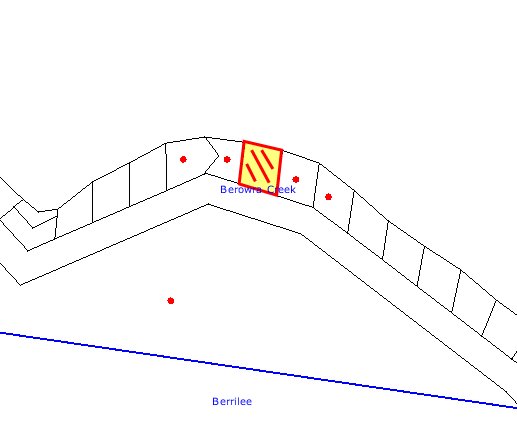
|
NOTIFICATION
PLAN
|
|
|
• PROPERTIES NOTIFIED
|
X SUBMISSIONS
RECEIVED
|
PROPERTY SUBJECT OF DEVELOPMENT
|
|
|
|
|
|
5.2 Public Authorities - Rural Fire Service
The site is located within a
bushfire prone area. The application was referred to the local RFS for
assessment, however, no return correspondence was received. Recommended
conditions of consent in relation to bushfire protection are listed in Schedule
1.
6. THE PUBLIC INTEREST
Section 79C(1)(e) of the Act
requires Council to consider “the public interest”.
The public interest is an
overarching requirement, which includes the consideration of the matters
discussed in this report. Implicit to the public interest is the achievement of
future built outcomes adequately responding to and respecting the future
desired outcomes expressed in environmental planning instruments and
development control plans.
The application is considered to
have satisfactorily addressed Council’s criteria and would provide a
development outcome that, on balance, would result in a positive impact for the
community. Accordingly, it is considered that the approval of the proposed
alterations and additions would be in the public interest.
CONCLUSION
The application proposes
alterations and additions to an existing dwelling. The proposed development
does not comply with the floorspace ratio development standard outlined in
Clause 15 of the Hornsby Shire Local Environmental Plan 1994, and is
inconsistent with the River Settlements and Foreshore Review for the draft
Annual LEP Amendments. An objection under State Environmental Planning Policy
No. 1 - Development Standards has demonstrated compliance with the zone
objectives, and is consistent with the established test for assessing SEPP 1
objections.
The application does not meet
some numerical development standards under Council’s River Settlements
Development Control Plan. Matters of non-compliance are not fatal to the
application and the merits of the proposal are addressed within the report.
No submissions were received in
respect of the application.
Having regard to the relevant
matters for consideration and the circumstances of the case, the application is
recommended for approval.
Note: At the time of the
completion of this planning report, no persons have made a Political
Donations Disclosure Statement pursuant to Section 147(3) of the
Environmental Planning and Assessment Act 1979 in respect of the subject
planning application.
|
Rod Pickles
Manager -
Assessment Team 2
Planning Division
|
Scott Phillips
Executive Manager
Planning Division
|
Attachments:
|
1.View
|
Locality Plan
|
|
|
|
2.View
|
Architectural Plan
|
|
|
|
3.View
|
Shadow Diagram
|
|
|
|
4.View
|
Sediment and
Erosion Control Plan
|
|
|
File Reference: DA/592/2009
Document Number: D01192214
SCHEDULE 1
GENERAL CONDITIONS
The conditions of consent within this notice
of determination have been applied to ensure that the use of the land and/or
building is carried out in such a manner that is consistent with the aims and
objectives of the planning instrument affecting the land.
Note: For
the purpose of this consent, the term ‘applicant’ means any person who has the
authority to act on or the benefit of the development consent.
Note:
For the purpose of this consent, any reference to an Act, Regulation,
Australian Standard or publication by a public authority shall be taken to mean
the gazetted Act or Regulation, or adopted Australian Standard or publication
as in force on the date that the application for a construction certificate is
made.
1. Approved
Plans and Supporting Documentation
The development must be carried
out in accordance with the plans and documentation listed below and endorsed
with Council’s stamp, except where amended by Council and/or other conditions
of this consent:
|
Plan No.
|
Drawn by
|
Dated
|
|
02122008 - Proposed First Floor Extension
|
Michael Yarak - ArchWood Design
|
18/05/2009
|
|
Shadow Diagram
|
Michael Yarak - ArchWood Design
|
N/A
|
|
Sediment and Erosion Control Plan
|
Michael Yarak - ArchWood Design
|
N/A
|
REQUIREMENTS PRIOR TO THE ISSUE OF A CONSTRUCTION
CERTIFICATE
The following conditions of consent must be
complied with prior to the issue of a ‘Construction Certificate’ by
either Hornsby Shire Council or an accredited certifier. All necessary
information to demonstrate compliance with the following conditions of consent
must be submitted with the application for a construction certificate.
2. Building
Code of Australia
All building
work must be carried out in accordance with the requirements of the Building
Code of Australia.
3. Contract
of Insurance (Residential Building Work)
In the case
of residential building work for which the Home Building Act 1989 requires
there to be a contract of insurance in force in accordance with Part 6 of that
Act, that such a contract of insurance is in force before any building work
authorised to be carried out by the consent commences.
Note: This
condition does not apply to the extent to which an exemption is in force
under Clause 187 or 188 of the Act, subject to the terms of any condition or
requirement referred to in Clause 187(6) or 188(4) of the Act, or to the
erection of a temporary building.
4. Notification
of Home Building Act 1989 Requirements
Residential
building work within the meaning of the Home Building Act 1989
must not be carried out unless the principal certifying authority for the
development to which the work relates (not being Council) has given Council
written notice of the following information:
a. In
the case of work for which a principal contractor is required to be appointed:
i. The
name and licence number of the principal contractor.
ii. The
name of the insurer by which the work is insured under Part 6 of that Act.
b. In
the case of work to be done by an owner-builder:
i. The
name of the owner-builder.
ii. If
the owner-builder is required to hold an owner-builder’s permit under that Act,
the number of the owner-builder’s permit.
Note: If
arrangements for doing the residential building work are changed while the work
is in progress so that the information notified becomes out of date, further
work must not be carried out unless the principal certifying authority for the
development to which the work relates (not being Council) has given Council
written notification of the updated information.
REQUIREMENTS PRIOR TO THE COMMENCEMENT OF ANY WORKS
The following conditions of consent must be
complied with prior to the commencement of any works on the site. The
conditions have been imposed to ensure that the works are carried out in such a
manner that complies with relevant legislation and Council’s policies and does
not disrupt the amenity of the neighbourhood or impact upon the environment.
5. Design
and Construction - Bushfire Attack Category
The
development must be constructed in accordance with Australian Standard
3959-2009 –‘Construction of buildings in bush fire-prone areas’ sections 5,
6 and 7 and the following conditions based on Planning
for Bush Fire Protection 2006 and the NSW Rural Fire Service’s publication
Standards for Asset Protection Zones:-
a. All materials
are to have a Flammability Index no greater than 5.
b. All guttering
and valleys are to be screened with non-corrosive mesh to prevent the build up
of flammable material. Any materials used shall have a Flammability index no
greater than 5.
c. All windows
directly exposed to the bushfire hazard are to be fitted with toughened or fire
rated glass capable of withstanding up to 40 kWs square metre radiant heat flux
loading and fitted non-combustible shutters.
d. All glazing must
be capable of withstanding up to 29kW/m2 of radiant heat flux
loading.
e. Proposed bi-fold
doors, French door(s) and the like facing the bush fire hazard must be a
proprietary type door system incorporating 5mm toughened glass, non combustible
seals, and a design that does not permit gaps greater than 1.8mm in diameter to
prevent the penetration of embers. Draught excluders, seals and door furniture
must be manufactured from materials having a “Flammability Index” no greater
than 5. The entire door system (including jamb and seals) must be designed and
constructed to withstand 29kW/m2 of radian heat flux.
f. All
exposed/external timber used in the development must be of a fire resistant
timber species as identified in RFS Development Control Note 001. These
species include Blackbutt, Kwila (Merbau), Red Iron Bark, Red River Gum, Silver
Top Ash, Spotted Gum and Turpentine.
Notes: Timbers treated with
an applied intumescent paint are no longer recognised by the Rural Fire Service
as a fire retardant treated timber or a performance option to increase fire
resistance.
6. Asset
Protection Zones
At the
commencement of building works the entire property must be maintained as an
inner protection area (IPA) as outlined within the document ‘Planning for
Bush Fire Protection 2006’ and the NSW Rural Fire Service’s document ‘Standards
for Asset Protection Zones.’ The Inner Protection Area should comprise the
following:
a. Minimal
fine fuel at ground level.
b. Vegetation
that does not provide a continuous path to buildings for transfer of fire.
c. Shrubs
and trees that do not form a continuous canopy and vegetation planted or
cleared in clumps rather than continuous rows.
d. Species
that retain dead material or deposit excessive quantities of ground fuel are
avoided.
e. Shrubs
and trees pruned or removed in such a way that they do not touch or overhang
the buildings.
f. Vegetation
located far enough away from the buildings so that plants do not ignite the
buildings by direct flame contact or radiant heat emission.
g. An
unobstructed pedestrian access around the building to allow for residents and
service personnel to undertake property protection activities.
7. Erection
of Construction Sign
A sign must
be erected in a prominent position on any site on which building work,
subdivision work or demolition work is being carried out:
a. Showing
the name, address and telephone number of the principal certifying authority
for the work.
b. Showing
the name of the principal contractor (if any) for any demolition or building
work and a telephone number on which that person may be contacted outside
working hours.
c. Stating
that unauthorised entry to the work site is prohibited.
Note: Any
such sign is to be maintained while the building work, subdivision work or
demolition work is being carried out, but must be removed when the work has
been completed.
REQUIREMENTS DURING CONSTRUCTION
The following conditions of consent must be
complied with during the construction of the development. The conditions have
been imposed to ensure that the works are carried out in such a manner that
complies with relevant legislation and Council’s policies and does not disrupt
the amenity of the neighbourhood or impact upon the environment.
8. Construction
Work Hours
All work on site (including demolition and earth works)
must only occur between the following hours:
Monday to Saturday 7 am to 5 pm
Sunday & Public Holidays No work
9. Environmental
Management
The site must
be managed in accordance with the publication ‘Managing Urban Stormwater –
Landcom (March 2004) and the Protection of the Environment Operations
Act 1997 by way of implementing appropriate measures to prevent sediment
run-off, excessive dust, noise or odour emanating from the site during the
construction of the development.
10. Disturbance
of Existing Site
During
construction works, the existing ground levels of open space areas and natural
landscape features, (including natural rock-outcrops, vegetation, soil and
watercourses) must not be altered unless otherwise nominated on the approved
plans.
REQUIREMENTS PRIOR TO THE ISSUE OF AN OCCUPATION
CERTIFICATE
The
following conditions of consent must be complied with prior to the ‘Principal
Certifying Authority’ issuing an ‘Occupation Certificate’
11. Fulfilment
of BASIX Commitments
The applicant
must demonstrate the fulfilment of BASIX commitments pertaining to the
development.
12. Smoke
Alarms – Dwelling Additions
Smoke alarms
must be installed in the existing building and the proposed additions in
accordance with the requirements of the Building Code of Australia.
13. Wastewater
to Existing System
All wastewater generated
within the approved development must be directed to the existing onsite sewage
management system servicing the site.
-
END OF CONDITIONS -
ADVISORY NOTES
The following information is provided for your
assistance to ensure compliance with the Environmental Planning and Assessment
Act 1979, Environmental Planning and Assessment Regulation 2000, other relevant
legislation and Council’s policies and specifications. This information does
not form part of the conditions of development consent pursuant to Section 80A
of the Act.
Environmental Planning and Assessment Act 1979
Requirements
· The Environmental Planning and
Assessment Act 1979 requires:
· A construction certificate prior to the
commencement of any works. Enquiries regarding the issue of a construction
certificate can be made to Council’s Customer Services Branch on 9847 6760.
· A principal certifying authority to be
nominated and Council notified of that appointment prior to the commencement of
any works.
· Council to be given at least two days
written notice prior to the commencement of any works.
· Mandatory inspections of nominated
stages of the construction inspected.
· An occupation certificate issued before
occupying any building or commencing the use of the land.
Long Service Levy
In accordance with Section 34 of the Building and
Construction Industry Long Service Payments Act 1986, a ‘Long Service Levy’ must be paid to the Long Service
Payments Corporation or Hornsby Council.
Note: The
rate of the Long Service Levy is 0.35% of the total cost of the work.
Note: Hornsby
Council requires the payment of the Long Service Levy prior to the issue of a
construction certificate.
Tree Preservation Order
To ensure the maintenance and
protection of the existing natural environment, it is an offence to ringbark,
cut down, top, lop, remove, wilfully injure or destroy a tree outside three
metres of the approved building envelope without prior written consent from
Council. Fines may be imposed for non-compliance with Council’s Tree
Preservation Order.
Note: A
tree is defined as a single or multi-trunked wood perennial plant having a
height of not less than three (3) metres, and which develops many branches,
usually from a distance of not less than one (1) metre from the ground, but
excluding any plant which, in its particular location, is a noxious plant
declared as such pursuant to the Noxious Weeds Act 1993. This definition of
‘tree’ includes any and all types of Palm trees.
All
distances are determined British Standard BS 5837: 2005, “Trees in Relation to
Construction – Recommendations”.
Dial Before You Dig
Prior to commencing any works,
the applicant is encouraged to contact Dial Before You Dig on 1100 or www.dialbeforeyoudig.com.au for
free information on potential underground pipes and cables within the vicinity
of the development site.
Planning Report No. PLN60/09
Date of Meeting:
5/08/2009
3 DEVELOPMENT APPLICATION
- ALTERATIONS AND ADDITIONS TO A DWELLING-HOUSE.
NO. 118 WOONONA AVENUE, WAHROONGA
|
Development Application No:
|
DA/434/2009
|
|
Description of Proposal:
|
Alterations and additions to a dwelling-house and the
erection of a carport.
|
|
Property Description:
|
Lot 11, DP 13036, No. 118 Woonona Avenue, Wahroonga
|
|
Applicant:
|
Accomplished Construction and Design Pty Ltd
|
|
Owner:
|
Mr Darren Brownlee and Ms Annette Hawkins
|
|
Statutory Provisions:
|
Hornsby Shire Local Environmental
Plan, 1994
Residential A (Low Density)
|
|
Estimated Value:
|
$433,357
|
|
Ward:
|
A
|
|
RECOMMENDATION
THAT Development Application
No. 434/2009 for alterations and additions to a dwelling-house and the
erection of a carport at Lot 11, DP 13036, No. 118 Woonona Avenue, Wahroonga,
be approved subject to the conditions of consent detailed in Schedule 1 of
this report.
|
1. The
application proposes alterations and additions to a dwelling-house and the
erection of a carport.
2. The
proposal complies with the Hornsby Shire Local Environmental Plan, 1994 and is
generally consistent with Council’s Dwelling House Development Control Plan.
3. A
Red Sticker has been placed against the application resulting in it being referred
to Council for determination.
4. One
submission has been received in respect of the application.
5. It
is recommended that the application be approved.
THE SITE
The rectangular shaped site has
an area of 695.5m2 and is located on the high, western side of
Woonona Avenue Wahroonga. The front and rear boundaries have a width of 15.24m
and the northern and southern side boundaries have a length of 45.72m.
The site contains a two level,
timber clad dwelling-house with a tile roof. The upper floor level contains
bedrooms, habitable rooms and living areas and a rear-facing deck. The lower
level contains a single garage and a laundry.
The site experiences a crossfall
of 15% with a steep grade rising approximately 4 metres from street level to
the front of the existing dwelling-house. A timber staircase provides
pedestrian access from street level.
There are four trees affected by
the proposal, a Frangipani and a Palm located at the rear of the existing
dwelling-house, a Jacaranda located adjacent to the existing driveway and a
Japanese Maple located at the front of the adjoining property, No. 120 Woonona Avenue.
The adjacent property to the
north (No. 120 Woonona Avenue) contains a split level, fibro and timber clad
dwelling-house. The dwelling-house includes a large unroofed first floor level
deck located on the northern side. The adjacent property to the south (No. 116 Woonona Avenue) contains a single storey, timber clad residence with a subfloor
level garage.
Other nearby residential development
is characterised by an eclectic blend of one and two-storey dwelling-houses,
ranging from modest, post-war design to houses of a more contemporary
appearance.
THE PROPOSAL
The application proposes
alterations and additions to a dwelling-house and the erection of a double
carport. The lower level alterations and additions include the extension of
the existing garage and laundry and its conversion to a bedroom, ensuite,
rumpus room and foyer.
On the upper level, the
alteration and additions include an extension to the rear of the
dwelling-house, increasing the size of the existing living rooms and bedrooms.
The proposed external cladding of the building would be weatherboard. A timber
deck is also proposed at the rear of the dwelling-house.
A double carport is proposed at
the front of the property.
ASSESSMENT
The development application has
been assessed having regard to the ‘2005 City of Cities Metropolitan
Strategy’, the ‘North Subregion (Draft) Subregional Strategy’
and the matters for consideration prescribed under Section 79C of the Environmental
Planning and Assessment Act 1979 (the Act). Subsequently, the following
issues have been identified for further consideration.
1. STRATEGIC CONTEXT
1.1 Metropolitan Strategy – (Draft) North Subregional Strategy
The Metropolitan Strategy is a
broad framework to secure Sydney’s place in the global economy by promoting and
managing growth. It outlines a vision for Sydney to 2031, the challenges
faced, and the directions to follow to address these challenges and achieve the
vision. The draft North Subregional Strategy acts as a framework for Council
in the preparation of a new Principal LEP by 2011.
The draft Subregional Strategy
sets the following targets for the Hornsby LGA by 2031:
· Employment capacity to
increase by 9,000 jobs; and
· Housing stock to
increase by 11,000 dwellings.
The proposed development would be
consistent with the draft Strategy by contributing to the housing choice in the
locality.
2. STATUTORY CONTROLS
Section 79C(1)(a) requires
Council to consider “any relevant environmental planning instruments, draft
environmental planning instruments, development control plans, planning
agreements and other prescribed matters”.
2.1 Hornsby Shire Local Environmental Plan, 1994
The subject land is zoned
Residential A (Low Density) under Hornsby Shire Local Environmental Plan, 1994
(HSLEP). The objectives of the zone zone are:
(a) to provide for the housing needs of the population of the
Hornsby area.
(b) to promote a variety of housing types and other land uses
compatible with a low density residential environment.
(c) to provide for development that is within the environmental
capacity of a low density residential environment.
The proposed development is
defined as “dwelling-house” under HSLEP and is permissible in the zone with
Council’s consent.
Clause 15 of the HSLEP prescribes
that the maximum floor space ratio (FSR) of development within the zone is
0.4:1. The applicant addresses this requirement by proposing an FSR of 0.34:1.
2.2 Dwelling House Development Control Plan
The proposed development has been
assessed having regard to the relevant performance and prescriptive design
standards within Council’s Dwelling House Development Control Plan (DCP). The
following table sets out the proposal’s compliance with the prescriptive
standards of the Plan:
|
Dwelling House
Development Control Plan
|
|
Control
|
Proposal
|
Requirement
|
Compliance
|
|
Floor Space Ratio
|
0.34:1
|
0.4:1
|
Yes
|
|
Site Cover
|
37%
|
40%
|
Yes
|
|
Dwelling Height
|
7.2m
|
9m
|
Yes
|
|
Storeys
|
1 and 2
|
2
|
Yes
|
|
Building Length
|
17.1m
|
24m
|
Yes
|
|
Wall Length
|
15.1m
|
10m
|
No
|
|
Private Open Space
|
258m2
|
120m2
|
Yes
|
|
Landscaping
|
58%
|
45%
|
Yes
|
|
Car parking
|
2 spaces
|
2 spaces
|
Yes
|
|
Setbacks:
Dwelling
- Front
- Side
- Side
- Rear
Carport
- Front
- Side
|
9.5m
1.59m
0.92m
15.6m
4m
0m
|
6m
1m
1m
5m
6m
1m
|
Yes
Yes
No
Yes
No
No
|
As detailed in the above table,
the proposed development does not comply with the unbroken wall length and
front and side setback requirements under the Dwelling House DCP. These
matters of non-compliance are detailed below, together with a brief discussion
on compliance with relevant performance standards.
2.2.1 Design
The proposed 15.1m unbroken
length of the southern wall and the 12.1m unbroken length of the northern wall
do not comply with the prescriptive measures of the Design element, which
states that “walls should not exceed 10m in length without a physical
‘break’ such as an indentation, bay window or change in level”. The
purpose of this control is to prevent large blank walls facing neighbouring
properties.
The northern elevation is
two-storey in height and contains an acceptable design balance between solid
walls and the three windows on each of the levels. The roof design also
includes two gables facing the side boundary which also provides articulation
effectively addressing any perceived detrimental visual impacts resulting from
this wall length. The elevation of the building would not be viewed as a whole
element from the neighbouring
property due to the location of
the dwelling on that property. Accordingly, the impact of the wall length
would be significantly reduced.
The southern façade is single
storey in height with windows within the wall and a glazed skylight within the
roof plane. The roof design also includes the gable end facing the side
boundary. The size and location of these windows and the articulation in the
roof effectively address any perceived detrimental visual impacts resulting
from this wall length.
It is considered that a departure
from the development standard is acceptable in the circumstances of the case.
2.2.2 Setbacks
The additions would result in a
side boundary setback of 0.92m on the northern side of the allotment. The carport
has a front boundary setback of 4m and a zero side boundary setback also on the
northern side of the allotment. These setbacks do not comply with the
prescriptive measures of the Setbacks element which requires that structures be
set back 6m from the front and 1m from side boundaries.
The proposed reduction in the
northern side setback is considered acceptable as the additions to the upper
and lower levels follow the same plane as the walls of the existing
dwelling-house and the 80mm variation to the 1m setback control would be
indistinguishable. Further, the dwelling at No. 120 Woonona Avenue backs onto
the subject property and does not enjoy amenity along that elevation.
Whilst the proposed siting of the
carport on the common boundary with No. 120 Woonona Avenue does not comply with
the Dwelling House DCP prescriptive 1m setback requirement, the subject carport
would replace the existing carparking area which exists in the same location.
As a consequence, the new carport would have similar impacts to the current
situation.
To address the owners concerns
regarding light spill and noise a 1.5m high screen that has openings no greater
than 30mm erected along the northern side of the carport is recommended.
Having regard to the steep
topography of Woonona Avenue and the numerous carports and garages in the
immediate area with reduced front boundary setbacks similar to the proposed
carport, including carports at No. 49 and No. 122 Woonona Avenue and garages at
No. 102, 104 and 122 Woonona Avenue, the proposed 4m setback is considered
acceptable. In summary, it is considered that in the circumstances of the case,
the proposed carport setbacks would not detract from the character of the
locality and would have no greater impact on the neighbour’s property than the
existing carparking area and therefore, a variation to the setback control is
acceptable.
2.2.3 Privacy
There are currently two large
windows located in the upper level of the northern wall of the existing
dwelling-house both of which currently overlook onto the blank wall and roof of
the dwelling at No. 120 Woonona Avenue. One of these windows would be replaced
with two smaller windows. The new windows would reduce existing privacy
impacts and consequently, the proposed design and window placement is
acceptable.
The new windows located in the
lower level are highlight in design, with sill heights 1.5m above the floor
level. As a consequence, no overlooking would occur.
The northern side of the new
first floor level deck has been designed with a 1.8 solid privacy screen, which
would prevent the direct overlooking of premises No. 120 Woonona Avenue.
The proposed carport at the front
of the property would replace the existing carparking spaces in the same
location and would have no greater privacy impacts as a consequence. As stated
above, a 1.5m high screen is recommended along the northern side of the
carport. The provision of this screen would also serve to minimise any
perceived privacy impacts.
The proposal meets the objectives
of the Privacy element of the Dwelling House DCP and is considered to be
acceptable.
2.2.4 Vehicle Access and Parking
The proposed carport would
provide parking for two vehicles. To establish acceptable driveway gradients
and manoeuvrability it is proposed that the existing front deck be reduced in
size and the existing carparking area removed and lowered by approximately
0.6m. This would have the outcome of negating the need for a retaining wall
between the subject property and No. 120 Woonona Avenue, which was of concern
to that owner.
The proposal meets the objectives
of the vehicle access and parking element of the Dwelling House DCP and is
considered to be acceptable.
3. ENVIRONMENTAL IMPACTS
Section 79C(1)(b) of the Act
requires Council to consider “the likely impacts of that development,
including environmental impacts on both the natural and built environments, and
social and economic impacts in the locality”.
3.1 Natural Environment
There are four trees affected by
the proposal, a Frangipani and a Palm tree located at the rear of the existing
dwelling-house, a Jacaranda located adjacent to the existing driveway and a
Japanese Maple located at the front of the adjoining property, No. 120 Woonona Avenue. It is Council’s assessment that these trees are not considered to
be significant.
The Japanese Maple would be
affected by the proposed carport to the extent that some branches that have
grown over the common boundary line would have to be removed. The removal of
these branches would not have any significant planning implications nor would
it affect the life expectancy of the tree. The main tree branches would remain
unaffected.
Further, the proposed carport
would not affect the root system of the Japanese Maple as the proposed carport
would be located in the same position and on the sandstone rock shelf as the
existing concrete carparking area.
3.2 Built Environment
The proposed alterations and
additions and carport would be consistent with the character of the established
built form of the residential development in the locality.
3.3 Social Impacts
There are no anticipated social
impacts resulting from the proposed development.
3.4 Economic Impacts
The proposal would not result in
any economic impacts.
4. SITE SUITABILITY
Section 79C(1)(c) of the Act
requires Council to consider “the suitability of the site for the
development”.
The site is not constrained by
flooding, landslip, bushfire or threatened flora or fauna and is suitable for
low density residential development of the type proposed.
5. PUBLIC PARTICIPATION
Section 79C(1)(d) of the Act
requires Council to consider “any submissions made in accordance with this
Act”.
5.1 Community Consultation
The proposed development was
placed on public exhibition and was notified to adjoining and nearby landowners
between 21 April and 5 May 2009, in accordance with Council’s Notification and
Exhibition Development Control Plan. During this period, Council received one
submission. The map below illustrates the location of the nearby landowner who
made a submission that is in close proximity to the development site.
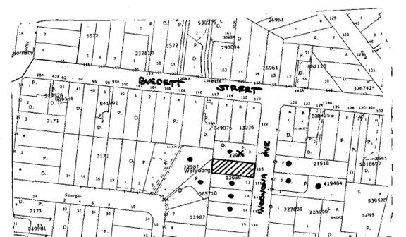
|
NOTIFICATION
PLAN
|
|
|
• PROPERTIES NOTIFIED
|
X SUBMISSIONS
RECEIVED
|
PROPERTY SUBJECT OF DEVELOPMENT
|
|
|
|
|
|
Two submissions have been
received, one from the owner of No. 120 Woonona Avenue and the other from a
planning consultant acting on behalf of the owner of No. 120 Woonona Avenue.
Both submissions raise concerns regarding privacy, setbacks, design, height,
carparking, fencing and retaining walls, noise, impacts on trees, sediment
controls, external finishes and the inaccurate and insufficient details on the
plans.
Those matters not addressed in
the body of the report are addressed as follows:
5.1.1 Inaccurate and insufficient details on the plans
· Floor levels and
excavation: The submitted plans include a survey plan, showing contours that
identify the existing ground level and the proposed levels of the development.
The plans also show that the existing garage slab would be removed and the lower
level excavated by 0.2m - 0.4m to achieve the required room heights. A 1m
excavation would take place on the southern side of the rumpus room resulting
from the expansion of the lower level. Excavations would also occur to
establish a level platform for the carport and the new driveway.
· Location of stormwater
and sewerage pipes: All wastewater and stormwater drainage pipes would be
connected to the existing drainage system that serves the existing
dwelling-house.
· Landscape concept plan,
clothesline and trampoline: Whilst a specific concept landscape plan has not
been submitted with the application, there is sufficient detail on the plans to
determine that at least 45% of the site is available for landscaping purposes
and the provision of a clothesline. The location and use of the trampoline is
not a land use planning matter and Council cannot control the use or placement
of this device on private property.
The plans and specifications
submitted with the application contain sufficient detail to enable a full and
proper assessment to be made.
5.1.2 Sediment and Erosion Controls
All
sedimentation controls would be located wholly within the boundaries of the
subject premises. Where sediment barriers are to be installed along the
northern property boundary, the barrier would be constructed using straw
bales. The installation of these straw bails would prevent damage to premises No. 120 Woonona Avenue.
The proposal meets the objectives
of the Soil and Water Management element of the Dwelling House DCP and is
considered to be acceptable.
5.1.3 On-site storage of materials and garbage bins
There is sufficient space on the
site to accommodate domestic storage and the off-street parking of vehicles.
5.1.4 Noise impacts
The alteration and additions
would have minimal noise impacts on the amenity of the adjacent property at No. 120 Woonona Avenue.
The proposal meets the objectives
of the Acoustics element of the Dwelling House DCP and is considered to be
acceptable.
5.1.5 Boundary Fence and Retaining Wall
The application does not propose
the erection of boundary fencing. The erection of boundary fencing is subject
to negotiation and agreement between the respective property owners in
accordance with the requirements of the Dividing Fences Act, 1991.
The required pier and beam construction
for the footings supporting the concrete floor of the rumpus room and guest
bedroom would ensure that the existing retaining wall located between the
subject premises and No. 120 Woonona Avenue is not impacted upon.
To establish a level platform for
the proposed garage and to establish an acceptable driveway grade the carport
would be excavated 0.6m lower than the existing ground level therefore negating
the need for retaining walls.
6. THE PUBLIC INTEREST
Section 79C(1)(e) of the Act
requires Council to consider “the public interest”.
The public interest is an
overarching requirement, which includes the consideration of the matters
discussed in this report. Implicit to the public interest is the achievement
of future built outcomes adequately responding to and respecting the future
desired outcomes expressed in environmental planning instruments and
development control plans.
The application is considered to
have satisfactorily addressed Council’s criteria and would provide a
development outcome that, on balance, would result in a positive impact for the
community. Accordingly, it is considered that the approval of the proposed
alterations and additions to the dwelling-house and erection of a carport would
be in the public interest.
CONCLUSION
The
application proposes the alterations and additions to an existing dwelling
house and the erection of a carport.
The proposal is consistent with
the objectives of the Hornsby Shire Local Environmental Plan, 1994 and
the Dwelling House DCP. The development would have minimal social, economic
and environmental impacts on both the natural and built environments in the
locality. It is considered that the objections to the development would not in
themselves, warrant refusal of the application.
Council
received submissions from one adjoining property owner concerning the
development. Matters raised in the submissions can be adequately overcome
subject to compliance with relevant conditions.
Having
regard to the assessment of the proposed development and the circumstances of
the case, it is recommended that Council approves the application.
Note: At the time of the completion of this planning report, no
persons have made a Political Donations Disclosure Statement pursuant to
Section 147(3) of the Environmental Planning and Assessment Act, 1979 in
respect of the subject planning application.
|
Simon Evans
Manager -
Assessment Team 1
Planning Division
|
Scott Phillips
Executive Manager
Planning Division
|
Attachments:
File Reference: DA/434/2009
Document Number: D01193596
SCHEDULE 1
CONDITIONS OF
APPROVAL
GENERAL CONDITIONS
The conditions of consent within this notice
of determination have been applied to ensure that the use of the land and/or
building is carried out in such a manner that is consistent with the aims and
objectives of the planning instrument affecting the land.
Note: For
the purpose of this consent, the term ‘applicant’ means any person who has the
authority to act on or the benefit of the development consent.
Note:
For the purpose of this consent, any reference to an Act, Regulation,
Australian Standard or publication by a public authority shall be taken to mean
the gazetted Act or Regulation, or adopted Australian Standard or publication
as in force on the date that the application for a construction certificate is
made.
1. Approved
Plans and Supporting Documentation
The development must be carried
out in accordance with the plans and documentation listed below and endorsed
with Council’s stamp, except where amended by Council and/or other conditions
of this consent:
|
Plan
|
Drawn by
|
Dated
|
|
Architecturals and Floor Plans
|
KK
|
26 March 2009
|
|
Site Plan - Job No. 86842
|
John Lowe and Associates P/L
|
11 March 2009
|
|
Sediment Plan - Job No. 86842
|
John Lowe and Associates P/L
|
11 March 2009
|
2. Amendment
of Plans
The approved plans are to be
amended as follows:
a. The privacy screen along the northern side of the proposed
rear deck must be of solid construction to 1.8m in height.
b. A 1.5m high screen with no openings more than 30mm wide
must be erected along the northern side of the carport.
REQUIREMENTS PRIOR TO THE ISSUE OF A CONSTRUCTION
CERTIFICATE
The following conditions of consent must be
complied with prior to the issue of a ‘Construction Certificate’ by
either Hornsby Shire Council or an accredited certifier. All necessary
information to demonstrate compliance with the following conditions of consent
must be submitted with the application for a construction certificate.
3. Building
Code of Australia
All building work must be
carried out in accordance with the requirements of the Building Code of
Australia.
4. Contract
of Insurance (Residential Building Work)
In the case
of residential building work for which the Home Building Act, 1989 requires
there to be a contract of insurance in force in accordance with Part 6 of that
Act, that such a contract of insurance is in force before any building work
authorised to be carried out by the consent commences.
Note: This
condition does not apply to the extent to which an exemption is in force
under Clause 187 or 188 of the Act, subject to the terms of any condition or
requirement referred to in Clause 187(6) or 188(4) of the Act, or to the
erection of a temporary building.
5. Notification
of Home Building Act, 1989 Requirements
Residential
building work within the meaning of the Home Building Act,
1989 must not be carried out unless the principal certifying authority for
the development to which the work relates (not being Council) has given Council
written notice of the following information:
a. In
the case of work for which a principal contractor is required to be appointed:
i. The
name and licence number of the principal contractor.
ii. The
name of the insurer by which the work is insured under Part 6 of that Act.
b. In
the case of work to be done by an owner-builder:
i. The
name of the owner-builder.
ii. If
the owner-builder is required to hold an owner-builder’s permit under that Act,
the number of the owner-builder’s permit.
Note: If
arrangements for doing the residential building work are changed while the work
is in progress so that the information notified becomes out of date, further
work must not be carried out unless the principal certifying authority for the
development to which the work relates (not being Council) has given Council
written notification of the updated information.
6. Sydney
Water – Quick Check
The
application must be submitted to a Sydney Water ‘Quick Check Agent’ or
‘Customer Centre’ for approval to determine whether the development will affect
any Sydney Water infrastructure, and whether further requirements are to
be met.
Note: Refer
to www.sydneywater.com.au or
telephone 13 20 92 for assistance.
REQUIREMENTS PRIOR TO THE COMMENCEMENT OF ANY WORKS
The following conditions of consent must be
complied with prior to the commencement of any works on the site. The
conditions have been imposed to ensure that the works are carried out in such a
manner that complies with relevant legislation and Council’s policies and does
not disrupt the amenity of the neighbourhood or impact upon the environment.
7. Erection
of Construction Sign
A sign must be erected in a
prominent position on any site on which building work, subdivision work or
demolition work is being carried out:
a. Showing the
name, address and telephone number of the principal certifying authority for
the work.
b. Showing the name
of the principal contractor (if any) for any demolition or building work and a
telephone number on which that person may be contacted outside working hours.
c. Stating that
unauthorised entry to the work site is prohibited.
Note: Any
such sign is to be maintained while the building work, subdivision work or
demolition work is being carried out, but must be removed when the work has
been completed.
8. Erosion
and Sediment Control
Erosion and
sediment control measures must be provided and maintained throughout the
construction period in accordance with the manual ‘Soils and Construction,
2004 (Bluebook)’, the approved plans, Council specifications and to the
satisfaction of the principal certifying authority. The erosion and sediment
control devices must remain in place until the site has been stabilised and
revegetated.
Any sediment
and erosion controls erected along the northern boundary must be constructed of
straw bales.
Note: On
the spot penalties up to $1,500 may be issued for any on-compliance with this
requirement without any further notification or warning.
REQUIREMENTS DURING CONSTRUCTION
The following conditions of consent must be
complied with during the construction of the development. The conditions have
been imposed to ensure that the works are carried out in such a manner that
complies with relevant legislation and Council’s policies and does not disrupt
the amenity of the neighbourhood or impact upon the environment.
9. Construction
Work Hours
All work on site (including demolition and earth works)
must only occur between the following hours 7 am and 5 pm Monday to Saturday.
No work is permitted on Sundays or Public Holidays.
10. Demolition
All
demolition work must be carried out in accordance with Australian Standard
2601-2001 – The Demolition of Structures.
11. Council
Property
During
construction works, no building materials, waste, machinery or related matter
is to be stored on the road or footpath. The public reserve is to be kept in a
clean, tidy and safe condition at all times.
12. Disturbance
of Existing Site
During
construction works, the existing ground levels of open space areas and natural
landscape features, (including natural rock-outcrops, vegetation, soil and
watercourses) must not be altered unless otherwise nominated on the approved
plans.
REQUIREMENTS PRIOR TO THE ISSUE OF AN OCCUPATION
CERTIFICATE
The following conditions of consent must be complied with
prior to the ‘Principal Certifying Authority’ issuing an ‘Occupation
Certificate’
Note: For
the purpose of this consent, any reference to ‘occupation certificate’ shall
also be taken to mean ‘interim occupation certificate’ unless otherwise stated.
13. Fulfilment
of BASIX Commitments
The applicant must demonstrate
the fulfilment of BASIX commitments pertaining to the development.
14. Stormwater
Drainage
The
stormwater drainage system for the development must be designed and constructed
for an average recurrence interval of 20 years and be gravity drained directly
to Council’s street drainage system.
15. Damage
to Council Assets
Any damage
caused to Council’s assets as a result of the construction of the development
must be rectified in accordance with Council’s written requirements and at the
sole cost of the applicant.
16. Smoke
Alarms
Smoke alarms must be installed
in the existing building and the proposed additions in accordance with the
requirements of the Building Code of Australia.
17. Retaining
Walls
All required retaining walls
must be constructed as part of the development.
-
END OF CONDITIONS -
ADVISORY NOTES
The following information is provided for your
assistance to ensure compliance with the Environmental Planning and Assessment
Act 1979, Environmental Planning and Assessment Regulation 2000, other relevant
legislation and Council’s policies and specifications. This information does
not form part of the conditions of development consent pursuant to Section 80A
of the Act.
Environmental Planning and Assessment Act 1979
Requirements
The Environmental Planning and Assessment Act 1979 requires:
· A construction certificate prior to the
commencement of any works. Enquiries regarding the issue of a construction
certificate can be made to Council’s Customer Services Branch on 9847 6760.
· A principal certifying authority to be
nominated and Council notified of that appointment prior to the commencement of
any works.
· Council to be given at least two days
written notice prior to the commencement of any works.
· Mandatory inspections of nominated
stages of the construction inspected.
· An occupation certificate issued before
occupying any building or commencing the use of the land.
Long Service Levy
In accordance with Section 34 of
the Building and Construction Industry Long Service Payments Act 1986, a ‘Long Service Levy’ must be paid to the Long
Service Payments Corporation or Hornsby Council.
Note: The
rate of the Long Service Levy is 0.35% of the total cost of the work.
Note: Hornsby
Council requires the payment of the Long Service Levy prior to the issue of a
construction certificate.
Tree Preservation Order
To ensure the maintenance and
protection of the existing natural environment, it is an offence to ringbark,
cut down, top, lop, remove, wilfully injure or destroy a tree outside 3 metres
of the approved building envelope without prior written consent from Council.
Fines may be imposed for non-compliance with Council’s Tree Preservation
Order.
Note: A
tree is defined as a single or multi-trunked wood perennial plant having a
height of not less than 3 metres, and which develops many branches, usually
from a distance of not less than 1 metre from the ground, but excluding any
plant which, in its particular location, is a noxious plant declared as such
pursuant to the Noxious Weeds Act, 1993. This definition of ‘tree’ includes
any and all types of Palm trees.
All
distances are determined British Standard BS 5837: 2005, “Trees in Relation to
Construction – Recommendations”.
Dial Before You Dig
Prior to commencing any works, the applicant is encouraged
to contact Dial Before You Dig on 1100 or www.dialbeforeyoudig.com.au for
free information on potential underground pipes and cables within the vicinity
of the development site.
Asbestos Warning
Should asbestos or asbestos
products be encountered during construction or demolition works advice and
information should be obtained prior to disturbing the material. It is
recommended that a contractor holding an asbestos-handling permit (issued by WorkCover
NSW), be engaged to manage the proper disposal and handling of the
material. Further information regarding the safe handling and removal of
asbestos can be found at:
www.environment.nsw.gov.au
www.nsw.gov.au/fibro
www.adfa.org.au
www.workcover.nsw.gov.au
Alternatively, telephone the WorkCover Asbestos and
Demolition Team on 8260 5885.
Planning Report No. PLN53/09
Date of Meeting:
5/08/2009
4 DEVELOPMENT APPLICATION
- SECTION 82A REVIEW - ALTERATIONS AND ADDITIONS TO A DWELLING-HOUSE
1 GLENOAK WAY, CHERRYBROOK
|
Development Application No:
|
DA/824/2008
|
|
Description of Proposal:
|
Alterations and additions to
a dwelling-house (Section 82A Review)
|
|
Property Description:
|
Lot 2, DP 285545, No. 1 Glenoak Way, Cherrybrook
|
|
Applicant:
|
Mr Laksha Siriwardena
|
|
Owners:
|
Mr Nambukara Tantri Mahinda Senadeera and Mrs
Widanalage Shanti Hycinth Senadeera
|
|
Statutory Provisions:
|
Hornsby Shire Local Environmental
Plan 1994
Residential A (Low Density)
|
|
Estimated Value:
|
$20,000
|
|
Ward:
|
B
|
|
RECOMMENDATION
THAT Development Application No. DA/824/2008 for
alterations and additions to a dwelling-house at Lot 2, DP 285545, No. 1
Glenoak Way Cherrybrook, be approved subject to the conditions of consent
detailed in Schedule 1 of this report.
|
1. On
2 October 2008, Council refused under delegated authority, Development
Application No. 824/2008 for alterations and additions to the subject
dwelling-house.
2. Pursuant to Section 82A of the Environmental
Planning and Assessment Act, 1979 (the Act), a request has been made of Council
to review its determination.
3. The
proposal does not comply with the 0.4:1 floor space ratio development standard
under the Hornsby Shire Local Environmental Plan, 1994 (HSLEP). Consequently,
the application has been supported by an objection under State Environmental
Planning Policy No. 1 – Development Standards (SEPP 1) seeking approval of a
variation to this standard.
4. No
submissions have been received in respect of the application.
5. It
is recommended that Council changes the determination and approves the
application, subject to conditions.
HISTORY OF THE APPLICATION
On 25 August 2008, Council refused DA/824/2008 on the following
grounds:
1. The
proposal does not comply with the prescriptive measures, performance criteria
and objectives of the Scale element of the Dwelling House DCP. The proposed
0.41:1 floor space ratio does not comply with the 0.4:1 floor space ratio
pursuant to Clause 15 of the Hornsby Shire Local Environmental Plan 1994,
resulting in an overdevelopment of the site which is inconsistent with the
intensity and scale of the development within the locality.
2. The
proposal does not comply with the prescriptive measures, performance criteria
and objectives of the Private Open Space element of the Dwelling House DCP
which requires a minimum area of 120m2 to be available for private
open space at the rear of the dwelling-house with a minimum dimension of 5m,
exclusive of driveways. With the proposed alterations to the rear of the
existing dwelling-house, the private open space would be reduced to
approximately 52m2 and does not provide adequate, useable private
open space to support outdoor activities and use.
On 15 June 2009, a request for Council
to review its determination of the application was lodged pursuant to Section
82A of the Act. In support of the request, a submission under SEPP 1 has been
lodged by the applicant seeking to vary the floor space ratio development
standard.
THE SITE
The rectangular shaped allotment
has an area of 500m2 and faces the cul-de-sac at the north-west end
of Glenoak Way, Cherrybrook. The topography of the land experiences an average
fall of 10% to the rear, north-west boundary of the allotment. The rear of the
site adjoins an Open Space A (Public recreation – Local) Zone.
The site accommodates a
contemporary designed, one and two storey dwelling-house of brick construction
with a tiled roof.
No trees would be removed as part
of this development.
The immediate area is
characterised by a predominance of two storey dwelling-houses of similar age
and design, surrounded by extensive landscaped garden areas.
THE PROPOSAL
The application proposes
alterations and additions to the existing single storey bedroom and family room
located at the rear of the dwelling-house. An internal wall in the dining room
is proposed to be demolished and the roof above the entire single storey
section of the dwelling-house would be tiled to match the remainder of the roof.
The total area of the proposed
extension would be 14m2.
ASSESSMENT
The development application has
been assessed having regard to the matters for consideration prescribed under
Section 79C of the Environmental Planning and Assessment Act, 1979 (the
Act). Subsequently, the following issues have been identified for further
consideration:
1. STRATEGIC CONTEXT
1.1 Metropolitan Strategy – (Draft) North Subregional
Strategy
The Metropolitan Strategy is a
broad framework to secure Sydney’s place in the global economy by promoting and
managing growth. It outlines a vision for Sydney to 2031; the challenges
faced, and the directions to follow to address these challenges and achieve the
vision. The draft North Subregional Strategy acts as a framework for Council
in the preparation of a new Principal LEP by 2011.
The draft Subregional Strategy
sets the following targets for the Hornsby LGA by 2031:
· Employment capacity to
increase by 9,000 jobs; and
· Housing stock to
increase by 11,000 dwellings.
The proposal would have no impact
on the Draft Strategy targets as it does not result in the net increase of the
housing stock in the Hornsby LGA.
2. STATUTORY CONTROLS
Section 79C(1)(a) requires
Council to consider “any relevant environmental planning instruments, draft
environmental planning instruments, development control plans, planning
agreements and other prescribed matters”.
2.1 Hornsby Shire Local Environmental Plan, 1994
The subject land is zoned
Residential A (Low Density) under Hornsby Shire Local Environmental Plan, 1994
(HSLEP). The objectives of the zone are:
(a) to
provide for the housing needs of the population of the Hornsby area;
(b) to
promote a variety of housing types and other land uses compatible with a low
density residential environment;
(c) to
provide for development that is within the environmental capacity of a low
density residential environment.
The proposed development is
defined as a “dwelling-house” and is permissible within the zone pursuant to
Clause 7 of the HSLEP.
Clause 15 of HSLEP prescribes
that the maximum floor space ratio (FSR) of development within the low density
zone is 0.4:1. The applicant seeks to erect
alterations and additions to a dwelling-house which would result in the
dwelling having an FSR of 0.41:1. Consequently, the proposal does not comply
with the development standard contained within Clause 15.
In this
regard, a detailed assessment has occurred to determine whether the proposal
satisfies the zone objectives and the objectives of the development standard.
To address this matter, the applicant has submitted an objection to the FSR
development standard under SEPP 1.
2.2 State
Environmental Planning Policy No. 1 – Development Standards
The application has been assessed
against the requirements of SEPP 1. This Policy provides flexibility in the
application of development standards in circumstances where strict compliance
with those standards would, in any particular case, be unreasonable or
unnecessary, or tend to hinder the attainment of the objectives of the Act.
The Land and Environment Court has expressed the view that
there are five different ways in which an objection may be well founded and
that approval of the objection may be consistent with the aims of the Policy:
1. The objectives of the standard are achieved
notwithstanding non-compliance with the standard;
2. The underlying objective or purpose of the
standard is not relevant to the development and therefore compliance is
unnecessary;
3. The underlying object of purpose would be defeated
or thwarted if compliance was required and therefore compliance is unreasonable;
4. The development standard has been virtually
abandoned or destroyed by the Council's own actions in granting consents
departing from the standard and hence compliance with the standard is
unnecessary and unreasonable;
5. The zoning of the particular land is
unreasonable or inappropriate so that a development standard appropriate for
that zoning is also unreasonable and unnecessary as it applies to the land and
compliance with the standard would be unreasonable or unnecessary. That is,
the particular parcel of land should not have been included in the particular
zone.
It is
considered that point 1 listed above is a relevant matter to consider in
respect of this application.
The
applicant has lodged a SEPP 1 objection to the development standard in the
following terms:
“ I wish to lodge an objection under SEPP 1 and request that
Council approves the proposed alterations and additions to the rear
of my house.
The proposal meets the scale of development and is
compatible with housing characteristics of the surrounding
area. The additions to the rear of the dwelling house will
"fit in" with the bulk and scale of other dwelling-houses in the
locality.
The minor scale of the proposal will not create
negative impacts on adjoining properties and occupants due to the orientation
of the block, the topography and proximity to the bushland reserve at the
rear. Privacy in relation to adjoining properties will be preserved
and neighbours will not be overshadowed.”
Whilst not applying directly to the site due to it being identified as
bushfire prone, Council’s assessment has had regard to the provisions of the
NSW Housing Code, which provides that the maximum gross floor area for
complying development as being:
· 330m2, if the lot has an
area of at least 450m2 but less than 600m2
· 380m2, if
the lot has an area of at least 600m2 but less than 900m2
· 430m2, if
the lot has an area of at least 900m2
Accordingly, if applicable, the
development would satisfy the FSR development standard under the Code.
Given that the NSW Housing Code
is now enacted in many parts of the Shire including adjoining allotments, it is
anticipated that more developments will be approved under this Code, which will
change the characteristics of dwelling-houses. Consequently, whilst Council has
previously applied a maximum FSR of 0.4:1 for dwelling-houses in the low
density residential zones within the Shire under the HSLEP, the introduction of
the new NSW Housing Code will change the effect of this standard.
Notwithstanding that the site is
subject to a bushfire risk, (as detailed in subsequent sections of this
report), it is considered that the proposed FSR of the building would not
impede the orderly development of the site and that
the additional floor space would not impinge on the environmental and amenity
aspects of the site and the underlying objectives of the zoning.
The
dwelling-house would also provide accommodation that would not detract from the
scale and variety of dwelling-houses in the low density areas of the Shire.
As the
proposal is considered to meet the zone objectives outlined in the HSLEP, the
“object of purpose” would be undermined if strict compliance of the
prescriptive measure was required.
2.3 State Environmental Planning Policy (Exempt and Complying
Development)
On 27 February 2009, SEPP (Exempt
and Complying Development) commenced operation. Under the SEPP, the Housing
Code outlines how residential developments including:
· detached one and two storey
dwellings,
· home extensions and
· other ancillary
development, such as swimming pools,
can proceed on lots of greater
than 450m2 in size as complying development with council or
accredited certifier approval. The subject allotment is excluded from the SEPP
on the basis that the land is identified as being bushfire prone.
2.4 Dwelling House
Development Control Plan
The proposed development has been
assessed having regard to the relevant performance and prescriptive design requirements
of Council’s Dwelling House DCP. The following table sets out the proposal’s
compliance with the prescriptive measures of the Plan:
|
Dwelling House
Development Control Plan
|
|
Control
|
Proposal
|
Requirement
|
Compliance
|
|
Gross Floor Area
|
206m²
|
200m²
|
No
|
|
FSR
|
0.41:1
|
0.4:1
|
No
|
|
Site coverage
|
31%
|
40%
|
Yes
|
|
Height
|
4.9m
|
<9m
|
Yes
|
|
Storeys
|
1 and 2 storeys
|
2 storeys
|
Yes
|
|
Car parking
|
2 spaces
|
2 spaces
|
Yes
|
|
Length of Building
|
14.76 m
|
24 m
|
Yes
|
|
Unbroken Wall length
|
17.8m
|
10m
|
No
|
|
Private Open Space
|
130m2
|
120 m2
|
Yes
|
|
Landscaping
|
48%
|
45%
|
Yes
|
|
Setbacks
- Front
- Side (north)
- Side
(south)
- Rear
|
9 m
1.3 m
3.1 m
4.7 m
|
9 m
1 m
1 m
3 m
|
Yes
Yes
Yes
Yes
|
As detailed in the above table,
the proposed development does not comply with a number of prescriptive measures
within Council’s Dwelling House DCP. The matters of non-compliance are
detailed below, as well as a brief discussion on compliance with the relevant
performance criteria.
2.4.1 Scale
The Scale element of the DCP
requires that:
“The
maximum floor space ratio for dwelling-houses is 0.4:1. The floor space
includes the sum of the areas of each floor of a building where the area of
each floor is taken to be the area within the outer face of the external
enclosing walls, including voids, but does not include carports, decks,
terraces and the like.
The floor
space also includes the area of any garage in excess of the car parking
requirements (refer to car parking element).”
The applicant’s FSR calculation
indicates that the gross floor area would increase from 192m2 to
206m2 which equates to an FSR of 0.41:1. It is considered that the
proposed minor increase in floor area would not adversely affect the scale of
the building in the streetscape as the extension would be at the rear of the
allotment and would front a public reserve. In summary, it is considered that
in the circumstances of the case, the proposed scale of the
development would not detract
from the character of the locality and therefore, a variation to the
development standards is acceptable.
2.4.2 Private Open Space
The proposal does not comply with
the prescriptive Private Open Space element of the DCP in that the minimum
dimension that should be considered as open space would be slightly reduced
below the 5m requirement. The dwelling extension would result in the width of
the private open space being 4.7m. Notwithstanding the variation, the
development still provides 130m2 of useable private open space
directly accessible from the ground floor living areas, which is in excess of
the minimum open space area. It is considered that reasonable amenity would be
maintained despite the departure from the development standard.
2.4.3 Design
The 17.8m northern side wall of
the dwelling-house does not comply with the prescriptive measures of the Design
element, which requires walls to be a maximum of 10m without providing a
physical break. The existing approved structure has an unbroken wall length
of 16.1m. The proposed extension increases the length by 1.7m.
The variation in the roof design and the openings in the
façade effectively address any monotonous or symmetrical appearance when viewed
from the adjoining premises. It is considered that a departure from the
development standard is acceptable in the circumstances of the case and would
not have an adverse visual impact when the building is viewed from an adjoining
property.
3. ENVIRONMENTAL IMPACTS
Section 79C(1)(b) of the Act
requires Council to consider “the likely impacts of that development,
including environmental impacts on both the natural and built environments, and
social and economic impacts in the locality”.
3.1 Natural Environment
Bushland and Biodiversity
The development would not have an
impact on any trees on the site or on any trees within the bushland reserve to
the rear of the site.
3.2 Built Environment
The proposed extension to the
rear of the dwelling-house is not out of character with the existing structure
and is consistent with the form of development permitted in the locality.
3.3 Social Impacts
There are no anticipated adverse
social impacts resulting from the proposed development.
4. SITE SUITABILITY
Section 79C (1) (c) of the Act
requires Council to consider “the suitability of the site for the
development”.
Bushfire Risk
The site is identified as being
subject to bushfire risk. The application demonstrates that the proposed
extension to the dwelling-house can be constructed in a manner that would
withstand that risk.
The application was referred to
the NSW Rural Fire Service (RFS) for comment. The RFS has advised that it
raises no objection to the development proceeding subject to relevant bushfire
mitigation conditions being imposed on any consent.
5. PUBLIC PARTICIPATION
Section 79C(1)(d) of the Act
requires Council to consider “any submissions made in accordance with this
Act”.
The original proposal was placed
on public exhibition and was notified to adjoining and nearby landowners
between 24 June, 2008 and 8 July, 2008 in accordance with Council’s
Notification and Exhibition Development Control Plan. During this period, no
submissions were received. The Section 82A application lodged on 15 June 2009
was not placed on public exhibition as the plans are unaltered from those
originally submitted.
6. THE PUBLIC INTEREST
Section 79C (1) (e) of the Act
requires Council to consider “the public interest”.
The public interest is an
overarching requirement, which includes the consideration of the matters
discussed in this report. Implicit to the public interest is the achievement
of future built outcomes adequately responding to, and respecting, the future
desired outcomes expressed in environmental planning instruments and
development control plans.
The minor increase in the FSR for
this development would not set an undesirable precedent for other developments
in the street and the locality and approval of this variation to the development standard would accord with the aim of SEPP
1 to “provides flexibility in the application of development standards in
circumstances where strict compliance with those standards would, in any
particular case, be unreasonable or unnecessary, or tend to hinder the
attainment of the objectives of the Act”.
The application satisfactorily
meets Council’s development standards and therefore provides a development outcome
that, on balance, would result in a positive impact for the community.
Accordingly, it is considered that approval of the proposal would be in the
public interest.
CONCLUSION
The
application proposes a 14m2, single storey extension to the rear of
the existing dwelling- house.
The
extension would result in the dwelling-house having a gross floor area of 206m2,
which exceeds the maximum 0.4:1 FSR development standard for the site by
6m2. The applicant has made a submission under the provisions of SEPP
1 to vary this development standard. It is considered that the approval of the
development is warranted in the circumstances of this case. The application
justifies the non-compliance with the relevant provisions within Clause
15 of
the HSLEP and approval of the application would not set an undesirable
precedent for the area. Other minor non-compliances with prescriptive measures
contained within the dwelling House DCP are considered to be acceptable.
No
submissions have been received concerning the development.
Having
regard to the assessment of the proposed development and the circumstances of
the case, it is recommended that Council approves the application.
Note: At the time of the completion of this planning report, no
persons have made a Political Donations Disclosure Statement pursuant to
Section 147(3) of the Environmental Planning and Assessment Act 1979 in respect
of the subject planning application.
|
Simon Evans
Manager -
Assessment Team 1
Planning Division
|
Scott Phillips
Executive Manager
Planning Division
|
Attachments:
|
1.View
|
Locality Plan
|
|
|
|
2.View
|
Site Plan
|
|
|
|
3.View
|
Floor Plans
|
|
|
|
4.
|
Elevation Plan
|
|
|
File Reference: DA/824/2008
Document Number: D01181678
SCHEDULE 1
CONDITIONS OF
APPROVAL
GENERAL CONDITIONS
The conditions of consent within this notice
of determination have been applied to ensure that the use of the land and/or
building is carried out in such a manner that is consistent with the aims and
objectives of the planning instrument affecting the land.
Note: For
the purpose of this consent, the term ‘applicant’ means any person who has the
authority to act on or the benefit of the development consent.
Note:
For the purpose of this consent, any reference to an Act, Regulation,
Australian Standard or publication by a public authority shall be taken to mean
the gazetted Act or Regulation, or adopted Australian Standard or publication
as in force on the date that the application for a construction certificate is
made.
1. Approved
Plans and Supporting Documentation
The development must be carried
out in accordance with the plans and documentation listed below and endorsed
with Council’s stamp, except where amended by Council and/or other conditions
of this consent:
|
Plan No.
|
Drawn by
|
Dated
|
|
Unnumbered floor plans and
elevations
|
Cyrilak
|
14.06.08
|
|
Site plan No. 8943
|
Surveyor
|
12.11.98
|
|
Document No.
|
Prepared by
|
Dated
|
|
SEPP 1 objection
|
Laksha Sisriwardena
|
June 2009
|
REQUIREMENTS PRIOR TO THE ISSUE OF A CONSTRUCTION
CERTIFICATE
The following conditions of consent must be
complied with prior to the issue of a ‘Construction Certificate’ by
either Hornsby Shire Council or an accredited certifier. All necessary
information to demonstrate compliance with the following conditions of consent
must be submitted with the application for a construction certificate.
2. Building
Code of Australia
All building
work must be carried out in accordance with the requirements of the Building
Code of Australia.
3. Contract
of Insurance (Residential Building Work)
In the case
of residential building work for which the Home Building Act 1989 requires
there to be a contract of insurance in force in accordance with Part 6 of that
Act, that such a contract of insurance is in force before any building work
authorised to be carried out by the consent commences.
Note: This
condition does not apply to the extent to which an exemption is in force
under Clause 187 or 188 of the Act, subject to the terms of any condition or
requirement referred to in Clause 187(6) or 188(4) of the Act, or to the erection
of a temporary building.
4. Notification
of Home Building Act, 1989 Requirements
Residential
building work within the meaning of the Home Building Act,
1989 must not be carried out unless the principal certifying authority for
the development to which the work relates (not being Council) has given Council
written notice of the following information:
a. In
the case of work for which a principal contractor is required to be appointed:
i. The
name and licence number of the principal contractor.
ii. The
name of the insurer by which the work is insured under Part 6 of that Act.
b. In
the case of work to be done by an owner-builder:
i. The
name of the owner-builder.
ii. If
the owner-builder is required to hold an owner-builder’s permit under that Act,
the number of the owner-builder’s permit.
Note: If
arrangements for doing the residential building work are changed while the work
is in progress so that the information notified becomes out of date, further
work must not be carried out unless the principal certifying authority for the
development to which the work relates (not being Council) has given Council
written notification of the updated information.
5. Sydney
Water – Quick Check
The
application must be submitted to a Sydney Water ‘Quick Check Agent’ or
‘Customer Centre’ for approval to determine whether the development will affect
any Sydney Water infrastructure, and whether further requirements are to
be met.
Note: Refer
to www.sydneywater.com.au or
telephone 13 20 92 for assistance.
6. Design
and Construction - Bushfire Attack Category
New
construction must comply with Australian Standard AS3959-2009 ‘Construction of
buildings in bush fire-prone areas’ Level 3 and the following conditions based
on Planning for Bush Fire Protection, 2006 and the NSW Rural Fire
Service’s publication Standards for Asset Protection Zones:
a. All guttering and
valleys are to be screened with non-corrosive mesh to prevent the build up of
flammable material. Any materials used shall have a flammability index no
greater than 5.
b. All
exposed/external timber used in the development should be of a fire resistant
timber species as identified in RFS Development Control Note 001. These species
include Blackbutt, Kwila (Merbau), Red Iron Bark, Red River Gum, Silver Top
Ash, Spotted Gum and Turpentine.
c. Any proposed new
external doors shall comply with RFS Development Control Note 3/06 “External
Doors” – Revised November 2007 (Release 2).
Notes: Timbers treated
with an applied intumescent paint are no longer recognised by the Rural Fire
Service as a fire retardant treated timber or a performance option to increase
fire resistance.
The
use of fire retardant treated timber in accordance with Level 3 construction
under Australian Standard 3959 – “Building in Bushfire Prone Areas” is
acceptable if a swimming pool is located not more than 20 metres from the
exposed hardwood timber on the building and a minimum 3kW (5hp) petrol or
diesel powered pump and a 38mm suction hose nozzle and fittings are provided to
enable water to be pumped from the pool.
REQUIREMENTS PRIOR TO THE COMMENCEMENT OF ANY WORKS
The following conditions of consent must be
complied with prior to the commencement of any works on the site. The
conditions have been imposed to ensure that the works are carried out in such a
manner that complies with relevant legislation and Council’s policies and does
not disrupt the amenity of the neighbourhood or impact upon the environment.
7. Erection
of Construction Sign
A sign must be erected in a
prominent position on any site on which building work, subdivision work or
demolition work is being carried out:
a. Showing the
name, address and telephone number of the principal certifying authority for
the work.
b. Showing the name
of the principal contractor (if any) for any demolition or building work and a
telephone number on which that person may be contacted outside working hours.
c. Stating that
unauthorised entry to the work site is prohibited.
Note: Any
such sign is to be maintained while the building work, subdivision work or
demolition work is being carried out, but must be removed when the work has
been completed.
8. Erosion
and Sediment Control
Erosion and sediment control
measures must be provided and maintained throughout the construction period in
accordance with the manual ‘Soils and Construction 2004 (Bluebook)’, the
approved plans, Council specifications and to the satisfaction of the principal
certifying authority. The erosion and sediment control devices must remain in
place until the site has been stabilised and revegetated.
Note: On
the spot penalties up to $1,500 may be issued for any on-compliance with this
requirement without any further notification or warning.
REQUIREMENTS DURING CONSTRUCTION
The following conditions of consent must be complied with
during the construction of the development. The conditions have been imposed
to ensure that the works are carried out in such a manner that complies with
relevant legislation and Council’s policies and does not disrupt the amenity of
the neighbourhood or impact upon the environment.
9. Construction
Work Hours
All work on site (including demolition and earth works)
must only occur between the hours of 7 am and 5 pm, Monday to Friday. No work
is permitted on Sundays or Public Holidays.
10. Council
Property
During construction works, no building
materials, waste, machinery or related matter is to be stored on the road or
footpath. The public reserve is to be kept in a clean, tidy and safe condition
at all times.
Note:
This consent does not give right of access to the site via Council’s park or
reserve. Should such access be required, separate written approval is to be
obtained from Council.
11. Disturbance
of Existing Site
During
construction works, the existing ground levels of open space areas and natural
landscape features, (including natural rock-outcrops, vegetation, soil and
watercourses) must not be altered unless otherwise nominated on the approved
plans.
REQUIREMENTS PRIOR TO THE ISSUE OF AN OCCUPATION
CERTIFICATE
The following conditions of consent must be complied with
prior to the ‘Principal Certifying Authority’ issuing an ‘Occupation
Certificate’
Note: For
the purpose of this consent, any reference to ‘occupation certificate’ shall
also be taken to mean ‘interim occupation certificate’ unless otherwise stated.
12. Stormwater
Drainage
The stormwater drainage system for the
development must be designed and constructed for an average recurrence interval
of 20 years and be gravity drained to the existing internal drainage system.
13. Damage
to Council Assets
Any damage
caused to Council’s assets as a result of the construction of the development
must be rectified in accordance with Council’s written requirements and at the
sole cost of the applicant.
-
END OF CONDITIONS -
ADVISORY NOTES
The following information is provided for your assistance to
ensure compliance with the Environmental Planning and Assessment Act 1979,
Environmental Planning and Assessment Regulation 2000, other relevant
legislation and Council’s policies and specifications. This information does
not form part of the conditions of development consent pursuant to Section 80A
of the Act.
Environmental Planning and Assessment Act, 1979
Requirements
The Environmental Planning and Assessment Act, 1979
requires:
· A construction certificate prior to the
commencement of any works. Enquiries regarding the issue of a construction
certificate can be made to Council’s Customer Services Branch on 9847 6760.
· A principal certifying authority to be
nominated and Council notified of that appointment prior to the commencement of
any works.
· Council to be given at least two days
written notice prior to the commencement of any works.
· Mandatory inspections of nominated
stages of the construction inspected.
· An occupation certificate issued before
occupying any building or commencing the use of the land.
Long Service Levy
In accordance with Section 34 of the Building and
Construction Industry Long Service Payments Act 1986, a ‘Long Service Levy’ must be paid to the Long Service
Payments Corporation or Hornsby Council.
Note: The
rate of the Long Service Levy is 0.35% of the total cost of the work.
Note: Hornsby
Council requires the payment of the Long Service Levy prior to the issue of a
construction certificate.
Tree Preservation Order
To ensure the maintenance and
protection of the existing natural environment, it is an offence to ringbark,
cut down, top, lop, remove, wilfully injure or destroy a tree outside 3 metres
of the approved building envelope without prior written consent from Council.
Fines may be imposed for non-compliance with Council’s Tree Preservation
Order.
Note: A
tree is defined as a single or multi-trunked wood perennial plant having a
height of not less than three (3) metres, and which develops many branches,
usually from a distance of not less than one (1) metre from the ground, but
excluding any plant which, in its particular location, is a noxious plant
declared as such pursuant to the Noxious Weeds Act 1993. This definition of
‘tree’ includes any and all types of Palm trees.
All
distances are determined British Standard BS 5837: 2005, “Trees in Relation to
Construction – Recommendations”.
Dial Before You Dig
Prior to commencing any works,
the applicant is encouraged to contact Dial Before You Dig on 1100 or www.dialbeforeyoudig.com.au for
free information on potential underground pipes and cables within the vicinity
of the development site.
Asbestos Warning
Should asbestos or asbestos products
be encountered during construction or demolition works advice and information
should be obtained prior to disturbing the material. It is recommended that a
contractor holding an asbestos-handling permit (issued by WorkCover NSW),
be engaged to manage the proper disposal and handling of the material. Further
information regarding the safe handling and removal of asbestos can be found
at:
www.environment.nsw.gov.au
www.nsw.gov.au/fibro
www.adfa.org.au
www.workcover.nsw.gov.au
Alternatively, telephone the WorkCover Asbestos and
Demolition Team on 8260 5885.
Planning Report No. PLN31/09
Date of Meeting:
5/08/2009
5 DEVELOPMENT APPLICATION
- ERECTION OF A DWELLING-HOUSE
31 YORK STREET, BEECROFT
|
Development Application No:
|
DA/353/2009
|
|
Description of Proposal:
|
Erection of a three level dwelling-house, double
garage, swimming pool, retaining walls and front fence.
|
|
Property Description:
|
Lot 945, DP 410085, No. 31 York Street, Beecroft
|
|
Applicant:
|
Ms Penny Rosier
|
|
Owner:
|
Mrs Janet Wotton
|
|
Statutory Provisions:
|
Hornsby Shire Local Environmental
Plan 1994
Residential AS (Low
Density-Sensitive Lands)
|
|
Estimated Value:
|
$484,750
|
|
Ward:
|
C
|
|
RECOMMENDATION
THAT Development Application
No. DA/353/2009 for the erection of a three level dwelling-house, double
garage, swimming pool, retaining walls and front fence at Lot 945, DP 410085,
No. 31 York Street Beecroft be approved subject to the conditions of consent
detailed in Schedule 1 of this report.
|
1. The
application proposes the erection of a dwelling-house, swimming pool, detached
garage, retaining walls and a front fence on a vacant site.
2. The
proposal generally complies with the Hornsby Shire Local Environmental Plan
1994 and Council’s Dwelling House Development Control Plan (DCP).
3. The
proposal does not comply with the 0.4:1 floor space ratio of the Hornsby Shire
Local Environmental Plan (HSLEP). Consequently, the application has been
supported by a submission under State Environmental Planning Policy No. 1 (SEPP
1) seeking approval of a variation to the development standard.
4. A
Red Sticker has been placed against the application resulting in it being
referred to Council for determination.
5. One
submission has been received in respect of the application.
6. It
is recommended that the application be approved.
HISTORY OF THE SITE
On 11 December 2007, consent was
granted to DA/843/2007 for the demolition of a Scout hall on the subject
allotment.
THE SITE
The vacant site has an area of
693.5m2 with a front boundary width of 16.74m and a rear boundary of
17.81m. The northern boundary is 46m and the southern boundary is 38.48m in
length.
The front half of the allotment
has a negligible slope. The rear half of the allotment has a fall of
approximately 40% towards the rear, south-east corner. The site is well
vegetated, including native and exotic trees.
Adjoining the southern boundary
is the Chilworth Recreation Reserve, which is zoned Open Space A. A 2.44m wide
“watermain” easement runs parallel to the southern boundary within this
reserve.
Consent was granted to
DA/1478/2008 on 16 December 2008, for the erection of a two-storey
dwelling-house on the northern adjoining allotment (No. 29 York Street,
Beecroft).
The surrounding residential
development is characterised by an eclectic blend of one and two storey
dwelling-houses, ranging from modest, post-war design to houses of a more
contemporary appearance, each surrounded by well established trees and
landscaped areas.
The site is located within the
Beecroft/Cheltenham heritage conservation area and is identified as bushfire
prone.
THE PROPOSAL
The application proposes the
erection of a three level, brick dwelling-house with a tiled mansard style
roof. The lower ground floor incorporates two bedrooms, a walk-in-robe and a
bathroom. The ground floor comprises an entry, sitting room, dining room,
family room, kitchen, pantry, laundry, study with ensuite, rear sitting room
and a terrace. The upper floor includes one bedroom, a bathroom, a walk-in-robe
and a sun room.
A detached double garage, also
with a mansard roof, is to be erected forward of the dwelling, with a masonry
and decorative metal fence along the front boundary up to 1.6m in height. An
in-ground swimming pool is to be constructed in the rear yard.
The proposal would require the
removal of thirteen trees.
ASSESSMENT
The development application has
been assessed having regard to the ‘2005 City of Cities Metropolitan
Strategy’, the ‘North Subregion (Draft) Subregional Strategy’ and
the matters for consideration prescribed under Section 79C of the Environmental
Planning and Assessment Act 1979 (the Act). Subsequently, the following
issues have been identified for further consideration:
1. STRATEGIC CONTEXT
1.1 Metropolitan Strategy – (Draft) North Subregional Strategy
The Metropolitan Strategy is a
broad framework to secure Sydney’s place in the global economy by promoting and
managing growth. It outlines a vision for Sydney to 2031, the challenges
faced, and the directions to follow to address these challenges and achieve the
vision. The draft North Subregional Strategy acts as a framework for Council
in the preparation of a new Principal LEP by 2011.
The draft Subregional Strategy
sets the following targets for the Hornsby LGA by 2031:
· Employment capacity to
increase by 9,000 jobs; and
· Housing stock to
increase by 11,000 dwellings.
The proposed development would be
consistent with the draft Strategy by providing an additional dwelling in the
Hornsby LGA and would contribute to housing choice in the locality.
2. STATUTORY CONTROLS
Section 79C(1)(a) requires
Council to consider “any relevant environmental planning instruments, draft
environmental planning instruments, development control plans, planning
agreements and other prescribed matters”.
2.1 Hornsby Shire Local Environmental Plan, 1994
The subject land is zoned
Residential AS (Low Density-Sensitive Lands) Zone under Hornsby Shire Local
Environmental Plan, 1994 (HSLEP). The objectives of the zone are:
(a) to
provide for the housing needs of the population of the Hornsby area.
(b) to promote a variety of housing types and other land uses
compatible with a low density residential environment and sensitive to the land
capability and established character of the environment.
(c) to
provide for development that is within the environmental capacity of a
sensitive low density residential environment.
The use is defined as a
“dwelling-house” and is permissible within the zone pursuant to Clause 7 of the
HSLEP.
Clause 15 of HSLEP prescribes
that the maximum floor space ratio (FSR) of development within the low density
zone is 0.4:1. The applicant seeks to erect a
dwelling-house with an FSR of 0.54:1 and consequently, the proposal does not
comply with the development standard contained within Clause 15.
In this
regard, a detailed assessment has occurred to determine whether the proposal
satisfies the zone objectives and the objectives of the development standard.
To address this matter, the applicant has submitted an objection to the FSR
development standard under State Environmental Planning Policy No. 1
(SEPP 1).
2.2 State
Environmental Planning Policy No. 1 – Development Standards
The application has been assessed
against the requirements of SEPP 1. This Policy provides flexibility in the
application of development standards in circumstances where strict compliance
with those standards would, in any particular case, be unreasonable or
unnecessary, or tend to hinder the attainment of the objectives of the Act.
The Land and Environment Court has expressed the view that
there are five different ways in which an objection may be well founded and
that approval of the objection may be consistent with the aims of the Policy:
1. The objectives of the standard are achieved
notwithstanding non-compliance with the standard;
2. The underlying objective or purpose of the
standard is not relevant to the development and therefore compliance is
unnecessary;
3. The underlying object of purpose would be
defeated or thwarted if compliance was required and therefore compliance is
unreasonable;
4. The development standard has been virtually
abandoned or destroyed by the Council's own actions in granting consents
departing from the standard and hence compliance with the standard is
unnecessary and unreasonable;
5. The zoning of the particular land is
unreasonable or inappropriate so that a development standard appropriate for
that zoning is also unreasonable and unnecessary as it applies to the land and
compliance with the standard would be unreasonable or unnecessary. That is,
the particular parcel of land should not have been included in the particular
zone.
The
points 1 to 3 listed above are relevant matters to consider in respect of this
application.
The
applicant’s SEPP 1 submission in support of the proposal is summarised (in
italics) below:
“The proposal meets the scale of development and is
compatible with housing characteristics of the locality particularly the older
houses in the Heritage Precinct which tend to be large with gracious setbacks.
The proposal provides for a dwelling house which fits in
with the bulk and scale of other dwelling-houses in the locality, and this is
particularly true due to the topography of the area and the relationship of
ground floors to the natural ground levels.
The effects of the scale of the proposal do not create
negative impacts on adjoining properties and occupants due to the orientation
of the block, the topography and proximity to Chilworth Reserve. Privacy is
preserved and neighbours are not overshadowed”.
The submission addresses the
objective of the floor space ratio provision in Council’s LEP through the
design of a dwelling-house that would not over intensify the scale of the
development of the land in regard to the land’s environmental capacity and the
zone objectives.
Whilst not applying directly to the site (refer to Section 2.3 of this
report), Council’s assessment has had regard to the provisions of the NSW
Housing Code, which provides that the maximum gross floor area for complying
development within the Beecroft/Cheltenham precinct (outside the heritage
conservation area) as being:
· 330m2, if the lot has an
area of at least 450m2 but less than 600m2
· 380m2, if
the lot has an area of at least 600m2 but less than 900m2
· 430m2, if
the lot has an area of at least 900m2
Accordingly, if applicable, the
development would satisfy the FSR development standard under the Code.
Given that the NSW Housing Code
is now enacted in many parts of the Shire, it is anticipated that more developments
will be approved under this Code, which will change the characteristics of
dwelling-houses. Consequently, whilst Council has previously applied a maximum
FSR of 0.4:1 for dwelling-houses in the low density residential zones within
the Shire under the HSLEP, the introduction of the new NSW Housing Code will
change the effect of this standard.
Having regard to the above,
Council’s assessment partly focussed on those aspects of the site that rendered
the development as not being complying development, namely heritage and the
bushfire risk. As concluded in subsequent sections of this report, it is
considered that the proposed FSR of the building would not impede the orderly
development of the site having regard to heritage requirements or bushfire risk.
In regard to whether the objection may be well founded, the applicant contends that:
“ Due to the topography and the proposed
building, that strict compliance with the development standards would undermine
the aim of the policy to allow flexibility of the application of the floor
space ratio development standard contained in the Hornsby LEP and is
unreasonable and unnecessary in this particular case.”
The
Council officer’s assessment is satisfied that the proposal takes into
consideration the environmental and topographical constraints of the site. The
additional floor space would not impinge on the environmental and amenity
aspects of the site and the underlying objectives of the zoning. The proposed
mansard roof design takes advantage of what would otherwise be a ceiling void,
by creating additional floor space to the dwelling-house without increasing the
scale of the development or the size of the building platform.
The
dwelling-house would provide accommodation that would not detract from the
scale and variety of dwelling-houses in the low density areas of the Shire. As
the proposal is considered to meet the zone objectives outlined in the HSLEP,
the “object of purpose” would be undermined if strict compliance of the
prescriptive measure was required.
2.3 State Environmental Planning Policy (Exempt and Complying
Development)
On 27 February 2009, SEPP (Exempt
and Complying Development) commenced operation. Under the SEPP, the Housing
Code outlines how residential developments including:
· detached one and two storey
dwellings,
· home extensions and
· other ancillary
development, such as swimming pools,
can proceed on lots of greater
than 450m2 in size as complying development with council or
accredited certifier approval. The subject allotment is excluded from the SEPP
on the basis that the land is within a heritage conservation area and is
identified as being bushfire prone.
2.4 Dwelling House Development Control Plan
The proposed development has been
assessed having regard to the relevant performance and prescriptive design
standards within Council’s Dwelling House Development Control Plan (DCP). The
following table sets out the proposal’s compliance with the prescriptive
standards of the Plan:
|
Dwelling House
Development Control Plan
|
|
Control
|
Proposal
|
Requirement
|
Compliance
|
|
Gross Floor Area
|
376m²
|
277.4m²
|
No
|
|
FSR
|
0.54:1
|
0.4:1
|
No
|
|
Site coverage
|
36%
|
40%
|
Yes
|
|
Height
|
7.65m
|
<9m
|
Yes
|
|
Storeys
|
3 storeys
|
3 storeys
|
Yes
|
|
Car parking
|
2 spaces
|
2 spaces
|
Yes
|
|
Length of Building
|
19 m
|
24 m
|
Yes
|
|
Unbroken Wall length
|
13m
|
10m
|
No
|
|
Private Open Space
|
130m2
|
120 m2
|
Yes
|
|
Landscaping
|
46%
|
45%
|
Yes
|
|
Setbacks
- Front
(garage)
- Side (north)
- Side
(south-garage)
- Rear
|
7.1m
1.5m
0.57m
5m
|
6 m
1 m
1 m
3 m
|
Yes
Yes
No
Yes
|
As detailed in the above table,
the proposed development does not comply with a number of prescriptive
standards within Council’s Housing DCP. The matters of non-compliance are
detailed below, as well as a brief discussion on compliance with relevant
performance standards.
2.4.1 Scale
The Scale element of the DCP
requires that:
“The
maximum floor space ratio for dwelling-houses is 0.4:1. The floor space
includes the sum of the areas of each floor of a building where the area of
each floor is taken to be
the area
within the outer face of the external enclosing walls, including voids, but
does not include carports, decks, terraces and the like.
The floor
space also includes the area of any garage in excess of the car parking
requirements (refer to car parking element).”
The applicant’s FSR calculation
indicates that the gross floor area is 376m2 which equates to an FSR
of 0.54:1.
An assessment of the suitability
of the scale of the proposed development is held under section 2.2 of this
report. In summary, it is considered that in the circumstances of the case,
the proposed scale of the development would not detract from the character of
the locality and therefore, a variation to the development standards is
acceptable.
2.4.2 Setbacks
The 18.16m front boundary setback of the dwelling-house
is well in excess of the 6m prescriptive measure of the Setbacks element. The
siting of the dwelling-house at this setback would reduce its visual impact
when viewed from the street.
Whilst the 0.575m setback of the garage to the
southern boundary does not comply with the 1m prescriptive measure of the
Setbacks element, this variation would not be detrimental to the character of
the streetscape and the adjoining Chilworth Reserve as it adjoins a reserve and
would not directly impact upon other residences. Accordingly, a variation to
the development standard is considered acceptable.
2.4.3 Design
The proposed unbroken wall length
of 13.2m for the northern facing wall does not comply with the prescriptive
measure of the Design element which requires walls that exceed 10m in length to
have an indentation or a physical break. The purpose of this control is to
prevent large blank walls facing neighbouring properties.
This façade would incorporate sufficient openings and
supports a pergola to effectively address any monotonous or symmetrical
appearance when viewed from the adjoining premises No. 29 York Street, Beecroft
and is therefore considered acceptable. It is considered that compliance with
the development standard would not necessarily improve the architectural merit
of the development.
2.4.4 Cut
The dwelling-house includes a
lower ground floor that requires a cut of up to 2.9m in depth to establish the
level. As the slope of the allotment falls at approximately 40% to the
south-east, the amount of cut is reduced to zero towards the rear of the
allotment.
The extent of excavation is
considered to be acceptable in this instance, as it has the effect of lowering
the overall height of the structure and reducing its visual impact on the area
with minimal environmental or amenity impacts.
The excavated spoil for the
dwelling-house is to be used as fill under the concrete slabs with all top soil
to be stockpiled for re-use on site.
2.5 Heritage Development Control Plan
As the allotment is located
within the Beecroft/Cheltenham heritage conservation area, the application was
referred to the Heritage Advisory Committee for comment.
Following the submission of
amended plans to address concerns regarding the roof style, setbacks, the
visual impact from the street and the impact on trees, the Heritage Advisory
Committee raised no objections to the proposal on heritage grounds.
The Committee noted that the
proposal was generally in keeping with the existing development within the
heritage conservation area and that it would not have an adverse impact upon
the significance of the heritage items within the vicinity or the character of
the surrounding conservation area.
3. ENVIRONMENTAL IMPACTS
Section 79C (1) (b) of the Act
requires Council to consider “the likely impacts of that development,
including environmental impacts on both the natural and built environments, and
social and economic impacts in the locality”.
3.1 Natural Environment
Bushland and Biodiversity
Council’s assessment of the
application noted that there are numerous trees on and in the vicinity of the site, including
locally native Eucalyptus pilularis, Angophora costata and Syncarpia
glomulifera and introduced species such as Citharexylum spinosum.
The development would necessitate
the removal of 13 trees from the site. The application has been supported by a
flora and fauna report which found 64 plant species, with 41 native, 20 weeds
and 3 identified as either weedy or native. The report also noted:
“that the native plant diversity is higher adjoining Chilworth
Reserve as it is larger and less disturbed. Although clearing for the
development will cause the loss of many individual native plants, these species
also exist outside the development footprint and commonly in the nearby
reserve.”
The removal of the trees is
considered acceptable, due to the limitations within the site for the
construction of a building.
The application has been
supported by a flora and fauna assessment prepared by Clive Barker (dated
February 2009) and an Assessment of Significance (‘Seven Part Test’). This
assessment concluded that there is unlikely to be a significant impact upon the
local population of threatened species, populations and communities listed
under the Threatened Species Conservation Act, 1995. Council officer’s
assessment concurs with the findings of those studies and appropriate
ecological conditions have been recommended to ensure that the development is
constructed in an environmentally sensitive manner.
3.2 Built Environment
The proposed dwelling-house is
not out of character with the established built form of residential development
in the Beecroft/Cheltenham heritage conservation area and is consistent with
the form of development permitted in the locality.
3.3 Social Impacts
There are no anticipated adverse
social impacts resulting from the proposed development.
3.4 Economic Impacts
The proposal would have a minor
positive impact on the local economy in conjunction with other new low density
residential development in the locality by generating an increase in demand for
local services.
4. SITE SUITABILITY
Section 79C (1) (c) of the Act
requires Council to consider “the suitability of the site for the
development”.
4.1 Bushfire Risk
The site is identified as being
subject to bushfire risk. The application demonstrates that the proposed
dwelling can be constructed in a manner that would withstand that risk.
The application was referred to
the NSW Rural Fire Service (RFS) for comment. The RFS has advised that it raises
no objection to the development proceeding subject to relevant bushfire
mitigation conditions being imposed on any consent.
5 PUBLIC PARTICIPATION
Section 79C (1) (d) of the Act
requires Council to consider “any submissions made in accordance with this
Act”.
5.1 Community Consultation
The proposed development was
placed on public exhibition and was notified to adjoining and nearby landowners
between 1 April and 14 April 2009, in accordance with Council’s Notification
and Exhibition DCP. During this period, Council received no submissions from
property owners and one submission from the Beecroft Cheltenham Civic Trust.
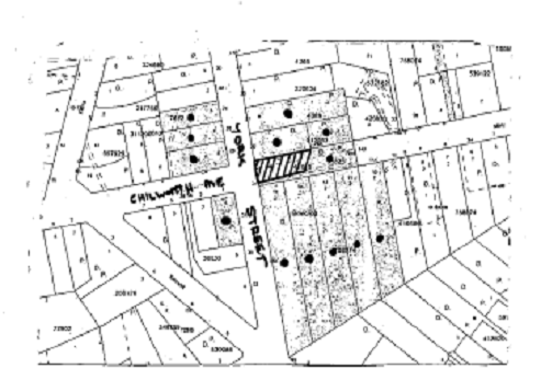
|
NOTIFICATION
PLAN
|
|
|
• PROPERTIES NOTIFIED
|
X SUBMISSIONS
RECEIVED
|
PROPERTY SUBJECT OF DEVELOPMENT
|
|
|
|
|
|
The Trust raised concerns about
the development, generally on the following grounds:
· The disposal of
stormwater to Chilworth Reserve;
· Referral to the NSW Rural
Fire Service;
· The potential habitable
room above the garage;
· The flora and fauna report
makes no reference to the Powerful Owl;
· The proposed swimming
pool is close to two trees;
· The impact of the
retaining wall adjacent to the Chilworth Reserve; and
· All works carried out is
to be certified by Council to protect Chilworth Reserve.
These issues are addressed as
follows:
5.1.1 Drainage
Due to the fall of the land,
stormwater from the dwelling-house would discharge to Chilworth Reserve.
Council’s engineering assessment concludes that the proposed stormwater
solution is acceptable, subject to the imposition of conditions that would
ensure that the discharge from a dispersal trench would be evenly spread over
the Reserve.
This method of stormwater
dispersal is consistent with the recommendation contained within the Stormwater
Management Assessment report prepared in support if this application. The
proposal meets the objectives of Council’s Drainage Control element of the
Dwelling House DCP and is considered acceptable.
5.1.2 Rural Fire Service Referral
The application was referred to
the NSW Rural Fire Service for comment. The RFS raised no objection to the
proposal, subject to the imposition of appropriate conditions. The proposal
meets the objectives of the Fire Hazard element of the Dwelling House DCP and
is considered acceptable.
5.1.3 Potential Habitable Room above the Garage
The room above the garage has
been described in the application as a “storage room”. However, the room could
be used as a “habitable room” without impinging on the environmental aspects of
the allotment and the amenity and privacy of the adjoining allotments. The
floor area of this storage room has been included in the calculation of the
floor space ratio on the assumption that the future occupant will use the room
for habitable purposes.
5.1.4 Powerful Owl not included in the Flora and Fauna Report
The impact of the proposal on the
powerful Owl is addressed in Page 10 of the flora and fauna report and is
referred to in Appendix 1: “Assessment of Significance – Potential
Endangered Populations and Threatened Fauna”.
Council’s environmental
assessment of the application concluded that the applicant’s report was
sufficient and that the impact of the development would not be significant.
5.1.5 The proposed swimming pool is close to two trees
It is Council’s assessment that
the two trees numbered T13 and T14 on Drawing No. 1/15 Site Plan, located in
close proximately to the proposed swimming pool, are not significant and would
be removed.
A recommended condition of
consent prescribes that all works, including the erection of retaining walls
adjoining the reserve, are carried out to minimise environmental and amenity
impacts.
5.1.6 Works carried out is to be certified by Council
Section 81A of the Act allows the
applicant with the choice of appointing either Council or a private accredited
certifier to act as the Principal Certifying Authority (PCA). The nominated
certifier is responsible for ensuring that all the works are carried out in
accordance with the approved plans and specifications.
p
The applicant is yet to appoint a
PCA for this development. If a private certifier is nominated to carry out the
designated inspections, Council would not be the statutory authority to certify
the works as they progress.
6. THE PUBLIC INTEREST
Section 79C (1) (e) of the Act
requires Council to consider “the public interest”.
The public interest is an
overarching requirement, which includes the consideration of the matters
discussed in this report. Implicit to the public interest is the achievement
of future
built outcomes adequately
responding to and respecting the future desired outcomes expressed in
environmental planning instruments and development control plans.
The application’s departure from
numerical development standards would not set an undesirable precedent for
other developments in the street and the locality and approval of a variation
to the development standards would accord with the
aim of SEPP 1 to “provides flexibility in the application of
development standards in circumstances where strict compliance with those
standards would, in any particular case, be unreasonable or unnecessary, or
tend to hinder the attainment of the objectives of the Act”.
The application is considered to
have satisfactorily addressed Council’s and relevant agencies’ criteria and
would provide a development outcome that, on balance, would result in a
positive impact for the community. Accordingly, it is considered that the
approval of the proposed dwelling-house, detached garage, swimming pool,
retaining walls and front fence would be in the public interest.
CONCLUSION
The
application proposes the erection of a dwelling-house, swimming pool, detached
garage, retaining walls and a front fence.
The
dwelling-house would have a gross floor area of 376m2, which
exceeds the 0.4:1 FSR requirement for the site. The applicant has made a
submission under the provisions of SEPP 1 to vary this development standard. It
is considered that the approval of the development is warranted in the
circumstances of this case. The application justifies the non-compliance with
the relevant provisions within Clause 15 of the HSLEP and approval of the
application would not set an undesirable precedent for the area.
Council
received one submission concerning the development. Matters raised in the
submission can be adequately overcome subject to compliance with relevant
conditions. The application was referred to Council’s Heritage Committee and
to the Rural Fire Service to comment on the heritage and bushfire impacts of
the proposal respectively. The Committee and the RFS each advised that the
development would be acceptable subject to the imposition of relevant
conditions.
Having
regard to the assessment of the proposed development and the circumstances of
the case, it is recommended that Council approves the application.
Note: At the time of the completion of this planning report, no
persons have made a Political Donations Disclosure Statement pursuant to
Section 147(3) of the Environmental Planning and Assessment Act, 1979 in
respect of the subject planning application.
|
Simon Evans
Manager -
Assessment Team 1
Planning Division
|
Scott Phillips
Executive Manager
Planning Division
|
Attachments:
|
1.View
|
Locality Plan
|
|
|
|
2.View
|
Site Plan
|
|
|
|
3.View
|
Floor Plans
|
|
|
|
4.View
|
Section
|
|
|
|
5.View
|
Elevations
|
|
|
|
6.
|
Landscape Plan
|
|
|
|
7.
|
Shadow Diagram
|
|
|
|
8.
|
Perspective
|
|
|
File Reference: DA/353/2009
Document Number: D01138569
SCHEDULE 1
CONDITIONS OF
APPROVAL
GENERAL CONDITIONS
The conditions of consent within this notice
of determination have been applied to ensure that the use of the land and/or
building is carried out in such a manner that is consistent with the aims and
objectives of the planning instrument affecting the land.
Note: For
the purpose of this consent, the term ‘applicant’ means any person who has the
authority to act on or the benefit of the development consent.
Note:
For the purpose of this consent, any reference to an Act, Regulation,
Australian Standard or publication by a public authority shall be taken to mean
the gazetted Act or Regulation, or adopted Australian Standard or publication
as in force on the date that the application for a construction certificate is
made.
1. Approved
Plans and Supporting Documentation
The
development must be carried out in accordance with the plans and documentation
listed below and endorsed with Council’s stamp, except where amended by Council
and/or other conditions of this consent:
|
Plan No.
|
Drawn by
|
Dated
|
|
1-15 (Amended D.A. Issue B)
|
Penny Rosier (Architect)
|
19/06/2009
|
2. Removal of Existing Trees
This
development consent only permits the removal of 13 trees numbered T2, T3, T4,
T5, T6, T7, T8, T9, T13, T14, T16, T17 and T22 as identified on Drawing No.1/15
(Site Plan), prepared by Penny Rosier (Architect) dated 19/06/2009. The
removal of any other trees requires separate approval under Council’s Tree
Preservation Order.
REQUIREMENTS PRIOR TO THE ISSUE OF A CONSTRUCTION
CERTIFICATE
The following conditions of consent must be
complied with prior to the issue of a ‘Construction Certificate’ by
either Hornsby Shire Council or an accredited certifier. All necessary
information to demonstrate compliance with the following conditions of consent
must be submitted with the application for a construction certificate.
3. Building
Code of Australia
All building work must be
carried out in accordance with the requirements of the Building Code of
Australia.
4. Contract
of Insurance (Residential Building Work)
In the case
of residential building work for which the Home Building Act, 1989 requires
there to be a contract of insurance in force in accordance with Part 6 of that
Act, that such a contract of insurance is in force before any building work
authorised to be carried out by the consent commences.
Note: This
condition does not apply to the extent to which an exemption is in force
under Clause 187 or 188 of the Act, subject to the terms of any condition or
requirement referred to in Clause 187(6) or 188(4) of the Act, or to the
erection of a temporary building.
5. Notification
of Home Building Act, 1989 Requirements
Residential
building work within the meaning of the Home Building Act,
1989 must not be carried out unless the principal certifying authority for
the development to which the work relates (not being Council) has given Council
written notice of the following information:
a. In
the case of work for which a principal contractor is required to be appointed:
i. The
name and licence number of the principal contractor.
ii. The
name of the insurer by which the work is insured under Part 6 of that Act.
b. In
the case of work to be done by an owner-builder:
i. The
name of the owner-builder.
ii. If
the owner-builder is required to hold an owner-builder’s permit under that Act,
the number of the owner-builder’s permit.
Note: If
arrangements for doing the residential building work are changed while the work
is in progress so that the information notified becomes out of date, further
work must not be carried out unless the principal certifying authority for the
development to which the work relates (not being Council) has given Council
written notification of the updated information.
6. Sydney
Water – Quick Check
The
application must be submitted to a Sydney Water ‘Quick Check Agent’ or
‘Customer Centre’ for approval to determine whether the development will affect
any Sydney Water infrastructure, and whether further requirements are to
be met.
Note: Refer
to www.sydneywater.com.au or
telephone 13 20 92 for assistance.
7. Design
and Construction - Bushfire Attack Category
The
development must be constructed in accordance with Australian Standard
3959-2009 –‘Construction of buildings in bush fire-prone areas’ Level 3 and the
following conditions based on Planning for Bush Fire Protection 2006 and
the NSW Rural Fire Service’s publication Standards for Asset
Protection Zones:-
a. No timber on the
building is to be exposed on the southern and eastern elevations.
b. All guttering
and valleys are to be screened with non-corrosive mesh to prevent the build up
of flammable material. Any materials used shall have a Flammability index no
greater than 5.
c. External doors
are to be sealed with draft excluders or weather strips to prevent the entry of
embers.
d. In accordance of
the Development Control Services ‘Fast Facts’ 4/08 – ‘Glazing in the Flame
Zone’ all windows/door glazing facing the hazard (eastern and southern
elevations) shall have:
i. The openable
portions screened using a mesh with a maximum aperture of 2mm made of corrosion
resistant steel or bronze, and
ii. the window/door
assemblies are protected by a complying bushfire shutter or;
iii. where
window/door systems are not protected by complying bushfire shutter-
1. the window system
shall have an FRL of at least -/30/- or
2. the window system
shall comply with AS 1530.8.2 when tested from the outside.
Notes:
Timbers treated with an applied intumescent paint are no longer recognised by
the Rural Fire Service as a fire retardant treated timber or a performance
option to increase fire resistance.
The
use of fire retardant treated timber in accordance with Level 3 construction
under Australian Standard 3959 – Building in Bushfire Prone Areas is acceptable
if a swimming pool is located not more than 20m from the exposed hardwood
timber on the building and a minimum 3kW (5hp) petrol or diesel powered pump
and a 38mm suction hose nozzle and fittings are provided to enable water to be
pumped from the pool.
REQUIREMENTS PRIOR TO THE COMMENCEMENT OF ANY WORKS
The following conditions of consent must be
complied with prior to the commencement of any works on the site. The
conditions have been imposed to ensure that the works are carried out in such a
manner that complies with relevant legislation and Council’s policies and does
not disrupt the amenity of the neighbourhood or impact upon the environment.
8. Erection
of Construction Sign
A sign must be erected in a
prominent position on any site on which building work, subdivision work or
demolition work is being carried out:
a. Showing the
name, address and telephone number of the principal certifying authority for
the work.
b. Showing the name
of the principal contractor (if any) for any demolition or building work and a
telephone number on which that person may be contacted outside working hours.
c. Stating that
unauthorised entry to the work site is prohibited.
Note: Any
such sign is to be maintained while the building work, subdivision work or
demolition work is being carried out, but must be removed when the work has
been completed.
9. Toilet
Facilities
Toilet
facilities must be available or provided at the works site before works begin
and must be maintained until the works are completed at a ratio of one toilet
for every 20 persons employed at the site. Each toilet must:
a. be a standard flushing
toilet connected to a public sewer; or
b. have an on-site
effluent disposal system approved under the Local Government Act, 1993;
or
c. be a temporary
chemical closet approved under the Local Government Act, 1993.
10. Erosion
and Sediment Control
Erosion and
sediment control measures must be provided and maintained throughout the
construction period in accordance with the manual ‘Soils and Construction
2004 (Bluebook)’, the approved plans, Council specifications and to the
satisfaction of the principal certifying authority. The erosion and sediment
control devices must remain in place until the site has been stabilised and
revegetated.
Note: On
the spot penalties up to $1,500 may be issued for any on-compliance with this
requirement without any further notification or warning.
REQUIREMENTS DURING CONSTRUCTION
The following conditions of consent must be
complied with during the construction of the development. The conditions have
been imposed to ensure that the works are carried out in such a manner that
complies with relevant legislation and Council’s policies and does not disrupt
the amenity of the neighbourhood or impact upon the environment.
11. Construction
Work Hours
All work on
site must only occur between the hours of 7 am to 5 pm, Monday to Saturday. No
work is permitted on Sundays or Public Holidays.
12. Works
near Trees
To ensure any work undertaken will not
adversely affect the longevity of the tree numbered T1, (Site Plan), prepared
by Penny Rosier (Architect) dated 16/06/2009, the driveway
must be laid on existing grade with no excavation or fill within the nominated
restriction zone, or
Pier and beam construction of the driveway or
road within the nominated restriction zone must be used with piers being
located no closer than 3m to the trunks of the trees. The driveway edge must
be no closer than 1m to the edge of the trunk. The excavation for the piers
within the nominated restriction zone must be hand dug to reveal the presence
of any roots. A qualified and experienced arborist must be on site
overseeing the work to ensure no roots greater
than 50mm in diameter are severed, and root damage is minimised.
13. Tree
Protection Barriers
To avoid
injury or damage, tree numbered T1 must have the trunk protected by 2m lengths
of 75mm x 25mm hardwood timbers spaced at 80mm secured with galvanised wire
(not fixed or nailed to the tree in any way).
14. Impacts
on Bushland
All required
tree protection measures must be maintained in good condition for the duration
of the construction period.
15. Bushland
Protection during Construction
To ensure the
protection of bushland during construction, all works, including the erection
of retaining walls adjoining the reserve, are to be carried out to minimise
environmental and amenity impacts in accordance with the following
requirements:
a. The
installation of a 1.8 metre high chain wire fencing (or similar) along the
southern and eastern property boundaries delineating the site from the adjacent
bushland of Chilworth Recreation Reserve identified on the approved plan Landscape
Concept Plan – DWG No. 12/15 Issue A prepared by Penny Rosier Architect (dated
March 2009).
b. All
machinery to be cleaned of soil and debris before entering the site to prevent
the spread of weeds and fungal pathogens.
Note:
Actions such as tree removal, understorey slashing or mowing, removal of dead
trees within this vegetation would likely impact upon this endangered
ecological community. Such action would qualify as illegally picking or
disturbing the habitat and could render any person who carried out such action
as liable for prosecution.
16. Council
Property
During
construction works, no building materials, waste, machinery or related matter
is to be stored on within the adjacent easement, Chilworth Recreation Reserve,
the road or the footpath. The public reserve is to be kept in a clean, tidy
and safe condition at all times.
Note:
This consent does not give right of access to the site via Council’s park or
reserve. Should such access be required, separate written approval is to be
obtained from Council.
17. Disturbance
of Existing Site
During
construction works, the existing ground levels of open space areas and natural
landscape features, (including natural rock-outcrops, vegetation, soil and
watercourses) must not be altered unless otherwise nominated on the approved
plans.
18. Survey
Report – Finished Floor Level
A report(s)
must be prepared by a registered surveyor and submitted to the principal
certifying authority prior to the pouring of concrete at each level of the
building certifying that:
a. The building,
retaining walls and the like have been correctly positioned on the site.
b. The finished
floor level(s) are in accordance with the approved plans.
REQUIREMENTS PRIOR TO THE ISSUE OF AN OCCUPATION CERTIFICATE
The following conditions of consent must be complied with
prior to the ‘Principal Certifying Authority’ issuing an ‘Occupation
Certificate’
Note: For
the purpose of this consent, any reference to ‘occupation certificate’ shall
also be taken to mean ‘interim occupation certificate’ unless otherwise stated.
19. Fulfilment
of BASIX Commitments
The applicant
must demonstrate the fulfilment of BASIX commitments pertaining to the
development.
20. Stormwater
Drainage – Dwellings
The
stormwater drainage system for the development must be designed and constructed
for an average recurrence interval of 20 years and be gravity drained in
accordance with the following requirements:
a. Roof water
connected to a rainwater tank having a minimum capacity of 3,500 litres (in
addition to any BASIX requirements). Overflow and collected surface water in
accordance with Council’s design specification; “On Site Absorption System”,
and the following requirements:
i. The
trench located a minimum of 5m from any down stream properties and 1m from the
side boundaries.
ii. The
trench laid on contour.
iii. The
trench is to be a minimum of 0.5 metres wide, 0.5 metres deep and 2 metres long
for every 50m2 of impervious area.
iv. Overland
flow from the trench is to be spread evenly over the site so as not to
discharge water in a concentrated manner onto adjoining land.
21. Internal
Driveway/Vehicular Areas
The driveway
and parking areas on site must be designed in accordance with Australian
Standards 2890.1, 2890.2, 3727 and the following requirements:
a. Design levels at
the front boundary are to be obtained from Council.
b. The driveway is
to be a rigid pavement.
c. The driveway
grade must not exceed 25 percent and changes in grade not exceed 8 percent.
22. Vehicular
Crossing
A separate
application under the Local Government Act, 1993 and the Roads Act,
1993 must be submitted to Council for the installation of a new vehicular
crossing and the removal of the redundant crossing. The vehicular crossing
must be constructed in accordance with Council’s Civil Works Design 2005
and the following requirements:
a. Any redundant
crossings are to be replaced with integral kerb and gutter; and
b. The footway area is
to be restored by turfing.
Note: An application
for a vehicular crossing can only be made to one of Council’s Authorised
Vehicular Crossing Contractors. You are advised to contact Council on 02 9847
6940 to obtain a list of contractors.
23. Damage
to Council Assets
Any damage
caused to Council’s assets as a result of the construction of the development
must be rectified in accordance with Council’s written requirements and at the
sole cost of the applicant.
24. Landscaping
of Site
In accordance
with the Landscape Concept Plan – DWG No. 12/15 Issue B prepared by Penny Rosier
Architect (dated 19/06/2009) the areas generally zoned “Indigenous
Species” the planting schedule must be locally indigenous to Blackbutt Gully Forest located within the site and adjoining Chilworth Recreation Reserve.
Screen planting along the north western boundary of the site must comprise of Allocasuarina
torulosa of local provenance obtained from a recognised native nursery.
Note:
Advice on suitable species for landscaping can be obtained from
Council’s planting guide ‘Indigenous Plants for the Bushland Shire’, available
at www.hornsby.nsw.gov.au.
25. Weed
Removal
To prevent
the further spread of weeds, the applicant must ensure that all environmental
and noxious weeds Moth Vine (Araujiera sericifera), Small-leaved Privet
(Ligustrum sinense), Large-leaved Privet (Ligustrum lucidum),
Trad (Tradescantia flumiensis), English Ivy (Hederea helix) and
Madeira Vine (Anredera cordifolia) on site are to be removed and
suppressed using recognised bush regeneration methods in accordance with ‘Recovering
bushland on the Cumberland Plain: Best practice guidelines for the management
and restoration of bushland – Department of Conservation 2005’.
Note: The
Guideline is available at: www.environment.nsw.gov.au,
publications
26. Retaining
Walls
All required retaining walls
must be constructed as part of the development.
OPERATIONAL CONDITIONS
The following conditions have been applied to
ensure that the ongoing use of the land is carried out in such a manner that
complies with relevant legislation and Council’s policies and does not disrupt
the amenity of the neighbourhood or impact upon the environment.
27. Bushfire
Management - Landscaping
The building must be constructed
and the land managed in a manner that is consistent with the aims and
objectives of the NSW Rural Fire Service publication ‘Planning For
Bush Fire Protection, 2006’ and in accordance with the following
requirements:
a. Suitable
impervious areas being provided immediately surrounding the building such as
courtyards, paths and driveways;
b. Grassed
areas/mowed lawns/ or ground cover plantings being provided in close proximity
to the building;
c. Restrict
planting in the immediate vicinity of the building which may over time and if
not properly maintained come in contact with the building;
d. New
plantings should not provide a continuous canopy to the building (i.e. shrubs
should be isolated or located in small clusters);
e. When
considering landscape species consideration needs to be given to estimated size
of the plant at maturity;
f. Avoid
species with rough fibrous bark, or which retain/shed bark in long strips or
retain dead material in their canopies;
g. Use
smooth bark species that may increase fuel at surface / ground level (i.e. leaf
litter);
h. Avoid
climbing species to walls and pergolas;
i. Locate
combustible materials such as woodchips/mulch, flammable fuel stores away from
the building;
j. Locate
combustible structures such as garden sheds, pergolas and materials such timber
garden furniture away from the building and
k. Use
flammability vegetation species.
Note: Further
information concerning planning for bush fire protection can be found at: www.rfs.nsw.gov.au.
28. Swimming
Pool Requirements
The construction and
operation of the swimming pool must comply with the provisions of the Swimming
Pool Act 1992, the Swimming Pool Regulation 1998, Australian
Standards 1926.1-3 – Swimming Pool Safety and the following requirements:
a. All waste water
from the pool’s filtration system must be piped to Sydney Water’s sewer
system;
b. The filtration
motor and pump must be housed in a soundproofed structure. Sound from the
equipment must not exceed 5(dBA) above ambient noise levels at any residential
property boundary; and
c. The applicant must participate in the ‘Static Water Supply
Project’ initiative of the NSW Fire Brigade and make available the water
in the swimming pool for use as a static water supply for fire fighting
purposes by the NSW Fire Brigade or the NSW Rural Fire Service.
Note: On completion of the swimming pool, the applicant is to
contact the local NSW Fire Brigade Station or NSW Rural Fire Service Station to
arrange the installation of a static water supply identification plate.
-
END OF CONDITIONS -
ADVISORY NOTES
The following information is provided for your
assistance to ensure compliance with the Environmental Planning and Assessment
Act 1979, Environmental Planning and Assessment Regulation 2000, other relevant
legislation and Council’s policies and specifications. This information does
not form part of the conditions of development consent pursuant to Section 80A
of the Act.
Environmental Planning and Assessment Act, 1979
Requirements
The Environmental Planning and Assessment Act, 1979
requires:
· A construction certificate to be issued
prior to the commencement of any works. Enquiries regarding the issue of a
construction certificate can be made to Council’s Customer Services Branch on
9847 6760.
· A principal certifying authority is to
be nominated and Council notified of that appointment prior to the commencement
of any works.
· Council is to be given at least two days
written notice prior to the commencement of any works.
· Mandatory inspections of nominated
stages of the construction.
· An occupation certificate to be issued
before occupying any building or commencing the use of the land.
Long Service Levy
In accordance with Section 34 of
the Building and Construction Industry Long Service Payments Act 1986, a ‘Long Service Levy’ must be paid to the Long
Service Payments Corporation or Hornsby Council.
Note: The
rate of the Long Service Levy is 0.35% of the total cost of the work.
Note: Hornsby
Council requires the payment of the Long Service Levy prior to the issue of a
construction certificate.
Tree Preservation Order
To ensure the maintenance and
protection of the existing natural environment, it is an offence to ringbark,
cut down, top, lop, remove, wilfully injure or destroy a tree outside 3m of the
approved building envelope without prior written consent from Council. Fines
may be imposed for non-compliance with Council’s Tree Preservation Order.
Note: A
tree is defined as a single or multi-trunked wood perennial plant having a
height of not less than 3m and which develops many branches, usually from a
distance of not less than 1m from the ground, but excluding any plant which, in
its particular location, is a noxious plant declared as such pursuant to the
Noxious Weeds Act, 1993. This definition of ‘tree’ includes any and all types
of Palm trees.
All
distances are determined British Standard BS 5837: 2005, “Trees in Relation to
Construction – Recommendations”.
Dial Before You Dig
Prior to commencing any works,
the applicant is encouraged to contact Dial Before You Dig on 1100 or www.dialbeforeyoudig.com.au for
free information on potential underground pipes and cables within the vicinity
of the development site.
Planning Report No. PLN45/09
Date of Meeting:
5/08/2009
6 DEVELOPMENT APPLICATION
- SECTION 96(2) - SUBDIVISION OF ONE LOT INTO TWO
10 REDGUM AVENUE PENNANT HILLS
|
Development Application No:
|
DA/1273/2004/A
|
|
Description of Proposal:
|
Section 96(2) – Modification to the proposed
subdivision boundary, retain the existing dwelling on the site and complete
minor alterations to the dwelling.
|
|
Property Description:
|
Lot 7 DP 514543, (No. 10) Redgum Avenue, Pennant Hills
|
|
Applicant:
|
Mr B Challita
|
|
Owner:
|
Mr J L Habkouk, Miss K J Habkouk and Mr B Challita
|
|
Statutory Provisions:
|
Hornsby Shire Local Environmental
Plan 1994
Residential A (Low Density)
Zone
|
|
Estimated Value:
|
$50,000
|
|
Ward:
|
C
|
|
RECOMMENDATION
THAT Council approve the
modification to Development Application No. 1273/2004 for the subdivision of
one lot into two and demolition of an existing dwelling at Lot 7 DP 514543
(No. 10) Redgum Avenue, Pennant Hills, as detailed in Schedule 1 of this
report.
|
1. The
application proposes to modify Development Consent No. 1273/2004, by adjusting
the proposed subdivision boundary, retaining the existing dwelling on the site
(previously approved for demolition) and completing minor alterations to the
existing dwelling.
2. On
20 July 2005, Development Application No. 1273/2004 for the subdivision of one
lot into two and demolition of the existing dwelling on the site was approved
by Council at its Planning Meeting.
3. The
proposal complies with the provisions of the Hornsby Shire Local Environmental
Plan 1994 and is consistent with the Residential Subdivision Development
Control Plan.
4. No
submissions have been received in respect of the application.
5. It
is recommended that the application be approved.
HISTORY OF THE APPLICATION
On 20 July 2005, Development
Application No. 1273/2004 for the subdivision of one lot into two and
demolition of the existing dwelling on the site was approved by Council at its
Planning Meeting. Part B of Council’s resolution stated:
‘Any
future applications for this site be brought before Council for determination’.
Accordingly, the proposed
modifications to the development consent is referred to a Planning Meeting for
Council’s consideration.
THE SITE
The site comprises an existing
battleaxe lot, has an area of 1410m2 and is located on the southern
side of Redgum Avenue. The site experiences a slight fall of 5% to the north of
the property and is accessed via an existing carriageway that services Nos. 8
and 10 Redgum Avenue. A single storey brick dwelling and a double carport
occupies the site. The site contains several locally native and introduced tree
species.
The site is within a low density
residential area and a Council reserve adjoins the eastern and southern
boundaries of the site. The site is identified as bush fire prone land and a
water course is located within 40 metres of the site.
APPROVED DEVELOPMENT
The approved development
comprises the subdivision of one lot into two and demolition of the existing
dwelling on the site. The approved lot sizes are:
· Lot 71 - 507m2 (excluding
access handle)
· Lot 72 - 528m2
(excluding access handle)
Access to the site is via a
shared access handle that services Nos. 8 and 10 Redgum Avenue. The approved
carriageway on the site is located along the western boundary, is 3 metres wide
with space for a 0.5 metre wide landscaping verge on each side of the
carriageway. The right of carriageway includes a vehicular turning area which
is shared by both approved allotments and is located within the rear section of
Lot 71.
PROPOSED MODIFICATION OF
DEVELOPMENT CONSENT
The proposal seeks to modify the
development consent to adjust the boundary line to the approved subdivision,
retain the existing dwelling on the site and complete minor alterations to the
dwelling.
The application proposes a minor
relocation of the boundary line, 2.4 metres towards the south. The
modifications would result in the following allotments:
· Proposed Lot 71 - 606m2
(excluding access handle)
· Proposed Lot 72 - 501m2
(excluding access handle)
The boundary adjustment would
result in the existing dwelling on the site being wholly located within
proposed Lot 71. The proposal involves the retention of the existing dwelling
and a re-design of the approved accessway and turning areas for the proposed
allotments.
The proposal includes the
following alterations to the existing dwelling:
· Demolition of a small
rear portion of the dwelling to maintain a 3 metre rear boundary setback. This
includes demolition of a bathroom and part of the laundry.
· Demolition of a concrete
access ramp attached to the dwelling on the western elevation. This removal is
necessary in order to accommodate the driveway access to the rear allotment.
The existing access door on the western elevation is proposed to be replaced
with wall cladding and a window. Access to the building is maintained through
the front door located on the northern elevation.
No trees are proposed to be
removed as part of this modification.
ASSESSMENT
The development application has
been assessed having regard to the ‘2005 City of Cities Metropolitan
Strategy’, the ‘North Subregion (Draft) Subregional Strategy’ and
the matters for consideration prescribed under Section 79C of the Environmental
Planning and Assessment Act 1979 (the Act). Subsequently, the following
issues have been identified for further consideration.
1. STRATEGIC CONTEXT
1.1 Metropolitan Strategy – (Draft) North Subregional Strategy
The Metropolitan Strategy is a
broad framework to secure Sydney’s place in the global economy by promoting and
managing growth. It outlines a vision for Sydney to 2031; the challenges
faced, and the directions to follow to address these challenges and achieve the
vision. The draft North Subregional Strategy acts as a framework for Council
in the preparation of a new Principal LEP by 2011.
The draft Subregional Strategy
sets the following targets for the Hornsby LGA by 2031:
· Employment capacity to
increase by 9,000 jobs; and
· Housing stock to
increase by 11,000 dwellings.
The proposed modification would
not result in any inconsistency with the draft Strategy.
2. STATUTORY CONTROLS
Section 79C(1)(a) requires
Council to consider “any relevant environmental planning instruments, draft
environmental planning instruments, development control plans, planning
agreements and other prescribed matters”.
2.1 Environmental Planning and Assessment Act, 1979 – Section
96
The application is lodged
pursuant to Section 96(2) of the Act which allows the modification of a
consent, where the proposal has been modified in accordance with regulatory
requirements, is substantially
the same development as approved and Council considers the application with
regard to Section 79C of the Act and any submissions.
The proposed development is
substantially the same development as approved.
The application was notified
pursuant to Council’s Notification and Exhibition DCP. There were no submissions
in response to the public exhibition of the proposal.
2.2 Hornsby Shire Local Environmental Plan 1994
The subject land is zoned
Residential A (Low Density) under the Hornsby Shire Local Environmental Plan
1994 (HSLEP). The objectives of the zone are:
(a) to
provide for the housing needs of the population of the Hornsby area.
(b) to
promote a variety of housing types and other land uses compatible with a low
density residential environment.
(c) to
provide for development that is within the environmental capacity of a low
density residential environment.
The proposed development is
defined as ‘subdivision’ and ‘dwelling-house’ under HSLEP and is permissible in
the zone with Council’s consent.
Clause 14 of the HSLEP prescribes
that the minimum allotment size for subdivision within the zone is 500m2,
excluding the area of any accessway. The proposed modification seeks to alter
the approved lot areas, to result in a lot size of 606m2 for
proposed Lot 71 and 501m2 for proposed lot 72. The proposed allotment
sizes comply with the above control.
Clause 15 of the HSLEP prescribes
that the maximum floor space ratio (FSR) of development within the Residential
A (Low Density) zone is 0.4:1. The FSR of proposed Lot 71 is 0.18:1, whilst the
indicative building envelope on proposed Lot 72 results in a FSR of 0.39:1,
which complies with the above control.
2.3 State Environmental Planning Policy No. 19 – Bushland in
Urban Areas
The application has been assessed
against the requirements of State Environmental Planning Policy No. 19-
Bushland in Urban Areas. This Policy provides State-wide planning controls for
the protection of bushland within urban areas.
The development requires
consideration against Clause 9 of the Policy as the site adjoins land zoned for
public space. The proposed subdivision and retention of the dwelling on the
site would not have any detrimental impact on bushland on the adjoining public
reserve. The proposal complies with the provisions of Clause 9 and the
objectives of the Policy.
2.4 State Environmental Planning Policy No. 20 – Hawkesbury Nepean River
The application has been assessed
against the requirements of State Environmental Planning Policy No. 20 – Hawkesbury Nepean River. This Policy provides State-wide planning controls for the
protection of the Hawkesbury-Nepean River system including its water quality.
Subject to the fulfilment of conditions for sediment and erosion controls being
implemented, the proposal complies with the objectives of the Policy.
2.5 Residential Subdivision Development Control Plan
The proposed development has been
assessed having regard to the relevant performance and prescriptive design
standards within Council’s Residential Subdivision Development Control Plan
(Residential Subdivision DCP). The following table sets out the proposal’s
compliance with the prescriptive standards of the Plan:
|
Residential
Subdivision Development Control Plan
|
|
Control
|
Proposal
|
Requirement
|
Compliance
|
|
Density
Proposed Lot 71
Proposed Lot 72
|
606m2
501m2
|
500m2
500m2
|
Yes
Yes
|
|
Building Envelope
|
198.5m2
|
200m2
|
No
|
|
Width of Access Handle
|
3.15m
|
4m
|
No
|
As detailed in the above table,
the proposed development does not comply with two of the prescriptive standards
within the Residential Subdivision DCP with respect to accessway width and the
building envelope. The matters of non-compliance with the Residential
Subdivision DCP are addressed as follows:
2.5.1 Allotment Design
The indicative building envelope
on proposed Lot 72 does not comply with the prescriptive measures of the
‘Allotment Design’ element of the Residential Subdivision DCP which requires a
building envelope of 200m2 with a minimum dimension of 10 metres to
be shown on the subdivision plan. The indicative building envelope on proposed Lot 72 is 198.5m2 and has a minimum dimension of 6 metres, which is inconsistent
with the above control.
Proposed Lot 72 is an irregular
shaped allotment as a result of the configuration of the rear boundary line. A
200m2 building envelope can be adequately sited on the allotment
whilst still complying with provisions for FSR, site coverage, landscaping and
private open space. Whilst the building envelope shows a minimum
dimension of 6 metres, this dimension occurs at the rear of the site where the
rear boundary line is irregular. The majority of the dwelling has a minimum
dimension of 10 metres in accordance with the prescriptive standard. Proposed Lot 72 complies with the minimum lot size requirements, is of sufficient dimensions and
appropriate shape to accommodate a future dwelling.
Notwithstanding the above, the
original subdivision layout illustrated a 200m2 building envelope.
Nothing in the proposed modification to the consent prevents the construction
of a dwelling within the approved envelope.
2.5.2 Accessway Design
The proposed development is
inconsistent with the prescriptive measures of the ‘Accessway Design’ element
of the Residential Subdivision DCP which requires a minimum carriageway width
of 3 metres and a landscape verge of 0.5 metres on each side of the
carriageway.
The proposal seeks to utilise the
existing driveway to access proposed lot 72. The current occupants use this
driveway to access the double carport located at the rear of the site. The existing
driveway is located along the western boundary and the driveway pavement meets
the western boundary where no landscaping verge exists.
The proposal involves the
demolition of an existing concrete ramp on the western elevation of the
dwelling in order to increase the width of the driveway. The wall of the
existing dwelling is setback 3.6 metres from the western boundary, whilst the
eaves of the dwelling are setback 3.15 metres from the western boundary.
Sufficient setback is available to provide the required 3 metre wide
carriageway, however retention of the dwelling means that no landscaping verge
along the western boundary can be provided. The absence of the landscaping
verge is considered acceptable as there would be no further impacts to the
amenity of the western adjoining property. The driveway is already in use by
the current occupants of 10 Redgum Avenue, who access the carport on the rear
section of the site where no screening is provided. The eaves are 2.6 metres
above the ground at the south western corner of the dwelling. The eave does not
overhang the driveway and would not hinder vehicular access.
The proposed modification would
not increase the number of allotments utilising the driveway and does not
require amendment of any conditions applied relating to the driveway and
access. Accordingly, it is considered that a departure from the numerical
development standard is acceptable in the circumstances of the case.
2.6 Dwelling House Development Control Plan
The proposed development has been
assessed having regard to the relevant performance and prescriptive design
standards within Council’s Dwelling House Development Control Plan. The
following table sets out the proposal’s compliance with the prescriptive
standards of the Plan:
|
Residential
Subdivision Development Control Plan
|
|
Control
|
Proposal
|
Requirement
|
Compliance
|
|
Site Cover
Proposed Lot 71
Proposed Lot 72
|
20%
39%
|
40%
40%
|
Yes
Yes
|
|
Car parking
Proposed Lot 71
Proposed Lot 72
|
2
2
|
2
2
|
Yes
Yes
|
|
Private Open Space
Proposed Lot 71
Proposed Lot 72
|
300m2
150m2
|
120m2
120m2
|
Yes
Yes
|
|
Landscaping
Proposed Lot 71
Proposed Lot 72
|
68%
45%
|
45%
45%
|
Yes
Yes
|
|
Setbacks
Proposed Lot 71
Side (north)
Side (east)
Side(west)
Rear (South)
Proposed Lot 72
Side (north)
Side (east)
Side (west)
Rear (south)
|
18m
6.2m
3.6m
3m
4.8m
4.5m
1.2m
3m
|
1m
1m
1m
3m
1m
1m
1m
3m
|
Yes
Yes
Yes
Yes
Yes
Yes
Yes
Yes
|
The proposal complies with the
prescriptive standards of the Dwelling House Development Control Plan and the
proposed retention and alterations to the dwelling are considered suitable for
the site.
2.7 Waste Minimisation and
Management Development Control Plan
The primary purpose of this
Development Control Plan is to provide planning strategies and controls to
promote waste minimisation and management. The original application did not
include a waste management plan and a condition has been applied to the consent
requiring this to be submitted at the issue of a construction certificate.
2.8 Sustainable
Water Development Control Plan
The proposed development has been
assessed having regard to the relevant performance and prescriptive design
standards within Council’s Sustainable Water Development Control Plan. Subject
to conditions requiring that stormwater management and sediment and erosion
controls be implemented, the proposal is consistent with the objectives of the
Plan.
3. ENVIRONMENTAL IMPACTS
Section 79C(1)(b) of the Act
requires Council to consider “the likely impacts of that development,
including environmental impacts on both the natural and built environments, and
social and economic impacts in the locality”.
3.1 Natural Environment
In its assessment of the original
development application, Council identified 22 trees on this site comprising of
a variety of species including locally native Syncarpia Glomulifera
(Turpentine) and Eucalyptus Resinifera, as well as introduced species
such as Liquid Amber and Jacaranda. No trees were permitted for removal as part
of the consent for the subdivision and demolition. Conditions were applied for
tree fencing to be erected during demolition works. The proposed modification
would not necessitate the removal of any trees on the site.
The proposed development would
not have a negative impact on the water quality of the creek subject to
fulfilment of the General Terms of Approval applied by the Department of Water
and Energy.
3.2 Built Environment
The retention of the existing
dwelling and subdivision boundary adjustment would not result in any
detrimental impacts on the built environment. The existing single storey brick
dwelling
is consistent with the style of
dwellings on adjacent properties and its retention would have no adverse
impacts in terms of privacy and overshadowing.
The proposed boundary adjustment
maintains acceptable allotment sizes and adequate separation between the
existing dwelling on proposed Lot 71 and the indicative building envelope on
proposed Lot 72.
3.3 Social Impacts
The proposal would not have any
social impacts on the locality.
3.4 Economic Impacts
The proposal would not have any
economic impacts on the locality.
4. SITE SUITABILITY
Section 79C(1)(c) of the Act
requires Council to consider “the suitability of the site for the
development”.
4.1 Bushfire Risk
The land is identified as being
subject to bushfire risk.
The application was referred to
the NSW Rural Fire Service for comment. The RFS has advised that it raises no
objection to the proposed modification subject to implementation of an Asset
Protection Zone (as currently conditioned).
5. PUBLIC PARTICIPATION
Section 79C(1)(d) of the Act
requires Council to consider “any submissions made in accordance with this
Act”.
5.1 Community Consultation
The proposed development was
placed on public exhibition and was notified to adjoining and nearby landowners
between 7 April 2009 and 23 April 2009 in accordance with Council’s
Notification and Exhibition Development Control Plan. During this period,
Council received no submissions.
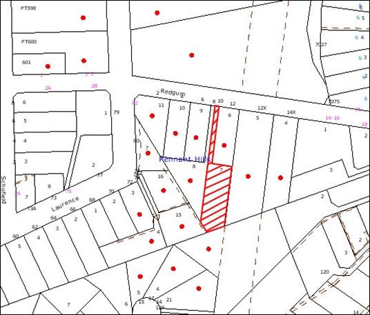
|
NOTIFICATION
PLAN
|
|
|
• PROPERTIES NOTIFIED
|
X SUBMISSIONS
RECEIVED
|
PROPERTY SUBJECT OF DEVELOPMENT
|
|
|
|
|
|
5.2 Public Agencies
The development application is
Integrated Development under the Act. Accordingly, the application was referred
to the following Agencies for comment:
5.2.1 Rural Fire Service
This matter has been addressed in
Section 4.1 of this report.
5.2.2 Department of Water and Energy
The application was referred to
the Department of Water and Energy as the site is within 40 metres of a
watercourse. The Department raised no objections to the modification subject to
the General Terms of Approval applied to the original consent for the
subdivision being applied to the consent.
6. THE PUBLIC INTEREST
Section 79C(1)(e) of the Act
requires Council to consider “the public interest”.
The public interest is an overarching
requirement, which includes the consideration of the matters discussed in this
report. Implicit to the public interest is the achievement of future built
outcomes adequately responding to and respecting the future desired outcomes
expressed in environmental planning instruments and development control plans.
The proposed modification is
considered to have satisfactorily addressed Council’s and relevant agencies’
criteria and would provide a development outcome that, on balance, would result
in a positive impact for the community. Accordingly, it is considered that the
approval of the boundary adjustment and retention of the existing dwelling
would be in the public interest.
CONCLUSION
The Section 96(2) application
proposes to modify the development consent for the subdivision of one lot into
two and demolition of an existing dwelling on the site. The proposed
modification involves a boundary adjustment to the approved subdivision,
retention of the existing dwelling and minor alterations to the dwelling.
The proposed modification does
not comply with the ‘Acessway Design’ element of the Residential Subdivision
Development Control Plan. The proposed retention of the dwelling does not
enable the provision of the 0.5 metre landscaping verge on the western
boundary. The forfeit of the landscaping verge is considered acceptable as
there would be no further significant impacts on the amenity of adjoining
properties.
The application was publicly
exhibited and Council received no submissions. The application was referred to
the RFS and Department of Water and Energy for comment. Both Agencies advised
Council that no objection was raised to the development subject to the
imposition of appropriate conditions/general terms of approval.
The application is assessed as
satisfactory against the provisions of Section 79C of the Environmental
Planning and Assessment Act, the Hornsby Shire Local Environmental Plan and the
Residential Subdivision Development Control Plan.
The application is considered to
be acceptable in relation to environmental impacts and is considered to be in
the public interest. The applicationis consequently recommended for approval
subject to conditions in Schedule 1 of this report.
|
Paul David
Manager -
Subdivision & Development Engineering Services, Planning Division
|
Rod Pickles
Manager -
Assessment Team 2
Planning Division
|
|
Scott Phillips
Executive Manager
Planning Division
|
|
Attachments:
|
1.View
|
Locality Plan
|
|
|
|
2.View
|
Subdivision Plan
|
|
|
|
3.View
|
Floor Plan
|
|
|
|
4.View
|
Subdivision Layout
Plan
|
|
|
File Reference: DA/1273/2004/A
Document Number: D01162490
SCHEDULE 1
PART A
SECTION 96
Date of this modification:
5 August 2009
Details of this modification: Conditions
amended for the retention of the existing dwelling on the site and boundary
adjustment.
Conditions Added: 60, 61, 62, 63
Conditions Deleted: 8, 38
GENERAL CONDITIONS
The conditions of consent within this notice of determination
have been applied to ensure that the use of the land and/or building is carried
out in such a manner that is consistent with the aims and objectives of the
planning instrument affecting the land.
Note: For
the purpose of this consent, the term ‘applicant’ means any person who has the
authority to act on or the benefit of the development consent.
Note:
For the purpose of this consent, any reference to an Act, Regulation,
Australian Standard or publication by a public authority shall be taken to mean
the gazetted Act or Regulation, or adopted Australian Standard or publication
as in force on the date that the application for a construction certificate is
made.
DEVELOPMENT ENGINEER
Construction Certificate – Subdivision/Engineering Works
1. A construction certificate must be obtained from
either Council or an Accredited Certifier. Engineering design plans and
specifications are to be prepared by a chartered professional engineer for any
proposed works. The plans and specifications are to be in accordance with
development consent conditions, appropriate Australian standards, and applicable
Council standards, in particular “Hornsby Shire Council Civil Works - Design
and Construction Specification”. Information required to be submitted with a
construction certificate is as follows:-
(a) copies
of compliance certificates relied upon;
(b) Four (4) copies of the detailed engineering plans in
accordance Hornsby Shire Council's Civil Works - Design Specification 1999.
The detailed plans may include but are not limited to the earthworks,
roadworks, road pavements, road furnishings, stormwater drainage, landscaping
and erosion control works;
(c) Hornsby Shire Council’s approval for works in the
existing public road and works involving Council-controlled drainage systems is
required prior to the issuing of a construction certificate for these works.
Principal Certifying Authority
2. Before any construction works commence, you are required to
appoint a Principal Certifying Authority as required by section 81A of the
Environmental Planning & Assessment Act, 1979. The Principal Certifying Authority
is responsible for ensuring that all the works are carried out in accordance
with the approved plans and specifications. On the date of this consent,
Council is the only principal certifying authority for subdivision work.
Council requires that the applicant enter into a deed of agreement identifying
each party’s responsibilities prior to the commencement of subdivision work.
Notifying
Council of Commencement of Works
3. It is a requirement of the Environmental Planning and
Assessment Act (Section 81A(2) that you notify Hornsby Council at least two (2)
days prior to the intention to commence works. Where works are to be undertaken
in a public place, such notice must be accompanied by evidence of the
contractor’s Public Liability and Workers’ Compensation Insurances. The public
risk policy shall be such an amount as determined by Council (not being less
than $10,000,000.00) and shall cover the owner and the Council against any
injury, loss or damage sustained by any person, firm or company.
Sediment & Erosion Control
4. Temporary sedimentation and erosion controls are to be
constructed prior to commencement of any work to eliminate the discharge of
sediment from the site. The controls are to be designed and installed in
accordance with the requirements of the NSW Department of Conservation and Land
Management's "Urban Erosion and Sediment Control" manual, Hornsby
Shire Council’s “Sustainable Water Best Practices” manual and shall:-
(a) be effectively maintained at all times during the course of
construction and shall not be removed until the site has been stabilised or
landscaped to the Principal Certifying Authority’s satisfaction;
(b) include a single all weather access way at the front of the
property consisting of 50-75mm aggregate or similar material at a minimum
thickness of 150mm and 7 metres long, laid over geotechnical fabric and
constructed prior to commencement of works;
(c) include
adequate measures to remove clay from vehicles leaving the site so as to
maintain public roads in a clean condition;
(d) ensure
that no spoil or fill encroaches upon adjacent bushland for the duration of the
works;
(e) ensure disturbed areas are rehabilitated with indigenous
plant species, landscaped and treated by approved methods of erosion mitigation
such as, mulching, and revegetation with native grasses or other suitable
stabilising processes within fifteen days of the completion of works;
(f) No site works are to commence until the sediment control
installation has been inspected and approved by the Principal Certifying
Authority. At least 48 hours notice is to be given for the inspection of such
works. A compliance certificate to be submitted to Hornsby Shire Council with
the notification for commencement of works.
Dust
Control
5. Measures to prevent the emission of dust or other
impurities into the surrounding environment are to be implemented during
demolition/excavation/construction works.
Demolition
6. All demolition work is to be carried out in accordance with
the applicable provisions of Australian Standard 2601-2001 ‘The
Demolition of Structures’.
Note: Applicants are reminded that WorkCover
NSW requires all plant and equipment used in demolition work must comply with
the relevant Australian Standards and manufacturer specifications.
7. Carrying out of demolition works are restricted to Monday
to Friday between the hours of 7.00am and 6.00pm. No demolition works are to be
undertaken on Saturdays, Sundays or Public Holidays.
8. Deleted
9. A waste management plan is to be submitted with the
construction certificate application. The plan is to detail the type and volume
of demolished building materials, waste building materials and excavated soil
wastes/fill materials and the means of their disposal, including recycling
options and the location of approved waste disposal depots or approved landfill
sites which will be utilised for disposal.
Note: The attention of the applicant is directed to the
requirements of the WorkCover Authority of NSW regarding the removal and
disposal of asbestos and materials containing asbestos and the use of
mechanical appliances on this site.
Hours of Construction
10. In order to maintain the amenity of adjoining properties,
site works shall be restricted to between 7.00 am and 6.00 pm, Monday to Friday
and 8.00 am to 1.00 pm Saturday. Site works may extend to 4.00 pm on Saturdays
if inaudible on residential properties. No work shall be undertaken on Sundays
or public holidays. Plant, goods or materials shall not be delivered to the
site outside the approved hours of site works unless otherwise approved by
Council.
Inspections – Engineering
11. All engineering work required by this consent must be
inspected and compliance certificates shall be issued prior to occupancy or
issue of the subdivision certificate, whichever occurs first, certifying that
the works comply with development consent, construction certificate and Hornsby
Shire Council Civil Works - Design and Construction Specification for the
following nominated stages:
· Implementation of erosion
control
· Implementation of traffic
control
· Boxing out
· Excavated trench and
before backfilling
· Pipes before backfilling
· Sand backfilling
· Final pipe inspection
· Pits base
· Pit walls
· Concrete pit tops
· Subgrade
· Subsoil laying
· Sub base
· Kerb pre-laying
· Kerb during laying
· Pavement Depths (Survey
certificate)
· Base Course
· Concrete tests
· Street furniture
· Footpath turfing
· Lot regrading and
trimming
· Re-vegetation
· Interallotment drainage
pipes
· Interallotment pit
construction
· Final erosion control
inspection
· Replacement of light duty
gutter crossing
· Conduits laid within
access way corridor prior to backfilling
· Driveways and accessways
· Final inspection
Sydney
Water
12. A Section 73 compliance certificate under the Sydney Water
Act 1994 must be obtained. Application must be made through an authorised Water
Servicing Coordinator. Please refer to “Your Business” section of Sydney
Water’s web site at www.sydneywater.com.au then the “e-developer” icon
or telephone 13 20 92.
Following
application, a “Notice of Requirements” will detail water and sewer extensions
to be built and charges to be paid. Please make early contact with the
Coordinator, since building of water/sewer extensions can be time consuming and
may impact on other services and building, driveway or landscape design.
The Notice
must be submitted to the Principal Certifying Authority prior to the
Construction Certificate being issued.
The Section 73 Certificate must be submitted to the Principal Certifying
Authority prior to occupation of the development/release of the plan of
subdivision.
Driveways
and Access
13. A Traffic Control Plan (TCP), prepared by a suitably
qualified work site traffic controller, is to be submitted with any
Construction Certificate, demonstrating compliance with the Road & Traffic
Authority’s Traffic Control at Worksites manual, 1998, and detailing:-
(a) Public Notification of proposed works;
(b) Short term, (during actual works) signage;
(c) Long term signage arrangement;
(d) Vehicle movement plans, where applicable;
(e) Traffic Management Plans;
(f) Pedestrian and cyclist access/safety;
Four copies of the TCP is
required to be submitted for consideration and approval prior to the release of
the Construction Certificate.
14. Construction
of the proposed right of carriageway in accordance with the following
requirements:-
(a) Construction
of 150mm thick reinforced concrete pavement;
(b) The
pavement width shall be a minimum width of 3.0 metres;
(c) The
pavement shall have a kerb to one side and a one-way crossfall with a minimum
gradient of 2%;
(d) The
provision of a safety rail – if required - at appropriate locations along the
carriageway.
15. A concrete footpath and gutter crossing is to be
constructed. The crossing shall be designed and constructed in accordance with
the following provisions:-
(a) Under the provisions of the Local Government Act 1993 and
Roads Act 1993 approval for the construction of the proposed concrete
footpath and gutter crossing to be sought and the appropriate fees paid prior
to the commencement of work;
(b) The crossings are to be designed and constructed in
accordance with Hornsby Shire Council’s standard. The crossing is to have
adequate width at the layback as appropriate for the adjacent driveway or car
park. A plan of the standard is available on request;
(c) Location of the crossings shall not conflict with street
trees, kerb inlet pits poles or other street furniture, unless permission to
relocate a service or remove a street tree is given by the relevant Authority;
(d) Existing crossings shall be removed and reinstated to
Hornsby Shire Council’s standard kerb and gutter;
(e) The vehicular crossing design and construction must be
certified by Hornsby Shire Council’s Works Division as being constructed in
accordance with Council’s standard, prior to release of any Subdivision
Certificate.
16. The internal driveways and car standing areas are to be
designed according to the requirements of Australian Standard AS2890.1 –2004 and
the following requirements;
(a) The internal driveway and manoeuvring areas shall be
designed and constructed to permit turning and manoeuvring for ingress and
egress in a forward direction for both Lots. Turning head design shall be
extended as amended in red on approved Subdivision Plan by B & G Surveying;
(b) Parking areas and driveways are to be paved and drained.
Details of pavement and drainage design are to be submitted in the form of
calculations and specifications or details. Spot levels, cross sections and/or
design contours must be shown on the plans;
(c) Details of car park and turning areas to be prepared by a
suitably qualified professional and shown on the Construction plans for
examination and approval with the Construction Certificate.
17. Reciprocal rights of carriageway and easement for services
are to be created over the access corridor under Section 88B of the
Conveyancing Act 1919.
Drainage
18. Stormwater drainage from the site shall be designed to
satisfactorily drain rainfall intensities for an average recurrence interval of
20 years. The design shall:-
(a) Be in accordance with Hornsby Shire Council Civil Works –
Design Specification 1999;
(b) Provide for drainage discharge to the existing drainage
system;
(c) Ensure that the development, either during construction or
upon completion, does not impede or divert natural surface water runoff so as
to cause a nuisance to adjoining properties.
19. The creation of a “Positive Covenant” over the proposed
front Lot requiring that any future development is to provide an on-site
detention system. The on-site detention system is to have a storage capacity of
5 cubic metres and a maximum discharge of 8 litres per second into Council’s
drainage system in accordance with Council’s standard wording.
Easements
& Restrictions on Title
20. All Section 88B restrictions and covenants created as part
of this consent are to contain a provision that they cannot be extinguished or
altered except with the consent of Hornsby Shire Council.
Subdivision/Strata Plan
21. House numbering can only be authorised by Hornsby Shire
Council. Before proceeding to number each lot/occupancy in the development, the
allocation of numbers must be obtained from Council's Planning Division.
Subdivision Certificate
22. Lodgement and approval of a subdivision certificate is
required to authorise the Plan of Subdivision.
23. All conditions of the development consent are to be
completed prior to the issue of the subdivision certificate.
24. The following documentary evidence is to be obtained and
forwarded to the Principal Certifying Authority prior to the release of the
subdivision certificate:-
(a) Submission of a surveyor’s certificate stating that all
structures within the subject land comply with the development consent in
regard to clearance from proposed new boundaries;
(b) The submission of a surveyor’s certificate stating that no
services, drainage lines or access way encroach over the proposed boundary
other than as provided for by easements created by the final plan of
subdivision;
(c) Submission of certification from an appropriately qualified
WorksiteTraffic Controller that the documentation requirements of Section 6 of
the Traffic Control at Work Sites Manual 1998 (RTA) have been complied with.
Where necessary, Council may require a copy of all documentation to be
submitted to Council for audit purposes prior to the issue of a subdivision
certificate. Council may also audit this documentation at any time during the
development works.
Utility Services
25. Council requires the underground reticulation of low voltage
electricity and telecommunications services for the approved development.
26. The applicant shall ensure that all public utility service
pipes, mains and conduits are laid and/or installed in all new roads and
existing roads, as part of the construction and drainage works associated with
the subdivision.
27. Certification that the requirements of the relevant utility
authorities /company such as Energy Australia and Telstra have been met shall
be submitted prior to the issue of the subdivision certificate.
Council Property
28. The cost of repairing any damage caused to Council's assets
as a result of construction works associated with the approved development is
to be met in full by the applicant/developer prior to the issue of a
subdivision certificate.
ENVIRONMENTAL HEALTH AND
BUILDING SURVEYOR
Site Works
29. No site works, including the removal of vegetation or any
demolition works, shall be commenced prior to:
29.1 A construction certificate being issued.
29.2 Tree/bushland protection measures have been implemented;
29.3 Sediment and erosion control measures have been implemented;
Asbestos Removal
30. Prior to commencement of any work involving the demolition,
alteration or addition to any building on the development site, a survey is to
be conducted by a competent person to ascertain whether any asbestos materials
exist thereon. Asbestos material means any material that contains
asbestos.
31. Where asbestos material is found to exist on the development
site and that asbestos material is to be removed or disturbed as a result of
any proposed demolition, alteration or addition, then all work involving
removal and disposal of asbestos material must be undertaken by persons who
hold the appropriate licence issued by WorkCover NSW under Chapter 10 of the
Occupational Health and Safety Regulation 2001.
32. The collection, storage, transportation or disposal of any
type of asbestos waste is to comply with the requirements of clause 29 of the
Protection of the Environment Operations (Waste) Regulation 1996.
33. Upon completion of disposal operations, the applicant must
lodge with the principal certifying authority, within seven (7) days, all
receipts (or certified photocopies) issued by the receiving landfill site as
evidence of proper disposal.
Note:
The person responsible for disposing of the asbestos material shall consult
with the Environment Protection Authority to determine the location of an
approved landfill site to receive asbestos material.
Signs for Demolition Sites
34. On construction sites where buildings contain asbestos
material, a standard commercially manufactured sign containing the words
‘DANGER ASBESTOS REMOVAL IN PROGRESS’ measuring not less than 400mm x 300mm is
to be erected on the site in a prominent position visible from the street. The
sign is to be erected prior to any work commencing and is to remain in place
until such time as all asbestos material has been removed from the site to an
approved waste facility. This condition is imposed for the purpose of worker
and public safety and to ensure compliance with Clause 259(2)(c) of the
Occupational Health and Safety Regulation 2001.
35. A sign must be erected in a prominent position on the premises,
on which the demolition of a building is being carried out, stating that
unauthorised entry to the premises is prohibited and showing the name of the
builder or other person in control of the premises and a telephone number at
which the builder or other person may be contacted during and outside work
hours.
Inspections
36. The demolition works must be inspected by the Principal
Certifying Authority to certify that the works comply with the development
consent and the approved plans and specifications.
Noise
37. The use of amplified equipment, such as radios and the like
during construction stage shall not be used where the noise is audible on any
neighbouring property.
Disconnection of Utilities
38. Deleted
Landscaping
39. All natural landscape features, including natural rock
outcrops, natural vegetation, soil and watercourses, are to remain undisturbed
except where affected by necessary works detailed on approved plans.
40. The area surrounding the building shall be reinstated to
good order as soon as practical after the completion of site works including,
where necessary, the establishment of new landscaping.
41. The natural ground levels of private open space areas are
not to be altered unless otherwise indicated on the approved plans.
Council Property
42. The land and adjoining areas are to be kept in a clean and
tidy condition at all times. Litter and rubbish shall be placed in containers
and removed from the site. A waste storage container is to be provided at the
commencement of the building work.
43. The cost of repairing any damage caused to Council's assets
as a result of construction works associated with the approved development is
to be met in full by the applicant/developer prior to the issue of a
subdivision certificate.
PARKS AND LANDSCAPE TEAM
44. No excavation or grade changes are to be carried out within
four metres of trees numbered 1, 3, 4, 7, 7a, 8, 9, 9a, 10, 11, 12, 13.
45. Trees marked on plan as 10, 11, 12 and 13 are to be suitably
protected from mechanical damage to trunks from construction machinery. Timber
hoarding or planking should be wired around tree to provide a measure of
protection from
accidental damage. This should be strictly adhered to as
trees are shared in a common driveway and provide amenity value to a number of
residents.
46. A Tree Preservation Order exists within the Hornsby Shire
whereby the cutting down, topping, lopping, removing or wilful destruction of
any tree exceeding 3.0 metres in height (except where exempt as defined under
Council’s Tree Preservation Order) without prior written consent of Council is
prohibited.
Release of the
Construction Certificate gives automatic approval to the removal only of those
trees located on the subject property within 3 metres of the foundation
footprint of an approved residential, commercial or community building, garage
or inground swimming pool. Other trees shall not be removed or damaged without
an application being made under Council’ s Tree Preservation Order. Penalties
apply for non-compliance.
GENERAL
Fences
47. All boundaries behind the building line and courtyard areas
shall be enclosed with 1.8m fences/screens/walls to protect the privacy of
future occupants as well as adjoining owners. Provided that where an adjoining
owner agrees to the provision of an alternate fence/screen/wall that
fence/screen/wall shall be erected in lieu of the fence required by this
condition. The fence/screen/wall is to be erected prior to the occupation of
the dwellings.
Contributions
48. The payment of a contribution towards the cost of transport
and traffic management, open space and recreation facilities, library and
community facilities, bushland and environmental works, stormwater drainage,
bushfire protection and Section 94 administration in accordance with Sections
94, 94B and 94C of the Environmental Planning and Assessment Act, 1979, and
Hornsby Shire Council’s Development Contributions Plan 2004-2010. The total
contribution shall be $12,858.80 if paid prior to 30 June 2005. Following this
date, contributions will be adjusted in accordance with the underlying consumer
price index for the subsequent financial years, it being noted that there are:-
· One (1) additional allotments @
$12,858.80 per dwelling/allotment
This amount is
to be paid to Council prior to issue of the construction certificate or the
subdivision certificate, whichever occurs first. The contribution rate will be
adjusted on an annual basis in accordance with the underlying consumer price
index movements if not paid prior to 30 June 2005.
Note:
A copy of Council’s Contributions Plan may be inspected during business hours
at the first floor of Hornsby Shire Council’s Administration Building located at No. 296 Pacific Highway, Hornsby.
DEPARTMENT INFRASTRUCTURE,
PLANNING AND NATURAL RESOURCES
49. All works proposed must be designed, constructed and
operated to minimise sedimentation, erosion and scour of the banks or bed of
the watercourse/foreshore and to minimise adverse impacts on aquatic and
riparian environments.
50. Erosion and sediment control measures are to be implemented
prior to any works commencing at the site and must be maintained, for as long
as necessary after the completion of works, to prevent sediment and dirty water
entering the watercourse/foreshore environment. These control measures are to
be in accordance with the requirements of Council or the consent authority and
best management practices as outlined in the NSW Department of Housing’s
“Managing Urban Stormwater: Soils and Construction” Manual (1998) - the ‘Blue
Book’.
51. The Part 3A Permit from DIPNR is issued for works on
FREEHOLD land only. This Permit is null and void for any works on Crown Land.
52. Rehabilitation of the area in accordance with the Part 3A
Permit Conditions or any direction from DIPNR is the responsibility of the
Permit holder and owner or occupier of the land.
53. Work as executed survey plans of a professional standard and
including information required by DIPNR shall be provided to DIPNR on request.
54. If, in the opinion of a DIPNR officer, works are carried out
in such a manner that they may damage or adversely affect the
watercourse or foreshore environment, the DIPNR officer may issue an oral or
written direction to immediately stop all work/s.
55. If any DIPNR Part 3A Permit Conditions are breached, the
Permit holder shall restore the site in accordance with these Conditions and
any other necessary remedial actions as directed by DIPNR. If any breach of the
Part 3A Permit Conditions requires a site inspection by DIPNR, then the permit
holder shall pay a fee prescribed by DIPNR for this inspection and all
subsequent breach inspections.
56. Details of any stormwater outlet to the creek (which must be
constructed to prevent erosion or scour of the bank) are to be submitted to
DIPNR for approval prior to the issue of permit. The stormwater outlet to the
watercourse should be designed, located and constructed to minimise any erosion
or scour of the banks or bed of the watercourse and the construction technique
adopted is to ensure that disturbance to the banks soil and vegetation is
kept to an absolute minimum. The stormwater outlet is to be of a soft
engineering design and should address the requirements of the guideline ‘Stormwater
Outlet Structures to Streams (Attachment A)’.
57. Any disturbed areas adjacent to the watercourse are to be
revegetated using a diverse range of native plant species propagated from local
genetic stock. A rehabilitation plan covering any disturbed areas in the
riparian zone, addressing the requirements of the DIPNR guideline on ‘Watercourse
and Riparian Zone Rehabilitation Requirements (Attachment B)’, is to be
submitted to DIPNR for approval prior to the issue of permit. The disturbed
areas must be revegetated for a minimum distance of 10 metres measured
from the edge of the disturbance.
58. A Soil and Water Management Plan (S&WMP) for all site
works is to be prepared by a suitably qualified person to the satisfaction of
Council and DIPNR and approved by
DIPNR prior to the issue of the 3A permit. The S&WMP
is to meet the requirements outlined in Chapter 3 of the NSW Department of
Housing’s ‘Managing Urban Stormwater: Soils and Construction’ (2004)
manual (the ‘BlueBook’).
59. Evidence of Owner’s Consent for any proposed easement to
drain water over any neighbouring property is required prior to the issue of
the permit.
ADDITIONAL CONDITIONS
60. Approved Plans
and Supporting Documentation
The
development must be carried out in accordance with the plans and documentation
listed below and endorsed with Council’s stamp, except where amended by Council
and/or other conditions of this consent:
|
Plan No.
|
Drawn by
|
Dated
|
|
2977 – D1 A
|
Plan Concepts Pty Ltd
|
April 2009
|
|
2977 - ED 1
|
Plan Concepts Pty Ltd
|
June 2009
|
|
Document No / Title
|
Prepared by
|
Dated
|
|
Tree Location Plan
|
Hornsby Shire Council
|
15 September 2009
|
61. Allotment Size
The
allotment size for each of the approved lots (Lot 71 and Lot 72) must have a
minimum area of 500m2, not including any access handle or right of
carriageway.
62. Fire
Safety Upgrade
To ensure the
protection of persons using the building and to facilitate egress from the
building in the event of a fire, the application for a construction certificate
must demonstrate that it will comply with the following Category 1 fire safety
provisions:
a. Part
3.7 of the Building Code of Australia Volume 2
63. Bushfire
Management – Protection Zones
At the issue of a
subdivision certificate and in perpetuity, the entire property shall be
maintained as an Inner Protection Area (IPA) as outlined in section 4.1.3 and
Appendix 5 of the NSW Rural Fire Service publication ‘Planning For
Bush Fire Protection 2006’ and ‘Standards for Asset Protection Zones’.
Note: Further
information concerning planning for bush fire protection can be found at: www.rfs.nsw.gov.au.
-
END OF CONDITIONS –
ADVISORY NOTES
1. The
applicant's attention is directed to the obligations and responsibilities under
the Dividing Fences Act concerning the rights of adjoining property owner/s
which may arise from this application. Further enquiries in this regard should
be directed to a Solicitor or the Local Land Board, telephone No 9228 6726.
2. A
changed determination issued under Section 82A of the Environmental Planning
& Assessment Act, 1979 replaces the earlier determination as from the date
of the review.
PART B:
Where delegated authority is in place, any future
applications for this site be so determined.
Standard Report No. PLN61/09
Planning Division
Date of Meeting:
5/08/2009
7 STRATEGIC PLANNING
PROGRAMME PROGRESS REPORT
EXECUTIVE SUMMARY
Council adopted the current Strategic Planning Programme at
its meeting in December 2008. Council also resolved that a six monthly report
be prepared for Councillors providing an update on the Programme.
The Town Planning Services Branch is currently progressing
a number of projects in accordance with the Strategic Planning Programme.
Other projects have also been identified by Council and will be the subject of
discussion in the report to Council on the December review of the Programme. This
review will provide Council with the opportunity to alter the priority of
strategic planning projects and introduce new projects where appropriate.
This report provides an interim status report to advise
Council of the current projects being undertaken by the Town Planning Services
Branch. It is recommended that Council note the contents of the report and
consider the priority of major projects in the December review of the Strategic
Planning Programme.
PURPOSE
The purpose of this report is to advise Council of the
status of strategic planning projects currently being undertaken by the Town
Planning Services Branch in accordance with the Strategic Planning Programme.
BACKGROUND
The Town Planning Services Branch within the Planning
Division of Council is responsible for town planning initiatives in accordance
with the Strategic Planning Programme. This Programme is adopted by Council
and sets out the major projects of the Branch.
At its meeting on 17 December 2008, Council considered
Executive Manager’s Report No. PLN246/08 on the Strategic Planning Programme
and resolved that:
1. The 2009/2010 Strategic Planning Programme attached to
Executive Manager’s Report No. PLN246/08 be adopted.
2. A six monthly report be prepared for Councillors providing
an update on the Strategic Planning Programme.
3. A Workshop with Councillors be conducted to discuss the
2009/2010 Strategic Planning Programme and Council priorities for strategic
planning over the current Council term.
A copy of the adopted Programme is attached. In
accordance with Council’s resolution, on 10 March 2009 a workshop with
Councillors was conducted to discuss the Strategic Planning Programme.
Councillors noted the projects currently being progressed in accordance with
the Programme and the process to incorporate new projects on the Programme. It
was also
noted that in
accordance with actions arising from the Councillors’ Strategic Weekend in
February/March 2009, reports will be presented to Council on options to
progress a review of planning controls for the Hornsby Town Centre Westside,
Pennant Hills Masterplan review and rural planning provisions review.
The Programme will be referred to Council in December 2009
to determine the priority of strategic planning over the current Council term.
The Programme is reviewed annually to enable Council to reconsider priorities
as issues evolve and to provide Council with an update on the achievements over
the preceding year. This report provides Council with a status report on
projects currently being undertaken in accordance with the Programme.
DISCUSSION
This report provides the status of current projects under
the 2009/2010 Strategic Planning Programme. A more comprehensive explanation
of the projects and their status will be provided with the review of the
Programme to be presented to Council in December 2009.
Current Projects -
Local Environmental Plans (LEPs)
Amendments
LEP (2007): Council resolved to progress an Amendments LEP to permit
specific uses, rezone various lands and update references to property addresses
and descriptions in the HSLEP as follows:
- rezone St Judes
carpark at Dural;
- rezone Landcom sites;
- permit a pharmaceutical facility at
Moores Road, Glenorie; and
- rezone a Department of Health site
at Pennant Hills.
The LEP
has been gazetted.
Amendments
LEP (2008): Council resolved to progress a LEP to amend the HSLEP
as follows:
- rezone property No. 5 Thornleigh
Street, Thornleigh;
- implement the recommendations of
the Open Space Land Acquisition Review;
- rezone property No. 122X Berowra
Waters Road, Berowra Heights;
- rezone Lot 100 DP 1053594 Pennant
Hills Road, Normanhurst;
- rezone properties Nos. 180-190
Pennant Hills Road, Thornleigh; and
- implement the recommendations of
the Foreshores Planning Provisions Review.
The LEP has been forwarded to the DOP for gazettal.
Hornsby Quarry and Environs LEP: The Hornsby
Quarry and Environs Land Capability Study recommends the preparation of a
draft LEP to rezone portions of the study area to permit concentrated
residential development and reclassify parts of the site to operational land.
Council has deferred progression of the draft LEP to consider options for the
site, including land filling.
Galston
Village LEP: A draft LEP has been prepared to implement the findings
of the Galston Village Masterplan Review. Council deferred the draft LEP until
determination of the development application for property No. 346 Galston Road.
The DA has been approved. Council has resolved that the Galston Village Working
Party consider the recommendations of the Review in light of the
approval of the supermarket. A workshop with Councillors concerning the
project is currently being arranged.
Comprehensive
LEP: Council has resolved to prepare a new Comprehensive LEP for
Hornsby Shire by March 2011 in accordance with
the State Government’s Standard Instrument.
Significant
progress has been made on the preparation of Council’s new LEP. The Waterways
Review has resulted in a draft LEP to inform the zoning of the waterways.
The Open Space Land Acquisition Review has been finalised and will
inform the preparation of the Land Acquisition Maps and zoning of open space
lands. A consultant has undertaken a translation of the rural zones into the Standard
Instrument format. Heritage Review Stage 4 has been adopted and
will update Council’s schedule of Heritage Items.
The Hornsby and Ku-ring-gai
Subregional Employment Study has been exhibited and will inform the zoning
and permitted land uses for commercial and industrial lands within the Shire.
The Housing Strategy has been exhibited and
will inform rezonings to facilitate additional housing opportunities to meet
Council’s obligations under the Metropolitan Strategy and draft North
Subregional Strategy.
A draft translation of zones, land use tables and zoning
maps have been discussed with the DOP’s Regional Office. Accordingly, Council
is well placed to prepare a draft Comprehensive LEP in the Standard
Instrument format and incorporating planning controls to meet the dwelling
and employment targets under the Metropolitan Strategy, by the target
date of March 2011.
Current Projects -
Development Control Plans
Heritage DCP Review:
The Heritage DCP was prepared in 1995. The Heritage Advisory Committee
has identified a number of matters that should be reviewed. The review will
require a formal process of preparation, exhibition and adoption. A consultant
has been engaged to provide input to assist progression of the draft DCP and a
draft Plan has been prepared and submitted. It is anticipated that the draft
DCP will be presented to Council in late 2009.
Business Lands DCP Amendments: Council resolved to
prepare an amendment to the Business Lands DCP to implement changes to
setback requirements for specific properties within Thornleigh to supplement
zoning changes recommended under the Amendments LEP 2008. At its
meeting on 1 July 2009, Council adopted the DCP amendments. The amendments
will come into force following gazettal of the associated amending LEP.
River
Settlements DCP Amendments: Council resolved to endorse the exhibition of draft DCP
amendments for bed and breakfast and short term accommodation to implement
recommendations arising from the River Settlements and Foreshores Review.
The amendments include controls for guest numbers, effluent disposal, signage,
car parking (where applicable), fire safety and guest responsibilities. At its
meeting on 1 July 2009, Council adopted the DCP amendments for bed and
breakfast accommodation. The amendments will come into force following
gazettal of the associated amending LEP. Council deferred the amendments
relating to short term accommodation pending the outcomes of a review being
undertaken by the DOP.
Hornsby Quarry and Environs DCP: The Hornsby Quarry
and Environs Land Capability Study
recommended the preparation of a draft DCP to provide a planning strategy and
guidelines for development within the study area. Council
has deferred progression of the draft DCP to consider options for the site,
including land filling.
Galston Village Masterplan DCP Amendments: Draft DCP amendments
have been prepared to implement the findings of the Galston Village
Masterplan Review. Council deferred the
draft amendments until determination of the
development application for property No. 346 Galston Road. The DA has been
approved. Council has resolved that the Galston Village Working Party consider
the recommendations of the Review in light of the approval of the
supermarket.
Comprehensive
DCP: Changes to Part 3 of the Environmental
Planning and Assessment Act, 1979 require that only one DCP apply to a
parcel. Accordingly, all Council DCPs are required to be amalgamated into one
comprehensive DCP within the same timeframe for the preparation of Council’s
new Comprehensive LEP. The preparation of the DCP has commenced.
Current Projects -
Studies
Heritage
Review Stage 4: As part of Council’s ongoing Heritage Review, Stage 4
involves a review of requests for inclusion or removal of items from Schedule D
of the HSLEP and a review of heritage listed trees. At its meeting on 3
June 2009, Council resolved to progress the recommendations of the Review
as part of the next Annual Amendments LEP.
Ku-ring-gai and Hornsby Subregional Employment Study: Council resolved to participate with the DOP and
Ku-ring-gai Council in the preparation of a Subregional Employment Study.
The objective of the Study is to ensure local employment strategies
facilitate opportunities to meet the employment targets under the State
Government’s Metropolitan Strategy. The Study
has been exhibited and a consultant engaged to undertake further analysis of
the Dural Service Centre. A draft report has been submitted by the
consultant. A report on submissions is currently being prepared for
consideration by the Employment Study Working Party.
Housing
Strategy: The Hornsby Shire Housing Strategy identifies areas
suitable for the provision of additional housing to meet Council’s dwelling
targets under the Metropolitan Strategy. The Strategy was
exhibited for public comment until 17 July 2009. A report on submissions is
currently being prepared for consideration by the Housing Strategy Steering
Committee in August 2009.
Outdoor Advertising Review: The purpose of the Review
is to provide an overview of the outdoor advertising controls relevant to
Hornsby Shire. The Review is currently being revised in accordance with
the definitions under the Standard Instrument and is anticipated to
result in a revised Outdoor Advertising DCP.
Current Projects - Other projects
Heritage
Week: Each year Council endorses
events to coincide with National Trust’s Heritage Week to assist in the
promotion of heritage conservation in the Shire. This year’s events have been
conducted and included an Aboriginal heritage walk, former Red Hill Observatory
Heritage Walk, Hawkesbury river boat trip, open day at Fagan Park, astronomical
pursuits exhibition and Heritage Awards.
Local
Heritage Assistance Fund: Each year
the Heritage Advisory Committee and Council endorse funding for a number of
heritage conservation projects. The projects for the
2008/2009
financial year have been completed and a report on the allocation of monies for
projects for the current financial year will be considered by Council at its
meeting on 5 August 2009.
Heritage
Inventories: The Information
Systems Branch is providing assistance to the Town Planning Services Branch to
digitize Council’s Heritage Study Inventory Sheets to ensure they are more
readily accessible to Council’s customers. The Sheets have been digitized and
are currently being quality assured prior to being made available to the public
on Council’s website.
Metropolitan
Development Program: Each year the
DOP requires information on dwelling and subdivision production in the Shire.
The Town Planning Services Branch is currently compiling the information for
2008/2009.
Management
Plan Projects
Equitable access to
transport nodes: Following completion of the Integrated Landuse and
Transport Study, Council resolved to review the Access and Mobility DCP to
facilitate equitable access to major transport nodes. As the ILUTS has
now been completed, this project is scheduled to commence.
DCP recreation controls:
As part of the Strategic Intent Action Plan, Council resolved to review
the recreation controls in Council’s DCPs. This project is scheduled to
commence.
New Projects
Amendments
LEP (2009): At its meeting on 3 June 2009, Council resolved to progress the recommendations of Heritage
Review Stage 4 as part of the next Amendments LEP. At its meeting on 2
September 2009, Council will also considered a planning proposal to permit
the strata title subdivision of property No. 218 Brooklyn Road, Brooklyn. Should Council support the proposal, it would be progressed as part of the
Amendments LEP.
A number of other projects have arisen as a result of
Council resolutions, consideration of development applications, requests from
other Divisions or State Government initiatives and rezoning submissions. New
projects were also identified at the Councillors’ Strategic Weekend in
February/March 2009. The projects include the Hornsby Town Centre West
precinct and Pennant Hills Masterplan. A workshop with Councillors is
currently being arranged to discuss the scope and timing of these projects. A
summary of the projects will be provided in the December review for
incorporation into the Strategic Planning Programme. The timing of these
projects will be required to be determined having regard to the priority of
other projects.
FINANCIAL
The Strategic Planning Programme has been designed in
accordance with the Council approved Town Planning Services Branch budget
allocation, including salaries and consultant expenditure. The Programme is
considered in the preparation of Annual Operating Plans. The Programme does
not commit to expenditure over that typically provided in the budget. The
financial implications of the individual projects are also reviewed and
reported to Council as a component of the project.
TRIPLE BOTTOM LINE SUMMARY
Triple Bottom Line is a framework for improving Council
decisions by ensuring accountability and transparency on social, environmental
and economic factors. It does this by reporting upon Council’s strategic
themes. As this report provides Council with information and does not propose
any actions which require a sustainability assessment, no Triple Bottom Line
considerations apply.
CONCLUSION
The Town Planning Services Branch is currently progressing
a number of projects in accordance with the Strategic Planning Programme
adopted by Council in December 2008. Other projects have also been identified
by Council and will be the subject of discussion in the report to Council on
the December review of the Programme. This review will provide Council with
the opportunity to alter the priority of strategic planning projects and
introduce new projects where appropriate.
This report provides an interim status report to advise
Council of the current projects being undertaken by the Town Planning Services
Branch. It is recommended that Council note the contents of the report and
consider the priority of major projects in the December review of the Strategic
Planning Programme.
RECOMMENDATION
|
THAT:
1. Council note the
contents of Executive Manager’s Report No. PLN61/09 concerning the status
of Strategic Planning Projects currently being undertaken by the Town Planning
Services Branch in accordance with the Strategic Planning Programme.
2. Council consider the
priority of Strategic Planning Projects in the December review
of the Strategic
Planning Programme.
|
|
James Farrington
Manager - Town
Planning Services
Planning Division
|
Scott Phillips
Executive Manager
Planning Division
|
Attachments:
|
1.View
|
Strategic Planning
Programme
|
|
|
File Reference: F2004/10086
Document Number: D01199855
Standard Report No. PLN62/09
Planning Division
Date of Meeting:
5/08/2009
8 LOCAL HERITAGE
ASSISTANCE FUND 2009/2010 APPLICATIONS
EXECUTIVE SUMMARY
This report presents the recommendations of the Heritage
Advisory Committee concerning the allocation of funds under the Local Heritage
Assistance Fund 2009/2010. The Committee recommends the allocation of $60,000
to assist twelve projects relating to the conservation of heritage items within
the Shire.
It is
recommended that Council endorse the expenditure of funds in accordance with
the recommendations of the Committee.
PURPOSE
The purpose of this report is to seek Council’s endorsement
to allocate $60,000 under the Local Heritage Assistance Fund.
BACKGROUND
As part of Council’s commitment to promoting the
conservation of the Shire’s heritage resources, Council has offered an annual
Local Heritage Assistance Fund since 1995. Through the Fund, Council
encourages the conservation of heritage items by contributing financially to
their maintenance. The Fund is allocated on a dollar for dollar basis between
the owner and Council.
The types of work that are eligible for assistance under
the Fund are as follows:
· repair, maintenance or reinstatement of original or missing
items on heritage buildings or structures (e.g. Windows, verandahs, roofs,
decorative details, traditional fences);
· reinstatement of traditional colour schemes on houses or
commercial buildings;
· structural stabilisation of buildings, ruins or slab barns;
and
· historic garden conservation.
The
following works however, are not eligible:
· additions and alterations;
· routine maintenance (including painting);
· work that has already been completed;
· the purchase or relocation of a building;
· internal decoration; and
· the construction of new outbuildings
Applicants are requested to provide the
following information with their application:
· historical background information on the property;
· a plan/sketch of the proposed works (if applicable);
· photographs of the existing structure;
· a minimum of two quotes for the proposed work; and
· a schedule of materials and colours (if applicable)
Over
the past fifteen years, Council has provided assistance to 160 projects valued
at a total of approximately $1,900,556. During April and May 2009,
applications were invited from all owners of heritage items within the Shire
for financial assistance to undertake conservation works. A total of
twenty-one applications were received. The proposed conservation works
totalled $557,798 of which $230,841 was sought from Council. The applications
were considered by the Heritage Advisory Committee at its meeting on 6 July
2008, where a number of projects were supported.
DISCUSSION
The attached table provides a summary of the applications
received, value of works, the recommendations of the Heritage Advisory
Committee and the proposed funding offers.
The Heritage Committee has recommended that the funds be
allocated to twelve projects which are to be completed over the following
twelve month period. The successful projects will be offered funding generally
on a dollar for dollar basis, although some projects will be offered less than
the amount sought due to the limited amount of funding available.
The successful projects recommended by the Committee are as
follows:
|
Project No.
|
Property
Address
|
Applicant
Name
|
Project
Description
|
Recommended
Funding Amount and Comment
|
|
1/08
|
2 Smalls Road Arcadia
|
Mr Peter John Turvey
|
Internal & external
repairs including replacement of hand rail
|
$5,000
|
|
2/08
|
23 Fiona Road, Beecroft
|
Mrs Pauline Ross
|
Replace existing tile roof
(including replacement of batons as required)
|
$8,720 (subject to matching colour and terracotta tile)
|
|
3/08
|
50 The Crescent Cheltenham
|
Mr & Mrs Bryce
|
Repointing of external
walls, reinstating broken footpaths and driveway, reinstating and stabilising
sandstone fences
|
$20,000 (subject to $3,208 being allocated to repointing and
the remainder on sandstone fences)
|
|
4/08
|
208 New Line Road Dural
|
Baris Akar
|
Installation of termite
barrier
|
$1,800
|
|
5/08
|
9 Galston Road, Hornsby
|
Alison MacDonald
|
Replacement of two verandah
posts, rotted joists and decking on verandah
|
$970
|
|
6/08
|
237 Pacific Hwy Hornsby
|
T.J. and M.P Wyatt
|
Repair to brickwork,
shingles, window sills and gable barge boards on upper level.
|
$4,500
|
|
7/08
|
16 Maple Avenue, Pennant Hills
|
Ms Elva Hoy
|
Remove paving, reinstate
grass, waterproof garage wall and improve drainage
|
$660
|
|
8/08
|
333A Pennant Hills Road
Pennant Hills
|
Warren & Hazel Ghisla
|
Repair/restore lace work
and timber of bull nose verandah
|
$1,400
|
|
9/08
|
18 Yarrara Road, Pennant Hills
|
Mr and Mrs Leigh
|
Remove and replace bull
nose sheeting on verandah, remove and replace guttering to the bull nose and
main roof
|
$6,000 (subject to matching profile of roof sheeting)
|
|
10/08
|
24 Dartford Road Thornleigh
|
Brende de Vere Burke
|
Remove and replace rotted
boards over verandah and restore original slate, repair damaged wood on gable
feature, replace water damaged structural posts on verandah
|
$2,000
|
|
11/08
|
15-17 Duffy Avenue Thornleigh (Highway House) - Woodlands
|
Thornleigh Community Baptist Church
|
Re-mortar brickwork on
façade
|
$990 (subject to confirmation that both tuck and
repointing are being undertaken)
|
|
12/08
|
14 Ingram Road, Wahroonga
|
Mr Kongmeng Yong
|
Replace roof
|
$7,960 (subject to matching colour and terracotta tile)
|
Clause
18(2) of the Hornsby Local Environmental Plan (HSLEP) provides that
development consent is not required where Council is of the opinion that
development would not adversely affect the heritage significance of the
heritage item. In supporting the applications, the Committee was of the
opinion that the proposed works would either satisfy Clause 18(2) of the HSLEP,
in that they would not adversely affect the heritage significance of the item
or that development consent has been granted for the works. In offering
applicants funds for works where no development consent has been granted,
Council would be endorsing the works to be undertaken without development
consent.
The successful applications would be subject to the
conditions of the Local Heritage Assistance Fund to ensure the projects are
carried out to a high standard and in an appropriate manner. Council’s Town
Planning Services Branch will be responsible for ensuring the projects are
carried out in accordance with the application and special conditions set by
the Heritage Committee.
In the unlikely event that an applicant does not accept the
offer of financial assistance or the works are unable to be completed this
financial year, it is recommended that the General Manager be authorised to
endorse any additional allocation or redistribution of funds following a
recommendation from the Executive Manager, Planning Division. Any allocation
or redistribution would be limited by the criteria and conditions of the Local
Heritage Assistance Fund.
CONSULTATION
During April and May 2009, applications were invited from
all owners of heritage items within the Shire for financial assistance to
undertake conservation works. Information regarding the Local Heritage
Assistance Fund 2009/2010 was also placed on Council’s website.
FINANCIAL
As part of the 2009/2010 Management Plan, Council has
allocated $60,000 towards the Local Heritage Assistance Fund.
TRIPLE BOTTOM LINE SUMMARY
This Triple Bottom Line (TBL) Statement forms part of
Council’s efforts towards “creating a living environment”. The Statement
addresses the strategic themes within Council’s Management Plan that cover
social, environmental and economic factors and the corresponding sustainability
questions contained in the TBL checklist.
· Working with our community: The Local Heritage Assistance Fund is open to owners of
heritage items within the Shire and an application form was sent to all owners
of heritage listed properties. The Fund provides for collaboration and
financial assistance concerning the conservation of heritage items.
· Conserving our natural environment: The Local Heritage Assistance Fund has been established
by Council to assist property owners to conserve identified heritage items
within the Shire. The aim of the fund is to encourage conservation works on
heritage items in the Shire. The program is intended to provide kick-start
funding to encourage the joint funding of projects between Council and local
residents. The Fund encourages interest and concern for the conservation of
other heritage items within the Shire of Hornsby.
· Contributing to community development through sustainable
facilities and services: The Fund does
not relate directly to the provision of services and facilities. Accordingly,
no adverse impact on opportunities for community development would be expected.
· Fulfilling our community’s vision in planning for the
future of the Shire: The Assistance Fund
assists in promoting the conservation of the important heritage values within
the Shire.
· Supporting our diverse economy: The Local Heritage Assistance Fund aims to assist in the
conservation of important character elements and heritage values which enhance
the attractiveness of the Shire as a place to live and work.
· Maintaining sound corporate and financial management: Council has allocated $60,000 towards the Local Heritage
Assistance Fund. Applicants will be required to provide at least matching
finance for the project. In some instances, applicants will need to contribute
more to the project.
· Other Sustainability Considerations: The Allocation of the Fund would not have an adverse
impact on the environment of the Shire.
CONCLUSION
The Local Heritage Assistance Fund 2009/2010 will provide
for the ongoing conservation of twelve heritage items in the Shire. In
addition, the provision of financial assistance towards privately owned
heritage items will encourage heritage conservation in the Shire and promote
Council’s commitment to heritage conservation.
RECOMMENDATION
|
THAT:
1. Council
endorse the expenditure of funds to the value of $60,000 from the Local
Heritage Assistance Fund budget to the following projects (to be completed
and reimbursed prior to 30 June 2010).
|
Project No.
|
Property Address
|
Applicant Name
|
Project Description
|
Recommended Funding Amount and Comment
|
|
1/08
|
2 Smalls Road Arcadia
|
Mr Peter John Turvey
|
Internal & external
repairs including replacement of hand rail
|
$5,000
|
|
2/08
|
23 Fiona Road, Beecroft
|
Mrs Pauline Ross
|
Replace existing tile
roof (including replacement of batons as required)
|
$8,720 (subject to matching colour and terracotta tile)
|
|
3/08
|
50 The Crescent Cheltenham
|
Mr & Mrs Bryce
|
Repointing of external
walls, reinstating broken footpaths and driveway, reinstating and
stabilising sandstone fences
|
$20,000 (subject to $3,208 being allocated to repointing
and the reminder on sandstone fences)
|
|
4/08
|
208 New Line Road Dural
|
Baris Akar
|
Installation of termite
barrier
|
$1,800
|
|
5/08
|
9 Galston Road, Hornsby
|
Alison MacDonald
|
Replacement of two
verandah posts, rotted joists and decking on verandah
|
$970
|
|
6/08
|
237 Pacific Hwy Hornsby
|
T.J. and M.P Wyatt
|
Repair to brickwork,
shingles, window sills and gable barge boards on upper level.
|
$4,500
|
|
7/08
|
16 Maple Avenue, Pennant Hills
|
Ms Elva Hoy
|
Remove paving, reinstate
grass, waterproof garage wall and improve drainage
|
$660
|
|
8/08
|
333A Pennant Hills Road
Pennant Hills
|
Warren & Hazel Ghisla
|
Repair/restore lace work
and timber of bull nose verandah
|
$1,400
|
|
9/08
|
18 Yarrara Road, Pennant Hills
|
Mr and Mrs Leigh
|
Remove and replace bull
nose sheeting on verandah, remove and replace guttering to the bull nose
and main roof
|
$6,000 (subject to matching profile of roof sheeting)
|
|
10/08
|
24 Dartford Road Thornleigh
|
Brende de Vere Burke
|
Remove and replace rotted
boards over verandah and restore original slate, repair damaged wood on
gable feature, replace water damaged structural posts on verandah
|
$2,000
|
|
11/08
|
15-17 Duffy Avenue Thornleigh (Highway House) - Woodlands
|
Thornleigh Community Baptist Church
|
Re-mortar brickwork on
façade
|
$990 (subject to confirmation that both pin and tuck
pointing being undertaken)
|
|
12/08
|
14 Ingram Road, Wahroonga
|
Mr Kongmeng Yong
|
Replace roof
|
$7,960 (subject to matching colour and terracotta tile)
|
2. Applicants be advised of Council’s
resolution.
3. Should any
applicant not accept the offer of financial assistance or the works are
unable to be completed this financial year, the General Manager be authorised
to endorse any additional allocation or redistribution of funds following a
recommendation from the Executive Manager, Planning Division.
|
|
James Farrington
Manager - Town
Planning Services
Planning Division
|
Scott Phillips
Executive Manager
Planning Division
|
Attachments:
|
1.View
|
Summary of
Applications
|
|
|
File Reference: F2009/00143
Document Number: D01199921
Standard Report No. PLN64/09
Planning Division
Date of Meeting:
5/08/2009
9 LOCAL NOMINATIONS FOR
THE JOINT REGIONAL PLANNING PANELS
EXECUTIVE SUMMARY
The NSW Government’s planning
reforms include the establishment of Joint Regional Planning Panels (JRPPs) to
determine development proposals of regional significance. The Government has
announced that the core objective of JRPPs is to provide stronger-decision
making through greater independence, to supplement councils’ expertise and draw
on local and regional knowledge.
In response to a request from the
Minister for Planning, Council wrote to the Department of Planning on 5 June
2009 advising that it had resolved to nominate the Executive Managers Planning
and Environment as local members and the General Manager as an alterative
member of the JRPP.
On 2 July 2009, the Department
released the Code of Conduct and Procedures for the Operation of the JRPPs. As
a consequence of those documents, it is identified that two of Council’s
nominees (Executive Managers Planning and Environment) are not appropriate
local members of the JRPP and therefore, it is necessary that Council nominates
new members.
PURPOSE
The purpose of this report is to
nominate new local members of the JRPP as it affects the Hornsby local
government area.
DISCUSSION
Background
The NSW Government’s planning
reforms, reportedly aimed at delivering a more efficient and transparent
planning system, include the establishment of JRPPs. The objective of JRPPs is
to create a panel of people with appropriate expertise to determine development
proposals of regional significance providing stronger decision-making through
greater expertise, independence and regional knowledge.
Six regions have been established
covering metropolitan and regional areas of NSW. Hornsby local government area
is in the Sydney West Region.
The Panels commenced operation on
1 July 2009.
Functions of JRPPs
The functions of the JRPPs are
to:
1. exercise certain consent authority functions for ‘regional
development’; and
2. where requested, advise the NSW Minister for Planning on planning
or development matters or environmental planning instruments in respect to the
JRPP’s region.
It is intended that JRPPs will
determine ‘regionally significant’ development applications, including:
· Commercial, residential,
mixed use, retail and tourism development with a capital investment value more
than $10 million and less than $100 million.
· Community infrastructure
and ecotourism developments more than $5 million both public and private, such
as schools, community halls and child care facilities.
· Designated development.
· Development where the
council is the proponent with a capital investment value of more than $5
million or has a potential conflict of interest.
JRPPs will also have such other
functions as are conferred on them by the Environmental Planning and Assessment
Act 1979 (the Act). For example, JRPPs may have a role in relation to Local
Environmental Plans (LEPs). This may include being appointed as the Relevant
Planning Authority (RPA) for a LEP or, where requested by the Minister,
reviewing or providing advice in respect of a proposed LEP. Where a JRPP is
appointed as an RPA for a LEP, the Minister may also delegate plan making
powers to the JRPP. JRPPs may also, in limited circumstances, be appointed by
the Minister to exercise the functions of the planning assessment panels under
s.118 of the Act (such is presently the case in Ku-Ring-Gai Council).
The Department of Planning has
advised that it intends to conduct information sessions throughout the State
for council staff, stakeholders and the community in August 2009.
Councils’ role in relation to
matters under consideration by the JRPP
The adopted ‘Procedures for the
Operation of the JRPPs’ prescribe that the assessment of applications to be
determined by the Panels is to be undertaken by the relevant council officers
in which the proposed development is located. The council officers are to
submit their assessment report and recommendations to the JRPP for
determination.
Whilst the council will not be
the determining body for JRPP matters, the council will have the opportunity to
provide its views about any matters that are to be considered by a JRPP. The
council’s view may be provided to a JRPP by way of a submission in the same way
that any other submissions about the matter are provided to a JRPP for its consideration
in determining a matter. The JRPP must consult the council prior to
determining a matter which is likely to have significant financial implications
for the council.
It is currently proposed that the
deemed refusal period in which an applicant could commence Class 1 action in
the NSW Land and Environment Court against the deemed refusal
(non-determination) of a development application in which a JRPP is the consent
authority is 70 days. However, it is foreseen that Council will not be able to
receive, publicly exhibit, assess, refer the application to a Planning Meeting
and make a recommendation to the JRPP in this time period on any occasion.
Council has previously expressed this concern to the Department of Planning at
a workshop on the proposed amendments to Part 4 of the Act.
Membership of JRPPs
JRPPs are to consist of five
members as follows:
State Members:
Three State members appointed by the Minister, each having expertise in one or
more of the following: planning, architecture, heritage, the environment, urban
design, land economics, traffic and transport, law, engineering, tourism or
government and public administration. One of the State members will be
appointed as the Chairperson of the JRPP.
Council Members:
Two council members appointed by each council that is situated in a part of the
state for which a JRPP is appointed. At least one council nominee is required
to have expertise in one or more of the following: planning, architecture,
heritage, the environment, urban design, land economics, traffic and transport,
law, engineering or tourism.
The council nominees will
automatically become members of the JRPP for matters in that council’s local
government area. However, council members will not sit on a JRPP for matters that
are within another local government area.
Nominations of Council members
to the JRPP
In May 2009, the Government
requested that by 5 June 2009, councils nominate two persons to become members
and a third person to be an alternate member of the relevant JRPP. Council
adhered to the Government’s request and wrote to the Department of Planning
advising that it had resolved to nominate the Executive Managers Planning and
Environment as local members and the General Manager as an alterative member of
the JRPP.
On 2 July 2009 (after the date
that councils were requested to nominate local members and after the
commencement date of the operation of the Panels), the Department released the
Code of Conduct and Procedures for the Operation of the JRPPs. As a consequence
of those documents, it is identified that two of Council’s nominees (Executive
Managers Planning and Environment) are not appropriate local members of the
JRPP and therefore, it is necessary for Council to nominate new members.
· Code of Conduct
The Code outlines the standard of
conduct expected of JRPP members (held at Attachment 1 to this report). The
Code outlines general conduct obligations, conflicts of interest, personal
benefits and relationship between JRPP members, council, council staff and the
community.
Relevantly, the Code prescribes
in Clause 5.5 that “(members) must not hold private meetings, briefings or
discussions (with applicants, residents etc.) in respect of the matter
in the absence of other JRPP members without council staff being in attendance,
and must not attend site visits unless they have been formally arranged by
council staff and you are accompanied by other JRPP members and/or council
staff”. These requirements on JRPP members may be more restrictive than
the Local Government ‘Model Code’, which recognises that appropriate lobbying
of councillors is a normal and legitimate part of the democratic system and
that councillors have a representative role in considering the views of their
constituents and communicating with them.
Councillors wishing to nominate
as a local member of the JRPP are encouraged to consider this and other
provisions of the Code in making such a decision.
Also of relevance is Clause 5.6
of the Code, which prescribes that “As a general rule, it is not appropriate
for council staff to be members of a JRPP, as it would be difficult for them to
appropriately manage the conflicts of duties between being a council staff
member and fulfilling the obligations of a JRPP member.” As it would
ordinarily be expected that the
Executive Managers Planning and
Environment would have (at a minimum) an indirect role in the assessment of
significant development applications, it would not be possible for these
officers to be local Panel members. Consequently, this report recommends that
Council advises the Department of Planning that it nominates new local Panel
members.
The General Manager however, does
not have any direct or indirect function in the assessment of development
applications or other planning decisions and therefore could remain a local
member or alternate member of the Panel without being in conflict with the
Code.
Selection Criteria for Local
Members
The selection criteria of local
members include:
· Senior level
experience in dealing with multiple stakeholders;
· high level
communication skills;
· capability to drive
high profile outcomes in a credible and authoritative manner;
· high level analytical
skills; and
· knowledge of the
assessment of complex developments and planning matters.
In addition, at least one of the
two council nominees must have a high level of expertise in one or more of the
following fields:
· Planning
· Architecture
· Heritage
· The environment
· Urban design
· Land economics
· Traffic and transport
· Law
· Engineering
· Tourism
Funding of the JRPP
The NSW Government has made a
commitment to fund the employment costs of State Panel members and the general
administration of the Panels. A JRPP secretariat will be appointed within the
Department of Planning.
The employment cost of local
members will be the responsibility of each council. In addition, councils are
required to provide, free of charge, appropriate rooms and facilities to allow
the respective Panel to meet and determine relevant planning applications.
Council has not allocated funding
for the JRPP in its 2009/10 operational budget.
Options for Local Members
Having regard to the Code of
Conduct and the selection criteria, Council has a number of options for the
nomination of local members.
1. Senior Council officers
Council could nominate senior
staff, whom it can be demonstrated would not have any direct or indirect role
in the negotiation or assessment of planning matters. Advantages of nominating
a senior Council officer include; members who understand the culture of
Council, have a good understanding of a broad spectrum of local issues and
would perform the role at no additional cost to Council.
It is considered that the General
Manager fulfils the relevant criteria and would be a suitable local
member/alternate member.
2. Councillors
Council could nominate a
Councillor or Councillors, subject to at least one nominated local member
having demonstrated expertise as listed above. Should a Councillor or
Councillors express an interest to be a local member of the Panel, they would
need to be mindful of their role having regard to the JRPP Code of Conduct. In
that regard, that Councillor/s may have less opportunity to liaise with
interested persons concerning relevant planning applications than they would
otherwise have in their role as a councillor as defined by the Local Government
‘Model Code’ issued by the Department of Local Government.
Advantages of nominating a
Councillor/s are similar to that of nominating senior Council staff. That is,
members who understand the culture of Council, have a good understanding of a
broad spectrum of local issues and would perform the role at no additional cost
to Council.
3. Technical experts
Council could nominate technical
experts from its current list of approved consultants to serve as local members
of the Panel. Advantages of technical experts include; members who have the
relevant expertise and who would not have any conflict of interest in respect
of the planning applications being considered by the Panel. Disadvantages of
technical experts would be an additional cost to Council that is currently not
funded.
4. Community representatives
Council could instigate an
‘expression of interest’ process inviting interested community members to serve
as local members of the Panel. Suitable community representatives might
include; retired councillors, retired senior staff, members of specific
community interest groups and/or general members of the community. Criteria
for the selection of community representatives would need to be established,
however, it is envisaged that criteria would include; demonstrated expertise,
understanding of local issues and service to the Hornsby community. As is the
case for community representatives on existing Council committees, it is
envisaged that Council would cover community members’ personal expenses, travel
and hospitality.
CONCLUSION
On 1 July 2009, JRPPs commenced
operation in NSW. As a consequence of the late release of the Code of Conduct
and Operational Procedures, Council is required to nominate two new local
members to the JRPP.
Subject to meeting selection
criteria, Council’s options for local members are; senior staff, Councillors,
technical experts and interested community representatives. Having regard to
the selection criteria and the Code of Conduct, it is recommended that Council
advises the Department of Planning that it now nominates the General Manager as
one of Council’s new local member of the JRPP. It is considered that the
General Manager satisfies the selection criteria and would provide an
appropriate balance between political and technical expertise. In addition, it
is recommended that Council instigates an expression of interest process to select
other suitable local members/alternative members for period of three years.
BUDGET
The cost of providing rooms and
facilities for the JRPP would be minimal and will be absorbed into existing
Divisional budgets.
Depending on Council’s
resolution, Council may need to allocate funds for the payment of expenses to
technical experts and/or community representatives to serve as local members of
the JRPP. In any regard, it is anticipated that those costs would not exceed
$5,000 per annum, which would be allocated from existing Divisional budgets by
way of re-prioritising other projects.
POLICY
There are no policy implications.
CONSULTATION
The Executive Management Team was
consulted in the preparation of this report.
TRIPLE BOTTOM LINE SUMMARY
Triple Bottom Line is a framework
for improving Council decisions by ensuring accountability and transparency on
social, environmental and economic factors. It does this by reporting on
Council’s strategic themes. As this report provides Council with information
and does not propose any actions which require a sustainability assessment, no
Triple Bottom Line considerations apply.
RESPONSIBLE OFFICER
The responsible officer for this
report is the Executive Manager Planning, Mr Scott Phillips, telephone 9847 6751.
RECOMMENDATION
|
THAT
1. Council advises the Department of Planning that it revokes its
nomination of the Executive Manager Planning and the Executive Manger
Environment as local members of the Joint Regional Planning Panel.
2. Council advises the Department of Planning that it now
nominates the General Manager as a local member of the Joint Regional
Planning Panel.
3. Council instigates an expression of interest process to select
other suitable local members/alternative members of the Joint Regional
Planning Panel.
4. The outcome of the expression of interest process be reported
to Council for its endorsement of new local members/alternative members of
the Joint Regional Planning Panel.
5. Council receives a report twelve months following the commencement
of the Joint Regional Planning Panel outlining the implications of the Panel
during this period.
|
|
Scott Phillips
Executive Manager
Planning Division
|
|
Attachments:
|
1.View
|
Joint Regional
Planning Panels Code of Conduct
|
|
|
File Reference: F2009/00493
Document Number: D01200986