BUSINESS PAPER
Planning
Meeting
Wednesday, 2 September, 2009
at 6:30pm
|
Hornsby Shire
Council
|
Table of Contents
|
|
Page
1
|
|
|
|
|
TABLE OF CONTENTS
AGENDA
AND SUMMARY OF RECOMMENDATIONS
Mayoral Minutes
Notices of Motion
Rescission Motions
MATTERS OF URGENCY
ITEMS PASSED BY EXCEPTION / CALL FOR SPEAKERS ON
AGENDA ITEMS
DEVELOPMENT APPLICATIONS
A
Ward Deferred
A
Ward
Item 1 PLN65/09 Development Application -
Construction of an ALDI supermarket and five speciality retail stores
757 Pacific Highway Mount Kuring-Gai
Item 2 PLN63/09 Development Application -
Section 96(AA) - Subdivision of one lot into eight
15 Gardiner Road Galston
B
Ward Deferred
B
Ward
C
Ward Deferred
C
Ward
Item 3 PLN57/09 Development Application -
Erection of a dwelling-house
4 Cherrybrook Road, West Pennant Hills
Item 4 PLN42/09 Development Application -
Construction of an ALDI supermarket
273 - 291 Pennant Hills Road and 2 Bellevue Street Thornleigh
Item 5 PLN66/09 Development Application -
Erection of a Dwelling-House
30 Fiona Road, Beecroft
General Business
Item 6 PLN71/09 Question Without Notice South
Dural Rezoning Proposal
Questions of Which Notice Has Been Given
SUPPLEMENTARY AGENDA
QUESTIONS WITHOUT NOTICE
|
Hornsby Shire Council
|
Agenda and Summary of
Recommendations
|
|
Page
1
|
|
|
|
|
AGENDA AND SUMMARY OF RECOMMENDATIONS
PRESENT
NATIONAL
ANTHEM
OPENING
PRAYER/S
Acknowledgement
of RELIGIOUS DIVERSITY
Statement by the
Chairperson
“We recognise our Shire's rich
cultural and religious diversity and we acknowledge and pay respect to the
beliefs of all members of our community, regardless of creed or faith."
ABORIGINAL
RECOGNITION
Statement
by the Chairperson:
"We
recognise the traditional inhabitants of the land we are meeting on tonight,
the Darug and Guringai Aboriginal people, and respect is paid to their elders
and their heritage."
AUDIO
RECORDING OF COUNCIL MEETING
Statement by the Chairperson:
"I advise all present that tonight's meeting is
being audio recorded for the purpose of assisting in the accuracy of the
Minutes. The recordings may be accessed by members of the public once the
Minutes have been finalised and speakers are requested to ensure their comments
are relevant to the issue at hand and refrain from making personal comments or
criticisms."
APOLOGIES
declarations
of interest
Clause 52 of Council’s Code of Meeting Practice (Section
451 of the Local Government Act, 1993) requires that a councillor or a member
of a Council committee who has a pecuniary interest in a matter which is before
the Council or committee and who is present at a meeting of the Council or
committee at which the matter is being considered must disclose the nature of
the interest to the meeting as soon as practicable. The disclosure is also to
be submitted in writing (on the form titled “Declaration of Interest”).
The Councillor or member of a Council committee must not
be present at, or in sight of, the meeting of the Council or committee:
(a) at
any time during which the matter is being considered or discussed by the
Council or committee.
(b) at
any time during which the Council or committee is voting on any question in
relation to the matter.
Clause 51A of Council’s Code of Meeting Practice provides
that a Councillor, Council officer, or a member of a Council committee who has
a non pecuniary interest in any matter with which the Council is concerned and
who is present at a meeting of the Council or committee at which the matter is
being considered must disclose the nature of the interest to the meeting as
soon as practicable. The disclosure is also to be submitted in writing (on the
form titled “Declaration of Interest”).
If the non-pecuniary interest is significant, the
Councillor must:
a) remove
the source of conflict, by relinquishing or divesting the interest that creates
the conflict, or reallocating the conflicting duties to another Council
official.
OR
b) have
no involvement in the matter by absenting themself from and not taking part in
any debate or voting on the issue as if the provisions of Section 451(2) of the
Act apply.
If the non-pecuniary interest is less than significant,
the Councillor must provide an explanation of why they consider that the
interest does not require further action in the circumstances.
Political
Donations Disclosure
Statement by the Chairperson:
“I advise all present that a Political Donations
Disclosure Statement pursuant to Section 147(3) of the Environmental Planning
and Assessment Act 1979 must be made in the event that a person has made or a
Councillor or political party has received a gift or political donation
from any person or organisation, including a person or organisation making a
submission to an application or other planning matter, listed on the Planning
Meeting agenda.”
confirmation
of minutes
THAT
the Minutes of the Planning Meeting held on 5 August, 2009 be confirmed; a copy
having been distributed to all Councillors.
petitions
Mayoral Minutes
Notices of Motion
Rescission Motions
MATTERS OF URGENCY
ITEMS PASSED BY EXCEPTION / CALL
FOR SPEAKERS ON AGENDA ITEMS
Note:
Persons wishing to address Council on matters which are on
the Agenda are permitted to speak, prior to the item being discussed, and their
names will be recorded in the Minutes in respect of that particular item.
DEVELOPMENT APPLICATIONS
A Ward Deferred
A Ward
Page
Number
Item 1 PLN65/09 Development
Application - Construction of an ALDI supermarket and five speciality retail
stores
757 Pacific Highway Mount Kuring-Gai
RECOMMENDATION
THAT Development Application No.
256/2009 for the demolition of the existing buildings and the construction of a
new commercial complex comprising an ALDI supermarket, five speciality retail
shops, an undercroft car park with eighty one spaces and associated signage at
Lot 5 DP 455847 and Lots 18 & 19 DP 6358 (No. 757) Pacific Highway Mount
Kuring-Gai be approved subject to the conditions of consent detailed in
Schedule 1 of this report.
Page
Number
Item 2 PLN63/09 Development
Application - Section 96(AA) - Subdivision of one lot into eight
15 Gardiner Road Galston
RECOMMENDATION
THAT pursuant to Section 96(AA)
of the Environmental Planning and Assessment Act, 1979, Development Application
No. 922/2003 for the subdivision of one lot into eight lots at Lot 3 DP
1108381, No. 15 Gardiner Road Galston be refused for the reasons detailed in
Schedule 1 of this report.
B Ward Deferred
B Ward
C Ward Deferred
C Ward
Page
Number
Item 3 PLN57/09 Development
Application - Erection of a dwelling-house
4 Cherrybrook Road, West Pennant Hills
RECOMMENDATION
THAT Development Application No.
DA/591/2009 for the erection of a one and two storey dwelling-house at Lot 1011, DP1134002, No. 4 Cherrybrook Road, Pennant Hills be approved subject to the
conditions of consent detailed in Schedule 1 of this report.
Page
Number
Item 4 PLN42/09 Development
Application - Construction of an ALDI supermarket
273 - 291 Pennant Hills Road and 2 Bellevue Street Thornleigh
RECOMMENDATION
THAT Development Application No.
1848/2007 for the construction of an ALDI supermarket with basement level car
parking, ancillary warehouse and associated signage at Lot 31 DP 263535, Lot 7
Sec 3 DP 1854, Lot 2 DP 609765, Lot 1 DP 609765, Lot 32 DP 263535, Lot 101 DP
883635 (Nos. 273-277, 279, 281, 281A & 283-291) Pennant Hills Road and 2
Bellevue Street, Thornleigh be approved subject to the conditions of consent
detailed in Schedule 1 of this report.
Page
Number
Item 5 PLN66/09 Development
Application - Erection of a Dwelling-House
30 Fiona Road, Beecroft
RECOMMENDATION
THAT Development Application No.
298/2009 for the demolition of a dwelling-house and carport and the erection of
a single storey dwelling-house, pool, gazebo, front fence and retaining walls
at Lot A, DP 337026, No. 30 Fiona Road, Beecroft be refused for the reasons
detailed in Schedule 1 of this report.
General Business
Page
Number
Item 6 PLN71/09 Question Without
Notice South Dural Rezoning Proposal
That
Council forward a letter to the Department of Planning confirming Council’s
support for the progression of investigations by the Department of South
Dural for inclusion on the NSW Government’s Metropolitan Development Program.
GENERAL
BUSINESS
·
Items for which there is a Public Forum Speaker
·
Public Forum for non agenda items
·
Balance of General Business items
Questions of Which Notice Has Been Given
SUPPLEMENTARY AGENDA
QUESTIONS WITHOUT NOTICE
Planning Report No. PLN65/09
Date of Meeting:
2/09/2009
1 DEVELOPMENT APPLICATION
- CONSTRUCTION OF AN ALDI SUPERMARKET AND FIVE SPECIALITY RETAIL STORES
757 PACIFIC HIGHWAY MOUNT KURING-GAI
|
Development Application No:
|
DA/256/2009
|
|
Description of Proposal:
|
Redevelopment of the Mount Kuring-Gai Village Centre
including the construction of an ALDI supermarket and five speciality retail
shops.
|
|
Property Description:
|
Lot 5 DP 455847, Lots 18 & 19 DP 6358 (No. 757) Pacific Highway Mount Kuring-Gai
|
|
Applicant:
|
Donaldson Worrad
|
|
Owner:
|
Mr. Bryan T Royce
|
|
Statutory Provisions:
|
Hornsby Shire Local Environmental
Plan 1994 –
Business C (Neighbourhood) Zone
|
|
Estimated Value:
|
$ 6,383,850
|
|
Ward:
|
A
|
|
RECOMMENDATION
THAT Development Application
No. 256/2009 for the demolition of the existing buildings and the
construction of a new commercial complex comprising an ALDI supermarket, five
speciality retail shops, an undercroft car park with eighty one spaces and
associated signage at Lot 5 DP 455847 and Lots 18 & 19 DP 6358 (No. 757)
Pacific Highway Mount Kuring-Gai be approved subject to the conditions of
consent detailed in Schedule 1 of this report.
|
1. The
application proposes the redevelopment of the Mount Kuring-Gai Village Centre
including the demolition of the existing buildings, construction of an ALDI
supermarket, five speciality retail shops, a public plaza, an undercroft
carpark with eighty-one car spaces and associated signage.
2. The
proposal is permissible under the provisions of the Hornsby Shire Local
Environmental Plan 1994 and is consistent with the requirements of the Business
Lands Development Control Plan.
3. Six
submissions have been received in respect of the application.
4. It
is recommended that the application be approved.
HISTORY OF THE SITE
The site was historically zoned
Neighbourhood Business 3(b) under the Local Planning Scheme and was used as a
caravan park, a residence and a small grocery store with petrol pumps installed
on site to service the caravan park.
On 18 December 1980 Council
approved the construction of a supermarket and four speciality shops with fifty
car parking spaces on the site. The site was zoned Neighbourhood 3 (c) at that
time.
On 12 October 1984 Council
approved DA/231/84 for the construction of a shopping centre on the site. The
approved plans indicate ten shops on the site with fifty car spaces. The
shopping centre was subsequently constructed and is known as the Mount
Kuring-Gai Village Centre which currently exists on the site.
THE SITE
The subject property is located
on the western side of the Pacific Highway at the intersection with Nyara Road adjoining the southern boundary of the site. The site is generally flat with a
3.6 % downward slope towards Nyara road (south-western corner).
The area of the site: 3564 sq
metres.
There are ten trees located
within the site and eighteen trees located nearby on adjoining properties
comprising locally native and introduced species. The current
improvements on the site include the Mount Kuring-Gai Shopping Village which
comprises a single storey commercial building accommodating ten retail shops
and commercial uses including a post office.
The gross floor area of the
commercial premise is 863.16 sq metres.
Access to the site is via a
single driveway off Nyara Road. At grade car parking is located on the site to
cater for the development.
The site adjoins a low density
residential area. The allotments immediately adjoining the site to north and
the west and those on the opposite side of Nyara road accommodate single
dwelling houses. A Telstra exchange building adjoins the site to the
north-east.
A pedestrian overpass is located
in close proximity to the site over Pacific Highway which provides access to
Mount Kuring-Gai Railway Station, situated on the opposite side of the road
within 60 to70 metres of the site.
THE PROPOSAL
The proposal involves the
demolition of the existing buildings and the construction of a commercial
complex comprising an ALDI supermarket, five speciality retail shops, including
a post-office.
Details of the size of the development is provided below:
|
Component
|
Gross
Floor Area
|
|
ALDI supermarket
|
|
ALDI store retail
area
|
846 m2
|
|
Associated
warehouse and storage area
|
370 m2
|
|
Staff Amenities
|
37 m2
|
|
ALDI
Gross Floor area
|
1253 m2
|
|
Speciality
Retail shops
|
|
Retail tenancy 1
|
100 m2
|
|
Retail tenancy 2
|
80 m2
|
|
Retail tenancy 3
|
83 m2
|
|
Retail tenancy 4
|
82 m2
|
|
Retail tenancy 5
(Post Office)
|
46 m2
|
|
Circulation
|
94 m2
|
|
Gross
Floor area of the complex
|
1738 m2
|
|
Total FSR
|
0.48:1
|
The undercroft level would
comprise eighty one car spaces including two disabled parking spaces. Vehicular
access to this level would be provided from Nyara Road via a single driveway
for ingress and egress. The basement would be provided with security screens
for after hours security. Bicycle parking is provided within the undercroft
level. A pedestrian ramp that adjoins the northern boundary and a lift would
provide access to the upper floor.
The undercroft level would
include a bin collection directly accessible to two loading docks. The loading
dock, loading and compactor bays for the ALDI store are to be located adjoining
the western boundary of the site in the same location as the existing loading
dock. The goods would be delivered to the ALDI store via a scissor lift
providing access to the warehouse and freezer area located at the ground level.
The ground level would comprise
an ALDI supermarket setback 35 metres from the Pacific Highway (eastern side)
and 13 metres from Nyara Road (southern side) frontages. The store would
immediately adjoin the northern and the western boundaries of the site. The
pedestrian ramp would adjoin the eastern façade of the store. Four speciality
retail shops and the post office would be located at the north-eastern corner
of the site next to the pedestrian ramp. The shops would be setback 3 metres
from the Pacific Highway. Public toilet facilities servicing the development
would be located to the rear of these shops. An alternate service entry is
proposed for each retail tenancy.
A public plaza is proposed in
front of the retail shops to provide an active frontage to the complex. Outdoor
seating areas are proposed in this plaza which would cater for future retail
use on the site. Pedestrian access to the plaza is provided via a set of stairs
and pedestrian ramp from the Pacific Highway. The plaza would provide a semi
outdoor space, being covered by an extended awning.
The design of the building would
be in contemporary style, being single storey in height to blend with the low
density residential environment. The undercroft car park would follow the
contours of the land and would be visible from the south-western corner of the
property providing a two storey appearance to the development in this section.
The applicant has provided details of the proposed schedule of colours and
finishes.
Under-awning lighting would be
provided for the forecourt area. The undercroft parking area would be lit
during business operating hours.
Trolley bays would be located in
the undercroft carpark area and also within the pedestrian forecourt adjacent
to the ALDI store. The applicant has advised that the standard coin-operated
trolley management would be undertaken on the site and managed by ALDI staff.
As part of the proposal, the
following signage is proposed:
|
Signage
|
Details
|
|
Sign type 1
|
One illuminated flush wall
mounted sign measuring 2 x 2.4 metres. The light box would project 0.185
metres from the wall and would display the ALDI logo on the southern
elevation of the building fronting Nyara Road
|
|
Sign type 2
|
One double sided and
illuminated pole sign to be located at the corner of Pacific Highway and Nyara Road. The pole sign would be 7.8 metres high. The advertising area would incorporate
separate panels including the following:
· The ALDI store logo: 2
x 2.4 metres;
· The “Mount Kuring-Gai
Village Centre” identification panel : 2 metres x 750 mm; and
· Five business
identification panels for the retail tenancies: 2 metres x 450 mm.
The total advertising area
would be: 10.8 sq metres.
|
|
Sign type 3
|
Five hamper signs for business
identification of the four retail shops and the post office. The hamper signs
would be located on the underside of the awning and would measure 2.4 x 0.54
metres with a depth of 0.185 metres.
|
|
Sign type 4
|
This sign would be a ‘lifestyle
graphic image’ including the photo of a fruit or a vegetable. No logos or
business identification sign would be included in this image. It would be
similar to a wall mural measuring 6 x 3 metres. The mural would be located at
the south-western corner of the site and is primarily designed to create
visual interest and eliminate monotonous façade design.
|
The proposed operating hours of the ALDI supermarket are:
Monday to Wednesday 8:30 am to 7 pm
Thursday 8:30 am to 9 pm
Friday 8:30 am to 7 pm
Saturday 9 am to 7 pm
The details of hours of operation
for retail shops have not been provided.
The applicant has advised that
all store products for ALDI would be supplied by trucks to the premises. No
food preparation would occur at the store. Two to four deliveries would be
required for the ALDI supermarket every day. The following delivery times have
been proposed:
Monday to Friday 6 am to 12 midnight
Saturday and Sunday 7 am to 10 pm
Deliveries to the speciality
shops by standard vehicles and vans would be undertaken in the car parking
area. Large delivery vehicles, such as rigid trucks, catering to the speciality
retails stores would utilise the additional loading space within the loading
dock catering to the ALDI store without conflicting with the supermarket
deliveries. The applicant proposes that such deliveries would occur outside the
operating hours of the retail premises. However, details of the delivery times
of the retail shops have not been provided as the application does not include
proposed uses of the speciality retail shops.
The ALDI store would employ a
maximum of twenty staff.
ASSESSMENT
The development application has
been assessed having regard to the ‘2005 City of Cities Metropolitan
Strategy’, the ‘North Subregion (Draft) Subregional Strategy’ and
the matters for consideration prescribed under Section 79C of the Environmental
Planning and Assessment Act 1979 (the Act). Subsequently, the following issues
have been identified for further consideration.
1. STRATEGIC CONTEXT
1.1 Metropolitan Strategy – (Draft) North Subregional Strategy
The Metropolitan Strategy is a
broad framework to secure Sydney’s place in the global economy by promoting and
managing growth. It outlines a vision for Sydney to 2031; the challenges
faced, and the directions to follow to address these challenges and achieve the
vision. The draft North Subregional Strategy acts as a framework for Council
in the preparation of a new Principal LEP by 2011.
The draft Subregional Strategy
sets the following targets for the Hornsby LGA by 2031:
· Employment capacity to
increase by 9,000 jobs; and
· Housing stock to
increase by 11,000 dwellings.
The proposed development would be
consistent with the draft Strategy by providing an additional twenty jobs in
the locality for the ALDI store and an anticipated additional ten jobs in the
retail shops.
1.2 Hornsby Shire Housing
Strategy
The Draft Hornsby Shire Housing
Strategy provides the community and development industry with a proposed
framework of future housing needs of the Shire and how the projected yield
would be accommodated in the Local Government Area over the next decade. As a
part of this Strategy, Council has placed on public exhibition twenty-five
precincts possibly suitable for multi-unit housing development to assist meet
Council’s housing obligations into the future. The identification, selection
and evaluation of precincts have been undertaken in accordance with State
Government’s Metropolitan Strategy and draft North Subregional Strategy, along
with principles and methodology utilised for Council’s Housing Strategy in
1998.
The Draft Housing Strategy has
identified the site as a potential location of shop-top housing. The Strategy
proposes mixed-use development on this site incorporating ground floor shops
and multi-unit housing to a height of five storeys. The Strategy has yet to be
adopted by Council and any rezoning to progress the Strategy would not be
implemented until at least 2011.
The development application for
the redevelopment of the Mount Kuring-Gai village centre was lodged with
Council prior to the commencement of the public exhibition of the Housing
Strategy. The application has been assessed under Council’s current statutory
development controls applicable to the site.
The approval of the development
would be contrary to the Housing Strategy in that it would develop the site for
employment generating purposes in lieu of higher density residential
development. Should the site not
be developed in accordance with the Strategy, Council would be required to
investigate alternative options for housing in the locality in future. This
outcome should not in itself lead to the refusal of the current development
application.
2. STATUTORY CONTROLS
Section 79C(1)(a) requires
Council to consider “any relevant environmental planning instruments, draft
environmental planning instruments, development control plans, planning
agreements and regulations”.
2.1 Hornsby Shire Local Environmental Plan 1994
The subject land is zoned
Business C (Neighbourhood) zone under Hornsby Shire Local Environmental Plan
1994 (HSLEP). The objectives of the zone are:
(a) to
encourage economic growth and employment opportunities.
(b) to
accommodate the retail, service and social needs of the community within the
neighbourhood.
(c) to
encourage development that improves the health, vitality, cultural environment
and social environment within neighbourhood business centres.
The proposed development is
defined as a “shop” under the HSLEP and is permissible in the zone with
Council’s consent.
The proposed development would
encourage economic growth and employment opportunities, would accommodate the
retail, service and social needs and would improve the health and vitality of
the neighbourhood. The proposal complies with the zone objectives in this regard.
Clause 15 of the HSLEP prescribes
that the maximum floor space ratio (FSR) of development within the Business C
zone is 0.5:1. The applicant addresses this requirement by proposing a FSR of
0.48:1 and is acceptable.
Clause 18 of the HSLEP provides heritage
conservation measures for the Shire. The proposal would adjoin a house at No. 3 Glenview Road which is listed as a heritage item of Local significance under Schedule
D of the HSLEP. The proposed development would adjoin the house in a similar
way as the current development and would not result in any greater impact on
its heritage significance. No further assessment in this regard is considered
necessary.
2.2 State Environmental Planning Policy No. 55 – Remediation
of Land (SEPP 55)
The
application has been assessed against the requirements of SEPP 55. This Policy
provides State-wide planning controls to promote the remediation of
contaminated land to reduce the risk of harm to human health and the
environment. Clause 7 of SEPP 55 provides that a consent
authority must not consent to the carrying out of any development on land
unless it has considered whether the land is contaminated and is suitable for
the development.
The applicant has addressed these
requirements by providing a preliminary site investigation report to Council.
The report concludes that the site has historically
been zoned and used for commercial and residential purposes and therefore the
site does not constitute potentially
contaminated
land. However, the report recommends additional investigations to be undertaken
on site after the demolition of the existing buildings to determine any
potential contaminants on site and the subsequent remediation, as underground
storage tanks related to the historic petrol pumps may still be present on
site.
The
application is considered satisfactory in this regard subject to implementation
of recommended conditions.
2.3 State Environmental
Planning Policy (Infrastructure) 2007
The
application has been assessed against the requirements of State Environmental
Planning Policy (Infrastructure) 2007. This Policy contains State-wide
planning controls for developments adjoining rail-corridors and busy roads.
2.3.1 Development with frontage to a classified road
The proposal is assessed against
the requirements of Clause 101 of SEPP (Infrastructure) as it fronts the Pacific Highway. In accordance with the requirements of the Policy, the development does not
propose any vehicular access from the Pacific Highway and is not sensitive to
road noise.
Council’s assessment of the
proposal considers that the development is satisfactory subject to the
implementation of recommended conditions.
2.3.2 Traffic Generating
Development
The development is classified as
a Traffic Generating Development in accordance with Clause 104 of the SEPP
(Infrastructure) as it is located on a site that has direct vehicular or
pedestrian access to a road that connects to a classified road, where the
access is located within 90m of the connection and would have an area of more than
500 sq metres.
The proposed development involves
access from Nyara Road via a 17 metre wide common driveway for ingress and
egress. Two loading docks are situated on the western boundary with direct
access to and from the driveway.
The development application
includes a traffic assessment report. The report calculates the traffic
generation for all components of the development in accordance with the NSW
Roads and Traffic Authority (RTA) guidelines and concludes that the development
would result in a net traffic generation of 95 – 195 vehicles per hour
(two-way) during the Friday afternoon and Saturday peak hours respectively. The
RTA guidelines also indicate that 25 per cent of the visits are likely to be
passing trade or linked trips.
The traffic intersection analysis
in the report has concluded that the intersection of Nyara Road with the site
would continue to operate with level of service A/B and that of Pacific Highway
with Nyara Road would continue to operate with a B level of service. Therefore
it is estimated that the road intersection would be able to accommodate the
additional traffic generated by the development.
The application was referred to
the RTA for concurrence whereby concerns were initially raised regarding the
manoeuvring of the vehicles within the site. The RTA recommended the submission
of a Service Vehicle Management Plan (SVMP) to ensure the proper operation of
the loading docks and the deliveries of the speciality retail shops and
requested that Council
impose conditions to ensure that
no queuing of vehicles occur onto the Pacific Highway as a result of the
development.
The applicant has addressed the
above issues by providing the swept path analysis that demonstrates that all
service vehicles including a 19 metre semi-trailer and 12.5 metre long rigid
truck can manoeuvre within the site to Council’s and RTA’s requirements. The submitted plans indicate that a separate specialty
shop loading space is provided in front of the compactor to be used by small to
heavy rigid vehicles, with smaller delivery vehicles using an area within the
car park.
The ALDI store would require two
to four deliveries per day. A Service Vehicle Management Plan (SVMP) has been
submitted to Council detailing the operations of the loading dock and the truck
management on site. The SVMP stipulates the
following delivery times for the ALDI store:
Monday to Friday 6am to 12 midnight
Saturday & Sunday 7am to 10pm
Council’s
assessment of the SVMP concludes that the delivery times are not acceptable due
to potential conflict with peak customer arrival and departure times.
Therefore, it is recommended that there be no deliveries between 2pm and 6pm
Monday to Friday and 10am and 3pm Saturday and Sunday.
With
regard to queuing of vehicles, Council’s assessment of the intersection
analysis concludes that queuing of vehicles would not occur at the
intersection. A condition is also recommended requiring no queuing to occur in
front of the loading dock at any time, to satisfy the RTA’s requirements.
Further,
a condition is recommended requiring the monitoring of the site for a period of
six months after occupation with regard to traffic impacts of the deliveries on
the Nyara Road and Pacific Highway intersection. Should the review indicate
that such delivery times would result in queuing at the intersection of Nyara Road and Pacific Highway, the delivery times would be required to be amended at that
time.
The SVMP
for the specialty shops stipulates that deliveries to the specialty shops would
occur outside of operating hours to ensure minimal disturbance to customer
vehicles. In any regard, it is not anticipated that the retail shops would
generate significant numbers of service vehicles.
Council’s
assessment of the application concludes that after-hours deliveries may not be
practically implemented during operation of the shops. Therefore a condition
is recommended requiring time restrictions on delivery hours of the speciality
shops similar to that of the ALDI store.
Given the above, it is considered
that the application addresses the requirements in relation to a Traffic
Generating development and the vehicular access to the site is satisfactorily.
The details in relation to parking are discussed in section 2.8 of this report.
2.4 State Environmental Planning Policy No. 64 – Advertisement
and Signage
The application has been assessed
against the requirements of State Environmental Planning Policy No. 64 (SEPP
64).
SEPP 64 defines a ‘business identification sign’ as a sign
that identifies or names a building or the nature of the business. The
proposed signage complies with the definition of business identification signs
under the SEPP.
Division 1 Clause 9 of SEPP 64 indicates that the Policy does not
apply to ‘business identification signs’. However, the Policy requires that the
consent authority must consider the assessment criteria within Schedule 1 of
SEPP 64 when assessing any sign.
The assessment of the proposal against Schedule 1 of the
SEPP 64 is detailed below:
2.4.1 Character of the Area
The site is located within the Mount Kuring-Gai commercial
precinct. The proposed signs are compatible with existing signage in the
locality and would not have a detrimental impact on the desired future
character of the area. None of the proposed signs would have an undesirable
visual impact on the surrounding residential area.
2.4.2 Special
Areas
The
proposed building and associated signage is located in an existing commercial
area. The proposal would not detract from the amenity or visual quality of any
environmentally sensitive areas.
2.4.3 Views and
Vistas
The proposed signage would not alter any significant views
or vistas from the Pacific Highway or from adjoining properties. The
signage does not obscure or compromise important views, dominate the skyline or
impact on the viewing rights of other advertisers.
2.4.4 Streetscape,
Setting or Landscape
The proposed signs are of a scale, proportion and form that
is appropriate for the streetscape and setting and would contribute to the
visual interest of the streetscape. The signage does not protrude above
buildings.
2.4.5 Site and
Building
The proposed signs are compatible with the site and
building on which the signage is to be located.
2.4.6 Associated
devices and logos with advertisements and advertising structures
The proposed signage contains the wording ‘ALDI’ and the
ALDI logo, which forms part of the business identification and is considered
suitable.
2.4.7 Illumination
The illumination of the proposed signs is not likely to
affect safety for pedestrians, vehicles or aircraft. A condition is
recommended requiring that no illumination in signage occurs after operating
hours and external lighting is to comply with the relevant Australian
standards.
2.4.8 Safety
The proposed signs would not reduce the safety of the
public road nor would they obscure the sight distances of pedestrians.
On the basis of this assessment, the proposed signs are
consistent with the objectives of the Policy and satisfy the assessment
criteria specified in Schedule 1.
2.5 Sydney Regional Environmental Plan No. 20 – Hawkesbury Nepean River
The application has been assessed
against the requirements of Sydney Regional Environmental Plan No. 20 (SREP –
20). This Policy provides general planning
considerations and strategies requiring Council to consider the impacts of the
proposal on water and scenic quality, aquaculture, recreation and tourism.
The proposed development would
have minimal potential to impact on the water quality of the catchment, subject
to the implementation of management measures for the construction and
operational phases of the development. A condition is recommended with respect
to the installation of sediment and erosion control measures prior to and
during construction.
The proposal also includes
details of stormwater management of the site. Council’s assessment of the
proposal in this regard concludes that the development is satisfactory. The
matter has been discussed in detail in section 3.1 of this report.
2.6 Business Lands Development Control Plan
The proposed development has been
assessed having regard to the relevant performance and prescriptive design
standards within Council’s Business Lands Development Control Plan (BLDCP).
The following table sets out the proposal’s compliance with the prescriptive
standards of the Plan:
|
Business Lands
Development Control Plan
|
|
Control
|
Proposal
|
Requirement
|
Compliance
|
|
FSR
|
0.48:1
|
0.5:1
|
Yes
|
|
Setbacks
Pacific Highway
Nyara Road
Northern side
Western side
|
3m
12.2m
0m
1m
|
3m
0m to 3m
0m
0m
|
Yes
Yes
Yes
Yes
|
|
Height
|
1 - 2 storeys
|
2 storeys
|
Yes
|
|
Car parking
|
81 spaces
|
93 spaces
|
No
|
|
Signs
Total Area:
|
19.85 m2
|
12.25 m2
|
No
|
As detailed in the above table,
the proposed development does not comply with some prescriptive standards within
Council’s BLDCP. The matters of non-compliance are detailed below, as well as
a brief discussion on compliance with relevant performance standards.
2.6.1 Density
The
proposed development complies with the required floor space ratio within the
site and complies with the density provisions of the BLDCP.
2.6.2 Height
The development proposes a single storey structure to be
situated on a raised plaza with undercroft parking area. The height compliments
the adjoining low-density residential area and complies with the BLDCP.
2.6.3
Car Parking and Vehicle Access
The proposal does not comply with the BLDCP with regard to
number of car spaces provided within the site. The matter has been discussed in
detail in section 2.8 of this report.
2.6.4 Signs
The total area of signage proposed on site would have
numerical non-compliance with the requirements of the BLDCP. However, the signs
are proposed on different facades of the building and under the awning at the
corner of Pacific Highway and Nyara Road. Therefore, the numerical
non-compliance with the total signage area would not have a detrimental impact
on the streetscape. The amount of signage proposed on site is not considered to
be excessive compared to the scale of the development and is therefore acceptable.
2.6.5 Acoustics
The proposal includes retail
premises and would adjoin a Residential A (Low) density zone to the north and
south-west. The applicant has submitted a Noise Assessment Report to address
the impact of the development on the surrounding residences with regard to
noise and the attenuation measures.
The noise assessment report has
considered the following noise generating criteria:
i. Operational noise from mechanical plant and equipments, truck
deliveries hours as detailed in the proposal section of this report and the
undercroft carpark which would be open at the north-western corner.
ii. Traffic noise from the public roads.
iii. Construction noise.
The fixed plants and equipments
to be used on site would include:
i. Two carpark exhaust fans, the exact locations of which are to
be determined with construction certificate plans. However, the fans would be
setback at least 6 metres from the any boundary.
ii. Two indoor air-conditioning units on the rooftop platform.
iii. Two refrigeration units on the rooftop platform.
iv. External air-conditioning units and exhausts for the
speciality retail shops would be required. Details of plant and equipment have
not been included in the proposal.
The report
concluded the following:
· Noise levels
from continuously operating plant would meet the DECC (Department of
Environment and Conservation) criteria subject to acoustic screening of the
external plant area.
· An acoustic
fence comprising 2 metres high precast concrete or masonry wall and a 1 metre
high clear acrylic screen, located along the western and the northern
boundaries would provide appropriate noise attenuation to the adjoining
properties. In accordance with the Noise Assessment report, the fence would be
2 metres high, with 3 metres high section adjacent to the façade of No. 6 Nyara Road adjoining the western boundary.
· The report
predicts that truck deliveries between 10 pm and 12 midnight would result in
noise generation exceeding the sleeping arousal criteria by 2 dbA. This would
impact the residences at No. 6 and No. 1 Nyara Road. The Environmental Criteria
for Road Traffic Noise (ECRTN) provides that such predicted noise levels would
be unlikely to result in awakening reactions.
· The report also
specifies that the total number of expected deliveries per day for the ALDI
store would be two to four. Therefore the expected ‘night’ (10 pm to 12 pm)
time delivery would be infrequent and therefore have minimal impacts.
The proposed delivery hours are:
Monday to Friday 6 am to 12 pm
Saturday and Sunday 7 am to 10 pm
· Currently the
site has a 24 hours delivery to the shops and there are no noise barriers in
place. The proposed development would improve the current situation.
· The traffic
generated by the development would comply with all the noise assessment
criteria.
· The noise levels
during construction would exceed the DECC criteria. In order to comply with
such criteria, a number of measures are proposed to control the on-going
construction works on site.
Council’s
assessment included a detailed examination of the Noise Assessment Report. It
is concluded that the above delivery hours would result in non-compliance with
the noise levels during “night” time (10 am and 12 pm) and would potentially
impact on the amenity of the neighbouring properties at No. 6 Nyara Road and No. 1 Nyara Road.
Therefore, the
following conditions are recommended to retain the amenity of the neighbouring
properties:
i. The delivery times for the ALDI supermarket and any
speciality retail shop be restricted to the following times:
Monday to Friday 6 am to 10 pm
Saturday and Sunday 7 am to 10 pm
ii. The noise generated by the proposal at any time are not to
exceed the background noise levels by more than 5dB(A).
iii. An acoustic assessment is to be undertaken by a suitably
qualified environmental consultant within 60 days of occupying the site in
accordance with the Environment NSW Industrial Noise Policy (2000), Council’s
Guidelines for Noise and Vibration Generating Development (Acoustic Guidelines
V.5, 2000) and DECC’s Noise Guide for Local Government (2004) to demonstrate
that the noise generated from the premise does not exceed the 5dB(A) level.
iv. Delivery/Waste Collection hours are to be restricted to the
following times:
Monday to
Friday 7 am to 10 pm
Saturday 7
am to 8 pm
Sundays,
Public Holidays 7 am to 6 pm
v. The applicant is to prepare a Construction Noise Management
Plan prior to any works commencing on site and have that plan approved by
Council.
vi. The proposal does not include the hours of operation of the
speciality retail shops. However, the shops are approved under this application
and the first occupation would be exempt pursuant to council’s Exempt and
Complying Development Control Plan. Therefore, the hours of operation for the
speciality retail shops are restricted to those times below:
Friday to Wednesday 7 am to 7 pm
Thursday 7 am to 9 pm
Given the implementation of the
above conditions, it is considered that the proposal would be acceptable with
regard to noise impacts on adjoining properties.
2.6.6 Solar Access
The applicant has submitted
shadow diagrams to demonstrate that shadows cast by the proposed development
between 9am and 3pm during winter solstice would not result in the unreasonable
loss of solar access to adjoining residential buildings or pedestrian areas.
2.6.7 Landscaping
The proposal includes a landscape plan incorporating
suitable planting along the street frontages and reinstatement of the nature
strip along the Pacific Highway and Nyara Road in front of the site.
Substantial planting would be undertaken along the both frontages of the site
to soften the appearance of the building and reduce any adverse visual impact
due to the retaining walls.
Council’s assessment of the proposal in this regard is
satisfactory subject to the implementation of recommended conditions.
2.6.8 Commercial Centre
Hierarchy
The site is classified as a
‘neighbourhood centre.’ The DCP indicates that the neighbourhood centres
primarily provide retail and other services to the residential area which
immediately surrounds them. The role of a neighbourhood centre is to serve the
needs of the local residents and not undermine the strength of the commercial
environment of surrounding larger centres.
The proposed development would
revitalise and improve the functioning of the neighbourhood centre. It would
also attract residents from the nearby catchment area. However, the development
would not have a negative impact on the larger commercial centre in Hornsby as
it caters for a broader community within the local government area.
2.6.9 Crime Prevention
The proposal includes an
undercroft car parking area to be secured by the installation of security
screens. Appropriate surveillance measures would be in place once operation of
the site commences.
Vehicular access to the site is
restricted to the use of the undercroft area. Pedestrians can access the car
park and the plaza via a ramp and an open set of stairs. The design of
pedestrian and vehicular access would not result in the creation of any blind
corners.
The development incorporates
territorial reinforcement by creating a public plaza with a sense of community
ownership.
The proposal was referred to NSW
Police for comments. However, no comments have been received.
2.6.10 Waste Management
A Waste Management Plan for
construction and on going waste has been submitted and is assessed as
satisfactory.
The ALDI store bin room is
proposed to be located adjoining the loading dock to be utilized for servicing
the bin. This is considered to be a suitable arrangement. The specialty shops
bin rooms are proposed to be located approximately 25 metres from the bin
collection point, which is considered to be a long distance and may result in
servicing inconvenience with regard to 660 litre bins.
The applicant has addressed this
issue by indicating that the grade of the car parking area is designed to
facilitate the movement of the laden bins from the bin storage area to the
garbage truck. Private waste contractors would be appointed to ensure the
proper waste management procedures on site. The vehicle swept path analysis
demonstrates that appropriate manoeuvring of 12.5 metre long garbage trucks
within the site can be provided.
Given the above, the application
is assessed as satisfactory with regard to waste management on site.
2.7 Mount Kuring-Gai Commercial Centre Masterplan
The Commercial Centre Masterplans
provide a planning strategy for development within the commercial centres of
the Shire and ensure that any future development is consistent with the role
and function of that commercial centre.
The Mount Kuring-Gai Commercial
Centre Masterplan is incorporated in the Business Lands DCP to provide planning
principles, strategies and the specific development controls for the site.
Compliance of the proposal with the development controls within the masterplan
is discussed below:
2.7.1 Masterplan Principles
The proposal complies with the
masterplan principles in the following way:
· The development
would encourage a range of retail uses including cafés in addition to the
supermarket.
· The design of the
development would enhance the amenity provided in the current commercial
precinct and allow safe and clear pedestrian movement throughout the site.
· The vehicular
access is designed to reduce potential conflict between car and pedestrian
movements.
· The residential
amenity of the adjoining dwellings would be protected by the acoustic
provisions as detailed in section 2.6.5 of this report.
· Residential uses
have not been proposed within site as the primary objective of the proposal is
to provide a neighbourhood centre with a mix of retail uses that promote an
active and viable shopping centre.
2.7.2 Design Objectives
The form and massing of the
development is low key to blend with the adjoining low density residential zone
and would encourage a range of retail and commercial uses on the site. However,
the layout of the proposed development does not comply with the layout
delineated in the Masterplan for the site, contained within the BLDCP.
The applicant has indicated that
the layout of the proposed development has been amended as it would provide an
active street frontage by providing a plaza and retail shops. This would in
turn increase the interaction of the community with the neighbourhood centre.
The current
design would result in minimising
overshadowing and noise generation and would provide adequate parking on the
site.
Given that the masterplan is a
concept plan for the site and the proposal satisfies the design objectives, the
non-compliance with the concept layout is considered acceptable.
2.7.3 Desired future
character
The site design, building and
parking locations would accommodate a semi outdoor public plaza to create a
pleasant environment for the neighbourhood. The plaza would accommodate outdoor
seating areas that may cater to future restaurants or food premises.
Appropriate landscaping is proposed along the Nyara Road and the Pacific Highway frontage. Re development of the centre would result in speciality retail and
a supermarket that would blend with the low-scale suburban neighbourhood and
comply with the desired future character of the area.
2.7.4 Vehicular Access
The proposal retains the existing
vehicular access from Nyara Road as indicated in section 2.3 of this report. No
vehicular exit is provided to the Pacific Highway directly.
There is a clear delineation and
separation of the vehicular and pedestrian access within the site. The
development also proposes undercroft parking in accordance with the RTA
Guidelines.
2.7.5 Building Design
The building mass is low scale
and is broken up to minimise its bulk. The building setback complies with the
requirements of the masterplan. The design is such that the roof fixtures would
not be visible from the road. Active street frontage would allow constant
surveillance and community interaction. The building is designed to step up at
the corners. The lifestyle graphic on the blank façade at the south-west corner
would result in breaking up the monotony and create visual interest for passing
vehicular and pedestrian traffic. The development proposes a landmark feature
at the corner, splayed treatment addressing both street frontages and a
distinctive top-middle and base.
It is considered that the design
of the development complies with the masterplan requirements and is assessed as
satisfactory.
2.8 Car Parking
Development Control Plan
The application has been assessed
against the requirements of Council’s Car parking Development Control Plan. The
DCP requires the provision of 1 car space per 17 sq metres of gross leasable
floor area (GLFA) in the Business C Zone.
In accordance with the RTA
guidelines, the GLFA would be 90% of the GFA. Being 1565 sq metres, the
development would require the provision of 93 spaces on site at the above rate.
The proposed development accommodates 81 spaces within the undercroft car
parking area and does not comply with the DCP in this regard.
The applicant has addressed this
matter by providing a Traffic Impact Statement. The statement has provided
details of extensive parking surveys undertaken on similar sites
accommodating ALDI stores and
indicates that the RTA’s “Guide to Traffic Generating Development” calculates
the peak parking demand for such supermarkets to be 4.2 spaces per 100 sq
metres and that for the speciality retail stores to be 4.5 spaces per 100 sq
metres.
In accordance with the above
rates, the parking demand for the site is calculated to be 68 spaces. The
proposal complies with this requirement. Further, the development is proposed
within a neighbourhood centre and is accessible by train and local bus
services. These services would provide alternative travel modes and reduce the
traffic generation and parking requirement on the site.
Council’s assessment of the
proposal in this regard in considered satisfactory and the proposal is
acceptable with regard to the non-compliance of the on-site parking spaces with
the DCP.
Parking spaces would be 5.4
metres x 2.4 metres in dimension, while the proposed minimum aisle width would
be 6.6 metres. Four (2.3 metres wide) small car spaces have also been proposed
in accordance with RTA guidelines and are considered acceptable.
Schedule C of the Car Parking DCP
requires retail development including supermarkets to provide 1-2 percent
accessible spaces. The proposal provides 2 accessible car parking spaces at the
basement level. Both of these spaces would be located in a convenient position
adjoining the lift and the pedestrian ramp with a grade of 1:14. The proposed
development satisfies the requirement of the Car Parking DCP with respect to
accessible spaces.
2.9 Access and Mobility Development Control Plan
The application is assessed against
the requirements of Council’s Access and Mobility Development Control Plan. The
applicant has addressed the requirements of this DCP by providing an Access
Report. The proposal satisfies the requirements for provision of accessible
parking spaces as indicated in section 2.8 of this report and provides the
following design elements:
· A continues path of travel to all
points of the site including access from public footpaths to the pedestrian
forecourt via a pedestrian ramp.
· Lift access and 1:14 access ramp to
the main store entry and speciality retail shops from the undercroft car park.
· Two accessible parking spaces located
adjacent to primary pedestrian access points.
· Disabled toilet facilities on the
ground floor.
The Access Report concludes that
the proposed development complies with Parts D3.2, D3.3, D3.5, D3.6, D3.8, E3.6
and F2.4 of the Building Code of Australia, relevant Australian Standards
AS1428.1, AS1428.4, AS1735.12 and AS2890.1 and Council’s Access and Mobility
DCP.
The proposal is assessed as
satisfactory with regard to access and mobility.
2.10 Outdoor Advertising
Development Control Plan
The proposed development has been
assessed having regard to the relevant performance and prescriptive design
standards within Council’s Outdoor Advertising Development Control Plan
(Outdoor Advertising DCP). The following table sets out the proposal’s
compliance with the prescriptive standards of the Plan:
|
Outdoor
Advertising Development Control Plan
|
|
Control
|
Proposal
|
Requirement
|
Compliance
|
|
Top Hamper Signs
Area of each sign
Height
Height above ground
|
1.29 m2
545mm
3m
|
5m2
600mm
3.7m
|
Yes
Yes
Yes
|
|
Illuminated Flush Wall sign
Area
Height above ground
|
4.4m2
2.6m
|
4m2
2.6m min
|
No
Yes
|
|
Pole Sign
Height above ground
Advertising area
|
7.8 m
10.8 m2
|
8 m
4.5 m2
|
Yes
No
|
As detailed in the above table,
the proposed development does not comply with some prescriptive measures within
Council’s Outdoor Advertising DCP. The matters of non-compliance are detailed
below:
2.10.1 Flush wall signs
The
illuminated flush wall mounted sign advertising ALDI would be erected on the
elevation fronting Nyara Road. The area of the sign box does not comply with
the prescriptive requirement contained in the Outdoor Advertising DCP.
However, given that the numerical non-compliance is minor (0.4 sq metres only),
it would not have a detrimental impact on the streetscape given the overall
scale of the development on site.
The proposed non-illuminated
flush wall image located on the Nyara Road frontage would have an area of 9 sq
metres. However, it is not considered to be a business identification sign as
it does not advertise a logo. It would consist of a vegetable/fruit image only.
The proposed non-illuminated flush wall sign exceeds Council’s control by 5.87
sq metres. The design of this signage is well integrated into the design of the
development and would create a visually interesting façade. It is considered to
be similar to a mural and is acceptable.
2.10.2 Pole Sign
The pole sign would be double
sided incorporating separate panels to identify the business within the site.
The total signage area exceeds the maximum area requirement prescribed in the
Outdoor Advertising DCP by 4.3 sq metres. This non-compliance has occurred in
order to
consolidate signage in the form
of an appropriately sized ALDI logo, identification sign for “Mount Kuring-Gai
Village Centre” and the speciality retail shops. The sign would be similar to
the double sided pole sign that exists on site currently and the overall impact
of the signage on site would not be detrimental to the streetscape due to its
location and design.
The pole sign would improve the
identity of the commercial complex and attract more visitors. Therefore, the
non-compliance is acceptable.
2.11 Sustainable Water
Development Control Plan
The application has been assessed
against the requirements of the Sustainable Water Development Control Plan.
Subject to implementation of conditions regarding sediment and erosion control
measures on site during construction, the proposal would comply with the
requirements contained within the Sustainable Water Development Control Plan.
2.12 Waste Management and
Minimisation Development Control Plan
The matters regarding compliance
of the proposal with the requirements of this DCP have been discussed in
section 2.6 of this report.
2.13 Section 94
Contributions Plan
Council’s Section 94 Plan applies
to the development as it would result in the generation of additional retail
floor space within the site. Council’s Section 94 Plan is calculated on the
basis of number of employees on the site at the rate of 1 employee per 30 sq
metres of gross floor area.
The development proposes 1738 sq
metres of commercial floor space of which 1253 sq metres would be dedicated to
the ALDI shop and 485 sq metres to the retail stores. 863 sq metres of commercial
space currently exists on the site. Therefore, the proposal would result in
the generation of 875 sq metres of additional commercial floor space on site.
The applicant has indicated that ALDI would employ a maximum of twenty staff on
site. Therefore the total commercial floor space generated on site would be
equivalent to the following number of employees:
· ALDI store would employ
20 staff
· The proposed floor area
for the retail shops would be equivalent to 16 employees (calculated at the
rate of 1 employee per 30 sq metres of gross floor area).
· The existing floor area
within the premises would be equivalent to 28 employees (calculated at the rate
of 1 employee per 30 sq metres of gross floor area).
Therefore the proposed additional
commercial floor space on site would be equivalent to 8 employees (20 + 16 –
28). Accordingly Section 94 contributions have been recommended based on 8
employees as a condition of development consent.
3. ENVIRONMENTAL IMPACTS
Section 79C(1)(b) of the Act
requires Council to consider “the likely impacts of that development,
including environmental impacts on both the natural and built environments, and
social and economic impacts in the locality”.
3.1 Natural Environment
3.1.1 Trees
There are ten trees on the site
and eighteen trees located on adjoining properties that would be affected by
this development. The trees comprise of a variety of species including locally
native Angophora sp., Callistemon sp., Leptospermum sp., Melaleuca sp. and
introduced species such as Lephostemon sp., Cupressus sp., Harpephyllum sp.,
Corymbia sp & Lagerstroema sp.
The site is not categorised as
environmentally sensitive. The proposed development would necessitate the
removal of all trees on the site and would impact on twelve trees that are
located on adjacent properties. The applicant has provided an Arborist’s report
justifying the removal of all the trees within the site.
Council’s assessment of the
proposal included a detailed examination of the existing trees on the site. It
is noted that a significant tree (Angophora Costata) is located on the northern
boundary of the site. Retention of this tree would only be achieved if no works
are proposed within 8 metres of the tree. In this regard, it is noted that the
land is zoned as Business C (neighbourhood) Zone. The objectives of the zone
are to promote a healthy community environment and promote economic growth of
the locality. The proposal complies with the zone objectives due to reasons
discussed in section 2.1 of this report. Further the proposal would also comply
with the draft North Subregional Strategy by providing employment opportunities
and having a positive social and economic impact on the locality.
The retention of the tree would
result in the loss of car parking on the site, reduce the feasibility of the
development on site and have no positive impact on the future development of
the site that would otherwise be achieved by the redevelopment of the
commercial centre. Due to these reasons it is considered that the removal of
the Angophora tree within the site is appropriate.
The applicant has provided owners
consent from the neighbouring properties at No. 759 Pacific Highway and No. 3 Glenview Road with regard to removal of trees within their property. The applicant has
also provided an additional report by Redgum Arboriculture and Horticulture
Consultants indicating the maintenance mechanism for all other trees within the
neighbouring properties to be affected by the development, in order to avoid
removal. Such maintenance works would include minor pruning and maintenance of
all trees to be impacted upon by the development including a Forest Red Gum
tree located within the adjoining property at No. 6 Nyara Road. The report
states that the works are to be undertaken within the site and would not impact
on the neighbouring properties.
3.1.2 Air
The proposed development is
located in the immediate vicinity of residential premises and there is
potential for dust to cause an impact on neighbouring premises during
construction works.
Schedule 6 of the Protection of
Environment Operations (Clean Air) Regulation 2002 (POEO) requires that dust
particles (solid particles) during construction are not to exceed 100 mg per
cubic metre. Further, the Regulations also require that testing facilities be
implemented on site in accordance with Schedule 7 of POEO and the publication: ‘Approved
Methods for the Sampling and
Analysis of Air Pollutants in New South Wales’ and Australian Standard
4323.2-1995.
A condition is recommended
requiring the applicant to provide an Air Quality Management Plan prior to the
issue of the construction certificate. The plan would incorporate the
compliance of the proposal with the above guidelines and the air quality
control measures proposed on site.
The fumes and dust particles from
the car exhaust vent would also have the potential to impact on the adjoining residential
properties.
The applicant has not provided
the detailed design of the car park exhaust system, however has indicated that
the proposed exhaust system for the undercroft parking area is designed to
extract car exhaust emissions away from the nearby residential dwellings. The
void at the north-western corner of the car park would act as the source of
fresh air supply to the system and would be under negative pressure. The
exhaust system and the associated negative pressure would minimise any emissions
leaving the carpark at this corner.
As noted earlier in this report,
the exhaust shaft would be located a minimum 6 metres from any adjoining
residential boundary and would ensure that the emissions are extracted away
from the residential properties. It would include acoustic lining of the inlet
and discharge ducts of car park exhaust fans to maintain compliance with the
DECC acoustic requirements.
3.1.3 Water
The RTA requires that the
stormwater runoff from the site not impact upon the RTA drainage system within
the Pacific Highway.
The applicant proposes an
on-site-detention system for stormwater management on the site. Stormwater
discharge from the detention system would be directed to the pit in the Pacific Highway.
The above works would require
concurrence from the RTA to satisfy its requirements. A condition has been
recommended requiring that the applicant submit a detailed stormwater
management plan addressing this requirement prior to the issue of the
construction certificate.
In the event that the RTA’s
concurrence is not received by the applicant to drain water to Pacific Highway, approximately 20 % of the stormwater from the detention system would
discharge into the stormwater pit within Nyara Road. This requirement has also
been incorporated within the development consent and details are to be
submitted prior to the release of the construction certificate.
Subject to compliance with the
above conditions regarding stormwater management on the site and appropriate
sediment-erosion control measures being implemented, the proposal would not
have an adverse impact on the water quality of the Hawkesbury-Nepean Catchment.
Given the above, the proposal is
considered acceptable with regard to its impact on the natural environment.
3.2 Built Environment
The matters in relation to the
impact of the development on the built environment and traffic of the locality
have been discussed in sections 2.3 and 2.6 of this report.
3.3 Social Impacts
The social impacts of the
development on the local and broader community have been considered with
specific reference to the potential employment generation within the complex.
It is estimated that the development would generate thirty equivalent full time
positions post construction. This is consistent with the North Subregion
(Draft) Subregional Strategy that provides a target of 9,000 jobs within the
Hornsby LGA by 2031.
There would also be a number of
multiplier effects that the development would provide throughout the local and
regional economies. These multiplier effects would result from the sourcing of
goods and services from suppliers to businesses within the complex as well as
the increased consumption generated by the increase of employment in the area.
The complex is likely to provide employment opportunities to younger age
groups, which typically have higher unemployment rates within the region.
3.4 Economic Impacts
The proposed development would
result in a notable increase in the total retail floor space within the Mount
Kuring-Gai village Centre. Accordingly, an assessment of the economic impact
of the development upon the centre and other nearby centres has been
undertaken.
In support of the development
application, the applicant has submitted an Economic Impact Assessment (EIA)
undertaken by SGS Economics and Planning Consultancy.
Several key issues have been
identified of relevance as follows:
(a) The proposal complies with the objectives of all
relevant planning controls;
(b) The Hornsby and Kuring-Gai Subregional Employment Lands
Study notes that there is around 1114 sq metres of floor space on this
including the forecourt area (being greater than the existing GFA) and there is
a demand for an additional 109 sq metres on site (given trends);
(c) Given the ‘linear’ nature of the urban area, a
secondary catchment of expenditure is likely to extend north and south of the
proposed development site, the primary catchment being Mount Kuring-Gai. While the net increase in the floor space would marginally add to the ‘crowding’ of
the neighbourhood centre, it does not oversupply the catchment for small centre
retailing. Since the population is separated from the town and regional
shopping centres, a small excess of local shopping would not be inappropriate;
(d) The current development would revitalise the otherwise
poorly performing centre at risk of future decline;
(e) The nearby industrial area hosts approximately 1200
workers. It is estimated that about 100 sq metres of supportable floor space
demand would be coming from theses workers in addition to the household demand
within the catchment;
(f) It is estimated that that catchment can support in the
order of 5730 sq metres of supermarket floor space which would be achieved
after the inclusion of the proposed ALDI development;
(g) The quantitative analysis indicates a demand-supply
balance following the ALDI development. However, the shops and centres to the
north of Mount-Kuring-Gai whose amenity and attractiveness is less in
comparison to this development, would experience a decline in their trading
performances;
(h) The reduced trip would one of the benefits achieved
from this development; and
(i) The development would provide a modest net community
benefit through the increase in effective rents and would not be cancelled out
by a commensurate decline in rents elsewhere.
An assessment of the Economic
Impact Statement has been undertaken by Council. Researches show that the
grocery prices ALDI supermarket, on average is 25 % to 40 % less that the other
supermarkets in Australia due to low overhead costs of the store. Discount
supermarket ALDI provides cheapest rates of grocery in all 40 regions where it
operates. The most expensive supermarket in each region is on average 41 per
cent dearer than ALDI. Therefore, if the redevelopment of this site includes an
ALDI store, it would result in affordable shopping for the residents within the
primary and secondary catchment as well as improving competition between
similar retail stores within the catchment. Council’s assessment of the Economic
Impact Statement concludes that the proposal would result in net community
benefit and a positive economic impact on the locality.
4. SITE SUITABILITY
Section 79C(1)(c) of the Act
requires Council to consider “the suitability of the site for the development”.
The site is not subject to
bushfire risk.
The development is considered to
be suitable for the site due to reasons discussed in Sections 2 and 3 of this
report.
5. PUBLIC PARTICIPATION
Section 79C(1)(d) of the Act
requires Council to consider “any submissions made in accordance with this
Act”.
5.1 Community Consultation
The proposed development was
placed on public exhibition and was notified to adjoining and nearby landowners
between 23 March 2009 and 3 April 2009 in accordance with Council’s
Notification and Exhibition Development Control Plan. The applicant did not
provide Council with the evidence of yellow notice being erected on site.
Therefore the notification period for extended between 29 May 2009 and 13 June
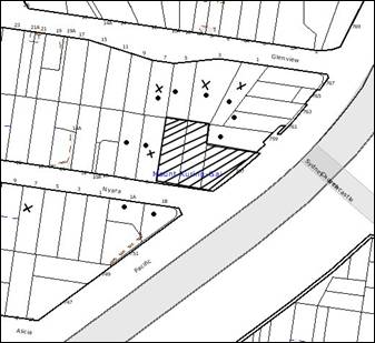
2009. During this period, Council received six submissions. The map below
illustrates the location of those nearby landowners who made a submission that
are in close proximity to the development site.
|
NOTIFICATION PLAN
|
|
|
• PROPERTIES NOTIFIED
|
X SUBMISSIONS
RECEIVED
|

PROPERTY SUBJECT OF DEVELOPMENT
|

|
|
The
address of one objector was not identified
|
|
|
|
|
Six submissions objected to the
development, generally on the grounds that the development would result in:
· Unacceptable
traffic on local streets;
· Loading docks being
located in close proximity to the bedroom of the adjoining residence at No. 6 Nyara Road;
· Removal of a
massive Forest Red Gum Tree (marked as Tree No. 21 in the tree plan) located
within No. 6 Nyara Road;
· Removal of the
Angophora Costata located on the northern boundary of the site (Tree No. 15 on
the tree plan);
· Removal of trees
along the boundary of No. 3 Glenview Road;
· Unacceptable impact
on the neighbouring properties due to the fumes from the car park exhaust vents;
· Lack of parking on
site and no street level parking which would result in on-street car parking
within Nyara Road;
· Unacceptable noise
from activities at the centre, and mechanical exhausts within the site and the
construction works;
· Unacceptable
privacy impact on the property at No. 7 Glenview Road due to reduction of the
height of the acoustic fence in this area;
· Unacceptable impact
on the security of the adjoining premises;
· Unacceptable
aesthetic impact on the adjoining properties;
· Development that is
excessive in bulk and scale.
The matters raised in the
community submissions have been addressed in the body of the report with the
exception of the following:
5.1.1 Privacy impact
Council’s records indicate that
the property at No. 7 Glenview Road does not directly adjoin the site. The
proposal includes a 3 metre high acoustic fence along the entire length of the
western boundary. The height of the fence is considered suitable to maintain
privacy of the adjoining properties.
5.1.2 Tree removal
One submission has requested the
removal of a Kaffir Palm tree located at the boundary of the site and the
adjoining property at No. 6 Nyara Road.
This is considered to be a
reasonable request and a condition is recommended for the removal of this tree.
5.1.3 Fencing details
One submission noted that the
details of fencing are not provided in the proposal.
The proposal includes details of
the proposed acoustic fence. No other fencing is proposed along the Pacific Highway and Nyara Road. Any proposed fencing along the northern boundary would be
subject to negotiation between the owners of the neighbouring properties.
5.1.4 On-going operation
during construction
One submission considered that
the post office and the pharmacy should continue to operate on site during
construction without any interruption.
The proposal seeks approval for
the redevelopment of the shopping centre and the construction of five retail
tenancies in addition to the ALDI store. One of the tenancies is likely to be a
post-office in the future. However, the proposal does not seek consent for
fitout of any retail tenancies and the post office is not approved as a part of
this development. It is not known whether a pharmacy would operate on the site
in future and would depend on the operator. In any case the ceasing of the
operation of the pharmacy or the post office within the site would not result
in non-compliance of the proposal with the relevant development controls and
statutory instruments. Therefore the request within the submission cannot be
adhered to.
Notwithstanding the above, the
applicant has proposed the following staging of construction within the site:
(a) Construction of the five retail tenancies on the site enabling
the continued operation of the retail premises at the rear.
(b) Following completion of the retail shops, the future occupiers
would occupy the speciality retail stores.
(c) The construction of the ALDI store would commence in the next
phase.
This staging would involve
restricted and controlled deliveries on site and would also significantly
reduce the number of available customer parking spaces within the site.
Conditions have been recommended regarding construction management on site to
ensure maintenance of appropriate levels of amenity during construction.
However, the staging of the construction is concept only and is not approved
under this application.
5.1.5 Moving footway
One submission suggested that a
moving footway should be provided for access to the shopping level from the
undercroft level.
The proposal includes a ramp and
a lift for access and complies with the relevant development controls in this
regard.
5.1.6 Construction Noise
Management
One submission suggested that:
· Noise barriers
should be provided during the demolition and construction phase.
· A Construction
Management Plan should be provided indicating that safe access within Nyara Road and the intersection would always be maintained during construction.
· Demolition and
construction hours should be maintained.
A condition has been recommended
regarding submission of a Construction Noise Management Plan prior to the issue
of the construction certificate for approval by Council. The Management plan
would include the following information:
(a) Identification of all nearby residences
and other sensitive land use.
(b) An assessment
of potential noise impacts from the proposed construction methods.
(c) A detailed
examination of feasible and reasonable noise mitigation measures to minimise or
avoid noise impacts.
(d) Development of
reactive and pro-active strategies for dealing promptly with any noise
complaints, including documentation and feedback mechanisms.
(e) Identification
of a site contact person to follow up complaints.
(f) The
establishment of monitoring systems at affected residences and other sensitive
land uses for noise levels.
(g) Regular
internal checks of plant and equipment to confirm there has been no degradation
in noise levels.
(h) Regular
independent auditing of procedures and noise levels by an environmental
consultant.
(i) A register to
be placed and maintained on site indicating the time, date and person
responsible for carrying out noise readings at the required times specified in
the management plan (at a minimum, readings should be conducted fortnightly
during the construction phase).
Subject to the approval of the
above management plan, the implementation of the techniques on site during
construction, recommended conditions regarding construction work hours and
traffic control plan, the amenity of the neighbouring properties would be
maintained reasonably during construction works.
5.1.7 Traffic related
requirements
Several submissions made the
following observations:
· Traffic Lights at
the intersection of Nyara Road and Pacific Highway should be reconfigured to
cater to the additional traffic and avoid accidents.
· “No stopping”
restrictions should be installed on Nyara Road.
· ‘Left turn’ slip
lane right lane arrows should be installed on Nyara Road to cater for the
additional traffic.
· Pedestrian ramps at
the intersection of Nyara Road and Pacific Highway should be upgraded.
· Pedestrian refuge
island should be provided on the driveway of the site.
The RTA reviewed the proposal in
this regard and raised no concerns regarding the existing traffic lights. A
condition has been recommended requiring installation of “No stopping” signs on
Nyara Road and the Pacific Highway. However, no recommendations have been
provided regarding the left turn lane, right turn arrows or pedestrian ramp
upgrade. The proposal demonstrates that the road network can accommodate that
additional traffic and is assessed as satisfactory in this regard. The driveway
is not to be used by pedestrians for access to the site therefore such a refuge
island would not be required. A refuge island would restrict manoeuvring of
trucks within the site and is not acceptable.
5.1.8 Design requirements
Submissions were received
concerning the design of the development as follows:
· Adequate sediment
and erosion control measures should be in place.
· Adequate disabled
access be provided.
· The illumination
within the site after business hours should be minimised.
· All mechanical
plants and equipments should be acoustically and aesthetically treated.
· No music or sound
from the commercial premises should be audible to residential properties after
9:30 pm.
· Waste and
loading/unloading facilities should be fully screened from public views.
· Stormwater
management plan should ensure retention of canopy trees.
· A new 1.2 metres
wide footpath should be constructed along the full width of the site.
· Graffiti management
plan should be adopted on site.
· Shopping trolley
management plan should include regular ‘collection patrol” around the site.
· Collection and
delivery services should not occur within the site between 8:00 pm and 8:00 am.
· The undercroft area
visible from Nyara Road should be screened and landscaping incorporated.
· Landscape treatment
should be provided to the disabled access ramp to the forecourt of the site.
· Business
identification signage should be minimised.
· The signage should
not dominate the design of the building.
The above matters raised in
community submissions have been addressed in the body of the report. Conditions
are recommended regarding the erosion and sediment control measures, disabled
access, footpath construction, noise, landscaping and treatment of mechanical
plants.
5.2 Public Agencies
The development application was
referred to the following Agencies for comment:
5.2.1 Roads and Traffic Authority
The proposal was referred to
Roads and Traffic Authority of New South Wales. The matter has been discussed
in detail in section 2.3 of this report.
5.2.2 NSW Police Force
The
development was referred to the NSW Police Force for comment with regard to
Crime Prevention. However, no comments have been received within the specified
time period. Notwithstanding, Council’s assessment under CPTED principles
concludes that the development addresses crime and safety requirements.
5.2.3 State Rail
The
proposal is located in close proximity to the rail corridor and Rail Corp was
notified of the development. No comments have been received. It is not
anticipated that the development would have any impact upon rail operations.
6. THE PUBLIC INTEREST
Section 79C(1)(e) of the Act
requires Council to consider “the public interest”.
The public interest is an
overarching requirement, which includes the consideration of the matters
discussed in this report. Implicit to the public interest is the achievement
of future built outcomes adequately responding to and respecting the future
desired outcomes expressed in environmental planning instruments and
development control plans.
The application is considered to
have satisfactorily addressed Council’s and relevant agencies’ criteria and
would provide a development outcome that, on balance, would result in a
positive impact for the community. Accordingly, it is considered that the
approval of the proposed development would be in the public interest.
CONCLUSION
The proposed development involves the demolition of an
existing commercial complex and the redevelopment of the Mount Kuring-Gai
Village Centre including an ALDI supermarket, four retail shops, a post office,
public forecourt and associated landscaping works. The proposal would involve a
gross floor area of 1738 sq metres and accommodate eighty-one car spaces within
the site.
The proposed development would promote employment
opportunities in a location that is well positioned to take advantage of nearby
public transport nodes.
The proposed development would be single storey, being
built over a raised plaza. It would present a visually interesting façade and
presentation to Nyara Road and the Pacific Highway. The development complies
with Section 79(c) of the Environmental Planning and Assessment Act 1979, the
standards within SEPP (Infrastructure) 2007, the Hornsby Shire Local
Environmental Plan 1994 and the objectives of the development controls within
Business Lands Development Control Plan – Mount Kuring-Gai Shopping Centre
Masterplan.
Approval of the proposal is
recommended.
|
Rod Pickles
Manager -
Assessment Team 2
Planning Division
|
Scott Phillips
Executive Manager
Planning Division
|
Attachments:
|
1.View
|
Locality Plan
|
|
|
|
2.View
|
Survey Plan
|
|
|
|
3.View
|
Site Plan
|
|
|
|
4.View
|
Floor Plans
|
|
|
|
5.View
|
Elevations and
Sections
|
|
|
|
6.View
|
Demolition Plan
|
|
|
|
7.View
|
Signage details
|
|
|
|
8.View
|
Waste Management
Plan
|
|
|
|
9.View
|
Shadow Plans
|
|
|
|
10.View
|
Landscape Plans
|
|
|
|
11.View
|
Tree Plan
|
|
|
File Reference: DA/256/2009
Document Number: D01204024
SCHEDULE 1
GENERAL CONDITIONS
The conditions of consent within this notice
of determination have been applied to ensure that the use of the land and/or
building is carried out in such a manner that is consistent with the aims and
objectives of the planning instrument affecting the land.
Note: For
the purpose of this consent, the term ‘applicant’ means any person who has the
authority to act on or the benefit of the development consent.
Note:
For the purpose of this consent, any reference to an Act, Regulation,
Australian Standard or publication by a public authority shall be taken to mean
the gazetted Act or Regulation, or adopted Australian Standard or publication
as in force on the date that the application for a construction certificate is
made.
1. Approved
Plans and Supporting Documentation
The development must be carried
out in accordance with the plans and documentation listed below and endorsed
with Council’s stamp, except where amended by Council and/or other conditions
of this consent:
|
Plan No.
|
Drawn by
|
Dated
|
|
Detail and Level Survey
|
Stutchbury Jaques Pty Ltd
|
28/07/2008
|
|
DA-01/E Site Plan
|
Donaldson Worrad
|
17/07/2009
|
|
DA-02/D Basement Carpark Plan
|
Donaldson Worrad
|
17/07/2009
|
|
DA-03/E Ground Floor Plan
|
Donaldson Worrad
|
17/07/2009
|
|
DA-04/D Roof Plan
|
Donaldson Worrad
|
05/03/2009
|
|
DA-05/D Elevations and Sections
|
Donaldson Worrad
|
17/07/2009
|
|
DA-06/D Elevations and Sections
|
Donaldson Worrad
|
17/07/2009
|
|
DA-07/C Demolition Plan
|
Donaldson Worrad
|
12/02/2009
|
|
DA-09/D Signage Detail
|
Donaldson Worrad
|
17/07/2009
|
|
DA-10/E Waste Management Plan
|
Donaldson Worrad
|
17/07/2009
|
|
LDA-001 B – Landscape Planting Plan
|
Scott Carver Pty Ltd
|
January 2009
|
|
LDA-002 B – Landscape Details
|
Scott Carver Pty Ltd
|
January 2009
|
|
L113-C0104 Rev D
Erosion and Sedimentation Control Plan
|
GW
Engineers
|
19/05/2009
|
|
L113-C L113 - C0100 Rev F Stormwater
Concept Plan
|
GW
Engineers
|
19/05/2009
|
|
Plan showing the
location of loading docks.
|
Donaldson Worrad
|
Received By Council on
23/06/2009
|
|
Document No.
|
Prepared by
|
Dated
|
|
Schedule of Finishes
|
Donaldson Worrad
|
March 2009
|
|
Building Code of Australia Compliance Report
|
Steve Watson and Partners
|
February 2009
|
|
BCA Energy Efficiency – Section
J
|
Erbas and Associates Pty Ltd
|
-
|
|
Geotechnical Investigations
|
Jeffery & Kataukas Pty Ltd
Consulting Geotechnical and Environmental Engineers
|
4 November 2008
|
|
Traffic Report
|
Colston Budd Hunt & Kafes
Pty Ltd
|
February 2009
|
|
Accessibility Report
|
Accessibility Solutions (NSW)
Pty Ltd
|
16 February 2009
|
|
Arboricultural Assessment
|
Regum Arboriculture and
Horticulture Consultants
|
9 October 2008
|
|
Noise Assessment Report Version
C
|
Wilkinon Murray Pty Ltd
|
February 2009
|
|
Infrastructure Services
Assessment
|
George Floth Pty Ltd Consulting
Engineers
|
12 August 2008
|
|
Stage 1 – Environmental Site
Assessment
|
Environmental Investigation
Services
|
November 2008
|
|
Economic Impact Assessment
|
SGS Economics and Planning
|
December 2008
|
|
Waste Management Plan
|
Donaldson Worrad
|
26/05/2009
|
|
Service Vehicle Management Plan
|
Donaldson Worrad
|
19/06/2009
|
|
Tree Management Agreements
|
Regum Arboriculture and
Horticulture Consultants
|
27/05/2009
|
2. Removal
of Existing Trees
This development consent permits
the removal of trees numbered T1, T4, T5, T6, T7, T9, T10, T11, T12, T13, T14
and T15 as identified on the Detail and Level Survey prepared by Stutchbury
Jaques Pty Ltd date 28/07/2008. The removal of any other trees requires
separate approval under Council’s Tree Preservation Order.
REQUIREMENTS PRIOR TO THE ISSUE OF A CONSTRUCTION
CERTIFICATE
The following conditions of consent must be
complied with prior to the issue of a ‘Construction Certificate’ by
either Hornsby Shire Council or an accredited certifier. All necessary
information to demonstrate compliance with the following conditions of consent
must be submitted with the application for a construction certificate.
3. Building
Code of Australia
All building work must be
carried out in accordance with the requirements of the Building Code of
Australia.
4. Sydney
Water – Quick Check
The
application must be submitted to a Sydney Water ‘Quick Check Agent’ or
‘Customer Centre’ for approval to determine whether the development will affect
any Sydney Water infrastructure, and whether further requirements are to
be met.
Note: Refer
to www.sydneywater.com.au or
telephone 13 20 92 for assistance.
5. Dilapidation
Report
A
‘Dilapidation Report’ is to be prepared by a ‘chartered structural engineer’
detailing the structural condition of all adjoining properties.
6. Traffic
Control Plan
A Traffic
Control Plan (TCP) must be prepared by a qualified traffic controller in
accordance with the Roads & Traffic Authority’s Traffic Control at
Worksites Manual 1998 and Australian Standard 1742.3 for all work on
a public road and be submitted to Council. The TCP must detail the following:
a. Arrangements
for public notification of the works.
b. Temporary
construction signage.
c. Permanent
post-construction signage.
d. Vehicle
movement plans.
e. Traffic
management plans.
f. Pedestrian
and cyclist access/safety.
7. Air
Quality Management Plan
An Air Quality
Management Plan must be prepared by a suitably qualified consultant and a copy
submitted to Council. The report must be prepared in accordance with the
requirements of Schedule 6 and Schedule 7 of the Protection of Environmental
Operations (Clean Air) Regulation 2002, the publication: Approved Methods
for the Sampling and Analysis of Air Pollutants in New South Wales
(Available from the Department of Environment and Climate Change) and
Australian Standard 4323.2-1995.
8. Construction
Noise Management Plan
A construction
noise management plan must be prepared by an appropriately qualified acoustic
engineer and a copy submitted to Council. The plan must be prepared in accordance
with the Draft NSW construction noise guidelines include the following
information:
a. Identification
of all nearby residences and other sensitive land uses.
b. An assessment
of potential noise impacts from the proposed construction methods.
c. A detailed
examination of feasible and reasonable noise mitigation measures to minimize
noise impacts.
d. Development of
strategies for dealing with any noise complaints.
e. Identification
of a site contact person to follow up complaints.
f. The establishment
of monitoring systems at affected residences and other sensitive land uses for
noise levels.
g. Regular checks
of plant and equipment with regard to noise levels.
h. Regular
independent auditing of procedures and noise levels by an environmental consultant.
REQUIREMENTS PRIOR TO THE COMMENCEMENT OF ANY WORKS
The following conditions of consent must be
complied with prior to the commencement of any works on the site. The
conditions have been imposed to ensure that the works are carried out in such a
manner that complies with relevant legislation and Council’s policies and does
not disrupt the amenity of the neighbourhood or impact upon the environment.
9. Erection
of Construction Sign
A sign must be erected in a
prominent position on any site on which building work, subdivision work or
demolition work is being carried out:
a. Showing
the name, address and telephone number of the principal certifying authority
for the work.
b. Showing
the name of the principal contractor (if any) for any demolition or building
work and a telephone number on which that person may be contacted outside
working hours.
c. Stating
that unauthorised entry to the work site is prohibited.
Note: Any
such sign is to be maintained while the building work, subdivision work or
demolition work is being carried out, but must be removed when the work has
been completed.
10. Protection
of Adjoining Areas
A temporary
hoarding, fence or awning must be erected between the work site and adjoining
lands before the works begin and must be kept in place until after the
completion of the works if the works:
a. Could
cause a danger, obstruction or inconvenience to pedestrian or vehicular
traffic.
b. Could
cause damage to adjoining lands by falling objects.
c. Involve
the enclosure of a public place or part of a public place.
Note: Notwithstanding
the above, Council’s separate written approval is required prior to the
erection of any structure or other obstruction on public land.
11. Toilet
Facilities
Toilet facilities must be
available or provided at the works site before works begin and must be
maintained until the works are completed at a ratio of one toilet for every 20
persons employed at the site. Each toilet must:
a. be
a standard flushing toilet connected to a public sewer; or
b. have
an on-site effluent disposal system approved under the Local Government Act
1993; or
c. be
a temporary chemical closet approved under the Local Government Act 1993.
12. Erosion
and Sediment Control
Erosion and sediment control
measures must be provided and maintained throughout the construction period in
accordance with the manual ‘Soils and Construction 2004 (Bluebook)’, the
approved plans, Council specifications and to the satisfaction of the principal
certifying authority. The erosion and sediment control devices must remain in
place until the site has been stabilised and revegetated.
Note: On
the spot penalties up to $1,500 may be issued for any on-compliance with this
requirement without any further notification or warning.
REQUIREMENTS DURING CONSTRUCTION
The following conditions of consent must be
complied with during the construction of the development. The conditions have
been imposed to ensure that the works are carried out in such a manner that
complies with relevant legislation and Council’s policies and does not disrupt
the amenity of the neighbourhood or impact upon the environment.
13. Construction
Work Hours
All
work on site (including demolition and earth works) must only occur between the
following hours:
Monday to Saturday 7 am to 5 pm
Sunday & Public Holidays No work
14. Demolition
All demolition work must be
carried out in accordance with Australian Standard 2601-2001 – The
Demolition of Structures and the following requirements:-
a. Demolition
material is to be disposed of to an authorised recycling and/or waste disposal
site and/or in accordance with an approved waste management plan.
15. Environmental
Management
The site must
be managed in accordance with the publication ‘Managing Urban Stormwater –
Landcom (March 2004) and the Protection of the Environment Operations
Act 1997 by way of implementing appropriate measures to prevent sediment
run-off, excessive dust, noise or odour emanating from the site during the
construction of the development.
16. Street
Sweeping
Street
sweeping must be undertaken following sediment tracking from the site along Nyara Road and Pacific Highway during works and until the site is
established.
17. Works
near Trees
All required
tree protection measures are to be maintained in good condition for the
duration of the construction period.
All works
(including driveways and retaining walls) within five metres of any trees
required to be retained (whether or not on the subject property, and pursuant
to this consent or the Tree Preservation Order) must be carried out
under the supervision of an ‘AQF Level 5 Arborist’ and in accordance
with the “Tree Maintenance Agreements” prepared by Redgum Arboriculture and
Horticulture Consultants dated 27/05/2009 and a certificate submitted to the
principal certifying authority detailing the methods used to preserve the
trees.
Note:
Except as provided above, the applicant is to ensure that no excavation,
filling or stockpiling of building materials, parking of vehicles or plant,
disposal of cement slurry, waste water or other contaminants is to occur within
4 metres of any tree to be retained.
18. Council
Property
During construction works, no building
materials, waste, machinery or related matter is to be stored on the road or
footpath. The public reserve is to be kept in a clean, tidy and safe condition
at all times.
19. Landfill
Landfill must
be constructed in accordance with Council’s ‘Construction Specification,
2005’. All fill material imported to the site is to wholly consist of
Virgin Excavated Natural Material (VENM) as defined in Schedule 1 of the Protection
of the Environment Operations Act 1997 or a material approved under the Department
of Environment and Climate Change’s general resource recovery exemption.
20. Excavated
Material
All excavated
material removed from the site must be classified in accordance with the NSW
Environment Protection Authority’s Environmental Guidelines – Assessment,
Classification and Management of Liquid and Non-Liquid Wastes prior to
disposal to an approved waste management facility and reported to the principal
certifying authority.
21. Underground
storage tanks
In the event
underground storage tank/s are encountered during construction or demolition
works, all tanks must be removed and disposed of in accordance with Australian
Standard 4976 – 2008: The removal and disposal of underground petroleum storage
tanks – Standards Australia.
22. Implementation
of Noise Management Plan
The recommendations and attenuation measures within the
Construction Noise Management Plan must be implemented on site at all times
during construction and demolition works in addition to the following
requirements:
a. A copy of the recorded noise readings be provided to
Council and the Principal Certifying Authority on a fortnightly basis (minimum).
b. A register be maintained on site indicating the time, date
and person responsible for carrying out noise readings at the required times
specified in the management plan.
REQUIREMENTS PRIOR TO THE ISSUE OF AN OCCUPATION
CERTIFICATE
The following conditions of consent must be complied with
prior to the ‘Principal Certifying Authority’ issuing an ‘Occupation
Certificate’
Note: For the
purpose of this consent, any reference to ‘occupation certificate’ shall also
be taken to mean ‘interim occupation certificate’ unless otherwise stated.
23. Maintain
Canopy Cover
To maintain canopy cover
the following requirements must be incorporated into the development:
a. Tree
No. 15 removed as a result of this Development Application must be replaced
with a tree, selected from Council’s booklet ‘Indigenous Plants for the
Bushland Shire’, such as Syncarpia glomulifera (Turpentine) are to
be planted on the subject site. The planting location shall not be within 4
metres of the foundation walls of a building. The pot size is to be a minimum
25 litres and the tree must be maintained until they reach the height of 3
metres. Trees must be native to Hornsby Shire and reach a mature height
greater than 8 metres.
b. Street
tree planting along the Nyara Road verge must consist of three Tristaniopsus
laurina (Water Gums) planted at a minimum pot size of 100 litres, in mulch
planters (500 mm x 500 mm). Tree must be located to ensure appropriate sight
lines for pedestrians and vehicles is maintained.
c. All
planter box areas must include automatic irrigation, subsoil drainage
(proprietary drainage cell, 50 mm sand and filter fabric), and waterproofing.
Soil depths additional to the requirement of subsoil drainage would be 500 mm
for shrubs.
24. Sydney
Water – s73 Certificate
A s73 Certificate must be
obtained from Sydney Water.
25. Stormwater
Drainage
The
stormwater drainage system for the development must be designed and constructed
in accordance with the approved stormwater drainage plans and Council’s Civil
Works – Design and Construction Specification 2005 and the following
requirements:
a. Connected
directly to Public drainage system subject to the conditions and comments in
the concurrence issued by Roads and Traffic Authority (Ref: DR412).
Note: A
certificate from a chartered civil engineer together with a works as executed
design plan must be submitted to the principal certifying authority to
demonstrate the satisfaction of this condition.
26. Internal
Driveway/Vehicular Areas
The driveway
and parking areas on site must be designed in accordance with Australian
Standards 2890.1, 2890.2, 3727 and the following requirements:
a. Design
levels at the front boundary be obtained from Council.
b. The
driveway be a rigid pavement.
c. The
driveway grade not exceed 25 percent and changes in grade not exceed 8 percent.
27. On
Site Stormwater Detention
An on-site
stormwater detention system must be designed by a Chartered Civil Engineer and
constructed in accordance with the following requirements:
a. The drainage system to control all
collected roof and surface stormwater must be designed with an
on-site-detention system. Stormwater discharge from the development site must
be limited to 55 litres per second and on site detention storage provided for
up to 50 year ARI storm events.
b. Discharge from the on-site detention
system must be directed to the pit within
Pacific Highway subject to consent of
the Roads and Traffic Authority.
c. Detail calculations are to be submitted
with the construction certificate application.
d. Have
a surcharge/inspection grate located directly above the outlet.
e. Where
above ground and the average depth is greater than 0.3 metres, a ‘pool type’
safety fence and warning signs to be installed.
f. Not
be constructed in a location that would impact upon the visual or recreational
amenity.
g.
The creation of an appropriate "Positive Covenant" and "Restriction
as to User" over the constructed on-site detention/retention systems
and outlet works, within the lots in favour of Council in accordance with
Council’s prescribed wording. The position of the on-site detention system is
to be clearly indicated on the title.
h.
To register the OSD easement, the restriction on the use of land “works-as-executed”
details of the on-site-detention system must be submitted verifying that the
required storage and discharge rates have been constructed in accordance with
the design requirements. The details must show the invert levels of the on
site system together with pipe sizes and grades. Any variations to the
approved plans must be shown in red on the “works-as-executed” plan and
supported by calculations.
Note: Council
must be nominated as the authority to release, vary or modify any easement,
restriction or covenant.
28. Vehicular
Crossing
A separate
application under the Local Government Act 1993 and the Roads Act
1993 must be submitted to Council for the installation/widening/replacement
of a vehicular crossing and the removal of the redundant crossing. The
vehicular crossing must be constructed in accordance with Council’s Civil
Works Design 2005 and the following requirements:
a. Approval
obtained from all relevant utility providers that all necessary conduits be
provided and protected under the crossing ( if any).
Note:
An application for a vehicular crossing can only be made to one of Council’s
Authorised Vehicular Crossing Contractors. You are advised to contact Council
on 02 9847 6940 to obtain a list of contractors. No application is
necessary if no changes are proposed to the existing vehicular footway
crossing.
29. Road
Works
All road works approved under
this consent must be constructed in accordance with Council’s Civil Works
Design and Construction Specification, 2005 and the following requirements:
a. Existing
kerb and gutter along Nyara Road be replaced and new kerb and gutter
constructed to full frontage of Pacific Highway, together with footpath
formation, necessary drainage to convey the runoff and sealing of road pavement
between the existing pavement and lip of the gutter.
b. The
existing road pavement to be saw cut a minimum of 300 mm from the existing edge
of the bitumen and reconstructed.
c. Nyara
Road pavement fronting the development be upgraded to industrial /commercial
standard.
d. The
submission of a compaction certificate from a geotechnical engineer for any
fill within road reserves, and all road sub-grade and road pavement materials.
e. The
existing footpath along Nyara Road and Pacific highway be removed and
reconstructed.
f. The
existing pram ramp crossing at the corner of Pacific Highway and Nyara Road be replaced by a concrete ramp in accordance with Council’s Civil Works
Specifications 2005.
g. All
works affecting Pacific Highway be approved by the Roads Traffic Authority of
New South Wales for Council’s endorsement.
h. A
construction certificate be obtained from Council for works within the public
road reserve.
30. Traffic
Control Plan
A Traffic
Control Plan (TCP) must be prepared by a qualified traffic controller in
accordance with the Roads & Traffic Authority’s Traffic Control at
Worksites Manual 1998 and Australian Standard 1742.3 for all work on
a public road and be submitted to Council. The TCP must detail the following:
g. Arrangements
for public notification of the works.
h. Temporary
construction signage.
i. Permanent
post-construction signage.
j. Vehicle
movement plans.
k. Traffic
management plans.
l. Pedestrian
and cyclist access/safety.
31. Damage
to Council Assets
Any damage
caused to Council’s assets as a result of the construction of the development
must be rectified in accordance with Council’s written requirements and at the
sole cost of the applicant.
32. Completion
of Landscaping
A certificate
must be provided by a practicing landscape architect, horticulturalist or person
with similar qualifications and experience certifying that all required
landscaping works have been satisfactorily completed in accordance with the
approved landscape plans.
Note: Advice
on suitable species for landscaping can be obtained from Council’s planting
guide ‘Indigenous Plants for the Bushland Shire’, available at www.hornsby.nsw.gov.au.
33. Car
Park exhaust
To protect
the amenity of the adjoining properties, the car park exhaust system and all mechanical
plants and equipment including the condenser unit for the air-conditioner on
site must be located a minimum 6 metres from any property boundary adjoining a
residential development.
34. External
Lighting
All external
lighting must be designed and installed in accordance with Australian
Standard AS 4282 – Control of the Obtrusive Effects of Outdoor Lighting.
Certification of compliance with the Standard must be obtained from a suitably
qualified person.
The approved
signage must not be illuminated after the operating hours of the retail
premises.
35. Waste
Management
The applicant must submit
documentary evidence (i.e. tipping dockets/receipts from recycling depots,
transfer stations and landfills) and a summary report of actual destinations
and quantities of waste generated by the works carried out under this
development consent. This summary report is to be based on and be in the format
of the Waste Management Plan Section One – Demolition Stage and/or Section
Three – Construction Stage. If less than 60% waste was reused or recycled, the
summary report must include the reasons why the 60% target was not achieved.
36. Bin
Storage
Bin storage areas must be
designed and constructed in accordance with Council’s Waste Minimisation and
Management Development Control Plan.
37. Food
Premises
The
fit out and operation of that part of the building to be used for the
manufacture, preparation or storage of food for sale, must be in accordance
with Australian Standard 4674-2004 – Design and fit out of food premises,
the Food Act 2003, and the Food Regulation 2004.
Note: Reference should also be made to the Food Safety Standards
and the ‘Safe Food Australia - A guide to the Food Safety Standards 2nd Edition
January 2001’.
38. Creation
of Easements
The following
matters must be nominated on the plan of subdivision under s88B of the Conveyancing
Act 1919:
a. The
creation of an appropriate "Positive Covenant" and "Restriction
as to User" over the constructed on-site detention/retention systems
and outlet works, in favour of Council in accordance with Council’s prescribed
wording. The position of the on-site detention system is to be clearly
indicated on the title.
b. To
register the OSD easement, the restriction on the use of land “works-as-executed”
details of the on-site-detention system must be submitted verifying that the
required storage and discharge rates have been constructed in accordance with
the design requirements. The details must show the invert levels of the on
site detention system together with pipe sizes and grades. Any variations to
the approved plans must be shown in red on the “works-as-executed” plan
and supported by calculations.
Note: Council
must be nominated as the authority to release, vary or modify any easement,
restriction or covenant.
39. Works
as Executed Plan
A
works-as-executed plan must be prepared by a registered surveyor and submitted
to Council for completed road pavement, kerb & gutter, public drainage
systems, and on-site detention system.
40. Site
Remediation Verification
The
applicant must provide documentation from a suitably qualified environmental
consultant verifying that the site has been remediated in accordance with the
NSW Environment Protection Authority’s Contaminated Sites – Guidelines for
Consultants Reporting on Contaminated Sites, the Contaminated Sites- Sampling
Design Guidelines Contaminated Sites – Guidelines for the NSW Site Auditor
Scheme and the recommendations of the Stage 1 Environmental Site Assessment
prepared by Environmental Investigation Services dated November 2008.
41. s94
Infrastructure Contributions
The payment to Council of a
contribution of $ 18148.4* for 8 employees towards the cost of
infrastructure identified in Councils Development Contributions Plan
2007-2011.
Note: * The value of contribution is based on a rate of $2268.55
per employee, derived from a rate of
one employee per 30sqm of commercial floor area for the speciality retail shops
and 20 employees for ALDI shop and is current
as at 18 August
2009. The contribution will be
adjusted from this date in accordance with the underlying consumer price index
for subsequent financial quarters.
It
is recommended that you contact Council to ascertain the indexed value of the
contribution prior to payment.
OPERATIONAL CONDITIONS
The following conditions have been applied to ensure that the
ongoing use of the land is carried out in such a manner that complies with
relevant legislation and Council’s policies and does not disrupt the amenity of
the neighbourhood or impact upon the environment.
42. Hours
of Operation
a. The
hours of operation of the ALDI store are restricted to those times listed
below:
Monday to Wednesday 8:30 am to 7 pm
Thursday 8:30 am to 9 pm
Friday 8:30 am to 7 pm
Saturday 8:30 am to 7 pm
Sunday 9 am to 7 pm
b. The
hours of operation of the speciality retail shops be restricted to those times
below:
Friday to Wednesday 7 am to 7 pm
Thursday 7 am to 9 pm
c. The delivery hours for the ALDI store and the retail shops
are restricted to those times listed below:
Monday to Friday 6 am to 10 pm
Saturday and Sunday 7 am to 10 pm
d. No deliveries are permitted within the premises for the
ALDI store during the following hours to avoid conflict with peak customer
traffic:
Monday to Friday 2 pm to 6 pm
Saturday and Sunday 10 am to 3 pm
e. The waste collection times within the premises are
restricted to those times listed below:
Monday to
Friday 7 am to10 pm
Saturday
and Sunday 7 am to 8 pm
Public
Holidays 7am to 6 pm
43. Traffic
Monitoring
An assessment
of the impact of the approved delivery times on the queuing of vehicles on Nyara Road and its nearby intersection with Pacific Highway must be undertaken by a suitably
qualified traffic consultant over a period of 6 months after occupying the site
in accordance with RTA guidelines for Traffic Generating
Developments
and the relevant Australian Standards. Should the assessment find that queuing
is occurring at the above locations, mitigation measures must be provided to
Council including further amendments to delivery times.
44. Car
Parking and Deliveries
All car parking must be
constructed and operated in accordance with Australian Standard AS 2890.1 –
2004 – Off Street Car Parking and Australian Standard 2890.2 - 2002 –
Off Street Commercial and the following requirement:
a. All
parking areas and driveways must be sealed to an all weather standard, line
marked and signposted.
b. Car
parking, loading and manoeuvring areas must be used solely for nominated
purposes.
c. Vehicles
awaiting loading, unloading or servicing must be parked on site and not on
adjacent or nearby public roads;
d. All
vehicular entry on to the site and egress from the site must be made in a
forward direction.
45. Noise
– Plant and Machinery
The level of total
continuous noise emanating from operation of all the plant, including air
conditioning units and processes in all buildings (LA10) (measured for at least
15 minutes) in or on the above premises, must not exceed the background
level by more than 5dB(A) when measured at all property boundaries.
An acoustic assessment is
to be undertaken by a suitably qualified environmental consultant within 60
days of occupying the site in accordance with the Environment NSW Industrial
Noise Policy (2000), Council’s Policy and Guidelines for Noise and
Vibration Generating Development (Acoustic Guidelines V.5, 2000) and the DECC’s
Noise Guide for Local Government (2004). The assessment must be submitted
to Council for review. Should the assessment find that noise from the premise
exceeds 5dB(A) appropriate measures must be employed to rectify excessive
noise.
46. Fire
Safety Statement - Annual
On at least one occasion in
every 12 month period following the date of the first ‘Fire Safety Certificate’
issued for the property, the owner must provide Council with an annual ‘Fire
Safety Certificate’ to each essential service installed in the building.
47. Maintenance
of Wastewater Device
All wastewater and
stormwater treatment devices (including drainage systems, sumps and traps) must
be regularly maintained in order to remain effective. All solid and liquid
wastes collected from the device must be disposed of in accordance with the Protection
of the Environment Operations Act 1997.
48. Lifestyle
Sign
The
illuminated flush wall sign referred to as the ‘lifestyle graphic’ must not
display any words, letters, symbols or images that identify a product or
corporate body or display an image that reduces the safety of road users.
49. Trolleys
The
supermarket operators must carry out regular patrols of the local streets to
ensure all trolleys are returned.
CONDITIONS OF CONCURRENCE – ROADS AND
TRAFFIC AUTHORITY
The following conditions of consent are from the nominated
State Agency pursuant to Section 79B of the Environmental Planning and
Assessment Act 1979 and must be complied with to the satisfaction of that
Agency.
50. Anchoring
Detailed
design drawings and associated geotechnical reports must be submitted to the
RTA prior to the issue of a Construction Certificate. The geotechnical report
must include the following requirements:
a. The impact of excavation/rock anchors on the stability of
Pacific Highway and detailing the methods of monitoring the carriageway with
regard to settlement.
b. The impact of the excavation on the structural stability
of Pacific Highway.
Note: The
applicant is to contact RTA’s Geotechnical Engineer at 8837 0246 or 8837 0245
for further information in this matter. The assessment cost shall be paid by
the applicant.
51. Stormwater
discharge
The post
development stormwater discharge from the subject site into the RTA drainage
system must not exceed the pre-development discharge. Details of design plans
and hydraulic calculations relating to any changes proposed to the drainage
system within Pacific Highway must be submitted to RTA for approval prior to
commencement of works on site.
Note: Details should be forwarded to:
The Sydney
Asset Management
PO BOX 973 Parramatta CBD NSW 2124
A plan checking fee would be
payable and performance bond required prior to the issue of the approval. The
applicant is to contact RTA’s Project Engineer at 8849 2114 regarding any Civil
Work requirements.
52. Sight
Lines
Any proposed landscaping or
fencing must not impede upon the desired site lines of vehicle drivers,
pedestrians and cyclists.
53. Construction
vehicles
All construction vehicles must
be accommodated within the site.
-
END OF CONDITIONS -
ADVISORY NOTES
The following information is provided for your
assistance to ensure compliance with the Environmental Planning and Assessment
Act 1979, Environmental Planning and Assessment Regulation 2000, other relevant
legislation and Council’s policies and specifications. This information does
not form part of the conditions of development consent pursuant to Section 80A
of the Act.
Environmental Planning and
Assessment Act 1979 Requirements
· The Environmental Planning and
Assessment Act 1979 requires:
· A construction certificate prior
to the commencement of any works. Enquiries regarding the issue of a
construction certificate can be made to Council’s Customer Services Branch on
9847 6760.
· A principal certifying authority
to be nominated and Council notified of that appointment prior to the
commencement of any works.
· Council to be given at least two
days written notice prior to the commencement of any works.
· Mandatory inspections of nominated
stages of the construction inspected.
· An occupation certificate issued
before occupying any building or commencing the use of the land.
Long Service Levy
In accordance with Section 34 of
the Building and Construction Industry Long Service Payments Act 1986, a ‘Long Service Levy’ must be paid to the Long
Service Payments Corporation or Hornsby Council.
Note: The
rate of the Long Service Levy is 0.35% of the total cost of the work.
Note: Hornsby
Council requires the payment of the Long Service Levy prior to the issue of a
construction certificate.
Tree Preservation Order
To ensure the maintenance and
protection of the existing natural environment, it is an offence to ringbark,
cut down, top, lop, remove, wilfully injure or destroy a tree outside three
metres of the approved building envelope without prior written consent from
Council. Fines may be imposed for non-compliance with Council’s Tree
Preservation Order.
Note: A
tree is defined as a single or multi-trunked wood perennial plant having a
height of not less than three (3) metres, and which develops many branches,
usually from a distance of not less than one (1) metre from the ground, but
excluding any plant which, in its particular location, is a noxious plant
declared as such pursuant to the Noxious Weeds Act 1993. This definition of
‘tree’ includes any and all types of Palm trees.
All
distances are determined British Standard BS 5837: 2005, “Trees in Relation to
Construction – Recommendations”.
Disability Discrimination Act
The applicant’s attention is
drawn to the existence of the Disability Discrimination Act. A
construction certificate is required to be obtained for the proposed
building/s, which will provide consideration under the Building Code of
Australia, however, the development may not comply with the requirements of
the Disability Discrimination Act. This is the sole responsibility of
the applicant.
Use of Building
This consent permits the use of
the premises for the purpose of “shops” only. Separate development consent is
required for the use of the premises for any other purpose in the future.
This consent does not permit the
fit-out of individual tenancies except ALDI.
Dial Before You Dig
Prior to commencing any works,
the applicant is encouraged to contact Dial Before You Dig on 1100 or www.dialbeforeyoudig.com.au for
free information on potential underground pipes and cables within the vicinity
of the development site.
Asbestos Warning
Should asbestos or asbestos
products be encountered during construction or demolition works you are advised
to seek advice and information should be prior to disturbing the material. It
is recommended that a contractor holding an asbestos-handling permit (issued by
Work Cover NSW), be engaged to manage the proper disposal and handling
of the material. Further information regarding the safe handling and removal of
asbestos can be found at:
www.environment.nsw.gov.au
www.nsw.gov.au/fibro
www.adfa.org.au
www.workcover.nsw.gov.au
Alternatively, telephone the Work
Cover Asbestos and Demolition Team on 8260 5885.
Food Authority Notification
The NSW Food Authority
requires businesses to electronically notify the Authority prior to the
commencement of its operation.
Note: NSW
Food Authority can be contacted at www.foodnotify.nsw.gov.au.
Roads and Traffic Authority
All proposed works are to at no cost to the Roads and
Traffic Authority.
Planning Report No. PLN63/09
Date of Meeting:
2/09/2009
2 DEVELOPMENT APPLICATION
- SECTION 96(AA) - SUBDIVISION OF ONE LOT INTO EIGHT
15 GARDINER ROAD GALSTON
|
Development Application No:
|
DA/922/2003/A
|
|
Description of Proposal:
|
Section 96(AA) application to
modify Development Consent No. 922/2003 for the Torrens title subdivision of
1 lot into 8 to amend the Restriction-As-To-User relating to the ‘Restricted
Development Area’ on the newly created lot 3.
|
|
Property Description:
|
Lot 3 DP 1108381, No. 15 Gardiner Road Galston
|
|
Applicant:
|
Mr T Hannah
|
|
Owner:
|
Mr PP Mustaca
|
|
Statutory Provisions:
|
Hornsby Shire Local Environmental
Plan 1994 - Residential AR (Low Density - Rural
Village)
|
|
Estimated Value:
|
Nil
|
|
Ward:
|
A
|
|
RECOMMENDATION
THAT pursuant to Section 96(AA)
of the Environmental Planning and Assessment Act, 1979, Development
Application No. 922/2003 for the subdivision of one lot into eight lots at
Lot 3 DP 1108381, No. 15 Gardiner Road Galston be refused for the reasons
detailed in Schedule 1 of this report.
|
1. The
application proposes to modify Development Consent No. 922/2003 for the Torrens
title subdivision of one lot into eight to amend the ‘Restriction-As-To-User’
relating to the ‘Restricted Development Area’ on the newly created Lot 3.
2. The
proposal is inconsistent with the element control for ‘Flora and Fauna
Protection’ of the Rural Lands Development Control Plan.
3. One
submission has been received in respect of the application.
4. It
is recommended that the application be refused.
HISTORY OF THE APPLICATION
On 21 July 2004 Council’s
Planning Meeting first considered the subject application and resolved that it
be refused principally on grounds that the proposal was an overdevelopment of
the site and would have an adverse environmental impact.
On 25 August 2004 the applicant lodged an appeal in the
Land and Environment Court against Council’s refusal of the application. The
Court subsequently upheld the appeal.
THE SITE
The subject site of the original consent had an area of
6,937 sqm, and an access handle to the western side of Arcadia Road and
frontage to the northern end of Gardiner Road. A watercourse runs northeast to
southwest and is situated towards the eastern portion of the site and the site
contains remnant Sydney Turpentine Ironbark Forest (STIF).
The Section 96(AA) application relates to the newly created
Lot 3 which has an area of 764.2 sqm and is accessed from Gardiner Road via a
Right-of-Access. There is a ‘Restriction-As-To-User’ located within the northern rear setback, 10 metres from
the rear boundary that prohibits development including building
structures or clearing of native vegetation.
THE APPROVED DEVELOPMENT
The approved development is for the Torrens title
subdivision of one allotment into eight and the creation of a right of
carriageway to service the proposed lots. The lots range in area (exclusive of
the access handle) from 572.9m² to 1033.8m².
The carriageway commences at the termination of the
cul-de-sac (Gardiner Road) and continues along the southern boundary of the
site, providing access to proposed lots 1 to 5. Access to proposed lots 7 and
8, (east of the watercourse) will be provided by piping a portion of the creek
to allow access over the creek. Access to lot 6 will be provided via an
existing access handle off Arcadia Road.
THE MODIFICATION
The proposed modification to the approved development is for
the amendment of condition No. 60 relating to the ‘Restriction-As-To-User’,
which states:
60. In order to conserve native flora and
fauna habitat a ‘Restriction-As-To-User’ shall be placed on Lots 3, 4, and 5
such that no development, including building structures and no clearing of
native vegetation is to occur within the “Restricted Development Area”, located
10 metres from the lots northern boundary, as marked in red diagonal lines on
the approved plans.
The applicant provided the
following information in support of the proposed modification:
“As per the
letter from Hornsby Shire Council’s Bushland and Biodiversity Team dated 18
March 2009, native vegetation no longer occurs in the area referred to in the
general conditions (paragraph 60) of the Development Consent in LEC 11016 of
2004. As such the application is for the removal of this condition.”
ASSESSMENT
The development application has
been assessed having regard to the ‘2005 City of Cities Metropolitan
Strategy’, the ‘North Subregion (Draft) Subregional Strategy’ and
the matters for consideration prescribed under Section 79C of the Environmental
Planning and Assessment Act 1979 (the Act). Subsequently, the following
issues have been identified for further consideration.
1. STRATEGIC CONTEXT
1.1 Metropolitan Strategy – (Draft) North Subregional Strategy
The Metropolitan Strategy is a
broad framework to secure Sydney’s place in the global economy by promoting and
managing growth. It outlines a vision for Sydney to 2031; the challenges
faced, and the directions to follow to address these challenges and achieve the
vision. The draft North Subregional Strategy acts as a framework for Council
in the preparation of a new Principal LEP by 2011.
The draft Subregional Strategy
sets the following targets for the Hornsby LGA by 2031:
· Employment capacity to
increase by 9,000 jobs; and
· Housing stock to
increase by 11,000 dwellings.
The proposed development would be
consistent with the draft Strategy by providing additional dwellings and would
improve housing choice in the locality.
2. STATUTORY CONTROLS
Section 79C(1)(a) requires
Council to consider “any relevant environmental planning instruments, draft
environmental planning instruments, development control plans, planning
agreements and other prescribed matters”.
2.1 Environmental Planning and Assessment Act 1979 - Section
96(AA)
The proposal constitutes an
amendment under Section 96(AA) of the Act. Pursuant to Section 96(AA), Council
may consider an application to amend development consent granted by the Court
provided that, inter alia:
(a) it is satisfied that the development to which the consent
as modified relates is substantially the same development as the development
for which the consent was originally granted and before that consent as
originally granted was modified (if at all), and
(b) it has notified the application in accordance with:
(i) the regulations, if the regulations so require, and
(ii) a development control plan, if the consent authority is
a council that has made a development control plan that requires the
notification or advertising of applications for modification of a development
consent, and
(c) it has notified, or made reasonable attempts to notify,
each person who made a submission in respect of the relevant development
application of the proposed modification by sending written notice to the last
address known to the consent authority of the objector or other person, and
(d) it has considered any submissions made concerning the
proposed modification within any period prescribed by the regulations or
provided by the development control plan, as the case may be.
With respect to (a), it is considered that the proposal as
amended is substantially the same as the development originally approved.
With respect to (b), (c) and (d), the amended application
was advertised and the one submission received was considered in the assessment
of the modification.
2.2 Hornsby Shire Local Environmental Plan 1994
The subject land is zoned Residential AR (Low Density - Rural Village) under the Hornsby Shire Local Environmental
Plan 1994 (HSLEP). The objectives of the zone are:
(a) to
provide for the housing needs of the rural village population of the Hornsby
area.
(b) to
promote a variety of housing types and other land uses compatible with a low
density rural village environment.
(c) to
provide for development that is within the environmental capacity of a low
density rural village environment.
The proposed development is
defined as “subdivision” under the HSLEP and is permissible in the zone with
Council’s consent.
The proposed development fails to
comply with objective (c) of the HSLEP in that removal of the
Restriction-As-To-User on the lot would not adequately protect environmentally
sensitive areas of the site and adversely impact upon the remnant Sydney Turpentine Ironbark Forest.
Clause 14 of HSLEP prescribes
that the minimum area per allotment (density) of development within the
Residential AR (Low Density - Rural Village) zone is 500 sqm. The proposed
modification would not alter the existing density of the site which complies
with the controls.
2.3 Sydney Regional Environmental Plan No. 20 - Hawkesbury-Nepean River
The site is located within the
catchment of the Hawkesbury-Nepean River. As such the land is subject to the
SREP No. 20. The aim of the Plan is to protect the environment of the Hawkesbury-Nepean River system by ensuring that the impacts of development are considered
in the regional context. The Plan addresses matters related to water quality,
significant vegetation habitats, extraction, environmental heritage and scenic
quality, recreation and tourism, and agriculture.
The proposed modification is
inconsistent with the specific planning policies and recommended strategies for
flora and fauna pursuant to Clause 6 of SREP No. 20, which requires that flora
and fauna communities are managed so that the diversity of species and genetics
within the catchment is conserved and enhanced.
The proposed modification to
remove the ‘‘Restriction-As-To-User’’ is contrary to the intent of Condition
No. 60 which was imposed to minimise adverse environmental impacts and protect
the existing STIF on and adjoining the site; and the Shale/Sandstone Transition
Forest (Smith & Smith 2008), which is an Endangered Ecological Community
(EEC), listed under the Threatened Species Conservation.
2.4 Rural Lands Development Control Plan
The objectives of the Rural Lands
Development Control Plan are:-
· to provide land use direction for
the rural area;
· to provide measures to protect the
natural and built environment;
· to enhance the established
character of rural areas; and
· to ensure development relates to
site conditions.”
The key controls within the DCP
that relate to the modification are the ‘Environmental Strategy’ and the
element control for ‘Flora and Fauna’. Council’s assessment of the
modification considers that the proposal is inconsistent with the performance
criteria of both the ‘Environmental Strategy’ and the element control
for ‘Flora and Fauna’. This matter is discussed further in Section 3.1
of this report.
3. ENVIRONMENTAL IMPACTS
Section 79C(1)(b) of the Act
requires Council to consider “the likely impacts of that development,
including environmental impacts on both the natural and built environments, and
social and economic impacts in the locality”.
3.1 Natural Environment
On and
adjacent to the subject site are remnant trees that form part of a mapped
Shale/Sandstone Transition Forest (Smith & Smith 2008), which is an
Endangered Ecological Community (EEC), listed under the Threatened Species
Conservation Act 1995.
There are four trees on or
adjacent to this property comprising a range of species, including locally
native species such as Angophora costata (Smooth-bark Apple) and
Synncarpia glomulifera (Turpentine).
There are three trees on
the subject site and one tree on an adjoining
property that are considered significant according to Council’s standard
assessment procedures for trees on development sites. These are trees numbered T2,
T3 & T4.
The removal of these trees or the excavation or filling of
soil or the placing of any building or associated works within a minimum of 4
metres of the trunks of these trees would unlikely be permitted during any
future development application for a dwelling on the site.
The proposed modification seeks
to remove the ‘Restriction-As-To-User’ on Lot 3 to permit future
building works and structures within the rear 10 metres of the site. Council’s
assessment of the proposal
concludes that the major item of conservation significance onsite that has
the potential to be retained in perpetuity post development is the Sydney
Turpentine Ironbark tree located along the rear of the property boundary.
Council’s assessment also
concludes that should the ‘Restriction-As-To-User’ be removed from Lot
3, it may lead to detrimental impacts to the critical root zones of trees on
the neighbouring property at No. 33 Arcadia Road, Galston which form part of
the local STIF population and would be contrary to the Court order granting
consent to the original subdivision.
The Angophora costata with
native understorey species located in the middle of the site does not form part
of the ‘‘Restriction-As-To-User’’ and due to its poor health,
would potentially be approved for removal as part of a future development
application as indicated in pre-DA advice provided to the applicant.
The applicant bases the
justification of the application on advice received by Council’s Bushland and
Biodiversity Team dated 18 March 2009. That advice states as follows:
· The subject site is
mapped as containing Shale Sandstone Transition Forest Endangered Ecological
Community listed under the Threatened Species Conservation Act 1995 (Smith and
Smith 2008).
· The subject site is
highly degraded containing one remnant Angophora costata (Smooth-barked Apple)
tree in the middle of the property and a Syncarpia glomulifera (Sydney
Turpentine) tree at the rear of the property.
· The Angophora
costata tree has been approved for removal by the Parks and Landscapes Team due
to the poor condition of this tree.
· The understorey
vegetation of this site is highly degraded and dominated by weeds however its
does include some native species including Lomandra longifolia and Acacia
parramatensis through the centre of the site.
· The ‘Restricted
Development Area’ occurs 10m from the rear boundary as a result of vegetation
mapping that indicates that Shale Sandstone Transition Forest Endangered
Ecological Community occurs at this location.
· Native vegetation
no longer occurs in this area as a result of either unauthorised clearing or
the buffer created from Council’s vegetation mapping system (Smith and Smith
2008).
· The Bushland and
Biodiversity Team consider that the Syncarpia glomulifera tree occurring at the
rear of the property is worthy of retention as it continues to provide
inter-canopy connectivity to adjacent trees.
· The applicant’s
request for extending the building envelope of the dwelling further northwards
is not considered to have a significant impact on native vegetation, however,
consultation about the planning requirements of the request should be put forth
to Council planners.
The purpose for creating the ‘Restriction-As-To-User’
was to protect the STIF. The removal and degradation of the zone as noted
in the advice above should not form the basis for the removal of the
restriction. Instead, the zone should be re-established in accordance with the
original intent of the approved subdivision.
It is considered that the removal
of the ‘Restriction-As-To-User’ is unacceptable in the circumstances of
the case due to the need to protect the existing and necessary re-establishment
of STIF located on the site and adjoining property.
3.2 Built Environment
The proposed modification would
not alter the approved subdivision layout.
3.3 Social Impacts
The proposed modification would
not have a detrimental social impact upon the locality.
3.4 Economic Impacts
The proposed modification would
not have a detrimental economic impact upon the locality.
4. SITE SUITABILITY
Section 79C(1)(c) of the Act
requires Council to consider “the suitability of the site for the
development”.
The suitability of the site has been assessed under
DA/922/2003. The proposed modification would impact on the intended
environmental outcome of the original proposal as detailed above.
5. PUBLIC PARTICIPATION
Section 79C(1)(d) of the Act
requires Council to consider “any submissions made in accordance with this
Act”.
5.1 Community Consultation
The proposed development was
placed on public exhibition and was notified to adjoining and nearby landowners
between 16 June 2009 and 30 June 2009 in accordance with Council’s Notification
and Exhibition Development Control Plan. During this period, Council received
one submission. The map below illustrates the location of the nearby landowner
that made a submission who is in close proximity to the development site.
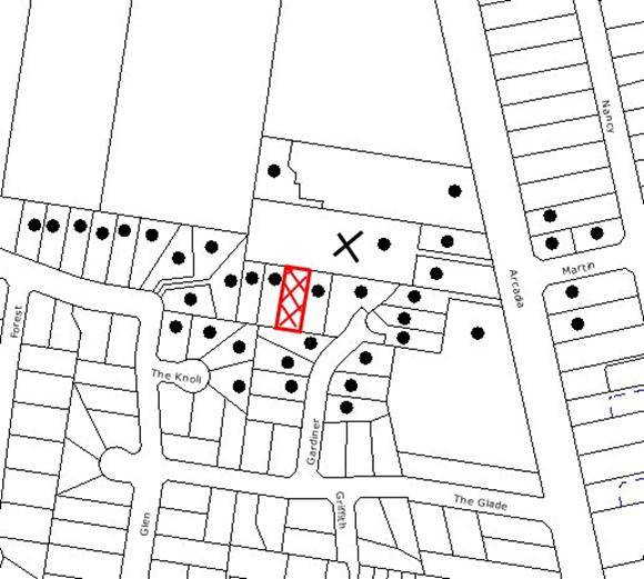
|
NOTIFICATION
PLAN
|
|
|
• PROPERTIES NOTIFIED
|
X SUBMISSIONS
RECEIVED
|
PROPERTY SUBJECT OF DEVELOPMENT
|
|
|
|
|
|
One submission objected to the
development, generally on the grounds that the removal of the ‘Restriction-As-To-User’
would result in:
· Detrimental impacts to
the existing flora and fauna that occurs on the site and the adjoining property
to the north.
· The Section 96(AA)
application has not indicated what effect the modification will have.
· The notification plan
is not the same as the plan approved by the Court.
· Use of the subject
site for stockpiling of excavated soil and rock from adjoining property
development.
The merits of the matters raised
in community submissions have been addressed in the body of the report with the
exception of the following:
5.1.1 Effect of Proposed Modification
The applicant has indicated in
the submitted Statement of Environmental Effects (SEE), that the modification
is intended to have the effect of removing the current 10m restriction.
However, the SEE does not address the environmental impact of the
modification. Instead, the applicant relies upon advice provided by Council
prior to the lodgement of the DA. This is not considered appropriate in the
circumstances of the case.
5.1.2 Notification Plan
Whilst it is acknowledged that
the submitted notification plan is not the plan that was approved by the Court,
the purpose of the plan is to indicate the allotment boundaries and the
existing trees on the site and the submitted plan addresses this requirement.
5.1.3 Compliance Matters
The submission raised concern
with regard to the stockpiling of excavated soil and rock on Lot 3 whilst works
were being undertaken on Lots 1 and 2, which resulted in degradation of the
existing restricted development area with Lot 3. This matter is currently
being investigated by Council’s officers.
5.2 Public Agencies
The original development
application is Integrated Development under the Act as it requires approval
under the Rural Fires Act, 1997 and the Rivers and Foreshores Improvement Act,
1948. Accordingly, the original application was referred to the NSW Rural Fire
Service and the Department of Water and Energy for comment. The proposed
modification is minor in nature and was not required to be referred to the
public agencies as detailed below.
The proposed modification would
not alter the layout of the approved subdivision or the original
recommendations of the NSW Rural Fire Service. Accordingly, the application
was not referred to the NSW Rural Fire Service for further comment.
During the assessment of the
original application, the Department of Water and Energy (DWE) determined that
a Part 3A Permit is required under the provisions of the Rivers and Foreshores
Improvement Act (1948) and issued General Terms of Approval (GTA’s).
The proposed modification does not
require any works within 40 metres of the watercourse. Accordingly, the
application was not referred to the DWE for further comment.
6. THE PUBLIC INTEREST
Section 79C(1)(e) of the Act
requires Council to consider “the public interest”.
The public interest is an
overarching requirement, which includes the consideration of the matters
discussed in this report. Implicit to the public interest is the achievement
of future built outcomes adequately responding to and respecting the future
desired outcomes expressed in environmental planning instruments and
development control plans.
The application is not considered
to have satisfactorily addressed Council’s environmental objectives for the
land and would provide a development outcome that, on balance, would not result
in a positive impact for the community. Accordingly, it is considered that the
approval of the proposed modification would not be in the public interest.
CONCLUSION
Consent is sought to remove a ‘Restriction-As-To-User’
on an approved subdivision that has the effect of protecting a 10-metre wide
STIF community. Council’s assessment concludes that the proposed modification
would have a detrimental impact upon the protection of existing flora and fauna
on the site and is inconsistent with the requirements of the Rural Lands DCP
and SREP 20.
Having regard to the
circumstances of the case, it is recommended that Council refuses the
application.
Note: At the time of the completion of this planning
report, no persons have made a Political Donations Disclosure Statement pursuant
to Section 147(3) of the Environmental Planning and Assessment Act 1979 in
respect of the subject planning application.
|
Rod Pickles
Manager -
Assessment Team 2
Planning Division
|
Paul David
Manager -
Subdivision & Development Engineering Services
Planning Division
|
|
Scott Phillips
Executive Manager
Planning Division
|
|
Attachments:
File Reference: DA/922/2003/A
Document Number: D01200046
SCHEDULE 1
1. Pursuant to the provisions of Section 79C(1)(a)(i) of the
Environmental Planning and Assessment Act 1979, it is considered that the
proposed development is unsatisfactory with respect to the aims, objectives and
policies of Sydney Regional Environmental Plan No. 20, in particular, the
policies and strategies for the protection of flora and fauna.
2. Pursuant to the provisions of Section 79C(1)(a)(i) of the
Environmental Planning and Assessment Act 1979, it is considered that the
proposal is unsatisfactory with respect to the aims and objectives of the Hornsby
Shire Local Environmental Plan to protect and enhance the environmental
qualities of the area and to protect environmentally sensitive areas.
3. Pursuant
to the provisions of Section 79C(1)(a)(iii) of the Environmental Planning and
Assessment Act 1979, it is considered that the proposal is unsatisfactory in
that it does not comply with the requirements of the Rural Lands Development
Control Plan, in particular, the ‘Environmental Strategy’ and the
element control for ‘Flora and Fauna Protection’.
4. Pursuant to the provisions of Section 79C(1)(b) of the
Environmental Planning and Assessment Act 1979, it is considered that the
development would have an adverse impact upon the remnant Sydney Turpentine Ironbark Forest.
5. Pursuant
to the provisions of Section 79C(1)(e) of the Environmental Planning and
Assessment Act, 1979, it is considered that approval of the application would
set an undesirable precedent for similar inappropriate development and is
therefore not in the public interest.
-
END OF REASONS FOR REFUSAL -
Planning Report No. PLN57/09
Date of Meeting: 2/09/2009
3 DEVELOPMENT APPLICATION
- ERECTION OF A DWELLING-HOUSE
4 CHERRYBROOK ROAD, WEST PENNANT HILLS
|
Development Application No:
|
DA/591/2009
|
|
Description of Proposal:
|
Erection of a dwelling-house
|
|
Property Description:
|
Lot 1011, DP1134002, No. 4 Cherrybrook Road, Pennant
Hills
|
|
Applicant:
|
Eden Brae Homes
|
|
Owners:
|
Mr Ben Murray and Mrs Claudia Antunez
|
|
Statutory Provisions:
|
Hornsby Shire Local Environmental
Plan, 1994
Residential A (Low Density
Zone)
|
|
Estimated Value:
|
$291,906
|
|
Ward:
|
C
|
|
RECOMMENDATION
THAT Development Application
No. DA/591/2009 for the erection of a one and two storey dwelling-house at Lot 1011, DP1134002, No. 4 Cherrybrook Road, Pennant Hills be approved subject to the
conditions of consent detailed in Schedule 1 of this report.
|
1. The
application proposes the erection of a one and two storey dwelling-house on a
vacant site.
2. The
proposal complies with the Hornsby Shire Local Environmental Plan, 1994 (HSLEP)
and generally complies with Council’s Dwelling House Development Control Plan
(DCP).
3. The
application has been referred to Council for determination in accordance with
Council’s resolution that required all future development applications be
determined by Council, which was adopted when the subdivision DA was approved.
4. Council did not receive any submissions objecting to the
development.
5. It
is recommended that the application be approved.
HISTORY OF THE APPLICATION
The development application was
lodged on 2 June, 2009. Amended plans were submitted to Council on 30 July,
2009 to address Council’s officers’ initial concerns regarding the extent of
fill proposed and the impact that the development would have on two Grey Gum
trees in the rear yard of the adjacent premises, No. 6 Cherrybrook Road.
HISTORY OF THE SITE
The subject allotment was created
as part of a two lot subdivision approved by Council under DA/716/2005 on 21
December, 2005.
THE SITE
The vacant, sector shaped site
has an area of 844.1m2 with a front boundary arc of 35.07m, a
north-eastern boundary length of 50.06m and a southern boundary length of
46.13m.
The front of the allotment is
oriented towards the north-west with the land falling from north to south at an
approximate gradient of 16%.
Stormwater from the development
would be drained via an interallotment drainage system located in the rear,
north-east corner of the site.
There are
three trees on the site comprising two Camellia and a Liquidambar and
two trees, Eucalyptus punctata (Grey Gum), which are located on the
neighbouring property, No. 6 Cherrybrook Road. There is no significant
vegetation or trees located on the subject and neighbouring properties that
would be impacted upon by the development.
A new two storey dwelling-house,
erected in accordance with DA/1474/2008, stands on the northern adjoining
allotment, No. 6 Cherrybrook Road.
Adjoining the southern boundary
is the second subdivided allotment approved under DA/716/2005 (Lot 1012 Cherrybrook Road), which is currently vacant.
The surrounding residential
development is characterised by an eclectic blend of one and two storey
dwelling-houses of a predominantly contemporary appearance, surrounded by well
established trees and landscaped gardens.
THE PROPOSAL
The application proposes the
erection of a one and two-storey, brick and tile dwelling-house comprising a
double garage, entry, living room, dining room, kitchen/meals room, bathroom,
laundry, media room, rumpus room and outdoor alfresco area located at the
ground floor level. Four bedrooms, an ensuite, a walk-in-robe, bathroom,
“upper lounge room" and a balcony are located at the first floor level.
The dwelling-house would be set
back 7.6m from the front boundary, 2.4m from the north-eastern side boundary,
1m from the southern side boundary and 18m from the rear corner of the
allotment.
ASSESSMENT
The development application has
been assessed having regard to the ‘2005 City of Cities Metropolitan
Strategy’, the ‘North Subregion (Draft) Subregional Strategy’
and the matters for consideration prescribed under Section 79C of the Environmental
Planning and Assessment Act 1979 (the Act). Subsequently, the following
issues have been identified for further consideration.
1. STRATEGIC CONTEXT
1.1 Metropolitan Strategy – (Draft) North Subregional Strategy
The Metropolitan Strategy is a
broad framework to secure Sydney’s place in the global economy by promoting and
managing growth. It outlines a vision for Sydney to 2031, the challenges faced
and the directions to follow to address these challenges and achieve the
vision. The draft North Subregional Strategy acts as a framework for Council in
the preparation of a new Principal LEP by 2011.
The draft Subregional Strategy
sets the following targets for the Hornsby LGA by 2031:
· Employment capacity to
increase by 9,000 jobs; and
· Housing stock to
increase by 11,000 dwellings.
The proposed development would be
consistent with the draft Strategy by providing an additional dwelling in the
Hornsby LGA and would contribute to housing choice in the locality.
2. STATUTORY CONTROLS
Section 79C(1)(a) requires
Council to consider “any relevant environmental planning instruments, draft
environmental planning instruments, development control plans, planning
agreements and other prescribed matters”.
2.1 Hornsby Shire Local Environmental Plan, 1994
The subject land is zoned
Residential A (Low Density) under Hornsby Shire Local Environmental Plan, 1994
(HSLEP). The objectives of the zone zone are:
(a) to provide
for the housing needs of the population of the Hornsby area.
(b) to promote a variety of housing types and other land uses
compatible with a low density residential environment.
(c) to
provide for development that is within the environmental capacity of a low
density
residential environment.
The use is defined as a
“dwelling-house” and is permissible within the zone pursuant to Clause 7 of the
HSLEP.
Clause 15 of HSLEP prescribes
that the maximum floor space ratio (FSR) of development within the Residential
A zone is 0.4:1. The proposal achieves an FSR of
0.37:1 which complies with the development
standard contained within Clause 15.
2.2
State Environmental Planning Policy (Exempt and Complying Development)
The NSW Government, as part of
its ongoing planning reforms, has released the first stage of the NSW Housing
Code.
This Housing Code outlines how
residential developments including:
· detached one and two storey
dwellings,
· home extensions and
· other ancillary
development, such as swimming pools,
can proceed on lots of greater
than 450m2 in size as complying development with council or
accredited certifier approval. The development is excluded by the guidelines
of the SEPP in this instance, as the application proposes a cut and fill of up
to 1.6m, which is contrary to the maximum allowable depth of 1m.
2.3 Dwelling House Development Control Plan
Pursuant to Section
79C(1)(a)(iii) of the Environmental Planning and Assessment Act, 1979 the
proposed development has been assessed having regard to the relevant
performance and prescriptive design requirements of Council’s Dwelling House
DCP. The following table sets out the proposal’s compliance with the
prescriptive measures of the Plan:
|
Dwelling House
Development Control Plan
|
|
Control
|
Proposal
|
Requirement
|
Compliance
|
|
Gross Floor Area
|
317.3m²
|
337.6m²
|
Yes
|
|
FSR
|
0.37:1
|
0.4:1
|
Yes
|
|
Site coverage
|
25%
|
40%
|
Yes
|
|
Height
|
7.8m
|
<9m
|
Yes
|
|
Storeys
|
1 and 2 storeys
|
2 storeys
|
Yes
|
|
Car parking
|
2 spaces
|
2 spaces
|
Yes
|
|
Length of Building
|
21.6 m
|
24 m
|
Yes
|
|
Unbroken Wall length
|
<10m
|
10m
|
Yes
|
|
Private Open Space
|
150m2
|
120m2
|
Yes
|
|
Landscaping
|
60%
|
45%
|
Yes
|
|
Setbacks
- Front
- Side (north-east)
- Side
(south)
- Rear
|
7.6 m
2.4m
1 m
9 m
|
6 m
1 m
1 m
3 m
|
Yes
Yes
Yes
Yes
|
Whilst the proposed development
complies with the prescriptive measures of the Dwelling House DCP as detailed
in the above table, the proposal raises design and privacy issues in terms of
the extent of excavation and the first floor level balcony. These issues of
non-compliance are detailed below, as well as a brief discussion on compliance
with the relevant performance criteria.
2.3.1 Landform
Modification
The dwelling-house includes a
ground floor that requires a cut of up to 1.6m in depth to establish the
building platform. This excavation does not meet the prescriptive measures of
the Design element which states that “Dwelling-houses should be designed
with a maximum cut or fill of 1m from natural ground level”. The purpose
of this control is to minimise amenity impacts as a consequence of excavating
or filling of the land. As the slope of the allotment has a cross fall of
approximately 16% towards the southern side, the amount of cut is reduced to
zero towards the middle of the site.
The extent of excavation has the
effect of lowering the overall height of the structure and reducing its visual
impact on the area. The excavated spoil for the dwelling-house would be used
as fill under the concrete slab.
The proposal meets the objectives
of the Design element of the Dwelling House DCP and is considered to be
acceptable.
2.3.2 Privacy
The first floor level balcony off
‘Bedroom1’ does not comply with the prescriptive measures of the Privacy element
which seeks to have living areas on the ground level to minimise overlooking of
the recreational and living areas of neighbouring properties. In this
instance, the proposed first floor level balcony is orientated towards the
street frontage only and would not impinge upon the privacy of the adjoining
allotments.
The proposal meets the objectives
of the Privacy element of the Dwelling House DCP and is considered to be
acceptable.
3. ENVIRONMENTAL IMPACTS
Section 79C (1)(b) of the Act
requires Council to consider “the likely impacts of that development,
including environmental impacts on both the natural and built environments, and
social and economic impacts in the locality”.
3.1 Natural Environment
The assessment of the application
noted that there are three trees on the site
comprising two Camellias and a Liquidambar. The site does not include any
indigenous trees or native vegetation.
It is considered that the removal
of these trees is acceptable as they have not been identified as significant.
Their removal would not have a deleterious impact on the character of the area.
The assessment also noted that
two trees, Eucalyptus punctata (Grey Gum) are located in the rear yard
of the neighbouring property, No. 6 Cherrybrook Road. As the amended plans
submitted to Council on 30 July,
2009 have deleted any development within 4m of these trees, the proposal would
not have any impact on these trees.
The submitted landscape concept
plan includes plant species appropriate to the development and the locality.
3.2 Built Environment
The proposed dwelling-house would
be consistent with the character of the established built form of the
residential development in the locality in terms of design, setbacks and
height.
3.3 Social Impacts
There are no anticipated social
impacts resulting from the proposed development.
3.4 Economic Impacts
The proposal would have a minor
positive impact on the local economy in conjunction with other new low density
development in the locality by generating an increase in demand for local
services.
4. SITE SUITABILITY
Section 79C (1) (c) of the Act
requires Council to consider “the suitability of the site for the
development”.
The site is identified as having
development constraints in accordance with Council’s Land Sensitivity Study,
which records ratings of Level 3 for Soil Dispersibility and Level 2 for Soil
Landscapes. The proposal involves an excavation up to a depth of up to 1.6m.
Subject to the implementation of soil and water management measures during the construction
phase, the development constraints would be satisfactorily addressed.
The site is otherwise considered
suitable for the proposed development.
5. PUBLIC PARTICIPATION
Section 79C (1) (d) of the Act
requires Council to consider “any submissions made in accordance with this
Act”.
5.1 Community Consultation
The proposed development was
placed on public exhibition and was notified to adjoining and nearby landowners
between 2 June and 16 June 2009, in accordance with Council’s Notification and Exhibition
DCP. The map below illustrates the location of those nearby landowners notified
who are in close proximity to the development site.
|
NOTIFICATION PLAN
|
|
|
• PROPERTIES NOTIFIED
|
X SUBMISSIONS
RECEIVED
|
PROPERTY SUBJECT OF DEVELOPMENT
|
|
|
|
|
|
Council did not receive any
submissions objecting to the development.
6. THE PUBLIC INTEREST
Section 79C (1) (e) of the Act
requires Council to consider “the public interest.”
The public interest is an
overarching requirement, which includes the consideration of the matters
discussed in this report. Implicit to the public interest is the achievement
of future built outcomes adequately responding to and respecting the future
desired outcomes expressed in environmental planning instruments and
development control plans.
The application is considered to
have satisfactorily addressed Council’s planning criteria and would provide a
development outcome that, on balance, would result in a positive impact for the
community. Accordingly, it is considered that the approval of the proposed one
and two storey dwelling-house would be in the public interest.
7. CONCLUSION
The
application proposes the erection of a one and two-storey dwelling-house in a
contemporary style design that would be in keeping with the existing and
recently erected dwelling-houses in the street.
The
scale of the development meets the prescriptive measures of Council’s Dwelling
House DCP and is in accordance with the objectives of the low density zoning
stipulated in the HSLEP. It is considered that the development would have a
positive impact upon the streetscape and would be in keeping with the built
form of the area.
Having
regard to the assessment of the proposed development, it is recommended that
Council approves the application.
Note: At the time of the completion of this planning report, no
persons have made a Political Donations Disclosure Statement pursuant to
Section 147(3) of the Environmental Planning and Assessment Act, 1979 in
respect of the subject planning application.
|
Simon Evans
Manager -
Assessment Team 1
Planning Division
|
Scott Phillips
Executive Manager
Planning Division
|
Attachments:
File Reference: DA/591/2009
Document Number: D01188462
SCHEDULE 1
CONDITIONS OF
APPROVAL
GENERAL CONDITIONS
The conditions of consent within this notice
of determination have been applied to ensure that the use of the land and/or
building is carried out in such a manner that is consistent with the aims and
objectives of the planning instrument affecting the land.
Note: For
the purpose of this consent, the term ‘applicant’ means any person who has the
authority to act on or the benefit of the development consent.
Note:
For the purpose of this consent, any reference to an Act, Regulation,
Australian Standard or publication by a public authority shall be taken to mean
the gazetted Act or Regulation, or adopted Australian Standard or publication
as in force on the date that the application for a construction certificate is
made.
1. Approved
Plans and Supporting Documentation
The
development must be carried out in accordance with the plans and documentation
listed below and endorsed with Council’s stamp, except where amended by Council
and/or other conditions of this consent:
|
Plan No.
|
Drawn by
|
Dated
|
|
A13007 (Sheets 1-9)
|
A&N Design
|
29/07/2009
|
2. Removal
of Existing Trees
This
development consent only permits the removal of trees numbered T1, T2 and T3 as
identified on the Site Plan, No. A13007 prepared by A&N Design dated
29/07/2009. The removal of any other trees requires separate approval under
Council’s Tree Preservation Order.
REQUIREMENTS PRIOR TO THE ISSUE OF A CONSTRUCTION
CERTIFICATE
The following conditions of consent must be
complied with prior to the issue of a ‘Construction Certificate’ by
either Hornsby Shire Council or an accredited certifier. All necessary
information to demonstrate compliance with the following conditions of consent
must be submitted with the application for a construction certificate.
3. Building
Code of Australia
All building work must be
carried out in accordance with the requirements of the Building Code of
Australia.
4. Contract
of Insurance (Residential Building Work)
In the case
of residential building work for which the Home Building Act,
1989 requires there to be a contract of insurance in force in accordance
with Part 6 of that
Act, that
such a contract of insurance is in force before any building work authorised to
be carried out by the consent commences.
Note: This
condition does not apply to the extent to which an exemption is in force
under Clause 187 or 188 of the Act, subject to the terms of any condition or
requirement referred to in Clause 187(6) or 188(4) of the Act, or to the
erection of a temporary building.
5. Notification
of Home Building Act, 1989 Requirements
Residential
building work within the meaning of the Home Building Act,
1989 must not be carried out unless the principal certifying authority for
the development to which the work relates (not being Council) has given Council
written notice of the following information:
a. In
the case of work for which a principal contractor is required to be appointed:
i. The
name and licence number of the principal contractor.
ii. The
name of the insurer by which the work is insured under Part 6 of that Act.
b. In
the case of work to be done by an owner-builder:
i. The
name of the owner-builder.
ii. If
the owner-builder is required to hold an owner-builder’s permit under that Act,
the number of the owner-builder’s permit.
Note: If
arrangements for doing the residential building work are changed while the work
is in progress so that the information notified becomes out of date, further
work must not be carried out unless the principal certifying authority for the
development to which the work relates (not being Council) has given Council
written notification of the updated information.
6. Sydney
Water – Quick Check
The
application must be submitted to a Sydney Water ‘Quick Check Agent’ or
‘Customer Centre’ for approval to determine whether the development will affect
any Sydney Water infrastructure, and whether further requirements are to
be met.
Note: Refer
to www.sydneywater.com.au or
telephone 13 20 92 for assistance.
REQUIREMENTS PRIOR TO THE COMMENCEMENT OF ANY WORKS
The following conditions of consent must be
complied with prior to the commencement of any works on the site. The
conditions have been imposed to ensure that the works are carried out in such a
manner that complies with relevant legislation and Council’s policies and does
not disrupt the amenity of the neighbourhood or impact upon the environment.
7. Erection
of Construction Sign
A sign must be erected in a
prominent position on any site on which building work, subdivision work or
demolition work is being carried out:
a. Showing the
name, address and telephone number of the principal certifying authority for
the work.
b. Showing the name
of the principal contractor (if any) for any demolition or building work and a
telephone number on which that person may be contacted outside working hours.
c. Stating that
unauthorised entry to the work site is prohibited.
Note: Any
such sign is to be maintained while the building work, subdivision work or
demolition work is being carried out, but must be removed when the work has
been completed.
8. Toilet
Facilities
Toilet
facilities must be available or provided at the works site before works begin
and must be maintained until the works are completed at a ratio of one toilet
for every 20 persons employed at the site. Each toilet must:
a. be a standard
flushing toilet connected to a public sewer; or
b. have an on-site
effluent disposal system approved under the Local Government Act, 1993;
or
c. be a temporary
chemical closet approved under the Local Government Act, 1993.
9. Erosion
and Sediment Control
Erosion and
sediment control measures must be provided and maintained throughout the
construction period in accordance with the manual ‘Soils and Construction
2004 (Bluebook)’, the approved plans, Council specifications and to the
satisfaction of the principal certifying authority. The erosion and sediment
control devices must remain in place until the site has been stabilised and
revegetated.
Note: On
the spot penalties up to $1,500 may be issued for any on-compliance with this
requirement without any further notification or warning.
REQUIREMENTS DURING CONSTRUCTION
The following conditions of consent must be
complied with during the construction of the development. The conditions have
been imposed to ensure that the works are carried out in such a manner that
complies with relevant legislation and Council’s policies and does not disrupt
the amenity of the neighbourhood or impact upon the environment.
10. Construction
Work Hours
All work on
site must only occur between the hours of 7 am to 5 pm, Monday to Saturday. No
work is permitted on Sundays or Public Holidays.
11. Council
Property
During
construction works, no building materials, waste, machinery or related matter
is to be stored on the road or the footpath. The public reserve is to be kept
in a clean, tidy and safe condition at all times.
12. Disturbance
of Existing Site
During
construction works, the existing ground levels of open space areas and natural
landscape features, (including natural rock-outcrops, vegetation, soil and
watercourses) must not be altered unless otherwise nominated on the approved
plans.
13. Survey
Report – Finished Floor Level
A report(s)
must be prepared by a registered surveyor and submitted to the principal
certifying authority prior to the pouring of concrete at each level of the
building certifying that:
a. The building,
retaining walls and the like have been correctly positioned on the site.
b. The finished
floor level(s) are in accordance with the approved plans.
REQUIREMENTS PRIOR TO THE ISSUE OF AN OCCUPATION
CERTIFICATE
The following conditions of consent must be complied with
prior to the ‘Principal Certifying Authority’ issuing an ‘Occupation
Certificate’
Note: For
the purpose of this consent, any reference to ‘occupation certificate’ shall
also be taken to mean ‘interim occupation certificate’ unless otherwise stated.
14. Fulfilment
of BASIX Commitments
The applicant
must demonstrate the fulfilment of BASIX commitments pertaining to the
development.
15. Stormwater
Drainage
The
stormwater drainage system for the development must be designed and constructed
for an average recurrence interval of 20 years and be gravity drained and connected
to the existing inter allotment drainage system.
16. Internal
Driveway/Vehicular Areas
The driveway
and parking areas on site must be designed in accordance with Australian
Standards 2890.1, 2890.2, 3727 and the following requirements:
a. Design levels at
the front boundary are to be obtained from Council.
b. The driveway is
to be a rigid pavement.
c. The driveway
grade must not exceed 25 percent and changes in grade not exceed 8 percent.
17. Vehicular
Crossing
A separate
application under the Local Government Act, 1993 and the Roads Act,
1993 must be submitted to Council for the installation of a new vehicular
crossing and the removal of the redundant crossing. The vehicular crossing
must be constructed in accordance with Council’s Civil Works Design 2005
and the following requirements:
a. Any redundant
crossings are to be replaced with integral kerb and gutter; and
b. The footway area is
to be restored by turfing.
Note: An application
for a vehicular crossing can only be made to one of Council’s Authorised
Vehicular Crossing Contractors. You are advised to contact Council on 02 9847
6940 to obtain a list of contractors.
18. Damage
to Council Assets
Any damage
caused to Council’s assets as a result of the construction of the development
must be rectified in accordance with Council’s written requirements and at the
sole cost of the applicant.
19. Retaining
Walls
All required retaining walls
must be constructed as part of the development.
-
END OF CONDITIONS –
ADVISORY NOTES
The following information is provided for your
assistance to ensure compliance with the Environmental Planning and Assessment
Act 1979, Environmental Planning and Assessment Regulation 2000, other relevant
legislation and Council’s policies and specifications. This information does
not form part of the conditions of development consent pursuant to Section 80A
of the Act.
Environmental Planning and Assessment Act, 1979
Requirements
The Environmental Planning and Assessment Act, 1979
requires:
· A construction certificate to be issued
prior to the commencement of any works. Enquiries regarding the issue of a
construction certificate can be made to Council’s Customer Services Branch on
9847 6760.
· A principal certifying authority is to
be nominated and Council notified of that appointment prior to the commencement
of any works.
· Council is to be given at least two days
written notice prior to the commencement of any works.
· Mandatory inspections of nominated
stages of the construction.
· An occupation certificate to be issued
before occupying any building or commencing the use of the land.
Long Service Levy
In accordance with Section 34 of
the Building and Construction Industry Long Service Payments Act 1986, a ‘Long Service Levy’ must be paid to the Long
Service Payments Corporation or Hornsby Council.
Note: The
rate of the Long Service Levy is 0.35% of the total cost of the work.
Note: Hornsby
Council requires the payment of the Long Service Levy prior to the issue of a
construction certificate.
Tree Preservation Order
To ensure the maintenance and
protection of the existing natural environment, it is an offence to ringbark,
cut down, top, lop, remove, wilfully injure or destroy a tree outside 3m of the
approved building envelope without prior written consent from Council. Fines
may be imposed for non-compliance with Council’s Tree Preservation Order.
Note: A
tree is defined as a single or multi-trunked wood perennial plant having a
height of not less than 3m and which develops many branches, usually from a
distance of not less than 1m from the ground, but excluding any plant which, in
its particular location, is a noxious plant declared as such pursuant to the
Noxious Weeds Act, 1993. This definition of ‘tree’ includes any and all types
of Palm trees.
All
distances are determined British Standard BS 5837: 2005, “Trees in Relation to
Construction – Recommendations”.
Dial Before You Dig
Prior to commencing any works,
the applicant is encouraged to contact Dial Before You Dig on 1100 or www.dialbeforeyoudig.com.au for
free information on potential underground pipes and cables within the vicinity
of the development site.
Planning Report No. PLN42/09
Date of Meeting:
2/09/2009
4 DEVELOPMENT APPLICATION
- CONSTRUCTION OF AN ALDI SUPERMARKET
273 - 291 PENNANT HILLS ROAD AND 2 BELLEVUE STREET THORNLEIGH
|
Development Application No:
|
DA/1848/2007
|
|
Description of Proposal:
|
Construction of an ALDI supermarket with basement
level car parking, ancillary warehouse and associated signage.
|
|
Property Description:
|
Lot 31 DP 263535, Lot 7 Sec 3 DP
1854, Lot 2 DP 609765, Lot 1 DP 609765, Lot 32 DP 263535, Lot 101 DP 883635
(Nos. 273-277, 279, 281, 281A & 283-291) Pennant Hills Road and (No. 2)
Bellevue Street, Thornleigh
|
|
Applicant:
|
Willana Associates
|
|
Owner:
|
Aldi Foods Pty Ltd
|
|
Statutory Provisions:
|
Hornsby Shire Local Environmental
Plan 1994:
Business A (General)
Residential A (Low Density)
|
|
Estimated Value:
|
$5,880,000
|
|
Ward:
|
C
|
|
RECOMMENDATION
THAT Development Application
No. 1848/2007 for the construction of an ALDI supermarket with basement level
car parking, ancillary warehouse and associated signage at Lot 31 DP 263535,
Lot 7 Sec 3 DP 1854, Lot 2 DP 609765, Lot 1 DP 609765, Lot 32 DP 263535, Lot
101 DP 883635 (Nos. 273-277, 279, 281, 281A & 283-291) Pennant Hills Road
and 2 Bellevue Street, Thornleigh be approved subject to the conditions of
consent detailed in Schedule 1 of this report.
|
1. The
application proposes the construction of an ALDI supermarket with basement
level car parking, ancillary warehouse and associated signage.
2. The
proposal is permissible under the provisions of the Hornsby Shire Local
Environmental Plan 1994 and is consistent with the requirements of the Business
Lands Development Control Plan, Car Parking Development Control Plan, Access
and
Mobility Development Control Plan and Sydney Regional Environmental Plan - Sydney Harbour Catchment.
3. Nine
submissions have been received in respect of the application. This includes two
letters in support and seven objections to the proposed development.
4. It
is recommended that the application be approved.
HISTORY OF THE APPLICATION
On 4 December 2007 Development
Application No. 1848/2007 was lodged for the construction of a commercial
and retail building containing an ALDI supermarket, two commercial tenancies
and associated basement level car parking and signage. Subsequent to the
submission of the application, Council made several requests for additional
information and raised a number of issues with respect to the proposal.
Following a series of detailed
negotiations between Council and the applicant, the applicant submitted amended
plans and additional information on 7 May 2009. The amended proposal, involves
the deletion of the first floor level at the northern corner of the building
which included two commercial tenancies. The amended proposal required the
re-exhibition of the application and referral to the relevant agencies. The
outcome of that process is set out in this report.
THE SITE
The site is comprised of six
allotments known as Lots 31 and 32 DP 263535, Lot 7 SEC 3 DP 1854, Lots 1 and 2
DP 609765 and Lot 101 DP 883635 (Nos. 273-277, 281, 281A, 283-291) Pennant Hills Road and (No. 2) Bellevue Street. The site has an area of 2700m2
and is irregular in shape. It has a 73.26m frontage to Pennant Hills Road, a
28.53m frontage to Bellevue Street and a 37.09m frontage to Station Street.
Apart from 2 Bellevue Street, the site is located within the Thornleigh
commercial precinct.
There are five allotments which
front Pennant Hills Road. All of these allotments are located within the
Business A (General) zone and contain existing commercial buildings. There are
no trees located on the site. The existing commercial buildings accommodate an
architectural practice, medical centre, swimming pool retailer, Subway shop,
pizza restaurant, post office, and children’s party rooms.
The allotment (No. 2 Bellevue Street) is located on the north eastern corner of the site and contains a hardstand
area and a fenced swimming pool used as part of the existing swimming pool
retailer. This allotment is zoned Residential A and is within the proposed
Thornleigh Draft Housing Strategy precinct.
To the east, the site adjoins
single storey residential developments. To the south and on the opposite side
of Station Street, the site adjoins a commercial and retail development. To the
north, the site fronts Thornleigh Marketplace shopping centre. There are a
number of commercial uses to the west and on the opposite side of Pennant Hills Road.
The site is located in close
proximity to Thornleigh Train Station and bus interchange. There is an existing
foot bridge adjacent to the site which provides pedestrian access to Thornleigh
Station.
THE PROPOSAL
The current application proposes
the construction of an ALDI supermarket with basement level car parking,
ancillary warehouse and associated signage. The applicant provided the
following statement with respect to the proposal:
“The
amended development is similar to the original development but does not include
the two commercial tenancies. As part of the amended proposal, the first floor
level at the northern corner of the building has been deleted.
It generally involves the following:
· Excavation and infrastructure
works.
· Erection of an ALDI
store with a basement parking level and ancillary warehouse, cool rooms,
loading dock (with vehicle turntable) and staff facilities.
· Changes to existing
services including the erection of an electrical substation.
· Fit out and use of
an ALDI store.
· Erection of
associated signage.
· Provision of new
on-site landscaping, including site fencing.
· Removal of existing
vehicular crossings and provision of two new crossings.
The
demolition of the existing buildings on the site will be subject to a separate
application.”
The details of the proposed floor
areas are described below:
Site area: 2700m2
Basement car
park: 2226m2
ALDI store: 1088m2
Staff
Amenities: 66m2
The proposed building is
comprised of the following:
Basement level
The basement contains car parking
for 66 vehicles. This includes 2 disabled parking spaces and a turning bay.
There is a vehicle access ramp providing ingress and egress from Station Street. There is a 1:14 pedestrian access ramp on the north western side of the
basement level. The ramp provides access to the main entry to the store. On the
south eastern side of the basement level, there is a sprinkler pump room, fire
egress stairs and lift access.
Ground floor level
The proposed supermarket is
located along the entire Pennant Hills Road frontage. It is sited behind the
pedestrian access ramp which provides access to the basement level. The main
entry to the ALDI store would be located on the corner of Pennant Hills Road
and Station Street. Adjacent to the main entry, there is lift access, trolleys
bays and an ancillary office.
The portion of the proposed
building located on the corner of Pennant Hills Road and Bellevue Street, would
be comprised of ancillary facilities including a warehouse, staff rooms,
amenities, freezer and cool room.
There is a loading dock, 7 staff
parking spaces and a turntable located on the eastern boundary of the site. The
loading dock and staff car parking spaces are accessed via a new driveway fronting
Bellevue Street. The waste bin enclosure which includes a garbage bin and
waste compactor would be located adjacent to the loading dock.
In addition, the following
signage is proposed:
Four illuminated flush mounted
business identification wall signs
Two of the proposed wall signs
would be located on the parapet entry, above the awning, at the corner of Station Street and Pennant Hills Road. One of the signs would face Pennant Hills Road and
the other sign would face Station Street.
The other two signs would be
located on the Bellevue Street and Pennant Hills Road frontage. One of the wall
signs would face Bellevue Street and the other would face Pennant Hills Road.
The dimensions of these signs
would be 2m in width and 2.4m in height. The colours of the signage would be
dark blue for the background, red and orange for the frame, light blue for the
ALDI corporate logo with white wording.
One illuminated flush wall
sign
The applicant advised that this
sign would be a ‘lifestyle image’ which would consist of a vegetable image and
would not advertise a product or business. It would have the dimensions of 4.2m
in width and 2.35m in height. The proposed sign would be located on the Pennant Hills Road elevation, near the intersection with Bellevue Street, just above the
footpath level.
One illuminated top hamper
sign
An illuminated top hamper sign is
proposed to be erected above the main store entrance. It would have a width of
450mm and a length of 4.5m. It would consist of a light box with internal
fluorescent tubing and would display the ALDI corporate logo with the wording
of ‘ALDI Store.’
Two illuminated under awning
signs
Two illuminated under awning
signs are proposed to be erected. One of the signs would be located on the Pennant Hills Road elevation and the other on the Station Street elevation. They would each
be located 10m from the main entrance and have a length of 1.8m and 450mm in
height.
The applicant provided the
following statement with respect to the nature of the operation:
“The hours
of operation are proposed to be 7.00am to 10.00pm, seven days a week. There
will be approximately 10-15 staff members in the store at any one time.
Employees shall be both full time, part time and managerial staff.
Deliveries
will occur on a daily basis. For a typical busy day two to four deliveries
would be undertaken. The hours of delivery will be between 7.00am to 10.00pm
Mondays to Sundays. The duration of each delivery is expected to be about 1
hour.
The
majority of ALDI products will be transported directly from a distribution
centre in Western Sydney, in ALDI managed and operated trucks. Trucks will be a
maximum of 12.5m in length with compartments that allow the concurrent
transportation of frozen, dry and chilled goods.
ALDI stores,
unlike other stores sell a limited range of 600 to 800 basic items and most
needed grocery lines and some household goods. This differs from traditional
supermarkets such as Coles and Woolworth’s, which sell in excess of 25,000
product lines.
The store
will comply with the requirements of the Food Act 2003. All goods will arrive
at the store pre-packaged. The store will not include kitchens, delicatessens,
bakeries or the like, where fresh food is handled or prepared.”
ASSESSMENT
The development application has
been assessed having regard to the ‘2005 City of Cities Metropolitan
Strategy’, the ‘North Subregion (Draft) Subregional Strategy’ and
the matters for consideration prescribed under Section 79C of the Environmental
Planning and Assessment Act 1979 (the Act). Subsequently, the following
issues have been identified for further consideration.
1. STRATEGIC CONTEXT
1.1 Metropolitan Strategy – (Draft) North Subregional
Strategy
The Metropolitan Strategy is a
broad framework to secure Sydney’s place in the global economy by promoting and
managing growth. It outlines a vision for Sydney to 2031; the challenges
faced, and the directions to follow to address these challenges and achieve the
vision. The draft North Subregional Strategy acts as a framework for Council
in the preparation of a new Principal LEP by 2011.
The draft Subregional Strategy
sets the following targets for the Hornsby LGA by 2031:
· Employment capacity to
increase by 9,000 jobs; and
· Housing stock to
increase by 11,000 dwellings.
The proposed development would be
consistent with the draft Strategy by providing an additional 20-30 jobs in the
locality.
1.2 Ku-Ring-Gai and
Hornsby Subregional Employment Study
As part of the preparation of the Comprehensive Local
Environmental Plan, Council (together with Ku-Ring-Gai Council) prepared the
Ku-Ring-Gai and Hornsby Subregional Employment Study.
The main aim of the Study is to ensure local employment
lands strategies facilitate opportunities for the provision of an additional
13,500 jobs within the North Subregion by the
year 2031, as required by the draft North Subregional
Strategy. The objective of the Study is to develop a strategy for zoning, land
uses and controls for employment lands that is consistent with the hierarchy of
commercial centres under the Metropolitan Strategy and the State Government’s
Standard Instrument.
The Study has been exhibited and a report on
submissions will be prepared in late 2009. At that time, Council will be
requested to determine whether to endorse the recommendations of the Study to
be progressed as part of Council’s Principal LEP.
The Study divides employment land within
Thornleigh into two employment functions:
(a) Village
centre activity located within the vicinity of the railway station; and
(b) Edge
of centre activity located on the periphery of the village, generally north
east of the centre.
Property Nos. 273 – 291 Pennant Hills Road,
Thornleigh are employment lands located within that area identified as
comprising a village centre function.
The Study assesses both employment and floor
space forecasts for Thornleigh to 2031. With respect to the village centre,
the Study estimates that the potential demand for floor space is much higher
than the potential supply of available floor space. The Study recommends that
employment floor space capacity be increased within Thornleigh village to meet
the forecast shortfall of approximately 5,361sqm of floor
space. The Study indicates that increasing floor space ratio controls is one
method to address this shortfall.
The proposal, which seeks to develop 442sqm of
residential land for the purpose of a supermarket, would contribute to the
employment floor space short fall identified in the Study, with respect to
Thornleigh village.
1.3 Hornsby Shire
Housing Strategy
The Hornsby Shire Housing Strategy identifies
opportunities for additional housing to be provided in planned precincts
throughout urban areas to assist meet Council’s housing obligations into the
future. The Strategy has been prepared in response to the draft North
Subregional Strategy. Property No. 2 Bellevue Street is located on the north
western edge of the proposed Station Street Precinct. The use of No. 2 Bellevue Street for commercial purposes would reduce the yield within the precinct by
approximately four dwellings. The use of the site for employment generating
uses instead of high density residential would not have a significant impact on
the Housing Strategy.
Following the exhibition, submissions will be
considered and reported to Council, detailing any recommended changes to the
Strategy. Council will then make a decision on whether to proceed with the
Strategy.
The Employment Study and the Housing Strategy
have been exhibited and therefore, do not currently form an adopted policy
position of the Council. The development proposal would provide additional
employment generating floor space, to address the projected floor space
shortfall identified in the Subregional Employment Study, with respect to
Thornleigh. As a consequence, the development proposal would assist facilitate
opportunities for the provision of an additional 13,500 jobs within the North
Subregion, as required by the draft North Subregional Strategy. However, the
benefit of providing additional employment should be
balanced against the need to provide additional
housing to assist meet Council’s housing obligations of an additional 2,600
dwellings by 2010.
2. STATUTORY CONTROLS
Section 79C(1)(a) requires
Council to consider “any relevant environmental planning instruments, draft
environmental planning instruments, development control plans, planning
agreements and other prescribed matters.”
2.1 Hornsby Shire Local Environmental Plan 1994
The subject land is zoned
Business A (General) and Residential A (Low Density) under the Hornsby Shire
Local Environmental Plan 1994 (HSLEP).
The proposed development is
defined as a ‘shop’ under the HSLEP and is permissible in the Business A
(General) zone with Council’s consent. However, a portion of the site, located
at the north east corner of the site, is zoned Residential A (Low Density) and
shops are prohibited in the zone.
Clause
11 of the HSLEP 1994 makes specific provision for development near zone
boundaries and provides an opportunity for Council to allow for development of
transitional land where the development is prohibited by the zoning, however is
permissible in the adjoining zone.
Clause
11 (1) applies to “transitional land”, which is defined in the HSLEP as
follows:
‘Transitional land means that land which is
within 20 metres of a boundary between any two zones.”
Clause 11 (2) states that:
Regardless of any other provision of this
plan, development may, with the consent of the Council, be carried out on land
to which this clause applies within a zone, for any purpose for which
development may be carried out in the adjoining zone, where the Council is
satisfied that:
(a) the
development is not inconsistent with the aims and objectives of this plan and
the objectives of both zones, and
(b) in the
case of business or industrial development, suitable land or premises are not
available for the development in any business or industrial zone in the
locality.
The proposed
staff carparking area and truck turntable is located within the area defined as
transitional land as it extends within 12 metres of the land zoned Residential
A (Low Density) and therefore, the proposal is consistent with clause 11(1).
In regard to
subclause 11(2)(a), the development is considered to be not inconsistent with
the aims and objectives of the HSLEP. Moreover the proposal must not be
inconsistent with the objectives of both zones. In this regard the zone
objectives are as follows:
The objectives of the Business A
(General) zone are:
(a) to encourage economic growth and employment
opportunities.
(b) to accommodate the retail, service and social needs of
the community within the neighbourhood.
(c) to encourage development that improves the health,
vitality, cultural environment and social environment within neighbourhood
business centres.
The objectives of the Residential
A (Low Density) zone are:
(a) to provide for the housing needs of the population of
the Hornsby area.
(b) to promote a variety of housing types and other land
uses compatible with a low density residential environment.
(c) to provide for development that is within the
environmental capacity of a low density residential environment.
With regard to clause 11(2)(a) of the HSLEP, the proposal
would not be inconsistent with the objectives of the Residential A (Low
density) zone, in that, the staff parking and truck manoeuvring area are within
the environmental capacity of the low density residential environment subject
to the provision of the proposed masonry acoustic wall and landscaping which would
screen from view this portion of the site when viewed from adjoining
residential area. The absence of built form on the transitional land provides
adequate visual separation between the proposed retail development and the
existing residential properties to the east.
The transitional land would only be utilised for staff
parking and truck manoeuvring. These uses are comparable to developments which
are permitted in the Residential A zone, including educational establishments,
child care centre, community facilities and veterinary clinics and the like.
In respect to clause 11(2)(b) the
applicant provided the following statement:
“The securing of a site for the ALDI store
was a lengthy process that required the amalgamation of a number of parcels in order
to form a development site capable of providing the ALDI store. The absence of
larger sites makes this task difficult, along with the nature of tenancies in
existing buildings in the locality. The result is that suitable sites within
the Business Zone, that can accommodate the ALDI store, are not ‘available.’
Notwithstanding the size and location of the
subject site, the resultant parcel still provide a number of challenges in
order to accommodate an orderly and functioning development. The provision of
separate entrance for some parking and the “turntable” to accommodate loading
and unloading of trucks is an example of the design flexibility required to
accommodate ALDI. It is also indicative as to the effort that is required to
find suitable locations for this form of development as it is the absence of
more suitable sites that has resulted in the need for some design alternatives.
The additional residential allotment is
required to help facilitate an appropriate level of on-site amenity and therefore
allow for the provision of a loading facility (including manoeuvring area),
employee parking and on-site landscaping. The ability
to utilise the additional residential
property allows for greater visual separation between the proposed building and
the existing dwelling on the adjoining site.”
Clause 11(2)(b) HSLEP
requires that Council be satisfied that, in the case of business development,
suitable land or premises are not available for development in any business
zone in the locality. Sections 1.2 and 1.3 of this report details the
strategic planning implications of the proposal in terms of both the Ku-ring-gai
and Hornsby Subregional Employment Study and the Hornsby Shire Housing
Strategy.
Clause 15 of the HSLEP prescribes
that the maximum floor space ratio (FSR) of development within the Business A
(General) zone is 1:1. Schedule B of HSLEP allows a floor space bonus within
the Business A (General) zone, of up to half of the site area, above that
allowed by the maximum FSR. The maximum FSR within the Residential A (Low
Density) is 0:4:1. No floor space is proposed within the Residential A zone.
The proposed building would have
a total floor area of 1,435m2. This equates to a FSR of 0.64:1 over
that portion of the site zoned Business A. Therefore, the proposed development
complies with the FSR provisions of the HSLEP.
2.2 Sydney Regional Environmental Plan (Sydney Harbour Catchment) 2005
The application has been assessed
against the requirements of the Sydney REP which includes planning principles
applicable to the site within the upper part of the catchment. The principles
incorporate measures to protect water quality, minimise urban runoff, conserve
water and to ensure the catchment watercourses, wetlands, riparian lands and
remnant vegetation are protected.
Subject to the implementation of
erosion and sediment control measures and stormwater detention measures, the
proposed development would not adversely impact on the catchment or water
quality.
2.3 Sydney Regional Environmental Plan 55 – Remediation of
Land
The application has been assessed
against the requirements of State Environmental Planning Policy No. 55 (SEPP
55). This Policy provides State-wide planning controls to promote the
remediation of contaminated land to reduce the risk of harm to human health and
the environment.
Pursuant to Clause 7 of SEPP 55, a consent authority must
not consent to the carrying out of any development on land unless it has
considered whether the land is contaminated, and if the land is contaminated, it
is satisfied that the land is suitable in its contaminated state (or will be
suitable, after remediation) for the purpose for which the development is
proposed to be carried out.
The site has historically been zoned and used for
commercial and residential purposes. It is unlikely that the site is affected
by land contamination. Notwithstanding, additional investigations would be
required to be undertaken after the demolition of the existing buildings to
determine any potential contaminants on site and the subsequent remediation.
The proposal is satisfactory subject to the implementation
of the recommended conditions in this regard.
2.4 State Environmental
Planning Policy No. 11 – Traffic Generating Development
State Environmental Planning Policy No. 11 (SEPP 11)
has been repealed, however at the time the application was lodged SEPP 11
applied. Accordingly, the provisions of SEPP 11 apply to the application
pursuant to the savings provisions of the SEPP (infrastructure 2007).
The proposed development constitutes development prescribed
under Schedule 2 of SEPP 11 as the development is located on land with direct
vehicular or pedestrian access to an arterial road, or land that has direct
vehicular or pedestrian access within 90m of an arterial road.
The
site has direct vehicular access to the Pennant Hills Road, which is an
arterial road, via Bellevue Street and Station Street. The development
application includes a Traffic Assessment Report. The application was referred
to the NSW Roads and Traffic Authority. The RTA recommended conditions with
respect to the proposal. This matter is discussed in detail in section 3.2.1 of
this report.
2.5 State Environmental
Planning Policy (Infrastructure) 2007
Clause 11
(savings provisions) of SEPP infrastructure states that this Policy does not
apply to or in respect of “the determination of a development application
made under Part 4 of the Act, but not finally determined before the
commencement of this Policy.” The Policy commenced on January 2008 and the
development application was lodged on 4 December 2007. Therefore, this Policy
does not apply.
2.6 Sydney Regional Environmental Plan 64 – Advertising and
Signage
The Policy aims to:
(a) ensure
that signage (including advertising) is compatible with the desired amenity and
visual character of the area, provides effective communication in suitable
locations and is of a high quality and finish;
(b) regulate
signage (but not content) under Part 4 of the Act; and
(c) provide
time-limited consents for the display of certain advertisements.
The Policy defines a ‘business identification sign’ as a
sign that “identifies or names a building, and that may
include the name of a business or building, the street number of a building,
the nature of the business and a logo or other symbol that identifies the
business, but that does not include general advertising of products, goods or
services.”
Division 1 Clause 9 of the Policy states that ‘business
identification signs’ are not applicable to the Policy. All the proposed signs
are considered to be consistent with the definition of ‘business
identification’ sign as outlined in the Policy.
Clause 13 Matters for Consideration states that:-
A consent authority must not grant consent to an
application to display an advertisement to which this Policy applies unless the
advertisement:
(a) is consistent with the
objectives of this Policy as set out in clause 3 (1) (a), and
(b) has been assessed by the consent
authority in accordance with the assessment criteria in Schedule 1 and the
consent authority is satisfied that the proposal is acceptable in terms of its
impacts, and
(c) satisfies any other relevant
requirements of this Policy.
An
assessment of the criteria listed in Schedule 1 and any other relevant
requirements is listed below.
1. Character
of the Area
· Is the proposal compatible with the existing or desired
future character of the area or locality in which it is proposed to be located?
· Is the proposal consistent with a particular theme for
outdoor advertising in the area or locality?
The site is located within the Thornleigh commercial
precinct. The proposed signage is compatible with existing signage in the
locality and would not have a detrimental impact on the desired future
character of the area. None of the proposed signs would have an undesirable
visual impact on the surrounding residential area.
2. Special
Areas
· Does the proposal detract from the amenity or visual
quality of any environmentally sensitive areas, heritage areas, natural or
other conservation areas, open space areas, waterways, rural landscapes or
residential areas?
The
proposed building and associated signage is located in an existing commercial
area. The proposal would not detract from the amenity or visual quality of any
environmentally sensitive areas.
3. Views and
Vistas
· Does the proposal dominate the skyline and reduce the
quality of vistas?
· Does the proposal obscure or compromise important views?
· Does the proposal respect the viewing rights of other
advertisers?
The proposed signage would not alter any significant views
or vistas from Pennant Hills Road or from adjoining properties. The
proposed signs do not obscure or compromise important views, dominate the
skyline nor impact on the viewing rights of other advertisers.
4. Streetscape,
Setting or Landscape
· Is the scale, proportion and form of the proposal
appropriate for the streetscape, setting or landscape?
· Does the proposal contribute to the visual interest of the
streetscape, setting or landscape?
· Does the proposal reduce clutter by rationalising and
simplifying existing advertising?
· Does the proposal screen unsightliness?
· Does the proposal protrude above buildings, structures or
tree canopies in the area or locality?
The proposed signs are of a scale, proportion and form that
are appropriate for the streetscape and setting and would contribute to the
visual interest of the streetscape. The signs would not protrude above
buildings.
5. Site and
Building
· Is the proposal compatible with the scale, proportion and
other characteristics of the site or building, or both, on which the proposed
signage is to be located?
· Does the proposal respect important features of the site or
building, or both?
· Does the proposal show innovation and imagination in its
relationship to the site or building, or both?
The proposed signs are compatible with the development and
site on which the signage is to be located.
6. Associated
devices and logos with advertisements and advertising structures
· Have any safety devices, platforms, lighting devices or
logos been designed as an integral part of the signage or structure on which it
is to be displayed?
The proposed signage contains the wording ‘ALDI’ and the
ALDI logo, which forms part of the business identification and is considered
suitable.
7. Illumination
· Would illumination result in unacceptable glare?
· Would illumination affect safety for pedestrians, vehicles
or aircraft?
· Would illumination detract from the amenity of any
residence or other form of accommodation?
· Can the intensity of the illumination be adjusted, if
necessary?
· Is the illumination subject to a curfew?
The illumination of the proposed signs are not likely to
affect safety for pedestrians, vehicles or aircraft.
8. Safety
· Would the proposal reduce the safety for any public road?
· Would the proposal reduce the safety for pedestrians or
bicyclists?
· Would the proposal reduce the safety for pedestrians,
particularly children, by obscuring sightlines from public areas?
The proposed signs would not reduce the safety of the
public road nor would they obscure the sight distances of pedestrians.
On the basis of this assessment, the proposed signs are
consistent with the objectives of the Policy and satisfy the assessment
criteria specified in Schedule 1.
2.7 Business Lands
Development Control Plan
The proposed development has been
assessed having regard to the relevant performance and prescriptive design
standards within Council’s Business Lands Development Control Plan (Business
Lands DCP). The following table sets out the proposal’s compliance with the
prescriptive standards of the Plan:
|
Business Lands
Development Control Plan
|
|
Control
|
Proposal
|
Requirement
|
Compliance
|
|
FSR
|
0.64:1
|
1:1
|
Yes
|
|
Setbacks
Pennant Hills Road
Station Street
Bellevue Street
|
0m
0m
0m
|
0m
0m to 3m
0m
|
Yes
Yes
Yes
|
|
Height
|
1 storey
|
3 storeys
|
Yes
|
|
Car parking
|
73 spaces
|
72 spaces
(1 space per 20m2 GLFA)
|
Yes
|
|
Signs
Total Area:
|
32.7m2
|
34.7m2
|
Yes
|
As detailed in the above table,
the proposed development complies with the prescriptive standard within
Council’s Business Lands DCP. A brief discussion on compliance with relevant
performance standards are detailed below:
2.7.1 Density
The objective of the density
element of the Business Lands DCP states that:
“To
reinforce the role and function of Business Centres and to ensure development
is compatible with the surrounding built form.”
The maximum floor space ratio in the Business A (General)
zone is 1:1. The gross floor area of the proposed development is 1,435m2. Accordingly, the floorspace ratio of the proposed
supermarket is 0.64:1, which complies with the maximum floorspace ratio
control. The bulk and scale of the proposed building is consistent with the
existing built form on adjoining sites.
2.7.2 Setback
The Business Lands DCP incorporates setback diagrams to
which buildings are required to conform. The setback diagram recommends a 0m
setback to the Pennant Hills Road, Bellevue Street and Station Street frontage.
However, the Business Lands DCP requires a 3m setback for a small portion,
adjacent to the residential development at No. 3 Station Street.
The proposed building has a nil setback to Pennant Hills Road and Bellevue Street. The proposed development provides a nil setback to Station Street frontage and the driveway to the basement level is provided within the 3m
setback area. Therefore, the proposed development complies with the
prescriptive setback provisions contained in the Business Lands DCP.
2.7.3 Building Design
The objectives of the control element Building Design
contained in the Business Lands DCP are:
“To provide for the integration of
individual developments into business precincts.
To ensure the design of buildings
complements and enhances existing business precincts.”
The building has a flat roof and incorporates a parapet to
provide a visual appearance of a two storey building to match the height of the
adjoining office building. The built form provides interest through the use of
contrasting materials comprising rendered and painted masonry with feature wall
cladding.
Shopfront glazing is proposed to be provided along the Pennant Hills Road frontage of the development. An awning which steps down towards Bellevue Street is proposed to be provided over the footpath fronting Pennant Hills Road.
This awning wraps around the main entry located on the Station Street. A smaller
awning would be provided on the corner of Pennant Hills Road and Bellevue Street.
The proposed building and has been designed to complement
and enhance the existing business precinct whilst the scale of the supermarket
would be compatible with adjoining residential developments located in Station
and Bellevue Streets.
The proposed development is consistent with the design
criteria of Council’s Business Lands DCP and the proposed design is acceptable
in terms of bulk and scale.
2.7.4 Height
The objective of the control element for Height in the
Business Lands DCP is:
“To promote development that integrates with
the built form of business precincts.”
The element prescribes that the height of buildings in the
Business A (General) zone should be consistent with the height of adjacent
developments and should not exceed three (3) storeys. The proposed development
is single storey with a height of 7.9 metres, which complies with the
prescriptive height provisions contained in the Business Lands DCP. Adjoining
developments comprise two and three storey office and retail developments. The
height of the building is compatible with the surrounding buildings.
2.7.5 Solar Access
The applicant submitted shadow
diagrams demonstrating shadows cast by the proposed development between 9am and
3pm during Winter Solstice. The shadow diagrams indicate that the proposed
development would not result in the unreasonable loss of solar access of
adjoining residential buildings or pedestrian areas.
2.7.6 Landscaping
The
prescriptive measure of the Landscaping element of the Business Lands DCP
requires landscaping to be provided to the rear of buildings where the site
abuts access streets, service roads or residential developments. The site
adjoins existing residential developments along its rear boundary. The
applicant submitted a landscape concept plan showing landscaping to be provided
on site along the boundary with No. 4 Bellevue Street and No. 3 Station Street.
Council’s
assessment of the proposal in this regard is satisfactory subject to the
implementation of recommended conditions.
2.7.7 Vehicle Access and
Parking
Vehicular access is to be
provided via both Bellevue Street and Station Street. The Station Street
driveway provides access for customers to the basement car park level. Service
vehicle access would be provided from Bellevue Street. The Traffic Report
submitted indicates that ALDI stores typically have two to four deliveries per
day. This includes one to three semi trailers. The store would be serviced by
vehicles ranging in size up to 12.5m. On-site manoeuvring is proposed to be
provided for services vehicles to enter and exit the site in a forward
direction. This includes the provision of a turntable to facilitate ingress and
egress from the loading dock.
A total of 73 car parking spaces
are proposed to be provided in the basement level. The Business Lands DCP
requires provision of 72 car parking spaces. Seven at grade employee parking
spaces are proposed to be provided. The staff parking spaces are accessed via Bellevue Street.
The
proposed development meets Council’s parking and access requirements.
2.7.8 Signs
The site has a 73.26m frontage to
Pennant Hills Road, a 28.53m frontage to Bellevue Street and 37.09m frontage
to Station Street. The site has a total road frontage of 138.9m. In accordance
with prescriptive measure of signs, the total advertising on a site should not
exceed 0.25m2 per linear metre for premises with two frontages. The
total advertising permitted on this site is 34.72m2. The proposed
development has a total area of 32.7m2 and therefore complies with
the Business Lands DCP.
2.7.9 Waste Management and
Minimisation
A Waste Management Plan for
construction and on going waste has been submitted. The application submits that
construction waste would be recycled off site at Kimbriki; hence at least 60%
waste would be reused or recycled as required by the Waste Minimisation and
Management Development Control Plan. Given that plastic wrap and pallets
are returned to the distribution centre for recycling/reuse, and all items are
pre-packaged (no food preparation in store), waste generation is expected to be
considerably lower than other supermarkets in general.
Council’s Waste Minimisation
and Management Guide provides an estimated waste generation rate for
supermarkets at 240 litres/100m2 floor space/day. The Australian
Capital Territory Development Control Code for Best Practice Waste
Management estimates waste generation for supermarkets at 100 – 300
litres/100m2/day. Waste generation for Retail shops (non-food shops)
in both these publications is estimated at 50 litres/100m2/day.
Based on these estimates and a floor space of 1062m2, the proposed
supermarket needs to be able to accommodate 0.5 to 1m3/day waste.
Given that commercial properties can arrange daily waste collection services if
required, a 1.5m3 bin as proposed would be adequate.
Council’s Waste Minimisation
and Management Guide provides an estimated recycling generation rate for a
supermarket at 240 Litres/100 m2 floor area/day suggesting that the
recycling generation rate should be around 17.5 m3/week. The
proposed 30 m3 cardboard/paper compactor would be adequate. Only the
side of the loading dock area is roofed at 4750mm height, the remainder being
open air, hence bins would be able to be serviced by either rear loader
(operating height 4.3m) or front loader (operating height 6.1m) waste
collection vehicles.
Turning templates have been
provided with 12.5m vehicles turning left into the property and right out of
the property onto Bellevue Street. It is proposed that all heavy vehicles
including waste and recycling collection vehicles approach the site from Pennant Hills Road via The Commenara Parkway and Wood Street to Bellevue Street rather than
directly to Bellevue Street from Pennant Hills Road, and depart the site via
the same route.
The proposed coin operated
trolley systems are generally successful in preventing shopping trolleys being
abandoned in local streets as people are more likely to return the trolley in
order to retrieve their coin. However, the supermarket operators would still
need to carry out regular patrols of the local streets to ensure all trolleys
are returned.
The
proposed development is acceptable with respect to Waste Minimisation and
Management.
2.7.10 Soil and Water
Management Plan
The submitted Erosion and
Sediment Control Plan satisfies the requirements of the Soil and Water
Management Plan element of the Business Lands DCP.
2.7.11 Commercial Centres Hierarchy
The element objective of the
Commercial Centres Hierarchy in the Business Lands DCP states that:
“To promote
development that is consistent with and reinforces the indentified role of the
centres within the commercial centres hierarchy.”
The site which is located on Pennant Hills Road in Thornleigh is classified as a ‘neighbourhood centre.’ The prescriptive
measure for neighbourhood centre states that:
“Primarily neighbourhood centres provide
retail and other services to the residential area which immediately surrounds
them.
In some instances, to improve the function
of neighbourhood centres, better integration of the centre should be provided
to improve vitality and urban renewal. Where appropriate, alternative uses for
under-utilised sites should be investigated.
The role of neighbourhood centres to serve
the needs of local residents should be reinforced. To ensure that
neighbourhood centres do not undermine the strength of the commercial
environment of surrounding larger centres, commercial/ retail uses that serve
the wider community should not be located within neighbourhood centres.”
The proposed development is consistent with the Commercial
Centres Hierarchy element of the Business Lands DCP.
2.7.12 Acoustics
The acoustic impact of the proposed development has been
carefully assessed having regard to the proximity of the site to residential
dwellings.
The objective of the control element of Acoustics contained
in the Business Lands DCP is:
“To provide a reasonable acoustic
environment for residents.”
A number of submissions in response to the public
exhibition of the application raised concern about the noise impacts of the
development. The applicant submitted an acoustic report with the original
application. The acoustic report identified the following noise impacts:
· Operational noise from fixed plant and equipment, truck
deliveries/waste collection and the car park.
· Additional traffic on public roads.
· Construction of the store.
In addition, the acoustic report identified that the
following acoustic measures would be necessary:
· Air-conditioning and refrigeration equipment would be
located on the rooftop, near the corner of Pennant Hills Road and Bellevue Street, and would be shielded on the sides exposed to residences in Bellevue and Station Streets by acoustic barriers.
· Car park exhaust and supply ducts would be fitted with 1D
silencer and directed up.
· Deliveries and waste removal would be restricted to occur
between 7.00am and 10.00pm 7 days a week.
The original application proposed the erection of a 1.8m
fence along the eastern boundary of the site. Council raised concern regarding
the noise generated by the truck turntable and the potential need for a higher
acoustic barrier along the eastern boundary.
The applicant submitted an additional acoustic report which
detailed the measurements of the noise levels and rotational speed of a similar
turntable at another ALDI store and provided revised prediction of receiver
noise levels from deliveries to the proposed store. The acoustic report
identified that a 3.5m high acoustic fence is predicted to result in both the
daytime and evening noise level criteria being satisfied for all delivery
periods. The proposed barrier consists of a 2.5m high masonry wall with an
additional 1m high perspex screen on top.
The plans show a 3.5m high acoustic barrier being located
along the boundary adjacent to No. 4 Bellevue Street and for the remainder of
the eastern boundary a 3m high wall is proposed. Council’s acoustic assessment
of the proposal has concluded that to satisfy the noise criteria, a condition
is recommended requiring the provision of 3.5m high acoustic wall along the
entire length of the eastern boundary with No. 3 Station Street and No. 4 Bellevue Street.
2.7.13 Crime Prevention
The objective of the control element of Crime Prevention in
the Business Lands DCP is:
“To reduce crime risk and minimise
opportunities for crime.”
The basement car parking has the potential to become an
area used for the congregation of people during non operating hours of the
supermarket. A security fence is proposed to be provided to enclose the
basement carparking outside of operating hours. The proposed development
satisfies the Crime Prevention element of the Business Lands DCP.
2.8 Car Parking Development
Control Plan
Council’s Car Parking DCP
requires the provision of 1 space per 20m2 GLFA in Business A Zone.
The proposed store has a total floor area of 1,435m2 and requires
the provision of 72 car parking spaces. A total of 73 car parking spaces are
proposed to be provided on site. This includes the following:
· 66 car parking spaces
in the basement level, which includes 2 accessible parking spaces.
· 7 staff car parking
spaces on ground level.
The proposed development meets
Council’s off-street car parking requirements.
Schedule C of the Car Parking DCP
requires retail development which includes supermarkets to provide 1-2 percent
accessible spaces. The proposal provides 2 accessible car parking
spaces in the basement level.
Both of these spaces are located in a convenient position within the basement
level car park. One of the spaces is located adjacent to the lift and the other
is located next to the lobby which would be accessed via a 1:14 grade ramp. The
proposed development satisfies the requirement of the Car Parking DCP with
respect to accessible spaces.
The surrounding land uses
comprise a mix of commercial retail developments predominantly along Pennant Hills Road. Some of these commercial and retail have on-site parking. The Thornleigh
Marketplace shopping centre is located to the north of the site, it has
frontage to Bellevue Street and has on-site car parking.
The site is accessible by train
and local bus services. These services would provide alternative travel modes and
reduce the traffic generation and parking requirement on the site. In addition,
the expanded hours of operation would spread the parking demands.
Accordingly, it is considered that the proposal provides sufficient off-street
car parking spaces and the development would not adversely impact upon the
amenity of the neighbourhood.
2.9 Access and Mobility
Development Control Plan
The proposal satisfies the
requirements for provision of accessible parking spaces, as well as the
following access requirements:
· On grade access from public footpath
into the entry to the store.
· Lift access and a 1:14 grade access
ramp to the main store entry from the basement car park level.
· Two accessible parking spaces located
adjacent to primary pedestrian access points.
The proposal includes an Access
Report which provides details of compliance with the access requirements. The
report concludes that the proposed development complies with relevant parts of
the Building Code of Australia, Australian Standards and Council’s Access and
Mobility DCP.
The proposal is assessed as being
satisfactory with regard to access and mobility.
2.10 Outdoor Advertising
Development Control Plan
The proposed development has been
assessed having regard to the relevant performance and prescriptive design
standards within Council’s Outdoor Advertising Development Control Plan
(Outdoor Advertising DCP). The following table sets out the proposal’s
compliance with the prescriptive standards of the Plan:
|
Outdoor
Advertising Development Control Plan
|
|
Control
|
Proposal
|
Requirement
|
Compliance
|
|
Top Hamper Sign
Area:
Height:
|
2.025m2
450mm
|
5m2
600mm
|
Yes
Yes
|
|
2 x Under Awning Signs
Length:
Width:
Depth:
Area:
|
1.8m
0.45m
0.15m
0.81m2
|
2.5m
0.4m
0.5m
1.25m2
|
Yes
No
Yes
Yes
|
|
4 x Illuminated Flush Wall signs
Area:
|
4.8m2
|
4m2
|
No
|
|
1 x Unilluminated Flush Wall sign
|
9.87m2
|
4m2
|
No
|
As detailed in the above table,
the proposed development does not comply with the maximum area and prescriptive
standard for width of under awning signs and flush wall signs within Council’s
Outdoor Advertising DCP. The matters of non-compliance are detailed below:
2.10.1 Under awning signs
The proposed
under awning signs do not comply with Council’s
standard regarding a maximum width of 0.4m. The intent of the standard is to
prevent conflict between pedestrians and signage. This non-compliance is
considered acceptable on the basis that it is a minor departure from the
control, with the proposed sign maintaining sufficient distance above the
ground to allow safe pedestrian access beneath.
2.10.2 Four illuminated and one unilluminated flush wall signs
Four
illuminated flush mounted wall signs are proposed to be erected on the
building. Two of these signs would be erected on the entry parapet, on Station Street and Pennant Hills Road elevation. These signs fail to comply with the
prescriptive requirement of 4m2 contained in the Outdoor Advertising
DCP. The proposal provides 4.8m2 signs. The proposal varies
Council’s control by 0.8m2.
The proposed unilluminated flush
wall sign is located on the Pennant Hills Road elevation near the intersection
with Bellevue Street. It would consist of a vegetable image only and have
dimensions of 4.2m in width and 2.35m in height. The maximum allowable area for
flush wall signs is 4m2. The proposal would provide a 9.87m2
sign. The proposed unilluminated flush wall sign exceeds Council’s control by
5.87m2. A variation to this standard is sought by the applicant
based on the following justification:
“Proposed
signs fulfil the objectives of the DCP, despite the variance to the maximum
area requirement of 4m2. The number of and size of the signs will
appropriately relate to the length and area of the building elevations. They
will be appropriately integrated into the building design and provide a uniform
and orderly visual impact, as well provide visual interest to the building
elevation.”
The proposed
variation to the signage requirement is considered satisfactory on the basis
that the overall signage proposed on the site is below the total signage area
permitted on a site with three street frontages. The
proposed signs are consistent with existing signs in the vicinity of the site,
such as approved signs at Thornleigh Market Place, Bunnings, McDonalds, nearby
service stations, motor showrooms and the advertisements located on the
adjoining pedestrian overhead bridge. The design of the signage is
integrated into the design of the development and is not visually obtrusive.
2.11 Waste Management and
Minimisation Development Control Plan
The proposal includes a Waste
Management Plan and details of on-going waste management on site. The design of
the development incorporates a common waste disposal area at the ground level
in addition to temporary waste cupboards being provided for each unit.
The application complies with the
requirements of Council’s Waste Management and Minimisation Development Control
Plan. A detailed discussion on this matter is provided in Section 2.7.9 of this
report.
2.12 Sustainable Water
Development Control Plan
Subject to sediment and erosion
control measures being implemented on site during construction, the proposal
would comply with the requirements contained within the Sustainable Water
Development Control Plan.
2.13 Section 94
Contributions Plan
Council’s Section 94 Plan applies
to the development if it results in the generation of additional retail floor
space within a site.
The gross floor area of the
existing buildings on the site is 1,438m2. The proposed gross floor
area is 1,435m2. There is no additional contribution payment
required for the proposed development.
3. ENVIRONMENTAL IMPACTS
Section 79C(1)(b) of the Act
requires Council to consider “the likely impacts of that development,
including environmental impacts on both the natural and built environments, and
social and economic impacts in the locality”.
3.1 Natural Environment
3.1.1 Air Quality
As the proposed development is
located in the immediate vicinity of residential properties and there is
potential for dust to cause an impact on neighbouring premises during
construction works. The Protection of Environment Operations (Clean Air)
Regulation 2002 (POEO) requires that dust particles (solid particles) during
construction are not to exceed 100 mg per cubic metre. Further, the Regulations
also require that testing facilities be implemented on site in accordance with
Schedule 7 of POEO and the publication: ‘Approved Methods for the Sampling
and Analysis of Air Pollutants in New South Wales’ and Australian Standard
4323.2-1995. Therefore, a condition has been recommended requiring the
applicant to provide an Air Quality Management Plan prior to the issue of the
construction certificate.
The plan would incorporate the
compliance of the proposal with the above guidelines and the air quality
control measures proposed on site.
The fumes and dust particles from
the car exhaust vent would also have the potential to impact on the adjoining
residential properties. The car park exhaust is located a distance of 13.5m
from the nearest residential boundary. In accordance with the AS 1668.2 – 1991
(The use of mechanical ventilation and air conditioning in buildings) a
minimum distance of 6m is required to be provided. A condition is recommended
requiring compliance with AS 1668.2 – 1991. In addition, a condition is
recommended requiring the carpark exhaust and supply ducts to be fitted with 1D
silencers and be directed upwards.
It is considered that subject to
adopting the above measures, the development would not adversely impact upon
residential properties.
3.2 Built Environment
3.2.1 Traffic
The application has been assessed having regard to the
potential volumes of traffic generated by the proposed development and the
impacts of additional traffic on the local road network, particularly Bellevue and Station Streets. Other impacts associated with increased traffic flow
including pedestrian safety and noise have also been identified as potential
issues.
A traffic
report was submitted with the original application and an additional report was
submitted with the amended proposal. The traffic report indicates that traffic generated by the proposed development in Station Street is expected to be between 160 to 240 vehicles per hour. However, the report concludes that the existing
road network is able to accommodate the proposed increase in traffic from the
proposed development.
Council’s engineering assessment
indicated that traffic mitigation effects at the intersection of Station and
Wood Streets would encourage departing traffic in Station Street to turn left
onto Wood Street. The applicant has advised that “ALDI Stores is agreeable
to providing some works to assist with the management of the intersection of Station Street and Wood Street. The works are in the form of ‘kerb blisters’.”
Therefore, a condition is recommended requiring the applicant to submit to
Council detailed designs for the entry treatment at the intersection of Station
and Wood Streets. The entry treatment would be
subject to approval by the Local Traffic Committee.
The site has direct vehicular
access to the Pennant Hills Road, which is an arterial road, via Bellevue Street and Station Street. The application was referred to the Roads and Traffic
Authority (RTA). The RTA initially raised concern with respect to design of the
service area turntable, safe movement of staff within the on-site car park,
provision of a service vehicle management plan and potential queuing of
vehicles on Station Street/Pennant Hills Road.
In response
to the RTA’s initial concerns, the additional information submitted by the
applicant demonstrates that the proposed turntable is capable of accommodating
the longest truck proposed which is 12.5m. There is room for one additional
12.5m truck to queue on-site if the turntable is in use. Therefore, the design
of the service area turntable is acceptable. Furthermore,
Council’s engineering assessment has concluded that there is no indication that
the safety of pedestrians or staff would be compromised as a result of the
proposed development. The RTA has advised Council that it is satisfied with the
outcome.
Council’s
engineering assessment concluded that a service management plan would not be
required given that the service access is separate from the car park access and
there is some queuing space within the property. A recommended condition of
consent requires that the service vehicles are not to queue on the street. The
applicant has advised that it is able to manage that outcome given that all
deliveries are by ADLI employees and can be scheduled as necessary.
The
deliveries to the site are likely to occur via Commenara Parkway, Wood Street and Bellevue Street. This is the current arrangement in place for deliveries to
the Woolworths development at Thornleigh Marketplace shopping Centre.
3.2.2 Streetscape and
Visual Impact
The development would
result in some visual impact on adjoining properties at No. 3 Station Street
and 4 Bellevue Street. It is considered that all reasonable measures have been
proposed to minimise the visual impact of the development on adjoining
properties. These measures include the provision of an acoustic wall,
landscaping and a suitable building setback from the eastern boundary.
3.3 Social Impacts
The social impacts of the
development on the local and broader community have been considered with
specific reference to the potential employment generation within the complex.
It is estimated that the development would generate 20 to 30 equivalent full
time positions post construction. This is consistent with the North Subregion
(Draft) Subregional Strategy that provides a target of 9,000 jobs within the
Hornsby LGA by 2031.
The proposed supermarket would
make a positive social contribution to the local community by providing
additional competitive shopping facilities to service the needs of the local
community.
3.4 Economic Impacts
Council received a number of
submissions to the development regarding the impact the development would have
on local businesses noting that ALDI provides a duplication of goods at nearby
supermarkets. In addition, a submission a raises concern that the applicant
failed to submit an economic impact assessment.
In support of the development
application, the applicant provided the following economic impact statement:
“The
question of economic impact focuses on whether the consequence of the ALDI
store would be that the economic viability of other businesses is compromised
to the extent of no longer becoming viable. In contrast, economic competition
can be in the interest of the wider community resulting in greater levels of
affordability and access to products within different price brackets.
The
proposed ALDI store is consistent with important retail principles relating to
competition, support for existing facilities, shopper convenience, maximisation
of investment, employment opportunities and population support. The ALDI
product range is limited to a single choice for each product line in return for
a reduced cost
per item.
In contrast, other supermarket operators stock a range of products with varying
prices, hence catering to a different consumer and to a different price range.
There is
the potential for an ALDI store to create flow-on effects for other surrounding
businesses and lead to an increased expenditure in other retail outlets, as
well as stimulate other development to strengthen the viability of the centre.
The store
is unlikely to pose a threat to undermine the economic viability of existing
supermarkets and food stores. It will provide a reasonable level of competition
by offering a different service. Whilst, there are supermarket outlets within
the locality, an ALDI store will offer an alternative to these by providing a
different choice of products.
The store
will be capable of achieving an economic output that will ensure its own well
being. It will offer lower priced products commensurate with the financial
capability of a low-income population, thereby focusing on providing affordable
products to a particular group in the community. It will provide convenient
access to everyday goods and services to support the needs of the local
residential community.
The store
will provide various job opportunities within the local government area and
especially opportunities for local residents. It is anticipated that there will
be 10 to 15 persons employed in connection with the onsite operation of the
store. This will include full-time, part time, casual, managerial, junior and
senior employees.
The
employment opportunities will not be limited to the operation state, but extend
to the construction stage. At the construction stage, there will be employment
opportunities generated by on-site construction works, as well as industrial
support employment opportunities (i.e. employment required by other industries
to produce the inputs for the construction industry) and consumption multiplier
benefits (i.e. demand for additional goods and services due to increased
spending by wage and salary earners across all industries arising from
employment.)”
In accordance with Fabcot Pty
Ltd –v- Hawkesbury City Council No. 10592 of 1996 [1997] NSWLEC (27 March 1997)
the economic impact of a proposed development upon individual traders is not
itself a planning consideration and what is instead required is a more general
consideration of the impact in the locality. In terms of direct competition
between trade competitors the above judgement advised the following:
“Economic
competition between individual trade competitors is not an environmental or
planning consideration to which the economic effect described in s 90(1)(d) is
directed. The Trade Practices Act 1974 (Cth) and the Fair Trading Act 1987
are the appropriate vehicles for regulating economic competition. Neither the
Council nor this Court is concerned with the mere threat of economic
competition between competing businesses. In an economy such as ours that is a
matter to be resolved by market forces, subject to the Trade Practices Act and the Fair Trading Act. It
is not part of the assessment of a proposal under the Environmental Planning
and Assessment Act for a consent authority to examine and determine the
economic viability of a particular proposal or the effect of any such proposal
on the economic viability of a trade competitor. Moreover, it is at least
arguable from the fact that the Trade Practices Act now
applies to local government councils, that if a local council were to refuse or
to limit a proposal for development on the ground of competition
with a
trade competitor, it could be guilty of anti-competitive conduct contrary to Pt
4 of that Act.”
Whilst the economic impact of a
proposed development upon private individual traders is not per se a proper
environmental or planning consideration, the overall economic impact of a
development on the wider locality is a valid planning consideration. The
provision of an ALDI supermarket at Thornleigh would compliment the area and
provide greater choice for local residents. The proposed development would not
result in the reduction in the level of service and facilities presently
enjoyed by the locality and would not undermine the viability of any retail
centre in the locality.
In addition, the proposed development
would generate employment during the construction stage and post construction.
The applicant estimates that in most situations, between 3 to 5 staff members
would be employed in the store at anyone time. This includes full time, part
time and casual positions.
It is considered that the
proposal would not result in an adverse economic impact on the locality.
4. SITE SUITABILITY
Section 79C(1)(c) of the Act
requires Council to consider “the suitability of the site for the
development”.
There is no known hazard/risk
associated with the site with respect to bushfire, landslip, subsidence and
flooding that would preclude approval of the proposed development. For the
reasons detailed in this report, it is considered that the site is suitable for
the development.
5. PUBLIC PARTICIPATION
Section 79C(1)(d) of the Act
requires Council to consider “any submissions made in accordance with this
Act”.
5.1 Community Consultation
The application was originally
placed on public exhibition between 21 January 2008 and 11 February 2008. As a
consequence of the submission of amended plans, the application was again
placed on public exhibition and was notified to adjoining and nearby landowners
between 7 May 2009 to 21 May 2009 in accordance with Council’s Notification and
Exhibition Development Control Plan. During this period, Council received nine
submissions, including two letters in support, a submission from the Thornleigh
Resident Action Group and Mr Greg Smith SC Member for Epping. The map below
illustrates the location of those nearby landowners who made a submission that
are in close proximity to the development site.
|
NOTIFICATION
PLAN
|
|
|
• PROPERTIES NOTIFIED
|
X SUBMISSIONS
RECEIVED
|
PROPERTY SUBJECT OF DEVELOPMENT
|
|
|
4
SUBMISSIONS RECEIVED OUT OF MAP RANGE
|
|
|
|
|
Seven submissions objected to the
development, generally on the grounds that the development would result in:
· Increase in traffic.
· Insufficient on-site
parking.
· Inadequate buffer
between commercial and adjoining residential buildings.
· Excessive movement of
trucks and number of deliveries.
· Unacceptable noise
impact and operating hours.
· Pedestrian safety.
· Lack of disabled
parking.
· Duplication of
supermarkets in Thornleigh.
· Impact on the
character of the area.
· Inadequate ingress and
egress points.
· Air pollution.
· Devalues homes.
· Lack of any retail or
economic impact assessment.
· Inconsistent with zone
objectives for land zoned residential.
· Impact of the loading
dock on nearby properties and existing approved retail development at
Thornleigh Market Place.
· Destabilisation of the
existing development at No. 3 Station Street due to excavation works.
· Loss of parking spaces
in Station Street during construction works.
· Height of fence
adjacent to No. 3 Station Street.
· Impact on existing
traffic on congestion Pennant Hills Road
Two submissions supported the
development and made the following observations:
· The development would
provide an increase in much needed services in the locality.
· Request that Council
impose a condition of consent requiring that the applicant pay for a new
boundary fence at the applicant’s cost.
The merits of the matters raised
in community submissions have been addressed in previous sections of the report
with the exception of the following:
5.1.1 Destabilisation of adjoining development
A condition of consent is
recommended requiring a ‘dilapidation report’ to be prepared by a ‘Chartered
Structural Engineer’ detailing the structural condition of all adjoining
properties. The ‘dilapidation report’ is to be submitted to the Principal
Certifying Authority prior to the release of the construction certificate.
5.1.2 Loss of parking in Station Street during construction
To minimise amenity impacts on the adjoining residential properties
during construction, a condition has been recommended requiring all site works
to be undertake between Monday to Friday from 7 am to
5 pm with no work being carried out on Sunday or public holidays.
5.1.3 Height of fence adjacent to 3 Station Street
Concern has been raised by the
adjoining property owner that the acoustic fence would be reduced to a height
of 1m above the ramp wall. The height of the acoustic fence needs to be reduced
at the front of the site to allow adequate sight distance for vehicles exiting
and entering the basement level car park. This is considered acceptable and
would not adversely impact upon the neighbouring residence.
5.1.4 Existing traffic congestion on Pennant Hills Road
Mr Greg Smith SC Member for
Epping has raised concern about the congestion presently experienced on Pennant Hills Road and that the development would exacerbate this existing problem.
The Traffic Report submitted by
the applicant identifies that the peak hour generation would be 160 and 240
vehicles per hour two-way during weekday afternoon and Saturday peak periods
respectively. The RTA guidelines suggest that 25 per cent of visits are likely
to be passing trade, that is, customer who would have driven past the store
regardless of their visit to the store. The Traffic Report takes into account
the 25 per cent passing trade.
Having regard to the analysis of
the existing two-way peak hour traffic flows plus the additional traffic
generated by the proposed development, the Traffic Report concludes that the
road network would be able to accommodate the additional traffic generated from
the proposed development.
Notwithstanding the above, the
officer’s assessment does not dismiss the regional issues that arise from the
lack of a F3–M2 link. That matter is beyond the parameters of the assessment
of this application.
6. THE PUBLIC INTEREST
Section 79C(1)(e) of the Act
requires Council to consider “the public interest”.
The public interest is an
overarching requirement, which includes the consideration of the matters
discussed in this report. Implicit to the public interest is the achievement
of future built outcomes adequately responding to and respecting the future
desired outcomes expressed in environmental planning instruments and
development control plans.
The application is considered to
have satisfactorily addressed Council’s and relevant agencies criteria and
would provide a development outcome that, on balance, would result in a
positive impact for the community. The proposed development would generate
employment during the construction stage and post construction. The applicant
estimates that between 20-30 staff members would be employed at the store. This
includes full time, part time and casual positions.
Accordingly, it is considered
that the approval of the proposed retail development would be in the public
interest.
CONCLUSION
The amended application proposes
construction of an ALDI supermarket with basement level car parking, ancillary
warehouse and associated signage. The proposal complies with Hornsby Shire
Local Environmental Plan 1994, Business Lands Development Control Plan, Car Parking
Development Control Plan, Access and Mobility Development Control Plan and
Sydney Regional Environmental Plan - Sydney Harbour Catchment
Approval of the proposed development is recommended.
Note: At the time of the
completion of this planning report, Mr Greg Smith SC Member for Epping made a Political
Donations Disclosure Statement pursuant to Section 147(5) of the
Environmental Planning and
Assessment Act 1979 in respect of the subject planning application.
|
Rod Pickles
Manager - Assessment
Team 2
Planning Division
|
Scott Phillips
Executive Manager
Planning Division
|
Attachments:
File Reference: DA/1848/2007
Document Number: D01156000
SCHEDULE 1
GENERAL CONDITIONS
The conditions of consent within this notice of determination
have been applied to ensure that the use of the land and/or building is carried
out in such a manner that is consistent with the aims and objectives of the
planning instrument affecting the land.
Note: For
the purpose of this consent, the term ‘applicant’ means any person who has the
authority to act on or the benefit of the development consent.
Note:
For the purpose of this consent, any reference to an Act, Regulation,
Australian Standard or publication by a public authority shall be taken to mean
the gazetted Act or Regulation, or adopted Australian Standard or publication
as in force on the date that the application for a construction certificate is
made.
1. Approved
Plans and Supporting Documentation
The development must be carried
out in accordance with the plans and documentation listed below and endorsed
with Council’s stamp, except where amended by Council and/or other conditions
of this consent:
|
Plan
No.
|
Drawn
by
|
Dated
|
|
DA-001 Revision C – Site Plan
|
Donaldson
Worrad
|
09.06.09
|
|
DA-002 Revision D – Basement
Floor Plan
|
Donaldson
Worrad
|
05.05.09
|
|
DA-003 Revision E – Ground Floor
Plan
|
Donaldson
Worrad
|
09.06.09
|
|
DA-008 Revision D – Roof Plan
|
Donaldson
Worrad
|
05.05.09
|
|
DA-010 Revision D – Elevations
|
Donaldson
Worrad
|
05.05.09
|
|
DA-015 Revision B – Sections
|
Donaldson
Worrad
|
05.05.09
|
|
DA-002 Revision D – Site Plan
|
Donaldson
Worrad
|
05.05.09
|
|
Proposed Landscape Plan -
Revision C
|
Daniel,
Dagger Design Consultants
|
22-04-2009
|
|
Erosion and Sediment Control Plan – 06S017TLDA C 03
|
Hughes
Trueman
|
21 November 2007
|
|
Document
No.
|
Prepared
by
|
Dated
|
|
D00892763 - Contingency Management Plan for Asbestos
Containing Materials in Fill, Petroleum Infrastructure or Hydrocarbon
Impacted Soils if Encountered During Site Redevelopment Works, 273-291
Pennant Hills Road, Thornleigh.
|
Coffey
Environments Pty Ltd
|
27
March 2008
|
|
Acoustic Report -
|
Wilkinson
Murray
|
30 September 2008
|
|
Traffic and Parking Report
|
Colston
Budd Hunt & Kafes Pty Ltd
|
28
April 2009
|
|
Building Code of Australia Statement
|
Steve
Watson and Partners
|
23
April 2009
|
|
D00755739 - Geotechnical Assessment
|
Coffey
Geotechnics Pty Ltd
|
27
August 2007
|
|
D01156271 – Schedule of Colours and Finishes –
Photomontage
|
|
7
May 2009
|
|
D00887232 – Construction Waste Management Plan
|
Donaldson
Worrad
|
17
March 2008
|
|
D00887688 – Access Report
|
Accessibility
Solutions Pty Ltd
|
4
April 2008
|
REQUIREMENTS PRIOR TO THE ISSUE OF A CONSTRUCTION
CERTIFICATE
The following conditions of consent must be complied with
prior to the issue of a ‘Construction Certificate’ by either Hornsby
Shire Council or an accredited certifier. All necessary information to
demonstrate compliance with the following conditions of consent must be
submitted with the application for a construction certificate.
2. Building
Code of Australia
All building
work must be carried out in accordance with the requirements of the Building
Code of Australia.
3. Sydney
Water – Quick Check
The application must be
submitted to a Sydney Water ‘Quick Check Agent’ or ‘Customer Centre’ for
approval to determine whether the development will affect any Sydney Water
infrastructure, and whether further requirements are to be met.
Note: Refer
to www.sydneywater.com.au
or telephone 13 20 92 for assistance.
4. Dilapidation
Report
A
‘Dilapidation Report’ is to be prepared by a ‘chartered structural engineer’
detailing the structural condition of all adjoining properties.
5. Air
Quality Management Plan
An Air Quality
Management Plan must be prepared by a suitably qualified consultant and a copy
submitted to Council. The report must be prepared in accordance with the
requirements of Schedule 6 and Schedule 7 of the Protection of Environmental
Operations
(Clean Air) Regulation 2002, the publication: Approved Methods for the
Sampling and Analysis of Air Pollutants in New South Wales (Available from
the Department of Environment and Climate Change) and Australian Standard
4323.2-1995.
6. Traffic
Control Plan
A Traffic
Control Plan (TCP) must be prepared by a qualified traffic controller in
accordance with the Roads & Traffic Authority’s Traffic Control at
Worksites Manual 1998 and Australian Standard 1742.3 for all work on
a public road and be submitted to Council. The TCP must detail the following:
a. Arrangements
for public notification of the works.
b. Temporary
construction signage.
c. Permanent
post-construction signage.
d. Vehicle
movement plans.
e. Traffic
management plans.
f. Pedestrian
and cyclist access/safety.
g. No work zone permitted on Pennant Hills Road.
REQUIREMENTS PRIOR TO THE COMMENCEMENT OF ANY WORKS
The following conditions of consent must be complied with
prior to the commencement of any works on the site. The conditions have been
imposed to ensure that the works are carried out in such a manner that complies
with relevant legislation and Council’s policies and does not disrupt the
amenity of the neighbourhood or impact upon the environment.
7. Erection
of Construction Sign
A sign must
be erected in a prominent position on any site on which building work,
subdivision work or demolition work is being carried out:
a. Showing
the name, address and telephone number of the principal certifying authority
for the work.
b. Showing
the name of the principal contractor (if any) for any demolition or building
work and a telephone number on which that person may be contacted outside
working hours.
c. Stating
that unauthorised entry to the work site is prohibited.
Note: Any
such sign is to be maintained while the building work, subdivision work or
demolition work is being carried out, but must be removed when the work has
been completed.
8. Protection
of Adjoining Areas
A temporary hoarding, fence or
awning must be erected between the work site and adjoining lands before the
works begin and must be kept in place until after the completion of the works
if the works:
a. Could
cause a danger, obstruction or inconvenience to pedestrian or vehicular
traffic.
b. Could
cause damage to adjoining lands by falling objects.
c. Involve
the enclosure of a public place or part of a public place.
Note: Notwithstanding
the above, Council’s separate written approval is required prior to the
erection of any structure or other obstruction on public land.
9. Toilet
Facilities
Toilet
facilities must be available or provided at the works site before works begin
and must be maintained until the works are completed at a ratio of one toilet
for every 20 persons employed at the site. Each toilet must:
a. be
a standard flushing toilet connected to a public sewer; or
b. have
an on-site effluent disposal system approved under the Local Government Act
1993; or
c. be
a temporary chemical closet approved under the Local Government Act 1993.
10. Erosion
and Sediment Control
Erosion and
sediment control measures must be provided and maintained throughout the
construction period in accordance with the manual ‘Soils and Construction
2004 (Bluebook)’, the approved plans, Council specifications and to the
satisfaction of the principal certifying authority. The erosion and sediment
control devices must remain in place until the site has been stabilised and
revegetated.
Note: On
the spot penalties up to $1,500 may be issued for any on-compliance with this
requirement without any further notification or warning.
11. Entry
Treatment
A detailed
design for the kerb blister vehicular entry treatment at the intersection of
Station and Wood Streets must be submitted to Council for approval under the
Local Government Act 1993.
REQUIREMENTS DURING CONSTRUCTION
The following conditions of consent must be complied with
during the construction of the development. The conditions have been imposed to
ensure that the works are carried out in such a manner that complies with
relevant legislation and Council’s policies and does not disrupt the amenity of
the neighbourhood or impact upon the environment.
12. Construction
Work Hours
All
work on site (including demolition and earth works) must only occur between the
following hours:
Monday to Saturday 7 am to 5 pm
Sunday & Public Holidays No work
13. Demolition
All
demolition work must be carried out in accordance with Australian Standard
2601-2001 – The Demolition of Structures and the following requirements:
a. Demolition
material is to be disposed of to an authorised recycling and/or waste disposal
site and/or in accordance with an approved waste management plan.
14. Environmental
Management
The site must
be managed in accordance with the publication ‘Managing Urban Stormwater –
Landcom (March 2004) and the Protection of the Environment Operations
Act 1997 by way of implementing appropriate measures to prevent sediment
run-off, excessive dust, noise or odour emanating from the site during the
construction of the development.
15. Street
Sweeping
Street
sweeping must be undertaken following sediment tracking from the site along Bellevue Street during works and until the site is established.
16. Council
Property
During construction works, no building
materials, waste, machinery or related matter is to be stored on the road or
footpath. The road reserve is to be kept in a clean, tidy and safe condition
at all times.
17. Landfill
Landfill must
be constructed in accordance with Council’s ‘Construction Specification,
2005’ and the following requirements:
a. All
fill material imported to the site is to wholly consist of Virgin Excavated
Natural Material (VENM) as defined in Schedule 1 of the Protection of the Environment
Operations Act 1997 or a material approved under the Department of
Environment and Climate Change’s general resource recovery exemption.
18. Excavated
Material
All excavated
material removed from the site must be classified in accordance with the NSW
Environment Protection Authority’s Environmental Guidelines – Assessment,
Classification and Management of Liquid and Non-Liquid Wastes prior to
disposal to an approved waste management facility and reported to the principal
certifying authority.
19. Noise
Management
During the period of
construction the quietest available plant should be used, regularly maintained
and fitted with appropriate mufflers. The use of hydraulic hammers should be
minimised during demolition and affected residents must be consulted during the
construction process and advised of progress.
REQUIREMENTS PRIOR TO THE ISSUE OF AN OCCUPATION
CERTIFICATE
The following conditions of consent must be complied with
prior to the ‘Principal Certifying Authority’ issuing an ‘Occupation
Certificate’
Note: For
the purpose of this consent, any reference to ‘occupation certificate’ shall
also be taken to mean ‘interim occupation certificate’ unless otherwise stated.
20. Sydney
Water – s73 Certificate
A s73 Certificate must be
obtained from Sydney Water.
21. Mechanical
Ventilation
The mechanical ventilation
system must comply with Australian Standard AS 1668.2-1991 - The use of
mechanical ventilation and air conditioning in buildings.
22. Stormwater
Drainage
The
stormwater drainage system for the development must be designed and constructed
in accordance with Council’s Civil Works – Design and Construction
Specification 2005 and the following requirements:
a. Connected
directly to Council’s street drainage system.
b. The
basement pump-out drainage system must be constructed in accordance with the
requirements of Australian Standards AS 3500 – Plumbing and Drainage.
23. Internal
Driveway/Vehicular Areas
The driveway
and parking areas on site must be designed in accordance with Australian
Standards 2890.1, 2890.2, 3727 and the following requirements:
a. Design
levels at the front boundary be obtained from Council.
b. The
driveway be a rigid pavement.
c. The
driveway grade not exceed 25 percent and changes in grade not exceed 8 percent.
24. On
Site Stormwater Detention
An on-site stormwater detention
system must be designed by a chartered civil engineer and constructed in
accordance with the following requirements:
a. Have
a capacity of not less than 45 cubic metres, and a maximum discharge (when
full) of 20 litres per second generally in accordance with Drawing No
06S017TLDAC01 Revision B dated 21-11-07 and Drawing No 06S017TLDAC02 Revision B
dated 21-11-07 by Hughes Trueman Consulting Engineers Pty Ltd and Hornsby Shire
Council Civil Works – Design Specification 2005.
b. Have
a surcharge/inspection grate located directly above the outlet.
c. The
discharge control device must be constructed within the above ground detention
tank.
d. Discharge
from the detention system must be controlled via 1 metre length of pipe, not
less than 50 millimetres diameter or via a stainless plate with sharply drilled
orifice bolted over the face of the outlet discharging into a larger diameter
pipe capable of carrying the design flow to an approved Council system.
e. Not
be constructed in a location that would impact upon the visual or recreational
amenity of residents.
25. Vehicular
Crossing
A separate
application under the Local Government Act 1993 and the Roads Act
1993 must be submitted to Council for the installation of a new vehicular
crossing and the removal of the redundant crossing. The vehicular crossing
must be constructed in accordance with Council’s Civil Works Design 2005
and the following requirements:
a. The
vehicular crossing in Bellevue Street shall be splayed in accordance with the
approved plans to enable a 12.5m heavy rigid vehicle
and 12.1m articulated vehicle to enter and leave the site without encroaching
over the centreline in Bellevue Street.
b. A
longitudinal section of the vehicular crossing in Station Street designed in
accordance with Australian Standards AS 2890.1 – 85th Percentile
Vehicle Ground Clearance Requirements shall be submitted with the application
for approval. Transitions to match existing levels in the road reserve may
require reconstruction of kerb and gutter, vehicular crossing and footpath
adjoining the development site.
c. Any
redundant crossings to be replaced with integral kerb and gutter.
d. The
footway area to be restored by turfing.
e. Approval
obtained from all relevant utility providers that all necessary conduits be
provided and protected under the crossing.
26. Road
Works
All road works approved under
this consent must be constructed in accordance with Council’s Civil Works
Design and Construction Specification, 2005 and the following requirements:
a. A
kerb and gutter and pavement along the full frontage of the proposed
development in Station Street and Bellevue Street together with necessary
drainage and sealing of road pavement between the existing pavement and lip of
the gutter.
b. The
existing road pavement to be saw cut a minimum of 300 mm from the existing edge
of the bitumen and reconstructed.
c. The
concrete footpath must be removed and reconstructed for the full width along
the full frontage of the development in Pennant Hills Road and a 1.2 metre wide
concrete footpath constructed along the full frontage of the development in Bellevue Street and Station Street with the remaining area turfed.
d. The
existing pram ramps fronting the development in Pennant Hills Road, Bellevue Street and Station Street shall be removed and reconstructed.
e. Council’s
piped drainage system in Station Street must be extended and a grated gully pit
with a 1.8 metre kerb inlet constructed to provide a direct connection for the
stormwater discharge from the development.
f. The
lintel of the existing grated gully pit in Bellevue Street must be removed and
replaced with a cast iron grate. A grated gully pit with 1.8 metre extended
kerb inlet shall be constructed upstream of the vehicular crossing and
Council’s piped drainage system extended to the pit.
g. All
damaged sections of the bitumen road pavement fronting the development in Station Street must be removed and reconstructed.
h. The
construction of an entry treatment at the intersection of Station Street and Wood Street required by condition No. 11.
i. The
relocation of street signs and power poles at no cost to Council.
27. Damage
to Council Assets
Any damage
caused to Council’s assets as a result of the construction of the development
must be rectified in accordance with Council’s written requirements and at the
sole cost of the applicant.
28. External
Lighting
All external
lighting must be designed and installed in accordance with Australian Standard
AS 4282 – Control of the Obtrusive Effects of Outdoor Lighting.
Certification of compliance with the Standard must be obtained from a suitably
qualified person.
29. Waste
Management Plan
To confirm compliance with
the Waste Management Plan lodged with this Development Application, prior to
issue of the occupation certificate, submit to Council documentary evidence
(i.e. tipping dockets/receipts from recycling depots, transfer stations and
landfills) and a summary report of actual destinations and quantities of waste
generated by the works carried out under this development consent. This summary
report is to be based on and be in the format of the Waste Management Plan
Section One – Demolition Stage and/or Section Three – Construction Stage. If
less than 60% waste was reused or recycled, then the summary report must
include the reasons why the 60% target was not achieved.
30. Bin
Storage
Bin storage areas must be
designed and constructed in accordance with Council’s Waste Minimisation and
Management Development Control Plan.
31. Food
Premises
·
The fit out and operation of that part of the
building to be used for the manufacture, preparation or storage of food for
sale, must be in accordance with Australian Standard 4674-2004 – Design
and fit out of food premises, the Food Act 2003, and the Food
Regulation 2004.
Note: Reference should also be made to the Food Safety Standards
and the ‘Safe Food Australia - A guide to the Food Safety Standards 2nd Edition
January 2001’.
32. Creation
of Easements
The following
matters must be nominated on the plan of subdivision under s88B of the Conveyancing
Act 1919:
a. The
creation of an appropriate "Positive Covenant" and "Restriction
as to User" over the constructed on-site detention/retention systems
and outlet works, in favour of Council in accordance with Council’s prescribed
wording. The position of the on-site detention system is to be clearly
indicated on the title.
b. To
register the OSD easement, the restriction on the use of land “works-as-executed”
details of the on-site-detention system must be submitted verifying that the
required storage and discharge rates have been constructed in accordance with
the design requirements. The details must show the invert levels of the on
site detention system together with pipe sizes and grades. Any variations to
the approved plans must be shown in red on the “works-as-executed” plan
and supported by calculations.
Note: Council
must be nominated as the authority to release, vary or modify any easement,
restriction or covenant.
33. Works
as Executed Plan
·
A works-as-executed plan(s) must be prepared by a
registered surveyor and submitted to Council for completed road pavement, kerb
& gutter, public drainage systems, and on-site detention system.
34. Planter Boxes/On Slab Planting
To ensure a
sustainable landscape is achieved to any on slab planter box areas, such as
where deep soil is to be provided over concrete pavements, they must include
automatic irrigation, subsoil drainage (proprietary drainage cell, 50mm sand
and filter fabric), and waterproofing. Soil depths additional to the
requirement of subsoil drainage must be a minimum of 1000mm with a soil volume
of 35 cubic metres for trees and a minimum of 500mm for shrubs.
The planter
box walls located along the eastern boundary of the site, adjacent to No. 4 Bellevue Street, shall have a maximum height of 600mm above the surface level of the
service entry driveway. The planter box design, materials and heights to Bellevue Street must be in keeping with the residential appearance of existing front
boundary fences and allow for driver site lines for vehicles entering and
leaving the service entry driveway.
35. Additional
Screen Planting
Additional
planting must be provided to the proposed landscape area along eastern boundary
adjacent to No. 3 Station Street. The screen planting to the on-grade landscape
area must include:
a. 7 Elaeocarpus reticulatus (Blueberry Ash) capable of
reaching a mature height of 5 metres and planted at 2 metre centres in planter
bed area. Trees to be installed at minimum pot size of 5 litres.
b. 7 Cyathea australis (Rough Tree Fern) capable of
reaching a mature height of 4 metres planted at 3 metre centres in planter bed
area. Tree ferns must be installed at a minimum height of 1.5 metre.
36. Landscape Works To All Areas – Plant sizes
and densities
Excepting the above specific
requirements, all landscape works must also meet the minimum construction
standards identified in the Hornsby Shire Council Landscape Code for
Development Applications including the construction of mulched planter beds,
planting of trees in minimum 5 litre pot sizes, shrubs in minimum 5 litre pot
sizes and groundcovers in minimum 150mm pot sizes in the densities identified
in the submitted planting specification.
37. Completion
of Landscaping
A certificate
must be provided by a practicing landscape architect, horticulturalist or
person with similar qualifications and experience certifying that all required
landscaping
works have been satisfactorily completed in accordance with the approved
landscape plans.
OPERATIONAL CONDITIONS
The following conditions have been applied to ensure that the
ongoing use of the land is carried out in such a manner that complies with
relevant legislation and Council’s policies and does not disrupt the amenity of
the neighbourhood or impact upon the environment.
38. Hours
of Operation
·
The hours of operation of the premises are restricted to those
times listed below:
Monday – Sunday 7.00am to 10.00pm
39. Hours
of Deliveries and Waste Removal
The hours of
deliveries and waste removal shall be restricted to approved opening hours of
the store.
40. Car
Parking and Deliveries
·
All car parking must be constructed and operated in accordance
with Australian Standard AS 2890.1 – 2004 – Off Street Car Parking and Australian
Standard 2890.2 - 2002 – Off Street Commercial and the following
requirements:
a. All
parking areas and driveways are to be sealed to an all weather standard, line
marked and signposted.
b. Car
parking, loading and manoeuvring areas to be used solely for nominated
purposes.
c. Vehicles
awaiting loading, unloading or servicing must be parked on site and not on
adjacent or nearby public roads;
d. All
vehicular entry on to the site and egress from the site must be made in a forward
direction.
41. Noise
a. All
noise generated by the proposed development must be attenuated to prevent
levels of noise being emitted to adjacent premises which possess tonal, beating
and similar characteristics or which exceeds background noise levels by more
than 5dB(A).
b. An Acoustic fence with a height of 3.5 metres must be
installed along the entire eastern boundary between the supermarket and No. 4 Bellevue Street and 3 Station Street, Thornleigh.
c. Air-conditioning and refrigeration equipment must be
located on the rooftop, near the corner of Pennant Hills Road and Bellevue Street. Acoustic barriers must be installed on the northern, eastern and southern
sides of the equipment so as residencies are not exposed to noise from the
equipment
d. Carpark exhaust and supply ducts must be fitted with 1D
silencers and directed upwards.
42. Fire
Safety Statement - Annual
- On at least one occasion in
every 12 month period following the date of the first ‘Fire Safety
Certificate’ issued for the property, the owner must provide Council with
an annual ‘Fire Safety Certificate’ to each essential service installed in
the building.
43. Maintenance
of Wastewater Device
- All wastewater and stormwater
treatment devices (including drainage systems, sumps and traps) must be
regularly maintained in order to remain effective. All solid and liquid
wastes collected from the device must be disposed of in accordance with
the Protection of the Environment Operations Act 1997.
44. Waste
Collection
The Management must keep
written evidence on site of a valid contract with a licensed waste
contractor(s) for the regular collection and disposal of the waste and
recyclables that are generated on site.
45. Operation
of Turntable
In
the event that the turntable is not operational, deliveries must not occur
unless there are accredited traffic controllers present to supervise the
reverse movement of vehicles from Bellevue Street to the loading dock.
46. Lifestyle
Sign
The
illuminated flush wall sign referred to as the ‘lifestyle graphic’ must not
display any words, letters, symbols or images that identify a product or
corporate body or display an image that reduces the safety of road users.
47. Trolleys
The
supermarket operators must carry out regular patrols of the local streets to
ensure all trolleys are returned.
CONDITIONS OF CONCURRENCE - ROADS AND
TRAFFIC AUTHORITY
The following conditions of consent are from
the nominated State Agency pursuant to Section 79B of the Environmental
Planning and Assessment Act 1979 and must be complied with to the
satisfaction of that Agency.
48. Anchoring
The developer must submit
detailed design drawings and geotechnical reports relating to the excavation of
the site and support structures to the Roads and Traffic Authority for assessment
(prior to the issue of any Construction Certificate). The developer must meet
full cost of the assessment by the Roads and Traffic Authority. This report
must address the following key issues:
a. The impact of excavation/rock
anchors on the stability of the Pennant Hills Road and detailing how the
carriageway would be monitored for settlement.
b. The impact of the excavation on the
structural stability of the Pennant Hills Road.
c. Any other issues that may need to
be addressed to the satisfaction of the Roads and Traffic Authority. (Contact
Geotechnical Engineer Stanley Yuen on 8837 0246 or Graham Yip 8837 0245 for
details).
49. Stormwater
Discharge
The post development
stormwater discharge from the site into the Roads and Traffic Authority drainage
system must not exceed the pre development discharge. Detailed design plans and
hydraulic calculations of any changes to the stormwater drainage system must be
submitted to the Roads and Traffic Authority for approval, prior to the
commencement of any works.
Details shall be forwarded to:
The Sydney Asset Management
PO Box 973
Parramatta CBD NSW 2124
A plan checking fee may be payable and a performance bond
may be required before the Roads and Traffic Authority’s approval is issued.
With regard to the civil works requirements, please contact the Roads and
Traffic Authority’s Project External Works on ph: 8849 2114 or fax: 8849 2766.
50. Sight
Lines
Any proposed landscaping,
fencing or signage must not impede the desired sight lines of all road users including
pedestrians and cyclists.
51. Vehicles
All vehicles must be able
to enter and exit the site in a forward direction.
52. Construction
Vehicles
All construction vehicles
must be accommodated on site.
53. Cost
of Works
All works must be at no cost to
the Roads and Traffic Authority.
-
END OF CONDITIONS -
ADVISORY NOTES
The following information is provided for your
assistance to ensure compliance with the Environmental Planning and Assessment
Act 1979, Environmental Planning and Assessment Regulation 2000, other relevant
legislation and Council’s policies and specifications. This information does
not form part of the conditions of development consent pursuant to Section 80A
of the Act.
Environmental Planning and Assessment Act 1979 Requirements
· The Environmental Planning and
Assessment Act 1979 requires:
· A construction certificate prior to the
commencement of any works. Enquiries regarding the issue of a construction
certificate can be made to Council’s Customer Services Branch on 9847 6760.
· A principal certifying authority to be
nominated and Council notified of that appointment prior to the commencement of
any works.
· Council to be given at least two days
written notice prior to the commencement of any works.
· Mandatory inspections of nominated
stages of the construction inspected.
· An occupation certificate issued before
occupying any building or commencing the use of the land.
Long Service Levy
In accordance with Section 34 of the Building and
Construction Industry Long Service Payments Act 1986, a ‘Long Service Levy’ must be paid to the Long Service
Payments Corporation or Hornsby Council.
Note: The
rate of the Long Service Levy is 0.35% of the total cost of the work.
Note: Hornsby
Council requires the payment of the Long Service Levy prior to the issue of a
construction certificate.
Asbestos Warning
Should asbestos or asbestos products be encountered during
construction or demolition works you are advised to seek advice and information
should be prior to disturbing the material. It is recommended that a contractor
holding an asbestos-handling permit (issued by Work Cover NSW), be
engaged to manage the proper disposal and handling of the material. Further
information regarding the safe handling and removal of asbestos can be found
at:
www.environment.nsw.gov.au
www.nsw.gov.au/fibro
www.adfa.org.au
www.workcover.nsw.gov.au
Alternatively, telephone the Work Cover Asbestos and
Demolition Team on 8260 5885.
Disability Discrimination Act
The applicant’s attention is
drawn to the existence of the Disability Discrimination Act. A
construction certificate is required to be obtained for the proposed
building/s, which will provide consideration under the Building Code of
Australia, however, the development may not comply with the requirements of
the Disability Discrimination Act. This is the sole responsibility of
the applicant.
Food Authority Notification
The NSW Food Authority requires businesses to
electronically notify the Authority prior to the commencement of its operation.
Note: NSW Food
Authority can be contacted at www.foodnotify.nsw.gov.au.
Planning Report No. PLN66/09
Date of Meeting:
2/09/2009
5 DEVELOPMENT APPLICATION
- ERECTION OF A DWELLING-HOUSE
30 FIONA ROAD, BEECROFT
|
Development Application No:
|
DA/298/2009
|
|
Description of Proposal:
|
Demolition of a dwelling-house and
carport. Erection of a dwelling-house, pool, gazebo, front fence and
retaining walls.
|
|
Property Description:
|
Lot A, DP 337026, No. 30 Fiona Road Beecroft
|
|
Applicant:
|
Mr P W Watkins
|
|
Owner:
|
Mr P W Watkins
|
|
Statutory Provisions:
|
Hornsby Shire Local Environmental
Plan, 1994
|
|
Estimated Value:
|
$559,000
|
|
Ward:
|
C
|
|
RECOMMENDATION
THAT Development Application
No. 298/2009 for the demolition of a dwelling-house and carport and the
erection of a single storey dwelling-house, pool, gazebo, front fence and
retaining walls at Lot A, DP 337026, No. 30 Fiona Road, Beecroft be refused
for the reasons detailed in Schedule 1 of this report.
|
1. The
application proposes the demolition of a dwelling-house and carport and the
erection of a single storey dwelling-house, pool, front fence, gazebo and
retaining walls.
2. The
proposal does not comply with the objectives of the Landscaping, Environment
Protection and Flora and Fauna Protection elements of the Dwelling House
Development Control Plan (DCP) and fails to meet the objectives of the
Residential AS (Low Density – Sensitive Lands) zone.
3. An
Assessment of Significance (Seven Part Test) conducted by Wildsearch
Consultants on behalf of the applicant under Section 5A of the Environmental
Planning and Assessment Act, 1979 found that the proposed development is likely
to cause a significant impact upon the long-term viability of the local
occurrence of Sydney Turpentine Ironbark Forest (STIF) which is an endangered
ecological community (EEC) growing on the site.
4. A
Red Sticker has been placed against the application requiring it to be referred
to Council for determination.
5. One
objection to the proposal and one submission of support have been received in
respect of the application.
6. It
is recommended that the application be refused.
HISTORY OF THE APPLICATION
The application was lodged on 23
March, 2009. Council’s preliminary assessment of the proposal identified that
remnant Sydney Turpentine Ironbark Forest (STIF), being an endangered
ecological community, is growing on the site. Consequently, the applicant was
requested to submit amended plans “that reduce the building footprint of the
dwelling-house to minimise the impact of the development on these threatened
trees.” In addition, Council requested that the applicant submit amended
plans and details to address concerns with respect to setbacks, vehicle access
and parking, finished floor levels, fencing and a schedule of finishes.
In response to Council’s request,
a meeting was held between the applicant and Council officers, which resolved
that Council would review the application and offer recommendations as to a
possible mutually agreeable outcome. Following Council officers’ review, the
applicant was advised that a front setback to the development of 12.5m from the
Fiona Road boundary would allow for the retention of a greater proportion of
the STIF ecological community located on the site, while still accommodating
the proposed single storey dwelling-house.
Notwithstanding this suggestion,
amended plans were submitted by the applicant proposing the retention of the
5.7m front boundary setback as originally submitted with minor modifications
and additional information in support of the application.
The applicant has requested that
the proposal be assessed in its current form.
THE SITE
The rectangular shaped site is
located on the northern side of Fiona Road with a total area of 1,839m2,
a width of 22.86m and length of 80.46m. The site has a 5% fall from the rear,
north-west to the front, south-east corner.
A single storey dwelling-house,
carport and shed are currently located on the site.
The site supports the growth of
156 trees comprising 72 different plant species, both exotic and native and
containing remnant Sydney Turpentine Ironbark Forest Endangered Ecological
Community which is listed under the Threatened Species Conservation Act,
1995.
The site is primarily surrounded by post-war style, weatherboard
and brick, one and two storey dwelling-houses, surrounded by well established
trees and landscaped areas and is located outside the Beecroft-Cheltenham
Heritage Conservation Area.
A small section of the site in the front, south-west corner is
mapped as being bushfire prone.
THE PROPOSAL
The proposal is for the
demolition of the existing dwelling-house, carport and shed and the erection of
a single storey dwelling-house consisting of a study, four bedrooms with
ensuites, a family room, kitchen, lounge room with a gas fire place, dining
room, workshop and garage, laundry, external dining area, drying court,
internal courtyard, pond and a lap pool.
A basement area is also proposed
containing a storeroom and a “services room” for air-conditioning equipment and
four 10,000 litre rain and surface water tanks.
An extensive turfed area, gazebo
and block retaining wall are proposed in the rear yard. A pergola is proposed
along the eastern side of the property. A 1.8m high masonry fence is proposed
along a section of the eastern boundary and a 1.5m high chain wire fence is
proposed along the western side of the site.
A fence consisting of perforated
metal panels fixed to masonry supports up to 2.7m in height, is proposed along
the Fiona Road boundary. The existing driveway and crossover which access the
middle of the site would be removed and replaced by similar structures adjacent
to the western side of the site.
The application proposes the
removal of 110 trees and the transplanting of 6 trees to accommodate the
development.
ASSESSMENT
The development application has
been assessed having regard to the ‘2005 City of Cities Metropolitan
Strategy’, the ‘North Subregion (Draft) Subregional Strategy’ and
the matters for consideration prescribed under Section 79C of the Environmental
Planning and Assessment Act, 1979 (the Act). Subsequently, the following
issues have been identified for further consideration:
1. STRATEGIC CONTEXT
1.1 Metropolitan Strategy – (Draft) North Subregional Strategy
The Metropolitan Strategy is a
broad framework to secure Sydney’s place in the global economy by promoting and
managing growth. It outlines a vision for Sydney to 2031, the challenges
faced, and the directions to follow to address these challenges and achieve the
vision. The draft North Subregional Strategy acts as a framework for Council
in the preparation of a new Principal LEP by 2011.
The draft Subregional Strategy
sets the following targets for the Hornsby LGA by 2031:
· Employment capacity to
increase by 9,000 jobs; and
· Housing stock to
increase by 11,000 dwellings.
The proposed development would be
consistent with the draft Strategy by contributing to the housing choice in the
locality.
2. STATUTORY CONTROLS
Section 79C(1)(a) requires
Council to consider “any relevant environmental planning instruments, draft
environmental planning instruments, development control plans, planning agreements
and other prescribed matters.”
2.1 Hornsby Shire Local Environmental Plan, 1994
The subject land is zoned Residential AS (Low Density – Sensitive Lands) under Hornsby Shire Local Environmental
Plan, 1994 (HSLEP). The objectives of the zone are:
(a) to
provide for the housing needs of the population of the Hornsby area.
(b) to promote a variety of housing types and other land
uses compatible with a low density residential environment and sensitive to the
land capability and established character of this environment.
(c) to
provide for development that is within the environmental capacity of a
sensitive low density residential environment.
The proposed development does not
achieve the objectives of this zone in that it is not sensitive to the land
capability and established character of the environment and is not within the
environmental capacity of the site.
The Flora and Fauna Survey
prepared by Wildsearch Consultants (March 2008) on behalf of the applicant
found that:
- “The vegetation that occurs on the subject site is an example
of Sydney Turpentine Ironbark Forest (STIF) which is an endangered ecological
community.
- Of the 1671m2of STIF that occurs on the site
outside of existing structures, 264m2 (16%) will be retained and
managed and 1407m2 (84%) will be removed.
- According to the Seven Part Test, the proposed development is
likely to cause a significant impact upon the long-term viability of the local
occurrence of STIF.”
The results of the fauna and
flora survey indicate that the proposed development does not achieve the
objectives of the Residential AS (Low Density – Sensitive Lands) zone.
Clause 15 of HSLEP prescribes
that the maximum floor space ratio (FSR) of development within the Residential
AS zone is 0.4:1. The applicant has addressed this requirement by proposing a
floor space ratio of 0.19:1 which complies with Clause 15.
2.2 State Environmental Planning Policy No. 19 - Bushland in
Urban Areas
The application has been assessed
against the requirements of State Environmental Planning Policy19 – Bushland in
Urban Areas. This Policy provides State-wide planning controls for protecting
urban bushland.
The Flora and Fauna Survey
prepared by Wildsearch Consultants concluded “that there is sufficient
native species in the tree, shrub and groundcover layers for the vegetation to
be considered bushland, according to the SEPP 19 definition.”
The applicant has not addressed
this site constraint, as the development proposes the clearing of 84% of the
STIF present on the site, resulting in a significant detrimental effect on the
endangered ecological community.
2.3 Dwelling House Development Control Plan
The proposed development has been
assessed having regard to the relevant performance and prescriptive design
standards within Council’s Dwelling House DCP. The following table sets out
the proposal’s compliance with the prescriptive standards of the Plan:
|
Dwelling House
Development Control Plan
|
|
Control
|
Proposal
|
Requirement
|
Compliance
|
|
Floor Space Ratio
|
0.19:1
|
0.4:1
|
Yes
|
|
Site Cover
|
29%
|
40%
|
Yes
|
|
Dwelling Height
|
6.2m
|
9m
|
Yes
|
|
Storeys
|
1
|
2
|
Yes
|
|
Building Length
|
34.7m
|
24m
|
No
|
|
Wall Length
|
27.4m
|
10m
|
No
|
|
Private Open Space
|
850m2
|
120m2
|
Yes
|
|
Landscaping
|
66%
|
45%
|
Yes
|
|
Car parking
|
2 spaces
|
2 spaces
|
Yes
|
|
Setbacks -Dwelling
Front
Side (east)
Side (west)
Rear
Gazebo
Side (west)
Rear
|
5.7m
1m
4.4m
31m
4.5m
4.5 m
|
6m
1m
1m
3m
1m
3m
|
No
Yes
Yes
Yes
Yes
|
As detailed in the above table,
the proposed development does not comply with a number of prescriptive
standards within Council’s Dwelling House DCP. These matters of non-compliance
are detailed below, as well as a brief discussion on compliance with relevant
performance standards.
2.3.1 Setbacks
The proposed front boundary
setback of 5.7m to the dwelling-house does not comply with the 6m prescriptive
measure. The 300mm encroachment by the garage is acceptable in this instance,
given that it is a minor variation and noting that the articulation within the
front façade has been designed to complement the streetscape.
However, as determined by the
flora and fauna survey, this 5.7m setback would require the removal of a
significant proportion of the higher quality STIF present in the front yard. In
this regard, a front setback of at least 12m (in line with the existing dwelling-house)
is recommended to ensure that a greater proportion of the remnant STIF would
remain.
This issue is further discussed
in Section 3.1 of this report.
2.3.2 Design
Whilst the 34.7m total building
length exceeds the 24m prescriptive measure by 10.7m, this length is in
proportion with the 80m length of the site and includes, with the design, an
open, internal courtyard and a pond. This space forms part of the private open
space for the development, exploits solar access in relation to active living
rooms and is considered acceptable.
The unbroken eastern wall length
of 27.4m is a significant increase in excess of the 10m maximum length
development standard without a ‘physical break’. In this instance, the wall is
single storey in height and the solid wall sections are broken up by
asymmetrical glazing. This wall is also screened from the adjoining property
by the proposed 1.8m masonry fence and is considered acceptable.
The proposal, however, fails to
meet the performance criteria of the Design element in that it is not
sympathetic to the natural features of the land, including trees and bushland.
These issues are further discussed in Section 3.1 of this report.
2.3.3 Privacy
Although the proposal is single
storey in height, the finished floor level potentially allows for the
overlooking of the adjoining western property, No. 34 Fiona Road. The applicant
has addressed this issue by proposing the screening of windows within the
western façade and the internal courtyard.
With these screens, the proposal
meets the objectives of the Privacy element and is considered acceptable.
3. ENVIRONMENTAL IMPACTS
Section 79C (1) (b) of the Act
requires Council to consider “the likely impacts of that development,
including environmental impacts on both the natural and built environments, and
social and economic impacts in the locality”.
3.1 Flora and Fauna
Protection
The application includes an
assessment by consulting arborist Stuart Pittendrigh of the trees on the site.
This assessment lists 156 trees, including 7 Sydney Turpentine trees numbered
13, 22, 31, 33, 34, 43 and 84.
Five of these trees (22, 31, 33, 34 and 43) are in the front portion of the
site and would be impacted by the development in its current form. The
arborist’s report also noted that no trees are rated as either rare or
endangered. There is no specific reference to any dangerous trees on the site,
though 13 were considered to be in poor or very poor condition and one is dead.
A Flora and Fauna Survey
undertaken by Wildsearch Consultants (March 2008) on behalf of the applicant
was also submitted, which determined from the Assessment of Significance (Seven
Part Test) under Section 5A of the Act, that “the proposed development is
likely to cause a significant impact upon the long-term viability of the local
occurrence of STIF.” The Ameliorate Strategies of the report also
identified the need to minimize the area of STIF to be cleared.
The Survey considered the threat
of the development to fauna and determined that the proposed development is
unlikely to cause a significant impact on any fauna species.
The nature strip in front of the
site also contains a corridor of STIF trees and understorey, providing a
vegetative link between the property and the road.
The assessment of the proposal by
Council’s officers concurs with the findings of the Survey, which concludes
that the proposed siting of the dwelling-house and garage and the landscaping
of the front yard does not allow for the retention of the vegetative link between
the property and the road. Repositioning the dwelling-house further back on
the site would allow for the retention of this link.
Although this repositioning may
still require the removal of numerous trees, it is considered to be a more
suitable outcome that responds to the site’s environmental constraints, while
still meeting the reasonable housing needs of the property owner. The removal
of trees from the site could also be offset by compensatory planting of similar
species. However, the applicant declined Council’s officers’ suggestions that
the application be amended to address this site constraint and instead,
requested that Council determine the application based on the information
before it.
The proposal would have a
significant effect on the remnant STIF, which is listed as an endangered
ecological community under the Threatened Species Conservation Act, 1995 and
is considered unacceptable.
3.2 Built Environment
The design of the dwelling-house
has attempted to minimise its visual impact by proposing a low roofed, single
storey structure. The proposal is not out of character with the established
built form of residential development in the area and is consistent with the
form of development permitted in the locality.
The design of the proposed front
fence up to 2.7m in height is inconsistent with the character of the
surrounding streetscape, which is typified by low, if any fencing. A condition
would be included in the consent, limiting the height of the front fence to a
maximum of 1.5m, should Council resolve to approve the application.
3.3 Social Impacts
There are no anticipated social
impacts resulting from the proposed development.
3.4 Economic Impacts
The proposal would have a minor
positive impact on the local economy in conjunction with other new low density
residential development in the locality by generating an increase in demand for
local services.
4. SITE SUITABILITY
Section 79C (1) (c) of the Act
requires Council to consider “the suitability of the site for the development”.
The site is not subject to
flooding or landslip, is not in a heritage conservation area or in the vicinity
of a heritage listed item. The site contains remnant STIF, an endangered
ecological community and a small section of the site in the front, south-west corner is
bushfire prone. Following a review of the plans and documents submitted, the
Rural Fire Service has advised that it raises no concerns or issues in relation
to bushfire risk.
.
The proposed development is not
suitable for the site in its proposed form as the extensive single storey
layout comprising two pavilions surrounding an internal courtyard would involve
the clearing of most of the remnant STIF community on the site resulting in a
significant effect on the long-term viability of the local occurrence of STIF.
5. PUBLIC PARTICIPATION
Section 79C (1) (d) of the Act
requires Council to consider “any submissions made in accordance with this
Act”.
5.1 Community Consultation
The proposed development was
placed on public exhibition and was notified to adjoining and nearby landowners
between 24 March and 6 April 2009 in accordance with Council’s Notification and
Exhibition Development Control Plan. During this period, Council received one
submission objecting to the proposal. A submission was also received after the
notification period in support of the development.
The map below illustrates the
location of those nearby landowners who made a submission that are in close
proximity to the development site.
|
NOTIFICATION
PLAN
|
|
|
• PROPERTIES NOTIFIED
|
X SUBMISSIONS
RECEIVED
|
PROPERTY SUBJECT OF DEVELOPMENT
|
|
|
|
|
|
|
|
One submission from the
Beecroft-Cheltenham Civic Trust objected to the development on the grounds that
the building footprint would result in an unacceptable loss of remnant
bushland. The Trust also requested that Council seek a photographic recording
of the property prior to its demolition, as a condition of consent.
A submission was received from an
adjoining property owner after the notification period, which supported the
development on the grounds that it proposed the removal of several trees
considered to be unsafe, at the same time reducing the costs involved with the
maintenance of such trees and lowering the bushfire risk whilst still
maintaining a group of trees at the front of the property.
The merits of the matters raised
in these submissions have been addressed in the body of the report under the
headings “Setbacks”, Design, “Heritage” and “Flora and Protection”.
The request for a photographic
record of the existing site, based on heritage protocols, is addressed as
follows:
5.1.1 Heritage
The property is not listed as a
heritage item, nor is it located within a heritage conservation area.
Generally, Council requires the
submission of a photographic recording in the case of the demolition of an
identified heritage item. The purpose of a photographic record is to provide
detailed documentation of a building, or to a lesser extent, landscape, to
assist in likely future research and/or education.
The existing dwelling-house at No. 30 Fiona Road represents a circa 1943-55 brick and tile structure. It is understood that
the property was the former residence of local nature conservationist, John
Noble and his legacy of a heavily vegetated site is clearly discernable.
A photographic recording of the
dwelling-house is considered unreasonable in this instance, given its limited
architectural merit. Moreover, a photographic recording of the vegetated
grounds is unlikely to provide any greater research and/or educational benefit
than publically-available aerial photography and the tree survey submitted as
part of the development application.
Accordingly, a photographic
recording would not be required as a condition of consent should Council
resolve to approve the application.
6. THE PUBLIC INTEREST
Section 79C (1) (e) of the Act
requires Council to consider “the public interest.”
The public interest is an
overarching requirement, which includes the consideration of the matters
discussed in this report. Implicit to the public interest is the achievement
of future built outcomes adequately responding to and respecting the future
desired outcomes expressed in environmental planning instruments and
development control plans.
The application has failed to
satisfactorily addressed Council’s criteria in relation to this environmentally
sensitive site. The development as submitted would result in a negative impact
for the community. Accordingly, it is considered that the refusal of the
proposed development would be in the public interest.
CONCLUSION
Consent is sought to demolish a
dwelling-house and carport and erect a dwelling-house, pool, gazebo, front
fence and retaining walls on an environmentally sensitive site.
Following the submission of the
application, Council officers have sought to negotiate with the applicant to
have the proposal modified to address this environmental sensitivity, by
increasing the front boundary setback of the dwelling from 5.7m to 12.5m. This
increased setback (in line with the existing dwelling-house on the site) would
allow for the retention of a greater proportion of the environmentally
sensitive STIF ecological community located in the front yard. The 12.5m
setback would also be in accordance with one of the conclusions from the Flora
and Fauna Survey prepared on behalf of the applicant, which concluded that “according
to the Seven Part Test, the proposed development is likely to cause a
significant impact upon the long-term viability of the local occurrence of
STIF.”
There is adequate space and scope
to design and position a dwelling-house that recognises the environmental
qualities of this ecological community identified by Council officers and the
consultant acting on behalf of the applicant, at the same time providing a home
which meets the reasonable aspirations of its occupants and more reasonably
satisfies Council’s planning guidelines.
However, the applicant has
requested that the application be assessed on its merits based on the current
design, noting that the siting of the development is consistent with other
dwelling-houses in the street and that its relocation would have implications
in relation to the sewer main that traverses the middle of the site.
The impacts of the development
have been assessed in accordance with Section 79C (1) of the Environmental
Planning and Assessment Act, 1997. It is considered that approval of the
proposal in its current configuration would significantly compromise the
environmental qualities of the site and would set an undesirable precedent for
further environmentally insensitive development.
Having
regard to the assessment of the proposed development, it is recommended
that Development Application No. 298/2009 for the demolition of a
dwelling-house and carport and the erection of a dwelling-house, pool gazebo,
front fence and retaining walls at Lot A, DP 337026, No. 30 Fiona Road Beecroft
be refused for the reasons detailed in Schedule 1 of this report.
Note: At the
time of the completion of this planning report, no persons have made a Political
Donations Disclosure Statement pursuant to Section 147(3) of the
Environmental Planning and Assessment Act, 1979 in respect of the subject
planning application.
|
Simon Evans
Manager -
Assessment Team 1
Planning Division
|
Scott Phillips
Executive Manager
Planning Division
|
Attachments:
|
1.View
|
Locality Plan
|
|
|
|
2.View
|
Existing Site Plan
|
|
|
|
3.View
|
Floor Plan
|
|
|
|
4.View
|
Basement Floor
Plan
|
|
|
|
5.View
|
Elevation Plan
|
|
|
|
6.View
|
Gazebo Elevation
|
|
|
|
7.View
|
Fence Plan
|
|
|
File Reference: DA/298/2009
Document Number: D01205784
SCHEDULE 1
1. Pursuant
to the provisions of Section 79C (1)(a)(i) of the Environmental Planning and
Assessment Act, 1979, it is considered that the proposed development fails to
satisfy the objectives of the Residential AS Zone under the Hornsby Shire Local
Environmental Plan, 1994 as it would not provide for development that is
within the environmental capacity of the site.
2. Pursuant
to the provisions of Section 79C (1)(b) and (c) of the Environmental Planning
and Assessment Act, 1979, it is considered that the development is not suitable
for the site as the extensive single storey layout comprising two pavilions
surrounding an internal courtyard would involve the clearing of most of the
remnant local occurrence of Sydney Turpentine Ironbark Forest (STIF) which is
an endangered ecological community (EEC) growing on the site resulting in a
significant effect on the long-term viability of the local occurrence of STIF.
3. Pursuant to
the provisions of Section 79C(1)(e) of the Environmental Planning and
Assessment Act, 1979, it is considered that the approval of the development
would set an undesirable precedent for similar inappropriate development and is
therefore not in the public interest.
Standard Report No. PLN71/09
Planning Division
Date of Meeting:
2/09/2009
6 QUESTION WITHOUT NOTICE
SOUTH DURAL REZONING PROPOSAL
EXECUTIVE SUMMARY
In August 2009, Council resolved that a report be prepared
concerning the status of the investigations into the rezoning of land at South
Dural. The Department of Planning (DOP) is directly responsible
for determining whether to include an area on the Metropolitan Development
Program (MDP). Inclusion of land on the MDP is required before land
can be rezoned for urban purposes.
The DOP has
confirmed that prior to the proposal being considered by the Land Supply CEOs
Group for inclusion on the MDP, formal comments will be sought from
Council to determine its position. Formal comments have not yet been sought
from Council in respect of the rezoning proposal and as such, Council has not
undertaken an evaluation of the proposal at this stage. However, Council may
consider that it may assist the Department to progress its consideration of the
proposal if Council indicates its support for the investigation process.
Accordingly, Council may consider it appropriate to forward a letter to the
Department confirming Council’s support to progress
the investigation of the area known as South Dural.
PURPOSE
The purpose of this report is to provide a response to a
Question Without Notice, concerning the report submitted to the DOP in February
2009, titled South Dural - Land Release Justification Submission, on
behalf of the South Dural Residents and Ratepayers Group.
BACKGROUND
Council, at its meeting on 5 August
2009, considered a Question Without Notice by Councillor Berman and resolved:
That the Executive Manager
Planning provide a report to the September 2009 Planning Meeting outlining the
status of South Dural in light of a report submitted to the Department of
Planning in February 2009 titled South Dural - Land Release Justification
Submission on behalf of the South Dural Residents and Ratepayers Group with a
view to Council sending the Department of Planning a letter of Council's
support for the NSW Government to progress the investigation of the inclusion
of the land on the Metropolitan Development Program?
This report has been prepared in response to the Question Without
Notice.
DISCUSSION
This report outlines the MDP process
and the role of Council in the process. This report also outlines the status
of the South Dural rezoning submission.
This report
does not include an evaluation of the rezoning submission. An evaluation of
the submission would be undertaken following receipt of a request from the DOP
for Council’s comments as part of the process of considering the inclusion of
South Dural on the MDP.
Metropolitan Development
Program (MDP)
The NSW Government has, since the
early 1970s, maintained the supply of new home sites to accommodate Sydney’s growing population through its urban development program. Since 2001, this has
been known as the Metropolitan Development Program or MDP. The MDP
is the Government's key program for tracking and managing housing supply and
covers major infill sites in existing urban areas as well as the release of
land not previously urbanised, known as greenfield release areas, typically on
the metropolitan fringe.
The MDP develops an
indicative ten-year dwelling supply forecast, which is used to track the likely
future availability of land for housing purposes to ensure the demand of the
housing market can be adequately met. The Program is also used by NSW
Government agencies responsible for the provision of infrastructure, by keeping
them informed of likely future land release areas that will require
infrastructure services. To assist with these functions, it is a requirement
that proposed land releases in the metropolitan region are included on the MDP
before they can proceed to formal rezoning.
The process for new release land
to be placed on the MDP includes five key steps as outlined in the
following table:
|
Step
|
Description
|
Lead Responsibility
|
|
Step 1: Release
|
Cabinet decides to urbanise the
land and include it on MDP.
|
Cabinet (Land Supply CEOs
Group, DOP)
|
|
Step 2: Rezoning
|
Detailed local planning is
undertaken leading to rezoning of area and development of an infrastructure
contributions plan.
|
DOP, local council
|
|
Step 3: Servicing
|
Key infrastructure is upgraded
to accommodate new dwellings i.e. extension of trunk network of water and
sewer to new area.
|
Infrastructure agencies,
developers
|
|
Step 4: Subdivision
|
Approval of development
application, construction of works, and title registration.
|
Local council
|
|
STEP 5: Sale
|
Marketing of land to builders
and home purchasers.
|
Land owner/developers
|
As indicated in the table, the
State Government has the major involvement in the early stages of the process
including release of land onto the MDP, preparation of sector structure
and infrastructure plans, the rezoning of land for residential purposes and the
servicing of the
land. Council’s formal role
commences in the rezoning process if Cabinet decides to include the land on the
MDP.
The council and developers have
the lead responsibility for the remaining steps in the process, including
development application activity/construction and land/housing sale. The State
Government has set benchmarks under the MDP for the first three steps
for which it has most control. A flow chart of the MDP process is attached.
The DOP has indicated that
investigations are currently underway to facilitate the Land Supply CEOs Group
to consider whether to recommend to Cabinet whether South Dural is suitable for
placement on the MDP at Step 1. However, as the Land Supply CEOs Group
process is “Cabinet in Confidence”, neither Council or the land owners will be
in a position to be advised of the decision until or unless Cabinet publicly
releases its decision. The status of the investigations are outlined below.
South Dural - Land Release Justification Submission
In
2007, representatives from the South Dural Residents and Ratepayers Group met
with the Minister for Planning to present their proposal to include South Dural
on the MDP. The meeting was conducted independent of representations
made to Council and was in response to concerns by the Group about Council’s
delay in resolving to commence investigations into the release of the area for
urban purposes.
As
discussed previously, the DOP is directly responsible for determining whether
to recommend an area be included on the MDP and therefore, all
representations for the inclusion of an area on the Program must be made
through the Department. As a result of the representations made by the Group,
the Department is now undertaking its own investigations into South Dural
independent of Council resolutions. However, Council is being consulted as
part of the process.
In October 2007, the DOP
conducted a workshop with key government agencies to determine infrastructure
requirements for the potential release of the land. At the conclusion of the
workshop, the proponent was requested to undertake investigation work where it
was identified that additional study is required. The investigation work was
requested to be submitted to the Department by February 2008.
In December 2007 and April 2008,
letters were received by Council from the South Dural and Ratepayers Group
advising that members had met with Sydney Water representatives to discuss the
servicing of South Dural. The Group commented that Sydney Water had confirmed
that servicing of both water and sewage was available to cater for residential
development of the area and that the Group had engaged a consultant to update
its reports accordingly. However, no supporting documentation was provided to
Council.
In
February 2009, the South Dural - Land Release Justification Submission was
submitted to the DOP on behalf of the South Dural Residents and Ratepayers
Group. A copy of the submission was also forwarded to Council for
its information at that time.
On 25 March 2009, the report was
considered by the Land Supply Senior Officers Group (which comprises
representatives from the Department and key Government agencies), to determine
whether the submitted report provided adequate investigation work to enable
progression of an evaluation of the proposal. It is understood that the Group
commented that further clarification from the proponent was required concerning
aspects of the proposal,
including the scope and funding
of infrastructure works to be undertaken by the proponent in conjunction with
the release of the land for urban purposes.
A further meeting was convened by
the DOP in April 2009, to enable the South Dural Residents and Ratepayers Group
to clarify the scope of works associated with the proposed rezoning. The
purpose of the meeting was also to enable Department representatives to outline
the next steps in the Department’s investigation process.
At the meeting, DOP
representatives confirmed that issues in relation to servicing and
infrastructure needed to be addressed prior to the proposal being considered by
the Land Supply CEOs Group for inclusion on the MPD. Specifically,
issues in relation to road capacity, water provision, electricity supply and
educational facilities were highlighted. The DOP advised that before
consideration of the proposal was progressed, the DOP would seek formal
comments from key Government agencies concerning issues associated with the
scope and funding of infrastructure works to be undertaken by the proponent.
The proponent would then be requested by the DOP to address any issues
identified by the Government agencies.
The DOP
representatives also advised that prior to the proposal being considered by the
Land Supply CEOs Group, formal comments would be sought from Council to
determine its position. At this time, Council would undertake an evaluation of
the proposal, including public exhibition of the proposal to ensure the views
of the community are included in any submission by Council.
To date,
formal comments have not been sought from Council in respect of the rezoning
proposal. However, it may assist the Department to progress its consideration
of the proposal if Council indicated its support for the process of investigation.
Accordingly, Council may consider it appropriate to forward a letter to the
Department confirming Council’s support to progress
the investigation of the area known as South Dural.
CONCLUSION
In
February 2009, the South Dural - Land Release Justification Submission was submitted
to the DOP on behalf of the South Dural Residents and Ratepayers Group. The
DOP is currently considering whether to progress evaluation of the proposal for inclusion of the land on MDP.
The
Department has advised that formal comments would be sought from Council to
determine its position on the proposal prior to the proposal being considered
by the Land Supply CEOs Group. To date, formal comments have not been sought
from Council. However, it may assist the Department to progress its
consideration of the proposal if Council indicates its support for the process
of investigation.
RECOMMENDATION
|
That
Council forward a letter to the Department of Planning confirming Council’s
support for the progression of investigations by the Department of
South Dural for inclusion on the NSW Government’s Metropolitan Development
Program.
|
|
James Farrington
Manager - Town
Planning Services
Planning Division
|
Scott Phillips
Executive Manager
Planning Division
|
Attachments:
|
1.View
|
Greenfield Land
Supply Process – Extract MPD Report - DOP.
|
|
|
File Reference: F2004/07492
Document Number: D01220848