BUSINESS PAPER
Planning
Meeting
Wednesday, 7 October, 2009
at 6:30pm
|
Hornsby
Shire Council
|
Table of Contents
|
|
Page
1
|
|
|
|
|
TABLE OF CONTENTS
AGENDA
AND SUMMARY OF RECOMMENDATIONS
Mayoral Minutes
Notices of Motion
Rescission Motions
MATTERS OF URGENCY
ITEMS PASSED BY EXCEPTION / CALL FOR SPEAKERS ON
AGENDA ITEMS
DEVELOPMENT APPLICATIONS
A
Ward Deferred
Item 1 PLN75/09 Development Application -
Further Report - Section 96(AA) - Subdivision of one lot into eight lots -15
Gardiner Road Galston
A
Ward
B
Ward Deferred
B
Ward
C
Ward Deferred
C
Ward
Item 2 PLN70/09 Development Application -
Alterations and additions to an existing church
34A Ramsay Road Pennant Hills
General Business
Item 3 PLN77/09 Local Nominations for the Joint
Regional Planning Panels
Item 4 PLN78/09 Draft Local Environmental Plan
To Allow Strata Subdivision - Property No. 218 Brooklyn Road, Brooklyn
Item 5 PLN79/09 Planning Reform Fund - Epping Town Centre
Questions of Which Notice Has Been Given
SUPPLEMENTARY AGENDA
QUESTIONS WITHOUT NOTICE
|
Hornsby Shire Council
|
Agenda and Summary of
Recommendations
|
|
Page
1
|
|
|
|
|
AGENDA AND SUMMARY OF RECOMMENDATIONS
PRESENT
NATIONAL
ANTHEM
OPENING
PRAYER
Rev. Ingrid
Robertson from Berowra Uniting Church will be opening the Meeting in Prayer.
Acknowledgement of RELIGIOUS DIVERSITY
Statement
by the Chairperson
“We recognise our Shire's rich
cultural and religious diversity and we acknowledge and pay respect to the
beliefs of all members of our community, regardless of creed or faith."
ABORIGINAL RECOGNITION
Statement by the Chairperson:
"We recognise the traditional inhabitants of the land
we are meeting on tonight, the Darug and Guringai Aboriginal people, and
respect is paid to their elders and their heritage."
AUDIO RECORDING OF COUNCIL MEETING
Statement by the Chairperson:
"I advise all present that
tonight's meeting is being audio recorded for the purpose of assisting in the
accuracy of the Minutes. The recordings may be accessed by members of the
public once the Minutes have been finalised and speakers are requested to
ensure their comments are relevant to the issue at hand and refrain from making
personal comments or criticisms."
APOLOGIES
declarations of interest
Clause 52 of Council’s Code of
Meeting Practice (Section 451 of the Local Government Act, 1993) requires that
a councillor or a member of a Council committee who has a pecuniary interest in
a matter which is before the Council or committee and who is present at a
meeting of the Council or committee at which the matter is being considered
must disclose the nature of the interest to the meeting as soon as
practicable. The disclosure is also to be submitted in writing (on the form
titled “Declaration of Interest”).
The Councillor or member of a
Council committee must not be present at, or in sight of, the meeting of the
Council or committee:
(a) at any time during which the matter is being considered or
discussed by the Council or committee.
(b) at
any time during which the Council or committee is voting on any question in
relation to the matter.
Clause 51A of Council’s Code
of Meeting Practice provides that a Councillor, Council officer, or a member of
a Council committee who has a non pecuniary interest in any matter with which
the Council is concerned and who is present at a meeting of the Council or
committee at which the matter is being considered must disclose the nature of
the interest to the meeting as soon as practicable. The disclosure is also to
be submitted in writing (on the form titled “Declaration of Interest”).
If the non-pecuniary interest
is significant, the Councillor must:
a) remove the source of conflict, by relinquishing or divesting
the interest that creates the conflict, or reallocating the conflicting duties
to another Council official.
OR
b) have no involvement in the matter by absenting themself from
and not taking part in any debate or voting on the issue as if the provisions
of Section 451(2) of the Act apply.
If the non-pecuniary interest
is less than significant, the Councillor must provide an explanation of why
they consider that the interest does not require further action in the
circumstances.
Political Donations Disclosure
Statement by the Chairperson:
“I advise all present that a
Political Donations Disclosure Statement pursuant to Section 147(3) of the
Environmental Planning and Assessment Act 1979 must be made in the event that a
person has made or a Councillor or political party has received a gift or
political donation from any person or organisation, including a person or
organisation making a submission to an application or other planning matter,
listed on the Planning Meeting agenda.”
confirmation of minutes
THAT
the Minutes of the Planning Meeting held on 2 September, 2009 be confirmed; a
copy having been distributed to all Councillors.
petitions
Mayoral Minutes
Notices of Motion
Rescission Motions
MATTERS OF URGENCY
ITEMS PASSED BY EXCEPTION / CALL
FOR SPEAKERS ON AGENDA ITEMS
Note:
Persons wishing to address Council on matters which are on
the Agenda are permitted to speak, prior to the item being discussed, and their
names will be recorded in the Minutes in respect of that particular item.
DEVELOPMENT APPLICATIONS
A Ward Deferred
Page
Number
Item 1 PLN75/09 Development
Application - Further Report - Section 96(AA) - Subdivision of one lot into
eight lots
15 Gardiner Road Galston
RECOMMENDATION
THAT pursuant to Section 96(AA) of
the Environmental Planning and Assessment Act, 1979, Development Application
No. 922/2003 for the subdivision of one lot into eight lots at Lot 3 DP
1108381, No. 15 Gardiner Road Galston be refused for the reasons detailed in
Schedule 1 of this report.
A Ward
B Ward Deferred
B Ward
C Ward Deferred
C Ward
Page
Number
Item 2 PLN70/09 Development
Application - Alterations and additions to an existing church - 34A Ramsay Road
Pennant Hills
RECOMMENDATION
THAT Council assume the
concurrence of the Director-General of the Department of Planning pursuant to
State Environmental Planning Policy No. 1 and approve Development Application
No. DA/751/2009 for alterations and additions to existing Church at lot 88 DP
11135 (No. 34A) Ramsay Road Pennant Hills as a deferred commencement consent
pursuant to Section 80(3) of the Environmental Planning and Assessment Act,
1979 subject to the conditions detailed in Schedule 1 of this report.
General Business
Page
Number
Item 3 PLN77/09 Local
Nominations for the Joint Regional Planning Panels
RECOMMENDATION
THAT:
1. Council advises the Department of Planning that it
nominates Ms Felicity Findlay as Council’s second local member and nominates Ms
Janelle McIntosh and Mr Peter Fryar as alternative local members of the Joint
Regional Planning Panel.
2. Council informs all persons that lodged an expression of
interest of Council’s decision and thanks them for their interest in the matter.
Page
Number
Item 4 PLN78/09 Draft Local
Environmental Plan To Allow Strata Subdivision - Property No. 218 Brooklyn Road, Brooklyn
RECOMMENDATION
THAT:
1. Amendments to the Hornsby Shire Local Environmental Plan
1994 to enable strata subdivision and correct a zoning anomaly at property No. 218 Brooklyn Road, Brooklyn be incorporated in Council’s Annual Amending Planning
Proposal 2009.
2. Prior to forwarding the Planning Proposal to the Department
of Planning for gazettal, Council’s Compliance Section ensure that the car
parking works approved as part of Development Consent No. 2482/2002 have been
undertaken.
Page
Number
Item 5 PLN79/09 Planning Reform
Fund - Epping Town Centre
RECOMMENDATION
THAT:
1. Council continue discussions with the Department of Planning
and Parramatta Council concerning options to refine the project brief and
funding options for the Epping Town Centre Study before determining
whether to accept the Minister’s offer of funding.
2. A further report be
presented to Council at its meeting on 4 November 2009 on the outcomes
of the discussions.
GENERAL
BUSINESS
·
Items for which there is a Public Forum Speaker
·
Public Forum for non agenda items
·
Balance of General Business items
Questions of Which Notice Has Been Given
SUPPLEMENTARY AGENDA
QUESTIONS WITHOUT NOTICE
Planning Report No. PLN75/09
Date of Meeting:
7/10/2009
1 DEVELOPMENT APPLICATION
- FURTHER REPORT - SECTION 96(AA) - SUBDIVISION OF ONE LOT INTO EIGHT LOTS
15 GARDINER ROAD GALSTON
|
Development Application No:
|
DA/922/2003/A
|
|
Description of Proposal:
|
Section 96(AA) application to modify
Development Consent No. 922/2003 for the Torrens title subdivision of one lot
into eight to amend the Restriction-As-To-User relating to the ‘Restricted
Development Area’ on the newly created lot 3.
|
|
Property Description:
|
Lot 3 DP 1108381, No. 15 Gardiner Road Galston
|
|
Applicant:
|
Mr Terence Ian Hannah
|
|
Owner:
|
Mr Terence Ian Hannah
Mrs Veronica Ann Hannah
|
|
Statutory Provisions:
|
Hornsby Shire Local Environmental
Plan 1994 - Residential AR (Low Density - Rural
Village)
|
|
Estimated Value:
|
Nil
|
|
Ward:
|
A
|
|
RECOMMENDATION
THAT pursuant to Section 96(AA)
of the Environmental Planning and Assessment Act, 1979, Development
Application No. 922/2003 for the subdivision of one lot into eight lots at
Lot 3 DP 1108381, No. 15 Gardiner Road Galston be refused for the reasons
detailed in Schedule 1 of this report.
|
1. The
application proposes to modify Development Consent No. 922/2003 for the Torrens
title subdivision of one lot into eight to amend the ‘Restriction-As-To-User’
relating to the ‘Restricted Development Area’ on the newly created Lot 3.
2. On
2 September 2009 Council’s Planning Committee first considered the subject
application and resolved to defer consideration of the matter to the next
Planning Meeting to allow further discussion with the applicant in order to
ascertain how the current restriction affects his requirements.
3. The
proposal is inconsistent with the element control for ‘Flora and Fauna
Protection’ of the Rural Lands Development Control Plan.
4. One
submission has been received in respect of the application.
5. It
is recommended that the application be refused.
HISTORY OF THE APPLICATION
On 3 June 2009 Council’s Planning
Committee first considered the subject application and resolved:
“THAT
consideration of this matter be deferred to the next Planning Meeting to allow
further discussion with the Applicant in order to ascertain how the current
restriction affects his requirements.”
The applicant was advised of
Council’s resolution and a meeting was held on 14 September 2009 to discuss how
the current restriction affects the proposed development of the site. At the
meeting, Council officers recommended that the applicant withdraw the current
S96 application and that the request to remove/amend the ‘Restriction-As-To-User’
be included in a future development application for a dwelling/swimming pool on
the site. This would enable Council to holistically assess how the current
restriction affects the proposed development of the site.
The applicant was also advised
that, in accordance with Section 5A of the Environmental Planning and
Assessment Act 1979, an Assessment of Significance ('Seven Part Test') for Sydney Turpentine Ironbark Forest is required to be prepared by a qualified and
experienced ecologist for the modification of the existing 10m
'Restriction-As-To-User'.
At the time of writing this
report, the S96 application has not been withdrawn and a 'Seven Part Test' has
not been provided. Accordingly, in accordance with Council’s resolution, the
application has been re-submitted to the October 2009 Planning Meeting for
Council’s further consideration of the matter.
THE SITE
The subject site of the original consent had an area of
6,937 sqm, an access handle to the western side of Arcadia Road and frontage to
the northern end of Gardiner Road. A watercourse runs northeast to southwest
and is situated towards the eastern portion of the site and the site contains
remnant Sydney Turpentine Ironbark Forest (STIF).
The Section 96(AA) application relates to the newly created
Lot 3 which has an area of 764.2 sqm and is accessed from Gardiner Road via a
Right-of-Access. There is a ‘Restriction-As-To-User’ located within the northern rear setback, 10 metres from
the rear boundary that prohibits development including building
structures or clearing of native vegetation.
THE APPROVED DEVELOPMENT
The approved development is for the Torrens title
subdivision of one allotment into eight and the creation of a right of
carriageway to service the proposed lots. The lots range in area (exclusive of
the access handle) from 572.9m² to 1033.8m².
The carriageway commences at the termination of the
cul-de-sac (Gardiner Road) and continues along the southern boundary of the
site, providing access to proposed lots 1 to 5. Access to proposed lots 7 and
8, (east of the watercourse) will be provided by piping a portion of the creek
to allow access over the creek. Access to lot 6 will be provided via an
existing access handle off Arcadia Road.
THE MODIFICATION
The proposed modification to the approved development is for
the amendment of condition No. 60 relating to the ‘Restriction-As-To-User’,
which states:
60. In order to conserve native flora and
fauna habitat a ‘Restriction-As-To-User’ shall be placed on Lots 3, 4, and 5
such that no development, including building structures and no clearing of
native vegetation is to occur within the “Restricted Development Area”, located
10 metres from the lots northern boundary, as marked in red diagonal lines on
the approved plans.
The applicant provided the
following information in support of the proposed modification:
“As per the
letter from Hornsby Shire Council’s Bushland and Biodiversity Team dated 18
March 2009, native vegetation no longer occurs in the area referred to in the
general conditions (paragraph 60) of the Development Consent in LEC 11016 of
2004. As such the application is for the removal of this condition.”
ASSESSMENT
The development application has
been assessed having regard to the ‘2005 City of Cities Metropolitan Strategy’,
the ‘North Subregion (Draft) Subregional Strategy’ and the matters for
consideration prescribed under Section 79C of the Environmental Planning and
Assessment Act 1979 (the Act). Subsequently, the following issues have
been identified for further consideration.
1. STRATEGIC CONTEXT
1.1 Metropolitan Strategy – (Draft) North Subregional Strategy
The Metropolitan Strategy is a
broad framework to secure Sydney’s place in the global economy by promoting and
managing growth. It outlines a vision for Sydney to 2031; the challenges
faced, and the directions to follow to address these challenges and achieve the
vision. The draft North Subregional Strategy acts as a framework for Council
in the preparation of a new Principal LEP by 2011.
The draft Subregional Strategy
sets the following targets for the Hornsby LGA by 2031:
· Employment capacity to
increase by 9,000 jobs; and
· Housing stock to
increase by 11,000 dwellings.
The approved development would be
consistent with the draft Strategy by providing additional sites for dwellings
and would improve housing choice in the locality.
2. STATUTORY CONTROLS
Section 79C(1)(a) requires
Council to consider “any relevant environmental planning instruments, draft
environmental planning instruments, development control plans, planning
agreements and other prescribed matters”.
2.1 Environmental Planning and Assessment Act 1979 - Section
96(AA)
The proposal constitutes an
amendment under Section 96(AA) of the Act. Pursuant to Section 96(AA), Council
may consider an application to amend development consent granted by the Court
provided that, inter alia:
(a) it is satisfied that the development to which the consent
as modified relates is substantially the same development as the development
for which the consent was originally granted and before that consent as
originally granted was modified (if at all), and
(b) it has notified the application in accordance with:
(i) the regulations, if the regulations so require, and
(ii) a development control plan, if the consent authority is
a council that has made a development control plan that requires the
notification or advertising of applications for modification of a development
consent, and
(c) it has notified, or made reasonable attempts to notify,
each person who made a submission in respect of the relevant development
application of the proposed modification by sending written notice to the last
address known to the consent authority of the objector or other person, and
(d) it has considered any submissions made concerning the
proposed modification within any period prescribed by the regulations or
provided by the development control plan, as the case may be.
With respect to (a), it is
considered that the proposal as amended is substantially the same as the
development originally approved.
With respect to (b), (c) and (d),
the amended application was advertised and the one submission received was
considered in the assessment of the modification.
2.2 Hornsby Shire Local Environmental Plan 1994
The subject land is zoned Residential AR (Low Density - Rural Village) under the Hornsby Shire Local Environmental
Plan 1994 (HSLEP). The objectives of the zone are:
(a) to
provide for the housing needs of the rural village population of the Hornsby
area.
(b) to
promote a variety of housing types and other land uses compatible with a low
density rural village environment.
(c) to
provide for development that is within the environmental capacity of a low
density rural village environment.
The proposed development is
defined as “subdivision” under the HSLEP and is permissible in the zone with
Council’s consent.
The proposed development fails to
comply with objective (c) of the HSLEP in that removal of the
Restriction-As-To-User on the lot would not adequately protect environmentally
sensitive areas of the site and adversely impact upon the remnant Sydney Turpentine Ironbark Forest.
Clause 14 of HSLEP prescribes
that the minimum area per allotment (density) of development within the
Residential AR (Low Density - Rural Village) zone is 500 sqm. The proposed
modification would not alter the existing density of the site which complies
with the controls.
2.3 Sydney Regional Environmental Plan No. 20 - Hawkesbury-Nepean River
The site is located within the
catchment of the Hawkesbury-Nepean River. As such the land is subject to the
SREP No. 20. The aim of the Plan is to protect the environment of the Hawkesbury-Nepean River system by ensuring that the impacts of development are considered
in the regional context. The Plan addresses matters related to water quality,
significant vegetation habitats, extraction, environmental heritage and scenic
quality, recreation and tourism, and agriculture.
The proposed modification is
inconsistent with the specific planning policies and recommended strategies for
flora and fauna pursuant to Clause 6 of SREP No. 20, which requires that flora
and fauna communities are managed so that the diversity of species and genetics
within the catchment is conserved and enhanced.
The proposed modification to
remove the ‘‘Restriction-As-To-User’’ is contrary to the intent of
Condition No. 60 which was imposed to minimise adverse environmental impacts
and protect the existing STIF on and adjoining the site; and the
Shale/Sandstone Transition Forest (Smith & Smith 2008), which is an
Endangered Ecological Community (EEC), listed under the Threatened Species
Conservation.
2.4 Rural Lands Development Control Plan
The objectives of the Rural Lands
Development Control Plan are:-
· to provide land use direction for
the rural area;
· to provide measures to protect the
natural and built environment;
· to enhance the established
character of rural areas; and
· to ensure development relates to
site conditions.”
The key controls within the DCP
that relate to the modification are the ‘Environmental Strategy’ and the
element control for ‘Flora and Fauna’. Council’s assessment of the
modification considers that the proposal is inconsistent with the performance
criteria of both the ‘Environmental Strategy’ and the element control
for ‘Flora and Fauna’. This matter is discussed further in Section 3.1
of this report.
3. ENVIRONMENTAL IMPACTS
Section 79C (1)(b) of the Act
requires Council to consider “the likely impacts of that development,
including environmental impacts on both the natural and built environments, and
social and economic impacts in the locality”.
3.1 Natural Environment
On and
adjacent to the subject site are remnant trees that form part of a mapped
Shale/Sandstone Transition Forest (Smith & Smith 2008), which is an
Endangered Ecological Community (EEC), listed under the Threatened Species
Conservation Act 1995.
There are four trees on or
adjacent to this property comprising a range of species, including locally native
species such as Angophora costata (Smooth-bark Apple) and Synncarpia
glomulifera (Turpentine).
There are three trees on
the subject site and one tree on an adjoining
property that are considered significant according to Council’s standard
assessment procedures for trees on development sites. These are trees numbered T2,
T3 & T4.
The removal of these trees or the excavation or filling of
soil or the placing of any building or associated works within a minimum of 4
metres of the trunks of these trees would unlikely be permitted during any
future development application for a dwelling on the site.
The proposed modification seeks
to remove the ‘Restriction-As-To-User’ on Lot 3 to permit future
building works and structures within the rear 10 metres of the site. Council’s
assessment of the proposal concludes that the major item of conservation
significance onsite that has the potential to be retained in perpetuity
post development is the Sydney Turpentine Ironbark tree located along the
rear of the property boundary.
Council’s assessment also
concludes that should the ‘Restriction-As-To-User’ be removed from Lot
3, it may lead to detrimental impacts to the critical root zones of trees on
the neighbouring property at No. 33 Arcadia Road, Galston which form part of
the local STIF population and would be contrary to the Court order granting
consent to the original subdivision.
The Angophora costata with
native understorey species located in the middle of the site does not form part
of the ‘‘Restriction-As-To-User’’ and due to its poor health,
would potentially be approved for removal as part of a future development
application as indicated in pre-DA advice provided to the applicant.
The applicant bases the
justification of the application on advice received by Council’s Bushland and
Biodiversity Team dated 18 March 2009. That advice states as follows:
· The subject site is
mapped as containing Shale Sandstone Transition Forest Endangered Ecological
Community listed under the Threatened Species Conservation Act 1995 (Smith and
Smith 2008).
· The subject site is
highly degraded containing one remnant Angophora costata (Smooth-barked Apple)
tree in the middle of the property and a Syncarpia glomulifera (Sydney
Turpentine) tree at the rear of the property.
· The Angophora
costata tree has been approved for removal by the Parks and Landscapes Team due
to the poor condition of this tree.
· The understorey
vegetation of this site is highly degraded and dominated by weeds however its
does include some native species including Lomandra longifolia and Acacia
parramatensis through the centre of the site.
· The ‘Restricted
Development Area’ occurs 10m from the rear boundary as a result of vegetation
mapping that indicates that Shale Sandstone Transition Forest Endangered
Ecological Community occurs at this location.
· Native vegetation
no longer occurs in this area as a result of either unauthorised clearing or
the buffer created from Council’s vegetation mapping system (Smith and Smith
2008).
· The Bushland and
Biodiversity Team consider that the Syncarpia glomulifera tree occurring at the
rear of the property is worthy of retention as it continues to provide
inter-canopy connectivity to adjacent trees.
· The applicant’s
request for extending the building envelope of the dwelling further northwards
is not considered to have a significant impact on native vegetation, however,
consultation about the planning requirements of the request should be put forth
to Council planners.
The purpose for creating the ‘Restriction-As-To-User’
was to protect the STIF. The removal and degradation of the zone as noted
in the advice above should not form the basis for the removal of the
restriction. Instead, the zone should be re-established in accordance with the
original intent of the approved subdivision.
It is considered that the removal
of the ‘Restriction-As-To-User’ is unacceptable in the circumstances of
the case due to the need to protect the existing and necessary re-establishment
of STIF located on the site and adjoining property.
3.2 Built Environment
The proposed modification would
not alter the approved subdivision layout.
3.3 Social Impacts
The proposed modification would
not have a detrimental social impact upon the locality.
3.4 Economic Impacts
The proposed modification would
not have a detrimental economic impact upon the locality.
4. SITE SUITABILITY
Section 79C(1)(c) of the Act
requires Council to consider “the suitability of the site for the
development”.
The suitability of the site has been assessed under
DA/922/2003. The proposed modification would impact on the intended
environmental outcome of the original proposal as detailed above.
5. PUBLIC PARTICIPATION
Section 79C(1)(d) of the Act
requires Council to consider “any submissions made in accordance with this
Act”.
5.1 Community Consultation
The proposed development was
placed on public exhibition and was notified to adjoining and nearby landowners
between 16 June 2009 and 30 June 2009 in accordance with Council’s Notification
and Exhibition Development Control Plan. During this period, Council received
one submission. The map below illustrates the location of the nearby landowner
that made a submission who is in close proximity to the development site.
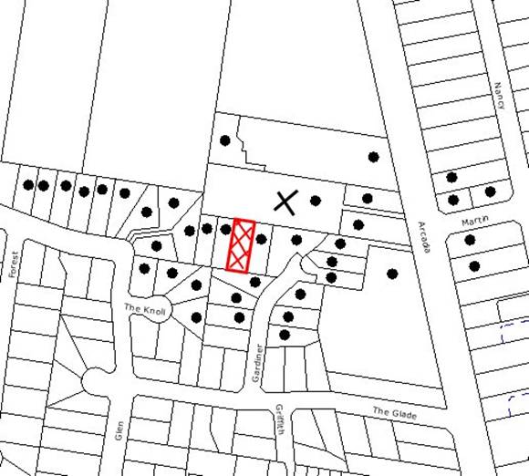
|
NOTIFICATION
PLAN
|
|
|
• PROPERTIES NOTIFIED
|
X SUBMISSIONS
RECEIVED
|

PROPERTY SUBJECT OF DEVELOPMENT
|

|
|
|
|
|
One submission objected to the
development, generally on the grounds that the removal of the ‘Restriction-As-To-User’
would result in:
· Detrimental impacts to
the existing flora and fauna that occurs on the site and the adjoining property
to the north.
· The Section 96(AA)
application has not indicated what effect the modification will have.
· The notification plan
is not the same as the plan approved by the Court.
· Use of the subject
site for stockpiling of excavated soil and rock from adjoining property
development.
The merits of the matters raised
in community submissions have been addressed in the body of the report with the
exception of the following:
5.1.1 Effect of Proposed Modification
The applicant has indicated in
the submitted Statement of Environmental Effects (SEE), that the modification
is intended to have the effect of removing the current 10m restriction.
However, the SEE does not address the environmental impact of the
modification. Instead, the applicant relies upon advice provided by Council
prior to the lodgement of the DA. This is not considered appropriate in the
circumstances of the case.
5.1.2 Notification Plan
Whilst it is acknowledged that
the submitted notification plan is not the plan that was approved by the Court,
the purpose of the plan is to indicate the allotment boundaries and the
existing trees on the site and the submitted plan addresses this requirement.
5.1.3 Compliance Matters
The submission raised concern
with regard to the stockpiling of excavated soil and rock on Lot 3 whilst works
were being undertaken on Lots 1 and 2, which resulted in degradation of the
existing restricted development area with Lot 3. This matter is currently
being investigated by Council’s officers.
5.2 Public Agencies
The original development
application is Integrated Development under the Act as it requires approval
under the Rural Fires Act, 1997 and the Rivers and Foreshores Improvement Act,
1948. Accordingly, the original application was referred to the NSW Rural Fire
Service and the Department of Water and Energy for comment. The proposed
modification is minor in nature and was not required to be referred to the
public agencies as detailed below.
The proposed modification would
not alter the layout of the approved subdivision or the original
recommendations of the NSW Rural Fire Service. Accordingly, the application
was not referred to the NSW Rural Fire Service for further comment.
During the assessment of the
original application, the Department of Water and Energy (DWE) determined that
a Part 3A Permit is required under the provisions of the Rivers and Foreshores
Improvement Act (1948) and issued General Terms of Approval (GTA’s).
The proposed modification does not
require any works within 40 metres of the watercourse. Accordingly, the
application was not referred to the DWE for further comment.
6. THE PUBLIC INTEREST
Section 79C(1)(e) of the Act
requires Council to consider “the public interest”.
The public interest is an
overarching requirement, which includes the consideration of the matters
discussed in this report. Implicit to the public interest is the achievement
of future built outcomes adequately responding to and respecting the future
desired outcomes expressed in environmental planning instruments and
development control plans.
The application is not considered
to have satisfactorily addressed Council’s environmental objectives for the
land and would provide a development outcome that, on balance, would not result
in a positive impact for the community. Accordingly, it is considered that the
approval of the proposed modification would not be in the public interest.
CONCLUSION
Consent is sought to remove a ‘Restriction-As-To-User’
on an approved subdivision that has the effect of protecting a 10-metre wide
STIF community. Council’s assessment concludes that the proposed modification
would have a detrimental impact upon the protection of existing flora and fauna
on the site and is inconsistent with the requirements of the Rural Lands DCP
and SREP 20.
Having regard to the
circumstances of the case, it is recommended that Council refuses the
application.
|
Rod Pickles
Manager -
Assessment Team 2
Planning Division
|
Scott Phillips
Executive Manager
Planning Division
|
Note: At the time of the completion of this planning
report, no persons have made a Political Donations Disclosure Statement pursuant
to Section 147(3) of the Environmental Planning and Assessment Act 1979 in
respect of the subject planning application.
Attachments:
File Reference: DA/922/2003/A
Document Number: D01238275
SCHEDULE 1
1. Pursuant to the provisions of Section 79C(1)(a)(i) of the
Environmental Planning and Assessment Act 1979, it is considered that the
proposed development is unsatisfactory with respect to the aims, objectives and
policies of Sydney Regional Environmental Plan No. 20, in particular, the
policies and strategies for the protection of flora and fauna.
2. Pursuant to the provisions of Section 79C(1)(a)(i) of the
Environmental Planning and Assessment Act 1979, it is considered that the
proposal is unsatisfactory with respect to the aims and objectives of the
Hornsby Shire Local Environmental Plan to protect and enhance the environmental
qualities of the area and to protect environmentally sensitive areas.
3. Pursuant
to the provisions of Section 79C(1)(a)(iii) of the Environmental Planning and
Assessment Act 1979, it is considered that the proposal is unsatisfactory in
that it does not comply with the requirements of the Rural Lands Development
Control Plan, in particular, the ‘Environmental Strategy’ and the
element control for ‘Flora and Fauna Protection’.
4. Pursuant to the provisions of Section 79C(1)(b) of the
Environmental Planning and Assessment Act 1979, it is considered that the
development would have an adverse impact upon the remnant Sydney Turpentine Ironbark Forest.
5. Pursuant
to the provisions of Section 79C(1)(e) of the Environmental Planning and
Assessment Act, 1979, it is considered that approval of the application would
set an undesirable precedent for similar inappropriate development and is
therefore not in the public interest.
-
END OF REASONS FOR REFUSAL -
Planning Report No. PLN70/09
Date of Meeting:
7/10/2009
2 DEVELOPMENT APPLICATION
- ALTERATIONS AND ADDITIONS TO AN EXISTING CHURCH
34A RAMSAY ROAD PENNANT HILLS
|
Development Application No:
|
DA/751/2009
|
|
Description of Proposal:
|
Alterations and additions to
an existing Church.
|
|
Property Description:
|
Lot 88 DP 11135 (No. 34A) Ramsay Road, Pennant Hills
|
|
Applicant:
|
NBRS & Partners
|
|
Owner:
|
Baptist Church Union of NSW
|
|
Statutory Provisions:
|
Hornsby Shire Local Environmental
Plan 1994
Residential A (Low Density)
Zone
|
|
Estimated Value:
|
$1,598,480
|
|
Ward:
|
C
|
RECOMMENDATION
THAT Council assume the concurrence of the Director-General
of the Department of Planning pursuant to State Environmental Planning Policy
No. 1 and approve Development Application No. DA/751/2009 for alterations and
additions to existing Church at lot 88 DP 11135 (No. 34A) Ramsay Road Pennant
Hills as a deferred commencement consent pursuant to Section 80(3) of the
Environmental Planning and Assessment Act, 1979 subject to the conditions
detailed in Schedule 1 of this report.
1. The
application proposes alterations and additions to the Pennant Hills Baptist Church.
2. The
proposal does not comply with the floor space ratio development standard
contained in the Hornsby Shire Local Environmental Plan for the Residential A
Zone. The applicant’s objection to the standard, submitted pursuant to State
Environmental Planning Policy No. 1 – Development Standards, is considered well
founded in accordance with established legal principle and is supported.
3. The
proposal does not comply with the density and car parking requirements of the
Community Uses Development Control Plan. The non-compliance is considered
acceptable with regard to the existing non-compliance and the merits of the
proposal.
4. One
submission was received in support of the application.
5. An
appropriate schedule of finishes had not been submitted by the applicant at the
time of this report. Accordingly, a deferred commencement consent is
recommended subject to the applicant satisfying this requirement.
HISTORY OF THE SITE
The Pennant Hills Baptist Church was built in 1952. A two storey addition to the rear of the church which was
added in 1966.
THE SITE
The corner site has an area of
824.9m2 with an 18.29m frontage to Ramsay Road, a 45.53m frontage to
Rosemount Avenue and a frontage of 18m to an unformed 3.5m wide lane. The
site includes an existing church building which is a one and two storey
building with an attached two storey building at the rear. No off-street car
parking is provided or available on-site. There are no significant trees on the
site.
The existing Church is a dominant
element in the streetscape. In this regard the dominance is more pronounced by
the absence of front fencing, the limited setback to Rosemount Avenue and the
extent of footpath paving which is partly over the Church land at the corner
frontage.
The Church site adjoins a single
storey inter-war dwelling house at No. 36 Ramsay Street and also at No. 32 Rosemount Avenue. There are a number of heritage items in the vicinity of the site
including No. 34 Ramsay Street (front fence), No. 35 Ramsay Street (front
fence), No. 37 Ramsay Street (house and fence) and No. 22 Rosemount Avenue
(house).
The site is located opposite Pennant Hills Public School which is bounded by Ramsay Road, Weemala Road and Greycliffe Avenue. St Marks Anglican Church, on the corner of Rosemount Avenue and Warne Street, is situated diagonally opposite the site. Pennant Hills Railway Station and
shops are situated 500m south east of the site. The immediate locality is a low
density residential area and includes a mix of non-residential uses including
schools, churches and child care centres.
THE PROPOSAL
The proposed alterations and
additions include a new ground floor plan which includes an entry and lobby,
nave, sanctuary, meeting room and administration, and a new first floor plan
for a meeting room and lobby. The alterations and additions combine with the
attached two storey building which includes the existing hall on the first
floor.
The proposed building additions
to the Rosemount Avenue elevation are two storey with a single storey addition
to the Ramsay Road elevation. The proposal involves:-
· A new combined
entry/lobby at the Rosemount Avenue frontage for the Church and the hall
building.
· A one and two storey
extension including a lift is proposed at the western side elevation.
· Removal of the
existing footpath paving over the church land, a front fence and landscaping.
ASSESSMENT
The development application has
been assessed having regard to the ‘2005 City of Cities Metropolitan
Strategy’, the ‘North Subregion (Draft) Subregional Strategy’ and
the matters for consideration prescribed under Section 79C of the Environmental
Planning and Assessment Act 1979 (the Act). Subsequently, the following
issues have been identified for further consideration.
1. STRATEGIC CONTEXT
1.1 Metropolitan Strategy – (Draft) North Subregional
Strategy
The Metropolitan Strategy is a
broad framework to secure Sydney’s place in the global economy by promoting and
managing growth. It outlines a vision for Sydney to 2031; the challenges
faced, and the directions to follow to address these challenges and achieve the
vision. The draft North Subregional Strategy acts as a framework for Council
in the preparation of a new Principal LEP by 2011.
The draft Subregional Strategy
sets the following targets for the Hornsby LGA by 2031:
· Employment capacity to
increase by 9,000 jobs; and
· Housing stock to
increase by 11,000 dwellings.
The proposed development would be
not be inconsistent with the draft Strategy in catering to the Church and
community activities.
2. STATUTORY CONTROLS
Section 79C(1)(a) requires
Council to consider “any relevant environmental planning instruments, draft
environmental planning instruments, development control plans, planning
agreements and regulations”.
2.1 Hornsby Shire Local Environmental Plan 1994
The subject land is zoned
Residential A (Low Density) under the Hornsby Shire Local Environmental Plan
1994 (HSLEP). The objectives of the zone are:
(a) to provide for the housing needs of the population of the
Hornsby area.
(b) to promote a variety of housing types and other land uses
compatible with a low density residential environment.
(c) to provide for development that is within the
environmental capacity of a low density residential environment.
The proposed development is
defined as a ‘place of worship’ and ‘community facility’ under the HSLEP and is
permissible in the zone with Council’s consent.
Clause 15 of the HSLEP prescribes
that the maximum floor space ratio (FSR) of development within the Residential
A zone is 0.4:1. The existing and proposed development does not comply with the
FSR development standard. An objection pursuant to SEPP 1 is submitted by the
applicant in this regard.
Clause 18 of the HSLEP sets out
heritage conservation provisions within the Hornsby area. The site is not an
item of environmental heritage or within a heritage conservation area. The
application includes an assessment of the impact of the proposal on the
heritage items in the vicinity of the site, in compliance with Clause 18.
2.2 State Environmental Planning Policy No. 1 – Development
Standards
The applicant submitted an objection against adherence to
the 0.4:1 maximum FSR development standard under Clause 15 of the HSLEP. The
existing FSR is 0.92:1. The proposed FSR is 1.10:1.
The application has been assessed
against the requirements of SEPP 1. This Policy provides flexibility in the
application of development standards in circumstances where strict compliance
with those standards would, in any particular case, be unreasonable or
unnecessary or tend to hinder the attainment of the objectives of the Act.
The Land and Environment Court
has expressed the view that there are five different ways in which an objection
may be well founded and that approval of the objection may be consistent with
the aims of the policy:
1. The objectives of the standard are achieved notwithstanding
non-compliance with the standards;
2. The underlying objective or purpose of the standard is not
relevant to the development and therefore compliance is unnecessary;
3. The underlying object of purpose would be defeated or
thwarted if compliance was required and therefore compliance is unreasonable;
4. The development standard has been virtually abandoned or
destroyed by the Council’s own actions in granting consents departing from the
standard and hence compliance with the standard is unnecessary and
unreasonable;
5. The zoning of the particular land is unreasonable or
inappropriate so that a development standard appropriate for that zoning is
also unreasonable and unnecessary as it applies to the land and compliance with
the standard would be unreasonable or unnecessary. That is, the particular
parcel of land should not have been included in the particular zone.
The applicant’s objection is made
with regard to the above 5 points and the objective of the FSR standard under
Clause 15 of the HSLEP, being:
To control
the intensity and scale of development of land so that development will be in
accordance with the land’s environmental capacity and zone objectives.
In summary the applicant submits
that:-
· objective (a) of
the zone is not relevant as the proposed use does not relate to housing.
· objective (b) is
not relevant as the low density development standard (0.4:1) is a constraint
when applied to permissible non-residential land uses which involve a built
form and bulk greater than that associated with a dwelling house.
· The development
standard enables the provision of recreation and private open space areas,
which are not necessary for the proposed development.
· A place of worship
traditionally has prominence as a building and as a meeting place.
· The existing
building exceeds the development standard but fits comfortably within the
context of the area.
· The FSR is
unachievable as the existing building has a FSR of 0.92:1.
· In respect to
objective (c) the site is not subject to land sensitivity constraints and is
capable of the proposed land use and FSR.
· The intensity of
the proposed development is similar to that existing and is not considered to
adversely impact upon the local area.
· Any restriction of
development to the existing building preserves a form and function now not
meeting acceptable standards of the congregation and the community.
· The proposed FSR
for the place of worship cannot be used as a precedent to obtain a greater FSR
for residential development.
The site has an area of 824.9m2.
The proposed alterations and additions increase the existing building footprint
by 15% to a site coverage of 74%. The proposed 148.5m2 increase in floor
area results in a floor space ratio increase of 16%. The increase in building
footprint is primarily at the two street frontages and does not significantly
increase the bulk and scale of the existing building in the streetscape.
The SEPP 1 objection is
considered well founded with regard to the existing floor space ratio, the
non-residential use of the land and the traditional built form of the church.
The proposed non-compliance with
the floor space ratio standard could not be considered as a precedent due to
the existing built form and non-residential nature of the development.
The SEPP 1 objection is
consistent with the aims of the Policy in being made in accordance with the
planning principles established by the Land and Environment Court.
2.3 Community Uses Development Control Plan
The proposed development has been
assessed having regard to the relevant performance and prescriptive design
standards within Council’s Community Uses Development Control Plan (DCP). The
following table sets out the proposal’s compliance with the prescriptive
standards of the Plan:
|
Community Uses
Development Control Plan
|
|
Control
|
Proposal
|
Requirement
|
Compliance
|
|
Floor Space Ratio
|
1.10:1
|
0.4:1
|
No
|
|
Car parking
|
0 spaces
|
60 spaces
|
No
|
|
Setbacks
|
Primary Front - 4.75m
Secondary Front –
0m
Side – 0m
|
Primary Front –
6.0m
Secondary Front –
3m
Side – 1m
|
No
|
|
Landscaping
|
20%
|
45%
|
No
|
|
Site cover
|
74%
|
40%
|
No
|
As detailed in the above table,
the proposed development does not comply with the prescriptive standards within
Council’s DCP. The matters of non-compliance are detailed below, as well as a
brief discussion on compliance with relevant performance standards.
2.3.1 Density
The existing Church is prominent
in the streetscape and has a proposed site coverage of 74%. The hall building
attached to the Church is contrary to the built form of the Church. The
proposed alterations and additions effectively form a more coherent building.
The existing and proposed
development does not comply with the DCP floor space ratio and site coverage
requirement. The non-compliance is considered acceptable with regard to the
submitted SEPP 1 objection as discussed in Section 2.2 of this report.
The Church as proposed has a
seating capacity for 300 people which involves an increase of approximately 100
people to the existing Church. The proposed operating hours and details of
Church services and activities are discussed in Section 2.3.5 of this report.
A condition is recommended for
the operation of the development to be consistent with the current range of
activities.
2.3.2 Design
The proposed alterations and
additions include refurbishment and upgrading to meet current access and fire
safety requirements. The proposed floor plan provides more functional spaces
with flexibility to provide for the range of Church activities and functions.
The proposed external alterations
include removal of several windows, infill with matching brick and provision of
new windows. A large bay window is proposed along the Rosemount
Avenue frontage. Similar style
windows are proposed to enclose the stair well, the ground floor lobby, first
floor lobby and the windows of the hall building at the street elevation. The
window style and architectural treatment of the additions provide consistency
between the two buildings. The schedule of materials and finishes had not been
finalised at the time of this report and a condition for a deferred consent
commencement is recommended.
The proposed stair at the street
elevation is enclosed with clear glass windows. To ensure safety on the stairs,
a condition is recommended for the windows to be in translucent glass.
The proposal includes a new
sanctuary which forms a single level extension at the front of the church and
creates a new element in the presentation of the church in the streetscape. The
proposed extension would not detract from the streetscape.
The proposed alterations and
additions at the western side elevation include provision for amenities and a
lift. There are no windows that would diminish privacy of adjoining residents
at the western side boundary.
The proposal meets the DCP design
performance criteria for buildings to complement the streetscape.
2.3.3 Setbacks
The existing building occupies a
corner site and does not comply with the minimum 3m front setback from the Rosemount Avenue secondary street frontage. The proposed additions involve zero setback to Rosemount Avenue. The additions reinforce the building’s interface with the public domain
and are considered acceptable with regard the function of the building as a
place of worship and community hall building.
The proposed sanctuary addition
at the front of the church does not comply with DCP requirement for an
encroachment on the 6m setback to 4m to be a maximum of 1/3 of the frontage.
The 8.8m wide addition exceeds this requirement by 2m. The non-compliance is
considered acceptable with regard to the proposed presentation of the church in
the streetscape. The non-compliance would not establish a precedent or alter
the predominant residential building line in the street.
The proposed additions at the
western side elevation increase the existing setback to 1.047m in compliance
with the DCP.
It is considered the proposed
setback encroachment meets the DCP performance criteria “where it does not
compromise the streetscape or the amenity and enjoyment of adjacent properties.”
2.3.4 Solar Access
The proposed alterations and
additions maintain the existing height of the building. The solar access of the
adjoining residential property remains the same as existing, in compliance with
the DCP.
The existing and proposed
developments overshadow the Rosemount Avenue footpath, in non-compliance with
the DCP requirement for sunlight on public footpaths between 12.00 noon and
2.00 pm on June 22. The non-compliance with the DCP is acceptable with regard
to the existing situation.
2.3.5 Car Parking
The existing development does not
include any on-site car parking and no car parking is provided for the proposed
development. A total of 60 car parking spaces would be required in accordance
with the DCP requirement for 1 space per 5 seats.
The applicant submitted an events
schedule which details the weekly activities conducted by the Church (held at
Attachment 9).
The majority of people (230)
attend the church on Sunday. During the week Pennant Hills Public School use the hall for school assembly, dance and gymnastic classes. The Church
conducts English language classes (ESL), a playgroup, youth group and Church
meetings. Other than for Sunday Church services, school activities are
predominant but would not result in traffic and car parking issues.
A traffic and road safety
investigation concluded that the proposal is acceptable in respect to traffic
and car parking impacts having regard to the circumstance of the case. A
condition is recommended for the operation of the Church to be consistent with
the range of current activities being conducted from the site and for the hall
not to be used in isolation from Sunday Church services.
2.3.6 Landscaping
The submitted landscaping plan is
satisfactory in the treatment of the public spaces along the street frontage
and more formal treatment at the Ramsay Street frontage of the Church. A
condition is recommended for the tubular steel front fence to be in flat top
profile, to ensure the fence forms a safe element in the public domain.
The proposal involves a minor
reduction in the existing landscaping from 21% to 20% and is in non-compliance
with the DCP requirement for 45% site landscaping. The non-compliance is
considered acceptable in view of the existing landscaping provision.
It is considered the proposal is
satisfactory with regard to the DCP performance criteria for landscaping to
reflect the scale of the development.
2.4 Heritage Development Control Plan
The site is not identified as a
heritage item or within a heritage conservation area. There are, however, a
number of heritage items in the vicinity of the site including:
22 Rosemount Avenue - house
34 Ramsay Street - fence
35 Ramsay Street - fence
37 Ramsay Street - house and fence
49 Ramsay Street - house
The items in the vicinity are of
local significance. The proposed alterations and additions to the existing
Church maintain the traditional built form and would not detract from the
heritage significance of the items.
3. ENVIRONMENTAL IMPACTS
Section 79C(1)(b) of the Act
requires Council to consider “the likely impacts of that development,
including environmental impacts on both the natural and built environments, and
social and economic impacts in the locality”.
3.1 Natural Environment
The proposed development would
not adversely impact on existing trees or the natural environment.
3.2 Built Environment
The proposed alterations and
additions to the church and hall would modify the appearance of the building in
the streetscape to a more contemporary standard but would retain the
traditional form of the Church building.
The proposed architectural style
provides a cohesive treatment to the church and attached hall building. A
condition is recommended for the finishes to complement the development in the
streetscape.
The development relies upon
on-street car parking. The proposed alterations and additions increase the
seating capacity of the Church from 200 to 300 people and would improve the
functional layout of the Church and hall. A condition is recommended for the
operation of the Church to be consistent with the range of current activities
being conducted and for the hall not to be used in isolation from Sunday church
services.
Subject to recommended
conditions, the reliance of on-street car parking generally maintains the
existing situation and is considered acceptable.
A vehicle crossing is at the
existing Church entry. A condition is recommended for a new vehicle crossing at
the new entry.
The Church is opposite Pennant Hills Public School and school children cross the road at the frontage of the site.
Pedestrian crossings are in place at the intersection of Ramsay Road with Rosemount Street and Weemala Road. A traffic management plan is recommended for the proposed
development to address pedestrian safety, particularly one hour prior to and
after school hours.
3.3 Social Impacts
The existing Church and hall
caters to a range of activities including those conducted by Pennant Hills Public School. The proposed alterations and additions refurbish the existing
building in meeting access requirements and would provide a more functional and
flexible use of space.
The proposal would therefore be
of positive social impact.
3.4 Economic Impacts
The proposed alterations and
additions would increase the economic life of the building. During construction
the proposal would contribute to the local economy in the provision of
employment opportunities.
4. SITE SUITABILITY
Section 79C(1)(c) of the Act
requires Council to consider “the suitability of the site for the
development”.
The proposal involves an existing
church site and is suitable for the proposed development.
5. PUBLIC PARTICIPATION
Section 79C(1)(d) of the Act
requires Council to consider “any submissions made in accordance with this
Act”.
5.1 Community Consultation
The proposed development was
placed on public exhibition and was notified to adjoining and nearby landowners
between 23 July and 13 August 2009, in accordance with Council’s Notification
and Exhibition Development Control Plan. During this period, one submission
was received by Council. The map below illustrates the location of the
properties notified and the property concerning the submission.
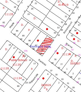
|
NOTIFICATION
PLAN
|
|
|
• PROPERTIES NOTIFIED
|
X SUBMISSIONS
RECEIVED
|
PROPERTY SUBJECT OF DEVELOPMENT
|
|
|
|
|
|
The submission was received from Pennant Hills Public School and was in support of the application, subject to pedestrian
safety of school children being addressed.
The pedestrian safety concerns
are addressed by recommended condition for a Traffic Management Plan to be
implemented during construction of the proposed development.
6. THE PUBLIC INTEREST
Section 79C(1)(e) of the Act
requires Council to consider “the public interest”.
The public interest is an
overarching requirement, which includes the consideration of the matters
discussed in this report. Implicit to the public interest is the achievement
of future built outcomes adequately responding to and respecting the future
desired outcomes expressed in environmental planning instruments and
development control plans.
The application is considered to
have satisfactorily addressed Council’s criteria and would provide a development
outcome that, on balance, would result in a positive impact for the community.
Accordingly, it is considered that the approval of the proposed alterations and
additions to the existing Church and hall would be in the public interest.
CONCLUSION
Consent is sought for alterations
and additions to the existing Pennant Hills Baptist Church. The proposed
alterations and additions provide a more functional floor plan and a more
coherent building in the streetscape.
The application is subject to an objection
to the floor space ratio development standard under Clause 15 of the HSLEP,
pursuant to SEPP 1 – Development Standards. The objection is well founded and
is supported with regard to the existing non-compliance and the merit of the
proposal in upgrading the church and hall building to a more contemporary
standard.
The existing and proposed
development does not comply with the Community Uses DCP in respect to density
and parking. The proposal, however, is considered satisfactory with regard to
the DCP performance criteria in respect to design, setbacks and landscaping
subject to recommended conditions. However, evidence of the acceptability of
the application is the lack of any community objections during the public
exhibition period.
The church and hall building
provide for a range of church and community activities including use by Pennant Hills Public School. The proposed alterations and additions increase the seating
capacity of the church. A condition is recommended for the use to remain consistent
with the current range of activities.
|
Rod Pickles
Manager -
Assessment Team 2
Planning Division
|
Scott Phillips
Executive Manager
Planning Division
|
Note: At the time of the completion of this planning
report, no persons have made a Political Donations Disclosure Statement pursuant
to Section 147(3) of the Environmental Planning and Assessment Act 1979 in
respect of the subject planning application.
Attachments:
|
1.View
|
Locality Plan
|
|
|
|
2.View
|
Site Plan
|
|
|
|
3.View
|
Existing Floor
Plan
|
|
|
|
4.View
|
Roof/Site Plan
|
|
|
|
5.View
|
DA Floor Plan
|
|
|
|
6.View
|
Elevations
|
|
|
|
7.View
|
Sections/Front
Elevation
|
|
|
|
8.View
|
Landscape Plan
|
|
|
|
9.View
|
Events Schedule
|
|
|
File Reference: DA/751/2009
Document Number: D01220204
SCHEDULE 1
GENERAL CONDITIONS
The conditions of consent within this notice
of determination have been applied to ensure that the use of the land and/or
building is carried out in such a manner that is consistent with the aims and
objectives of the planning instrument affecting the land.
Note: For
the purpose of this consent, the term ‘applicant’ means any person who has the
authority to act on or the benefit of the development consent.
Note:
For the purpose of this consent, any reference to an Act, Regulation,
Australian Standard or publication by a public authority shall be taken to mean
the gazetted Act or Regulation, or adopted Australian Standard or publication
as in force on the date that the application for a construction certificate is
made.
1. Deferred
Commencement
Pursuant
to Section 80(3) of the Environmental Planning and Assessment Act 1979, this
consent does not operate until the following information is submitted to
Council:
a. The
submission to Council of a schedule of finishes for the alterations and
additions that complement the existing development and maintain the integrity
of the existing Church building within the streetscape.
Such
information must be submitted within 12 months of the date of this notice,
otherwise this consent will lapse.
Upon Council’s written
satisfaction of the above information, the following conditions of development
consent will apply:
2. Approved
Plans and Supporting Documentation
The development must be carried
out in accordance with the plans and documentation listed below and endorsed
with Council’s stamp, except where amended by Council and/or other conditions
of this consent:
|
Plan No.
|
Drawn by
|
Dated
|
|
07107-DA01-A Site
|
NBRS + Partners
|
7/07/2009
|
|
07107-DA02-A Floor
|
NBRS + Partners
|
7/07/2009
|
|
07107-DA03-A Eleva
|
NBRS + Partners
|
7/07/2009
|
|
07107-DA04-A Section
|
NBRS + Partners
|
7/07/2009
|
|
34A/LP/D Landscape
|
JCA Urban Designers
|
18/06/2009
|
|
SW-04 B Stormwater
|
Sparks and Partners
|
May 2009
|
|
Document No.
|
Prepared by
|
Dated
|
|
D01201050 – Statement
Environmental Effects
|
Chris Young Planning Pty Ltd
|
July 2009
|
|
TBA – Materials & Finishes
Schedule
|
NBRS + Partners
|
|
REQUIREMENTS PRIOR TO THE ISSUE OF A CONSTRUCTION
CERTIFICATE
The following conditions of consent must be
complied with prior to the issue of a ‘Construction Certificate’ by
either Hornsby Shire Council or an accredited certifier. All necessary
information to demonstrate compliance with the following conditions of consent
must be submitted with the application for a construction certificate.
3. Building
Code of Australia
All building work must be
carried out in accordance with the requirements of the Building Code of
Australia.
4. Fire
Safety Upgrade
To ensure the protection of
persons using the building and to facilitate egress from the building in the
event of a fire, the application for a construction certificate must
demonstrate that it will comply with the following Category 1 fire safety
provisions:
a. To
ensure the protection of persons using the existing building and to facilitate
egress from this building in the event of a fire, details must be submitted
with the application for a construction certificate, detailing what works are
necessary (if any) to bring it into full compliance with Parts C, D and E of the Building Code of Australia.
5. Sydney
Water – Quick Check
The application must be submitted
to a Sydney Water ‘Quick Check Agent’ or ‘Customer Centre’ for approval
to determine whether the development will affect any Sydney Water
infrastructure, and whether further requirements are to be met.
Note: Refer
to www.sydneywater.com.au or
telephone 13 20 92 for assistance.
6. Stair
Windows
The windows to the stairway at the east elevation must be in translucent
glass to provide for safety of people on the stairs.
7. Front
Fence
The tubular steel fence at the frontage must be in flat top profile to
form a safe element in the public domain.
REQUIREMENTS PRIOR TO THE COMMENCEMENT OF ANY WORKS
The following conditions of consent must be
complied with prior to the commencement of any works on the site. The
conditions have been imposed to ensure that the works are carried out in such a
manner that complies with relevant legislation and Council’s policies and does
not disrupt the amenity of the neighbourhood or impact upon the environment.
8. Erection
of Construction Sign
A sign must be erected in a
prominent position on any site on which building work, subdivision work or
demolition work is being carried out:
a. Showing
the name, address and telephone number of the principal certifying authority
for the work,
b. Showing
the name of the principal contractor (if any) for any demolition or building
work and a telephone number on which that person may be contacted outside
working hours, and
c. Stating
that unauthorised entry to the work site is prohibited.
Note: Any
such sign is to be maintained while the building work, subdivision work or
demolition work is being carried out, but must be removed when the work has
been completed.
9. Toilet
Facilities
Toilet facilities must be
available or provided at the works site before works begin and must be
maintained until the works are completed at a ratio of one toilet for every 20
persons employed at the site. Each toilet must:
a. be
a standard flushing toilet connected to a public sewer; or
b. be
a temporary chemical closet approved under the Local Government Act, 1993;
or
c. have
an on-site effluent disposal system approved under the Local Government Act,
1993
10. Erosion
and Sediment Control
Erosion and sediment control
measures must be provided and maintained throughout the construction period in
accordance with the manual ‘Soils and Construction 2004 (Bluebook)’, the
approved plans, Council specifications and to the satisfaction of the principal
certifying authority. The erosion and sediment control devices must remain in
place until the site has been stabilised and revegetated.
Note: On
the spot penalties up to $1,500 may be issued for any non-compliance with this
requirement without any further notification or warning.
11. Traffic
Control Plan
A Traffic Control Plan (TCP)
must be prepared by a qualified traffic controller in accordance with the Roads
& Traffic Authority’s Traffic Control at Worksites Manual 1998 and Australian
Standard 1742.3 for all work on a public road and be submitted to Council.
The TCP must detail the following:
a. Arrangements
for public notification of the works.
b. Temporary
construction signage.
c. Permanent
post-construction signage.
d. Vehicle
movement plans.
e. Traffic
management plans.
f. Pedestrian
and cyclist access/safety.
g. Pedestrian
safety of school children particularly for 1 hour before 9.15am and 1 hour
after 3.15pm Monday to Friday.
REQUIREMENTS DURING CONSTRUCTION
The following conditions of consent must be
complied with during the construction of the development. The conditions have
been imposed to ensure that the works are carried out in such a manner that
complies with relevant legislation and Council’s policies and does not disrupt
the amenity of the neighbourhood or impact upon the environment.
12. Construction
Work Hours
All
work on site (including demolition and earth works) must only occur between 7am
and 5pm Monday to Saturday.
No
work is to be undertaken on Sundays or public holidays.
13. Demolition
All demolition work must be
carried out in accordance with Australian Standard 2601-2001 – The
Demolition of Structures and the following requirements:
a. Demolition
material is to be disposed of to an authorised recycling and/or waste disposal
site and/or in accordance with an approved waste management plan.
b. Demolition
works, where asbestos material is being removed, must be undertaken by a
contractor that holds an appropriate licence issued by WorkCover NSW in
accordance with Chapter 10 of the Occupational Health and Safety Regulation
2001 and Clause 29 of the Protection of the Environment Operations
(Waste) Regulation 1996.
c. On
construction sites where buildings contain asbestos material, a standard
commercially manufactured sign containing the words ‘DANGER ASBESTOS REMOVAL IN
PROGRESS’ measuring not less than 400mm x 300mm must be erected in a prominent
position visible from the street.
14. Council
Property
During construction works, no building
materials, waste, machinery or related matter is to be stored on the road or
footpath. The public reserve is to be kept in a clean, tidy and safe condition
at all times.
REQUIREMENTS PRIOR TO THE ISSUE OF AN OCCUPATION
CERTIFICATE
The following conditions of consent must be complied with
prior to the ‘Principal Certifying Authority’ issuing an ‘Occupation
Certificate’.
Note: For the
purpose of this consent, any reference to ‘occupation certificate’ shall also
be taken to mean ‘interim occupation certificate’ unless otherwise stated.
15. Survey
Report – Finished Floor Level
A report(s) must be prepared by
a registered surveyor and submitted to the principal certifying authority prior
to the pouring of concrete at each level of the building certifying that:
a. The
building, retaining walls and the like have been correctly positioned on the
site.
b. The
finished floor level(s) are in accordance with the approved plans.
16. Stormwater
Drainage
The stormwater drainage
system for the development must be designed and constructed for an average
recurrence interval of 20 years and be drained to street gutter via the
existing outlet point (located about 20m down stream of property boundary). The
system is to be constructed generally in accordance with the drawing SW04, job
No 0913, prepared by Sparks and Partners.
17. Footpath
a. Damaged
footpath due to stormwater drainage works shall be reinstated.
b. The
land adjoining the footpath to be fully turfed.
c. Any
public utility adjustments to be carried out at the cost of the applicant and
to the requirements of the relevant public authority.
18. Damage
to Council Assets
Any damage caused to Council’s
assets as a result of the construction of the development must be rectified in
accordance with Council’s written requirements and at the sole cost of the
applicant.
19. Vehicular
Crossing
A separate application under the
Local Government Act, 1993 and the Roads Act, 1993 must be
submitted to Council for the installation of a new vehicular crossing and the
removal of the redundant crossing. The vehicular crossing must be constructed
in accordance with Council’s Civil Works Design, 2005 and the following
requirements:
a. Any
redundant crossings to be replaced with integral kerb and gutter.
b. The
footway area to be restored by turfing.
c. The
new crossing is to be sited for ease of access to the new entry to the
building.
Note:
An application for a vehicular crossing can only be made to one of Council’s
Authorised Vehicular Crossing Contractors. You are advised to contact Council
on 02 9847 6940 to obtain a list of contractors.
20. Completion
of Landscaping
A certificate must be provided
by a practicing landscape architect, horticulturalist or person with similar
qualifications and experience certifying that all required landscaping works
have been satisfactorily completed in accordance with the approved landscape
plans.
Note: Advice
on suitable species for landscaping can be obtained from Council’s planting
guide ‘Indigenous Plants for the Bushland Shire’, available at www.hornsby.nsw.gov.au.
OPERATIONAL CONDITIONS
The following conditions have been applied to ensure that the
ongoing use of the land is carried out in such a manner that complies with
relevant legislation and Council’s policies and does not disrupt the amenity of
the neighbourhood or impact upon the environment.
21. Fire
Safety Statement - Annual
On at least one occasion in
every 12 month period following the date of the first ‘Fire Safety Certificate’
issued for the property, the owner must provide Council with an annual ‘Fire
Safety Certificate’ to each essential service installed in the building.
22. Use
of Premises
The operation and use of
the Church premises must be in accordance with the following:
a. The
development approved under this consent must be used for a ‘place of worship’
and ‘community facility’ as detailed in the ‘Events Schedule’ and not
for any other purpose without Council’s separate written consent.
b. All activities in the hall on a Sunday must be ancillary to
and in conjunction with the primary use as a place of worship.
c. The
hours of operation of the premise are restricted to those times listed below:
Sunday 8.30 am to 9.00 pm
Monday to Saturday 9.00 am to 10.30 pm
23. Landscape
establishment
The landscape works must be
maintained in perpetuity to ensure the establishment and successful growth of
plant material to meet the intent of the landscape design. This shall include
but not be limited to watering, weeding, replacement of failed plant material
and promoting the growth of plants through standard industry practices.
-
END OF CONDITIONS -
ADVISORY NOTES
The following information is provided for your
assistance to ensure compliance with the Environmental Planning and Assessment
Act 1979, Environmental Planning and Assessment Regulation 2000, other relevant
legislation and Council’s policies and specifications. This information does
not form part of the conditions of development consent pursuant to Section 80A
of the Act.
Environmental Planning and Assessment Act, 1979
Requirements
· The Environmental Planning and
Assessment Act, 1979 requires:
· The issue of a construction certificate
prior to the commencement of any works. Enquiries regarding the issue of a
construction certificate can be made to Council’s Customer Services Branch on
9847 6760.
· A principal certifying authority to be
nominated and Council notified of that appointment prior to the commencement of
any works.
· Council to be given at least two days
written notice prior to the commencement of any works.
· Mandatory inspections of nominated
stages of the construction inspected.
· An occupation certificate to be issued
before occupying any building or commencing the use of the land.
Long Service Levy
In accordance with Section 34 of the Building and
Construction Industry Long Service Payments Act 1986, a ‘Long Service Levy’ must be paid to the Long Service
Payments Corporation or Hornsby Council.
Note: The
rate of the Long Service Levy is 0.35% of the total cost of the work.
Note: Hornsby
Council requires the payment of the Long Service Levy prior to the issue of a
construction certificate.
Should asbestos or asbestos products be encountered during
demolition or construction works you are advised to seek advice and information
should be prior to disturbing the material. It is recommended that a contractor
holding an asbestos-handling permit (issued by WorkCover NSW) be engaged
to manage the proper handling of the material. Further information regarding
the safe handling and removal of asbestos can be found at:
www.environment.nsw.gov.au
www.nsw.gov.au/fibro
www.adfa.org.au
www.workcover.nsw.gov.au
Alternatively, telephone the WorkCover Asbestos and
Demolition Team on 8260 5885.
Disability Discrimination Act
The applicant’s attention is drawn to the existence of the Disability
Discrimination Act. A construction certificate is required to be obtained
for the proposed building/s, which will provide consideration under the Building
Code of Australia, however, the development may not comply with the
requirements of the Disability Discrimination Act. This is the sole
responsibility of the applicant.
Advertising Signage – Separate DA Required
This consent does not permit the erection or display of any
advertising signs. Most advertising signs or structures require development
consent. Applicants should make separate enquiries with Council prior to erecting
or displaying any advertising signage.
Prior to commencing any works, the applicant is encouraged
to contact Dial Before You Dig on 1100 or www.dialbeforeyoudig.com.au for
free information on potential underground pipes and cables within the vicinity
of the development site.
Standard Report No. PLN77/09
Planning Division
Date of Meeting:
7/10/2009
3 LOCAL NOMINATIONS FOR
THE JOINT REGIONAL PLANNING PANELS
EXECUTIVE SUMMARY
The NSW Government’s planning
reforms include the establishment of Joint Regional Planning Panels (JRPPs) to
determine development proposals of regional significance. The Government has
announced that the core objective of JRPPs is to provide stronger-decision
making through greater independence, to supplement councils’ expertise and draw
on local and regional knowledge.
In response to a request from the
Minister for Planning, Council wrote to the Department of Planning on 5 June
2009 advising that it had resolved to nominate the Executive Managers Planning
and Environment as local members and the General Manager as an alterative
member of the JRPP. On 2 July 2009, the Department released the Code of
Conduct and Procedures for the Operation of the JRPPs. As a consequence of
those documents, it was identified that the Executive Managers Planning and
Environment were not appropriate local members of the JRPP and therefore, it
became necessary that Council nominates new local members.
To facilitate that outcome,
Council has carried out an Expression of Interest process to identify
alternative suitable local members. This report recommends the appointment of
a new local member and two alternative members.
PURPOSE/OBJECTIVE
The purpose of this report is to
nominate new local members of the JRPP as it affects the Hornsby local
government area.
DISCUSSION
Background
The NSW Government’s planning
reforms, reportedly aimed at delivering a more efficient and transparent
planning system, include the establishment of JRPPs. The objective of JRPPs is
to create a panel of people with appropriate expertise to determine development
proposals of regional significance providing stronger decision-making through
greater expertise, independence and regional knowledge.
Six regions have been established
covering metropolitan and regional areas of NSW. Hornsby local government area
is in the Sydney West Region.
The Panels commenced operation on
1 July 2009.
Functions of JRPPs
The functions of the JRPPs are
to:
1. exercise certain consent authority functions for ‘regional
development’; and
2. where requested, advise the NSW Minister for Planning on planning
or development matters or environmental planning instruments in respect to the
JRPP’s region.
JRPPs determine ‘regionally
significant’ development applications, including:
· Commercial, residential,
mixed use, retail and tourism development with a capital investment value more
than $10 million and less than $100 million.
· Community infrastructure
and ecotourism developments more than $5 million both public and private, such
as schools, community halls and child care facilities.
· Designated development.
· Development where the
council is the proponent with a capital investment value of more than $5
million or has a potential conflict of interest.
JRPPs also have such other
functions as are conferred on them by the Environmental Planning and Assessment
Act 1979 (the Act). For example, JRPPs may have a role in relation to Local
Environmental Plans (LEPs). This may include being appointed as the Relevant
Planning Authority (RPA) for a LEP or, where requested by the Minister,
reviewing or providing advice in respect of a proposed LEP. Where a JRPP is
appointed as an RPA for a LEP, the Minister may also delegate plan making
powers to the JRPP. JRPPs may also, in limited circumstances, be appointed by
the Minister to exercise the functions of the planning assessment panels under
s.118 of the Act (such is presently the case in Ku-Ring-Gai Council).
Councils’ role in relation to
matters under consideration by the JRPP
The adopted ‘Procedures for the
Operation of the JRPPs’ prescribe that the assessment of applications to be
determined by the Panels is to be undertaken by the relevant council officers
in which the proposed development is located. The council officers are to
submit their assessment report and recommendations to the JRPP for
determination.
Whilst the council will not be
the determining body for JRPP matters, the council will have the opportunity to
provide its views about any matters that are to be considered by a JRPP. The
council’s view may be provided to a JRPP by way of a submission in the same way
that any other submissions about the matter are provided to a JRPP for its
consideration in determining a matter. The JRPP must consult the council prior
to determining a matter which is likely to have significant financial
implications for the council.
Membership of JRPPs
JRPPs consist of five members as
follows:
State Members:
Three State members appointed by the Minister, each having expertise in one or
more of the following: planning, architecture, heritage, the environment, urban
design, land economics, traffic and transport, law, engineering, tourism or
government and public administration. One of the State members will be
appointed as the Chairperson of the JRPP.
The Minister for Planning has
appointed the following State members for Sydney West; Janet Thompson (Chair),
Bruce McDonald and Paul Mitchell, with Stuart McDonald and Lindsay Fletcher as
alternates.
Local Members: Two
local members appointed by each council that is situated in a part of the state
for which a JRPP is appointed. At least one council nominee is required to
have
expertise in one or more of the
following: planning, architecture, heritage, the environment, urban design,
land economics, traffic and transport, law, engineering or tourism. The
council nominees will automatically become local members of the JRPP for
matters in that council’s local government area. However, local members will
not sit on a JRPP for matters that are within another local government area.
Nominations of Council members
to the JRPP
In May 2009, the Government
requested that by 5 June 2009, councils nominate two persons to become members
and a third person to be an alternate member of the relevant JRPP. Council
adhered to the Government’s request and wrote to the Department of Planning
advising that it had resolved to nominate the Executive Managers Planning and
Environment as local members and the General Manager as an alterative member of
the JRPP.
On 2 July 2009 (after the date
that councils were requested to nominate local members and after the
commencement date of the operation of the Panels), the Department released the
Code of Conduct and Procedures for the Operation of the JRPPs. As a
consequence of those documents, it was identified that two of Council’s
nominees (Executive Managers Planning and Environment) were not appropriate
local members of the JRPP and therefore, was necessary for Council to nominate
new members.
On 5 August 2009 Council resolved
to nominate Council’s General Manager as a local member of the Panel. At that
time, Councillors declined to be nominated as members. In doing so, Council
resolved to undertake an Expression of Interest (EOI) process to identify
suitable additional local members. This report identifies a second nominee and
two alternate nominees.
Selection Criteria for Local
Members
The selection criteria of local
members include:
· Senior level
experience in dealing with multiple stakeholders;
· high level
communication skills;
· capability to drive
high profile outcomes in a credible and authoritative manner;
· high level analytical
skills; and
· knowledge of the
assessment of complex developments and planning matters.
In addition, at least one of the
two council nominees must have a high level of expertise in one or more of the
following fields:
· Planning
· Architecture
· Heritage
· The environment
· Urban design
· Land economics
· Traffic and transport
· Law
· Engineering
· Tourism
Outcome of EOI Process
In accordance with Council’s resolution,
notices were placed in three local newspapers inviting EOIs until 14 September
2009. During the advertising period, Council received twelve EOIs from the
following persons:
- Mr Jack Cleaver
- Ms Anne Conway
- Mr Lindsay Dyce
- Mr Glenn Falson
- Ms Felicity Findlay
- Mr Peter Fryar
- Ms Sue Haertsch
- Mr Stephen Ledger
- Ms Janelle McIntosh
- Mr Alan Moore
- Mr Philip Scott
- Mr Rajiv Shankar
Each person that lodged an
expression of interest demonstrated that they satisfy the selection criteria and
ten of the twelve persons have the necessary qualifications to be an ‘expert’
local member. Accordingly, further consideration was given to those
nominations that best demonstrated their knowledge and understanding of Council
and the local area. Nine nominees are either residents of Hornsby or former
long-standing employees.
Given that Council has already
nominated one ‘expert’ local member (Mr Ball), emphasis was given to those
nominees that best demonstrated their contribution to the local community. It
is noted that two nominees were former councillors, who each made a
considerable public contribution to the Hornsby community through their
councillor duties. Having regard to the above circumstances, and based on each
nominee meeting the selection criteria, it is recommended that Council
nominates Ms Felicity Findlay as a local member and Ms Janelle McIntosh as an
alternate local member.
From time to time, Council’s
current local member, Mr Ball, may be unable to sit on the Panel due to other
commitments or a conflict (as set out in the Code of Conduct). On that basis,
and having regard to the fact that Ms Findlay and Ms McIntosh are ‘non-expert’
members, it is considered appropriate to nominate an alternate ‘expert’ local
member. It is considered that Mr Peter Fryar best demonstrates that he meets
the selection criteria and an understanding of the planning framework within
Council and the Hornsby Shire. Mr Fryar is a qualified town planner, who was
employed by Council between 2000 and 2008 as the Manager Assessments. Mr Fryar
has considerable planning experience within Hornsby Shire and more broadly
across the State. Mr Fryar is a recognised expert in the Land and Environment Court and would be suitably placed to sit as a local member of the JRPP in the
event that Mr Ball is unavailable.
Funding of the JRPP
The NSW Government has made a
commitment to fund the employment costs of State Panel members and the general
administration of the Panels. A JRPP secretariat has been appointed within the
Department of Planning.
The employment costs of local
members are the responsibility of each council. The Minister for Planning has
written to all Mayors setting out remuneration guidelines for local members
of JRPPs. The Minister states “while
I have decided not to set the fees for Council nominated members, so that
councils are free to determine the fees paid to their appointed members, the
following should be considered when setting fees:
- Council staff
members: No fees should be paid, as participation in the Regional Panel would
form part of the employee’s regular duties, consistent with the Department of
Premier and Cabinet Guidelines for NSW Board and Committee Members: Appointment
and Remuneration on payment to Public Sector Employees.
- Elected councillors:
As councillors already receive an annual fee set by the Local Government
Remuneration Tribunal each ear for performing their councillor duties, an
additional per meeting fee of no more than $600 appears reasonable, recognising
that membership of the Regional Panel will bring additional responsibilities.
- Community members:
Each council may determine an appropriate level of remuneration for that
person, by arrangement with that member, but that a meeting fee not exceeding
$1400 should be considered as a guide when determining appropriate remuneration
rates. This is commensurate with the fee proposed for State appointed members.
- Alternates: Alternate
members, when serving on the Regional Panel, should receive fees commensurate
to those paid to comparable council-appointed members.”
Having regard to the Minister’s
guidelines, it is recommended that ‘non-expert’ local members be paid a fee of
$600 per meeting, consistent with the fee that would be paid to a Councillor
and that (non-staff) ‘expert’ local members are paid a fee of $1,400,
consistent with the fee that is being paid to State appointed members.
Council has not allocated funding
for the JRPP in its 2009/10 operational budget due to the timing of the
Minister’s announcement being after the setting of Council’s budget. For the
remainder of the 2009/10 financial year, funding will be allocated from the
Planning Division consultancy budget.
BUDGET
The financial implications of the
appointments are set out above. It is estimated that the cost to Council for
local members for the remainder of 2009/10 will be approximately $3,000 to
$5,000, which will be allocated from the Planning Division consultancy budget.
POLICY
There are no policy implications.
CONSULTATION
The EOI process was open between
2 and 14 September 2009.
TRIPLE BOTTOM LINE SUMMARY
Triple Bottom Line is a framework
for improving Council decisions by ensuring accountability and transparency on
social, environmental and economic factors. It does this by reporting on
Council’s strategic themes. As this report provides Council with information
and does not propose any actions
which require a sustainability assessment, no Triple Bottom Line considerations
apply.
RESPONSIBLE OFFICER
The responsible officer for this
report is the Executive Manager Planning, Mr Scott Phillips, telephone 9847
6751.
RECOMMENDATION
|
THAT:
1. Council advises the Department of Planning that it nominates Ms
Felicity Findlay as Council’s second local member and nominates Ms Janelle McIntosh
and Mr Peter Fryar as alternative local members of the Joint Regional
Planning Panel.
2. Council informs all persons that lodged an expression of
interest of Council’s decision and thanks them for their interest in the
matter.
|
|
Scott Phillips
Executive Manager
Planning Division
|
|
Note: At the time of the completion of this planning
report, no persons have made a Political Donations Disclosure Statement pursuant
to Section 147(3) of the Environmental Planning and Assessment Act 1979 in
respect of the subject planning application.
Attachments:
There are no
attachments for this report.
File Reference: F2009/00493
Document Number: D01243644
Standard Report No. PLN78/09
Planning Division
Date of Meeting:
7/10/2009
4 DRAFT LOCAL
ENVIRONMENTAL PLAN TO ALLOW STRATA SUBDIVISION - PROPERTY NO. 218 BROOKLYN ROAD, BROOKLYN
EXECUTIVE SUMMARY
Council has received a request to
prepare a draft Local Environmental Plan (LEP) to permit the strata subdivision
of an existing multi-unit housing development. The proponent has requested that
Clause 22 – Exceptions of the Hornsby Shire Local Environmental Plan (HSLEP)
1994 be amended to permit strata subdivision of the existing building on
property No. 218 Brooklyn Road, Brooklyn.
Currently, Clause 14(4) of the HSLEP
prohibits the separate occupation of proposed strata title lots in the
Residential A, AA, AM, AS and AT zones. The underlying objective of Clause
14(4) is to emulate the State Government’s prohibition on the subdivision of
dual occupancy developments. The site contains a multi-unit housing development
comprising six dwellings and has been used for the same since at least 1986.
The prohibition of strata subdivision has created a planning anomaly in that
the change to the legislation did not envisage such a prohibition on the
subject site.
The majority of the site is zoned
Residential A (Low Density) with two small areas of Business A (General) zoned
land at the western end of the site. A review of the zoning history of the site
indicates that the business zoning is also an anomaly. Should an amendment to
the HSLEP be prepared to facilitate the strata subdivision of the site,
it should also seek to rectify the zoning anomaly.
This report recommends that,
should Council wish to progress a draft LEP amendment to permit strata
subdivision and rectify the zoning anomaly for the site, a planning proposal be
prepared and presented to Council in accordance with recent State Government
changes to the draft LEP making process. The planning proposal should
incorporate other matters set out for inclusion in Council’s Annual Amending
LEP, including the recommendations of Heritage Review Stage 4.
PURPOSE
The purpose of this report is to
inform Council of a request to prepare a draft LEP to permit the strata
subdivision of an existing multi-unit housing development at property No. 218 Brooklyn Road, Brooklyn.
BACKGROUND
Council records indicate that the
existing building at property No. 218 Brooklyn Road has been used for the
purpose of multi-unit housing since at least 1986. Council records also
indicate that on 16 April 2003, a development application was approved for
alterations and additions to the existing multi-unit housing development,
including car parking. The approved alterations and additions have been
completed. However, the approved car parking has not been provided. The
proponent advises that this is due to site constraints making construction of
the approved parking difficult, unsightly and costly.
The proponent
first approached Council in December 2008 concerning a proposal for a combined
development application and LEP amendment to strata subdivide the existing
units on the site. The proponent also requested advice from Council concerning
the potential purchase of Council land in the vicinity of the site for
provision of car parking. Council advised that the matters involving purchase
of Council land are subject to separate negotiation with Council’s Property
Development Branch. The proponent was advised that a site specific exception to
permit strata subdivision may be considered by Council as part of Council’s
next Annual Amending LEP. However in order for Council to formally consider the
matter, a comprehensive draft LEP submission would be required, including an
evaluation of the proposal, the likely strategic planning and land use
implications and demonstrating the community benefits arising from the
proposal.
A draft LEP
submission was submitted by the proponent on 27 March 2009, requesting that
Clause 22 – Exceptions of the HSLEP be amended to permit strata
subdivision of the existing development on property No. 218 Brooklyn Road, Brooklyn. This report discusses the proposal and the implications
of preparing an amendment to the HSLEP.
EVALUATION
In evaluating the proposal it is appropriate to consider
the site, the proposal, the surrounding environment and amenity and the
community benefit of the proposal.
The Site
and Context
The site consists of Lot 1 DP
901075, Lot 6 DP 664306 and Lots 8-10, Section B DP 2746. The combined area of
the site is 799m2. The site is located at the eastern end of Brooklyn Road, Brooklyn.
The site is developed with an
existing two-storey sandstone and brick building on stone foundations with a
galvanised iron roof. A detached studio is erected to the east of the
two-storey building. A number of small sheds and outbuildings are also located
on the site. The building comprises six residential
flats, with four smaller units on the ground floor and two larger units on the
first floor. There is no car parking available on the site.
The site is bounded by Brooklyn
Commercial Centre to the west and low density residential properties to the
south and east. The buildings within the commercial centre are typically two
storeys in height. The site is located on the corner of Brooklyn Road and William Street. However, there is a significant change in level directly adjacent the
property to the east, where the property meets an unformed section of William Street. This difference in level means that Brooklyn Road and William Street are not
connected, and Brooklyn Road effectively ends in front of the site.
Zoning History
Prior to 1951 - The
proponent’s submission states that the main building on the site was built in
the early 1900s. There is photographic evidence to suggest the building was
used for commercial purposes in the early 1900s.
1951 onwards (County of Cumberland Planning Scheme Ordinance) - The property was zoned ‘living
area’ under the County of Cumberland Planning Scheme Ordinance.
The ‘living area’ zone was a residential zone that permitted single dwelling-houses
without
consent from Council, and other
residential flat buildings with consent. There is anecdotal evidence to
suggest the building has been used as multi-unit housing since at least the
1960s.
1977 onwards (Hornsby Shire
Planning Scheme Ordinance) - The property was zoned ‘Residential a2’ under
the Hornsby Shire Planning Scheme Ordinance. The ‘Residential a2’ zone
was a low density zone that permitted single dwelling-houses without consent
from Council, and residential flat buildings up to two-storeys with consent.
Current zoning (Hornsby Shire
Local Environmental Plan) - The majority of the site is zoned Residential A
(Low Density) with two small areas of Business A zoned land at the western end
of the site. A review of the zoning history of the site as set out above
indicates that the Business zoning is an anomaly. Should an amendment to the HSLEP
be prepared to facilitate the strata subdivision of the site, it should also
seek to rectify the zoning anomaly.
Development Approvals
In April 2003, Council approved
Development Application No. 2482/02 for alterations and additions to an
existing multi-unit housing development and the provision of on-site car
parking. The approved works included the reconstruction of two heritage style
balconies to the front of the building, the erection of a new external timber
staircase to the western side of the building and the construction of a six
vehicle car park in the south eastern corner of the site (adjacent to William
Street). The approved vehicle parking area is to be accessed via William Street and would be constructed as an elevated concrete slab with retaining wall. To
date, the works concerning the balconies and external staircase have been
carried out. The approved car park has not been constructed.
The Proposal
The proponent
has requested an amendment to Clause 22 of the HSLEP to permit the
strata subdivision of the existing multi-unit housing development. The purpose of Clause 22 is to provide exceptions that
allow or prohibit development in accordance with the overall objectives of the HSLEP.
The granting of an exception would retain the current zoning of the land.
However, strata subdivision would be permissible with the consent of Council.
Currently, Clause 14(4) of the HSLEP
prohibits the separate occupation of proposed strata title lots in the
Residential A, AA, AM, AS and AT zones. The Clause was introduced in 1995 (HSLEP
Amendment No. 8) to avoid development pressure in Hornsby Shire after
similar changes to State legislation resulted in Hornsby Shire being one of the
few local government areas in which separately titled dual occupancy
developments were still permitted. The underlying objective of Clause 14(4) is
to emulate the State Government’s prohibition on the subdivision of dual
occupancy developments. The existing multi-unit housing development on the site
has been used for the same since at least 1986. The prohibition of strata
subdivision has created a planning anomaly in that the change to the
legislation did not envisage such a prohibition on the subject site, where
there was otherwise a reasonable expectation that strata subdivision could
occur.
HSLEP (Amendment No. 8)
contains savings and transitional provisions that allow subdivision of
multi-unit housing developments approved between specific dates in accordance
with certain planning instruments. However, the existing development does not
benefit from the savings provisions.
Council has previously supported
amendments to the HSLEP to permit strata subdivision of existing
multi-unit housing developments (other than dual occupancy developments) which
predate the prohibition of strata subdivision and do not benefit from the
savings provisions. Should Council seek to permit strata subdivision on this
site, there are a number of options available to Council to facilitate this.
The options include an amendment to Clause 22 - Exceptions as requested by the
proponent, or rezoning the site to a Residential B (Medium/Density),
Residential C (Medium/High Density) or Business A (General) zone, all of which
permit strata subdivision.
The
Residential B zone promotes townhouse type development with attached dwellings
configured over two levels, and the Residential C zone promotes three storey
walk up unit development. Both zonings would permit a higher floor space ratio
on the site. These built forms do not accord with the existing building, and
the site does not adjoin existing Residential B or Residential C zoned land.
The Business A zone would permit additional commercial uses on the site which
would potentially generate additional traffic and car parking demands. A
Business zoning would also potentially cause land use conflict, as some units
would be used for residential and others for commercial with associated amenity
impacts. Further, the recently exhibited Ku-ring-gai and Hornsby Subregional
Employment Study does not identify the Brooklyn
Commercial Centre as requiring expansion to service the local catchment or to
meet the employment targets set for the Shire in the draft North Subregional
Strategy.
Accordingly,
should Council support the submission to permit strata subdivision of the site,
an amendment to Clause 22 of the HSLEP (and retention of the existing
Residential A zoning) is the most appropriate method to facilitate the same.
Should a draft LEP to amend Clause 22 of the HSLEP be gazetted, the
proponent would be required to submit a development application for the strata
title subdivision of the building.
Amenity
Should Council resolve to prepare a draft LEP to permit
strata subdivision, it should be satisfied that the proposal would not impact
on the amenity of surrounding uses. Strata subdivision would not result in any
material change to the existing site or the existing building. Amending Clause
22 of the HSLEP to allow strata subdivision on the site does not alter
building density, landscaping, or car parking requirements. The proponent
states that under separate strata title and ownership the building is less
likely to be demolished or undergo significant alterations and therefore, no
additional impacts to neighbours or the locality would arise.
Car Parking
As discussed above, Development
Application No. 2482/2002 included an approved car park to the south eastern
corner of the site. Although the majority of the works associated with the
development application have been carried out, the car park has not been
constructed. The draft LEP submission identifies a parcel of Council land in
the adjoining road reserve as an alternate location suitable for car parking.
The submission indicates that should the land be purchased from Council, a
proposal to provide parking at this location would be included in any
development application for strata subdivision.
Council’s Property Development
Branch has indicated that the subject Council land is not suitable to be sold
to the applicant. Accordingly, the proponent will need to provide car parking
for the existing multi-unit housing development in accordance with Development
Consent No. 2482/2002. Should
Council resolve to prepare an amendment to the HSLEP to permit strata
subdivision, this would not negate the non-compliance with Development Consent
No. 2482/2002.
Community Benefit
In deciding whether to support the submission for an
exception under Clause 22 of the HSLEP, Council should be satisfied that
the proposal demonstrates a community benefit either socially, economically
and/or environmentally.
The proponent claims that the draft LEP to permit strata
subdivision would benefit the community through the likely long term retention
of the existing building with its historical value as a building from the early
1900s. The draft LEP would permit the separate strata titling of the
existing multi-unit housing development, bringing six residential units onto
the market which are well serviced by the adjacent Brooklyn Commercial Centre
and train station. The strata title subdivision would provide a form of housing
that may be more affordable than the detached single dwellings common in the
local area. The use and appearance of the development would remain the same and
the character of the area would be retained.
Notwithstanding
the above, the community benefit would be enhanced if the proponent completed
the car park in accordance with Development Consent No. 24821/2002.
Accordingly, should Council resolve to support the submission to permit strata
subdivision of the site, Council should ensure that the car parking works have
been undertaken prior to forwarding a draft LEP to the DOP for gazettal.
CONSULTATION
Following
receipt of the draft LEP submission, the proposal was informally exhibited to
seek public comment to assist in the assessment of the proposal. Property
owners adjoining the site were notified of the proposal and invited to make
submissions. No submissions were received.
Council’s Assessment Teams and Property Development Branch
were consulted in the preparation of this report. No objections were raised in
principle to a future development application being considered to allow for the
strata subdivision of the existing building. However, Council’s Team Leader,
Building Certifications advises that the non-compliance with Development
Consent No. 2482/2002 concerning the provision of car parking should be
addressed.
PLANNING REFORMS
In July 2009, the State
Government announced changes to the way that LEPs are progressed. A new system,
known as the “gateway plan-making process”, has been established. The gateway
process has been introduced to assist meet the Government’s target of a 50%
overall reduction in the time taken to produce LEPs and to allow the steps in
the system to be tailored to the complexity of individual LEPs. The new gateway
process involves the following steps:
Planning Proposal —
Council is responsible for the preparation of a planning proposal for submission to the
DOP, which explains the effect of, and justification for, the proposal.
Gateway — The
Minister (or delegate) determines whether the planning proposal is to proceed.
This gateway acts as a checkpoint to ensure that the proposal is justified
before
further studies are done and
resources allocated to the preparation of a plan. If necessary, the proposal is
amended. A community consultation process is also determined, including
consultation with relevant public authorities.
Community consultation
— The proposal is publicly exhibited (generally low impact proposals for 14
days, others for 28 days).
Assessment –
Council considers public submissions and the proposal is amended as necessary.
Parliamentary Counsel then prepares a draft LEP.
Decision – With the
Minister’s (or delegate’s) approval the plan becomes law and is published on
the NSW legislation website.
Should Council wish to progress a
draft LEP to permit strata subdivision of the site, a planning proposal would
be required to be prepared. The planning proposal must set out the objectives
or intended outcomes of the proposed draft LEP, an explanation of the
provisions that are to be included in the proposed draft LEP, justification for
the proposal, and the intended community consultation to be carried out.
Council’s current practice is to
progress minor amendments to the HSLEP as one Annual Amending LEP rather
than as separate amendments, consistent with previous advice from the DOP. At
its meeting on 3 June 2009, Council resolved (in part) to implement the
recommendations of Heritage Review Stage 4 as part of an Annual Amending
LEP. Any planning proposal prepared to permit strata subdivision at property No. 218 Brooklyn Road, Brooklyn should form part of Council’s Annual Amending Planning
Proposal in 2009.
STATUTORY CONSIDERATIONS
As part of Council’s
consideration of amendments to LEPs, Council is required to consider the
relevance of any State Environmental Planning Policy (SEPP) or Ministerial
Direction under Section 117 of the Environmental Planning and Assessment
Act, 1979. The proposal is not contrary to any SEPP or relevant Section
117 Directions.
OPTIONS
Council has before it the following options:
Option 1 – Resolve not to prepare a planning proposal
An appropriate resolution for this option would be:
1. Council
not progress the preparation of a planning proposal for property No. 218
Brooklyn Road, Brooklyn as the proposal is not the result of any strategic
study or report and represents a minor amendment with minimal broader economic
or community benefit.
1. The
advertising fee of $1,200 be refunded to the proponent.
2. Council’s
Compliance Section follow up the non-compliance with Development Consent No.
2482/2002 in relation to car parking.
Option 2 – Incorporate amendments relevant to property No. 218 Brooklyn Road, Brooklyn in Council’s Annual Amending Planning Proposal 2009
This option would allow the amendments relating to the site
to be incorporated as part of an Annual Amending LEP. The Planning Proposal
would include the amendment to permit strata subdivision and correct the zoning
anomaly at property No. 218 Brooklyn Road, Brooklyn, along with the
recommendations from Heritage Review Stage 4.
Option
2 is recommended. The prohibition of strata subdivision was not intended to
apply to this type of development which predates current planning controls. The
strata subdivision of the existing building on the site would bring six
residential units onto the market which are well serviced by the adjacent
Brooklyn Commercial Centre and train station. The use and appearance of the
development would remain the same and the character of the area would be
retained. The site’s zoning anomaly can be rectified as part of the proposal.
Progression of the amendments as an Annual Amending Planning Proposal
incorporating other anomalies or minor amendments to
the HSLEP is consistent with previous advice from the DOP.
FINANCIAL
In accordance with Council’s Schedule of Fees and Charges,
a fee of $16,200 has been paid to cover the administration, advertising and
assessment costs associated with the submission. Should Council resolve not to
support the preparation of a planning proposal, it would be appropriate to
refund the advertising fee associated with the submission.
TRIPLE BOTTOM LINE SUMMARY
This Triple Bottom Line (TBL) Statement forms part of
Council’s efforts towards creating a living environment”. The statement
addresses the strategic themes within Council’s Management Plan that cover
social, environmental and economic factors and the corresponding sustainability
questions contained in the TBL checklist.
● Working
with our community: Should Council resolve to progress the planning
proposal, a consultation strategy relevant to the amendment would be prepared
as part of the consultation strategy for the Annual Planning Proposal 2009
addressing anomalies or minor amendments. Public exhibition material would be
readily accessible and understandable to all members of the community by
providing it in a number of locations and means of communication. The community
would be able to obtain hard copy information from Council or download
information from Council’s website.
● Conserving
our natural environment: The proposal seeks strata subdivision of an
existing multi-unit housing building. The facilitation of the proposal would
not impact negatively upon the natural environment.
● Contributing
to community development through sustainable facilities and services: The
request to permit the strata subdivision of the existing multi-unit housing
building is not applicable to the provision of sustainable facilities and
services for the community.
● Fulfilling
our community’s vision in planning for the future of the Shire: The
progression of a Clause 22 Exception provision would permit the strata
subdivision of the existing building. There is no expansion proposed. The
existing
built form of
the multi-unit housing development is consistent with Development Consent No.
2482/2002 issued by Council. The facility is not incompatible with the
established residential and business character of the area and the proposal to
permit strata subdivision would not alter the visual appearance of the
property.
● Supporting
our diverse economy: The proposal to permit the strata subdivision of the
existing building within the residentially zoned land would not adversely
affect the adjacent commercial centre.
● Other
sustainability considerations: The building has been operating as
multi-unit housing since at least 1986. A development application was approved
on the site in 2003. Strata subdivision of the existing building would not
result in any material change to the existing site or the existing building.
Accordingly, there are no likely potential negative impacts.
CONCLUSION
The proponent has requested that
Clause 22 – Exceptions of the Hornsby Shire Local Environmental Plan (HSLEP)
1994 be amended to permit strata subdivision of the existing building on
property No. 218 Brooklyn Road, Brooklyn.
Currently, Clause 14(4) of the HSLEP
prohibits the separate occupation of proposed strata title lots on the site.
The prohibition of strata subdivision has created a planning anomaly in that
the change to the legislation did not envisage such a prohibition on the
subject site. Progression of an amendment to the HSLEP
to permit the separate strata titling of the existing multi-unit housing
development would bring six residential units onto the market which are well
serviced by the adjacent Brooklyn Commercial Centre and train station. The use
and appearance of the development would remain the same and the character of
the area would be retained.
A review of the zoning history of
the site indicates that a small portion of the site is zoned Business A
(General), an anomaly which could be rectified as part of an amendment to the HSLEP.
This report recommends that,
should Council wish to progress a draft LEP amendment to permit strata
subdivision and rectify the zoning anomaly for the site, it should be
incorporated in Council’s Annual Amending Planning Proposal 2009 (along with
the recommendations of Heritage Review Stage 4) in accordance with
recent State Government changes to the draft LEP making process.
RECOMMENDATION
|
THAT:
1. Amendments to the Hornsby Shire Local Environmental Plan
1994 to enable strata subdivision and correct a zoning anomaly at
property No. 218 Brooklyn Road, Brooklyn be incorporated in Council’s
Annual Amending Planning Proposal 2009.
2. Prior to
forwarding the Planning Proposal to the Department of Planning for gazettal,
Council’s Compliance Section ensure that the car parking works approved as
part of Development Consent No. 2482/2002 have been undertaken.
|
|
James Farrington
Manager - Town
Planning Services
Planning Division
|
Scott Phillips
Executive Manager
Planning Division
|
Note: Statement pursuant to
Section 147(3) of the Environmental Planning and Assessment Act 1979 must be
made in the event that a Councillor has received a gift or political donation
from any person/organisation (including a person/organisation making a
submission to an application) in the prescribed manner.
Attachments:
|
1.View
|
Draft LEP
Submission
|
|
|
File Reference: F2009/00263
Document Number: D01246151
Standard Report No. PLN79/09
Planning Division
Date of Meeting:
7/10/2009
5 PLANNING REFORM FUND -
EPPING TOWN CENTRE
EXECUTIVE SUMMARY
The funding allocation by the
Minister for Planning towards progression of the Epping Town Centre Study
represents a significant shortfall in the total costs of the Study. In
September 2009, representatives of the Department of Planning, Parramatta and Hornsby Councils met to discuss options to progress the Study.
Department
representatives advised that the offer of funding is based on the delivery of
the completed study including revised planning controls for the Centre.
Therefore, a proposal to stage the Study, with the balance of the Study to be
progressed when funds are allocated in the future, would unlikely be
supported. However, there may be opportunity to revise the scope of
works in light of previous studies undertaken by the Councils, provided the
Study outputs are achieved. With a revised scope of works, a financial
contribution by Council is still likely to be required to progress the Study.
It is recommended that Council
continue discussions with the DOP and Parramatta Council concerning options to
refine the study brief and funding options before determining whether to accept
the Minister’s offer.
PURPOSE
The purpose of this report is to
advise Council of the outcomes of a meeting with
representatives from the DOP and Parramatta Council concerning funding
under the State Government’s Planning Reform Fund to progress the Epping
Town Centre Study and options to progress the Study.
BACKGROUND
At its meeting on 2 September
2009, Council considered a Mayoral Minute advising of the outcome of a joint
application with Parramatta Council for funding under the State Government’s
Planning Reform Fund to progress the Epping Town Centre Study. The
Minute noted that the Minister for Planning announced the allocation of
$125,000 towards the Study which represents a significant shortfall in the
total costs of the Study.
Council resolved to defer
consideration of the funding offer pending discussions with the DOP and
Parramatta Council concerning options for funding the Study and/or amendment to
the study brief. Council also resolved that the Mayor, Councillors Browne,
Hutchence and Martin be invited to participate in the discussions.
In accordance with Council’s
resolution, a meeting between representatives of the Department, Parramatta and Hornsby Councils was scheduled to be held on 11
September 2009. However, Department representatives withdrew from the meeting
due to other commitments. Representatives from the Councils met to discuss
options for a way forward. At the conclusion of the meeting, it was agreed
that to progress the Study it is essential that direction be provided by the
Department concerning the opportunity to amend the timing of the Study or stage
the Study to reflect the funding offer.
The meeting with Department
representatives was rescheduled and was held on 17 September 2009. Councillors Browne and Hutchence, Executive Manager,
Planning Division and Manager, Town Planning Services represented Council at
the meeting. This report addresses the outcomes of the meeting and options to
progress the Study.
DISCUSSION
At the meeting, Department
representatives reaffirmed that the draft North
Subregional Strategy identifies that the DOP is to work with both Hornsby
and Parramatta Councils to prepare a town centre study to provide the strategic
context required to deliver revised planning controls for Epping.
Council representatives
acknowledged that the draft Strategy identifies the Study as a State government initiative to
maximise opportunities arising from investment in rail infrastructure. Council
has previously indicated its willingness to provide staff resources to assist
in the progression of the Study through participation on working parties.
However, at the suggestion of the DOP, a joint application with Parramatta
Council was made for Planning Reform Funds to progress the Study.
Funding totalling $300,000 was
sought from the DOP including $250,000 for consultant input. A further $50,000
was sought to fund a part-time project officer to administer the Study. The
funding offer of $125,000 by the Minister for Planning is not adequate to cover
the costs of delivering the study brief. It was noted that neither Hornsby nor
Parramatta Councils have made a budget allocation towards the Study.
Accordingly, advice was sought from the Department concerning whether there is
opportunity to refine the study brief or undertake the Study in stages to
reflect the funding offer.
The following key directions from
the meeting were noted:
· The offer of funding is based on the delivery of the
completed study including revised planning controls for the Centre. Therefore,
a proposal to stage the Study (eg. undertake the traffic study as the first
stage) utilising the funding offered, with the balance of the Study to be
progressed when funds are allocated in the future, would unlikely be supported.
· The offer of funding is based on a joint review of controls
within both the Hornsby and Parramatta local government areas. Therefore,
acceptance of the funds by one Council to progress the Study for a component of
the Centre would unlikely be supported.
· The application for
Planning Reform Funds includes $250,000 to undertake traffic and transport
modelling, opportunities and constraints analysis, scoping of development
options, and economic modelling. There may be opportunity to revise the scope
of works in light of the funding offer and previous studies undertaken by the
Councils, provided the Study outputs are achieved.
· The Study should be
completed within 12 months from the signing of any Memorandum of Understanding
(MOU). This would include the exhibition and adoption by the Councils of any
draft Local Environmental Plan to amend existing planning controls for the
Centre. The 12 month timeframe would enable any financial contribution by the
Councils to be allocated over two financial years.
· Should the offer of
funding be rejected by the Council(s), a report would be prepared by the
Department’s Regional Team to the Minister for Planning outlining options for
consideration by the Minister to achieve the objective of preparing revised
planning controls for Epping.
At the conclusion of the meeting,
it was agreed that representatives from the Councils should review the scope of
works for the Study in light of previous studies undertaken by the Councils
that may assist in achieving the Study outputs. A revised scope of works
should then be presented to the Department for confirmation that the revised
brief would meet the terms of the funding offer. The timeframe for signing the
MOU has been extended to enable a report to be presented to the Council meeting
on 4 November 2009 concerning any revised scope of works.
It would be appropriate for
Council to continue discussions with the DOP and Parramatta Council concerning
options to refine the study brief and funding options before determining whether
to accept the Minister’s offer.
FINANCIAL
The funding of $125,000 by the
Minister for Planning towards the progression of the Study represents a
significant shortfall in the total costs of the Study. It should be noted
that, even with a revised scope of works, a financial contribution by Council
is likely to be required to progress the Study.
The Annual Operating Budget for
the Town Planning Services Branch has been allocated towards the progression of
Council’s Comprehensive LEP and DCP and the Hornsby Shire Housing Strategy.
Accordingly, funding and staff resources have not been allocated to contribute
to undertake the Study. The report on a revised brief for the Study would also
address options to reallocate finds and resources to progress the Study.
TRIPLE BOTTOM LINE SUMMARY
Triple Bottom Line is a framework for improving Council
decisions by ensuring accountability and transparency on social, environmental
and economic factors. It does this by reporting upon Council’s strategic
themes. As this report provides Council with information and does not propose
any actions which require a sustainability assessment, no Triple Bottom Line
considerations apply.
CONCLUSION
In September 2009,
representatives of the Department of Planning, Parramatta and Hornsby Councils
met to discuss options to progress the Epping Town Centre Study. Department representatives advised that there may be
opportunity to revise the scope of works in light of previous studies
undertaken by the Councils, provided the Study output of revised planning
controls for the Centre is achieved. With a revised scope of works, a
financial contribution by Council is still likely to be required to progress
the Study.
It is recommended that Council
continue discussions with the Department and Parramatta Council concerning
options to refine the project brief and funding options before determining
whether to accept the Minister’s offer.
RECOMMENDATION
|
THAT:
1. Council continue discussions with the Department of Planning
and Parramatta Council concerning options to refine the project brief and
funding options for the Epping Town Centre Study before determining
whether to accept the Minister’s offer of funding.
2. A further report be
presented to Council at its meeting on 4 November 2009 on the outcomes
of the discussions.
|
|
James Farrington
Manager - Town
Planning Services
Planning Division
|
Scott Phillips
Executive Manager
Planning Division
|
Note: At the time of the completion of this planning
report, no persons have made a Political Donations Disclosure Statement pursuant
to Section 147(3) of the Environmental Planning and Assessment Act 1979 in
respect of the subject planning application.
Attachments:
There are no
attachments for this report.
File Reference: F2004/07521
Document Number: D01247050