BUSINESS PAPER
Planning
Meeting
Wednesday, 4 November, 2009
at 6:30pm
|
Hornsby
Shire Council
|
Table of Contents
|
|
Page
1
|
|
|
|
|
TABLE OF CONTENTS
AGENDA
AND SUMMARY OF RECOMMENDATIONS
Mayoral Minutes
Notices of Motion
Rescission Motions
MATTERS OF URGENCY
ITEMS PASSED BY EXCEPTION / CALL FOR SPEAKERS ON
AGENDA ITEMS
DEVELOPMENT APPLICATIONS
A
Ward Deferred
A
Ward
Item 1 PLN76/09 Development Application -
Construction of an Indoor Swimming Pool
312 Galston Road, Galston.
Item 2 PLN81/09 Development Application - Rural
Subdivision - One Lot into Two
30 Peebles Road, Fiddletown
Item 3 PLN82/09 Development Application –
Erection of a Dwelling-House
146 Galston Road, Hornsby Heights
Item 4 PLN83/09 Development Application -
Alterations and Additions
78A Somerville Road, Hornsby Heights
Item 5 PLN87/09 Development Application -
Demolition of a Garage and Subdivision of One Lot into Two
20 Warruga Crescent Berowra Heights
B
Ward Deferred
B
Ward
Item 6 PLN80/09 Development Application -
Section 82A Review - Mixed use development
42 Denman Parade Normanhurst
C
Ward Deferred
C
Ward
Item 7 PLN72/09 Development Application - Two Lot Subdivision - Demolition
77 Hannah Street Beecroft
General Business
Item 8 PLN85/09 Reporting Variations to
Development Standards
Item 9 PLN86/09 Heritage Festival 2010
Item 10 PLN89/09 Annual Amendments Planning
Proposal and Development Control Plan Amendments
Item 11 PLN91/09 Waterways Review Planning
Proposal
Questions of Which Notice Has Been Given
SUPPLEMENTARY AGENDA
QUESTIONS WITHOUT NOTICE
|
Hornsby Shire Council
|
Agenda and Summary of
Recommendations
|
|
Page
1
|
|
|
|
|
AGENDA AND SUMMARY OF RECOMMENDATIONS
PRESENT
NATIONAL
ANTHEM
OPENING
PRAYER/S
Acknowledgement
of RELIGIOUS DIVERSITY
Statement by the
Chairperson
“We recognise our Shire's rich
cultural and religious diversity and we acknowledge and pay respect to the
beliefs of all members of our community, regardless of creed or faith."
ABORIGINAL
RECOGNITION
Statement
by the Chairperson:
"We recognise the traditional inhabitants of the land
we are meeting on tonight, the Darug and Guringai Aboriginal people, and
respect is paid to their elders and their heritage."
AUDIO
RECORDING OF COUNCIL MEETING
Statement by the Chairperson:
"I advise all present that
tonight's meeting is being audio recorded for the purpose of assisting in the
accuracy of the Minutes. The recordings may be accessed by members of the
public once the Minutes have been finalised and speakers are requested to
ensure their comments are relevant to the issue at hand and refrain from making
personal comments or criticisms."
APOLOGIES
declarations
of interest
Clause 52 of Council’s Code of
Meeting Practice (Section 451 of the Local Government Act, 1993) requires that
a councillor or a member of a Council committee who has a pecuniary interest in
a matter which is before the Council or committee and who is present at a
meeting of the Council or committee at which the matter is being considered
must disclose the nature of the interest to the meeting as soon as
practicable. The disclosure is also to be submitted in writing (on the form
titled “Declaration of Interest”).
The Councillor or member of a
Council committee must not be present at, or in sight of, the meeting of the
Council or committee:
(a) at any time during which the matter is being considered or
discussed by the Council or committee.
(b) at any time during which the Council or committee is
voting on any question in relation to the matter.
Clause 51A of Council’s Code
of Meeting Practice provides that a Councillor, Council officer, or a member of
a Council committee who has a non pecuniary interest in any matter with which
the Council is concerned and who is present at a meeting of the Council or
committee at which the matter is being considered must disclose the nature of
the interest to the meeting as soon as practicable. The disclosure is also to
be submitted in writing (on the form titled “Declaration of Interest”).
If the non-pecuniary interest
is significant, the Councillor must:
a) remove the source of conflict, by relinquishing or divesting
the interest that creates the conflict, or reallocating the conflicting duties
to another Council official.
OR
b) have no involvement in the matter by absenting themself from
and not taking part in any debate or voting on the issue as if the provisions
of Section 451(2) of the Act apply.
If the non-pecuniary interest
is less than significant, the Councillor must provide an explanation of why
they consider that the interest does not require further action in the
circumstances.
Political
Donations Disclosure
Statement by the Chairperson:
“I advise all present that a
Political Donations Disclosure Statement pursuant to Section 147(3) of the
Environmental Planning and Assessment Act 1979 must be made in the event that a
person has made or a Councillor or political party has received a gift or
political donation from any person or organisation, including a person or
organisation making a submission to an application or other planning matter,
listed on the Planning Meeting agenda.”
confirmation
of minutes
THAT
the Minutes of the Planning Meeting held on 7 October, 2009 be confirmed; a
copy having been distributed to all Councillors.
petitions
Mayoral Minutes
Notices of Motion
Rescission Motions
MATTERS OF URGENCY
ITEMS PASSED BY EXCEPTION / CALL
FOR SPEAKERS ON AGENDA ITEMS
Note:
Persons wishing to address Council on matters which are on
the Agenda are permitted to speak, prior to the item being discussed, and their
names will be recorded in the Minutes in respect of that particular item.
DEVELOPMENT APPLICATIONS
A Ward Deferred
A Ward
Page
Number
Item 1 PLN76/09 Development
Application - Construction of an indoor swimming pool
312 Galston Road, Galston.
RECOMMENDATION
THAT Development Application No.
1114/2009 for the construction of an indoor swimming pool at Lot 3, DP 255997, No. 312 Galston Road, Galston be approved subject to the conditions of consent detailed in
Schedule 1 of this report.
Page
Number
Item 2 PLN81/09 Development
Application - Rural Subdivision - One Lot into Two
30 Peebles Road, Fiddletown
RECOMMENDATION
THAT Council seek the concurrence
of the Director-General of the Department of Planning for approval of
Development Application No. DA/914/2009 for the subdivision of one rural lot
into two at lot 3 DP 551290 (No. 30) Peebles Road, Fiddletown as a deferred
commencement consent pursuant to Section 80(3) of the Environmental Planning
and Assessment Act, 1979 subject to the conditions detailed in Schedule 1 of
this report.
Page
Number
Item 3 PLN82/09 DEVELOPMENT
APPLICATION - ERECTION OF A DWELLING-HOUSE
146 GALSTON rOAD, HORNSBY HEIGHTS
RECOMMENDATION
THAT Development Application No.
1149/2009 for the erection of a dwelling-house at proposed Lot 102 within Lot
100, DP 1130236, No. 146 Galston Road, Hornsby Heights be approved as a
deferred commencement consent subject to conditions of consent detailed in
Schedule 1 of this report.
Page
Number
Item 4 PLN83/09 Development
Application - Alterations and Additions
78A Somerville Road, Hornsby Heights
RECOMMENDATION
THAT Development Application No. 1232/2009 for the erection
of alterations and additions to a garage at Lot 12, DP 1137290, No. 78A Somerville Road, Hornsby Heights be approved subject to the conditions of consent detailed
in Schedule 1 of this report.
Page
Number
Item 5 PLN87/09 Development
Application - Demolition of a garage and subdivision of one lot into two
20 Warruga Crescent Berowra Heights
RECOMMENDATION
THAT Development Application No.
616/2009 for the demolition of a garage and the subdivision of one allotment
into two at Lot 2 DP 553883 (No. 20) Warruga Crescent Berowra Heights be approved subject to the conditions of consent detailed in Schedule 1 of this report.
B Ward Deferred
B Ward
Page
Number
Item 6 PLN80/09 Development
Application - Section 82A Review - Mixed use development
42 Denman Parade Normanhurst
RECOMMENDATION
THAT Council adheres to its decision to refuse Development
Application No. 532/2009 for the demolition of an existing building and
construction of a residential unit at Lot 2B DP 365028 (No. 42) Denman Parade
Normanhurst, for the reasons of refusal detailed in Schedule 1 of this report.
C Ward Deferred
C Ward
Page
Number
Item 7 PLN72/09 Development
Application - Two Lot Subdivision - Demolition
77 Hannah Street Beecroft
RECOMMENDATION
THAT Development Application No.
897/2009 for the demolition of an existing dwelling and garage and the Torrens title subdivision of one lot into two lots at Lot 1 DP 231939, No. 77 Hannah Street
Beecroft be approved subject to the conditions of consent detailed in Schedule
1 of this report.
General Business
Page
Number
Item 8 PLN85/09 Reporting
Variations to Development Standards
THAT Council note the contents of
Executive Manager’s Report No. PLN85/09.
Page
Number
Item 9 PLN86/09 Heritage
Festival 2010
THAT:
1. Council endorse the program of events and budget for the Heritage
Festival 2010 as outlined in Executive Manager’s Report No. PLN86/09.
2. Council delegate the judging of the Heritage Awards 2010 to
Council’s Heritage Advisory Committee to enable the timely exhibition of
entries during the Heritage Festival and the presentation of awards at the
Planning Meeting on 5 May 2010.
3. Council endorse the photograph of the Hawkesbury River Rail Bridge, Brooklyn attached to Executive Manager’s Report No. PLN86/09 to be used on
the postcard to advertise the Heritage Festival 2010.
Page
Number
Item 10 PLN89/09 Annual
Amendments Planning Proposal and Development Control Plan Amendments
THAT:
1. Council
endorse progression of the Planning Proposal attached to Executive Manager’s
Report No. PLN89/09 to:
1.1 rezone and permit strata subdivision at property No. 218 Brooklyn Road, Brooklyn;
1.2 update the listing of heritage items in accordance with the
recommendations of Heritage Review State 4 and East Epping
Heritage Review; and
1.3 implement the recommendations of the Hornsby West Side
Conservation Area Review.
2. Council forward the Planning Proposal to the Minister of
Planning seeking “approval” to progress the preparation of the draft LEP in
accordance with Section 56(1) of the Environmental and Planning Assessment
Act 1979.
3. Should the Minister determine under Section 56(2) of the Environmental
Planning and Assessment Act, 1979, that the matter may proceed without
significant amendment to the Proposal, Council publicly exhibit the Planning
Proposal in accordance with the Minister’s determination.
4. The draft amendments to the Heritage, Dwelling-House,
Residential Subdivision, Low Density Multi-Unit Housing, Medium Density
Multi-Unit Housing, Medium/High Density Multi-Unit Housing, Dural Village
Centre, River Settlements, Rural Lands and Extractive Industries Development
Control Plans as outlined in Executive Manager’s Report No. PLN89/09, be
exhibited for 28 days with the exhibition of the Planning Proposal.
5. Following the exhibition, a report on submissions be presented
to Council.
Page
Number
Item 11 PLN91/09 Waterways Review
Planning Proposal
THAT:
1. Council
endorse progression of the Planning Proposal attached to Executive Manager’s
Report No. PLN91/09 to:
1.1 zone the
waterways of Hornsby Shire to accord with the physical and environmental
constraints of the area;
1.2 amend the
provisions of clause 11 of the Hornsby Shire Local Environmental
Plan 1994 (Development Near Zone Boundaries) to not apply to
the proposed W1 Natural Waterways, W2 Recreational Waterways, Environmental
Protection A (Wetlands) or National Parks and Nature Reserves
zones, where they adjoin land;
1.3 prohibit
reclamation in all waterways zones;
1.4 specify
that dredging that requires consent is designated development; and
1.5 introduce
various definitions within the Hornsby Shire Local Environmental Plan
1994 to accord with the proposed zonings and other draft LEP provisions.
2. The
balance of the recommendations of the Waterways Reviews that cannot be
implemented as an amending Local Environmental Plan be implemented when Council
prepares its new Comprehensive Local Environmental Plan.
3. Pursuant to
Section 56(1) of the Environmental Planning and Assessment Act, 1979,
Council forward the Planning Proposal to the Minister of Planning seeking
“gateway” determination to progress the preparation of the draft Local
Environmental Plan.
4. Should the
Minister determine under Section 56(2) of the Environmental Planning and
Assessment Act, 1979 that the matter may proceed without significant
amendment to the Proposal, Council publicly exhibit the Planning Proposal in
accordance with the Minister’s determination.
5. Following the exhibition, a report on
submissions be presented to Council.
GENERAL
BUSINESS
·
Items for which there is a Public Forum Speaker
·
Public Forum for non agenda items
·
Balance of General Business items
Questions of Which Notice Has Been Given
SUPPLEMENTARY AGENDA
QUESTIONS WITHOUT NOTICE
Planning Report No. PLN76/09
Date of Meeting:
4/11/2009
1 DEVELOPMENT APPLICATION
- CONSTRUCTION OF AN INDOOR SWIMMING POOL
312 GALSTON ROAD, GALSTON.
|
Development Application No:
|
DA/1114/2009
|
|
Description of Proposal:
|
Construction of an indoor
swimming pool
|
|
Property Description:
|
Lot 3, DP 255997, No. 312 Galston Road, Galston
|
|
Applicant:
|
Mr R J Ball
|
|
Owner:
|
Mr R J Ball and Mrs J P Ball
|
|
Statutory Provisions:
|
Hornsby Shire Local Environmental
Plan, 1994
Rural BA (Small Holdings –
Agricultural Landscapes)
|
|
Estimated Value:
|
$98,500
|
|
Ward:
|
A
|
|
RECOMMENDATION
THAT Development Application
No. 1114/2009 for the construction of an indoor swimming pool at Lot 3, DP 255997, No. 312 Galston Road, Galston be approved subject to the conditions of
consent detailed in Schedule 1 of this report.
|
1. The
application proposes the construction of an indoor swimming pool attached to
the existing dwelling-house.
2. The
proposal generally complies with the Hornsby Shire Local Environmental Plan,
1994 and Council’s Rural Lands Development Control Plan (DCP).
3. The
application is a minor development that is being referred to Council for
determination as the applicant is a member of Council’s staff, who is a
‘Designated Person’.
4. No
submissions have been received in respect of the application.
5. It
is recommended that the application be approved.
THE SITE
The irregular shaped site is
located on the northern side of Galston Road, near the intersection with Crosslands Road. The site has an area of 2,000m2 with a splayed front boundary
width of 47.54m and a rear boundary width of 93.10m. The western boundary is
191.60m in length and the eastern boundary is 231.60m in length.
The site has a 5% cross fall from
the front, south-west corner to the rear, north eastern corner and is orientated
towards the south east.
Existing improvements comprise a
single storey, brick and tile dwelling-house with a double garage at sub-floor
level. An above-ground swimming pool stands within a fenced enclosure adjacent
to the southern side of the dwelling-house. The front and rear yard areas are
landscaped lawn, shrubs and tree plantings and a sealed driveway provides
vehicle access to the street.
Surrounding development is
characterised by similar scale, one and two storey dwelling-houses, surrounded
by well established landscaped areas, rural structures, market gardens and
orchards typical of the rural parts of Galston. The Rowland Retirement Village is opposite the entrance to the subject site.
The site is not within a bushfire
prone zone.
THE PROPOSAL
The application proposes the
construction of an indoor swimming pool attached to the southern end of the
dwelling-house, finished with materials and in a style that is consistent with
the existing exterior. The room would have wall lengths of 16.6m x 7.5m and
would be approximately the same height as the existing building. Below ground
rainwater storage tanks, totalling 10,000 litres is also proposed.
The room would incorporate a
reinforced concrete swimming pool of approximately 60,000 litre capacity. The
development would involve the removal of the nearby above-ground swimming pool
and five non significant trees and shrubs.
PROBITY APPLICATION
The development involves land
owned by a ‘Designated Person’ and his spouse. Pursuant to ‘Planning
Division Practice Note No. 7 - Assessment Practice’ the application
was assessed by Council Officers as it is a development that involves ‘non-controversial
small scale development’.
ASSESSMENT
The development application has
been assessed having regard to the ‘2005 City of Cities Metropolitan
Strategy’, the ‘North Subregion (Draft) Subregional Strategy’ and
the matters for consideration prescribed under Section 79C of the Environmental
Planning and Assessment Act, 1979 (the Act). Subsequently, the following
issues have been identified for further consideration.
1. STRATEGIC CONTEXT
1.1 Metropolitan Strategy – (Draft) North Subregional Strategy
The Metropolitan Strategy is a
broad framework to secure Sydney’s place in the global economy by promoting and
managing growth. It outlines a vision for Sydney to 2031, the challenges
faced, and the directions to follow to address these challenges and achieve the
vision. The draft North Subregional Strategy acts as a framework for Council
in the preparation of a new Principal LEP by 2011.
The draft Subregional Strategy
sets the following targets for the Hornsby LGA by 2031:
· Employment capacity to
increase by 9,000 jobs; and
· Housing stock to
increase by 11,000 dwellings.
The proposed development would not
be inconsistent with the draft Strategy.
2. STATUTORY CONTROLS
Section 79C(1)(a) requires
Council to consider “any relevant environmental planning instruments, draft
environmental planning instruments, development control plans, planning
agreements and regulations”.
2.1 Hornsby Shire Local Environmental Plan, 1994
The subject land is zoned Rural
BA (Small Holdings – Agricultural Landscapes) under Hornsby Shire Local
Environmental Plan, 1994 (HSLEP). The objectives of the zone are:
(a) to
restrain population growth, maintain the rural character of the area and ensure
that existing or potentially productive agricultural land is preserved.
(b) to
promote agricultural use of land and provide for a range of compatible land
uses which maintain the agricultural and rural environment of the area.
(c) to
ensure development is carried out in a manner that improves the environmental
qualities, and is within the servicing capacity, of the area.
The proposed development is
defined as a “dwelling-house” (ancillary structure) under HSLEP and is
permissible in the zone with Council’s consent.
2.2 Rural Lands
Development Control Plan
The proposed development has been
assessed having regard to the relevant element objectives, performance criteria
and prescriptive measures within Council’s Rural Lands DCP as follows:
2.2.1 Setbacks
The proposed setbacks comply with
the 15m prescriptive measure within the DCP and would have minimal visual and
environmental impacts.
2.2.2 Dwelling Design
The proposed design themes and
materials selected for the addition are consistent with the existing
dwelling-house. The development is compatible with the built form character of
the surrounding rural area and is considered acceptable.
2.2.3 Soil and Water Management
Sediment and erosion control
measures would be appropriately positioned on the site and materials and waste
would be stockpiled to minimise environmental impacts during the construction
phase. With these measures in place, the proposal would not have any detrimental
environmental impacts and is considered acceptable.
2.2.4 Effluent Disposal
The septic tanks and effluent
treatment trenches that serve the dwelling-house are sited within the
north-east corner of the site, no closer than 20m from the proposed development.
The contours of the site are such that any stormwater runoff from the
development or backwash water from the pool’s filtration system would drain
well clear of the waste treatment areas.
The proposal would have no
detrimental impacts on the environment and public health and would not cause
unhealthy or insanitary conditions.
2.2.5 Flora and Fauna Protection
The proposal would require the
removal of five trees including a Liquidambar and two palm trees growing in the
vicinity of the existing above ground pool. None of these trees are local,
indigenous species and their removal would have no detrimental environmental
impacts.
2.2.6 Visual Amenity
The design of the proposed
development is consistent with the existing dwelling-house and its height and
location would have no impacts on the rural views currently enjoyed from
adjacent properties.
3. ENVIRONMENTAL IMPACTS
Section 79C(1)(b) of the Act
requires Council to consider “the likely impacts of that development,
including environmental impacts on both the natural and built environments, and
social and economic impacts in the locality”.
3.1 Natural Environment
The proposed development would
necessitate the removal of five trees from the site. It is considered that the
removal of these trees is acceptable in the circumstances of the case, as none
of them are significant or local indigenous species.
3.2 Built Environment
Given the 180m front boundary
setback and the established trees and landscaping in the front yard area, the
proposed development would not be visible from the street.
The design has attempted to
minimise any visual impacts when viewed from adjacent premises by proposing
materials and architectural details that are in keeping with the existing
dwelling-house.
3.3 Social and Economic Impacts
There are no anticipated social
or economic impacts resulting from the proposed development.
4. SITE SUITABILITY
Section 79C(1)(c) of the Act
requires Council to consider “the suitability of the site for the
development”.
The site is not constrained by
flooding, bushfire, landslip, threatened species or a natural watercourse and
considered suitable for the proposed development.
5. PUBLIC PARTICIPATION
Section 79C(1)(d) of the Act
requires Council to consider “any submissions made in accordance with this
Act”.
5.1 Community Consultation
The proposed development was
placed on public exhibition and was notified to adjoining and nearby landowners
between 8 September and 22 September 2009, in accordance with Council’s
Notification and Exhibition DCP. No submissions were received by Council
during this period. The map below illustrates the location of those nearby
landowners who were notified of the proposal.
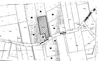
|
NOTIFICATION
PLAN
|
|
|
• PROPERTIES NOTIFIED
|
X SUBMISSIONS
RECEIVED
|

PROPERTY SUBJECT OF DEVELOPMENT
|

|
|
|
|
|
6. THE PUBLIC INTEREST
Section 79C(1)(e) of the Act
requires Council to consider “the public interest”.
The public interest is an
overarching requirement, which includes the consideration of the matters
discussed in this report. Implicit to the public interest is the achievement
of future built outcomes adequately responding to and respecting the future
desired outcomes expressed in environmental planning instruments and
development control plans.
The application is considered to
have satisfactorily addressed Council’s planning criteria and would provide a
development outcome that, on balance, would not affect the public interest.
Accordingly, it is considered that approval of the proposed swimming pool
within an enclosing room attached to the dwelling-house would not be
inconsistent with public interest.
CONCLUSION
The application proposes the
construction of an indoor swimming pool attached to the existing
dwelling-house. The design of the addition would be in keeping with the
existing structure and similar development in the area.
The
development meets the objectives of Council’s Rural Lands DCP and is in
accordance with the objectives of the rural zoning stipulated in the HSLEP. It
is considered that the development would have a positive impact upon the rural
landscape and would be in keeping with the built form of the area.
Having
regard to the assessment of the proposed development, it is recommended that
Council approves the application.
Note: At the time of the completion of this planning report,
no persons have made a Political Donations Disclosure Statement pursuant
to Section 147(3) of the Environmental Planning and Assessment Act, 1979 in
respect of the subject planning application.
|
Simon Evans
Manager -
Assessment Team 1
Planning Division
|
Scott Phillips
Executive Manager
Planning Division
|
Attachments:
File Reference: DA/1114/2009
Document Number: D01241928
SCHEDULE 1
CONDITIONS OF
APPROVAL
GENERAL
CONDITIONS
The
conditions of consent within this notice of determination have been applied to
ensure that the use of the land and/or building is carried out in such a manner
that is consistent with the aims and objectives of the relevant legislation,
planning instruments and Council policies affecting the land and does not
disrupt the amenity of the neighbourhood or impact upon the environment.
Note: For the
purpose of this consent, the term ‘applicant’ means any person who has the
authority to act on or the benefit of the development consent.
Note: For the purpose of
this consent, any reference to an Act, Regulation, Australian Standard or
publication by a public authority shall be taken to mean the gazetted Act or
Regulation, or adopted Australian Standard or publication as in force on the
date that the application for a construction certificate is made.
1. Approved
Plans and Supporting Documentation
The development must be carried
out in accordance with the plans and documentation listed below and endorsed
with Council’s stamp, except where amended by Council and/or other conditions
of this consent:
|
Plan No.
|
Drawn by
|
Dated
|
|
1 of 3 to 3 of 3
|
Absolute Architectural
|
24.08.09
|
2. Removal
of Existing Trees
This consent
only permits the removal of the 5 trees in the immediate vicinity of the
development. The removal of any other trees requires separate approval under
Council’s Tree Preservation Order.
REQUIREMENTS
PRIOR TO THE ISSUE OF A CONSTRUCTION CERTIFICATE
3. Building
Code of Australia
All building work must be
carried out in accordance with the requirements of the Building Code of
Australia.
4. Contract
of Insurance (Residential Building Work)
In the case
of residential building work for which the Home Building Act, 1989 requires
there to be a contract of insurance in force in accordance with Part 6 of that
Act, that such a contract of insurance is in force before any building work
authorised to be carried out by the consent commences.
Note: This
condition does not apply to the extent to which an exemption is in force
under Clause 187 or 188 of the Act, subject to the terms of any condition or
requirement referred to in Clause 187(6) or 188(4) of the Act, or to the
erection of a temporary building.
5. Notification
of Home Building Act, 1989 Requirements
Residential building work within
the meaning of the Home Building Act, 1989 must not be
carried out unless the principal certifying authority for the development to
which the work relates (not being Council) has given Council written notice of
the following information:
a. In
the case of work for which a principal contractor is required to be appointed:
i. The
name and licence number of the principal contractor.
ii. The
name of the insurer by which the work is insured under Part 6 of that Act.
b. In
the case of work to be done by an owner-builder:
i. The
name of the owner-builder.
ii. If
the owner-builder is required to hold an owner-builder’s permit under that Act,
the number of the owner-builder’s permit.
Note: If
arrangements for doing the residential building work are changed while the work
is in progress so that the information notified becomes out of date, further
work must not be carried out unless the principal certifying authority for the
development to which the work relates (not being Council) has given Council
written notification of the updated information.
REQUIREMENTS PRIOR TO THE COMMENCEMENT OF ANY WORKS
6. Erection
of Construction Sign
A sign must
be erected in a prominent position on any site on which building work,
subdivision work or demolition work is being carried out:
a. Showing
the name, address and telephone number of the principal certifying authority
for the work,
b. Showing
the name of the principal contractor (if any) for any demolition or building
work and a telephone number on which that person may be contacted outside
working hours, and
c. Stating
that unauthorised entry to the work site is prohibited.
Note: Any
such sign is to be maintained while the building work, subdivision work or
demolition work is being carried out, but must be removed when the work has
been completed.
7. Erosion
and Sediment Control
Erosion and
sediment control measures must be provided and maintained throughout the construction
period in accordance with the manual ‘Soils and Construction 2004
(Bluebook)’, the approved plans, Council specifications and to the
satisfaction of the principal certifying authority. The erosion and sediment
control devices must remain in place until the site has been stabilised and
revegetated.
Note: On
the spot penalties up to $1,500 may be issued for any non-compliance with this
requirement without any further notification or warning.
REQUIREMENTS
DURING CONSTRUCTION
8. Construction
Work Hours
All work on site (including demolition and earth works)
must only occur between 7am and 5pm Monday to Saturday. No work is to be
undertaken on Sundays or public holidays.
9. Swimming
Pool Requirements
The construction and operation
of the swimming pool must comply with the provisions of the Swimming Pool
Act 1992, the Swimming Pool Regulation, 1998, Australian
Standards 1926.1-3 – Swimming Pool Safety and the following requirements:
a. As
Sydney Water’s sewer system is not provided to the site, a pool water
filtration system that does not require backwashing must be provided.
Alternatively, all waste water from the pool’s filtration equipment must be
piped to discharge to the disposal system that serves the existing above-ground
pool.
b. The
filtration motor and pump, or spa heater and blower unit must be housed in a
soundproofed structure. Sound from the equipment must not exceed 5(dBA) above
ambient noise levels at any property boundary.
c. The applicant must participate in the ‘Static Water Supply
Project’ initiative of the NSW Fire Brigades and make available the water in
the swimming pool for use as a static water supply for fire fighting purposes
by the NSW Fire Brigades or the NSW Rural Fire Service.
Note: On completion of the swimming pool, the applicant is to
contact the local NSW Fire Brigade Station or NSW Rural Fire Service Station to
arrange the installation of a static water supply identification plate.
-
END OF CONDITIONS –
ADVISORY
NOTES
The following information is provided for your assistance to
ensure compliance with the Environmental Planning and Assessment Act, 1979,
Environmental Planning and Assessment Regulation 2000, other relevant
legislation and Council’s policies and specifications. This information does
not form part of the conditions of development consent pursuant to Section 80A
of the Act.
Environmental Planning and Assessment Act, 1979
Requirements
· The Environmental Planning and
Assessment Act, 1979 requires:
· The issue of a construction certificate
prior to the commencement of any works. Enquiries regarding the issue of a
construction certificate can be made to Council’s Customer Services Branch on
9847 6760;
· A principal certifying authority to be
nominated and Council notified of that appointment prior to the commencement of
any works;
· Council to be given at least two days
written notice prior to the commencement of any works;
· Mandatory inspections of nominated
stages of the construction inspected; and
· An occupation certificate to be issued
before occupying any building or commencing the use of the land.
Long Service Levy
In accordance with Section 34 of
the Building and Construction Industry Long Service Payments Act 1986, a ‘Long Service Levy’ must be paid to the Long
Service Payments Corporation or Hornsby Council.
Note: The
rate of the Long Service Levy is 0.35% of the total cost of the work.
Note: Hornsby
Council requires the payment of the Long Service Levy prior to the issue of a
construction certificate.
Tree Preservation Order
To ensure the maintenance and
protection of the existing natural environment, it is an offence to ringbark,
cut down, top, lop, remove, wilfully injure or destroy a tree outside 3m of the
approved building envelope without the prior written consent from Council.
Note: A
tree is defined as a single or multi-trunked wood perennial plant having a
height of not less than three (3) metres, and which develops many branches,
usually from a distance of not less than one (1) metre from the ground, but
excluding any plant which, in its particular location, is a noxious plant
declared as such pursuant to the Noxious Weeds Act 1993. This definition of
‘tree’ includes any and all types of Palm trees.
All
distances are determined under British Standard BS 5837: 2005, “Trees in
Relation to Construction – Recommendations”.
Dial Before You Dig
Prior to commencing any works,
the applicant is encouraged to contact Dial Before You Dig on 1100 or www.dialbeforeyoudig.com.au for
free information on potential underground pipes and cables within the vicinity
of the development site.
Asbestos Warning
Should asbestos or asbestos
products be encountered during demolition or construction works you are advised
to seek advice and information should be prior to disturbing the material. It
is recommended that a contractor holding an asbestos-handling permit (issued by
WorkCover NSW) be engaged to manage the proper handling of the material.
Further information regarding the safe handling and removal of asbestos can be
found at:
www.environment.nsw.gov.au
www.nsw.gov.au/fibro
www.adfa.org.au
www.workcover.nsw.gov.au
Alternatively, telephone the WorkCover Asbestos and
Demolition Team on 8260 5885.
Planning Report No. PLN81/09
Date of Meeting:
4/11/2009
2 DEVELOPMENT APPLICATION
- RURAL SUBDIVISION - ONE LOT INTO TWO
30 PEEBLES ROAD, FIDDLETOWN
|
Development Application No:
|
DA/914/2009
|
|
Description of Proposal:
|
Subdivision of one lot into
two.
|
|
Property Description:
|
Lot 3 DP 551290 (No. 30) Peebles Road, Fiddletown
|
|
Applicant:
|
Carolyn Stubbs
|
|
Owner:
|
Mrs C L Stubbs
|
|
Statutory Provisions:
|
Hornsby Shire Local Environmental
Plan 1994
Rural AA (Large Holdings –
Agricultural Landscapes) / Environmental Protection B (River Catchments)
|
|
Estimated Value:
|
Nil
|
|
Ward:
|
A
|
|
RECOMMENDATION
THAT Council seek the
concurrence of the Director-General of the Department of Planning for
approval of Development Application No. DA/914/2009 for the subdivision of
one rural lot into two at lot 3 DP 551290 (No. 30) Peebles Road, Fiddletown
as a deferred commencement consent pursuant to Section 80(3) of the
Environmental Planning and Assessment Act, 1979 subject to the conditions
detailed in Schedule 1 of this report.
|
1. The
application proposes the subdivision of one rural lot into two lots.
2. The
proposal does not comply with the minimum rural lot size pursuant to Clause 14
of Hornsby Shire Local Environmental Plan. The submitted objection to the
minimum lot size development standard is well founded with regard to State
Environmental Planning Policy No. 1 – Development Standards.
4. A
joint submission has been received in support of the application.
5. It
is recommended that the application be referred to the Director-General of the
Department of Planning for approval.
THE SITE
The site comprises a rural
holding of 5.47 hectares and occupies a section of a low ridge (Fagan Ridge)
that extends from Arcadia to Marramarra National Park. The site has frontage
to both sides of Peebles Road which traverses north south through the site. The
site is generally uniform in shape. Peebles Road divides the site into a 1.67
hectare parcel on the western side and a 3.8 hectare parcel on the eastern side
of the road. The western side includes an existing dwelling house, metal sheds
and a dam. The eastern side includes a metal shed and three dams. The previous
use of the site for poultry farming has been discontinued.
The majority of the site is
cleared with remnant bushland along the western and eastern side boundaries.
The eastern part of the site drains to Fiddletown Creek and the western part
drains to Coolah Creek, which flow to Marramura Creek and the Hawkesbury River.
The site is within a bushfire
prone area. Approximately 0.46 hectares of the site is within an environment
protection zone, the remainder is within a rural zone.
The locality is characterised by
similar sized farm holdings along Peebles Road and Fagan Ridge, north of Northholm Grammar School. The farm holdings are generally bordered by large tracts of crown
land comprising bushland. However, the subject allotment is the only similarly
sized allotment in the locality that is physically divided by a public road.
THE PROPOSAL
The proposal is for the
subdivision of one lot into two lots with each lot having frontage to either
side of Peebles Road, which forms the boundary frontage of the proposed lots.
Proposed lot 31 has an area of
1.67 hectares, has frontage to the western side of Peebles Road and includes
the existing dwelling house.
Proposed lot 32 has an area of
3.8 hectares, has frontage to the eastern side of Peebles Road and is the site
of the indicative building envelope for a future dwelling. Approximately 0.46
hectares of the proposed lot is within the Environment Protection B zone. The
proposal includes an 840m2 area site for a future dwelling house. It
is the applicant’s intention to establish an animal training establishment for
horses on the proposed lot, subject to Council’s separate approval.
ASSESSMENT
The development application has
been assessed having regard to the ‘2005 City of Cities Metropolitan
Strategy’, the ‘North Subregion (Draft) Subregional Strategy’ and
the matters for consideration prescribed under Section 79C of the Environmental
Planning and Assessment Act 1979 (the Act). Subsequently, the following
issues have been identified for further consideration.
1. STRATEGIC CONTEXT
1.1 Metropolitan Strategy – (Draft) North Subregional
Strategy
The Metropolitan Strategy is a
broad framework to secure Sydney’s place in the global economy by promoting and
managing growth. It outlines a vision for Sydney to 2031; the challenges
faced, and the directions to follow to address these challenges and achieve the
vision. The draft North Subregional Strategy acts as a framework for Council
in the preparation of a new Principal LEP by 2011.
The draft Subregional Strategy
sets the following targets for the Hornsby LGA by 2031:
· Employment capacity to
increase by 9,000 jobs; and
· Housing stock to
increase by 11,000 dwellings.
The proposed development involves
the subdivision of rural land and is generally outside the scope of the draft
Strategy.
2. STATUTORY CONTROLS
Section 79C(1)(a) requires
Council to consider “any relevant environmental planning instruments, draft
environmental planning instruments, development control plans, planning
agreements and regulations”.
2.1 Hornsby Shire Local Environmental Plan 1994
The subject land is partly zoned
Rural AA (Large Holdings – Agricultural Landscapes) Zone and partly zoned
Environment Protection B (River Catchment) Zone under Hornsby Shire Local
Environmental Plan 1994 (HSLEP).
The objectives of the Rural AA
zone are:
(a) to restrain population growth, maintain the rural
character of the area and ensure that existing or potentially productive
agricultural land is preserved in large land holdings.
(b) to promote agricultural use of land and provide for a
range of compatible land uses which maintain the agricultural and rural
environment of the area.
(c) to ensure development is carried out in a manner that
improves the environmental qualities, and is within the servicing capacity, of
the area.
The objectives of the Environment
Protection B zone are:
(a) to protect the natural environment of sensitive areas
within the catchment of the Hawkesbury River.
(b) to protect the valleys and escarpments within the catchment
of the Hawkesbury River and accommodate land uses, including housing, that
recognizes environmental sensitivity of the area.
(c) to protect the scenic quality of visually prominent areas
and water quality within the catchment of the Hawkesbury River.
The proposed development is
defined as ‘subdivision’ under HSLEP and is permissible in the zone with
Council’s consent.
Clause 14 of the HSLEP prescribes
that the minimum area per allotment within the Rural AA zone is 10 hectares and
within the Environment Protection B zone is 40 hectares. The existing allotment
and the proposed subdivision do not comply with the minimum lot area
requirements. In this regard the application is the subject of an objection
pursuant to State Environmental Planning Policy No. 1 – Development Standards.
Clause 18 of the HSLEP sets out heritage
conservation provisions within the Hornsby area. The subject site is not an
item of environmental heritage and the proposal is not subject to a heritage
assessment.
2.2 State Environmental Planning Policy No. 1 – Development
Standards (SEPP 1)
The applicant submitted an
objection against Council’s adherence to the minimum 10 hectare lot size
development standard under Clause 14 of the HSLEP. The existing lot area is
5.47 hectares including 0.46 hectares within the Environment Protection B zone.
The two proposed lots are 1.67 hectares and 3.8 hectares respectively.
The application has been assessed
against the requirements of SEPP 1. This Policy provides flexibility in the
application of development standards in circumstances where strict compliance
with those standards would, in any particular case, be unreasonable or
unnecessary or tend to hinder the attainment of the objectives of the Act.
The Land and Environment Court
has expressed the view that there are five different ways in which an objection
may be well founded and that approval of the objection may be consistent with
the aims of the Policy:
1. The objectives of the standard are achieved notwithstanding
non-compliance with the standards;
2. The underlying objective or purpose of the standard is not
relevant to the development and therefore compliance is unnecessary;
3. The underlying object of purpose would be defeated or
thwarted if compliance was required and therefore compliance is unreasonable;
4. The development standard has been virtually abandoned or
destroyed by the Council’s own actions in granting consents departing from the
standard and hence compliance with the standard is unnecessary and
unreasonable;
5. The zoning of the particular land is unreasonable or
inappropriate so that a development standard appropriate for that zoning is
also unreasonable and unnecessary as it applies to the land and compliance with
the standard would be unreasonable or unnecessary. That is, the particular
parcel of land should not have been included in the particular zone.
The applicant’s objection is made
with regard to the above 5 point test and the objectives of the Rural AA zone
and Environment Protection B zone.
In summary the applicant submits
that:-
1. The objectives of the 10 hectare and 40 hectare subdivision
development standards have been achieved as outlined in Sections 6, 7 and 8 of
this SEPP 1 Objection, i.e.:-
· The proposal meets
with the objectives of the zoning as the proposed lots are consistent with the
existing lot sizes within 1 km of the site, having and average lot size of 3.75
ha.
· The proposed lots are
suitable for a range of rural activities including raising horses, animal
boarding, bed and breakfast establishments, ecotourism, flower growing and
intensive horticulture.
· The proposed
subdivision does not fragment the existing bushland and the site’s Environment
Protection B zoned land.
2. The subject subdivision development standards have reduced
relevancy because only a small number of existing allotments in the locality
have complying lot sizes or have areas proximate to the Rural AA Zone 10
hectare subdivision standard.
The
underlying objective of maintaining low development density should therefore be
considered in the context of the prevailing density of approximately 1 dwelling
per 4 hectares rather than the much lower density of 1 dwelling per 10
hectares. The proposed subdivision achieves reasonable consistency with the
prevailing density and results in a minimal increase in overall development
density within the locality and no noticeable change to the small farm
character of the locality.
3. The circumstances of the case are unique in that there are
few rural holdings in Hornsby Shire that remain split by a formed public road.
As detailed in Section 6, the proposal will not create a precedent to the
extent that it would defeat or thwart the object or purpose of the identified
subdivision development standards, i.e.:-
· The 10 ha minimum lot
size is not recognised by the existing subdivision pattern along Peebles Road.
· The proposal maintains
the linear small farm rural character of the area.
· The proposal is
consistent with circumstances subject of an appeal upheld in the Land and Environment Court, ‘Rein Warry and Company v Wollondilly Shire Council (2008) NSWLEC 1176
(12 May 2008)’, involving subdivision of a rural parcel bisected by a public
road.
4. It is our understanding that Council has consistently
applied the subdivision development standards since the gazettal of HSLEP and
that the approved variations to this standard have been relatively rare. It
should be noted that most subdivision approvals to remove splitting of rural properties
by formed public roads were approved prior to the 1994 gazettal of HSLEP.
5. This test is not applicable as the zoning of the land is
not unreasonable or inappropriate. Given that the great majority of land
holdings in the Peebles Road locality and in some other rural localities in
Hornsby Shire, have areas significantly less than the 10 hectare minimum lot
area that applies in the Rural AA zone, there is an argument that an additional
rural zone with a minimum lot size more reflective of prevailing lot size is
warranted.
The SEPP 1 objection is
considered to be well founded and is supported with regard to;
(a) the existing land parcel is physically divided by a public
road,
(b) the resulting lot areas are not inconsistent with the size
and character of lots in the locality,
(c) the proposal maintains the linear pattern of rural
development along Pebbles Road, and
(d) the proposal would not result in a precedent given the
unique circumstances of the case (refer also to Section 2.6.1).
The approval of the
Director-General of the Department of Planning is required for the proposed
subdivision in accordance with Planning Circular PS 08-003 concerning
variation to development standards.
2.3 State Environmental Planning Policy No. 55 – Remediation
of Land (SEPP 55)
The Policy provides for the
remediation of contaminated land to reduce risks to human health and the
environment and includes provision for identifying potentially contaminated
land and standards for remediation.
The applicant submitted a
Preliminary Contamination Assessment prepared by Geotechnique Pty Ltd in
accordance with the Policy. The assessment involved the proposed indicative
area for a future dwelling comprising an area of approximately 840m2
within proposed lot 32. The assessment determined the area suitable for future
residential use. The area included a higher concentration of zinc, due to
corrosion of galvanised iron sheds and tanks on the site, which may impact on
plant growth but would not present a risk to human health. Accordingly, it is
considered prudent that further testing of this area be undertaken for possible
remediation.
A condition is recommended for
the implementation of the report recommendation to remediate the zinc
concentration prior to Council issuing a subdivision certificate.
2.4 Rural Fires Act 1997
The site is within a bushfire
prone area. The development application for subdivision forms ‘integrated
development’ and was referred to the NSW Rural Fire Service (RFS) for
assessment in accordance with Planning For Bushfire Protection NSW 2006 guidelines.
The RFS raised no objection to
the proposal subject to recommended conditions.
2.5 Sydney Regional Environmental Plan No. 20 – Hawkesbury Nepean River
The Plan regulates impacts of
future land uses on the River through implementation of planning policies and
strategies for total catchment management, environmentally sensitive areas,
water quality, water quantity, cultural heritage, flora and fauna, riverine
scenic quality, agriculture/aquaculture and fishing, rural residential
development, urban development, recreation and tourism.
Clause 11 of the Plan includes
development controls for intensive horticultural establishments and intensive
animal industries including horse training and boarding establishments. The
proposed future use of lot 32 for an animal training establishment for horses
would be the subject of a separate development application, irrespective of
whether this application is approved.
The proposed subdivision would
not adversely impact on the river or the catchment.
2.6 Rural Lands Development Control Plan
The proposed development has been
assessed having regard to the relevant performance and prescriptive design
standards within Council’s Rural Lands Development Control Plan (DCP). The
following table sets out the proposal’s compliance with the prescriptive
standards of the Plan:
|
Rural Lands
Development Control Plan
|
|
Control
|
Proposal
|
Requirement
|
Compliance
|
|
Lot size
|
Lot 31 – 1.67 ha
Lot 32 – 3.8 ha
|
10 ha
|
No
|
|
Setbacks
|
Lot 32 – Front 15m
Side 20m
|
15m Front & all
boundaries
|
Yes
|
The proposed development does not
comply with the minimum lot area prescriptive standard within Council’s DCP.
The matters of non-compliance, as well as a brief discussion on compliance with
relevant performance standards are discussed as follows.
2.6.1 Subdivision
The existing land parcel and a
majority of the surrounding properties with the Rural AA zone do not comply
with the prescribed minimum 10 hectare lot size. The proposed subdivision would
not detract from the pattern of rural development along Pebbles Road and meets
the DCP subdivision performance criteria, i.e.:
· The density of
allotments should retain the rural character of the area and avoid elements of
an urban nature.
· Lots sizes should be
compatible with the character of the surrounding area.
The proposed subdivision is
consistent with the rural holdings in the locality and maintains the pattern of
rural development along Peebles Road. The rural land uses in the locality include
horse keeping, orchards, poultry farming including ducks, small scale livestock
and flower growing. The proposed subdivision would provide for similar rural
activities.
As noted in Section 2.2 of this
report, the proposed subdivision is unique to the existing parcel being split
by a public road. In this regard an existing parcel north of the site (lot 1 DP
406980) is similarly split, however subdivision would result in a relatively
small area (approx 6,000m2) and would on merit be inconsistent with
the subject proposal.
2.6.2 Agriculture
The existing land parcel is
effectively divided by Peebles Road which compromises safety for movement of
stock and operation for rural enterprises. The proposed subdivision would
assist in promoting a more viable use of the respective lots and is consistent
with the DCP agriculture performance criteria, i.e.:
· The use of land
should conserve the potential for the agricultural use of the land.
2.6.3 Setbacks
The indicative site area for a
future dwelling on proposed lot 32 is setback 15m from Peebles Road and 20m
from the northern side boundary. The proposed setbacks comply with the DCP
setback prescriptive measures and performance criteria.
2.6.4 Drainage Control
The site occupies a ridge and
drains to on-site dams, minimising runoff impacts on the two neighbouring
creeks. The applicant submitted an on-site waste management report concerning
site capability for effluent disposal. Subject to the report recommendations a
future dwelling on lot 32 would not adversely impact on downstream water
quality.
The proposed subdivision meets
the drainage control performance criteria, i.e.:
· Drainage from
development sites should be consistent with the pre-development stormwater
patterns.
2.6.5 Fences and Gates
The proposed subdivision does not
alter the existing boundary fencing and would not warrant the requirement for
new fencing.
3. ENVIRONMENTAL IMPACTS
Section 79C (1) (b) of the Act
requires Council to consider “the likely impacts of that development, including
environmental impacts on both the natural and built environments, and social
and economic impacts in the locality”.
3.1 Natural Environment
The proposed subdivision does not
involve the removal of any existing trees or native vegetation and maintains
the existing lot boundaries and the physical characteristics of the site. The
bushland areas of the site are within the Environment Protection B (River
Catchment) Zone.
The existing dams on the site
provide a buffer between the agricultural areas and the bushland areas of the
proposed lots.
It is considered the proposed
subdivision would not adversely impact on the bushland areas of the site.
3.2 Built Environment
The existing dwelling house on
proposed lot 31 and the existing shed building on proposed lot 32 are retained
by the proposal.
The indicative site for a future
dwelling on proposed lot 32 would maintain an appropriate separation with the
neighbouring dwelling and the rural character of the locality. The planning
merits of any dwelling on that allotment would be assessed under a separate
development application.
3.3 Social Impacts
The proposal would involve
minimal population increase and maintain the rural character of the locality.
3.4 Economic Impacts
The proposed lots would remain
viable for a range of agricultural pursuits given the close proximity to the Sydney market.
4. SITE SUITABILITY
Section 79C (1) (c) of the Act
requires Council to consider “the suitability of the site for the
development”.
4.1 Bushfire Risk
The land is identified as being
subject to bushfire risk. The NSW Rural Fire Service considered the proposed
subdivision and raised no objection to the proposal subject to recommended
conditions.
4.2 Land Contamination
The site’s land use history
includes poultry farming and market gardening. A preliminary contamination
assessment prepared in accordance with the requirements of SEPP 55, determined
the proposed site of a future dwelling is suitable for residential use.
5. PUBLIC PARTICIPATION
Section 79C (1) (d) of the Act
requires Council to consider “any submissions made in accordance with this
Act”.
5.1 Community Consultation
The proposed development was
placed on public exhibition and was notified to adjoining and nearby landowners
between 18 August and 8 September 2009 in accordance with Council’s
Notification and Exhibition Development Control Plan. During this period,
Council received one submission on behalf of two neighbours. The map below
illustrates the location of those nearby landowners who made a submission that
are in close proximity to the development site.
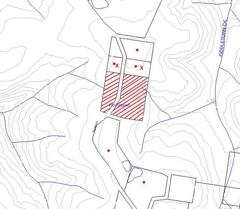
|
NOTIFICATION
PLAN
|
|
|
• PROPERTIES NOTIFIED
|
X SUBMISSIONS
RECEIVED
|
PROPERTY SUBJECT OF DEVELOPMENT
|
|
|
|
|
|
A submission on behalf of two
adjoining residents supported the application with regard to a similar earlier
subdivision resulting in the creation of their own properties in 1974.
5.2 Public Agencies
The development application is
Integrated Development under the Act in requiring the approval of the NSW Rural
Fire Service. The RFS raised no objection to the proposal subject to
recommended conditions.
6. THE PUBLIC INTEREST
Section 79C (1) (e) of the Act
requires Council to consider “the public interest”.
The public interest is an
overarching requirement, which includes the consideration of the matters
discussed in this report. Implicit to the public interest is the achievement
of future built outcomes adequately responding to and respecting the future
desired outcomes expressed in environmental planning instruments and
development control plans.
The application is considered to
have satisfactorily addressed Council’s and relevant agencies’ criteria and
would provide a development outcome that, on balance, would result in a
positive impact for the community. Accordingly, it is considered that the
approval of the proposed rural subdivision would be in the public interest.
CONCLUSION
Consent is sought to subdivide an
existing rural allotment which is physically divided by a public road.
The proposed subdivision is
considered satisfactory in maintaining the rural character of the locality,
notwithstanding the minimum lot size applicable for the subject Rural AA zone.
The majority of allotments in the Peebles Road locality are less than the
minimum 10 hectare development standard.
The submitted SEPP 1 objection to
the standard is considered well founded in accordance with the planning
principles established by the Land and Environment Court. The circumstances of
the application are considered to be unique with the existing parcel being
split by Pebbles Road and would not establish an undesirable precedent for
smaller rural lot subdivision.
The proposed subdivision is
considered acceptable with regard the provisions of the relevant environmental
planning instruments applicable to the rural site, the Rural Lands DCP and the
requirements of the NSW Rural Fire Service.
The application is supported in
the public submissions and is recommended for approval.
|
Rod Pickles
Manager -
Assessment Team 2
Planning Division
|
Paul David
Manager -
Subdivision & Development Engineering Services
Planning Division
|
|
Scott Phillips
Executive Manager
Planning Division
|
|
Attachments:
|
1.View
|
Locality Plan
|
|
|
|
2.View
|
Site Plan
|
|
|
|
3.View
|
Subdivision Plan
|
|
|
|
4.View
|
Cadastral Plan - Peebles Road
|
|
|
File Reference: DA/914/2009
Document Number: D01253070
SCHEDULE 1
1. Deferred
Commencement
Pursuant
to Section 80(3) of the Environmental Planning and Assessment Act 1979, this
consent does not operate until the following information is submitted to
Council:
a. A
further Preliminary Contamination Assessment (to report dated 19 February 2009)
must be submitted for the remaining cleared area of proposed lot 32, in
accordance with requirements of the NSW Environment Protection Authority Contaminated
Sites – Guidelines for Reporting on Contaminated Sites and Contaminated
Sites Sampling Design Guidelines.
Such
information must be submitted within 12 months of the date of this notice,
otherwise this consent will lapse.
Upon Council’s written
satisfaction of the above information, the following conditions of development
consent will apply:
GENERAL
CONDITIONS
The conditions of consent within this notice of determination have
been applied to ensure that the use of the land and/or building is carried out
in such a manner that is consistent with the aims and objectives of the
relevant legislation, planning instruments and Council policies affecting the
land and does not disrupt the amenity of the neighbourhood or impact upon the
environment.
Note: For the
purpose of this consent, the term ‘applicant’ means any person who has the
authority to act on or the benefit of the development consent.
Note: For the purpose of
this consent, any reference to an Act, Regulation, Australian Standard or
publication by a public authority shall be taken to mean the gazetted Act or
Regulation, or adopted Australian Standard or publication as in force on the
date that the application for a construction certificate is made.
2. Approved
Plans and Supporting Documentation
The
development must be carried out in accordance with the plans and documentation
listed below and endorsed with Council’s stamp, except where amended by Council
and/or other conditions of this consent:
|
Plan No.
|
Drawn by
|
Dated
|
|
Ref: 0604-2
|
G. J. Atkins & Associates
|
4 February 2009
|
|
Ref: 0604-3-REV B
|
G. J. Atkins & Associates
|
23 February 2009
|
|
Document No.
|
Prepared by
|
Dated
|
|
D01217899
|
Geotechnique Pty Ltd
|
19 February 2009
|
REQUIREMENTS PRIOR TO THE ISSUE OF A SUBDIVISION
CERTIFICATE
Note: For
the purpose of this consent, any reference to ‘occupation certificate’ shall
also be taken to mean ‘interim occupation certificate’ unless otherwise stated.
3. Water/Electricity
Utility Services
The applicant
must submit written evidence of the following service provider requirements:
a. Energy
Australia – a letter of consent demonstrating that satisfactory
arrangements have been made to service the proposed development.
b. Sydney
Water – the submission of a ‘Notice of Requirements’ under s73 of the Sydney
Water Act 1994.
Note: Sydney
Water requires that s73 applications are to be made through an authorised
Sydney Water Servicing Coordinator. Refer to www.sydneywater.com.au or telephone
13 20 92 for assistance.
4. Sydney
Water – s73 Certificate
A s73
Certificate must be obtained from Sydney Water.
5. Site
Remediation
a. The site contamination identified in the Preliminary
Contamination Assessment must be remediated in accordance with the recommendation
of Geotechnique Pty Ltd report dated 19 February 2009 and certification of the
remediation submitted to Council.
b. The recommendations of the further Preliminary Contamination
Assessment required under condition No. 1 of this consent must be implemented
and certification of remediation as required submitted to Council.
6. s94
Infrastructure Contributions
The payment to Council of a
contribution of $19,263.30* for one additional lot towards the cost of
infrastructure identified in Council’s Development Contributions Plan
2007-2011.
Note:
* The value of contribution is based on a rate of $19,263.30 per
additional lot and is current as at 14 October 2009. The contribution will be
adjusted from this date in accordance with the underlying consumer price index
for subsequent financial quarters.
It
is recommended that you contact Council to ascertain the indexed value of the
contribution prior to payment.
7. Presence
of Soil Contamination
Council and the PCA must be
notified immediately should the presence of asbestos or soil contamination, not
recognised during the original assessment process be identified during
demolition or construction works.
8. Future
Dwelling Site
Any future dwelling on proposed lot 32 must be situated within the area
identified on plan Ref: 0604-3-REV B prepared by G. J. Atkins & Associates.
GENERAL
TERMS OF APPROVAL – NSW RURAL FIRE SERVICE
The following conditions of consent are General Terms of Approval
from the nominated State Agency pursuant to Section 91A of the Environmental
Planning and Assessment Act 1979 and must be complied with to the
satisfaction of that Agency.
9. General Condition
The development proposal is to comply with the subdivision layout
identified on the drawing prepared by G. J. Atkins & Associates Pty Ltd
numbered 0604-2, dated 4 February 2009.
10. Asset Protection
Zones
The intent of measures is to provide sufficient space and maintain
reduced fuel loads so as to ensure radiant heat levels of buildings are below
critical limits and to prevent direct flame contact with a building.
At the issue of subdivision certificate and in perpetuity, the land
surrounding the existing dwelling on proposed lot 31, to a distance of 20
metres, or to the property boundary, shall be maintained as an inner protection
area (IPA) as outlined within section 4.1.3 and Appendix 5 of ‘Planning for
Bush Fire Protection 2006’ and the NSW Rural Fire Service’s document ‘Standards
for asset protection zones’.
11. Access
The intent of measures for property access is to provide safe access
to/from the public road system for fire fighters providing property protection
during a bush fire and for occupants faced with evacuation.
Property access roads shall comply with section 4.1.3 (2) of ‘Planning
for Bush Fire Protection 2006’.
12. Design and
Construction
The intent of measures is that buildings are designed and constructed to
withstand the potential impacts of bush fire attack.
The existing dwelling on proposed Lot 31 is required to be upgraded to
improve ember protection. This is to be achieved by enclosing all openings
(excluding roof tile spaces) or covering openings with a non-corrosive metal
screen. Where applicable, this includes any sub floor areas, openable windows,
doors, vents, weepholes and eaves.
-
END OF CONDITIONS -
ADVISORY NOTES
The following information is provided for your
assistance to ensure compliance with the Environmental Planning and Assessment
Act, 1979, Environmental Planning and Assessment Regulation 2000, other
relevant legislation and Council’s policies and specifications. This
information does not form part of the conditions of development consent
pursuant to Section 80A of the Act.
Environmental Planning and
Assessment Act, 1979 Requirements
· The Environmental Planning and
Assessment Act, 1979 requires:
· The issue of a construction
certificate prior to the commencement of any works. Enquiries regarding the
issue of a construction certificate can be made to Council’s Customer Services
Branch on 9847 6760.
· A principal certifying authority to
be nominated and Council notified of that appointment prior to the commencement
of any works.
· Council to be given at least two days
written notice prior to the commencement of any works.
· Mandatory inspections of nominated
stages of the construction inspected.
· An occupation certificate to be
issued before occupying any building or commencing the use of the land.
Subdivision Certificate
Requirements
A subdivision certificate
application is required to be lodged with Council containing the following
information:
a. Certification
that the requirements of relevant utility authorities have been met; and
b. Certification
that the requirements of the NSW Rural Fire Service have been met.
Note: Council
will not issue a subdivision certificate until all conditions of the
development consent have been completed.
Fees and Charges – Subdivision
All fees payable to Council as
part of any construction, compliance or subdivision certificate or inspection associated
with the development (including the registration of privately issued
certificates) are required to be paid in full prior to the issue of the
subdivision certificate. Any additional Council inspections beyond the scope
of any compliance certificate required to verify compliance with the terms of
this consent will be charged at the individual inspection rate nominated in
Council's Fees and Charges Schedule.
Tree Preservation Order
To ensure the maintenance and
protection of the existing natural environment, it is an offence to ringbark,
cut down, top, lop, remove, wilfully injure or destroy a tree outside 3 metres
of the approved building envelope without the prior written consent from
Council.
Note: A
tree is defined as a single or multi-trunked wood perennial plant having a
height of not less than three (3) metres, and which develops many branches,
usually from a distance of not less than one (1) metre from the ground, but
excluding any plant which, in its particular location, is a noxious plant
declared as such pursuant to the Noxious Weeds Act 1993. This definition of
‘tree’ includes any and all types of Palm trees.
All
distances are determined under British Standard BS 5837: 2005, “Trees in
Relation to Construction – Recommendations”.
Fines may be imposed for
non-compliance with Council’s Tree Preservation Order.
NSW Rural Fire Service
This approval is for the
subdivision of the land only. Any further development application for class 1,
2 & 3 buildings as identified by the ‘Building Code of Australia’ must be
subject to separate application under section 79BA of the EP & A Act and
address the requirements of ‘Planning for Bush Fire Protection 2006’.
Planning Report No. PLN82/09
Date of Meeting:
4/11/2009
3 DEVELOPMENT APPLICATION
- ERECTION OF A DWELLING-HOUSE
146 GALSTON ROAD, HORNSBY HEIGHTS
|
Development Application No:
|
DA/1149/2009
|
|
Description of Proposal:
|
Erection of a dwelling-house
|
|
Property Description:
|
Proposed Lot 102 within Lot 100, DP 1130236, No. 146 Galston Road, Hornsby Heights
|
|
Applicant:
|
Mrs J P Ball
|
|
Owner:
|
Mrs J P Ball
|
|
Statutory Provisions:
|
Hornsby Shire Local Environmental
Plan, 1994
Residential A (Low Density)
|
|
Estimated Value:
|
$220,000
|
|
Ward:
|
A
|
|
RECOMMENDATION
THAT Development Application
No. 1149/2009 for the erection of a dwelling-house at proposed Lot 102 within
Lot 100, DP 1130236, No. 146 Galston Road, Hornsby Heights be approved as a
deferred commencement consent subject to conditions of consent detailed in
Schedule 1 of this report.
|
1. The
application proposes the erection of a single storey dwelling-house on an
approved allotment that is yet to be registered.
2. The
development involves land owned by the spouse of a ‘Designated Person”. As the
proposal is not minor development, in accordance with Council’s adopted Policy ‘PSA1
Proposed Council Developments’ and ‘Practice Note No. 7 Assessment
Practice’, an independent assessment of the development application has
been undertaken by Andrews Neil Urban Design Group.
3. The
proposal generally complies with the Hornsby Shire Local Environmental Plan,
1994 and Council’s Dwelling House Development Control Plan (DCP).
4. No
submissions have been received in respect of the application.
5. It
is recommended that Council consider the attached
report prepared by Andrews Neil Urban Design Group and determine the application by approval.
ASSESSMENT
The development involves land
owned by the spouse of a ‘Designated Person”. As the proposal is not minor
development, in accordance with Council’s adopted policy ‘PSA1 Proposed
Council Developments’ and ‘Practice Note No. 7 Assessment Practice’,
an independent assessment of the development application has been undertaken by
Andrews Neil Urban Design Group, which is held at Attachment 6.
CONCLUSION
The
application proposes the erection of a single storey dwelling-house in a
contemporary style design.
Council has referred the
application to a planning consultancy to undertake an independent assessment of
the application. The assessment concludes that the application is worthy of
Council’s development consent subject to relevant conditions.
It is recommended that Council
approve the application in accordance with the recommended conditions of
consent prepared by Andrews Neil Urban Design
Group held at
Schedule 1 of that report.
Note: At the time of the completion
of this planning report, no persons have made a Political Donations
Disclosure Statement pursuant to Section 147(3) of the Environmental
Planning and Assessment Act 1979 in respect of the subject planning
application.
|
Simon Evans
Manager -
Assessment Team 1
Planning Division
|
Scott Phillips
Executive Manager
Planning Division
|
Attachments:
|
1.View
|
Locality Plan
|
|
|
|
2.View
|
Site Plan
|
|
|
|
3.View
|
Floor Plan
|
|
|
|
4.View
|
Elevations
|
|
|
|
5.View
|
Landscape Plan
|
|
|
|
6.View
|
Independent
Development Assessment Report
|
|
|
File Reference: DA/1149/2009
Document Number: D01254960
SCHEDULE 1
CONDITIONS OF
APPROVAL
1. Deferred
Commencement
Pursuant to Section 80(3) of
the Environmental Planning and Assessment Act 1979, this consent does not
operate until the following information is submitted to Council:
a. A
registered plan of subdivision from the NSW Department of Lands creating
the proposed lot must be submitted to Council.”
Such
information shall be submitted within 12 months of the date of this notice,
otherwise this consent will lapse.
Upon
Council’s written satisfaction of the above information, the following
conditions of development consent will apply:
GENERAL
CONDITIONS
The conditions of consent within this notice of determination have
been applied to ensure that the use of the land and/or building is carried out
in such a manner that is consistent with the aims and objectives of the
relevant legislation, planning instruments and Council policies affecting the
land and does not disrupt the amenity of the neighbourhood or impact upon the
environment.
Note: For the
purpose of this consent, the term ‘applicant’ means any person who has the
authority to act on or the benefit of the development consent.
Note: For the purpose of
this consent, any reference to an Act, Regulation, Australian Standard or
publication by a public authority shall be taken to mean the gazetted Act or
Regulation, or adopted Australian Standard or publication as in force on the
date that the application for a construction certificate is made.
2. Approved
Plans and Supporting Documentation
The
development must be carried out in accordance with the plans and documentation
listed below and endorsed with Council’s stamp, except where amended by Council
and/or other conditions of this consent:
|
Plan No.
|
Drawn by
|
Dated
|
|
Ball 1 of 3 to Ball 3 of 3
|
BB of Absolute Architectural P/L
|
07.09.09
|
|
Document No.
|
Prepared by
|
Dated
|
|
Landscape Plan - Ball 1 of 1
|
Absolute Architectural P/L
|
12.08.09
|
3. Removal
of Existing Trees
This
development consent only permits the removal of the 2 trees (Acacia and
Magnolia) as identified on the Landscape Plan No. “Ball 1 of 1”, prepared by Absolute
Architectural and dated 12.08.09. The removal of any other trees requires
separate approval under Council’s Tree Preservation Order.
REQUIREMENTS PRIOR TO THE ISSUE OF A CONSTRUCTION
CERTIFICATE
4. Building
Code of Australia
All building work must be
carried out in accordance with the requirements of the Building Code of
Australia.
5. Contract
of Insurance (Residential Building Work)
In the case
of residential building work for which the Home Building Act, 1989 requires
there to be a contract of insurance in force in accordance with Part 6 of that
Act, that such a contract of insurance is in force before any building work authorised
to be carried out by the consent commences.
Note: This
condition does not apply to the extent to which an exemption is in force
under Clause 187 or 188 of the Act, subject to the terms of any condition or
requirement referred to in Clause 187(6) or 188(4) of the Act, or to the
erection of a temporary building.
6. Notification
of Home Building Act, 1989 Requirements
Residential
building work within the meaning of the Home Building Act,
1989 must not be carried out unless the principal certifying authority for
the development to which the work relates (not being Council) has given Council
written notice of the following information:
a. In
the case of work for which a principal contractor is required to be appointed:
i. The
name and licence number of the principal contractor.
ii. The
name of the insurer by which the work is insured under Part 6 of that Act.
b. In
the case of work to be done by an owner-builder:
i. The
name of the owner-builder.
ii. If
the owner-builder is required to hold an owner-builder’s permit under that Act,
the number of the owner-builder’s permit.
Note: If
arrangements for doing the residential building work are changed while the work
is in progress so that the information notified becomes out of date, further
work must not be carried out unless the principal certifying authority for the
development to which the work relates (not being Council) has given Council
written notification of the updated information.
7. Sydney
Water – Quick Check
The
application must be submitted to a Sydney Water ‘Quick Check Agent’ or
‘Customer Centre’ for approval to determine whether the development will affect
any Sydney Water infrastructure, and whether further requirements are to
be met.
Note: Refer
to www.sydneywater.com.au or
telephone 13 20 92 for assistance.
REQUIREMENTS PRIOR TO THE COMMENCEMENT OF ANY WORKS
8. Erection
of Construction Sign
A sign must
be erected in a prominent position on any site on which building work,
subdivision work or demolition work is being carried out:
a. Showing
the name, address and telephone number of the principal certifying authority
for the work,
b. Showing
the name of the principal contractor (if any) for any demolition or building
work and a telephone number on which that person may be contacted outside
working hours, and
c. Stating
that unauthorised entry to the work site is prohibited.
Note: Any
such sign is to be maintained while the building work, subdivision work or
demolition work is being carried out, but must be removed when the work has
been completed.
9. Toilet
Facilities
Toilet
facilities must be available or provided at the works site before works begin
and must be maintained until the works are completed at a ratio of one toilet
for every 20 persons employed at the site. Each toilet must:
a. be
a standard flushing toilet connected to a public sewer; or
b. be
a temporary chemical closet approved under the Local Government Act, 1993;
or
c. have
an on-site effluent disposal system approved under the Local Government Act,
1993.
10. Erosion
and Sediment Control
Erosion and
sediment control measures must be provided and maintained throughout the
construction period in accordance with the manual ‘Soils and Construction
2004 (Bluebook)’, the approved plans, Council specifications and to the
satisfaction of the principal certifying authority. The erosion and sediment
control devices must remain in place until the site has been stabilised and
revegetated.
Note: On
the spot penalties up to $1,500 may be issued for any non-compliance with this
requirement without any further notification or warning.
REQUIREMENTS DURING CONSTRUCTION
11. Construction
Work Hours
All work on site, including earth works, must only occur
between 7am and 5pm Monday to Saturday. No work is to be undertaken on Sundays
or public holidays.
12. Council
Property
During
construction works, no building materials, waste, machinery or related matter
is to be stored on the road or footpath. The public reserve is to be kept in a
clean, tidy and safe condition at all times.
13. Survey
Report – Finished Floor Level
A report(s)
must be prepared by a registered surveyor and submitted to the principal
certifying authority prior to the pouring of concrete at each level of the
building certifying that:
a. The
building, retaining walls and the like have been correctly positioned on the
site.
b. The
finished floor level(s) are in accordance with the approved plans.
REQUIREMENTS PRIOR TO THE ISSUE OF AN OCCUPATION
CERTIFICATE
Note: For
the purpose of this consent, any reference to ‘occupation certificate’ shall
also be taken to mean ‘interim occupation certificate’ unless otherwise stated.
14. Fulfilment
of BASIX Commitments
The applicant must demonstrate
the fulfilment of BASIX commitments pertaining to the development.
15. Stormwater
Drainage
The
stormwater drainage system for the development must be designed and constructed
for an average recurrence interval of 20 years and be gravity drained directly
to Council’s street drainage system.
16. Internal
Driveway/Vehicular Areas
The driveway
and parking areas on site must be designed in accordance with Australian
Standards 2890.1, 2890.2, 3727 and the following requirements:
a. Design
levels at the front boundary be obtained from Council.
b. The
driveway be a rigid pavement.
c. The
driveway grade must not exceed 25 percent and changes in grade must not exceed
8 percent.
17. Vehicular
Crossing
A separate
application under the Local Government Act, 1993 and the Roads Act,
1993 must be submitted to Council for the installation of a new vehicular
crossing and the removal of the redundant crossing. The vehicular crossing
must be constructed in accordance with Council’s Civil Works Design, 2005
and the following requirements:
a. Any
redundant crossings to be replaced with integral kerb and gutter.
b. The
footway area to be restored by turfing.
c. Approval
obtained from all relevant utility providers that all necessary conduits be
provided and protected under the crossing.
Note:
An application for a vehicular crossing can only be made to one of Council’s
Authorised Vehicular Crossing Contractors. You are advised to contact Council
on 02 9847 6940 to obtain a list of contractors.
18. Damage
to Council Assets
Any damage
caused to Council’s assets as a result of the construction of the development
must be rectified in accordance with Council’s written requirements and at the
sole cost of the applicant.
19. Retaining
Walls
All required retaining walls
must be constructed as part of the development.
-
END OF CONDITIONS -
ADVISORY
NOTES
The following information is provided for your assistance to
ensure compliance with the Environmental Planning and Assessment Act, 1979,
Environmental Planning and Assessment Regulation 2000, other relevant legislation
and Council’s policies and specifications. This information does not form part
of the conditions of development consent pursuant to Section 80A of the Act.
Environmental Planning and Assessment Act, 1979
Requirements
· The Environmental Planning and
Assessment Act, 1979 requires:
· The issue of a construction certificate
prior to the commencement of any works. Enquiries regarding the issue of a
construction certificate can be made to Council’s Customer Services Branch on
9847 6760.
· A principal certifying authority to be
nominated and Council notified of that appointment prior to the commencement of
any works.
· Council to be given at least two days
written notice prior to the commencement of any works.
· Mandatory inspections of nominated stages
of the construction inspected.
· An occupation certificate to be issued
before occupying any building or commencing the use of the land.
Long Service Levy
In accordance with Section 34 of
the Building and Construction Industry Long Service Payments Act 1986, a ‘Long Service Levy’ must be paid to the Long
Service Payments Corporation or Hornsby Council.
Note: The
rate of the Long Service Levy is 0.35% of the total cost of the work.
Note: Hornsby
Council requires the payment of the Long Service Levy prior to the issue of a
construction certificate.
Tree Preservation Order
To ensure the maintenance and
protection of the existing natural environment, it is an offence to ringbark,
cut down, top, lop, remove, wilfully injure or destroy a tree outside 3 metres
of the approved building envelope without the prior written consent from
Council.
Note: A
tree is defined as a single or multi-trunked wood perennial plant having a
height of not less than three (3) metres, and which develops many branches, usually
from a distance of not less than one (1) metre from the ground, but excluding
any plant which, in its particular location, is a noxious plant declared as
such pursuant to the Noxious Weeds Act 1993. This definition of ‘tree’
includes any and all types of Palm trees.
All
distances are determined under British Standard BS 5837: 2005, “Trees in
Relation to Construction – Recommendations”.
Fines may be imposed for non-compliance with Council’s Tree
Preservation Order.
Dial Before You Dig
Prior to commencing any works,
the applicant is encouraged to contact Dial Before You Dig on 1100 or www.dialbeforeyoudig.com.au for
free information on potential underground pipes and cables within the vicinity
of the development site.
Planning Report No. PLN83/09
Date of Meeting:
4/11/2009
4 DEVELOPMENT APPLICATION
- ALTERATIONS AND ADDITIONS
78A SOMERVILLE ROAD, HORNSBY HEIGHTS
|
Development Application No:
|
DA/1232/2009
|
|
Description of Proposal:
|
Enclosure of an existing
storeroom
|
|
Property Description:
|
Lot 12, DP 1137290, No. 78A Somerville Road, Hornsby Heights
|
|
Applicant:
|
Mr N M Berman
|
|
Owner:
|
Mr N M Berman
|
|
Statutory Provisions:
|
Hornsby Shire Local Environmental
Plan, 1994
Residential A (Low Density)
|
|
Estimated Value:
|
$2,500
|
|
Ward:
|
A
|
|
RECOMMENDATION
THAT Development Application No. 1232/2009 for the
erection of alterations and additions to a garage at Lot 12, DP 1137290, No.
78A Somerville Road, Hornsby Heights be approved subject to the conditions of
consent detailed in Schedule 1 of this report.
|
1. The
application proposes the enclosure of an existing storeroom located at the rear
of a free-standing garage.
2. The
report has been prepared for Council determination as the development involves
land owned by a ‘designated person’ namely Council’s Mayor.
3. The
proposal complies with the Hornsby Shire Local Environmental Plan, 1994 and
Council’s Dwelling House Development Control Plan (DCP).
4. Due
to the minor nature of the work, the application was not required to be
notified pursuant to Council’s Notification and Exhibition Development Control
Plan.
5. It is recommended that
the application be approved.
THE SITE
The irregular shaped battle-axe
allotment is oriented towards the north-east, overlooking the Berowra Bushland
reserve and is accessed via a right-of-way from the eastern side of Somerville Road. The site has an area of 836m2 with a 9% fall from
the street to the rear, south-west corner and is located within a bushfire
prone zone.
Existing improvements comprise a
dwelling-house adjacent to the rear, north-eastern boundary and a free-standing
garage including a partially enclosed storeroom adjacent to the southern side
boundary.
Surrounding development is
characterised by a predominance of modest, post-war, single storey
dwelling-houses interspaced by two storey dwelling-houses of more contemporary
design, all surrounded by well established landscaped areas and gardens.
THE PROPOSAL
The application proposes fully
enclosing a partly enclosed storeroom at the rear of the exiting garage by incorporating
a double sliding door within the northern façade and the installation of
cladding to the eastern façade.
PROBITY APPLICATION
The development involves land
owned by the spouse of a ‘Designated Person’. Pursuant to ‘Planning
Division Practice Note No. 7 - Assessment Practice’ the application
was assessed by Council Officers as it is a development that involves ‘non-controversial
small scale development’.
ASSESSMENT
The development application has
been assessed having regard to the ‘2005 City of Cities Metropolitan
Strategy’, the ‘North Subregion (Draft) Subregional Strategy’ and
the matters for consideration prescribed under Section 79C of the Environmental
Planning and Assessment Act 1979 (the Act). Subsequently, the following
issues have been identified for further consideration.
1. STRATEGIC CONTEXT
1.1 Metropolitan Strategy – (Draft) North Subregional Strategy
The Metropolitan Strategy is a
broad framework to secure Sydney’s place in the global economy by promoting and
managing growth. It outlines a vision for Sydney to 2031; the challenges
faced, and the directions to follow to address these challenges and achieve the
vision. The draft North Subregional Strategy acts as a framework for Council
in the preparation of a new Principal LEP by 2011.
The proposed development would
not be inconsistent with the draft Strategy.
2. STATUTORY CONTROLS
Section 79C(1)(a) requires
Council to consider “any relevant environmental planning instruments, draft
environmental planning instruments, development control plans, planning
agreements and regulations”.
2.1 Hornsby Shire Local Environmental Plan, 1994
The subject land is zoned
Residential A (Low Density) under Hornsby Shire Local Environmental Plan, 1994
(HSLEP). The objectives of the zone zone are:
(a) to
provide for the housing needs of the population of the Hornsby area.
(b) to
promote a variety of housing types and other land uses compatible with a low
density residential environment.
(c) to
provide for development that is within the environmental capacity of a low
density residential environment.
The proposed development is
defined as a “dwelling-house” (ancillary structure) under the HSLEP and is
permissible in the zone with Council’s consent.
2.2 Dwelling House
Development Control Plan
The proposed design and materials
selected for the addition are consistent with the existing garage and would be
in keeping with compatible with the built form character of the surrounding
area.
The proposal would not be
inconsistent with the planning controls contained within Council’s Dwelling
House Development Control Plan (DCP).
3. ENVIRONMENTAL IMPACTS
Section 79C(1)(b) of the Act
requires Council to consider “the likely impacts of that development,
including environmental impacts on both the natural and built environments, and
social and economic impacts in the locality”.
Due to the minor nature of the
development it would have no impacts on the natural and built environment or
have any negative social or economic impacts.
4. SITE SUITABILITY
Section 79C(1)(c) of the Act
requires Council to consider “the suitability of the site for the
development”.
The site is not constrained by
flooding, landslip, significant flora & fauna, a natural watercourse or
acid sulphate soils.
Whilst the development is located
on a site identified as bushfire prone, enclosing the existing storeroom would
not be inconsistent with the requirements of Australian Standard 3959 -
Building in Bushfire Prone Areas. The development would not increase the
risk of bushfire on the site or on adjoining sites.
5. PUBLIC PARTICIPATION
Section 79C(1)(d) of the Act
requires Council to consider “any submissions made in accordance with this
Act”.
5.1 Community Consultation
Given the minor scale of the
development, the application was not subject to the notification requirements
of Council’s Notification and Exhibition Development Control Plan.
6. THE PUBLIC INTEREST
Section 79C(1)(e) of the Act
requires Council to consider “the public interest”.
The public interest is an
overarching requirement, which includes the consideration of the matters
discussed in this report. Implicit to the public interest is the achievement
of future built outcomes adequately responding to and respecting the future
desired outcomes expressed in environmental planning instruments and
development control plans.
The minor scale of the proposal
raises no issues with respect to its social, economic or environmental impact
on the community. Accordingly, it is considered that the approval of the
development would not be inconsistent with the public interest.
CONCLUSION
Note: At the time of the
completion of this planning report, no persons have made a Political
Donations Disclosure Statement pursuant to Section 147(3) of the
Environmental Planning and Assessment Act 1979 in respect of the subject
planning application.
|
Simon Evans
Manager -
Assessment Team 1
Planning Division
|
Scott Phillips
Executive Manager
Planning Division
|
Attachments:
|
1.View
|
Locality Plan
|
|
|
|
2.View
|
Site/Floor/Elevation
Plan
|
|
|
File Reference: DA/1232/2009
Document Number: D01256536
SCHEDULE 1
CONDITIONS OF
APPROVAL
GENERAL
CONDITIONS
The
conditions of consent within this notice of determination have been applied to
ensure that the use of the land and/or building is carried out in such a manner
that is consistent with the aims and objectives of the relevant legislation,
planning instruments and Council policies affecting the land and does not
disrupt the amenity of the neighbourhood or impact upon the environment.
Note: For the
purpose of this consent, the term ‘applicant’ means any person who has the
authority to act on or the benefit of the development consent.
Note: For the purpose of
this consent, any reference to an Act, Regulation, Australian Standard or
publication by a public authority shall be taken to mean the gazetted Act or
Regulation, or adopted Australian Standard or publication as in force on the
date that the application for a construction certificate is made.
1. Approved
Plans and Supporting Documentation
The development must be carried
out in accordance with the plans and documentation listed below and endorsed
with Council’s stamp, except where amended by Council and/or other conditions
of this consent:
|
Plan No.
|
Drawn by
|
Dated
|
|
WD1 Revision A
|
Russell Byrne and Associates
|
24.5.96
|
REQUIREMENTS PRIOR TO THE ISSUE OF A CONSTRUCTION
CERTIFICATE
2. Building
Code of Australia
All building
work must be carried out in accordance with the requirements of the Building
Code of Australia.
3. Notification
of Home Building Act, 1989 Requirements
Residential
building work within the meaning of the Home Building Act,
1989 must not be carried out unless the principal certifying authority for
the development to which the work relates (not being Council) has given Council
written notice of the following information:
a. In
the case of work for which a principal contractor is required to be appointed:
i. The
name and licence number of the principal contractor.
ii. The
name of the insurer by which the work is insured under Part 6 of that Act.
b. In
the case of work to be done by an owner-builder:
i. The
name of the owner-builder.
ii. If
the owner-builder is required to hold an owner-builder’s permit under that Act,
the number of the owner-builder’s permit.
Note: If
arrangements for doing the residential building work are changed while the work
is in progress so that the information notified becomes out of date, further
work must not be carried out unless the principal certifying authority for the
development to which the work relates (not being Council) has given Council
written notification of the updated information.
4. Design
and Construction - Bushfire Attack Category
The
development must be constructed in accordance with the current Australian
Standard AS3959 ‘Construction of buildings in bush fire-prone areas’ Level 3.
REQUIREMENTS PRIOR TO THE COMMENCEMENT OF ANY WORKS
5. Erection
of Construction Sign
A sign must be erected in a
prominent position on any site on which building work, subdivision work or
demolition work is being carried out:
a. Showing
the name, address and telephone number of the principal certifying authority
for the work,
b. Showing
the name of the principal contractor (if any) for any demolition or building
work and a telephone number on which that person may be contacted outside
working hours, and
c. Stating
that unauthorised entry to the work site is prohibited.
Note: Any
such sign is to be maintained while the building work, subdivision work or
demolition work is being carried out, but must be removed when the work has
been completed.
REQUIREMENTS DURING CONSTRUCTION
6. Construction
Work Hours
All
work on site (including demolition and earth works) must only occur between 7am
and 5pm Monday to Saturday. No work is to be undertaken on Sundays or public
holidays.
-
END OF CONDITIONS -
ADVISORY
NOTES
The
following information is provided for your assistance to ensure compliance with
the Environmental Planning and Assessment Act, 1979, Environmental Planning and
Assessment Regulation 2000, other relevant legislation and Council’s policies
and specifications. This information does not form part of the conditions of
development consent pursuant to Section 80A of the Act.
Environmental Planning and Assessment Act, 1979
Requirements
· The Environmental Planning and
Assessment Act, 1979 requires:
· The issue of a construction certificate
prior to the commencement of any works. Enquiries regarding the issue of a
construction certificate can be made to Council’s Customer Services Branch on
9847 6760.
· A principal certifying authority to be
nominated and Council notified of that appointment prior to the commencement of
any works.
· Council to be given at least two days
written notice prior to the commencement of any works.
· Mandatory inspections of nominated
stages of the construction inspected.
· An occupation certificate to be issued
before occupying any building or commencing the use of the land.
Planning Report No. PLN87/09
Date of Meeting:
4/11/2009
5 DEVELOPMENT APPLICATION
- DEMOLITION OF A GARAGE AND SUBDIVISION OF ONE LOT INTO TWO
20 WARRUGA CRESCENT BEROWRA HEIGHTS
|
Development Application No:
|
DA/616/2009
|
|
Description of Proposal:
|
Demolition of a garage and
subdivision of one lot into two.
|
|
Property Description:
|
Lot 2 DP 553883 (No. 20) Warruga Crescent, Berowra Heights
|
|
Applicant:
|
PS Graham and Associates
|
|
Owner:
|
Mr Patrick Moran and Mrs Clare Moran
|
|
Statutory Provisions:
|
Residential A (Low Density) Zone
|
|
Estimated Value:
|
$35,000
|
|
Ward:
|
A
|
|
RECOMMENDATION
THAT Development Application
No. 616/2009 for the demolition of a garage and the subdivision of one
allotment into two at Lot 2 DP 553883 (No. 20) Warruga Crescent Berowra Heights be approved subject to the conditions of consent detailed in Schedule 1 of this
report.
|
EXECUTIVE
SUMMARY
1. The
application proposes the retention of an existing dwelling, the demolition of a
garage and the subdivision of one allotment into two.
2. The
proposal complies with the provisions of the Hornsby Shire Local Environmental
Plan 1994 and is generally consistent with the requirements of Council’s Residential
Subdivision Development Control Plan.
3. Six
submissions have been received in respect of the application.
4. It
is recommended that the application be approved.
HISTORY OF THE SITE
On 8 September 2004 Council
refused a development application for subdivision of one allotment into two on
the subject property on the following grounds:
1. Pursuant
to the provisions of Section 79C(1)(a)(i) and (c) of the Environmental Planning
and Assessment Act, 1979 the proposed subdivision is considered an
overdevelopment of the site.
2. The
proposal does not comply with the objective of Clause 14 of Hornsby Shire Local
Environmental Plan 1994, namely, to provide for development that is within the
environmental capacity of the land.
3. Pursuant
to the provisions of Section 79C(1)(a)(iii) and (c) of the Environmental
Planning and Assessment Act, 1979 and Council’s Residential Subdivision Control
Plan, proposed Lot 21 is considered deficient in regard to the provision of
minimum lot size as a result of existing site gradients.
4. Pursuant
to the provisions of Section 79C(1)(a)(iii) and (c) of the Environmental
Planning and Assessment Act, 1979 and Council’s Residential Subdivision and
Dwelling House Development Control Plans, the proposed subdivision is considered
deficient in regard to the provision of off-street parking and vehicle turning
paths.
5. Pursuant
to the provisions of Section 79C(1)(a)(iii) and (c) of the Environmental
Planning and Assessment Act, 1979 and Council’s Residential Subdivision and Dwelling
House Development Control Plans, the proposed subdivision is considered
deficient in regard to the provision of minimum access handle width.
6. Pursuant
to the provisions of Section 79C(1)(e) of the Environmental Planning and
Assessment Act, 1979 the proposed subdivision is not considered to be in the
public interest.
The current application, whilst
similar in configuration, provides further information that seeks to address
Council’s previous reasons for refusal.
THE SITE
The subject property is an
irregular shaped battleaxe allotment located on the southern side of Warruga Crescent. The allotment slopes towards the rear with an average grade of 11.3 % from
the north-western corner to the south-eastern corner.
The site has an area of 1151 m2
(1037 m2 excluding access handle)
Access to the property is via a
3.8 metre wide driveway. The current improvement on the site is a single
storey clad dwelling and a detached garage. The gross floor area of the
existing dwelling is 100 m2.
The front section of the site
accommodates a fibro garage which is utilised for storage purposes. Two
retaining walls are located along the width of the property at two levels to
support the land. A number of trees are located in and around the site
including native planted trees and locally indigenous specimens such as Eucalyptus
spp., Callistemon spp., Cupressus spp., Liquidamber spp., Camellia spp.,
Macadamia spp., Syagrus spp. & Baobab spp.
The surrounding land uses
comprise single and two storey residential dwellings. A power pole is located
on the street in close proximity to the driveway entrance. A two-storey
dwelling house is located on the property immediately fronting the site. This
dwelling house overlooks the front yard of the site.
THE PROPOSAL
The proposal involves the
demolition of the garage, retention of the existing dwelling and the
subdivision of one allotment into two in the following configuration:
· Site area for lot 1:
500 m2 (excluding turning area and access handle); and
· Site area for lot 2:
500.3 m2 (excluding turning area and access handle).
The Floor Space Ratio of the
existing dwelling on lot 2 would be 0.2:1.
The existing 3.8 metre wide
driveway would provide access to the lots with both allotments having a
reciprocal right-of way (R.O.W). A common turning area is to be provided that
would enable vehicles to enter and exit the site in a forward direction.
Proposed lot 1 would comprise an
irregular shaped battleaxe allotment to be accessed by a shared R.O.W. A
building envelope with a total area of 200 m2 is proposed within
this allotment including provision for two car spaces.
Proposed lot 2 would comprise an
irregular shaped allotment to be accessed by the same R.O.W and would accommodate
the existing dwelling. Two car spaces are proposed to be located on the
south-western side of the dwelling house in a stacked arrangement and a
driveway proposed for access to the car spaces from the common turning area.
The construction the vehicular turning area and driveway would require the
demolition of the existing steps and construction of a retaining wall in front
of the dwelling house. Pedestrian access to the dwelling house from this
turning area would be provided via a set of stairs.
Stormwater drainage from both
allotments would be connected to Council’s drainage system within Woodcourt Road via a 1 metre wide drainage easement within the adjoining allotment (Lot 12
DP 816320). Documentary evidence of the drainage easement has been submitted to
Council.
ASSESSMENT
The development application has
been assessed having regard to the ‘2005 City of Cities Metropolitan
Strategy’, the ‘North Subregion (Draft) Subregional Strategy’ and
the matters for consideration prescribed under Section 79C of the Environmental
Planning and Assessment Act 1979 (the Act). Subsequently, the following
issues have been identified for further consideration.
1. STRATEGIC CONTEXT
1.1 Metropolitan Strategy – (Draft) North Subregional
Strategy
The Metropolitan Strategy is a
broad framework to secure Sydney’s place in the global economy by promoting and
managing growth. It outlines a vision for Sydney to 2031; the challenges
faced, and the directions to follow to address these challenges and achieve the
vision. The draft North Subregional Strategy acts as a framework for Council
in the preparation of a new Principal LEP by 2011.
The draft Subregional Strategy
sets the following targets for the Hornsby LGA by 2031:
· Employment capacity to
increase by 9,000 jobs; and
· Housing stock to
increase by 11,000 dwellings.
The proposed development would be
consistent with the draft Strategy by providing an additional allotment and
would contribute towards housing choice in the locality.
2. STATUTORY CONTROLS
Section 79C(1)(a) requires
Council to consider “any relevant environmental planning instruments, draft
environmental planning instruments, development control plans, planning
agreements and other prescribed matters”.
2.1 Hornsby Local Environmental Plan 1994
The subject land is zoned
Residential A (Low Density) zone under Hornsby Local Environmental Plan 1994
(HSLEP). The objectives of the Residential A zone are:
(a) to provide for the housing needs of the population of the
Hornsby area.
(b) to promote a variety of housing types and other land uses
compatible with a low density residential environment.
(c) to provide for development that is within the environmental
capacity of a low density residential environment.
The use is defined as ‘demolition’
and ‘subdivision’ and is permissible within the zone pursuant to Clause
7 of the HSLEP.
The
development would facilitate the provision of housing for the population of the
area and would be compatible with the low density residential environment. In
this regard, the proposal complies with objectives (a) and (b) of the zone.
Though the proposed allotments are irregular in shape, the application
demonstrates that the allotment sizes and shapes are suitable to accommodate
building envelopes, private open space areas, car spaces and driveways
complying with Council’s Residential Subdivision Development Control Plan. The
development is within the environmental capacity of the site and complies with
objective (c) in this regard.
Clause 14 of the HSLEP prescribes
that the minimum size of allotments within the zone is 500 m2. The proposal complies with Clause 14 in this regard.
Clause 15 of the HSLEP prescribes
that the maximum floor space ratio (FSR) of development within the zone is
0.4:1. The proposed FSR for the existing dwelling on proposed allotment 2 is
0.2:1. Therefore, the proposal complies with Clause 15 with regard to the
proposed FSR.
2.2 State Regional Environmental Plan No. 20 – Hawkesbury Nepean River
The application has been assessed
against the requirements of Sydney Regional Environmental Plan No. 20. This
Policy provides controls to protect the environment of the Hawkesbury-Nepean
system, including its water quality. The plan addresses matters related to
water quality, significant vegetation habitats, extraction, environmental
heritage and scenic quality, recreation and tourism, and agriculture.
The proposed development includes a satisfactory stormwater
management plan and is consistent with the objectives of the SREP 20 subject to implementation of
consent conditions regarding erosion and sediment control measures during
construction.
2.3 Residential Subdivision Development Control Plan
The proposed development has been
assessed having regard to the relevant performance and prescriptive design standards
within Council’s Residential Subdivision Development Control Plan (RSDCP). The
following table sets out the proposal’s compliance with the prescriptive
measures of the Plan:
|
Residential
Subdivision Development Control Plan
|
|
Control
|
Proposal
|
Requirement
|
Compliance
|
|
Density
Lot 1
Lot 2
|
500 m2
500.3 m2
|
510 m2
510 m2
|
No
No
|
|
FSR
Lot 2
|
0.2:1
|
0.4:1
|
Yes
|
|
Site cover
Lot 2
|
23%
|
40%
|
Yes
|
|
Building Envelope
Lot 1
|
200 m2
|
200 m2
|
Yes
|
|
Minimum Dimension
Lot 1
|
7 m
|
10 m
|
No
|
|
Car parking
Lot 1
Lot 2
|
2 spaces
2 spaces
|
2 spaces
2 spaces
|
Yes
Yes
|
|
Private Open Space
Lot 1
Lot 2
|
120 m2
100 m2
|
120 m2
80 m2
|
Yes
Yes
|
|
Landscaping
Lot 1
Lot 2
|
45%
50%
|
45%
45%
|
Yes
Yes
|
|
Width of Access handle
|
3.8 m
|
4 m
|
No
|
|
Setbacks
Lot 1
Front
Eastern
side
Western
side No Yes
Rear
Lot 2
Front
Eastern
side
Western
side No Yes
Rear
|
1m
6 m
7 m
1m
7m
Existing retained
Existing retained
Existing retained
|
1m
1m
1 m
3 m
1m
|
Yes
Yes
Yes
No
Yes
|
The compliance of the proposal
with the objectives, performance criteria and prescriptive measures of the various
elements within Council’s RSDCP are discussed below:
2.3.1 Density
The proposed allotments comply
with the minimum allotment sizes as prescribed in the HSLEP. The RSDCP requires
allotment sizes to be increased with the slope of the land. Given that the
slope of the land is 11.3 %, the proposed allotment sizes should be a minimum
of 510 – 520 sq metres to comply with the prescriptive measures within the
RSDCP. However, given that the proposed allotments can accommodate a reasonably
sized dwelling house, a building envelope and private open space areas in
addition to driveways, the minor non-compliance with regard to allotment sizes
within the RSDCP is considered acceptable.
2.3.2 Design
The proposed shapes of the
allotments are a product of the existing dwelling on the site, which is
proposed to be retained. The existing dwelling is old and is modest in design
having a limited life-span. It is anticipated that the dwelling would be
replaced with a more modern dwelling in the short term.
The proposal to retain the
existing dwelling is problematic in that it creates irregular shaped allotments
that do not strictly comply with the design standards under the RSDCP. A
superior outcome for the site would be to demolish the dwelling and create more
regular shaped allotments. That outcome would make the future design of
dwellings on the land more straight forward.
Notwithstanding the above, it
would still be possible to design two satisfactory dwellings on the lots as
currently proposed. It is on this basis that approval of the application is
recommended. However, should Council consent to the subdivision application,
the land owner is encouraged to give close consideration to amending the
development to achieve a superior subdivision pattern as described above.
The proposal is considered
acceptable, but not ideal with regard to the objectives of the “Allotment
Design” element of the RSDCP.
2.3.3 Setbacks
The proposed allotments satisfy
the DCP standards with regard to building setbacks except for the non-compliance
with the rear setback dimension for proposed lot 1. The current application is
for subdivision and the proposed location of the building envelope is
indicative only. Further, the rear setback area would not be utilised for
private open space purposes. Therefore non-compliance with regard to the rear
setback is acceptable in this instance. The location of any future dwelling
house on the land and the associated setbacks would be assessed under a
separate application.
2.3.4 Solar access
The allotments are north-south
orientated. The private open space areas are proposed to be orientated in a
north-south direction to receive sufficient solar access. The existing
dwelling house is single storey and would not have adverse impact on the
adjoining development with regard to overshadowing.
Any impact of overshadowing due
to a future dwelling on proposed lot 1 would be assessed under a separate
application.
2.3.5 Private Open Space & Landscaping
Both allotments would have
sufficient area suitable for use as private open space. The existing dwelling
would have its private open space located at the rear and to the west. The
location of its private open space would not be impacted upon by overlooking
from adjoining properties.
The applicant has demonstrated
that a suitable private open space area could be provided for proposed Lot 1. The private open space area would not be level and would be partly separated by two
retaining walls. However, the location of the building envelope indicates that
direct access to the outdoor space could be provided in future from the primary
living areas. The details of the useability of the private open area would be
assessed under a separate application for dwelling house on this allotment.
The proposed location and suitability
of the private open spaces and the landscaped areas are considered
satisfactory.
2.3.6 Drainage Control
The application includes a
stormwater management plan, details of a proposed on-site detention system and
calculations demonstrating that the allotments could be connected to the
Council controlled drainage system within Woodcourt Road via a drainage
easement within the adjoining western allotment (No. 16 Woodcourt Road) without
adversely impacting on the adjoining properties.
Council’s engineering assessment
of the application concludes that drainage control on site is satisfactory.
2.3.7 Privacy
The allotment slopes towards the
rear. The existing dwelling house on Lot 2 is single storey and is sufficiently
separated from the dwelling house to the south. No major alterations are
proposed to this dwelling house apart from removal of the existing steps due to
the location of the proposed car turning area. This would not alter the
location of the dwelling house or impact on the privacy of the neighbouring
dwelling houses.
The building envelope on Lot 1 is proposed within the front yard of the site replacing an existing garage. The
adjoining dwelling to the north currently overlooks this section of the site.
It is considered that any proposed dwelling house on this allotment would be
adequately separated from the adjoining developments. The boundary fence would
also restrict any adverse privacy impact on the private open space area.
The proposal is acceptable in its
current form with regard to privacy. However, details of the impact of any
future dwelling house on the privacy of neighbouring properties would be
assessed under a separate application for dwelling house on proposed lot 1.
2.3.8 Access Handle
The existing access to the site
is via a 3.8 metres wide driveway off Warruga Crescent. The proposal would
retain the use of the access handle to provide access to lots 1 and 2. The
access handle would not comply with the prescriptive measure within RSDCP which
requires a 4 metres wide access to battleaxe allotments including a 3 metre
wide pavement and 0.5 metre landscaped area on either side. However, the RSDCP
provides that the 4 metre width of driveway primarily applies to new access
handles and can be varied for existing battleaxe allotments subject to
landscaping being provided on both sides.
The driveway width can
accommodate a 3 metre wide pavement to facilitate vehicle access and would
include 0.4 metre wide landscaped strips on either side of the pavement. Given
that the non-compliance relates to the landscaping strip only and that the
driveway includes existing fences on both sides, this is considered acceptable
and would not result in adverse impact on the neighbouring properties.
2.4 Berowra Cowan
Development Control Plan
The proposed development has been
assessed having regard to the relevant performance and prescriptive design
standards within Council’s Berowra Cowan Development Control Plan. The plan
provides recommendations and guidelines for development within the unique low
density areas of Berowra, Berowra Heights and Cowan and embodies the findings
and recommendations of the Berowra/Cowan Planning Study, conducted in 1994. The
compliance of the proposal with the strategies of this DCP is discussed below:
The ‘Residential Strategy’
of the plan aims to provide a wide range of housing types which are
efficient and sustainable in relation to natural, built and social
environments. The proposal provides opportunities for varying dwelling sizes
and is considered to be sustainable in relation to the natural and built
environment.
The ‘Traffic Services Strategy’
specifies that safe, convenient and efficient movement of people should be
promoted. The proposal complies with this requirement.
2.5 Dwelling House
Development Control Plan
The existing dwelling house on
proposed lot 2 has been assessed having regard to the relevant performance and
prescriptive design requirements of Council’s Dwelling House Development
Control Plan. The proposal does not alter the height or design of the existing
dwelling. The compliance of the dwelling houses with the relevant performance
criteria such as FSR, site cover, privacy, setbacks, private open space, and
landscaping are discussed in Section 2.3 of this report.
2.5.1 Car Parking
Council’s Dwelling House DCP
requires that car parking be provided behind the building line. Proposed lot 2
includes two hard stand car spaces in a stacked arrangement within the front
and side setback and complies with the DCP development standard.
2.6 Car Parking Development Control Plan
The development’s compliance with
the relevant requirements of the Car Parking DCP has been discussed under
sections 2.3 and 2.5 of this report.
2.7 Sustainable Water
Development Control Plan
Subject to a recommended condition
requiring erosion and sediment control measures to be implemented on site
during construction works, the proposal would comply with the Sustainable Water
DCP.
2.8 Section 94
Contributions Plan
Council’s Section 94 Contributions
Plan applies to the development as one additional allotment is proposed. This
requirement is addressed as a condition of consent.
3. ENVIRONMENTAL IMPACTS
Section 79C(1)(b) of the Act
requires Council to consider “the likely impacts of that development,
including environmental impacts on both the natural and built environments, and
social and economic impacts in the locality”.
3.1 Natural Environment
3.1.1 Trees
The site comprises a number of
exotic and native planted trees and locally indigenous specimens including Eucalyptus
spp., Callistemon spp., Cupressus spp., Liquidamber spp., Camellia spp.,
Macadamia spp., Syagrus spp. & Baobab spp. The proposal would require
the removal of one tree to facilitate the construction of the car spaces within
lot 2.
Council’s assessment of the proposal
included a detailed examination of the existing trees on site and concluded
that none of the trees located within the site are significant and may be
removed for future developments on the proposed allotments. However, the
subdivision application would require the removal of only one tree for driveway
construction within proposed lot 2. Therefore a condition of consent is
recommended requiring the retention of all other trees on site including those
on the neighbouring properties at the subdivision stage.
3.1.2 Water Quality
Subject to conditions requiring
implementation of erosion and sediment control measures on site during
construction works, the proposal would not have an adverse impact on the water
quality of the catchment.
3.2 Built Environment
The impact of the proposed
allotment on the built environment has been discussed in detail within Section
2.3 of this report.
Council’s engineering assessment
of the traffic impacts of the development is considered satisfactory.
3.3 Social Impacts
The proposal would result in a
positive social impact by improving the housing choice in the locality.
3.4 Economic Impacts
The proposal would result in a
positive economic impact by contributing towards an additional allotment and
dwelling house in the locality.
4. SITE SUITABILITY
Section 79C(1)(c) of the Act
requires Council to consider “the suitability of the site for the
development”.
The site does not constitute
bushfire prone land. The site is suitable for the development.
5. PUBLIC PARTICIPATION
Section 79C(1)(d) of the Act
requires Council to consider “any submissions made in accordance with this
Act”.
5.1 Community Consultation
The proposed development was
placed on public exhibition and was notified to adjoining and nearby landowners
between 18 June 2009 and 9 July 2009 in accordance with Council’s Notification
and Exhibition Development Control Plan. During this period, Council received
six submissions. The map below illustrates the location of those nearby
landowners who made a submission that are in close proximity to the development
site.
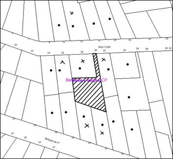
|
NOTIFICATION
PLAN
|
|
|
• PROPERTIES NOTIFIED
|
X SUBMISSIONS
RECEIVED
|

PROPERTY SUBJECT OF
DEVELOPMENT
|
|
|
|
|
|
Six submissions objected to the
development, generally on the grounds that the development would result in:
· Unacceptable impact on the
stormwater runoff to No. 12 Woodcourt Road
· Non-compliance with allotment sizes
as the site has a gradient exceeding 15 %
· Unsatisfactory turning area within
the allotments
· Unacceptable impact of stormwater
runoff with regard to the retaining wall within No. 16 Warruga Crescent
· Unacceptable increase in noise and
density
· Unacceptable impact on the privacy
of neighbouring properties
· Unacceptable width of driveway being
2.7 metres
· Restriction of views for the
residence within 18 Warruga Crescent
· Irregular allotment shapes not
complying with the subdivision pattern of the locality
· Irregular shaped building envelope
· Removal of trees within the site
· Insufficient parking within the site
resulting in on-street parking for visitors to the site
· Insufficient space for garbage bins
The objectors also raised the
following issues:
· Reversing of vehicles onto Warruga Crescent should not be permitted
· Currently a number of vehicles
obstruct the driveway of No. 15 Warruga Crescent and result in damage to the
property. Further subdivision would aggravate this problem.
· The proposed dwelling house within
the site should be single storey
· The proposed stormwater drainage via
No. 16 Woodcourt Road is not possible as it is higher up than the subject
property.
· The proposal would require
relocation of the telegraph pole located at the entrance.
· The proposal does not include
details of the stormwater easement.
· The proposal should manage the
stormwater flows from No. 18 Warruga Crescent.
The merits of the matters raised
in community submissions have been addressed in the body of the report with the
exception of the following:
5.1.1 Restriction of views
The residence located within No. 18 Warruga Crescent currently overlooks the front yard of the site. Any dwelling house
located within the front allotment in future would be at a lower level than the
adjoining dwelling house and is unlikely to impact upon the views of the
occupants. Details of this matter would be assessed under a separate
application for construction of a dwelling house on this allotment.
5.1.2 Noise
The proposal would result in one
additional allotment and the increase in the noise would not be significant.
5.1.3 Garbage
bins
The proposed allotments have
sufficient space for storage of garbage bins. The details of location of
garbage bins would assessed under a separate development application for the
construction of a dwelling.
5.1.4 Damage to assets due
to car parking
This matter relates to the public
road and is not considered to be relevant to the proposed subdivision
application.
5.1.5 Telegraph
pole
An engineering assessment of the
application considers that the telegraph pole would not require relocation as
no alterations are proposed to the existing vehicular crossing.
5.1.6 Stormwater
from 18 Warruga Crescent
The proposal does not include No. 18 Warruga Crescent. Stormwater management of this property is not included in the
development application.
5.2 Public Agencies
The development application is
not Integrated Development under the Act. Accordingly, the application was not
referred to any Public Agency.
6. THE PUBLIC INTEREST
Section 79C(1)(e) of the Act
requires Council to consider “the public interest”.
The public interest is an
overarching requirement, which includes the consideration of the matters
discussed in this report. Implicit to the public interest is the achievement
of future built outcomes adequately responding to and respecting the future
desired outcomes expressed in environmental planning instruments and
development control plans.
The application is considered to
have satisfactorily addressed Council’s and relevant agencies’ criteria and
would provide a development outcome that, on balance, would result in an
acceptable impact. Accordingly, it is considered that the approval of the
proposed development would not be inconsistent with the public interest.
7. CONCLUSION
The application proposes the
demolition of the existing garage, subdivision of one allotment into two and
the retention of the existing dwelling.
The proposal complies with
Section 79C of the Environmental Planning and Assessment Act, 1979, the Hornsby
Shire Local Environmental Plan, 1994 and Council’s Berowra-Cowan, Car Parking
and Sustainable Water DCP.
The proposed development is
generally consistent with the requirements of Council’s Residential Subdivision
Development Control Plan. The subdivision would result in irregular shaped
allotments. However, the proposal demonstrates that the allotments can
accommodate suitable building envelopes, private open space areas and car
spaces. The minor non-compliance with regards to the dimensions of the building
envelope, setback of the building envelope from the rear boundary and the
provision of a 0.5m landscape strip along the proposed accessway do not warrant
refusal of the application as the development is considered to be acceptable in
relation to environmental impacts.
Approval of the application is
recommended.
|
Rod Pickles
Manager -
Assessment Team 2
Planning Division
|
Paul David
Manager -
Subdivision & Development Engineering Services
Planning Division
|
|
Scott Phillips
Executive Manager
Planning Division
|
|
Attachments:
|
1.View
|
Locality Plan
|
|
|
|
2.View
|
Survey Plan
|
|
|
|
3.View
|
Subdivision Plan
|
|
|
|
4.View
|
Subdivision Plan
with Building Envelopes
|
|
|
File Reference: DA/616/2009
Document Number: D01259268
SCHEDULE 1
GENERAL
CONDITIONS
The conditions of consent within this notice of determination have
been applied to ensure that the use of the land and/or building is carried out
in such a manner that is consistent with the aims and objectives of the
relevant legislation, planning instruments and Council policies affecting the
land and does not disrupt the amenity of the neighbourhood or impact upon the
environment.
Note: For the
purpose of this consent, the term ‘applicant’ means any person who has the
authority to act on or the benefit of the development consent.
Note: For the purpose of
this consent, any reference to an Act, Regulation, Australian Standard or
publication by a public authority shall be taken to mean the gazetted Act or
Regulation, or adopted Australian Standard or publication as in force on the
date that the application for a construction certificate is made.
1. Approved
Plans and Supporting Documentation
The
development must be carried out in accordance with the plans and documentation
listed below and endorsed with Council’s stamp, except where amended by Council
and/or other conditions of this consent:
|
Plan No.
|
Drawn by
|
Dated
|
|
Detail Survey –S.14700
|
PS Graham and Associates
|
14/05/2009
|
|
Stormwater Concept Plan
|
PS Graham and Associates
|
Received by Council on
21/09/2009
|
|
Proposed Plan of Subdivision
|
PS Graham and Associates
|
14/05/2009
|
2. Removal
of existing Trees
This
development consent only permits the removal of tree numbered T3 as identified
on Plan No. S.14700 prepared by PS Graham and Associates dated 14/05/2009. The removal of any other trees requires
separate approval under Council’s Tree Preservation Order.
REQUIREMENTS PRIOR TO THE ISSUE OF A CONSTRUCTION
CERTIFICATE
3. Easement
Over Downstream Land
The proposed
drainage easement over Lot 12 DP 816320 must be registered with the NSW
Department of Lands.
4. Building
Code of Australia
All building
work must be carried out in accordance with the requirements of the Building
Code of Australia.
5. Water/Electricity
Utility Services
The applicant
must submit written evidence of the following service provider requirements:
a. Energy
Australia – a letter of consent demonstrating that satisfactory
arrangements have been made to service the proposed development.
b. Sydney
Water – the submission of a ‘Notice of Requirements’ under s73 of the Sydney
Water Act 1994.
Note: Sydney
Water requires that s73 applications are to be made through an authorised
Sydney Water Servicing Coordinator. Refer to www.sydneywater.com.au or telephone
13 20 92 for assistance.
REQUIREMENTS PRIOR TO THE COMMENCEMENT OF ANY WORKS
6. Erection
of Construction Sign
A sign must
be erected in a prominent position on any site on which building work,
subdivision work or demolition work is being carried out:
a. Showing
the name, address and telephone number of the principal certifying authority
for the work.
b. Showing
the name of the principal contractor (if any) for any demolition or building
work and a telephone number on which that person may be contacted outside
working hours.
c. Stating
that unauthorised entry to the work site is prohibited.
Note: Any
such sign is to be maintained while the building work, subdivision work or
demolition work is being carried out, but must be removed when the work has
been completed.
7. Erosion
and Sediment Control
Erosion and
sediment control measures must be provided and maintained throughout the
construction period in accordance with the manual ‘Soils and Construction
2004 (Bluebook)’, the approved plans, Council specifications and to the
satisfaction of the principal certifying authority. The erosion and sediment
control devices must remain in place until the site has been stabilised and
revegetated.
Note: On
the spot penalties up to $1,500 may be issued for any on-compliance with this
requirement without any further notification or warning.
REQUIREMENTS DURING CONSTRUCTION
8. Construction
Work Hours
All work on site (including demolition and earth works)
must only occur between the following hours:
Monday to Saturday 7 am
to 5 pm
Sunday & Public Holidays No
work
9. Demolition
All
demolition work must be carried out in accordance with Australian Standard
2601-2001 – The Demolition of Structures and the following requirements:
a. Demolition
material is to be disposed of to an authorised recycling and/or waste disposal
site and/or in accordance with an approved waste management plan.
b. Demolition
works, where asbestos material is being removed, must be undertaken by a
contractor that holds an appropriate licence issued by WorkCover NSW in
accordance with Chapter 10 of the Occupational Health and Safety Regulation
2001 and Clause 29 of the Protection of the Environment Operations
(Waste) Regulation 1996.
c. On
construction sites where buildings contain asbestos material, a standard
commercially manufactured sign containing the words ‘DANGER ASBESTOS REMOVAL IN
PROGRESS’ measuring not less than 400mm x 300mm must be erected in a prominent
position visible from the street.
10. Environmental
Management
The site must
be managed in accordance with the publication ‘Managing Urban Stormwater –
Landcom (March 2004) and the Protection of the Environment Operations
Act 1997 by way of implementing appropriate measures to prevent sediment
run-off, excessive dust, noise or odour emanating from the site during the
construction of the development.
11. Works
near Trees
All required
tree protection measures are to be maintained in good condition for the
duration of the construction period.
All works
(including driveways and retaining walls) within four metres of trees numbered
T26, T27A, T27B, T27C, T27D (as marked on the approved plans) required to be
retained (whether or not on the subject property, and pursuant to this consent
or the Tree Preservation Order), must be carried out under the
supervision of an ‘AQF Level 5 Arborist’ and a certificate submitted to
the principal certifying authority detailing the methods used to preserve the
trees.
Note:
Except as provided above, the applicant is to ensure that no excavation,
filling or stockpiling of building materials, parking of vehicles or plant, disposal
of cement slurry, waste water or other contaminants is to occur within 4 metres
of any tree to be retained.
REQUIREMENTS PRIOR TO THE ISSUE OF A SUBDIVISION
CERTIFICATE
12. Sydney
Water – s73 Certificate
A s73
Certificate must be obtained from Sydney Water.
13. Stormwater
Drainage
The
stormwater drainage system for the development must be designed and constructed
in accordance with Council’s Civil Works – Design and Construction
Specification 2005 and the following requirements:
a. Connected
directly to Council’s street drainage system.
b. An
inter-allotment stormwater drainage system to service the proposed lot with
pits being constructed in situ.
c. The
roof and stormwater drainage system from the existing dwelling to be connected
to the proposed inter-allotment drainage system.
14. Internal
Driveway/Vehicular Areas
The driveway
and parking areas on site must be designed in accordance with Australian
Standards 2890.1, 2890.2, 3727 and the following requirements:
a. The
driveway be a rigid pavement.
b. The
driveway grade must not exceed 25 percent and changes in grade must not exceed
8 percent. Parking and turning areas are not to exceed 5 percent grade.
c. The
driveway pavement be a minimum 3 metres wide, 0.15 metres thick reinforced
concrete with F72 steel reinforcing fabric and a 0.15 metre sub-base.
d. The
existing driveway be removed unless a chartered structural engineer certifies
that it is capable of remaining stable under an 8 tonne traffic loading.
e. The
pavement have a kerb to one side and a one-way cross fall with a minimum
gradient of 2 percent and a lintel and pit provided at the low point.
f. Retaining
walls required to support the carriageway and the compaction of all fill
batters to be in accordance with the requirements of a chartered structural
engineer.
g. The
provision of safety rails where there is a level difference more than 0.3
metres and a 1:4 batter can not be achieved.
h. Planting
of landscaping strips 0.5 metres wide along both sides of the length of the driveway.
i. Conduit
for utility services including electricity, water, gas and telephone be
provided.
15. Damage
to Council Assets
Any damage
caused to Council’s assets as a result of the construction of the development
must be rectified in accordance with Council’s written requirements and at the
sole cost of the applicant.
16. Creation
of Easements
The following
matter must be nominated on the plan of subdivision under s88B of the Conveyancing
Act 1919:
a. A
right of access and easement for services over the access corridor.
b. An
inter-allotment drainage easement over each of the burdened lots.
c. The
creation of a “Positive Covenant” over the proposed Lot 1 requiring that
any future development is to provide an on-site detention system. The on-site detention
system is to have a storage capacity of 5 cubic metres and a maximum discharge
of 8 litres per second into Council’s drainage system in accordance with
Council’s prescribed wording.
Note: Council
must be nominated as the authority to release, vary or modify any easement,
restriction or covenant.
17. Works
as Executed Plan
A works-as-executed plan(s)
must be prepared by a registered surveyor and submitted to Council for
completed road pavement, kerb & gutter, public drainage systems, driveways
and on-site detention system. The plan(s) must be accompanied by a certificate
from a registered surveyor certifying that all pipelines and associated
structures lie wholly within any relevant easements.
18. Boundary
Fencing
Fencing must
be erected along all property boundaries behind the front building alignment to
a height of 1.8 metres.
Note:
Alternative fencing may be erected subject to the written consent of
the adjoining property owners.
19. s94
Infrastructure Contributions
The payment to Council of a
contribution of $ 19263.30* for one additional lot towards the cost of
infrastructure identified in Council’s Development Contributions Plan 2007-2011
Note: * The
value of contribution is based on a rate of $ 19263.30 per additional lot and
is current as at 6 October 2009. The contribution will be
adjusted from this date in accordance with the underlying consumer price index
for subsequent financial quarters.
It is recommended that you contact Council to ascertain the indexed value of
the contribution prior to payment.
- END OF CONDITIONS -
ADVISORY NOTES
The following information is provided for your
assistance to ensure compliance with the Environmental Planning and Assessment
Act 1979, Environmental Planning and Assessment Regulation 2000, other relevant
legislation and Council’s policies and specifications. This information does
not form part of the conditions of development consent pursuant to Section 80A
of the Act.
Environmental Planning and
Assessment Act 1979 Requirements
· The Environmental Planning and
Assessment Act 1979 requires:
· A construction certificate prior to the
commencement of any works. Enquiries regarding the issue of a construction
certificate can be made to Council’s Customer Services Branch on 9847 6760.
· A principal certifying authority to be
nominated and Council notified of that appointment prior to the commencement of
any works.
· Council to be given at least two days
written notice prior to the commencement of any works.
· Mandatory inspections of nominated stages
of the construction inspected.
· An occupation certificate issued before
occupying any building or commencing the use of the land.
Long Service Levy
In accordance with Section 34 of
the Building and Construction Industry Long Service Payments Act 1986, a ‘Long Service Levy’ must be paid to the Long
Service Payments Corporation or Hornsby Council.
Note: The
rate of the Long Service Levy is 0.35% of the total cost of the work.
Note: Hornsby
Council requires the payment of the Long Service Levy prior to the issue of a
construction certificate.
Tree Preservation Order
To ensure the maintenance and
protection of the existing natural environment, it is an offence to ringbark,
cut down, top, lop, remove, wilfully injure or destroy a tree outside three
metres of the approved building envelope without prior written consent from
Council. Fines may be imposed for non-compliance with Council’s Tree
Preservation Order.
Note: A
tree is defined as a single or multi-trunked wood perennial plant having a
height of not less than three (3) metres, and which develops many branches,
usually from a distance of not less than one (1) metre from the ground, but
excluding any plant which, in its particular location, is a noxious plant
declared as such pursuant to the Noxious Weeds Act 1993. This definition of
‘tree’ includes any and all types of Palm trees.
All
distances are determined British Standard BS 5837: 2005, “Trees in Relation to
Construction – Recommendations”.
Subdivision Certificate
Requirements
A subdivision certificate
application is required to be lodged with Council containing the following
information:
· A surveyor’s certificate certifying that
all structures within the subject land comply with the development consent in
regard to the setbacks from the new boundaries.
· A surveyor’s certificate certifying that
all services, drainage lines or access are located wholly within the property
boundaries. Where services encroach over the new boundaries, easements are to
be created.
· Certification that the requirements of
relevant utility authorities have been met; and
· a surveyor’s certificate certifying finished
ground levels are in accordance with the approved plans.
Note: Council
will not issue a subdivision certificate until all conditions of the
development consent have been completed.
Fees and Charges – Subdivision
All fees payable to Council as part
of any construction, compliance or subdivision certificate or inspection
associated with the development (including the registration of privately issued
certificates) are required to be paid in full prior to the issue of the
subdivision certificate. Any additional Council inspections beyond the scope
of any compliance certificate required to verify compliance with the terms of
this consent will be charged at the individual inspection rate nominated in
Council's Fees and Charges Schedule.
Dial Before You Dig
Prior to commencing any works,
the applicant is encouraged to contact Dial Before You Dig on 1100 or www.dialbeforeyoudig.com.au for
free information on potential underground pipes and cables within the vicinity
of the development site.
Asbestos Warning
Should asbestos or asbestos
products be encountered during demolition or construction works you are advised
to seek advice and information should be prior to disturbing the material. It
is recommended that a contractor holding an asbestos-handling permit (issued by
WorkCover NSW) be engaged to manage the proper handling of the material.
Further information regarding the safe handling and removal of asbestos can be
found at:
www.environment.nsw.gov.au
www.nsw.gov.au/fibro
www.adfa.org.au
www.workcover.nsw.gov.au
Alternatively, telephone the WorkCover
Asbestos and Demolition Team on 8260 5885.
House Numbering
House numbering can only be
authorised by Council. Before proceeding to number each premise in the
development, the allocation of numbers is required to be obtained from
Council's Planning Division. The authorised numbers are required to be
displayed in a clear manner at or near the main entrance to each premise.
Planning Report No. PLN80/09
Date of Meeting:
4/11/2009
6 DEVELOPMENT APPLICATION
- SECTION 82A REVIEW - MIXED USE DEVELOPMENT
42 DENMAN PARADE NORMANHURST
|
Development Application No:
|
DA/532/2009
|
|
Description of Proposal:
|
Demolition of an existing building and construction of
a residential unit and carport within a mixed use development (Section 82A
Review)
|
|
Property Description:
|
Lot 2B DP 365028 (No. 42) Denman Parade, Normanhurst
|
|
Applicant:
|
Mr Shehade Hajje and Mrs Dawn Hajje
|
|
Owner:
|
Mr Shehade Hajje and Mrs Dawn Hajje
|
|
Statutory Provisions:
|
Hornsby Shire Local Environmental
Plan 1994
Business C (Neighbourhood)
zone
|
|
Estimated Value:
|
$43,000
|
|
Ward:
|
B
|
|
RECOMMENDATION
THAT Council adheres to its decision to refuse Development
Application No. 532/2009 for the demolition of an existing building and
construction of a residential unit at Lot 2B DP 365028 (No. 42) Denman Parade
Normanhurst, for the reasons of refusal detailed in Schedule 1 of this
report.
|
1. On
28 July 2009, Council refused under delegated authority, Development
Application No. 532/2009 for the demolition of an existing building and the
construction of a residential unit and carport.
2. Pursuant
to Section 82A of the Environmental Planning and Assessment Act, 1979 (the
Act), a request has been made for Council to review its determination.
3. The
proposal does not comply with the Hornsby Shire Local Environmental Plan 1994
(HSLEP), the Business Lands Development Control Plan and the Car Parking
Development Control Plan. The application does not comply with the 0.5:1 floor
space ratio development standard under the HSLEP and the application has been
supported by an objection under State Environmental Planning Policy No. 1 -
Development Standards (SEPP 1) seeking a variation to this standard.
4. No
submissions have been received in respect of the application.
5. It
is recommended that Council adhere to its previous decision to refuse the
application.
HISTORY OF THE APPLICATION
On 28 July 2009, Development
Application No. 532/2009 was refused under delegated authority on the following
grounds:
1. Pursuant
to the provisions of Section 79C(1)(a)(i) and (c) of the Environmental Planning
and Assessment Act, 1979, the proposal does not comply with the aims and
objectives of State Environmental Planning Policy No. 1 – Development
Standards.
2. Pursuant
to the provisions of Section 79C(1)(a)(i) and (c) of the Environmental Planning
and Assessment Act, 1979 and Hornsby Shire Local Environmental Plan 1994, the
proposal does not comply with the objectives of Clause 15 Floor Space Ratio.
3. Pursuant
to the provisions of Section 79C(1)(a)(i) and (c) of the Environmental Planning
and Assessment Act, 1979 and Hornsby Shire Local Environmental Plan 1994, the
proposal does not comply with the objectives of the Business C (Neighbourhood)
zone.
4. The
proposal is unsatisfactory in respect to the provisions of Section 79C(1)(a) of
the Environmental Planning and Assessment Act, 1979, as the proposal does not
comply with the requirements of the Business Lands Development Control Plan, in
particular, the element controls for ‘Density, ‘Building Design’, ‘Vehicle
Access and Parking’, ‘Drainage Control’, ‘Acoustic’ and ‘Crime Prevention’.
5. Pursuant
to the provisions of Section 79C(1)(a)(i) and (c) of the Environmental Planning
and Assessment Act, 1979, the proposal fails to address the requirements of
Clause 87 of State Environmental Planning Policy (Infrastructure) 2007.
6. Pursuant
to the provisions of Section 79C(1)(e) of the Environmental Planning and
Assessment Act, 1979, the proposal is not considered to be in the public
interest.
On 8 September 2009, a request
for Council to review its determination was lodged pursuant to Section 82A of
the Act.
THE SITE
The site has an area of 366
square metres and is located on the southern side of Denman Parade, opposite
the railway line. The site is essentially flat, with a frontage of 8.8 metres
to Denman Parade and a depth of 48 metres.
The site contains a two storey
building, comprising a shop on the ground floor and a
residential unit on the first
floor. This arrangement is consistent with adjoining development fronting
Denman Parade.
The rear portion of the site
contains a free standing building containing a garage door with an attached
carport. Other ancillary structures in the rear yard include a free standing
laundry / bathroom and two sheds. The existing development on the site results
in a floor space ratio (FSR) of 0.67:1
Vehicular access to the site is
via an existing Right of Way from Normanhurst Road which serves several other
properties to the east of the site. Parking is provided informally on the site
for two vehicles.
A landscaped area containing
shrubs and lawn is located adjacent to the rear boundary and is 50 square
metres in area.
THE PROPOSAL
The proposal involves the
demolition of an existing building and the construction of a two storey
structure, containing a residential unit on the first floor and a carport
below. The existing building proposed to be demolished is located in the rear
portion of the site, is 49.6 square metres in floor area and
contains a garage door and attached carport.
The proposed first floor unit
contains one bedroom and has a total area of 80 square metres. The proposed
carport located below would contain three car spaces and an additional two open
car spaces are proposed to be provided on site. Access to the site is proposed
to be maintained via the existing Right of Way from Normanhurst Road.
There is no proposed change to
the existing shop and first level unit fronting Denman Parade. The proposed
development would result in a FSR of 0.76:1.
The request for Council to review
its determination pursuant to Section 82A of the Act, included an amended car
parking plan showing vehicular movements for access and egress from the site.
The Section 82A review
application requested that the original SEPP 1 objection be reconsidered and
determined at a Council meeting.
ASSESSMENT
The development application has
been assessed having regard to the ‘2005 City of Cities Metropolitan
Strategy’, the ‘North Subregion (Draft) Subregional Strategy’ and
the matters for consideration prescribed under Section 79C of the Environmental
Planning and Assessment Act 1979 (the Act). Subsequently, the following
issues have been identified for further consideration.
1. STRATEGIC CONTEXT
1.1 Metropolitan Strategy – (Draft) North Subregional
Strategy
The Metropolitan Strategy is a
broad framework to secure Sydney’s place in the global economy by promoting and
managing growth. It outlines a vision for Sydney to 2031; the challenges
faced, and the directions to follow to address these challenges and achieve the
vision. The draft North Subregional Strategy acts as a framework for Council
in the preparation of a new Principal LEP by 2011.
The draft Subregional Strategy
sets the following targets for the Hornsby LGA by 2031:
· Employment capacity to
increase by 9,000 jobs; and
· Housing stock to
increase by 11,000 dwellings.
The proposed development would be
consistent with the Draft Strategy in so far as providing an additional single
dwelling.
Council has prepared a draft
Housing Strategy to facilitate the construction of some of the 11,000 dwellings
required under the Subregional Strategy. The Housing Strategy, as exhibited,
identifies the subject allotment as well as surrounding properties as possibly
accommodating higher density housing. The subject application is not consistent
with the Strategy in that it would further fragment land and make opportunities
for redevelopment more difficult. Consequently, it is considered that the
development would not be in the strategic planning interests of the Shire.
2. STATUTORY CONTROLS
Section 79C(1)(a) requires
Council to consider “any relevant environmental planning instruments, draft
environmental planning instruments, development control plans, planning
agreements and regulations”.
2.1 Hornsby Shire Local Environmental Plan 1994
The subject land is zoned
Business C (Neighbourhood) zone under the Hornsby Shire Local Environmental
Plan 1994 (HSLEP). The objectives of the zone are:
(a) to encourage economic growth and employment
opportunities.
(b) to accommodate the retail, service and social needs
of the community within the neighbourhood.
(c) to encourage development that improves the health,
vitality, cultural environment and social environment within neighbourhood
business centres.
The proposed development is defined
as ‘multi-unit housing’ under the HSLEP and is permissible in the zone with
Council’s consent.
Clause 15 of the HSLEP prescribes
that the maximum FSR of development within the Business C (Neighbourhood) zone
is 0.5:1. The proposed development results in a FSR of 0.76:1 which is
inconsistent with this requirement. The application includes an objection
pursuant to SEPP 1 in support of the proposed variation to the development
standard.
It is considered that the
proposal would not result in any improvement to the health, vitality and
cultural and social environment within the zone. The proposal would result in
an over-development of the site and would not provide parking arrangements in
accordance with Council’s requirements. Furthermore, the proposed development
would set an undesirable precedent for future development which would not
improve the social and cultural environment of the zone. Accordingly, the
proposal does not comply with the objectives of the Business C (Neighbourhood)
zone.
2.2 State Environmental Planning Policy No. 1 – Development
Standards
The application has been assessed
against the requirements of SEPP 1. This Policy provides flexibility in the
application of development standards in circumstances where strict compliance
with those standards would, in any particular case, be unreasonable or
unnecessary or tend to hinder the attainment of the objectives of the Act.
The Land and Environment Court
has expressed the view that there are five different ways in which an objection
may be well founded and that approval of the objection may be consistent with
the aims of the Policy:
1. The objectives of the standard are achieved
notwithstanding non-compliance with the standard;
2. The underlying objective or the purpose of the standard
is not relevant to the development and therefore compliance is unnecessary;
3. The underlying object of purpose would be defeated or
thwarted if compliance was required and therefore compliance is unreasonable;
4. The development standard has been virtually abandoned or
destroyed by the Council’s own actions in granting consents departing from the
standard and hence compliance with the standard would be unnecessary and
unreasonable;
5. The zoning of the particular land is unreasonable or
inappropriate so that a development standard appropriate for that zoning is
also unreasonable and unnecessary as it applies to the land and compliance with
the standard would be unreasonable or unnecessary. That is, a particular parcel
of land should not have been included in the particular zone.
The objective of the FSR standard
as stated in the HSLEP is:
‘To control
the intensity and scale of development of land so that development will be in
accordance with the lands environmental capacity and zone objectives’.
The SEPP 1 objection cannot be
considered well founded as it does not comply with the above listed objective
of the FSR standard.
The intensity and scale of the
development is not in accordance with the lands environmental capacity. The
proposal would result in an over development of the site and a shortfall in
parking.
The development requires six car
spaces to be provided in order to satisfy the requirements of the ‘Vehicle
Access and Parking’ element of the Business Lands Development Control Plan.
Five car spaces are proposed as part of this application. The application has
not demonstrated that safe and efficient access to the site can be provided or
that vehicles are able to turn on site and egress in a forward direction.
The Section 82A review
application included an amended car parking plan showing vehicular movements
for access and egress from the site. An engineering assessment of the revised
parking layout concluded that the proposal does not sufficiently demonstrate
the ability for vehicles to enter and leave the subject site in forward
direction. In consideration the current access arrangement and the proposed car
parking design it is determined that the proposal does not provide for safe
ingress/egress to the site and is unsatisfactory. It is not within the capacity
of the site to provide the parking required in accordance with Council’s
requirements and Council therefore cannot support the departure from the FSR
standard when sufficient parking has not been demonstrated.
The proposal does not demonstrate
a design which complies with AS2890.1-2004 or the ‘Vehicle Access and Parking’
element of the Business Lands Development Control Plan and is the proposed
development is therefore not considered within the environmental capacity of the
site.
The proposal is inconsistent with
the objectives of the FSR standard as the proposal is not consistent with the
objectives of the Business C (Neighbourhood) zone as addressed in Section 2.1
of this report.
The SEPP 1 objection was
submitted in support of the proposal and is summarised as follows:
‘The extent
of non compliance is numerically minor being limited to 73 square metres or
within 20% of the policy compliance.
The
non-compliance results from additional floor area not contributing in any
significant way to the perceived bulk of the building.
The sites
environmental attribute and capacity area not altered or compromised as a
consequence of the additional gross floor area.
The
proposal does not compromise the attainment of zone objectives by the existing
building in a streetscape context nor lead to a built form outcome which would
be perceived as being generally within the sites visual catchment.
The
objection is well founded on the basis that strict compliance would serve no
proper planning purpose having regard to the minor nature of the variation
proposed, the impact of the proposals ability to satisfy the underlying
objective and purpose of the floor space ratio development standard.
The Draft
Housing Strategy for the site allows a FSR of 0.8:1 far in excess of what is
proposed. The proposal does not alter the size, scale, bulk and height of the
existing shop and dwelling and is within the environmental capacity of the
site.’
With respect to the above
comments contained within the SEPP 1 objection, Council’s planning assessment
has determined the following:
Whilst the SEPP 1 objection
states non-compliance is numerically minor, it is considered that the departure
of the standard is significant and the proposal would result in an over
development of the site having regard to the inability of the site to
accommodate the required number of car parking spaces.
Whilst the SEPP 1 objection
states that the additional floor area would not contribute to the perceived
bulk of the building, it is considered that the demolition of a single storey
building and construction of a two storey structure would have an impact on the
scale and perceived bulk of the building when viewed from adjoining properties.
It is considered the proposed development would result in an over development
of the site and would not compliment and the existing built environment.
The SEPP 1 submission is not
supported on the basis of the draft Housing Strategy as the development is
inconsistent with the Strategy. Specific planning controls for the precincts
adopted under the Strategy would not be released until precincts are adopted,
which would contain relevant planning controls in terms of setbacks, building
envelope, parking arrangements and the like for zones accommodating higher
density development.
The application states the
existing building to be demolished is a residence, which is to be replaced with
a new first floor residence and ground level carport. The existing building on
the site is a brick building 49.6m2 in area with a garage roller
door and attached carport. There are no Council records which indicate that
consent has been granted to use the building as a residence and no evidence was
provided to demonstrate this within the application.
The SEPP 1 is not well founded as
it would result in a development which would set an undesirable precedent for
future applications in the zone. The SEPP 1 objection does not comply with the
objectives of the FSR standard and the proposed development is not considered
suitable and appropriate for the site.
2.3 State Environmental Planning Policy No. 20 – Hawkesbury Nepean River
The application has been assessed
against the requirements of State Environmental Planning Policy No. 20. Hawkesbury-Nepean River. This Policy provides State-wide planning controls for the
protection of the Hawkesbury – Nepean River system including its water quality.
Council’s engineering assessment
of the drainage requirements of the development concludes an on-site detention
system (OSD) would be required to prevent nuisance of stormwater run off to
adjoining properties. The application did not include any details of the
required OSD.
It is unlikely the construction
process of the proposed development would have any significant impact on the
catchment of the Hawkesbury Nepean River system subject to the implementation
of sediment and erosion control measures.
2.4 State Environmental
Planning Policy (Infrastructure) 2007
The application has been assessed against the
requirements of State Environmental Planning Policy (Infrastructure) 2007.
Clause 87 of the Policy applies to development on land in or adjacent to a rail
corridor that is likely to be adversely affected by rail noise or vibration.
The proposed development is for residential use therefore it is required that
the application demonstrate that appropriate measures will be taken to ensure
that LAeq levels are not exceeded. The application did not include any details
of measures to abide by this Policy.
2.5 Business Lands Development
Control Plan
The proposed development has been
assessed having regard to the relevant performance and prescriptive design
standards within the Business Lands Development Control Plan. The following
table sets out the proposal’s compliance with the prescriptive standards of the
Plan:
|
Business Lands
Development Control Plan
|
|
Control
|
Proposal
|
Requirement
|
Compliance
|
|
Floor Space Ratio
|
0.76:1
|
0.5:1
|
No
|
|
Car parking
|
5 Spaces
|
6 Spaces
|
No
|
As detailed in the above table,
the proposed development does not comply with the prescriptive standards within
the Business Lands Development Control Plan. The matters of non-compliance are
addressed as follows:
2.5.1 Density
The proposal does not comply with
the 0.5:1 FSR prescriptive measure of the Business Lands Development Control
Plan. This matter has been addressed in Section 2.2 of this report.
The proposal does not comply with
the objectives of the ‘Density’ element as the bulk, scale and intensity of the
development is not compatible with the surrounding built form and results in an
over development of the site.
2.5.2 Vehicle Access and Parking
The proposed car parking layout
is not satisfactory as addressed in Section 2.2 of this report.
2.5.3 Drainage Control
The application states the proposal
would connect to the existing Council drainage system to drain to Denman
Parade. Council’s engineering assessment of the drainage requirements of the
development concludes an on-site detention system (OSD) would be required. The
Section 82A review application did not include any details with respect to
required OSD.
2.5.4 Building Design
The proposed development is
inconsistent with the objectives of the ‘Building Design’ element which
requires buildings to compliment and enhance the existing business precinct.
The proposed two storey free
standing development is setback 8 metes from the existing two storey building
at the front of the site. The proposed development is significantly larger in
bulk and scale than the existing single storey building on the site proposed to
be demolished. The two storey free standing development has a zero metre
setback from the northern adjoining property and a 1.5 metre setback from the
southern boundary. It is considered that the new development would result in an
over development of the site, would not compliment and enhance the existing
business precinct and would not result in a positive impact on the built
environment.
2.6 Car Parking
Development Control Plan
The proposal results in a
shortfall in the number of car spaces required for the development and the
proposed car parking layout is not satisfactory as addressed in Section 2.2 of
this report.
3. ENVIRONMENTAL IMPACTS
Section 79C(1)(b) of the Act
requires Council to consider “the likely impacts of that development,
including environmental impacts on both the natural and built environments, and
social and economic impacts in the locality”.
3.1 Natural Environment
The proposed development would
not have a detrimental impact on the natural environment.
3.2 Built Environment
The proposal is considered an
over development of the site and would be detrimental to the existing built
environment.
The proposed development would
result in a development excessive in bulk and scale having regard to setbacks.
The development proposes a zero metre setback from the northern boundary and a
1.5 metre setback from the southern boundary. Privacy impacts would result from
the windows serving the proposed first floor unit which would overlook the
private open space of the southern and western adjoining properties. The
proposal gives little regard to the provision of landscaping and open space and
is not considered an improvement to the existing development on the site.
The proposed development would
not complement and enhance the existing business precinct and is considered
unacceptable in terms of its impact on the built environment.
3.3 Social Impacts
The original proposal does not
demonstrate any crime prevention measures (e.g. clear entry, lighting, casual
surveillance). The statement accompanying the Section 82A review application
stated that surveillance measures would be implemented, however no specific
details were provided.
The proposed development would
not provide for safe and efficient vehicular access and would result in an over
development of the site, therefore Council cannot be satisfied that the
proposal would result in a positive social impact.
3.4 Economic Impacts
The proposed development would
not have a detrimental economic impact upon the locality.
4. SITE SUITABILITY
Section 79C(1)(c) of the Act
requires Council to consider “the suitability of the site for the
development”.
The site is not flood prone land
and the site is not affected by bushfire risk.
5. PUBLIC PARTICIPATION
Section 79C(1)(d) of the Act
requires Council to consider “any submissions made in accordance with this
Act”.
5.1 Community Consultation
The proposed development was
placed on public exhibition and was notified to adjoining and nearby landowners
between 28 May, 2009 and 18 June, 2009 in accordance with Council’s
Notification and Exhibition Development Control Plan. During this period,
Council received no submissions. The Section 82A application was placed on
exhibition from 24 September, 2009 and 8 October 2009, during which time
Council received no submissions.
6. THE PUBLIC INTEREST
Section 79C(1)(e) of the Act
requires Council to consider “the public interest”.
The public interest is an
overarching requirement, which includes the consideration of the matters
discussed in this report. Implicit to the public interest is the achievement
of future built outcomes adequately responding to and respecting the future
desired outcomes expressed in environmental planning instruments and
development control plans.
The application has not
satisfactorily addressed Council’s criteria and would provide a development
outcome that, on balance, would not result in a positive impact for the
community. Accordingly, it is considered that the approval of the proposed
development would not be in the public interest.
CONCLUSION
The proposal is for the
demolition of an existing building and construction of a residential unit and
new carport.
The application does not comply
with the 0.5:1 floor space ratio development standard under the Hornsby Local
Environmental Plan 1994. The application included an objection pursuant to
State Environmental Planning Policy No. 1 to support the variation to the
development standard. It is determined that the objection is not well founded
and therefore the proposed variation cannot be supported.
The Section 82A review
application included an amended car parking plan demonstrating vehicular access
to the site. This amended plan does not demonstrate compliance with Council’s
Car Parking Development Control Plan and the ‘Vehicular Access and Parking’
element of the Business Lands Development Control Plan and is unsatisfactory.
It is recommended that Council
adheres to its original decision and that the application be refused for the
reasons for refusal detailed in Schedule 1 of this report.
Note: At the time of the
completion of this planning report, no persons have made a Political
Donations Disclosure Statement pursuant to Section 147(3) of the
Environmental Planning and Assessment Act 1979 in respect of the subject
planning application.
|
Rod Pickles
Manager -
Assessment Team 2
Planning Division
|
Scott Phillips
Executive Manager
Planning Division
|
Attachments:
|
1.View
|
Locality Plan
|
|
|
|
2.View
|
Site Plan
|
|
|
|
3.View
|
Elevation Plan
|
|
|
|
4.View
|
Floor Plan
|
|
|
|
5.View
|
Car Parking Plan
|
|
|
File Reference: DA/532/2009
Document Number: D01247787
SCHEDULE 1
1. Pursuant
to the provisions of Section 79C(1)(a)(i) of the Environmental Planning and
Assessment Act, 1979, the proposal does not demonstrate that compliance with
the development standard under Clause 15 of the Hornsby Shire Local
Environmental Plan 1994 is unnecessary or unreasonable in the circumstances of
the case, pursuant to State Environmental Planning Policy No. 1 – Development
Standards.
2. Pursuant to the provisions of Section 79C(1)(a)(i) of the
Environmental Planning and Assessment Act, 1979 and Hornsby Shire Local
Environmental Plan 1994, the proposal does not comply with the prescriptive
standard or objectives of Clause 15 Floor Space Ratio.
3. Pursuant
to the provisions of Section 79C(1)(a)(i) of the Environmental Planning and
Assessment Act, 1979 and Hornsby Shire Local Environmental Plan 1994, the
proposal does not comply with the objectives of the Business C (Neighbourhood) zone.
4. Pursuant
to the provisions of Section 79C(1)(a)(i) of the Environmental Planning and
Assessment Act, 1979, the proposal fails to address the requirements of Clause
87 of State Environmental Planning Policy (Infrastructure) 2007.
5. Pursuant
to the provisions of Section 79C(1)(a)(iii)of the Environmental Planning and
Assessment Act, 1979, as the proposal does not comply with the requirements of
the Business Lands Development Control Plan, in particular, the element
controls for ‘Density, ‘Building Design’, ‘Vehicle
Access and Parking’, ‘Drainage Control’, ‘Acoustic’ and ‘Crime
Prevention’.
6. Pursuant
to the provisions of Section 79C(1)(b) of the Environmental Planning and
Assessment Act, 1979, the proposal would result in insufficient parking
arrangement and would have a detrimental impact on the built environment.
7. Pursuant
to the provisions of Section 79C(1)(b) of the Environmental Planning and
Assessment Act, 1979, the proposal would detrimentally impact upon the privacy
and amenity of adjoining properties.
8. Pursuant
to the provisions of Section 79C(1)(b) of the Environmental Planning and
Assessment Act, 1979, the proposal would not be suitable for the site given the
size of the proposed development and the existing improvements on the site.
9. Pursuant
to the provisions of Section 79C(1)(e) of the Environmental Planning and
Assessment Act, 1979, the proposal would be inconsistent with the draft
Subregional Strategy and the draft Housing Strategy and would not be in the
public interest.
10. Pursuant
to the provisions of Section 79C(1)(e) of the Environmental Planning and
Assessment Act, 1979, the proposal would set an undesirable precedent for
similar inappropriate development and is not considered to be in the public
interest.
-
END OF REASONS FOR REFUSAL -
Planning Report No. PLN72/09
Date of Meeting:
4/11/2009
7 DEVELOPMENT APPLICATION
- TWO LOT SUBDIVISION - DEMOLITION
77 HANNAH STREET BEECROFT
|
Development Application No:
|
DA/897/2009
|
|
Description of Proposal:
|
Demolition of an existing dwelling
and garage and Torrens title subdivision of one lot into two lots
|
|
Property Description:
|
Lot 1 DP 231939, No. 77 Hannah Street, Beecroft
|
|
Applicant:
|
PS Graham and Associates
|
|
Owner:
|
Mr S K C Wong and Mrs C L Wong
|
|
Statutory Provisions:
|
Hornsby Shire Local Environmental
Plan 1994
Residential AS (Low Density -
Sensitive Lands)
|
|
Estimated Value:
|
$15,000
|
|
Ward:
|
C
|
|
RECOMMENDATION
THAT Development Application
No. 897/2009 for the demolition of an existing dwelling and garage and the Torrens title subdivision of one lot into two lots at Lot 1 DP 231939, No. 77 Hannah Street
Beecroft be approved subject to the conditions of consent detailed in
Schedule 1 of this report.
|
1. The
application proposes the demolition of the existing dwelling and the Torrens title subdivision of one lot into two lots.
2. The
proposal complies with the Hornsby Shire Local Environmental Plan 1994 and the
Residential Subdivision Development Control Plan.
3. The
proposal is integrated development and the General Terms of Approval have been
received from the Department of Water and Energy.
4. Two
submissions have been received in respect of the application.
5. It
is recommended that the application be approved.
THE SITE
The site has an area of 1534.7
sqm and is located on the southern side of Hannah Street, 120 metres east of Hull Road. The site is an irregular lot with frontage to Hannah Street of 49.38 metres, a
rear boundary length of 31.19 metres and depths of 38.1 metres and 42.21
metres.
A single dwelling-house and
detached double garage is constructed on the site.
The bulk of the site has a
crossfall from west to east of approximately 10-13%. Devlins Creek is located
adjacent to the eastern boundary with a lower and higher bank with a grade of
approximately 40% and a height of 4-5 metres.
The site comprises a number of
exotic, native planted trees and locally indigenous specimens.
Significant trees are located
adjacent to the creek and the Hannah Street road frontage.
THE PROPOSAL
It is proposed to demolish the
existing dwelling and garage on the site and subdivide one allotment into two
allotments as follows:
· Lot 1: has an
area of 600 sqm
· Lot 2: has an
area of 934.7 sqm and includes a 10 metre wide riparian buffer zone along the
eastern boundary.
Each lot would have separate
access to Hannah Street and would drain to Devlins Creek.
The proposal does not involve the
removal of any vegetation. However, approval of the development would result
in the future removal of vegetation under separate development consents.
ASSESSMENT
The development application has
been assessed having regard to the ‘2005 City of Cities Metropolitan
Strategy’, the ‘North Subregion (Draft) Subregional Strategy’ and
the matters for consideration prescribed under Section 79C of the Environmental
Planning and Assessment Act 1979 (the Act). Subsequently, the following
issues have been identified for further consideration.
1. STRATEGIC CONTEXT
1.1 Metropolitan Strategy – (Draft) North Subregional Strategy
The Metropolitan Strategy is a
broad framework to secure Sydney’s place in the global economy by promoting and
managing growth. It outlines a vision for Sydney to 2031; the challenges
faced, and the directions to follow to address these challenges and achieve the
vision. The draft North Subregional Strategy acts as a framework for Council
in the preparation of a new Principal LEP by 2011.
The draft Subregional Strategy
sets the following targets for the Hornsby LGA by 2031:
· Employment capacity to
increase by 9,000 jobs; and
· Housing stock to
increase by 11,000 dwellings.
The proposed development would be
consistent with the draft Strategy by providing an additional residential lot
and would contribute to housing choice in the locality.
2. STATUTORY CONTROLS
Section 79C(1)(a) requires
Council to consider “any relevant environmental planning instruments, draft
environmental planning instruments, development control plans, planning
agreements and regulations”.
2.1 Hornsby Shire Local Environmental Plan 1994
The subject land is zoned Residential AS (Low Density - Sensitive Lands) under Hornsby Shire Local Environmental
Plan 1994 (HSLEP). The objectives of the zone are:
(a) to
provide for the housing needs of the population of the Hornsby area.
(b) to
promote a variety of housing types and other land uses compatible with a low
density residential environment and sensitive to the land capability and
established character of this environment.
(c) to
provide for development that is within the environmental capacity of a
sensitive low density residential environment.
The proposed development is
defined as ‘demolition’ and ‘subdivision’ under the HSLEP and is
permissible in the zone with Council’s consent.
Clause 14 of the HSLEP prescribes
that the minimum area of an allotment within the Residential AS zone is 600
sqm, excluding the area of any accessway. The proposed lots comply with this
requirement.
Clause 18 of the HSLEP sets out
heritage conservation provisions within the Hornsby area. The property is
located within the vicinity of property No. 86X Hannah Street, Beecroft which
is listed as a heritage item (park) of Local significance under the provisions
of Schedule D (Heritage Items) of the Hornsby Shire Local Environmental Plan
(HSLEP) 1994.
Council’s heritage assessment
noted that the heritage listed park at property No. 86X Hannah Street,
Beecroft is located on the opposite side of the road and would
not be adversely affected by the development proposal.
2.2 State Environmental Planning Policy No. 19 - Bushland in
Urban Areas
The general aim of this Policy is
to protect and preserve bushland within the urban areas because of its value to
the community as part of the natural heritage, its aesthetic value,
and its value as a recreational, educational and scientific resource.
One of the submissions raises
concern that development within or adjacent to a bushland protection area
should be accompanied by a comprehensive assessment of trees likely to be
affected, in accordance with the provisions of SEPP 19.
Clause 9 of SEPP 19 relates to
land adjoining land zoned or reserved for public open space. Fearnley Park (No. 86X Hannah Street) is
located on the opposite side of the road and is zoned Open Space A
(Public Recreation - Local) under HSLEP.
The proposed development would
not impact upon bushland on the adjoining open space land on the opposite side
of the road and the development includes a 10 metre riparian buffer zone to
protect the creek that is located on the land immediately adjacent to
the site to the east, which is privately owned land and zoned
Residential AS (Low Density - Sensitive Lands).
The proposal also includes the
retention of a majority of remnant canopy trees onsite, which would
continue to function as a wildlife corridor and vegetation link with Fearnley Park, which is on the opposite side of Hannah Street.
Accordingly, no further assessment under SEPP 19 is
required.
2.3 State Environmental Planning Policy No. 55 - Contaminated
Lands
Clause 7 of State Environmental Planning Policy No. 55 -
Remediation of Land (SEPP 55) requires Council to consider whether land is
contaminated prior to granting consent to the carrying out of any development
on that land.
Should the land be contaminated Council must be satisfied
that the land is suitable in a contaminated state for the proposed use. If the
land requires remediation to be undertaken to make the land suitable for the
proposed use, Council must be satisfied that the land will be remediated before
the land is used for that purpose.
The site history indicates a history of residential
development, it is not likely that the site has experienced any significant
contamination, and further assessment under SEPP 55 is not required.
2.4 State Environmental Planning Policy (Sydney Harbour Catchment) 2005
The site is located within the
catchment of Sydney Harbour. As such the land is subject to the SREP (Sydney Harbour Catchment) 2005. The aim of the Plan is to ensure that the catchment,
foreshores, waterways and islands of Sydney Harbour are recognised, protected,
enhanced and maintained. The Plan addresses matters related to biodiversity,
ecology and environment protection; public access to, and use of, foreshores
and waterways; maintenance of a working harbour; interrelationship of waterway
and foreshore uses; foreshore and waterways scenic quality; maintenance,
protection and enhancement of views and boat storage facilities.
It is considered that the proposed development is not inconsistent
with the aims and objectives of the
Plan. Notwithstanding, the proposal involves works that would require
specific conditions to be imposed regarding erosion and sediment control
measures. These matters are addressed in Schedule 1.
2.5 Water Management Act 2000
The site
adjoins Devlins Creek.
The Water
Management Act 2000 includes provision for prescribed activities within 40
metres of a watercourse. Subdivision is a controlled activity under the Act and
requires the approval of the Department of Water and Energy. In this regard the
application is ‘integrated development’ and was referred to the Department for
assessment.
The Department
of Water and Energy has granted ‘General Terms of Approval’ for the proposed
development.
2.6 Residential Subdivision Development Control Plan
The proposed development has been
assessed having regard to the relevant performance and prescriptive design
standards within Council’s Residential Subdivision Development Control Plan
(Residential Subdivision DCP). The following table sets out the proposal’s
compliance with the prescriptive standards of the Plan:
|
Residential Subdivision Development Control
Plan
|
|
Control
|
Proposal
|
Requirement
|
Compliance
|
|
Site Area
|
1534.7m2
|
N/A
|
N/A
|
|
Allotment Size
Lot 1
Lot 2
|
600m2
934.7m2
|
600m2
600m2
|
Yes
Yes
|
As detailed in the above table,
the proposed development complies with the prescriptive standards within
Council’s Residential Subdivision DCP. The merits of the proposal, as well as
a brief discussion on compliance with relevant performance standards are
detailed below.
2.6.1 Allotment Layout and Design
Proposed lot 1 can accommodate a
200 sqm indicative building envelope in compliance with the DCP allotment
layout and design performance criteria.
Proposed lot 2 is relatively
large and accommodates a 200 sqm building envelope with a minimum dimension of
10 metres in compliance with the DCP allotment layout and design performance
criteria. It is noted that lot 2 has been
designed to provide a riparian buffer zone to protect the watercourse on the
adjoining property.
2.6.2 Landscaping
The proposed subdivision includes
adequate areas for future landscaping to ensure privacy of future and existing
residents.
A submission received raises the
following concerns:
(a) The plan of subdivision indicated that seven
significant trees will be adversely impacted by the proposed building platforms
and associated driveways / turning areas. This is contrary to the Residential
Subdivision DCP Landscaping- Prescriptive Measures; proposed building envelopes
etc should have a minimum setback of 4m from trees and groups of trees which
have been assessed as significant’.
Council’s assessment of the
proposal included a detailed examination of the existing trees on site which
noted that Trees numbered 1 – 7 would be adversely affected by the proposed
building envelopes and driveway access. None of these trees have been assessed
as significant and Tree number 5 is exempt from Council’s Tree Preservation
Order.
Notwithstanding, no trees are
proposed to be removed as part of the application and recommended conditions of
consent have been imposed to ensure that during site works and construction,
protective barriers will be placed around trees to be retained.
(b) On the basis of professional tree advice, the Trust
believes that the 4 metre setback is insufficient for the larger trees on this
site. Council is urged to adopt and apply the recently released Australian
Standard AS4970 – 2009 Protection of trees on development sites when
assessing this application.
The
recent Australian Standard 4970-2009 Protection of trees on
development sites has been prepared to provide recommendations and guidance
for aborculturists when assessing trees on development sites. This is a
guideline only. Each tree is assessed on its individual merit taking into
account site constraints which may result in the recommended distances being
reduced, whilst still achieving the same outcome of retaining the tree. These
matters would be further considered at development application for dwellings
stage.
(c) The DCP also requires that ‘Applications should be
accompanied by a survey plan indicating the precise location of existing
trees”. The plan of subdivision submitted indicates that the tree positions and
sizes shown are estimated. This raises the question as to how can this plan be
relied upon by Council in any accurate assessment?
The applicant has provided
written advice stating that the survey plan complies with Council’s
requirements and indicates the precise location of the trunks of all existing
trees.
The applicant’s response states
that the notation on the plan, ‘tree positions and sizes shown are estimated’
is necessary to allow for the occasional leaning tree which is most difficult
to show on a plan. The leaning tree may have a spread of 5 metres in one
direction and only two metres in another.
(d) The Beecroft Cheltenham Civic Trust expresses serious
concerns with regard to the extent of crown reduction that may be necessary to
make safe the larger canopy trees proposed for retention, as they will overhang
future dwellings proposed for the site. Extensive pruning may very well destroy
significant healthy native trees not impacted by the ground and building works.
All
trees are protected under Council's Tree Preservation Order and all
applications with regards to these trees will be assessed on there own
merits.
2.6.3 Drainage Control
The proposed stormwater drainage
system is to be piped to the existing watercourse which adjoins the site’s
eastern boundary.
A stormwater detention system is
recommended for the subdivision. The detention system, together with
recommended conditions of the Department of Water and Energy, would ensure no
adverse impact on the watercourse and downstream properties as a result of the
development.
2.6.4 Utility Services
All public utilities are available
on site. A recommended condition requires that the applicant must submit
written evidence that satisfactory arrangements have been made to service the
proposed development from Energy Australia and Sydney Water.
2.6.5 Acoustics
The site is not affected by adverse noise impacts.
2.6.6 Fencing
No fencing is proposed as part of
the application.
2.6.7 Heritage
The heritage listed ‘Fearnley Park’ at property No. 86X Hannah Street,
Beecroft is located on the opposite side of the road and would
not be adversely affected by the development proposal.
2.6.8 Section 94 Contributions
The applicant would be required
to make a payment of a contribution towards the cost of transport and traffic
management, library and community facilities, civic improvements, stormwater drainage,
bushfire protection and Section 94 administration in accordance with Sections
94, 94B and 94C of the Environmental Planning and Assessment Act 1979 and
Hornsby Shire Council’s Development Contributions Plan 2007-2011. A condition
has been imposed to ensure the payment of s94 contributions for the
development.
2.7 Waste Minimisation and Management Development Control
Plan
The primary purpose of this
Development Control Plan is to provide planning strategies and controls to
promote waste minimisation and management.
The applicant has submitted a
satisfactory waste management plan in accordance with the requirements of the
DCP.
3. ENVIRONMENTAL IMPACTS
Section 79C(1)(b) of the Act
requires Council to consider “the likely impacts of that development,
including environmental impacts on both the natural and built environments, and
social and economic impacts in the locality”.
3.1 Natural Environment
The site and adjacent creek line
of Lot 1 DP 406979 contains trees that are consistent with Council's vegetation
mapping of Blackbutt Gully Forest - Community L (Smith and Smith
2008). The area mapped as containing Sydney Turpentine Ironbark Forest
Endangered Ecological Community comprises the area for the existing
dwelling and does not comprise of remnant canopy species with exception of
large remnant trees at the front of the property which are considered
necessary to be retained.
Council’s assessment of the
proposal included a detailed examination of the existing trees on site which
noted the following:
· Trees numbered 5, 19,
21, 22, 22, 23, 25, 26 located within the property are exempt from Council’s
Tree Preservation Order.
· Trees numbered 1 – 7
may be adversely affected by the proposed building envelopes and driveway
access. None of these trees have been identified as being significant.
In accordance with Section 5A of
the Environmental Planning and Assessment Act 1979, it is considered
that the proposal would not have a significant impact upon species, populations
and communities listed under the Threatened Species Conservation Act 1995
and a Species Impact Statement would not be required. Therefore, no
further information is required from the applicant regarding matters listed
under the Threatened Species Conservation Act 1995.
Notwithstanding the above, no
trees are proposed to be removed as part of the application and recommended
conditions of consent have been imposed to ensure that during site works and
construction, protective barriers would be placed around trees to be retained.
3.2 Built Environment
The site is located within a low
density residential area. The proposed subdivision is of acceptable design in
addressing the street and in providing for residential amenity, private open
space, landscaping, vehicle access and parking.
A submission raises concerns with
regards to the potential loss of on-street car parking as a result of a second
driveway for the newly created lot and the increase in traffic along Hannah Street.
The proposed development would
generate an additional nine daily traffic movements in accordance with the
RTA’s Guide to Traffic Generating Developments. Council’s engineering
assessment of the development considered that the proposed lots are of
sufficient size to cater to off-street parking for any future development and
existing development within the street is well set back to allow for adequate
off-street parking to cater to the residents needs. Accordingly, this
objection does not warrant refusal of the application.
3.3 Social Impacts
The proposed development would
have a positive social impact upon the locality.
3.4 Economic Impacts
The proposal would have a minor
positive impact on the local economy in conjunction with other new low density
residential development in the locality by generating an increase in demand for
local services.
4. SITE SUITABILITY
Section 79C(1)(c) of the Act
requires Council to consider “the suitability of the site for the
development”.
There is no known hazard/risk associated with the site with
respect to bushfire, landslip and subsidence that would preclude approval of
the proposed development. However, part of the
land the subject of the development is identified as being below the 1:100 year
flood level.
The application includes a drainage report prepared by GJ
McDonald Consulting Engineers and Council’s engineering assessment of the
proposal raised concludes that dwelling could be appropriately constructed on
site without being adversely affected by flooding.
The site is located in close
proximity to public transport, shops, schools, sporting and community
facilities and is well located for residential development.
5. PUBLIC PARTICIPATION
Section 79C(1)(d) of the Act
requires Council to consider “any submissions made in accordance with this
Act”.
5.1 Community Consultation
The proposed development was
placed on public exhibition and was notified to adjoining and nearby landowners
between 19 August 2009 and 9 September 2009 in accordance with Council’s
Notification and Exhibition Development Control Plan. During this period,
Council received two submissions. The map below illustrates the location of
those landowners who made a submission that are in close proximity to the
development site.
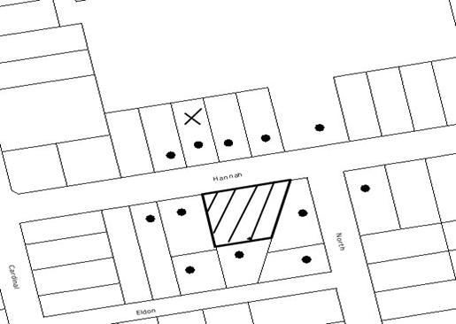
|
NOTIFICATION
PLAN
|
|
|
• PROPERTIES NOTIFIED
|
X SUBMISSIONS
RECEIVED
|
PROPERTY SUBJECT OF DEVELOPMENT
|
|
|
ONE SUBMISSIONS
RECEIVED OUT OF MAP RANGE
|
|
|
|
|
Two submissions objected to the
development, generally on the following grounds:
· Application does not address SEPP 19
· The adverse impact of
the development on significant trees on the site and potential removal of
significant trees;
· Use of recently released Australian
Standards when assessing tree impacts;
· Survey Plan does not show ‘precise’
location of trees;
· Unacceptable traffic on local streets;
· Loss of on-street car parking.
The merits of the matters raised
in community submissions have been addressed in the body of the report.
5.2 Public Agencies
The development application is
Integrated Development under the Act. Accordingly, the application was
referred to the following Agency for comment:
5.2.1 Department of Water and Energy
The Department of Water and
Energy has raised no objection to the proposal subject to the General Terms of
Approval granted and the issuing of a Controlled Activity Approval prior to
issue of the Construction Certificate.
6. THE PUBLIC INTEREST
Section 79C(1)(e) of the Act
requires Council to consider “the public interest”.
The public interest is an
overarching requirement, which includes the consideration of the matters
discussed in this report. Implicit to the public interest is the achievement
of future built outcomes adequately responding to and respecting the future
desired outcomes expressed in environmental planning instruments and
development control plans.
The application is considered to
have satisfactorily addressed Council’s and relevant agencies’ criteria and
would provide a development outcome that, on balance, would result in a
positive impact for the community. Accordingly, it is considered that the
approval of the proposed development would be in the public interest.
CONCLUSION
The application proposes the
demolition of the existing dwelling and detached garage and the Torrens title subdivision of one allotment into two.
The proposed development
generally maximises the development opportunity of the site available under
Council’s planning controls. The proposal has been assessed as satisfactory
pursuant to Section 79C of the Environmental Planning and Assessment Act, 1979,
the Hornsby Shire Local Environmental Plan, 1994 and Council’s Residential
Subdivision, Development Control Plan.
The development is considered to
be acceptable in relation to environmental impacts and is considered to be in
the public interest.
Approval of the application is recommended.
Note: At the time of the completion of this planning
report, no persons have made a Political Donations Disclosure Statement pursuant
to Section 147(3) of the Environmental Planning and Assessment Act 1979 in
respect of the subject planning application.
|
Rod Pickles
Manager -
Assessment Team 2
Planning Division
|
Paul David
Manager -
Subdivision & Development Engineering Services
Planning Division
|
|
Scott Phillips
Executive Manager
Planning Division
|
|
Attachments:
|
1.View
|
Locality Plan
|
|
|
|
2.View
|
Subdivision Plan
|
|
|
File Reference: DA/897/2009
Document Number: D01230499
SCHEDULE 1
GENERAL
CONDITIONS
The
conditions of consent within this notice of determination have been applied to
ensure that the use of the land and/or building is carried out in such a manner
that is consistent with the aims and objectives of the relevant legislation,
planning instruments and Council policies affecting the land and does not
disrupt the amenity of the neighbourhood or impact upon the environment.
Note: For the
purpose of this consent, the term ‘applicant’ means any person who has the
authority to act on or the benefit of the development consent.
Note: For the purpose of
this consent, any reference to an Act, Regulation, Australian Standard or
publication by a public authority shall be taken to mean the gazetted Act or
Regulation, or adopted Australian Standard or publication as in force on the
date that the application for a construction certificate is made.
1. Approved
Plans and Supporting Documentation
The development must be carried
out in accordance with the plans and documentation listed below and endorsed
with Council’s stamp, except where amended by Council and/or other conditions
of this consent:
|
Plan No.
|
Plan Title
|
Drawn by
|
Dated
|
|
S14660
|
Plan of Proposed Subdivision
|
PS Graham & Associates
|
26 July 2009
|
|
Document No.
|
Prepared by
|
Dated
|
|
Statement of Environmental
Effects
|
PS Graham & Associates
|
28 July 2009
|
|
Waste Management Plan
|
PS Graham & Associates
|
28 July 2009
|
|
Drainage Report Ref: 09012.doc
|
GJ McDonald Consulting Engineers
|
August 2009
|
REQUIREMENTS PRIOR TO THE ISSUE OF A CONSTRUCTION
CERTIFICATE
2. Water/Electricity
Utility Services
The applicant
must submit written evidence of the following service provider requirements:
a. Energy
Australia – a letter of consent demonstrating that satisfactory
arrangements have been made to service the proposed development.
b. Sydney
Water – the submission of a ‘Notice of Requirements’ under s73 of the Sydney
Water Act 1994.
Note: Sydney
Water requires that s73 applications are to be made through an authorised
Sydney Water Servicing Coordinator. Refer to www.sydneywater.com.au or telephone
13 20 92 for assistance.
REQUIREMENTS PRIOR TO THE COMMENCEMENT OF ANY WORKS
3. Erection
of Construction Sign
A sign must be erected in a
prominent position on any site on which building work, subdivision work or
demolition work is being carried out:
a. Showing
the name, address and telephone number of the principal certifying authority
for the work,
b. Showing
the name of the principal contractor (if any) for any demolition or building
work and a telephone number on which that person may be contacted outside
working hours, and
c. Stating
that unauthorised entry to the work site is prohibited.
Note: Any
such sign is to be maintained while the building work, subdivision work or
demolition work is being carried out, but must be removed when the work has
been completed.
4. Erosion
and Sediment Control
Erosion and
sediment control measures must be provided and maintained throughout the
construction period in accordance with the manual ‘Soils and Construction
2004 (Bluebook)’, the approved plans, Council specifications and to the
satisfaction of the principal certifying authority. The erosion and sediment
control devices must remain in place until the site has been stabilised and
revegetated.
Note: On
the spot penalties up to $1,500 may be issued for any non-compliance with this
requirement without any further notification or warning.
5. Tree
Protection Barriers
Tree
protection fencing must be erected around trees numbered 8, 10, 11, 12, 13, 14,
15, 16 and 17 to be retained at a 4 metre setback. The tree fencing must be
constructed of 1.8 metre ‘cyclone chainmesh fence’ or star pickets spaced at 2
metre intervals, connected by a continuous high-visibility barrier/hazard mesh
at a height of 1 metre.
To avoid
injury or damage, trees numbered 1, 2, 3, 6 and 7 must have trunks protected by
2 metre lengths of 75mm x 25mm hardwood timbers spaced at 80mm secured with
galvanised wire (not fixed or nailed to the tree in any way).
REQUIREMENTS DURING CONSTRUCTION
6. Construction
Work Hours
All work on site (including demolition and earth works)
must only occur between 7am and 5pm Monday to Saturday.
No
work is to be undertaken on Sundays or public holidays.
7. Demolition
All demolition work must be
carried out in accordance with Australian Standard 2601-2001 – The
Demolition of Structures and the following requirements:
a. Demolition
material is to be disposed of to an authorised recycling and/or waste disposal
site and/or in accordance with an approved waste management plan.
8. Environmental
Management
The site must
be managed in accordance with the publication ‘Managing Urban Stormwater –
Landcom (March 2004) and the Protection of the Environment Operations
Act 1997 by way of implementing appropriate measures to prevent sediment
run-off, excessive dust, noise or odour emanating from the site during the construction
of the development.
9. Works
near Trees
All required tree protection
measures are to be maintained in good condition for the duration of the
construction period.
All works
(including driveways and retaining walls) within 6 metres of any trees required
to be retained (whether or not on the subject property, and pursuant to this
consent or the Tree Preservation Order), must be carried out under the
supervision of an ‘AQF Level 5 Arborist’ and a certificate submitted to
the principal certifying authority detailing the method(s) used to preserve the
tree(s).
Note: Except as provided
above, the applicant is to ensure that no excavation, filling or stockpiling of
building materials, parking of vehicles or plant, disposal of cement slurry,
waste water or other contaminants is to occur within 4 metres of any tree to be
retained.
10. Bushland
Protection during Construction
To ensure the protection of
bushland during construction, the applicant must ensure that all machinery to
be cleaned of soil and debris before entering the site to prevent the spread of
weeds and fungal pathogens.
Note: The
site contains Blackbutt Gully Forest and Turpentine Ironbark Forest which is listed as an ‘Endangered Ecological
Community’ under the ‘Threatened Species Conservation Act 1995’. The Act
prohibits the disturbance to threatened species, endangered populations and
endangered ecological communities, or their habitat, without the approval of
the ‘Department of Environment and Climate Change’ where such activities are not
authorised by a development consent under the ‘Environmental Planning and
Assessment Act 1979’.
Actions such as tree removal, understorey slashing or mowing, removal of dead
trees within this vegetation would likely impact upon this endangered
ecological community. Such action would qualify as illegally picking or
disturbing the habitat and could render any person who carried out such action
as LIABLE FOR PROSECUTION.
11. Setback
from Prescribed Stream
A buffer
setback of 10 metres must be provided from the crest of the watercourse to any
construction works. The setback area must be suitably vegetated with native
grasses and groundcovers consistent with Blackbutt Gully Forest (Community
L) species as per the Hornsby Council planting guide, Indigenous Plants
for the Bushland Shire, available at Council or on Council’s web site: www.hornsby.nsw.gov.au – “Native
Vegetation Communities of Hornsby Shire” (Smith and Smith 2008) to facilitate
the filtration of surface runoff.
REQUIREMENTS PRIOR TO THE ISSUE OF A SUBDIVISION
CERTIFICATE
Note: For the
purpose of this consent, any reference to ‘occupation certificate’ shall also
be taken to mean ‘interim occupation certificate’ unless otherwise stated.
12. Sydney
Water – s73 Certificate
A s73 Certificate must be
obtained from Sydney Water.
13. Stormwater
Drainage
The
stormwater drainage system for the development must be designed and constructed
in accordance with Council’s Civil Works – Design and Construction Specification
2005 and the following requirements:
a. Connected
directly to Devlins Creek in accordance with Council’s Sustainable Water Best
Practices Manual and Development Control Plan.
b. An
inter-allotment stormwater drainage system to service the proposed lot with
pits being constructed in situ.
14. Vehicular
Crossing
A separate
application under the Local Government Act, 1993 and the Roads Act,
1993 must be submitted to Council for the installation of a new vehicular
crossing and the removal of the redundant crossing. The vehicular crossing
must be constructed in accordance with Council’s Civil Works Design, 2005
and the following requirements:
a. Any
redundant crossings to be replaced with integral kerb and gutter.
b. The
footway area to be restored by turfing.
c. Approval
obtained from all relevant utility providers that all necessary conduits be
provided and protected under the crossing.
a.
Note:
An application for a vehicular crossing can only be made to one of Council’s
Authorised Vehicular Crossing Contractors. You are advised to contact Council
on 02 9847 6940 to obtain a list of contractors.
15. Road
Works
All road
works approved under this consent must be constructed in accordance with
Council’s Civil Works Design and Construction Specification, 2005 and
the following requirements:
a. A
kerb and gutter and pavement along the full frontage of the proposed
subdivision, together with footpath formation, necessary drainage and sealing
of road pavement between the existing pavement and lip of the gutter.
b. The
existing road pavement to be saw cut a minimum of 300 mm from the existing edge
of the bitumen and reconstructed.
16. Traffic
Control Plan
A Traffic
Control Plan (TCP) must be prepared by a qualified traffic controller in
accordance with the Roads & Traffic Authority’s Traffic Control at
Worksites Manual 1998 and Australian Standard 1742.3 for all work on
a public road and be submitted to Council. The TCP must detail the following:
a. Arrangements
for public notification of the works.
b. Temporary
construction signage.
c. Permanent
post-construction signage.
d. Vehicle
movement plans.
e. Traffic
management plans.
f. Pedestrian
and cyclist access/safety.
17. Creation
of Easements
The following
matters must be nominated on the plan of subdivision under s88B of the Conveyancing
Act 1919:
a. An
inter-allotment drainage easement(s) over each of the burdened lots.
b. A
restriction over the pipeline and the flow path for a 100 year average
recurrence interval storm. The "Restriction on the Use of Land"
over the affected lots is to prohibit the alteration of the final floodway
shape and the erection of any structures, including fencing, in the floodway
without the written permission of Council. The terms of this restriction must
be obtained from Council.
c. A
"Restriction on the Use of Land" for any lot adjacent to the
floodway, requiring the finished floor level of any habitable room to be not
less than 500mm and the garage 300mm above the 100 year average recurrence
interval storm level. The levels must be related to Australian Height Datum.
d. The
creation of a “Positive Covenant” over the proposed Lot 1 requiring that
any future development is to provide an on-site detention system. The on-site
detention system is to have a storage capacity of 5 cubic metres and a maximum
discharge of 8 litres per second into Council’s drainage system in accordance
with Council’s prescribed wording.
Note: Council
must be nominated as the authority to release, vary or modify any easement,
restriction or covenant.
18. Works
as Executed Plan
A works-as-executed plan(s)
must be prepared by a registered surveyor and submitted to Council for
completed road pavement, kerb & gutter, interallotment drainage and
vehicular crossings.
19. Damage
to Council Assets
Any damage caused to Council’s
assets as a result of the construction of the development must be rectified in
accordance with Council’s written requirements and at the sole cost of the
applicant.
20. Maintain
Canopy Cover
To maintain canopy cover, four medium to large trees selected from Council’s
booklet ‘Indigenous Plants for the Bushland Shire’ such as Syncarpia
glomulifera or Acmena smithii are to
be planted on the subject site. The planning location shall not be within 4
metres of the foundation walls of a dwelling or in-ground pool. The pot size
is to be a minimum 25 litres and the trees must be maintained until they reach
the height of 3 metres. Trees must be native to Hornsby Shire and reach a
mature height greater than 10 metres.
21. Restriction
as to User - Protection of Land from Future Development
To inform
current and future owners that the areas of native vegetation and habitat on
the site is to be protected from future development, a Restriction as to User
must be created under Section 88B of the Conveyancing Act 1919
identifying that the area of the site identified on the approved plans is
restricted from future development or disturbance of any kind.
Any weed
removal work undertaken in the Riparian Buffer Zone is to be undertaken in
accordance with recognised bush regeneration methods in accordance with ‘Recovering
bushland on the Cumberland Plain: Best practice guidelines for the management
and restoration of bushland – Department of Conservation 2005’;
Note: The
Guideline is available at: www.environment.nsw.gov.au,
publications.
Any plantings
are to comprise of Blackbutt Gully Forest (Community L) species as per
the Hornsby Council planting guide, Indigenous Plants for the Bushland Shire,
available at Council or on Council’s web site: www.hornsby.nsw.gov.au – “Native
Vegetation Communities of Hornsby Shire” (Smith and Smith 2008). Landscape
plants must be non-invasive and not have the potential to spread into the
surrounding bushland.
Note: The
wording of the Restriction as to User must be to Council’s satisfaction and Council
must be nominated as the authority to release, vary or modify the Restriction.
22. s94
Infrastructure Contributions
The payment to Council of a
contribution of $19263.30* for one additional lot towards the cost of
infrastructure identified in Council’s Development Contributions Plan
2007-2011.
Note:
* The value of contribution is based
on a rate of $19263.30 per additional lot and is current as at 8 October 2009. The contribution will be
adjusted from this date in accordance with the underlying consumer price index
for subsequent financial quarters.
It is recommended that you contact Council to ascertain the indexed value of
the contribution prior to payment.
GENERAL TERMS OF APPROVAL - DEPARTMENT OF
WATER AND ENERGY
The following conditions of consent are
General Terms of Approval from the nominated State Agency pursuant to Section
91A of the Environmental Planning and Assessment Act 1979 and must be
complied with to the satisfaction of that Agency.
23. General
Terms of Approval
These General
Terms of Approval (GTA) only apply to the controlled activities described in
the plans and associated documentation relating to DA/897/2009 and provided by
Council:
(i) Site plan, map and/or surveys
Any amendments or modifications to the proposed controlled activities
may render these GTA invalid. If the proposed controlled activities are
amended or modified the NSW Office of Water must be notified to determine if
any variations to these GTA will be required.
24. Controlled
Activity Approval
Prior to the
commencement of any controlled activity (works) on waterfront land, the consent
holder must obtain a Controlled Activity Approval (CAA) under the Water
Management Act from the NSW Office of Water. Waterfront land for the purposes
of this DA is land and material in or within 40 metres of the top of the bank
or shore of the river identified.
25. Erosion
and Sediment Control Plan
The consent
holder must prepare or commission the preparation of:
(i) Erosion and Sediment Control Plan
26. Discharge
Points
The consent
holder must stabilise drain discharge points to prevent erosion in accordance
with a plan approved by the Office of NSW Water.
27. Erosion
and Sediment Control Works
The consent
holder must establish all erosion and sediment control works and water
diversion structures in accordance with a plan approved by the NSW Office of
Water. These works and structures must be inspected and maintained throughout
the working period and must not be removed until the site has been fully
stabilised.
28. Riparian
Corridor
The consent
holder must establish a riparian corridor along Devlin Creek in accordance with
a plan approved by the NSW Office of Water.
-
END OF CONDITIONS –
ADVISORY
NOTES
The
following information is provided for your assistance to ensure compliance with
the Environmental Planning and Assessment Act, 1979, Environmental Planning and
Assessment Regulation 2000, other relevant legislation and Council’s policies
and specifications. This information does not form part of the conditions of
development consent pursuant to Section 80A of the Act.
Environmental Planning and Assessment Act, 1979
Requirements
· The Environmental Planning and
Assessment Act, 1979 requires:
· The issue of a construction certificate
prior to the commencement of any works. Enquiries regarding the issue of a
construction certificate can be made to Council’s Customer Services Branch on 9847
6760.
· A principal certifying authority to be
nominated and Council notified of that appointment prior to the commencement of
any works.
· Council to be given at least two days
written notice prior to the commencement of any works.
· Mandatory inspections of nominated
stages of the construction inspected.
· An occupation certificate to be issued
before occupying any building or commencing the use of the land.
Tree Preservation Order
To ensure the maintenance and protection of the existing
natural environment, it is an offence to ringbark, cut down, top, lop, remove,
wilfully injure or destroy a tree outside 3 metres of the approved building
envelope without the prior written consent from Council.
Note: A
tree is defined as a single or multi-trunked wood perennial plant having a
height of not less than three (3) metres, and which develops many branches,
usually from a distance of not less than one (1) metre from the ground, but
excluding any plant which, in its particular location, is a noxious plant
declared as such pursuant to the Noxious Weeds Act 1993. This definition of
‘tree’ includes any and all types of Palm trees.
All
distances are determined under British Standard BS 5837: 2005, “Trees in
Relation to Construction – Recommendations”.
Fines may be imposed for non-compliance with Council’s Tree
Preservation Order.
Subdivision Certificate Requirements
A subdivision certificate application is required to be
lodged with Council containing the following information:
a. A
surveyor’s certificate certifying that all structures within the subject land
comply with the development consent in regard to the setbacks from the new
boundaries.
b. A
surveyor’s certificate certifying that all services, drainage lines or access
are located wholly within the property boundaries. Where services encroach
over the new boundaries, easements are to be created.
c. Certification
that the requirements of relevant utility authorities have been met; and
d. A
surveyor’s certificate certifying finished ground levels are in accordance with
the approved plans.
Note: Council
will not issue a subdivision certificate until all conditions of the
development consent have been completed.
Fees and Charges – Subdivision
All fees payable to Council as part of any construction,
compliance or subdivision certificate or inspection associated with the
development (including the registration of privately issued certificates) are
required to be paid in full prior to the issue of the subdivision certificate.
Any additional Council inspections beyond the scope of any compliance
certificate required to verify compliance with the terms of this consent will
be charged at the individual inspection rate nominated in Council's Fees and
Charges Schedule.
Dial Before You Dig
Prior to commencing any works,
the applicant is encouraged to contact Dial Before You Dig on 1100 or www.dialbeforeyoudig.com.au for
free information on potential underground pipes and cables within the vicinity
of the development site.
Asbestos Warning
Should asbestos or asbestos
products be encountered during demolition or construction works you are advised
to seek advice and information prior to disturbing the material. It is
recommended that a contractor holding an asbestos-handling permit (issued by WorkCover
NSW)be engaged to manage the proper handling of the material. Further
information regarding the safe handling and removal of asbestos can be found
at:
www.environment.nsw.gov.au
www.nsw.gov.au/fibro
www.adfa.org.au
www.workcover.nsw.gov.au
Alternatively, telephone the WorkCover Asbestos and
Demolition Team on 8260 5885.
House Numbering
House numbering can only be
authorised by Council. Before proceeding to number each premise in the
development, the allocation of numbers is required to be obtained from
Council's Planning Division. The authorised numbers are required to be
displayed in a clear manner at or near the main entrance to each premise.
Standard Report No. PLN85/09
Planning Division
Date of Meeting:
4/11/2009
8 REPORTING VARIATIONS TO
DEVELOPMENT STANDARDS
EXECUTIVE SUMMARY
In accordance with the Department
of Planning’s Planning Circular PS 08-14, Council is required to report
variations to development standards for development applications approved under
delegated authority, which relied upon State Environmental Planning Policy No.
1 - Development Standards (SEPP 1).
PURPOSE
The purpose of this report is to advise Council of
determined development applications involving a SEPP 1 variation to a
development standard relating to the period 1 July 2009 to 30 September 2009.
BACKGROUND
The Department of Planning issued Circular PS
08–014 on 14 November 2008. The purpose of the Circular was to remind councils
of their responsibilities to monitor the use of the Director-General’s assumed
concurrence under State Environmental Planning Policy No. 1. Councils were
reminded of the need to keep accurate records of the use of SEPP 1 and to
report on a quarterly basis.
The Circular also provides that Councils are
required to adopt the following four measures in response to the findings of
the recent ICAC investigation into corruption allegations affecting Wollongong
City Council:
1. Establish
a register of development applications determined with variations in standards
under SEPP 1;
2. Require
all development applications where there has been a variation greater than 10%
in standards under SEPP 1 to be determined by full council (rather than general
manager or nominated staff member);
3. Provide
a report to each council meeting on the development applications determined
where there had been a variation in standards under SEPP 1;
4. Make
the register of development applications determined with variations in
standards under SEPP 1 available to the public on the council’s website.
DISCUSSION
Prior to August 2009, all development applications
involving a SEPP 1 objection were determined by Council. Accordingly, it has
not become necessary until this time to provide Council with a quarterly report
pursuant to Planning Circular PS 08-14.
In accordance with Point 3 of the Department’s Circular,
attached hereto is a list of development applications determined under
delegated authority involving a SEPP 1
variation to a development standard for the
period 1 July 2009 to 30 September 2009.
A copy of the attachment to this report is also reproduced
on Council’s website.
BUDGET
There are no budget implications.
POLICY
There are no policy implications.
CONSULTATION
There was no consultation in the preparation of this
report.
TRIPLE BOTTOM LINE SUMMARY
Triple Bottom Line is a framework for improving Council
decisions by ensuring accountability and transparency on social, environmental
and economic factors. It does this by reporting upon Council’s strategic
themes.
As this report simply provides Council with information and
does not propose any actions which require a sustainability assessment, no
Triple Bottom Line considerations apply.
RECOMMENDATION
|
THAT Council note the contents of
Executive Manager’s Report No. PLN85/09.
|
|
Rod Pickles
Manager -
Assessment Team 2
Planning Division
|
Scott Phillips
Executive Manager
Planning Division
|
Attachments:
File Reference: F2004/07599
Document Number: D01256707
Standard Report No. PLN86/09
Planning Division
Date of Meeting:
4/11/2009
9 HERITAGE FESTIVAL 2010
EXECUTIVE SUMMARY
The National Trust organises an annual Heritage Festival to
promote an awareness of heritage and conservation throughout Australia. The Trust coordinates a series of events throughout the Festival and encourages local
councils and the community to do the same.
Council’s Town Planning Services Branch is coordinating
events to take place as part of the Hornsby Shire Heritage Festival 2010 to be
held from 9 April to 24 April 2010. Council’s Heritage Advisory Committee has
been involved in the event planning. This Report provides further details of
the programme and budget for the Heritage Festival 2010.
PURPOSE/OBJECTIVE
The purpose of this report is to seek Council’s endorsement
of a programme of events and budget for the Heritage Festival 2010 and request
that the judging of Council’s annual Heritage Awards be delegated to Council’s
Heritage Advisory Committee.
DISCUSSION
Every year, the National Trust organises a Heritage
Festival to promote an awareness of heritage and conservation throughout Australia. The Trust coordinates a series of events throughout the Festival and encourages
local councils and the community to do the same.
Council has held its own Heritage Festival each year since
1994. The Festival aims to promote heritage conservation and education within
the Shire and has included guided cruises, plaque ceremonies, talks, bushwalks
and other community events. Publicity is provided through the National Trust’s
advertising and publications, as well as Council’s own promotion of events.
Following Council’s endorsement, the organisation of events
will be finalised and dates for each event confirmed. Quotes for most events
have been obtained and are discussed in this report.
DISCUSSION
The National Trust has advised that the upcoming Heritage
Festival will be held from 9 April to 24 April 2010 and is two weeks in
duration (details of the Festival are attached). For the Festival, the National
Trust has adopted the theme “The Making of Our Nation” which will mark the 200th
Anniversary of Governor Lachlan Macquarie’s 12 year tenure as the 5th
Governor of the colony of New South Wales. Governor Macquarie is widely
recognised as being a visionary responsible for instigating hundreds of public
works programs which transformed the new colony to an economically independent
civilisation. The theme endeavours to identify who and what has played an
important role in shaping our nation at the local level.
At its
meeting on 12 October 2009, Council’s Heritage
Advisory Committee agreed that the following events should be considered for
the Heritage Festival 2010:
· Hawkesbury River Boat Trip: As per previous years, a guided Hawkesbury River Boat
Trip would depart from Brooklyn. A local historian would guide a boat trip from
Brooklyn, following the historic development of the Hawkesbury River settlements, including Brooklyn, Mooney Mooney, Dangar Island and Bar Island. The focus would be on the history of the construction of major transport infrastructure
including the Hawkesbury River road and railway bridges. The duration of the
trip would be approximately three (3) hours. Numbers would be limited to a
maximum of fifty (50) people and there would be a small booking fee ($10.00)
for the event. A suitable boat would be chartered.
· Open Day at Fagan Park: The Friends of Fagan Park
are organising an annual Open Day within Fagan Park. Farm machinery and blacksmith demonstrations, and a parade
of old farm vehicles will
be arranged throughout Netherby Homestead and the Rural Museum.
· Library Exhibition: Each
year, the Hornsby Shire Historical Society, in conjunction with Council’s Local
Studies Library, coordinates a display within Council libraries which reflects
the theme of the NSW Heritage Festival. The exhibition would be shown from 9
April to 24 April 2010, during opening hours, at the Hornsby, Epping and
Pennant Hills libraries.
· Aboriginal Heritage Walk: An Aboriginal guide, in conjunction
with a local historian, would lead a guided walk providing a commentary of the
philosophical, cultural and historical issues concerning both Aboriginal and
European culture in Hornsby Shire. The duration of the walk would be
approximately two and a half hours. Numbers would be limited to twenty (20)
people and there would be no charge for the event. The location of the walk is
under discussion.
· Heritage Walk – Hornsby Rail Yards: This walk would include a talk on the various buildings
that comprise the Hornsby Rail Yards and the importance of the railway in the
development of the Shire. The tour would include a visit to the Hornsby Rail
Yards Signal Box. The duration of the walk would be approximately two hours.
Numbers would be limited to twenty (20) people and there would be no charge for
the event. Final approval for access to the Rail Yards is currently being
sought.
Details for all events would be finalised following
Council’s endorsement of the proposed events.
Heritage Awards
Each year, Council has offered awards to recognise and
publicly acknowledge work undertaken on items of heritage significance, or the
education and promotion of heritage conservation. The Hornsby Shire Heritage
Awards form part of the Heritage Festival celebrations. Nominations for the annual
awards will be called in time for the presentation of the Awards at the Council
Meeting on Wednesday, 5 May 2010.
The awards consist of three categories:
Category A: Work involving the preservation, restoration,
reconstruction or maintenance of a heritage item.
Category B: Work involving either (a) the erection of a sensitively
designed new building in a Heritage Conservation Area or in close proximity to
a heritage item; or (b) a sensitively designed extension or alteration to an
existing heritage item or building in a Heritage Conservation Area.
Owen Nannelli Memorial Award (Category C): This award is in honour of the contributions of the late
Councillor Owen Nannelli to heritage conservation within the Shire and will be
awarded to a group or individual who has made an outstanding contribution to
the education and promotion of heritage within the Shire.
Winners of categories A and B are awarded a commemorative
bronze plaque to attach to the dwelling/structure and a framed certificate.
Participants who receive a ‘highly commended’ award for categories A and B and
winners of the Owen Nannelli Memorial Award are presented with a framed
certificate.
To enable the timely exhibition of entries during the
Heritage Festival and the presentation of the awards at the Council Meeting
on 5 May 2010, it is recommended that the final
judging of Council’s annual Heritage Awards be delegated to Council’s Heritage
Advisory Committee.
Advertising
The Heritage Festival events will be advertised in
Council’s Calender of Events, Bushland Shire News, advertisements in local
newspapers and by the distribution of a free postcard outlining the events.
The postcard will be placed in libraries and Council offices and distributed to
historical societies.
Based on a recommendation from the Heritage Advisory
Committee, a photograph of the Hawkesbury River Rail Bridge, Brooklyn (copy attached) has been
chosen for the postcard. The photograph represents one of the more
important pieces of infrastructure that helped facilitate development within
and beyond the Shire to reflect the theme for the Festival. This photograph has
been chosen for the postcard for the following
reasons:
· The photograph depicts a historical view of the Hawkesbury River Rail Bridge which is recommended to be part of
the discussion on the Hawkesbury River Boat Cruise during the Heritage Festival
2010, and so is likely to draw interest to the event;
· It is in keeping with the historical photographs used in
previous years. The view is a striking image which would attract the attention
and interest of the community; and
· The photograph displays part of the transport
infrastructure accomplishments of the Hornsby Shire in keeping with the NSW
Heritage Festival theme of “The Making of our Nation”.
The Hornsby Shire Heritage Advisory Committee
endorsed the photograph at its meeting on 12 October 2009. It is recommended that Council endorse the use of the photograph for
advertising the Heritage Festival 2010.
BUDGET
An amount of $5,000 is available for the Heritage Festival
2010 (including the Heritage Awards). The following cost estimates are
provided:
|
Event
|
Requirements
|
Cost Estimate
$
|
|
Hawkesbury River Boat Trip
|
Charter of suitable boat (less income for booking fee)
|
1,500
(- 500)
|
|
Open Day at Fagan Park
|
Nil (advertising included in general Heritage Festival
advertising)
|
Nil
|
|
Aboriginal Heritage Walk
|
Guides
|
600
|
|
Heritage Walk – Hornsby Rail Yards
|
Nil (advertising included in general Heritage Festival
advertising)
|
Nil
|
|
Library Exhibition
|
Nil (advertising included in general Heritage Festival
advertising)
|
Nil
|
|
Heritage Awards
|
Plaques and framed certificates
|
600
|
|
Advertising
|
Local papers, brochures, postcard etc
|
2,800
|
|
TOTAL
|
|
5,000
|
Although not all costs have been finalised, it is
anticipated that the $5,000 budget will be adequate for all events and
advertising.
CONSULTATION
At its meeting on 12 October 2009, Council’s Heritage Advisory Committee endorsed a series of events
for consideration as part of the Heritage Festival 2010.
Other groups involved in the events have been consulted in
the preparation of this report, including the National Trust, Hornsby Shire
Historical Society, Friends of Fagan Park and the various guides and hosts.
TRIPLE BOTTOM LINE SUMMARY
This Triple Bottom Line (TBL) Statement forms part of
Council’s efforts towards “creating a living environment”. The statement
addresses the strategic themes within Council’s Management Plan that cover
social, environmental and economic factors and the corresponding sustainability
questions contained in the TBL checklist.
· Working with our community: The Heritage Festival events have been organised in
consultation with key stakeholders and community representatives to cover
significant places and events throughout the Shire. All sections of the local
community would have access to information on the events via advertising in the
local papers, the Festival postcard and information on Council’s website.
· Conserving our natural environment: The Heritage Festival would promote significant historic
places and environments at locations throughout Hornsby Shire. The Heritage
Walk event would directly promote the conservation of rail heritage.
· Contributing to community development through sustainable
facilities and services: The project does
not relate directly to the provision of services and facilities. Accordingly,
no adverse impact on opportunities for community development would be expected.
· Fulfilling our community’s vision in planning for the
future of the Shire: The Heritage Festival
would facilitate community understanding of the important heritage values
within the Shire.
· Supporting our diverse economy: The Heritage Festival events do not relate directly to
economic development. However, the events would utilise local services to cater
for the events.
· Maintaining sound corporate and financial management: Council has allocated funds in its annual budget for the
project. The Heritage Festival events do not have other corporate or financial
implications for Council.
· Other Sustainability Considerations: The project would be managed to ensure any potential
negative impacts of the events would be minimised.
CONCLUSION
Council’s Heritage Advisory Committee has recommended that
Council organise a number of events for the Heritage Festival 2010. The events
include a Hawkesbury River Boat Trip, Open Day at Fagan Park, Aboriginal
Heritage Walk, Heritage Walk at Hornsby Rail Yards, library exhibition and
Heritage Awards.
Following endorsement by Council, the details of events
would be finalised and promoted. A budget of $5,000 is available for the
Heritage Festival 2010. An estimate of costs indicates that the budget would
be adequate for all events and advertising.
It is recommended that Council endorse the Heritage
Advisory Committee’s proposal for events to be included in the Heritage
Festival 2010. To enable the timely exhibition of entries during the
Heritage Festival and the presentation of the awards at the Council Meeting on
5 May 2010, it is also recommended that the final
judging of Council’s annual Heritage Awards be delegated to Council’s Heritage
Advisory Committee.
RECOMMENDATION
|
THAT:
1. Council endorse the program of events and budget for the
Heritage Festival 2010 as outlined in Executive Manager’s Report No.
PLN86/09.
2. Council delegate the judging of the Heritage Awards 2010 to
Council’s Heritage Advisory Committee to enable the timely exhibition of
entries during the Heritage Festival and the presentation of awards at the
Planning Meeting on 5 May 2010.
3. Council endorse the photograph of the Hawkesbury River Rail Bridge, Brooklyn attached to Executive Manager’s Report No. PLN86/09 to be used on
the postcard to advertise the Heritage Festival 2010.
|
|
Karen Harragon
Acting Manager -
Town Planning Services
Planning Division
|
Scott Phillips
Executive Manager
Planning Division
|
Attachments:
|
1.View
|
National Trust
Invitation
|
|
|
|
2.View
|
Hawkesbury River Rail Bridge, Brooklyn - Photograph
|
|
|
File Reference: F2009/00567
Document Number: D01257514
Standard Report No. PLN89/09
Planning Division
Date of Meeting:
4/11/2009
10 ANNUAL AMENDMENTS
PLANNING PROPOSAL AND DEVELOPMENT CONTROL PLAN AMENDMENTS
EXECUTIVE SUMMARY
The Director-General of the Department of Planning (DOP)
has encouraged councils to prepare only one amendment, or a limited number of
housekeeping amendments, to their existing environmental planning instruments
each year. Council’s Strategic Planning Programme includes the preparation of
an annual Amendments Local Environmental Plan (LEP).
In July 2009,
the State Government announced changes to the way that LEPs are progressed. A
new system, known as the “gateway plan-making process”, has been established.
The gateway process has been introduced to assist meet the Government’s target
of a 50% overall reduction in the time taken to produce LEPs and to allow the
steps in the system to be tailored to the complexity of individual LEPs. The
new gateway process involves the preparation of a planning proposal for
submission to the DOP.
Over the past year, Council has identified planning
anomalies to be rectified and minor amendments to be made, to the Hornsby
Shire Local Environmental Plan (HSLEP) 1994 as part of the annual
Amendments LEP. This report presents a planning proposal to rezone various
lands and implement the recommendations of Heritage Review Stage 4, East Epping Heritage Review and Hornsby West
Side Conservation Area Review.
It is recommended that the Planning Proposal be endorsed
for the purpose of seeking a “gateway” determination from the DOP to progress
the preparation of Council’s 2009 Annual Amendments Planning Proposal. In
anticipation of the DOP determining that the matter may proceed, the Planning
Proposal should also be endorsed for public exhibition.
PURPOSE/OBJECTIVE
The purpose of this report is to present a Planning
Proposal that seeks to rezone lands, address planning anomalies and make minor
amendments to the HSLEP.
BACKGROUND
The Director-General of the DOP, in a letter to all
councils in May 2006, advised that the Department and councils have limited
resources available for the progression of amending draft LEPs whilst preparing
their new comprehensive LEPs. Councils are encouraged to prepare only one
amendment, or a limited number of amendments, to their existing environmental
planning instruments each year where councils need to rectify planning anomalies
or make minor amendments to existing LEPs.
The Strategic Planning Programme includes the preparation
of an Amendments LEP and over the past year, Council has identified a number of
amendments to the HSLEP to be progressed as part of the LEP.
In July 2009,
the State Government announced changes to the way that LEPs are progressed. A
new system, known as the “gateway plan-making process”, has been established.
The gateway process has been introduced to assist meet the Government’s target
of a 50% overall reduction in the time taken to produce LEPs and to allow the
steps in the system to be tailored to the complexity of individual LEPs. The
new gateway process involves the preparation of a planning proposal for
submission to the DOP.
This report presents a 2009 Annual Amendments Planning
Proposal explaining the effect of, and justification for, the Proposal
and also containing a consultation strategy.
DISCUSSION
This report discusses the planning amendments that comprise
this year’s Annual Amendments Planning Proposal, namely amendments to:
· rezone and permit strata subdivision at property No. 218 Brooklyn Road, Brooklyn;
· update the listing of heritage items generally in
accordance with the recommendations of Heritage Review Stage 4 and the East
Epping Heritage Review; and
· implement the recommendations of the Hornsby West Side
Conservation Area Review
by expanding the residential component of the
existing Conservation Area.
The report also addresses statutory considerations and
provides recommendations, should Council resolve to progress the Planning
Proposal.
Property No. 218
Brooklyn Road, Brooklyn
At its meeting on 7 October 2009, Council considered
Executive Manager’s Report No. PLN78/09 presenting a request to prepare a draft
LEP to permit the strata subdivision of an existing multi-unit housing
development. The report also presented a review of the zoning history of the
site which indicates that the two small sections of Business A (General) zoned
land at the western end of the site are an anomaly and should be rezoned
Residential A (Low Density) to reflect the primary zoning of the site. Council
resolved that:
1. Amendments to
the Hornsby Shire Local Environmental Plan 1994 to enable strata subdivision
and correct a zoning anomaly at property No. 218 Brooklyn Road, Brooklyn be
incorporated in Council’s Annual Amending Planning Proposal.
2. Prior to
forwarding the Planning Proposal to the Department of Planning for gazettal,
Council’s Compliance Section ensure that the car parking works approved as part
of Development Consent No. 2482/2002 have been undertaken.
In accordance with Part 1 of Council’s resolution, the
Planning Proposal seeks to enable the strata subdivision of the existing
multi-unit development by providing an exception under Clause 22 of the HSLEP.
The Planning Proposal also seeks to rezone areas of the property zoned Business
A (General) to Residential A (Low Density) under the HSLEP.
In accordance with Part 2 of Council’s resolution,
Council’s Compliance Team has directed the owner of the property to comply with
the terms of the multi-unit housing development consent and provide on-site
parking.
Heritage Review Stage 4
At its
meeting on 3 June 2009, Council considered Executive Manager’s Report No. PLN22/09
presenting a review of submissions and made recommendations in relation to the
progression of the Hornsby Shire Heritage Review Stage 4. Heritage
Review Stage 4 provides a review of existing heritage listed trees and
other items proposed for inclusion or deletion from the heritage list. Council
resolved that:
Part A
Council endorse
the recommendations of Executive Manager’s Report No. PLN22/09 to include,
remove and amend items on the heritage list and progress as part of an Annual
Amending LEP, with the exception of Property No. 5 Chilcott Road, Berrilee –
former Berrilee Public School (Identification No. B9).
Part
B
Council officers
undertake further considerations regarding the recommendation in respect of
property No. 5 Chilcott Road, Berrilee – former Berrilee Public School
(Identification No. B9) and prepare a report for Council’s consideration at the
1 July 2009 Planning Meeting.
At its meeting on 1 July 2009,
Council considered Executive Manager’s Report No.
PLN52/09 presenting further information
concerning the proposed listing of No. 5 Chilcott Road, Berrilee as
required by Part B of Council resolution. Council
resolved (in part) not to progress the heritage listing of the former
school building.
The
endorsed heritage list includes property No. 17 Dorset Street, Epping. At its
meeting on 7 September 2009, the Hornsby Shire Heritage Advisory Committee
discussed the status of the proposed listing of No. 17 Dorset Street, Epping in
its consideration of Development Application No. 915/2009 for the demolition of
the existing dwelling-house. The Committee noted that the house is a proposed
item, but does not constitute a draft heritage item and as such can not be
considered under Section 79C of the Environmental Planning and Assessment
Act. Development Application No. 915/2009 for the proposed demolition of
the dwelling was approved on 2 October 2009. Accordingly, it is
recommended that the proposed listing of the property not be progressed.
The
Planning Proposal proposes the deletion of thirty-two heritage items,
comprising twenty-six tree listings and seven built/cultural items. Fifteen
additional heritage items, comprising one tree listing and fourteen
built/cultural items are recommended for inclusion on Council’s heritage list.
Eight existing heritage items are recommended for amendment. The Planning
Proposal details the proposed listings, deletions and amendments (copy
attached).
East Epping Heritage
Review
At its meeting on 7 November 2001, Council considered
Executive Manager’s Report No. PLN346/01 concerning the preparation of a draft
LEP and draft DCP amendments to implement the recommendations of the East
Epping Conservation Evaluation and Review Study and the East Epping Heritage Review. Council resolved (in part) to progress the draft LEP to:
1.1 include an
additional 14 proposed heritage items in Schedule D – Heritage Items; and
1.2 include
two proposed Heritage Conservation Areas in Schedule E - Heritage Conservation
Areas;
A draft
LEP (Amendment No. 76) for the establishment of the East Epping and Essex
Street Heritage Conservation Areas and the nomination of 14 properties
for heritage listing, was forwarded to the Department
on 22 January 2003.
In 2004, the DOP advised that the
draft LEP would be unlikely to be progressed due to the perceived conflict
between Heritage Conservation Areas and urban consolidation principles,
particularly in view of the forthcoming Epping Town Centre Study. In
March 2009, representatives of the Department advised Council to progress the 14
properties for heritage listing as part of an Amendments LEP. Council at its
meeting on 3 June 2009 considered Executive Manager’s Report No. PLN22/09 and
resolved to progress the proposed East Epping Review listings as part of
the Annual Amending LEP.
The East
Epping Review recommends the listing of Nos. 5 and 41 Norfolk Road,
Epping. Further information concerning the historical significance of
the property has since been reviewed. In 1999,
development consent was granted in respect of Nos. 3, 5, and 7 Norfolk Road, for demolition of existing cottages and ancillary structures. The
work has subsequently been completed in accordance with the consent and the
dwelling at No 3. Norfolk Road demolished. Accordingly, it is recommended that
the proposed listing of property No. 3 Norfolk Road not be progressed.
The
statement of heritage significance for No. 41 Norfolk Road, identifies that the
property is worthy of listing because it represents:
“… a fine example of the Federation Bungaalow style of architecture,
clearly demonstrating particular characteristics of the style, including large
roof planes, a prominent gable verge, face brickwork, and sparingly decorated
timberwork. The detailing and sedate composition of the house contribute to
its architectural presence in the streetscape.”
In
1998, the Land and Environment Court approved Development Application No.
388/1998 for alterations and additions to property No. 41 Norfolk Road,
Epping. The work has subsequently been completed, including significant
additions to the front facade of the dwelling. The heritage values of the
property have been detrimentally affected. Accordingly, it is
recommended that the heritage listing not be progressed.
Accordingly,
the Planning Proposal has been prepared to progress twelve of the proposed
items recommended by the East Epping Review.
Hornsby West Side Conservation Area Review
The proposed Mount Errington Heritage Conservation Area
represents an expansion of the residential component of the existing Hornsby
West Side Heritage Conservation Area, which is based on the 1896 Mount Errington subdivision. The Hornsby West Side Heritage Conservation Area Review
notes that the built character of the area is predominately residential,
typified by detached houses well spaced on separate lots. Most of the houses
of the original subdivision have designs dating from the Federation and
Inter-War periods. In general, the housing constructed prior to 1960 has
features that unify the character of the area and contribute to the heritage
fabric for which the area is significant.
The Review recommends that the boundaries of the
Mount Errington Precinct be adjusted to include all residential properties that
contribute to the heritage significance of the Hornsby West Side Conservation
Area. The adjustment of the boundaries is based on the original 1886 and 1897
subdivision surveys.
The Review notes that any future development within
the boundaries and in the vicinity of a Heritage Conservation Area should be
managed with appropriate planning controls to retain the elements that make the
area significant and enhance its character and visual qualities. Accordingly,
the report recommends a number of conservation management strategies to guide
future development of the area to retain and enhance the heritage significance
and streetscape qualities. The conservation management strategy elements are
summarised below.
Heritage Conservation Area: The Review recommends the retention of the Mount Errington precinct as part of the current Hornsby West Side Heritage Conservation
Area. To assist identify the three precincts that form the Hornsby West Side
Heritage Conservation Area, the Review recommends that the precincts
should be individually identified as follows:
- Mount Errington Precinct (original subdivision);
- Pretoria Parade Precinct (the residential area
surrounding Pretoria Parade); and
- Peat’s Ferry Road Precinct (the civic and
commercial area).
The Review recommends that the areas should be
re-named in the HSLEP and Heritage DCP.
Boundaries of the Heritage Conservation Area: The Review recommends that the boundaries of the
Mount Errington Precinct should be adjusted to include properties and areas
that contribute to the heritage significance of the Hornsby West Side Heritage
Conservation Area. The adjustment of the boundaries is based on the boundaries
of the original 1886 and 1897 subdivision surveys. The Review does not include
an analysis of the Conservation Area as it relates to the commercial area and
therefore, does not include any recommendations in relation to the significance
or boundaries of the Peat’s Ferry Road Precinct.
Statement of Significance: The Review recommends that the statement of
significance contained in the Review (copy attached) should be appended
to the current inventory sheet for the Hornsby West Side Heritage Conservation
Area. The statement should also complement the proposed planning controls to
assist in the assessment of the impact of development in the area.
Character Statement: The
Review includes a detailed character statement for the Mount Errington
Precinct of the Hornsby West Side Heritage Conservation Area (copy attached).
The Review recommends that the statement should be included in Council’s
Heritage DCP.
Contributing Features: The
Review recommends that Council’s Heritage DCP should be amended to
include guidelines identifying features that contribute to the heritage
significance and streetscape qualities of the area. These features should be
retained and enhanced on all properties within the Heritage Conservation Area.
This includes both existing built and landscape elements and any new
development that occurs within the area.
The Review identifies contributing features relating
to setting, lot sizes, density, setbacks, building design and landscape
features. The Review notes that the identification of these
contributing features in the Heritage DCP will encourage good design and
protect the significance of the Heritage Conservation Area.
At its meeting on 5 November 2003, Council considered
Executive Manager’s Report No. PLN361/03 and resolved to forward the LEP for
the Hornsby West Side Conservation Area to the DOP for gazettal. Council also
resolved that the draft amendments to the Heritage DCP for the Mount
Errington Heritage Conservation Area, be adopted subject to additional minor
amendments.
Draft LEP (Amendment No. 84) for the establishment of the
Mount Errington Heritage Conservation Area was forwarded to the DOP for
gazettal on 23 April 2004. In 2004, the Department indicated to Council
its unwillingness to gazette draft LEPs relating to heritage conservation areas
until the Department had undertaken a review of heritage conservation areas and
determined its position in consultation with the then NSW Heritage Office. In
2008, the Department advised Council that it should progress the draft LEPs as
part of Council’s Comprehensive LEP. In August 2009, the Department advised
that it was prioritising the delivery of sixty seven councils’ new Standard
Instrument based LEPs by 2011. Council is not on the priority list.
Accordingly, the DOP advised that the amendments to the Heritage Conservation
Area should be progressed using the new gateway process.
The Planning Proposal has been prepared to expand the
boundaries of the existing Hornsby West Side Conservation Area to include
residential properties that contribute to the heritage significance of the Hornsby
West Side Conservation Area. The Planning Proposal also includes the
rezoning of the expanded precinct to Residential AS (Low Density – Sensitive
Lands), which has a corresponding minimum allotment size of 600m2,
to reflect and maintain the existing subdivision pattern and landscape
characteristics of the area.
Associated draft DCP amendments are also proposed to be
exhibited with the draft LEP to update the list of heritage conservation areas
contained in relevant DCPs and reflect the proposed amendments supported by
Council in 2003.
Draft Development Control Plan Amendments
Following a gateway determination by the DOP for the
Planning Proposal to proceed, the draft DCP Amendments would be exhibited
concurrently. In accordance with the EP&A Act, draft DCP amendments
are required to be exhibited for a minimum period of 28 days for public input
following endorsement by Council.
Following the exhibition, an assessment of submissions
would be undertaken and a further report would be presented to Council for its
consideration detailing any recommended amendments to the draft DCP
amendments.
The DCP amendments would come into force upon notice being
placed in local papers following gazettal of the LEP amendments.
CONSULTATION
A Guide to Preparing Local
Environmental Plans has been prepared by the DOP to assist councils in
preparing planning proposals and LEPs. In accordance with the Guide,
the planning proposal is considered to be “low impact”, in that:
a) it is consistent with the pattern of surrounding land uses;
b) is consistent with the strategic planning framework;
c) presents no issues with regard to infrastructure servicing;
d) is not a principal LEP; and
e) does not reclassify public land.
Being “low impact” the Guidelines
recommend exhibition for a period of 14 days. However, associated draft DCP
amendments are also proposed to be exhibited with the draft LEP. In accordance
with the Environmental Planning and Assessment Act, draft DCP amendments
are required to be exhibited for a minimum period of 28 days.
Accordingly,
it is proposed to publicly exhibit the Planning Proposal for a period of 28 days.
A consultation strategy relevant to the public
exhibition of the draft LEP has been prepared as part of the Planning Proposal
for endorsement by the DOP.
Following the exhibition period, a report on submissions
will be presented to Council for its consideration.
PLANNING REFORMS
In July 2009, the State
Government announced changes to the way that LEPs are progressed. A new system,
known as the “gateway plan-making process”, has been established. The gateway
process has been introduced to assist meet the Government’s target of a 50%
overall reduction in the time taken to produce LEPs and to allow the steps in
the system to be tailored to the complexity of individual LEPs. The new gateway
process involves the following steps:
Planning Proposal —
Council is responsible for the preparation of a planning proposal for submission to the
DOP, which explains the effect of, and justification for, the proposal.
Gateway — The
Minister (or delegate) determines whether the planning proposal is to proceed.
This gateway acts as a checkpoint to ensure that the proposal is justified
before further studies are done and resources allocated to the preparation of a
plan. If necessary, the proposal is amended. A community consultation process
is also determined, including consultation with relevant public authorities.
Community consultation
— The proposal is publicly exhibited (generally low impact proposals for 14
days, others for 28 days).
Assessment –
Council considers public submissions and the proposal is amended as necessary.
Parliamentary Counsel then prepares a draft LEP.
Decision – With the
Minister’s (or delegate’s) approval the plan becomes law and is published on
the NSW legislation website.
STATUTORY CONSIDERATIONS
As part of Council’s
consideration of amendments to LEPs, Council is required to consider the
relevance of any State Environmental Planning Policy (SEPP) or Ministerial
Direction under Section 117 of the Environmental Planning and Assessment
Act, 1979. The proposal is not contrary to any SEPP or relevant Section
117 Directions. An assessment of relevant SEPP and Section 117 Directions is
contained in the Planning Proposal.
TRIPLE BOTTOM LINE SUMMARY
Triple
Bottom Line is a framework for improving Council decisions by ensuring
accountability and transparency on social, environmental and economic factors.
It does this by reporting upon Council’s strategic themes.
A Triple Bottom Line summary was
provided in respect of Heritage Review Stage 4 in the previous report to
Council, Executive Manager's Report No. PLN32/08, considered by Council on 20
February 2008. A Triple Bottom Line summary was provided in respect of
property No. 218 Brooklyn Road, Brooklyn in the previous report to Council,
Executive Manager's Report No. PLN78/09, considered by Council on 7 October
2008.
The following Triple Bottom Line
summary addresses the strategic themes within
Council’s Management Plan in respect of the West Hornsby Conservation Area
and East Epping Heritage Review.
· Working with our community: A consultation strategy has been prepared as part of the
Planning Proposal for endorsement by the DOP. It is proposed that public
exhibition material will be readily accessible and understandable to all
sectors of the community by providing a number of locations and means of
communication. The community will be able to obtain hard copy information from
Council or download information from Council or the DOP’s website.
· Conserving our natural environment: The Proposal is part
of an on-going review of heritage items and conservation areas to assist
conserve identified heritage items within the Shire. Council’s heritage
provisions aim to encourage the ongoing conservation of heritage items.
· Contributing to community development through sustainable
facilities and services: The Proposal
does not relate directly to the provision of services and facilities.
Accordingly, no adverse impact on opportunities for community development would
be expected.
· Fulfilling our community’s vision in planning for the
future of the Shire: The Proposal
would assist in promoting the conservation of the important heritage values
within the Shire.
· Supporting our diverse economy: The Proposal aims to assist in the conservation of
important character elements and heritage values which enhance the
attractiveness of the Shire as a place to live and work.
· Maintaining sound corporate and financial management: The Proposal does not relate directly to corporate and
financial management. Accordingly, no adverse impact on management principles
would be expected.
· Other sustainability considerations: The Proposal would not have an adverse impact on the
environment of the Shire.
CONCLUSION
Over the past year, Council has identified a number of
planning anomalies to be rectified, and minor amendments to be made, to the HSLEP
as part of the annual Amendments LEP. This report presents a Planning Proposal
to rezone various lands and implement the recommendations of the Heritage
Review Stage 4, East Epping Heritage Review and Hornsby West Side Conservation Area Review.
The Planning Proposal should be endorsed for the purposes
of seeking “gateway” approval from the DOP to progress the draft LEP pursuant
to Section 56(1) of the Environmental Planning and Assessment (EP&A)
Act, 1979. In anticipation of the DOP issuing a determination under
Section 56(2) that the Planning Proposal may proceed, the Planning Proposal
should also be endorsed for public exhibition.
RECOMMENDATION
|
THAT:
1. Council
endorse progression of the Planning Proposal attached to Executive Manager’s
Report No. PLN89/09 to:
1.1 rezone and permit strata subdivision at property No. 218 Brooklyn Road, Brooklyn;
1.2 update the listing of heritage items in accordance with the
recommendations of Heritage Review State 4 and East Epping
Heritage Review; and
1.3 implement the recommendations of the Hornsby West Side
Conservation Area Review.
2. Council forward the Planning Proposal to the Minister of
Planning seeking “approval” to progress the preparation of the draft LEP in
accordance with Section 56(1) of the Environmental and Planning Assessment
Act 1979.
3. Should the Minister determine under Section 56(2) of the Environmental
Planning and Assessment Act, 1979, that the matter may proceed without
significant amendment to the Proposal, Council publicly exhibit the Planning
Proposal in accordance with the Minister’s determination.
4. The draft amendments to the Heritage, Dwelling-House,
Residential Subdivision, Low Density Multi-Unit Housing, Medium Density
Multi-Unit Housing, Medium/High Density Multi-Unit Housing, Dural Village
Centre, River Settlements, Rural Lands and Extractive Industries Development
Control Plans as outlined in Executive Manager’s Report No. PLN89/09, be
exhibited for 28 days with the exhibition of the Planning Proposal.
5. Following the exhibition, a report on submissions be
presented to Council.
|
|
Scott Phillips
Executive Manager
Planning Division
|
James Farrington
Manager - Town
Planning Services
Planning Division
|
Attachments:
|
1.View
|
2009 Annual
Amendments Planning Proposal
|
|
|
|
2.View
|
DCP Amendments
|
|
|
File Reference: F2009/00758
Document Number: D01263911
Standard Report No. PLN91/09
Planning Division
Date of Meeting:
4/11/2009
11 WATERWAYS REVIEW
PLANNING PROPOSAL
EXECUTIVE SUMMARY
Under
the Hornsby Shire Local Environmental Plan 1994 (HSLEP), land below the
mean high water mark (MHWM) currently has no statutory zoning.
Consequently, subject to Council consent, a variety of activities and
developments are possible within the waterways.
To rectify
this situation and to assist Council in strategically managing the waterways,
draft waterway zonings and other waterways development controls have been
recommended for incorporation into the HSLEP and Comprehensive Local
Environmental Plan (LEP) by the Hornsby Shire Waterways Review 2005 and
the Review of draft Waterways Local Environmental Plan 2006,
respectively.
Council
is not on the Department of Planning (DOP) priority list for the progression of
a new principal LEP based on the Standard Instrument. As such, the
timing for the progression of Council’s new Comprehensive LEP is
uncertain. To avoid the waterways planning studies losing currency,
a planning proposal has been prepared to implement amendments to the HSLEP
based on the recommendations of the Waterways Reviews.
It is recommended that the Planning Proposal be endorsed
for the purpose of seeking a “gateway” determination from the DOP to progress
the preparation of a draft amending LEP. The balance of the
recommendations of the Waterways Reviews that cannot be implemented as
an amending LEP will be implemented when Council prepares its new Comprehensive
LEP.
PURPOSE
The purpose of this report is to
present a planning proposal that seeks to implement the recommendations of the Hornsby
Shires Waterways Review 2005 (2005 Review) and Review of the Draft
Waterways Local Environmental Plan 2006 (2006 Review).
BACKGROUND
In 2005,
Council undertook the Hornsby Shires Waterways Review to evaluate
relevant legislation, best practice planning controls and recommend appropriate
zoning and development controls for the waterways of Hornsby Shire having
regard to environmental constraints and development capacity. The 2005 Review recommends that the waterways of
Hornsby Shire be zoned and that associated amendments be made to the HSLEP
and relevant Council Development Control Plans (DCPs). At its meeting on 16
November 2005, Council resolved to endorse the preparation of a draft LEP to
implement the recommendations of the 2005 Review.
At its meeting on 2 August 2006, Council considered a
report on the progression of the key recommendations of the 2005 Review
in the context of the gazettal of the NSW Government’s Standard Instrument.
The Standard Instrument prescribes the form and content of a principal
LEP for a local government area. The report noted that the zones, permissible
land uses and definitions used in the Standard Instrument do not align
directly with those contained in the draft Waterways LEP 2005. The
report also noted that Council is unable to progress the draft Waterways LEP
2005 as it is inconsistent with the Standard Instrument and
recommended a review of the draft Waterways LEP 2005 in the context of
the Standard Instrument. Council resolved to undertake a review of the
draft Waterways LEP 2005.
At its meeting on 7 February 2007, Council considered a
report on the findings of the Review of the Draft Waterways LEP 2006 in
the context of the Standard Instrument. The Review recommends that a draft
Waterways LEP 2006 be progressed as part of Council’s Comprehensive LEP.
Council resolved to endorse the preparation of the draft Waterways LEP 2006
as the first stage of Council’s Comprehensive LEP.
At
its meeting on 5 September 2007, Council considered a report presenting advice
from the DOP concerning progression of Council’s Comprehensive LEP. The report
noted that there were a number of difficulties and legal uncertainties in
preparing Council’s new LEP in stages and that it would be simpler to prepare
the Plan in one stage. Accordingly, Council resolved to prepare its
Comprehensive LEP as a single plan, rather than in stages.
On
10 August 2009, Council received a letter from the DOP advising that it was
reprioritising the delivery of new comprehensive LEPs from councils across NSW
under the Standard Instrument LEP program. Council was originally
required to prepare its new LEP by March 2011. The DOP has identified that to
ensure the delivery of the program, its resources must be focused. The DOP has
included 67 councils on a priority list to ensure that their new LEPs are in
place by June 2011. Hornsby Council is not included on the list. The DOP has
advised that councils not on the priority list should consult the DOP on how
best to progress their plans.
On
11 August 2009, Council wrote to the DOP concerning the progression of
Council’s new comprehensive LEP. On 28 August 2009, the Department advised
that it would assist Council continue to progress the drafting of its new
comprehensive LEP. However, Council’s strategic planning work and other
notified priorities should be progressed as amendments to the HSLEP.
At
a meeting with representatives of the DOP on 24 September 2009, Council
officers sought the DOP’s support for the progression of a planning proposal to
implement the recommendations from the Waterways Reviews. It was
submitted that it could not be determined when Council’s new Comprehensive LEP
would be progressed by the DOP and further delay may result in the planning
studies losing their currency. The DOP representatives advised that Council
should prepare a planning proposal. Accordingly, a planning proposal has been
prepared to seek amendment to the HSLEP to implement the recommendations
of the Waterways Reviews.
DISCUSSION
This report provides a summary of
the recommendations of the Waterways Reviews and presents a planning
proposal to implement their recommendations.
Hornsby Shire Waterways Review
2005
The Hornsby Shires Waterways Review 2005 includes a capability
assessment of the waterways which identifies environmental constraints and the
capacity for future development to determine the appropriate zoning and
development controls. The 2005 Review also includes a review of
legislation (including the draft Standard Instrument LEP), best practice
techniques and the roles and responsibilities of key government organisations.
The 2005 Review recommends a series of amendments to the HSLEP
and Council’s DCPs having regard to the draft Standard Instrument LEP and
other planning documents considered best practice at the time. In
summary, the 2005 Review recommends that:
· All of the waterways
be zoned;
· The zoning approach
accord with the physical and environmental constraints of the area and provide
for:
- Waterways A (General) - a general zone that permits a
broad range of uses which would be applied in limited areas;
- Waterways B (Scenic) - a more restrictive zone that allows
uses consistent with the scenic and environmental qualities of the area which
would be applied across the majority of the area;
- National Parks and Nature Reserves - the existing National
Parks and Nature Reserves zone to extend over the water for the areas that fall
within the National Park;
- Environmental Protection A (Waterways) - a revision of the
existing Environmental Protection A (Wetlands) zone to extend over both land
and water (including existing mapped areas) and be restrictive in the permitted
uses.
· The proposed zoning
and uses fit as much as possible within the format of the draft Standard
Instrument;
· Clause 21 of the HSLEP
be amended to clarify that all forms of dredging (other than maintenance
dredging of navigable waters undertaken by a Public Authority) comprise
designated development and require the submission of an Environmental Impact
Statement (EIS);
· Reclamation
be prohibited in all waterways zones;
· Moorings
be prohibited in the Environmental Protection A (Waterways) zone;
· Seawalls
be prohibited below MHWM;
· Clause 11 of the HSLEP
not apply to the proposed Waterways A (General) and Waterways B (Scenic) zones,
Environmental Protection A (Waterways) zone or the National Parks and Nature
reserves zone, where they adjoin land.
· Aquatic communities
mapping undertaken by the Department of Primary Industries (DPI) be the basis
to identify the boundaries of the Environmental Protection A (Waterways) zone;
· Certain waterways in
Brooklyn zoned Business D (Aquatic Service Centres) and Residential AT (Low
Density - Tourist Village) be rezoned to the Waterways A (General) zone to
reflect that Council is no longer pursuing reclamation strategies; and
· A submission be made
to the DOP requesting additional waterways zones and definitions be included in
the Standard Instrument to enable Council to best regulate development
of the waterways.
Council
resolved to endorse the preparation of a draft amending LEP to implement the
recommendations of the 2005 Review.
Review of the Draft Waterways
Local Environmental Plan 2006
The Review of the Draft Waterways Local Environmental
Plan 2006 was
undertaken to evaluate the recommendations of the 2005 Review in the
context of the gazettal of the NSW Government’s Standard Instrument in
March 2006. The 2006 Review notes that zones, permissible land uses and
definitions used in the Standard Instrument do not align directly with
those contained in the draft Waterways LEP 2005.
As Council is not on the priority
list for the Standard Instrument LEP Program, the preparation of the
draft Waterways LEP 2006 based on the model stand alone LEP is no longer
appropriate. Accordingly, the alternate model draft LEP included in the 2006
Review has been reviewed to progress an amendment to the HSLEP.
There are only minor differences between the original 2005
draft Waterways LEP and the 2006 draft amending LEP. These include that there are
three new definitions contained, namely “natural waterbased aquaculture”,
“navigable waters” and “waterbody (artificial)”. These
definitions were included as they are defined in the Standard Instrument.
The 2006 draft amending LEP also promotes alternate zones to those zones
recommended in the 2005 Review as the zones originally recommended do
not appear in the gazetted version of the Standard Instrument. The table
below includes a comparison of the zones from the draft LEPs.
|
2006 Draft Waterways LEP (based on Standard Instrument)
|
2005 Draft Waterways LEP
(based on HSLEP and Draft Standard Instrument)
|
|
E2 Environmental Conservation
|
Environmental Protection A (Waterways)
|
|
W1 Natural Waterways
|
Waterways B (Scenic)
|
|
W2 Recreational Waterways
|
Waterways A (General)
|
|
E1 National Parks and Nature Reserves Zones
|
National Parks and Nature Reserves Zones
|
While Council could progress the
2006 draft amending LEP, the Review notes that there are two significant
negative implications. Firstly, the introduction of the option would result in
a hybrid of zones and definitions and Council could not bring land based
definitions into alignment with the Standard Instrument. Secondly,
there have been a number of changes to legislation since the 2006 Review
and a number of definitions recommended for insertion have not been included in
the latest version of the Standard Instrument. Accordingly, the
following Planning Proposal has been prepared to best implement the
recommendations of both the Waterways Reviews.
Waterways Review Planning
Proposal
The Planning Proposal seeks to
implement the recommendations of the Waterways Reviews as an amendment
to the HSLEP. The principles applied in preparing the Planning Proposal
are as follows:
- maintaining the land based definitions under the HSLEP;
- including a range of waterways definitions to be inserted
into the HSLEP as originally recommended but only where they are
identified in the Standard Instrument;
- avoiding a change in zoning, provision or definition that
would have effect across the Shire (i.e. not be restricted to the waterways);
and
- maintaining where possible a similar format and zoning
approach to that which exists in the HSLEP.
The following discussion
identifies the various zoning, definition and provision integration issues
addressed in the Planning Proposal.
Zoning
There are two land use zoning
integration issues which are discussed under the headings of “Environmental
Protection Zones” and “National Parks and Nature Reserve Zones”.
Environmental Protection
Zones: The Environmental Protection A (Wetlands) zone of the HSLEP
currently applies to land above and below the MHWM that contains seagrass,
mangrove, saltmarsh and other sensitive aquatic and wetland vegetation
communities. Both Waterways Reviews recommend that a new Environmental
Protection based zone be applied to these lands and that the new zone further
restrict the permissible land uses. The 2005 Review also recommends
that aquatic communities mapping undertaken by the DPI be the basis to identify
the boundaries of the new zone.
A review of DPI mapping and
consultation with Council’s Water Catchments Team has been undertaken to
identify all sensitive aquatic communities below MHWM. The review determined
the boundaries of the Environmental Protection zone in the Planning Proposal
below MHWM. However, as both the Waterways Reviews recommend that the
same zone also apply to sensitive wetland vegetation communities above MHWM and
that it be more restrictive than the existing zone, a review of Council’s most
recent vegetation community mapping (Smith and Smith 2006) and consultation
with Council’s Bushland Biodiversity Team was also undertaken to determine the
extent of the Environmental Protection zone above MHWM.
The review identified that the existing
Environmental Protection A (Wetlands) zoning above MHWM does not always align
with the sensitive wetland vegetation communities identified in Smith and Smith
2006. The variations are particularly evident in the low lying rural areas of
the Shire. This results in an integration difficulty as the application of the
new more restrictive zoning to the existing Environmental Protection A zone
above the MHWM may sterilise agricultural development opportunities. A recent
planning circular notes that the application of restrictive Environmental
Protection zones over private lands which would sterilise development potential
may be tantamount to a reservation and should be avoided.
An option to address this
integration difficulty would be to redefine the boundaries of the Environmental
Protection zone above the MHWM. However, this requires substantial amendment
to the extent of both the environmental protection and surrounding rural
zones. The Waterways Reviews do not justify zone boundary changes above
MHWM. It is more appropriate that this work be undertaken as part of the
preparation of the Comprehensive LEP. Accordingly, the Planning Proposal
extends the less restrictive Environmental Protection A (Wetlands) zone below
the MHWM. Expansion of the existing Environmental Protection A zone below the
MHWM also maintains a suite of environmental protection zones in the HSLEP
that are consistent in format.
National Parks and Nature
Reserves Zone: The 2006 draft Waterways LEP seeks to apply the E1
National Parks and Nature Reserve zone over land comprising National Park above
and below the MHWM. The original 2005 Review recommends that the
existing National Parks and Nature Reserve zone be retained and extended over
the water where necessary. The Standard Instrument’s E1 zone is similar
to the existing National Parks and Nature Reserve Zone contained in the HSLEP.
However, the existing HSLEP zoning has been included in the Planning
Proposal on the basis that it has a similar format and zoning approach to that
which exists in the HSLEP.
In summary, the following table shows the zoning promoted by the Planning Proposal and
includes a comparison of the zones from the draft Waterways LEP 2006.
|
Planning Proposal (based on Standard Instrument and HSLEP)
|
2006 Draft Waterways LEP (based on Standard Instrument)
|
|
Environmental Protection A (Wetlands)
|
E2 Environmental Conservation
|
|
W1 Natural Waterways
|
W1 Natural Waterways
|
|
W2 Recreational Waterways
|
W2 Recreational Waterways
|
|
National Parks and Nature Reserves Zones
|
E1 National Parks and Nature Reserves Zones
|
Land Use Definitions
There are two land use definition
integration issues which are discussed under the headings of “Dictionary” and
“Land Use Control Tables”.
Dictionary: The Planning
Proposal seeks to insert the following water based definitions from the Standard
Instrument recommended by the Waterways Reviews, namely “aquaculture”,
“boat launching ramp”, “boat repair facility”,
“boat shed”, “canal estate development”, “charter and tourism boating
facility”, “drainage”, “environmental facility”, “environmental protection
works”, “fill”, “flood mitigation work”, “jetty”, “marina”, “mean high water
mark”, “mooring”, “natural water-based aquaculture”, “navigable waterway” “waterbody”, “waterbody
(artificial)”, “waterbody (natural)”, “watercourse”, “water
recreation structure”, “waterway” and
“wetland”.
The Waterways Reviews
recommend the introduction of land use definitions into the Dictionary having
regard to best practice waterways documents such as Sydney Regional
Environmental Plan (Sydney Harbour Catchment) 2005. Council made
submissions to the DOP requesting that a number of the definitions be included
in the Standard Instrument to enable Council to best manage its
waterways. However, the current version of the Standard Instrument has
not included the following definitions promoted by the Waterways Reviews, namely
“boat industry facility”, “boat lift”, “commercial marina”, “dredging”, “flora
and fauna enclosure” “intertidal dredging”, “maintenance dredging”, “mooring
pen”, “natural waterbody”, “navigation aid”, “private landing steps”, “private
marina”, “public boardwalk”, “public water recreational facility” “public water
transport facility”, “reclamation”, “sea wall”, “single mooring”, “slipway”,
“swimming enclosure” and ”water recreational facility”.
These land use definitions have
not been included in the Planning Proposal as their inclusion would be
inconsistent with the Standard Instrument and therefore, not likely to
be supported by the DOP. There are no adverse implications of not inserting
the definitions. A review of the land use definitions not included identified
that the land uses would all be covered by existing definitions in the HSLEP
or the Standard Instrument definitions that have been proposed for
insertion in the HSLEP by the Planning Proposal. The land use
translation tables for W1 Natural Waterways and W2 Recreational Waterways zones
(copy attached) identify the equivalent definitions.
The Planning Proposal seeks to
remove the definitions of “aquaculture”, “marina” and “reclamation”
from the HSLEP and replace them with the definitions of “aquaculture”, “marina”, and “fill” from the Standard Instrument as recommended
by the Waterways Reviews. There would be no adverse implications of
inserting the new definitions in the HSLEP in place of the existing
definitions as they are consistent and would provide a step towards adopting
the Standard Instrument format. In the case of introducing the
definition of “fill” in the place of “reclamation”, it would also
address a definition anomaly. The current definition of “reclamation”
only relates to the deposition of material from a river bed only where the
definition of “fill” refers to the deposition of material from the same
or another site.
The Waterways Reviews
recommend removal of the definition of “dredging” from the HSLEP and
replacing it with the definitions of “dredging”, intertidal dredging” and
“maintenance dredging” from the Waterways Review. As discussed above, the
new dredging definitions are not included in the Standard Instrument and
therefore will not be included in the Planning Proposal. Notwithstanding,
there would be no adverse implication of removing the definition of “dredging”
from the HSLEP, as “dredging”
is now controlled by the Infrastructure SEPP.
The
Infrastructure SEPP contains dredging provisions that override LEPs.
The Infrastructure SEPP permits dredging by any person on any land with
consent. Dredging of
existing navigation channels is
permitted without consent by the SEPP when undertaken by a public authority in
regard to a port facility, navigation facility or wharf or boating facility.
The removal of the definition of dredging would also provide a step
towards adopting the Standard Instrument format. Accordingly, the Planning Proposal seeks
to remove the definition of “dredging” from the HSLEP.
Land Use Control Tables:
The W1 Natural Waterways zone provides three zone objectives in addition to
three mandated zone objectives. The W2 Recreational Waterways zone provides
four zone objectives in addition to the three mandated zone objectives. The
DOP advised in a recent planning circular concerning the drafting of zone
objectives that a maximum of three additional objectives can be added and only where
they supplement the core objectives.
A review of the recommended
objectives identifies that one additional objective per waterways zone should
be included to supplement the core objectives of the zones and achieve the
intent of the 2006 Review. Accordingly, appropriate objectives for the
waterways zones have been drafted in the Planning Proposal.
The W1 Natural Waterways and W2
Recreational Waterways land use tables refer to both the Standard Instrument
definitions and definitions recommended for inclusion by the Waterways
Reviews but not included in the latest version of the Standard
Instrument. Accordingly, the land use tables have been reviewed to
identify where land uses are not defined by the HSLEP or Standard
Instrument definitions proposed for inclusion by the Planning Proposal.
The closest available equivalent to the land use definitions have been chosen
for inclusion in the land use table. The land uses proposed for introduction
to the W1 Natural Waterways and W2 Recreational Waterways zones in the Planning
Proposal and the rationale for same is identified in the land use translation
tables attached.
Other Provisions
The 2006 Review recommends
revision to Clause 21 Designated Development of the HSLEP by specifying
that all “dredging” other than “maintenance dredging” or dredging
undertaken by a public authority is designated development and therefore
requires the submission of an EIS. The recommended provision refers to the
definitions of “dredging”, “intertidal dredging” and “maintenance
dredging”. These are best practice waterway definitions that were
recommended for inclusion in the Standard Instrument by the Waterways
Reviews but were not included.
State Environmental Planning
Policy (Infrastructure) 2007 (Infrastructure SEPP) has subsequently been
gazetted and provides that dredging undertaken by a public authority in the
waterways is permissible without consent where associated with wharf or boating
facilities. The Infrastructure SEPP also provides that dredging
undertaken by a private person in the waterways is permissible with consent.
Accordingly, the Planning Proposal has been prepared having regard to the
Infrastructure SEPP by specifying that dredging that requires consent is
designated development.
Summary of Planning
Proposal
In summary, the Planning Proposal
seeks to:
· zone the waterways of
Hornsby Shire to reflect the physical and environmental constraints of the
area, namely:
- W1 Natural Waterways - a Standard Instrument zone
to be applied to the majority of the area to restrict uses consistent with the
scenic and environmental qualities of the area;
- W2 Recreational Waterways - a Standard Instrument
zone to be limited to areas in Brooklyn and Berowra Waters to permit a broader
range of uses consistent with the use of these areas for recreational pursuits;
- Environmental Protection A (Wetlands) - an existing HSLEP
zone to extend over the water (i.e. land below the MHWM) to protect mangrove,
saltmarsh, seagrass and other important aquatic communities;
- National Parks and Nature Reserves - an existing HSLEP
zone to be applied to the areas where National Parks extend over the water.
· amend the provisions
of clause 11 of the HSLEP (Development Near Zone Boundaries) to not
apply to the proposed W1 Natural Waterways, W2 Recreational Waterways,
Environmental Protection A (Wetlands) or the National Parks and Nature Reserves
zones, where they adjoin land;
· prohibit reclamation
in all waterways zones;
· specify that dredging
that requires consent is designated development; and
· introduce various
definitions within the HSLEP to accord with the proposed zonings and
other draft LEP provisions.
CONSULTATION
The
2005 Review was overseen by a working party including representatives
from the Brooklyn and Berowra Estuary Management Committees. Consultation was
also undertaken with relevant Government Authorities and agencies in
undertaking the Review, including the Department of Planning, Department of
Primary Industries (Fisheries), Department of Environment and Climate Change
(National Parks and Wildlife Service), NSW Maritime Authority, Department of
Lands, and the adjoining waterway councils of Pittwater, Kuring-gai, Hawkesbury
and Gosford.
The
Review recommends a zoning and development control strategy for the
waterways having regard to the interests of the various relevant Government
Authorities and agencies.
A Guide to Preparing Local
Environmental Plans has been prepared by the DOP to assist Council’s in
preparing planning proposals. The Guide identifies that there are two
types of planning proposals (i.e. low impact and other) and each requires a
different exhibition period. The Guide identifies a series of qualifiers for
low impact planning proposals. The Planning Proposal falls into the “other”
category and requires to be exhibited for 28 days as it could be interpreted to
not meet one of the qualifiers, namely being consistent with the pattern of
surrounding land uses. The Planning Proposal seeks to introduce waterways
zonings to the HSLEP.
It is
proposed to publicly exhibit the Planning Proposal for a period of 28 days. A consultation strategy relevant to the public exhibition
of the draft LEP has been prepared as part of the Planning Proposal for
endorsement by the DOP. Following the exhibition period, a report on
submissions would be presented to Council for its consideration.
PLANNING REFORMS
In July 2009, the State
Government announced changes to the way that LEPs are progressed. A new system,
known as the “gateway plan-making process”, has been established. The gateway
process has been introduced to assist meet the Government’s target of a 50%
overall reduction in the time taken to produce LEPs and to allow the steps in
the system to be tailored to the complexity of individual LEPs. The new gateway
process for a planning proposal will involve the following steps:
Planning Proposal —
Council is responsible for the preparation of a planning proposal for submission to the
DOP, which explains the effect of, and justification for, the proposal.
Gateway — The
Minister (or delegate) determines whether a planning proposal is to proceed.
This gateway acts as a checkpoint to ensure that the proposal is justified
before further studies are done and resources allocated to the preparation of a
plan. If necessary, the proposal is amended. A community consultation process
is also determined, including consultation with relevant public authorities.
Community consultation
— The proposal is publicly exhibited for 14 days if deemed to be a “low impact
proposal” or 28 days for “other proposals”.
Assessment – Council
considers public submissions and the proposal is amended as necessary.
Parliamentary Counsel then prepares a draft LEP.
Decision – With the
Minister’s (or delegate’s) approval the plan becomes law and is published on
the NSW legislation website.
To implement the recommendations
of the Waterways Reviews, a planning proposal has been prepared. The
Planning Proposal sets out Council’s objectives or intended outcomes, an
explanation of the planning provisions that are to be prepared, justification
for the proposal, and the intended community consultation to be carried out.
STATUTORY CONSIDERATIONS
As part of Council’s
consideration of planning proposals, Council is required to consider the
relevance of any State Environmental Planning Policy (SEPP) or Ministerial
Direction under Section 117 of the Environmental Planning and Assessment
Act, 1979. The proposal is not inconsistent with any SEPP or relevant
Section 117 Directions. An assessment of relevant SEPPs and Section 117
Directions are contained in the Planning Proposal.
TRIPLE BOTTOM LINE SUMMARY
Triple
Bottom Line is a framework for improving Council decisions by ensuring
accountability and transparency on social, environmental and economic factors.
It does this by reporting upon Council’s strategic themes.
A Triple Bottom Line summary was
provided in respect of the Review of the Draft Waterways Local Environmental
Plan in Executive Manager's Report No. PLN14/07 considered by Council on 7
February 2007.
CONCLUSION
Under
the HSLEP, land below the MHWM currently has no statutory zoning.
Consequently, subject to Council consent, a variety of activities and
developments are possible within the waterways.
To
rectify this situation and to assist Council in strategically managing the
waterways, draft waterway zonings and other waterways development controls have
been recommended for incorporation into the HSLEP and Comprehensive LEP
by the Hornsby Shire Waterways Review 2005 and the Review of draft
Waterways Local Environmental Plan 2006, respectively.
Council
is not on the DOP priority list for the progression of a new principal LEP
based on the Standard Instrument. As such, the timing for the
progression of Council’s new Comprehensive LEP is uncertain. To avoid the
waterways planning studies losing currency, a planning proposal has been
prepared to implement amendments to the HSLEP based on the
recommendations of the Waterways Reviews.
The Planning Proposal should be endorsed for the purposes
of seeking “gateway” approval from the DOP to progress the preparation of the
draft amending LEP. The balance of the recommendations of the Waterways
Reviews that cannot be implemented as an amending LEP will be implemented
when Council prepares its new Comprehensive LEP.
RECOMMENDATION
|
THAT:
1. Council
endorse progression of the Planning Proposal attached to Executive Manager’s
Report No. PLN91/09 to:
1.1 zone the
waterways of Hornsby Shire to accord with the physical and environmental
constraints of the area;
1.2 amend the
provisions of clause 11 of the Hornsby Shire Local Environmental
Plan 1994 (Development Near Zone Boundaries) to not apply to
the proposed W1 Natural Waterways, W2 Recreational Waterways, Environmental
Protection A (Wetlands) or National Parks and Nature Reserves
zones, where they adjoin land;
1.3 prohibit
reclamation in all waterways zones;
1.4 specify
that dredging that requires consent is designated development; and
1.5 introduce
various definitions within the Hornsby Shire Local Environmental Plan
1994 to accord with the proposed zonings and other draft LEP provisions.
2. The
balance of the recommendations of the Waterways Reviews that cannot be
implemented as an amending Local Environmental Plan be implemented when
Council prepares its new Comprehensive Local Environmental Plan.
3. Pursuant to
Section 56(1) of the Environmental Planning and Assessment Act, 1979,
Council forward the Planning Proposal to the Minister of Planning seeking “gateway”
determination to progress the preparation of the draft Local Environmental
Plan.
4. Should the
Minister determine under Section 56(2) of the Environmental Planning and
Assessment Act, 1979 that the matter may proceed without significant
amendment to the Proposal, Council publicly exhibit the Planning Proposal in
accordance with the Minister’s determination.
5. Following the exhibition, a report on
submissions be presented to Council.
|
|
James Farrington
Manager - Town
Planning Services
Planning Division
|
Scott Phillips
Executive Manager
Planning Division
|
Attachments:
|
1.View
|
Zone/Land Use
Translation
|
|
|
|
2.View
|
Waterways Review -
Planning Proposal
|
|
|
File Reference: F2009/00762
Document Number: D01264645