BUSINESS PAPER
Planning
Meeting
Wednesday, 3 February, 2010
at 6.30pm
|
Hornsby
Shire Council
|
Table of Contents
|
|
Page
1
|
|
|
|
|
TABLE OF CONTENTS
AGENDA AND
SUMMARY OF RECOMMENDATIONS
APOLOGIES / LEAVE OF ABSENCE
Item 6 GM2/10 Apologies / Leave of Absence...................................................................... 78
Mayoral Minutes
Notices of Motion
Rescission Motions
MATTERS OF URGENCY
ITEMS PASSED BY EXCEPTION / CALL FOR
SPEAKERS ON AGENDA ITEMS
DEVELOPMENT APPLICATIONS
A Ward Deferred
A Ward
Item 1 PLN69/09
Development Application - Erection of a Residential Office, Shed and Front Fence
- 8 Taylors Road Dural......................................................................................................................... 1
B Ward Deferred
B Ward
Item 2 PLN107/09
Development Application - Educational Establishment and Child Care Centre - 1-25 Clarke Road and 1-3 Marillian Avenue, Waitara and Nos. 28A, 30, 30A and 32A Unwin Road
Wahroonga 23
C Ward Deferred
C Ward
Item 3 PLN102/09
Development Application - Erection of a Dwelling-House - 30 Fiona Road,
Beecroft 57
General Business
Item 4 PLN108/10 Epping Town Centre Study - Memorandum of Understanding and Planning Proposal 69
Item 5 PLN109/10 Reporting
Variations to Development Standards........................................ 76
Questions of Which Notice Has Been Given
SUPPLEMENTARY AGENDA
QUESTIONS WITHOUT NOTICE
|
Hornsby Shire Council
|
Agenda and Summary of
Recommendations
|
|
Page
1
|
|
|
|
|
AGENDA AND SUMMARY OF RECOMMENDATIONS
PRESENT
NATIONAL ANTHEM
OPENING PRAYER/S
The Meeting shall be
opened in Prayer.
Acknowledgement of RELIGIOUS DIVERSITY
Statement
by the Chairperson:
“We recognise
our Shire's rich cultural and religious diversity and we acknowledge and pay
respect to the beliefs of all members of our community, regardless of creed or
faith."
ABORIGINAL RECOGNITION
Statement
by the Chairperson:
"We recognise the traditional inhabitants of the land
we are meeting on tonight, the Darug and Guringai Aboriginal people, and
respect is paid to their elders and their heritage."
AUDIO RECORDING OF COUNCIL MEETING
Statement by the Chairperson:
"I advise all present that
tonight's meeting is being audio recorded for the purpose of assisting in the
accuracy of the Minutes. The recordings may be accessed by members of the
public once the Minutes have been finalised and speakers are requested to
ensure their comments are relevant to the issue at hand and refrain from making
personal comments or criticisms."
APOLOGIES / LEAVE OF ABSENCE
Page Number 78
Item 6 GM2/10 Apologies
/ Leave of Absence
Advice has been received from
Councillor Chopra of an inability to attend the Planning Meeting on 3 February
2010 and the Ordinary Meeting on 17 February 2010 together with a request that
Council accept an apology for non attendance and grant leave of absence from
those meetings. Councillor Chopra stated an inability to attend these meetings
is as a consequence of travelling overseas from 27 January 2010 to 28 February
2010. Councillor Chopra indicated that during his overseas visit, he planned
to study local government issues and related matters, such as planning,
infrastructure and housing.
RECOMMENDATION
THAT the apology and request for
leave of absence from Councillor Chopra in respect of an inability to attend
the Planning Meeting on 3 February 2010 and the Ordinary Meeting on 17 February
2010 be accepted and leave of absence be granted.
declarations of interest
Clause 52 of Council’s Code of
Meeting Practice (Section 451 of the Local Government Act, 1993) requires that
a councillor or a member of a Council committee who has a pecuniary interest in
a matter which is before the Council or committee and who is present at a
meeting of the Council or committee at which the matter is being considered
must disclose the nature of the interest to the meeting as soon as
practicable. The disclosure is also to be submitted in writing (on the form
titled “Declaration of Interest”).
The Councillor or member of a
Council committee must not be present at, or in sight of, the meeting of the
Council or committee:
(a) at any time during which the matter is being considered or
discussed by the Council or committee.
(b) at any time during which the Council or committee is
voting on any question in relation to the matter.
Clause 51A of Council’s Code
of Meeting Practice provides that a Councillor, Council officer, or a member of
a Council committee who has a non pecuniary interest in any matter with which
the Council is concerned and who is present at a meeting of the Council or
committee at which the matter is being considered must disclose the nature of
the interest to the meeting as soon as practicable. The disclosure is also to
be submitted in writing (on the form titled “Declaration of Interest”).
If the non-pecuniary interest
is significant, the Councillor must:
a) remove the source of conflict, by
relinquishing or divesting the interest that creates the conflict, or
reallocating the conflicting duties to another Council official.
OR
b) have no involvement in the matter by absenting themself from
and not taking part in any debate or voting on the issue as if the provisions
of Section 451(2) of the Act apply.
If the non-pecuniary interest
is less than significant, the Councillor must provide an explanation of why
they consider that the interest does not require further action in the
circumstances.
Political
Donations Disclosure
Statement by the Chairperson:
“I advise all
present that a Political Donations Disclosure Statement pursuant to Section
147(3) of the Environmental Planning and Assessment Act 1979 must be made in
the event that a person has made or a Councillor or political party has
received a gift or political donation from any person or organisation,
including a person or organisation making a submission to an application or
other planning matter, listed on the Planning Meeting agenda.”
confirmation of minutes
THAT
the Minutes of the Planning Meeting held on 2 December, 2009 be confirmed; a
copy having been distributed to all Councillors.
petitions
Mayoral Minutes
Notices of Motion
Rescission Motions
MATTERS OF URGENCY
ITEMS PASSED BY
EXCEPTION / CALL FOR SPEAKERS ON AGENDA ITEMS
Note:
Persons wishing to address Council on matters which are on
the Agenda are permitted to speak, prior to the item being discussed, and their
names will be recorded in the Minutes in respect of that particular item.
DEVELOPMENT APPLICATIONS
A Ward Deferred
A Ward
Page Number 1
Item 1 PLN69/09 Development Application - Erection of a residential office, shed and
front fence - 8 Taylors Road Dural
RECOMMENDATION
THAT Development Application No.
384/2009 for the erection of a residential office, shed and front fence at Lot
14 DP 238481 (No. 8) Taylors Road, Dural, be approved subject to the conditions
detailed in Schedule 1 of this report.
B Ward Deferred
B Ward
Page Number 23
Item 2 PLN107/09 Development Application -
Educational Establishment and Child Care Centre - 1-25 Clarke Road and 1-3 Marillian Avenue, Waitara and Nos. 28A, 30, 30A and 32A Unwin Road Wahroonga
RECOMMENDATION
THAT Development Application No.
83/2009 for demolition of existing structures and construction of an
educational establishment and child care centre at Lot 1 DP 519826, Lot 2 DP
8245, Lot 3 DP 8245, Lot 4 DP 8245, Lot 5 DP 951017, Lot 6 DP 8245, Lot 7 DP
8245, Lot 8 DP 8245, Lot 9 DP 8245, Lot 10 DP 8245, Lot 2 DP 226796, Lot 1 DP
226796, Lot 11 DP 635739, Lot 12 DP 635739, Lot 4 DP 226796, Lot 3 DP 564798,
Lot 2 DP 528800, Lot 4 DP 236907 and Lot 6 DP 236907, Nos. 1-25 Clarke Road and
Nos. 1-3 Marillian Avenue, Waitara and Nos. 28A, 30, 30A & 32A Unwin Road,
Wahroonga be approved subject to the conditions of consent detailed in Schedule
1 of this report.
C
Ward Deferred
C Ward
Page Number 57
Item 3 PLN102/09 Development Application - Erection of a Dwelling-House - 30 Fiona Road, Beecroft
RECOMMENDATION
THAT Development Application No.
298/2009 for the demolition of a dwelling-house and carport and the erection of
a single storey dwelling-house, pool, gazebo, front fence and retaining walls
at Lot A, DP 337026, No. 30 Fiona Road, Beecroft be refused for the reasons
detailed in Schedule 1 of this report.
General Business
Page Number 69
Item 4 PLN108/10 Epping Town Centre Study - Memorandum of Understanding
and Planning Proposal
RECOMMENDATION
THAT:
1. Council endorse the draft Memorandum of
Understanding and project workplan.
2. The General Manager
be delegated authority to sign the Memorandum of Understanding subject to any
minor amendments agreed to by Parramatta City Council and the Department of
Planning.
3. A Councillor (Council
to nominate a Councillor) be elected as the Hornsby Shire Council
Councillor representative on the Project Steering Committee to provide
stakeholder input into the Epping Town Centre Study.
4. Council facilitate
the commencement of the Epping Town Centre Study by forwarding the
Planning Proposal, attached to Executive Mangers Report PLN 108/10, to the
Minister of Planning seeking a “gateway” determination pursuant to Section
56(1) of the Environmental and Planning Assessment Act 1979.
Page Number 76
Item 5 PLN109/10 Reporting Variations to Development Standards
RECOMMENDATION
THAT Council note the contents of
Executive Manager’s Report No. PLN109/10.
GENERAL BUSINESS
·
Items for which there is a Public Forum
Speaker
·
Public Forum for non agenda items
·
Balance of General Business items
Questions of Which Notice Has Been Given
SUPPLEMENTARY AGENDA
QUESTIONS WITHOUT NOTICE
Planning Report No. PLN69/09
Date of Meeting:
3/02/2010
1 DEVELOPMENT
APPLICATION - ERECTION OF A RESIDENTIAL OFFICE, SHED AND FRONT FENCE - 8 TAYLORS ROAD DURAL
|
Development Application No:
|
DA/384/2009
|
|
Description of Proposal:
|
Erection of a residential office, shed and front fence.
|
|
Property Description:
|
Lot 14 DP 238481 (No. 8) Taylors Road, Dural
|
|
Applicant:
|
Mr Vanick Yedgar
|
|
Owners:
|
Mr Javid Rahiminia
Mr Yousef Rahiminia
|
|
Statutory Provisions:
|
Hornsby Shire Local Environmental
Plan 1994:
Rural BA (Small Holdings –
Agricultural Landscapes) zone Environmental B (River Catchment) zone
|
|
Estimated Value:
|
$195 000
|
|
Ward:
|
A
|
|
RECOMMENDATION
THAT Development Application No. 384/2009 for the erection
of a residential office, shed and front fence at Lot 14 DP 238481 (No. 8) Taylors Road, Dural, be approved subject to the conditions detailed in Schedule 1 of this
report.
|
1. The
application proposes the erection of a residential office, shed and front fence
at a rural property.
2. The
proposal complies with the Hornsby Shire Local Environmental Plan 1994 and is
generally consistent with the Rural Lands Development Control Plan. There is a
non compliance with the ‘Setbacks’ element of the Rural Lands Development
Control Plan however this non compliance would have no significant impact on
adjoining land and a variation to the development standard is supported.
3. Twenty
submissions from fourteen people and one petition with eight signatures have
been received in respect of the application.
4. A
Red Sticker has been placed against the application resulting in it being
referred to Council for determination.
5.
It is recommended that the application be approved.
HISTORY OF THE SITE
In October 2008, Council was
notified by a person of the community that a demountable building had been
transported to the site.
On 2 February 2009, following the
investigation of the site, Council issued an order for the removal / demolition
of the unauthorised demountable building from the site.
On 8 April 2009, Development Application
No. 384/2009 was lodged for the use of the demountable building as a
residential office, as well as the construction of a shed and front fence. This
application is the subject of this report.
THE SITE
The site has an area of 2.23
hectares and is located on the southern side of Taylors Road. The site slopes
to the rear boundary and experiences and average grade of 15%. The site has a
frontage of 98 metres to Taylors Road and a depth of 200 metres.
The front portion of the site is
zoned rural and contains a single storey dwelling, a workshop, a swimming pool
and landscaped lawns. The rear portion of the site is zoned environmental
protection and contains dense bushland and a watercourse adjacent to the rear
boundary. There are no agricultural activities presently being carried out on
the site and the site is within a bushfire prone area.
The site is affected by a 60
metre wide transmission line easement which traverses the property from the
north-west to the south-east section of the site.
The locality is characterised by
similar sized rural holdings, containing one and two storey dwelling-houses.
THE PROPOSAL
The application proposes a
residential office, storage shed and front fence at the property. The
application has been significantly amended from the original proposal to
address concerns raised by Council officers and nearby residents.
Residential Office
The application proposes the
erection of a residential office 92 square metres in area (9.2 x 10m) with a
maximum height of 5 metres. The proposed office would comprise the demountable
building, which would be renovated to include the construction of brick walls
and a pitched tile roof. The building would be positioned to the rear of an
existing brick workshop on the site.
The facilities within the
proposed office include a toilet, basin, tea area and photocopy room. The
residential office would be accessible through the existing brick work shop at
the front of the site, through two access doors on the western elevation, and
through a sliding door on the eastern elevation adjacent to the dwelling.
The application has provided the
following details with respect to the operation of the proposed residential
office.
· The residential office
is for an existing painting business ‘Arrow Painting’.
· The business would
employ no more than two staff members other than the permanent residents to
work within the residential office.
· 10 to 15 painters are
employed or subcontracted by the business who work off site.
· No painting for the
purpose of the business would be carried out on the site.
· The site would not be
used as a meeting place for clients.
· The site would not be
used for subcontractor gatherings or meetings.
Storage Shed
The proposed storage shed is 120
square metres in area (12m x 10m) with a maximum height of 5.5 metres.
The storage shed is proposed to
be located 80 metres from the front boundary and setback 5 metres from the
western boundary. The application proposes the construction of a driveway to
access the shed and a parking area in front of the shed. The proposed storage
shed would not be used for storage of paints or other items in relation to the
business.
Front Fence
The application proposes the
erection of a 1.8 metre high front fence constructed of timber posts and
horizontal timber panels.
ASSESSMENT
The development application has
been assessed having regard to the ‘2005 City of Cities Metropolitan
Strategy’, the ‘North Subregion (Draft) Subregional Strategy’ and
the matters for consideration prescribed under Section 79C of the Environmental
Planning and Assessment Act 1979 (the Act). Subsequently, the following
issues have been identified for further consideration.
1. STRATEGIC CONTEXT
1.1 Metropolitan Strategy – (Draft) North Subregional Strategy
The Metropolitan Strategy is a
broad framework to secure Sydney’s place in the global economy by promoting and
managing growth. It outlines a vision for Sydney to 2031; the challenges faced,
and the directions to follow to address these challenges and achieve the
vision. The draft North Subregional Strategy acts as a framework for Council
in the preparation of a new Principal LEP by 2011.
The draft Subregional Strategy
sets the following targets for the Hornsby LGA by 2031:
· Employment capacity
to increase by 9,000 jobs; and
· Housing stock to
increase by 11,000 dwellings.
The proposed development would be
consistent with the draft Strategy by providing employment within the locality.
2. STATUTORY CONTROLS
Section 79C(1)(a) requires
Council to consider “any relevant environmental planning instruments, draft
environmental planning instruments, development control plans, planning
agreements and other prescribed matters”.
2.1 Hornsby Shire Local Environmental Plan 1994
The proposed development is
located within land zoned Rural BA (Small Holdings) under Hornsby Shire Local
Environmental Plan 1994 (HSLEP). The objectives of the zone are:
(a) to
restrain population growth, maintain the rural character of the area and ensure
that existing or potentially productive agricultural land is preserved.
(b) to
promote agricultural use of land and provide for a range of compatible land
uses which maintain the agricultural and rural environment of the area.
(c) to
ensure development is carried out in a manner that improves the environmental
qualities, and is within the servicing capacity, of the area.
The proposed development is
defined as ‘residential office’ and ‘rural structure’ which is permissible in
the zone with Council’s consent. The proposal’s compliance with the
requirements for residential offices and rural structures is addressed in
Section 2.3.2 and 2.3.3 of this report.
The proposal maintains the rural
character of the locality and would not detract from the environmental
qualities of the area. The amended design of the residential office is in
keeping with the character of the existing dwelling on the site and the nearby
adjoining properties. The proposed residential office is permissible in the
zone and is within the servicing capacities of the area. The proposal is
consistent with the zone objectives in this regard.
2.1.1 Clause 13 –
Suspension of Restrictions on Land
The objective of Clause 13 of the
HSLEP is to ensure private restrictions do not restrict development or
activities being carried out in accordance with the HSLEP.
Restrictions on the 88B
instrument were applied at the approval of subdivision within Taylors Road in 1969. Restriction No. 3 outlines a number of prohibited structures and land
uses for the subject site and surrounding properties. Restriction No. 3 (i) of
the instrument requires that no commercial non agricultural activity be carried
out on the allotments. Restriction no. 3 (f) of the instrument requires that no
main building be erected other than as a single private dwelling house.
The proposed development is
defined as ‘residential office’ which is permissible in the Rural BA (Small
Holdings) zone with Council’s consent. Given the proposed use is permissible in
the zone and complies with the HSLEP, the restrictions within the 88B
instrument do not apply to this development for the purpose to the assessment
of the development application.
It should be noted that the
restrictions within the 88B instrument are not released as a result of this
consent. In that regard, a development consent would not remove the risk of
civil action against the land owner of a breach of the restriction.
2.2 Sydney Regional Environmental Plan No. 20 – Hawkesbury
Nepean Catchment
The application has been assessed
against the requirements of Sydney Regional Environmental Plan No. 20 –
Hawkesbury Nepean Catchment. This Policy provides State-wide planning controls
for the protection of the Hawkesbury Nepean Catchment including its water
quality.
The proposed residential office
is for the administrative aspects of the business only and the site would not
be used for the storage or disposal of paints in association with the business.
There would therefore be no detrimental impact on the water quality of the
catchment as a result of the operation of the business.
As a result of the additional
bathroom proposed as part of this development the waste water system is
proposed to be upgraded. Conditions of consent have been recommended for the
installation of the upgraded waste water system.
The application included a
sediment and erosion control plan. A condition has been recommended to ensure
the sediment and erosion control measures are implemented before commencement
of any construction works.
Subject to the fulfilment of
conditions the proposal would have no significant impact on the water quality
of the Hawkesbury Nepean Catchment and the development is considered acceptable
in this regard.
2.3 Sydney Environmental Planning Policy (Building
Sustainability Index: BASIX) 2004
The application has been assessed
against the requirements of the State
Environmental Planning Policy (Building Sustainability Index: BASIX) 2004,
which aims to ensure consistency in the implementation of the BASIX scheme
throughout the State.
A
BASIX Certificate was submitted as part of this application. A condition has
been recommended for applicant to demonstrate the fulfilment of BASIX
commitments pertaining to the development.
2.4 Rural Lands Development Control Plan
The proposed development has been
assessed having regard to the relevant performance and prescriptive design
standards within the Rural Lands Development Control Plan (Rural Lands DCP).
The following table sets out the proposal’s compliance with the prescriptive
standards of the Plan:
|
Rural Lands
Development Control Plan
|
|
Control
|
Proposal
|
Requirement
|
Compliance
|
|
Setbacks
Proposed shed:
Front
Side (west)
Side (east)
Rear
Residential office:
Front
Side (west)
Rear
|
80m
5m
75m
90m
12m
44m
180m
|
15m
15m
15m
15m
15m
15m
15m
|
Yes
No
Yes
Yes
No
Yes
Yes
|
As detailed in the above table,
the proposed shed does not comply with the prescriptive measures of the
‘Setbacks’ element of the Rural Lands DCP. The relevant matters of the Plan
are addressed below.
2.4.1 Setbacks
The proposed shed is setback 5
metres from the western boundary which does not comply with the prescriptive
measures of the ‘Setbacks’ element that requires structures to be setback 15
metres from all property boundaries.
Existing vegetation located along
the western boundary provides a sufficient level of screening for the shed when
viewed from the western adjoining property. The proposed location of the shed
is considered acceptable as it would have no detrimental impact on the
streetscape or adjoining properties and would not impact on the bushland
located 10 metres to the south of the proposed shed. The non compliance with
the side setback requirement is considered acceptable in this regard.
The proposed office is setback 12
metres from the front boundary which does not comply with the minimum 15 metre
prescriptive setback requirement. As the proposed office would be positioned
behind an existing brick workshop setback 7 metres from the front boundary, the
proposal would have any significant impact on the streetscape. The residential
office is consistent with the setbacks of the existing dwelling and the
proposed location of the office is considered suitable for the site.
2.4.2 Land Use: Agricultural and Rural Structures
The proposed shed has been
considered with respect to the ‘Land Use: Agricultural and Rural Structures’
element of the Rural Lands DCP.
The storage shed was originally
proposed to be located within the front portion of the site, setback 7 metres
from the front boundary. Due to concerns raised with respect the visual impact
of the structure, amended plans were submitted showing a revised location of
the shed, setback 80 metres from the front boundary and setback 5 metres from
the western boundary. As addressed in Section 2.4.1 of this report, the
proposed location of the shed is
considered acceptable and would
have no detrimental impact on the streetscape or adjoining properties.
The application does not indicate
the proposed colour of the shed. To ensure the colour used in the construction
of rural shed is consistent with the dominant colours of the rural area and
surrounding bushland, a condition has been recommended requiring that the shed
be a green colour consistent with those shown in Appendix D of the Rural Lands
DCP.
A parking area 60 square metres
in area is nominated to be located in front of the proposed shed. As the
proposed shed is used as a rural structure and would not be used in association
with the business, it is not considered necessary that a parking area be
provided in this location. Accordingly, the parking area illustrated on the
site plan is recommended to be deleted.
Subject to the imposition of
relevant conditions, the proposed shed would be consistent with the ‘Land Use:
Agricultural and Rural Structures’ element of the Rural Lands DCP and would not
result in any significant impact on the rural environment.
2.4.3 Land Use: Home Industry, Home Occupation and Residential
Office
The proposed residential office
has been assessed having regard to the ‘Land Use: Home Industry, Home
Occupation and Residential Office’ of the Rural Lands DCP.
The requirements for residential
offices as outlined in the Rural Lands DCP and Clause 23 of the HSLEP is
outlined below:
‘‘residential
office’ means a dwelling in which an occupation is carried out by the permanent
residents of the dwelling which does not involve any of the following:
(a) the
employment of more than 3 persons other than the permanent residents;
(b) the
interference in any way with the amenity of adjoining properties or the
locality in which the dwelling is situated;
(c) the
exhibition of any notice; advertisement or sign (other than a notice or sign
which would fit within a rectangular figure 1.2 metres in length and 0.6 metres
in height and exhibited on that dwelling or land to indicate the name and
occupation of the resident);
(d) exposure
to view from any public place or any matter, except as provided by paragraph
(c);
(e) a
change in the appearance of the dwelling or the land on which it is erected out
of character with that of the adjoining land;’
With respect to (a), the
applicant has advised the business would employ two people to work within the
residential office other than the permanent residents of the dwelling. The
business subcontracts / employs 10 – 15 painters who would work off site. The
applicant has advised the painters would not be visiting the site for meetings
or gatherings. In this regard, the proposal is consistent with the maximum
number of employees as only two staff members would visit the site for business
purposes.
With respect to (b) the applicant
has advised the proposal would not interfere with the amenity of adjoining
properties or the locality, as site would be used for administrative aspects of
the business only.
The perceived amenity impacts of
the business, including noise and fumes, were some of the concerns outlined in
the community submissions. It is unlikely the proposal would have any amenity
impacts in terms of fumes or noise as no painting works or storage of materials
in relation to the business would be permitted on site. A condition has been
recommended for noise levels to not background noise levels by more than
5dB(A).
With respect to (c), no signage
is proposed as part of this application.
With respect to (d), the amended
design of the proposed office would be consistent with the appearance of the
existing dwelling house and existing workshop on the site. The office would not
be easily visible from the street due to the proposed location of the office
behind the existing workshop. A condition is also recommended for screen
planting to be erected on the north-western side of the site to screen the
office from Taylors Road. Furthermore, the day to bay business operations would
be within the office and would therefore not be viewed from any public place.
With respect to (e) the proposal
would not result in any significant change in the appearance of the dwelling
and would not be out of character dwellings on adjoining properties. The
proposed office would consist of brick walls and a pitched tile roof consistent
with the existing dwelling on the site and the surrounding properties.
A number of concerns were raised
in community submissions regarding the appearance of the office originally
proposed as part of this application. The proposed office was initially to
utilise a white metal demountable structure transported to the site. The
original proposal for the office was considered out of character with the
existing dwelling on the site and general character of the area, however, the
amended proposal is considered to significantly address the concerns raised.
The amended design involved a
change to the external materials and appearance of the structure to brick walls
and tile roof and proposed to reduce the total area of the proposed office from
121 square metres (13.2m 9.2m), to 92 square metres (9.2 x 10m). The applicant
advised it is the intention to utilise two of the three parts of the temporary
building on the site as a frame for the development.
The proposal has demonstrated
compliance with the definition of ‘residential office’ as outlined in the HSLEP
and the Rural Lands DCP. Conditions have been recommended to ensure the
structure is used for the approved use and maintains compliance with the
definition of ‘residential office’ pursuant to Schedule D of the HSLEP.
2.4.4 Dwelling Design
The proposed design of the
residential office is acceptable as it is in keeping with the existing dwelling
and rural character of the area as addressed in Section 2.4.3 of this report.
2.4.5 Fences and Gates
The application originally
proposed a 1.8 metre front fence consisting of masonry piers and
metal pole infill. Council recommended
changes to the proposed fence to be consistent with the ‘Fences and Gates’
element of the Rural Lands DCP.
The amended fence design consists
of timber posts and horizontal timber panels. The amended design maintains the
proposed height of 1.8 metres and would extend for 98 metres along the length
of the front boundary.
Taylors road is largely
characterised by open fencing constructed of timber and wire. It is considered
that the proposed 1.8 metre high fence along the front boundary would be excessive
in height and inconsistent with adjoining properties. It is considered that a
1.5 metre high with openings of at least 50% would reduce the perceived impacts
on the streetscape and be in keeping with the character of the area. Conditions
have been recommended that require amendments to the front fence.
The original plans submitted as
part of the application nominated a metal fence to be erected on the western
side boundary of the site. Concerns were raised from the adjoining property
regarding this proposed fencing. The applicant was advised that side fencing is
regulated under the Dividing Fences Act 1991 and that consideration can be
given to Council’s Exempt and Complying Development DCP and the State
Environmental Planning Policy (Exempt and Complying Development) 2008. The side
boundary fencing no longer forms part of this application.
2.4.6 Visual Amenity
The proposed office would have no
detrimental impact on the visual amenity of the area due to the location behind
the existing workshop and additional screen planting required, as addressed in
Section 2.4.3 of this report.
The proposed shed would have no
detrimental impact on the visual amenity of the area due to the significant
setback from the street and existing screen vegetation as addressed in Section
2.4.2 of this report.
2.5 Waste Minimisation
and Management Development Control Plan.
A Waste Management Plan was
submitted with the application in accordance with the Waste Minimisation and
Management Development Control Plan.
3. ENVIRONMENTAL IMPACTS
Section 79C(1)(b) of the Act
requires Council to consider “the likely impacts of that development,
including environmental impacts on both the natural and built environments, and
social and economic impacts in the locality”.
3.1 Natural Environment
The proposed shed would
necessitate the removal of one tree from the site. This tree has not been
identified as being significant and is considered acceptable for removal. A
recommended condition requires tree fencing to be constructed in a manner to
ensure protection of trees located along the western boundary adjacent to the
proposed shed.
The rear portion of the site is
zoned Environmental B (River Catchment) and contains bushland and a creek along
the rear boundary. The proposed location of the shed is
considered suitable as it would
be located 10 metres from the bushland on site and 90 metres from the
watercourse. The proposed construction of the shed and office would not have
any significant impact on the environment subject to conditions for sediment
and erosion control measures being implemented.
The approval for a residential
office does not permit the storage or disposal of if paints, solvents and other
potentially toxic materials for the purpose of the business on site and is for
the administrative aspects of the business only. Subject to conditions, the
proposal would have no significant impact on the natural environment.
3.2 Built Environment
The amended proposal is
considered acceptable with respect to the built environment as addressed in
Section 2.4.2 and 2.4.4 of this report.
3.3 Social Impacts
The proposal would not result in
any adverse impacts on the social environment.
3.4 Economic Impacts
The proposal would have a
positive economic impact by generating employment.
4. SITE SUITABILITY
Section 79C(1)(c) of the Act
requires Council to consider “the suitability of the site for the
development”.
4.1 Bushfire Risk
The land is identified as being
subject to bushfire risk and was referred to the Rural Fire Service for
comment. The Rural Fire Service raised no objections to the proposal subject to
conditions relating to design and construction of structures.
5. PUBLIC PARTICIPATION
Section 79C(1)(d) of the Act
requires Council to consider “any submissions made in accordance with this
Act”.
5.1 Community Consultation
The proposed development was
placed on public exhibition and was notified to adjoining and nearby landowners
between 21 April 2009 and 27 May 2009 in accordance with Council’s Notification
and Exhibition Development Control Plan. During this period, Council received
fourteen submissions and one petition with eight signatures. Amended plans were
lodged demonstrating a revised location of the proposed shed. The application
was re-notified between 19 June 2009 and 3 July 2009. During this period
Council received an additional six submissions. The map below illustrates the
location of those nearby landowners who made a submission that are in close
proximity to the development site.
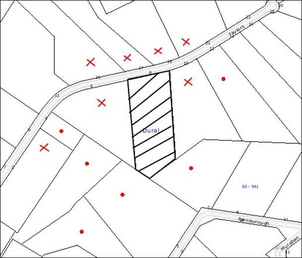
|
NOTIFICATION
PLAN
|
|
|
• PROPERTIES NOTIFIED
|
X SUBMISSIONS
RECEIVED
|

PROPERTY SUBJECT OF DEVELOPMENT
|

|
|
7 SUBMISSIONS RECEIVED
OUT OF MAP RANGE
|
|
|
|
|
Twenty submissions from fourteen
residents objected to the development, generally on the grounds that the
development would result in:
· An office out of character with
the area and detrimental to the streetscape.
· A shed positioned too close to the
street that would detrimentally impact on the streetscape.
· Unacceptable
traffic on Taylors Road and on street parking congestion.
· Unacceptable noise resulting from
the operation of the business and additional cars and trucks on the street.
· Fumes from the painting business
that could pose a risk to nearby residents.
· Detrimental environmental impacts to
the bushland and water course on the site should paints, solvents and other
potentially toxic materials be incorrectly stored, managed and disposed of.
· A fire hazard as a result of the
storage of paints and materials for the business.
· Colourbond fencing along the
western side boundary that would be out of character with the rural
environment.
On 16 December 2009, amended
plans were submitted showing a reduction in the scale of the proposed
residential office and a change in the external appearance of the structure to
be in keeping with the existing dwelling on the site. These recent amendments
were not re-notified to adjoining properties. It is considered that these
amendments address the issues raised with respect to the appearance of the
proposed office. The relocation of the proposed shed also addresses the issues
raised with respect to the impact of the shed on the streetscape.
The merits of the matters raised
in community submissions have been addressed in the body of the report with the
exception of the following:
5.1.1 Additional traffic on local streets
The business would employ two
part time staff to work within the office. The applicant has advised the site
would not be used for a meeting place for contractors or clients, nor would any
deliveries of paints or materials for the purpose of the operation of the
business occur. In this regard, the additional traffic load resulting from two
employees visiting the site is not considered significant.
6. THE PUBLIC INTEREST
Section 79C(1)(e) of the Act
requires Council to consider “the public interest”.
The public interest is an
overarching requirement, which includes the consideration of the matters
discussed in this report. Implicit to the public interest is the achievement
of future built outcomes adequately responding to and respecting the future
desired outcomes expressed in environmental planning instruments and
development control plans.
The application is considered to
have satisfactorily addressed Council’s and relevant agencies’ criteria and
would provide a development outcome that, on balance, would result in a
positive impact for the community. Accordingly, it is considered that the
approval of the proposed development would be in the public interest.
CONCLUSION
The application proposes the construction of a residential
office, a storage shed and front fence at an existing rural property. The
application was significantly amended to satisfy Council’s requirements and
reduce the perceived detrimental impacts of the development.
The proposal has been assessed as satisfactory against the
provisions of the Environmental Planning and Assessment Act 1979, the Hornsby
Shire Local Environmental Plan 1994 and the Rural Lands Development Control
Plan. There is a non compliance with the ‘Setbacks’ element of the Rural Lands
Development Control Plan however this non compliance would not have any
significant impact on adjoining properties or the streetscape and is
acceptable. Subject to conditions the proposed development not result in any
negative social, economic or environmental impacts and is recommended for
approval.
|
Scott Phillips
Executive Manager
Planning Division
|
|
Attachments:
|
1.View
|
Locality Plan
|
|
|
|
2.View
|
Site Plan/Shed
Fence Evaluation
|
|
|
|
3.View
|
Office Floor
Plan/Elevations
|
|
|
File Reference: DA/384/2009
Document Number: D01208518
SCHEDULE 1
GENERAL CONDITIONS
The conditions of consent within this notice
of determination have been applied to ensure that the use of the land and/or
building is carried out in such a manner that is consistent with the aims and
objectives of the planning instrument affecting the land.
Note: For
the purpose of this consent, the term ‘applicant’ means any person who has the
authority to act on or the benefit of the development consent.
Note:
For the purpose of this consent, any reference to an Act, Regulation,
Australian Standard or publication by a public authority shall be taken to mean
the gazetted Act or Regulation, or adopted Australian Standard or publication
as in force on the date that the application for a construction certificate is
made.
1. Approved
Plans and Supporting Documentation
The development must be carried
out in accordance with the plans and documentation listed below and endorsed
with Council’s stamp, except where amended by Council and/or other conditions
of this consent:
|
Plan No.
|
Drawn by
|
Dated
|
|
AO/1209 (Site Plan)
|
NY Solutions Pty Ltd
|
14/12/2009
|
|
AO/1209 – sheet 2A
|
NY Solutions Pty Ltd
|
Revision A-1 dated 14/12/09
|
|
AO/1209 – Sheet 3
|
NY Solutions Pty Ltd
|
14/12/2009
|
|
Document No.
|
Prepared by
|
Dated
|
|
REP-07709-A – ‘On-site
Wastewater Management Report’ for 8 Taylors Road, Dural.
|
EnviroTech
Pty Ltd
|
28
May 2009
|
2. Front
Fence
The front fence is to be no
greater than 1.5 metres in height above natural ground level. To achieve an
open appearance, the width of each opening is to be equal to or greater than
the width of each railing, as marked in red on the approved plans.
3. Rural
Structure
The colour used in the
construction of rural shed is to be a green colour consistent with those shown
in Appendix D of the Rural Lands Development Control Plan.
4. Removal
of Existing Trees
This development consent only
permits the removal of tree numbered T7 (located within the building envelope) as
identified on Site Plan No. AO/1209 prepared by NY Solutions dated 14/12/09.
The removal of any other trees requires separate approval under Council’s Tree
Preservation Order.
REQUIREMENTS PRIOR TO THE ISSUE OF A CONSTRUCTION
CERTIFICATE
The following conditions of consent must be
complied with prior to the issue of a ‘Construction Certificate’ by
either Hornsby Shire Council or an accredited certifier. All necessary
information to demonstrate compliance with the following conditions of consent
must be submitted with the application for a construction certificate.
5. Building
Code of Australia
All building work must be
carried out in accordance with the requirements of the Building Code of
Australia.
6. Contract
of Insurance (Residential Building Work)
In the case of residential
building work for which the Home Building Act, 1989 requires there to be
a contract of insurance in force in accordance with Part 6 of that Act, that
such a contract of insurance is in force before any building work authorised to
be carried out by the consent commences.
Note: This
condition does not apply to the extent to which an exemption is in force under
Clause 187 or 188 of the Act, subject to the terms of any condition or
requirement referred to in Clause 187(6) or 188(4) of the Act, or to the
erection of a temporary building.
7. Notification
of Home Building Act, 1989 Requirements
Residential building work within
the meaning of the Home Building Act, 1989 must not be
carried out unless the principal certifying authority for the development to
which the work relates (not being Council) has given Council written notice of
the following information:
a. In
the case of work for which a principal contractor is required to be appointed:
i. The
name and licence number of the principal contractor.
ii. The
name of the insurer by which the work is insured under Part 6 of that Act.
b. In
the case of work to be done by an owner-builder:
i. The
name of the owner-builder.
ii. If
the owner-builder is required to hold an owner-builder’s permit under that Act,
the number of the owner-builder’s permit.
Note: If
arrangements for doing the residential building work are changed while the work
is in progress so that the information notified becomes out of date, further
work must not be carried out unless the principal certifying authority for the
development to which the work relates (not being Council) has given Council
written notification of the updated information.
REQUIREMENTS PRIOR TO THE COMMENCEMENT OF ANY WORKS
The following conditions of consent must be
complied with prior to the commencement of any works on the site. The
conditions have been imposed to ensure that the works are carried out in such a
manner that complies with relevant legislation and Council’s policies and does
not disrupt the amenity of the neighbourhood or impact upon the environment.
8. Erection
of Construction Sign
A sign must be erected in a
prominent position on any site on which building work, subdivision work or
demolition work is being carried out:
a. Showing
the name, address and telephone number of the principal certifying authority
for the work,
b. Showing
the name of the principal contractor (if any) for any demolition or building
work and a telephone number on which that person may be contacted outside
working hours, and
c. Stating
that unauthorised entry to the work site is prohibited.
Note: Any
such sign is to be maintained while the building work, subdivision work or
demolition work is being carried out, but must be removed when the work has
been completed.
9. Erosion
and Sediment Control
Erosion and sediment control
measures must be provided and maintained throughout the construction period in
accordance with the manual ‘Soils and Construction 2004 (Bluebook)’, the
approved plans, Council specifications and to the satisfaction of the principal
certifying authority. The erosion and sediment control devices must remain in
place until the site has been stabilised and revegetated.
Note: On
the spot penalties up to $1,500 may be issued for any non-compliance with this
requirement without any further notification or warning.
10. Tree
Protection Barriers
Tree protection fencing must be
erected around trees numbered T5, T6, T8, and T9 to be retained at a three
metre setback. The tree fencing must be constructed of 1.8 metre ‘cyclone chainmesh
fence’ or star pickets spaced at 2 metre intervals, connected by a continuous
high-visibility barrier/hazard mesh at a height of 1 metre.
REQUIREMENTS DURING CONSTRUCTION
The following conditions of consent must be
complied with during the construction of the development. The conditions have
been imposed to ensure that the works are carried out in such a manner that
complies with relevant legislation and Council’s policies and does not disrupt
the amenity of the neighbourhood or impact upon the environment.
11. Construction
Work Hours
All
work on site (including demolition and earth works) must only occur between 7am
and 5pm Monday to Saturday.
No
work is to be undertaken on Sundays or public holidays.
12. Works
near Trees
All required tree protection
measures are to be maintained in good condition for the duration of the
construction period.
All works (including driveways
and retaining walls) within four metres of any trees required to be retained
(whether or not on the subject property, and pursuant to this consent or the Tree
Preservation Order), must be carried out under the supervision of an ‘AQF
Level 5 Arborist’ and a certificate submitted to the principal certifying
authority detailing the methods used to preserve the trees.
Note: Except as provided
above, the applicant is to ensure that no excavation, filling or stockpiling of
building materials, parking of vehicles or plant, disposal of cement slurry,
waste water or other contaminants is to occur within 4 metres of any tree to be
retained.
13. Demolition
All demolition work must be
carried out in accordance with Australian Standard 2601-2001 – The
Demolition of Structures and demolition material is to be disposed of to an
authorised recycling and/or waste disposal site and/or in accordance with an
approved waste management plan.
14. Environmental
Management
The site must
be managed in accordance with the publication ‘Managing Urban Stormwater –
Landcom (March 2004) and the Protection of the Environment Operations
Act 1997 by way of implementing appropriate measures to prevent sediment
run-off, excessive dust, noise or odour emanating from the site during the
construction of the development.
15. Landfill
Landfill must
be constructed in accordance with Council’s ‘Construction Specification, 2005’.
All fill material imported to the site is to wholly consist of Virgin Excavated
Natural Material (VENM) as defined in Schedule 1 of the Protection of the
Environment Operations Act 1997 or a material approved under the Department
of Environment and Climate Change’s general resource recovery exemption.
16. Excavated
Material
All excavated material removed
from the site must be classified in accordance with the NSW Environment
Protection Authority’s Environmental Guidelines – Assessment, Classification and
Management of Liquid and Non-Liquid Wastes prior to disposal to an approved
waste management facility and reported to the principal certifying authority.
17. Disturbance
of Existing Site
During construction works, the
existing ground levels of open space areas and natural landscape features,
(including natural rock-outcrops, vegetation, soil and watercourses) must not
be altered unless otherwise nominated on the approved plans.
REQUIREMENTS PRIOR TO THE ISSUE OF AN OCCUPATION
CERTIFICATE
The following conditions of consent must be complied with
prior to the ‘Principal Certifying Authority’ issuing an ‘Occupation
Certificate’ or ‘Subdivision Certificate’
Note: For the
purpose of this consent, any reference to ‘occupation certificate’ shall also
be taken to mean ‘interim occupation certificate’ unless otherwise stated.
18. Fulfilment
of BASIX Commitments
The applicant must demonstrate
the fulfilment of BASIX commitments pertaining to the development.
19. Stormwater
Drainage – Dwellings
The stormwater drainage system
for the development must be designed and constructed for an average recurrence
interval of 20 years and be gravity drained in accordance with the following
requirements:
Roof water is to be
connected to a rainwater tank having a minimum capacity of 3,500 litres (in
addition to any BASIX requirements). The overflow from the rainwater tank and
collected surface water must be disposed of in accordance with Council’s design
specification; “On Site Absorption System”, and the following requirements:
i. The
trench located a minimum of 5 metres from any down stream properties and 1
metre from the side boundaries;
ii. The
trench laid on contour;
iii. The
trench be a minimum of 0.5 metres wide, 0.5 metres deep and 2 metres long for
every 50 square metres of impervious area; and
iv. Overland
flow from the trench be spread evenly over the site so as not to discharge
water in a concentrated manner onto adjoining land.
20. Internal
Driveway/Vehicular Areas
The driveway and parking areas
on site must be designed in accordance with Australian Standards 2890.1,
2890.2, 3727 and the driveway grade must not exceed 25 percent and changes
in grade must not exceed 8 percent.
21. Wastewater
System Approval
An on-site sewage
management system, separately approved under the Local Government Act 1993,
must be installed, commissioned and certified by a licensed plumber in
accordance with Australian Standard 1547 – Onsite Domestic Wastewater
Management (2000) and Environment & Health Protection Guidelines – Onsite
Sewage Management for Single Households (1998).
22. Maintain
Canopy Cover
To maintain canopy cover,
two (2) medium to large trees selected from Council’s booklet ‘Indigenous
Plants for the Bushland Shire’ such as Syncarpia glomulifera
(Turpentine) are to be planted on the subject site. The planning location shall
not be within 4 metres of the foundation walls of a dwelling or in-ground pool.
The pot size is to be a minimum 25 litres and the tree(s) must be maintained
until they reach the height of 3 metres. Trees must be native to Hornsby Shire
and reach a mature height greater than ten metres (10m).
23. Screen
Planting
A screen of trees or shrubs
(minimum mature growth height of 3-4 metres), as listed in Council’s “Indigenous
Plants for the Bushland Shire” publication must be planted to the west of
the proposed residential office in the location nominated in red on the
approved plans.
OPERATIONAL CONDITIONS
The following conditions have been applied to ensure that the
ongoing use of the land is carried out in such a manner that complies with
relevant legislation and Council’s policies and does not disrupt the amenity of
the neighbourhood or impact upon the environment.
24. Use
of Premises
The development approved
under this consent adjacent to the existing dwelling shall be used for a ‘residential
office’ and not for any other purpose without Council’s separate written
consent.
Note:
Pursuant to Clause 23 of the HSLEP, ‘residential office’ is defined as ‘a
dwelling in which an occupation is carried out by the permanent residents of
the dwelling which does not involve any of the following:
(a) the
employment of more than 3 persons other than the permanent residents;
(b) the
interference in any way with the amenity of adjoining properties or the locality
in which the dwelling is situated;
(c) the
exhibition of any notice; advertisement or sign (other than a notice or sign
which would fit within a rectangular figure 1.2 metres in length and 0.6 metres
in height and exhibited on that dwelling or land to indicate the name and
occupation of the resident);
(d) exposure
to view from any public place or any matter, except as provided by paragraph
(c);
(e) a
change in the appearance of the dwelling or the land on which it is erected out
of character with that of the adjoining land;’
25. Operation
of Painting business
No painting work for the
purpose of the business is to be carried out on site. Paints or other materials
used in association with the business must not be stored or disposed of on
site. The site must not be used as a display room or meeting place for painting
contractors or clients.
26. Use
of Shed
The shed approved under
this consent shall only be used as a ‘rural structure’ and not for any other
purpose without Council’s separate written consent. The shed must not to be
used for the storage of paints, materials or any other items in association
with the business.
27. Hours
of Operation
The hours of operation of
the residential office are restricted to those times listed below:
Monday to Saturday 7 am to 6 pm
Sunday
& Public Holidays No work
28. Noise
All noise generated by the
residential office must be attenuated to prevent levels of noise being emitted
to adjacent premises which possess tonal, beating and similar characteristics
or which exceeds background noise levels by more than 5dB(A).
CONDITIONS OF CONCURRENCE – NSW RURAL FIRE
SERVICE
The following conditions of consent are from the nominated
State Agency pursuant to Section 79B of the Environmental Planning and
Assessment Act 1979 and must be complied with to the satisfaction of that
Agency.
29. Design
and Construction
All
proposed Class 10 structures as defined per the ‘Building Code of Australia’
2006 attached to or within 10 metres of the habitable building must comply with
Australian Standard AS3959-1999 ‘Construction of buildings in bush fire-prone
areas’ Level 1.
-
END OF CONDITIONS -
ADVISORY NOTES
The following information is provided for your
assistance to ensure compliance with the Environmental Planning and Assessment
Act 1979, Environmental Planning and Assessment Regulation 2000, other relevant
legislation and Council’s policies and specifications. This information does
not form part of the conditions of development consent pursuant to Section 80A
of the Act.
Environmental Planning and Assessment Act, 1979
Requirements
· The Environmental Planning and
Assessment Act, 1979 requires:
· The issue of a construction
certificate prior to the commencement of any works. Enquiries regarding the
issue of a construction certificate can be made to Council’s Customer Services
Branch on 9847 6760.
· A principal certifying authority
to be nominated and Council notified of that appointment prior to the
commencement of any works.
· Council to be given at least two
days written notice prior to the commencement of any works.
· Mandatory inspections of nominated
stages of the construction inspected.
· An occupation certificate to be
issued before occupying any building or commencing the use of the land.
Long Service Levy
In accordance with Section 34 of the Building and
Construction Industry Long Service Payments Act 1986, a ‘Long Service Levy’ must be paid to the Long Service
Payments Corporation or Hornsby Council.
Note: The
rate of the Long Service Levy is 0.35% of the total cost of the work.
Note: Hornsby
Council requires the payment of the Long Service Levy prior to the issue of a
construction certificate.
Tree Preservation Order
To ensure the maintenance and protection of the existing
natural environment, it is an offence to ringbark, cut down, top, lop, remove,
wilfully injure or destroy a tree outside 3 metres of the approved building
envelope without the prior written consent from Council.
Note: A
tree is defined as a single or multi-trunked wood perennial plant having a
height of not less than three (3) metres, and which develops many branches,
usually from a distance of not less than one (1) metre from the ground, but
excluding any plant which, in its particular location, is a noxious plant
declared as such pursuant to the Noxious Weeds Act 1993. This definition of ‘tree’
includes any and all types of Palm trees.
All
distances are determined under British Standard BS 5837: 2005, “Trees in
Relation to Construction – Recommendations”.
Fines may be imposed for non-compliance with Council’s Tree
Preservation Order.
Disability Discrimination Act
The applicant’s attention is drawn to the existence of the Disability
Discrimination Act. A construction certificate is required to be obtained
for the proposed building/s, which will provide consideration under the Building
Code of Australia, however, the development may not comply with the
requirements of the Disability Discrimination Act. This is the sole
responsibility of the applicant.
Covenants
The land upon which the subject building is to be
constructed may be affected by restrictive covenants. Council issues this
approval without enquiry as to whether any restrictive covenant affecting the
land would be breached by the construction of the building, the subject of this
consent. Applicants must rely on their own enquiries as to whether or not the
building breaches any such covenant.
Dial Before You Dig
Prior to commencing any works, the applicant is encouraged
to contact Dial Before You Dig on 1100 or www.dialbeforeyoudig.com.au for
free information on potential underground pipes and cables within the vicinity
of the development site.
Asbestos Warning
Should asbestos or asbestos products be encountered during
demolition or construction works you are advised to seek advice and information
should be prior to disturbing the material. It is recommended that a contractor
holding an asbestos-handling permit (issued by WorkCover NSW) be engaged
to manage the proper handling of the material. Further information regarding the
safe handling and removal of asbestos can be found at:
www.environment.nsw.gov.au
www.nsw.gov.au/fibro
www.adfa.org.au
www.workcover.nsw.gov.au
Alternatively, telephone the WorkCover Asbestos and
Demolition Team on 8260 5885.
Planning Report No. PLN107/09
Date of Meeting:
3/02/2010
2 DEVELOPMENT APPLICATION
- EDUCATIONAL ESTABLISHMENT AND CHILD CARE CENTRE 1 - 25 CLARKE ROAD AND 1 - 3 MARILLIAN AVENUE, WAITARA AND NOS. 28A, 30, 30A AND 32A UNWIN ROAD WAHROONGA
|
Development Application No:
|
DA/83/2009
|
|
Description of Proposal:
|
Demolition of existing structures and construction of
an educational establishment and child care centre.
|
|
Property Description:
|
Lot 1 DP 519826, Lot 2 DP 8245, Lot 3 DP 8245, Lot 4
DP 8245, Lot 5 DP 951017, Lot 6 DP 8245, Lot 7 DP 8245, Lot 8 DP 8245, Lot 9
DP 8245, Lot 10 DP 8245, Lot 2 DP 226796, Lot 1 DP 226796, Lot 11 DP 635739,
Lot 12 DP 635739, Lot 4 DP 226796, Lot 3 DP 564798, Lot 2 DP 528800, Lot 4 DP
236907 and Lot 6 DP 236907, Nos. 1-25 Clarke Road & Nos. 1-3 Marillian
Avenue, Waitara and Nos. 28A, 30, 30A & 32A Unwin Road, Wahroonga
|
|
Applicant:
|
The Council of Barker College
|
|
Owner:
|
Barker College
|
|
Statutory Provisions:
|
Hornsby Shire Local Environmental
Plan 1994
Residential A (Low Density)
|
|
Estimated Value:
|
$12,092,000
|
|
Ward:
|
B
|
|
RECOMMENDATION
THAT Development Application
No. 83/2009 for demolition of existing structures and construction of an educational
establishment and child care centre at Lot 1 DP 519826, Lot 2 DP 8245, Lot 3
DP 8245, Lot 4 DP 8245, Lot 5 DP 951017, Lot 6 DP 8245, Lot 7 DP 8245, Lot 8
DP 8245, Lot 9 DP 8245, Lot 10 DP 8245, Lot 2 DP 226796, Lot 1 DP 226796, Lot
11 DP 635739, Lot 12 DP 635739, Lot 4 DP 226796, Lot 3 DP 564798, Lot 2 DP
528800, Lot 4 DP 236907 and Lot 6 DP 236907, Nos. 1-25 Clarke Road and Nos.
1-3 Marillian Avenue, Waitara and Nos. 28A, 30, 30A & 32A Unwin Road,
Wahroonga be approved subject to the conditions of consent detailed in
Schedule 1 of this report.
|
1. The
application proposes the demolition of existing structures and the construction
of an educational establishment and child care centre.
2. The
proposal complies with the requirements of Hornsby Shire Local Environmental
Plan 1994 and the relevant Development Control Plans.
3. Six
submissions have been received in respect of the application.
4. It
is recommended that the application be approved
THE SITE
The site comprises 19 allotments
and covers an area of approximately 1.8 hectares. The site has a frontage of
192 metres to Clarke Road, 114 metres to Marillian Avenue and 64 metres to Unwin Road.
Existing development on the site
comprises predominantly single storey dwellings on each of the allotments
except for Nos. 1 and 1A Marillian Avenue which contain two storey dwellings
and No. 17 Clarke Road which is vacant and planted with grape vines, vegetable
gardens and orchard trees.
The site has an average slope of
1:15 from Clarke Road down to the south and south-east and contains a mix of
exotic and native trees.
Residential development is
located south, east and west of the site and the main campus of Barker College is located to the north of the site.
THE PROPOSAL
The application proposes the
demolition of a number of the existing buildings and erection of an early
learning centre (ELC) comprising an educational establishment and child care
centre. A description of the proposed works is provided below.
The development is located mainly
on the western part of the site and involves demolition of nine cottages (Nos. 11-25 Clarke Road and Nos. 1, 1A and 3 Marillian Avenue). No. 9 Clarke Road would be
retained in its existing format and used for caretaker’s accommodation and for
archive and storage of ELC records and materials.
The five existing cottages Nos. 1-7 Clarke Road would be retained in their existing form for use as staff housing and
potential future development. The rear 10 metres of these existing allotments
would be excised and used for the main access drive to the ELC off Unwin Road.
Nos. 28A, 30, 30A and 32A Unwin Road would also be retained for potential future development. A strip along the
northern and western boundary of No. 28A would be excised and used for parking
and landscaping of the ELC, together with a small triangular corner of No. 30 Unwin Road. Nos. 30A and 32A are unaffected by the development.
The ELC comprises three main
elements:
· Pre-school childcare
centre;
· Infants school
(kindergarten - Year 2); and
· Out of school hours
(OOSH) infants and junior care facility.
The proposed development
generally has a V-shaped form oriented east-west on the site, with the space
inside the V occupied by a roofed piazza.
The child care centre occupies
the eastern part of the development and the infants school the western part,
these being divided by the main pedestrian access from Clarke Road and
connecting through to the main Barker College campus.
The child care centre comprises
four activity rooms (1 x age 0-2, 1 x age 2-3 and 2 x age 3-5), an atelier (art
and craft studio), kitchen and administration rooms, all at the level of Clarke Road.
The infants’ school to the west
of the child care centre comprises a library, central administration building,
two kindergarten classrooms and four classrooms for Years 1-2. It is
anticipated that 120 children will attend Years K-2 at the campus.
The development is on two levels
to accommodate the slope of the site, with the buildings on eastern part of the
development built over a basement carpark. From the lower ground car park
level, access is gained to the ground level via a circular ‘tree walk’ ramp or
via stairs and lift within the central administration building.
The applicant proposes to stage
the development as follows:
Stage 1 Construction of the entry and accessway off Unwin Road and construction the parking areas and drop off and pick-up zone and provision of
demountable buildings for use by Kindergarten, Year 1 and Year 2. The boundary
adjustment for proposed Lots A, B, C, D, E and 2 would also be undertaken at
this time.
Stage 2 Construction of the permanent building for
Kindergarten, Year 1 and Year 2 and the administration block.
Stage 3 Construction of the child care centre.
ASSESSMENT
The development application has
been assessed having regard to the ‘2005 City of Cities Metropolitan
Strategy’, the ‘North Subregion (Draft) Subregional Strategy’ and
the matters for consideration prescribed under Section 79C of the Environmental
Planning and Assessment Act 1979 (the Act). Subsequently, the following
issues have been identified for further consideration.
1. STRATEGIC CONTEXT
1.1 Metropolitan Strategy – (Draft) North Subregional Strategy
The Metropolitan Strategy is a
broad framework to secure Sydney’s place in the global economy by promoting and
managing growth. It outlines a vision for Sydney to 2031; the challenges
faced, and the directions to follow to address these challenges and achieve the
vision. The draft North Subregional Strategy acts as a framework for Council
in the preparation of a new Principal LEP by 2011.
The draft Subregional Strategy
sets the following targets for the Hornsby LGA by 2031:
· Employment capacity
to increase by 9,000 jobs; and
· Housing stock to
increase by 11,000 dwellings.
The proposed development would be
consistent with the draft Strategy by providing additional jobs in the
locality.
2. STATUTORY CONTROLS
Section 79C(1)(a) requires
Council to consider “any relevant environmental planning instruments, draft
environmental planning instruments, development control plans, planning
agreements and regulations”.
2.1 Hornsby Shire Local
Environmental Plan 1994
The subject land is zoned Residential A (Low Density) under
Hornsby Local Environmental Plan 1994 (HSLEP). The objectives of the zone are:
(a) to
provide for the housing needs of the population of the Hornsby area.
(b) to
promote a variety of housing types and other land uses compatible with a low
density residential environment.
(c) to
provide for development that is within the environmental capacity of a low
density residential environment.
The proposed development is defined as ‘educational
establishment’ and ‘child care centre’ under the HSLEP and is
permissible in the zone with Council’s consent.
Clause 15 of HSLEP prescribes
that the maximum floor space ratio (FSR) of development within the Residential
A (Low Density) zone is 0.4:1. The proposed development complies with this
requirement.
Clause 18 of HSLEP sets out
heritage conservation provisions within the Hornsby area. The property is
within the vicinity of properties No. 1A Clarke Road (house) and Nos. 27-31 Clarke Road, Waitara (house and garden) which are listed as heritage items of local
significance under the provisions of Schedule D (Heritage Items) of the HSLEP.
The property is also within the vicinity of the Barker College Heritage
Conservation Area listed under the provisions of Schedule E (Heritage
Conservation Areas) of the HSLEP.
At its meeting on 2 March 2009,
the Heritage Advisory Committee commented that the proposal is adequately
separated from the heritage listed property at Nos. 27-31 Clarke Road and
located a sufficient distance from the heritage item at No. 1A Clarke Road that the proposal would not have an adverse impact upon the significance of
these properties. Furthermore, the proposal is commensurate in its use and
scale to the adjacent Barker College Heritage Conservation Area. Accordingly,
the Committee resolved that no objections be raised to the proposal on heritage
grounds.
2.2 State Environmental
Planning Policy (Infrastructure) 2007
The application was referred to
the RTA pursuant to Clause 104 of the Infrastructure SEPP as Schedule 3 applies
to educational establishments that accommodate 50 or more students. The
application was considered by the Sydney Regional Development Advisory
Committee (SRDAC) on 11 March 2009 which raised no objections to the proposed
development subject to the imposition of conditions, detailed in Schedule 1.
2.3 State Environmental
Planning Policy No. 44 – Koala Habitat
State Environmental Planning
Policy No 44 (SEPP 44) applies to land that has, together with any adjoining
land in the same ownership, an area of more than 1 hectare, whether or not the
development application applies to the whole, or only part, of the land.
The subject site has an area of
approximately 1.8 hectares. Accordingly, Council is required to consider
whether the land is a potential core koala habitat.
The site has long been developed
for residential purposes and is largely cleared with isolated remnant native
forest trees in some rear yards. The site does not contain any potential
habitat for koalas and no further assessment is required under the provisions
of SEPP 44.
2.4 State Environmental Planning Policy No. 55 – Remediation
of Land
The application has been assessed
against the requirements of State Environmental Planning Policy No. 55.
This Policy provides State-wide planning controls to promote the remediation of
contaminated land to reduce the risk of harm to human health and the
environment.
Historical information and an
inspection of the site and surrounding areas indicates that the site has been
used for residential purposes and there is no known history of uses that might
result in soil contamination such as industry, commercial horticulture or
agricultural purposes
The site contamination report
submitted with the application states that based on the historical review, site
inspection and laboratory analysis of the soil samples, there appears no
reasonable grounds upon which to suspect that any significant soil
contamination exists on the site and that no remedial works are deemed
necessary.
2.5 Sydney Regional Environmental Plan No. 20 – Hawkesbury Nepean River
The site is located within the
catchment of the Hawkesbury River. Any development works associated with the
construction of the proposed development have the potential to impact on the
integrity of downstream watercourses. The proposal involves works that would
require specific conditions to be imposed regarding erosion and sediment
control measures. These are addressed in Schedule 1.
2.6 Community Uses Development Control Plan
The proposed ‘educational
establishment’ and ‘child care centre’ component of the development
has been assessed having regard to the relevant performance and prescriptive
design standards within Council’s Community Uses Development Control Plan
(Community Uses DCP). The following table sets out the proposal’s compliance
with the prescriptive standards of the Plan:
|
Community Uses
Development Control Plan
|
|
Control
|
Proposal
|
Requirement
|
Compliance
|
|
Site Area
|
10,876m2
|
500m2
|
Yes
|
|
Floor Area
|
2369m2
|
N/A
|
N/A
|
|
FSR
|
0.22:1
|
0.4:1
|
Yes
|
|
Height
|
4.2m - 7.4m
|
9m
|
Yes
|
|
Recreation Space
- Educational
establishment (20m2 per student)
- Child
care: Outdoor (7m2 per child)
- Child
care: Indoor (3.25m2 per child)
|
2405m2
1237m2
450m2
|
2400m2
462m2
214.5m2
|
Yes
Yes
Yes
|
|
Landscaping
|
56%
|
45%
|
Yes
|
|
Car Parking
|
70 spaces
|
30 spaces
|
Yes
|
|
Setbacks
- Clarke
Road
- Unwin
Road
- Marillian
Avenue
- Southern
boundary
|
12-16.5m
84m
6m
23.5m
|
6m
6m
6m
1m
|
Yes
Yes
Yes
Yes
|
As detailed in the above table,
the proposed development complies with the prescriptive standards contained
within Council’s Community Uses DCP. A brief discussion on compliance with
relevant performance standards is provided below.
2.6.1 Maximum Size of Child Care Centres
The ‘density element’ of
the Community Uses DCP states that child care centres on land zoned Residential
should be limited to 50 children of which no more than 30 should be in the 2
years and over age group. The proposed development is for 66 children,
including 56 aged 2 years or over, which exceeds the level recommended by the
DCP.
The objective of the prescriptive
measure is to maintain the character of residential areas and minimise the
impact of noise on adjacent properties.
The proposed child care centre is
located within the centre of the site away from adjoining residential
development and opposite the main Barker campus. Notwithstanding that the
current proposal is for 66 children, the environmental capacity of the site
would readily cater to 80 children, whilst satisfying the requirements for
recreation space and car parking on-site and would not have a detrimental
acoustic impact on the locality. (Further discussion on the acoustic impact of
the proposal is provided in Section 2.6.8 under the heading ‘Acoustics’.) It
is considered that the scale of the development is in keeping with the low
density scale of the surrounding residential development and the proposed
increase in the number of children for the proposed child care centre to 80
children is considered appropriate in the circumstances of the case.
2.6.2 Site Cover
Under the DCP, site coverage
should not exceed 40% of the site area. The performance criteria states that
site coverage should allow adequate areas for access, car parking, landscaping
and useable outdoor recreation. Furthermore, the area of the site covered by
impervious surfaces (including roofed areas, paving, driveways etc) should be
minimised to reduce stormwater runoff from the site.
Approximately 33% of the site is
to be used as open space for recreation by both the educational establishment
and the child care centre. Furthermore over 50% of the site is proposed to be
landscaped. Accordingly, the proposed development will not exceed the maximum
site coverage requirement of 40%.
2.6.3 Masterplan
The ‘density element’ of
the Community Uses DCP requires applications for special use developments to be
accompanied by a masterplan.
The school submitted a masterplan
in 1998 for consideration in the assessment of the Science Building (DA/393/1998) and the masterplan was updated in 2005. The masterplan whilst primarily
for the main campus includes the adjacent sites owned by Barker College in Clarke Road. The siting of the proposed ELC is generally consistent with the intent
of the masterplan to redevelop the land for educational facilities.
2.6.4 Site Selection
The ‘Site
Selection’ element of the Community Uses DCP aims to provide site selection
criteria that will encourage the location of special use developments on sites
with the lowest potential social and environmental impacts.
The site
adjoins the main campus of Barker College and is well served by train and bus
services. The proposed ELC site is large enough to provide extensive
recreation areas and adequate car parking for the proposed school population.
Accordingly, the site’s attributes are considered conducive
to the proposed development.
2.6.5 Parking and Access
Under the DCP, the proposed
development would require 30 car spaces. The application has been supported by
a Traffic and Parking Report and the proposal includes 70 spaces and provision
for a vehicle drop-off/pick up area located within the site.
Resident submissions received
raise concerns with regards to the proposed access arrangements and traffic
impacts on Clarke Road and Unwin Road with particular regard to traffic queuing
and on-street car parking.
·
The SIDRA analysis contained within the submitted Traffic and
Parking Report indicates that operation of intersections in the area would be
affected by the proposed ELC during the morning and afternoon peak periods,
however the current level of service at most intersections would not change
over a one hour period. The Level of Service (LOS) at the intersection of Unwin
Road and Clarke Road would change from LOS A to LOS B in the AM peak hour period.
LOS B is considered acceptable for stop sign control which currently exists at
the intersection.
·
Peak volumes distributed over one hour period in the simulation
suggest queuing in Unwin Road extending 95 metres south of the Pacific Highway
(with development). Council staff observations of queues in excess of 200
metres at this location have been confirmed with residents reporting queues
reaching Clarke Road to be more common. These extensive queues observed on site
by staff and residents represent the 15 minute peak generated by combination of
existing educational establishments in the immediate area. Whilst this
congestion and queuing would further increase with the development, designing a
road network to cater for the 15 minute peak is not standard practice as the
congestion is averaged over a one hour period.
Officers assessment of the
proposal concluded that parking needs were currently met, and that traffic
generated by this development would not adversely affect the local road
network,
2.6.6 Design
The Community Uses DCP does not
prescribe a height control for the land zoned Residential A and Special Uses
A. Notwithstanding, the proposed development would emulate the overall bulk,
height and scale of adjoining residential development.
Submissions received raise
concerns with regards to the proposed design of the building fronting Marillian Avenue and that it is unsympathetic with the streetscape.
The development comprises two
arms arranged in a V-shaped formation. The elevation to Clarke Road has been
modulated to present as a series of smaller buildings with similar scale and
spacing as the existing cottages.
The design of the buildings
employing raked roofing and high level glazing reflects contemporary domestic
architecture of modern homes and high density residential development in the
surrounding area.
The two buildings which front Marillian Avenue are single storey in height, are articulated and have a width of 10.6
metres and 20.2 metres, respectively. The proposed landscaping works include
trees and shrubs which will screen the buildings.
The proposal complements the
existing Barker College Campus and adjoining residential development and would
not have a detrimental impact upon the existing streetscape of Marillian Avenue or Clarke Road.
2.6.7 Landscaping
Submissions received raise
concerns with regards to the proposed landscaping of the development.
The ‘landscaping’ element
of the Community Uses DCP requires 45% of the site to be landscaped. The
proposed development exceeds the minimum required landscape area. A landscape
buffer of approximately 5 metres in width surrounds the development, which
exceeds the minimum of 2 metres prescribed in this element. The development
aims to retain a number of the existing large trees to provide a suitable
landscape setting for the buildings.
2.6.8 Acoustics
Submissions raised concern
regarding potential acoustic impacts arising from the operation of the child
care centre and educational establishment.
Whilst it is recognised that
there would be some increase in noise associated with an increase in
development on the site, it is considered that the noise increase would not be
significant as to warrant refusal of the application in itself. Noise
restrictions are set out in the Protection of the Environment Operations Act
1997 and noise generated by the development could be reasonably managed on
site.
The proposed child care centre
and educational establishment are set well back from the boundaries and are
located adjacent to a long established school. They do not present any
significant potential to increase noise arising from operation of the school.
Furthermore,
an Acoustic Assessment Report for the proposed ELC was submitted with the
application, and subject to compliance with the recommendations of the acoustic
report and conditions contained in Schedule 1, the proposal is considered
satisfactory with respect to potential acoustic impacts.
2.6.9 Solar Access
The development is centrally
positioned on the site and is set well back from private boundaries. The
single and two storey building height ensures that no overshadowing of
neighbouring properties would occur.
2.6.10 Crime Prevention
The proposed development has been
designed to minimise crime in accordance with Crime Prevention through
Environmental Design (CPTED) principles by way of clear sightlines, windows
that overlook the street, suitable pedestrian access for the users of the
school and clearly defined building entry and access.
The proposal complies with the
Community Uses DCP crime prevention element objective.
2.7 Residential Subdivision Development Control Plan
The proposed development has been
assessed having regard to the relevant performance and prescriptive design
standards within Council’s Residential Subdivision Development Control Plan
(Residential Subdivision DCP). The following table sets out the proposal’s
compliance with the prescriptive standards of the Plan:
|
Residential
Subdivision Development Control Plan
|
|
Control
|
Proposal
|
Requirement
|
Compliance
|
|
Site Area by Allotments
- Lot A
(Early Learning Centre)
- Lot B (7 Clarke Road )
- Lot C (5 Clarke Road )
- Lot D (3 Clarke Road )
- Lot E (1 Clarke Road )
- Lot 2 (28A Unwin Road - exc. access handle)
|
13468m2
612m2
620m2
620m2
632m2
917m2
|
500m2
500m2
500m2
500m2
500m2
500m2
|
Yes
Yes
Yes
Yes
Yes
Yes
|
|
Floor Area
- Lot A
(Early Learning Centre)
- Lot B (7 Clarke Road )
- Lot C (5 Clarke Road )
- Lot D (3 Clarke Road )
- Lot E (1 Clarke Road )
- Lot 2 (28A Unwin Road)
|
2369m2
130m2
100m2
130m2
110m2
150m2
|
N/A
N/A
N/A
N/A
N/A
N/A
|
N/A
N/A
N/A
N/A
N/A
N/A
|
|
FSR
- Lot A
(Early Learning Centre)
- Lot B (7 Clarke Road )
- Lot C (5 Clarke Road )
- Lot D (3 Clarke Road )
- Lot E (1 Clarke Road )
- Lot 2
(28A Unwin Road)
|
0.22:1
0.21:1
0.16:1
0.21:1
0.17:1
0.16:1
|
0.4:1
0.4:1
0.4:1
0.4:1
0.4:1
0.4:1
|
Yes
Yes
Yes
Yes
Yes
Yes
|
|
Height
- Early
Learning Centre
- Dwellings
on remaining lots
|
4.2m - 7.4m
unchanged
|
9m
|
Yes
|
|
Private Open Space
- Lot B (7 Clarke Road )
- Lot C (5 Clarke Road )
- Lot D (3 Clarke Road )
- Lot E (1 Clarke Road )
- Lot 2 (28A Unwin Road)
|
240m
264m
268m
>200m
>200m
|
120m
120m
120m
120m
120m
|
Yes
Yes
Yes
Yes
Yes
|
|
Landscaping
- Lot A
(Early Learning Centre)
- Lot B (7 Clarke Road )
- Lot C (5 Clarke Road )
- Lot D (3 Clarke Road )
- Lot 3 (1 Clarke Road )
- Lot 2 (28A Unwin Road)
|
56%
58%
60%
60%
69%
>45%
|
45%
45%
45%
45%
45%
45%
|
Yes
Yes
Yes
Yes
Yes
Yes
|
|
Car Parking
- Lot A
(Early Learning Centre)
- Lot B (7 Clarke Road )
- Lot C (5 Clarke Road )
- Lot D (3 Clarke Road )
- Lot E (1 Clarke Road )
- Lot 2
(28A Unwin Road)
|
70 spaces
2 spaces
2 spaces
2 spaces
2 spaces
2 spaces
|
30 spaces
2 spaces
2 spaces
2 spaces
2 spaces
2 spaces
|
Yes
Yes
Yes
Yes
Yes
Yes
|
|
Setbacks
Lot A (Early Learning
Centre)
- Clarke
Road
- Unwin
Road
- Marillian
Avenue
- Southern
boundary
Lot B (7 Clarke Road)
- Clarke
Road
- East
(side)
- West
(side)
- South
(rear)
Lot C (5 Clarke Road)
- Clarke
Road
- East
(side)
- West
(side)
- South
(rear)
Lot D (3 Clarke Road)
- Clarke
Road
- East
(side)
- West
(side)
- South
(rear)
Lot E (1 Clarke Road)
- Clarke
Road
- Unwin
Road
- West
(side)
- Southern
(side)
Lot 2 (28A Unwin Road)
- Unwin
Road
- North
(side)
- South
(side)
- West
(rear)
|
12-16.5m
84m
6m
23.5m
Unchanged
Unchanged
Unchanged
15.5m
Unchanged
Unchanged
Unchanged
16m
Unchanged
Unchanged
Unchanged
16.5m
Unchanged
Unchanged
Unchanged
21.5m
Unchanged
Unchanged
Unchanged
15m
|
6m
6m
6m
1m
6m
1m
1m
3m
6m
1m
1m
3m
6m
1m
1m
3m
6m
6m
1m
1m
6m
1m
1m
3m
|
Yes
Yes
Yes
Yes
Yes
Yes
Yes
Yes
Yes
Yes
Yes
Yes
Yes
Yes
Yes
Yes
Yes
Yes
Yes
Yes
Yes
Yes
Yes
Yes
|
As detailed in the above table,
the proposed development complies with the prescriptive standards contained
within Council’s Residential Subdivision DCP. The relevant performance
standards of the Residential Subdivision DCP are consistent with those
contained in the Community Uses DCP and have been addressed in Section 2.6
above.
2.8 Car Parking Development Control Plan
The primary purpose of this
DCP is to provide parking controls for the development.
A total of 70 car parking
spaces are proposed on site. The car parking rate for educational
establishments is one car parking space per full time teacher, accordingly, 10
car parking spaces are required. The car parking rate for child care centres
is one car parking space per four children, resulting in 20 car parking spaces
being required. The proposed development
includes provision for a further 40 car parking spaces on-site which well
exceeds the minimum car parking requirements of the DCP.
2.9 Access and Mobility Development Control Plan
The objective of this DCP is to
ensure that new development is accessible and usable by all people in Hornsby
Shire, including those people with disabilities. The applicant submitted an
Access Report prepared by ‘Morris-Goding Accessibility Consulting’. The
application proposes a continuous path of travel and incorporates disabled
toilets and a lift between floors in the two storey building.
2.10 Waste Minimisation and
Management Development Control Plan
The primary purpose of this
Development Control Plan is to provide planning strategies and controls to
promote waste minimisation and management. The applicant has submitted a waste
management plan in accordance with the requirements of the DCP.
Council’s waste assessment of the
proposal noted that vehicle turning paths have been provided for a 10.5m medium
rigid vehicle turning on site. The swept path analysis indicates that the
driveway/turning area would need to be modified at several points to
accommodate waste collection vehicles. The turning path of waste collection
vehicles makes use of several car parking spaces, hence service timing and
parking restrictions would need to be carefully managed to ensure services are
not prevented by parked cars, and trucks are not forced to reverse in or out of
the site.
The bin collection point would be
completed in Stage 1 and interim bin storage areas would be established prior
to completion of Stages 1 and 2. Bin storage and collection arrangements for
each of the three stages are adequate.
Conditions are recommended for
implementation of the Waste Management Plan, for the construction of the
development to be carried out in accordance with Council’s waste minimisation
and management guidelines, for the bin collection point to be suitably screened
and for the internal layout of the driveway to be redesigned so that waste
vehicles can be accommodated on-site.
2.11 Sustainable Water
Development Control Plan
The objective of this DCP is to
ensure the sustainability of water as a renewable resource and adopt the
principles of Ecologically Sustainable Development to achieve this goal. The
development site is not located in close proximity to an existing creek.
Recommended conditions of consent address erosion and sediment control and
stormwater management.
3. ENVIRONMENTAL IMPACTS
Section 79C(1)(b) of the Act
requires Council to consider “the likely impacts of that development,
including environmental impacts on both the natural and built environments, and
social and economic impacts in the locality”.
3.1 Natural Environment
The site comprises a number of exotic, native planted trees
and locally indigenous specimens.
The proposed development would
necessitate the removal of 24 trees from the site. The application has been
supported by an Arborist Report and Council’s assessment of the proposal
concluded that no trees which would be removed or adversely affected are
considered to be significant. Furthermore, the
proposed landscaping works would ensure that local tree canopy cover is
maintained after the completion of the works.
3.2 Built Environment
The development would not have an
adverse visual impact as the buildings are not in a visually sensitive location
and the view from land used for residential purposes would be moderated by
distance. The bulk of the development would be single storey, with one two
storey building which is consistent with adjoining residential development.
3.3 Social Impacts
The proposed child care centre
would provide an extra 66 child care spaces in the locality and the development
would make a positive social contribution to the local community by providing a
modern educational establishment with improved facilities to service the needs
of the school community.
3.4 Economic Impacts
The proposed development would
not have a negative economic impact on the locality.
4. SITE SUITABILITY
Section 79C(1)(c) of the Act
requires Council to consider “the suitability of the site for the
development”.
There is no known hazard/risk
associated with the site with respect to bushfire, landslip, subsidence and
flooding that would preclude approval of the proposed development and the
attributes of the site are conducive to the proposed development.
5. PUBLIC PARTICIPATION
Section 79C(1)(d) of the Act
requires Council to consider “any submissions made in accordance with this
Act”.
5.1 Community Consultation
The proposed development was
placed on public exhibition and was notified to adjoining and nearby landowners
between 3 February 2009 and 5 March 2009 in accordance with Council’s
Notification and Exhibition Development Control Plan. During this period,
Council received six submissions. The map below illustrates the location of
those nearby landowners who made a submission that are in close proximity to
the development site.
|
NOTIFICATION
PLAN
|
|
|
• PROPERTIES NOTIFIED
|
X SUBMISSIONS
RECEIVED
|
PROPERTY SUBJECT OF DEVELOPMENT
|
|
|
|
|
|
Six submissions objected to the
development, generally on the following grounds that the development would
result in:
· Unacceptable traffic
on local streets;
· Access and Parking
impacts;
· Acoustic impacts;
· Design of the building
fronting Marillian Avenue;
· Demolition of existing
dwellings at Nos. 1 and 3 Marillian Avenue;
The merits of the matters raised
in community submissions have been addressed in the body of the report with the exception of the following:
5.1.1 Demolition of existing dwellings at No. 1 and 3 Marillian Avenue
The submission raised concerns
that the proposed development includes the demolition of the existing dwellings
at Nos. 1 and 3 Marillian Avenue, which the writer considers are in
‘immaculate’ condition and would provide accommodation in the current housing
shortage. Notwithstanding, the location of the dwellings is required to provide
the necessary recreation space for the ELC and adequate landscaping and
screening for the development and surrounding properties. Accordingly, the
concerns raised do not warrant refusal of the application.
5.2 Public Agencies
As stated previously in the
report, the application was referred to the RTA pursuant to Clause 104 of the
Infrastructure SEPP. The application was considered by the Sydney Regional
Development Advisory Committee (SRDAC) and no objections were raised to the
proposed development.
6. THE PUBLIC INTEREST
Section 79C(1)(e) of the Act
requires Council to consider “the public interest”.
The public interest is an
overarching requirement, which includes the consideration of the matters
discussed in this report. Implicit to the public interest is the achievement
of future built outcomes adequately responding to and respecting the future
desired outcomes expressed in environmental planning instruments and
development control plans.
The application is considered to
have satisfactorily addressed Council’s and relevant agencies’ criteria and
would provide a development outcome that, on balance, would result in a
positive impact for the community. Accordingly, it is considered that the
approval of the proposed development would be in the public interest.
CONCLUSION
The
application proposes demolition of existing structures and construction of an
educational establishment and child care centre adjacent to the main campus of Barker College.
The proposal
is consistent with the relevant aims and objectives contained within the
relevant State and Regional Environmental Planning Policies, the Hornsby Shire
Local Environmental Plan 1994, and the Development Control Plans which are
applicable to the site.
The development
is unlikely to result in any significant impacts upon the natural or built
environments, or have any negative social or economic impacts. The development
provides for improved educational and child care facilities for the school and
broader community. Given this, and the recommended conditions, it is
recommended that the application be approved.
Note: At the time of the completion of this planning
report, no persons have made a Political Donations Disclosure Statement pursuant
to Section 147(3) of the Environmental Planning and Assessment Act 1979 in
respect of the subject planning application.
|
Scott Phillips
Executive Manager
Planning Division
|
|
Attachments:
|
1.View
|
Locality Plan
|
|
|
|
2.View
|
Subdivision Plan
|
|
|
|
3.View
|
Staging Plan
|
|
|
|
4.View
|
Site/Floor Plans
|
|
|
|
5.View
|
Elevations and
Sections
|
|
|
|
6.View
|
Landscape Plan
|
|
|
File Reference: DA/83/2009
Document Number: D01309575
SCHEDULE 1
GENERAL
CONDITIONS
The conditions of consent within this notice of determination have
been applied to ensure that the use of the land and/or building is carried out
in such a manner that is consistent with the aims and objectives of the
relevant legislation, planning instruments and Council policies affecting the
land and does not disrupt the amenity of the neighbourhood or impact upon the
environment.
Note: For the
purpose of this consent, the term ‘applicant’ means any person who has the
authority to act on or the benefit of the development consent.
Note: For the purpose of
this consent, any reference to an Act, Regulation, Australian Standard or
publication by a public authority shall be taken to mean the gazetted Act or
Regulation, or adopted Australian Standard or publication as in force on the
date that the application for a construction certificate is made.
CONDITIONS APPLICABLE TO ALL
STAGES
1. Approved
Plans and Supporting Documentation
The
development must be carried out in accordance with the plans and documentation
listed below and endorsed with Council’s stamp, except where amended by Council
and/or other conditions of this consent:
Subdivision
Plan prepared by PMDL Architecture + Design Pty Ltd
|
Plan No.
|
Title
|
Rev
|
Dated
|
|
DA E109
|
Barker ELC Subdivision Plan
|
B
|
23 December 2009
|
Architectural Plans prepared
by PMDL Architecture + Design Pty Ltd
|
Plan No.
|
Title
|
Rev
|
Dated
|
|
DA E101
|
Demolition Plan
|
A
|
18 November 2008
|
|
DA E103
|
Lower Level Plan
|
B
|
19 November 2008
|
|
DA E104
|
Ground Level Plan
|
C
|
19 November 2008
|
|
DA E105
|
Roof Plan
|
B
|
19 November 2008
|
|
DA E106
|
Separable Stage - Lower Level
|
B
|
2 November 2009
|
|
DA E107
|
Separable Stage - Upper Level
|
A
|
19 November 2008
|
|
DA E108
|
Site Survey
|
A
|
4 December 2008
|
|
DA E201
|
Elevations - Sheet 1
|
A
|
21 November 2008
|
|
DA E202
|
Elevations - Sheet 2
|
A
|
20 November 2008
|
|
DA E301
|
Sections
|
A
|
23 November 2008
|
Landscape Plans prepared
by DEM (Aust) Pty Ltd
|
Plan No.
|
Title
|
Rev
|
Dated
|
|
lask
0501
|
Significant Tree Locations
|
-
|
30 January 2008
|
|
lask
0502
|
Site Analysis Plan
|
A--
|
1 February 2008
|
|
lask
0503
|
Slope Analysis Plan
|
A--
|
1 February 2008
|
|
laEL
0501
|
Landscape Plan - Sheet 1
|
a04
|
6 January 2009
|
|
laEL
0502
|
Landscape Plan - Sheet 2
|
a04
|
6 January 2009
|
|
laEL
2201
|
Landscape Sections - Sheet 1
|
a03
|
6 January 2009
|
|
laEL
2202
|
Landscape Sections - Sheet 2
|
a03
|
6 January 2009
|
|
laEL
8901
|
Landscape Details - Sheet 1
|
a03
|
6 January 2009
|
|
SKEL001
|
Landscape Precedents &
Material Images
|
a01
|
19 December 2008
|
Civil Engineering Plans
prepared by Hughes Trueman
|
Plan No.
|
Title
|
Rev
|
Dated
|
|
07P847-01-DAC110
|
Siteworks Plan - Lower Level
|
C
|
30 October 2009
|
|
07P847-01-DAC111
|
Siteworks Plan - Upper Level
|
C
|
30 October 2009
|
|
07P847-01-DAC120
|
Erosion & Sediment Control
Plan
|
C
|
30 October 2009
|
|
07P847-01-DAC130
|
Details
|
C
|
30 October 2009
|
Supporting Documentation
|
Document Title
|
Prepared by
|
Dated
|
|
Statement of Environmental
Effects
|
Mark Shanahan Planning Pty Ltd
|
12 January 2009
|
|
Traffic Report 073583r03-ELC
|
Masson Wilson Twiney
|
29 January 2009
|
|
Heritage Impact Statement
Project No. SYH-000334
|
HBO+EMTB Heritage Pty Ltd
|
21 November 2008
|
|
Civil Engineering Report No.
070847 091030
|
Hughes Trueman Pty Ltd
|
30 October 2009
|
|
Landscape Report Project No.
3999-01
|
DEM (Aust) Pty Ltd
|
6 January 2009
|
|
Ecological Assessment
|
Molino Stewart Pty Ltd
|
January 2009
|
|
Noise Assessment Report No. 3446
|
RSA Acoustics Pty Ltd
|
November 2008
|
|
Accessibility Report
|
Morris-Goding Accessibility
Consulting
|
11 December 2009
|
|
Waste Management Plan
|
Warren Marsh
|
4 December 2008
|
|
Barker After School Program
Management Plan
|
Neil Harrison – Head of Barker Junior School
|
undated
|
|
Indicative Fence Detail DA E110A
|
PMDL Architecture + Design Pty Ltd
|
undated
|
2. Removal
of Existing Trees
This
development consent only permits the removal of trees numbered 6, 7, 8, 9, 10,
11, 12, 18, 19, 20, 21, 22, 25, 26, 27, 28, 29, 30, 31, 39, 40, 41, 44, and 45
as identified on Plan No. lask0501 - Significant Tree Locations, prepared by DEM, dated 30 January 2008. The removal
of any other trees requires separate approval under Council’s Tree Preservation
Order.
REQUIREMENTS PRIOR TO THE ISSUE OF A CONSTRUCTION
CERTIFICATE
CONDITIONS APPLICABLE TO ALL
STAGES
3. Building
Code of Australia
All building
work must be carried out in accordance with the requirements of the Building
Code of Australia.
4. Water/Electricity
Utility Services
The applicant
must submit written evidence of the following service provider requirements:
a. Energy
Australia – a letter of consent demonstrating that satisfactory
arrangements have been made to service the proposed development.
b. Sydney
Water – the submission of a ‘Notice of Requirements’ under s73 of the Sydney
Water Act 1994.
Note: Sydney
Water requires that s73 applications are to be made through an authorised
Sydney Water Servicing Coordinator. Refer to www.sydneywater.com.au or telephone
13 20 92 for assistance.
5. Wombat
Crossing Design
A detailed
design of the necessary works to provide for the relocation of the Wombat
Crossing must be approved by Council.
6. Construction
Management Plan
A
Construction Management Plan must be submitted covering traffic impact and
safety on the Clarke Road and Unwin Road for Council’s approval.
7. Access
and Mobility
The
development must be carried out in accordance with the recommendations provided
in the Accessibility Report prepared by Morris-Goding Accessibility Consulting,
dated 11 December 2009. Details are to be provided to the accredited certifier
with the application for a Construction Certificate.
ADDITIONAL CONDITIONS
APPLICABLE TO STAGE 1
8. Design
of Waste Vehicle Entry/Exit and Turning Area
The sections
of driveway/road that will be used by waste collection vehicles (including site
entry/exit and vehicle turning area) must be designed in accordance with Australian
Standard AS 2890.2 – 2002 Parking Facilities Part 2: Off-street commercial
vehicle facilities. The minimum design vehicle dimensions to be used in the
driveway/roadway design are: heavy rigid vehicles of 10.5 metres overall
length, design width of 2.5 metres, design turning radius of 11.25 metres, and
4.5 metre clearance height.
Notes:
· The ‘Waste Minimisation and Management Development Control
Plan’ requires a minimum turning radius of 11.25 metres.
· The driveway plans will require amendments in order to
comply with this condition.
ADDITIONAL CONDITIONS
APPLICABLE TO STAGE 3
9. Bin
Room Design
The bin
rooms, garbage chute and related devices must be designed in accordance with
the provisions of Hornsby Shire Council’s Waste Minimisation and Management
Development Control Plan.
REQUIREMENTS PRIOR TO THE COMMENCEMENT OF ANY WORKS
CONDITIONS APPLICABLE TO ALL
STAGES
10. Erection
of Construction Sign
A sign must
be erected in a prominent position on any site on which building work,
subdivision work or demolition work is being carried out:
a. Showing
the name, address and telephone number of the principal certifying authority
for the work,
b. Showing
the name of the principal contractor (if any) for any demolition or building
work and a telephone number on which that person may be contacted outside
working hours, and
c. Stating
that unauthorised entry to the work site is prohibited.
Note: Any
such sign is to be maintained while the building work, subdivision work or
demolition work is being carried out, but must be removed when the work has
been completed.
11. Protection
of Adjoining Areas
A temporary
hoarding, fence or awning must be erected between the work site and adjoining
lands before the works begin and must be kept in place until after the
completion of the works if the works:
a. Could
cause a danger, obstruction or inconvenience to pedestrian or vehicular
traffic.
b. Could
cause damage to adjoining lands by falling objects.
c. Involve
the enclosure of a public place or part of a public place.
Note: Notwithstanding
the above, Council’s separate written approval is required prior to the
erection of any structure or other obstruction on public land.
12. Toilet
Facilities
Toilet
facilities must be available or provided at the works site before works begin
and must be maintained until the works are completed at a ratio of one toilet
for every 20 persons employed at the site. Each toilet must:
a. be
a standard flushing toilet connected to a public sewer; or
b. be
a temporary chemical closet approved under the Local Government Act, 1993;
or
c. have
an on-site effluent disposal system approved under the Local Government Act,
1993
13. Erosion
and Sediment Control
Erosion and
sediment control measures must be provided and maintained throughout the
construction period in accordance with the manual ‘Soils and Construction
2004 (Bluebook)’, the approved plans, Council specifications and to the
satisfaction of the principal certifying authority. The erosion and sediment
control devices must remain in place until the site has been stabilised and
revegetated.
Note: On
the spot penalties up to $1,500 may be issued for any non-compliance with this
requirement without any further notification or warning.
14. Tree
Protection Barriers
Tree
protection fencing must be erected around trees to be retained at a 3 metre setback. The tree fencing must be constructed
of 1.8 metre ‘cyclone chainmesh fence’ or star pickets spaced at 2 metre
intervals, connected by a continuous high-visibility barrier/hazard mesh at a
height of 1 metre.
REQUIREMENTS DURING CONSTRUCTION
CONDITIONS APPLICABLE TO ALL
STAGES
15. Construction
Work Hours
All work on site (including demolition and earth works)
must only occur between 7am and 5pm Monday to Saturday.
No work is to be undertaken on Sundays or public holidays.
16. Demolition
All
demolition work must be carried out in accordance with Australian Standard
2601-2001 – The Demolition of Structures and the following requirements:
a. Demolition
material is to be disposed of to an authorised recycling and/or waste disposal
site and/or in accordance with an approved waste management plan.
b. Demolition
works, where asbestos material is being removed, must be undertaken by a
contractor that holds an appropriate licence issued by WorkCover NSW in
accordance with Chapter 10 of the Occupational Health and Safety Regulation
2001 and Clause 29 of the Protection of the Environment Operations
(Waste) Regulation 1996.
c. On
construction sites where buildings contain asbestos material, a standard
commercially manufactured sign containing the words ‘DANGER ASBESTOS REMOVAL IN
PROGRESS’ measuring not less than 400mm x 300mm must be erected in a prominent
position visible from the street.
17. Environmental
Management
The site must
be managed in accordance with the publication ‘Managing Urban Stormwater –
Landcom (March 2004) and the Protection of the Environment Operations
Act 1997 by way of implementing appropriate measures to prevent sediment
run-off, excessive dust, noise or odour emanating from the site during the
construction of the development.
18. Landfill
Landfill must
be constructed in accordance with Council’s ‘Construction Specification,
2005’. All fill material imported to the site must wholly consist of
Virgin Excavated Natural Material (VENM) as defined in Schedule 1 of the Protection
of the Environment Operations Act 1997 or a material approved under the Department
of Environment and Climate Change’s general resource recovery exemption.
19. Excavated
Material
All excavated
material removed from the site must be classified in accordance with the NSW
Environment Protection Authority’s Environmental Guidelines – Assessment,
Classification and Management of Liquid and Non-Liquid Wastes prior to
disposal to an approved waste management facility and reported to the principal
certifying authority.
20. Works
near Trees
All required
tree protection measures are to be maintained in good condition for the
duration of the construction period.
All works
(including driveways and retaining walls) within 4 metres of any trees required
to be retained (whether or not on the subject property, and pursuant to this
consent or the Tree Preservation Order), must be carried out under the
supervision of an ‘AQF Level 5 Arborist’ and a certificate submitted to
the principal certifying authority detailing the method(s) used to preserve the
tree(s).
Note:
Except as provided above, the applicant is to ensure that no excavation,
filling or stockpiling of building materials, parking of vehicles or plant,
disposal of cement slurry, waste water or other contaminants is to occur within
4 metres of any tree to be retained.
21. Council
Property
During
construction works, no building materials, waste, machinery or related matter
is to be stored on the road or footpath. The public reserve is to be kept in a
clean, tidy and safe condition at all times.
22. Waste
Management Plan Work Practices
Appropriate
work practices shall be employed to implement the Waste Management Plan
Section One – Demolition Stage and Section Three – Construction Stage as
applicable.
REQUIREMENTS PRIOR TO THE ISSUE OF AN OCCUPATION
CERTIFICATE
Note: For
the purpose of this consent, any reference to ‘occupation certificate’ shall
also be taken to mean ‘interim occupation certificate’ unless otherwise stated.
CONDITIONS APPLICABLE TO ALL
STAGES
23. Maintain
Canopy Cover
To maintain canopy cover,
replanting must be undertaken as per the submitted Landscape Plans, Drawing
Nos. laEL0501 and laEL 0502, Revision a04, dated 6 January 2009.
24. Completion
of Landscaping
A certificate
must be provided by a practicing landscape architect, horticulturalist or
person with similar qualifications and experience certifying that all required
landscaping works have been satisfactorily completed in accordance with the
approved landscape plans.
25. Wombat
Crossing
The Wombat Crossing in Clarke Road must be relocated in
accordance with Council’s requirements prior to the enrolment of any children
at the campus.
26. Retaining
Walls
All required
retaining walls must be constructed as part of the development.
27. External
Lighting
All external
lighting must be designed and installed in accordance with Australian
Standard AS 4282 – Control of the Obtrusive Effects of Outdoor Lighting.
Certification of compliance with the Standard must be obtained from a suitably
qualified person.
28. Food
Premises
The fit out and operation
of that part of the building to be used for the manufacture, preparation or
storage of food for sale, must be in accordance with Australian Standard
4674-2004 – Design and fit out of food premises, the Food Act
2003, and the Food Regulation 2004.
Note: Reference should also be made to the Food Safety Standards
and the ‘Safe Food Australia - A guide to the Food Safety Standards 2nd Edition
January 2001’.
29. Grease
Trap & Dry Basket Arrestor Installation
An application must be
submitted to Sydney Water for the installation of a grease trap and dry
basket arrestor (floor and sink) in accordance with the ‘Guidelines for the
On-Site Pre-Treatment of Trade Wastewater Discharges – Sydney Water (May 2004)’.
30. Kitchen
Exhaust Installation
A kitchen exhaust system
must be designed and installed to effectively prevent air pollution in
accordance with the Protection of the Environment Operations Act 1997.
ADDITIONAL CONDITIONS
APPLICABLE TO STAGE 1
31. Sydney
Water – s73 Certificate
A s73
Certificate must be obtained from Sydney Water.
32. Stormwater
Drainage
A separate
application under the Local Government Act, 1993 and the Roads Act,
1993 must be submitted to Council for the construction of any stormwater
works in public roads. The stormwater drainage system for the development must
be designed and constructed in accordance with Council’s Civil Works –
Design and Construction Specification 2005 and the following requirements:
a. Connected
directly to Council’s street drainage system.
b. A
Council drainage system is to be constructed in Marillian Avenue from the
proposed outlet of the OSD to the existing Council drainage pit adjacent to No. 9 Marillian Avenue. The pipeline is to be located under the kerb & gutter. The
existing kerb and gutter is to be removed and reconstructed after the
construction of the pipeline. A separate application under the Local
Government Act, 1993 and the Roads Act, 1993 must be submitted to
Council for the construction of the stormwater pipeline in Marillian Avenue.
c. An
inter-allotment stormwater drainage system is to be constructed to service Nos 1-7 Clarke Rd with pits being constructed in situ.
33. On
Site Stormwater Detention
An on-site
stormwater detention system must be designed by a chartered civil engineer and
constructed in accordance with the following requirements:
a. Have
a capacity of not less than 150 cubic metres, and a maximum discharge (when
full) of 220 litres per second.
b. Have
a surcharge/inspection grate located directly above the outlet.
c. Discharge
from the detention system to be controlled via 1 metre length of pipe, not less
than 50 millimetres diameter or via a stainless plate with sharply drilled
orifice bolted over the face of the outlet discharging into a larger diameter
pipe capable of carrying the design flow to an approved Council system.
34. Internal
Driveway/Vehicular Areas
The driveway
and parking areas on site must be designed and constructed in accordance with Australian
Standards 2890.1, 2890.2, 3727 and the following requirements:
a. Design
levels at the front boundary are to be obtained from Council.
b. The
driveway be a rigid pavement.
c. The
driveway grade must not exceed 25 percent and changes in grade must not exceed
8 percent.
d. The
driveway pavement be a minimum 3 metres wide, 0.15 metres thick reinforced
concrete with F72 steel reinforcing fabric and a 0.15 metre sub-base.
e. Retaining
walls required to support the carriageway and parking areas and the compaction
of all fill batters to be in accordance with the requirements of a chartered
structural engineer.
f. The
provision of safety rails where there is a level difference more than 0.3
metres and a 1:4 batter can not be achieved.
35. Vehicular
Crossing
A separate
application under the Local Government Act, 1993 and the Roads Act,
1993 must be submitted to Council for the installation of a new vehicular
crossing and the removal of the redundant crossing. The vehicular crossing
must be constructed in accordance with Council’s Civil Works Design, 2005
and the following requirements:
a. All
redundant crossings to be replaced with integral kerb and gutter.
b. The
footway area to be restored by turfing.
Note:
An application for a vehicular crossing can only be made to one of Council’s
Authorised Vehicular Crossing Contractors. You are advised to contact Council
on 02 9847 6940 to obtain a list of contractors.
36. Road
Works
A separate
application under the Local Government Act, 1993 and the Roads Act,
1993 must be submitted to Council for all construction works in Clarke Road and Marillian Avenue. All road works approved under this consent must be
constructed in accordance with Council’s Civil Works Design and Construction
Specification, 2005 and the following requirements:
a. A
Wombat crossing is to be constructed within Clarke Road.
b. A
concrete footpath to be constructed within the road verge of Clarke Road from the intersection of Unwin Road to the intersection of Marillian Avenue. The
verge is to be regarded from the property boundary to the top of kerb in Clarke Rd at a grade of 4%. Batters and or retaining walls are to be constructed within the
property boundaries where necessary.
c. All
redundant access crossing are to be removed and reinstated with kerb and gutter
d. Any
public utility adjustments to be carried out at the cost of the applicant and
to the requirements of the relevant public authority.
37. Traffic
Control Plan
A Traffic
Control Plan (TCP) must be prepared by a qualified traffic controller in
accordance with the Roads & Traffic Authority’s Traffic Control at
Worksites Manual 1998 and Australian Standard 1742.3 for all work on
a public road and be submitted to Council. The TCP must detail the following:
a. Arrangements
for public notification of the works.
b. Temporary
construction signage.
c. Permanent
post-construction signage.
d. Vehicle
movement plans.
e. Traffic
management plans addressing all construction aspects of the project.
f. Pedestrian
and cyclist access/safety.
38. Damage
to Council Assets
Any damage
caused to Council’s assets as a result of the construction of the development
must be rectified in accordance with Council’s written requirements and at the
sole cost of the applicant.
39. Creation
of Easements
The following
matter(s) must be nominated on the plan of subdivision under s88B of the Conveyancing
Act 1919:
a. An
inter-allotment drainage easement(s) over each of the burdened lots.
b. The
creation of an appropriate "Positive Covenant" and "Restriction
as to User" over the constructed on-site detention/retention systems
and outlet works, within the lots in favour of Council in accordance with
Council’s prescribed wording. The position of the on-site detention system is
to be clearly indicated on the title.
c. To
register the OSD easement, the restriction on the use of land “works-as-executed”
details of the on-site-detention system must be submitted verifying that the
required storage and discharge rates have been constructed in accordance with
the design requirements. The details must show the invert levels of the on
site system together with pipe sizes and grades. Any variations to the
approved plans must be shown in red on the “works-as-executed” plan and
supported by calculations.
Note: Council
must be nominated as the authority to release, vary or modify any easement,
restriction or covenant.
40. Works
as Executed Plan
A works-as-executed plan(s)
must be prepared by a registered surveyor and submitted to Council for
completed road pavement, kerb & gutter, public drainage systems, driveways
and on-site detention system. The plan(s) must be accompanied by a certificate
from a registered surveyor certifying that all pipelines and associated
structures lie wholly within any relevant easements.
41. Subdivision
The proposed subdivision is
to be registered with the Department of Lands.
Note: The
applicant is recommended to submit the plan of subdivision to the NSW
Department of Lands at least 4-6 weeks prior to seeking an occupation
certificate.
42. Certification
of Access for Waste Collection Vehicles
a.
A report(s) must be
prepared by a registered surveyor and submitted to the principal certifying
authority prior to the issue of the Subdivision/Occupation Certificate,
certifying that:
b.
a. The
finished road/access way (including vehicle turning
area and site entry/exit) complies with Australian Standard
AS2890.2-2002 Parking Facilities Part 2: Off-street Commercial Vehicle
Facilities for heavy rigid vehicles with minimum design vehicle dimensions
of 10.5 metres overall length, width of 2.5 metres, turning radius of 11.25
metres, and 4.5 metre clearance height; and
b. The
finished road/access way (including vehicle turning
area and site entry/exit) complies with the Waste
Minimisation and Management Development Control Plan with a minimum radius
of 11.25 metres and minimum width of 4 metres.
43. Management
Plan for Waste Collection Vehicles
Submit to the
Principal Certifying Authority, a management plan for the car parking spaces
within the turning path of waste collection vehicles which ensures that waste
services are not prevented from taking place by obstruction from parked cars and
ensures that waste collection vehicles are able to enter and leave the site in
a forward direction.
44. Screen
Bin Collection Point
The bins
placed at the bin collection point for servicing must be screened from public
view.
ADDITIONAL CONDITIONS APPLICABLE
TO STAGE 2
45. Landscape
treatment of acoustic fence in Marillian Avenue
The screen
planting to on-grade landscape setback areas in front of acoustic fence to
Marillian Avenue must include a 24 x Syzigium ‘Royal Flame’ planted at 1
metre centres in mulched planter beds. Shrubs be installed at minimum 25 litre
pot size.
The acoustic fence must be
2.1 metre high solid timber with a 600 high lattice above. The lattice must
include a flat polycarbonate sheet to one side.
46. Road
Works
A separate
application under the Local Government Act, 1993 and the Roads Act,
1993 must be submitted to Council for all construction works in Clarke Road and Marillian Avenue. All road works approved under this consent must be
constructed in accordance with Council’s Civil Works Design and Construction
Specification, 2005 and the following requirements:
a. A
concrete footpath to be constructed within the road verge of Marillian Avenue from the intersection of Clarke Road across the frontage of the site in Marillian Avenue. The verge is to be regarded from the property boundary to the top of kerb
in Clarke Rd at a grade of 4%. Batters and or retaining walls are to be
constructed within the property boundaries where necessary.
b. All
redundant access crossings to be removed and reinstated with kerb and gutter.
c. Any
public utility adjustments to be carried out at the cost of the applicant and
to the requirements of the relevant public authority.
47. Traffic
Control Plan
A Traffic
Control Plan (TCP) must be prepared by a qualified traffic controller in
accordance with the Roads & Traffic Authority’s Traffic Control at
Worksites Manual 1998 and Australian Standard 1742.3 for all work on
a public road and be submitted to Council. The TCP must detail the following:
a. Arrangements
for public notification of the works.
b. Temporary
construction signage.
c. Permanent
post-construction signage.
d. Vehicle
movement plans.
e. Traffic
management plans.
f. Pedestrian
and cyclist access/safety.
48. Damage
to Council Assets
Any damage
caused to Council’s assets as a result of the construction of the development
must be rectified in accordance with Council’s written requirements and at the
sole cost of the applicant.
49. Works
as Executed Plan
A works-as-executed plan(s)
must be prepared by a registered surveyor and submitted to Council for
completed road pavement, kerb & gutter, public drainage systems, driveways
and on-site detention system. The plan(s) must be accompanied by a certificate
from a registered surveyor certifying that all pipelines and associated
structures lie wholly within any relevant easements.
ADDITIONAL CONDITIONS
APPLICABLE TO STAGE 3
50. Traffic
Control Plan
A Traffic
Control Plan (TCP) must be prepared by a qualified traffic controller in
accordance with the Roads & Traffic Authority’s Traffic Control at
Worksites Manual 1998 and Australian Standard 1742.3 for all work on
a public road and be submitted to Council. The TCP must detail the following:
a. Permanent
post-construction signage.
b. Vehicle
movement plans.
c. Traffic
management plans.
d. Pedestrian
and cyclist access/safety.
51. Damage
to Council Assets
Any damage
caused to Council’s assets as a result of the construction of the development
must be rectified in accordance with Council’s written requirements and at the
sole cost of the applicant.
52. Works
as Executed Plan
A works-as-executed plan(s)
must be prepared by a registered surveyor and submitted to Council for
completed road pavement, kerb & gutter, public drainage systems, driveways
and on-site detention system. The plan(s) must be accompanied by a certificate
from a registered surveyor certifying that all pipelines and associated
structures lie wholly within any relevant easements.
53. Bin
Storage Room Design
The bin
storage room must be designed and constructed in accordance with the Waste
Minimisation and Management Development Control Plan with regards to
water/hose for cleansing, graded floors with drainage to sewer, robust door(s),
sealed/impervious surfaces, adequate lighting and ventilation.
There must be
no steps along the bin carting route(s).
54. Waste Management Plan Compliance
A report(s) covering each stage of the development
(either separately or together), must be prepared by an appropriately qualified
person certifying that:
Either:
a. The
Waste Management Plan Section One – Demolition Stage and Section Three –
Construction Stage was implemented and at least 60 % waste generated was reused
or recycled; or
b. If
the 60% diversion from landfill was not achieved in the Demolition Stage and/or
Construction Stage, the Report is to include the reasons why this occurred and
certify that appropriate work practices were employed in the demolition and
construction stages to implement the Waste Management Plan.
The report(s) must based on
documentary evidence (i.e. tipping dockets/receipts from recycling depots,
transfer stations and landfills, audits of procedures etc) which have been
attached to the Report.
CONDITIONS APPLICABLE TO ALL
STAGES
55. Number
of Children
The maximum
number of children in attendance at any one time at the Child Care Centre shall
be 80 children.
56. Hours
of Operation
The hours of operation of
the Child Care Centre are Monday to Friday, 7am to
6.30pm.
57. Fire
Safety Statement - Annual
On at least one occasion in
every 12 month period following the date of the first ‘Fire Safety Certificate’
issued for the property, the owner must provide Council with an annual ‘Fire
Safety Certificate’ to each essential service installed in the building.
58. Out
of School Hours (OOSH) program
The Out of
School Hours (OOSH) program must be conducted in accordance with an OOSH
Management Plan that details the hours of operation of the service, which must
be no later than 6:00 pm, Monday to Friday, and the measures undertaken to
ensure minimal noise impact on surrounding residential properties.
59. Noise
The
development must be carried out in accordance with the recommendations provided
in Report No. 3446 - Noise Assessment – Barker College Proposed Early
Learning Centre, prepared by Brian Marston (MAAS), Senior Consultant, RSA
Acoustics Pty Ltd, dated November 2008 except where amended by Council
and/or other conditions of this consent.
60. Noise
All noise generated by the
proposed development must be attenuated to prevent levels of noise being
emitted to adjacent premises which possess tonal, beating and similar
characteristics or which exceeds background noise levels by more than 5dB(A).
Note: Council
accepts that all reasonable efforts to reduce noise, including the construction
of acoustic barriers to reduce noise to 26 Clarke Road and No. 6 through No.
14 Marillian Avenue, may exceed background levels by more than 5dB(A).
Therefore, for this area only, the criterion to be applied is that noise must
be attenuated to prevent levels of noise being emitted to adjacent premises
which possess tonal, beating and similar characteristics or which exceeds
background noise levels by more than 10dB(A).
61. Noise
- Child Care Centre Outdoor Play
In order to
minimise the impacts on the adjoining property, the total number of children permitted
to play outside at any one time at the Child Care Centre is limited to a
maximum total of 40 children.
62. Landscape
establishment
The landscape
works shall be maintained into the future to ensure the establishment and
successful growth of plant material to meet the intent of the landscape design.
This shall include but not be limited to watering, weeding, replacement of
failed plant material and promoting the growth of plants through standard
industry practices.
63. Car
Parking and Deliveries
All car parking must be
constructed and operated in accordance with Australian Standard AS 2890.1 –
2004 – Off Street Car Parking and Australian Standard 2890.2 - 2002 –
Off Street Commercial and the following requirement:
a. All
parking areas and driveways are to be sealed to an all weather standard, line
marked and signposted.
b. Car
parking, loading and manoeuvring areas to be used solely for nominated
purposes.
c. Vehicles
awaiting loading, unloading or servicing shall be parked on site and not on
adjacent or nearby public roads;
d. All
vehicular entry on to the site and egress from the site shall be made in a
forward direction.
e. Bicycle parking racks for staff shall be provided
on site at the rate recommended by Austroads bicycle guidelines. (RTA
recommendation)
f. The waste vehicle is not to enter the site during peak
school periods, 8:00am - 9:30am and 2:30pm - 4:00pm.
64. Evidence
of a Valid Contract with a Licensed Waste Contractor
All
commercial tenants must keep written evidence on site of a valid contract with
a licensed waste contractor(s) for the regular collection and disposal of the
waste and recyclables that are generated on site.
ADDITIONAL CONDITIONS APPLICABLE
TO STAGE 2 AND 3
65. Noise
– Acoustic Assessment
An acoustic assessment is
to be undertaken by a suitably qualified environmental consultant within 60
days of occupying the site in accordance with the Environment NSW Industrial
Noise Policy (2000), Council’s Policy and Guidelines for Noise and
Vibration Generating Development (Acoustic Guidelines V.5, 2000) and the DECC’s
Noise Guide for Local Government (2004). The assessment must be submitted
to Council for review. Should the assessment find that noise from the premise
exceeds 5dB(A) appropriate measures must be employed to rectify excessive
noise.
CONDITIONS OF CONCURRENCE – ROADS AND
TRAFFIC AUTHORITY
The following conditions of consent are from
the nominated State Agency pursuant to Section 79B of the Environmental
Planning and Assessment Act 1979 and must be complied with to the
satisfaction of that Agency.
CONDITIONS APPLICABLE TO ALL
STAGES
66. A
clear vision of sight to pedestrians, cyclists and other vehicles is to be
maintained at all times for the driveway entry and exit points and car parking
area.
67. Off
street parking associated with the proposed development (including driveways,
grades, aisle widths, aisle lengths, turning paths, sight distance
requirements, and parking bay dimensions) should be designed in accordance with
AS 2890.1 – 2004.
68. Suitable
provision should be made on-site to accommodate all demolition/ construction
vehicles.
69. All
vehicles are to enter and exit the development in a forward direction.
70. All
works associated with the proposed development shall be at no cost to the RTA.
-
END OF CONDITIONS -
ADVISORY NOTES
The following information is provided for your
assistance to ensure compliance with the Environmental Planning and Assessment
Act, 1979, Environmental Planning and Assessment Regulation 2000, other
relevant legislation and Council’s policies and specifications. This
information does not form part of the conditions of development consent
pursuant to Section 80A of the Act.
Environmental Planning and
Assessment Act, 1979 Requirements
· The Environmental Planning and
Assessment Act, 1979 requires:
· The issue of a construction certificate
prior to the commencement of any works. Enquiries regarding the issue of a
construction certificate can be made to Council’s Customer Services Branch on
9847 6760.
· A principal certifying authority to be
nominated and Council notified of that appointment prior to the commencement of
any works.
· Council to be given at least two days
written notice prior to the commencement of any works.
· Mandatory inspections of nominated
stages of the construction inspected.
· An occupation certificate to be issued
before occupying any building or commencing the use of the land.
Long Service Levy
In accordance with Section 34 of
the Building and Construction Industry Long Service Payments Act 1986, a ‘Long Service Levy’ must be paid to the Long
Service Payments Corporation or Hornsby Council.
Note: The
rate of the Long Service Levy is 0.35% of the total cost of the work.
Note: Hornsby
Council requires the payment of the Long Service Levy prior to the issue of a
construction certificate.
Tree Preservation Order
To ensure the maintenance and
protection of the existing natural environment, it is an offence to ringbark,
cut down, top, lop, remove, wilfully injure or destroy a tree outside 3 metres
of the approved building envelope without the prior written consent from
Council.
Note: A
tree is defined as a single or multi-trunked wood perennial plant having a
height of not less than three (3) metres, and which develops many branches,
usually from a distance of not less than one (1) metre from the ground, but
excluding any plant which, in its particular location, is a noxious plant
declared as such pursuant to the Noxious Weeds Act 1993. This definition of ‘tree’
includes any and all types of Palm trees.
All
distances are determined under British Standard BS 5837: 2005, “Trees in
Relation to Construction – Recommendations”.
Fines may be imposed for
non-compliance with Council’s Tree Preservation Order.
Disability Discrimination Act
The applicant’s attention is
drawn to the existence of the Disability Discrimination Act. A
construction certificate is required to be obtained for the proposed
building/s, which will provide consideration under the Building Code of
Australia, however, the development may not comply with the requirements of
the Disability Discrimination Act. This is the sole responsibility of
the applicant.
Advertising Signage – Separate
DA Required
This consent does not permit the
erection or display of any advertising signs. Most advertising signs or
structures require development consent. Applicants should make separate
enquiries with Council prior to erecting or displaying any advertising signage.
Subdivision Certificate
Requirements
A subdivision certificate
application is required to be lodged with Council containing the following
information:
a. A
surveyor’s certificate certifying that all structures within the subject land
comply with the development consent in regard to the setbacks from the new
boundaries.
b. A
surveyor’s certificate certifying that all services, drainage lines or access
are located wholly within the property boundaries. Where services encroach
over the new boundaries, easements are to be created.
c. Certification
that the requirements of relevant utility authorities have been met; and
d. a
surveyor’s certificate certifying finished ground levels are in accordance with
the approved plans.
Note: Council
will not issue a subdivision certificate until all conditions of the
development consent have been completed.
Fees and Charges – Subdivision
All fees payable to Council as
part of any construction, compliance or subdivision certificate or inspection
associated with the development (including the registration of privately issued
certificates) are required to be paid in full prior to the issue of the
subdivision certificate. Any additional Council inspections beyond the scope
of any compliance certificate required to verify compliance with the terms of
this consent will be charged at the individual inspection rate nominated in
Council's Fees and Charges Schedule.
Dial Before You Dig
Prior to commencing any works,
the applicant is encouraged to contact Dial Before You Dig on 1100 or www.dialbeforeyoudig.com.au for
free information on potential underground pipes and cables within the vicinity
of the development site.
Asbestos Warning
Should asbestos or asbestos
products be encountered during demolition or construction works you are advised
to seek advice and information should be prior to disturbing the material. It
is recommended that a contractor holding an asbestos-handling permit (issued by
WorkCover NSW)be engaged to manage the proper handling of the material.
Further information regarding the safe handling and removal of asbestos can be
found at:
www.environment.nsw.gov.au
www.nsw.gov.au/fibro
www.adfa.org.au
www.workcover.nsw.gov.au
Alternatively, telephone the WorkCover
Asbestos and Demolition Team on 8260 5885.
House Numbering
House numbering can only be
authorised by Council. Before proceeding to number each premise in the
development, the allocation of numbers is required to be obtained from
Council's Planning Division. The authorised numbers are required to be
displayed in a clear manner at or near the main entrance to each premise.
Food Authority Notification
The NSW Food Authority
requires businesses to electronically notify the Authority prior to the
commencement of its operation.
Note: NSW
Food Authority can be contacted at www.foodnotify.nsw.gov.au.
Council Notification – Food
Premises
Prior to the commencement of the
business, the operator is requested to contact Council’s Environmental Health
Team to arrange an inspection for compliance against the relevant legislation
and guidelines outlined in this approval.
Note: Council’s
Environmental Health Officer can be contacted on 02
9847 6745.
Waste Bin OH&S
When full, 660 litre and 1100
litre bins will weigh more than the person trying to manoeuvre them and considering
the very large distance in which they are required to be moved, there are
significant occupational health and safety risks involved in transferring bins
from the bin storage area to the collection point which must be mitigated.
Planning Report No. PLN102/09
Date of Meeting:
3/02/2010
3 DEVELOPMENT APPLICATION
- ERECTION OF A DWELLING-HOUSE
30 FIONA ROAD, BEECROFT
|
Development Application No:
|
DA/298/2009
|
|
Description of Proposal:
|
Demolition of a dwelling-house and
carport. Erection of a dwelling-house, pool, gazebo, front fence and
retaining walls.
|
|
Property Description:
|
Lot A, DP 337026, No. 30 Fiona Road, Beecroft
|
|
Applicant:
|
Mr P W Watkins
|
|
Owner:
|
Mr P W Watkins
|
|
Statutory Provisions:
|
Hornsby Shire Local Environmental
Plan, 1994
|
|
Estimated Value:
|
$559,000
|
|
Ward:
|
C
|
|
RECOMMENDATION
THAT Development Application
No. 298/2009 for the demolition of a dwelling-house and carport and the
erection of a single storey dwelling-house, pool, gazebo, front fence and
retaining walls at Lot A, DP 337026, No. 30 Fiona Road, Beecroft be refused
for the reasons detailed in Schedule 1 of this report.
|
1. The
application proposes the demolition of a dwelling-house and carport and the
erection of a single storey dwelling-house, pool, front fence, gazebo and
retaining walls.
2. The
proposal does not comply with the objectives of the Landscaping, Environment
Protection and Flora and Fauna Protection elements of the Dwelling House
Development Control Plan (DCP) and fails to meet the objectives of the
Residential AS (Low Density – Sensitive Lands) zone.
3. An
Assessment of Significance (Seven Part Test) conducted by Wildsearch
Consultants on behalf of the applicant under Section 5A of the Environmental
Planning and Assessment Act, 1979 found that the proposed development is likely
to cause a significant impact upon the long-term viability of the local
occurrence of Sydney Turpentine Ironbark Forest (STIF) which is an endangered
ecological community (EEC) growing on the site.
4. A
Red Sticker has been placed against the application requiring it to be referred
to Council for determination.
5. One
objection and one submission of support have been received in respect of the
application.
6. Council
at its meeting on 2 September, 2009 deferred the determination of the
application to allow the applicant the opportunity to address the issues
identified in the Planning Report.
7. At
subsequent meetings between the applicant and Council officers, several
development options were explored. However, consensus on development outcomes
was not achieved and the application is re-submitted to Council for
determination.
8.
It is recommended that the application be refused.
HISTORY OF THE APPLICATION
The application was lodged on 23
March, 2009. The application was initially referred to Council’s Planning
Meeting on 2 September, 2009. At that meeting, Council resolved that
consideration of the application be deferred to allow the applicant to:
1. Submit a Species Impact Statement that is consistent with the
findings of the applicant’s environmental expert ‘Wildsearch Consultants’ which
determined that “the proposed development is likely to cause a significant
impact upon the long term viability of the local occurrence of STIF ”.
2. Upon completion of the evaluation of a satisfactory Species
Impact Statement, the applicant be invited to discuss with Council officers and
interested Councillors, an outcome suitable to all stakeholders.
In response to Council’s
resolution, Council officers have had telephone discussions and have met with
the applicant and his environmental consultant on several occasions, most
recently on 8 December, 2009.
During discussions, the applicant
expressed a willingness to reach a compromise with Council by way of increasing
the front setback of the building from the original 5.7 metres. The applicant
first proposed increasing the front setback to 6.5 metres and thereafter to
7.8 metres. It was recognised that should Council be prepared to consider
the increased setback, a new Seven Part Test would need to be prepared. The
applicant advised that he was unable to further increase the setback as it
would require the sewer line to be encased which in the applicant’s opinion is
an excessive expense.
However, the officers advised
that any front setback less than 12.5 metres would be unacceptable. Council
officers also noted that based on the environmental assessment, a Species
Impact Statement may be required to determine the significance of the impact of
the development upon the long-term viability of the local occurrence of Sydney
Turpentine Ironbark Forest (STIF) growing on the site. The applicant advised
that he was not prepared to submit a Seven Part Test.
The outcome of the discussions
was that the parties agreed as follows:
· That all reasonable
development options had been explored.
· That the meeting
resulted in the certainty of the officer’s recommendation to Council concerning
the determination of the DA.
· That consensus on
development outcomes was not achieved.
· That having regard to
the opinions expressed at the meeting, there would be no value in holding
further discussions.
· That Council should
proceed to determine the DA and the applicant should proceed to consider his
options.
Having regard to the above, Council
is requested to determine the original application.
THE SITE
The rectangular shaped site is
located on the northern side of Fiona Road, with a total area of 1,839m2,
a width of 22.86 metres and length of 80.46 metres. The site has a 5% fall
from the rear, north-west to the front, south-east corner.
A single storey dwelling-house,
carport and shed are currently located on the site.
The site supports the growth of
156 trees comprising 72 different plant species, both exotic and native and
containing remnant Sydney Turpentine Ironbark Forest Endangered Ecological
Community which is listed under the Threatened Species Conservation Act,
1995.
The site is primarily surrounded by post-war style, weatherboard
and brick, one and two storey dwelling-houses, surrounded by well established
trees and landscaped areas and is located outside the Beecroft-Cheltenham
Heritage Conservation Area.
A small section of the site in the front, south-west corner is
mapped as being bushfire prone.
THE PROPOSAL
The proposal is for the
demolition of the existing dwelling-house, carport and shed and the erection of
a single storey dwelling-house consisting of a study, four bedrooms with
ensuite, a family room, kitchen, lounge room with a gas fire place, dining
room, workshop and garage, laundry, external dining area, drying court,
internal courtyard, pond and a lap pool.
A basement area is also proposed
containing a storeroom and a “services room” for air-conditioning equipment and
four 10,000 litre rain and surface water tanks.
An extensive turfed area, gazebo
and block retaining wall are proposed in the rear yard. A pergola is proposed
along the eastern side of the property. A 1.8 metre high masonry fence is
proposed along a section of the eastern boundary and a 1.5 metre high chain
wire fence is proposed along the western side of the site.
A fence consisting of perforated
metal panels fixed to masonry supports up to 2.7 metres in height, is proposed
along the Fiona Road boundary. The existing driveway and crossover which
access the middle of the site would be removed and replaced by similar
structures adjacent to the western side of the site.
The application proposes the
removal of 110 trees and the transplanting of 6 trees to accommodate the
development.
ASSESSMENT
The development application has
been assessed having regard to the ‘2005 City of Cities Metropolitan
Strategy’, the ‘North Subregion (Draft) Subregional Strategy’ and
the matters for consideration prescribed under Section 79C of the Environmental
Planning and Assessment Act, 1979 (the Act). Subsequently, the following
issues have been identified for further consideration:
1. STRATEGIC CONTEXT
1.1 Metropolitan Strategy – (Draft) North Subregional Strategy
The Metropolitan Strategy is a
broad framework to secure Sydney’s place in the global economy by promoting and
managing growth. It outlines a vision for Sydney to 2031, the challenges
faced, and the directions to follow to address these challenges and achieve the
vision. The draft North Subregional Strategy acts as a framework for Council
in the preparation of a new Principal LEP by 2011.
The draft Subregional Strategy
sets the following targets for the Hornsby LGA by 2031:
· Employment capacity to
increase by 9,000 jobs; and
· housing stock to
increase by 11,000 dwellings.
The proposed development would be
consistent with the draft Strategy by contributing to the housing choice in the
locality.
2. STATUTORY CONTROLS
Section 79C(1)(a) requires
Council to consider “any relevant environmental planning instruments, draft
environmental planning instruments, development control plans, planning
agreements and other prescribed matters.”
2.1 Hornsby Shire Local Environmental Plan, 1994
The subject land is zoned Residential AS (Low Density – Sensitive Lands) under Hornsby Shire Local Environmental
Plan, 1994 (HSLEP). The objectives of the zone are:
(a) To
provide for the housing needs of the population of the Hornsby area.
(b) To promote a variety of housing types and other land
uses compatible with a low density residential environment and sensitive to the
land capability and established character of this environment.
(c) To
provide for development that is within the environmental capacity of a
sensitive low density residential environment.
The proposed development does not
achieve the objectives of this zone in that it is not sensitive to the land
capability and established character of the environment and is not within the
environmental capacity of the site.
The Flora and Fauna Survey
prepared by Wildsearch Consultants (March 2008) on behalf of the applicant
found that:
· “The vegetation that
occurs on the subject site is an example of Sydney Turpentine Ironbark Forest (STIF) which is an endangered ecological community.
· Of the 1671m2 of
STIF that occurs on the site outside of existing structures, 264m2
(16%) will be retained and managed and 1407m2 (84%) will be removed.
· According to the Seven
Part Test, the proposed development is likely to cause a significant impact
upon the long-term viability of the local occurrence of STIF.”
The results of the fauna and
flora survey indicate that the proposed development does not achieve the
objectives of the Residential AS (Low Density – Sensitive Lands) zone.
Clause 15 of HSLEP prescribes
that the maximum floor space ratio (FSR) of development within the Residential
AS zone is 0.4:1. The applicant has addressed this requirement by proposing a
floor space ratio of 0.19:1 which complies with Clause 15.
2.2 State Environmental Planning Policy No. 19 - Bushland in
Urban Areas
The application has been assessed
against the requirements of State Environmental Planning Policy 19 – Bushland
in Urban Areas. This Policy provides State-wide planning controls for
protecting urban bushland.
The Flora and Fauna Survey
prepared by Wildsearch Consultants concluded “that there is sufficient
native species in the tree, shrub and groundcover layers for the vegetation to
be considered bushland, according to the SEPP 19 definition.”
The applicant has not addressed
this site constraint, as the development proposes the clearing of 84% of the STIF
present on the site, resulting in a significant detrimental effect on the
endangered ecological community.
2.3 Dwelling House Development Control Plan
The proposed development has been
assessed having regard to the relevant performance and prescriptive design
standards within Council’s Dwelling House DCP. The following table sets out
the proposal’s compliance with the prescriptive standards of the Plan:
|
Dwelling House
Development Control Plan
|
|
Control
|
Proposal
|
Requirement
|
Compliance
|
|
Floor Space Ratio
|
0.19:1
|
0.4:1
|
Yes
|
|
Site Cover
|
29%
|
40%
|
Yes
|
|
Dwelling Height
|
6.2 m
|
9 m
|
Yes
|
|
Storeys
|
1
|
2
|
Yes
|
|
Building Length
|
34.7 m
|
24 m
|
No
|
|
Wall Length
|
27.4 m
|
10 m
|
No
|
|
Private Open Space
|
850 m2
|
120 m2
|
Yes
|
|
Landscaping
|
66%
|
45%
|
Yes
|
|
Car parking
|
2 spaces
|
2 spaces
|
Yes
|
|
Setbacks -Dwelling
Front
Side (east)
Side (west)
Rear
Gazebo
Side (west)
Rear
|
5.7 m
1 m
4.4 m
31 m
4.5 m
4.5 m
|
6 m
1 m
1 m
3 m
1 m
3 m
|
No
Yes
Yes
Yes
Yes
Yes
|
As detailed in the above table,
the proposed development does not comply with a number of prescriptive
standards within Council’s Dwelling House DCP. These matters of non-compliance
are detailed below, as well as a brief discussion on compliance with relevant
performance standards.
2.3.1 Setbacks
The proposed front boundary setback
of 5.7 metres to the dwelling-house does not comply with the 6m prescriptive
measure. The 300 mm encroachment by the garage is acceptable in this instance,
given that it is a minor variation and noting that the articulation within the
front façade has been designed to complement the streetscape.
However, as determined by the
flora and fauna survey, this 5.7 metre setback would require the removal of a
significant proportion of the higher quality STIF present in the front yard.
This issue is further discussed
in Section 3.1 of this report.
2.3.2 Design
Whilst the 34.7 metres total
building length exceeds the 24 m prescriptive measure by 10.7 metres, this
length is in proportion with the 80 metre length of the site and includes, with
the design, an open, internal courtyard and a pond. This space forms part of
the private open space for the development, exploits solar access in relation
to active living rooms and is considered acceptable.
The unbroken eastern wall length
of 27.4 metres is a significant increase in excess of the 10 metre maximum
length development standard without a ‘physical break’. In this instance, the
wall is single storey in height and the solid wall sections are broken up by
asymmetrical glazing. This wall is also screened from the adjoining property
by the proposed 1.8 metre masonry fence and is considered acceptable.
The proposal, however, fails to
meet the performance criteria of the Design element in that it is not
sympathetic to the natural features of the land, including trees and bushland.
These issues are further discussed in Section 3.1 of this report.
2.3.3 Privacy
Although the proposal is single
storey in height, the finished floor level potentially allows for the
overlooking of the adjoining western property, No. 34 Fiona Road. The applicant
has addressed this issue by proposing the screening of windows within the
western façade and the internal courtyard.
With these screens, the proposal
meets the objectives of the Privacy element and is considered acceptable.
3. ENVIRONMENTAL IMPACTS
Section 79C (1) (b) of the Act
requires Council to consider “the likely impacts of that development,
including environmental impacts on both the natural and built environments, and
social and economic impacts in the locality”.
3.1 Flora and Fauna Protection
The application includes an
assessment by consulting arborist Stuart Pittendrigh of the trees on the site.
This assessment lists 156 trees, including 7 Sydney Turpentine trees numbered
13, 22, 31, 33, 34, 43 and 84. Five of these trees (22, 31, 33, 34 and 43) are
in the front portion of the site and would be impacted by the development in
its current form. The arborist’s report also noted that no trees are rated as
either rare or endangered. There is no specific reference to any dangerous
trees on the site, though 13 were considered to be in poor or very poor
condition and one is dead.
A Flora and Fauna Survey
undertaken by Wildsearch Consultants (March 2008) on behalf of the applicant
was also submitted, which determined from the Assessment of Significance (Seven
Part Test) under Section 5A of the Act, that “the proposed development is
likely to cause a significant impact upon the long-term viability of the local
occurrence of STIF.” The Ameliorate Strategies of the report also
identified the need to minimize the area of STIF to be cleared.
The survey considered the threat
of the development to fauna and determined that the proposed development is
unlikely to cause a significant impact on any fauna species.
The nature strip in front of the
site also contains a corridor of STIF trees and understorey, providing a
vegetative link between the property and the road.
The assessment of the proposal by
Council’s officers concurs with the findings of the survey, which concludes
that the proposed siting of the dwelling-house and garage and the landscaping
of the front yard does not allow for the retention of the vegetative link
between the property and the road. Subject to a revised Seven Part Test, the
repositioning of the dwelling-house further back on the site would allow for
the retention of this link.
The proposal would have a
significant effect on the remnant STIF, which is listed as an endangered
ecological community under the Threatened Species Conservation Act, 1995 and
is considered unacceptable. As a consequence of the environmental assessment,
a Species Impact Statement (SIS) is required to be prepared and Council has no
power to approve the application unless Council forms the opinion that the
impact of the development is not significant.
3.2 Built Environment
The design of the dwelling-house
has attempted to minimise its visual impact by proposing a low roofed, single
storey structure. The proposal is not out of character with the established
built form of residential development in the area and is consistent with the
form of development permitted in the locality.
The design of the proposed front
fence up to 2.7m in height is inconsistent with the character of the
surrounding streetscape, which is typified by low, if any fencing. A condition
would be included in the consent, limiting the height of the front fence to a
maximum of 1.5m, should Council resolve to approve the application.
3.3 Social and Economic Impacts
There are no anticipated social
or economic impacts resulting from the proposed development.
4. SITE SUITABILITY
Section 79C (1) (c) of the Act
requires Council to consider “the suitability of the site for the
development”.
The site is not subject to
flooding or landslip, is not in a heritage conservation area or in the vicinity
of a heritage listed item. The site contains remnant STIF, an endangered
ecological community and a small section of the site in the front, south-west corner is
bushfire prone. Following a review of the plans and documents submitted, the
NSW Rural Fire Service has advised that it raises no concerns or issues in
relation to bushfire risk.
.
The proposed development is not
suitable for the site in its proposed form as the extensive single storey
layout comprising two pavilions surrounding an internal courtyard would involve
the clearing of most of the remnant STIF community on the site resulting in a
significant effect on the long-term viability of the local occurrence of STIF.
5. PUBLIC PARTICIPATION
Section 79C (1) (d) of the Act
requires Council to consider “any submissions made in accordance with this
Act”.
5.1 Community Consultation
The proposed development was
placed on public exhibition and was notified to adjoining and nearby landowners
between 24 March and 6 April 2009 in accordance with Council’s Notification and
Exhibition DCP. During this period, Council received one submission objecting
to the proposal. A submission was also received after the notification period
in support of the development.
The map below illustrates the
location of those nearby landowners who made a submission that are in close
proximity to the development site.
|
NOTIFICATION
PLAN
|
|
|
• PROPERTIES NOTIFIED
|
X SUBMISSIONS
RECEIVED
|
PROPERTY SUBJECT OF DEVELOPMENT
|
|
|
|
|
|
|
|
One submission from the
Beecroft-Cheltenham Civic Trust objected to the development on the grounds that
the building footprint would result in an unacceptable loss of remnant
bushland. The Trust also requested that Council seek a photographic recording
of the property prior to its demolition, as a condition of consent.
A submission was received from an
adjoining property owner after the notification period, which supported the
development on the grounds that it proposed the removal of several trees
considered to be unsafe, at the same time reducing the costs involved with the
maintenance of such trees and lowering the bushfire risk whilst still
maintaining a group of trees at the front of the property.
The merits of the matters raised
in these submissions have been addressed in the body of the report under the
headings “Setbacks”, Design, “Heritage” and “Flora and Protection”.
The request for a photographic
record of the existing site, based on heritage protocols, is addressed as follows:
5.1.1 Heritage
The property is not listed as a
heritage item, nor is it located within a heritage conservation area.
Generally, Council requires the
submission of a photographic recording in the case of the demolition of an
identified heritage item. The purpose of a photographic record is to provide
detailed documentation of a building, or to a lesser extent, landscape, to
assist in likely future research and/or education.
The existing dwelling-house at No. 30 Fiona Road represents a circa 1943-55 brick and tile structure. It is understood that
the property was the former residence of local nature conservationist, John
Noble and his legacy of a heavily vegetated site is clearly discernable.
A photographic recording of the
dwelling-house is considered unreasonable in this instance, given its limited
architectural merit. Moreover, a photographic recording of the vegetated
grounds is unlikely to provide any greater research and/or educational benefit
than publically-available aerial photography and the tree survey submitted as
part of the development application.
Accordingly, a photographic
recording would not be required as a condition of consent should Council
resolve to approve the application.
6. THE PUBLIC INTEREST
Section 79C (1) (e) of the Act
requires Council to consider “the public interest.”
The public interest is an
overarching requirement, which includes the consideration of the matters
discussed in this report. Implicit to the public interest is the achievement
of future built outcomes adequately responding to and respecting the future
desired outcomes expressed in environmental planning instruments and
development control plans.
The application has failed to
satisfactorily addressed Council’s criteria in relation to this environmentally
sensitive site. The development as submitted would result in a negative impact
for the community. Accordingly, it is considered that the refusal of the
proposed development would be in the public interest.
CONCLUSION
Consent is sought to demolish a
dwelling-house and carport and erect a dwelling-house, pool, gazebo, front
fence and retaining walls on an environmentally sensitive site.
Following the submission of the
application, Council officers have sought to negotiate with the applicant to
have the proposal modified to address this environmental sensitivity, by
increasing the front boundary setback of the dwelling-house from 5.7 metres to
12.5 metres.
Subject to conformation in a
revised Seven Part Test, this increased setback (in line with the existing
dwelling-house on the site) would allow for the retention of a greater
proportion of the environmentally sensitive STIF ecological community located
in the front yard. The 12.5m setback would also be in accordance with one of
the conclusions from the Flora and Fauna Survey prepared on behalf of the
applicant, which concluded that “according to the Seven Part Test, the
proposed development is likely to cause a significant impact upon the long-term
viability of the local occurrence of STIF.” Therefore, a SIS is required
to be submitted in support of the application prior to Council being able to
approve the application.
The impacts of the development
have been assessed in accordance with Section 79C (1) of the Environmental
Planning and Assessment Act, 1997. It is considered that approval of the
proposal in its current configuration would significantly compromise the
environmental qualities of the site and would set an undesirable precedent for
further environmentally insensitive development.
Having
regard to the assessment of the proposed development, it is recommended
that Development Application No. 298/2009 for the demolition of a
dwelling-house and carport and the erection of a dwelling-house, pool, gazebo,
front fence and retaining walls at Lot A, DP 337026, No. 30 Fiona Road,
Beecroft be refused for the reasons detailed in Schedule 1 of this report.
Note: At the
time of the completion of this planning report, no persons have made a Political
Donations Disclosure Statement pursuant to Section 147(3) of the
Environmental Planning and Assessment Act, 1979 in respect of the subject
planning application.
|
Scott Phillips
Executive Manager
Planning Division
|
|
Attachments:
|
1.View
|
Locality Plan
|
|
|
|
2.View
|
Existing Site Plan
|
|
|
|
3.View
|
Floor Plan
|
|
|
|
4.View
|
Basement Floor
Plan
|
|
|
|
5.View
|
Elevation Plan
|
|
|
|
6.View
|
Gazebo Elevation
|
|
|
|
7.View
|
Fence Plan
|
|
|
File Reference: DA/298/2009
Document Number: D01284997
SCHEDULE 1
1. Pursuant
to the provisions of Section 79C (1) (a) (i) of the Environmental Planning and Assessment
Act, 1979, it is considered that the proposed development fails to satisfy the
objectives of the Residential AS (Low Density-Sensitive Lands) Zone under the
Hornsby Shire Local Environmental Plan, 1994 as it would not provide for
development that is within the environmental capacity of the site.
2. Pursuant
to the provisions of Section 79C (1)(b) and (c) of the Environmental Planning
and Assessment Act, 1979, it is considered that the development is not suitable
for the site as the extensive single storey layout comprising two pavilions
surrounding an internal courtyard would involve the clearing of most of the
remnant local occurrence of Sydney Turpentine Ironbark Forest (STIF) which is
an endangered ecological community (EEC) growing on the site resulting in a
significant effect on the long-term viability of the local occurrence of STIF.
3. Pursuant
to the provisions of Section 79C (1) (e) of the Environmental Planning and
Assessment Act, 1979, it is considered that the approval of the development
would set an undesirable precedent for similar inappropriate development and is
therefore not in the public interest.
Standard Report No. PLN108/10
Planning Division
Date of Meeting:
3/02/2010
4 EPPING TOWN CENTRE STUDY - MEMORANDUM OF UNDERSTANDING AND PLANNING PROPOSAL
EXECUTIVE
SUMMARY
The
Minister for Planning has approved a contribution of $125,000 towards the Epping
Town Centre Study. A draft Memorandum of Understanding (MOU)
containing a revised project workplan and the terms and conditions of the
funding has been prepared in consultation with the Department of Planning (DOP)
and Parramatta City Council (PCC) representatives. A financial
contribution of approximately $100,000 will be required by Council to progress
the revised Study over the next two financial years.
The Department has advised that the Councils and the DOP
need to agree on the revised project workplan and sign the MOU to secure
the funding. It is recommended that Council endorse the draft MOU and
the General Manager be delegated authority to sign the MOU subject to
any minor amendments required by PCC and the DOP.
The Epping Town Centre Study
Planning Proposal should also be endorsed for the purposes of seeking
“gateway” determination from the DOP to progress the preparation of a draft
amending Local Environmental Plan (LEP). The amending LEP will be implemented
when Council prepares its new Comprehensive LEP.
PURPOSE
The purpose of this report is to seek endorsement of a
draft MOU (copy attached) between Hornsby and Parramatta Councils and
the DOP for funding to prepare the Epping Town Centre Study. The report
also presents a planning proposal (copy attached) for the purpose of
seeking a “gateway” determination from the DOP to implement recommendations
from the Epping Town Centre Study.
BACKGROUND
At its meeting on 2 September
2009, Council considered a Mayoral Minute advising of the outcome of a joint
application with Parramatta Council for funding under the State Government’s
Planning Reform Fund to progress the Epping Town Centre Study. The
Minute notes that the Minister for Planning announced the allocation of
$125,000 towards the Study, which represents a shortfall in the total
costs of the Study.
Council resolved to defer
consideration of the funding offer pending discussions with the DOP and
Parramatta Council concerning options for funding the Study and/or
amendment to the project brief. Council also resolved that the Mayor and
Councillors Browne, Hutchence and Martin be invited to participate in the
discussions.
In accordance
with Council’s resolution, representatives from the
Councils met with representatives of the Department’s Sydney North West
Regional Office concerning the opportunity to amend the timing of the Study
or stage the Study to reflect the funding offer.
At its meeting on 7 October 2009,
Council reaffirmed its commitment to continue discussions to progress the Study
and resolved to continue discussions with the DOP and PCC concerning options to
refine the project brief and funding options before determining whether to
accept the Minister’s offer of funding.
On 19 October 2009, PCC resolved to accept the Department’s
funding offer subject to the funding being used for an integrated
traffic and transport plan and PCC expending no further funds on the production
of a new LEP.
A draft MOU and revised project workplan has been
prepared in consultation with the PCC and the DOP. Both Councils’ endorsement
of the MOU is required prior to final allocation of funding by the Department.
DISCUSSION
This report presents the revised Epping Town Centre
Study MOU and Planning Proposal for endorsement.
Epping Town Centre Study
A draft MOU between Hornsby and Parramatta Council’s
and the DOP for the preparation of the Epping Town Centre Study is
attached for Council’s consideration. The key components of the MOU are
summarised as follows:
Purpose of the MOU: The purpose of the MOU is to undertake the Epping
Town Centre Study in accordance with the agreed project plan and the
specified terms and conditions.
Objectives of the Planning Reform Fund: The objectives of the Fund are to assist councils in
preparing new principal LEPs, planning strategies to inform the preparation of
LEPs and to identify solutions to broader issues that can be applied in other
areas.
Schedule A - Project Workplan: The schedule is comprised of the aim, outputs, scope and
constraints of the project, the resources, a project workplan, project
management and communication details, payment details and special conditions.
These are summarised as follows:
Aims: The aim of the Epping Town Centre Study is to
explore the potential for the Epping Town Centre to accommodate increased
residential and employment growth to fulfil its role as a Town Centre in the
Metropolitan context and to maximise the benefits arising from State Government
infrastructure investment. The Study will inform future planning
controls and infrastructure requirements to accommodate this growth and provide
certainty for Epping residents and businesses on the future of Epping.
Objectives: The
objectives of the Epping Town Centre Study are to:
· analyse transport issues within the Study area and
model transport outcomes;
· analyse the major issues, development opportunities and
constraints for the Study area;
· explore two growth scenarios (short term and long term) for
the Epping Town Centre;
· identify infrastructure (including transport) upgrades
required to accommodate each scenario;
· develop planning controls for the Hornsby and Parramatta sides of the Epping Town Centre; and
· identify funding sources for the provision of any proposed
works and facilities associated with development.
Outputs: There are
four expected outcomes of the Epping Town Centre Study, namely:
· Transport Capacity Analysis and Scoping: A capacity
analysis, traffic modelling and car parking analysis which address the traffic
congestion and transport interchange issues which currently affect the Centre.
· Opportunities and Constraints Analysis: A land capability
analysis in relation to identified opportunities and constraints (including
land ownership, heritage, topography, urban design, geotechnical stability,
flora and fauna, and building type and condition).
· Urban Structure Plan: A Structure Plan that identifies the
appropriate footprint for development, recommends planning controls and identifies
funding sources for the provision of any proposed works and facilities
associated with anticipated development.
· Draft Planning Controls: Planning controls capable of
being incorporated into Hornsby and Parramatta Councils’ Comprehensive LEPs and
Consolidated DCPs.
Scope:
The preparation of the Study is
anticipated to be undertaken over a twelve (12) month period. The Study
will be completed in five steps as follows:
· Step 1 Transport Capacity Analysis and Scoping;
· Step 2 Opportunities and Constraints Analysis;
· Step 3 Development of Retail/Commercial Core -
Structure Plan;
· Step 4 Development of Surrounding Residential Areas within
Walkable Catchment - Review of controls; and
· Step 5 Finalisation and Implementation -
Endorsement of revised planning controls, infrastructure contributions plan and
public domain improvement plan.
For the
Parramatta City side of Epping, the Study only requires a review of
existing studies.
Assumptions,
Constraints and Risks: It is assumed
that, when finalised, the North and West Central Subregional
Strategies, will maintain the status of Epping as a Town Centre in the
commercial centres hierarchy.
The period identified for the completion of the project is
proposed on the basis of the councils endorsing the various components of the
project.
Resources: The
resources identified to undertake the revised project include three Hornsby
Council and two Parramatta Council internal project staff and a DOP
representative to attend Steering Committee meetings on an as needs basis.
Project Budget:
The total budget for the project is
$225,000, with $125,000 being contributed by DOP and $100,000 being contributed
by Hornsby Council over two financial years.
Project Workplan:
The revised project workplan identifies the tasks, milestones, timeframe, task
responsibility and output to be achieved at the end of each milestone. The
project workplan identifies that the project should commence in February 2010
with the planning proposal being submitted to the DOP. Consultants should be
engaged by June 2010. The Study should be endorsed for public exhibition
in March 2011 and the Study recommendations (including planning controls
for inclusion in Council’s Comprehensive LEP and DCP) should be adopted in July
2011.
The revised workplan relies upon the review of planning
studies already completed within the Parramatta City side of Epping. The
majority of new work will be restricted to the Hornsby Shire side of Epping.
The transport capacity analysis and scoping will be completed for both sides of
Epping.
Management: The Manager, Town
Planning Services of Hornsby Council will be responsible for overseeing the
Study and ensuring the expected outputs are delivered in accordance with the
project workplan.
A
Project Steering Committee consisting of Councillor representatives and
relevant officers from Council, PCC and the DOP will be established to prepare
detailed briefs, select consultants, oversee the provision of information and
aim to ensure the successful delivery of the Study. PCC and the DOP, with HSC
will be involved in the critical decision making for the Study on an ongoing
basis by representation on the Steering Committee. It is recommended that
Council nominate a Councillor to participate on the Steering Committee.
In
2008, the DOP convened the Epping Study Project Control Group. The Group
consisted of senior representatives from Hornsby and Parramatta Councils,
Epping Chamber of Commerce and the Epping Civic Trust. Councillor Browne was
Council’s nominated representative on the Project Control Group. Councillors
Hutchence and Martin were nominated as alternates. The Councillors have represented Council in discussions
concerning the progression of the Study and the funding offer from the Minister.
Project Stakeholders: A Stakeholder Reference Group, with clear terms of
reference and broad representation, will be established to assist in the Study
on an as needs basis. The Reference Group may comprise community, industry,
environmental and other groups.
Payment: Payment
of funds by the Department will be made in three instalments, one at the
commencement of the project and the others at key milestones. The instalments
will be distributed to reflect the costs throughout the various stages of the
project.
Schedule B - Terms and Conditions of Funding: The schedule is comprised of terms and conditions that
address funding acceptance, timeframe for the project, changes to the project,
payment, project management, project reporting, project review and evaluation,
project finalisation, project responsibility, insurance and indemnity, project
acknowledgement, electronic access to planning instruments, access to reports
and documents, taxation, dispute resolution and breach of conditions.
Schedule C - Party Details: The schedule includes the details for the DOP and the
Councils.
PLANNING REFORMS
In July 2009, the State
Government announced changes to local plan making. A new system, known as the
“gateway plan-making process”, has been established. The first step in the
process is known as a “planning proposal”. Council is responsible for the
preparation of a planning proposal for submission to the DOP, which explains the
details of the proposal and outlines the community consultation that is to be
undertaken.
The second step is known as the
“gateway”. The Minister for Planning determines whether a planning
proposal is to proceed. The “gateway” acts as a checkpoint to ensure that the
proposal is justified before further studies are done and resources allocated.
If necessary, the proposal is amended. A community consultation process is
determined, including consultation with relevant public authorities.
The third step is community
consultation. The proposal is publicly exhibited for 14 days if deemed to be a
“low impact proposal” or 28 days for “other proposals”. The Director-General’s
approval must be obtained before any community consultation takes place.
After the exhibition period,
Council must consider public submissions and can amend the planning proposal as
necessary. Once the planning proposal is finalised, the legal instrument which
implements the planning proposal (the LEP) is drafted and made by the Minister
for Planning.
In addition to finalising the MOU
with PCC and the DOP, Council must also undertake the first step in the new
plan-making process. Accordingly, a planning proposal has been prepared. The Epping
Town Centre Study Planning Proposal sets out Council’s objectives in
preparing the Study, the intended outcomes of the Study, justification
for the proposal and the intended community consultation to be carried out.
CONSULTATION
The draft MOU has been prepared in consultation with
PCC and DOP. On 19 October 2009, PCC resolved to accept the Department’s
funding offer subject to the funding being used for an integrated
traffic and transport plan. The MOU requires
Council’s endorsement prior to final agreement by the Department.
PCC has advised that the draft MOU is generally
consistent with the terms of PCC’s resolution dated 19 October 2009 and raised
a number of minor matters in the MOU that require clarification by the
DOP prior to signing. In the event that PCC and the Department agree to
further amendment to the draft MOU prior to finalisation, it is
considered appropriate that the General Manager be delegated authority to make
minor changes to the draft MOU.
FINANCIAL
The Minister
for Planning has approved a contribution of $125,000 towards the preparation of
the Epping Town Centre Study, representing a shortfall in the total
costs of the Study anticipated under the original project scope. The Department has advised that the MOU is required
to be finalised to secure funding. In light of the previous studies
undertaken by PCC, a revised project scope has been prepared in consultation with PCC and DOP.
A financial
contribution of approximately $100,000 is required by Council to progress the
revised Study over the next two financial years, 2010/2011 and
2011/2012. The Town Planning Services Branch budget
includes $120,000 of funding in the consultants budget for 2010/2011 to
progress projects. The Planning Division will need to reallocate funds within
its budget to provide the necessary funding for the project.
No further financial contribution
is expected to be made by PCC in light of contributions by that Council to
previous studies.
POLICY
Once the Epping Town Centre
Study is finalised and recommendations are adopted by Council, statutory
and policy controls will be required to be prepared in accordance with the State
Government’s recent planning reforms. Any rezoning will be required to be
incorporated into Council’s Comprehensive LEP. New controls arising from the
Study will be incorporated into Council’s Comprehensive DCP.
TRIPLE BOTTOM LINE SUMMARY
Triple Bottom Line is a framework
for improving Council decisions by ensuring accountability and transparency on
social, environmental and economic factors. It does this by reporting upon
Council’s strategic themes. This TBL Statement forms part of Council’s efforts
towards “creating a living environment”.
· Working with our community: Information on the Epping Town Centre Study will
be accessible to all sectors of the community. A consultation strategy is
outlined in this report which would involve letters being sent to residents in
and around identified precincts. Details would also be available on Council’s
website and from Council’s libraries and Administration Centre.
· Conserving our natural environment: The Study will investigate opportunities for
increased residential density close to transport and shops to encourage walking
and public transport. Bushland mapping will identify areas with high
biodiversity value to be protected.
· Contributing to community development through sustainable
facilities and services: Opportunity for increased housing will be investigated to maximise the use of existing
facilities and services.
· Fulfilling our community’s vision in planning for the
future of the Shire: The Study
will enable the future growth potential of Epping to be investigated on a
holistic basis and facilitate development required to respond to the need to
rejuvenate the Centre.
· Supporting our diverse economy: The Study will include input by economic analysts.
· Maintaining sound corporate and financial
management: The Study will be completed
with funding from the State Government’s Planning Reform Funds and the Town
Planning Services Annual Operating Budget.
· Other Sustainability Considerations: The Study will be prepared by Council using a
triple bottom line approach to ensure a clear understanding of the social,
environmental and economic factors being considered in decision making.
Potential negative impacts will be considered through the evaluation process.
CONCLUSION
The Department has advised that Hornsby and Parramatta Councils
and the DOP need to agree on a revised project workplan and sign the MOU
to secure funding offered by the Minister for Planning under the NSW
Government’s Planning Reform Fund. It is recommended that Council endorse the
draft MOU and the General Manager be delegated authority to sign the MOU
subject to any minor amendments required by PCC and the DOP.
The Epping Town Centre Study
Planning Proposal attached to this report should also be endorsed for the
purposes of seeking “gateway” determination from the DOP to progress the
preparation of a draft amending LEP. The amending LEP will be implemented when
Council prepares its new Comprehensive LEP.
RECOMMENDATION
|
THAT:
1. Council endorse the draft Memorandum of
Understanding and project workplan.
2. The General
Manager be delegated authority to sign the Memorandum of Understanding
subject to any minor amendments agreed to by Parramatta City Council and the
Department of Planning.
3. A Councillor (Council
to nominate a Councillor) be elected as the Hornsby Shire Council
Councillor representative on the Project Steering Committee to provide
stakeholder input into the Epping Town Centre Study.
4. Council
facilitate the commencement of the Epping Town Centre Study by
forwarding the Planning Proposal, attached to Executive Mangers Report PLN
108/10, to the Minister of Planning seeking a “gateway” determination
pursuant to Section 56(1) of the Environmental and Planning Assessment Act
1979.
|
|
Jason Rawlin
Principal
Strategic Town Planner - Town Planning Services
Planning Division
|
Scott Phillips
Executive Manager
Planning Division
|
Attachments:
|
1.View
|
Epping Town
Centre Memorandum of Understanding
|
|
|
|
2.View
|
Epping Town
Centre Planning Proposal
|
|
|
File Reference: F2004/07521
Document Number: D01316585
Standard Report No. PLN109/10
Planning Division
Date of Meeting:
3/02/2010
5 REPORTING VARIATIONS TO
DEVELOPMENT STANDARDS
EXECUTIVE SUMMARY
In accordance with the Department
of Planning’s Planning Circular PS 08-14, Council is required to report
variations to development standards for development applications approved under
delegated authority, which relied upon State Environmental Planning Policy No.
1 - Development Standards (SEPP 1).
PURPOSE
The purpose of this report is to advise Council of
determined development applications involving a SEPP 1 variation to a
development standard relating to the period 1 October 2009 to 31 December 2009.
BACKGROUND
The Department of Planning issued Circular PS
08–014 on 14 November 2008. The purpose of the Circular was to remind councils
of their responsibilities to monitor the use of the Director-General’s assumed
concurrence under State Environmental Planning Policy No. 1. Councils were
reminded of the need to keep accurate records of the use of SEPP 1 and to
report on a quarterly basis.
DISCUSSION
In accordance with the Department’s Circular, attached
hereto is a list of development applications determined under delegated
authority involving a SEPP 1 variation to a
development standard for the period 1 October 2009 to 31 December 2009.
A copy of the attachment to this report is also reproduced
on Council’s website.
BUDGET
There are no budget implications.
POLICY
There are no policy implications.
CONSULTATION
There was no consultation in the preparation of this
report.
TRIPLE BOTTOM LINE SUMMARY
Triple Bottom Line is a framework for improving Council
decisions by ensuring accountability and transparency on social, environmental
and economic factors. It does this by reporting upon Council’s strategic
themes.
As this report only provides Council with information and
does not propose any actions which require a sustainability assessment, no
Triple Bottom Line considerations apply.
RECOMMENDATION
|
THAT
Council note the contents of Executive Manager’s Report No. PLN109/10.
|
|
Scott Phillips
Executive Manager
Planning Division
|
|
Attachments:
File Reference: F2004/07599
Document Number: D01319553
Standard Report No. GM2/10
General Manager
Division
Date of Meeting:
3/02/2010
6 APOLOGIES / LEAVE OF
ABSENCE
Advice has been received from
Councillor Chopra of an inability to attend the Planning Meeting on 3 February
2010 and the Ordinary Meeting on 17 February 2010 together with a request that
Council accept an apology for non attendance and grant leave of absence from
those meetings. Councillor Chopra stated an inability to attend these meetings
is as a consequence of travelling overseas from 27 January 2010 to 28 February
2010. Councillor Chopra indicated that during his overseas visit, he planned
to study local government issues and related matters, such as planning,
infrastructure and housing.
RECOMMENDATION
|
THAT the apology and request
for leave of absence from Councillor Chopra in respect of an inability to
attend the Planning Meeting on 3 February 2010 and the Ordinary Meeting on 17
February 2010 be accepted and leave of absence be granted.
|
|
Robert Ball
General Manager
General Manager
Division
|
|
Attachments:
There are no
attachments for this report.
File Reference: F2010/00002
Document Number: D01323390