BUSINESS PAPER
Planning
Meeting
Wednesday, 5 May, 2010
at 6.30pm
|
Hornsby
Shire Council
|
Table of Contents
|
|
Page
1
|
|
|
|
|
TABLE OF CONTENTS
AGENDA
AND SUMMARY OF RECOMMENDATIONS
Mayoral Minutes
Notices of Motion
Rescission Motions
MATTERS OF URGENCY
ITEMS PASSED BY EXCEPTION / CALL FOR SPEAKERS ON
AGENDA ITEMS
DEVELOPMENT APPLICATIONS
A
Ward Deferred
A
Ward
B
Ward Deferred
B
Ward
Item 1 PLN12/10 Development Application -
Modification to Approved Subdivision - Removal of a Tree - 26A Osborn Road, Normanhurst
C
Ward Deferred
C
Ward
Item 2 PLN17/10 Development Application -
Alterations to an Existing Dwelling and Subdivision of One Lot into Two - 8 Chorley Avenue Cheltenham
Item 3 PLN25/10 Development Application -
Alterations and Additions to Existing Motor Showroom - 320 Pennant Hills Road
Pennant Hills
General Business
Item 4 PLN26/10 Reporting Variations to
Development Standards
Item 5 PLN27/10 Amendments Planning Proposal
2009 - Report on Submissions
Questions of Which Notice Has Been Given
SUPPLEMENTARY AGENDA
QUESTIONS WITHOUT NOTICE
|
Hornsby Shire Council
|
Agenda and Summary of
Recommendations
|
|
Page
1
|
|
|
|
|
AGENDA AND SUMMARY OF RECOMMENDATIONS
PRESENT
NATIONAL
ANTHEM
OPENING
PRAYER/S
Rev. Ian Millican of St. Mark’s Anglican Church, Berowra
will be opening the Meeting in prayer.
Acknowledgement
of RELIGIOUS DIVERSITY
Statement by the
Chairperson
“We recognise our Shire's rich
cultural and religious diversity and we acknowledge and pay respect to the
beliefs of all members of our community, regardless of creed or faith."
ABORIGINAL
RECOGNITION
Statement
by the Chairperson:
"We recognise the traditional inhabitants of the land
we are meeting on tonight, the Darug and Guringai Aboriginal people, and
respect is paid to their elders and their heritage."
AUDIO
RECORDING OF COUNCIL MEETING
Statement by the Chairperson:
"I advise all present that
tonight's meeting is being audio recorded for the purpose of assisting in the
accuracy of the Minutes. The recordings may be accessed by members of the
public once the Minutes have been finalised and speakers are requested to
ensure their comments are relevant to the issue at hand and refrain from making
personal comments or criticisms."
APOLOGIES
/ LEAVE OF ABSENCE
presentations
The Mayor to present the 2010 Heritage Awards.
Political
Donations Disclosure
Statement by the Chairperson:
“In accordance with Section
147 of the Environmental Planning and Assessment Act 1979, any person or
organisation who has made a relevant planning application or a submission in
respect of a relevant planning application which is on tonight’s agenda, and
who has made a reportable political donation or gift to a Councillor or
employee of the Council, must make a Political Donations Disclosure Statement.
If a Councillor or
employee has received a reportable political donation or gift from a person or
organisation who has made a relevant planning application or a submission in
respect of a relevant planning application which is on tonight’s agenda, they
must declare a non-pecuniary conflict of interests to the meeting, disclose the
nature of the interest and manage the conflict of interests in accordance with
Council’s Code of Conduct.”
declarations
of interest
Clause 52 of Council’s Code of
Meeting Practice (Section 451 of the Local Government Act, 1993) requires that
a councillor or a member of a Council committee who has a pecuniary interest in
a matter which is before the Council or committee and who is present at a
meeting of the Council or committee at which the matter is being considered
must disclose the nature of the interest to the meeting as soon as
practicable. The disclosure is also to be submitted in writing (on the form
titled “Declaration of Interest”).
The Councillor or member of a
Council committee must not be present at, or in sight of, the meeting of the
Council or committee:
(a) at any time during which the matter is being considered or
discussed by the Council or committee.
(b) at any time during which the Council or committee is
voting on any question in relation to the matter.
Clause 51A of Council’s Code
of Meeting Practice provides that a Councillor, Council officer, or a member of
a Council committee who has a non pecuniary interest in any matter with which
the Council is concerned and who is present at a meeting of the Council or
committee at which the matter is being considered must disclose the nature of
the interest to the meeting as soon as practicable. The disclosure is also to
be submitted in writing (on the form titled “Declaration of Interest”).
If the non-pecuniary interest
is significant, the Councillor must:
a) remove the source of conflict, by relinquishing or divesting
the interest that creates the conflict, or reallocating the conflicting duties
to another Council official.
OR
b) have no involvement in the matter by absenting themself from
and not taking part in any debate or voting on the issue as if the provisions
of Section 451(2) of the Act apply.
If the non-pecuniary interest
is less than significant, the Councillor must provide an explanation of why
they consider that the interest does not require further action in the
circumstances.
confirmation
of minutes
THAT the Minutes of the Planning Meeting held on 7 April, 2010
be confirmed; a copy having been distributed to all Councillors.
petitions
Mayoral Minutes
Notices of Motion
Rescission Motions
MATTERS OF URGENCY
ITEMS PASSED BY EXCEPTION / CALL
FOR SPEAKERS ON AGENDA ITEMS
Note:
Persons wishing to address Council on matters which are on
the Agenda are permitted to speak, prior to the item being discussed, and their
names will be recorded in the Minutes in respect of that particular item.
DEVELOPMENT APPLICATIONS
A Ward Deferred
A Ward
B Ward Deferred
B Ward
Page
Number
Item 1 PLN12/10 Development
Application - Modification to approved subdivision - Removal of a tree - 26A Osborn Road, Normanhurst
RECOMMENDATION
THAT Development Application No.
2392/2004/B for a modification to the consent for the subdivision of one
allotment into two at Lot 5 DP 28463 (No. 26A) Osborn Road Normanhurst be
approved subject to the conditions of consent detailed in Schedule 1 of this
report.
C Ward Deferred
C Ward
Page
Number
Item 2 PLN17/10 Development
Application - Alterations to an Existing Dwelling and Subdivision of One Lot
into Two
8 Chorley Avenue Cheltenham
RECOMMENDATION
THAT Development Application No.
1340/2009 for alterations to an existing dwelling and subdivision of one lot
into two at lot 144 DP 12364 (No. 8) Chorley Avenue, Cheltenham be approved
subject to the conditions of consent detailed in Schedule 1 of this report.
Page Number
Item 3 PLN25/10 Development
Application - Alterations and additions to existing motor showroom - 320 Pennant Hills Road Pennant Hills
RECOMMENDATION
THAT Development Application No.
118/2010 for alterations and additions to an existing motor showroom and new
signage at lot 201 DP 1105214 (No. 320) Pennant Hills Road, Pennant Hills be
approved subject to the conditions of consent detailed in Schedule 1 of this
report.
General Business
Page
Number
Item 4 PLN26/10 Reporting
Variations to Development Standards
RECOMMENDATION
THAT Council note the contents of
Executive Manager’s Report No. PLN26/10.
Page
Number
Item 5 PLN27/10 Amendments
Planning Proposal 2009 - Report on Submissions
RECOMMENDATION
THAT:
1. Council adopt the amended Planning
Proposal attached to Executive Manager’s Report No. PLN27/10 to:
1.1 rezone and permit strata subdivision at property No. 218 Brooklyn Road, Brooklyn
1.2 update the listing of heritage items in accordance with the
recommendations of Heritage Review Stage 4, with the exception of the
following items:
- CWA Building, Hornsby Park Pacific Highway, Hornsby
- Property Nos. 3-5 Hannah Street, Beecroft;
1.3 implement the recommendations of the Hornsby West Side
Conservation Area Review.
2. Consideration of the heritage listing of “CWA Building, Hornsby Park Pacific Highway, Hornsby” and “Property Nos. 3-5 Hannah Street,
Beecroft” be deferred for further consideration following finalisation of the
Old Mans Valley Park Masterplan/Hornsby Pool Plans and Council’s Housing
Strategy, respectively.
3. The provisions of the Planning Proposal relating to permitting
strata subdivision of property No. 218 Brooklyn Road be deferred for
consideration as part of a future Planning Proposal when the car parking works
have been undertaken.
4. The Planning Proposal be forwarded to the Department of
Planning for gazettal.
5. Council endorse the amendments to the Heritage,
Dwelling-House, Residential Subdivision, Low, Medium, and Medium/High Density
Multi-Unit Housing, Dural Village Centre, River Settlements, Rural Lands and
Extractive Industries Development Control Plans attached to Executive
Manager’s Report No. PLN27/10.
6. The Heritage Inventory
Sheet for property No 33 Wongala Crescent Beecroft be
amended to:
· correct the photograph of
the rear garden;
· remove reference to the
radiata pine and concrete cancer; and
· delete the management
recommendations regarding the gate.
7. Submitters be advised of
Council’s resolution.
GENERAL
BUSINESS
·
Items for which there is a Public Forum Speaker
·
Public Forum for non agenda items
·
Balance of General Business items
Questions of Which Notice Has Been Given
SUPPLEMENTARY AGENDA
QUESTIONS WITHOUT NOTICE
Planning Report No. PLN12/10
Date of Meeting:
5/05/2010
1 DEVELOPMENT APPLICATION
- MODIFICATION TO APPROVED SUBDIVISION - REMOVAL OF A TREE
26A OSBORN ROAD, NORMANHURST
|
Development Application No:
|
DA/2392/2004/B
|
|
Description of Proposal:
|
Section 96(2) modification to an approved subdivision
of one lot into two lots by removing a tree
|
|
Property Description:
|
Lot 5 DP 28463 (No. 26A) Osborn Road Normanhurst
|
|
Applicant:
|
Mr Gregory Kenneth Wynne
|
|
Owner:
|
Mr. Gregory Wynn & Mr. Peter Egan
|
|
Statutory Provisions:
|
Hornsby Shire Local Environmental
Plan 1994 – Residential A (Low Density) Zone
|
|
Estimated Value:
|
No amendment to original cost of
works
|
|
Ward:
|
B
|
|
RECOMMENDATION
THAT Development Application
No. 2392/2004/B for a modification to the consent for the subdivision of one
allotment into two at Lot 5 DP 28463 (No. 26A) Osborn Road Normanhurst be
approved subject to the conditions of consent detailed in Schedule 1 of this
report.
|
1. DA/2392/2004
for the subdivision of one allotment into two at the subject property was
approved by Council on 19 July 2005.
2. The
application proposes modifications to the approved development by amending a
condition to facilitate the removal of a Blackbutt tree located on the access
handle of the allotment.
3. The
application also involves the proposed correction of discrepancies between two
conditions of the development consent, one involving the width of the driveway
and the other involving the tree trunk protection measures for the Blackbutt
tree.
4. The
application does not alter the compliance of the proposal to the provisions of
Hornsby Shire Local Environmental Plan 1994 (HSLEP) and the Residential
Subdivision Development Control Plan (RSDCP).
5. Three
submissions have been received objecting to the proposal.
6. It
is recommended that the proposed modifications to the development consent be
approved.
HISTORY OF THE APPLICATION
On 19 July 2005 Council approved
DA/2392/2004 for the subdivision of one allotment into two. The access handle
has a maximum width of 3.66 metres. The following conditions were imposed
regarding the width of the proposed access driveway and the retention of a
Blackbutt tree (marked as tree 4E on the approved plans, being located partly
on the adjoining property to the north):
“11. The internal driveway and parking areas are to be
designed and constructed in accordance with Australian Standard 2890.1.
13. Construction of the proposed right of carriageway
and a common turning area in accordance with the following requirements:-
a. Construction of 150mm thick
reinforced concrete pavement with F72 steel reinforcing fabric;
b. The pavement width shall be a
minimum width of 3.0 metres;
c. The pavement shall have a kerb
to one side and a one-way crossfall with a minimum gradient of 2%; and
d. The grades of the driveway
shall be comply with the requirements of AS2890.1
55. A permanent suspended
driveway shall be constructed prior to release of the linen plan with
the piers being no closer than 3 metres to the trunks of the trees. The
driveway edge should be located no closer than 1 metre to the edge of the
trunk. The excavation for the piers must be hand dug with no root greater than
50mm severed. Prior to commencement of any site preparation
or construction on Lot 52 the suspended driveway shall be in place to prevent
root zone impact on trees adjoining the driveway. Tree labelled 4E on the
updated Tree Appraisal Report (prepared by PMA, March 2005), a Blackbutt
(Eucalyptus pilularis) must be protected from any root-zone impact during
construction and during future use of the accessway. The suspended driveway
must be permanent and maintained in good order during the lifetime of the
development.
56. Upon completion of the works
and prior to the issue of a subdivision certificate, a SULE assessment prepared
by a qualified arborist attesting to the health and status of the tree labelled
4E on the updated Tree Appraisal Report (prepared by PMA March 2005) is to be
submitted to Council certifying that the tree has been maintained in its
current condition as determined in the tree appraisal report prepared by PMA
dated March 2005. In the event that the specified tree is found damaged, dying
or dead as a result of any negligence by the applicant or its agent, or as a
result of the construction works at any time during the construction period it
will be considered a non-compliance with consent conditions. Penalties apply for non-compliance.
63. The root zones of native plants 3, 4, 5, 4A, 4E, 5B, 15C,
15D, 15E on the adjoining properties shall be protected by:
a. Maintaining the suspended
driveway;
b. Prohibiting excavation,
trenching or soil disturbance within the drip line of any native shrub or tree
to be retained without the prior written consent of Council; and
c. Prohibiting placement of
goods, materials, stockpiles, temporary buildings or parking of vehicles /
machinery within the drip line of any native shrub or tree to be retained on
the subject site.”
The development consent included
a Restricted Development Zone within the site to avoid adverse impact on the
existing Blue Gum High Forest within the site. In addition, trees on the
adjoining properties were recommended to be protected.
On 26 May 2009, a Section 96(1)
application to modify DA/2392/2004 was lodged with Council proposing that:
· Condition 55 be amended by deleting
the reference to the suspended driveway being maintained permanently within the
Critical Root Zone (CRZ) of the tree numbered 4E located on the boundary of the
site and the adjoining property to the north;
· Condition 56 be deleted; and
· Condition 63 be amended to delete any
reference to retention of tree numbered 4E.
The purpose of the proposed
amendments to the above conditions were to facilitate the removal of the tree
numbered 4E (the subject Blackbutt tree) located on the boundary of the site
and the adjoining northern property and to achieve compliance with conditions
Nos. 11 and 13 requiring the driveway to be a minimum 3 metres wide.
On 4 June 2009, Council approved
the modification to the application in the following terms:
1. Deletion
of condition Nos. 55 and 56.
2. Addition
of condition No. 69 detailing building works near trees to be retained on the
site.
Therefore, that consent did not
approve the removal of tree No. 4E located on the driveway.
Subsequent discussions and
meetings with the applicant revealed that tree No. 4E (Blackbutt) is partly
located on the boundary of the property and partly on No. 26 Osborn Road
(adjoining property to the north, adjacent to the access driveway. The trunk of
the tree is located 1 metre within the driveway indicating that a 3 metre wide
driveway could not be physically built within the 3.66 metre wide access handle
without the removal of the tree.
Consequently, the applicant
lodged the current application on 21 July 2009 requesting the deletion of
condition 63 to facilitate the removal of the Blackbutt tree and to facilitate
practical compliance with condition Nos. 11 and 13 relating to a 3 metre wide driveway
within a 3.66 metre wide access handle.
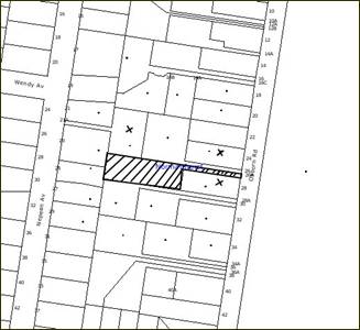
THE SITE
The site is a battleaxe allotment
located on the western side of Osborn Road with an area of 1574 sq metres and a
gradient of approximately 14% towards the north-western corner of the site. A
dwelling is located towards the eastern end of the site.
Vehicular access to the site is
gained via a 3.66 metre wide access handle off Osborn Road. The property
contains remnant Blue Gum High Forest, an Endangered Ecological Community
scheduled under the Threatened Species Conservation Act, 1995.
A Blackbutt (Eucalyptus
pilularis) is located on the access handle along the northern boundary of
the property, being partly located within the site and partly within the access
handle of the adjoining northern property (No. 26 Osborn Road, Normanhurst).
The tree is 35 metres high, consists of a double trunk and has a canopy overlap
with many other (mainly introduced) trees within the allotments named No. 26
and No. 24 Osborn Road.
THE APPROVED DEVELOPMENT
The approved development involves
the subdivision of one allotment into two including the following:
· Proposed Lot 51 having an area of
544.5 sq metres (excluding access) and the retention of the existing dwelling.
Access to the above allotment is via the 3.66 metre wide existing access
handle.
· Lot 52, with an area of 727.2 sqm
(excluding access) located to the rear of lot 51. Vehicular access to proposed Lot 52 is gained via a 3.66 metre wide battle‑axe handle fronting Osborn Road.
THE
PROPOSED MODIFICATION
The
application proposes the modification to the approved development by way of
amendment to condition No. 63 insofar as deleting any reference to the
retention of tree No. 4E.
The applicant has indicated that
the modification would result in the ability to achieve compliance with
conditions No. 11 and 13 which require a 3 metre wide pavement to be
constructed in accordance with the relevant Australian Standards. The applicant
contends that the retention of the tree would not result in a safe accessway
for future occupants of the site and would restrict emergency access to the
battleaxe allotments. The practical application of the condition would
deteriorate in the future with the growth of the tree trunk and the further
reduction of the width of the driveway.
The consent from the neighbouring
property at No. 26 Osborn Road has been included with the application as the
tree is partly located within that property.
As an alternative to the removal
of the tree, the applicant first contacted the owners of the adjoining southern
property to acquire some land for widening the right-of-way which would allow
for the retention of the Blackbutt tree. However owner’s consent was declined
thus giving the applicant no other option than to request the removal of the
tree.
An Assessment of significance of
the tree (7 part test) has been conducted pursuant to section 5A of the
Environmental Planning & Assessment Act. The ecologist’s assessment notes
that the tree is significant however, concludes that the removal of the tree
would not have a significant impact on the Blue Gum High Forest located within
the site.
The proposed modification to the
consent would resolve the contradiction between conditions 11 and 13 regarding
the required driveway width and condition 63 requiring the retention of the
tree and would be the only practical way to complete works in accordance with
the development consent.
ASSESSMENT
The development application has
been assessed having regard to the ‘2005 City of Cities Metropolitan
Strategy’, the ‘North Subregion (Draft) Subregional Strategy’ and
the matters for consideration prescribed under Section 79C of the Environmental
Planning and Assessment Act 1979 (the Act). Subsequently, the following
issues have been identified for further consideration.
1. STRATEGIC CONTEXT
1.1 Metropolitan Strategy – (Draft) North Subregional Strategy
The Metropolitan Strategy is a
broad framework to secure Sydney’s place in the global economy by promoting and
managing growth. It outlines a vision for Sydney to 2031; the challenges
faced, and the directions to follow to address these challenges and achieve the
vision. The draft North Subregional Strategy acts as a framework for Council
in the preparation of a new Principal LEP by 2011.
The draft Subregional Strategy
sets the following targets for the Hornsby LGA by 2031:
· Employment capacity
to increase by 9,000 jobs; and
· housing stock to
increase by 11,000 dwellings.
The proposed modification would not be inconsistent with the
draft Strategy.
2. STATUTORY CONTROLS
Section 79C(1)(a) requires
Council to consider “any relevant environmental planning instruments, draft
environmental planning instruments, development control plans, planning
agreements and other prescribed matters”.
2.1 Environmental
Planning and Assessment Act, 1979 (the Act) - Section 96(2)
The application has been lodged
pursuant to Section 96(2) of the Act, which allows the modification of a
consent, where the proposal has been notified in accordance with regulatory
requirements, is substantially the same development as approved and Council
considers the application with regard to Section 79C of the Act and any
submissions.
The proposed modification
involves the amendment to conditions to facilitate the removal of a tree and
facilitate practical compliance with the required width of the access handle.
The modification is considered to be substantially the same development as
approved.
The application was notified
pursuant to Council’s Notification & Exhibition DCP and Council received
three submissions (refer to Section 5 of this report).
2.2 Hornsby Local Environmental Plan 1994
The site is zoned Residential A
(Low Density) zone. The objectives of the zone are:
(a) to provide for the housing needs of the population of the
Hornsby area.
(b) to promote a variety of housing types and other land uses
compatible with a low density residential environment.
(c) to provide for development that is within the environmental
capacity of a low density residential environment.
The proposed modification would
not alter the compliance of the original proposal with the objectives of the
zone.
2.3 Residential Subdivision Development Control Plan
The proposal to modify the
development consent would not alter the compliance of the original proposal
with the relevant performance criteria and prescriptive standards contained
within the RSDCP. The matters relevant to the current modification are
discussed below.
2.3.1 Vehicle Access and
Parking
The subject Blackbutt tree is
located on the northern boundary of the site adjoining the existing access
driveway. The width of the existing driveway measured from the edge of the
trunk of the tree to the side boundary is 2.6 metres. Council conducted an
engineering assessment of the proposal and in considering the impact of the
existing tree on the use of the accessway found that should the tree be
retained in its existing form, the resultant width of the access driveway would
be a maximum of 2.5 metres adjoining the tree. This does not comply with the
required minimum width of 3 metres in accordance with Council’s RSDCP and
Australian Standards AS 2890.1 – 2002.
Whilst a reduced width handle is
acceptable in certain circumstances, it is considered that an access handle
width of only 2.5 metres would not provide a safe and efficient entry/exit for
future occupants of the allotment.
Access by emergency vehicles
would be restricted by the proposed access driveway and the future width of the
access driveway is likely to be further reduced as the trunk of the tree
expands, thus exacerbating the problem.
3. ENVIRONMENTAL IMPACTS
Section 79C(1)(b) of the Act
requires Council to consider “the likely impacts of that development,
including environmental impacts on both the natural and built environments, and
social and economic impacts in the locality”.
3.1 Natural Environment
A Blackbutt (Eucalyptus
pilularis) is located on the access handle along the northern boundary of
the property, being partly located within the site and partly within the access
handle of the adjoining northern property (No. 26 Osborn Road, Normanhurst).
The tree is 35 metres high, consists of a double trunk and has a canopy overlap
with many other (mainly introduced) trees within the allotments named No. 26
and No. 24 Osborn Road.
The tree
contains small-sized hollows which provide potential roosting habitat
for micro bats and upper canopy connectivity to other trees. The tree
also functions as a protection buffer (e.g. wind sheltering etc) to other
tall large remnant trees in the vicinity. The existing clear distance from
the edge of the tree trunk to the southern boundary of the access handle is 2.6
metres.
The applicant has conducted an
Ecological Assessment and Assessment of Significance ('7 Part Test') for
the subject tree which concludes that the removal of this tree is unlikely to
have a significant impact upon the local population of the Blue Gum High Forest
Critically Endangered Ecological Community.
Council officers have considered
the recommendations of the ecological report and concurs that the subject tree
does not form part of mapped Blue Gum High Forest. However, the tree appears to
be in good health and provides an ecological function amongst the developed
urban landscape.
The removal of the tree would
have some adverse impact on the natural environment, but not on the Critically
Endangered Ecological Community. The retention of the tree, however, would
result in non-compliance with the width of the access handle and would not
provide a safe and suitable vehicular access for the future occupants within
the Residential A (Low Density) Zone.
The removal of the tree is
supported in the circumstances as practical negotiations with the neighbour to
obtain a right of carriageway failed and as it was demonstrated that the
development would result in a suitable outcome that complies with the desired
future character of the locality, satisfies the objectives of the zone and
provides safe access to two adjoining allotments (No. 26A and No. 26 Osborn Road).
In order to compensate for the
loss of bio-diversity as a result of the proposed modification, the following
condition is recommended in accordance with Council’s Offset Code:
“A monetary
contribution to the value of $180 is to be made to Council's Community Nursery
at Brittania Street to offset the loss of the Eucalyptus pilularis tree. The contribution is
to be utilized by Council to grow 6 locally indigenous canopy trees to a
suitable pot size for replanting within the Council owned reserves in the
Normanhurst area.”
The applicant has raised no
objection to the above condition.
3.2 Built Environment
The proposal as modified would
not have any adverse impact on the built environment within the locality.
4. SITE SUITABILITY
Section 79C(1)(c) of the Act
requires Council to consider “the suitability of the site for the
development”.
The suitability of the site for
the development was considered at the time of assessment of DA/2392/2004.
5. PUBLIC
PARTICIPATION
Section 79C(1)(d) of the Act
requires Council to consider “any submissions made in accordance with this
Act”.
5.1 Community Consultation
The proposed development was
placed on public exhibition and was notified to adjoining and nearby landowners
between 18 March 2010 and 1 April 2010 in accordance with Council’s
Notification and Exhibition Development Control Plan. During this period,
Council received three submissions. The map below illustrates the location of
those nearby landowners who made a submission that are in close proximity to
the development site.
|
NOTIFICATION
PLAN
|
|
|
• PROPERTY NOTIFIED
|
X SUBMISSION
RECEIVED
|

PROPERTY SUBJECT OF DEVELOPMENT
|

|
|
|
|
|
The submissions objected to the proposed modification on the
following grounds:
· A preferred
development outcome would be to provide a 3 metre wide driveway for the entire
length of the access handle except where it adjoins the tree (width being 2.6
metres) which is an acceptable situation and does not require the removal of
the Blackbutt tree.
· The original
subdivision was approved on the basis that the tree would be retained on the
site. Therefore, the tree should not be removed. The development consent for
the subdivision should be revoked.
· The proposed
modification would result in detrimental impact on the native flora by removing
a significant tree.
· The removal of the
tree would take away the shade to the backyard of No. 24 Osborn Road that is
currently enjoyed by the occupants.
· The current width of
the driveway has allowed emergency vehicles to access to No. 26A Osborn Road in
the past and therefore would be able to do so in the future.
· The arborist’s report
does not include methods of retaining sections of the tree and widening the
driveway in the process.
The merits of the matters raised in community submissions
have been addressed in the body of the report with the exception of the
following:
5.1.1 Retention of part of the tree
The proposal to retain a 3 metre
wide driveway would require a substantial portion of the tree trunk to be
removed. It is unlikely that the tree would survive and therefore is not a
recommended option by the arborist.
5.1.2 Solar access to the private open space area
Removal of the tree would improve
solar access to the private open space area for the property at No. 24 Osborn Road. This is considered to be a satisfactory outcome which complies with the
objectives of the RSDCP.
5.2 Public Agencies
DA/2392/2004 was ‘Integrated
Development’ under the Act being bushfire prone land. The proposed
modification to the consent does not involve any building works and therefore
the proposal was not required to be referred to the NSW Rural Fire Services for
further comments.
5. THE PUBLIC INTEREST
Section 79C(1)(e) of the Act
requires Council to consider “the public interest”.
The public interest is an
overarching requirement, which includes the consideration of the matters
discussed in this report. Implicit to the public interest is the achievement
of future built outcomes adequately responding to and respecting the future
desired outcomes expressed in environmental planning instruments and
development control plans.
The proposed modification is
considered to have satisfactorily addressed Council’s criteria and would
provide a development outcome that, on balance, would result in a positive
impact for the community. Accordingly, it is considered that the approval of
the proposed modification would be in the public interest.
6. CONCLUSION
The Section 96(2) application
proposes to modify the consent for the subdivision of one lot into two. The
proposed modification involves the removal of a significant tree to facilitate
vehicular access to the site.
The application is assessed as
satisfactory against Sections 79C and 96(2) of the Act. The amendment of the
proposal would not alter the compliance of the proposal with the Hornsby Shire
Local Environmental Plan 1994 and Council’s Residential Subdivision Development
Control Plan.
It is recommended that the
removal of the tree and the loss of bio-diversity on the site as a result of
the future subdivision be compensated by offset planting elsewhere within the
Shire in accordance with Council’s Offset Code.
Approval of the section 96 (2)
application is recommended.
Note: At the time of the completion of this planning
report, no persons have made a Political Donations Disclosure Statement pursuant
to Section 147(3) of the Environmental Planning and Assessment Act 1979 in
respect of the subject planning application.
|
Paul David
Manager -
Subdivision & Development Engineering Services
Planning Division
|
Scott Phillips
Executive Manager
Planning Division
|
Attachments:
|
1.View
|
Locality Plan
|
|
|
|
2.View
|
Site Plan Approved
|
|
|
|
3.View
|
Plan of Tree
Location
|
|
|
File Reference: DA/2392/2004/B
Document Number: D01341323
SCHEDULE 1
|
Date of 1st
modification:
|
4 June 2009
|
|
Details of 1ST
modification:
|
Alteration to driveway
works and removal of a tree located on the driveway
|
|
|
|
|
Conditions Added:
|
69
|
|
Conditions Deleted:
|
55 and 56
|
|
Conditions Modified:
|
63
|
|
Date of this
modification:
|
5 May 2010
|
|
Details of this
modification:
|
Modify Condition No. 63 to
facilitate removal of the Blackbutt tree located on the access handle and
construction of a 3 metre wide driveway.
|
|
|
|
|
Conditions Added:
|
1A, 70
|
|
Conditions Deleted:
|
None
|
|
Conditions Modified:
|
57, 63
|
DEVELOPMENT ENGINEER
Construction Certificate – Subdivision/Engineering
Works
1. A construction certificate must be obtained from
either Council or an Accredited Certifier. Engineering design plans and
specifications are to be prepared by a chartered professional engineer for any
proposed works. The plans and specifications are to be in accordance with
development consent conditions, appropriate Australian standards, and
applicable Council standards, in particular “Hornsby Shire Council Civil Works
- Design and Construction Specification”. Information required to be submitted
with a construction certificate is as follows:
a. Four (4) copies of compliance certificates relied
upon;
b. Four (4) copies of the detailed engineering
plans in accordance Hornsby Shire Council's Civil Works - Design Specification
1999. The detailed plans may include but are not limited to the earthworks,
roadworks, road pavements, road furnishings, stormwater drainage, landscaping
and erosion control works and
c. Hornsby Shire Council’s approval for the
existing roadworks and public drainage is required prior to the issuing of a
construction certificate for these works.
Approved
Plans
1A. The development must be carried out in accordance with the
approved plans dated 2 May 2005 (Document No. D00190250) as amended in red and
endorsed by Council’s stamp.
Principal
Certifying Authority
2. Before any construction works
commence, you are required to appoint a Principal Certifying Authority as
required by section 81A of the Environmental Planning & Assessment Act,
1979. The Principal Certifying Authority is responsible for ensuring that all
the works are carried out in accordance with the approved plans and
specifications.
On the date of this consent,
Council is the only principal certifying authority for subdivision work.
Notifying Council of Commencement of
Works
3. It is a requirement of the
Environmental Planning and Assessment Act (Section 81A(2)(c)) that you notify
Hornsby Council at least two (2) days prior to the intention to commence works.
Where works are to be undertaken in a public place, such
notice must be accompanied by evidence of the contractor's Public Liability and
Workers’ Compensation Insurances. The public risk policy shall be such an
amount as determined by Council (not being less than $10,000,000.00) and shall
cover the owner and the Council against any injury, loss or damage sustained by
any person, firm or company.
Hours
of Works
4. In order to maintain the amenity
of adjoining properties, site works shall be restricted to between 7.00 am and
6.00 pm, Monday to Friday and 8.00 am to 1.00 pm Saturday.
Site works may extend to 4.00 pm
on Saturdays if inaudible on residential properties. No work shall be
undertaken on Sundays or public holidays. Plant, goods or materials shall not
be delivered to the site outside the approved hours of site works unless
otherwise approved by Council.
Inspections
– Engineering
5. All
engineering work required by this consent must be inspected and compliance
certificates shall be issued prior to occupancy or issue of the subdivision
certificate, whichever occurs first, certifying that the works comply with
development consent, construction certificate and Hornsby Shire Council Civil
Works - Design and Construction Specification for the following nominated
stages:
- Implementation of erosion control
- Implementation of traffic control
- Interallotment drainage pipes
- Interallotment pit construction
- Final erosion control inspection
- Conduits laid within access way corridor prior
to backfilling
- Driveways and accessways
- Construction of OSD
- Drainage structures
- Final inspection
Sydney Water
6. A Section 73 compliance
certificate under the Sydney Water Act 1994 must be obtained. Application must
be made through an authorised Water Servicing Coordinator. Please refer to
“Your Business” section of Sydney Water’s web site at www.sydneywater.com.au then
the “e-developer” icon or telephone 13 20 92.
Following application, a “Notice of Requirements” will detail
water and sewer extensions to be built and charges to be paid. Please make
early contact with the Coordinator, since building of water/sewer extensions
can be time consuming and may impact on other services and building, driveway
or landscape design.
The Notice
must be submitted to the Principal Certifying Authority prior to the
Construction Certificate being issued.
The Section 73 Certificate must be submitted to the
Principal Certifying Authority prior to occupation of the development/release
of the plan of subdivision.
Roadworks
7. A Traffic
Control Plan (TCP), prepared by a qualified work site traffic controller, is to
be submitted with any construction certificate, demonstrating compliance with
the Road & Traffic Authority’s Traffic Control At Worksites Manual, 1998,
and detailing:-
a. Public notification of proposed works.
b. Short term (during actual works) signage.
c. Vehicle Movement Plans, where applicable.
d. Traffic Management Plans.
e Pedestrian and cyclist access/safety.
Access
Way/Driveway
8. A separate application under the Local
Government Act 1993 and Roads Act 1993 shall be submitted to Council for
approval for the following:
a. the installation of a vehicular footway crossing
servicing the development, and the removal of any redundant crossings; and
b. the undertaking of work within a public road (
this includes Laneways, Public Pathways, Footways).
9. The vehicular crossing shall be designed and
constructed in accordance with Council’s Civil Works - Design and Construction
Specification 1999.
10. The cost of repairing any damage caused to
Council's assets in the vicinity of the subject site as a result of
construction works associated with the approved development is to be paid for
by the applicant/developer prior to issue of a subdivision certificate.
11. The internal driveway and parking areas are to be
designed and constructed in accordance with Australian Standard 2890.1.
12. Reciprocal rights of carriageway and easement for
services are to be created over the access corridor under Section 88B of the
Conveyancing Act 1919.
13. Construction of the proposed right of carriageway
and a common turning area in accordance with the following requirements:-
a. Construction of 150mm thick
reinforced concrete pavement with F72 steel reinforcing fabric;
b. The pavement width shall be a
minimum width of 3.0 metres;
c. The pavement shall have a kerb to
one side and a one-way crossfall with a minimum gradient of 2%; and
d. The grades of the driveway shall be comply with the
requirements of AS2890.1
Drainage
14. Construction of an interallotment
stormwater drainage system to service the proposed lot. The roof and stormwater
drainage system from the existing dwelling shall be connected into the proposed
interallotment drainage system.
15. Stormwater drainage from the site
shall be designed to satisfactorily drain rainfall intensities for an average
recurrence interval of 20 years. The design shall:-
a. Be in accordance with Hornsby Shire
Council Civil Works – Design Specification 1999;
b. Provide for drainage discharge to
the existing drainage system; and
c. Ensure that the development, either
during construction or upon completion, does not impede or divert natural
surface water runoff so as to cause nuisance to adjoining properties.
Drainage - On Site Detention
16. The drainage system is to be
constructed with an on-site-detention system, having a capacity of not less
than 5m3 and a maximum discharge, when full, of 8 l/s to collect the stormwater
from the right of way, as well as the storm water from the existing dwelling.
The on-site-detention system shall be located at the end of the right of way.
The system shall be designed by a chartered professional civil engineer to the
following requirements:
· A surcharge/inspection grate is to be located directly
above the outlet.
· Stormwater discharge from the detention system is to be
controlled via a one metre length of pipe not less than 50mm diameter
discharging into a larger diameter pipe capable of carrying the design flow to
Council's gutter/stormwater pit.
· Where the on-site detention system is proposed under the
vehicular driveway, the engineer is to certify that the detention tank is
structurally capable of withstanding the maximum anticipated traffic loads
prior to release of Construction Certificate.
· The on-site detention
systems within private or common courtyard areas must be designed so they do
not impact on the amenity of the development or the use of such areas.
A compliance certificate is to be submitted to Council which
includes work-as-executed details of the on-site-detention system prepared by a
chartered professional engineer/registered surveyor verifying that the required
storage and discharge volumes have been constructed in accordance with the
design requirements. The details are to show the invert levels of the on system
as well as the pipe sizes and grades. Any variations to approved plans must be
shown in red and supported by calculations.
17. The creation of an appropriate "Positive
Covenant" and "Restriction as to User" over the constructed
on-site detention/retention systems and outlet works, within both Lot 51 and lot 52 in favour of Council to ensure the continued maintenance and performance
of the stormwater management system in accordance with Council’s standard
wording. The position of the on-site detention system is to be clearly
indicated on the Final Plan of Subdivision.
Easements
& Restrictions on Title
18. Any easement(s) or restriction(s) on Title required by this
consent must nominate Hornsby Shire Council as the authority to release, vary
or modify the easement(s) or restriction(s).
19. All Section 88B restrictions and
covenants created as part of this consent are to contain a provision that they
cannot be extinguished or altered except with the consent of Hornsby Shire
Council.
20. Each of the proposed lots serviced
by the proposed interallotment drainage easement shall have this burden and
benefit created pursuant to Section 88B of the Conveyancing Act 1919.
21. The drainage easement over the downstream lot No. 13 DP
12343 shall be registered with Land and Property Information New South Wales
(formerly the Land Titles Office) prior to issue of the construction
certificate.
Subdivision
Certificate
22. Lodgement and approval of a subdivision certificate is
required to authorise the Plan of Subdivision.
23. All conditions of the development consent are to be
completed prior to the issue of the subdivision certificate.
24. The following documentary evidence is to be submitted to the
Principal Certifying Authority prior to the issue of the subdivision
certificate:
· a compliance
certificate certifying that all structures within the subject land comply with
the Building Code of Australia.
· a surveyor's
certificate stating that no services, drainage lines or accessways encroach
over the proposed boundary other than as provided for by easements created by
the Final Plan of Subdivision.
25. Suitable provision is to
be made for the supply of all relevant services to allotments.
Long Service Levy
26. Under Section 34 of the Building and Construction Industry
Long Service Payments Act 1986 any work costing $25,000 or more is subject to a
Long Service Levy. The levy rate is 0.2% of the total cost of the work and
shall be paid to either the Long Service Payments Corporation or Hornsby Shire
Council. Under section 109F (1) of the Environmental Planning & Assessment
Act, 1979 this payment must be made prior to a construction certificate being
issued.
Works As Executed
27. A works-as-executed plan prepared by a chartered
professional engineer or a registered surveyor must be lodged with Hornsby
Shire Council when the engineering works are complete, prior to the release of
the subdivision certificate.
28. A compliance certificate shall be submitted (prior to the
release of the subdivision certificate) by a registered surveyor indicating
that all pipelines and associated structures lie wholly within any easements
required by this consent.
ENVIRONMENTAL
HEALTH & BUILDING SURVEYOR
Site Works
29. No site works, including the removal of vegetation or any
demolition works, shall be commenced prior to:
29.1 A construction certificate being issued.
29.2 Sediment and erosion control measures in accordance with
condition No. 48 have been implemented;
Demolition
30. All demolition work is to be carried out in accordance with
the applicable provisions of Australian Standard 2601-2001 ‘The Demolition of
Structures’.
Note:
Applicants are reminded that WorkCover NSW requires all plant and equipment
used in demolition work must comply with the relevant Australian Standards and
manufacturer specifications.
Dust Control
31. Measures to prevent the emission
of dust or other impurities into the surrounding environment are to be
implemented during demolition works.
Hours of Demolition Works
32. In order to maintain the amenity of adjoining properties,
demolition works shall be restricted to between 7.00 am and 6.00 pm. No
demolition works are to be undertaken on Saturdays, Sundays or Public Holidays.
Plant, goods or materials shall not be delivered to the site outside the
approved hours of site works unless written Council gives consent.
Asbestos Removal
33. Prior to commencement of any work involving the demolition,
alteration or addition to any building on the development site, a survey is to
be conducted by a competent person to ascertain whether any asbestos materials
exist thereon. Asbestos material means any material that contains asbestos.
34. Where asbestos material is found to exist on the development
site and that asbestos material is to be removed or disturbed as a result of
any proposed demolition, alteration or addition, then all work involving
removal and disposal of asbestos material must be undertaken by persons who
hold the appropriate licence issued by WorkCover NSW under Chapter 10 of the
Occupational Health and Safety Regulation 2001.
35. The collection, storage, transportation or disposal of
any type of asbestos waste is to comply with the requirements of clause 29 of
the Protection of the Environment Operations (Waste) Regulation 1996.
36. Upon completion of disposal operations, the applicant must
lodge with the principal certifying authority, within seven (7) days, all
receipts (or certified photocopies) issued by the receiving landfill site as
evidence of proper disposal.
Note:
The person responsible for disposing of the asbestos material shall consult
with the Environment Protection Authority to determine the location of an
approved landfill site to receive asbestos material.
Signs for Demolition Sites
37. On construction sites where buildings contain asbestos
material, a standard commercially manufactured sign containing the words
‘DANGER ASBESTOS REMOVAL IN PROGRESS’ measuring not less than 400mm x 300mm is
to be erected on the site in a prominent position visible from the street. The
sign is to be erected prior to any work commencing and is to remain in place
until such time as all asbestos material has been removed from the site to an
approved waste facility. This condition is imposed for the purpose of worker
and public safety and to ensure compliance with Clause 259(2)(c) of the
Occupational Health and Safety Regulation 2001.
38. A sign must be erected in a prominent position on the
premises, on which the demolition of a building is being carried out, stating
that unauthorised entry to the premises is prohibited and showing the name of
the builder or other person in control of the premises and a telephone number
at which the builder or other person may be contacted during and outside work
hours. The sign is to be removed when the demolition of the building has been
completed.
Signs for Construction
Sites
39. On-site
signage is required to clearly identify the PCA and the principal contractor
(the coordinator of the building work) pursuant to the Environmental
Planning and Assessment Amendment (Quality of Construction) Act 2003,
s157(1)(c1), Cl 98A, 136C & 227A.
Inspections
40. The demolition works must be
inspected by the Principal Certifying Authority to certify that the works
comply with the development consent and the approved plans and specifications.
Noise
41. The use of amplified equipment, such as radios and the like
during construction stage shall not be used where the noise is audible on any
neighbouring property.
Disconnection of Utilities
42. All
utilities shall be disconnected in a satisfactory manner so as not to pose any
risk or nuisance to the public.
Landscaping
43. All natural landscape features, including natural rock
outcrops, natural vegetation, soil and watercourses, are to remain undisturbed
except where affected by necessary works detailed on approved plans.
44. The area surrounding the building shall be reinstated to
good order as soon as practical after the completion of site works including,
where necessary, the establishment of new landscaping.
45. The natural ground levels of private open space areas are
not to be altered unless otherwise indicated on the approved plans.
Council Property
46. The land and adjoining areas are to be kept in a clean and
tidy condition at all times. Litter and rubbish shall be placed in containers
and removed from the site. A waste storage container is to be provided at the
commencement of the building work.
47. The cost of repairing any damage caused to Council's assets
as a result of construction works associated with the approved development is
to be met in full by the applicant/developer prior to the issue of a
subdivision certificate.
Sediment & Erosion Control
48. Temporary sedimentation and erosion controls are to be
constructed prior to commencement of any work to eliminate the discharge of
sediment from the site. The controls are to be designed and installed in
accordance with the requirements of Landcom’s “Managing Urban Stormwater: Soils
and Construction”, Volume 1, 4th Edition, March 2004, (the Blue
Book), and Hornsby Shire Council’s “Sustainable Water Best Practices” manual
and shall:-
· be effectively
maintained at all times during the course of works and shall not be removed
until the site has been stabilised or landscaped to the Principal Certifying
Authority’s satisfaction.
· include adequate
measures to remove clay from vehicles leaving the site so as to maintain public
roads in a clean condition.
· ensure disturbed areas
are rehabilitated with indigenous plant species, landscaped and treated by
approved methods of erosion mitigation such as, mulching, and revegetation with
native grasses or other suitable stabilising processes within fifteen days of
the completion of works.
House Numbering
49. House numbering can only be authorised by Hornsby Shire
Council. Before proceeding to number each lot/occupancy in your development,
approval must be sought from Council’s Planning Division.
Council issues consecutive house numbers according to lot
numbers, therefore door numbers are to align with lot numbers. These numbers
must correspond, i.e. Lot one, house number 1 or Lot two, unit number 2.
PARKS AND LANDSCAPE TEAM
Tree Preservation Order
50. A Tree Preservation Order exists
within the Hornsby Shire whereby the cutting down, topping, lopping, removing
or wilful destruction of any tree exceeding 3.0 metres in height (except where
exempt as defined under Council’s Tree Preservation Order) without prior
written consent of Council is prohibited.
Release of the Construction Certificate gives automatic
approval to the removal only of those trees located on the subject property
within 3 metres of the foundation footprint of an approved residential,
commercial or community building, garage or inground swimming pool. Other trees
shall not be removed or damaged without an application being made under
Council’s Tree Preservation Order. Penalties apply for non-compliance.
BUSHLAND AND BIODIVERSITY TEAM
Restriction-As-To-User
51. A Restriction-As-To-User shall be
placed on the southern and eastern part of Lot 52 – the ‘Restricted Development
Zone’ (ADD distances from boundaries) marked in red diagonal lines on the
approved plans, to maintain the Blue Gum High Forest endangered ecological
community in accordance with the approved Bushland Management Plan. No building
work including paving or ancillary building structures (i.e. dwelling, shed,
pool, fence, driveway), no clearing of native vegetation (trees, shrubs and
groundcovers), no stock piles, no changes to soil aeration or hydrological
capacity, no disturbance of bush rock, no open cut trenching, no placement of
temporary buildings, no parking or movement of machinery, no spillage/disposal
of building chemicals of any description is to occur within the ‘Restricted
Development Zone’.
Positive
Covenant
52. A positive covenant shall be
placed on Lot 52 to maintain the remnant Blue Gum High Forest scheduled under
the Threatened Species Conservation Act 1995 as an endangered ecological
community. The positive covenant shall require management of the southern and
eastern parts of the lot (the ‘Restricted Development Zone’) to be in strict
accordance with the approved Bushland Management Plan. Upon development of Lot 52, bush regeneration and landscaping is to be undertaken in accordance with the
approved Bushland Management Plan to conserve the endangered Blue Gum High
Forest.
Bushland
Management Plan
53. A detailed
Bushland Management Plan shall be prepared by a recognised and experienced
bushland regeneration company or equivalent, for the restoration of the area
delineated on the site plan as “Restricted Development Zone”. The Plan must be
submitted to and deemed satisfactory by Council's Bushland and Biodiversity
Management Team. In preparation of the plan, the consent conditions for the
development should be observed. The Plan shall include, but is not limited to
the following:
a. Weed management using bush
regeneration techniques;
b. Encouragement of natural
regeneration from the soil seed bank;
c. Revegetation works, where required,
using a diversity of locally indigenous species and include planting density
and source of planting stock;
d. Provide landscaping requirements for
future landowners including a list of indigenous and non-invasive species that
can be planted on the allotment;
e. Erosion, sediment and stormwater
runoff controls;
f. Details of any pathways or
structures (e.g. fencing);
g. Appropriate map of the site;
h. Determine timeframes and assign
responsibilities for management actions;
i. Specify quantitative performance
measures; and
j. Monitoring and reporting details (i.e. a compliance and
performance report to be provided to Council from an independent ecological
consultant).
54. Prior to issue of the Construction
Certificate the Applicant shall engage an experienced (Australian
Association of Bushland Regenerators (AABR)-approved) bush
regeneration professional/company to undertake on-going bush regeneration and
restoration works as detailed in the approved Bushland Management Plan.
Documentation illustrating this commitment including the procedure and duration
of works shall be submitted to Council’s Bushland and Biodiversity Management
Team for approval.
55. Deleted
56. Deleted
57. Prior to the commencement of any
works or site preparations (including excavation of all footings for the
suspended driveway (where necessary) and the dwelling, the drainage easement,
retaining walls,), the Applicant shall engage a qualified and experienced
Arborist to provide expert advice on the implementation of best tree management
practices that minimise impacts and promotes the long-term health of the
retained trees. The Arborist shall be present on site to monitor any excavation
works to minimise the impact of the works on the root zone of all retained
trees on adjoining properties as well as the subject site. No mechanical
excavation shall be undertaken until root pruning by hand along the perimeter
line of such works is completed;
58. All environmental weeds, noxious
and invasive plants including Senna/Cassia, Spider Plant/Ribbon Plant,
Trad/Wandering Jew, Jasmine, English Ivy, Scotch Broom, Cotoneaster, Moth Vine,
Black-eyed Susan, Agapanthus, Asparagus Fern, Fleabane, Impatiens, Large-leaved
Privet, Small-leaved Privet, African Olive, Passionfruit, Giant Reed, Ginger
Lily, Wild Tobacco, Paspalum, Plantain, Panic Veldtgrass and Prairie Grass are
to be removed and suppressed throughout the entire site being subdivided (26A
Osborn Road) using appropriate bush regeneration methods prior to release of
the final plan. Ongoing bush regeneration and weed control must be undertaken
within the Restricted Development Zone in accordance with the Bushland
Management Plan to be submitted to Council.
59. Landscaping is to be composed of
locally occurring native species, as listed in the Hornsby Council planting
guide, Indigenous Plants for the Bushland Shire, available at Council or on
Council’s internet site: www.hornsby.nsw.gov.au.
Construction
and ongoing management of Lot 52
60. Prior to commencement of any works
on site, including site clearing/preparation, an exclusion zone must be
established and maintained around the perimeter of the ‘Restricted Development
Zone’. This area is to be clearly identified by the placement of a temporary
brightly coloured barrier mesh around the perimeter of the area to be protected
and weatherproof signage to indicate that no entry into the Zone or removal of
the barrier is permitted.
61. In order to preserve the remnant Blue Gum High Forest all locally indigenous trees including Sydney Blue Gum (Eucalyptus
saligna), Blackbutt (Eucalyptus pilularis), White Stringybark (Eucalyptus
globoidea) and indigenous understorey vegetation, are to remain undisturbed
and protected during on-site construction works. No excavation or change of
soil level or placement of building materials is to occur within 6 metres of
retained indigenous trees, unless approved by Council.
62. Tree Protection Zones shall be
maintained around trees number 7 8, 9, 10, 11, 14, 17, 18 (as per the updated Tree
Appraisal Report prepared by PMA, March 2005) for the duration of on-site
works. These trees shall be protected within a temporary barrier fence or
brightly coloured barrier mesh secured in place at least 6 metres from the
trunk of each tree to protect the tree trunk, root zone and understorey from
clearing and damage by equipment or by stockpiling of materials during on-site
construction works. The fencing / barrier must be maintained during construction.
63. The
root zones of native plants 3, 4, 5, 4A, 5B, 15C, 15D, 15E on the adjoining
properties shall be protected by:
a. Maintaining the suspended driveway
wherever necessary; and
b. Prohibiting excavation, trenching or soil
disturbance within the drip line of any native shrub or tree to be retained and
conducting all works in accordance with requirements specified in Condition No.
69.
64. No tree roots of 50mm or greater
in diameter located within the setback buffer area of at least 6 metres from
retained trees shall be severed or injured in the process of any on-site works.
Excavation shall be carried out using hand methods, ensuring tree roots between
10mm and 50mm diameter are cut cleanly while a qualified and experienced
Arborist is present to treat cut roots.
65. On completion of construction
works all disturbed areas are to be restored
to a natural state including the replacement of topsoil and the removal of
weeds and building materials.
66. All Illawarra Flame Trees, Silky Oaks, African Olives,
Camphor Laurels, Jacaranda, Umbrella Tree, Cestrum, Liquidambar, Murraya and
Cotoneasters shall be removed and replacement plantings of the same number of
native shrub or tree species shall be made. All of these replacement plantings
shall be locally indigenous and comprise species that are found within Blue Gum
High Forest Communities.
Contributions
67. The payment of a contribution towards the cost of transport
and traffic management, open space and recreation facilities, library and community
facilities, bushland and environmental works, stormwater drainage, bushfire
protection and Section 94 administration in accordance with Sections 94, 94B
and 94C of the Environmental Planning and Assessment Act, 1979, and Hornsby
Shire Council’s Development Contributions Plan 2004-2010. The total
contribution shall be $12,858.80 if paid prior to the end of the quarter of the
date of consent. Following this date, contributions will be adjusted in
accordance with the underlying consumer price index for the subsequent
financial years, it being noted that there are:-
*
Additional allotments @ $12,858.80 per dwelling/allotment
This amount is to be paid
to Council prior to issue of the construction certificate or the subdivision
certificate, whichever occurs first. The contribution rate will be adjusted on
an annual basis in accordance with the underlying consumer price index
movements if not paid prior to the end of the quarter of the date of consent.
Note: A
copy of Council’s Contributions Plan may be inspected during business hours at
the first floor of Hornsby Shire Council’s Administration Building located at No. 296 Pacific Highway, Hornsby.
Fencing
68. All
boundaries behind the building line and courtyard areas shall be enclosed with
1.8m fences/screens/walls to protect the privacy of future occupants as well as
adjoining owners. Provided that where an adjoining owner agrees to the
provision of an alternate fence/screen/wall that fence/screen/wall shall be
erected in lieu of the fence required by this condition. The fence/screen/wall
is to be erected prior to the occupation of the dwellings or prior to the issue
of the subdivision certificate, which ever occurs first.
Works near Trees
69. All works (including driveways and retaining walls) within three
metres of any trees required to be retained (whether or not on the subject
property, and pursuant to this consent or the Tree Preservation Order),
must be carried out under the supervision of an ‘AQF Level 5 Arborist’
and a certificate submitted to the principal certifying authority detailing the
methods used to preserve the trees.
Note:
Except as provided above, the applicant is to ensure that no excavation,
filling or stockpiling of building materials, parking of vehicles or plant,
disposal of cement slurry, waste water or other contaminants is to occur within
4 metres of any tree to be
Offset measure
70. A monetary contribution to the value of $180 is to be made
to Council's Community Nursery at Brittania Street to offset the loss of the Eucalyptus
pilularis tree. The contribution is to be utilized by Council to grow
6 locally indigenous canopy trees to a suitable pot size for
replanting within the Council owned reserves in the Normanhurst area.
Planning Report No. PLN17/10
Date of Meeting:
5/05/2010
2 DEVELOPMENT APPLICATION
- ALTERATIONS TO AN EXISTING DWELLING AND SUBDIVISION OF ONE LOT INTO TWO
8 CHORLEY AVENUE CHELTENHAM
|
Development Application No:
|
DA/1340/2009
|
|
Description of Proposal:
|
Alterations to an existing
dwelling and subdivision of one lot into two.
|
|
Property Description:
|
Lot 144 DP 112364 (No. 8) Chorley Avenue, Cheltenham
|
|
Applicant:
|
P S Graham & Associates
|
|
Owner:
|
Mrs B L McDonald and Mr R G Rae
|
|
Statutory Provisions:
|
Hornsby Shire Local Environmental
Plan 1994
Residential AS (Low Density –
Sensitive Lands)
|
|
Estimated Value:
|
$50,000
|
|
Ward:
|
C
|
|
RECOMMENDATION
THAT Development Application
No. 1340/2009 for alterations to an existing dwelling and subdivision of one
lot into two at lot 144 DP 12364 (No. 8) Chorley Avenue, Cheltenham be
approved subject to the conditions of consent detailed in Schedule 1 of this
report.
|
1. The
application proposes alterations to an existing dwelling and the subdivision of
one lot into two lots.
2. The
site was subject to a previous development application (DA/1202/2008) for the
demolition of the existing dwelling and the subdivision of one lot into two
lots, approved by Council on 4 February 2009.
3. The
proposal generally complies with Council’s Residential Subdivision Development
Control Plan other than the requirements for 4m accessway width and 4m setback
from a significant tree. The variation in the accessway width is acceptable in
retaining the existing dwelling in the heritage streetscape. Subject to
recommended conditions the variation in the tree setback is acceptable.
4. Fourteen
submissions have been received in respect of the application.
5. It
is recommended that the application be approved.
HISTORY OF THE SITE
On 4 February 2009 Council at its
Planning Meeting approved Development Application No. DA/1202/2008 for the
demolition of the existing dwelling and the subdivision of one lot into two
lots. The officer’s report to Council recommended refusal of the application,
principally on heritage grounds.
The approved plan involved the
creation of a battleaxe lot handle along the eastern boundary of the site to
access the newly created lot to the rear.
HISTORY OF THE APPLICATION
The application was lodged on 22
October 2009. An amended plan was submitted 12 April 2010.
The initial proposal involved
demolition of the western side wall to provide a 3m wide accessway to the rear
lot. The amended proposal is to only demolish the chimney, allow a 2.84m width
accessway for proposed Lot 2 and retain the existing driveway for the existing
dwelling on Lot 1.
THE SITE
The site has frontage to the
northern side of Chorley Avenue and an area of 1,407m2. The site is
irregular in shape and is of dimensions; frontage 20.115m, western side
boundary 60.96m, eastern side boundary 81.08m and rear boundary 30.81m. The
site has a fall of 10% to the western side boundary.
The site includes an existing
single storey brick dwelling house with tiled roof which was constructed in
1937. The house has a lower floor single garage at the western side of the
house. The adjoining properties include dwelling houses of similar age and
construction.
The site includes several trees
including two large trees located on each side boundary.
The site is located 350m north
east of Cheltenham Railway Station and is within the Beecroft-Cheltenham
Heritage Conservation Area.
THE PROPOSAL
The proposal is to subdivide one
lot into two lots and retain the existing dwelling. Alterations to the dwelling
are proposed to allow the construction of a 3m wide accessway along the western
boundary. The alterations include the removal of the chimney. The proposed
accessway reduces to 2.84m along the western side of the house.
Proposed Lot 1 has an area of
661m2 and is the site of the existing dwelling, No. 8 Chorley Avenue.
The lot includes a 1.175m wide section along the western side of the house. A
right of way is proposed over this section for the accessway of Lot 1 along the western side of the house. The existing driveway is retained.
Proposed Lot 2 is an irregular
shaped lot of area 746m2 including the access handle. The lot has an
average fall of 15% to the northern boundary. The lot includes two significant
trees, Tree No. 24 on the eastern boundary and Tree No. 30 on the western
boundary.
Whilst not part of the proposal
itself, the application is supported by architectural floor plans of a
dwelling-house which demonstrate that a three bedroom, double garage single
storey house could be constructed on the land without impacting upon
residential amenity.
ASSESSMENT
The development application has
been assessed having regard to the ‘2005 City of Cities Metropolitan
Strategy’, the ‘North Subregion (Draft) Subregional Strategy’ and
the matters for consideration prescribed under Section 79C of the Environmental
Planning and Assessment Act 1979 (the Act). Subsequently, the following
issues have been identified for further consideration.
1. STRATEGIC CONTEXT
1.1 Metropolitan Strategy – (Draft) North Subregional Strategy
The Metropolitan Strategy is a
broad framework to secure Sydney’s place in the global economy by promoting and
managing growth. It outlines a vision for Sydney to 2031; the challenges
faced, and the directions to follow to address these challenges and achieve the
vision. The draft North Subregional Strategy acts as a framework for Council
in the preparation of a new Principal LEP by 2011.
The draft Subregional Strategy
sets the following targets for the Hornsby LGA by 2031:
· Employment capacity to
increase by 9,000 jobs; and
· Housing stock to
increase by 11,000 dwellings.
The proposed development would be
consistent with the draft Strategy insofar as contributing to the increase in
housing stock within the Hornsby LGA.
2. STATUTORY CONTROLS
Section 79C(1)(a) requires
Council to consider “any relevant environmental planning instruments, draft
environmental planning instruments, development control plans, planning
agreements and regulations”.
2.1 Hornsby Shire Local Environmental Plan 1994
The subject land is zoned Residential AS (Low Density – Sensitive Lands) under the Hornsby Shire Local
Environmental Plan, 1994 (HSLEP). The objectives of the zone are:
(a) to provide for the housing needs of the population of the
Hornsby area.
(b) to promote a variety of housing types and other land uses
compatible with a low density residential environment and sensitive to the land
capability and established character of this environment.
(c) to provide for development that is within the
environmental capacity of a sensitive low density residential environment.
The proposed development is
defined as ‘demolition’ and ‘subdivision’ under the HSLEP and is
permissible in the zone with Council’s consent.
Clause 14 of the HSLEP prescribes
a minimum area of 600m2 for an allotment within the Residential AS
zone. The development satisfies this criteria.
Clause 15 of the HSLEP prescribes
that the maximum floor space ratio (FSR) of development within the Residential
AS zone is 0.4:1. The existing dwelling on proposed Lot 1 complies with this
requirement. Subject to addressing site constraints, a 256 sqm dwelling could
be constructed on proposed Lot 2 in satisfaction of the 0.4:1 FSR. The
application has been supported by floor plans that demonstrate that a new
dwelling could be constructed on the lot in satisfaction of this development
standard.
Clause 18 of the HSLEP sets out
heritage conservation provisions within the Hornsby area. The site is within
the Beecroft Cheltenham Heritage Conservation Area and is in the vicinity of
items of environmental heritage at No. 15 Chorley Avenue (house), No. 8 Cheltenham Road (house) and No. 10 Cheltenham Road (house). Section 2.4 of this
report details the heritage implications of the development.
2.2 State Environmental Planning Policy – Sydney Regional
Environmental Plan (Sydney Harbour Catchment) 2005
The application has been assessed
against the requirements of the Policy which includes planning principles
applicable to the site within the upper part of the harbour catchment. The
principles incorporate measures to protect water quality, minimise urban
runoff, to conserve water and to ensure the catchment watercourses, wetlands,
riparian lands and remnant vegetation are protected.
Subject to the implementation of
erosion and sediment control measures and stormwater detention, the proposed
subdivision would not adversely impact on the catchment or water quality.
2.3 Residential Subdivision Development Control Plan
The proposed development has been
assessed having regard to the relevant performance and prescriptive design
standards within Council’s Residential Subdivision Development Control Plan
(Subdivision DCP). The following table sets out the proposal’s compliance with
the prescriptive standards of the Plan:
|
Subdivision DCP
|
|
Control
|
Proposal
|
Requirement
|
Compliance
|
|
Density
|
Lot 1 – 649.4m2
(excl ROW)
Lot 2 – 647.2m2
(excl access)
|
600m2
|
Yes
|
|
Floor Space Ratio
|
Lot 1 – 0.27:1
|
0.4:1
|
Yes
|
|
Car parking
|
Lot 1 – 2 spaces
|
2 spaces
|
Yes
|
|
Private Open Space
|
Lot 1 – 200m2
|
120m2
|
Yes
|
|
Accessway Width
|
2.84m-3.0m
|
4m
|
No
|
|
Setback From Significant Tree
|
0.25m (driveway)
|
4m
|
No
|
As detailed in the above table,
the proposed development does not comply with all prescriptive standards within
Council’s Subdivision DCP. The matters of non-compliance are detailed below,
as well as a brief discussion on compliance with relevant performance
standards.
2.3.1 Density
The proposed lots comply with the
density prescriptive measures, including floor space ratio and site coverage.
Proposed Lot 2 has an average
fall of 15% and complies with the prescriptive measure for larger lot size on
steeper sites.
2.3.2 Lot Layout & Design
The proposed subdivision as
amended is more sympathetic to the existing dwelling on proposed Lot 1 as the house is essentially retained with only the chimney proposed for removal. The
proposed lot includes the existing driveway and is generally acceptable in
accommodating the existing dwelling house, providing adequate private open
space and a suitable living environment for residents.
Proposed Lot 2 is irregular in
shape, is elevated to adjoining properties to the north and is constrained by
necessary setbacks to significant trees Nos. 30 and 24. The applicant submitted
an indicative floor plan detailing a 3 bedroom single storey dwelling in
compliance with tree setback requirements. It is considered a single storey
dwelling house could be designed for the lot with regard to solar access and
privacy of existing and future residents.
The layout and design of the
proposed subdivision is considered satisfactory in retaining the existing
dwelling in the heritage streetscape. The proposed rear lot while irregular in
shape and elevated to adjoining properties to the rear includes sufficient area
to accommodate a dwelling house in keeping with the residential character of
the area.
A condition is recommended for
boundary fencing.
2.3.3 Landscaping
The adjoining land on the western
boundary includes a large significant tree (No. 30) Eucalyptus pilularis (Blackbutt).
The Subdivision DCP requires a minimum 4m setback for proposed driveways,
construction works, drainage and service trenches. The proposed driveway and
easement for services does not comply with this requirement.
Tree No. 30 is a mature tree and
encroachment within the setback area is acceptable subject to tree sensitive
construction measures, including investigative design for pier and beam,
construction at existing grade, tunnel boring, excavation by hand and
compaction control. Construction of the driveway and the driveway turning head
is recommended at the subdivision stage, to prevent injury to the tree from
vehicles in the construction of any future dwelling.
Subject to recommended conditions
the non-compliance with the 4m tree setback requirement is considered
acceptable.
2.3.4 Accessway Design
The proposed accessway is 2.84m –
3.0m wide and does not comply with the Subdivision DCP requirement for a 4.0
wide accessway.
The proposed accessway is for
access only to the rear lot. The reduction to a width of 2.84m would not impact
on the safe operation of the accessway given access is limited to a single
dwelling.
The proposed accessway is not of
sufficient width to provide 0.5m wide landscaping each side of the driveway.
The proposed accessway however allows the existing house to be retained
generally without alteration to the heritage streetscape. Subject to condition
for coloured concrete or stencilled driveway to complement the existing
dwelling, the non-compliance is considered acceptable and a more desirable
outcome than the partial demolition of the dwelling.
The proposal would involve
duplication of driveways at the frontage. To minimise impact on the streetscape
a condition is recommended for a vehicle crossing serving both driveways. The
operation of the two driveways is considered satisfactory for traffic safety as
vehicles accessing Lot 2 would be required to enter and leave the site in a
forward direction.
The amended subdivision plan
includes a second car parking space on the driveway at the frontage of the
existing dwelling. The proposed car parking space is setback 8m from the
frontage and would not detract from the streetscape. The proposed car parking
complies with the Subdivision DCP requirement.
2.4 Heritage Development Control Plan
The property is located within
the Beecroft Heritage Conservation Area listed under the provisions of Schedule
E (Heritage Conservation Areas) of the HSLEP.
|
Address
|
Heritage Item
|
|
· 15 Chorley Avenue, Cheltenham
|
House
|
|
· 8 Cheltenham Road, Cheltenham
|
House
|
|
· 10 Cheltenham Road, Cheltenham
|
House
|
|
· 19 Norma Crescent, Cheltenham
|
House
|
Council’s Heritage Advisory
Committee previously commented ‘that the circa 1937 dwelling house
contributes to the significance of the Beecroft-Cheltenham Heritage
Conservation Area. The existing dwelling house is part of an intact collection
of Inter-War houses within Chorley Avenue. The property contributes to the
Conservation Area in its scale, architectural character and landscaping’.
The proposed subdivision retains
the existing dwelling house in the heritage streetscape. The proposal
represents reduced impacts on the significance of the Heritage Conservation
Area, compared to the development approved under DA/1202/2008. The amended plan
involving only the demolition of the chimney at the western side wall would
further minimise impact on the contributory significance of the existing
dwelling to the Heritage Conservation Area.
2.5 Byles Creek Development Control Plan
The site is within the catchment
of Byles Creek. The remnant indigenous trees on the site particularly Tree No.
30, Tree No. 24 and Tree No. 29, contribute to the scenic quality of the
locality.
The proposed accessway does not
comply with the requirement of the Byles Creek DCP for driveways to be setback
a minimum of 4 metres from significant trees. The non-compliance is considered
acceptable with regard to recommended conditions for driveway construction
involving tree sensitive construction measures to retain significant trees.
3. ENVIRONMENTAL IMPACTS
Section 79C(1)(b) of the Act
requires Council to consider “the likely impacts of that development,
including environmental impacts on both the natural and built environments, and
social and economic impacts in the locality”.
3.1 Natural Environment
The site includes a significant
tree located on the western boundary of the site. The tree (No. 30), a
Blackbutt Eucalyptus pilularis, has a height of 24m and trunk diameter
of 1.6m, is in good condition and contributes to the visual quality of
the locality. The construction of the proposed driveway, car turning area and
drainage easement are within the recommended setback area required to protect
the long term health and condition of the tree. The adjoining property owner
objected to the proposal in respect to impact on the tree which is
substantially within the adjoining property (No. 10 Chorley Avenue).
The consent of the adjoining
owner would be required for removal of tree No. 30 should the tree decline and
become a hazard.
The previous development
application (DA/1202/2008) was amended to relocate the accessway to the eastern
side boundary, to comply with the accessway width requirement and to meet the
required setback from tree No. 30. Notwithstanding, it is considered that
subject to the implementation of recommended tree sensitive construction
measures, the health of the tree can be maintained. (Refer to discussion in
Section 2.3.3.)
Trees numbered 24 and 29 are identified as a significant
group of trees identified as ‘Sydney Blue Gums Eucalyptus Saligna’ and
would be retained. Trees Nos. 24, 29 and 30 are mapped in a transitional
zone between Blackbutt Gully Forest and Turpentine – Ironbark Forest (STIF) listed
as an ‘Endangered Ecological Community’ under the ‘Threatened Species
Conservation Act 1995’.
Subject to recommended conditions
the proposal would not adversely impact on the natural environment.
3.2 Built Environment
The proposal is the first
subdivision in the locality since the original construction of the precinct in
the 1920s. The proposal retains the existing dwelling house and would
generally maintain the existing streetscape. (Refer also to comments in
Section 2.4.)
3.3 Social Impacts
The proposed subdivision would
not result in a social impact.
3.4 Economic Impacts
The proposal would have a minor
positive impact on the local economy in conjunction with other new low density
residential development in the locality by generating an increase in demand for
local services.
4. SITE SUITABILITY
Section 79C(1)(c) of the Act
requires Council to consider “the suitability of the site for the
development”.
The rear area of the site includes a number of large remnant
trees and is mapped as forming a transitional zone between Blackbutt Gully
Forest and Turpentine – Ironbark Forest (STIF) listed as an ‘Endangered
Ecological Community’ under the ‘Threatened Species Conservation Act 1995’.
Future residential development within this area would need
to be sensitively designed to minimize impacts on the ecology.
5. PUBLIC PARTICIPATION
Section 79C(1)(d) of the Act
requires Council to consider “any submissions made in accordance with this
Act”.
5.1 Community Consultation
The proposed development was
placed on public exhibition and was notified to adjoining and nearby landowners
between 4 November and 25 November 2009 in accordance with Council’s
Notification and Exhibition Development Control Plan. During this period,
Council received 14 submissions. The map below illustrates the location of
those nearby landowners who made a submission that are in close proximity to
the development site.
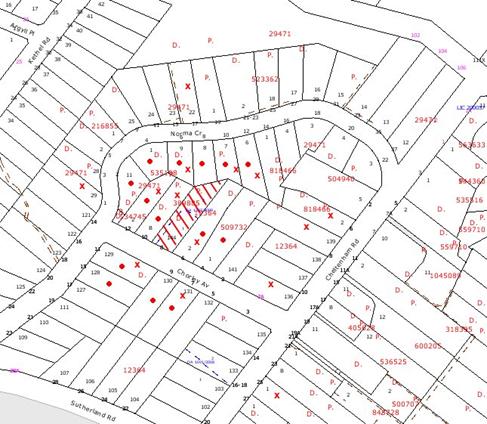
|
NOTIFICATION
PLAN
|
|
|
• PROPERTIES NOTIFIED
|
X SUBMISSIONS
RECEIVED
|
PROPERTY SUBJECT OF DEVELOPMENT
|
|
|
|
|
|
Fourteen submissions objected to the
development, generally on the following grounds that the development would
result in:
· Lack of space for safe
access and egress;
· Inappropriate alteration
to house in heritage area;
· Inadequate driveway
width;
· Design constraint for
rear lot;
· Adverse impact on amenity
and privacy;
· Adverse impact on
significant trees;
· Discrepancy with previous
plans;
· Impact on endangered
vegetation area;
· Non-compliance with the
Development Control Plan.
The merits of the matters raised
in community submissions have been addressed in the body of the report.
6. THE PUBLIC INTEREST
Section 79C(1)(e) of the Act
requires Council to consider “the public interest”.
The public interest is an
overarching requirement, which includes the consideration of the matters
discussed in this report. Implicit to the public interest is the achievement
of future built outcomes adequately responding to and respecting the future
desired outcomes expressed in environmental planning instruments and
development control plans.
The application is considered to
have satisfactorily addressed Council’s criteria and would provide a
development outcome that, on balance, would result in a positive impact for the
community. Accordingly, it is considered that the approval of the proposed
subdivision would be in the public interest.
CONCLUSION
Consent is sought for alterations
to an existing dwelling and subdivision of one lot into two. The proposed
subdivision differs from the previous proposal approved by Council in the
location of the accessway along the western side boundary and in retaining the
existing dwelling. The subject proposal generally maintains the heritage
streetscape and, subject to recommended conditions for tree protection, would
ensure impacts on a significant tree located on the western side boundary are
minimised.
The proposed non-compliance with
the Residential Subdivision DCP requirements for accessway design width and
setback from significant trees, is considered acceptable in retaining the
existing dwelling in the heritage streetscape and with regard to recommended
conditions for tree protection.
The concerns raised by
neighbouring residents in submissions in response to the proposal are generally
addressed by the amended plan and recommended conditions.
It is recommended that Council approve the application.
|
Paul David
Manager -
Subdivision & Development Engineering Services
Planning Division
|
Scott Phillips
Executive Manager
Planning Division
|
Attachments:
|
1.View
|
Locality Plan
|
|
|
|
2.View
|
Subdivision Plan
|
|
|
|
3.View
|
Tree Assessment
|
|
|
|
4.View
|
Indicative Floor
Plans of Dwelling-House on Proposed Lot 2
|
|
|
File Reference: DA/1340/2009
Document Number: D01349919
SCHEDULE 1
GENERAL
CONDITIONS
The
conditions of consent within this notice of determination have been applied to
ensure that the use of the land and/or building is carried out in such a manner
that is consistent with the aims and objectives of the relevant legislation,
planning instruments and Council policies affecting the land and does not
disrupt the amenity of the neighbourhood or impact upon the environment.
Note: For the
purpose of this consent, the term ‘applicant’ means any person who has the
authority to act on or the benefit of the development consent.
Note: For the purpose of
this consent, any reference to an Act, Regulation, Australian Standard or
publication by a public authority shall be taken to mean the gazetted Act or
Regulation, or adopted Australian Standard or publication as in force on the
date that the application for a construction certificate is made.
1. Approved
Plans and Supporting Documentation
The
development must be carried out in accordance with the plans and documentation
listed below and endorsed with Council’s stamp, except where amended by Council
and/or other conditions of this consent:
|
Plan No.
|
Drawn by
|
Dated
|
|
S.14547B
|
P S Graham & Associates
|
17-07-08
|
2. Removal
of Existing Trees
This
development consent only permits the removal of trees numbered 3, 4, 5, 10, 11,
17, 18 and 19 as identified on Plan No. S.14547B
prepared by P S Graham & Associates dated 17-07-08. The removal of any
other trees requires separate approval under Council’s Tree Preservation Order.
REQUIREMENTS PRIOR TO THE ISSUE OF A CONSTRUCTION
CERTIFICATE
3. Easement
Over Downstream Land
The proposed
drainage easement over downstream property 8 Norma Crescent must be registered
with the NSW Department of Lands. A copy of the registered transfer
granting easement shall be submitted with the Construction Certificate.
4. Water/Electricity
Utility Services
The applicant
must submit written evidence of the following service provider requirements:
a. Energy
Australia – a letter of consent demonstrating that satisfactory
arrangements have been made to service the proposed development.
b. Sydney
Water – the submission of a ‘Notice of Requirements’ under s73 of the Sydney
Water Act 1994.
Note: Sydney
Water requires that s73 applications are to be made through an authorised
Sydney Water Servicing Coordinator. Refer to www.sydneywater.com.au or telephone
13 20 92 for assistance.
5. Stormwater
Drainage
The
stormwater drainage system for the development must be designed and constructed
in accordance with Council’s Civil Works – Design and Construction
Specification 2005 and the following requirements:
a. Connected
directly to Council’s street drainage system in Norma Crescent via the proposed
interallotment drainage easement.
b. The
drainage system to service the proposed lot shall provide pits to be
constructed in-situ.
c. The
roof and stormwater drainage system from the existing dwelling and the proposed
access handle driveway to be connected to the proposed inter-allotment drainage
system.
6. Internal
Driveway/Vehicular Areas
The driveway
and parking areas on site must be designed and constructed in accordance with Australian
Standards 2890.1, 3727 and the following requirements:
a. Design
levels at the front boundary be obtained from Council.
b. The
driveway be a rigid pavement designed and constructed 2.8m wide between the
street alignment and the north end of the southern elevation wall for the front
lot. Subsequently, the driveway shall transition to at least 3m wide at all
other locations.
c. The
driveway shall skew slightly to avoid paving near the significant tree on the
common boundary with No. 10 Chorley Avenue, and be designed with a pier and
beam design to an appropriate bearing strata to avoid compression of soils
around the tree.
d. The
driveway grade must not exceed 25 percent and changes in grade must not exceed
8 percent per plan metre.
e. The
driveway pavement be a minimum 0.15 metres thick reinforced concrete with F72
steel reinforcing fabric and a 0.15 metre sub-base, except where a structural
pavement design is necessary to avoid tree root zones.
f. The
pavement shall have a kerb on the No. 8 House (eastern) side of the driveway
and a one-way cross fall with a minimum gradient of 2 percent to the kerb. For
driveway drainage, cast in-situ pits and integrated kerb inlets shall be
provided on the kerb line on grade and at low points and connected to the
proposed interallotment drainage system.
g. An
appropriate damp proof course shall be constructed for No. 8’s external walls
in the vicinity of the driveway kerb at least.
h. Conduit
for utility services including electricity, water, gas and telephone shall be
provided.
i. Concrete
pavement strips shall be designed and constructed as necessary to service the
existing dwelling.
7. In
order to provide for pedestrian and vehicular traffic proposed to be generated
by the development, the following shall be designed and constructed at the
applicant’s cost;-
a. The existing open swale across the entire Chorley Avenue
frontage of the development shall be removed and reconstructed with Council’s
standard 150mm integral kerb and gutter.
b. The alignment and level of the kerb line shall be set by
Council’s Works Division.
c. Construction of Council’s standard 300 mm thick road
shoulder and seal, with grades and levels designed in accordance with Council’s
standard.
e. The footpath shall, where possible, be graded up between the
top of kerb and the boundary at 4%.
f. All existing and proposed street trees and services are to
be shown on the proposed construction plans to ensure there are no conflicts with
these requirements and services or access points to services.
g. All proposed designs and constructions shall be in
accordance with Council’s Design and Construction Specification 2005.
h. Designs for works required in the public road shall be
prepared by a suitably qualified and Chartered Engineer and submitted for
consideration and written approval of Hornsby Shire Council’s Subdivisions
Branch prior to the release of the Construction Certificate.
i. Pursuant to the Roads Act 1993, these works, once
approved shall be supervised by and constructed to the complete satisfaction of
Hornsby Shire Council’s Manager, Subdivisions prior to the release of the
Subdivision Certificate.
8. Traffic
Control Plan
A Traffic
Control Plan (TCP) must be prepared by a qualified traffic controller in
accordance with the Roads & Traffic Authority’s Traffic Control at
Worksites Manual 1998 and Australian Standard 1742.3 for all work on
a public road and be submitted to Council. The TCP must detail the following:
a. Arrangements
for public notification of the works.
b. Temporary
construction signage.
c. Permanent
post-construction signage.
d. Vehicle
movement plans.
e. Traffic
management plans.
f. Pedestrian
and cyclist access/safety.
9. Building
Code of Australia
All building
work must be carried out in accordance with the requirements of the Building
Code of Australia.
REQUIREMENTS PRIOR TO THE COMMENCEMENT OF ANY WORKS
10. Erection
of Construction Sign
A sign must
be erected in a prominent position on any site on which building work,
subdivision work or demolition work is being carried out:
a. Showing
the name, address and telephone number of the principal certifying authority
for the work,
b. Showing
the name of the principal contractor (if any) for any demolition or building
work and a telephone number on which that person may be contacted outside
working hours, and
c. Stating
that unauthorised entry to the work site is prohibited.
Note: Any
such sign is to be maintained while the building work, subdivision work or
demolition work is being carried out, but must be removed when the work has
been completed.
11. Erosion
and Sediment Control
Erosion and
sediment control measures must be provided and maintained throughout the
construction period in accordance with the manual ‘Soils and Construction
2004 (Bluebook)’, the approved plans, Council specifications and to the
satisfaction of the principal certifying authority. The erosion and sediment
control devices must remain in place until the site has been stabilised and
revegetated.
Note: On
the spot penalties up to $1,500 may be issued for any non-compliance with this
requirement without any further notification or warning.
REQUIREMENTS DURING CONSTRUCTION
12. Construction
Work Hours
All work on site (including demolition and earth works)
must only occur between 7am and 5pm Monday to Saturday.
No work is to be undertaken on Sundays or public holidays.
13. Demolition
All
demolition work must be carried out in accordance with Australian Standard
2601-2001 – The Demolition of Structures and the following requirements:
a. Demolition
material is to be disposed of to an authorised recycling and/or waste disposal
site and/or in accordance with an approved waste management plan.
b. Demolition
works, where asbestos material is being removed, must be undertaken by a
contractor that holds an appropriate licence issued by WorkCover NSW in
accordance with Chapter 10 of the Occupational Health and Safety Regulation
2001 and Clause 29 of the Protection of the Environment Operations
(Waste) Regulation 1996.
c. On
construction sites where buildings contain asbestos material, a standard
commercially manufactured sign containing the words ‘DANGER ASBESTOS REMOVAL IN
PROGRESS’ measuring not less than 400mm x 300mm must be erected in a prominent
position visible from the street.
14. Western
Side Wall
To replace any
void left from removal of the chimney, the existing bricks must be used to
infill the void in the wall and in the same brickwork pattern.
15. Driveway
Visual Impact
To minimise
visual impact and to complement the existing dwelling house, the driveway for
proposed lot 2 must be in coloured concrete or stencilled.
16. Environmental
Management
The site must
be managed in accordance with the publication ‘Managing Urban Stormwater –
Landcom (March 2004) and the Protection of the Environment Operations
Act 1997 by way of implementing appropriate measures to prevent sediment
run-off, excessive dust, noise or odour emanating from the site during the
construction of the development.
17. Works
near Trees
All required
tree protection measures are to be maintained in good condition for the
duration of the construction period.
All works
(including driveways and retaining walls) within 4 metres of any trees required
to be retained (whether or not on the subject property, and pursuant to this
consent or the Tree Preservation Order), must be carried out under the
supervision of an ‘AQF Level 5 Arborist’ and a certificate submitted to
the principal certifying authority detailing the method(s) used to preserve the
tree(s).
Note:
Except as provided above, the applicant is to ensure that no excavation,
filling or stockpiling of building materials, parking of vehicles or plant,
disposal of cement slurry, waste water or other contaminants is to occur within
4 metres of any tree to be retained.
18. Works
near Tree No. 30
Tree numbered 30 Eucalyptus pilularis
(Blackbutt) is located within the neighbouring property to the west at 10 Chorley Avenue. To ensure any work undertaken will not adversely affect the longevity of
the tree the following methods of construction are required:
a. Prior to work commencing and to
avoid mechanical injury or damage, tree numbered 30 is to have its trunk
protected by 2m lengths of 75mm x 25mm hardwood timbers spaced at 80mm secured
with galvanised wire (not fixed or nailed to the tree in any way). Trunk
protection is to be installed prior to the issue of a construction certificate
and maintained in good condition for the duration of the construction period.
Affixing signage to trees located on site or located on the nature strip is not
permitted.
b. Excavation for
the installation of the storm water drainage pipe must be carried out by tunnel
boring. Tunnel boring must be carried out at
least 1 metre beneath natural ground surface to minimise damage to the trees
root system.
c. Pier and beam construction of
the driveway within the nominated restriction zone (15m) must be used with
piers being located no closer than 3 metres to the trunk of the tree with all
beams being above the natural soil grade.
d. Excavation for the piers within
the nominated restriction zone (15m) must be hand dug to reveal the presence of
any roots. Tree roots between 10mm and 50mm diameter, revealed during
excavation, must be cut cleanly by a sharp hand saw. The severance of tree
roots greater than 50mm in diameter is not permitted. A qualified and experienced arborist is to be on site
overseeing the work to ensure no roots greater than 50mm in diameter are
severed, and root damage is minimised.
e. Soil compaction within the Tree Protection Zone (TPZ) must be minimised. Appropriate compaction control methods such as mulching (AS4454) must be
used. Vehicular traffic is not permitted within the TPZ of tree 30.
f. A qualified and experienced
arborist (AQF5) is to be on site overseeing the work throughout the development
period to ensure all tree protection specifications are maintained.
19. Disturbance
of Existing Site
During
construction works, the existing ground levels of open space areas and natural
landscape features, (including natural rock-outcrops, vegetation, soil and
watercourses) must not be altered unless otherwise nominated on the approved
plans.
20. Council
Property
During
construction works, no building materials, waste, machinery or related matter
is to be stored on the road or footpath. The public reserve is to be kept in a
clean, tidy and safe condition at all times.
21. Vehicular
Crossing
A
Construction Certificate or an application under the Local Government Act,
1993 and the Roads Act, 1993 must be submitted to Council for the
installation of a new 5.5m wide vehicular crossing for the proposed access
handle and the existing concrete strips servicing the retained dwelling car
spaces, and the removal of the redundant crossing. The vehicular crossing must
be constructed in accordance with Council’s Civil Works Design, 2005 and
the following requirements:
a. Any
redundant crossings to be replaced with integral kerb and gutter.
b. The
footway area to be restored by turfing.
Note:
An application for a vehicular crossing can only be made to one of Council’s
Authorised Vehicular Crossing Contractors. You are advised to contact Council
on 02 9847 6940 to obtain a list of contractors.
REQUIREMENTS PRIOR TO THE ISSUE OF A SUBDIVISION
CERTIFICATE
22. Sydney
Water – s73 Certificate
A s73
Certificate must be obtained from Sydney Water.
23. Creation
of Easements
The following
matter(s) must be nominated on the plan of subdivision under s88B of the Conveyancing
Act 1919:-
a. An
easement for services, as required, over the access corridor.
b. An
inter-allotment drainage easement(s) over each of the burdened lots.
c. The
creation of a “Positive Covenant” over the proposed Lot 2 requiring that
any future development is to provide an on-site detention system. The on-site
detention system is to have a storage capacity of 5 cubic metres and a maximum
discharge of 8 litres per second into the interallotment drainage system in
accordance with Council’s prescribed wording.
d. To
register the subdivision plan, “works-as-executed” details of all civil
works and drainage systems must be submitted verifying that the works have been
constructed in accordance with the design requirements. The details must show
the invert levels of the on site system together with pipe sizes and grades.
Any variations to the approved plans must be shown in red on the “works-as-executed”
plan and supported by calculations.
Note: Council
must be nominated as the authority to release, vary or modify any easement,
restriction or covenant.
24. Boundary
Fencing
Fencing must
be erected along all property boundaries behind the front building alignment to
a height of 1.8 metres, other than the western boundary fence which must extend
from the front building alignment and taper to a height of 1.0 metres at the
front boundary. All fencing must be constructed at the sole cost of the
applicant.
Note:
Alternative fencing may be erected subject to the written consent of
the adjoining property owner(s).
25. Subdivision
Work
The
construction of the accessway and driveway turning head for Lot 2, the
stormwater drainage works for both lots and works involving the existing
dwelling-house, must be completed in accordance with the conditions of this
consent and to Council’s written satisfaction.
26. s94
Infrastructure Contributions
The payment to Council of a
contribution of $19,592.20* for 1 additional lot towards the cost of
infrastructure identified in Council’s Development Contributions Plan
2007-2011.
Note: * The value of contribution is based on a rate of $19,592.20 per
additional lot and is current as at 13 April
2010. The contribution will be adjusted from this date in accordance with the
underlying consumer price index for subsequent financial quarters.
It
is recommended that you contact Council to ascertain the indexed value of the
contribution prior to payment.
- END OF CONDITIONS -
ADVISORY NOTES
The following information is provided for your assistance to
ensure compliance with the Environmental Planning and Assessment Act 1979,
Environmental Planning and Assessment Regulation 2000, other relevant
legislation and Council’s policies and specifications. This information does
not form part of the conditions of development consent pursuant to Section 80A
of the Act.
Environmental Planning and
Assessment Act, 1979 Requirements
· The Environmental Planning and
Assessment Act, 1979 requires:
· The issue of a construction certificate
prior to the commencement of any works. Enquiries regarding the issue of a
construction certificate can be made to Council’s Customer Services Branch on
9847 6760.
· A principal certifying authority to be
nominated and Council notified of that appointment prior to the commencement of
any works.
· Council to be given at least two days
written notice prior to the commencement of any works.
· Mandatory inspections of nominated
stages of the construction inspected.
· An occupation certificate to be issued
before occupying any building or commencing the use of the land.
Subdivision Certificate Requirements
A subdivision certificate
application is required to be lodged with Council containing the following
information:
· A surveyor’s certificate certifying that
all structures within the subject land comply with the development consent in
regard to the setbacks from the new boundaries.
· A surveyor’s certificate certifying that
all services, drainage lines or access are located wholly within the property
boundaries. Where services encroach over the new boundaries, easements are to
be created.
· Certification that the requirements of
relevant utility authorities have been met.
· A surveyor’s certificate certifying
finished ground levels are in accordance with the approved plans.
Note: Council
will not issue a subdivision certificate until all conditions of the
development consent have been completed.
Fees and Charges – Subdivision
All fees payable to Council as
part of any construction, compliance or subdivision certificate or inspection
associated with the development (including the registration of privately issued
certificates) are required to be paid in full prior to the issue of the
subdivision certificate. Any additional Council inspections beyond the scope
of any compliance certificate required to verify compliance with the terms of
this consent will be charged at the individual inspection rate nominated in
Council's Fees and Charges Schedule.
Dial Before You Dig
Prior to commencing any works,
the applicant is encouraged to contact Dial Before You Dig on 1100 or www.dialbeforeyoudig.com.au for
free information on potential underground pipes and cables within the vicinity
of the development site.
House Numbering
House numbering can only be
authorised by Council. Before proceeding to number each premise in the
development, the allocation of numbers is required to be obtained from
Council's Planning Division. The authorised numbers are required to be
displayed in a clear manner at or near the main entrance to each premise.
Tree Preservation Order
To ensure the maintenance and
protection of the existing natural environment, it is an offence to ringbark,
cut down, top, lop, remove, wilfully injure or destroy a tree outside 3 metres
of the approved building envelope without the prior written consent from
Council.
Note: A
tree is defined as a single or multi-trunked wood perennial plant having a
height of not less than three (3) metres, and which develops many branches,
usually from a distance of not less than one (1) metre from the ground, but
excluding any plant which, in its particular location, is a noxious plant
declared as such pursuant to the Noxious Weeds Act 1993. This definition of
‘tree’ includes any and all types of Palm trees.
All
distances are determined under British Standard BS 5837: 2005, “Trees in
Relation to Construction – Recommendations”.
Fines may be imposed for
non-compliance with Council’s Tree Preservation Order.
Planning Report No. PLN25/10
Date of Meeting:
5/05/2010
3 DEVELOPMENT APPLICATION
- ALTERATIONS AND ADDITIONS TO EXISTING MOTOR SHOWROOM
320 PENNANT HILLS ROAD PENNANT HILLS
|
Development Application No:
|
DA/118/2010
|
|
Description of Proposal:
|
Alterations and additions to an existing motor
showroom and new signage
|
|
Property Description:
|
Lot 201 DP 1105214 (No. 320) Pennant Hills Road,
Pennant Hills
|
|
Applicant:
|
Alto Group Pty Ltd
|
|
Owner:
|
Capricorn Constructions Pty Ltd
|
|
Statutory Provisions:
|
Hornsby Shire Local Environmental
Plan 1994
Industrial B (Light) Zone
|
|
Estimated Value:
|
$3,771,033
|
|
Ward:
|
C
|
|
RECOMMENDATION
THAT Development Application
No. 118/2010 for alterations and additions to an existing motor showroom and
new signage at lot 201 DP 1105214 (No. 320) Pennant Hills Road, Pennant Hills
be approved subject to the conditions of consent detailed in Schedule 1 of
this report.
|
1. The
application proposes alterations and additions to an existing motor showroom
and new signage.
2. The
proposal satisfies the requirements of Hornsby Shire Local Environmental Plan
1994, the Industrial Lands Development Control Plan and the Pennant Hills
Commercial Centre Development Control Plan.
4. One
submission has been received in respect of the application.
5. It
is recommended that the application be approved.
HISTORY OF THE SITE
The existing motor showroom on
the site was approved by Council in 1988.
THE SITE
The site has an area of 3,893m2
and is located on the western side of Pennant Hills Road adjacent to the main
northern railway. Stevens Street defines the northern boundary of the site.
The western rear boundary is defined by the rail corridor and an access road
along the rear of the site. An access road also forms the southern boundary.
The site includes the existing
Audi and Mitsubishi motor showrooms.
Motor showrooms predominate south
of and opposite the site. The land north of Stevens Street is occupied by
medium-high density housing.
THE PROPOSAL
The proposed alterations and
additions include:
Lower Level:
· Alterations to the
internal walls and doors to accommodate a new service reception area.
· Modify the existing
lunchroom, amenities and locker room.
· Demolish part of the
existing storage area at rear of the workshop.
· Replace the existing
roller doors at the rear of the workshop.
· Accommodate six
service bays.
· Internal modifications
to the workshop.
· Reclad part of the
northern external wall adjoining Stevens Street.
· Remove the rear awning
to the workshop and replace with a new awning extension over the service
vehicle car parking.
Upper Level:
· Remove the existing
awning at the front of the showroom.
· Demolish the small
office at the southern end of the building.
· Extend the showroom
towards Pennant Hills Road by demolishing the existing glazed wall and
constructing a new glazed wall interwoven with ‘Audi’s’ new signature mesh
screen wall.
· Construct an internal
mezzanine level above the showroom.
· Internal refurbishment
works to provide offices, sales area, lounge and vehicle hand over space.
· Modify the existing
amenities.
· Modify the existing
vehicle display area and service vehicle parking to improve the onsite vehicle
manoeuvrability.
· Extend the stairs and
landing to the northern showroom and upgrade the entry area.
The existing Mitsubishi
dealership would be relocated to a new showroom currently under construction at
338 Pennant Hills Road, Pennant Hills (DA/1685/2008).
All of the existing vehicular
entry and exit points remain unchanged.
The proposed alterations and
additions are in accordance with Audi’s corporate design theme.
The proposed signage includes:
· Sign A: Audi pylon
measuring 1.93m x 6.0m high.
· Sign B: Audi used car
sign measuring 1.05m x 2.8m high.
· Sign C: Audi entrance
sign measuring 1.05m x 1.25m high.
· Sign D: Audi direction
al sign measuring 1.05m x 1.77m high.
· Wall Signs – Audi logo
3 @ 4.1m x 1.427m.
· Wall Signs – Audi Alto
Pennant Hills 3 @ 0.6 x 8.6m.
· Wall Sign – Audi
Service reception 1 @ 0.6m x 8.6m.
The proposed signs would replace
the existing signage.
ASSESSMENT
The development application has
been assessed having regard to the ‘2005 City of Cities Metropolitan
Strategy’, the ‘North Subregion (Draft) Subregional Strategy’ and
the matters for consideration prescribed under Section 79C of the Environmental
Planning and Assessment Act 1979 (the Act). Subsequently, the following
issues have been identified for further consideration.
1. STRATEGIC CONTEXT
1.1 Metropolitan Strategy – (Draft) North Subregional Strategy
The Metropolitan Strategy is a
broad framework to secure Sydney’s place in the global economy by promoting and
managing growth. It outlines a vision for Sydney to 2031; the challenges
faced, and the directions to follow to address these challenges and achieve the
vision. The draft North Subregional Strategy acts as a framework for Council
in the preparation of a new Principal LEP by 2011.
The draft Subregional Strategy
sets the following targets for the Hornsby LGA by 2031:
· Employment capacity to
increase by 9,000 jobs; and
· Housing stock to
increase by 11,000 dwellings.
The proposed development would be
consistent with the draft Strategy by providing additional job opportunities in
the locality.
2. STATUTORY CONTROLS
Section 79C(1)(a) requires
Council to consider “any relevant environmental planning instruments, draft
environmental planning instruments, development control plans, planning
agreements and regulations”.
2.1 Hornsby Shire Local Environmental Plan 1994
The subject land is zoned
Industrial B (Light) under the Hornsby Shire Local Environmental Plan 1994
(HSLEP). The objectives of the zone are:
(a) to encourage economic growth and employment opportunities.
(b) to allow a broad range of light industrial, warehousing
and other compatible land uses to locate within the area.
(c) to promote development that does not adversely impact on
the natural and built environment.
The proposed development is
defined as a ‘motor showroom’ under the HSLEP and is permissible in the zone
with Council’s consent.
Clause 15 of the HSLEP prescribes
that the maximum floor space ratio (FSR) of development within the Industrial B
zone is 1:1. The proposed development complies with this requirement.
2.2 State Environmental Planning Policy No. 64 – Advertising
and Signage
The application has been assessed
against the requirements of State Environmental Planning Policy No. 64. This
Policy provides State-wide planning controls to regulate signage to ensure
advertising signs are compatible with amenity and visual character, communicate
effectively and are of good design.
The proposed signs are defined as
building identification signs, and are subject to assessment under Part
2 and Schedule 1 of the Policy.
The proposed signs are satisfactory
in regard to the assessment criteria provided under Schedule 1 of the Policy,
concerning the character of the area, views and vistas, streetscape, site and
building features, illumination and safety.
The signs do not exceed 20m2
in area, are less than 8 metres in height and would not require the concurrence
of the NSW Roads and Traffic Authority.
2.3 Industrial Lands Development Control Plan
The proposed development has been
assessed having regard to the relevant performance and prescriptive design
standards within Council’s Industrial Lands Development Control Plan
(Industrial Lands DCP). The following table sets out the proposal’s compliance
with the prescriptive standards of the Plan:
|
Industrial Lands
Development Control Plan
|
|
Control
|
Proposal
|
Requirement
|
Compliance
|
|
Gross Floor Area
|
1,905m2
|
N/A
|
N/A
|
|
Floor Space Ratio
|
0.489:1
|
1:1
|
Yes
|
|
Front Setback
|
6.5m
|
5m
|
Yes
|
|
Car parking – 1 space per 130m2 + 6 per
service bay
|
51 spaces
|
51 spaces
|
Yes
|
|
Signage – 0.5m2 per linear metre road
frontage
|
55.85m2
|
58.5m2
|
Yes
|
|
Storeys
|
2 storeys
|
2 storeys
|
Yes
|
The proposed alterations and
additions to the existing motor showroom comply with the prescriptive standards
within Council’s Industrial Lands DCP. The following is a brief discussion on
compliance with relevant performance standards.
2.3.1 Density
The proposal involves alterations
and additions to the motor showroom increasing the total floor area from 1,896m2
to 1,905m2...
The proposal would not result in
a substantive intensification of the operation of the existing motor showroom.
2.3.2 Setbacks
The existing building has a
minimum setback of 3.5m to the Pennant Hills Road frontage. The existing
setback would remain unchanged by the proposed development.
The proposed additions would
involve a minimum front setback of 6.5m. The proposed setback complies with the
required minimum 5m main road front setback.
2.3.3 Design
The proposed alterations and
additions incorporate the Audi corporate façade treatment colour scheme. The
change in the façade includes extensive glazing and a parapet wall above. The
parapet at the Pennant Hills Road frontage features a mesh-screen finish. The
building height to the top of the parapet is 9m.
The general layout of the
showroom and service workshop would remain unchanged with vehicle access
provided to the service workshop off Stevens Street and customer access to the
vehicle showroom and display areas from Pennant Hills Road.
The presentation of the building
would complement the streetscape and is consistent with the recently
constructed motor showroom south of the site. The proposal would also comply
with the Industrial Land DCP building design performance criteria.
2.3.4 Vehicle Access and Parking
The existing vehicular access for
the motor showroom and service workshop including the vehicle loading and
unloading facilities would be maintained for the development.
The proposal includes
reconfiguring the existing car parking spaces and outdoor car display areas.
The proposed car parking area for the service workshop and motor showroom
comply with the requirements of the Industrial Lands DCP for 51 car parking
spaces. The design and layout of the car parking is considered functional for
the respective operations of the motor showroom and workshop.
In a submission,
traffic safety was raised as a concern on Stevens Street. To address this
concern, a convex safety mirror is required to be erected on the northern side
of Stevens Street located opposite the service bay exit. The safety mirror
would improve sight lines to vehicles on Stevens Street.
2.3.5 Signs
The proposed signage forms part
of the architectural expression of the building as proposed.
The proposed signage complies
with the prescriptive measures and performance criteria of the Industrial Lands
DCP and SEPP 64.
2.3.6 Landscaping
The existing landscape area is
maintained for the proposal and is acceptable.
2.3.7 Acoustics
The proposed development would
maintain the motor showroom’s existing operating acoustic environment.
The site is adjacent to a
medium/high density residential development located on the north side of Stevens Street. To maintain the existing acoustic environment a condition is recommended
for background noise levels not to be exceeded by 5dB(A).
The proposed hours of operation
for the motor showroom are from 8.00am to 6.00pm Monday to Saturday and 9.00am
to 5.00pm Sundays and public holidays. A condition is recommended to restrict
the operation hours of the service workshop to 7.30am to 6.00pm Monday to
Friday and to 8.00am to 1pm Saturday.
2.3.8 Drainage Control
There would be no net increase in
stormwater runoff from the proposed development. The existing stormwater
drainage infrastructure is adequate for the development.
2.4 Pennant Hills Commercial Centre Development Control Plan
The motor showroom is located
within the Plan’s ‘Service Precinct’. The proposed development maintains the
present use of the land and complies with the relevant requirements of the Plan
in respect to solar access, car parking, density, building design, setbacks and
height.
The proposed signage does not
comply with the Plan’s prescriptive measure for a maximum area for signage of
3m2 for signs within the Light Industrial Zones. The non-compliance
is considered acceptable with regard to streetscape visual impact and
integration of the signs with the architectural expression of the building as
proposed.
3. ENVIRONMENTAL IMPACTS
Section 79C(1)(b) of the Act
requires Council to consider “the likely impacts of that development, including
environmental impacts on both the natural and built environments, and social
and economic impacts in the locality”.
3.1 Natural Environment
The proposed development
maintains the existing landscaping and would not result in an adverse impact on
the natural environment.
3.2 Built Environment
The proposed development
contributes positively to the built form of the Pennant Hills Service Precinct
involving motor showrooms on Pennant Hills Road.
The current traffic generation
and vehicle access to the site would remain unchanged.
3.3 Social Impacts
The proposed alterations and
additions upgrade to the existing building would assist in maintaining the
viability of motor vehicle industry jobs in the locality.
3.4 Economic Impacts
The proposed alterations and
additions maintain the economic life of the building.
4. SITE SUITABILITY
Section 79C(1)(c) of the Act
requires Council to consider “the suitability of the site for the
development”.
The site comprises an existing
motor showroom and is suitable for the proposed development.
5. PUBLIC PARTICIPATION
Section 79C(1)(d) of the Act
requires Council to consider “any submissions made in accordance with this
Act”.
5.1 Community Consultation
The proposed development was
placed on public exhibition and was notified to adjoining and nearby landowners
between 15 February and 11 March 2010 in accordance with Council’s Notification
and Exhibition Development Control Plan. During this period, Council received
one submission. The map below illustrates the location of the nearby landowner
who made a submission.
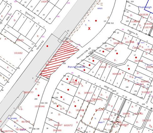
|
NOTIFICATION
PLAN
|
|
|
• PROPERTIES NOTIFIED
|
X SUBMISSIONS
RECEIVED
|
PROPERTY SUBJECT OF DEVELOPMENT
|
|
|
|
|
|
The one submission objected to
the development, generally on grounds that the development would result in:
· Unacceptable traffic
safety on Stevens Street.
The merits of the matter raised
in the submission have been addressed in Section 2.3.4 of the report.
5.2 Public Agencies
The proposed development adjoins the northern rail corridor
and was referred to RailCorp for comment.
RailCorp advised it had no objections to the proposal and
raised no specific conditions or requirements.
6. THE PUBLIC INTEREST
Section 79C(1)(e) of the Act
requires Council to consider “the public interest”.
The public interest is an
overarching requirement, which includes the consideration of the matters
discussed in this report. Implicit to the public interest is the achievement
of future built outcomes adequately responding to and respecting the future
desired outcomes expressed in environmental planning instruments and
development control plans.
The application is considered to
have satisfactorily addressed Council’s and relevant agencies’ criteria and
would provide a development outcome that, on balance, would result in a positive
impact for the community. Accordingly, it is considered that the approval of
the proposed motor showroom alterations and additions and signage would be in
the public interest.
CONCLUSION
Consent is sought for alterations and additions to upgrade
an existing motor showroom for an Audi dealership.
The proposal reconfigures the
existing floor space, maintains the existing vehicle access and would not
result in an intensification of the current use. The proposal complies with
requirements of the Industrial Lands DCP in respect to density, setbacks,
building design, vehicle access, parking, signs, drainage control and solar
access.
The proposal complies with the Pennant Hills Commercial
Centre DCP other than the prescriptive measure for signs not to exceed 3m2.
The non-compliance is considered acceptable.
The traffic safety concerns raised in public consultation
would be addressed by recommended condition for a convex safety mirror.
The application is recommended for approval.
Note: At the time of the completion of this planning
report, no persons have made a Political Donations Disclosure Statement pursuant
to Section 147(3) of the Environmental Planning and Assessment Act 1979 in
respect of the subject planning application.
|
Scott Phillips
Executive Manager
Planning Division
|
|
Attachments:
|
1.View
|
Locality Plan
|
|
|
|
2.View
|
Plan Existing
Building
|
|
|
|
3.View
|
Lower Level
|
|
|
|
4.View
|
Upper Level and
Mezzanine
|
|
|
|
5.View
|
Roof Plan
|
|
|
|
6.View
|
Elevations East
and South
|
|
|
|
7.View
|
Elevations West
|
|
|
|
8.View
|
Elevations North
|
|
|
|
9.View
|
Sections
|
|
|
|
10.View
|
Outdoor Signs
|
|
|
File Reference: DA/118/2010
Document Number: D01375716
SCHEDULE 1
GENERAL
CONDITIONS
The
conditions of consent within this notice of determination have been applied to
ensure that the use of the land and/or building is carried out in such a manner
that is consistent with the aims and objectives of the relevant legislation,
planning instruments and Council policies affecting the land and does not
disrupt the amenity of the neighbourhood or impact upon the environment.
Note: For the
purpose of this consent, the term ‘applicant’ means any person who has the
authority to act on or the benefit of the development consent.
Note: For the purpose of
this consent, any reference to an Act, Regulation, Australian Standard or
publication by a public authority shall be taken to mean the gazetted Act or
Regulation, or adopted Australian Standard or publication as in force on the
date that the application for a construction certificate is made.
1. Approved
Plans and Supporting Documentation
The development must be carried
out in accordance with the plans and documentation listed below and endorsed
with Council’s stamp, except where amended by Council and/or other conditions
of this consent:
|
Plan No.
|
Drawn by
|
Dated
|
|
AUDA-05 Issue B – Lower Level
|
AS Architects
|
14/01/2010
|
|
AUDA-06 Issue C – Upper &
Mezzanine
|
AS Architects
|
3/03/2010
|
|
AUDA-07 Issue B - Roof
|
AS Architects
|
14/01/2010
|
|
AUDA-08 Issue B – Lower Level
South
|
AS Architects
|
14/01/2010
|
|
AUDA-09 Issue C – Lower Level
North
|
AS Architects
|
3/03/2010
|
|
AUDA–10 Issue C – Upper Level
|
AS Architects
|
3/03/2010
|
|
AUDA–11 Issue C – Upper Level
North
|
AS Architects
|
3/03/2010
|
|
AUDA-12 Issue C - Elevations
|
AS Architects
|
3/03/2010
|
|
AUDA–13 Issue C – East &
South Elevation
|
AS Architects
|
3/03/2010
|
|
AUDA–14 Issue B – West
Elevations
|
AS Architects
|
14/01/2010
|
|
AUDA–15 Issue B – Elevations
Showrm Nth
|
AS Architects
|
14/01/2010
|
|
AUDA-16 Issue B – Sections A
& B
|
AS Architects
|
14/01/2010
|
|
AUDA-17 Issue B – Sections C
& D
|
AS Architects
|
14/01/2010
|
|
AUDA-18 Issue B – Sections E
& F
|
AS Architects
|
14/01/2010
|
|
AUDA-19 Issue B – Sections G
& H
|
AS Architects
|
14/01/2010
|
|
AUDA-20 Issue B – Outdoor
Signage
|
AS Architects
|
14/01/2010
|
|
|
|
|
|
Document No.
|
Prepared by
|
Dated
|
|
D01335310 – Statement of Environmental
Effects
|
Ryan Planning
|
February 2010
|
REQUIREMENTS PRIOR TO THE ISSUE OF A CONSTRUCTION
CERTIFICATE
2. Building
Code of Australia
All building work must be
carried out in accordance with the requirements of the Building Code of
Australia.
3. Fire
Safety Upgrade
To ensure the protection of
persons using the building and to facilitate egress from the building in the
event of a fire, the application for a construction certificate must
demonstrate that it would comply with the following Category 1 fire safety
provisions:
a. Emergency
lighting and illuminated exit signs must be provided throughout in accordance
with Part E4.2 & E4.5 of the BCA
b. Fire
Hydrants, Fire Hose Reels & Portable Fire Extinguishers must be provided in
accordance with Part E1.3, E1.4 & E1.6 of the BCA
REQUIREMENTS PRIOR TO THE COMMENCEMENT OF ANY WORKS
4. Erection
of Construction Sign
A sign must be erected in a
prominent position on any site on which building work, subdivision work or
demolition work is being carried out:
a. Showing
the name, address and telephone number of the principal certifying authority
for the work,
b. Showing
the name of the principal contractor (if any) for any demolition or building
work and a telephone number on which that person may be contacted outside
working hours, and
c. Stating
that unauthorised entry to the work site is prohibited.
Note: Any
such sign is to be maintained while the building work, subdivision work or
demolition work is being carried out, but must be removed when the work has
been completed.
5. Erosion
and Sediment Control
Erosion and sediment control
measures must be provided and maintained throughout the construction period in
accordance with the manual ‘Soils and Construction 2004 (Bluebook)’, the
approved plans, Council specifications and to the satisfaction of the principal
certifying authority. The erosion and sediment control devices must remain in
place until the site has been stabilised and revegetated.
Note: On
the spot penalties up to $1,500 may be issued for any non-compliance with this
requirement without any further notification or warning.
REQUIREMENTS DURING CONSTRUCTION
6. Waste
Management Plan
Appropriate work practices
shall be employed to implement the Waste Management Plan Section One –
Demolition Stage and Section Three – Construction Stage as specified in the
Statement of Environmental Effects dated February 2010.
7. Demolition
All demolition work must be
carried out in accordance with Australian Standard 2601-2001 – The
Demolition of Structures and the following requirements:
a. Demolition
material is to be disposed of to an authorised recycling and/or waste disposal
site and/or in accordance with an approved waste management plan.
b. Demolition
works, where asbestos material is being removed, must be undertaken by a
contractor that holds an appropriate licence issued by WorkCover NSW in
accordance with Chapter 10 of the Occupational Health and Safety Regulation
2001 and Clause 29 of the Protection of the Environment Operations
(Waste) Regulation 1996.
c. On construction
sites where buildings contain asbestos material, a standard commercially
manufactured sign containing the words ‘DANGER ASBESTOS REMOVAL IN PROGRESS’
measuring not less than 400mm x 300mm must be erected in a prominent position
visible from the street.
8. Construction
Work Hours
All
work on site (including demolition and earth works) must only occur between 7am
and 5pm Monday to Saturday.
No
work is to be undertaken on Sundays or public holidays.
9. Council
Property
During construction works, no building
materials, waste, machinery or related matter is to be stored on the road or
footpath. The public reserve is to be kept in a clean, tidy and safe condition
at all times.
REQUIREMENTS PRIOR TO THE ISSUE OF AN OCCUPATION
CERTIFICATE
Note: For the
purpose of this consent, any reference to ‘occupation certificate’ shall also
be taken to mean ‘interim occupation certificate’ unless otherwise stated.
10. Traffic
Control Plan
A Traffic Control Plan (TCP)
must be prepared by a qualified traffic controller in accordance with the Roads
& Traffic Authority’s Traffic Control at Worksites Manual 1998 and Australian
Standard 1742.3 for all work on a public road and be submitted to Council.
The TCP must detail the following:
a. Arrangements
for public notification of the works.
b. Temporary
construction signage.
c. Permanent
post-construction signage.
d. Vehicle
movement plans.
e. Traffic
management plans.
f. Pedestrian
and cyclist access/safety.
11. Hours
of Operation
The hours of operation of
the Service Workshop are restricted to those times listed below:
Monday to Friday 7.30 am to 6 pm
Saturday 8 am to 1 pm
Sunday & Public Holidays No work
12. Car
Parking and Deliveries
All car parking must be
constructed and operated in accordance with Australian Standard AS 2890.1 –
2004 – Off Street Car Parking and Australian Standard 2890.2 - 2002 –
Off Street Commercial and the following requirement:
a. All
parking areas and driveways are to be sealed to an all weather standard, line
marked and signposted.
b. Car
parking, loading and manoeuvring areas to be used solely for nominated
purposes.
c. Vehicles
awaiting loading, unloading or servicing must be parked on site and not on
adjacent or nearby public roads;
d. All
vehicular entry on to the site and egress from the site must be made in a
forward direction.
13. Traffic
and Road Safety
A convex safety mirror
must be erected on the northern side of Stevens Street opposite the service bay
exit, to provide a sight line to/from vehicles west bound on Stevens Street and vehicles leaving the service bay driveway onto Stevens Street.
14. Noise
All noise generated by the
proposed development must be attenuated to prevent levels of noise being
emitted to adjacent premises which possess tonal, beating and similar
characteristics or which exceeds background noise levels by more than 5dB(A).
15. Motor
Vehicle Repairs
The operation of motor
vehicle repairs at the premises must be carried out in accordance with the
following requirements:
a. No
motor vehicle or part of a motor vehicle which is in
the custody of the person carrying on the motor vehicle repair business is to
be left standing on any public road or place.
b. All work to vehicles must be undertaken within the confines
of the building.
c. The
removal and dismantling of all mechanical parts is to be conducted in a roofed,
concrete floored area that is graded to a drainage point connected to Sydney
Water’s sewer in accordance with its requirements.
16. Storage
of Flammable and Combustible Goods
Flammable and combustible
liquids must be stored in accordance with Australian Standard 1940 – The
Storage and Handling of Flammable and Combustible Liquids. A bund wall
must be constructed around all work and liquid storage areas to prevent any
spillage entering into the stormwater system. The bunded area must provide a
volume equal to 110% of the largest container stored and graded to a blind sump
so as to facilitate emptying and cleansing.
17. Trade
Waste
Liquid trade waste
generated on the site must be discharged in accordance with a trade waste
agreement with Sydney Water and by a licensed liquid trade waste
contractor.
18. Maintenance
of Wastewater Device
All wastewater and
stormwater treatment devices (including drainage systems, sumps and traps) must
be regularly maintained in order to remain effective. All solid and liquid
wastes collected from the device must be disposed of in accordance with the Protection
of the Environment Operations Act 1997.
19. Environmental
Management
The site must
be managed in accordance with the publication ‘Managing Urban Stormwater –
Landcom (March 2004) and the Protection of the Environment Operations
Act 1997 by way of implementing appropriate measures to prevent sediment
run-off, excessive dust, noise or odour emanating from the site during the
construction of the development.
20. Excavated Material
All excavated
material removed from the site must be classified in accordance with the NSW
Environment Protection Authority’s Environmental Guidelines – Assessment,
Classification and Management of Liquid and Non-Liquid Wastes prior to
disposal to an approved waste management facility and reported to the principal
certifying authority.
21. Fire
Safety Statement - Annual
On at least one occasion in
every 12 month period following the date of the first ‘Fire Safety Certificate’
issued for the property, the owner must provide Council with an annual ‘Fire
Safety Certificate’ to each essential service installed in the building.
-
END OF CONDITIONS -
ADVISORY NOTES
The following information is provided for your
assistance to ensure compliance with the Environmental Planning and Assessment
Act, 1979, Environmental Planning and Assessment Regulation 2000, other
relevant legislation and Council’s policies and specifications. This
information does not form part of the conditions of development consent
pursuant to Section 80A of the Act.
Environmental Planning and Assessment Act, 1979
Requirements
· The Environmental Planning and
Assessment Act, 1979 requires:
· The issue of a construction certificate
prior to the commencement of any works. Enquiries regarding the issue of a
construction certificate can be made to Council’s Customer Services Branch on
9847 6760.
· A principal certifying authority to be
nominated and Council notified of that appointment prior to the commencement of
any works.
· Council to be given at least two days
written notice prior to the commencement of any works.
· Mandatory inspections of nominated
stages of the construction inspected.
· An occupation certificate to be issued
before occupying any building or commencing the use of the land.
Long Service Levy
In accordance with Section 34 of
the Building and Construction Industry Long Service Payments Act 1986, a ‘Long Service Levy’ must be paid to the Long
Service Payments Corporation or Hornsby Council.
Note: The
rate of the Long Service Levy is 0.35% of the total cost of the work.
Note: Hornsby
Council requires the payment of the Long Service Levy prior to the issue of a
construction certificate.
Disability Discrimination Act
The applicant’s attention is
drawn to the existence of the Disability Discrimination Act. A
construction certificate is required to be obtained for the proposed
building/s, which will provide consideration under the Building Code of
Australia, however, the development may not comply with the requirements of
the Disability Discrimination Act. This is the sole responsibility of
the applicant.
Dial Before You Dig
Prior to commencing any works,
the applicant is encouraged to contact Dial Before You Dig on 1100 or www.dialbeforeyoudig.com.au for
free information on potential underground pipes and cables within the vicinity
of the development site.
Asbestos Warning
Should asbestos or asbestos
products be encountered during demolition or construction works you are advised
to seek advice and information should be prior to disturbing the material. It
is recommended that a contractor holding an asbestos-handling permit (issued by
WorkCover NSW) be engaged to manage the proper handling of the material.
Further information regarding the safe handling and removal of asbestos can be
found at:
www.environment.nsw.gov.au
www.nsw.gov.au/fibro
www.adfa.org.au
www.workcover.nsw.gov.au
Alternatively, telephone the WorkCover
Asbestos and Demolition Team on 8260 5885.
Waste Management
Council encourages the operation
to install an indoor waste/recycling cupboard for the interim storage of a
minimum one day’s waste/recycling generation with separate containers for
general waste and recyclable materials within each kitchen/lunch room.
Standard Report No. PLN26/10
Planning Division
Date of Meeting:
5/05/2010
4 REPORTING VARIATIONS TO
DEVELOPMENT STANDARDS
EXECUTIVE SUMMARY
In accordance with the Department
of Planning’s Planning Circular PS 08-14, Council is required to report
variations to development standards for development applications approved under
delegated authority, which relied upon State Environmental Planning Policy No.
1 - Development Standards (SEPP 1).
PURPOSE
The purpose of this report is to advise Council of
determined development applications involving a SEPP 1 variation to a
development standard relating to the period 1 January 2010 to 31 March 2010.
BACKGROUND
The Department of Planning issued Circular PS
08–014 on 14 November 2008. The purpose of the Circular was to remind councils
of their responsibilities to monitor the use of the Director-General’s assumed
concurrence under State Environmental Planning Policy No. 1. Councils were
reminded of the need to keep accurate records of the use of SEPP 1 and to
report on a quarterly basis.
DISCUSSION
In accordance with the Department’s Circular, attached
hereto is a list of development applications determined under delegated
authority involving a SEPP 1 variation to a
development standard for the period 1 January 2010 to 31 March 2010.
A copy of the attachment to this report is also reproduced
on Council’s website.
BUDGET
There are no budget implications.
POLICY
There are no policy implications.
CONSULTATION
There was no consultation in the preparation of this
report.
TRIPLE BOTTOM LINE SUMMARY
Triple Bottom Line is a framework for improving Council
decisions by ensuring accountability and transparency on social, environmental
and economic factors. It does this by reporting upon Council’s strategic
themes.
As this report only provides Council with information and
does not propose any actions which require a sustainability assessment, no
Triple Bottom Line considerations apply.
|
RECOMMENDATION
THAT Council note the contents
of Executive Manager’s Report No. PLN26/10.
|
|
Scott Phillips
Executive Manager
Planning Division
|
|
Attachments:
File Reference: F2004/07599
Document Number: D01378579
Standard Report No. PLN27/10
Planning Division
Date of Meeting:
5/05/2010
5 AMENDMENTS PLANNING
PROPOSAL 2009 - REPORT ON SUBMISSIONS
EXECUTIVE SUMMARY
In November 2009, Council
considered a report identifying a number of planning anomalies to be rectified
and amendments to be made to the Hornsby Shire Local Environmental Plan 1994
(HSLEP) as part of its annual Amendments Local Environmental Plan (LEP)
2009. Council endorsed a Planning Proposal for public exhibition
proposing to rezone lands, address planning anomalies and make minor amendments
to the HSLEP.
The Planning Proposal was
exhibited for community comment in February and March 2010 along with
supporting Development Control Plan (DCP) amendments. Ten submissions
were received in response to the exhibition. The key issues raised in
submissions are addressed in this report. Minor amendments to the
Planning Proposal and draft DCP amendments are recommended in response to the
issues raised in submissions.
It is recommended that Council
adopt the amended Planning Proposal attached to this report and forward it to
the Department of Planning (DOP) for gazettal.
PURPOSE
The purpose of this report is to
review submissions received in response to the exhibition of the Annual
Amendments 2009 Planning Proposal and associated draft DCP amendments.
BACKGROUND
At its meeting on 4 November
2009, Council considered Executive Manager’s Report No. PLN89/09 concerning
Council’s annual amendments review. The report presented a Planning
Proposal to rezone lands, address planning anomalies and make minor amendments
to the HSLEP. Council resolved that:
1. Council endorse progression of the
Planning Proposal attached to Executive Manager’s Report No. PLN89/09 to:
1.1 rezone and permit strata subdivision at
property No. 218 Brooklyn Road, Brooklyn;
1.2 update the listing of heritage items in
accordance with the recommendations of Heritage Review Stage 4 and East Epping
Heritage Review; and
1.3 implement the recommendations of the Hornsby
West Side Conservation Area Review with the exception of the rezoning of the
precinct to Residential AS (Low Density - Sensitive Lands).
2. Council forward the Planning
Proposal to the Minister for Planning seeking “approval” to progress the
preparation of the draft LEP in accordance with Section 56(1) of the Environmental
and Planning Assessment Act 1979.
3. Should the Minister determine
under Section 56(2) of the Environmental Planning and Assessment Act, 1979,
that the matter may proceed without significant amendment to the Proposal,
Council publicly exhibit the Planning Proposal in accordance with the Minister’s
determination.
4. The draft amendments to the Heritage,
Dwelling-House, Residential Subdivision, Low Density Multi-Unit Housing, Medium
Density Multi-Unit Housing, Medium/High Density Multi-Unit Housing, Dural
Village Centre, River Settlements, Rural Lands and Extractive Industries
Development Control Plans as outlined in Executive Manager’s Report No.
PLN89/09, be exhibited for 28 days with the exhibition of the Planning
Proposal.
5. Following the exhibition, a report
be prepared for Council’s consideration on submissions received.
In
accordance with Council’s resolution, on 1 December 2009, the Planning Proposal
was forwarded to the DOP seeking a Gateway Determination by the Minister in
accordance with Section 56 of the Environmental Planning and Assessment (EP&A)
Act.
On 30
December 2009, Council received a Gateway Determination from the DOP,
indicating that the Planning Proposal should be exhibited. The Gateway
Determination was issued with a condition that proposed heritage items from the
East Epping Heritage Review be removed from the Planning Proposal. The
DOP advised that this matter would be addressed in the context of the Epping
Town Centre Study currently being progressed by Council. Accordingly, the
Planning Proposal was amended to reflect the Gateway Determination.
In
accordance with the adopted Consultation Strategy, the Commissioner of the
Rural Fire Service was consulted prior to the commencement of the exhibition
period. No objections were received. The NSW Rural Fire Service noted that
future development on bushfire prone land would need to comply with Section
79BA or Section 91 of the EP&A Act and may require a bushfire safety
authority as per Section 100B of the Rural Fires Act 1997.
The
Planning Proposal and associated draft DCP amendments were exhibited for
community comment between 16 February and 19 March 2010 at Council’s
Administration Centre, Council’s libraries and on the Council website.
Letters were sent to affected property owners, two community groups and
relevant State Government agencies. An advertisement was placed in the
local newspapers on two occasions. Relevant Council branches were also
invited to comment on the Planning Proposal and draft DCP amendments.
DISCUSSION
Ten
submissions were received in response to the exhibition. Six submissions are
generally supportive, or raise no objection to the Planning Proposal and draft
DCP amendments including submissions from Sydney Water and the Roads and
Traffic Authority. The key issues raised in submissions are outlined below as
they relate to each component of the Planning Proposal.
CWA Building and
Sandstone Steps, Hornsby Park Pacific Highway, Hornsby
The
Planning Proposal seeks to add the CWA Building and Sandstone Steps within Hornsby Park as a heritage item of local significance to Schedule D (Heritage Items) of the
HSLEP. The CWA Building and Sandstone
Steps are located within Hornsby Park, comprising three separate allotments
which run from the Pacific Highway to Rosemead Road.
Submissions: Council’s Environment Division raises
concern with the CWA Building being added as an item of local significance to
Schedule D (Heritage Items) of the HSLEP. The Environment
Division’s submission notes that Council is currently progressing two projects
(preparation of a park masterplan for Old Mans Valley and the redevelopment of
Hornsby Pool) that may potentially impact on the proposed heritage listing. The
submission suggests that the listing of the CWA Building as a heritage item should
be deferred until current investigations, including development options for the
projects, are further progressed.
Representatives
from the Environment Division have indicated that there is no objection to the
listing of the Sandstone Steps, which are located towards the western end of
the park, within a separate Lot and DP to the CWA Building.
Comment:
Heritage Review Stage 4 recognises
that the CWA Building is of local heritage significance. However, the
heritage significance of the building should be balanced against the community
benefit arising from the projects being progressed by the Environment Division.
The submission by the Environment Division indicates that current
investigations will involve further consideration of heritage issues. Accordingly,
it would be appropriate to defer the listing of the CWA Building as a heritage
item until investigations have been completed.
With
respect to the Sandstone Steps, further investigation has confirmed that the
Sandstone Steps referred to within Heritage Review Stage 4, are located
at the western end of Hornsby Park on Lot 7017, DP 1052646 and the adjacent
unmade road reserve immediately to the south. The
CWA Building is located at the eastern entrance to the Park adjacent to Pacific Highway, on Lot 7019, DP 1059310. Accordingly, the listing of the Steps would not
impact on the projects being progressed by the Environment Division.
Resolve:
It is recommended that consideration
of heritage listing of the CWA Building be deferred for further consideration
following finalization of the Old Mans Valley Park Masterplan and Hornsby Pool
Plans. It is recommended that the listing of the Sandstone Steps be amended to
reflect the location of the Sandstone Steps on Lot 7017, DP 1052646 and the
adjacent unmade road reserve immediately to the south.
Property
Nos. 3-5 Hannah Street, Beecroft
The
Planning Proposal seeks to add property Nos. 3-5 Hannah Street, Beecroft as a
heritage item (Retail Shops) of local significance to Schedule D (Heritage
Items) of the HSLEP.
Submissions: Two submissions from the property
owners object to property Nos. 3-5 Hannah Street, Beecroft being added as an
item of local significance to Schedule D (Heritage Items) of the HSLEP. The
submissions comment that the inventory, which forms part of Heritage Review
Stage 4, contains a number of inaccuracies including the item name,
physical description and Statement of Significance. The owners contest the
historical importance of the properties and suggest they do not warrant heritage
listing.
Comment:
Council is progressing a Housing
Strategy that identifies opportunities for additional housing within
planned precincts proposed to be rezoned to permit higher density multi-unit
housing. Property Nos. 3-5 Hannah Street, Beecroft are within the Beecroft Road, Beecroft precinct and are being considered for possible rezoning to
facilitate 5 storey mixed use development as part of the Strategy. Council has been advised previously by the DOP that draft
LEPs relating to Heritage Conservation Areas and heritage items will not be
progressed in areas close to train stations which may assist Council in
fulfilling dwelling target obligations under the Metropolitan Strategy.
Accordingly, it would be appropriate to defer consideration of the listing of
property Nos. 3-5 Hannah Street, Beecroft as a heritage item until Council has
finalised the Housing Strategy.
Resolve:
It is recommended that consideration
of the heritage listing of property Nos. 3-5 Hannah Street, Beecroft be
deferred for further consideration following finalization of Council’s Housing
Strategy.
Property
No. 33 Wongala Crescent, Beecroft
The
Planning Proposal seeks to add property No. 33 Wongala Crescent, Beecroft as a
heritage item (House and Garden) of local significance to Schedule D (Heritage
Items) of the HSLEP. The inventory which forms part of Heritage
Review Stage 4 states that the significant features of the property include
a faux timber archway (evidence of concrete cancer), pond and a radiata pine.
The inventory also recommends liaising with owners regarding presentation,
structural integrity and sympathetic addition of gates.
Submissions: One submission from the property owner
objects to property No. 33 Wongala Crescent being added as an item of local
significance to Schedule D (Heritage Items) of the HSLEP. The
submission comments that the inventory which forms part of Heritage Review
Stage 4 contains an incorrect photo, which does not depict the property.
The submission states that the significant features of the property, especially
the pond, have been compromised by tree root damage.
Comment:
Council’s Heritage Consultant was
requested to review the issues raised in the submission. The Heritage
Consultant advises that the house is typical of its type but has rustic
features such as the verandah and entrance arch that reflect the construction
of the house in an era when the area would have been semi rural. The house
appears in reasonable condition but confirms that the entrance arch is showing
signs of deterioration (unlikely to be concrete cancer) and the side walls are
cracking. The Consultant confirms that the radiata pine thought to be causing
damage has been removed and that the photograph of the rear garden is
incorrect. However, the Consultant advises that, subject to the updating of the
inventory sheet, the property merits listing. It is also noted that a local
heritage listing cannot require property owners of heritage items to undertake
works. Therefore, the management recommendations within the inventory regarding
the gate should be removed.
Resolve:
It is recommended that the heritage
listing of property No. 33 Wongala Crescent, Beecroft be progressed, and that
the inventory be amended to:
- correct the photograph of
the rear garden;
- remove reference to the
radiata pine and concrete cancer; and
- delete the management
recommendations regarding the gate.
Hornsby
West Side Conservation Area
The
Planning Proposal seeks to implement the recommendations of the Hornsby West
Side Conservation Area Review by expanding the residential component of the
existing Conservation Area.
Submissions: Two submissions support the
expansion of the residential component of the existing Conservation Area as
recommended by the Review. However, one of the submissions objects to
the reduction of minimum block size within the Conservation Area from 800m2
to 600m2.
Comment:
The draft Planning Proposal presented
to Council at its meeting on 4 November 2009 included the proposed rezoning of
properties within the Heritage Conservation Area to Residential AS (Low Density – Sensitive Lands). The rezoning of the lands was proposed to provide a
consistent zoning with lands within the Beecroft Cheltenham Heritage
Conservation Area and in recognition of the landscape qualities and larger
allotment sizes that characterise the area. A rezoning of the area to Residential AS would increase the minimum allotment size to 600m² (excluding any accessway).
Council
endorsed the progression of the Planning Proposal to (in part) implement the
recommendations of the Hornsby West Side Conservation Area Review with
the exception of the rezoning of the precinct to Residential AS (Low Density –
Sensitive Lands).
The
underlying zoning of the land as Residential A (Low Density) is proposed to be
retained. Therefore, the minimum allotment size that applies under the current
zoning of 500m² (excluding any accessway) will also be retained. It is
understood that in resolving to delete the change in zoning from the Planning
Proposal, Council was of the view that existing controls in the Heritage DCP
including design, streetscape, siting and landscaping are adequate to ensure
new development is sympathetic to the identified heritage values of the area.
Resolve:
It is recommended that no amendment be
made to the Planning Proposal as a result of the submissions concerning the Hornsby
West Side Conservation Area Review and minimum lot sizes.
Property No. 218 Brooklyn Road, Brooklyn
At its meeting on 7 October 2009,
Council considered Executive Manager’s Report No. PLN78/09 evaluated a
submission requesting that the HSLEP be amended to permit strata
subdivision at property No. 218 Brooklyn Road, Brooklyn.
The Report noted that Development
Application No. 2482/02 was approved in April 2003 for alterations and
additions to an existing multi-unit housing development and the provision of
on-site car parking. The Report noted that works including the construction of
balconies and external staircase have been carried out. However, the
construction of six car park spaces in the south eastern corner of the site
(adjacent to William Street) has not been commenced. The approved vehicle
parking area is to be constructed as an elevated concrete slab with retaining
wall.
Council resolved that amendments to the HSLEP to enable strata subdivision
and correct a zoning anomaly at property No. 218 Brooklyn Road be incorporated
in Council’s Annual Amending Planning Proposal 2009. Council also resolved
that prior to forwarding the Planning Proposal to the DOP for gazettal, car
parking be provided in accordance with Development Consent No. 2482/2002.
In accordance with Council’s
resolution, the Planning Proposal seeks to amend Clause 22 – Exceptions of the HSLEP
to permit strata subdivision at No. 218 Brooklyn Road. The Proposal
also seeks to rectify a zoning anomaly by rezoning two small areas of Business
A (General) zoned land at the western end of the site to Residential A (Low
Density) to provide a consistent zoning across the land. On 27 October 2009,
the proponent was requested to undertake the necessary actions to ensure the
provision of car parking on-site.
Comment: On 22 December
2009, Council received a Section 96(1A) application to delete all the approved
carparking on the site pursuant to DA/2482/2002. On 25 February 2010, the
Section 96(1A) application was amended to delete four of the six approved
carparking spaces. The two spaces identified to be retained are able to be
provided at close to existing ground level without the need for extensive
retaining walls and cantilevered structures unlike the remaining four spaces.
In the assessment of the
application, it was noted that a search of Council’s files indicates that
historically there were only 4 units in the premises. It is therefore
appropriate that carparking be provided on the site as part of DA/2482/2002 to
cater for the two additional units. The assessment notes that the provision of
2 additional parking spaces satisfies the requirement in the Brooklyn DCP
that at least one car parking space be provided per additional dwelling.
Accordingly, the amendment to the Development consent was approved on 4 March
2010 under delegated authority.
Notwithstanding
the above, the Section 96(1A) amendment does not negate the non-compliance with
the Development Consent as car parking has still not been provided on-site.
Accordingly, it would be appropriate to defer the provisions of the Planning
Proposal relating to permitting strata subdivision of the site for
consideration as part of a future Planning Proposal when the car parking works
have been undertaken.
Resolve: It is
recommended that the provisions of the Planning Proposal relating to permitting
strata subdivision of property No. 218 Brooklyn Road
be deferred for consideration as part of a future Planning Proposal when
the car parking works have been undertaken.
Property
Nos. 22-56 Hillmont Road, Thornleigh
The
Planning Proposal seeks to add property Nos. 22-56 Hillmont Avenue, Thornleigh
as a heritage item (Trees) of local significance to Schedule D (Heritage Items)
of the HSLEP. During the exhibition, it was noted that there is a
typographical error for the proposed listing of property Nos. 22-56 Hillmont
Avenue, Thornleigh. The Planning Proposal should be amended as follows:
|
Address
|
Property
Description
|
Item
|
Significance
|
|
22
40-56 Hillmont Road Avenue
|
Lots
25-26 and 30-34 39, DP 28362, Lots A and B, DP 403196, Lots 4-5 and Lot 7, DP 30002, and Lots 61 and 62, DP
1111312
|
Trees
|
L
|
STATUTORY CONSIDERATIONS
Statutory considerations are
discussed below in terms of both the Planning Proposal and draft DCP
amendments.
Planning Proposal
The Planning Proposal is being
progressed as part of the new “gateway plan-making process”. Community
consultation forms part of this process and is only complete when Council has
considered any submissions made concerning the Planning Proposal.
Under Section 58 of the EP&A
Act, Council may vary the Planning Proposal based on consideration of submissions
and must forward a copy of the revised Planning Proposal to the Minister.
The issues identified in submissions are addressed in this report.
Minor amendments are recommended to the Planning Proposal as a result of
submissions. The amendments are minor in nature and do not warrant the
re-exhibition of the Planning Proposal. The amended Planning Proposal addresses
relevant Section 117 Directions and State Environmental Planning Policies
required to be considered by Council. It is recommended that the amended
Planning Proposal be forwarded to the Minister.
Draft Development Control Plan
Amendments
Draft
DCP amendments which reflect the amendments to the HSLEP were exhibited
in accordance with Clause 18 of the Environmental Planning and Assessment
Regulations. No submissions were received in relation to the draft DCP
amendments. Minor amendments are recommended to the draft DCP
amendments to reflect the changes to the Planning Proposal and do not warrant
re-exhibition. The amended DCP amendments are attached and would come into
effect following the gazettal of the LEP amendments.
CONSULTATION
On 1
December 2009, Council forwarded the Planning Proposal to the DOP seeking
Gateway Determination by the Minister in accordance with Section 56 of the EP&A
Act. On 31 December 2009, the DOP issued Council with a
Gateway Determination to exhibit the Planning Proposal. Council consulted
with relevant Government agencies concerning the Planning Proposal. No
objections were received from Government agencies.
The Planning Proposal was
exhibited for community comment in February and March 2010. Ten
submissions have been received and are addressed in this report.
TRIPLE BOTTOM LINE SUMMARY
Triple Bottom Line is a framework
for improving Council decisions by ensuring accountability and transparency on
social, environmental and economic factors. It does this by reporting upon
Council’s strategic themes.
A Triple Bottom Line summary was
provided in respect of Heritage Review Stage 4 in Executive Manager’s Report
No. PLN32/08, considered by Council on 20 February 2008. A Triple Bottom Line
summary was provided in respect of property No. 218 Brooklyn Road, Brooklyn in Executive Manager’s Report No. PLN78/09, considered by Council on 7 October
2009. A Triple Bottom Line summary was provided in respect of the Hornsby
West Side Conservation Area Review in Executive Manager’s Report No.
PLN89/09, considered by Council on 4 November 2009.
CONCLUSION
Council has identified a number
of planning anomalies to be rectified and minor amendments to be made to the HSLEP
as part of its 2009 annual Amendments Planning Proposal. A Planning
Proposal and associated draft DCP amendments to rectify planning anomalies and
make amendments to the HSLEP has been prepared in consultation with
relevant Government agencies and the community.
No objections were received from
Government agencies. Ten submissions were received in response to the
exhibition of the Planning Proposal and draft DCP amendments. The issues
raised in submissions have been addressed in this report.
It is recommended that Council
adopt the Planning Proposal and draft DCP amendments subject to the minor
amendments indentified in this report and forward the Planning Proposal to the
DOP for gazettal.
|
RECOMMENDATION
THAT:
1. Council adopt the amended Planning
Proposal attached to Executive Manager’s Report No. PLN27/10 to:
1.1 rezone and permit strata subdivision at property No. 218 Brooklyn Road, Brooklyn
1.2 update the listing of heritage items in accordance with the
recommendations of Heritage Review Stage 4, with the exception of the
following items:
- CWA Building, Hornsby Park Pacific Highway, Hornsby
- Property Nos. 3-5 Hannah Street, Beecroft;
1.3 implement the recommendations of the Hornsby West Side
Conservation Area Review.
2. Consideration of the heritage listing of “CWA Building, Hornsby Park Pacific Highway, Hornsby” and “Property Nos. 3-5 Hannah Street,
Beecroft” be deferred for further consideration following finalisation of the
Old Mans Valley Park Masterplan/Hornsby Pool Plans and Council’s Housing
Strategy, respectively.
3. The provisions of the Planning Proposal relating to permitting
strata subdivision of property No. 218 Brooklyn Road be deferred for
consideration as part of a future Planning Proposal when the car parking
works have been undertaken.
4. The Planning Proposal be forwarded to the Department of
Planning for gazettal.
5. Council endorse the amendments to
the Heritage, Dwelling-House, Residential Subdivision, Low, Medium, and
Medium/High Density Multi-Unit Housing, Dural Village Centre, River
Settlements, Rural Lands and Extractive Industries Development Control Plans
attached to Executive Manager’s Report No. PLN27/10.
6. The Heritage Inventory
Sheet for property No 33 Wongala Crescent Beecroft be
amended
to:
· correct the photograph
of the rear garden;
· remove reference to the
radiata pine and concrete cancer; and
· delete the management
recommendations regarding the gate.
7. Submitters be advised
of Council’s resolution.
|
|
James Farrington
Manager - Town
Planning Services
Planning Division
|
Scott Phillips
Executive Manager
Planning Division
|
Attachments:
|
1.View
|
Planning Proposal
- Annual Amendments 2009
|
|
|
|
2.View
|
Draft DCP Amendments
|
|
|
File Reference: F2009/00758
Document Number: D01380448