BUSINESS PAPER
Planning
Meeting
Wednesday, 2 June 2010
at 6.30pm
|
Hornsby
Shire Council
|
Agenda and Summary of
Recommendations
|
|
Page
1
|
|
|
|
|
TABLE OF CONTENTS
AGENDA
AND SUMMARY OF RECOMMENDATIONS
Mayoral Minutes
Notices of Motion
Rescission Motions
MATTERS OF URGENCY
ITEMS PASSED BY EXCEPTION / CALL FOR SPEAKERS ON
AGENDA ITEMS
DEVELOPMENT APPLICATIONS
A
Ward Deferred
A
Ward
B
Ward Deferred
B
Ward
Item 1 PLN106/09 Development Application -
Increase in Student Numbers - Loreto Normanhurst - Mount Pleasant Avenue and
Pennant Hills Road Normanhurst
C
Ward Deferred
C
Ward
Item 2 PLN15/10 Development Application -
Section 96(2) - Registered Club - Alterations and Additions - Amended Staging
of Works - 103 - 109 New Line Road Cherrybrook
Item 3 PLN28/10 Development Application -
Residential - Alterations and Additions - 29 George Street, Pennant Hills
Item 4 PLN30/10 Development Application -
Subdivision of One Lot into two - 50 Sutherland Road, Beecroft
Item 5 PLN33/10 Development Application -
Subdivision - One Lot into Two and Construction of a New Dwelling - 41 Cardinal Avenue Beecroft
General Business
Item 6 PLN29/10 Heritage Advisory Committee -
Technical Specialist Representation
Item 7 PLN31/10 Amendments Planning Proposal
2009 - Report on Submissions
Item 8 PLN34/10 Metropolitan Strategy Review - Sydney Towards 2036
Questions of Which Notice Has Been Given
SUPPLEMENTARY AGENDA
QUESTIONS WITHOUT NOTICE
AGENDA AND SUMMARY OF RECOMMENDATIONS
PRESENT
NATIONAL
ANTHEM
OPENING
PRAYER/S
Rev. Neil Dawson of Thornleigh Community Baptist Church, Thornleigh will be opening the Meeting in prayer.
Acknowledgement
of RELIGIOUS DIVERSITY
Statement by the
Chairperson:
“We recognise our Shire's rich
cultural and religious diversity and we acknowledge and pay respect to the
beliefs of all members of our community, regardless of creed or faith."
ABORIGINAL
RECOGNITION
Statement
by the Chairperson:
"We recognise the traditional inhabitants of the land
we are meeting on tonight, the Darug and Guringai Aboriginal people, and
respect is paid to their elders and their heritage."
AUDIO
RECORDING OF COUNCIL MEETING
Statement by the Chairperson:
"I advise all present that
tonight's meeting is being audio recorded for the purpose of assisting in the
accuracy of the Minutes. The recordings may be accessed by members of the
public once the Minutes have been finalised. Speakers are requested to ensure
their comments are relevant to the issue at hand and to refrain from making
personal comments or criticisms."
APOLOGIES
/ LEAVE OF ABSENCE
Political
Donations Disclosure
Statement by the Chairperson:
“In
accordance with Section 147 of the Environmental Planning and Assessment Act
1979, any person or organisation who has made a relevant planning application
or a submission in respect of a relevant planning application which is on
tonight’s agenda, and who has made a reportable political donation or gift to a
Councillor or employee of the Council, must make a Political Donations
Disclosure Statement.
If a
Councillor or employee has received a reportable political donation or
gift from a person or organisation who has made a relevant planning application
or a submission in respect of a relevant planning application which is on
tonight’s agenda, they must declare a non-pecuniary conflict of interests to
the meeting, disclose the nature of the interest and manage the conflict of
interests in accordance with Council’s Code of Conduct.”
declarations
of interest
Clause 52 of Council’s Code of
Meeting Practice (Section 451 of the Local Government Act, 1993) requires that
a councillor or a member of a Council committee who has a pecuniary interest in
a matter which is before the Council or committee and who is present at a
meeting of the Council or committee at which the matter is being considered
must disclose the nature of the interest to the meeting as soon as
practicable. The disclosure is also to be submitted in writing (on the form
titled “Declaration of Interest”).
The Councillor or member of a
Council committee must not be present at, or in sight of, the meeting of the
Council or committee:
(a) at any time during which the matter is being considered or
discussed by the Council or committee.
(b) at any time during which the Council or committee is
voting on any question in relation to the matter.
Clause 51A of Council’s Code
of Meeting Practice provides that a Councillor, Council officer, or a member of
a Council committee who has a non pecuniary interest in any matter with which
the Council is concerned and who is present at a meeting of the Council or
committee at which the matter is being considered must disclose the nature of
the interest to the meeting as soon as practicable. The disclosure is also to
be submitted in writing (on the form titled “Declaration of Interest”).
If the non-pecuniary interest
is significant, the Councillor must:
a) remove the source of conflict, by relinquishing or divesting
the interest that creates the conflict, or reallocating the conflicting duties
to another Council official.
OR
b) have no involvement in the matter by absenting themself from
and not taking part in any debate or voting on the issue as if the provisions
of Section 451(2) of the Act apply.
If the non-pecuniary interest
is less than significant, the Councillor must provide an explanation of why
they consider that the interest does not require further action in the
circumstances.
confirmation
of minutes
THAT the Minutes of the Planning Meeting held on 5 May, 2010 be
confirmed; a copy having been distributed to all Councillors.
petitions
Mayoral Minutes
Notices of Motion
Rescission Motions
MATTERS OF URGENCY
ITEMS PASSED BY EXCEPTION / CALL
FOR SPEAKERS ON AGENDA ITEMS
Note:
Persons wishing to address Council on matters which are on
the Agenda are permitted to speak, prior to the item being discussed, and their
names will be recorded in the Minutes in respect of that particular item.
DEVELOPMENT APPLICATIONS
A Ward Deferred
A Ward
B Ward Deferred
B Ward
Page
Number
Item 1 PLN106/09 Development
Application - Increase in student numbers - Loreto Normanhurst - Mount Pleasant
Avenue and Pennant Hills Road Normanhurst
RECOMMENDATION
THAT Development Application No. 1277/2004/B to increase
student numbers from 915 to 1150 at Loreto Normanhurst at Lot 1 DP 734965, Lot
B DP 327538, Lots 11-16, 20-23 and 25-36 DP 6612, Lot 1 DP 809066, Lot 1 DP
34834 (Nos. 8, 10-12, 14, 16-22, 24-28 and 30-62) Mount Pleasant Avenue and
(Nos. 91-93) Pennant Hills Road, Normanhurst, be approved as detailed in
Schedule 1 of this report.
C Ward Deferred
C Ward
Page
Number
Item 2 PLN15/10 Development
Application - Section 96(2) - Registered Club - Alterations and Additions -
Amended Staging of Works - 103-109 New Line Road Cherrybrook
RECOMMENDATION
THAT
Development Application No. DA/1046/2007/A for alterations and additions to the
West Pennant Hills Sports Club including a new car park, relocation of bowling
greens, tennis courts and cricket nets and the erection of one sign at Lot 2 DP
367373, No. 103 - 109 New Line Road, Cherrybrook be modified as detailed in
Schedule 1 of this report.
Page
Number
Item 3 PLN28/10 Development
Application - Residential Alterations and additions - 29 George Street Pennant
Hills
RECOMMENDATION
THAT Council assume the
concurrence of the Director-General of the Department of Planning pursuant to
State Environmental Planning Policy No. 1 and approve Development Application
No. DA/330/2010 for the erection of alterations and additions to a
dwelling-house at Lot 102, DP 875670, No. 29 George Street, Pennant Hills
subject to the conditions of consent detailed in Schedule 1 of this report.
Page
Number
Item 4 PLN30/10 Development
Application - Subdivision of one lot into two - 50 Sutherland Road, Beecroft
RECOMMENDATION
THAT Development Application No. 1118/2009 for the
subdivision of one lot into two at Lot A DP 349374 (No. 50) Sutherland Road,
Beecroft be approved subject to the conditions of consent detailed in Schedule
1 of this report.
Page
Number
Item 5 PLN33/10 Development
Application - Subdivision - One lot into two and construction of a new dwelling
41 Cardinal Avenue Beecroft
RECOMMENDATION
THAT Development Application No.
DA/723/2009 for the subdivision of one lot into two and the construction of a
dwelling at Lot 2 DP 584894 (No. 41) Cardinal Avenue, Beecroft be approved subject
to the conditions of consent detailed in Schedule 1 of this report.
General Business
Page
Number
Item 6 PLN29/10 Heritage
Advisory Committee - Technical Specialist Representation
RECOMMENDATION
1. THAT the Heritage Advisory Committee Constitution be
amended in accordance with the revised Constitution (attached) to:
- increase the number of
Technical Specialists to a minimum of three and a maximum of four;
- reduce the number of Councillors to three;
and
- require the attendance of three members for
a quorum.
2. Council invite Micheal Clarke, Margaret
Desgrand and Roy Lucas to participate on the Hornsby Shire Advisory
Committee as voluntary technical specialists.
3. Submitters be advised of Council’s resolution and thanked for
their interest in the matter.
4. Three Councillors (Council
to nominate three Councillors) be elected as Councillor representatives
on the Hornsby Heritage Advisory Committee.
Page Number
Item
7 PLN31/10 Amendments Planning Proposal 2009 - Report on
Submissions
THAT:
1. Council adopt the amended Planning
Proposal attached to Executive Manager’s Report No. PLN27/10 to:
1.1 rezone and permit strata subdivision at property
No. 218 Brooklyn Road, Brooklyn
1.2 update the listing of heritage items in
accordance with the recommendations of Heritage Review Stage 4, with the
exception of the following items:
- CWA Building, Hornsby Park Pacific Highway, Hornsby
- Property Nos. 3-5 Hannah
Street, Beecroft;
1.3 implement the recommendations of the Hornsby
West Side Conservation Area Review.
2. Consideration of the heritage listing
of “CWA Building, Hornsby Park Pacific Highway, Hornsby” and “Property Nos. 3-5 Hannah Street, Beecroft” be deferred for further consideration following finalisation of
the Old Mans Valley Park Masterplan/Hornsby Pool Plans and Council’s Housing
Strategy, respectively.
3. The Planning Proposal be forwarded to
the Department of Planning for gazettal.
4. Council endorse the amendments to the Heritage,
Dwelling-House, Residential Subdivision, Low, Medium, and Medium/High Density
Multi-Unit Housing, Dural Village Centre, River Settlements, Rural Lands and
Extractive Industries Development Control Plans attached to Executive
Manager’s Report No. PLN27/10.
5.
The Heritage Inventory Sheet for property No 33 Wongala Crescent Beecroft be
amended to:
· correct the photograph of
the rear garden;
· remove reference to the
radiata pine and concrete cancer; and
· delete the management
recommendations regarding the gate.
6.
Submitters be advised of Council’s resolution.
Page
Number
Item 8 PLN34/10 Metropolitan
Strategy Review - Sydney Towards 2036
RECOMMENDATION
THAT
Council forward the submission attached to Executive Manager’s Report No.
PLN34/10 to the Department of Planning commenting on the State Government’s
review of the Metropolitan Strategy.
Questions of Which Notice Has Been Given
SUPPLEMENTARY AGENDA
QUESTIONS WITHOUT NOTICE
Planning Report No. PLN106/09
Date of Meeting:
2/06/2010
1 DEVELOPMENT APPLICATION
- INCREASE IN STUDENT NUMBERS
- LORETO NORMANHURST - MOUNT PLEASANT AVENUE AND PENNANT HILLS ROAD NORMANHURST
|
Development Application No:
|
DA/1277/2004/B
|
|
Description of Proposal:
|
Section 96(2) application to
increase student numbers from 915 to 1150 at Loreto Normanhurst
|
|
Property Description:
|
Lot 1 DP 734965, Lot B DP 327538, Lots 11-16, 20-23
and 25-36 DP 6612, Lot 1 DP 809066, Lot 1 DP 34834 (Nos. 8, 10-12, 14, 16-22,
24-28 and 30-62) Mount Pleasant Avenue and (Nos. 91-93) Pennant Hills Road,
Normanhurst
|
|
Applicant:
|
Loreto Normanhurst
|
|
Owner:
|
Loreto Convent Property Association
|
|
Statutory Provisions:
|
Hornsby Shire Local Environmental
Plan 1994
Special Uses A (Community
Purposes)
Residential A (Low Density)
|
|
Estimated Value:
|
Nil
|
|
Ward:
|
B
|
|
RECOMMENDATION
THAT Development Application No. 1277/2004/B to increase
student numbers from 915 to 1150 at Loreto Normanhurst at Lot 1 DP 734965,
Lot B DP 327538, Lots 11-16, 20-23 and 25-36 DP 6612, Lot 1 DP 809066, Lot 1
DP 34834 (Nos. 8, 10-12, 14, 16-22, 24-28 and 30-62) Mount Pleasant Avenue
and (Nos. 91-93) Pennant Hills Road, Normanhurst, be approved as detailed in
Schedule 1 of this report.
|
1. The
application proposes to modify a condition of consent to increase student
numbers at Loreto Normanhurst from 915 to 1150.
2. The proposal complies
with the Hornsby Shire Local Environmental Plan 1994 and Community Uses
Development Control Plan.
3. Eleven
submissions (including 5 individual submissions and 6 pro forma letters) have
been received in respect of the application.
4. It
is recommended that the proposed modification to the consent be approved.
HISTORY OF THE APPLICATION
On 3 November 2004 Council approved DA/1277/2004 for the
demolition of an existing classroom building and the erection of a new school
classroom building. A condition of consent restricted the maximum number of
pupils to 850.
On 12 December 2005 Council approved a Section 96(2)
application to increase student numbers to 915.
THE SITE
The site has an area of 12.85 hectares and is bounded by Osborn Road, Pennant Hills Road and Mount Pleasant Avenue, Normanhurst. The site is
occupied by a private Catholic girls’ secondary school. Existing buildings are
concentrated on the northern portion of the site. The existing school oval,
playing fields, bushland and cemetery are located towards the southern end of
the site.
The site is partly zoned Special Uses A (Community
Purposes) and partly zoned Residential A (Low Density). Most of the buildings
on the site are located within the Special Uses zone with the exception of the
Principal’s residence, the Loreto Community houses and the Director of Boarding
Residence. The Loreto Convent, grounds, gates and cemetery on the site are
heritage items of regional significance.
The indoor swimming pool and gymnasium complexes are
located immediately to the north of the oval towards the Mount Pleasant Avenue
side of the site.
Current access to the site is via Mount Pleasant Avenue, Pennant Hills Road and Osborn Road.
THE PROPOSAL
The application proposes a modification to the approved
development by way of an amendment to condition No. 65 to increase student
numbers from 915 to 1150. The proposal involves no physical works on the site.
Condition No. 65 of Development Consent No. 1277/2004
states as follows:
65. There shall be
no increase in the number of students above 915 pupils without the prior
written consent of Council. Upon written request by Council, at a frequency of
no greater than one occasion per calendar year, the school shall provide
written advice of current numbers within twenty-one days of request.
ASSESSMENT
The development application has
been assessed having regard to the ‘2005 City of Cities Metropolitan
Strategy’, the ‘North Subregion (Draft) Subregional Strategy’ and
the matters for consideration prescribed under Section 79C of the Environmental
Planning and Assessment Act 1979 (the Act). Subsequently, the following
issues have been identified for further consideration.
1. STRATEGIC CONTEXT
1.1 Metropolitan Strategy – (Draft) North Subregional Strategy
The Metropolitan Strategy is a
broad framework to secure Sydney’s place in the global economy by promoting and
managing growth. It outlines a vision for Sydney to 2031; the challenges
faced, and the directions to follow to address these challenges and achieve the
vision. The draft North Subregional Strategy acts as a framework for Council
in the preparation of a new Principal LEP by 2011.
The draft Subregional Strategy
sets the following targets for the Hornsby LGA by 2031:
· Employment capacity to
increase by 9,000 jobs; and
· Housing stock to
increase by 11,000 dwellings.
The proposed development would
not be inconsistent with the draft Strategy.
2. STATUTORY CONTROLS
Section 79C(1)(a) requires
Council to consider “any relevant environmental planning instruments, draft
environmental planning instruments, development control plans, planning
agreements and regulations”.
2.1 Environmental Planning and Assessment Act. 1979
The application has been lodged
pursuant to Section 96(2) of the Act, which allows the modification of a
consent, where the proposal has been notified in accordance with regulatory
requirements, is substantially the same development as approved and Council
considers the application with regard to Section 79C of the Act and any
submissions.
The proposed modification
involves the amendment to a condition of consent to permit the increase in
student numbers from 915 to 1150. The modification in considered to be
substantially the same development as approved.
The application was notified
pursuant to Council’s Notification and Exhibition DCP and Council received
eleven submissions (refer to Section 5 of this report).
2.2 Hornsby Shire Local Environmental Plan 1994
The site is zoned Special Uses A (Community Purposes) and
Residential A (Low Density). The existing development is defined as an
‘educational establishment’ which is permissible pursuant to Clause 7.
The zone objectives are:-
(a) to provide
for the cultural needs of the community.
(b) to
identify land for the provision of community services and facilities.
(c) to ensure
that community uses are compatible with the amenity of the area in which they
are located.
The proposed modification would
not alter the compliance of the original proposal with the objectives of the
zone.
2.3 State Environmental Planning Policy (Infrastructure)
2007
The
application has been assessed against the requirements of State Environmental
Planning Policy (Infrastructure) 2007. This Policy contains State-wide
planning controls for developments adjoining rail-corridors and busy roads.
2.3.1 Traffic Generating
Development
The development is classified as
a Traffic Generating Development in accordance with Clause 104 of the SEPP
(Infrastructure) as it is located on a site that has direct vehicular or
pedestrian access to a classified road. In accordance with the SEPP, the
application was referred to the RTA for comment. The RTA raised no concerns
with regard to the proposed increase in student numbers.
A further assessment of traffic
impacts associated with the application is detailed below.
2.4 Community Uses
Development Control Plan
The proposal to modify the development
consent would not alter the compliance of the original proposal with the
relevant performance criteria and prescriptive standards contained within the
Community Uses DCP.
The primary impacts of the
application concern the availability of car parking spaces (either on-site or
on-street) and the capacity of the local road network to accommodate additional
traffic. These impacts are described below:
2.4.1 Car Parking
The prescriptive measures for secondary schools states that
the provision of off-street student parking is to be determined on the basis of
a “Parking Survey” or “Traffic Impact Study” which has regard to locational
factors and existing transport networks or at a rate of 1 space per 2 students
of driving age, plus 5 bicycle racks per class for years 5 to 11.
In support of the application,
the applicant submitted a Traffic and Parking Report. The report states that
the number of students currently driving is 25, however, acknowledges that
student drivers currently approach an actual maximum of 30 each year from a
school population of 915. The report details that an increase from 915 to 1150
would result in an increased parking requirement to 33 student vehicles and
recommends that the student driver permits be capped at a new limit of 50. The
current student driver permits are limited to 40.
Notwithstanding the findings of
the Traffic and Parking Report, it is considered that the existing cap of 40
student driving permits would be retained. This would still allow the
projected extra students who would drive to school the ability to park, whilst
not increasing car parking demands beyond the current capacity of the site.
The Traffic and Parking Report
further recommends that the informal angle parking located along Mount Pleasant Avenue, located adjacent to the school, be utilised
for student parking. However, as there is sufficient car parking on-site (as
detailed below), and due to safety concerns regarding visibility when reversing
out of angled parking bays, it is considered appropriate to require all student
car parking to be accommodated on-site.
Council’s Car Parking Development
Control Plan requires that 1 parking space be provided per full time staff
member. Currently there is provision for 201 on-site parking spaces, which would
allow sufficient parking for the projected 171 staff. Accordingly, it is
considered that the proposed staff car parking allocation would be acceptable.
The Traffic and Parking Report considers that only 80% of staff would be
driving and that the increase in car parking for staff associated with the
increased student numbers would not be significant.
With respect to the provision of bicycle racks, the school
has advised that students are not permitted to ride bicycles to school.
Therefore, no bicycle racks would be required to be provided in association
with this application. If however the School changed its policy and permitted
students to cycle to school, sufficient space is available on-site to
accommodate bike racks.
Having regard to the matters above, the proposal is assessed
as satisfactory with regard to car parking.
2.4.2 Access
No changes are proposed to the
existing vehicular access arrangements to and from the site. These
arrangements are considered adequate and would accommodate the increase in
traffic associated with the proposed development.
2.4.3 Traffic
The traffic engineering assessment concluded that the
majority of increased vehicular access to the site would be from Osborn Road. The Traffic and Parking Report records that traffic volumes along this road
would be 3000 vehicles per day, which represents an increase of approximately
66, or a projected 33 extra vehicle tips to the school. The impact of this
increase on the operation of this street report is considered acceptable.
The current
vehicle volumes along Mount Pleasant Avenue are estimated to be 1,600 vehicles
per day, and as the result of the proposed changes a minor increase of up to 8
vehicles, or 16 vehicle trips, is expected. The impact of this on the operation
of Mount Pleasant Avenue is considered acceptable.
Based on the
information provided, the increases on the road network are acceptable, as the
proposed hourly distributions would not significantly impact on the current
traffic situation.
The existing infrastructure would
not require any improvements to service the proposed increase in student
numbers. All the necessary infrastructure is currently in place along the
major routes.
2.4.4 Recreation Space
The element ‘Recreation Space’ of the Community Uses
DCP requires a minimum of 20m2 of recreation space per
student to be provided for education establishments. On the basis of 1150
students, a total of 23,000m2 of recreation space is
required to be provided. The school currently provides well in excess of this
requirement.
2.5 Heritage Development
Control Plan
The Loreto Convent grounds, gates and cemetery located on
Lot 1, DP 734955, Lots 15 & 16, DP 6612 are listed as heritage items of
regional significance under the HSLEP. The application does not involve any
works to or result in any impact upon, the heritage items on the site and would
satisfy the requirements of Clause 18 of the HSLEP and the Heritage Development
Control Plan.
2.6 Car Parking
Development Control Plan
The primary
purpose of this DCP is to ensure that adequate car parking is provided for
development. The issue of parking for students and
staff is discussed in detail in section 2.4 of this report.
3. ENVIRONMENTAL IMPACTS
Section 79C(1)(b) of the Act
requires Council to consider “the likely impacts of that development,
including environmental impacts on both the natural and built environments, and
social and economic impacts in the locality”.
3.1 Natural Environment
The proposed development would
not necessitate the removal of any trees or vegetation from the site.
3.2 Built Environment
The modification does not propose any alterations to the
built form or change in vehicular access or parking arrangements on the site.
The traffic impacts of the development have been addressed
under section 2.4 of this report.
3.3 Social Impacts
The proposed modification would not have a social impact on the
locality.
3.4 Economic Impacts
The economic impacts of the
development on the local and broader community have been considered with
specific reference to the potential employment generation within the school.
The development would generate additional employment for teaching staff.
4. SITE SUITABILITY
Section 79C(1)(c) of the Act
requires Council to consider “the suitability of the site for the
development”.
4.1 Bushfire Risk
The land is identified as being
subject to bushfire risk and the application was referred to the Rural Fire
Service for comment. This matter is addressed in 5.2.1 of this report.
5. PUBLIC PARTICIPATION
Section 79C(1)(d) of the Act
requires Council to consider “any submissions made in accordance with this
Act”.
5.1 Community Consultation
The proposed development was
placed on public exhibition and was notified to adjoining and nearby landowners
between 20 November 2009 and 10 December 2009 in accordance with Council’s
Notification and Exhibition Development Control Plan. During this period,
Council received eleven submissions (including five individual submissions and
six pro forma letters). The map below illustrates the location of those nearby
landowners who made a submission that are in close proximity to the development
site.
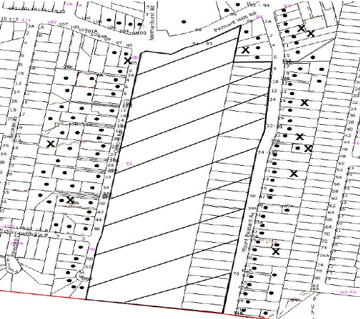
|
NOTIFICATION
PLAN
|
|
|
• PROPERTIES NOTIFIED
|
X SUBMISSIONS
RECEIVED
|

PROPERTY SUBJECT OF DEVELOPMENT
|

|
|
|
|
|
Eleven submissions objected to
the development, generally on the grounds that the development would result in:
· Unacceptable
increase in traffic impact on local streets.
· Increase in student
parking in Mount Pleasant Avenue.
· Unacceptable impact
on egress from Mount Pleasant Avenue to Pennant Hills Road.
· Unacceptable
student parking on the grass verge adjacent to the school.
· Unacceptable impact
of the Seventh Day Adventist development on the traffic situation.
· Unsafe conditions in Osborn Road would be further
exacerbated.
The merits of the matters raised in community submissions
have been addressed in the body of the report with the exception of the
following:
5.1.1 Seventh Day Adventist development, Wahroonga
Several resident submissions raised concerns about the
cumulative traffic impacts in light of the announced ‘Major Project
Application’ for the Seventh Day Adventist hospital.
The scale of the approved concept plan for the Seventh Day
Adventist development has been considerably reduced and the link from the
development to Osborn Road has been deleted. The RTA advised that the traffic issues in Mount Pleasant Avenue have been
considered as part of the approval for the Seventh Day Adventist development.
Accordingly, it is concluded that there is not a strong nexus between the two
developments in terms of traffic impacts.
5.2 Public Agencies
The development application is
Integrated Development under the Act. Accordingly, the application was
referred to the following Agency for comment:
5.2.1 Rural Fire
Service
The site is classified as
bushfire prone land. The Rural Fire Service raised no objection to the proposal
and recommended condition No. 69 be incorporated into the consent.
6. THE PUBLIC INTEREST
Section 79C(1)(e) of the Act
requires Council to consider “the public interest”.
The public interest is an
overarching requirement, which includes the consideration of the matters
discussed in this report. Implicit to the public interest is the achievement
of future built outcomes adequately responding to and respecting the future
desired outcomes expressed in environmental planning instruments and
development control plans.
The application is considered to
have satisfactorily addressed Council’s and relevant agencies’ criteria and
would provide a development outcome that, on balance, would result in a
positive impact for the community. Accordingly, it is considered that the
approval of the proposed development would be in the public interest.
CONCLUSION
The proposed modification to the development involves an
increase in student numbers from 915 to 1150. The modification to increase
student numbers is considered acceptable on the basis that the site has
sufficient parking capacity and satisfactory site conditions to cater for the
increase in student numbers without resulting in adverse impacts on the road
network or surrounding properties.
Eleven submissions were received raising concerns with the
development. It is considered that these concerns can be managed though the
school maintaining a responsible approach to the provision of on-site car
parking for students and staff.
The proposal is recommended for approval.
Note: At the time of the
completion of this planning report, no persons have made a Political Donations
Disclosure Statement pursuant to Section 147 of the Environmental Planning
and Assessment Act 1979 in respect of the subject planning application.
|
Rod Pickles
Manager -
Assessment Team 2
Planning Division
|
Scott Phillips
Executive Manager
Planning Division
|
Attachments:
|
1.View
|
Locality Plan
|
|
2.View
|
Site Plan Showing
On-Site Parking
|
File Reference: DA/1277/2004/B
Document Number: D01309063
SCHEDULE 1
|
Date of 1st modification:
|
12 December 2005
|
|
Details of 1 st modification:
|
Increase in student
numbers from 850 to 915
|
|
Conditions Added:
|
67
|
|
Conditions Deleted:
|
Nil
|
|
Conditions Modified:
|
65
|
|
Date of this modification:
|
2 June 2010
|
|
Details of this modification:
|
Increase in student
numbers from 915 to 1150.
|
|
Conditions Added:
|
68, 69 and 70
|
|
Conditions Deleted:
|
Nil
|
|
Conditions Modified:
|
65
|
GENERAL CONDITIONS
The
conditions of consent within this notice of determination have been applied to
ensure that the use of the land and/or building is carried out in such a manner
that is consistent with the aims and objectives of the relevant legislation,
planning instruments and Council policies affecting the land and does not
disrupt the amenity of the neighbourhood or impact upon the environment.
Note: For the
purpose of this consent, the term ‘applicant’ means any person who has the
authority to act on or the benefit of the development consent.
Note: For the purpose of
this consent, any reference to an Act, Regulation, Australian Standard or
publication by a public authority shall be taken to mean the gazetted Act or
Regulation, or adopted Australian Standard or publication as in force on the
date that the application for a construction certificate is made.
Site Works
1. No site
works, including the removal of vegetation or any demolition works, shall be
commenced prior to:
1.1 A construction
certificate being issued.
1.2 Sediment and
erosion control measures in accordance with condition No. 18 have been
implemented;
Principal Certifying Authority
2. Before any
construction works commence, you are required to appoint a Principal Certifying
Authority as required by section 81A of the Environmental Planning &
Assessment Act, 1979. The Principal Certifying Authority is responsible for
ensuring that all the works are carried out in accordance with the approved
plans and specifications.
Notifying Council of Commencement of Works
3. It is a
requirement of the Environmental Planning and Assessment Act, section 81A(2)(c)
that you notify Hornsby Council at least two (2) days prior to the intention to
commence works.
Where works are to be undertaken in a public
place, such notice must be accompanied by evidence of the contractor's Public
Liability and Workers’ Compensation Insurances. The public risk policy shall
be such an amount as determined by Council (not being less than $10,000,000.00)
and shall cover the owner and the Council against any injury, loss or damage
sustained by any person, firm or company.
Building Code of Australia
4. All building
work must be carried out in accordance with the requirements of the Building
Code of Australia.
Should there be any alternative solutions
listed as Category 2 Fire Safety Provisions and outlined in the Environmental
Planning and Assessment Regulation 2000, a fire engineering report should be
forwarded to the Brigades for comment under Clause 144 of the Environmental
Planning and Assessment Regulation 2000.
Council Property
5. The land and
adjoining areas are to be kept in a clean and tidy condition at all times.
Litter and rubbish shall be placed in containers and removed from the site. A
waste storage container is to be provided at the commencement of the building
work.
6. The cost of
repairing any damage caused to Council's assets as a result of construction
works associated with the approved development is to be met in full by the
applicant/developer prior to the issue of a subdivision certificate.
Hours of Demolition Works
7. In order to
maintain the amenity of adjoining properties, demolition works shall be
restricted to between 7.00 am and 6.00 pm. No demolition works are to be
undertaken on Saturdays, Sundays or Public Holidays. Plant, goods or materials
shall not be delivered to the site outside the approved hours of site works
unless written Council gives consent.
Demolition
8. All
demolition work is to be carried out in accordance with the applicable
provisions of Australian Standard 2601-2001 ‘The Demolition of Structures’.
Note:
Applicants are reminded that WorkCover NSW requires all plant and equipment
used in demolition work must comply with the relevant Australian Standards and
manufacturer specifications.
Dust Control
9. Measures to
prevent the emission of dust or other impurities into the surrounding
environment are to be implemented during demolition works.
Disconnection of Utilities
10. All
utilities shall be disconnected in a satisfactory manner so as not to pose any
risk or nuisance to the public.
Asbestos Removal
11. Prior to
commencement of any work involving the demolition, alteration or addition to
any building on the development site, a survey is to be conducted by a
competent person to ascertain whether any asbestos materials exist thereon.
Asbestos material means any material that contains asbestos.
12. Where asbestos
material is found to exist on the development site and that asbestos material
is to be removed or disturbed as a result of any proposed demolition,
alteration or addition, then all work involving removal and disposal of
asbestos material must be undertaken by persons who hold the appropriate
licence issued by WorkCover NSW under Chapter 10 of the Occupational Health and
Safety Regulation 2001.
13. The
collection, storage, transportation or disposal of any type of asbestos waste
is to comply with the requirements of clause 29 of the Protection of the
Environment Operations (Waste) Regulation 1996.
14. Upon
completion of disposal operations, the applicant must lodge with the principal
certifying authority, within seven (7) days, all receipts (or certified
photocopies) issued by the receiving landfill site as evidence of proper
disposal.
Note:
The person responsible for disposing of the asbestos material shall consult
with the Environment Protection Authority to determine the location of an
approved landfill site to receive asbestos material.
Signs for Demolition Sites
15. On
construction sites where buildings contain asbestos material, a standard
commercially manufactured sign containing the words ‘DANGER ASBESTOS REMOVAL IN
PROGRESS’ measuring not less than 400mm x 300mm is to be erected on the site in
a prominent position visible from the street. The sign is to be erected prior
to any work commencing and is to remain in place until such time as all
asbestos material has been removed from the site to an approved waste
facility. This condition is imposed for the purpose of worker and public
safety and to ensure compliance with Clause 259(2)(c) of the Occupational
Health and Safety Regulation 2001.
16. A sign must be
erected in a prominent position on the premises, on which the demolition of a
building is being carried out, stating that unauthorised entry to the premises
is prohibited and showing the name of the builder or other person in control of
the premises and a telephone number at which the builder or other person may be
contacted during and outside work hours. The sign is to be removed when the
demolition of the building has been completed.
Signs for
Construction Sites
17. On-site
signage is required to clearly identify the PCA and the principal contractor
(the coordinator of the building work) pursuant to the Environmental
Planning and Assessment Amendment (Quality of Construction) Act 2003,
s157(1)(c1), Cl 98A, 136C & 227A.
Sediment &
Erosion Control
18. Temporary
sedimentation and erosion controls are to be constructed prior to commencement
of any work to eliminate the discharge of sediment from the site. The controls
are to be designed and installed in accordance with the requirements of the NSW
Department of Conservation and Land Management's "Urban Erosion and Sediment
Control" manual, Hornsby Shire Council’s “Sustainable Water Best
Practices” manual and shall:-
· be effectively maintained at all times during the course of
construction and shall not be removed until the site has been stabilised or
landscaped to the Principal Certifying Authority’s satisfaction.
· include a single all weather access way at the front of the
property consisting of 50-75mm aggregate or similar material at a minimum
thickness of 150mm and 7 metres long, laid over geotechnical fabric and
constructed prior to commencement of works.
· include adequate measures to remove clay from vehicles
leaving the site so as to maintain public roads in a clean condition.
· ensure that no spoil or fill encroaches upon adjacent
bushland for the duration of the works.
· ensure disturbed areas are rehabilitated with indigenous
plant species, landscaped and treated by approved methods of erosion mitigation
such as, mulching, and revegetation with native grasses or other suitable
stabilising processes within fifteen days of the completion of works.
· No site works are to commence until the sediment control
installation has been inspected and approved by the Principal Certifying
Authority. At least 48 hours notice is to be given for the inspection of such
works. A compliance certificate be submitted to Hornsby Shire Council with the
notification for commencement of works.
Engineers Certifications -Building
19. A chartered
professional structural engineer's "Certificate of Adequacy"
certifying the ability of the existing walls and footings to take the proposed
additions is to be submitted with the construction certificate application and
a copy provided to Hornsby Council.
A qualified practising chartered Structural
Engineer shall inspect the slab steel reinforcement prior to the pouring of any
concrete and supply the Principal Certifying Authority and a copy to Hornsby
Shire Council with a certification of structural adequacy.
Protection of Public Places
20. If the
erection or demolition of a building causes pedestrian or vehicular traffic in
a public place to be obstructed or rendered inconvenient, a fence must be
erected between the building premises and the public place. The fence must be
at least 1.8m high of chainwire and galvanised pipe construction. Welded wire
reinforcing fabric is not to be used.
21. The work site
is to be kept lit between sunset and sunrise if it is likely to be a source of
danger to persons using a public place or upon instruction by Council to
enhance the safety and security of the area in which the work is located.
22. Any hoarding,
fence or awning is to be removed when no longer required.
Hours of Construction
23. In order to
maintain the amenity of adjoining properties, site works shall be restricted to
between 7.00 am and 6.00 pm, Monday to Friday and 8.00 am to 1.00 pm Saturday.
No work shall be undertaken on Sundays or public holidays. Plant, goods or
materials shall not be delivered to the site outside the approved hours of site
works unless otherwise approved by Council.
Inspections – Building
24. The building
works must be inspected and compliance certificates obtained certifying that
the works comply with the development consent and the approved plans and
specifications for the following nominated stages:-
· The levels of each floor prior to the pouring of concrete
or other means of construction.
· The framework including roof members when completed and
prior to the fixing of any internal sheets.
· The building or structure when completed and before
occupation or use is commenced.
It is the responsibility of the
builder/applicant to organise the required inspections and compliance
certificates in accordance with the development consent. Should Council be
nominated as the certifier of works, inspections can be arranged by contacting
Council on 9847 6760 during normal business hours.
Fire Hazard Properties
25. Materials and
assemblies of the building are to comply with Specification C1.10 of the Building
Code of Australia. Certification in respect of compliance with the above is
to be submitted to the PCA and Council.
Safety Glazing
26. All glazing is
to comply with Part B 1.3 of the Building Code of Australia and
Australian Standards 1288 & 2047. Certification in respect of compliance
with the above is to be submitted to the PCA and Council.
Ventilation
27. Ventilation to
the building is to comply with Part F 4 of the Building Code of Australia
and Australian Standards 1668 Part 2-1991. Certification in respect of
compliance with the above is to be submitted to the PCA and Council.
Fire Upgrading
28. The following
works are to be undertaken to ensure that the building is provided with a
satisfactory level of fire safety.
29. In order to
satisfy Part 3.2 of the BCA the openings to the existing buildings situated
less than 6m from the new buildings shall be protected in accordance with Part
C3.4 of the Building Code of Australia to restrict the spread of fire from the
building to other buildings nearby. Alternatively the option is available to
submit a Fire Engineered Report/Solution seeking dispensation in respect of the
above works for Councils’ consideration. It is to be noted that this
Report/Solution is to be prepared in accordance with “Fire Engineering
Guidelines-2001 Edition” by-ABCB.
30. Any
electricity meter boards, distribution boards or ducts, central
telecommunications boards or equipment located in a required exit or any
corridor, hallway, lobby or the like leading to a required exit shall be
enclosed by a fire-protective covering with openings suitably sealed against
smoke spreading from the enclosure, in accordance with Part D2.7 of the
Building Code of Australia.
31. Additional
Fire Hose Reel/s is/are to be provided in accordance with Part E1.4 of the BCA
and AS 2441 should the nozzle end of the fire hose fitted to the existing
reel/s does not reach every part of the buildings. It is noted that this
requirement does not include classrooms and associated corridors in a primary
or secondary school.
32. Any
switchboard located within the building which sustains emergency equipment
operating in the emergency mode must be separated from any part of the building
by construction having an FRL of not less than 120/120/120, and any doorway in
that construction protected with a self closing fire door having an FRL of not
less than -/120/30 in accordance with C2.13 of the BCA.
33. All switchboards
in the electrical distribution system, which sustain the electricity supply to
the emergency equipment (i.e. fire hydrant booster pumps, pumps for hose
reels), must provide full segregation by way of enclosed metal partition
designed to prevent the spread of any fault from non-emergency switchgear to
the emergency equipment switchgear.
34. Any enclosure
of spaces under stairs are to be removed or upgraded in fire rated construction
in accordance with Part D2.8 of the BCA.
35. Hydrant/s are
to be provided on site in accordance with E1.3 of the BCA and AS 2419.1.
Fire Safety Schedule
36. In accordance
with clause 168 of the Environmental Planning and Assessment Regulation 2000
fire safety measures shall be implemented in the building. A schedule of all
proposed and existing Essential Fire Safety Measures to be installed in the
building (e.g.: hydrants, hose reels, exit signs, smoke control systems) shall
be submitted with the Construction Certificate application and distinguish
between the existing and proposed fire safety measures. Should the
Construction Certificate involve the use of an alternate solution, the
application must also be accompanied by details of the performance requirements
that the alternate solution is intended to meet and the assessment methods use
to establish compliance with those performance requirements.
Fire Safety Certificate – Final
37. In accordance
with Part 9, Division 4 of the Environmental Planning & Assessment
Regulation, 2000, the owner of the building must, on completion of the
building, provide Council with a certificate in relation to each essential fire
safety or other safety measure implemented in the building.
Fire Safety Statement - Annual
38. In accordance
with Part 9, Division 5 of the Environmental Planning & Assessment
Regulation, 2000, at least once in each period of 12 months after the date of
the first fire safety certificate, the owner shall provide Council with a
further certificate in relation to each essential service installed in the
building.
Toilet Facilities
39. Closet
accommodation is to be provided at the work site at all times at the rate of
one closet for every 20 persons and be located wholly within the boundaries of
the property.
Occupation
40. The building
or part thereof shall not be occupied until an occupation certificate has been
issued in accordance with Sections 109C and 109H of the Environmental Planning
& Assessment Act, 1979.
41. The premises
shall be occupied solely for the approved use. No separate occupation or use
of any part of the premises shall take place without prior development consent,
(other than for exempt or complying development).
Construction
Certificate – Subdivision/Engineering Works
42. A construction
certificate must be obtained from either Council or an Accredited Certifier.
Engineering design plans and specifications are to be prepared by a chartered
professional engineer for any proposed works. The plans and specifications are
to be in accordance with the development consent conditions, appropriate Australian
Standards, and applicable Council standards, in particular “Hornsby Shire
Council Civil Works - Design and Construction Specification”. The information
that is required to be submitted with a construction certificate is as follows:
(a) Copies of any compliance certificates to be
relied upon
(b) Four (4) copies of the detailed engineering plans
in accordance Hornsby Shire Council's Civil Works - Design Specification 1999.
The detailed plans may include but are not limited to the earthworks, roadworks,
road pavements, road furnishings, stormwater drainage, landscaping and erosion
control works.
(c) Hornsby Shire Council’s approval for the
proposed works in the existing road and public drainage is required before the
issuing of a construction certificate for these works.
Access Way/Driveway
43. A separate
application under the Local Government Act 1993 and Roads Act 1993 shall be
submitted to Council for approval for the following:
(a) The installation of a vehicular footway crossing
servicing the development, and the removal of any redundant crossings.
(b) The undertaking of any work within a public road
(this includes Laneways, Public Pathways, Footways).
44. The vehicular
crossing shall be designed and constructed in accordance with Council’s Civil
Works - Design and Construction Specification 1999.
45. The internal
driveway is to be designed and constructed in accordance with Australian
Standard 2890.1 - 1993.
46. The provision
of a safety rail at appropriate locations along the driveway where there is a
level difference between the driveway and the adjoining ground level of more
than 300 mm or a 1:4 batter and 300 mm beam cannot be achieved.
47. In order to
enable unencumbered movement of traffic and pedestrians in the public road and
construction site during construction works, a Construction Traffic Management
Plan prepared by a suitably qualified traffic engineer shall be prepared and
submitted with the construction certificate according to the following
requirements:-
(a) The plans shall
detail the order of construction works and arrangement of all construction
machines and vehicles being used at the same time during all stages.
(b) In order to
prevent injury, accident and loss of property, no building materials, work
sheds, vehicles, machines or the like shall be allowed to remain in the road
reserve area without written consent of Hornsby Shire Council.
(c) The Plan shall
be generally in compliance with the requirements of the Road and Traffic
Authority’s “Traffic Control at Worksites Manual 1998” and detailing:-
(i) Public
notification of proposed works;
(ii) Long
term signage requirements;
(iii) Short
term (during actual works) signage;
(iv) Vehicle
Movement Plans, where applicable;
(v) Traffic
Management Plans;
(vi) Pedestrian
and Cyclist access and safety;
(d) The plans shall
indicate traffic controls including those used during non-working hours and
shall provide pedestrian access and two-way traffic in the public road to be
facilitated at all times.
(e) The Applicant
and all employees of contractors on the site must obey any direction or notice
from the Prescribed Certifying Authority or Hornsby Shire Council in order to
ensure the above.
Retaining Walls
48. Retaining
walls or other approved methods necessary to prevent the movement of excavated
or filled ground, together with associated stormwater drainage measures, are to
be designed and constructed by a chartered professional civil engineer or other
appropriately qualified person. Details are to be included with plans and specifications
to accompany any construction certificate.
Drainage
49. Stormwater
drainage from the site shall be designed to satisfactorily drain rainfall
intensities for an average recurrence interval of 20 years. The design shall:
(a) Be in
accordance with Hornsby Shire Council Civil Works – Design Specification 1999.
(b) Provide for
drainage discharge to the existing drainage system.
(c) Ensure that the
development, either during construction or upon completion, does not impede or
divert natural surface water runoff so as to cause a nuisance to adjoining
properties.
50. The drainage
system for the new building and courtyard is to be constructed with an
on-site-detention system, having a capacity of not less than 20m3
and a maximum discharge, when full, of 24 l/s prior to discharging into the
existing site drainage system. The system shall be designed by a chartered
professional civil engineer to the following requirements:
· A surcharge/inspection grate is to be located directly
above the outlet.
· Stormwater discharge from the detention system is to be
controlled via a one-metre length of pipe not less than 50mm diameter
discharging into a larger diameter pipe capable of carrying the design flow to
Council's gutter/stormwater pit.
· Where the on-site detention system is proposed under the
vehicular driveway, the engineer is to certify that the detention tank is
structurally capable of withstanding the maximum anticipated traffic loads.
· Any alternate design will require the submission of design
calculations by a qualified civil engineer. The permissible site discharge from
the developed site for the 20 year ARI storm shall be limited to the 5 year ARI
discharge for the site prior to development.
A compliance certificate is to be submitted to
Council prior to the issue of the occupation certificate that includes
work-as-executed details of the on-site-detention system prepared by a
chartered professional engineer/registered surveyor verifying that the required
storage and discharge volumes have been constructed in accordance with the
design requirements. The details are to show the invert levels of the on system
as well as the pipe sizes and grades. Any variations to approved plans must be
shown in red and supported by calculations.
51. A certificate from
a chartered professional civil engineer must be obtained before release of
construction certificate verifying that the structures associated with the
on-site detention system have been designed to withstand all loads
likely to be imposed on them during their lifetime.
52. A certificate
from a chartered professional civil engineer/registered surveyor must be
obtained before release of construction certificate verifying that the on-site
detention system will function hydraulically in accordance with the
approved design plans.
Inspections - Engineering
53. All
engineering work required by this consent must be inspected and compliance
certificates shall be issued prior to occupancy or issue of the subdivision
certificate, whichever occurs first, certifying that the works comply with
development consent, construction certificate and Hornsby Shire Council Civil
Works – Design and Construction Specification for the following nominated
stages:
- Implementation
of erosion control
- Implementation
of traffic control
- Boxing Out
- Pipes before
backfilling
- Final pipe
inspection
- Final erosion
control inspection
- Replacement of
redundant gutter crossing
- On-site
detention - when steel & formwork for tank is ready
- when control
pit is completed
- when pits formwork
is ready
- when pipes
are laid before backfilling
- for pipe
laid across Council’s land
- at
completion of on-site detention system
- Driveways and
access ways
- Retaining
walls
- Final
inspection
Easements & Restrictions on Title
54. All Section
88B restrictions and covenants created as part of this consent are to contain a
provision that they cannot be extinguished or altered except with the consent
of Hornsby Shire Council.
55. The creation
of an appropriate "Positive Covenant" and "Restriction as to
User" over the constructed on-site detention/retention systems and outlet
works, within the lots in favour of Council to ensure the continued maintenance
and performance of the stormwater management system in accordance with
Council’s standard wording. The position of the on-site detention system is to
be clearly indicated on the title of the
property.
Works as Executed
56. A
works-as-executed plan prepared by a chartered professional engineer or a
registered surveyor must be lodged with Hornsby Shire Council when the
engineering works are complete, before the release of the Occupation
Certificate.
Council Property
57. The cost of
repairing any damage caused to Council's assets in the vicinity of the subject
site as a result of construction works associated with the approved development
is to be paid for by the applicant/developer prior to occupation.
ENVIRONMENTAL HEALTH AND
PROTECTION
58. All noise
generated by the proposed development is to be attenuated to prevent levels of
noise being emitted to adjacent premises which possess tonal, beating and
similar characteristics or which exceeds background noise levels by more than
5dB(A).
59. The operation
and management of the site shall be undertaken in accordance with the Acoustic
Report: New Mornane Building Loreto Normanhurst prepared by PKA Acoustic
Consulting, project number 204 006 dated March 2004 approved by Council.
Activities in the proposed development must not exceed 10:00pm.
60. All wastewater
and stormwater treatment devices (including drainage systems, sumps and traps)
must be regularly maintained in order to remain effective. All solid and liquid
wastes collected from the device must be disposed of in accordance with the Protection
of the Environment Operations Act 1997.
61. Council and
the PCA must be notified immediately should the presence of asbestos or soil
contamination, not recognised during the original assessment process be
identified during demolition or construction works.
Parks and Landscape
62. A Tree
Preservation Order exists within the Hornsby Shire whereby the cutting down,
topping, lopping, removing or wilful destruction of any tree exceeding 3.0
metres in height (except where exempt as defined under Council’s Tree
Preservation Order) without prior written consent of Council is prohibited.
Release of the Construction Certificate gives
automatic approval to the removal only of those trees located on the subject
property within 3 metres of the foundation footprint of an approved
residential, commercial or community building, garage or inground swimming
pool. Other trees shall not be removed or damaged without an application being
made under Council’s Tree Preservation Order. Penalties apply for
non-compliance.
Landscape Plan
63. The following
issues are to be addressed by the applicant through submission of a new
landscape plan prepared by a Landscape Architect with the following
information;
Inclusion of 4 Eucalyptus pilularis or
equivalent capable of reaching 15m in approximately the positions marked in red
on the submitted plan;
Plant species locations are currently not
identified on the plans; and
Plant schedule including botanical and common
names, mature heights, spacing, and quantities divided into three tiers –
trees, shrubs, groundcovers and ferns, needs to be prepared.
This detailed landscape concept plan is to be
prepared in accordance with the Hornsby Shire Council Landscape Code prior to
the release of a construction certificate.
Heritage
64. The approved
development shall be constructed generally in accordance with the schedule of
external finishes submitted with the application.
Staff/student numbers
65. There shall be
no increase in the number of students above 1150 pupils without the prior
written consent of Council. Upon written request by Council, at a frequency of
no greater than one occasion per calendar year, the school shall provide
written advice of current numbers within twenty-one days of request.
Traffic Management
66. In order to
minimise impacts on on-street parking, the oval shall be made available and
utilised at all times for the parking of construction workers’ vehicles.
Workers’ vehicles shall not be parked on the surrounding streets during the
construction period.
Osborn Road car park
67. The Osborn
Road carpark must be made available for student parking.
Student Permits and Parking
68. Student
driver permits must be limited to 40 and student parking must be provided
on-site.
RURAL FIRE SERVICE
Evacuation and Emergency Management
69. Arrangements for emergency and evacuation are to comply with
section 4.2.7 of ‘Planning for Bush Fire Protection 2006.’
Roads and Traffic
Authority
Works and Signposting
70. All works/regulatory signposting associated with the
proposed development must be at no cost to the RTA.
Planning Report No. PLN15/10
Date of Meeting:
2/06/2010
2 DEVELOPMENT APPLICATION
- SECTION 96(2) - REGISTERED CLUB - ALTERATIONS AND ADDITIONS - AMENDED STAGING
OF WORKS
103 - 109 NEW LINE ROAD CHERRYBROOK
|
Development Application No:
|
DA/1046/2007/A
|
|
Description of Proposal:
|
Section 96(2) application to amend
the staging of works for alterations and additions to the West Pennant Hills
Sports Club including a new car park, relocation of bowling greens, tennis
courts and cricket nets and the erection of one sign.
|
|
Property Description:
|
Lot 2 DP 367373, No. 103 - 109 New Line Road,
Cherrybrook
|
|
Applicant:
|
West Pennant Hills Sports Club Limited
|
|
Owner:
|
West Pennant Hills Sports Club Limited
|
|
Statutory Provisions:
|
Hornsby Shire Local Environmental
Plan 1994
Open Space C (Private
Recreation)
|
|
Estimated Value:
|
No change to original
|
|
Ward:
|
C
|
|
RECOMMENDATION
THAT
Development Application No. DA/1046/2007/A for alterations and additions to
the West Pennant Hills Sports Club including a new car park, relocation of
bowling greens, tennis courts and cricket nets and the erection of one sign
at Lot 2 DP 367373, No. 103 - 109 New Line Road, Cherrybrook be modified as
detailed in Schedule 1 of this report.
|
1. On 3 September 2008 Council approved Development
Application No. DA/1046/2007 for alterations and additions to the West Pennant
Hills Sports Club including a new car park, relocation of the bowling greens,
tennis courts and cricket nets and erection of one sign.
2. The application proposes to modify the consent by way of
amending the staging of some works and to allow ‘special event’ trading outside
of prescribed opening hours. Due to the complexity of the original consent and
the nature of the proposed amendments, the numbering and sequencing of
conditions has also been modified.
3. The
proposal complies with the provisions of the Hornsby Shire Local Environmental
Plan and the relevant Development Control Plans.
4. Fifty-five
submissions from twenty-eight residents have been received in respect of the
application.
5. It
is recommended that the application be approved.
HISTORY OF THE APPLICATION
On 3 September 2008 Council
approved Development Application No. DA/1046/2007 for alterations and additions
to the West Pennant Hills Sports Club including a new car park, relocation of
the bowling greens, tennis courts and cricket nets and erection of one sign.
HISTORY OF THE SITE
On 29 April 1968, Council
approved Certificate of Consent No. 68/63 for the construction of bowling
greens, a licensed clubhouse, courts and a pool.
The site has been used as a recreation
facility and registered club since that time with various improvements to the
site being built since the 1980’s.
THE SITE
The site is rectangular in shape
with an area of 2.177 hectares. The site is located on the western side of New Line Road, 100m south of Cedarwood Drive and 150m north of Edward Bennett Drive,
Cherrybrook and experiences an average fall of 3% to the front of the site. A
tributary of Berowra Creek traverses the eastern and southern portions of the
site, with a bridge connecting the front landscaped area of the site to the
sports club and its facilities. Facilities on the site include two bowling
greens, three all-weather tennis courts and ancillary outbuildings, and cricket
nets.
The existing building (1754.42
sqm) includes a main entry, gaming room, reception and administration areas,
auditorium, TAB and facilities including toilets, bowls room, cool room,
kitchen, servery, coffee shop and bar. One hundred and fifty-four (154) line
marked car spaces are located around the building to the east, south and west.
Vehicular access to the site is available from New Line Road, via separate
entry and exit driveways.
Land to the north and south is
zoned Residential A (Low Density) and supports detached dwellings (along Bowerman Place) and two-storey townhouses, respectively. Edward Bennett Oval abuts the
western boundary of the site with access available via a gate. Across New Line Road to the east the land is zoned Residential A and incorporates detached
dwellings.
The alignment of New Line Road adjacent the entry to
the site narrows from two lanes in each direction to two lanes northbound and
one lane southbound.
THE APPROVED DEVELOPMENT
The approved development involves
the re-development of the West Pennant Hills Sports Club comprising the
retention of the existing clubhouse with the following alterations and
additions:
· A two level building extension
adjoining the northern elevation of the existing clubhouse will be constructed
comprising:
- At basement level - a
gymnasium, reception area, café, amenities and expanded services area.
- At ground level -
expanded lounge areas, TAB, administration offices, amenities.
· A minor extension to the north
western corner of the existing clubhouse to provide a children’s play area.
· An open space/ outdoor ‘break out’
area is provided in response to a design requirement imposed on the Club by the
Smoke-Free Environment Act 2000. This area will be accessible from the
lounge and dining areas of the Club via acoustically rated air locked
accessways. The area will be landscaped with undercover seating. An outdoor
smoking area for patrons is also provided on the eastern elevation of the
building.
· The two existing bowling greens will
be reconstructed alongside each other, adjoining the rear western boundary.
The northern-most green is to be an almost identical position to the existing
whilst the second green will be built in the location of the existing rear
open-air car park.
· One and a half levels of enclosed
basement parking will be constructed beneath the new bowling greens.
· The three existing tennis courts will
be removed to make way for the building extension and additional on grade parking
close to the Club’s entry. However, two tennis courts will be reinstated to
the front of the site with an associated amenities gazebo structure.
· The three cricket pitches along the New Line Road frontage to the Club will be relocated at the front of the site.
· Additional on grade parking will be
provided at the front of the site close to the new tennis courts and cricket
nets.
· A single lane car bridge will be
duplicated over the watercourse alongside a new dedicated pedestrian bridge.
· Existing parking along the length of
the southern boundary will be retained but with the addition of new on grade
spaces along this boundary towards the front of the site. Lighting to these
parking areas will be brought up to current Australian Standards and safety
code requirements.
· The existing pedestrian link provided
between Edward Bennett Park and the Club premises will be maintained as well as
an extra access point created via the bowling greens.
· The proposed new gymnasium has been
incorporated into the development to further enhance the quality and variety of
sporting facilities that the Club can offer to its members and the wider local
community. Membership to the gymnasium will be limited to Club members only
but the Club has indicated its willingness to offer occasional use of this
facility to nearby sporting groups and local schools.
· Higher boundary acoustic fencing to
both the northern (2.7m high) and southern boundaries (3.6m high) with
adjoining properties is to be erected.
· A masonry acoustic wall/ barrier
(5.4m high) will be constructed in the central courtyard, set back 6.082 metres
from the northern boundary to effectively enclose the central courtyard area
and provided complete screening of this area from adjacent residential
properties.
· Erection of signage to the New Line Road frontage of the site.
The approved development included
a staging plan for undertaking the redevelopment works and the provision of a
roundabout at the intersection of New Line Road and Cedarwood Drive to
facilitate traffic management at the site.
THE MODIFICATION
The amendments sought by this application
do not propose any significant alterations to the master plan concept. Rather
the application is a request to amend the staging of works and delete
particular conditions of approval which the applicant considers to be either a
minor drafting error or unreasonable in that they are impractical and that they
would unduly impact the proper functioning of the Club’s operations.
Of particular note, the
application proposes to modify the dimensions of Sign B to reduce its visual
impact as well as seek approval for the construction of the full seagull
intersection arrangement proposed by the original application.
The applicant is seeking to
modify the staging of the development and a number of the conditions of consent
as follows:
· Amend conditions to
enable various construction works to be undertaken in accordance with the
original staging plan lodged with the DA. The changes relate to landscaping and
roadworks specified in the development consent for Stages 1A, 1B, 1C and 2A.
· Amend
conditions to extend the southern bowling green hours of use to 9pm.
· Amend conditions to
permit the illumination of the southern-most bowling green.
· Amend conditions to
permit up to six significant special events annually where the Club may operate
extended hours.
· Amend conditions to
delete the 45 day monitoring period and require that prior to issue of the
occupation certificate a suitably qualified lighting consultant measure and
verify the light emanating from the premises complies with the condition.
· Amend conditions to
permit inaudible television screens within the central courtyard, any outdoor
area and the smoking deck area to enable emergency and paging announcements.
· Amend conditions to
allow smoking and alcohol consumption in other suitable areas of the Club.
· Permit the erection
of a sign to the Edward Bennett Oval frontage.
· Amend conditions to
permit the illumination of the approved sign on the New Line Road frontage.
· Delete the
requirement that noise monitoring equipment be installed during construction.
· Amend conditions
relating to the riparian corridor to include the wording ‘or beyond those
areas of riparian landscape depicted on the approved plans’.
· Amend conditions to
correct typographical errors in the plan referencing.
· Delete conditions
requiring the installation of a permanent noise monitoring system.
· Delete conditions
restricting patron, visitor and staff numbers.
· Delete conditions
relating to the construction of a roundabout at Cedarwood Drive.
· Amend conditions to
reflect the access arrangements proposed in the current Section 96(2)
application.
ASSESSMENT
The development application has
been assessed having regard to the ‘2005 City of Cities Metropolitan
Strategy’, the ‘North Subregion (Draft) Subregional Strategy’ and
the matters for consideration prescribed under Section 79C of the Environmental
Planning and Assessment Act 1979 (the Act). Subsequently, the following
issues have been identified for further consideration.
1. STRATEGIC CONTEXT
1.1 Metropolitan Strategy – (Draft) North Subregional Strategy
The Metropolitan Strategy is a
broad framework to secure Sydney’s place in the global economy by promoting and
managing growth. It outlines a vision for Sydney to 2031; the challenges faced,
and the directions to follow to address these challenges and achieve the
vision. The draft North Subregional Strategy acts as a framework for Council
in the preparation of a new Principal LEP by 2011.
The draft Subregional Strategy
sets the following targets for the Hornsby LGA by 2031:
· Employment capacity to
increase by 9,000 jobs; and
· Housing stock to
increase by 11,000 dwellings.
The proposed development would be
consistent with the draft Strategy by providing additional jobs in the
locality.
2. STATUTORY CONTROLS
Section 79C(1)(a) requires
Council to consider “any relevant environmental planning instruments, draft
environmental planning instruments, development control plans, planning
agreements and regulations”.
2.1 Environmental Planning and Assessment Act 1979 – Section
96(2)
The proposal constitutes an
amendment to the original development consent under Section 96(2) of the Act.
Pursuant to Section 96(2), Council may consider an application to amend
development consent provided that, inter alia:
“(a) it is satisfied that the development to which the consent
as modified relates is substantially the same development as the development
for which the consent was originally granted and before that consent as
originally granted was modified (if any at all), and
(b) it has consulted with the relevant Minister, public
authority or approval body (within the meaning of Division 5) in respect of a
condition imposed as a requirement of a concurrence to the consent or in
accordance with the general terms of an approval proposed to be granted by the
approval body and that Minister, authority or body has not, within 21 days
after being consulted, objected to the modification of that consent, and
(c) it has notified the application in accordance with the
regulations, and
(i) the regulations, if the regulations so require, or
(ii) a development control plan, if the consent authority is a
council that has made a development control plan that requires the notification
or advertising of applications for modification of a development consent, and
(d) it has considered any submissions made concerning the
proposed modification within the period prescribed by the regulations or
provided by the development control plan, as the case may be.”
With respect to (a), it is
considered that the proposal as amended is substantially the same as the
development originally approved.
With respect to (b) the
development is integrated development and was referred to the Office of Water,
who advised that the proposed modifications do not appear to have any impact
upon the GTAs previously issued to Council.
With respect to (c) and (d), the
amended application was advertised and 55 submissions from 28 residents were
received.
2.2 Hornsby Shire Local Environmental Plan 1994
The subject land is zoned Open
Space C (Private Recreation) under the Hornsby Shire Local Environmental Plan
1994 (HSLEP). The objectives of the zone are:
(a) to
ensure there is provision of adequate open space to meet the needs of the
community and to enhance the environmental quality of the Hornsby area.
(b) to
encourage a diversity of recreational settings and facilities.
(c)
to sustain the use of privately owned land for sporting activities.
The proposed development is
defined as ‘Registered Club’ and ‘Recreation Facility’ under the
HSLEP and is permissible in the zone with Council’s consent.
The
HSLEP 1994 contains no development standards which apply to the Open Space C
(Private Recreation) zone.
Clause 18 of the HSLEP sets out
heritage conservation provisions within the Hornsby area. The site is not
listed as a heritage item of local significance and is not located within a
heritage conservation area.
2.3 State Environmental Planning Policy No. 11 Traffic
Generating Development
The
proposed modification would not alter the development’s compliance with the
provisions of this SEPP.
2.4 State Environmental Planning Policy No. 64 Advertising
and Signage
The Policy defines a ‘business
identification sign’ as a sign that indicates the name of the person and the
business carried out at the premises or place at which the sign is displayed
and may include the address of the premises or place and a logo or other symbol
that identifies the business.
Division 1 Clause 9 of the Policy
states that ‘business identification signs’ are not applicable to the Policy.
Accordingly, further assessment of the proposed modification against SEPP 64 is
not required.
2.5 Sydney Regional Environmental Plan No. 20 Hawkesbury-Nepean River
The
site is located within the catchment of the Hawkesbury Nepean River. Part 2 of this Plan contains general planning considerations and strategies requiring
Council to consider the impacts of proposals on water quality, scenic quality,
aquaculture, recreation and tourism.
Subject
to compliance with the approved conditions of consent the proposed development
satisfies the objectives of the Plan. The proposed modification would not
alter this compliance.
2.6 Cherrybrook Precinct Development Control Plan
The primary purpose of this DCP
is to provide controls for the Cherrybrook Precinct. The Plan has no
prescriptive development standards which apply to this site, or this form of
development. Notwithstanding, the objectives of the Cherrybrook Precinct DCP
include provisions requiring development to be designed to minimise noise to
the occupants of adjoining neighbouring dwellings, and to ensure the orderly
development of the Cherrybrook Precinct. These issues are addressed in Section
3 of this report where the impacts of the proposed modification are discussed in
detail.
2.7 Car Parking Development Control Plan
The primary purpose of this DCP is
to provide parking controls for the development. The proposed modification
does not alter the approved number of car parking spaces on the site. Matters
relating to the proposed amendments to the access of the site from New Line Road are discussed in Section 3 of the report.
2.8 Access and Mobility Development Control Plan
The primary purpose of this DCP is
to assist proponents and Council in ensuring the requirements for equitable
access are satisfied when building work is proposed. The proposed modification
does not alter the development’s compliance with this DCP.
2.9 Outdoor Advertising Development Control Plan
The primary purpose of the Plan
is to control the visual impact of advertisements and advertising structures on
the environment and to provide adequate opportunities for the community to
advertise their goods and/or services.
The modification includes the
illumination of the approved Sign A and seeks consent for Sign B fronting
Edward Bennett Oval. These matters are discussed in Section 3 of this report.
2.10 Waste Minimisation and Management Development Control
Plan
The primary purpose of this DCP
is to provide planning strategies and controls to promote waste minimisation
and management. The proposed modification would not alter the development’s
compliance with the DCP.
3. ENVIRONMENTAL IMPACTS
Section 79C(1)(b) of the Act
requires Council to consider “the likely impacts of that development, including
environmental impacts on both the natural and built environments, and social
and economic impacts in the locality”.
As the application involves
changes to a number of conditions, each of the conditions proposed to be
amended is discussed below. The applicant’s justification is provided in italics.
Furthermore, due to the complex
nature of the original consent, the conditions have been reformatted and
renumbered so that the consent is ordered under the headings of when works
would occur.
3.1 Condition No. 3 - Amend Staging Works
The existing wording of condition
No. 3 is as follows:
3. The approved staging plan is amended as follows:
STAGE 1A
- Relocate tennis courts and cricket
nets to eastern Club site
- Retain western and central bowling
greens and on-grade parking areas to west and south of the Club
- Construct new on grade parking
areas to eastern side of the Club
- Construct temporary storage/ back
of house undercroft space and overhead slab structure to be converted for
future temporary parking and gymnasium
- Erect acoustic fences and landscape
buffer planting to northern Club boundary as depicted on staging plan
- Erect acoustic fences along
southern boundary as depicted on staging plan
- Construct new vehicular entry to New Line Road
- Construct first portion of ground
floor Club facilities extensions as depicted on staging plan
- Refurbish existing Club kitchen,
bars, administration and reception areas to cater for new extensions
- Construct new eastern tennis
pavilions and amenities block.
- Construct new vehicular and
pedestrian bridges over creek line
STAGE 1B
- Extend acoustic fence to southern
boundary as depicted on staging plan
- Convert temporary storage/ back of
house undercroft area to temporary parking for 41 cars spaces to service Stage
1B Club extensions.
- Construct second portion of ground
floor Club facilities extensions as depicted on staging plan
- Complete all riparian zone works
and landscape treatments and New Line Road landscaping as per staging plan
STAGE 1C
- Undertake remaining internal
refurbishments and upgrading works to existing Club building
- Extend southern and northern
acoustic fencing treatments to western boundary.
- Complete northern and southern
boundary landscape screen treatments
- Complete New Line Road landscape
treatments and footpath/bus bay
- Construct New Traffic Management
improvement to New Line Road
STAGE 2A
- Construct first portion fitout
works of new gymnasium
STAGE 2B
- Deactivate central bowling green
- Complete undercroft area as additional
temporary parking for Stage 2A Club extension areas
- Construct central courtyard areas
and western edge of Stage 1B areas
- Complete noise walls and landscape
treatments to northern boundary buffer zone.
STAGE 2C
- Construct new western basement
parking
- Construct new bowling greens
- Complete last portion of ground
floor Club facilities extensions as depicted on staging plan
- Complete fitout of new gymnasium
facility
It is proposed to amend the
condition to enable various construction works to be undertaken in accordance
with the original staging plan. The changes to the condition relate to
landscaping and roadworks specified in the development consent for Stages 1A,
1B, 1C and 2A.
Specifically, the applicant
proposes to delay the construction of a roundabout in New Line Road from Stage
1C to Stage 2C. The development would now provide for a seagull traffic
arrangement in Stage 1C, with the roundabout constructed in Stage 2C when the
Club’s facilities are in full operation.
Landscaping and riparian drainage
works would be undertaken during the relevant stage following infrastructure
works.
To facilitate the new works within
the main Club building, the applicant also proposes to relocate the existing
Cub administration area into temporary demountable building accommodation in
the Club Director’s parking area and relocate part of the internal gaming area
into the existing administration area to enable the installation of protective
hoardings and pedestrian barriers to the existing gaming area during Stage 1A
works.
No objection is raised to the
proposed modifications to the staging plan as detailed in Schedule 1.
3.2 Condition No. 4 - Amend Hours of Use of the Bowling
Greens
The existing wording of condition
No. 4 is as follows:
4. The hours of operation of the site
must be in accordance with the following:
Club
Sunday - Wednesday & Public Holidays: 9am –
11pm
Thursday - Saturday: 9am
– 12 midnight
Gymnasium
Monday – Sunday & Public Holidays: 6am –
10pm
Tennis Courts
Monday - Friday: 6am
– 10pm
Saturday: 7am
– 10pm
Sunday & Public Holidays: 8am
– 10pm
Bowling Green
Monday - Saturday: 7am
– Sunset
Sunday & Public Holidays: 8am
– Sunset
Monday - Saturday: 7am
- Sunset
Sunday & Public Holidays: 8am
- Sunset
It is
proposed to amend the bowling green hours specified in condition No. 4
to extend the approved hours of use of the southern bowling green to 9pm, as it
is also proposed to modify condition No. 5 to permit illumination of the
southern bowling green.
Applicant’s Justification:
The Club
requests that condition 4 be modified as above to allow the Club to operate the
southern-most bowling green in the evening, consistent with that requested by
the original DA.
The amended
hours are considered reasonable on the grounds that the impacts of the lighting
of the bowling green were assessed as part of the original DA and it was found
that there would be no adverse impacts. In addition, Council’s Planning report
PLN184/08 did not object to the illumination subject to conditions. Further
argument in support of this amendment is detailed in Condition 5 below.
The assessment of the original
application and the acoustic report submitted in support raised no objection to
the development and recommended conditions including the following hours of use
for the illuminated bowling green:
Monday
- Saturday: 7am – 9pm
Sunday & Public Holidays: 8am – 9pm
The supplementary report provided
amendments to the proposed conditions incorporating comments received by
Councillors at the previous Planning Meeting and the hours of operation were
amended so that bowling green activities ceased at sunset.
The approved noise attenuation
measures would ensure that noise emissions from mechanical plant and from the
operations of the Club meet specific design goals as recommended by the
applicant’s acoustic consultants and no objection is raised to the amendment of
the bowling green hours of use, subject to condition No. 5 also being amended
to permit the lighting of the southern green.
3.3 Condition No. 5 - Permit lighting of the southern Bowling Green
The existing wording of condition
No. 5 is as follows:
5. The bowling greens shall not
contain any lighting and the existing lights are to be removed as part of the
Stage 1A works.
It is
proposed to amend condition No. 5 to permit illumination of the
southern-most Bowling green.
Applicant’s Justification:
The Club
requests modification to Condition 5 in order to reflect:
· the fact that the
existing bowling greens do not have any lights; and
· to allow the new
southern-most bowling green to have lighting as proposed in the DA submission.
This is considered justified on the grounds that:-
The lighting report submitted
with the DA clearly demonstrated that there were no adverse impacts to
neighbouring properties from anticipated lighting to the new bowling greens.
There was no objective justification for not allowing the new greens to be lit
in a controlled fashion.
As stated
in the Electrical & Mechanical Services report lodged as Appendix 8.4 to
the SOEE for the DA…”The lighting to the southern bowling green will be
designed to fall within the requirements of AS/NZS 4282, which specifies the
extent of spill lighting to neighbouring properties to an acceptable minimum
standard.”
In Section
2.6 of Council report PLN184/08, concerns regarding lighting of recreational
facilities was acknowledged. However, the report recommended these amenity
issues can be adequately addressed by imposing a condition ensuring that the
lighting complies with the Australian Standards for “Control of the obtrusive
effects of outdoor lighting”. (p.18, PLN184/08). This requirement was achieved
through the imposition of Condition 12 on the final consent. Worthy of note is
the fact that Report PLN184/08 did not include any conditions which imposed an
outright ban on lighting of the bowling green. At that meeting however it was
resolved to defer consideration of the DA to allow further review of the security
management plan and other matters.
Inexplicably,
the subsequent report to Council (PLN194/08) on 3rd September 2008
introduced an extra condition (Condition 5 on final consent) prohibiting bowling green lighting. Our investigation of Council’s documents indicate that no sound
justification was provided to support the imposition of such a condition and it
contravenes arguments submitted by Council’s planners in their earlier report,
which clearly supported bowling green lighting subject to appropriate
conditions.
In line
with Council’s Planning Report PLN184/08, Condition 12 should suffice as a
mechanism by which light spillage or nuisance to neighbours can be avoided.
Hence, the refusal to allow greens to be illuminated is considered
unreasonable.
The assessment of the original
application and subsequent further reports noted that concerns have been raised
with regards to the proposed lighting of the car park and recreation facilities
(tennis courts and bowling greens). To address the amenity impacts of
surrounding residents, condition No. 10 was imposed to ensure that the proposed
lighting complies with the Australian Standards for ‘Control of the obtrusive
effects of outdoor lighting’. Furthermore, condition No. 11 was imposed to
ensure an automatic time switch is placed on the tennis court lighting to
comply with the approved hours of operation.
The supplementary report prepared
for the meeting held on 3 September 2008 provided recommended amendments to the
proposed consent, incorporating comments received by Councillors at the
previous Planning Meeting. As a result the conditions relating to the use of
the bowling greens including hours of operation and lighting were either
amended and/or deleted.
No objection is raised to the
lighting of the southern bowling green and it is recommended to require the
fitting of an automatic time switch to all lights associated with the use of
the bowling greens for night time bowls to ensure that they are switched off at
9.00pm, in order to preserve the existing and future residential amenity of the
surrounding properties.
3.4 Condition No. 6 - Permit up to six special events outside
of standard Hours of Use
The existing wording of condition
No. 6 is as follows:
6. The Club shall obtain the consent
of Council if it proposes to extend the opening hours of any component of the
Club.
It is proposed to amend condition
No. 6 to permit up to six indoor ‘significant special events’ so as to permit
the Club to operate for extended hours.
Applicant’s Justification:
The Club
requests that Condition 6 be modified, to allow some flexibility
in trading hours to permit the Club to cater for extraordinary events that are
scheduled from time to time. In particular international sporting events are an
example where late evening broadcasts due to international time zone
differences, necessitates extended trading. The Club already has 24 hour
trading under the State Government’s Liquor Licensing provisions and believes
that it is reasonable to be able to cater for these one off events without the
need for further Council approval on each occasion.
The Club
requests approval to conduct up to a maximum of six (6) major functions per
year. This may include events such as World Cup Soccer / Rugby, Ashes Series,
Olympics events and the like which are held overseas in different time zones.
To assist
management of these special events, the Club will ensure that a parking
management strategy is in place. Security staff will direct all vehicles to the
proposed new undercover and enclosed parking area at the rear of the Club.
Security staff will also ensure that quiet and orderly conduct is observed
whilst patrons enter and leave the premises during such events which would be
held wholly within the internal areas of the Club.
The Club has advised that the six
‘special events’ to occur in a calendar year would be held at night. The
events would be held wholly within the internal areas of the Club and upon
operation of the basement car parking area, all access and parking would be from
the rear of the site to minimise acoustic impacts. The ‘Security Management
Plan’ has been amended to reflect the operations during such ‘special events’
and subject to recommended conditions, no objections are raised to the
inclusion of specific hours of operation for six ‘special events’ per calendar
year. The holding of the ‘special events’ would not occur until such time as
the works within the main Club building are finished at the complete of Stage
1C.
3.5 Condition No. 14 – Delete the requirement to monitor the
lighting for 45 days after occupation of the development.
The existing wording of condition
No. 14 is as follows:
14. During the
first 45 days of the occupation of the tennis courts and the Club premises
(including the car park areas), the following outdoor lighting control measures
shall be undertaken:
(a) A suitably
qualified lighting consultant must be appointed to:
(i) measure and
verify that the light emanating from the premises complies with the criteria in
condition No. 12, and
(ii) if necessary
make recommendations to ensure that the light emanating from the outdoor
lighting at the premises complies with the outdoor lighting criteria in
condition No. 12.
(b) The outdoor
lighting assessment and any required recommendations must be:
(i) Undertaken
without the knowledge of the applicant, manager, or operator of the premises,
and
(ii) Taken on two
different occasions on two different days of the week when the Club is open and
the tennis courts are being used, and
(iii) Taken from
9pm to 12 midnight, and
(iv) Submitted to
the Council within 7 days of testing.
(c) If the
lighting consultant recommends that additional treatment or works be undertaken
under conditions (a)(ii) above, those recommendations must be:
(i) submitted to
Council with the light readings as required in (b)(iv) above, and
(ii) implemented
to the lighting consultant’s satisfaction within 60 days of the receipt of the
recommendations of the lighting assessment report.
(d) If the
lighting consultant’s recommendations are not implemented in accordance with
this condition, the use of the tennis courts must cease until such time as the
recommendations are implemented and verified.
It is proposed to amend condition
No. 14 to delete the 45 day monitoring period and require that prior to issue
of the occupation certificate a suitably qualified lighting consultant measure
and verify the light emanating from the premises complies with condition No.
12.
No objection is raised to the
modification of this condition, as it did not form part of the original
recommended conditions and subject to the lights being tested to ensure
compliance with Australian Standard AS3282:1997 The Control of Obtrusive
Effects of Outdoor Lighting prior to occupation, further monitoring is
unnecessary.
3.6 Condition Nos. 21, 26 and 32 - Permit inaudible
television screens
The existing wording of
conditions Nos. 21, 26 and 32 are as follows:
21. No music,
entertainment (including television screens) or amplified music/announcements
is permitted in the central courtyard/ outdoor area.
26. No music,
entertainment (including television screens) or amplified music/announcements
is permitted in the smoking deck area of the development.
32. No music,
entertainment (including television screens) or amplified music/announcements
is permitted in any outside area, including the awning facing onto the existing
bowling greens. The acoustic mitigation measures required under this
consent shall be strictly enforced immediately by the patrolling of all outside
areas and appropriate signs shall be erected reminding patrons of their
obligations to minimise noise in accordance with the Club’s requirements.
It is proposed to amend condition
Nos. 21, 26 and 32 to permit inaudible television screens within the central
courtyard/ outdoor area (condition No. 21); within the smoking deck area
(condition No. 26) and within any outside areas (condition No. 32) to enable
emergency and paging announcements. It is also proposed to delete the
reference to ‘including the awning facing onto the existing bowling green’ within condition No. 32.
Applicant’s Justification:
The Club
requests that Conditions 21, 26 and 32 be modified as it is impractical and
contrary to the provisions of the Building Code of Australia, preventing the
Club from activating safety warnings and emergency evacuation announcements
required by law as well as being overly restrictive on the use of inaudible
television screens. The restriction on the ability to broadcast paging
announcements also inhibits the Club’s ability to operate in an orderly manner.
The Club is
willing to accept some restrictions to the provision of live entertainment
outside after a certain time but cannot accept restrictions which would
compromise its patron’s safety in the way of audible warnings or restrictions
on non-audible visual displays which allow the Club to run its facility in an
orderly manner.
This view
is supported by the acoustic consultant in their report attached. In summary
their report states:-
There is no
need to prohibit television screens that do not have sound on the basis of the
nominated acoustic control measures.
Emergency
announcements are required by BCA for any evacuation circumstances and as such
are assumed to be excluded by this condition.
There is a
significant degree of acoustic shielding to the courtyard and as such there
could be some limited degree of announcements for daylight hours subject to
further testing.
Some sound
is permitted from televisions and background music if limited to a maximum
level of 65dB(A) at 1 metre. Such music levels are not considered
entertainment.
The Club has a history of noise
complaints and anti-social behaviour. Accordingly, Councillors previously
specified that TVs not be provided in the central courtyard/outdoor areas and
the smoking decks to reduce the incidence of loud cheering etc, during sporting
events.
The condition was not intended to
restrict the Club’s ability to provide emergency announcements and evacuation
messages as required.
Accordingly, conditions relating
to acoustic control measures in the outdoor areas and the smoker’s balcony
(eastern elevation) have been amended to permit the installation of inaudible
television screens for emergency and paging announcements.
3.7 Condition No. 31 - Permit smoking and alcohol consumption
in certain areas of the Club
The existing wording of condition
No. 31 is as follows:
31. With the
exception of the proposed outdoor dining and proposed outdoor central
courtyard, no smoking or consumption of alcohol shall occur in any outside
area, including the existing awning facing onto the existing bowling
greens. The acoustic mitigation measures required under this consent
shall be strictly enforced immediately by the patrolling of all outside areas
and appropriate signs shall be erected reminding patrons of their obligations
to minimise noise in accordance with the Club’s requirements.
The application seeks to amend
condition No. 31 to allow smoking and alcohol consumption in other suitable
areas of the Club.
Applicant’s Justification:
The Club
requests that this condition be modified to also exclude the proposed new
outdoor smoker’s decks and outdoor gaming area and outdoor gaming courtyard
from smoking and drinking restrictions as shown on Plan No. ar 1206 Rev a01.
These two areas are specifically provided so that the Club can comply with the
State Government’s new smoking legislation which requires all clubs by law to
now provide segregated outdoor smoking areas for patron use.
The
acoustic report supports this argument stating that “this condition needs to be
amended to permit drinking in the new outdoor areas within the building
envelope” (refer to Appendix 9.2).
The
existing awning facing onto the existing bowling greens has been operational
for many years. Of particular concern is the fact that the literal
interpretation of condition 31 would have the effect of retrospectively
restricting the usage of a previously approved and operational area which is
not subject to this Development Consent. This condition should not impose any
restrictions on an existing portion of the Club that does not form part of the
master plan works, the subject of DA 1046/2007. This wording should therefore
be deleted from the condition.
No objection is raised to the
modification of the wording of the condition to clarify that the intent of the
condition is not to exclude the consumption of alcohol and smoking within the
purpose built smoking decks and outdoor gaming areas.
3.8 Condition No. 35 and Condition No. 36 - Permit illumination
of Sign A and the erection of Sign B
The existing wording of
conditions Nos. 35 and 36 are as follows:
35. Sign B
identified on the development application plans is not approved and shall not
be erected as part of the development.
36. The approved
sign (Sign A) shall be maintained in a presentable state of repair to Council’s
satisfaction and shall not be illuminated.
The applicant has requested that
condition No. 35 be deleted and that a smaller sign than originally proposed be
permitted to be erected on the Edward Bennett Oval frontage and that condition
No. 36 be amended to enable the approved sign on the New Line Road frontage to
be illuminated.
Council report PLN128/08
recommended refusal of Sign B on the basis that the erection of a pole sign
(Sign B) at the rear of the site fronting Edward Bennett Oval was inconsistent
with the open space zone and would have had an undesirable visual impact on the
adjoining park and surrounding residential area.
In response to these concerns the
sign has now been redesigned as a horizontal sign attached to the rear boundary
wall and would be partially obscured by the embankment of the oval.
The modified Sign B design is
considered suitable for approval on the following grounds:
· The visual impact on
the Oval has been lessened by a reduction in both the size and height of the
sign;
· The topography
minimises the potential visual impact. The natural ground level of Edward
Bennett Oval is higher than the ground level at the rear entry to the Club; and
· The sign would not be
illuminated thereby minimising its visual intrusion on the Oval.
Accordingly, no objection is
raised to the erection of proposed Sign B or to the illumination of the
existing approved Sign A during the approved hours of operation of the Club.
3.9 Condition No. 63 - Delete the requirement to undertake
noise monitoring during construction works
The applicant has requested that Condition 63 be deleted
which reads as follows:
63. During
construction noise monitoring equipment must be installed at the nearest
residential boundary (of residences affected by noise from any use of the site)
for a period of no less than three (3) months to ensure that the acoustic
amenity of surrounding residents is maintained on an ongoing basis. The noise
monitoring results for each month must be submitted to Council within 14 days
of the end of the month to which they apply.
At the end of the 3 month period the
applicant be required to submit to Council an Acoustic Report from a qualified
Acoustic Consultant confirming that the results of the monitoring demonstrate
that the noise criterion set by Council and the DECC, described in the Acoustic
Report prepared by the Acoustic Group dated 8 November 2007 and Supplementary
Information dated 18 March 2008, are being met. Where the consultant finds that
the criterion set by Council and the DECC are not being met, the applicant is
to provide recommendations to reduce the noise to meet the criteria. The
recommendations must be submitted to Council within 30 days of the end of the
three month monitoring period.
It is considered appropriate that
construction noise is managed. This is legislated through the Protection of
the Environment Operations Act 1997 and administered by the principal
certifying authority. Condition 63 imposes requirements on this applicant that
are beyond the controls typically imposed on similar developments and
developments near residential properties. Consequently, it is considered that
the condition is onerous and does not satisfy the legal test for conditions.
An alternative condition requiring compliance with the Act is recommended to
replace Condition 63.
3.10 Condition No. 68 - Clarify buffer setback
The existing wording of condition
No. 68 is as follows:
68. A buffer
set back of an average width of 10 metres must be provided from the crest of
the watercourse to structures/developments and be suitably vegetated with
native grasses to facilitate the filtration of surface runoff. Accordingly, no
land disturbance, buildings or associated structures may encroach within 10
metres from the crest of the bank of the watercourse.
It is proposed to amend the
condition to include the wording ‘or beyond those areas of riparian
landscape depicted on the approved plans’.
No objection is raised to the
amended wording of the condition as it accurately reflects Council’s intention
to protect the existing watercourse.
3.11 Condition No. 76.1 and 76.2 - Correct error in plan
reference
It is proposed to amend condition
Nos. 76.1 & 76.2 to correct the typographical error in the plan referencing
with regard to the Riparian Zone Landscape Plan prepared by DEM (Aust) Pty Ltd,
(Drawing No. la-0504 Rev a07, dated 17/12/2007)
No objection is raised to
amending the wording of the condition to correct the reference to the approved
plans.
3.12 Condition No. 139 - Permanent Noise Monitoring System
The existing wording of condition
No. 139 is as follows:
139. The Club is
required to install a permanent noise monitoring system immediately after the
acoustic fencing is built in Stage One and in accordance with the Security
Management Plan. These monitors are to be placed along the acoustic fencing
adjacent to the neighbours of Bowerman Place and Edward Bennett Drive
Cherrybrook. The records for the noise monitoring system are to be made
available for inspection by the NSW Police and the Liquor Administration Board
at all times.
The Club has requested that
condition No. 139 requiring the installation of a permanent noise monitoring
system be deleted as it is inappropriate and impractical. The request was
accompanied by a report prepared by The Acoustic Group (TAG).
Condition No. 139 was originally
recommended by the NSW Police on the basis of community meetings held and a
similar requirement imposed by North Sydney Council as part of the consent
issued for an outdoor terrace at North Sydney Leagues Club.
The report prepared by TAG has
indicated that the North Sydney Leagues Club system was of no real assistance,
kept on tripping on bird noise and was not practical. The consent for North
Sydney Leagues Club was subsequently amended to delete this requirement.
On the basis of the North Sydney experience and the findings of the acoustic report, it is recommended that
acoustic monitoring equipment be installed in accordance with the
recommendations in The Acoustic Group’s letter dated 22 March 2010 (Page 4) for
a period of 60 days after the completion of site works. In addition, an
Acoustic Assessment Report is to be undertaken by a suitably qualified
environmental consultant within 90 days of occupying the site in accordance
with the Environment NSW Industrial Noise Policy (2000), Council’s
Policy and Guidelines for Noise and Vibration Generating Development (Acoustic
Guidelines V.5, 2000) and the DECC’s Noise Guide for Local Government
(2004). The amended condition requires that the assessment be submitted to
Council for review and should the assessment find that noise from the premises
exceeds 5dB(A) appropriate measures are required to be employed to rectify
excessive noise.
Additionally, a noise management
plan outlining how the Club would respond to residents’ complaints and high
levels of noise in the outdoor areas is required to be prepared.
The NSW Police raised no objection
to the deletion of condition No. 139 subject to an alternative noise monitoring
device such as the one suggested by TAG in the submitted acoustic report being
implemented and that a Noise Management Plan is prepared for the development.
On this basis, no objection is
raised to the deletion of the requirement for the installation of a permanent
noise monitoring system.
3.13 Condition No. 141 - Number of patrons
It is proposed to delete
condition No. 141 which limits the number of patrons, visitors and staff on the
premises at any one time. The wording of the condition is as follows:
141. The combined number of patrons, visitors and staff on site
at any one time is to be limited to 750.
The Club requests that condition
No. 141 be deleted as it is considered unreasonable and inappropriate.
The maximum number of patrons was
determined based on all car parking spaces being used. This was to limit
parking on adjacent residential streets. If there is no cap on the number of
patrons and staff using the Club, car parking may occur on local residential
streets, extending the area impacted by noise and Club activity.
The number of patrons, visitors
and staff should remain capped to a capacity relating to the number of car
parking spaces provided. To enforce the maximum occupancy it may be necessary
to take bookings for peak events. Cinemas, night clubs and bars have capacity
limits, and are able to organise their activities within this constraint. With
these considerations in mind, the imposition of a ceiling on patron/staff
levels in the Club is considered reasonable. Accordingly, it is recommended to
cap patrons et al to a maximum of 1,032, which is the operating capacity of the
on-site car parking.
3.14 Condition No. 162
The existing wording of condition
No. 162 is as follows:
162. To provide a
safe vehicular and pedestrian access to the site considering traffic increases
caused by the development, a roundabout is to be designed and constructed at
the intersection of New Line Road and Cedarwood Drive in accordance with
Hornsby Shire Council Civil Works Specification, the requirements of Austroads
Guide to Engineering Practise Part 6 and the requirements of the RTA. The
concrete roundabout is to have a minimum thickness of 200mm and reinforced with
2 layers of F72. All costs associated with the construction of the roundabout
are to be met by the applicant. The design and construction of the roundabout
are to include but not limited to the following:
- Linemarking
- Service
adjustments
- Signage
- Median
strips
- Pram ramps
and pedestrian footpaths
- Public road
acquisition
- Road
furniture
- The surface
of the roundabout is to be finished with “biscuit marigold” oxide
- Reconstruction
of the pavement within the roundabout
- Footpath construction
- Stormwater drainage
The Club initially proposed
deleting condition No. 162 relating to the construction of a roundabout at Cedarwood Drive/New Line Road and a full seagull traffic arrangement be provided at the
entrance to the Club.
Following a meeting with the
applicant’s traffic engineer an alternative traffic arrangement was proposed
involving construction of a seagull traffic arrangement during Stage 1C and the
second stage (stage 2C) of the new traffic management improvement would involve
constructing a roundabout at the intersection of Cedarwood Drive and New Line
Road prior to the completion of the new basement car park.
Accordingly, the roundabout is
now proposed to be constructed during Stage 2C works. This would maintain safe
and efficient traffic flows on the local road network.
3.15 Condition No. 165 - New Line Road intersection works
The existing wording of condition
No. 165 is as follows:
165. The
intersection design (New Line Road and Club access option No 2) as detailed in
the Transport and Traffic Planning Associates report dated 12 Nov 2007 is to be
designed and constructed in accordance with the Hornsby Shire Council Civil
Works Specification and the requirements of the RTA. All costs associated with
the construction of the intersection are to be met by the applicant. The works
are to include but not limited to the following;
- Linemarking
- Service
adjustments
- Signage
- Painted
median strips
- Pram ramps
and pedestrian footpaths
- Public road
acquisition (where required)
- Road furniture
- Service
adjustment
This condition has been modified
to reflect the new vehicular access arrangements proposed in the current
application (as detailed above).
3.16 Natural Environment
Subject to the recommended
conditions, the proposed modification would not have a detrimental impact upon
the natural environment.
3.17 Built Environment
Subject to the recommended
conditions, the proposed modification would not have a detrimental impact upon
the built environment.
3.18 Social Impacts
The proposed modification would
not have a detrimental social impact upon the locality.
3.19 Economic Impacts
The proposed modification would
not have a detrimental economic impact upon the locality.
4. SITE SUITABILITY
Section 79C(1)(c) of the Act
requires Council to consider “the suitability of the site for the
development”.
The suitability of the site has
been addressed in the original assessment of the application. The proposed
modifications do not alter the suitability of the site for the development.
5. PUBLIC PARTICIPATION
Section 79C(1)(d) of the Act
requires Council to consider “any submissions made in accordance with this
Act”.
5.1 Community Consultation
The proposed development was
placed on public exhibition and was notified to adjoining and nearby landowners
between 27 August 2009 and 10 September 2009 in accordance with Council’s
Notification and Exhibition Development Control Plan. During this period,
Council received 55 submissions from 28 residents. The map below illustrates
the location of those nearby landowners who made a submission that are in close
proximity to the development site.
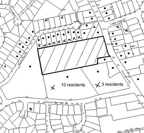
|
NOTIFICATION
PLAN
|
|
|
• PROPERTIES NOTIFIED
|
X SUBMISSIONS
RECEIVED
|
PROPERTY SUBJECT OF DEVELOPMENT
|
|
|
3
SUBMISSIONS RECEIVED OUT OF MAP RANGE
|
|
|
|
|
Fifty-five submissions from
twenty-eight residents objected to the development, generally on the following
grounds that the modification would result in:
· Works never being done if changes are made to the
Staging Plan.
· Light spillage.
· Noise.
· Non-compliance with previous consents.
· Out of character with the adjoining residential area.
· Increase in hours and associated impacts.
· Traffic generation and parking.
· Pedestrian safety.
The merits of the matters raised
in community submissions have been addressed in the original assessment of the
application and in the body of this report.
5.2 Public Agencies
The development application is
Integrated Development under the Act. Accordingly, the application was
referred to the following Agencies for comment:
5.2.1 Roads and Traffic Authority
The RTA raised no objection to
the proposed modifications and provided recommended amendments to conditions of
consent.
5.2.2 Office of Water
The Office of Water raised no
objection to the proposed modifications and advised that no changes are
required to the General Terms of Approval that were granted for the original
consent.
5.2.3 NSW Police
The following comments were
received from the NSW Police:
‘Police
recommended that a Noise Management Plan be established by the Club in relation
to how they will monitor the noise levels emitting from the outdoor
entertaining areas and how they will address any noise issues or concerns.
It was also
noted that condition 6 stated that on six occasions the Club is able to trade
later on special event nights. If the Club is to trade after midnight, then if
possible it is recommended that the outdoor entertaining areas be closed off
after midnight to minimize the noise outdoors. In the past, many noise complaints
have been in relation to special events such as State of Origin nights and
Boxing matches that have been televised and the noise is then carried outside.
Where possible television screens which have televised special events should
not be seen from the outside entertaining areas as this usually results in loud
noises being emitted from people responding to what is being televised.’
6. THE PUBLIC INTEREST
Section 79C(1)(e) of the Act
requires Council to consider “the public interest”.
The public interest is an
overarching requirement, which includes the consideration of the matters
discussed in this report. Implicit to the public interest is the achievement
of future built outcomes adequately responding to and respecting the future
desired outcomes expressed in environmental planning instruments and
development control plans.
The application is considered to
have satisfactorily addressed Council’s and relevant agencies’ criteria and
would provide a development outcome that, on balance, would result in a
positive impact for the community. Accordingly, it is considered that the
approval of the proposed modifications would be in the public interest.
CONCLUSION
The
approved development is for alterations and additions to the West Pennant Hills
Sports Club, involving the refurbishment of the existing clubhouse and
extension of the building to create 4374m² of floor space to the Club, provide
an outdoor courtyard, relocate the existing tennis courts, bowling greens and
cricket nets on the site and the erection of an advertising panel at the New
Line Road Entry to the site. The works include the expansion/relocation of
existing car parking facilities to provide a total of 388 car spaces, including
10 spaces for disabled access and the continuation of the courtesy bus service.
The
proposed modification includes amendments to the staging of construction of the
approved works and amendments to 19 conditions of consent. Subject to the
imposition of modified conditions and amendments to the staging of some of the
works, the proposed development is considered to be within the capacity of the
site.
Accordingly,
the proposed modification is recommended for approval.
Note: At the time of the completion of this planning
report, no persons have made a Political Donations Disclosure Statement pursuant
to Section 147(3) of the Environmental Planning and Assessment Act 1979 in
respect of the subject planning application.
|
Rod Pickles
Manager -
Assessment Team 2
Planning Division
|
Scott Phillips
Executive Manager
Planning Division
|
Attachments:
|
1.View
|
Locality Plan
|
|
2.View
|
Architectural and
Staging Plans
|
File Reference: DA/1046/2007/A
Document Number: D01341609
SCHEDULE 1
GENERAL
CONDITIONS
The
conditions of consent within this notice of determination have been applied to
ensure that the use of the land and/or building is carried out in such a manner
that is consistent with the aims and objectives of the relevant legislation,
planning instruments and Council policies affecting the land and does not
disrupt the amenity of the neighbourhood or impact upon the environment.
Note: For the
purpose of this consent, the term ‘applicant’ means any person who has the
authority to act on or the benefit of the development consent.
Note: For the purpose of this
consent, any reference to an Act, Regulation, Australian Standard or
publication by a public authority shall be taken to mean the gazetted Act or
Regulation, or adopted Australian Standard or publication as in force on the
date that the application for a construction certificate is made.
1. Approved
Plans and Supporting Documentation
The development must be
carried out in accordance with the following plans and documentation listed
below and endorsed with Council’s stamp, except where amended by other
conditions of this consent:
Architectural Plans by DEM
|
Drawing No.
|
Description
|
Issue
|
Date
|
|
ar-0101
|
Site Plan
|
a04
|
04/08/2009
|
|
ar-0102
|
Interim Staging Plan Basement Floor
|
a08
|
29/04/2010
|
|
ar-0103
|
Interim Staging Plan Ground Floor
|
a07
|
29/04/2010
|
|
ar-0104
|
Final Staging Plan Basement Floor
|
a07
|
29/04/2010
|
|
ar-0105
|
Final Staging Plan Ground Floor
|
a07
|
29/04/2010
|
|
ar-0201
|
Basement Floor Masterplan
|
a03
|
04/08/2009
|
|
ar-0202
|
Ground Floor Masterplan
|
a03
|
04/08/2009
|
|
ar-0203
|
Lower Roof Masterplan
|
a02
|
04/08/2009
|
|
ar-0204
|
Roof Masterplan
|
a02
|
04/08/2009
|
|
ar-1201
|
Basement Carpark 2
|
a03
|
21/11/2007
|
|
ar-1202
|
Basement Carpark 1
|
a03
|
11/01/2008
|
|
ar-1203
|
Gymnasium Level
|
a04
|
27/03/2008
|
|
ar-1204
|
Tennis Courts & On-grade Carpark
|
a03
|
04/08/2009
|
|
ar-1205
|
Bowling greens
|
a02
|
21/11/2007
|
|
ar-1206
|
Ground Floor Club
|
a01
|
26/07/2007
|
|
ar-1207
|
Lower Roof Plan
|
a01
|
26/07/2007
|
|
ar-1208
|
Upper Roof Plan
|
a01
|
26/07/2007
|
|
ar-2101
|
Sections Sheet 1
|
a02
|
11/01/2008
|
|
ar-2102
|
Sections Sheet 2
|
a02
|
11/01/2008
|
|
ar-2103
|
Sections Sheet 3
|
a02
|
11/01/2008
|
|
ar-2104
|
Sections Sheet 4
|
a01
|
26/07/2007
|
|
ar-2400
|
Site Elevations
|
a02
|
11/01/2008
|
|
ar-2401
|
Site Sections
|
a01
|
26/07/2007
|
|
ar-2501
|
Elevations
|
a02
|
11/01/2008
|
|
ar-2502
|
Elevations
|
a02
|
11/01/2008
|
|
ar-4901
|
Club External Signage
|
a03
|
26/03/2010
|
Landscape Plans by DEM
|
Drawing No.
|
Description
|
Issue
|
Date
|
|
la-0501
|
Overall Landscape Plan
|
a04
|
27/07/2007
|
|
la-0502
|
Detail Landscape Plan (1 of 2)
|
a06
|
17/12/2007
|
|
la-0503
|
Detail Landscape Plan (2 of 2)
|
a06
|
17/12/2007
|
|
la-0504
|
Riparian Zone Landscape Plan
|
a07
|
17/12/2007
|
|
la-2401
|
Landscape Sections (1 of 2)
|
a05
|
17/12/2007
|
|
la-2402
|
Landscape Sections (2 of 2)
|
a05
|
17/12/2007
|
|
la-2403
|
Riparian Zone Landscape Sections
|
a06
|
17/12/2007
|
|
la-2404
|
Landscape Sections
|
a01
|
17/12/2007
|
|
la-8901
|
Landscape Details
|
a01
|
09/11/2007
|
|
SK0001
|
lask-0001_Planting Palette
|
a02
|
13/10/2006
|
Hydraulic Services by Sydney
All Services Pty Ltd
|
Drawing No.
|
Description
|
Issue
|
Date
|
|
30193-C01
|
Site Plan (1 of 2)
|
E
|
30/10/2007
|
|
30193-C02
|
Site Plan (2 of 2)
|
E
|
30/10/2007
|
|
30193-C04
|
Details & Notes
|
C
|
30/10/2007
|
|
30193-C05
|
Soil & Water Management Plan
|
C
|
260/10/2007
|
|
30193-C07
|
Flood Extent Plan
|
A
|
26/10/2007
|
|
30193-C08
|
Flood Extent Plan Proposed Site Conditions
|
A
|
26/10/2007
|
|
30193-C09
|
Detailed Cross Sections Flood Levels
|
A
|
26/10/2007
|
|
30193-C10
|
Details & Notes
|
A
|
30/10/2007
|
|
06014-C10
|
Creek Widening Works & Bund Details
|
A
|
29/04/2008
|
Survey Plan by Danny Linker
& Co
|
Drawing No.
|
Description
|
Issue
|
Date
|
|
060211
|
Site Survey showing detail & levels
|
-
|
03/03/2006
|
Supporting Documentation
|
Document No.
|
Title
|
Date
|
|
SK001 Rev A
|
Project No. 3482-00 Sample Board
|
July 2008
|
|
37.3170.R9:ZJM
|
Acoustic
Report
prepared by
The Acoustic Group
|
08/11/2007
|
|
38.3170.R11:ZJM
|
Acoustic
Report - Supplementary Information prepared by The Acoustic Group
|
18/03/2008
|
|
40.3170.L15:ZSC
|
Acoustic
Letter - Supplementary Information prepared by The Acoustic Group
|
22/03/2010
|
|
0665
|
Assessment of Traffic & Parking Implications prepared
by Transport & Traffic Planning Associates
|
May 2007
|
|
-
|
Supplementary Traffic Advice prepared by Transport &
Traffic Planning Associates
|
12/11/2007
|
|
|
Supplementary Traffic Advice prepared by Transport &
Traffic Planning Associates (no. 2)
|
24/03/2010
|
|
-
|
Access Report prepared by Accessibility Solutions
|
28/9/2006
|
|
6261
|
Building Code of Australia 2006 Report prepared by DIX
Gardiner
|
26/09/2006
|
|
-
|
Waste Management Plan prepared by DEM
|
18/7/2007
|
|
3842
|
Landscape Works Specification prepared by DEM
|
9/11/2007
|
|
D00713127
|
Site Plan Tree Location
|
28/09/2007
|
|
|
Security Management Plan
|
30/03/2010
|
2. Staging
of Works
The development must be
constructed in accordance with the approved staging plan except as modified by
this condition:
a. STAGE 1A
WORKS
i. Relocate
the existing Cub administration area into temporary demountable building
accommodation in the Club Director’s parking area and relocate part of the
internal gaming area into the existing administration area.
ii. Install
protective hoarding and pedestrian barriers to the existing gaming area.
iii. Relocate
the tennis courts and cricket nets to eastern Club site.
iv. Retain
the western and central bowling greens and on-grade parking areas to the west
and south of the Club.
v. Construct
the new on grade parking areas to eastern side of the Club.
vi. Construct
the temporary storage/ ‘back-of-house’ undercroft space and overhead slab
structure to be converted for future temporary parking and gymnasium.
vii. Erect
acoustic fences and landscape buffer planting to northern Club boundary as
depicted on the staging plan.
viii. Erect
acoustic fences along the southern property boundary as depicted on the staging
plan.
ix. Construct
the new vehicular entry to New Line Road.
x. Construct
the first portion of ground floor Club facilities extensions as depicted on the
staging plan.
xi. Refurbish
the existing Club kitchen, bars, administration and reception areas to cater
for the new extensions.
xii. Construct
the new eastern tennis pavilions and amenities block.
xiii. Construct
the new pedestrian bridge over the creek line.
xiv. Construct
a 1.2m wide footpath, physically separated from the access road, connecting New Line Road and the new at-grade parking area on the eastern side of the Club to the Club
building entrance.
xv. Construct
the pedestrian refuge island in New Line Road to the immediate south of Cedarwood Drive.
xvi. Relocate
the temporary Club administration and gaming facilities into the final new
building locations and remove the temporary demountable accommodation.
xvii. Modify
channel in watercourse to prevent flooding of the site.
xviii. Construction
of the On Site Detention system.
b. STAGE 1B
WORKS
i. Extend
the acoustic fence to southern boundary as depicted on the staging plan.
ii. Convert
the temporary storage/ ‘back-of-house’ undercroft area to temporary parking for
41 cars spaces to service the Stage 1B Club extensions.
iii. Construct
the second portion of the ground floor Club facilities extensions as depicted
on staging plan.
iv. Complete
all riparian zone works and landscape treatments and New Line Road landscaping
as per the staging plan.
c. STAGE 1C
WORKS
i. Undertake
remaining internal refurbishments and upgrading works to the existing Club
building.
ii. Extend
the southern and northern acoustic fencing treatments to the western boundary.
iii. Complete
the northern and southern boundary landscape screen treatments.
iv. Complete
the New Line Road landscape treatments and footpath/bus bay.
v. Construct
the first stage of the new traffic management improvement to New Line Road including seagull traffic management arrangement and bus bay.
d. STAGE 2A
WORKS
i. Construct
the first portion fitout works of the new gymnasium.
ii. Complete
the final riparian zone works and landscape treatments following the bridge
construction.
iii. Construct
a new vehicular bridge over the creek line.
e. STAGE 2B
WORKS
i. Deactivate
the central bowling green.
ii. Complete
the undercroft area as additional temporary parking for Stage 2A Club extension
areas.
iii. Construct
the central courtyard areas and the western edge of Stage 1B areas.
iv. Complete
the noise walls and landscape treatments to the northern boundary buffer zone.
f. STAGE
2C WORKS
i. Construct
the new western basement car park.
ii. Construct
the new bowling greens.
iii. Complete
the last portion of the ground floor Club facilities extensions as depicted on
the staging plan.
iv. Complete
the fitout of the new gymnasium facility.
v. Complete
the new basement car park.
vi. Complete
the northern and southern boundary landscape screen treatments following on
from basement car park and new bowling green works.
vii. Construct
the second stage of new traffic management improvement to New Line Road
comprising a roundabout at the intersection of Cedarwood Drive and New Line Road prior to the occupation of the basement car park.
viii. Complete
the New Line Road landscape treatment and footpath/bus bay following on from
second stage of new traffic management improvement to New Line Road.
REQUIREMENTS PRIOR TO THE ISSUE OF A CONSTRUCTION
CERTIFICATE
3. Building
Code of Australia
All building work must be
carried out in accordance with the requirements of the Building Code of
Australia.
4. Weed
and Creek Management Plan
The applicant must submit
to Council for approval a ‘Weed and Creek Management Plan’ to direct and inform
maintenance staff in weed control and horticultural maintenance activities to
ensure that potential noxious and environmental weeds on the site do not spread
downstream and are managed in an environmentally sensitive manner. Maintenance
works are to achieve a quality landscaping outcome which is not compromised as
result of uncontrolled weed invasion.
The Plan must
be prepared by a qualified and experienced bushland restoration company that
include but not be limited to the following:
a. weed removal techniques for pre and post construction of the development
proposal;
b. use of environmentally safe herbicide applications where
applicable;
c. maintenance regimes for weeds and proposed plantings post
development;
d. reference to the approved landscaping plan Riparian Zone
Landscape Plan prepared by DEM (Aust) Pty Ltd, (Drawing No. la-0504 Rev a07,
dated 17/12/2007) for replanting where required to compensate for natural
mortality of tube stock lost in early establishment stages;
e. provide guidelines for best environmental practice considering
that the subject site for the plan is a watercourse;
f. provide minimum qualifications required of maintenance
horticultural staff (including those required for use of chemicals if
appropriate);
g. list of weeds previously recorded on site prior to the development
that are likely to regenerate following the development proposal; and
h. identification and control techniques of noxious weeds in
Hornsby LGA as listed under the Noxious Weeds Act 1993.
5. Traffic
Management Plan – Construction
In order to enable
unencumbered movement of traffic in New Line Road during construction works, a
Construction Management Plan, including a Traffic Management Plan and Scaled
Construction Plan must be prepared by a chartered engineer and qualified
worksite traffic controller and submitted to Council for approval with the
construction certificate. The Construction Management Plan and Traffic
Management Plan must address the following requirements:
a. Detail the order of construction works and arrangement of
all construction machines and vehicles being used at the same time during all
stages.
b. Be in compliance with the requirements of the Road and
Traffic Authority’s “Traffic Control at Worksites Manual 1998” and
detailing:
i. Public notification of proposed works;
ii. Long term signage requirements;
iii. Short term (during actual works) signage;
iv. Vehicle Movement Plans, where applicable;
v. Traffic Management Plans;
vi. Pedestrian and Cyclist access and safety;
c. Indicate traffic controls including those used during
non-working hours and provide pedestrian access and two-way traffic in the
public road to be facilitated at all times.
REQUIREMENTS PRIOR TO THE COMMENCEMENT OF ANY WORKS
6. Erection
of Construction Sign
A sign must be erected in a
prominent position on any site on the site:
a. Showing
the name, address and telephone number of the principal certifying authority
for the work,
b. Showing
the name of the principal contractor (if any) for any demolition or building
work and a telephone number on which that person may be contacted outside
working hours, and
c. Stating
that unauthorised entry to the work site is prohibited.
Note: Any
such sign is to be maintained while the building work, subdivision work or
demolition work is being carried out, but must be removed when the work has
been completed.
7. Protection
of Adjoining Areas
A temporary hoarding, fence
or awning must be erected between the work site and adjoining lands before the
works begin and must be kept in place until after the completion of the works
if the works:
a. Could
cause a danger, obstruction or inconvenience to pedestrian or vehicular
traffic.
b. Could
cause damage to adjoining lands by falling objects.
c. Involve
the enclosure of a public place or part of a public place.
Note: Notwithstanding
the above, Council’s separate written approval is required prior to the
erection of any structure or other obstruction on public land.
8. Toilet
Facilities
Toilet facilities must be
available or provided at the works site before works begin and must be
maintained until the works are completed at a ratio of one toilet for every 20
persons employed at the site. Each toilet must:
a. be
a standard flushing toilet connected to a public sewer; or
b. be
a temporary chemical closet approved under the Local Government Act, 1993;
or
c. have
an on-site effluent disposal system approved under the Local Government Act,
1993
9. Erosion
and Sediment Control
Erosion and sediment
control measures must be provided and maintained throughout the construction
period in accordance with the manual ‘Soils and Construction 2004
(Bluebook)’, the approved plans, Council specifications and to the
satisfaction of the principal certifying authority. The erosion and sediment
control devices must remain in place until the site has been stabilised and
revegetated.
Note: On
the spot penalties up to $1,500 may be issued for any non-compliance with this
requirement without any further notification or warning.
10. Erosion
Control - Watercourse
In addition to any other conditions
of this consent, the following erosion control measures must be adopted near
the watercourse:
a. All headwall outlets must incorporate flow velocity
reduction controls (i.e. bedded boulders and small stones) to minimise erosive
and scouring impacts to the watercourse.
b. Energy dissipater controls must be landscaped to
accommodate outlet sheet flow (forced jump).
c. No engineering works are permitted within the bed of the
watercourse.
d. A buffer set back of an average width of 10 metres must be
provided from the crest of the watercourse to any structures and be suitably
vegetated with native grasses to facilitate the filtration of surface runoff.
e. No land disturbance, buildings or associated structures may
encroach within 10 metres from the crest of the bank of the watercourse or
beyond those areas of riparian landscape depicted on the approved plan.
11. Tree
Protection Barriers
Tree protection fencing
must be erected around Tree Group A, trees numbered T13, T14, T18a, T18c, T32,
T33, T34, T35 and T36 T37, T38, T39, T40, T41, T41a, T42, T43, T44, T45, T46,
T47, T48 to be retained at a 4 metre setback
and Tree Group B, trees numbered T37, T38, T39, T40, T41, T41a, T42, T43, T44,
T45, T46, T47, T48 to be retained at a 3 metre
setback. The tree fencing must be constructed of 1.8 metre ‘cyclone chainmesh
fence’ or star pickets spaced at 2 metre intervals, connected by a continuous
high-visibility barrier/hazard mesh at a height of 1 metre.
12. Dilapidation
Report
A ‘Dilapidation Report’ is
to be prepared by a ‘chartered structural engineer’ detailing the structural
condition of all adjoining properties that are within the zone of influence of
any works approved under this consent.
REQUIREMENTS DURING CONSTRUCTION
13. Construction
Work Hours
All
work on site (including demolition and earth works) must only occur between 7am
and 5pm Monday to Saturday.
No work is to be undertaken on Sundays or public holidays.
14. Demolition
All demolition work must be
carried out in accordance with Australian Standard 2601-2001 – The
Demolition of Structures and the following requirements:
a. Demolition
material is to be disposed of to an authorised recycling and/or waste disposal
site and/or in accordance with an approved waste management plan.
b. Demolition
works, where asbestos material is being removed, must be undertaken by a
contractor that holds an appropriate licence issued by WorkCover NSW in
accordance with Chapter 10 of the Occupational Health and Safety Regulation
2001 and Clause 29 of the Protection of the Environment Operations
(Waste) Regulation 1996.
c. On
construction sites where buildings contain asbestos material, a standard
commercially manufactured sign containing the words ‘DANGER ASBESTOS REMOVAL IN
PROGRESS’ measuring not less than 400mm x 300mm must be erected in a prominent
position visible from the street.
15. Environmental
Management
The site must be managed in
accordance with the publication ‘Managing Urban Stormwater – Landcom (March
2004) and the Protection of the Environment Operations Act 1997 by
way of implementing appropriate measures to prevent sediment run-off, excessive
dust, noise or odour emanating from the site during the construction of the
development.
16. Street
Sweeping
Street
sweeping must be undertaken following sediment tracking from the site along New Line Road during works and until the site is established.
17. Works
near Trees
All required tree
protection measures are to be maintained in good condition for the duration of
the construction period.
All works
(including driveways and retaining walls) within 4 metres of any trees required
to be retained (whether or not on the subject property, and pursuant to this
consent or the Tree Preservation Order), must be carried out under the
supervision of an ‘AQF Level 5 Arborist’ and a certificate submitted to
the principal certifying authority detailing the method(s) used to preserve the
tree(s).
Note:
Except as provided above, the applicant is to ensure that no excavation,
filling or stockpiling of building materials, parking of vehicles or plant,
disposal of cement slurry, waste water or other contaminants is to occur within
4 metres of any tree to be retained.
18. Council
Property
During construction works,
no building materials, waste, machinery or related matter is to be stored on
the road or footpath. The public reserve is to be kept in a clean, tidy and
safe condition at all times.
Note:
This consent does not give right of access to the site via Council’s park or
reserve. Should such access be required, separate written approval is to be
obtained from Council.
19. Excavated
Material
All excavated material
removed from the site must be classified in accordance with the NSW
Environment Protection Authority’s Environmental Guidelines – Assessment,
Classification and Management of Liquid and Non-Liquid Wastes prior to
disposal to an approved waste management facility and reported to the principal
certifying authority.
20. Survey
Report – Finished Floor Level
A report must be prepared
by a registered surveyor and submitted to the principal certifying authority
prior to the pouring of concrete at each level of the building certifying that:
a. The
building, retaining walls and the like have been correctly positioned on the
site.
b. The
finished floor levels are in accordance with the approved plans.
REQUIREMENTS PRIOR TO THE ISSUE OF AN
OCCUPATION CERTIFICATE FOR ANY STAGE OF WORKS
Note: For
the purpose of this consent, any reference to ‘occupation certificate’ shall
also be taken to mean ‘interim occupation certificate’ unless otherwise stated.
21. External
Lighting - General
All lighting must comply
with the Australian Standard AS3282:1997 The Control of Obtrusive Effects of
Outdoor Lighting. A suitably qualified lighting consultant must be
appointed to measure and verify that the light emanating from the site complies
with AS3282:1997.
22. Patron
Signage - Noise
The applicant must erect
prominent notices inside and outside the building advising patrons of the need
to not cause any noise disturbance due to the proximity of the neighbouring
residences.
23. Boundary
Fence Acoustic Control Measures
The applicant must
construct solid fencing in accordance with all acoustic reports listed in
condition 1 and the following:
a. The fence on the western end of the southern boundary from
the western boundary 40 metres past the western façade of the Club building
must be no less than 2.5 metres in height.
b. The fence on the southern boundary 40 metres from the
western façade of the Club building to 25 metres from the eastern façade of the
Club building must be no less than 3.6 metres in height.
c. The fence on the northern boundary fence must be no less
than 1.8 metres in height.
24. Carpark
Entry Ramp – Acoustic Control Measures
A minimum 65% of the roof
area of the entry ramp of the underground carpark must be constructed using
acoustic absorption having an NRC not less than 0.74.
25. Consumption
of Alcohol and Smoking in Outdoor Areas
With the exception of the
outdoor dining, the outdoor central courtyard, the smokers’ balcony and the
outdoor gaming areas, no smoking or consumption of alcohol is permitted in any
outdoor area.
26. Entertainment
in Outdoor Areas
No music, entertainment or
amplified announcements is permitted in any outside area, with the exception of
inaudible television screens and emergency and paging announcements essential
to the safe and orderly management of the Club and its patrons. The acoustic
mitigation measures required under this consent shall be strictly enforced
immediately by the patrolling of all outside areas and appropriate signs shall
be erected reminding patrons of their obligations to minimise noise in
accordance with the Club’s requirements.
27. Mechanical
Plant – Acoustic Control Measures
All mechanical plant
equipment must have noise specifications, locations and orientations reviewed
prior to installation on the site to ensure that they will not singularly or in
total emit noise levels which possess tonal, beating and similar
characteristics or which exceeds background noise levels by more than 5dB(A).
Should the calculated noise emissions from the mechanical plant equipment be in
excess of the set limits, appropriate acoustic treatment must be implemented by
a suitably qualified consultant.
28. Carpark
ventilation stack
The carpark ventilation
must be constructed in a fully enclosed shaft discharging above the roof level
and be constructed and located in accordance with the requirements of Australian
Standard AS1668.2.
29. Construction
of Food Preparation Areas
The construction, fitout
and operation of that part of the development to be used for the manufacture,
preparation or storage of food for sale, is to be in accordance with Australian
Standard 4674-2004, Design and Fit Out of Food Premises, the Food
Act 2003, and the Food Regulation 2004 and the following
requirements:
a. Lodgement of an application to Sydney Water for the
installation of a grease trap and dry basket arrestors (floor & sink) in
accordance with the Guidelines for the On-Site Pre-Treatment of Trade
Wastewater Discharges, Sydney Water, May 2004.
b. Mechanical ventilation and the exhaust system is to be
designed and installed in accordance with the requirements of Australian
Standard 1668.2 and the Protection of the Environment Operations Act
1997.
30. Riparian
Zone Landscape Plan
In addition to the Riparian
Zone Landscape Plan prepared by DEM (Aust) Pty Ltd, (Drawing No. la-0504 Rev
a07, dated 17/12/2007) the applicant must adhere to the following requirements:
a. Use plants purchased from a recognised native plant nursery
and grown from provenance seed.
b. Use trees that are tube stock, or were possible larger, and
grown from locally genetic stock.
c. Replace all plants that die within one calendar month.
d. Use jute matting or equivalent on the entire embankment prior
to landscaping to assist in weed suppression and bank stabilisation.
e. Use weed free eucalypt mulch.
f. Prevent the spread of turf or weeds into the creek of the
property through the erection of a physical barrier along the edge of the
existing turf area using materials such as timber, logs, rock, or concrete.
The barrier is to be installed underground as well as above ground to provide a
root barrier and to act as a mown strip to delineate the mown area from the
bushland area. The physical barrier shall be inserted approximately 20cm below
the soil with a minimum 8cm above the soil.
g. Specify watering regime based on type and size of species of
plants.
h. Maximise the use of fertilisers on site to reduce the impact
on the watercourse.
i. Cross reference the approved Weed and Creek Management Plan
for maintenance activities and responsibilities.
31. Driveway/Parking
Bay – Protection of Trees
To ensure any work
undertaken will not adversely affect the longevity of the tree T3, T13 &
T14, the driveway/parking bay is to be laid on existing grade with no
excavation or fill within the nominated 4 metre restriction zones. The
driveway/parking bay edge must not be within 2 metres of the edge of the trunks.
32. Boundary
Screen Planting
To ensure adequate screen
planting is provided to adjoining properties, screen planting to the on-grade
landscape setback zone adjacent to the property boundaries must include:
a. Northern Boundary:
i. 30 trees capable of reaching a mature height of 8 metres
planted at 6 metre centres in mulched planter beds. Trees to be installed at
minimum pot size of 45 litres.
ii. 60 shrubs/small trees capable of reaching a mature height of
5 metres planted at 2 metre centres in mulched planter beds. Plants to be
installed at minimum pot size of 5 litres.
b. Southern Boundary:
i. 30 trees capable of reaching a mature height of 8 metres
planted at 6 metre centres in mulched planter beds. Trees to be installed at
minimum pot size of 45 litres.
33. Landscape
Works
Except as otherwise
specified within this consent, all landscape works must meet the construction
standards identified in the Hornsby Shire Council Landscape Code for
Development Applications and the following requirements:
a. The construction of mulched planter beds, planting of
trees in minimum 25 litre pot sizes, shrubs in minimum 5 litre pot sizes and
groundcovers in minimum 150mm pot sizes and native grasses in virocell tubes in
the densities identified in the submitted planting specification.
b. Slab planter box areas must include automatic irrigation,
subsoil drainage (proprietary drainage cell, 50mm sand and filter fabric),
waterproofing, minimum 500mm planting soil for shrubs and minimum 1000mm
planting soil for trees and palms, and 75mm mulch.
c. The landscape works and planting must be monitored and
maintained in perpetuity after installation as specified and nominated in
landscape specification to ensure successful establishment of all landscape
works.
d. A compliance certificate must be submitted to the principal
certifying authority from a registered landscape architect confirming that
landscape works have been installed and comply with the approved landscape plan
and conditions of consent at the completion of relevant stages of work.
34. Waste
Management - Construction
To confirm compliance with
approved Waste Management Plan, the applicant must submit to the principal
certifying authority a report of actual destinations and quantities of waste
generated by the works carried out under this development consent. This report
is to be based on documentary evidence (i.e. tipping dockets/receipts from
transfer stations and landfills).
35. Waste
Management - Operational
Bin storage areas must be
designed and constructed in accordance with Council’s Waste Minimisation and
Management Development Control Plan.
36. Drainage
Stormwater drainage from
the site must be designed to satisfactorily drain rainfall intensities for an
average recurrence interval of 20 years. The design shall:-
a. Be in accordance with Council’s Civil Works – Design
Specification 1999 and generally in accordance with plans prepared by
Sydney All Services Pty Ltd Job No 06014 Drawing C04 issue C.
b. Provide for drainage discharge to the existing drainage
system.
c. Ensure that the development, either during construction or
upon completion, does not impede or divert natural surface water runoff so as
to cause a nuisance to adjoining properties.
37. Works
As Executed Plan
A works-as-executed plan
prepared by a chartered professional engineer or a registered surveyor must be
lodged with Council when the engineering works are complete, prior to the
release of the occupation certificate.
38. Damage
to Council Property
Any damage caused to Council's
assets in the vicinity of the subject site as a result of construction works
associated with the approved development is to be repaired by the
applicant/developer prior to the issue of the occupation certificate.
REQUIREMENTS PRIOR TO THE ISSUE OF AN OCCUPATION
CERTIFICATE FOR STAGE 1A WORKS
Note: For the
purpose of this consent, any reference to ‘occupation certificate’ shall also
be taken to mean ‘interim occupation certificate’ unless otherwise stated.
39. Drainage
To ensure downstream properties
are not flood affected by the increase in flows from the development site, the
drainage system must be constructed with an on-site-detention system, having a
capacity of not less than 176m3 and a maximum discharge, when full,
of 88 l/s. The system must be designed by a chartered civil engineer to the
following requirements:
a. A surcharge/inspection grate is to be located directly above
the outlet.
b. Stormwater discharge from the detention system is to be
controlled via a one metre length of pipe not less than 50mm diameter
discharging into a larger diameter pipe capable of carrying the design flow to
Council's gutter/stormwater pit.
c. Where the on-site detention system is proposed under the
vehicular driveway, the engineer is to certify that the detention tank is
structurally capable of withstanding the maximum anticipated traffic loads.
A compliance
certificate is to be submitted to Council which includes work-as-executed
details of the on-site-detention system prepared by a chartered engineer
verifying that the required storage and discharge volumes have been constructed
in accordance with the design requirements. The details are to show the invert
levels of the on system as well as the pipe sizes and grades. Any variations
to approved plans must be shown in red and supported by calculations. The on
site detention system and associated drainage works is to be completed prior to
the issue of an occupation certificate for Stage 1A.
40. Flood
Protection – Carpark and Accessways
To prevent flooding of the
carpark and accessways, the existing watercourse is to be modified generally in
accordance with the plans prepared by Sydney All Services Pty Ltd Job No 06014
drawing No C10 to prevent inundation of the carpark and bridge. The proposed
works are to be consistent with the requirements of the Part 3A permit.
Engineering plans are to be prepared by a suitably qualified civil engineer
detailing the proposed works. Prior to the issue of a construction certificate
for these works, the plans are to be approved by Council. The modifications to
the watercourse are to be completed prior to the issue of an occupation
certificate for Stage 1A.
41. Flood Mitigation – Catch Drain
To prevent flooding of the
site a catch drain is to be designed and constructed within the subject
property to intercept overland flows from Edward Bennett Oval and direct these
flows to the existing creek so as to protect the proposed buildings from
overland flows. The work is to be carried out generally out in accordance with
plans prepared by Sydney All Services Pty Ltd Job No 06014 drawing No C10. The
construction of the catch drain is to be completed prior to the issue of an
occupation certificate for Stage 1A.
42. Vehicular
Crossing
The concrete vehicular
crossing (layback) must be designed and constructed in accordance with
Council’s Civil Works - Design and Construction Specification 1999 and
the following requirements:
a. Be a minimum of 200mm in depth reinforced with 2 layers of
F72 steel reinforcing fabric.
b. Have a minimum width of 7m each for the entry and exit
crossings at the property boundary alignment and shall be separated with a
minimum 1m wide median. This width shall extend a minimum of 6m inside the
property boundary in accordance with AS 2890.1. The maximum grade of the
access driveways in this location shall be 1 in 20.
c. The
ingress and egress crossings shall be suitably signposted prior to occupation.
43. Driveway
The access driveways must
be designed and constructed in accordance with Council’s Civil Works -
Design and Construction Specification 1999 and the following requirements:
a. Construction of 150mm thick reinforced concrete pavement
with 150mm of DGS 20 sub base.
b. The pavement shall have a kerb to one side and a one-way
crossfall with a minimum gradient of 2%.
c. Construction of retaining walls, as required to support the
carriageway and the compaction of all filled batters to the requirements of a
practising geotechnical engineer.
d. The provision of a safety rail at appropriate locations
along the carriageway where there is a level difference between the driveway
and the adjoining ground level of more than 300 mm or a 1:4 batter cannot be
achieved.
e. The construction of a new pedestrian bridge to span the
existing watercourse. The underside of the bridge must have a minimum clearance
of 300mm above the 1 in 100 year storm event. Prior to the release of the
construction certificate a certificate from a chartered civil engineer is to be
obtained confirming the underside of the bridges has been designed 300mm above
the 1 in 100 year flood levels.
f. The construction of a separate 1.2m wide footpath from New Line Road to the Club’s building entrance.
44. Pedestrian
Refuge
A pedestrian refuge is to
be constructed in New Line Road in accordance with Council’s Civil Works -
Design and Construction Specification 1999 and Standard Drawing No 19. All
costs associated with the construction of the pedestrian refuge are to be met
by the applicant. The works are to include but not be limited to the following:
a. Linemarking.
b. Service adjustments.
c. Signage.
d. Median strips.
e. Pram ramps and pedestrian footpaths.
f. Road furniture.
g. The surface of the pedestrian refuge is
to be finished with “biscuit marigold” oxide.
h. Footpath construction.
REQUIREMENTS
PRIOR TO THE ISSUE OF AN OCCUPATION CERTIFICATE FOR STAGE 1C WORKS
Note: For the
purpose of this consent, any reference to ‘occupation certificate’ shall also
be taken to mean ‘interim occupation certificate’ unless otherwise stated.
45. Bus Bay
An indented bus bay must be
constructed in accordance with Council’s Civil Works - Design and
Construction Specification 1999. The bus bay must be designed for an 18m
articulated bus with a minimum length of 40m and all costs must be met by the
applicant. The works are to include but not be limited to the following:
a. Linemarking.
b. Service adjustments.
c. Signage.
d. Median strips.
e. Pram ramps and pedestrian footpaths.
f. Public road acquisition (minimum 3.5m
wide footpath area).
g. Road furniture.
h. Pavement construction.
i. Footpath construction.
j. Stormwater drainage.
46. Subdivision
Certificate – Road Widening – Bus Bay
Prior to the principal
certifying authority issuing an occupation certificate, the applicant must
lodge with Council a subdivision certificate and dedicate the land required for
road widening associated with the bus bay at no cost to Council. The applicant
must submit a surveyor’s certificate certifying that all structures within the
land comply with the development consent in regard to clearance from new
property boundaries.
47. Road
Intersection
The intersection design
(New Line Road and Club access) as detailed in the ‘Transport and Traffic
Planning Associates report 0655 Figure 1 Proposed Access Arrangement dated 20
July, 2009’ must be designed and constructed in accordance with Council’s Civil
Works - Design and Construction Specification 1999 and the requirements of
the RTA. All costs associated with the construction of the intersection must be
met by the applicant. The works are to include but not limited to the
following;
a. Linemarking.
b. Service adjustments.
c. Signage.
d. Painted median strips.
e. Pram ramps and pedestrian footpaths.
f. Public road acquisition (where required).
g. Road furniture.
h. Service adjustment.
48. Existing
Kerb and Gutter
The existing kerb and
gutter must be removed and reconstructed across the frontage of the site in New Line Road. The existing road pavement must be saw cut a minimum of 300mm from the
existing lip of kerb and reconstructed. The work must be completed prior to the
issue of the occupation certificate.
49. Road
Pavement
Road pavements are to be
designed by a professional civil engineer in accordance with Council’s Civil
Works - Design and Construction Specification 1999 and must be based upon
soil tests performed by a registered NATA Soils Laboratory. The traffic
loadings for pavement design must be 2 x 10⁶.
50. Footpaths
A 1.2m wide concrete
footpath must be designed and constructed across the frontage of the site in New Line Road. The concrete footpath is to be constructed so as to connect to the existing
footpath both north and south of the site in accordance with Council’s Civil
Works - Design and Construction Specification 1999. The rear of the
footpath must be located 600mm from the property boundary. The footpath area
(from the rear of the kerb to the property boundary) must have a grade of 4%
from the property boundary down to the top of kerb. Where the level of the rear
of the footpath area exceeds 300mm from the existing surface level a masonry
retaining wall is to be constructed with a 1.0 metre high safety fence erected
on top of the wall.
REQUIREMENTS PRIOR TO THE ISSUE OF AN OCCUPATION
CERTIFICATE FOR STAGE 2A WORKS
Note: For the
purpose of this consent, any reference to ‘occupation certificate’ shall also
be taken to mean ‘interim occupation certificate’ unless otherwise stated.
51. Vehicular
Bridge
The vehicular access bridge
over the watercourse must be designed and constructed in accordance with
Council’s Civil Works - Design and Construction Specification 1999 and
the following requirements:
a. The pavement must have a kerb to one side and a one-way
crossfall with a minimum gradient of 2%.
b. The provision of a safety rail at appropriate locations along
the carriageway where there is a level difference between the driveway and the
adjoining ground level of more than 300 mm.
c. The underside of the bridge must have a minimum clearance of
300mm above the 1 in 100 year storm event. Prior to the release of the
construction certificate a certificate from a chartered civil engineer must be
obtained confirming the underside of the bridges has been designed 300mm above
the 1 in 100 year flood levels.
REQUIREMENTS PRIOR TO THE ISSUE OF AN OCCUPATION
CERTIFICATE FOR STAGE 2C WORKS
Note: For the
purpose of this consent, any reference to ‘occupation certificate’ shall also
be taken to mean ‘interim occupation certificate’ unless otherwise stated.
52. Construction
of Roundabout
A roundabout must be
designed and constructed at the intersection of New Line Road and Cedarwood Drive in accordance with Council’s Civil Works - Design and Construction
Specification 1999, the requirements of Austroads Guide to Engineering
Practise Part 6 and the requirements of the RTA. The concrete roundabout
must have a minimum thickness of 200mm and reinforced with two layers of F72.
All costs associated with the construction of the roundabout must be met by the
applicant. The design and construction of the roundabout are to include but not
limited to the following:
a. Linemarking.
b. Service adjustments.
c. Signage.
d. Median strips.
e. Pram ramps and pedestrian footpaths.
f. Public road acquisition.
g. Road furniture.
h. The surface of the roundabout is to be finished with
“biscuit marigold” oxide.
i. Reconstruction of the pavement within the roundabout.
j. Footpath construction.
k. Stormwater drainage.
53. Subdivision Certificate Road Widening - Roundabout
Prior to the principal
certifying authority issuing an occupation certificate, the applicant must
lodge with Council a subdivision certificate and dedicate the land required for
road widening associated with the roundabout at no cost to Council. The
applicant must submit a surveyor’s certificate certifying that all structures
within the land comply with the development consent in regard to clearance from
new property boundaries.
54. Sydney
Water – s73 Certificate
A s73 Certificate must be
obtained from Sydney Water.
55. Hours
of Use
The hours of operation of
the various part of the Club must be in accordance with the following:
CLUB -
GENERAL
Operational
upon receipt of an occupation certificate for Stage 1C works
Sunday -
Wednesday & Public Holidays: 9am – 11pm
Thursday -
Saturday: 9am – 12 midnight
CLUB -
SPECIAL EVENT (INTERNAL CLUB AREAS ONLY)
Operational
upon receipt of an occupation certificate for Stage 1C works
Maximum 6
nights per calendar year 11pm – 9am
GYMNASIUM
Operational
upon receipt of an occupation certificate for Stage 2A works
Monday –
Sunday & Public Holidays: 6am – 10pm
TENNIS COURTS
Operational
upon receipt of an occupation certificate for Stage 1A works
Monday -
Friday: 6am – 10pm
Saturday: 7am
– 10pm
Sunday &
Public Holidays: 8am – 10pm
SOUTHERN
BOWLING GREEN (ILLUMINATED)
Operational
upon receipt of an occupation certificate for Stage 2C works
Monday -
Saturday: 7am – 9pm
Sunday &
Public Holidays: 8am – 9pm
NORTHERN
BOWLING GREEN (UNLIT)
Operational
upon receipt of an occupation certificate for Stage 2C works
Monday -
Saturday: 7am – Sunset
Sunday &
Public Holidays: 8am – Sunset
56. Lighting
– Bowling Greens
All lights used for night
time bowls must be connected to an automatic time switch to be switched off at
9.00pm.
57. Lighting
– Tennis Courts
All lights used for night
time tennis must be connected to an automatic time switch to be switched off at
10.00pm.
58. Outdoor
Area Acoustic Control Measures
The following acoustic
measures must be employed within the central undercover outdoor area:
a. A maximum of 120 patrons in the undercover outdoor area,
200 patrons in the central courtyard and 20 patrons in the outdoor gaming area
at any one time.
b. The northern and western boundary of the area shown as the
courtyard ‘water feature’ must have a barrier not less than 4 metres above
ground level (RL 160) and the barrier must be constructed of solid masonry.
c. The walls of the outdoor gaming room must not be less than
2 metres in height.
d. No music, entertainment or amplified music/announcements is
permitted in the central courtyard/outdoor area, with the exception of
inaudible television screens for emergency and paging announcements essential
to the safe and orderly management of the Club and its patrons.
59. Smokers
Balcony (eastern elevation) Acoustic Control Measures
The following acoustic
control measures must be employed within the smokers balcony on the eastern
elevation of the building:
a. A maximum of 60 patrons on the balcony at any one time.
b. The northern elevation of the smokers balcony must have a
physical barrier to the ceiling height of the balcony and a 1.5 metres return
on the eastern elevation. The barrier must have a transmission loss not less
than Rw of 30.
c. The underside of roof of the smokers’ balcony must be
constructed with acoustic absorption having an NRC not less than 0.85.
d. Air lock doors must be installed at the exits of the Sports
Lounge to the smokers’ balcony.
e. No music, entertainment or amplified music/announcements is
permitted on the smokers’ balcony, with the exception of inaudible television
screens for emergency and paging announcements essential to the safe and
orderly management of the Club and its patrons.
60. Advertising
Signs
All advertisings signs
approved under this consent must be maintained in a presentable state of repair
to Council’s satisfaction and:
a. Sign A must be fitted with an automatic timing device to
extinguish the illumination outside of the approved hours of use for the Club.
b. Sign B must not be illuminated.
61. Fire
Safety Statement - Annual
On at least one occasion in
every 12 month period following the date of the first ‘Fire Safety Certificate’
issued for the property, the owner must provide Council with an annual ‘Fire
Safety Certificate’ to each essential service installed in the building.
62. Noise
Monitoring
To ensure that the Club’s
activities do not unreasonably impact upon the amenity of the adjoining
residential population, the applicant must:
a. Install acoustic monitoring equipment in accordance with
the recommendations of The Acoustic Group’s letter dated 22 March 2010
for a period of 60 days after the completion of construction works.
b. Prepare a noise management plan outlining how the Club will
respond to residents’ complaints and high levels of noise in the outdoor areas.
c. Manage any noise complaints under the direct supervision of
the Duty Club Manager and to the satisfaction of the NSW Police. The Manager
must record all relevant details including date, time, name, contact number and
details of the complaint.
63. Maximum
Persons on Site
The combined number of
patrons, visitors and staff on site at any one time must not exceed 1,032.
64. Car
Parking and Deliveries
All car parking must be
constructed and operated in accordance with Australian Standard AS 2890.1 –
2004 – Off Street Car Parking and Australian Standard 2890.2 - 2002 –
Off Street Commercial and the following requirement:
a. All
parking areas and driveways are to be sealed to an all weather standard, line
marked and signposted.
b. Car
parking, loading and manoeuvring areas to be used solely for nominated
purposes.
c. Vehicles
awaiting loading, unloading or servicing shall be parked on site and not on
adjacent or nearby public roads;
d. All
vehicular entry on to the site and egress from the site shall be made in a
forward direction.
e.
GENERAL TERMS OF APPROVAL - OFFICE OF
WATER
The following conditions of consent are
General Terms of Approval from the nominated State Agency pursuant to Section
91A of the Environmental Planning and Assessment Act 1979 and must be
complied with to the satisfaction of that Agency.
GTA1. Before
any works are commenced within 40 metres of any watercourse on or near the
site, a Part 3A Permit must be obtained from the Office of Water.
GTA2. Works
are to be carried out in accordance with the plans and documents presented to
the Office of Water for the subject development application and these
conditions.
GTA3. All
documentation and plans and bonds required as part of these conditions must be
prepared and provided to the Office of Water prior to the issuing of the Part
3A Permit.
GTA4. All
engineering, other structural works or natural landscaping proposed must be
designed, constructed and operated by suitably qualified professionals,
recognised in that specialised field. For any Vegetation Management Plan, this
relates particularly to bushland rehabilitation practices, and for any Works
Plan, this relates particularly in natural stream processes, design and
rehabilitation practices. The designs and construction methods and activities
are to result in NIL or minimal harm to aquatic and riparian environments and
do not cause erosion, sedimentation, or increase flood levels of Protected
Waters.
GTA5. Erosion
and sediment control measures are to be implemented prior to any works
commencing at the site and must be maintained for as long as necessary after
the completion of works, to prevent sediment and dirty water entering the
watercourse/foreshore environment. These control measures are to be in
accordance with the requirements of Council, and best to follow relevant
management practices as outlined in the Landcom manual “Managing Urban
Stormwater: Soils and Construction – Volume 1” (4th Ed., 2004) –
the “Blue Book”, or other suitable control measures to mitigate erosion
where conventional measures are not adequate (such as within bed and banks of a
watercourse).
GTA6. The
Part 3A permit from the Office of Water is issued for works on FREEHOLD land
only and is null and void for any works on Crown Land.
GTA7. Evidence
of Owner’s Consent for all works over any lands within 40 metres of any
watercourse is required prior to the issue of the Part 3A permit.
GTA8. In
the event that there is an inconsistency between the drawings, other
documentation and the conditions herein, the interpretation that will result in
the best outcome for the stabilisation of the Site and the subsequent
rehabilitation and maintenance of the Site and Protected Land and Protected
Waters, is to prevail. Such interpretation is to be applied in consultation
with, and with the approval of, the Office of Water.
GTA9. The
development is to satisfy all requirements of Council in relation to flooding,
drainage, stormwater detention and water quality, but in so doing, must not
compromise in any way the form and function of any works, on Protected Waters
and in riparian zones required by these conditions.
GTA10. Works
shall not commence for the following, if a licence under the Water Act
(1912) or the Water Management Act (2000) is required:
a. Install a pump for extraction of water from a surface and/or
ground water source. The temporary extraction of water for establishment of
vegetation in a Vegetation Management Plan does not require a licence.
b. Construct a dam.
c. Construct a levee.
d. Divert any part of Protected Waters.
e. Irrigate from any of the above.
GTA11. Operations
shall not damage or interfere in any way with:
a. Vegetation and habitat on Protected Land on the Site outside
the area approved.
b. The stability of adjacent or nearby bed or banks of Protected
Waters.
c. The stability of Protected Waters and their associated
environments.
d. The flow of Protected Waters.
e. The quality of Protected Waters.
f. Any pumps or structures in the vicinity (that are licensed
under the Water Act 1912 or the Water Management Act 2000).
GTA12. No
piping, for the placement of bulk earthworks (including roads), of any
watercourse is allowed.
GTA13. Any
permanent constructed basin/wetlands/flood compensatory area and their
associated disturbed areas are not to be located in any riparian area in or
on-line and be consistent with the Office of Water Guide: Constructed
Wetlands (and Detention Basins) – Keep Them Off-Line Guideline.
GTA14. Any
flood study, are to take into account the effects of the vegetation required in
any Vegetation Management Plan and any other vegetation within the flood area.
GTA15. The
design of any stormwater outlets (including from roads, buildings, constructed
basin/wetlands, swales or other drainage) and their spillways must be a “soft
engineering solution” and be consistent with the Office of Water Guide: Stormwater
Outlet Structures to Streams (For pipes, culverts, drains and spillways.
GTA16. Points
of constriction or any other places where scour is likely within or near any
stream or any part of the riparian zones on the site are to be suitably
protected against scour using permanent rock scour protection (rip rap) or any
other “soft engineering solution” and be consistent with the Office of Water
Guide: Works and Watercourse Design Guideline.
GTA17. Wire
mesh structures (Mattresses and baskets), concrete, spray concrete, concrete
grouting, and concrete grouting between rocks comprising rip-rap scour
protection crib walling, masonry, car tyres and the like are not permitted.
GTA18. Any
works that involve any change (including realignment, stabilisation,
naturalised enhancement etc) of any watercourse, must emulate a stable natural
watercourse system that behaves as, and has the appearance of a stable natural
stream system of the area (including floodplains, terraces and other typical
natural features.) Part of the form of the watercourse is to create meanders,
suitable pool and riffle sequences, with suitable aquatic and terrestrial
habitat.
GTA19. The
extent of the rehabilitation/restoration of Protected Land and/or Protected
Waters are to be as indicated by a Works Plan for all works that involve any
change (including realignment, stabilisation, naturalised enhancement etc) of
any watercourse. Rehabilitation/restoration and watercourse for must be
consistent with the Office of Water Guide: Works and Watercourse Design
Guideline.
GTA20. Following
the completion of the physical works associated with any watercourse at the
site these works and all associated disturbed areas must be maintained for a
period of at least three (3) years after practical completion, consistent with
the Office of Water Guide: Works and Watercourse Design Guideline, particularly
the maintenance and reporting criteria.
GTA21. Any
crossing structures, including utility crossings and associated works, must be
located, designed and constructed consistent with the Office of Water Guides: Watercourse
Crossing Design & Construction Guideline and Pipe and Cable Laying
Across Watercourses and Riparian Area Guideline. The Office of Water may
require a Works Plan depending upon the potential impact upon the watercourse
and must be consistent with the Office of Water Guide: Works and Watercourse
Design Guideline.
GTA22. For
any retaining walls and sea walls, their location, design and construction must
be consistent with the Office of Water Guide: Works and Watercourse Design
Guideline.
GTA23. Any
accessways, (being roads, tracks, cycleways, pedestrian pathways or other form
of accessway) that may be proposed for the site, are to be normally located
beyond the riparian zones, and be consistent with the Office of Water Guide: Design
and Construction of Paths and Cycleways and Accessways along
Watercourses and Riparian Areas Guideline.
GTA24. A
permanent physical barrier, (such as a fence, pathway, road etc), to prevent
inadvertent damage to riparian zones, is to be placed at their landward extent
in all locations, and be consistent with the Office of Water Guide: How to
Prepare a Vegetation Management Plan Guideline.
GTA25. There
is to be no permanent or temporary excavation of, or placement of material on,
protected land, or anything done that may detrimentally affect the flow of protected
waters, and are not to be placed in any area that has existing native riparian
vegetation that is identified as part of any riparian zone in any Vegetation
Management Plan.
GTA26. A
riparian zone consisting of local native plant species shall be established and
maintained in and adjacent to all Protected Waters, including beneath bridges,
for their entirety within the site. The extent of the riparian zones is to be
measured horizontally landward from the top of the bank of the watercourse/s,
and on both sides of the watercourse, and is to be of an average width of 10
metres on both sides, for their entirety within the site, as shown on the
presented plans and associated documentation to the Office of Water.
GTA27. All
riparian zones at the site must be rehabilitated where they are affected by, or
located adjacent to, or located within 10m of, any works on Protected Land that
require a Part 3A permit, for the purposes of aiming at naturalised bed and
bank stabilisation and giving adequate space for the natural functioning of the
watercourse.
GTA28. A
Vegetation Management Plan for site rehabilitation that demonstrates protection
of any remnant local native riparian vegetation at the site and restore any
riparian zones disturbed or otherwise affected by the development to a state
that is reasonably representative of the natural ecotone of the protected
waters system, to achieve sound naturalised watercourse and long term riparian
area stabilisation and management by the enhancement/emulation of the native
vegetation communities of the subject area is to be prepared, and be consistent
with the Office of Water Guide: How to Prepare a Vegetation Management Plan
Guideline.
GTA29. Seed
and propagule sources are to be from local botanical provenance (regarded as
from as close as possible and from the same general habitat (same soil type,
distance from watercourse, exposure etc)) is required consistent with the
Office of Water Guide: How to Prepare a Vegetation Management Plan Guideline.
GTA30. The
riparian zone (and all areas and activities described in the Vegetation
Management Plan must be maintained for a period of at least two (2) years after
final planting or where other revegetation methods are used, two years after
plants are at least of tube stock size and are at the densities required by
these conditions and with species richness as described in the Vegetation
Management Plan, and three (3) years minimum for those areas required for
access and maintenance relating to any Works Plan and being consistent with
the Office of Water Guide: How to Prepare a Vegetation Management Plan
Guideline, particularly the maintenance and reporting requirements.
GTA31. The
Part 3A permit holder must ensure that all works and activities at the site do
not compromise the implementation of the Vegetation Management Plan.
GTA32. Any
requirements for bushfire asset protection zones, including fire trails, are
not to compromise in any way the extent, form or function of the riparian
zones. Fuel reduced areas are to be located outside of riparian zones.
GTA33. Any
property boundary fence should generally be located beyond the riparian zones
and be consistent with the Office of Water Guide: How to Prepare a
Vegetation Management Plan Guideline.
GTA34. As
a pre-condition to the granting of any Part 3A permit, the applicant for a Part
3A permit will be required to provide a security deposit (bank guarantee or
cash bond). The security deposit is to cover the cost, as approved by the
Office of Water, of completing selected works and activities listed in the
previous GTA conditions in accordance with the conditions of the Part 3A
permit.
GTA35. Any
bank guarantee is to be provided from a bank licensed pursuant to the Banking
Act 1959 (Cth) and is to be provided in favour of the Office of Water and it
must be drawn up in the format required by the Office of Water.
- END OF CONDITIONS –
ADVISORY NOTES
The following information is provided for your
assistance to ensure compliance with the Environmental Planning and Assessment Act
1979, Environmental Planning and Assessment Regulation 2000, other relevant
legislation and Council’s policies and specifications. This information does
not form part of the conditions of development consent pursuant to Section 80A
of the Act.
Environmental Planning and
Assessment Act, 1979 Requirements
· The Environmental Planning and
Assessment Act, 1979 requires:
· The issue of a construction certificate
prior to the commencement of any works. Enquiries regarding the issue of a
construction certificate can be made to Council’s Customer Services Branch on
9847 6760.
· A principal certifying authority to be
nominated and Council notified of that appointment prior to the commencement of
any works.
· Council to be given at least two days
written notice prior to the commencement of any works.
· Mandatory inspections of nominated
stages of the construction inspected.
· An occupation certificate to be issued
before occupying any building or commencing the use of the land.
Long Service Levy
In accordance with Section 34 of
the Building and Construction Industry Long Service Payments Act 1986, a ‘Long Service Levy’ must be paid to the Long
Service Payments Corporation or Hornsby Council.
Note: The
rate of the Long Service Levy is 0.35% of the total cost of the work.
Note: Hornsby
Council requires the payment of the Long Service Levy prior to the issue of a
construction certificate.
Tree Preservation Order
To ensure the maintenance and
protection of the existing natural environment, it is an offence to ringbark,
cut down, top, lop, remove, wilfully injure or destroy a tree outside 3 metres
of the approved building envelope without the prior written consent from
Council.
Note: A
tree is defined as a single or multi-trunked wood perennial plant having a
height of not less than three (3) metres, and which develops many branches,
usually from a distance of not less than one (1) metre from the ground, but
excluding any plant which, in its particular location, is a noxious plant
declared as such pursuant to the Noxious Weeds Act 1993. This definition of
‘tree’ includes any and all types of Palm trees.
All
distances are determined under British Standard BS 5837: 2005, “Trees in
Relation to Construction – Recommendations”.
Fines may be imposed for non-compliance
with Council’s Tree Preservation Order.
Disability Discrimination Act
The applicant’s attention is
drawn to the existence of the Disability Discrimination Act. A
construction certificate is required to be obtained for the proposed
building/s, which will provide consideration under the Building Code of
Australia, however, the development may not comply with the requirements of
the Disability Discrimination Act. This is the sole responsibility of
the applicant.
Covenants
The land upon which the subject
building is to be constructed may be affected by restrictive covenants.
Council issues this approval without enquiry as to whether any restrictive
covenant affecting the land would be breached by the construction of the
building, the subject of this consent. Applicants must rely on their own
enquiries as to whether or not the building breaches any such covenant.
Dial Before You Dig
Prior to commencing any works,
the applicant is encouraged to contact Dial Before You Dig on 1100 or www.dialbeforeyoudig.com.au for
free information on potential underground pipes and cables within the vicinity
of the development site.
Asbestos Warning
Should asbestos or asbestos
products be encountered during demolition or construction works you are advised
to seek advice and information should be prior to disturbing the material. It
is recommended that a contractor holding an asbestos-handling permit (issued by
WorkCover NSW) be engaged to manage the proper handling of the material.
Further information regarding the safe handling and removal of asbestos can be
found at:
www.environment.nsw.gov.au
www.nsw.gov.au/fibro
www.adfa.org.au
www.workcover.nsw.gov.au
Alternatively, telephone the WorkCover
Asbestos and Demolition Team on 8260 5885.
Roadworks
A separate application under the Local
Government Act 1993 and Roads Act 1993 must be submitted to Council
for approval prior to the commencement of any works within the road reserve of New Line Road.
Food Authority Notification
The NSW Food Authority
requires businesses to electronically notify the Authority prior to the
commencement of its operation.
Note: NSW
Food Authority can be contacted at www.foodnotify.nsw.gov.au.
Council Notification – Food
Premises
Prior to the commencement of the
business, the operator is requested to contact Council’s Environmental Health
Team to arrange an inspection for compliance against the relevant legislation
and guidelines outlined in this approval.
Note: Council’s
Environmental Health Officer can be contacted on 02
9847 6745.
Planning Report No. PLN28/10
Date of Meeting:
2/06/2010
3 DEVELOPMENT APPLICATION
- RESIDENTIAL - ALTERATIONS AND ADDITIONS
29 GEORGE STREET PENNANT HILLS
|
Development Application No:
|
DA/330/2010
|
|
Description of Proposal:
|
Alterations and additions
|
|
Property Description:
|
Lot 102, DP 875670, No. 29 George Street, Pennant
Hills
|
|
Applicant:
|
Mrs Kathryn Leigh Blackwell
|
|
Owner:
|
Mrs Kathryn Leigh Blackwell
|
|
Statutory Provisions:
|
Hornsby Shire Local Environmental
Plan 1994
Residential A (Low Density)
|
|
Estimated Value:
|
$25,000
|
|
Ward:
|
C
|
|
RECOMMENDATION
THAT Council assume the
concurrence of the Director-General of the Department of Planning pursuant to
State Environmental Planning Policy No. 1 and approve Development Application
No. DA/330/2010 for the erection of alterations and additions to a dwelling-house
at Lot 102, DP 875670, No. 29 George Street, Pennant Hills subject to the
conditions of consent detailed in Schedule 1 of this report.
|
1. The
application proposes the erection of alterations and additions to a dwelling-house.
2. The
proposal generally complies with the Hornsby Shire Local Environmental Plan
1994 and Council’s Dwelling House Development Control Plan (DCP).
3. The
proposal does not comply with the 0.4:1 floor space ratio development standard
under the Hornsby Shire Local Environmental Plan (HSLEP). Accordingly, the
application has been supported by a submission under State Environmental
Planning Policy No. 1 (SEPP 1) seeking approval of a variation to the
development standard.
4. No
submissions have been received in respect of the application.
5. It
is recommended that the application be approved.
THE SITE
The site is located on the
northern side of George Street, Pennant Hills and has an area of 612.3m². The
site has a 17% fall from the front to the rear with a 21.9m wide frontage to
George Street and a 20.41m wide rear boundary. The western boundary is 28m in
length and the eastern boundary is 26.5m in length with a 2.1m wide splay at
the rear, northeast corner.
The site contains a two storey
dwelling-house surrounded by well established landscaping. It is bordered on
both sides by accessways for the adjoining battle-axe allotments.
The surrounding residential
development is characterised by an eclectic blend of one and two storey
dwelling-houses, ranging from modest, post-war design to houses of a more
contemporary appearance, each surrounded by well established trees and
landscaped areas.
THE PROPOSAL
The application proposes the
erection of a first floor level family room at the rear, north-west corner of
the dwelling-house. The additions will increase the floor area of the
dwelling-house by 13.6m2.
ASSESSMENT
The development application has
been assessed having regard to the ‘2005 City of Cities Metropolitan
Strategy’, the ‘North Subregion (Draft) Subregional Strategy’ and
the matters for consideration prescribed under Section 79C of the Environmental
Planning and Assessment Act 1979 (the Act). Subsequently, the following
issues have been identified for further consideration.
1. STRATEGIC CONTEXT
1.1 Metropolitan Strategy – (Draft) North Subregional Strategy
The Metropolitan Strategy is a
broad framework to secure Sydney’s place in the global economy by promoting and
managing growth. It outlines a vision for Sydney to 2031; the challenges faced,
and the directions to follow to address these challenges and achieve the
vision. The draft North Subregional Strategy acts as a framework for Council
in the preparation of a new Principal LEP by 2011.
The draft Subregional Strategy
sets the following targets for the Hornsby LGA by 2031:
· Employment capacity to
increase by 9,000 jobs; and
· Housing stock to
increase by 11,000 dwellings.
The proposed development is
consistent with the draft strategy by contributing to housing choice in the
locality.
2. STATUTORY CONTROLS
Section 79C(1)(a) requires
Council to consider “any relevant environmental planning instruments, draft
environmental planning instruments, development control plans, planning
agreements and regulations”.
2.1 Hornsby Shire Local Environmental Plan 1994
The subject land is zoned
Residential A (Low Density) under the Hornsby Shire Local Environmental Plan
1994 (HSLEP). The objectives of the zone zone are:
(a) to
provide for the housing needs of the population of the Hornsby area.
(b) to
promote a variety of housing types and other land uses compatible with a low
density residential environment.
(c) to
provide for development that is within the environmental capacity of a low
density residential environment.
The proposed development is
defined as a “dwelling-house” under the HSLEP and is permissible in the
zone with Council’s consent.
Clause 15 of the HSLEP prescribes
that the maximum floor space ratio (FSR) of development within the Residential
A (Low Density) zone is 0.4:1. At the time that the dwelling was constructed,
it was in compliance with the then definition of floor space ratio development
standard. The dwelling-house does not comply with the
current development standard under Council’s definition of floor space ratio,
as it was constructed during a period when the floor area of the garage area
was included within FSR calculations. Council currently specifies the
definition of a garage in the Dwelling House DCP to allow no more than 38m2
for a double garage to be excluded from FSR calculations.
The
applicant seeks to erect alterations and additions to the dwelling-house which
would increase the FSR from 0.42:1 to 0.45:1. In this regard, a detailed
assessment has occurred to determine whether the proposal satisfies the zone
objectives and the objectives of the development standard. To address this
matter, the applicant has submitted an objection to the FSR development
standard under State Environmental Planning Policy No. 1 (SEPP 1).
2.2 State Environmental Planning Policy No. 1 – Development
Standards
The application has been assessed
against the requirements of SEPP 1. This Policy provides flexibility in the
application of development standards in circumstances where strict compliance
with those standards would, in any particular case, be unreasonable or
unnecessary, or tend to hinder the attainment of the objectives of the Act.
The Land and Environment Court has expressed the view that
there are five different ways in which an objection may be well founded and that
approval of the objection may be consistent with the aims of the Policy:
1. The objectives of the standard are achieved
notwithstanding non-compliance with the standard;
2. The underlying objective or purpose of the
standard is not relevant to the development and therefore compliance is
unnecessary;
3. The underlying object of purpose would be
defeated or thwarted if compliance was required and therefore compliance is
unreasonable;
4. The development standard has been virtually
abandoned or destroyed by the Council's own actions in granting consents
departing from the standard and hence compliance with the standard is
unnecessary and unreasonable;
5. The zoning of the particular land is
unreasonable or inappropriate so that a development standard appropriate for
that zoning is also unreasonable and unnecessary as it applies to the land and
compliance with the standard would be unreasonable or unnecessary. That is,
the particular parcel of land should not have been included in the particular
zone.
Point
(1) listed above is the most relevant matter to consider in respect of this
application.
The
applicant’s SEPP 1 submission in support of the proposal is summarised (in
italics) below:
“The variation is minor only with 0.05:1 increase proposed
over the standard ratio of 0.4:1 and considering the site coverage of 38% is
below the maximum allowed for the site.
The land is isolated by access driveways on both sides of
the property thus a reduced visual density and increasing its environmental
capacity.
Provides for the housing needs of a growing young family.
Minimal effect on visual streetscape character. The scale
of the existing development on the site is low due to the single storey street
elevation and the proposed addition will not impact on this scale.
No impact on solar access to the property or adjoining
dwellings and their private open space will occur as a result of the addition.
Private open space and landscaped area provided on the site
exceeds the minimum requirement of Council’s development controls.
This small variation would not have a cumulative impact as
it is site specific and all other objective and prescriptive planning
requirements are met by the development”.
The submission addresses the
objective of the floor space ratio provision in Council’s LEP through the
design of additions that would not over intensify the scale of the development
of the land in regard to the land’s environmental capacity and the zone
objectives.
Whilst not applying directly to the site (refer to Section 2.3 of this
report), Council’s assessment has had regard to the provisions of the NSW
Housing Code, which provides that the maximum gross floor area for complying
development within the Pennant Hills area (outside bushfire prone lands) as
being:
· 330m2, if the lot has an
area of at least 450m2 but less than 600m2
· 380m2, if
the lot has an area of at least 600m2 but less than 900m2
· 430m2, if
the lot has an area of at least 900m2
Accordingly, the development
would satisfy the FSR development standard under the Code if the application
qualified as complying development.
Given that the NSW Housing Code
is now enacted in many parts of the Shire, it is anticipated that more
developments will be approved under this Code, which will change the
characteristics of dwelling-houses. Consequently, whilst Council has
traditionally applied a maximum FSR of 0.4:1 for dwelling-houses in the low
density residential zones within the Shire under the HSLEP, the introduction of
the new NSW Housing Code will change the effect of this standard.
It is
considered that the proposal takes into consideration the environmental and
topographical constraints of the site. The additional floor space would not
impinge on the environmental and amenity aspects of the site and the underlying
objectives of the zoning. The addition would provide accommodation that would
not detract from the scale and variety of dwelling-houses in the low density
areas of the Shire. As the proposal is considered to meet the zone objectives
outlined in the HSLEP, the “object of purpose” would be undermined if strict
compliance of the prescriptive measure was required.
2.3 State Environmental Planning Policy (Exempt and Complying
Development)
On 27 February 2009, SEPP (Exempt
and Complying Development) commenced operation. Under the SEPP, the Housing
Code outlines how residential developments including:
· detached one and two storey
dwellings,
· home extensions and
· other ancillary
development, such as swimming pools,
can proceed on lots of greater
than 450m2 in size as complying development with council or
accredited certifier approval. The subject allotment is excluded from the SEPP
on the basis that the land is identified as being bushfire prone.
2.4 Dwelling House
Development Control Plan
The proposed development has been
assessed having regard to the relevant performance and prescriptive design standards
within Council’s Dwelling House Development Control Plan (DCP). The following
table sets out the proposal’s compliance with the prescriptive standards of the
Plan:
|
Dwelling House
Development Control Plan
|
|
Control
|
Proposal
|
Requirement
|
Compliance
|
|
Gross Floor Area
|
273m²
|
245m²
|
No
|
|
FSR
|
0.45:1
|
0.4:1
|
No
|
|
Site coverage
|
38%
|
40%
|
Yes
|
|
Height
|
7.6m
|
<9m
|
Yes
|
|
Car parking
|
2 spaces
|
2 spaces
|
Yes
|
|
Length of Building
|
19.5m
|
24 m
|
Yes
|
|
Unbroken Wall length
|
6.4m
|
10m
|
Yes
|
|
Private Open Space
|
180m2
|
120 m2
|
Yes
|
|
Landscaping
|
47%
|
45%
|
Yes
|
|
Setbacks
- Front
(garage)
- Side (east)
- Side
(west)
- Rear
|
7m
1.36m
1.0m
6m
|
6 m
1 m
1 m
3 m
|
Yes
Yes
Yes
Yes
|
As detailed in the above table,
the proposed development does not comply with a prescriptive standard within
Council’s Housing DCP. The matter of non-compliance is detailed below, as well
as a brief discussion on compliance with relevant performance standards.
2.4.1 Scale
The Scale element of the DCP
requires that:
“The
maximum floor space ratio for dwelling-houses is 0.4:1. The floor space
includes the sum of the areas of each floor of a building where the area of
each floor is taken to be the area within the outer face of the external
enclosing walls, including voids, but does not include carports, decks,
terraces and the like.
The floor
space also includes the area of any garage in excess of the car parking
requirements (refer to the Vehicle Access and Parking element).”
The applicant’s FSR calculation
indicates that the gross floor area is 273m2 which equates to an FSR
of 0.45:1.
An assessment of the suitability
of the scale of the proposed development is held under Section 2.2 of this
report. In summary, it is considered that in the circumstances of the case,
the proposed scale of the development would not detract from the character of
the locality and therefore, a variation to the development standards is
acceptable.
2.4.2 Privacy
The living room is proposed to be
located on the first floor of the dwelling-house which does not comply with a
prescriptive measure of the Privacy element which seeks to have living and
entertaining areas located on the ground floor only.
This room is served by a window in
the north elevation which is orientated towards the private open space of the property and has a setback of approximately 7m from the adjoining rear battle-axe allotment,
No. 29A George Street. Additionally, the two accessways bordering the western
boundary act as a buffer to minimise the loss of privacy to the private open space areas of adjoining properties.
On that basis, the proposal meets
the objectives of the Privacy element and is considered acceptable.
2.5 Heritage Impact
The site is not located within a
heritage conservation area but is in the vicinity of two heritage listed items,
namely the dwelling-houses at No’s 6 and 43 George Street. The proposed
development would not have any impacts upon the heritage values on these listed
items or the character of the streetscape. The proposal is in keeping with the
style of the existing dwelling and would not be highly visible from the street.
3. ENVIRONMENTAL IMPACTS
Section 79C(1)(b) of the Act
requires Council to consider “the likely impacts of that development,
including environmental impacts on both the natural and built environments, and
social and economic impacts in the locality”.
3.1 Natural Environment
The proposed development is
within the footprint of the existing dwelling-house. On that basis, the
proposal would not require the removal of any trees and would not result in any
adverse environmental impacts.
3.2 Built Environment
The proposed alterations and
additions would not be out of character with the established built form of
residential development in the area and would be consistent with the form of
development permitted in the locality.
3.3 Social and Economic Impacts
There are no anticipated adverse
social or economic impacts from the proposed development.
4. SITE SUITABILITY
Section 79C(1)(c) of the Act
requires Council to consider “the suitability of the site for the
development”.
4.1 Bushfire Risk
The site is identified as being
subject to bushfire risk. The application was referred to the NSW Rural Fire
Service (RFS) for comment. The RFS has advised that it raises no objection to
the development, subject to relevant bushfire mitigation conditions being
imposed on any consent.
5. PUBLIC PARTICIPATION
Section 79C(1)(d) of the Act
requires Council to consider “any submissions made in accordance with this
Act”.
5.1 Community Consultation
The proposed development was
placed on public exhibition and was notified to adjoining and nearby landowners
between 24 March and 7 April 2010 in accordance with Council’s Notification and
Exhibition Development Control Plan. During this period, Council received no
submissions. The map below illustrates the location of those nearby landowners
who were notified of the proposal.
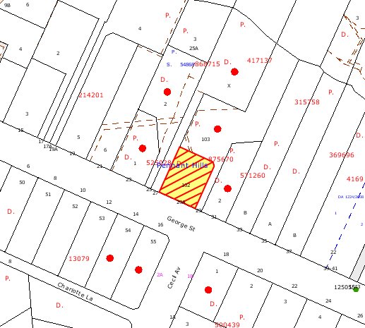
|
NOTIFICATION
PLAN
|
|
|
• PROPERTIES NOTIFIED
|
X SUBMISSIONS
RECEIVED
|
PROPERTY SUBJECT OF DEVELOPMENT
|
|
|
|
|
|
|
|
6. THE PUBLIC INTEREST
Section 79C (1) (e) of the Act
requires Council to consider “the public interest”.
The public interest is an
overarching requirement, which includes the consideration of the matters
discussed in this report. Implicit to the public interest is the achievement
of future built outcomes adequately responding to and respecting the future
desired outcomes expressed in environmental planning instruments and
development control plans.
The application’s departure from
numerical development standards would not set an undesirable precedent for
other developments in the street or the locality and approval of a variation to
the development standards would accord with the aim
of SEPP 1 to “provides flexibility in the application of development
standards in circumstances where strict compliance with those standards would,
in any particular case, be unreasonable or unnecessary, or tend to hinder the
attainment of the objectives of the Act”.
The application is considered to
have satisfactorily addressed Council’s and relevant agencies’ criteria and
would provide a development outcome that, on balance, would result in a
positive impact for the community. Accordingly, it is considered that the
approval of the proposed alterations and additions would be in the public
interest.
CONCLUSION
The application proposes
alterations and additions in the form of a first floor family room at the rear,
north-west corner of the dwelling-house.
The
addition would increase the gross floor area to 273m2, which
exceeds the 0.4:1 FSR requirement for the site. The applicant has made a
submission under the provisions of SEPP 1 to vary this development standard.
It is considered that approval of the development is warranted in the
circumstances of this case. The application justifies the non-compliance with
the relevant provisions within Clause 15 of the HSLEP and approval of the
application would not set an undesirable precedent for the area.
Council
did not receive any submissions to the proposed development. The application
was referred to the Rural Fire Service to comment on the bushfire impacts of
the proposal. The RFS advised that the development would be acceptable subject
to the imposition of relevant conditions.
Having
regard to the assessment of the proposed development and the circumstances of
the case, it is recommended that Council approves the application.
Note: At the time of the
completion of this planning report, no persons have made a Political
Donations Disclosure Statement pursuant to Section 147 of the Environmental
Planning and Assessment Act 1979 in respect of the subject planning
application.
|
Simon Evans
Manager -
Assessment Team 1
Planning Division
|
Scott Phillips
Executive Manager
Planning Division
|
Attachments:
|
1.View
|
Locality Plan
|
|
2.View
|
Site Plan
|
|
3.View
|
Floor Plan
|
|
4.View
|
Elevations and
Sections
|
File Reference: DA/330/2010
Document Number: D01396804
SCHEDULE 1
GENERAL CONDITIONS
The conditions of consent within this notice of determination have
been applied to ensure that the use of the land and/or building is carried out
in such a manner that is consistent with the aims and objectives of the
relevant legislation, planning instruments and Council policies affecting the
land and does not disrupt the amenity of the neighbourhood or impact upon the
environment.
Note: For the
purpose of this consent, the term ‘applicant’ means any person who has the
authority to act on or the benefit of the development consent.
Note: For the purpose of
this consent, any reference to an Act, Regulation, Australian Standard or
publication by a public authority shall be taken to mean the gazetted Act or
Regulation, or adopted Australian Standard or publication as in force on the
date that the application for a construction certificate is made.
1. Approved
Plans and Supporting Documentation
The
development must be carried out in accordance with the plans and documentation
listed below and endorsed with Council’s stamp, except where amended by Council
and/or other conditions of this consent:
|
Plan No.
|
Drawn by
|
Dated
|
|
928.1/5 – 928.5/5
|
Ross Morton Sundesign
|
25-03-2009
|
REQUIREMENTS PRIOR TO THE ISSUE OF A CONSTRUCTION
CERTIFICATE
2. Building
Code of Australia
All building work must be
carried out in accordance with the requirements of the Building Code of
Australia.
3. Contract
of Insurance (Residential Building Work)
In the case
of residential building work for which the Home Building Act, 1989 requires
there to be a contract of insurance in force in accordance with Part 6 of that
Act, that such a contract of insurance is in force before any building work
authorised to be carried out by the consent commences.
Note: This
condition does not apply to the extent to which an exemption is in force
under Clause 187 or 188 of the Act, subject to the terms of any condition or
requirement referred to in Clause 187(6) or 188(4) of the Act, or to the
erection of a temporary building.
4. Notification
of Home Building Act, 1989 Requirements
Residential
building work within the meaning of the Home Building Act,
1989 must not be carried out unless the principal certifying authority for
the development to which the work relates (not being Council) has given Council
written notice of the following information:
a. In
the case of work for which a principal contractor is required to be appointed:
i. The
name and licence number of the principal contractor.
ii. The
name of the insurer by which the work is insured under Part 6 of that Act.
b. In
the case of work to be done by an owner-builder:
i. The
name of the owner-builder.
ii. If
the owner-builder is required to hold an owner-builder’s permit under that Act,
the number of the owner-builder’s permit.
Note: If
arrangements for doing the residential building work are changed while the work
is in progress so that the information notified becomes out of date, further
work must not be carried out unless the principal certifying authority for the
development to which the work relates (not being Council) has given Council
written notification of the updated information.
5. Design
and Construction - Bushfire Attack Category
The new
construction must comply with Australian Standard AS3959-1999 ‘Construction
of buildings in bush fire-prone areas’ Level 1. Roofing must be gutterless
or gutters and valleys are to be screened to prevent the build up of
flammable material. Any materials used must have a flammability index of no
greater than 5 when tested in accordance with the Australian Standard
AS1530.2-1993 ‘Methods for Fire Tests on Building Materials, Components
and Structures – Test for Flammability of Materials’.
REQUIREMENTS PRIOR TO THE COMMENCEMENT OF ANY WORKS
6. Erection
of Construction Sign
A sign must
be erected in a prominent position on any site on which building work,
subdivision work or demolition work is being carried out:
a. Showing
the name, address and telephone number of the principal certifying authority
for the work,
b. Showing
the name of the principal contractor (if any) for any demolition or building
work and a telephone number on which that person may be contacted outside
working hours, and
Note: Any
such sign is to be maintained while the building work or demolition work is
being carried out, but must be removed when the work has been completed.
REQUIREMENTS DURING CONSTRUCTION
7. Construction
Work Hours
All work on site (including demolition and earth works)
must only occur between 7am and 5pm Monday to Saturday. No work is to be
undertaken on Sundays or public holidays.
8. Demolition
All
demolition work must be carried out in accordance with Australian Standard
2601-2001 – The Demolition of Structures and the following requirements:
a. Demolition
material is to be disposed of to an authorised recycling and/or waste disposal
site and/or in accordance with an approved waste management plan.
b. Demolition
works, where asbestos material is being removed, must be undertaken by a
contractor that holds an appropriate licence issued by WorkCover NSW in
accordance with Chapter 10 of the Occupational Health and Safety Regulation
2001 and Clause 29 of the Protection of the Environment Operations
(Waste) Regulation 1996.
c. On
construction sites where buildings contain asbestos material, a standard
commercially manufactured sign containing the words ‘DANGER ASBESTOS REMOVAL IN
PROGRESS’ measuring not less than 400mm x 300mm must be erected in a prominent
position visible from the street.
9. Council
Property
During construction works, no building
materials, waste, machinery or related matter is to be stored on the road or
footpath. The public reserve is to be kept in a clean, tidy and safe condition
at all times.
REQUIREMENTS PRIOR TO THE ISSUE OF AN
OCCUPATION CERTIFICATE
Note: For
the purpose of this consent, any reference to ‘occupation certificate’ shall
also be taken to mean ‘interim occupation certificate’ unless otherwise stated.
10. Stormwater
Drainage
The
stormwater from the additional roof is to be connected to the existing drainage
disposal system.
11. Damage
to Council Assets
Any damage
caused to Council’s assets as a result of the construction of the development
must be rectified in accordance with Council’s written requirements and at the
sole cost of the applicant.
12. Smoke
Alarms – Dwelling Additions
Smoke alarms must be installed
in the existing building and the proposed additions in accordance with the
requirements of the Building Code of Australia.
13. Bushfire
Protection Zone
At the commencement of
building works and in perpetuity, the entire property shall be managed as an
Inner Protection Area (IPA) as outlined within section 4.1.3 and appendix 5 of
‘Planning for Bushfire Protection 2006’ and the NSW Rural Fire Service’s
document ‘Standards for Asset Protection Zones’.
-
END OF CONDITIONS -
ADVISORY NOTES
The following information is provided for your assistance to
ensure compliance with the Environmental Planning and Assessment Act, 1979,
Environmental Planning and Assessment Regulation 2000, other relevant
legislation and Council’s policies and specifications. This information does
not form part of the conditions of development consent pursuant to Section 80A
of the Act.
Environmental Planning and Assessment Act, 1979
Requirements
· The issue of a construction certificate
prior to the commencement of any works. Enquiries regarding the issue of a
construction certificate can be made to Council’s Customer Services Branch on
9847 6760.
· A principal certifying authority to be
nominated and Council notified of that appointment prior to the commencement of
any works.
· Council to be given at least two days
written notice prior to the commencement of any works.
· Mandatory inspections of nominated
stages of the construction inspected.
· An occupation certificate to be issued
before occupying any building or commencing the use of the land.
Long Service Levy
In accordance with Section 34 of
the Building and Construction Industry Long Service Payments Act 1986, a ‘Long Service Levy’ must be paid to the Long
Service Payments Corporation or Hornsby Council.
Note: The
rate of the Long Service Levy is 0.35% of the total cost of the work.
Note: Hornsby
Council requires the payment of the Long Service Levy prior to the issue of a
construction certificate.
Tree Preservation Order
To ensure the maintenance and
protection of the existing natural environment, it is an offence to ringbark,
cut down, top, lop, remove, wilfully injure or destroy a tree outside 3 metres
of the approved building envelope without the prior written consent from
Council.
Note: A
tree is defined as a single or multi-trunked wood perennial plant having a
height of not less than three (3) metres, and which develops many branches,
usually from a distance of not less than one (1) metre from the ground, but
excluding any plant which, in its particular location, is a noxious plant
declared as such pursuant to the Noxious Weeds Act 1993. This definition of
‘tree’ includes any and all types of Palm trees. All distances are determined
under British Standard BS 5837: 2005, “Trees in Relation to Construction –
Recommendations”.
Fines may be imposed for non-compliance with Council’s Tree
Preservation Order.
Dial Before You Dig
Prior to commencing any works,
the applicant is encouraged to contact Dial Before You Dig on 1100 or www.dialbeforeyoudig.com.au for
free information on potential underground pipes and cables within the vicinity
of the development site.
Asbestos Warning
Should asbestos or asbestos
products be encountered during demolition or construction works you are advised
to seek advice and information should be prior to disturbing the material. It
is recommended that a contractor holding an asbestos-handling permit (issued by
WorkCover NSW) be engaged to manage the proper handling of the material.
Further information regarding the safe handling and removal of asbestos can be
found at:
www.environment.nsw.gov.au
www.nsw.gov.au/fibro
www.adfa.org.au
www.workcover.nsw.gov.au
Alternatively, telephone the WorkCover Asbestos and
Demolition Team on 8260 5885.
Planning Report No. PLN30/10
Date of Meeting: 2/06/2010
4 DEVELOPMENT APPLICATION
- SUBDIVISION OF ONE LOT INTO TWO
50 SUTHERLAND ROAD, BEECROFT
|
Development Application No:
|
DA/1118/2009
|
|
Description of Proposal:
|
Subdivision of one lot into two.
|
|
Property Description:
|
Lot A DP 349374 (No. 50) Sutherland Road, Beecroft
|
|
Applicant:
|
Just Property & Planning
|
|
Owner:
|
Mr G Hwang and Mrs Y H Kim
|
|
Statutory Provisions:
|
Hornsby Shire Local Environmental
Plan 1994
Residential AS (Low Density –
Sensitive Lands) Zone
|
|
Estimated Value:
|
$22,000
|
|
Ward:
|
C
|
|
RECOMMENDATION
THAT Development Application No. 1118/2009 for the
subdivision of one lot into two at Lot A DP 349374 (No. 50) Sutherland Road, Beecroft be approved subject to the conditions of consent detailed in
Schedule 1 of this report.
|
1. The
application proposes the demolition of the existing dwelling and the
subdivision of one lot into two.
2. The
proposal complies with the Hornsby Shire Local Environmental Plan 1994 and the
Residential Subdivision Development Control Plan.
3. The
proposal is integrated development and the General Terms of Approval have been
received from the NSW Rural Fire Service.
4. Four
submissions have been received in respect of the application including a
submission from the Beecroft-Cheltenham Civic Trust.
5. It
is recommended that the application be approved.
THE SITE
The site is a relatively long
narrow rectangular lot located on the northern side of Sutherland Road,
Beecroft. The site has an area of 2,084m2, a frontage of 16.8m and a
depth of 124.8m. The site has an average fall of 15% to the rear boundary. A
watercourse is located on adjoining land located to the rear of the site.
An existing single-storey fibro
and vinyl clad dwelling house with tiled roof is sited on the land. The
dwelling includes a lower ground floor laundry and storage space.
The site is located within the
Beecroft-Cheltenham Heritage Conservation Area. An area of remnant bushland at
the rear of the site is identified as Blackbutt Gully Forest and is within a
Bushland Protection Area. The local topography is undulating.
The residential character of the
locality along Sutherland Road has undergone a more recent transition with
battle-axe subdivisions accompanied with new larger dwelling houses
predominating. Sutherland Road has a narrow roadside verge and features large
remnant trees adjacent to and within the adjoining rail corridor.
THE PROPOSAL
The proposal involves the
subdivision of one lot into two lots and the demolition of the existing
dwelling.
Proposed lot 1 has an area of
812.16m2 and would front Sutherland Road. A right of carriageway is
proposed along the eastern boundary of the site for access to proposed lot 2.
Proposed lot 2 has an area of
1271.84m2 and includes a Bushland Protection Area as shown hatched
on the HSLEP map of approximately 920m2 in area at the rear of the
site. A 4m wide accessway is provided for the lot.
ASSESSMENT
The development application has
been assessed having regard to the ‘2005 City of Cities Metropolitan
Strategy’, the ‘North Subregion (Draft) Subregional Strategy’ and
the matters for consideration prescribed under Section 79C of the Environmental
Planning and Assessment Act 1979 (the Act). Subsequently, the following
issues have been identified for further consideration.
1. STRATEGIC CONTEXT
1.1 Metropolitan Strategy – (Draft) North Subregional
Strategy
The Metropolitan Strategy is a
broad framework to secure Sydney’s place in the global economy by promoting and
managing growth. It outlines a vision for Sydney to 2031; the challenges
faced, and the directions to follow to address these challenges and achieve the
vision. The draft North Subregional Strategy acts as a framework for Council
in the preparation of a new Principal LEP by 2011.
The draft Subregional Strategy
sets the following targets for the Hornsby LGA by 2031:
· Employment capacity to
increase by 9,000 jobs; and
· Housing stock to
increase by 11,000 dwellings.
The proposed development would be
consistent with the draft Strategy by providing additional housing
opportunities in the locality.
2. STATUTORY CONTROLS
Section 79C(1)(a) requires
Council to consider “any relevant environmental planning instruments, draft
environmental planning instruments, development control plans, planning
agreements and regulations”.
2.1 Hornsby Shire Local Environmental Plan 1994
The subject land is zoned Residential AS (Low Density - Sensitive Lands) under the Hornsby Shire Local
Environmental Plan 1994 (HSLEP). The objectives of the zone are:
(a) to provide for the housing needs of the population of the
Hornsby area.
(b) to promote a variety of housing types and other land uses
compatible with a low density residential environment and sensitive to the land
capability and established character of this environment.
(c) to provide for development that is within the
environmental capacity of a sensitive low density residential environment.
The proposed development is
defined as ‘subdivision’ and ‘demolition’ under the HSLEP and is permissible in
the zone with Council’s consent.
Clause 14 of the HSLEP prescribes
a minimum lot area of 600m2 for subdivision within the Residential
AS (Low Density – Sensitive Lands) Zone. The proposal complies with this
requirement.
Clause 18 of the HSLEP sets out
heritage conservation provisions within the Hornsby area. The site is located
within the Beecroft-Cheltenham Heritage Conservation. The applicant submitted a
Statement of Heritage Impact in accordance with the provision.
Clause 19 of the HSLEP requires
consent for development on land designated “bushland protection”. The site
includes a bushland protection area. A flora and fauna survey was submitted
with the application.
2.2 State Environmental Planning Policy – Sydney Regional
Environmental Plan (Sydney Harbour Catchment) 2005
The application has been assessed
against the requirements of the Policy which includes planning principles
applicable to the site within the upper part of the harbour catchment. The
principles incorporate measures to protect water quality, minimise urban
runoff, to conserve water and to ensure the catchment watercourses, wetlands,
riparian lands and remnant vegetation are protected.
Subject to the implementation of
erosion and sediment control measures and stormwater detention, the proposed
subdivision would not adversely impact on the catchment or water quality.
2.3 Rural Fires Act 1997
The application involves
subdivision within a bushfire prone area and forms ‘integrated development’
requiring the approval of the NSW Rural Fire Service before consent can be
granted.
The NSW Rural Fire Service has
granted General Terms of Approval for the issue of a Bush Fire Safety Authority
subject to development consent.
2.4 Residential Subdivision Development Control Plan
The proposed development has been
assessed having regard to the relevant performance and prescriptive design
standards within Council’s Residential Subdivision Development Control Plan
(Subdivision DCP). The following table sets out the proposal’s compliance with
the prescriptive standards of the Plan:
|
Residential
Subdivision Development Control Plan
|
|
Control
|
Proposal
|
Requirement
|
Compliance
|
|
Density
|
Lot 1 – 812.16m2
Lot 2 – 1271.84m2
|
600m2
|
Yes
|
|
Accessway
|
4m width
|
4m width
|
Yes
|
As detailed in the above table,
the proposed development complies with the prescriptive standard within
Council’s Subdivision DCP. Below is brief discussion on compliance with
relevant performance standards.
2.4.1 Accessway Design
The proposed 4m wide accessway
along the eastern boundary includes provision for a future turning area on
proposed lot 1 and lot 2 enabling vehicles to enter and leave the site in a
forward direction. The accessway design avoids duplication of driveways and
maintains the streetscape.
A condition is recommended for
solid fencing along the eastern boundary of lot 1 to minimise amenity impacts
from operation of the driveway on adjoining residents.
The proposed accessway requires
cut and fill works to achieve gradient design criteria. A condition is
recommended for a dilapidation assessment to be undertaken concerning the
adjoining dwelling house. In addition, a condition is recommended for coloured
concrete/stencilling to minimise visual impact of the driveway.
Subject to recommended conditions
the proposed accessway meets the Subdivision DCP performance criteria.
2.4.2 Allotment Layout and Design
The site occupies a north facing
slope maximising solar access. The proposed lots are of adequate size to
accommodate residential use with regard to the topography of the site.
The proposed lots comply with the
Residential DCP performance criteria for lot layout and design.
2.4.3 Drainage Control
The proposal includes stormwater
drainage connection to the watercourse adjoining the rear of the site and
located approximately 15m north of the rear boundary. The adjoining owner has
provided written consent to granting a drainage easement.
2.5 Byles Creek Development Control Plan
The site is located within the
Byles Creek Catchment Area. The watercourse adjacent to the rear of the site
forms a tributary of Byles Creek. Stormwater connection is proposed to the
watercourse. Subject to stormwater drainage detention system and
dissipater/infiltration system at the stormwater outlet, the proposal would not
adversely impact on the watercourse.
The proposal retains the existing
stand of trees at the rear of the site. The trees are located within a Bushland
Protection Area and contribute to the environmental quality of the Byles Creek
catchment.
The implementation of erosion and
sediment control measures would minimise subdivision construction impacts and maintain
water quality.
2.6 Heritage Development Control Plan
The site is located within the
Beecroft-Cheltenham Heritage Conservation Area.
Council’s Heritage Advisory
Committee advised that the remnant Blackbutt Gully Forest, which is to be
protected from future development by the imposition of a
restriction-as-to-user, would provide a visual back drop to the proposed
developed and would continue to contribute to dominant landscape character of
the Conversation Area in the locality. Accordingly, the Committee resolved that
no objections be raised to the proposal on heritage grounds.
2.7 Section 94 Development Contributions Plan 2007-2011
The proposed additional allotment
is subject to a monetary contribution in accordance with the provisions of the
Plan.
3. ENVIRONMENTAL IMPACTS
Section 79C(1)(b) of the Act
requires Council to consider “the likely impacts of that development,
including environmental impacts on both the natural and built environments, and
social and economic impacts in the locality”.
3.1 Natural Environment
The site includes a Bushland
Protection Area mapped on the HSLEP. The mapped area of the site has an area of
approximately 920m2 (55m x 16.7m). The proposed indicative building
envelope on lot 2 is clear of the mapped area. The proposed stormwater drainage
easement would be provided through the Bushland Protection Area and appropriate
conditions are recommended to protect the trees within the area.
The proposed subdivision works
would necessitate the removal of one tree from the site (Tree No. 32). The
indicative building envelope on proposed lot 2 would involve the removal of
trees Nos. 29, 47, 48, 49 and 51. None of the trees to be removed as a result
of the proposed subdivision and future dwellings are identified as significant.
Council’s assessment of the
proposal included a detailed examination of the existing trees located on the
site which identified trees Nos. 1 to 17, 21, 24 and 37 as significant.
Appropriate conditions are recommended to protect these trees.
The NSW Rural Fire Service (RFS)
has provided amended General Terms of Approval that minimises removal of native
vegetation and would allow for the maximum retention of locally significant
bushland located at the rear of the site. The proposal would meet the principles
of Ecological Sustainable Development in regard to direct and indirect impacts
on a locally significant vegetation community and a wildlife corridor which is
likely to provide marginal but important habitat for threatened species that
rely on remnant vegetation within urban environments.
3.2 Built Environment
The site is located within a low
density residential area. The proposed subdivision is of acceptable design in
addressing the streetscape and in providing for residential amenity, private open
space, landscaping, vehicle access and parking.
3.3 Social Impacts
The proposed subdivision would
not result in a social impact.
3.4 Economic Impacts
The proposal would have a minor
positive impact on the local economy in conjunction with other new low density
residential development in the locality by generating an increase in demand for
local services.
4. SITE SUITABILITY
Section 79C(1)(c) of the Act
requires Council to consider “the suitability of the site for the
development”.
4.1 Bushfire Risk
The land is identified as being
subject to bushfire risk from an area of remnant vegetation of approximately
0.9 hectares in area north and northwest of the site.
The NSW Rural Fire Service
recommends conditions for the implementation of Inner and Outer Asset
Protection Zones for the proposed lots in minimise bushfire risk.
5. PUBLIC PARTICIPATION
Section 79C(1)(d) of the Act
requires Council to consider “any submissions made in accordance with this
Act”.
5.1 Community Consultation
The proposed development was
placed on public exhibition and was notified to adjoining and nearby landowners
between 22 September and 14 October 2009 in accordance with Council’s
Notification and Exhibition Development Control Plan. During this period,
Council received two resident submissions and a submission from the
Beecroft-Cheltenham Civic Trust. The amended plans were notified between 2
February and 16 February 2010. An additional submission was received in
response advising of no objection. The map below illustrates the location of
those nearby landowners who made a submission that are in close proximity to
the development site.
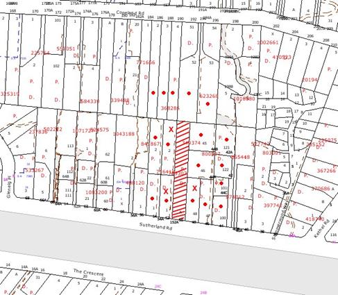
|
NOTIFICATION
PLAN
|
|
|
• PROPERTIES NOTIFIED
|
X SUBMISSIONS
RECEIVED
|
PROPERTY SUBJECT OF DEVELOPMENT
|
|
|
1 SUBMISSION RECEIVED OUT OF MAP RANGE
|
|
|
|
|
The submissions objected to the
initial proposal, generally on the grounds that the development would result
in:
· Unacceptable removal
of trees.
· Non-compliance
accessway width and design.
· Unacceptable impact on
significant tree No. 37.
· Adverse impacts on
amenity.
In response, the application was
amended and following re-exhibition a fourth submission was received raising no
objection to the proposal.
The merits of the matters raised
in community submissions have been addressed in the body of the report with the
exception of the following:
5.1.1 Boundary fence
It is considered to be a
reasonable request that the applicant be required to construct the boundary
fence at nil cost to the neighbouring property owner. A recommended condition
of consent has been included in Attachment A.
5.2 Public Agencies
The development application is
‘Integrated Development’ under the Act and was referred to the NSW Rural Fire
Service (RFS) for comment. The RFS has raised no objection to the proposal
subject to the General Terms of Approval granted.
6. THE PUBLIC INTEREST
Section 79C(1)(e) of the Act
requires Council to consider “the public interest”.
The public interest is an
overarching requirement, which includes the consideration of the matters
discussed in this report. Implicit to the public interest is the achievement
of future built outcomes adequately responding to and respecting the future
desired outcomes expressed in environmental planning instruments and development
control plans.
The application is considered to
have satisfactorily addressed Council’s and relevant agencies’ criteria and
would provide a development outcome that, on balance, would result in a
positive impact for the community. Accordingly, it is considered that the
approval of the proposed subdivision would be in the public interest.
CONCLUSION
The application proposes the
demolition of the existing dwelling and the Torrens title subdivision of one
allotment into two.
The proposed development
maintains the heritage streetscape, retains significant trees and provides for
bushfire risk management whilst retaining an area of bushland at the rear of
the site. The proposal has been assessed as satisfactory pursuant to Section
79C of the Environmental Planning and Assessment Act, 1979, the Hornsby Shire
Local Environmental Plan, 1994 and Council’s Residential Subdivision
Development Control Plan.
The development is considered to
be acceptable in relation to environmental impacts and is considered to be in
the public interest.
Approval of the application is recommended.
Note: At the time of the completion of this planning
report, no persons have made a Political Donations Disclosure Statement pursuant
to Section 147 of the Environmental Planning and Assessment Act 1979 in respect
of the subject planning application.
|
Rod Pickles
Manager -
Assessment Team 2
Planning Division
|
Scott Phillips
Executive Manager
Planning Division
|
Attachments:
|
1.View
|
Locality Plan
|
|
2.View
|
Subdivision Plan
|
File Reference: DA/1118/2009
Document Number: D01407338
SCHEDULE 1
GENERAL CONDITIONS
The
conditions of consent within this notice of determination have been applied to
ensure that the use of the land and/or building is carried out in such a manner
that is consistent with the aims and objectives of the relevant legislation,
planning instruments and Council policies affecting the land and does not
disrupt the amenity of the neighbourhood or impact upon the environment.
Note: For the
purpose of this consent, the term ‘applicant’ means any person who has the
authority to act on or the benefit of the development consent.
Note: For the purpose of
this consent, any reference to an Act, Regulation, Australian Standard or
publication by a public authority shall be taken to mean the gazetted Act or
Regulation, or adopted Australian Standard or publication as in force on the
date that the application for a construction certificate is made.
1. Approved
Plans and Supporting Documentation
The
development must be carried out in accordance with the plans and documentation
listed below and endorsed with Council’s stamp, except where amended by Council
and/or other conditions of this consent:
|
Plan No.
|
Drawn by
|
Dated
|
|
4404-1-1
|
JKL Design
|
04.08.09
|
2. Removal
of Existing Trees
This
development consent only permits the removal of trees numbered 29, 32, 47, 48
& 51 as identified on Plan No. 4404-1 prepared by JKL Design dated 04/08/09.
The removal of any other trees requires separate approval under Council’s Tree
Preservation Order.
REQUIREMENTS PRIOR TO THE ISSUE OF A
CONSTRUCTION CERTIFICATE
3. Easement
Over Downstream Land
The proposed
drainage easement over Lot 52 DP 623268 must be registered with the NSW
Department of Lands.
4. Water/Electricity
Utility Services
The applicant
must submit written evidence of the following service provider requirements:
a. Energy
Australia – a letter of consent demonstrating that satisfactory
arrangements have been made to service the proposed development.
b. Sydney
Water – the submission of a ‘Notice of Requirements’ under s73 of the Sydney
Water Act 1994.
Note: Sydney
Water requires that s73 applications are to be made through an authorised
Sydney Water Servicing Coordinator. Refer to www.sydneywater.com.au or telephone
13 20 92 for assistance.
5. Dilapidation
Report
A
‘Dilapidation Report’ is to be prepared by a ‘chartered structural engineer’
detailing the structural condition of adjoining properties located adjacent to
the proposed accessway.
REQUIREMENTS PRIOR TO THE COMMENCEMENT OF
ANY WORKS
6. Erection
of Construction Sign
A sign must
be erected in a prominent position on any site on which building work,
subdivision work or demolition work is being carried out:
a. Showing
the name, address and telephone number of the principal certifying authority
for the work,
b. Showing
the name of the principal contractor (if any) for any demolition or building
work and a telephone number on which that person may be contacted outside
working hours, and
c. Stating
that unauthorised entry to the work site is prohibited.
Note: Any
such sign is to be maintained while the building work, subdivision work or
demolition work is being carried out, but must be removed when the work has
been completed.
7. Toilet
Facilities
Toilet
facilities must be available or provided at the works site before works begin
and must be maintained until the works are completed at a ratio of one toilet
for every 20 persons employed at the site. Each toilet must:
a. be
a standard flushing toilet connected to a public sewer; or
b. be
a temporary chemical closet approved under the Local Government Act, 1993;
or
c. have
an on-site effluent disposal system approved under the Local Government Act,
1993
8. Tree
Protection Barriers
Tree
protection fencing must be erected around tree number 37 to be retained at a 4m metre setback. The tree fencing must be constructed
of 1.8 metre ‘cyclone chainmesh fence’ or star pickets spaced at 2 metre
intervals, connected by a continuous high-visibility barrier/hazard mesh at a
height of 1 metre.
9. Erosion
and Sediment Control
Erosion and
sediment control measures must be provided and maintained throughout the
construction period in accordance with the manual ‘Soils and Construction
2004 (Bluebook)’, the approved plans, Council specifications and to the
satisfaction of the principal certifying authority. The erosion and sediment
control devices must remain in place until the site has been stabilised and
revegetated.
Note: On
the spot penalties up to $1,500 may be issued for any non-compliance with this
requirement without any further notification or warning.
REQUIREMENTS DURING CONSTRUCTION
10. Construction
Work Hours
All work on site (including demolition and earth works)
must only occur between 7am and 5pm Monday to Saturday.
No work is to be undertaken on Sundays or public holidays.
11. Demolition
All
demolition work must be carried out in accordance with Australian Standard
2601-2001 – The Demolition of Structures and the following requirements:
a. Demolition
material is to be disposed of to an authorised recycling and/or waste disposal
site and/or in accordance with an approved waste management plan.
b. Demolition
works, where asbestos material is being removed, must be undertaken by a
contractor that holds an appropriate licence issued by WorkCover NSW in
accordance with Chapter 10 of the Occupational Health and Safety Regulation
2001 and Clause 29 of the Protection of the Environment Operations
(Waste) Regulation 1996.
c. On
construction sites where buildings contain asbestos material, a standard
commercially manufactured sign containing the words ‘DANGER ASBESTOS REMOVAL IN
PROGRESS’ measuring not less than 400mm x 300mm must be erected in a prominent
position visible from the street.
12. Works
near Trees
All required
tree protection measures are to be maintained in good condition for the
duration of the construction period.
All works
(including driveways and retaining walls) within 4 metres of any trees required
to be retained (whether or not on the subject property, and pursuant to this
consent or the Tree Preservation Order), must be carried out under the
supervision of an ‘AQF Level 5 Arborist’ and a certificate submitted to
the principal certifying authority detailing the method(s) used to preserve the
tree(s).
Note:
Except as provided above, the applicant is to ensure that no excavation,
filling or stockpiling of building materials, parking of vehicles or plant,
disposal of cement slurry, waste water or other contaminants is to occur within
4 metres of any tree to be retained.
13. Council
Property
During
construction works, no building materials, waste, machinery or related matter
is to be stored on the road or footpath. The public reserve is to be kept in a
clean, tidy and safe condition at all times.
Note:
This consent does not give right of access to the site via Council’s park or
reserve. Should such access be required, separate written approval is to be
obtained from Council.
14. Landfill
Landfill must
be constructed in accordance with Council’s ‘Construction Specification,
2005’ and the following requirements:
a. All
fill material imported to the site is to wholly consist of Virgin Excavated
Natural Material (VENM) as defined in Schedule 1 of the Protection of the Environment
Operations Act 1997 or a material approved under the Department of
Environment and Climate Change’s general resource recovery exemption.
b. A
compaction certificate is to be obtained from a geotechnical engineer verifying
that the specified compaction requirements have been met.
REQUIREMENTS PRIOR TO THE ISSUE OF A
SUBDIVISION CERTIFICATE
Note: For
the purpose of this consent, any reference to ‘occupation certificate’ shall
also be taken to mean ‘interim occupation certificate’ unless otherwise stated.
15. Boundary
Fencing
Solid fencing
must be erected along the eastern boundary adjacent to the accessway behind the
front building alignment to a height of 1.8 metres, at no cost to the adjoining
owner.
Note:
Alternative fencing may be erected subject to the written consent of
the adjoining property owner(s).
16. Sydney
Water – s73 Certificate
A s73
Certificate must be obtained from Sydney Water.
17. Stormwater
Drainage
The
stormwater drainage system for the development must be designed and constructed
in accordance with Council’s Civil Works – Design and Construction
Specification 2005 and the following requirements:
a. Connected
directly to the existing watercourse located within Lot 52 DP 623268.
b. An
inter-allotment stormwater drainage system to service the proposed lot with
pits being constructed in situ.
c. The
roof and stormwater drainage system from the existing dwelling to be connected
to the proposed inter-allotment drainage system.
18. Stormwater
Drainage – Land Adjoining a Watercourse
In addition to other
stormwater drainage requirements under this consent, all headwall outlets must
incorporate flow velocity reduction controls (i.e. bedded boulders and small
stones) to minimise erosive and scouring impacts to the watercourse. Energy
dissipater controls must be landscaped to accommodate outlet sheet flow (forced
jump). No engineering works are permitted within the bed of the watercourse.
19. Internal
Driveway/Vehicular Areas
The driveway
and parking areas on site must be designed in accordance with Australian
Standards 2890.1, 2890.2, 3727 and the following requirements:
a. Design
levels at the front boundary be obtained from Council.
b. The
driveway be a rigid pavement.
c. The
driveway grade must not exceed 25 percent and changes in grade must not exceed
8 percent.
d. The
driveway pavement be a minimum 3 metres wide, 0.15 metres thick reinforced
concrete with F72 steel reinforcing fabric and a 0.15 metre sub-base.
e. The
pavement have a kerb to one side and a one-way cross fall with a minimum
gradient of 2 percent and a lintel and pit provided at the low point.
f. Retaining
walls required to support the carriageway and the compaction of all fill
batters to be in accordance with the requirements of a chartered structural engineer.
g. The
provision of safety rails where there is a level difference more than 0.3
metres and a 1:4 batter can not be achieved.
h. Planting
of landscaping strips 0.5 metres wide along both sides of the length of the
driveway.
i. Conduits
for utility services including electricity, water, gas and telephone be
provided.
20. Vehicular
Crossing
A separate
application under the Local Government Act, 1993 and the Roads Act,
1993 must be submitted to Council for the installation of a new vehicular
crossing and the removal of the redundant crossing. The vehicular crossing
must be constructed in accordance with Council’s Civil Works Design.
Note:
An application for a vehicular crossing can only be made to one of Council’s
Authorised Vehicular Crossing Contractors. You are advised to contact Council
on 02 9847 6940 to obtain a list of contractors.
21. Road
Works
A separate
application under the Local Government Act, 1993 and the Roads Act,
1993 must be submitted to Council for the construction of kerb and gutter
across the frontage of the site. All road works approved under this consent
must be constructed in accordance with Council’s Civil Works Design and
Construction Specification, 2005 and the following requirements:
a. A
kerb and gutter and pavement, necessary drainage and sealing of road pavement
between the existing pavement and lip of the gutter.
b. The
existing road pavement to be saw cut a minimum of 300 mm from the existing edge
of the bitumen and reconstructed.
22. Traffic
Control Plan
A Traffic
Control Plan (TCP) must be prepared by a qualified traffic controller in
accordance with the Roads & Traffic Authority’s Traffic Control at
Worksites Manual 1998 and Australian Standard 1742.3 for all work on
a public road and be submitted to Council. The TCP must detail the following
where required:
a. Arrangements
for public notification of the works.
b. Temporary
construction signage.
c. Permanent
post-construction signage.
d. Vehicle
movement plans.
e. Traffic
management plans.
f. Pedestrian
and cyclist access/safety.
23. Damage
to Council Assets
Any damage
caused to Council’s assets as a result of the construction of the development
must be rectified in accordance with Council’s written requirements and at the
sole cost of the applicant.
24. Creation
of Easements
The following
matter(s) must be nominated on the plan of subdivision under s88B of the Conveyancing
Act 1919:
a. A
right of access and easement for services over the access corridor.
b. An
inter-allotment drainage easement(s) over each of the burdened lots.
c. The
creation of a “Positive Covenant” over the proposed Lot A requiring that
any future development is to provide an on-site detention system. The on-site
detention system is to have a storage capacity of 5m3 and a maximum discharge
of 8 litres per second into Council’s drainage system in accordance with
Council’s prescribed wording.
Note: Council
must be nominated as the authority to release, vary or modify any easement,
restriction or covenant.
25. Works
as Executed Plan
A works-as-executed plan(s)
must be prepared by a registered surveyor and submitted to Council for
completed road pavement, kerb & gutter, public drainage systems, driveways
and on-site detention system. The plan(s) must be accompanied by a certificate
from a registered surveyor certifying that all pipelines and associated
structures lie wholly within any relevant easements.
26. Bushfire
Protection (survey markers)
The extent of the 12 metre
Inner Protection Area within the approved Asset Protection Zone must be
permanently delineated on site by the erection of highly visible
non-combustible survey markers or a similar method at a spacing distance of
approximately 4 metres apart along the boundary of the Inner Protection Zone in
order to prevent the encroachment of clearing for bushfire protection into
bushland proposed for retention on site.
27. Restriction
as to User – Protection of Land from Future Development
To inform
current and future owners that the areas of native vegetation and habitat on
the site is to be protected from future development, a Restriction as to User
must be created under Section 88B of the Conveyancing Act 1919
identifying that the northern (rear) area of the site identified on the
approved plans as red diagonal lines is restricted from future development or
disturbance of any kind.
Note: The
wording of the Restriction as to User must be to Council’s satisfaction and Council
must be nominated as the authority to release, vary or modify the Restriction.
28. s94
Infrastructure Contributions
The payment to Council of a
contribution of $19,748.70* for 1 additional lot towards the cost of
infrastructure identified in Council’s Development Contributions Plan
2007-2011.
Note: * The value of contribution is based on a rate of $19,748.70 per
additional lot and is current as at 13 April
2010. The contribution will be adjusted from this date in accordance with the
underlying consumer price index for subsequent financial quarters.
It
is recommended that you contact Council to ascertain the indexed value of the
contribution prior to payment.
29. Bushfire
Protection (manual methods)
No clearing of
native vegetation is to occur within the “Restricted Development Area”.
Where bushfire mitigation measures are required, the measures must be
restricted to manual fuel removal methods including the removal of dead timber
and build up of leaf litter (i.e. by raking) to reduce fine fuel loadings. No
mulch or garden waste to be placed within the “Restricted Development Area”.
GENERAL TERMS OF APPROVAL – NSW RURAL FIRE
SERVICE
The following conditions of consent are
General Terms of Approval from the nominated State Agency pursuant to Section
91A of the Environmental Planning and Assessment Act 1979 and must be
complied with to the satisfaction of that Agency.
30. General
Condition
The development proposal is
to comply with the subdivision layout identified on the drawing prepared by JKL
Design numbered 4404-1-1. dated 4 August 2009, except where altered by the
condition below.
31. Asset
Protection Zones
The intent of measures is
to provide sufficient space and maintain reduced fuel loads so as to ensure
radiant heat levels of buildings are below critical limits and to prevent
direct flame contact with building.
a. At
the issue of subdivision certificate and in perpetuity, the entire property of
proposed lot 1 must be managed as an inner protection area (IPA) as outlined
within section 4.1.3 and Appendix 5 of ‘Planning for Bush Fire Protection
2006’ and the NSW Rural Fire Service’s document ‘Standards for asset
protection zones’.
b. At
the issue of subdivision certificate and in perpetuity the area of proposed lot
2 comprising the proposed building envelope and south, east and west to the
boundary and 15m from the proposed building envelope to the north must be
managed as an inner protection area (IPA) with a further 12m to the north
managed as an outer protection area (OPA) as outlined within section 4.1.3 and
Appendix 5 of ‘Planning for Bush Fire Protection 2006’ and the NSW Rural
Fire Service’s document ‘Standards for asset protection zones’.
32. Water
Utilities
Water,
electricity and gas must comply with section 4.1.3 and Appendix 5 of ‘Planning
for Bush Fire Protection 2006’.
The
intent of measures is to provide adequate services of water for the protection
of buildings during and after the passage of a bush fire, and to locate gas and
electricity so as not to contribute to the risk of fire to a building
33. Access
The intent of measures for
property access is to provide safe access to/from the public road system for
fire fighters providing property protection during a bush fire and for
occupants faced with evacuation.
Property access roads must comply with section 4.1.13 (2) of ‘Planning
for Bush Fire Protection 2006’. In this regard the access provided to
proposed Lot 2 shall be 4 metres wide.
-
END OF CONDITIONS -
ADVISORY NOTES
The following information is provided for your
assistance to ensure compliance with the Environmental Planning and Assessment
Act, 1979, Environmental Planning and Assessment Regulation 2000, other
relevant legislation and Council’s policies and specifications. This
information does not form part of the conditions of development consent
pursuant to Section 80A of the Act.
Tree Preservation Order
To ensure the maintenance and protection of the existing
natural environment, it is an offence to ringbark, cut down, top, lop, remove,
wilfully injure or destroy a tree outside three metres of the approved building
envelope without prior written consent from Council. Fines may be imposed for
non-compliance with Council’s Tree Preservation Order.
Note: A
tree is defined as a single or multi-trunked wood perennial plant having a
height of not less than three (3) metres, and which develops many branches, usually
from a distance of not less than one (1) metre from the ground, but excluding
any plant which, in its particular location, is a noxious plant declared as
such pursuant to the Noxious Weeds Act 1993. This definition of ‘tree’
includes any and all types of Palm trees.
All
distances are determined British Standard BS 5837: 2005, “Trees in Relation to
Construction – Recommendations”.
Environmental Planning and Assessment Act, 1979
Requirements
· The Environmental Planning and
Assessment Act, 1979 requires:
· The issue of a construction certificate
prior to the commencement of any works. Enquiries regarding the issue of a
construction certificate can be made to Council’s Customer Services Branch on
9847 6760.
· A principal certifying authority to be
nominated and Council notified of that appointment prior to the commencement of
any works.
· Council to be given at least two days
written notice prior to the commencement of any works.
· Mandatory inspections of nominated
stages of the construction inspected.
· An occupation certificate to be issued
before occupying any building or commencing the use of the land.
Long Service Levy
In accordance with Section 34 of the Building and
Construction Industry Long Service Payments Act 1986, a ‘Long Service Levy’ must be paid to the Long Service
Payments Corporation or Hornsby Council.
Note: The
rate of the Long Service Levy is 0.35% of the total cost of the work.
Note: Hornsby
Council requires the payment of the Long Service Levy prior to the issue of a
construction certificate.
Subdivision Certificate Requirements
A subdivision certificate application is required to be
lodged with Council containing the following information:
a. A
surveyor’s certificate certifying that all structures within the subject land
comply with the development consent in regard to the setbacks from the new
boundaries.
b. A
surveyor’s certificate certifying that all services, drainage lines or access
are located wholly within the property boundaries. Where services encroach over
the new boundaries, easements are to be created.
c. Certification
that the requirements of relevant utility authorities have been met; and
d. A
surveyor’s certificate certifying finished ground levels are in accordance with
the approved plans.
Note: Council
will not issue a subdivision certificate until all conditions of the
development consent have been completed.
Fees and Charges – Subdivision
All fees payable to Council as part of any construction,
compliance or subdivision certificate or inspection associated with the
development (including the registration of privately issued certificates) are
required to be paid in full prior to the issue of the subdivision certificate.
Any additional Council inspections beyond the scope of any compliance certificate
required to verify compliance with the terms of this consent will be charged at
the individual inspection rate nominated in Council's Fees and Charges Schedule.
Prior to commencing any works, the applicant is encouraged
to contact Dial Before You Dig on 1100 or www.dialbeforeyoudig.com.au for
free information on potential underground pipes and cables within the vicinity
of the development site.
House Numbering
House numbering can only be authorised by Council. Before
proceeding to number each premise in the development, the allocation of numbers
is required to be obtained from Council's Planning Division. The authorised
numbers are required to be displayed in a clear manner at or near the main
entrance to each premise.
Planning Report No. PLN33/10
Date of Meeting:
2/06/2010
5 DEVELOPMENT APPLICATION
- SUBDIVISION - ONE LOT INTO TWO AND CONSTRUCTION OF A NEW DWELLING
41 CARDINAL AVENUE BEECROFT
|
Development Application No:
|
DA/723/2009
|
|
Description of Proposal:
|
Subdivision of One Lot into Two and Construction of a Dwelling.
|
|
Property Description:
|
Lot 2 DP 584894 (No. 41) Cardinal Avenue, Beecroft
|
|
Applicant:
|
Mr Lionel Curtin
|
|
Owner:
|
Mr Brett Mervyn Price
Mrs Marilla Philomena Price
|
|
Statutory Provisions:
|
Hornsby Shire Local Environmental
Plan 1994
Residential AS (Low Density –
Sensitive Lands) Zone
|
|
Estimated Value:
|
$450,000
|
|
Ward:
|
C
|
|
RECOMMENDATION
THAT Development Application
No. DA/723/2009 for the subdivision of one lot into two and the construction
of a dwelling at Lot 2 DP 584894 (No. 41) Cardinal Avenue, Beecroft be
approved subject to the conditions of consent detailed in Schedule 1 of this
report.
|
1. The
application proposes the subdivision of one lot into two and the construction
of a dwelling.
2. The proposal complies with the Hornsby Shire Local
Environmental Plan 1994 and is generally consistent with Council’s Residential
Subdivision Development Control Plan and Dwelling House Development
Control Plan.
3. Five
submissions have been received in respect of the application including a
submission from the Beecroft-Cheltenham Civic Trust.
4. It
is recommended that the application be approved.
THE SITE
The site has an area of 1,862m2
and is located on the western side of Cardinal Avenue, Beecroft. The site
is an ‘L’ shaped allotment with a frontage of 18.3 metres to Cardinal Avenue, a depth of 80.6 metres and a rear boundary width of 36.6 metres. The site
slopes moderately towards Cardinal Avenue with an average grade of 16%.
An open drainage easement is
located on the northern adjoining property near the front of the site.
The site currently contains a two
storey brick dwelling and a swimming pool sited within the rear western portion
of the site. Access to the dwelling is from an existing driveway from Cardinal Avenue.
The site contains a number of
significant tress, introduced exotic trees and non indigenous native trees. Two
Sydney Blue Gums are located at the front of the site form part of the Sydney
Blue Gum High Forest, a critically endangered community listed under the Threatened
Species Conservation Act 1995.
The surrounding development
comprises low density residential development consisting of one and two storey
dwelling houses.
THE PROPOSAL
The proposal involves the
subdivision of one lot into two and the construction of a dwelling on proposed Lot 1.
Proposed Lot 1 has an area of
680m2 and would front Cardinal Avenue. The application proposes a
dwelling to be constructed within this allotment. A right of carriageway is
proposed along the southern side of the site for access to proposed Lot 2.
Proposed Lot 2 has an area of
1189m2 and would contain the existing dwelling on the site. No
alterations are proposed to this dwelling as part of this application.
The proposed dwelling within Lot 1 would have a total floor area of 190.5m2 and would be two storeys in plus
a lower ground level double garage. The ground level would contain a
living/dining area, rumpus, kitchen, bathroom, laundry and deck and the first
floor would contain three bedrooms, two bathrooms a study area and a balcony.
ASSESSMENT
The development application has
been assessed having regard to the ‘2005 City of Cities Metropolitan
Strategy’, the ‘North Subregion (Draft) Subregional Strategy’ and
the matters for consideration prescribed under Section 79C of the Environmental
Planning and Assessment Act 1979 (the Act). Subsequently, the following
issues have been identified for further consideration.
1. STRATEGIC CONTEXT
1.1 Metropolitan Strategy – (Draft) North Subregional Strategy
The Metropolitan Strategy is a
broad framework to secure Sydney’s place in the global economy by promoting and
managing growth. It outlines a vision for Sydney to 2031; the challenges
faced, and the directions to follow to address these challenges and achieve the
vision. The draft North Subregional Strategy acts as a framework for Council
in the preparation of a new Principal LEP by 2011.
The draft Subregional Strategy
sets the following targets for the Hornsby LGA by 2031:
· Employment capacity to
increase by 9,000 jobs; and
· Housing stock to
increase by 11,000 dwellings.
The proposal would be consistent
with the draft Strategy by providing and additional dwelling that would improve
housing choice in the locality.
2. STATUTORY CONTROLS
Section 79C(1)(a) requires
Council to consider “any relevant environmental planning instruments, draft
environmental planning instruments, development control plans, planning
agreements and regulations”.
2.1 Hornsby Shire Local Environmental Plan 1994
The subject land is zoned Residential AS (Sensitive Lands) under the Hornsby Local Environmental Plan 1994
(HSLEP). The objectives of the zone are:
(a) to provide for the housing needs of
the population of the Hornsby area.
(b) to promote a variety of housing types and other
land uses compatible with a low density residential environment.
(c) to provide for development that is within the
environmental capacity of a low density residential environment.
The proposed development is
defined as ‘subdivision’ and ‘multi-unit housing’ under HSLEP and is
permissible in the zone with Council’s consent.
The
development would facilitate the provision of housing for the population of the
area and would be compatible with the low density residential environment. The
proposal complies with objectives (a) and (b) of the zone. The proposal
demonstrates that the allotment sizes would be suitable to accommodate the
existing and proposed dwellings, private open space areas, car spaces and
driveways consistent with Council’s development controls. The development would
be within the environmental capacity of the site and complies with objective
(c).
2.1.1 Clause 14 – Density
Clause 14 of the HSLEP prescribes
the minimum allotment size for sites within the Residential A (Low Density –
Sensitive Lands) zone to be 600m2.
Proposed Lot 2 has an area of
1189m2 thereby satisfying this requirement.
Proposed Lot 1 has an area of
680m2 inclusive of the access handle. Clause 14 of the HSLEP states
that in calculating the area of battle-axe or hatchet shaped allotments, the
area of any accessway, right of carriageway or the like is to be excluded.
Proposed Lot 1 is not a hatchet or battle-axe allotment, accordingly Lot 1 complies with the density requirements of Clause 14 of the HSLEP.
2.1.2 Clause 15 – Floor Space
Ratio
Clause 15 of the HSLEP prescribes
that the maximum floor space ratio (FSR) of development within the Residential
AS (Sensitive Lands) zone is 0.4:1.
The existing dwelling on proposed
Lot 2 would result in a FSR of 0.19:1 and the proposed dwelling within Lot 1 would result in a FSR of 0.35:1. The application is therefore consistent with the
requirements of Clause 15.
2.1.3 Clause 18 – Heritage
Clause 18 of the HSLEP sets out
the heritage conservation provisions within the Hornsby area. The site is not
located within the Beecroft Cheltenham Heritage Conservation Area and does not
adjoin a heritage item.
2.2 Sydney Regional Environmental Plan (Sydney Harbour Catchment)
The
site is located within the catchments of the Sydney Harbour and requires
consideration against the
provisions of Sydney Regional Environmental Plan (Sydney Harbour Catchment).
The
Policy includes planning principals to protect water quality, minimise urban
runoff, to conserve water and to ensure the catchment watercourses, wetlands,
riparian lands and remnant vegetation are protected.
Subject to the implementation of the recommended condition of
consent relating to sediment and erosion control measures, the proposed
development would not adversely impact on the catchment or water quality.
2.3 Residential Subdivision Development Control Plan.
The proposed development has been
assessed having regard to the relevant performance and prescriptive design
standards within the Residential Subdivision Development Control Plan
(Subdivision DCP). The following table sets out the proposal’s compliance with
the prescriptive standards of the Plan:
|
Residential
Subdivision Development Control Plan
|
|
Control
|
Proposal
|
Requirement
|
Compliance
|
|
Density
Lot 1
Lot 2
|
680m2
1189m2
|
600m2
600m2
|
Yes
Yes
|
|
Floor Space Ratio
Lot 1
Lot 2
|
0.35:1
0.19:1
|
0.4:1
0.4:1
|
Yes
Yes
|
|
Site Cover
Lot 1
Lot 2
|
15%
23%
|
40%
40%
|
Yes
Yes
|
|
Car parking
Lot 1
Lot 2
|
2 spaces
2 spaces
|
2 spaces
2 spaces
|
Yes
Yes
|
|
Private Open Space
Lot 1
Lot 2
|
270m2
500m2
|
120m2
120m2
|
Yes
Yes
|
|
Access handle width
|
2.2 – 3m
|
4m
|
No
|
|
Landscaping
Lot 1
Lot 2
|
74%
55%
|
45%
45%
|
Yes
Yes
|
|
Setbacks
Lot 1
Front / Road
Side (north)
Side (south)
Rear
Lot 2
Side (north)
Side (south)
Side (east)
Rear
|
6.2m
1m
8m
18m
1m
1.3m
7m
17m
|
6m
1m
1m
3m – 5m
1m
1m
1m
3m – 5m
|
Yes
Yes
Yes
Yes
Yes
Yes
Yes
Yes
|
As detailed in the above table,
the proposed development does not comply with the minimum driveway width
requirement as stipulated by the ‘Accessway Design’ element of the Subdivision
DCP. This matter of non compliance is detailed below, as well as a brief
discussion on compliance with the relevant performance criteria.
2.3.1 Density
The proposal complies with the
density requirements of the HSLEP as addressed in Section 2.1.1 of this report.
2.3.2 Accessway
Design
The prescriptive measures of the
‘Accessway Design’ element of the Subdivision DCP requires that private
accessways have a minimum width of 4 metres, consisting of a 3 metre wide
carriageway excluding kerbs and a landscape verge of 0.5 metres on each side.
The proposed driveway would not adjoin the southern side boundary and space for
landscaping and open grassed areas would be available on the each side of the
driveway. A condition has been recommended for the development to satisfy the
Australian Standards for driveways and be a minimum of three metres wide in
accordance with Council’s Subdivision DCP. Subject to these conditions
the accessway is considered acceptable.
Concerns were raised in the
community submissions about the failure of the development to provide adequate
vehicular turning area within the site. This matter was addressed in the
amended plans submitted to Council. The revised layout involves proposed Lot 1
being accessed directly from the street with a separate driveway provided to
access Lot 2. The amended accessway design provides for safe and efficient
vehicular access and is considered acceptable subject to the imposition of
relevant conditions.
2.3.3 Urban Streams
The proposal is located adjacent
to an open drainage easement located on the northern adjoining property.
The prescriptive measure of the
‘Urban Streams’ element of the Subdivision DCP requires that structures
be setback a minimum of 10 metres from the crest of a watercourse. The proposed
location of the dwelling has been assessed as acceptable despite the
non-compliance with the setback requirement. This is due to the fact that no
riparian vegetation it located on the site or the surrounding area and does not
represent an aquatic habitat. Further to this, the watercourse was observed to
be partially piped up and down stream.
The drainage channel is not
identified as a watercourse on Council’s mapping system and no referral to the
NSW Office of Water was required.
Concerns were raised in community
submissions about the proximity of the watercourse to the proposed dwelling.
The proposed location of the dwelling is assessed as acceptable subject to
conditions for sediment and erosion controls, landfill, excavation and
environmental management. A flood study submitted confirmed that the habitable
floor space of the dwelling would not be inundated in a 1 in 100 year flood
event.
2.3.4 Setbacks
The amended plans submitted with
the application comply with the prescriptive standards for building setbacks.
The original design proposed a
four metre front setback. Community submissions raised concerns with respect to
this setback and the impact this would have on the streetscape and character of
the area. The amended design involves a 6.2 metre front setback and is in
accordance with Council’s setback requirements.
2.3.5 Drainage
Control
Concerns were raised in the
community submissions about stormwater runoff generated by the development.
A condition has been recommended
for the stormwater drainage to be designed and constructed for an average
recurrence interval of 20 years. The existing dwelling is to be connected to an
existing Council kerb drainage system in Cardinal Avenue. The proposed dwelling
is to be connected to the street drainage system via an on-site detention (OSD)
system.
2.4 Dwelling House Development Control Plan
The proposed development has been
assessed having regard to the relevant performance and prescriptive design
standards within the Dwelling House Development Control Plan.
|
Dwelling House
Development Control Plan
|
|
Control
|
Proposal
|
Requirement
|
Compliance
|
|
Floor Area
Lot 1
Lot 2
|
190.5m2
231m2
|
N/A
N/A
|
N/A
N/A
|
|
Floor Space Ratio
Lot 1
Lot 2
|
0.35:1
0.19:1
|
0.4:1
0.4:1
|
Yes
Yes
|
|
Height
Lot 1
|
7.9m
|
9m
|
Yes
|
|
Unbroken Wall Length
|
8m
|
10m
|
Yes
|
|
Building length
|
13m
|
24m
|
Yes
|
|
Vehicle Access and Parking
Lot 1
Lot 2
|
2 spaces
2 Spaces
|
2 spaces
2 spaces
|
Yes
Yes
|
As detailed in the above table,
the proposed development complies with the prescriptive standard within the Dwelling
House Development Control Plan. Below is a brief discussion on the
proposal’s compliance with the relevant performance standards.
2.4.1 Height
The proposed development is
consistent with the ‘Height’ element of the Dwelling House Development
Control Plan which requires dwellings not exceed 9 metres in height.
The proposed dwelling would reach
a maximum height of 7.9 metres and would be located at the street frontage. The
proposed dwelling would be setback 6.2 metres and proposed screen planting
would minimise the impact of the proposal on the streetscape. The proposal
would not have any significant impact on the privacy of adjoining properties as
the living areas are not located within the upper level. The balconies are
proposed to be located at the front of the dwelling and would be orientated
towards to the street. The proposal would have no significant impacts on the
solar access of adjoining properties as addressed in Section 2.4.2 of this
report.
2.4.2 Solar Access
Shadow diagrams were submitted as
part of this application which demonstrate the over shadowing impacts of the
proposal at 9am, 12pm and 3pm on 22 June. The proposal would not have any
significant impact on the solar access to adjoining properties and is within
the acceptable limits prescribed by the ‘Solar Access’ element of the Dwelling
House Development Control Plan.
2.4.3 Privacy
The proposal would not have any
significant impact on the privacy of adjoining properties as the living areas
are restricted to the ground level and the bedrooms are proposed within the
upper level. The proposed balconies are orientated towards the street and would
not result in overlooking to the private open space of adjoining properties.
Any privacy implications from the development would not be significant and the
proposal is acceptable in this regard.
2.4.4 Design
Concerns were raised in the
community submissions about the design and appearance of the proposed dwelling,
which residents considered to be out of character with the area. The
submissions raised concerns that the dwelling has the appearance of a three
storey dwelling from the street.
The proposed dwelling involves a
double garage on the lower ground level, living and amenities on the
ground/middle level and bedrooms on the upper level. The garage is recessed and
upper levels counter-lever towards the street to minimise the visual dominance
of the garage. Whilst the three levels of the dwelling would be seen from the
front elevation, the development would be within the height requirements
prescribed by the Dwelling House Development Control Plan. The
development is consistent with Council’s front setback requirements and
plantings at the front of the site would minimise the impact of the proposal on
the streetscape.
The colours and materials of the
dwelling as well as the skillion roof design would positively contribute to the
streetscape.
The design of the dwelling is
sympathetic to the site’s natural features by involving the retention of all
Sydney Blue Gums. The dwelling is designed with a small building envelope to
minimise the impact on the site’s existing vegetation. Given the site’s
constrains and the efforts to minimise the impact on the trees on site, the
location of the garage on the lower ground level is considered acceptable.
The prescriptive measures of the
‘Design’ element of the Dwelling House Development Control Plan requires
cut and fill to not exceed one metre. The proposal would result in a two metre
cut and the deepest point to accommodate the garage within the lower ground
level. Whilst the cut does not comply with Council’s prescriptive standards,
the non compliance occurs within a small section of the site and is considered
acceptable as a result of the topography and the natural features within the
site.
2.5 Sustainable
Water Development Control Plan
Subject to compliance with a
recommended condition regarding erosion and sediment control measures to be
implemented on site during construction works, the proposal would comply with
the Sustainable Water Development Control Plan.
2.6 Waste
Minimisation and Management Development Control Plan
A waste management plan was not
submitted with the application. A condition has been recommended for a waste
management plan to be submitted to the principal certifying authority prior to
the issue of a construction certificate.
2.7 Section
94 Contributions Plan
Council’s Section 94
Contributions Plan applies to the development as one additional allotment
is proposed. This requirement is recommended as a condition of consent.
3. ENVIRONMENTAL IMPACTS
Section 79C (1) (b) of the Act
requires Council to consider “the likely impacts of that development,
including environmental impacts on both the natural and built environments, and
social and economic impacts in the locality”.
3.1 Natural Environment
Council’s assessment of the
proposal included a detailed examination of the existing trees on site. The
site contains introduced exotic trees, non indigenous native trees (Corymbia
maculata and Eucalyptus microcorys) and remnant Sydney Blue Gum (Eucalyptus
saligna) trees at the front of the property which form part of Blue Gum
High Forest Critically Endangered Ecological Community listed under the Threatened
Species Conservation Act 1995.
The proposed development would necessitate the removal of seven trees from
the site. Two of the trees identified for removal are non-indigenous Spotted
Gums (Corymbia maculate) The arborist’s report submitted with the
application states that both trees exhibit a decline in health which
significantly affects their useful life expectancy. The other trees on site
identified for removal comprise four introduced exotic species and one
non-indigenous Illawarra Flame Tree, none of which are identified as
being significant.
The proposal includes the
retention of the two large Sydney Blue Gums (Eucalyptus saligna) located
within the Council’s reserve at the front of the site that form part of the
Blue Gum High Forest Critically Endangered Ecological Community under the
Threatened Species Conservation Act 1995. The proposal involves the retention
of two large Spotted Gums (Corymbia maculata) and one introduced native
Tallowwood. The proposed location of the dwelling and efforts to restrict the
size of the building footprint ensures these trees would not be significantly
impacted upon providing the applicant adheres to the conditions of consent
during construction.
Concerns were raised about the
impact the development may have on the stability of large trees to be retained
on the site. A condition has been recommended for an arborist to be on site to
supervise any works within 5 metres of trees. Conditions for tree protection
fencing, bushland protection and driveway construction methods are recommended
to minimise the impacts on trees to be retained.
Concerns were raised in the
community submissions regarding the impact the proposal would have on the
existing vegetation on the site. One submission questioned the necessity for
removal of trees numbered 1 – 6 (as identified on the site plan) that are not
located within 4 metres of the proposed dwelling. It is considered appropriate
to permit the removal of tree number 4, as the arborist’s report and Council
officers’ assessment identifies this tree as being in poor condition. The
removal of any other trees (that are not listed in the consent for removal)
would be subject to a separate application to Council, except where removal is
exempt under Council’s Tree Preservation Order.
The impact of the development on
the drainage easement near the site has been addressed in Section 2.3.3 of this
report.
Subject to conditions the
proposal is considered acceptable with respect to its impact on the natural
environment.
3.2 Built Environment
The proposal would result in adequate separation between
the existing and the proposed dwelling. The proposed height and design of the
proposed dwellings is considered acceptable as addressed in Section 2.4 and 2.5
of this report. The proposal is acceptable in terms of its impact on the built
environment.
3.3 Social Impacts
The proposal would not result in
a social impact.
3.4 Economic Impacts
The proposal would have a minor
positive impact on the local economy in conjunction with other new low density
residential development in the locality by generating an increase in demand for
local services.
4. SITE SUITABILITY
Section 79C(1)(c) of the Act
requires Council to consider “the suitability of the site for the
development”.
Whilst the site is not identified
as flood prone land on Council’s mapping system, the proposal is located within
close proximity to an open drainage channel. A flood study was submitted as
part of this application which confirmed the habitable floor area of the
dwelling would not be inundated in a 1 in 100 year flood event.
The site is not subject to
bushfire risk. The site’s attributes are conducive to the proposed development.
5. PUBLIC PARTICIPATION
Section 79C(1)(d) of the Act
requires Council to consider “any submissions made in accordance with this
Act”.
5.1 Community Consultation
The proposed development was
placed on public exhibition and was notified to adjoining and nearby landowners
between 15 July 2009 and 5 August 2009 in accordance with Council’s
Notification and Exhibition Development Control Plan. During this period,
Council received five submissions. Council requested amended plans in response
to a number of concerns relating to the development.
Amended plans were submitted to
Council on 26 February 2010. The application was re-notified to adjoining and
nearby landowners between 26 February 2010 and 12 March 2010. During this
period, Council received no additional submissions.
The map below illustrates the
location of those nearby landowners who made a submission during the original
notification period that are in close proximity to the development site.
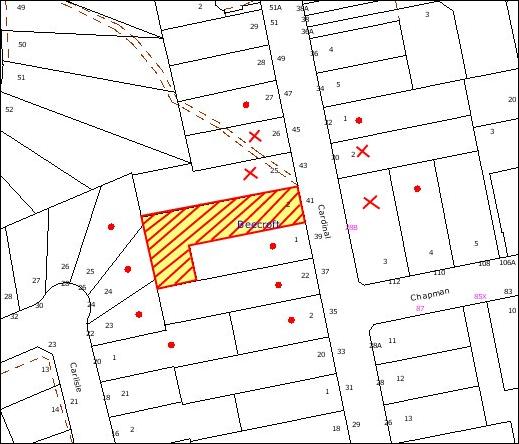
|
NOTIFICATION
PLAN
|
|
|
• PROPERTIES NOTIFIED
|
X SUBMISSIONS
RECEIVED
|
PROPERTY SUBJECT OF
DEVELOPMENT
|
|
|
One
submission received out of map range
|
|
|
|
|
Five submissions objected to the
development, generally on the grounds that the development would result in:
· Excessive removal of
trees on the site. Concerns were raised that the removal of trees would
detrimentally impact on the character of the Beecroft area.
· Insufficient front
setbacks. Concerns were raised that the originally proposed 4 metre front setback
of the development would have a detrimental impact on the streetscape.
· The development is out of
character with the area. The proposed dwelling has the appearance of a terrace
which is not suited to the low density zone.
· The development has the appearance
of the 3 storey dwelling when viewed from the street.
· A development with
insufficient vehicular turning and manoeuvring area.
· Impacts from storm water
runoff to adjoining properties located on the opposite side of the road.
· Insufficient lot size.
The concerns raised in the
community submissions have been addressed in the body of this report. The
amended plans submitted as part of this application have addressed the front
setback non-compliance and modified the vehicular accessway design. Whilst the
concerns raised in the community submissions are valid planning considerations,
these matters are not considered grounds for refusal of the application.
5.2 Public Agencies
The application is not Integrated
Development under the Act and was not referred to any external agencies.
The site is located within the
vicinity of an open drainage channel. This is not identified as a watercourse
on Council’s mapping system and therefore no referral was required to the NSW
Office of Water.
6. THE PUBLIC INTEREST
Section 79C(1)(e) of the Act
requires Council to consider “the public interest”.
The public interest is an
overarching requirement, which includes the consideration of the matters
discussed in this report. Implicit to the public interest is the achievement
of future built outcomes adequately responding to and respecting the future
desired outcomes expressed in environmental planning instruments and
development control plans.
The application is considered to
have satisfactorily addressed Council’s relevant criteria and would provide a
development outcome that, on balance, would result in a positive impact for the
community. Accordingly, it is considered that the approval of the proposed
subdivision and dwelling would be in the public interest.
CONCLUSION
The application proposes the
subdivision of one lot into two and the construction of a dwelling.
The proposal is assessed as being
satisfactory against Section 79C of the Act, HSLEP, the Subdivision
DCP and the Dwelling House DCP. There is a non-compliance with the
‘Accessway Design’ and ‘Urban Streams’ element of the Subdivision DCP
and the ‘Design’ element of the Dwelling House DCP. These
non-compliances have been addressed in this report and have been assessed as
satisfactory.
The proposal would not have any
significant detrimental impact on the natural, social and economic environment
and approval of the proposal is recommended.
Note: At the time of the
completion of this planning report, no persons have made a Political Donations
Disclosure Statement pursuant to Section 147 of the Environmental Planning
and Assessment Act 1979 in respect of the subject planning application.
|
Rod Pickles
Manager -
Assessment Team 2
Planning Division
|
Paul David
Manager -
Subdivision & Development Engineering Services
Planning Division
|
|
Scott Phillips
Executive Manager
Planning Division
|
|
Attachments:
File Reference: DA/723/2009
Document Number: D01410323
SCHEDULE 1
GENERAL CONDITIONS
The
conditions of consent within this notice of determination have been applied to
ensure that the use of the land and/or building is carried out in such a manner
that is consistent with the aims and objectives of the relevant legislation,
planning instruments and Council policies affecting the land and does not
disrupt the amenity of the neighbourhood or impact upon the environment.
Note: For the
purpose of this consent, the term ‘applicant’ means any person who has the
authority to act on or the benefit of the development consent.
Note: For the purpose of
this consent, any reference to an Act, Regulation, Australian Standard or
publication by a public authority shall be taken to mean the gazetted Act or
Regulation, or adopted Australian Standard or publication as in force on the
date that the application for a construction certificate is made.
1. Approved
Plans and Supporting Documentation
The
development must be carried out in accordance with the plans and documentation
listed below and endorsed with Council’s stamp, except where amended by Council
and/or other conditions of this consent:
|
Plan No.
|
Plan Title
|
Drawn by
|
Dated
|
|
HOR1209 – Page 1
|
Site Plan
|
Lionel Curtin Design and
Documentation
|
June 2009
(Amended January 2010)
|
|
HOR1209 – Page 2
|
Upper Level
|
Lionel Curtin Design and
Documentation
|
June 2009
(Amended January 2010)
|
|
HOR1209 – Page 3
|
Middle Level
|
Lionel Curtin Design and
Documentation
|
June 2009
(Amended January 2010)
|
|
HOR1209 – Page 4
|
Lower Level
|
Lionel Curtin Design and
Documentation
|
June 2009
(Amended January 2010)
|
|
HOR1209 – Page 5
|
East Elevation
|
Lionel Curtin Design and
Documentation
|
June 2009
(Amended January 2010)
|
|
HOR1209 – Page 6
|
South Elevation
|
Lionel Curtin Design and
Documentation
|
June 2009
(Amended January 2010)
|
|
HOR1209 – Page 7
|
North Elevation
|
Lionel Curtin Design and
Documentation
|
June 2009
(Amended January 2010)
|
|
Document No.
|
Issued by
|
Dated
|
|
BASIX Certificate No. 256133S
|
NSW Department of Planning
|
22 June 2009
|
2. Removal
of Existing Trees
This
development consent only permits the removal of trees numbered T4 and T10 to
T16 as identified within the Schedule of Surveyed Trees prepared by Urban
Forestry Australia on 25 September 2008 and the associated Tree Location Plan.
The removal of any other trees requires separate approval under Council’s Tree
Preservation Order.
REQUIREMENTS PRIOR TO THE ISSUE OF A CONSTRUCTION
CERTIFICATE
3. Building
Code of Australia
All building
work must be carried out in accordance with the requirements of the Building
Code of Australia.
4. Waste
Management Plan
A waste
management plan is required to be submitted to the accredited certifier prior
to the issue of a construction certificate.
5. Contract
of Insurance (Residential Building Work)
In the case
of residential building work for which the Home Building Act, 1989 requires
there to be a contract of insurance in force in accordance with Part 6 of that
Act, that such a contract of insurance is in force before any building work
authorised to be carried out by the consent commences.
Note: This
condition does not apply to the extent to which an exemption is in force under
Clause 187 or 188 of the Act, subject to the terms of any condition or
requirement referred to in Clause 187(6) or 188(4) of the Act, or to the
erection of a temporary building.
6. Notification
of Home Building Act, 1989 Requirements
Residential
building work within the meaning of the Home Building Act,
1989 must not be carried out unless the principal certifying authority for
the development to which the work relates (not being Council) has given Council
written notice of the following information:
a. In
the case of work for which a principal contractor is required to be appointed:
i. The
name and licence number of the principal contractor.
ii. The
name of the insurer by which the work is insured under Part 6 of that Act.
b. In
the case of work to be done by an owner-builder:
i. The
name of the owner-builder.
ii. If
the owner-builder is required to hold an owner-builder’s permit under that Act,
the number of the owner-builder’s permit.
Note: If
arrangements for doing the residential building work are changed while the work
is in progress so that the information notified becomes out of date, further
work must not be carried out unless the principal certifying authority for the
development to which the work relates (not being Council) has given Council
written notification of the updated information.
7. Water/Electricity
Utility Services
The applicant
must submit written evidence of the following service provider requirements:
a. Energy
Australia – a letter of consent demonstrating that satisfactory
arrangements have been made to service the proposed development.
b. Sydney
Water – the submission of a ‘Notice of Requirements’ under s73 of the Sydney
Water Act 1994.
Note: Sydney
Water requires that s73 applications are to be made through an authorised
Sydney Water Servicing Coordinator. Refer to www.sydneywater.com.au or telephone
13 20 92 for assistance.
REQUIREMENTS PRIOR TO THE COMMENCEMENT OF
ANY WORKS
8. Erection
of Construction Sign
A sign must
be erected in a prominent position on any site on which building work,
subdivision work or demolition work is being carried out:
a. Showing
the name, address and telephone number of the principal certifying authority
for the work,
b. Showing
the name of the principal contractor (if any) for any demolition or building
work and a telephone number on which that person may be contacted outside
working hours, and
c. Stating
that unauthorised entry to the work site is prohibited.
Note: Any
such sign is to be maintained while the building work, subdivision work or
demolition work is being carried out, but must be removed when the work has
been completed.
9. Protection
of Adjoining Areas
A temporary
hoarding, fence or awning must be erected between the work site and adjoining
lands before the works begin and must be kept in place until after the
completion of the works if the works:
a. Could
cause a danger, obstruction or inconvenience to pedestrian or vehicular
traffic.
b. Could
cause damage to adjoining lands by falling objects.
c. Involve
the enclosure of a public place or part of a public place.
Note: Notwithstanding
the above, Council’s separate written approval is required prior to the
erection of any structure or other obstruction on public land.
10. Toilet
Facilities
Toilet
facilities must be available or provided at the works site before works begin
and must be maintained until the works are completed at a ratio of one toilet
for every 20 persons employed at the site. Each toilet must:
a. be
a standard flushing toilet connected to a public sewer; or
b. be
a temporary chemical closet approved under the Local Government Act, 1993;
or
c. have
an on-site effluent disposal system approved under the Local Government Act,
1993
11. Erosion
and Sediment Control
Erosion and
sediment control measures must be provided and maintained throughout the
construction period in accordance with the manual ‘Soils and Construction
2004 (Bluebook)’, the approved plans, Council specifications and to the
satisfaction of the principal certifying authority. The erosion and sediment
control devices must remain in place until the site has been stabilised and
revegetated.
Note: On
the spot penalties up to $1,500 may be issued for any non-compliance with this
requirement without any further notification or warning.
12. Tree
Protection Barriers
Tree
protection fencing must be erected around trees numbered T7, T8, T9, T20 and
T21 to be retained at a 3 metre setback. The tree fencing must be constructed
of 1.8 metre ‘cyclone chainmesh fence’ or star pickets spaced at 2 metre
intervals, connected by a continuous high-visibility barrier/hazard mesh at a
height of 1 metre.
REQUIREMENTS DURING CONSTRUCTION
13. Construction
Work Hours
All work on site (including demolition and earth works)
must only occur between 7am and 5pm Monday to Saturday.
No work is to be undertaken on Sundays or public holidays.
14. Environmental
Management
The site must
be managed in accordance with the publication ‘Managing Urban Stormwater –
Landcom (March 2004) and the Protection of the Environment Operations
Act 1997 by way of implementing appropriate measures to prevent sediment
run-off, excessive dust, noise or odour emanating from the site during the
construction of the development.
15. Works
near Trees
All required
tree protection measures are to be maintained in good condition for the
duration of the construction period.
All works
(including driveways and retaining walls) within 5 metres of any trees required
to be retained (whether or not on the subject property, and pursuant to this
consent or the Tree Preservation Order), must be carried out under the
supervision of an ‘AQF Level 5 Arborist’ and a certificate submitted to
the principal certifying authority detailing the methods used to preserve the
trees.
Note:
Except as provided above, the applicant is to ensure that no excavation,
filling or stockpiling of building materials, parking of vehicles or plant,
disposal of cement slurry, waste water or other contaminants is to occur within
4 metres of any tree to be retained.
16. Bushland
Protection during Construction
To ensure the
protection of bushland during construction, the applicant must ensure that all
machinery is cleaned of soil and debris before entering the site to prevent the
spread of weeds and fungal pathogens.
Note: The
site contains Eucalyptus saligna which is listed as an ‘Endangered Ecological
Community’ under the ‘Threatened Species Conservation Act 1995’. The Act
prohibits the disturbance to threatened species, endangered populations and
endangered ecological communities, or their habitat, without the approval of
the ‘Department of Environment and Climate Change’ where such activities are
not authorised by a development consent under the ‘Environmental Planning and
Assessment Act 1979’.
Actions such as tree removal, understorey slashing or mowing, removal of dead
trees within this vegetation would likely impact upon this endangered ecological
community. Such action would qualify as illegally picking or disturbing the
habitat and could render any person who carried out such action as liable for
prosecution.
17. Driveway
Construction and Tree Protection
Pier and beam construction of the driveway within the
nominated restriction zone must be used with piers being located no closer than
3 metres to the trunks of any trees to be retained. The driveway edge must be
no closer than 1 metre to the edge of the trunk. The excavation for the piers
within the nominated restriction zone must be hand dug. Any tree roots between 10mm and 50mm
diameter, revealed during excavation must be cut cleanly by a sharp hand saw.
All excavation within six metres of the
trees must be supervised by a (AQF5) arborist to ensure no roots greater than 50mm in diameter are
severed, and root damage is minimised.
18. Council
Property
During
construction works, no building materials, waste, machinery or related matter
is to be stored on the road or footpath. The public reserve is to be kept in a
clean, tidy and safe condition at all times.
19. Landfill
Landfill must
be constructed in accordance with Council’s ‘Construction Specification,
2005’ and the following requirements:
a. All
fill material imported to the site is to wholly consist of Virgin Excavated
Natural Material (VENM) as defined in Schedule 1 of the Protection of the
Environment Operations Act 1997 or a material approved under the Department
of Environment and Climate Change’s general resource recovery exemption.
b. A
compaction certificate is to be obtained from a geotechnical engineer verifying
that the specified compaction requirements have been met.
20. Survey
Report – Finished Floor Level
A report(s)
must be prepared by a registered surveyor and submitted to the principal
certifying authority prior to the pouring of concrete at each level of the
building certifying that:
a. The
building, retaining walls and the like have been correctly positioned on the
site.
b. The
finished floor level(s) are in accordance with the approved plans.
REQUIREMENTS PRIOR TO THE ISSUE OF A
SUBDIVISION CERTIFICATE
Note: For
the purpose of this consent, any reference to ‘occupation certificate’ shall
also be taken to mean ‘interim occupation certificate’ unless otherwise stated.
21. Sydney
Water – s73 Certificate
A s73 Certificate must be
obtained from Sydney Water.
22. Internal
Driveway/Vehicular Areas
The driveway
and parking areas on site must be designed and constructed in accordance with Australian
Standards 2890.1, 3727 and the following requirements:
a. Design
levels at the front boundary be obtained from Council.
b. The
driveways must be a rigid pavement.
c. A
longitudinal section for the proposed driveways must be prepared by a suitably
qualified Engineer or Surveyor and considered for approval. The driveway grades
must not exceed 25 percent and changes in grade must not exceed 8 percent per
plan metre to avoid vehicle scraping.
d. The
driveway pavement be a minimum 3 metres wide, 0.15 metres thick reinforced concrete
with F72 steel reinforcing fabric and a 0.15 metre sub-base.
e. The
pavement have a kerb to one side and a one-way cross fall with a minimum
gradient of 2 percent and a lintel and pit provided on grade and at low points.
f. Retaining
walls required to support the carriageway and the compaction of all fill
batters to be in accordance with the requirements of a chartered structural
engineer.
g. The
provision of safety rails where there is a level difference more than 0.3
metres and a 1:4 batter can not be achieved.
h. Conduits
for utility services including electricity, water, gas and telephone be
provided.
REQUIREMENTS PRIOR TO THE ISSUE OF AN
OCCUPATION CERTIFICATE
Note: For
the purpose of this consent, any reference to ‘occupation certificate’ shall
also be taken to mean ‘interim occupation certificate’ unless otherwise stated.
23. Vehicular
Crossing
A separate
application under the Local Government Act, 1993 and the Roads Act,
1993 must be submitted to Council for the installation of two new vehicular
crossings and the removal of any redundant crossing. The vehicular crossings
must be constructed in accordance with Council’s Civil Works Design, 2005
and the following requirements:
a. Any
redundant crossings to be replaced with integral kerb and gutter.
b. The
footway area to be restored by turfing.
c. Approval
obtained from all relevant utility providers that all services are protected
under the crossing.
Note:
An application for a vehicular crossing can only be made to one of Council’s
Authorised Vehicular Crossing Contractors. You are advised to contact Council
on 02 9847 6940 to obtain a list of contractors.
24. Stormwater
Drainage – Dwellings
The
stormwater drainage system for the development must be designed and constructed
for an average recurrence interval of 20 years and be gravity drained in
accordance with the following requirements:
a. Connected
directly to Council’s street drainage system via on-site detention (OSD).
b. The
existing dwelling to be connected to an existing Council’s kerb drainage system
in Council’s road.
25. On
Site Stormwater Detention
An on-site
stormwater detention system for the proposed dwelling must be designed by a
chartered civil engineer and constructed in accordance with the following
requirements:
a. Have
a capacity of not less than 5.0 cubic metres, and a maximum discharge (when
full) of 8.0 litres per second.
b. Have
a surcharge/inspection grate located directly above the outlet.
c. Discharge
from the detention system to be controlled via 1 metre length of pipe, not less
than 50 millimetres diameter or via a stainless plate with sharply drilled
orifice bolted over the face of the outlet discharging into a larger diameter
pipe capable of carrying the design flow to an approved Council system.
d. Where
above ground and the average depth is greater than 0.3 metres, a ‘pool type’
safety fence and warning signs to be installed.
e. Not
be constructed in a location that would impact upon the visual or recreational
amenity of residents.
26. Creation
of Easements
The following
matter(s) must be nominated on the plan of subdivision under s88B of the Conveyancing
Act 1919:
a. An
inter-allotment drainage easement(s) over each of the burdened lots as required.
b. A
drainage easement 3 metres wide over the affected lot in favour of Council and
in accordance with the terms set out in Memorandum B5341305V filed with
the NSW Department of Lands and method available from Council.
c. A
restriction over the pipeline and the flow path for a 100 year average recurrence
interval storm. The "Restriction on the Use of Land" over the
affected lots is to prohibit the alteration of the final floodway shape and the
erection of any structures, including fencing, in the floodway without the
written permission of Council. The terms of this restriction must be obtained
from Council.
d. A
"Restriction on the Use of Land" for any lot adjacent to the
floodway, requiring the finished floor level of any habitable room to be not
less than 500mm and the garage 300mm above the 100 year average recurrence
interval storm level. The levels must be related to Australian Height Datum.
e. The
creation of an appropriate "Positive Covenant" and "Restriction
as to User" over the constructed on-site detention/retention systems
and outlet works, within the lots in favour of Council in accordance with
Council’s prescribed wording. The position of the on-site detention system is
to be clearly indicated on the title.
f. To
register the OSD easement, the restriction on the use of land “works-as-executed”
details of the on-site-detention system must be submitted verifying that the
required storage and discharge rates have been constructed in accordance with
the design requirements. The details must show the invert levels of the on
site system together with pipe sizes and grades. Any variations to the
approved plans must be shown in red on the “works-as-executed” plan and
supported by calculations.
Note: Council
must be nominated as the authority to release, vary or modify any easement,
restriction or covenant.
27. s94
Infrastructure Contributions
The payment to Council of a
contribution of $19478.70* for one additional lots towards the cost of
infrastructure identified in Council’s Development Contributions Plan
2007-2011.
Note: * The
value of contribution is based on a rate of $ 19748.70 per
additional lot and is current as at 29/04/2010. The
contribution will be adjusted from this date in accordance with the underlying
consumer price index for subsequent financial quarters.
It is recommended that you contact Council to ascertain the indexed value of
the contribution prior to payment.
28. Maintain
Canopy Cover
To maintain canopy cover,
four medium to large trees selected from Council’s booklet ‘Indigenous
Plants for the Bushland Shire’ such as Syncarpia glomulfera
(Turpentine) or Acmena simithii (Lilly Pilly) are
to be planted on the subject site. The planning location shall not be within 4
metres of the foundation walls of a dwelling or in-ground pool. The pot size
is to be a minimum 25 litres and the tree(s) must be maintained until they
reach the height of 3 metres. Trees must be native to Hornsby Shire and reach
a mature height greater than ten metres.
29. Damage
to Council Assets
Any damage
caused to Council’s assets as a result of the construction of the development
must be rectified in accordance with Council’s written requirements and at the
sole cost of the applicant.
30. Fulfilment
of BASIX Commitments
The applicant
must demonstrate the fulfilment of BASIX commitments pertaining to the
development.
-
END OF CONDITIONS -
ADVISORY NOTES
The following information is provided for your
assistance to ensure compliance with the Environmental Planning and Assessment
Act, 1979, Environmental Planning and Assessment Regulation 2000, other
relevant legislation and Council’s policies and specifications. This
information does not form part of the conditions of development consent
pursuant to Section 80A of the Act.
Environmental Planning and
Assessment Act, 1979 Requirements
· The Environmental Planning and
Assessment Act, 1979 requires:
· The issue of a construction certificate
prior to the commencement of any works. Enquiries regarding the issue of a
construction certificate can be made to Council’s Customer Services Branch on
9847 6760.
· A principal certifying authority to be
nominated and Council notified of that appointment prior to the commencement of
any works.
· Council to be given at least two days
written notice prior to the commencement of any works.
· Mandatory inspections of nominated
stages of the construction inspected.
· An occupation certificate to be issued
before occupying any building or commencing the use of the land.
Long Service Levy
In accordance with Section 34 of
the Building and Construction Industry Long Service Payments Act 1986, a ‘Long Service Levy’ must be paid to the Long
Service Payments Corporation or Hornsby Council.
Note: The
rate of the Long Service Levy is 0.35% of the total cost of the work.
Note: Hornsby
Council requires the payment of the Long Service Levy prior to the issue of a
construction certificate.
Tree Preservation Order
To ensure the maintenance and
protection of the existing natural environment, it is an offence to ringbark,
cut down, top, lop, remove, wilfully injure or destroy a tree outside 3 metres
of the approved building envelope without the prior written consent from
Council.
Note: A
tree is defined as a single or multi-trunked wood perennial plant having a
height of not less than three (3) metres, and which develops many branches,
usually from a distance of not less than one (1) metre from the ground, but
excluding any plant which, in its particular location, is a noxious plant
declared as such pursuant to the Noxious Weeds Act 1993. This definition of
‘tree’ includes any and all types of Palm trees.
All
distances are determined under British Standard BS 5837: 2005, “Trees in
Relation to Construction – Recommendations”.
Fines may be imposed for
non-compliance with Council’s Tree Preservation Order.
Covenants
The land upon which the subject
building is to be constructed may be affected by restrictive covenants.
Council issues this approval without enquiry as to whether any restrictive
covenant affecting the land would be breached by the construction of the
building, the subject of this consent. Applicants must rely on their own
enquiries as to whether or not the building breaches any such covenant.
Subdivision Certificate
Requirements
A subdivision certificate
application is required to be lodged with Council containing the following
information:
· A surveyor’s certificate certifying that
all structures within the subject land comply with the development consent in
regard to the setbacks from the new boundaries.
· A surveyor’s certificate certifying that
all services, drainage lines or access are located wholly within the property
boundaries. Where services encroach over the new boundaries, easements are to
be created.
· Certification that the requirements of
relevant utility authorities have been met.
· A surveyor’s certificate certifying
finished ground levels are in accordance with the approved plans.
Note: Council
will not issue a subdivision certificate until all conditions of the
development consent have been completed.
Fees and Charges – Subdivision
All fees payable to Council as
part of any construction, compliance or subdivision certificate or inspection
associated with the development (including the registration of privately issued
certificates) are required to be paid in full prior to the issue of the
subdivision certificate. Any additional Council inspections beyond the scope
of any compliance certificate required to verify compliance with the terms of
this consent will be charged at the individual inspection rate nominated in
Council's Fees and Charges Schedule.
Dial Before You Dig
Prior to commencing any works,
the applicant is encouraged to contact Dial Before You Dig on 1100 or www.dialbeforeyoudig.com.au for
free information on potential underground pipes and cables within the vicinity
of the development site.
House Numbering
House numbering can only be
authorised by Council. Before proceeding to number each premise in the
development, the allocation of numbers is required to be obtained from
Council's Planning Division. The authorised numbers are required to be
displayed in a clear manner at or near the main entrance to each premise.
Standard Report No. PLN29/10
Planning Division
Date of Meeting:
2/06/2010
6 HERITAGE ADVISORY
COMMITTEE - TECHNICAL SPECIALIST REPRESENTATION
EXECUTIVE SUMMARY
The Heritage Advisory Committee Constitution
states that the Committee should consist of eleven members, namely, four
Councillors, three Council officers, two technical specialists and two
community representatives. One of the technical specialists has resigned
recently due to personal reasons.
Council has sought expression of interest for the technical
specialist positions from industry groups and the local community. Council has
received submissions from a number of suitably qualified and experienced
members of the public with relevant professional experience in heritage
matters. The high number of suitable candidates provides Council with an
opportunity to increase the level of technical and professional expertise on
the Committee from two specialists to a minimum of three and a maximum of four.
Accordingly, it is recommended that Council endorse nominees to fill three
technical specialist vacancies on the Heritage Advisory Committee and amend the
Constitution to include further technical specialist representation.
To
ensure that the Committee maintains a balance of membership and equality of
representation, it is also recommended that the Constitution be amended
to require that the Committee consist of a minimum of eight members, namely,
three Councillor representatives, and a minimum of three technical specialists
and two community representatives. Council staff would continue to provide
support to the Committee but would not participate in voting.
PURPOSE
The purpose of this report is to outline options available
to Council to increase technical specialist representation on the Hornsby Shire
Heritage Advisory Committee.
BACKGROUND
Council’s Heritage Advisory Committee was formed in January
1994, under Section 377 of the Local Government Act, 1993.
Members of the Committee are volunteers who assist in the assessment of
development applications affecting heritage items and heritage conservation
areas, educating the community on the importance of heritage conservation and
making recommendations for financial assistance to conserve items of heritage
significance.
At its meeting on 3 March 2010,
Council considered Executive Manager’s Report No. PLN5/10 seeking endorsement
of a nominee to fill a single technical specialist
vacancy. In acknowledgement of the number of high quality expressions
of interest from technically based professionals, Council
resolved to defer consideration of the matter pending a report being
prepared for Council’s consideration outlining options to increase technical specialist representation.
DISCUSSION
This report discusses the composition of the Heritage
Advisory Committee and seeks endorsement of an amendment to the Constitution
to include further technical specialist representation.
The Committee currently comprises four (4) Councillors
(Councillors Browne, Evans, Hutchence and Martin), three Council Officers, two
technical specialists and two community representatives (being a representative
from the general community and a representative from the Hornsby Historical
Society). The Constitution also states that the quorum of the Committee
shall be four members, including a minimum of one community representative and
one industry representative.
Committee Composition
Committee members volunteer significant amounts of their
own time to provide heritage advice and recommendations in accordance with
Council’s Heritage Development Control Plan for proposals affecting
heritage items and heritage conservation areas. The Committee also assists in
organising and promoting Heritage Week events, judging Assistance Funding
applications and the annual Heritage Awards. The Committee would benefit from
increased technical expertise and professional input, particularly in relation
to the assessment of development applications concerning heritage items, which
can involve complex technical issues. On some occasions, due to the
professional commitments of technical specialists and competing demands on
their time, it has not always been possible for them to attend all meetings.
Due to the technical role of the Committee, it is important that there is
always an appropriate level of technical specialist representation at each
meeting. Increasing the number of technical representatives on the Committee
would ensure appropriate representation at all meetings.
Executive Manager’s Report No. 5/2010, reviews seven
expressions of interest received by Council for the vacant technical specialist
position. As outlined in the report, expressions of interest were received
from a number of suitably qualified and experienced members of the public with
relevant professional experience in heritage matters. The high number of
suitable candidates provides Council with an opportunity to increase technical
expertise and professional input on the Committee to three. Accordingly, it is
recommended that the Constitution be amended to include a minimum of
three technical specialists (and a maximum of four).
Councillor representation on the Committee has also been
reviewed. Councillor representation on the Committee has exceeded technical
specialist representation since 2004 when Council resolved to increase
Councillor representation from three to four. In increasing Councillor
numbers, Council acknowledged that there may be occasions where nominated
Councillors are not always able to attend meetings due to competing
priorities. However, the Constitution satisfactorily addresses this concern by
allowing all other Councillors to attend meetings as ex officio members and
vote in the absence of Councillors who are members.
To ensure appropriate technical specialist representation
at all meetings and to ensure that the Committee maintains a balance of
membership and equality of representation, it is recommended that the Constitution
be amended to require:
· Three nominated Councillors.
All other Councillors may be ex officio members
of the Committee but are not entitle to vote other than in the absence of
Councillors who are members of the Committee.
· A minimum of three and a maximum of four technical specialists
from the architectural/planning or other related professions with expertise in
heritage.
· Two community representatives:
- a representative from Hornsby Shire
Historical Society; and
- a representative from the general
community.
It is recommended that Council staff continue to provide
support to the Committee and participate in Committee debate but not vote. It
is also recommended that the Constitution be amended to require a
quorum of three members to conduct a meeting.
Technical Specialist Representation
A summary of each of the seven expressions of interest is
detailed in Executive Manager’s Report No. 5/2010. Each of the applicants has
outlined individual technical expertise, experience and interests that would
add significant value to the Committee. Six of the nominees have confirmed
their continued interest in the technical specialist position. However Jill
Gleave has withdrawn her nomination.
Should Council resolve to amend the Constitution,
three technical specialist positions would be vacant. The following nominees
are recommended for endorsement (in alphabetical order) in respect of the three
technical specialist positions.
Michael Clarke
Michael Clarke is a resident of
Normanhurst and has qualifications in Civil Engineering. Mr Clarke was employed
as a civil engineer with the Department of Public Works from 1987 until he
retired as Chief Engineer in 1992.
Mr Clarke has maintained an
interest in a range of heritage and conservation activities in his professional
career and in a voluntary capacity. He is currently a member of the NSW
Heritage Council: Register Committee and has been a member and held executive
roles on both the Sydney Engineering Heritage Committee and on Engineering
Heritage Australia. In his involvement with the last two organizations, he
managed the oral history programs, including the preparation of oral history
policies and procedures.
Mr Clarke is also a member (or a
previous member) of the National Trust of Australia, the Friends of the
Historic Houses Trust of NSW, the History Council of NSW, Oral History
Association of Australia, the Australian Society for the History of Engineering
and Technology, the Sydney Opera House Conservation Council and the Department
of Public Works and Services Oral History Committee.
Mr Clarke has presented papers on
engineering heritage and authored a number of documents relating to heritage
including, “Historic Engineering Plaques of Australia” and “Sydney’s Engineering Heritage – Walks”, which received a National Trust
Award. He has also presented keynote addresses, talks and presentations on
various aspects of the history of engineering. Mr Clarke was made a Emeritus
Member of the College of Civil Engineers (Australia) in 2000 and was awarded
the Hazel De Berg Award for Excellence in Oral History in 2007.
Margaret Desgrand
Margaret Desgrand is a resident of Wahroonga and architect
with specialist qualifications in heritage conservation. She has in excess of
30 years post graduate experience in the design, construction and management of
projects involving heritage assets including in state government in the
Government Architect’s Branch, in the private sector and in local government.
She is a registered architect and is currently a member of the NSW Chapter of the
Australian Institute of Architects (RAIA) Heritage Committee and the National
Trust of Australia (NSW) Buildings Committee, and a member of the Australian
Garden Historical Society. Mrs Desgrand is Senior Heritage Specialist within
the Urban Design and Heritage Unit of the City of Sydney Council.
Mrs Desgrand has been nominated by the RAIA to represent
the Institute on the Committee. Mrs Diane Jones, Chairwoman, NSW RAIA has been
nominated as an alternate representative should Margaret Desgrand be unable to
attend.
Roy Lucas
Roy Lucas is a resident of St Ives and has extensive
experience in the building industry within the private sector and in academia.
He has a Bachelor of Science Degree, a Diploma in Building (Hons), a Diploma of
Architecture and an Associate Diploma in Valuation. He has in excess of
sixty years experience in the practical construction, renovation and
restoration of the various period styles and materials covering both commercial
and residential properties. In the later part of his career, Mr Lucas also
became involved in lecturing in construction technology and in the
identification of the age of buildings. He is a
co-presenter on the Institute of TAFE’s series of videos “The Age of Buildings”
and author of the “The Age of Buildings” learning guides for TAFE Diploma of
Valuation.
Mr Lucas maintains contact with the building industry as
an Examiner for the Builders’ Licensing Board and as
a Judge for The Excellence of Building with the Master Builders’
Association NSW.
Evaluation/Recommendation
The submissions prepared by Micheal Clarke, Margaret
Desgrand and Roy Lucas and demonstrate sound technical expertise in their given
fields, with either specialist heritage qualifications and/or heritage
experience with both the practical and policy aspects of heritage
conservation. Their extensive years of experience in the design, construction
and management of projects involving heritage assets would assist in the
assessment of development applications affecting heritage items and heritage
conservation areas, educating the community on the importance of heritage
conservation and making recommendations for financial assistance to conserve
items of heritage significance. Accordingly, it is recommended that Council
invite Micheal Clarke, Margaret Desgrand and Roy Lucas to participate on the
Heritage Advisory Committee as technical specialists.
TRIPLE BOTTOM LINE SUMMARY
Triple Bottom Line is a framework for improving Council
decisions by ensuring accountability and transparency on social, environmental
and economic factors. It does this by reporting upon Council’s strategic
themes. As this report provides Council with information and does not propose
any actions which require a sustainability assessment, no Triple Bottom Line
considerations apply.
CONCLUSION
The Heritage Advisory Committee’s Constitution
requires that the Committee consist of eleven members, two of which are
technical specialist. One of the technical specialists has resigned recently
due to personal reasons. Council has sought expression of interest for the
technical specialist positions from industry groups and the local community.
To ensure appropriate technical specialist representation
at all meetings and to ensure that the Committee maintains a balance of membership
and equality of representation, it is recommended that the Constitution
be amended to require that the Committee consist of a minimum of eight members,
namely, three Councillors, two community representatives and a minimum of three
and maximum of four technical specialists. Council staff will continue to
provide support to the Committee but should not participate in voting.
|
RECOMMENDATION
1. THAT the Heritage Advisory Committee Constitution be
amended in accordance with the revised Constitution (attached) to:
- increase the number
of Technical Specialists to a minimum of three and a maximum of four;
- reduce the number of Councillors to three;
and
- require the attendance of three members
for a quorum.
2. Council invite Micheal Clarke, Margaret
Desgrand and Roy Lucas to participate on the Hornsby Shire Advisory
Committee as voluntary technical specialists.
3. Submitters be advised of Council’s resolution and thanked for
their interest in the matter.
4. Three Councillors
(Council to nominate three Councillors) be elected as
Councillor representatives on the Hornsby Heritage Advisory Committee.
|
|
James Farrington
Manager - Town
Planning Services
Planning Division
|
Scott Phillips
Executive Manager
Planning Division
|
Attachments:
|
1.View
|
Revised Heritage
Advisory Committee Constitution
|
File Reference: F2009/00088
Document Number: D01406208
Standard Report No. PLN31/10
Planning Division
Date of Meeting:
2/06/2010
7 AMENDMENTS PLANNING
PROPOSAL 2009 - REPORT ON SUBMISSIONS
EXECUTIVE SUMMARY
In November 2009, Council
considered a report identifying a number of planning anomalies to be rectified
and amendments to be made to the Hornsby Shire Local Environmental Plan 1994
(HSLEP) as part of its annual Amendments Local Environmental Plan (LEP)
2009. Council endorsed a Planning Proposal for public exhibition
proposing to rezone lands, address planning anomalies and make minor amendments
to the HSLEP.
The Planning Proposal was
exhibited for community comment in February and March 2010 along with
supporting Development Control Plan (DCP) amendments. Ten submissions
were received in response to the exhibition. The key issues raised in
submissions are addressed in this report. Minor amendments to the
Planning Proposal and draft DCP amendments are recommended in response to the
issues raised in submissions.
It is recommended that Council
adopt the amended Planning Proposal attached to this report and forward it to
the Department of Planning (DOP) for gazettal.
PURPOSE
The purpose of this report is to
review submissions received in response to the exhibition of the Annual
Amendments 2009 Planning Proposal and associated draft DCP amendments.
BACKGROUND
At its meeting on 4 November
2009, Council considered Executive Manager’s Report No. PLN89/09 concerning
Council’s annual amendments review. The report presented a Planning
Proposal to rezone lands, address planning anomalies and make minor amendments
to the HSLEP. Council resolved that:
1. Council endorse progression of the
Planning Proposal attached to Executive Manager’s Report No. PLN89/09 to:
1.1 rezone and permit strata subdivision at
property No. 218 Brooklyn Road, Brooklyn;
1.2 update the listing of heritage items in
accordance with the recommendations of Heritage Review Stage 4 and East Epping
Heritage Review; and
1.3 implement the recommendations of the Hornsby
West Side Conservation Area Review with the exception of the rezoning of the
precinct to Residential AS (Low Density - Sensitive Lands).
2. Council forward the Planning
Proposal to the Minister for Planning seeking “approval” to progress the
preparation of the draft LEP in accordance with Section 56(1) of the
Environmental and Planning Assessment Act 1979.
3. Should the Minister determine
under Section 56(2) of the Environmental Planning and Assessment Act, 1979,
that the matter may proceed without significant amendment to the Proposal,
Council publicly exhibit the Planning Proposal in accordance with the
Minister’s determination.
4. The draft amendments to the
Heritage, Dwelling-House, Residential Subdivision, Low Density Multi-Unit
Housing, Medium Density Multi-Unit Housing, Medium/High Density Multi-Unit
Housing, Dural Village Centre, River Settlements, Rural Lands and Extractive
Industries Development Control Plans as outlined in Executive Manager’s Report
No. PLN89/09, be exhibited for 28 days with the exhibition of the Planning
Proposal.
5. Following the exhibition, a report
be prepared for Council’s consideration on submissions received.
In
accordance with Council’s resolution, on 1 December 2009, the Planning Proposal
was forwarded to the DOP seeking a Gateway Determination by the Minister in
accordance with Section 56 of the Environmental Planning and Assessment (EP&A)
Act.
On 30
December 2009, Council received a Gateway Determination from the DOP,
indicating that the Planning Proposal should be exhibited. The Gateway
Determination was issued with a condition that proposed heritage items from the
East Epping Heritage Review be removed from the Planning Proposal. The DOP
advised that this matter would be addressed in the context of the Epping
Town Centre Study currently being progressed by Council. Accordingly, the
Planning Proposal was amended to reflect the Gateway Determination.
In
accordance with the adopted Consultation Strategy, the Commissioner of the
Rural Fire Service was consulted prior to the commencement of the exhibition
period. No objections were received. The NSW Rural Fire Service noted that
future development on bushfire prone land would need to comply with Section
79BA or Section 91 of the EP&A Act and may require a bushfire safety
authority as per Section 100B of the Rural Fires Act 1997.
The
Planning Proposal and associated draft DCP amendments were exhibited for
community comment between 16 February and 19 March 2010 at Council’s
Administration Centre, Council’s libraries and on the Council website.
Letters were sent to affected property owners, two community groups and
relevant State Government agencies. An advertisement was placed in the
local newspapers on two occasions. Relevant Council branches were also
invited to comment on the Planning Proposal and draft DCP amendments.
At its meeting on 5 May 2010,
Council considered Executive Manager’s Report No. PLN27/10 presenting a review
of submissions received in response to the exhibition of the Annual Amendments
2009 Planning Proposal and associated draft DCP amendments. Council
resolved that:
Consideration
of Executive Manager’s Report No. PLN2710 be deferred to the June 2010 Planning
Meeting, to allow residents concerns to be addressed.
On 14 May 2010, the owner of
property No. 218 Brooklyn Road, Brooklyn signed an Owner’s Agreement to provide
two car spaces onsite and a vehicular crossing within 6 months of the issue of
the Construction Certificate. A Construction Certificate for the two car spaces
and vehicular crossing has been lodged with Council. The owner has also
provided Council with an unconditional Bank Guarantee (“Bond”) of $20,000 as
security that the works will be undertaken within the specified timeframe.
DISCUSSION
Ten
submissions were received in response to the exhibition. Six submissions
are generally supportive, or raise no objection to the Planning Proposal and
draft DCP amendments including submissions from Sydney Water and the Roads and
Traffic Authority. The key issues raised in submissions are outlined below as
they relate to each component of the Planning Proposal.
CWA Building and
Sandstone Steps, Hornsby Park Pacific Highway, Hornsby
The
Planning Proposal seeks to add the CWA Building and Sandstone Steps within Hornsby Park as a heritage item of local significance to Schedule D (Heritage Items) of the
HSLEP. The CWA Building and Sandstone Steps are located within Hornsby Park, comprising three separate allotments which run from the Pacific Highway to Rosemead Road.
Submissions: Council’s Environment Division raises
concern with the CWA Building being added as an item of local significance to
Schedule D (Heritage Items) of the HSLEP. The Environment
Division’s submission notes that Council is currently progressing two projects
(preparation of a park masterplan for Old Mans Valley and the redevelopment of
Hornsby Pool) that may potentially impact on the proposed heritage listing. The
submission suggests that the listing of the CWA Building as a heritage item
should be deferred until current investigations, including development options
for the projects, are further progressed.
Representatives
from the Environment Division have indicated that there is no objection to the
listing of the Sandstone Steps, which are located towards the western end of
the park, within a separate Lot and DP to the CWA Building.
Comment:
Heritage Review Stage 4 recognises
that the CWA Building is of local heritage significance. However, the
heritage significance of the building should be balanced against the community
benefit arising from the projects being progressed by the Environment Division.
The submission by the Environment Division indicates that current
investigations will involve further consideration of heritage issues.
Accordingly, it would be appropriate to defer the listing of the CWA Building as a heritage item until investigations have been completed.
With
respect to the Sandstone Steps, further investigation has confirmed that the
Sandstone Steps referred to within Heritage Review Stage 4, are located
at the western end of Hornsby Park on Lot 7017, DP 1052646 and the adjacent
unmade road reserve immediately to the south. The CWA Building is located at
the eastern entrance to the Park adjacent to Pacific Highway, on Lot 7019, DP 1059310. Accordingly, the listing of the Steps would not impact on the
projects being progressed by the Environment Division.
Resolve:
It is recommended that consideration
of heritage listing of the CWA Building be deferred for further consideration
following finalization of the Old Mans Valley Park Masterplan and Hornsby Pool
Plans. It is recommended that the listing of the Sandstone Steps be amended to
reflect the location of the Sandstone Steps on Lot 7017, DP 1052646 and the
adjacent unmade road reserve immediately to the south.
Property
Nos. 3-5 Hannah Street, Beecroft
The
Planning Proposal seeks to add property Nos. 3-5 Hannah Street, Beecroft as a
heritage item (Retail Shops) of local significance to Schedule D (Heritage
Items) of the HSLEP.
Submissions: Two submissions from the property
owners object to property Nos. 3-5 Hannah Street, Beecroft being added as an
item of local significance to Schedule D (Heritage Items) of the HSLEP. The
submissions comment that the inventory, which forms part of Heritage Review
Stage 4, contains a number of inaccuracies including the item name,
physical description and Statement of Significance. The owners contest the
historical importance of the properties and suggest they do not warrant
heritage listing.
Comment:
Council is progressing a Housing
Strategy that identifies opportunities for additional housing within
planned precincts proposed to be rezoned to permit higher density multi-unit housing.
Property Nos. 3-5 Hannah Street, Beecroft are within the Beecroft Road,
Beecroft precinct and are being considered for possible rezoning to facilitate
5 storey mixed use development as part of the Strategy. Council has been advised previously by the DOP that draft
LEPs relating to Heritage Conservation Areas and heritage items will not be
progressed in areas close to train stations which may assist Council in
fulfilling dwelling target obligations under the Metropolitan Strategy.
Accordingly, it would be appropriate to defer consideration of the listing of
property Nos. 3-5 Hannah Street, Beecroft as a heritage item until Council has
finalised the Housing Strategy.
Resolve:
It is recommended that consideration
of the heritage listing of property Nos. 3-5 Hannah Street, Beecroft be
deferred for further consideration following finalization of Council’s Housing
Strategy.
Property
No. 33 Wongala Crescent, Beecroft
The
Planning Proposal seeks to add property No. 33 Wongala Crescent, Beecroft as a
heritage item (House and Garden) of local significance to Schedule D (Heritage
Items) of the HSLEP. The inventory which forms part of Heritage
Review Stage 4 states that the significant features of the property include
a faux timber archway (evidence of concrete cancer), pond and a radiata pine.
The inventory also recommends liaising with owners regarding presentation,
structural integrity and sympathetic addition of gates.
Submissions: One submission from the property owner
objects to property No. 33 Wongala Crescent being added as an item of local
significance to Schedule D (Heritage Items) of the HSLEP. The
submission comments that the inventory which forms part of Heritage Review
Stage 4 contains an incorrect photo, which does not depict the property.
The submission states that the significant features of the property, especially
the pond, have been compromised by tree root damage.
Comment:
Council’s Heritage Consultant was
requested to review the issues raised in the submission. The Heritage Consultant
advises that the house is typical of its type but has rustic features
such as the verandah and entrance arch that reflect the construction of the
house in an era when the area would have been semi rural. The house appears in
reasonable condition but confirms that the entrance arch is showing signs of
deterioration (unlikely to be concrete cancer) and the side walls are cracking.
The Consultant confirms that the radiata pine thought to be causing damage has
been removed and that the photograph of the rear garden is incorrect. However,
the Consultant advises that, subject to the updating of the inventory sheet,
the property merits listing. It is also noted that a local heritage listing
cannot require property owners of heritage items to undertake works. Therefore,
the management recommendations within the inventory regarding the gate should
be removed.
Resolve:
It is recommended that the heritage
listing of property No. 33 Wongala Crescent, Beecroft be progressed, and that
the inventory be amended to:
- correct the photograph of
the rear garden;
- remove reference to the
radiata pine and concrete cancer; and
- delete the management
recommendations regarding the gate.
Hornsby
West Side Conservation Area
The
Planning Proposal seeks to implement the recommendations of the Hornsby West
Side Conservation Area Review by expanding the residential component of the
existing Conservation Area.
Submissions: Two submissions support the
expansion of the residential component of the existing Conservation Area as
recommended by the Review. However, one of the submissions objects to
the reduction of minimum block size within the Conservation Area from 800m2
to 600m2.
Comment:
The draft Planning Proposal presented
to Council at its meeting on 4 November 2009 included the proposed rezoning of
properties within the Heritage Conservation Area to Residential AS (Low Density – Sensitive Lands). The rezoning of the lands was proposed to provide
a consistent zoning with lands within the Beecroft Cheltenham Heritage
Conservation Area and in recognition of the landscape qualities and larger
allotment sizes that characterise the area. A rezoning of the area to Residential AS would increase the minimum allotment size to 600m² (excluding any accessway).
Council
endorsed the progression of the Planning Proposal to (in part) implement the
recommendations of the Hornsby West Side Conservation Area Review with
the exception of the rezoning of the precinct to Residential AS (Low Density –
Sensitive Lands).
The underlying
zoning of the land as Residential A (Low Density) is proposed to be
retained. Therefore, the minimum allotment size that applies under the
current zoning of 500m² (excluding any accessway) will also be retained.
It is understood that in resolving to delete the change in zoning from the
Planning Proposal, Council was of the view that existing controls in the Heritage
DCP including design, streetscape, siting and landscaping are adequate to
ensure new development is sympathetic to the identified heritage values of the
area.
Resolve:
It is recommended that no amendment be
made to the Planning Proposal as a result of the submissions concerning the Hornsby
West Side Conservation Area Review and minimum lot sizes.
Property No. 218 Brooklyn Road,
Brooklyn
At its meeting on 7 October 2009,
Council considered Executive Manager’s Report No. PLN78/09 evaluated a
submission requesting that the HSLEP be amended to permit strata
subdivision at property No. 218 Brooklyn Road, Brooklyn.
The Report noted that Development
Application No. 2482/02 was approved in April 2003 for alterations and
additions to an existing multi-unit housing development and the provision of
on-site car parking. The Report noted that works including the
construction of balconies and external staircase have been carried out.
However, the construction of six car park spaces in the south eastern corner of
the site (adjacent to William Street) has not been commenced. The
approved vehicle parking area is to be constructed as an elevated concrete slab
with retaining wall.
Council resolved that amendments to the HSLEP to enable strata subdivision
and correct a zoning anomaly at property No. 218 Brooklyn Road be incorporated
in Council’s Annual Amending Planning Proposal 2009. Council also
resolved that prior to forwarding the Planning Proposal to the DOP for
gazettal, car parking be provided in accordance with Development Consent No.
2482/2002.
In accordance with Council’s
resolution, the Planning Proposal seeks to amend Clause 22 – Exceptions of the HSLEP
to permit strata subdivision at No. 218 Brooklyn Road. The
Proposal also seeks to rectify a zoning anomaly by rezoning two small areas of
Business A (General) zoned land at the western end of the site to Residential A
(Low Density) to provide a consistent zoning across the land. On 27
October 2009, the proponent was requested to undertake the necessary actions to
ensure the provision of car parking on-site.
Comment: On 22
December 2009, Council received a Section 96(1A) application to delete all the
approved carparking on the site pursuant to DA/2482/2002. On 25 February
2010, the Section 96(1A) application was amended to delete four of the six
approved carparking spaces. The two spaces identified to be retained are
able to be provided at close to existing ground level without the need for
extensive retaining walls and cantilevered structures unlike the remaining four
spaces.
In the assessment of the
application, it was noted that a search of Council’s files indicates that historically
there were only 4 units in the premises. It is therefore appropriate that
carparking be provided on the site as part of DA/2482/2002 to cater for the two
additional units. The assessment notes that the provision of 2 additional
parking spaces satisfies the requirement in the Brooklyn DCP that at
least one car parking space be provided per additional dwelling.
Accordingly, the amendment to the Development consent was approved on 4 March
2010 under delegated authority.
Notwithstanding the above, the
Section 96(1A) amendment does not negate the non-compliance with the
Development Consent as car parking has still not been provided on-site. At
its meeting on 5 May 2010, Council considered Executive Manager’s Report No.
PLN27/10 recommending that the provisions of the Planning Proposal relating to
property No. 218 Brooklyn Road be deferred for consideration as part of a
future Planning Proposal when the car parking works have been undertaken.
Council resolved to defer consideration of the Report to the June 2010 Planning
Meeting. Since then, the owner of No. 218 Brooklyn Road, Brooklyn has signed an
Owner’s agreement, lodged a Construction Certificate for the two car spaces and
provided Council with a Bank Guarantee. This has given Council the certainty
that the required two car spaces will be provided within 6 months of the
Construction Certificate being issued.
Resolve: It is
recommended that the provisions of the Planning Proposal relating to permitting
strata subdivision of property No. 218 Brooklyn Road
be progressed.
Property
Nos. 22-56 Hillmont Road, Thornleigh
The
Planning Proposal seeks to add property Nos. 22-56 Hillmont Avenue, Thornleigh
as a heritage item (Trees) of local significance to Schedule D (Heritage Items)
of the HSLEP. During the exhibition, it was noted that there is a
typographical error for the proposed listing of property Nos. 22-56 Hillmont
Avenue, Thornleigh. The Planning Proposal should be amended as follows:
|
Address
|
Property
Description
|
Item
|
Significance
|
|
22
40-56 Hillmont Road Avenue
|
Lots
25-26 and 30-34 39, DP 28362, Lots A and B, DP 403196, Lots 4-5 and Lot 7, DP 30002, and Lots 61 and 62,
DP 1111312
|
Trees
|
L
|
STATUTORY CONSIDERATIONS
Statutory considerations are
discussed below in terms of both the Planning Proposal and draft DCP
amendments.
Planning Proposal
The Planning Proposal is being
progressed as part of the new “gateway plan-making process”. Community
consultation forms part of this process and is only complete when Council has
considered any submissions made concerning the Planning Proposal.
Under Section 58 of the EP&A
Act, Council may vary the Planning Proposal based on consideration of
submissions and must forward a copy of the revised Planning Proposal to the
Minister. The issues identified in submissions are addressed in
this report. Minor amendments are recommended to the Planning Proposal as
a result of submissions. The amendments are minor in nature and do not warrant
the re-exhibition of the Planning Proposal. The amended Planning Proposal
addresses relevant Section 117 Directions and State Environmental Planning
Policies required to be considered by Council. It is recommended that the
amended Planning Proposal be forwarded to the Minister.
Draft Development Control Plan
Amendments
Draft
DCP amendments which reflect the amendments to the HSLEP were exhibited
in accordance with Clause 18 of the Environmental Planning and Assessment
Regulations. No submissions were received in relation to the draft DCP
amendments. Minor amendments are recommended to the draft DCP
amendments to reflect the changes to the Planning Proposal and do not warrant
re-exhibition. The amended DCP amendments are attached and would come into
effect following the gazettal of the LEP amendments.
CONSULTATION
On 1
December 2009, Council forwarded the Planning Proposal to the DOP seeking
Gateway Determination by the Minister in accordance with Section 56 of the EP&A
Act. On 31 December 2009, the DOP issued Council with a
Gateway Determination to exhibit the Planning Proposal. Council consulted
with relevant Government agencies concerning the Planning Proposal. No
objections were received from Government agencies.
The Planning Proposal was
exhibited for community comment in February and March 2010. Ten submissions
have been received and are addressed in this report.
TRIPLE BOTTOM LINE SUMMARY
Triple Bottom Line is a framework
for improving Council decisions by ensuring accountability and transparency on
social, environmental and economic factors. It does this by reporting upon
Council’s strategic themes.
A Triple Bottom Line summary was
provided in respect of Heritage Review Stage 4 in Executive Manager’s
Report No. PLN32/08, considered by Council on 20 February 2008. A Triple Bottom
Line summary was provided in respect of property No. 218 Brooklyn Road, Brooklyn in Executive Manager’s Report No. PLN78/09, considered by Council on 7 October
2009. A Triple Bottom Line summary was provided in respect of the Hornsby
West Side Conservation Area Review in Executive Manager’s Report No.
PLN89/09, considered by Council on 4 November 2009.
CONCLUSION
Council has identified a number
of planning anomalies to be rectified and minor amendments to be made to the HSLEP
as part of its 2009 annual Amendments Planning Proposal. A Planning
Proposal and associated draft DCP amendments to rectify planning anomalies and
make amendments to the HSLEP has been prepared in consultation with
relevant Government agencies and the community.
No objections were received from
Government agencies. Ten submissions were received in response to the
exhibition of the Planning Proposal and draft DCP amendments. The issues
raised in submissions have been addressed in this report.
It is recommended that Council
adopt the Planning Proposal and draft DCP amendments subject to the minor
amendments indentified in this report and forward the Planning Proposal to the
DOP for gazettal.
|
RECOMMENDATION
THAT:
1. Council adopt the amended Planning
Proposal attached to Executive Manager’s Report No. PLN27/10 to:
1.1 rezone and permit strata subdivision at
property No. 218 Brooklyn Road, Brooklyn
1.2 update the listing of heritage items in
accordance with the recommendations of Heritage Review Stage 4, with
the exception of the following items:
- CWA Building, Hornsby Park Pacific Highway, Hornsby
- Property Nos. 3-5 Hannah
Street, Beecroft;
1.3 implement the recommendations of the Hornsby
West Side Conservation Area Review.
2. Consideration of the heritage
listing of “CWA Building, Hornsby Park Pacific Highway, Hornsby” and
“Property Nos. 3-5 Hannah Street, Beecroft” be deferred for further
consideration following finalisation of the Old Mans Valley Park
Masterplan/Hornsby Pool Plans and Council’s Housing Strategy, respectively.
3. The Planning Proposal be forwarded
to the Department of Planning for gazettal.
4. Council endorse the amendments to
the Heritage, Dwelling-House, Residential Subdivision, Low, Medium, and
Medium/High Density Multi-Unit Housing, Dural Village Centre, River
Settlements, Rural Lands and Extractive Industries Development Control Plans
attached to Executive Manager’s Report No. PLN27/10.
5.
The Heritage Inventory Sheet for property No 33 Wongala Crescent Beecroft be
amended to:
· correct the photograph of
the rear garden;
· remove reference to the
radiata pine and concrete cancer; and
· delete the management
recommendations regarding the gate.
6.
Submitters be advised of Council’s resolution.
|
|
James Farrington
Manager - Town
Planning Services
Planning Division
|
Scott Phillips
Executive Manager
Planning Division
|
Attachments:
|
1.View
|
Planning Proposal
- Annual Amendments 2009
|
|
2.View
|
Draft DCP
Amendments
|
File Reference: F2009/00758
Document Number: D01408629
Standard Report No. PLN34/10
Planning Division
Date of Meeting:
2/06/2010
8 METROPOLITAN STRATEGY
REVIEW - SYDNEY TOWARDS 2036
EXECUTIVE SUMMARY
In December 2005, the NSW
Government released its Metropolitan Strategy for Sydney to 2031.
Almost five years on, the Department of Planning is undertaking a review
of the Strategy. The Department has released a discussion paper
titled Sydney Towards
2036 as the first step in the review. The discussion paper highlights
key challenges including jobs growth in Western Sydney, making Sydney climate change-ready, placing new homes close to services and infrastructure and
revitalising centres. The discussion paper sets out the challenges facing Sydney over the next 25 years.
Specifically,
in relation to the North Subregion, the discussion paper identifies that the
population is anticipated to increase by 22% to 321,000 by 3036. The paper
notes that while the preparation of Council Comprehensive Local Environmental
Plans will continue to plan for the short to medium term to meet current
housing targets set by the Metropolitan Strategy in 2005, updated
housing targets will need to be determined in consultation with councils.
Furthermore, the paper states that employment capacity targets will also need
to be reviewed to reflect the forecast increase in population.
It is recommended that Council forward a submission to the
DOP indicating its general support for the review of the Metropolitan
Strategy and suggesting that planned population growth in Sydney should place commitments on all relevant State government agencies. Population
strategies should clearly identify actions and timeframes, assign
responsibility and allocate funding for the delivery of actions.
PURPOSE
The
purpose of this report is to advise Council of the State Government’s review of
the Metropolitan Strategy and its implication for Hornsby Shire.
BACKGROUND
In December 2005, the State Government released the Metropolitan
Strategy entitled City of Cities: A Plan for Sydney’s Future to
provide a broad framework to facilitate and manage the growth of Sydney over the next 25 years. The Metropolitan Strategy divides Sydney into ten
subregions. Hornsby Shire has been grouped with Ku-ring-gai to form the North
Subregion.
In October 2007, the Department of Planning (DOP) released
the draft North Subregional Strategy to translate the Metropolitan
Strategy actions into local housing and employment objectives and capacity
targets. The draft Strategy requires that Council identify
opportunities to provide an additional 11,000 dwellings and 9,000 jobs by 2031.
Almost
five years on, a scheduled review of the Metropolitan Strategy is
underway through the release of a discussion paper, Metropolitan
Strategy Review (Sydney Towards
2036). The paper is the first step in a comprehensive review of
the Metropolitan Strategy. It sets out the challenges facing Sydney over the next 25 years. The paper also outlines a number of directions and
questions which councils are invited to consider.
The release of Sydney
Towards 2036 corresponds with the exhibition of the Metropolitan
Transport Plan for public comment. Direct integration of land use planning
and public transport to facilitate employment growth is a key element of both
Plans. Following consultation and review, it is anticipated that both
documents will be consolidated into the one Metropolitan Plan proposed
to be finalised toward the end of 2010.
The Department is inviting
submissions on Sydney Towards 2036 until 28 May 2010. A
submission has been forwarded to the DOP requesting an extension of time to
enable the matter to be considered by Council at its meeting on 2 June 2010.
DISCUSSION
This report outlines the contents of Sydney Towards 2036 and identifies its implications
for Hornsby Shire.
Sydney Towards 2036
(Discussion Paper)
Sydney Towards 2036 notes that over the last few years several challenges
have arisen, including the Global Financial Crisis, higher than expected
population forecasts, housing affordability and climate change. The discussion
paper comments that the Metropolitan Strategy should address
these challenges to ensure the right decisions are made about growth and
development. The release of the discussion paper is the first step of the
review of the Metropolitan Strategy.
The aim of
the review is to assess the progress of the Metropolitan Strategy and
enable the incorporation of the feedback received from the community,
stakeholders and local government as well as the latest government policies. Sydney Towards 2036 is a discussion paper that:
· sets
out the key concepts of the Metropolitan Strategy;
· looks
at what has changed over the last five years and future challenges for Sydney;
· considers
what elements of the Metropolitan Strategy have been successful over the
last five years and will continue for long term planning;
· sets
out the areas requiring greater focus to improve the way Sydney is planned to
2036;
· sets
key directions for discussion within the community; and
· is
integrated with the exhibition of the Metropolitan Transport Plan.
The
discussion paper outlines revised targets for 2036 (in comparison to existing
targets for 2031), with the main targets for Sydney being:
· A
population forecast to reach 6 million by 2036;
· A
need for 770,00 additional homes by 2036;
· A
need to accommodate an additional 760,000 jobs, to a total of 2.9 million jobs.
The discussion
paper builds upon the original structure, aim and themes of the Metropolitan
Strategy, with a focus on the following directions which have been
prepared in response to the above issues and challenges:
1. Planning for a growing population;
2. Making Sydney climate change ready;
3. Integrating land use with transport;
4. More jobs in the Sydney region;
5. Growing Sydney’s value;
6. Strengthening a City of Cities;
7. Meeting changing housing needs;
8. Balancing land uses on the city fringe;
9. Achieving renewal; and
10. Implementation.
The
discussion paper also incorporates the Metropolitan Transport Plan:
Connecting the City of Cities. The Plan presents a 25 year vision for land
use and transport planning for Sydney, accompanied by a 10 year fully funded
package of transport infrastructure projects for the Sydney metropolitan area.
The Metropolitan Strategy and the Metropolitan Transport Plan
will be reviewed in conjunction with each other. Once this has been completed,
they will be integrated to form a Metropolitan Plan that will be released in
the second half of 2010.
Implications
for Council
The major
potential implication for Hornsby Shire identified in Sydney Towards
2036 is the identification of revised dwelling and employment
targets. Specifically, in relation to the North Subregion, the
discussion paper identifies that the population is anticipated to increase by
22% to 321,000 by 3036. The paper notes that updated housing targets will need
to be determined in consultation with councils. Furthermore, the paper states
that employment capacity targets will also need to be reviewed to reflect the
forecast increase in population. Until the details are released of how
Council’s housing and employment targets will be amended, the full implications
of the revised figures outlined in the discussion paper cannot be determined.
However, the
aim of allocating dwelling and employment targets, identifying strategic
centres and corridors, and coordinating local and State agency investment is
appropriate and is consistent with the approach taken by Council in the
formation of the Hornsby Shire Housing Strategy and preparation of the Hornsby
and Ku-ring-gai Subregional Employment Study. Furthermore, the proposal to
integrate the Metropolitan Transport Plan with the Metropolitan
Strategy is a commendable approach. However, Council should reiterate its
concerns raised in commenting on both the formulation of the Metropolitan
Strategy and draft North Subregional Plan that the obligation for
councils to respond to housing and employment targets should be matched by
commitments by State government agencies to deliver associated infrastructure
and services. The Strategies should also acknowledge that concessions to
councils may be required, should critical infrastructure not be provided by
State agencies in a timely manner.
In the preparation of the Hornsby
Shire Housing Strategy, the State Government has advised that
infrastructure and services will be provided by other State agencies to cater
for increase in demand. However, the majority of objections received during
the exhibition of the Strategy raise concerns in relation to the provision of
supporting services and facilities by State agencies and the capacity of the road network and public transport
system to cater for the increase in dwelling numbers. It would be appropriate
for Council to forward a submission to the DOP commenting that it is
sound planning practice for infrastructure and services to be provided prior to
development. The submission should note that Council is concerned about the
ability of other State agencies to deliver required infrastructure and services
in a timely and coordinated manner to supplement Council’s Housing Strategy.
In progressing the rezoning of areas for increased residential densities, the
State Government should be satisfied that services and infrastructure will be
provided to cater for increased demand.
In summary, it is recommended that Council forward a
submission to the DOP indicating its general support for the review of the Metropolitan
Strategy and suggesting that planned population growth in Sydney should place commitments on all relevant State government agencies. Population
strategies should clearly identify actions and timeframes, assign
responsibility and allocate funding for the delivery of actions. The
submission should also suggest that the following issues be addressed in the
review of the Metropolitan Strategy:
· Implementation
of the NSW Government’s draft Sea Level Rise Policy and draft NSW
Coastal Planning Guidelines, which provide coastal local governments, state
agencies, communities and development proponents with clear advice to aid land
use planning, development assessment, management responses and adaptation
strategies for areas subject to coastal hazards.
· A
targeted review focusing on the acquisition of additional open space for active
recreation purposes to meet the increased demand for sporting facilities
generated by increased population projected under the Metropolitan Strategy.
· The prioritised
delivery of the following actions identified in the Metropolitan Transport
Plan for the North Subregion to improve the transport system:
- North West Rail Link;
- Improvements to bus networks including the establishment of
strategic bus corridors; and
- Upgrading of the Pacific Highway.
· The delivery of
projects such as the Epping to Parramatta Rail Link and the F3 to M2 motorway
link which are critical in terms of the quality, efficiency and connectivity of
the public transport system and road network to ensure Sydney remains
competitive as a Global City.
· The establishment of a clear urban growth boundary to
prevent land speculation. The Metropolitan Development Program should
provide certainty for land owners by clearly identifying areas that may be
suitable for future release for urban purposes and those areas that should be
protected. In this regard, Council supports the investigation by the Department
of the suitability of the release of land at South Dural for urban purposes.
· A focus on
reinvigorating existing commercial centres rather than the creation of new
centres which may undermine the role and function of centres in the commercial
centres hierarchy and generate significant community opposition.
· Confirmation
that any variations to existing dwelling and employment targets should not
impact on current strategy formation including the Housing Strategy or
the preparation of Comprehensive LEPs.
A draft submission is attached to
this report.
CONSULTATION
The Manager Traffic and Road
Safety Branch, Manager Environmental Sustainability Heath Team and Council’s
Research and Policy Development Officer were consulted in the preparation of
this report.
POLICY
The Metropolitan Strategy acts as a framework to
guide the preparation of Council land use strategies and planning controls.
The discussion paper notes that preparation of Council Comprehensive
LEPs and the current Housing Strategy will continue to plan for the
short to medium term to meet current housing targets set by the Metropolitan
Strategy in 2005.
TRIPLE BOTTOM LINE
Triple Bottom Line is a framework for improving Council
decisions by ensuring accountability and transparency on social, environmental
and economic factors. It does this by reporting upon Council’s strategic
themes. As this report provides Council with information and does not propose
any actions which require a sustainability assessment, no Triple Bottom Line
considerations apply.
CONCLUSION
The review of the Metropolitan
Strategy includes the preparation of revised dwelling and employment
targets. These targets promote higher growth than is currently identified in
the Metropolitan Strategy. However, until the details of how the
revised targets will be translated at the local government level, the full
implications of the revised figures outlined in the discussion paper cannot be
determined.
It is recommended that Council forward a submission to the
DOP indicating its general support for the review of the Metropolitan
Strategy and suggesting that planned population growth in Sydney should place commitments on all relevant State government agencies. Population
strategies should clearly identify actions and timeframes, assign
responsibility and allocate funding for the delivery of actions.
|
RECOMMENDATION
THAT
Council forward the submission attached to Executive Manager’s Report No.
PLN34/10 to the Department of Planning commenting on the State Government’s
review of the Metropolitan Strategy.
|
|
James Farrington
Manager - Town
Planning Services
Planning Division
|
Scott Phillips
Executive Manager
Planning Division
|
Attachments:
File Reference: F2004/07218-02
Document Number: D01410839