BUSINESS PAPER
Planning
Meeting
Wednesday, 3 November, 2010
at 6.30 pm
|
Hornsby
Shire Council
|
Table of Contents
|
|
Page
1
|
|
|
|
|
TABLE OF CONTENTS
AGENDA
AND SUMMARY OF RECOMMENDATIONS
Mayoral Minutes
Notices of Motion
Rescission Motions
MATTERS OF URGENCY
ITEMS PASSED BY EXCEPTION / CALL FOR SPEAKERS ON
AGENDA ITEMS
DEVELOPMENT APPLICATIONS
A
Ward Deferred
A
Ward
Item 1 PLN70/10
Development Application - Section 82A Review - Demolition and Subdivision of One
Lot into Two - 20 Warruga Crescent, Berowra Heights
Item 2 PLN71/10
Development Application - Section 82A Review - Residential Alterations and
Additions - Lot 11A, DP 409358 Dusthole Point, Berowra Creek
B
Ward Deferred
B
Ward
C
Ward Deferred
C
Ward
General Business
Item 3 PLN76/10 Wahroonga (North) Heritage
Conservation Area
Item 4 PLN78/10 Promotion of Heritage Events in
2011
Item 5 PLN79/10 Reporting Variations to Development
Standards
Confidential Items
Item 6 PLN77/10 Progression of Legal Action
Concerning Hornsby Quarry
Questions of Which Notice Has Been Given
SUPPLEMENTARY AGENDA
QUESTIONS WITHOUT NOTICE
|
Hornsby Shire Council
|
Agenda and Summary of
Recommendations
|
|
Page
1
|
|
|
|
|
AGENDA AND SUMMARY OF RECOMMENDATIONS
PRESENT
NATIONAL
ANTHEM
OPENING
PRAYER/S
Rev. Neil Dawson of
Thornleigh Community Baptist Chuch, Thornleigh will be opening the meeting in
Prayer.
Acknowledgement
of RELIGIOUS DIVERSITY
Statement by the
Chairperson:
“We recognise our Shire's rich
cultural and religious diversity and we acknowledge and pay respect to the
beliefs of all members of our community, regardless of creed or faith."
ABORIGINAL
RECOGNITION
Statement
by the Chairperson:
"We recognise the traditional inhabitants of the land
we are meeting on tonight, the Darug and Guringai Aboriginal people, and
respect is paid to their elders and their heritage."
AUDIO
RECORDING OF COUNCIL MEETING
Statement by the Chairperson:
"I advise all present that tonight's meeting is being audio
recorded for the purposes of providing a record of public comment at the meeting, supporting the democratic process, broadening knowledge and
participation in community affairs, and demonstrating Council’s commitment to
openness and accountability. The
recordings will be made available on Council’s website once the Minutes have
been finalised. All speakers are requested to ensure their comments are
relevant to the issue at hand and to refrain from making personal comments or
criticisms."
APOLOGIES
/ LEAVE OF ABSENCE
Political
Donations Disclosure
Statement by the Chairperson:
“In
accordance with Section 147 of the Environmental Planning and Assessment Act
1979, any person or organisation who has made a relevant planning application or
a submission in respect of a relevant planning application which is on
tonight’s agenda, and who has made a reportable political donation or gift to a
Councillor or employee of the Council, must make a Political Donations
Disclosure Statement.
If a Councillor or
employee has received a reportable political donation or gift from a person or
organisation who has made a relevant planning application or a submission in
respect of a relevant planning application which is on tonight’s agenda, they
must declare a non-pecuniary conflict of interests to the meeting, disclose the
nature of the interest and manage the conflict of interests in accordance with
Council’s Code of Conduct.”
declarations
of interest
Clause 52 of Council’s Code of
Meeting Practice (Section 451 of the Local Government Act, 1993) requires that
a councillor or a member of a Council committee who has a pecuniary interest in
a matter which is before the Council or committee and who is present at a
meeting of the Council or committee at which the matter is being considered
must disclose the nature of the interest to the meeting as soon as
practicable. The disclosure is also to be submitted in writing (on the form
titled “Declaration of Interest”).
The Councillor or member of a
Council committee must not be present at, or in sight of, the meeting of the
Council or committee:
(a) at any time during which the matter is being considered or
discussed by the Council or committee.
(b) at any time during which the Council or committee is
voting on any question in relation to the matter.
Clause 51A of Council’s Code
of Meeting Practice provides that a Councillor, Council officer, or a member of
a Council committee who has a non pecuniary interest in any matter with which
the Council is concerned and who is present at a meeting of the Council or
committee at which the matter is being considered must disclose the nature of
the interest to the meeting as soon as practicable. The disclosure is also to
be submitted in writing (on the form titled “Declaration of Interest”).
If the non-pecuniary interest
is significant, the Councillor must:
a) remove the source of conflict, by relinquishing or divesting
the interest that creates the conflict, or reallocating the conflicting duties
to another Council official.
OR
b) have no involvement in the matter by absenting themself from
and not taking part in any debate or voting on the issue as if the provisions
of Section 451(2) of the Act apply.
If the non-pecuniary interest
is less than significant, the Councillor must provide an explanation of why
they consider that the interest does not require further action in the
circumstances.
confirmation of
minutes
THAT the Minutes of the Planning Meeting held on 6 October, 2010
be confirmed; a copy having been distributed to all Councillors.
petitions
Mayoral Minutes
Notices of Motion
Rescission Motions
MATTERS OF URGENCY
ITEMS PASSED BY EXCEPTION / CALL
FOR SPEAKERS ON AGENDA ITEMS
Note:
Persons wishing to address Council on matters which are on
the Agenda are permitted to speak, prior to the item being discussed, and their
names will be recorded in the Minutes in respect of that particular item.
DEVELOPMENT APPLICATIONS
A Ward Deferred
A Ward
Page
Number
Item 1 PLN70/10 Development
Application - Section 82A Review - Demolition and Subdivision of one lot into two
20 Warruga Crescent, Berowra Heights
RECOMMENDATION
THAT Development Application No.
616/2009 for the demolition of a garage and the subdivision of one allotment
into two at 20 Warruga Crescent, Berowra Heights, be approved subject to the
conditions of consent detailed in Schedule 1 of this report.
Page
Number
Item 2 PLN71/10 Development
Application - Section 82A Review - Residential Alterations and Additions
Lot 11A, DP 409358 Dusthole Point, Berowra Creek
RECOMMENDATION
THAT Council assume the
concurrence of the Director General of the Department of Planning and approve
Development Application No. 327/2009 for alterations and additions to an
existing dwelling at Lot 11A DP 409358 Dusthole Point Berowra Creek subject to
the conditions of consent detailed in Schedule 1 of this report.
B Ward Deferred
B Ward
C Ward Deferred
C Ward
General Business
Page
Number
Item 3 PLN76/10 Wahroonga
(North) Heritage Conservation Area
RECOMMENDATION
THAT:
1. Council endorse progression of the Planning Proposal attached to
Executive Manager’s Report No.PLN76/10 to establish the Wahroonga (North)
Heritage Conservation Area, by amending Schedule E (Heritage Conservation
Areas) of the Hornsby Shire Local Environmental Plan 1994.
2. Pursuant to Section 56(1) of the Environmental Planning and
Assessment Act 1979, Council forward the Planning Proposal to the Minister for
Planning seeking “gateway” determination to progress the preparation of the Planning
Proposal.
3. Should the Minister determine under Section 56(2) of the Environmental
Planning and Assessment Act 1979 that the matter may proceed without
significant amendment to the proposal, Council publicly exhibit the Planning
Proposal in Accordance with the Minister’s determination.
4. Following the exhibition, a report on submissions be presented to
Council.
5. Development controls for the area be prepared for inclusion in
the heritage section of Council’s Comprehensive Development Control Plan.
Page
Number
Item 4 PLN78/10 Promotion of
Heritage Events in 2011
RECOMMENDATION
THAT:
1. Council endorse a program of heritage events to be conducted as
part of the Bushland Shire Festival, generally consistent with events promoted
as part of previous Heritage Festivals.
2. Council delegate the judging of the Heritage Awards 2011 to
Council’s Heritage Advisory Committee to enable the timely exhibition of
entries during the Bushland Shire Festival and the presentation of awards at
the corresponding Planning Meeting.
Page
Number
Item 5 PLN79/10 Reporting
Variations to Development Standards
RECOMMENDATION
THAT Council note the contents of
Executive Manager’s Report No. PLN79/10.
Confidential Items
Item 6 PLN77/10 Progression
of Legal Action Concerning Hornsby Quarry
This report should be dealt with in
confidential session, under Section 10A (2) (g) of the Local Government Act,
1993. This report contains advice concerning litigation, or advice that would
otherwise be privileged from production in legal proceedings on the ground of
legal professional privilege.
Questions of Which Notice Has Been Given
SUPPLEMENTARY AGENDA
QUESTIONS WITHOUT NOTICE
Planning Report No. PLN70/10
Date of Meeting:
3/11/2010
1 DEVELOPMENT APPLICATION
- SECTION 82A REVIEW - DEMOLITION AND SUBDIVISION OF ONE LOT INTO TWO
20 WARRUGA CRESCENT, BEROWRA HEIGHTS
|
Development Application No:
|
DA/616/2009
|
|
Description of Proposal:
|
Demolition of a garage and subdivision of one lot into
two
|
|
Property Description:
|
Lot 2 DP 553883 (No. 20) Warruga Crescent, Berowra Heights
|
|
Applicant:
|
BBC Consultant Planners
|
|
Owner:
|
Mr Patrick Noel Moran
Ms Clare Holly Moran
|
|
Statutory Provisions:
|
Hornsby Shire Local Environmental
Plan 1994-
Residential A (Low Density)
Zone
|
|
Estimated Value:
|
$35,000
|
|
Ward:
|
A
|
|
RECOMMENDATION
THAT Development Application
No. 616/2009 for the demolition of a garage and the subdivision of one
allotment into two at 20 Warruga Crescent, Berowra Heights, be approved
subject to the conditions of consent detailed in Schedule 1 of this report.
|
1. On
4 November 2009, Council refused Development Application No. 616/2009 for the
retention of an existing dwelling, the demolition of a garage and the
subdivision of one allotment into two.
2. Pursuant
to Section 82A of the Environmental Planning and Assessment Act, 1979 (the
Act), a request has been made for Council to review its determination.
3. The
proposal complies with the provisions of the Hornsby Shire Local Environmental
Plan 1994 and is generally consistent with the requirements of Council’s
Residential Subdivision Development Control Plan.
4. Eight
submissions have been received in respect of the application.
5. It
is recommended that Council changes the determination and approves the
application, subject to conditions.
HISTORY OF THE APPLICATION
On 4 November 2009, Council at
its Planning Meeting considered Executive Manager’s Report PLN87/09 concerning
the subject development application and resolved:
“THAT Development Application No.
616/2009 for the demolition of a garage and the subdivision of one allotment
into two at Lot 2 DP 553883 (No. 20) Warruga Crescent, Berowra Heights, be refused on the following grounds:
1. The
configuration of the proposed lots is unacceptable.
2. The
size of the proposed lots is inadequate having regard to the scope of the site.
3. The
configuration of proposed car parking for the existing dwelling is
unacceptable.
4. The
subdivision would create an unacceptable precedent and is not in the public
interest.”
On 18 August
2010 an application was lodged pursuant to Section 82A of the Act requesting
Council to review its determination.
On 10
September 2010, Council was served with a Class 1 Appeal to the Land and Environment Court against Council’s refusal of DA/616/2009. The matter is set down for
Hearing on 10 December 2010.
HISTORY OF THE SITE
On 8 September 2004 Council
refused a development application for subdivision of one allotment into two on
the subject property on the following grounds:
1. Pursuant
to the provisions of Section 79C(1)(a)(i) and (c) of the Environmental Planning
and Assessment Act, 1979 the proposed subdivision is considered an
overdevelopment of the site.
2. The
proposal does not comply with the objective of Clause 14 of Hornsby Shire Local
Environmental Plan 1994, namely, to provide for development that is within the
environmental capacity of the land.
3. Pursuant
to the provisions of Section 79C(1)(a)(iii) and (c) of the Environmental
Planning and Assessment Act, 1979 and Council’s Residential Subdivision Control
Plan, proposed Lot 21 is considered deficient in regard to the provision of
minimum lot size as a result of existing site gradients.
4. Pursuant
to the provisions of Section 79C(1)(a)(iii) and (c) of the Environmental
Planning and Assessment Act, 1979 and Council’s Residential Subdivision and
Dwelling House Development Control Plans, the proposed subdivision is
considered deficient in regard to the provision of off-street parking and
vehicle turning paths.
5. Pursuant
to the provisions of Section 79C(1)(a)(iii) and (c) of the Environmental
Planning and Assessment Act, 1979 and Council’s Residential Subdivision and
Dwelling House Development Control Plans, the proposed subdivision is considered
deficient in regard to the provision of minimum access handle width.
6. Pursuant
to the provisions of Section 79C(1)(e) of the Environmental Planning and
Assessment Act, 1979 the proposed subdivision is not considered to be in the
public interest.
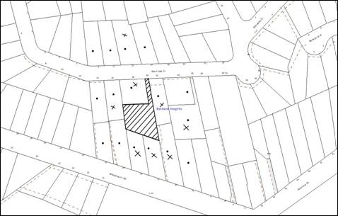
THE SITE
The subject property is an
irregular shaped battleaxe allotment located on the southern side of Warruga Crescent. The allotment slopes towards the rear with an average grade of 11.3% from
the north-western corner to the south-eastern corner. The site has an area of
1151 m2 (1037 m2 excluding access handle).
Access to the property is via a
3.8 metre wide driveway. The current improvement on the site is a single
storey clad dwelling and a detached garage. The gross floor area of the
existing dwelling is 100 m2.
The front section of the site
accommodates a fibro garage which is utilised for storage purposes. Two
retaining walls are located along the width of the property at two levels to
support the land. A number of trees are located in and around the site
including native planted trees and locally indigenous specimens such as Eucalyptus
spp., Callistemon spp., Cupressus spp., Liquidamber spp., Camellia spp.,
Macadamia spp., Syagrus spp. & Baobab spp.
The surrounding land uses
comprise single and two storey residential dwellings. A power pole is located
on the street in close proximity to the driveway entrance. A two-storey
dwelling house is located on the property immediately fronting the site. This
dwelling house overlooks the front yard of the site.
THE PROPOSAL
The proposal involves the
demolition of the garage, the retention of the existing dwelling and the
subdivision of one allotment into two in the following configuration:
· Site area for lot 1:
500 m2 (excluding turning area and access handle); and
· Site area for lot 2:
500 m2 (excluding turning area and access handle).
The floor space ratio of the
existing dwelling on lot 2 would be 0.2:1.
The existing 3.8 metre wide
driveway would provide access to the lots with both allotments having a
reciprocal right-of way (R.O.W). A common turning area is to be provided that
would enable vehicles to enter and exit the site in a forward direction.
Proposed lot 1 would comprise an
irregular shaped battleaxe allotment to be accessed by a shared R.O.W. A
building envelope with a total area of 200 m2 is proposed within
this allotment including provision for two car spaces.
Proposed lot 2 would comprise an
irregular shaped allotment to be accessed by the same R.O.W and would
accommodate the existing dwelling. Two car spaces are proposed to be located on
the south-western side of the dwelling house in a stacked arrangement and a
driveway proposed for access to the car spaces from the common turning area.
The construction the vehicular turning area and driveway would require the
demolition of the existing steps and construction of a retaining wall in front
of the dwelling house. Pedestrian access to the dwelling house from this
turning area would be provided via a set of stairs.
Stormwater drainage from both
allotments would be connected to Council’s drainage system within Woodcourt Road via a 1 metre wide drainage easement within the adjoining allotment (Lot 12
DP 816320). Documentary evidence of the drainage easement has been submitted to
Council.
ASSESSMENT
1. STRATEGIC CONTEXT
1.1 Metropolitan Strategy – (Draft) North Subregional
Strategy
The Metropolitan Strategy is a
broad framework to secure Sydney’s place in the global economy by promoting and
managing growth. It outlines a vision for Sydney to 2031; the challenges
faced, and the directions to follow to address these challenges and achieve the
vision. The draft North Subregional Strategy acts as a framework for Council
in the preparation of a new Principal LEP by 2011.
The draft Subregional Strategy
sets the following targets for the Hornsby LGA by 2031:
· Employment capacity to
increase by 9,000 jobs; and
· Housing stock to
increase by 11,000 dwellings.
The proposed development would be
consistent with the draft Strategy by providing an additional allotment and
would contribute towards housing choice in the locality.
2. STATUTORY CONTROLS
Section 79C(1)(a) requires
Council to consider “any relevant environmental planning instruments, draft
environmental planning instruments, development control plans, planning
agreements and regulations”.
2.1 Section 82A - Environmental Planning and Assessment Act,
1979
The application for review of
Council’s refusal of DA/616/2009 is made pursuant to Section 82A of the Act. In
accordance with the provisions under Section 82A, the applicant may make
amendments to the development. Council is to notify the application and to take
into consideration any submissions in carrying out the review. The
notification and assessment of the application are in accordance with Section
82A.
The submitted plan for the
proposed subdivision of one lot into two is the same plan as previously
considered by Council. The application includes additional information with
regard to the building envelope on proposed Lot 1 and the vehicular swept paths
for proposed lot 2.
Reasons for Refusal
On 4 November 2009, Development
Application No. 616/2009 was refused by Council on the following grounds:
1. The
configuration of the proposed lots does not comply with the “Allotment Design”
element of the Residential Subdivision Development Control Plan.
2. The size
of the proposed lots does not comply with the “Density” element of the
Residential Subdivision Development Control Plan.
3. The
configuration of proposed car parking for the existing dwelling is unacceptable
in that it does not comply with the “Vehicular Access and Parking” element of
the Dwelling House Development Control Plan.
4. The
subdivision would create an unacceptable precedent and is not in the public
interest.
The grounds for refusal of the
application are considered with regard to the additional information submitted
by the applicant under relevant headings as follows:
2.1.1 Allotment Design
The Residential Subdivision
Development Control Plan (RSDCP) requires that subdivisions should result
in useable allotments which provide pleasant streetscapes, maximise energy
efficiency and mitigate environmental impacts.
The proposed shapes of the
allotments are an outcome of the existing dwelling on the site, which is
proposed to be retained. Retention of the existing dwelling is problematic as
it creates irregular shaped allotments that do not strictly comply with the
design standards under the RSDCP. The existing dwelling is old and is
modest in design having a limited life-span. It is anticipated that the
dwelling would be replaced with a more modern dwelling in the short term.
A superior outcome for the site
would be to demolish the dwelling and create more regular shaped allotments.
Notwithstanding this, the applicant has demonstrated that it would be possible
to design two satisfactory dwellings on the lots as currently proposed. The
applicant has submitted additional information which demonstrates that Lot 1 can accommodate a building envelope with a minimum dimension of 10 metres. On that
basis, it is considered that the allotment design satisfies the objectives of
the RSDCP and Item 1 of the grounds for refusal is satisfactorily
addressed.
2.1.2 Density
The proposed allotments comply
with the minimum allotment sizes as prescribed in the Hornsby Shire local
Environmental Plan 1994 (HSLEP). Additionally, the RSDCP
requires allotment sizes to be increased with the slope of the land. Given that
the slope of the land is 11.3 %, the proposed allotment sizes should be a
minimum of 510 – 520 sq metres to comply with the prescriptive measures within
the RSDCP. The proposed allotment size for both lots is 500 sq metres
which does not comply with the requirements of RSDCP.
The section 82A review
application includes the following additional information in support of the
proposal:
“The lots
have an overall gentle grade and do not contain natural or cultural features
that require protection and are not constrained by bushland, drainage or
bushfire risk. The slope of the land poses no significant constraint and does
not limit or restrict their development potential. The proposal demonstrates
that the allotment can comfortably accommodate suitable building envelopes,
ancillary building, private open space, access and car spaces.”
Given the above and that the
proposed allotments can accommodate a reasonably sized dwelling house, a
building envelope and private open space areas in addition to driveways, the
minor non-compliance with regard to allotment sizes within the RSDCP is
considered acceptable. The application satisfactorily addresses Item 2 of the
grounds for refusal.
2.1.3 Vehicular Access
and Parking
Proposed lot 2 includes two hard
stand car spaces in a stacked arrangement within the front and side setback.
The car spaces for both allotments are accessed via an access handle off Warruga Crescent. The following matters have been considered in this regard:
2.1.3.1 Access Handle
The existing access to the site
is via a 3.8 metres wide driveway off Warruga Crescent. The proposal would
retain the use of the access handle to provide access to lots 1 and 2. The
access handle does not comply with the prescriptive measure within RSDCP
which requires a 4 metres wide access to battleaxe allotments including a 3
metre wide pavement and 0.5 metre landscaped area on either side. However, the RSDCP
provides that the 4 metre width of driveway primarily applies to new access
handles and can be varied for existing battleaxe allotments subject to
landscaping being provided on both sides.
The driveway width can
accommodate a 3 metre wide pavement to facilitate vehicle access and would
include 0.4 metre wide landscaped strips on either side of the pavement. Given
that the non-compliance relates to the landscaping strip only and that the
driveway includes existing fences on both sides, this is considered acceptable
and would not result in adverse impact on the neighbouring properties.
2.1.3.2 Car Parking
Council’s Dwelling House
Development Control Plan (DHDCP) requires that car parking be provided behind
the building line. The car parking for lot 2 is proposed in front of the
existing dwelling house, which does not comply with the requirements of the
DHDCP.
The applicant has provided the
following information in support of the application:
“The
requirement to provide a car parking behind the building line is applicable to
traditional subdivision where lots have a road frontage and a predominant
building line is evident. It is submitted that this control has no work to do
in this case where the application is for a subdivision of an existing
battleaxe allotment. There is no building line, nor front setback to consider.
Furthermore,
vehicle swept turning path plans indicate that the parking spaces as shown on
the plan are appropriately designed and can be readily accessed enabling
vehicles to enter and leave the sites in a forward direction. The additional
information provided within Section 82A Review application shows that safe and
convenient access can be provided to parking and meet the requirements of the
DCP.”
An engineering assessment of the
vehicle swept paths, submitted with this application is considered
satisfactory. The proposed parking spaces within Lot 2 are satisfactory and
comply with the objectives of the element “Vehicular Access and Parking” within
the Dwelling House DCP, which require the provision of safe and convenient
parking for residents.
The application satisfactorily
addresses Item 3 of the grounds for refusal.
2.1.4 The Public Interest
The public interest is an
overarching requirement, which includes the consideration of the matters
discussed in this report. Implicit to the public interest is the achievement
of future built outcomes adequately responding to and respecting the future
desired outcomes expressed in environmental planning instruments and
development control plans.
The application is considered to
have satisfactorily addressed Council’s criteria and would provide a
development outcome that, on balance, would result in an acceptable impact.
The minor non-compliance with a limited number of numerical provisions of the
relevant Development Control Plans would not hinder the orderly and economic
use of the land as it would result in two satisfactory dwellings on both the
subdivided allotments.
Accordingly, the proposed
subdivision would not create an undesirable precedent for the locality and it
is considered that the approval of the proposed development would not be
inconsistent with the public interest.
2.2 Hornsby Local Environmental Plan 1994
The subject land is zoned
Residential A (Low Density) zone under Hornsby Local Environmental Plan 1994
(HSLEP). The objectives of the Residential A zone are:
(a) to provide for the housing needs of the population of the
Hornsby area.
(b) to promote a variety of housing types and other land uses
compatible with a low density residential environment.
(c) to provide for development that is within the environmental
capacity of a low density residential environment.
The use is defined as ‘demolition’
and ‘subdivision’ and is permissible within the zone pursuant to Clause
7 of the HSLEP.
The
development would facilitate the provision of housing for the population of the
area and would be compatible with the low density residential environment. In
this regard, the proposal complies with objectives (a) and (b) of the zone.
Though the proposed allotments are irregular in shape, the application
demonstrates that the allotment sizes and shapes are suitable to accommodate
building envelopes, private open space areas, car spaces and driveways
complying with Council’s Residential Subdivision Development Control Plan. The
development is within the environmental capacity of the site and complies with
objective (c) in this regard.
Clause 14 of the HSLEP prescribes
that the minimum size of allotments within the zone is 500 m2. The proposal complies with Clause 14 in this regard.
Clause 15 of the HSLEP prescribes
that the maximum floor space ratio (FSR) of development within the zone is
0.4:1. The proposed FSR for the existing dwelling on proposed allotment 2 is
0.2:1. Therefore, the proposal complies with Clause 15 with regard to the
proposed FSR.
2.3 State Regional Environmental Plan No. 20 – Hawkesbury Nepean River
The application has been assessed
against the requirements of Sydney Regional Environmental Plan No. 20. This
Policy provides controls to protect the environment of the Hawkesbury-Nepean
system, including its water quality. The plan addresses matters related to
water quality, significant vegetation habitats, extraction, environmental
heritage and scenic quality, recreation and tourism, and agriculture.
The proposed development includes a satisfactory stormwater
management plan and is consistent with the objectives of the SREP 20 subject to implementation of
consent conditions regarding erosion and sediment control measures during
construction.
2.4 Residential Subdivision Development Control Plan
The proposed development has been
assessed having regard to the relevant performance and prescriptive design
standards within Council’s Residential Subdivision Development Control Plan
(RSDCP). The following table sets out the proposal’s compliance with the
prescriptive measures of the Plan:
|
Residential
Subdivision Development Control Plan
|
|
Control
|
Proposal
|
Requirement
|
Compliance
|
|
Density
Lot 1
Lot 2
|
500 m2
500 m2
|
510 m2
510 m2
|
No
No
|
|
FSR
Lot 2
|
0.2:1
|
0.4:1
|
Yes
|
|
Site cover
Lot 2
|
23%
|
40%
|
Yes
|
|
Building Envelope
Lot 1
|
200 m2
|
200 m2
|
Yes
|
|
Minimum Dimension
Lot 1
|
7 m
|
10 m
|
No
|
|
Car parking
Lot 1
Lot 2
|
2 spaces
2 spaces
|
2 spaces
2 spaces
|
Yes
Yes
|
|
Private Open Space
Lot 1
Lot 2
|
120 m2
100 m2
|
120 m2
80 m2
|
Yes
Yes
|
|
Landscaping
Lot 1
Lot 2
|
45%
50%
|
45%
45%
|
Yes
Yes
|
|
Width of Access handle
|
3.8 m
|
4 m
|
No
|
|
Setbacks
Lot 1
Front
Eastern
side
Western
side No Yes
Rear
Lot 2
Front
Eastern
side
Western
side No Yes
Rear
|
1m
6 m
7 m
1m
7m
Existing retained
Existing retained
Existing retained
|
1m
1m
1 m
3 m
1m
|
Yes
Yes
Yes
No
Yes
|
The compliance of the proposal
with the objectives, performance criteria and prescriptive measures of the
various elements within Council’s RSDCP are discussed below:
2.4.1 Density
The proposed allotments comply
with the minimum allotment sizes as prescribed in the HSLEP. The RSDCP requires
allotment sizes to be increased with the slope of the land. Given that the
slope of the land is 11.3 %, the proposed allotment sizes should be a minimum
of 510 – 520 sq metres to comply with the prescriptive measures within the
RSDCP. However, given that the proposed allotments can accommodate a reasonably
sized dwelling house, a building envelope and private open space areas in
addition to driveways, the minor non-compliance with regard to allotment sizes
within the RSDCP is considered acceptable.
2.4.2 Design
The proposed shapes of the
allotments are a product of the existing dwelling on the site, which is
proposed to be retained. The existing dwelling is old and is modest in design
having a limited life-span. It is anticipated that the dwelling would be
replaced with a more modern dwelling in the short term.
The proposal to retain the
existing dwelling is problematic in that it creates irregular shaped allotments
that do not strictly comply with the design standards under the RSDCP. A
superior outcome for the site would be to demolish the dwelling and create more
regular shaped allotments. That outcome would make the future design of dwellings
on the land more straight forward.
Notwithstanding the above, it
would still be possible to design two satisfactory dwellings on the lots as
currently proposed. It is on this basis that approval of the application is
recommended. However, should Council consent to the subdivision application,
the land owner is encouraged to give close consideration to amending the
development to achieve a superior subdivision pattern as described above.
The proposal is considered
acceptable, but not ideal with regard to the objectives of the “Allotment
Design” element of the RSDCP.
2.4.3 Setbacks
The proposed allotments satisfy
the DCP standards with regard to building setbacks except for the
non-compliance with the rear setback dimension for proposed lot 1. The current
application is for subdivision and the proposed location of the building
envelope is indicative only. Further, the rear setback area would not be
utilised for private open space purposes. Therefore non-compliance with regard
to the rear setback is acceptable in this instance. The location of any future
dwelling house on the land and the associated setbacks would be assessed under
a separate application.
2.4.4 Solar access
The allotments are north-south
orientated. The private open space areas are proposed to be orientated in a
north-south direction to receive sufficient solar access. The existing
dwelling house is single storey and would not have adverse impact on the
adjoining development with regard to overshadowing.
Any impact of overshadowing due
to a future dwelling on proposed lot 1 would be assessed under a separate
application.
2.4.5 Private Open Space & Landscaping
Both allotments would have
sufficient area suitable for use as private open space. The existing dwelling
would have its private open space located at the rear and to the west. The
location of its private open space would not be impacted upon by overlooking
from adjoining properties.
The applicant has demonstrated
that a suitable private open space area could be provided for proposed Lot 1. The private open space area would not be level and would be partly separated by two
retaining walls. However, the location of the building envelope indicates that
direct access to the outdoor space could be provided in future from the primary
living areas. The details of the useability of the private open area would be
assessed under a separate application for dwelling house on this allotment.
The proposed location and
suitability of the private open spaces and the landscaped areas are considered
satisfactory.
2.4.6 Drainage Control
The application includes a
stormwater management plan, details of a proposed on-site detention system and
calculations demonstrating that the allotments could be connected to the
Council controlled drainage system within Woodcourt Road via a drainage
easement within the adjoining western allotment (No. 16 Woodcourt Road) without
adversely impacting on the adjoining properties.
Council’s engineering assessment
of the application concludes that drainage control on site is satisfactory.
2.4.7 Privacy
The allotment slopes towards the
rear. The existing dwelling house on Lot 2 is single storey and is sufficiently
separated from the dwelling house to the south. No major alterations are
proposed to this dwelling house apart from removal of the existing steps due to
the location of the proposed car turning area. This would not alter the
location of the dwelling house or impact on the privacy of the neighbouring
dwelling houses.
The building envelope on Lot 1 is proposed within the front yard of the site replacing an existing garage. The
adjoining dwelling to the north currently overlooks this section of the site.
It is considered that any proposed dwelling house on this allotment would be
adequately separated from the adjoining developments. The boundary fence would
also restrict any adverse privacy impact on the private open space area.
The proposal is acceptable in its
current form with regard to privacy. However, details of the impact of any
future dwelling house on the privacy of neighbouring properties would be
assessed under a separate application for dwelling house on proposed lot 1.
2.4.8 Access Handle
The existing access to the site
is via a 3.8 metres wide driveway off Warruga Crescent. The proposal would retain
the use of the access handle to provide access to lots 1 and 2. The access
handle would not comply with the prescriptive measure within RSDCP which
requires a 4 metres wide access to battleaxe allotments including a 3 metre
wide pavement and 0.5 metre landscaped area on either side. However, the RSDCP
provides that the 4 metre width of driveway primarily applies to new access
handles and can be varied for existing battleaxe allotments subject to
landscaping being provided on both sides.
The driveway width can
accommodate a 3 metre wide pavement to facilitate vehicle access and would
include 0.4 metre wide landscaped strips on either side of the pavement. Given
that the non-compliance relates to the landscaping strip only and that the
driveway includes existing fences on both sides, this is considered acceptable
and would not result in adverse impact on the neighbouring properties.
2.5 Berowra Cowan
Development Control Plan
The proposed development has been
assessed having regard to the relevant performance and prescriptive design
standards within Council’s Berowra Cowan Development Control Plan. The plan
provides recommendations and guidelines for development within the unique low
density areas of Berowra, Berowra Heights and Cowan and embodies the findings
and recommendations of the Berowra/Cowan Planning Study, conducted in 1994. The
compliance of the proposal with the strategies of this DCP is discussed below:
The ‘Residential Strategy’
of the plan aims to provide a wide range of housing types which are
efficient and sustainable in relation to natural, built and social
environments. The proposal provides opportunities for varying dwelling sizes
and is considered to be sustainable in relation to the natural and built
environment.
The ‘Traffic Services Strategy’
specifies that safe, convenient and efficient movement of people should be
promoted. The proposal complies with this requirement.
2.6 Dwelling House
Development Control Plan
The existing dwelling house on
proposed lot 2 has been assessed having regard to the relevant performance and
prescriptive design requirements of Council’s Dwelling House Development
Control Plan. The proposal does not alter the height or design of the existing
dwelling. The compliance of the dwelling houses with the relevant performance
criteria such as FSR, site cover, privacy, setbacks, private open space, and
landscaping are discussed in Section 2.3 of this report.
2.6.1 Car Parking
Council’s Dwelling House DCP
requires that car parking be provided behind the building line. Proposed lot 2
includes two hard stand car spaces in a stacked arrangement within the front
and side setback and complies with the DCP development standard.
2.7 Car Parking Development Control Plan
The development’s compliance with
the relevant requirements of the Car Parking DCP has been addressed in this
report.
2.8 Sustainable Water
Development Control Plan
Subject to a recommended condition
requiring erosion and sediment control measures to be implemented on site
during construction works, the proposal would comply with the Sustainable Water
DCP.
2.9 Section 94
Contributions Plan
Council’s Section 94 Contributions
Plan applies to the development as one additional allotment is proposed. This
requirement is addressed as a condition of consent.
3. ENVIRONMENTAL IMPACTS
Section 79C(1)(b) of the Act
requires Council to consider “the likely impacts of that development,
including environmental impacts on both the natural and built environments, and
social and economic impacts in the locality”.
3.1 Natural Environment
3.1.1 Trees
The site comprises a number of
exotic and native planted trees and locally indigenous specimens including Eucalyptus
spp., Callistemon spp., Cupressus spp., Liquidamber spp., Camellia spp.,
Macadamia spp., Syagrus spp. & Baobab spp. The proposal would require
the removal of one tree to facilitate the construction of the car spaces within
lot 2.
Council’s assessment of the
proposal included a detailed examination of the existing trees on site and
concluded that none of the trees located within the site are significant and
may be removed for future developments on the proposed allotments. However, the
subdivision application would require the removal of only one tree for driveway
construction within proposed lot 2. Therefore a condition of consent is
recommended requiring the retention of all other trees on site including those
on the neighbouring properties at the subdivision stage.
3.1.2 Water Quality
Subject to conditions requiring
implementation of erosion and sediment control measures on site during
construction works, the proposal would not have an adverse impact on the water
quality of the catchment.
3.2 Built Environment
The impact of the proposed
allotment on the built environment has been addressed in detail within Section
2 of this report.
Council’s engineering assessment
of the traffic impacts of the development is considered satisfactory.
3.3 Social Impacts
The proposal would result in a
positive social impact by improving the housing choice in the locality.
3.4 Economic Impacts
The proposal would result in a
positive economic impact by contributing towards an additional allotment and
dwelling house in the locality.
4. SITE SUITABILITY
Section 79C(1)(c) of the Act
requires Council to consider “the suitability of the site for the
development”.
The site does not constitute
bushfire prone land. The site is suitable for the development.
5. PUBLIC PARTICIPATION
The Section 82A Review
Application was placed on public exhibition and was notified to adjoining and
nearby landowners between 2 September 2009 and 16 September 2009 in accordance
with Council’s Notification and Exhibition Development Control Plan. During
this period, Council received eight submissions. The map below illustrates the
location of those nearby landowners who made a submission that are in close
proximity to the development site.
|
NOTIFICATION
PLAN
|
|
|
• PROPERTIES NOTIFIED
|
X SUBMISSIONS
RECEIVED
|

PROPERTY SUBJECT OF DEVELOPMENT
|

|
|
|
|
|
Eight submissions objected to the
development, generally on the following grounds that the development would
result in:
· Unacceptable Stormwater runoff and
flooding of the downstream properties and Woodcourt Road.
· Encroachment of easement into the
adjoining property at No. 14 Woodcourt Road resulting in adverse impacts.
· Unacceptable impact on the privacy
of the properties located at the lower level.
· Non-compliance with regard to
width and gradient of driveway providing access to the subdivided allotments.
· Undersized allotments in the
locality, given the steep gradient of the site.
· Irregular allotment shapes not
complying with the subdivision pattern of the locality.
· Removal of trees within the site.
· Overshadowing of the adjoining
dwellings due to the new dwelling.
· Increase in the impervious areas
on the site with no useable spaces.
· Unacceptable width of driveway
being less than 4 metres.
· Unacceptable vehicular access and
parking to the site.
· Undesirable precedent for the
area.
· Devaluation of the adjoining
properties.
· Insufficient parking within the
site resulting in on-street parking for visitors to the site and residents.
· Unacceptable increase in noise and
density.
· Restriction of views for the
residence within No. 18 Warruga Crescent.
Additionally the objectors made
the following observations:
· Demolition of the
garage would have adverse impact on the surrounding environment due to possible
presence of asbestos.
· It is unclear
whether the proposed building envelope includes a garage or a carport and
whether that would cause overlooking opportunities.
· The proposed
location of the car spaces would require excavation of the site and
construction of retaining walls. The proposal does not include these details.
The merits of the matters raised
in community submissions have been addressed in the body of the report and
further expanded as follows:
5.1 Drainage Control
The application includes a
Stormwater Management Plan, details of a proposed on-site detention system and
calculations demonstrating that the allotments could be connected to the
Council controlled drainage system within Woodcourt Road via a drainage
easement within the adjoining western allotment (No. 16 Woodcourt Road) without
adversely impacting on the adjoining properties.
Council’s engineering assessment
of the application concludes that drainage control on site is satisfactory
subject to recommended conditions regarding amendment to the layout of the pipe
near Woodcourt Road. In order to maintain the amenity of the adjoining
properties, a condition is recommended to relocate the easement at a distance
of 1 metre from the property boundary of Lot 3 DP 553883 (No. 14) Woodcourt Road, located to the east of No. 16 Woodcourt Road.
Given the above, the proposal
would improve the current drainage situation in the locality and is considered
acceptable.
5.2 Solar Access
The allotments are north-south
orientated. The private open space areas are proposed to be orientated in a
north-south direction to receive sufficient solar access. The existing
dwelling house is single storey and would not have an adverse impact on the
adjoining development with regard to overshadowing.
Any impact of overshadowing due
to a future dwelling on proposed lot 1 would be assessed under a separate application.
5.3 Privacy
The allotment slopes towards the
rear. The existing dwelling house on Lot 2 is single storey and is sufficiently
separated from the dwelling house to the south. No major alterations are
proposed to this dwelling house apart from removal of the existing steps due to
the location of the proposed car turning area. This would not alter the
location of the dwelling house or impact on the privacy of the neighbouring
dwelling houses.
The building envelope on Lot 1 is proposed within the front yard of the site replacing an existing garage. The
adjoining dwelling to the north currently overlooks this section of the site.
It is considered that any proposed dwelling house on this allotment would be
adequately separated from the adjoining developments. The boundary fence would
also restrict any adverse privacy impact on the private open space area.
The proposal is considered
acceptable in its current form with regard to privacy. However, details of the
impact of any future dwelling house on the privacy of neighbouring properties
would be assessed under a separate application for dwelling house on proposed
lot 1.
5.4 Tree Removal
The site comprises a number of
exotic and native planted trees and locally indigenous specimens including Eucalyptus
spp., Callistemon spp., Cupressus spp., Liquidamber spp., Camellia spp.,
Macadamia spp., Syagrus spp. & Baobab spp. The proposal would require
the removal of one tree to facilitate the construction of the car spaces within
lot 2.
Council’s assessment of the
proposal included a detailed examination of the existing trees on site and
concluded that none of the trees located within the site are significant and
may be removed for future developments on the proposed allotments. However, the
subdivision application would require the removal of only one tree for driveway
construction within proposed lot 2. Therefore a condition of consent is
recommended requiring the retention of all other trees on site including those
on the neighbouring properties at the subdivision stage.
5.5 Noise
The proposal would result in one
additional allotment and the increase in the noise would not be significant.
5.6 Restriction of Views
The residence located within No. 18 Warruga Crescent currently overlooks the front yard of the site. Any dwelling house
located within the front allotment in future would be at a lower level than the
adjoining dwelling house and is unlikely to impact upon the views of the
occupants. Details of this matter would be assessed under a separate application
for construction of a dwelling house on this allotment.
5.7 Car spaces
The proposal is for subdivision
of the subject property only. Details of location of car spaces or garage and
the associated excavation within lot 1 would be assessed under a separate
application.
5.8 Asbestos
Recommended conditions of
development consent would ensure the safe removal of asbestos from the site.
CONCLUSION
The applicant has requested that
Council review its decision to refuse DA/616/2009 for the subdivision of one
lot into two lots, retention of the existing dwelling and demolition of the
garage.
The applicant has provided
additional information demonstrating that a suitable building envelope can be
accommodated within proposed lot 1. Vehicular swept paths submitted with the
application demonstrate that the proposed car spaces within lot 2 are safe and
convenient.
The proposed development is
generally consistent with the requirements of Council’s Residential Subdivision
Development Control Plan. The subdivision would result in irregular shaped
allotments. However, the proposal demonstrates that the allotments can
accommodate suitable building envelopes, private open space areas and car
spaces. The minor non-compliance with regard to the dimensions of the building
envelope, setback of the building envelope from the rear boundary and the
provision of a 0.5m landscape strip along the proposed access way do not
warrant refusal of the application as the development is considered to be
acceptable in relation to environmental impacts.
It is recommended that Council
approve the application.
Note: At the time of the completion of this planning report, no
persons have made a Political Donations Disclosure Statement pursuant to
Section 147 of the Environmental Planning and Assessment Act 1979 in respect of
the subject planning application.
|
Rod Pickles
Manager -
Assessment Team 2
Planning Division
|
Paul David
Manager -
Subdivision & Development Engineering Services
Planning Division
|
|
Scott Phillips
Executive Manager
Planning Division
|
|
Attachments:
|
1.View
|
Locality Plan
|
|
|
|
2.View
|
Subdivision Plan
|
|
|
|
3.View
|
Tree Plan
|
|
|
|
4.View
|
Vehicle Swept
Paths
|
|
|
|
5.View
|
Building Envelope
Plan
|
|
|
|
6.View
|
Stormwater
management plan
|
|
|
File Reference: DA/616/2009
Document Number: D01500237
SCHEDULE 1
GENERAL
CONDITIONS
The
conditions of consent within this notice of determination have been applied to
ensure that the use of the land and/or building is carried out in such a manner
that is consistent with the aims and objectives of the relevant legislation,
planning instruments and Council policies affecting the land and does not
disrupt the amenity of the neighbourhood or impact upon the environment.
Note: For the
purpose of this consent, the term ‘applicant’ means any person who has the
authority to act on or the benefit of the development consent.
Note: For the purpose of
this consent, any reference to an Act, Regulation, Australian Standard or
publication by a public authority shall be taken to mean the gazetted Act or
Regulation, or adopted Australian Standard or publication as in force on the
date that the application for a construction certificate is made.
1. Approved
Plans and Supporting Documentation
The
development must be carried out in accordance with the plans and documentation
listed below and endorsed with Council’s stamp, except where amended by Council
and/or other conditions of this consent:
|
Plan No.
|
Drawn by
|
Dated
|
|
Plan of Proposed Subdivision
|
PS Graham and Associates
|
13/08/2010
|
|
Stormwater Concept Plan
|
PS Graham and Associates
|
Received by Council on
21/09/2009
|
2. Removal
of existing Trees
This
development consent only permits the removal of tree numbered T3 as identified
on Plan No. S.14700 prepared by PS Graham and Associates dated 13/08/2010. The removal of any other trees requires
separate approval under Council’s Tree Preservation Order.
3. Amendment
of Plans
The “Stormwater Concept
Plan” approved in condition 1 of this development consent is to be amended as
follows:
a.
The piping layout within Lot 12 DP 816320 (No. 16 Woodcourt Road) is to be
altered as marked in red
b.
The proposed easement through Lot 12 DP 816320 (No. 16 Woodcourt Road) is to be
relocated to a distance of 1 metre from the eastern boundary adjoining Lot 3 DP
553883 (No. 14) Woodcourt Road. The setback is to be maintained along the
entire length of the easement as marked in red in the Stormwater concept Plan.
REQUIREMENTS PRIOR TO THE ISSUE OF A CONSTRUCTION
CERTIFICATE
4. Easement
Over Downstream Land
The proposed
drainage easement over Lot 12 DP 816320 must be registered with the NSW
Department of Lands.
5. Building
Code of Australia
All building
work must be carried out in accordance with the requirements of the Building
Code of Australia.
6. Water/Electricity
Utility Services
The applicant
must submit written evidence of the following service provider requirements:
a. Energy
Australia – a letter of consent demonstrating that satisfactory
arrangements have been made to service the proposed development.
b. Sydney
Water – the submission of a ‘Notice of Requirements’ under s73 of the Sydney
Water Act 1994.
Note: Sydney
Water requires that s73 applications are to be made through an authorised
Sydney Water Servicing Coordinator. Refer to www.sydneywater.com.au or telephone
13 20 92 for assistance.
REQUIREMENTS PRIOR TO THE COMMENCEMENT OF ANY WORKS
7. Erection
of Construction Sign
A sign must
be erected in a prominent position on any site on which building work,
subdivision work or demolition work is being carried out:
a. Showing
the name, address and telephone number of the principal certifying authority
for the work.
b. Showing
the name of the principal contractor (if any) for any demolition or building
work and a telephone number on which that person may be contacted outside
working hours.
c. Stating
that unauthorised entry to the work site is prohibited.
Note: Any
such sign is to be maintained while the building work, subdivision work or
demolition work is being carried out, but must be removed when the work has
been completed.
8. Erosion
and Sediment Control
Erosion and
sediment control measures must be provided and maintained throughout the
construction period in accordance with the manual ‘Soils and Construction
2004 (Bluebook)’, the approved plans, Council specifications and to the
satisfaction of the principal certifying authority. The erosion and sediment
control devices must remain in place until the site has been stabilised and
revegetated.
Note: On
the spot penalties up to $1,500 may be issued for any on-compliance with this
requirement without any further notification or warning.
REQUIREMENTS DURING CONSTRUCTION
9. Construction
Work Hours
All work on site (including demolition and earth works)
must only occur between the following hours:
Monday to Saturday 7 am
to 5 pm
Sunday & Public Holidays No
work
10. Demolition
All
demolition work must be carried out in accordance with Australian Standard
2601-2001 – The Demolition of Structures and the following requirements:
a. Demolition
material is to be disposed of to an authorised recycling and/or waste disposal
site and/or in accordance with an approved waste management plan.
b. Demolition
works, where asbestos material is being removed, must be undertaken by a
contractor that holds an appropriate licence issued by WorkCover NSW in
accordance with Chapter 10 of the Occupational Health and Safety Regulation
2001 and Clause 29 of the Protection of the Environment Operations
(Waste) Regulation 1996.
c. On
construction sites where buildings contain asbestos material, a standard
commercially manufactured sign containing the words ‘DANGER ASBESTOS REMOVAL IN
PROGRESS’ measuring not less than 400mm x 300mm must be erected in a prominent
position visible from the street.
11. Environmental
Management
The site must
be managed in accordance with the publication ‘Managing Urban Stormwater –
Landcom (March 2004) and the Protection of the Environment Operations
Act 1997 by way of implementing appropriate measures to prevent sediment
run-off, excessive dust, noise or odour emanating from the site during the
construction of the development.
12. Works
near Trees
All required
tree protection measures are to be maintained in good condition for the
duration of the construction period.
All works
(including driveways and retaining walls) within four metres of trees numbered
T26, T27A, T27B, T27C, T27D (as marked on the approved plans) required to be
retained (whether or not on the subject property, and pursuant to this consent
or the Tree Preservation Order), must be carried out under the
supervision of an ‘AQF Level 5 Arborist’ and a certificate submitted to
the principal certifying authority detailing the methods used to preserve the
trees.
Note:
Except as provided above, the applicant is to ensure that no excavation,
filling or stockpiling of building materials, parking of vehicles or plant,
disposal of cement slurry, waste water or other contaminants is to occur within
4 metres of any tree to be retained.
REQUIREMENTS PRIOR TO THE ISSUE OF A SUBDIVISION CERTIFICATE
13. Sydney
Water – s73 Certificate
A s73
Certificate must be obtained from Sydney Water.
14. Stormwater
Drainage
The
stormwater drainage system for the development must be designed and constructed
in accordance with Council’s Civil Works – Design and Construction
Specification 2005 and the following requirements:
a. Connected
directly to Council’s street drainage system.
b. An
inter-allotment stormwater drainage system to service the proposed lot with
pits being constructed in situ.
c. The
roof and stormwater drainage system from the existing dwelling to be connected
to the proposed inter-allotment drainage system.
Note: This condition
should be read in conjunction with condition No. 3.
15. Internal
Driveway/Vehicular Areas
The driveway
and parking areas on site must be designed in accordance with Australian
Standards 2890.1, 2890.2, 3727 and the following requirements:
a. The
driveway be a rigid pavement.
b. The
driveway grade must not exceed 25 percent and changes in grade must not exceed
8 percent. Parking and turning areas are not to exceed 5 percent grade.
c. The
driveway pavement be a minimum 3 metres wide, 0.15 metres thick reinforced
concrete with F72 steel reinforcing fabric and a 0.15 metre sub-
d. base.
e. The
existing driveway be removed unless a chartered structural engineer certifies
that it is capable of remaining stable under an 8 tonne traffic loading.
f. The
pavement have a kerb to one side and a one-way cross fall with a minimum
gradient of 2 percent and a lintel and pit provided at the low point.
g. Retaining
walls required to support the carriageway and the compaction of all fill
batters to be in accordance with the requirements of a chartered structural
engineer.
h. The
provision of safety rails where there is a level difference more than 0.3
metres and a 1:4 batter can not be achieved.
i. Planting
of landscaping strips 0.5 metres wide along both sides of the length of the
driveway.
j. Conduit
for utility services including electricity, water, gas and telephone be
provided.
16. Damage
to Council Assets
Any damage
caused to Council’s assets as a result of the construction of the development
must be rectified in accordance with Council’s written requirements and at the
sole cost of the applicant.
17. Creation
of Easements
The following
matter must be nominated on the plan of subdivision under s88B of the Conveyancing
Act 1919:
a. A
right of access and easement for services over the access corridor.
b. An
inter-allotment drainage easement over each of the burdened lots.
c. The
creation of a “Positive Covenant” over the proposed Lot 1 requiring that
any future development is to provide an on-site detention system. The on-site
detention system is to have a storage capacity of 5 cubic metres and a maximum
discharge of 8 litres per second into Council’s drainage system in accordance
with Council’s prescribed wording.
Note: Council
must be nominated as the authority to release, vary or modify any easement,
restriction or covenant.
Note: This condition
should be read in conjunction with condition No. 3.
18. Works
as Executed Plan
A works-as-executed plan(s)
must be prepared by a registered surveyor and submitted to Council for
completed road pavement, kerb & gutter, public drainage systems, driveways
and on-site detention system. The plan(s) must be accompanied by a certificate
from a registered surveyor certifying that all pipelines and associated
structures lie wholly within any relevant easements.
19. Boundary
Fencing
Fencing must
be erected along all property boundaries behind the front building alignment to
a height of 1.8 metres.
Note:
Alternative fencing may be erected subject to the written consent of
the adjoining property owners.
20. s94
Infrastructure Contributions
The payment to Council of a
contribution of $ 19827.80* for one additional lot towards the cost of
infrastructure identified in Council’s Development Contributions Plan 2007-2011
Note: * The
value of contribution is based on a rate of $ 19827.80 per additional lot and
is current as at 5 October 2010. The contribution will be
adjusted from this date in accordance with the underlying consumer price index
for subsequent financial quarters.
It is recommended that you contact Council to ascertain the indexed value of
the contribution prior to payment.
- END OF CONDITIONS -
ADVISORY NOTES
The following information is provided for your
assistance to ensure compliance with the Environmental Planning and Assessment
Act 1979, Environmental Planning and Assessment Regulation 2000, other relevant
legislation and Council’s policies and specifications. This information does
not form part of the conditions of development consent pursuant to Section 80A
of the Act.
Environmental Planning and
Assessment Act 1979 Requirements
· The Environmental Planning and
Assessment Act 1979 requires:
· A construction certificate prior to the
commencement of any works. Enquiries regarding the issue of a construction
certificate can be made to Council’s Customer Services Branch on 9847 6760.
· A principal certifying authority to be
nominated and Council notified of that appointment prior to the commencement of
any works.
· Council to be given at least two days
written notice prior to the commencement of any works.
· Mandatory inspections of nominated
stages of the construction inspected.
· An occupation certificate issued before
occupying any building or commencing the use of the land.
Long Service Levy
In accordance with Section 34 of
the Building and Construction Industry Long Service Payments Act 1986, a ‘Long Service Levy’ must be paid to the Long
Service Payments Corporation or Hornsby Council.
Note: The
rate of the Long Service Levy is 0.35% of the total cost of the work.
Note: Hornsby
Council requires the payment of the Long Service Levy prior to the issue of a
construction certificate.
Tree Preservation Order
To ensure the maintenance and
protection of the existing natural environment, it is an offence to ringbark,
cut down, top, lop, remove, wilfully injure or destroy a tree outside three
metres of the approved building envelope without prior written consent from
Council. Fines may be imposed for non-compliance with Council’s Tree
Preservation Order.
Note: A
tree is defined as a single or multi-trunked wood perennial plant having a
height of not less than three (3) metres, and which develops many branches,
usually from a distance of not less than one (1) metre from the ground, but
excluding any plant which, in its particular location, is a noxious plant
declared as such pursuant to the Noxious Weeds Act 1993. This definition of
‘tree’ includes any and all types of Palm trees.
All
distances are determined British Standard BS 5837: 2005, “Trees in Relation to
Construction – Recommendations”.
Subdivision Certificate
Requirements
A subdivision certificate
application is required to be lodged with Council containing the following
information:
· A surveyor’s certificate certifying that
all structures within the subject land comply with the development consent in
regard to the setbacks from the new boundaries.
· A surveyor’s certificate certifying that
all services, drainage lines or access are located wholly within the property
boundaries. Where services encroach over the new boundaries, easements are to
be created.
· Certification that the requirements of
relevant utility authorities have been met; and
· a surveyor’s certificate certifying finished
ground levels are in accordance with the approved plans.
Note: Council
will not issue a subdivision certificate until all conditions of the
development consent have been completed.
Fees and Charges – Subdivision
All fees payable to Council as part
of any construction, compliance or subdivision certificate or inspection
associated with the development (including the registration of privately issued
certificates) are required to be paid in full prior to the issue of the
subdivision certificate. Any additional Council inspections beyond the scope
of any compliance certificate required to verify compliance with the terms of
this consent will be charged at the individual inspection rate nominated in
Council's Fees and Charges Schedule.
Dial Before You Dig
Prior to commencing any works,
the applicant is encouraged to contact Dial Before You Dig on 1100 or www.dialbeforeyoudig.com.au for
free information on potential underground pipes and cables within the vicinity
of the development site.
Asbestos Warning
Should asbestos or asbestos
products be encountered during demolition or construction works you are advised
to seek advice and information should be prior to disturbing the material. It
is recommended that a contractor holding an asbestos-handling permit (issued by
WorkCover NSW) be engaged to manage the proper handling of the material.
Further information regarding the safe handling and removal of asbestos can be
found at:
www.environment.nsw.gov.au
www.nsw.gov.au/fibro
www.adfa.org.au
www.workcover.nsw.gov.au
Alternatively, telephone the WorkCover
Asbestos and Demolition Team on 8260 5885.
House Numbering
House numbering can only be
authorised by Council. Before proceeding to number each premise in the
development, the allocation of numbers is required to be obtained from
Council's Planning Division. The authorised numbers are required to be
displayed in a clear manner at or near the main entrance to each premise.
Planning Report No. PLN71/10
Date of Meeting:
3/11/2010
2 DEVELOPMENT APPLICATION
- SECTION 82A REVIEW - RESIDENTIAL ALTERATIONS AND ADDITIONS
LOT 11A, DP 409358 DUSTHOLE POINT, BEROWRA CREEK
|
Development Application No:
|
DA/327/2009
|
|
Description of Proposal:
|
Alterations and additions to
an existing dwelling (Section 82A Review)
|
|
Property Description:
|
Lot 11A, DP 409358 Dusthole Point, Berowra Creek
|
|
Applicant:
|
Miss Elyse Grogan
|
|
Owner:
|
Mr Matthew Alan McLennan
|
|
Statutory Provisions:
|
Environmental Protection E
(River Settlements) Zone
|
|
Estimated Value:
|
$ 200,000
|
|
Ward:
|
A
|
|
RECOMMENDATION
THAT Council assume the
concurrence of the Director General of the Department of Planning and approve
Development Application No. 327/2009 for alterations and additions to an
existing dwelling at Lot 11A DP 409358 Dusthole Point Berowra Creek subject
to the conditions of consent detailed in Schedule 1 of this report.
|
1. On
3 February 2010, Council refused under delegated authority, Development
Application No. 327/2009 for alterations to an existing dwelling including the
addition of an upper floor.
2. Pursuant
to Section 82A of the Environmental Planning and Assessment Act, 1979 (the
Act), a request has been made for Council to review its determination.
3. The
proposal does not comply with the floor space ratio development standard
contained in the Hornsby Shire Local Environmental Plan 1994 for the
Environmental Protection E (River Settlements) zone. The applicant’s objection
to the standard, submitted pursuant to State Environmental Planning Policy No.
1 – Development Standards, is considered well founded in accordance with
established legal principle and is supported.
4. The
proposal complies with the Sydney Regional Environmental Plan No. 20 Hawkesbury
Nepean River, the Hornsby Shire Local Environmental Plan 1994 (HSLEP) and is
generally consistent with the River Settlements Development Control Plan. There
is a non compliance with the ‘Height’ and ‘Density’ element of the River
Settlements Development Control Plan, however the non compliances would not
have any significant impact and the variation is supported in this report.
5. No submissions have
been received in respect of the application.
6. It
is recommended that Council changes the determination and approves the
application, subject to conditions.
HISTORY OF THE APPLICATION
On 27 March 2009, DA/327/2009 for alterations and additions
to the existing dwelling house was lodged with Council.
The draft Amendment No. 97 to the
Hornsby Shire Local Environmental Plan 1994 was exhibited in March 2009 for
public comments. Amendment No. 97 to Hornsby Shire Local Environmental Plan
1994 was gazetted in January 2010 which amended the floor space ratio for the
Environmental Protection E Zone from 0.4:1 to 0.3:1. The Amendment did not
include a savings and transitional provision.
On 3 February 2010, Development
Application No. 327/2009 was refused under delegated authority on the following
grounds:
“1. The proposal does not comply with the objective
(b) and (c) of the Environmental Protection E zone. The development does not
accommodate low-density housing in accordance with the environmental
sensitivity and infrastructure limitations of the area and is not within the
environmental capacity of the site.
2. The proposal does not comply with Clause 15 of
the Hornsby Shire Local Environmental Plan 1994 (Amendment No. 97) as it
exceeds the maximum permissible floor space ratio of 0.3:1. An objection under
the State Environmental Planning Policy No. 1 has not been submitted to
Council.
3. The proposal is
unsatisfactory pursuant to section 79C(1)(c) of the Environmental Planning and
Assessment Act 1979 as it fails to demonstrate that the site is suitable for
the proposed development having regard to environmental constraints.
4. The proposal does not comply with Clause 10
“Services” of the Hornsby Shire Local Environmental Plan 1994 as the proposed
subsurface dispersal area is insufficient to cater for the increased
potential effluent volume resulting from an increase in the maximum potential
occupancy of the dwelling.
5. The proposal does not
comply with the element “Effluent Disposal” within Council’s River Settlements
Development Control Plan.
6. The proposal does not
comply with the “Water Quality” and “Environmentally Sensitive Areas Policy”
within Clause 6 and “Sewerage Systems or works” within Clause 11 of the Sydney
Regional Environmental Plan No. 20.
7. The existing septic
tank is partially located within the adjoining property located to the west of
the site (Lot 10 DP 18039). Owners consent from the neighbouring
property has not been provided with the application. The proposal does not
comply with Clause 49 of the Environmental Planning and Assessment Regulation
2000 in this regard.
Having addressed Council’s
reasons for refusal, on 24 August 2010, a request for Council to review its
determination was lodged pursuant to Section 82A of the Act.
THE SITE
The site has an area of 556 sq metres and is located on the southern side of Hawkesbury River, at Dusthole Point. Access to the site is via an existing jetty and
pontoon.
A 2 metre high seawall is
constructed all along the frontage of the property above the Mean High Water
Mark. A set of stairs leads to the first level of the development from the
pontoon. This level includes an in ground swimming pool and an open deck. A 2.5
metre high sandstone retaining wall forms the southern (rear) boundary of this
level area.
The site currently accommodates a
split level dwelling set back at a distance of 5 metres from the river bank.
The dwelling house includes a non-habitable sub floor area with the living
areas being located at the first floor level. A covered open space area is
located on the eastern side of the building. The gross floor area of the
existing dwelling house is 113.8 sq metres.
Developments surrounding the site
consist of one and two storey residential developments of varied style and
scale. A two storey development exists on the northern side of the site located
close to the crest of the river.
THE PROPOSAL
The proposal involves the following:
· Minor internal alterations to the
lower level to include an open plan living, family and study area with a toilet
and kitchen.
· Construction of an upper level to
include a lounge area, three bedrooms and bathrooms and balcony.
· The upper floor would extend further
towards the rear and would rest on poles over an existing rock outcrop
· The roof line would be extended to
cover the existing deck and proposed balcony.
The proposal would result in a gross floor area of 227.8 sq
metres.
ASSESSMENT
The development application has
been assessed having regard to the ‘2005 City of Cities Metropolitan
Strategy’, the ‘North Subregion (Draft) Subregional Strategy’ and
the matters for consideration prescribed under Section 79C of the Environmental
Planning and Assessment Act 1979 (the Act). Subsequently, the following
issues have been identified for further consideration.
1. STRATEGIC CONTEXT
1.1 Metropolitan Strategy – (Draft) North Subregional Strategy
The Metropolitan Strategy is a
broad framework to secure Sydney’s place in the global economy by promoting and
managing growth. It outlines a vision for Sydney to 2031; the challenges
faced, and the directions to follow to address these challenges and achieve the
vision. The draft North Subregional Strategy acts as a framework for Council
in the preparation of a new Principal LEP by 2011.
The draft Subregional Strategy
sets the following targets for the Hornsby LGA by 2031:
· Employment capacity to
increase by 9,000 jobs; and
· Housing stock to
increase by 11,000 dwellings.
The proposed development would be
consistent with the draft Strategy by contributing towards housing choice in
the locality.
2. STATUTORY CONTROLS
Section 79C(1)(a) requires
Council to consider “any relevant environmental planning instruments, draft
environmental planning instruments, development control plans, planning
agreements and regulations”.
2.1 Section 82A Review
The application for review of Council’s
refusal of DA/327/2009 is made pursuant to Section 82A of the Act. In
accordance with the provisions under Section 82A, the applicant may make
amendments to the development. Council is to notify the application and to take
into consideration any submissions in carrying out the review. The
notification and assessment of the application are in accordance with Section
82A.
To address Council’s reasons for
refusal, the submitted plan for the proposed alterations and additions includes
an amendment to the ground floor plan by deleting the study room and
incorporating an open-plan layout. In addition, the applicant has submitted
further information including an objection pursuant to State Environmental
Planning Policy No. 1 (SEPP 1) and an amended on-site sewerage management plan.
The relevant matters are considered in the following sections of this report.
2.2 Hornsby Local Environmental Plan 1994
2.2.1 Clause 7 – Zone
Objectives
The subject land is zoned
Environmental Protection E (River Settlements) Zone under the Hornsby Local
Environmental Plan 1994 (HSLEP). The objectives of the zone are:
(a) To
protect the natural environment of sensitive areas within the catchment of the Hawkesbury River.
(b) To
accommodate low density housing that is consistent with the environmental
sensitivity, infrastructure limitations and access limitations of the area.
(c) To
protect the scenic quality and water quality of the area and promote
development that is within the environmental capacity of the area.
The proposed development is
defined as “dwelling house” under the HSLEP and is permissible in the zone with
Council’s consent.
The proposed addition to the
dwelling would have no significant impact on the environmentally sensitive area
subject to conditions for sediment and erosion controls, waste water management
and excavation procedures. The proposal complies with objective (a) in this
regard.
The proposal would maintain the
low density residential character of the area and would not significantly alter
the building envelope of the dwelling. The amended proposal has reduced the
number of bedrooms and demonstrates that it is within the servicing capacity of
the locality. Therefore, it is assessed as satisfactory against clause (b) the
HSLEP.
The proposal would not
detrimentally impact on the scenic quality of Berowra Creek as the proposed
extension would not be highly visible from the waterfront. The amended proposal
would be within the environmental capacity of the area and would have minimal
impact on water quality subject to conditions. The proposal complies with
objective (c) in this regard.
Given the above, it is considered
that the amended proposal satisfies Item 1 of grounds for refusal.
2.2.2 Floor space ratio
Clause 15 of the HSLEP prescribes
that the maximum Floor Space Ratio (FSR) of development within the
Environmental Protection E (River Catchment) Zone is 0.3:1. The proposed
alterations and additions would result in a FSR of 0.36:1, exceeding the
maximum permissible FSR. The original application did not include an objection
pursuant to State Environmental Planning Policy No. 1 – Development Standards
(SEPP 1) to support the variation.
The section 82A review application
includes an objection pursuant to SEPP 1 in support of the proposal and this is
addressed in Section 2.3 of this report.
2.2.3 Sewage
services
Clause
10 of the HSLEP prescribes that adequate sewerage services be provided for any
development.
The
applicant has provided additional details regarding the proposed septic tank
system on the site. The amended proposal has reduced the number of bedrooms in
order to reduce the total area required for effluent disposal for the
development and provides the details of a suitable effluent management system
on the site. The submitted on-site sewerage management report demonstrates that
100 sq metres of effluent disposal area can be provided at the rear which is
assessed as satisfactory.
Further,
it is also noted in the submitted survey plan that the existing septic tank
within the site is partially located within the neighbouring property to the
west of the site (Lot 10 DP 18039). Owner’s consent from the neighbouring property has been
included in the application as it would require alterations to the septic tank.
Given
the above, it is considered that the amended proposal satisfactorily addresses
the Item Nos. 4 and 7 of the grounds for refusal.
2.3 State Environmental Planning Policy No. 1 – Development
Standards
The application has been assessed
against the requirements of SEPP 1. This Policy provides flexibility in the
application of development standards in circumstances where strict compliance
with those standards would, in any particular case, be unreasonable or
unnecessary or tend to hinder the attainment of the objectives of the Act.
The FSR development standard for
the Environmental E (River Settlements) zone has reduced from 0.4:1 to 0.3:1 as
part of Amendment No. 97 to the HSLEP. The original application was lodged in
March 2009 well before the amendment of the HSLEP on 29 December 2009 and was
under assessment at that time. The amendment did not include savings provisions
for applications lodged prior to the amendment date. The proposal results in a
FSR of 0.4:1. The section 82A Review application includes a SEPP 1 objection
against the adherence to the revised FSR standard.
The Land and Environment Court
has expressed the view that there are five different ways in which an objection
may be well founded and that approval of the objection may be consistent with
the aims of the policy:
1. The objectives of the standard are achieved notwithstanding
non-compliance with the standard;
2. The underlying objective or the purpose of the standard is
not relevant to the development and therefore compliance is unnecessary;
3. The underlying object of purpose would be defeated or
thwarted if compliance was required and therefore compliance is unreasonable;
4. The development standard has been virtually abandoned or
destroyed by the Council’s own actions in granting consents departing from the
standard and hence compliance with the standard would be unnecessary and
unreasonable.
5. The zoning of the particular land is unreasonable or
inappropriate so that a development standard appropriate for that zoning is
also unreasonable and unnecessary as it applies to the land and compliance with
the standard would be unreasonable or unnecessary. That is, a particular parcel
of land should not have been included in the particular zone.
It is considered that the
abovementioned circumstances are relevant matters to consider in respect of
this application.
The objective of the FSR
development standard as stated in the HSLEP is:
‘To control
the intensity and scale of development of land so that development will be in
accordance with the lands environmental capacity and zone objectives’.
The amended proposal would be
consistent with the objectives of the FSR standard of the HSLEP as the proposal
is consistent with the zone objectives of the Environmental Protection E (River
Settlements) zone. Furthermore, the proposal is considered acceptable in terms
of intensity and scale as the additions would not significantly alter the
building footprint of the dwelling. Whilst the proposal exceeds the maximum
permissible floor area, the scale of the development is in keeping with the
bulk, scale and intensity of the surrounding dwellings on Berowra Creek. The
proposed development is considered to be within the environmental capacity of
the site and would have minimal impact on the natural environment subject to
conditions. In this regard the proposal achieves the objectives of the FSR
standard and the non compliance is considered well founded.
The applicant submits that strict
compliance with the FSR requirement is unreasonable and unnecessary for the
following reasons:
· The proposed first
floor addition is compatible with the scale and massing of the existing
dwelling and designed within the existing building footprint.
· The additional
floor area would not impact on the scenic or environmental qualities of the
locality with the proposed addition presenting an acceptable built form for
this waterfront property.
· The proposed
additional floor area is within the existing building footprint and would have
no impact on the natural site features such as existing trees/ vegetation
surrounding the dwelling resulting in minimal impacts (if any) on the water
catchment.
· The proposed first
floor addition would not obstruct water views from the adjoining properties or
the bushland reserve.
· The proposal would
not result in additional amenity impacts to the adjoining residential
properties with regard to overshadowing or loss of privacy. The shadow cast by
the additional floor area falls onto the rear of the subject site and the
adjoining unformed road between 9am and 3pm at mid winter.
· The first floor
addition accommodates bedrooms with the impact on privacy from bedroom windows
not as significant concern as overlooking from living areas.
· The dwelling
subject to the alterations and addition is compatible with the scale and
density of housing in the locality.
· The proposed
alterations and additions to the dwelling meet the Density objective and
performance criteria contained in Part 3 – DCP River Settlements and the Scale
provisions contained in DCP – Dwelling Houses. The bulk and scale of the
dwelling subject to the alterations and additions is consistent with the bulk,
scale and intensity of residential development fronting Berowra Creek.
It is considered that the
applicant’s SEPP 1 submission is well founded and that compliance with the
development standard would be unreasonable and unnecessary in the circumstances
of the case. Accordingly, the SEPP 1 objection is supported and is considered
that the application satisfactorily addresses Item No. 2 of the ground for
refusal of the original application.
2.4 Sydney Regional Environmental Plan No. 20 –
Hawkesbury - Nepean River
The relevant matter of the Sydney
Regional Environmental Plan No. 20 (SREP-20) is discussed below.
2.4.1 Clause 6 - Environmentally Sensitive Areas and
Water Quality
Clause 6 of SREP-20 requires the
quality of environmentally sensitive areas to be protected and adverse impacts
on water quality to be minimised.
Dusthole Point is identified as
an Environmentally Sensitive Area due to its location within the riverine
corridor of the Hawkesbury River, riparian land, vegetation, habitats and
scenic qualities. The proposal, as amended includes
adequate effluent disposal area to cater for this scale of development. To
ensure the protection of the environmentally sensitive areas, conditions have
been recommended regarding excavation and for sediment and erosion control
measures to be implemented.
Subject to conditions the
proposal would have minimal impact on the water quality of the Hawkesbury
Nepean Catchment and is consistent with the strategies of SREP No. 20 with
respect to ‘Environmentally sensitive areas’ and ‘Water Quality’.
2.4.2 Clause 11 - Sewerage
Systems or works
As discussed in Section 2.2.3 of
this report, the application is assessed as satisfactory with regard to the
proposed sewerage system on the site.
In this regard, the application
addresses the Item No. 6 of the grounds for refusal of the original application
satisfactorily.
2.5 River Settlements Development Control Plan
The proposed development has been
assessed having regard to the relevant performance and prescriptive design
standards within Council’s River Settlements Development Control Plan (The
DCP). The following table sets out the proposal’s compliance with the
prescriptive standards of the Plan:
|
River Settlement
Development Control Plan
|
|
Control
|
Proposal
|
Requirement
|
Compliance
|
|
Storeys
|
2
|
2
|
Yes
|
|
Site cover
|
42%
|
30%
|
No
|
|
Setback
Front (River)
Side (west)
Side (east)
Rear building limit
|
5m
Existing unchanged
Existing unchanged
2m – 7m
|
2m
Not specified
|
Yes
Yes
|
The compliance of the proposed development with the relevant
development standards of the DCP are provided below:
2.5.1 Site Cover
The development exceeds the
maximum site coverage on the site. The existing development covers more than 30
% of the site area. The proposed development would result in a minor extension
of the upper floor to the rear of the site which would not be visible from the
river. This extension would result in further non-compliance with the DCP with
regard to site coverage as the site area is only 556 sq metres. Given that the
additional covered area would not visible from any public area or the river,
the non-compliance is considered acceptable.
2.5.2 Design
The proposal involves the
construction of an upper floor and minor alterations to the lower floor of the
building. The extension would increase the height of the building by an
additional storey and the resultant development would have the appearance of a
three storey structure due to the existing elevated
terrace and retaining walls.
However,
it is noted that the development would be two-storey in height when considered
with regard to the existing ground levels and it would not protrude over the
tree canopy. Given that the existing dwellings in close proximity to the
development have similar heights, it is considered that the dwelling would not
be visually obtrusive and would blend with the established character of the
area.
Further
the proposed extension would be set back from the foreshore and would not have
any adverse impact on the absorption capacity of the river. The external
appearance of the additional floor would match the existing dwelling and is
considered acceptable.
2.5.3 Effluent
Disposal
The additional information submitted with the application
with regard to effluent disposal on the site is assessed as satisfactory as
discussed in section 2.2.3 of this report.
It is considered that the application satisfactorily
addresses Item 5 of the grounds for refusal.
3. ENVIRONMENTAL IMPACTS
Section 79C(1)(b) of the Act
requires Council to consider “the likely impacts of that development,
including environmental impacts on both the natural and built environments, and
social and economic impacts in the locality”.
3.1 Natural Environment
3.1.1 Trees
The proposal would not result in the removal of any trees on
the site and would not have a significant adverse impact on the natural
environment of the locality.
4. SITE SUITABILITY
4.1 Bushfire Risk
The land is identified as being subject
to bushfire risk. The proposal was referred to NSW Rural Fire Service for
comments. No objections were raised from the RFS subject to the implementation
of recommended conditions.
4.2 Impact on
environment
The application includes
satisfactory information regarding provision of effluent disposal area on the
site.
The applicant has demonstrated
that the site is suitable for the development and Item 3 of the grounds for
refusal has been addressed satisfactorily.
5. PUBLIC PARTICIPATION
The Section 82A Review
application was placed on public exhibition and was notified to adjoining and
nearby landowners between 9 September and 23 September 2010 in accordance with
Council’s Notification and Exhibition Development Control Plan. During this period,
Council did not receive any submissions. The map below illustrates the
location of those nearby landowners who were notified.
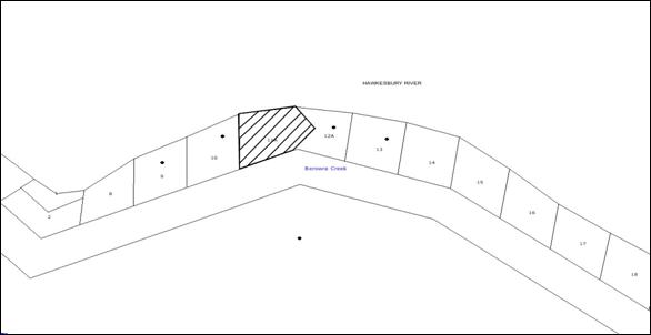
|
NOTIFICATION
PLAN
|
|
|
• PROPERTIES NOTIFIED
|
X SUBMISSIONS
RECEIVED
|
PROPERTY SUBJECT OF DEVELOPMENT
|
|
|
|
|
|
6. THE PUBLIC INTEREST
Section 79C(1)(e) of the Act
requires Council to consider “the public interest”.
The public interest is an
overarching requirement, which includes the consideration of the matters
discussed in this report. Implicit to the public interest is the achievement
of future built outcomes adequately responding to and respecting the future
desired outcomes expressed in environmental planning instruments and
development control plans.
The application satisfactorily
addresses Council’s and relevant agency’s criteria and would provide a
development outcome that, on balance, would result in a positive impact for the
community. Accordingly, it is considered that the approval of the proposed
development would be in the public interest.
CONCLUSION
The proposal involves alterations
to the lower level of an existing dwelling house and addition of an upper
floor. The site has a number of constraints with regard to the steep gradient
and lack of space.
The application does not comply
with the 0.3:1 floor space ratio development standard under the Hornsby Local
Environmental Plan 1994. The Section 82A Review application includes an
objection pursuant to State Environmental Planning Policy No. 1 to support the
variation to the development standard. It is determined that the objection is
well founded and therefore the proposed variation is supported.
The Section 82A Review
application also includes an amended effluent disposal report which is assessed
as satisfactory. The proposal is assessed as satisfactory against Section 79C
of the Act, SREP 20 and is generally consistent with the HSLEP and the River
Settlements Development Control Plan. The proposal does not comply with the
prescriptive measures for ‘Density’ and ‘Height’ in the River Settlements DCP,
however these non compliances would not result in any significant impact and
the variation is supported. The proposal would not result in adverse social,
environmental or economic impacts in the area and approval of the proposal is
recommended.
Note: At the time of the completion of this planning report, no
persons have made a Political Donations Disclosure Statement pursuant to
Section 147 of the Environmental Planning and Assessment Act 1979 in respect of
the subject planning application.
|
Rod Pickles
Manager -
Assessment Team 2
Planning Division
|
Scott Phillips
Executive Manager
Planning Division
|
Attachments:
|
1.View
|
Locality Plan
|
|
|
|
2.View
|
Site and Section
Plans
|
|
|
|
3.View
|
Elevation and
Floor Plan
|
|
|
|
4.View
|
Shadow Plan
|
|
|
|
5.View
|
DA/327/2009 Delegated
Report
|
|
|
File Reference: DA/327/2009
Document Number: D01500613
SCHEDULE 1
GENERAL
CONDITIONS
The
conditions of consent within this notice of determination have been applied to
ensure that the use of the land and/or building is carried out in such a manner
that is consistent with the aims and objectives of the relevant legislation,
planning instruments and Council policies affecting the land and does not
disrupt the amenity of the neighbourhood or impact upon the environment.
Note: For the purpose
of this consent, the term ‘applicant’ means any person who has the authority to
act on or the benefit of the development consent.
Note: For the purpose of
this consent, any reference to an Act, Regulation, Australian Standard or
publication by a public authority shall be taken to mean the gazetted Act or
Regulation, or adopted Australian Standard or publication as in force on the
date that the application for a construction certificate is made.
1. Approved
Plans and Supporting Documentation
The development must be carried
out in accordance with the plans and documentation listed below and endorsed
with Council’s stamp, except where amended by Council and/or other conditions
of this consent:
|
Plan No.
|
Drawn by
|
Dated
|
|
Floor Plans and Elevations- Issue
B
|
Archwood Design
|
26/01/2010
|
|
Site Plan and Section
|
Archwood Design
|
02/12/2008
|
|
Sediment and Erosion Control
Plan
|
Archwood Design
|
Received by Council on
27/03/2009
|
|
Stormwater drainage Plan
|
Kozarovski & Partners
|
30/01/2008
|
|
Survey Plan
|
Base Surveying
|
9/9/2008
|
|
Document No.
|
Prepared by
|
Dated
|
|
BASIX Certificate – A4895
|
NSW Department of Planning
|
5/12/2008
|
|
Bushfire Assessment Report
-90239
|
FPA Australia
|
Received by Council on
27/03/2009
|
|
Effluent Management Report
|
Blue Mountains Geological &
Environmental Services Pty Ltd
|
November
2009
|
|
Amendment to Report for On-Site
Effluent Management
|
Blue Mountains Geo-technical and
Environmental Services Pty Ltd
|
9/02/2010
|
|
Objection Pursuant to SEPP 1
|
Chapman Planning Pty Ltd
|
Received by Council on
24/08/2010
|
|
Schedule of Finishes
|
-
|
Received by Council on
27/03/2009
|
2. Removal
of Existing Trees
This
development consent does not permit the removal of any trees on the site. The
removal of any other trees requires separate approval under Council’s Tree
Preservation Order.
REQUIREMENTS PRIOR TO THE ISSUE OF A CONSTRUCTION
CERTIFICATE
3. Building
Code of Australia
All building work must be
carried out in accordance with the requirements of the Building Code of
Australia.
4. Contract
of Insurance (Residential Building Work)
In the case of residential
building work for which the Home Building Act, 1989 requires there to be
a contract of insurance in force in accordance with Part 6 of that Act, that
such a contract of insurance is in force before any building work authorised to
be carried out by the consent commences.
Note: This
condition does not apply to the extent to which an exemption is in force
under Clause 187 or 188 of the Act, subject to the terms of any condition or
requirement referred to in Clause 187(6) or 188(4) of the Act, or to the
erection of a temporary building.
5. Notification
of Home Building Act, 1989 Requirements
Residential building work within
the meaning of the Home Building Act, 1989 must not be
carried out unless the principal certifying authority for the development to
which the work relates (not being Council) has given Council written notice of
the following information:
a. In
the case of work for which a principal contractor is required to be appointed:
i. The
name and licence number of the principal contractor.
ii. The
name of the insurer by which the work is insured under Part 6 of that Act.
b. In
the case of work to be done by an owner-builder:
i. The
name of the owner-builder.
ii. If
the owner-builder is required to hold an owner-builder’s permit under that Act,
the number of the owner-builder’s permit.
Note: If
arrangements for doing the residential building work are changed while the work
is in progress so that the information notified becomes out of date, further
work must not be carried out unless the principal certifying authority for the
development to which the work relates (not being Council) has given Council
written notification of the updated information.
REQUIREMENTS PRIOR TO THE COMMENCEMENT OF ANY WORKS
6. Erection
of Construction Sign
A sign must
be erected in a prominent position on any site on which building work,
subdivision work or demolition work is being carried out:
a. Showing
the name, address and telephone number of the principal certifying authority
for the work,
b. Showing
the name of the principal contractor (if any) for any demolition or building
work and a telephone number on which that person may be contacted outside
working hours, and
c. Stating
that unauthorised entry to the work site is prohibited.
Note: Any
such sign is to be maintained while the building work, subdivision work or
demolition work is being carried out, but must be removed when the work has
been completed.
7. Erosion
and Sediment Control
Erosion and
sediment control measures must be provided and maintained throughout the
construction period in accordance with the manual ‘Soils and Construction
2004 (Bluebook)’, the approved plans, Council specifications and to the
satisfaction of the principal certifying authority. The erosion and sediment control
devices must remain in place until the site has been stabilised and
revegetated.
Note: On
the spot penalties up to $1,500 may be issued for any non-compliance with this
requirement without any further notification or warning.
REQUIREMENTS DURING CONSTRUCTION
8. Construction
Work Hours
All
work on site (including demolition and earth works) must only occur between 7am
and 5pm Monday to Saturday.
No
work is to be undertaken on Sundays or public holidays.
9. Demolition
All demolition work must be carried
out in accordance with Australian Standard 2601-2001 – The Demolition of
Structures and the following requirements:
a. Demolition
material is to be disposed of to an authorised recycling and/or waste disposal
site and/or in accordance with an approved waste management plan.
b. Demolition
works, where asbestos material is being removed, must be undertaken by a
contractor that holds an appropriate licence issued by WorkCover NSW in
accordance with Chapter 10 of the Occupational Health and Safety Regulation
2001 and Clause 29 of the Protection of the Environment Operations
(Waste) Regulation 1996.
c. On
construction sites where buildings contain asbestos material, a standard
commercially manufactured sign containing the words ‘DANGER ASBESTOS REMOVAL IN
PROGRESS’ measuring not less than 400mm x 300mm must be erected in a prominent
position visible from the street.
10. Environmental
Management
The site must
be managed in accordance with the publication ‘Managing Urban Stormwater –
Landcom (March 2004) and the Protection of the Environment Operations
Act 1997 by way of implementing appropriate measures to prevent sediment
run-off, excessive dust, noise or odour emanating from the site during the
construction of the development.
11. Works
near Trees
All required
tree protection measures are to be maintained in good condition for the
duration of the construction period.
All works
(including driveways and retaining walls) within four metres of any trees
required to be retained (whether or not on the subject property, and pursuant
to this consent or the Tree Preservation Order), must be carried out
under the supervision of an ‘AQF Level 5 Arborist’ and a certificate
submitted to the principal certifying authority detailing the method(s) used to
preserve the tree(s).
Note:
Except as provided above, the applicant is to ensure that no excavation,
filling or stockpiling of building materials, parking of vehicles or plant,
disposal of cement slurry, waste water or other contaminants is to occur within
4 metres of any tree to be retained.
12. Disturbance
of Existing Site
During
construction works, the existing ground levels of open space areas and natural
landscape features, (including natural rock-outcrops, vegetation, soil and
watercourses) must not be altered unless otherwise nominated on the approved
plans.
13. Council
Property
During construction works, no building
materials, waste, machinery or related matter is to be stored on the unformed
road at the rear of the site. The public reserve is to be kept in a clean,
tidy and safe condition at all times.
REQUIREMENTS PRIOR TO THE ISSUE OF AN OCCUPATION
CERTIFICATE
Note: For the
purpose of this consent, any reference to ‘occupation certificate’ shall also
be taken to mean ‘interim occupation certificate’ unless otherwise stated.
14. Fulfilment
of BASIX Commitments
The applicant must demonstrate
the fulfilment of BASIX commitments pertaining to the development.
15. Stormwater
Drainage – Land Adjoining a Watercourse
In addition to other stormwater drainage requirements
under this consent, all headwall outlets must incorporate flow velocity
reduction controls (i.e. bedded boulders and small stones) to minimise erosive
and scouring impacts to the watercourse. Energy dissipater controls must be
landscaped to accommodate outlet sheet flow (forced jump). No engineering
works are permitted within the bed of the watercourse.
16. Smoke
Alarms – Dwelling Additions
Smoke alarms must be installed
in the existing building and the proposed additions in accordance with the requirements
of the Building Code of Australia.
17. Wastewater
System Approval
An on-site sewage management system, separately
approved under the Local Government Act 1993, must be installed, commissioned
and certified by a licensed plumber in accordance with Australian Standard 1547
– Onsite Domestic Wastewater Management (2000) and Environment & Health
Protection Guidelines – Onsite Sewage Management for Single Households (1998).
The site must include 100 sq metres of effluent
disposal area at the rear of the dwelling house.
CONDITIONS OF CONCURRENCE – NEW RURAL FIRE
SERVICE
The following conditions of consent are from the nominated
State Agency pursuant to Section 79B of the Environmental Planning and
Assessment Act 1979 and must be complied with to the satisfaction of that
Agency.
18. Asset
Protection Zone
To allow
emergency service personnel and residents to undertake property protection
activities, a defendable space that permits unobstructed pedestrian access is
to be provided around the building.
19. Water
and Utilities
The intent of this measure is to minimize bushfire attack
and provide protection for emergency services personnel, residents and others
assisting in the fire fighting activities:
a. A
5000 litre water supply tank be provided for fire fighting purposes (Refer to
Fast Facts 3/08 “water Supply for Fire Fighting Purposes)
b. A
minimum 3 kw (5 hp) petrol or diesel powered fire fighting pump is to be
provided to reach all areas of the building. A 19 mm (internal diameter) fire
hose and reel is to be connected to the pump.
Note: The
above water source may be used for other purposes and allow for circulation of
fresh water to avoid health issues provided the tank is kept full
20. Design
and Construction
The intent of
measures is to ensure buildings are designed and constructed to withstand
potential impacts of bushfire attack. The following design standards must be
incorporated into the development:
a. New
Construction of the southern elevation of the building must be constructed to
comply with Level 3 construction in accordance with Australian Standard AS
3959-1999 ‘Construction of buildings in bushfire prone areas’.
b. Roofing
must be gutterless or the guttering and valleys screened to prevent build up of
flammable material.
c. Any
material used must have a Flammability Index no greater than 5 when tested in
accordance with Australian Standard AS 1530.2 – 1993 ‘Methods for Fire Tests on
Building Materials, Components and Structures – Test for Flammability of
Materials.’
d. All
exposed timber used in the development be of a fire resistant species as
identified in RFA Development Control Note 001. These species include:
Blackbutt, Kwila, Red Iron Bark, Red River Gum, Silver Top Ash, Spotted Gum and
Turpentine
e. The
screens of all existing windows on the southern elevation must be upgraded to
comply with Australian Standard 3959-1999 ‘Construction of buildings in
bushfire prone areas’ – Level 3. The screen must be placed over the
openable section of the windows.
f. The
northern, eastern and western elevation of the dwelling house must be upgraded
to comply with AS 3959-1999 ‘Construction of buildings in bushfire prone
areas’ – Level 2.
-
END OF CONDITIONS -
ADVISORY NOTES
The following information is provided for your
assistance to ensure compliance with the Environmental Planning and Assessment
Act, 1979, Environmental Planning and Assessment Regulation 2000, other
relevant legislation and Council’s policies and specifications. This
information does not form part of the conditions of development consent
pursuant to Section 80A of the Act.
Environmental Planning and Assessment Act, 1979
Requirements
· The Environmental Planning and
Assessment Act, 1979 requires:
· The issue of a construction certificate
prior to the commencement of any works. Enquiries regarding the issue of a
construction certificate can be made to Council’s Customer Services Branch on
9847 6760.
· A principal certifying authority to be
nominated and Council notified of that appointment prior to the commencement of
any works.
· Council to be given at least two days
written notice prior to the commencement of any works.
· Mandatory inspections of nominated
stages of the construction inspected.
· An occupation certificate to be issued
before occupying any building or commencing the use of the land.
Long Service Levy
In accordance with Section 34 of the Building and
Construction Industry Long Service Payments Act 1986, a ‘Long Service Levy’ must be paid to the Long Service
Payments Corporation or Hornsby Council.
Note: The
rate of the Long Service Levy is 0.35% of the total cost of the work.
Note: Hornsby
Council requires the payment of the Long Service Levy prior to the issue of a
construction certificate.
Tree Preservation Order
To ensure the maintenance and
protection of the existing natural environment, it is an offence to ringbark,
cut down, top, lop, remove, wilfully injure or destroy a tree outside 3 metres
of the approved building envelope without the prior written consent from
Council.
Note: A
tree is defined as a single or multi-trunked wood perennial plant having a
height of not less than three (3) metres, and which develops many branches,
usually from a distance of not less than one (1) metre from the ground, but
excluding any plant which, in its particular location, is a noxious plant
declared as such pursuant to the Noxious Weeds Act 1993. This definition of ‘tree’
includes any and all types of Palm trees.
All
distances are determined under British Standard BS 5837: 2005, “Trees in
Relation to Construction – Recommendations”.
Fines may be imposed for
non-compliance with Council’s Tree Preservation Order.
Covenants
The land upon which the subject
building is to be constructed may be affected by restrictive covenants.
Council issues this approval without enquiry as to whether any restrictive
covenant affecting the land would be breached by the construction of the
building, the subject of this consent. Applicants must rely on their own
enquiries as to whether or not the building breaches any such covenant.
Dial Before You Dig
Prior to commencing any works,
the applicant is encouraged to contact Dial Before You Dig on 1100 or www.dialbeforeyoudig.com.au for
free information on potential underground pipes and cables within the vicinity
of the development site.
Standard Report No. PLN76/10
Planning Division
Date of Meeting:
3/11/2010
3 WAHROONGA (NORTH)
HERITAGE CONSERVATION AREA
EXECUTIVE SUMMARY
In
August 2005, Council considered a report concerning the establishment of the
Wahroonga (North) Heritage Conservation Area. Council deferred the progression
of the Conservation Area based on advice from the Department of Planning (DOP)
that the establishment of heritage conservation areas should be investigated as
part of a comprehensive Local Environmental Plan (LEP).
Council’s
heritage consultant has reviewed the merits of progressing the Conservation
Area and generally concurs that the area has local heritage significance. The
Review recommends that the Wahroonga (North) area be listed as a heritage
conservation area under Schedule E (Heritage Conservation Areas)
of the Hornsby Shire Local Environmental Plan (HSLEP) 1994.
It is
recommended that Council endorse the Wahroonga (North) Heritage
Conservation Area Planning Proposal attached to this report for
submission to the DOP for gateway determination and exhibition.
PURPOSE
The purpose
of this report is to present the findings of a review of the Wahroonga (North)
Heritage Conservation Area Study and to seek Council’s endorsement to submit
the Wahroonga (North) Heritage Conservation Area Planning Proposal
to the DOP for gateway determination and exhibition.
BACKGROUND
In September 2003, Council was presented with a petition
from 128 local residents requesting that a draft LEP be prepared to protect the
heritage and streetscape qualities of Wahroonga in the area bounded by Myra Street, Alexandria Parade, Edgeworth David Avenue and the F3 Freeway (locality plan
attached). Council resolved (in part) that a report be prepared outlining the
merits and process involved in preparing a draft LEP to protect the heritage
and streetscape qualities of the area.
At its meeting on 5 November 2003, Council considered
Executive Manager’s Report No. PLN368/03 outlining the merits and process
involved in undertaking a heritage study and sought endorsement of a Study
Brief for the review. Council resolved (in part) that:
a) Council
undertake a heritage assessment to determine whether the Wahroonga (North) area
is of heritage significance; and
b) A report be
submitted to Council recommending a consultant to undertake the study together
with a further report on funding availability.
In August 2004, Council resolved
to appoint heritage consultant Godden Mackay Logan (GML) to undertake a review
of the heritage potential of the proposed Wahroonga (North) Heritage
Conservation Area. On 17 August 2005, Council considered Executive Manager’s
Report No. PLN224/05 presenting the findings of the Wahroonga (North)
Heritage Conservation Area Review (GML Study) assessing the heritage
significance and streetscape qualities of the Wahroonga (North) Study Area. The
GML Study (copy attached) recommends the establishment of a
heritage conservation area including the identification of a number of
potential heritage items. Council resolved (in part) to:
a) Prepare a draft LEP to establish the
Wahroonga (North) Heritage Conservation Area in accordance with the recommendations
of the GML Study; and
b) Seek the advice of the Department
concerning whether the progression of the draft Plan was likely to be
supported.
In accordance with Council’s resolution, Council sought the Department’s
support for progression of the draft Plan. In September 2005, the Department
advised that the establishment of the heritage conservation area should not be
progressed as an amendment to the HSLEP 1994, rather that it should be
investigated as part of Council’s Comprehensive LEP. At its meeting on 2
November 2005, Council resolved (in part) to defer the establishment of the
Wahroonga (North) Heritage Conservation Area and investigate the
heritage conservation area for inclusion in Council’s Comprehensive LEP.
In August 2006, the Minister for
Planning advised that draft LEPs for Heritage Conservation Areas would not be
progressed until Council’s targets for the Subregion have been finalised as
part of the Metropolitan Strategy and preparation of the Subregional
Strategy. Council’s Housing Strategy,
to identify precincts for increased residential densities to meet Council’s
dwelling targets under the Metropolitan Strategy, is currently with the
DOP awaiting gazettal.
Heritage
Review Stage 4 was conducted in 2008 and reviewed items proposed for
inclusion or deletion from heritage listing, including items recommended by the
GML Study. The recommendations from Heritage Review Stage 4 were
incorporated into the Annual Amendments 2009 Planning Proposal. The Planning
Proposal is currently with the DOP awaiting gazettal and includes the
heritage listing of the following items within Wahroonga (North):
· 15 Ingalara Avenue (House);
· 22 Ingalara Avenue (House);
· 79 Alexandria Parade (House and fence);
· 58-60 Bundarra Avenue (House and
garden); and
· 64 Bundarra Avenue (House).
Given the time that has elapsed since the GML Study
was completed, Council’s heritage consultant, Sue Haertsch Planning, was
requested to review the findings and recommendations of the GML Study
having regard to developments in the area since 2005, applying current best
practice methods.
DISCUSSION
This
report discusses the major findings of the review of the GML Study
conducted by Council’s heritage consultant and presents a planning proposal to
implement the recommendations from the studies.
GML
Study
The GML
Study was conducted in 2005 and assesses the heritage and streetscape
qualities of the Wahroonga (North) area using the criteria set out at
that time by the Heritage Council of NSW. The GML Study determines that
the area, as a whole, demonstrates local historic significance for its compact,
representative demonstration of major themes and development periods in the
history of the Shire.
The Statement of Significance prepared as part of the GML Study,
refers to the distinctive qualities and retained integrity of the areas diverse
subdivision pattern, streetscapes and houses, within a bush suburban setting.
The Statement of Significance notes that these features support its recognition
and management as a heritage conservation area. Furthermore, the Study Area
retains its original subdivision pattern which contributes to the established
streetscape of the area.
The area also retains an
illustrative collection of housing periods and styles particularly between the
1930s and 1950s. Notable houses include the Horbury Hunt designed Hordern
Family residence, The Highlands. The endurance of this large estate
delayed further subdivision of the area and shaped the street pattern.
Significant numbers of inter-war and post-war bungalows, such as those in Ingalara Avenue, also feature in the distinctive character of the area.
In addition to a number of
existing heritage items contained within the Study Area, the GML Study
identifies a significant number of contributory dwellings and potential items,
which add to the overall significance and setting of the area. The GML Study
recommends these contributory dwellings be retained within a designated
heritage conservation area and the listing of the potential items.
The GML
Study recommends that Council establish the area bounded by Myra Street, Alexandria Parade, Edgeworth David Avenue, Wahroonga and the F3 Freeway, as a
heritage conservation area under Schedule E (Heritage Conservation Areas)
of the HSLEP 1994. The GML Study also recommends that Council
amend the development controls contained within the Heritage Development
Control Plan (DCP) to ensure the controls reflect best practice and
provide for the conservation of important heritage values within the area.
The
Review
Council
has submitted its Housing Strategy to the DOP to address its housing
obligations under the Metropolitan Strategy and North Subregional
Plan. The Strategy does not include the rezoning of lands within the
Wahroonga (North) area. Accordingly, it is timely for Council to review the
progression of the heritage conservation for the area. It is also prudent that
the GML Study recommendations be reviewed for currency in the context of
development approvals within the area since the GML Study was finalised
in 2005. In addition to drawing upon the background information provided within
the GML Study, the Wahroonga (North) Heritage Conservation Area
Review (Review) by Council’s heritage consultant also incorporates:
· recent inspections of the area;
· review of development approvals and court decisions since
2005;
· review of sites identified as contributory within the GML
Study;
· review of opportunities and threats in the context of
heritage and/or streetscape qualities of the area; and
· the application of current best practice heritage methods.
The
Review (copy attached) generally concurs with the findings of the GML
Study. However, in respect of character and streetscape, the Review
identifies distinctions between the northern and southern areas of Wahroonga
(North). This differs from the GML Study, which discusses the area as a
whole. The Review identifies a Southern Precinct, bounded by the south
side of Oleander Road, Fern Avenue, the F3 Freeway, Alexandria Parade and Myra Street, representing an earlier phase of development and history in the area. This
precinct is predominately large, two story houses characteristic of Federation
and Inter War styles on large irregular lots. A Northern Precinct bounded by Edgeworth David Avenue, the F3 Freeway, Fern Avenue, Myra Street and Oleander Road, is
characterised by small, single storey houses characteristic of the
Interwar/Post War style on regular lots.
Analysis
of Heritage Significance
The
statement of significance prepared as part of the Review includes those
elements provided by the earlier GML Study. However, greater detail is
provided concerning the heritage assessment criteria within the NSW Heritage
Manual. The revised statement provides a stronger basis for the assessment
of future works within the area.
The
Review and the GML Study both use the criteria within the NSW
Heritage Assessment Manual to determine the heritage significance of the area.
The Review generally concurs with the GML Study that the area has
local heritage significance in relation to historic significance,
aesthetic/creative, research and rarity criterion. Although the Review
finds the proposed conservation area has historic associative significance,
little evidence was found to support the GML Study’s reference to the
late Robert Klippel. The Review supports the GML Study findings
that the proposed conservation area has local representative significance, but
makes more specific reference to the primary development and building phases of
the area. In reviewing the social significance at a local level, the Review
notes that there is insufficient evidence to meet this criterion.
Analysis
of Contributory Items
The
Review provides a building contribution analysis of heritage items, and confirms
the location of potential heritage items and contributory items (map of Study
area attached). The Review also identifies ‘neutral’ buildings which do
not contribute to the significance of the area. The analysis undertaken for the
GML Study bases the assessment on the elements and buildings that
contribute to the significance of the area. The Review uses current best
practice methods which rely on contribution ratings, placing greater emphasis
on significant building phases and historical periods within the area.
The
Review concurs with the recommendations for listing of potential heritage
items in the GML Study. These potential items are currently being
progressed as part of the Annual Amendments 2009 Planning Proposal. As a
result of development having been completed since 2005, the Review
identifies a smaller number of contributory buildings. However, the Review
states that the reduced number still contribute significantly to the character
of the area.
Review
Recommendations
The
Review confirms the recommendation of the GML Study that the
Wahroonga (North) area should be listed as a heritage conservation area,
as it meets the criteria and objectives for
inclusion. The Review also recommends that the area be divided into two
precincts, Northern and Southern, and that appropriate development controls be
tailored to reflect the differing historic subdivision patterns and building
stock of the precincts.
Along
with the matters identified in the GML Study, the Review
recommends appropriate controls be progressed to address housing form, gardens
and streetscape, including:
· avoiding changes to driveways and the like where mature
trees could be affected;
· retention of single storey, modest scale dwellings within
the Northern Precinct; and
· flexibility to permit two storey dwellings within the
Southern Precinct, where it can be demonstrated that the new building is
complemented by an appropriate landscaped setting.
Planning
Proposal
The Review
and GML Study both recommend that the Wahroonga (North) area be listed
as a heritage conservation area. Council is currently preparing its new
Comprehensive LEP, which is a translation of controls within the HSLEP 1994 in
accordance with DOP’s Standard Instrument. The establishment of a
heritage conservation area as part of the Comprehensive LEP would be outside
the scope of the translation. Furthermore, the establishment of a conservation
area has not been the subject of recent community consultation and the position
of the Department is uncertain in relation to the progression of the
conservation area. To ensure that consideration of the heritage qualities of
the area does not delay the progression of Council’s Comprehensive LEP, a
separate planning proposal has been prepared for consideration by Council to progress
the heritage conservation area.
CONSULTATION
Extensive community consultation
was previously undertaken as part of the GML Study. However, it has been
five years since the GML Study was finalised and there have been a
number of changes in ownership within the area. Accordingly, it is appropriate
to undertake further consultation with the community regarding the
establishment of the heritage conservation area.
“A guide to preparing local
environmental plans” has been prepared by the DOP (2009) to assist councils
in preparing planning proposals and LEPs. In accordance with the Guidelines,
the Planning Proposal is considered to be “low impact” and the Guidelines
recommend exhibition for a period of 14 days. However, it has been a
considerable time since the GML Study was finalised. Therefore, it is
appropriate to exhibit the Planning Proposal for a period of 28 days. A
consultation strategy relevant to the public exhibition of the draft LEP has
been prepared as part of the Planning Proposal for endorsement by the
DOP.
Following the exhibition period,
a report on submissions would be presented to Council for its consideration.
STATUTORY
CONSIDERATIONS
Statutory
considerations are discussed below in relation to both the progression of a
planning proposal and DCP amendments.
Planning
Proposals
The
draft Wahroonga (North) Heritage Conservation Area Planning Proposal
(attached) outlines the objectives, intended outcomes and justification for the
proposal, along with a map identifying the boundary of the proposed heritage
conservation area and a consultation strategy for endorsement by the DOP. It is
recommended that Council facilitate the exhibition of the attached Planning
Proposal by forwarding it to the DOP seeking a gateway determination.
As part
of the consideration of planning proposals, Council is required to consider the
relevance of any State Environmental Planning Policy (SEPP) or Ministerial
Direction under Section 117 of the Environmental Planning and Assessment
Act, 1979. The proposal is not contrary to any SEPP or relevant Section 117
Directions. An assessment of relevant SEPPs and Section 117 Directions is
contained in the Planning Proposal.
DCP
Amendments
The GML
Study and the Review recommend
appropriate controls be progressed regarding housing form, gardens and
streetscape, to support the heritage conservation area. As the position
of the Department is uncertain in relation to the progression of the
conservation area, it would be appropriate to receive gateway determination for
the proposal prior to extensive work being undertaken on developing controls. Accordingly, it is recommended that controls for the area
be incorporated into the heritage section of the Comprehensive DCP, which would
be progressed concurrently with the proposal.
OPTIONS
Council
has before it the following options:
Option
1 – Progress the Wahroonga (North) Heritage Conservation Area Planning Proposal
This
option is to progress the Planning Proposal to establish a heritage
conservation area for Wahroonga (North) in accordance with the recommendations
of the GML Study and the Review, by
forwarding the Planning Proposal to the DOP seeking a gateway
determination.
Option
2 – Not progress the Wahroonga (North) Heritage Conservation Area Planning
Proposal
This option
is not to progress the Planning Proposal to establish a heritage
conservation area within Wahroonga (North). This option would be in recognition
of a number of alteration and additions to contributory items identified by the
GML Study. An appropriate resolution for this option would be:
1. Council note the contents of
Executive Manager’s Report No. PLN76/10 and the Review undertaken by Sue
Haertsch Planning regarding the Wahroonga (North) Heritage Conservation Area
Review.
2. Council not progress a Planning
Proposal to establish the Wahroonga (North) Heritage Conservation Area due to
recent developments within the area.
Two reviews investigating the
heritage significance of the area have been undertaken by heritage consultants.
Both reviews recommend that the area be listed as a heritage conservation area
under Schedule E (Heritage Conservation Areas) of the HSLEP 1994,
as the area meets the criteria and objectives for inclusion. Accordingly, based
on the recommendation of the reviews, option 1 is recommended.
TRIPLE BOTTOM LINE SUMMARY
Triple Bottom Line is a
framework for improving Council decisions by ensuring accountability and
transparency on social, environmental and economic factors. It does this by
reporting upon Council’s strategic themes.
· Working with our community:
The GML Study involved community information meetings and Council sought
comments and feedback concerning the preliminary fieldwork results, the Study
and the potential heritage conservation area. A consultation strategy has been
prepared as part of the Planning Proposal for endorsement by the DOP. It
is proposed that public exhibition material would be readily accessible and
understandable to all sectors of the community by providing a number of
locations and means of communication. The community would be able to obtain
hard copy information from Council or download information from Council or the
DOP’s website.
· Conserving our natural environment:
The Planning Proposal would assist to conserve identified areas of
heritage significance within the Shire.
· Contributing to community
development through sustainable facilities and services: The Proposal
to implement a heritage conservation area does not relate directly to the
provision of services and facilities. Accordingly, no adverse impact on
opportunities for community development would be expected.
· Fulfilling our community’s vision
in planning for the future of the Shire: The establishment of the heritage
conservation area as recommended within the Review would ensure that
important heritage values within the Shire are conserved.
· Supporting our diverse economy: The
Review recommends the progression of the heritage conservation area to
retain important character elements and heritage values to enhance the
attractiveness of the Shire as a place to live and work.
· Maintaining sound corporate and
financial management: The Proposal does not relate directly to corporate
and financial management. Accordingly, no adverse impact on management
principles would be expected.
· Other
Sustainability Considerations: The Proposal would not have an
adverse impact on the environment of the Shire.
CONCLUSION
In
2005, GML undertook a study to assess the heritage and streetscape qualities of
the Wahroonga (North) area. Council’s heritage consultant has completed a
review of the GML Study to determine the relevancy of the previous
recommendation in respect of recent developments within the area, using current
best practice methods. The Review generally concurs with the findings of
the GML Study that the area has local significance in regard to
historic, historic associative, aesthetic/creative, research, rarity and
representativeness elements.
The
Review supports the recommendation of the GML Study that the
Wahroonga (North) area be listed as a heritage conservation area under Schedule
E (Heritage Conservation Areas) of the HSLEP 1994, as it meets the criteria and objectives for inclusion.
Accordingly, it is recommended that Council endorse the Wahroonga
(North) Heritage Conservation Area Planning Proposal attached to
this report for submission to the DOP for gateway determination and exhibition.
|
RECOMMENDATION
THAT:
1. Council endorse progression of the Planning Proposal
attached to Executive Manager’s Report No.PLN76/10 to establish the Wahroonga
(North) Heritage Conservation Area, by amending Schedule E (Heritage
Conservation Areas) of the Hornsby Shire Local Environmental Plan
1994.
2. Pursuant to Section 56(1) of the Environmental Planning and
Assessment Act 1979, Council forward the Planning Proposal to the
Minister for Planning seeking “gateway” determination to progress the
preparation of the Planning Proposal.
3. Should the Minister determine under Section 56(2) of the Environmental
Planning and Assessment Act 1979 that the matter may proceed without
significant amendment to the proposal, Council publicly exhibit the Planning
Proposal in Accordance with the Minister’s determination.
4. Following the exhibition, a report on submissions be presented
to Council.
5. Development controls for the area be prepared for inclusion in
the heritage section of Council’s Comprehensive Development Control Plan.
|
|
James Farrington
Manager - Town
Planning Services
Planning Division
|
Scott Phillips
Executive Manager
Planning Division
|
Attachments:
|
1.View
|
Locality Plan
|
|
|
|
2.View
|
Wahroonga (North)
Heritage Conservation Area Review - GML
|
|
|
|
3.View
|
Wahroonga (North)
Heritage Conservation Area Review - Sue Haertsch
|
|
|
|
4.View
|
Map of Study Area
|
|
|
|
5.View
|
Wahroonga (North)
Heritage Conservation Area Planning Proposal
|
|
|
File Reference: F2004/07639
Document Number: D01511231
Standard Report No. PLN78/10
Planning Division
Date of Meeting:
3/11/2010
4 PROMOTION OF HERITAGE
EVENTS IN 2011
EXECUTIVE SUMMARY
Every year Council conducts a Heritage Festival to promote
heritage conservation and education within the Shire. Council has previously
scheduled this program of heritage events to coincide with the National Trust’s
annual Heritage Festival in April, to take advantage of the publicity provided
through the Trust’s advertising and publications. The Heritage Festival
typically includes a guided boat cruise, plaque ceremony, talks, bushwalks and
other community events.
Opportunities to improve the promotion of Council’s
heritage events and the promotion of heritage generally in the Shire have been
reviewed. Scheduling heritage events to be conducted as part of the
Bushland Shire Festival provides a greater
opportunity to promote heritage conservation within the Shire by taking
advantage of the publicity generated for the Bushland Festival, which directly
targets Shire residents in its communication. The Bushland Festival provides
greater opportunity to showcase heritage promotion in the Shire to a larger
audience, with more than 10,000 people attending the Festival.
To increase participation and promotion of heritage to
Hornsby Shire residents, it is recommended that Council endorse the scheduling
of heritage events, previously promoted as part of the Heritage Festival, as
part of the Bushland Shire Festival.
PURPOSE
The purpose of this report is to evaluate options for
conducting a program of events to promote heritage conservation and awareness
in Hornsby Shire.
BACKGROUND
Every year, the National Trust organises a Heritage
Festival to promote an awareness of heritage and conservation throughout Australia. The Trust coordinates a series of events throughout the Festival and encourages
local councils and the community to do the same.
The National Trust has advised that the upcoming Heritage
Festival will be held from 2 April to 17 April 2011 and is two weeks in
duration (details of the Festival are attached). For the Festival, the National
Trust has adopted the theme “Amazing Stories”. The theme endeavours to
reference the historic places, landmarks, collections and sites which mark
tangible connections to history.
Council has held its own Heritage Festival each year since
1994, with the aim of promoting heritage conservation and education within the
Shire. Each year the Festival has involved a program of heritage events
including boat cruises, plaque ceremonies, talks, bushwalks and other community
events.
At its meeting on 27 September 2010, the Local Heritage
Advisory Committee discussed events to coincide with the National Trust’s
Heritage Week to be held in 2011. The Committee noted that a similar program
of events has been run over a number of years. The Committee recommended that
the Planning Division investigate alternate options for future festivals and
events that continue to promote the conservation of heritage assets within the
Shire. The Committee also suggested that it may be appropriate to conduct some
events on the program on alternate years.
DISCUSSION
This report outlines options for the promotion of the
heritage conservation within the Shire.
Heritage Events as part of
National Trust Heritage Festival
Council has held its own Heritage Festival in recent years
to coincide with the National Trust’s Festival. Events held as part of
previous Heritage Festivals conducted by Council have included a Hawkesbury
River Boat Trip, an Open Day at Fagan Park (held by the Friends of Fagan Park),
an Aboriginal Heritage Walk, a Library Exhibition (curated by the Hornsby Shire
Historical Society) and the Hornsby Shire Heritage Awards. To enable the
timely exhibition of entries during the Heritage Festival and the presentation
of the awards, the final judging of Council’s annual Heritage Awards has been
delegated in previous years to Council’s Heritage Advisory Committee.
The Heritage Festival events are advertised in Council’s
Calender of Events, National Trust Newsletter and web site, advertisements in
local newspapers and by the distribution of a free postcard outlining the
events. Postcards are placed in libraries and Council offices and distributed
to historical societies.
Due to the nature and location of many of these events,
participation is generally restricted to approximately 20 people for each
event, with 50 people attending the Hawkesbury River Cruise. In response to
the National Trust’s advertising, participants are often from outside the
Shire, having been made aware of the event by the National Trust which targets
those with a current interest in heritage conservation.
A budget of $5,000 is available within the Town Planning
Services Annual Operating Plan for the conduct and advertising of Heritage
Festival Events. In the past years, a substantial program of events has been
conducted utilising the limited resources available with the support of local
historical groups and community representatives. Council has received positive
feedback from participants at events and in most instances, booking requests
for events have exceeded the spaces available. Furthermore, as a result of
promoting the events as part of the National Trust Festival, a number of
participants are from outside the Shire. Accordingly, it is appropriate to
review options for heritage events to promote heritage conservation within the
Shire.
Heritage Events as part of Hornsby Shire Bushland
Festival
Since 2009, 10,000 people annually have attended the
Bushland Shire Festival at Fagan’s Park. The Bushland Shire Festival currently
includes heritage themed events with the Friends of Fagan Park opening
the Heritage Area of Netherby Homestead and rural museums in Fagan Park as part of the Festival.
Conducting
heritage events as part of the Bushland Festival would build on the success of
the Festival to include heritage promotion. It is anticipated that this option
would involve expansion of the Festival program to include events previously
conducted as part of the Heritage Festival. These events include a boat
cruise, heritage walks and heritage talks.
The Bushland Shire Festival is promoted to all rate payers in
the Shire via a flyer in the rates notice sent in August and in the Bushland
Shire News which is distributed to all residents. The event is also promoted
in a calendar distributed by Hills Rural newspaper, as well as display
advertising in local newspapers.
Scheduling
heritage themed events to occur as part of the Bushland Shire Festival provides an opportunity to take advantage of the publicity
generated for the Bushland Festival, which directly targets Shire residents in
its communication. The Bushland Shire Festival also provides significantly
greater opportunity to showcase heritage promotion in the Shire to a larger
audience. Therefore, conducting heritage events as part of the Bushland
Festival would provide greater opportunities to promote heritage conservation
and education within the Shire.
BUDGET
An amount of $5,000 is available in the current budget for
heritage events (including the Heritage Awards). An amount of $2,800 is
allocated from the heritage events budget for advertising.
Although not all costs have been finalised, it is
anticipated that the $5,000 budget would be adequate for all events and
advertising should the programming of events proceed either as part of National
Trust Heritage Festival activities or as part of the Bushland Shire Festival.
However, should Council resolve to conduct heritage events as part of the
Bushland Festival, the full budget would be available for the coordination of
events, as advertising would be included in promotional material for the
Bushland Festival. This may enable additional events to be conducted.
CONSULTATION
At its meeting on 27 September 2010, the Heritage Advisory
Committee noted that a similar program of events had been run for the Heritage
Festival over a number of years. The Committee recommended that the Planning
Division investigate alternate options for future festivals and events that
continue to promote the conservation of heritage assets within the Shire.
The Manager, Community Relations Branch was consulted in
the preparation of this report.
Options
Council has before
it the following options:
Option
1 – Endorse a program of heritage events as part of the Bushland Shire
Festival
This option
would involve including a program of heritage events as part of the Bushland Shire
Festival 2011, generally consistent with events promoted as part of previous
Heritage Festivals.
Option
2 – Endorse a program of heritage events to coincide with the National Trust’s annual Heritage Festival
This option would retain the current arrangement, with
Council scheduling heritage events to coincide with the National Trust’s annual
Heritage Festival in April 2011.
Under this option, events would be advertised in local
newspapers and by the distribution of a free postcard outlining the events.
Council would need to endorse the use of a photograph for advertising the
Heritage Festival 2011. A 1942 photograph of boats wedged against trees at
Crosslands (copy attached) is suggested, if promotion for this option is
required. The photograph represents a story from Hornsby Shire’s history,
which reflects the National Trust’s Festival theme for 2011 – “Amazing
Stories”. The photograph depicts the story of a series of events during World
War II, which saw the regions small boats stored at Crosslands, hit by a wave
of water after an upstream river blockage broke.
To enable the timely exhibition of entries during
the Heritage Festival and the presentation of the awards at the Council Meeting
on 6 April 2011, this option would also require the
judging of Council’s annual Heritage Awards to be delegated to Council’s
Heritage Advisory Committee.
An appropriate resolution for this option would be:
1. Council endorse a programme of
events for the Heritage Festival 2011, to coincide with the National Trust’s
annual Heritage Festival in April 2011, generally in accordance with previous
Heritage Festival events.
2. Council delegate the judging of the
Heritage Awards 2011 to Council’s Heritage Advisory Committee to enable the
timely exhibition of entries during the Heritage Festival and the presentation
of awards at the Planning Meeting on 6 April 2011.
3. Council endorse the photograph of a
boat at Crosslands attached to Executive Manager’s Report No. PLN78/10 to be
used on the postcard to advertise the Heritage Festival 2011.
To increase participation and promotion of heritage to
Hornsby Shire residents, it is recommended that Council endorse the scheduling
of heritage events, previously promoted as part of the Heritage Festival, as
part of the Bushland Shire Festival. Accordingly, option 1 is recommended.
TRIPLE BOTTOM LINE SUMMARY
This Triple Bottom Line (TBL) Statement forms part of
Council’s efforts towards “creating a living environment”. The statement
addresses the strategic themes within Council’s Management Plan that cover
social, environmental and economic factors and the corresponding sustainability
questions contained in the TBL checklist.
· Working with our community: The heritage events are organised in consultation with key
stakeholders and community representatives to cover significant places and
events throughout the Shire. All sections of the local community would have
access to information on the events via advertising in the local papers,
promotional material and information on Council’s website.
· Conserving our natural environment: Appropriate heritage events would promote significant
historic places and environments at locations throughout Hornsby Shire.
· Contributing to community development through sustainable
facilities and services: The conduct of
heritage events does not relate directly to the provision of services and
facilities. Accordingly, no adverse impact on opportunities for community
development would be expected.
· Fulfilling our community’s vision in planning for the
future of the Shire: Heritage events facilitate community understanding of the important
heritage values within the Shire.
· Supporting our diverse economy: Events do not relate
directly to economic development. However, the events would utilise local
services to cater for the events.
· Maintaining sound corporate and financial management: Council has allocated funds in its annual budget for heritage
events undertaken as part of the Heritage Festival. The events do not have
other corporate or financial implications for Council.
· Other Sustainability Considerations: Heritage events would be managed to ensure any potential
negative impacts would be minimised.
CONCLUSION
Scheduling
heritage events to be conducted as part of the Bushland Shire Festival provides a greater opportunity to promote heritage
conservation to Shire residents by taking advantage of the publicity generated
for the Bushland Festival, which directs communications to target Shire
residents. The Bushland Shire Festival also provides significantly greater
opportunity to increase heritage promotion in the Shire, with more than 10,000
people attending the Bushland Shire Festival.
To increase participation and promotion of heritage to
Hornsby Shire residents, it is recommended that Council endorse the scheduling
of heritage events, previously promoted as part of Heritage Festival, as part
of the Bushland Shire Festival.
|
RECOMMENDATION
THAT:
1. Council endorse a program of heritage events to be conducted as
part of the Bushland Shire Festival, generally consistent with events
promoted as part of previous Heritage Festivals.
2. Council delegate the judging of the Heritage Awards 2011 to
Council’s Heritage Advisory Committee to enable the timely exhibition of
entries during the Bushland Shire Festival and the presentation of awards at
the corresponding Planning Meeting.
|
|
James Farrington
Manager - Town
Planning Services
Planning Division
|
Scott Phillips
Executive Manager
Planning Division
|
Attachments:
|
1.View
|
National Trust
invitation
|
|
|
|
2.View
|
Photograph
suggestion
|
|
|
File Reference: F2010/00565
Document Number: D01513380
Standard Report No. PLN79/10
Planning Division
Date of Meeting:
3/11/2010
5 REPORTING VARIATIONS TO
DEVELOPMENT STANDARDS
EXECUTIVE SUMMARY
In accordance with the Department
of Planning’s Planning Circular PS 08-14, Council is required to report
variations to development standards for development applications approved under
delegated authority, which relied upon State Environmental Planning Policy
No. 1 - Development Standards (SEPP 1).
PURPOSE
The purpose of this report is to advise Council of
determined development applications involving a SEPP 1 variation to a
development standard relating to the period 1 July 2010 to 30 September 2010.
DISCUSSION
The Department of Planning issued Circular
PS 08–014 on 14 November 2008. The purpose of the Circular was to remind
councils of their responsibilities to monitor the use of the Director-General’s
assumed concurrence under State Environmental Planning Policy No. 1.
Councils were reminded of the need to keep accurate records of the use of SEPP
1 and to report on a quarterly basis.
The Circular also provides that Councils are
required to adopt the following four measures:
1. Establish
a register of development applications determined with variations in standards
under SEPP 1.
2. Require
all development applications where there has been a variation greater than 10%
in standards under SEPP 1 to be determined by full council (rather than general
manager or nominated staff member)
3. Provide
a report to each council meeting on the development applications determined
where there had been a variation in standards under SEPP 1.
4. Make
the register of development applications determined with variations in
standards under SEPP 1 available to the public on the council’s website.
In accordance with Point 3 of the Department’s Circular,
attached hereto is a list of development applications determined under
delegated authority involving a SEPP 1
variation to a development standard for the
period 1 July 2010 to 30 September 2010.
A copy of the attachment to this report is also reproduced
on Council’s website.
BUDGET
There are no budget implications.
POLICY
There are no policy implications.
CONSULTATION
There was no consultation in the preparation of this
report.
TRIPLE BOTTOM LINE SUMMARY
Triple Bottom Line is a framework for improving Council
decisions by ensuring accountability and transparency on social, environmental
and economic factors. It does this by reporting upon Council’s strategic
themes.
As this report simply provides Council with information and
does not propose any actions which require a sustainability assessment, no
Triple Bottom Line considerations apply.
|
RECOMMENDATION
THAT Council note the contents
of Executive Manager’s Report No. PLN79/10.
|
|
Rod Pickles
Manager -
Assessment Team 2
Planning Division
|
Scott Phillips
Executive Manager
Planning Division
|
Attachments:
File Reference: F2004/07599
Document Number: D01515534