BUSINESS PAPER
Planning
Meeting
Wednesday, 2 February, 2011
at 6.30pm
Hornsby Shire Council Table
of Contents
Page
1
TABLE OF CONTENTS
AGENDA
AND SUMMARY OF RECOMMENDATIONS
Mayoral Minutes
Notices of Motion
Item 1 NOM1/11
Investigations Regarding the Inclusion of South Dural on the NSW Government's
Metropolitan Development Program
Rescission Motions
MATTERS OF URGENCY
ITEMS PASSED BY EXCEPTION / CALL FOR SPEAKERS ON
AGENDA ITEMS
DEVELOPMENT APPLICATIONS
A
Ward Deferred
A
Ward
Item 2 PLN1/11
Development Application - Telecommunications Facility - 47 McKay Road Hornsby Heights
B
Ward Deferred
B
Ward
Item 3 PLN5/11
Development Application - Alterations and Additions to the Existing
'Woolworths' Tenancy for an Internal Retail Packaged Liquor Outlet
Cherrybrook Shopping Centre, 41 - 47 Shepherds Drive, Cherrybrook
C
Ward Deferred
Item 4 PLN6/11
Development Application – Construction of an Affordable Rental Housing
Development Comprising Eight Townhouses - 3 & 5 Fulbourne Avenue Pennant
Hills
C
Ward
Item 5 PLN14/11
Development Application - Subdivision of One Allotment Into Two - 16 Trelawney
Street Thornleigh
Item 6 PLN15/11
Development Application - Construction of a Golf Driving Range and Golf centre
- 142 - 178 Pennant Hills Road, Thornleigh
General Business
Item 7 PLN13/11 Reporting Variations to
Development Standards
Item 8 PLN16/11 Townhouse Planning Proposal -
Report On Submissions
Questions of Which Notice Has Been Given
SUPPLEMENTARY AGENDA
QUESTIONS WITHOUT NOTICE
Hornsby
Shire Council Agenda and
Summary of Recommendations
Page
1
AGENDA AND SUMMARY OF RECOMMENDATIONS
PRESENT
NATIONAL
ANTHEM
OPENING
PRAYER/S
Rev.
Geoff Collison of St. Johns Anglican Church, Beecroft will be opening the
meeting in prayer.
Acknowledgement of RELIGIOUS DIVERSITY
Statement by the Chairperson:
“We recognise our Shire's rich
cultural and religious diversity and we acknowledge and pay respect to the
beliefs of all members of our community, regardless of creed or faith."
ABORIGINAL
RECOGNITION
Statement
by the Chairperson:
"We recognise the traditional inhabitants of the land
we are meeting on tonight, the Darug and Guringai Aboriginal people, and
respect is paid to their elders and their heritage."
AUDIO
RECORDING OF COUNCIL MEETING
Statement by the Chairperson:
"I advise all present that tonight's meeting is being audio
recorded for the purposes of providing a record of public comment at the meeting, supporting the democratic process, broadening knowledge and
participation in community affairs, and demonstrating Council’s commitment to
openness and accountability. The
recordings will be made available on Council’s website once the Minutes have
been finalised. All speakers are requested to ensure their comments are
relevant to the issue at hand and to refrain from making personal comments or
criticisms."
APOLOGIES
/ LEAVE OF ABSENCE
Political
Donations Disclosure
Statement by the Chairperson:
“In
accordance with Section 147 of the Environmental Planning and Assessment Act
1979, any person or organisation who has made a relevant planning application
or a submission in respect of a relevant planning application which is on
tonight’s agenda, and who has made a reportable political donation or gift to a
Councillor or employee of the Council, must make a Political Donations Disclosure
Statement.
If a
Councillor or employee has received a reportable political donation or
gift from a person or organisation who has made a relevant planning application
or a submission in respect of a relevant planning application which is on
tonight’s agenda, they must declare a non-pecuniary conflict of interests to
the meeting, disclose the nature of the interest and manage the conflict of
interests in accordance with Council’s Code of Conduct.”
declarations
of interest
Clause 52 of Council’s Code of
Meeting Practice (Section 451 of the Local Government Act, 1993) requires that
a councillor or a member of a Council committee who has a pecuniary interest in
a matter which is before the Council or committee and who is present at a
meeting of the Council or committee at which the matter is being considered
must disclose the nature of the interest to the meeting as soon as
practicable. The disclosure is also to be submitted in writing (on the form
titled “Declaration of Interest”).
The Councillor or member of a
Council committee must not be present at, or in sight of, the meeting of the
Council or committee:
(a) at any time during which the matter is being considered or
discussed by the Council or committee.
(b) at any time during which the Council or committee is
voting on any question in relation to the matter.
Clause 51A of Council’s Code
of Meeting Practice provides that a Councillor, Council officer, or a member of
a Council committee who has a non pecuniary interest in any matter with which
the Council is concerned and who is present at a meeting of the Council or
committee at which the matter is being considered must disclose the nature of
the interest to the meeting as soon as practicable. The disclosure is also to
be submitted in writing (on the form titled “Declaration of Interest”).
If the non-pecuniary interest
is significant, the Councillor must:
a) remove the source of conflict, by relinquishing or divesting
the interest that creates the conflict, or reallocating the conflicting duties
to another Council official.
OR
b) have no involvement in the matter by absenting themself from
and not taking part in any debate or voting on the issue as if the provisions
of Section 451(2) of the Act apply.
If the non-pecuniary interest
is less than significant, the Councillor must provide an explanation of why
they consider that the interest does not require further action in the
circumstances.
confirmation of minutes
THAT the Minutes of the Planning Meeting held on 1 December,
2010 be confirmed; a copy having been distributed to all Councillors.
petitions
Mayoral Minutes
Notices of Motion
Page Number
Item 1 NOM1/11 Investigations
Regarding the Inclusion of South Dural on the NSW Government's Metropolitan
Development Program
COUNCILLOR SMART TO MOVE
THAT Council write to the
Minister for Planning:
1. Requesting an update on, and timeframe for completion of the
NSW Government's investigations of South Dural for inclusion on the NSW
Government’s Metropolitan Development Program.
2. Reaffirming its advice dated 2 September
2009 stating that Council supports the NSW Government's progression of
investigations of South Dural for inclusion on the NSW Government’s
Metropolitan Development Program.
3. Requesting that the NSW Government progress investigations
of the release of South Dural for urban purposes as a matter of urgency so as
to ensure that Council is well placed to deliver sufficient additional housing
in the Hornsby local government area as a possible component of the third
tranche of Council's Housing Strategy to meet the NSW Government's housing
supply targets identified in the North Subregion Draft Subregional Strategy.
Rescission Motions
MATTERS OF URGENCY
ITEMS PASSED BY EXCEPTION / CALL
FOR SPEAKERS ON AGENDA ITEMS
Note:
Persons wishing to address Council on matters which are on
the Agenda are permitted to speak, prior to the item being discussed, and their
names will be recorded in the Minutes in respect of that particular item.
DEVELOPMENT APPLICATIONS
A Ward Deferred
A Ward
Page
Number
Item 2 PLN1/11 Development
Application - Telecommunications Facility - 47 McKay Road Hornsby Heights
RECOMMENDATION
THAT Development Application No.
DA/1414/2010 for the erection of a telecommunications facility including mobile
phone tower and associated equipment shelter at Lot 1 DP 622005 (No. 47) McKay Road, Hornsby Heights be approved subject to the conditions of consent detailed in
Schedule 1 of this report.
B Ward Deferred
B Ward
Page
Number
Item 3 PLN5/11 Development
Application - Alterations and additions to the existing 'Woolworths' tenancy
for an internal retail packaged liquor outlet
Cherrybrook Shopping Centre, 41 - 47 Shepherds Drive, Cherrybrook
RECOMMENDATION
THAT Development Application No.
1138/2010 for alterations and additions to the existing ‘Woolworths’ tenancy
for an internal retail packaged liquor outlet at Lot 1 DP 816893 be approved
subject to the conditions of consent detailed in Schedule 1 of this report.
C Ward Deferred
Page
Number
Item 4 PLN6/11 Development
Application - Construction Of An Affordable Rental Housing Development
Comprising Eight Townhouses - 3 & 5 Fulbourne Avenue Pennant Hills
RECOMMENDATION
THAT Development Application No.
DA/1021/2010 for the demolition of existing dwellings and the construction of
an affordable housing development comprising eight townhouses at Lot 16 and Lot 15 DP 10203 (Nos 3 & 5) Fulbourne Avenue, Pennant Hills be approved
subject to the conditions of consent detailed in Schedule 1 of this report.
C Ward
Page
Number
Item 5 PLN14/11 Development
Application - Subdivision of one allotment into two - 16 Trelawney Street
Thornleigh
RECOMMENDATION
THAT Council assume the
concurrence of the Director-General of the Department of Planning pursuant to
State Environmental Planning Policy No. 1 and approve Development Application
No. 1204/2010 for the subdivision of one allotment into two allotments at CP SP
37391, (No. 16) Trelawney Street, Thornleigh subject to the conditions of
consent detailed in Schedule 1 of this report.
Page
Number
Item 6 PLN15/11 Development
Application - Construction of a golf driving range and golf centre - 142 - 178 Pennant Hills Road, Thornleigh
RECOMMENDATION
THAT Development Application No.
1245/2010 for the construction of a Golf Driving Range and Golf Centre at Lot 1
DP 633292, (Nos. 142 – 178) Pennant Hills Road, Thornleigh be approved for the
reasons detailed in the independent town planning consultant’s report – AECOM
Australia Pty Ltd and reproduced in Schedule 1 of this report.
General Business
Page
Number
Item 7 PLN13/11 Reporting
Variations to Development Standards
RECOMMENDATION
THAT Council note the contents of
Executive Manager’s Report No. PLN13/11.
Page
Number
Item 8 PLN16/11 Townhouse
Planning Proposal - Report On Submissions
RECOMMENDATION
THAT:
1. Council
forward the attached Townhouse Planning Proposal to the Minister
for Planning for gazettal pursuant to Sections 58 and 59 of the Environmental
Planning and Assessment Act 1979, with the following amendments:
1.1 Delete the proposed boundary
extension for the Mount Colah Commercial Centre Housing Strategy
precinct; and
1.2 Include a section of road reserve at
the frontage of property Nos. 396-398 Pacific Highway, Hornsby in the Mildred Street, Hornsby townhouse precinct.
2. Draft amendments to the Medium
Density Multi-Unit Housing Development Control Plan
including key principles diagrams identifying local traffic improvements be
prepared and presented to Council for adoption for exhibition.
3. Submitters be advised of
Council’s resolution.
SUPPLEMENTARY AGENDA
CONFIDENTIAL ITEMS
Questions of Which Notice Has Been Given
QUESTIONS
WITHOUT NOTICE
Notice of Motion No. NOM1/11
Date of Meeting:
2/02/2011
1 INVESTIGATIONS
REGARDING THE INCLUSION OF SOUTH DURAL ON THE NSW GOVERNMENT'S METROPOLITAN
DEVELOPMENT PROGRAM
|
COUNCILLOR Smart
To Move
THAT Council write to the
Minister for Planning:
1. Requesting an update
on, and timeframe for completion of the NSW Government's investigations of
South Dural for inclusion on the NSW Government’s Metropolitan Development
Program.
2. Reaffirming its
advice dated 2 September 2009 stating that Council supports the NSW
Government's progression of investigations of South Dural for inclusion on
the NSW Government’s Metropolitan Development Program.
3. Requesting that the
NSW Government progress investigations of the release of South Dural for
urban purposes as a matter of urgency so as to ensure that Council is well placed
to deliver sufficient additional housing in the Hornsby local government area
as a possible component of the third tranche of Council's Housing
Strategy to meet the NSW Government's housing supply targets
identified in the North Subregion Draft Subregional Strategy.
|
Attachments:
There are no
attachments for this report.
File Reference: F2011/00003
Document Number: D01579000
Planning Report No. PLN1/11
Date of Meeting:
2/02/2011
2 DEVELOPMENT APPLICATION
- TELECOMMUNICATIONS FACILITY - 47 MCKAY ROAD HORNSBY HEIGHTS
|
Development Application No:
|
DA/1414/2010
|
|
Description of Proposal:
|
Erection of a
Telecommunications Facility including a Mobile Phone Tower and Associated
Equipment Shelter.
|
|
Property Description:
|
Lot 1 DP 622005 (No. 47) McKay Road, Hornsby Heights
|
|
Applicant:
|
Telstra Corporation Ltd
|
|
Owner:
|
Sydney Water
|
|
Statutory Provisions:
|
Hornsby Shire Local Environmental
Plan 1994
Special Uses A (Community
Purposes)
|
|
Estimated Value:
|
$250,000
|
|
Ward:
|
A
|
|
RECOMMENDATION
THAT Development Application
No. DA/1414/2010 for the erection of a telecommunications facility including
mobile phone tower and associated equipment shelter at Lot 1 DP 622005 (No.
47) McKay Road, Hornsby Heights be approved subject to the conditions of
consent detailed in Schedule 1 of this report.
|
1. The
application proposes erection of a 42 metre high telecommunications tower,
including associated antennas and equipment shelter.
2. The
proposal is satisfactory with regard to relevant legislation including the
Environmental Planning and Assessment Act 1979, Telecommunications Act 1997 and
the Hornsby Shire Local Environmental Plan 1994.
3. Two
submissions and a petition with seven signatories objected to the development.
4. It
is recommended that the application be approved.
THE SITE
The site has an area of 6129m2
and is located on the western side of McKay Road Hornsby Heights. The property
is known as the ‘Hornsby Heights Reservoir Trig Station.’ The site contains a
23 metre high water tower which is located in the north western corner of the
site. There is an 11 metre high water tank which is located centrally on the
site. Along the frontage of the site, there is a screen of mature trees and vegetation.
On the northern and western
boundary, the site adjoins Crown land and Berowra Valley Regional Park. To the south and east, the site adjoins existing residential dwellings.
THE PROPOSAL
The application proposes the
erection of a new telecommunications facility involving the erection of a new
35 metre monopole supporting Telstra antennas. The existing Rural Fire Service
and Police equipment would be relocated from the water tower to the proposed
Telstra monopole, and would be located on the turret mount at 38 metres. The
highest point of the structure would be 42.02 metres. The associated equipment
would be sited at the base of the pole.
The Telstra installation would
consist of the following:
· 35 metre monopole
accommodating six Telstra panel antennas. Each antenna measures 2.63 metres in
height, 0.37 metres in width and 0.12 metre in depth.
· An associated
equipment shelter measuring 3.28 metre in length, 2.28 metres in width and
2.995 metres in height is to be located close to the base of the pole.
· The feeder cables
would be located in an elevation cable tray between the equipment shelter to
the proposed pole.
· The colour of the
monopole would be matt grey and the equipment shed would be coloured green.
Vehicular access to the
development is proposed to be provided via an existing driveway fronting McKay Road.
The applicant has indicated that
the proposed installation is designed to significantly improve the quality and
continuity of 3G coverage and services to the Hornsby Heights area which due to
the topography and network capacity constraints, is not adequately services by
Telstra’s existing Next-G facilities in the surrounding area. The proposal has
an added public benefit in that it improves emergency services (Police and
Rural Fire Service) telecommunications infrastructure.
ASSESSMENT
The development application has
been assessed having regard to the ‘2005 City of Cities Metropolitan
Strategy’, the ‘North Subregion (Draft) Subregional Strategy’ and
the matters for consideration prescribed under Section 79C of the Environmental
Planning and Assessment Act 1979 (the Act). Subsequently, the following
issues have been identified for further consideration.
STRATEGIC CONTEXT
1.1 Metropolitan Strategy – (Draft) North Subregional Strategy
The Metropolitan Strategy is a
broad framework to secure Sydney’s place in the global economy by promoting and
managing growth. It outlines a vision for Sydney to 2031; the challenges
faced, and the directions to follow to address these challenges and achieve the
vision. The draft North Subregional Strategy acts as a framework for Council
in the preparation of a new Principal LEP by 2011.
The draft Subregional Strategy
sets the following targets for the Hornsby LGA by 2031:
· Employment capacity to
increase by 9,000 jobs; and
· Housing stock to
increase by 11,000 dwellings.
The proposed development would
not be inconsistent with the draft Strategy.
1. STATUTORY CONTROLS
Section 79C(1)(a) requires
Council to consider “any relevant environmental planning instruments, draft
environmental planning instruments, development control plans, planning
agreements and regulations”.
2.1 Telecommunications Act 1997
Under Division 3 of Part 1 of Schedule 3 of the Telecommunications
Act 1997 a carrier has the right to install a telecommunications facility
for purposes connected with the supply of a carriage service if:
(i) the carrier
is authorised to do so by a facility installation permit.
(ii) the facility
is a low impact facility.
(iii) the facility
is a temporary facility for use by a defence organisation for defence purposes.
(iv) the facility
is installed before 1 July 2000 for the sole purpose of connecting a building,
structure, caravan or mobile home to a line that forms part of a
telecommunications network that was in existence on 30 June 1997.
The proposal does not fall within the exempt provisions of
Schedule 3 of the Act and therefore relevant State legislation applies. Council
is the consent authority for the proposal.
2.2 State Environmental Planning Policy (Infrastructure) 2007
The Infrastructure SEPP provides provisions
that allow telecommunications infrastructure providers to be either exempt or
complying development for a range of telecommunications facilities, subject to
criteria including health and amenity considerations.
However,
as the land is zoned Special Uses and the proposal involves the construction of
a new telecommunications tower, the infrastructure requires development consent
under Part 4 of the Act.
2.3 Hornsby Shire Local Environmental Plan 1994
The subject land is zoned Special
Uses A (Community Purposes) under the Hornsby Shire Local Environmental Plan
1994 (HSLEP). The objectives of the Special Uses A (Community Purposes) zone
are:
(a) to provide for the cultural needs of the
community.
(b) to identify land for the provision of community
services and facilities.
(c) to ensure that community uses are compatible
with the amenity of the area in which they are located.
The proposed development is
defined as a ‘utility installation’ under the HSLEP and is permissible in the
zone with Council’s consent. The proposed development is consistent with the
objectives of the zone.
Clause 18 of the HSLEP sets out
heritage conservation provisions within the Hornsby area. The site does not
contain a heritage item nor is it located in the vicinity of a heritage item.
The site is not sited within a heritage conservation area.
2.4 Sydney Regional Environmental Plan No. 20 Hawkesbury-Nepean River
Hornsby Shire is located within
the catchment of the Hawkesbury Nepean River. Part 2 of SREP 20 contains
general planning considerations and strategies to be considered by the consent
authority as to the impacts of development on the scenic quality of the area,
water quality, aquaculture, recreation and tourism.
Subject to recommended condition
of consent relating to sediment and erosion control measures being implemented
and maintained, the proposed development is consistent with the objectives of
the Sydney Regional Environmental Plan No. 20.
2.5 State Environmental Planning Policy No. 55 - Remediation
of Land
Clause 7 of State Environmental Planning Policy No. 55 -
Remediation of Land (SEPP 55) requires Council to consider whether land is
contaminated prior to granting consent to the carrying out of any development
on that land.
Should the land be contaminated Council must be satisfied
that the land is suitable in a contaminated state for the proposed use. If the
land requires remediation to be undertaken to make the land suitable for the
proposed use, Council must be satisfied that the land will be remediated before
the land is used for that purpose.
The
site history suggests that it is unlikely that the site would be contaminated and
therefore further assessment under SEPP 55 is not warranted.
2. ENVIRONMENTAL IMPACTS
Section 79C(1)(b) of the Act
requires Council to consider “the likely impacts of that development,
including environmental impacts on both the natural and built environments, and
social and economic impacts in the locality”.
3.1 Natural Environment
The site comprises bushland
consistent with Community D – Grey Gum Scribbly Gum Woodland (Smith and
Smith 2009) and cleared areas comprising an area of 200sqm. There are no
threatened plants recorded on the site. Based on Council officers assessment,
it is unlikely that the proposed development would have a significant impact on
threatened species, populations and communities and their habitat as listed under
the Threatened Species Conservation Act 1995.
The proposed development would
necessitate the removal of two trees from the site. Both of these trees
proposed to be removed are not identified as ‘significant trees’ under
Council’s Tree Preservation Order.
The proposed development would
have no adverse impact on the natural environment.
3.2 Built Environment
3.2.1 Visual Impact
Given its
height, the proposed facility has the potential to have a significant visual
impact in the locality. To address this matter, the applicant provided the
following Visual Amenity Impact Statement:
“The proposed installation involving a new pole with antennas and
ground based equipment would have minimal impact on the general use of the land
at the Water Reservoir site and the land would remain unaffected by the
proposal.
The surrounding trees and foliage would screen the majority of the
pole and shelter from surrounding vantage points, however, the upper reaches of
the pole and antennas would be visible from limited vantage points.
Nevertheless, the slimmest available structure has been utilised and the
antennas have been sensitively clustered tightly atop, as opposed to being
mounted on a larger bulky head frame. Furthermore, the facility would be
positioned within a public utility site next to an existing water tank and
water tower. Accordingly, the proposal is not considered to have a detrimental
impact the surrounding area and would not be intrusive when viewed short and
longer distances.
The facility would occupy a foot print of 54m2 adjacent to
the existing water tanks within the Special Uses zone. Utilising a narrow
footprint and minimising the pole height to the lowest possible level whilst
still achieving acceptable coverage would have a negligible impact on the
surrounding area and would ensure the development is compatible with the
environmental capabilities. Accordingly, the principal use of the land would
remain unaffected and continue to offer similar levels of amenity as at
present.
The proposal before Council is the optimum solution in the cell search
area and has been designed (slender and uncluttered in nature) so as to
minimise environmental impact while providing optimum coverage levels. This
proposal would have minimum affect on visual amenity and therefore constitutes
an appropriate form of development at the site.”
It is
acknowledged that views of the facility from the adjoining residential
properties would be generally limited to the upper portion of the tower. The
visual impact of the tower has been minimised by way of a slimline design. The
most visual part of the tower would be the headframe. However, the design of
the headframe is compact, with relatively flat antennas. The applicant advised
that the height of the facility has been determined to provide the desired
coverage and it needs to clear the nearby trees to work and stop signal
reflection.
From a
distance, the tower would not be visually dominant and would be partially
screened when viewed from McKay Road and The Crest by existing vegetation,
water tanks, topography and alignment of the road.
The colour of
the tower would be matt grey and the equipment shed would be pale eucalypt in
colour to reduce the visual impact in the context of the surrounds.
Given that
there is an existing water tank and water tower on the site, the proposed
telecommunications tower would not be a stand alone structure. It is
considered that the proposed tower would not be visually prominent in its
setting. The existing visual amenity of the locality would be largely
maintained and visual disturbance would be minor.
3.2.2 Health Impact –
Electromagnetic Radiation
Telecommunication
carriers must adhere to Commonwealth Legislation and Regulation that is
administered by the Australian Communications and Media Authority (ACMA).
In 2003, ACMA
adopted Radio Communications (Electromagnetic Radiation – Human Exposure)
Standard 2003 which relates to continuous exposure of the general public to
radio frequency electromagnetic energy (RF EME) from mobile phone stations.
This
technical standard was prepared by the Australian Radiation Protection and
Nuclear Safety Agency (ARPANSA) and is the same as that recommended by the
International Commission for Non-Ionising Radiation Protection (ICNIRP), an
agency associated with the World Health Organisation.
The Standard
operates by placing a limit on the strength of the signal (or RF EME) that
operators can transmit to and from any network base station. The Standard has a
significant safety margin, or precautionary approach built into it.
In order to
demonstrate compliance with the Standard, ARPANSA have a prediction report
based on a standard methodology to analyse the maximum potential impact of any
new facility. The maximum EME level from the proposed site, once operational,
has been estimated as being 0.34% of the ACMA mandated exposure limit using the
predictive report methodology.
This is
considered to be low, noting that carriers are permitted to operate base
stations with EME levels up to 100% of the ACMA standard. Based on the
information submitted, the predicted EME exposure falls well within acceptable
levels.
3.2.3 Access
Vehicular access to the site is
proposed to be provided via an existing driveway fronting McKay Road. The
applicant has indicated that the proposed equipment would require maintenance
approximately four times a year or as required in the event of an electricity
failure or other similar event. This maintenance would be undertaken by one
vehicle.
The applicant has indicated that
the construction and major repairs for the facility would be undertaken on
Sydney Water land. However, for general maintenance purposes access to the
facility would be gained via the existing fire fighting access track located on
the adjoining property (at No. 49 McKay Road) which is owned by the Crown. The
applicant has advised that to facilitate access, Telstra has entered into an
access licence agreement with the Department of Climate Change and Water.
It is considered that access to
the site is satisfactory.
3.3 Social Impacts
The development would make a
positive social contribution to the local community by improving
telecommunication services, including emergency services communication
infrastructure.
3.4 Economic Impacts
The proposal would not have an
adverse economic impact on the locality.
3. SITE SUITABILITY
Section 79C(1)(c) of the Act
requires Council to consider “the suitability of the site for the
development”.
4.1 Site Selection
The applicant is required to
demonstrate the selected site is the most appropriate one for the facility. Public submissions raised concern with regard to the
location of the proposed facility and two submissions have requested that the
facility be relocated further to the west or within the Berowra Valley Regional Park.
Telstra has considered two other potential sites for the
location of a new mobile phone tower to increase mobile phone coverage in the Hornsby Heights area. Option One included the use of one of the existing light poles at Montview Park. This option would require replacement of an existing lighting pole with a
new telecommunications monopole. A tower in this location would be considered
more sensitive to the community as Montview Park is surrounded by residential
properties to the north, south and west. Option Two included the use an
industrial site at No. 8 Kookaburra Road. The site is located in close
proximity to sensitive land uses including a public school at Somerville Road and is also surrounded by residential developments on its southern, eastern
and western boundaries. The applicant has indicated that both of these
alterative sites do not satisfy Telstra’s coverage requirements.
The
applicant’s preferred option is the Sydney Water reservoir site at No. 47 McKay Road, Hornsby Heights. On the northern and western boundary, the site adjoins
land which is zoned Environmental Protection B (River Catchments) and is owned
by the Crown. To the south and east, the site adjoins residential developments
and is occupied by two large water tanks. In this location, the proposed
tower would not present a hazard to any nearby residential developments (as
discussed in section 3.2.2) and the proposal is also not likely to adversely
affect the visual amenity of the area, since the top of the pole and antennas
would be visible from only limited residential areas. The location of the
facility on the water reservoir site would have the least environmental impact
compared to the facility being located on the adjoining Crown land, which would
require clearing of bushland. In order to locate the proposed tower within the
Berowra Valley Regional Park approval would be required from the National
Parks and Wildlife Service.
It is
considered that given the screening of the proposal by the existing trees,
water tank and water tower, the proposal is well located. The site would
provide optimal telecommunication coverage and meets Telstra’s objectives for
the area.
It is
considered that the subject land is suitable for the proposed development.
4. PUBLIC PARTICIPATION
Section 79C(1)(d) of the Act
requires Council to consider “any submissions made in accordance with this
Act”.
5.1 Community Consultation
The proposed development was
placed on public exhibition and was notified to adjoining and nearby landowners
between 24 November 2010 and 16 December 2010 in accordance with Council’s
Notification and Exhibition Development Control Plan. During this period,
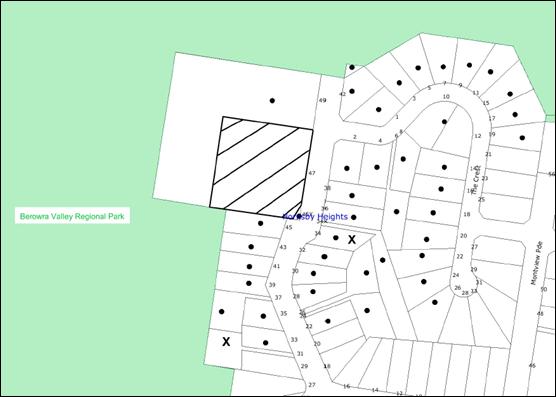
Council received two submissions and a petition. The map below illustrates the
location of those nearby landowners who made a submission that are in close
proximity to the development site.

|
NOTIFICATION
PLAN
|
|
|
• PROPERTIES NOTIFIED
|
X SUBMISSIONS
RECEIVED
|

PROPERTY SUBJECT OF DEVELOPMENT
|

|
|
|
|
|
Two submissions and a petition
with seven signatories objected to the development, generally on the following
grounds that the development would result in:
· Construction of a
tower which is too close to residential properties and should be relocated further
to the west on the adjoining Crown land or the Berowra Valley Regional Park.
· A tower which is too
high.
· Adverse impact to
property values.
· Detrimental health
impacts.
Furthermore, a submission raised
concern that Telstra should be requested to provide justification with respect
to the need for improved coverage in the area.
The merits of the matters raised
in community submissions have been addressed in the body of the report with the
exception of the following:
5.1.1 Justification to be provided by Telstra for the proposed
facility
A public submission raised
concern that Telstra should provide evidence of who specifically has requested
the improved coverage to justify the application. The applicant advised that Telstra
cannot give out personal details of customer complaints for privacy reasons,
however, the following statement has been provided with regard to the purpose
of the proposal:
“Telstra
regularly undertakes detailed assessments of its mobile telecommunications
network to evaluate its performance and service capabilities, especially in the
face of increasing consumer demand for services such as wireless broadband.
Evaluation methods include a combination of drive surveys, statistical
measures, computer modelling of coverage and the evaluation of customer
complaints.
As a result
of these assessments, Telstra is aware that improved indoor and outdoor mobile
network coverage is required in the Hornsby Heights area. The area currently
experiencing unreliable service is roughly bounded by Margaret Avenue to the
south, The Crest to the north, Herman Crescent to the east and Berowra Valley to the west.
This area
is not being adequately serviced by the surrounding Telstra Next-G Network
sites, which can be found at Rofe Park, Galston Road, Hornsby; Ku-ring-gai Chase Road, Mt Colah and 601 Pacific Highway, Mt Colah. These existing
facilities do not provide reliable service across Hornsby Heights due to a
number of technical constraints including distance and topography which play
important roles in limiting service provision.
Additionally,
the surrounding sites do not provide service to Hornsby Heights because of
constraints on network capacity. Each facility has a finite capacity to handle
multiple simultaneous users so once that capacity is reached, a mobile network
facility will drop calls, and wireless broadband connections would become
unworkably slow.
Mobile
network planning must take into account not just the provision of basic signal
coverage, but also the likely demands on capacity (both now and in the future)
to allow for the increasing use of capacity ambitious services such as wireless
broadband.
The new
facility proposed at Hornsby Heights would link up with Telstra’s
existing sites in the wider area and would therefore improve the current
shortfall in network coverage and ensure that sufficient network capacity is
maintained to service the current and likely consumer demand in the Hornsby
Heights area.
The result
should be a more reliable local service with fewer call drop-outs and better
call quality. The new facility would also ensure the provision of dependable,
fast-speed wireless broadband services, that allows for greater range of mobile
phone services such as transmission of live footage and faster data speeds for
downloading information from the wireless broadband connections. This can only
be delivered by local facilities that offer good quality, indoor coverage.
In summary,
there is a technical requirement for a new 3G facility to provide a high level
of indoor and outdoor network radio coverage. The proposed facility would
service the area with improved mobile network reception and a greater capacity
for high speed wireless broadband services. It would also address the lack of
service continuity being experienced across Hornsby Heights.”
The proposed development would
increase the availability and quality of mobile services in the area. The
existing Police and Rural Fire Service equipment would be relocated from the
water tower to the proposed Telstra tower to achieve better coverage.
5.1.2 Impact to property values
Concerns have
been raised about the impact of the proposed facility on property values. No
documentary evidence has been submitted to suggest that the increase in
telecommunications infrastructure in residential settings has had any impact on
property values. Notwithstanding, the impact of a development on individual
property values is not a matter for consideration under Section 79C of Act.
5.2 Public Agencies
The development application was
referred to the NSW Rural Fire Service (RFS) for comment. The RFS raised no
objections to the proposal.
5. THE PUBLIC INTEREST
Section 79C(1)(e) of the Act requires
Council to consider “the public interest”.
The public interest is an
overarching requirement, which includes the consideration of the matters
discussed in this report. Implicit to the public interest is the achievement
of future built outcomes adequately responding to and respecting the future
desired outcomes expressed in environmental planning instruments and
development control plans.
The application is considered to
have satisfactorily addressed Council’s and relevant agencies’ criteria and would
provide a development outcome that, on balance, would result in a positive
impact for the community. Accordingly, it is considered that the approval of
the proposed telecommunications facility would be in the public interest.
CONCLUSION
The proposal involves the
erection of a 42 metre high telecommunications tower, including associated
antennas and equipment shelter.
The proposal is satisfactory with
regard to relevant legislation including the Environmental Planning and
Assessment Act 1979, Telecommunications Act 1997 and the Hornsby Shire Local
Environmental Plan 1994.
The proposal
would result in some electromagnetic radiation, however, based on the
information submitted, the predicted EME exposure falls well within acceptable
levels.
The proposed
tower is not considered to be visually intrusive in its setting and residential
visual amenity would be largely maintained.
The proposal is satisfactory and
is recommended for approval.
Note: At the time of the completion of this planning report, no
persons have made a Political Donations Disclosure Statement pursuant to
Section 147 of the Environmental Planning and Assessment Act 1979 in respect of
the subject planning application.
|
Scott Phillips
Executive Manager
Planning Division
|
|
Attachments:
|
1.View
|
Locality Plan
|
|
|
|
2.View
|
DA Plans
|
|
|
|
3.View
|
Site Access Plan
|
|
|
|
4.View
|
EME Precautionary
Approach Checklist
|
|
|
|
5.View
|
Summary of RF EME
Levels
|
|
|
File Reference: DA/1414/2010
Document Number: D01565209
SCHEDULE 1
GENERAL
CONDITIONS
The conditions
of consent within this notice of determination have been applied to ensure that
the use of the land and/or building is carried out in such a manner that is
consistent with the aims and objectives of the relevant legislation, planning
instruments and Council policies affecting the land and does not disrupt the
amenity of the neighbourhood or impact upon the environment.
Note: For the
purpose of this consent, the term ‘applicant’ means any person who has the
authority to act on or the benefit of the development consent.
Note: For the purpose of
this consent, any reference to an Act, Regulation, Australian Standard or
publication by a public authority shall be taken to mean the gazetted Act or
Regulation, or adopted Australian Standard or publication as in force on the
date that the application for a construction certificate is made.
1. Approved
Plans and Supporting Documentation
The development must be carried
out in accordance with the plans and documentation listed below and endorsed
with Council’s stamp, except where amended by Council and/or other conditions
of this consent:
|
Plan No.
|
Sheet No.
|
Title
|
Drawn by
|
Dated
|
|
N25726 – Issue 6
|
S1
|
Site Access and Locality Plan
|
Telstra Corporation Limited
|
17.08.10
|
|
N25726 – Issue 1
|
S1-1
|
Site Access and Locality Plan –
Sheet 2
|
Telstra Corporation Limited
|
17.08.10
|
|
N25726 – Issue 5
|
S3
|
Site Elevation
|
Telstra Corporation Limited
|
17.08.10
|
|
Document Title.
|
Prepared by
|
Dated
|
|
Site Specific Notes (Reference
No. N25726 – Issue 5, Sheet S0)
|
Telstra Corporation Limited
|
17.08.10
|
|
Planning Report (Reference No.
NA03077.01)
|
Urbis Pty ltd
|
October 2010
|
2. Removal
of Existing Trees
This
development consent only permits the removal of trees numbered 1 & 2 as
identified on Site Tree Location Plan. The removal of any other trees requires
separate approval under Council’s Tree Preservation Order.
REQUIREMENTS PRIOR TO THE ISSUE OF A CONSTRUCTION
CERTIFICATE
3. Building
Code of Australia
All building work must be
carried out in accordance with the requirements of the Building Code of
Australia.
4. Sydney
Water – Quick Check
The application must be
submitted to a Sydney Water ‘Quick Check Agent’ or ‘Customer Centre’ for
approval to determine whether the development will affect any Sydney Water
infrastructure, and whether further requirements are to be met.
Note: Refer
to www.sydneywater.com.au or
telephone 13 20 92 for assistance.
REQUIREMENTS PRIOR TO THE COMMENCEMENT OF ANY WORKS
5. Erection
of Construction Sign
A sign must
be erected in a prominent position on any site on which building work,
subdivision work or demolition work is being carried out:
a. Showing
the name, address and telephone number of the principal certifying authority
for the work,
b. Showing
the name of the principal contractor (if any) for any demolition or building
work and a telephone number on which that person may be contacted outside
working hours, and
c. Stating
that unauthorised entry to the work site is prohibited.
Note: Any
such sign is to be maintained while the building work, subdivision work or
demolition work is being carried out, but must be removed when the work has
been completed.
6. Protection
of Adjoining Areas
A temporary
hoarding, fence or awning must be erected between the work site and adjoining
lands before the works begin and must be kept in place until after the
completion of the works if the works:
a. Could
cause a danger, obstruction or inconvenience to pedestrian or vehicular
traffic.
b. Could
cause damage to adjoining lands by falling objects.
c. Involve
the enclosure of a public place or part of a public place.
Note: Notwithstanding
the above, Council’s separate written approval is required prior to the
erection of any structure or other obstruction on public land.
7. Toilet
Facilities
Toilet facilities must be
available or provided at the works site before works begin and must be
maintained until the works are completed at a ratio of one toilet for every 20
persons employed at the site. Each toilet must:
a. be
a standard flushing toilet connected to a public sewer; or
b. be
a temporary chemical closet approved under the Local Government Act, 1993;
or
c. have
an on-site effluent disposal system approved under the Local Government Act,
1993
8. Erosion
and Sediment Control
Erosion and
sediment control measures must be provided and maintained throughout the
construction period in accordance with the manual ‘Soils and Construction
2004 (Bluebook)’, the approved plans, Council specifications and to the
satisfaction of the principal certifying authority. The erosion and sediment
control devices must remain in place until the site has been stabilised and
revegetated.
Note: On
the spot penalties up to $1,500 may be issued for any on-compliance with this
requirement without any further notification or warning.
REQUIREMENTS DURING CONSTRUCTION
9. Construction
Work Hours
All work on site (including demolition and earth works)
must only occur between 7am and 5pm Monday to Saturday.
No work is to be undertaken on Sundays or public holidays.
10. Environmental
Management
The site must
be managed in accordance with the publication ‘Managing Urban Stormwater –
Landcom (March 2004) and the Protection of the Environment Operations
Act 1997 by way of implementing appropriate measures to prevent sediment
run-off, excessive dust, noise or odour emanating from the site during the
construction of the development.
11. Council
Property
During construction works, no building
materials, waste, machinery or related matter is to be stored on the road or footpath.
The public reserve is to be kept in a clean, tidy and safe condition at all
times.
12. Noise
– Plant and Machinery
The level of total
continuous noise emanating from operation of all the plant, including air
conditioning units and processes in all buildings (LA10) (measured for at least
15 minutes) in or on the above premises, must not exceed the background
level by more than 5dB(A) when measured at all property boundaries.
13. Site
Compliance Certificate
A
Site Compliance Certificate issued by a NATA accredited service must be
submitted to Council for the site at 47 McKay Road, Hornsby confirming the
operating EME levels once operational. The site must be assessed and found to
comply with the Australian Radiation Protection and Nuclear Safety Agency
(ARPANSA)’s Radiation Protection Standards and the RF Human Exposure Limits as
specified by the Australian Communications and Media Authority (ACMA).
14. Telecommunications
Facility
The
telecommunications facility on the site must be operated in compliance with,
but not limited to:
a) Australian Radiation Protection and Nuclear Safety Agency’s
(ARPANSA) ‘Radiation Protection Standard for Maximum Exposure Levels to
Radiofrequency Fields – 3kHz to 300 GHz’, (2002).
b) The Australian Communication Industry
Forum Code (ACIF), Industry Code C564:2004, Deployment of Mobile Phone
Network Infrastructure, (2002).
c) The Australian Communications Authority
(ACA), Radiocommunications (Electromagnetic Radiation – Human Exposure)
Standard, (2003).
- END OF CONDITIONS -
ADVISORY NOTES
The following information is provided for your assistance to
ensure compliance with the Environmental Planning and Assessment Act 1979,
Environmental Planning and Assessment Regulation 2000, other relevant
legislation and Council’s policies and specifications. This information does
not form part of the conditions of development consent pursuant to Section 80A
of the Act.
Environmental Planning and
Assessment Act, 1979 Requirements
· The Environmental Planning and
Assessment Act, 1979 requires:
· The issue of a construction certificate
prior to the commencement of any works. Enquiries regarding the issue of a
construction certificate can be made to Council’s Customer Services Branch on
9847 6760.
· A principal certifying authority to be
nominated and Council notified of that appointment prior to the commencement of
any works.
· Council to be given at least two days
written notice prior to the commencement of any works.
· Mandatory inspections of nominated
stages of the construction inspected.
· An occupation certificate to be issued
before occupying any building or commencing the use of the land.
Long Service Levy
In accordance with Section 34 of
the Building and Construction Industry Long Service Payments Act 1986, a ‘Long Service Levy’ must be paid to the Long
Service Payments Corporation or Hornsby Council.
Note: The
rate of the Long Service Levy is 0.35% of the total cost of the work.
Note: Hornsby
Council requires the payment of the Long Service Levy prior to the issue of a
construction certificate.
Tree Preservation Order
To ensure the maintenance and
protection of the existing natural environment, it is an offence to ringbark,
cut down, top, lop, remove, wilfully injure or destroy a tree outside 3 metres
of the approved building envelope without the prior written consent from
Council.
Note: A
tree is defined as a single or multi-trunked wood perennial plant having a
height of not less than three (3) metres, and which develops many branches,
usually from a distance of not less than one (1) metre from the ground, but
excluding any plant which, in its particular location, is a noxious plant
declared as such pursuant to the Noxious Weeds Act 1993. This definition of ‘tree’
includes any and all types of Palm trees.
All
distances are determined under Australian Standard AS4970-2009 ”Protection of
Trees on Development Sites”.
Fines may be imposed for
non-compliance with Council’s Tree Preservation Order.
Covenants
The land upon which the subject
building is to be constructed may be affected by restrictive covenants.
Council issues this approval without enquiry as to whether any restrictive
covenant affecting the land would be breached by the construction of the building,
the subject of this consent. Applicants must rely on their own enquiries as to
whether or not the building breaches any such covenant.
Dial Before You Dig
Prior to commencing any works,
the applicant is encouraged to contact Dial Before You Dig on 1100 or www.dialbeforeyoudig.com.au for
free information on potential underground pipes and cables within the vicinity
of the development site.
Planning Report No. PLN5/11
Date of Meeting:
2/02/2011
3 DEVELOPMENT APPLICATION
- ALTERATIONS AND ADDITIONS TO THE EXISTING 'WOOLWORTHS' TENANCY FOR AN
INTERNAL RETAIL PACKAGED LIQUOR OUTLET - CHERRYBROOK SHOPPING CENTRE,
41 - 47 SHEPHERDS DRIVE, CHERRYBROOK
|
Development Application No:
|
DA/1138/2010
|
|
Description of Proposal:
|
Alterations and Additions to the Existing ‘Woolworths’
Tenancy for an Internal Retail Packaged Liquor Outlet.
|
|
Property Description:
|
Lot 1, DP 816893
No. 41 – 47 Shepherds Drive, Cherrybrook
Cherrybrook Shopping Centre
|
|
Applicant:
|
Woolworths Limited
|
|
Owner:
|
BNY Trust Company of Australia Limited
|
|
Statutory Provisions:
|
Hornsby Shire Local Environmental
Plan 1994
Business A (General) zone
|
|
Estimated Value:
|
$370,000
|
|
Ward:
|
B
|
|
RECOMMENDATION
THAT Development Application
No. 1138/2010 for alterations and additions to the existing ‘Woolworths’
tenancy for an internal retail packaged liquor outlet at Lot 1 DP 816893 be
approved subject to the conditions of consent detailed in Schedule 1 of this
report.
|
1. The
application proposes alterations and additions to the existing ‘Woolworths’
tenancy for an internal retail packaged liquor outlet.
2. The
proposal complies with the requirements of the Hornsby Shire Local
Environmental Plan 1994 and the relevant Development Control Plans
4. Four
submissions have been received in respect of the application.
5. It
is recommended that the application be approved.
HISTORY OF THE SITE
The site is currently used as a
shopping centre known as ‘Cherrybrook Shopping Village’.
THE SITE
The site, known as Nos. 41-47 Shepherds Drive - Lot 1 DP 816893, is located on the northern side of Shepherds Drive between Kenburn Avenue and Macquarie Drive, Cherrybrook, a distance of
approximately 350 metres. The size of the land is 2.954 hectares and generally
has a rectangular shape with splayed north-eastern and south-western side
boundaries.
An existing local shopping centre
is constructed on the land, with the buildings set back from the street
frontage recessed into the hillside and retained along Shepherds Drive.
The site comprises two components
namely, the upper level (Lot 1), which contains the existing shopping centre,
car park, car wash and child care centre, and a lower level (Lot 2) at the
eastern end of the site, adjacent to the intersection with Macquarie Drive,
where a Caltex / Woolworths Service Station outlet is located under separate
Stratum title with a concrete slab over, upon which the existing shopping
centre car park is partly located.
The site falls approximately 2.5m
from northwest to the southeast to the edge of the existing car park, which is
elevated above Shepherds Drive at a height ranging from 1 to 6 metres.
THE PROPOSAL
The application proposes alterations and additions to the existing
‘Woolworths’ tenancy for an internal retail packaged liquor outlet.
The gross floor area of the retail packaged liquor outlet is 125sqm and comprises the retail space and a
coolroom. The store would utilise the existing Woolworths stockroom, kitchen
facilities and WC for staff.
The floor area of the proposed
retail packaged liquor outlet would replace a portion of the retail floor area
of the existing supermarket.
The proposed operating hours of
the retail liquor store would be between 8am and 10pm Monday to Saturday and
10am to 10pm Sunday. It is proposed to erect two signs above the two entry
points to the store, one of which is accessed via the existing shopping mall
and the second entry point is accessed internally from the supermarket.
The proposal would utilise the
approved car parking facilities within the site.
ASSESSMENT
The development application has
been assessed having regard to the ‘2005 City of Cities Metropolitan
Strategy’, the ‘North Subregion (Draft) Subregional Strategy’ and
the matters for consideration prescribed under Section 79C of the Environmental
Planning and Assessment Act 1979 (the Act). Subsequently, the following
issues have been identified for further consideration.
1. STRATEGIC CONTEXT
1.1 Metropolitan Strategy – (Draft) North Subregional
Strategy
The Metropolitan Strategy is a
broad framework to secure Sydney’s place in the global economy by promoting and
managing growth. It outlines a vision for Sydney to 2031; the challenges
faced, and the directions to follow to address these challenges and achieve the
vision. The draft North Subregional Strategy acts as a framework for Council
in the preparation of a new Principal LEP by 2011.
The draft Subregional Strategy
sets the following targets for the Hornsby LGA by 2031:
· Employment capacity to
increase by 9,000 jobs; and
· Housing stock to
increase by 11,000 dwellings.
The proposed development would be
consistent with the draft Strategy by providing additional jobs in the
locality.
2. STATUTORY CONTROLS
Section 79C(1)(a) requires
Council to consider “any relevant environmental planning instruments, draft
environmental planning instruments, development control plans, planning
agreements and regulations”.
2.1 Hornsby Shire Local Environmental Plan 1994
The subject land is zoned
Business A (General) under the Hornsby Shire Local Environmental Plan 1994
(HSLEP). The objectives of the Business A (General) zone are:
(a) to encourage economic growth and employment opportunities.
(b) to accommodate the retail, commercial and social needs of
the community.
(c) to encourage development that improves the health, vitality,
cultural environment and social environment within the area.
The proposed development is
defined as ‘shop’ under the HSLEP and is permissible in the zone with
Council’s consent.
Clause 15 of HSLEP prescribes
that the maximum floor space ratio (FSR) of development within the Business A
(General) zone is 1:1. The proposed development does not increase the existing
FSR for the site as the floor area of the proposed retail packaged liquor
outlet would replace a portion of the retail floor area of the existing
supermarket.
Clause 18 of HSLEP sets out
heritage conservation provisions within the Hornsby area. The site is located
in the vicinity of heritage items, which are identified in the HSLEP as being
of local heritage significance. These items include “The Lakes of Cherrybrook”
opposite the site in Shepherds Drive and two stands of remnant bushland within
the adjoining Greenway Park.
The proposed development is
located within the existing shopping centre and would not result in an adverse
impact upon the adjoining heritage items and their significance.
2.2 State
Environmental Planning Policy No. 19 - Bushland in
Urban Areas
The general aim of this Policy is to protect and preserve
bushland within the urban areas because of its value to the community as part
of the natural heritage, its aesthetic value, and its value as a
recreational, educational and scientific resource.
Clause 9 of SEPP 19 relates to
land adjoining land zoned or reserved for public open space. The Lakes of
Cherrybrook is located opposite the site in Shepherds Drive and Greenway Park surrounds the site to the rear. Both sites are zoned Open Space A (Public
Recreation - Local) under the HSLEP.
The
proposal is locate wholly within the existing footprint of the shopping centre
and does not affect bushland on the adjoining open space lands.
2.3 State Environmental Planning Policy No. 44 - Koala
Habitat Protection
The Policy requires Council to
consider whether development upon land with an area greater then 1 hectare will
have an adverse impact upon potential koala habitat. As the site is cleared and
contains an existing shopping centre, further consideration of the SEPP is not
required.
2.4 State Environmental Planning Policy No. 64 -
Advertising and Signage
This Policy aims to improve the amenity of urban and
natural settings by managing the impact of outdoor advertising. In accordance with Part 3, Clause 9, the proposed signage is defined as a ‘business identification
sign’ and the provisions of Part 3 of the Policy do not apply.
The proposed
signs are located wholly within the existing shopping centre complex and are
not visible from the street. The signage is considered to be consistent with
the provisions of SEPP 64, in that it meets the objectives to be compatible
with the desired amenity and visual character of the area and satisfies the
assessment criteria in Schedule 1 of the SEPP and is considered to be
acceptable in terms of its impact.
2.5 State Environmental Planning Policy (Exempt and
Complying Developments Code) 2008
This
Policy aims to provide streamlined assessment processes for development that
complies with specified development standards.
On 5
May 2004, Council issued Development Consent No. 341/2004 for the fitout of the
Woolworths supermarket within the Cherrybrook Village Shopping Centre.
Accordingly, it would appear that the proposed development could have been
lodged as a complying development application under Part 5 General
Commercial and Industrial Code of the SEPP. Notwithstanding, the applicant
would need to make their own enquiries in this regard.
2.6 Sydney Regional Environmental Plan No. 20 - Hawkesbury Nepean River
Sydney
Regional Environmental Plan No. 20 aims to protect the environment of the
Hawkesbury/Nepean River system by ensuring that the impacts of future land uses
are considered in a regional context. Part 2 of the Plan requires Council to
consider total catchment management, environmentally sensitive areas, water
quality, water quantity, cultural heritage, flora and fauna, riverine scenic
quality, agriculture/aquaculture and fishing, recreation and tourism, rural
residential development, urban development and the Metropolitan Strategy.
The
proposal is consistent with the objectives of the Sydney Regional Environmental
Plan and would not impact on water quality.
2.7 Draft State Environmental Planning
Policy (Competition) 2010
The NSW Government has released a
proposed state-wide planning policy which removes artificial barriers on
competition between retail businesses. The draft SEPP is a relevant matter for
consideration under s.79 of the Act.
This draft SEPP proposes:
· The commercial
viability of a proposed development may not be taken into consideration by a
consent authority, usually the local council, when determining development
applications;
· The likely impact of a
proposed development on the commercial viability of other individual businesses
may also not be considered unless the proposed development is likely to have an
overall adverse impact on the extent and adequacy of local community services
and facilities, taking into account those to be provided by the proposed
development itself; and
· Any restrictions in
local planning instruments on the number of a particular type of retail store
in an area, or the distance between stores of the same type, will have no
effect.
Whilst submissions received
raised concerns that there was an existing retail liquor shop within the centre
thereby negating the need for a second liquor shop, there are no planning
grounds to refuse the application based on potential competition between retail
businesses.
2.8 Business Lands Development Control Plan
The proposed development has been
assessed having regard to the relevant performance and prescriptive design
standards within Council’s Business Lands Development Control Plan (Business
Lands DCP). The following table sets out the proposal’s compliance with the prescriptive
standards of the Plan:
|
Business Lands
Development Control Plan
|
|
Control
|
Proposal
|
Requirement
|
Compliance
|
|
Site Area
|
2.954ha
|
N/A
|
N/A
|
|
Existing Floor Area of Centre
|
9604.6m2
|
N/A
|
N/A
|
|
Floor Space Ratio
|
0.32:1
|
1:1
|
Yes
|
|
Liquor Outlet Floor Area
|
125m2
|
N/A
|
N/A
|
|
Site Cover
|
unchanged
|
N/A
|
N/A
|
|
Car Parking
|
Unchanged
|
463 spaces approved
|
Yes
|
|
Setbacks
|
Unchanged
|
|
Yes
|
|
Signage
|
2 signs
|
3 signs
|
Yes
|
As detailed in the above table,
the proposed development complies with the prescriptive standards within
Council’s Business Lands DCP. A brief discussion on compliance with relevant
performance standards are detailed below.
2.8.1 Density
The proposed retail packaged
liquor outlet would replace 125sqm of the approved retail floor area of the
existing supermarket. Therefore there would be no net increase in floor area
for the development and the density of the existing development on the site
remains unchanged.
2.8.2 Car Parking
The existing development on the
site includes provision for 463 approved car parking spaces. As the proposed
retail packaged liquor outlet would replace a portion of the approved retail
floor area of the existing supermarket, there is no net increase in floor area
for the development and therefore no additional car parking is required.
2.8.3 Signage
The proposal includes the
erection of two signs for the use which satisfies the requirement of a maximum
total of three signs per site. The signage is located within the shopping
centre and would not be visible form Shepherds Drive.
2.8.4 Acoustics
The DCP requires that the
operating hours of all commercial activities be restricted to 7 am and 6 pm,
Monday Wednesday and Friday, 7 am and 9 pm on Thursday and 8 am to 4 pm on
Saturdays, with no work being undertaken on Sundays and Public Holidays.
The application for the retail packaged liquor outlet proposes the following hours of operation:
Monday to
Saturday 8am to 10pm
Sunday 10am
to 10pm
Condition No. 3 of Development
Consent No. 2215/2002 granted on 21 May 2003 and subsequently modified on 4
December 2003, 7 April 2004, 1 November 2004 and 20 November 2005 states:
3. The hours of use of the shopping Centre shall be 7.00am to
10.00pm, 7 days per week.
As the proposed hours of the
retail packaged liquor outlet are within the approved hours of operation for the shopping centre, a reduction in the operating hours in line with the performance criteria of the DCP would not be consistent with the objectives of the Business C
(Neighbourhood) zone or the intent of the commercial centres role to provide
goods and services to the local community.
2.8.5 Crime Prevention
The objective of the control
element is:
"To reduce crime risk and
minimise opportunities for crime."
Concern has been raised that the
proposed development would result in an increase in youths and underage
drinkers congregating in the shopping centre and the adjacent park. The
proposed development was referred to the NSW Police Service for comments and
further discussion is provided in Section 5.2.1 of this report.
Furthermore, the existing
shopping centre has security during the hours of operation and condition No. 97
of Development Consent No. 2215/2002 requires the shopping centre to maintain a
security management plan.
2.8.6 Contributions
As previously stated, the proposed
alterations to the existing Woolworths supermarket to provide a retail packaged
liquor outlet do not increase the existing floor area. Accordingly, Section 94
contributions are not required to be levied.
2.9 Car Parking Development Control Plan
The primary purpose of this
DCP is to provide parking controls for the development. The shopping complex
has an approved shared parking provision for all tenancies. As the proposal is
for a retail liquor outlet within the existing Woolworths and no increase to
the existing retail floor area is proposed, the proposal is considered
consistent with the provisions of Council’s Car Parking Development Control
Plan.
2.10 Outdoor Advertising Development Control Plan
The primary purpose of the Plan
is to control the visual impact of advertisements and advertising structures on
the environment and to provide adequate opportunities for the community to
advertise their goods and/or services.
The application proposes the erection of two signs:
Sign 1 - wall sign 1200mm x 600mm, located above the
entry from the mall; and
Sign 2 - wall sign 1200mm
x 600mm, located above the internal entry from the ‘Woolworths’ checkout area.
This type of signage is classified
as ‘wall signs’ under the Outdoor Advertising Development Control Plan. The
Development Control Plan provides the following development controls for wall signs.
(a) where
it is illuminated, shall not be less than 2.6m above the ground;
(b) shall
not extend laterally beyond the wall of the building to which it is attached;
(c) shall
not project above the top of the wall to which it is attached;
(d) shall
not have an area greater than 4.5 sqm. This includes window signs (painted or mounted);
(e) shall
not cover any window or architectural projections.
The proposed signs are consistent
with the requirements for wall signs in the DCP and conditions are recommended
to ensure the signs are maintained in a presentable and satisfactory state of repair if consent is granted.
2.11 Access and Mobility Development Control Plan
The primary purpose of this DCP is
to assist proponents and Council in ensuring the requirements for equality of
access in the Disability Discrimination Act 1992 are satisfied when
building work is proposed.
The proposed development is
consistent with the objectives of the Access and Mobility Development Control
Plan.
2.12 Cherrybrook Precinct Development Control Plan
The primary purpose of this DCP
is to provide controls for the Cherrybrook Precinct. The subject site is
included within the precinct and complies with the provisions of the DCP and
the Cherrybrook Precinct Masterplan.
2.13 Waste Minimisation and Management Development Control Plan
The primary purpose of this
Development Control Plan is to provide planning strategies and controls to
promote waste minimisation and management. Subject to recommended conditions
of consent relating to disposal of waste being implemented, the proposed
development is consistent with the objectives of the Plan.
3. ENVIRONMENTAL IMPACTS
Section 79C(1)(b) of the Act
requires Council to consider “the likely impacts of that development,
including environmental impacts on both the natural and built environments, and
social and economic impacts in the locality”.
3.1 Natural Environment
The proposed development would
not necessitate the removal of any trees from the site and would not have a
negative impact on the natural environment of the area.
3.2 Built Environment
The proposed works would not be visible from Shepherds Drive. As such, the proposed retail liquor premises would have minimal impact on the existing streetscape of the shopping centre or the built environment of the locality.
3.3 Social Impacts
The
proposed development would cater to the daily and regular needs of the
community residing in the Cherrybrook area and would not have a negative social
impact on the locality. An assessment of whether the development satisfies the
public interest test is held at Section 6 of this report.
3.4 Economic Impacts
The proposal would not have a
negative economic impact on the locality.
4. SITE SUITABILITY
Section 79C(1)(c) of the Act
requires Council to consider “the suitability of the site for the
development”.
The site is not known to be
subject to subsidence, flooding or landslip. A small section in the south of
the site is identified as bushfire prone land. In accordance with Section 79BA
of the Environmental Planning and Assessment Act 1979 and that the proposed
development is located wholly within the existing shopping centre on the site,
Council is satisfied that the development conforms to the specifications and
requirements of ‘Planning for Bushfire Protection 2006’.
5. PUBLIC PARTICIPATION
Section 79C(1)(d) of the Act
requires Council to consider “any submissions made in accordance with this
Act”.
5.1 Community Consultation
The proposed development was
placed on public exhibition and was notified to adjoining and nearby landowners
between 4 November 2010 and 25 November 2010 in accordance with Council’s
Notification and Exhibition Development Control Plan. During this period,
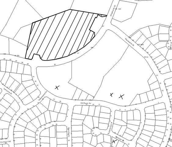
Council received four submissions. The map below illustrates the location of
those nearby landowners who made a submission that are in close proximity to
the development site.
|
NOTIFICATION
PLAN
|
|
|
• PROPERTIES NOTIFIED
|
X SUBMISSIONS
RECEIVED
|
PROPERTY SUBJECT OF DEVELOPMENT
|
|
|
|
|
|
Four submissions objected to the
development, generally on the grounds that the development would result in:
· loss of social
amenity,
· impact on the wellbeing
of teenagers;
· the current
adequate availability of alcohol;
· the unsuitability
of combining groceries and alcohol sales;
· the avoidance of
further criminal activity,
· liquor shop is a
quarter of the area of the supermarket leading to a reduction in grocery lines
due to reduction of supermarket floor area;
· there is already an
existing liquor outlet in the centre;
· the application was
refused last year;
· youth will drink
alcohol in the park opposite the shopping centre;
The merits of the matters raised
in community submissions have been addressed in the body of the report with the exception of the following:
5.1.1 Application refused last year
Council has not received a
previous application for a retail package liquor outlet on the site. The
submission is most likely referring to the proponent’s preparation of the Community
Impact Statement (CIS) for the proposed packaged liquor licence application to
the NSW Office of Liquor, Gaming and Racing (OLGR) that would have been
notified to surrounding residences and Council. The OLGR is the statutory body
that regulates liquor licences. A search of the OLGR website indicates that a
packaged liquor licence has not yet been applied for by the applicant.
Furthermore, a packaged liquor licence would not be granted by the OLGR until
such time as a development consent or approval (if required) is granted.
5.2 Public Agencies
The development application was
referred to the following public agencies:
5.2.1 NSW Police
The application was reviewed by
the Licensing Officer and the Crime Prevention Officer from the Eastwood Local
Area Command of the NSW Police Force. No objection was raised to the proposed
development subject to the imposition of the recommendations provided.
6. THE PUBLIC INTEREST
Section 79C(1)(e) of the Act
requires Council to consider “the public interest”.
The public interest is an
overarching requirement, which includes the consideration of the matters
discussed in this report. Implicit to the public interest is the achievement
of future built outcomes adequately responding to and respecting the future
desired outcomes expressed in environmental planning instruments and
development control plans.
In Double Bay Marina Pty Ltd v
Woollahra Council [2009] NSWLEC 1001, the Commissioner suggested a
relatively new planning principal: discerning the public interest in
development applications. The Commissioner noted that consideration of the
public interest ought to be broken into three steps:
1. Defining the public whose interest is being invoked.
2. Defining the benefit towards which a proposal claims to
make a contribution (or from which it is claimed to detract).
3. Making explicit the weight given to the public interest
relative to other considerations.
It could be argued that there is
a public benefit for the establishment of the development by way of providing
customers the convenience of purchasing groceries and packaged liquor at the
same time. In addition, the development would improve competition, as there is
an existing liquor store in the shopping centre.
As previously stated, submissions
raised concerns that the proposed development could result in a proliferation
of the supply of alcohol in the Shire, potential for secondary supply to minors
and social problems resulting from alcohol abuse and possible criminal activity
which would be to the public detriment. However, there is no indication that
the proposed development would result in these impacts, rather the consumption
of alcohol generally does result in social consequences within the community.
In this regard, the public dis-benefit of the development would not be grounds
for the refusal of the application.
The proposed development would
provide private benefit to shareholders in the company.
Similar to the public dis-benefit
of the development, it could be argued that there is an indirect private
dis-benefit of the development by way of immediate neighbours possibly
witnessing youth drinking alcohol and creating noise in the park opposite the
shopping centre. However, it should be noted that the shopping centre has
security monitoring the site and shops during operating hours which addresses
such impacts.
Notwithstanding the above, the
possible public detriment of the development is beyond the scope of the
assessment of the development application as this societal issue is a wider
public policy consideration which sets the policy and framework for assessment
of the suitability of retail alcohol outlets in urban areas.
Having regard to the above, the
application is considered to have satisfactorily addressed Council’s and
relevant agencies’ criteria and would provide a development outcome that, on
balance, would result in a positive impact for the community. Accordingly, it
is considered that the approval of the proposed development would be in the
public interest.
CONCLUSION
The application proposes
alterations and additions to the existing ‘Woolworths’ tenancy for an internal
retail packaged liquor outlet.
The proposal would not generate
any additional floor space or alter the appearance of the approved commercial
centre on site. The proposed development would utilise the approved car parking
facilities on site and would not result in additional traffic generation.
The development generally meets Council’s
planning controls and is satisfactory having regard to the matters for
consideration pursuant to Section 79C of the Environmental Planning and
Assessment Act, 1979.
Council received four submissions
during the public notification period and appropriate controls and conditions
have been imposed to minimise disruption to residential amenity.
Having regard to the
circumstances of the case, approval of the application is recommended for
approval.
Note: At the time of the completion of this planning report, no
persons have made a Political Donations Disclosure Statement pursuant to
Section 147 of the Environmental Planning and Assessment Act 1979 in respect of
the subject planning application.
|
Scott Phillips
Executive Manager
Planning Division
|
|
Attachments:
|
1.View
|
Locality Plan
|
|
|
|
2.View
|
Architectural
Plans
|
|
|
File Reference: DA/1138/2010
Document Number: D01561195
SCHEDULE 1
GENERAL
CONDITIONS
The conditions of consent within this notice of determination have
been applied to ensure that the use of the land and/or building is carried out
in such a manner that is consistent with the aims and objectives of the
relevant legislation, planning instruments and Council policies affecting the
land and does not disrupt the amenity of the neighbourhood or impact upon the
environment.
Note: For the
purpose of this consent, the term ‘applicant’ means any person who has the
authority to act on or the benefit of the development consent.
Note: For the purpose of
this consent, any reference to an Act, Regulation, Australian Standard or
publication by a public authority shall be taken to mean the gazetted Act or
Regulation, or adopted Australian Standard or publication as in force on the
date that the application for a construction certificate is made.
1. Approved
Plans and Supporting Documentation
The
development must be carried out in accordance with the plans and documentation
listed below and endorsed with Council’s stamp, except where amended by Council
and/or other conditions of this consent:
Architectural
Plans prepared by Woolworths Limited
|
Plan No.
|
Plan Title
|
Rev
|
Dated
|
|
L1
|
Liquor Control Plan
|
E
|
22 December 2009
|
|
L2
|
Combined Liquor Plan
|
E
|
22 December 2009
|
Supporting Documentation
|
Document Title
|
Prepared by
|
Dated
|
|
Statement of Environmental
Effects
|
Andrew Martin Planning
|
September 2010
|
|
Community Impact Statement
|
BSV
|
13 September 2010
|
|
Statement of Impact
|
BSV
|
13 September 2010
|
REQUIREMENTS PRIOR TO THE ISSUE OF A CONSTRUCTION
CERTIFICATE
2. Building
Code of Australia
All building
work must be carried out in accordance with the requirements of the Building
Code of Australia.
REQUIREMENTS PRIOR TO THE COMMENCEMENT OF ANY WORKS
3. Erection
of Construction Sign
A sign must
be erected in a prominent position on any site on which building work,
subdivision work or demolition work is being carried out:
a. Showing
the name, address and telephone number of the principal certifying authority
for the work,
b. Showing
the name of the principal contractor (if any) for any demolition or building
work and a telephone number on which that person may be contacted outside
working hours, and
c. Stating
that unauthorised entry to the work site is prohibited.
Note: Any
such sign is to be maintained while the building work, subdivision work or
demolition work is being carried out, but must be removed when the work has
been completed.
4. Waste
Management Plan
Prior to issue of the Construction Certificate, A Waste Management Plan Section One –
Demolition Stage, Section Two – Design Stage, Section Three – Construction
Stage and Section Four – Use and On-going Management as applicable,
covering the scope of this project is required to be submitted to Council in
accordance with the Waste Minimisation and Management Development Control
Plan.
REQUIREMENTS DURING CONSTRUCTION
5. Waste
Management Plan - Work Practices
Appropriate work practices must be employed to implement
the Waste Management Plan Section One –
Demolition Stage and Section Three – Construction Stage as applicable.
6. Hours
of Operation
The hours of operation of
the premise are restricted to those times listed below:
Monday to Wednesday 8am to 10pm
Sunday & Public Holidays 10am to 10pm
7. Fire
Safety Statement - Annual
On at least one occasion in
every 12 month period following the date of the first ‘Fire Safety Certificate’
issued for the property, the owner must provide Council with an annual ‘Fire
Safety Certificate’ to each essential service installed in the building.
CONDITIONS OF CONCURRENCE – NSW POLICE
The following conditions of consent are from
the nominated State Agency pursuant to Section 79B of the Environmental
Planning and Assessment Act 1979 and must be complied with to the
satisfaction of that Agency.
8. Installation
of Safety and Security Measures
The following safety and
security measures must be installed in the premises:
a. CCTV
cameras must be installed inside the business, capturing customers coming into
and leaving the business. CCTV cameras must also be recording the money
transactions and there should be a TV displaying to the customers that they are
being recorded. There needs to be adequate signage displayed to inform
customers that CCTV is being used. The CCTV should be of high quality and
should capture customer’s faces as they enter the liquor store. This enables
Police to better identify offenders. CCTV cameras must be suitably placed
throughout the store and ensure that they cover all areas of the store. Mirrors
must be used in areas that are difficult to supply adequate surveillance.
b. A
safe designed and installed to the relevant Australian Standards must be
installed and bolted to the floor to store cash and valuables.
c. The
doors to the manager’s office and the area into the cash handling area must be
fitted with security coded locks.
d. A
duress facility must be incorporated to enable staff to activate the system
manually in the event of an emergency, such as a robbery.
e. Lighting
must be designed to the relevant Australian and New Zealand Lighting Standards
and a lighting maintenance policy must be established for the development.
-
END OF CONDITIONS -
ADVISORY NOTES
The following information is provided for your
assistance to ensure compliance with the Environmental Planning and Assessment
Act, 1979, Environmental Planning and Assessment Regulation 2000, other
relevant legislation and Council’s policies and specifications. This
information does not form part of the conditions of development consent
pursuant to Section 80A of the Act.
Environmental Planning and
Assessment Act, 1979 Requirements
The Environmental Planning and
Assessment Act, 1979 requires:
· The issue of a construction certificate
prior to the commencement of any works. Enquiries regarding the issue of a
construction certificate can be made to Council’s Customer Services Branch on
9847 6760.
· A principal certifying authority to be
nominated and Council notified of that appointment prior to the commencement of
any works.
· Council to be given at least two days
written notice prior to the commencement of any works.
· Mandatory inspections of nominated
stages of the construction inspected.
· An occupation certificate to be issued
before occupying any building or commencing the use of the land.
Long Service Levy
In accordance with Section 34 of
the Building and Construction Industry Long Service Payments Act 1986, a ‘Long Service Levy’ must be paid to the Long
Service Payments Corporation or Hornsby Council.
Note: The
rate of the Long Service Levy is 0.35% of the total cost of the work.
Note: Hornsby
Council requires the payment of the Long Service Levy prior to the issue of a
construction certificate.
Disability Discrimination Act
The applicant’s attention is
drawn to the existence of the Disability Discrimination Act. A
construction certificate is required to be obtained for the proposed
building/s, which will provide consideration under the Building Code of
Australia, however, the development may not comply with the requirements of
the Disability Discrimination Act. This is the sole responsibility of
the applicant.
Food Authority Notification
The NSW Food Authority
requires businesses to electronically notify the Authority prior to the
commencement of its operation.
Note: NSW
Food Authority can be contacted at www.foodnotify.nsw.gov.au.
Council Notification – Food
Premises
Prior to the commencement of the
business, the operator is requested to contact Council’s Environmental Health
Team to arrange an inspection for compliance against the relevant legislation
and guidelines outlined in this approval.
Note: Council’s
Environmental Health Officer can be contacted on 02
9847 6745.
Planning Report No. PLN6/11
Date of Meeting:
2/02/2011
4 DEVELOPMENT APPLICATION
- CONSTRUCTION OF AN AFFORDABLE RENTAL HOUSING DEVELOPMENT COMPRISING EIGHT
TOWNHOUSES
3 & 5 FULBOURNE AVENUE PENNANT HILLS
|
Development Application No:
|
DA/1021/2010
|
|
Description of Proposal:
|
Construction of an affordable rental housing
development comprising eight townhouses.
|
|
Property Description:
|
Lot 16 and Lot 15 DP 10203 (Nos. 3 & 5) Fulbourne Avenue, Pennant Hills.
|
|
Applicant:
|
Mr Ram Shanker Kangatharan
C/- Glendinning Minto & Associates
|
|
Owner:
|
Mr R S Kangatharan
|
|
Statutory Provisions:
|
Hornsby Shire Local Environmental
Plan 1994
Residential A (Low Density)
Zone
State Environmental Planning
Policy Affordable Rental Housing 2009
|
|
Estimated Value:
|
$2,700,000
|
|
Ward:
|
C
|
|
RECOMMENDATION
THAT Development Application
No. DA/1021/2010 for the demolition of existing dwellings and the
construction of an affordable housing development comprising eight townhouses
at Lot 16 and Lot 15 DP 10203 (Nos 3 & 5) Fulbourne Avenue, Pennant Hills
be approved subject to the conditions of consent detailed in Schedule 1 of
this report.
|
1. The
application proposes the demolition of two existing dwelling houses and the
construction of an affordable housing development containing eight townhouses.
2. The
proposal complies with the development standards contained within State
Environmental Housing Policy (Affordable Rental Housing) 2009.
3. Council
on 1 December 2010 resolved to defer consideration of the application subject
to consultation with residents.
4. The
matters raised in Council’s resolution insofar as further consultation with
residents has now been addressed.
5. It
is recommended that the application be approved.
DEFERRAL OF THE APPLICATION
On 1 December 2010 Council’s
Planning Committee first considered the subject application and resolved (with
relevance to the development application):
THAT
Council:
1. Defer consideration of this matter to the 2 February 2011
Planning Meeting to allow the professional consultant engaged by the residents
to put in a submission regarding this proposal given the issues raised. The
report of the Executive Manager accompanying this submission should include
further information on how the Affordable Housing SEPP may address shortages of
rental housing in the Hornsby Shire Local Government Area.
Meeting with Residents
A meeting with concerned
residents was held on 14 December 2010 to provide a forum for residents to
discuss issues of concern with Council staff and the applicant. The meeting
commenced at 4.30pm and concluded at 6.45pm.
At the meeting the Executive
Manager Planning provided an overview of the application of the SEPP Affordable
Rental Housing with regard to; affordable housing for key workers in locations
with access to employment; planning incentives for private sector development
of affordable rental housing; limited take-up of the development incentives in
Hornsby LGA; and the eligibility criteria for affordable rental housing
according to household income. Council’s notification requirements for
development applications were also discussed.
The residents planning consultant
outlined the issues of concern detailed in his submission including; need for
consultation with residents; impact on heritage and residential character;
excessive driveways with vehicles required to reverse near adjoining child care
centre; zoning objectives and design guidelines; catalyst for similar
development; and need to design for single storey with single driveway
operation.
The applicant’s planning
consultant advised of the potential to amend the proposal to delete the
driveway adjacent to the child care centre. Such amendment would result in the
loss of a garage space and a visitor car parking space. The consultant
commented that the amendment may result in a compromised outcome. The
consultant also provided advice concerning the amended proposed stormwater
drainage system to increase the detention capacity, provide for water saving
and recycling and minimise any increase in runoff, in order to maintain the
pre-development 1 in 100 year flood level. A copy of the amended stormwater
drainage plans are attached to this report.
The Executive Manager Planning
discussed the non-discretionary planning assessment criteria under the SEPP and
responded to residents questions concerning requirements for the proposal in
respect to car parking, traffic safety, stormwater design and residential
density.
Further Submissions
Following Council’s resolution on
1 December 2010 further submissions were received from eight residents. The
submissions reiterated previous concerns and included additional concerns which
are noted and commented on as follows:
|
Additional
Concerns
|
Comment
|
|
Difficulty of enforcement of
affordable rental housing for target group.
|
Condition
No. 33 is considered appropriate to address this concern.
|
|
Need for installation of ‘no
parking’ signs for traffic safety of child care centre.
|
Post development on-street car
parking should be monitored to determine need.
|
|
Need for privacy screens to
first floor windows to prevent overlooking of child care centre.
|
Privacy screening is considered
unwarranted in respect to commercial land use and the requirements of
Council’s Community Uses Development Control Plan.
|
|
Need for child care centre to
be advised of construction work.
|
Additional condition No. 13AA
is recommended.
|
|
Need for management control of
storm water drainage system to ensure efficiency and prevent mosquitoes.
|
Condition No. 26d is considered
appropriate. In this regard a copy of the terms and conditions of Council’s
covenant are attached to this report.
|
|
Unreliable electricity supply
and need for substation.
|
Condition No. 7 requires
evidence of satisfactory supply prior to a Construction Certificate being
issued.
|
|
Impacts of air conditioning
systems.
|
The proposed buildings are
designed for energy efficiency and comply with BASIX requirements, reducing
the need for air conditioning.
|
|
Need for management of common
property to prevent obstruction/resident conflict.
|
Additional condition No. 35 is
recommended to prohibit parking of vehicles other than in approved car
parking spaces.
|
|
Council to exercise duty of
care to ensure safety and well being of community in approving development.
|
Council’s duty of care is implicit
in the assessment and determination of development applications in accordance
with the legislation.
|
|
Inadequate car parking will
increase traffic congestion and reduce safety Yarrara Road. Car parking is
inadequate as 50% of dwellings are not required for affordable rental housing
and the existing 50 place child care centre has 5 car parking spaces.
|
Post development monitoring of
traffic management is noted as above.
|
Housing Market Analysis
The applicant submitted a housing
market analysis for the Hornsby LGA prepared by Housing NSW. The analysis
identifies the Hornsby LGA within the Outer North Sydney property market and
provides comparative data with adjoining LGAs and the Greater Metropolitan
Region.
Key parameters in the analysis
include a growing population, high housing need, low proportion of private
rental housing (17.2%), high proportion of housing stress (62%) and small
proportion of public housing (1.2%).
Key findings include; lack of
affordable housing for rental and purchase; need for more one bedroom, studio
and boarding house accommodation; and limited affordable housing opportunities
for older people.
A copy of the analysis is
attached to this report.
THE
SITE
The site comprises two allotments
located on the southern side of Fulbourne Avenue. The site has an area of
2,089.5m2, is of regular shape with a frontage of 41.5m and depth of
50.5m. The site has an average fall of 6% to the rear south western corner.
The site includes two existing
single storey dwelling houses. A 1.8m wide stormwater drainage easement is
located over the south east corner of the site. The trees on the site mainly
include previously planted species other than a number of remnant trees in the
western rear part of the site.
The surrounding locality
comprises a low density residential area of single and two storey dwelling
houses. The adjoining property at No. 1 Fulbourne Avenue on the corner of Yarrara Road operates as a child care centre. The adjoining dwelling house at No. 7 Fulbourne Avenue is an item of environmental heritage of local significance. The Main
Northern Rail Corridor is located 45m east of the site parallel to Yarrara Road.
The site is located 500m north
east of Pennant Hills shops and Railway Station.
THE PROPOSAL
The proposal includes the
demolition of the two existing dwelling houses and the construction of eight
townhouses comprising two x 2 storey duplex at the front of the site and a two
storey building containing four townhouses at the rear of the site. The
townhouses include four x 3 bedroom and four x 4 bedroom dwellings. Five
townhouses include attached single storey garaging and living space. Open car
parking spaces at the rear are proposed for three of the dwellings.
The proposal includes a central
accessway that separates the two buildings at the frontage and provides access
to the building at the rear.
ASSESSMENT
The development application has
been assessed having regard to the ‘2005 City of Cities Metropolitan
Strategy’, the ‘North Subregion (Draft) Subregional Strategy’ and
the matters for consideration prescribed under Section 79C of the Environmental
Planning and Assessment Act 1979 (the Act). Subsequently, the following
issues have been identified for further consideration.
1. STRATEGIC CONTEXT
1.1 NSW State Plan
Priority of E6 of the NSW
State Plan is ‘Housing Affordability’. The Plan notes that:
Strong
economic growth for the last 10 years has seen home values rise dramatically
across many parts of NSW. Alongside this however, there has been a corresponding
increase in difficulty for many people in affording housing.
The
Government considers housing affordability from two perspectives. Firstly,
from the perspective of the first home buyer for whom purchasing a home is
increasingly difficult. Secondly, from the perspective of the most vulnerable
households – the frail aged, people with disabilities, people with mental
illness and people at risk of homelessness – who face poor health, educational
or other social outcomes due to high housing costs or overcrowding.
A key lever
of Priority E6 was the introduction of State Environmental Planning Policy
(Affordable Rental Housing) 2009. Being a recent planning initiative, Hornsby
local government area is only now seeing development applications for this type
of housing. Therefore, it is important to carefully consider development
proposals in the context of this strategic planning objective as well as more
established local planning controls.
1.2 Metropolitan Strategy – (Draft) North Subregional Strategy
The Metropolitan Strategy is a
broad framework to secure Sydney’s place in the global economy by promoting and
managing growth. It outlines a vision for Sydney to 2031; the challenges
faced, and the directions to follow to address these challenges and achieve the
vision. The draft North Subregional Strategy acts as a framework for Council
in the preparation of a new Principal LEP by 2011.
The draft Subregional Strategy
sets the following targets for the Hornsby LGA by 2031:
· Employment capacity to
increase by 9,000 jobs; and
· Housing stock to
increase by 11,000 dwellings.
The proposed development would be
consistent with the draft Strategy by providing an additional six dwellings and
would improve housing choice in the locality.
2. STATUTORY CONTROLS
Section 79C(1)(a) requires
Council to consider “any relevant environmental planning instruments, draft
environmental planning instruments, development control plans, planning
agreements and regulations”.
2.1 Hornsby Shire Local Environmental Plan 1994
The subject land is zoned
Residential A (Low Density) under the Hornsby Shire Local Environmental Plan
1994 (HSLEP). The objectives of the zone are:
(a) to provide for the housing needs of the population of the
Hornsby area.
(b) to promote a variety of housing types and other land uses
compatible with a low density residential environment.
(c) to provide for development that is within the
environmental capacity of a low density residential environment.
The compliance of the development
with the zone objectives must be read in the context of the aims of State
Environmental Planning Policy (Affordable Rental Housing) 2009. An assessment
of the application against the SEPP is held at section 2.2 of this
report.
The proposed development is
defined as ‘multi-unit housing’ under the HSLEP and is permissible in the zone
with Council’s consent.
Clause 15 of the HSLEP prescribes
that the maximum floor space ratio (FSR) of development within the Residential
A zone is 0.4:1. The proposal exceeds this requirement and relies on the
provisions of State Environmental Planning Policy (Affordable Rental Housing)
2009 which permits a maximum floor space ratio of 0.75:1. To the extent of any
inconsistency between the HSLEP and the SEPP, the provisions of the SEPP prevail.
Clause 18 of the HSLEP sets out
heritage conservation provisions within the Hornsby area. The site adjoins an
item of environmental heritage at No. 7 Fulbourne Avenue (house). The
application includes a Heritage Impact Assessment of the proposed development.
This matter is addressed in section 2.3 of this report.
2.2 State Environmental Planning Policy (Affordable Rental
Housing) 2009
The application has been assessed
against the requirements of State Environmental Planning Policy (Affordable
Rental Housing) 2009 (SEPP – Affordable Rental Housing). This Policy provides
State-wide planning controls for delivery of affordable rental housing through
planning incentives to increase rental housing close to business centres and to
expand the role of non-profit housing providers. The Policy also provides for
the retention of existing affordable housing and for housing support for
disadvantaged people.
The Policy applies to the
majority of Council’s residential land use zones for sites within 800 metres
walking distance of a railway station or 400 metres of a bus stop with an
hourly bus service.
For the subject site, the Policy
provides for a maximum building height of 8.5m and a maximum floor space ratio
of 0.75:1 with at least 50% of dwellings to be used for affordable rental
housing for a period of 10 years.
Affordable housing is defined
under the Policy according to a household income level being less than 120% of
the median household income (Sydney Statistical Division). The affordable
rental housing accommodation is to be managed by a registered community housing
provider.
The Policy includes development
standards and applies design criteria for low rise and high rise developments.
For the subject site, the Seniors Living Policy: Urban Design Guidelines for
Infill Development is to be taken into consideration, subject to the
provisions being consistent with the Policy. The following table sets out the
proposal’s compliance with the prescriptive standards of the Policy:
|
SEPP -
Affordable Rental Housing
|
|
Control
|
Proposal
|
Requirement
|
Compliance
|
|
Site Area
|
2,089.5m2
|
450m2
|
Yes
|
|
Floor Space Ratio
|
0.60:1
|
0.75:1
|
Yes
|
|
Dwelling Size
|
141m2 –
167m2
|
Min 95m2
– 3 br +
|
Yes
|
|
Height
|
8.5m
|
8.5m
|
Yes
|
|
Car parking
|
10 spaces
|
4 spaces (0.5 per
dwlg)
|
Yes
|
|
Solar Access
|
100%
|
70%
|
Yes
|
|
Deep Soil Zone
|
28%
|
15%
|
Yes
|
|
Landscaped Area
|
717m2
|
280m2
|
Yes
|
As detailed in the above table,
the proposed development complies with the prescriptive standards within the
Policy. Below is a brief discussion on compliance with design principles and
best practice standards within the Urban Design Guidelines for Infill
Development.
2.2.1 Responding to Context
The immediate locality is
characterised mainly by single storey older style detached dwellings with open
landscaped frontages in the streetscape. Front setbacks are variable and there
is a mix of building materials and finishes and housing styles.
The proposed development provides
a contemporary architectural form and includes a mix of materials and
finishes. The development maintains the existing building alignment along the
lower southern side of the street. The proposal introduces a new built form and
style of housing but would maintain the existing pattern of buildings in the
streetscape.
The development makes good use of
internal/external spaces and incorporates sustainable building practices that
are more efficient than the majority of existing dwellings in the locality.
2.2.2 Site Planning and Design
The site is of uniform shape and
is situated on the lower side of the street. The site does not include any
significant constraints to development other than the stormwater drainage
easement across the south eastern corner of the site.
The proposed townhouses are
oriented north south living and open space areas are primarily located on the
northern elevation of the dwellings, to maximise solar access. The proposed
dwelling design would achieve a high level of energy efficiency and amenity.
Separate driveways are provided
for dwellings 1 and 4. A central accessway provides a shared pedestrian and
vehicular access to the proposed rear dwellings and vehicular access for units
2 and 3. The dwellings at the frontage have independent pedestrian access.
2.2.3 Impacts on Streetscape
The proposal includes informal
private open space within the front setback which is inconsistent with the
streetscape.
The proposed buildings have a
minimum front setback of 8.6m. The proposed private open space areas extend to
within 2.8m of the front boundary and are enclosed with 1.2m high tubular steel
fencing with brick piers. Being enclosed by 1.2m high fences, the front
courtyards of units 1 to 4 are not intended to be used as formal private
areas. Instead, the courtyards take advantage of the northern elevation and
improve internal/external living and amenity. This results in a sustainable
and environmentally efficient design outcome.
Landscaping for privacy is
proposed at the immediate frontage. The proposed landscaping would provide
effective screening of the private open space areas. The first floor component
of the two front buildings would present as the dominant element in the
streetscape.
Subject to implementation of the
landscape plan the proposal is considered acceptable in respect to impact on
the existing streetscape.
2.2.4 Impacts on Neighbours
The proposed development is
considered acceptable in respect to privacy and amenity to the adjoining child
care centre and the adjoining heritage listed dwelling subject to the
construction of new boundary fencing. The proposed buildings would not
overshadow neighbouring properties to the extent of any non-compliance with the
Urban Design Guidelines For Infill Development.
The proposed rear townhouse
building is setback 4.9m from the rear boundary. The ground floor levels of the
proposed dwellings are 1.2m above natural ground level at the rear boundary. To
minimise overlooking of adjoining properties from the rear patios, the proposal
includes privacy screens 1.5m above the floor level fixed to the rear boundary
fence. A 3m wide deep soil landscaping area is proposed along the rear of the
development in compliance with the Policy. The proposed landscaping area
includes planting along the boundary which would provide some screening of the
development. The majority of the proposed deep soil zone at the rear of the
site is proposed for lawn area.
To prevent overlooking of the
adjoining rear properties, privacy louvers are proposed for the first floor
windows. The privacy screening reduces the visual amenity impacts of rear open
space areas of adjoining properties in Stevens Street.
The Urban Design Guidelines
For Infill Development include controls for the rear 25% of the site to be
single storey. However, the SEPP – Affordable Rental Housing provides for a
building height of not more than 8.5m which prevails to the extent of the
inconsistency with the Guidelines.
Having regard to the aims of the
SEPP – Affordable Rental Housing, this is considered to be an acceptable
outcome.
2.2.5 Internal Site Amenity
The fin walls of the proposed buildings
give separation and identity to individual dwellings within the development.
Fences and landscaping provide
suitable screening for proposed private open space areas. The use of louvers
for first floor windows and balcony screens minimises privacy impacts within
the development. The proposed private open space areas comply with the
required 35m2 of landscaping per dwelling.
Five of the eight dwellings have
single car garages. The proposed open car parking spaces in the frontage of
Units 6 and 7 are not allocated to those units and would detract from their
amenity, as the ‘ownership’ of the spaces is in conflict with the front entries
and immediate outlook of these units. Whilst car ownership is reduced for low
income households as recognised by the Policy with the requirement for 0.5
spaces per dwelling, the provision of a separate common parking area should be
of design to minimise amenity impacts. To address this impact, it is
recommended that low height screen fencing be provided between unit 5 car space
and unit 6 as well as unit 8 car space and unit 7.
The proposed design does not
provide adequate space for landscape treatment to provide transition and
separation between the internal driveway/shared pedestrian access and the
dwelling entries, resulting in dominance of the central accessway which
detracts from the architectural style of the development and amenity. It
would be open to Council to require the removal of car parking spaces to
improve this amenity. Whilst that would result in the development maintaining
the required number of car parking spaces under SEPP – Affordable Rental
Housing, a reduction in car parking is considered to be an inferior outcome due
to the density of the development. Therefore on merit, the development is
considered acceptable in its current form.
The proposed dwelling entries at
the frontage and central access to the rear dwellings are clearly defined
access points to the development. Casual surveillance of the access points is
achieved within the development minimising opportunities for crime.
The site is in the vicinity of
the rail corridor. The rail line is elevated in relation to the site and
results in noise impacts. Rail Corp recommends noise mitigation measures for
the proposed development, which have been included as a recommended condition
of consent.
2.3 Heritage Development Control Plan
The site adjoins an item of
environmental heritage at No. 7 Fulbourne Avenue (house) which is an item of
local significance as an Inter-War weatherboard cottage.
Council’s Heritage Committee
raised objections to the proposed development on grounds that the bulk and
scale of the proposed development is out of character and not sympathetic with
the adjoining heritage item.
A Heritage Impact Report
was submitted in support of the application. The report notes:
The new
buildings occupy a site adjoining the item and separated from it by some
distance allowing for appropriate landscape separation. Additionally, the new
buildings are set below the road level and have overall heights that are
compatible with the adjoining development on both sides of the site. The
increased density of development will not be highly obvious from the street due
to the fall of the site and the screening effect of the retained vegetation.
The applicant notes the concerns
of the Heritage Committee. However, the applicant considers that the merits of
the application coupled with the minor impact on the heritage item are such
that the proposal should be supported in its current form.
The officer’s assessment of the
application concurs with the opinion of the applicant and therefore recommends
that Council not require amendments to the design of the buildings. The
development would be set back to enable landscaping to sufficiently screen the
development to minimise impacts and would result in a development that relates
positively to the streetscape.
3. ENVIRONMENTAL IMPACTS
Section 79C(1)(b) of the Act
requires Council to consider “the likely impacts of that development,
including environmental impacts on both the natural and built environments, and
social and economic impacts in the locality”.
3.1 Natural Environment
The site includes twenty trees
comprising a mix of exotic, introduced native and remnant trees.
The proposed development would
necessitate the removal of six trees from the site. None of the trees to be
removed are identified as ‘significant trees’. Tree No. 20, a Brush Box (Lophostemon
confertus) located in the south eastern part of the site, is identified as
good and worthy of preservation and is to be retained.
The submitted landscape plan
includes locally indigenous plant species and is considered acceptable is
respect to replacement of existing trees proposed for removal.
3.2 Built Environment
The design of the proposed
townhouses provides for cost effective construction of energy efficient housing
with functional floor plans and an acceptable standard of accommodation for
large families. The proposed built form however is predicated on reduced car
parking provision in accordance with the provisions of the SEPP – Affordable
Rental Housing.
Given that 50% of the development
is required for this purpose for a relatively short time (10 years) compared to
the economic life of the development, the large 3 and 4 bedrooms dwellings are
compromised by the comparative deficiency of the car parking provision for
accommodation of this size. However, under Clause 14 of the Policy, a consent
authority must not refuse consent to development on car parking grounds when 0.5
spaces per dwelling are provided. It is acknowledged that to facilitate
affordable housing in the strategic context, inconsistencies may arise with
local planning expectations.
The proposal retains the existing
vehicle crossings in the street maintaining this aspect of the streetscape. The
eastern crossing is adjacent to the adjoining child care centre. To ensure
adequate sight distance at the frontage, the floor height of the garage for
Unit 4 and its driveway are at an appropriate level with the footpath.
Bin storage is proposed within
the respective dwelling areas. Collection at the road frontage is considered
acceptable for the proposal.
The proposed development includes
a mix of materials; sheet metal, face brick, weatherboard, aluminium louvers
and privacy shutters. The mix of materials and proposed finishes complement the
architectural style of the development and result in a high quality design that
would enhance the existing streetscape.
3.3 Social Impacts
The proposed development would be
of positive social impact in providing affordable rental accommodation
particularly for large families, thus reducing social disadvantage and
fostering inclusive and diverse communities. This is a key priority of the NSW
State Plan.
3.4 Economic Impacts
The proposal would have a minor
positive impact on the local economy in conjunction with other residential
development in the locality by generating an increase in demand for local
services.
4. SITE SUITABILITY
Section 79C(1)(c) of the Act
requires Council to consider “the suitability of the site for the
development”.
4.1 Flooding
The stormwater drainage easement
over the south eastern part of the site is subject to an overland flow path for
the 1 in 100 year flood. The proposed floor levels would be a minimum of 500mm
above flood height. The submitted flood study recommends minor excavation work
at the rear of proposed Units 7 and 8 to maintain pre-development flood levels.
Subject to implementation of the
recommendations of the flood study the proposal would not adversely impact on
downstream properties.
The development is otherwise
considered suitable for the site.
5. PUBLIC PARTICIPATION
Section 79C(1)(d) of the Act
requires Council to consider “any submissions made in accordance with this
Act”.
5.1 Community Consultation
The proposed development was
placed on public exhibition and was notified to adjoining and nearby landowners
between 7 September and 30 September 2010 in accordance with Council’s
Notification and Exhibition Development Control Plan. During this period,
Council received thirteen submissions. The map below illustrates the location
of those nearby landowners who made a submission that are in close proximity to
the development site.
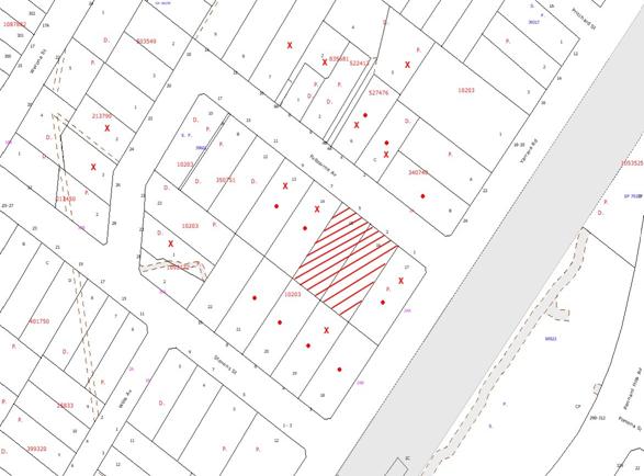
|
NOTIFICATION
PLAN
|
|
|
• PROPERTIES NOTIFIED
|
X SUBMISSIONS
RECEIVED
|
PROPERTY SUBJECT OF DEVELOPMENT
|
|
|
1 SUBMISSION RECEIVED
OUT OF MAP RANGE
|
|
|
|
|
Thirteen submissions objected to
the development, generally on the grounds that the development would result in:
· Lack of car parking.
· Unacceptable
residential density.
· Negative impact on
streetscape and residential character.
· Impact on heritage
item.
· Impact on traffic
safety.
· Overshadowing and
privacy impacts.
· Lack of space for
children’s recreation and for clothes drying.
· Building height >
3.6m.
· Unacceptable number of
bins for waste collection.
The merits of the matters raised
in community submissions have been addressed in the body of the report with the
exception of the following:
5.1.1 Boundary fence
It is considered to be a
reasonable request that the applicant be required to construct the boundary
fence at nil cost to the neighbouring property owner. A recommended condition
of consent has been included in Attachment A.
5.2 Public Agencies
The development application was
referred to NSW Transport (Rail Corp) in respect development in the vicinity of
the rail corridor.
Rail Corp raised no objection to
the proposal subject to a condition for compliance with noise mitigation
measures.
6. THE PUBLIC INTEREST
Section 79C(1)(e) of the Act
requires Council to consider “the public interest”.
The public interest is an
overarching requirement, which includes the consideration of the matters
discussed in this report. Implicit to the public interest is the achievement
of future built outcomes adequately responding to and respecting the future
desired outcomes expressed in environmental planning instruments and
development control plans.
The application is considered to
have satisfactorily addressed Council’s and relevant agencies’ criteria and
would provide a development outcome that, on balance, would result in a
positive impact for the community. Accordingly, it is considered that the
approval of the proposed affordable rental housing development would be in the
public interest.
CONCLUSION
Consent is sought for demolition
of two existing dwelling houses and construction of an affordable housing
development comprising eight townhouses.
The proposed affordable housing
development complies with the development standards prescribed under the SEPP –
Affordable Rental Housing in respect to floor space ratio, car parking,
landscaping, deep soil zones, solar access and dwelling size. The proposed
townhouses would provide accommodation for low income families and conditions
are recommended to ensure the accommodation is managed for this purpose.
The proposed townhouses are
designed for energy efficiency and achieve a cost effective quality design
standard. The non-discretionary development standards to facilitate the
provision of this form of housing result in a shortfall in parking which has
implications for the standard of accommodation and internal site amenity. In
this regard the provisions of the SEPP – Affordable Rental Housing prevail notwithstanding
the concerns raised in public submissions.
The concerns raised in public
submissions concerning privacy are considered to have been addressed by the
provision of fixed screens and landscaping. It is considered the proposed
development would not significantly detract from the residential character of
the locality.
The proposed development is
therefore recommended for approval subject to recommended conditions.
Note: At the time of the completion of this planning report, no
persons have made a Political Donations Disclosure Statement pursuant to
Section 147 of the Environmental Planning and Assessment Act 1979 in respect of
the subject planning application.
|
Scott Phillips
Executive Manager
Planning Division
|
|
Attachments:
|
1.View
|
Locality Plan
|
|
|
|
2.View
|
Amended Stormwater
Drainage Plans
|
|
|
|
3.View
|
Terms of Positive
Covenant
|
|
|
|
4.View
|
Housing Market
Analysis
|
|
|
|
5.View
|
Demolition Plan
|
|
|
|
6.View
|
Survey Plan
|
|
|
|
7.View
|
Site Analysis Plan
|
|
|
|
8.View
|
Floor Plans
|
|
|
|
9.View
|
Elevations
|
|
|
|
10.View
|
Perspective Front
Elevation
|
|
|
|
11.View
|
Sections
|
|
|
|
12.View
|
Landscape Plan
|
|
|
|
13.View
|
Overland Flow Path
|
|
|
File Reference: DA/1021/2010
Document Number: D01561494
SCHEDULE 1
GENERAL
CONDITIONS
The
conditions of consent within this notice of determination have been applied to
ensure that the use of the land and/or building is carried out in such a manner
that is consistent with the aims and objectives of the relevant legislation,
planning instruments and Council policies affecting the land and does not
disrupt the amenity of the neighbourhood or impact upon the environment.
Note: For the
purpose of this consent, the term ‘applicant’ means any person who has the
authority to act on or the benefit of the development consent.
Note: For the purpose of
this consent, any reference to an Act, Regulation, Australian Standard or
publication by a public authority shall be taken to mean the gazetted Act or
Regulation, or adopted Australian Standard or publication as in force on the
date that the application for a construction certificate is made.
1. Approved
Plans and Supporting Documentation
The development must be carried
out in accordance with the plans and documentation listed below and endorsed
with Council’s stamp, except where amended by Council and/or other conditions
of this consent:
|
Plan No.
|
Drawn by
|
Dated
|
|
DA 00 - Calculations
|
GGF Architects
|
04/11/10
|
|
DA 01 – Site Analysis
|
GGF Architects
|
04/11/10
|
|
DA 02 - Demolition
|
GGF Architects
|
27/07/10
|
|
DA 03 – Gnd Floor Plan
|
GGF Architects
|
04/11/10
|
|
DA 04 – 1st Floor Plan
|
GGF Architects
|
04/11/10
|
|
DA 05 - Elevations
|
GGF Architects
|
04/11/10
|
|
DA 06 - Elevations
|
GGF Architects
|
04/11/10
|
|
DA 07 - Sections
|
GGF Architects
|
04/11/10
|
|
108.10/179 ‘A’
|
ISCAPE Landscape Architecture
|
November 2010
|
|
|
|
|
2. Removal
of Existing Trees
This
development consent only permits the removal of tree(s) numbered T1 –T7, T12, T14, T17 and T19 as identified on Drawing
No. DA 02 prepared by GGF Architects dated 27/07/10. The removal of any other
trees requires separate approval under Council’s Tree Preservation Order.
3. Amendment
of Plans
The approved plans are to be
amended as follows:
a. Screen
fencing 1.2m high is to be erected at the frontage of Unit 7 and Unit 6 to
provide screening of the car parking spaces at the frontage of the units.
REQUIREMENTS PRIOR TO THE ISSUE OF A CONSTRUCTION
CERTIFICATE
4. Building
Code of Australia
All building
work must be carried out in accordance with the requirements of the Building
Code of Australia.
5. Contract
of Insurance (Residential Building Work)
In the case
of residential building work for which the Home Building Act, 1989 requires
there to be a contract of insurance in force in accordance with Part 6 of that
Act, that such a contract of insurance is in force before any building work
authorised to be carried out by the consent commences.
Note: This
condition does not apply to the extent to which an exemption is in force
under Clause 187 or 188 of the Act, subject to the terms of any condition or
requirement referred to in Clause 187(6) or 188(4) of the Act, or to the
erection of a temporary building.
6. Notification
of Home Building Act, 1989 Requirements
Residential
building work within the meaning of the Home Building Act,
1989 must not be carried out unless the principal certifying authority for
the development to which the work relates (not being Council) has given Council
written notice of the following information:
a. In
the case of work for which a principal contractor is required to be appointed:
i. The
name and licence number of the principal contractor.
ii. The
name of the insurer by which the work is insured under Part 6 of that Act.
b. In
the case of work to be done by an owner-builder:
i. The
name of the owner-builder.
ii. If
the owner-builder is required to hold an owner-builder’s permit under that Act,
the number of the owner-builder’s permit.
Note: If
arrangements for doing the residential building work are changed while the work
is in progress so that the information notified becomes out of date, further
work must not be carried out unless the principal certifying authority for the
development to which the work relates (not being Council) has given Council
written notification of the updated information.
7. Water/Electricity
Utility Services
The applicant
must submit written evidence of the following service provider requirements:
a. Energy
Australia – a letter of consent demonstrating that satisfactory
arrangements have been made to service the proposed development.
b. Sydney
Water – the submission of a ‘Notice of Requirements’ under s73 of the Sydney
Water Act 1994.
Note: Sydney
Water requires that s73 applications are to be made through an authorised
Sydney Water Servicing Coordinator. Refer to www.sydneywater.com.au or telephone
13 20 92 for assistance.
8. Noise
– Rail Corridor
An acoustic assessment is to be submitted to Council prior to the issue
of a construction certificate demonstrating how the proposed development will
comply with the Department of Planning’s document titled “Development Near Rail
Corridors and Busy Roads- Interim Guidelines.
9. Foundation
Design
Foundations
are to be designed by a Structural Engineer to extend below the level of the
Council-controlled drainage system.
10. On
Site Stormwater Detention
An on-site
stormwater detention system must be designed by a chartered civil engineer and
constructed in accordance with the following requirements:
a. Have
a capacity of not less than 27 cubic metres, and a maximum discharge (when
full) of 40 litres per second.
b. Have
a surcharge/inspection grate located directly above the outlet and accessible
exterior of the dwellings.
c. Discharge
from the detention system to be controlled via 1 metre length of pipe, not less
than 50 millimetres diameter or via a stainless plate with sharply drilled
orifice bolted over the face of the outlet discharging into a larger diameter
pipe capable of carrying the design flow to an approved Council system.
d. Where
above ground and the average depth is greater than 0.3 metres, a ‘pool type’
safety fence and warning signs to be installed.
e. Not
be constructed in a location that would impact upon the visual or recreational
amenity of residents.
11. Stormwater
Drainage
The
stormwater drainage system for the development must be designed and constructed
in accordance with Council’s Civil Works – Design and Construction
Specification 2005 and the following requirements:
a. Connected
to the on-site detention system and then the existing Council piped drainage
system, using a full depth 900 mm x 900 mm Council standard junction pit
on-line, stepirons and grated pit cover.
b. The
existing depression be constructed to contain the 1 in 100 year Average
Recurrence Interval storm event as per overland flow design prepared by
Acor Appleyard (reference GO100353).
c. Minimum
floor levels are to be set at least 500mm above the 100 year design storm level
as set out by Acor Appleyard.
d. Fencing
in the area affected by the design overland flow shall be constructed as
described by Acor Appleyard.
e. Pier
and beam method construction adjacent to easements to the depth of the invert
of proposed and existing pipes.
Note: A
certificate from a chartered civil engineer together with a works as executed
design plan must be submitted to the principal certifying authority to
demonstrate the satisfaction of this condition.
12. Internal
Driveway/Vehicular Areas
The driveway
and parking areas on site must be designed in accordance with Australian
Standards 2890.1, 3727 and the following requirements:
a. Design
levels at the front boundary be obtained from Council.
b. The
driveway be a rigid pavement.
c. The
driveway grade must not exceed 25 percent and transitions for changes in grade
must not exceed 8 percent per plan metre.
d. The
driveway pavement be a minimum 3 metres wide, 0.15 metres thick reinforced
concrete with F72 steel reinforcing fabric and a 0.15 metre sub-base.
e. The
pavement have a kerb to one side and a one-way cross fall with a minimum
gradient of 2 percent and a lintel and pit provided at the low points and on
grade.
f. Retaining
walls required to support the carriageway and the compaction of all fill
batters to be in accordance with the requirements of a chartered structural
engineer.
g. The
provision of safety rails where there is a level difference more than 0.3
metres and a 1:4 batter can not be achieved.
h. Conduit
for utility services including electricity, water, gas and telephone be
provided.
REQUIREMENTS PRIOR TO THE COMMENCEMENT OF ANY WORKS
13. Erection
of Construction Sign
A sign must
be erected in a prominent position on any site on which building work,
subdivision work or demolition work is being carried out:
a. Showing
the name, address and telephone number of the principal certifying authority
for the work,
b. Showing
the name of the principal contractor (if any) for any demolition or building
work and a telephone number on which that person may be contacted outside
working hours, and
c. Stating
that unauthorised entry to the work site is prohibited.
Note: Any
such sign is to be maintained while the building work, subdivision work or
demolition work is being carried out, but must be removed when the work has
been completed.
13A. Notification of
Schedule of Works
A Schedule of Works must be
provided to the management of the adjoining Pennant Hills Preschool
Kindergarten detailing the construction phases of the development.
14. Erosion
and Sediment Control
Erosion and
sediment control measures must be provided and maintained throughout the
construction period in accordance with the manual ‘Soils and Construction
2004 (Bluebook)’, the approved plans, Council specifications and to the
satisfaction of the principal certifying authority. The erosion and sediment
control devices must remain in place until the site has been stabilised and
revegetated.
Note: On
the spot penalties up to $1,500 may be issued for any non-compliance with this
requirement without any further notification or warning.
15. Dilapidation
Report
A
‘Dilapidation Report’ is to be prepared by a chartered engineer detailing the
condition of adjoining properties and assets in the public road and submitted
to Hornsby Shire Council.
16. Toilet
Facilities
Toilet
facilities must be available or provided at the works site before works begin
and must be maintained until the works are completed at a ratio of one toilet
for every 20 persons employed at the site. Each toilet must:
a. be
a standard flushing toilet connected to a public sewer; or
b. be
a temporary chemical closet approved under the Local Government Act, 1993;
or
c. have
an on-site effluent disposal system approved under the Local Government Act,
1993
17. Tree
Protection Barriers
Tree
protection fencing must be erected around trees numbered 20 to be retained at a 3 metre setback.
The tree fencing must be constructed of 1.8 metre ‘cyclone chainmesh fence’ or
star pickets spaced at 2 metre intervals, connected by a continuous
high-visibility barrier/hazard mesh at a height of 1 metre.
REQUIREMENTS DURING CONSTRUCTION
18. Construction
Work Hours
All work on site (including demolition and earth works)
must only occur between 7am and 5pm Monday to Saturday.
No work is to be undertaken on Sundays or public holidays.
19. Demolition
All
demolition work must be carried out in accordance with Australian Standard
2601-2001 – The Demolition of Structures and the following requirements:
a. Demolition
material is to be disposed of to an authorised recycling and/or waste disposal
site and/or in accordance with an approved waste management plan.
b. Demolition
works, where asbestos material is being removed, must be undertaken by a
contractor that holds an appropriate licence issued by WorkCover NSW in
accordance with Chapter 10 of the Occupational Health and Safety Regulation
2001 and Clause 29 of the Protection of the Environment Operations
(Waste) Regulation 1996.
c. On
construction sites where buildings contain asbestos material, a standard
commercially manufactured sign containing the words ‘DANGER ASBESTOS REMOVAL IN
PROGRESS’ measuring not less than 400mm x 300mm must be erected in a prominent
position visible from the street.
20. Environmental
Management
The site must
be managed in accordance with the publication ‘Managing Urban Stormwater –
Landcom (March 2004) and the Protection of the Environment Operations
Act 1997 by way of implementing appropriate measures to prevent sediment
run-off, excessive dust, noise or odour emanating from the site during the
construction of the development.
21. Council
Property
During
construction works, no building materials, waste, machinery or related matter
is to be stored on the road or footpath. The public reserve is to be kept in a
clean, tidy and safe condition at all times.
22. Vehicular
Crossing
Separate
applications under the Local Government Act, 1993 and the Roads Act,
1993 must be submitted to Council for the installation of a new vehicular
crossings and the removal of any redundant crossing. The vehicular crossings
must be constructed in accordance with Council’s Civil Works Design, 2005
and the following requirements:
a. Any
redundant crossings to be replaced with integral kerb and gutter.
b. The
footway area to be restored by turfing.
Note:
An application for a vehicular crossing can only be made to one of Council’s
Authorised Vehicular Crossing Contractors. You are advised to contact Council
on 02 9847 6940 to obtain a list of contractors.
23. Works
near Trees
All required
tree protection measures are to be maintained in good condition for the
duration of the construction period.
All works
(including driveways and retaining walls) within 5
metres of any trees required to be retained (whether or not on the subject
property, and pursuant to this consent or the Tree Preservation Order),
must be carried out under the supervision of an ‘AQF Level 5 Arborist’
and a certificate submitted to the principal certifying authority detailing the
method(s) used to preserve the tree(s).
Note:
Except as provided above, the applicant is to ensure that no excavation,
filling or stockpiling of building materials, parking of vehicles or plant,
disposal of cement slurry, waste water or other contaminants is to occur within
4 metres of any tree to be retained.
REQUIREMENTS PRIOR TO THE ISSUE OF AN OCCUPATION
CERTIFICATE
Note: For
the purpose of this consent, any reference to ‘occupation certificate’ shall
also be taken to mean ‘interim occupation certificate’ unless otherwise stated.
24. Sydney
Water – s73 Certificate
A s73
Certificate must be obtained from Sydney Water.
25. Damage
to Council Assets
Any damage
caused to Council’s assets as a result of the construction of the development
must be rectified in accordance with Council’s written requirements and at the
sole cost of the applicant.
26. Creation
of Easements
The following
matter(s) must be nominated on the plan of subdivision under s88B of the Conveyancing
Act 1919:
a. A
drainage easement 3 metres wide located centrally over the Council pipeline
within the burdened lot in favour of Council and in accordance with the terms
set out in Memorandum B5341305V filed with the NSW Department of
Lands.
b. A
restriction over the pipeline and the flow path for a 100 year average
recurrence interval storm. The "Restriction on the Use of Land"
over the affected lots is to prohibit the alteration of the final floodway
shape and the erection of any structures, including fencing, in the floodway
without the written permission of Council. The terms of this restriction must
be obtained from Council.
c. A
"Restriction on the Use of Land" for any lot adjacent to the
floodway, requiring the finished floor level of any habitable room to be not
less than 500mm and the garage 300mm above the 100 year average recurrence
interval storm level. The levels must be related to Australian Height Datum.
d. The
creation of an appropriate "Positive Covenant" and "Restriction
as to User" over the constructed on-site detention/retention systems
and outlet works, within the lot in favour of Council in accordance with
Council’s prescribed wording. The position of the on-site detention system is
to be clearly indicated on the title.
e. To
register the OSD, easement, and restriction on the use of land “works-as-executed”
details of the on-site-detention system must be submitted verifying that the
required storage and discharge rates have been constructed in accordance with
the design requirements. The details must show the invert levels of the on
site system together with pipe sizes and grades. Any variations to the
approved plans must be shown in red on the “works-as-executed” plan and
supported by calculations.
Note: Council
must be nominated as the authority to release, vary or modify any easement,
restriction or covenant.
27. Maintain
Canopy Cover
To maintain canopy cover,
10 medium to large trees selected from Council’s booklet ‘Indigenous Plants
for the Bushland Shire’ are to be planted on the subject site. The planning
location shall not be within 4 metres of the foundation walls of a dwelling or
in-ground pool. The pot size is to be a minimum 25 litres and the tree(s) must
be maintained until they reach the height of 3 metres. Trees must be native to
Hornsby Shire and reach a mature height greater than 10 metres.
28. Fulfilment
of BASIX Commitments
The applicant
must demonstrate the fulfilment of BASIX commitments pertaining to the
development.
29. Completion
of Landscaping
A certificate
must be provided by a practicing landscape architect, horticulturalist or
person with similar qualifications and experience certifying that all required
landscaping works have been satisfactorily completed in accordance with the
approved landscape plans.
Note: Advice
on suitable species for landscaping can be obtained from Council’s planting
guide ‘Indigenous Plants for the Bushland Shire’, available at www.hornsby.nsw.gov.au.
30. Boundary
Fencing
Fencing must
be erected along all property boundaries behind the front building alignment to
a height of 1.8 metres at nil cost to adjoining owners.
31. Consolidation
of Allotments
All allotments the subject
of this consent must be consolidated into one allotment.
Note: The applicant is recommended to submit the plan of
subdivision to consolidate allotments to the NSW Department of Lands at least
4-6 weeks prior to seeking an occupation certificate.
32. s94
Infrastructure Contributions
The payment to Council of a
contribution of $99,287.35* for 6 additional dwellings towards the cost of
infrastructure identified in Council’s Development Contributions Plan
2007-2011.
Note:
* The value of contribution
is current as at 9 November 2010. The contribution will be adjusted from this date in accordance with the underlying consumer price index for subsequent
financial quarters.
It is recommended that you contact Council to ascertain the indexed value of
the contribution prior to payment.
33. Restriction
as to User – Affordable Rental Housing
To inform
current and future owners that the townhouse development on the site is for
affordable rental housing, a Restriction as to User must be created under
Section 88B of the Conveyancing Act 1919 identifying the following:
(a) The development is for affordable rental housing pursuant to
State Environmental Planning Policy (Affordable Rental Housing) 2009 for a
period of 10 years from the date of the issue of the occupation certificate.
(b) The dwellings identified as Units Nos. 2, 3, 5 and 8 on the
approved plans must be used for the purpose of affordable housing pursuant to
Clause 6 of State Environmental Planning Policy (Affordable Rental Housing)
2009.
(c) The dwellings identified as Units Nos. 2, 3, 5 and 8 on the
approved plans must be managed by a registered community housing provider
as defined in the Housing Act 2001.
Note: The
wording of the Restriction as to User must be to Council’s satisfaction and Council
must be nominated as the authority to release, vary or modify the Restriction.
34. Landscaping
Maintenance
All of the
approved landscaping for the development must be continually maintained to
ensure screening for privacy and the presentation of the development.
35. Driveway
Operation
The internal accessway and manoeuvring areas are to be unobstructed at
all times. The parking of vehicles on site is prohibited other than in approved
car parking spaces.
-
END OF CONDITIONS -
ADVISORY NOTES
The following information is provided for your
assistance to ensure compliance with the Environmental Planning and Assessment
Act, 1979, Environmental Planning and Assessment Regulation 2000, other
relevant legislation and Council’s policies and specifications. This
information does not form part of the conditions of development consent
pursuant to Section 80A of the Act.
Environmental Planning and Assessment Act, 1979
Requirements
· The Environmental Planning and
Assessment Act, 1979 requires:
· The issue of a construction certificate
prior to the commencement of any works. Enquiries regarding the issue of a
construction certificate can be made to Council’s Customer Services Branch on
9847 6760.
· A principal certifying authority to be
nominated and Council notified of that appointment prior to the commencement of
any works.
· Council to be given at least two days
written notice prior to the commencement of any works.
· Mandatory inspections of nominated
stages of the construction inspected.
· An occupation certificate to be issued
before occupying any building or commencing the use of the land.
Long Service Levy
In accordance with Section 34 of the Building and
Construction Industry Long Service Payments Act 1986, a ‘Long Service Levy’ must be paid to the Long Service
Payments Corporation or Hornsby Council.
Note: The
rate of the Long Service Levy is 0.35% of the total cost of the work.
Note: Hornsby
Council requires the payment of the Long Service Levy prior to the issue of a
construction certificate.
Tree Preservation Order
To ensure the maintenance and protection of the existing
natural environment, it is an offence to ringbark, cut down, top, lop, remove,
wilfully injure or destroy a tree outside 3 metres of the approved building
envelope without the prior written consent from Council.
Note: A
tree is defined as a single or multi-trunked wood perennial plant having a
height of not less than three (3) metres, and which develops many branches,
usually from a distance of not less than one (1) metre from the ground, but
excluding any plant which, in its particular location, is a noxious plant
declared as such pursuant to the Noxious Weeds Act 1993. This definition of ‘tree’
includes any and all types of Palm trees.
All
distances are determined under British Standard BS 5837: 2005, “Trees in
Relation to Construction – Recommendations”.
Fines may be imposed for non-compliance with Council’s Tree
Preservation Order.
Dial Before You Dig
Prior to commencing any works, the applicant is encouraged
to contact Dial Before You Dig on 1100 or www.dialbeforeyoudig.com.au for
free information on potential underground pipes and cables within the vicinity
of the development site.
Asbestos
Should asbestos or asbestos products be encountered during
demolition or construction works you are advised to seek advice and information
should be prior to disturbing the material. It is recommended that a contractor
holding an asbestos-handling permit (issued by WorkCover NSW) be engaged
to manage the proper handling of the material. Further information regarding
the safe handling and removal of asbestos can be found at:
www.environment.nsw.gov.au
www.nsw.gov.au/fibro
www.adfa.org.au
www.workcover.nsw.gov.au
Alternatively, telephone the WorkCover Asbestos and
Demolition Team on 8260 5885.
House Numbering
House numbering can only be authorised by Council. Before
proceeding to number each premise in the development, the allocation of numbers
is required to be obtained from Council's Planning Division. The authorised
numbers are required to be displayed in a clear manner at or near the main
entrance to each premise.
Planning Report No. PLN14/11
Date of Meeting:
2/02/2011
5 DEVELOPMENT APPLICATION
- SUBDIVISION OF ONE ALLOTMENT INTO TWO
16 TRELAWNEY STREET THORNLEIGH
|
Development Application No:
|
DA/1204/2010
|
|
Description of Proposal:
|
Subdivision of One Allotment
into Two
|
|
Property Description:
|
CP SP 37391, (No. 16) Trelawney Street, Thornleigh
|
|
Applicant:
|
Red Gum Town Planning Services
|
|
Owner:
|
Unit 1 – Mr James P Ranieri and Mrs Anne G Ranieri
Unit 2 – Mr Phillip L Abadee and Ms Elizabeth M
Millington
|
|
Statutory Provisions:
|
Hornsby Shire Local Environmental
Plan 1994
Residential A (Low Density)
Zone
|
|
Estimated Value:
|
Nil
|
|
Ward:
|
C
|
|
RECOMMENDATION
THAT Council assume the concurrence
of the Director-General of the Department of Planning pursuant to State
Environmental Planning Policy No. 1 and approve Development Application No.
1204/2010 for the subdivision of one allotment into two allotments at CP SP
37391, (No. 16) Trelawney Street, Thornleigh subject to the conditions of
consent detailed in Schedule 1 of this report.
|
EXECUTIVE
SUMMARY
1. The
application proposes the Torrens title subdivision of one lot into two lots to
create separate Torrens title allotments for the two existing detached
dwellings on the property.
2. The
proposal does not comply with the minimum allotment size for the Residential A
Zone within the Hornsby Shire Local Environmental Plan 1994. However, pursuant
to the State Environmental Planning Policy No. 1 – Development Standards, the
proposed variation to the development standard is supported as the development
does not alter the physical conditions or relationship between the two existing
dwellings.
3. No
public submissions have been received in respect of the application.
4. It
is recommended that the application be approved.
HISTORY OF THE SITE
On 22 June 1989, Council approved
Development Application No. 256/1989 to create a dual occupancy under the
provisions of Sydney Regional Environmental Plan No. 12 – Dual Occupancy.
On 12 July 1990, Council approved
Subdivision Certificate No. 463/1990 for Lot 2 DP 22762 to create two strata
lots. The subdivision did not create any common property, with each dwelling
contained entirely within separate lots.
THE SITE
The allotment has an area of 970
m2, is located on the south corner of Trelawney Street and Loch
Maree Avenue and experiences a 16% fall to the east side.
The site has a 62 metre frontage
to Trelawney Street and a 6.85 metre frontage to Loch Maree Avenue. The site
accommodates a two storey weather board dwelling-house located on the western
side of the allotment and accessed via a driveway from Trelawney Street. A
second two storey dwelling approved under DA/1255/1989 has been constructed on
the eastern portion of the site with separate access via Trelawney Street. The
dwellings are each located on separate strata titled part-lots.
The allotment is located in close
proximity to Pennant Hills Road (Cumberland Highway) to the west. There are
single and two storey dwelling-houses surrounding the site. A significant
group of trees namely ‘Garden Group’ is located to the north of the site and is
listed as a heritage item of local significance under the Hornsby Shire Local
Environmental Plan 1994.
THE PROPOSAL
The application proposes the
re-subdivision of the site to convert the allotment from a two lot strata title
subdivision into a two lot Torrens title subdivision. The existing detached
dwellings on the property would each be located on a separate Torrens title
allotment. The eastern lot (Lot No. 1) has an area of 419 m2 while
the western lot (Lot No. 2) has an area of 551 m2.
ASSESSMENT
The development application has
been assessed having regard to the ‘2005 City of Cities Metropolitan
Strategy’, the ‘North Subregion (Draft) Subregional Strategy’ and
the matters for consideration prescribed under Section 79C of the Environmental
Planning and Assessment Act 1979 (the Act). Subsequently, the following
issues have been identified for further consideration.
1. STRATEGIC CONTEXT
1.1 Metropolitan Strategy – (Draft) North Subregional Strategy
The Metropolitan Strategy is a
broad framework to secure Sydney’s place in the global economy by promoting and
managing growth. It outlines a vision for Sydney to 2031; the challenges
faced, and the directions to follow to address these challenges and achieve the
vision. The draft North Subregional Strategy acts as a framework for Council
in the preparation of a new Principal LEP by 2011.
The draft Subregional Strategy
sets the following targets for the Hornsby LGA by 2031:
· Employment capacity to
increase by 9,000 jobs; and
· Housing stock to
increase by 11,000 dwellings.
The proposed development would be
consistent with the objectives of the draft Strategy.
2. STATUTORY CONTROLS
Section 79C(1)(a) requires
Council to consider any relevant environmental planning instruments, draft
environmental planning instruments, development control plans, planning
agreements and other prescribed matters.
2.1 Hornsby Local Environmental Plan 1994
The site is zoned Residential A
(Low Density) under the Hornsby Shire Local Environmental Plan 1994 (HSLEP).
The zone objectives are:
(a) to
provide for the housing needs of the population of the Hornsby area.
(b) to
promote a variety of housing types and other land uses compatible with a low
density residential environment.
(c) to
provide for development that is within the environment capacity of a low
density residential environment.
The proposed development is
defined as ‘Subdivision’ under the HSLEP and is permissible in the zone with
Council’s consent.
The proposed development complies
with the zone objectives, as the proposal already exists and no works have been
proposed.
Clause 14 of the HSLEP prescribes
that the minimum allotment area of development within Residential A zones is to
be 500 m2. The application does not comply with the development
standard as proposed Lot 1 is 419 m2 in area. The applicant
addresses the requirement by submitting an objection to the development
standard pursuant to the State Environmental Planning Policy No. 1 as discussed
further under the relevant heading of this report.
Clause 15 of the HSLEP prescribes
that the maximum floor space ratio (FSR) of development within Residential A
Zones is 0.4:1. The applicant addresses this requirement by demonstrating that
the existing dwellings on proposed Lot No. 1 and lot 2 would have a floor space
ratio of 0.3:1 and 0.25:1 respectively.
2.2 State Environmental Planning Policy No. 1 –
Development Standards
The application has been assessed
against the requirements of State Environmental Planning Policy No. 1 –
Development Standards (SEPP 1). This policy provides flexibility in the
application of development standards in circumstances where strict compliance
with those standards would, in particular case, be unreasonable or unnecessary
or tend to hinder the attainment of the objectives of the Act.
The Land and Environment Court
has expressed the view that there are five different ways in which an objection
may be well founded and the approval of the objection may be consistent with
the aims of the Policy as follows:
1. The objectives of the standard are achieved
notwithstanding non-compliance with the standard;
2. The underlying objective or purpose of the standard is
not relevant to the development and therefore compliance is unnecessary;
3. The underlying object of purpose would be defeated or
thwarted if compliance was required and therefore compliance is unreasonable;
4. The development standard has been virtually abandoned or
destroyed by the Council’s own actions in granting consents departing from the
standard and hence compliance with the standard is unnecessary and
unreasonable;
5. The zoning of the particular land is unreasonable or
inappropriate so that a development standard appropriate for that zoning is
also unreasonable and unnecessary, as it applies to the land and compliance
with the standard would be unreasonable and unnecessary. That is, the
particular parcel of land should not have been included in the particular zone.
The applicant made a written
submission in accordance with the SEPP 1, which is summarized (in italics) as
follows:-
· The variation proposed involves
a lot size of 419 m2, which represents a shortfall of 81 m2
or a 16% variation to the minimum lot size of 500 m2. This lot
reflects that currently in place on the site registered on a Strata Plan.
There will be no visually perceptible increase or change to the scale of
development present on the site. The proposed variation will maintain the
housing needs of the residents and is entirely compatible within its low
density context. The level of development currently existing on the site and
maintained under the proposed subdivision is also within the environmental
capacity of the area.
· The granting of consent to such
a variation will not adversely affect or thwart the intent of the lot size
standard nor does it create an undesirable precedent as the subdivision
reflects the existing dual occupancy development approved under a now repealed
State planning instrument.
· The proposed variation to the
lot size control will not result in any loss of views, increase in
overshadowing or loss of privacy to any neighbouring properties or any broader
amenity impact on the locality.
· There will be no increase in
the total number of dwellings present on the site and no subsequent increase in
parking demand. Further, the proposed subdivision is along the exact same
lines and boundaries as that currently in place.
· The proposal will allow for the
registration of the lots as entirely separate and unencumbered titles better
reflecting the layout currently on the site. Each existing dwelling will be
maintained and will not represent an increase in development intensity (in
floor space terms) relative to the proposed new lots in which they will sit.
Further, any further development or improvements to the dwellings can
comfortably be accommodated within the requirements of the relevant Development
Control Plan (i.e. Dwelling House Development Control Plan).
For the reasons detailed in the
applicant’s submission, it is considered that strict compliance with the
minimum allotment size is unnecessary and unreasonable and that the submitted
SEPP No. 1 objection is acceptable and is supported in the circumstances of the
case.
2.3 Sydney Regional
Environmental Plan No. 20 – Hawkesbury Nepean River
Council is required to consider
the impact of a proposal located in the Hawkesbury-Nepean River Catchments, on
water quality, urban and rural residential development, scenic quality,
environmental heritage, recreation and tourism.
The proposal does not involve any
building works and therefore further assessment under the Plan is not required.
2.4 Residential Subdivision and Low Density Multi-Unit
Housing Development Control Plans
The proposed development has been
assessed having regard to the relevant performance and prescriptive design
standards within Council’s Residential Subdivision and Low Density Multi-Unit
Housing Development Control Plans. The following table sets out the proposal’s
compliance with the prescriptive standards of the Plan:
|
Residential
Subdivision and Low Density Multi-Unit Housing Development Control Plans
|
|
Control
|
Proposal
|
Requirement
|
Compliance
|
|
Site Area
|
970 m2
|
N/A
|
N/A
|
|
Allotment Size
*Lot No. 1
*Lot No. 2
|
419 m2
551 m2
|
500 m2
500 m2
|
No
Yes
|
|
Floor Space Ratio
*Lot No. 1 (dwelling)
*Lot No. 2 (dwelling)
|
0.3:1
0.25:1
|
0.4:1
0.4:1
|
Yes
Yes
|
|
Site Coverage
*Lot No. 1 (dwelling)
*Lot No. 2 (dwelling)
|
31%
29%
|
40%
40%
|
Yes
Yes
|
|
Height
*Lot No. 1 (dwelling)
*Lot No. 2 (dwelling)
|
2 storeys
2 storeys
|
Existing
Existing
|
Unchanged
Unchanged
|
|
Private Open Space
*Lot No. 1 (dwelling)
*Lot No. 2 (dwelling)
|
314 m2
443 m2
|
120 m2
120 m2
|
Yes
Yes
|
|
Car Parking
*Lot No. 1 (dwelling)
*Lot No. 2 (dwelling)
|
2 spaces
2 spaces
|
Existing
Existing
|
Unchanged
Unchanged
|
|
Landscape
*Lot No. 1 (dwelling)
*Lot No. 2 (dwelling)
|
>45%
>45%
|
45%
45%
|
Yes
Yes
|
|
Setbacks
*Lot No. 1 (dwelling)
Front/Trelawney St
East Side
West Side
Rear
*Lot No. 2 (dwelling)
Front/Trelawney St (POS)
East Side
West Side (POS)
Rear
|
7.75 m
7.85 m
Nil – 2.95 m
0.70 m
3.45 m – 6.10 m
5.25 m – 11.15 m
10.25 m – 12.60 m
1.30 m – 6.10 m
|
Existing
Existing
Existing
Existing
Existing
Existing
Existing
Existing
|
Unchanged
Unchanged
Unchanged
Unchanged
Unchanged
Unchanged
Unchanged
Unchanged
|
As detailed in the above table,
the proposed development does not comply with the element “Density”
within Council’s Residential Subdivision Development Control Plan. The matter
of non-compliance is explained below, as well as a brief discussion on
compliance with other relevant performance standards.
2.4.1 Density
The ‘Density’ element of
the Residential Subdivision Development Control Plan requires development to
provide for lots of sufficient size to satisfy use requirements. Proposed Lot 1 does not comply with the minimum allotment area of 500 m2 prescribed
within Clause 14 of the HSLEP. As previously discussed at Section 2.2 of this
report, a variation to the minimum lot size is supported as the development
does not alter existing physical conditions or relationship between the two
existing dwelling-houses.
The proposed subdivision seeks to
provide separate Torrens title for each of the existing dwellings. The bulk,
scale and density of the existing development would not be modified by the
current proposal. It is considered that the compliance with the development
standard is unreasonable and unnecessary in the circumstances of the case.
2.4.2 Setbacks
The proposed subdivision does not
involve any alterations to the front, rear and side setbacks of the existing
detached dwellings.
2.4.3 Fencing
No new fencing has been proposed as
part of this application. As this development application does not alter the
physical layout of the land, no additional requirements are considered
necessary.
2.4.4 Landscaping
The proposal does not involve the
removal of any vegetation. Proposed lots would achieve the required level of
landscaping of 45% as stipulated under Council’s Low Density Multi-Unit Housing
Development Control Plan. The proposal seeks to subdivide a development, which
was approved under the Sydney Regional Environmental Plan No. 12. The
development complied with the requirements at that time and the current
proposal does not seek to reduce the provision of landscaping for the site in
general, the proposal is considered acceptable in this regard.
2.4.5 Section
94 Contribution
The proposal would not result in
an increase in demand for infrastructure and community services. Accordingly,
payment of a section 94 contribution would not be required.
2.5 Car Parking Development Control Plan
This DCP provides car parking
controls for development. The proposal complies with the DCP and does not
propose any alterations to the current parking arrangement within the site.
3. ENVIRONMENTAL IMPACTS
Section 79C(1)(b) of the Act
requires Council to consider “the likely impacts of that development,
including environmental impacts on both the natural and built environments, and
social and economic impacts in the locality”.
3.1 Built Environment
The site is located in the close
proximity of a group of trees known as ‘Garden Group’, which is listed a
heritage item of local significance under Schedule D of the Hornsby Shire Local
Environmental Plan 1994. The proposed development application does not involve
physical alterations or additions to the existing dwellings that would impact
on its significance. Accordingly, no objection is raised to the proposal in
heritage grounds.
3.2 Social Impacts
The proposal would not have a
detrimental social impact upon the locality.
3.3 Economic Impacts
The proposal would not have a detrimental economic impact upon the
locality.
4. SITE SUITABILITY
Section 79C(1)(c) of the Act
requires Council to consider “the suitability of the site for the
development”.
The site does not have any
natural or built site constraints such as flooding or bushfire risk. The
proposed development would be generally consistent with the zone objectives for
low density housing.
5. PUBLIC PARTICIPATION
Section 79C(1)(d) of the Act
requires Council to consider “any submissions made in accordance with this
Act”.
5.1 Community Consultation
The proposed development was
placed on public exhibition and was notified to adjoining and nearby landowners
between 7 October and 29 October 2010 in accordance with Council’s Notification
and Exhibition Development Control Plan. During this period, Council did not
receive any public submissions. The map below illustrates the location of those
nearby landowners were notified of the development application.
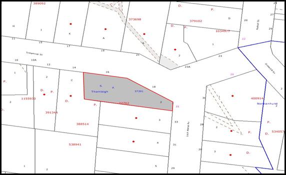
|
NOTIFICATION
PLAN
|
|
|
• PROPERTIES NOTIFIED
|
X SUBMISSIONS
RECEIVED
|
PROPERTY SUBJECT OF DEVELOPMENT
|
|
|
|
|
|
5.2 Public Agencies
No referrals to external agencies were required.
6. THE PUBLIC INTEREST
Section 79C(1)(e) of the Act
requires Council to consider “the public interest”.
The public interest is an
overarching requirement, which includes the consideration of the matters
discussed in this report. Implicit to the public interest is the achievement
of future built outcomes adequately responding to and respecting the future
desired outcomes expressed in environmental planning instruments and
development control plans.
The application is considered to
have satisfactorily addressed Council’s criteria and would provide a
development outcome that, on balance, would result in a positive impact for the
community. Accordingly, it is considered that the approval of the proposed
subdivision would be in the public interest.
CONCLUSION
The application proposes the
re-subdivision of a strata subdivision allotment resulting in two Torrens title allotments for an existing two unit multi-unit housing development.
The proposal is generally
consistent with the relevant requirements as contained within SEPP 1, HSLEP and
the respective Development Control Plans. The proposal does not comply with
the prescriptive density control for the Residential A zones in the HSLEP.
However, in accordance with SEPP 1, the proposed variation to the development
standard is supported.
The development is unlikely to
result in any significant impacts upon the natural or built environments, or
have any negative social or economic impacts. Given this, and the recommended
conditions, it is recommended that the application be approved.
Note: At the time of the
completion of this planning report, no persons have made a Political
Donations Disclosure Statement pursuant to Section 147(3) of the
Environmental Planning and Assessment Act 1979 in respect of the subject
planning
|
Rod Pickles
Manager -
Assessment Team 2
Planning Division
|
Paul David
Manager -
Subdivision & Development Engineering Services
Planning Division
|
|
Scott Phillips
Executive Manager
Planning Division
|
|
Attachments:
|
1.View
|
Locality Plan
|
|
|
|
2.View
|
Site Plan
|
|
|
|
3.View
|
Floor Plans
|
|
|
|
4.View
|
First Floor Plan
|
|
|
|
5.View
|
Indicative
Stormwater Concept Plan (existing)
|
|
|
|
6.View
|
Stormwater Concept
Plan (2/16 Trelawney Street)
|
|
|
File Reference: DA/1204/2010
Document Number: D01578533
SCHEDULE 1
GENERAL
CONDITIONS
The conditions of consent within this notice of determination have
been applied to ensure that the use of the land and/or building is carried out
in such a manner that is consistent with the aims and objectives of the relevant
legislation, planning instruments and Council policies affecting the land and
does not disrupt the amenity of the neighbourhood or impact upon the
environment.
Note: For the
purpose of this consent, the term ‘applicant’ means any person who has the authority
to act on or the benefit of the development consent.
Note: For the purpose of
this consent, any reference to an Act, Regulation, Australian Standard or
publication by a public authority shall be taken to mean the gazetted Act or
Regulation, or adopted Australian Standard or publication as in force on the
date that the application for a construction certificate is made.
1. Approved
Plans and Supporting Documentation
The development must be carried
out in accordance with the plans and documentation listed below and endorsed
with Council’s stamp, except where amended by Council and/or other conditions
of this consent:
|
Plan
|
Provided by
|
Lodged on
|
|
Site Plan
|
Red Gum Town Planning Services
|
29.09.2010
|
|
Ground Floor Plan
|
Red Gum Town Planning Services
|
29.09.2010
|
|
First Floor Diagram
|
Red Gum Town Planning Services
|
29.09.2010
|
|
Stormwater Concept Plan (2/16 Trelawney Street)
|
Red Gum Town Planning Services
|
29.09.2010
|
|
Indicative Stormwater Concept
Plan (Existing)
|
Red Gum Town Planning Services
|
29.09.2010
|
REQUIREMENTS PRIOR TO THE ISSUE OF A SUBDIVISION
CERTIFICATE
Note: For
the purpose of this consent, any reference to ‘occupation certificate’ shall
also be taken to mean ‘interim occupation certificate’ unless otherwise stated.
2. Sydney
Water – s73 Certificate
A s73 Certificate must be
obtained from Sydney Water.
- END OF CONDITIONS –
ADVISORY NOTES
The following information is provided for your
assistance to ensure compliance with the Environmental Planning and Assessment
Act 1979, Environmental Planning and Assessment Regulation 2000, other relevant
legislation and Council’s policies and specifications. This information does
not form part of the conditions of development consent pursuant to Section 80A
of the Act.
Subdivision Certificate Requirements
A subdivision certificate
application is required to be lodged with Council containing the following
information:
· A surveyor’s certificate certifying that
all structures within the subject land comply with the development consent in
regard to the setbacks from the new boundaries.
· A surveyor’s certificate certifying that
all services, drainage lines or access are located wholly within the property
boundaries. Where services encroach over the new boundaries, easements are to
be created.
Note: Council
will not issue a subdivision certificate until all conditions of the
development consent have been completed.
Fees and Charges – Subdivision
All fees payable to Council as
part of any construction, compliance or subdivision certificate or inspection
associated with the development (including the registration of privately issued
certificates) are required to be paid in full prior to the issue of the
subdivision certificate. Any additional Council inspections beyond the scope
of any compliance certificate required to verify compliance with the terms of
this consent will be charged at the individual inspection rate nominated in
Council's Fees and Charges Schedule.
House Numbering
House numbering can only be
authorised by Council. Before proceeding to number each premise in the
development, the allocation of numbers is required to be obtained from
Council's Planning Division. The authorised numbers are required to be
displayed in a clear manner at or near the main entrance to each premise.
Tree Preservation Order
To ensure the maintenance and
protection of the existing natural environment, it is an offence to ringbark,
cut down, top, lop, remove, wilfully injure or destroy a tree outside 3 metres
of the approved building envelope without the prior written consent from
Council.
Note: A
tree is defined as a single or multi-trunked wood perennial plant having a
height of not less than three (3) metres, and which develops many branches,
usually from a distance of not less than one (1) metre from the ground, but
excluding any plant which, in its particular location, is a noxious plant
declared as such pursuant to the Noxious Weeds Act 1993. This definition of
‘tree’ includes any and all types of Palm trees.
All
distances are determined under Australian Standard 4970-2009 “Protection of
Trees on Development Sites”.
Fines may be imposed for
non-compliance with Council’s Tree Preservation Order.
Planning Report No. PLN15/11
Date of Meeting: 2/02/2011
6 DEVELOPMENT APPLICATION
- CONSTRUCTION OF A GOLF DRIVING RANGE AND GOLF CENTRE
142 - 178 PENNANT HILLS ROAD, THORNLEIGH
|
Development Application No.
|
1245/2010
|
|
Description of Proposal:
|
Construction of a Golf
Driving Range and Golf Centre
|
|
Property Description:
|
Brickpit Park, Lot 1 DP 633292, (Nos. 142 – 178) Pennant Hills Road, Thornleigh
|
|
Applicant:
|
Thornleigh Golf Centre Pty Ltd
|
|
Owner:
|
Hornsby Shire Council
|
|
Statutory Provisions:
|
Hornsby Shire Local Environmental
Plan 1994
Industrial A (General) Zone
Open Space A (Public
Recreation – Local) Zone
|
|
Estimated Value:
|
$3,750,000
|
|
Ward:
|
C
|
|
RECOMMENDATION
THAT Development Application
No. 1245/2010 for the construction of a Golf Driving Range and Golf Centre at
Lot 1 DP 633292, (Nos. 142 – 178) Pennant Hills Road, Thornleigh be approved
for the reasons detailed in the independent town planning consultant’s report
– AECOM Australia Pty Ltd and reproduced in Schedule 1 of this report.
|
1. The
application proposes the construction of a golf driving range and golf centre.
2. Council
is the owner of the land. In accordance with Council’s adopted policies ‘PSA1
Proposed Council Developments’ and ‘Practice Note No. 7 Assessment
Practice’, and independent assessment of the development application has
been undertaken by AECOM Australia Pty Ltd.
3. The
proposal complies with the relevant provisions of:-
i. Hornsby
Shire Local Environmental Plan 1994, and
ii. The
Brickpit Park Plan of Management.
4. No
public submissions have been received in respect of the application.
5. The
report by AECOM Australia Pty Ltd is attached to this report for
Council’s consideration. The independent consultant’s report recommends
approval of the application.
ASSESSMENT
In accordance with Council’s adopted
policies ‘PS41 Proposed Council Developments’ and ‘Practice Note No.
7- Assessment Practice, the assessment of the development application has
been referred to an independent town planning consultant. The report by AECOM
Australia Pty Ltd is held at Attachment 2 of this report.
CONCLUSION
The proposal involves the
construction of a golf driving range and golf centre.
No public submissions have been
received concerning the proposal.
Council has referred the
application to an independent planning consultancy to carry out an assessment
of the application. The report concludes that the application should be
approved.
It is recommended that Council
approved the application in accordance with the recommended conditions of
consent prepared by AECOM Australia Pty Ltd and held at Schedule 1 of
this report.
Note: At the time of the completion of this planning report,
no persons have made a Political Donations Disclosure Statement pursuant
to Section 147(3) of the Environmental Planning and Assessment Act 1979 in
respect of the subject planning application.
|
Rod Pickles
Manager -
Assessment Team 2
Planning Division
|
Scott Phillips
Executive Manager
Planning Division
|
Attachments:
|
1.View
|
Locality Plan
|
|
|
|
2.View
|
Consultant's
Report
|
|
|
|
3.View
|
Site Plan and
Earthworks Plan
|
|
|
|
4.View
|
Landscape Plans
|
|
|
|
5.View
|
Perimeter Fence
System Plan
|
|
|
|
6.View
|
Club House Plans
|
|
|
|
7.View
|
Stormwater Concept
Plan
|
|
|
|
8.View
|
Waste Store and
Concept Plan
|
|
|
File Reference: DA/1245/2010
Document Number: D01578580
SCHEDULE 1
GENERAL
CONDITIONS
The
conditions of consent within this notice of determination have been applied to
ensure that the use of the land and/or building is carried out in such a manner
that is consistent with the aims and objectives of the relevant legislation, planning
instruments and Council policies affecting the land and does not disrupt the
amenity of the neighbourhood or impact upon the environment.
Note: For the purpose of
this consent, the term ‘applicant’ means any person who has the authority to
act on or the benefit of the development consent.
Note: For the purpose of
this consent, any reference to an Act, Regulation, Australian Standard or
publication by a public authority shall be taken to mean the gazetted Act or
Regulation, or adopted Australian Standard or publication as in force on the
date that the application for a construction certificate is made.
1. Approved
Plans and Supporting Documentation
The
development must be carried out in accordance with the plans and documentation
listed below and endorsed with Council’s stamp, except where amended by Council
and/or other conditions of this consent:
|
Plan No.
|
Drawn by
|
Dated
|
|
B64\DA\A01
|
OPRA Architects
|
05/10/10
|
|
B64\DA\A02
|
OPRA Architects
|
05/10/10
|
|
B64\DA\A03
|
OPRA Architects
|
05/10/10
|
|
B64\DA\A04
|
OPRA Architects
|
05/10/10
|
|
B64\DA\B64waste
|
OPRA Architects
|
14/11/10
|
|
Landscape details sheet 1
|
OPRA Architects
|
14/11/10
|
|
Landscape details sheet 2
|
OPRA Architects
|
25/11/10
|
|
Landscape details sheet 3
|
OPRA Architects
|
25/11/10
|
|
Silt Control Plan H-02
|
Building Services
Engineers Pty Ltd
|
05/10/10
|
|
Site Survey
|
Craig and Rhodes
Surveyors Pty Ltd
|
March 2010
|
|
Stormwater Concept Plan –
Drawing No. H-01
|
Building Services
Engineers
|
5/10/10
|
|
Document
|
Prepared by
|
Dated
|
|
Statement of
Environmental Effects
|
Glendinning Minto and
Associates
|
October 2010
|
2. Retention
of Terra Street access
The existing
access to Brickpit Park from Pennant Hills Road near Terra Street is to be
maintained to allow access to the skate park, sports stadium and playground.
3. Retention
of Existing Trees
This
development consent does not permit the removal of trees identified on Plan No.
11-01 prepared by Building Services Engineers dated 5-10-2010. The removal of
any other trees requires separate approval under Council’s Tree Preservation
Order.
REQUIREMENTS PRIOR TO THE ISSUE OF A CONSTRUCTION
CERTIFICATE
4. Miniature
golf course detail
Detailed plans of the 36
hole miniature golf course proposed at the western end of the site must be
provided and approved by Council prior to the issue of a Construction
Certificate for the miniature golf course.
5. Water/Electricity
Utility Services
The applicant
must submit written evidence of the following service provider requirements:
a. Energy
Australia – a letter of consent demonstrating that satisfactory arrangements
have been made to service the proposed development.
b. Sydney
Water – the submission of a ‘Notice of Requirements’ under s73 of the Sydney
Water Act 1994.
Note: Sydney
Water requires that s73 applications are to be made through an authorised Sydney
Water Servicing Coordinator. Refer to www.sydneywater.com.au
or telephone 13 20 92 for assistance.
6. Internal
Driveway/Vehicular Areas
Driveway areas
on site must be designed in accordance with Australian Standards 2890.1,
2890.2, and the following requirements:
a. The
driveway grade must not exceed 15 percent and transitions for changes in grade
must not exceed AS 2890.2 requirements for MRV’s.
b. The
pavement be designed and constructed as either concrete or asphaltic concrete
seal full depth pavement according to Council’s Design and Construction
Specification 2005.
c. The
pavement shall have a kerb to one side and a one-way cross fall with a minimum
gradient of 2 percent and kerb inlet pits provided on grade and at sag points.
d. Retaining
walls required to support the carriageway and the compaction of all fill
batters to be in accordance with the requirements of a chartered structural
engineer.
e. The
provision of safety rails where there is a level difference more than 0.3
metres and a 1:4 batter can not be achieved.
f. Parking
and access area lighting shall be designed and constructed in accordance with
AS 1158.
g. All
parking areas and driveways are to be sealed to an all weather standard, line
marked and signposted;
h. Conduit
for utility services including electricity, water, gas and telephone be
provided.
7. On
Site Stormwater Detention
An on-site
stormwater detention system must be designed by a chartered civil engineer and
constructed in accordance with the following requirements:
a. Have
a detained volume of not less than which contains the 20 year average
recurrence interval (ARI) storm from the driving range catchment, and a
corresponding maximum discharge (when full) for that catchment’s predevelopment
5 year ARI flow rate.
b.
Have a surcharge/inspection grate located directly above the outlet.
c. Discharge
from the detention system to be controlled via 1 metre length of pipe, not less
than 50 millimetres diameter or via a stainless plate with sharply drilled
orifice bolted over the face of the outlet discharging into a larger diameter
pipe capable of carrying the design flow to an approved Council system.
d. Where
above ground and the design storm depth is greater than 0.3 metres, a warning
sign indicating ponding depth during the design storm should be provided.
e. Not
be constructed in a location that would impact upon the visual or recreational
amenity of facility users.
8. Stormwater
Drainage
The stormwater
drainage system for the development must be designed and constructed in
accordance with Council’s Civil Works – Design and Construction
Specification 2005 and the following requirements:
a. Connected
directly from the proposed on-site detention and pavement system drainage to
the existing Council-controlled piped drainage system within the skate park
land adjacent to the north, with consent of the owner, Hornsby Shire Council.
b. The
drainage system be designed and constructed as a reinforced concrete piped
drainage system to contain the 20 year Average Recurrence Interval storm event
from the upstream catchment.
9. Range
fence post footings and gabion walls
To ensure
sufficient area to install the range fence posts footings near gabion walls
details must be provided prior to the issuing of a construction certificate.
10. Earthworks
surrounding range post footings
The grade of
all banks associated with the range post footings must be no greater than 1:4.
11. Revised
Waste Management Plan
The submission
of a revised Waste Management Plan – Section Four – Use and On-going
Management is required including:
a. Location
and dimensions of the bin storage room and bin collection point (if not the bin
storage room).
b. Waste
generation rates, bin sizes, number of bins and frequency of servicing.
c. Use of medium-rigid
vehicles for waste collection only.
d. Vehicle
turning paths need to be provided to demonstrate that medium rigid waste
collection vehicles are able to enter the site, drive to the bin
room/collection point and exit in a forward direction.
e.
The bin collection point must be located no greater than 6 metres from the
waste collection vehicle parking position, the distance being measured along
the bin carting route.
f.
The bins placed at the bin collection point for servicing must be screened from
public view.
12. Bin
storage design
The bin
storage room(s) must be designed in accordance with the Waste Minimisation
and Management Development Control Plan with regards to water/hose for
cleansing, graded floors with drainage to sewer, robust door(s),
sealed/impervious surfaces, adequate lighting and ventilation.
13. Building
Code of Australia
All building
work must be carried out in accordance with the requirements of the Building
Code of Australia.
REQUIREMENTS PRIOR TO THE COMMENCEMENT OF ANY WORKS
14. Erosion
and Sediment Control
Erosion and
sediment control measures must be provided and maintained throughout the
construction period in accordance with the manual ‘Soils and Construction
2004 (Bluebook)’, the approved plans, Council specifications and to the
satisfaction of the principal certifying authority. The erosion and sediment
control devices must remain in place until the site has been stabilised and
revegetated.
Note: On
the spot penalties up to $1,500 may be issued for any non-compliance with this
requirement without any further notification or warning.
15. Landscape
Plan
The landscape
plan (B64/DA/B64waste dated 14/11/2010) must be amended to include reference to
the following:
a. In addition to the planting of Wallaby Grass (Themeda
australis), the planting schedule shall be diversified and combined with
other locally native grasses which originate from native Blue Gum Forest
including a mixture of some of the following native species:
i. Danthnoia
tenuoir.
ii. Danthnoia
racemosa.
iii. Echinopgon
ovatus.
iv. Poa
affinis.
v. Austrostipa
pubecsens.
vi. Dichelcahne
micranthra.
vii. Microlanena
stipoides.
viii. Entolasia
marginate.
b. Seed stock must be collected from the local vegetation
communities comprising the Blue Gum High Forest (BGHF) Critically Endangered
Community or Sydney Turpentine Ironbark Forest Endangered Ecological Community
listed under the Threatened Species Conservation Act 1995 from Northern Sydney and/or within a 20 Km radius of the site.
Notes: *Seed should be collected by qualified and
experienced/licensed seed collectors (Section 91 license No. from DECCW to be
provided to Council).
*If seed
cannot be purchased in time, the site should be jute matted with no plant
material installed until seed obtained at an appropriate collection period can
be applied.
*No mulch
should be placed on the area outside the lease zone within the BGHF.
Application of mulch in areas outside the BGHF area is permitted.
REQUIREMENTS DURING CONSTRUCTION
16. Council
Property
During
construction works, no building materials, waste, machinery or related matter
is to be stored on the road or footpath. The public reserve is to be kept in a
clean, tidy and safe condition at all times.
17. Demolition
All demolition
work must be carried out in accordance with Australian Standard 2601-2001 –
The Demolition of Structures and the following requirements:
a. Demolition
material is to be disposed of to an authorised recycling and/or waste disposal
site and/or in accordance with an approved waste management plan.
b. Demolition
works, where asbestos material is being removed, must be undertaken by a
contractor that holds an appropriate licence issued by WorkCover NSW in
accordance with Chapter 10 of the Occupational Health and Safety Regulation
2001 and Clause 29 of the Protection of the Environment Operations
(Waste) Regulation 1996.
c. On
construction sites where buildings contain asbestos material, a standard
commercially manufactured sign containing the words ‘DANGER ASBESTOS REMOVAL IN
PROGRESS’ measuring not less than 400mm x 300mm must be erected in a prominent
position visible from the street.
18. Environmental
Management
The site must
be managed in accordance with the publication ‘Managing Urban Stormwater –
Landcom (March 2004) and the Protection of the Environment Operations
Act 1997 by way of implementing appropriate measures to prevent sediment
run-off, excessive dust, noise or odour emanating from the site during the
construction of the development.
19. Street
Sweeping
Street sweeping must be undertaken following sediment
tracking from the site along Dartford Road, Thornleigh and Pennant Hills Road, Thornleigh during works and until the site is
established.
20. Landfill
Earthworks on
site must be undertaken in accordance with Council’s ‘Construction
Specification, 2005’ and the following requirements:
a. All
fill material imported to the site is to wholly consist of Virgin Excavated
Natural Material (VENM) as defined in Schedule 1 of the Protection of the
Environment Operations Act 1997 or a material approved under the Department
of Environment and Climate Change’s general resource recovery exemption.
b. A
compaction certificate is to be obtained from a geotechnical engineer verifying
that the specified compaction requirements have been met.
21. Excavated
Material
All excavated
material removed from the site must be classified in accordance with the
Department of Environment, Climate Change and Water NSW Waste Classification
Guidelines prior to disposal to an approved waste management facility and
reported to the principal certifying authority.
22. Noise
– Plant and Machinery
The level of total
continuous noise emanating from operation of all the plant, including air
conditioning units and processes in all buildings (LA10) (measured for at least
15 minutes) in or on the above premises, must not exceed the background
level by more than 5dB(A) when measured at all property boundaries.
23. Works
near Trees
All required
tree protection measures are to be maintained in good condition for the
duration of the construction period.
All works
(including driveways and retaining walls) within four metres of any trees
required to be retained (whether or not on the subject property, and pursuant
to this consent or the Tree Preservation Order), must be carried out
under the supervision of an ‘AQF Level 5 Arborist’ and a certificate
submitted to the principal certifying authority detailing the method(s) used to
preserve the tree(s).
Note: Except as provided above, the applicant is to ensure that no
excavation, filling or stockpiling of building materials, parking of vehicles
or plant, disposal of cement slurry, waste water or other contaminants is to
occur within 4 metres of any tree to be retained.
24. Retention
of clay capping
No actions,
works or material during the construction and operation of the proposed
development are to penetrate through the clay capping on site at 142-178 Pennant Hills Road, Thornleigh.
25. Settlement
Should
settlement on the site result in troughs, material must be added to
smooth/level the surface to achieve a satisfactory slope as opposed to removing
material from the site.
REQUIREMENTS PRIOR TO THE ISSUE OF AN OCCUPATION
CERTIFICATE
Note: For
the purpose of this consent, any reference to ‘occupation certificate’ shall
also be taken to mean ‘interim occupation certificate’ unless otherwise stated.
26. Sydney
Water – s73 Certificate
A s73
Certificate must be obtained from Sydney Water.
27. Damage
to Council Assets
Any damage
caused to Council’s assets as a result of the construction of the development
must be rectified in accordance with Council’s written requirements and at the
sole cost of the applicant.
28. Creation
of Easements
The following forms, sketches
and plans must be submitted to Hornsby Shire Council prior to release of the
Occupation Certificate;-
a. The
submission of completed Surveyor’s Sketches and properly filled-out standard
LPMA Forms 13PC and 13RPA for the "Positive Covenant" and "Restriction
as to User", respectively, over the constructed on-site detention
system and outlet works, within the development area in favour of Council in
accordance with Council’s prescribed wording. The position of the on-site
detention system is to be clearly indicated on the title as per the Surveyor’s
Sketch.
b. “Works-as-executed”
details of the on-site-detention system must be submitted verifying that the
required storage and discharge rates have been constructed in accordance with
the design requirements. The details must show the invert levels of the on
site system together with pipe sizes and grades. Any variations to the
approved plans must be shown in red on the “works-as-executed” plan and
supported by calculations.
Note: Council
must be nominated as the authority to release, vary or modify any easement,
restriction or covenant.
29. Works
as Executed Plan
A works-as-executed plan(s)
must be prepared by a registered surveyor and submitted to Council for
completed road pavement, kerb & gutter, public drainage systems, driveways
and on-site detention systems.
30. Completion
of Landscaping
A certificate
must be provided by a practicing landscape architect, horticulturalist or
person with similar qualifications and experience certifying that all required
landscaping works have been satisfactorily completed in accordance with the
approved landscape plans.
31. Bushland
Restoration
To ensure the
regeneration of bushland, the applicant must ensure the following:
a. All
environmental and noxious weeds including African Olive, Broad-leaved Privet,
Small-leaved Privet and Bridal Creeper at the western end inside the lease area
where the Blue Gum High Forest occurs are to be removed and suppressed using
recognised bush regeneration methods in accordance with ‘Recovering bushland
on the Cumberland Plain: Best practice guidelines for the management and
restoration of bushland – Department of Conservation 2005’.
Note:
The Guideline is available at: www.environment.nsw.gov.au,
publications.
Note:
Advice on appropriate bush regeneration methods and the removal of noxious
and environmental weeds can be obtained from Council’s Bushland and
Biodiversity Management Team on 9847 6542.
32. Waste
Management Plan compliance
To confirm compliance with the Waste Management Plans
lodged with this Development Application, a report(s) must be prepared
by an appropriately qualified person and submitted to the principal certifying
authority prior to the issue of the Subdivision/Occupation Certificate,
certifying that:
a. Either
i. The
Waste Management Plan Section One – Demolition Stage and Section Three –
Construction Stage were implemented and at least 60 % waste generated was
reused or recycled;
Or
ii. If
the 60% diversion from landfill was not achieved in the Demolition Stage and/or
Construction Stage, the Report is to include the reasons why this occurred and
certify that appropriate work practices were employed in the demolition and
construction stages to implement the Waste Management Plan.
b. The
Report(s) is based on documentary evidence (i.e. tipping dockets/receipts from
recycling depots, transfer stations and landfills, audits of procedures etc)
which have been attached to the Report.
33. Gas
removal system
Any
constructed building must have a passive gas removal system in place via a gas
drainage layer or sub floor ventilation.
34. Car
park access
Access to the
car park must be provided by creating an additional leg to the roundabout with
the geometry and surface finish of the access consistent with the existing
internal road network. Amended plans showing the additional leg to the
roundabout are to be provided and approved by Council.
35. Landscape
establishment
The landscape works, the subject of this development
consent, must be maintained into the future to ensure the establishment and
successful growth of plant material to meet the intent of the landscape design.
This shall include but not be limited to watering, weeding, replacement of
failed plant material and promoting the growth of plants through standard
industry practices.
36. Hours
of Operation
The hours of operation of
the premise are restricted to those times listed below:
Monday to Sunday 6:30
am to 10:30 pm
37. Valid
waste contractor contract
The operation
must keep written evidence on site of a valid contract with a licensed waste
contractor(s) for the regular collection and disposal of the waste and
recyclables that are generated on site.
38. Use
of enclosed bins
All
waste/recyclable materials generated on site must be kept in enclosed bins with
securely fitting lids so the contents are not able to leak or overflow.
39. Maintenance of clean/tidy site
The
land and adjoining areas are to be kept in clean and tidy conditions at all
times. This includes, but is not limited to, stray golf ball
retrieval/collection, including patrols of neighbouring streets to retrieve
golf balls at least monthly or more frequently if required or as requested by
Council.
40. Restriction on Advertising
In accordance
with Clause 10 of State Environmental Planning Policy No.64 – Advertising and
Signage the content of all approved signage must be restricted to business or
building identification and shall not include advertisements.
41. Car Parking
All car parking must be operated in accordance with Australian
Standard AS/NZS 2890.1:2004 – Off-street car parking,
a. Car
parking, loading and manoeuvring areas to be used solely for nominated
purposes;
b. Vehicles
awaiting loading, unloading or servicing shall be parked on site and not on adjacent
or nearby public roads;
c. All
vehicular entry on to the site and egress from the site shall be made in a
forward direction.
42. Rain
Water Tank
Water
collected within any rainwater tank as part of the development must be limited
to non-potable uses only.
Note: NSW Health recommends that the use of rainwater tanks
for drinking purposes not occur where a reticulated potable water supply is
available.
43. Noise
All noise generated by the
proposed development must be attenuated to prevent levels of noise being
emitted to adjacent premises which possess tonal, beating and similar
characteristics or which exceeds background noise levels by more than 5dB(A).
44. Flag
Pole Structures
The three flag pole
structures approved under this consent is decorative only and must not display
advertisements.
- END OF CONDITIONS –
ADVISORY NOTES
The following information is provided for your
assistance to ensure compliance with the Environmental Planning and Assessment
Act 1979, Environmental Planning and Assessment Regulation 2000, other relevant
legislation and Council’s policies and specifications. This information does
not form part of the conditions of development consent pursuant to Section 80A
of the Act.
Environmental Planning
and Assessment Act, 1979 Requirements
· The issue of a construction certificate
prior to the commencement of any works. Enquiries regarding the issue of a
construction certificate can be made to Council’s Customer Services Branch on
9847 6760.
· A principal certifying authority to be
nominated and Council notified of that appointment prior to the commencement of
any works.
· Council to be given at least two days
written notice prior to the commencement of any works.
· Mandatory inspections of nominated
stages of the construction inspected.
· An occupation certificate to be issued
before occupying any building or commencing the use of the land.
Dial Before You Dig
Prior to commencing any works,
the applicant is encouraged to contact Dial Before You Dig on 1100 or www.dialbeforeyoudig.com.au for
free information on potential underground pipes and cables within the vicinity
of the development site.
Support post placement
The netting support posts must not be placed over gas lines or penetrate
the clay capping.
Disability Discrimination Act
The applicant’s attention is
drawn to the existence of the Disability Discrimination Act. A
construction certificate is required to be obtained for the proposed
building/s, which will provide consideration under the Building Code of
Australia, however, the development may not comply with the requirements of
the Disability Discrimination Act. This is the sole responsibility of
the applicant.
Advertising Signage – Separate DA Required
No advertising signage may be
located on the Dartford Road directional signs located at the junctions of
Dartford Road/Pennant Hills Road and Milson Parade/Dartford Road.
This consent does not permit the
erection or display of any additional advertising signs. Most advertising
signs or structures require development consent. Applicants should make
separate enquiries with Council prior to erecting or displaying any advertising
signage.
Standard Report No. PLN13/11
Planning Division
Date of Meeting:
2/02/2011
7 REPORTING VARIATIONS TO
DEVELOPMENT STANDARDS
EXECUTIVE SUMMARY
In accordance with the Department
of Planning’s Planning Circular PS 08-14, Council is required to report
variations to development standards for development applications approved under
delegated authority, which relied upon State Environmental Planning Policy
No. 1 - Development Standards (SEPP 1).
PURPOSE
The purpose of this report is to advise Council of
determined development applications involving a SEPP 1 variation to a
development standard relating to the period 1 October 2010 to 31 December 2010.
DISCUSSION
The Department of Planning issued Circular
PS 08–014 on 14 November 2008. The purpose of the Circular was to remind
councils of their responsibilities to monitor the use of the Director-General’s
assumed concurrence under State Environmental Planning Policy No. 1.
Councils were reminded of the need to keep accurate records of the use of SEPP
1 and to report on a quarterly basis.
The Circular also provides that Councils are
required to adopt the following four measures:
1. Establish
a register of development applications determined with variations in standards
under SEPP 1.
2. Require
all development applications where there has been a variation greater than 10%
in standards under SEPP 1 to be determined by full council (rather than general
manager or nominated staff member)
3. Provide
a report to each council meeting on the development applications determined
where there had been a variation in standards under SEPP 1.
4. Make
the register of development applications determined with variations in standards
under SEPP 1 available to the public on the council’s website.
In accordance with Point 3 of the Department’s Circular,
attached hereto is a list of development applications determined under
delegated authority involving a SEPP 1
variation to a development standard for the
period 1 October 2010 to 31 December 2010.
A copy of the attachment to this report is also reproduced
on Council’s website.
BUDGET
There are no budget implications.
POLICY
There are no policy implications.
CONSULTATION
There was no consultation in the preparation of this
report.
TRIPLE BOTTOM LINE SUMMARY
Triple Bottom Line is a framework for improving Council
decisions by ensuring accountability and transparency on social, environmental
and economic factors. It does this by reporting upon Council’s strategic
themes.
As this report simply provides Council with information and
does not propose any actions which require a sustainability assessment, no
Triple Bottom Line considerations apply.
|
RECOMMENDATION
THAT Council note the contents
of Executive Manager’s Report No. PLN13/11.
|
|
Scott Phillips
Executive Manager
Planning Division
|
|
Attachments:
File Reference: F2004/07599
Document Number: D01576914
Standard Report No. PLN16/11
Planning Division
Date of Meeting:
2/02/2011
8 TOWNHOUSE PLANNING
PROPOSAL - REPORT ON SUBMISSIONS
EXECUTIVE SUMMARY
At its meeting on 7 July 2010,
Council considered a report concerning (in part) a Townhouse Planning
Proposal prepared to assist meet the shortfall in Council’s dwelling
obligations caused by the deletion of certain precincts from the Housing Strategy. The Proposal aims to rezone land to permit townhouses and
to amend the boundary of a Housing Strategy precinct in Mount Colah.
Council resolved to forward the Townhouse
Planning Proposal to the Department of Planning (DOP) requesting
authorisation for public exhibition. A Gateway Determination was received
indicating that the Planning Proposal could be exhibited. Accordingly,
the Proposal was placed on public exhibition from 23 September 2010 to
22 October 2010.
A total of 37 submissions were
received, including 5 submissions from government agencies. The Rural Fire
Service (RFS) raises concern with the boundary extension for the Mount Colah
Commercial Centre Housing Strategy precinct. Accordingly, this
report recommends that the boundary extension be deleted from the Planning
Proposal until the concerns of the RFS have been investigated. Council’s
internal investigations recommend that an area of road reserve on the Pacific Highway at the frontage of property Nos. 396-398 Pacific Highway, Hornsby be
included in the townhouse precinct bounded by Mildred Street, Pacific Highway and Citrus Avenue, Hornsby. This report recommends the inclusion of the road
reserve.
Issues
raised in submissions are addressed in this report. An amended Planning
Proposal is attached. It is recommended that Council forward the Planning
Proposal to the DOP for gazettal and prepare draft amendments to the Medium
Density Multi-Unit Housing Development Control Plan (DCP) to incorporate
key principles diagrams for the new townhouse precincts.
PURPOSE
The purpose of this report is to review submissions received
in response to the exhibition of the Townhouse Planning Proposal.
BACKGROUND
At its
meeting on 7 July 2010, Council considered Executive Manager's Report No.
PLN44/10 concerning the Hornsby Shire Housing Strategy. The report
included a Townhouse Planning Proposal to assist meet the shortfall in
Council’s dwelling obligations under the Metropolitan Strategy caused by
the deletion of certain precincts from the Housing Strategy.
Council resolved (in part) to forward the Townhouse Planning
Proposal to the Minister seeking a Gateway Determination under Section 56
of the Environmental Planning and Assessment (EP&A) Act 1979.
In accordance
with Council’s resolution, the Townhouse Planning Proposal was forwarded
to the DOP on 13 July 2010. A Gateway Determination was received on 24 August
2010, indicating that the Planning Proposal could be exhibited for 28
days. Accordingly, the Townhouse Planning Proposal was placed on public
exhibition from 23 September 2010 to 22 October 2010.
DISCUSSION
This report discusses submissions
received in response to the public exhibition of the Townhouse Planning
Proposal.
Townhouse Planning Proposal
The Townhouse Planning
Proposal aims to rezone land to permit townhouses in out of centre
locations along transport corridors in Hornsby, Asquith and Mount Colah to assist increase the supply of this form of housing and ensure Council’s dwelling
target is met. The Proposal also aims to amend the boundary of a Housing Strategy precinct in Mount Colah, extending the area in which 5 storey
multi-unit development is permissible and including an additional property.
Exhibition and review of
submissions
The Townhouse Planning
Proposal was exhibited from 23 September 2010 to 22 October 2010. The
consultation met the statutory requirements of the Gateway Determination
including a requirement that the Proposal be exhibited for 28 days and
notified through a local newspaper, on the Council website and sent to relevant
public authorities. Advertisements were placed in the Hornsby Advocate,
Hills News and Northern District Times. The Planning Proposal
and supporting documentation were displayed at Council’s Administration Centre,
at all libraries, and on the Council website. Letters were sent to property
owners proposed to be rezoned and owners within 500m of properties proposed to
be rezoned. Letters were also sent to relevant community and industry groups,
and referrals were sent to other Divisions of Council.
In accordance with the Gateway
Determination, 7 public authorities including the Department of Education and
Training, Department of Environment, Climate Change and Water, Department of Housing, Energy Australia, NSW Rural Fire Service, NSW Transport and Infrastructure and the
Roads and Traffic Authority were consulted.
A total of 37 submissions
(including three received after the exhibition period) have been received,
including 5 submissions from public authorities and 4 from Council branches.
Fifteen submissions (40%) raise objection to the Planning Proposal, 13
submissions (35%) indicate support or no objection, 7 make general comments on
the Planning Proposal and/or suggest alternative areas and 2 make
comment on the Housing Strategy which has already been adopted by
Council.
Key issues raised in submissions
concerning the Townhouse Planning Proposal include objections to further
development, objections to the extension of the Housing Strategy
precinct at Mount Colah, objections to density and suggestions for other areas.
A summary of submissions is attached to this report. Major issues raised in
submissions are addressed below.
Objections to further
development
Submitters comment that further
development should not be imposed on the community. Some of the reasons for
objection to further development include:
· unnecessary extra
development;
· the proposal is
negligible in meeting the State Government housing target;
· inadequate local
infrastructure;
· detrimental impact on the
character of the area; and
· traffic issues.
Comment: The
precincts identified for townhouse development are required to assist meet
Council’s dwelling obligations under the Metropolitan Strategy. The
dwelling yields associated with the Townhouse Planning Proposal count
towards Council’s Housing Strategy target. Council consulted with
infrastructure providers during the preparation and exhibition of the Housing Strategy. Service providers indicated that services either have capacity or
can be augmented to meet Council’s housing target. Therefore, no amendments are
recommended to the Proposal based on objections concerning extra
development, housing targets and inadequate infrastructure.
Places continue to change, evolve
and grow over time to cater for the changing needs of the population. By
selecting precincts in particular areas for rezoning, the Planning Proposal
aims to assist in protecting the low density nature of the remainder of the
Shire. Therefore, no amendments are recommended to the Proposal based on
objections concerning character.
Council’s Traffic and Road Safety
Branch investigated the Proposal and the RTA was consulted during the
exhibition of the Proposal. No objections were raised. The magnitude of
traffic that will be generated as a result of the proposed townhouses is not
expected to have an adverse impact on traffic conditions on the road network.
Local traffic management improvement works would be identified in key
principles diagrams to be drafted for inclusion in Council’s Medium Density
Multi-Unit Housing DCP. The key principles diagrams would be presented to
Council and subsequently exhibited as an amendment to the DCP. Therefore,
no amendments are recommended to the Proposal based on objections
concerning traffic issues.
Resolve: No
amendments are recommended as a result of submissions objecting to further
development. A report be presented to Council concerning draft amendments to
the Medium Density Multi-Unit Housing DCP, including the insertion of
key principles diagrams identifying traffic improvements.
Extension of Housing Strategy precinct boundary
A number of submissions object to
the proposal to extend the Housing Strategy precinct at Mount Colah due to bushfire issues. One submission was received in support of the proposed
extension to the Mt Colah Commercial Centre precinct boundary. The submission,
made on behalf of the owner of part of the precinct, comments that the boundary
extension will facilitate management of the overall development, particularly
in regard to bushfire control.
A submission from the RFS raises
concern with the extension to the precinct boundary. The RFS submission raises
concern with the ability of future development in the precinct to achieve the
aims and objectives of Planning for Bushfire Protection 2006. None of
the precincts proposed for townhouse development are bushfire prone, and the
RFS raises no issues concerning the other precincts proposed as part of the Townhouse
Planning Proposal.
Comment: Council
sought clarification from the RFS concerning its submission, as the RFS
previously raised no objection to the rezoning of the Mount Colah Commercial
Centre precinct during consultation on the Housing Strategy. In
response, the RFS advises that as a result of the outcomes of the Royal
Commission into the Victorian bushfires, it is currently reviewing and
developing policies to cater for high rise development in the future, and that
it has requested the Minister to defer the gazettal of the Mount Colah
Commercial Centre precinct in the Housing Strategy Planning Proposal
until the concerns have been investigated.
Council has sought clarification
from the DOP concerning the implications of the RFS advice. No response has
been received to date. However, in light of the concerns and the pending
investigation by the RFS into how increased density is addressed in Planning
for Bushfire Protection 2006, it would be appropriate to defer the proposed
boundary extension at this stage. The proposal should be deleted from the Townhouse
Planning Proposal. Should the RFS concerns be resolved, the boundary
extension should be progressed as part of a separate Planning Proposal.
Resolve: The
proposed extension to the boundary of the Mount Colah Commercial Centre
precinct be deleted from the Townhouse Planning Proposal, pending
the RFS investigation into Planning for Bushfire Protection and high
rise development.
Objections to density
A number of submissions raise
concerns with the density of townhouse development. Submitters comment that the
proposal may lead to more high rise precincts in the future and that townhouses
could be 5 storeys in height with no building area controls.
Comment: The
Townhouse Planning Proposal aims to extend the boundaries of a Housing Strategy precinct which has previously been adopted to be rezoned to allow
5 storey development. The new precincts identified in the Proposal are
all proposed to be rezoned to allow 2 storey townhouse development. Once
rezoned, Council’s existing Medium Density Multi-Unit Housing DCP would
apply to future townhouse development. The DCP contains controls
limiting height, setbacks, and building area. The DCP would be amended
to include key principles diagrams for each precinct, which would be subject to
a separate report to Council and public exhibition as discussed above under the
heading Objections to further development.
Resolve: No
amendments be made to the Planning Proposal as a result of submissions
objecting to density.
Suggestions for other areas
A number of submitters comment
that there may be other areas more suitable for further development rather than
those identified in the Proposal. Other areas suggested in submissions
include:
· further north between Mount Colah and Mount Kuring-gai;
· within small concentric circles around
the station;
· in the vicinity of Asquith, Mount Colah and Mount Kuring-gai stations;
· in bush areas where no residents will be
affected;
· areas on the outskirts of Hornsby Heights, Mount Colah, Mount Kuring-gai and Berowra;
· between the railway and Unwin Road, Wahroonga;
· outskirts of Sydney;
· Asquith shopping area; and
· property Nos. 1101 – 1133 Pacific
Highway, Cowan.
A detailed submission for the
inclusion of the above properties at Cowan as a townhouse precinct was received
from a planning consultant.
Comment: Council
has identified townhouse precincts in out of centre locations (i.e. outside
commercial centre radii specified in the draft North Subregional Strategy)
and along transport corridors. This meets the requirements of the Metropolitan
Strategy and is consistent with the methodology used in the Housing Strategy. Some of the suggestions in submissions do not meet the Housing Strategy methodology such as avoiding bushfire prone land and areas of
heavy vegetation, and choosing areas with minimal traffic impacts.
The proposed Cowan precinct
requested for inclusion in the planning consultant submission involves bushfire
prone land. Given the recent comments from the RFS, Council should continue to
avoid bushfire prone land in selecting precincts for housing. Cowan was
discussed as a possible location for additional housing in the preparation of
the Housing Strategy. However, Cowan was removed from
consideration due to its limited range of services and shops, low train
frequency, lack of sewage system and bushfire prone land.
Resolve: No
amendments be made to the Planning Proposal as a result of submissions
suggesting other areas for rezoning.
Request for minor extension
of precinct
An investigation by Council’s
Works Division reveals that the precinct bounded by Citrus Avenue, Pacific
Highway and Mildred Avenue should be extended into the road reserve to
facilitate a road closure, reclassification and sale.
Comment: The area
of land at the frontage of property Nos. 396-398 Pacific Highway, Hornsby is
currently zoned Special Uses B (Transport Corridor). The road reserve is no
longer required for a road widening plan which was rescinded in 1992. Council,
at its meeting on 20 October 2010 considered Executive Manager’s Report No.
PLN71/10 concerning the proposed closure and sale of road adjoining property
Nos. 396-398 Pacific Highway, Hornsby. Council resolved (in part) to apply for
the closure of a small section (approximately 200sqm) of the Pacific Highway at the frontage of the property. To enable the consolidation of the road
closure land with the adjoining property, rezoning consistent with the adjoining
property is required. This would also assist regularise the zone boundary along
the Pacific Highway.
Resolve: The
proposed precinct bounded by Citrus Avenue, Pacific Highway and Mildred Avenue (Mildred Street precinct) be extended to include the road closure land
identified in Executive Manager’s Report No. PLN71/10 at the frontage of
property Nos. 396-398 Pacific Highway, Hornsby.
CONSULTATION
On 13
July 2010, Council forwarded the Townhouse Planning Proposal to the DOP
seeking a Gateway Determination by the Minister in accordance with Section 56
of the EP&A Act. On 24 August 2010, the DOP issued a
Gateway Determination enabling exhibition of the Planning Proposal. The Planning
Proposal was exhibited for community comment in September/October 2010. The
Proposal was also forwarded to government agencies and other Council
Divisions for comment. Thirty-seven submissions have been received and are
addressed in this report.
The Environment Division
investigated the Proposal prior to and during the exhibition of the
Proposal. The Environment Division has advised that no open space is required
to be identified for future acquisition under this Planning Proposal.
STATUTORY CONSIDERATIONS
As part of the consideration of
planning proposals, Council is required to consider the relevance of any State
Environmental Planning Policy (SEPP) or Ministerial Direction under Section 117
of the EP&A Act 1979. An assessment of relevant SEPPs and
Section 117 Directions is contained within the attached Townhouse Planning
Proposal. The Proposal is not inconsistent with any SEPP or relevant
Section 117 Direction.
To facilitate the gazettal of the
Townhouse Planning Proposal, Council must submit the Proposal to
the DOP for the legal instrument (the Local Environmental Plan or LEP) to be
drafted and made by the Minster.
TRIPLE BOTTOM LINE SUMMARY
Triple
Bottom Line (TBL) is a framework for improving Council decisions by ensuring
accountability and transparency on social, environmental and economic factors.
It does this by reporting upon Council’s strategic themes. The TBL assessment summary for the Townhouse
Planning Proposal is as follows:
Working
with our community: This
report is available to the public through Council’s web site. The Planning
Proposal was exhibited through notice in local newspapers, Council’s
website and letters to relevant property owners.
Conserving
our natural environment: Precincts for townhouse development have been
identified based on least constraints such as the absence of bushfire prone land,
vegetation, and by choosing areas with minimal traffic issues. Any new
developments resulting from the proposal would be required to comply with
BASIX, an assessment tool which sets energy and water reduction targets for
house and units.
Contributing
to community development through sustainable facilities and services: The
proposal is based on the principles of active living and situating new housing
along transport corridors to encourage public transport use. The proposal
assists Council meet its dwelling obligations, allowing Council to retain
planning powers and to provide strategic planning at the local level.
Fulfilling
our community’s vision in planning for the future of the Shire: The
proposal will enhance the existing built environment by providing opportunity
for the development of townhouses, a form which is lacking in the Shire. The
proposal aims to meet community needs by providing additional housing to
reflect future needs.
Supporting
our diverse economy: The proposal will result in an increase in density for
the identified sites, stimulating redevelopment and renewal. The proposal would
have a positive effect on local employment through the construction stages.
Maintaining sound corporate
and financial management: Council has received funding from the State
Government for the Housing Strategy, which forms the basis of the
current proposal.
Other Sustainability
Considerations: The negative impacts associated with the Planning
Proposal have been identified, assessed and avoided where possible
in choosing locations for housing.
CONCLUSION
The
Townhouse Planning Proposal provides opportunities for townhouse
development in out of centre locations along transport corridors in Hornsby,
Asquith and Mount Colah to assist increase the supply of this form of housing
and ensure Council’s dwelling target is met.
The
Proposal has been exhibited in accordance with the Gateway Determination
issued by the DOP. Thirty-seven submissions were received and are addressed in
this report. Submissions do not raise any issues that would prevent the
progression of the Planning Proposal. However, based on submissions, it
is recommended that the Planning Proposal be amended to delete the
proposed extension of the boundary of the Mount Colah Commercial Centre Housing Strategy precinct, and to extend the boundary of the Mildred Street
townhouse precinct to include the road reserve at the frontage of property Nos.
396-398 Pacific Highway, Hornsby. An updated Planning Proposal is
attached.
It is recommended that Council
forward the updated Planning Proposal to the DOP for gazettal, and that
draft amendments to the Medium Density Multi-Unit Housing DCP be
prepared and reported to Council incorporating key principles diagrams for the
new townhouse precincts.
RECOMMENDATION
|
THAT:
1. Council
forward the attached Townhouse Planning Proposal to the
Minister for Planning for gazettal pursuant to Sections 58 and 59 of the Environmental
Planning and Assessment Act 1979, with the following amendments:
1.1 Delete the proposed boundary
extension for the Mount Colah Commercial Centre Housing Strategy
precinct; and
1.2 Include a section of road reserve
at the frontage of property Nos. 396-398 Pacific Highway, Hornsby in the Mildred Street, Hornsby townhouse precinct.
2. Draft amendments to the Medium
Density Multi-Unit Housing Development Control Plan
including key principles diagrams identifying local traffic improvements be
prepared and presented to Council for adoption for exhibition.
3. Submitters be advised of
Council’s resolution.
|
|
Katherine Vickery
Acting Manager –
Town Planning Services
Planning Division
|
Scott Phillips
Executive Manager
Planning Division
|
Attachments:
|
1.View
|
Townhouse Planning
Proposal - February 2011
|
|
|
|
2.View
|
Summary of
Submissions
|
|
|
File Reference: F2010/00389
Document Number: D01578684