BUSINESS PAPER
Planning
Meeting
Wednesday, 2 March, 2011
at 6.30pm
Hornsby Shire Council Table
of Contents
Page
1
TABLE OF CONTENTS
AGENDA AND SUMMARY OF RECOMMENDATIONS
Mayoral Minutes
Notices of Motion
Rescission Motions
MATTERS OF URGENCY
ITEMS PASSED BY EXCEPTION / CALL FOR
SPEAKERS ON AGENDA ITEMS
DEVELOPMENT APPLICATIONS
A Ward Deferred
A Ward
Item 1 PLN19/11 Development Application -
Recreation Facility - 7 Vision Valley Road, Arcadia
Item 2 PLN20/11 Development Application - Residential
- Alterations and Additions - 21 Milsons Passage, Milsons Passage
B Ward Deferred
B Ward
Item 3 PLN11/11 Development Application -
Construction of an Industrial Building including a Service Shop - 2 Chilvers
Road Thornleigh
Item 4 PLN4/11 Development Application -
Alterations and Additions to an Existing Multi-unit Housing Development and
Torrens Title Subdivision of One Lot into Two Lots - 8 Hall Road Hornsby
Item 5 PLN18/11 Development Application - Change
of use for Veterinary Clinic - 31 Normanhurst Road, Normanhurst
C Ward Deferred
C Ward
Item 6 PLN8/11 Development Application –
Erection of a Dwelling House – 6 Maroota Way, Beecroft
Item 7 PLN12/11 Development Application -
Alterations and Additions to an Existing Hotel - 344 - 352 Pennant Hills Road
Pennant Hills
General Business
Item 8 PLN22/11 Strategic Planning Programme
Review - 2011
Item 9 PLN23/11 Housing Strategy
Development Control Plan - Report on Submissions
SUPPLEMENTARY AGENDA
CONFIDENTIAL ITEMS
Questions of Which Notice Has Been Given
QUESTIONS WITHOUT NOTICE
Hornsby
Shire Council Agenda and
Summary of Recommendations
Page
1
AGENDA AND SUMMARY OF RECOMMENDATIONS
PRESENT
NATIONAL ANTHEM
OPENING PRAYER/S
Rev. Fergus Semler of
Dural Anglican Church, Dural will be opening the meeting in prayer.
Acknowledgement of RELIGIOUS DIVERSITY
Statement
by the Chairperson:
“We recognise
our Shire's rich cultural and religious diversity and we acknowledge and pay
respect to the beliefs of all members of our community, regardless of creed or
faith."
ABORIGINAL RECOGNITION
Statement
by the Chairperson:
"We recognise the traditional inhabitants of the land
we are meeting on tonight, the Darug and Guringai Aboriginal people, and
respect is paid to their elders and their heritage."
AUDIO RECORDING OF COUNCIL MEETING
Statement by the Chairperson:
"I advise all present that tonight's meeting is being audio
recorded for the purposes of providing a record of public comment at the meeting, supporting the democratic process, broadening knowledge and
participation in community affairs, and demonstrating Council’s commitment to
openness and accountability. The
recordings will be made available on Council’s website once the Minutes have
been finalised. All speakers are requested to ensure their comments are
relevant to the issue at hand and to refrain from making personal comments or
criticisms."
APOLOGIES / LEAVE OF ABSENCE
Political
Donations Disclosure
Statement by the Chairperson:
“In
accordance with Section 147 of the Environmental Planning and Assessment Act
1979, any person or organisation who has made a relevant planning application
or a submission in respect of a relevant planning application which is on
tonight’s agenda, and who has made a reportable political donation or gift to a
Councillor or employee of the Council, must make a Political Donations
Disclosure Statement.
If a
Councillor or employee has received a reportable political donation or
gift from a person or organisation who has made a relevant planning application
or a submission in respect of a relevant planning application which is on
tonight’s agenda, they must declare a non-pecuniary conflict of interests to
the meeting, disclose the nature of the interest and manage the conflict of
interests in accordance with Council’s Code of Conduct.”
declarations of interest
Clause 52 of Council’s Code of
Meeting Practice (Section 451 of the Local Government Act, 1993) requires that
a councillor or a member of a Council committee who has a pecuniary interest in
a matter which is before the Council or committee and who is present at a
meeting of the Council or committee at which the matter is being considered
must disclose the nature of the interest to the meeting as soon as
practicable. The disclosure is also to be submitted in writing (on the form
titled “Declaration of Interest”).
The Councillor or member of a
Council committee must not be present at, or in sight of, the meeting of the
Council or committee:
(a) at any time during which the matter is being considered or
discussed by the Council or committee.
(b) at any time during which the Council or committee is
voting on any question in relation to the matter.
Clause 51A of Council’s Code
of Meeting Practice provides that a Councillor, Council officer, or a member of
a Council committee who has a non pecuniary interest in any matter with which
the Council is concerned and who is present at a meeting of the Council or
committee at which the matter is being considered must disclose the nature of
the interest to the meeting as soon as practicable. The disclosure is also to
be submitted in writing (on the form titled “Declaration of Interest”).
If the non-pecuniary interest
is significant, the Councillor must:
a) remove the source of conflict, by
relinquishing or divesting the interest that creates the conflict, or
reallocating the conflicting duties to another Council official.
OR
b) have no involvement in the matter by absenting themself from
and not taking part in any debate or voting on the issue as if the provisions
of Section 451(2) of the Act apply.
If the non-pecuniary interest
is less than significant, the Councillor must provide an explanation of why
they consider that the interest does not require further action in the
circumstances.
confirmation of minutes
THAT the Minutes of the Planning Meeting held
on 2 February, 2011 be confirmed; a copy having been distributed to all
Councillors.
petitions
Mayoral Minutes
Notices of Motion
Rescission Motions
MATTERS OF URGENCY
ITEMS PASSED BY
EXCEPTION / CALL FOR SPEAKERS ON AGENDA ITEMS
Note:
Persons wishing to address Council on matters which are on
the Agenda are permitted to speak, prior to the item being discussed, and their
names will be recorded in the Minutes in respect of that particular item.
DEVELOPMENT
APPLICATIONS
A Ward Deferred
A Ward
Page Number
Item 1 PLN19/11 Development Application - Recreation facility - 7 Vision Valley Road,
Arcadia
RECOMMENDATION
THAT Development Application No.
1474/2010 for the installation of an outdoor recreation facility at Lot 2 DP
533150 and Lot 32 DP 538494, Lot D2 DP 389003, Lot 229 DP 752048, and Lot 11 DP
217208 (No. 7) Vision Valley Road, Arcadia be approved subject to the
conditions of consent detailed in Schedule 1 of this report.
Page Number
Item 2 PLN20/11 Development Application - Residential Alterations and additions - 21
Milsons Passage, Milsons Passage
RECOMMENDATION
THAT Development Application No.
1473/2010 for alterations and additions to an existing dwelling at Lot 7 DP
9231, 21 Milsons Passage, Milsons Passage be approved subject to the conditions
of consent detailed in the independent town planning report – ADW Johnson
reproduced in Schedule 1 of this report.
B Ward Deferred
B Ward
Page Number
Item 3 PLN11/11 Development Application - Construction of an industrial building including a service shop - 2 Chilvers Road Thornleigh
RECOMMENDATION
THAT Council assume the concurrence
of the Director-General of the Department of Planning pursuant to State
Environmental Planning Policy No. 1 and approve Development Application No.
855/2010 for the construction of an industrial building containing 13 units
including a service shop at Lot 2 DP 513555 (No. 2) Chilvers Road, Thornleigh
subject to the conditions of consent detailed in Schedule 1 of this report.
Page Number
Item 4 PLN4/11 Development Application - Alterations and additions to an existing
multi-unit housing development and Torrens title subdivision of one lot into two lots - 8 Hall Road Hornsby
RECOMMENDATION
THAT Council assume the
concurrence of the Director-General of the Department of Planning pursuant to
State Environmental Planning Policy No. 1 and approve Development Application
No. 1463/2010 for alterations and additions to an existing multi-unit housing
development and Torrens title subdivision of one lot into two lots at Lot 13 DP
35085, No. 8 Hall Road, Hornsby subject to the conditions of consent detailed
in Schedule 1 of this report.
Page Number
Item 5 PLN18/11 Development Application - Change of use for veterinary clinic - 31 Normanhurst Road, Normanhurst
RECOMMENDATION
THAT Development Application No.
1462/2010 for the change of use of an existing premises to a veterinary clinic
and the installation of signage at Lot 5 DP 13033 (No. 31) Normanhurst Road,
Normanhurst be approved subject to the conditions of consent detailed in Schedule
1 of this report.
C Ward Deferred
C Ward
Page Number
Item 6 PLN8/11 DEVELOPMENT APPLICATION - ERECTION OF A DWELLING HOUSE - 6 MAROOTA WAY, BEECROFT
RECOMMENDATION
THAT Development Application No.
812/2010 for the erection of a
dwelling-house at Lot 8, DP 270639, No. 6 Maroota Way, Beecroft be
approved subject to the conditions of consent detailed in Schedule 1 of this
report.
Page Number
Item 7 PLN12/11 Development Application - Alterations and additions to an existing
hotel - 344 - 352 Pennant Hills Road Pennant Hills
RECOMMENDATION
THAT Development Application No.
529/2010 for alterations and additions to an existing hotel (Pennant Hills Inn)
at Lot 39 and Lots 13-17 DP 262566 (Nos. 344-352) Pennant Hills Road, Pennant
Hills be approved subject to the conditions of consent detailed in Schedule 1
of this report.
General Business
Page Number
Item 8 PLN22/11 Strategic Planning Programme Review - 2011
RECOMMENDATION
THAT the
20011/2012 Strategic Planning Programme attached to Executive Manager’s Report
No. PLN/11 be adopted.
Page Number
Item 9 PLN23/11 Housing Strategy Development Control Plan - Report on Submissions
RECOMMENDATION
THAT:
- The Housing Strategy
Development Control Plan attached to Executive Manager’s Report No.
PLN23/11 be approved, incorporating the following amendments:
1.1 Inclusion
of deep soil minimum length dimensions;
1.2 Inclusion of a control allowing variations to
setbacks where it assists the protection of heritage qualities;
1.3 Inclusion of a Heritage Precinct chapter,
including a Heritage Conservation element;
1.4 Increase of front setback controls for the Beecroft Road, Beecroft precinct (residential portion) to 12m;
1.5 Clarification of setbacks to permit balcony
encroachments limited to the line of underground parking/deep soil setbacks.
1.6 Inclusion
of a sliding scale control for private open space;
1.7 Inclusion of a Town Centre Linkage Diagram
for the Fisher Avenue, Pennant Hills precinct;
1.8 Inclusion of a plaza in the Beecroft Road, Beecroft precinct (mixed use portion) key principles and town centre linkage
diagrams;
1.9 Updating and inclusion of traffic management
improvements in key principles diagrams;
1.10 Inclusion
of a Traffic Management element;
1.11 Inclusion
of a Design Quality – SEPP 65 element;
1.12 Amendment of the Vehicle Access and Parking element and
key principles diagram in the Heritage Precinct chapter to identify access to
residential development should be via the commercial centre where possible;
1.13 Encouraging flat or gently pitched roofs for development
in the heritage precinct;
1.14 Inclusion of a Site Requirement element, including a
minimum site width of 30m;
1.15 Amendments
to the DCP format;
1.16 Expansion of the articulation element for the Beecroft Road, Beecroft precinct;
1.17 Insertion
of a note concerning BASIX requirements;
1.18 Separation of the Amenity element into Privacy, Sunlight
and Ventilation and Public Domain elements;
1.19 Insertion
of desired future character statements;
1.20 Inclusion
of a fencing control for residential development;
1.21 Inclusion
of controls encouraging operable louvres on balconies;
1.22 Inclusion of RailCorp requirements for referral of
Development Applications for particular precincts near railway lines or
proposed rail corridors;
1.23 Clarification
of the required landscaped area;
1.24 Amendment of the Bouvardia Street key principles diagram
to delete a tree which has been removed; and
1.25 Correction
of minor formatting or other errors.
- The amendments to the Medium
Density Multi-Unit Housing, Medium/High Density Multi-Unit Housing, High Den sity Multi-Unit Housing, Business Lands, and Berowra Cowan Development
Control Plans attached to Executive Manager’s Report No. PLN23/11 be
approved incorporating updated key principles diagrams to include traffic
management improvements.
- Should the Housing Strategy
Planning Proposal be made with the deletion of the Berowra and Mount Colah
Commercial Centre Precincts, the Housing Strategy DCP be amended to remove
reference to the precincts prior to the DCP coming into force.
- Submitters be advised of Council’s
resolution.
SUPPLEMENTARY AGENDA
confidential items
Questions of Which Notice Has Been Given
QUESTIONS WITHOUT
NOTICE
Planning Report No. PLN19/11
Date of Meeting:
2/03/2011
1 DEVELOPMENT APPLICATION
- RECREATION FACILITY
7 VISION VALLEY ROAD, ARCADIA
|
Development Application No.
|
DA/1474/2010
|
|
Description of Proposal:
|
Installation of an Outdoor Recreation Facility (‘Ropes
Course and Flying Fox’)
|
|
Property Description:
|
Lot 2 DP 533150, Lot 32 DP 538494, Lot D2 DP 389003,
Lot 229 DP 752048, and Lot 11 DP 217208 (No. 7) Vision Valley Road, Arcadia
|
|
Applicant:
|
Maitland and Butler Pty Ltd
C/- The Uniting Church in Australia
|
|
Owner:
|
The Uniting Church in Australia Property Trust (NSW)
|
|
Statutory Provisions:
|
Hornsby Shire Local Environmental
Plan 1994
Rural AA (Large Holdings – Agricultural Landscapes) Zone
Environmental Protection B
(River Catchment) Zone
|
|
Estimated Value:
|
$120,000
|
|
Ward:
|
A
|
|
RECOMMENDATION
THAT Development Application
No. 1474/2010 for the installation of an outdoor recreation facility at Lot 2
DP 533150 and Lot 32 DP 538494, Lot D2 DP 389003, Lot 229 DP 752048, and Lot
11 DP 217208 (No. 7) Vision Valley Road, Arcadia be approved subject to the
conditions of consent detailed in Schedule 1 of this report.
|
EXECUTIVE
SUMMARY
1. The
application proposes the installation of an additional outdoor recreation
facility namely ‘Ropes Course with Flying Fox’.
2. A
Red Sticker has been placed against the application resulting in it being
referred to Council for determination.
3. The
proposal complies with the Hornsby Shire Local Environmental Plan 1994 and the
Rural Lands Development Control Plan.
4. Three
public submissions have been received in respect of the application.
5. It
is recommended that the application be approved.
HISTORY OF THE SITE
On 26 February 1969, Council
granted consent to Development Application No. 38/1960 for a church-operated
Youth and Adult Conference Centre. The approved development included the
construction of a main conference centre building, two attached dormitory
buildings, a caretaker’s residence, a swimming pool, an amphitheatre, several
ball game courts and an artificial lake in the south-western corner of that
site, accessed from Vision Valley Road. It also included the construction of a
motel (with associated recreation building), a caravan park and sports oval
towards the east and south-east of that site, with access from Geelans Road.
On 12 November 1970, Council
approved Development Application No. 147/1970 for the same development as
described above, following the expiry of the abovementioned 12-month consent.
On 12 February 1999, Council
granted consent to Development Application No. 269/1998 for the erection of a
fourth single-storey accommodation lodge (Lodge 4) partly on (No. 5A) Vision Valley Road and partly on the subject site.
On 20 December 1999, Council
approved Development Application No. 2600/1999 for the alterations and additions
to the existing conference and recreation centre.
On 18 November 2010, Development
Application No. 1474/2010 was lodged for alterations and additions to an
existing recreation facility (‘Ropes Course’). This application is the subject
of this report.
THE SITE
The site is located on the
northern side of Vision Valley Road. The site is one of five allotments, which
make up the 30 hectare Vision Valley Conference and Recreation Centre
facility (hereafter ‘Vision Valley’). The Centre provides camps and retreats
for organisation and school groups.
Vision Valley comprises a number
of buildings and recreational facilities including:
· Four
lodges accommodating a total of 224 beds;
· A conference centre containing a
dining room and large auditorium and meeting rooms; and
· A chapel with seating for
up to 100 people including a kitchen, bathrooms and large open
veranda overlooking the lake.
Outdoor facilities include a
large playing field located at the eastern end of the site, two swimming pools,
volleyball court, a ‘pirate ship’ playground and large amphitheatre. Existing
recreational facilities on the site include a flying fox, giant swing, rock
climbing, archery, horse riding and water activities.
The conference centre is located
within a natural bushland setting and surrounded by steep embankments and sand
stone rock outcrops. The site is located at the headwaters of Halls Creek (a
tributary of Berowra Creek).
THE PROPOSAL
The proposal involves the
installation of a high ropes course known as the ‘Flying Fox’. The Flying Fox
facility would be located adjacent to the existing playing field at the
northern side of the site. The height of the flying fox would be approximately
15.5 metres above natural ground level and would be situated between the
existing tree canopies. The structure would encompass three sections being:
a. Proposed
ropes course, which consist of the following sections:
i. climbing
tower;
ii. abseiling
wall;
iii. traversing
elements/bridges; and
iv. balance
beam.
The structure
of this apparatus would comprise six, 15.5 metre high timber poles tensioned by
galvanised cables and anchored to points approximately 12 metres from the
poles.
b. Flying
fox with cable spanning 62 metres.
c. A treated timber landing area.
The apparatus would be located
approximately 14 metres from the north boundary, diagonal to the archery field.
This facility is in addition to the existing recreational and training
facilities located within the Vision Valley Conference and Recreation Centre.
ASSESSMENT
The development application has
been assessed having regard to the ‘2005 City of Cities Metropolitan
Strategy’, the ‘North Subregion (Draft) Subregional Strategy’ and
the matters for consideration prescribed under Section 79C of the Environmental
Planning and Assessment Act 1979 (the Act). Subsequently, the following
issues have been identified for further consideration.
1. STRATEGIC CONTEXT
1.1 Metropolitan Strategy – (Draft) North Subregional
Strategy
The Metropolitan Strategy is a
broad framework to secure Sydney’s place in the global economy by promoting and
managing growth. It outlines a vision for Sydney to 2031; the challenges
faced, and the directions to follow to address these challenges and achieve the
vision. The draft North Subregional Strategy acts as a framework for Council
in the preparation of a new Principal LEP by 2011.
The draft Subregional Strategy
sets the following targets for the Hornsby LGA by 2031:
· Employment
capacity to increase by 9,000 jobs; and
· Housing
stock to increase by 11,000 dwellings.
The proposed development would
not be inconsistent with the draft Strategy.
2. STATUTORY CONTROLS
Section 79C(1)(a) requires
Council to consider “any relevant environmental planning instruments, draft
environmental planning instruments, development control plans, planning
agreements and other prescribed matters”.
2.1 Hornsby Shire Local Environmental Plan 1994
The subject site is partly within
the Rural AA (Large Holdings – Agricultural Landscapes) zone and partly within
the Environmental Protection B (River Catchments) zone under the Hornsby Shire
Local Environmental Plan 1994 (HSLEP). The proposed ropes course and flying
fox would be constructed upon that part of the site within the Rural AA (Large
Holdings – Agricultural Landscapes) Zone.
The proposed ropes course is a “recreation
facility”, which is a permissible use within the Rural AA zone pursuant to
the zoning control table contained within Clause 7 of the HSLEP.
The objectives of the Rural AA
zone are:
(a) to restrain population growth, maintain the rural
character of the area and ensure that existing or potentially productive
agricultural land is preserved in large land holdings.
(b) to promote agricultural use of land and provide for a
range of compatible land uses which maintain the agricultural and rural
environment of the area.
(c) to ensure development is carried out in a manner that
improves the environmental qualities, and is within the servicing capacity, of
the area.
The proposal is ancillary to the
current use of the site. Given the minor nature and proposed location of the
development, it is considered that the proposed ropes course and flying fox
would have a negligible impact upon the environment. The proposal would comply
with the objectives of the zone.
2.2 State
Environmental Planning Policy No. 20 – Hawkesbury-Nepean River
The site is located within the
catchment of the Hawkesbury-Nepean River. As such, the land is subject to the
SREP No. 20 provisions. The aim of the Plan is to protect the environment of
the Hawkesbury-Nepean River system by ensuring that the impacts of the
development are considered in the regional context. The Plan addresses matters
related to water quality, significant vegetation habitats, extraction,
environmental heritage and scenic quality, recreation and tourism and
agriculture.
The proposed development would
have the potential to impact on the water quality of the catchment of the Hawkesbury-Nepean River system during construction. In this regard, appropriate measures
designed to prevent the escape of sediment laden waters from the site are
required and have been recommended as a condition of approval.
2.3 Rural Lands Development Control Plan
The proposed development has been
assessed having regard to the relevant performance and prescriptive design
standards within Council’s Rural Lands Development Control Plan. The following
table sets out the proposal’s compliance with the prescriptive standards of the
Plan:
|
Rural Lands
Development Control Plan
|
|
Control
|
Proposal
|
Requirement
|
Compliance
|
|
Site Area
|
30 Hectares
|
N/A
|
N/A
|
|
Development Area
Proposed Ropes Course
Landing area
|
1,008.2 m2
151.5 m2
|
N/A
N/A
|
N/A
N/A
|
|
Height of the timber poles
|
15.5 metres
|
N/A
|
N/A
|
|
Flying Fox Span
|
62 metres
(lengthwise)
|
N/A
|
N/A
|
|
Setbacks
|
14 metres
|
15 metres
|
No
|
As detailed in the above table,
the proposed development does not comply with the element ‘Setbacks’ stipulated
under Council’s Rural Lands Development Control Plan. The matter of
non-compliance is detailed below, as well as a brief discussion on compliance
with relevant performance standards.
2.3.1 Density
The scale of the proposed
development is considered to be appropriate for its location.
2.3.2 Design
The proposal involves the
erection of a ropes course with flying fox at the northern section of site.
The proposed ropes course would be located on the least constrained section of
the land so as to protect and retain mature trees on the site. The structure
would be constructed of treated timber, which is compatible with the natural
character of the surroundings in so far as it is within the tree canopy.
Given the location of the
facility within a natural amphitheatre and surrounded by trees and a rock
escarpment, the proposal would not have any negative visual impact on the
locality.
The proposal is satisfactory
regarding design.
2.3.3 Setbacks
The apparatus is located 14
metres from the northern boundary of the site. The proposal would present a
variation of 5 metres from the prescriptive measure stipulated under the
element ‘Setbacks’ of Council’s DCP. The proposal would be located at a
considerable distance from residences with the closest dwelling being
approximately 330 metres away (to the north). The existing steep embankment
and natural bushland to the north would provide a natural backdrop and
protection from view from neighbouring residential developments.
It is considered that the
proposal would comply with the objectives stipulated under the element ‘Setbacks’
of Council’s Rural Lands Development Control Plan and is acceptable in this
regard.
2.3.4 Traffic and Parking
Concerns were expressed regarding
the potential traffic generated as a result of the development. The proposed
ropes course and flying fox are intended to be additional facilities to be
offered to visitors in conjunction with the existing facilities at the Centre.
It is not anticipated that the development would generate additional patronage
and therefore, there would not be any additional traffic to and from the site.
2.3.5 Acoustics
Concerns were expressed regarding
the amount of noise likely to be generated from the use of the proposed ropes
course and flying fox.
The use of the proposed ropes
course and flying fox would unlikely result in any uncharacteristic or
unacceptable noise, as the proposal would:
· Be located at a
considerable distance from adjoining residences, with the closest dwelling
being 330 metres (to the north).
· Be located adjacent
to rocky outcrops and bushland, which would deflect much noise transmission to
properties located to the north and west.
· Be used relatively
infrequently and for limited time periods during daytime.
· Be supervised by
trained staff.
· Be unlikely to result
in additional traffic and thus, no additional vehicular noise.
Given the above assessment, the
proposal would not generate an excessive level of noise. A condition is
recommended to ensure that the proposed development does not exceed the
background noise level by more than 5 dB(A).
3. ENVIRONMENTAL IMPACTS
Section 79C(1)(b) of the Act
requires Council to consider “the likely impacts of that development,
including environmental impacts on both the natural and built environments, and
social and economic impacts in the locality”.
3.1 Natural Environment
Concerns were expressed regarding
the removal of trees. The site predominantly comprises cleared areas and
bushland consistent with Community D – Grey Gum Scribbly Gum Woodland
(as per Smith and Smith 2009).
A maximum of 400 square metres of
locally common native vegetation comprising predominantly Allocasuarina
littoralis, Pittopsorum undulatum and Lomandra longifolia would be
removed to allow a linear route for the proposed flying fox. No plants listed
under the Threatened Species Conservation Act 1995 were recorded on this
section of the site.
Council’s environmental
assessment concluded that it is unlikely that the proposed development would
have a significant impact on threatened species, populations and communities
and their habitat as listed under the Threatened Species Conservation Act
1995 due to its location. A condition is recommended to ensure the
protection of bushland during construction.
3.2 Built Environment
Given the location and natural
topography of the site, it is considered that the proposed development would
not have any detrimental visual impacts. The proposed works would not be
visible from the adjoining residences.
3.3 Social Impacts
It is unlikely the proposed development
would have any negative social impacts, as it would be consistent with the
zoning and approved use of the subject site.
3.4 Economic Impacts
It is considered unlikely the
proposed development would have any negative economic impacts.
4. SITE SUITABILITY
Section 79C(1)(c) of the Act requires Council to consider “the
suitability of the site for the development”.
4.1 Bushfire Risk
The land is identified as being
bushfire prone. The proposal was referred to the NSW Rural Fire Service in
accordance with Section 79BA of the Act.
The Service reviewed the plans
and documentation submitted for the proposal and raised no concerns or issues
in relation to bushfire.
5. PUBLIC PARTICIPATION
Section 79C(1)(d) of the Act
requires Council to consider “any submissions made in accordance with this
Act”.
5.1 Community Consultation
The proposed development was
placed on public exhibition and was notified to adjoining and nearby landowners
between 30 November 2010 and 13 January 2011 in accordance with Council’s
Notification and Exhibition Development Control Plan. During this period,
Council received three public submissions. The map below illustrates the
location of those nearby landowners who made a submission that are in close
proximity to the development site.
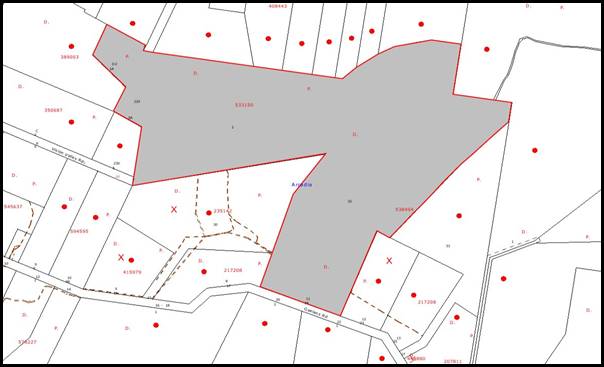
|
NOTIFICATION
PLAN
|
|
|
• PROPERTIES NOTIFIED
|
X SUBMISSIONS
RECEIVED
|

PROPERTY SUBJECT OF DEVELOPMENT
|

|
|
|
|
|
Three submissions objected to the
development, generally on the grounds that the development would result in:
· unacceptable
traffic on local streets;
· unacceptable noise
from activities at the centre;
· the removal of
significant trees; and
· permissibility of
development.
The merits of the matters raised
in community submissions have been addressed in the body of the report with the
exception of the following:
5.1.1 Permissibility of development
Concerns were raised that the
development cannot be considered a community facility as the community is
prohibited to enter the site. The submission suggested that many of the guests
at Vision Valley are from overseas – Japan and North America mainly.
The proposal is ancillary to the
existing approved land use as a ‘recreational facility’. The facilities are
used by the guests of the centre only as a policy of its administrators. This
concern is not a matter for consideration under the Act.
6. THE PUBLIC INTEREST
Section 79C(1)(e) of the Act requires Council to consider “the
public interest”.
The public interest is an
overarching requirement, which includes the consideration of the matters
discussed in this report. Implicit to the public interest is the achievement
of future built outcomes adequately responding to and respecting the future
desired outcomes expressed in environmental planning instruments and development
control plans.
The application is considered to
have satisfactorily addressed Council’s and relevant agencies’ criteria and
would provide a development outcome that, on balance, would result in a
positive impact for the community. Accordingly, it is considered that the
approval of the proposed ropes course would be in the public interest.
CONCLUSION
The application proposes the
installation of a ropes courses and flying fox to an existing approved
recreation facility.
The proposal satisfies the
general objectives of the Hornsby Shire Local Environmental Plan 1994 and
Council’s Rural Lands Development Control Plan. It is considered unlikely the
proposed development would result in any detrimental impacts upon the natural
and/or built environments, or have any negative or economic impacts.
The proposal is suitable to the
site and is recommended for approval subject to conditions of consent.
Note: At the time of the completion of this planning report,
no persons have made a Political Donations Disclosure Statement pursuant
to Section 147(3) of the Environmental Planning and Assessment Act 1979 in
respect of the subject planning application.
|
Rod Pickles
Manager -
Assessment Team 2
Planning Division
|
Scott Phillips
Executive Manager
Planning Division
|
Attachments:
|
1.View
|
Locality Plan
|
|
|
|
2.View
|
Location Plan
|
|
|
|
3.View
|
Apparatus
Arrangement Plan
|
|
|
|
4.View
|
Indicative Design
Sketch for the Apparatus
|
|
|
File Reference: DA/1474/2010
Document Number: D01593144
SCHEDULE 1
GENERAL
CONDITIONS
The
conditions of consent within this notice of determination have been applied to
ensure that the use of the land and/or building is carried out in such a manner
that is consistent with the aims and objectives of the relevant legislation,
planning instruments and Council policies affecting the land and does not
disrupt the amenity of the neighbourhood or impact upon the environment.
Note: For the
purpose of this consent, the term ‘applicant’ means any person who has the
authority to act on or the benefit of the development consent.
Note: For the purpose of
this consent, any reference to an Act, Regulation, Australian Standard or
publication by a public authority shall be taken to mean the gazetted Act or
Regulation, or adopted Australian Standard or publication as in force on the
date that the application for a construction certificate is made.
1.
Approved Plans and Supporting Documentation
The
development must be carried out in accordance with the plans and documentation
listed below and endorsed with Council’s stamp, except where amended by Council
and/or other conditions of this consent:
|
Plan
|
Drawn by
|
Dated
|
|
Proposed Ropes Course – Location
Plan – Drawing No. WES70-S01C
|
Maitland and Butler Pty Ltd
|
March 2010
|
|
Proposed Ropes Course – Site
Plan – Drawing No. WES70-S02C
|
Maitland and Butler Pty Ltd
|
March 2010
|
|
Proposed Ropes Course – General
arrangement plan – Drawing No. 10-1110-A
|
Adventure Developments Pty Ltd
|
17.11.2010
|
|
Indicative design sketch of the
proposed ropes course – Drawing No. A01
|
Adventure Developments Pty Ltd
|
06/02/2009
|
REQUIREMENTS PRIOR TO THE ISSUE OF A CONSTRUCTION
CERTIFICATE
2. Building Code of Australia
All
building work must be carried out in accordance with the requirements of the
Building Code of Australia.
3. Structural Safety
Structural Engineers details are to be submitted to the Principal
Certifying Authority prior to the issue of any Construction Certificate
REQUIREMENTS PRIOR TO THE COMMENCEMENT OF ANY WORKS
4. Erection
of Construction Sign
A sign must be erected in a
prominent position on any site on which building work, subdivision work or
demolition work is being carried out:
a. Showing
the name, address and telephone number of the principal certifying authority
for the work,
b. Showing
the name of the principal contractor (if any) for any demolition or building
work and a telephone number on which that person may be contacted outside
working hours, and
c. Stating
that unauthorised entry to the work site is prohibited.
Note: Any
such sign is to be maintained while the building work, subdivision work or
demolition work is being carried out, but must be removed when the work has
been completed.
5. Protection
of Adjoining Areas
A temporary
hoarding, fence or awning must be erected between the work site and adjoining
lands before the works begin and must be kept in place until after the
completion of the works if the works:
a. Could
cause a danger, obstruction or inconvenience to pedestrian or vehicular
traffic.
b. Could
cause damage to adjoining lands by falling objects.
c. Involve
the enclosure of a public place or part of a public place.
Note: Notwithstanding
the above, Council’s separate written approval is required prior to the
erection of any structure or other obstruction on public land.
6. Erosion
and Sediment Control
Erosion and
sediment control measures must be provided and maintained throughout the
construction period in accordance with the manual ‘Soils and Construction
2004 (Bluebook)’, the approved plans, Council specifications and to the
satisfaction of the principal certifying authority. The erosion and sediment
control devices must remain in place until the site has been stabilised and
revegetated.
Note: On
the spot penalties up to $1,500 may be issued for any non-compliance with this
requirement without any further notification or warning.
7. Toilet
Facilities
Toilet
facilities must be available or provided at the works site before works begin
and must be maintained until the works are completed at a ratio of one toilet
for every 20 persons employed at the site. Each toilet must:
a. be
a standard flushing toilet connected to a public sewer; or
b. be
a temporary chemical closet approved under the Local Government Act, 1993;
or
c. have
an on-site effluent disposal system approved under the Local Government Act,
1993.
REQUIREMENTS DURING CONSTRUCTION
8. Construction
Work Hours
All work on site (including demolition and earth works)
must only occur between 7 am and 5 pm Monday to Saturday.
No work is to be undertaken on Sundays or public holidays.
9. Bushland
Protection during Construction
To ensure the
protection of bushland during construction, the applicant must ensure all
machinery to be cleaned of soil and debris before entering the site to prevent
the spread of weeds and fungal pathogens.
REQUIREMENTS PRIOR TO THE ISSUE OF AN OCCUPATION
CERTIFICATE
10. Structural stability of the apparatus
The Structural
Engineer is to certify the installation and construction prior to use.
11. Noise
All noise generated by the
proposed development must be attenuated to prevent levels of noise being
emitted to adjacent premises which possess tonal, beating and similar
characteristics or which exceeds background noise levels by more than 5 dB(A).
12. Hours
of Operation
The
recreation facility must only be used during daylight hours.
- END OF CONDITIONS –
ADVISORY NOTES
The following information is provided for your assistance to
ensure compliance with the Environmental Planning and Assessment Act 1979,
Environmental Planning and Assessment Regulation 2000, other relevant
legislation and Council’s policies and specifications. This information does
not form part of the conditions of development consent pursuant to Section 80A
of the Act.
Environmental Planning and Assessment Act, 1979
Requirements
· The issue of a construction certificate
prior to the commencement of any works. Enquiries regarding the issue of a
construction certificate can be made to Council’s Customer Services Branch on
9847 6760.
· A principal certifying authority to be
nominated and Council notified of that appointment prior to the commencement of
any works.
· Council to be given at least two days
written notice prior to the commencement of any works.
· Mandatory inspections of nominated
stages of the construction inspected.
· An occupation certificate to be issued
before occupying any building or commencing the use of the land.
Tree Preservation Order
To ensure the maintenance and
protection of the existing natural environment, it is an offence to ringbark,
cut down, top, lop, remove, wilfully injure or destroy a tree outside 3 metres
of the approved development without the prior written consent from Council.
Note: A
tree is defined as a single or multi-trunked wood perennial plant having a
height of not less than 3 metres, and which develops many branches, usually
from a distance of not less than 1 metre from the ground, but excluding any
plant which, in its particular location, is a noxious plant declared as such
pursuant to the Noxious Weeds Act 1993. This definition of ‘tree’ includes any
and all types of Palm trees.
All
distances are determined under Australian Standard AS 4970-2009 “Protection of
Trees on Development Sites”.
Fines may be imposed for
non-compliance with Council’s Tree Preservation Order.
Disability Discrimination Act
The applicant’s attention is
drawn to the existence of the Disability Discrimination Act. A
construction certificate is required to be obtained for the proposed
building/s, which will provide consideration under the Building Code of Australia,
however, the development may not comply with the requirements of the Disability
Discrimination Act. This is the sole responsibility of the applicant.
Planning Report No. PLN20/11
Date of Meeting:
2/03/2011
2 DEVELOPMENT APPLICATION
- RESIDENTIAL - ALTERATIONS AND ADDITIONS
21 MILSONS PASSAGE, MILSONS PASSAGE
|
Development Application No:
|
DA/1473/2010
|
|
Description of Proposal:
|
Alterations and additions to
an existing dwelling
|
|
Property Description:
|
Lot 7 DP 9231, 21 Milsons Passage, Milsons Passage
|
|
Applicant:
|
Mr Stephen Wrixon Russell
|
|
Owner:
|
Mr Stephen Wrixon Russell
|
|
Statutory Provisions:
|
Hornsby Shire Local Environmental
Plan 1994
Environmental Protection E
(River Settlements) zone
|
|
Estimated Value:
|
$20,000
|
|
Ward:
|
A
|
|
RECOMMENDATION
THAT Development Application
No. 1473/2010 for alterations and additions to an existing dwelling at Lot 7
DP 9231, 21 Milsons Passage, Milsons Passage be approved subject to the
conditions of consent detailed in the independent town planning report – ADW
Johnson reproduced in Schedule 1 of this report.
|
1. The
application proposes alterations and additions to an existing dwelling.
2. The
development involves land owned by a Councillor. In accordance with Council’s
adopted Policy ‘PSA1 Proposed Council Developments’ and ‘Practice Note No. 7
Assessment Practice’, an independent assessment of the development
application has been undertaken by ADW Johnson.
3. The
proposal complies with the Hornsby Shire Local Environmental Plan 1994, Sydney Regional Environmental Plan No. 20 and the River Settlements Development Control
Plan.
4. No
submissions have been received in respect of the application.
5. The
report prepared by ADW Johnson is attached to this report for Council’s
consideration. The independent consultant’s report recommends approval of the
application.
ASSESSMENT
In accordance with Council’s
adopted Policy PS41 Proposed Council Developments and Practice Note
No. 7 – Assessment Practice, the assessment of the development application
has been referred to an independent town planning consultant. The report by
ADW Johnson is held at Attachment 2 of this report.
CONCLUSION
The application proposes
alterations and additions to an existing dwelling.
Council has referred the
application to an independent planning consultancy to carry out an assessment
of the application and to consider public submissions. No public submissions
were received. The independent consultant’s report recommends approval of the
application.
Note: At the time of the completion of this planning report, no
persons have made a Political Donations Disclosure Statement pursuant to
Section 147 of the Environmental Planning and Assessment Act 1979 in respect of
the subject planning application.
|
Rod Pickles
Manager -
Assessment Team 2
Planning Division
|
Scott Phillips
Executive Manager
Planning Division
|
Attachments:
|
1.View
|
Locality Plan
|
|
|
|
2.View
|
Consultant's
Report
|
|
|
|
3.View
|
Site Plans
|
|
|
|
4.View
|
Floor Plans
|
|
|
|
5.View
|
Elevations
|
|
|
File Reference: DA/1473/2010
Document Number: D01593275
SCHEDULE 1
GENERAL
CONDITIONS
The
conditions of consent within this notice of determination have been applied to
ensure that the use of the land and/or building is carried out in such a manner
that is consistent with the aims and objectives of the relevant legislation,
planning instruments and Council policies affecting the land and does not
disrupt the amenity of the neighbourhood or impact upon the environment.
Note: For the
purpose of this consent, the term ‘applicant’ means any person who has the
authority to act on or the benefit of the development consent.
Note: For the purpose of
this consent, any reference to an Act, Regulation, Australian Standard or
publication by a public authority shall be taken to mean the gazetted Act or
Regulation, or adopted Australian Standard or publication as in force on the
date that the application for a construction certificate is made.
1. Approved
Plans and Supporting Documentation
The
development must be carried out in accordance with the plans and documentation
listed below and endorsed with Council’s stamp, except where amended by Council
and/or other conditions of this consent:
|
Plan No.
|
Drawn by
|
Dated
|
|
00A, 00B, 00C, 01, 01.1, 02, 03,
04, 04.1, 05, 06, 07.
|
C.G
|
November 2010
|
|
Document No.
|
Prepared by
|
Dated
|
|
Statement of Environmental
Effects
|
Cameron Gaunt
|
November 2010
|
REQUIREMENTS PRIOR TO THE ISSUE OF A CONSTRUCTION
CERTIFICATE
2. Building
Code of Australia
All building
work must be carried out in accordance with the requirements of the Building
Code of Australia.
3. Design
and Construction - Bushfire Attack Category
The
development must be constructed in accordance with the recommended conditions
from the Hornsby FCC Office in their correspondence dated 9th
December 2010. A copy of this correspondence is attached in Appendix 1 to this
consent.
In this regard,
the Hornsby FCC provides the following recommendations:
a. At
the commencement of any building works and in perpetuity the entire property
shall be managed as an inner protection area (IPA) as outlined within section
4.1.3 and Appendix 5 of ‘Planning for Bush Fire Protection 2006’and the NSW
Rural Fire Service’s document ‘Standards for asset protection zones’.
b. New
construction shall comply with section 5 (BAL 12.5) Australian Standard
AS3959-2009 ‘Construction of buildings in bush fire-prone areas’ and section
A3.7 Addendum Appendix 3 of ‘Planning for Bush Fire Protection’.
c. Roofing
shall be gutterless or guttering and valleys are to be screened to prevent the
build up of flammable material. Any materials used shall have Flammability
Index of n greater than 5 when tested in accordance with Australian Standard
AS1530.2-1993 ‘Methods for Fire Tests on Building Materials, Components and
Structures – Test for Flammability of Materials.
4. Minimum
Floor Level
A minimum floor level of 2.5m AHD is applicable to all habitable
rooms.
5. Filling
of Site
No part of the site below RL 2.0 AHD is to be filled.
REQUIREMENTS PRIOR TO THE COMMENCEMENT OF ANY WORKS
6. Contract
of Insurance (Residential Building Work)
In the case
of residential building work for which the Home Building Act, 1989 requires
there to be a contract of insurance in force in accordance with Part 6 of that
Act, that such a contract of insurance is in force before any building work
authorised to be carried out by the consent commences.
7. Notification
of Home Building Act, 1989 Requirements
Residential
building work within the meaning of the Home Building Act,
1989 must not be carried out unless the principal certifying authority for
the development to which the work relates (not being Council) has given Council
written notice of the following information:
a. In
the case of work for which a principal contractor is required to be appointed:
i. The
name and licence number of the principal contractor.
ii. The
name of the insurer by which the work is insured under Part 6 of that Act.
b. In
the case of work to be done by an owner-builder:
i. The
name of the owner-builder.
ii. If
the owner-builder is required to hold an owner-builder’s permit under that Act,
the number of the owner-builder’s permit.
Note: If
arrangements for doing the residential building work are changed while the work
is in progress so that the information notified becomes out of date, further
work must not be carried out unless the principal certifying authority for the
development to which the work relates (not being Council) has given Council
written notification of the updated information.
8. Sydney
Water – Quick Check
The
application must be submitted to a Sydney Water ‘Quick Check Agent’ or
‘Customer Centre’ for approval to determine whether the development will affect
any Sydney Water infrastructure, and whether further requirements are to
be met.
Note: Refer
to www.sydneywater.com.au
or telephone 13 20 92 for assistance.
9. Erection
of Construction Sign
A sign must
be erected in a prominent position on any site on which building work,
subdivision work or demolition work is being carried out:
a. Showing
the name, address and telephone number of the principal certifying authority
for the work,
b. Showing
the name of the principal contractor (if any) for any demolition or building
work and a telephone number on which that person may be contacted outside
working hours, and
c. Stating
that unauthorised entry to the work site is prohibited.
Note: Any
such sign is to be maintained while the building work, subdivision work or
demolition work is being carried out, but must be removed when the work has
been completed.
10. Protection
of Adjoining Areas
A temporary
hoarding, fence or awning must be erected between the work site and adjoining
lands before the works begin and must be kept in place until after the
completion of the works if the works:
a. Could
cause a danger, obstruction or inconvenience to pedestrian or vehicular
traffic.
b. Could
cause damage to adjoining lands by falling objects.
c. Involve
the enclosure of a public place or part of a public place.
Note: Notwithstanding
the above, Council’s separate written approval is required prior to the
erection of any structure or other obstruction on public land.
11. Toilet
Facilities
Toilet
facilities must be available or provided at the works site before works begin
and must be maintained until the works are completed at a ratio of one toilet
for every 20 persons employed at the site. Each toilet must:
a. be
a standard flushing toilet connected to a public sewer; or
b. be
a temporary chemical closet approved under the Local Government Act, 1993;
or
c. have
an on-site effluent disposal system approved under the Local Government Act,
1993
12. Erosion
and Sediment Control
Erosion and
sediment control measures must be provided and maintained throughout the
construction period in accordance with the manual ‘Soils and Construction
2004 (Bluebook)’, the approved plans, Council specifications and to the
satisfaction of the principal certifying authority. The erosion and sediment
control devices must remain in place until the site has been stabilised and
revegetated.
Note: On
the spot penalties up to $1,500 may be issued for any non-compliance with this
requirement without any further notification or warning
REQUIREMENTS DURING CONSTRUCTION
13. Construction
Work Hours
All work on site (including demolition and earth works)
must only occur between 7am and 5pm Monday to Saturday.
No work is to be undertaken on Sundays or public holidays.
14. Demolition
All
demolition work must be carried out in accordance with Australian Standard
2601-2001 – The Demolition of Structures and the following requirements:
a. Demolition
material is to be disposed of to an authorised recycling and/or waste disposal
site.
b. Demolition
works, where asbestos material is being removed, must be undertaken by a
contractor that holds an appropriate licence issued by WorkCover NSW in
accordance with Chapter 10 of the Occupational Health and Safety Regulation
2001 and Clause 29 of the Protection of the Environment Operations
(Waste) Regulation 2005.
15. Acid Sulfate
Soils
Should acid sulfate soils
be encountered during construction works, Council is to be notified immediately
and an Acid Sulfate Soils Management Plan, written in accordance with the NSW
Acid Sulfate Soil Manual 1998, is to be submitted to Council.
16. Environmental
Management
The site must
be managed in accordance with the publication ‘Managing Urban Stormwater –
Landcom (March 2004) and the Protection of the Environment Operations
Act 1997 by way of implementing appropriate measures to prevent sediment
run-off, excessive dust, noise or odour emanating from the site during the
construction of the development.
17. Disturbance of
Existing Site
During
construction works, the existing ground levels of open space areas and natural
landscape features, (including natural rock-outcrops, vegetation, soil and
watercourses) must not be altered unless otherwise nominated on the approved
plans.
18. Landfill
Landfill must
be constructed in accordance with Council’s ‘Construction Specification,
2005’ and the following requirements:
a. All
fill material imported to the site is to wholly consist of Virgin Excavated
Natural Material (VENM) as defined in Schedule 1 of the Protection of the
Environment Operations Act 1997 or a material approved under the Department
of Environment and Climate Change’s general resource recovery exemption.
A compaction
certificate is to be obtained from a geotechnical engineer verifying that the
specified compaction requirements have been met.
19. Excavated
Material
All excavated
material removed from the site must be classified in accordance with the NSW
Environment Protection Authority’s Environmental Guidelines – Assessment,
Classification and Management of Liquid and Non-Liquid Wastes prior to disposal
to an approved waste management facility and reported to the principal
certifying authority.
20. Stormwater
Drainage – Land Adjoining a Watercourse
In addition to other
stormwater drainage requirements under this consent, all headwall outlets must
incorporate flow velocity reduction controls (i.e. bedded boulders and small
stones) to minimise erosive and scouring impacts to the watercourse. Energy
dissipater controls must be landscaped to accommodate outlet sheet flow (forced
jump). No engineering works are permitted within the bed of the watercourse.
21. Wastewater
to Existing System
All wastewater generated
within the approved development must be directed to the existing onsite sewage
management system servicing the site.
REQUIREMENTS
PRIOR TO THE ISSUE OF AN OCCUPATION CERTIFICATE
Note: For the
purpose of this consent, any reference to ‘occupation certificate’ shall also
be taken to mean ‘interim occupation certificate’ unless otherwise stated.
22. Damage
to Council Assets
Any damage
caused to Council’s assets as a result of the construction of the development
must be rectified in accordance with Council’s written requirements and at the
sole cost of the applicant.
23. Smoke
Alarms – Dwelling Additions
Smoke alarms
must be installed in the existing building and the proposed additions in
accordance with the requirements of the Building Code of Australia.
- END OF CONDITIONS -
ADVISORY NOTES
The following information is provided for your
assistance to ensure compliance with the Environmental Planning and Assessment
Act 1979, Environmental Planning and Assessment Regulation 2000, other relevant
legislation and Council’s policies and specifications. This information does
not form part of the conditions of development consent pursuant to Section 80A
of the Act.
Environmental Planning and
Assessment Act, 1979 Requirements
· The Environmental Planning and
Assessment Act, 1979 requires:
· The issue of a construction certificate
prior to the commencement of any works. Enquiries regarding the issue of a
construction certificate can be made to Council’s Customer Services Branch on
9847 6760.
· A principal certifying authority to be
nominated and Council notified of that appointment prior to the commencement of
any works.
· Council to be given at least two days
written notice prior to the commencement of any works.
· Mandatory inspections of nominated
stages of the construction inspected.
· An occupation certificate to be issued
before occupying any building or commencing the use of the land.
Tree Preservation Order
To ensure the maintenance and
protection of the existing natural environment, it is an offence to ringbark, cut
down, top, lop, remove, wilfully injure or destroy a tree outside 3 metres of
the approved building envelope without the prior written consent from Council.
Note: A
tree is defined as a single or multi-trunked wood perennial plant having a
height of not less than three (3) metres, and which develops many branches,
usually from a distance of not less than one (1) metre from the ground, but
excluding any plant which, in its particular location, is a noxious plant
declared as such pursuant to the Noxious Weeds Act 1993. This definition of
‘tree’ includes any and all types of Palm trees.
All
distances are determined under Australian Standard AS4970-2009 ”Protection of
Trees on Development Sites”.
Fines may be imposed for
non-compliance with Council’s Tree Preservation Order.
Dial Before You Dig
Prior to commencing any works,
the applicant is encouraged to contact Dial Before You Dig on 1100 or www.dialbeforeyoudig.com.au for
free information on potential underground pipes and cables within the vicinity
of the development site.
Asbestos Warning
Should asbestos or asbestos
products be encountered during demolition or construction works you are advised
to seek advice and information should be prior to disturbing the material. It
is recommended that a contractor holding an asbestos-handling permit (issued by
WorkCover NSW) be engaged to manage the proper handling of the material.
Further information regarding the safe handling and removal of asbestos can be
found at:
www.environment.nsw.gov.au
www.nsw.gov.au/fibro
www.adfa.org.au
www.workcover.nsw.gov.au
Alternatively, telephone the WorkCover
Asbestos and Demolition Team on 8260 5885.
Planning Report No. PLN11/11
Date of Meeting:
2/03/2011
3 DEVELOPMENT APPLICATION
- CONSTRUCTION OF AN INDUSTRIAL BUILDING INCLUDING A SERVICE SHOP
2 CHILVERS ROAD THORNLEIGH
|
Development Application No:
|
DA/855/2010
|
|
Description of Proposal:
|
Construction of an Industrial Building containing 13
units including a Service Shop.
|
|
Property Description:
|
Lot 2 DP 513555 (No. 2) Chilvers Road, Thornleigh
|
|
Applicant:
|
Construction Co Pty Ltd
|
|
Owner:
|
Asset Co Pty Ltd and Construction Co Pty Ltd
|
|
Statutory Provisions:
|
Hornsby Shire Local Environmental
Plan 1994
Industrial A (General) Zone
|
|
Estimated Value:
|
$2,990,000
|
|
Ward:
|
B
|
|
RECOMMENDATION
THAT Council assume the
concurrence of the Director-General of the Department of Planning pursuant to
State Environmental Planning Policy No. 1 and approve Development Application
No. 855/2010 for the construction of an industrial building containing 13
units including a service shop at Lot 2 DP 513555 (No. 2) Chilvers Road, Thornleigh
subject to the conditions of consent detailed in Schedule 1 of this report.
|
1. The
application proposes construction of an industrial building containing 13 units
including a service shop.
2. The
proposal complies with the Hornsby Shire Local Environmental Plan other than
the proposed floor space ratio which is the subject of an objection pursuant to
State Environmental Planning Policy No. 1 – Development Standards. The
objection is supported given the minor variation to the development standard.
3. The
proposal complies with the Industrial Lands Development Control Plan other than
the maximum two storey building height. The proposed three storey height is
considered acceptable with regard to topography, the corner site and surrounding
development.
4. Two
submissions have been received concerning the proposal.
5. It
is recommended that the application be approved.
HISTORY OF THE SITE
On 6 May 2005 Council approved
DA/2403/2004 for demolition of a service station on the subject site. The
service station has been demolished and site has been remediated in accordance
with the conditions of consent.
On 22 January 2009, Development
Application DA/60/2009 was lodged for the construction of an industrial
building. The development application was withdrawn on 7 April 2009 prior to
Council’s determination of the application. The development now proposed is
similar to the previous proposal.
HISTORY OF THE APPLICATION
The current application initially
included a proposal for six shops at the Chilvers Road frontage. The
application was amended as retail use within the Industrial A zone is limited
to a service shop with a gross floor area of not more than 100m2.
THE SITE
The site has an area of 1,540.09m2
and occupies the south west corner of Sefton Road and Chilvers Road. The site
has a 36.27m frontage to Chilvers Road, a 9.1m splay to the corner and a 30.75m
frontage to Sefton Road. The western side boundary dimension is 42.67m and the
southern side boundary 36.575m. The site has an average fall of 2% to the Sefton Road frontage.
A 1.83m wide stormwater drainage
easement is over a drainage line that flows south-north through the western
rear portion of the site.
Surrounding developments fronting
Chilvers Road and the southern side of Sefton Road include a range of
industrial uses including warehousing, plumbing supplies, plastics manufacture,
concrete batching, timber supplies, pharmaceutical manufacture, motor vehicle
body repairs, mechanical and engineering workshops. Council’s works depot is
located 40m west of the site.
The northern side of Sefton Road opposite the site is a low density residential area. A neighbourhood shopping
centre is located on the north east corner of Sefton Road and Larool Crescent. A single storey brick industrial building is constructed on the southern
side boundary. A two storey industrial building adjoins the western boundary.
The site forms part of the
Thornleigh industrial area and is located 1.1km north of Thornleigh Railway
Station.
THE PROPOSAL
The proposal is for the
construction of a two and three storey industrial building with basement car
parking. The building includes a lower ground floor industrial unit at the
northern elevation, fronting Sefton Road.
The proposed building has an open
car parking area at the Chilvers Road frontage. The building appears two storey
at the Chilvers Road frontage and three storey at the Sefton Road frontage.
Access to the basement car park is off Sefton Road.
The proposed building consists of
13 industrial units including a service shop (Tenancy 7). The majority of units
are small industrial units ranging in floor area from 85m2 to 116m2,
the lower ground floor industrial unit has an area of 330m2. The
proposed service shop has a floor area of 100m2.
The proposed building includes a
combined goods/passengers lift and 33 car parking spaces.
The proposal does not include
strata subdivision.
ASSESSMENT
The development application has
been assessed having regard to the ‘2005 City of Cities Metropolitan
Strategy’, the ‘North Subregion (Draft) Subregional Strategy’ and
the matters for consideration prescribed under Section 79C of the Environmental
Planning and Assessment Act 1979 (the Act). Subsequently, the following
issues have been identified for further consideration.
1. STRATEGIC CONTEXT
1.1 Metropolitan Strategy – (Draft) North Subregional Strategy
The Metropolitan Strategy is a
broad framework to secure Sydney’s place in the global economy by promoting and
managing growth. It outlines a vision for Sydney to 2031; the challenges
faced, and the directions to follow to address these challenges and achieve the
vision. The draft North Subregional Strategy acts as a framework for Council
in the preparation of a new Principal LEP by 2011.
The draft Subregional Strategy
sets the following targets for the Hornsby LGA by 2031:
· Employment capacity to
increase by 9,000 jobs; and
· Housing stock to
increase by 11,000 dwellings.
The proposed development would be
consistent with the draft Strategy by providing an estimated 32 additional jobs
in the locality.
2. STATUTORY CONTROLS
Section 79C(1)(a) requires
Council to consider “any relevant environmental planning instruments, draft
environmental planning instruments, development control plans, planning
agreements and regulations”.
2.1 Hornsby Shire Local Environmental Plan 1994
The subject land is zoned
Industrial A (General) under the Hornsby Shire Local Environmental Plan 1994
(HSLEP). The objectives of the zone are:
(a) to encourage economic growth and employment opportunities.
(b) to allow a broad range of industrial, warehousing and
other compatible land uses to locate within the area.
(c) to promote development that does not adversely impact upon
the natural and built environment.
The proposed development is
defined as ‘industry’ and ‘service shop’ under the HSLEP and is permissible in
the zone with Council’s consent.
Clause 15 of the HSLEP prescribes
that the maximum floor space ratio (FSR) of development within the Industrial A
zone is 1:1. The proposed 1,580m2 floor area results in a floor
space ratio of 1.0259:1 which exceeds the ratio by 39.91m2. The
application includes an objection under State Environmental Planning Policy No.
1 – Development Standards (SEPP 1) in respect to non-compliance with the
standard.
2.2 State Environmental Planning Policy No. 1 – Development
Standards
The applicant submitted an
objection against Council’s development standard for a maximum floor space
ratio of 1:1 under Clause 15 of the HSLEP.
The application has been assessed
against the requirements of SEPP 1. This Policy provides flexibility in the
application of development standards in circumstances where strict compliance
with those standards would, in any particular case, be unreasonable or
unnecessary or tend to hinder the attainment of the objectives of the Act.
The Land and Environment Court has expressed the view that
there are five different ways in which an objection may be well founded and
that approval of the objection may be consistent with the aims of the Policy:
1. The objectives of the standard are achieved notwithstanding
non-compliance with the standards;
2. The underlying objective or purpose of the standard is not
relevant to the development and therefore compliance is unnecessary;
3. The underlying object of purpose would be defeated or
thwarted if compliance was required and therefore compliance is unreasonable;
4. The development standard has been virtually abandoned or
destroyed by the Council’s own actions in granting consents departing from the
standard and hence compliance with the standard is unnecessary and
unreasonable;
5. The zoning of the particular land is unreasonable or
inappropriate so that a development standard appropriate for that zoning is
also unreasonable and unnecessary as it applies to the land and compliance with
the standard would be unreasonable or unnecessary. That is, the particular
parcel of land should not have been included in the particular zone.
The applicant’s objection is made with regard to the above
five point test and the objectives of the Industrial A zone.
In summary the applicant submits that:
· The proposed
development utilises space within the basement level which is contained within
the building envelope.
· The objective of
the Industrial A (General Zone) encourage a broad range of industrial,
warehousing and other compatible land uses. Large scale warehouses and bulky
good premises are not uncommon in the area. The proposal aims to provide a
larger industrial tenancy and a mix of uses, which is entirely consistent with
the intent of the LEP in terms of the role/function of the zone.
· All other LEP
requirements have been met, ensuring that the proposed development is highly
functional and achieves the desired outcome for development of the site.
· Strict compliance
with the development standard is seen as a hindrance in obtaining the objects
of the Act, as it would prevent the best use of the site, in this case the
space would be wasted as unnecessary manoeuvring area.
· Strict compliance
with Clause 15 of the HSLEP would be unreasonable and unnecessary when adopting
the test of Justice Preston in Wehbe v Pittwater Council.
The principles expressed in the
Land and Environment Court decision at points 1 and 3 above are considered to
be satisfied by the proposal and the SEPP 1 objection. The objection is
therefore well founded in respect to non-compliance with the floor space ratio
standard.
2.3 Industrial Lands Development Control Plan
The proposed development has been
assessed having regard to the relevant performance and prescriptive design
standards within Council’s Industrial Lands Development Control Plan
(Industrial Lands DCP). The following table sets out the proposal’s compliance
with the prescriptive standards of the Plan:
|
Industrial Lands
Development Control Plan
|
|
Control
|
Proposal
|
Requirement
|
Compliance
|
|
Site Area
|
1,540.09m2
|
N/A
|
N/A
|
|
Total Floor Area
|
1,580m2
|
N/A
|
N/A
|
|
Floor Space Ratio
|
1.02:1
|
1:1
|
No
|
|
Setbacks
|
Chilvers Rd -
12.6m-15m
Sefton Rd – 3m
South Side – 0m
West Side – 0m
|
3m
0m
|
Yes
Yes
|
|
Height
|
2-3 storey
|
2 storey
|
No
|
|
Car parking
|
35 spaces
|
20 spaces
|
Yes
|
|
Outdoor Area
|
37m2
|
32m2
|
Yes
|
As detailed in the above table,
the proposed development does not comply with a number of prescriptive
standards within Council’s Industrial Lands DCP. The matters of non-compliance
are detailed below, as well as a brief discussion on compliance with relevant
performance standards.
2.3.1 Density
The proposed development does not
comply with the maximum floor space ratio for the Industrial A zone. The
non-compliance is relatively minor and considered acceptable with regard to the
submitted SEPP 1 objection.
The proposal is satisfactory in
respect to the performance criteria, that the density of development should be
in keeping with the bulk, scale and intensity of the area.
2.3.2 Setbacks
The proposed building complies
with the prescriptive setback requirements.
The proposed basement car park
has a zero setback from the Chilvers Road frontage. The setback is considered
acceptable with regard to existing ground level at the Chilvers Road frontage
and the top of the basement carpark being predominately at existing ground
level at the Chilvers Road frontage. The proposed setback of the basement
carpark would not detract from the streetscape or the appearance of the
building.
2.3.3 Design
The proposed building is
contemporary in style and in keeping with recent industrial development in the
area. In presentation, the Chilvers Road façade contrasts with the Sefton Road façade, providing interest in the streetscape and at the corner frontage. The
proposed design is consistent with the theme of recent developments in the
Thornleigh Industrial Area and is satisfactory in respect to the Industrial
Lands DCP design performance criteria.
The proposed units on Level 2 and
Level 3 are relatively small and would provide for a range of uses suitable to
the size of the units in accordance uses permitted with consent in the
Industrial A zone.
The proposed building is designed
for access for people with a disability.
The proposed development would be
constructed over the existing stormwater drainage easement. The design of the
proposed basement carpark and western elevation of the building allows overland
stormwater flows to pass through the building in a major flood. The proposed
openings in the western wall are enclosed with steel mesh fencing. Refer also
to comments in Section 3.2.
The proposed development is three
storey at the Sefton Road elevation which is in non-compliance with the two
storey maximum height requirement of the Industrial Lands DCP. The proposed
height is considered acceptable with regard to the proposed building design
which maximises the advantage of the site topography and the corner site. The
proposed lower ground floor unit is the only unit fronting Sefton Road.
The additional height at the Sefton Road elevation therefore would not result in overlooking or light spill impacts on
adjacent residential properties opposite Sefton Road. It is considered the
proposed height would not detract from the built form of the Thornleigh
Industrial Area or result in an adverse visual impact.
2.3.4 Landscaping
The proposed development includes
sufficient landscaping within the setback areas to soften the appearance of the
proposed building in the streetscape.
The proposal involves the removal
of a Bottlebrush tree at the Sefton Road frontage which is not identified as a
significant tree. A number of eucalypts which have regenerated through the
demolished material on the site would also be removed.
The proposal includes an outdoor
dining area at the frontage of the proposed service shop, which is considered
satisfactory in meeting the prescriptive measure for an outdoor eating and
seating area for employees. A 1.5m high parapet wall screens the outdoor dining
area from Sefton Road.
The proposal complies with the
landscaping element objective of the Industrial Lands DCP.
2.3.5 Vehicle Access and Parking
The proposed redevelopment of the
former service station site maintains the existing vehicle crossings.
The proposed car parking
provision is considered appropriate for the proposed development in
accommodating a range of land uses.
The proposed vehicle access,
manoeuvring, loading and unloading areas comply with the RTA requirements for
medium rigid trucks, which are the minimum sized vehicles able to be considered
for smaller scale industrial developments and are appropriate for the units as
proposed.
The proposed traffic generation
of the industrial units and service shop involves approximately 80 daily
vehicle trips and would not detract from the service level efficiency of the
local road network and the Sefton Road/Chilvers Road/Larool Crescent
intersections.
A condition is recommended to
prohibit access by heavy rigid and articulated vehicles.
Subject to recommended conditions
the proposal complies with the vehicle access and parking element objectives of
the Industrial Lands DCP.
2.3.6 Acoustics
The proposed development is
located opposite low density residential development on the northern side of Sefton Road and fronting Gilgandra Avenue.
The activity of the majority of
the proposed units would predominate on Chilvers Road. A single tenancy is
proposed at the Sefton Road frontage minimising noise impacts on adjacent
residential properties. The proposed industrial building is designed with
regard to neighbouring residential properties and is considered acceptable in
respect to the existing acoustic environment.
Future uses of the proposed
industrial units would be subject to separate development applications and
acoustic assessments.
2.3.7 Waste Minimisation and Management
The former service station on the
site has been demolished and the site remediated.
The proposal includes a waste
storage area within the basement of the development that would be accessed from
Sefton Road. The location of the proposed waste storage area would obstruct
the overland flow path over the proposed stormwater drainage easement. A
condition is recommended for the plans to be amended to relocate the waste
storage area clear of the overland flow path and reduce the area of Unit 1 to
accommodate the waste storage area. Refer also to comments in Section 2.3.8.
2.3.8 Drainage Control
The site is subject to a 1.83m
wide stormwater drainage easement over a piped drainage line through the
western part of the site. The stormwater drainage line forms part of a piped
system that flows to Larool Creek 230m north of the site. There is no natural
landscape feature associated with the drainage line in the immediate vicinity
of the site.
The proposed development involves
relocation of the easement and reconstruction of the drainage line to allow the
construction of the building over the proposed easement. The proposed building
is designed to allow the passage of the 1 in 100 year overland flow path
through the basement car park. Council’s engineer recommends the position of
the easement remain unchanged and raised no objection to the proposed building
and reconstruction of the drainage line, as the basement car park has
sufficient vertical clearance to allow access for Council’s excavator in the
event the drainage line is blocked. The proposed overland flow path includes
pollution control measures to intercept debris from entry into Council’s
stormwater drainage system.
A condition is recommended for a
stormwater detention system to be incorporated into the development. Subject
to recommended conditions, the proposal complies with the Industrial Lands DCP
drainage control element.
3. ENVIRONMENTAL IMPACTS
Section 79C(1)(b) of the Act
requires Council to consider “the likely impacts of that development,
including environmental impacts on both the natural and built environments, and
social and economic impacts in the locality”.
3.1 Natural Environment
The former service station site
was essentially a concrete paved site. A number of non‑significant
eucalypt trees, which have since regenerated through demolished material, would
be removed by the proposed development. Given the industrial zoning of the site
and the former use, removal of the trees is considered acceptable.
3.2 Built Environment
The proposed building is 12
metres high and would generally exceed the height of surrounding single and two
storey developments. The proposed building is designed with regard to the
corner site and the two street frontages. It is considered the building would
contribute to the more recent contemporary style of industrial buildings
located within the Thornleigh Industrial Area.
The proposed building is opposite
a low density residential area involving dwelling houses with frontage to Gilgandra Avenue. The alternate residential frontage, the open space of the rear yards of
the dwellings and existing mature trees within the road reserve of Sefton Road opposite the site, would mitigate any visual impact of the proposed industrial
building on the character of the residential area.
3.3 Social Impacts
The social impacts of the
development on the local and broader community have been considered with
specific reference to the potential employment generation within the complex.
It is estimated that the development would generate 32 full time positions post
construction. This is consistent with the North Subregion (Draft) Subregional
Strategy that provides a target of 9,000 jobs within the Hornsby LGA by 2031.
3.4 Economic Impacts
There would be a number of
multiplier effects that the development would provide throughout the local and
regional economies. These multiplier effects would result from the sourcing of
goods and services from suppliers to businesses within the complex as well as
the increased consumption generated by the increase of employment in the area.
4. SITE SUITABILITY
Section 79C(1)(c) of the Act
requires Council to consider “the suitability of the site for the
development”.
The existing industrial site has
been remediated from the former service station use and is suitable for
redevelopment subject to stormwater drainage works.
5. PUBLIC PARTICIPATION
Section 79C(1)(d) of the Act
requires Council to consider “any submissions made in accordance with this
Act”.
5.1 Community Consultation
The proposed development was
placed on public exhibition and was notified to adjoining and nearby landowners
between 8 August and 26 August 2010 in accordance with Council’s Notification
and Exhibition Development Control Plan. During this period, Council received
two submissions. The map below illustrates the location of those nearby
landowners who made a submission that are in close proximity to the development
site.
|
NOTIFICATION
PLAN
|
|
|
• PROPERTIES NOTIFIED
|
X SUBMISSIONS
RECEIVED
|
PROPERTY SUBJECT OF DEVELOPMENT
|
|
|
|
|
|
Two submissions objected to the
development, generally on the following grounds that the development would
result in:
· Unacceptable number of
retail shops;
· Unacceptable height
and overlooking;
· Unacceptable noise;
· Unacceptable traffic
generation;
· Unacceptable light
spill onto residential property;
· Unacceptable privacy
impacts on dwellings opposite.
The merits of the matters raised
in community submissions have been addressed in the body of the report.
6. THE PUBLIC INTEREST
Section 79C(1)(e) of the Act
requires Council to consider “the public interest”.
The public interest is an
overarching requirement, which includes the consideration of the matters
discussed in this report. Implicit to the public interest is the achievement
of future built outcomes adequately responding to and respecting the future
desired outcomes expressed in environmental planning instruments and
development control plans.
The application is considered to
have satisfactorily addressed Council’s criteria and would provide a
development outcome that, on balance, would result in a positive impact for the
community. Accordingly, it is considered that the approval of the proposed
industrial building and service shop would be in the public interest.
CONCLUSION
Consent is sought for
construction of an industrial building containing 13 units including a service
shop.
The proposed development would
provide for a range of uses permissible within the Industrial A (General) Zone.
The proposed shops have been amended to provide single service shop in
accordance with the provisions of the HSLEP.
The proposed floor space exceeds
the maximum permitted 1:1 floor space ratio by approximately 40m2
which is considered acceptable in respect to the submitted SEPP 1 objection.
The former service station site
has been remediated to a standard acceptable for the proposed use. The existing
vehicle crossings on Chilvers Road and Sefton Road are maintained for the
proposed development.
The proposed building has primary
frontage to Chilvers Road and is designed with regard to the corner site
minimising activity at the Sefton Road frontage and impacts on neighbouring
residents. The proposal complies with the Industrial Lands DCP in respect to
setbacks, building design, landscaping, vehicle access and parking. The
non-compliance with the two storey height limit is considered acceptable with
regard to the design of the building on the corner site and minimal impacts on
neighbouring properties.
The existing stormwater drainage
line and easement are subject to reconstruction for the proposed development.
The proposed building over the easement allows sufficient vertical clearance
for Council machinery to access in the event of blockages and is considered
acceptable. A condition is recommended for relocation of the waste storage area
to prevent obstruction of the overland flow path through the basement of the
building.
The proposed development
contributes to the recent contemporary style of industrial development within
the Thornleigh Industrial Area and is recommended for approval.
|
Rod Pickles
Manager -
Assessment Team 2
Planning Division
|
Scott Phillips
Executive Manager
Planning Division
|
Attachments:
|
1.View
|
Locality Plan
|
|
|
|
2.View
|
Basement/Site Plan
|
|
|
|
3.View
|
Floor Plans
|
|
|
|
4.View
|
Roof Plan
|
|
|
|
5.View
|
Elevations
|
|
|
|
6.View
|
Landscaping Plans
|
|
|
File Reference: DA/855/2010
Document Number: D01526303
SCHEDULE 1
GENERAL
CONDITIONS
The
conditions of consent within this notice of determination have been applied to
ensure that the use of the land and/or building is carried out in such a manner
that is consistent with the aims and objectives of the relevant legislation,
planning instruments and Council policies affecting the land and does not
disrupt the amenity of the neighbourhood or impact upon the environment.
Note: For the
purpose of this consent, the term ‘applicant’ means any person who has the
authority to act on or the benefit of the development consent.
Note: For the purpose of
this consent, any reference to an Act, Regulation, Australian Standard or
publication by a public authority shall be taken to mean the gazetted Act or
Regulation, or adopted Australian Standard or publication as in force on the
date that the application for a construction certificate is made.
1. Approved
Plans and Supporting Documentation
The development must be carried
out in accordance with the plans and documentation listed below and endorsed
with Council’s stamp, except where amended by Council and/or other conditions
of this consent:
|
Plan No.
|
Drawn by
|
Dated
|
|
SK 1-02 C – Basement/Site Plan
|
Mayhill Architecture Urban
Planning
|
01-12-10
|
|
SK 1-03 B – Ground Floor Plan
|
Mayhill Architecture Urban
Planning
|
02-10-10
|
|
SK 1-04 B – First Floor Plan
|
Mayhill Architecture Urban
Planning
|
02-10-10
|
|
SK 1-05 B – Roof Plan
|
Mayhill Architecture Urban
Planning
|
02-10-10
|
|
SK 2-01 C – Elevations 01
|
Mayhill Architecture Urban
Planning
|
01-12-10
|
|
SK 2-02 C – Elevations /
Sections
|
Mayhill Architecture Urban
Planning
|
01-12-10
|
|
SK 2-03 A – Colour Elevations 01
|
Mayhill Architecture Urban
Planning
|
02-10-10
|
|
SK 2-04 A – Colour Elevations 02
|
Mayhill Architecture Urban
Planning
|
02-10-10
|
|
LSC 1/3 Landscape Plan -
Basement
|
SB Design
|
01.09.2009
|
|
LSC 2/3 Landscape Plan – Ground
Flr
|
SB Design
|
01.09.2009
|
|
LSC 3/3 Landscaping
Specifications
|
SB Design
|
01.09.2009
|
2. Removal
of Existing Trees
This development consent only
permits the removal of tree(s) as identified on the approved plans including
the regenerated Eucalypts on the site. The removal of any other trees requires
separate approval under Council’s Tree Preservation Order.
3. Amendment
of Plans
The approved plans are to be
amended as follows:
a. The
basement waste storage area is to be relocated to provide a 12 metre wide overland
flow path clear of any obstruction. The waste storage area must comply with the
design criteria of the Waste Minimisation and Management Development Control
Plan.
REQUIREMENTS PRIOR TO THE ISSUE OF A CONSTRUCTION
CERTIFICATE
4. Building
Code of Australia
All building work must be
carried out in accordance with the requirements of the Building Code of
Australia.
5. Sydney
Water – Quick Check
The
application must be submitted to a Sydney Water ‘Quick Check Agent’ or
‘Customer Centre’ for approval to determine whether the development will affect
any Sydney Water infrastructure, and whether further requirements are to
be met.
Note: Refer
to www.sydneywater.com.au or
telephone 13 20 92 for assistance.
6. Water/Electricity
Utility Services
The applicant must submit
written evidence of the following service provider requirements:
a. Energy
Australia – a letter of consent demonstrating that satisfactory
arrangements have been made to service the proposed development.
b. Sydney
Water – the submission of a ‘Notice of Requirements’ under s73 of the Sydney
Water Act 1994.
Note: Sydney
Water requires that s73 applications are to be made through an authorised
Sydney Water Servicing Coordinator. Refer to www.sydneywater.com.au or telephone
13 20 92 for assistance.
7. Dilapidation
Report
A ‘Dilapidation Report’ is to be
prepared by a ‘chartered structural engineer’ detailing the structural
condition of all adjoining properties.
8. Trunk
Stormwater Drainage
The
Council-controlled stormwater drainage system and Easement within the subject
site shall be designed and reconstructed in accordance with Council’s Civil
Works – Design and Construction Specification 2005 and the following
requirements:-
a. The
pipeline shall be designed and constructed as reinforced concrete pipe with
class appropriate for design loadings and backfill. It shall have a minimum
hydraulic capacity of at least the 20 year average interval recurrence interval
(ARI) storm and an internal diameter of at least 900 mm.
b. To
reduce maintenance and prevent hydraulic losses, the pipeline shall be
constructed on an alignment within the existing 1.83m wide Drainage Easement
and connected to the Council controlled drainage systems both upstream and the
existing kerb inlet pit in Sefton Road. All junction pits and adjustments to the existing system shall be undertaken as necessary at the Applicant’s cost.
c. The
Council drainage system shall be designed and constructed as either fully
concrete encased or else encased as required by Hornsby Shire Council.
d. Pier
and beam method of construction prepared by a Structural Engineer adjacent the
Easements to the depth of the invert of proposed pipes, and to delineate an
area for the drainage easement over the pipe.
e. In
order to permit access to the pipe system for maintenance, a clear headroom of
3.8m shall be maintained over the site of the drainage easement. Details to be
provided on the construction plans.
f. Pursuant
to Section 59A and 68 of the Local Government Act 1993, an Application
shall be made to Hornsby Shire Council for consideration and approval of the
proposed Council-controlled drainage works, prior to the release of any
Construction Certificate. Application requires payment of Council’s fee for
assessment, approval and inspection.
9. Overland
Flow Path
In order to
reduce risk of damage to property from overland flow, the applicant shall
undertake the following works at the applicant’s cost. Details from these
requirements are to be prepared by a chartered hydraulic engineer on the
construction plans;-
a. The south elevation of the lower carpark shall incorporate
design and construction of an open pervious system of security screens
extending to the existing ground level, to permit the design 100 year average
recurrence interval (ARI) overland flow to be conveyed through the basement car
parking aisle.
b. The lower carpark security gate shall be a pervious design
and provide a lateral sliding secure gate over the 12m width of the western
side car space module and aisle to permit conveyance of the design storm flow
to Sefton Road.
c. To ensure no obstruction to design flows, the proposed bin
room must be recessed into the lower ground floor tenancy. Only parking modules
and accessways without kerbs and handrailing may be proposed within the design
100 year ARI storm flow area.
d. The floor levels of all tenancies and utility rooms shall
be not less than 0.5m above the 100 year ARI storm level.
e. The area affected by design storm flow shall be shaped at
a minimum grade of 1% down to the proposed crossing threshold level. The aisle
and parking module shall be rectangular in section for conveyance of the design
flow.
f. No part of the 100 year ARI design flow shall permit the velocity
x depth product to exceed 0.7 m2/s, or exceed 200mm in depth.
g. Drainage plans showing the following details must be
prepared by the hydraulic engineer and submitted for consideration with the
Construction Certificate Application. The plans are to include basement design
with levels and contours designed to convey the engineer’s proposed 3.3 m3/s
design overland flowrate in the Sefton Road access western aisle and car module
as per the above.
10. On
Site Stormwater Detention
An on-site
stormwater detention system must be designed by a chartered civil engineer and
constructed in accordance with the following requirements:
a. Have
a capacity of not less than 23 cubic metres, and a maximum discharge (when
full) of 36 litres per second.
b. Have
a surcharge/inspection grate located directly above the outlet.
c. Discharge
from the detention system to be controlled via 1 metre length of pipe, not less
than 50 millimetres diameter or via a stainless plate with sharply drilled orifice
bolted over the face of the outlet discharging into a larger diameter pipe
capable of carrying the design flow to an approved Council system.
d. For
safety, an overflow system capable of conveying the balance of the 100 year ARI
design storm from the on-site detention system directly to a Council-controlled
drainage system shall be provided.
e. If
the system is to be constructed above ground in a car parking area, the maximum
depth of ponding for the on-site detention volume shall be 200 mm and warning
signs shall be installed.
11. Internal
Driveway/Vehicular Areas
The driveway
and parking areas on site must be designed in accordance with Australian
Standards 2890.1, 2890.2, and the following requirements:
a. Design
levels at the street boundaries be obtained from Council.
b. The
driveway be rigid pavements and be designed by a chartered structural engineer.
c. The
pavement design to incorporate levels required to convey the design 100 year
ARI storm along the overland flow path and contain the proposed on-site
detention volume.
d. Car
spaces to be line marked.
e. The
Chilvers Road boundary side truck access, service bay and manoeuvring areas
shall be designed and constructed for the maximum design vehicle being the
Medium Rigid Vehicle.
12. Road
Works
All road
works approved under this consent must be constructed in accordance with
Council’s Civil Works Design and Construction Specification, 2005 and
the following requirements:
a. A
concrete footpath to be constructed within the road verge with the remaining
area turfed.
b. Council’s
standard heavy duty vehicular crossings to either street frontage are required
to be designed and constructed.
c. Council’s
standard kerb and gutter at levels and alignments similar to the existing kerb
on all Chilvers Road, kerb return and Sefton Road alignments adjacent property
boundaries, together with footpath formation and necessary drainage
construction and adjustments.
d. The
existing road pavement to be saw cut a minimum of 700 mm from the existing lip
of kerb and reconstructed.
e. Pursuant
to Section 138 of the Roads Act 1993, an Application shall be made to
Hornsby Shire Council for consideration and approval of the proposed public
road works, prior to the release of any Construction Certificate. Application
requires payment of Council’s fee for assessment, approval and inspection.
13. Traffic
Control Plan
A Traffic
Control Plan (TCP) must be prepared by a qualified traffic controller in
accordance with the Roads & Traffic Authority’s Traffic Control at Worksites
Manual 1998 and Australian Standard 1742.3 for all work on a public
road and be submitted to Council. The TCP must detail the following:
a. Arrangements
for public notification of the works.
b. Temporary
construction signage.
c. Permanent
post-construction signage.
d. Construction
vehicle movement plans.
e. Traffic
management plans.
f. Pedestrian
and cyclist access/safety.
REQUIREMENTS PRIOR TO THE COMMENCEMENT OF ANY WORKS
14. Erection
of Construction Sign
A sign must
be erected in a prominent position on any site on which building work,
subdivision work or demolition work is being carried out:
a. Showing
the name, address and telephone number of the principal certifying authority
for the work,
b. Showing
the name of the principal contractor (if any) for any demolition or building
work and a telephone number on which that person may be contacted outside
working hours, and
c. Stating
that unauthorised entry to the work site is prohibited.
Note: Any
such sign is to be maintained while the building work, subdivision work or
demolition work is being carried out, but must be removed when the work has
been completed.
15. Protection
of Adjoining Areas
A temporary
hoarding, fence or awning must be erected between the work site and adjoining
lands before the works begin and must be kept in place until after the
completion of the works if the works:
a. Could
cause a danger, obstruction or inconvenience to pedestrian or vehicular
traffic.
b. Could
cause damage to adjoining lands by falling objects.
c. Involve
the enclosure of a public place or part of a public place.
Note: Notwithstanding
the above, Council’s separate written approval is required prior to the
erection of any structure or other obstruction on public land.
16. Toilet
Facilities
Toilet
facilities must be available or provided at the works site before works begin
and must be maintained until the works are completed at a ratio of one toilet
for every 20 persons employed at the site. Each toilet must:
a. be
a standard flushing toilet connected to a public sewer; or
b. be
a temporary chemical closet approved under the Local Government Act, 1993;
or
c. have
an on-site effluent disposal system approved under the Local Government Act,
1993
17. Erosion
and Sediment Control
Erosion and
sediment control measures must be provided and maintained throughout the
construction period in accordance with the manual ‘Soils and Construction
2004 (Bluebook)’, the approved plans, Council specifications and to the
satisfaction of the principal certifying authority. The erosion and sediment
control devices must remain in place until the site has been stabilised and
revegetated.
Note: On
the spot penalties up to $1,500 may be issued for any non-compliance with this
requirement without any further notification or warning.
REQUIREMENTS DURING CONSTRUCTION
18. Demolition
All
demolition work must be carried out in accordance with Australian Standard
2601-2001 – The Demolition of Structures and the following requirements:
a. Demolition
material is to be disposed of to an authorised recycling and/or waste disposal
site and/or in accordance with an approved waste management plan.
b. Demolition
works, where asbestos material is being removed, must be undertaken by a
contractor that holds an appropriate licence issued by WorkCover NSW in
accordance with Chapter 10 of the Occupational Health and Safety Regulation
2001 and Clause 29 of the Protection of the Environment Operations
(Waste) Regulation 1996.
c. On
construction sites where buildings contain asbestos material, a standard
commercially manufactured sign containing the words ‘DANGER ASBESTOS REMOVAL IN
PROGRESS’ measuring not less than 400mm x 300mm must be erected in a prominent
position visible from the street.
19. Soil
Contamination
Council must be notified
immediately should the presence of asbestos or soil contamination, not
recognised during the original assessment process be identified during
demolition or construction works.
20. Construction
Work Hours
All work on site (including demolition and earth works)
must only occur between 7am and 5pm Monday to Saturday.
No work is to be undertaken on Sundays or public holidays.
21. Council
Property
During
construction works, no building materials, waste, machinery or related matter
is to be stored on the road or footpath. The public reserve is to be kept in a
clean, tidy and safe condition at all times.
22. Survey
Report – Finished Floor Level
A report(s)
must be prepared by a registered surveyor and submitted to the principal
certifying authority prior to the pouring of concrete at each level of the
building certifying that:
a. The
building, retaining walls and the like have been correctly positioned on the
site.
b. The
finished floor level(s) are in accordance with the approved plans.
23. Excavated
Material
All excavated
material removed from the site must be classified in accordance with the NSW
Environment Protection Authority’s Environmental Guidelines – Assessment,
Classification and Management of Liquid and Non-Liquid Wastes prior to
disposal to an approved waste management facility and reported to the principal
certifying authority.
24. Environmental
Management
The site must
be managed in accordance with the publication ‘Managing Urban Stormwater –
Landcom (March 2004) and the Protection of the Environment Operations
Act 1997 by way of implementing appropriate measures to prevent sediment
run-off, excessive dust, noise or odour emanating from the site during the
construction of the development.
25. Landfill
Landfill must
be constructed in accordance with Council’s ‘Construction Specification,
2005’ and the following requirements:
a. All
fill material imported to the site is to wholly consist of Virgin Excavated
Natural Material (VENM) as defined in Schedule 1 of the Protection of the
Environment Operations Act 1997 or a material approved under the Department
of Environment and Climate Change’s general resource recovery exemption.
b. A
compaction certificate is to be obtained from a geotechnical engineer verifying
that the specified compaction requirements have been met.
REQUIREMENTS PRIOR TO THE ISSUE OF AN OCCUPATION
CERTIFICATE
Note: For
the purpose of this consent, any reference to ‘occupation certificate’ shall
also be taken to mean ‘interim occupation certificate’ unless otherwise stated.
26. Sydney
Water – s73 Certificate
A s73
Certificate must be obtained from Sydney Water.
27. Damage
to Council Assets
Any damage
caused to Council’s assets as a result of the construction of the development
must be rectified in accordance with Council’s written requirements and at the
sole cost of the applicant.
28. Creation
of Easements and Restrictions
The following
matters must be nominated on a Deposited Plan under s88B of the Conveyancing
Act 1919:-
a. Removal
of the existing Council drainage easement and creation of a drainage easement 3
Metres Wide over the proposed Council stormwater pipe in favour of Council and
in accordance with the terms set out in Memorandum B5341305V filed with
the NSW Department of Lands.
b. As
the Council pipe is in a securable area, a positive covenant shall be created
to ensure access for Council’s maintenance of the drainage system at any time
either after giving notice or in an emergency, and removal of all plant,
property, vehicles etc. from the easement and adjacent land immediately upon
any request from Council. The terms shall indemnify Council against any
property loss, loss of amenity or convenience or claims arising from access and
working on the property and Easement. The terms must be obtained from Council.
c. A
restriction over the flow path for a 100 year average recurrence interval
storm. The "Restriction on the Use of Land" over the affected
lots is to prohibit the alteration of the final floodway shape and the erection
of any obstruction, including gates or fencing, in the floodway without the
written permission of Council. The terms of this restriction must be obtained
from Council.
d. A
"Restriction on the Use of Land" on the property, requiring
the finished floor level of any habitable room to be not less than 500mm above
the 100 year average recurrence interval storm level. The levels must be
related to Australian Height Datum.
e. The
creation of an appropriate "Positive Covenant" and "Restriction
as to User" over the constructed on-site detention systems and outlet
works, within the lots in favour of Council in accordance with Council’s
prescribed wording. The position of the on-site detention system is to be
clearly indicated on the title.
f. To
register the OSD easement, the restriction on the use of land “works-as-executed”
details of the Council drainage system, overland flow and on-site-detention
system must be submitted, while verifying that the required storage and
discharge rates have been constructed in accordance with the design
requirements. The details must show the invert levels of the systems together
with pipe sizes and grades. Any variations to the approved plans must be shown
in red on the “works-as-executed” plan and supported by calculations.
g. Application
shall be made to Hornsby Shire Council for consideration and approval of the
deposited plan. Application requires payment of Council’s fee for approval and
release. A copy of the registered plan shall be submitted to the Principle
Certifying Authority prior to the release of the Occupation Certificate.
Note: Council
must be nominated as the authority to release, vary or modify any easement,
restriction or covenant.
29. Completion
of Landscaping
A certificate
must be provided by a practicing landscape architect, horticulturalist or person
with similar qualifications and experience certifying that all required
landscaping works have been satisfactorily completed in accordance with the
approved landscape plans.
Note: Advice
on suitable species for landscaping can be obtained from Council’s planting
guide ‘Indigenous Plants for the Bushland Shire’, available at www.hornsby.nsw.gov.au.
30. External
Lighting
All external
lighting must be designed and installed in accordance with Australian Standard
AS 4282 – Control of the Obtrusive Effects of Outdoor Lighting.
Certification of compliance with the Standard must be obtained from a suitably
qualified person.
31. Garbage
Collection Easement
For the
purpose of waste collection, an easement entitling Council, its servants and
agents and persons authorised by it to enter upon the subject land and to
operate thereon, vehicles and other equipment for the purposes of garbage
collection must be granted to Council by the owner of the land.
Note: The
easement must be in a form prescribed by Council and must include covenants to
the effect that parties will not be liable for any damage caused to the subject
land or any part thereof or to any property located therein or thereon by
reason of the operation thereon of any vehicle or other equipment used in
connection with the collection of garbage and to the effect that the owner for
the time being of the subject land shall indemnify the Council, its servants,
agents and persons authorised by it to collect garbage against liability in
respect of any such claims made by any person whomsoever.
32. s94
Infrastructure Contributions
The payment to Council of a
contribution of $65,371.80* for 31.6 employees towards the cost of infrastructure
identified in Council’s Development Contributions Plan 2007-2011.
Note:
* The value of contribution is
based on a rate of $2,068.72 per employee, derived from a rate of one
employee per 50sqm industrial floor area and is current
as at 9 February 2011. The contribution will be adjusted from this date in
accordance with the underlying consumer price index for subsequent financial
quarters.
It is recommended that you contact Council to ascertain the indexed value of
the contribution prior to payment.
33. Food
Premises
The fit out and operation
of that part of the building to be used for the manufacture, preparation or
storage of food for sale, must be in accordance with Australian Standard
4674-2004 – Design and fit out of food premises, the Food Act
2003, and the Food Regulation 2004.
Note: Reference should also be made to the Food Safety Standards
and the ‘Safe Food Australia - A guide to the Food Safety Standards 2nd Edition
January 2001’.
34. Kitchen
Exhaust Installation
A kitchen exhaust system
must be designed and installed to effectively prevent air pollution in
accordance with the Protection of the Environment Operations Act 1997.
35. Grease
Trap & Dry Basket Arrestor Installation
An application must be
submitted to Sydney Water for the installation of a grease trap and dry
basket arrestor (floor and sink) in accordance with the ‘Guidelines for the
On-Site Pre-Treatment of Trade Wastewater Discharges – Sydney Water (May 2004)’.
36. Use
of Premises
The development approved
under this consent in respect to Tenancy 7 shall be used for a ‘service shop’
and not for any other purpose without Council’s separate written consent.
37. Fire
Safety Statement - Annual
On at least one occasion in
every 12 month period following the date of the first ‘Fire Safety Certificate’
issued for the property, the owner must provide Council with an annual ‘Fire
Safety Certificate’ to each essential service installed in the building.
38. Hours
of Operation
The hours of operation of
the premise (Tenancy 7) are restricted to those times listed below:
Monday to Wednesday 7 am to 6
pm
Thursday 7
am to 9 pm
Friday 7
am to 6 pm
Saturday 7
am to 6 pm
Sunday & Public Holidays No
work
39. Vehicle Access
Prohibited
Site access for heavy rigid
vehicles and articulated vehicles is prohibited.
40. Noise
All noise generated by the
proposed development must be attenuated to prevent levels of noise being
emitted to adjacent premises which possess tonal, beating and similar
characteristics or which exceeds background noise levels by more than 5dB(A).
-
END OF CONDITIONS -
ADVISORY NOTES
The following information is provided for your
assistance to ensure compliance with the Environmental Planning and Assessment
Act, 1979, Environmental Planning and Assessment Regulation 2000, other relevant
legislation and Council’s policies and specifications. This information does
not form part of the conditions of development consent pursuant to Section 80A
of the Act.
Environmental Planning and
Assessment Act, 1979 Requirements
· The Environmental Planning and
Assessment Act, 1979 requires:
· The issue of a construction certificate
prior to the commencement of any works. Enquiries regarding the issue of a
construction certificate can be made to Council’s Customer Services Branch on
9847 6760.
· A principal certifying authority to be
nominated and Council notified of that appointment prior to the commencement of
any works.
· Council to be given at least two days
written notice prior to the commencement of any works.
· Mandatory inspections of nominated
stages of the construction inspected.
· An occupation certificate to be issued
before occupying any building or commencing the use of the land.
Long Service Levy
In accordance with Section 34 of
the Building and Construction Industry Long Service Payments Act 1986, a ‘Long Service Levy’ must be paid to the Long
Service Payments Corporation or Hornsby Council.
Note: The
rate of the Long Service Levy is 0.35% of the total cost of the work.
Note: Hornsby
Council requires the payment of the Long Service Levy prior to the issue of a
construction certificate.
Tree Preservation Order
To ensure the maintenance and
protection of the existing natural environment, it is an offence to ringbark,
cut down, top, lop, remove, wilfully injure or destroy a tree outside 3 metres
of the approved building envelope without the prior written consent from
Council.
Note: A
tree is defined as a single or multi-trunked wood perennial plant having a
height of not less than three (3) metres, and which develops many branches,
usually from a distance of not less than one (1) metre from the ground, but
excluding any plant which, in its particular location, is a noxious plant
declared as such pursuant to the Noxious Weeds Act 1993. This definition of
‘tree’ includes any and all types of Palm trees.
All
distances are determined under Australian Standard AS4970-2009 ”Protection of
Trees on Development Sites”.
Fines may be imposed for
non-compliance with Council’s Tree Preservation Order.
Disability Discrimination Act
The applicant’s attention is
drawn to the existence of the Disability Discrimination Act. A
construction certificate is required to be obtained for the proposed
building/s, which will provide consideration under the Building Code of
Australia, however, the development may not comply with the requirements of
the Disability Discrimination Act. This is the sole responsibility of
the applicant.
Use of Building – Separate DA
Required
This consent does not permit the
use of the premises, other than Tenancy 7, for any purpose. Separate
development consent is required for the use of the remaining tenancies prior to
the occupation of the building.
Advertising Signage – Separate
DA Required
This consent does not permit the
erection or display of any advertising signs. Most advertising signs or
structures require development consent. Applicants should make separate
enquiries with Council prior to erecting or displaying any advertising signage.
Dial Before You Dig
Prior to commencing any works,
the applicant is encouraged to contact Dial Before You Dig on 1100 or www.dialbeforeyoudig.com.au for
free information on potential underground pipes and cables within the vicinity
of the development site.
Asbestos Warning
Should asbestos or asbestos
products be encountered during demolition or construction works you are advised
to seek advice and information should be prior to disturbing the material. It
is recommended that a contractor holding an asbestos-handling permit (issued by
WorkCover NSW) be engaged to manage the proper handling of the material.
Further information regarding the safe handling and removal of asbestos can be
found at:
www.environment.nsw.gov.au
www.nsw.gov.au/fibro
www.adfa.org.au
www.workcover.nsw.gov.au
Alternatively, telephone the WorkCover
Asbestos and Demolition Team on 8260 5885.
Food Authority Notification
The NSW Food Authority
requires businesses to electronically notify the Authority prior to the
commencement of its operation.
Note: NSW
Food Authority can be contacted at www.foodnotify.nsw.gov.au.
Council Notification – Food
Premises
Prior to the commencement of the
business, the operator is requested to contact Council’s Environmental Health
Team to arrange an inspection for compliance against the relevant legislation
and guidelines outlined in this approval.
Note: Council’s
Environmental Health Officer can be contacted on 02
9847 6745.
Planning Report No. PLN4/11
Date of Meeting:
2/03/2011
4 DEVELOPMENT APPLICATION
- ALTERATIONS AND ADDITIONS TO AN EXISTING MULTI-UNIT HOUSING DEVELOPMENT AND TORRENS TITLE SUBDIVISION OF ONE LOT INTO TWO LOTS
8 HALL ROAD HORNSBY
|
Development Application No:
|
DA/1463/2010
|
|
Description of Proposal:
|
Alterations and Additions to an Existing
Multi-unit Housing Development and Torrens Title Subdivision of One Lot into Two Lots
|
|
Property Description:
|
Lot 13 DP 35085, No. 8 Hall Road, Hornsby
|
|
Applicant:
|
Mr Brett Slavin
|
|
Owner:
|
Mr Brett Slavin
Mrs Fiona Lynette Slavin
Mr Warrick Geoffrey Mattinson
Mrs Kylie Gai Mattinson
|
|
Statutory Provisions:
|
Hornsby Shire Local Environmental Plan 1994 Residential
A (Low Density)
|
|
Estimated Value:
|
$80,000
|
|
Ward:
|
B
|
|
RECOMMENDATION
THAT Council assume the
concurrence of the Director-General of the Department of Planning pursuant to
State Environmental Planning Policy No. 1 and approve Development Application
No. 1463/2010 for alterations and additions to an existing multi-unit housing
development and Torrens title subdivision of one lot into two lots at Lot 13
DP 35085, No. 8 Hall Road, Hornsby subject to the conditions of consent
detailed in Schedule 1 of this report.
|
1. The
application proposes alterations and additions to an existing multi-unit
housing development and Torrens title subdivision of one lot into two lots.
2. The
proposal does not comply with the minimum lot size pursuant to Clause 14 of the
Hornsby Shire Local Environmental Plan 1994. The submitted objection to the
minimum lot size development standard is well founded with regard to State
Environmental Planning Policy No. 1 – Development Standards.
3. No
submissions have been received in respect of the application.
4. It
is recommended that the application be approved.
HISTORY OF THE SITE
On 12 July 1988, Council approved
Development Application No. 228/88 for the erection of a second dwelling under
Sydney Regional Environmental Plan No. 12 - Dual Occupancy.
THE SITE
The site is located on the
intersection of Hall Road and Innes Avenue, Hornsby. The site is relatively
flat and contains two detached single storey dwellings. The original fibro
cottage has a frontage to Hall Road and the second dwelling, which is single
storey and brick veneer has a frontage to Innes Avenue.
Surrounding residential
development is characterised by attached and detached single and two storey
dwellings. The housing stock is a mix of original fibro cottages and new, two
storey brick dwellings.
THE PROPOSAL
The application proposes the
following works:
· Torrens title
subdivision of the existing dual occupancy into two lots, with each dwelling
located on a separate allotment, each having a total area of 403m2;
· Demolition of an
existing brick double garage;
· Alterations and
additions to the dwelling on proposed Lot 2, comprising an attached single
garage and extended living area;
· Provision of
off-street parking for both dwellings; and
· Erection of fencing,
modifying driveways and minor ancillary development.
ASSESSMENT
The development application has
been assessed having regard to the ‘2005 City of Cities Metropolitan
Strategy’, the ‘North Subregion (Draft) Subregional Strategy’ and
the matters for consideration prescribed under Section 79C of the Environmental
Planning and Assessment Act 1979 (the Act). Subsequently, the following
issues have been identified for further consideration.
1. STRATEGIC CONTEXT
1.1 Metropolitan Strategy – (Draft) North Subregional
Strategy
The Metropolitan Strategy is a
broad framework to secure Sydney’s place in the global economy by promoting and
managing growth. It outlines a vision for Sydney to 2031; the challenges
faced, and the directions to follow to address these challenges and achieve the
vision. The draft North Subregional Strategy acts as a framework for Council
in the preparation of a new Principal LEP by 2011.
The draft Subregional Strategy
sets the following targets for the Hornsby LGA by 2031:
· Employment capacity to
increase by 9,000 jobs; and
· Housing stock to
increase by 11,000 dwellings.
The proposed development would
not be inconsistent with the draft Strategy.
2. STATUTORY CONTROLS
Section 79C(1)(a) requires
Council to consider “any relevant environmental planning instruments, draft
environmental planning instruments, development control plans, planning
agreements and regulations”.
2.1 Sydney Regional Environmental
Plan No. 12 - Dual Occupancy (Repealed)
SREP 12 was implemented to allow dual occupancy
developments on parcels of land within Sydney that would not otherwise be
permitted. The objective of this Plan was to increase the density of suburbs
able to withstand an increase in density.
The
application for dual occupancy development was approved on the 12 July
1988. At that time, SEPP 25 was not in place to
permit the subdivision of dual occupancy development. As such, the development
does not benefit from the savings provisions within the HSLEP - Amendment No. 8
and the minimum area standard contained within Clause 14 of the HSLEP. The
‘Design’ element of Council’s Residential Subdivision Development Control Plan
would apply.
2.2 Hornsby Shire Local Environmental Plan 1994
The subject land is zoned
Residential A (Low Density) under the Hornsby Shire Local Environmental Plan
1994 (HSLEP). The objectives of the Residential A (Low Density) zone are:
(a) to
provide for the housing needs of the population of the Hornsby area.
(b) to
promote a variety of housing types and other land uses compatible with a low
density residential environment.
(c) to
provide for development that is within the environmental capacity of a low
density residential environment.
The proposed development is
defined as ‘demolition’, ‘multi-unit housing’ and ‘subdivision’
under the HSLEP and is permissible in the zone with Council’s consent.
The proposed development is not
inconsistent with the zone objectives, as the proposed subdivision would not
alter the land use within the area, would maintain the residential character of
the area and the development works are considered to be within the
environmental capacity of a low density residential environment.
Clause 14 of the HSLEP prescribes
that the minimum area per allotment within the Residential A (Low Density) zone
is 500m2. The proposed subdivision does not comply with the minimum
lot area requirements. In this regard the application is the subject of an
objection pursuant to State Environmental Planning Policy No. 1 - Development
Standards and this matter is addressed in Section 2.3 of this report.
Clause 15 of the HSLEP prescribes
that the maximum floor space ratio (FSR) of development within the Residential
A (Low Density) zone is 0.4:1. The proposed development complies with this
requirement.
Clause 18 of the HSLEP sets out
heritage conservation provisions within the Hornsby area. There is no heritage
item located on the site, nor in the immediate vicinity of the site and the
site is not located within a heritage conservation area.
2.3 State Environmental Planning Policy No. 1 - Development
Standards
SEPP 1 provides flexibility in
applying development standards and enables a consent authority to vary a
standard where strict compliance would be unnecessary, unreasonable, or tend to
hinder the objectives of the Act. Where there is a variation to a development
standard, the application must be accompanied by a SEPP 1 objection.
The applicant submitted an
objection against Council’s adherence to the minimum 500m2 lot size
development standard under Clause 14 of the HSLEP. Each of the proposed lots
would have an area of 403m2.
The Land and Environment Court
has expressed the view that there are five different ways in which an objection
may be well founded and that approval of the objection may be consistent with
the aims of the Policy:
1. The objectives of the standard are achieved
notwithstanding non-compliance with the standards;
2. The underlying objective or purpose of the standard is
not relevant to the development and therefore compliance is unnecessary;
3. The underlying object of purpose would be defeated or
thwarted if compliance was required and therefore compliance is unreasonable;
4. The development standard has been virtually abandoned or
destroyed by the Council’s own actions in granting consents departing from the
standard and hence compliance with the standard is unnecessary and
unreasonable;
5. The zoning of the particular land is unreasonable or
inappropriate so that a development standard appropriate for that zoning is
also unreasonable and unnecessary as it applies to the land and compliance with
the standard would be unreasonable or unnecessary. That is, the particular
parcel of land should not have been included in the particular zone.
The applicant submits that strict
compliance with the density requirements is unreasonable and unnecessary for
the following reasons:
· The development is
consistent with the environmental capacity of the land. The site density is
consistent with Council’s LEP standards for multi-unit dwellings and meets
Council’s DCP requirements.
· In relation to
built form and amenity controls, the proposal satisfies the built form and
environmental controls set by Council in their Development Control Plans for
multi-unit housing within the Residential A zone.
· This proposal seeks
to provide for an outcome for the subject site, identical with currently
existing on a number of the adjoining properties. In the immediate context,
diagonally opposite the site, 5A and 5B Hall Road is a strata titled attached
dual occupancy and next to that on 3 Neutral Road is another strata titled
attached dual occupancy.
· The proposal is
able to achieve the objectives of the standard to a degree so that strict
compliance with that standard is unnecessary and unreasonable. It is
unnecessary as the objective of limiting development in proportion to the lands
environmental capacity is achieved through compliance with Council’s controls.
The application seeks to
subdivide an existing detached dual occupancy development approved under SREP
12. An internal boundary fence is proposed to separate the two dwellings, the
existing garage demolished and parking provided for both lots. Each dwelling
is provided with a private open space area, car parking and separate access to
either Hall Road or Innes Avenue. A proposed easement for services and storm
water drainage would be provided over the existing service pipes.
Approval of the application for Torrens title subdivision would not alter the appearance of each dwelling except for the
deletion of the double garage and the replacement with a single garage on
proposed Lot 2. The density of the development would not be altered by the
proposal and the floor space ratio of the development complies with the
requirements of Clause 15 of the HSLEP. The associated works, namely the
addition to the dwelling on proposed Lot 2, the driveway alterations and the
proposed fencing are relatively minor and could be effectively conditioned with
any approval.
The proposal would not have a
negative impact upon the residential environment of the locality and the
proposal is not inconsistent with the objectives contained within section 5(a)
(i) and (ii) of the Environmental Planning and Assessment Act 1979.
It is considered that the
applicant’s SEPP 1 submission is well founded and that compliance with the
development standard would be unreasonable and unnecessary in the circumstances
of the case. Accordingly, the SEPP 1 objection is supported.
2.4 State Environmental Planning Policy No. 55 - Remediation
of Land
Clause
7 of State Environmental Planning Policy No. 55 - Remediation of Land
requires Council to consider whether land is contaminated prior to granting
consent to the carrying out of any development on that land.
Should
the land be contaminated Council must be satisfied that the land is suitable in
a contaminated state for the proposed use. If the land requires remediation to
be undertaken to make the land suitable for the proposed use, Council must be
satisfied that the land would be remediated before the land is used for that
purpose.
The site history indicates a history of residential
development. It is not likely that the site has experienced any significant
contamination, and further assessment under SEPP 55 is not required.
2.5 State Environmental Planning Policy (Building Sustainability
Index: BASIX) 2004
The application has been assessed
against the requirements of State Environmental Planning Policy (BASIX) 2004
which seeks to encourage sustainable residential development.
The proposal includes a BASIX
certificate for the alterations to the existing dwelling on proposed Lot 2 in acc ordance with the requirements of the SEPP including the list of commitments to
be complied with at the construction stage and during the use of the premises.
The BASIX certificate achieves the minimum scores for thermal comfort, water and energy.
The proposal is acceptable in
this regard.
2.6 Sydney Regional Environmental Plan No. 20 - Hawkesbury Nepean River
The Plan regulates impacts of
future land uses on the River through implementation of planning policies and
strategies for total catchment management, environmentally sensitive areas,
water quality, water quantity, cultural heritage, flora and fauna, riverine
scenic quality, agriculture/aquaculture and fishing, rural residential
development, urban development, recreation and tourism.
The proposed boundary adjustment
would not adversely impact on the River or its catchment.
2.7 Low Density Multi-Unit Housing Development Control Plan
The proposed development has been
assessed having regard to the relevant performance and prescriptive design
standards within Council’s Low Density Multi-Unit Housing Development Control
Plan (LDMUH DCP). The following table sets out the proposal’s compliance with
the prescriptive standards of the Plan:
|
Low Density
Multi-Unit Housing Development Control Plan
|
|
Control
|
Proposal
|
Requirement
|
Compliance
|
|
Density
|
1 dwelling per 403m2
|
1 dwelling per 350m2
|
Yes
|
|
Floor Area
- Lot 1 Dwelling
- Lot 2 Dwelling
|
104.6m2
131.4m2
|
N/A
N/A
|
N/A
N/A
|
|
Floor Space Ratio
- Lot 1 Dwelling
- Lot 2 Dwelling
|
0.26:1
0.32:1
|
0.4:1
0.4:1
|
Yes
Yes
|
|
Height
- Lot 1 Dwelling
- Lot 2 Dwelling
|
unchanged
4.3m
|
9m
9m
|
Yes
Yes
|
|
Car parking
- Lot 1 Dwelling
- Lot 2 Dwelling
|
1 space
1 space
|
1 spaces
2 spaces
|
Yes
No
|
|
Site cover
- Lot 1 Dwelling
- Lot 2 Dwelling
|
26%
45%
|
40%
40%
|
Yes
No
|
|
Private Open Space
- Lot 1 Dwelling
- Lot 2 Dwelling
|
71m2
118m2
|
60m2
100m2
|
Yes
Yes
|
|
Landscape Area
- Lot 1 Dwelling
- Lot 2 Dwelling
|
60%
50%
|
45%
45%
|
Yes
Yes
|
|
Setbacks
Lot 1 Dwelling
- Front (Hall St)
-Front (Innes Ave)
- Side (west)
- Side (north)
Lot 2 Dwelling
- Front (Innes Ave)
-Side (north)
- Side (south)
- Rear (west)
|
7.5m
3.5m
2m
4m
3.5m
3m
900mm
4.5m
|
6m
6m
1m
1m
6m
1m
1m
3m
|
Yes
No
Yes
Yes
No
Yes
No
Yes
|
As detailed in the above table,
the proposed development does not comply with a number of prescriptive
standards within Council’s LDMUH DCP. The matters of non-compliance are
detailed below, as well as a brief discussion on compliance with relevant
performance standards.
2.7.1 Design
The proposed development is
consistent with the subdivision pattern within the locality and would not have
detrimental impact upon the existing streetscape nor detract from the
characteristic built form of the locality.
Whilst the development satisfies
the DCP requirements for lot size and FSR, the proposed development does not
comply with the requirements for site coverage on proposed Lot 2 which states
that site coverage should not exceed 40% of the site area.
The applicant has justified the
non-compliance on the basis that the site coverage standard expressed in the
LDMUH DCP is inconsistent with both Council’s ‘Exempt and Complying
Development DCP’ and 'State Environmental Planning Policy (Exempt and Complying
development Codes) 2008' controls as follows:
· Council’s exempt and
complying controls allow certain development to occur without the need to
conform to the site coverage requirement. The Codes SEPP also varies in the
calculation of site coverage, particularly in regard to exclusions.
· The Exempt and
Complying DCP allows development included in calculation of site area to be
built as "exempt or complying development". For example, while the
Low Density Multi-Unit Housing DCP requires the site coverage calculation to
include garages, carports, outbuildings, terraces and verandas. The same
developments may be built without reference to the site coverage control. The
proposed development subject to this application would have the same built outcome
were the extension to the house on Lot 2 approved and the garden shed and
pergola built under council's Exempt and Complying DCP.
· The Codes SEPP
allows development included in the DCP calculation of site area to be built as
"exempt or complying development". For example, while the Multi-Unit
Housing DCP requires the site coverage calculation to include garages,
carports, outbuildings, terraces and verandas, the same developments may be
built without reference to council's site coverage control. In fact, the site
coverage for a dwelling house is 50% for dwellings on lots between 450m2
and 900m2, which will change to 55% for lots between 300m2
and 450m2 when the amendments to the Codes SEPP commence in February
2011. The proposed development subject to this development application would
have the same built outcome were the extension to the house on Lot 2 approved
and the garden shed and pergola done under the Codes SEPP.
As the bulk of the proposed built
form is existing, the minor non-compliance with the site coverage requirements
of the DCP does not warrant refusal of the application.
2.7.2 Setbacks
Whilst the proposed development
is inconsistent with the requirements for the front setback on both lots and
the southern side setback for the dwelling on Lot 2, both dwellings are
existing on the site and the built form of the existing development remains
essentially unchanged. Accordingly, non-compliance with the requirements of
the setback element of the DCP would not warrant refusal of the application
2.7.3 Car Parking
The DCP states that two car
parking spaces are required to be provided for dwellings greater than 100m² in
area. This would result in a requirement of one car parking space for the
existing dwelling on proposed Lot 1 and two car parking spaces on proposed Lot 2.
The proposed subdivision and
alterations to the dwelling on proposed Lot 2 result in a parking shortfall of
one space for this dwelling. The applicant has provided the following
justification for the non-compliance:
“While the
alterations and additions to the dwelling on Lot 2 increase the floor area and
hence increase Council’s parking requirements from one to two spaces, this is
considered unnecessary because:
· The existing dual
occupancy was approved with one space for each dwelling and this would
continue;
· The number of
bedrooms would not increase, just living space and so given no increase in the
houses capacity, the extra space is not required.”
As the proposed works would not
result in an increase to the number of bedrooms to the dwelling on proposed Lot 2 and given that the provision of car parking is consistent with the original approval
of the development under SREP 12, the non-compliance with the car parking
requirements does not warrant refusal of the application.
2.7.4 Safety, Security & Crime
The proposed design includes
windows at the front elevation that would enable casual surveillance of the
street and the driveway entry. Accordingly, the proposed development is
satisfactory in respect to the crime prevention element objective of the Low
Density Multi-Unit Housing DCP.
2.7.5 Privacy
The proposal is well set back
from the residences on adjoining properties and in conjunction with the boundary
fencing and proposed landscaping, would have minimal impact on the privacy of
adjoining properties.
2.7.6 Drainage Control
The existing dwellings are
connected to the existing internal drainage system which includes and on-site
detention system.
2.7.7 Solar Access
The existing dwellings would not
result in non-compliance with the DCP requirement for 4 hours of sunlight to
the private open space for adjacent dwellings between 9:00am and 3:00pm.
2.7.8 Private Open Space
The proposed private open space
areas are accessible from the dwelling is living areas and comply with the area
requirement of the Low Density Multi-Unit Housing DCP.
2.7.9 Streetscape and Visual Impact
The development is consistent
with the surrounding streetscape in regard to landscaping and setbacks.
Surrounding dwellings are similar in scale.
2.7.10 Access Routes & Entrances to Building
The proposed development is
considered acceptable with regard to pedestrian and vehicular access routes and
entrances to dwellings.
2.7.11 Section 94 Contributions
The proposal involves the Torrens title subdivision of an existing dual occupancy development approved under SREP 12
in 1988.
The proposal does not involve an
increase in population and subsequent increase in demand on services such as;
transport and traffic management, library and community facilities, civic
improvements, stormwater drainage, bushfire protection and Section 94
administration. Accordingly, no contribution is required.
2.8 Residential
Subdivision Development Control Plan
The proposed development has been
assessed having regard to the relevant performance and prescriptive design
standards within Council’s Residential Subdivision Development Control Plan
(Subdivision DCP). The following table sets out the proposal’s compliance with
the prescriptive standards of the Plan:
|
Residential
Subdivision Development Control Plan
|
|
Control
|
Proposal
|
Requirement
|
Compliance
|
|
Site Area
|
806m2
|
N/A
|
N/A
|
|
Allotment Site Area
- Lot 1 Dwelling
- Lot 2 Dwelling
|
403m2
403m2
|
500m2
500m2
|
No
No
|
As detailed in the above table,
the proposed development does not comply with the prescriptive standards for allotment size area within Council’s Subdivision DCP. The matters of non-compliance, as well
as a brief discussion on compliance with relevant performance standards have
been discussed in Section 2.3 and 2.7 above.
2.9 Car Parking Development Control Plan
The primary purpose of the DCP is
to provide car parking controls for development. In accordance with Council’s
Car Parking Development Control Plan, two car parking spaces are required to be
provided for dwellings greater than 100m² in area.
The proposal’s non-compliance with
the requirements of the DCP is discussed in section 2.7.3 above.
3. ENVIRONMENTAL IMPACTS
Section 79C(1)(b) of the Act
requires Council to consider “the likely impacts of that development,
including environmental impacts on both the natural and built environments, and
social and economic impacts in the locality”.
3.1 Natural Environment
The site comprises a number of exotic, native planted trees
and locally indigenous specimens. The proposed development would necessitate
the removal of two trees from the site. None of the trees to be removed are
identified as ‘significant trees’ under Council’s Tree Management Plan.
Council’s assessment of the proposal included a detailed
examination of the existing trees on site. The majority of the trees are
introduced exotic species.
It is considered that the removal of the trees is acceptable
in the circumstances.
3.2 Built Environment
The proposed development includes
the retention of the existing dwellings and buildings on each of the lots and
the matters in relation to the impact of the development on the built
environment have been discussed in sections 2.6 of this report.
3.3 Social Impacts
The proposed development would
not have a detrimental social impact upon the locality.
3.4 Economic Impacts
The proposed development would
not have a detrimental economic impact upon the locality.
4. SITE SUITABILITY
Section 79C(1)(c) of the Act
requires Council to consider “the suitability of the site for the
development”.
There is no known hazard/risk
associated with the site with respect to bushfire, flooding, landslip and
subsidence that would preclude approval of the proposed development.
5. PUBLIC PARTICIPATION
Section 79C(1)(d) of the Act
requires Council to consider “any submissions made in accordance with this
Act”.
5.1 Community Consultation
The proposed development was
placed on public exhibition and was notified to adjoining and nearby landowners
between 25 November 2010 and 16 December 2010e in accordance with Council’s
Notification and Exhibition Development Control Plan. During this period,
Council did not receive any submissions. The map below illustrates the
location of those nearby landowners who were notified of the development.

|
NOTIFICATION
PLAN
|
|
|
• PROPERTIES NOTIFIED
|
X SUBMISSIONS
RECEIVED
|
PROPERTY SUBJECT OF DEVELOPMENT
|
|
|
|
|
|
5.2 Public Agencies
The development application was
not referred to any Public Agencies for comment.
6. THE PUBLIC INTEREST
Section 79C(1)(e) of the Act
requires Council to consider “the public interest”.
The public interest is an
overarching requirement, which includes the consideration of the matters
discussed in this report. Implicit to the public interest is the achievement
of future built outcomes adequately responding to and respecting the future
desired outcomes expressed in environmental planning instruments and
development control plans.
The application is considered to
have satisfactorily addressed Council’s criteria and would provide a
development outcome that, on balance, would result in a positive impact for the
community. Accordingly, it is considered that the approval of the proposed
development would be in the public interest.
CONCLUSION
The applicant seeks to subdivide
an existing multi-unit housing development containing two dwellings into two
separate lots.
The application does not comply
with the Hornsby Shire Local Environmental Plan, 1994 in respect to Clause 14
‘Density’. A State Environmental Planning Policy No. 1 objection to the
development standard contained within Clause 14 has been submitted. The
proposal, when taking into consideration the aims and objectives of State
Environmental Planning Policy No. 1, is considered to be acceptable.
The proposal does not comply with
the elements design, setbacks and car parking within the Low Density Multi-Unit
Housing Development Control Plan and the density element in the Residential
Subdivision Development Control Plan. These non-compliances are considered to
be minor and are as a consequence of the approval of the dual occupancy under
Sydney Regional Environmental Plan No. 12 in 1988 and have been adequately
addressed by the recommended conditions of consent.
Approval of the application for Torrens title subdivision, pursuant to State Environmental Planning Policy No. 1, is
recommended.
Note: At the time of the completion of this planning report, no
persons have made a Political Donations Disclosure Statement pursuant to
Section 147 of the Environmental Planning and Assessment Act 1979 in respect of
the subject planning application.
|
Rod Pickles
Manager -
Assessment Team 2
Planning Division
|
Christopher Fraser
Acting Manager
Subdivisions Branch
|
|
Scott Phillips
Executive Manager
Planning Division
|
|
Attachments:
|
1.View
|
Locality Plan
|
|
|
|
2.View
|
Subdivision/Demolition
Plan
|
|
|
|
3.View
|
Floor Plan and
Elevations
|
|
|
File Reference: DA/1463/2010
Document Number: D01550566
SCHEDULE 1
GENERAL
CONDITIONS
The
conditions of consent within this notice of determination have been applied to
ensure that the use of the land and/or building is carried out in such a manner
that is consistent with the aims and objectives of the relevant legislation,
planning instruments and Council policies affecting the land and does not
disrupt the amenity of the neighbourhood or impact upon the environment.
Note: For the
purpose of this consent, the term ‘applicant’ means any person who has the
authority to act on or the benefit of the development consent.
Note: For the purpose of
this consent, any reference to an Act, Regulation, Australian Standard or
publication by a public authority shall be taken to mean the gazetted Act or
Regulation, or adopted Australian Standard or publication as in force on the
date that the application for a construction certificate is made.
1. Approved
Plans and Supporting Documentation
The
development must be carried out in accordance with the plans and documentation
listed below and endorsed with Council’s stamp, except where amended by Council
and/or other conditions of this consent:
Subdivision
Plan prepared by Caddey & Associates
|
Plan No.
|
Title
|
Dated
|
|
16679B
|
Plan of Proposed Subdivision
|
26 October 2010
|
Architectural Plans
prepared by Architectural Design & Drafting
|
Plan No.
|
Title
|
Dated
|
|
SLAV 01
|
Site & Floor Plan
|
November 2010
|
|
SLAV 04
|
Elevations
|
February 2011
|
Supporting Documentation
|
Document Title
|
Prepared by
|
Dated
|
|
Statement of Environmental Effects
|
Brett Slavin
|
November 2010
|
|
Site Tree Location Plan
(Document No. D01592446)
|
HSC
|
31 January 2011
|
|
Waste Management Plan
|
Brett Slavin
|
15 November 2010
|
|
BASIX Certificate No. A99010
|
-
|
1 February 2011
|
2. Removal
of Existing Trees
This
development consent only permits the removal of trees numbered 4 and 5 as
identified on the Site Tree Location Plan prepared by HSC dated 31 January 2011
(Document No. D01592446). The removal of any other trees requires separate
approval under Council’s Tree Preservation Order.
REQUIREMENTS PRIOR TO THE ISSUE OF A CONSTRUCTION
CERTIFICATE
3. Building
Code of Australia
All building
work must be carried out in accordance with the requirements of the Building
Code of Australia.
4. Contract
of Insurance (Residential Building Work)
In the case
of residential building work for which the Home Building Act, 1989 requires
there to be a contract of insurance in force in accordance with Part 6 of that
Act, that such a contract of insurance is in force before any building work authorised
to be carried out by the consent commences.
Note: This
condition does not apply to the extent to which an exemption is in force
under Clause 187 or 188 of the Act, subject to the terms of any condition or
requirement referred to in Clause 187(6) or 188(4) of the Act, or to the
erection of a temporary building.
5. Notification
of Home Building Act, 1989 Requirements
Residential
building work within the meaning of the Home Building Act,
1989 must not be carried out unless the principal certifying authority for
the development to which the work relates (not being Council) has given Council
written notice of the following information:
a. In
the case of work for which a principal contractor is required to be appointed:
i. The
name and licence number of the principal contractor.
ii. The
name of the insurer by which the work is insured under Part 6 of that Act.
b. In
the case of work to be done by an owner-builder:
i. The
name of the owner-builder.
ii. If
the owner-builder is required to hold an owner-builder’s permit under that Act,
the number of the owner-builder’s permit.
Note: If
arrangements for doing the residential building work are changed while the work
is in progress so that the information notified becomes out of date, further
work must not be carried out unless the principal certifying authority for the
development to which the work relates (not being Council) has given Council
written notification of the updated information.
6. Water/Electricity
Utility Services
The applicant
must submit written evidence of the following service provider requirements:
a. Energy
Australia – a letter of consent demonstrating that satisfactory
arrangements have been made to service the proposed development.
b. Sydney
Water – the submission of a ‘Notice of Requirements’ under s73 of the Sydney
Water Act 1994.
Note: Sydney
Water requires that s73 applications are to be made through an authorised
Sydney Water Servicing Coordinator. Refer to www.sydneywater.com.au or telephone
13 20 92 for assistance.
7. Sydney
Water – Quick Check
The
application must be submitted to a Sydney Water ‘Quick Check Agent’ or
‘Customer Centre’ for approval to determine whether the development will affect
any Sydney Water infrastructure, and whether further requirements are to
be met.
Note: Refer
to www.sydneywater.com.au or
telephone 13 20 92 for assistance.
REQUIREMENTS PRIOR TO THE COMMENCEMENT OF ANY WORKS
8. Erection
of Construction Sign
A sign must
be erected in a prominent position on any site on which building work,
subdivision work or demolition work is being carried out:
a. Showing
the name, address and telephone number of the principal certifying authority
for the work,
b. Showing
the name of the principal contractor (if any) for any demolition or building
work and a telephone number on which that person may be contacted outside
working hours, and
c. Stating
that unauthorised entry to the work site is prohibited.
Note: Any
such sign is to be maintained while the building work, subdivision work or
demolition work is being carried out, but must be removed when the work has
been completed.
9. Protection
of Adjoining Areas
A temporary
hoarding, fence or awning must be erected between the work site and adjoining
lands before the works begin and must be kept in place until after the
completion of the works if the works:
a. Could
cause a danger, obstruction or inconvenience to pedestrian or vehicular
traffic.
b. Could
cause damage to adjoining lands by falling objects.
c. Involve
the enclosure of a public place or part of a public place.
Note: Notwithstanding
the above, Council’s separate written approval is required prior to the
erection of any structure or other obstruction on public land.
10. Toilet
Facilities
Toilet
facilities must be available or provided at the works site before works begin
and must be maintained until the works are completed at a ratio of one toilet
for every 20 persons employed at the site. Each toilet must:
a. be
a standard flushing toilet connected to a public sewer; or
b. be
a temporary chemical closet approved under the Local Government Act, 1993;
or
c. have
an on-site effluent disposal system approved under the Local Government Act,
1993
11. Erosion
and Sediment Control
Erosion and
sediment control measures must be provided and maintained throughout the
construction period in accordance with the manual ‘Soils and Construction
2004 (Bluebook)’, the approved plans, Council specifications and to the
satisfaction of the principal certifying authority. The erosion and sediment
control devices must remain in place until the site has been stabilised and
revegetated.
Note: On
the spot penalties up to $1,500 may be issued for any non-compliance with this
requirement without any further notification or warning.
REQUIREMENTS DURING CONSTRUCTION
12. Construction
Work Hours
All work on site (including demolition and earth works)
must only occur between 7am and 5pm Monday to Saturday.
No work is to be undertaken on Sundays or public holidays.
13. Demolition
All
demolition work must be carried out in accordance with Australian Standard
2601-2001 – The Demolition of Structures and the following requirements:
a. Demolition
material is to be disposed of to an authorised recycling and/or waste disposal
site and/or in accordance with an approved waste management plan.
b. Demolition
works, where asbestos material is being removed, must be undertaken by a
contractor that holds an appropriate licence issued by WorkCover NSW in
accordance with Chapter 10 of the Occupational Health and Safety Regulation
2001 and Clause 29 of the Protection of the Environment Operations
(Waste) Regulation 2005.
c. On
construction sites where buildings contain asbestos material, a standard
commercially manufactured sign containing the words ‘DANGER ASBESTOS REMOVAL IN
PROGRESS’ measuring not less than 400mm x 300mm must be erected in a prominent
position visible from the street.
14. Environmental
Management
The site must
be managed in accordance with the publication ‘Managing Urban Stormwater –
Landcom (March 2004) and the Protection of the Environment Operations
Act 1997 by way of implementing appropriate measures to prevent sediment
run-off, excessive dust, noise or odour emanating from the site during the
construction of the development.
15. Council
Property
During
construction works, no building materials, waste, machinery or related matter
is to be stored on the road or footpath. The public reserve is to be kept in a
clean, tidy and safe condition at all times.
16. Excavated
Material
All excavated
material removed from the site must be classified in accordance with the NSW
Environment Protection Authority’s Environmental Guidelines – Assessment,
Classification and Management of Liquid and Non-Liquid Wastes prior to
disposal to an approved waste management facility and reported to the principal
certifying authority.
REQUIREMENTS PRIOR TO THE ISSUE OF A SUBDIVISION
CERTIFICATE
Note: For the
purpose of this consent, any reference to ‘occupation certificate’ shall also
be taken to mean ‘interim occupation certificate’ unless otherwise stated.
17. Fulfilment
of BASIX Commitments
The applicant
must demonstrate the fulfilment of BASIX commitments pertaining to the
development.
18. Sydney
Water – s73 Certificate
A s73
Certificate must be obtained from Sydney Water.
19. Internal
Driveway/Vehicular Areas
The driveway
and parking areas on site must be designed in accordance with Australian
Standards 2890.1, 2890.2, 3727 and the following requirements:
a. Design
levels at the front boundary be obtained from Council.
b. The
driveway be a rigid pavement.
c. The
driveway grade must not exceed 25 percent and changes in grade must not exceed
8 percent.
d. Conduit
for utility services including electricity, water, gas and telephone be
provided.
20. Vehicular
Crossing
A separate
application under the Local Government Act, 1993 and the Roads Act,
1993 must be submitted to Council for the installation of a new vehicular
crossing and the removal of the redundant crossing. The vehicular crossing
must be constructed in accordance with Council’s Civil Works Design, 2005 and the following requirements:
a. Any
redundant crossings to be replaced with integral kerb and gutter.
b. The
footway area to be restored by turfing.
c. Approval
obtained from all relevant utility providers that all necessary conduits be
provided and protected under the crossing.
Note:
An application for a vehicular crossing can only be made to one of Council’s
Authorised Vehicular Crossing Contractors. You are advised to contact Council
on 02 9847 6940 to obtain a list of contractors.
21. Damage
to Council Assets
Any damage
caused to Council’s assets as a result of the construction of the development
must be rectified in accordance with Council’s written requirements and at the
sole cost of the applicant.
22. Stormwater Drainage – Dwellings
The stormwater drainage system for the development must be designed and constructed for an average recurrence interval of 20 years and be gravity drained in accordance with the following requirements:
a. Connected
to the existing internal drainage system.
23. Stormwater Drainage – On-Site Detention / Retention System
The location
of the existing stormwater drainage on-site detention / retention system shall
be certified by a registered surveyor: A “works-as-executed” details of
the existing on-site detention / retention system must be submitted verifying
that the required storage and discharge rates have been constructed in accordance with the design requirements. The details must show the invert levels of the on site
system together with pipe sizes and grades. Any variations to the approved
plans must be shown in red on the “works-as-executed” plan and supported by calculations.
24. Creation
of Easements
The following
matter(s) must be nominated on the plan of subdivision under s88B of the Conveyancing
Act 1919:
a. An
inter-allotment drainage easement(s) in favour of proposed Lot 2 over the
on-site detention / retention system and interallotment drainage system within
proposed Lot 1.
b. The
creation of an appropriate "Positive Covenant" and "Restriction
as to User" over the constructed on-site detention/retention systems
and outlet works, within the lots in favour of Council in accordance with
Council’s prescribed wording. The position of the on-site detention system is
to be clearly indicated on the title.
Note: Council
must be nominated as the authority to release, vary or modify any easement,
restriction or covenant.
25. Smoke
Alarms – Dwelling Additions
Smoke alarms
must be installed in the existing building and the proposed additions in
accordance with the requirements of the Building Code of Australia.
26. Boundary
Fencing
Fencing must
be erected along all property boundaries behind the front building alignment to
a height of 1.8 metres.
Note:
Alternative fencing may be erected subject to the written consent of
the adjoining property owner(s).
-
END OF CONDITIONS –
ADVISORY NOTES
The following information is provided for your
assistance to ensure compliance with the Environmental Planning and Assessment
Act, 1979, Environmental Planning and Assessment Regulation 2000, other
relevant legislation and Council’s policies and specifications. This
information does not form part of the conditions of development consent
pursuant to Section 80A of the Act.
Environmental Planning and
Assessment Act, 1979 Requirements
The Environmental Planning and
Assessment Act, 1979 requires:
· The issue of a construction certificate
prior to the commencement of any works. Enquiries regarding the issue of a
construction certificate can be made to Council’s Customer Services Branch on
9847 6760.
· A principal certifying authority to be
nominated and Council notified of that appointment prior to the commencement of
any works.
· Council to be given at least two days
written notice prior to the commencement of any works.
· Mandatory inspections of nominated
stages of the construction inspected.
· An occupation certificate to be issued
before occupying any building or commencing the use of the land.
Long Service Levy
In accordance with Section 34 of
the Building and Construction Industry Long Service Payments Act 1986, a ‘Long Service Levy’ must be paid to the Long
Service Payments Corporation or Hornsby Council.
Note: The
rate of the Long Service Levy is 0.35% of the total cost of the work.
Note: Hornsby
Council requires the payment of the Long Service Levy prior to the issue of a
construction certificate.
Tree Preservation Order
To ensure the maintenance and
protection of the existing natural environment, it is an offence to ringbark,
cut down, top, lop, remove, wilfully injure or destroy a tree outside 3 metres
of the approved building envelope without the prior written consent from
Council.
Note: A
tree is defined as a single or multi-trunked wood perennial plant having a
height of not less than three (3) metres, and which develops many branches,
usually from a distance of not less than one (1) metre from the ground, but
excluding any plant which, in its particular location, is a noxious plant
declared as such pursuant to the Noxious Weeds Act 1993. This definition of
‘tree’ includes any and all types of Palm trees.
All
distances are determined under Australian Standard AS4970-2009 "Protection
of Trees on Development Sites”.
Fines may be imposed for
non-compliance with Council’s Tree Preservation Order.
Covenants
The land upon which the subject
building is to be constructed may be affected by restrictive covenants.
Council issues this approval without enquiry as to whether any restrictive
covenant affecting the land would be breached by the construction of the
building, the subject of this consent. Applicants must rely on their own
enquiries as to whether or not the building breaches any such covenant.
Subdivision Certificate
Requirements
A subdivision certificate
application is required to be lodged with Council containing the following
information:
· A surveyor’s certificate certifying that
all structures within the subject land comply with the development consent in
regard to the setbacks from the new boundaries.
· A surveyor’s certificate certifying that
all services, drainage lines or access are located wholly within the property
boundaries. Where services encroach over the new boundaries, easements are to
be created.
· Certification that the requirements of
relevant utility authorities have been met.
· A surveyor’s certificate certifying
finished ground levels are in accordance with the approved plans.
Note: Council
will not issue a subdivision certificate until all conditions of the
development consent have been completed.
Fees and Charges – Subdivision
All fees payable to Council as
part of any construction, compliance or subdivision certificate or inspection
associated with the development (including the registration of privately issued
certificates) are required to be paid in full prior to the issue of the
subdivision certificate. Any additional Council inspections beyond the scope
of any compliance certificate required to verify compliance with the terms of
this consent will be charged at the individual inspection rate nominated in
Council's Fees and Charges Schedule.
Dial Before You Dig
Prior to commencing any works,
the applicant is encouraged to contact Dial Before You Dig on 1100 or www.dialbeforeyoudig.com.au for
free information on potential underground pipes and cables within the vicinity
of the development site.
Asbestos Warning
Should asbestos or asbestos
products be encountered during demolition or construction works you are advised
to seek advice and information should be prior to disturbing the material. It
is recommended that a contractor holding an asbestos-handling permit (issued by
WorkCover NSW) be engaged to manage the proper handling of the material.
Further information regarding the safe handling and removal of asbestos can be
found at:
www.environment.nsw.gov.au
www.nsw.gov.au/fibro
www.adfa.org.au
www.workcover.nsw.gov.au
Alternatively, telephone the WorkCover
Asbestos and Demolition Team on 8260 5885.
House Numbering
House numbering can only be
authorised by Council. Before proceeding to number each premise in the
development, the allocation of numbers is required to be obtained from
Council's Planning Division. The authorised numbers are required to be
displayed in a clear manner at or near the main entrance to each premise.
Rain Water Tank
It is recommended that water
collected within any rainwater tank as part of the development be limited to
non-potable uses. NSW Health recommends that the use of rainwater tanks
for drinking purposes not occur where a reticulated potable water supply is
available.
Planning Report No. PLN18/11
Date of Meeting:
2/03/2011
5 DEVELOPMENT APPLICATION
- CHANGE OF USE FOR VETERINARY CLINIC
31 NORMANHURST ROAD, NORMANHURST
|
Development Application No:
|
DA/1462/2010
|
|
Description of Proposal:
|
Change of Use of Existing Premises for a Veterinary Clinic
and Installation of Signage.
|
|
Property Description:
|
Lot 5 DP 13033 (No. 31) Normanhurst Road, Normanhurst.
|
|
Applicant:
|
Elbridge Pty Ltd
|
|
Owner:
|
R & I Services Pty Ltd and Ceranova Pty Ltd
|
|
Statutory Provisions:
|
Hornsby Shire Local Environmental
Plan 1994
Business C (Neighbourhood)
Zone
|
|
Estimated Value:
|
$40,000
|
|
Ward:
|
B
|
|
RECOMMENDATION
THAT Development Application
No. 1462/2010 for the change of use of an existing premises to a veterinary
clinic and the installation of signage at Lot 5 DP 13033 (No. 31) Normanhurst
Road, Normanhurst be approved subject to the conditions of consent detailed
in Schedule 1 of this report.
|
1. The
application proposes the change of use of an existing premises to establish a
veterinary clinic and install new signage.
2. The
proposal complies with the Hornsby Shire Local Environmental Plan, the Business
Lands Development Control Plan and Outdoor Advertising Development Control
Plan.
3. A
Red Sticker has been placed against the application resulting in it being
referred to Council for determination.
4. Three
submissions (two objections and one support) have been received in respect of
the application.
5. It
is recommended that the application be approved.
THE SITE
The site is a commercial lot with
an area of 360.7m2 on the western side of Normanhurst Road and at
the rear of the shopping strip on Denman Parade. The site is irregular in shape
with frontage of 13.285m to Normanhurst Road, rear boundary dimension 8.79m,
northern boundary 37.725m and southern boundary 35.8m. The site includes an
existing single storey contemporary commercial building approved for office
premises.
A right of carriageway (ROC)
adjoins the western boundary over the accessway which services adjoining
commercial properties fronting Denman Parade. The ROC provides vehicle and
pedestrian access to the site and to a small car parking area at the rear of
the existing premises. Car parking is also provided at the site frontage.
The existing commercial building
is of brick construction with sheet metal skillion roof and is fitted out for
office premises. The gross floor area of the premises is 170m2. The
main entry to the building is at the Normanhurst Road frontage. A staff/service
entry is at the frontage to the accessway.
The site forms part of the
Normanhurst neighbourhood shopping centre but is the only commercial site with
primary frontage to Normanhurst Road, which is otherwise a residential street.
The southern boundary of the site adjoins a dwelling house.
Normanhurst is physically divided
by the Northern Rail Corridor. The rail bridge at the end of Buckingham Street
70m north-west of the site links the neighbourhood shopping centre to the
northern part of Normanhurst. Pennant Hills Road is located 300m south of the
site.
THE PROPOSAL
The proposal is for change of use
from office premises to a veterinary clinic and installation of signage as
follows:
· Establishment and
operation as a Veterinary Clinic. Activities include minor health checks,
vaccinations, dental checks/procedures, critical care/surgery, X-ray screening,
pathology for domestic animals.
· Fitout of the existing
premises with internal partitioning to create a waiting/reception area, 2
consulting rooms, 2 treatment rooms, pathology laboratory, pharmacy, radiology
area, mechanise storage, food preparation area, recovery rooms, isolation room,
staff room and office.
· Operating hours between
8.00am to 7.00pm weekdays, 8.00am to 12.00 midday Saturdays and closed on
Sundays. Consultation hours between 8.00am to 11.00am and 4.00pm to 7.00pm
weekdays and 8.00am to 12.00 midday Saturdays.
· Employment of 1
Veterinarian and 1 Veterinary Nurse/Receptionist on a permanent basis.
· Consultation with approximately 2
patients per hour.
· Accommodation of a maximum of 10
animals during treatment and recovery.
· Business Identification Signage
including:
Sign A – facia sign 2.4m x 0.5m
Sign B – facia sign 1.61m x 0.5m
Sign C – facia sign 1.71m x 0.5m
Sign D – wall sign 0.7m x 0.7m
Sign E – wall sign 0.67m x 1.16m
Sign F – illuminated pole sign 1.2m x 0.7m x 3.5m high
ASSESSMENT
The development application has
been assessed having regard to the ‘2005 City of Cities Metropolitan
Strategy’, the ‘North Subregion (Draft) Subregional Strategy’
and the matters for consideration prescribed under Section 79C of the Environmental
Planning and Assessment Act 1979 (the Act). Subsequently, the following
issues have been identified for further consideration.
1. STRATEGIC CONTEXT
1.1 Metropolitan Strategy – (Draft) North Subregional Strategy
The Metropolitan Strategy is a
broad framework to secure Sydney’s place in the global economy by promoting and
managing growth. It outlines a vision for Sydney to 2031; the challenges
faced, and the directions to follow to address these challenges and achieve the
vision. The draft North Subregional Strategy acts as a framework for Council
in the preparation of a new Principal LEP by 2011.
The draft Subregional Strategy
sets the following targets for the Hornsby LGA by 2031:
· Employment capacity to
increase by 9,000 jobs; and
· Housing stock to
increase by 11,000 dwellings.
The proposed development would be
consistent with the draft Strategy by contributing to local employment.
2. STATUTORY CONTROLS
Section 79C(1)(a) requires
Council to consider “any relevant environmental planning instruments, draft
environmental planning instruments, development control plans, planning
agreements and regulations”.
2.1 Hornsby Shire Local Environmental Plan 1994
The subject land is zoned
Business C (Neighbourhood) under the Hornsby Shire Local Environmental Plan
1994 (HSLEP). The objectives of the zone are:
(a) to encourage economic growth and employment opportunities.
(b) to accommodate the retail, service and social needs of the
community within the neighbourhood.
(c) to encourage development that improves the health,
vitality, cultural environment and social environment within neighbourhood
business centres.
The proposed development is
defined as ‘veterinary clinic’ under the HSLEP and is permissible in the zone
with Council’s consent. The HSLEP includes the following definition:
‘veterinary
clinic’ means a building or place used for diagnosing or medically (but not
surgically) treating animals where animals are not accommodated on the
premises, but does not include a veterinary hospital.
The development application as
made is for a ‘veterinary clinic’. The application however was registered and
advertised by Council as a ‘veterinary hospital’. This error has been
corrected. A ‘veterinary hospital’ would be a prohibited use in the Business C
(Neighbourhood) zone.
2.2 Veterinary Practice Act 2003
The object of the
legislation is to promote the welfare of animals, ensure competencies of
veterinary practitioners, ensure acceptable standards and public health
protection.
The legislation
makes provision for veterinary hospitals as premises where ‘major surgery’ may be
carried out subject to license. Under the legislation ‘major surgery’ is
defined as procedure requiring the administration of an anaesthetic (other than
a local anaesthetic). Major surgery can only be undertaken at a veterinary
hospital licensed by the Veterinary Practitioners Board.
The legislation
does not make reference to a ‘veterinary clinic’ but to ‘veterinary practice’
or ‘veterinary hospital’. The Standard LEP definition and Council’s draft
Comprehensive LEP only makes provision for ‘veterinary hospital’ which would be
a permitted use on the site within the B1 Neighbourhood Centre Zone under the
draft Comprehensive LEP.
For the operation of the proposed
veterinary clinic, animals requiring ‘major surgery’ would require referral to
a veterinary hospital in accordance with the Act.
2.3 State Environmental Planning Policy No. 64 – Advertising
and Signage
The aim of the Policy is to
ensure proposed signage is compatible with the amenity and visual character of
the area, provides effective communication and is of quality design.
The proposed signage is
identified as ‘business identification sign’ and is satisfactory in
consideration of the assessment criteria under Schedule 1 of the Policy.
2.4 Business Lands Development Control Plan
The proposed development has been
assessed having regard to the relevant performance and prescriptive design
standards within Council’s Business Lands Development Control Plan (Business
Lands DCP). The following table sets out the proposal’s compliance with the
prescriptive standards of the Plan:
|
Business Lands
Development Control Plan
|
|
Control
|
Proposal
|
Requirement
|
Compliance
|
|
Signs
|
Sign Area – 4.97m2
|
Max. Area – 6.64m2
|
Yes
|
As detailed in the above table,
the proposed development complies with the relevant prescriptive standard
within Council’s Business Lands DCP. Below is a brief discussion on compliance
with relevant performance standards.
2.4.1 Density
The proposed change of use does
not involve any increase in the existing floor area or change to the exterior
of the existing building other than the proposed signage.
The proposed floor plan would
provide for additional staff and consultation hours. Any proposed expansion of
the veterinary practice would be subject to future development application.
2.4.2 Vehicle Access and Parking
The site includes five existing
car parking spaces, two at the frontage of the building and three car parking
spaces at the rear of the building. One of the spaces at the frontage is
proposed for disabled parking. The existing accessway is adequate for vehicle
manoeuvring and goods delivery.
The Business Lands DCP does not
include a numeric car parking requirement for veterinary clinics or veterinary
hospitals.
The proposed disabled car parking
space at the frontage would result in four car parking spaces including the
disabled space. The disabled space is proposed for a loading/unloading area
outside of consultation hours.
Council’s Traffic and Road Safety
assessment concludes that the development would not adversely impact upon the
local road network.
2.4.3 Signs
The proposed business
identification signs are considered satisfactory in compliance with the
Business Lands DCP performance criteria, i.e.:
The number
and size of signs should be limited to ensure equity for land uses and a
pleasant visual environment.
2.4.4 Commercial Centres Hierarchy
The site is within the Denman
Parade Normanhurst Neighbourhood Centre.
The proposed veterinary clinic
would service the surrounding residential area and contribute to the economic
vitality of the neighbourhood centre.
2.4.5 Acoustics
The existing building is designed
with regard to amenity of the residential property adjoining the southern
boundary. The brick building is constructed to the boundary with no openings at
the southern elevation, minimising noise impacts on residential amenity. No
animals are proposed to be housed outside the existing building.
The applicant submitted an
Acoustic Assessment, prepared by SLR Heggies Global Environmental Solutions,
which discussed noise from barking dogs, car parking and mechanical plant,
having regard to the design of the existing building, the proposed fitout and
the adjoining residential property.
The report concluded as follows:
The noise
from barking dogs, the car park and mechanical plant associated with the
operation of the proposed veterinary clinic has been assessed and found to
present no significant risk to the neighbouring residence at 29 Normanhurst Road.
A condition is recommended to
maintain the existing acoustic environment.
2.5 Outdoor Advertising Development Control Plan
The proposed signage has been
assessed having regard to the relevant specifications within Council’s Outdoor
Advertising Development Control Plan (Outdoor Advertising DCP). The following
table sets out the proposal’s compliance with the specifications of the Plan:
|
Outdoor
Advertising Development Control Plan
|
|
Control
|
Proposal
|
Requirement
|
Compliance
|
|
Facia Signs
|
A – 2.4m x 0.5m
B – 1.61m x 0.5m
C – 1.71m x 0.5m
TOTAL – 2.86m2
|
Max. Area – 3m2
|
Yes
|
|
Wall Sign
|
D – 0.7m x 0.7m
(.49m2)
E – 0.67m x 1.16m
(.77m2)
|
Max. @ 4m2
|
Yes
|
|
Pole Sign
|
F – 1.2m x .7m
(.84m2)
Height 3.4m
|
Area – 4.5m2
Height – 8m
|
Yes
|
The proposed signs are business
identification signs and achieve the purpose and objectives of the Outdoor
Advertising DCP.
3. ENVIRONMENTAL IMPACTS
Section 79C(1)(b) of the Act
requires Council to consider “the likely impacts of that development,
including environmental impacts on both the natural and built environments, and
social and economic impacts in the locality”.
3.1 Natural Environment
The site includes an exotic
deciduous tree at the frontage which contributes to the streetscape and is to
be retained. The proposed ramp at the frontage is setback 4m from the tree in
accordance with Council’s setback requirements.
The safe disposal of dead animals
and hazardous waste material is to be in accordance with the licensing
requirements of the Veterinary Practitioners Board of NSW and legislative
requirements.
3.2 Built Environment
The proposed signage would not
detract from the appearance of the site in the streetscape.
3.3 Social Impacts
The proposal would not result in
a social impact.
3.4 Economic Impacts
The proposal would contribute to
the range of services provided by the Normanhurst Neighbourhood Centre and the
vitality of the centre.
4. SITE SUITABILITY
Section 79C(1)(c) of the Act
requires Council to consider “the suitability of the site for the
development”.
The existing site is considered
suitable for the proposed veterinary clinic.
5. PUBLIC PARTICIPATION
Section 79C(1)(d) of the Act
requires Council to consider “any submissions made in accordance with this
Act”.
5.1 Community Consultation
The proposed development was
placed on public exhibition and was notified to adjoining and nearby landowners
between 25 November 2010 and 16 December 2010 in accordance with Council’s
Notification and Exhibition Development Control Plan. During this period,
Council received three submissions. The map below illustrates the location of
those nearby landowners who made a submission that are in close proximity to
the development site.
|
NOTIFICATION
PLAN
|
|
|
• PROPERTIES NOTIFIED
|
X SUBMISSIONS
RECEIVED
|
PROPERTY SUBJECT OF DEVELOPMENT
|
|
|
2 SUBMISSIONS RECEIVED
OUT OF MAP RANGE
|
|
|
|
|
Two submissions objected to the
development, generally on the following grounds that the development would
result in:
· Unacceptable noise;
· Illegal land use;
· Parking deficiency;
· Additional staffing for proposed
clinic;
· Non-compliance Sydney Water
requirements.
One submission supported the
proposal and made the following observations:
· The development would provide a
veterinary practice closer to home.
The merits of the matters raised in community submissions
have been addressed in the body of the report with the exception of the
following:
5.1.1 Trade Waste
In a submission concern was
raised the proposal was not in accordance with Sydney Water trade waste
requirements. Sydney Water has advised the use of settlement pits is no longer
a requirement for veterinary clinics however floor waste collection traps are
recommended.
A condition is recommended for
compliance with Sydney Water requirements.
6. THE PUBLIC INTEREST
Section 79C(1)(e) of the Act
requires Council to consider “the public interest”.
The public interest is an
overarching requirement, which includes the consideration of the matters
discussed in this report. Implicit to the public interest is the achievement
of future built outcomes adequately responding to and respecting the future
desired outcomes expressed in environmental planning instruments and
development control plans.
The application is considered to
have satisfactorily addressed Council’s and relevant agencies’ criteria and
would provide a development outcome that, on balance, would result in a
positive impact for the community. Accordingly, it is considered that the
approval of the proposed veterinary clinic would be in the public interest.
CONCLUSION
The development application for
the proposed veterinary clinic includes detailed information concerning the
proposed veterinary procedures, operating hours, staff, animal accommodation
and fitout of the existing premises.
The proposed veterinary practice
complies in respect to the Business Lands DCP objectives for vehicle access and
parking, signs, commercial centres hierarchy and acoustics.
The proposed signage complies
with the specification requirements of the Outdoor Advertising DCP.
The existing site is considered
suitable for the proposed use which is recommended for approval.
|
Rod Pickles
Manager -
Assessment Team 2
Planning Division
|
Scott Phillips
Executive Manager
Planning Division
|
Attachments:
File Reference: DA/1462/2010
Document Number: D01593042
SCHEDULE 1
GENERAL
CONDITIONS
The
conditions of consent within this notice of determination have been applied to
ensure that the use of the land and/or building is carried out in such a manner
that is consistent with the aims and objectives of the relevant legislation,
planning instruments and Council policies affecting the land and does not
disrupt the amenity of the neighbourhood or impact upon the environment.
Note: For the
purpose of this consent, the term ‘applicant’ means any person who has the
authority to act on or the benefit of the development consent.
Note: For the purpose of
this consent, any reference to an Act, Regulation, Australian Standard or
publication by a public authority shall be taken to mean the gazetted Act or
Regulation, or adopted Australian Standard or publication as in force on the
date that the application for a construction certificate is made.
1. Approved
Plans and Supporting Documentation
The development must be carried
out in accordance with the plans and documentation listed below and endorsed
with Council’s stamp, except where amended by Council and/or other conditions
of this consent:
|
Plan No.
|
Drawn by
|
Dated
|
|
01B - Site Plan
|
GWN Drafting
|
Nov 2010
|
|
03A – Floor Plan
|
GWN Drafting
|
Nov 2010
|
|
04A – Signage Elevation
|
GWN Drafting
|
Nov 2010
|
|
A – Signage Proof
|
Catalyst Graphics
|
Undated
|
|
B – Signage Proof
|
Catalyst Graphics
|
Undated
|
|
C – Signage Proof
|
Catalyst Graphics
|
Undated
|
|
D – Signage Proof
|
Catalyst Graphics
|
Undated
|
|
E – Signage Proof
|
Catalyst Graphics
|
Undated
|
|
Document No.
|
Prepared by
|
Dated
|
|
REF: 2606 C-2 Statement of
Environmental Effects
|
GWN Drafting
|
12 Nov 2010
|
|
REF: 610.10136 L002 DA
Assessment 20101112.doc Acoustic Assessment DA for Change of Use Proposed
Veterinary Clinic, 31 Normanhurst Road
|
SLR Heggies Pty Ltd
|
12 Nov 2010
|
|
REF: 2606 – Appendix D, Environmental
Site Management Plan
|
GWN Drafting
|
Undated
|
REQUIREMENTS PRIOR TO THE ISSUE OF A CONSTRUCTION
CERTIFICATE
2. Building
Code of Australia
All building work must be
carried out in accordance with the requirements of the Building Code of
Australia.
REQUIREMENTS PRIOR TO THE COMMENCEMENT OF ANY WORKS
3. Erection
of Construction Sign
A sign must be erected in a
prominent position on any site on which building work, subdivision work or
demolition work is being carried out:
a. Showing
the name, address and telephone number of the principal certifying authority
for the work,
b. Showing
the name of the principal contractor (if any) for any demolition or building
work and a telephone number on which that person may be contacted outside
working hours, and
c. Stating
that unauthorised entry to the work site is prohibited.
Note: Any
such sign is to be maintained while the building work, subdivision work or
demolition work is being carried out, but must be removed when the work has
been completed.
4. Erosion
and Sediment Control
Erosion and
sediment control measures must be provided and maintained throughout the
construction period in accordance with the manual ‘Soils and Construction
2004 (Bluebook)’, the approved plans, Council specifications and to the
satisfaction of the principal certifying authority. The erosion and sediment
control devices must remain in place until the site has been stabilised and
revegetated.
Note: On
the spot penalties up to $1,500 may be issued for any non-compliance with this
requirement without any further notification or warning.
REQUIREMENTS DURING CONSTRUCTION
5. Construction
Work Hours
All work on site (including demolition and earth works)
must only occur between 7am and 5pm Monday to Saturday.
No work is to be undertaken on Sundays or public holidays.
6. Council
Property
During
construction works, no building materials, waste, machinery or related matter is
to be stored on the road or footpath. The public reserve is to be kept in a
clean, tidy and safe condition at all times.
7. Environmental
Management
The site must
be managed in accordance with the publication ‘Managing Urban Stormwater –
Landcom (March 2004) and the Protection of the Environment Operations
Act 1997 by way of implementing appropriate measures to prevent sediment
run-off, excessive dust, noise or odour emanating from the site during the
construction of the development.
REQUIREMENTS PRIOR TO THE ISSUE OF AN OCCUPATION
CERTIFICATE
Note: For the
purpose of this consent, any reference to ‘occupation certificate’ shall also
be taken to mean ‘interim occupation certificate’ unless otherwise stated.
8. Damage
to Council Assets
Any damage
caused to Council’s assets as a result of the construction of the development
must be rectified in accordance with Council’s written requirements and at the
sole cost of the applicant.
9. Dry
Basket Arrestor Installation
An application must be
submitted to Sydney Water for the installation of a dry basket arrestor
(floor and sink), in accordance with the ‘Guidelines for the On-Site
Pre-Treatment of Trade Wastewater Discharge – Sydney Water (May 2004)’.
10. Car
Parking and Deliveries
All car parking must be
constructed and operated in accordance with Australian Standard AS 2890.1 –
2004 – Off Street Car Parking and Australian Standard 2890.2 - 2002 –
Off Street Commercial and the following requirement:
a. All
parking areas and driveways are to be sealed to an all weather standard, line
marked and signposted.
b. Car
parking, loading and manoeuvring areas to be used solely for nominated
purposes.
c. Vehicles
awaiting loading, unloading or servicing shall be parked on site and not on
adjacent or nearby public roads;
d. The
disabled parking space must be constructed in accordance with AS/NZS
2890.6.2009.
11. Veterinary
Practice
The development approved
under this consent shall be used for a veterinary clinic and not for any other
purpose without Council’s separate written consent.
Veterinary
procedures requiring ‘major surgery’ pursuant to the Veterinary Practice Act
2003 are to be referred to a veterinary hospital.
12. Hours
of Operation
The hours of operation of
the premise are restricted to those times listed below:
Weekdays 8 am to 7 pm
Saturday 8 am to 12 midday
13. Noise
All noise generated by the
proposed development must be attenuated to prevent levels of noise being
emitted to adjacent premises which possess tonal, beating and similar
characteristics or which exceeds background noise levels by more than 5dB(A).
-
END OF CONDITIONS -
ADVISORY NOTES
The following information is provided for your
assistance to ensure compliance with the Environmental Planning and Assessment
Act, 1979, Environmental Planning and Assessment Regulation 2000, other
relevant legislation and Council’s policies and specifications. This
information does not form part of the conditions of development consent
pursuant to Section 80A of the Act.
Environmental Planning and Assessment Act, 1979
Requirements
· The Environmental Planning and
Assessment Act, 1979 requires:
· The issue of a construction certificate
prior to the commencement of any works. Enquiries regarding the issue of a
construction certificate can be made to Council’s Customer Services Branch on
9847 6760.
· A principal certifying authority to be
nominated and Council notified of that appointment prior to the commencement of
any works.
· Council to be given at least two days
written notice prior to the commencement of any works.
· Mandatory inspections of nominated
stages of the construction inspected.
· An occupation certificate to be issued
before occupying any building or commencing the use of the land.
Long Service Levy
In accordance with Section 34 of
the Building and Construction Industry Long Service Payments Act 1986, a ‘Long Service Levy’ must be paid to the Long
Service Payments Corporation or Hornsby Council.
Note: The
rate of the Long Service Levy is 0.35% of the total cost of the work.
Note: Hornsby
Council requires the payment of the Long Service Levy prior to the issue of a
construction certificate.
Tree Preservation Order
To ensure the maintenance and
protection of the existing natural environment, it is an offence to ringbark,
cut down, top, lop, remove, wilfully injure or destroy a tree outside 3 metres
of the approved building envelope without the prior written consent from
Council.
Note: A
tree is defined as a single or multi-trunked wood perennial plant having a
height of not less than three (3) metres, and which develops many branches,
usually from a distance of not less than one (1) metre from the ground, but
excluding any plant which, in its particular location, is a noxious plant
declared as such pursuant to the Noxious Weeds Act 1993. This definition of ‘tree’
includes any and all types of Palm trees.
All
distances are determined under Australian Standard AS4970-2009 "Protection
of Trees on Development Sites”.
Fines may be imposed for non-compliance with Council’s Tree
Preservation Order.
Disability Discrimination Act
The applicant’s attention is
drawn to the existence of the Disability Discrimination Act. A
construction certificate is required to be obtained for the proposed
building/s, which will provide consideration under the Building Code of Australia,
however, the development may not comply with the requirements of the Disability
Discrimination Act. This is the sole responsibility of the applicant.
Planning Report No. PLN8/11
Date of Meeting:
2/03/2011
6 DEVELOPMENT APPLICATION
- ERECTION OF A DWELLING HOUSE
6 MAROOTA WAY, BEECROFT
|
Development Application No:
|
DA/812/2010
|
|
Description of Proposal:
|
Erection of a Dwelling-house
|
|
Property Description:
|
Lot 8, DP 270639, No. 6 Maroota Way, Beecroft
|
|
Applicant:
|
Vigor Master P/L
|
|
Owner:
|
Mr Zhen Xi
|
|
Statutory Provisions:
|
Hornsby Shire Local Environmental
Plan, 1994
Special Uses A (Community
Purposes)
|
|
Estimated Value:
|
$380,000
|
|
Ward:
|
C
|
|
RECOMMENDATION
THAT Development Application
No. 812/2010 for the erection of
a dwelling-house at Lot 8, DP 270639, No. 6 Maroota Way, Beecroft be
approved subject to the conditions of consent detailed in Schedule 1 of this
report.
|
1. The application seeks development
consent for the erection of a two storey dwelling-house.
2. The proposal generally complies with the
requirements of the Hornsby Shire Local Environmental Plan 1994 (HSLEP) and
Council’s Development Control Plans applicable to the development.
3. One submission has been received in
respect of the application.
4. It is recommended that the application
be approved.
HISTORY OF THE SITE
The site was formerly part of the
grounds of the Mount St Benedict’s Convent. The site was surplus to the
School’s needs and the current allotment was created as part of a multi-lot
subdivision in December 2003 under DA/2457/2002.
Council
approved DA/34/2010 on 2 June 2010 for the erection of a dwelling-house and a
swimming pool on the subject site.
Council refused DA/986/2010 on 5
November, 2010 for a two lot subdivision of the subject site on the grounds
that the proposed development did not comply with the requirements of the
Subdivision DCP and its impact on existing vegetation.
The
subject application proposes a smaller dwelling-house of more simple design and
deleting the swimming pool that formed part of the previous application.
THE SITE
The vacant 1,403m2
site is located on the southern side of Maroota Way, Beecroft. The site has a
15% fall to the rear and is burdened by an easement to drain water and a
riparian zone in the rear, eastern corner.
A Sydney Blue Gum (Eucalyptus
saligna) stands in the front yard area, which is a significant tree. This
tree would be retained under the proposed development.
The allotment sits within an
eight allotment residential estate. To the south and west of the site is
established residential development, which comprises the northern area of
Beecroft.
The site is located in the
Beecroft/Cheltenham Heritage Conservation Area, and is in the vicinity of a
heritage listed items, namely the buildings and grounds of Mount St Benedict’s
Convent and the Hull Road - Road Reserve (“Street trees”).
Council’s records indicate that a
portion of the site has been subject to significant amounts of uncontrolled
fill. As a consequence, a geotechnical report outlining the design of any
foundation for future development on the site has been submitted with the
application.
THE PROPOSAL
The application proposes the construction of a two storey
dwelling-house incorporating a double garage, living room, dining room,
kitchen, meal room, family room, bathroom, laundry and balcony and pergola on
the ground floor. The lower ground floor level would incorporate three
bedrooms, two ensuite, a bathroom and a study/sitting room.
Following Council’s preliminary
assessment of the application, amended architectural plans were submitted to
address concerns raised regarding the height and appearance of the proposal and
its impact on a significant tree located at the front of the property. An
amended landscape plan was also submitted indicating the location of the
riparian zone in the rear, south-east corner of the site. This zone is to be
managed as part of the existing 88b and 88e instrument provided on the title,
based on a condition of consent for the original, eight lot subdivision.
ASSESSMENT
The development application has
been assessed having regard to the ‘2005 City of Cities Metropolitan
Strategy’, the ‘North Subregion (Draft) Subregional Strategy’ and
the matters for consideration prescribed under Section 79C of the Environmental
Planning and Assessment Act 1979 (the Act). Subsequently, the following
issues have been identified for further consideration.
1. STRATEGIC CONTEXT
1.1 Metropolitan Strategy – (Draft) North Subregional Strategy
The Metropolitan Strategy is a
broad framework to secure Sydney’s place in the global economy by promoting and
managing growth. It outlines a vision for Sydney to 2031; the challenges
faced, and the directions to follow to address these challenges and achieve the
vision. The draft North Subregional Strategy acts as a framework for Council
in the preparation of a new Principal LEP by 2011.
The draft Subregional Strategy
sets the following targets for the Hornsby LGA by 2031:
· Employment capacity to
increase by 9,000 jobs; and
· Housing stock to
increase by 11,000 dwellings.
The proposed development would be
consistent with the draft Strategy by providing an additional dwelling and
would contribute towards housing choice in the locality.
2. STATUTORY CONTROLS
Section 79C(1)(a) requires
Council to consider “any relevant environmental planning instruments, draft
environmental planning instruments, development control plans, planning
agreements and other prescribed matters”.
2.1 Hornsby Shire Local Environmental Plan, 1994
The subject land is zoned Special
Uses A (Community Purposes) under Hornsby Shire Local Environmental Plan 1994
(HSLEP). The objectives of the zone zone are:
(a) to
provide for the cultural needs of the community;
(b) to
identify land for the provision of community services and facilities; and
(c) to
ensure that the community uses are compatible with the amenity of the area in
which they are located.
The proposed development is
defined as a “dwelling-house” under the HSLEP and is permissible in the zone
with Council’s consent. The Special Uses A (Community Purposes) zone for this
site has been retained following the subdivision of surplus land formerly owned
by the Mount St Benedict’s Convent.
In respect to the impending
Standard Local Environmental Plan, (which is intended to be a “translation”
environmental planning instrument) the Special Uses A zone will change to a R2
- Low Density Residential zoning. In this regard, the proposal has been
assessed in terms of the surrounding Residential AS (Low Density-Sensitive
Lands) zone.
The objectives of the Residential
AS zone are:
(a) to
provide for the housing needs of the population of the Hornsby area.
(b) to
promote a variety of housing types and other land uses compatible with a low
density residential environment and sensitive to the land capability and
established character of this environment.
(c) to
provide for development that is within the environmental capacity of a
sensitive low density residential environment.
Clause 15 of the HSLEP prescribes
the maximum floor space ratio (FSR) requirements for development within the
Residential, Business and Industrial zones. As the subject site is zoned
Special Uses A, the FSR development standard is not applicable.
Notwithstanding, consideration has been given to the FSR controls on the
adjoining Residential AS zone which prescribes a maximum FSR of 0.4:1. The
development has an FSR of 0.2:1, which complies with the standard.
Clause 18 of the HSLEP sets out
heritage conservation provisions within Hornsby Shire. The site is located
within the Beecroft/Cheltenham Heritage Conservation Area, is in the vicinity
of property No. 449D Pennant Hills Road, Pennant Hills, (Mount St Benedict’s
Convent and Grounds) and the Hull Road - Road Reserve (“Street trees”) which
are listed as heritage items of local significance, under the provisions of
Schedule D (Heritage Items) of the HSLEP.
It is considered that the
heritage value of the Hull Road streetscape would not be impacted upon and that
the proposal is consistent with the evolving development in the locality. The
development would not have any detrimental impacts on the surrounding heritage
conservation area or the nearby heritage listed items.
2.2 Dwelling House Development Control Plan
Pursuant to Section
79C(1)(a)(iii) of the Act, the proposed development has been assessed having
regard to the relevant performance and prescriptive design requirements of
Council’s Dwelling House DCP. The following table sets out the proposal’s
compliance with the prescriptive measures of the Plan:
|
Dwelling House
Development Control Plan
|
|
Control
|
Proposal
|
Requirement
|
Compliance
|
|
FSR
|
0.20:1
|
0.40:1
|
Yes
|
|
Site coverage
|
30%
|
40%
|
Yes
|
|
Height
|
7.35m
|
<9m
|
Yes
|
|
Car parking
|
2 spaces
|
2 spaces
|
Yes
|
|
Length of Building
|
15.6m
|
24m
|
Yes
|
|
Unbroken Wall length
|
14.6m
|
10m
|
No
|
|
Private Open Space
|
300m2
|
120m2
|
Yes
|
|
Landscaping
|
65%
|
45%
|
Yes
|
|
Setbacks
- Front
- Side (east)
- Side
(west)
- Rear
|
7m
2.5m
1m
16.4m
|
6 m
1 m
3 m
3 m
|
Yes
Yes
Yes
Yes
|
Following an assessment of the
proposal against Council’s Dwelling House Development Control Plan, the
following matters require further assessment:
2.2.1 Design
The Dwelling House Development
Control Plan seeks to avoid symmetrical and monotonous design by restricting
the unbroken wall length to 10m. In this instance, there is sufficient
articulation incorporated in the design through the inclusion of windows and
doorway openings to comply with this guideline.
The “stepped” design is also
sympathetic to the slope of the site, is in keeping with development in the
surrounding area and proposes an accessible and pleasing nexus between the
active-use rooms at the rear of the dwelling-house and the private open space
in the rear yard.
The proposal meets the objectives
of the Design element and is considered acceptable.
2.2.2 Privacy
Whilst the
slope of the site towards the rear boundary and the proposed active use family
room and balcony within the southern elevation may allow overlooking of the
adjacent property, Lot 7 Maroota Way, that section of the allotment has been
set aside for protection and maintenance as bushland.
The 16m
setback of the balcony from the rear boundary would ensure that there would be
minimum privacy impacts on the premises in Spring Street.
The proposal meets the objectives
of the Privacy element and is considered acceptable.
2.2.3 Heritage
The
objective of the Heritage element of the Dwelling House DCP requires “The
retention of heritage items and conservation of the heritage values in heritage
conservation areas to provide continuity with the past”.
As
detailed in Section 2.1 of this report, it is considered that the development
would not have any adverse impact upon the value of nearby heritage items.
2.2.4 Height/Visual Impacts
The proposed development would
have a maximum height of 7.35m which complies with the 9m prescriptive measure
of the Height element of the DCP. The contemporary design and 16m setback from
the respondent’s property would ensure that the development has acceptable
visual impacts.
The proposal meets the objectives
of the Height element and is considered acceptable.
2.2.5 Solar Access
The
north/south orientation of the site and the diagrams submitted confirm that the
shadows cast would fall for the most part, over the rear yard area of the
subject site on 22 June (the winter solstice) and would not overshadow
neighbouring properties.
The proposal
meets the objectives of the Solar Access element and is considered acceptable.
3. ENVIRONMENTAL IMPACTS
Section 79C(1)(b) of the Act
requires Council to consider “the likely impacts of that development,
including environmental impacts on both the natural and built environments, and
social and economic impacts in the locality”.
3.1 Natural Environment
The development proposes a 4m
setback of the driveway and dwelling-house from the significant Sydney Blue Gum
(Eucalyptus saligna) located at the front of the property. This tree forms
part of a remnant Blue Gum High Forest (BGHF) Critically Endangered Ecological
Community listed under the Threatened Species Conservation Act, 1995.
An
environmental assessment from a bushland and biodiversity perspective concludes
that this tree would not be detrimentally impacted by the development and would
not be grounds to reject the application.
The site also contains a riparian
zone, which encumbers the south-east corner of the allotment. The development
is sited clear of this zone. A landscape plan has been submitted which
recognises the environmental qualities of the riparian zone and the
requirements of the conditions of consent for the original, eight lot
subdivision of the land. Appropriate conditions requiring the ongoing
management of the riparian zone have been included in the recommendations of
this report.
3.2 Built Environment
The proposed dwelling-house would
not be out of character with the evolving form of residential development
approved elsewhere in the subdivision and would be consistent with the form of
development permitted in the locality.
The approval of this development
would not detract from the character of the area and would not set an
undesirable precedence for similar developments in the immediate neighbourhood.
The site is burdened by a
restriction-to-user which requires a structural engineer to detail the method
of foundation design, associated works and the development’s suitability in
relation to the imported fill that has been placed on the site.
3.3 Social and Economic Impacts
There are no anticipated adverse
social or economic impacts resulting from the proposed development.
4. SITE SUITABILITY
Section 79C(1)(c) of the Act
requires Council to consider “the suitability of the site for the
development”.
The site is appropriately zoned
to accommodate a dwelling-house. There are no natural or built hazards
preventing the construction of a dwelling-house with the exception of the
riparian zone in which the proposal does not encroach upon. The site is
considered suitable for the development.
5. PUBLIC PARTICIPATION
Section 79C(1)(d) of the Act
requires Council to consider “any submissions made in accordance with this
Act”.
5.1 Community Consultation
The plans submitted were notified
to adjoining and nearby landowners between 14 July 2010 and 28 July 2010 in
accordance with Council’s Notification and Exhibition DCP. During this period,
Council received one submission.
The map below illustrates the
location of those nearby landowners who were notified and the location of the
landowner who made the submission.
|
NOTIFICATION
PLAN
|
|
|
• PROPERTIES NOTIFIED
|
X SUBMISSIONS
RECEIVED
|
PROPERTY SUBJECT OF DEVELOPMENT
|
|
|
|
|
|
One submission objected to the
development generally on the grounds of concerns relating to the height,
appearance and solar access associated with the development. The merits of the
matters raised in the submission have been addressed in the body of this
report.
6. THE PUBLIC INTEREST
Section 79C(1)(e) of the Act
requires Council to consider “the public interest”.
The public interest is an
overarching requirement, which includes the consideration of the matters
discussed in this report. Implicit to the public interest is the achievement
of future built outcomes adequately responding to and respecting the future
desired outcomes expressed in environmental planning instruments and
development control plans.
The application is considered to
have satisfactorily addressed Council’s criteria and would provide a
development outcome that, on balance, would result in a positive impact for the
community. Accordingly, it is considered that the approval of the proposed description
of the proposal would be in the public interest.
CONCLUSION
The
application proposes the erection of a two storey dwelling-house in a style that would be in keeping with evolving
development in the residential estate to which the site is located.
The development generally meets
Council’s planning controls and is satisfactory having regard to the matters
for consideration pursuant to Section 79C of the Environmental Planning and
Assessment Act, 1979.
Council received one submission during the public
notification period. Conditions have been recommended to minimise disruption
to residential amenity and address matters raised in the community submission.
Having regard to the circumstances of the case, approval of
the application is recommended.
Note: At the time of the completion of this planning report,
no persons have made a Political Donations Disclosure Statement pursuant
to Section 147 of the Environmental Planning and Assessment Act 1979 in respect
of the subject planning application.
|
Simon Evans
Manager -
Assessment Team 1
Planning Division
|
Scott Phillips
Executive Manager
Planning Division
|
Attachments:
|
1.View
|
Locality Plan
|
|
|
|
2.View
|
Site Plan
|
|
|
|
3.View
|
Ground Floor Plan
|
|
|
|
4.View
|
Lower Floor Plan
|
|
|
|
5.View
|
North Elevation
|
|
|
|
6.View
|
South Elevation
|
|
|
|
7.View
|
West Elevation
|
|
|
|
8.View
|
East Elevation
|
|
|
|
9.View
|
Section View
|
|
|
|
10.View
|
Shadow Diagrams
|
|
|
|
11.View
|
Landscape Plan
|
|
|
|
12.View
|
Stormwater
Drainage Plan
|
|
|
File Reference: DA/812/2010
Document Number: D01521815
SCHEDULE 1
CONDITIONS OF
APPROVAL
GENERAL
CONDITIONS
The conditions of consent within this notice of determination have
been applied to ensure that the use of the land and/or building is carried out
in such a manner that is consistent with the aims and objectives of the
relevant legislation, planning instruments and Council policies affecting the
land and does not disrupt the amenity of the neighbourhood or impact upon the
environment.
Note: For the
purpose of this consent, the term ‘applicant’ means any person who has the
authority to act on or the benefit of the development consent.
Note: For the purpose of
this consent, any reference to an Act, Regulation, Australian Standard or
publication by a public authority shall be taken to mean the gazetted Act or
Regulation, or adopted Australian Standard or publication as in force on the
date that the application for a construction certificate is made.
1. Approved
Plans and Supporting Documentation
The
development must be carried out in accordance with the plans and documentation
listed below and endorsed with Council’s stamp, except where amended by Council
and/or other conditions of this consent:
|
Plan No.
|
Drawn by
|
Dated
|
|
DA68-8A
101-2:Issue C, 103 and 105 to 107:Issue B
|
Vigor
Master Pty Ltd
|
Dec., 2010
for Issue B; Feb., 2011 for Issue C
|
|
DA68-8A
201: Issue C, 202: Issue B, 203: Issue C, 204: Issue B, 205: Issue C, 206 to
208: Issue B
|
Vigor
Master Pty Ltd
|
Dec.,
2010 for Issue B; Feb., for Issue C
|
|
Landscape
Concept Plan LP-01
|
CALDESIGN
landscape architects
|
09/02/11
|
REQUIREMENTS PRIOR TO THE ISSUE OF A CONSTRUCTION
CERTIFICATE
2. Building
Code of Australia
All building
work must be carried out in accordance with the requirements of the Building
Code of Australia.
3. Contract
of Insurance (Residential Building Work)
In the case
of residential building work for which the Home Building Act, 1989 requires
there to be a contract of insurance in force in accordance with Part 6 of that
Act, that such a contract of insurance is in force before any building work
authorised to be carried out by the consent commences.
Note: This
condition does not apply to the extent to which an exemption is in force
under Clause 187 or 188 of the Act, subject to the terms of any condition or
requirement referred to in Clause 187(6) or 188(4) of the Act, or to the
erection of a temporary building.
4. Notification
of Home Building Act, 1989 Requirements
Residential
building work within the meaning of the Home Building Act,
1989 must not be carried out unless the principal certifying authority for
the development to which the work relates (not being Council) has given Council
written notice of the following information:
a. In
the case of work for which a principal contractor is required to be appointed:
i. The
name and licence number of the principal contractor.
ii. The
name of the insurer by which the work is insured under Part 6 of that Act.
b. In
the case of work to be done by an owner-builder:
i. The
name of the owner-builder.
ii. If
the owner-builder is required to hold an owner-builder’s permit under that Act,
the number of the owner-builder’s permit.
Note: If
arrangements for doing the residential building work are changed while the work
is in progress so that the information notified becomes out of date, further
work must not be carried out unless the principal certifying authority for the
development to which the work relates (not being Council) has given Council
written notification of the updated information.
5. Sydney
Water – Quick Check
The
application must be submitted to a Sydney Water ‘Quick Check Agent’ or
‘Customer Centre’ for approval to determine whether the development will affect
any Sydney Water infrastructure, and whether further requirements are to
be met.
Note: Refer
to www.sydneywater.com.au or
telephone 13 20 92 for assistance.
REQUIREMENTS PRIOR TO THE COMMENCEMENT OF ANY WORKS
6. Erection
of Construction Sign
A sign must
be erected in a prominent position on any site on which building work,
subdivision work or demolition work is being carried out:
a. Showing
the name, address and telephone number of the principal certifying authority
for the work;
b. Showing
the name of the principal contractor (if any) for any demolition or building
work and a telephone number on which that person may be contacted outside
working hours; and
c. Stating
that unauthorised entry to the work site is prohibited.
Note: Any
such sign is to be maintained while the building work is being carried out, but
must be removed when the work has been completed.
7. Toilet
Facilities
Toilet facilities must be
available or provided at the site before works begin and must be maintained
until the works are completed at a ratio of one toilet for every 20 persons
employed at the site. Each toilet must be a temporary chemical closet approved
under the Local Government Act, 1993.
8. Tree
Protection Barriers
To avoid
injury or damage, tree number 1 Sydney Blue Gum (Eucalyptus
saligna) located at the front of the property, must have its trunk protected
by 2m lengths of 75mm x 25mm hardwood timbers spaced at 80mm secured with
galvanised wire (not fixed or nailed to the tree in any way).
9. Erosion
and Sediment Control
Erosion and
sediment control measures must be provided and maintained throughout the
construction period in accordance with the manual ‘Soils and Construction
2004 (Bluebook)’, the approved plans, Council specifications and to the
satisfaction of the principal certifying authority. The erosion and sediment
control devices must remain in place until the site has been stabilised and
revegetated.
Note: On
the spot penalties up to $1,500 may be issued for any non-compliance with this
requirement without any further notification or warning.
REQUIREMENTS DURING CONSTRUCTION
10. Construction
Work Hours
All work on site (including demolition and earth works)
must only occur between 7am and 5pm Monday to Saturday. No work is to be
undertaken on Sundays or public holidays.
11. Council
Property
During construction works, no building
materials, waste, machinery or related matter is to be stored on the road or
footpath. The public reserve is to be kept in a clean, tidy and safe condition
at all times.
12. Disturbance
of Existing Site
During
construction works, the existing ground levels of open space areas and natural
landscape features, (including natural rock-outcrops, vegetation, soil and
watercourses) must not be altered unless otherwise nominated on the approved
plans.
13. Works
near Trees
All required
tree protection measures are to be maintained in good condition for the
duration of the construction period. All works (including driveways and
retaining walls) within 6m of any trees required to be retained (whether or not
on the subject property, and pursuant to this consent or the Tree Preservation
Order), must be carried out under the supervision of an AQF Level 5
arborist and a certificate submitted to the principal certifying authority
detailing the method(s) used to preserve the tree(s).
Note:
Except as provided above, the applicant is to ensure that no excavation,
filling or stockpiling of building materials, parking of vehicles or plant,
disposal of cement slurry, waste water or other contaminants is to occur within
4 metres of any tree to be retained.
14. Bushland
Protection during Construction
To protect
the adjacent bushland during construction, the applicant must ensure that all
machinery is cleaned of soil and debris before entering the site to prevent the
spread of weeds and fungal pathogens.
Note: The
site contains a Blue Gum High Forest tree which is listed as an ‘Endangered
Ecological Community’ under the ‘Threatened Species Conservation Act, 1995’.
The Act prohibits the disturbance to threatened species, endangered populations
and endangered ecological communities, or their habitat, without the approval
of the ‘Department of Environment and Climate Change’ where such activities are
not authorised by a development consent under the ‘Environmental Planning and
Assessment Act, 1979’.
Actions such as tree removal, understorey slashing or mowing, removal of dead
trees within this vegetation would likely impact upon this endangered
ecological community. Such action would qualify as illegally picking or
disturbing the habitat and could render any person who carried out such action
as liable to prosecution.
REQUIREMENTS PRIOR TO THE ISSUE OF AN OCCUPATION
CERTIFICATE
Note: For
the purpose of this consent, any reference to ‘occupation certificate’ shall
also be taken to mean ‘interim occupation certificate’ unless otherwise stated.
15. Fulfilment
of BASIX Commitments
The applicant must demonstrate
the fulfilment of BASIX commitments pertaining to the development.
16. On Site
Stormwater Detention
An on-site
stormwater detention system must be designed by a chartered civil engineer in
accordance with the following requirements:
a. Have
a capacity of not less than 5 cubic metres, and a maximum discharge (when full)
of 8 litres per second;
b. Have
a surcharge/inspection grate located directly above the outlet, to permit
inspection by the prescribed authority at any time; and
c. Discharge
from the detention system to be controlled via 1 metre length of pipe, not less
than 50 millimetres diameter or via a stainless plate with sharply drilled
orifice bolted over the face of the outlet discharging into a larger diameter
pipe capable of carrying the design flow to an approved Council-controlled
drainage system.
17. Stormwater
Drainage
The
stormwater drainage system for the development must be designed and constructed
for an average recurrence interval of 20 years and be gravity drained from the
on-site detention tank overflow and be connected to an existing inter-allotment
drainage system on the western side of the allotment, draining to the Hull Road
- Council-controlled drainage system.
18. Internal
Driveway/Vehicular Areas
The driveway
and parking areas on site must be designed in accordance with Australian
Standards 2890.1, 2890.2, 3727 and the following requirements:
a. Design
levels at the front boundary are to be obtained from Council;
b. The
driveway is to be a rigid pavement;
c. The
driveway grade must not exceed 25 percent and changes in the grade must not
exceed 8 percent; and
d. Conduit
for utility services including electricity, water, gas and telephone must be
provided.
19. Damage
to Council Assets
Any damage
caused to Council’s assets as a result of the construction of the development
must be rectified in accordance with Council’s written requirements and at the
sole cost of the applicant.
20. Retaining
Walls
All required retaining walls
must be constructed as part of the development.
21. Maintain
Canopy Cover
To maintain canopy cover, 4
medium to large trees selected from Council’s booklet ‘Indigenous Plants for
the Bushland Shire’ are to be planted on the subject site. The planning
location shall not be within 4m of the foundation walls of a dwelling-house.
The pot size is to be a minimum 25 litres and the trees must be maintained
until they reach the height of 3m. Trees must be native to Hornsby Shire and
reach a mature height greater than 10m.
22. Creation
of Easements
The following
matters must be addressed in accordance with the approved subdivision under
s88B of the Conveyancing Act, 1919:
a. The
creation of an appropriate "Positive Covenant" and "Restriction
as to User" over the constructed on-site detention/retention system in
favour of Hornsby Council in accordance with Council’s prescribed wording. The
position of the on-site detention system is to be clearly indicated on the
title; and
b.
To register the OSD easement, the restriction on the use of land “works-as-executed”
details of the on-site-detention system must be submitted verifying that the
required storage and discharge rates have been constructed in accordance with
the design requirements. The details must show the invert levels of the on
site system together with pipe sizes and grades. Any variations to the
approved plans must be shown in red on the “Works-as-executed” plan and
supported by calculations.
Note: Council
must be nominated as the authority to release, vary or modify any easement,
restriction or covenant.
23. Riparian
Zone Management
The riparian zone must
remain undisturbed and be maintained in accordance with the Landscape and
Vegetation Management Plan prepared by Landscape Architects International Pty
Ltd (Designer Ted Webster) dated 18.07.05 (Issue D/Final) Job Ref 05-21CC, as
required under condition No. 55 of DA/2457/2002 for the subdivision.
The landscaping on the
remainder of the site must be maintained in perpetuity in accordance with the
Landscape Plan No. LP-01 prepared by Caldesign landscape architects dated 09/02/11.
-
END OF CONDITIONS -
ADVISORY
NOTES
The
following information is provided for your assistance to ensure compliance with
the Environmental Planning and Assessment Act, 1979, Environmental Planning and
Assessment Regulation 2000, other relevant legislation and Council’s policies
and specifications. This information does not form part of the conditions of
development consent pursuant to Section 80A of the Act.
Environmental Planning and Assessment Act, 1979
Requirements
The
Environmental Planning and Assessment Act, 1979 requires:
· The issue of a construction certificate
prior to the commencement of any works. Enquiries regarding the issue of a
construction certificate can be made to Council’s Customer Services Branch on
9847 6760.
· A principal certifying authority to be
nominated and Council notified of that appointment prior to the commencement of
any works.
· Council to be given at least two days
written notice prior to the commencement of any works.
· Mandatory inspections of nominated
stages of the construction inspected.
· An occupation certificate to be issued
before occupying any building or commencing the use of the land.
Long Service Levy
In accordance with Section 34 of
the Building and Construction Industry Long Service Payments Act 1986, a ‘Long Service Levy’ must be paid to the Long
Service Payments Corporation or Hornsby Council.
Note: The
rate of the Long Service Levy is 0.35% of the total cost of the work.
Note: Hornsby
Council requires the payment of the Long Service Levy prior to the issue of a
construction certificate.
Tree Preservation Order
To ensure the maintenance and
protection of the existing natural environment, it is an offence to ringbark,
cut down, top, lop, remove, wilfully injure or destroy a tree outside 3m of the
approved building envelope without the prior written consent from Council.
Note: A
tree is defined as a single or multi-trunked wood perennial plant having a
height of not less than three (3) metres, and which develops many branches,
usually from a distance of not less than one (1) metre from the ground, but
excluding any plant which, in its particular location, is a noxious plant
declared as such pursuant to the Noxious Weeds Act, 1993. This definition of
‘tree’ includes any and all types of Palm trees.
All
distances are determined under Australian Standard AS 4970-2009 “Protection of
trees on Development Sites”.
Fines may be imposed for non-compliance with Council’s Tree
Preservation Order.
Dial Before You Dig
Prior to commencing any works,
the applicant is encouraged to contact Dial Before You Dig on 1100 or www.dialbeforeyoudig.com.au for
free information on potential underground pipes and cables within the vicinity
of the development site.
Planning Report No. PLN12/11
Date of Meeting:
2/03/2011
7 DEVELOPMENT APPLICATION
- ALTERATIONS AND ADDITIONS TO AN EXISTING HOTEL
344 - 352 PENNANT HILLS ROAD PENNANT HILLS
|
Development Application No:
|
DA/529/2010
|
|
Description of Proposal:
|
Alterations and Additions to Existing
Hotel (Pennant Hills Inn)
|
|
Property Description:
|
Lot 39 and Lots 13 - 17 DP 262566 (Nos 344-352) Pennant Hills Road, Pennant Hills.
|
|
Applicant:
|
Realize Architecture Pty Ltd
|
|
Owner:
|
Lesday Pty Ltd
|
|
Statutory Provisions:
|
Hornsby Shire Local Environmental
Plan 1994
Business A (General) Zone
|
|
Estimated Value:
|
$2,682,000
|
|
Ward:
|
C
|
|
RECOMMENDATION
THAT Development Application
No. 529/2010 for alterations and additions to an existing hotel (Pennant
Hills Inn) at Lot 39 and Lots 13-17 DP 262566 (Nos. 344-352) Pennant Hills Road, Pennant Hills be approved subject to the conditions of consent detailed
in Schedule 1 of this report.
|
1. The
application proposes alterations and additions to an existing hotel (Pennant
Hills Inn).
2. The
proposal complies with Hornsby Shire Local Environmental Plan, the Car Parking
Development Control Plan, the Heritage Development Control Plan and the Access
and Mobility Development Control Plan. The proposal complies with the Pennant
Hills Commercial Centre Development Control Plan other than the required 5m
front setback development standard which is acceptable with regard to the
existing building.
4. One
submission has been received in respect of the application.
5. It
is recommended that the application be approved.
THE SITE
The site has an area of 6,455m2
and forms a triangular shaped area of land bounded by Pennant Hills Road
and Railway Street and is located opposite Pennant Hills Railway Station. The
site includes the Pennant Hills Inn which occupies the street corner and is
built to the street alignment. A large open car park is located at the rear
northern side of the hotel. The site also includes a free standing drive-thru
bottle-shop fronting Pennant Hills Road and a commercial building at the rear
of the site used as a craft store which has frontage to the car park.
The current operating hours of
the hotel are from 10am to 3am Monday to Saturday and 10am to 10pm on Sunday.
The hotel includes an existing entertainment venue ‘Patricks Night Club’ which
has a floor area of 414.1m2.
Railway Street on the western
side of the hotel includes a bus-rail interchange with bus shelters along each
side of the street. The street ends in a cul-de-sac and provides access to
adjacent commercial development fronting Pennant Hills Road north of the site.
The bus-rail interchange includes pedestrian access to the railway station with
a bridge over connection to the Pennant Hills shops on Yarrara Road on the
western side of the station.
The site comprises six lots. The
hotel and bottle shop are sited on Lot 39 DP 262566 which has an area of 4,511m2.
The remaining lots (Lots 13-17 DP 262566) are long narrow lots with a combined
area of 1,944m2 which includes the hotel car parking area. The craft
store building is sited on part of all six lots.
The site is within the Pennant
Hills Commercial Centre. Surrounding land uses north and south of the site on
Pennant Hills Road includes light industrial, motor showrooms, service station
and shop uses. The opposite corner of Pennant Hills Road and The Crescent south
of the site includes a recently completed townhouse development within ‘The
Crescent, Pennant Hills Heritage Conservation Area’. Pennant Hills Park and sporting facilities are located 500m east of the site.
Pennant Hills Road is a major
highway linking the F3, M2 and F7 motorways and is the main arterial connection
between Parramatta, Hornsby, Newcastle and the Central Coast. The average daily
traffic on the road at Pennant Hills is over 60,000 vehicles.
THE PROPOSAL
The proposal involves alterations
and additions in the refurbishment of the existing hotel to provide a more
family oriented establishment. The proposal includes the following:
· Removal of the
existing night club and reduction in the public bar area.
· Alterations for a
large commercial kitchen, bistro, lounge bar, lounge, party room, TAB, toilet
facilities and office.
· A family oriented
bistro dining area, kids play area and outdoor terraced areas.
· Smokers terrace area.
· Upgrading existing car
park.
The additions mainly involve
extensions to the rear of the hotel into the car park. The additions increase
the internal floor area from 916.6m2 to 982.2m2 and the
external public floor area from 90m2 to 293.1m2.
The proposed additions involve
the loss of 11 car parking spaces within the existing car park and diversion of
the existing driveway off Railway Street. A total of 94 car parking spaces are
proposed.
The alterations and additions
include upgrading external finishes to integrate the existing building with the
new additions in a more contemporary style. The alterations include demolition
of the existing roof over the rear part of the building, replacement with a new
roof together with a series of skillion roofs over the terrace areas.
The submitted plans include
indicative signage which would be subject to a further development application.
The proposal does not include any
change to the existing drive-thru bottle shop or to the existing craft store at
the rear of the site. There are no changes proposed to the current operating
hours of the hotel or the current number of staff (18).
ASSESSMENT
The development application has
been assessed having regard to the ‘2005 City of Cities Metropolitan
Strategy’, the ‘North Subregion (Draft) Subregional Strategy’ and
the matters for consideration prescribed under Section 79C of the Environmental
Planning and Assessment Act 1979 (the Act). Subsequently, the following issues
have been identified for further consideration.
1. STRATEGIC CONTEXT
1.1 Metropolitan Strategy – (Draft) North Subregional Strategy
The Metropolitan Strategy is a
broad framework to secure Sydney’s place in the global economy by promoting and
managing growth. It outlines a vision for Sydney to 2031; the challenges
faced, and the directions to follow to address these challenges and achieve the
vision. The draft North Subregional Strategy acts as a framework for Council
in the preparation of a new Principal LEP by 2011.
The draft Subregional Strategy
sets the following targets for the Hornsby LGA by 2031:
· Employment capacity to
increase by 9,000 jobs; and
· Housing stock to
increase by 11,000 dwellings.
The proposed development would be
consistent with the draft Strategy.
2. STATUTORY CONTROLS
Section 79C(1)(a) requires
Council to consider “any relevant environmental planning instruments, draft
environmental planning instruments, development control plans, planning
agreements and regulations”.
2.1 Hornsby Shire Local
Environmental Plan 1994
The subject land is zoned
Business A (General) under the Hornsby Shire Local Environmental Plan 1994
(HSLEP). The objectives of the zone are:
(a) to encourage economic growth and employment opportunities.
(b) to accommodate the retail, commercial and social needs of
the community.
(c) to encourage development that improves the health,
vitality, cultural environment and social environment within the area.
The proposed development is
defined as ‘hotel’ under the HSLEP and is permissible in the zone with
Council’s consent.
Clause 15 of the HSLEP prescribes
that the maximum floor space ratio (FSR) of development within the Business A
zone is 1:1. The proposed development complies with this requirement.
Clause 15(2) of the HSLEP applies
to the site and allows a floor space ratio variation to 1.5:1 subject to provision
of public car parking. A floor space ratio variation is not proposed.
Clause 18 of the HSLEP sets out
heritage conservation provisions within the Hornsby Shire area. The site is not
identified as an item of environmental heritage. The site is in the vicinity of
‘The Crescent, Pennant Hills’ Heritage Conservation Area. The submitted
Statement of Environmental Effects includes a heritage assessment. Refer to
discussion in Section 2.5.
2.2 State Environmental Planning Policy, Sydney REP 20 – Hawkesbury Nepean River
This Policy provides general
planning considerations and strategies requiring Council to consider the
impacts of the proposal on water and scenic quality, aquaculture, recreation
and tourism. The proposed development would have minimal potential to impact on
the water quality of the catchment, subject to the implementation of sediment
and erosion control measures.
2.3 State Environmental Planning Policy (Infrastructure)
2007
The Policy
includes provision for concurrence to be obtained from the RTA for development
on classified roads involving residential subdivision, strata subdivision or
development involving a capital investment value greater than $150,000.
The RTA
concurrence requirements for the proposed development are addressed by the
amended plans and recommended conditions. Refer to discussion in Section 3.2
and Section 5.2.2.
2.4 Smoke-free Environment Regulation 2007
The proposed smokers terrace
(35.7m2) at the western elevation complies with the requirements of
the Regulation in respect to being sufficiently open to the outdoors.
2.5 Pennant Hills
Commercial Centre Development Control Plan
The proposed development has been
assessed having regard to the relevant performance and prescriptive design
standards within Council’s Pennant Hills Commercial Centre Development Control
Plan (Pennant Hills DCP). The following table sets out the proposal’s
compliance with the prescriptive standards of the Plan:
|
Pennant Hills Commercial
Centre Development Control Plan
|
|
Control
|
Proposal
|
Requirement
|
Compliance
|
|
Existing Floor Area
|
Hotel – 3,647.4m2
Bottleshop – 296m2
Craft Shop – 502m2
|
N/A
|
N/A
|
|
Proposed Floor Area
|
Hotel – 3,713m2
Bottleshop – 296m2
Craft Shop – 502m2
|
N/A
|
N/A
|
|
Floor Space Ratio
|
0.70:1
|
1:1
|
Yes
|
|
Setbacks
|
0m
|
5m
|
No
|
|
Height
|
2 storey
|
2 storey
|
Yes
|
As detailed in the above table,
the proposed development does not comply with the prescriptive front setback
standard within Council’s Pennant Hills DCP. The matter of non-compliance is
detailed below as well as a brief discussion on compliance with relevant
performance standards.
2.5.1 Density
The proposed alterations and
additions increase the existing gross floor area by 65.6m2.
The proposed licensed external
courtyard area has an area of 230m2 and is not included in gross floor
area but increases the hotel use of the site and forms part of the assessment
for car parking demand.
The proposed floor space ratio
complies with the density performance criteria.
2.5.2 Setbacks
The existing and proposed nil
setback to Pennant Hills Road does not comply with the 5m setback requirement
detailed on the setbacks diagram within the Setbacks Element of the Pennant
Hills DCP.
The proposed setback maintains
the existing building alignment and is considered acceptable for the proposal
given the extent of the frontage (157.6m) and that the hotel site is the
predominant feature in the existing streetscape.
2.5.3 Height
The proposal does not alter the
existing height of the building.
2.5.4 Building Design
The proposed alterations and additions
promote bistro use as the focus for the hotel operation with the proposed north
facing outdoor terrace areas, bistro and refurbished bar areas comprising
approximately 60% of the hotel’s licensed area.
The proposed outdoor terrace
areas are partially enclosed, screening the terrace areas from the car park and
the public domain. Skillion roofs are proposed over the outdoor terraces. The
additions are integrated with the proposed hotel refurbishment and external
finishes and form a more contemporary style building. The proposed outdoor area
would have a northerly aspect and overlook the car park and surrounding area.
The main point of access to the hotel from the car park is incorporated in the
proposed new entry to the hotel.
The proposed alterations include
a kids play and infants area observable from the bistro area.
The proposed alterations include
a smokers terrace off the public bar at the western elevation adjacent to the
existing bus shelters, which would interface with the public domain. The proposed
smokers terrace is consistent with the existing smokers area at the rear of the
hotel adjacent to Railway Street and the bus/rail interchange.
The proposed design, materials
and finishes meet the building design performance criteria to reinforce the
existing character of the Pennant Hills Commercial Centre.
2.5.5 Landscaping
The site is extensively paved and
devoid of landscaping. The proposal involves the removal of four existing Cocus
Palms Syagrus romanzoffianum within a planter at the Pennant Hills Road
frontage and a Eucalyptus nicholli and Melaleuca from within the
car park, none of which are identified as significant.
The proposal includes landscaping
and planter beds to complement the development which is considered satisfactory
in respect to the Pennant Hills DCP landscaping performance criteria.
2.5.6 Acoustics
The applicant submitted a Noise
Impact Assessment prepared by RSA Acoustics for the operation of the proposed
outdoor terrace areas and bistro on the northern side of the hotel with regard
to nearby sensitive land uses. The assessment determined a predicted increase
in noise level at residential property located 160m north of the site fronting Yarrara Road. The prediction is based on one person per m2 floor area with 50%
talking loudly, as a worst case scenario.
The acoustic consultants
recommended noise control measures including restriction for the use of the
outdoor terraces and use of glazing and construction materials to minimise
noise impacts. Subject to recommended conditions the proposed development is
considered satisfactory in respect to acoustics.
2.5.7 Crime Prevention
The application includes a
Management Plan which addresses the following issues:
· Patron Access.
· Noise Control.
· Neighbourhood Amenity.
· Security Staff and
Security Facilities.
· Staff Performance
Standards.
· Responsible Service of
Alcohol.
· Responsible Conduct of
Gambling.
· Graffiti Control.
The application was referred to
NSW Police in accordance with Council protocol to facilitate the incorporation
of Crime Prevention through Environmental Design (CPTED) principles. The NSW
Police advised the proposed change in hotel operation to focus on bistro use
was considered positive and recommended conditions for upgraded surveillance
technology to improve policing of the hotel.
Subject to recommended conditions
the proposed development is considered satisfactory in respect to crime
prevention.
2.6 Car Parking Development Control Plan
The proposed development has been
assessed having regard to the relevant performance and prescriptive design
standards within Council’s Car Parking Development Control Plan (Car Parking
DCP). The Car Parking DCP states that parking demand for hotels is to be based
on a parking study.
The existing car park is
relatively large for the hotel. The car park also provides car parking and
access for the existing craft store. The proposed alterations and additions
reduce the number of on-site car parking spaces from 105 to 94 and would
increase traffic by an additional 15 vehicles per hour.
The application includes a
Traffic Impact Assessment Report prepared by Traffix which included a parking
survey carried out on Friday 26 March 2010 between 4pm and 10pm. The maximum
parking demand was at 4pm with 15 spaces associated with the hotel and 54 with
the craft store and commuter parking. Peak patronage at the hotel occurred at
7pm with 86 patrons. Peak parking demand, taking the proposed development into
account, is 73 spaces at 4pm. Peak hotel patronage is estimated to be 111
persons at 7pm. At this time generally all car parking spaces would be
available for the hotel with the equivalent car parking provision of 1 space
per 1.18 patrons. It is considered the proposal would not reduce available
on-street car parking in the locality.
Council’s traffic and road safety
assessment concludes the proposed 94 car parking spaces are adequate for the
proposal. The proposed upgrading of the car park would maintain access and
parking for the existing craft store. Refer also to discussion in Section 3.2.
2.7 Heritage Development Control Plan
The site is in the vicinity of
‘The Crescent Pennant Hills Heritage Conservation Area’. The proposed
alterations and additions to the existing hotel would not detract from the
significance of the heritage conservation area.
2.8 Access and Mobility Development Control Plan
The applicant submitted an access
report prepared by Accessibility Solutions. The report determined the proposal
is satisfactory in respect to AS1428.1, AS1428.4, AS2890.6, Parts D3 and F2.4
of the Building Code of Australia and Council’s Access and Mobility Development
Control Plan.
In subsequent amendment to the
proposal to address RTA requirements, the proposed relocation of two disabled
car parking spaces is considered acceptable.
2.9 Section 94 Development Contributions Plan 2007-2011
The proposed alterations and
additions increase the gross floor area of the hotel by 65.6m2. It
is considered the increase in floor space would increase demand for Council
services and infrastructure and that the Contributions Plan is applicable to
the proposal as commercial space with a rating of 1 worker per 30m2
gross floor area. A condition of consent requiring a contribution has been
included in Schedule 1.
3. ENVIRONMENTAL IMPACTS
Section 79C(1)(b) of the Act
requires Council to consider “the likely impacts of that development,
including environmental impacts on both the natural and built environments, and
social and economic impacts in the locality”.
3.1 Natural Environment
The site is substantially paved
and devoid of remnant indigenous vegetation.
The proposed development would
necessitate the removal of six trees from the site including 4 Cocus Palms (Syagrus
romanzoffianum). None of the trees are identified as significant.
The planting of five indigenous
canopy trees is recommended to compensate for the loss of trees on the site.
3.2 Built Environment
The proposed alterations and
additions would upgrade the appearance of the hotel to a more contemporary
standard and contribute to the built form of the Pennant Hills Commercial
Centre.
The site has frontage to one of
the busiest roads in Australia with average daily traffic volumes of more than
60,000 vehicles. The RTA concurrence requirements for the proposal involved
amendments to hotel car park to prevent vehicle egress onto Pennant Hills Road
and the deletion of a proposed cantilevered section of building over the
driveway off Railway Street, for heavy vehicle access. The operation of the
existing drive-thru bottle shop remains the same. The RTA requirements would
improve traffic safety for the hotel site and Pennant Hills Road.
The proposal does not involve any
works affecting the Railway Street bus/rail interchange. The proposed change in
operation of the hotel car park would direct traffic onto Railway Street which
is acceptable.
3.3 Social Impacts
The proposed alterations and
additions to the hotel focus on family oriented bistro operation and outdoor
hotel areas. The proposal does not involve any increase in the existing hotel
gaming area. The gaming area would not be visible from the proposed bistro and
lounge areas. The existing hotel operating hours would remain unchanged.
The applicant submitted a Plan of
Management which addresses ‘Responsible Service of Alcohol’ and ‘Responsible
Conduct of Gambling’ and establishes a regime for conduct of the hotel
operation.
It is considered the proposed
alterations and additions and Plan of Management are acceptable in minimising
anti-social behaviour through alcohol abuse and problem gambling.
3.4 Economic Impacts
The proposed development would
upgrade the existing hotel operation and contribute to the local economy.
4. SITE SUITABILITY
Section 79C(1)(c) of the Act
requires Council to consider “the suitability of the site for the
development”.
4.1 Traffic Safety
The existing hotel site is
suitable for the proposed development subject to traffic safety on Pennant Hills Road being addressed as detailed in this report.
4.2 Lead Based Petrol
The site has been exposed to lead
contamination from Pennant Hills Road and conditions are recommended for the
implementation of Safe Lead Work Practices in the demolition of the existing
tiled roof and for certification of the hotel refurbishment by an occupational
hygienist.
5. PUBLIC PARTICIPATION
Section 79C(1)(d) of the Act
requires Council to consider “any submissions made in accordance with this
Act”.
5.1 Community Consultation
The proposed development was
placed on public exhibition and was notified to adjoining and nearby landowners
between 22 June and 15 July 2010 in accordance with Council’s Notification and
Exhibition Development Control Plan. During this period, Council received one
submission. The map below illustrates the location of the nearby landowner who
made a submission who is in close proximity to the development site.
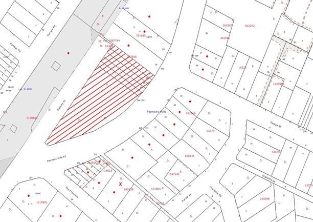
|
NOTIFICATION
PLAN
|
|
|
• PROPERTIES NOTIFIED
|
X SUBMISSIONS
RECEIVED
|
PROPERTY SUBJECT OF
DEVELOPMENT
|
|
|
|
|
|
The one submission objected to
the development, generally on the grounds that the development would result in:
· Patrons parking in Harold Avenue and The Crescent;
· Unacceptable noise and
behaviour from patrons leaving the hotel.
The merits of the matters raised
in community submissions are considered to be addressed in the recommended
condition for operation of the hotel in accordance with the submitted
Management Plan.
5.2 Public Agencies
5.2.1 NSW Police
The development application is
subject to a protocol for the referral of certain types of applications to the
NSW Police for comment in respect to Crime Prevention through Environmental
Design (CPTED) principles.
The proposed change in focus of
the hotel operation to bistro use is supported by NSW Police subject to conditions
for implementation and operation of an upgraded CCTV security system.
5.2.2 Roads and Traffic Authority (RTA)
The proposed development involves
works in Pennant Hills Road and requires the concurrence of the RTA.
The RTA concurrence requirements
restrict vehicle egress onto Pennant Hills Road and direct traffic onto Railway Street. The existing drive-thru bottle shop operation would remain the same.
The applicant initially sought to
maintain access onto Pennant Hills Road but amended the proposal in accordance
with the RTA requirements. The amendments included the provision of a turning
area within the car park, barriers preventing egress onto Pennant Hills Road,
relocation of disabled car parking spaces to prevent queuing on Pennant Hills
Road, widening of the existing vehicle crossing (car park/bottle-shop entry) on
Pennant Hills Road and deletion of the proposed cantilevered addition over the
driveway off Railway Street.
6. THE PUBLIC INTEREST
Section 79C(1)(e) of the Act
requires Council to consider “the public interest”.
The public interest is an
overarching requirement, which includes the consideration of the matters
discussed in this report. Implicit to the public interest is the achievement
of future built outcomes adequately responding to and respecting the future
desired outcomes expressed in environmental planning instruments and
development control plans.
The application is considered to
have satisfactorily addressed Council’s and relevant agencies’ criteria and
would provide a development outcome that, on balance, would result in a
positive impact for the community. Accordingly, it is considered that the
approval of the proposed alterations and additions to the existing hotel would
be in the public interest.
CONCLUSION
Consent is sought for alterations
and additions to an existing hotel (Pennant Hills Inn).
The proposed alterations and
additions remove the existing night club venue and upgrade the hotel to provide
a family bistro centred operation. The proposed outdoor terrace areas off the
hotel bistro would complement the proposed change in operation. The proposed
upgrading would create a contemporary style building and contribute to the
built form of the Pennant Hills Commercial Centre.
The proposal results in the loss
of eleven car parking spaces which is acceptable with regard to the relatively
large size of the hotel car park, the existing hotel patronage and the proposed
increase in the licensed area of the hotel.
The concurrence requirements of
the RTA restrict egress of vehicles onto Pennant Hills Road and direct vehicles
onto Railway Street. The application has been amended in accordance with the
RTA requirements.
The proposal complies with the
requirements of Council’s development control plans other than the minimum 5m
front setback requirement of the Pennant Hills Commercial Centre Development
Control Plan. The non-compliance is acceptable with regard to the existing
building and the streetscape.
The application is supported and
recommended for approval subject to recommended conditions.
|
Rod Pickles
Manager -
Assessment Team 2
Planning Division
|
Scott Phillips
Executive Manager
Planning Division
|
Attachments:
|
1.View
|
Locality Plan
|
|
|
|
2.View
|
Floor Plans
|
|
|
|
3.View
|
Elevations
|
|
|
|
4.View
|
Perspective Views
|
|
|
|
5.View
|
Management Plan
|
|
|
File Reference: DA/529/2010
Document Number: D01444311
SCHEDULE 1
GENERAL
CONDITIONS
The conditions of consent within this notice of determination have
been applied to ensure that the use of the land and/or building is carried out
in such a manner that is consistent with the aims and objectives of the
relevant legislation, planning instruments and Council policies affecting the
land and does not disrupt the amenity of the neighbourhood or impact upon the
environment.
Note: For the
purpose of this consent, the term ‘applicant’ means any person who has the
authority to act on or the benefit of the development consent.
Note: For the purpose of
this consent, any reference to an Act, Regulation, Australian Standard or
publication by a public authority shall be taken to mean the gazetted Act or
Regulation, or adopted Australian Standard or publication as in force on the
date that the application for a construction certificate is made.
1. Approved
Plans and Supporting Documentation
The
development must be carried out in accordance with the plans and documentation
listed below and endorsed with Council’s stamp, except where amended by Council
and/or other conditions of this consent:
|
Plan No.
|
Drawn by
|
Dated
|
|
09.167.DA01.C Site Analysis and
Roof Plans
|
Realize Architecture
|
09.02.11
|
|
09.167.DA02.C Lower Ground Floor
Plan
|
Realize Architecture
|
09.02.11
|
|
09.167.DA03.D Ground Floor Plan
|
Realize Architecture
|
09.02.11
|
|
09.167.DA04.C First Floor
Plan/Roof
|
Realize Architecture
|
09.02.11
|
|
09.167.DA05.D Elevations North
|
Realize Architecture
|
09.02.11
|
|
Document No.
|
Prepared by
|
Dated
|
|
D01425682 External Finishes
Schedule
|
Realize Architecture
|
14.04.10
|
|
D01425679 Management Plan
|
Lesday Pty Ltd
|
Undated
|
|
D01504254 Access Report
|
Accessibility Solutions
|
24 Sept 2010
|
|
D01425676 Noise Impact
Assessment
|
RSA Acoustics
|
April 2010
|
|
D01425681 Waste Management Plan
|
Realize Architecture
|
23.04.10
|
2. Removal
of Existing Trees
This development consent only permits the removal of tree(s)
numbered 1, 2, 3, 4, 5 and 6 as identified on the Detail & Level Survey
Plan dated 19/02/10. The removal of any other trees requires separate approval
under Council’s Tree Preservation Order.
REQUIREMENTS PRIOR TO THE ISSUE OF A CONSTRUCTION
CERTIFICATE
3. Building
Code of Australia
a. All building work must be carried out in accordance with the
requirements of the Building Code of Australia.
b. A report regarding Section J of the Building Code of
Australia is to be submitted to the Principle Certifying Authority prior to the
issue of a construction certificate.
4. Fire
Safety Upgrade
To ensure the
protection of persons using the building and to facilitate egress from the
building in the event of a fire, the application for a construction certificate
must demonstrate that it will comply with the following Category 1 fire safety
provisions:
a. The
building is to comply with Part C1.10, C2.9, C3.11, C3.12, Specification C1.1
and Specification C3.15 of the Building Code of Australia.
b. The
building is to comply with Part D1.4, D1.6, D1.13, D2.8, D3.2, D3.3, D3.8 of
the Building Code of Australia.
c. The
building is to comply with Part E1.3, E1.4, E2.3, E4.2, E4.5 of the Building
Code of Australia.
Note: This
condition does not apply to the extent to which an exemption is in force
under Clause 187 or 188 of the Act, subject to the terms of any condition or
requirement referred to in Clause 187(6) or 188(4) of the Act, or to the
erection of a temporary building.
5. Sydney
Water – Quick Check
The
application must be submitted to a Sydney Water ‘Quick Check Agent’ or
‘Customer Centre’ for approval to determine whether the development will affect
any Sydney Water infrastructure, and whether further requirements are to
be met.
Note: Refer
to www.sydneywater.com.au or
telephone 13 20 92 for assistance.
REQUIREMENTS PRIOR TO THE COMMENCEMENT OF ANY WORKS
6. Erection
of Construction Sign
A sign must
be erected in a prominent position on any site on which building work,
subdivision work or demolition work is being carried out:
a. Showing
the name, address and telephone number of the principal certifying authority
for the work,
b. Showing
the name of the principal contractor (if any) for any demolition or building
work and a telephone number on which that person may be contacted outside
working hours, and
c. Stating
that unauthorised entry to the work site is prohibited.
Note: Any
such sign is to be maintained while the building work, subdivision work or
demolition work is being carried out, but must be removed when the work has
been completed.
7. Protection
of Adjoining Areas
A temporary
hoarding, fence or awning must be erected between the work site and adjoining
lands before the works begin and must be kept in place until after the
completion of the works if the works:
a. Could
cause a danger, obstruction or inconvenience to pedestrian or vehicular
traffic.
b. Could
cause damage to adjoining lands by falling objects.
c. Involve
the enclosure of a public place or part of a public place.
Note: Notwithstanding
the above, Council’s separate written approval is required prior to the
erection of any structure or other obstruction on public land.
8. Toilet
Facilities
Toilet
facilities must be available or provided at the works site before works begin and
must be maintained until the works are completed at a ratio of one toilet for
every 20 persons employed at the site. Each toilet must:
a. be
a standard flushing toilet connected to a public sewer; or
b. be
a temporary chemical closet approved under the Local Government Act, 1993;
or
c. have
an on-site effluent disposal system approved under the Local Government Act,
1993
9. Erosion
and Sediment Control
Erosion and
sediment control measures must be provided and maintained throughout the
construction period in accordance with the manual ‘Soils and Construction
2004 (Bluebook)’, the approved plans, Council specifications and to the
satisfaction of the principal certifying authority. The erosion and sediment
control devices must remain in place until the site has been stabilised and
revegetated.
Note: On
the spot penalties up to $1,500 may be issued for any non-compliance with this
requirement without any further notification or warning.
REQUIREMENTS DURING CONSTRUCTION
10. Demolition
All
demolition work must be carried out in accordance with Australian Standard
2601-2001 – The Demolition of Structures and the following requirements:
a. Demolition
material is to be disposed of to an authorised recycling and/or waste disposal
site and/or in accordance with an approved waste management plan.
b. Demolition
works, where asbestos material is being removed, must be undertaken by a
contractor that holds an appropriate licence issued by WorkCover NSW in
accordance with Chapter 10 of the Occupational Health and Safety Regulation
2001 and Clause 29 of the Protection of the Environment Operations
(Waste) Regulation 1996.
c. On construction
sites where buildings contain asbestos material, a standard commercially
manufactured sign containing the words ‘DANGER ASBESTOS REMOVAL IN PROGRESS’
measuring not less than 400mm x 300mm must be erected in a prominent position
visible from the street.
d. Demolition works
must be implemented in accordance with safe lead work procedures in ‘Ceiling
Dusts Containing Lead: Guidance Note’, issued by WorkCover NSW, refer to
www.workcover.nsw.gov.au.
11. Construction
Work Hours
All work on site (including demolition and earth works)
must only occur between 7am and 5pm Monday to Saturday.
No work is to be undertaken on Sundays or public holidays.
12. Council
Property
During
construction works, no building materials, waste, machinery or related matter
is to be stored on the road or footpath. The public reserve is to be kept in a
clean, tidy and safe condition at all times.
13. Environmental
Management
The site must
be managed in accordance with the publication ‘Managing Urban Stormwater –
Landcom (March 2004) and the Protection of the Environment Operations
Act 1997 by way of implementing appropriate measures to prevent sediment
run-off, excessive dust, noise or odour emanating from the site during the
construction of the development.
14. Landfill
Landfill must
be constructed in accordance with Council’s ‘Construction Specification,
2005’ and the following requirements:
a. All
fill material imported to the site is to wholly consist of Virgin Excavated
Natural Material (VENM) as defined in Schedule 1 of the Protection of the
Environment Operations Act 1997 or a material approved under the Department
of Environment and Climate Change’s general resource recovery exemption.
b. A
compaction certificate is to be obtained from a geotechnical engineer verifying
that the specified compaction requirements have been met.
15. Excavated
Material
All excavated
material removed from the site must be classified in accordance with the NSW
Environment Protection Authority’s Environmental Guidelines – Assessment,
Classification and Management of Liquid and Non-Liquid Wastes prior to
disposal to an approved waste management facility and reported to the principal
certifying authority.
REQUIREMENTS PRIOR TO THE ISSUE OF AN OCCUPATION
CERTIFICATE
Note: For
the purpose of this consent, any reference to ‘occupation certificate’ shall
also be taken to mean ‘interim occupation certificate’ unless otherwise stated.
16. Maintain
Canopy Cover
To maintain canopy cover,
five (5) medium to large trees selected from Council’s booklet ‘Indigenous
Plants for the Bushland Shire’ are to be planted on the subject site. The
planting location shall not be within 4 metres of the foundation walls of a
building. The pot size is to be a minimum 25 litres and the tree(s) must be
maintained until they reach the height of 3 metres.
17. Stormwater
Drainage
The
stormwater drainage system for the development must be designed and constructed and a construction Certificate issued for these
works. The stormwater drainage system is to be designed in accordance with
Council’s Civil Works – Design and Construction Specification 2005 and
the following requirements:
a. Connected
directly to Council’s street drainage system.
18. Internal
Driveway/Vehicular Areas
The driveway
and parking areas on site must be designed, constructed
and a Construction Certificate issued in
accordance with Australian Standards 2890.1, 2890.2, 3727 and the following
requirements:
a. Design
levels at the front boundary be obtained from Council for the Railway St crossing.
b. A
gate is to be erected at the eastern end of the car park to prohibit vehicles
exiting the site on to Pennant Hills Rd from the car park. Delivery vehicles
for the bottle shop are exempted from this requirement.
c. Except
for when delivery vehicles that are exiting the site on to Pennant Hills Rd the
gates are to be shut at all times.
d. A
“No Exit for Passenger Cars”, or similar, sign is to be erected at the gate to
prohibit vehicles leaving the car park and exiting the site on to Pennant Hills
Rd.
e. An
“Entry Only’ sign is to be erected at the western access driveway on Pennant Hills Rd.
f. A
“No Exit” sign is to be erected at the western access driveway on Pennant Hills Rd.
19. Vehicular
Crossing
Prior to the
issue of a Construction Certificate for these works a separate
application under the Local Government Act, 1993 and the Roads Act,
1993 must be submitted to Council for the reconstruction of the vehicular
crossing and driveway in Railway St and the widening of the western vehicular
crossing in Pennant Hills Rd. The vehicular crossing must be constructed in
accordance with Council’s Civil Works Design, 2005 and the following requirements:
a. The
Railway St access crossing and driveway is to comply with AS 2890.2. The total
width of the access crossing is to be 8m so as to allow a HRV vehicle to enter
and exit the site.
b. The
Pennant Hills Rd access is to comply with the requirements of the RTA and the
written concurrence of the RTA is to be obtained prior to seeking approval from
the Council under the Roads Act.
c. All
driveways are to be suitably signposted.
d. Engineering
design plans are to be submitted to Council for approval under the Roads Act
Note:
An application for a vehicular crossing can only be made to one of Council’s
Authorised Vehicular Crossing Contractors. You are advised to contact Council
on 02 9847 6940 to obtain a list of contractors.
20. Traffic
Control Plan
A Traffic
Control Plan (TCP) must be prepared by a qualified traffic controller in
accordance with the Roads & Traffic Authority’s Traffic Control at
Worksites Manual 1998 and Australian Standard 1742.3 for all work on
a public road and be submitted to Council. The TCP must detail the following:
a. Arrangements
for public notification of the works.
b. Temporary
construction signage.
c. Permanent
post-construction signage.
d. Vehicle
movement plans.
e. Traffic
management plans.
f. Pedestrian
and cyclist access/safety.
21. Damage
to Council Assets
Any damage
caused to Council’s assets as a result of the construction of the development
must be rectified in accordance with Council’s written requirements and at the
sole cost of the applicant.
22. Works
as Executed Plan
A works-as-executed plan(s)
must be prepared by a registered surveyor and submitted to Council for
completed road pavement, kerb & gutter, public drainage systems, driveways
and on-site detention system. The plan(s) must be accompanied by a certificate
from a registered surveyor certifying that all pipelines and associated
structures lie wholly within any relevant easements.
23. Completion
of Landscaping
A certificate
must be provided by a practicing landscape architect, horticulturalist or
person with similar qualifications and experience certifying that all required
landscaping works have been satisfactorily completed in accordance with the
approved landscape plans.
Note: Advice
on suitable species for landscaping can be obtained from Council’s planting
guide ‘Indigenous Plants for the Bushland Shire’, available at www.hornsby.nsw.gov.au.
24. Occupational
Hygienist
A report by a suitably qualified Occupational Hygienist must be prepared
to certify the hotel refurbishment is clear of contamination.
25. s94
Infrastructure Contributions
The payment to Council of a
contribution of $5,146.30* for 2.18 employees towards the cost of
infrastructure identified in Council’s Development Contributions Plan
2007-2011.
Note: * The value of contribution is based on a rate of $2,360.68 per
employee, derived from a rate of one employee per 30sqm commercial floor area
and is current as at 14 February 2011. The
contribution will be adjusted from this date in accordance with the underlying
consumer price index for subsequent financial quarters.
It is recommended that you contact Council to ascertain the indexed value of
the contribution prior to payment.
26. Food
Premises
The fit out and operation
of that part of the building to be used for the manufacture, preparation or
storage of food for sale, must be in accordance with Australian Standard
4674-2004 – Design and fit out of food premises, the Food Act
2003, and the Food Regulation 2004.
Note: Reference should also be made to the Food Safety Standards
and the ‘Safe Food Australia - A guide to the Food Safety Standards 2nd Edition
January 2001’.
27. Grease
Trap & Dry Basket Arrestor Installation
An application must be
submitted to Sydney Water for the installation of a grease trap and dry
basket arrestor (floor and sink) in accordance with the ‘Guidelines for the
On-Site Pre-Treatment of Trade Wastewater Discharges – Sydney Water (May 2004)’.
28. Kitchen
Exhaust Installation
A kitchen exhaust system must
be designed and installed to effectively prevent air pollution in accordance
with the Protection of the Environment Operations Act 1997.
29. Noise
– Plant and Machinery
The level of total
continuous noise emanating from operation of all the plant, including air
conditioning units and processes in all buildings (LA10) (measured for at least
15 minutes) in or on the above premises, must not exceed the background
level by more than 5dB(A) when measured at all property boundaries.
30. Hours
of Operation
The hours of operation of
the premises are:
Monday: 10am to 3am
Tuesday: 10am to 3am
Wednesday: 10am to 3am
Thursday: 10am to 3am
Friday: 10am to 3am
Saturday: 10am to 3am
Sunday: 10am to 10pm
31. Operation
of Licensed Premises
The use of the premises
must not give rise to any of the following:
a. Transmission
of vibration to any place of different occupancy greater than specified in Australian
Standard 2670 (as amended).
b. An
indoor sound pressure level in any place of different occupancy (and/or public
place) greater than 3dB above the L90 background level or greater than 5dB at
the boundary of any affected property in any octave band from 31.5 Hz to 8,000
Hz centre frequencies inclusive between the hours of 8.00 a.m. to 10.00 p.m.
daily and 0dB above the L90 background between 10.00 p.m. and 8.00 a.m. the
following morning.
c. A
sound level at any point on the boundary of the site greater than the
background levels specified in Australian Standard 1055 – Acoustics – Description
and Measurement of Environmental Noise.
d. The
"emission of an offensive noise" specified under the Protection
of the Environment (Operations) Act 1997.
Note: The method
of measurement of vibration must be carried out in accordance with Australian
Standard 2973 (as amended) for vibration measurements, Australian Standard 1055
(as amended) for outdoor sound level measurements, and Australian Standard 2107
(as amended) for indoor sound level measurements.
32. Acoustic
Assessment
a. An
acoustic assessment is to be undertaken by a suitably qualified environmental
consultant within 60 days of occupying the site in accordance with the Environment
NSW Industrial Noise Policy (2000), Council’s Policy and Guidelines for
Noise and Vibration Generating Development (Acoustic Guidelines V.5, 2000) and
the DECC’s Noise Guide for Local Government (2004). The assessment must
be submitted to Council for review. Should the assessment find that noise from
the premise exceeds 5dB(A) appropriate measures must be employed to rectify
excessive noise.
b. The construction and operation of the proposed
development must be carried out in accordance with the Noise Impact Assessment
prepared by RSA Acoustics Acoustic Consultants dated April 2010, report number
4698.
33. Fire
Safety Statement - Annual
On at least one occasion in
every 12 month period following the date of the first ‘Fire Safety Certificate’
issued for the property, the owner must provide Council with an annual ‘Fire
Safety Certificate’ to each essential service installed in the building.
CONDITIONS OF CONCURRENCE – NSW POLICE FORCE
The following conditions of consent are from
the nominated State Agency pursuant to Section 79B of the Environmental
Planning and Assessment Act 1979 and must be complied with to the
satisfaction of that Agency.
34. Closed
Circuit Television (CCTV)
a. The licensee shall install and maintain surveillance cameras
and recorders to monitor and record all public areas of the licensed premises
including every entrance and exit. The camera will also monitor the 50 metre
vicinity of the hotel including, but not limited to, the footpath area in front
of the licensed premises to at least 50 metres north east and 50 metres south
west on Pennant Hills Road and 50 metres north west towards the railway line
area and towards Railway Street. Recordings are to be made twenty four (24)
hours a day seven (7) days a week, irrespective of opening and closing times.
b. As a minimum, CCTV cameras at entry and exit points to the
premises must record footage of a nature and quality in which it can be used to
identify a person recorded by the camera. All other cameras must record footage
of a nature and quality in which it can be used to recognise a person recorded
by the camera.
c. The time and date must automatically be recorded on all
recordings made whilst it is recording. All recordings are to be kept for a
minimum period of thirty (30) days before they can be reused or destroyed. Any
recordings made are to be promptly delivered to police as soon as possible
following request. Notwithstanding this requirement, should any footage exist,
regardless of whether it falls within the thirty (30) day period, it must be
supplied to police or other regulatory officers upon request.
d. If requested by police or any regulatory officer, the licensee
is to archive any recording until such time as they are no longer required.
e. Recordings are to be made in a common media format such as
Windows Media Player or similar, or should be accompanied by applicable viewing
software to enable viewing on any windows computer.
f. The CCTV control system should be located within a secured
area of the venue and only accessible by authorised personnel. In addition, at
all times whilst the venue is open and trading, an authorised person MUST be on
the premises with access to the system and ability to use the system and make
copies of any recordings at the request of police or any other regulatory
officer.
g. The CCTV system shall be maintained by a registered security
surveillance company. If, at any time, the CCTV system is not in full
operational condition, the licensee is to notify the Local Area Commander of
police within one (1) hour of the fault being discovered.
h. If the CCTV system is not operational, immediate steps are to
be taken by the licensee to ensure that it is returned to a fully operational
condition as soon as possible.
i. A colour monitor, at least 30cm screen size, is to be
situated at the main entrance to the venue so that patrons entering are able to
clearly view they are being recorded by cameras.
j. Signs are to be displayed, throughout the premises notifying
patrons that a CCTV system is recording throughout the premises.
CONDITIONS OF CONCURRENCE – NSW ROADS AND TRAFFIC
AUTHORITY
The following conditions of consent are from
the nominated State Agency pursuant to Section 79B of the Environmental
Planning and Assessment Act 1979 and must be complied with to the
satisfaction of that Agency.
35. Traffic
and Road Safety
a. A physical barrier is to be installed between the car park and
the bottle shop driveway on the eastern side of the site to restrict vehicles
from the car park to exit on Pennant Hills Road. Service vehicles are exempt
from this condition. (Therefore limiting the use of the eastern driveway for
the bottle shop and service vehicles only)
b. The developer shall be responsible for all public utility adjustment/relocation works, associated with this development and as required by the various
public utility authorities and/or their agents.
c. The required sight lines to pedestrians or other vehicles in
or around the car park or entrances should not be compromised by landscaping,
signage, fencing or display materials in accordance with AS2890.1-2004.
Measures should be implemented to improve visibility to pedestrians and other
vehicles where sight distance is restricted.
d. The design and construction of the western/entry driveway on Pennant Hills Road shall be in accordance with AS2890.1-2004 and the RTA’s requirement.
Any redundant
driveway must be removed and replaced with kerb & gutter to match the
existing. The proposed kerb and gutter must also be designed and constructed to
RTA requirements.
Details of
further requirements of the proposed driveway and kerb and gutter can be
obtained from the RTA’s Project Services Manager, Traffic Projects Section,
Parramatta (ph: 02 8849 2144).
A certified
copy of the design plans shall be submitted to the RTA for consideration and
approval prior to the release of any new construction certificate(s) for the
development by Council or commencement of any works.
The RTA fees
for administration, plan checking, civil works inspections and project
management must be paid by the developer prior to the commencement of the
works.
e. An ‘Entry Only’ signage shall be installed on the
western/entry Pennant Hills Road driveway to Council’s satisfaction.
f. All vehicles are to enter and exit the site in a forward
direction.
g. All demolition and construction vehicles and activities should
be contained wholly within the site as a work zone permit will not be approved
on Pennant Hills Road.
h. Should there be changes to the RTA’s drainage system then
detailed plans and hydraulic calculations of the stormwater drainage system are
to be submitted to the RTA for approval, prior to the commencement of any
works.
Details should
be forwarded to:
The Sydney
Asset Management
Roads and
Traffic Authority
PO Box 973
Parramatta CBD 2124
A plan
checking fee will be payable and a performance bond may be required before the
RTA’s approval is issued. With regard to the Civil Works requirement please
contact the RTA’s Project Engineer, External Works Ph: 8849 2114 or Fax: 8849
2766.
i. The layout of the proposed car parking areas and loading
areas associated with the subject development (including driveways, grades,
turn paths, sight distance requirements, aisle widths, aisle lengths, parking
bay dimensions and loading bay dimensions) should be in accordance with AS
2890.1 – 2004 and AS2890.2 – 2002.
j. All car parking shall be accommodated on site. To enforce
this requirement, full time ‘No Stopping’ restrictions shall be installed along
the entire Pennant Hills Road property frontage. This restriction should be
implemented prior to the commencement of any construction works relating to the
proposed development. Prior to the installation of the parking restrictions the
applicant is to contact the RTA’s Traffic Management Services on phone: (02)
8849 2928 for a ‘works instruction’.
k. All costs associated with the proposed development shall be at
no cost to the RTA.
-
END OF CONDITIONS -
ADVISORY NOTES
The following information is provided for your
assistance to ensure compliance with the Environmental Planning and Assessment
Act, 1979, Environmental Planning and Assessment Regulation 2000, other
relevant legislation and Council’s policies and specifications. This
information does not form part of the conditions of development consent
pursuant to Section 80A of the Act.
Environmental Planning and
Assessment Act, 1979 Requirements
· The Environmental Planning and
Assessment Act, 1979 requires:
· The issue of a construction certificate
prior to the commencement of any works. Enquiries regarding the issue of a
construction certificate can be made to Council’s Customer Services Branch on
9847 6760.
· A principal certifying authority to be
nominated and Council notified of that appointment prior to the commencement of
any works.
· Council to be given at least two days
written notice prior to the commencement of any works.
· Mandatory inspections of nominated
stages of the construction inspected.
· An occupation certificate to be issued
before occupying any building or commencing the use of the land.
Long Service Levy
In accordance with Section 34 of
the Building and Construction Industry Long Service Payments Act 1986, a ‘Long Service Levy’ must be paid to the Long
Service Payments Corporation or Hornsby Council.
Note: The
rate of the Long Service Levy is 0.35% of the total cost of the work.
Note: Hornsby
Council requires the payment of the Long Service Levy prior to the issue of a
construction certificate.
Tree Preservation Order
To ensure the maintenance and
protection of the existing natural environment, it is an offence to ringbark,
cut down, top, lop, remove, wilfully injure or destroy a tree outside 3 metres
of the approved building envelope without the prior written consent from
Council.
Note: A
tree is defined as a single or multi-trunked wood perennial plant having a
height of not less than three (3) metres, and which develops many branches,
usually from a distance of not less than one (1) metre from the ground, but
excluding any plant which, in its particular location, is a noxious plant
declared as such pursuant to the Noxious Weeds Act 1993. This definition of ‘tree’
includes any and all types of Palm trees.
All
distances are determined under Australian Standard AS4970-2009 "Protection
of Trees on Development Sites”.
Fines may be imposed for
non-compliance with Council’s Tree Preservation Order.
Disability Discrimination Act
The applicant’s attention is
drawn to the existence of the Disability Discrimination Act. A
construction certificate is required to be obtained for the proposed
building/s, which will provide consideration under the Building Code of Australia,
however, the development may not comply with the requirements of the Disability
Discrimination Act. This is the sole responsibility of the applicant.
Advertising Signage – Separate
DA Required
This consent does not permit the
erection or display of any advertising signs. Most advertising signs or
structures require development consent. Applicants should make separate
enquiries with Council prior to erecting or displaying any advertising signage.
Dial Before You Dig
Prior to commencing any works,
the applicant is encouraged to contact Dial Before You Dig on 1100 or www.dialbeforeyoudig.com.au for
free information on potential underground pipes and cables within the vicinity
of the development site.
Asbestos Warning
Should asbestos or asbestos
products be encountered during demolition or construction works you are advised
to seek advice and information should be prior to disturbing the material. It
is recommended that a contractor holding an asbestos-handling permit (issued by
WorkCover NSW) be engaged to manage the proper handling of the material.
Further information regarding the safe handling and removal of asbestos can be
found at:
www.environment.nsw.gov.au
www.nsw.gov.au/fibro
www.adfa.org.au
www.workcover.nsw.gov.au
Alternatively, telephone the WorkCover
Asbestos and Demolition Team on 8260 5885.
Food Authority Notification
The NSW Food Authority
requires businesses to electronically notify the Authority prior to the
commencement of its operation.
Note: NSW
Food Authority can be contacted at www.foodnotify.nsw.gov.au.
Council Notification – Food
Premises
Prior to the commencement of the
business, the operator is requested to contact Council’s Environmental Health
Team to arrange an inspection for compliance against the relevant legislation
and guidelines outlined in this approval.
Note: Council’s
Environmental Health Officer can be contacted on 02
9847 6745.
Standard Report No. PLN22/11
Planning Division
Date of Meeting:
2/03/2011
8 STRATEGIC PLANNING
PROGRAMME REVIEW - 2011
EXECUTIVE SUMMARY
At its
meeting on 3 March 2010, Council adopted the current Strategic Planning
Programme. The majority of projects scheduled to be completed under the
Programme by December 2010 have been completed, or are nearing completion.
An
annual review of the Programme is required to ensure it is consistent with
Council’s strategic planning priorities. An amended Strategic Planning
Programme is attached for Council’s consideration.
PURPOSE
The
purpose of this report is to review the Strategic Planning Programme and seek
endorsement of a revised Programme for 2011.
BACKGROUND
The
Town Planning Services Branch within the Planning Division of Council is
responsible for strategic town planning initiatives in accordance with the
Strategic Planning Programme. The Programme is adopted by Council and
sets out the major projects of the Branch.
At its
meeting on 3 March 2010, Council considered Executive Manager’s Report No.
PLN11/10 on the Strategic Planning Programme and resolved that the current
Programme be adopted. A summary of the projects under the Programme is
attached (Attachment A).
This
report enables Council to determine the priorities for strategic planning over
the current Council term. The Programme is reviewed annually to enable
Council to reconsider priorities as issues evolve and to provide Council with
an update on the achievements over the preceding year.
DISCUSSION
The
remainder of this report considers the current Strategic Planning Programme,
other projects and a revised Programme.
2010
Strategic Planning Programme
The
current Strategic Planning Programme is divided into the following sections:
Planning
Proposals: Two Planning Proposals (addressing four planning issues)
were identified for completion in 2010. The preparation of a
Comprehensive LEP for Hornsby Shire is also identified to be progressed in
2011.
Development
Control Plans: One DCP project was identified for completion in 2010. The
preparation of a Comprehensive DCP for Hornsby Shire is also identified to be
progressed in 2011.
Studies: Two studies
were identified for completion in 2010.
Management
Plan Projects: The Programme includes three Management Plan projects, none
of which were identified for completion in 2010. The projects include
progressing Hornsby Quarry legal actions and land filling proposal and
consideration of revised planning controls for the Hornsby Town Centre west
precinct.
Miscellaneous: The Programme
includes three miscellaneous projects. These projects are annual
projects, such as the Local Heritage Assistance Fund and Heritage Week which
occurs in April of each year.
The
following projects under the current Programme have been completed:
· Amendments Planning Proposal (2009) which:
- rezoned No. 218 Brooklyn Road, Brooklyn;
- implemented the recommendations of Heritage Review Stage 4;
and
- implemented the recommendations of the Hornsby West Side
Conservation Area Review.
· Kangaroo Point Planning Proposal;
· Heritage Schedule DCP Amendments; and
· Ku-ring-gai and Hornsby Subregional Employment Study.
The following projects are nearing
completion:
· Housing Strategy Planning Proposal (awaiting gazettal);
· Townhouse Planning
Proposal (awaiting gazettal); and
· Housing Strategy DCP
(a report on the exhibition of the draft DCP is included on the Business Paper
for the Council meeting on 2 March 2011).
The following projects have been adopted for
exhibition or have been exhibited:
· Wahroonga North Planning Proposal (2009); and
· Kangaroo Point DCP Amendments.
The
other projects are in various states of preparation, exhibition or finalisation
as summarised in Attachment A.
Projects
Outside the Strategic Planning Programme
The
Town Planning Services Branch has also undertaken a number of projects outside
the Strategic Planning Programme, including:
· Evaluating nominations
for the vacant voluntary industry representative position on the Hornsby Shire
Heritage Advisory Committee;
· Reporting on the State
Government’s Metropolitan Strategy Review Discussion Paper;
· Evaluating the
implications for Hornsby Shire of draft Comprehensive LEPs for Parramatta, Hawkesbury and Gosford;
· Reporting
on the opportunities and constraints
concerning the rezoning of the Kookaburra Road Industrial Precinct for
residential uses;
· Evaluating options for conducting a program of events to
promote heritage conservation and awareness in Hornsby Shire; and
· Presenting the
findings of a review of the Wahroonga (North) Heritage Conservation Area Study.
The Branch has also assisted
other Divisions in progressing projects, including:
· Developing a model to assess the impact of
development on water quality - assist Environment Division;
· Kangaroo Point Tenders - assist Works
Division; and
· Flood Prone Land Mapping - assist Works Division.
Other
Projects
A
number of other projects have arisen as a result of Council resolutions,
Councillor Strategic Planning Workshops, consideration of development
applications, State Government initiatives or recommendations of planning
studies. These projects should be incorporated into the Strategic
Planning Programme and include:
· Townhouse Planning Proposal;
· Housing Strategy DCP;
· Kangaroo Point DCP amendments;
· Sex services premises development controls review;
· Hawkesbury, Hills and Hornsby Tourism Development Study;
and
· Bushfire Prone Land Map Review.
The
timing of the above projects will be required to be determined having regard to
the priority of other projects.
A review of the Pennant Hills
Masterplan was considered by Council’s Employment and Economic Development
Taskforce at its meeting on 12 May 2010. The Taskforce considered the priority
of a Masterplan review in the context of the strategic direction under the
State Government’s Metropolitan Strategy and draft North Subregional Plan. The
Taskforce noted that progression of the Hornsby Shire Housing Strategy and
Townhouse Planning Proposals will rezone lands to facilitate the provision of
2,600 dwellings to meet the State Government’s dwelling targets for the next 10
years. Furthermore, the Hornsby and Ku-ring-gai Subregional Employment Study concludes that there is sufficient existing capacity within
Council’s employment lands to meet employment targets without the need to
rezone additional lands.
The
Taskforce acknowledged that although a review of the Masterplan may assist in
addressing issues including traffic, parking and urban design, a strategic
review of the Centre is not required in the short term in response to dwelling
and employment targets under the Metropolitan Strategy. Accordingly, the
Taskforce agreed that a review of the Masterplan should be considered for
inclusion on the Strategic Planning Programme after 2011/2012.
Revised
Strategic Planning Programme
A
Revised Strategic Planning Programme has been prepared on the basis of
this report and is attached for Council’s consideration (Attachment B).
The Programme aims to prioritise projects that facilitate
the preparation and timely delivery of Council’s Comprehensive LEP and DCP in
accordance with the State Government’s Planning Reforms. It is anticipated
that these draft Plans will be exhibited in 2011. In addition to the
translation of Council’s current planning controls into the Standard LEP
Template format, the major projects being progressed include the Housing
Strategy (including the Townhouse Planning Proposal) and Epping Town Centre
Study. These projects are essential to ensure that Council meets its
obligations under the Metropolitan Strategy and draft North Subregion
Strategy. The major amendments to the current Programme include:
· Incorporating the progression of Planning Proposals for
Townhouses, Kookaburra Road and Wahroonga North Heritage Conservation Area.
· Including the preparation of controls for sex service
premises as part of the Comprehensive DCP.
· Including the progression of the Hawkesbury, Hills and
Hornsby Regional Tourism Development Study. The Study is currently being
progressed by consultants on behalf of the Councils to review and map existing
tourism products within the region and identify potential business development
and wealth creation opportunities that may lead to employment generation.
· Incorporating a review of Council’s Bush Fire Prone Land map which is required to be undertaken every 5 years.
The
timeline for each project provides an estimate of the time required to complete
the project. It is not possible, nor appropriate, to pre-empt the
findings of any study and the likely implications prior to its preparation, nor
can Council always accurately predict the level of community interest in a
project. Accordingly, the Programme is dynamic as the timeline can be
impacted upon by additional consultation, the project being expanded or
competing priorities.
The
finalisation of the Housing Strategy Planning Proposal has been delayed as a
result of involvement by the DOP. At its meeting on 7 July 2010, Council
resolved to forward the Planning Proposal to the Department for Gazettal.
However, Council is still awaiting finalisation of the Proposal. At the
request of the Department, the Epping Town Centre Planning Proposal has also
been delayed to be progressed following finalisation of the findings and
recommendations of the Epping Town Centre Study.
The Hornsby Town Centre controls review has
been delayed to enable workshops. At a workshop on 22 September 2010,
Councillors considered the aims, objectives and scope of any review and the likely
intensity of development required to be permitted to encourage economically
feasible development. At its meeting on 2 February 2011, Council resolved that
a report be prepared presenting options for alternative planning
controls that may facilitate a range of viable built forms including
commercial, retail and residential development consistent with the
Draft North Subregional Strategy. Furthermore, the preparation of a
revised Local Development Contributions Plan has been deferred pending a submission
by Council seeking a rate increase to fund asset improvements.
Should
Council consider amending the priority of projects on the Programme, it should
be mindful that a number of projects on the Programme (such as the Housing
Strategy, Epping Town Centre Study and Comprehensive LEP and DCP) incorporate
timeframes that are set by the State Government.
Town
Planning Services Branch Resources
The
Town Planning Services Branch comprises six Town Planners, a Cartographer, an
administrative assistant and a Section 149 Certificate Coordinator. In
addition to providing town planning services to Council, the Branch is also
responsible for heritage conservation, production of 149 (zoning) certificates,
cartography and some aspects of the geographic and land information systems.
As
opportunities have arisen, staff from other branches within the Planning
Division have been seconded into the Branch to increase the capacity of the
Branch to fulfill its requirements under the Strategic Planning Programme.
FINANCIAL
The
Strategic Planning Programme requires financial resources for staff in the Town
Planning Services Branch and for consultancy fees. The recommended
Programme has been designed in accordance with the typical Town Planning
Services Branch budget allocation, including salaries and consultant
expenditure. The Programme is considered in the preparation of Annual
Operating Plans. The Programme does not commit to expenditure over that
typically provided in the budget. The financial implications of the individual
projects are also reviewed and reported to Council as a component of the
project.
There
has been no increase in the consultant budget for the Town Planning Services
Branch for the current financial year. The Operating Plan for the Town Planning
Services Branch also includes $125,000 in Planning Reform Funds which must be
expended on consultancy fees to the Epping Town Centre Study. Under the
terms and conditions of the Funds, these monies cannot be reallocated to
progress alternative projects. Council has also resolved to commit
$100,000 in the Town Planning Services Budget to fund the balance of monies
required to progress the Study.
TRIPLE
BOTTOM LINE SUMMARY
Triple
Bottom Line is a framework for improving Council decisions by ensuring accountability
and transparency on social, environmental and economic factors. It does
this by reporting upon Council’s strategic themes. As this report
provides Council with information and does not propose any actions which
require a sustainability assessment, no Triple Bottom Line considerations
apply.
CONCLUSION
Council
at its meeting on 3 March 2010 adopted the current Strategic Planning
Programme. The majority of projects scheduled to be completed under the
Programme by December 2010 have been completed or are nearing completion.
An
annual review of the Programme is required to ensure it is consistent with
Council’s strategic planning priorities. An amended strategic planning
Programme is attached for Council’s consideration.
RECOMMENDATION
|
THAT the
20011/2012 Strategic Planning Programme attached to Executive Manager’s
Report No. PLN/11 be adopted.
|
|
James Farrington
Manager - Town
Planning Services
Planning Division
|
Scott Phillips
Executive Manager
Planning Division
|
Attachments:
|
1.View
|
A - Summary of
Projects
|
|
|
|
2.View
|
B - Proposed
2011-2012 Strategic Planning Programme
|
|
|
File Reference: F2004/10086
Document Number: D01599794
Standard Report No. PLN23/11
Planning Division
Date of Meeting:
2/03/2011
9 HOUSING STRATEGY
DEVELOPMENT CONTROL PLAN - REPORT ON SUBMISSIONS
EXECUTIVE SUMMARY
At its meeting on 1 September
2010, Council resolved to exhibit the Housing Strategy Development
Control Plan (DCP) and associated amendments to the Medium Density
Multi-Unit Housing, Medium/High Density Multi-Unit Housing, High Density
Multi-Unit Housing, Business Lands, and Berowra Cowan DCPs. The DCP and
associated amendments were placed on public exhibition from 16 September 2010
to 15 October 2010. A total of 50 submissions were received, including 6 from
public authorities. Thirty-six submissions object to the DCP or suggest
amendments, 8 submissions indicate support or no objection and 6 make comment
on the Housing Strategy which has already been adopted by
Council.
A number of amendments have been
made to the DCP and draft DCP amendments as a result of submissions. The review
of submissions and preparation of amendments has been overseen by Councillors
during two workshops, held on 10 November 2010 and 9 February 2011. Available
Councillors and staff also met with interested stakeholders, namely the Beecroft
Cheltenham Civic Trust, North of Hornsby Resident Action Group and residents of
Chapman Avenue during the exhibition period.
Issues raised in submissions are
addressed in this report. An amended Housing Strategy DCP and
amendments to existing DCPs are attached. It is recommended that Council
approve the DCP and amendments to DCPs to come into force after the gazettal of
the Housing Strategy Planning Proposal.
PURPOSE
The purpose of this report is to
review submissions received in response to the exhibition of the Housing Strategy DCP and amendments to Council’s existing Medium Density
Multi-Unit Housing, Medium/High Density Multi-Unit Housing, High Density
Multi-Unit Housing, Business Lands, and Berowra Cowan DCPs.
BACKGROUND
At its meeting on 1 September
2010, Council considered Executive Manager’s Report No. PLN57/10 concerning the
Housing Strategy DCP. Council resolved that:
1. The draft Housing Strategy Development Control Plan
attached to Executive Manager’s Report No. PLN57/10 be exhibited.
2. The draft amendments to the Medium Density Multi-Unit Housing Medium/High Density Multi-Unit Housing, High Density Multi-Unit Housing, Business
Lands, and Berowra Cowan Development Control Plans be exhibited.
3. Following the exhibition, an informal workshop meeting be
arranged to brief the Councillors, prior to a report being presented to
Council.
4. The draft Housing Strategy Development Control Plan clearly
reflects the need to maintain appropriate development controls to protect the
amenity of residents in adjoining sensitive low density residential zones.
5. The draft Housing Strategy Development Control Plan clearly
reflects an array of site design options drawn from the Residential Flat Design
Code and SEPP 65, to achieve high quality design outcomes.
6. Council officers be available to meet with interested
stakeholders within two weeks of the exhibition of the draft Housing Strategy Development Control Plan to discuss proposed design controls that will achieve
development outcomes which are in keeping with the existing and future desired
vision for each precinct.
In accordance with parts 1 and 2
of Council’s resolution, the Housing Strategy DCP and associated
amendments to existing DCPs were placed on public exhibition from 16 September
2010 to 15 October 2010. This report reviews submissions received in response
to the exhibition. In accordance with parts 3 and 6, workshops were held with
Councillors and interested stakeholders and are discussed in this report under
the heading ‘Consultation’. In accordance with parts 4 and 5, the amendments
have been made to the DCP and are discussed in this report under the heading
‘Exhibition and review of submissions’.
DISCUSSION
This report discusses submissions
received in response to the exhibition of the Housing Strategy DCP
and associated amendments to relevant exiting DCPs.
Exhibition and review of
submissions
The Housing Strategy
DCP and associated DCP amendments were exhibited from 16 September 2010 to
15 October 2010. The exhibition included advertisements in local newspapers and
on Council’s website, letters to community and industry groups, displays at the
Council Administration Centre and all Council libraries, letters to statutory
authorities and referrals to other Divisions of Council.
A total of 50 submissions have
been received, including 6 from public authorities. Thirty-six submissions
object to the DCP or suggest amendments, 8 submissions indicate support or no
objection and 6 make comment on the Housing Strategy which has already
been adopted by Council. Over 70% of submissions objecting to the DCP
relate to Beecroft, including 17 form letters (or letters adapted from form
letters) and one petition.
Key issues raised in submissions
include vegetation and landscaping, setbacks, heritage impacts, impacts on
surrounding sensitive low density residential zones, open space, pedestrian
linkages, traffic, SEPP 65 controls, car parking, roof forms, site
amalgamation, bushfire, waste management and DCP format. A summary of
submissions is attached to this report. Major issues raised in submissions are
addressed below.
Vegetation and Landscaping
A number of submissions object to
the potential loss of vegetation and comment that existing endangered
ecological communities (such as Blue Gum High Forest) should be retained. A
submission from the Pennant Hills District Civic Trust comments that minimum
length dimensions for deep soil areas should be specified. One submission
comments that the controls to retain Blue Gum High Forest within the south
western corner of the Balmoral Street, Waitara precinct would decrease
development potential, and that the vegetation contains species introduced by
landholders in the early 1980s such as fruit trees. The submission comments
that retention of vegetation in the area would render at least one site
isolated and unable to be redeveloped.
Comment: The DCP
includes controls to protect and retain significant vegetation and endangered
ecological communities. The key principles diagrams for each precinct identify
prominent streetscape features or important bushland remnants (including Blue Gum High Forest) which should be retained. The DCP also requires deep soil landscaping
surrounding residential flat buildings. It is acknowledged that the DCP would be
improved by clarifying the minimum length dimensions for deep soil areas,
namely 7m from front and rear boundaries and 4m from side boundaries.
The vegetation in the south
western corner of the Balmoral Street, Waitara precinct has been identified by
an environmental consultant as remnant Blue Gum High Forest. The consultant
report has been peer reviewed by Council’s Environment Division which has
concurred with the finding. The retention of endangered ecological communities
is an important part of Council’s Housing Strategy. The key
principles diagrams represent the key concepts that should be addressed as part
of any future development. At Development Application stage, should an
applicant demonstrate that the vegetation, or parts of the vegetation, is not
an endangered ecological community, consideration would be given to its removal
on a case by case basis. The controls within the DCP concerning isolated sites
aim to ensure that sites are not left isolated and undevelopable.
Resolve: It is
recommended that minimum length dimensions for deep soil areas should be
inserted into a table in the Setbacks and Landscaping elements.
Setbacks
A number of submissions comment
that setbacks should be increased. In particular, form letters relating to the
Beecroft precinct comment that setbacks to Chapman Avenue should be increased
to 20m. Other submissions comment that a minimum setback of 10m to heritage
items should be specified, and object to the allowable setback encroachments
and corner setbacks. A submission from the Beecroft Cheltenham Civic Trust
requests that variations to setbacks be permitted where the variation assists
the protection of heritage qualities.
One submission states that
setbacks are not adequate to prevent overlooking and overshadowing. An
alternative view is expressed by Housing NSW that, although the DCP is
generally supported, proposed residential setbacks are excessive and will
constrain achievable dwelling yields.
Comment: An urban
design consultant was engaged to review the comments in submissions and
setbacks to Chapman Avenue. The consultant recommends against a 20m setback for
the following reasons:
· Pressure would be placed
on the removal of Blue Gum High Forest at the rear of the sites;
· Larger building forms
would be encouraged facing all street frontages, as the “buildable area” would
be reduced and would no longer facilitate two buildings separated by deep soil;
· Due to the topography,
more visually intrusive driveway area, excavation and retaining walls would be
required; and
· Yields which have been
committed to the Department of Planning would be reduced by 15%.
The urban design consultant
recommends a 12m setback from Chapman Avenue (see below under the heading
‘‘Impacts on surrounding sensitive low density residential zones”).
In relation to applying a 10m
setback to heritage items, the urban design consultant advises against applying
simple numeric specifications to the protection of heritage significance.
Identified heritage values are specific to each item and curtilage and visual
qualities do not have the same importance for any two items. Therefore, a merit
assessment on a case by case basis is appropriate which takes into account
relative height and proximity between two structures, available sight-lines, the
shape of new buildings and architectural treatments and whether or not
important landscape elements would be removed. Variations to setbacks may be
necessary to achieve adequate protection of heritage items and a control
allowing such variations should be included in the DCP.
Allowable setback encroachments
have been included in the DCP to accommodate minor building elements which
contribute to high standards of residential amenity and effective articulation
of building forms where they do not add to the bulk and scale of buildings.
Without the allowable encroachments, the definition of ‘building line’ and
‘setbacks’ in the Standard Instrument may prevent driveways, pedestrian
ramps, supporting walls or posts, eaves and balconies. The setback encroachments
for residential development should clarify that balconies are permitted to
encroach to align with the underground parking/deep soil setbacks.
Corner setback controls within
the DCP state that for buildings with a corner frontage, front and rear boundary
setbacks apply to the shorter street frontage, and side boundary setbacks apply
to the longer of the two street frontages. The application of a side boundary
setback to secondary street frontages is consistent with Council’s existing Medium/High
Density Multi-Unit Housing DCP.
Setback controls have been
drafted based on the requirements of SEPP 65 to prevent overlooking and
overshadowing or requiring screening where appropriate. The setbacks are part
of a suite of building envelope controls designed to manage the bulk and scale
of development, while allowing orderly and economic development of sites.
Resolve: It is
recommended that a control allowing variations to setbacks to be considered
where the variation assists the protection of heritage qualities be inserted in
the DCP. It is also recommended that setback encroachments be clarified to
permit balcony encroachments limited to the line of underground parking/deep
soil setbacks.
Heritage Impacts
A number of submissions comment
that the DCP does not take into account the heritage significance of the Beecroft Road, Beecroft precinct. The submissions state that there should be a separate DCP
specific to Beecroft which respects the established heritage value of the area
and that heritage controls should be included, based on the elements already
established in the 2004 Heritage Assessment and Conservation Principles
Analysis prepared by Godden Mackay Logan.
Comment: The DCP
has been prepared to apply to proposed Housing Strategy
development. Council’s existing Heritage DCP would also apply where
development involves a heritage item, is located in the vicinity of a heritage
item, or is located within a heritage conservation area. The Height and
Setbacks elements include a note concerning the application of the Heritage
DCP and the key principles diagrams identify heritage items and sensitive
interface areas surrounding the items. However, it is acknowledged that the DCP
would be further strengthened by the inclusion of a separate chapter for the Beecroft Road precinct, as it is the only precinct which is located within a heritage
conservation area. This chapter should contain a Heritage Conservation element
which reflects the principles of the Godden Mackay Logan Study.
Resolve: It is
recommended that a Heritage Precinct chapter, including a Heritage Conservation
element, be included in the DCP.
Impacts on surrounding
sensitive low density residential zones
At its meeting on 1 September
2010, Council resolved that the DCP should include appropriate development
controls to protect the amenity of residents in adjoining sensitive low density
residential zones. A number of submissions also comment that the sensitive
nature of the land zoned Residential AS (Low Density - Sensitive Lands)
adjoining the Beecroft Road precinct to the north should be addressed in the
DCP controls.
Comment: An
urban design consultant was engaged to review the impact of proposed
development on the properties to the north of the Beecroft Road precinct, based
on Council’s resolution and comments raised in submissions. The consultant
recommends that the front setbacks for the Beecroft Road precinct (residential
portion) be increased by 2 metres. This would balance the retention of dwelling
yields with the protection of the character of the adjoining land zoned low
density sensitive land, which is also located within the Beecroft/Cheltenham
Heritage Conservation Area.
Resolve: It is
recommended that the front setback for the Beecroft Road precinct (residential
portion) be increased to 12m, which can be reduced to 10m for a maximum of one
third of the building width.
Open Space
A number of submissions comment
that additional communal and/or private open space should be required in the
DCP.
Comment: The DCP
requires communal open space for residential development with more than 10
dwellings and mixed use development over 8 storeys in height with more than 10
dwellings. The rate of communal open space is proportional to the site area,
ensuring that as sites increase in size, the amount of required communal open
space increases.
The DCP requires 12sqm of private
open space per unit, with a minimum width of 2.5m. The width is consistent with
the guidelines in the SEPP 65 Residential Flat Design Code and
would accommodate a table and four chairs. The minimum area of 12sqm has been
reviewed and compared to the proposed State Government Housing Code
for small lots, which proposes that a 3 bedroom house/townhouse/unit on a small
lot should include a minimum 16sqm of private open space. As the DCP requires a
mix of housing (i.e. a mix of 1, 2 and 3 bedroom units) which would cater for
different occupants with varying needs for private open space, a sliding scale
should be inserted into the Open Space element requiring increased or decreased
rates of private open space in accordance with the size of the unit.
Resolve: It is
recommended that the open space control should be amended to a sliding scale
requiring 10sqm for 1 bedroom units, 12sqm for 2 bedroom units and 16sqm for 3
bedroom units.
Pedestrian Linkages
A number of submissions comment
that there should be open areas between buildings for cyclists and pedestrians.
A submission from the Pennant Hills District Civic Trust comments that there
should be a Town Centre Linkage Diagram for the Fisher Avenue, Pennant Hills
precinct. A submission from Beecroft Cheltenham Civic Trust Beecroft comments
there should be a pedestrian plaza from Hannah Street to Wongala Crescent in
accordance with the existing masterplan in the Business Lands DCP.
Comment: The key
principles diagrams identify pedestrian walkways between and around buildings
within precincts. Where more than one building is proposed on the same site,
the DCP requires that they be separated by a minimum of 6m. Within mixed use
precincts, where the key principles diagrams identify pedestrian walkways or
the separation of buildings, the DCP states that they should comprise open air
walkways located at ground level at least 6m wide.
The Town Centre Linkage Diagrams
have been prepared for precincts which contain business zoned land or areas
which contain a number of precincts. However, it is acknowledged that the
Fisher Avenue, Pennant Hills precinct would benefit from a Town Centre Linkage
Diagram to indicate pedestrian and cyclist routes around the precinct to the
commercial centre, the railway station and to nearby open space areas.
The key principles diagram and
Town Centre Linkage Diagram for the Beecroft Road precinct should be amended to
reflect the current masterplan identifying a plaza in the Business Lands DCP
at the corner of Hannah Street and Wongala Crescent.
Resolve: It is
recommended that:
· a Town Centre Linkage
Diagram for the Fisher Avenue, Pennant Hills precinct be included in the DCP;
· a plaza be included in
the Beecroft Road, Beecroft (mixed use portion) key principles diagram and Town
Centre Linkage Diagram; and
· a Public Domain element
be inserted into the DCP, reinforcing the requirements for pedestrian linkages
and walkways.
Traffic Improvements
A number of submissions raise
concern with additional traffic congestion and traffic management. Objections
are raised to the partial closure of Amor Street and the proposed roundabout at
the intersection of Amor Street and Lords Avenue.
Comment: The Housing Strategy and Housing Strategy DCP have been prepared in
consultation with the Roads and Traffic Authority (RTA) and Council’s Traffic
and Road Safety Branch. Based on feedback from this consultation, the key
principles diagrams in both the Housing Strategy DCP and in the
amendments to existing DCPs (namely the Medium Density and High Density
Multi-Unit Housing DCPs) should be updated to include required traffic
management improvements. In addition, a Traffic Management element should be
added to the DCP including a Traffic Management Improvement Plan for Asquith.
This would inform a Traffic Impact Study required by the RTA.
Any proposed traffic improvements
shown for Asquith or for any other precinct on the key principles diagrams
would be subject to separate consultation prior to implementation. The Traffic
Management element should clarify that Council or the RTA will undertake the
necessary traffic management improvements located on public land and roads. Any
future development proposing alternative traffic management solutions should be
accompanied by a traffic assessment.
The key principles diagram for
Asquith should be amended to clarify that the traffic management at the corner
of Amor Street and Pacific Highway is not a partial closure but a new median on
the Pacific Highway to restrict movements to left in and left out only from Amor Street. The proposed roundabout is required to assist traffic circulation through the
commercial centre.
Resolve: It is
recommended that the key principles diagrams in the DCP and those to be
inserted as amendments to existing DCPs be updated to include required traffic
management improvements. It is also recommended that a Traffic Management
element be inserted in the DCP, and the key principles diagram for Asquith be
amended to restrict movements to left in and left out of Amor Street.
SEPP 65 controls
At its meeting on 1 September
2010, Council resolved that the DCP should include site design options from the
Residential Flat Design Code and SEPP 65, to achieve high quality
design outcomes. A number of submissions also comment that SEPP 65
controls should be included in the DCP.
Comment: The
controls within the DCP have been prepared to complement the requirements of SEPP
65. However, it is recommended that a SEPP 65 element be inserted
into the DCP to clarify that SEPP 65 applies along with the DCP and to
outline the lodgement requirements and design quality principles as set out in
the SEPP.
Resolve: It is
recommended that a Design Quality – SEPP 65 element be inserted into each part
of the DCP.
Car Parking and Access
Submitters comment that car
parking rates should be increased and that all car parking should be located in
basements. A number of submissions comment that access to Chapman Avenue
development in the Beecroft Road, Beecroft precinct should be from the
commercial centre. One submission comments that no cycle racks are shown.
Comment: Car
parking rates within the DCP are consistent with current car parking rates in
Council’s existing DCPs. Council is currently undertaking a Car Parking
Management Strategy and any recommendations adopted from the final Strategy
would be translated into relevant DCPs.
The DCP requires that resident
and visitor parking for residential developments be provided in basements.
Mixed use development is also required to provide resident, visitor and
customer parking (where required) in basements. However, some existing at grade
parking areas are identified on key principles diagrams to be retained to allow
convenient parking and access for retail shoppers.
There is scope for access to
development in the Beecroft Road precinct (residential portion) to be via the
commercial centre car park and driveway identified on the key principles
diagram for the Beecroft Road precinct. Where access is not possible from this
driveway or car park, existing vehicle entries on Chapman Avenue should be
consolidated to provide access.
Bicycle racks are not shown on
the key principles diagrams. However, the DCP requires bicycle parking in the
form of a rail/rack or locker for residents and visitors in residential
development, and bicycle parking in the form of a rail/rack for mixed use
development.
Resolve: It is
recommended that the Vehicle Access and Parking element and key principles
diagrams in the Heritage precinct chapter be amended to identify that access to
residential development should be via the commercial centre where possible.
Roof forms
A number of submissions object to
the requirement for flat roof forms.
Comment: The DCP
encourages flat roof forms with eaves to break up the built form and minimise
the height of exterior walls. This does not prohibit pitched roof forms
provided the height and other building envelope controls are met. However, the
desired future character of the Housing Strategy precincts is for flat roofs.
Council’s urban design consultant recommends that flat or gently pitched roof
forms be encouraged in heritage precinct developments to acknowledge the
traditional roof forms in the heritage conservation area.
Resolve: It is
recommended that part 3 of the DCP state that flat or gently pitched roof forms
are encouraged for development in the heritage precinct.
Site amalgamation
A submission from Pennant Hills
District Civic Trust comments that site amalgamation controls should be
included for the Fisher Avenue, Pennant Hills precinct. One submission comments
that minimum lot size requirements should be included.
Comment: The
building envelope controls contained in the DCP are based on the amalgamation
of at least two typical properties. However, it is acknowledged that there are
no minimum lot size or amalgamation provisions in the DCP. It is recommended
that a Site Requirement element be introduced, specifying a minimum site width
of 30m measured at the street frontage. This would clarify Council’s intention
for the amalgamation of at least two blocks and would strengthen the control
relating to isolated sites.
Resolve: It is
recommended that a Site Requirements element, including a control for a minimum
site width of 30m, be inserted into the DCP.
Bushfire
A number of submissions,
including one from the Rural Fire Service (RFS), raise issues concerning
bushfire risk. The RFS comments that the Berowra Commercial Centre and Mount
Colah Commercial Centre precincts may not be able to achieve asset protection
zones required under Planning for Bushfire Protection 2006.
Comment: Council
has sought clarification from the RFS concerning its submission. The RFS has
advised that as a result of the outcomes of the Royal Commission into the
Victorian Bushfires, it is currently reviewing and developing policies to cater
for high rise development in the future, and that it has requested the Minister
defer the gazettal of the Berowra and Mount Colah Commercial Centre precincts
in the Housing Strategy Planning Proposal until the concerns have
been investigated. Council has requested advice from the Department of Planning
on the implications of these comments on the progression of the Housing Strategy on two occasions. No response has been received.
Resolve: It is
recommended that no amendment be made to the DCP as a result of submissions
commenting on bushfire. However, it is also recommended that should the Housing
Strategy Planning Proposal be made with the deletion of the Mount Colah
Commercial Centre and Berowra Precincts, the DCP be amended to remove reference
to the precincts prior to the DCP coming into force.
Waste Management
A submission from the Pennant
Hills District Civic Trust comments that waste management and collection should
be addressed within the DCP.
Comment: It is
acknowledged that waste management is an important issue in the redevelopment
of precincts. Council’s existing Waste Minimisation and Management DCP
would apply to future development of the Housing Strategy
precincts. The issue of waste management for multi-unit development is being
reviewed as part of a wider review of Council’s DCPs in the preparation of the Comprehensive
DCP.
Resolve: It is
recommended that no amendment be made to the DCP as a result of submissions
concerning waste management.
DCP Format
A number of submissions comment
that the DCP is not “reader-friendly”, is difficult to navigate and the
controls are unclear.
Comment: The
two-column format is the most appropriate format for the DCP. The DCP contains
separate controls in separate parts for residential and mixed use precincts or
parts of precincts. The DCP format has been reviewed to present controls in
table format where possible, increase the size and gutter between columns,
increase the size of diagrams and pictures, move the side-bar tab to the bottom
of the pages and to include a contents page once the DCP is finalised.
Resolve: It is
recommended that the DCP controls be presented in table format with larger
columns and diagrams, a contents page be inserted and the side-bar tab be
relocated as a footer on each page.
Other amendments
A number of further amendments to
the DCP are recommended as a result of the review of submissions, including:
· Expansion of the
articulation element for the Beecroft Road, Beecroft precinct;
· Insertion of a note
requiring a BASIX certificate ensuring the facilitation of energy efficient
housing;
· Rewording and separation
of the Amenity element into Privacy, Sunlight and Ventilation and Public Domain
elements;
· Insertion of desired
future character statements for each part of the DCP;
· Inclusion of a fencing
control under the landscaping element for residential development;
· Inclusion of controls
encouraging operable louvres on balconies;
· Inclusion of RailCorp
requirements for referral of Development Applications for particular precincts
near railway lines or proposed rail corridors;
· Clarification of the
required landscaped area; and
· Amendment of the Bouvardia Street key principles diagram to delete a tree which has been removed from the
Coles car park.
An amended DCP and DCP amendments
are attached to this report incorporating the above amendments.
CONSULTATION
The DCP has been prepared based
on the controls and diagrams exhibited on two occasions as part of the Housing Strategy. The DCP and amendments to existing DCPs were publicly exhibited
for one month and changes have been made in accordance with public feedback
with the assistance of an urban design consultant and Council’s Traffic and
Road Safety and Parks and Landscapes teams.
The review of submissions and
preparation of amendments to the DCP has been overseen by Councillors during
two workshops, held on 10 November 2010 and 9 February 2011. Available
Councillors and staff met with interested stakeholders, namely the Beecroft
Cheltenham Civic Trust, North of Hornsby Resident Action Group and residents of
Chapman Avenue during the exhibition period. The amended DCP has been
circulated to the same groups prior to reporting to Council.
STATUTORY CONSULTATION
Should Council approve the DCP
and draft DCP amendments, public notice of Council’s decision is required in
local newspapers in accordance with Clause 21 of the Environmental Planning
and Assessment Regulation 2000. The Housing Strategy DCP and
amendments to existing DCPs would come into force on the date that public
notice is given in the local newspaper, or on a later date specified in the
notice (to correspond to the gazettal of the Housing Strategy
Planning Proposal).
FINANCIAL
An urban design consultant was
engaged to assist with the review of submissions and preparation of amendments
to the Housing Strategy DCP. A further $20,000 has been expended
from Planning Reform Funds for the Housing Strategy within the
Town Planning Services Budget. All Reform Funds have now been expended.
TRIPLE BOTTOM LINE SUMMARY
Triple
Bottom Line is a framework for improving Council decisions by ensuring
accountability and transparency on social, environmental and economic factors.
It does this by reporting upon Council’s strategic themes. A Triple
Bottom Line summary was provided in respect of the Housing Strategy in
Executive Manager's Report No. PLN5/09 considered by Council on 4 February
2009.
CONSULTATION
The Housing Strategy DCP and
draft amendments to the Medium Density Multi-Unit Housing, Medium/High
Density Multi-Unit Housing, High Density Multi-Unit Housing, Business Lands,
and Berowra Cowan DCPs were exhibited from 16 September to 15 October 2010.
Fifty submissions were received and are addressed in this report. A number of
amendments to the DCP have been made as a result of submissions and discussions
with interest groups.
It is recommended that Council
approve the DCP to come into force after the gazettal of the Housing Strategy Planning Proposal. Due to uncertainty concerning discussions
between the Department of Planning and the RFS, it is recommended that should
the Housing Strategy Planning Proposal be made with the deletion of the
Berowra and Mount Colah Commercial Centre Precincts, the Housing Strategy
DCP be amended to remove reference to the precincts prior to the DCP coming
into force.
RECOMMENDATION
|
THAT:
1. The Housing Strategy Development Control Plan
attached to Executive Manager’s Report No. PLN23/11 be approved,
incorporating the following amendments:
1.1 Inclusion of deep soil minimum length dimensions;
1.2 Inclusion of a control allowing variations to setbacks where it
assists the protection of heritage qualities;
1.3 Inclusion of a Heritage Precinct chapter, including a Heritage
Conservation element;
1.4 Increase of front setback controls for the Beecroft Road,
Beecroft precinct (residential portion) to 12m;
1.5 Clarification of setbacks to permit balcony encroachments
limited to the line of underground parking/deep soil setbacks.
1.6 Inclusion of a sliding scale control for private open space;
1.7 Inclusion of a Town Centre Linkage Diagram for the Fisher Avenue , Pennant Hills precinct;
1.8 Inclusion of a plaza in the Beecroft Road, Beecroft precinct
(mixed use portion) key principles and town centre linkage diagrams;
1.9 Updating and inclusion of traffic management improvements in
key principles diagrams;
1.10 Inclusion of a Traffic Management element;
1.11 Inclusion of a Design Quality – SEPP 65 element;
1.12 Amendment of the Vehicle Access and Parking element and key
principles diagram in the Heritage Precinct chapter to identify access to
residential development should be via the commercial centre where possible;
1.13 Encouraging flat or gently pitched roofs for development in the
heritage precinct
1.14 Inclusion of a Site Requirement element, including a minimum
site width of 30m;
1.15 Amendments to the DCP format;
1.16 Expansion of the articulation element for the Beecroft Road, Beecroft precinct;
1.17 Insertion of a note concerning BASIX requirements;
1.18 Separation of the Amenity element into Privacy, Sunlight and
Ventilation and Public Domain elements;
1.19 Insertion of desired future character statements;
1.20 Inclusion of a fencing control for residential development;
1.21 Inclusion of controls encouraging operable louvres on balconies;
1.22 Inclusion of RailCorp requirements for referral of Development
Applications for particular precincts near railway lines or proposed rail
corridors;
1.23 Clarification of the required landscaped area;
1.24 Amendment of the Bouvardia Street key principles diagram to
delete a tree which has been removed; and
1.25 Correction of minor formatting or other errors.
2. The amendments to the Medium Density Multi-Unit Housing, Medium/High Density Multi-Unit Housing, High Density Multi-Unit Housing, Business Lands, and Berowra Cowan Development Control Plans attached to Executive
Manager’s Report No. PLN23/11 be approved incorporating updated key
principles diagrams to include traffic management improvements.
3. Should the Housing Strategy Planning Proposal be made
with the deletion of the Berowra and Mount Colah Commercial Centre Precincts,
the Housing Strategy DCP be amended to remove reference to the
precincts prior to the DCP coming into force.
4. Submitters be advised
of Council’s resolution.
|
|
James Farrington
Manager - Town
Planning Services
Planning Division
|
Scott Phillips
Executive Manager
Planning Division
|
Attachments:
|
1.View
|
Summary of
Submissions
|
|
|
|
2.View
|
Housing Strategy
DCP
|
|
|
|
3.View
|
DCP Amendments
|
|
|
File Reference: F2010/00480
Document Number: D01601522