BUSINESS PAPER
Planning
Meeting
Wednesday, 6 July, 2011
at 6.30pm
Hornsby Shire Council Table
of Contents
Page
1
TABLE OF CONTENTS
AGENDA AND SUMMARY OF RECOMMENDATIONS
Mayoral Minutes
Notices of Motion
Rescission Motions
MATTERS OF URGENCY
ITEMS PASSED BY EXCEPTION / CALL FOR
SPEAKERS ON AGENDA ITEMS
DEVELOPMENT APPLICATIONS
A Ward Deferred
A Ward
Item 1 PLN45/11
Development Application - Section 96(2) Modification to a Seniors Living
Development Comprising 150 Independent Living Units and a Community Facility
599 - 607 Old Northern Road, Glenhaven
Item 2 PLN47/11
Development Application - Multi-Unit Housing Development Comprising Seventeen Townhouses
and Strata Subdivision - 4 - 12 Kita Road, Berowra Heights
Item 3 PLN50/11
Development Application - Section 96(1A) - Subdivision of One Allotment into Two - 146 Galston Road & 14 Robinson Close Hornsby Heights
B Ward Deferred
B Ward
Item 4 PLN51/11
Development Application - Section 96(AB) - Erection of an Eleven Storey Mixed Use
Building - 135-137 Pacific Highway and Pound Road Reserve Hornsby
C Ward Deferred
Item 5 PLN52/11
Development Application - Subdivision Of One Lot Into Two
37 Cardinal Avenue Beecroft
C Ward
Item 6 PLN49/11
Development Application - Section 96(2) - Recreation facility (indoor) -
Alterations and Additions - West Epping Park and Oval - 15X Ward Street, Epping
General Business
Item 7 PLN29/11
Voluntary Planning Agreement - DA/1470/2009
39 Hannah Street, Beecroft
Item 8 PLN53/11
Amendments to the Medium Density Mulit-Unit Housing Development Control Plan -
Report on Submissions
Questions of Which Notice Has Been Given
SUPPLEMENTARY AGENDA
QUESTIONS WITHOUT NOTICE
Hornsby
Shire Council Agenda and
Summary of Recommendations
Page
1
AGENDA AND SUMMARY OF RECOMMENDATIONS
PRESENT
NATIONAL ANTHEM
OPENING PRAYER/S
Karina
Kreminski of Community Life Church, Cherrybrook will be opening the meeting in
prayer.
Acknowledgement of RELIGIOUS DIVERSITY
Statement
by the Chairperson:
“We recognise
our Shire's rich cultural and religious diversity and we acknowledge and pay
respect to the beliefs of all members of our community, regardless of creed or
faith."
ABORIGINAL RECOGNITION
Statement
by the Chairperson:
"We acknowledge we are on the traditional lands of the
Darug and Guringai Peoples. We pay our respects to elders past and
present."
AUDIO RECORDING OF COUNCIL MEETING
Statement by the Chairperson:
"I advise all present that tonight's meeting is being audio
recorded for the purposes of providing a record of public comment at the meeting, supporting the democratic process, broadening knowledge and
participation in community affairs, and demonstrating Council’s commitment to
openness and accountability. The
recordings will be made available on Council’s website once the Minutes have
been finalised. All speakers are requested to ensure their comments are
relevant to the issue at hand and to refrain from making personal comments or
criticisms."
APOLOGIES / LEAVE OF ABSENCE
Political
Donations Disclosure
Statement by the Chairperson:
“In accordance
with Section 147 of the Environmental Planning and Assessment Act 1979, any
person or organisation who has made a relevant planning application or a
submission in respect of a relevant planning application which is on tonight’s
agenda, and who has made a reportable political donation or gift to a
Councillor or employee of the Council, must make a Political Donations
Disclosure Statement.
If a
Councillor or employee has received a reportable political donation or
gift from a person or organisation who has made a relevant planning application
or a submission in respect of a relevant planning application which is on
tonight’s agenda, they must declare a non-pecuniary conflict of interests to
the meeting, disclose the nature of the interest and manage the conflict of
interests in accordance with Council’s Code of Conduct.”
declarations of interest
Clause 52 of Council’s Code of
Meeting Practice (Section 451 of the Local Government Act, 1993) requires that
a councillor or a member of a Council committee who has a pecuniary interest in
a matter which is before the Council or committee and who is present at a
meeting of the Council or committee at which the matter is being considered
must disclose the nature of the interest to the meeting as soon as practicable.
The disclosure is also to be submitted in writing (on the form titled
“Declaration of Interest”).
The Councillor or member of a
Council committee must not be present at, or in sight of, the meeting of the
Council or committee:
(a) at any time during which the matter is being considered or
discussed by the Council or committee.
(b) at any time during which the Council or committee is
voting on any question in relation to the matter.
Clause 51A of Council’s Code
of Meeting Practice provides that a Councillor, Council officer, or a member of
a Council committee who has a non pecuniary interest in any matter with which
the Council is concerned and who is present at a meeting of the Council or
committee at which the matter is being considered must disclose the nature of
the interest to the meeting as soon as practicable. The disclosure is also to
be submitted in writing (on the form titled “Declaration of Interest”).
If the non-pecuniary interest
is significant, the Councillor must:
a) remove the source of conflict, by
relinquishing or divesting the interest that creates the conflict, or
reallocating the conflicting duties to another Council official.
OR
b) have no involvement in the matter by absenting themself from
and not taking part in any debate or voting on the issue as if the provisions
of Section 451(2) of the Act apply.
If the non-pecuniary interest
is less than significant, the Councillor must provide an explanation of why
they consider that the interest does not require further action in the
circumstances.
confirmation of minutes
THAT the Minutes of the Planning Meeting held
on 1 June, 2011 be confirmed; a copy having been distributed to all
Councillors.
petitions
Mayoral Minutes
Notices of Motion
Rescission Motions
MATTERS OF URGENCY
ITEMS PASSED BY
EXCEPTION / CALL FOR SPEAKERS ON AGENDA ITEMS
Note:
Persons wishing to address Council on matters which are on
the Agenda are permitted to speak, prior to the item being discussed, and their
names will be recorded in the Minutes in respect of that particular item.
DEVELOPMENT
APPLICATIONS
A Ward Deferred
A Ward
Page Number
Item 1 PLN45/11 Development Application - Section 96(2) modification to a Seniors
Living Development comprising 150 independent living units and a community facility
599 - 607
Old Northern Road, Glenhaven
RECOMMENDATION
THAT Development Application No.
1709/2007/E for a seniors living development comprising 154 independent living
units, community facility and ancillary works at Lot 2 DP 1123753, Nos. 599-607 Old Northern Road, Glenhaven be approved as detailed in Schedule 1 of this report.
Page Number
Item 2 PLN47/11 Development Application - Multi-Unit Housing Development comprising
seventeen townhouses and strata subdivision
4
- 12 Kita Road, Berowra Heights
RECOMMENDATION
THAT Development Application No.
1615/2010 for the demolition of the existing structures and the erection of a
medium density multi-unit housing development comprising seventeen two-storey
townhouses, car parking and strata subdivision at Lots 3, 4, 5, 6 and 7 DP
232401, Nos. 4 – 12 Kita Road, Berowra Heights be approved subject to the
conditions of consent detailed in Schedule 1 of this report.
Page Number
Item 3 PLN50/11 Development Application - Section 96(1A) - Subdivision of one allotment into two
146 Galston Road & 14 Robinson Close Hornsby Heights
RECOMMENDATION
THAT Council consider the options
detailed in this report and the independent town planning consultant’s report
held at Attachment 2, prepared by Nexus Environmental Planning Pty Ltd with
respect to Development Application No. 452/2008/B for the two lot subdivision
of Lots 101 & 102, DP 1149208 No. 146 Galston Road and No. 14 Robinson
Close, Hornsby Heights and determine the application.
B Ward Deferred
B Ward
Page Number
Item 4 PLN51/11 Development Application - Section 96(AB) - Erection of an eleven
storey mixed use building
135-137 Pacific Highway and Pound Road Reserve Hornsby
RECOMMENDATION
THAT Development Application No. DA/1586/2001/D for the construction of
a mixed use development comprising 106 residential units and one level of
commercial and retail units at Lot 1 DP 606694, Lot 2 DP 606694 Nos. 135-137
Pacific Highway and Pound Road Reserve, Hornsby be approved subject to the
conditions of consent in Schedule 1 of the report titled a S96AB Assessment
Report dated June 2011 by ADW Johnson.
C Ward Deferred
Page Number
Item 5 PLN52/11 Development Application - Subdivision Of One Lot Into Two
37 Cardinal Avenue Beecroft
RECOMMENDATION
THAT Development Application No.
1375/2010 for the subdivision of one lot into two at Lot 22 DP 21629, No. 37 Cardinal Avenue, Beecroft be approved subject to the conditions of consent detailed
in Schedule 1 of this report.
C Ward
Page Number
Item 6 PLN49/11 Development Application - Section 96(2) - Recreation facility
(indoor) - Alterations and additions
West Epping Park and Oval - 15X Ward Street, Epping
RECOMMENDATION
THAT Development Application No.
19/2010/A for alterations and additions to an
existing recreation facility and extension of the existing car park area at West Epping Park and Oval, Lot 100 DP 834523, No. 15X Ward Street, Epping be refused for
the reasons detailed in Schedule 1 of this report.
General Business
Page Number
Item 7 PLN29/11 Voluntary Planning Agreement - DA/1470/2009
39 Hannah Street, Beecroft
RECOMMENDATION
THAT:
1. The General Manager be
authorised to execute the Voluntary Planning Agreement, held at
Attachment A of this report.
2. A copy of the Voluntary Planning Agreement be forwarded to
the NSW Department of Planning for its records.
3. A copy of the Voluntary Planning Agreement be placed on
Council’s website for public inspection.
Page Number
Item 8 PLN53/11 Amendments to the Medium Density Mulit-Unit Housing Development
Control Plan - Report on Submissions
RECOMMENDATION
THAT:
1. Council approve the draft amendments to the Medium
Density Multi-Unit Housing Development Control Plan attached to Executive
Manager’s Report No. PLN53/11.
2. Submitters be advised of Council’s resolution.
Questions of Which Notice Has Been Given
SUPPLEMENTARY AGENDA
QUESTIONS WITHOUT
NOTICE
Planning Report No. PLN45/11
Date of Meeting:
6/07/2011
1 DEVELOPMENT APPLICATION
- SECTION 96(2) MODIFICATION TO A SENIORS LIVING DEVELOPMENT COMPRISING 150
INDEPENDENT LIVING UNITS AND A COMMUNITY FACILITY
599 - 607 OLD NORTHERN ROAD, GLENHAVEN
|
Development Application No:
|
DA/1709/2007/E
|
|
Description of Proposal:
|
Section 96(2) modification to an
approved Seniors Living Development comprising 150 independent living units
and a community facility
|
|
Property Description:
|
Lot 2 DP 1123753, Nos. 599 – 607
Old Northern Road, Glenhaven
|
|
Applicant:
|
Anglican Retirement Villages –
Castle Hill
|
|
Owner:
|
Anglican Retirement Villages –
Castle Hill
|
|
Statutory Provisions:
|
Hornsby Shire
Local Environmental Plan 1994 - Rural BA (Small Holdings – Agricultural
Landscapes)
State
Environmental Planning Policy (Housing for Seniors or People with a
Disability) 2004
|
|
Estimated Value:
|
$18 million
(cost of modification)
|
|
Ward:
|
A
|
|
RECOMMENDATION
THAT Development Application
No. 1709/2007/E for a seniors living development comprising 154 independent
living units, community facility and ancillary works at Lot 2 DP 1123753,
Nos. 599-607 Old Northern Road, Glenhaven be approved as detailed in Schedule
1 of this report.
|
1. The
application proposes to modify an approved seniors living development by
increasing the total number of units to 154, altering the approved staging of
the works, re-orientating and redesigning a number of independent living units,
deleting a meeting room, adding a workshop, removing trees, relocating a
substation, adding an acoustic fence, amending landscape treatments and
altering engineering works related to the dam and the creek.
2. On
17 December 2008 Council granted consent to Development Application No. 1709/2007
for a retirement village (Glenhaven Green) comprising 150 independent living
units, community facility and ancillary works. The development consent was
subsequently modified on four occasions.
3. The
proposed modification does not alter the development’s compliance with the
provisions of State Environmental Planning Policy (Housing for Seniors or
People with a Disability) 2004.
4. No
submissions have been received in respect of the application.
5. It
is recommended that the application be approved.
HISTORY OF THE SITE
The property is owned by the Anglican Retirement Village and is subject to three development consents for self-care
dwellings for the aged or differently abled persons, known as DA/753/2002,
DA/539/2003 and DA/2450/2003.
On 1 April 2003 the Land and
Environment Court approved Development Application No. 753/2002 for ‘the
erection of 130 self-care dwellings under SEPP No. 5’ on No. 599 - 601 Old
Northern Road, Glenhaven This application was subsequently amended with
Council consent on a number of occasions reducing the number of units to 122.
The application approved the staged construction of the development that has
since commenced on the site.
On 15 October 2003 the Council
approved Development Application No. 539/2003 for the ‘demolition of
existing buildings, construction of a SEPP 5 Development comprising 38 (3-bed)
self care dwellings, associated carparking and site works’ on No. 607 Old
Northern Road.
On 29 October 2004 the Land and
Environment Court approved Development Application No. 2450/2003 for “the
construction of a SEPP 5 development comprising 38 (3-bed) self care units,
community centre with aged care facilities’ at No. 603-605 Old Northern
Road.
The original application,
DA/1709/2007 was lodged to rationalise and redesign the three approved
developments on the site and to facilitate construction of 150 independent
living units within the site in five stages. On 17 December 2008 Council
approved DA/1709/2007 for Seniors Living Development (Glenhaven Green) comprising
150 independent living units, community facility and ancillary works.
The application has been
subsequently modified via five previous Section 96 applications. The
modifications related to the timing of payment of the Section 94 contributions,
minor design alterations to the dwelling units, timing of issue of the
occupation certificate for a few units, amendments to the on-site detention
system and stormwater management within the site.
THE SITE
Lot 2 DP 1123753 is located on
the eastern side of Old Northern Road at Glenhaven and has an area of 9.853
hectares.
The subject property has an
irregular shape with a frontage of 344 metres to Old Northern Road and a depth
from Old Northern Road of up to 445 metres. The property is an undulating site
bisected by two watercourses. The first watercourse is located approximately
150 metres from Old Northern Road, flowing in a south-easterly direction from
the Flower Power dam towards the side (eastern) property boundary, surrounded
by Blue Gum High Forest. The second watercourse is located at the rear of the
site, flowing from north to south. This secondary watercourse is currently a
grass swale.
The existing trees within the
site consist of a mix of exotic and local indigenous species. Dominant
indigenous tree species within the locality include Sydney Blue Gum, Blackbutt,
Turpentine and Grey Ironbark.
The site
previously contained three single-storey dwelling-houses and a number of
outbuildings. Work has commenced on the site for a retirement village in
accordance with DA No. 753/2002 and DA/1709/2007. The independent living units
within Stage 1 and 2 and the community centre have been completed. The units
have been occupied.
The site is
serviced with water and electricity. A sewerage service is available on the
opposite side of Old Northern Road in The Hills Shire. It is noted that during
construction works, asbestos was identified in a certain section of the site
(marked on the attached site plan as “zone of contaminated fill”). The
asbestos-containing materials have been capped in this section of the site
without consent from Council and therefore the soil in this location is
currently contaminated, which is contradictory to the original development
consent and the Remedial Action Plan approved by Council.
A retail nursery ‘Flower
Power’ adjoins the site’s northern boundary, and rural properties adjoin
the eastern and southern boundaries. The land to the southwest of Old Northern Road comprises single and two storey residential developments within The Hills
Shire Council.
The rear north-eastern corner of
the property adjoins No. 593 Old Northern Road which was approved by the Land
and Environment Court for 83 aged housing units pursuant to SEPP No. 5.
THE APPROVED DEVELOPMENT
The approved development (as
modified) involves the following:
· The phased
construction of housing for aged or differently abled persons comprising
150 self contained dwellings comprising 16 x 2-bed dwellings and 134 x 3-bed
dwellings.
· The construction of a central communal
building comprising administrative offices, café, lounge/ multi-purpose room,
computer library room and games room, kiosk, chapel, hair & beauty salon,
three consulting suites and an indoor pool and gym. Three separate smaller
meeting rooms are distributed throughout the village.
· Provision of 272 on-site car parking
spaces comprising:
- 150 resident car
parking spaces;
- 38 on-street parking
spaces; and
- 84 tandem (stacked) car
parking spaces (located in resident’s driveways).
· Ancillary works and landscaping.
· The development was approved to be
completed in five stages. Stages 1 and 2
have been
completed.
THE PROPOSED MODIFICATION
The proposed modification
involves the following:
· The phased
construction of housing for aged or differently abled persons comprising
154 self contained dwellings comprising 42 x 2-bed dwellings and 112 x 3-bed
dwellings. The details of the modifications to the units are as follows:
- Replacement of forty-eight approved independent living units
(ILUs) of types located on the north-western side of the site (north of Blue
Gum, Drive) with fifty-two ILUs. The units would be either single or double
storey with attached car parking facilities.
- The new units would be redesigned and re-orientated to maximise
the number of single detached living units and paired designs. The
modifications would include the deletion of five ILUs and relocation elsewhere
on the site. The deletion of two of the units would facilitate the retention of
two significant Eucalyptus trees on the site.
· Five ILUs would be
located fronting Old Northern Road. A timber acoustic fence with landscaped
frontage along Old Northern Road is proposed as a noise mitigation measure for
the courtyards of these units.
· Deletion of Meeting
Room 2 and replaced by a workshop located at the northern corner of the site.
The applicant
has advised that Meeting Room 2 was not useable due to lack of parking nearby.
The amended design of the workshop would provide for a variety of activities
for the residents and include adjoining parking areas.
The proposed
hours of operation of the workshop would be 7 am to 7 pm on all days.
· The bin bay locations
in the north-western section of the site are proposed to be amended to suit the
new unit layout in Stages 4 and 5. A total of six bin enclosures are proposed
in the modified section of the site.
· Adjustments to
internal road layout and road levels.
· Removal of a Paperbark
tree (No. 39), three Radiata Pine trees (Nos. 129, 130 and 131) which were
formerly heritage listed and one dead Oak tree (No. 68).
The removal of
the Paperbark tree would facilitate the retention of two other significant
trees on the site (37 and 38).
· Location of the
substation near the community facility.
· Amendments to the
landscaping treatment around the dam and within the riparian corridor.
· Piping of a section of
the dam overland flow path and reconfiguration of the remaining section.
· Minor adjustment to
the rock wall around the dam.
· Extension of a
retaining wall along the northern aspect of the Blue Gum High Forest
Conservation Area (Pocket Park).
· Re-staging of the
construction works as follows:
Stage 1 - Fifty
dwellings have been completed pursuant to DA/753/2002. No alterations are
proposed to stage 1.
Stage 2 –
Construction of thirty-four dwellings comprising 12 x 2-bed units and 22 x
3-bed units, the central community facility, ancillary roads and
garbage/meeting rooms. This stage includes construction of thirty-four
resident parking spaces (garages), thirteen on-street visitor spaces, thirteen
tandem resident/ visitor spaces, fourteen spaces adjacent to the community
centre, works to the riparian area within the Blue Gum High Forest (Pocket
Park) and part construction of the loop road (Blue Gum Drive) to provide access
for service and garbage vehicles.
Stage 3 –
Construction of sixteen dwellings comprising 8 x 2-bed units and 8 x 3 bed
units, construction of sixteen resident parking spaces (garages), six on-street
visitor spaces, six tandem resident/ visitor spaces, part construction of the
internal access roads and landscaping works.
Stage 4 –
Construction of twenty-seven dwellings, a workshop, part construction of a road
(Orchard Drive) and a loop road (Blue Gum Drive), landscaping works adjoining
the dam, riparian works to part of the creek and community recreation
facilities. The units would comprise 18 x 2-bed units and 9 x 3-bed
units. This stage includes construction of 27 resident parking spaces
(garages), twelve tandem spaces, seven on-street visitor spaces, eleven spaces
adjacent to the community centre and five spaces adjacent to the workshop. The
construction of the roads would ensure appropriate access for service/garbage
vehicles.
Stage 5 –
Construction of twenty-five dwellings comprising 8 x 2-bed units and 17 x 3 bed
units, construction of twenty-five resident parking spaces (garages), nineteen
tandem spaces, part construction of the access road (Harvest Crescent) and
landscaping works.
Stage 6 –
Construction of fifty-two dwellings, riparian works, substation and switch
rooms. The units would comprise 6 x 2-bed units and 46 x 3-bed
units. This stage includes construction of fifty-two resident parking spaces
(garages) and three on-street visitor spaces. The construction of the roads
would ensure appropriate access for service/garbage vehicles.
|
Comparison
of the Approved and Modified Development Proposal
|
|
|
Approved
Development
Stage
1 & new Stages 2-5
|
Modified Proposal
Stage 1 & new
Stages 2 - 6
|
Net
Change
|
|
Unit
Mix
1-bed
2-bed
3-bed
Total
Units
|
4
37
159
200 units
|
4
63
137
204 units
|
0
+26
-22
+ 4 units
|
|
No.
Bedrooms
|
555 beds
|
549 beds
|
-6 beds
|
|
Gross
Floor Area (m2)
|
27,306m2
|
26,742 m2
|
-564 m2
|
|
FSR
|
0.28:1
|
0.27:1
|
-0.01:1
|
|
Community Facility
|
1,405 m2
|
1,405 m2
|
No change proposed
|
|
Total
Parking
|
59 spaces (Stage 1) +
274 (Stage 2-5)
Total 333 spaces
|
59 spaces (Stage 1) +
263 spaces (Stage 2-6)
Total 322 spaces
|
- 11 spaces
|
ASSESSMENT
The development application has
been assessed having regard to the ‘Metropolitan Plan for Sydney 2036’,
the ‘North Subregion (Draft) Subregional Strategy’ and the matters for
consideration prescribed under Section 79C of the Environmental Planning and
Assessment Act 1979 (the Act). Subsequently, the following issues have
been identified for further consideration.
1. STRATEGIC CONTEXT
1.1 Metropolitan Plan for Sydney 2036 and (Draft) North Subregional
Strategy
The Metropolitan Plan for Sydney 2036 is a broad framework to secure Sydney’s place in the global economy by
promoting and managing growth. It outlines a vision for Sydney to 2036; the
challenges faced, and the directions to follow to address these challenges and
achieve the vision. The Draft North Subregional Strategy acts as a
framework for Council in its preparation of the Comprehensive LEP by the
end of 2011.
The Draft North Subregional
Strategy sets the following targets for the Hornsby LGA by 2031:
· Employment capacity
to increase by 9,000 jobs; and
· Housing stock to
increase by 11,000 dwellings.
The proposed development would be
consistent with the draft Strategy by providing an additional four dwellings
and would improve housing choice in the locality. It would also provide for
some local employment in support services for the elderly residents.
2. STATUTORY CONTROLS
Section 79C(1)(a) requires
Council to consider “any relevant environmental planning instruments, draft
environmental planning instruments, development control plans, planning
agreements and regulations”.
2.1 Environmental Planning and Assessment Act 1979 – Section
96(2)
The proposal constitutes an
amendment under Section 96(2). Council pursuant to Section 96(2) of the
Environmental Planning & Assessment Act, 1979, may consider an application
to amend development consent provided that, inter alia:
(a) it is satisfied that the development to which the
consent as modified relates is substantially the same development as the development
for which consent was originally granted and before that consent as originally
granted was modified (if at all), and
(b) it has consulted with the relevant Minister, public
authority or approval body (within the meaning of Division 5) in respect of a
condition imposed as a requirement of a concurrence to the consent or in
accordance with the general terms of an approval proposed to be granted by the
approval body and that Minister, authority or body has not, within 21 days
after being consulted, objected to the modification of that consent, and
(c) it has notified the application in accordance with
(i) the regulations, if the regulations so require, or
(ii) a development control plan, if the consent authority is a
council that has made a development control plan that requires the notification
or advertising of applications for modification of a development consent, and
(d) it has considered any submissions made concerning the
proposed modification within the period prescribed by the regulations or
provided by the development control plan, as the case may be.
(3) In determining an application for modification of a
consent under this section, the consent authority must take into consideration
such of the matters referred to in section 79C (1) as are of relevance to the
development the subject of the application.
With regard to Section
96(2)(a), DA/1709/2007 approved 150 self serviced independent living units
within the site. The proposed modification would increase the number of units
to 154 (as originally proposed) and would modify the design of 48 units within
the site (being replaced by 52 units). The modified design would align with
contemporary market demands. The proposal also includes amendments to the
landscaping and creek restoration works. However, no major alterations are
proposed to the overall site layout, density and building height within the
retirement village. The application includes the construction of an acoustic
fence along a section of the site adjoining Old Northern Road, which is
considered to be ancillary to the proposed modifications to the unit designs.
Given the above, the proposed modification is considered to be substantially
the same as the development originally approved.
With regard to Section
96(2)(b), the proposal was referred to New South Wales Office of Water for
comments. No objections were raised subject to implementation of the conditions
of DA/1709/2007.
With regard to Section
96(2)(c) and (d), the application was re-notified to neighbouring properties in
accordance with Council’s Notification and Exhibition Development Control Plan
and no submissions were received.
With regard to Section
96(2)(3), an assessment against the relevant provisions of Section 79C(1) are
provided within this report.
2.2 Hornsby Shire Local Environmental Plan 1994
The subject land is zoned Rural
BA (Small Holdings - Agricultural Landscapes) under the Hornsby Local
Environmental Plan 1994 (HLEP). The objectives of the zone are:
(a) to restrain population growth, maintain the rural
character of the area and ensure that existing or potentially productive
agricultural land is preserved.
(b) to promote agricultural use of land and provide for a
range of compatible land uses which maintain the agricultural and rural
environment of the area.
(c) to ensure development is carried out in a manner that
improves the environmental qualities, and is within the servicing capacity, of
the area.”
The proposed development is
defined as ‘housing for aged or differently abled persons’ under the HSLEP
and is prohibited in the zone. The proposal is also inconsistent with the zone
objectives. However, the land use is permissible pursuant to the State
Environmental Planning Policy (Housing for Seniors or People with a Disability)
2004.
The compliance of the
development with the zone objectives has been considered in detail as part of
the assessment of the original application. The proposed modification would not
alter the compliance of the development in this regard.
Clause 18 of the HSLEP sets out
heritage conservation provisions within the Hornsby area. At the time of
assessment of the original application, the subject property adjoined Pine
Trees along Old Northern Road which were identified as heritage items of local
significance under Schedule D of the HSLEP. However, pursuant to Amendment 98
of the HSLEP gazetted on 19 November 2010, the subject trees were deleted from
heritage listing. The application seeks approval to remove the three pine
trees. Council’s assessment in this regard concludes that the removal of pine
trees is satisfactory subject to replacement by appropriate native species.
2.3 State Environmental Planning Policy (Housing for Seniors or People with a Disability) 2004
The application has been assessed
against the requirements of State Environmental Planning Policy Housing for (Seniors or People with a Disability) 2004, (SEPP
Seniors Living) as the original application was lodged and approved pursuant to
the provisions of this SEPP. This Policy provides State-wide planning controls
for the development of housing for the aged and disabled.
An assessment of the proposed modifications against the
other relevant provisions of the SEPP (Seniors Living) is provided below.
2.3.1 Clause 24
Site compatibility certificate required for certain development applications
Pursuant
to the requirements of Clause 24, a site compatibility certificate was issued
by the Director General Department of Planning on 25 November 2008 which
permitted a maximum of 154 dwellings on the site. However, Council’s approval
reduced the number of units to 150. The current modification seeks approval to
increase the number of units to 154 as originally proposed. This increase would
not involve any modifications to the site-compatibility certificate. Therefore,
no further assessment in this regard is necessary.
2.3.2 Clause
28 - Water and sewer
The property is serviced by reticulated water. Sewerage is
to be provided by linking into the Sydney Water system on the southern side of Old Northern Road. The matter was assessed as satisfactory under DA/1709/2007. The proposed
modification would not alter this assessment.
2.3.3 Clause
33 - Neighbourhood amenity and streetscape
The development’s impact on neighbourhood amenity and
streetscape was assessed under DA/1709/2007. The proposed modifications would
involve the construction of a 35 metre long acoustic fence in the north-western
section of the site along the Old Northern Road frontage. The suitability of
the modified design is assessed in detail elsewhere in this report.
2.3.4 Clause
34 - Visual and acoustic privacy
The site is separated from neighbouring residential
developments by Old Northern Road and landscape buffers are provided along the
boundaries to screen the development from adjoining rural residential
properties. The proposed front setbacks to Old Northern Road, for the
re-designed units are comparable to the original development consent. The
application would involve the construction of an acoustic fence within the
front setback area of five units located in the north-western section of the
site. The applicant has advised that the fence is required to alleviate the
impact of traffic noise upon the private open space areas of these units. Given
the above, it is considered that sufficient visual and acoustic privacy has
been provided to the re-designed units within the site.
2.3.5 Clause 35 - Solar access and design for climate
Overshadowing
The siting of the buildings would not result in excessive
overshadowing of neighbouring properties. The majority of the units are
designed and oriented to provide solar access to private open space areas. A
BASIX certificate has been submitted with the application to ensure that the
design minimises energy/ water use.
Solar access to individual units and courtyards
The modified units are designed
so that they have a north/ north-east oriented living room and some solar
access to private open spaces areas. The applicant submitted solar access
diagrams which demonstrate that more than 70% of the re-designed units achieve
a minimum three hours sun penetration into the living room and adjacent
courtyard.
2.3.6 Clause 36 - Stormwater
The modified proposal involves piping of a section of the
dam overflow path and reconfiguration of the remainder of the path to act as a
landscaped feature within the community garden adjoining Blue Gum Drive. The
applicant has submitted a revised flood modelling to support the proposed
modifications. Council’s engineering assessment in this regard concludes that
the proposed design is satisfactory.
2.3.7 Clause
37 - Crime Prevention
The modified development would achieve appropriate passive
and active surveillance, access control, territorial reinforcement, and space
management.
2.3.8 Clause
38 - Accessibility
The modified development as a whole has been designed to
achieve 100% wheelchair accessibility to and from units, to the community
facility and village gardens. The proposed development has obvious and safe
pedestrian links from the site to public transport services. Adequate access
and parking is provided for residents and visitors.
2.3.9 Clause
39 -Waste Management
Adequate
waste storage and collection facilities are available on the site and are
assessed as satisfactory subject to recommended conditions of consent.
2.3.10 Clause
40 - Development Standards
Clause 40(4) prescribes a maximum height control of eight
metres and two storeys for developments in residential zones where residential
flat buildings are not permitted. This clause does not apply because the site
is zoned Rural. Notwithstanding, the development comprises a mixture of single
and two storey units in conformity with the development standard.
2.3.11 Clause
41 - Standards for hostels and self contained dwellings
This clause provides development standards to ensure an
adequate level of access for people with disabilities. The application
includes a Disability Access Assessment report by Access Associates Sydney that
addresses the controls in SEPP (Seniors Living). Compliance with the controls is
discussed below and reinforced by conditions of consent.
|
Clause
|
Provision
|
Compliance
|
Comments
|
|
2(1)&(3)
|
Wheelchair access:
100% of the units must have
wheelchair access by a continuous path of travel to an adjoining public road
and to common areas.
|
Yes
|
The levels are designed to
provide a continuous accessible path from the units to the community
facilities, internal driveway and public road.
|
|
2(3)
|
Security:
Pathway lighting.
|
Yes
|
Condition of development
consent 1709/2007
|
|
2(4)
|
Letterboxes:
Pathway lighting.
|
Yes
|
Condition of development
consent 1709/2007
|
|
2(5)
|
Private car
accommodation
If car parking (not being
car parking for employees) is provided:
(a) car paces must comply with AS2890, and
(b) 5% of total number must be designed to enable width to be
increased to 3.8 metres.
|
Yes
Yes
|
The
Access Report advises that the units comply.
The Access Report advises
that 5% of the total number comply, being the additional spaces on the
driveway of the units.
|
|
2(6)
|
Accessible entry
Every entry must comply
with AS4299.
|
Yes
|
The
Access Report advises that the units comply.
Compliance
via condition of consent recommended under 1709/2007
|
|
2(7)
|
Interior: general
Widths of internal
corridors and circulation at internal doorways must comply with AS1428.1.
|
Yes
|
The
Access Report advises that the units comply with AS1428.1.
Compliance via condition of
consent recommended under 1709/2007
|
|
2(8)
|
Bedroom
One
bedroom to accommodate a wardrobe and queen-size bed and a clear area of at
least 1200mm at the foot of the bed and 1000mm wide beside the bed and the
wall.
|
Yes
|
The
Access Report advises that the units comply with AS1428.1.
Compliance
via condition of consent recommended under 1709/2007
|
|
2(9)
|
Bathroom
At least 1 bathroom to
comply with AS1428.1
|
Yes
|
The
Access Report advises that the units comply with AS1428.1.
Compliance via condition of
consent recommended under DA/1709/2007
|
|
2(10)
|
Toilet
Provide a visitable toilet
per AS4299.
|
Yes
|
The
Access Report advises that the units comply with this provision.
Compliance via condition of
consent recommended under DA/1709/2007
|
|
2(11, 12 and 13)
|
Surface finishes, Door
hardware, Ancillary items
Slip resistance surfaces.
|
Yes
|
Compliance
via condition of consent recommended under DA/1709/2007
|
|
2(15)
|
Living room and dining
room
Circulation space per
AS4299.
|
Yes
|
The
Access Report advises that the units comply with this provision.
Compliance is provided via
a condition of consent recommended under DA/1709/2007
|
|
2(16 and 17)
|
Kitchen and Access
Circulation space per
Cl.4.5.2 of AS4299. Width of door approaches of 1200mm.
Access to kitchen, main
bedroom, bathroom and toilet
|
Yes
Yes
|
The
Access Report advises that the units comply with this provision.
Compliance
is provided via a condition of consent recommended under DA/1709/2007
|
|
2(19)
|
Laundry
Width of door approach to
be 1200mm Clear space in front of appliances of 1300mm.
|
Yes
|
The
Access Report advises that the units comply with this provision.
Compliance
via condition of consent recommended under DA/1709/2007
|
|
2(20)
|
Storage for Linen
Linen cupboard per AS4299.
|
Yes
|
Linen
cupboards provided. Condition of consent to require compliance.
|
|
2(21)
|
Garbage
A garbage storage area must
be provided in an accessible location.
|
Yes
|
An
accessible path of travel is provided to the garbage storage rooms.
|
2.3.12 Clause 50 - Standards that cannot be
used to refuse development consent for self contained dwellings
|
Clause
|
Provision
|
Compliance
|
|
50(a)
|
Building Height
Maximum 8 metres from
ceiling to pre-development ground level.
|
All units that have been
modified to comply with the height requirement.
|
|
50(b)
|
Density and Scale
Maximum FSR 0.5:1.
|
Yes
0.27:1
|
|
50(c)
|
Landscaped Area
Min 30% of the site area.
|
Yes
50%
|
|
50(d)
|
Deep Soil Zone
Min 15% of the site area.
|
Yes
40%
|
|
50(e)
|
Solar Access.
70%
of units’ living rooms and private open space receive 3 hours of direct
sunlight in mid-winter.
|
Yes
See discussion in section
2.3.5 of this report
|
|
50(f)
|
Private Open Space
Ground floor unit, min
15sqm with min dimensions of 3 * 3.
All other units, min
balcony area of 10sqm with dimension of 2m.
Note: This development
standard applies to infill self care housing.
|
N/A
This
clause does not apply to serviced self-care housing developments.
Notwithstanding the above, it is noted that majority of the re-designed units
include private open space areas which exceeds 15 sq metres. However, due to
the slope of the land, a number of units around Harvest Crescent would not
strictly comply with this numerical requirement. Large areas of open spaces
and community recreational facilities are provided in lieu of the private
open space areas.
|
|
50(h)
|
Parking
Minimum of 0.5 car spaces
for each bedroom.
|
Yes
A minimum of 274 car
parking spaces are required for the development. A total of 322 spaces are
proposed (stages 1-5 inclusive).
|
2.4 State Environmental Planning Policy No. 11: Traffic
Generating Development
The
original application was assessed with regard to State Environmental Planning
Policy No. 11 as the property is adjacent to an arterial road and comprises
development that accommodates more than fifty vehicles. At the time of
assessment, DA/1709/2007 was referred to the NSW Roads and Traffic Authority
(RTA) for comments. No objections were raised to the application subject to the
implementation of recommended conditions. The current application would not
modify the access to the site and would reduce the number of car spaces.
Therefore, no further assessment is required with regard to traffic generation
or access.
2.5 State
Environmental Planning Policy (Infrastructure) 2007
The
provisions of State Environmental Planning Policy (Infrastructure) 2007 (SEPP
(Infrastructure) did not apply to the original application as it was submitted
prior to the commencement of the Policy. However, the current application has
been assessed against the relevant provisions of the SEPP(Infrastructure) as a
guide.
2.5.1 Impact of Noise
Clause
87 of the SEPP (Infrastructure) applies to the development as it would be
impacted upon by the noise and vibration from vehicles that use Old Northern Road. In accordance with the requirements of the SEPP, the modified application
has been assessed against the noise related controls contained within the Department
of Planning’s publication “Development near Rail Corridors and Busy Roads –
Interim Guidelines”.
The
original Noise Assessment Report submitted with DA/1709/2007 detailed the
construction techniques to attenuate road noise and vibration and concluded
that the development would not exceed the specified noise criteria and Leq
levels within Clause 87 of the SEPP (Infrastructure). No objections were
raised at the time of assessment of the original application subject to the
implementation of recommended conditions. The applicant has submitted an
addendum to this Noise Assessment Report, accompanying the modified proposal.
The proposal also includes the construction of an Acoustic fence for a length
of 35 metres along the frontage of Old Northern Road. The purpose of this fence
is to alleviate noise impact to the private open space areas of five dwellings
that front the busy road.
The modified proposal includes a men’s shed (workshop) at
the northern corner of the site. The applicant has provided an acoustic report
for this use which demonstrates that the proposed use would not have an adverse
impact on the dwellings in close proximity.
Council’s
technical assessment of the modified application concluded that the development
is satisfactory subject to the implementation of the previously imposed
conditions under DA/1709/2007 and restrictions on the operating hours of the
workshop.
2.5.2 Development with frontage to a classified road
The
matter has been discussed in Section 2.4 of this report.
2.5.3 Traffic Generating
Development
The matter has been
discussed in Section 2.4 of this report.
2.6 State Environmental
Planning Policy No. 44: Koala Habitat Protection
This
Policy aims to encourage the proper conservation and management of areas of
native vegetation that provide habitat for koalas. Council’s mapping indicates
that the site may be potential koala habitat. The proposed modifications are
located within the building footprint that was previously approved by Council
under DA/1709/2007. Therefore the proposal would not have any adverse impact on
the potential koala habitat within the site.
2.7 State Environmental Planning
Policy No. 55: Remediation of Land
State
Environmental Planning Policy 55 (SEPP 55) requires that the consent authority
must not consent to the carrying out of any development on land unless it has
considered whether the land is contaminated or requires remediation for the
proposed use.
The
applicant submitted a contamination assessment report with the original
development application. The report concluded that the soil in certain
sections of the site near the dam was contaminated. Accordingly a Remedial
Action Plan (RAP) was submitted detailing procedures for remediating the site.
Council’s environmental assessment of the application raised no concerns and
considered the site to be suitable for the use subject to remediation being
undertaken in accordance with the plan and by way of conditions of consent.
Subsequently, asbestos-containing
materials were disposed on the site without consent from Council and in
contradiction to the original development consent. The submitted site plan
identifies the area of contaminated fill near Blue Gum Drive in close proximity
to dwelling units. The documentation submitted with the Section 96 application
state that, “Environmental Investigations (EI) was engaged by Anglican
Retirement Villages to assess and provide guidance in dealing with an
unexpected Asbestos Containing Material (ACM) find.” EI confirmed that
bonded chrysotile and amosite asbestos was found within fragments of fibrous
cement sheeting. “EI recommended the materials required management and the
most suitable remedial option was to cap and contain the material in
inaccessible areas on-site.”
The applicant initially advised
Council that the fill would remain in place in its current form. Council
officers requested the applicant to engage a NSW DECCW approved Site Auditor to
provide a Site Audit Statement certifying that the site is suitable for the
proposed use. This information has not been provided by the applicant. In
absence of such information, a condition has been recommended to remove the
contaminated fill from the site and undertake all remediation works in
accordance with the approved Remediation Action Plan prepared by Environmental
Investigations Australia dated 20 October 2006 prior to construction. The
applicant has agreed to this outcome.
Subject to the implementation of
the above condition, the site would be suitable for the proposed use.
2.8 State Environmental Planning
Policy (BASIX) 2004
The
application has been assessed against the requirements of State Environmental
Planning Policy (BASIX) 2004 which seeks to encourage sustainable residential
development.
The
modified proposal includes a BASIX certificate in accordance with the
requirements of the SEPP including the list of commitments to be complied with
at the construction stage and during the use of the premises. The BASIX
certificate achieves the minimum scores for thermal comfort, water and energy.
2.9 Sydney Regional
Environmental Plan 20: Hawkesbury Nepean River
The original application was
assessed against the requirements of Sydney Regional Environmental Plan No. 20
(SREP 20). The modified proposal would not alter the compliance of the
original proposal with the provisions of SREP 20 subject to recommended
conditions regarding erosion and sediment control measures to be implemented on
the site. The proposed works near the creek would not have any adverse impact
on the water quality of the river catchment.
2.10 Rural Lands Development Control Plan
The modified proposal has been
assessed having regard to the relevant performance and prescriptive design
standards contained within Council’s Rural Lands Development Control Plan
(Rural DCP). There are no specific planning
provisions within the Rural DCP that apply to housing for aged or disabled
persons within a rural zone since this land use is not permissible in the zone
pursuant to the HSLEP. The compliance of the modified development against the
generic controls in the Rural DCP is discussed below:
2.10.1 Rural Character and Visual Amenity
The site is located in a rural
setting. During the Land and Environment Court appeal M & R Civil Pty Ltd v Hornsby Shire
Council [2003] NSW LEC for
DA/753/2002, the Commissioners
provided the following comments:
“In our
opinion, the proposal achieves compatibility with the rural area around it.
First and foremost, it will be screened or filtered by vegetation that extends
around all sides. The buildings facing the road are single-storey, and about
the same length as the visually dominant two-storey houses that line a portion
of the western side of the road. There are sizeable gaps through the proposed
buildings and these give views of the rural lands beyond.”
Subsequent to the Court
approvals, the majority of the trees adjacent to the Old Northern Road boundary
have been removed with the consent of Council as these were impacted by road
widening. Council subsequently imposed new consent conditions to replant a vegetation
screen along the front boundary.
DA/1709/2007 ensured that
sufficient setback was maintained from Old Northern Road with a landscape
buffer. The intent of the original approval was also to maintain an open
streetscape, avoid bulky buildings, encourage single storey structures fronting
Old Northern Road and introduce cluster developments intercepted by
landscaped green corridors.
The proposed modification
includes single and two storey dwelling units with the majority being single
storey. The independent units would be separated by landscaped buffers and the
internal streetscapes would maintain the rural character of the area where
possible. The modified internal streetscapes within the site are considered
satisfactory.
The modified proposal would
include five units fronting Old Northern Road. The proposed setbacks of the
units to the road are comparable to that approved under Stages 1 and 2 of the
development. However, an acoustic fence is proposed in between the five units
and the front boundary. This fence would be 35 metres long, setback 6.5 metres
from the boundary, would be solid (timber) and would attain a maximum height of
3 metres to alleviate the vehicle noise impacts on the units fronting Old
Northern Road. The fence would then extend along the northern boundary
(adjoining Flower Power) for approximately 10 metres. A low height timber ‘post
and rail’ fence currently exists along the front boundary of the site. A dense
landscape screen comprising of existing and proposed plant species would
separate the two fences so that the acoustic fence is not prominent when
compared to the rural fence. The applicant has submitted detailed elevations of
the fence including landscape screening.
It is noted that the acoustic
fence would be inconsistent with the previous approvals and the rural character
of the area. However, given the existing and proposed landscaped screening and
the sudden fall of the land from the road reserve, the fence would not be
visually prominent.
The extended section of the fence
adjoining Flower Power would not be visually prominent when viewed from Old Northern Road due to the setback and the Flower Power car park would provide a screen
buffer. Further landscaping is proposed in this section of the site to screen
the fence.
Additionally, a timber screen
fence is proposed along the north-western boundary of the site, north of the
dam. The height of this fence would be 2.4 metres and it would not be strictly
in character with the rural area. The applicant has advised that this fence is
required to maintain the amenity of the units adjoining the north-western
boundary, on either side of Spring Harvest Crescent. The timber fence would
not have any additional visual impact as it would not be visible from Old Northern Road due to the existing vegetation and the Flower Power buildings.
2.10.2 Dwelling Design
The objective of the ‘Dwelling
Design’ element in the Rural Lands Development Control requires development
to promote housing design that is compatible with the character of the
village and rural areas and has regard to the environmental constraints of
sites.
The proposed aged care units are
one and two storeys that step down the undulating site. The proposal would
involve alterations to the internal layout and also to the overall external
appearance of the structures including the roof pitch and gables. The dwelling
houses approved in Stage 1 of the development provide a flatter roof with a
more square presentation. The dwelling houses within Stage 4 of the development
would be located in close proximity to those in Stage 1 but would have a much
steeper roof form. However, the modified roof forms within Stage 4 would be
similar to those approved in Stage 2 and the proposed ILUs on the northern side
of Blue Gum Drive would integrate with the existing dwellings in the precinct.
The building height, bulk and setbacks are similar to those previously
approved.
The building elevation materials
comprise painted fibre cement sheeting and face brickwork with a metal/
colourbond roof. The material colours comprise various shades of grey coloured
roof, with the wall materials including terracotta or brown brickwork, with
grey or green fibre cement. The materials and finishes are not inconsistent
with the character of the area.
2.10.3 Setbacks
The objective of the ‘Setback’
element in the Rural Lands Development Control requires setbacks to complement
the rural character, provide for landscaping and protect the privacy of
adjacent dwellings.
The DCP prescribes a minimum
setback to buildings and other structures of 30 metres from Old Northern Road
and 15 metres from side and rear boundaries. The relevant matters are discussed
below:
Old Northern Road Setback
(Stage 4 area)
The Scenic Assessment undertaken
as part of DA/539/2003 concluded that the land adjacent to Old Northern Road
has a high scenic sensitivity and a low absorption capacity because it is level
with the road. The scenic assessment recommended that the built form address
the street with a 20 metre setback. In comparison, the buildings in Stage 4
have a variable setback of 15 to 17 metres to the Old Northern Road frontage.
This variation to the setback was supported under DA/1709/2007 subject to
landscaping requirements along the frontage. The current application would
maintain building setbacks which are comparable to the originally approved
setbacks except the location of the acoustic fence. This matter has been
discussed in detail in Section 2.10.1 of this report.
West (side boundary) Setback
This side boundary adjoins the
Flower Power nursery. The setbacks are comparable to those previously approved
under DA/1709/2007 and are considered appropriate. The acoustic fence extends
to this section of the site and is considered acceptable due to the proposed
landscape screening along the frontage.
North (rear boundary) Setback
The northern side boundary is
common with the rear boundary of rural residential properties at Wayfield Road. The setbacks are comparable to those previously approved under DA/1709/2007
and are acceptable.
2.11 Heritage Development Control Plan
The Heritage Development Control
Plan does not apply to the proposal as the subject Pine trees have now been
deleted from the heritage listing, as discussed in Section 2.3 of this report.
2.12 Car Parking Development Control Plan
The proposed modification has been
assessed against the requirements of Council’s Car Parking Development Control
Plan and SEPP (Seniors Living). The proposal would result in the construction
of 322 spaces within the site including visitors’ spaces.
The total number of car spaces
proposed within the site exceeds the number required by SEPP (Seniors Living)
as discussed in Section 2.3.12 of this report. Therefore, no further assessment
in this regard is necessary.
2.13 Access and Mobility Development Control Plan
The application has been assessed against the
requirements of Council’s Access and Mobility Development Control Plan.
The development is designed to provide
suitable access for people with disabilities. The matter has been assessed in
detail under SEPP (Seniors Living). Compliance
of the proposal with the various requirements is ensured via appropriate
conditions of development consent.
2.14 Waste Minimisation and
Management Development Control Plan
The proposed retirement village
is to have a shared bin system. The modified site layout includes the location
for six bin enclosures at regular intervals within Stages 4 and 5 of the
development. However, it is noted that a number of bin enclosures would require
minor modifications to accommodate the required number of bins. This is
recommended as a condition of development consent. All dwellings are located
within 60 metres of a bin compound with eight dwellings being within 50 metres
of a bin compound. Village management are to provide support taking waste
between dwellings and bin enclosures where necessary. This is considered
acceptable.
No modifications are proposed to
the bin enclosures located elsewhere on the site.
Internal roads for the modified
area of the site, have been designed to accommodate waste collection vehicles
(10.2 metres long) with a 22.5 metre diameter turning circle. At the completion
of each stage, the collection vehicles would be able to enter the site, service
the bins, turn around where necessary and exit in a forward direction.
The Waste Management Plans for
the demolition and construction stages indicate that at least 60% of waste
would be reused or recycled as required by the Waste Minimisation and
Management Development Control Plan.
The requirement for adequate
waste management is addressed by consent conditions.
2.15 Sustainable Water
Development Control Plan
The Sustainable Water Development
Control Plan aims to achieve the implementation of sustainable water practices
into the management of development in the Hornsby Shire.
The original application was
assessed as satisfactory against the objectives of this DCP. The modified
proposal would not alter the compliance of the proposal with this DCP.
3. ENVIRONMENTAL IMPACTS
Section 79C(1)(b) of the Act
requires Council to consider “the likely impacts of that development,
including environmental impacts on both the natural and built environments, and
social and economic impacts in the locality”.
3.1 Natural Environment
3.1.1 Threatened Species
The site contains Blue Gum High
Forest (BGHF), a critically Endangered Ecological Community as listed under the
Threatened Species Conservation Act 1995. This remnant vegetation is located
near the centre of the site, in the vicinity of the community centre and
riparian corridor (known as Pocket Park). DA/1709/2007 included a Vegetation
Management Plan and Creek Restoration Plan to address the retention and
maintenance of this remnant vegetation. The proposed modification involves the
construction of a retaining wall in the northern aspect of the Pocket Park.
The applicant has submitted an
Ecologist Report prepared by Coachers Travers assessing the impact of the
proposed retaining wall on the existing flora and fauna in this area. The
report concludes that the proposed retaining wall does not represent a
significant impact on BGHF. Selected trees may be affected sufficiently
resulting in their removal which may reduce the terrestrial connectivity.
However, given the limited pedestrian access to the Pocket Park, its habitat
value can be enriched by implementing several measures. The most significant
measure is the placement of sandstone rock boulders at the toe of the retaining
walls to provide habitat for ground dwelling fauna. Enrichment planting would
continue to discourage the use of the Pocket Park by pest species and encourage
native fauna occupation instead.
The ecological assessment
undertaken by Council has found that the proposal is unlikely to have a
significant impact on threatened species, populations, communities and their
habitat as listed under the Threatened Species Conservation Act 1995, with the
implementation of the recommended conditions of consent.
3.1.2 Tree Removal.
Initially the site included 255
trees comprising of a variety of species. In accordance with the original
consent, ninety-one trees would be remaining after the development.
The current modification proposes
the removal of three Radiata Pine trees (previously heritage listed), one
Paperbark tree and one Oak tree. The proposal would also result in the
retention of two significant Eucalyptus trees within the pocket park due to the
exclusion of dwelling units in this area. Council’s assessment in this regard
is considered satisfactory and no objections are raised to the removal of the
trees.
3.2 Built Environment
The impact of the development on
the streetscape and the built environment of the locality have been discussed
in the previous sections of this report. The modified development would not
result in additional traffic generation and would provide sufficient car
parking within the site.
The proposal is acceptable with
regard to its impact on the built environment.
3.3 Social Impacts
The
proposed modification to the design of the units would provide suitable
additional housing stock for seniors and would have a positive social impact.
3.4 Economic Impacts
The
economic impact of the proposed development on the locality is considered
minimal and the provision of accommodation for older people would have a
positive effect on the local economy.
4. SITE SUITABILITY
Section 79C(1)(c) of the Act
requires Council to consider “the suitability of the site for the
development”.
4.1 Riparian Corridors/ Flooding
The proposed modification
includes minor works to the riparian corridor including the addition of
dissipater boulders. The applicant also proposes to redesign the dam overflow
path within the site by piping a section of the swale and proposing a sloping
open swale near the creek. The applicant has submitted a revised flood
modelling investigation report to support the proposed modifications. The works
are assessed as satisfactory. No alterations are proposed to the overland flow
path or the Watercycle Management Plan previously approved by Council. All new
units would be constructed above the 1:100 year flood level.
5. PUBLIC PARTICIPATION
Section 79C(1)(d) of the Act
requires Council to consider “any submissions made in accordance with this
Act”.
5.1 Community Consultation
The proposed development was
placed on public exhibition and was notified to adjoining and nearby landowners
between 22 March 2011 and 5 April 2011 and then between 14 April 2011 and 28
April 2011 (due to submission of amended plans) in accordance with Council’s Notification
and Exhibition Development Control Plan. During these periods, Council
received no submissions. The map below illustrates the location of those
nearby landowners who were notified of the development application.

NOTIFICATION PLAN
|
• PROPERTIES NOTIFIED
|

PROPERTY SUBJECT OF DEVELOPMENT
|

|
5.2 Public Agencies
The original development
application was Integrated Development under the Act. Pursuant to Section 96 of
the Act, the proposed modification was referred to the following agency for comments:
5.2.1 NSW Office of Water
The application was referred to
the Office of Water for comments since minor works are proposed within the
riparian corridor, the dam and the dwelling units are to be located within 40
metres of the watercourse. No objections are raised by the Office of Water.
5.2.2 Roads and Traffic Authority
The application was not referred
to RTA as no alterations are proposed to the access from Old Northern Road.
5.2.3 Department of Planning
During
the assessment of the original application, the Director-General of the
Department of Planning issued a site compatibility certificate for the property
required pursuant to Clause 24 of SEPP (Housing for Seniors or People with a
Disability) 2004. The site compatibility certificate issued on 25 November
2008 advised that the development of 154 serviced self care dwellings is
compatible with the surrounding environment. The proposed modification would
result in the erection of 154 dwellings within the site. Therefore, no further
assessment is required in this regard.
5.2.4 The Hills Shire Council
Hornsby
Council referred the application to the Hills Shire Council. The Hills Shire
Council provided details of 34 neighbouring residents to be notified of the
proposal. This notification was undertaken by Hornsby Council. No objections
were received.
6. THE PUBLIC INTEREST
Section 79C(1)(e) of the Act
requires Council to consider “the public interest”.
The public interest is an
overarching requirement, which includes the consideration of the matters
discussed in this report. Implicit to the public interest is the achievement
of future built outcomes adequately responding to and respecting the future
desired outcomes expressed in environmental planning instruments and
development control plans.
The application is considered to
have satisfactorily addressed Council’s and relevant agencies’ criteria and
would provide a development outcome that, on balance, would result in a
positive impact for the community. Accordingly, it is considered that the
approval of the proposed modifications to the unit designs and the landscaping
works within the site would be in the public interest.
CONCLUSION
The application proposes to amend
the approved Seniors Living Development by deleting forty-eight units and
replacing them with fifty-two redesigned units to suit the current market for
aged housing, erection of an acoustic fence along a section of the Old Northern
Road frontage and the western boundary adjoining the Flower Power car park,
amendments to the staging of the development by proposing six stages instead of
five, amendments to the road layout, additional car parking, deletion of one
meeting room, addition of a workshop, minor amendments to the riparian
corridor, removal of some trees and reconstruction of the dam swale.
The
development is substantially the same as originally approved and is permissible
pursuant to the provisions of Section 96(2) of the Environmental Planning and
Assessment Act. The environmental impacts of the proposed modification is
assessed as satisfactory against section 79(c) of the Environmental Planning
and Assessment Act 1979 and the State Environmental Planning Policy (Housing
for Seniors and Disabled) 2004.
Approval of the application is
recommended.
Note: At the time of the completion of this planning report, no
persons have made a Political Donations Disclosure Statement pursuant to
Section 147 of the Environmental Planning and Assessment Act 1979 in
respect of the subject planning application.
|
Rod Pickles
Manager -
Assessment Team 2
Planning Division
|
Scott Phillips
Executive Manager
Planning Division
|
Attachments:
|
1.View
|
Locality Plan
|
|
2.View
|
Overlay of
Modified Layout over Approved Site Layout
|
|
3.View
|
Revised Staging
Plan
|
|
4.View
|
Site plan and Part
Site Plans
|
|
5.View
|
Shadow Diagrams
|
|
6.View
|
Shadow Diagram - 2
|
|
7.View
|
Streetscapes Plan
|
|
8.View
|
Landscape Plan and
Tree Plan
|
|
9.View
|
Details of
Acoustic Fence
|
|
10.View
|
Plan and
Elevations of Workshop
|
|
11.View
|
Bin Enclosure
Details
|
|
12.View
|
Amendments to Dam
|
|
13.View
|
Creeks 1 Works
|
File Reference: DA/1709/2007/E
Document Number: D01660135
SCHEDULE 1
|
Date of 1st
modification:
|
22 June 2009
|
|
Details of 1ST
modification:
|
Amend condition No. 80
relating to the timing of the payment of the Section 94 contributions.
|
|
|
|
|
Conditions Added:
|
Nil
|
|
Conditions Deleted:
|
Nil
|
|
Conditions Modified:
|
80
|
|
Date of 2nd
modification:
|
27 January 2010
|
|
Details of 2nd
modification:
|
Amend the approved plans to
incorporate changes to the Stage 2 units’ roof form, and other minor
amendments.
|
|
|
|
|
Conditions Added:
|
Nil
|
|
Conditions Deleted:
|
Nil
|
|
Conditions Modified:
|
1, 2
|
|
Date of 3rd
modification:
|
11 February 2010
|
|
Details of 3rd
modification:
|
Minor
relocation of community centre building footprint, realignment of Blue Gum
Drive, construction of a pathway with suitable for wheelchair access,
external alterations to the community centre building, alterations to meeting
room 1, stormwater connection from “pocket park” to the creek, construction
of retaining walls, alterations to car spaces on the site
|
|
|
|
|
Conditions Added:
|
59A
|
|
Conditions Deleted:
|
Nil
|
|
Conditions Modified:
|
1, 2 and 57
|
|
Date of 4th
modification:
|
25 August 2010
|
|
Details of this
modification:
|
Modify Condition 5 to allow
occupation of six units and a meeting room within stage 2 of the development
prior to the completion of the main community facility.
|
|
|
|
|
Conditions Added:
|
Nil
|
|
Conditions Deleted:
|
Nil
|
|
Conditions Modified:
|
5
|
|
Date of 5th
modification:
|
1 June 2011
|
|
Details of this
modification:
|
Modify the approved dry bed
on-site detention system by converting it to a permanent wet water quality
control pond
|
|
|
|
|
Conditions Added:
|
33a, 76a, 76b, 122, 123
|
|
Conditions Deleted:
|
Nil
|
|
Conditions Modified:
|
1
|
|
Date of this
modification:
|
6 July 2011
|
|
Details of this
modification:
|
Section
96(2) modification to delete 48 units and replace by 52 units with modified
unit layout, amend staging by proposing six stages instead of five,
amendments to road layouts and levels, propose acoustic fence along a section
of the road frontage, amend bin bay locations, remove trees including three
heritage listed trees, minor amendments to the recreational garden along Blue
Gum Drive, minor adjustments to the rock wall and landscape treatment around
the dam, provision of substation adjacent to community facility and
adjustment to the retaining wall around the Blue Gum High Forest.
Amend
description to increase the unit numbers to 154 instead of the approved 150.
|
|
|
|
|
Conditions Added:
|
2 (e – m), 16e, 2N, 36a,
44a, 46a, 45a, 54a, 54b, 54c, 54d, 54e, 61A, 70(a – d), 80a, 85A and 85B
|
|
Conditions Deleted:
|
36
|
|
Conditions Modified:
|
1, 2, 35, 42, 57, 64, 65, 66, 67, 69, 70, 123
|
1. Approved
Plans and Supporting Documentation
The
development must be carried out in accordance with the plans and documentation
listed below and endorsed with Council’s stamp, except where amended by Council
and/or other conditions of this consent:
Survey
Plan
|
Drawing No.
|
Rev
|
Drawing title
|
Drawn by
|
Dated
|
|
274-05
|
|
Survey drawing
|
Craig and Rhodes
|
12/2005
|
Architectural
Plans
|
Drawing No.
|
Rev
|
Drawing title
|
Drawn by
|
Dated
|
|
Sheet 1
|
D
|
Site plan
|
A+N Design Pty Ltd
|
10.05.2011
|
|
DA02
|
C
|
Site plan. Area A level 1
|
NRP Architecture
|
19.11.09
|
|
DA03
|
D
|
Site plan. Area A level 2
|
NRP Architecture
|
12.10.09
|
|
DA04
|
D
|
Site plan. Area A level 3
|
NRP Architecture
|
12.10.09
|
|
DA05
|
D
|
Site plan. Area A level 4
|
NRP Architecture
|
13.10.09
|
|
DA06
|
F
|
Site plan. Area A level 5
|
NRP Architecture
|
23.10.09
|
|
Sheet 4
|
D
|
Part Site plan
|
A+N Design Pty Ltd
|
10.05.2011
|
|
Sheet 5
|
D
|
Part Site plan
|
A+N Design Pty Ltd
|
10.05.2011
|
|
Sheet 6
|
D
|
Part Site plan
|
A+N Design Pty Ltd
|
10.05.2011
|
|
Sheet 7
|
D
|
Part Site plan
|
A+N Design Pty Ltd
|
10.05.2011
|
|
Sheet 8
|
D
|
Part Site plan
|
A+N Design Pty Ltd
|
10.05.2011
|
|
DA13
|
B
|
Site plan. Area E level 1
|
NRP Architecture
|
20.06.08
|
|
DA14
|
B
|
Site plan. Area E level 2
|
NRP Architecture
|
20.06.08
|
|
DA15
|
B
|
Site plan. Area E level 3
|
NRP Architecture
|
20.06.08
|
|
DA16
|
B
|
Unit type A and B. Plan
elevation and section
|
NRP Architecture
|
13.10.09
|
|
DA17
|
B
|
Unit type C. Plan elevation and
section
|
NRP Architecture
|
14.10.09
|
|
DA21
|
B
|
Unit type J and J1. Plan
elevation and section
|
NRP Architecture
|
12.11.09
|
|
DA22
|
|
Unit type L. Plan elevation and
section
|
NRP Architecture
|
06.11.07
|
|
DA23
|
|
Unit type M and M1.Plan
elevation and section
|
NRP Architecture
|
14.04.08
|
|
DA24
|
A
|
Unit type N. Plan elevation and
section
|
NRP Architecture
|
14.04.08
|
|
Sheet 1
|
A
|
Floor Plans RV5-A
|
A+N Design Pty Ltd
|
28.02.2011
|
|
Sheet 2
|
A
|
Elevations RV5-A
|
A+N Design Pty Ltd
|
28.02.2011
|
|
Sheet 3
|
A
|
Floor Plans RV7
|
A+N Design Pty Ltd
|
28.02.2011
|
|
Sheet 4
|
A
|
Elevations RV7
|
A+N Design Pty Ltd
|
28.02.2011
|
|
Sheet 5
|
A
|
Floor Plans RV7-A
|
A+N Design Pty Ltd
|
28.02.2011
|
|
Sheet 6
|
A
|
Elevations RV7-A
|
A+N Design Pty Ltd
|
28.02.2011
|
|
Sheet 7
|
A
|
Floor Plans RV8-A
|
A+N Design Pty Ltd
|
28.02.2011
|
|
Sheet 8
|
A
|
Elevations RV8-A
|
A+N Design Pty Ltd
|
28.02.2011
|
|
Sheet 9
|
A
|
Floor Plans RV9-A
|
A+N Design Pty Ltd
|
28.02.2011
|
|
Sheet 10
|
A
|
Elevations RV9-A
|
A+N Design Pty Ltd
|
28.02.2011
|
|
Sheet 11
|
A
|
Floor Plans RV10-A
|
A+N Design Pty Ltd
|
28.02.2011
|
|
Sheet 12
|
A
|
Elevations RV10-A
|
A+N Design Pty Ltd
|
28.02.2011
|
|
Sheet 13
|
A
|
Floor Plans RV11-A Lower
|
A+N Design Pty Ltd
|
28.02.2011
|
|
Sheet 14
|
A
|
Floor Plans RV11-A Upper
|
A+N Design Pty Ltd
|
28.02.2011
|
|
Sheet 15
|
A
|
Elevations RV11-A
|
A+N Design Pty Ltd
|
28.02.2011
|
|
Sheet 16
|
A
|
Floor Plans RV12-A
|
A+N Design Pty Ltd
|
28.02.2011
|
|
Sheet 17
|
A
|
Elevations RV12-A
|
A+N Design Pty Ltd
|
28.02.2011
|
|
Sheet 18
|
A
|
Floor Plans RV13
|
A+N Design Pty Ltd
|
28.02.2011
|
|
Sheet 19
|
A
|
Elevations RV13
|
A+N Design Pty Ltd
|
28.02.2011
|
|
Sheet 20
|
A
|
Plans RV14
|
A+N Design Pty Ltd
|
28.02.2011
|
|
Sheet 21
|
A
|
Elevations RV14
|
A+N Design Pty Ltd
|
28.02.2011
|
|
Sheet 22
|
A
|
Plans Workshop
|
A+N Design Pty Ltd
|
28.02.2011
|
|
Sheet 23
|
A
|
Elevations Workshop
|
A+N Design Pty Ltd
|
28.02.2011
|
|
DA25
|
C
|
Site sections
|
NRP Architecture
|
19.10.09
|
|
DA26
|
B
|
Site sections
|
NRP Architecture
|
30.06.08
|
|
DA27
|
A
|
Site elevations
|
NRP Architecture
|
30.06.08
|
|
Sheet 9
|
E
|
Streetscapes
|
A+N Design Pty Ltd
|
10.05.11
|
|
DA28
|
C
|
Community centre plans
elevations and section
|
NRP Architecture
|
10.12.09
|
|
DA29
|
|
Perspective unit type A and C
|
NRP Architecture
|
06.11.07
|
|
DA32
|
|
Perspective community centre Blue Gum Drive
|
NRP Architecture
|
06.11.07
|
|
DA33
|
A
|
Meeting rooms plan elevations
and sections
|
NRP Architecture
|
10.12.09
|
|
Sheet 2
|
D
|
Staging Plan
|
A+N Design Pty Ltd
|
10.05.2011
|
|
Fig 5
|
|
Garbage Enclosures
|
NRP Architecture
|
31.01.08
|
|
Fig 6
|
B
|
Garbage Enclosure Plan
|
NRP Architecture
|
14.04.08
|
|
Fig 5
|
|
Demolition Plan
|
NRP Architecture
|
July 2007
|
|
DA-001
|
A
|
Typical Awning Details
|
NRP Architecture
|
20.01.10
|
Landscape
Plans
|
Drawing No.
|
Rev
|
Drawing title
|
Drawn by
|
Dated
|
|
LP00
|
C
|
Landscape Site Plan, stages 4
and 5
|
John Lock and Associates
|
8.04.11
|
|
|
|
|
|
|
|
LA02
|
G
|
Landscape Plan
|
Taylor Brammer
|
19.06.08
|
|
LP02
|
C
|
Landscape Plan
|
John Lock and Associates
|
8.04.11
|
|
LP03
|
C
|
Landscape Plan
|
John Lock and Associates
|
8.04.11
|
|
LP04
|
|
Landscape Plan
|
John Lock and Associates
|
8.04.11
|
|
LP05
|
C
|
Landscape Plan
|
John Lock and Associates
|
8.04.11
|
|
LP06
|
C
|
Landscape Plan
|
John Lock and Associates
|
8.04.11
|
|
LA03
|
G
|
Landscape Plan
|
Taylor Brammer
|
19.06.08
|
|
LA04
|
G
|
Landscape Plan
|
Taylor Brammer
|
19.06.08
|
|
LA05
|
G
|
Plant Schedule
|
Taylor Brammer
|
19.06.08
|
|
LA06
|
B
|
Landscape Sections
|
Taylor Brammer
|
02.05.08
|
|
LP07
|
A
|
Elevations and Sections
|
John Lock and Associates
|
28.02.11
|
|
LP08
|
A
|
Elevations and Sections
|
John Lock and Associates
|
28.02.11
|
|
LP09
|
A
|
Landscape details Dam treatment
|
John Lock and Associates
|
28.02.11
|
|
LP10
|
A
|
Landscape details Community Park
|
John Lock and Associates
|
28.02.11
|
|
LP11
|
A
|
Planting Details
|
John Lock and Associates
|
28.02.11
|
|
LP13
|
A
|
Landscape details Stages 4 and
5
|
John Lock and Associates
|
28.02.11
|
|
LA07
|
B
|
Landscape Sections
|
Taylor Brammer
|
02.05.08
|
|
LA08
|
B
|
Landscape Sections
|
Taylor Brammer
|
02.05.08
|
|
TP01
|
P
|
Tree Removals Plan
|
Taylor Brammer
|
24.06.08
|
|
LA01
|
C
|
Rainwater Garden-Option 1
|
Taylor Brammer
|
24.02.11
|
Stormwater,
Erosion and Sediment Control Plans
|
Drawing No.
|
Rev
|
Drawing title
|
Drawn by
|
Dated
|
|
05P735-E1
|
2
|
Sediment and Erosion Control
Notes Legends and Details Sheet 1 of 5
|
Hughes Truman
|
03.03.11
|
|
05P735-E2 –
|
3
|
Sediment and Erosion Control
Plan Stage 2 & 3 Sheet 2 of 5
|
Hughes Truman
|
03.03.11
|
|
05P735-E3
|
3
|
Sediment and Erosion Control
Plan Stage 4 Sheet 3 of 5
|
Hughes Truman
|
03.03.11
|
|
05P735-E4
|
3
|
Sediment and Erosion Control
Plan Stage 5 Sheet 4 of 5
|
Hughes Truman
|
03.03.11
|
|
05P735-E5
|
3
|
Sediment and Erosion Control
Plan Stage 6 Sheet 5 of 5
|
Hughes Truman
|
03.03.11
|
|
05P735-D1
|
11
|
Site Plan Sheet 1 of 6
|
Hughes Truman
|
24.05.11
|
|
05P735-D2
|
3
|
Creek 1 Sections Sheet 2 of 6
|
Hughes Truman
|
03.03.11
|
|
05P735-D3
|
3
|
Creek 2 Sections Sheet 3 of 6
|
Hughes Truman
|
03.03.11
|
|
05P735-D6
|
4
|
Overflow Creek Sections Sheet 5
of 6
|
Hughes Truman
|
03.03.11
|
|
05P735-D8
|
A
|
Stormwater Details
|
Hughes Trueman
|
24.05.11
|
|
05P735-05
|
2
|
Raingarden Adjustment details
|
Hughes Truman
|
13.04.11
|
Vegetation
Management and Creek Restoration Plans
|
Drawing No.
|
Rev
|
Drawing title
|
Drawn by
|
Dated
|
|
Schedule 1
|
S1
|
Vegetation Management Works
|
Travers Environmental
|
09.09.08
|
|
Schedule 2.1
|
S2
|
Creek and Blue Gum High Forest Restoration Plan – Bluegum High Forest Conservation Area
|
Travers Environmental
|
23.12.09
|
|
Schedule 2.2
|
S12.2
|
Creek Restoration Plan – Upper
Riparian Corridor
|
Travers Environmental
|
10.09.08
|
|
Figure 7
|
C
|
Creek 1 Remedial Works Plan
|
Hughes Trueman
|
03.03.11
|
|
Figure 8
|
C
|
Basin 2 Plan
|
Hughes Trueman
|
03.03.11
|
Civil
Services Plans
|
Drawing No.
|
Rev
|
Drawing title
|
Drawn by
|
Dated
|
|
MPH-01
|
P8
|
Masterplan – Sewer Services
|
GDK Hydraulics Consulting
|
23.06.08
|
|
MPH-02
|
P7
|
Masterplan – Landscape
Watering, Domestic Water, Fire Hydrant & Gas
|
GDK Hydraulics Consulting
|
23.06.08
|
|
MPH-03
|
P6
|
Masterplan – Rainwater
Harvesting Services
|
GDK Hydraulics Consulting
|
23.06.08
|
Supporting
Reports and Information
|
Document No.
|
Prepared by
|
Dated
|
|
DA34 Shadow Diagrams Sheet 1
|
NRP Architecture
|
06.11.07
|
|
DA35- Shadow Diagrams Sheet 2
|
NRP Architecture
|
06.11.07
|
|
Shadow Diagrams – Sheet 10 Rev
D
|
A+ N Design Pty Ltd
|
10.05.11
|
|
Shadow Diagrams – Sheet 11 Rev
D
|
A+ N Design Pty Ltd
|
10.05.11
|
|
Shadow Diagrams – Sheet 12 Rev
D
|
A+ N Design Pty Ltd
|
10.05.11
|
|
Comparison Plan-Sheet 3 Rev D
|
A+ N Design Pty Ltd
|
10.05.11
|
|
LP-01 Tree Plan
|
John Lock and Associated
|
25.03.11
|
|
Statement of Environmental
Effects Glenhaven Green Stages 2-5
|
Smyth Planning
|
Nov 2007
|
|
Statement of Environmental
Effects Stages 2 – 6
|
Smyth Planning
|
8.03.11
|
|
Statement of Environmental Effects Glenhaven Green
Stages 2-5 Addendum
|
Smyth Planning
|
18.03.11
|
|
Vegetation Management Plan
(Ref:8039 VMP) (D01004663)
|
Travers Environmental
|
Sept 08
|
|
Ecology Assessment Letter
|
Travers Bushfire and Ecology
|
23.12.09
|
|
Ecology Assessment Report-Addendum
|
Travers Bushfire and Ecology
|
23.03.11
|
|
Ecologist Report
|
Travers Bushfire and Ecology
|
09.03.11
|
|
Water Cycle Management Plan
(D00953218)
|
Hughes Trueman
|
1.07.08
|
|
Flood Modelling Investigation-Addendum
|
Hughes Trueman
|
24.05.11
|
|
Glenhaven Green Village Rules (D01004650)
|
ARV
|
Oct 2002
|
|
Environment & Construction
Management Plan (D00953217)
|
Hughes Trueman
|
1.07.08
|
|
Tree Assessment – 599 Old
Northern Road, 603 Old Northern Road, 607 Old Northern Road (D00953215)
|
Stuart Pittendrigh
|
June 2008
|
|
Tree Assessment Report –
Addendum
|
Stuart Pittendrigh
|
14.12.09
|
|
Tree Assessment Report-Addendum
|
Stuart Pittendrigh
|
14.12.09
|
|
Garbage Enclosure Schedule
(D00962361)
|
Unknown
|
Received 14.07.08
|
|
Waste Management Plan
(D00849085)
|
Smyth Planning
|
04.02.08
|
|
Sewer pump out calculations
(D00852808)
|
Unknown
|
Received 01.02.08
|
|
Letter on Overland Flow Path
|
Hughes Truman
|
9 July 2008
|
|
Letter on proposed alterations to Stage 1/2
Raingarden
|
Hughes Truman
|
13.04.11
|
|
Letter on Reviewed Modelling for raingarden
|
Hughes Truman
|
10.03.11
|
|
Glenhaven Raingarden Work Area Plan
|
Co-ordinated Landscapes
|
3.03.11
|
|
Glenhaven Raingarden Silt/Erosion Control Plan
|
Co-ordinated Landscapes
|
3.03.11
|
|
Circular Planters Installation and Road Closure Plan
|
Co-ordinated Landscapes
|
3.03.11
|
|
ARV Services Statement
|
ARV
|
Undated
|
|
Flora and Fauna Report
|
Conacher Travers
|
Nov 2006
|
|
Access for people with a
disability
|
Access Associates Sydney
|
Nov 2007
|
|
Access Report-Section 96 Review
|
Access Associates Sydney
|
Feb 2011
|
|
Access Report addendum
|
Access Associates Sydney
|
29.03.11
|
|
Assessment of Traffic Noise
Intrusion
|
Acoustic Logic Consultancy
|
07.11.07
|
|
Acoustic Report
|
Wilkinson Murray Pty Ltd
|
24.02.11
|
|
Acoustic Statement Addendum
|
Wilkinson Murray Pty Ltd
|
1.04.11
|
|
Traffic, Parking and Access
Report
|
GTA Consultants
|
07.11.07
|
|
Traffic and Parking Report
Section 96 review
|
Transport and Traffic Planning
Associates
|
March 2011
|
|
Traffic and Parking Report
Addendum
|
Transport and Traffic Planning
Associates
|
March 2011
|
|
BASIX Certificate 151507M_02
|
|
23.11.09
|
|
BASIX Certificate 362882M
|
Benchmark Building Certifiers
|
1.03.11
|
|
Schedule of Finishes
|
|
Nov 07
|
|
Schedule of Finishes
|
A+N Designs Pty Ltd
|
Received by Council on 9.03.11
|
|
Hazardous Materials Survey. 599
Old Northern Road Glenhaven Report E523.1 AA
|
EI Australia
|
23.12.05
|
|
Hazardous Materials Survey. 601
Old Northern Road Glenhaven Report E524.1 AA
|
EI Australia
|
22.12.05
|
|
Hazardous Materials Survey. 603
Old Northern Road Glenhaven Report E525.1 AA
|
EI Australia
|
10.02.06
|
|
Hazardous Materials Survey. 607
Old Northern Road Glenhaven Report E526.1AA
|
EI Australia
|
30.12.05
|
|
Environmental Site Assessment
599-601 Old Northern Road Glenhaven
|
EI Australia
|
28.02.06
|
|
Environmental Site Assessment
603 Old Northern Road Glenhaven
|
EI Australia
|
19.05.06
|
|
Environmental Site Assessment
607 Old Northern Road Glenhaven
|
EI Australia
|
07.08.06
|
|
Remediation Action Plan. 607 Old
Northern Road Glenhaven
|
EI Australia
|
20.10.06
|
Amendment of Plans
2. The approved plans are to be further amended as
follows:-
a) Deleted
b) In order to improve the landscape setting of the
development, the retaining wall in the landscape setback adjacent to Old Northern Road is not to be sited within 1.5 metres of the front property boundary. This
applies where the retaining wall setback on the approved plans is less than 1.5
metres. Where the setback of the wall is currently shown as being greater than
1.5 metres, it is not to be further reduced.
c) Deleted
d) Deleted
e) The following approved
plans are to be amended to include floor plans of all dwelling units as
approved under DA/1709/2007/C:
|
Drawing No.
|
Rev
|
Drawing title
|
Drawn by
|
Dated
|
|
Sheet
7 –
|
D
|
Part
Site plan
|
A+N
Design Pty Ltd
|
10.05.2011
|
|
Sheet
8 -
|
D
|
Part
Site plan
|
A+N
Design Pty Ltd
|
10.05.2011
|
f) The following approved
plans are to be amended to include floor plans of all dwelling units as
approved under DA/1709/2007/E and approved landscape details:
|
Drawing No.
|
Rev
|
Drawing title
|
Drawn by
|
Dated
|
|
DA25
|
C
|
Site
sections
|
NRP Architecture
|
19.10.09
|
|
DA26
|
B
|
Site
sections
|
NRP Architecture
|
30.06.08
|
|
DA27
|
A
|
Site
elevations
|
NRP Architecture
|
30.06.08
|
|
LA02
|
G
|
Landscape
Plan
|
Taylor
Brammer
|
19.06.08
|
|
LA07
|
B
|
Landscape
Sections
|
Taylor
Brammer
|
02.05.08
|
|
LA08
|
B
|
Landscape
Sections
|
Taylor
Brammer
|
02.05.08
|
|
MPH-01
|
P8
|
Masterplan
- Sewer Services
|
GDK
Hydraulics Consulting
|
23.06.08
|
|
MPH-02
|
P7
|
Masterplan
- Landscape Watering, Domestic Water, Fire Hydrant & Gas
|
GDK
Hydraulics Consulting
|
23.06.08
|
|
MPH-03
|
P6
|
Masterplan
- Rainwater Harvesting Services
|
GDK
Hydraulics Consulting
|
23.06.08
|
g) The approved plan DA33-
Meeting Rooms plan, elevations and sections prepared by NRP Architecture dated
10.12.09 is to be amended to delete Meeting Room 2.
h) The approved “Figure 5-
Garbage Enclosures prepared by NRP Architecture dated 31.01.08” is to be
amended to include the details submitted in “Sheet 14 Rev D” prepared by A+ N
Design Pty Ltd and received by Council on 10.05.11.
i) The approved “Figure 6-
Garbage Enclosures prepared by NRP Architecture dated 31.01.08” is to be
amended to include the details submitted in “Sheet 13 Rev D” prepared by A+ N
Design Pty Ltd and received by Council on 10.05.11.
j) The tree numbering in
LP-01 (Tree Plan) prepared by John Lock and Associates dated 25.03.11 is to be
corrected so that the tree numbers are the same as in the approved plan
TP01-rev P Tree Removals Plan prepared by Taylor Brammer dated 24.06.08.
k) The following supporting
documentation must be amended to include the unit layouts approved under
DA/1709/2007/E
|
Document Name
|
Prepared By
|
Dated
|
|
DA34
Shadow Diagrams Sheet 1 – to be amended to include new layout
|
NRP Architecture
|
06.11.07
|
|
DA35-
Shadow Diagrams Sheet 2 – to be amended to include new layout
|
NRP Architecture
|
06.11.07
|
l) The approved BASIX Certificate
151507M_02 dated 23.11.09 must be amended to delete the unit types that have
been excluded from the site plan under DA/1709/2007/E
m) The Water Cycle Management Plan
(D00953218) prepared by Hughes Trueman dated 1.07.08 is to be amended to
include the figures as listed below and included in this development consent:
|
Figure name
|
Prepared By
|
Dated
|
|
Existing
Site Layout – Figure 1C
|
Hughes
Trueman
|
03.03.11
|
|
Existing
Catchment Plan – Figure 2C
|
Hughes
Trueman
|
03.03.11
|
|
Proposed
Site Plan – Figure 3D
|
Hughes
Trueman
|
28.03.11
|
|
Proposed
Catchment Plan– Figure 4D
|
Hughes
Trueman
|
28.03.11
|
|
Stormwater
Quality Catchment Plan – Figure 5C
|
Hughes
Trueman
|
03.03.11
|
|
Water
Cycle Management Plan overall – Figure 6C
|
Hughes
Trueman
|
03.03.11
|
|
Creek
1 Works – Figure 7C
|
Hughes
Trueman
|
03.03.11
|
|
Basin
2 Plan – Figure 8C
|
Hughes
Trueman
|
03.03.11
|
|
Basin
2 Cross Sections – Figure 9C
|
Hughes
Trueman
|
03.03.11
|
|
Creek
1 Raingarden Details – Figure 10C
|
Hughes
Trueman
|
03.03.11
|
|
Creek
2 Plan – Figure 11D
|
Hughes
Trueman
|
28.03.11
|
|
Creek
2 Cross Sections– Figure 12C
|
Hughes
Trueman
|
03.03.11
|
|
Creek
2 Raingarden Details – Figure 13C
|
Hughes
Trueman
|
03.03.11
|
|
Dam
Overflow Swale Plan and Details – Figure 14E
|
Hughes
Trueman
|
24.05.11
|
|
Dam
overflow Long Sections – Figure 15C
|
Hughes
Trueman
|
03.03.11
|
2N. Removal and retention
of Trees
a) DA/1709/2007/E permits the removal
of trees no. 39, 68, 129, 130 and 131 as marked in red in the LP-01
(Tree Plan) prepared by John Lock and Associates dated 25.03.11.
b) Trees Nos. 37, 38, 134, 135 and 141
as identified in LP-01 (Tree Plan) prepared by John Lock and Associates
dated 25.03.11 must be retained.
Note:
Certain tree nos. in LP-01 (Tree Plan) prepared by John Lock and Associates
dated 25.03.11 are incorrect as the trees have been numbered twice. Only those trees that have been specifically marked
in red with a cross sign in the above plan are permitted to be removed under
DA/1709/2007/E.
The trees
identified in condition 3(b) have been identified in LP-01 (Tree Plan) prepared
by John Lock and Associates dated 25.03.11. These trees are to be retained in
accordance with the Statement of Environmental Effects submitted in conjunction
with DA/1709/2007/E.
The tree
numbers in LP-01 (Tree Plan) prepared by John Lock and Associates dated
25.03.11 are to be updated in accordance with condition 2(j) of this
development consent.
Access and Mobility
3. The development is to be designed and constructed to
comply with the standards concerning accessibility and useability for self
contained dwellings (serviced self care housing) in Schedule 3 of State
Environmental Planning Policy (Housing for Seniors or People with a Disability)
2004. A suitably qualified access consultant is to certify compliance with
this condition prior to the issue of an Occupation Certificate.
4. Resident
Services are to be provided in accordance with the Resident Services Statement
provided at Annexure 23 to the Statement of Environmental Effects and shall
include:-
a) home
delivered meals, and
b) personal care
and home nursing services, and
c) assistance
with housework and cleaning services.
Occupation
5. The
occupation certificate for the developments in Stage 2 to be issued in the
following way:
· Occupation Certificate for a maximum of six dwellings and
one meeting room (Meeting Room 1 as indicated in the site plan) to be issued
prior to the completion of the community centre.
· The occupation certificate for the remaining dwellings to
be issued after the completion of the main community facility within the
complex
· The community facility within stage 2 of the development
must be completed by October 2010.
· Section 94 contributions in accordance with Condition 80
are to be paid for six dwellings prior to the issue of the occupation
certificate.
6. Footpaths from the site to bus stops and pedestrian
refuges, immediately adjacent and opposite the site, shall be constructed on Old Northern Road in accordance with AS1428 and Austroads Part 13, to ensure a continuous
path of travel to bus services in accordance with the requirements of SEPP
(Housing for Seniors or People with a Disability) Clause 26. These works are
to be completed prior to the issue of an occupation certificate.
7. In accordance with Clause 43 of
SEPP (Housing for Seniors or People with a Disability) the owner of the premises shall provide a dedicated bus
service for the use of the residents of the development. This bus is to be
capable of carrying at least 10 passengers and is to provide the following
minimum service:
a) will
drop off and pick up passengers at a local centre that provides residents with
access to the following:
i) shops,
bank service providers and other retail and commercial services that residents
may reasonably require, and
ii) community
services and recreation facilities, and
iii) the
practice of a general medical practitioner, and
b) that
is available both to and from the proposed development to any such local centre
at least once between 8am and 12pm each day and at least once between 12pm and 6pm each day.
8. A
restriction as to user is to be registered on the title of the property, in
accordance with Section 88E of the Conveyancing Act, limiting the use of any
accommodation to which the application relates to the kinds of people referred
to in Clause 18(1) of SEPP (Housing for Seniors or People with a Disability).
In this regard,
accommodation is only to be occupied by the following:
a)
seniors, or people with a disability,
b) people
who live within the same household with seniors or people who have a
disability,
c) staff
employed to assist in the administration of and provision of services to
housing provided.
9. Any
easement(s) or restriction on Title required by this consent must nominate
Hornsby Shire Council as the authority to release, vary or modify the
easement(s) or restriction(s).
Acoustic Privacy
10. In order to
mitigate potential noise intrusion from Old Northern Road and the adjoining
nursery (Flower Power), all of the self contained dwellings are to be designed
and constructed to ensure that the following LAeq levels are not exceeded:
a) in any bedroom – 35dB(A) at any time between 10pm and 7am, and
b) anywhere else in the building (other than a garage, kitchen,
bathroom or hallway) – 40 dB(A) at any time.
Utility Services
11. Electricity
services within the public road are to be provided underground. Satisfactory
arrangements are to be made with the electricity authority.
12. A
Section 73 Compliance Certificate under the Sydney Water Act 1994 must be
obtained from Sydney Water Corporation.
Please refer to
the Building Developing and Plumbing section of the web site
www.sydneywater.com.au or telephone 13 20 92 for assistance.
12A. Water supply – Reticulated water supply is to be provided to
the site. All requirements of Sydney Water are to be complies with including
those requirements outlined in Annexure 9 ‘Hydraulic Services’ of the Statement
of Environmental Effects.
13. Sewerage services – The discharge of sewer from the
proposed development shall connect to Sydney Water’s sewerage system via a
private pumping system. This is to be in accordance with the requirements of
Sydney Water.
Building Code of Australia
14. All building work must be carried out in accordance with the
requirements of the Building Code of Australia.
Demolition
15. All demolition work is to be carried out in accordance with
the applicable provisions of Australian Standard 2601-2001 ‘The Demolition of
Structures’.
Note:
Applicants are reminded that WorkCover NSW requires all plant and equipment
used in demolition work must comply with the relevant Australian Standards and
manufacturer specifications.
Asbestos Removal
16. a)
Prior to commencement of any work involving the demolition, alteration or
addition to any building on the development site, a survey is to be conducted
by a competent person to ascertain whether any asbestos materials exist
thereon. Asbestos material means any material that contains asbestos.
b) Where asbestos material is found to exist on the development
site and that asbestos material is to be removed or disturbed as a result of
any proposed demolition, alteration or addition, then all work involving
removal and disposal of asbestos material must be undertaken by persons who
hold the appropriate licence issued by WorkCover NSW under Chapter 10 of the
Occupational Health and Safety Regulation 2001.
c) The collection, storage, transportation or disposal of any
type of asbestos waste is to comply with the requirements of clause 29 of the Protection
of the Environment Operations (Waste) Regulation 1996.
d) Upon completion of disposal operations, the applicant must
lodge with the principal certifying authority, within seven (7) days, all
receipts (or certified photocopies) issued by the receiving landfill site as
evidence of proper disposal.
Note: The person responsible for disposing of the asbestos
material shall consult with the Environment Protection Authority to determine
the location of an approved landfill site to receive asbestos material.
e) Should the presence of asbestos or soil contamination, not
recognised during the application process be identified during demolition or
construction works, the applicant must immediately notify the Principal
Certifying Authority and Council.
Hours of Construction
17. In order to maintain the amenity of adjoining properties,
site works (including demolition) shall be restricted to between 7.00 am and
6.00 pm, Monday to Friday and 8.00 am to 1.00 pm Saturday. No work shall be
undertaken on Sundays or public holidays. Plant, goods or materials shall not
be delivered to the site outside the approved hours of site works unless
otherwise approved by Council.
Long Service Levy
18. Under Section 34 of the Building and Construction Industry
Long Service Payments Act 1986 any work costing $25,000 or more is subject to a
Long Service Levy. The levy rate is 0.35% of the total cost of the work and
shall be paid to either the Long Service Payments Corporation or Hornsby Shire
Council. Under section 109F (1) of the Environmental Planning & Assessment
Act, 1979 this payment must be made prior to a construction certificate being
issued.
Home Building Act 1989
19. The builder or person who does the residential building work
must comply with the applicable requirements of Part 6 of the Home Building Act
1989 and must not contract to do any residential building work unless a
contract of insurance that complies with that Act is in force in relation to
the proposed work. A copy of the contract of insurance shall be submitted to
Hornsby Council before any works commence.
Fire Safety Schedule
20. In
accordance with clause 168 of the Environmental Planning and Assessment
Regulation 2000 fire safety measures shall be implemented in the building. A
schedule of all proposed and existing Essential Fire Safety Measures to be installed
in the building (e.g.: hydrants, hose reels, exit signs, smoke control systems)
shall be submitted with the Construction Certificate application and
distinguish between the existing and proposed fire safety measures. Should the
Construction Certificate involve the use of an alternate solution, the
application must also be accompanied by details of the performance requirements
that the alternate solution is intended to meet and the assessment methods use
to establish compliance with those performance requirements.
Fire Safety Certificate –
Final
21. In
accordance with Part 9, Division 4 of the Environmental Planning &
Assessment Regulation, 2000, the owner of the building must, on completion of
the building, provide Council with a certificate in relation to each essential
fire safety or other safety measure implemented in the building.
Fire Safety
Statement - Annual
22. In accordance with Part 9, Division 5 of the Environmental
Planning & Assessment Regulation, 2000, at least once in each period of 12
months after the date of the first fire safety certificate, the owner shall
provide Council with a further certificate in relation to each essential
service installed in the building.
Retaining Walls
23. Retaining walls exceeding 600mm in height with associated
stormwater drainage measures, are to be designed and constructed by a chartered
Structural engineer of the institution of Engineers, Australia. Details are to
be included with plans and specifications to accompany any construction
certificate.
23a. The
sandstone boulders to be placed against the retaining walls within Pocket Park
must be of a variety that traps and retains heat.
Note: This
condition ensures that the on-ground habitat within the Pocket Park is
improved.
Engineering Works
24. All engineering works required by this consent must be
designed and undertaken in accordance with the relevant aspects of the
following documents, except as otherwise authorised by this consent. A
Construction Certificate is to be obtained prior to commencement of works.
a) Australian Rainfall and Run-Off
b) Hornsby Shire Council's Design and Construction
Specifications 1999
Note: Any variation from these design requirements must be
separately approved by Council.
Road Network, Parking and
Loading
25. Parking and loading/unloading areas are to be designed in
accordance with Australian Standards AS 2890.1 and 2890.2 2004.
26. All driveways to the units from roads shall be designed to
comply with the maximum grade of 25% with maximum transition for changes of
grade of 8% per plan metre.
Drainage – On Site Detention
27. The drainage system to control all collected roof and
surface stormwater shall be designed with on-site-detention systems. A
construction certificate is to be obtained prior to commencement of works.
28. The on-site-detention systems shall be constructed to limit
discharge from the development site to predevelopment levels. On site detention
storage volume shall be provided for up to 100 ARI storms. Detail calculations
and plans showing the controls for 5 year, 20 year and 100 ARI pre development levels are to be provided (ensure that during a 5 year ARI storm, the flow from the development site does not exceed 5 year pre development ARI level, so on). The system shall be designed by a Chartered Professional Civil/Hydraulic
Engineer of the Institution of Engineers Australia and constructed in
accordance with Council's Engineering specifications.
29. The on site detention systems are to be located outside 100
year overland flowpath or riparian zones.
30. Suitable swimming pool standard fencing is to be constructed
around the perimeters of above ground OSD systems.
31. Where the banks of the ponding area exceed a grade of 1 in 4
they are to be covered by a stable maintenance free surface.
32. After completion of works, a certificate confirming that the
on site detention systems have been constructed according to the Construction
Certificate and will function hydraulically in accordance with the approved
design plans and shall be submitted to the PCA.
33. The certificate (OSD) is to include work-as-executed details
of the on-site-detention systems prepared by a Chartered Engineer/Registered
Surveyor and verify that the storages have been constructed in accordance with
the design requirements. The details are to show the invert levels of the OSD
system as well as the pipe sizes and grades. Any variations must be shown in
red and supported by calculations.
Wet Detention Basin
33a. Wet
detention basin shall be constructed in accordance with Hornsby Shire Council’s
Sustainable Water Development Control Plan and Best Practices and certified
from an appropriately qualified engineer.
34. An appropriate 88B restriction as to user and a positive
covenant are to be created over the constructed on-site detention systems and
outlet works in favour of Council to ensure continued maintenance and
performance of the stormwater management system in accordance with Council’s
standard wording prior to occupation of the premises.
Overland Flowpath and
Restriction as to User
35. The proposed culvert structure and the overland flow path
from the “Flower Power Dam” to the water course shall be constructed in
accordance to the “Flood Study Report”, prepared by Hughes Trueman Pty Ltd
(Council’s record D00975207) and the “Flood
Modelling Investigation-Addendum” prepared by Hughes Trueman dated
24.05.11 (D01679133) for a 100 year ARI storm event. The floor levels of the
units and garages abutting the flowpath (complying with a minimum 500mm and
300mm above 100 year flow level) shall be constructed in accordance with the
levels contained in the report. Prior to works proceeding beyond the floor
level, a registered surveyor is to confirm that the floor levels have been
built to the requirements.
36. Deleted
Easement to Drain Water
36a. Prior to the issue of an occupation certificate, an easement to
drain water must be created in favour of Lot 476 DP 752053 over the proposed
culvert structure and overflow swale that conveys the flows from the Flower
Power Dam to Blue Gum Creek.
Road Signs
37. All road signs to be erected shall comply with Australian
Standards AS 1743-2001
Bridges/Culverts
38. The underside of the bridge slabs shall be a minimum 0.5m
above the 100 year ARI flow level. Detail calculations are to be provided with
a construction certificate. The bridges/ culverts are to be designed and
constructed under the supervision of a Chartered Structural Engineer of the
Institution of Engineers, Australia.
Floor Levels of habitable rooms and garage in the proximity of
creeks
39. The floor levels of habitable rooms and garages of units
abutting creeks shall be a minimum 500mm and 300mm above 100 year ARI flow level.
Boundary Screen Planting (Western Boundary)
40. To
ensure adequate screen planting is provided to adjoining properties, additional
planting is to be provided between the proposed path and western boundary
adjacent to units 85A and 84A. The landscape area must include:
(i) 30 Syzigium australe ‘Aussie
Southern’ planted at 1 metre centres in mulched planter beds. Shrubs to be
installed at minimum pot size of 5 litres.
Boundary Planting (Eastern Boundary)
41. To
ensure adequate planting is provided along the eastern boundary, additional
planting is to be provided in the landscape area between Blue Gum Drive and
site boundary opposite units 131 and 137. Tree planting to the landscape area
must include:
(i) 10 Eucalyptus
paniculata planted at 5 metre centres in mulched planter beds. Trees to be
installed at minimum pot size of 25 litres.
Boundary
Screen Planting (Old Northern Road Boundary)
42. Planting and construction work associated with the new
acoustic fence to Old Northern Road is to ensure that all existing native
screen planting located in this area is protected and retained to complement
the proposed new additional screen planting.
Landscape Works To All Areas – Plant sizes and densities
43. All landscape
works shall meet the minimum construction standards identified in the Hornsby
Shire Council Landscape Code for development applications and be maintained
into the future to ensure the establishment and successful growth of plant
material to meet the intent of the landscape design.
Landscape Certification
44. Prior to the issuing of any Occupancy Certificate, landscape
works shall be inspected and certified by experienced Landscape
Architect/Designer as being completed in accordance with the requirements of
the Development Consent.
Landscape establishment
44a. The landscape works must be maintained into the future to
ensure the establishment and successful growth of plant material to meet the
intent of the landscape design. This must include but not be limited to
watering, weeding, replacement of failed plant material and promoting the
growth of plants through standard industry practices.
Waste Minimisation and
Management
45. Blue Gum Drive is to be constructed at Stage 2 to ensure
adequate access for service vehicles.
45a. Construction
of “Bin Compound 6” as marked in “Sheet 13 Rev D prepared by A+ N Design Pty
Ltd and received by Council on 10.05.11” of Stage 6 must be completed prior
to occupation of Dwellings 58A and 59A in stage 5.
Note:
This condition ensures that all dwellings are located within 60 metres of a bin
enclosure.
46. Bin storage areas must be designed and constructed in
accordance with Council’s Waste Minimisation and Management Development
Control Plan.
46a. The bin enclosure layout plan and elevations as detailed in “Sheet
14 Rev D prepared by A+ N Design Pty Ltd and received by Council on 10.05.11” must be specifically designed as follows:
a. Bin
Compounds 1 and 2 must accommodate a minimum of 6 garbage bins, 3 recycling
bins and 1 green waste bin
b. Bin
Compound 3 must accommodate a minimum of 3 garbage bins, 2 recycling bins and 1
green waste bin
c. Bin
Compounds 4 and 5 must accommodate a minimum of 4 garbage bins, 2 recycling
bins and 1 green waste bin.
d. Bin
Compound 6 must accommodate bins of sufficient volume to contain the quantity
of waste expected to be generated by the dwellings using it (at a rate of 110
litres per dwelling per week for garbage and 50 litres per dwelling per week
for recycling) plus one green waste bin.
Note: Each
bin would have a volume of 240 litres, the dimensions being 580 mm wide, 715 mm
deep and 1080 mm high
47. An easement shall be registered on the title of the land
entitling the Council, its servants and agents and persons authorised by it to
enter upon the property and to operate equipment for the purpose of waste and
recycling collection services. This easement must be granted in favour of
Council prior to the occupation of the development and prior to registration of
any plan of subdivision or strata subdivision of the land.
Environmental Sustainability
48. Waters captured in the sediment basin shall be flocculated
to ensure that discharges contain no more than 50 mg/L of suspended solids,
turbidity is no more than 30 ntu’s and the pH is between 6.5 – 7.5 before being
discharged. Gypsum (calcium sulfate) shall be used as the flocculant agent and
applied within 48 hours following rainfall events. The flocculant shall be
evenly distributed over the surface area of the sediment retention basin.
Settled sediment shall be pumped out and disposed of to an approved waste
management facility. Approval must be sought from Council prior to discharge
into Council’s stormwater system.
49. Dust control measures must be utilised to ensure airborne
dust particulates are abated and airborne movement of sediment blown from
exposed disturbed areas is contained within the site.
50. Any imported soils to the subject
site must be Virgin Excavated Natural Material (VENM) as defined in Schedule 1
of the Protection of the Environment Operations Act 1997 or a material
as approved under the DECC general resource recovery exemption.
51. All excavated material removed
from the site must be classified in accordance with NSW EPA (1999) Environmental
Guidelines: Assessment, Classification and Management of Liquid and Non-Liquid
Wastes prior to disposal. All excavated material must be disposed of to an
approved waste management facility.
52. All wastewater and stormwater treatment devices (including
drainage systems, sumps and traps) must be regularly maintained in order to
remain effective. All solid and liquid wastes collected from the device must be
disposed of in accordance with the Protection of the Environment Operations
Act 1997.
53. All noise generated by the proposed development is to be
attenuated to prevent levels of noise being emitted to adjacent premises which
possess tonal, beating and similar characteristics or which exceeds background
noise levels by more than 5dB(A).
54. All headwall outlets shall incorporate flow velocity
reduction controls (i.e. bedded boulders and small stones) to minimise erosive
and scouring impacts to the watercourse. Accordingly, energy dissipator
controls shall be landscaped to accommodate outlet sheet flow (forced jump). No
engineering works are permitted within the bed of the watercourse.
54a. During construction works, the existing ground levels of open
space areas and natural landscape features, (including natural rock-outcrops,
vegetation, soil and watercourses) must not be altered unless otherwise
nominated on the approved plans.
54b. Erosion and sediment control measures must be provided and
maintained throughout the construction period in accordance with the manual ‘Soils
and Construction 2004 (Bluebook)’, the approved plans, Council
specifications and to the satisfaction of the principal certifying authority.
The erosion and sediment control devices must remain in place until the site
has been stabilised and revegetated.
Note: On the spot
penalties up to $1,500 may be issued for any non-compliance with this
requirement without any further notification or warning.
Site Remediation Verification
54c. The
applicant must provide documentation from a suitably qualified environmental
consultant verifying that the entire site has been remediated in accordance
with the NSW Environment Protection Authority’s Contaminated Sites –
Guidelines for Consultants Reporting on Contaminated Sites, the Contaminated
Sites- Sampling Design Guidelines Contaminated Sites – Guidelines for the NSW
Site Auditor Scheme and the recommendations of the Remediation Action Plan
prepared by Environmental Investigations dated 20 October 2006.
54d. A validation report must be prepared by a suitably qualified
environmental consultant in accordance with the NSW Environment Protection
Authority’s Contaminated Sites – Guidelines for Consultants Reporting on
Contaminated Sites and Contaminated Sites – Sampling Design Guidelines validating
that the proposed development has been remediated and is suitable for its
intended use. The validation report is to be submitted to Council for approval.
54e. All land fill from the proposed area of “zone of contaminated
fill” as identified in the “Site Plan DA01-Rev D” prepared by A+N Design Pty
Ltd and received by Council on 10.05.11 must be removed prior to the
commencement of works for Stage 4 of the development and the site remediated in
accordance with condition 54c and d.
Designated
Route - Blue Gum High Forest (BGHF) Trees 159, 158, 157, 156
55. To prevent or minimize soil compaction, designated routes
for equipment and foot traffic by work crews shall be determined prior to
commencing construction activities. Written approval must be given from both
Council and the appointed project ecologist for any works to occur within the
area nominated as BGHF.
These routes
shall be clearly marked at the site, prior to commencement of construction,
with tree protection fencing and signage as specified in Tree Fencing
paragraphs of this section.
Compaction
56. Where fencing to prevent
compaction of the Critical Root Zone (CRZ) is not possible, the use of Trunk
Protection (as below) & temporary wood-chip mulch, gravel mulch or bridges
to prevent soil compaction around tree roots is permitted. Wood-chip or gravel
mulch, 150mm – 300mm deep on top of a geotextile landscape fabric, will be
placed over the root zone of the trees to be protected.
Tree
Trunk Protection
57. To avoid mechanical injury or
damage, trees numbered 176, 175, 166, 165, 159, 158, 157, 156, 43, 37, 38, 68,
34, 33, 49, 70, 71, 191, 196 and 197 are to have their trunks protected by 2m
lengths of 75mm x 25mm (recycled) hardwood timbers spaced at 80mm secured with
galvanised wire (not fixed or nailed to the tree in any way). Trunk protection
is to be installed prior to the issue of a construction certificate and
maintained in good condition for the duration of the construction period.
Note: The trees referred to in the above condition are
numbered in accordance with TP01 ver P prepared by Taylor Brammer dated
24.06.2008.
Tree Fencing
58. Prior to work commencing, tree protection fencing must be
erected around Tree Group A, the Blue Gum High Forest (BGHF), to be retained as
specified in the Vegetation Management Plan.
59. Prior to work commencing, tree protection fencing must be
erected around the trees numbered 30 – 34 to be retained at a 4.5m setback.
59A. Tree protection fencing must
be erected around trees numbered 213 and 215 to be retained at a four metre setback.
The tree fencing must be constructed of 1.8 metre ‘cyclone chainmesh fence’ or
star pickets spaced at 2 metre intervals, connected by a continuous
high-visibility barrier/hazard mesh at a height of 1 metre.
60. Where Tree Protection Fencing obstructs construction, the
fencing shall be placed no closer than 2000mm from the edge of the trees trunk
& Tree Trunk Protection & Compaction techniques (per Condition Nos. 56
and 57) shall be emplaced for the duration of the particular work inside the
CRZ.
61. The tree fencing must be constructed of 1.8 metre ‘cyclone
chainmesh fence’. The tree protection fencing must be maintained in good
working order until the completion of all building or development works. A
statement of compliance from a qualified tree surgeon
or environmental consultant shall be submitted to Council prior to the issue of
the Construction Certificate.
61A. All required tree
protection measures are to be maintained in good condition for the duration of
the construction period.
All works
(including driveways and retaining walls) within four metres of any trees
required to be retained (whether or not on the subject property, and pursuant
to this consent or the Tree Preservation Order), must be carried out
under the supervision of an ‘AQF Level 5 Arborist’ and a certificate
submitted to the principal certifying authority detailing the methods used to
preserve the trees.
Note:
Except as provided above, the applicant is to ensure that no excavation,
filling or stockpiling of building materials, parking of vehicles or plant,
disposal of cement slurry, waste water or other contaminants is to occur within
4 metres of any tree to be retained.
Excavation
– Trees 34, 33, 37, 49, 68, 70, 71, 43, 129, 144
62. To prevent damage to tree roots,
excavation (for services and other works), change of soil level (cut or fill),
parking (vehicles or plant), or placement of building materials (including
disposal of cement slurry and waste water) within the specified tree protection setbacks, and within
4m of all other trees to be retained onsite, is not permitted.
63. No tree roots located within a 6m
setback of any tree located in the specified Blue Gum High Forest shall be
severed or injured in the process of any site works during the construction or
landscaping phases of the approved project.
64. Excavation for the
installation of Fire Hydrants (DFH) within the specified setbacks of trees 34,
33, 68, 49 shall be carried out by hand excavation only.
Note: The trees referred to in the above condition are
numbered in accordance with TP-01 version P prepared by Taylor Brammer dated
24.06.2008.
65. Excavation for the
installation of Fire Hydrant (FH), Landscape (LW) & Cold Water (CW) piping
within the specified setbacks of trees 37, 34, 68, 70, 71, 43 shall be carried
out by using the thrust boring method only.
Note: The trees referred to in the above condition are
numbered in accordance with TP01 version P prepared by Taylor Brammer dated
24.06.2008.
66. Excavation for the
installation of Sewer Services within the specified setback of tree 68 has been
approved by Council’s Parks and Landscape Team and shall be carried out by
using either the thrust boring method or hand excavation.
Note: The trees referred in the above condition are
numbered in accordance with TP01 version P prepared by Taylor Brammer dated
24.06.2008.
Driveways/
Pathways – Trees 34, 37
67. The road, Harvest Crescent is
proposed to be located within the Critical Root Zone (CRZ) of trees 34 &
37. To ensure any work undertaken will not adversely affect the longevity of
the tree, pier and beam construction of the road within the CRZ shall be used
with piers being located no closer than 3 metres to the trunks of the trees.
The driveway edge shall be no closer than 2 metres to the edge of the trunk.
The excavation for the piers within the nominated restriction zone shall be
hand dug to reveal the presence of any roots. A qualified and experienced arborist
is to be on site overseeing the work to ensure no roots greater than 50mm in
diameter are severed, and root damage is minimised.
Note: The trees referred to in the above condition are
numbered in accordance with TP01 version P prepared by Taylor Brammer dated
24.06.2008.
Tree
Removals
68. The removal of trees must
be undertaken by a qualified and experienced Arborist and must be undertaken in
a manner that does not impact on the surrounding vegetation.
69. Trees,
180, 181, 182, 183, 192, 194, 195 to be removed from the designated Blue Gum
High Forest are to be removed by hand only with no excavation/plant equipment
entering the area to minimise impacts on the surrounding vegetation. The
stumps are to be cut to ground level only with no stump grinding within 6m of
any tree located inside the forest.
Note: The trees referred to in the above condition are
numbered in accordance with TP01 version P prepared by Taylor Brammer dated
24.06.2008.
Maintain
Canopy Cover and Replacement Planting
70. To maintain local tree canopy cover, a minimum 120 medium to
large trees, such as Eucalyptus paniculata (Grey Ironbark), Angophora
floribunda ((Rough-bark Apple) or Syncarpia glomulifera (Turpentine)
are to be planted on the subject site in accordance with condition 70b of this
development consent.
70a. Planting as identified in LP-01
(Tree Plan) prepared by John Lock and Associates dated 25.03.11, to replace the
removal of the three Radiata Pine Trees (marked as 129, 130 and 131 in the
plan) is to be undertaken in accordance with the plan and as stated in
condition 70b of this development consent.
70b. The planting location shall not be within 4 metres of the
foundation walls of a dwelling or in-ground pool.
The pot size is to be a minimum 25 litres and the trees must be maintained and
protected until they reach the height of 3 metres. Trees must be locally
indigenous, from local plant stock (preferably), reach a mature height greater
than 12 metres and have a life span greater than 20 years.
70c. Shrub species that typically occur within
Blue Gum High Forest must be strategically planted to enhance the natural
floristic and habitat value of the Pocket Park.
Note:
Selected species should be such as those recommended in Schedule 2.1 of the
approved Creek Restoration Plan – prepared by Conachers Travers 2008 (Doc
DO1077810).
70d. Trees
that are significantly affected (damage to the core structural root zone),
should be removed and replaced with planted trees of the same species. The
replacement trees are to be obtained from a recognised native nursery that is
certified free of Myrtle Rust. Receipts of purchased trees are to be retained
and provided to certifier.
Tree
Removal Prohibited
71. To protect significant trees, the removal of trees numbered
Tree Group A (nominated as BGHF restoration area) marked on the plan, Travers
Environmental, 2008, REF:8039-VMP, Vegetation Management Works, or excavation
or filling of soil or the placing of building materials or associated works
(i.e. water, sewer, telephone, drainage) within a 6 metre setback is not
permitted without written approval from Council.
72. The Village Management Plan and associated Village Rules are
to be amended to require on-going management and maintenance of the Blue Gum
High Forest Conservation Area. The amendment to the village rules shall
include a clause that states “on-going management and maintenance of the Blue Gum High Forest remnants is to be undertaken in perpetuity by either a fully qualified
bush regenerator or bush regeneration team every 6 months to undertake
maintenance weeding and supplementary planting. The maintenance regime is to
be enhanced if the level of weed infestation deteriorates beyond the
restoration targets as stated in the approved Vegetation Management Plan. The
bush regeneration team is to remain under the direction of the Project
Ecologist who will carry out an inspection every 6 months to assess the
condition of the Blue Gum High Forest and submit a compliance report to Council
once a year. To ensure relevance of the maintenance works within the Blue Gum High Forest Conservation Area, the Village Association may request a review or
updated Vegetation Management Plan which will need to be submitted to Hornsby
Council for approval.”
Note: This condition has been agreed by Applicant’s Ecological
Consultant.
73. A “Construction Works Plan” shall be prepared that takes
into consideration any final conditions of approval in accordance with the NSW
Department of Water and Energy Guidelines for “Controlled Activities –
Outlet Pipes, Laying Pipes and Cable in Watercourses and In-stream Works”. This
Plan is to be approved and certified by the Project Ecologist and Council.
General Bushland Conditions of
Consent
74. A Restriction-As-To-User shall be created under Section 88B
of The Conveyancing Act 1919 to preserve the remnant Blue Gum High
Forest as mapped in the approved Vegetation Management Plan. No building work
including paving, excavation or construction, no removal of native vegetation
(trees, shrubs and groundcovers), no stockpiles, no changes to soil aeration or
hydrological capacity, no open cut trenching, no placement of temporary
buildings, no parking or movement of machinery, no spillage/disposal of
building waste, no agricultural uses are to occur within this area is to be
considered the ‘Restricted Development Area’, except where approved by Council
or part of the approved Vegetation Management Plan. The ‘Restricted
Development Area’ shall be managed for the long term conservation of the Blue Gum High Forest.
75. A positive covenant shall be created under Section
88E of The Conveyancing Act 1919 for the Blue Gum High Forest as mapped
in the approved Vegetation Management Plan. This area is to be considered the
‘Restricted Development Area’. The covenant shall specify:
a) All
landscaping and vegetation management including weed control shall be in
accordance with the approved Vegetation Management Plan prepared by Travers
Environmental dated September 2008 (to include the amendments in accordance
with the Conditions of Consent) and the Village Management Plan.
b) Any
approved tree removal within the ‘Restricted Development Area’ shall be
undertaken by a qualified Arborist and undertaken in a manner that will have
minimal impact on the Blue Gum High Forest remnant. Dead trees shall be left
standing to provide native fauna habitat, except if located on the edge of the
remnant adjoining any building, road or pedestrian path. Any replacement tree
must be a species associated with Blue Gum High Forest and be grown from local
provenance seed stock.
c) No
development shall encroach within the ‘Restricted Development Area’, nor any
clearing of indigenous vegetation, no on-site effluent disposal, nor any
vehicle assess, nor any stock or agricultural activities.
d) High
use open space areas shall be limited to land outside the ‘Restricted
Development Area’.
e) Trees
within the ‘Restricted Development Area’ shall be inspected annually by a
qualified Arborist, and treated to maintain tree health to ensure the stand of
trees will be preserved.
f) Landscaping
shall be only undertaken if determined by and under the supervision of a
qualified ecologist or bush regeneration consultant, using Blue Gum High Forest
species grown from local provenance seed stock.
76. Prior to the issue of the Construction Certificate
the applicant shall submit to Council documentation to show that a qualified
and experienced ecologist has been engaged to undertake all works within the
approved Vegetation Management Plan and ensure the compliance of all
environmental protection conditions of consent.
76a. All planted aquatic macrophyte plants are to consist of
locally occurring native plant species (as formally advised by a qualified and
experienced ecologist) that are planted at a density to prevent the
establishment of terrestrial and aquatic weeds. Aquatic macrophytes are to be
planted at a minimum density of 5 plants per square metre. A minimum of 3
plants per square metre is to be planted on the embankments to ensure good
native vegetation cover.
76b. The approved wet water pond is to be maintained on a
permanent basis including monitoring the occurrence of noxious weeds such as Ludwigia
peruviana, Alligator Weed and Brazilian Milfoil. If these weeds are
detected they are to be removed immediately and disposed at an authorised waste
disposal facility.
Traffic and Road Safety
77. To ensure safe vehicle and
pedestrian access is available to the site, traffic signals, road widening
works and pedestrian footpaths to bus stops at Old Northern Road shall be
completed in accordance with the requirements of DA/753/2002 (as amended) and
the NSW Roads and Traffic Authority prior to issue of the occupation
certificate for any building on site.
78. The
kerb returns at intersections of 5.5 and 4.5 metre wide roads are to be 6.0m
radius minimum and be constructed with fully mountable kerb.
79. Clear
zones near garages with frontage to 4.5m wide roads shall be provided as per
traffic report (GTA consultants 15 April 2008).
s94 Infrastructure
Contributions
80. The
payment to Council of a contribution of $1,393,987.50* for 150 additional
dwellings towards the cost of infrastructure identified in Council’s Development
Contributions Plan 2007-2011.
The
contribution is to be paid prior to the issue of an Occupation Certificate for
the relevant number of dwelling completed in each release stage or sub-stage.
Note:
* The value of contribution is based
on a rate of $9293.25 per dwelling and is current as at 17 December 2008. The contribution will be adjusted from
this date in accordance with the underlying consumer price index for subsequent
financial quarters.
It
is recommended that you contact Council to ascertain the indexed value of the
contribution prior to payment.
80a. The
payment to Council of a contribution of $39,420.20 for
four additional dwellings towards the cost of infrastructure identified in
Council’s Development Contributions Plan 2007-2011.
Note: * The value of contribution is based on a rate of $9855.10 per
dwelling and is current as at 31 May 2010.
The contribution will be adjusted from this date in accordance with the
underlying consumer price index for subsequent financial quarters.
It is recommended that you contact Council to confirm the value of the contribution
prior to payment.
Roads and Traffic Authority
81. The emergency access to Old Northern Road at the southern
end of the development is to be limited to emergency use only.
82. Due to the proximity of Acacia Drive to the signalised
intersection of Blue Gum Drive and Old Northern Road, a no exit sign for
vehicles over 6 metres is to be posted at Acacia Drive at its intersection with
Blue Gum Drive.
83. All pedestrian crossings are to be clearly sign posted and
marked on the road to ensure safety for pedestrians.
84. Vegetation and proposed landscaping/fencing must not hinder
sight lines to and from the proposed access driveways to motorists, pedestrians
and cyclists.
85. Off street parking associated with the proposed development,
including grades, parking bay dimensions, sight distance requirements, and turn
paths are to be in accordance with AS 2890.1-2004.
Fulfillment of BASIX Commitments
85A. The
applicant must demonstrate the fulfilment of BASIX commitments pertaining to
the development prior to the issue of the Occupation Certificate.
Hours of Operation
85B. The
hours of operation of the proposed men’s shed must be restricted between 7 am and 7 pm on all days.
Department
Of Water and Energy (General Terms of Approval)
86. Before any works are commenced
within 40m of any watercourse on or near the site, a Part 3A Permit must be
obtained from the Department of Water and Energy (the Department).
87. Works are to be carried out in
accordance with the plans and documents presented to the Department for the
subject Development Application and these conditions.
88. All documentation and plans and
bonds required as part of these conditions must be prepared and provided to the
Department prior to the issuing of the Part 3A Permit.
89. All engineering, other structural
works or natural landscaping proposed must be designed, constructed and
operated by suitably qualified professionals, recognised in that specialised
field. For any VMP, this relates particularly to bushland
rehabilitation practices, and for any WP, this relates particularly in
natural stream processes, design and rehabilitation practices. The designs and
construction methods and activities are to result in NIL or minimal harm to
aquatic and riparian environments and do not cause erosion, sedimentation, or
increase flood levels of Protected Waters.
90. Erosion and sediment control
measures are to be implemented prior to any works commencing at the site and
must be maintained for as long as necessary after the completion of works, to
prevent sediment and dirty water entering the watercourse/foreshore
environment. These control measures are to be in accordance with the
requirements of Council, and best to follow relevant management practices as
outlined in the Landcom manual “Managing Urban Stormwater: Soils and
Construction – Volume 1” (4th Ed., 2004) - the “Blue Book”, or
other suitable control measures to mitigate erosion where conventional measures
are not adequate (such as within bed and banks of a watercourse).
91. The Part 3A permit from the
Department is issued for works on FREEHOLD land only and is null and void for
any works on Crown Land.
92. Evidence of Owner’s Consent for
all works over any lands within 40m of any watercourse is required prior to the
issue of the Part 3A permit.
93. In the event that there is an
inconsistency between the drawings, other documentation and the conditions
herein, the interpretation that will result in the best outcome for the
stabilisation of the Site and the subsequent rehabilitation and maintenance of
the Site and Protected Land and Protected Waters, is to prevail. Such
interpretation is to be applied in consultation with, and with the approval of,
the Department.
94. The development is to satisfy all
requirements of Council in relation to flooding, drainage, stormwater detention
and water quality, but in so doing, must not compromise in any way the
form and function of any works, on Protected Waters and in riparian zones
required by these conditions.
95. Works shall
not commence for the following, if a licence under the Water Act (1912) or the
Water Management Act (2000) is required:
· Install a pump for extraction of water from a surface
and/or ground water source. The temporary extraction of water for establishment
of vegetation in a VMP does not require a licence.
· Construct a dam.
· Construct a levee.
· Divert any part of Protected Waters.
· Irrigate from any of the above.
96. Operations shall not damage or
interfere in any way with:
· Vegetation and habitat on Protected Land on the Site
outside the area approved.
· The stability of adjacent or nearby bed or banks of Protected
Waters.
· The stability of Protected Waters and their associated
environments.
· The flow of Protected Waters.
· The quality of Protected Waters.
· Any pumps or structures in the vicinity (that are licensed
under the Water Act 1912 or the Water Management Act 2000).
97. No piping, for the placement of
bulk earthworks (including roads), of any watercourse is allowed.
98. Any permanent constructed
basin/wetlands/flood compensatory area and their associated disturbed areas are
not to be located in any riparian area in or on-line and be consistent
with the Departmental guide: Constructed Wetlands (and Detention Basins) – Keep Them Off-line Guideline.
99. Any flood study, are to take into
account the effects of the vegetation required in any VMP and any other
vegetation within the flood area.
100. The
design of any stormwater outlets (including from roads, buildings, constructed
basin/wetlands, swales or other drainage) and their spillways must be a “soft
engineering solution” and be consistent with the Departmental guide: Stormwater
Outlet Structures to Streams (For pipes, culverts, drains and spillways.
101. Points of constriction or any other
places where scour is likely within or near any stream or any part of the
riparian zones on the Site are to be suitably protected against scour using
permanent rock scour protection (rip rap) or any other “soft engineering design
solution. In the event that scour protection works not described in the
approved plans are proposed, approval from the Department must be obtained
prior to their construction and may require a WP and must be consistent
with the Departmental guide: Works and Watercourse Design Guideline.
102. Wire mesh structures (mattresses
and baskets), concrete, spray concrete, concrete grouting, and concrete
grouting between rocks comprising rip-rap scour protection crib walling,
masonry, car tyres and the like are not permitted.
103. Any works that involve any change
(including realignment, stabilisation, naturalised enhancement etc) of any watercourse,
must emulate a stable natural watercourse system that behaves as, and has the
appearance of a stable natural stream system of the area (including
floodplains, terraces and other typical natural features). Part of the form of
the watercourse is to create meanders, suitable pool and riffle sequences, with
suitable aquatic and terrestrial habitat.
104. The extent of the rehabilitation /
restoration of Protected Land and/or Protected Waters are to be as indicated by
a WP for all works that involve any change (including realignment,
stabilisation, naturalised enhancement etc) of any watercourse.
Rehabilitation / restoration, and watercourse form must be consistent with the
Departmental guide: Works and Watercourse Design Guideline.
105. Following the completion of the
physical works associated with any watercourse at the Site these works and all
associated disturbed areas must be maintained for a period of at least three
(3) years after practical completion, consistent with the Departmental
guide: Works and Watercourse Design Guideline, particularly the
maintenance and reporting criteria.
106. Any crossing structures, including
utility crossings and associated works, must be located, designed and
constructed consistent with the Departmental guides: Watercourse Crossing
Design & Construction Guideline and Pipe and Cable Laying
Across Watercourses and Riparian Area Guideline. The Department may
require a WP depending upon the potential impact upon the watercourse
and must be consistent with the Departmental guide: Works and Watercourse
Design Guideline.
107. For any retaining walls and sea
walls, their location design and construction must be consistent with the
Departmental guide: Works and Watercourse Design Guideline.
108. Any accessways, (being roads,
tracks, cycleways, pedestrian pathways or other form of accessway) that may be
proposed for the Site, are to be normally located beyond the riparian zones and
be consistent with the Departmental guide: Design and Construction of Paths
and Cycleways and Accessways along Watercourses and Riparian Areas Guideline.
109. A permanent physical barrier, (such
as a fence, pathway, road etc), to prevent inadvertent damage to riparian
zones, is to be placed at their landward extent in all locations and be consistent
with the Departmental guide: How to Prepare a Vegetation Management Plan
Guideline.
110. There is to be no permanent or
temporary excavation of, or placement of material on, protected land, or
anything done that may detrimentally affect the flow of protected waters, and
are not to be placed in any area that has existing native riparian vegetation
that is identified as part of any riparian zone in any VMP.
111. Documentation that demonstrates a
right of access to the site for a sufficient time to enable the full
implementation and maintenance of any works, including any VMP and WP,
and inspections, is to be provided to the Department by the owner. Such
documentation is to be legally binding upon the land and its present and future
owners until such time as the implementation and their maintenance of the
works, including any VMP and WP are completed, and inspected, as
approved by the Department. The instrument is to be in favour of the current
owner or Council.
112. A riparian zone consisting of local
native plant species shall be established and maintained in and adjacent to all
Protected Waters, including beneath bridges, for their entirety within the
Site. The extent of the riparian zones is to be:
· For watercourse A: at least 10 metres wide from the top of
the bank on each side of the watercourse, measured horizontally and at right
angles in accordance with the plans approved by 3A Permit issued for
DA753/2003/B
· For watercourse B: 10 metres wide on each side, measured
horizontally and at right angles from the centreline of the watercourse for the
full length of the site and in accordance with the plans approved by the 3A
Permit issued for DA753/2003/B
113. All riparian zones at the site must
be rehabilitated where they are affected by, or located adjacent to, or
located within 10m of, any works on Protected Land that require a Part 3A
permit, for the purposes of aiming at naturalised bed and bank stabilisation
and giving adequate space for the natural functioning of the watercourse.
114. A VMP for Site
rehabilitation that demonstrates protection of any remnant local native
riparian vegetation at the Site and restore any riparian zones disturbed or
otherwise affected by the development to a state that is reasonably
representative of the natural ecotone of the protected waters system, to
achieve sound naturalised watercourse and long term riparian area stabilisation
and management by the enhancement/emulation of the native vegetation
communities of the subject area is to be prepared, and be consistent with the
Departmental guide: How to Prepare a Vegetation Management Plan Guideline.
115. Seed and propagule sources are to
be from local botanical provenance (regarded as from as close as
possible and from the same general habitat (same soil type, distance from
watercourse, exposure etc)) is required consistent with the Departmental guide:
How to Prepare a Vegetation Management Plan Guideline.
116. The riparian zone (and all areas
and activities described in the VMP must be maintained for a period of
at least two (2) years after final planting or where other revegetation
methods are used, two years after plants are at least of tubestock size and are
at the densities required by these conditions and with species richness as
described in the VMP, and three (3) years minimum for those areas
required for access and maintenance relating to any WP and being
consistent with the Departmental guide: How to Prepare a Vegetation
Management Plan Guideline, particularly the maintenance and reporting
requirements.
117. The Part 3A permit holder must
ensure that all works and activities at the Site do not compromise the
implementation of the VMP in any way.
118. Any requirements for bushfire asset
protection zones, including fire trails, are not to compromise in any way the
extent, form or function of the riparian zones. Fuel reduced areas are to be
located outside of riparian zones.
119. Any property boundary fence should
generally be located beyond the riparian zones and be consistent with the
Departmental guide: How to Prepare a Vegetation Management Plan Guideline.
120. As a pre-condition to the granting of any Part 3A
permit, the applicant for a Part 3A permit will be required to provide a
security deposit (bank guarantee or cash bond). The security deposit is to
cover the cost, as approved by the Department, of completing selected works and
activities listed in the previous GTA conditions in accordance with the
conditions of the Part 3A permit.
121. Any bank guarantee is to be provided from a bank licensed
pursuant to the Banking Act 1959 (Cth) and is to be provided in favour of the
Department and it must be drawn up in the format required by the Department.
Amended Controlled Activity Approval
122. An amended Controlled Activity Approval (CAA) is to be obtained from the NSW Office of Water prior to commencement of any works within the
riparian area pursuant to DA/1709/2007/F.
Note:
An administration charge of $ 136 would apply for any amendment to the CAA.
Further information on Controlled Activity
Approvals and Water Management Act 2000 can be obtained from
http://www.water.nsw.gov.au/Water-Licensing/Approvals/Controlled-activities/default.aspx
123. All Sediment and Erosion
control works in the near vicinity of the wet water on-site detention basin
must be undertaken in accordance with the details approved under DA/1709/2007/F
and the conditions of this development consent.
- END OF CONDITIONS -
ADVISORY NOTES
The following information is provided for your
assistance to ensure compliance with the Environmental Planning and Assessment
Act 1979, Environmental Planning and Assessment Regulation 2000, other relevant
legislation and Council’s policies and specifications. This information does
not form part of the conditions of development consent pursuant to Section 80A
of the Act.
Principal Certifying Authority
Before any construction works
commence, you are required to appoint a Principal Certifying Authority as
required by section 81A of the Environmental Planning & Assessment Act,
1979. The Principal Certifying Authority is responsible for ensuring that all
the works are carried out in accordance with the approved plans and
specifications.
Notifying Council of
Commencement of Works
It is a requirement of the
Environmental Planning and Assessment Act, section
81A(2)(c) that you notify Hornsby Council at least two (2) days prior to
the intention to commence works.
Signs for Construction Sites
On-site signage is required to
clearly identify the PCA and the principal contractor (the coordinator of the
building work) pursuant to the Environmental Planning and Assessment
Amendment (Quality of Construction) Act 2003, s157(1)(c1), Cl 98A, 136C
& 227A.
Signs for Demolition Sites
On construction sites where
buildings contain asbestos material, a standard commercially manufactured sign
containing the words ‘DANGER ASBESTOS REMOVAL IN PROGRESS’ measuring not less
than 400mm x 300mm is to be erected on the site in a prominent position visible
from the street. The sign is to be erected prior to any work commencing and is
to remain in place until such time as all asbestos material has been removed
from the site to an approved waste facility. This condition is imposed for the
purpose of worker and public safety and to ensure compliance with Clause 259(2)(c)
of the Occupational Health and Safety Regulation 2001.
A sign must be erected in a
prominent position on the premises, on which the demolition of a building is
being carried out, stating that unauthorised entry to the premises is
prohibited and showing the name of the builder or other person in control of
the premises and a telephone number at which the builder or other person may be
contacted during and outside work hours. The sign is to be removed when the
demolition of the building has been completed.
Signs for Construction
Sites
On-site signage is required
to clearly identify the PCA and the principal contractor (the coordinator of
the building work) pursuant to the Environmental Planning and Assessment
Amendment (Quality of Construction) Act 2003, s157(1)(c1), Cl 98A, 136C
& 227A.
Construction Certificate
–Engineering Works
A construction certificate must
be obtained from either Council or an Accredited Certifier. Engineering design
plans and specifications are to be prepared by a chartered professional
engineer for any proposed works. The plans and specifications are to be in
accordance with development consent conditions, appropriate Australian
standards, and applicable Council standards, in particular “Hornsby Shire
Council Civil Works - Design and Construction Specification”. Information
required to be submitted with a construction certificate is as follows:
a) copies of compliance certificates relied upon
b) Four (4) copies of the detailed engineering plans in accordance
Hornsby Shire Council's Civil Works - Design Specification 1999. The detailed
plans may include but are not limited to the earthworks, roadworks, road
pavements, road furnishings, stormwater drainage, landscaping and erosion
control works.
c) Hornsby Shire Council’s approval for the existing roadworks
and public drainage is required prior to the issuing of a construction
certificate for these works.
Inspections – Engineering
All engineering work required
this consent must be inspected at the “hold points” as nominated in the Hornsby
Shire Council Civil Works Construction Specifications 1999.
Rainwater tanks
The installation of the rainwater
tank and associated plumbing must be in accordance with Sydney Water’s Guidelines
for Rainwater Tanks on Residential Properties: Plumbing Requirements, dated
April 2003.
Tree
Preservation Order
A Tree
Preservation Order exists within the Hornsby Shire whereby the cutting down,
topping, lopping or wilful destruction of any tree exceeding 3.0 metres in
height (except where exempt as defined under Council’s Tree Preservation Order
) or substantially altering the soil level around the trunk or within 3 metres
of the trunk, without prior written consent is prohibited. Release of the
Construction Certificate gives automatic approval to the removal of those trees
located on the subject property within 3 metres of the foundation footprint of
an approved residential, commercial or community building, garage, in-ground
swimming pool or within the alignment of approved vehicular access or parking
area. Other trees shall not be removed or damaged without approval being
granted under Council’s Tree Preservation Order. Penalties apply for
non-compliance.
Threatened Species Conservation Act 1995
The
applicant should be advised that the restricted development area contains Blue Gum High Forest which is listed as an Endangered Ecological Community under the Threatened
Species Conservation Act 1995. The TSC Act prohibits the disturbance to
threatened species, endangered populations and endangered ecological
communities, or their habitat. Any actions that are outside this development
consent would qualify as illegally picking or disturbing the habitat of Blue Gum High Forest and could render any person who carried out this action as liable for
prosecution.'
NSW Department of Primary
Industries
Any dredging and reclamation works
approved by this application may require a permit from NSW DPI to authorise
such activities. This application is to be obtained prior to such works being
undertaken.
Note: It is an offence to
dredge reclaim in any waters and/or affect marine vegetation without permits
from NSW Department of Primary Industries.
Planning Report No. PLN47/11
Date of Meeting:
6/07/2011
2 DEVELOPMENT APPLICATION
- MULTI-UNIT HOUSING DEVELOPMENT COMPRISING SEVENTEEN TOWNHOUSES AND STRATA SUBDIVISION
4 - 12 KITA ROAD, BEROWRA HEIGHTS
|
Development Application No:
|
DA/1615/2010
|
|
Description of Proposal:
|
Demolition of the existing
structures and erection of a medium density multi-unit housing development
comprising seventeen two-storey townhouses, car parking and strata
subdivision
|
|
Property Description:
|
Lots 3, 4, 5, 6 and 7 DP 232401, Nos. 4 – 12 Kita Road, Berowra Heights
|
|
Applicant:
|
Assure NSW Pty Ltd
|
|
Owner:
|
Assure NSW Pty Ltd
Mr Christopher Frank Dawes
Mrs Vanessa Ruth Dawes
Pamm (NSW) Pty Ltd.
|
|
Statutory Provisions:
|
Hornsby Shire Local Environmental
Plan 1994 – Residential B (Medium Density) Zone
|
|
Estimated Value:
|
$ 3.4 million
|
|
Ward:
|
A
|
|
RECOMMENDATION
THAT Development Application
No. 1615/2010 for the demolition of the existing structures and the erection
of a medium density multi-unit housing development comprising seventeen
two-storey townhouses, car parking and strata subdivision at Lots 3, 4, 5, 6
and 7 DP 232401, Nos. 4 – 12 Kita Road, Berowra Heights be approved subject
to the conditions of consent detailed in Schedule 1 of this report.
|
1. The
application proposes the demolition of the existing structures and erection of
a medium density multi-unit housing development comprising seventeen two-storey
townhouses, car parking and strata subdivision.
2. The
proposal generally complies with the provisions of the Hornsby Shire Local
Environmental Plan 1994.
3. The
proposal does not comply with the provisions of the Turner Road Commercial
Centre Masterplan contained within Council’s Medium Density Multi-unit Housing
Development Control Plan with regard to the location of accessway, pedestrian
linkage within the precinct, amalgamation of the sites and the provision of a
communal open space within the site.
4. Eleven
submissions have been received in respect of the application from owners of ten
properties (eight objections and three supporters).
5. It
is recommended that the application be approved.
HISTORY OF THE SITE
The site has a history of low
density residential use.
On 18 December 2002 Council
refused DA/1986/2002 for the demolition of the existing structures and erection
of a multi-unit housing development comprising seventy four dwellings on 2-12 Kita Road Berowra Heights.
On 6 April 2006 Council adopted
the Turner Road Commercial Centre Masterplan. The subject site forms part of
this Masterplan.
On 1 November 2007 the Land and Environment Court approved a medium density multi-unit housing development comprising ten
two-storey townhouses and at-grade car parking at No. 3-5 Turner Road, which
adjoins part of the northern boundary of the subject property. The approved
development at 3-5 Turner Road incorporates a pedestrian pathway which could be
connected to the site (subject to creation of rights-of-access) and is land
identified within the Masterplan.
THE SITE
The site comprises four
allotments known as 6-12 Kita Road, Berowra Heights. The subject property is
irregular in shape with a 59.6 metres frontage to Kita Road. All allotments
have separate access via driveways off Kita Road. The site slopes towards the
street with an average slope of 6%.
No. 6 Kita Road is a battleaxe
allotment forming the easternmost boundary of the site. Reciprocal
rights-of-ways benefit the access handles for No. 6 Kita Road and the adjoining
property at No. 4 Kita Road (Lot 3 DP 232401). The combined width of the
driveway is 5.8 metres.
The current improvements on the
site include one dwelling on each of the allotments and associated
outbuildings. The allotments and the neighbouring properties accommodate a
large number of trees including native and exotic species.
The site is surrounded by predominantly single and
two-storey dwellings and commercial developments which comprises a mixture of
one and two-storey buildings. The Marketplace shopping centre forms the western
boundary of the site and the Berowra Village Centre is located in close
proximity to the eastern boundary of the site. Shops located on the western
side of the site have direct access from Kita Road. Rear yards of dwelling houses
fronting Berowra Waters Road dominate the streetscape of Kita Road on the
southern side. The site is located approximately 2.5 kilometres from the
Berowra Railway Station and within 250 metres of a bus stop on Turner Road.
Kita Road ends as a cul-de-sac in
close proximity to the access driveway of the allotment at No. 6. A road
reserve is located between the end of the street and public open space land
located at the corner of Turner Road and Berowra Waters Road. The Berowra
Village Centre carpark adjoins the northern boundary of this reserve, being
situated at a higher level on the western end. Further east, the land slopes up
to be at the same level with the car park and then falls away gradually to Turner Road.
An embankment defines the shopping centre boundary due to
the level changes on the western side of the reserve and steps are provided on
this embankment for pedestrian access to the shopping centre. At grade access
to the carpark can be obtained from this reserve at other points due to the upward
slope of the land. A formal set of stairs is also provided near the medical
centre building along with a pedestrian crossing within the carpark for direct
pedestrian access to the Coles supermarket and speciality retail stores from
this reserve. Currently an informal pedestrian trail exists within the reserve
utilised by the Kita Road residents for access to the shopping centre car park
and Council maintained open space and recreational area (Crossroads reserve).
THE PROPOSAL
The proposal involves the following:
· Demolition of the
existing dwellings and outbuildings on the site.
· Erection of a medium
density multi-unit housing development comprising seventeen two- storey town
houses located in three separate blocks separated by driveways and private
open-space areas.
· Access to the site is
proposed off Kita Road. The proposal would utilise the existing combined
driveway at No. 6 Kita Road and the adjoining allotment at No. 4 Kita Road to
provide access to the site in the future. The width of this driveway would be 6
metres and it would be north-south orientated. A second internal driveway is
proposed further north to provide access to the townhouses located at the rear
of the site. This driveway would be east-west orientated with a car turning bay
at the centre. A truck turning area is to be provided at the intersection of
these two driveways being located within the neighbouring property. Consent
from the adjoining neighbour has been provided with the application.
· Townhouse Nos. 1- 5
are to be located on the western side of the main driveway, perpendicular to Kita Road (east-west orientation). The townhouses would be two-storey in height with
attached garages on the ground floor being accessed off this driveway. Private
open space areas are to be located at the rear with a separate front courtyard
providing pedestrian access to individual townhouses. The private open space
area for townhouse No. 1 would be partly located in the setback fronting Kita Road. This townhouse would be adaptable with separate pedestrian access from Kita Road via a disabled ramp.
· Townhouses Nos. 14 –
17 are proposed to front Kita Road. Pedestrian access is provided to the
individual townhouses from Kita Road through a landscaped front courtyard. The
two-storey townhouses would have private open space areas at the rear. Detached
garages, located on the northern side would front the internal driveway.
· Townhouses 6 – 8 are
proposed to be located at the end of the main driveway. These townhouses would
be two-storeys in height with attached garages. Townhouse No. 6 is proposed to be
adaptable. Private open space areas are located to the north of theses
townhouses.
· A row of townhouses (9
– 13) would be located towards the rear of the site. Due to the slope of the
land, these townhouses would incorporate individual garages at the basement
level. The living areas would be located in two levels above the garage. The
private open space areas would be located at the rear (north) and accessed from
the ground floor.
· The development would
include a mix of two and three bedroom townhouses. Typically primary living
areas would be located on the ground floor and the bedrooms on the upper
floor. The details of the floor areas of these townhouses are provided below:
|
Unit no.
|
Gross Floor Area
|
No. of Bedrooms
|
Car Spaces
|
|
Unit 1
|
112.9 m2
|
3 bedrooms
|
1
|
|
Unit 2
|
90.7 m2
|
3 bedrooms
|
1
|
|
Unit 3
|
90.97 m2
|
3 bedrooms
|
1
|
|
Unit 4
|
92.6 m2
|
3 bedrooms
|
1
|
|
Unit 5
|
71.9 m2
|
2 bedrooms
|
1
|
|
Unit 6
|
106.5 m2
|
3 bedrooms
|
1
|
|
Unit 7
|
90.4 m2
|
3 bedrooms
|
1
|
|
Unit 8
|
89.5 m2
|
3 bedrooms
|
1
|
|
Unit 9
|
109.14 m2
|
3 bedrooms
|
2
|
|
Unit 10
|
92.5 m2
|
3 bedrooms
|
1
|
|
Unit 11
|
92.5 m2
|
3 bedrooms
|
1
|
|
Unit 12
|
92.5 m2
|
3 bedrooms
|
1
|
|
Unit 13
|
92.5 m2
|
3 bedrooms
|
1
|
|
Unit 14
|
70.2 m2
|
2 bedrooms
|
1
|
|
Unit 15
|
74.56 m2
|
2 bedrooms
|
1
|
|
Unit 16
|
90.46 m2
|
3 bedrooms
|
1
|
|
Unit 17
|
100.8 m2
|
3 bedrooms
|
2
|
|
Total
|
1467.86
m2
|
48
bedrooms
|
19
car spaces
|
· In addition to the
above, three visitors’ car spaces are proposed to be located at the entrance to
the site adjoining townhouse 1.
· A common bin storage
area is proposed to be located between townhouses 9 and 10 with a car wash bay
being located in front of this storage area.
· The applicant proposes
to construct a pathway through the road reserve providing a formal pedestrian
access from Kita Road to the public open space located at the intersection of Turner Road and Berowra Waters Road. This pathway would also facilitate pedestrian access to
the shopping centre via the existing stairs.
· Strata subdivision of
the townhouses.
ASSESSMENT
The development application has
been assessed having regard to the ‘Metropolitan Plan for Sydney 2036’,
the ‘North Subregion (Draft) Subregional Strategy’ and the matters for
consideration prescribed under Section 79C of the Environmental Planning and
Assessment Act 1979 (the Act). Subsequently, the following issues have
been identified for further consideration.
1. STRATEGIC CONTEXT
1.1 Metropolitan Plan for Sydney 2036 and (Draft) North Subregional
Strategy
The Metropolitan Plan for Sydney 2036 is a broad framework to secure Sydney’s place in the global economy by
promoting and managing growth. It outlines a vision for Sydney to 2036; the
challenges faced, and the directions to follow to address these challenges and
achieve the vision. The Draft North Subregional Strategy acts as a
framework for Council in its preparation of the Comprehensive LEP by the
end of 2011.
The Draft North Subregional
Strategy sets the following targets for the Hornsby LGA by 2031:
· Employment capacity to
increase by 9,000 jobs; and
· Housing stock to
increase by 11,000 dwellings.
The proposed development would be
consistent with the draft Strategy by providing seventeen additional
medium density dwellings and would contribute towards housing choice in the
locality.
2. STATUTORY CONTROLS
Section 79C(1)(a) requires
Council to consider “any relevant environmental planning instruments, draft
environmental planning instruments, development control plans, planning
agreements and regulations”.
2.1 Hornsby Shire Local Environmental Plan 1994
The subject land is zoned
Residential B (Medium Density) Zone under the Hornsby Shire Local Environmental
Plan 1994 (HSLEP). The objectives of the zone are:
(a) to
provide for the housing needs of the population of the Hornsby area.
(b) to
promote a variety of housing types and other land uses compatible with a medium
density residential environment.
(c) to
provide for development that is within the environmental capacity of a medium
density residential environment.
The proposed development is
defined as “multi-unit” housing under the HSLEP and is permissible in the zone
with Council’s consent. The proposal would cater for the housing needs of the
Hornsby area, would provide a variety of housing types that are compatible and
within the environmental capacity of the medium density residential
environment.
Clause 15 of the HSLEP prescribes
that the maximum floor space ratio (FSR) of development within the Residential
B zone is 0.6:1. The application satisfies this requirement by proposing a
floor space ratio of 0.43:1.
Clause 18 of the HSLEP sets out
heritage conservation provisions within the Hornsby area. The site does not
accommodate a heritage item nor is located in the vicinity of a heritage item.
The subject property is not located in a heritage conservation area. No further
assessment in this regard is required.
2.2 State Environmental Planning Policy No. 55 - Remediation
of Land
The application has been assessed
against the requirements of State Environmental Planning Policy No. 55. This
Policy provides State-wide planning controls for soil contamination and
proposed remedies.
The site has a history of
residential land uses which would not typically result in soil contamination.
Accordingly no further assessment in this regard is considered necessary.
2.3 State Environmental Planning Policy (Building
Sustainability Index: BASIX) 2004
The application has been assessed
against the requirements of State Environmental Planning Policy (Building
Sustainability Index: BASIX) 2004.
The proposal
includes a BASIX Certificate for the proposed townhouses and is considered to
be satisfactory.
2.4 Sydney Regional Environmental Plan No. 20 – Hawkesbury Nepean River
The application has been assessed
against the requirements of Sydney Regional Environmental Plan No. 20 (SREP
20). This Policy provides controls to protect the environment of the
Hawkesbury-Nepean system, including its water quality. SREP 20 addresses
matters related to water quality, significant vegetation habitats, extraction,
environmental heritage and scenic quality, recreation and tourism, and
agriculture.
The proposal
is consistent with the environmental capability of the site and includes a
satisfactory Stormwater Management Plan. Subject to implementation of
recommended conditions relating to sediment and erosion control, the
development would prevent adverse impacts on water quality. The development
complies with SREP 20 in this regard.
2.5 Berowra Cowan Development Control Plan
The
application has been assessed against the requirements of Berowra Cowan
Development Control Plan. The Plan aims to provide a
detailed planning strategy and development guidelines to protect the natural
and built environment of the Berowra Heights area. The compliance of the
proposal with the relevant strategies within this DCP are discussed below:
2.5.1 Residential
Strategy
The proposed development complies with the Residential
Strategy element of the DCP as it would provide medium density housing in an
area which is connected to a bus route and is located in close proximity to the
commercial, retail and medical facilities of Berowra Heights.
2.6 Medium Density Multi-Unit Housing Development Control
Plan
The proposed development has been
assessed having regard to the relevant performance and prescriptive design
standards within Council’s Medium Density Multi-Unit Housing Development
Control Plan (Medium Density DCP). The following table sets out the
proposal’s compliance with the prescriptive standards of the Plan:
|
Medium Density
Multi-Unit Housing Development Control Plan
|
|
Control
|
Proposal
|
Requirement
|
Compliance
|
|
Density
|
17 dwellings/3370 m2
|
17 dwellings/3390 m2
|
No
|
|
Minimum frontage
|
59.7m
|
30m
|
Yes
|
|
Site Cover
|
40%
|
40%
|
Yes
|
|
Setbacks
Kita Road
Western side
Eastern side
Rear
|
3m – 6m
0m
3m
6m
|
6m
0m
0m
0m
|
No
Yes
Yes
Yes
|
|
Maximum building length
|
35m
|
30m
|
No
|
|
Maximum length of wall planes
|
10m
|
10m
|
Yes
|
|
Height to ceiling
|
7m
|
7m
|
Yes
|
|
Height to ceiling for single storey section
|
2.7m
|
3m
|
Yes
|
|
Height of basement above ground level for Townhouses 9
- 13
|
1m (max)
|
1m
|
Yes
|
|
Open Space
Unit 1
Unit 2
Unit 3
Unit 4
Unit 5
Unit 6
Unit 7
Unit 8
Unit 9
Unit 10
Unit 11
Unit 12
Unit 13
Unit 14
Unit 15
Unit 16
Unit 17
|
60m2
63m2
64m2
63m2
40m2
63m2
60m2
66m2
70m2
101m2
67.5m2
68.2m2
75.17m2
42m2
42.5m2
63.2m2
63.1m2
|
60m2
60m2
60m2
60m2
40m2
60m2
60m2
60m2
60m2
60m2
60m2
60m2
60m2
40m2
40m2
60m2
60m2
|
Yes
Yes
Yes
Yes
Yes
Yes
Yes
Yes
Yes
Yes
Yes
Yes
Yes
Yes
Yes
Yes
Yes
|
|
Landscaping
|
46.5%
|
50% ( No requirement
in Masterplan due to basement car parking)
|
No
|
|
Car parking
Townhouses 1 and 6
Townhouses 9 and 17
Townhouses 2 – 5, 7, 8, 10- 16
|
1 space/townhouse
2 spaces/ townhouse
1 space/ townhouse
|
2 spaces/ townhouse
2 spaces/ townhouse
1 space/ townhouse
|
No
Yes
Yes
|
|
Visitors’ Parking
|
3 spaces
|
4 spaces@ 1 space/5
townhouses
|
No
|
|
Dimension of single garage
|
3m x 6m
|
3m x 6m
|
Yes
|
|
Minimum headroom for car parking
|
2.45m
|
2.3m
|
Yes
|
|
Width of driveway
|
6m
|
6m
|
Yes
|
As detailed in the above table,
the proposed development does not comply with a number of prescriptive
standards within Council’s Medium Density DCP. The matters of non-compliance
are detailed below, as well as a brief discussion on compliance with relevant
performance standards.
2.6.1 Density
The proposal involves medium
density residential development with varying sizes. Townhouses 5, 14 and 15
would have a gross floor area less than 75 sq metres (medium dwellings). All
other townhouses would be categorised as large dwellings. Council’s Medium
Density DCP requires the minimum site area for medium dwellings to be 150 sq
metres and that for large dwellings to be 210 sq metres. Based on the above,
the minimum site area required for seventeen dwellings is 3390 sq metres. The
site has an area of 3370 sq metres which does not strictly comply with the
above requirement.
However, this is considered to be
a minor numerical non-compliance and would not result in the overdevelopment
for the site. The proposal readily complies with Council’s FSR and site-coverage
requirements and proposes a development that is within the environmental
capacity of the site. Given the above, the non-compliance with regard to
density is supported.
2.6.2 Privacy
The design of the development
aims at maintaining visual privacy of the proposed townhouses. The rear yards and balconies would not front each other to
retain privacy of the future residents. The first floor balcony of townhouse 4
has the opportunity to overlook onto the rear yards of townhouses 14-17. Screen
planting is proposed along the boundaries separating the private open space
areas to avoid adverse impacts. Further, the balcony would adjoin the secondary
living spaces and would be separated by a minimum distance of 10 metres. It is
considered that the location of the balcony would not have an adverse impact on
the privacy of the townhouses located at 90 degrees to townhouse 4.
The
proposed development is considered acceptable in regard to privacy and
satisfies the element objective.
2.6.3 Solar Access
The Medium Density DCP requires
that all medium density multi-unit housing developments should provide at least
three hours of solar access to 50% of the private open spaces and to the north
facing windows of the proposed and adjacent dwellings between 9 am and 3 pm during the winter solstice.
Townhouses 1, 3 – 12 and 17 would
provide satisfactory solar access to the private open space areas during winter
solstice and comply with the above requirement. Townhouses 2, 13, 14, 15 and 16
would provide three hours of solar access to the living room windows and two
hours of solar access to the entire private open space area. The private open
space areas for townhouses 13, 14, 15 and 16 are located on the northern side.
However, they are partly overshadowed by the detached single storey garages
located at the rear.
In this regard, it is noted that
the Australian Model Code for Residential development (AMCORD) requires two
hours of solar access to the ground level private open space areas (for areas
with temperate and cool climate). Given that all townhouses provide at least
two hours of solar access to the ground level private open space and that the
rear yards of 70% of the townhouses would receive in excess of three hours of
solar access during winter solstice, the proposal is considered to be
acceptable.
The living area windows for the
townhouses have been orientated to the north wherever possible and would
receive more than three hours of solar access during Winter Solstice.
2.6.4 Open Space
The Medium Density DCP requires
that 60 sq metres of private open space be provided to townhouses with a gross
floor area of 85 to 125 sq metres and 40 sq metres of private open space be
provided to townhouses with a gross floor area less than 85 sq metres.
The proposal complies with this
requirement. The dwelling townhouses include landscaped front courtyards that
would enhance the streetscape and the entrances. Due to the orientation of
townhouse 1 and the location being at the corner of Kita Road and the entrance
driveway, the private open space area of for this townhouse would be partly
located within the setback area fronting Kita Road. The applicant proposes a
low height front fence and screen planting along the length of the frontage in
this section of the site to maintain privacy of the courtyard for townhouse 1.
The design of the private open space and the proposed screening is considered
satisfactory.
2.6.5 Setbacks, Landscaping and Building Design
The compliance of the proposal
with regard to setbacks, landscaping and building design are discussed in
section 2.7 of this report.
2.6.6 Vehicle Access and
Parking
The development incorporates at
grade parking provisions in the form of attached and detached garages. The
proposal also includes three visitors’ spaces located at the entrance to the
site.
The development includes one car
space for Townhouses 1 and 6 which does not comply with the requirements of the
Medium Density DCP. The applicant has argued that these two townhouses would be
dedicated as adaptable townhouses. Therefore one car space is considered to be
suitable to cater for the townhouses. This is considered to be a satisfactory
outcome given that the gross floor areas of these townhouses are marginally
over 100 sq metres.
Council’s Medium Density DCP
requires four visitors’ parking spaces to be provided for seventeen dwellings.
The proposal includes three spaces on the site. Given that two townhouses are
adaptable, the three car spaces would suitably cater for the remaining fifteen
townhouses. The proposal includes one space to be signposted for disabled
parking on Kita Road in front of the pedestrian entrance to Townhouse 1. This
is not considered acceptable as the disabled space is to be located on the
street. It is noted that the proposed site plan includes a car wash bay in
between townhouse 9 and 10 in front of the bin storage area. This area can
suitably accommodate the required additional visitor’s car space and have
sufficient room for bin manoeuvring and wheeling. This amendment to the development
is recommended as a condition of consent. Given the above the proposal would
comply with the requirements for the Medium Density DCP with regard to the
provision of visitor’s car space.
The access driveway and the
turning paths comply with Council’s requirement and with AS2890.1. The proposal
is assessed as satisfactory with regard to vehicular access to the site.
2.6.7 Waste Management
The applicant proposes that the
waste collection bins are to be stored in a common bin area located between
townhouses 9 and 10, being at the same level as the basement garages. The bin
storage area would accommodate twenty-eight bins for weekly and fortnightly
collection which is considered sufficient to cater for the proposed
development.
It is proposed that a site
manager would be appointed to wheel the bins from the bin storage room to the
footpath on Kita Road for collection. This system is prevalent in others part
of the Shire and there are specific service providers that conduct such
activities for townhouse and unit complexes efficiently. Given this, it is
considered that the bin managing system would be appropriate for the
development. Council’s Medium Density DCP requires the maximum bin wheeling
distance to be 75 metres. The proposal complies within this requirement.
Sufficient frontage is available on Kita Road to accommodate twenty bins every
week.
Currently, Council undertakes
monthly clean up services for unwanted bulky items within townhouse
developments with shared bin systems. An area of approximately 10 sq metres is
required to be allocated within 6 metres of the entrance to the site to store
such items. This requirement is recommended as a condition of consent. It is
noted that there is sufficient space adjoining the visitors’ parking spaces to
accommodate such a facility.
2.6.8 Fencing
The proposal includes a low
height front fence comprising a 1 metre high solid brick wall and 0.2 metres of
transparent component along the entire frontage of the site to enhance the
streetscape and retain the opportunity of casual surveillance from the front
courtyards.
2.6.9 Crime Prevention
Council’s Medium Density DCP
requires development to be designed to provide or enhance opportunities for
effective surveillance and preventing crime. The applicant has submitted a
Crime Risk Assessment Report to address this matter. The report concludes that
the internal site layout provides an open plan with limited areas of
entrapment. The balconies on the upper floor provide an opportunity for casual
surveillance of the driveways. Townhouses No. 14 – 17 would front the street
and include clear sight lines between public and private spaces. Lighting would
be provided along the internal roads to prevent crime at night. The footpath
and the informal pedestrian trails encourage moderate amount of pedestrian
traffic on the road and in the locality.
The report recommends a number of
crime preventing measures to be installed within the site. These requirements
are recommended as conditions of consent. Subject to appropriate mechanisms
installed, the proposed development is assessed as satisfactory with regard to
crime prevention.
2.7 Turner Road Commercial Centre Masterplan
The Turner Road Commercial Centre
Masterplan provides planning principles, strategies and the specific development
controls for the locality. Compliance of the proposal with the development
controls within the Masterplan is discussed below:
2.7.1 Desired Future Character
The Masterplan envisages the
continuation of residential uses within Area 2 of the Turner Road commercial
centre and identifies the subject property to be suitable for two-storey town
house development, with basement car parking, that maintains tree cover and
retain existing mature trees. The Masterplan requires amalgamation of the
adjoining sites in the southern section of the Area 2 with a central access off
Kita Road and continued pedestrian linkage to Turner Road via the adjoining
northern properties at 3 – 5 Turner Road. It also requires the creation of a
communal open space.
The proposal involves two-storey
town houses on the site and maintains existing significant trees wherever
possible. However it does not comply with the Masterplan in the following ways:
· No communal open space
is provided.
· The site amalgamation
does not include the easternmost properties of the precinct resulting in the
driveway being located further west of the location identified in the
Masterplan.
· No pedestrian linkage
has been provided to Turner Road via the adjoining northern properties
Whilst sound in its planning
intent, the implementation of the Masterplan provides considerable challenges
having regard to the fragmented ownership of land, housing affordability and
land costs as well as market acceptability for the plan’s intended outcomes.
The matters of non-compliance are
discussed below:
2.7.1.1 Site Amalgamation
The applicant has endeavoured to
amalgamate as many sites as possible. The current development therefore comprises
four allotments. Attempts have been made to purchase the three adjoining
residential allotments in Kita Road, located to the south-east. However, the
owners have not mutually agreed to a favourable outcome with regard to site
amalgamation.
The owner of No. 4 Kita Road has
agreed to provide a combined accessway in lieu of such amalgamation, which
would act as the central driveway for the precinct, should future medium
development occur on the adjoining allotments. This is considered to be a
satisfactory outcome for the precinct and generally in conformation with the
objectives of the Masterplan to allow orderly and economic development of land.
2.7.1.2 Basement Carpark
The proposed development does not
include a basement carpark in accordance with the requirements of the
Masterplan. The applicant has advised that following in this regard:
· Geotechnical
investigations of the site reveal that there is a hard rock bed approximately 1
metre below the ground level and the excavation of such rock to provide
basement carpark would not result in a financially viable development on the
land. Further, if only 1 metre excavation is undertaken to provide basement car
park, the buildings would not comply with the prescriptive standards regarding
the height limitation.
· Basement garages have
been provided for townhouses 9 – 13 in order to retain significant trees
located on the northern side of the site and within the neighbouring
properties.
It is also noted that due to lack
of site amalgamation, a combined basement area cannot be provided for the
precinct and provision of separate basement areas for two adjoining development
sites would result multiple access driveways and ramps off Kita Road.
Given the above, the current form
of development with at-grade parking and part basement parking is considered to
be more suitable form of development for the site. It would result in provision
of landscaped and deep soil areas within the precinct and retain the canopy
cover in accordance with the objectives of the Masterplan.
2.7.1.3 Pedestrian Link to Turner Road
As discussed above, the
Masterplan requires the site to provide pedestrian linkage to Turner road via
the properties located on the northern side.
The provision
of a pedestrian linkage requires rights of carriageway to be created over adjoining
land. However in 2007, the Land and Environment Court approved DA/1007/2005 at
Nos. 3 - 5 Turner Road for a medium density development comprising ten
two-storey townhouses. This property adjoins the subject property to the north.
The design of the development at Nos. 3 – 5 Turner Road included a pathway which
could potentially be connected to this site, when developed. At the hearing the
Commissioner provided the view that the legal rights
of access through this pathway by users of any other property was a subject of
negotiation in the future. The Commissioner accepted that it was appropriate
for the adjoining owners to either negotiate these easements or obtain them
through various rights in either the Land & Environment Court or the
Supreme Court. Therefore, at the time of the approval of DA/1007/2005, no conditions
were imposed which required the establishment of legal rights-of-access for
neighbouring properties over this pathway that would form the point of
pedestrian connection for the current development.
Given this, the provision of a pedestrian linkage to Turner Road from this site in accordance with the Masterplan would be dependent on a number
of variables such as legal and monetary negotiations with the adjoining owner
or multiple owners in the future. The provision of a direct pedestrian thoroughfare
may also result in adverse impact on security of the premises in the future.
The site has an available strip of land on the eastern boundary adjoining
townhouse No. 6 which could potentially be connected to the previously approved
pathway on the northern side through the adjoining property at No. 4 Kita Road. However, given that the adjoining eastern property is currently not being
developed, the future connection of this pathway cannot be guaranteed.
In order to provide pedestrian linkage to Turner Road and specifically to the shopping centre, the applicant proposes to construct a
pedestrian pathway through the road reserve at the end of Kita Road. This
pathway would provide a permanent and easy access for the future residents of
this site and within the precinct to the Berowra Village Shopping Centre and
would not be dependent on legal negotiations with other private property
owners. As discussed in a previous section of this report, the shopping centre
already includes several access points from the reserve. The construction of
the pathway would facilitate connection to these access points and would comply
with the desired character of this residential precinct which envisages
pedestrian friendly linkage to Turner Road shopping centre. Such a proposal
would comply with Council’s footpath strategy and provide a favourable outcome
for the community. The applicant would require a separate approval under the
Roads Act for construction of the pathway through Council’s reserve. This is
recommended as a condition of development consent.
The proposal also includes a pedestrian connection to the
IGA shopping centre which is assessed as satisfactory.
2.7.1.4 Location of the access driveway
The access driveway provided for this site is not located
in the exact location as identified in the Masterplan. As the sites have not
been amalgamated, it is not feasible to locate the access through the adjoining
eastern properties. Notwithstanding this, the proposed development
incorporates a shared driveway which would act as the common driveway for the
precinct when the adjoining allotments are developed. This is considered to be
generally in compliance with the Masterplan.
2.7.1.5 Communal Open Space
The proposal does not include communal open space in
accordance with the Masterplan. The Masterplan required this communal space to
be provided within the subject site so that it could cater for the entire
residential precinct. The applicant has argued that a communal open space is
not required for this precinct and cannot be provided for the following
reasons:
· There are significant trees on the northern section of the
site which are required to be retained. Since the buildings at the rear are
located outside the critical root zones of these trees, the proposal has
resulted in a large rear setback area. This area cannot be utilised as a
communal space due to its location within the premises.
· The location of a common area at the centre of the site
would result in non-compliances of the proposal with regard to private
open-space areas and solar access to the private open space areas.
· There is an existing public open space located on the
corner of Turner Road and Berowra Waters Road. This open space is for public
use and is located within 500 metres for the site. The applicant proposes to
connect the development site with this open space by proposing the pedestrian
pathway in lieu of providing a communal open space within the site.
This design approach is considered to be reasonable as it
would not result in duplicating open space areas in the precinct which may be
underutilised in the future and would also eliminate likely protracted legal
negotiations between all the owners regarding legal access and maintenance of
the open space and free access by all future residents of adjoining properties.
It is considered that the
proposal would cater to the current market demand and comply with the NSW
Metropolitan Strategy by improving housing choice in the locality. The proposed
medium density development would integrate well with the existing commercial
and retail floor space within the commercial centre and increase the number of
potential users. The proposal as such complies with the overall vision of the
precinct to introduce townhouse style, low scale developments integrating with
the surrounding low density character of the locality and maintaining the
canopy cover. Strict compliance with the Masterplan is not possible due to
legal implications, multiple owners of land and a precedent set by the Land and
Environment Court with regard to legal rights-of-access over the adjoining
allotments.
Given the above, the
non-compliance with regard to the Masterplan is considered acceptable.
2.7.2 Masterplan Principles
The Planning Principles under the
Masterplan require the residential developments to
provide alternative housing stock for the area and improve the visual quality
by creating a village character.
The
proposed development would create housing choice in the locality and provide
two-storey developments that are in character with the locality.
2.7.3 Precinct
Qualities
The Masterplan provides design
guidelines to achieve the desired precinct qualities for Area 2 in the plan. It
requires retention of bushland views, provide a 6 metre setback to Kita Road for landscaping and provide a break in building lines.
2.7.3.1 Bushland views
The townhouses have been designed
in such a way that the majority of the townhouses can take advantage of the
bushland views. The townhouses at the rear (9 – 13) are located at a higher
level and would still retain the bushland views to some extent from the upper
floor. Townhouses 1 – 5 are located at 90 degrees to Kita Road. However, the
upper floor balconies would have some views of the bushland.
2.7.3.2 Setbacks
The Masterplan requires a 6 metre
setback to Kita Road to maintain landscaped setbacks and a 1.2 – 1.8 metre high
fence defining the boundary of the site.
The site layout for the proposed
development maintains a 3 metre setback to the front boundary for the single
storey component and a 6 metre setback to the front boundary for the upper
floor. It is also noted that one corner of the adaptable townhouse 1 would have
a slight encroachment of 400 mm within the 3 metre setback to enable 360 degree
turning of the wheelchair in accordance with the relevant Australian Standards.
The applicant has indicated that
the requirement to retain trees located at the rear of the site and the
adjoining neighbouring properties has resulted in large rear setbacks for
Townhouses 9 – 13 (> 10 metres) and the overall repositioning of all townhouses
towards the front boundary of the site. Council’s assessment of the application
regarding the variation to the front setback concludes that the current layout
would maintain a landscaped street front with separate pedestrian entrances to
the townhouses, would have an appealing visual impact on the streetscape due to
the front elevations that do not contain garages and would assist in crime
prevention by allowing casual surveillance of the public areas at all times.
The site layout would also eliminate the possibility of locating private open
space areas for Townhouses 14 – 17 along the frontage of Kita Road and
detrimental visual impact on the streetscape due to the fencing.
The site abuts the IGA shopping
centre to its west. The shops fronting Kita Road have a 0 – 1m setback from the
road. Therefore, the proposed 3 metre setback adjoining the shopping complex
would provide an appropriate transition. Notwithstanding the non-compliance
with the Masterplan, the front setback complies with the prescriptive standards
within the element “Setbacks” of the Medium Density DCP except the minor
encroachment for the adaptable townhouse and is acceptable.
The Masterplan does not provide
any requirements for side setbacks. It is noted that townhouse No. 13 would
maintain a zero setback to the boundary adjoining the IGA Shopping Centre. The
applicant has submitted a Building Compliance Report to support this
application which indicates that location of walls of townhouses within 900 mm
of the property boundary is acceptable subject to exclusion of openings from
this wall and appropriate fire separation measures being adhered to during
construction works. This requirement is recommended as a condition of
development consent.
2.7.3.3 Landscaping
The Masterplan does not include
any requirement for landscaping in this precinct as it envisages the provision
of basement carpark. As the proposal does not incorporate a basement carpark,
the development includes 46.5 % landscaped area which is considered to be
suitable for the site, given the site constraints.
The submitted landscape plan
includes details of street tree planting along Kita Road and replacement of
removed trees which are assessed as satisfactory.
2.7.3.4 Design
The development proposes the
townhouses in four separate blocks to provide breaks in building lines in
accordance with the Masterplan.
2.7.4 Opportunities and Constraints
The Masterplan requires
minimisation of access points to Kita Road, minimise driveways at the centre of
the precinct, provision of pedestrian links and incorporation of noise reducing
architectural treatments.
The matters have been discussed
in Section 2.7.1 of this report with the exception of the following:
2.7.4.1 Acoustics
The application is supported by
an Acoustic Assessment Report. To maintain acoustic privacy for future
residents, the design of the development and the site layout incorporates the
following acoustic attenuation measures:
· Fencing is proposed
along the entire western boundary separating the site from the shopping
complex.
· The townhouses are
setback 3 metres from the Kita Road frontage.
· The family areas
primarily front the rear yard of the premises.
· Fencing is proposed to
enclose the individual private open space areas.
· Noise attenuating
construction techniques are proposed in the acoustic report.
The above design elements would
contribute towards maintaining acoustic privacy to the future occupants and are
considered satisfactory.
2.7.5 Building Height and Design
The development would result in a
two-storey development that is in character with the adjoining low-density
areas in accordance with the design objectives of the Masterplan. The
townhouses would not overshadow public areas. The design would result in a well
defined streetscape along Kita Road with opportunities for tree planting within
the landscaped areas in front of the townhouses in addition to street tree
planting. The proposal would thus provide liveable space in accordance with
good environmental practices.
The development provides active
street frontage with pedestrian access to the individual townhouses provided
from the street. The roof form would comprise a combination of pitched and
gabled rooflines. The proposed colours and materials would be face brickwork as
preferred in the Masterplan. The front elevations of each of the townhouses
would incorporate a balcony at the upper level and porches at the lower level
fronting the street. The proposal incorporates at grade parking for most of the
townhouses which reduces the overall bulk of the development in the precinct.
Fencing is proposed along the boundary to separate development from the
adjoining shopping centre.
The proposal is assessed as
satisfactory with regard to building design.
2.8 Car Parking
Development Control Plan
The application has been assessed
against the requirements of Council’s Car Parking Development Control Plan. The
application satisfies Council’s requirements with regard to car parking as
discussed in section 2.6 of this report.
2.9 Access and Mobility
Development Control Plan
The proposed development has been
assessed having regard to the relevant performance and prescriptive design
standards within Council’s Access and Mobility Development Control Plan (the
Mobility DCP). The following table sets out the proposal’s compliance with the
relevant prescriptive standards of the Plan:
|
Access
and Mobility Development Control Plan
|
|
Control
|
Proposal
|
Requirement
|
Compliance
|
|
Width of stairs
|
1000mm
|
1250mm
|
Yes
|
|
Density
|
2 units
|
1 per 5-10 units
|
Yes
|
|
Entrance door width
|
1000mm minimum
|
760mm minimum
|
Yes
|
|
Width of car space
|
3.2m
|
3.2m minimum
|
Yes
|
As indicated in the above table
the development includes two adaptable townhouses with single garages.
Continuous barrier free access is provided to the entrances of each of the
townhouses. Each of the townhouses would include a main bedroom and a toilet
facility on the ground floor for disabled access in accordance with AS4299.
The applicant has submitted an
Access Report to support the application. Subject to the implementation of the
construction techniques and standards recommended in the Access Report, the
development is considered acceptable with regard to disabled access.
2.10 Waste Management and
Minimisation Development Control Plan
The proposal includes a waste management
plan and details of on-going waste management on site and is assessed as
satisfactory.
2.11 Sustainable Water
Development Control Plan
Subject to sediment and erosion
control measures being implemented on site during construction, the proposal
would comply with the requirements contained within the Sustainable Water
Development Control Plan.
2.12 Section 94
Contributions Plan
Council’s Section 94 Plan applies
to the development as it would result in the generation of additional
residential floor space and car parking requirements on the site.
The requirement for a monetary
Section 94 contribution has been imposed as a recommended condition of
development consent.
3. ENVIRONMENTAL IMPACTS
Section 79C(1)(b) of the Act
requires Council to consider “the likely impacts of that development,
including environmental impacts on both the natural and built environments, and
social and economic impacts in the locality”.
3.1 Natural Environment
3.1.1 Trees
The site currently contains a
number of trees of native and exotic species and the proposed development would
require the removal of eighteen trees. Only one tree, identified as being
significant is required to be removed as townhouses 9 -11 and the bin storage
area would be encroaching into the critical root zone of this tree. The
applicant has provided an Arborist’s report justifying the removal of the
subject tree within the site.
Council’s assessment of the
proposal included a detailed examination of the existing trees on the site. It
is noted that a significant tree (Sydney Blue Gum) is required to be removed
under this application. Retention of this tree would only be achieved if no
works are proposed within 10.5 metres of the tree. The applicant has
considered design modifications to retain the tree; however such modifications
would not result in a desirable planning outcome for the site. The proposal
retains the significant trees along the northern boundary of the property
wherever possible by altering the building layout.
It is considered that the tree
being located at the centre of the developable area of the property would
compromise orderly and economic development of the land. Given this, removal of
the tree is considered acceptable. A condition is recommended requiring
replacement planting within the site to compensate the tree loss.
3.1.2 Water
2
The applicant proposes an on-site-detention system for stormwater
management on the site. The townhouse development would include landscaped
areas to minimize the potential of erosion.
3
Subject to compliance with the
conditions regarding stormwater management on the site and appropriate
sediment-erosion control measures being implemented, the proposal would not
have an adverse impact on the water quality of the Hawkesbury-Nepean Catchment.
3.2 Built Environment
The matters in relation to the
impact of the development on the built environment have been discussed in
section 2 of this report. The relevant matter is discussed below:
3.2.1 Traffic Generation
The development application
includes a traffic assessment report. The report calculates the traffic
generation for all components of the development in accordance with the NSW
Roads and Traffic Authority (RTA) guidelines and concludes that the development
would result in a net traffic generation of 70 vehicles per day. Kita Road is a quiet road with a cul-de-sac end and has an environmental capacity of
1000-2000 vehicles per day. Council’s traffic assessment concludes that the
traffic generation due to this development would have negligible impact on the
locality.
3.3 Social Impacts
The development would improve the
housing choice in the locality by providing ten additional townhouses that
blend with the low-density character of the area. This is consistent with the
North Subregion (Draft) Subregional Strategy.
3.4 Economic Impacts
The proposal would have a
positive impact on the local economy by generating an increase in demand for
local services.
4. SITE SUITABILITY
Section 79C(1)(c) of the Act
requires Council to consider “the suitability of the site for the
development”.
4.1 Bushfire Risk
The land is identified as being
subject to bushfire risk. The original proposal and the subsequent amendments
were referred to New South Wales Rural Fire Service (RFS) for comments. The RFS raised no objections to the development subject to recommended conditions being imposed.
5. PUBLIC PARTICIPATION
Section 79C(1)(d) of the Act
requires Council to consider “any submissions made in accordance with this
Act”.
5.1 Community Consultation
The proposed development was
placed on public exhibition and was notified to adjoining and nearby landowners
between 13 January 2011 and 3 February 2011 in accordance with Council’s Notification
and Exhibition Development Control Plan. During this period, Council received
eleven submissions from owners of ten properties. The proposal was renotified
between 3 May 2011 and 17 May 2011 upon receipt of amended plans and Council
received five submissions (from persons who also lodged a submission to the
original proposal) during this period. The map below illustrates the location
of those nearby landowners who made a submission that are in close proximity to
the development site.

|
NOTIFICATION
PLAN
|
|
|
• PROPERTIES NOTIFIED
|
X OBJECTIONS
ü SUPPORTERS
|
PROPERTY SUBJECT OF DEVELOPMENT
|
|
|
|
|
|
Eleven submissions objected to
the development, generally on the following grounds:
· The proposal is not in
character with the area.
· The proposal does not
comply with setback requirements.
· The developer states
that there is sufficient space in front of townhouse 6 for additional parking.
This is considered unacceptable as this would be a landscaped area.
· Tree No. 17 located
between Townhouse 9 and 10 is to be removed though it is deemed significant.
· The disabled parking
space is located on the street. This would set an undesirable precedent.
· One parking space is
provided for each of townhouses 1 and 6 as they are adaptable townhouses.
However, in reality two parking spaces per unit would be required.
· The proposal does not
comply with the density requirements. Due to the increase in the number of
townhouses, there is deficiency in the open space available to each townhouse.
· Since a common
driveway access is proposed to the development which forms a part of the
adjoining site, the adjoining development should be assessed concurrently.
· The western boundary
of the development does not comply with the required 3 metre setback and
provides a zero setback for TH 13.
· The proposed
landscaped area is well short of the required 50 %. The visitors’ spots would
not be shaded in the future due to lack of trees.
· The proposal does not
include a mobility impaired access to Townhouses1 to 5 which have direct access
to the common driveway.
· The efficiency of the
common driveway to cater for the present development and any future development
is to be addressed during the assessment of the current application.
· The IGA Shopping
Centre includes mechanical plants and rooftop air conditioning unit which have
been noise generating elements in the past. They would have detrimental
acoustic impact on future developments.
· A 1.8 metre high fence
should be provided on all property boundaries.
· Kita Road is not
suited for medium density housing and the proposal is an over development with
regard to Kita Road’s capacity.
· On-street parking
would increase due to this development.
· The traffic report
includes flaws with regard to traffic generation, location of bus stop and the
number of vehicles accessing the site per day.
· Further driveways to Kita Road must not be allowed in accordance with the requirements of the Masterplan.
· The development would
have adverse impact on evacuation during bushfires.
· The development would
increase traffic on Kita Road.
· A number of townhouses
are three storeys.
· The “potential
pedestrian connection” through the IGA Shopping Centre is unsafe and should be
discouraged.
· Repositioning of
townhouses 1 and 5 in the amended proposal has resulted in encroachment of
townhouse 1 within the front setback
· Repositioning of
townhouses 10 – 13 further away from Kita Road, in the amended proposal, has further
reduced the amount of available open space
· The repositioning of
townhouses 14 – 17 towards Kita Road, in the amended proposal has reduced the
front yard areas and resulted in non-compliance with the DCP.
· The provision of
pedestrian accessway from Kita Road to the individual townhouses, in the
amended plans would result in a further increase of on-street parking
· The site area is
stated wrongly in the Statement of Environmental Effects accompanying the
amended plans resulting in discrepancies of site coverage and density.
· It appears that the
private open space areas for the townhouses have a dimension less than 4
metres.
· The solar access
diagrams submitted with the amended plans do not clearly indicate the extent of
solar access to the townhouses during Winter Solstice.
· The area of the
adjoining allotment should not be added while calculating the site coverage or
landscaped areas, given that a section of this allotment is utilized for
driveway purposes.
· The design of the
development does not compliment the streetscape.
· The amended proposal
would result in the relocation of the dwelling townhouses towards the bushfire
hazard and would require further restrictions on the design and construction
techniques and non compliance with the asset protection zones.
· The area between
townhouse 9 and townhouse 10 is delineated as a turning circle in some sections
of the proposal and as a visitor space in other sections. One location serves
conflicting functions.
· The location of the
designated car wash bay is not clear.
· Townhouse 7 and
townhouse 14 would have significant departure to the density clause (210 sq
metres per townhouse).
· The development
proposes 198.25 sq metres per townhouse.
· The proposed
development does not include a mix of dwellings as majority of the townhouses
have an area over 95 sq metres.
One submission from the owner of
three properties at No. 148 Berowra Waters Road, Nos.2 and 4 Kita Road was in
support of the proposal.
A number of matters raised in the
community submissions related to the original proposal and were addressed via
amended plans. The merits of the matters raised in community submissions have
been addressed in the body of the report with the exception of the following:
5.1.1 Noise Impact on the
development due to IGA Shopping Centre
The submitted Acoustic Assessment
Report identifies that there are no mechanical plants and equipments within the
IGA Shopping Centre located in close proximity to the subject site. Given this,
the future residents would not be impacted upon by the noise from the shopping
centre.
5.1.2 Calculation of site
coverage
The site area for No. 4 Kita Road has not been included in the calculation for floor space ratio or site
coverage for the development.
5.2 Public Agencies
The development application is
Integrated Development under the Act. Accordingly, the application was
referred to the following Agencies for comment:
5.2.1 Rural Fire Service
The matter has been discussed in
Section 4.1 of this report.
6. THE PUBLIC INTEREST
Section 79C(1)(e) of the Act
requires Council to consider “the public interest”.
The public interest is an
overarching requirement, which includes the consideration of the matters
discussed in this report. Implicit to the public interest is the achievement
of future built outcomes adequately responding to and respecting the future
desired outcomes expressed in environmental planning instruments and
development control plans.
The application is considered to
have satisfactorily addressed Council’s and relevant agencies’ criteria and
would provide a development outcome that, on balance, would result in a
positive impact for the community. Accordingly, it is considered that the
approval of the proposed townhouse development would be in the public interest.
CONCLUSION
The proposal seeks approval for
the erection of a medium density multi-unit housing development comprising
seventeen, two-storey townhouses, car parking and strata subdivision on the
subject property. It would incorporate a common driveway off Kita Road, part of which would be located on the adjoining eastern allotment.
The proposed development is to be
located within a precinct affected by the Turner Road Commercial Centre
Masterplan within Council’s Medium Density Multi-unit Housing Development
Control Plan. The development does not comply with a number of aspects of the
Masterplan such as the site layout, provision of a communal open space,
pedestrian linkage to Turner Road through the site and provision of basement
car parking. The applicant has demonstrated that the above aspects of the
Masterplan cannot be complied with due to legal rights, negotiations with
multiple owners and duplication of existing open spaces in the locality. The
proposal would result in a development which complies with the overall desired
future character envisaged in the Masterplan and is within the environmental
capacity of the site.
The proposal is consistent with Sydney Regional
Environmental Plan No. 20, Hornsby Local Environmental Plan 1994, Council’s
Medium Density Multi-unit Housing, Car Parking, Sustainable Water and Access
and Mobility Development Control Plans.
Approval of the application is recommended.
Note: At the time of the completion of this planning report, no
persons have made a Political Donations Disclosure Statement pursuant to
Section 147 of the Environmental Planning and Assessment Act 1979 in
respect of the subject planning application.
|
Rod Pickles
Manager -
Assessment Team 2
Planning Division
|
Scott Phillips
Executive Manager
Planning Division
|
Attachments:
|
1.View
|
Locality Plan
|
|
2.View
|
Site Analysis Plan
|
|
3.View
|
Site Plan and
Floor Plans
|
|
4.View
|
Sections
|
|
5.View
|
Elevations
|
|
6.View
|
Coloured
Streetscape Elevation
|
|
7.View
|
Solar Access
Diagrams
|
|
8.View
|
Solar Access
Diagrams - 2
|
|
9.View
|
Schematic Plan of
Proposed Community Pathway
|
|
10.View
|
Tree Plan
|
File Reference: DA/1615/2010
Document Number: D01673566
SCHEDULE 1
GENERAL
CONDITIONS
The conditions of consent within this notice of determination have
been applied to ensure that the use of the land and/or building is carried out
in such a manner that is consistent with the aims and objectives of the
relevant legislation, planning instruments and Council policies affecting the
land and does not disrupt the amenity of the neighbourhood or impact upon the
environment.
Note: For the
purpose of this consent, the term ‘applicant’ means any person who has the
authority to act on or the benefit of the development consent.
Note: For the purpose of
this consent, any reference to an Act, Regulation, Australian Standard or
publication by a public authority shall be taken to mean the gazetted Act or
Regulation, or adopted Australian Standard or publication as in force on the
date that the application for a construction certificate is made.
1. Approved
Plans and Supporting Documentation
The development must be carried
out in accordance with the plans and documentation listed below and endorsed
with Council’s stamp, except where amended by Council and/or other conditions
of this consent:
Architectural Plans
|
Plan No.
|
Revision
|
Drawn by
|
Dated
|
|
Lower Ground and Ground Floor
Plan
|
DA01-F
|
Jack Taylor Architects
|
21/04/2011
|
|
Upper Ground Floor Plan
|
DA02-E
|
Jack Taylor Architects
|
21/04/2011
|
|
Roof Plan
|
DA03-C
|
Jack Taylor Architects
|
21/04/2011
|
|
Roof/Site Plan
|
DA04-C
|
Jack Taylor Architects
|
21/04/2011
|
|
Sections
|
DA05-D
|
Jack Taylor Architects
|
21/04/2011
|
|
Elevations
|
DA07-D
|
Jack Taylor Architects
|
21/04/2011
|
|
Plan of proposed pathway
|
DA10-A
|
Jack Taylor Architects
|
24/05/2011
|
|
Kita Road elevation and external
finishes
|
DA11-A
|
Jack Taylor Architects
|
25/05/2011
|
|
Survey Plan
|
2205291/2
|
Cooper and Richards
|
24/09/10
|
Landscape Plans
|
Plan No.
|
Revision
|
Drawn by
|
Dated
|
|
Cover Sheet
|
000-E
|
Site Image Landscape Architects
|
13/12/2010
|
|
Landscape Plan
|
101-E
|
Site Image Landscape Architects
|
10/12/2010
|
|
Landscape Plan
|
102-G
|
Site Image Landscape Architects
|
13/12/2010
|
|
Landscape Specs and Details
|
501-G
|
Site Image Landscape Architects
|
13/12/2010
|
|
Landscape Details
|
502-C
|
Site Image Landscape Architects
|
08/12/2010
|
Stormwater Management
and Erosion and Sediment Control Plans
|
Plan No.
|
Revision
|
Drawn by
|
Dated
|
|
KB100-H01
|
1A
|
Clapham Design Services
|
9/12/2010
|
|
KB100-H02
|
1A
|
Clapham Design Services
|
9/12/2010
|
|
KB100-H03
|
1A
|
Clapham Design Services
|
9/12/2010
|
|
KB100-H04
|
1A
|
Clapham Design Services
|
9/12/2010
|
|
KB100-SC01
|
1
|
Clapham Design Services
|
9/12/2010
|
Supporting Documents
|
Document No.
|
Prepared by
|
Dated
|
|
Statement of Environmental
Effects
|
Coastplan Consulting
|
Dec 2010
|
|
Addendum to Statement
|
Coastplan Consulting
|
8/03/2011
|
|
Arboricultural Impact Assessment
|
Adrian Swain
|
13/12/2010
|
|
BCA Assessment Overview Report
|
BCA Logic
|
2/12/2010
|
|
BASIX Certificate341975M
|
SLR Heggies Pty Ltd
|
8/12/2010
|
|
Crime Risk Assessment
|
Sydney Bay Pty Ltd
|
Received by Council on
22/12/2010
|
|
Access Report
|
Accessibility Solutions
|
8/12/2010
|
|
Waste Management Plan
|
Sydney Bay Pty Ltd
|
21/12/2010
|
|
Assessment of Traffic and
Parking Implications
|
Transport and Traffic Planning
Associates
|
December 2010
|
|
Environmental Noise Assessment
|
Acoustic Logic
|
9/12/2010
|
|
Bushfire Hazard Assessment Report
|
Building Code and Bushfire
Hazards Pty Ltd
|
18/10/2010
|
|
Thermal Comfort Assessment
|
SLR Heggies Pty Ltd
|
8/12/2010
|
|
Landscape Report
|
Site Image Landscape Architects
|
December 2010
|
|
Stormwater Drainage Calculations
|
Clapham Design Services
|
2/12/2010
|
2. Removal
of Existing Trees
This
development consent only permits the removal of trees numbered T1, T2, T3, T4,
T5, T7, T8, T9, T10A, T10B, T11, T12, T13, T14, T15, T16, T17, T18, T19, T20 as
identified within the Arboricultural Impact Assessment prepared by Adrian
Swain, dated 13/12/10. The removal of any other trees requires separate
approval under Council’s Tree Preservation Order.
3. Amendment
of Plans
a. The following approved plans are to be amended by amending the
site layout and floor plans approved under this development consent in
condition 1- “Architectural Plans”:
|
Plan No.
|
Revision
|
Drawn by
|
Dated
|
|
Cover Sheet
|
000-E
|
Site Image Landscape Architects
|
13/12/2010
|
|
Landscape Plan
|
101-E
|
Site Image Landscape Architects
|
10/12/2010
|
|
Landscape Plan
|
102-G
|
Site Image Landscape Architects
|
13/12/2010
|
|
Landscape Specs and Details
|
501-G
|
Site Image Landscape Architects
|
13/12/2010
|
|
KB100-H01
|
1A
|
Clapham Design Services
|
9/12/2010
|
|
KB100-H02
|
1A
|
Clapham Design Services
|
9/12/2010
|
|
KB100-H03
|
1A
|
Clapham Design Services
|
9/12/2010
|
|
KB100-H04
|
1A
|
Clapham Design Services
|
9/12/2010
|
|
KB100-SC01
|
1
|
Clapham Design Services
|
9/12/2010
|
b. The “front fence” elevation identified in the “Landscape
Details” plan 502-C prepared by Site Image Landscape Architects dated 8/12/2010
is to be amended to comply with the fencing details approved under the
“Elevations and external finishes” DA07/D prepared by Jack Taylor Architects
dated 21/04/2011.
c. One visitor’s car space is to be accommodated in the area in
between townhouse 9 and 10 as marked on the approved “Lower
Ground and Ground Floor Plan” – Rev F prepared by Jack Taylor and Architects
dated 21/04/2011. This area is to be have a shared use as a car wash bay.
REQUIREMENTS PRIOR TO THE ISSUE OF A CONSTRUCTION
CERTIFICATE
4. Building
Code of Australia
All building work must be
carried out in accordance with the requirements of the Building Code of
Australia
5. Fire
Safety
To ensure the protection of
persons using the townhouses and to facilitate egress from the all townhouses
in the event of a fire, the application for a construction certificate must
demonstrate that the plans comply with the recommendations of the submitted BCA
Assessment Overview Report prepared by BCA Logic dated 2/12/2010.
6. Contract
of Insurance (Residential Building Work)
In the case
of residential building work for which the Home Building Act, 1989 requires
there to be a contract of insurance in force in accordance with Part 6 of that
Act, that such a contract of insurance is in force before any building work
authorised to be carried out by the consent commences.
4
Note: This
condition does not apply to the extent to which an exemption is in force
under Clause 187 or 188 of the Act, subject to the terms of any condition or
requirement referred to in Clause 187(6) or 188(4) of the Act, or to the
erection of a temporary building.
7. Notification
of Home Building Act, 1989 Requirements
Residential
building work within the meaning of the Home Building Act,
1989 must not be carried out unless the principal certifying authority for
the development to which the work relates (not being Council) has given Council
written notice of the following information:
a. In
the case of work for which a principal contractor is required to be appointed:
i. The
name and licence number of the principal contractor.
ii. The
name of the insurer by which the work is insured under Part 6 of that Act.
b. In
the case of work to be done by an owner-builder:
i. The
name of the owner-builder.
ii. If
the owner-builder is required to hold an owner-builder’s permit under that Act,
the number of the owner-builder’s permit.
Note: If
arrangements for doing the residential building work are changed while the work
is in progress so that the information notified becomes out of date, further
work must not be carried out unless the principal certifying authority for the
development to which the work relates (not being Council) has given Council
written notification of the updated information.
8. Water/Electricity
Utility Services
The applicant
must submit written evidence of the following service provider requirements:
a. Energy
Australia – a letter of consent demonstrating that satisfactory
arrangements have been made to service the proposed development.
b. Sydney
Water – the submission of a ‘Notice of Requirements’ under s73 of the Sydney
Water Act 1994.
Note: Sydney
Water requires that s73 applications are to be made through an authorised
Sydney Water Servicing Coordinator. Refer to www.sydneywater.com.au or telephone
13 20 92 for assistance.
9. Traffic
Management Plan
A Traffic
management Plan for the construction phase of the development must be prepared
and submitted for approval by the Principle Certifying Authority.
10. Car
Parking
All car parking must be
constructed and operated in accordance with Australian Standard AS 2890.1 –
2004 – Off Street Car Parking and the following requirement:
a. All
parking areas and driveways are to be sealed to an all weather standard, line
marked and signposted.
b. Car
parking and manoeuvring areas to be used solely for nominated purposes.
c. All
vehicular entry on to the site and egress from the site shall be made in a
forward direction.
11. Acoustic
Details
The
Construction certificate plans must demonstrate compliance with the
recommendations of the “Environmental Noise Assessment Report” prepared by
Acoustic Logic dated 9/12/2010 by incorporating the following requirements:
a. The bedroom and living room windows of all townhouses must
have 4 mm thickness glass as detailed in Section 4.3.3 of the report.
b. All mechanical plants must be acoustically treated by
including screens/enclosures/ silencers and internal lining.
REQUIREMENTS PRIOR TO THE COMMENCEMENT OF ANY WORKS
12. Erection
of Construction Sign
A sign must be erected in a
prominent position on any site on which building work, subdivision work or
demolition work is being carried out:
a. Showing
the name, address and telephone number of the principal certifying authority
for the work,
b. Showing
the name of the principal contractor (if any) for any demolition or building
work and a telephone number on which that person may be contacted outside
working hours, and
c. Stating
that unauthorised entry to the work site is prohibited.
Note: Any
such sign is to be maintained while the building work, subdivision work or
demolition work is being carried out, but must be removed when the work has
been completed.
13. Protection
of Adjoining Areas
A temporary hoarding, fence or
awning must be erected between the work site and adjoining lands before the
works begin and must be kept in place until after the completion of the works
if the works:
a. Could
cause a danger, obstruction or inconvenience to pedestrian or vehicular
traffic.
b. Could
cause damage to adjoining lands by falling objects.
c. Involve
the enclosure of a public place or part of a public place.
Note: Notwithstanding
the above, Council’s separate written approval is required prior to the
erection of any structure or other obstruction on public land.
14. Toilet
Facilities
Toilet facilities must be
available or provided at the works site before works begin and must be
maintained until the works are completed at a ratio of one toilet for every 20
persons employed at the site. Each toilet must:
a. be
a standard flushing toilet connected to a public sewer; or
b. be
a temporary chemical closet approved under the Local Government Act, 1993;
or
c. have
an on-site effluent disposal system approved under the Local Government Act,
1993
15. Erosion
and Sediment Control
Erosion and sediment control
measures must be provided and maintained throughout the construction period in
accordance with the manual ‘Soils and Construction 2004 (Bluebook)’, the
approved plans, Council specifications and to the satisfaction of the principal
certifying authority. The erosion and sediment control devices must remain in
place until the site has been stabilised and revegetated.
Note: On
the spot penalties up to $1,500 may be issued for any non-compliance with this
requirement without any further notification or warning.
16. Tree
Protection Barriers
Tree
protection fencing must be erected around trees numbered T21, T22 and T23
identified in the Arboricultural Impact Assessment prepared by Adrian Swain,
dated 13/12/10. The Tree Protection Zone for the trees to be retained are to be
in accordance with Section 7 “Tree Survey Table” of the above report and the
fencing details are to be in accordance with Section 10.3 of the above report.
REQUIREMENTS DURING CONSTRUCTION
17. Construction
Work Hours
All work on site (including demolition and earth works)
must only occur between 7am and 5pm Monday to Saturday.
No work is to be undertaken on Sundays or public holidays.
18. Demolition
All
demolition work must be carried out in accordance with Australian Standard
2601-2001 – The Demolition of Structures and the following requirements:
a. Demolition
material is to be disposed of to an authorised recycling and/or waste disposal
site and/or in accordance with an approved waste management plan.
b. Demolition
works, where asbestos material is being removed, must be undertaken by a
contractor that holds an appropriate licence issued by WorkCover NSW in
accordance with Chapter 10 of the Occupational Health and Safety Regulation
2001 and Clause 29 of the Protection of the Environment Operations
(Waste) Regulation 2005.
c. On
construction sites where buildings contain asbestos material, a standard
commercially manufactured sign containing the words ‘DANGER ASBESTOS REMOVAL IN
PROGRESS’ measuring not less than 400mm x 300mm must be erected in a prominent
position visible from the street.
19. Environmental
Management
The site must
be managed in accordance with the publication ‘Managing Urban Stormwater –
Landcom (March 2004) and the Protection of the Environment Operations
Act 1997 by way of implementing appropriate measures to prevent sediment
run-off, excessive dust, noise or odour emanating from the site during the
construction of the development.
20. Street
Sweeping
Street
sweeping must be undertaken following sediment tracking from the site along Turner Road and Kita Road during works and until the site is
established.
21. Works
near Trees
All required
tree protection measures are to be maintained in good condition for the
duration of the construction period.
All works
(including driveways and retaining walls) within the Tree Protection Zone
identified in Section 7 of the Arboricultural Impact Assessment Report prepared
by Adrian Swain, dated 13/12/10 for the trees required to be retained (whether
or not on the subject property, and pursuant to this consent or the Tree
Preservation Order), must be in the form of hand excavation and carried out
under the supervision of an ‘AQF Level 5 Arborist’ and the
recommendations of Sections 6.3, 6.4 and 10 of the above report. A certificate
must be submitted to the principal certifying authority detailing the methods
used to preserve the trees.
Note:
Except as provided above, the applicant is to ensure that no excavation,
filling or stockpiling of building materials, parking of vehicles or plant,
disposal of cement slurry, waste water or other contaminants is to occur within
4 metres of any tree to be retained.
22. Council
Property
During construction works, no building
materials, waste, machinery or related matter is to be stored on the road or
footpath. The public reserve is to be kept in a clean, tidy and safe condition
at all times.
23. Landfill
Landfill must
be constructed in accordance with Council’s ‘Construction Specification,
2005’ and the following requirements:
a. All
fill material imported to the site is to wholly consist of Virgin Excavated
Natural Material (VENM) as defined in Schedule 1 of the Protection of the
Environment Operations Act 1997 or a material approved under the Department
of Environment and Climate Change’s general resource recovery exemption.
24. Excavated
Material
All excavated
material removed from the site must be classified in accordance with the NSW
Environment Protection Authority’s Environmental Guidelines – Assessment,
Classification and Management of Liquid and Non-Liquid Wastes prior to
disposal to an approved waste management facility and reported to the principal
certifying authority.
25. Soil
Contamination
Should the
presence of asbestos or soil contamination, not recognised during the
application process be identified during demolition, the applicant must
immediately notify the principal certifying authority and Council.
26. Waste
Management
Waste management during the
demolition and construction phase of the development must be undertaken in
accordance with the approved Waste Management Plan. Additionally written record
of the following items must be maintained during the removal of any waste from
the site
a. The
identity of the person removing the waste.
b. The
waste carrier vehicle registration.
c. A
description of the waste (type of waste and estimated quantity).
d. The
site to which the waste is to be taken.
e. The
corresponding tip docket/receipt from the site to which the waste is
transferred.
f. Whether
the waste is expected to be reused, recycled or go to landfill.
Note: In accordance with
the Protection of the Environment Operations Act 1997, the definition of waste
includes any unwanted substance, regardless of whether it is reused, recycled
or disposed to landfill.
27. Waste
Management
All work must be carried
out in accordance with the approved waste management plan.
REQUIREMENTS PRIOR TO THE ISSUE OF AN OCCUPATION
CERTIFICATE
Note: For the
purpose of this consent, a reference to ‘occupation certificate’ shall not
be taken to mean an ‘interim occupation certificate’ unless otherwise stated.
28. Fulfilment
of BASIX Commitments
The applicant must demonstrate
the fulfilment of BASIX commitments pertaining to the development.
29. Sydney
Water – s73 Certificate
A s73 Certificate must be
obtained from Sydney Water.
30. Stormwater
Drainage
The
stormwater drainage system for the development must be designed and constructed
in accordance with Council’s Civil Works – Design and Construction
Specification 2005 and be connected directly to Council’s piped street
drainage system via the onsite detention system.
Note: A
separate construction certificate is required to be issued for these works.
31. On
Site Stormwater Detention
An on-site
stormwater detention system must be designed by a chartered civil engineer and
constructed in accordance with the following requirements:
a. Have
a capacity of not less than 27 cubic metres, and a maximum discharge (when
full) of 63.3 litres per second.
b. Have
a surcharge/inspection grate located directly above the outlet.
c. Discharge
from the detention system to be controlled via 1 metre length of pipe, not less
than 50 millimetres diameter or via a stainless plate with sharply drilled
orifice bolted over the face of the outlet discharging into a larger diameter
pipe capable of carrying the design flow to an approved Council system.
Note: A
separate construction certificate is to be issued for the above works.
32. Internal
Driveway/Vehicular Areas
The driveway
and parking areas on site must be designed in accordance with Australian
Standards 2890.1, 2890.2, 3727 and the following requirements:
a. Design
levels at the front boundary be obtained from Council.
b. The
driveway be a rigid pavement.
c. The driveway grade must not exceed 20 percent and changes in
grade must not exceed 8 percent.
d. The
driveway pavement be a minimum width of 5.5 metres that extends for 6m inside
the property boundary.
e. The
driveway and circulation roads are to be designed so that all vehicles can
leave in a forward direction.
Note: A separate
construction certificate is required for these works.
33. Footpath
A concrete footpath must be
constructed along the full frontage of the subject site in accordance Council’s
Civil Works Design and Construction Specification, 2005 and the
following requirements:
a. The
existing footpath being removed.
b. The
verge be re-graded to achieve a uniform grade of 4% from the top of kerb to the
property boundary.
c. A
new concrete footpath 1.2 metre wide, to be constructed across the full
frontage of the site and be located 600 mm from the property boundary. The
footpath is to be linked to the existing footpath located at both ends of the
site frontage.
d. The
street trees proposed in the Landscape Plan approved under this development
consent must be planted between the concrete footpath and the kerb.
e. Any
public utility adjustments to be carried out at the cost of the applicant and
to the requirements of the relevant public authority.
f.
A 1.2m wide footpath is to be constructed from the development site to the
Crossroads Reserve generally in accordance with the schematic plan No DA 10 Rev
A and in accordance with the requirements of Council’s Parks Assets Branch.
Note: A
separate construction certificate is required to be issued for these works.
Prior to the issue of a construction certificate for these works a separate
application under the Local Government Act, 1993 and the Roads Act, 1993 must
be submitted to Council for the construction of footpaths within the road reserve.
Note: The plan of the
pathway as approved by Council is concept only. The applicant is required to
contact Council’s Parks and Landscapes Branch to obtain the survey levels of
the Crossroads Reserve and the exact alignment of the pathway within the
reserve prior to the issue of the construction certificate for the pathway. The
alignment of the pathway may vary from the approved layout in accordance with
Council’s design requirements.
34. Vehicular
Crossing
A separate
application under the Local Government Act, 1993 and the Roads Act,
1993 must be submitted to Council for the installation of a new vehicular
crossing and the removal of the redundant crossing. The vehicular crossing
must be constructed in accordance with Council’s Civil Works Design, 2005
and the following requirements:
a. Any
redundant crossings to be replaced with integral kerb and gutter.
b. The
footway area to be restored by turfing.
c. The
access crossing is to be a minimum width of 5.5m from the kerb line to the
property boundary.
5
Note:
An application for a vehicular crossing can only be made to one of Council’s
Authorised Vehicular Crossing Contractors. Applicants are advised to contact
Council on 02 9847 6940 to obtain a list of contractors.
35. Traffic
Control Plan
A Traffic
Control Plan (TCP) must be prepared by a qualified traffic controller in
accordance with the Roads & Traffic Authority’s Traffic Control at
Worksites Manual 1998 and Australian Standard 1742.3 for all work on
a public road and be submitted to Council. The TCP must detail the following:
a. Arrangements
for public notification of the works.
b. Temporary
construction signage.
c. Permanent
post-construction signage.
d. Vehicle
movement plans.
e. Traffic
management plans.
f. Pedestrian
and cyclist access/safety.
36. Damage
to Council Assets
Any damage
caused to Council’s assets as a result of the construction of the development
must be rectified in accordance with Council’s written requirements and at the
sole cost of the applicant.
37. Creation
of Easements
The following matters must be
nominated on the plan of subdivision under s88B of the Conveyancing Act 1919:
a. The
creation of an appropriate "Positive Covenant" and "Restriction
as to User" over the constructed on-site detention/retention systems
and outlet works, within the lots in favour of Council in accordance with
Council’s prescribed wording. The position of the on-site detention system is
to be clearly indicated on the title.
b. To
register the OSD easement, the restriction on the use of land “works-as-executed”
details of the on-site-detention system must be submitted verifying that the
required storage and discharge rates have been constructed in accordance with
the design requirements. The details must show the invert levels of the on
site system together with pipe sizes and grades. Any variations to the
approved plans must be shown in red on the “works-as-executed” plan and
supported by calculations.
Note: Council
must be nominated as the authority to release, vary or modify any easement,
restriction or covenant.
38. Completion
of Landscaping
A certificate
must be provided by a practicing landscape architect, horticulturalist or
person with similar qualifications and experience certifying that all required
landscaping works have been satisfactorily completed in accordance with the
approved landscape plans.
Note: Advice
on suitable species for landscaping can be obtained from Council’s planting
guide ‘Indigenous Plants for the Bushland Shire’, available at www.hornsby.nsw.gov.au.
39. External
Lighting
All external
lighting must be designed and installed in accordance with Australian
Standard AS 4282 – Control of the Obtrusive Effects of Outdoor Lighting.
Certification of compliance with the Standard must be obtained from a suitably
qualified person.
40. Works
as Executed Plan
A works-as-executed plan
must be prepared by a registered surveyor and submitted to Council for
completed road pavement, kerb & gutter, public drainage systems, driveways
and on-site detention system. The plan must be accompanied by a certificate
from a registered surveyor certifying that all pipelines and associated
structures lie wholly within any relevant easements.
41. Construction
for a safe environment
The site must
include the following elements in accordance with the recommendations of the
Crime Risk Assessment Report submitted with this development application:
a. An intercom system be installed at gate locations to ensure
screening of persons entering dwellings.
b. The entryway to the site be illuminated in high luminance at
all times
c. The Kita Road footpath be illuminated with high luminance by
motion sensor lighting
d. Front and rear yard spaces of each dwelling be illuminated
with high luminance by motion sensor lighting
e. The north-west boundary adjacent to the shopping complex be
illuminated in high luminance by motion sensor lighting
f. The landscaped strip adjoining TH 6 be illuminated during
night time with low luminance.
g. The common driveways are to be illuminated with low luminance
at all times.
h. Anti-graffiti paint be used for the walls adjacent to Kita Road and the north-western boundary.
i. Vandal proof locking mechanisms to be installed in all gates
to individual townhouses
j. Robust materials which cannot be forced or breached with
minimised maintenance requirements are to be used for construction work in the
common areas.
42. Installation
of Air Conditioner
To protect
the amenity of adjacent properties, the condenser unit for the air conditioner
must be sited a minimum of 3 metres from the property boundary of any adjoining
residential premises unless a certificate has been prepared by a suitably
qualified person confirming that the unit has been tested for heating and
cooling on the highest settings and that the noise levels generated do not
exceed 5 dB(A) above background noise levels when tested at the property
boundary between 8 pm and 10 pm.
43. Boundary
Fencing
Fencing must
be erected along all property boundaries in accordance with the approved
“Landscape Details” prepared by Site Image Landscape Architects dated 8/12/2010
as amended by Condition 3(b) of this development consent.
Note: Alternative
fencing may be erected subject to the written consent of the adjoining property
owners..
44. Consolidation
of allotments
The
allotments at Nos. 6 – 16 Kita Road are to be consolidated prior to the issue
of an occupation certificate.
45. Waste
Management Details
The following waste management
requirements must be complied with:
a. The
bin storage room must include water or a hose for cleaning, graded floors with
drainage to sewer, a robust door, sealed and impervious surface, adequate
lighting and ventilation.
b. An
area of 10 sqm metres, located outside the verge and within 6 metres of the
entrance to the site must be allocated for storing bulky items for the clean-up
service.
Note: The above area is
not required to be concreted, paved or covered. Bulky items must not be placed
on the verge as this causes illegal storage problems.
c. A report must be prepared by an appropriately
qualified person, certifying that at least 60% of the waste generated during
the demolition and construction phase of the development was reused or
recycled.
Note: If the 60%
diversion from landfill cannot be achieved in the Construction Stage, the
Report is to include the reasons why this occurred and certify that appropriate
work practices were employed to implement the approved Waste Management Plan.
The Report must be based on documentary evidence such as tipping
dockets/receipts from recycling depots, transfer stations and landfills, audits
of procedures etc. which are to be attached to the report.
d. Each
dwelling must be provided with an indoor waste/recycling cupboard for the
interim storage of a minimum one day’s waste generation with separate
containers for general waste and recyclable materials.
e. Space
must be provided for either individual compost containers for each dwelling or
a communal compost container;
Note: The location of
the compost containers should have regard for potential amenity impacts.
f. The
bin carting route must be devoid of any steps.
Note:
Ramps between different levels are acceptable
46. Maintain
Canopy Cover
To maintain canopy cover, each
removed tree must be replaced on the subject site with a native tree of
like or similar habit to the tree removed. The replacement trees must include
the following:
a. Twelve
locally native canopy trees; and
b. six
locally native or deciduous small trees.
Replacement trees must be
selected from Council’s booklet ‘Indigenous Plants for the Bushland Shire’ (www.hornsby.nsw.gov.au/environment) and would
comprise specimens such as Eucalyptus haemastoma (Scribbly Gum), Eucalyptus
botryoides (Bangalay) or Corymbia eximia (Yellow Bloodwood). The planting location must not be within 4 metres of
the foundation walls of a dwelling unit. The pot size must be a minimum 25
litres and the trees must be maintained until they reach the height of 3
metres.
47. s94
Infrastructure Contributions
The payment to Council of a
contribution of $165,564.80* for thirteen additional three-bedroom and two
bedroom townhouses towards the cost of infrastructure identified in Council’s
Development Contributions Plan 2007-2011.
Note:
* The value of contribution is current as at 30 May
2010. The contribution will be adjusted from this date in accordance
with the underlying consumer price index for subsequent financial quarters.
It
is recommended that you contact Council to ascertain the indexed value of the
contribution prior to payment
48. Post
Construction maintenance
Tree
Protection fencing with additional trunk and root protection must be removed
following the completion of construction works. The mulch layer in the Tree
Protection Zones of the retained trees on the site and the neighbouring
properties must be retained and replenished when required to main a minimum of
75 mm thickness.
Note: In
the event of any tree deteriorating in health after the construction period,
the Project Arborist must be engaged to provide advice for remedial action and
Council advised of such incident. The remedial action is to be implemented as
soon as practicable and certified by the Project Arborist.
49. On-going
waste management
A site manager or caretaker
must be employed and be responsible for moving bins from the bin storage area
to the waste collection point, washing bins and maintaining storage areas,
managing the communal composting area, arranging the prompt removal of dumped
rubbish, and ensuring all residents are informed of the waste management
system.
50. Maintenance
of Wastewater Device
All wastewater and
stormwater treatment devices (including drainage systems, sumps and traps) must
be regularly maintained in order to remain effective. All solid and liquid
wastes collected from the device must be disposed of in accordance with the Protection
of the Environment Operations Act 1997.
51. Fire
Safety Statement - Annual
On at least one occasion in
every 12 month period following the date of the first ‘Fire Safety Certificate’
issued for the property, the owner must provide Council with an annual ‘Fire
Safety Certificate’ to each essential service installed in the building.
52. Landscape
Establishment
The landscape works must be maintained to ensure the
establishment and successful growth of plant material including (but not be
limited to) watering, weeding, replacement of failed plant material and
promoting the growth of plants through standard industry practices.
53. Fencing
The proposed
front fence must not exceed an overall height of 1.2 metres comprising 1 metre
of solid fencing material and 0.2 metres of transparent fencing material as
approved under this development consent.
GENERAL TERMS OF APPROVAL – NSW RURAL FIRE SERVICE
The following conditions of consent are
General Terms of Approval from the nominated State Agency pursuant to Section
91A of the Environmental Planning and Assessment Act 1979 and must be
complied with to the satisfaction of that Agency.
54. Asset
Protection Zone
Prior to the
issue of the Occupation Certificate, the following matter must be nominated on
the property title under s88B of the Conveyancing Act 1919:
The creation
of a “Positive Covenant” requiring that the entire property be managed
as an Inner Protection Area (IPA) as outlined within Section 4.1.3 and Appendix
5 of Planning for Bushfire Protection 2006 and the NSW Rural Fire
Service’s document ‘Standards for asset protection zones’.
Note 1:
The intent of this measure is to provide sufficient space and maintain reduced
fuel load so as to ensure the radiant heat levels of the buildings are below
the critical limits and to prevent direct flame contact with the building.
Note 2:
This condition does not provide permission to remove trees on the site unless
permitted under other conditions of this development consent.
55. Water
and Utilities
Water,
electricity and gas must comply with Section 4.1.3 of Planning for Bushfire
Protection 2006.
56. Access
Access to the
subject property must comply with Section 4.1.3(2) of Planning for Bushfire
Protection 2006.
57. Design
and Construction
a. Construction of Townhouses 6 -10, as approved under this
development consent must comply with section 5 (BAL 12.5) AS3959-1999
‘Construction of buildings in bushfire prone areas’ and Section A3.7 Addendum
Appendix 3 of Planning for Bushfire Protection 2006.
b. Construction of the southern, eastern and western facades of
townhouses 3-5 and 11-13, as approved under this development consent must
comply with section 6 (BAL 19) AS3959-1999 ‘Construction of buildings in
bushfire prone areas’ and Section A3.7 Addendum Appendix 3 of Planning for
Bushfire Protection 2006
c. Construction of the northern façade of townhouses 3-5 and
11-13 as approved under this development consent must comply with section 5
(BAL 12.5) AS3959-1999 ‘Construction of buildings in bushfire prone areas’ and
Section A3.7 Addendum Appendix 3 of Planning for Bushfire Protection 2006.
d. Construction of the eastern, western and southern facades of
townhouses 1, 2 and 14 - 17 as approved under this development consent must
comply with section 7 (BAL 29) AS3959-1999 ‘Construction of buildings in
bushfire prone areas’ and Section A3.7 Addendum Appendix 3 of Planning for
Bushfire Protection 2006.
e. Construction of the northern façade of townhouses 1, 2, 14-17
as approved under this development consent must comply with section 6 (BAL 19)
AS3959-1999 ‘Construction of buildings in bushfire prone areas’ and Section
A3.7 Addendum Appendix 3 of Planning for Bushfire Protection 2006.
58. Landscaping
The
landscaping of the site must comply with the principles of Appendix 5 of Planning
for Bushfire Protection 2006.
-
END OF CONDITIONS -
ADVISORY NOTES
The following information is provided for your
assistance to ensure compliance with the Environmental Planning and
Assessment Act, 1979, Environmental Planning and Assessment Regulation 2000,
other relevant legislation and Council’s policies and specifications. This
information does not form part of the conditions of development consent
pursuant to Section 80A of the Act.
Environmental Planning and
Assessment Act, 1979 Requirements
· The Environmental Planning and
Assessment Act, 1979 requires:
· The issue of a construction
certificate prior to the commencement of any works. Enquiries regarding the
issue of a construction certificate can be made to Council’s Customer Services
Branch on 9847 6760.
· A principal certifying authority to
be nominated and Council notified of that appointment prior to the commencement
of any works.
· Council to be given at least two days
written notice prior to the commencement of any works.
· Mandatory inspections of nominated
stages of the construction inspected.
· An occupation certificate to be
issued before occupying any building or commencing the use of the land.
Long Service Levy
In accordance with Section 34 of
the Building and Construction Industry Long Service Payments Act 1986, a ‘Long Service Levy’ must be paid to the Long
Service Payments Corporation or Hornsby Council.
Note: The
rate of the Long Service Levy is 0.35% of the total cost of the work.
Note: Hornsby
Council requires the payment of the Long Service Levy prior to the issue of a
construction certificate.
Tree Preservation Order
To ensure the maintenance and
protection of the existing natural environment, it is an offence to ringbark,
cut down, top, lop, remove, wilfully injure or destroy a tree outside 3 metres
of the approved building envelope without the prior written consent from
Council.
Note: A
tree is defined as a single or multi-trunked wood perennial plant having a
height of not less than three (3) metres, and which develops many branches,
usually from a distance of not less than one (1) metre from the ground, but
excluding any plant which, in its particular location, is a noxious plant
declared as such pursuant to the Noxious Weeds Act 1993. This definition of
‘tree’ includes any and all types of Palm trees.
All
distances are determined under British Standard BS 5837: 2005, “Trees in
Relation to Construction – Recommendations”.
Fines may be imposed for
non-compliance with Council’s Tree Preservation Order.
Disability Discrimination Act
The applicant’s attention is
drawn to the existence of the Disability Discrimination Act. A
construction certificate is required to be obtained for the proposed
building/s, which will provide consideration under the Building Code of
Australia, however, the development may not comply with the requirements of
the Disability Discrimination Act. This is the sole responsibility of
the applicant.
Covenants
The land upon which the subject
building is to be constructed may be affected by restrictive covenants.
Council issues this approval without enquiry as to whether any restrictive
covenant affecting the land would be breached by the construction of the
building, the subject of this consent. Applicants must rely on their own
enquiries as to whether or not the building breaches any such covenant.
Dial Before you Dig
Prior to commencing any works,
the applicant is encouraged to contact Dial Before You Dig on 1100 or www.dialbeforeyoudig.com.au for
free information on potential underground pipes and cables within the vicinity
of the development site.
House Numbering
House numbering can only be
authorised by Council. Before proceeding to number each premise in the
development, the allocation of numbers is required to be obtained from
Council's Planning Division. The authorised numbers are required to be
displayed in a clear manner at or near the main entrance to each premise.
Rain Water Tank
It is recommended that water
collected within any rainwater tank as part of the development be limited to
non-potable uses. NSW Health recommends that the use of rainwater tanks
for drinking purposes not occur where a reticulated potable water supply is
available.
Asbestos Warning
Should asbestos or asbestos
products be encountered during demolition or construction works you are advised
to seek advice and information should be prior to disturbing the material. It
is recommended that a contractor holding an asbestos-handling permit (issued by
WorkCover NSW)be engaged to manage the proper handling of the material.
Further information regarding the safe handling and removal of asbestos can be
found at:
www.environment.nsw.gov.au
www.nsw.gov.au/fibro
www.adfa.org.au
www.workcover.nsw.gov.au
Alternatively, telephone the WorkCover
Asbestos and Demolition Team on 8260 5885
Planning Report No. PLN50/11
Date of Meeting:
6/07/2011
3 DEVELOPMENT APPLICATION
- SECTION 96(1A) - SUBDIVISION OF ONE ALLOTMENT INTO TWO
146 GALSTON ROAD & 14 ROBINSON CLOSE HORNSBY HEIGHTS
|
Development Application No:
|
DA/452/2008/B
|
|
Description of Proposal:
|
Section 96(1A) to modify a development consent for the
subdivision of one lot into two.
|
|
Property Description:
|
Lots 101 & 102, DP 1149208 No. 146 Galston Road and No. 14 Robinson Close, Hornsby Heights.
|
|
Applicant:
|
Mrs J P Ball
|
|
Owner:
|
Mrs J P Ball
|
|
Statutory Provisions:
|
Hornsby Shire Local Environmental
Plan 1994
Residential A (Low Density)
zone
|
|
Estimated Value:
|
Nil
|
|
Ward:
|
A
|
|
RECOMMENDATION
THAT Council consider the
options detailed in this report and the independent town planning
consultant’s report held at Attachment 2, prepared by Nexus Environmental
Planning Pty Ltd with respect to Development Application No. 452/2008/B for
the two lot subdivision of Lots 101 & 102, DP 1149208 No. 146 Galston
Road and No. 14 Robinson Close, Hornsby Heights and determine the
application.
|
1. Development
consent has been granted for the subdivision of one lot into two. The consent
has been acted upon and has been finalised by issuance of a Subdivision
Certificate.
2. The
application proposes to modify condition No. 38 which relates to Section 94
Contributions.
3. The
development involves land owned by the spouse of a ‘Designated Person” In
accordance with Council’s adopted policy ‘PSA1 Proposed Council
Developments’ and ‘Practice Note No. 7 Assessment Practice’, an
independent assessment of the development application has been undertaken by Nexus
Environmental Planning Pty Ltd.
4. It
is recommended that Council consider the attached report
prepared by Nexus Environmental Planning Pty Ltd and determine
the application.
ASSESSMENT
In accordance with Council’s
adopted Policy PS41 Proposed Council Developments and Practice Note
No. 7 – Assessment Practice, the assessment of the development application
has been referred to an independent town planning consultant. The report by Nexus
Environmental Planning Pty Ltd is held at Attachment 2 of this report.
OPTIONS
The following options are
provided to Council:
1. That Council refuses the application in accordance with the
report by Nexus Environmental Planning Pty Ltd. Should Council adhere
to Option 1, a suggested resolution is as follows:
THAT Development
Application No. 452/2008/B for subdivision of one allotment into two be refused
on the following grounds:
1. Pursuant to sub-section 94B (1) of the Environmental
Planning and Assessment Act 1979, the Council is only able to levy a
contribution under s.94 if that contribution is provided for in a Section 94
Contributions Plan. The Hornsby Shire Council Development Contributions Plan
2007-2011 does not provide for an amendment to Condition 38 of Development
Consent No. 452/2008 as requested by the applicant.
2. Pursuant to section 79C(1)(e) Environmental Planning and
Assessment Act 1979, it is considered that the approval of the development
would not be in the public interest.
2. That Council approve the application by way of amending the
monetary value of the contribution under condition 38 to zero. Should Council
adhere to Option 2, a suggested resolution is as follows:
THAT Development
Application No. 452/2008/B for subdivision of one allotment into two be amended
as follows:
Amendment of condition
38 to read as follows:
38. To offset the value of the
dedication of land for road widening purposes, payment is required for one (1)
additional allotment, towards the cost of transport and traffic management,
open space and recreation facilities, library and community facilities,
bushland regeneration, stormwater drainage, civic improvements and section 94
plan administration in accordance with sections 94, 94A and 94C of the
Environmental Planning and Assessment Act, 1979 and the Hornsby Shire Council’s
Development Contributions Plan 2007-2011. The contribution is based on a rate
of Nil per dwelling or additional allotment and it is to be paid by the end of
the 30 June 2008 and prior to the issuing of a construction certificate or
subdivision certificate.
3. That Council approve the application by way of deleting
condition 27 and enter into negotiations with the applicant regarding the land
dedicated to Council under condition 27. Should Council adhere to Option
3, a suggested resolution is as follows:
THAT:
1.
Development Application No. 452/2008/B for subdivision of one allotment into
two be amended as follows:
Deletion of condition
27.
2. Storey
and Gough Lawyers be authorised to negotiate with the applicant on Council’s
behalf for the settlement of the acquisition of land identified in condition 27
to the value of not more than the money paid in respect of condition 38.
CONCLUSION
The
proposal seeks to modify condition No. 38 which relates to Section 94
Contributions.
Council has referred the
application to an independent planning consultancy to carry out an assessment of
the application. The assessment concludes that the application should not be
approved.
It is recommended that Council consider the attached report prepared by Nexus
Environmental Planning Pty Ltd and determine the application.
Note: At the time of the completion of this planning report, no
persons have made a Political Donations Disclosure Statement pursuant to
Section 147 of the Environmental Planning and Assessment Act 1979 in respect of
the subject planning application.
|
Rod Pickles
Manager - Assessment
Team 2
Planning Division
|
Scott Phillips
Executive Manager
Planning Division
|
Attachments:
|
1.View
|
Locality Plan
|
|
2.View
|
Consultant's
Report
|
|
3.
|
Legal
Advice - Storey & Gough Lawyers dated 14 April 2011 - This attachment
should be dealt with in confidential session, under Section 10A (2) (g) of
the Local Government Act, 1993. This report contains advice concerning
litigation, or advice that would otherwise be privileged from production in
legal proceedings on the ground of legal professional privilege.
|
File Reference: DA/452/2008/B
Document Number: D01688204
Planning Report No. PLN51/11
Date of Meeting:
6/07/2011
4 DEVELOPMENT APPLICATION
- SECTION 96(AB) - ERECTION OF AN ELEVEN STOREY MIXED USE BUILDING
135-137 PACIFIC HIGHWAY AND POUND ROAD RESERVE HORNSBY
|
Development Application No:
|
DA/1586/2001/D
|
|
Description of Proposal:
|
Mixed use building comprising 106 residential units
and one level of commercial and retail units - Section 96 (AB) Application
|
|
Property Description:
|
Lot 10 DP 1153089 Nos. 135 - 137 Pacific Highway and Pound Road Reserve, Hornsby
|
|
Applicant:
|
Restifa & Partners Pty Ltd
|
|
Owner:
|
Fal Management Group Pty Ltd and Hornsby Shire Council
(Pound Road)
|
|
Statutory Provisions:
|
Hornsby Shire Local Environmental
Plan 1994
Residential D (High Density)
|
|
Estimated Value:
|
$22,000,000
|
|
Ward:
|
B
|
|
RECOMMENDATION
THAT Development Application No. DA/1586/2001/D for the construction
of a mixed use development comprising 106 residential units and one level of
commercial and retail units at Lot 1 DP 606694, Lot 2 DP 606694 Nos. 135-137
Pacific Highway and Pound Road Reserve, Hornsby be approved subject to the
conditions of consent in Schedule 1 of the report titled a S96AB Assessment
Report dated June 2011 by ADW Johnson.
|
1. The
applicant seeks Council’s review of Council’s decision to refuse Development
Application No. 1586/2001/D, which proposes to modify Development Consent No.
1586/2001.
2. A portion of the site is owned by Council. In accordance with
Council’s adopted Policy ‘PSA1 Proposed Council Developments’ and ‘Practice
Note No. 7 Assessment Practice’ an independent assessment of the
development application has been undertaken by ADW Johnson.
3. Two
submissions have been received in respect of the application.
4. The report by ADW Johnson is attached
to this report for Council’s consideration. The independent consultant’s report
recommends that Council overturn its previous decision and approve the
application.
ASSESSMENT
In accordance with Council’s
adopted Policy PS41 Proposed Council Developments and Practice Note
No. 7 – Assessment Practice, the assessment of the development application
has been referred to an independent town planning consultant. The report by ADW Johnson is held at Attachment 2 of
this report.
CONCLUSION
The proposal seeks to erect a
mixed use development comprising 106 residential units and one level of
commercial and retail units.
Council has referred the
application to an independent planning consultancy to carry out an assessment
of the application. The assessment concludes that based on the planning merits
of the case, the application should be approved.
It is recommended that Council overturn
its previous decision and approve the application in accordance with the
recommendation in the report prepared by ADW Johnson and
the conditions of consent held at Schedule 1 of this report.
Note: At the time of the completion of this planning report, no
persons have made a Political Donations Disclosure Statement pursuant to
Section 147 of the Environmental Planning and Assessment Act 1979 in respect of
the subject planning application.
|
Rod Pickles
Manager -
Assessment Team 2
Planning Division
|
Scott Phillips
Executive Manager
Planning Division
|
Attachments:
|
1.View
|
Locality Plan
|
|
|
|
2.View
|
Independent
Consultant's Report
|
|
|
|
3.View
|
Floor Plans - Part
1
|
|
|
|
4.View
|
Floor Plans - Part
2
|
|
|
|
5.View
|
Elevations and
Sections
|
|
|
|
6.View
|
Shadow Diagrams
|
|
|
|
7.View
|
Schedue and
Finishes
|
|
|
File Reference: DA/1586/2001/D
Document Number: D01688249
SCHEDULE 1
|
Date of 1st modification:
|
3 June 2009
|
|
Details of 1st modification:
|
Mixed use building comprising 70 residential units and
three levels of commercial units - Section 96(2) Application
|
|
|
|
|
Conditions Added:
|
103 to 125
|
|
Conditions Deleted:
|
1, 4, 10-14, 16, 18, 20, 36, 42-45, 53-60, 61-63, 69-71,
74-76 and 88-90.
|
|
Conditions Modified:
|
6, 17, 37, 64, 79, 80, 81, 91, 92, 93 and 99
|
|
Date of 2nd modification:
|
3 March 2010
|
|
Details of 2nd modification:
|
Section 96(1A) modification to amend condition Nos. 82,
91A, 91B, 82 and 102
|
|
|
|
|
Conditions Added:
|
126-130
|
|
Conditions Deleted:
|
101 and 102
|
|
Conditions Modified:
|
82, 91A, 91B and 114
|
|
Date of this modification:
|
6 July 2011
|
|
Details of this modification:
|
Mixed use building comprising 106 residential units and
one level of commercial and retail units - Section 96 (AB) Application
The description of the
development should read as follows:
DEVELOPMENT: Erection of a building comprising 106
residential units, one ground level of commercial and retail tenancies and
four levels of basement car parking.
|
|
|
|
|
Conditions Added:
|
131-147
|
|
Conditions Deleted:
|
91B
|
|
Conditions Modified:
|
6, 30, 91A, 125
|
GENERAL
CONDITIONS
The
conditions of consent within this notice of determination have been applied to
ensure that the use of the land and/or building is carried out in such a manner
that is consistent with the aims and objectives of the relevant legislation,
planning instruments and Council policies affecting the land and does not
disrupt the amenity of the neighbourhood or impact upon the environment.
Note: For the purpose
of this consent, the term ‘applicant’ means any person who has the authority to
act on or the benefit of the development consent.
Note: For the purpose of
this consent, any reference to an Act, Regulation, Australian Standard or
publication by a public authority shall be taken to mean the gazetted Act or
Regulation, or adopted Australian Standard or publication as in force on the
date that the application for a construction certificate is made.
1. Deleted
Sediment & Erosion Control
2. Temporary sedimentation and erosion controls shall be
constructed prior to commencement of any work to eliminate the discharge of
sediment from the site. The controls are to be designed and installed in
accordance with the requirements of the NSW Department of Conservation and Land
Management's "Urban Erosion and Sediment Control" manual, Hornsby
Shire Council’s “Sustainable Water Best Practices” manual and shall:-
·
Be effectively maintained at all times during the course of
construction and shall not be removed until the site has been stabilised or
landscaped to the Principal Certifying Authority’s satisfaction.
·
Include adequate measures to remove clay from vehicles leaving
the site so as to maintain public roads in a clean condition.
·
Ensure disturbed areas are rehabilitated with indigenous plant
species, landscaped and treated by approved methods of erosion mitigation such
as, mulching, and revegetation with native grasses or other suitable
stabilising processes within fifteen days of the completion of works.
·
No site works are to commence until the sediment control
installation has been inspected and approved by the Principal Certifying
Authority. At least 48 hours notice is to be given for the inspection of such
works. A compliance certificate be submitted to Hornsby Shire Council with the
notification for commencement of works.
Sydney
Water
3. A Section 73 compliance certificate under the Sydney Water
Act 1994 must be obtained. Application must be made through an authorised
Water Servicing Coordinator. Please refer to “Your Business” section of Sydney
Water’s web site at www.sydneywater.com.au
then the “e-developer” icon or telephone 13 20 92.
Following
application, a “Notice of Requirements” will detail water and sewer extensions
to be built and charges to be paid. Please make early contact with the
Coordinator, since building of water/sewer extensions can be time consuming and
may impact on other services and building, driveway or landscape design.
The Notice
must be submitted to the Principal Certifying Authority prior to the
Construction Certificate being issued.
The Section 73
Certificate must be submitted to the Principal Certifying Authority prior to
occupation of the development/release of the plan of subdivision.
4. Deleted
Use of Materials
5. If reflective glass is to be used externally in the
construction of the building, the reflectivity index of the glass is to be not
more than 20%.
6. The materials and colours to be used in the construction
must be the same as those samples shown on plan prepared by Woodhead
(Reference: DWG No. W4004 issue A) dated 15 November 2010.
Carparking
7. The commercial car parking spaces shall be signposted and
made available at all times during business hours.
8. The residential visitor parking spaces shall be signposted
and made available at all times.
9. Parking, loading and manoeuvring areas are to be used
solely for such purposes.
10. Deleted
11. Deleted
12. Deleted
13. Deleted
14. Deleted
Energy Efficiency and Services
15. A NatHERS assessment shall be
submitted to the Principal Certifying Authority demonstrating that the building
will achieve a minimum rating of 3.5 stars or greater.
16. Deleted
Access & Mobility
17. A minimum of 2 units within the development must be provided
as adaptable units and shall comply with Australian Standard 1428 Parts 1 and 4
and the Building Code of Australia. Prior to occupation of the building, a
compliance certificate certifying compliance with these requirements must be
obtained and submitted to the Principal Certifying Authority.
18. Deleted
Lighting
19. All external lighting shall comply with Australian
Standard 4282 – 1997 ‘Control of the obtrusive effects of outdoor lighting’.
20. Deleted
Notifying Council of Commencement of
Works
21. It is a requirement of the
Environmental Planning and Assessment Act (Section 81A(2)(c)) that you notify
Hornsby Council at least two (2) days prior to the intention to commence works.
Where works are to be undertaken in a public place, such
notice must be accompanied by evidence of the contractor's Public Liability and
Workers’ Compensation Insurances. The public risk policy shall be such an
amount as determined by Council (not being less than $10,000,000.00) and shall
cover the owner and the Council against any injury, loss or damage sustained by
any person, firm or company.
Dust Control
22. Measures to prevent the emission
of dust or other impurities into the surrounding environment are to be
implemented during demolition/excavation/construction works.
Inspections
– Engineering
23. All engineering work required by this consent
must be inspected and compliance certificates shall be issued prior to
occupancy or issue of the subdivision certificate, whichever occurs first,
certifying that the works comply with development consent, construction
certificate and Hornsby Shire Council Civil Works - Design and Construction
Specification for the following nominated stages:
- Implementation of erosion control
- Implementation of traffic control
- Replacement of redundant gutter crossing
- At completion of on-site detention system
- Driveways and accessways
- Pavement marking
- Final inspection
Access Way/Driveway
24. A separate application under the Local Government
Act 1993 and Roads Act 1993 shall be submitted to Council for approval for the
following:
(a) The installation of a vehicular footway crossing
servicing the development, and the removal of any redundant crossings.
(b) The undertaking of work within a public road
(this includes Laneways, Public Pathways, Footways).
25. Any redundant gutter and/or footway crossing must
be replaced with integral kerb and gutter. The footway area must be restored
by turfing. Works are to be completed prior to occupancy.
26. The vehicular crossing shall be designed and
constructed in accordance with Council’s Civil Works - Design and Construction
Specification 1999.
27. The concrete vehicular crossing shall be a
minimum of 150mm in depth and reinforced with F72 steel reinforcing fabric.
28. The vehicular crossing shall have a minimum width
of 6.0m at the property boundary alignment. The crossings shall be located no
closer than 6m to the tangent point of the kerb return in Government Rd in
accordance with AS 2890.1.
29. Any damage caused to Council's assets in the
vicinity of the subject site as a result of construction works associated with
the approved development is to be repaired by the applicant/developer prior to
occupation.
30. All car
parking must be constructed and operated in accordance with Australian Standard
AS/NZS 2890.1:2004 – Off-street car parking, and Australian Standard 2890.2 -
2002 – Off-street commercial vehicle facilities and the following requirement:
(a) All
parking areas and driveways are to be sealed to an all weather standard, line
marked and signposted.
(b) Car
parking, loading and manoeuvring areas to be used solely for nominated
purposes.
(c) Vehicles
awaiting loading, unloading or servicing shall be parked on site and not on
adjacent or nearby public roads;
(d) All
vehicular entry on to the site and egress from the site shall be made in a
forward direction.
31. A Traffic Control Plan (TCP), prepared by a
qualified work site traffic controller, is to be submitted with any
construction certificate for any works within the road reserve, demonstrating
compliance with the Road & Traffic Authority’s Traffic Control At Worksites
Manual, 1998, and detailing:-
(a) Public notification of proposed works.
(b) Long term signage arrangement.
(c) Short term (during actual works) signage.
(d) Vehicle Movement Plans, where applicable.
(e) Traffic Management Plans.
(f) Pedestrian and cyclist access/safety.
Drainage
32. The drainage system is to be
designed and constructed with an on-site-detention system. Stormwater drainage
from the site shall be designed to satisfactorily drain rainfall intensities
for an average recurrence interval of 20 years. The maximum permitted site
discharge is to be equal to the 1 in 5 year ARI pre development storm event.
Full engineering hydraulic calculations verifying the storage and discharge
rates are to be submitted with the construction certificate plans. The system
shall be designed by a chartered professional civil engineer to the following
requirements:
(a) A surcharge/inspection grate is
to be located directly above the outlet.
(b) Stormwater discharge from the
detention system is to be controlled via a one metre length of pipe not less
than 50mm diameter discharging into a larger diameter pipe capable of carrying
the design flow to Council's gutter/stormwater pit.
(c) Where the on-site detention
system is proposed under the vehicular driveway, the engineer is to certify
that the detention tank is structurally capable of withstanding the maximum
anticipated traffic loads.
(d) The on-site detention systems within private or
common courtyard areas must be designed so they do not impact on the amenity of
the development or the use of such areas.
A compliance certificate is to be submitted to Council
which includes work-as-executed details of the on-site-detention system
prepared by a chartered professional engineer/registered surveyor verifying
that the required storage and discharge volumes have been constructed in
accordance with the design requirements. The details are to show the invert
levels of the on system as well as the pipe sizes and grades. Any variations
to approved plans must be shown in red and supported by calculations.
33. A certificate from a chartered professional civil
engineer/registered surveyor must be obtained prior to release of construction
certificate verifying that the on-site detention system will function
hydraulically in accordance with the approved design plans.
34. The creation of an appropriate "Positive
Covenant" and "Restriction as to User" over the constructed
on-site detention/retention systems and outlet works, within the lots in favour
of Council to ensure the continued maintenance and performance of the
stormwater management system in accordance with Council’s standard wording. The
position of the on-site detention system is to be clearly indicated on the
title of the property.
Works as Executed
35. A works-as-executed plan prepared by a chartered
professional engineer or a registered surveyor must be lodged with Hornsby
Shire Council when the engineering works are complete, prior to the release of
the subdivision certificate.
36. Deleted
Building Code of Australia
37. All building work must be carried out in accordance with the
requirements of the Building Code of Australia.
Council Property
38. The land and adjoining areas are to be kept in a clean and
tidy condition at all times. Litter and rubbish to be placed in containers and
removed from the site. A waste storage container is to be provided at the
commencement of the building work.
39. The cost of repairing any damage caused to
Council's assets as a result of construction works associated with the approved
development is to be met in full by the applicant/developer prior to the issue
of a subdivision certificate.
Hours of Demolition Works
40. In order to maintain the amenity of
adjoining properties, demolition works shall be restricted to between 7.00 am
and 6.00 pm. No demolition works are to be undertaken on Saturdays, Sundays or
Public Holidays. Plant, goods or materials shall not be delivered to the site
outside the approved hours of site works unless written Council gives consent.
Demolition
41. All demolition work is to be carried out in accordance with the applicable provisions of Australian Standard 2601-2001 ‘The Demolition of Structures’.
Note: Applicants are reminded that WorkCover NSW requires all plant and equipment used in demolition work must comply with the relevant Australian Standards and manufacturer specifications.
42. Deleted
43. Deleted
44. Deleted
45. Deleted
Signs for Building And
Demolition Sites
46. A sign must be erected in a prominent position on the
premises, on which the erection or demolition of a building is being carried
out, stating that unauthorised entry to the premises is prohibited and showing
the name of the builder or other person in control of the premises and a
telephone number at which the builder or other person may be contacted during
and outside work hours.
The sign is to be removed when the erection
or demolition of the building has been completed. This condition does not
apply to building work carried out inside an existing building or building work
carried out on premises, that is to be occupied continuously (both during and
outside working hours) while the work is being carried out.
Hours of Construction
47. In order to maintain the amenity of adjoining properties,
site works shall be restricted to between 7.00 am and 6.00 pm, Monday to Friday
and 8.00 am to 1.00 pm Saturday. Site works may extend to 4.00 pm on Saturdays
if inaudible on residential properties. No work shall be undertaken on Sundays
or public holidays. Plant, goods or materials shall not be delivered to the
site outside the approved hours of site works unless otherwise approved by
Council.
Engineers certifications –
Building
48. A qualified practising chartered Structural engineer shall
inspect the slab steel reinforcement prior to the pouring of any concrete and
supply the Principal Certifying Authority and copy to Hornsby Shire Council
with a certification of structural adequacy.
Excavation
& Backfilling
49. All excavations must be properly guarded and protected to
prevent them from being dangerous to life or property.
50. Retaining walls or other approved methods necessary to
prevent the movement of excavated or filled ground, shall be constructed
together with associated stormwater drainage measures prior to occupation of
the development or before where site conditions require.
Support for Neighbouring
Properties
51. If an excavation extends below the level of the base of
the footings of a building on an adjoining allotment of land, the person
causing the excavation to be made must:
-
preserve and protect the building from damage;
-
if necessary, underpin and support the building in an approved
manner; and
-
at least 7 days before excavating, give notice of intention to do
so to the adjoining owner and furnish particulars to the owner of the proposed
work.
52. A Dilapidation Report is to be
prepared by a chartered professional structural engineer at the applicant’s
expense, detailing the structural condition of adjoining properties, including
Council’s property, and their ability to withstand the proposed excavation.
This report must include any measures required to be incorporated to ensure that
no damage will occur during the course of works. The report shall be submitted
to the principal certifying authority prior to any excavation works taking
place. Such works shall take place in accordance with the
recommendations of the report.
53. Deleted
54. Deleted
55. Deleted
56. Deleted
57. Deleted
58. Deleted.
59. Deleted
60. Deleted
61. Deleted
62. Deleted
63. Deleted
Fire Safety
Statement - Annual
64. On at least one occasion
in every 12 month period following the date of the first ‘Fire Safety
Certificate’ issued for the property, the owner must provide Council with an
annual ‘Fire Safety Certificate’ to each essential service installed in the
building.
Survey Reports
65. To ensure that the building and
any associated structures are correctly positioned on the site, a report
prepared by a registered surveyor is to be submitted to the principal
certifying authority at each level of construction of the building (prior to
the pouring of concrete) indicating that the finished floor level is in
accordance with the approved plans.
Cooling Towers
66. All cooling towers are to be designed and
installed in accordance with Australian/New Zealand Standard AS/NZS 3666.1:1995
Air-Handling & Water Systems of Buildings – Microbial Control, Part 1:
Design, Installation & Commissioning and a compliance certificate
certifying same is to be submitted to Council with the occupation certificate.
Toilet Facilities
67. Closet accommodation is to be provided at the work site at
all times at the rate of one closet for every 20 persons and be constructed in
accordance with the requirements of sub clause 3.1 of the BCA, and be located
wholly within the boundaries of the property.
Unit Numbering
68. Unit numbering can only be
authorised by Hornsby Shire Council. Before proceeding to number each
lot/occupancy in your development, approval must be sought from Council’s
Planning Division.
69. Deleted
70. Deleted
71. Deleted.
Environmental Health & Protection
72. The site shall be sampled by a suitably
qualified/experienced consultant in accordance with NSW Environment Protection
Authority’s Guidelines for Consultants Reporting on Contaminated Sites.
This will take the form of a Stage 2 – Detailed Site Investigation. Each soil
sample shall be assessed to determine whether or not it is carrying impurities
and contaminants including:
(a) Heavy metal (Arsenic, Cadmiun, Lead, Copper, Mercury and
Zinc).
(b) Organochlorins and Organophosphates.
(c) Polycylic Aromatic Hydrocarbons.
(d) Other recognised contaminants.
Sampling shall be carried out in accordance with NSW
Environment Protection Authority’s Sampling Design Guidelines for
Contaminated Sites. Upon sampling a contamination assessment of the site
shall be submitted to the Principal Certifying Authority.
If the findings of the assessment conclude that there is
contamination present and that the levels exceed the provisions of the
contaminant criteria within the NSW Environment Protection Authority’s Guidelines
for NSW Site Auditor Scheme, a site Remedial Action Plan (RAP) shall be
prepared. This RAP shall be prepared by a suitably qualified/experienced
consultant in accordance with NSW Environment Protection Authority’s Guidelines
for Consultants Reporting on Contaminated Sites and be submitted to the
Principal Certifying Authority.
Water Catchments
73. A permanent stormwater treatment device(s) shall be
designed to service the total site during the post development phase. The
device shall screen and capture gross stormwater pollutants that will be
generated during the post development phase.
Accordingly, engineering cross sectional plans and
maintenance/management details shall be provided to the Principal Certifying
Authority with the Soil and Water Management Plan, or the stormwater
engineering plans.
The design criteria for the device shall include the
following:
(a) Performance capture criteria in excess of 90% of gross
stormwater pollutants (e.g. litter, floatable, organic debris, coarse/fine
sediments, suspended solids, oils and road grit) during a 3-6 month/year ARI storm event.
(b) Stormwater pollutants captured shall not be resuspended.
(c) The device shall be non-blocking and not cause impact on
drainage infrastructure.
(d) The device shall have access for inspection and
maintenance and adequately accessible by a vehicle for cleaning, dewatering and
removal of captured pollutants.
(e) Be fully installed and cleaned at the completion of the
development.
(f) The device shall be non-accessible to the general public
and aesthetically non-intrusive.
74. Deleted
75. Deleted
76. Deleted
77. Minimum sight lines for pedestrian safety at driveway exit
shall be in accordance with AS 2890.1-1993.
Waste Management
78. The site is to be serviced by
Council or its authorised Contractor. (Domestic Waste Only).
79A. The Commercial waste can be serviced
by any authorised collection contractor, including Council.
79B. All commercial tenants must keep written evidence on site of
a valid contract with a licensed waste contractor(s) for the regular collection
and disposal of the waste and recyclables that are generated on site.
80. An easement entitling the
Council, its servants and agents and persons authorised by it to enter upon the
property and to operate equipment for the purpose of waste and recycling
collection services. This easement must be granted in favour of Council
prior to the occupation of the development and prior to registration of any
plan of subdivision or strata subdivision of the land.
Note: An 88(b) instrument is an acceptable form of
easement subject to the area affected by the easement not requiring renewal
upon sale or transfer at any time.
81. The bin rooms, garbage
chute and related devices must be designed and constructed in accordance with
the provisions of Hornsby Shire Council’s Waste Minimisation and Management
Development Control Plan.
Landscape Architect
82. The Landscape Plan shall be
prepared in accordance with the requirements of the High Density Multi-Unit
Housing Development Control Plan and the Hornsby Shire Council Landscape Code
for Development and Building Approval. The Applicant shall address all
requirements of the code in the submission of a plan to the Principal
Certifying Authority prior to the release of any Construction Certificate for
any works other than excavations, test holes and piling works. The plan shall
include the following: -
General design and plan information
- The scope of proposed
construction works.
- Basic design levels for paving,
pathways and soft landscape areas.
Soft landscape
- Proposed finishes are to be clearly indicated, e.g.
paving, lawn, garden beds, water, and gravel;
- Character or intent of the landscape design proposal,
e.g. plant colour, spatial relationships, sizes;
- List of intended plant species with botanical and common
names, mature heights and spacing, divided into three tiers - trees, shrubs,
groundcovers and ferns;
- Screening of adjoining properties with tree and
shrub plantings
- Numbers of plants and pot sizes,
- Adequate proportion of native tree and shrub
species
- Suitable and appropriate species combinations
and
- Planting
densities.
Hard landscape
- Basic
design levels on paving, pathways and soft landscaping;
- Type and heights of any walling;
- All existing information: buildings - and structures and
fences, underground services, boundary lines;
- Outline of adjoining buildings in close proximity.
Pacific Highway
streetscape
83. Council requires street tree plantings, on the kerbside of
Eucalyptus maculata in minimum 75 Litre pot sizes.
84. Street tree/specimen tree planting shall be undertaken
according to Council’s Urban Tree Planting specification and shall include the
following requirements:
- proved soil backfill mix around the tree rootball;
- Structural soils to create an adequate lateral growing
volume below the pavement; and
- Root control barriers.
85. Tree grates shall not be used for any trees in paved areas
due to asset management and risk management issues and shall be substituted
with proprietary tree surrounds such as TerrabondTM or equivalent.
The tree surrounds shall comprise an approved resin bonded aggregate with
feature granite setts to Council selection and in accordance with Council’s
Tree Surrounds specification.
86. The existing street verge paving shall be removed and
replaced with unit paving to match the adjoining development. The
specification of the unit paving shall be Claypave ‘Monarch Tan’ 230x110x60mm
laid in herringbone with headercourse to kerbing and banding at nominated spacings
to match the adjoining paving layout and laid in accordance with Council’s Unit
Paving specification.
87. The paving works adjacent to the top of the proposed and
existing pram ramps shall include a double row of 300x300mm tactile indicator
pavers with 30% luminance contrast to unit paver colour in accordance with AS
1428.
88. Deleted
89. Deleted
90. Deleted
Contributions / Fees
91A. The payment to Council of a contribution of $1,191,146.45 for
106 dwellings towards the cost of infrastructure identified in Council’s
Development Contributions Plan 2007-2011.
The contribution
must be paid prior to the issue of an Occupation Certificate for the dwellings.
Note:
* The value of contribution is current as at 9 June 2011. The
contribution will be adjusted from this date in accordance with the underlying
consumer price index for subsequent financial quarters.
It is
recommended that you contact Council to ascertain the indexed value of the
contribution prior to payment.
91B. Deleted
Dedication of Pound Road
92. Prior to
the release of the occupation certificate, that stratum part of the land known
as Lot 1 DP1077943 comprising the former Pound Road excluding the stratum
required for the basement car parking must be landscaped in accordance with the
requirements of conditions Nos. 4 and 88-90 and be identified as public open
space and the land must be dedicated to Council, at no cost to Council
Roads and Traffic Authority
93. No stopping restrictions shall be installed across both Pacific Highway and Government Road.
94. All deliveries to/from the site are not to be undertaken
directly from the Pacific Highway frontage.
95. Suitable provision shall be made to retard stormwater
run-off from the site onto the Pacific Highway.
96. All off-street parking, ramp grades and manoeuvring areas
to Council’s satisfaction. Design of car parking area to conform to
AS2890.1-1993 and AS2890.2-1989.
97. The commercial spaces clearly segregated and signposted
away from the residential spaces.
98. The proposed disabled spaces should be located in close
proximity to the elevators/lifts.
99. Noise protection must be provided in accordance with the
Department of Planning’s Developments Near Rail Corridors and Busy Roads
Interim Guideline. The cost of any attenuation measures must be provided at no
cost to the Roads and Traffic Authority.
100. All works/regulatory signposting associated with the
development will be at no cost to the Roads and Traffic Authority.
101. Deleted
102. Deleted
103. All demolition work must be carried out in accordance with
Australian Standard 2601-2001 – The Demolition of Structures and the following
requirements
(a) Demolition material is to be disposed of to an authorised
recycling and/or waste disposal site and/or in accordance with an approved
waste management plan.
(b) Demolition works, where asbestos material is being removed,
must be undertaken by a contractor that holds an appropriate licence issued by
WorkCover NSW in accordance with Chapter 10 of the Occupational Health and
Safety Regulation 2001 and Clause 29 of the Protection of the Environment
Operations (Waste) Regulation 1996.
(c) On construction sites where buildings contain asbestos
material, a standard commercially manufactured sign containing the words ‘DANGER
ASBESTOS REMOVAL IN PROGRESS’ measuring not less than 400mm x 300mm must be
erected in a prominent position visible from the street.
104. A temporary hoarding, fence or awning must be erected between
the work site and adjoining lands before the works begin and must be kept in
place until after the completion of the works if the works:
(a) Could cause a danger, obstruction or inconvenience to
pedestrian or vehicular traffic.
(b) Could cause damage to adjoining lands by falling objects.
(c) Involve the enclosure of a public place or part of a public
place.
Note:
Notwithstanding the above, Council’s separate written approval is required
prior to the erection of any structure or other obstruction on public land.
105. The floor
to ceiling height must be no less than 4.5 metres in all areas used to
manoeuvre, park and load heavy rigid vehicles, including loading bays/ service
areas.
106. The
manoeuvring path for heavy rigid vehicles must be clear of all structures.
107. To confirm
compliance with the Waste Management Plans lodged with this Development
Application, prior to issue of the subdivision certificate/occupation
certificate, the applicant must submit to Council documentary evidence (i.e.
tipping dockets/receipts from recycling depots, transfer stations and
landfills) and provide a summary report of actual destinations and quantities
of waste generated by the works carried out under this development consent.
This summary report is to be based on and be in the format of the Waste
Management Plan Section One – Demolition Stage and/or Section Three –
Construction Stage. If less than 60% waste was reused or recycled, then the
summary report must include the reasons why the 60% target was not achieved.
108. A site
caretaker must be employed and be responsible for moving bins where and when
required, washing bins and maintaining storage areas, managing the communal
composting area, arranging the prompt removal of dumped rubbish, and ensuring
all residents and commercial tenants are informed of the waste management
system.
109. Each
bin room must be designed to comply with the Building Code of Australia with
particular regard to fire prevention provisions.
110. Each dwelling must be provided with an indoor waste/recycling
cupboard for the interim storage of a minimum one day’s garbage and recycling
generation.
111. Space must be provided for a communal compost container; the
siting of which will have regard for potential amenity impacts.
112. Site security measures implemented on the property, including
electronic gates, must not prevent access to the bin room/collection point by
waste removal services.
113. The residential component and non-residential component of
the development must have separate and self-contained waste management systems,
including separate waste/recycling storage rooms. Commercial tenants must be
prevented (via signage and other means) from using the residential
waste/recycling bins and vice versa.
114. Submission to Hornsby Shire Council for approval the Pound Road landscape pedestrian plaza development plans, prior to the issue of any Construction Certificate for any works other than
excavations, test holes and piling works. The plans shall demonstrate
the scope of construction works, consistent with the requirements of the following
conditions. Design requirements shall include:
(a) The park must be developed with clear open sight lines
through the space from Government Road. Areas of shrub planting must not be
included in the central areas. The majority of the area must be grassed.
(b) A central paved space must be provided which relates to the
proposed commercial use of 1 Pound Road and the entry to the existing building
at 4-10 Pound Road.
(c) Paths linking through the site must follow the main
pedestrian movement corridors, in particular the diagonal movement across the
plaza. Emergency exit points of adjacent building must be incorporated into the
plan.
(d) Screen shrub planting to a height of 3-4 metres must be
provided in front of any blank building walls.
115. The applicant must develop the landscape pedestrian plaza on Pound Road including paving, lighting, retaining walls, planting and furnishings to meet the
following requirements:
Paving works to area
(a) All existing concrete and bitumen pavements must be demolished
and removed from the site.
(b) Paving must be constructed to a standard equal to paving in
public areas managed by Council and must include a clay brick paving surface
finish, laid on sand and a concrete base course over a compacted subgrade.
(c) The new paving must provide a consistent paved pathway
treatment through all pedestrian access areas;
(d) The concrete base course to paved areas must consist of a
minimum 100mm thick 25 Mpa reinforced concrete with SL72 centrally placed;
(e) A central paved area must be provided for temporary tables
should an appropriate tenant be established in the adjoining commercial
leasing. Paved areas must be of minimum dimensions 15 x 15 metres.
(f) All new brick paving must be Claypave Regency Tan 230mm x
115mm x 50mm pavers supplied by Claypave Pty Ltd, Chum St Dinmore Queensland,
phone 07 3282 1444 or approved equivalent.
Retaining walls and steps
(g) Retaining walls that may be utilised to define garden bed
areas must have a maximum height of 900mm above the adjacent finished surface
level and must be constructed from reinforced concrete blockwork with a
coloured masonry finish and / or bagged and painted finish with an approved
capping securely fixed to the wall.
(h) It is preferred that turf areas are set at a level nominal
150mm above adjacent paving level with finished block work.
Furniture Works and Lighting
(i) Landscape development works must include the construction
of:
1. Four (4) new park benches;
2. 3.5 metre height pedestrian scale light poles with
luminaires to meet the requirements of the relevant Australian Standards for
pedestrian lighting.
(j) New park benches must be Bench Seat 12 Aluminium (1800mm x
1200mm x 450mm high) supplied by Botton and Gardiner Urban Furniture, 37/34-36
Ralph Street, Alexandria NSW, phone 02 9667 8100. Park benches must be
installed in a paved area, extending a minimum of 200mm beyond the edges of the
bench in all directions.
Landscaping
(k) Landscaping
of all areas must be planted with shrubs, groundcovers or native grasses and
provided with a minimum 400mm depth of topsoil and 100mm depth of mulch.
Topsoil must be suitable for the successful development of native shrubs and
meet the requirements of AS4419 or approved equivalent.
(l) Landscaping
of areas where tree planting is proposed must include a minimum topsoil depth
of 1.0 metre, and topsoil volume of 4.0 cubic metres. The top 400mm of this
topsoil must meet the requirements of AS4419 or approved equivalent.
(m) All turf
areas must be constructed with a minimum 150mm depth of topsoil that meets the
requirements of AS4419 or approved equivalent. Turf shall be Buffalo ‘shade
master’ or approved equivalent.
(n) Tree
planting to the plaza areas must include mature palms with a minimum height of
5 metres. Butia Palm or approved equivalent is to be provided.
(o) Screen planting to eastern edge of plaza must be installed
in a minimum pot size of 25 litres and be Syzigium species.
116. Following completion of construction, the landscape softworks
must be maintained by the applicant for a minimum of 12 months to ensure the
establishment and successful growth of plant material to meet the intent of the
landscape design. Maintenance must include but not be limited to watering,
weeding, replacement of plant material and promoting the growth of all plants
through standard industry practices.
117. A defects liability period of 12 months shall apply to all
hard landscape construction works.
118. Prior to the issuing of the Final Occupancy Certificate, the
completed works must be inspected and certified by a Registered Landscape
Architect as being completed in accordance with the requirements of the
Development Consent.
119. The swept path of the longest vehicle (including garbage
trucks) entering and exiting the subject site, as well as manoeuvrability
through the site, must be in accordance with AUSTROADS. In this regard, a plan
must be submitted to Hornsby Shire Council for approval, which shows that the
proposed development complies with this requirement.
120. The developer must submit detailed design drawings and
geotechnical reports relating to the excavation of the site and support
structures to the Roads and Traffic Authority for assessment (prior to the
issue of any Construction Certificate). The developer must meet full cost of
the assessment by the Roads and Traffic Authority. This report must address the
following key issues:
(a) The impact of excavation/rock anchors on the stability of
the Pacific Highway and detailing how the carriageway would be monitored for
settlement.
(b) The impact of the excavation on the structural stability of
the Pacific Highway.
(c) Any other issues that may need to be addressed to the
satisfaction of the Roads and Traffic Authority. (Contact Geotechnical
Engineer Stanley Yuen on 8837 0246 or Graham Yip 8837 0245 for details).
121. The post development stormwater discharge from the site into
the Roads and Traffic Authority drainage system must not exceed the pre
development discharge. Detailed design plans and hydraulic calculations of any
changes to the stormwater drainage system must be submitted to the Roads and
Traffic Authority for approval, prior to the commencement of any works.
Details shall
be forwarded to:
The Sydney
Asset Management
PO Box 973
Parramatta CBD NSW 2124
A plan checking fee may be payable and a performance bond
may be required before the Roads and Traffic Authority’s approval is issued.
With regard to the civil works requirements, please contact the Roads and
Traffic Authority’s Project External Works on ph: 8849 2114 or fax: 8849 2766.
122. Any proposed landscaping, fencing or signage must not impede
the desired sight lines of all road users including pedestrians and cyclists.
123. All vehicles must be able to enter and exit the site in a
forward direction.
124. All construction vehicles must be accommodated on site.
125.
Approved Plans and Supporting Documentation
The
development must be carried out in accordance with the plans and documentation
listed below and endorsed with Council’s stamp, except where amended by Council
and/or other conditions of this consent:
|
Plan No.
|
Issue
|
Drawn by
|
Dated
|
|
W2000 – Ground Floor Plan
& Site Plan
|
C
|
Woodhead
|
06.05.2011
|
|
W2001 – Level 1 Floor Plan
|
B
|
Woodhead
|
06.05.2011
|
|
W2002 – Level 2-7 Floor Plan
|
B
|
Woodhead
|
06.05.2011
|
|
W2008 – Level 8 Floor Plan
|
C
|
Woodhead
|
06.05.2011
|
|
W2009 – Level 9 Floor Plan
|
C
|
Woodhead
|
06.05.2011
|
|
W2010 – Floor Plan
|
C
|
Woodhead
|
06.05.2011
|
|
W2011 – Plant Level Floor Plan
|
C
|
Woodhead
|
06.05.2011
|
|
W2012 – Roof Plan
|
B
|
Woodhead
|
06.05.2011
|
|
W2014 – Level 11 Floor Plan
|
A
|
Woodhead
|
06.05.2011
|
|
W2015 – Basement 1 Floor Plan
|
C
|
Woodhead
|
06.05.2011
|
|
W2016 – Basement 2 Floor Plan
|
B
|
Woodhead
|
06.05.2011
|
|
W2017 – Basement 3 Floor Plan
|
B
|
Woodhead
|
06.05.2011
|
|
W2018 - Basement 4 Floor Plan
|
B
|
Woodhead
|
06.05.2011
|
|
W4001 – Elevations
|
B
|
Woodhead
|
06.05.2011
|
|
W4002 – Elevations
|
C
|
Woodhead
|
06.05.2011
|
|
W4003 – Elevations
|
B
|
Woodhead
|
06.05.2011
|
|
W4010 – Sections
|
B
|
Woodhead
|
06.05.2011
|
|
W4011 – Sections
|
C
|
Woodhead
|
06.05.2011
|
|
Supporting Documents
|
Issue
|
Prepared by
|
Dated
|
|
Statement of Environmental
Effects
|
-
|
Wayne Siwak Urban Planning
Consultant
|
May 2011
|
|
W4004 – Finishes
|
B
|
Woodhead
|
06.05.2011
|
|
W6000 – 3D Perspectives
|
B
|
Woodhead
|
06.05.2011
|
|
Architectural Design Statement
|
-
|
Woodhead
|
9 May 2011
|
|
Building Code of Australia Report
|
-
|
McKenzie Group Consulting
(NSW) Pty Ltd
|
November 2010
|
|
Traffic Report (Reference
08151)
|
-
|
Transport and Traffic Planning
Associates
|
November 2010
|
|
Access Review
|
-
|
Morris-Goding Accessibility
Consulting
|
16 November 2010
|
|
Building Services Statement
(Project No. S10562)
|
-
|
Floth Sustainable Building
Consultants
|
16 November 2010
|
|
Civil Notes & Drawing
Schedule (Drawing No. C0 )
|
A
|
Demlakian Engineers Pty Ltd
|
November 2010
|
|
Sediment & Erosion Control
Plan (Drawing No. C1)
|
A
|
Demlakian Engineers Pty Ltd
|
November 2010
|
|
Sediment & Erosion Control
Details (Drawing No. C2)
|
A
|
Demlakian Engineers Pty Ltd
|
November 2010
|
|
Stormwater Notes & Drawing
Schedule (Drawing No. SW0)
|
A
|
Demlakian Engineers Pty Ltd
|
November 2010
|
|
Basement 4 Stormwater Drainage
Plan (Drawing No. SW1)
|
A
|
Demlakian Engineers Pty Ltd
|
November 2010
|
|
Typical Basement Stormwater
Drainage Plan (Drawing No. SW2)
|
A
|
Demlakian Engineers Pty Ltd
|
November 2010
|
|
Basement 1 Stormwater Drainage
Plan (Drawing No. SW3)
|
-
|
Demlakian Engineers Pty Ltd
|
November 2010
|
|
Stormwater Details (Drawing No.
SW4
|
A
|
Demlakian Engineers Pty Ltd
|
November 2010
|
Railcorp
126. Prior to the
issuing of a Construction Certificate, the Applicant must provide a
Geotechnical Engineering report to RailCorp. The report must demonstrate that
the development has no negative impact on the rail corridor or the integrity of
the infrastructure through its loading and ground deformation and must contain
structural design detail/analysis for review by RailCorp.
127. An acoustic assessment must be submitted to Principal
Certifying Authority prior to the issue of any
Construction Certificate for any works other than excavations and test holes demonstrating
how the proposed development will comply with the Department of Planning’s Road
and Rail Guidelines. A Construction Certificate must not be issued until the
measures recommended in the Acoustic Report have been incorporated into the
design.
128. Prior to the issue of any
Construction Certificate for any works other than excavations and test holes,
the Applicant is to procure a report on the Electrolysis Risk to the
development from stray currents, and the measures that will be taken to control
that risk. The Applicant is advised to consult an Electolysis expert. A Construction Certificate for any works other than
excavations and test holes must not be issued until the measures
recommended in the Electrolysis report have been incorporated into the design.
129. The Applicant is required to submit to RailCorp for its
endorsement a plan showing all carnage and other aerial operations for the
development prior to the issue of any Construction
Certificate for any works other than excavations and test holes. The
Applicant is advised that no loads are to be carried over RailCorp’s land.
130. Where a condition of consent requires RailCorp’s endorsement
the Principal Certifying Authority shall not issue a Construction Certificate
or Occupancy Certificate, as a case may be, until written confirmation has been
received from RailCorp that the particular condition has been complied with.
Traffic
131. A security gate is to be provided to separate residential
parking from residential visitor, retail and commercial parking.
132. Space number 28 on level B3 is a small car space and is not
considered adequate for residential parking. A replacement space is to be
provided for residential parking.
133. All vehicles shall enter and exit the site in forward
direction, 12.5m removalist vehicle excepted.
134. Vertical clearance for MRV access is to be 4.5m in
accordance with AS 2890.2-2002.
135. All deliveries shall be made within the site, under no
circumstances are delivery vehicles to be loaded or unloaded upon the public
road.
136. Parking spaces are not to be used as storage bays.
137. Formulate a car park management plan that prevents long term
parking by motorists not using the development.
138. Prior to occupation, car parking spaces are to be allocated
to each unit in accordance with Hornsby Shire Council’s Car Parking DCP and a
corresponding compliance certificate obtained.
Waste Management
139. Prior to issue of the
Construction Certificate, a Waste Management Plan Section One – Demolition
Stage, Section Two – Design Stage, Section Three – Construction Stage and
Section Four – Use and On-going Management as applicable, covering the scope of
this project (as amended) is required to be submitted to the Principal Certifying
Authority in accordance with the Waste Minimisation and Management Development
Control Plan.
140. The floor to ceiling height
must be no less than 4.5 metres in all areas used to manoeuvre, park and load
waste and recycling collection vehicles, including loading bays/ service areas.
141. During Construction, appropriate
work practices shall be employed to implement the Waste Management Plan Section
One – Demolition Stage and Section Three – Construction Stage as applicable.
142. Prior to issue of an Occupation Certificate a report(s)
must be prepared by a registered surveyor and submitted to the principal
certifying authority prior to the issue of the Subdivision/Occupation
Certificate, certifying that:
(a) The
finished road/access way (including vehicle turning area and site entry/exit) complies
with Australian Standard AS2890.2-2002 Parking Facilities Part 2: Off-street
Commercial Vehicle Facilities for heavy rigid vehicles with minimum design
vehicle dimensions of 10.5 metres overall length, width of 2.5 metres, turning
radius of 11.25 metres, and 4.5 metre clearance height; and
(b) The
finished gradient(s), dimensions and geometry of the road/access way (including
vehicle turning area) are in accordance with the approved plans.
143. To
confirm compliance with the Waste Management Plans lodged with this Development
Application, prior to issue of an Occupation Certificate, a report(s) must be
prepared by an appropriately qualified person and submitted to the principal
certifying authority prior to the issue of the Subdivision/Occupation
Certificate, certifying that:
(a) Either
(i) The
Waste Management Plan Section One – Demolition Stage and Section Three –
Construction Stage were implemented and at least 60 % waste generated was
reused or recycled; or
(ii) If
the 60% diversion from landfill was not achieved in the Demolition Stage and/or
Construction Stage, the Report is to include the reasons why this occurred and
certify that appropriate work practices were employed in the demolition and construction
stages to implement the Waste Management Plan.
(b) The
Report(s) is based on documentary evidence (i.e. tipping dockets/receipts from
recycling depots, transfer stations and landfills, audits of procedures etc)
which have been attached to the Report.
144. Prior
to issue of an Occupation Certificate, each dwelling must be provided with an
indoor waste/recycling cupboard for the interim storage of a minimum one day’s
garbage and recycling generation.
145. Prior
to issue of an Occupation Certificate, each kitchen/lunchroom of the
commercial/retail areas must be provided with an indoor waste/recycling
cupboard for the interim storage of a minimum one day’s garbage and recycling
generation.
146. Prior
to issue of an Occupation Certificate, space must be provided for a communal
compost container; the siting of which will have regard for potential amenity
impacts.
147. Prior
to issue of an Occupation Certificate, a recycling bin must be provided on each
residential level next to the garbage chute.
- END OF CONDITIONS –
ADVISORY NOTES
The following information is provided for your assistance to
ensure compliance with the Environmental Planning and Assessment Act 1979,
Environmental Planning and Assessment Regulation 2000, other relevant
legislation and Council’s policies and specifications. This information
does not form part of the conditions of development consent pursuant to Section
80A of the Act.
Advertising Signage – Separate DA Required
This consent does not permit the
erection or display of any advertising signs. Most advertising signs or
structures require development consent. Applicants should make separate
enquiries with Council prior to erecting or displaying any advertising signage.
Environmental Planning and Assessment Act 1979 Requirements
· The
Environmental Planning and Assessment Act 1979 requires:
· A
construction certificate prior to the commencement of any works.
Enquiries regarding the issue of a construction certificate can be made to
Council’s Customer Services Branch on 9847 6760.
· A
principal certifying authority to be nominated and Council notified of that
appointment prior to the commencement of any works.
· Council
to be given at least two days written notice prior to the commencement of any
works.
· Mandatory
inspections of nominated stages of the construction inspected.
· An
occupation certificate issued before occupying any building or commencing the
use of the land.
Transfer of Pound Road
This consent does not commit the
Council in any manner whatsoever, as owner of the land, to any agreement (other
than which currently applies for the future transfer or use of the land. Any
variation to the existing contracts/options will require further negotiation
with the Property Branch of Council’s Works Division and will be subject to a
formal resolution of Council in accordance with Section 377 of the Local
Government Act 1993.
Planning Report No. PLN52/11
Date of Meeting:
6/07/2011
5 DEVELOPMENT APPLICATION
- SUBDIVISION OF ONE LOT INTO TWO
37 CARDINAL AVENUE BEECROFT
|
Development Application No:
|
DA/1375/2010
|
|
Description of Proposal:
|
Subdivision of one lot into
two.
|
|
Property Description:
|
Lot 22 DP 21629, No. 37 Cardinal Avenue, Beecroft
|
|
Applicant:
|
Clarke Dowdle & Associates
|
|
Owner:
|
Mrs A M Randall and Mrs J F Longhurst
|
|
Statutory Provisions:
|
Hornsby Shire Local Environmental
Plan 1994
Residential AS (Low Density –
Sensitive Lands)
|
|
Estimated Value:
|
N/A
|
|
Ward:
|
C
|
|
RECOMMENDATION
THAT Development Application
No. 1375/2010 for the subdivision of one lot into two at Lot 22 DP 21629, No. 37 Cardinal Avenue, Beecroft be approved subject to the conditions of consent detailed
in Schedule 1 of this report.
|
1. The
application proposes subdivision of one lot into two lots.
2. Council
considered Planning Report No. PLN37/11 on 4 May 2011 and resolved to defer the
application to enable the applicant to address the recommended grounds of
refusal attached to the officer’s report.
3. The
proposal complies with the Residential Subdivision Development Control Plan
other than the required 4m setback from significant trees and accessway design.
Refusal of the application for non-compliance is considered unwarranted given
the ability to protect vegetation via a restrictive covenant.
4. Two
submissions have been received in respect of the application.
5. It
is recommended that the application be approved.
HISTORY OF THE APPLICATION
On 4 May 2011 Council first
considered the subject application at its Planning Meeting and resolved:
“THAT
consideration of Development Application No. 1375/2010 for the subdivision of one
lot into two at Lot 22 DP 21629, No. 37 Cardinal Avenue, Beecroft be deferred
until the 6 July 2011 Planning Meeting to allow the applicant an opportunity to
address the matters raised in Schedule 1 of Executive Manager’s Report No.
PLN37/11.”
On 24 May 2011 a site meeting
took place attended by relevant stakeholders. At the site meeting the impact on
existing trees resulting from the proposed accessway and the potential
development of the proposed rear lot was discussed.
On 30 May 2011 the applicant submitted
an amended plan of the proposed accessway and an indicative building envelope
on the proposed rear lot, together with a supporting arborist report. The
application has been re-assessed on the basis of the information provided.
THE SITE
The site has an area of 1,465.1m2
and is located on the western side of Cardinal Avenue near the intersection
with Chapman Avenue. The site has an average gradient of 12% to the frontage.
An existing single storey dwelling house is sited on the land. The dwelling
includes an existing driveway and vehicle crossing on the southern side of the
site. A second concrete strip driveway extends across the frontage of the
dwelling and along the northern boundary. The street frontage includes kerb and
gutter and concrete footpath.
The site includes several large
remnant trees which form part of a critically endangered ecological community
(Blue Gum High Forest). Large remnant trees also feature in Cardinal Avenue and
surrounding streets. The remnant trees within the Cardinal Avenue road reserve
are an item of environmental heritage.
The site is located within a low
density residential area with dwelling houses on relatively large lots with
remnant trees and undulating topography. Fernleigh Park is in close proximity
to the site.
The site is located 300m east of Pennant Hills Road and 1.17 km west of Beecroft Railway Station and shops.
THE PROPOSAL AS AMENDED
The proposal is for the
subdivision of one lot into two. The existing dwelling house is to be retained
on the front lot.
Proposed Lot 221 as amended has
an area of 859.9m2 and is of dimensions 18.345m width x 47.03m
depth. The lot includes the existing dwelling house and retains the existing
driveway and vehicle crossing. The lot has an average fall of 13% to the
frontage. A new vehicle crossing and right of carriageway is proposed for a
driveway proposed along the northern side boundary for access to proposed Lot 222. The driveway is curved at the frontage to retain significant trees Nos. 1 and 2
within the nature strip.
Proposed Lot 222 as amended has
an area of 605.3m2 and is of dimensions 18.345m width and 33.0m
depth. The lot has an average fall of 10% to the common boundary with Lot 221. The lot includes significant trees Nos. 7, 9 and 12. Trees Nos. 6 and 10 on
adjoining land are also significant. Access is via a proposed right of
carriageway over proposed Lot 221.
The amendments to the proposed
subdivision include an increased setback from Tree No. 1 at the frontage,
repositioning the proposed accessway to the centre of the site frontage, and a
revised building envelope on proposed Lot 222, clear of the structural root
zones of Trees Nos. 7, 10, 12 and 15. The amendments include a driveway and
turning circle clear of the structural root zones of Trees Nos. 6, 7, 9 and 10.
The amended proposal addresses previous environmental concerns and does not
detract from residential amenity as originally proposed. Notification of the
amended proposal is therefore considered unwarranted.
ASSESSMENT
The development application has
been assessed having regard to the ‘Metropolitan Plan for Sydney 2036’,
the ‘North Subregion (Draft) Subregional Strategy’ and the matters for
consideration prescribed under Section 79C of the Environmental Planning and
Assessment Act 1979 (the Act). Subsequently, the following issues have
been identified for further consideration.
1. STRATEGIC CONTEXT
1.1 Metropolitan Plan for Sydney 2036 and (Draft) North Subregional
Strategy
The Metropolitan Plan for Sydney 2036 is a broad framework to secure Sydney’s place in the global economy by
promoting and managing growth. It outlines a vision for Sydney to 2036; the
challenges faced, and the directions to follow to address these challenges and
achieve the vision. The Draft North Subregional Strategy acts as a
framework for Council in its preparation of the Comprehensive LEP by the
end of 2011.
The Draft North Subregional
Strategy sets the following targets for the Hornsby LGA by 2031:
· Employment capacity to
increase by 9,000 jobs; and
· Housing stock to
increase by 11,000 dwellings.
The proposed development would be
consistent with the draft Strategy by providing an additional residential lot
and would contribute towards housing choice in the locality.
2. STATUTORY CONTROLS
Section 79C(1)(a) requires
Council to consider “any relevant environmental planning instruments, draft
environmental planning instruments, development control plans, planning
agreements and regulations”.
2.1 Hornsby Shire Local Environmental Plan 1994
The subject land is zoned Residential AS (Low Density – Sensitive Lands) under the Hornsby Shire Local
Environmental Plan 1994 (HSLEP). The objectives of the zone are:
(a) to provide for the housing needs of the population of the
Hornsby area.
(b) to promote a variety of housing types and other land uses
compatible with a low density residential environment and sensitive to the land
capability and established character of this environment.
(c) to provide for development that is within the environmental
capacity of a sensitive low density residential environment.
The proposed development is
defined as ‘subdivision’ under the HSLEP and is permissible in the zone with
Council’s consent.
Clause 14 of the HSLEP prescribes
a minimum lot area of 600m2 for subdivision within the Residential
AS Zone.
Clause 15 of the HSLEP prescribes
that the maximum floor space ratio (FSR) of development within the Residential
AS zone is 0.4:1. The existing dwelling on proposed Lot 221 complies with this
requirement.
Clause 18 of the HSLEP sets out
heritage conservation provisions within the Hornsby area. The Cardinal Avenue road reserve includes remnant trees identified as items of heritage of local
significance. Tree No. 1 at the frontage of the site is now identified as 40
years old. The tree therefore is not a remnant tree for heritage conservation
as previously considered in Planning Report PLN37/11.
2.2 Sydney
Regional Environmental Plan (Sydney Harbour Catchment) 2005
The application has been assessed
against the requirements of the Plan which includes planning principles
applicable to the site within the upper part of the harbour catchment. The
principles incorporate measures to protect water quality, minimise urban
runoff, to conserve water and to ensure the catchment watercourses, wetland,
riparian lands and remnant vegetation are protected.
Subject to the implementation of
erosion and sediment control measures and stormwater management the proposed
subdivision would not adversely impact on the catchment or water quality.
2.3 Residential Subdivision Development Control Plan
The proposed development has been
assessed having regard to the relevant performance and prescriptive design
standards within Council’s Residential Subdivision Development Control Plan
(Residential Subdivision DCP). The following table sets out the proposal’s
compliance with the prescriptive standards of the Plan:
|
Residential
Subdivision Development Control Plan
|
|
Control
|
Proposal
|
Requirement
|
Compliance
|
|
Density
|
Lot 221 – 859.9m2
Lot 222 – 605.3m2
|
618m2
600m2
|
Yes
Yes
|
|
Floor Space Ratio
|
Lot 221 – 0.15:1
|
0.4:1
|
Yes
|
|
Car parking
|
Lot 221 – 2 spaces
|
2 spaces
|
Yes
|
|
Private Open Space
|
Lot 221 - 196m2
|
120 m2
|
Yes
|
|
Landscaping – Significant Tree Setback
|
Tree No. 1 – 9m
Tree No. 5 – 1.8m
Tree No 6 – 3.3m
Tree No. 7 – 3.4m
Tree No. 9 – 3.2m
Tree No. 10 – 2.4m
Tree No. 12 – 2.7m
Tree No. 15 – 3.3m
|
4m
|
Yes
No
No
No
No
No
No
No
|
As detailed in the above table,
the proposed development complies with most prescriptive standards within
Council’s Residential Subdivision DCP. The proposal however does not comply
with the required 4m setback from significant trees. The matters of
non-compliance are detailed below, as well as a brief discussion on compliance
with relevant performance standards.
2.3.1 Density
The amended plan is satisfactory
in respect to the density performance criteria subject to the imposition of a
condition to protect significant trees.
2.3.2 Allotment Layout and Design
The proposed lots are of uniform
shape and dimension.
The proposed subdivision as amended
includes a centrally located driveway for the proposed rear lot. The proposed
driveway adjoins the existing driveway. The duplication of driveways would
detract from the visual quality of the streetscape but would enable the
significant trees Nos. 1 and 2 at the frontage to be retained. The driveway
would effectively alienate a greater portion of land at the frontage than a
typical driveway along the side boundary, however the alienated area would not
substantially limit the useable residential area of the proposed lot for the
existing dwelling house (refer also to comments in Section 2.3.5).
The proposal includes landscaping
of the proposed driveway to provide separation and screening of the driveway
from the existing dwelling.
The indicative building envelope
on proposed Lot 222 does not comply with the prescriptive measure to maintain a
4m setback from significant trees. The non-compliance is considered acceptable
with regard to the submitted arboriculturist report and the recommended setback
for protection of the structural root zone of the trees to be retained (refer
also to comments in Section 2.3.3).
2.3.3 Landscaping
The trees Nos. 1, 2, 6, 7, 9, 10,
12 and 15 within the road reserve and on the site, are identified as
significant and contribute to visual quality and the character of the area.
The amended proposal identifies
the structural root zones and tree protection zones for the significant trees
to be retained, in accordance with arboriculturist recommendation. A condition
is recommended for a restrictive covenant on title identifying the trees to be
protected and requiring future development to be in accordance with Australian
Standard AS-4970 – Protection of Trees on Development Sites. Subject to the
recommended condition the non-compliance with 4m tree setback requirement of
the Residential Subdivision DCP, is considered acceptable.
2.3.4 Drainage Control
A stormwater detention system is
required for future development of the proposed additional lot to minimise
runoff impacts on Council’s stormwater drainage system at the site frontage.
Subject to the adherence to a
recommended condition, the proposal complies with the Residential Subdivision
DCP drainage control element objective.
2.3.5 Accessway Design
The existing dwelling includes a
driveway and vehicle crossing on the southern side and a concrete strip
driveway extending across the frontage and along the northern boundary.
The proposed accessway for Lot 222 includes a curve across the site frontage to avoid significant trees within the
road reserve. The proposed curve across the frontage is inconsistent with the
accessway design element objective, i.e.:
To ensure
vehicular access to all lots within the subdivision is simple, safe, direct and
creates a pleasant environment.
The non-compliance is considered
acceptable with regard to the retention of significant trees at the frontage.
To provide for traffic safety at
the frontage of the site, a condition is recommended for a turning area to be
constructed for the existing dwelling to ensure vehicles enter and leave
proposed Lot 221 in a forward direction.
The suitable turning area can be
accommodated on the site of proposed Lot 222 clear of significant trees.
2.4 Heritage Development Control Plan
The proposed subdivision retains
the existing trees within the road reserve. The trees contribute to the
character of the streetscape and to remnant trees within the road reserve which
are identified as an item of environmental heritage.
3. ENVIRONMENTAL IMPACTS
Section 79C(1)(b) of the Act
requires Council to consider “the likely impacts of that development,
including environmental impacts on both the natural and built environments, and
social and economic impacts in the locality”.
3.1 Natural Environment
In respect to the amended
proposal an environmental assessment noted that the site is mapped as
containing Blue Gum High Forest Critically Endangered Ecological Community
(CEEC) listed under the Threatened Species Conservation Act 1995. This
determination includes remnant isolated trees without a native under-storey.
The site contains Angophora costata and Eucalyptus saligna trees which form
part of NSW Scientific Committee’s Determination of listing Blue Gum High
Forest as a CEEC.
Council officers previously did not
support the proposal due to the impacts on remnant BGHF trees. However, the
applicant has amended the location of the driveway in order to avoid the
Structural Root Zones of significant trees. Council’s environmental assessment
concurs with the amended plans dated 30/05/11 that it can be demonstrated that
the indicative building envelope and driveway could be developed without
adversely affecting significant trees subject to certain conditions of
consent.
As result of these modifications,
it is considered that the proposal is unlikely to have a significant impact
upon Blue Gum High Forest Critically Endangered Ecological Community if
adequate protection measures are placed on the title of the new allotment.
3.2 Built Environment
The proposed subdivision is
consistent with the pattern of development occurring in the locality.
3.3 Social Impacts
The proposal would not result in
a social impact.
3.4 Economic Impacts
The proposal would have a minor
positive impact on the local economy in conjunction with other new low density
residential development in the locality by generating an increase in demand for
local services.
4. SITE SUITABILITY
Section 79C(1)(c) of the Act
requires Council to consider “the suitability of the site for the
development”.
The site contains existing trees
identified as Blue Gum High Forest, a critically endangered ecological
community. A condition is recommended for a restrictive covenant to be placed
on title to protect the trees.
Subject to the recommended
condition, the site is considered suitable for residential subdivision.
5. PUBLIC PARTICIPATION
Section 79C(1)(d) of the Act
requires Council to consider “any submissions made in accordance with this
Act”.
5.1 Community Consultation
The proposed development was placed
on public exhibition and was notified to adjoining and nearby landowners
between 8 November and 1 December 2010 in accordance with Council’s
Notification and Exhibition Development Control Plan. During this period,
Council received two submissions. The map below illustrates the location of
the nearby landowner who made a submission, who is in close proximity to the
development site.
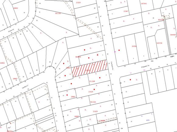
|
NOTIFICATION
PLAN
|
|
|
• PROPERTIES NOTIFIED
|
X SUBMISSIONS
RECEIVED
|
PROPERTY SUBJECT OF DEVELOPMENT
|
|
|
ONE SUBMISSION RECEIVED OUT OF MAP RANGE
|
|
|
|
|
Two submissions objected to the
development, generally on the grounds that the development would result in:
· Loss of a Sydney Blue
Gum and trees that form part of critically endangered ecological community.
The merits of the matters raised
in community submissions have been addressed in the body of the report with the
exception of the following:
5.1.1 Boundary fence
It is considered to be a
reasonable request that the applicant be required to construct the northern
side boundary fence at nil cost to the neighbouring property owner. A
recommended condition of consent has been included in Schedule 1.
6. THE PUBLIC INTEREST
Section 79C(1)(e) of the Act
requires Council to consider “the public interest”.
The public interest is an
overarching requirement, which includes the consideration of the matters
discussed in this report. Implicit to the public interest is the achievement
of future built outcomes adequately responding to and respecting the future
desired outcomes expressed in environmental planning instruments and
development control plans.
The application is considered to
have satisfactorily addressed Council’s criteria and would provide a
development outcome that, on balance, would result in a positive impact for the
community. Accordingly, it is considered that the approval of the proposed
subdivision would be in the public interest.
CONCLUSION
The proposal is for one
residential lot into two with the retention of the existing dwelling on the
site.
The application was previously
considered at the Planning Meeting on 4 May 2011 when Council resolved to defer
the application to allow the applicant to address the grounds for refusal.
Following an on-site meeting the
applicant submitted amended plans which detailed setbacks to protect the
structural root zones of significant trees to be retained. The trees are
identified as Blue Gum High Forest, a critically endangered ecological
community.
The amended proposal is
considered satisfactory in demonstrating the proposed additional rear lot would
accommodate low density residential development and retain existing trees
identified as significant. In this regard the non-compliance with the
Residential Subdivision DCP required 4m setback from significant trees is
considered acceptable subject to a restrictive covenant for future development
in accordance with AS 4960 – Protection of trees on Development Sites.
The proposed accessway involves a
curve across the frontage and duplication of the existing driveway, in
non-compliance with the accessway design element objective of the Residential
Subdivision DCP. The proposed non compliance enables the retention of a
significant tree and should not warrant refusal of the application.
The proposed development would
otherwise comply with the Residential Subdivision DCP and is recommended for
approval.
|
Rod Pickles
Manager -
Assessment Team 2
Planning Division
|
Paul David
Manager -
Subdivision & Development Engineering Services
Planning Division
|
|
Scott Phillips
Executive Manager
Planning Division
|
|
Attachments:
|
1.View
|
Locality Plan
|
|
|
|
2.View
|
Subdivision Plan
|
|
|
File Reference: DA/1375/2010
Document Number: D01690411
SCHEDULE 1
GENERAL
CONDITIONS
The conditions of consent within this notice of determination have
been applied to ensure that the use of the land and/or building is carried out
in such a manner that is consistent with the aims and objectives of the
relevant legislation, planning instruments and Council policies affecting the
land and does not disrupt the amenity of the neighbourhood or impact upon the
environment.
Note: For the
purpose of this consent, the term ‘applicant’ means any person who has the
authority to act on or the benefit of the development consent.
Note: For the purpose of
this consent, any reference to an Act, Regulation, Australian Standard or
publication by a public authority shall be taken to mean the gazetted Act or
Regulation, or adopted Australian Standard or publication as in force on the
date that the application for a construction certificate is made.
1. Approved
Plans and Supporting Documentation
The
development must be carried out in accordance with the plans and documentation
listed below and endorsed with Council’s stamp, except where amended by Council
and/or other conditions of this consent:
|
Plan No.
|
Drawn by
|
Dated
|
|
15095 Subdivision Plan
|
Clarke Dowdle & Associates
|
30/05/11
|
REQUIREMENTS PRIOR TO THE ISSUE OF A CONSTRUCTION
CERTIFICATE
2. Building
Code of Australia
All building
work must be carried out in accordance with the requirements of the Building
Code of Australia.
3. Water/Electricity
Utility Services
The applicant
must submit written evidence of the following service provider requirements:
a. Energy
Australia – a letter of consent demonstrating that satisfactory
arrangements have been made to service the proposed development.
b. Sydney
Water – the submission of a ‘Notice of Requirements’ under s73 of the Sydney
Water Act 1994.
Note: Sydney
Water requires that s73 applications are to be made through an authorised
Sydney Water Servicing Coordinator. Refer to www.sydneywater.com.au or telephone
13 20 92 for assistance.
4. Dilapidation
Report
A
‘Dilapidation Report’ is to be prepared by a ‘chartered structural engineer’
detailing the structural condition of the property adjoining the proposed
accessway.
REQUIREMENTS PRIOR TO THE COMMENCEMENT OF ANY WORKS
5. Erection
of Construction Sign
A sign must
be erected in a prominent position on any site on which building work,
subdivision work or demolition work is being carried out:
a. Showing
the name, address and telephone number of the principal certifying authority
for the work,
b. Showing
the name of the principal contractor (if any) for any demolition or building
work and a telephone number on which that person may be contacted outside
working hours, and
c. Stating
that unauthorised entry to the work site is prohibited.
Note: Any
such sign is to be maintained while the building work, subdivision work or
demolition work is being carried out, but must be removed when the work has
been completed.
6. Toilet
Facilities
Toilet
facilities must be available or provided at the works site before works begin
and must be maintained until the works are completed at a ratio of one toilet
for every 20 persons employed at the site. Each toilet must:
a. be
a standard flushing toilet connected to a public sewer; or
b. be
a temporary chemical closet approved under the Local Government Act, 1993;
or
c. have
an on-site effluent disposal system approved under the Local Government Act,
1993
7. Erosion
and Sediment Control
Erosion and
sediment control measures must be provided and maintained throughout the
construction period in accordance with the manual ‘Soils and Construction
2004 (Bluebook)’, the approved plans, Council specifications and to the
satisfaction of the principal certifying authority. The erosion and sediment
control devices must remain in place until the site has been stabilised and
revegetated.
Note: On
the spot penalties up to $1,500 may be issued for any non-compliance with this
requirement without any further notification or warning.
REQUIREMENTS DURING CONSTRUCTION
8. Construction
Work Hours
All work on site (including demolition and earth works)
must only occur between 7am and 5pm Monday to Saturday.
No work is to be undertaken on Sundays or public holidays.
9. Demolition
All
demolition work must be carried out in accordance with Australian Standard
2601-2001 – The Demolition of Structures and the following requirements:
a. Demolition
material is to be disposed of to an authorised recycling and/or waste disposal
site and/or in accordance with an approved waste management plan.
b. Demolition
works, where asbestos material is being removed, must be undertaken by a
contractor that holds an appropriate licence issued by WorkCover NSW in
accordance with Chapter 10 of the Occupational Health and Safety Regulation
2001 and Clause 29 of the Protection of the Environment Operations
(Waste) Regulation 2005.
c. On
construction sites where buildings contain asbestos material, a standard
commercially manufactured sign containing the words ‘DANGER ASBESTOS REMOVAL IN
PROGRESS’ measuring not less than 400mm x 300mm must be erected in a prominent
position visible from the street.
10. Environmental
Management
The site must
be managed in accordance with the publication ‘Managing Urban Stormwater –
Landcom (March 2004) and the Protection of the Environment Operations
Act 1997 by way of implementing appropriate measures to prevent sediment
run-off, excessive dust, noise or odour emanating from the site during the
construction of the development.
11. Works
near Trees
All required
tree protection measures are to be maintained in good condition for the duration
of the construction period.
All works
(including driveways and retaining walls) within 5 metres of any trees required
to be retained (whether or not on the subject property, and pursuant to this
consent or the Tree Preservation Order), must be carried out under the
supervision of an ‘AQF Level 5 Arborist’ and a certificate submitted to
the principal certifying authority detailing the method(s) used to preserve the
tree(s).
Note:
Except as provided above, the applicant is to ensure that no excavation,
filling or stockpiling of building materials, parking of vehicles or plant,
disposal of cement slurry, waste water or other contaminants is to occur within
4 metres of any tree to be retained.
12. Tree
Protection Barriers
Tree
protection fencing must be erected around trees numbered 1, 2, 6, 7, 9, 10, 12
and 15 to be retained at a 2 metre setback.
The tree fencing must be constructed of 1.8 metre ‘cyclone chainmesh fence’ or
star pickets spaced at 2 metre intervals, connected by a continuous high-visibility
barrier/hazard mesh at a height of 1 metre. Trees located on neighbouring
properties only require protective fencing within the subject property.
13. Tree
Protection Zones
The following
trees will require sensitive construction techniques as outlined in Australian
Standard AS- 4970 - Protection of Trees on Development Sites with in there Tree
Protection Zones such as pier and beam construction or screw piles to minimise
the impact on the trees and to preserve the long-term protection of the below numbered
trees.
Please refer
to the reviewed Arboricultural Assessment prepared by Advanced Treescape
Consulting dated 8th February 2011 for tree numbering and
location.
|
Tree Number
|
Species
|
Structural Root Zone (m)
|
|
1
|
Eucalyptus saligna
|
3.4
|
|
2
|
Angophora costata
|
1.7
|
|
6
|
Backhousia myrtifolia
|
3.3
|
|
7
|
Angophora costata
|
3.4
|
|
9
|
Angophora costata
|
3.4
|
|
10
|
Angophora costata
|
2.4
|
|
12
|
Angophora costata
|
2.7
|
|
15
|
Syncarpia glomulifera
|
3.3
|
14. Council
Property
During
construction works, no building materials, waste, machinery or related matter
is to be stored on the road or footpath. The public reserve is to be kept in a
clean, tidy and safe condition at all times.
15. Disturbance
of Existing Site
During
construction works, the existing ground levels of open space areas and natural
landscape features, (including natural rock-outcrops, vegetation, soil and
watercourses) must not be altered unless otherwise nominated on the approved
plans.
16. Excavated
Material
All excavated
material removed from the site must be classified in accordance with the NSW
Environment Protection Authority’s Environmental Guidelines – Assessment,
Classification and Management of Liquid and Non-Liquid Wastes prior to
disposal to an approved waste management facility and reported to the principal
certifying authority.
REQUIREMENTS PRIOR TO THE ISSUE OF A SUBDIVISION
CERTIFICATE
Note: For
the purpose of this consent, a reference to ‘occupation
certificate’ shall not be taken to mean an ‘interim occupation
certificate’ unless otherwise stated.
17. Sydney
Water – s73 Certificate
A s73
Certificate must be obtained from Sydney Water.
18. Stormwater
Drainage
The
stormwater drainage system for the development must be designed and constructed
in accordance with Council’s Civil Works – Design and Construction
Specification 2005 and the following requirements:
a. Connected
directly to Council’s street drainage system.
b. An
inter-allotment stormwater drainage system to service the proposed lot with
pits being constructed in situ.
19. Internal
Driveway/Vehicular Areas
The driveway
and parking areas on site must be designed in accordance with Australian
Standards 2890.1, 2890.2, 3727 and the following requirements:
a. Design
levels at the front boundary be obtained from Council.
b. The
driveway be a rigid pavement.
c. The
driveway grade must not exceed 25 percent and changes in grade must not exceed
8 percent.
d. The
driveway pavement be a minimum 3 metres wide, 0.15 metres thick reinforced
concrete with F72 steel reinforcing fabric and a 0.15 metre sub-base.
e. The
pavement have a kerb to one side and a one-way cross fall with a minimum
gradient of 2 percent and a lintel and pit provided at the low point.
f. Retaining
walls required to support the carriageway and the compaction of all fill batters
to be in accordance with the requirements of a chartered structural engineer.
g. Planting
of landscaping strips 0.5 metres wide along both sides of the length of the
driveway.
h. Conduit
for utility services including electricity, water, gas and telephone be
provided. All existing overhead assets including electricity and
telecommunications cabling shall be relocated underground at no cost to
Council.
i. The
driveway for the existing dwelling is to include a turning area to enable
vehicles to enter and leave the site of Lot 221 in a forward direction.
20. Vehicular
Crossing
A separate
application under the Local Government Act, 1993 and the Roads Act,
1993 must be submitted to Council for the installation of a new vehicular
crossing and the removal of the redundant crossing. The vehicular crossing
must be constructed in accordance with Council’s Civil Works Design, 2005
and the following requirements:
a. Any
redundant crossings to be replaced with integral kerb and gutter.
b. The
existing concrete footpath on both sides of the vehicular crossing shall be
removed and reconstructed with a smooth transition to the existing levels in
accordance with Council’s Civil Works Specification.
c. The
footway area to be restored by turfing. All batters shall not exceed 1 in 4
(25%).
d. Approval
obtained from all relevant utility providers that all necessary conduits be
provided and protected under the crossing.
1.
Note:
An application for a vehicular crossing can only be made to one of Council’s
Authorised Vehicular Crossing Contractors. You are advised to contact Council
on 02 9847 6940 to obtain a list of contractors.
21. Easement
for Letterboxes
An easement
for letterboxes shall be created over proposed lot 221 benefiting proposed lot
222. The 88b instrument shall be worded to reflect the obligations and
responsibilities of the benefiting and burdening parties.
22. Damage
to Council Assets
Any damage
caused to Council’s assets as a result of the construction of the development
must be rectified in accordance with Council’s written requirements and at the
sole cost of the applicant.
23. Creation
of Easements
The following
matter(s) must be nominated on the plan of subdivision under s88B of the Conveyancing
Act 1919:
a. A
right of access and easement for services over the access corridor.
b. An
inter-allotment drainage easement(s) over each of the burdened lots.
c. The
creation of a “Positive Covenant” over the proposed Lot 222 requiring
that any future development is to provide an on-site detention system. The
on-site detention system is to have a storage capacity of 5 cubic metres and a
maximum discharge of 8 litres per second into Council’s drainage system in
accordance with Council’s prescribed wording.
Note: Council
must be nominated as the authority to release, vary or modify any easement,
restriction or covenant.
24. Boundary
Fencing
Fencing must
be erected along all property boundaries behind the front building alignment to
a height of 1.8 metres at the sole cost of the applicant.
Note:
Alternative fencing may be erected subject to the written consent of
the adjoining property owner(s).
25. Restriction
as to User – Protection of Land from Future Development
To inform
current and future owners the site contains significant remnant Blue Gum High Forest
Critically Endangered Ecological Community, a Restriction-as-to-User must be
created under Section 88B of the Conveyancing Act 1919 adjoining trees
numbered in the table below and as shown on Plan No. 15095 Subdivision Plan
dated 30/5/11 requiring that any future building construction must be in
accordance with Australian Standard AS-4960 – Protection of Trees on
Development Sites.
|
Tree Number
|
Species
|
Structural Root Zone (m)
|
|
1
|
Eucalyptus saligna
|
3.4
|
|
2
|
Angophora costata
|
1.7
|
|
6
|
Backhousia myrtifolia
|
3.3
|
|
7
|
Angophora costata
|
3.4
|
|
9
|
Angophora costata
|
3.4
|
|
10
|
Angophora costata
|
2.4
|
|
12
|
Angophora costata
|
2.7
|
|
15
|
Syncarpia glomulifera
|
3.3
|
Note: The
wording of the Restriction as to User must be to Council’s satisfaction and Council
must be nominated as the authority to release, vary or modify the Restriction.
26. Works
as Executed Plan
A works-as-executed plan(s)
must be prepared by a registered surveyor and submitted to Council for
completed road pavement, kerb & gutter, public drainage systems, driveways
and on-site detention system. The plan(s) must be accompanied by a certificate
from a registered surveyor certifying that all pipelines and associated
structures lie wholly within any relevant easements. The location of all
necessary service conduits provided to facilitate the proposed subdivision
shall be clearly indicated on the works as executed plan.
27. s94
Infrastructure Contributions
The payment to Council of a
contribution of $20,000 for one additional lot towards the cost of
infrastructure identified in Council’s Development Contributions Plan
2007-2011.
Note:
* The value of contribution is capped
at $20,000 per additional lot in accordance with Ministerial Direction
(Section 94E of the Environmental Planning and Assessment Act 1979) issued on
16 September 2010. In the event that this Direction is repealed or amended,
Council will apply the value of the contribution from the date of this consent,
adjusted from this date in accordance with the
underlying consumer price index for subsequent financial quarters. It is
recommended that you contact Council to confirm the value of the contribution
prior to payment.
-
END OF CONDITIONS -
ADVISORY NOTES
The following information is provided for your
assistance to ensure compliance with the Environmental Planning and
Assessment Act, 1979, Environmental Planning and Assessment Regulation 2000,
other relevant legislation and Council’s policies and specifications. This
information does not form part of the conditions of development consent pursuant
to Section 80A of the Act.
Environmental Planning and
Assessment Act, 1979 Requirements
· The Environmental Planning and
Assessment Act, 1979 requires:
· The issue of a construction
certificate prior to the commencement of any works. Enquiries regarding the
issue of a construction certificate can be made to Council’s Customer Services
Branch on 9847 6760.
· A principal certifying authority to
be nominated and Council notified of that appointment prior to the commencement
of any works.
· Council to be given at least two days
written notice prior to the commencement of any works.
· Mandatory inspections of nominated
stages of the construction inspected.
· An occupation certificate to be
issued before occupying any building or commencing the use of the land.
Long Service Levy
In accordance with Section 34 of
the Building and Construction Industry Long Service Payments Act 1986, a ‘Long Service Levy’ must be paid to the Long
Service Payments Corporation or Hornsby Council.
Note: The
rate of the Long Service Levy is 0.35% of the total cost of the work.
Note: Hornsby
Council requires the payment of the Long Service Levy prior to the issue of a
construction certificate.
Tree Preservation Order
To ensure the maintenance and
protection of the existing natural environment, it is an offence to ringbark,
cut down, top, lop, remove, wilfully injure or destroy a tree outside 3 metres
of the approved building envelope without the prior written consent from
Council.
Note: A
tree is defined as a single or multi-trunked wood perennial plant having a
height of not less than three (3) metres, and which develops many branches,
usually from a distance of not less than one (1) metre from the ground, but
excluding any plant which, in its particular location, is a noxious plant
declared as such pursuant to the Noxious Weeds Act 1993. This definition of
‘tree’ includes any and all types of Palm trees.
All
distances are determined under Australian Standard AS4970-2009 ”Protection of
Trees on Development Sites”.
Fines may be imposed for
non-compliance with Council’s Tree Preservation Order.
Subdivision Certificate
Requirements
A subdivision certificate
application is required to be lodged with Council containing the following
information:
· A surveyor’s certificate certifying
that all structures within the subject land comply with the development consent
in regard to the setbacks from the new boundaries.
· A surveyor’s certificate certifying
that all services, drainage lines or access are located wholly within the
property boundaries. Where services encroach over the new boundaries,
easements are to be created.
· Certification that the requirements
of relevant utility authorities have been met.
· A surveyor’s certificate certifying
finished ground levels are in accordance with the approved plans.
Note: Council
will not issue a subdivision certificate until all conditions of the
development consent have been completed.
Fees and Charges – Subdivision
All fees payable to Council as
part of any construction, compliance or subdivision certificate or inspection
associated with the development (including the registration of privately issued
certificates) are required to be paid in full prior to the issue of the
subdivision certificate. Any additional Council inspections beyond the scope
of any compliance certificate required to verify compliance with the terms of
this consent will be charged at the individual inspection rate nominated in
Council's Fees and Charges Schedule.
Dial Before You Dig
Prior to commencing any works, the applicant is encouraged
to contact Dial Before You Dig on 1100 or www.dialbeforeyoudig.com.au for
free information on potential underground pipes and cables within the vicinity
of the development site.
Planning Report No. PLN49/11
Date of Meeting:
6/07/2011
6 DEVELOPMENT APPLICATION
- SECTION 96(2) - RECREATION FACILITY (INDOOR) - ALTERATIONS AND ADDITIONS
WEST EPPING PARK AND OVAL - 15X WARD STREET, EPPING
|
Development Application No:
|
DA/19/2010/A
|
|
Description of Proposal:
|
Section 96(2) application to stage
the construction works for alterations and
additions to the existing YMCA recreation facility and extension of the
existing car park area at West Epping Park and Oval
|
|
Property Description:
|
West Epping Park and Oval, Lot 100 DP 834523, No. 15X Ward Street, Epping.
|
|
Applicant:
|
Mr Phillip Hare
|
|
Owner:
|
Hornsby Shire Council
|
|
Statutory Provisions:
|
Hornsby Shire Local Environmental
Plan 1994 - Open Space A (Public Recreation - Local) and Residential A (Low
Density) zone
|
|
Estimated Value:
|
No change to original ($550,000)
|
|
Ward:
|
C
|
|
RECOMMENDATION
THAT Development Application
No. 19/2010/A for alterations and additions to an
existing recreation facility and extension of the existing car park area at West Epping Park and Oval, Lot 100 DP 834523, No. 15X Ward Street, Epping be refused
for the reasons detailed in Schedule 1 of this report.
|
1. On
7 April 2010 Council approved Development Application No. 19/2010 for alterations and additions to an existing recreation facility
and extension of the existing car park area at West Epping Park and Oval.
2. The
application proposes to modify the consent by way of staging the construction
works for the development so that the fitness centre upgrade works occur in
stage 1 and the car park extension and upgrade works occur in stage 2.
3. The
development involves land owned by Council. Given that Council is the owner of
the land and that Council received public submissions regarding the development
application, it is appropriate that the matter be considered by Council at a
Planning Meeting.
4. The
proposed modification does not alter the development’s compliance with the
provisions of the Hornsby Shire Local Environmental Plan 1994. However, the
staging works proposed are inconsistent with Council’s Car Parking Development
Control Plan.
5. One
submission has been received in respect of the application.
6. It
is recommended that the application be refused.
HISTORY OF THE APPLICATION
On 7 April 2010 Council approved
Development Application No. 19/2010 for alterations
and additions to the existing YMCA recreation facility and extension of the
existing car park area at West Epping Park and Oval.
THE SITE
The site has an area of 36,350
square metres and is located on the western side of Ward Street at the
intersection of Lilli Pilli Street, between West Epping Oval to the north and West Epping Public School to the south.
Access to the site is off Ward Street via a shared driveway and pedestrian walkway. To the eastern side and
underneath the existing building is a broad surface car park accommodating 23
car spaces.
The site is currently used as a
recreation area and facility comprising a YMCA building, Council’s Community
Centre, the West Epping Child Care Centre, five tennis courts and two soccer
fields.
Surrounding development comprises
West Epping Bowling Club to the north, West Epping Public School to the south
and residential development to the east and west of the site.
THE APPROVED DEVELOPMENT
The existing facility is
currently used as a fitness centre and YMCA Club facility. The approved
development would maintain the use within a larger facility with more usable
and functional internal spaces which responds to the increasing needs of the
community.
The approved development
comprises the following works:
· Extension of existing bitumen area to
the eastern side of the Club building to create an open car park area;
· Line marking and lighting to the
existing car park area on the western side of the Club building;
· new retaining walls and tree screen
along the eastern side of the new car park area;
· new floor and external brick and
glass walls to the northern and eastern sides of the undercover ground floor
car park area to create a new ‘Program/Fitness Area’;
· demolition of existing access
corridor and provision of new secure entry and corridor off West Epping Oval;
· provision of new male, female and
disable toilets and shower facilities;
· provision of new window/visual link
between the entry and the new ‘Program/Fitness Area’;
· provision of new access ramp; and
· provision of new reception desk.
THE MODIFICATION
The amendments sought by this
application do not propose any alterations to the master plan concept. Rather
the application is a request to stage the construction works for the approved
development.
The applicant is seeking to
modify the staging of the development as follows:
Stage 1 Works
· New floor and external brick and
glass walls to the northern and eastern sides of the undercover ground floor
car park area to create a new ‘Program/Fitness Area’;
· Demolition of existing access
corridor and provision of new secure pedestrian entry and corridor off West
Epping Oval;
· Provision of new male, female and
disable toilets and shower facilities;
· Provision of new window/visual link between
the entry and the new ‘Program/Fitness Area’;
· Provision of new access ramp; and
· Provision of new reception desk.
Stage 2 Works
· Extension of existing bitumen area to
the eastern side of the Club building to create an open car park area, including
a new retaining wall and tree screen along the eastern side of the new car park
area and provision of line marking and lighting to the existing car park area
on the western side of the Club building.
PROBITY DEVELOPMENT
APPLICATIONS
The development involves land
owned by a Hornsby Shire Council. In accordance with Council’s adopted policy, ‘Probity
DA’s’ involving ‘non-controversial small scale development’ or ‘routine
operational development’ (as defined as Category 1 development under the ICAC position
paper - Corruption risks in the NSW development approval process), which
are not subject to any objection, may be assessed by Council officers and
determined under delegated authority, unless otherwise requested to be referred
to Council by Councillor(s). As Council received public submissions regarding
the development application, it is appropriate that the matter be considered by
Council at its Planning Meeting.
The YMCA leases the premises from
Council at a ‘peppercorn’ rate and therefore Council does not obtain any
commercial gain from the premises. Given that Council would not stand to
financially gain from the application, it is not considered necessary to refer
the application to an independent consultant to assess the merits of the proposal.
Council’s determination of the application upon considering the officer’s
assessment report would be consistent with Council’s Probity Development
Applications Policy.
ASSESSMENT
The development application has
been assessed having regard to the ‘2005 City of Cities Metropolitan
Strategy’, the ‘North Subregion (Draft) Subregional Strategy’ and
the matters for consideration prescribed under Section 79C of the Environmental
Planning and Assessment Act 1979 (the Act). Subsequently, the following
issues have been identified for further consideration.
1. STRATEGIC CONTEXT
1.1 Metropolitan Plan for Sydney 2036 and (Draft) North Subregional
Strategy
The Metropolitan Plan for Sydney 2036 is a broad framework to secure Sydney’s place in the global economy by
promoting and managing growth. It outlines a vision for Sydney to 2036; the
challenges faced, and the directions to follow to address these challenges and
achieve the vision. The Draft North Subregional Strategy acts as a
framework for Council in its preparation of the Comprehensive LEP by the
end of 2011.
The Draft North Subregional
Strategy sets the following targets for the Hornsby LGA by 2031:
· Employment capacity to
increase by 9,000 jobs; and
· Housing stock to
increase by 11,000 dwellings.
The proposed development would be
consistent with the Metropolitan Plan for Sydney 2036 and the draft
Strategy insofar as providing additional community facilities for an expanding
population.
2. STATUTORY CONTROLS
Section 79C(1)(a) requires
Council to consider “any relevant environmental planning instruments, draft
environmental planning instruments, development control plans, planning
agreements and regulations”.
2.1 Environmental Planning and Assessment Act 1979 – Section
96(2)
The proposal constitutes an
amendment to the original development consent under Section 96(2) of the Act.
Pursuant to Section 96(2), Council may consider an application to amend
development consent provided that, inter alia:
“(a) it is satisfied that the development to which the consent
as modified relates is substantially the same development as the development
for which the consent was originally granted and before that consent as
originally granted was modified (if any at all), and
(b) it has consulted with the relevant Minister, public
authority or approval body (within the meaning of Division 5) in respect of a
condition imposed as a requirement of a concurrence to the consent or in
accordance with the general terms of an approval proposed to be granted by the
approval body and that Minister, authority or body has not, within 21 days
after being consulted, objected to the modification of that consent, and
(c) it has notified the application in accordance with the
regulations, and
(i) the regulations, if the regulations so require, or
(ii) a development control plan, if the consent authority is a
council that has made a development control plan that requires the notification
or advertising of applications for modification of a development consent, and
(d) it has considered any submissions made concerning the
proposed modification within the period prescribed by the regulations or
provided by the development control plan, as the case may be.”
With respect to (a), it is
considered that the proposal as amended is substantially the same as the
development originally approved.
With respect to (b) the
development is not integrated development and was not required to be referred
to an approval body.
With respect to (c) and (d), the
amended application was advertised and one submission was received.
2.2 Hornsby Shire Local Environmental Plan 1994
The subject land is zoned part
Residential A (Low Density) zone and part Open Space A (Public Recreation -
Local) zone under the Hornsby Local Environmental Plan 1994 (HSLEP). The
development is located wholly within the Open Space A (Public Recreation -
Local) zone.
The objectives of the Open Space
A (Public Recreation - Local)zone are:
(a) to ensure there is provision of adequate open space to meet
the needs of the community and to enhance the environmental quality of the
Hornsby area.
(b) to encourage a diversity of recreational settings and
facilities.
(c) to protect and preserve areas of urban bushland which are
considered valuable in terms of their ecology.
The proposed development is
defined as ‘recreation facility’ under the HSLEP and is permissible in
the zone with Council’s consent.
There are no density or floor space
ratio (FSR) provisions contained within Clause 14 and 15 of the HSLEP for the
Open Space A (Public Recreation - Local) zone.
Clause 18 of the HSLEP sets out
heritage conservation provisions within the Hornsby area. The site is not
listed as a heritage item under Schedule D of the HSLEP and the site is not
located within a Heritage Conservation Area under Schedule E of the HSLEP.
Whilst the site adjoins Epping West Public School which contains a heritage item of local significance, the
proposed development is sited away from the heritage item and would therefore
not have a detrimental impact upon its significance.
2.3 Sydney Regional Environmental Plan (Sydney Harbour Catchment) 2005
The site is located within the
catchment of the Sydney Harbour and requires consideration against the
provisions of Sydney Regional Environmental Plan (Sydney Harbour Catchment)
2005. The Plan aims to establish a balance between promoting a prosperous
working harbour, maintaining a healthy and sustainable waterway environment and
promoting recreational access to the foreshore and waterways. The Plan
establishes planning principles and controls for the catchment as a whole.
Subject
to compliance with the approved conditions of consent the proposed development
satisfies the objectives of the Plan. The proposed modification would not
alter this compliance.
2.4 Plan of Management - District One
The original application has been
assessed having regard to the Plan of Management for District One adopted by
Council on 10 November 2004. The Plan covers Council’s open space community
land and land under Council’s care, control and management (generally Crown
land). This land includes parks and reserves, bushland and community
facilities such as community centres, where the land is owned or managed by
Council.
The application was assessed as
being consistent with the Plan subject to the imposition of recommended
conditions relating to line marking of the car park and illumination of the car
park and pedestrian access, being funded by the applicant. The modification
relates to staging of the car parking works including the pedestrian access and
this matter is discussed in detail in Section 3.1 of this report.
2.5 Car Parking Development Control Plan
The primary purpose of this
DCP is to provide parking controls for the development. The proposed
modification does not alter the approved number of car parking spaces provided
for the development. However, the modification relates to staging the works
and the provision of the required car parking at a later point. This matter is
discussed in detail in Section 3.1 of this report.
2.6 Access and Mobility Development Control Plan
The primary purpose of this DCP is
to assist proponents and Council in ensuring the requirements for equitable
access are satisfied when building work is proposed. The proposed modification
does not alter the development’s compliance with this DCP.
2.7 Waste Minimisation and Management Development Control
Plan
The primary purpose of this DCP
is to provide planning strategies and controls to promote waste minimisation
and management. The proposed modification would not alter the development’s
compliance with the DCP.
2.8 Sustainable Waters Development Control Plan
The DCP aims to achieve the
implementation of sustainable water practices into the management of
development in the Hornsby Shire. Subject
to compliance with the approved conditions of consent the proposed modification
would be consistent with the objectives
of the DCP.
3. ENVIRONMENTAL IMPACTS
Section 79C(1)(b) of the Act
requires Council to consider “the likely impacts of that development,
including environmental impacts on both the natural and built environments, and
social and economic impacts in the locality”.
3.1 Proposed Staging of the Construction Works
The
modification proposes to stage the construction works for the approved
development with all internal works and upgrades within the YMCA leased areas
being completed during Stage 1 and all external/civil works outside the YMCA
leased areas which comprise a new car park area, improved pedestrian footpaths
and lighting for the facility and upgrading works to an existing car park area
being undertaken in Stage 2.
The
applicant’s Statement of Environmental Effects (SEE) states:
“The YMCA
proposes that Stage 2 is deferred to allow more time for funds to be sourced
without delaying Stage 1 of the development.”
It is noted
that the applicant has not provided a timeframe for the start or completion of
the Stage 2 works, although the SEE indicates an estimated start date of July
2011 for the Stage 1 works.
Notwithstanding,
the deferment of the parking improvements to a second stage is not supported
for the following reasons:
· New
parking designed to partially offset the 17 spaces lost in the Stage 1 works has no date for construction. Also, Stage 1 of the proposal would infer that an occupation
certificate is to be granted at the finish of that stage for compliance with the EP&A Act and insurance purposes, while the new parking might never be
constructed.
· The
impact of the loss of the proposed eastern car park spaces would be felt
immediately and has no proposed ending, resulting in possible complaints to
Council for the provision of these spaces at any future time.
· Council
has received submissions from the community seeking an upgrade to the existing
shared use car park at West Epping Oval that is adjacent to the pre-school site
(west of the YMCA leased building) irrespective of the works approved under
this development consent. The YMCA proposal would only increase use and wear
and tear on this car park. It would be unreasonable to postpone the proposed
upgrade as there is no benefit to the wider community for doing so.
· The
proposal would increase patronage of the YMCA and additional parking should be
provided to accommodate this additional use as well as the loss of parking
within the YMCA lease area. The current traffic and parking problems in Ward Street and Lilli Pilli Street would be exacerbated if these external works were
deferred.
In summary, it appears that the applicant
proposes to undertake all works that have a ‘private’ benefit now and defer all
works that have a ‘public’ benefit at an undisclosed date in the future,
resulting in a short term public dis-benefit and uncertainty for Council and
the community.
3.2 Natural Environment
The proposed modification would
not alter the original assessment of the proposed development on the natural
environment.
3.3 Built Environment
The proposed modification would
not alter the original assessment of the proposed development on the built
environment with the exception of the delaying of construction of the
replacement car park area which has been addressed in Section 3.1 of this
report.
3.4 Social Impacts
The proposed modification would
have a negative social impact on the locality through the delaying of the
provision of car parking for the improved recreation facilities. Subject to
completing all works, the development would have a long term positive impact
upon the community.
3.5 Economic Impacts
The proposed modification would
not have a detrimental economic impact upon the locality.
4. SITE SUITABILITY
Section 79C(1)(c) of the Act
requires Council to consider “the suitability of the site for the
development”.
The suitability of the site has
been addressed in the original assessment of the application. The proposed
modification does not alter the suitability of the site for the development.
5. PUBLIC PARTICIPATION
Section 79C(1)(d) of the Act
requires Council to consider “any submissions made in accordance with this
Act”.
5.1 Community Consultation
The proposed development was
placed on public exhibition and was notified to adjoining and nearby landowners
between 18 May 2011 and 1 June 2011 in accordance with Council’s Notification
and Exhibition Development Control Plan. During this period, Council received
one submission. The map below illustrates the location of those nearby
landowners who made a submission that are in close proximity to the development
site.
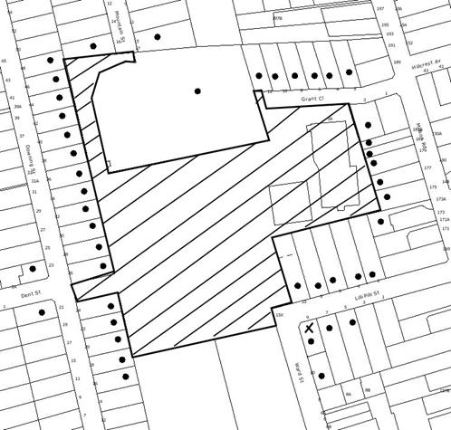
|
NOTIFICATION
PLAN
|
|
|
• PROPERTIES NOTIFIED
|
X SUBMISSIONS
RECEIVED
|
PROPERTY SUBJECT OF DEVELOPMENT
|
|
|
|
|
|
One submission objected to the
development, on the following grounds:
· Unacceptable traffic
on local streets;
· Noise and safety
issues.
The merits of the matters raised
in community submissions have been addressed in the body of the report with the
exception of the following:
5.1.1 Noise and safety issues
The submission received raised
concerns that the development would result in noise and safety issues, however
no details were provided with respect to specific concerns. Notwithstanding,
these matters were addressed in the original application and the proposed
modification is for staging of the construction works only.
5.2 Public Agencies
The development application is
not Integrated Development under the Act and no external referrals were
undertaken.
6. THE PUBLIC INTEREST
Section 79C(1)(e) of the Act
requires Council to consider “the public interest”.
The public interest is an
overarching requirement, which includes the consideration of the matters
discussed in this report. Implicit to the public interest is the achievement
of future built outcomes adequately responding to and respecting the future
desired outcomes expressed in environmental planning instruments and
development control plans.
The application is considered not
to have satisfactorily addressed Council’s criteria insofar as the provision of
car parking in Stage 2 of the construction works would provide a development
outcome that, on balance, would result in a negative impact for the community. Accordingly, it is considered that the approval of the proposed modification
would not be in the public interest.
CONCLUSION
The
approved development is for alterations and additions to the YMCA
building located within the West Epping Park and Oval.
The
proposed modification is to the stage the construction of the approved works,
with the provision of the required car parking during Stage 2. As there is no
mechanism to ensure that the car parking is provided prior to the occupation of
the new works to the YMCA facility the proposal would result in traffic and
parking impacts that are not in the community’s interest.
Accordingly,
the proposed modification is recommended for refusal.
Note: At the time of the
completion of this planning report, no persons have made a Political
Donations Disclosure Statement pursuant to Section 147(3) of the
Environmental Planning and Assessment Act 1979 in respect of the subject
planning application.
|
Rod Pickles
Manager -
Assessment Team 2
Planning Division
|
Scott Phillips
Executive Manager
Planning Division
|
Attachments:
|
1.View
|
Locality Plan
|
|
|
|
2.View
|
Staging Plan
|
|
|
File Reference: DA/19/2010/A
Document Number: D01686543
SCHEDULE 1
1. Pursuant to the provisions of Section 79C(i)(b) of the
Environmental Planning and Assessment Act 1979, it is considered that the
proposed staging of works would result in an unacceptable carparking shortfall
in the short term and consequently an unacceptable impact on the local road
network within the vicinity of the site.
2. Pursuant
to the provisions of Section 79C(i)(e) of the Environmental Planning and
Assessment Act 1979, it is considered that the approval of the staging of the
development would set an undesirable precedent for similar inappropriate
development and is therefore not the in public interest.
- END OF REASONS FOR REFUSAL -
Standard Report No. PLN29/11
Planning Division
Date of Meeting:
6/07/2011
7 VOLUNTARY PLANNING
AGREEMENT - DA/1470/2009
39 HANNAH STREET, BEECROFT
EXECUTIVE SUMMARY
Council, at its Planning Meetings
on 1 September and 6 October 2010, considered Executive Manager’s Report No.
PLN35/10 and Rescission Motion No. RM1/10 and resolved to approve the subdivision
of the subject land (Lot 9 DP 7484) into two lots A condition of development
consent required the applicant to enter into a Voluntary Planning Agreement
(VPA) with Hornsby Shire Council to offset the loss of Sydney Blue Gum High
Forest on the site.
In accordance with Section 93G of
the Environmental Planning and Assessment Act, 1979 the VPA was publicly
exhibited between 5 January 2011 and 2 February, 2011. No submissions were
received during this notification period.
This report recommends that the
General Manager be authorised to execute the Voluntary Planning Agreement, held
at Attachment A to this report.
PURPOSE
The purpose of this report is to
seek Council’s endorsement of the Voluntary Planning Agreement under
DA/1470/2009.
DISCUSSION
Council, following the Planning
Committee Meeting on 6 October 2010, resolved to approve a development
application for the subdivision of the land into two allotments. Condition No.
3 of the consent is set out below:
3. Voluntary Planning Agreement
Pursuant to
section 93F of the Environmental Planning and Assessment Act 1979, the
applicant must prepare and enter into a Voluntary Planning Agreement (VPA) with
Hornsby Shire Council for the offsetting of the loss of Blue Gum High Forest
under Council’s Green Offset Code (2007).
The terms of the VPA must include but not be limited to the
following:
a. The Applicant agrees to pay Council a monetary contribution
of $20,000 towards the replacement of 400m2 of Blue Gum High Forest lost from the site as result of the development.
b. Hornsby Shire Council agrees to provide an area of 2,000m2
within Ray Park, Carlingford being Lot 44 DP 210615, for revegetation,
restoration and enhancement of Blue Gum High Forest.
c. In addition to the above, the applicant agrees to pay all
costs (including Council’s costs) associated with the preparation, public
notification, legal costs and administration costs of the VPA.
The agreed area of 2,000m2
within Ray Park, Carlingford forms part of an area of Blue Gum High Forest restoration
being undertaken in accordance with Council’s Significant Areas – Bushland
Plans of Management and Action Plans (2000) and Plan of Management –
District One. The voluntary contribution of $20,000 made under the VPA
would provide the funds necessary for Council, through its Bushcare Program, to
rehabilitate the area and offset the Blue Gum High Forest area lost through
residential subdivision of the land at 39 Hannah Street, Beecroft.
Council’s solicitor has confirmed
the VPA, prepared on behalf of the applicant, has been drafted in accordance
with Council’s resolution, Section 93F of the Environmental Planning and
Assessment Act, 1979 and Council’s Policy on Planning Agreements – 2007.
BUDGET
There are no budget implications
arising from this report.
POLICY
The VPA has been prepared with
consideration given to Council’s Policy on Planning Agreements – 2007.
There are no policy implications arising from this report.
CONSULTATION
Pursuant to Section 93G (l) of
the Environmental Planning and Assessment Act, 1979, the VPA was
publicly exhibited in the Northern District Times on Wednesday 5 January 2011.
Submissions were invited until 2 February 2011.
Council did not receive any
submissions during the public exhibition period.
TRIPLE BOTTOM LINE SUMMARY
Triple Bottom Line is a framework
for improving Council decisions by ensuring accountability and transparency on
social, environmental and economic factors. It does this by reporting upon
Council’s strategic themes.
As this report simply provides
Council with information and does not propose any actions which require a
sustainability assessment, no Triple Bottom Line considerations apply.
RECOMMENDATION
|
THAT
1. The General Manager
be authorised to execute the Voluntary Planning Agreement, held at
Attachment A of this report.
2. A copy of the Voluntary Planning Agreement be forwarded
to the NSW Department of Planning for its records.
3. A copy of the Voluntary Planning Agreement be placed on
Council’s website for public inspection.
|
|
Rod Pickles
Manager -
Assessment Team 2
Planning Division
|
Scott Phillips
Executive Manager
Planning Division
|
Attachments:
|
1.View
|
Voluntary Planning
Agreement
|
|
|
File Reference: DA/1470/2009
Document Number: D01608865
Standard Report No. PLN53/11
Planning Division
Date of Meeting:
6/07/2011
8 AMENDMENTS TO THE MEDIUM
DENSITY MULIT-UNIT HOUSING DEVELOPMENT CONTROL PLAN - REPORT ON SUBMISSIONS
EXECUTIVE SUMMARY
At its meeting on 6 April 2011,
Council resolved to exhibit draft amendments to the Medium Density
Multi-Unit Housing Development Control Plan (DCP) to provide controls to supplement
the rezonings proposed as part of the Townhouse Planning Proposal. The Townhouse
Planning Proposal was gazetted on 10 June 2011.
The DCP amendments were
placed on public exhibition from 21 April 2011 to 27 May 2011. A total of five
submissions were received, including three from public authorities. All
submissions indicate support or no objection. It is recommended that Council
approve the DCP amendments.
PURPOSE
The purpose of this report is to
review submissions received in response to the exhibition of draft amendments
to Council’s Medium Density Multi-Unit Housing DCP.
BACKGROUND
At its meeting on 6 April 2011,
Council considered Executive Manager’s Report No. PLN33/11 presenting draft
amendments to the Medium Density Multi-Unit Housing DCP to provide
controls to supplement the Townhouse Planning Proposal. Council resolved
to endorse the draft DCP amendments for public
exhibition. Subsequently, the Townhouse Planning Proposal was gazetted
on 10 June 2011.
In accordance with Council’s
resolution, the amendments to the Medium Density Multi-Unit Housing DCP (attached)
were placed on public exhibition from 21 April 2011 to 27 May 2011. This report
reviews submissions received in response to the exhibition.
DISCUSSION
This report discusses submissions
received in response to the exhibition of the amendments to the Medium
Density Multi-Unit Housing DCP.
Exhibition and review of
submissions
Council’s existing Medium
Density Multi-Unit Housing DCP applies to the precincts rezoned as part of
the Townhouse Planning Proposal. New key principles diagrams to be
inserted within the “Housing Strategy – Precinct Masterplans” element of the DCP
have been prepared to supplement the existing controls. The key principles
diagrams set out how future development should occur by identifying trees,
landscaping and heritage items to be retained, traffic improvements and access
requirements.
The draft DCP amendments
were exhibited from 21 April 2011 to 27 May 2011. The exhibition included
advertisements in the Hornsby Advocate and on Council’s website, letters to
persons who made a submission on the Townhouse Planning Proposal,
displays at the Council Administration Centre and at Hornsby library, letters
to statutory authorities and referrals to other Divisions of Council.
A total of five submissions have
been received, including three from public authorities. All submissions
indicate support or no objection to the draft DCP amendments. One
submission reiterates previous concerns raised during the exhibition of the Townhouse
Planning Proposal regarding increased densities within precincts. However,
the rezonings have been gazetted and the submission raises no objections to the
draft DCP amendments. A summary of submissions is attached to this
report.
A submission from the Rural Fire
Service (RFS) suggests that where development is affected by bush fire prone
land, this should be indicated on the key principle diagrams. There is no bush
fire prone land within the Pacific Highway (north), Mount Colah and Asquith, Old Berowra Road and Mildred Avenue, Hornsby precincts. Accordingly, the RFS comments are not relevant to the key principle diagrams.
A submission from the Roads and
Traffic Authority (RTA) supports the inclusion of vegetation along shared
driveways. However, the submission notes that vegetation should not encroach
onto driveways to allow clear vision for motorists, cyclists and pedestrians.
The submission also includes comments on the design and construction of traffic
controls and liaison with the RTA concerning medians and consolidation of
driveways. These matters would be considered as part of the development
application process and do not require amendment to the key principal diagrams.
It is recommended the no
amendments be made to the Medium Density Multi-Unit Housing DCP
amendments as a result of submissions.
STATUTORY CONSIDERATIONS
Should Council approve the
amendments to the Medium Density Multi-Unit Housing DCP, public notice
of Council’s decision is required in local newspapers in accordance with Clause
21 of the Environmental Planning and Assessment Regulation 2000. The DCP
amendments would come into force on the date that public notice is given in the
local newspaper.
CONSULTATION
The draft DCP amendments
were exhibited from 21 April 2011 to 27 May 2011. Five submissions were
received and are addressed in this report.
TRIPLE BOTTOM LINE SUMMARY
Triple Bottom Line (TBL) is a framework for improving Council decisions by ensuring accountability and transparency
on social, environmental and economic factors. It does this by reporting upon
Council’s strategic themes. A Triple Bottom Line summary was provided in
respect of the Townhouse Planning Proposal in Executive Manager’s Report
No. PLN16/11 considered by Council on 2 February 2011.
CONCLUSION
The draft amendments to the Medium
Density Multi-Unit Housing DCP were exhibited from 21 April 2011 to 27 May
2011. Five submissions were received indicating support for, or no objection
to, the draft DCP amendments. Accordingly, it is recommended that
Council approve the draft DCP amendments.
RECOMMENDATION
|
THAT:
1. Council approve the draft amendments to the Medium
Density Multi-Unit Housing Development Control Plan attached to Executive
Manager’s Report No. PLN53/11.
2. Submitters be advised of Council’s resolution.
|
|
James Farrington
Manager - Town
Planning Services
Planning Division
|
Scott Phillips
Executive Manager
Planning Division
|
Attachments:
|
1.View
|
Summary of
Submissions
|
|
|
|
2.View
|
Amendments to the
Medium Density Multi-Unit Housing DCP
|
|
|
File Reference: F2010/00389
Document Number: D01694282