Planning Report No. PLN72/11
Date of Meeting:
7/12/2011
1 DEVELOPMENT APPLICATION
- DWELLING-HOUSE
6 TALBOT WAY, BEROWRA
|
Development Application No:
|
DA/1056/2011
|
|
Description of Proposal:
|
Erection
of a dwelling-house
|
|
Property Description:
|
Lot 35, DP 270489, No. 6 Talbot Way, Berowra
|
|
Applicant:
|
Greenfield DA Services
|
|
Owners:
|
Mr Allan Miralles Villanueva and Mrs Aileen Lariza
Villanueva
|
|
Statutory Provisions:
|
Hornsby Shire Local Environmental
Plan 1994
Residential AS (Low Density-
Sensitive Lands) zone
|
|
Estimated Value:
|
$420,000
|
|
Ward:
|
A
|
|
THAT Council assume the
concurrence of the Director-General of the Department of Planning and Infrastructure
pursuant to State Environmental Planning Policy No. 1 and approve Development
Application No. DA/1056/2011 for a dwelling-house at Lot 35, DP 270489, No. 6 Talbot Way Berowra, subject to the conditions of consent detailed in Schedule 1 of this report.
|
EXECUTIVE
SUMMARY
1. The application proposes the erection of a dwelling-house.
2. The proposal generally complies with the Hornsby Shire Local Environmental Plan 1994
(HSLEP), Council’s Dwelling House, Heritage and Berowra/Cowan Development Control
Plans (DCP).
3. The proposal does not comply with the 0.4:1 floor space ratio development standard
contained in the HSLEP. Consequently, the application has been supported by a
submission under State Environmental Planning Policy No. 1 (SEPP 1) seeking
approval of a variation to this development standard.
4. Two submissions have been received raising objections to the
proposal. One submission has also been received requesting additional time to
consider the proposal.
5. It is recommended that the application be approved.
HISTORY OF THE SITE
The site is located within the
grounds of the former “La Mancha Caravan Park”, which operated from 1959, prior
to the gazettal of the Hornsby Shire Local Environmental Plan (HSLEP) in 1994
and the Hornsby Planning Scheme Ordinance in 1977.
The
site was approved as part of a multi-lot, Community title subdivision of the Caravan Park on 25 October 2005 under DA /957/2005 and is known as the “Illoura
Estate”.
On 7 June 2006, Council approved
Development Application No. 166/2006 for the erection of a dwelling-house.
This application subsequently lapsed.
On 3 August 2011, Council
approved Development Application No. 479/2011 for the erection of a
dwelling-house at No. 6 Talbot Way, Berowra. Development consent was
subsequently declared invalid by the Land and Environment Court following a
Third Party Appeal. The basis of the declaration is that the application was
not accompanied by a submission under State Environmental Planning Policy
No. 1 (SEPP 1).
On 7 October 2011, Development
Application No. 1056/2011 was lodged with Council for the erection of a
dwelling-house. The design and construction of the dwelling-house as depicted
in the plans and specifications and as described in any other information
furnished with the application are the same information as submitted to Council
under Development Application No. 479/2011. The application is the subject to
this report.
THE SITE
The vacant, 450m2 site
is located on the southern side of Talbot Way Berowra and has a 10 % fall to
the rear, south-western boundary. The site is burdened by a 1.5 metre wide easement for drainage adjacent to the rear boundary and a restriction-as-to-user. The site has access to a 1 metre wide easement to drain water to the reserve at the rear and
is located within a bush fire prone area.
The former “La Mancha Caravan Park” site, (Nos. 899 – 903 Pacific Highway Berowra) is listed as a heritage item of
local significance under the provisions of Schedule D (Heritage Items) of the
HSLEP. The inventory sheet states that the property represents “prominent
cultural plantings of Radiata Pines from circa 1930s on prominent hilltop site
beside highway”.
Adjacent development within the
“Illoura Estate” is characterised by a predominance of contemporary styled, two
storey dwelling-houses surrounded by well established landscaped areas. The visual character of development when viewed from the streets within the subdivision is
large dwellings with an absence of front fencing.
THE DEVELOPMENT
The application proposes the
erection of a two storey dwelling-house comprising a double garage, laundry,
toilet, kitchen/family/meals room, pantry, alfresco area, media/rumpus room and
a living room at ground floor level. The first floor would incorporate 4
bedrooms, 3 walk-in-robes, an ensuite, a bathroom, a rumpus room and a balcony.
No significant trees would be
removed or adversely impacted by the proposed development.
THE ASSESSMENT
The development application has
been assessed having regard to the ‘Metropolitan Plan for Sydney 2036’,
the ‘North Subregion (Draft) Subregional Strategy’ and the matters for
consideration prescribed under Section 79C of the Environmental Planning and
Assessment Act, 1979 (the Act). The following issues below have been
identified for further consideration:
1. STRATEGIC CONTEXT
1.1 Metropolitan Plan for Sydney 2036 and (Draft) North Subregional
Strategy
The Metropolitan Plan for Sydney 2036 is a broad framework to secure Sydney’s place in the global economy by
promoting and managing growth. It outlines a vision for Sydney to 2036, the
challenges faced and the directions to follow to address these challenges and
achieve the vision. The Draft North Subregional Strategy acts as a
framework for Council in its preparation of the Comprehensive LEP by the
end of 2012.
The Draft North Subregional
Strategy sets the following targets for the Hornsby LGA by 2031:
· Employment capacity to
increase by 9,000 jobs; and
· Housing stock to
increase by 11,000 dwellings.
The proposed development would be
consistent with the Metropolitan Plan for Sydney 2036 and Draft North
Subregional Strategy as it would contribute to the achievement of the
dwelling target for the Shire.
2. STATUTORY CONTROLS
Section 79C(1)(a) requires
Council to consider “any relevant environmental planning instruments, draft
environmental planning instruments, development control plans, planning agreements
and regulations”.
2.1 Hornsby Shire Local Environmental Plan 1994
The subject land is zoned Residential AS (Low Density- Sensitive Lands) zone under the HSLEP. The objectives of
the zone are:
(a) to provide for the housing needs of the population of the
Hornsby area.
(b) to promote a variety of housing types and other land uses
compatible with a low density residential environment and sensitive to the land
capability and established character of this environment.
(c) to provide for development that is within the
environmental capacity of a sensitive low density residential environment.
The proposed development is
defined as a “dwelling-house” under the HSLEP and is permissible in the zone
with Council’s consent.
Clause 15 of the HSLEP prescribes
that the maximum floor space ratio (FSR) of development within the Residential
AS (Low Density-Sensitive Lands) zone is 0.4:1. The proposed development has a
FSR of 0.67:1, which does not comply with this standard.
The subject land is identified as
containing a heritage item, pursuant to Schedule D of the HSLEP 1994. Clause
18(6) provides that development consent cannot be granted unless a heritage
assessment has been considered. The Statement of Environmental Effects dated 5
October 2011 submitted with the development application contains a heritage
assessment, which was considered in the assessment of the application.
2.2 Sydney Regional Environmental Plan No. 20 – Hawkesbury Nepean River
The application has been assessed
against the requirements of Sydney Regional Environmental Plan No. 20 (SREP
20). This Policy provides controls to protect the environment of the
Hawkesbury-Nepean system, including its water quality. SREP 20 addresses
matters related to water quality, significant vegetation habitats, extraction,
environmental heritage and scenic quality, recreation and tourism, and
agriculture.
The proposal
is consistent with the environmental capability of the site and subject to
implementation of recommended conditions relating to sediment and erosion
control, the development would prevent adverse impacts on water quality. The
development complies with SREP 20 in this regard.
2.3 State
Environmental Planning Policy No. 1 – Development Standards
The proposal would have a floor
space ratio of 0.67:1 which departs from the 0.4:1 development standard as
contained within Clause 15 of the HSLEP. To address this matter, the applicant
has submitted an objection to the standard under State Environmental Planning
Policy No. 1 (SEPP 1).
The application has been assessed against the requirements
of SEPP 1. This Policy provides flexibility in the application of
development standards in circumstances where strict compliance with those
standards would, in any particular case, be unreasonable or unnecessary, or
tend to hinder the attainment of the objectives of the Act.
The NSW Land and Environment Court in Wehbe v
Pittwater Council [2007]
NSWLEC 827 has expressed the view that
there are 5 different ways in which an objection may be well founded and that
approval of the objection may be consistent with the aims of the Policy as
follows:
1. The objectives of the standard
are achieved notwithstanding non-compliance with the standard;
2. The underlying objective or purpose of the
standard is not relevant to the development and therefore compliance is
unnecessary;
3. The underlying object of purpose would be
defeated or thwarted if compliance was required and therefore compliance is
unreasonable;
4. The development standard has been virtually
abandoned or destroyed by the Council's own actions in granting consents
departing from the standard and hence compliance with the standard is
unnecessary and unreasonable;
5. The zoning of the particular land is
unreasonable or inappropriate so that a development standard appropriate for
that zoning is also unreasonable and unnecessary as it applies to the land and
compliance with the standard would be unreasonable or unnecessary. That is, the particular parcel of land should not have been included in the particular
zone.
In regard to whether the
objection may be well founded, it is considered that Point 1 is most relevant.
The applicant’s SEPP 1 objection contends that “The proposal is considered
to be consistent with the objective relevant to the floor space ratio design
standard in that the intensity and scale of the proposed dwelling is in
accordance with the subject site’s environmental capacity and remains
consistent with the established low density residential zone objectives.”
The applicant has supported the proposal by noting that:
(a) “dwelling-houses within the subdivision have a floor space
ratio of 0.3:1 to 0.7:1, therefore the proposed floor space ratio of the
dwelling is consistent with the bulk and scale of existing dwelling(s) within
this locality;
(b) the proposed dwelling complements the low density
development of the locality and does not place any adverse increase capacities
of the infrastructure network;
(c) the proposed dwelling complements the low density
residential character of the locality and will not generate adverse increase
in vehicular or pedestrian traffic to the locality; and
(d) the proposed dwelling is designed to be compatible with the
bulk and scale of established residential development in the locality.”
The applicant’s SEPP 1
application concludes that “while contravening the numerical controls of
Clause 15(1), (the development) still achieves the relevant objectives.”
In addition, the fourth point in Wehbe
v Pittwater Council is also relevant, as both Council and the NSW Land and
Environment Court have consented to numerous developments within the “Illoura
Estate” that are in excess of the 0.4:1 development standard. Of the 59
residential allotments within the “Illoura Estate”, 39 dwelling-houses exceed
the 0.4:1 floor space ratio development standard, including 15 in excess of 0.5:1 and 9 in excess of 0.6:1.
In granting these consents, the 0.4:1 development standard as it has been applied in the
Illoura Estate “has been virtually abandoned or destroyed by the Council's
own actions”. Approval of the subject application would be consistent with
these previous consents, as “compliance with the standard” would be “unnecessary
and unreasonable.”
On 27 February 2009, State
Environmental Planning Policy (Exempt and Complying Development Codes) 2008 (SEPP)
commenced operation. Under the SEPP, the NSW Housing Code (Code)
outlines how residential developments, including detached one and two storey
dwelling-houses, home extensions and other ancillary development, such as
swimming pools, can proceed on lots of greater than 450m2 in size as
complying development with Council or accredited certifier approval.
The SEPP is not applicable in
this instance, as the site is heritage-listed in Schedule D (Heritage Items) of
the HSLEP. However, the introduction of the Codes SEPP indicates that there is
a general acceptance in the metropolitan context that a density/floorspace
ratio of approximately 0.67:1 on a 450m2 allotment is compatible
with the character of typical ‘suburban’ single dwelling areas. The 0.67:1 FSR of the proposed dwelling-house would be consistent with the floor area permissible
under the SEPP.
Similarly, the Court has
established that, in areas comprising relatively small allotments, restricting
the FSR to less than 0.5:1 may unreasonably limit potential to increase the
size of existing dwelling-houses to cater for the level of residential amenity
and changing social demand for housing which is now expected. This is seen as an obstacle to satisfying the objectives of the Environmental Planning and
Assessment Act, 1979 which encourages the orderly and economic use of land.
With
respect to the orderly and economic use of this land, the additional floor
space would not impinge on the environmental and amenity aspects of the site
and the underlying objectives of the zoning. In this regard, the objection
under SEPP 1 is sustained. In addition, the Land and Environment Court and
Council have approved other developments within the subdivision that are
consistent in terms of bulk and scale to the proposal currently under
consideration. Accordingly, the SEPP 1 objection submitted with the development
application is well founded.
2.4 Dwelling
House Development Control Plan
The proposed
development has been assessed having regard to the relevant performance
criteria and design requirements of Council’s Dwelling House DCP. The following table sets out the proposal’s compliance with the relevant prescriptive
measures of the Plan:
|
Dwelling House
Development Control Plan
|
|
Control
|
Proposal
|
Requirement
|
Compliance
|
|
FSR
|
0.67:1
|
0.4:1
|
No
|
|
Site coverage
|
44%
|
40%
|
No
|
|
Height
|
8.8m
|
9m
|
Yes
|
|
No. of Storeys
|
2
|
2
|
Yes
|
|
Length of Building
|
18.3m
|
24m
|
Yes
|
|
Unbroken Wall length
|
8.2m
|
10m
|
Yes
|
|
Private Open Space
|
103m2
|
120m2
|
No
|
|
Landscaping
|
45%
|
45%
|
Yes
|
|
Car parking
|
2 spaces
|
2 spaces
|
Yes
|
|
Cut and Fill
|
0.8m
|
1m
|
Yes
|
|
Solar access
|
-
|
-
|
No
|
|
BASIX Certificate
|
362555S
|
-
|
Yes
|
|
Setbacks
- Front
- Side (east)
- Side (west)
- Rear
|
4.2m
1.3m
2.5m
5.6m
|
6m
1 m
1 m
3m
|
No
Yes
Yes
Yes
|
As detailed in the above table,
the proposed development does not comply with a number of prescriptive measures
within the DCP. The matters of non-compliance are detailed below, as well as a
discussion on compliance with relevant performance measures.
2.4.1 Scale
The proposal has a floor space
ratio of 0.67:1 which does not comply with the 0.4:1 prescriptive measure of
the Scale element.
Developments within the “Illoura
Estate” have been approved with floorspace ratios that range between 0.3:1 and 0.68:1. The 0.67:1 FSR of the development is not inconsistent with the bulk and scale
of a significant proportion of dwelling-houses within the “Illoura Estate” and
would not result in adverse impacts on the character and identity of the
surrounding dwelling-houses.
The proposal also takes into consideration the
environmental and topographical constraints of the site. The additional floor
space would not impinge on the environmental and amenity aspects of the site
and the underlying objectives of the zoning.
The proposal meets the objectives
of the Scale element and is considered acceptable.
2.4.2 Site
Coverage
The proposal has a site coverage
of 44% which does not comply with the 40% prescriptive measure of the Scale
element. The proposed site coverage is not inconsistent with the site coverage
of development within the “Illoura Estate”.
The purpose of this control is to
ensure there is sufficient area on the site for landscaping, outdoor recreation
and cloths drying. Furthermore, impervious surfaces should be minimised to
reduce stormwater runoff.
The proposed design provides for
adequate open space for landscaping, recreation activities and cloths drying.
With respect to stormwater run off, the “Illoura Estate” incorporates a ‘water
sensitive urban design’ which collects stormwater from all roofed areas and all
hard surfaces on the Estate and the water is put back into the ground.
The proposal meets the objectives
of the Scale element and is considered acceptable.
2.4.3 Setbacks
The objectives of the Setbacks
element are to encourage development to “complement the streetscape, provide
for landscaping and protect the privacy and sunlight to neighbouring properties.”
The 4.2 metre front boundary
setback to the front porch does not comply with the 6 metre prescriptive
measure of the Setbacks element. The remainder of the front façade of the
dwelling-house would be set back between 4.9 metres and 5.8 metres from the
front boundary.
The front boundary setback would
be consistent with other dwelling-houses in the “Illoura Estate” and in
particular would be consistent with the 4m front setbacks of the dwelling
houses at Nos. 4 and 8 Talbot Way. As a consequence, the development would
have no detrimental visual or amenity impacts on the established streetscape
character of the area.
The setbacks from the side
and rear property boundaries comply with the prescriptive measures of the Setbacks
element.
The proposal meets the objectives of the Setbacks element
and is considered acceptable.
2.4.4 Design
The objective of the Design
element is to seek building “design that is consistent with and enhances the
character and amenity of the local area, has regard for environmental
characteristics and energy efficiency”.
The two storey
design of the proposal is consistent in terms of the built form, materials,
textures, scale, height, bulk roof form, setbacks between buildings and the
style and location of driveways with other dwelling-houses in the “Illoura
Estate”.
The proposal meets the objectives
of the Design element and is considered acceptable.
2.4.5 Height
The objective of the Height
element is to encourage building height to be “consistent with residential
development in the local area and that maximises privacy, solar access and
views”.
The proposed 8.8 metre height complies with the prescriptive measure of the Height element which states that “Two
storey dwelling-houses should generally no exceed 9m in height measured
vertically from the natural ground level to the ridge line”.
The purpose of this control
is to ensure that the height of a development is consistent with other
residential development and that reasonable levels of privacy, solar access and
views are maintained.
The height of the proposal
would be consistent with the similar two-storey dwelling-houses in the “Illoura
Estate” and the solar access and privacy impacts on adjacent properties would
be within reasonable limits. These impacts are discussed in more detail under
the headings “Privacy” and “Solar Access”.
The impact of the development on
views has been considered with respect to the NSW Land and Environment Court’s
planning principles of view sharing that arose from the judgement of Tenacity
Consulting v Warringah Council. The principal of view sharing involves a
four step assessment to decide whether view sharing is reasonable and involves
an assessment of the views affected, the part of the property to which the
views are obtained, the extent of the impact and the reasonableness of the
proposal that is causing the impact.
In assessing the views that
may be affected, it is noted that the principle outlooks from the adjacent
premises No. 4 and 8 Talbot Way face north towards trees, landscaped areas and
other dwelling-houses within the “Illoura Estate” and south, towards portions
of the Berowra Valley Regional Park.
The height and sitting of
the development would have an acceptable impact on these views to the north and
south and its appearance when viewed from these adjacent premises would be
consistent with what can be seen elsewhere in the subdivision.
The proposal meets the
objectives of the Height element and is considered acceptable.
2.4.6 Privacy
The objective of the Privacy
element is to encourage development “that ensures reasonable privacy in the
home and the private open space for existing and future residents”.
The first floor level rumpus room
and balcony do not comply with the prescriptive measures of the Privacy element
which states that “Where the proposed dwelling-house is two storeys, the
living and entertaining areas should be located on the ground floor level”.
To address this issue, the rumpus
room windows within the western side elevation would be of “highlight” style,
to prevent a direct line of sight towards the adjacent premises, No. 4 Talbot Way.
The adjacent 2m2
balcony is orientated north towards Talbot Way only, is restricted in terms of
useable space and would not allow overlooking of the living room windows or
private open spaces of the adjacent premises.
Views from the remaining first
floor level windows would be from non-active rooms, including bedrooms, a
bathroom and an ensuite. The windows are considered to be acceptable in terms
of maintaining privacy, as views from such rooms would be much less frequent
than from a living room or other actively used room. It is also common for
such windows to be fitted with curtains or blinds that would further restrict
views to neighbouring properties.
As the site slopes towards the
rear boundary, the “raised” floor level of the structure and the corresponding
height of the “Alfresco area” off the family room at the rear of the
development, may allow overlooking of the private open space of the adjacent
property at No. 4 Talbot Way. To address this issue, a condition is
recommended requiring the erection of a 1.5 metre high privacy screen along the
north western elevation.
With these measures in
place, the proposal meets the objectives of the Privacy element and is
considered acceptable.
2.4.7 Solar Access
The objective of the Solar Access
element is to encourage development “that ensures reasonable solar access to
living areas within dwellings and the open spaces around dwellings”.
The shadows cast from the
proposal would allow the north-facing windows to the living areas of the
adjacent dwelling-house at No. 8 Talbot Way to receive 3 hours of sunshine over
a portion of their surface on 22 June (the winter solstice). The amount of sunlight
entering into these windows is sufficient to facilitate adequate solar amenity
for the adjoining occupants.
The shadows cast by the
proposal in relation to the private open space at the rear of the adjacent
premises at No. 8 Talbot Way do not comply with the prescriptive measures of
the Solar Access element which states that “Unless site conditions dictate,
dwelling-houses should be designed to allow at least 4 hours of sunshine to the
private open space required for adjacent and proposed dwelling between 9am and
3pm on 22 June”. In assessing this variation to the 4 hour prescriptive
measure as it relates to the private open spaces of the adjacent dwelling-house
at No. 8 Talbot Way, the following points are noted:
· the dwelling-houses erected along the
southern side of Talbot Way in the vicinity of the proposal are 2 storey in
height and are orientated to the north east;
· given the size of the respective
allotments and the height, bulk and scale of the dwelling-houses thereon, there
is significant overshadowing by each dwelling-house of their respective
private open spaces in the 6 hour period between 9am and 3pm;
· the extent of this overshadowing,
exacerbated by the contours of the rear yard areas which fall to the south,
results in development which does not comply with the prescriptive measure as
it relate to sunlight over the required 120m2 area of private open
space;
· there is a “shared” overshadowing
impact on the private open spaces of the adjacent properties in Talbot Way
by way of a “domino effect”, particularly between at 12 noon and 3pm, and
· the solar access impacts caused by
the subject proposal would be consistent with the extent of overshadowing that
already exists in the rear yards of the adjacent allotments in Talbot Way.
Given these circumstances, it is
considered that the development would ensure a reasonable level of solar access
is provided to the open spaces around the adjacent dwelling-house at No. 8 Talbot Way on 22 June (the winter solstice).
The development is consistent
with the Planning Principle handed down by Senior Commissioner Moore in The
Benevolent Society v Waverley Council [2010] NSWLEC 1082, namely:
· The overshadowing cast is not a
result of poor design; and
· The area of the
adjoining property’s private open space which will receive sunlight is useable
and is accessible from the living area. The area will be subjected to adequate
solar amenity.
The proposal meets the objectives of the Solar Access
element and is considered acceptable.
2.4.8 Private Open Space
The objective of the Private Open
Space element is to encourage development “that provides adequate useable
private open space to support residential outdoor activities and use”.
Whilst the 103m2 of
private open space at the rear of the premises does not comply with the 120m2
prescriptive measure, this space, including an “Alfresco” area, is directly
accessible via sliding doors off the Family room, is not inconsistent with
similar development in the “Illoura Estate” and is a minor variation from the
prescriptive measure. The “Illoura Estate” is also provided with community
facilities which include a swimming pool, community hall, tennis court and play
ground.
The proposal meets the objectives
of the Private Open Space element and is considered acceptable.
2.4.9 Landscaping
The objectives of the Landscaping
element are to encourage development “that reinforces the function of a
street and enhances the amenity of dwelling-houses” and to “conserve
significant trees, groups of trees and trees that add to the environmental
character of the area or natural vegetation”.
There are no significant trees on
the site or in the vicinity of the proposal that would be impacted by the
development.
The proposal meets the objectives
of the Landscaping element and is considered acceptable.
2.5 Heritage
Development Control Plan
The proposed
development has been assessed having regard to the relevant objectives of
Council’s Heritage DCP.
Schedule
D (Heritage Items) of the HSLEP 1994 identifies
the grounds of the former “La Mancha Caravan Park” as having local heritage
significance due to the existence of ‘prominent cultural plantings of
Radiata Pines from circa 1930s on prominent hilltop site beside highway”.
The development would have no
impact on the heritage significance of the site as no Radiata Pine trees would
be affected by the proposal.
2.6 Berowra
/ Cowan Development Control Plan
The proposed
development has been assessed having regard to the relevant objectives of
Council’s Berowra / Cowan DCP.
The development would not be
contrary to the residential strategies identified with the DCP in that the
development would provide balanced, efficient and sustainable housing.
3. ENVIRONMENTAL IMPACTS
Section 79C(1)(b) of the Act
requires Council to consider “the likely impacts of that development,
including environmental impacts on both the natural and built environments, and
social and economic impacts in the locality”.
3.1 Natural Environment
The proposal would not impact
upon any trees, satisfies the objectives of the Flora and Fauna Protection
element of Council’s Dwelling House DCP and is considered acceptable.
As the property is in a bushfire
prone area, appropriated bushfire conditions recommended by the NSW Rural Fire
Service are included in the consent.
3.2 Built Environment
The proposal would not be out of
character with the established built form of residential development in the
area and would be consistent with the form of development permitted in the
locality.
Approval of this development
would not detract from the character of the area and would not set an
undesirable precedence for similar developments in the immediate neighbourhood.
3.3 Social or Economic Impacts
There are no anticipated adverse
social or economic impacts resulting from the proposed development.
4. SITE SUITABILITY
Section 79C(1)(c) of the Act
requires Council to consider “the suitability of the site for the development”.
The site has the capacity to
support the dwelling-house and the proposal would be consistent with the
established residential character of the surrounding subdivision known as the
“Illoura Estate”.
The site is considered suitable for the development.
5. PUBLIC PARTICIPATION
Section 79C(1)(d) of the Act
requires Council to consider “any submissions made in accordance with this
Act”.
5.1 Community Consultation
The proposed development was
placed on public exhibition and was notified to adjoining and nearby landowners
and the managers of the community title (Community Association DP 270489)
between 7 October 2011 and 21 October 2011 in accordance with Council’s
Notification and Exhibition Development Control Plan. During this period,
Council received 3 submissions, including 1 from the strata manager on behalf
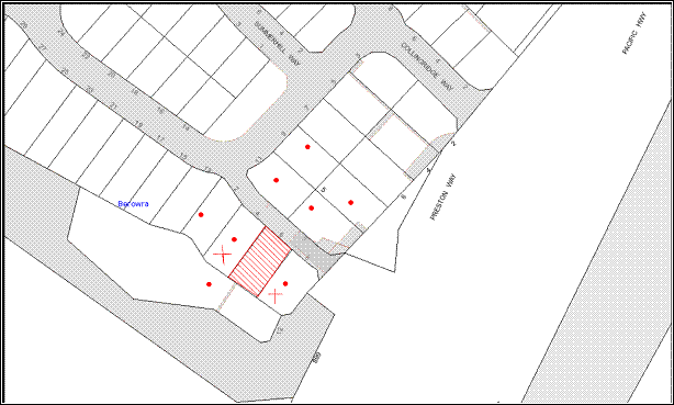
of the “Illoura Estate” Community Association. The map below illustrates the
location of the nearby landowners who made the submissions.
|
NOTIFICATION
PLAN
|
|
|
• PROPERTIES NOTIFIED
|
X SUBMISSION
RECEIVED
* Submission
from the Illoura Estate Community Assoc.
|

PROPERTY SUBJECT OF DEVELOPMENT
|

|
|
|
|
|
The submissions objected to the
proposal, generally on the grounds that the development would result in
unacceptable impacts in terms of scale, setbacks, design, height, privacy,
solar access, private open space and landscaping. These issues have been
addressed in Part 2.4 of this report under the relevant headings.
The Illoura Community
Association’s submission noted that it had previously “provided its approval
for the construction of a house at 6 Talbot Way” and requested that Council
“not approve the amended application until the Community Association has
provided its consent”.
Subsequent advice from the owner
has confirmed that approval was granted by the Illoura Community Association to
the plans (Revision G) currently under consideration.
6. THE PUBLIC INTEREST
Section 79C(1)(e) of the Act requires Council to consider “the
public interest”.
The public interest is an
overarching requirement, which includes the consideration of the matters
discussed in this report. Implicit to the public interest is the achievement
of future built outcomes adequately responding to and respecting the future
desired outcomes expressed in environmental planning instruments and
development control plans.
The application is considered to
have satisfactorily addressed Council’s criteria and would provide a
development outcome that, on balance, would result in a positive impact for the
community. Accordingly, it is considered that the approval of the proposed
dwelling house would be in the public interest.
CONCLUSION
The
application proposes the erection of a two-storey dwelling-house in a style
that would generally be in keeping with the development in the surrounding low
density residential zone.
One of the
objectives of this zone is “to control the
intensity and scale of development of land so that development will be in
accordance with the land’s environmental capacity and zone objectives.” To meet these objectives, Council prescribes a floor space ratio (FSR) for
dwelling-houses in a low density zone of 0.4:1 in Clause 15 of the HSLEP.
Dwelling-houses
within the “Illoura Estate” are characterised by developments previously
approved by both Council and the NSW Land and Environment Court with floor
space ratios that vary from between 0.3:1 and 0.68:1. The subject development
would have a FSR of 0.67:1 which exceeds the 0.4:1 FSR development standard.
In seeking approval for a variation to this standard, the
applicant has lodged an objection under the provisions of SEPP 1. In consideration of this objection and the views of the NSW Land and Environment Court as to
how an objection may be well founded, it is noted that the 0.4:1 development standard for development in the “Illoura Estate” “has been virtually
abandoned or destroyed by the Council's own actions in granting consents
departing from the standard and hence compliance with the standard is
unnecessary and unreasonable”. It is noted that of the 59 residential
allotments within the subdivision, over 66% of the dwelling-houses therein
exceed the 0.4:1 floor space ratio development standard.
The proposed 0.67:1 FSR is within the range of developments
already approved within the “Illoura Estate”. As a consequence, the
development would be consistent with the bulk
and scale of a significant proportion of residential development in the
surrounding “Illoura Estate,” would not result
in adverse impact on the character and identity of the area and is consistent
with the objectives of the HSLEP 1994.
Submissions
were received from the owners of the adjacent premises No.s 4 and 8 Talbot Way, raising objections to the proposal. A letter was also received from the
strata management of the “Illoura Estate” requesting additional time to
consider the proposal. The issues raised in submissions have been addressed in
the body of the report.
Having
regard to the assessment of the proposed development and the circumstances of
the case, it is recommended that the application be approved.
Note: At the time of the completion of this planning report, no
persons have made a Political Donations Disclosure Statement pursuant to
Section 147 of the Environmental Planning and Assessment Act 1979 in respect of
the subject planning application.
RECOMMENDATION
THAT Development Application No. DA/1056/2011 for the erection of a dwelling-house at Lot 35, DP 270489, No. 6 Talbot Way, Berowra be approved, subject to the conditions attached to this report.
|
Simon Evans
Manager -
Assessment Team 1
Planning Division
|
James Farrington
Acting Executive
Manager
Planning Division
|
Attachments:
|
1.View
|
Locality Plan
|
|
|
|
2.View
|
Floor Plans
|
|
|
|
3.View
|
Site Plans
|
|
|
|
4.View
|
Shadow Diagram
|
|
|
|
5.View
|
Elevations/Sections
Plans
|
|
|
|
6.View
|
Drainage Plan
|
|
|
|
7.View
|
Statement of
Environmental Effects
|
|
|
File Reference: DA/1056/2011
Document Number: D01774532
SCHEDULE 1
GENERAL
CONDITIONS
The conditions of consent within this notice of determination have
been applied to ensure that the use of the land and/or building is carried out
in such a manner that is consistent with the aims and objectives of the
relevant legislation, planning instruments and Council policies affecting the
land and does not disrupt the amenity of the neighbourhood or impact upon the
environment.
Note: For the
purpose of this consent, the term ‘applicant’ means any person who has the
authority to act on or the benefit of the development consent.
Note: For the purpose of
this consent, any reference to an Act, Regulation, Australian Standard or
publication by a public authority shall be taken to mean the gazetted Act or
Regulation, or adopted Australian Standard or publication as in force on the
date that the application for a construction certificate is made.
1. Approved
Plans and Supporting Documentation
The
development must be carried out in accordance with the plans and documentation
listed below and endorsed with Council’s stamp, except where amended by Council
and/or other conditions of this consent:
|
Plan No.
|
Drawn by
|
Dated
|
|
Job No. HT173: Sheets 1/10 to
10/10: Rev G
|
Hotondo Homes
|
Latest revision 04.03.11
|
REQUIREMENTS PRIOR TO THE ISSUE OF A CONSTRUCTION
CERTIFICATE
2. Building
Code of Australia
All building
work must be carried out in accordance with the requirements of the Building
Code of Australia.
3. Contract
of Insurance (Residential Building Work)
In the case
of residential building work for which the Home Building Act, 1989 requires
there to be a contract of insurance in force in accordance with Part 6 of that
Act, that such a contract of insurance is in force before any building work
authorised to be carried out by the consent commences.
4. Notification
of Home Building Act, 1989 Requirements
Residential
building work within the meaning of the Home Building Act,
1989 must not be carried out unless the principal certifying authority for
the development to which the work relates (not being Council) has given Council
written notice of the following information:
a. In
the case of work for which a principal contractor is required to be appointed:
i. The
name and licence number of the principal contractor.
ii. The
name of the insurer by which the work is insured under Part 6 of that Act.
b. In
the case of work to be done by an owner-builder:
i. The
name of the owner-builder.
ii. If
the owner-builder is required to hold an owner-builder’s permit under that Act,
the number of the owner-builder’s permit.
Note: If
arrangements for doing the residential building work are changed while the work
is in progress so that the information notified becomes out of date, further
work must not be carried out unless the principal certifying authority for the
development to which the work relates (not being Council) has given Council
written notification of the updated information.
5. Sydney
Water – Quick Check
The
application must be submitted to a Sydney Water ‘Quick Check Agent’ or
‘Customer Centre’ for approval to determine whether the development will affect
any Sydney Water infrastructure, and whether further requirements are to
be met.
Note: Refer
to www.sydneywater.com.au or
telephone 13 20 92 for assistance.
6. Asset
Protection Zones
To provide sufficient space
and maintain reduced fuel loads so as to ensure radiant heat levels of
buildings are below critical limits and to prevent direct flame contact with a
building, at the commencement of building works and in perpetuity the entire
property must be managed as an Inner Protection Area (IPA) as outlined within
section 4.1.3 and Appendix 5 of ‘Planning for Bush Fire Protection 2006’ and
the NSW Rural Fire Service’s document ‘Standards for asset protection zones’.
7. Design
and Construction
To withstand
the potential impacts of bushfire attack, the following conditions apply:
a. New construction on the south-west elevation must comply with
Section 8 (BAL 40) Australian Standard AS395-2009 ‘Construction of buildings in
bush fire-prone areas’ and Section A3.7 Addendum Appendix 3 of ‘Planning for
Bushfire Protection’;
b. New construction on the north-west, north-east and southern
elevations must comply with Section 7 (BAL 29) Australian Standard AS395-2009
‘Construction of buildings in bush fire-prone areas’ and Section A3.7 Addendum
Appendix 3 of ‘Planning for Bushfire Protection’; and
c. Roofing must be
gutterless or guttering and valleys must be screened to prevent the build up of
flammable material. Any materials used must be non-combustible.
REQUIREMENTS PRIOR TO THE COMMENCEMENT OF ANY WORKS
8. Erection
of Construction Sign
A sign must
be erected in a prominent position on any site on which building work is being
carried out:
a. Showing
the name, address and telephone number of the principal certifying authority
for the work;
b. Showing
the name of the principal contractor (if any) for any demolition or building
work and a telephone number on which that person may be contacted outside
working hours, and
c. Stating
that unauthorised entry to the work site is prohibited.
Note: Any
such sign is to be maintained while the building work, subdivision work or
demolition work is being carried out, but must be removed when the work has
been completed.
9. Toilet
Facilities
Toilet
facilities must be available or provided at the works site before works begin
and must be maintained until the works are completed at a ratio of one toilet
for every 20 persons employed at the site. Each toilet must:
a. be
a standard flushing toilet connected to a public sewer; or
b. be
a temporary chemical closet approved under the Local Government Act, 1993.
10. Erosion
and Sediment Control
Erosion and
sediment control measures must be provided and maintained throughout the
construction period in accordance with the manual ‘Soils and Construction
2004 (Bluebook)’, the approved plans, Council specifications and to the
satisfaction of the principal certifying authority. The erosion and sediment
control devices must remain in place until the site has been stabilised and
revegetated.
Note: On
the spot penalties up to $1,500 may be issued for any non-compliance with this
requirement without any further notification or warning.
REQUIREMENTS DURING CONSTRUCTION
11. Construction
Work Hours
All work on site, including site preparation/earth works
must only occur between 7am and 5pm Monday to Saturday. No work is to be
undertaken on Sundays or public holidays.
12. Council
Property
During
construction works, no building materials, waste, machinery or related matter
is to be stored on the road or footpath. The public reserve is to be kept in a
clean, tidy and in a safe condition at all times.
13. Disturbance
of Existing Site
During
construction works, the existing ground levels of open space areas and natural
landscape features, (including natural rock-outcrops, vegetation, soil and watercourses)
must not be altered unless otherwise nominated on the approved plans.
14. Survey
Report – Finished Floor Level
A report(s)
must be prepared by a registered surveyor and submitted to the principal
certifying authority prior to the pouring of concrete at each level of the
building certifying that:
a. the
building, retaining walls and the like have been correctly positioned on the
site; and
b. the
finished floor levels are in accordance with the approved plans.
REQUIREMENTS PRIOR TO THE ISSUE OF AN OCCUPATION
CERTIFICATE
Note: For
the purpose of this consent, a reference to ‘occupation
certificate’ shall not be taken to mean an ‘interim occupation
certificate’ unless otherwise stated.
15. Fulfilment
of BASIX Commitments
The applicant
must demonstrate the fulfilment of BASIX commitments pertaining to the
development.
16. Stormwater
Drainage
The stormwater drainage
system for the development must be designed and constructed for an average
recurrence interval of 20 years and be gravity drained and connected to the
existing inter-allotment drainage system.
17. Internal
Driveway/Vehicular Areas
The driveway
and parking areas on site must be designed in accordance with Australian
Standards 2890.1, 2890.2, 3727 and the following requirements:
a. Design
levels at the front boundary be obtained from Council;
b. The
driveway be a rigid pavement; and
c. The
driveway grade must not exceed 25 percent and changes in grade must not exceed
8 percent.
18. Vehicular
Crossing
A separate
application under the Local Government Act, 1993 and the Roads Act,
1993 must be submitted to Council for the installation of a new vehicular
crossing. The vehicular crossing must be constructed in accordance with
Council’s Civil Works Design, 2005 and the following requirements:
a. The
footway area to be restored by turfing; and
b. Approval
must be obtained from all relevant utility providers that all necessary
conduits be provided and protected under the crossing.
Note:
An application for a vehicular crossing can only be made to one of Council’s
Authorised Vehicular Crossing Contractors. You are advised to contact Council
on 02 9847 6940 to obtain a list of contractors.
19. Damage
to Council Assets
Any damage
caused to Council’s assets as a result of the construction of the development
must be rectified in accordance with Council’s written requirements and at the
sole cost of the applicant.
20. Retaining
Walls
All required retaining walls
must be constructed as part of the development.
21. Installation
of Privacy Devices
To establish and maintain a
reasonable level of privacy towards the private open space of the adjoining
property No. 4 Talbot Way, a 1.5 metre high close-form lattice/louvre or solid
privacy screen must be erected along the north-western elevation of the ground
floor level “Alfresco area”.
-
END OF CONDITIONS -
ADVISORY
NOTES
The following information is provided for your assistance to
ensure compliance with the Environmental Planning and Assessment Act, 1979,
Environmental Planning and Assessment Regulation 2000, other relevant
legislation and Council’s policies and specifications. This information does
not form part of the conditions of development consent pursuant to Section 80A
of the Act.
Environmental Planning and Assessment Act, 1979
Requirements
· The Environmental Planning and
Assessment Act, 1979 requires:
· The issue of a construction certificate
prior to the commencement of any works. Enquiries regarding the issue of a
construction certificate can be made to Council’s Customer Services Branch on
9847 6760;
· A principal certifying authority to be
nominated and Council notified of that appointment prior to the commencement of
any works;
· Council to be given at least two days
written notice prior to the commencement of any works;
· Mandatory inspections of nominated
stages of the construction inspected; and
· An occupation certificate to be issued
before occupying any building or commencing the use of the land.
Long Service Levy
In accordance with Section 34 of
the Building and Construction Industry Long Service Payments Act 1986, a ‘Long Service Levy’ must be paid to the Long
Service Payments Corporation or Hornsby Council.
Note: The
rate of the Long Service Levy is 0.35% of the total cost of the work.
Note: Hornsby
Council requires the payment of the Long Service Levy prior to the issue of a
construction certificate.
Tree Preservation Order
To ensure the maintenance and
protection of the existing natural environment, it is an offence to ringbark,
cut down, top, lop, remove, wilfully injure or destroy a tree outside 3 metres
of the approved building envelope without the prior written consent from
Council.
Note: A
tree is defined as a single or multi-trunked wood perennial plant having a
height of not less than 3 metres, and which develops many branches, usually
from a distance of not less than 1 metre from the ground, but excluding any
plant which, in its particular location, is a noxious plant declared as such
pursuant to the Noxious Weeds Act 1993. This definition of ‘tree’ includes any
and all types of Palm trees.
All
distances are determined under Australian Standard AS4970-2009 ”Protection of
Trees on Development Sites”.
Fines may be imposed for non-compliance with Council’s Tree
Preservation Order.
Dial Before You Dig
Prior to commencing any works,
the applicant is encouraged to contact Dial Before You Dig on 1100 or www.dialbeforeyoudig.com.au for
free information on potential underground pipes and cables within the vicinity
of the development site.
Planning Report No. PLN70/11
Date of Meeting:
7/12/2011
2 DEVELOPMENT APPLICATION
- SUBDIVISION OF FIVE LOTS INTO FOUR, CONSTRUCTION OF THREE DWELLING-HOUSES
AND RETENTION OF EXISTING HERITAGE LISTED DWELLING
115 BEECROFT ROAD BEECROFT
|
Development Application No:
|
DA/605/2011
|
|
Description of Proposal:
|
Subdivision of five
allotments into four, construction of three dwelling-houses and retention of
existing heritage listed dwelling
|
|
Property Description:
|
Lots 1- 5 DP 2073, No. 115 Beecroft Road, Beecroft
|
|
Applicant:
|
Wagstaff Enterprises Pty Ltd
|
|
Owner:
|
Mr C. P. Harris
|
|
Statutory Provisions:
|
Hornsby Shire
Local Environmental Plan 1994
Residential
AS (Low Density - Sensitive Lands)
|
|
Estimated Value:
|
$730,000
|
|
Ward:
|
C
|
|
RECOMMENDATION
THAT Council assume the
concurrence of the Director-General of the Department of Planning and
Infrastructure pursuant to State Environmental Planning Policy No. 1 and
approve Development Application No. 605/2011 for subdivision of five
allotments into four, construction of three dwelling-houses and retention of
the existing heritage listed dwelling at Lots 1-5 DP 2073, No. 115 Beecroft
Road, Beecroft subject to the conditions of consent detailed in Schedule 1 of
this report.
|
1. The
application proposes Torrens title subdivision of five allotments into four,
construction of three new dwellings and retention of the existing heritage
listed dwelling.
2. The
proposal does not comply with the density control for the Residential AS (Low
Density- Sensitive Lands) zone in the Hornsby Shire Local Environmental Plan
1994. However, pursuant to SEPP 1, the proposed variation to the development
standard is supported as the proposed lots are larger than the existing
allotments and the subdivision pattern is similar to the adjoining properties.
The three detached dwellings to be constructed are designed in response to the
size of the proposed lots. The development would be compatible with the
locality.
3. Fifteen
submissions, including an objection from the Beecroft Cheltenham Civic Trust,
have been received in respect of the application.
4. It
is recommended that the application be approved.
HISTORY OF THE SITE
On 31 August 2011, Council’s
Compliance Officer inspected the property and found that a timber paling fence
had been erected along the southern side of the property fronting Beecroft Road and works had been carried out on the existing heritage listed cottage.
Council issued an Order on the property owner to cease carrying out any
building works at the premises. In response to the Order, the owner made
representations to Council detailing the extent of the works to the cottage.
On 7 September 2011, the Order
was rescinded and the owner was permitted to carry out maintenance works on the
dwelling. It was acknowledged that the erection and location of the timber
fence would be considered as part of the assessment of this application.
HISTORY OF THE APPLICATION
On 15 June 2011, Development
Application No. DA/605/2011 was lodged for the Torrens title subdivision
of five allotments into four, construction of three dwellings and retention of
the existing heritage listed dwelling. The application is the subject of this
report.
On 15 August 2011, the applicant
submitted revised plans which provide the following modifications:
· Driveway access from
The Crescent and two car parking spaces for the heritage listed building on
proposed Lot 1.
· A 1.8 metre hedge
screen along The Crescent frontage to achieve the private open space area for
the heritage listed building on proposed Lot 1.
· Increased front
setback to 5 metres for the proposed dwellings on Lots 3 and 4.
· Provision of a 1.8
metre timber lapped fence along the Beecroft Road frontage and between each of
the proposed lots.
Furthermore, the applicant
submitted the following additional information:
· Details of works
and maintenance proposed to be undertaken to the heritage listed building.
· Photomontage,
revised landscape plan, schedule of finishes and an erosion and sediment
control plan.
In response to Council’s heritage
assessment of the application, on 4 October 2011, the applicant submitted an
archaeological assessment.
THE SITE
The site is comprised of five
existing allotments known as Lots 1, 2, 3, 4 and 5 in DP 2073 and is located on
the corner of Beecroft Road and The Crescent. The site experiences a moderate
grade from the southern to the northern property boundary. The site is
irregular in shape and has a total area of 1864m2. The area of each
of the existing lots is as follows:
|
Existing Lot Number
|
Existing Lot Area
|
|
1
|
379 m2
|
|
2
|
373 m2
|
|
3
|
359 m2
|
|
4
|
367 m2
|
|
5
|
386 m2
|
|
TOTAL Area:
|
1864 m2
|
The site contains an existing
heritage listed dwelling located adjacent to the western property boundary.
There is an existing dilapidated shed/garage located adjacent to the northern
western property boundary.
The site contains a number of exotic, native and locally
indigenous trees.
The
site is located opposite the Beecroft Tennis Club and lawn tennis courts on the
western side of The Crescent. The Beecroft Scout and Guide Hall is opposite the
site on the northern side of The Crescent. The recreation/community facilities
adjoin the Northern Railway corridor and ‘The Village Green’. To the east, the
site adjoins an existing two storey dwelling house.
The
rail corridor is parallel to The Crescent. The railway and Beecroft Road impact
on the acoustic environment of the site.
The
site is located 550m south of Beecroft Railway Station and shops. The
surrounding locality is generally characterised by Federation era dwelling-houses,
large remnant trees and the ‘The Village Green’ open space recreation area.
THE PROPOSAL
The applicant seeks
re-subdivision of five allotments into four, construction of three new
dwellings and retention of the heritage listed dwelling. The development would
be undertaken in the following stages:
Stage 1
· Consolidation of
existing Lots 1, 2 and 3.
· Subdivision to create
new Lots 1 and 2.
· Boundary adjustment to
existing Lots 4 and 5 to create new Lots 3 and 4.
|
Proposed Lots
|
Proposed Lot Areas
|
|
1
|
513.3m2
|
|
2
|
450 m2
|
|
3
|
450.2 m2
|
|
4
|
450.2 m2
|
Stage 2
· Demolition of the
existing garage on proposed Lot 1.
· Construction of a two
storey dwelling and associated works on proposed Lot 2.
Stage 3
· Construction of a two
storey dwelling and associated works on proposed Lot 3.
Stage 4
· Construction of a two
storey dwelling and associated works on proposed Lot 4.
ASSESSMENT
The development application has
been assessed having regard to the ‘Metropolitan Plan for Sydney 2036’,
the ‘North Subregion (Draft) Subregional Strategy’ and the matters for
consideration prescribed under Section 79C of the Environmental Planning and
Assessment Act 1979 (the Act). The following issues have been identified
for further consideration.
1. STRATEGIC CONTEXT
1.1 Metropolitan Plan for Sydney 2036 and (Draft) North Subregional
Strategy
The Metropolitan Plan for Sydney 2036 is a broad framework to secure Sydney’s place in the global economy by
promoting and managing growth. It outlines a vision for Sydney to 2036; the
challenges faced, and the directions to follow to address these challenges and
achieve the vision. The Draft North Subregional Strategy acts as a
framework for Council in the preparation of a new Comprehensive LEP.
The Draft North Subregional
Strategy sets the following targets for the Hornsby LGA by 2031:
· Employment capacity to
increase by 9,000 jobs; and
· Housing stock to
increase by 11,000 dwellings.
The proposed development would be
consistent with the Metropolitan Plan and Draft Subregional Strategy by
providing an additional three dwellings and contributing towards housing choice
in the locality.
2. STATUTORY CONTROLS
Section 79C(1)(a) requires
Council to consider “any relevant environmental planning instruments, draft
environmental planning instruments, development control plans, planning agreements
and regulations”.
2.1 Hornsby Shire Local Environmental Plan 1994
The subject land is zoned Residential AS (Low Density-Sensitive Lands) under the Hornsby Shire Local
Environmental Plan 1994 (HSLEP). The objectives of the Residential
AS (Low Density-Sensitive Lands) zone are:
(a) to provide for the housing needs of the population of the
Hornsby area.
(b) to promote a variety of housing types and other land uses
compatible with a low density residential environment and sensitive to the land
capability and established character of this environment.
(c) to provide for development that is within the environmental
capacity of a sensitive low density residential environment.
The proposed development is
defined as “subdivision” and “dwelling-houses” under the HSLEP
and is permissible in the zone with Council’s consent.
Clause 14 of the HSLEP prescribes
that the minimum area of an allotment within the Residential AS (Low
Density-Sensitive Lands) zone is 600sqm. The proposed lots do not comply with
this requirement. An objection to the development standard pursuant to State
Environmental Planning Policy No. 1 (SEPP 1) has been submitted and is
discussed further at Section 2.2 of this report.
Clause 15 of the HSLEP prescribes
that the maximum floor space ratio (FSR) of development within the Residential
AS (Low Density-Sensitive Lands) zone is 0.4:1. Development on each of the
proposed lots would comply with this development standard.
Clause 18 of the HSLEP
sets out heritage conservation provisions within Hornsby Shire. The property is
listed as a heritage item (“Carmel”) of local significance under the
provisions of Schedule D (Heritage Items) of the HSLEP. The property is
also located within the Beecroft/Cheltenham Heritage Conservation Area, which
is listed under the provisions of Schedule E (Heritage Conservation Areas) of
the HSLEP. The property is located within the vicinity of property Nos.
110-118 and Nos. 128-130 Beecroft Road, Beecroft (house and garden,
“Ravenhurst” and garden, fence garden and hedge, house, “Romana House” and
Garden) which are listed as heritage items of local significance under the
provisions of Schedule D (Heritage Items) of the HSLEP. The development
application was referred to Council’s Heritage Advisory Committee and this
matter is discussed in detail in section 2.8 of this report.
2.2 State Environmental Planning Policy No. 1 – Development
Standards
SEPP 1 provides flexibility in
applying development standards and enables a consent authority to vary a
standard where strict compliance would be unnecessary, unreasonable or tend to
hinder the objectives of the Act. Where there is a variation to a development
standard, the application must be accompanied by a SEPP 1 objection.
The applicant submitted an
objection against Council’s adherence to the minimum 600m2 lot size
under Clause 14 of the HSLEP.
The Land and Environment Court has expressed the view that
there are five different ways in which an objection may be well founded and
that approval of the objection may be consistent with the aims of the Policy:
1. the objectives of the standard are achieved notwithstanding
non-compliance with the standards;
2. the underlying objective or purpose of the standard is not
relevant to the development and therefore compliance is unnecessary;
3. the underlying object or purpose would be defeated or
thwarted if compliance was required and therefore compliance is unreasonable;
4. the development standard has been virtually abandoned or
destroyed by the Council’s own actions in granting consents departing from the
standard and hence compliance with the standard is unnecessary and
unreasonable;
5. the zoning of the particular land is unreasonable or
inappropriate so that a development standard appropriate for that zoning is
also unreasonable and unnecessary as it applies to the land and compliance with
the standard would be unreasonable or unnecessary. That is, the particular
parcel of land should not have been included in the particular zone.
The applicant submits that strict
compliance with the density requirements is unreasonable and unnecessary for
the following reasons:
“Whilst the
proposal departs from the requirements of the Principal Development Standard,
the merit assessment below demonstrates that the proposed development
satisfactorily maintains consistency with the objectives of the Principal
Development Standard:
· “To promote a
low-density residential environment and provide for lots of sufficient size to
satisfy user requirements.”
The subject
site is currently comprised of five individual allotments. The proposed lot
consolidation and re-subdivision effectively reduces the number of lots from
five to four.
Comparison
between the existing and proposed lot sizes is demonstrated in the table below:
|
Existing Lot
|
Existing Area
|
Proposed Lot
|
Proposed Area
|
Net Increase
|
|
1
|
379m2
|
1
_____________
2
|
513.3m2
_____________
450m2
|
134m2
_____________
91m2
|
|
2
|
373m2
|
|
3
|
359m2
|
|
4
|
367m2
|
3
|
450.2m2
|
83.2m2
|
|
5
|
386m2
|
4
|
450.2m2
|
64.2m2
|
|
Total
|
1864m2
|
|
1864m2
|
|
The
reduction in the numbers of lots from five to four, results in an overall net
increase in the allotment sizes which provides an improvement to the existing
situation and a more desirable planning outcome with regards to desired future
character by reducing the existing overall housing density potential which
could be achieved if the subject site was developed ‘as is.’
Consistency
with the established subdivision pattern
The
established subdivision pattern in the locality comprises a variety of
allotment configurations and sizes. A predominant pattern exists with
allotments providing a direct street frontage and regularity in shape. There is
a variety of smaller lots together with larger lots.
The proposed
allotment configuration and sizes are generally consistent with the established
subdivision pattern and configuration within The Crescent and the wider
locality. The proposed development would enable orderly residential
development of the site and maintain consistency with the residential density
and character of the streetscape.
Ability
for the lots to be developed in accordance with the provisions of the Hornsby
Shire Local Environmental Plan 1994 and the relevant DCPs
While the
lot sizes do not achieve the minimum numerical amount of 600m2 per
lot, detailed architectural plans with dwelling designs are proposed for each
of the lots (Lots 2, 3 and 4).
Fundamentally,
the architectural plans demonstrate that each resulting allotment can
accommodate a dwelling house that achieves consistency with the provisions of
Hornsby LEP 1994 and the relevant DCPs.
In this
regard, the proposed lots allow for the undertaking of orderly residential
development with dwelling-houses that maintain a consistent pattern of
development, sense of openness, building separation and a sufficient area of
landscape open space that maintains the landscape setting of the locality.
Incentive
for the retention of a heritage item
The proposed
lot consolidation and re-subdivision would effectively provide the necessary
funds for the undertaking of essential conservation works to the existing
heritage listed dwelling on the site. The proposed scheme has been considered
in detail in the Heritage Impact Statement which demonstrates that there would
be no unreasonable impacts on the heritage significance of the site.
The net
reduction from five to four lots would reduce the potential housing density
and thus reduce the impact on the heritage significance of the site by
reconfiguring the lots so that the existing dwelling is located on one lot,
ensuring a sufficient landscape curtilage is maintained and sufficient setbacks
are achieved to the new dwellings.
On balance,
the proposed allotments are an incentive to the retention and protection of the
existing heritage item.
Conclusion
The above
merit assessment demonstrates that while strict numerical compliance with the
development standard is unreasonable and unnecessary in the circumstances of
the case, the proposed development is consistent with the objectives and
intent of Clause 14 of the Hornsby Shire Local Environmental Plan 1994.
The proposed
allotments maintain a consistent subdivision pattern and configuration and
would enable the orderly development of the site with the accommodation of
residential dwellings on Lots 2, 3 and 4 which achieve compliance with the
provisions of the Hornsby LEP 1994 and the relevant DCPs. In this regard, the
proposed development ‘provides lots of sufficient size to satisfy user
requirements.’
The housing
density proposed would be consistent with the variety of the housing density
and allotment sizes in the locality and would not unreasonably impact on the
established streetscape character.
As such, the
proposed development does not result in any unreasonable environmental impact,
nor set an undesirable planning precent for future development to emulate
within the streetscape.”
Based on the reasons contained in
this report, it is considered that the applicant’s SEPP 1 submission is
consistent with the Land and Environment Court’s test No. 1 and compliance with
the development standard would be unreasonable and unnecessary in the
circumstances of the case. The proposal includes the resubdivision of existing
undersized lots. The lots created would be larger than the existing allotments
and the proposal would reduce the number of non-conforming allotments from five
to four. Therefore, the proposal would not create a precedent for the creation
of undersized lots. The proposal would not have a negative impact upon the
residential environment of the locality and the proposal is not inconsistent
with the objectives contained within section 5(a) (i) and (ii) of the
Environmental Planning and Assessment Act 1979. Accordingly, the SEPP 1
objection is supported.
2.3 State Environmental Planning Policy No. 55 - Contaminated
Lands
Clause 7 of State Environmental Planning Policy No. 55 -
Remediation of Land (SEPP 55) requires Council to consider whether land is
contaminated prior to granting consent to the carrying out of any development
on that land.
The site contamination report
submitted with the application states that based on an historical review, site
inspection and laboratory analysis of soil samples, there appears no reasonable
grounds to suspect that any significant soil contamination exists on the site
and that no remedial works are deemed necessary. Accordingly, no further
assessment in this regard is considered necessary.
2.4 State Environmental Planning Policy (Building Sustainability Index: BASIX) 2004
The application has been assessed
against the requirements of State Environmental
Planning Policy (Building Sustainability Index: BASIX) 2004, which aims to
ensure consistency in the implementation of the BASIX scheme throughout the
State.
A
BASIX Certificate has been submitted as part of this application. A condition
is recommended requiring that the applicant demonstrate the fulfilment
of BASIX commitments pertaining to the development.
2.5 State Environmental Planning Policy – Sydney Regional
Environmental Plan (Sydney Harbour Catchment) 2005
The application has been assessed
against the requirements of the Policy which includes planning principles
applicable to the site within the upper part of the harbour catchment. The
principles incorporate measures to protect water quality, minimise urban
runoff, conserve water and ensure the catchment watercourses, wetlands,
riparian lands and remnant vegetation are protected.
The applicant has addressed this
requirement by providing an erosion and sediment control plan for the
construction of the development. Stormwater quality would not be significantly
impacted by this residential development subject to appropriate consent
conditions.
2.6 Dwelling House Development Control Plan
The proposed development has been
assessed having regard to the relevant performance and prescriptive design
provisions within Council’s Dwelling House Development Control Plan (DCP). The
following table sets out the proposal’s compliance with the prescriptive
provisions of the Plan:
|
Dwelling
House Development Control Plan
|
|
Control
|
Proposal
|
Requirements
|
Complies
|
|
Site
Area
|
1864m2
|
N/A
|
N/A
|
|
Lot 1 – Existing
Dwelling
|
|
Floor
space ratio
Lot 1 – Existing Dwelling
Lot 2 – Proposed Dwelling
Lot 3 – Proposed Dwelling
Lot 4 – Proposed Dwelling
|
0.236:1
0.4:1
0.4:1
0.4:1
|
0.4:1
|
Yes
Yes
Yes
Yes
|
|
Site
Cover
Lot 1 – Existing Dwelling
Lot 2 – Proposed Dwelling
Lot 3 – Proposed Dwelling
Lot 4 – Proposed Dwelling
|
31.3%
36%
38.6%
32%
|
40%
|
Yes
Yes
Yes
Yes
|
|
Unbroken
Wall Length
Lot 1 – Existing Dwelling
Lot 2 – Proposed Dwelling
Lot 3 – Proposed Dwelling
Lot 4 – Proposed Dwelling
|
N/A
9.6m
10.2m
10.4m
|
10m
|
N/A
Yes
No
No
|
|
Total Building Length
Lot 1 – Existing Dwelling
Lot 2 – Proposed Dwelling
Lot 3 – Proposed Dwelling
Lot 4 – Proposed Dwelling
|
N/A
19.3m
19.25m
13.5m
|
24m
|
N/A
Yes
Yes
Yes
|
|
Private
Open Space
Lot 1 – Existing Dwelling
Lot 2 – Proposed Dwelling
Lot 3 – Proposed Dwelling
Lot 4 – Proposed Dwelling
|
>120m2
120m2
120m2
120m2
|
120m2
|
Yes
Yes
Yes
Yes
|
|
Landscaping
Lot 1 – Existing Dwelling
Lot 2 – Proposed Dwelling
Lot 3 – Proposed Dwelling
Lot 4 – Proposed Dwelling
|
>45%
52%
52%
61%
|
45%
|
Yes
Yes
Yes
Yes
|
|
Setbacks:
|
|
|
|
|
Lot 1 – Proposed Dwelling
Front
Side
(East)
Side
(West)
Rear
|
No change
2.85m
No change
13.5m
|
6m
1m
1m
3m
|
Yes
Yes
Yes
Yes
|
|
Lot 2 – Proposed Dwelling
Front
Side
(East)
Side
(West)
Rear
|
6m
1.2m
0.8m
9.5m
|
4-6m
1m
1m
5m
|
Yes
Yes
No
Yes
|
|
Lot 3 – Proposed Dwelling
Front
Side
(East)
Side
(West)
Rear
|
5m – 7.6m
1.1m
0.6m
10.5m
|
4 – 6m
1m
1m
5m
|
Yes
Yes
No
Yes
|
|
Lot 4 Proposed Dwelling
Front
Side (East)
Side
(West)
Rear
|
5.6m – 15.7m
1.1m
1m
9.5m
|
4m – 6m
1m
1m
5m
|
Yes
Yes
Yes
Yes
|
|
Car Parking
|
|
No. of
spaces
|
2 spaces per dwelling
|
2 spaces per dwelling
|
Yes
|
As detailed in the above table, the proposed development does not comply
with the setback and the unbroken wall length prescriptive requirements within
Council’s Dwelling House DCP. The matters of non-compliance are
detailed below, as well as a brief discussion on compliance with relevant
performance requirements.
2.6.1 Setbacks
The ‘setback’ element
requires development to complement the streetscape, provide for landscaping and
protect the privacy of and sunlight to adjacent dwellings.
The Dwelling
House DCP requires a minimum front setback of 6 metres. However, encroachments
to 4 metres are permitted for up to one third of the property width. The
northern corner of the carport on Lot 4 has a setback of 5.5 metres and a small
portion of the bedroom of the proposed dwelling on Lot 3 has a setback of 5
metres. It is considered that the proposed development provides adequate front
setbacks and landscaping to minimise impact on the existing streetscape.
The western elevations of the
proposed dwellings on Lots 2 and 3 do not comply with the minimum 1 metre side
setback requirement of the DCP. The encroachment is limited to the garages and
carports of proposed dwellings and are single storey in height.
The proposed setbacks are
supported as there is minimal impact on the streetscape. Furthermore, the
encroachments would not result in any significant privacy or sunlight
implications.
2.6.2 Design
The ‘design’
element requires development to be consistent with and enhance the character
and amenity of the local area and have regard for environmental characteristics
and energy efficiency.
The immediate locality is
characterised by single and two storey older style detached dwellings with open
landscaped frontages and varying housing styles. Dwellings contain a mix of
building materials and finishes.
Although the streetscape in The
Crescent is charactered predominantly by single storey dwellings, the site
adjoins an existing two storey dwelling on the eastern boundary and the
Beecroft Village Green to the north and west. It is considered that the proposed development would fit in with the established
streetscape. The design, bulk, scale and setback of the proposed dwellings are
compatible with the adjacent properties in The Crescent.
The
proposed dwellings on Lots 3 and 4 would have a building wall in excess of 10
metres in length, contrary to the provisions of the DCP. However, the non
compliance is considered minor and would have no significant impact on the
streetscape or on adjacent properties.
2.6.3 Privacy
The ‘privacy’ element
requires that existing and future residents be provided with reasonable privacy
in their home and private open space.
The proposed dwellings are
designed with regard to visual privacy to avoid overlooking neighbouring and
future residents. Private open space areas are integrated with the living areas
of the dwellings and have regard to acoustic privacy.
2.6.4 Solar Access
The ‘solar access’ element
requires development to ensure reasonable solar access to living areas within
dwellings and to open spaces around dwellings.
Solar access is maintained to
neighbouring properties in compliance with Council’s DCP requirements. The
proposed dwellings would receive a minimum of 4 hours of sunlight to private
open space and living areas between 9 am and 3 pm on 22 June. Furthermore, a
BASIX certificate has been submitted to ensure the building addresses energy
efficiency requirements.
2.6.5 Private Open Space
The ‘Private Open Space’
element requires the provision of adequate private open space to support
residential outdoor activities and use.
The proposal provides areas of
private open space in accordance with the minimum area requirements of the DCP.
Open space areas are accessible from internal living areas and comply with the
solar access requirements.
2.6.6 Landscaping
The ‘landscaping’ element
requires developments to provide attractive landscapes that reinforce the
function of a street, enhance the amenity of dwellings and to preserve
significant stands of trees or natural vegetation.
The element requires at least 45%
of each lot to be landscaped. The proposed development complies with this
requirement.
The proposal would preserve two
significant trees located on the site. These trees on the site are located
adjacent to the rear boundary within proposed Lots 3 and 4.
Accordingly, the proposal
complies with the landscaping requirements of the DCP.
2.6.7 Vehicle Access and Parking
The ‘vehicle access and
parking’ element requires vehicular access to be simple, safe and direct.
It also requires sufficient and convenient parking for residents and visitors.
In accordance with the provisions
of the DCP, two car parking spaces are required to be provided per dwelling.
The existing heritage listed dwelling would be provided with an open car
parking area. Each of the proposed dwellings on Lots 2 and 3 would be provided
with a double garage and the dwelling on proposed Lot 4 would have a double
carport. The proposal complies with the car parking requirements of the DCP.
Each dwelling would be provided
individual access from The Crescent. The engineering assessment of the
application concludes that the development is satisfactory, subject to
appropriate conditions.
2.6.8 Fencing
The ‘fencing’ element
requires fencing to complement the character of the area.
The proposal includes details of
fencing to be erected along the southern boundary fronting Beecroft Road and
between each of the proposed lots. The proposed fence along the Beecroft Road frontage is not inconsistent with adjacent fencing along Beecroft Road and
would not compromise the established streetscape character of the surrounding
area. The proposed fencing complies with the requirements of the DCP.
2.7 Residential Subdivision Development Control Plan
The proposed allotments do not
comply with the minimum 600m2 allotment area requirement within
Council’s Residential Subdivision DCP. As previously discussed at Section 2.2
of this report, the proposal results in the reduction of the number of existing
lots from five to four. This reduction results in a net increase in the size of
the allotments. The non-compliance is supported as the development would result
in a subdivision pattern consistent with that occurring on adjoining properties
to the east.
The size and configuration of the
proposed lots enables the construction of a built form that is sympathetic with
the established character of the area. The inclusion of proposed dwellings
within this application demonstrates that the proposed allotments are capable
of accommodating a built form that would have minimal environmental impacts and
is generally consistent with the established character of the area.
2.8 Heritage Development Control Plan
The
primary purpose of the Plan is to manage the heritage in Hornsby Shire and to
provide guidance and outline specific controls for development relating to
heritage items and heritage conservation areas.
The property is listed as a
heritage item (“Carmel”) of local significance under the provisions of
Schedule D (Heritage Items) of the HSLEP. The property is also located
within the Beecroft/Cheltenham Heritage Conservation Area, which is listed
under the provisions of Schedule E (Heritage Conservation Areas) of the HSLEP.
The property is located within the vicinity of property Nos. 110-118 and Nos. 128-130 Beecroft Road, Beecroft (house and garden, “Ravenhurst” and garden, fence garden
and hedge, house, “Romana House” and Garden) which are listed as heritage
items of local significance under the provisions of Schedule D (Heritage Items)
of the HSLEP.
At its meeting on 12 September
2011, the Local Heritage Advisory Committee generally agreed that, prior to any
development consent being granted for the property, an assessment should be
undertaken by a suitably qualified consultant of the potential archaeological
significance of the site. The applicant submitted an archaeological assessment
which concludes that the site has low potential to yield archaeological
significance for the following reasons:
a. The dwelling and detached shed are characteristic of a
modest scale residential occupation and elements such as cellars, pits and
wells are uncharacteristic of the vernacular.
b. An assessment and comparison of successive aerial
photography from circa 1943 onwards did not show evidence of any structures,
buildings or distinguished site features.
c. An inspection of the site did not reveal any occupation
deposits, artefacts or relics.
The archaeological assessment
recommends that an appropriate condition of consent be imposed requiring that
work cease should excavation on the site uncover any artefacts. The submitted
archaeological report addresses the concerns raised by the Committee in respect
of archaeological significance.
The Committee acknowledged that
the proposed subdivision design would address the existing anomaly whereby the
heritage listed dwelling is erected over a lot boundary. The re-subdivision of
the site from five lots into four would facilitate retention of the heritage
item on a single allotment. The Committee also agreed that the subdivision
design would provide a sympathetic curtilage to the heritage item and ensure
appropriate separation between the item and proposed dwellings.
The Committee agreed that the
bulk, scale, and design of the proposed dwellings would complement the heritage
item on the site and streetscape. Furthermore, the proposed dwellings have
been located to maximise the retention of significant trees on the site which
contribute to the heritage significance of the property and Heritage
Conservation Area. However, it was noted that the provision of additional landscaping
adjacent to the proposed driveway to service the heritage listed dwelling would
contribute to the landscape setting of the item.
The Committee raised no
objections to the proposal on heritage grounds subject to the provision of a
1.0 metre wide landscaping strip adjacent to the proposed driveway to service
the heritage listed dwelling. Having regard to the recommendations of the
archaeological report, a condition is recommended requiring the applicant to
notify the Heritage Council of NSW should any relics
be uncovered during site works.
2.9 Waste Minimisation and Management Development Control
Plan
The proposal complies with the
objectives and measures contained within the Waste Minimisation and Management
Development Control Plan. A waste management plan has been submitted and would
be required to be implemented in accordance with the consent conditions.
Residential waste would be collected from the street frontage, which is
consistent with the prescriptive controls for Waste Minimisation and Management
within the Dwelling House DCP.
2.10 Sustainable Water Development Control Plan
Subject to sediment and erosion
control measures being implemented on site during construction, the proposal
would comply with the requirements contained within the Sustainable Water
Development Control Plan.
2.11 Contributions
The application does not create
any additional allotments. Accordingly, a Section 94 Contribution is not
required.
3. ENVIRONMENTAL IMPACTS
Section 79C(1)(b) of the Act
requires Council to consider “the likely impacts of that development,
including environmental impacts on both the natural and built environments, and
social and economic impacts in the locality”.
3.1 Natural Environment
The proposed development would
necessitate the removal of seven trees from the site. None of the trees to be
removed are identified as ‘significant trees’ under Council’s Tree Management
Plan. It is considered removal of the nominated trees on the site is
acceptable.
The proposed landscaping includes
appropriate screen planting for privacy and to complement the proposed
buildings.
3.2 Built Environment
The proposal is compatible with
the locality and has a negligible impact on the built environment as previously
discussed in this report.
3.2.1 Traffic
Given that the proposal involves the reduction of one
allotment, the proposed development would not result in additional in traffic
generation above that would be otherwise generated from redevelopment of the
site in its current subdivision layout. Council’s traffic assessment of the
proposal is that the proposed subdivision would generate 36 daily
vehicle trips in accordance with the Roads and Traffic Authority’s Guide To
Traffic Generating Developments and the traffic generation would not impact
on the capacity of the local road network.
3.2.2 Drainage
The engineering assessment concludes that stormwater can be
drained independently to the street gutter from the proposed lots and Lots 2-4
would each have an on-site detention system in accordance with the Council’s
engineering requirements.
3.3 Social Impacts
The proposed development would
not have an adverse social impact on the locality.
3.4 Economic Impacts
The proposal would have a minor
positive impact on the local economy in conjunction with other new residential
development in the locality by generating an increase in demand for local
services.
4. SITE SUITABILITY
Section 79C(1)(c) of the Act
requires Council to consider “the suitability of the site for the
development”.
The site does not have any
prohibitive site constraints such as flooding or bushfire risk. The proposed
development is consistent with the zone objectives for low density housing.
5. PUBLIC PARTICIPATION
Section 79C(1)(d) of the Act
requires Council to consider “any submissions made in accordance with this
Act”.
5.1 Community Consultation
The proposed development was
placed on public exhibition and was notified to adjoining and nearby landowners
between 27 June 2011 and 20 July 2011 in accordance with Council’s Notification
and Exhibition Development Control Plan. During this period, Council
received fifteen submissions, including a submission from the Beecroft
Cheltenham Civic Trust. The map below illustrates the location of those nearby
landowners who made a submission and are in close proximity to the development
site.
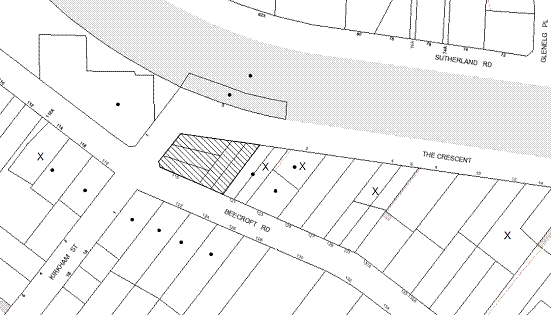
|
NOTIFICATION
PLAN
|
|
|
• PROPERTIES NOTIFIED
|
X SUBMISSIONS
RECEIVED
|
PROPERTY SUBJECT OF DEVELOPMENT
|
|
|
10 SUBMISSIONS
RECEIVED OUT OF MAP RANGE
|
|
|
|
|
The concerns raised in the
submissions objecting to the proposed development relate to:
· Insufficient
allotment sizes.
· Building
design not in keeping with area.
· Unacceptable
traffic and safety impacts on local streets.
· Unacceptable
overshadowing of the adjoining property.
· Development
is excessive in bulk, height and scale.
· The removal
of significant trees.
· Loss
of privacy.
· Insufficient
building setbacks.
· Overdevelopment
of the site.
· Inadequate
landscaping.
· Insufficient
perimeter fencing.
· Insufficient
restoration to the heritage listed building.
· Unsatisfactory street numbering.
The merits of the matters raised in
community submissions have been addressed in the body of the report and by
conditions of consent with the exception of the following:
5.1.1 Street Numbering
Public
submissions have raised concerns regarding likely changes to the existing
property numbers as a result of the requirement to provide new street numbers
to the proposed lots. The numbering of properties occurs in accordance with
Council’s protocol, which is to ensure that there is no duplication of numbers
in a street.
5.2 Public Agencies
The application was referred to
the following Agency for comment:
5.2.1 Roads and Traffic Authority
The application was referred to
the Roads and Traffic Authority. The RTA raises no objections to the proposal
and recommends conditions of consent. As an advisory note to Council for
consideration, the RTA has suggests that that the entry and exit for vehicles
from the proposed lots should be in a forward direction. However, vehicles
access to the proposed lots would be gained via The Crescent which is not
considered to be a busy road. Council’s engineer considers this arrangement
satisfactory and in accordance with the requirements of the Residential
Subdivision DCP, the provision of a turning area on each of the proposed lots
is not warranted.
6. THE PUBLIC INTEREST
Section 79C(1)(e) of the Act
requires Council to consider “the public interest”.
The public interest is an
overarching requirement, which includes the consideration of the matters
discussed in this report. Implicit to the public interest is the achievement
of future built outcomes adequately responding to, and respecting, the future
desired outcomes expressed in environmental planning instruments and
development control plans.
The application is considered to
have satisfactorily addressed Council’s and relevant agencies’ criteria and
would provide a development outcome that, on balance, would result in a
positive impact for the community. Accordingly, it is considered that the
approval of the proposed development would be in the public interest.
CONCLUSION
The application proposes the Torrens title subdivision of five lots into four, the erection of three detached dwellings
and the retention of an existing heritage listed building.
The proposal is consistent with
the relevant aims and objectives contained within the relevant State and
Regional Environmental Planning Policies, the Hornsby Shire Local Environmental
Plan 1994, and the Development Control Plans which are applicable to the site. The
proposal does not comply with the prescriptive density control for the
Residential A zone in the Hornsby Shire Local Environmental Plan 1994.
However, pursuant to SEPP 1, the proposed variation to the development standard
is supported as the proposed subdivision pattern is similar to the adjoining
properties and the design would address the existing anomaly whereby the
heritage listed dwelling is erected over a lot boundary.
The
development is unlikely to result in any significant impacts upon the natural
or built environments, or have any negative social or economic impacts. The
development provides for additional housing which is consistent with the
Metropolitan Strategy. Given this, and the recommended conditions, it is
recommended that the application be approved.
Note: At the time of the completion of this planning report, no
persons have made a Political Donations Disclosure Statement pursuant to
Section 147 of the Environmental Planning and Assessment Act 1979 in
respect of the subject planning application.
|
Rod Pickles
Manager -
Assessment Team 2
Planning Division
|
Paul David
Manager -
Subdivision & Development Engineering Services
Planning Division
|
|
James Farrington
Executive Manager
- Planning
Planning Division
|
|
Attachments:
|
1.View
|
Locality Plan
|
|
|
|
2.View
|
Site Plan
|
|
|
|
3.View
|
Subdivision Plan
|
|
|
|
4.View
|
Floor Plans
|
|
|
|
5.View
|
Elevations and
Sections
|
|
|
|
6.View
|
Shadow Diagrams
|
|
|
|
7.View
|
Landscape Plan
|
|
|
|
8.View
|
Photo Montages
|
|
|
File Reference: DA/605/2011
Document Number: D01762303
SCHEDULE 1
GENERAL
CONDITIONS
The conditions of consent within this notice of determination have
been applied to ensure that the use of the land and/or building is carried out
in such a manner that is consistent with the aims and objectives of the
relevant legislation, planning instruments and Council policies affecting the
land and does not disrupt the amenity of the neighbourhood or impact upon the
environment.
Note: For the
purpose of this consent, the term ‘applicant’ means any person who has the
authority to act on or the benefit of the development consent.
Note: For the purpose of
this consent, any reference to an Act, Regulation, Australian Standard or
publication by a public authority shall be taken to mean the gazetted Act or
Regulation, or adopted Australian Standard or publication as in force on the
date that the application for a construction certificate is made.
STAGE
1 – SUBDIVISION OF FIVE ALLOTMENTS INTO FOUR
STAGE 2 – Demolition of the existing garage on proposed
Lot 1 AND Construction of a two storey dwelling ON PROPOSED lOT 2
STAGE
3 – Construction of a two storey
dwelling on proposed Lot 3
STAGE
4 – Construction of a two storey
dwelling on proposed Lot 4
CONDITIONS APPLICABLE TO ALL
STAGES
1. Approved
Plans and Supporting Documentation
The
development must be carried out in accordance with the plans and documentation
listed below and endorsed with Council’s stamp, except where amended by Council
and/or other conditions of this consent:
Architectural
Plans
|
Plan Title.
|
Drawing No.
|
Drawn by
|
Dated
|
|
Site Plan and Proposed
Development
|
-
|
-
|
August 2011
|
|
Proposed Subdivision
|
2654-1
|
Warren
Eldridge
|
20.5.11
|
|
Proposed Residence Lot 2 – Ground Floor Plan
|
1780/1/5
|
Apted
Plan Services
|
May 2011
|
|
Proposed Residence Lot 2 – First Floor Plan
|
1780/2/5
|
Apted
Plan Services
|
May 2011
|
|
Proposed Residence Lot 2 – Elevations
|
1780/3/5
|
Apted
Plan Services
|
May 2011
|
|
Proposed Residence Lot 2 – Sections
|
1780/4/5
|
Apted
Plan Services
|
May 2011
|
|
Proposed Residence Lot 3 – Ground Floor Plan
|
1781/1/5
|
Apted
Plan Services
|
May 2011
|
|
Proposed Residence Lot 3 – First Floor Plan
|
1781/2/5
|
Apted
Plan Services
|
May 2011
|
|
Proposed Residence Lot 3 – Elevations
|
1781/3/5
|
Apted
Plan Services
|
May 2011
|
|
Proposed Residence Lot 3 – Sections
|
1781/4/5
|
Apted
Plan Services
|
May 2011
|
|
Proposed Residence Lot 4 – Ground Floor Plan and First Floor Plan
|
1782/1/3
|
Apted
Plan Services
|
May 2011
|
|
Proposed Residence Lot 4 – Elevations
|
1782/2/3
|
Apted
Plan Services
|
May 2011
|
|
Landscape Plan
|
-
|
Genesis Garden Design
|
-
|
Supporting
Plans and Documents
|
Document Title.
|
Prepared by
|
Dated
|
|
Sediment and Erosion Control
Plan (Reference No. 2654-1)
|
Warren Eldridge
|
12.08.11
|
|
Heritage Impact Statement
(Reference No. EP2011/0106)
|
Edwards Planning
|
June 2011
|
|
State Environmental Planning
Policy No. 1 Objection (Reference No. EP2011/0106)
|
Edwards Planning
|
June 2011
|
|
Statement of Environmental
Effects (Reference No. EP2011/0106)
|
Edwards Planning
|
June 2011
|
|
Archaeological Assessment (Reference
No. EP2011/0106)
|
Edwards Planning
|
4 October 2011
|
|
Shadow Diagram (Reference: DWG
No. 1780/5/5)
|
-
|
May 2011
|
|
Shadow Diagrams (Reference: DWG
No. 1781/5/5)
|
|
August 2011
|
|
Shadow Diagrams (Reference: DWG
No. 1782/3/3)
|
|
August 2011
|
|
Drainage Plan
|
-
|
May 2011
|
|
Waste Management Plan
|
Wagstaff Enterprises Pty Ltd
|
2.06.11
|
|
Tree Report
|
Allison Eldridge
|
1 June 2011
|
|
BASIX Certificate No. 378976S
|
Wagstaff Enterprises Pty Ltd
|
30 May 2011
|
|
Photomontages
|
-
|
Received by Council on 5 October
2011
|
|
Schedule of Colours and Finishes
|
Wagstaff Enterprises Pty Ltd
|
11 August 2011
|
2. Removal
of Existing Trees
This
development consent only permits the removal of trees numbered 2, 4, 7, 8, 12,
13 and 14 as identified on Tree Report prepared by Allison Eldridge dated 1
June 2011. The removal of any other trees requires separate approval under
Council’s Tree Preservation Order.
3. Amendment
of Plans
The approved
plans are to be amended as follows:
a. Provision
of a 1.0 metre wide landscaping strip adjacent to the proposed driveway to the
heritage listed dwelling on Lot 1.
REQUIREMENTS PRIOR TO THE ISSUE OF A CONSTRUCTION
CERTIFICATE
CONDITIONS APPLICABLE TO STAGE
1
4. Traffic
Control Plan
A Traffic
Control Plan (TCP) must be prepared by a qualified traffic controller in
accordance with the Roads & Traffic Authority’s Traffic Control at Worksites
Manual 1998 and Australian Standard 1742.3 for all work on a public
road and be submitted to Council. The TCP must detail the following:
a. Arrangements
for public notification of the works.
b. Temporary
construction signage.
c. Permanent
post-construction signage.
d. Vehicle
movement plans.
e. Traffic
management plans.
f. Pedestrian
and cyclist access/safety.
CONDITIONS APPLICABLE TO STAGES
2, 3 and 4
5. Building
Code of Australia
All building
work must be carried out in accordance with the requirements of the Building
Code of Australia.
6. Contract
of Insurance (Residential Building Work)
In the case
of residential building work for which the Home Building Act 1989 requires
there to be a contract of insurance in force in accordance with Part 6 of that
Act, that such a contract of insurance is in force before any building work
authorised to be carried out by the consent commences.
a.
Note: This
condition does not apply to the extent to which an exemption is in force
under Clause 187 or 188 of the Act, subject to the terms of any condition or
requirement referred to in Clause 187(6) or 188(4) of the Act, or to the
erection of a temporary building.
7. Notification
of Home Building Act, 1989 Requirements
Residential
building work within the meaning of the Home Building Act 1989
must not be carried out unless the principal certifying authority for the
development to which the work relates (not being Council) has given Council
written notice of the following information:
a. In
the case of work for which a principal contractor is required to be appointed:
i. The
name and licence number of the principal contractor.
ii. The
name of the insurer by which the work is insured under Part 6 of that Act.
b. In
the case of work to be done by an owner-builder:
i. The
name of the owner-builder.
ii. If
the owner-builder is required to hold an owner-builder’s permit under that Act,
the number of the owner-builder’s permit.
Note: If
arrangements for doing the residential building work are changed while the work
is in progress so that the information notified becomes out of date, further
work must not be carried out unless the principal certifying authority for the
development to which the work relates (not being Council) has given Council
written notification of the updated information.
8. Water/Electricity
Utility Services
The applicant
must submit written evidence of the following service provider requirements:
a. Energy
Australia – a letter of consent demonstrating that satisfactory
arrangements have been made to service the proposed development.
b. Sydney
Water – the submission of a ‘Notice of Requirements’ under s73 of the Sydney
Water Act 1994.
Note: Sydney
Water requires that s73 applications are to be made through an authorised
Sydney Water Servicing Coordinator. Refer to www.sydneywater.com.au or telephone
13 20 92 for assistance.
REQUIREMENTS PRIOR TO THE COMMENCEMENT OF ANY WORKS
CONDITIONS APPLICABLE TO ALL
STAGES
9. Erection
of Construction Sign
A sign must
be erected in a prominent position on any site on which building work,
subdivision work or demolition work is being carried out:
a. Showing
the name, address and telephone number of the principal certifying authority
for the work,
b. Showing
the name of the principal contractor (if any) for any demolition or building
work and a telephone number on which that person may be contacted outside
working hours, and
c. Stating
that unauthorised entry to the work site is prohibited.
Note: Any
such sign is to be maintained while the building work, subdivision work or
demolition work is being carried out, but must be removed when the work has
been completed.
10. Protection
of Adjoining Areas
A temporary
hoarding, fence or awning must be erected between the work site and adjoining
lands before the works begin and must be kept in place until after the
completion of the works if the works:
a. Could
cause a danger, obstruction or inconvenience to pedestrian or vehicular
traffic.
b. Could
cause damage to adjoining lands by falling objects.
c. Involve
the enclosure of a public place or part of a public place.
Note: Notwithstanding
the above, Council’s separate written approval is required prior to the
erection of any structure or other obstruction on public land.
11. Toilet
Facilities
Toilet
facilities must be available or provided at the works site before works begin
and must be maintained until the works are completed at a ratio of one toilet
for every 20 persons employed at the site. Each toilet must:
a. be
a standard flushing toilet connected to a public sewer; or
b. be
a temporary chemical closet approved under the Local Government Act 1993; or
c. have
an on-site effluent disposal system approved under the Local Government Act
1993
12. Erosion
and Sediment Control
Erosion and
sediment control measures must be provided and maintained throughout the
construction period in accordance with the manual ‘Soils and Construction
2004 (Bluebook)’, the approved plans, Council specifications and to the
satisfaction of the principal certifying authority. The erosion and sediment
control devices must remain in place until the site has been stabilised and
revegetated.
Note: On
the spot penalties up to $1,500 may be issued for any non-compliance with this
requirement without any further notification or warning.
13. Tree
Protection Barriers
Tree
protection fencing must be erected around trees numbered 5 & 6 to be
retained at a 4 metre setback. The tree
fencing must be constructed of 1.8 metre ‘cyclone chainmesh fence’ or star
pickets spaced at 2 metre intervals, connected by a continuous high-visibility
barrier/hazard mesh at a height of 1 metre.
REQUIREMENTS DURING CONSTRUCTION
CONDITIONS APPLICABLE TO ALL
STAGES
14. Relics
Should any
archaeological deposits, artefacts and/or relics be uncovered by the excavation
or disturbance, work must cease in the affected area (s) and the Heritage
Council of NSW must be notified. Additional assessment and approval may be
required prior to works continuing in the affected area(s) based on the nature
of the discovery.
CONDITIONS APPLICABLE TO STAGES
2, 3 and 4
15. Construction
Work Hours
All work on site (including demolition and earth works)
must only occur between 7am and 5pm Monday to Saturday.
No work is to be undertaken on Sundays or public holidays.
16. Demolition
All
demolition work must be carried out in accordance with Australian Standard
2601-2001 – The Demolition of Structures and the following requirements
a. Demolition
material is to be disposed of to an authorised recycling and/or waste disposal
site and/or in accordance with an approved waste management plan.
b. Demolition
works, where asbestos material is being removed, must be undertaken by a
contractor that holds an appropriate licence issued by WorkCover NSW in
accordance with Chapter 10 of the Occupational Health and Safety Regulation
2001 and Clause 29 of the Protection of the Environment Operations
(Waste) Regulation 2005.
c. On
construction sites where buildings contain asbestos material, a standard commercially
manufactured sign containing the words ‘DANGER ASBESTOS REMOVAL IN PROGRESS’
measuring not less than 400mm x 300mm must be erected in a prominent position
visible from the street.
17. Environmental
Management
The site must
be managed in accordance with the publication ‘Managing Urban Stormwater –
Landcom (March 2004) and the Protection of the Environment Operations
Act 1997 by way of implementing appropriate measures to prevent sediment
run-off, excessive dust, noise or odour emanating from the site during the
construction of the development.
18. Works
near Trees
All required
tree protection measures are to be maintained in good condition for the
duration of the construction period.
All works
(including driveways and retaining walls) within four metres of any trees
required to be retained (whether or not on the subject property, and pursuant
to this consent or the Tree Preservation Order), must be carried out
under the supervision of an ‘AQF Level 5 Arborist’ and a certificate
submitted to the principal certifying authority detailing the method(s) used to
preserve the tree(s).
Note:
Except as provided above, the applicant is to ensure that no excavation,
filling or stockpiling of building materials, parking of vehicles or plant,
disposal of cement slurry, waste water or other contaminants is to occur within
4 metres of any tree to be retained.
19. Council
Property
During
construction works, no building materials, waste, machinery or related matter
is to be stored on the road or footpath. The public reserve is to be kept in a
clean, tidy and safe condition at all times.
20. Disturbance
of Existing Site
During
construction works, the existing ground levels of open space areas and natural
landscape features, (including natural rock-outcrops, vegetation, soil and
watercourses) must not be altered unless otherwise nominated on the approved
plans.
21. Landfill
Landfill must
be constructed in accordance with Council’s ‘Construction Specification,
2005’ and the following requirements:
a. All
fill material imported to the site is to wholly consist of Virgin Excavated
Natural Material (VENM) as defined in Schedule 1 of the Protection of the
Environment Operations Act 1997 or a material approved under the Department
of Environment and Climate Change’s general resource recovery exemption.
22. Excavated
Material
All excavated
material removed from the site must be classified in accordance with the NSW
Environment Protection Authority’s Environmental Guidelines – Assessment,
Classification and Management of Liquid and Non-Liquid Wastes prior to
disposal to an approved waste management facility and reported to the principal
certifying authority.
23. Demolition
and Construction Vehicles
All
demolition and construction vehicles must be contained wholly within the site and
vehicles must enter the site before stopping. A construction zone will not be
permitted on Beecroft Road.
REQUIREMENTS PRIOR TO THE ISSUE OF A SUBDIVISION
CERTIFICATE
CONDITIONS APPLICABLE TO STAGE
1
24. Sydney
Water – s73 Certificate
A s73 Certificate
must be obtained from Sydney Water.
25. Internal
Driveway/Vehicular Areas
The driveway
and parking areas on site must be designed in accordance with Australian
Standards 2890.1, 2890.2, 3727 and the following requirements:
a. The
driveway be a rigid pavement.
b. The
driveway grade must not exceed 25 percent and changes in grade must not exceed
8 percent.
c. A
minimum of two car parking spaces shall be provided for proposed Lot 1 in accordance with Council’s Dwelling House DCP.
Note:
A Construction Certificate is required to be submitted and approval
obtained prior to the commencement of these works.
26. Road
Works
A separate
application under the Local Government Act 1993 and the Roads Act
1993 must be submitted to Council for all road works approved under this
consent. The design and construction shall be in accordance with Council’s Civil
Works Design and Construction Specification, 2005 and the following
requirements:
a. The
existing bitumen kerb shall be removed and replaced with a concrete kerb and
gutter and pavement along the full frontage of the development site in The
Crescent, together with footpath formation, necessary drainage and sealing of
road pavement between the existing pavement and lip of the gutter.
b. The
existing road pavement to be saw cut a minimum of 300 mm from the existing edge
of the bitumen and reconstructed.
c. The
existing pram ramp in The crescent shall be removed and reconstructed.
d. A
vehicular crossing shall be constructed to provide vehicular access for proposed
Lot 1.
Note:
A separate Construction Certificate is required to be submitted and
approval obtained from Council prior to the commencement of these works.
27. Preservation
of Survey Marks
A certificate
by a Registered Surveyor shall be submitted to the Principal Certifying
Authority, certifying that there has been no removal, damage, destruction,
displacement or defacing of the existing survey marks in the vicinity of the
proposed development or otherwise the re-establishment of damaged, removed or
displaced survey marks has been undertaken in accordance with the Surveyor
General’s Direction No.11 – “Preservation of Survey Infrastructure”.
28. Damage
to Council Assets
Any damage
caused to Council’s assets as a result of the construction of the development
must be rectified in accordance with Council’s written requirements and at the
sole cost of the applicant.
29. Creation
of Easements
The following
matter(s) must be nominated on the plan of subdivision under s88B of the Conveyancing
Act 1919:
a. The
creation of a “Positive Covenant” over the proposed Lots 2, 3 and 4
requiring that any future development is to provide an on-site detention
system. The on-site detention system is to have a storage capacity of 5 cubic
metres and a maximum discharge of 8 litres per second into Council’s drainage
system in accordance with Council’s prescribed wording.
Note: Council
must be nominated as the authority to release, vary or modify any easement,
restriction or covenant.
30. Works
as Executed Plan
A works-as-executed plan(s)
must be prepared by a registered surveyor and submitted to Council for
completed road pavement, kerb & gutter, public drainage systems, driveways
and on-site detention system. The plan(s) must be accompanied by a certificate
from a registered surveyor certifying that all pipelines and associated
structures lie wholly within any relevant easements.
31. Maintain
Canopy Cover
To maintain canopy cover, 4
medium to large trees selected from Council’s booklet ‘Indigenous Plants for
the Bushland Shire’ are to be planted on the subject site. The planning
location shall not be within 4 metres of the foundation walls of a dwelling or
in-ground pool. The pot size is to be a minimum 25 litres and the tree(s) must
be maintained until they reach the height of 3 metres. Trees must be native to
Hornsby Shire and reach a mature height greater than 8
metres.
32. Allotment
Numbering
The
allocation of allotment numbering must be authorised by Council prior to the
numbering of each allotment in the development.
33. Boundary
Fencing
Fencing must
be erected along all property boundaries behind the front building alignment to
a height of 1.8 metres.
Note:
Alternative fencing may be erected subject to the written consent of
the adjoining property owner(s).
REQUIREMENTS PRIOR TO THE ISSUE OF AN OCCUPATION
CERTIFICATE
Note: For
the purpose of this consent, a reference to ‘occupation
certificate’ shall not be taken to mean an ‘interim occupation
certificate’ unless otherwise stated.
CONDITIONS APPLICABLE TO STAGES
2, 3 and 4
34. Damage
to Council Assets
Any damage
caused to Council’s assets as a result of the construction of the development
must be rectified in accordance with Council’s written requirements and at the
sole cost of the applicant.
35. Vehicular
Crossing
A separate
application under the Local Government Act 1993 and the Roads Act
1993 must be submitted to Council for the installation of a new vehicular
crossing and the removal of the redundant crossing. The vehicular crossing
must be constructed in accordance with Council’s Civil Works Design, 2005
and the following requirements:
a. Any
redundant crossings to be replaced with integral kerb and gutter.
b. The
footway area to be restored by turfing.
c. Approval
obtained from all relevant utility providers that all necessary conduits be
provided and protected under the crossing.
b.
Note:
An application for a vehicular crossing can only be made to one of Council’s
Authorised Vehicular Crossing Contractors. You are advised to contact Council
on 02 9847 6940 to obtain a list of contractors.
36. Stormwater
Drainage – Dwellings
The
stormwater drainage system for the development must be designed and constructed
for an average recurrence interval of 20 years and be gravity drained in
accordance with the following requirements:
a. Connected
directly to Council’s street drainage system.
37. On
Site Stormwater Detention
An on-site
stormwater detention system must be designed by a chartered civil engineer and
constructed in accordance with the following requirements:
a. Have
a capacity of not less than 5 cubic metres, and a maximum discharge (when full)
of 8 litres per second.
b. Have
a surcharge/inspection grate located directly above the outlet.
c. Discharge
from the detention system to be controlled via 1 metre length of pipe, not less
than 50 millimetres diameter or via a stainless plate with sharply drilled
orifice bolted over the face of the outlet discharging into a larger diameter
pipe capable of carrying the design flow to an approved Council system.
d. Where
above ground and the average depth is greater than 0.3 metres, a ‘pool type’
safety fence and warning signs to be installed.
e. Not
be constructed in a location that would impact upon the visual or recreational
amenity of residents.
Note:
A Construction Certificate is required to be submitted and approval
obtained prior to the commencement of these works.
38. Creation
of Easements
The following
matter(s) must be nominated on the plan of subdivision under s88B of the Conveyancing
Act 1919:
a. The
creation of an appropriate "Positive Covenant" and "Restriction
as to User" over the constructed on-site detention/retention systems
and outlet works, within the lots in favour of Council in accordance with
Council’s prescribed wording. The position of the on-site detention system is
to be clearly indicated on the title.
b. To
register the OSD easement, the restriction on the use of land “works-as-executed”
details of the on-site-detention system must be submitted verifying that the
required storage and discharge rates have been constructed in accordance with
the design requirements. The details must show the invert levels of the on
site system together with pipe sizes and grades. Any variations to the
approved plans must be shown in red on the “works-as-executed” plan and
supported by calculations.
Note: Council
must be nominated as the authority to release, vary or modify any easement,
restriction or covenant.
39. Fulfilment
of BASIX Commitments
The applicant
must demonstrate the fulfilment of BASIX commitments pertaining to the
development.
40. Completion
of Landscaping
A certificate
must be provided by a practicing landscape architect, horticulturalist or
person with similar qualifications and experience certifying that all required
landscaping works have been satisfactorily completed in accordance with the
approved landscape plans.
Note: Advice
on suitable species for landscaping can be obtained from Council’s planting
guide ‘Indigenous Plants for the Bushland Shire’, available at www.hornsby.nsw.gov.au.
41. Sight
Distance
Any
landscaping and/or fencing must not restrict sight distance to pedestrians and
cyclists.
42. Retaining
Walls
All required retaining walls must be constructed as part of
the development.
43. Dwelling
Numbering
The allocation of dwelling numbering must be authorised by
Council prior to the numbering of each dwelling in
the development.
44. Boundary
Fencing
Fencing must
be erected along all property boundaries behind the front building alignment to
a height of 1.8 metres.
Note:
Alternative fencing may be erected subject to the written consent of
the adjoining property owner(s).
CONDITIONS APPLICABLE TO STAGE
2, 3 AND 4
45. Internal
Driveway/Vehicular Areas
The driveway
and parking areas on site must be designed in accordance with Australian
Standards 2890.1, 2890.2, 3727 and the following requirements:
a. The
driveway be a rigid pavement.
b. The
driveway grade must not exceed 25 percent and changes in grade must not exceed
8 percent.
c. A
minimum of two car parking spaces shall be provided for each dwelling-house in
accordance with Council’s Dwelling House DCP.
Note:
A Construction Certificate is required to be submitted and approval obtained
prior to the commencement of these works.
CONDITIONS OF CONCURRENCE - Roads and Traffic Authority
The following conditions of consent are from
the nominated State Agency pursuant to Section 79B of the Environmental
Planning and Assessment Act 1979 and must be complied with to the
satisfaction of that Agency.
46. Redundant
Driveways
Any redundant
driveways must be removed and the footway is reinstated to match existing.
47. Vehicle
Access
Vehicle
access to all lots must be from The Crescent. No access is permitted from Beecroft Road.
48. Stormwater
Drainage System
Detailed
design plans and hydraulic calculations of any changes to the stormwater
drainage system must be submitted to the Roads and Traffic Authority (RTA) for
approval, prior to the commencement of any works.
Details
should be followed to:
The Sydney
Asset Management
Roads and
Traffic Authority
PO Box 973 PARRAMATTA CBD 2124
A plan
checking fee will be payable and a performance bond may be required before the
RTA’s approval is issued. With regard to the Civil Works requirement please
contact the RTA’s Project Engineer External Works Ph: 8849 2766.
49. Cost
of Works
All works
associated with the development must be at no cost of the Roads and Traffic
Authority.
50. Noise
The proposed
development must be designed so that road noise is mitigated in accordance with
the Department of Environment, Climate Change and Water NSW Road Noise
Policy.
CONDITIONS OF CONCURRENCE – RAILCORP
The following conditions of consent are from
the nominated State Agency pursuant to Section 79B of the Environmental
Planning and Assessment Act 1979 and must be complied with to the
satisfaction of that Agency.
51. Acoustic
Assessment
An acoustic
assessment must be submitted to the Principal Certifying Authority prior to the
issue of a Construction Certificate demonstrating how the proposed development
will comply with the Department of Planning’s document titled “Development
Near Rail Corridors and Busy Roads – Interim Guidelines.”
52. Electrolysis
Risk
Prior to the
issue of a Construction Certificate, the applicant is to engage an Electrolysis
Expert to prepare a report on the Electrolysis Risk to the development from
stray currents. The applicant must incorporate in the development all the
measures recommended in the report to control that risk. A copy of the report
must be submitted to the Principal Certifying Authority with the application
for a Construction Certificate.
ADVISORY NOTES
The following information is provided for your
assistance to ensure compliance with the Environmental Planning and
Assessment Act, 1979, Environmental Planning and Assessment Regulation 2000,
other relevant legislation and Council’s policies and specifications. This
information does not form part of the conditions of development consent pursuant
to Section 80A of the Act.
Environmental Planning and
Assessment Act, 1979 Requirements
· The Environmental Planning and
Assessment Act, 1979 requires:
· The issue of a construction
certificate prior to the commencement of any works. Enquiries regarding the
issue of a construction certificate can be made to Council’s Customer Services
Branch on 9847 6760.
· A principal certifying authority to
be nominated and Council notified of that appointment prior to the commencement
of any works.
· Council to be given at least two days
written notice prior to the commencement of any works.
· Mandatory inspections of nominated
stages of the construction inspected.
· An occupation certificate to be
issued before occupying any building or commencing the use of the land.
Long Service Levy
In accordance with Section 34 of
the Building and Construction Industry Long Service Payments Act 1986, a ‘Long Service Levy’ must be paid to the Long
Service Payments Corporation or Hornsby Council.
Note: The
rate of the Long Service Levy is 0.35% of the total cost of the work.
Note: Hornsby
Council requires the payment of the Long Service Levy prior to the issue of a
construction certificate.
Covenants
The land upon which the subject
building is to be constructed may be affected by restrictive covenants.
Council issues this approval without enquiry as to whether any restrictive
covenant affecting the land would be breached by the construction of the
building, the subject of this consent. Applicants must rely on their own
enquiries as to whether or not the building breaches any such covenant.
Subdivision Certificate
Requirements
A subdivision certificate
application is required to be lodged with Council containing the following
information:
· A surveyor’s certificate certifying
that all structures within the subject land comply with the development consent
in regard to the setbacks from the new boundaries.
· A surveyor’s certificate certifying
that all services, drainage lines or access are located wholly within the
property boundaries. Where services encroach over the new boundaries,
easements are to be created.
· Certification that the requirements
of relevant utility authorities have been met.
· A surveyor’s certificate certifying
finished ground levels are in accordance with the approved plans.
Note: Council
will not issue a subdivision certificate until all conditions of the
development consent have been completed.
Fees and Charges – Subdivision
All fees payable to Council as
part of any construction, compliance or subdivision certificate or inspection
associated with the development (including the registration of privately issued
certificates) are required to be paid in full prior to the issue of the
subdivision certificate. Any additional Council inspections beyond the scope
of any compliance certificate required to verify compliance with the terms of
this consent will be charged at the individual inspection rate nominated in
Council's Fees and Charges Schedule.
Dial Before You Dig
Prior to commencing any works,
the applicant is encouraged to contact Dial Before You Dig on 1100 or www.dialbeforeyoudig.com.au for
free information on potential underground pipes and cables within the vicinity
of the development site.
Asbestos Warning
Should asbestos or asbestos
products be encountered during demolition or construction works you are advised
to seek advice and information should be prior to disturbing the material. It
is recommended that a contractor holding an asbestos-handling permit (issued by
WorkCover NSW)be engaged to manage the proper handling of the material.
Further information regarding the safe handling and removal of asbestos can be
found at:
www.environment.nsw.gov.au
www.nsw.gov.au/fibro
www.adfa.org.au
www.workcover.nsw.gov.au
Alternatively, telephone the WorkCover
Asbestos and Demolition Team on 8260 5885.
House Numbering
House numbering can only be
authorised by Council. Before proceeding to number each premise in the
development, the allocation of numbers is required to be obtained from
Council's Planning Division. The authorised numbers are required to be
displayed in a clear manner at or near the main entrance to each premise.
Rain Water Tank
It is recommended that water
collected within any rainwater tank as part of the development be limited to
non-potable uses. NSW Health recommends that the use of rainwater tanks
for drinking purposes not occur where a reticulated potable water supply is
available.
Works to Heritage Listed
Dwelling
Any future development
application for works to the heritage listed dwelling-house should include
details of parking areas and/or structures to be provided to service the
dwelling.