BUSINESS PAPER
Planning
Meeting
Wednesday, 1 February, 2012
at 6.30PM
Hornsby Shire Council Table
of Contents
Page
1
TABLE OF CONTENTS
AGENDA AND SUMMARY OF RECOMMENDATIONS
Rescission Motions
ITEMS PASSED BY EXCEPTION / CALL FOR
SPEAKERS ON AGENDA ITEMS
DEVELOPMENT APPLICATIONS
A Ward Deferred
A Ward
Item 1 PLN12/12 Development Application -
Infrastructure - Telecommunications facility - 609 Old Northern Road, Glenhaven
B Ward Deferred
B Ward
Item 2 PLN13/12 Alterations and additions to
existing dwelling within a cluster housing development - 6 Blamey Way
Cherrybrook
C Ward Deferred
C Ward
Item 3 PLN14/12 Development Application -
Subdivision of one lot into two lots - 37 Boronia Street, Cheltenham
General Business
Item 4 PLN15/12 Reporting Variations to
Development Standards
Item 5 PLN16/12 State Environmental Planning
Policy 65 and Residential Flat Design Code Review
Item 6 PLN17/12 NSW Government review of housing
opportunities on landowner nominated sites
Item 7 PLN18/12 Improving The NSW Planning
System - Issues Paper
Questions of Which Notice Has Been Given
Mayoral Minutes
Notices of Motion
SUPPLEMENTARY AGENDA
MATTERS OF URGENCY
QUESTIONS WITHOUT NOTICE
Hornsby
Shire Council Agenda and
Summary of Recommendations
Page
1
AGENDA AND SUMMARY OF RECOMMENDATIONS
PRESENT
NATIONAL ANTHEM
OPENING PRAYER/S
Acknowledgement of RELIGIOUS DIVERSITY
Statement
by the Chairperson:
“We recognise
our Shire's rich cultural and religious diversity and we acknowledge and pay
respect to the beliefs of all members of our community, regardless of creed or
faith."
ABORIGINAL RECOGNITION
Statement
by the Chairperson:
"We acknowledge we are on the traditional lands of the
Darug and Guringai Peoples. We pay our respects to elders past and
present."
AUDIO RECORDING OF COUNCIL MEETING
Statement by the Chairperson:
"I advise all present that tonight's meeting is being audio
recorded for the purposes of providing a record of public comment at the meeting, supporting the democratic process, broadening knowledge and
participation in community affairs, and demonstrating Council’s commitment to
openness and accountability. The
recordings will be made available on Council’s website once the Minutes have
been finalised. All speakers are requested to ensure their comments are
relevant to the issue at hand and to refrain from making personal comments or
criticisms."
APOLOGIES / LEAVE OF ABSENCE
Political
Donations Disclosure
Statement by the Chairperson:
“In
accordance with Section 147 of the Environmental Planning and Assessment Act
1979, any person or organisation who has made a relevant planning application
or a submission in respect of a relevant planning application which is on
tonight’s agenda, and who has made a reportable political donation or gift to a
Councillor or employee of the Council, must make a Political Donations
Disclosure Statement.
If a
Councillor or employee has received a reportable political donation or
gift from a person or organisation who has made a relevant planning application
or a submission in respect of a relevant planning application which is on
tonight’s agenda, they must declare a non-pecuniary conflict of interests to
the meeting, disclose the nature of the interest and manage the conflict of
interests in accordance with Council’s Code of Conduct.”
declarations of interest
Clause 52 of Council’s Code of
Meeting Practice (Section 451 of the Local Government Act, 1993) requires that
a councillor or a member of a Council committee who has a pecuniary interest in
a matter which is before the Council or committee and who is present at a
meeting of the Council or committee at which the matter is being considered
must disclose the nature of the interest to the meeting as soon as
practicable. The disclosure is also to be submitted in writing (on the form
titled “Declaration of Interest”).
The Councillor or member of a
Council committee must not be present at, or in sight of, the meeting of the
Council or committee:
(a) at any time during which the matter is being considered or
discussed by the Council or committee.
(b) at any time during which the Council or committee is
voting on any question in relation to the matter.
Clause 51A of Council’s Code
of Meeting Practice provides that a Councillor, Council officer, or a member of
a Council committee who has a non pecuniary interest in any matter with which
the Council is concerned and who is present at a meeting of the Council or
committee at which the matter is being considered must disclose the nature of
the interest to the meeting as soon as practicable. The disclosure is also to
be submitted in writing (on the form titled “Declaration of Interest”).
If the non-pecuniary interest
is significant, the Councillor must:
a) remove the source of conflict, by
relinquishing or divesting the interest that creates the conflict, or
reallocating the conflicting duties to another Council official.
OR
b) have no involvement in the matter by absenting themself from
and not taking part in any debate or voting on the issue as if the provisions
of Section 451(2) of the Act apply.
If the non-pecuniary interest
is less than significant, the Councillor must provide an explanation of why
they consider that the interest does not require further action in the
circumstances.
confirmation of minutes
THAT
the Minutes of the Planning Meeting held on 7 December, 2011 be confirmed; a
copy having been distributed to all Councillors.
petitions
Rescission Motions
ITEMS PASSED BY
EXCEPTION / CALL FOR SPEAKERS ON AGENDA ITEMS
Note:
Persons wishing to address Council on matters which are on
the Agenda are permitted to speak, prior to the item being discussed, and their
names will be recorded in the Minutes in respect of that particular item.
DEVELOPMENT
APPLICATIONS
A Ward Deferred
A Ward
Page Number
Item 1 PLN12/12 Development Application - Infrastructure - Telecommunications
facility - 609 Old Northern Road, Glenhaven
RECOMMENDATION
THAT Development Application No. 1167/2011
for the erection of a mobile phone tower at Lot 476 DP 752053, No. 609 Old Northern Road, Glenhaven be approved
subject to the conditions of consent detailed in Schedule 1 of this report.
B Ward Deferred
B Ward
Page Number
Item 2 PLN13/12 Alterations and additions to existing dwelling within a cluster
housing development
6 Blamey Way Cherrybrook
RECOMMENDATION
THAT Development Application No.
1026/2011 for alterations and additions to an existing dwelling-house at Lot 24
DP 858122, No. 6 Blamey Way, Cherrybrook be approved subject to the conditions
of consent detailed in Schedule 1 of this report.
C Ward Deferred
C Ward
Page Number
Item 3 PLN14/12 Development Application - Subdivision of one lot into two lots - 37 Boronia Street, Cheltenham
RECOMMENDATION
THAT Development Application No.
1040/2011 for subdivision of one lot into two and alterations and additions to
the existing dwelling at Lot 6 DP 965313, No. 37 Boronia Avenue, Cheltenham be
approved subject to the conditions of consent detailed in Schedule 1 of this
report.
General Business
Page Number
Item 4 PLN15/12 Reporting Variations to Development Standards
RECOMMENDATION
THAT Council note the contents of
Executive Manager’s Report No. PLN1/12.
Page Number
Item 5 PLN16/12 State Environmental Planning Policy 65 and Residential Flat Design
Code Review
RECOMMENDATION
THAT a submission based on the
discussion contained in Executive Manager’s Report No. PLN9/12 be forwarded to
the Department of Planning and Infrastructure for its consideration as part of
the public consultation stage of the review of State Environmental Planning
Policy 65 – Design Quality of Residential Flat Development and Residential
Flat Design Code.
Page Number
Item 6 PLN17/12 NSW Government review of housing opportunities on landowner
nominated sites
RECOMMENDATION
THAT:
1. A submission based on the discussion contained in Executive
Manager’s Report No. PLN10/12 concerning the NSW Government review of housing
opportunities be forwarded to the Department of Planning and Infrastructure
concerning landowner nominated sites and stating that:
1.1 Council confirms its support for the progression of
investigations for the release of South Dural for urban purposes.
1.2 Any release of lands at South Dural and/or North Glenhaven
should be accompanied by a funding and delivery plan for the associated
infrastructure works.
2. A copy of the submission be forwarded to Local Members of
Parliament for their information.
Page Number
Item 7 PLN18/12 Improving The NSW Planning System - Issues Paper
RECOMMENDATION
THAT a submission be forwarded to the Planning Review Panel
commending it on the consultation undertaken to date and noting that the issues
identified in the Issues Paper includes those identified by Council in its
previous submission to the Review.
Questions of Which Notice Has Been Given
Mayoral Minutes
Notices of Motion
SUPPLEMENTARY AGENDA
MATTERS OF URGENCY
QUESTIONS WITHOUT
NOTICE
Planning Report No. PLN12/12
Date of Meeting:
1/02/2012
1 DEVELOPMENT APPLICATION
- INFRASTRUCTURE - TELECOMMUNICATIONS FACILITY - 609 OLD NORTHERN ROAD,
GLENHAVEN
|
Development Application No:
|
DA/1167/2011
|
|
Description of Proposal:
|
Infrastructure –
Telecommunications facility
|
|
Property Description:
|
Lot 476 DP 752053, No. 609 Old Northern Road,
Glenhaven
|
|
Applicant:
|
Optus
C/- Aurecon Australia Pty Ltd
|
|
Owner:
|
Syesun Pty Ltd
|
|
Statutory Provisions:
|
Hornsby Shire Local Environmental Plan
1994
Rural BA (Small Holdings – Agricultural
Landscapes)
Telecommunications Act 1997
State Environmental Planning Policy
(Infrastructure) 2007
|
|
Estimated Value:
|
$125,000
|
|
Ward:
|
A
|
|
RECOMMENDATION
THAT Development Application
No. 1167/2011 for the erection of a mobile phone tower
at Lot 476 DP 752053, No. 609 Old Northern Road, Glenhaven be
approved subject to the conditions of consent detailed in Schedule 1 of this
report.
|
1. The
application proposes the erection of a mobile phone tower, cabling and a shed
for the storage of equipment.
2. The
proposal complies with the relevant provisions of the Environmental Planning
and Assessment Act 1979, the Telecommunications Act 1997, and the Hornsby Shire
Local Environmental Plan 1994.
4. Thirty-five
submissions and one petition have been received in respect of the application.
5. It
is recommended that the application be approved.
HISTORY OF THE SITE
On 15 May 1996, Council approved
DA/57/1996 for the erection of a Telstra Mobile Phone Base Station at the
subject site, however the proposal did not proceed. The subject application was
lodged with Council on 1 November 2011.
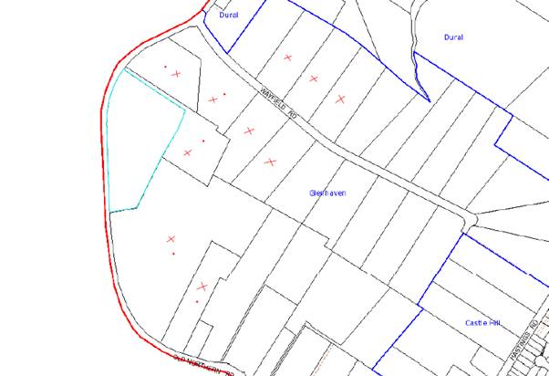
THE SITE
The site has an area of 4,604sqm,
is located on the eastern side of Old Northern Road and falls to the street.
The site contains an existing retail plant nursery, “Flower Power”, including a
shop and ancillary café, substantial outdoor display areas, storage sheds, car
parking and landscaping.
The area of the site for the
proposed facility is located at the northern boundary, adjacent to the access
handle servicing 613 Old Northern Road and is 125 metres from Old Northern Road. The area is currently used for the storage of goods in relation to the
retail plant nursery. There is no significant vegetation present on site.
THE PROPOSAL
The application proposes the
erection of a telecommunications facility, being a mobile phone tower.
The tower consists of a 30 metre
high pole, with 3 antennae extending 2.5 metres above the pole, and a 600 mm
dish attached to the pole at a 25 metre height. An equipment shed measuring 3
metres x 2.5 metres would be located adjacent to the pole, enclosed within a 3
metre high metal fence. Sub-terrain cabling including fibre-optics and mains
would connect to a pit located on the western side of the site.
In relation to the predominant use
of the site as a retail plant nursery, ‘Flower Power’, the tower would be
located adjacent to the storage and pick up point for landscape supplies.
Parking is available on site to accommodate employees for intermittent
maintenance works.
ASSESSMENT
The development
application has been assessed having regard to the ‘Metropolitan Plan for Sydney 2036’, the ‘North Subregion (Draft) Subregional Strategy’ and the matters
for consideration prescribed under Section 79C of the Environmental Planning
and Assessment Act 1979 (the Act). The following issues have been
identified for further consideration.
1. STRATEGIC CONTEXT
1.1 Metropolitan Plan for Sydney 2036 and (Draft) North
Subregional Strategy
The Metropolitan Plan for Sydney 2036 is a broad framework to secure Sydney’s place in the global economy by
promoting and managing growth. It outlines a vision for Sydney to 2036; the
challenges faced, and the directions to follow to address these challenges and
achieve the vision. The Draft North Subregional Strategy acts as a
framework for Council in its preparation of the Comprehensive LEP by the
end of 2012.
The Draft North Subregional
Strategy sets the following targets for the Hornsby LGA by 2031:
· Employment capacity to
increase by 9,000 jobs; and
· Housing stock to
increase by 11,000 dwellings.
The development would not be
inconsistent with the Strategy and would provide improved communications
facilities for an increase in population.
2. STATUTORY CONTROLS
Section 79C(1)(a) requires
Council to consider “any relevant environmental planning instruments, draft
environmental planning instruments, development control plans, planning
agreements and regulations”.
2.1. Telecommunications Act 1997
Under Division 3
of Part 1 of Schedule 3 of the Telecommunications Act 1997 a carrier has
the right to install a telecommunications facility for purposes connected with
the supply of a carriage service if:
(i) the carrier is authorised to do so by a
facility installation permit.
(ii) the facility is a low impact facility.
(iii) the facility is a temporary facility for
use by a defence organisation for defence purposes.
(iv) the facility is installed before 1 July
2000 for the sole purpose of connecting a building, structure, caravan or
mobile home to a line that forms part of a telecommunications network that was
in existence on 30 June 1997.
The proposal
does not fall within the exempt provisions of Schedule 3 of the Act and
therefore, relevant State legislation applies. Council is the consent authority
for the proposal.
2.2 Hornsby Shire Local Environmental Plan 1994
The subject land is zoned Rural
BA (Small Holdings – Agricultural Landscapes) under the Hornsby Shire Local
Environmental Plan 1994 (HSLEP). The objectives of the Rural BA zone
are:
(a) to restrain population growth,
maintain the rural character of the area and ensure that existing or
potentially productive agricultural land is preserved.
(b) to promote agricultural use of
land and provide for a range of compatible land uses which maintain the
agricultural and rural environment of the area.
(c) to ensure development is carried
out in a manner that improves the environmental qualities, and is within the
servicing capacity, of the area.
The proposed development is
defined as a ‘communications facility’ under the HSLEP and is
permissible in the zone with Council’s consent.
2.3 State Environmental Planning
Policy (Infrastructure) 2007
The Infrastructure
SEPP contains provisions that allow telecommunications infrastructure
providers to be either exempt or complying development for a range of
telecommunications facilities, subject to criteria including health and amenity
considerations.
As the proposal
involves the construction of a new telecommunications tower on land zoned Rural
BA (Small Holdings – Agricultural Landscapes) the communications facility
requires development consent under Part 4 of the Environmental Planning and
Assessment Act 1979.
Proposal for
communications facilities are required to be prepared - consideration of the
principles contained within the NSW Telecommunications Facilities Guideline
including Broadband. These principles address design and minimising visual
impact, attempting where possible co-location with existing facilities, health
standards with regards to EME and maximising compliance with relevant policies.
The proposed
development satisfies the principles of the Guideline through a site
selection process, utilising modern design elements and demonstrating
compliance with the EME standards established by the Australian Communications
and Media Authority. Non-compliance with Council’s setback controls is
addressed within the report and considered acceptable.
2.4 Sydney Regional Environmental
Plan No. 20 – Hawkesbury and Nepean Rivers
Sydney
Regional Environmental Plan No. 20 contains general
planning considerations and strategies to be considered by the consent
authority as to the impacts of development on the scenic quality of the area,
water quality, aquaculture, recreation and tourism.
The proposed
development would not impact upon the health or use of the catchment. Subject
to a recommended condition of consent relating to sediment and erosion control
measures being implemented and maintained, the proposed development would be
consistent with the objectives of the Sydney Regional Environmental Plan No.
20.
2.5 Rural Lands Development Control
Plan (DCP)
The DCP
implements the objectives of the rural zones in regulating development to
enhance agricultural productivity, and protect the rural landscape. It provides
guidance for achieving strategic economic, social and environmental outcomes,
as well as controls for general and specific development types for the rural
zones.
The development
involves the erection of a telecommunications tower, improving services for the
rural community of the area. The development is consistent with the desirable
economic and social outcomes for the area by improving connectivity.
The DCP does not
include specific controls for communications facilities.
2.5.1 Setbacks
The DCP requires
development to maintain a minimum setback of 15 metres from all property
boundaries. The tower and ancillary infrastructure would be located 1.3 metres
from the northern boundary.
The objective of
the element is to complement the rural character and maintain the privacy of
adjoining properties. The applicant provided the following statement justifying
the location of the proposed tower on the site, as opposed to the location
approved for the Telstra tower in 1996:
“Optus understand that Telstra lodged, and had
approved, a DA for a similar telecommunications facility in 1995 (sic). The
location of Telstra’s proposed facility differs to that of Optus’ current
proposal here. It is noted that the Telstra proposal was on the ‘eastern’
boundary of the property, approximately 150m from the proposed Optus site.
Optus investigated a number of locations on the Flower Power lot, and the final
location proposed here by Optus was the site that was agreed upon by the
landowner, and taking into account the many considerations of Optus (and the
landowner). It is felt that the Telstra location provided a much higher degree
of visual intrusiveness in the area, and would be viewed as a standalone
vertical element, whereas the proposed Optus location is viewed against natural
screening. It is noted, also, that the proposed Telstra location was further
distanced from a residential dwelling; however, Optus has taken into account
all factors when considering the siting of a telecommunications facility and
concludes that the proposed location is the most suitable on the lot.”
The numerical
setback controls aim to ensure that the built form does not detract from the
character of the area. The proposed tower and ancillary structures would be
setback 125 metres from Old Northern Road with the lower half screened by
existing vegetation. The ancillary structures would be in keeping with the
scale of development in relation to the retail plant nursery, and the
residential built form present on the Hills Shire Council side of Old Northern
Road. The variation to the setback control would therefore, not impinge upon
the rural character of the area and is considered acceptable.
3 ENVIRONMENTAL IMPACTS
Section 79C(1)(b) of the Act
requires Council to consider “the likely impacts of that development,
including environmental impacts on both the natural and built environments, and
social and economic impacts in the locality”.
3.1 Natural Environment
The site is
primarily developed for a retail plant nursery. The proposed development has a
minimal building footprint and would not impact on the natural environment.
3.2 Built Environment
3.2.1 Visual Impact
Council received
several objections concerned with the visual impact of the development on the
area. While the 30 metre tower would protrude above established building and
tree heights, and be situated at the high point of the site (RL 197.32), it
would not adversely impact upon vistas and would form a minor visual element in
the context of the surrounding environment. Mature vegetation within the site
and adjacent to the site boundaries would obscure the base of the tower. The
presence of power poles and transmission lines at the Glenhaven Road and Old Northern Road intersection would lessen the visual impact of the proposed tower on this
view corridor. The applicant states that the proposal represents “a
development within a lot that has existing bulk and scale (in the form of
[Flower Power]) and provides a setback site is considered to be the most
appropriate location for Optus’ proposed facility.”
The applicant
also submits that the proposal utilises the best available technology to
minimise the scale of the tower and antennae whilst maximising utility: “the
use of the turret headframe to mount the antennas rather than a bulky
triangular frame” contributes to mitigating the visual impact of the
development.
The design of
the proposal therefore, would minimise the visual impact on the area.
3.2.1.1 Legal Decisions
The Land and Environment Court developed a set of planning principles to assess the impact of development
on adjoining properties following the decision in Pafburn v North Sydney Council. The proposed development is discussed in relation to these
principles as follows:
1. How does the impact change the amenity
of the affected property(ies)? How much sunlight, view or privacy is lost as
well as how much is retained?
Maintaining
views is the primary amenity issue regarding the development. The closest
dwelling, at 615 Old Northern Road, would be approximately 40 metres from the
tower which would be visible from the dwelling. The design of the tower
utilises the best available technology, and is situated so as to minimise its
impact on the landscape. There are no significant views from the adjoining
dwellings in the direction of the proposed tower, and as such, the impact of
the proposal on the amenity of the area with regards to impact on views has
been minimised.
2. How necessary and/or reasonable is the
proposal causing the impact?
The proposed
development would improve mobile phone coverage for the area and is therefore,
considered reasonable.
3. How vulnerable to the impact is the
property receiving the impact? Would it require the loss of reasonable
development potential to avoid the impact?
The proposed
development would not restrict the development potential of adjoining
properties.
4. Does the impact arise out of poor
design? Could the same amount of floor space and amenity be achieved for the
proponent while reducing the impact on neighbours?
The use of the
turret headframe to mount the antennas rather than a bulky triangular frame
contributes to mitigating the visual impact of the development. The siting of
the tower is optimum for achieving coverage and minimising amenity impacts on
the area.
5. Does the proposal comply with the
planning controls? If not, how much of the impact is due to the non-complying
elements of the proposal?
Non-compliance
with the setback controls is considered acceptable as the scale and siting of
the tower does not detriment the rural character of the area. The proposed
tower is an important piece of infrastructure that strikes a balance between
responding to demand for services and minimising impacts on the visual amenity
of the area.
As such, the
impact of the development is considered acceptable.
3.2.2 Acoustics
Acoustic impacts
have been addressed within the Statement of Environmental Impacts as follows:
“The only noise emitted by the facility would be associated with a
small air conditioning unit located within the proposed Optus shelter, which
would produce a sound level similar to that of domestic air conditioners. Due
to the location of the proposed facility, it is not expected that the noise
generated by the facility would impact on the surrounding properties.”
Appropriately
worded conditions are recommended in Schedule 1 to mitigate potential noise
impacts.
3.2.3 Access
The proposed
development would be situated within the ‘Flower Power’ retail garden nursery
adjacent to a stock yard. Vehicular access is provided via Old Northern Road,
and there is sufficient parking on site to accommodate employees during
construction and maintenance.
It is considered
that access to the site is satisfactory.
3.3 Social Impacts
The proposed
telecommunication facility has given rise to an increased community concern
regarding public safety. The matters for concern
regarding the proposed development are addressed below.
3.3.1 Health Impact - Electromagnetic Radiation
The proposed facility
involves the generation of electromagnetic energy. Several submissions raise
concerns regarding electromagnetic energy emitted from the proposed
development.
Telecommunication
carriers must adhere to Commonwealth Legislation and Regulation that is
administered by the Australian Communications and Media Authority (ACMA). In
2003, ACMA adopted the Radio Communications (Electromagnetic Radiation -
Human Exposure) Standard 2003 which relates to continuous exposure of the
general public to radio frequency electromagnetic energy (RF EME) from mobile
phone stations.
This technical
standard was prepared by the Australian Radiation Protection and Nuclear Safety
Agency (ARPANSA) and is the same as that recommended by the International
Commission for Non-Ionising Radiation Protection (ICNIRP), an agency associated
with the World Health Organisation. The Standard operates by placing a limit
on the strength of the signal (or RF EME) that operators can transmit to, and
from, any network base station. The Standard has a significant safety margin,
or precautionary approach built into it.
To demonstrate
compliance with the Standard, the applicant has provided a report which
predicts the EME from the proposed facility. The report concludes that the
maximum EME level would be 0.096% of the ACMA mandated exposure limit using the
predictive report methodology.
The report also
includes measures at sensitive sites in the vicinity of the proposed
development. The predicted EME exposure at the closest residential property,
being 615 Old Northern Road, is 0.0036% of the ACMA mandated exposure limit.
The Kindalin Childcare Centre located at 1 Glenhaven Road would experience an
exposure level 0.017% of the ACMA mandated exposure limit, and the Veterinary Hospital located at 442 Old Northern Road would experience an exposure level
0.039% of the ACMA mandated exposure limit.
These are
considered to be low, noting that carriers are permitted to operate base
stations with EME levels up to 100% of the ACMA standard. Based on the
information submitted, the predicted EME exposure falls well within acceptable
levels. Appropriately worded conditions are recommended within Schedule 1 to
ensure that EME are restrained to levels prescribed by the relevant agencies.
Several submissions
objecting to the development comment that the application of the precautionary
principle should justify refusal of the application. The precautionary
principle was applied in the case of Telstra v Hornsby to determine the
suitability of a site for a mobile phone tower where the health impacts on the
surrounding population were uncertain. In his determination, CJ Preston
concluded that the risk of adverse health impacts as a result of EME has been
addressed in the preparation of the standards developed by ARPANSA, and adopted
by the ACMA. The precautionary principle is therefore applied in the
implementation of the Standard.
3.4 Economic Impacts
Submissions
raise concerns regarding the devaluation of properties due to the development.
However, this is not a matter for consideration under the provisions of Section
79C of the Act.
The development
would contribute positively to the local economy by improving
telecommunications connectivity.
4. SITE SUITABILITY
Section 79C(1)(c) of the Act
requires Council to consider “the suitability of the site for the
development”.
4.1 Site
Selection
The applicant
provided a summary discussion on potential sites for the proposed development.
Four sites were discounted due to their proximity to schools and insufficient
radiofrequency transmission as a result of terrain and distance. Furthermore,
the applicant states that “the selection of the site has taken into account
all the issues that Section 5.1 of the ACIF Code requires”.
At the proposed
location, the proposed facility would not cause any significant adverse impact
to the amenity of residents in the immediate area and would not provide any
significant visual impact. Given that the location of the facility would be
partially screened by existing trees and the Flower Power buildings, the
proposed facility is appropriately located.
The applicant
has demonstrated that the site is the most suitable to minimise impacts on the
surrounding area.
5. PUBLIC PARTICIPATION
Section 79C(1)(d) of the Act
requires Council to consider “any submissions made in accordance with this
Act”.
5.1 Community Consultation
The proposed development was
placed on public exhibition and was notified to adjoining and nearby landowners
between 15 November 2011 and 6 December 2011 in accordance with Council’s Notification
and Exhibition Development Control Plan. During this period, Council
received 35 submissions and 1 petition. The map below illustrates the location
of landowners who made a submission and are in close proximity to the development
site.
|
NOTIFICATION
PLAN
|
|
|
• PROPERTIES NOTIFIED
|
X SUBMISSIONS
RECEIVED
|

PROPERTY SUBJECT OF DEVELOPMENT
|

|
|
15 SUBMISSIONS RECEIVED OUT OF MAP RANGE
|
|
|
|
|
Council received
35 submissions and 1 petition containing 97 signatures objecting to the
proposal generally on the following grounds:
· The health impacts from mobile phone towers are uncertain,
particularly on young people. The development should not be approved until
there is consensus on the evidence.
· Council and the applicant have not undertaken sufficient community
consultation.
· Due diligence has not been afforded in consideration of the health
impacts on sensitive land uses within the vicinity of the proposed development,
being the childcare, veterinary hospital, nursing homes and residential areas.
The highest predicted readings occur at the childcare centre.
· There are no provisions to monitor the EME, and for Council to
decommission the tower should the stated levels be exceeded.
· The development would have an adverse impact on property values
within the area.
· The visual amenity of the area would be affected.
· The proposal has not taken into consideration other locations.
· The current quality of mobile coverage is sufficient to render the
proposal unnecessary.
The merits of
the matters raised in community submissions have been addressed in the body of
the report .
6. THE PUBLIC INTEREST
Section 79C(1)(e) of the Act
requires Council to consider “the public interest”.
The public interest is an overarching
requirement, which includes the consideration of the matters discussed in this
report. Implicit to the public interest is the achievement of future built
outcomes adequately responding to and respecting the future desired outcomes
expressed in environmental planning instruments and development control plans.
The application is considered to
have satisfactorily addressed Council’s and relevant agencies’ criteria and
would provide a development outcome that, on balance, would result in a positive
impact for the community. Accordingly, it is considered that the approval of
the proposed telecommunications tower would be in the public interest.
CONCLUSION
The application
proposes the erection of a mobile phone tower, cabling and a shed for the storage
of equipment.
The application
has been assessed in accordance with the relevant provisions under the
Telecommunications Act 1997, Hornsby Shire Local Environmental Plan 1994 and
the Rural Lands DCP and is considered acceptable.
The proposed EME
levels are substantially below the prescribed standard set by the ACMA. The
concerns raised within the submissions have been addressed within the report
and conditions of consent are recommended to maintain the amenity of the area.
Having regard to
the circumstances of the case, approval of the application is recommended.
Note: At the time of the completion of this planning report, no
persons have made a Political Donations Disclosure Statement pursuant to
Section 147 of the Environmental Planning and Assessment Act 1979 in
respect of the subject planning application.
|
Garry Mahony
Acting Manager -
Assessment Team 2
Planning Division
|
James Farrington
Acting Executive
Manager - Planning
Planning Division
|
Attachments:
|
1.View
|
Locality Plan
|
|
|
|
2.View
|
Overall Site Plan
|
|
|
|
3.View
|
Site Layout and
Setout Plan
|
|
|
|
4.View
|
Elevations
|
|
|
File Reference: DA/1167/2011
Document Number: D01835807
SCHEDULE 1
GENERAL
CONDITIONS
The conditions of consent within this notice of
determination have been applied to ensure that the use of the land and/or
building is carried out in such a manner that is consistent with the aims and
objectives of the relevant legislation, planning instruments and Council
policies affecting the land and does not disrupt the amenity of the neighbourhood
or impact upon the environment.
Note: For the
purpose of this consent, the term ‘applicant’ means any person who has the
authority to act on or the benefit of the development consent.
Note: For the purpose of
this consent, any reference to an Act, Regulation, Australian Standard or
publication by a public authority shall be taken to mean the gazetted Act or
Regulation, or adopted Australian Standard or publication as in force on the
date that the application for a construction certificate is made.
1. Approved
Plans and Supporting Documentation
The development must be carried out in accordance with the plans and
documentation listed below and endorsed with Council’s stamp, except where
amended by Council and/or other conditions of this consent:
|
Plan No.
|
Drawn by
|
Dated
|
|
S8697-G2 Overall Site Plan
|
Aurecon
|
10.10.11
|
|
S8697-G3 Site Layout and Setout Plan
|
Aurecon
|
10.10.11
|
|
S8697-G4 Site Elevation
|
Aurecon
|
10.10.11
|
|
Document No.
|
Prepared by
|
Dated
|
|
Summary of Estimated RF EME
Levels NSA Site No (2156011)
|
‘yes’ Optus
|
21.10.11
|
REQUIREMENTS PRIOR TO THE ISSUE OF A CONSTRUCTION
CERTIFICATE
2. Building
Code of Australia
All building work must be carried out in accordance with the
requirements of the Building Code of Australia.
REQUIREMENTS PRIOR TO THE COMMENCEMENT OF ANY WORKS
3. Erection
of Construction Sign
A sign must be erected in a prominent position on any site on which
building work, subdivision work or demolition work is being carried out:
a. Showing the name, address and
telephone number of the principal certifying authority for the work,
b. Showing the name of the principal
contractor (if any) for any demolition or building work and a telephone number
on which that person may be contacted outside working hours, and
c. Stating that unauthorised entry
to the work site is prohibited.
Note: Any
such sign is to be maintained while the building work, subdivision work or
demolition work is being carried out, but must be removed when the work has
been completed.
4. Protection
of Adjoining Areas
A temporary hoarding, fence or awning must be erected between the
work site and adjoining lands before the works begin and must be kept in place
until after the completion of the works if the works:
a. Could cause a danger, obstruction
or inconvenience to pedestrian or vehicular traffic.
b. Could cause damage to adjoining
lands by falling objects.
c. Involve the enclosure of a public
place or part of a public place.
Note: Notwithstanding
the above, Council’s separate written approval is required prior to the
erection of any structure or other obstruction on public land.
5. Erosion
and Sediment Control
Erosion and sediment control measures must be provided and
maintained throughout the construction period in accordance with the manual ‘Soils
and Construction 2004 (Bluebook)’, the approved plans, Council
specifications and to the satisfaction of the principal certifying authority.
The erosion and sediment control devices must remain in place until the site
has been stabilised and revegetated.
Note: On
the spot penalties up to $1,500 may be issued for any non-compliance with this
requirement without any further notification or warning.
REQUIREMENTS DURING CONSTRUCTION
6. Construction
Work Hours
All work on site (including demolition and earth
works) must only occur between 7am and 5pm Monday to Saturday.
No work is to be undertaken on Sundays or public
holidays.
7. Environmental
Management
The site must be managed in accordance with the publication ‘Managing
Urban Stormwater – Landcom (March 2004) and the Protection of the
Environment Operations Act 1997 by way of implementing appropriate measures
to prevent sediment run-off, excessive dust, noise or odour emanating from the
site during the construction of the development.
8. Council
Property
During construction works, no building
materials, waste, machinery or related matter is to be stored on the road or
footpath. The public reserve is to be kept in a clean, tidy and safe condition
at all times.
9. Excavated
Material
All excavated material removed from the site must be classified in
accordance with the NSW Environment Protection Authority’s Environmental
Guidelines – Assessment, Classification and Management of Liquid and Non-Liquid
Wastes prior to disposal to an approved waste management facility and
reported to the principal certifying authority.
REQUIREMENTS PRIOR TO THE ISSUE OF AN OCCUPATION
CERTIFICATE
Note: For
the purpose of this consent, any reference to ‘occupation certificate’ shall
also be taken to mean ‘interim occupation certificate’ unless otherwise stated.
10. Damage
to Council Assets
Any damage caused to Council’s assets as a result of the
construction of the development must be rectified in accordance with Council’s
written requirements and at the sole cost of the applicant.
11. External
Lighting
All external lighting must be designed and installed in accordance
with Australian Standard AS 4282 – Control of the Obtrusive Effects of
Outdoor Lighting. Certification of compliance with the Standard must be
obtained from a suitably qualified person.
12. Noise
– Plant and Machinery
The level of total
continuous noise emanating from operation of all the plant, including air
conditioning units and processes in all buildings (LA10) (measured for at least
15 minutes) in or on the above premises, must not exceed the background
level by more than 5dB(A) when measured at all property boundaries.
13. Site
Compliance Certificate
A Site Compliance Certificate issued by a NATA accredited service is
to be submitted to Council for the site at 609 Old
Northern Road, Glenhaven NSW 2156 – Lot 476 DP 752053
confirming the operating EME levels, within one month of the commencement of
the operation of the facility. The site is to be assessed and found to comply
with the Australian Radiation Protection and Nuclear Safety Agency (ARPANSA)’s
Radiation Protection Standards and the RF Human Exposure Limits as specified by
the Australian Communications and Media Authority (ACMA).
14. Telecommunications
Facility
The
telecommunications facility on the site must be operated in compliance with,
but not limited to:
a. Australian Radiation Protection and Nuclear
Safety Agency’s (ARPANSA) ‘Radiation Protection Standard for Maximum
Exposure Levels to Radiofrequency Fields – 3kHz to 300 GHz’, (2002).
b. The Australian Communication Industry Forum
Code (ACIF), Industry Code C564:2004, Deployment of Mobile Phone Network
Infrastructure, (2002).
c. The Australian Communications Authority
(ACA), Radiocommunications (Electromagnetic Radiation – Human Exposure)
Standard, (2003).
- END OF CONDITIONS -
ADVISORY NOTES
The following information is
provided for your assistance to ensure compliance with the Environmental
Planning and Assessment Act 1979, Environmental Planning and Assessment
Regulation 2000, other relevant legislation and Council’s policies and
specifications. This information does not form part of the conditions of
development consent pursuant to Section 80A of the Act.
Environmental
Planning and Assessment Act, 1979 Requirements
The Act, 1979
requires:
· The issue
of a construction certificate prior to the commencement of any works. Enquiries
regarding the issue of a construction certificate can be made to Council’s
Customer Services Branch on 9847 6760.
· A
principal certifying authority to be nominated and Council notified of that
appointment prior to the commencement of any works.
· Council
to be given at least two days written notice prior to the commencement of any
works.
· Mandatory
inspections of nominated stages of the construction inspected.
· An
occupation certificate to be issued before occupying any building or commencing
the use of the land.
Dial Before
You Dig
Prior to
commencing any works, the applicant is encouraged to contact Dial Before You
Dig on 1100 or www.dialbeforeyoudig.com.au
for free information on potential underground pipes and cables within the
vicinity of the development site.
Planning Report No. PLN13/12
Date of Meeting:
1/02/2012
2 ALTERATIONS
AND ADDITIONS TO EXISTING DWELLING WITHIN A CLUSTER HOUSING DEVELOPMENT - 6
BLAMEY WAY CHERRYBROOK
|
Development Application No:
|
DA/1026/2011
|
|
Description of Proposal:
|
Alterations and additions to existing dwelling-house
within a cluster housing development
|
|
Property Description:
|
Lot 24 DP 858122, 6 Blamey Way Cherrybrook
|
|
Applicant:
|
V.R. Drafting & Design
|
|
Owner:
|
Choice Pc Pty Ltd
|
|
Statutory Provisions:
|
Hornsby Shire Local Environmental
Plan 1994
Residential A (Low Density)
|
|
Estimated Value:
|
$49, 500
|
|
Ward:
|
B
|
|
RECOMMENDATION
THAT Development Application
No. 1026/2011 for alterations and additions to an existing dwelling-house at
Lot 24 DP 858122, No. 6 Blamey Way, Cherrybrook be approved subject to the
conditions of consent detailed in Schedule 1 of this report.
|
1. The
application proposes alterations and additions to an existing dwelling-house
within a cluster housing development.
2. The
proposed alterations and additions exceed the floor space ratio development
standard under Hornsby Shire Local Environmental Plan 1994 by 37%. The
non-compliance is the subject of an objection under State Environmental
Planning Policy No. 1 – Development Standards. The objection is considered
well founded and is supported.
3. No submissions
have been received in respect of the application.
4. It is
recommended that the application be approved.
HISTORY OF THE SITE
The existing dwelling-house forms
part of a cluster housing development that was approved by Council under State
Environmental Planning Policy No. 25 – Residential Allotment Sizes, on 24
October 1994 (DA/272/1994). The development comprises semi-detached dwellings
on Torrens title allotments ranging in size from 240m2 to 756m2.
THE SITE
The site has an area of 367.1m2,
forms part of a cluster housing development and is located on the northern side
of Blamey Way. A two storey, semi-detached dwelling-house is sited on the
land. A portion of a right of way is over part of the frontage. The site has
a 9% fall to the frontage.
The cluster housing development
comprises of 57 dwellings and is in proximity to New Line Road to the south and
Cherrybrook Technology High School to the north.
THE PROPOSAL
This application proposes
alterations and additions comprising of a rumpus room, guest bedroom, bathroom
and toilet to the ground floor at the north eastern elevation of the existing
multi-unit housing dwelling. The proposal increases the floor area from 134 m2
to 177 m2.
ASSESSMENT
The development application has
been assessed having regard to the ‘Metropolitan Plan for Sydney 2036’,
the ‘North Subregion (Draft) Subregional Strategy’ and the matters for
consideration prescribed under Section 79C of the Environmental Planning and
Assessment Act 1979 (the Act). The following issues have been identified
for further consideration.
1. STRATEGIC CONTEXT
1.1 Metropolitan Plan
for Sydney 2036 and (Draft) North Subregional Strategy
The Metropolitan Plan for Sydney 2036 is a broad framework to secure Sydney’s place in the global economy by
promoting and managing growth. It outlines a vision for Sydney to 2036; the challenges
faced, and the directions to follow to address these challenges and achieve the
vision. The Draft North Subregional Strategy acts as a framework for
Council in its preparation of the Comprehensive LEP by the end of 2012.
The Draft North Subregional
Strategy sets the following targets for the Hornsby LGA by 2031:
· Employment capacity to
increase by 9,000 jobs; and
· Housing stock to
increase by 11,000 dwellings.
The proposed development would be
consistent with the Metropolitan Plan for Sydney 2036.
2. STATUTORY CONTROLS
Section 79C(1)(a) requires
Council to consider “any relevant environmental planning instruments, draft
environmental planning instruments, development control plans, planning
agreements and regulations”.
2.1 Hornsby Shire Local
Environmental Plan 1994
The subject land is zoned
Residential A (Low Density) under Hornsby Shire Local Environmental Plan
1994 (HSLEP). The objectives of the zone are:
(a) to
provide for the housing needs of the population of the Hornsby area.
(b) to
promote a variety of housing types and other land uses compatible with a low
density residential environment.
(c) to
provide for development that is within the environmental capacity of a low
density residential environment.
The proposed development is
defined as “dwelling-house” under the HSLEP and is permissible in the
zone with Council’s consent.
Clause 15 of the HSLEP
prescribes that the maximum floor space ratio (FSR) of development within the
Low Density Residential zone is 0.4:1. The proposed development has an FSR of
0.55:1 in non-compliance with this standard. To address this matter, the
applicant submitted an objection to the standard under State Environmental
Planning Policy No. 1 – Development Standards. Refer to discussion in
Section 2.2.
Clause 18 of the HSLEP
sets out heritage conservation provisions within Hornsby Shire. Clause 18 is
not applicable to this application as the subject property is not located
within a Heritage Conservation Area and does not adjoin a heritage item.
2.2 State Environmental
Planning Policy No. 1 – Development Standards
The application has been assessed
against the requirements of State Environmental Planning Policy No. 1 –
Development Standards (SEPP 1). This policy provides flexibility in the
application of development standards in circumstances where strict compliance
with those standards would be unreasonable or unnecessary or tend to hinder the
attainment of the objectives of the Act.
The Land and Environment Court
has expressed the view that there are five Principles on which an objection may
be well founded and the approval of the objection may be consistent with the
aims of the Policy as follows: -
1. The objectives of the standard are achieved notwithstanding
non-compliance with the standard;
2. The underlying objective or purpose of the standard is not
relevant to the development and therefore compliance is unnecessary;
3. The underlying object of purpose would be defeated or
thwarted if compliance was required and therefore compliance is unreasonable;
4. The development standard has been virtually abandoned or
destroyed by the Council’s own actions in granting consents departing from the
standard and hence compliance with the standard is unnecessary and
unreasonable;
5. The zoning of the particular land is unreasonable or
inappropriate so that a development standard appropriate for that zoning is
also unreasonable and unnecessary, as it applies to the land and compliance
with the standard would be unreasonable and unnecessary. That is, the
particular parcel of land should not have been included in the particular zone.
In regard to whether the objection may be well founded, the applicant (in summary)
submits that:
· The proposed addition will not
affect any neighbouring properties as it will not affect overshadowing,
privacy, noise, height, solar access, or amenity.
· The proposal is only single storey
and will not add bulk and will appear to be in keeping with surrounding
development.
· The established streetscape is
well maintained as the design of the addition is in keeping with the existing
residence with the use of the same building materials and hip roof design.
The matters listed above have
been taken into consideration in assessing the merits of the SEPP 1
objection. The proposed alterations and additions complement the existing cluster
housing development which generally exceeds the residential density provisions
under the HSLEP.
The
applicant’s SEPP 1 submission is supported as the proposed additions
cannot be viewed within the streetscape and comply with other various elements
of the Low Density Multi-Unit Housing DCP, which aim to control the
intensity of development and protect the amenity of adjoining properties. The
proposed development maintains the integrity of the established streetscape and
amenity of adjoining properties.
The
submitted SEPP 1 objection is therefore considered well founded in
respect to the above Principles Nos. 1, 2 and 3.
2.3 Sydney Regional
Environmental Plan No. 20: Hawkesbury – Nepean Rivers
Sydney Regional Environmental
Plan No. 20 aims to protect the environment of the Hawkesbury – Nepean
Rivers system by ensuring that the impacts of future land uses are considered
in a regional context.
The site is
located within the catchment of the Hawkesbury – Nepean Rivers. Part 2 of Sydney
Regional Environmental Plan No. 20 contains general planning considerations
and strategies, and requires Council to consider the impact of any proposal on
water quality, riverine scenic quality, aquaculture, recreation and tourism.
Water quality is
the only relevant issue for the assessment of this proposal and would be
addressed by conditions requiring the implementation of sediment and erosion
control measures. The proposed development would therefore, have negligible
impacts on the water quality of the catchment area.
2.4 State Environmental Planning Policy (Exempt and Complying
Development)
On 27
February 2009, State Environmental Planning Policy (Exempt and Complying
Development Codes) commenced operation. Under the SEPP, the NSW Housing
Code outlines how residential developments, including home extensions and other
ancillary development, can proceed on lots of greater than 200 m2 in
size as complying development with Council or accredited certifier approval.
The SEPP
would be applicable to the existing dwelling as it is a separate Torrens title lot. However, the proposed rear setback does not comply with the setback
provisions. Accordingly, the proposal is subject to a development
application. Notwithstanding the proposal would be
in accordance with the other provisions of the Code.
2.5 Cherrybrook Precinct Development Control Plan
The Cherrybrook Precinct DCP
provides a detailed planning strategy and guidelines for development within the
Cherrybrook Precinct. The Cherrybrook Masterplan ensures that
residential subdivision promotes the garden suburb character of the Cherrybrook
Precinct while the Residential Strategy protects residential amenity through
setback, height and acoustic requirements.
The proposed additions would be
consistent with the objectives of the Cherrybrook DCP and are considered
acceptable.
2.6 Low Density Multi-Unit Housing Development Control Plan
The proposed development has been
assessed having regard to the relevant performance and prescriptive design
measures within Council’s Low Density Multi-Unit Housing Development Control
Plan. The following table sets out the proposal’s compliance with the
prescriptive measures of the DCP.
|
Low Density
Multi-Unit Housing Development Control Plan
|
|
Control
|
Proposal
|
Requirement
|
Compliance
|
|
FSR
|
0.55:1
|
0.4:1
|
No
|
|
Site Cover
|
38%
|
40%
|
Yes
|
|
Height
|
2.4 m
|
3.6 m
|
Yes
|
|
Setbacks
|
|
Front (southern)
|
Unchanged
|
6
m
|
Yes
|
|
Rear (northern)
|
1.13
m
|
3
m
|
No
|
|
Side (west)
|
Unchanged
|
1
m
|
Yes
|
|
Side (east)
|
1.04
m
|
1
m
|
Yes
|
|
Car parking
|
2 spaces
|
2 spaces
|
Yes
|
|
Private Open Space
|
77 m2
|
120 m2
|
No
|
|
Landscaping
|
41%
|
45%
|
No
|
|
Storeys
|
1 storeys
|
2 storeys
|
Yes
|
As detailed in the table above,
the proposal does not comply with the prescriptive measures of the Density, Setbacks,
Landscaping and Private Open Space. These issues are addressed as follows:
2.6.1 Density
The proposal would have a gross
floor area of 177 m2 and a FSR of 0.55:1 which does not comply with
the 0.4:1 development standard of the HSLEP 1994. The proposal is
considered acceptable in this instance as the scale of the existing dwelling is
consistent with the bulk and scale of existing dwellings within the cluster
housing development. The additional floor space would not detract from the
environmental and amenity aspects of the site. Furthermore, the proposal would
not result in the loss of solar access or privacy for adjacent development.
The development forms part of a
cluster housing development approved under State Environmental Planning
Policy No. 25 – Residential Allotment Sizes which provided a maximum
allowable FSR of 0.5:1. The proposal would equate to a 15.8 m2
variation of the 0.5:1 FSR.
The
dwelling-house would provide accommodation that would not detract from the
scale and variety of dwelling-houses in the immediate locality. The non-compliance
with the Low Density Multi-Unit Housing DCP density provisions is
therefore, considered acceptable.
2.6.2 Setbacks
The proposed 1.13 metre
(northern) rear boundary setback does not comply with the 3 metre prescriptive
measure of the Setbacks element. This non-compliance is considered acceptable
in this instance as there would be negligible visual impacts on adjoining
properties. The encroaching structure is single storey in height while the
natural ground level of the adjoining properties to the north, namely Nos. 14
and 16 Forrest Glen, are located above the natural ground level of the subject
property. Accordingly, the proposed development is considered to be low scale
development which does not compromise the amenity of adjacent properties in
respect to visual impact, loss of privacy or overshadowing.
The proposal meets the objectives
of the Setbacks element and is considered acceptable.
2.6.3 Landscaping
The proposed 41% landscaped area
does not comply with the 45% prescriptive measure of the Landscaping element.
The proposal is considered acceptable in this instance as it is a minor
variation to the requirement. Furthermore, the available landscaped area
contributes to the amenity of the dwelling by providing lawn and paved areas
that is consistent with the landscaping of surrounding development. The
proposed landscaped area is suitable to provide private open space to
facilitate active recreation for occupants.
The proposal meets the objectives
of the Landscaping element and is considered acceptable.
2.6.4 Private Open Space
The existing private open space
would be reduced to 77 m2 as a result of the proposed additions
would not comply with the 120 m2 prescriptive measure of the Private
Open Space element. This non-compliance is considered acceptable in this
instance as there is adequate usable private open space to accommodate both
outdoor recreation activities as well as providing space for service functions
such as storage or clothes drying.
The private open space would be
usable and complement the amenity of the development as it would receive
adequate solar access due to its northerly aspect and it is directly accessible
from the active living areas of the dwelling.
The proposal meets the objectives
of the Private Open Space element and is considered acceptable.
2.6.5 Design
The design of the proposed
addition is consistent with the existing dwelling and surrounding residential
development. There is no landform modification proposed and there is
sufficient articulation incorporated in the design to avoid monotonous and
symmetrical development.
The proposal meets the objectives
of the Design element and is considered acceptable.
3. ENVIRONMENTAL
IMPACTS
Section 79C(1)(b) of the Act
requires Council to consider “the likely impacts of that development,
including environmental impacts on both the natural and built environments, and
social and economic impacts in the locality”.
3.1 Natural Environment
The site does not contain any
significant vegetation. The proposal does not require the removal of any trees
and would have negligible impacts on the surrounding natural environment.
3.2 Built Environment
The proposal would complement the
established built form of the existing cluster housing development.
3.3 Social and Economic
Impacts
There are no anticipated adverse
social or economic impacts resulting from the proposed development.
4. SITE SUITABILITY
Section 79C(1)(c) of the Act
requires Council to consider “the suitability of the site for the development”.
The subject site has not been
identified as bushfire prone, flood prone or environmentally sensitive lands.
The site is considered to be capable of accommodating the proposed
development. The scale of the proposed development is consistent with the
capability of the site and is considered acceptable.
5. PUBLIC
PARTICIPATION
Section 79C(1)(d) of the Act
requires Council to consider “any submissions made in accordance with this
Act”.
5.1 Community Consultation
The proposed development was placed
on public exhibition and was notified to adjoining and nearby landowners
between 13 October 2011 and 10 November 2011 in accordance with Council’s Notification
and Exhibition Development Control Plan. Council received no submissions.
6. THE PUBLIC INTEREST
Section 79C(1)(e) of the Act
requires Council to consider “the public interest”.
The public interest is an
overarching requirement, which includes the consideration of the matters
discussed in this report. Implicit to the public interest is the achievement
of future built outcomes adequately responding to and respecting the future
desired outcomes expressed in environmental planning instruments and
development control plans.
The application is considered to
have satisfactorily addressed Council’s and relevant agencies’ criteria and
would provide a development outcome that, on balance, would result in a
positive impact for the community. Accordingly, it is considered that the
approval of the proposed alterations and additions to the existing dwelling
would be in the public interest.
CONCLUSION
The application proposes
alterations and additions to existing dwelling-house within a cluster housing
development.
The proposal does not comply with
the 0.4:1 floor space ratio development standard contained in the HSLEP. The
application has been supported by an objection under State Environmental
Planning Policy No. 1 – Development Standards for a variation to this
development standard.
The existing dwelling forms part
of a cluster housing development under State Environmental Planning No. 25 –
Residential Allotment Sizes which permitted a maximum 0.5:1 FSR.
The proposal would equate to a
15.8m2 variation on the original permissible FSR and would generally
be consistent with the scale of dwellings within the existing cluster housing
development. The submitted SEPP 1 objection is considered well founded with
regard to the principles established by the Land and Environment Court.
No submissions have been received
in respect of the application.
It is recommended
that the application be approved.
Note: At the time of the
completion of this planning report, no persons have made a Political
Donations Disclosure Statement pursuant to Section 147 of the Environmental
Planning and Assessment Act 1979 in respect of the subject planning
application.
|
Garry Mahony
Acting Manager,
Assessment Team 2
Planning Division
|
James Farrington
Acting Executive
Manager
Planning Division
|
Attachments:
|
1.View
|
Locality Plan
|
|
|
|
2.View
|
Site Plan
|
|
|
|
3.View
|
Survey Plan
|
|
|
|
4.View
|
Existing Floor
Plan
|
|
|
|
5.View
|
Proposed Floor
Plan
|
|
|
|
6.View
|
Elevations
|
|
|
|
7.View
|
Elevations and
Sections
|
|
|
File Reference: DA/1026/2011
Document Number: D01818870
SCHEDULE
1
GENERAL CONDITIONS
The conditions of consent within this notice
of determination have been applied to ensure that the use of the land and/or
building is carried out in such a manner that is consistent with the aims and
objectives of the relevant legislation, planning instruments and Council
policies affecting the land and does not disrupt the amenity of the
neighbourhood or impact upon the environment.
Note: For
the purpose of this consent, the term ‘applicant’ means any person who has the
authority to act on or the benefit of the development consent.
Note:
For the purpose of this consent, any reference to an Act, Regulation,
Australian Standard or publication by a public authority shall be taken to mean
the gazetted Act or Regulation, or adopted Australian Standard or publication
as in force on the date that the application for a construction certificate is
made.
1. Approved
Plans and Supporting Documentation
The
development must be carried out in accordance with the plans and documentation
listed below and endorsed with Council’s stamp, except where amended by Council
and/or other conditions of this consent:
|
Plan
No.
|
Drawn
by
|
Dated
|
|
4236A3
Sheet 1-6 of 6
|
V &
R Design
|
23 June
2011
|
|
12421
|
Hammond
Smeallie & Co Pty Ltd
|
28 March
2011
|
2. Use
of Materials
The finished surface
materials, including colours and textures of the building and hard paved areas,
must blend with the surrounding environment and must be non-glare.
REQUIREMENTS PRIOR TO THE
ISSUE OF A CONSTRUCTION CERTIFICATE
3. Building
Code of Australia
All building work must be
carried out in accordance with the requirements of the Building Code of
Australia.
4. Contract
of Insurance (Residential Building Work)
In the case of residential building
work for which the Home Building Act, 1989 requires there to be a
contract of insurance in force in accordance with Part 6 of that Act, that such
a contract of insurance is in force before any building work authorised to be
carried out by the consent commences.
Note: This condition does not apply to the
extent to which an exemption is in force under Clause 187 or 188 of the Act,
subject to the terms of any condition or requirement referred to in Clause
187(6) or 188(4) of the Act, or to the erection of a temporary building.
5. Notification
of Home Building Act, 1989 Requirements
Residential
building work within the meaning of the Home Building Act,
1989 must not be carried out unless the principal certifying authority for
the development to which the work relates (not being Council) has given Council
written notice of the following information:
a. In
the case of work for which a principal contractor is required to be appointed:
i. The
name and licence number of the principal contractor.
ii. The
name of the insurer by which the work is insured under Part 6 of that Act.
b. In
the case of work to be done by an owner-builder:
i. The
name of the owner-builder.
ii. If
the owner-builder is required to hold an owner-builder’s permit under that Act,
the number of the owner-builder’s permit.
Note: If
arrangements for doing the residential building work are changed while the work
is in progress so that the information notified becomes out of date, further
work must not be carried out unless the principal certifying authority for the
development to which the work relates (not being Council) has given Council
written notification of the updated information.
6. Sydney Water –
Quick Check
The
application must be submitted to a Sydney Water ‘Quick Check Agent’ or
‘Customer Centre’ for approval to determine whether the development will affect
any Sydney Water infrastructure, and whether further requirements are to
be met.
Note: Refer
to www.sydneywater.com.au or
telephone 13 20 92 for assistance.
REQUIREMENTS PRIOR TO THE COMMENCEMENT OF ANY WORKS
7. Erection of
Construction Sign
A sign must be erected in a
prominent position on any site on which building work, subdivision work or
demolition work is being carried out:
a. Showing
the name, address and telephone number of the principal certifying authority
for the work,
b. Showing
the name of the principal contractor (if any) for any demolition or building
work and a telephone number on which that person may be contacted outside
working hours, and
c. Stating
that unauthorised entry to the work site is prohibited.
Note: Any
such sign is to be maintained while the building work, subdivision work or
demolition work is being carried out, but must be removed when the work has
been completed.
8. Erosion
and Sediment Control
Erosion and
sediment control measures must be provided and maintained throughout the
construction period in accordance with the manual ‘Soils and Construction
2004 (Bluebook)’, the approved plans, Council specifications and to the
satisfaction of the principal certifying authority. The erosion and sediment
control devices must remain in place until the site has been stabilised and
revegetated.
Note: On
the spot penalties up to $1,500 may be issued for any non-compliance with this
requirement without any further notification or warning.
REQUIREMENTS DURING CONSTRUCTION
9. Council
Property
During construction works, no building
materials, waste, machinery or related matter is to be stored on the road or
footpath. The public reserve is to be kept in a clean, tidy and safe condition
at all times.
Note:
This consent does not give right of access to the site via Council’s park or
reserve. Should such access be required, separate written approval is to be
obtained from Council.
10. Disturbance of
Existing Site
During
construction works, the existing ground levels of open space areas and natural
landscape features, (including natural rock-outcrops, vegetation, soil and
watercourses) must not be altered unless otherwise nominated on the approved
plans.
REQUIREMENTS PRIOR TO THE ISSUE OF AN OCCUPATION
CERTIFICATE
Note: For
the purpose of this consent, a reference to ‘occupation
certificate’ shall not be taken to mean an ‘interim occupation
certificate’ unless otherwise stated.
11.
Stormwater Drainage – Dwellings
The
stormwater drainage system for the development must be designed and constructed
for an average recurrence interval of 20 years and be connected to the existing
internal drainage system.
12. Damage to
Council Assets
Any damage
caused to Council’s assets as a result of the construction of the development
must be rectified in accordance with Council’s written requirements and at the
sole cost of the applicant.
- END OF CONDITIONS –
ADVISORY NOTES
The following information is provided for your
assistance to ensure compliance with the Environmental Planning and Assessment
Act 1979, Environmental Planning and Assessment Regulation 2000, other relevant
legislation and Council’s policies and specifications. This information does
not form part of the conditions of development consent pursuant to Section 80A
of the Act.
Environmental Planning and Assessment Act, 1979
Requirements
· The issue of a construction
certificate prior to the commencement of any works. Enquiries regarding the
issue of a construction certificate can be made to Council’s Customer Services Branch
on 9847 6760.
· A principal certifying authority to
be nominated and Council notified of that appointment prior to the commencement
of any works.
· Council to be given at least two days
written notice prior to the commencement of any works.
· Mandatory inspections of nominated
stages of the construction inspected.
· An occupation certificate to be
issued before occupying any building or commencing the use of the land.
Long Service Levy
In accordance with Section 34 of the Building and Construction
Industry Long Service Payments Act 1986, a ‘Long
Service Levy’ must be paid to the Long Service Payments Corporation
or Hornsby Council.
Note: The
rate of the Long Service Levy is 0.35% of the total cost of the work.
Note: Hornsby
Council requires the payment of the Long Service Levy prior to the issue of a
construction certificate.
Dial before You Dig
Prior to commencing any works,
the applicant is encouraged to contact Dial Before You Dig on 1100 or www.dialbeforeyoudig.com.au for
free information on potential underground pipes and cables within the vicinity
of the development site.
Tree Preservation Order
To ensure the maintenance and
protection of the existing natural environment, it is an offence to ringbark,
cut down, top, lop, remove, wilfully injure or destroy a tree outside 3 metres
of the approved building envelope without the prior written consent from
Council.
Note: A
tree is defined as a single or multi-trunked wood perennial plant having a
height of not less than three (3) metres, and which develops many branches,
usually from a distance of not less than one (1) metre from the ground, but
excluding any plant which, in its particular location, is a noxious plant
declared as such pursuant to the Noxious Weeds Act 1993. This definition of
‘tree’ includes any and all types of Palm trees.
All
distances are determined under Australian Standard AS 4970-2009 “Protection of
Trees on Development Sites”.
Fines may be imposed for non-compliance with Council’s Tree
Preservation Order.
Planning Report No. PLN14/12
Date of Meeting:
1/02/2012
3 DEVELOPMENT
APPLICATION - SUBDIVISION OF ONE LOT INTO TWO LOTS - 37 BORONIA STREET, CHELTENHAM
|
Development Application No:
|
DA/1040/2011
|
|
Description of Proposal:
|
Subdivision of one lot into two lots and alterations
and additions to the existing dwelling-house
|
|
Property Description:
|
Lot 6 DP 965313, No. 37 Boronia Avenue, Cheltenham
|
|
Applicant:
|
Ray Fuggle & Associates Pty Ltd
|
|
Owner:
|
Ms Susan Ash and Ms Sally Ash
|
|
Statutory Provisions:
|
Hornsby Shire Local Environmental
Plan 1994
Residential AS (Low Density –
Sensitive Lands)
|
|
Estimated Value:
|
$15,000
|
|
Ward:
|
C
|
|
RECOMMENDATION
THAT Development Application
No. 1040/2011 for subdivision of one lot into two and alterations and
additions to the existing dwelling at Lot 6 DP 965313, No. 37 Boronia Avenue,
Cheltenham be approved subject to the conditions of consent detailed in
Schedule 1 of this report.
|
1. The
application proposes subdivision of one lot into two lots and alterations and
additions to the existing dwelling-house.
2. The
proposal complies with the Hornsby Shire Local Environmental Plan 1994 and the
Heritage Development Control Plan. The proposal complies with the Residential
Subdivision Control Plan other than the proposed rear setback which is
considered acceptable.
3. Fifty
five submissions were received to the original proposal which included
demolition of the existing Federation era dwelling. In response to the amended
proposal to retain the dwelling, eleven submissions were received.
4. It
is recommended that the application be approved.
HISTORY OF THE APPLICATION
The development application
originally proposed demolition of the existing dwelling-house and subdivision
of one lot into two lots. However, the application was subsequently amended to
retain the existing dwelling-house.
THE SITE
The site is a regular shaped
allotment with an area of 1,421m2 located on the northern side of Boronia Avenue and has an average fall of 7% to the site frontage (25.145m). An existing
single storey, Federation era dwelling-house is sited on the land. An existing
3.05m wide right of way along the eastern side boundary provides rear access to
the residence at No. 150A Beecroft Road, Cheltenham, which adjoins the rear
boundary of the site and has a limited setback from the rear boundary (>
1.4m).
The northern side boundary of the
site adjoins three allotments with dwelling-houses fronting Murray Road. The
surrounding properties comprise single and two storey dwelling-houses, the
majority originally of similar era to the subject site. The site is within the
Beecroft-Cheltenham Heritage Conservation Area and is in the vicinity of a
heritage item at No. 24 Boronia Avenue (house).
The site includes several large
trees which contribute to the visual quality of the locality and the
streetscape.
The site is 750m west of
Cheltenham Railway Station and 1km south of Beecroft Village Shops. The M2
Motorway is 400m south of the site.
THE PROPOSAL
The proposal is for subdivision
of one lot into two lots and includes alterations and additions to the existing
dwelling. The proposed lots are detailed as follows:
Lot 1 has an area of 820.74m2,
a frontage of 25.145m, northern side boundary of 32.639m, rear boundary of
25.145m and southern side boundary of 32.639m. The lot includes a proposed 4.0m
wide right of way along the southern side boundary for access to the rear lot.
The lot has an average fall of 6% to the frontage. The lot includes the
existing dwelling-house. The proposal involves demolition of a rear addition to
the dwelling to provide a 2.614m setback from the proposed rear boundary. At
the frontage the lot includes locally indigenous trees Nos. 17 and 19 which,
together with tree No. 20 on adjoining land, are identified as significant
trees.
Lot 2 has an area of 600.03m2
and is of dimensions 25.145m western boundary, 24.433m northern boundary,
25.17m rear boundary and 23.291m southern boundary. The lot has an average fall
of 8% to the western boundary. The proposed lot involves demolition of an
existing car port, demolition of the rear addition to the existing dwelling and
the removal of two large trees.
The proposed alterations and
additions to the existing dwelling include the demolition of the addition at
the rear, restoration of the original rear wall including windows, doors and
verandah roof, demolition of an internal wall and conversion of a window to a
door at the northern elevation to provide access to outdoor open space. Two
car parking spaces are proposed with access off the proposed right of way.
ASSESSMENT
The development application has
been assessed having regard to the ‘Metropolitan Plan for Sydney 2036’,
the ‘North Subregion (Draft) Subregional Strategy’ and the matters for
consideration prescribed under Section 79C of the Environmental Planning and
Assessment Act 1979 (the Act). The following issues have been identified
for further consideration.
1. STRATEGIC CONTEXT
1.1 Metropolitan Plan for Sydney 2036 and (Draft) North Subregional
Strategy
The Metropolitan Plan for Sydney 2036 is a broad framework to secure Sydney’s place in the global economy by
promoting and managing growth. It outlines a vision for Sydney to 2036; the
challenges faced, and the directions to follow to address these challenges and
achieve the vision. The Draft North Subregional Strategy acts as a
framework for Council in its preparation of the Comprehensive LEP by the
end of 2012.
The Draft North Subregional
Strategy sets the following targets for the Hornsby LGA by 2031:
· Employment capacity to
increase by 9,000 jobs; and
· Housing stock to
increase by 11,000 dwellings.
The proposed development would be
consistent with the draft Strategy by providing an additional
residential lot and would contribute towards housing choice in the locality.
2. STATUTORY CONTROLS
Section 79C(1)(a) requires
Council to consider “any relevant environmental planning instruments, draft
environmental planning instruments, development control plans, planning
agreements and regulations”.
2.1 Hornsby Shire Local Environmental Plan 1994
The subject land is zoned Residential AS (Low Density – Sensitive Lands) under Hornsby Shire Local Environmental
Plan 1994 (HSLEP). The objectives of the zone are:
(a) to provide for the housing needs of the population of the
Hornsby area.
(b) to promote a variety of housing types and other land uses
compatible with a low density residential environment and sensitive to the land
capability and established character of this environment.
(c) to provide for development that is within the
environmental capacity of a sensitive low density residential environment.
The proposed development is
defined as ‘subdivision’ and ‘dwelling-house’ under the HSLEP and is
permissible in the zone with Council’s consent.
Clause 14 of the HSLEP
prescribes a minimum allotment size of 600m2 for subdivision within
the Residential AS (Low Density – Sensitive Lands) Zone. The Clause also
provides that:
In
calculating the area of a battle-axe or hatchet shaped allotment, the area of
any accessway, right of carriageway or the like is to be excluded.
The proposed lots are not
battle-axe or hatchet shaped allotments. The exclusion of the right of way is
therefore, not applicable other than for floor space ratio calculation under
Clause 15. Refer also to discussion in Section 2.3.1.
Clause 15 of the HSLEP
prescribes that the maximum floor space ratio (FSR) of development within the
Residential AS (Low Density – Sensitive Lands) Zone is 0.4:1. Proposed lot 1
complies with this requirement in respect to the existing dwelling.
Clause 18 of the HSLEP
sets out heritage conservation provisions. In accordance with the provision,
the application includes a Heritage Impact Statement in respect to the proposed
subdivision and the alterations and additions to the existing dwelling within
the Beecroft-Cheltenham Heritage Conservation Area. Refer to discussion in
Section 2.4.
2.2 Sydney Regional Environmental Plan (Sydney Harbour Catchment) 2005
The application has been assessed
against the requirements of the Plan which includes planning principles
applicable to the site within the upper part of the Harbour catchment. The
principles incorporate measures to protect water quality, minimise urban
runoff, to conserve water and to ensure the catchment watercourses, wetland, riparian
lands and remnant vegetation are protected.
Subject to the implementation of
erosion and sediment control measures, the proposal would not adversely impact
on the catchment or water quality.
2.3 Residential Subdivision Development Control Plan
The proposed development has been
assessed having regard to the relevant performance and prescriptive design
standards within Council’s Residential Subdivision Development Control Plan
(Residential Subdivision DCP). The following table sets out the proposal’s
compliance with the prescriptive requirements of the Plan:
|
Residential
Subdivision Development Control Plan
|
|
Control
|
Proposal
|
Requirement
|
Compliance
|
|
Density
|
Lot 1 – 820.74m2
Lot 2 – 600.03m2
|
600m2
|
Yes
|
|
Floor Space Ratio
|
Lot 1 – 0.16:1
|
0.4:1
|
Yes
|
|
Rear Set Back
|
Lot 1 – 2.614m
|
3.0m
|
No
|
|
Car parking
|
Lot 1 – 2 spaces
|
2 spaces
|
Yes
|
|
Private Open Space
|
Lot 1 - 120m2
|
120m2
|
Yes
|
|
Accessway Width
|
4m
|
4m
|
Yes
|
As detailed in the above table,
the proposed development does not comply with the prescriptive requirement for
rear setbacks within Council’s Residential Subdivision DCP. The matter
of non-compliance as well as a brief discussion on compliance with the relevant
performance requirements, are set out below:
2.3.1 Density
The proposed lots are of regular
shape and of even slope. The proposed lot areas comply with the 600m2
minimum lot area requirement (including the area of the right of way) as the
lots are not battleaxe shaped lots. The inclusion of the right of way for the
purposes of calculating the area of a regular shaped allotment has been applied
by Council for similar developments and follows consideration in defence of an
appeal in the Land and Environment Court against refusal of DA/1944/2003 (Defence
Housing Authority v Hornsby Shire Council, Proceedings No. 10831 of 2004).
The exclusion of the area of the
right of way from the site area is required for the purpose of determining
floor space ratio, ensuring residential density is maintained in accordance
with the objectives of the zoning.
2.3.2 Allotment Layout and Design
The proposed subdivision retains
the existing dwelling which involves a reduced rear setback from the common
boundary and the provision of private open space along the northern side
boundary of proposed Lot 1. In this regard, a similar outcome would result in a
future residential development of proposed Lot 2, as detailed in the indicative
dwelling plan submitted with the application.
The provision of private open
space along the northern boundary of the proposed Lot 1 and the indicative
siting of a future dwelling on proposed Lot 2 is considered acceptable with
regard to future residential amenity on the basis that:
· The northern boundary
adjoins the large rear yards of adjoining dwelling-houses fronting Murray Road providing complementary open space provision between dwellings.
· The proposed open
space areas comply with the area and minimum dimension requirements of the Residential
Subdivision DCP.
· The proposed open
space areas at the northern boundary maximise solar access.
· The existing dwelling
is retained maintaining the existing streetscape.
· The design of a future
dwelling on proposed Lot 2 could address the interface at the common boundary
with proposed Lot 1 and the existing dwelling at No. 150A Beecroft Road, to
minimise privacy impacts as demonstrated in the indicative dwelling design.
· The proposed lots
provide adequate area for vehicle access, manoeuvring and car parking.
The proposed subdivision, in
retaining the existing dwelling, is therefore considered acceptable in respect
to the allotment layout and design element objectives of the Residential
Subdivision DCP.
2.3.3 Setbacks
The existing dwelling on proposed
Lot 1 complies with the setback requirements other than the proposed 2.614m
rear setback. The proposed alterations and additions to the rear elevation of
the dwelling include openings that would result in an activity area in close
proximity to the common boundary with potential impacts on residential amenity.
The potential impacts on
residential amenity would be addressed as follows:
· The plan of the
indicative dwelling submitted for proposed Lot 2 demonstrates amenity impacts
could be addressed by design to avoiding interface at the common boundary.
· The 2.614m setback would
provide a passive outdoor covered living space and subject to solid boundary
fencing would contribute to the amenity of the existing dwelling.
· The proposal includes
a new open space area for the existing dwelling with access at the northern
elevation off the living areas of the dwelling.
The proposed minor non-compliance
with the 3.0m rear setback requirement of the Residential Subdivision DCP
is therefore considered acceptable.
2.3.4 Private Open Space
The proposed private open space
for the existing dwelling on proposed Lot 1 includes alterations to the
dwelling to provide access off the living areas. The open space area also
complies with the prescriptive measures of the Residential Subdivision DCP
with regard to area, minimum dimensions and solar access.
2.3.5 Landscaping
The proposed subdivision involves
the removal of a large Turpentine tree (Tree No. 1) and a Camphor Laurel tree
(Tree No. 2) within the indicative building envelope of proposed Lot 2. Tree No. 1 is a locally indigenous tree however, is not assessed as significant.
Tree No. 2 is a species exempt under Council’s Tree Preservation Order.
The site includes locally
indigenous trees at the frontage identified as significant trees including
Trees Nos. 17 and 19 which are retained and together with Tree No. 20 on
adjoining land, maintain the streetscape character and visual quality of the
site.
Tree No. 1 is not identified as a
significant tree and its removal together with Tree No. 2 would not result in
any non-compliance with the landscaping prescriptive measure of the Residential
Subdivision DCP.
Refer also to comments in Section
3.1.
2.3.6 Drainage Control
The proposed subdivision involves
inter-allotment stormwater drainage to Council’s drainage system in Boronia Avenue and complies with the drainage control element objective subject to
recommended conditions.
2.3.7 Accessway Design
An existing 3.05m wide right of
way along the southern side boundary benefits No. 150A Beecroft Road at the
rear of the site. The property No. 150A Beecroft Road is a battleaxe lot with
accessway handle off Beecroft Road. The existing right of way provides a
secondary rear access.
The proposed subdivision involves
the creation of a 4m wide right of way over proposed Lot 1 benefiting proposed
Lot 2. The existing 3.05m wide right of way for No. 150A Beecroft Road would be
reiterated in the proposed right of way and would remain in place over proposed
Lot 2. A condition is recommended for the existing driveway to be formed over
proposed Lot 2 for access to be recognised and maintained for No. 150A Beecroft Road.
The proposal includes two car
parking spaces for the existing dwelling with access off the proposed 4m wide
accessway. The proposed accessway is considered satisfactory in respect to
residential amenity of existing and future dwellings subject to a condition
requiring the erection of fencing.
Subject to recommended conditions
the proposed subdivision complies with the accessway design element objective
of the Residential Subdivision DCP.
2.4 Heritage Development Control Plan
At its meeting on 7 November
2011, the Heritage Advisory Committee considered the original proposal for the
subdivision of one allotment into two and the demolition of the existing
dwelling-house. The Committee reviewed the Heritage Impact Statement (HIS)
submitted with the application and noted the assessment contained in the
Statement of the significance of the dwelling and the impact of the proposal on
the Heritage Conservation Area, inter alia that:
“The loss
of the Federation style dwelling in the Boronia Avenue streetscape will detract
from the significance of the Conservation Area.”
Accordingly, the Committee agreed
that the application does not provide sufficient justification for the proposed
demolition of the dwelling. The Committee resolved that consideration of the
development application be deferred pending further clarification by the
applicant of justification for demolition of the dwelling. Further, the
Committee agreed that subject to a revised subdivision proposal being submitted
which enables retention of the existing dwelling, that the matter be referred
to the Planning Division for consideration.
The amended proposal provides for
an increased lot size to facilitate retention of the existing dwelling on
proposed Lot 1. Minor alterations to the dwelling are proposed including:
· Removal of the rear sunroom extension;
· Removal of an existing internal wall to enable the
conversion of a bedroom into an enlarged lounge room; and
· Conversion of a north facing window into a door to
provide direct access to the northern open space area.
The amended proposal addresses the
concerns of the Heritage Advisory Committee by providing for the retention of
the existing dwelling. The proposed sympathetic modifications to the existing
dwelling would have negligible impact upon the contributory qualities of the
dwelling. The proposal is therefore in accordance with the requirements of the
Heritage Development Control Plan in respect to the Beecroft-Cheltenham
Heritage Conservation Area.
3. ENVIRONMENTAL IMPACTS
Section 79C(1)(b) of the Act
requires Council to consider “the likely impacts of that development,
including environmental impacts on both the natural and built environments, and
social and economic impacts in the locality”.
3.1 Natural Environment
The site includes 24 trees on, or
adjacent to, the site including exotic, native planted and locally indigenous
trees. The proposed development would necessitate the removal of four trees
from the site as follows:
Tree No. 1 –
Turpentine Syncarpia glomulifera;
Tree No. 2 –
Camphor laurel Cinnamomum camphora;
Tree No. 4 –
Brush Box Lophostemon confertus;
Tree No. 16 –
Hinoki False Cypress Chamaecyparis oblusa ‘Crippsli’.
The trees to be removed are not
assessed as ‘significant trees’ in accordance with Council’s tree management
criteria. The application has been supported by an arborist report that
assesses Trees Nos. 1, 2 and 4 as in ‘poor’ condition and Tree No. 16 in ‘good’
condition.
Council’s assessment of the
proposal includes a detailed examination of the existing trees on site and
concurs with the arborist report. It is considered that the removal of the
trees is acceptable with regard to the number of trees to be retained and the
preservation of the existing streetscape.
3.2 Built Environment
The proposed subdivision retains
the existing dwelling-house in the streetscape and would generally maintain the
residential character of the locality.
Refer also to comments in Section
2.4.
3.3 Social Impacts
There are no anticipated adverse
social impacts resulting from the proposed development.
3.4 Economic Impacts
The proposal would have a minor
positive impact on the local economy in conjunction with other new low density
residential development in the locality by generating an increase in demand for
local services.
4. SITE SUITABILITY
Section 79C(1)(c) of the Act
requires Council to consider “the suitability of the site for the
development”.
The site is generally not subject
to environmental constraints and subject to recommended conditions for
protection of significant trees is considered suitable for subdivision as
proposed.
5. PUBLIC PARTICIPATION
Section 79C(1)(d) of the Act
requires Council to consider “any submissions made in accordance with this
Act”.
5.1 Community Consultation
The proposed development was
placed on public exhibition and was notified to adjoining and nearby landowners
between 19 October and 9 November 2011 in accordance with Council’s Notification
and Exhibition Development Control Plan. During this period, Council
received 55 submissions. In response to the notification of the amended
proposal, Council received 11 submissions. The map below illustrates the
location of those nearby landowners who made a submission in response to the
amended proposal that are in close proximity to the development site.
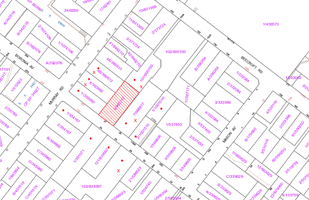
|
NOTIFICATION
PLAN
|
|
|
• PROPERTIES NOTIFIED
|
X SUBMISSIONS
RECEIVED
|
PROPERTY SUBJECT OF DEVELOPMENT
|
|
|
SIX SUBMISSIONS
RECEIVED OUT OF MAP RANGE
|
|
|
|
|
Nine submissions including a
submission from the Beecroft-Cheltenham Civic Trust, object to the development,
generally on the following grounds:
· Reduced
lot sizes;
· Removal
of landscape trees;
· Loss of
privacy;
· Loss of
visual amenity;
· Loss of
heritage significance;
· Non
compliance rear setback;
· Land
size incorrect; and
· Lack of
open space.
Two submissions
support or are neutral to the development and include the following
observation:
· The development retains
the Federation era existing dwelling-house.
The merits of the matters raised
in community submissions have been addressed in the body of the report with the
exception of the following:
5.1.1 Incorrect Lot Size
Council’s property information
indicates that the site has a land area of 1,416m2. However, the
submitted survey plan prepared by a registered surveyor indicates that the site
has a land area of 1,421m2. The discrepancy occurs as a result of
the conversion of the lot area from Imperial measure to metric by the Valuer General’s
Office at the time of metric conversion and is not uncommon for Council records
of older properties. It is accepted that the registered surveyor’s land area of
1,421m2 is correct.
6. THE PUBLIC INTEREST
Section 79C(1)(e) of the Act
requires Council to consider “the public interest”.
The public interest is an
overarching requirement, which includes the consideration of the matters
discussed in this report. Implicit to the public interest is the achievement
of future built outcomes adequately responding to and respecting the future
desired outcomes expressed in environmental planning instruments and
development control plans.
The application is considered to
have satisfactorily addressed Council’s criteria and would provide a
development outcome that, on balance, would result in a positive impact for the
community. Accordingly, it is considered that the approval of the proposed
subdivision would be in the public interest.
CONCLUSION
The proposed development, as
amended, is for the subdivision of one lot into two lots and alterations and
additions to the existing dwelling.
The proposed subdivision is
considered acceptable as it retains the existing dwelling which contributes to
the Beecroft-Cheltenham Heritage Conservation Area and provides for appropriate
residential amenity for residents of the existing dwelling on proposed Lot 1
and future residents of proposed Lot 2 at the rear.
The proposal complies with the
Residential Subdivision DCP in respect to density, allotment layout and design,
landscaping, private open space, drainage control and accessway design. The
proposed minor non-compliance with the 3.0m rear setback is considered
acceptable.
The original proposal for
demolition of the existing dwelling and subdivision was subject to a high
number of public submissions objecting to the demolition of the Federation era
dwelling. The majority of the objections have been addressed by the amended
proposal which retains the dwelling.
The application is therefore
recommended for approval.
|
Garry Mahony
Acting Manager,
Assessment Team 2
Planning Division
|
James Farrington
Acting Executive
Manager
Planning Division
|
Attachments:
|
1.View
|
Locality Plan
|
|
|
|
2.View
|
Survey Plan
|
|
|
|
3.View
|
Partial
Demolition, Alteration and Additions Plan
|
|
|
|
4.View
|
Typical Rear
Dwelling Plan
|
|
|
File Reference: DA/1040/2011
Document Number: D01836829
SCHEDULE 1
GENERAL
CONDITIONS
The conditions of consent within this notice of determination have
been applied to ensure that the use of the land and/or building is carried out
in such a manner that is consistent with the aims and objectives of the
relevant legislation, planning instruments and Council policies affecting the
land and does not disrupt the amenity of the neighbourhood or impact upon the
environment.
Note: For the
purpose of this consent, the term ‘applicant’ means any person who has the
authority to act on or the benefit of the development consent.
Note: For the purpose of
this consent, any reference to an Act, Regulation, Australian Standard or publication
by a public authority shall be taken to mean the gazetted Act or Regulation, or
adopted Australian Standard or publication as in force on the date that the
application for a construction certificate is made.
1. Approved
Plans and Supporting Documentation
The
development must be carried out in accordance with the plans and documentation
listed below and endorsed with Council’s stamp, except where amended by Council
and/or other conditions of this consent:
|
Plan No.
|
Drawn by
|
Dated
|
|
L-01/2 – Subdivision Plan
|
Ray Fuggle & Associates
|
28/11/11
|
|
L-02/2 – Partial Demolition of
Existing Dwelling, Plans & Alterations
|
Ray Fuggle & Associates
|
28/11/11
|
|
Document No.
|
Prepared by
|
Dated
|
|
D01774238 – Arboricultural
Impact Assessment
|
Urban Tree Management Australia
|
5 September 2011
|
2. Removal
of Existing Trees
This
development consent only permits the removal of tree(s) numbered 1, 2, 4 and 16
as identified on Plan No. L-01/2 prepared by Ray Fuggle & Associates dated
28/11/11. The removal of any other trees requires separate approval under
Council’s Tree Preservation Order.
REQUIREMENTS PRIOR TO THE ISSUE OF A CONSTRUCTION
CERTIFICATE
3. Building
Code of Australia
All building
work must be carried out in accordance with the requirements of the Building
Code of Australia.
4. Contract
of Insurance (Residential Building Work)
In the case
of residential building work for which the Home Building Act, 1989 requires
there to be a contract of insurance in force in accordance with Part 6 of that
Act, that such a contract of insurance is in force before any building work
authorised to be carried out by the consent commences.
Note: This
condition does not apply to the extent to which an exemption is in force
under Clause 187 or 188 of the Act, subject to the terms of any condition or
requirement referred to in Clause 187(6) or 188(4) of the Act, or to the
erection of a temporary building.
5. Notification
of Home Building Act, 1989 Requirements
Residential
building work within the meaning of the Home Building Act,
1989 must not be carried out unless the principal certifying authority for
the development to which the work relates (not being Council) has given Council
written notice of the following information:
a. In
the case of work for which a principal contractor is required to be appointed:
i. The
name and licence number of the principal contractor.
ii. The
name of the insurer by which the work is insured under Part 6 of that Act.
b. In
the case of work to be done by an owner-builder:
i. The
name of the owner-builder.
ii. If
the owner-builder is required to hold an owner-builder’s permit under that Act,
the number of the owner-builder’s permit.
Note: If
arrangements for doing the residential building work are changed while the work
is in progress so that the information notified becomes out of date, further
work must not be carried out unless the principal certifying authority for the
development to which the work relates (not being Council) has given Council
written notification of the updated information.
6. Water/Electricity
Utility Services
The applicant
must submit written evidence of the following service provider requirements:
a. Energy
Australia – a letter of consent demonstrating that satisfactory
arrangements have been made to service the proposed development.
Note: Sydney
Water requires that s73 applications are to be made through an authorised
Sydney Water Servicing Coordinator. Refer to www.sydneywater.com.au or telephone
13 20 92 for assistance.
7. Stormwater
Drainage
The
stormwater drainage system for the development must be designed and constructed
in accordance with Council’s Civil Works – Design and Construction
Specification 2005 and the following requirements:
a. An
inter-allotment stormwater drainage system to service the proposed lots with
pits being constructed in situ.
b. The
roof and stormwater drainage system from the existing dwelling to be connected
to the proposed inter-allotment drainage system.
8. Internal
Driveway/Vehicular Areas
The driveway
and parking areas on site must be designed in accordance with Australian
Standards 2890.1, 3727 and the following requirements:-
a. Design
levels at the front boundary be obtained from Council.
b. The
driveway be a rigid pavement to the extent of the proposed access handle at
least to Lot 2.
c. The
driveway pavement be a minimum 3 metres wide, 0.15 metres thick reinforced
concrete with SL72 steel reinforcing fabric and a 0.15 metre sub-base.
d. The
pavement have a kerb to one side and a one-way cross fall with a minimum
gradient of 2 percent, with kerb inlet pits provided on grade and at low
points.
e. Planting
of landscaping strips 0.5 metres wide along both sides of the length of the
driveway.
f. Conduit
for utility services including electricity, water, gas and telephone be
provided and shown on construction plans.
REQUIREMENTS PRIOR TO THE COMMENCEMENT OF ANY WORKS
9. Erection
of Construction Sign
A sign must
be erected in a prominent position on any site on which building work,
subdivision work or demolition work is being carried out:
a. Showing
the name, address and telephone number of the principal certifying authority
for the work,
b. Showing
the name of the principal contractor (if any) for any demolition or building
work and a telephone number on which that person may be contacted outside
working hours, and
c. Stating
that unauthorised entry to the work site is prohibited.
Note: Any
such sign is to be maintained while the building work, subdivision work or
demolition work is being carried out, but must be removed when the work has
been completed.
10. Toilet
Facilities
Toilet
facilities must be available or provided at the works site before works begin
and must be maintained until the works are completed at a ratio of one toilet
for every 20 persons employed at the site. Each toilet must:
a. be
a standard flushing toilet connected to a public sewer; or
b. be
a temporary chemical closet approved under the Local Government Act, 1993;
or
c. have
an on-site effluent disposal system approved under the Local Government Act,
1993
11. Erosion
and Sediment Control
Erosion and
sediment control measures must be provided and maintained throughout the
construction period in accordance with the manual ‘Soils and Construction
2004 (Bluebook)’, the approved plans, Council specifications and to the
satisfaction of the principal certifying authority. The erosion and sediment
control devices must remain in place until the site has been stabilised and
revegetated.
Note: On
the spot penalties up to $1,500 may be issued for any non-compliance with this
requirement without any further notification or warning.
12. Tree
Protection Barriers
Tree
protection fencing must be erected around trees numbered 17 and 19 to be
retained at a 2 metre setback. The tree fencing
must be constructed of 1.8 metre ‘cyclone chainmesh fence’ or star pickets
spaced at 2 metre intervals, connected by a continuous high-visibility
barrier/hazard mesh at a height of 1 metre.
To avoid
injury or damage, tree numbered 20 must have its trunk protected by 2 metre
lengths of 75mm x 25mm hardwood timbers spaced at 80mm secured with galvanised
wire (not fixed or nailed to the tree in any way.
REQUIREMENTS DURING CONSTRUCTION
13. Construction
Work Hours
All work on site (including demolition and earth works)
must only occur between 7am and 5pm Monday to Saturday.
No work is to be undertaken on Sundays or public holidays.
14. Demolition
All
demolition work must be carried out in accordance with Australian Standard
2601-2001 – The Demolition of Structures and the following requirements:
a. Demolition
material is to be disposed of to an authorised recycling and/or waste disposal
site and/or in accordance with an approved waste management plan.
b. Demolition
works, where asbestos material is being removed, must be undertaken by a
contractor that holds an appropriate licence issued by WorkCover NSW in
accordance with Chapter 10 of the Occupational Health and Safety Regulation
2001 and Clause 29 of the Protection of the Environment Operations
(Waste) Regulation 2005.
c. On
construction sites where buildings contain asbestos material, a standard
commercially manufactured sign containing the words ‘DANGER ASBESTOS REMOVAL IN
PROGRESS’ measuring not less than 400mm x 300mm must be erected in a prominent
position visible from the street.
15. Environmental
Management
The site must
be managed in accordance with the publication ‘Managing Urban Stormwater –
Landcom (March 2004) and the Protection of the Environment Operations
Act 1997 by way of implementing appropriate measures to prevent sediment
run-off, excessive dust, noise or odour emanating from the site during the
construction of the development.
16. Council
Property
During
construction works, no building materials, waste, machinery or related matter is
to be stored on the road or footpath. The public reserve is to be kept in a
clean, tidy and safe condition at all times.
17. Disturbance
of Existing Site
During
construction works, the existing ground levels of open space areas and natural
landscape features, (including natural rock-outcrops, vegetation, soil and
watercourses) must not be altered unless otherwise nominated on the approved
plans.
18. Vehicular
Crossing
A separate
application under the Local Government Act, 1993 and the Roads Act,
1993 must be submitted to Council for the installation of a new vehicular
crossing and the removal of the existing crossing. The vehicular crossing must
be constructed in accordance with Council’s Civil Works Design, 2005 and
the following requirements:
a. Any
redundant crossings to be replaced with integral kerb and gutter.
b. The
footway area to be restored by turfing.
Note:
An application for a vehicular crossing can only be made to one of Council’s
Authorised Vehicular Crossing Contractors, (or be the subject of a Construction
Certificate Application to Council as the Roads Authority). You are advised to
contact Council on 02 9847 6940 to obtain a list of contractors.
19. Traffic
Control Plan
A Traffic
Control Plan (TCP) must be prepared by a qualified traffic controller in
accordance with the Roads & Traffic Authority’s Traffic Control at
Worksites Manual 1998 and Australian Standard 1742.3 for all work on
a public road and be submitted to Council. The TCP must detail the following:
a. Arrangements
for public notification of the works.
b. Temporary
construction signage.
c. Vehicle
movement plans.
d. Construction
Traffic management plans.
20. Works
near Trees
All required
tree protection measures are to be maintained in good condition for the
duration of the construction period.
All works
(including driveways and retaining walls) within 5 metres of any trees required
to be retained (whether or not on the subject property, and pursuant to this
consent or the Tree Preservation Order), must be carried out under the
supervision of an ‘AQF Level 5 Arborist’ and a certificate submitted to
the principal certifying authority detailing the method(s) used to preserve the
tree(s).
Note:
Except as provided above, the applicant is to ensure that no excavation, filling
or stockpiling of building materials, parking of vehicles or plant, disposal of
cement slurry, waste water or other contaminants is to occur within 4 metres of
any tree to be retained.
REQUIREMENTS PRIOR TO THE ISSUE OF A SUBDIVISION
CERTIFICATE
Note: For
the purpose of this consent, a reference to ‘occupation
certificate’ shall not be taken to mean an ‘interim occupation
certificate’ unless otherwise stated.
21. Sydney
Water – s73 Certificate
A s73
Certificate must be obtained from Sydney Water.
22. Damage
to Council Assets
Any damage
caused to Council’s assets as a result of the construction of the development
must be rectified in accordance with Council’s written requirements and at the
sole cost of the applicant.
23. Creation
of Easements
The following
matter(s) must be nominated on the plan of subdivision under s88B of the Conveyancing
Act 1919:-
a. A
right of access and easement for services over the access corridor.
b. An
inter-allotment drainage easement(s) over each burdened lot.
c. The
creation of a “Positive Covenant” over the proposed Lot 2 requiring that
any future development is to provide an on-site detention system. The on-site
detention system is to have a storage capacity of 5 cubic metres and a maximum
discharge of 8 litres per second into Council’s drainage system in accordance
with Council’s prescribed wording.
Note: Council
must be nominated as the authority to release, vary or modify any easement,
restriction or covenant.
24. Existing
Driveway
The existing
driveway within the right of way over proposed Lot 2 must be reformed to
maintain access to the residence at No. 150A Beecroft Road Cheltenham via Boronia Avenue.
25. Boundary
Fencing
a. Fencing must be erected along all property boundaries behind
the front building alignment to a height of 1.8 metres.
b. A solid lapped and capped 1.8m high timber fence must be erected
along the common boundary of Lot 1 and Lot 2.
Note:
Alternative fencing may be erected subject to the written consent of
the adjoining property owner(s).
26. Works
as Executed Plan
A works-as-executed plan(s)
must be prepared by a registered surveyor and submitted to Council for
completed road assets, internal pavements, kerb & gutter, drainage systems,
driveways and services and service conduits.
27. s94
Infrastructure Contributions
The payment to Council of a
contribution of $20,000 for one additional lot towards the cost of
infrastructure identified in Council’s Development Contributions Plan
2007-2011.
Note:
* The value of contribution is capped
at $20,000 per additional lot in accordance with Ministerial Direction
(Section 94E of the Environmental Planning and Assessment Act 1979) issued on
16 September 2010. In the event that this Direction is repealed or amended,
Council will apply the value of the contribution from the date of this consent,
adjusted from this date in accordance with the
underlying consumer price index for subsequent financial quarters. It is
recommended that you contact Council to confirm the value of the contribution
prior to payment.
- END OF
CONDITIONS -
ADVISORY NOTES
The following information is provided for your
assistance to ensure compliance with the Environmental Planning and
Assessment Act, 1979, Environmental Planning and Assessment Regulation 2000,
other relevant legislation and Council’s policies and specifications. This
information does not form part of the conditions of development consent
pursuant to Section 80A of the Act.
Environmental Planning and
Assessment Act, 1979 Requirements
· The Environmental Planning and
Assessment Act, 1979 requires:
· The issue of a construction
certificate prior to the commencement of any works. Enquiries regarding the
issue of a construction certificate can be made to Council’s Customer Services
Branch on 9847 6760.
· A principal certifying authority to
be nominated and Council notified of that appointment prior to the commencement
of any works.
· Council to be given at least two days
written notice prior to the commencement of any works.
· Mandatory inspections of nominated
stages of the construction inspected.
· An occupation certificate to be
issued before occupying any building or commencing the use of the land.
Long Service Levy
In accordance with Section 34 of
the Building and Construction Industry Long Service Payments Act 1986, a ‘Long Service Levy’ must be paid to the Long
Service Payments Corporation or Hornsby Council.
Note: The
rate of the Long Service Levy is 0.35% of the total cost of the work.
Note: Hornsby
Council requires the payment of the Long Service Levy prior to the issue of a
construction certificate.
Tree Preservation Order
To ensure the maintenance and
protection of the existing natural environment, it is an offence to ringbark,
cut down, top, lop, remove, wilfully injure or destroy a tree outside 3 metres
of the approved building envelope without the prior written consent from
Council.
Note: A
tree is defined as a single or multi-trunked wood perennial plant having a
height of not less than three (3) metres, and which develops many branches,
usually from a distance of not less than one (1) metre from the ground, but
excluding any plant which, in its particular location, is a noxious plant
declared as such pursuant to the Noxious Weeds Act 1993. This definition of ‘tree’
includes any and all types of Palm trees.
All
distances are determined under Australian Standard AS4970-2009 ”Protection of
Trees on Development Sites”.
Fines may be imposed for
non-compliance with Council’s Tree Preservation Order.
Subdivision Certificate
Requirements
A subdivision certificate
application is required to be lodged with Council containing the following
information:
· A surveyor’s certificate certifying
that all structures within the subject land comply with the development consent
in regard to the setbacks from the new boundaries.
· A surveyor’s certificate certifying
that all services, drainage lines or access are located wholly within the
property boundaries. Where services encroach over the new boundaries,
easements are to be created.
· Certification that the requirements
of relevant utility authorities have been met.
· A surveyor’s certificate certifying
finished ground levels are in accordance with the approved plans.
Note: Council
will not issue a subdivision certificate until all conditions of the
development consent have been completed.
Fees and Charges – Subdivision
All fees payable to Council as
part of any construction, compliance or subdivision certificate or inspection
associated with the development (including the registration of privately issued
certificates) are required to be paid in full prior to the issue of the
subdivision certificate. Any additional Council inspections beyond the scope
of any compliance certificate required to verify compliance with the terms of
this consent will be charged at the individual inspection rate nominated in
Council's Fees and Charges Schedule.
Dial Before You Dig
Prior to commencing any works,
the applicant is encouraged to contact Dial Before You Dig on 1100 or www.dialbeforeyoudig.com.au for
free information on potential underground pipes and cables within the vicinity
of the development site.
Asbestos Warning
Should asbestos or asbestos
products be encountered during demolition or construction works you are advised
to seek advice and information should be prior to disturbing the material. It
is recommended that a contractor holding an asbestos-handling permit (issued by
WorkCover NSW)be engaged to manage the proper handling of the material.
Further information regarding the safe handling and removal of asbestos can be
found at:
www.environment.nsw.gov.au
www.nsw.gov.au/fibro
www.adfa.org.au
www.workcover.nsw.gov.au
Alternatively, telephone the WorkCover
Asbestos and Demolition Team on 8260 5885.
House Numbering
House numbering can only be
authorised by Council. Before proceeding to number each premise in the
development, the allocation of numbers is required to be obtained from
Council's Planning Division. The authorised numbers are required to be
displayed in a clear manner at or near the main entrance to each premise.
Standard Report No. PLN15/12
Planning Division
Date of Meeting:
1/02/2012
4 REPORTING VARIATIONS TO
DEVELOPMENT STANDARDS
EXECUTIVE SUMMARY
In accordance with the Department
of Planning’s Planning Circular PS 08-14, Council is required to report
variations to development standards for development applications approved under
delegated authority, which relied upon State Environmental Planning Policy
No. 1 - Development Standards (SEPP 1).
PURPOSE
The purpose of this report is to advise Council of
determined development applications involving a SEPP 1 variation to a
development standard relating to the period 1 October 2011 to 31 December 2011.
DISCUSSION
The Department of Planning and Infrastructure
issued Circular PS 08–014 on 14 November 2008. The purpose of the
Circular was to remind councils of their responsibilities to monitor the use of
the Director-General’s assumed concurrence under SEPP 1. Councils were reminded
of the need to keep accurate records of the use of SEPP 1 and to report
on a quarterly basis.
The Circular also provides that councils are
required to adopt the following four measures:
1. Establish
a register of development applications determined with variations in standards
under SEPP 1.
2. Require
all development applications where there has been a variation greater than 10%
in standards under SEPP 1 to be determined by full council (rather than general
manager or nominated staff member).
3. Provide
a report to each council meeting on the development applications determined
where there had been a variation in standards under SEPP 1.
4. Make
the register of development applications determined with variations in
standards under SEPP 1 available to the public on the council’s website.
In accordance with Point 3 of the Department’s Circular,
attached hereto is a list of development applications determined under
delegated authority involving a SEPP 1
variation to a development standard for the
period 1 October 2011 to 31 December 2011.
A copy of the attachment to this report is also reproduced
on Council’s website.
BUDGET
There are no budget implications.
POLICY
There are no policy implications.
CONSULTATION
There was no consultation in the preparation of this
report.
TRIPLE BOTTOM LINE SUMMARY
Triple Bottom Line is a framework for improving Council
decisions by ensuring accountability and transparency on social, environmental
and economic factors. It does this by reporting upon Council’s strategic
themes. As this report simply provides Council with information and does not
propose any actions which require a sustainability assessment, no Triple Bottom
Line considerations apply.
|
RECOMMENDATION
THAT Council note the contents
of Executive Manager’s Report No. PLN1/12.
|
|
James Farrington
Acting Executive
Manager - Planning
Planning Division
|
|
Attachments:
File Reference: F2004/07599
Document Number: D01809474
Standard Report No. PLN16/12
Planning Division
Date of Meeting:
1/02/2012
5 STATE ENVIRONMENTAL
PLANNING POLICY 65 AND RESIDENTIAL FLAT DESIGN CODE REVIEW
EXECUTIVE SUMMARY
In 2002, State Environmental
Planning Policy 65 – Design Quality of Residential Flat Development (SEPP 65)
was gazetted. The SEPP aims to improve the design quality of residential
flat buildings (RFBs) in NSW. The Residential Flat Design Code (RFDC)
was prepared to support SEPP 65 and provides guidelines for the
application of the Policy and the design of RFBs.
SEPP 65 has not undergone
a substantial review since its gazettal. The
Department of Planning and Infrastructure (DP&I) is currently undertaking a
review of SEPP 65 and the RFDC to ensure they remain relevant and
useful resources.
It is recommended that Council
forward a submission to the DP&I indicating its general support for the
review and providing suggestions for improvement to SEPP 65 and the RFDC.
PURPOSE
The purpose of this report is to
seek endorsement of a submission to the DP&I for consideration as part of
the current review of SEPP 65 and RFDC.
BACKGROUND
In 2002, SEPP 65 was gazetted.
The SEPP aims to improve the design quality of RFBs in NSW. The SEPP
contains ten design quality principles which guide the design and assessment of
RFBs. It also allows the Minister to form design review panels to give consent
authorities independent advice on the design quality of proposals. The RFDC
was prepared to support SEPP 65 and provides guidelines for the design
of RFBs and the application of the design quality principles.
SEPP 65 has not undergone
a substantial review since its gazettal. The
DP&I is currently undertaking a review of SEPP 65 and the RFDC
to ensure they remain relevant and useful resources for industry and local
government. The
Department has advised that the review is being conducted in four stages:
· Initial consultation with
key stakeholders groups and individuals to inform a Discussion Paper.
Stakeholders included local government, State agencies, peak industry bodies,
professional associations, Design Review Panel members, architects and
landscape architects (May-July 2011);
· Discussion Paper
preparation (August-October 2011);
· Public consultation on
Discussion Paper – SEPP 65 & Residential Flat Design Code Review
(November-February 2012); and
· Revision of SEPP 65
and RFDC documents (February-May 2012).
As part of public consultation,
written submissions are invited on the Discussion Paper (copy attached) and
will be received until 24 February 2012.
DISCUSSION
The DP&I is seeking views on
the useability and application of the legislation and accompanying Code to
ensure SEPP 65 and the RFDC maintain currency and continue to
encourage best practice in the design of RFBs. The objectives of the review
are to:
· provide opportunities
for input into the review process from a wide range of stakeholders;
· update SEPP 65
and RFDC to ensure that best practice in the planning and design of RFBs
continues in NSW; and
· encourage the
development of RFBs that are sustainable and affordable.
The scope for submissions on the
review is generally unlimited. However, the Discussion Paper contains a number
of specific issues for review and a series of questions upon which feedback is
sought. Therefore, it would be appropriate for Council to make a submission
identifying its general support for the review and providing comments in
regards to the top ten issues identified in the Discussion Paper as they relate
to the implementation of SEPP 65 and the RFDC in Hornsby Shire.
The submission should also include suggestions for amendments for improvements
to the legislation and Code. The following discussion identifies the basis for
a submission.
1. Application of SEPP 65 to other types of development
The Discussion Paper notes that a
number of stakeholders, including councils and industry groups, have suggested
that SEPP 65 and the RFDC should apply to development types other
than RFBs. SEPP 65 currently applies to:
· erection of new RFBs;
· substantial
redevelopment or refurbishment of an existing RFB; and
· conversion of an
existing building to a RFB.
The types of development
suggested for consideration under SEPP 65 and the RFDC include
serviced apartments, lower scale medium density development (for example villa
style and townhouse development), student housing and boarding housing.
The broadening of SEPP 65
to apply to serviced apartments is generally supported. Serviced apartments are
similar in building form and function to RFBs and often occur together. This
type of development could seamlessly be accommodated within the expansion of
the current RFDC. The broadening of SEPP 65 to apply to townhouse
and villa developments to assist in improving the design quality of these types
of developments is also generally supported. However, the inclusion of
townhouse and villa development, which have a different building form, would
require a separate code or at least a separate chapter in the Code. Townhouses
and villa developments have been identified in Council’s Housing Strategy
to provide a mix of housing types and a more affordable housing form (as
compared to dwelling-houses) within the Shire. Controls for townhouse and villa
developments should be prepared so that they are not too onerous such that they
impact on the affordability of these developments.
State Environmental Planning
Policy (Affordable Rental Housing) 2009 already provides guidance on the
development of new affordable rental housing such as boarding houses. To avoid
possible confusion, it may be simpler to have only one policy apply to such
development. Accordingly, SEPP 65 should be expanded to apply to
serviced apartments, townhouse and villa developments, but not amended to
include student housing or boarding housing. Any proposed urban design
controls for student housing or boarding housing should be incorporated into
the existing Affordable Rental Housing SEPP.
2. Inclusion of
definitions from the Standard Instrument
To implement the above changes,
the definitions within SEPP 65 would need to be amended and new
definitions added. Currently, there are different definitions of a RFB within
the SEPP and the Standard Instrument. SEPP 65 defines a
RFB as a building that comprises:
(a) 3 or more storeys (not including levels below ground level
provided for car parking or storage, or both, that protrude less than 1.2
metres above ground level), and
(b) 4 or more self-contained dwellings (whether or not the
building includes uses for other purposes, such as shops), but does not include
a Class 1a building or a Class 1b building under the Building Code of Australia.
The definition under the Standard
Instrument states that a:
Residential
flat building means a building containing 3 or more dwellings, but does not
include an attached dwelling or multi dwelling housing.
The Discussion Paper notes that
the differing definitions can lead to confusion and that this could be
rectified with the use of one consistent definition of RFBs, preferably from the
Standard Instrument. The use of the definition for RFBs from the Standard
Instrument would result in SEPP 65 applying to more types of RFBs,
such as 2 storey RFB developments. However, the SEPP would no longer
apply to shop top housing developments as a separate definition of ‘shop top
housing’ is included in the Standard Instrument. The use of the
definition for RFBs from the Standard Instrument is supported as it
would provide consistency across policies and result in the improved design
quality of more RFBs within the Shire. However, the definitions of ‘shop top
housing’, ‘serviced apartments’ and ‘attached dwelling’ within the Standard
Instrument should also be included to ensure that the SEPP applies
to all the forms of development discussed above.
SEPP 65 should therefore
be amended to contain:
· a definition of
‘residential flat buildings’ that is consistent with the definition within the Standard
Instrument; and
· the definition of
‘shop top housing’, ‘serviced apartments’ and ‘attached dwelling’ from the Standard
Instrument.
3. Design quality principles and RFDC
SEPP 65 contains ten
design quality principles for good design. The SEPP requires the
assessment of RFB applications and draft planning policy against these
principles and the RFDC. The Discussion Paper notes that a number of
stakeholders including councils, industry and peak professional bodies have
suggested that the design quality principles could be streamlined and
overlapping principles simplified or consolidated. It has also been suggested
that the relationship between the design quality principles and the Code should
be made clearer and strengthened.
The RFDC has three
distinct parts, namely local context, site design and building design. A number
of related development guidelines appear under each part. SEPP 65 should
be amended so that the ten design quality principles are grouped into three
sections to align with the three parts of the RFDC.
As there is sometimes overlap or
interrelationships between the design quality principles and parts of the RFDC,
it would also be useful to have a matrix table within the RFDC to show
the relationship between the design quality principles and the elements of the
Code.
4. Statutory weight of RFDC
When determining an application
where SEPP 65 applies, a consent authority is required to consider the RFDC.
The Code is a set of guidelines that provides benchmarks for better practice in
the planning and design of RFBs.
The Discussion Paper notes that
there is uncertainty within councils and the community concerning the statutory
weight of the RDFC in the assessment of developments. The Code was
intended as a set of best practice guidelines. Instead the Code has been used
by some consent authorities as “controls” against which development must comply.
In some cases, the Land and Environment Court has given the same weight to the
guidelines within the Code as to controls within Development Control Plans
(DCPs).
The Discussion Paper also notes
that there are differing opinions amongst stakeholders in regards to the RFDC
being given statutory recognition and the maintenance of flexibility within the
Code. Accordingly, there should be greater clarification within SEPP 65
as to the role of the guidelines within the RFDC. Where a council has an
adopted policy concerning the design and development of RFBs, which has been
prepared having regard to the Code, those controls should be the primary
development standards to be considered during assessment of applications for
RFBs. The Code would provide supplementary guidelines. However, if a Council
does not have an adopted policy concerning the development of RFBs, then the
guidelines within the RFDC should be given similar statutory weight as
controls within DCPs.
In the case of Hornsby Shire, the
Medium/High and High Density Multi-Unit Housing and Housing Strategy
Development Control Plans provide guidelines for RFB development. These are
being incorporated into Council’s new Comprehensive DCP and updated where
necessary having regard to SEPP 65 and the RFDC.
5. FSR Guidelines
Within the Primary Development
Controls element of the RFDC, there are Floor Space Ratio (FSR)
guidelines which provide guidance on developing and applying FSR controls for
RFBs. The Discussion Paper notes that stakeholders have requested more guidance
on aligning FSR and building height controls and determining FSR relative to
the size of sites.
In recent times, Council has
moved away from the use of FSR controls to control bulk and scale in
residential zones. Council has placed greater emphasis on other building
envelope controls such as building height and setbacks to manage same. New five
and ten storey RFBs in Housing Strategy precincts have no FSR controls. Instead
the Housing Strategy DCP contains a suite of controls to manage bulk and
scale, including building heights, site coverage, setbacks, landscaped area and
outdoor living area. A similar approach is employed in the preparation of
Council’s draft Comprehensive Local Environmental Plan and DCP. Therefore, the RFDC
should be reviewed and consideration given to the deletion of the section
on FSR. Greater emphasis should be placed on the use of building envelope
controls, consistent with Council’s adopted approach.
6. Parking requirements
The Discussion Paper notes that a
number of stakeholders have suggested promoting a further reduction in car use
through measures such as car share programs, reduction in number of visitor
spaces and provision of bicycle parking. The Discussion Paper also notes that
some stakeholders have recommended that SEPP 65 and/or the RFDC
be amended to provide for reduced parking provision for sites close to
transport and centres.
These recommendations are
consistent with the findings of the Hornsby Town Centre Parking Management
Review, Epping Town Centre Study and Integrated Land Use Transport Study. The
Studies recommend that further investigation and consideration should be given
to reducing parking rates for various centres due to their close proximity to
rail stations and/or high frequency bus stops on strategic bus corridors.
The RFDC should be amended
to promote a reduction in car parking rates for sites with good proximity to
high frequency public transport and commercial centres.
7. Open Space
requirements
The RFDC provides rules of
thumb for communal and private open space for RFBs. The rules of thumb suggest
that 25-30 % of the site area should be communal open space and more if it is a
larger site, though this may be varied depending on context, density, site
size, availability of public domain or private open spaces. A minimum private
open space area for ground floor apartments (25m2 with a minimum
dimension of 4m) is also specified. The Discussion Paper notes that a number of
stakeholders have suggested that flexibility for prescriptive standards
concerning open space provision should be considered in relation to local
context and density of the development.
The rule of thumb for communal
open space within the RFDC (25-30% of the site) is generally consistent
with the open space controls within Council’s Housing Strategy DCP (minimum
25% of the site). The rate of communal open space is proportional to the site
area, ensuring that as sites increase in size, the amount of required communal
open space increases. However, the guideline for private open space for ground
floor apartments within the Code is more onerous than the DCP. The Housing
Strategy DCP contains a sliding scale for private open space requiring 10m2
for 1 bedroom units, 12m2 for 2 bedroom units and 16m2 for
3 bedroom units. This is generally consistent with the State Government Housing
Code for small lots, which proposes that a 3 bedroom house/townhouse/unit
on a small lot should include a minimum 16m2 of private open space.
The RFDC should be
reviewed concerning the metrics and guidelines for private open space
requirements. Consideration should be given to the insertion of a sliding scale
requiring rates of private open space based on the size of the unit.
8. Requirements for
Apartment Mix and Universal Design
Within the Building Configuration
element of the RFDC, there are guidelines that seek to ensure that
apartments can accommodate a wider range of residents and lifestyle needs for
people now and in the future, including apartment layout, apartment mix and
flexibility. Currently there are no rules of thumb provided for these
guidelines. The Discussion Paper notes this has been identified as an issue by
the development industry citing experience that the principles are rarely
applied. The Discussion Paper also notes that some stakeholders have suggested
that more guidance or a suggested mix of different apartment types should be
provided for medium and large developments. It has also been suggested that
design consideration should be given to children and the aged as well as
catering to the needs of multicultural communities.
Council’s Housing Strategy DCP
requires that developments should include a mix of 1, 2 and 3 bedroom units.
At least 10% of each unit type should be provided. It also requires at least
30% of proposed dwellings to be adaptable to meet needs of residents as they
age. Therefore, a move towards greater requirements for adaptability and
accessibility across NSW would be consistent with Council’s approach to
requiring dwelling mix and a percentage of adaptable dwellings.
9. Design verification
The Environmental
Planning and Assessment Regulation 2000 requires that a development
application for a RFB must be accompanied by a design verification statement
from a qualified designer (registered architect) verifying that:
· they
designed, or directed the design of the RFB; and
· the
design quality principles in SEPP 65 are achieved for the residential
flat development.
The
Discussion Paper notes that a number of councils have raised concern that the intention
of improving design quality may not be fully met by the current design
verification statement requirements as an unregistered person could be
responsible for preparing a design. Several councils have suggested that it
should be a requirement that a registered architect verifies that they designed
the RFB. This recommendation should be supported as it would ensure all aspects
of RFBs are professionally designed including building layout and construction
details. Accordingly, SEPP 65 should be amended to require that a
registered architect verify that they designed a project, as opposed to
overseeing the design.
10. Update policy to remove conflict with BASIX
In the event
of any inconsistency between SEPP 65 and another environmental planning
instrument, SEPP 65 prevails to the extent of the inconsistency.
However, the Discussion Paper notes that a number of stakeholders have
identified that there are potential conflicts between SEPP 65 and BASIX,
which has been introduced since SEPP 65 was established. BASIX contains
best practice sustainability criteria for energy efficiency, thermal comfort
and water efficiency.
The daylight
access, natural ventilation, energy efficiency and water conservation
guidelines of the RFDC should be reviewed and amended accordingly to
reduce any conflict or overlaps with BASIX.
Summary
In summary,
it would be appropriate for Council to make a submission to the DP&I
identifying its general support for the review and providing suggestions for
improvements. The suggestions for amendments to SEPP 65 include the:
· expansion of the SEPP
to apply to serviced apartments, townhouse and villa developments;
· inclusion of
definitions of ‘residential flat buildings’, ‘shop top housing’, ‘serviced
apartments’ and ‘attached dwelling’ from the Standard Instrument;
· grouping
of design quality principles into three sections to align with the three parts
of the RFDC;
· inclusion
of a requirement that a registered architect verify that they designed a
project; and
· provision
of greater clarification within the SEPP concerning the role of the
guidelines within the RFDC.
The
suggestions for amendments to the RFDC include the:
· deletion
of FSR guidelines and placing greater emphasis on building envelope controls;
· promotion of a reduction
in car parking rates for sites with good proximity to high frequency public
transport and commercial centres;
· review
of metrics and guidelines for private open space requirements;
· inclusion
of greater requirements for adaptability and accessibility; and
· reduction
of conflicts or overlaps with BASIX.
CONSULTATION
The Manager, Assessment Team 2
has been consulted in the preparation of this report.
TRIPLE BOTTOM LINE SUMMARY
Triple Bottom Line is a framework
for improving Council decisions by ensuring accountability and transparency on
social, environmental and economic factors. It does this by reporting
upon Council’s strategic themes. As this report only provides Council
with information and does not propose any actions which require a
sustainability assessment, no Triple Bottom Line considerations apply.
CONCLUSION
SEPP 65 has not undergone
a substantial review since its gazettal. The
DP&I is currently undertaking a review of SEPP 65 and the RFDC
to ensure they remain relevant and useful resources. It is recommended that
Council forward a submission to the DP&I identifying its general support
for the review and providing suggestions for improvement to SEPP 65 and
the RFDC.
|
RECOMMENDATION
THAT a submission based on the
discussion contained in Executive Manager’s Report No. PLN9/12 be forwarded
to the Department of Planning and Infrastructure for its consideration as
part of the public consultation stage of the review of State Environmental
Planning Policy 65 – Design Quality of Residential Flat Development and Residential
Flat Design Code.
|
|
Jason Rawlin
Acting Manager -
Town Planning Services
Planning Division
|
James Farrington
Acting Executive
Manager - Planning
Planning Division
|
Attachments:
|
1.View
|
Discussion Paper -
SEPP 65 & Residential Flat Design Code Review
|
|
|
File Reference: F2004/07599
Document Number: D01838901
Standard Report No. PLN17/12
Planning Division
Date of Meeting:
1/02/2012
6 NSW GOVERNMENT REVIEW
OF HOUSING OPPORTUNITIES ON LANDOWNER NOMINATED SITES
EXECUTIVE SUMMARY
In November 2011, the Department
of Planning and Infrastructure (DP&I) advised Council that it has commenced
a review to identify sites, in appropriate locations, that will increase
dwelling production in the short term. In this regard, Council has been
invited to comment on landowner nominated sites at South Dural and North Glenhaven within the adjoining Hills Shire.
The release of South Dural for
urban purposes would be consistent with Council’s previous resolution in
September 2011 that, subject to being satisfied that all necessary public infrastructure
and community services would be in place to accommodate the additional
population, the NSW Government should progress investigations to release the
precinct for urban purposes to assist Council deliver additional housing in
Hornsby Shire as a possible component of the next stage of Council's Housing
Strategy to meet the NSW Government's housing supply targets.
It is recommended that Council
forward a submission to the DP&I identifying its general support for the
release of South Dural for urban purposes. The submission should also comment
that any release of lands at South Dural or North Glenhaven should be
accompanied by a funding plan for the associated infrastructure works with
clear delineation between funding to be provided by the proponents and the
commitment of funds by the State Government to address the balance of the
costs.
PURPOSE
The purpose of this report is to
advise Council of the NSW Government review of housing opportunities and seek
endorsement of a submission to the Department of Planning and Infrastructure
concerning landowner nominated sites in Hornsby Shire.
BACKGROUND
On 16 November 2011, the DP&I
advised Council that it has commenced a review of new housing opportunities
identified by landowners across the State. This follows a general invitation
by the Minister for Planning and Infrastructure to owners of large landholdings
to have their land considered by the NSW Government for housing development.
Submissions were invited to be received by 29 November 2011.
On 12 December 2011, the
Department advised Council of a landowner nominated site in Hornsby Shire and
an adjoining landowner nominated site in the Hills Shire. These are the sites
of “South Dural” and “North Glenhaven”, respectively. The South Dural site is
bounded by New Line Road, Old Northern Road and Hastings Road and the North Glenhaven site is generally comprised of land adjoining Glenhaven Road, Old Glenhaven Road, Mills Road, Logie Road, Robson Road, Kylie Avenue and Edgecliff Road, Glenhaven.
Council has been requested to
provide comments in relation to the sites and matters for consideration
endorsed by the NSW Government against which the sites will be evaluated for
their potential rezoning to facilitate housing development. Comments are being
invited until 3 February 2012.
DISCUSSION
This report does not present a
comprehensive evaluation of the submissions nominating the release of the
precincts for urban development. The report responds to the Department’s
request for Council’s comments concerning the consistency of the nominated
sites with Council’s planning frame-work, timing for the delivery of housing
and infrastructure requirements to support any development.
State Government Review of New Housing Opportunities in
NSW
The DP&I states that increasing
housing supply is a key priority for the NSW Government. Accordingly, the
purpose of the review is to identify sites, in appropriate locations, that will
increase dwelling production in the short term at no additional cost to the
Government.
Following receipt of nominations
for landowner sites, the Department is now in the process of reviewing the
potential housing opportunities of the sites and input from councils is being
sought as part of the process. The Department has advised (letter attached)
that matters for consideration as part of the evaluation process include the
following:
1. Housing Delivery: Identification of sites which
are suitable for urban planning and have viable prospects for producing houses
in the short term. Consideration will be given to land capability, lead times
for undertaking any necessary studies, views of the local council and
likelihood of houses being built within 3 years (taking into account land
ownership patterns and planning processes).
2. Infrastructure: Provision of infrastructure and
services for new communities in a timely and efficient manner at no additional
cost to Government. No cost to Government may be achieved through either
reprioritising existing capital programs or developer funding. Consideration
will be given to the willingness of the landowner to finance the planning and
infrastructure to deliver the housing.
3. Strategic Setting: Support for the broad
planned pattern of growth and urban policies. Consideration will be given to
consistency with local, State and National strategies, plans and policies.
In the context of the above
matters for consideration, the Department is seeking comments from Council
specifically in relation to the following:
1. Council’s opinion in relation to the prospects of the site
delivering housing in the short term;
2. local infrastructure requirements, broad order of costs and
implications for Council;
3. consistency with Council’s planning framework; and
4. any other matters of relevance to the review.
A CEOs Review Committee, chaired
by the Director-General of Premier and Cabinet will oversee the review and make
recommendations to the State Government. Conduct of the review will be in
accordance with a probity plan reviewed by the Independent Commission Against
Corruption. The review is anticipated to be completed in the first quarter of
2012.
South Dural
The area known as the South Dural
precinct (map attached) is bounded by Hastings Road, Old Northern Road and New Line Road and is zoned part Rural BA (Small Holdings – Agricultural Landscapes) and part
Environmental Protection B (River Catchment) under the Hornsby Local
Environmental Plan 1994. The precinct is 240 hectares in size and consists
of 135 allotments. The precinct also contains a group of allotments zoned
Special Uses A (Community Purposes), which are owned by Sydney Water and
operated for the purpose of a water reservoir.
Proposal
The submission has been prepared
by a consultant on behalf of the South Dural Residents and Ratepayers Group
Incorporated (SDRRG) seeking the rezoning of the precinct for urban purposes.
The submission indicates that the precinct could yield approximately 3,000
dwellings in a mixture of housing types.
The submission is accompanied by
a planning report and technical studies that were prepared in 2009 as part of
the request by the SDRRG that the State Government include the precinct on the Metropolitan
Development Program (MDP). A copy of the report was also previously
forwarded to Council for its information. The main issues raised in the
submission supporting the nomination of the precinct are summarised as follows:
· Development of the
precinct provides the opportunity for the provision of new detached housing in
Hornsby Shire in a market context of limited supply. Furthermore, the release
of the precinct would be consistent with the State Government’s objective of a
50/50 mix of housing development in Growth corridors and in areas close to
transport nodes;
· The precinct is
surrounded principally by urban development at Glenhaven, Cherrybrook, Round
Corner, Dural and the eastern side of New Line Road. Land within the precinct
is largely used for rural-residential development and therefore, is currently
providing a limited contribution to agricultural production;
· Principal
infrastructure costs associated with development of the precinct include
upgrading existing roads, the extension of water and sewer carrier mains,
drainage, electricity and communications. Further detailed planning is
required concerning the provision of water and sewerage services;
· The immediate road
network requires upgrading to cater for ‘background growth’ in the area. These
upgrades should accommodate the development of South Dural. The submission
acknowledges that the land owners have offered to assist in the upgrade of New Line Road and Old Northern Road;
· The precinct is
approximately 5 minutes from the Franklin Road Station proposed as part of the
North West Rail Link;
· Projected expenditure
generated by new residents would be approximately $102 million per year with
possible direct local expenditure of $20.5 million per year. This expenditure
would provide greater support for local centres and the Dural Service Centre,
and provide additional employment opportunities;
· The existing
vegetation corridor along Georges Creek is of significant ecological
significance and should be retained as a wildlife corridor and habitat for
threatened species;
· The retention of the Georges Creek bushland and riparian corridor, including associated tributaries, creates a
bushfire hazard that requires detailed assessment. Appropriate bushfire
mitigation measures would be required, including designation of Asset
Protection Zones and standards of construction;
· Housing is likely to
be staged over a 10 year period (depending on take-up rates) following rezoning
of the lands and completion of the extension of services.
Comment
The following discussion
evaluates the consistency of the proposal with Council’s planning frame work
and comments on the timing for the delivery of housing and infrastructure
requirements to support any development.
Consistency with Council’s
Planning Framework
It is acknowledged that the
provision of housing at South Dural would assist Council meet its dwelling
targets under the State Government’s Metropolitan Strategy and the draft
North Subregional Strategy. The Hornsby Shire Housing Strategy was
gazetted on 2 September 2011 providing opportunities for an additional 2,600
dwellings over the next 10 years. However, a future strategy will be required
to identify opportunities for a further 3,900 dwellings to meet the balance of
Council’s dwelling obligation of 11,000 dwellings by 2036. The provision of
additional housing opportunities at South Dural would contribute significantly
to the achievement of Council’s dwelling target.
South Dural has been the subject
of numerous submissions and applications seeking rezoning since 1990. Most
recently, at its meeting on 2 September 2009, Council considered a report concerning the report submitted to the DP&I on behalf
of the SDRRG in February 2009, titled South
Dural - Land Release Justification Submission. Council noted that the
Department is directly responsible for determining whether to include an
area on the MDP. Inclusion of land on the MDP is required before
land can be rezoned for urban purposes. Council resolved to forward a letter
to the Department confirming Council’s support for the progression of
investigations of the precinct for inclusion on the MDP.
At its meeting on 2 February
2011, Council considered a Notice of Motion concerning the progression of
investigations by the Department and resolved to write to the then Minister for
Planning requesting an update on, and timeframe for completion of, the
investigations. Council also resolved to request that, subject to being
satisfied that all necessary public infrastructure and community services would
be in place to accommodate the additional population, the NSW Government
progress investigations to release South Dural for urban purposes as a matter
of urgency so as to ensure that Council is well placed to deliver sufficient
additional housing in Hornsby Shire as a possible component of the next stage
of Council's Housing Strategy to meet the NSW Government's housing
supply targets.
Accordingly, it would be
appropriate for Council to reiterate its position that it supports progression of investigations of the precinct for
urban development as the provision of housing at South Dural would assist
Council meet its dwelling targets under the State Government’s Metropolitan
Strategy and the draft North Subregional Strategy.
Delivery of Housing in the
Short Term
Should the release of the area
for urban purposes be supported by the State Government, it would then be appropriate
to prepare a comprehensive local environmental study (LES) addressing the
implications of the rezoning and incorporating a detailed masterplan for the
precinct. A number of key steps would be required to be undertaken prior to
housing being delivered as outlined in the following table:
|
Step
|
Description
|
Lead Responsibility
|
|
Step 1: Rezoning
|
Detailed local planning is
undertaken leading to rezoning of area and development of an infrastructure
contributions plan.
|
DP&I, local council
|
|
Step 2: Servicing
|
Key infrastructure is upgraded
to accommodate new dwellings i.e. extension of trunk network of water and
sewer to new area.
|
Infrastructure agencies,
developers
|
|
Step 3: Subdivision
|
Approval of development
application, construction of works and title registration.
|
Local council/JRPP/developers
|
|
Step 4: Sale
|
Marketing of land to builders
and home purchasers.
|
Land owner/developers
|
The proponent’s submission
acknowledges that, although the studies submitted provide an indication of the
development opportunities of the precinct, this work would be required to be
reviewed and more detailed investigations undertaken. Public exhibition of any
proposal should also be undertaken to ensure the views of the community are
included as part of the process.
Previous experience in
undertaking planning studies, masterplanning and the preparation of planning
proposals has shown that this process would likely take a minimum of 3-5
years. The Council and developers would then have the lead responsibility for
the remaining steps in the process, including development application
activity/construction and land/housing sale. The proponent’s submission
indicates that the provision of housing is likely to be staged over a 10 year
period (depending on take-up rates) following rezoning of the lands and
completion of the extension of services. Accordingly, following any release of
the area, it is likely that housing would be provided within the precinct in
5-10 years.
Infrastructure Requirements
The proponent’s submission acknowledges
that principal infrastructure costs associated with development of the precinct
would include the upgrade of existing roads, the extension of water and sewer
carrier mains, drainage, electricity and communications. Further detailed
planning is required concerning the provision of water and sewerage services.
Urban development may lead to
increased patronage on public transport. However, there would still be a heavy
reliance on the use of private vehicles given its distance from the nearest
transport node. It is acknowledged that the proposed North West Rail Link may
provide improved access to public transport for the people of North West
Sydney, including South Dural. However, additional traffic that will be
generated by the NWRL may impact on the capacity of the local road network and
operation of critical intersections. Significant impacts may occur at major
intersections along County Drive, Castle Hill Road and New Line Road. The
rezoning of the precinct would exacerbate traffic problems unless the road
network is upgraded.
In discussions with DP&I
representatives over the last few years concerning the rezoning of the
precinct, Department representatives have confirmed that issues in relation to
servicing and infrastructure need to be addressed prior to the proposal being
considered for release for urban development. Specifically, issues in relation
to road capacity, water provision, electricity supply and educational
facilities have been highlighted.
The proponent’s submission does
not provide details of what level of funding is proposed in respect of the
proposal in terms of either the preparation of a LES or the subsequent funding
of services and facilities to the precinct should urban development be
supported. However, the submission states that the proponents are committed to
reasonable payments concerning the costs of servicing future urban development.
Prior to the release of the area
for urban purposes being supported by the State Government, formal commitment
should be obtained from key Government agencies concerning the scope and costs
of infrastructure works to be undertaken to facilitate development of the
precinct. Furthermore, a funding plan should be prepared for the works with
clear delineation between funding to be provided by the proponents and the
commitment of funds by the State Government to address the balance of the
costs.
North Glenhaven
The North Glenhaven precinct (map
attached) is generally comprised of land adjoining Glenhaven Road, Old Glenhaven Road, Mills Road, Logie Road, Robson Road, Kylie Avenue and Edgecliff Road, Glenhaven. The precinct has an area of approximately 170 hectares, is
located within the Hills local government area and is zoned Rural 1(c) under
the Baulkham Hills LEP 2005.
Proposal
The submission has been prepared
by a consultant on behalf of the “2156 Landowners Association” seeking the
rezoning of the precinct for urban purposes”. The submission indicates that
the precinct could yield approximately 2,000 dwellings based on 12 dwellings
per hectare. The submission is accompanied by a consultant report and
subdivision concept plan (copy attached). The main issues raised in the
submission supporting the nomination of the precinct are summarised as follows:
· The precinct is
located adjacent to the North West Growth Centre and therefore, forms a logical
extension to the existing residential area. The precinct also adjoins the
proposed South Dural precinct;
· Infrastructure
including roads, services (sewer, water, electricity, telephone, gas etc), and
public transport would be required to support development of the precinct.
However, the precinct adjoins existing urban lands which would be required to
be expanded to service the precinct;
· Glenhaven is in urgent
need of infrastructure upgrades. Development would provide funding to
contribute to these upgrades including funds for improvements to address
traffic issues along, and around, Glenhaven Road;
· The area is currently
primarily used as rural-residential, with 89% of allotments adjoining the
existing urban area of Glenhaven used for residential purposes;
· It is acknowledged
that property owners would be required to contribute/or enter into agreements
to fund planning and infrastructure. However, the submission comments that as
the aim of the review is to provide additional housing for population growth,
local and State government should primarily be responsible for costs associated
with any land release.
Comment
As indicated above under the
discussion concerning the South Dural precinct, it is acknowledged that the
release of the precinct would assist in addressing the dwelling targets under
the State Government’s Metropolitan Strategy. However, this aim should
be balanced against the value of rural and resource lands. There is a need to
establish a clear urban growth boundary to assist in preventing land
speculation, impacting on land prices to the point where they more closely
reflect the current planning controls rather than speculative development
potential. For rural resource lands to be sustainable they require long term
security and without this, there will be insufficient capital investment,
undermining the future of rural and resource lands.
The proponent’s submission
acknowledges that, should the Department support in principle, the
consideration of the precinct for release for urban purposes, comprehensive
local studies would be required to be undertaken. Furthermore, similar to
comments concerning South Dural above, prior to any release of the area for
urban purposes, formal commitment should be obtained from key Government
agencies concerning the infrastructure works required to facilitate development
of the precinct. Furthermore, a funding plan should be prepared with clear
delineation between funding to be provided by the proponents and the commitment
of funds by the State Government to address the balance of the costs.
FINANCIAL IMPLICATIONS
The extent of the work required
in undertaking the preparation of a local environmental study (LES) would
require significant resources. Where work is required to be undertaken by a
consultant, there are additional resourcing implications for Council through
the preparation of a project brief, selection of consultants, administration
and management of consultants and a working party. Given the scale of the South
Dural precinct and the anticipated scope of the LES, it is anticipated that
costs for the preparation of a LES and associated planning controls are likely
to exceed $400,000.
The Annual Operating Plan for the
Town Planning Services Branch has been allocated towards other projects in
accordance with the Management Plan and Strategic Planning Program and does not
include the necessary funds to undertake the review. The resource allocation
and demands of the Planning Division do not provide the opportunity to
undertake the work at this stage without altering the Strategic Planning
Program.
Should the Department support the
release of the area for urban purposes and proceed with the preparation of a
LES, it would be appropriate that funding be sourced from the proponent. The
proponent should be requested to enter into a binding agreement to fund such a
study.
TRIPLE BOTTOM LINE SUMMARY
Triple Bottom Line is a framework
for improving Council decisions by ensuring accountability and transparency on
social, environmental and economic factors. It does this by reporting upon
Council’s strategic themes. As this report provides Council with information
and does not recommend any actions which require a sustainability assessment,
no Triple Bottom Line considerations apply.
CONCLUSION
The release of South Dural for
urban purposes would be consistent with previous resolutions of Council to indicate its support for the progression of
investigations of the precinct by the Department of Planning and
Infrastructure.
It is recommended that Council
forward a submission to the DP&I identifying its general support for the
release of South Dural for urban purposes. The submission should also comment
that any release of lands at South Dural or North Glenhaven should be
accompanied by a funding plan for the associated infrastructure works.
|
RECOMMENDATION
THAT:
1. A submission based on the discussion contained in Executive
Manager’s Report No. PLN10/12 concerning the NSW Government review of housing
opportunities be forwarded to the Department of Planning and Infrastructure
concerning landowner nominated sites and stating that:
1.1 Council confirms its support for the progression of
investigations for the release of South Dural for urban purposes.
1.2 Any release of lands at South Dural and/or North Glenhaven
should be accompanied by a funding and delivery plan for the associated
infrastructure works.
2. A copy of the submission be forwarded to Local Members of
Parliament for their information.
|
|
James Farrington
Acting Executive
Manager
Planning Division
|
|
Attachments:
|
1.View
|
Letter from the
Department of Planning and Infrastructure
|
|
|
|
2.View
|
South Dural
Precinct Concept Plan
|
|
|
|
3.View
|
North Glenhaven
Precinct Map and Concept Plan
|
|
|
File Reference: F2004/07492
Document Number: D01838935
Standard Report No. PLN18/12
Planning Division
Date of Meeting:
1/02/2012
7 IMPROVING THE NSW
PLANNING SYSTEM - ISSUES PAPER
EXECUTIVE SUMMARY
As part of the NSW Planning
System Review, the Planning Review Panel (PRP) has released an Issues Paper
that outlines the key issues raised during the listening and scoping stage
of the Review.
Council made a submission to the
PRP identifying the top 10 issues faced by Council in the implementation of the
Environmental Planning and Assessment (EP&A) Act, 1979 for its
consideration as part of the listening and scoping stage of the Review. All of
Council’s issues have been addressed within the Issues Paper.
It is recommended that Council
forward a submission to the PRP commending it on the thorough nature of the
consultation undertaken to date and noting that the issues identified in the
Issues Paper as being required to be addressed in any future planning system
includes those identified by Council in its previous submission on the Review.
The submission should also identify that Council looks forward to providing
detailed comment on policy options and draft legislation at the Green and White
Paper stages.
PURPOSE
The purpose of this report is to
review the NSW Planning System Review Issues Paper, entitled, The way ahead
for planning in NSW?
BACKGROUND
In July 2011, the Minister for
Planning and Infrastructure announced the establishment of a PRP to oversee a
review of the EP&A Act with the intent of providing independent
advice to the NSW Government in drafting new planning legislation for the
State. The Review will be conducted in four stages:
· Listening and Scoping
Stage – to identify the key outcomes and principles for a new planning system
(ended in November 2011);
· Issues Paper - focuses
on questions concerning issues raised at community forums and stakeholder
meetings. The community is invited to provide feedback on the questions raised
(ends mid February 2012);
· Green Paper –
outlining options for the future planning system and the basis of a legislative
scheme (to be released by the end of April 2012); and
· White Paper – setting
out the Government’s new framework for the NSW planning system, including the
draft legislation (details of timing to be released in due course).
As part of the listening and
scoping stage of the Review, the PRP held community forums and meetings with
key stakeholders throughout NSW. The PRP also invited written submissions. At its
meeting on 2 November 2011, Council considered Executive Manager’s Report No
PLN75/11 concerning the review of the NSW Planning System. The report
discussed the top 10 issues faced by Council in the implementation of the EP&A
Act including suggestions for the drafting of new legislation. Council
resolved that:
1. A submission based on the discussion contained in Executive
Manager’s Report No. PLN75/11 be forwarded to the Planning Review Panel for its
consideration as part of the listening and scoping stage of the NSW Planning
System Review.
2. A copy of the submission be forwarded to Local Members of
Parliament for their information.
In accordance with Council’s
resolution, a submission (copy attached) was forwarded to the PRP and copies of
the submission were sent to Local Members of Parliament.
On 6 December 2011, the PRP released
an Issues Paper that outlines the key issues raised during the listening
and scoping stage of the Review. The Issues Paper can be downloaded from
the NSW Planning System Review website www.planningreview.nsw.gov.au
The PRP has invited submissions
to be made on the Issues Paper. The PRP has advised that feedback on the Paper
will assist develop policy options to be released (i.e. the Green Paper) at the
end of April 2012. The closing date for submissions is 17 February 2012.
DISCUSSION
This report reviews the NSW
Planning System Review Issues Paper having regard to Council’s submission
forwarded to the PRP for its consideration as part of the listening and
scoping stage of the Review.
Issues Paper
The Issues Paper of the NSW
Planning System Review, entitled, The way ahead for planning in NSW? outlines
the key issues raised during the listening and scoping stage of the
Review. The Issues Paper also contains feedback questions (copy attached) that
represent the matters that the PRP believes should be considered as part of a
new planning system for NSW. These have been distilled from the issues
outlined under the 6 chapters of the Issues Paper as summarised below.
Chapter A - Introduction:
Provides a background to the Review and asks high level questions about what
the new planning system might look like.
The Chapter notes that extensive
consultation has been undertaken with both key stakeholders and the community
during the listening and scoping consultation stage of the Review. This
included the holding of 91 community forums across NSW, 70 stakeholder meetings
and the receipt of more than 330 written submissions.
The Chapter identifies that some
of the issues submitted raise questions of broad principle. The value of
flexibility and the idea that ‘one size does not fit all’ were recurring themes
that arose throughout the consultation. The Chapter notes that common concerns
about the EP&A Act include its lack of relevance given its age, the
overly legalistic language and complexity of the provisions. Concerns were
also expressed about the overly complicated processes and the openness of
decision making. This was particularly the case in the context of plan making
and in development assessment and determination processes.
Chapter B - Key elements,
structure and objectives of a new planning system: Explores the key issues
around the possible options for a new planning system framework.
The Chapter identifies that it is
important to clarify the objectives of the new planning legislation as they
will provide the basis for the legislation. The Chapter notes that the new
planning legislation will set out the framework for making plans and decisions
about development. It will also define roles for those in the planning system,
from everyone from the Minister for Planning and Infrastructure to council
officers. The Chapter also notes that the new planning legislation will set
the basis for community engagement, particularly in relation to how the
planning system should serve the social, economic and environmental goals of
our society.
Chapter C - Making plans: Explores
the key issues and principles relevant to the content and processes of
making plans.
The Chapter identifies the issues
and principles that relate to both plans that sets out broad land use planning
strategies and plans that prescribe specific development standards and controls
for an area. The Chapter also identifies issues that are relevant to specific
types of plans and policies in the current system (i.e. strategic plans, State
Environmental Planning Policies, Local Environmental Plans and Development
Control Plans).
Chapter D - Development
proposals and assessment: Explores the key issues at the centre of
approving and regulating development.
The Chapter notes that members of
the community are most likely to be engaged with the planning system when they
are seeking to build or when there is a development proposed in their
neighbourhood. Accordingly, the most frequently raised topics at the community
forums were development proposals and the regulation of carrying out
development. The Chapter identifies the issues discussed related to applying
for permission to carry out development, the assessment process, decision making
and post-approval procedures such as modification of approvals and
certification of building works.
Chapter E - Appeals and
reviews; enforcement and compliance: Explores the key issues related to
appeal and review systems.
The Chapter notes that when it
was introduced, the EP&A Act was characterised by accountability
through rights of appeal and review. However, the extent of rights to appeal
or seeking reviews of decisions has remained a matter of controversy since.
The Chapter also notes that during the consultation phase, the PRP sought
comments about availability of, and processes for, appeals and reviews of
decisions, and enforcement and compliance.
Chapter F - Implementation of
the new planning system: Explores a range of issues and questions related
to implementing a new planning system.
The Chapter notes that a
statutory framework is one element that will ensure that a new planning system
operates effectively. However, implementation measures must also be developed
and considered by government. The Chapter identifies that some of these
measures will be of a transitional nature while others may require structural
change and financial and/or staffing reallocation or supplementation.
The Chapter identifies that it is
unlikely that there will be significant budget increases available to support
implementation measures. As a consequence, implementation recommendations will
need to be of modest budget cost. Alternatively, if a larger commitment is
needed, they will need to be able to be implemented progressively over a number
of years. The Chapter notes that this might be the case for increased use of
information technology.
Council Submission
The top 10 issues faced by
Council in the implementation of the EP&A Act including suggestions
for the drafting of new legislation were outlined in Executive Manager’s Report
No. PLN75/11. A submission based on the discussion contained in the report was
forwarded to the PRP on 4 November 2011. In summary, the submission discussed
the following matters:
- Overly complex system;
- Centralised planning system;
- Accountability, certainty and community
confidence;
- Responsive to emerging local issues;
- Transparency in assessment process;
- Streamlined assessment process;
- Highly regulated system;
- Meaningful community involvement in
planning process;
- Funding of required infrastructure; and
- Litigious and adversarial system of review.
The Issues Paper
addresses all of Council’s issues and suggestions for the drafting of new
legislation either specifically or generally. Accordingly, there are no
outstanding issues raised by Council that have not been included in the Issues
Paper and feedback questions identified by the PRP as being required to be
addressed.
Council should forward a
submission to the PRP commending it on the thorough nature of the consultation
undertaken to date and that the issues identified in the Issues Paper as being
required to be addressed in any future planning system includes those
identified by Council in its previous submission on the listening and scoping
stage of the Review. The submission should also identify that Council looks
forward to providing detailed comment on policy options and draft legislation
at the Green and White Paper stages.
CONSULTATION
Council’s Managers, Assessment
and Subdivision Teams have been consulted in the preparation of this report.
TRIPLE BOTTOM LINE
Triple Bottom Line is a framework
for improving Council decisions by ensuring accountability and transparency on
social, environmental and economic factors. It does this by reporting
upon Council’s strategic themes. As this report only provides Council
with information and does not propose any actions which require a
sustainability assessment, no Triple Bottom Line considerations apply.
CONCLUSION
As part of the NSW Planning
System Review, the PRP has released an Issues Paper that outlines the key
issues raised during the listening and scoping stage of the Review.
Council made a submission to the
PRP identifying the top 10 issues faced by Council in the implementation of the
EP&A Act for its consideration as part of the listening and scoping
stage of the Review. All of Council’s issues have been addressed within the
Issues Paper.
It is recommended that Council
forward a submission to the PRP commending it on the thorough nature of the
consultation undertaken to date and noting that Council will provide detailed
comment on policy options and draft legislation at the Green and White Paper
stages.
|
RECOMMENDATION
THAT a submission be forwarded to the Planning Review
Panel commending it on the consultation undertaken to date and noting that
the issues identified in the Issues Paper includes those identified by
Council in its previous submission to the Review.
|
|
Jason Rawlin
Acting Manager,
Town Planning Services
Planning Division
|
James Farrington
Acting Executive
Manager
Planning Division
|
Attachments:
|
1.View
|
Council's Previous
Submission to the Review
|
|
|
|
2.View
|
Issues Paper
Feedback Questions
|
|
|
File Reference: F2004/07218-03
Document Number: D01839114