BUSINESS PAPER
Planning
Meeting
Wednesday, 7 March, 2012
at 6:30 pm
Hornsby Shire Council Table
of Contents
Page
1
TABLE OF CONTENTS
AGENDA AND SUMMARY OF RECOMMENDATIONS
Rescission Motions
ITEMS PASSED BY EXCEPTION / CALL FOR
SPEAKERS ON AGENDA ITEMS
DEVELOPMENT APPLICATIONS
A Ward Deferred
A Ward
B Ward Deferred
B Ward
Item 1 PLN4/12 Development Application -
Subdivision - One Lot into Two
30 and 32 Hall Road Hornsby
C Ward Deferred
C Ward
General Business
Item 2 PLN19/12 Draft Comprehensive Local
Environmental Plan - Section 65 Certificate
Item 3 PLN20/12 Options for a review of Planning
Controls in Galston and Glenorie
CONFIDENTIAL ITEMS
Questions of Which Notice Has Been Given
Mayoral Minutes
Notices of Motion
SUPPLEMENTARY AGENDA
MATTERS OF URGENCY
QUESTIONS WITHOUT NOTICE
Hornsby
Shire Council Agenda and
Summary of Recommendations
Page
1
AGENDA AND SUMMARY OF RECOMMENDATIONS
PRESENT
NATIONAL ANTHEM
OPENING PRAYER/S
Rev. Fergus Semler of Dural
Anglican Church, will be opening the meeting in prayer.
Acknowledgement of RELIGIOUS DIVERSITY
Statement
by the Chairperson:
“We recognise
our Shire's rich cultural and religious diversity and we acknowledge and pay
respect to the beliefs of all members of our community, regardless of creed or
faith."
ABORIGINAL RECOGNITION
Statement
by the Chairperson:
"We acknowledge we are on the traditional lands of the
Darug and Guringai Peoples. We pay our respects to elders past and
present."
AUDIO RECORDING OF COUNCIL MEETING
Statement by the Chairperson:
"I advise all present that tonight's meeting is being audio
recorded for the purposes of providing a record of public comment at the meeting, supporting the democratic process, broadening knowledge and
participation in community affairs, and demonstrating Council’s commitment to
openness and accountability. The
recordings will be made available on Council’s website once the Minutes have
been finalised. All speakers are requested to ensure their comments are
relevant to the issue at hand and to refrain from making personal comments or
criticisms."
APOLOGIES / LEAVE OF ABSENCE
Political
Donations Disclosure
Statement by the Chairperson:
“In
accordance with Section 147 of the Environmental Planning and Assessment Act
1979, any person or organisation who has made a relevant planning application
or a submission in respect of a relevant planning application which is on
tonight’s agenda, and who has made a reportable political donation or gift to a
Councillor or employee of the Council, must make a Political Donations
Disclosure Statement.
If a
Councillor or employee has received a reportable political donation or
gift from a person or organisation who has made a relevant planning application
or a submission in respect of a relevant planning application which is on
tonight’s agenda, they must declare a non-pecuniary conflict of interests to
the meeting, disclose the nature of the interest and manage the conflict of
interests in accordance with Council’s Code of Conduct.”
declarations of interest
Clause 52 of Council’s Code of
Meeting Practice (Section 451 of the Local Government Act, 1993) requires that
a councillor or a member of a Council committee who has a pecuniary interest in
a matter which is before the Council or committee and who is present at a
meeting of the Council or committee at which the matter is being considered
must disclose the nature of the interest to the meeting as soon as
practicable. The disclosure is also to be submitted in writing (on the form titled
“Declaration of Interest”).
The Councillor or member of a
Council committee must not be present at, or in sight of, the meeting of the
Council or committee:
(a) at any time during which the matter is being considered or
discussed by the Council or committee.
(b) at any time during which the Council or committee is
voting on any question in relation to the matter.
Clause 51A of Council’s Code
of Meeting Practice provides that a Councillor, Council officer, or a member of
a Council committee who has a non pecuniary interest in any matter with which
the Council is concerned and who is present at a meeting of the Council or
committee at which the matter is being considered must disclose the nature of
the interest to the meeting as soon as practicable. The disclosure is also to
be submitted in writing (on the form titled “Declaration of Interest”).
If the non-pecuniary interest
is significant, the Councillor must:
a) remove the source of conflict, by
relinquishing or divesting the interest that creates the conflict, or
reallocating the conflicting duties to another Council official.
OR
b) have no involvement in the matter by absenting themself from
and not taking part in any debate or voting on the issue as if the provisions
of Section 451(2) of the Act apply.
If the non-pecuniary interest
is less than significant, the Councillor must provide an explanation of why
they consider that the interest does not require further action in the
circumstances.
confirmation of minutes
THAT
the Minutes of the Planning Meeting held on 1 February, 2012 be confirmed; a
copy having been distributed to all Councillors.
petitions
Rescission Motions
ITEMS PASSED BY
EXCEPTION / CALL FOR SPEAKERS ON AGENDA ITEMS
Note:
Persons wishing to address Council on matters which are on
the Agenda are permitted to speak, prior to the item being discussed, and their
names will be recorded in the Minutes in respect of that particular item.
DEVELOPMENT
APPLICATIONS
A Ward Deferred
A Ward
B Ward Deferred
B Ward
Page Number
Item 1 PLN4/12 Development
Application - Subdivision - One Lot into Two - 30 and 32 Hall Road Hornsby
RECOMMENDATION
THAT Development Application No.
DA/971/2011 for the subdivision of proposed Lot 2 into two lots at Lot A DP
305378 and Lot B DP 317488, Nos. 30 & 32 Hall Road, Hornsby be approved
subject to the conditions of consent detailed in Schedule 1 of this report.
C Ward Deferred
C Ward
General Business
Page Number
Item 2 PLN19/12 Draft
Comprehensive Local Environmental Plan - Section 65 Certificate
RECOMMENDATION
THAT:
1. Council endorse the revised draft Comprehensive Local
Environmental Plan (as discussed in Executive Manager’s Report No. PLN19/12 and
available for viewing at www.hornsby.nsw.gov.au\clep)
for public exhibition.
2. A submission be made to the Department of Planning and
Infrastructure requesting the Section 65 Certificate be re-issued to enable the
revised Plan to be placed on public exhibition.
3. Should conditions of the re-issued certificate only require
minor amendment to the draft Comprehensive Local Environmental Plan, the
General Manager be delegated authority to endorse and exhibit the Plan for a
minimum of sixty days in accordance with the consultation strategy attached to
Executive Manager’s Report No.PLN92/10.
4. Following exhibition of the draft Comprehensive Local
Environmental Plan, a report on submissions be presented to Council for its consideration.
Page Number
Item 3 PLN20/12 Options
for a review of Planning Controls in Galston and Glenorie
RECOMMENDATION
THAT Council determine a position
concerning a review of planning controls for the Galston and Glenorie areas
based on the options outlined in Executive Manager’s Report No. PLN20/12.
CONFIDENTIAL
ITEMS
Questions of Which Notice Has Been Given
Mayoral Minutes
Notices of Motion
SUPPLEMENTARY AGENDA
MATTERS OF URGENCY
QUESTIONS WITHOUT NOTICE
Planning Report No. PLN4/12
Date of Meeting:
7/03/2012
1 DEVELOPMENT APPLICATION
- SUBDIVISION - ONE LOT INTO TWO
30 AND 32 HALL ROAD HORNSBY
|
Development Application No:
|
DA/971/2011
|
|
Description of Proposal:
|
Subdivision of a proposed lot
into two lots.
|
|
Property Description:
|
Proposed Lot 2 in the re-subdivision of Lot A DP
305378 and Lot B DP 317488, Nos. 30 and 32 Hall Road, Hornsby
|
|
Applicant:
|
Ms Helen Hoang
|
|
Owner:
|
Hoangs Investments Pty Ltd
|
|
Statutory Provisions:
|
Hornsby Shire Local Environmental
Plan 1994
Residential A (Low Density) Zone
|
|
Estimated Value:
|
$2, 000
|
|
Ward:
|
B
|
|
RECOMMENDATION
THAT Development Application
No. DA/971/2011 for the subdivision of proposed Lot 2 into two lots at Lot A
DP 305378 and Lot B DP 317488, Nos. 30 & 32 Hall Road, Hornsby be
approved subject to the conditions of consent detailed in Schedule 1 of this
report.
|
1. The
application proposes the subdivision of an approved lot (Lot 2) into two lots.
2. The
existing dwelling on proposed Lot 22 would exceed the maximum 0.4:1 floor space
ratio development standard of the Hornsby Shire Local Environmental Plan
1994. The non-compliance is the subject of an objection pursuant to State
Environmental Planning Policy No. 1 – Development Standards. The objection
is considered well founded and is supported.
3. No
submissions have been received in respect of the application.
4. It
is recommended that the application be approved.
HISTORY OF THE SITE
On 17 March 2005, Council approved
Development Application No. 1685/2004 for the demolition of an existing
dwelling and garage at No. 30 Hall Road and subdivision of two lots into four
lots and the retention of an existing two storey dwelling (No. 32 Hall Road).
The lots have not been registered with the Department of Land and Property
Information.
On 22 July 2011, Council approved
Development Application No. 504/2011 for the erection of a new two-storey detached
dwelling on approved Lot No. 2 to form a multi-unit housing development while
retaining the existing dwelling-house. The approved dwelling is currently
under construction (refer to attached plans).
THE SITE
The site (approved Lot No. 2) is
located on the northern side of Hall Road and experiences an average grade of
4% to the frontage of the site. The site is rectangular in shape, has a
frontage of 13.9 metres to Hall Road, a depth of 79.2 metres, and an area of
1,108m2.
An existing two storey brick
dwelling-house with in-ground swimming pool is located at the northern section
of the site. Vehicular access to the dwelling is via a right of carriageway
over the existing accessway to the two battleaxe lots approved under
DA/1685/2004.
A 3.6 metre wide drainage easement
over a piped drainage line crosses the central part of the lot. The site is
flood affected as identified by Council’s Draft Floodmap 2010. The 1 in 100
year overland flowpath of the drainage line has a width of 8.6 metres to 12.1 metres.
The surrounding area is primarily
low density residential with one and two storey dwelling houses. Reddy Park is adjacent to the north of the site. The site is located 850 metres south west
of the Hornsby Town Centre.
THE PROPOSAL
The application proposes the Torrens Title subdivision of Lot 2 into two lots.
Proposed Lot 21 is a rectangular
shaped allotment with an area of 500m2, an average fall of 10.8% and
a frontage of 13.9 metres to Hall Road. A drainage easement crosses the
proposed rear northern boundary. An in-ground swimming pool is located at the
northern end of the allotment. Council approved DA/504/2011 for the
construction of a two-storey dwelling-house on the site.
Proposed Lot 22 is a rectangular
shaped allotment located at the rear of proposed Lot 21. The lot has an
average fall of 8.7% from the northern boundary to the southern boundary and an
area of 608m2. Access to Lot 22 from Hall Road would be via the
existing accessway which serves approved battleaxe lots 3 and 4. The drainage
easement is located over the southern part of the proposed lot.
ASSESSMENT
The development application has
been assessed having regard to the ‘Metropolitan Plan for Sydney 2036’,
the ‘North Subregion (Draft) Subregional Strategy’ and the matters for
consideration prescribed under Section 79C of the Environmental Planning and
Assessment Act 1979 (the Act). The following issues have been identified
for further consideration.
1. STRATEGIC CONTEXT
1.1 Metropolitan Plan for Sydney 2036 and (Draft) North Subregional
Strategy
The Metropolitan Plan for Sydney 2036 is a broad framework to secure Sydney’s place in the global economy by
promoting and managing growth. It outlines a vision for Sydney to 2036; the
challenges faced, and the directions to follow to address these challenges and
achieve the vision. The Draft North Subregional Strategy acts as a
framework for Council in its preparation of the Comprehensive LEP by the
end of 2012.
The Draft North Subregional
Strategy sets the following targets for the Hornsby LGA by 2031:
· Employment capacity to
increase by 9,000 jobs; and
· Housing stock to
increase by 11,000 dwellings.
The proposed development would be
consistent with the draft Strategy by providing additional housing
opportunity and would contribute towards housing choice in the locality.
2. STATUTORY CONTROLS
Section 79C(1)(a) requires
Council to consider “any relevant environmental planning instruments, draft
environmental planning instruments, development control plans, planning agreements
and regulations”.
2.1 Hornsby Shire Local Environmental Plan 1994
The subject land is zoned
Residential A (Low Density) under the Hornsby Shire Local Environmental Plan
1994 (HSLEP). The objectives of the zone are:
(a) to
provide for the housing needs of the population of the Hornsby area.
(b) to
promote a variety of housing types and other land uses compatible with a low
density residential environment.
(c) to
provide for development that is within the environmental capacity of a low
density residential environment.
The proposed development is
defined as ‘subdivision’ under the HSLEP and is permissible in the zone
with Council’s consent.
Clause 14 of the HSLEP prescribes
a minimum lot area of 500m2 for subdivision in the Residential A
zone. The proposed subdivision complies with this requirement.
Clause 15 of the HSLEP prescribes
that the maximum floor space ratio (FSR) of development within Residential A
Zones is 0.4:1. The proposed FSR of the existing dwelling-house on proposed Lot 22 of 0.47:1 is in non-compliance with the development standard. The applicant
submitted an objection to the development standard pursuant to the State
Environmental Planning Policy No. 1 – Development Standards. Refer to
discussion in Section 2.2.
Clause 18 of the HSLEP
sets out heritage conservation provisions within the Hornsby Shire area.
Clause 18 is not applicable to this application as the subject property is not
located within a Heritage Conservation Area or in the vicinity of a heritage
item.
2.2 State Environmental Planning Policy No. 1 – Development
Standards
The application has been assessed
against the requirements of State Environmental Planning Policy No. 1 –
Development Standards (SEPP 1). This Policy provides flexibility in the
application of development standards in circumstances where strict compliance
with those standards would be unreasonable or unnecessary or tend to hinder the
attainment of the objectives of the Environmental Planning and Assessment
Act 1979.
The Land and Environment Court
has expressed the view that there are five different ways in which an objection
may be considered well founded and the approval of the objection may be
consistent with the aims of the Policy as follows: -
1. The objectives of the standard are achieved
notwithstanding non-compliance with the standard;
2. The underlying objective or purpose of the standard is
not relevant to the development and therefore compliance is unnecessary;
3. The underlying object of purpose would be defeated or
thwarted if compliance was required and therefore compliance is unreasonable;
4. The development standard has been virtually abandoned or
destroyed by the Council’s own actions in granting consents departing from the
standard and hence compliance with the standard is unnecessary and
unreasonable;
5. The zoning of the particular land is unreasonable or
inappropriate so that a development standard appropriate for that zoning is
also unreasonable and unnecessary, as it applies to the land and compliance
with the standard would be unreasonable and unnecessary. That is, the
particular parcel of land should not have been included in the particular zone.
In regard to whether the objection may be well founded, the applicant contends that:
“The
existing two storey brick home will have all access via the new driveway which
has been constructed to serve the new lots created by the approved
subdivision. The utility services could utilise the conduits already installed
for the approved subdivision thereby leaving the proposed Lots 21 and 22 free
of any extra Easement for Services.
Lot 22 has ample private open space areas both front and back
of the existing dwelling-house. The existing home is in fine condition and
will be an adequate family home on the proposed Lot 22. Accordingly it is
considered that the objectives of the Floor Space Ratio provisions and
objectives of the zone as set out above are still achieved notwithstanding that
the Floor Space Ratio (0.47:1) of the existing dwelling on the proposed Lot 22
slightly exceeds the 0.4:1 development standard.
The matters listed above have
been taken into consideration in assessing the merits of the SEPP 1
objection.
Clause
15 of the HSLEP (Floor Space Ratio) states that the objective of the
provision is:
“To
control the intensity and scale of development of land so that the development
will be in accordance with the land’s environmental capacity and zone
objectives”.
The
dwelling-house on the site is an existing structure. There are no changes
proposed to the bulk and scale of the building. In this regard, the intensity
and scale of the development remains unchanged albeit the size of the allotment
is reduced in area from 1108m2 to 608m2.
Therefore, subdivision would not
result in a change to the built form and the amenity impacts on adjoining
residential amenity would be consistent with existing development.
The detached dwelling at the
frontage approved under DA/504/2011 satisfied both Clause 14 (Density) and
Clause 15 (FSR) provisions of the HSLEP. The combined floor space ratio
of the existing and approved dwelling complied with the floor space ratio
requirement of 0.4:1 for the Residential A (Low Density) zone under Clause 15
of the HSLEP. In this regard, the subject site has previously been
assessed as part of the approved multi-unit housing development as being
capable of accommodating the existing dwelling and approved dwelling under
construction in respect to the intensity and scale of development that is
compatible with the low density residential zone.
The
submitted SEPP 1 objection is therefore considered well founded in
respect to the above Principle No. 1 as the objectives of the FSR
standard are achieved.
2.3 Sydney Regional Environmental Plan No. 20: Hawkesbury –
Nepean Rivers
Sydney Regional Environmental
Plan No. 20 aims to protect the environment of the Hawkesbury – Nepean
Rivers system by ensuring that the impacts of future land uses are considered
in a regional context.
The site is located within the
catchment of the Hawkesbury – Nepean Rivers. Part 2 of the Sydney Regional
Environmental Plan No. 20 contains general planning considerations and
strategies, and requires Council to consider the impact of any proposal on
water quality, riverine scenic quality, aquaculture, recreation and tourism.
Given the location of the site,
water quality is the only relevant issue for the assessment of this proposal.
The proposed development would have negligible impacts on the water quality of
the catchment area as the density and scale of the additional allotment and
dwelling under construction would be consistent with the environmental capacity
of the site.
2.4 Residential Subdivision DCP
The proposed development has been
assessed having regard to the relevant performance and prescriptive design
requirements within Council’s Residential Subdivision Development Control
Plan (Residential Subdivision DCP). The following table sets out the
proposal’s compliance with the prescriptive measures of the Plan:
|
Residential Subdivision Development Control
Plan
|
|
Control
|
Proposal
|
Requirement
|
Compliance
|
|
Site Area
|
1108m2
|
N/A
|
N/A
|
|
Allotment Size
Lot 21
Lot 22
|
500m2
608m2
|
500m2
500m2
|
Yes
Yes
|
As detailed in the above table,
the proposed development complies with the prescriptive measures within the Residential
Subdivision DCP. The merits of the proposal, as well as a brief discussion
on compliance with relevant performance measures are detailed below.
2.4.1 Allotment Layout and Design
Proposed Lot 21 has a rectangular
shape with a north/south orientation. The allotment would adequately
accommodate a building envelope that would be sited clear of the overland flow
path. The approved dwelling under construction on the proposed lot is
satisfactory in this regard, and in providing sufficient front, side and rear boundary
setbacks while providing for adequate private open space.
Proposed Lot 22 has a rectangular
shape with north/south orientation. There would be an acceptable level of
amenity provided in respect to private open space and vehicular access for the existing
dwelling-house, subject to condition for removal of redundant driveway and
landscaping.
The proposed allotment would
accommodate development consistent with the capacity of the site and the low
density residential zone. The proposal meets the objectives of the Allotment
Layout element and is considered acceptable.
2.4.2 Density
The existing dwelling on proposed
Lot 22 has a gross floor area of 281.6m2 which equates to an FSR of
0.47. The FSR does not comply with the 0.4:1 development standard of the HSLEP
1994. The proposal is considered acceptable in this instance as the scale
of the existing dwelling is consistent with the bulk and scale of existing low
density residential development in the locality. The built form of both the
existing dwelling and multi-unit housing development under construction has
been approved by Council. The subject application is for the subdivision of
the multi-unit housing development and would not alter the approved built form
of the development.
2.4.3 Setbacks
The proposed setbacks of the
existing and approved dwelling are acceptable in respect to the Setbacks
element objective and the proposed common boundary.
2.4.4 Landscaping
The proposal includes the removal
of the redundant driveway on proposed Lot 22 and replacement with lawn area.
The inclusion of this lawn area would achieve a landscaped area in compliance
with the 45% prescriptive measure and provide amenity for the existing
dwelling.
A condition requiring landscaping
in accordance with the submitted landscape plan has been included in the
conditions of consent.
2.4.5 Private Open Space
The existing dwelling on proposed
Lot 22 has 98m2 of private open space provided at the rear and
approximately 60m2 of open space at the front of the dwelling. The
proposed open space is acceptable as it is in compliance with the prescriptive
measure of the Private Open Space element.
The private open space of the
approved dwelling on proposed Lot 21 would be reduced to 260m2 which
remains compliant with the prescriptive measure of the Private Open Space
element.
2.4.6 Privacy
The existing dwelling-house on
proposed Lot 22 has a balcony located at first floor level. The balcony is 13m2
in area and limited in respect to privacy impacts as the small area would not
facilitate any intensive entertainment activities.
Any overlooking would be further
alleviated by 20 metres of separation from the second storey balcony to the
rear boundary of proposed lot 21 and 30 metres of separation to the detached
multi-unit housing development approved under DA/504/2011.
The proposal meets the objectives
of the Privacy element and is considered acceptable.
2.4.7 Vehicle Access and Parking
Proposed Lot 21 would be serviced
by a new driveway providing direct access to Hall Road. Proposed Lot 22 would be serviced by the constructed driveway as required for the subdivision of
DA/1685/2004. There are existing paved areas providing linkage from the
existing dwelling of proposed Lot 22 to the constructed driveway and there is
sufficient turning area at the front of the existing dwelling to allow for
vehicles to exit in a forward direction.
The redundant driveway which runs
across both proposed lots 21 and 22 would be removed to form landscaping for
both lots.
2.4.8 Section 94 Contributions
The payment of a contribution
towards local infrastructure was required for the additional dwelling-house
approved under DA/504/2011. A provisionary condition requiring payment of
section 94 contributions in the event the contributions required under
DA/504/2011 are not paid has been included.
3. ENVIRONMENTAL IMPACTS
Section 79C(1)(b) of the Act
requires Council to consider “the likely impacts of that development,
including environmental impacts on both the natural and built environments, and
social and economic impacts in the locality”.
3.1 Natural Environment
The proposed development would
not necessitate the removal of trees from the site.
3.2 Built Environment
The proposed subdivision is
consistent with the pattern of infill development occurring within the
surrounding low density residential area.
3.3 Social Impacts
The proposal would not result in
a social impact.
3.4 Economic Impacts
The proposal would have a minor
positive impact on the local economy in conjunction with other new low density
residential development in the locality by generating an increase in demand for
local services.
4. SITE SUITABILITY
Section 79C(1)(c) of the Act
requires Council to consider “the suitability of the site for the
development”.
4.1 Flooding
A piped
stormwater drain is located adjacent to the southern boundary of proposed Lot
22 and the northern boundary of proposed Lot 21 and as a consequence, the
subject allotment has been identified as flood affected. The existing dwelling
on proposed Lot 22 is sited above the 1 in 100 year flood level with the
exception of a small portion of the non-habitable garage. In this regard, risk
of stormwater inundation would be negligible.
Approved Lot 2 has established floor levels on title above the 1 in 100 year flood level. The
approved dwelling on proposed lot 21 complies with this requirement.
The approved
detached dwelling under construction on proposed Lot 21 demonstrates the lot
accommodates development clear of the overland flowpath.
5. PUBLIC PARTICIPATION
Section 79C(1)(d) of the Act
requires Council to consider “any submissions made in accordance with this
Act”.
5.1 Community Consultation
The proposed development was
placed on public exhibition and was notified to adjoining and nearby landowners
between 27 September 2011 and 20 October 2011 in accordance with Council’s Notification
and Exhibition Development Control Plan. During this period, Council
received no submissions. The map below illustrates the location of those
nearby landowners who were notified that are in close proximity to the
development site.
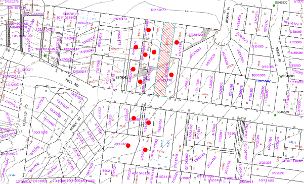
|
NOTIFICATION
PLAN
|
|
|
• PROPERTIES NOTIFIED
|
X SUBMISSIONS
RECEIVED
|

PROPERTY SUBJECT OF DEVELOPMENT
|

|
|
|
|
|
6. THE PUBLIC INTEREST
Section 79C(1)(e) of the Act
requires Council to consider “the public interest”.
The public interest is an
overarching requirement, which includes the consideration of the matters
discussed in this report. Implicit to the public interest is the achievement
of future built outcomes adequately responding to and respecting the future
desired outcomes expressed in environmental planning instruments and
development control plans.
The application is considered to
have satisfactorily addressed Council’s and relevant agencies’ criteria and
would provide a development outcome that, on balance, would result in a
positive impact for the community. Accordingly, it is considered that the
approval of the proposed subdivision of one lot into two lots would be in the
public interest.
CONCLUSION
The
application proposes the subdivision of one lot into two lots.
The existing dwelling on proposed Lot 22 does not comply with the 0.4:1 floor space ratio development standard of the HSLEP
1994. Consequently the application has been supported by a submission
under State Environmental Planning Policy No. 1 seeking approval of a
variation to this development standard.
The proposal generally complies
with the requirements of Council’s Residential Subdivision DCP other
than the maximum floor space ratio which is acceptable with regard to the well
founded SEPP 1 objection.
The multi-unit housing
development approved under DA/504/2011 complies with the requirements of both
Clause 14 (Density) and Clause 15 (FSR) provisions of the HSLEP. In
this regard, the proposed subdivision would not alter the approved built form
of the development.
No
submissions have been received in respect of the application.
It
is recommended that the application be approved.
Note: At the time of the completion of this planning report, no
persons have made a Political Donations Disclosure Statement pursuant to
Section 147 of the Environmental Planning and Assessment Act 1979 in
respect of the subject planning application.
|
James Farrington
Acting Executive
Manager - Planning
Planning Division
|
Rod Pickles
Manager -
Assessment Team 2
Planning Division
|
|
Paul David
Manager -
Subdivision & Development Engineering Services
Planning Division
|
|
Attachments:
|
1.View
|
Locality Plan
|
|
|
|
2.View
|
Plan for proposed
re-subdivision
|
|
|
|
3.View
|
Surveyor's Plan
for approved subdivision
|
|
|
|
4.View
|
Plans for approved
dwelling on proposed Lot 21
|
|
|
|
5.View
|
Landscape Plan
|
|
|
File Reference: DA/971/2011
Document Number: D01818529
SCHEDULE 1
GENERAL
CONDITIONS
The conditions of consent within this notice of determination have
been applied to ensure that the use of the land and/or building is carried out
in such a manner that is consistent with the aims and objectives of the
relevant legislation, planning instruments and Council policies affecting the
land and does not disrupt the amenity of the neighbourhood or impact upon the
environment.
Note: For the
purpose of this consent, the term ‘applicant’ means any person who has the
authority to act on or the benefit of the development consent.
Note: For the purpose of
this consent, any reference to an Act, Regulation, Australian Standard or
publication by a public authority shall be taken to mean the gazetted Act or
Regulation, or adopted Australian Standard or publication as in force on the date
that the application for a construction certificate is made.
1. Deferred
Commencement
Pursuant to Section 80(3) of
the Environmental Planning and Assessment Act 1979, this consent does not
operate until the following information is submitted to Council:
a. The
registration of the Plan of Subdivision creating proposed Lot 2 in accordance
with the conditions of consent of DA/1685/2004. A stamped copy of the
registered plan of subdivision must be submitted to Council.
Such information shall be
submitted within 12 months of the date of this notice.
Upon Council’s written
satisfaction of the above information, the following conditions of development
consent will apply:
2. Approved
Plans and Supporting Documentation
The development must be carried
out in accordance with the plans and documentation listed below and endorsed
with Council’s stamp, except where amended by Council and/or other conditions
of this consent:
|
Plan No.
|
Drawn by
|
Dated
|
|
“Plan for prop. Re-subdivision”
(Subdivision plan)
|
Unnamed
|
09.09.2011
|
|
“Plan for prop. Re-subdivision”
(Existing dwelling plan)
|
Unnamed
|
09.09.2011
|
|
“Surveyor’s plan for approved
subdivision”
|
Terry Edward Bartlett
|
08.02.2010
|
REQUIREMENTS PRIOR TO THE COMMENCEMENT OF ANY WORKS
3. Erosion
and Sediment Control
Erosion and
sediment control measures must be provided and maintained throughout the
construction period in accordance with the manual ‘Soils and Construction
2004 (Bluebook)’, the approved plans, Council specifications and to the
satisfaction of the principal certifying authority. The erosion and sediment
control devices must remain in place until the site has been stabilised and
revegetated.
Note: On
the spot penalties up to $1,500 may be issued for any non-compliance with this
requirement without any further notification or warning.
4. Erection
of Construction Sign
A sign must be erected in a
prominent position on any site on which building work, subdivision work or
demolition work is being carried out:
a. Showing
the name, address and telephone number of the principal certifying authority
for the work,
b. Showing
the name of the principal contractor (if any) for any demolition or building
work and a telephone number on which that person may be contacted outside
working hours, and
c. Stating
that unauthorised entry to the work site is prohibited.
Note: Any
such sign is to be maintained while the building work, subdivision work or
demolition work is being carried out, but must be removed when the work has
been completed.
REQUIREMENTS DURING CONSTRUCTION
5. Council
Property
During construction works, no building
materials, waste, machinery or related matter is to be stored on the road or
footpath. The public reserve is to be kept in a clean, tidy and safe condition
at all times.
6. Construction
Work Hours
All work
on site (including demolition and earth works) must only occur between 7am and
5pm Monday to Saturday.
No
work is to be undertaken on Sundays or public holidays.
REQUIREMENTS
PRIOR TO THE ISSUE OF A SUBDIVISION CERTIFICATE
7. Sydney
Water – s73 Certificate
A s73 Certificate must be
obtained from Sydney Water.
8. Creation
of Easements
The following matter(s) must be
nominated on the plan of subdivision under s88B of the Conveyancing Act 1919:-
a. An
inter-allotment drainage easement(s) to connect all lots to a Council
controlled drainage system, over any burdened lot, and a 150 mm diameter
pipeline constructed within that easement.
b. The creation of a “Positive
Covenant” over the proposed Lot 21 requiring that any future development is
to provide an on-site detention system. The on-site detention system is to
have a storage capacity of 5 cubic metres and a maximum discharge of 8 litres
per second into Council’s drainage system in accordance with Council’s
prescribed wording.
Note: Council
must be nominated as the authority to release, vary or modify any easement,
restriction or covenant.
9. Damage
to Council Assets
Any damage caused to Council’s assets as a result of the construction
of the development must be rectified in accordance with Council’s written
requirements and at the sole cost of the applicant.
10. Boundary
Fencing
Fencing must
be erected along all property boundaries behind the front building alignment to
a height of 1.8 metres.
Note:
Alternative fencing may be erected subject to the written consent of
the adjoining property owner(s).
11. Landscaping
Paved
areas are to be reinstated to landscaping in accordance with the approved
landscape plan.
12. s94
Infrastructure Contributions
In
the event that the contribution required under DA/504/2011 is not paid, the
payment to Council of a contribution of $20,000 for one additional lot towards
the cost of infrastructure identified in Council’s Development Contributions
Plan 2007-2011.
Note:
* The value of contribution is capped
at $20,000 per additional lot in accordance with Ministerial Direction
(Section 94E of the Environmental Planning and Assessment Act 1979) issued on
16 September 2010. In the event that this Direction is repealed or amended,
Council will apply the value of the contribution from the date of this consent,
adjusted from this date in accordance with the
underlying consumer price index for subsequent financial quarters. It is
recommended that you contact Council to confirm the value of the contribution
prior to payment.
13. Minimum Flood Planning Level (FPL)
All
future proposed habitable and lockable rooms for any dwelling or other building
on any Lot shall be constructed on a level higher than any level line
perpendicular to and coincident with the water flow line represented by joining
points “U” and “V” from the relevant deposited plan being at FPL levels 156.60
m AHD and 155.90 m AHD respectively.
- END OF CONDITIONS -
ADVISORY NOTES
The following information is provided for your
assistance to ensure compliance with the Environmental Planning and Assessment
Act 1979, Environmental Planning and Assessment Regulation 2000, other relevant
legislation and Council’s policies and specifications. This information does
not form part of the conditions of development consent pursuant to Section 80A
of the Act.
Environmental Planning and Assessment Act, 1979
Requirements
· The Environmental Planning and
Assessment Act, 1979 requires:
· The issue of a construction
certificate prior to the commencement of any works. Enquiries regarding the
issue of a construction certificate can be made to Council’s Customer Services
Branch on 9847 6760.
· A principal certifying authority to
be nominated and Council notified of that appointment prior to the commencement
of any works.
· Council to be given at least two days
written notice prior to the commencement of any works.
· Mandatory inspections of nominated
stages of the construction inspected.
· An occupation certificate to be
issued before occupying any building or commencing the use of the land.
Subdivision Certificate Requirements
A subdivision certificate application is required to be
lodged with Council containing the following information:
· A surveyor’s certificate certifying
that all structures within the subject land comply with the development consent
in regard to the setbacks from the new boundaries.
· A surveyor’s certificate certifying
that all services, drainage lines or access are located wholly within the
property boundaries. Where services encroach over the new boundaries,
easements are to be created.
· Certification that the requirements
of relevant utility authorities - including Ausgrid and Telstra - have been
met.
Note: Council
will not issue a subdivision certificate until all conditions of the
development consent have been completed.
Fees and Charges – Subdivision
All fees payable to Council as
part of any construction, compliance or subdivision certificate or inspection
associated with the development (including the registration of privately issued
certificates) are required to be paid in full prior to the issue of the
subdivision certificate. Any additional Council inspections beyond the scope
of any compliance certificate required to verify compliance with the terms of
this consent will be charged at the individual inspection rate nominated in
Council's Fees and Charges Schedule.
Dial Before You Dig
Prior to commencing any works,
the applicant is encouraged to contact Dial Before You Dig on 1100 or www.dialbeforeyoudig.com.au for
free information on potential underground pipes and cables within the vicinity
of the development site.
House Numbering
House numbering can only be
authorised by Council. Before proceeding to number each premise in the
development, the allocation of numbers is required to be obtained from
Council's Planning Division. The authorised numbers are required to be
displayed in a clear manner at or near the main entrance to each premise.
Tree Preservation Order
To ensure the maintenance and
protection of the existing natural environment, it is an offence to ringbark,
cut down, top, lop, remove, wilfully injure or destroy a tree outside 3 metres
of the approved building envelope without the prior written consent from
Council.
Note: A
tree is defined as a single or multi-trunked wood perennial plant having a
height of not less than three (3) metres, and which develops many branches,
usually from a distance of not less than one (1) metre from the ground, but
excluding any plant which, in its particular location, is a noxious plant
declared as such pursuant to the Noxious Weeds Act 1993.
Fines may be imposed for
non-compliance with Council’s Tree Preservation Order.
Standard Report No. PLN19/12
Planning Division
Date of Meeting:
7/03/2012
2 DRAFT COMPREHENSIVE
LOCAL ENVIRONMENTAL PLAN - SECTION 65 CERTIFICATE
EXECUTIVE SUMMARY
In June 2011, Council endorsed a
draft Comprehensive Local Environmental Plan (CLEP) for public exhibition and
resolved that a submission be made to the Department of Planning and
Infrastructure (DP&I) requesting certification to enable the draft Plan to
be placed on public exhibition. Accordingly, a submission was made requesting
certification of the draft Plan.
In October 2011, Council received
a Section 65 Certificate from the Department. The Certificate includes
conditions with which Council is required to comply prior to the draft CLEP
being placed on public exhibition. The conditions of certification have been
reviewed, consultation with the Department undertaken and a revised draft CLEP
prepared for Council endorsement.
It is recommended that the
revised draft CLEP (available for viewing at www.hornsby.nsw.gov.au\clep) be
endorsed for public exhibition and the Department requested to re-issue the
Section 65 Certificate based on the revised Plan.
PURPOSE
The purpose of this report is to
advise Council of the Section 65 Certificate issued by the DP&I and seek
endorsement of a revised draft CLEP for public exhibition that addresses the conditions
of the Certificate.
BACKGROUND
At its meeting on 1 June 2011,
Council considered Executive Manager’s Report No. PLN46/11 reviewing
submissions received in response to consultation undertaken with public
authorities in the preparation of the draft CLEP. The report notes that the
preparation of Council’s draft Plan has principally been a process of
transferring Council’s current planning instrument, the Hornsby Shire Local
Environmental Plan 1994 (HSLEP), into the NSW Government’s Standard
Instrument LEP format. The report also notes that the draft Plan has been
informed by local planning studies undertaken by Council to respond to
obligations under regional planning strategies and to satisfy Section 33A of
the Environmental Planning and Assessment Act concerning the making of a
new principal LEP for the Shire. Council resolved that:
1. Council endorse the revised draft Comprehensive Local
Environmental Plan attached to Executive Manager’s Report No. PLN46/11 for
public exhibition.
2. A submission be made to the Department of Planning and
Infrastructure pursuant to Section 64 of the Environmental Planning and
Assessment Act, 1979 requesting certification to enable the draft Comprehensive
Local Environmental Plan to be placed on public exhibition.
3. Should conditions of certification only require minor
amendment to the draft Comprehensive Local Environmental Plan, the General
Manager be delegated authority to endorse and exhibit the Plan for a minimum of
60 days in accordance with the consultation strategy attached to Executive
Manager’s Report No. PLN92/10.
4. Following exhibition of the draft Comprehensive Local
Environmental Plan, a report on submissions be presented to Council for its
consideration.
On 16 June 2011, Council
forwarded a submission to the DP&I pursuant to Section 64 of the EP&A
Act requesting certification to enable the draft CLEP to be placed on
public exhibition. On 11 October 2011, Council received a Section 65
Certificate (copy attached) from the DP&I.
The Certificate includes
conditions with which Council is required to comply prior to the draft CLEP
being placed on public exhibition. These conditions include making a number of
amendments to provisions within the draft Plan that implement Council endorsed
planning strategies. The Certificate also requires that a number of minor
amendments to the format of the written instrument and maps be made after
exhibition.
To progress the draft Plan as
certified (or a Department accepted variation of same) to public exhibition
necessitates further Council endorsement. Accordingly, this report reviews the
conditions of certification, identifies further consultation undertaken with
the Department and presents a revised draft CLEP for Council endorsement.
DISCUSSION
The following discussion provides
a summary of the review process, identifies the Section 65 Certificate
conditions that have been included and not included in the redrafting of the
Plan, and outlines other matters requiring change to the draft Plan.
1. Peer Review and
Consultation
In March 2011, funding was
granted to Council by the DP&I for additional planning and GIS mapping
services to assist with the accelerated delivery of Council’s draft CLEP. In
July 2011, Council engaged the services of SJB Planning Consultants to assist
in tasks including a peer review of the draft CLEP and reviewing submissions
following exhibition of the draft Plan. SJB subsequently embarked on its peer
review of the draft Plan.
In December 2011, Council staff
met with representatives from the DP&I to discuss the Section 65
Certificate and to seek preliminary feedback on strategies for addressing the
conditions requiring amendment to provisions that implement Council endorsed
planning strategies. The DP&I advised that Council would need to accept
the request, justify the retention of Council’s provisions or make
recommendations for alternate provisions. Accordingly, the scope of the peer
review of the draft Plan was extended to cover the conditions imposed by the
Section 65 Certificate.
In January 2012, SJB completed
the peer review of the draft Plan. The Review identifies that the draft CLEP
(as previously drafted) is generally sound. The Review provides a series of
recommendations to address the amendments identified in the Section 65
Certificate. The Review also provides a number of recommendations that respond
to changes to planning legislation, wording in gazetted Standard Instrument
based LEPs and Council resolutions made since Council last considered the draft
CLEP.
In January 2012, Council staff
met with representatives from the DP&I to present the recommendations of
the peer review. The Department considered the recommendations and provided
feedback concerning drafting of the revised Plan.
2. Section 65 Certificate
The following discussion
identifies the major amendments to the draft Plan conditioned by the
Certificate to be made prior to public exhibition and those amendments that
have been included in the revised draft Plan and those that have not.
Conditions Included
The conditions of the Certificate
that have been included and an explanation concerning why they can be made
without impacting on Council endorsed planning strategies are identified below
under the relevant part of the Plan.
Part 1 - Preliminary
· The
draft Plan was certified subject to the deletion of the words “and are
compatible with the character and infrastructure capacity of areas” from
Aim 1.2(2)(c). The words are not necessary as the key development standards
within the draft Plan require that development proposals are assessed against
the “site constraints, development potential and infrastructure capacity of
the locality”.
Part 2 - Permitted or
Prohibited Development
· Rural Land Use Zones:
The draft Plan was certified subject to deletion of an objective from the rural
zones and their replacement with an alternate objective. The alternate
objective has been included but modified slightly as follows “To ensure that
development in the area does not unreasonably increase the demand for public
infrastructure, services or facilities” so that it generally achieves the
same intent as the original objective.
· Residential Land Use Zones: The draft Plan was certified subject to deletion of
the objective “To enable development that is compatible with the character
and within the infrastructure capacity of the area” from the residential
zones. The objective is not necessary as key development standards within the
draft Plan require that development proposals are assessed against “site
constraints, development potential and infrastructure capacity of the locality”.
· Business Land Use
Zones: The draft Plan was certified subject to deletion of the objective “To
encourage appropriate employment opportunities in accessible locations”
from the B5 Business Development zone. As the B5 zone extends along the Pacific Highway and Pennant Hills Road, the objective cannot be achieved in relation to
accessibility in all circumstances and therefore has been removed.
· Industrial Land Use Zones: The draft Plan was certified subject to prohibition of a
number of land uses in the IN1 General Industrial and IN2 Light Industrial
Zones as the Department is concerned that some land uses proposed may impact on
the employment/industrial use of the land. Health consulting rooms, hospitals,
medical centres, car parks and entertainment facilities have therefore been
prohibited in both the IN1 and IN2 zones. Also, registered clubs have been
prohibited in the IN1 zone and amusement centres prohibited in the IN2 zone.
· The
draft Plan was certified subject to prohibition of dwelling houses in the IN4
Working Waterfront zone. Dwelling
houses are inconsistent with the zone objectives and therefore have been
prohibited.
· Special Purpose
Land Use Zones: The draft Plan was certified subject to a minor change in
labelling on the Land Zoning Map for a number of special uses zoned sites to
reflect definitions within the Standard Instrument dictionary.
· Recreation Land Use Zones: The draft Plan was certified subject to the prohibition
of public administration buildings from the RE2
Private Recreation zone. Public
administration buildings are inconsistent with
the zone objectives and therefore have been prohibited.
· Environmental Protection Land Use Zones: The draft Plan was certified subject to the prohibition of
recreation facilities (indoor) in the E3 Environmental Management zone.
Recreation facilities (indoor) have been prohibited as the definition permits
land uses (eg. bowling alleys and ice rinks) inappropriate on steep lands and
floodplains.
Part 4 - Principal
Development Standards
· Minimum Subdivision Lot Size: The draft Plan was certified subject to the use of
two new model provisions, relating to minimum subdivision lot sizes for
community title schemes and strata plans. The
model provisions preclude community title and strata subdivision of
residential accommodation or tourist and visitor accommodation in certain zones
and therefore have been included.
· Floor Space Ratio: The
draft Plan was certified subject to deletion of Area 6 relating to a special
FSR provision for the Pennant Hills Hotel site. Area 6 provisions in Council’s
draft CLEP sought to promote the development of a public car park on the site.
However, having regard to commercial viability, redevelopment in accordance
with the existing provisions is unlikely. The provision of public carparking
within the Centre would be reviewed as part of the review of the Pennant Hills
Masterplan scheduled to be undertaken in accordance with the Strategic Planning
Programme. Accordingly, the provisions relating to Area 6 have been removed and
corresponding changes to the Height of Building Map have been made.
Part 6 - Local Provisions
· Acid Sulfate Soils: The
draft Plan was certified subject to the deletion of Clause 6.3(7) providing an
exemption from the need to submit an acid sulfate soils management plan. Clause 6.3(7) is not necessary as ploughing,
scarifying, tilling and ripping are unlikely to penetrate the ground surface by
more than a metre (i.e. the requirement for the highest class of Acid Sulfate
Soil lands where agriculture is permitted). The clause has therefore been
deleted.
· Natural Resource
Biodiversity: The draft Plan was certified subject to replacement of the
Natural Resource Biodiversity clause with the latest model clause. The
differences between the clauses are minor and do not materially change the
affect of the existing clause.
· High Risk Flood Planning Areas: The draft Plan was certified subject to the use of the
Department’s model clause that includes a definition of “flood planning area”.
Council included reference to “high risk flood planning areas” in response to
recent changes to the Housing Code SEPP which permit complying
development in “low risk” flood planning areas. The additional reference to
“high risk” was included in response to the lack of clear guidelines to
certifiers as to what constitutes “high risk” flood planning areas. Rather
than pursue a variation on the model clause, the Department has been requested
to clarify the relevant guidelines.
Schedule 1 - Additional
Permitted Uses
· The
draft Plan was certified subject to the deletion of a number of Items or
elements of Items under the Schedule. The Items and elements of Items
requested to be deleted that should be accepted are:
- Item 4 - Use of certain land at Dural
in zone RU2: (i.e. delete recreation areas/facilities at Pacific Hills Christian School subject to site area and student limits). Educational
facilities are permitted with consent in the RU2 zone under the Infrastructure
SEPP. Further, recreation areas and facilities are permitted with consent
in the zone under the draft CLEP. Student limits will be included in Council’s
draft Comprehensive DCP. Accordingly, the additional permitted use is not
included;
- Item 9 - Use of certain land at
Glenorie in zone RU4: (i.e. delete pharmaceutical research, development and
manufacturing facility). A development application has been lodged to
formalise the pharmaceutical research, development and manufacturing facility.
The application is currently under assessment. The draft CLEP includes savings
provisions for DAs lodged but not determined enabling Council to consider the
development without the additional permitted use;
- Item 10 - Use of certain land at
Hornsby and Waitara in zone R4: (i.e. delete medical centres). Medical centres
are permitted with consent in the R4 zone under the Infrastructure SEPP.
Accordingly, the additional permitted use is not required; and
- Item 11 - Use of certain land at Hornsby and Waitara in
zone R4: (i.e. delete office premises and the words “on the ground
floor”). Office premises on the ground floor would not promote ‘active street
frontages’ and therefore the use has been removed. The remaining additional
permitted uses would, by nature, only be located on the ground floor.
Conditions Not Included
The conditions of the Certificate
that have not been included in the revised draft Plan and an explanation
concerning why the provisions should be retained, or an alternate response
provided, are identified below under the relevant part of the Plan.
Part 1 - Preliminary
· The
draft Plan was certified subject to deletion of the first aim of the Plan,
namely the aim that provides Council’s vision. The aim of the draft Plan has
been redrafted having regard to the vision contained in Council’s Community
Plan 2010 - 2020 and a best practice example in the recently gazetted Penrith
LEP 2010.
Part 2 - Permitted or
Prohibited Development
· Rural Land Use Zones: The
draft Plan was certified subject to deletion of additional use provisions for Dural Village. The provisions permitted a number of commercial land uses where limited in
gross floor area. The additional use provisions for Dural Village have been deleted and instead (along with shop top housing) included as permitted
development under the RU5 Village zone. A 0.5:1 floor space ratio (FSR) on
the FSR Map and a local provision to restrict the scale and intensity of
development in Dural Village has also been included.
· Special Purpose Land Use Zones: The draft Plan
was certified subject to deletion of the local objectives from the SP3 Tourist
zone. The Department advised that these objectives potentially contradicted
the primary objective, namely to promote tourist development. However, the
Department also encouraged Council to develop alternate zone objectives that
reinforce the primacy of tourism related uses. Accordingly, appropriate
objectives have been drafted. A 0.5:1 FSR on the FSR Map to control the scale and
intensity of commercial land uses has also been included to reinforce the
nature of development that is promoted in the SP3 zone.
· Recreation Land Use Zones: The draft Plan was certified subject to the
prohibition of car parks, entertainment facilities and public administration
buildings from the RE1 Public Recreation zone. Entertainment facilities have
been prohibited in the zone. However, there is limited land available for the
establishment of car parks (at grade and/or multi storey) in Brooklyn and
Berowra Waters to support the identified parking needs of river residents.
There are a number of open space lands in these suburbs that could provide for
the establishment of same and still maintain a recreation function. These open
space lands could also provide for remote Council and/or State Government
agency offices that need to be located near the river (eg. Fisheries). Accordingly,
car parks and public administration buildings have been retained as permitted
land uses in the RE1 zone.
· The
draft Plan was certified subject to the change of the zoning of two bowling
clubs (located in the suburbs of Epping and North Epping) from RE1 Public
Recreation to RE2 Private Recreation. It is understood that the Department is
requesting this change in recognition of the private ownership of the lands and
as “registered clubs” are permitted under the RE2 zone. The bowling clubs are
both marked for acquisition by Council on the Land Reservation Acquisition
Map. Accordingly, Council’s intention is to secure the land for public
recreation purposes which better aligns with the RE1 zone.
Part 4 - Principal
Development Standards
· Minimum Subdivision Lot Size: The draft Plan was
certified subject to the deletion of local provisions
that permit a reduced allotment size where the subdivision facilitates
development for the purposes of recreation areas and/or facilities that form
part of the Pacific Hills Christian School. The
School is zoned RU2 and educational establishments are permitted with consent
under the Infrastructure SEPP. Further, recreational areas and
facilities are permitted with consent under the RU2 zone of the draft CLEP.
Accordingly, the local provisions have been deleted however, the minimum lot
size on the Minimum Lot Size Map has been reduced to 5,000sqm for the subject
land to achieve generally the same intent as the original clause.
· Floor Space Ratio: The draft Plan was certified
subject to the adoption of redrafted provisions relating to areas that benefit
from bonus FSR provisions so that the maximum FSR is shown on the map and the
lesser FSR requirement for various land uses is contained in the written
provisions. The redrafted provisions provide greater clarity and transparency,
with the exception of the special FSR area provisions relating to mixed use
development in Council’s Housing Strategy precincts (i.e. Area 5). Accordingly,
the Department’s provisions have been redrafted having regard to Council’s
intent.
Part 6 - Local Provisions
· Location of Sex
Services Premises: The draft Plan was certified subject to the replacement
of the existing Location of Sex Services Premises clause with the Department’s
model clause. The existing clause varies the Department’s model clause to
require Council to consider specified impacts in determining an application in
sensitive locations, irrespective of the zone where a sensitive land use is
located. The Department’s model clause would not require Council to consider
the impacts that a sex service premises may have on an amusement centre,
entertainment facility or other land use not listed in the model clause that is
likely to be regularly frequented by children and could adjoin sex services
premises. Accordingly, the existing clause has been retained.
· Earthworks:
The Earthworks clause in the draft CLEP includes a variation to the
Department’s model clause. The modified clause aims to prohibit earthworks in
the E2, W1 and W2 zones, consistent with recommendations from the Waterways
Review 2006. However, the draft Plan was certified subject to the model
Earthworks clause being used. The principles behind the prohibition of
earthworks in the E2, W1 and W2 zones remain relevant, namely to prohibit land
reclamation. There is no alternate method available under the draft CLEP to
achieve same. Accordingly, the existing earthworks clause has been retained.
Schedule 1 - Additional
Permitted Uses
· The draft Plan was certified subject to the deletion of a
number of Items or elements of Items under the Schedule. The Items or elements
of Items requested to be deleted that should be
included or where an alternate response is required are:
- Item 3 - Use of certain land at Brooklyn in zone RE1 (i.e. delete boat launching ramps, a caretaker’s residence and
jetties at Kangaroo Point). A caretaker’s residence is not defined under the Standard
Instrument and could be permitted as ancillary development. Accordingly,
its reference has been removed. Boat launching ramps and jetties not primarily
used for recreation purposes may not be covered by the Water Recreation
Structures definition. Accordingly, boat launching ramps and jetties have been
retained as additional permitted uses;
- Item 5 - Use of certain land at Dural
in zone RU5 (i.e. delete various low scale and low intensity commercial
uses at Dural Village). As discussed above, the additional use provisions have
been deleted and instead included as permitted development under the RU5
Village zone. A 0.5:1 FSR on the FSR Map and a local provision to restrict
the scale and intensity of development in Dural Village has also been included;
- Item 7 - Use of certain land at Dural
in zone IN2 (i.e. delete bulky goods premises at Dural Service Centre).
Having regard to the zones available under the Standard Instrument, the Dural
Service Centre Study (2010) recommended the IN2 zone be applied to a
component of the Dural Service Centre and that bulky goods premises be
permitted within that area. The relevance of permitting the land use in the
Dural Service Centre has potentially increased with the announcement that the
rural zoned areas of “South Dural” and “North Glenhaven” are being considered
for residential land release as part of the DP&I’s review of potential
housing opportunities on landowner nominated sites. Accordingly, bulky goods
premises has been retained as an additional permitted use; and
- Item 8 - Use of certain land at
Glenorie in zone RU4 (i.e. delete fruit shop with floor space limits). The
fruit shop would potentially benefit from existing use rights (therefore not
requiring the additional permitted use). However, due to size of the site the
(2ha) the use could expand without a floor space limitation. The fruit shop
has been removed as an additional permitted use. However, a 0.02:1 FSR has been
applied over the land on the FSR Map to limit the size of the existing fruit
shop to approximately 400sqm.
3. Changes to Planning
Legislation and Council Resolutions
The major peer review
recommendations (and corresponding amendments to the draft CLEP) that respond
to recent changes to planning legislation, wording in gazetted Standard
Instrument based LEPs and Council resolutions are identified below under
the relevant part of the Plan.
Part 2 - Permitted or
Prohibited Development
· Land Use Zones: The
Review notes that “seniors housing” is permitted in urban zones under
the draft CLEP to reflect the Seniors Housing SEPP. The Seniors
Housing SEPP contains detailed development standards for seniors housing.
The removal of FSR from residential zones under the draft CLEP removes the
primary development control for seniors housing potentially resulting in
greater development opportunity under the draft CLEP than the SEPP.
Therefore, the peer review recommends that the permissibility of seniors
housing should be via the Seniors Housing SEPP. Accordingly, reference
to “seniors housing” as a permitted land use under the draft CLEP has been
removed.
· The Review notes that water supply
systems, including water reticulation systems, are permitted under the Infrastructure
SEPP where constructed by, or on behalf of, a public authority. However,
the SEPP does not cover situations where private persons seek to connect
to water. The draft CLEP has been amended to permit water reticulation systems
in appropriate zones.
· The Review notes that mortuaries are
prohibited and there are limited sites where cemeteries are permitted in the
Shire. The draft CLEP has been amended to permit “cemeteries” under the
recreation zones and “mortuaries” under the IN1 General Industrial and IN2
Light Industrial zones.
· The Review notes that garden centres,
landscaping material supplies and plant nurseries are permitted in various
rural zones under the draft CLEP. Rural supplies are similar in nature to the
aforementioned land uses but were not permitted in the rural zones. They are
permitted in the Dural Service Centre which was originally established to
service the rural needs of the Shire. However, the zone and function of the
Centre has changed. Rural supplies are proposed to be permitted in rural zones
by the Hills Shire Council. Accordingly, rural supplies have been permitted in
various rural zones in the revised draft CLEP.
· On 2 September 2011, the Housing
Strategy LEP was gazetted and facilitated a mix of higher density housing
types in various suburbs throughout the Shire. However, the draft Berowra and
Mount Colah Commercial Centre precincts forwarded as part of Council’s Housing
Strategy Planning Proposal were not gazetted. Accordingly, relevant maps
have been revised to no longer promote high density housing in these precincts.
· At its meeting on 5
October 2011, Council considered Executive Manager’s Report No. PLN 71/11
presenting options for promoting affordable housing opportunities in the
Shire. The report notes that the preparation of the new CLEP provides the
opportunity for Council to introduce previously undefined housing types as permitted
land uses should Council see merit in same. Council resolved to defer
consideration of the matter to allow an informal briefing of Councillors.
A workshop on the matter was held on 22 February 2012. The outcome of the
workshop was not known at the date of finalisation of this report.
The Affordable
Housing SEPP permits secondary dwellings in residential zones. The draft
CLEP has been revised to permit “secondary dwellings” in rural zones and the
development controls for same be 60m2 or 20% of the total floor area
of the principal dwelling, which ever is greater. The draft CLEP has been
revised to permit “hostels” in the B2 and B4 zones.
Part 4 - Principal
Development Standards
· Floor Space Ratio: In light of a recent Planning
Assessment Commission approval for a day surgery at property No. 1A Northcote
Road, Hornsby, rather than rely solely on height limit, it is appropriate to
apply a 0.5:1 FSR to control the scale and intensity of development over those
lands currently zoned Residential AM under the HSLEP and proposed to be
zoned SP2 - Health Services Facility under the draft CLEP. A 0.5:1 FSR is
consistent with FSR applied to B1 Neighbourhood zoned land and would best
translate Council’s adopted planning strategy for the area.
· Height of Buildings: Preparation of Council’s draft
Comprehensive DCP has identified that the building height for the R3 Medium
Density Residential zone should increase slightly to enable the development of
2 storey residential flat buildings with an attic. Accordingly, the height of
building maps have been revised from 10m to 10.5m for the areas zoned R3 -
Medium Density Residential.
· The peer review notes that the
building heights proposed for industrial zones restrict appropriate clearance
for trucks accessing loading docks. Accordingly, a review of recent industrial
building DAs approved within the Shire and the Department’s Commercial and
Industrial Code SEPP Discussion Paper was undertaken to determine
appropriate heights. The height for 2 and 3 storey industrial developments,
namely the 8.5m height limit has been revised to 10.5m and the 12m height limit
has been revised to 14.5m.
Part 5 - Miscellaneous
Provisions
· Relevant
Acquisition Authority: The Housing Strategy DCP came into force on
15 September 2011 upon the gazettal of the Housing Strategy LEP. The
DCP includes a Traffic Management Improvement Plan to facilitate orderly and
efficient development in the Asquith Commercial Centre precinct. The Plan
involves the acquisition of two properties and extension of Wattle Street.
Accordingly, the Relevant Acquisition Authority clause and corresponding map
have been revised to implement the Plan.
· Council undertook an Open
Space Land Acquisition Review in 2006 and identified certain local open
space lands that would not address the recreational needs of residents. In
2008, Council resolved to rezone those lands not required, including two
parcels of land owned by the Metropolitan Local Aboriginal Land Council
(MLALC). Council sought comment from the MLALC to assist in determining an
appropriate zone for the lands under the draft CLEP. In June 2011, the Office
of Strategic Lands requested the rezoning of regional open space also owned by
the MLALC that directly adjoins the subject local open space zoned land.
Accordingly, the lands have been zoned E3 Environmental Management and the Land
Reservation and Acquisition Map revised.
· In November 2011, the
Roads and Maritime Services (RMS) requested a number of changes be made to the
classified road reservations on the Land Reservation and Acquisition Map. The
RMS provided additional information to support the requests, including
certificates of title and property dealings. The requests have been reviewed
and revisions made where appropriate.
Part 6 - Local Provisions
· Stormwater: The
peer review notes that the Stormwater clause is based on the Department’s model
clause. However, practical implementation of the model clause would be
difficult as it seeks to impose the same matters for consideration for
residential, business and industrial development which have different urban
forms and impacts. Accordingly, the Stormwater clause has been removed from
the draft CLEP and the development specific stormwater management/water
sensitive urban design provisions have been included in Council’s draft
Comprehensive DCP.
Schedule 5 - Environmental
Heritage
· At its meeting on 1
June 2011, Council resolved to endorse the Wahroonga North Heritage
Conservation Area (HCA) for inclusion in the HSLEP. On 2 September
2011, the amendment to include the HCA was gazetted. Accordingly, the schedule
in the draft CLEP has been updated.
· Various minor
amendments have been made to the property descriptions of heritage items having
regard to recently registered subdivisions.
STATUTORY CONSIDERATIONS
Statutory considerations were
addressed in Executive Manager’s Report No. PLN92/10 considered at Council’s
meeting on 1 December 2010. This report identifies the conditions of the
DP&I’s Section 65 certificate and reviews same having regard to Council’s
ability to implement its previously endorsed planning strategies. This report
reviews other provisions of the draft Plan having regard to changes to planning
legislation, wording in gazetted Standard Instrument based LEPs and
Council resolutions made since Council last considered the draft CLEP which
have implications for its preparation. This report also presents a revised
draft Plan for endorsement for public exhibition. Should Council endorse the
revised draft CLEP, the Department would be requested to re-issue the Section
65 Certificate based on the revised Plan.
BUDGET
Council’s new Comprehensive LEP
has been prepared with resources allocated to the Town Planning Services Branch
under the adopted Strategic Planning Program.
In March 2011, $89,600 was
granted to Council by the DP&I as part of its Local Environmental Plan
Acceleration Fund. The funding was granted for Council for additional planning
and GIS mapping services to assist with the accelerated delivery of its Plan.
Monies have been expanded from the grant to fund the preparation of the peer
review of the draft CLEP.
CONSULTATION
A peer review of draft Plan
having regard to the conditions of certification has been undertaken by SJB
Planning Consultants. Council officers have discussed the conditions of
certification and recommendations of the Review with the DP&I on two
occasions to inform the preparation of the revised draft CLEP.
CONSULTATION STRATEGY
A Consultation Strategy for the
draft CLEP was outlined in Executive Manager’s Report No. PLN92/10 and endorsed
by Council at its meeting on 1 December 2010. In summary, the draft Plan is
proposed to be exhibited for a minimum of 60 days, including advertisement in
local newspapers and on Council’s website, notification of relevant public
authorities and community and interest groups, distribution of a brochure and
use of the ‘Have Your Say’ website.
TRIPLE BOTTOM LINE SUMMARY
The Triple Bottom Line Summary
for the draft CLEP was addressed in Executive Manager’s Report No. PLN92/10.
CONCLUSION
Council has received a Section 65
Certificate from the Department. However, the Certificate includes conditions
within which Council is required to comply prior to exhibiting the draft CLEP.
To progress the draft Plan as
certified (or a Department accepted variation of same) to public exhibition
necessitates further amendments to the CLEP and Council endorsement.
Accordingly, it is recommended that the revised draft CLEP (available for
viewing at www.hornsby.nsw.gov.au\clep)
be endorsed for public exhibition and the Department requested to re-issue the
Section 65 Certificate based on the revised Plan.
|
RECOMMENDATION
THAT:
1. Council endorse the revised draft Comprehensive Local
Environmental Plan (as discussed in Executive Manager’s Report No. PLN19/12
and available for viewing at www.hornsby.nsw.gov.au\clep)
for public exhibition.
2. A submission be made to the Department of Planning and
Infrastructure requesting the Section 65 Certificate be re-issued to enable
the revised Plan to be placed on public exhibition.
3. Should conditions of the re-issued certificate only
require minor amendment to the draft Comprehensive Local Environmental Plan,
the General Manager be delegated authority to endorse and exhibit the Plan
for a minimum of sixty days in accordance with the consultation strategy
attached to Executive Manager’s Report No.PLN92/10.
4. Following exhibition of the draft Comprehensive Local
Environmental Plan, a report on submissions be presented to Council for its
consideration.
|
|
Jason Rawlin
Acting Manager -
Town Planning Services
Planning Division
|
James Farrington
Acting Executive
Manager
Planning Division
|
Attachments:
|
1.View
|
Section 65
Certificate
|
|
|
File Reference: F2007/00692-04
Document Number: D01868156
Standard Report No. PLN20/12
Planning Division
Date of Meeting:
7/03/2012
3 OPTIONS FOR A REVIEW OF
PLANNING CONTROLS IN GALSTON AND GLENORIE
EXECUTIVE SUMMARY
In May 2011, Council resolved
that a report be prepared for Council’s consideration outlining options to
prepare planning controls that provide greater housing choice in the
Galston and Glenorie areas. This report outlines Council’s existing controls
and vision for the areas, discusses opportunities and constraints to the
provision of greater housing choice and presents the following options for a
review of controls:
· Nominate Galston and
Glenorie for investigation for inclusion on the State Government’s Metropolitan
Development Program;
· Reduce allotment sizes
in the Galston and Glenorie areas while retaining the rural character and
lifestyle; or
· Retain the current
controls.
The advantages and disadvantages
of each option are outlined in the report. It is acknowledged that the
identification of additional housing opportunities in the Galston and Glenorie
areas would assist in addressing the dwelling targets under the State
Government’s Metropolitan Strategy. However, this aim should be
balanced against the value of rural and resource lands. For rural resource
lands to be sustainable they require long term security and without this, there
will be insufficient capital investment, undermining the future of rural and
resource lands.
Should Council consider the
progression of any option to review housing opportunities in the Galston or
Glenorie areas, it would be appropriate to consult with the Department of
Planning and Infrastructure in this first instance to determine its position.
This would enable Council to obtain preliminary advice prior to undertaking the
necessary supporting studies and community and stakeholder consultation.
This report recommends that Council
determine a position concerning a review of planning controls for the Galston
and Glenorie areas based on the options presented.
PURPOSE
The purpose of this report is to
outline options for a review of planning controls to provide greater housing choice
in the Galston and Glenorie areas.
BACKGROUND
At its meeting on 4 May 2011,
Council considered Notice of Motion No. NOM7/11
and resolved that a report be prepared for Council’s consideration outlining
the proposed planning controls under the Comprehensive Local Environment
Plan for the Galston and Glenorie areas. Council also resolved that the
report include options to prepare planning controls that provide greater
housing choice in the Galston and Glenorie areas having regard to the NSW
Government's commitment to construct sewerage infrastructure in the areas in
the short term and the Government's commitment to facilitating an increased
supply of greenfield housing in the Sydney metropolitan region. The report
should also include a preliminary analysis of any constraints to development,
including (but not limited to) appropriate allotment sizes, agricultural
viability of land, infrastructure and services, transport and
environmental constraints.
This report provides the above
information in accordance with Council’s resolution.
DISCUSSION
This report outlines Council’s
existing controls and vision for the Galston and Glenorie areas, discusses
opportunities and constraints to the provision of greater housing choice within
these areas and presents options for a review of planning controls.
In considering options to provide
greater housing choice, it is appropriate to consider Council’s rural lands
strategies, previous reviews of allotment sizes in the Galston area and current
and proposed planning controls for the area. It is also appropriate to
consider the current State and regional planning context.
1. Hornsby Rural Lands
Strategies
Council’s rural lands strategies
are discussed below in terms of the Rural Lands Study undertaken in 1995
and the more recent Rural Resource Lands Study prepared in 2006.
1.1 Rural Lands Study
In 1995, Council prepared the Rural
Lands Study which reviewed the environmental, social, economic and planning
issues relevant to the rural areas of the Shire. The Study notes that
although the value of agriculture in Hornsby Shire is a small component of the
value of agricultural production in Sydney, agriculture in the Shire is an
important contributor to the local economy. The Study comments that the
major threat to the continuation of agriculture in the Shire derives from the
pressure created by the growth of urban and rural/residential development
within the region. This pressure leads to more specific threats to agriculture
including fragmentation of agricultural land, uncertainty about the future use
of the land for agriculture, and the relatively high value placed on the land.
In recognition of the benefits of
agriculture and potentially productive agricultural land, and to minimise the
pressures on agricultural land uses, the Study recommends that
agriculture be recognised as a legitimate constraint to urban and
rural/residential development. With respect to population growth, the Study
concludes that demand for rural/residential and urban encroachment should be resisted
where inadequate or insufficient infrastructure is available or where natural
environments and existing or potentially productive agricultural land may be
compromised. Given the availability of existing infrastructure and services
and the likely economic benefits to local commerce, the Study recognises
that the preferred strategy to address demand for additional housing is to
accommodate growth within existing villages. The current rural zones embodied
in the Hornsby Shire Local Environmental Plan 1994 (HSLEP) are based on
the recommendations of the Study.
1.2 Rural Resource Lands
Study
The Rural Resource Lands Study
was co-ordinated by the Hills Council in 2006 on behalf of a number of Sydney
Councils, including Hornsby. The Study was undertaken in response to
concerns by a number of councils that the protection of rural lands was not
being adequately addressed at a regional level.
The Study recognises the
significance of rural and resource lands and comments that the Councils
involved in the Study have generally attempted to protect the future of
such lands. However, the Study notes the absence of a clear strategy for
these lands within the Sydney metropolitan region and the lack of regional
recognition has lead to uncertainty regarding their future, in turn resulting
in land banking, property speculation and pressure for subdivision.
The Study emphasises that
for rural resource lands to be sustainable, they require long term security and
that without this there will be insufficient capital investment. The Study
notes that the establishment of a clear urban growth boundary would assist in
preventing land speculation and the resultant pressure on land prices, so that
they more closely reflect the current planning controls rather than speculative
development potential.
The Study establishes a
vision for the role of rural lands in the region, addresses the regional rural
economy, incorporates links to the Metropolitan Strategy and addresses
sustainability issues. The Study also notes the absence of base
information including biodiversity mapping in the release of the Metropolitan
Strategy. This mapping is needed to inform decisions about land use in the
future. Although not part of the Metropolitan Strategy, vegetation
mapping is now available to Hornsby Council for consideration in planning for
Galston and Glenorie and is discussed later in this report.
2. Review of Allotment
Sizes in the Galston Area
Council has previously considered
the issue of whether to progress a review of minimum allotment sizes in the
Galston area. In response to representations from landowners, in February
2003, Council resolved to undertake community consultation concerning the
appropriateness of reducing permissible allotment sizes in the Galston area.
The consultation included consideration of underlying issues, including
agricultural viability, commercial viability of the Galston Village,
sustainability, the provision of social services and the appropriateness of
half and one acre allotments in Galston. The consultation was undertaken by an
independent consultant and included visitor and resident surveys, focus groups,
letters to government agencies and service providers and a public meeting. The
results of the consultation are summarised as follows:
· 50% of Galston
ratepayers supported subdivision to reduced allotment sizes and 50% were
opposed.
· Considerable community
concern was raised with ongoing temporary electricity service interruptions
(also termed ‘brown-outs’, being less in duration than ‘black-outs’).
· Service providers and
government agencies indicated that core infrastructure services, including
water and electricity, are currently at capacity and that new development would
be required to fund additional infrastructure. Sydney Water also confirmed
that on-site disposal was not appropriate for increased residential
development.
· The Department of
Primary Industries stated that it would not support the loss of potentially
productive agricultural lands.
· The Department of
Planning and Infrastructure indicated that any plan promoting additional
subdivision would be contrary to the State Government’s housing strategies and
would be unlikely to be supported.
In April 2004, Council resolved
not to progress a review of allotment sizes for rural zoned lands in Galston, except
for School Road and Johnston Road, which are within the Galston Village. Council also resolved to progress a number of initiatives to address issues raised in
the community consultation regarding inadequate infrastructure and services in
Galston and the viability of the Village. In October 2004, Council considered
a report concerning a rezoning proposal in respect of properties Nos. 5, 7 and 9 School Road, Galston. Council resolved not to support the rezoning proposal on a number
of grounds, including the potential for unsatisfactory environmental impacts as
the proposal did not provide a proven method of effluent disposal.
4. Current Controls
The current vision for Galston
and Glenorie is embodied within the HSLEP 1994 and Rural Lands DCP
as summarised below.
4.1 Hornsby Shire Local
Environmental Plan 1994
The Galston area is comprised of
approximately 2,364 hectares and is generally bounded by Galston Road,
Mid-Dural Road, Old Northern Road and Arcadia Road. The Galston Commercial
Centre is zoned Business C (Neighbourhood) and is supported by a range of
community uses on lands zoned Special Uses A (Community Purposes). The Galston Village residential area bounds the Commercial Centre to the north, east and west and
is zoned Residential AR (Low Density – Rural Village).
Glenorie is bisected by a local
government boundary, with the area to the west of Old Northern Road within the
Hills Local Government Area (LGA) and land to the east within Hornsby Shire.
Old Northern Road also separates the community uses and residential components
of Glenorie Village located within Hornsby Shire from the commercial
development with the Hills LGA. The area with Hornsby Shire is comprised of
approximately 1,450 hectares and is bisected by a number of roads, including Cairnes Road and Moores Road. The residential area of Glenorie Village is zoned Residential
AR (Low Density – Rural Village) with lands zoned Special Uses A (Community
Purposes) providing for a variety of community uses supporting the Village.
The general zoning philosophy of
the current zones surrounding Glenorie and Galston Villages is based on a
combination of retaining the best land for agriculture in the Shire, as well as
retaining other land for rural and scenic landscape significance. Rural BA
(Small Holdings – Agricultural Landscapes) is the dominant rural zone in the
locality reflecting higher agricultural productive lands, with lands zoned
Rural BR (Small Holdings – Rural Landscapes) and Rural AR (Large Holdings –
Rural Landscapes) identifying lower productive land fringing the
environmentally sensitive steeper lands zoned Environmental Protection B (River
Catchment). A small area of land north of Glenorie, zoned Rural AA (Large
Holdings - Agricultural Landscapes), reflects higher agricultural productive
lands held in large land holdings. The following zone objectives identify
Council’s adopted vision for the areas:
The primary objectives of the Rural AA (Large Holdings -
Agricultural Landscapes) zone are to:
· to restrain
population growth, maintain the rural character of the area and ensure that
existing or potentially productive agricultural land is preserved in large land
holdings; and
· to promote
agricultural use of land and provide for a range of compatible land uses which
maintain the agricultural and rural environment of the area.
The primary objectives of the Rural BA (Small Holdings –
Agricultural Landscapes) zone are to:
· to restrain
population growth, maintain the rural character of the area and ensure that
existing or potentially productive agricultural land is preserved; and
· to promote
agricultural use of land and provide for a range of compatible land uses which
maintain the agricultural and rural environment of the area.
The primary objectives of the Rural AR (Large Holdings –
Rural Landscapes) zone are to:
· to restrain
population growth and maintain the rural character of the area; and
· to provide for a
range of compatible land uses, including agriculture, which maintain the rural
environment of the area.
The primary objectives of the Rural BR (Small Holdings –
Rural Landscapes) zone are to:
· to restrain
population growth and maintain the rural character of the area; and
· to provide for a
range of compatible land uses, including agriculture, which maintain the rural
environment of the area and support the urban populace.
The HSLEP specifies a
maximum floor space ratio for the Business C (Neighbourhood) zone of 0.5:1 and
a minimum allotment size for the Residential AR zone of 500sqm. The minimum
allotment size requirements for non - urban land includes a 10 hectares minimum
for the Rural AA (Large Holdings – Agricultural Landscapes) and Rural AR (Large Holdings – Rural Landscapes) zones and a 2 hectares minimum for the Rural
BA (Small Holdings - Agricultural Landscapes) and Rural BR (Small Holdings -
Rural Landscapes) zones. A minimum allotment size of 40 hectares applies to
the Environmental Protection B (River Catchment) zone.
4.2 Rural Lands DCP
The Rural Lands DCP
contains general controls for development of rural lands as well as strategies
to guide development. Strategies address the environment, population, rural
character, economic development, community development, transport and Village
Masterplans.
The current Council adopted
visions for Galston and Glenorie Villages are embodied in the Village
Masterplans contained in the DCP. The Masterplans aim to enhance the
character of the Villages. The Galston Village Masterplan promotes improvements
to the character and identity of the commercial area through the development of
a scheme focused on a village green. The Glenorie Village Masterplan promotes
the strengthening of the rural/bushland character through minor civic
improvements to enhance the amenity of the Village.
5. Proposed Controls
The draft Hornsby
Comprehensive Local Environmental Plan (CLEP) is the subject of a
further report to Council at its meeting on 7 March 2012 in response to the
conditions of certification for exhibition issued by the Department of Planning
and Infrastructure. In the preparation of the CLEP, the Department
advised that the zoning philosophy embodied in the Rural Lands Study and
Rural Resource Lands Study should be reviewed to provide updated
planning controls in respect to the translation of rural zones. Accordingly,
Council engaged an independent planning consultant to review the studies.
The Rural Lands Planning
Provisions Review (2009) informed the selection of zones and includes a
land audit to identify land with the highest agricultural potential and other
land units including rural/residential development. The land use audit
identifies that the rural areas north of Galston Village are the most suitable
for agriculture and the rural areas south of Galston Village are generally rural-residential
in nature. Three new rural zones (RUI – Primary Production, RU2 – Rural
Landscapes and RU4 – Rural Small Holdings) have been used to implement the
findings of the land audit and the existing 2 and 10 hectare subdivision
pattern. The table below identifies the translation of rural zones.
|
Hornsby Shire
LEP 1994
|
Comprehensive
LEP 2011
|
|
Rural AA (Large Holdings -
Agricultural Landscapes)
|
RU1 - Primary Production
|
|
Rural AE (Large Holdings -
Extraction)
|
RU1 - Primary Production
|
|
Rural AR (Large Holdings -
Rural Landscapes)
|
RU1 - Primary Production
|
|
Rural BA (Small Holdings -
Agricultural Landscapes)
|
RU2 - Rural Landscape (south of
Galston Village)
RU4 – Primary Production Small
Lots (north of Galston Village)
|
|
Rural BR (Small Holdings - Rural
Landscapes)
|
RU2 - Rural Landscape (south of
Galston Village)
RU4 – Primary Production Small
Lots (north of Galston Village)
|
Although the zoning of lands is
proposed to be amended under the CLEP to reflect the new zone
descriptions, the land uses permissible within the zones remains largely
unaltered. Furthermore, minimum allotment size is proposed to be controlled
via a separate Lot Size Map which reflects the current 2 hectare and 10 hectare
requirements under the HSLEP.
‘Dwelling-houses’ and ‘rural
workers’ dwellings’ are currently permitted with development consent in the
rural zones under the HSLEP. The bulk and scale of dwelling-houses is
controlled by requirements in the Rural Lands DCP. Rural worker’s
dwellings are defined as ‘moveable dwellings’ and limited to a maximum gross
floor area of 110m2 by the HSLEP.
‘Dwelling houses’ and ‘rural
workers’ dwellings’ are proposed to be permitted with development consent in
rural zones under the CLEP. The bulk and scale of dwelling houses and
rural workers dwellings will be controlled by requirements in Council’s new
Consolidated DCP. In addition, secondary dwellings are also proposed to be
permitted with development consent in the rural zones. Secondary dwellings
will be limited in size to 60m2 or 20% of the total floor area of
the principal dwelling, which ever is greater. Secondary dwellings cannot be
subdivided from the principal dwelling.
The Review also provides
recommendations concerning the translation of Environmental Protection zones. The
Environmental Protection B zone from the existing HSLEP has been
amalgamated with the Environmental Protection D zone into the E3 Environmental
Protection Management zone from the Standard Instrument.
The Residential AR (Low Density –
Rural Village) zone, currently applying to the residential areas of the
Galston and Glenorie Villages has been translated to the R2 – Low Density
zone. The Galston Village commercial core has been translated to B1 –
Neighbourhood Centre.
6. Planning Context
The above discussion outlines the
background to the current planning strategies for Galston and Glenorie that
have informed the current and proposed planning controls for the areas.
However, in considering a review of planning controls to provide greater
housing choice in the Galston and Glenorie areas, it is also appropriate to
consider the NSW State Government’s current commitment to increase housing
supply.
6.1 Metropolitan Plan
for Sydney 2036
Through
the Government’s Metropolitan Plan for Sydney 2036, the Department
of Planning and Infrastructure continues to plan for the delivery of an
additional 770,000 homes in the Sydney metropolitan area by 2036. It
aims to maintain a course for a sustainable city by limiting urban sprawl,
protecting Sydney’s valuable resource land, encouraging more development near
public transport and reducing the need for car travel. Furthermore,
new housing is encouraged within existing areas, with the majority of new greenfield development being concentrated in the North-West and South-West Growth centres.
The following comments within the
Balancing Land Uses on the City Fringe component of the Metropolitan
Plan regarding rural lands are relevant to Council’s consideration of
residential opportunities within Galston and Glenorie:
· Sydney metropolitan
fringe contains significant biodiversity and conservation reserves, cultural
landscapes, major agricultural and resource lands;
· Lands outside Sydney’s
footprint are not simply areas awaiting urbanisation but essential lands
providing important employment, scenic, recreational, heritage and
environmental benefits as well as the preferred location for sustainable
agricultural and resource industries;
· Fringe lands are
protected by focusing the majority of urban growth in existing centres and
within recognised Growth centres;
· Satisfying the demand
for urban land while containing Sydney’s urban footprint will provide social,
economic and environmental benefits; and
· Modelling indicates
potential for more congestion, slower travel times and increasing economic
costs if development is not contained within the current footprint.
The Metropolitan Plan identifies
a dwelling target of an additional 29,000 dwellings within the North Subregion
by 2036. This represents an increase of 8,000 dwellings from the target
identified in the previous Metropolitan Strategy of 21,000 dwellings by
2031.
In considering where the
additional housing should be provided, the Growing and Renewing Centres
component of the Metropolitan Plan reflects a concentrated model whereby
new development and renewal is promoted in and around centres, towns, villages
and neighbourhoods and is focussed on public transport. The Metropolitan
Plan identifies a target of 70% of all new housing to be provided in
existing urban areas.
6.2 Draft
North Subregional Plan
The draft North Subregional
Strategy was released in 2007. It is anticipated that Subregional
Strategies will be reviewed and finalised based on the new dwelling targets
under the Metropolitan Plan and will break down the dwelling and
employment targets for each Council area. Currently, the draft Strategy
identifies that Hornsby Council must provide 11,000 new dwellings by 2031.
This target is expected to increase when the North Subregional Strategy
is finalised to correspond with the Metropolitan Plan.
The draft Subregional Strategy
makes the following recommendations for the Shire’s rural and resource lands:
· Council identify
significant rural and resource lands in its principal LEP and incorporate
measures to protect them from incompatible and inappropriate uses.
· Provide greater
certainty to encourage investment in resource lands.
The provision of additional
housing opportunities at Galston and Glenorie would assist Council meet its
dwelling targets under the State Government’s Metropolitan Plan and the draft
North Subregional Strategy. The Hornsby Shire Housing Strategy was
gazetted on 2 September 2011 providing opportunities for an additional 2,600
dwellings over the next 10 years. However, a future strategy will be required
to identify opportunities for a further 3,900 dwellings to meet the balance of
Council’s current dwelling obligation of 11,000 dwellings. The provision of
additional housing opportunities at Galston and Glenorie would contribute to
the achievement of Council’s dwelling target. However, the need for a
potential contribution from these areas should be considered in the context of other
projects being progressed by the State Government and Council that may assist
in achieving the balance of Council’s dwelling obligations. These projects
include South Dural, Epping Town Centre Study and the Hornsby West Side
Planning Proposal.
6.3 Metropolitan
Development Program
Future residential land release
in the metropolitan region is required to be included on the NSW Government’s Metropolitan Development Program (MDP) before it can proceed to formal rezoning for urban purposes. The MDP is the State
Government’s key program for managing housing supply and assisting in
coordinating infrastructure provision. Through the MDP, the State
Government aims to provide smaller dwellings which would be more affordable.
The Program covers both infill sites in existing urban areas as well as the
releases of land not previously urbanised, known as greenfield areas.
The
DP&I is directly responsible for determining whether to include an area on
the MDP and the State Government has the major involvement in the
early stages of the land release process, including inclusion of land on the MDP,
preparation of structure and infrastructure plans, as well as the servicing of
the land. Council’s formal role commences in the rezoning process if Cabinet
decides to include the land on the MDP. Accordingly, depending on the
scope of any review of planning controls to provide greater housing choice in
the Galston and Glenorie areas, the first step in the process may require
inclusion of the areas on the MDP.
7. Opportunities and
Constraints to Development in the Galston and Glenorie Area
As
indicated above, Galston and Glenorie have been the subject of considerable
study, analysis and consultation with both the community and stakeholders.
Based on this work to date, the following discussion outlines the main
opportunities and constraints to further housing development in Galston
and Glenorie. However, it should be noted that the extent to which the
following issues are relevant would vary depending on the scope of any review
of housing opportunities.
7.1 Reticulated Water
Water is piped to the rural areas
of the Shire from Sydney’s water supply dams, via Prospect Reservoir. The
Galston area is served by an elevated reservoir located at Galston Road,
Dural. This reservoir also provides sufficient pressure to properties with a
high elevation in Arcadia, Dural and Glenorie.
Augmentation of this system would
be required to provide for further urban development. Sydney Water has advised
that most of the reticulated mains are at their supply limit and that there are
few opportunities for extension without the requirement for pumping stations
and additional storage reservoirs. Should Council resolve to review the
potential for additional housing supply in the Galston and Glenorie areas, the
review should include further consultation with Sydney Water concerning water
supply.
7.2 Sewerage Services
A reticulated sewerage system is
not available in the Galston and Glenorie areas and therefore, residents rely
on pump-out septic systems, domestic treatment plants or chemical and
composting toilets. The disposal of effluent and waste water is a potential a
source of pollution. Accordingly, the development potential of the Galston and
Glenorie areas is limited without the provision of a reticulated sewerage
system.
Reticulated sewerage services are
proposed for the Cowan, Galston and Glenorie communities through Stage 2 of
Sydney Water’s Priority Sewerage Program. In this regard, the Operating
Licence of Sydney Water includes that sewerage be provided to Galston and
Glenorie by 30 June 2015 to service an estimated 633 allotments. It is unclear
whether the Program will have potential to service additional
residential development beyond the estimated 633 allotments.
As part of the Galston community
consultation undertaken in 2003, Sydney Water advised that the Program
only includes the Galston village area. In this regard, future developments
outside the village are not included in the Program and benefits will be
limited to existing development. Accordingly, any review of housing
opportunities would require further consultation with Sydney Water to confirm
the servicing capacity of the Program.
7.3 Viability of
Agricultural Land
Hornsby Shire
is a significant producer of nurseries and cut flowers as well as having some
stone fruit orchards and market gardening. There are also a number of farm
gate sales and the rural tourism market is growing. There is also an
increasing demand for rural residential development in the Shire.
The Department of Primary
Industries was consulted as part of the Galston community consultation. The
Department advised that it supports the retention of agricultural lands in the
Shire and notes the importance of retaining viable agricultural lands in close
proximity to Sydney markets. The Department acknowledged that current
practices may or may not be economically viable. However, agricultural
viability is dependent upon a range of factors such as capital invested, crop
varieties selected, yields, market demand, level of management skills,
expertise and the personal aspirations of the farmer. Agriculture pursuits are
required to operate over a long term to realise investment and any new
agricultural investment will consider the land used for agriculture and the
constraints from adjoining land uses. Furthermore, improved agricultural
practices and technology are providing solutions for farmers.
The Department commented that
reducing lot size reduces the flexibility for future agricultural opportunities
and increases the likelihood of the property being used solely for the
construction of a dwelling. This in turn intensifies the opportunities for
land use conflict between differing land uses (eg: due to crop spraying,
working hours and the like).
For continued agricultural
investment in the Galston area, the Department advised that Council should make
a strong commitment to agricultural zoned land. While there is uncertainty
regarding the future use of land, people will speculate and this ensures that
land prices remain above agricultural land values, making it difficult for new
agricultural investment.
7.4 Environmentally
Sensitive Areas
The natural environment is a
dominant feature of the Galston and Glenorie areas and is well preserved through
the reservation of National Parks, bushland reserves, open spaces and other
bushland areas. Steep slopes are also a significant constraint to rural and
urban development. Lands with slopes in excess of 20% are generally considered
to be unsuitable for agriculture, rural or residential development, due to
engineering difficulties, site instability and erosion problems. Parcels of
land in the Galston and Glenorie areas have been zoned Environmental Protection
B (River Catchment) to protect sensitive areas from development and reflect
land capability. Should Council resolve to review the residential potential of
land in Galston and Glenorie, the review should address the impact of
development on environmentally sensitive areas.
7.5 Flora and Fauna
Large areas of native bushland
within the rural areas of the Shire have been cleared for agricultural
activities and the majority of natural vegetation and fauna habitat is located
on steeper non-rural lands. Recent updated vegetation mapping for the Shire has
confirmed that remnant vegetation within the Galston and Glenorie areas is
dominated by Peppermint-Angophora Forest (the most common community within
Hornsby Shire), Grey Gum - Scribbly Gum Woodland (a common community in the
Shire) and Narrow-leaved Apple Gully Forest (a regionally significant
community). The areas also contain remnant pockets
of threatened ecological communities including Blue Gum High Forest, Sydney Turpentine Ironbark Forest and Shale Sandstone Transition Forest.
Flora species listed under the
NSW Threatened Species Conservation Act 1995 and recorded within the
area include Acacia bynoeana; Darwinia biflora; Epacris purpurascens var.
purpurascens; Eucalyptus scoparia; Melaleuca deanei; Persoonia mollis subsp.
Maxima; Pimelea curviflora and Tetratheca glandulosa.
Fauna species listed under the
NSW Threatened Species Conservation Act 1995 recorded within the area
include Barking Owl, Glossy Black-Cockatoo,Grey-headed Flying-fox, Koala,
Large-footed Myotis, Powerful Owl and Rosenberg's Goanna, Spotted-tailed Quoll
and Turquoise Parrot.
Council’s Biodiversity
Conservation Strategy aims to conserve species, populations and communities
of native plants and animals in Hornsby Shire. Should Council resolve to
review the residential potential of land in Galston and Glenorie, the review
should consider appropriate interfaces between urban
uses and bushland areas.
7.6 Bushfire Prone Land
Approximately 70% of the land
within the Galston and Glenorie areas is identified as bushfire prone on Council’s
Bushfire Prone Land Map. The bushfire prone land is typically located within
those areas with slopes in excess of 20% and in areas containing stands of
bushland. Should a review of housing opportunities be progressed, bushfire
mitigation measures would be required to be investigated that respect the
ecological significance of the areas and threatened ecological communities.
7.7 Water Quality
Hornsby Shire’s rural lands are
located within the Berowra Creek catchment and both rural and urban activities
within the area contribute to water quality problems experienced in Berowra
Creek and the Hawkesbury River. Council has entered into an agreement with
other statutory authorities to achieve ecological sustainable development (ESD)
in the Berowra Creek catchment through a Statement of Joint Intent.
Sydney Regional Environmental
Plan No. 20 also requires that a total catchment management approach be
undertaken to planning within the catchment of the Hawkesbury/Nepean River,
including a framework for the preparation of LEPs and DCPs. The
Hawkesbury/Nepean catchment is nominated in the regional planning strategy as
an ecologically sustainable region and involves integrating economic growth
with environmental protection and pollution control.
Council’s water quality data
suggests that the urban and rural-residential catchments have poorer water
quality than the rural catchments. Accordingly, further residential
development in the Galston and Glenorie areas may potentially result in further
deterioration in water quality. Should Council resolve to review
the residential potential of land in Galston and Glenorie, the review should be
considered in the context of the principles of ESD and total catchment
management.
7.8 Transport Services
The existing public transport
system within the rural areas of the Shire provides limited opportunities for
residents to access shopping and employment centres. The low level of
patronage and limited potential population growth in the Galston and Glenorie
areas makes increased public transport services unlikely in the foreseeable
future.
7.9 Housing for Seniors
or People with a Disability
SEPP Housing for
Seniors or People with a Disability facilitates additional housing choice
in the rural area by permitting development of serviced self-care housing (i.e.
independent living accommodation) on land adjoining land zoned primarily for
urban purposes subject to a number of requirements. There are currently 3 Site
Compatibility Certificates issued for senior living developments in close
proximity to Galston Village.
DA/484/2011 has been approved by
the Land and Environment Court for the construction of 76 independent living
units and a community facility at No. 392 and No. 5 Mid-Dural Road.
DA/850/2011 is the subject of a report recommending approval to the Joint
Regional Planning Panel at its meeting on 23 February 2012. The outcome of the
meeting was unknown at the time of finalisation of this report. However,
approval of the application would permit the construction of 96 independent
living units and a community facility at Nos. 330-334 Galston Road. A further
site at No. 353 Galston Road has been nominated for 30 dwellings.
Galston Village contains
approximately 400 dwellings. The above proposals would increase the number of
dwellings in the village by 50%. The implications of the increase in seniors
housing has not been the subject of any planning study to examine social
impacts, infrastructure provision, environmental impacts or community
facilities and services. A number of submissions in response to the Galston
community consultation indicated that the progression of reduced allotment
sizes may provide an alternative housing form to senior living developments and
was a popular response for older residents wanting to stay in Galston by
allowing them to sell off at part of their land to fund their retirement. The
major reasons advanced in favour of subdivision was that Galston could ‘control
its own destiny’ and so that the ‘viability of the shops can be improved’.
7.10 Appropriate Allotment
Sizes
A number of options for potential
allotment sizes could be evaluated depending on the objective of any review.
For instance, options may range from supporting urban release of land or
maintaining a rural character. A range of allotment sizes were considered as
part of the Galston community consultation. In conclusion, the consultant’s
report noted that those against reduced allotment sizes want to preserve a
productive rural environment, whereas those in favour supported a prestige
garden type suburb set in a rural landscape. Furthermore, the results
indicated that should a review of allotment sizes be progressed, the only lot
size that had support from the Galston community was 1 acre (4,000sqm) within 1
km of Galston Village. It was acknowledged that the 1 km radius was not
identified for any planning reason, except to indicate that further subdivision
close to the Village was more acceptable than subdivision across the whole
suburb. It was noted that should a review of allotment sizes be progressed, a
number of other factors should be considered in determining the extent of the
area to be subject to change in planning controls, including environmental
capability, infrastructure and land fertility.
In summary, it is acknowledged
that the identification of additional housing opportunities in the Galston and
Glenorie areas would assist in addressing the dwelling targets under the State
Government’s Metropolitan Strategy. However, this aim should be
balanced against the value of rural and resource lands. There is a need to
establish a clear urban growth boundary to assist in preventing land
speculation and the resultant pressure on land prices so that they more closely
reflect the current planning controls rather than speculative development
potential. For rural resource lands to be sustainable, they require long term
security and without this, there will be insufficient capital investment,
undermining the future of rural and resource lands.
OPTIONS FOR A REVIEW OF PLANNING
CONTROLS
The Department of Planning and
Infrastructure has not been consulted in the preparation of this report.
However, as part of the Galston community consultation, the Department advised
that it would be unlikely to support reduced allotment sizes in the Galston
area given its remoteness from existing urban areas and that it is unlikely to
form part of the Metropolitan Development Program in the foreseeable
future. Further, the protection of productive agricultural land is a major
factor in the Government’s identification of new urban release areas in the
Sydney Region and the Department indicated that it would not support the
fragmentation of lands that would be likely to threaten the overall viability
of remaining or future agricultural concerns in the Galston area.
The Department stated that it
encourages new residential development in Hornsby Shire in accessible
locations. Finally, the Department advised that, at the time, it was
developing the Medium Term Land Release Program. Accordingly, the
Department requested that Council not make any decisions which could pre-empt
this work. Given the above comments, should Council consider the progression
of any option to review housing opportunities in the Galston or Glenorie areas,
it would be appropriate to consult with the Department in this first instance
to determine its position. Notwithstanding, the previous advice of the
Department, the following options are provided for consideration by Council.
Option 1: Nominate Galston and Glenorie for investigation for
inclusion on the Metropolitan Development Program
The Metropolitan Plan for Sydney 2036 identifies an increased housing target for the North Subregion. This
revised target represents an increase of 8,000 dwellings from the Metropolitan
Strategy. Accordingly, in recognition of the State Government’s commitment
to sewer Galston and Glenorie by 2015, this option would involve nominating the
areas for inclusion on the MDP to contribute to the achievement of the
revised housing target.
It should be noted that the
inclusion of an area on the MDP indicates that the area is suitable for
investigation for urban purposes (ie. minimum allotment sizes in the order of
500 – 600sqm). Should the release of the areas for urban purposes be supported
by the State Government, a comprehensive local environmental study (LES) would
then be required addressing the implications of the rezoning and incorporating
detailed master planning for the areas. Under this option, it would be
appropriate to nominate an indicative study area. It is suggested that a 1 km
radius should be identified from Galston and Glenorie villages to indicate that
any subdivision should be close to the Villages rather than across the whole
suburb. Furthermore, a 1 km radius generally represents walking distance from
the services provided within the Village areas.
It should also be noted that
Council’s Housing Strategy is aimed at providing housing choice and
housing affordability through multi-unit housing. The Hornsby Shire Housing
Strategy aims to provide smaller dwellings which would be more affordable.
Affordability is difficult to achieve through the release of new urban sites
within Hornsby Shire, as new detached dwellings in the greenfield environment
are constructed for the middle and high priced sub market. Greenfield
residential development within the Galston/Glenorie area would likely be aimed
at the high priced sub-marked, which would not represent affordable housing.
Furthermore, the Department of Planning and Infrastructure has previously
indicated that it would not support the inclusion of Galston on the MDP
due to its remoteness from existing urban areas. The advantages and
disadvantages of this option are outlined below.
Advantages
· Additional housing
choice to enable older people to remain in the area by down-sizing and younger
couples to bring up families in a rural area.
· Provision of
additional population to support local commercial centres.
· Provision of funding
through developer contributions towards improvements to services and the public
domain.
Disadvantages
· Potential loss of
rural character and landscape qualities.
· Potential loss of
agricultural land and increase in urban/rural landuse conflicts.
· Existing poor
infrastructure supply (particularly water and electricity) may be unable to
cope with increased development.
· Out of centre location
for housing would place a great reliance on the use of private vehicles.
Should Council be of a mind to
support this option, an appropriate resolution would be as follows:
That
Council write to the Minister for Planning and Infrastructure to determine
whether the NSW Government would support the progression of investigations by
Council concerning the potential nomination of land within 1 kilometre of
Galston and Glenorie Villages for inclusion on the State Government’s
Metropolitan Development Program.
Option 2: Reduce allotment sizes in the Galston and Glenorie
areas while retaining the rural character and lifestyle
This option would involve retaining
the existing rural zoning of lands in Galston and Glenorie or apply the large
lot residential zone available under the Standard Instrument. The
existing minimum allotment sizes would be reviewed to provide additional
opportunity for housing provision.
Should this option be supported,
Council should be mindful that the issues associated with allotment sizes in
these areas are not unique. As part of Council’s previous consultations on
subdivision potential of rural land, representations were received from
residents in many rural areas requesting amendments to zonings or subdivisions
standards. These areas include Berrilee, Fiddletown, Arcadia, Middle Dural,
Dural and Wisemans Ferry. In consideration of these submissions, Council was
consistent in its resolutions that further subdivision should not be supported
as it may not be in the public interest as it could result in increased
environmental, social, transport and economic problems. The advantages and
disadvantages of this option are outlined below.
Advantages
· Additional housing
choice to enable older people to remain in the area by down-sizing and younger
couples to bring up families in a rural area.
· Maintain the rural
character of the area.
· Provision of
additional population to support local commercial centres.
· Provision of funding
through developer contributions towards improvements to services and the public
domain.
Disadvantages
· Potential increase in
urban/rural landuse conflicts.
· Existing poor
infrastructure supply (particularly water and electricity) may be unable to
cope with increased development.
· Out of centre location
of housing would place a great reliance on the use of private vehicles.
There are a number of options for
subdivision that could be explored under this option including various
allotment sizes and the extent of the study area. Therefore, should Council be
of a mind to support this option, an appropriate resolution would be as
follows:
That a
workshop be conducted with Councillors to discuss the aims, objectives,
methodology and timing for undertaking a review to reduce allotment sizes in
the Galston and Glenorie areas while retaining the rural character and
lifestyle.
Option 3: Retain the
Current Controls
This option would involve
retaining the existing controls for the Galston and Glenorie areas as contained
in the HSLEP 1994 and Rural Lands DCP. The existing controls
would be translated into the CLEP and Comprehensive DCP. The
advantages and disadvantages of this option are outlined below.
Advantages
· Conserves agricultural
and rural landscape qualities.
· Maintain current water
quality level in the area and the catchment.
· Maintain current level
of biodiversity in the area.
· No increased demand on
existing infrastructure.
Disadvantages
· Current level of
housing choice maintained.
· Current uncertainty
concerning the location and timing of senior living developments.
Should Council be of a mind to
support this option, an appropriate resolution would be as follows:
Council not
undertake a review of planning controls to provide additional housing
opportunities within the Galston and Glenorie areas as:
1. It would be inconsistent with the State Government’s ‘Compact City’ strategy and the concentrated housing model embodied in the Hornsby Shire
Housing Strategy.
2. There is a low priority to provide additional land in the
higher priced sub-market given existing land supplies in the north-west sector.
3. The existing and potential agricultural productivity of the
area would be lost.
4. The scenic qualities of the area would be compromised.
5. Increased density of development may result in further
deterioration of the water quality of Berowra Creek.
6. The area is poorly serviced by public transport and
therefore increased density of development of the area may place an additional
reliance on private motor vehicles with consequent impacts on air quality and
the road network.
It is recommended that Council
determine a position concerning a review of housing opportunities for Glenorie
and Galston based on the options outlined above.
STATUTORY CONSIDERATIONS
Should Council resolve to
progress option 1, it would be appropriate to seek the Department’s advice
regarding the inclusion of the land on the NSW Government’s MDP. Should Council
resolve to progress Option 2, following identification of the aims,
objectives, methodology and timing for undertaking a review, it would also be
appropriate to consult with the Department concerning its position in light of
its previous advice that it would not support the fragmentation of lands that
would threaten the overall viability of remaining or future agricultural
concerns in the Galston area.
FINANCIAL IMPLICATIONS
Should Council resolve to
progress either option 1 or 2, the work would potentially have significant
resource implications for Council through the staff and financial resources
required to progress the necessary environmental studies and undertake
community and stakeholder consultation.
The Annual Operating Plan for the
Town Planning Services Branch has been allocated towards other projects in
accordance with the Management Plan and Strategic Planning Program and does not
include funds or staff resources to undertake a review of housing opportunities
in Galston or Glenorie. Accordingly, should Council resolve to progress option
1 or 2, it would be appropriate that a subsequent workshop and/or report to
Council address the funding and resource implications of the project.
TRIPLE BOTTOM LINE SUMMARY
Triple Bottom Line (TBL) is a
framework for improving Council decisions by ensuring accountability and
transparency on social, environmental and economic factors. It does this by
reporting upon Council’s strategic themes. As this report provides Council with
information and options, a TBL summary is not required.
CONCLUSION
This report discusses the current
controls for the Galston and Glenorie, the opportunities and constraints to
increasing housing options within the areas, and outlines the advantages and
disadvantages of options for a review of planning controls. It is recommended
that Council determine a position concerning a review of planning controls for
Galston and Glenorie based on one of the options presented.
|
RECOMMENDATION
THAT Council determine a
position concerning a review of planning controls for the Galston and
Glenorie areas based on the options outlined in Executive Manager’s Report
No. PLN20/12.
|
|
James Farrington
Acting Executive
Manager - Planning
Planning Division
|
|
Attachments:
There are no
attachments for this report.
File Reference: F2004/07524
Document Number: D01869406