BUSINESS PAPER
General Meeting
Wednesday, 15
August, 2012
at 6:30 PM
Hornsby Shire Council Table
of Contents
Page
1
TABLE OF CONTENTS
AGENDA AND SUMMARY OF RECOMMENDATIONS
Rescission
Motions
ITEMS PASSED BY EXCEPTION / CALL FOR
SPEAKERS ON AGENDA ITEMS
GENERAL BUSINESS
General Manager's Division
Nil
Corporate Support Division
Item 1 CS9/12
Hornsby Shire Community Plan 2010-2020 - Implementation and End of Term Report
Item 2 CS10/12
Local Government Association - 2012 Annual Conference - Submission of Motions
Item 3 CS11/12
Investments and Borrowings for 2011/12 - Status for Period Ending 30 June 2012
Item 4 CS12/12
Pecuniary Interest and Other Matters Returns - Disclosures by Councillors and
Designated Persons
Environment and Human Services
Division
Nil
Planning Division
Item 5 PL13/12
Development Application - Five storey mixed use development
5 and 7 Thornleigh Street, Thornleigh
Item 6 PL14/12
Reporting Variations to Development Standards
Item 7 PL16/12
Precinct Support Scheme for Urban Activation Precincts
Item 8 PL18/12
Development Application - Townhouse Development
156 - 160 Sherbrook Road, Asquith
Infrastructure and Recreation
Division
Item 9 IR5/12
Request to Remove Tree at 33 Hannah Street, Beecroft
Item 10 IR11/12
Request to Remove Tree at 23 Millstream Grove Dural
PUBLIC FORUM – NON AGENDA ITEMS
Questions
of Which Notice Has Been Given
Mayor's
Notes
Mayoral
Minutes
Notices
of Motion
MATTERS OF URGENCY
SUPPLEMENTARY AGENDA
QUESTIONS WITHOUT NOTICE
Hornsby
Shire Council Agenda and
Summary of Recommendations
Page
1
AGENDA AND SUMMARY OF RECOMMENDATIONS
PRESENT
NATIONAL ANTHEM
OPENING PRAYER/S
Reverand Geoff Collison of St Johns Anglican Church Beecroft, will open the meeting in prayer
Acknowledgement of RELIGIOUS DIVERSITY
Statement
by the Chairperson:
"We
recognise our Shire's rich cultural and religious diversity and we acknowledge
and pay respect to the beliefs of all members of our community, regardless of
creed or faith."
ABORIGINAL RECOGNITION
Statement
by the Chairperson:
"We
acknowledge we are on the traditional lands of the Darug and Guringai Peoples.
We pay our respects to elders past and present."
AUDIO RECORDING OF COUNCIL MEETING
Statement
by the Chairperson:
"I advise
all present that tonight's meeting is being audio recorded for the purposes of
providing a record of public comment at
the meeting, supporting the democratic
process, broadening knowledge and participation in community affairs, and
demonstrating Council’s commitment to openness and accountability. The recordings will be made available on Council’s
website once the Minutes have been finalised. All speakers are requested to
ensure their comments are relevant to the issue at hand and to refrain from
making personal comments or criticisms."
APOLOGIES
/ LEAVE OF ABSENCE
political
donations disclosure
Statement by the Chairperson:
“In
accordance with Section 147 of the Environmental Planning and Assessment Act
1979, any person or organisation who has made a relevant planning application
or a submission in respect of a relevant planning application which is on
tonight’s agenda, and who has made a reportable political donation or gift to a
Councillor or employee of the Council, must make a Political Donations
Disclosure Statement.
If a Councillor or
employee has received a reportable political donation or gift from a person or
organisation who has made a relevant planning application or a submission in
respect of a relevant planning application which is on tonight’s agenda, they
must declare a non-pecuniary conflict of interests to the meeting, disclose the
nature of the interest and manage the conflict of interests in accordance with
Council’s Code of Conduct.”
presentations
declarations
of interest
Clause 52 of Council’s Code of Meeting Practice (Section
451 of the Local Government Act, 1993) requires that a councillor or a member
of a Council committee who has a pecuniary interest in a matter which is before
the Council or committee and who is present at a meeting of the Council or
committee at which the matter is being considered must disclose the nature of
the interest to the meeting as soon as practicable. The disclosure is also to
be submitted in writing (on the form titled “Declaration of Interest”).
The Councillor or member of a Council committee must not
be present at, or in sight of, the meeting of the Council or committee:
(a) at
any time during which the matter is being considered or discussed by the
Council or committee.
(b) at
any time during which the Council or committee is voting on any question in
relation to the matter.
Clause 51A of Council’s Code of Meeting Practice provides
that a Councillor, Council officer, or a member of a Council committee who has
a non pecuniary interest in any matter with which the Council is concerned and
who is present at a meeting of the Council or committee at which the matter is
being considered must disclose the nature of the interest to the meeting as
soon as practicable. The disclosure is also to be submitted in writing (on the
form titled “Declaration of Interest”).
If the non-pecuniary interest is significant, the
Councillor must:
a) remove the source of conflict, by relinquishing or
divesting the interest that creates the conflict, or reallocating the
conflicting duties to another Council official.
OR
b) have
no involvement in the matter by absenting themself from and not taking part in
any debate or voting on the issue as if the provisions of Section 451(2) of the
Act apply.
If the non-pecuniary interest is less than significant,
the Councillor must provide an explanation of why they consider that the
interest does not require further action in the circumstances.
confirmation
of minutes
THAT the Minutes of the General Meeting held
on 18 July, 2012 be confirmed; a copy having been distributed to all
Councillors.
Petitions
Rescission
Motions
ITEMS PASSED BY EXCEPTION / CALL FOR
SPEAKERS ON AGENDA ITEMS
Note:
Persons
wishing to address Council on matters which are on the Agenda are permitted to
speak, prior to the item being discussed, and their names will be recorded in
the Minutes in respect of that particular item.
Persons
wishing to address Council on non agenda matters, are permitted to speak
after all items on the agenda in respect of which there is a speaker from the
public have been finalised by Council. Their names will be recorded in the
Minutes under the heading "Public Forum for Non Agenda Items".
GENERAL BUSINESS
·
Items for which there is a Public Forum
Speaker
·
Public Forum for non agenda items
·
Balance of General Business items
General
Manager's Division
Nil
Corporate
Support Division
Page Number
Item 1 CS9/12 Hornsby
Shire Community Plan 2010-2020 - Implementation and End of Term Report
RECOMMENDATION
THAT
the contents of Deputy General Manager’s Report No. CS9/12 be received
and noted.
Page Number
Item 2 CS10/12 Local
Government Association - 2012 Annual Conference - Submission of Motions
RECOMMENDATION
THAT Council adopt the
draft motion in Deputy General Manager’s Report No. CS10/12 for submission to
the 2012 Local Government Association Conference.
Page Number
Item 3 CS11/12 Investments
and Borrowings for 2011/12 - Status for Period Ending 30 June 2012
RECOMMENDATION
THAT
the contents of Deputy General Manager’s Report No. CS11/12 be received and
noted.
Page Number
Item 4 CS12/12 Pecuniary
Interest and Other Matters Returns - Disclosures by Councillors and Designated
Persons
RECOMMENDATION
THAT Council note the Disclosure of Pecuniary Interests and
Other Matters Returns recently lodged with the General Manager have been tabled
as required by the Local Government Act.
Environment
and Human Services Division
Nil
Planning
Division
Page Number
Item 5 PL13/12 Development
Application - Five storey mixed use development 5 and 7 Thornleigh Street,
Thornleigh
RECOMMENDATION
THAT Council assume the
concurrence of the Director-General of the Department of Planning and
Infrastructure pursuant to State Environmental Planning Policy No. 1 and
approve Development Application No. 453/2012 for demolition of existing
structures and erection of a five storey mixed use development comprising 1
commercial unit and 21 residential units with basement car parking at Lot 25,
26 and 27 Sec 4 DP 1854, Nos. 5 & 7 Thornleigh Street, Thornleigh subject
to the conditions of consent detailed in Schedule 1 of Group Manager’s Planning
Report No. PL13/12.
Page Number
Item 6 PL14/12 Reporting
Variations to Development Standards
RECOMMENDATION
THAT the contents of Group
Manager’s Report No. PL14/12 be received and noted.
Page Number
Item 7 PL16/12 Precinct
Support Scheme for Urban Activation Precincts
RECOMMENDATION
THAT:
1. Council
nominate the Epping Town Centre for consideration by
the Department of Planning and Infrastructure
under the Urban Activation Precincts Scheme as the Scheme provides opportunity for financial support to
progress infrastructure upgrades required to service the resultant population
growth within the Centre identified under the Epping Town Centre Study.
2. Council’s
nomination recognise that any amendment to planning controls should be
progressed generally in accordance with the Epping Town Centre Study
recommendations subject to further review of a range of matters in response to
public submissions including Heritage Conservation Area boundaries, potential
heritage items, urban form in the Town Centre Core, residential precinct
heights, property acquisition and North West Rail Link impacts.
Page Number
Item 8 PL18/12 Development
Application - Townhouse Development
156 - 160 Sherbrook Road, Asquith
RECOMMENDATION
THAT Development Application No. 414/2012 for construction
of a townhouse development comprising 20 dwellings and strata subdivision at
Lot 2 DP 669154, Lot 1 DP 669153, Lot D DP 402287, Nos. 156-160 Sherbrook Road,
Asquith be approved subject to the conditions of consent detailed in Schedule 1
of Group Manager’s Planning Report No. PL18/12.
Infrastructure
and Recreation Division
Page Number
Item 9 IR5/12 Request
to Remove Tree at 33 Hannah Street, Beecroft
RECOMMENDATION
THAT Council refuse
application TA/37/2012 to remove one Eucalyptus saligna (Sydney Blue
Gum) from the property at 33 Hannah Street, Beecroft.
Page Number
Item 10 IR11/12 Request
to Remove Tree at 23 Millstream Grove Dural
RECOMMENDATION
THAT
Council refuse application TA/32/2012
to remove one Angophora costata (Smooth-barked Apple) from the property
at 23 Millstream Grove, Dural.
PUBLIC FORUM – NON AGENDA ITEMS
Questions
of Which Notice Has Been Given
Mayor's
Notes
Mayoral
Minutes
Notices
of Motion
SUPPLEMENTARY AGENDA
MATTERS OF URGENCY
QUESTIONS WITHOUT NOTICE
Deputy General
Manager's Report No. CS9/12
Corporate Support
Division
Date of Meeting:
15/08/2012
1 HORNSBY SHIRE COMMUNITY PLAN 2010-2020 - IMPLEMENTATION AND END OF TERM
REPORT
EXECUTIVE SUMMARY
· The Division of Local
Government’s integrated planning and reporting framework requires that all
councils develop a long term strategic plan and that at the end of their term,
a report is presented outlining the effectiveness of the strategic plan in
achieving the council’s objectives.
· Council’s end of term report
comprises a report on the implementation and effectiveness of the Hornsby Shire
Community Plan 2010-2020 since its adoption in 2010; and a key
achievements/highlights document covering the four-year term of this Council.
The intent is for both documents to be combined into a single publication
titled “Our Bushland Shire - A snapshot of the Hornsby Shire in 2012”.
· An update of the performance
measures indicates improvements in social and cultural areas and mixed trends
in environmental areas. The key achievements cover a myriad of projects with
positive outcomes, ranging from a significant reduction in legal expenses to
the construction of numerous local facilities and improvements to parks and
sportsgrounds.
· This term of Council has ensured
the financial sustainability of the organisation in the longer term. This in
turn has enabled the planning and implementation of numerous significant
capital works projects, including the Hornsby Aquatic Centre. Council is well
placed to continue playing a critical role in delivering local services and
providing opportunities for recreation, leisure and cultural expression.
· As Council is currently in
caretaker mode prior to the 8 September 2012 election, this Report has been
prepared having regard to the requirements of Council’s Elections – Caretaker
Period Policy. It is considered that the recommended decision below is not a
“major decision” within the context of Council’s Policy.
|
RECOMMENDATION
THAT
the contents of Deputy General Manager’s Report No. CS9/12 be received
and noted.
|
PURPOSE
The purpose of this Report is to present Council’s end of
term report, including reporting on the implementation of the Hornsby Shire
Community Plan 2010-2020 and its effectiveness in achieving social,
environmental, economic and civic leadership objectives over the past two
years.
BACKGROUND
The Division of Local Government’s integrated planning and
reporting framework requires that all councils develop a long term strategic plan.
The legislation also requires that, at the end of the term of council, a report
is presented outlining the effectiveness of the strategic plan in achieving its
objectives.
In 2009, Hornsby Shire Council
engaged its community in discussing a preferred future for the Shire. The
engagement results were translated into the Hornsby Shire Community Plan 2010 –
2020 and then exhibited for public comment in order to confirm the document
accurately reflected the outcomes from the community consultations. The
Hornsby Shire Community Plan 2010 – 2020 was adopted by Council in June 2010.
Immediately following the formulation of the Hornsby Shire
Community Plan, Council published a baseline document describing the state of
play in Hornsby Shire in 2010. The document, which includes the community’s
performance measures, is titled “Our Bushland Shire - A snapshot of the Hornsby
Shire in 2010”.
DISCUSSION
Council is required to endorse its end of term report at the
last meeting of Council. As the end of term report must be aligned to the
requirements for integrated planning and reporting, Council’s report comprises
the following two elements (both of which are attached):
· A report on the implementation
and effectiveness of the Hornsby Shire Community Plan 2010-2020 since its
adoption in 2010 (through an update of the document to reflect changes over the
past two years)
· A key achievements and highlights
document covering the four-year term of Council from September 2008 to June
2012
The intent is for both of these documents to be flowed into
a single publication titled “Our Bushland Shire - A snapshot of the Hornsby
Shire in 2012”.
Performance indicators
The performance indicators contained in the Hornsby Shire
Community Plan 2010-2020 were established by a community reference group as
part of the community planning process.
An update of the performance measures indicates improvements
in social and cultural areas. The statistics also suggest the number of healthy
waterways has decreased compared to previous measurement – noting that this
result is highly influenced by the amount of wet weather. If nitrogen is used
as an indicator of waterway health in freshwater creeks, it shows that
approximately 40% of sites are improving, 40% of sites are not changing and
about 20% are degrading. Potable water consumption by residents continues to
decline.
The key points to note from the updating process include:
· There has been a $1.3 billion
increase in gross regional product over two years
· Perceptions of safety when
walking in the Shire or travelling on public transport during the day and night
increased from 63% in 2010 to 80% in 2012
· In 2011/12 there was no net loss
of bushland due to development
· The percentage of local trips
using sustainable transport options has declined from 50% in 2010 to 44% in
2012
Achievements during this term of Council
In order to reflect Council’s achievements during the full
four-year term, the second attachment has been prepared to summarise key
achievements and awards from October 2008 to July 2012. The key achievements
cover a myriad of projects with positive outcomes, ranging from a significant
reduction in legal expenses to the construction of numerous local facilities
and improvements to parks and sportsgrounds. Some of the major achievements
include:
· Establishment of the Wallarobba
Arts and Cultural Centre
· Gazettal of the Hornsby Shire
Housing Strategy
· Securing the ability to fund
improvements to local facilities via a special rate
· Delivering major bush-care
projects
· Completing significant capital
works including Oxford Street Epping; Greenway Park Community and Childcare
facility; Rural Fire Service headquarters at the old Berowra Tollgates; and the
new sportsground facility at John Purchase Primary School at Cherrybrook.
CONSULTATION
The preparation of the Hornsby
Shire Community Plan 2010 – 2020 involved consultation with the community about
a preferred future for the Shire.
BUDGET
There
are no budgetary implications associated with this Report.
POLICY
As Council is currently in caretaker mode prior to the 8
September 2012 election, this Report has been prepared having regard to the
requirements of Council’s Elections – Caretaker Period Policy. It is considered
that the recommended decision is not a “major decision” within the context of
Council’s Policy.
CONCLUSION
This term of Council has ensured the financial
sustainability of the organisation in the longer term through the achievement
of an approval from the Minister for Local Government of a special rate
variation. This in turn has enabled the planning and implementation of numerous
significant capital works projects, including the Hornsby Aquatic Centre.
Council is well placed to continue playing a critical role in delivering local
services and providing opportunities for recreation, leisure and cultural
expression.
RESPONSIBLE OFFICER
The officer responsible for the
preparation of this Report is the Manager Strategy and Communications – Julie
Williams - who can be contacted on 9847 6790.
|
Julie Williams
Manager - Strategy and
Communications
Corporate Support
Division
|
Gary Bensley
Deputy General Manager
Corporate Support
Division
|
Attachments:
|
1.View
|
Report on implementation of Hornsby Shire Community Plan 2010-2020 -
July 2012
|
|
|
|
2.View
|
Key Highlights and Awards - 2008-2012
|
|
|
File Reference: F2009/00024-02
Document Number: D01958883
Deputy General
Manager's Report No. CS10/12
Corporate Support
Division
Date of Meeting:
15/08/2012
2 LOCAL GOVERNMENT ASSOCIATION - 2012 ANNUAL CONFERENCE - SUBMISSION OF
MOTIONS
EXECUTIVE SUMMARY
· The 2012 Annual Conference of the
NSW Local Government Association (LGA) will be held in Dubbo from 28 October to
30 October 2012. The Conference provides an opportunity for Council to submit
motions for debate and decision by delegates from member local governments
across NSW.
· In preparing draft motions for
Council’s consideration, regard has been had to resolutions made by Council
over the past 12 months, discussions between Councillors and members of the
Executive Committee (ExCo) and recommendations emanating from ExCo members in
respect of matters for which their Divisions are responsible.
· One motion is proposed to be
submitted to the Conference by Council. That motion deals with the use of
media (other than newspapers) for statutory advertising required by the Local
Government Act and Regulation as well as other relevant Acts and Regulations. The purpose of the motion is to enable councils to use
more cost effective communication mediums, such as the internet, when meeting
their advertising obligations under the Acts and Regulations.
· As Council is currently in
caretaker mode prior to the 8 September 2012 election, this Report has been
prepared having regard to the requirements of Council’s Elections – Caretaker
Period Policy. It is considered that the recommended decision below is not a
“major decision” within the context of Council’s Policy.
|
RECOMMENDATION
THAT Council
adopt the draft motion in Deputy General Manager’s Report No. CS10/12 for
submission to the 2012 Local Government Association Conference.
|
PURPOSE
The purpose of this Report is to provide an opportunity for
Council to formally adopt motions to be submitted to the 2012 Annual Conference
of the LGA.
BACKGROUND
The 2012 Annual Conference of the LGA will be held in Dubbo
from 28 October to 30 October 2012. The Conference provides an opportunity for
Council to submit motions for debate and decision by delegates from member
local governments across NSW.
Any motions proposed by councils will be categorised by the
LGA as either Category 1 or Category 2 Motions. In this regard:
· Category 1 motions must seek to
establish a new policy or position or amend existing policy and must be of
regional, state or national significance.
· Category 2 motions are motions which
are already covered by existing policy or subject to ongoing lobbying and/or
representation.
For motions to be considered at the Conference they must be
determined to be Category 1 motions. Category 2 motions will be dealt with by
the Executive of the LGA and not by the Conference. Where councils submit
similar motions on related topics, these motions may be grouped and the
strategic issue debated at the Conference to arrive at a “local government
industry” position.
DISCUSSION
The LGA has advised that motions submitted for the 2012
Conference must fall under one of the following four subject headings:
· Services (human services,
environmental services, library services, cultural programs, recreation
programs, health protection and promotion, development approvals, environmental
regulatory activity, etc)
· Infrastructure (issues
relating to transport, roads, bridges, footpaths, open space, water and
sewerage facilities, waste facilities and services, recreation facilities, arts
facilities, civic buildings, etc)
· Finance (revenue raising,
government funding, cost shifting, emergency services levy, waste levy, carbon
tax, economic development, etc)
· General (land use
planning, development approvals, environmental regulatory activity, workforce
planning and development, industrial issues, etc)
The LGA has also advised that each motion is to be formatted
in the following manner:
|
Name of Council:
|
|
|
Subject Heading
|
Select from: Services, Infrastructure, Finance,
General
|
|
Title:
|
Maximum allowed: 80 characters
|
|
Motion:
|
Insert Motion Text which should commence with
That the Local Government Association…
|
|
Note from Council:
|
|
It is noted that the closing date for the submission of
motions to the LGA is 15 August 2012. As such, the draft motion contained in
this Report has been submitted to the LGA on the basis that it is pending
adoption by Council.
_________________________________
Based on feedback received to date from Councillors and
members of ExCo, it is proposed that the following motion be submitted by
Council for consideration at the Conference.
|
Name of Council:
|
Hornsby Shire Council
|
|
Subject Heading
|
Services
|
|
Title:
|
Use Of Alternative Media
For Statutory Advertising
|
|
Motion:
|
That
the Local Government Association make representations to the State Government
for the Local Government Act, Local Government (General) Regulation and other
Acts and Regulations relevant to local government to be amended to allow
councils to use media other than newspapers (e.g. internet and online service
providers) for statutory advertising and the provision of public information.
|
|
Note from Council:
|
The
Local Government Act and Regulation and other Acts and Regulations relevant
to local government require councils to advertise certain matters in
newspapers. Advances in telecommunications and information technology have
provided new methods for society to access and use information. As the
readership of newspapers continues to decline over time, councils’ use of new
technology for statutory advertisements may lead to greater exposure of the
advertisements (at reduced cost). The purpose of this motion is to enable
councils to use more cost effective communication mediums, such as the
internet, when meeting its advertising obligations under the various Acts and
Regulations. It is estimated that in respect of statutory development
application advertising alone, Hornsby Shire Council could save in the
vicinity of $150,000 per annum by using electronic media instead of
newspapers. This could translate to several millions of dollars of savings
per annum for councils across the State. Council does not intend that an
amendment to the legislation should preclude an individual council from
undertaking its statutory advertising in a newspaper if it so chooses.
|
BUDGET
There
are no budgetary implications associated with this Report.
POLICY
As Council is currently in
caretaker mode prior to the 8 September 2012 election, this Report has been
prepared having regard to the requirements of Council’s Elections – Caretaker
Period Policy. It is not considered that the recommended decision is a “major
decision” within the context of Council’s Policy.
CONCLUSION
Having
regard to the requirements of the LGA in respect of the submission of motions
to its 2012 Annual Conference, and internal discussions that have occurred at
Council in respect of this matter, it is appropriate that the proposed motion
contained within this Report dealing with the use of alternative media for
statutory advertising be submitted to the LGA.
RESPONSIBLE OFFICER
The officer responsible for the
preparation of this Report is the Manager Governance and Customer
Service – Robyn Abicair - who can be contacted on 9847 6608.
|
Robyn Abicair
Manager - Governance
and Customer Service
Corporate Support
Division
|
Gary Bensley
Deputy General Manager
Corporate Support
Division
|
Attachments:
There are no attachments for
this report.
File Reference: F2011/00735
Document Number: D01959649
Deputy General
Manager's Report No. CS11/12
Corporate Support
Division
Date of Meeting:
15/08/2012
3 INVESTMENTS AND BORROWINGS FOR 2011/12 - STATUS FOR PERIOD ENDING 30 JUNE
2012
EXECUTIVE SUMMARY
· Council may invest funds that are not, for the time
being, required for any other purpose. The investments must be in accordance
with relevant legislative requirements and Council’s policies.
· The Chief Financial Officer must report monthly to
Council on the details of funds invested.
· This Report provides details of Council’s
investment performance for the period ending 30 June 2012. It indicates that
for total investments, the
annualised return for the period was 4.6% compared to the benchmark of 3.52%.
· In respect of Council’s borrowings, the
weighted average interest rate payable on loans taken out from June 2002 to
June 2012, based on the principal balances outstanding, is 6.96%.
· Consideration of this Report ensures that Council has
met and complied with the requirements of the Local Government Act in respect
of the investment of funds.
· As Council is currently in
caretaker mode prior to the 8 September 2012 election, this Report has been
prepared having regard to the requirements of Council’s Elections – Caretaker
Period Policy. It is considered that the recommended decision below is not a
“major decision” within the context of Council’s Policy.
|
RECOMMENDATION
THAT
the contents of Deputy General Manager’s Report No. CS11/12 be received and
noted.
|
PURPOSE
The purpose of this Report is to advise Council of funds invested
in accordance with Section 625 of the Local Government Act and to provide
details as required by Clause 212(1) of the Local Government (General)
Regulation 2005 and Council's Investment of Surplus Funds Policy.
BACKGROUND
Each month, a report is provided for Council’s consideration which
details Council's investments and borrowings and highlights the monthly and
year to date performance of the investments. Initial investments and
reallocation of funds are made, where appropriate, after consultation with
Council's financial investment adviser and fund managers.
DISCUSSION
Council may invest funds which
are not, for the time being, required for any other purpose. Such investment
must be in accordance with relevant legislative requirements and Council’s
Policies, and the Chief Financial Officer must report monthly to Council on the
details of the funds invested. Council’s investment performance for the period
ending 30 June 2012 is detailed in the attached document and summarised below:
· The At-Call and Term Deposits
achieved an annualised return of 5.26% for the period compared to the benchmark
of 3.50%.
· NSW T-Corp Long Term Growth
Facility achieved a marked to market annualised return of 1.41% for the period
compared to the benchmark of 4.22%. This fund has a 70% allocation to growth
assets. Short term performance is expected to be volatile and the investment
should be viewed over the longer term.
· The Capital Guaranteed Notes
achieved annualised returns of 0% for the period compared to the benchmark of
3.51%. No interest will be accrued for the remaining life of the securities.
The total value of these Notes was $3,775,490 as at 30 June 2012.
· For total investments, the
annualised return for the period ending 30 June 2012 was 4.6% compared to the
benchmark of 3.52%.
In respect of Council borrowings, the weighted average interest
rate payable on loans taken out from June 2002 to June 2012, based on the
principal balances outstanding, is 6.96%. The Borrowings Schedule as at 30
June 2012 is attached for Council’s information.
CONSULTATION
Appropriate consultation has occurred with Council's financial
investment adviser and fund managers.
BUDGET
Total year to date investment income for the period ending 30 June
2012 was $1,976,000. The revised budgeted income for the period was
$1,970,000. Approximately 32% of the total income relates to externally
restricted funds and is required to be allocated to those funds.
POLICY
All investments
have been made in accordance with the Local Government Act, the Local
Government (General) Regulation 2005 and Council's Investment of Surplus Funds
Policy.
As Council is currently in caretaker mode prior to the 8
September 2012 election, this Report has been prepared having regard to the
requirements of Council’s Elections – Caretaker Period Policy. It is
considered that the recommended decision is not a “major decision” within the
context of Council’s Policy.
CONCLUSION
The investment of Council funds for the period ending 30
June 2012 is detailed in the attached document. Council’s consideration of this Report and the attached document ensures
that the requirements of State legislation and Council protocols have been met
in respect of those investments.
RESPONSIBLE OFFICER
The officer responsible for the preparation of this Report is the
Chief Financial Officer - Glen Magus - who can be contacted on 9847 6635.
|
Glen Magus
Chief Financial Officer
- Financial Services
Corporate Support
Division
|
Gary Bensley
Deputy General Manager
Corporate Support
Division
|
Attachments:
|
1.View
|
HSC Investment Portfolio as at 30 June 2012
|
|
|
|
2.View
|
HSC Borrowings Schedule as at 30 June 2012
|
|
|
File Reference: F2004/06987
Document Number: D01965218
Deputy General
Manager's Report No. CS12/12
Corporate Support
Division
Date of Meeting:
15/08/2012
4 PECUNIARY INTEREST AND OTHER MATTERS RETURNS - DISCLOSURES BY COUNCILLORS
AND DESIGNATED PERSONS
EXECUTIVE SUMMARY
· Section 449 of the Local
Government Act (the Act) details the statutory requirements in respect of the
lodgement of Disclosure of Pecuniary Interests and Other Matters Return/s by
Councillors and Designated Persons.
· Section 450A(2) of the Act
requires that Returns lodged under Section 449 are to be tabled at the next
available Council meeting.
· In line with Section 450A(2),
this Report seeks to table the Return/s recently lodged with the General
Manager.
· As Council is currently in
caretaker mode prior to the 8 September 2012 election, this Report has been
prepared having regard to the requirements of Council’s Elections – Caretaker
Period Policy. It is considered that the recommended decision below is not a
“major decision” within the context of Council’s Policy.
|
RECOMMENDATION
THAT Council note the Disclosure of Pecuniary Interests and
Other Matters Returns recently lodged with the General Manager have been
tabled as required by the Local Government Act.
|
PURPOSE
The
purpose of this Report is to table the Disclosure of Pecuniary Interests and
Other Matters Returns lodged by Councillors/Designated Persons who have left,
commenced with, or internally transferred to a relevant position within
Council.
BACKGROUND
Section
449(1) of the Act requires a Councillor or Designated Person to complete and
lodge with the General Manager a Disclosure of Pecuniary Interests and Other
Matters Return within three months after becoming a Councillor or a Designated
Person. Section 449(3) requires a Councillor or Designated Person holding that
position at 30 June in any year to complete and lodge with the General Manager
a Return within three months after that date. Section 449(5) states that
nothing prevents a Councillor or Designated Person from lodging more than one
Return in any year.
Section
450A(2) of the Act requires that Returns lodged under Section 449 are to be
tabled at a meeting of Council. Returns lodged under Sections 449(1) and
449(3) are to be tabled at the first meeting held after the last day for
lodgement under those Sections; and Returns lodged for any other reason are to
be tabled at the first meeting after their lodgement.
Council's
procedures in respect of the disclosing of interests have been developed to
cater for the election/appointment/employment/retirement/resignation/etc of
Councillors or Designated Persons. These procedures:
· Require all Councillors and
Designated Persons who hold that position at 30 June in any year to submit
Returns to the General Manager by 30 September in that year (i.e. they are
lodged under S449(3)). These Returns are tabled at Council’s October General
Meeting for that year.
· Require newly elected Councillors
or newly appointed Designated Persons to lodge Returns to the General Manager
within three months of their election/appointment (i.e. they are lodged under
S449(1)). These Returns are tabled at the next available General Meeting of
Council.
· Require those Councillors or
Designated Persons who are leaving Council (because of retirement, resignation,
etc) to lodge Returns to the General Manager by their last day with Council.
These Returns are tabled at the next available General Meeting of Council.
DISCUSSION
Returns Lodged in Accordance with Sections 449(1) and/or 449(5) of
the Act and Council's Procedures
Council
last considered the tabling of Disclosure of Pecuniary Interests and Other Matters
Returns under these Sections of the Act at the General Meeting held on 18 July
2012 (see Deputy General Manager’s Report No. CS4/12). Since that time, two
additional Returns have been lodged with the General Manager and are now tabled
as required by the Act.
|
Date Lodged
|
Councillor/Designated Person (Position)
|
Reason for Lodgement
|
|
5 July 2012
|
Community
Liaison Officer
|
Leaving Council
|
|
9 July 2012
|
Development
and Environmental Protection Officer - Compliance
|
New employee
|
BUDGET
There
are no budgetary implications associated with this Report.
POLICY
As Council is currently in caretaker mode prior to the 8
September 2012 election, this Report has been prepared having regard to the
requirements of Council’s Elections – Caretaker Period Policy. It is
considered that the recommended decision is not a “major decision” within the
context of Council’s Policy.
CONCLUSION
In
line with the requirements of the Act, it is necessary that the two Returns
lodged with the General Manager be tabled at this General Meeting.
RESPONSIBLE OFFICER
The
officer responsible for the preparation of this Report is the Manager,
Governance and Customer Service – Ms Robyn Abicair - who can be contacted on
9847 6608.
|
Robyn Abicair
Manager - Governance
and Customer Service
Corporate Support
Division
|
Gary Bensley
Deputy General Manager
Corporate Support
Division
|
Attachments:
There are no attachments for
this report.
File Reference: F2012/00606
Document Number: D01969205
Planning Report No. PL13/12
Planning Division
Date of Meeting:
15/08/2012
5 DEVELOPMENT APPLICATION - FIVE STOREY MIXED USE
DEVELOPMENT
5 AND 7 THORNLEIGH STREET, THORNLEIGH
|
DA No:
|
DA/453/2012
|
|
Description:
|
Demolition of existing structures and erection of a
five storey mixed use development comprising 1 commercial unit and 21
residential units with basement car parking
|
|
Property:
|
Lots 25, 26 and 27 Sec 4 DP 1854, Nos. 5 & 7 Thornleigh Street, Thornleigh
|
|
Applicant:
|
Mr Mario Khaicy
|
|
Owner:
|
Mr R P Zaiter, Mr Barry
Whittle, Mrs Julie Anne Bird
|
|
Estimated Value:
|
$ 4,600,000
|
|
Ward:
|
C
|
EXECUTIVE SUMMARY
· The application proposes the
demolition of existing structures and erection of a five storey mixed use
development comprising 1 commercial unit and 21 residential units with basement
car parking.
· The proposal does not comply
with the Hornsby Shire LEP 1994 with regard to Clause 15 (Floor Space
Ratio). The applicant has made a submission pursuant to State Environmental
Planning Policy (SEPP) No. 1 to vary the standard. The submission is
considered well-founded and is supported.
· The proposal complies with the
requirements of SEPP No. 65, Council’s Housing Strategy Development
Control Plan and Business Lands Development Control Plan.
· One submission has been
received in response to notification of the application.
· It is recommended that the
application be approved.
· As Council is currently in caretaker mode prior to the
8 September 2012 election, this Report has been prepared having regard to the
requirements of Council’s Elections – Caretaker Period Policy. The recommended
decision is not a “major decision” within the context of Council’s Policy.
|
RECOMMENDATION
THAT Council assume the
concurrence of the Director-General of the Department of Planning and
Infrastructure pursuant to State Environmental Planning Policy No. 1 and
approve Development Application No. 453/2012 for demolition of existing
structures and erection of a five storey mixed use development comprising 1
commercial unit and 21 residential units with basement car parking at Lot 25,
26 and 27 Sec 4 DP 1854, Nos. 5 & 7 Thornleigh Street, Thornleigh subject
to the conditions of consent detailed in Schedule 1 of Group Manager’s
Planning Report No. PL13/12.
|
BACKGROUND
The land at No. 5 Thornleigh Street was rezoned from
Residential A (Low Density) to Business A (General) in 2009 (Amendment No. 97).
The land at No. 7 Thornleigh Street was rezoned from
Residential A (Low Density) to Residential C (Medium-High Density) on 2
September 2011 as part of Council’s Housing Strategy.
SITE
The site comprises three
allotments, (Nos. 5 and 7 Thornleigh Street) located on the northern side of
the road with a total area of 1337 m2. The site has an average slope
of 7.7% towards the street from the north-western corner (rear) to the
south-eastern corner (front).
Existing improvements on Nos.
5 and 7 Thornleigh Street include single storey dwelling-houses with garages at
the rear. A number of trees are located within the rear setback of both
properties.
The surrounding developments
on the eastern and southern sides include single and two storey residential dwellings.
The adjoining developments on the western and north-western sides include one
to three storey high commercial developments. Shops, offices and a gymnasium
are located in these commercial buildings.
PROPOSAL
The proposal involves the
demolition of the existing structures within the site and construction of a
five storey mixed use development comprising one commercial unit and 21
residential units with two levels of basement carpark. The details of the
development are provided below:
Commercial component:
The development involves the
construction of one commercial unit on the ground floor adjoining the western
boundary. The unit would have an area of 133 m2 with separate
entrance from Thornleigh Street.
Residential Component:
Twenty-one units are proposed
to be constructed in five levels. The unit mix would comprise of 4 x 1-bedroom
units, 15 x 2-bedroom units and 2 x 3-bedroom units. The units would be
accessed via a lift and would include balconies fronting the street, the rear
and the side boundaries.
The gross floor area of the
residential component of the development is 2133m2.
Car parking and access
The building would be
accessed from Thornleigh Street via a driveway located on the eastern boundary
of the site. A separate pedestrian entry would provide access to the foyer and
the lift for vertical circulation. A total of 23 residential spaces, 4
visitor’s parking spaces and 3 commercial parking spaces including disabled car
spaces and adaptable spaces are proposed in 2 basement levels.
Landscaping
The development would include
landscaped areas along the front, rear and side setback areas. The communal
open space area is proposed to be located at the rear of the site.
ASSESSMENT
The development application
has been assessed having regard to the ‘Metropolitan Plan for Sydney 2036’, the ‘North Subregion (Draft) Subregional Strategy’ and the matters
for consideration prescribed under Section 79C of the Environmental Planning
and Assessment Act 1979 (the Act). The following issues have been
identified for further consideration.
1. STRATEGIC CONTEXT
1.1 Metropolitan Plan for Sydney 2036 and (Draft) North
Subregional Strategy
The Metropolitan Plan for Sydney 2036 is a broad framework to secure Sydney’s place in the global economy by
promoting and managing growth. It outlines a vision for Sydney to 2036; the
challenges faced, and the directions to follow to address these challenges and
achieve the vision. The Draft North Subregional Strategy acts as a
framework for Council in its preparation of the Comprehensive LEP by the
end of 2012.
The Draft North
Subregional Strategy sets the following targets for the Hornsby LGA by
2031:
· Employment capacity to
increase by 9,000 jobs; and
· Housing stock to
increase by 11,000 dwellings.
The proposed development
would be consistent with the draft Strategy by providing an additional
21 dwellings and would contribute towards housing choice in the locality. The
development would also include a commercial component and generate employment
opportunity in the locality.
2. STATUTORY CONTROLS
2.1 Hornsby Shire Local Environmental Plan 1994
2.1.1 Clause 7 –
Permissibility
The subject land is zoned Business A (General) and Residential C (Medium/High Density) under the Hornsby
Shire Local Environmental Plan 1994 (HSLEP). The objectives of the
zones are:
Residential C zone:
(a) to provide for the housing needs of the
population of the Hornsby area.
(b) to promote a variety of housing types and
other land uses compatible with a medium to high density residential
environment.
(c) to provide for development that is within
the environmental capacity of a medium to high density residential environment.
This zone would only
accommodate the residential units. The proposed landuses are defined as
“demolition” and “multi-unit housing” under the HSLEP and are
permissible in the zone with Council’s consent.
Business A zone:
(a) to
encourage economic growth and employment opportunities.
(b) to
accommodate the retail, commercial and social needs of the community.
(c) to
encourage development that improves the health, vitality, cultural environment
and social environment within the area.
The proposed commercial unit
with residential units on top would be located in this zone. The proposed
landuses are defined as “demolition”, “business premises” and “multi-unit
housing” under the HSLEP and are permissible in the zone with Council’s
consent.
The proposed commercial unit
would facilitate employment opportunities in the locality. The proposal
complies with the objectives of the Business A zone in this regard.
2.1.2 Clause 11 -
Developments near the Zone Boundaries
The objective of this clause
is “to allow for development near zone boundaries where the development is
prohibited by zoning but is not inconsistent with the aims and objectives of
this plan”.
Clause 11 states the
following:
(1) This
clause applies to transitional land.
(2) Regardless of any other
provision of this plan, development may, with the consent of the Council, be
carried out on land to which this clause applies within a zone, for any purpose
for which development may be carried out in the adjoining zone, where the
Council is satisfied that:
(a) the development is not
inconsistent with the aims and objectives of this plan and the objectives of
both zones, and
(b) in the case of business or
industrial development, suitable land or premises are not available for the
development in any business or industrial zone in the locality.
Transitional land is defined
as “that land which is within 20 metres of a boundary between any two zones.”
Clause 11 of the HSLEP applies to the site as it comprises two zones and
is transitional land. It is noted that the toilet and storage area for the
commercial unit and the commercial car spaces in the basement would be located
within the “transitional land” component of the site. In this regard, the
location of the landuses, ancillary to the commercial unit, is appropriate as
the uses would be integrated as part of the overall development and would
promote the orderly development of the site.
2.1.3 Clause
15 – Floor Space Ratio
Clause 15 of the HSLEP
prescribes the maximum permissible floor space ratio (FSR) for development
within the Residential C zone. Subclause (5) of Clause 15 states that “This
clause does not apply to land shown edged heavy black on diagrams 1-8 in
Schedule BB.” The part of the site located in the Residential C zone is
identified in Diagram 8 of Schedule BB of the HSLEP. Therefore, Clause
15 does not apply to this section of the site.
The part of the site zoned Business A is identified in
Schedule B (Diagram 22) of the HSLEP. Clause 15(2) of the HSLEP
prescribes that the maximum FSR for a site identified in Diagram 22 should not
exceed 1.5:1. The proposed development results in an FSR of 1.83:1 in the
Business A Zone and does not comply with the above requirement. The application
is supported by a submission pursuant to State Environmental Planning Policy
No. 1 and is discussed in Section 2.3 of this report.
2.1.4 Clause 15A –
Height of Buildings
Clause 15A of the HSLEP
applies to the Residential C zone of the site and states the following:
“Height of Buildings
(1) The height of a building on any land shown edged heavy black
on Diagrams1-15 in Schedule BB is not to exceed the maximum height shown in the
Height of Building Map.”
In accordance with the above,
the maximum permissible height of any development on the Residential C
component of the site is 17.5 metres. The proposed development complies with
this requirement.
2.1.5 Clause 18 – Heritage
Clause 18 of the HSLEP
sets out heritage conservation provisions for Hornsby Shire. The site does not
include a heritage item and is not located in a Heritage Conservation Area.
Therefore, no further assessment in this regard is necessary.
2.2 Draft Hornsby Local Environmental Plan
Council, at its meeting in March 2012, endorsed the draft Hornsby
Local Environmental Plan (HLEP) for public exhibition. The draft HLEP
is currently being exhibited for public comment. The relevant provisions of the
draft HLEP that apply to the site are outlined below.
2.2.1 Zoning
The site would be zoned B6 (Enterprise Corridor) and R4
(High Density Residential) zone pursuant to the Land Use Table of the draft
HLEP. The proposed development within the B6 zone is defined as
‘Business premises’ and ‘Shop top housing’. The component of the development
within the R4 zone is defined as a ‘Residential Flat Building’. The development
would be permissible in the respective zones with Council’s consent.
2.2.2 Development
near zone boundaries
Clause 5.3 of the
draft HLEP includes provisions for developments near zone boundaries.
This Clause would apply to any land located within 20 metres of a boundary of
two zones and would allow flexibility in permissible landuses provided the
development is not inconsistent with the objectives of both zones.
This Clause would
apply to the site as it is located on a zone boundary. The matter is discussed
in detail in Section 2.1.2 of this report.
2.2.3 Height
of Building
Clause 4.3 of the draft HLEP provides that the height
of a building on any land is not to exceed the maximum height shown for the
land on the Height of Buildings Map. The maximum permissible height for the
subject site within the R4 zone is 17.5 metres and that within the B4 zone is
16 metres. The proposal complies with this provision.
2.2.4 Floor Space
ratio
Clause 4.4 of the draft
HLEP specifies that the floor space ratio of a building on any land is not
to exceed the maximum FSR shown for the land on the Floor Space Ratio Map. The
maximum permissible FSR for the B6 component of the site is 1.5:1. As discussed
above, the proposal would not comply with this requirement and is supported by
a submission pursuant to SEPP 1.
2.3 State
Environmental Planning Policy No. 1 - Development
Standards
The application has been
assessed against the requirements of SEPP 1. This Policy provides
flexibility in the application of development standards in circumstances where
strict compliance with those standards would, in any particular case, be
unreasonable or unnecessary or tend to hinder the attainment of the objectives
of the Act. The relevant objectives of Section 5(a) of the Act
are to encourage:
“(i) the proper management, development and
conservation of natural and artificial resources, including agricultural land,
natural areas, forests, minerals, water, cities, towns and villages for the
purpose of promoting the social and economic welfare of the community and a
better environment,
(ii) the promotion and co-ordination of the
orderly and economic use and development of land,
(v) the provision and co-ordination of
community services and facilities,”
One of the broad objectives
of the HSLEP is “to facilitate the orderly and economic development
of land within the area”.
The objective of Clause 15 is
“to control intensity and scale of development of land so that development
will be in accordance with the land’s environmental capacity and zone
objectives.”
The proposed development
would result in a FSR of 1.83:1 within the Business A zone. The remaining part
of the site is zoned Residential C with no FSR control. The applicant submits
that the proposal is consistent with the objectives of the Business A zone,
Clause 15 of the HSLEP and the Act in the following ways:
· “The extent of non-compliance, when considering the
whole development site, is approximately 10% and is imperceptible when
considering the bulk and scale associated with the development;
· The design concept provides for an appropriate
distribution of the building mass, noting technical compliance with the control
could be achieved through a redistribution of the building mass to the
Residential C land however the design outcome would be poor in terms of amenity
and the level of presentation to Thornleigh Street;
· The design of the development proposal has been
carried out to align with the desired future character of the Station Street Precinct, which will adopt building forms of approximately five (5) storeys
and 17.5 metres. The current proposal will exhibit a comparable intensity and
scale to the future development of the precinct;
· The intensity and scale of the development does not
exceed the environmental capacity of the land, noting that the design concept
ensures that environmental impacts are acceptable. Amenity for future occupants
is maximised with 81% of units receiving more than 2 hours of solar access at
mid-winter and are cross-ventilated;
· The development proposal provides for a ground floor
commercial tenancy to activate the street frontage and to contribute to the
retail, commercial and social needs of the local community. The ground floor
commercial tenancy will also provide future employment opportunities and the
overall concept will contribute to the improvement of the health, vitality, cultural
and social environment within the area;
· The proposal is generally consistent with the
provisions of the Draft Hornsby Local Environmental Plan 2012, noting
compliance with the 16 metres height limit.
· The Business A zone of No. 5 Thornleigh Street is an
anomaly in that it has been used for residential purposes for several decades,
with the relatively recent development of the adjoining site to the north-west
effectively extinguishing any substantive commercial development potential of
the 445 m2 allotment.
· The current proposal ensures that the allotment zoned
Business A will not be isolated and facilitates the orderly and economic
development of the land by providing an appropriate intensity that aligns with
the future scale of development in the Station Street Precinct whilst providing
commercial floor area at the ground floor. The dual zoning of the site provides
a logical transition at the interface of the commercial zone to the north and
west with the residential zoned land to the east”.
The Land and Environment
Court has expressed the view that there are five different ways in which an
objection may be well founded and that approval of the objection may be
consistent with the aims of the Policy:
1. The objectives of the standard are achieved
notwithstanding non-compliance with the standard;
2. The underlying objective or the purpose of the
standard is not relevant to the development and therefore compliance is
unnecessary;
3. The underlying object of purpose would be
defeated or thwarted if compliance was required and therefore compliance is
unreasonable;
4. The development standard has been virtually
abandoned or destroyed by the Council’s own actions in granting consents
departing from the standard and hence compliance with the standard would be
unnecessary and unreasonable.
5. The zoning of the particular land is
unreasonable or inappropriate so that a development standard appropriate for
that zoning is also unreasonable and unnecessary as it applies to the land and
compliance with the standard would be unreasonable or unnecessary. That is, a
particular parcel of land should not have been included in the particular
zone.
It is considered that the
first three of the above points are relevant matters to consider in respect of
this application. Having regard to the above points, the following matters are
considered relevant:
· The
development is consistent with the objectives of Section 5 of the Act
and the broad objective of the HSLEP in that it encourages the improved
management of urban land and promotes the orderly use of that land.
· The
current development would be a desirable outcome for the site as it would be
consistent with Council’s vision of accommodating additional housing
stock in the area whilst providing employment opportunities in the locality.
· The
proposal complies with the objectives of the development standard for “Floor
Space Ratio” within the HSLEP.
· The site is located at the boundary
of a business precinct and a high density residential precinct. This
development would provide an appropriate transition between the two areas.
· The
proposed additional floor space would not be visible from the public domain and
would not result in additional bulk or scale.
Based on this assessment, it
is considered that the applicant’s SEPP 1 submission is well founded and
that compliance with the development standard would be unreasonable and
unnecessary in the circumstances of the case. Accordingly, the SEPP 1
submission is supported.
2.4 State Environmental Planning Policy No. 55 – Remediation of
Land
State
Environmental Planning Policy No. 55 (SEPP 55) requires
that Council must not consent to the carrying out of any development on land
unless it has considered whether the land is contaminated or requires
remediation for the proposed use.
The site has been used for residential purposes and is unlikely to
be contaminated. No further assessment is considered necessary in this regard.
A condition is recommended to notify Council should any contamination be found
during construction.
2.5 State Environmental Planning Policy No. 65
– Design Quality of Residential Flat Development
The application
has been assessed against the requirements of State Environmental Planning
Policy No. 65 (SEPP 65). This Policy provides State-wide planning controls for the assessment of residential flat developments and for
residential components of mixed use developments. The primary aim of SEPP 65 is to “improve
the design quality of residential flat development in New South Wales”.
An assessment of
the design of the proposed development against the ten principles provided in
Part 2 of SEPP 65 is detailed below.
2.5.1 Principle
1: Context
The site is
located within a precinct zoned for five storey residential flat buildings in
close proximity to Pennant Hills Road and the Thornleigh commercial centre. The desired future character of the area,
as outlined in Council’s Housing Strategy Development Control Plan, is
that of a high density residential precinct incorporating five storey
developments in a landscaped setting.
The submitted
“Design Verification Statement” indicates that the proposal responds to the
desired future character of the area visualised by Council. Once the precinct
is redeveloped, the development would integrate with the surrounding sites and
would be in keeping with the
desired urban form. The commercial unit would provide a transitional
development on the zone boundary.
This is the first
development application lodged with Council for the redevelopment of the
precinct. The above argument is supported as the development responds
appropriately to the ‘context’ principle of SEPP 65, and would
contribute to the identity and future character of the precinct.
2.5.2 Principle 2: Scale
The proposed
development complies with the maximum height limit permitted in the residential
precinct and provides a building envelope which confines itself within the
setbacks required by Council’s Housing Strategy Development Control Plan.
The component of the building within the Business zone, however does not comply
with the three storey height limit stipulated in the Business Lands Development
Control Plan. The matter is discussed in Section 2.11 of this report.
The articulated
facades of the building provide an appropriate transition between the adjacent,
existing two to three storey commercial developments and the future high density
residential precinct. The proposed design and inclusion of No. 5 Thornleigh
Street as part of the development would avoid the creation of an isolated
site between the commercial centre and residential precinct.
The scale of the
development is consistent with the desired future character of the precinct.
The application is assessed as satisfactory in this regard.
2.5.3 Principle 3: Built Form
The proposed
development presents a distinct architectural design which would set a
desirable precedent for the locality. The details of the elements of the built
form are assessed in Section 2.10 of this report.
2.5.4 Principle 4: Density
The HSLEP does not
incorporate any floor space ratio requirements for the residential component of
the site within the Housing Strategy precinct. The density of development is
guided by the height of the building and the required setbacks from the
boundaries. The development does not comply with the FSR requirement of
the Business A zone contained within the HSLEP. The matters have been discussed in detail in Sections 2.3 of this report.
The proposal achieves a
dwelling density consistent with the requirements of the Housing Strategy
Development Control Plan which establishes the desired future character for
the “Station Street, Thornleigh” precinct. The density of the development also
provides an appropriate transition between the residential precinct and
Thornleigh commercial centre.
2.5.5 Principle 5:
Resource, energy and water efficiency
The proposed development
includes a BASIX certificate and complies with the requirements with regard to
water, thermal comfort and energy. The proposal also complies with the natural
ventilation and solar access requirements within the Residential Flat Design
Code (RFDC). The details of the above matters are discussed in 2.6 of this
report.
2.5.6 Principle 6:
Landscape
The application
includes a landscape concept plan providing landscaping along the street
frontage and the side boundaries. This planting would activate the street frontage
and provide a landscaped setting for the proposed development.
The proposed
development also incorporates deep soil planting wherever possible and communal
recreational area within the rear setback. Given the above, the proposal
satisfies the intent of the ‘Landscaping’ principle of SEPP 65.
2.5.7 Principle 7: Amenity
The proposal
would provide convenient and safe access to the development via a central lift
connecting the basement and all other levels. The application has been assessed
against the ‘Building Amenity’ criteria within the RFDC and is discussed
in detail in Section 2.6 of this report.
2.5.8 Principle 8: Safety and security
The proposed
development is located on a road that experiences a medium level of pedestrian
movements. The design has regard to ‘Crime Prevention through Environmental
Design (CPTED)’ principles and does not include any obvious unobserved
areas.
The RFDC requires the
preparation of a formal Crime Assessment Report for development that comprises
more than 20 residential units. The proposal includes an assessment of the
development against crime prevention controls in the Statement of Environmental
Effects. The applicant advises that the safety of the public domain is enhanced
by providing apartment layouts that optimize occupant surveillance, well-lit
entry lobbies, garden paths and public areas, secured car-park entry and casual
surveillance for all communal areas.
The location of the balconies
and the card-only access to the premises would assist in passive surveillance
and would restrict unauthorized entry. The application is assessed as
satisfactory with regard to safety and security subject to a condition
requiring lighting of the service areas of the ground
floor, the garbage room and the communal open space at the rear.
2.5.9 Principle 9: Social dimensions
The site is
located within close proximity to a variety of shopping, recreation and
educational facilities. An appropriate mix of
landuses, dwelling types and sizes is proposed improving housing choice in the
locality. Accordingly, the
development is assessed as satisfactory with regard to social dimensions.
2.5.10 Principle
10: Aesthetics
The proposal is
generally consistent with the design principles contained within the RFDC.
It is considered that the aesthetic quality of the building contributes to the
desired future character of the precinct. The details of the assessment of the
built form and the aesthetics of the development are contained in Section 2.10
of this report.
2.6 SEPP 65 Residential
Flat Design Code
Clause 30(2) of SEPP 65
requires consent authorities to consider the
design quality of residential flat development when evaluated in accordance
with the design quality principles, and the Department of Planning and
Infrastructure’s Residential Flat Design Code (RFDC). The
following is an assessment of the proposal against the requirements of the
RFDC:
|
Residential Flat
Design Code
|
|
Control
|
Proposal
|
Requirement
|
Compliance
|
|
Deep Soil Zone
|
>30% within the Res C zone
|
Min 25%
|
Yes
|
|
Communal Open Space
|
28% within the Res C zone
|
25-30%
|
Yes
|
|
Ground Level Private Open Space
|
25m2
< 4m
|
25m2
Min Dimension 4m
|
Yes
No
|
|
Minimum Dwelling Size
|
1 br – 50m2
2 br – 70m2
3 br – 95m2
|
1 br – 50m2
2 br – 70m2
3 br – 95m2
|
Yes
Yes
Yes
|
|
Unit depth and maximum Kitchen Distance
|
8m
|
8m
|
Yes
|
|
Minimum Balcony Depth
|
2m
|
2m
|
Yes
|
|
Ceiling heights -
Residential floors
|
2.7m
|
2.7m (Min)
|
Yes
|
|
Ceiling
height-commercial floors
|
3m
|
3m (Min)
|
Yes
|
|
Total Storage area
|
1 br - > 6m3
2 br - > 8m3
3 br - > 10m3
> 50% accessible from the apartments
|
6m3 (Min)
8m3 (Min)
10 m3 (Min)
50% accessible from apartments
|
Yes
Yes
Yes
Yes
|
|
Dual Aspect & Cross Ventilation
|
76% (16 out of
units)
|
60%
|
Yes
|
|
Adaptable Housing
|
30%
|
10%
|
Yes
|
As detailed in
the above table, the proposed development generally complies with the
prescriptive measures within the RFDC. The matter of non-compliance
with dimensions for open space is discussed below as well as a brief discussion
on compliance with the relevant performance standards.
2.6.1 Building Depth and Separation
The proposed building depth
and the design of the facades are in accordance with the requirements of
Council’s Housing Strategy Development Control Plan and are discussed in
Section 2.10.
The majority of the living
areas and single aspect balconies would be setback 6 metres from the side
boundaries facilitating a future building separation of 12 metres with
adjoining sites in accordance with the RFDC. The top level balconies on
the eastern side would not provide a 9 metre separation from the boundary (18
metres from adjoining future development). Compliance can however, be achieved
via conditions of consent. The matter is discussed in Section 2.10 of this
report.
The proposed building
separation would not result in unreasonable compromise of natural ventilation
and solar access to the proposed, or adjoining future, developments subject to
the implementation of conditions of consent.
2.6.2 Apartment Layout
The proposed development
includes a mix of single aspect and corner units including, one, two and three
bedroom apartments. All units would be well ventilated minimising single aspect
areas wherever possible. Each apartment would include one primary balcony with
a secondary balcony being provided for most of the units. In accordance with
the RFDC, the majority of units (52%) have kitchens with access to natural
ventilation. Furthermore, no units are proposed as single aspect, south
facing.
The apartments include
storage areas in accordance with the requirements of the RFDC. The
storage areas are provided at the basement levels and additional storage areas
are also provided within the apartments.
The layout of the apartments
and the building configuration comply with the rules of thumb of the RFDC.
2.6.3 Ground Floor
Apartments and Private open Space
The majority of the ground
floor units have been provided with 25 sq metres of courtyard space. Unit No. 4
on the ground floor would not achieve the 4m minimum depth in one direction.
However, this ground floor terrace would be elevated above the ground due to
the slope of the land. Therefore, strict compliance with the objectives and the
prescriptive measure in relation to this standard is not applicable to this
unit.
The private courtyards on the
eastern side would include privacy screens to alleviate adverse impact on the
visual and acoustic privacy of residents on the adjoining allotment whilst
maintaining a communal landscaped strip along the boundary for pedestrian
access to the rear.
The location and dimensions
of the private courtyards for the ground floor apartments are considered
satisfactory.
2.6.4 Internal Circulation
The proposal includes barrier
free access to all floors via a lift. A maximum of 5 units would be accessed
from a double loaded corridor.
2.6.5 Acoustic Privacy
The internal
layout of the residential units is designed such that noise generating areas would generally adjoin each
other. Storage or circulation zones would act as a buffer between units.
Bedrooms and service areas such as kitchens, bathrooms and laundries would be
grouped together wherever possible. Measures to reduce noise transmission from
common corridors have been provided within the unit layouts. No balconies would
front Thornleigh Street at the ground level.
The proposal
complies with the ‘Acoustic Privacy’ requirements within the RFDC and is
assessed as satisfactory.
2.7 State Environmental Planning Policy
(Building Sustainability Index – BASIX) - 2004
The application has been assessed against the requirements
of State Environmental Planning Policy (Building Sustainability Index:
BASIX) 2004. The proposal includes a BASIX Certificate for the proposed
units and is considered to be satisfactory.
2.8 State Environmental Planning Policy No. 32 - Urban Consolidation (Redevelopment of Urban Land) (SEPP 32)
The application
has been assessed against the requirements of SEPP 32, which requires
Council to implement the aims and
objectives of this Policy to the fullest extent practicable when
considering development applications relating to redevelopment of urban land.
The application complies with the objectives of the Policy as it would
promote social and economic welfare of the locality and would result in the
orderly and economic use of under utilised land within the Shire.
2.9 Sydney Regional
Environmental Plan (Sydney Harbour Catchment) 2005
The
application has been assessed against the requirements of Sydney Regional
Environmental Plan (Sydney Harbour Catchment) 2005. This Policy provides
general planning
considerations and strategies to ensure
that the catchment, foreshores, waterways and islands of Sydney Harbour are recognised, protected, enhanced and maintained.
The proposal includes details of stormwater management of
the site by providing an on-site detention system. Council’s assessment of the
proposal in this regard concludes that the development is satisfactory. A
condition is recommended with respect to installation of sediment and erosion
control measures prior to, and during, construction.
The proposed development
would have minimal potential to impact on the Sydney Harbour Catchment subject
to implementation of recommended conditions.
2.10 Housing Strategy
Development Control Plan
The proposed development has
been assessed having regard to the relevant performance and prescriptive design
requirements within Council’s Housing Strategy Development Control Plan (Housing
Strategy DCP). The following table sets out the compliance of the
component of the proposed development within the Residential C zone, with the various
elements of the Housing Strategy DCP:
|
Housing Strategy
Development Control Plan
|
|
Control
|
Proposal
|
Requirement
|
Compliance
|
|
Site Width
|
36.57m
|
30m
|
Yes
|
|
Height
|
5 storeys – 17.5m
|
5 storeys – 17.5m
|
Yes
|
|
Lowest Residential Floor Above Ground
|
1.2m
|
1.5m Max
|
Yes
|
|
Maximum Floorplate Dimension
|
32m
|
35m
|
Yes
|
|
Building Indentation
|
4m x 4m
|
4m x 4m
|
Yes
|
|
Front Setback
|
10m
8m for 1/3 of
building length (6.5m)
|
10m
8m for 1/3 of
building length (6.8m)
|
Yes
Yes
|
|
Eastern Side Setback
|
6m
4m for 1/3 of
building length (6.5m)
|
6m
4m for 1/3 of
building length (6.8m)
|
Yes
Yes
|
|
Western Side setback
|
Building extends to
Business A zone
|
N/A
|
N/A
|
|
Rear Setback
|
11m
8m for 1/3 of
building length (6m)
|
10m
8m for 1/3 of
building length (6.8m)
|
Yes
|
|
Additional Top Storey Setback From Ground Floor
|
<3m
|
3m
|
No – Discussed
later
|
|
Underground Parking Setback
|
Front & Rear -
7m
Eastern Side - 4m
|
7m
4m
|
Yes
Yes
|
|
Balcony setback
|
Front & Rear -
7m
Sides - 4m
|
7m
4m
|
Yes
Yes
|
|
Basement Ramp Setback (6m wide)
|
2m (Min)
|
2m (Min)
|
Yes
|
|
Pedestrian access setback
|
> 2m
|
2m
|
Yes
|
|
Garbage enclosure setback
|
2m
|
2m
|
Yes
|
|
Parking
|
23 resident spaces
4 visitor spaces
7 bicycle spaces
|
23 resident spaces
4 visitor spaces
7 bicycle spaces
|
Yes
Yes
Yes
|
|
Landscaped areas
|
Front & Rear –
7m wide
Sides – 4m wide
|
7m wide
4m wide
|
Yes
Yes
|
|
Private Open Space with Min Width 2.5m
|
1 br units > 10 m2
2 br units >12 m2
3 br units >30 m2
|
1 br
units 10m2 (min)
1 br
units 12m2 (min)
1 br
units 16m2 (min)
|
Yes
Yes
Yes
|
|
Communal Open Space with minimum dimension 2.5m
|
28%
|
25%
|
Yes
|
|
Solar Access
|
71.4%
|
70%
|
Yes
|
|
Housing Choice (1br, 2 br and 3 br)
|
10% of each type
|
10% of each type
(min)
|
Yes
|
|
Adaptable Units
|
30% (6 units)
|
30%
|
Yes
|
|
Accessible units
|
10% (2 units)
|
10%
|
Yes
|
As indicated in the above
table, the proposal generally complies with the numerical requirements of the Housing
Strategy DCP. The matters of non-compliance and an assessment of the
proposal against the various relevant elements of the Housing Strategy DCP
are discussed below.
2.10.1 Site Requirements
The Housing Strategy DCP
requires sites to have a minimum frontage of 30 metres. The site has a frontage
of 32.9 metres and complies with this requirement. The site does not result in
isolation of adjoining blocks and would not restrict orderly and economic
development of any land in the precinct.
2.10.2 Setbacks
Ground Floor courtyard
The private courtyard for
Unit 4 on the ground floor is raised to provide level access from the unit. The
courtyard is to be enclosed by a 0.8m - 1.5m high retaining wall with a 1.4m
high privacy screen on top, setback 1m from the eastern boundary. This would
result in a narrow landscaped strip between the fence and the courtyard not
complying with the Housing Strategy DCP which requires the maintenance
of a 2m wide landscaped strip adjoining ground floor courtyards.
To ensure a reasonably wide
landscape strip, a condition of consent is recommended requiring a 2m wide
setback from the courtyard wall to the eastern boundary. This would also reduce
the height of the wall and the depth of the fill. The additional setback would
still retain the required courtyard area. The privacy screen would alleviate
overlooking opportunities.
Privacy screens are proposed
for all ground level courtyards along the eastern boundary to maintain privacy.
This is considered to be an acceptable design outcome.
Setbacks for the top
storey
The Housing Strategy DCP
requires that the top storey be setback an additional 3m from the ground floor.
The proposed development generally complies with this requirement except in the
following areas:
· Additional 3m setback is not provided for the
components of the building which have a setback >10m at the ground level.
The subject areas are minor when compared to the total building envelope.
Comment: The minor encroachment is considered reasonable as
the 3m additional setback in these areas would not provide any extra amenity to
the residents and would reduce useable floor area. The habitable rooms of the
building located in these areas would achieve the18m building separation from
an adjoining residential development as required by the RFDC. The
encroachment would also not have any negative impact on building articulation.
Therefore, the numerical non-compliance is considered acceptable.
· The walls of the uppermost level on the eastern side
of the building have been setback an additional 3m from the ground floor.
However, this additional setback area is utilised as a terrace on the upper
level, being setback 4m from the eastern boundary (same as the ground floor).
As a result, the balconies on the uppermost level would not achieve the 18m
separation (9m from the boundary) at the fifth level as required by the RFDC.
Comment: The eastern boundary provides the residential
interface for the development. The 3m additional setback requirement for the
uppermost level aims to achieve the 18m building separation from a future
residential development on the adjoining site as required by the RFDC
and provides for appropriate privacy to the residential units that would front
each other in any future. The proposed location of the terraces would not
achieve visual and acoustic privacy for future residents. Further, it would set
an undesirable precedent in the locality.
Accordingly, a condition of
consent is recommended to align the terraces with the building line fronting
the eastern boundary. This can be achieved by setting the balustrades back and
would provide a minimum 7m setback of the terraces from the boundary (a minimum
14m building separation in the future assuming similar setbacks are approved
for a future development on the adjoining site). Though the setback would not
strictly comply with the numerical requirements, it would satisfy the objective
of the Housing Strategy DCP and the RFDC with regard to privacy.
· The terraces of the uppermost level (fifth storey) on
the northern side (rear) are setback 7m – 8m from the boundary which would be
the same as the ground level terraces. As a result, the balconies would not
achieve the 18m separation from a future residential development on the
adjoining site.
Comment: The outcome on the northern side is considered
reasonable as the terraces would not extend along the entire length of the
façade within the Residential C zone, would provide building articulation and
maximise the northern aspect. Should similar setbacks be approved for any
future five storey residential developments at the rear, a minimum 14m building
separation would be achieved separated by landscaping resulting in a desirable
outcome.
Subject to recommended
conditions, the proposed development would achieve the desired outcomes
regarding setbacks as envisaged in the Housing Strategy DCP.
2.10.3 Landscaping
The landscaped areas
adjoining the front and side setbacks comply with the requirements of the Housing
Strategy DCP.
The on-site detention system
(OSD) is proposed to be located within the deep soil area at the front which
would hinder the planting of canopy trees in this section of the site. However,
the location of the OSD within the front setback is based on the slope of the
site, engineering requirements and to facilitate the connection of the
stormwater discharged from the site to the street.
The area in front of the
residential component of the building is proposed to be landscaped with shrubs
and trees which would soften the streetscape and would achieve the desired
outcome as envisaged in the Housing Strategy DCP. In this regard, the
location of the OSD is considered appropriate.
The rear setback area would
be landscaped and would be utilised as the communal open space.
2.10.4 Floorplates,
Separations and Articulation
The building complies with
the required floorplate lengths/widths and indentations. The indentations would
create two separate “building pavilions” rather than a single building mass.
This is accentuated by the proposed roof form.
The articulation of the
building facades has been achieved in the following ways:
· The building has been vertically stepped, two steps
being provided across 50% of the width of each façade.
· Vertical solid planes have been provided intercepting
the balconies on the front and rear façade up to the fourth floor. The street
elevation would incorporate a continuous vertical floor to divide the façade
into two pavilions.
· The facades have been divided into vertical ‘panels’,
no wider than 8 metres. Such panels have been visually separated by
indentations and projections across the alignment of the exterior walls,
balconies, terraces and pergolas to achieve the desired articulation.
· Wrap around balconies have been provided at the
building corners. The balustrades of the balconies would incorporate light
weight materials such as glass and steel.
· A flat roof has been
provided without parapet.
· Sunscreens and
pergolas have been provided at prominent corners.
· The top storey would
incorporate penthouses with a large proportion of openings.
· The façade would
display a varied pattern of solid to void.
· The building would
incorporate contemporary colours in pastel shades.
· The commercial
component would blend appropriately with the residential development.
The design of the floor
plates, the proposed indentations and the articulation of the facades have been
assessed as satisfactory.
2.10.5 Privacy
The matters in relation to
acoustic privacy of the units have been discussed in detail under “Residential
Flat Design Code” in Section 2.6.5 of this report. The design of the
building achieves the ‘building separation’ requirements as required by SEPP
65.
The living areas of the
residential units have been positioned to face the front and the rear wherever
possible. The ground floor balconies fronting the communal open space at the
rear would be suitably screened by landscaping and privacy screens. The
proposal has been assessed as satisfactory in this regard and would not
compromise the privacy of future occupants.
2.10.6 Housing Choice
Six units are proposed to be
adaptable. The submitted plans include details of typical “Accessible Units”
and the relevant fit-outs. The application is assessed as satisfactory with
regard to housing choice.
2.10.7 Solar Access
Solar access to units
The applicant has submitted
solar access diagrams which demonstrate that 71.4% of the units would receive 3
hours solar access during Winter Solstice. Council’s assessment in this regard
is satisfactory.
Solar Access to Communal
Area
The communal area would be
orientated towards the northern boundary and would receive 3 hours of solar
access.
2.10.8 Vehicular Access and Parking
The development proposes two
levels of basement for residents, commercial users and visitor’s car parking
with access via a 6 metre wide driveway from Thornleigh Street. The driveway
width, ramp gradients, aisle widths, location and number of car parking spaces
have been assessed as satisfactory.
Adaptable resident and
commercial car spaces with shared zones and one accessible visitor’s car space
have been demarcated on the basement plan satisfying the requirements of the Housing
Strategy DCP.
The
driveway configuration would allow the parking of a Medium Rigid Vehicle (MRV)
at the ground level on the driveway. This would be required for removalist
vehicles and garbage trucks to access the site without hindering road traffic.
It is anticipated that the Strata Management Plan would incorporate rules and
regulations to notify residents of the time and dates when such disruptions
would occur. The trucks would be able to reverse in and out of the driveway
and this is considered acceptable on an occasional basis.
2.10.9 Station Street,
Thornleigh Precinct
The strategy for
redevelopment of the precinct is to predominantly incorporate five storey
residential flat buildings in garden settings with parking in basements. The
proposal complies with this strategy for the precinct.
The development would provide
a landscaped setback along the entire frontage. The proposed built-form would
achieve the articulation as desired in the Housing Strategy DCP.
The proposed development
would achieve the desired outcome for the Thornleigh Precinct and is assessed
as satisfactory in this regard.
2.11 Business Lands
Development Control Plan
The application has been assessed against the requirements
of the Business Lands Development Control Plan (BLDCP). The BLDCP applies to the component of the site
located in the Business A Zone. The compliance of the proposal with the various
elements of the BLDCP is discussed below.
2.11.1 Setbacks
The BLDCP
requires that a building be setback 6 metres from the boundary fronting Thornleigh Street. The proposed commercial unit on the ground floor complies with this
requirement. No other setback requirements are stipulated by the BLDCP.
The building within the
Business zone would have the same front setback on the upper levels as the
component of the development within the Residential C zone. The balconies
would be setback 4m from the rear boundary for all upper levels with additional
setback for the top floor. The building would be built to the western boundary
at the ground level where it would adjoin an existing commercial premise, with
the setbacks increasing on the upper levels to provide solar access and
ventilation to the residential units.
The setbacks within the
Business A zone are considered satisfactory.
2.11.2 Height
The BLDCP permits a
maximum building height of three storeys in the Business A zone. The proposed
development would have a height of 15.5 metres (5 storeys) within this zone and
would not comply with the BLDCP. The applicant has provided the
following argument in support of the non-compliance:
· The height of the building within the Business A zone
has been increased to align with the development controls of the Housing
Strategy DCP.
· The draft HLEP specifies a height limit of 16
metres for the Business zone component of the subject site. The proposal
complies with this requirement.
· The variation applies to a small portion of the
business zoned land in the area which would otherwise be isolated by the
current development.
· The site is within the Thornleigh precinct and the
prevailing forms of development in the vicinity of the site will be of
comparable form and height in the future.
· The business zoned land has traditionally being used
for residential purposes and the development adjoining the western boundary of
the subject site has effectively sterilized any viable commercial development
on the site.
· Integration of the business zoned land with the
adjoining zone has been achieved via the non-compliance with the height control
and is considered to be an appropriate planning outcome for the site.
The above argument is
considered acceptable and the non-compliance with regard to the height is
supported on that basis. The heights proposed would promote an appropriate
transition to the adjacent commercial centre.
2.11.3 Residential Development
The BLDCP encourages
shop-top housing within a business zone that integrates with the relevant
commercial precinct. The proposed development complies with the objectives of
the element in this regard.
Private Open Space, Solar
Access and Natural Ventilation
The BLDCP does not include
any prescriptive measures regarding provision of private open space for
shop-top housing. Notwithstanding, balconies and secondary private open space
areas have been provided for each unit complying with the Housing Strategy
DCP.
The residential units comply with
the RFDC with regard to provision of solar access and natural
ventilation. Sufficient storage areas have also been provided in conjunction
with each unit within the Business zone. These matters have been discussed in
detail in the earlier sections of this report and are assessed as satisfactory.
2.11.4 Landscaping
The land within the Business A
zone would include a paved area at the front setback with soft landscaping
along the front boundary. The rear portion of the site has also been
appropriately landscaped, integrating it with the communal open space area
within the Residential C zone. The private open space area of the ground floor
unit would be screened to separate it from the communal landscaped area.
2.11.5 Vehicular Access and Parking
The basement car park includes 3
commercial car spaces including one disabled space. This complies with the
requirements of the BLDCP. The parking spaces would be separated from
the residential spaces. Direct access to the common lobby would be provided via
a lift.
2.12 Waste Management and Minimisation Development
Control Plan
The proposal includes a waste
management plan with details of waste management during the demolition phase
and the construction phase of building works.
Level 1 of the basement would
accommodate a communal waste storage area with a separate compaction room. There
is additional area in the bin storage room for residents to place unwanted
bulky items awaiting removal. A separate commercial bin storage area is
proposed adjacent to the basement ramp.
The garbage collection area
is located at the ground level adjoining the driveway on the eastern boundary
within 10 metres of the waste storage area. A site caretaker is required
to transfer the bins between the garbage chute room and recycling cupboard on
each level to the bin storage room and then to the bin collection point for
servicing in accordance with the weekly schedule
of garbage collection. This is recommended as a condition of consent. A total
of 10 bins would be stored in this collection area. A small rigid garbage
collection vehicle would reverse onto the driveway for garbage collection.
The noise and odour from the
compaction system in the basement would be eliminated via the mechanical
exhaust system.
2.13 Access and
Mobility Development Control Plan
The proposed development has
been assessed having regard to the relevant performance and prescriptive design
requirements within Council’s Access and Mobility Development Control Plan.
The development proposes
continuous barrier free access to all floors via a lift and complies with the
requirements of the Housing Strategy DCP with regard to the provision of
adaptable and accessible units. The width of the corridors and the lift would
be suitable for wheelchair access.
The application is assessed
as satisfactory with regard to the Access and Mobility DCP.
2.14 Car Parking
Development Control Plan
The proposed development has
been assessed having regard to the relevant performance and prescriptive design
requirements contained within Council’s Car Parking Development Control Plan
(Car Parking DCP). The matter has been discussed in detail under Sections
2.10 and 2.11 of this report.
2.15 Sustainable
Water Development Control Plan
Subject to sediment and
erosion control measures being implemented on site during construction, the
proposal would comply with the requirements contained within the Sustainable
Water Development Control Plan.
2.16 Section 94
Contributions Plan
Council’s Section 94 Plan
applies to the development as it would result in 19 additional residential
units and one commercial unit in lieu of the two existing residences.
Accordingly, the requirement for a monetary Section 94 contribution has been
recommended as a condition of development consent.
3. ENVIRONMENTAL IMPACTS
Section 79C(1)(b) of the Act
requires Council to consider “the likely impacts of that development,
including environmental impacts on both the natural and built environments, and
social and economic impacts in the locality”.
3.1 Natural Environment
The proposed development
would necessitate the removal of a number of trees from the site including one
street tree. The application is supported by a Tree Report that assesses
existing trees and provides recommendations for retaining one street tree.
Council’s assessment of the application with regard to its impact on trees
concludes that the proposal is satisfactory.
The construction
of the building would not result in a negative impact on the natural
environment subject to implementation of recommended conditions during
construction.
3.2 Built Environment
3.2.1 Built form
The building would be located
within a transitional zone between a commercial centre and a five-storey
residential flat building precinct. The built form of the proposal would be
consistent with the desired future character of the precinct and would provide
an appropriate transition between the two zones.
3.2.2 Traffic Impacts
The application is supported
by a Traffic Report which is assessed as satisfactory. The proposed development
would not result in significant traffic generation within the locality.
3.2.3 Stormwater Management
The proposed development
would discharge the stormwater on to the street via an on-site detention system
with a pump out system proposed for the basement. The proposed stormwater
management system is assessed as satisfactory.
3.3 Social Impacts
The residential development
would improve the housing choice in the locality by providing 21 additional units
that range in size from one bedroom to three bedroom units.
3.4 Economic Impacts
The development would result
in a positive economic impact on the locality via employment generation due to
the presence of the commercial component. The residential component of the
development would have a minor positive impact on the local economy in
conjunction with other new residential development in the precinct by
generating an increase in demand for local services.
4. SITE SUITABILITY
Section 79C(1)(c) of the Act
requires Council to consider “the suitability of the site for the
development”.
There is no known hazard or
risk associated with the site with respect to landslip, subsidence, flooding
and bushfire that would preclude development of the site. For the reasons
detailed in this report, it is considered that the site is suitable to
accommodate the development.
5. PUBLIC PARTICIPATION
Section 79C(1)(d) of the Act
requires Council to consider “any submissions made in accordance with this
Act”.
5.1 Community Consultation
The proposed development was
placed on public exhibition and was notified to adjoining and nearby landowners
between 24/05/2012 and 14/06/2012 in accordance with Council’s Notification
and Exhibition Development Control Plan. During this period, Council
received one submission from a resident group namely, the Thornleigh
Neighbourhood Residents Group. The map below illustrates the location of those
nearby landowners who were notified of the development application.
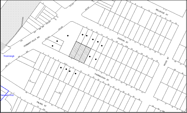
|
NOTIFICATION PLAN
|
|
|
• PROPERTIES NOTIFIED
|
X SUBMISSIONS
RECEIVED
|

PROPERTY SUBJECT OF DEVELOPMENT
|

|
|
ONE SUBMISSION FROM THE
THORNLEIGH NEIGHBOURHOOD RESIDENTS GROUP.
|
|
|
|
|
The submission objects to the
development, generally on the following grounds:
· The proposed balconies include
clear glass and no screens which may have adverse privacy impacts on adjoining
residents and also on the residents living on the opposite side of the road.
· The balconies do not incorporate
satisfactory screened clothes drying areas.
· The development incorporates
minimal landscaping which does not blend with the residential character of the
Thornleigh precinct.
The merits of the matters
raised in the submission have been addressed in the body of the report with the
exception of the following:
5.1.2 Privacy Screens and translucent glass for
balconies
The proposal complies with
Council’s Housing Strategy DCP with regard to setbacks. The balconies
are sufficiently separated from each other to maintain a reasonable level of
privacy in accordance with the Housing Strategy DCP and the RFDC.
Further, addition of privacy screens or translucent glass would cause
unreasonable impacts on the solar access and ventilation provisions of the
future occupants. The balconies fronting Thornleigh Street would be located a
significant distance from the houses on the opposite side of the road
minimising any privacy impacts.
Most of the residential units
include secondary balconies which can accommodate clothes lines. Further, it
has also been observed that Strata Management Plans for high density
residential flat buildings often do not allow clothes hanging on the balconies
located on the front façade of the buildings to avoid adverse visual impact on
the streetscape. Most of the units would be provided with dryers to avoid this
situation.
5.2 Public Agencies
The proposal is not required
to be referred to any Public Agencies.
6. THE PUBLIC INTEREST
Section 79C(1)(e) of the Act
requires Council to consider “the public interest”.
The public interest is an
overarching requirement, which includes the consideration of the matters
discussed in this report. Implicit to the public interest is the achievement
of future built outcomes adequately responding to and respecting the future
desired outcomes expressed in environmental planning instruments and
development control plans.
The application is considered
to have satisfactorily addressed Council’s criteria and would provide a
development outcome that, on balance, would result in a positive impact for the
community. Accordingly, it is considered that the approval of the proposed
mixed use development would be in the public interest.
7. POLICY
As Council is currently in caretaker mode prior to the 8
September 2012 election, this Report has been prepared having regard to the
requirements of Council’s Elections – Caretaker Period Policy. The recommended
decision is not a “major decision” within the context of Council’s Policy.
CONCLUSION
The application seeks
approval for the demolition of existing structures and the construction of a
five storey mixed use development comprising a commercial unit on the ground
floor and twenty-one residential units with basement car parking. The proposed
development would be partly located on a land zoned business and partly within
land zoned as a high density residential.
The proposed floor area of
the building within the business zone does not comply with the floor space ratio development standard of
the Hornsby Shire Local Environmental Plan 1994. The applicant has made
a submission pursuant to State Environmental Planning Policy No.1 to
support the non-compliance. The submission is considered to be well founded and
is supported.
The application
has been assessed having regard to Section 79C of the Environmental Planning
and Assessment Act 1979, the design principles within SEPP 65, the
provisions within the Hornsby Shire Local Environmental Plan 1994 and
the objectives of the development controls within Council’s Housing Strategy
Development Control Plan and Business Lands Development Control Plan.
The application
is also assessed as satisfactory against the draft Hornsby Local
Environmental Plan and the draft Hornsby Development Control Plan.
The proposal would result in
the expansion of an urban built form in keeping with the desired future
character of the precinct.
Approval of the proposal is
recommended.
Note: At the time of the completion of this planning report, no
persons have made a Political Donations Disclosure Statement pursuant to
Section 147 of the Environmental Planning and Assessment Act 1979 in
respect of the subject planning application.
|
Rod Pickles
Manager - Assessments
Planning Division
|
James Farrington
Group Manager
Planning Division
|
Attachments:
|
1.View
|
Locality Map
|
|
|
|
2.View
|
Survey Plan
|
|
|
|
3.View
|
Site Plan
|
|
|
|
4.View
|
Landscape Plan
|
|
|
|
5.View
|
Floor Plans
|
|
|
|
6.View
|
Elevations and Sections
|
|
|
|
7.View
|
Shadow Diagrams
|
|
|
|
8.View
|
Photomontage
|
|
|
File Reference: F2004/07599
Document Number: D01959337
SCHEDULE 1
GENERAL CONDITIONS
The conditions of consent
within this notice of determination have been applied to ensure that the use of
the land and/or building is carried out in such a manner that is consistent
with the aims and objectives of the relevant legislation, planning instruments
and Council policies affecting the land and does not disrupt the amenity of the
neighbourhood or impact upon the environment.
Note:
For the purpose of this consent, the term ‘applicant’ means any
person who has the authority to act on or the benefit of the development
consent.
Note:
For the purpose of this consent, any reference to an Act, Regulation,
Australian Standard or publication by a public authority shall be taken to mean
the gazetted Act or Regulation, or adopted Australian Standard or publication
as in force on the date that the application for a construction certificate is
made.
1. Approved Plans and Supporting
Documentation
The development must be carried
out in accordance with the plans and documentation listed below and endorsed
with Council’s stamp, except where amended by Council and/or other conditions
of this consent:
|
Plan No.
|
Rev No.
|
Drawn by
|
Dated
|
|
Survey Plan
|
-
|
SDG Land Development Solutions
|
30/01/2012
|
|
Basement Level 2 – DA100
|
A
|
Mackenzie Architects
|
3/07/2012
|
|
Basement Level 1 – DA101
|
A
|
Mackenzie Architects
|
3/07/2012
|
|
Ground Floor Plan – DA102
|
A
|
Mackenzie Architects
|
3/07/2012
|
|
First Floor Plan – DA103
|
A
|
Mackenzie Architects
|
3/07/2012
|
|
Second Floor Plan – DA104
|
A
|
Mackenzie Architects
|
3/07/2012
|
|
Third Floor Plan – DA105
|
A
|
Mackenzie Architects
|
3/07/2012
|
|
Fourth Floor Plan – DA106
|
A
|
Mackenzie Architects
|
3/07/2012
|
|
Site/Roof Plan-DA107
|
A
|
Mackenzie Architects
|
3/07/2012
|
|
Elevations – DA200
|
A
|
Mackenzie Architects
|
3/07/2012
|
|
Elevations (2) – DA201
|
A
|
Mackenzie Architects
|
3/07/2012
|
|
Sections – DA300
|
A
|
Mackenzie Architects
|
3/07/2012
|
|
Accessible and adaptable Unit layouts – DA401
|
A
|
Mackenzie Architects
|
3/07/2012
|
|
Soil and Water Management Plan – DA402
|
-
|
Mackenzie Architects
|
30/04/2012
|
|
Document No.
|
Rev No.
|
Prepared by
|
Dated
|
|
Shadow Diagrams (9am and 12 noon) – DA500
|
A
|
Mackenzie Architects
|
3/07/2012
|
|
Shadow Diagrams (3 pm) – DA501
|
A
|
Mackenzie Architects
|
3/07/2012
|
|
Landscape Plan – LDPA 12-331/1
|
|
Conzept Landscape Architects
|
May 2012
|
|
Basement Stormwater Management layouts
|
A
|
ALW Design
|
7/05/2012
|
|
Site stormwater Management Layouts
|
A
|
ALW Design
|
7/05/2012
|
|
Schedule of Finishes
|
-
|
Mackenzie Architects
|
Received by Council on 11/05/2012
|
|
Basix Certificate – 426864M
|
-
|
Planning Principles
|
8/05/2012
|
|
Access Report
|
-
|
Accessibility Solutions Pty Ltd
|
8/05/2012
|
|
Design Verification Statement
|
-
|
Mackenzie Architects
|
10/05/2012
|
|
Statement of Environmental Effects
|
-
|
Chapman Planning Pty Ltd
|
7/05/2012
|
|
Arboricultural Report for Development Application
|
-
|
Ents Tree Consultancy
|
30/04/2012
|
|
Traffic and Planning Assessment Report
|
-
|
Varga Traffic Planning Pty Ltd
|
10/05/2012
|
|
Waste Management Plan
|
-
|
North Point Construction Group Pty Ltd
|
7/05/2012
|
|
Photo montage
|
-
|
Mackenzie Architects
|
Received by Council on 11/05/2012
|
2. Removal
of Existing Trees
This development consent permits
the removal of trees numbered
1,3,4,5,6,7,8,9,10,11,12,13,14,15,16,17,18,19,20,21 and 22 as identified on the
Survey Plan prepared by SDG Land Development Solutions dated 30/01/2012
and all the remaining trees within the property that are exempt from Council’s
Tree Preservation Order. The removal of any other trees requires separate
approval under Council’s Tree Preservation Order.
3. Amendment
of Plans
a. The
“Fourth Floor Plan – DA106A”, “Elevations – DA200A”, “Elevations (2) – DA201A”
and “Sections – DA300A” prepared by Mackenzie Architects dated 3/07/2012 are to
be amended as follows:
· The terraces fronting the eastern
boundary are to have a setback of 7m – 8m from as marked in red on the approved
plan. No part of the terrace is to protrude beyond the building line at this
level.
b. The
following plans are to be amended to incorporate the layouts of the Floor plans
as approved in Condition 1 of this development consent:
|
Plan No.
|
Rev No.
|
Prepared by
|
Dated
|
|
Landscape Plan – LDPA 12-331/1
|
|
Conzept Landscape Architects
|
May 2012
|
|
Basement Stormwater Management layouts
|
A
|
ALW Design
|
7/05/2012
|
|
Site stormwater Management Layouts
|
A
|
ALW Design
|
7/05/2012
|
c. The
approved Ground Floor Plan – DA102 Rev A prepared by Mackenzie Architects dated
3/07/2012 is to be amended as follows:
· The wall enclosing the courtyard
of Unit 4 is to have a setback of 2m from the eastern boundary as marked in red
in the approved plans.
REQUIREMENTS PRIOR TO THE ISSUE OF A CONSTRUCTION
CERTIFICATE
4. Building
Code of Australia
All
building work must be carried out in accordance with the requirements of the
Building Code of Australia.
5. Contract
of Insurance (Residential Building Work)
In
the case of residential building work for which the Home Building Act 1989 requires
there to be a contract of insurance in force in accordance with Part 6 of that
Act, that such a contract of insurance is in force before any building work
authorised to be carried out by the consent commences.
Note: This condition does not
apply to the extent to which an exemption is in force under Clause 187 or 188
of the Act, subject to the terms of any condition or requirement referred to in
Clause 187(6) or 188(4) of the Act, or to the erection of a temporary building.
6. Water/Electricity
Utility Services
The
applicant must submit written evidence of the following service provider
requirements:
a. Energy
Australia – a letter of consent demonstrating that satisfactory
arrangements have been made to service the proposed development.
b. Sydney
Water – the submission of a ‘Notice of Requirements’ under s73 of the Sydney
Water Act 1994.
Note: Sydney Water requires
that s73 applications are to be made through an authorised Sydney Water
Servicing Coordinator. Refer to www.sydneywater.com.au
or telephone 13 20 92 for assistance.
7. Accessible
units
The
details of fit-outs of all accessible units and details of adaptable units must
be provided with the Construction Certificate Plans.
8. Letter
boxes
The
details of letter boxes and meter enclosures must be provided with the
Construction Certificate Plans. The letter boxes and meter enclosures must be
provided with a minimum setback of 2 metres from all boundaries and must be
suitably screened.
9. Dilapidation
Report
A
‘Dilapidation Report’ is to be prepared by a ‘chartered structural engineer’
detailing the structural condition of all adjoining properties.
REQUIREMENTS PRIOR TO THE COMMENCEMENT OF ANY WORKS
10. Erection
of Construction Sign
A
sign must be erected in a prominent position on any site on which building
work, subdivision work or demolition work is being carried out:
a. Showing the name, address and telephone number of the principal
certifying authority for the work.
b. Showing the name of the principal contractor (if any) for any demolition
or building work and a telephone number on which that person may be contacted
outside working hours.
c. Stating that unauthorised entry to the work site is prohibited.
Note: Any such sign is to be
maintained while the building work, subdivision work or demolition work is
being carried out, but must be removed when the work has been completed.
11. Protection
of Adjoining Areas
A
temporary hoarding, fence or awning must be erected between the work site and
adjoining lands before the works begin and must be kept in place until after
the completion of the works if the works:
a. Could
cause a danger, obstruction or inconvenience to pedestrian or vehicular
traffic.
b. Could
cause damage to adjoining lands by falling objects.
c. Involve
the enclosure of a public place or part of a public place.
Note: Notwithstanding the
above, Council’s separate written approval is required prior to the erection of
any structure or other obstruction on public land.
12. Toilet
Facilities
Toilet
facilities must be available or provided at the works site before works begin
and must be maintained until the works are completed at a ratio of one toilet
for every 20 persons employed at the site. Each toilet must:
a. be
a standard flushing toilet connected to a public sewer; or
b. have an on-site effluent disposal system approved under the Local
Government Act 1993; or
c. be
a temporary chemical closet approved under the Local Government Act 1993.
13. Erosion
and Sediment Control
Erosion
and sediment control measures must be provided and maintained throughout the
construction period in accordance with the manual ‘Soils and Construction
2004 (Bluebook)’, the approved plans, Council specifications and to the
satisfaction of the principal certifying authority. The erosion and sediment
control devices must remain in place until the site has been stabilised and
revegetated.
Note: On the spot penalties up
to $1,500 may be issued for any on-compliance with this requirement without any
further notification or warning.
14. Tree
Protection Barriers
Tree protection fencing must be
erected around T2 as identified on the Survey Plan prepared by SDG
Land Development Solutions dated 30/01/2012, to be retained at a 3
metre setback. The tree fencing must be constructed of 1.8 metre ‘cyclone
chainmesh fence’ or star pickets spaced at 2 metre intervals, connected by a
continuous high-visibility barrier/hazard mesh at a height of 1 metre.
REQUIREMENTS DURING CONSTRUCTION
15. Construction
Work Hours
All work on site (including demolition and earth works) must only
occur between the following hours:
Monday to Saturday 7 am to
5 pm
Sunday & Public Holidays No work
16. Demolition
All
demolition work must be carried out in accordance with Australian Standard
2601-2001 – The Demolition of Structures and the following requirements:
a. Demolition material is to be disposed of to an authorised
recycling and/or waste disposal site and/or in accordance with an approved
waste management plan.
b. Demolition works, where asbestos material is being removed, must
be undertaken by a contractor that holds an appropriate licence issued by WorkCover
NSW in accordance with Chapter 10 of the Occupational Health and Safety
Regulation 2001 and Clause 29 of the Protection of the Environment
Operations (Waste) Regulation 2005.
c. On construction sites where buildings contain asbestos material,
a standard commercially manufactured sign containing the words ‘DANGER ASBESTOS
REMOVAL IN PROGRESS’ measuring not less than 400mm x 300mm must be erected in a
prominent position visible from the street.
17. Environmental
Management
The
site must be managed in accordance with the publication ‘Managing Urban
Stormwater – Landcom (March 2004) and the Protection of the Environment
Operations Act 1997 by way of implementing appropriate measures to prevent
sediment run-off, excessive dust, noise or odour emanating from the site during
the construction of the development.
18. Council
Property
During
construction works, no building materials, waste, machinery or related matter
is to be stored on the road or footpath.
19. Excavated
Material
All
excavated material removed from the site must be classified in accordance with
the NSW Environment Protection Authority’s Environmental Guidelines –
Assessment, Classification and Management of Liquid and Non-Liquid Wastes
prior to disposal to an approved waste management facility and reported to the
principal certifying authority.
20. Landfill
Landfill
must be constructed in accordance with Council’s ‘Construction
Specification, 2005’ and the following requirements:
a. All fill material imported to the site is to wholly consist of
Virgin Excavated Natural Material (VENM) as defined in Schedule 1 of the Protection
of the Environment Operations Act 1997 or a material approved under the Department
of Environment and Climate Change’s general resource recovery exemption.
b. A compaction certificate is to be obtained from a geotechnical
engineer verifying that the specified compaction requirements have been met.
21. Survey
Report – Finished Floor Level
Reports
must be prepared by a registered surveyor and submitted to the principal
certifying authority prior to the pouring of concrete at each level of the
building certifying that:
a. The
building, retaining walls and the like have been correctly positioned on the
site.
b. The
finished floor levels are in accordance with the approved plans.
22. Contamination
during construction works
Should
the presence of asbestos or soil contamination, not recognised during the
application process be identified during demolition, the applicant must
immediately notify the Principal Certifying Authority and Council.
23. Waste
Management
Waste
management during the demolition and construction phase of the development must
be undertaken in accordance with the approved Waste Management Plan.
Additionally written record of the following items must be maintained during
the removal of any waste from the site and such information submitted to the
Principal Certifying Authority within fourteen days of the date of completion
of the works:
a. The identity of the
person removing the waste.
b. The
waste carrier vehicle registration.
c. Date
and time of waste collection.
d. A
description of the waste (type of waste and estimated quantity).
e. Details
of the site to which the waste is to be taken.
f. The
corresponding tip docket/receipt from the site to which the waste is
transferred (noting date and time of delivery, description (type and
quantity) of waste).
g. Whether
the waste is expected to be reused, recycled or go to landfill.
Note: In accordance with the
Protection of the Environment Operations Act 1997, the definition of waste
includes any unwanted substance, regardless of whether it is reused, recycled
or disposed to landfill.
24. Works
near Trees
All required tree protection
measures are to be maintained in good condition for the duration of the
construction period.
All works (including driveways
and retaining walls) within 3 metres of any trees required to be retained
(whether or not on the subject property, and pursuant to this consent or the Tree
Preservation Order), must be carried out under the supervision of an ‘AQF
Level 5 Arborist’ and a certificate submitted to the principal certifying
authority detailing the method(s) used to preserve the tree(s).
Note: Except
as provided above, the applicant is to ensure that no excavation, filling or
stockpiling of building materials, parking of vehicles or plant, disposal of
cement slurry, waste water or other contaminants is to occur within 4 metres of
any tree to be retained.
REQUIREMENTS
PRIOR TO THE ISSUE OF AN OCCUPATION CERTIFICATE
Note: For
the purpose of this consent, a reference to ‘occupation
certificate’ shall not be taken to mean an ‘interim occupation
certificate’ unless otherwise stated.
25. Fulfilment
of BASIX Commitments
The applicant must demonstrate the fulfilment of BASIX
commitments pertaining to the development.
26. Sydney
Water – s73 Certificate
A
s73 Certificate must be obtained from Sydney Water.
27. Stormwater
Drainage
The
stormwater drainage system for the development must be designed and constructed
in accordance with Council’s Civil Works – Design and Construction
Specification 2005 and the following requirements:
a. Connected directly to Council’s piped drainage
system in Thornleigh St generally in accordance with the Stormwater Plans
listed in Condition 1 of this development consent (as amended).
b. The inter-allotment stormwater drainage system
is to be relocated generally in accordance with the Stormwater Plans listed in
Condition 1 of this development consent (as amended) with pits being
constructed in situ.
Note: A construction
certificate is to be issued prior to the commencement of any works.
28. On
Site Stormwater Detention
An
on-site stormwater detention system must be designed and constructed for the
development. The stormwater drainage system is to be designed in accordance
with Council’s Civil Works – Design and Construction Specification 2005
and the following requirements:
a. Have a capacity of not less than 14 cubic
metres, and a maximum discharge (when full) of 28 litres per second.
b. Have a surcharge/inspection grate located
directly above the outlet.
c. Discharge from the detention system to be
controlled via 1 metre length of pipe, not less than 50 millimetres diameter or
via a stainless plate with sharply drilled orifice bolted over the face of the
outlet discharging into a larger diameter pipe capable of carrying the design
flow to an approved Council system.
d. Not be constructed in a location that would
impact upon the visual or recreational amenity of residents.
Note: A construction
certificate is to be issued prior to the commencement of any works.
29. Internal
Driveway/Vehicular Areas
The
driveway and parking areas on site must be designed in accordance with Australian
Standards 2890.1, 2890.2, 3727 and the following requirements:
a. Design levels at the front boundary be
obtained from Council.
b. The driveway be a rigid pavement.
c. The driveway is to have a minimum width across
the road reserve of 5.5 metres and this width is to extend to be 6 metres
inside the property boundary. The grade of the driveway at this location must
not exceed 5%.
d. The driveway pavement be a minimum of 0.15
metres thick reinforced concrete with F72 steel reinforcing fabric and a 0.15
metre sub-base.
Note: A separate construction
certificate is required to be issued prior to the commencement of any work.
30. Footpath
A
concrete footpath must be constructed along the full frontage of the subject
site in accordance Council’s Civil Works Design and Construction
Specification, 2005 and the following requirements:
a. Pouring of the
concrete footpath to the full frontage of the subject site.
b. The land adjoining
the footpath to be fully turfed.
c. The verge and
footpath area are to be regarded from the property boundary to the top of kerb
at a grade of 4%.
d. Any public utility
adjustments to be carried out at the cost of the applicant and to the
requirements of the relevant public authority.
Note: A separate construction
certificate is required to be issued prior to the commencement of any work.
Note:
Prior to the issue of a Construction Certificate for these works a separate
application under the Local Government Act, 1993 and the Roads Act, 1993 must
be submitted to Council for the construction of footpaths within the road
reserve.
31. Vehicular
Crossing
A
separate application under the Local Government Act, 1993 and the Roads
Act, 1993 must be submitted to Council for the installation of a new
vehicular crossing and the removal of the redundant crossing. The vehicular
crossing must be constructed in accordance with Council’s Civil Works
Design, 2005 and the following requirement:
a. Any public utility
adjustments to be carried out at the cost of the applicant and to the requirements
of the relevant public authority.
Note: A separate construction
certificate is required to be issued prior to the commencement of any work.
Note: An application for a
vehicular crossing can only be made to one of Council’s Authorised Vehicular
Crossing Contractors. You are advised to contact Council on 02 9847 6940 to
obtain a list of contractors.
32. Road
Works
All
road works approved under this consent must be constructed in accordance with
Council’s Civil Works Design and Construction Specification, 2005 and a
separate application under the Local Government Act 1993 and the Roads
Act 1993 must be submitted to Council. The engineering plans must address
the following requirements:
a. The existing kerb and gutter across the frontage of the site along
Thornleigh Street be removed and reconstructed.
b. The existing road pavement to be saw cut a minimum of
300 mm from the existing lip of gutter and reconstructed.
c. Pit No 11244 is to
be converted to a kerb inlet pit with a 1.8m long lintel
Note: A separate construction
certificate is required to be issued prior to the commencement of any work.
Note:
Prior to the issue of a Construction Certificate for these works a separate
application under the Local Government Act, 1993 and the Roads Act, 1993 must
be submitted to Council for the construction of footpaths within the road
reserve.
33. Damage
to Council Assets
Any
damage caused to Council’s assets as a result of the construction of the
development must be rectified in accordance with Council’s written requirements
and at the sole cost of the applicant.
34. Traffic
Control Plan
A
Traffic Control Plan (TCP) must be prepared by a qualified traffic controller
in accordance with the Roads & Traffic Authority’s Traffic Control at
Worksites Manual 1998 and Australian Standard 1742.3 for all work on
a public road and be submitted to Council. The TCP must detail the following:
a. Arrangements
for public notification of the works.
b. Temporary
construction signage.
c. Permanent
post-construction signage.
d. Vehicle
movement plans.
e. Traffic
management plans.
f. Pedestrian
and cyclist access/safety.
g. Details of pedestrian and vehicular access to the property at No. 10 Edgeworth David Avenue, in accordance with the construction management plan.
35. Consolidation
of allotments
All allotments of the
development site are to be consolidated into one allotment.
36. Creation
of Easements
The
following matter(s) must be nominated on the plan of subdivision under s88B of
the Conveyancing Act 1919:
a. The existing
interallotment drainage easement as detailed in DP 644307 is to be relocated as
detailed on the approved drawings and the existing easement is to be released.
b. The creation of an
appropriate "Positive Covenant" and "Restriction as to
User" over the constructed on-site detention/retention systems and
outlet works, within the lots in favour of Council in accordance with Council’s
prescribed wording. The position of the on-site detention system is to be
clearly indicated on the title.
c. To register the OSD
easement, the restriction on the use of land “works-as-executed” details
of the on-site-detention system must be submitted verifying that the required
storage and discharge rates have been constructed in accordance with the design
requirements. The details must show the invert levels of the on site system
together with pipe sizes and grades. Any variations to the approved plans must
be shown in red on the “works-as-executed” plan and supported by
calculations.
Note: Council must be
nominated as the authority to release, vary or modify any easement, restriction
or covenant.
37. Garbage
Collection Easement
For
the purpose of waste collection, an easement entitling Council, its servants
and agents and persons authorised by it to enter upon the subject land and to
operate thereon, vehicles and other equipment for the purposes of garbage
collection must be granted to Council by the owner of the land.
Note: The easement must be in
a form prescribed by Council and must include covenants to the effect that
parties will not be liable for any damage caused to the subject land or any
part thereof or to any property located therein or thereon by reason of the
operation thereon of any vehicle or other equipment used in connection with the
collection of garbage and to the effect that the owner for the time being of
the subject land shall indemnify the Council, its servants, agents and persons
authorised by it to collect garbage against liability in respect of any such
claims made by any person whomsoever.
38. Works
as Executed Plan
A
works-as-executed plan(s) must be prepared by a registered surveyor and
submitted to Council for completed road pavement, kerb & gutter, public
drainage systems, driveways and on-site detention system.
39. External
Lighting
All
external lighting must be designed and installed in accordance with Australian
Standard AS 4282 – Control of the Obtrusive Effects of Outdoor Lighting.
Certification of compliance with the Standard must be obtained from a suitably
qualified person.
40. Section 94 Infrastructure
Contributions
a. The payment to Council of a contribution of $209,818.90 for nineteen
additional residential units towards the cost of infrastructure identified in
Council’s Development Contributions Plan 2007-2011 in accordance with the
following table:
b. The payment to Council of a contribution of $9757.55* for four
employees towards the cost of infrastructure identified in Council’s Development
Contributions Plan 2007-2011.
Note:*The value of contribution is based on a rate of $2439.35 per employee, derived from a rate of one employee per
30sqm commercial floor area and is current
as at 12/07/2012.
The
contribution will be adjusted from this date in accordance with the underlying
consumer price index for subsequent financial quarters. It is recommended that
you contact Council to ascertain the indexed value of the contribution prior to
payment.
41. Accessibility
Requirements
All
accessible units must include the fit outs as approved under this development
consent.
42. Construction
for a safe environment
The
site must include the following elements:
a. An intercom system be installed at gate
locations to ensure screening of persons entering the units and the commercial
unit.
b. The entryway to the site be illuminated in
high luminance at all times
c. The communal open space at the rear of the
site be illuminated with high luminance by motion sensor lighting
d. The service areas of the ground floor and the garbage room at the
basement be illuminated with high
luminance by motion sensor lighting
e. The driveway and the basement carpark is to be
illuminated with low luminance at all times.
f. Robust materials which cannot be forced or
breached with minimised maintenance requirements are to be used for
construction work in the common areas.
43. Waste
Management Details
The
following waste management requirements must be complied with:
a. The
bin storage rooms at the basement level must include water or a hose for
cleaning, graded floors with drainage to sewer, a robust door, sealed and
impervious surface, adequate lighting and ventilation.
b. A report
must be prepared by an appropriately qualified person, certifying the
following:
i. A comparison
of the estimated quantities of each waste type against the actual quantities of
each waste type.
Note:
Explanations of any deviations to the approved Waste Management Plan is
required to be included in this report
ii. That
at least 60% of the waste generated during the demolition and construction
phase of the development was reused or recycled.
Note:
If the 60% diversion from landfill cannot be achieved in the Construction
Stage, the Report is to include the reasons why this occurred and certify that
appropriate work practices were employed to implement the approved Waste
Management Plan. The Report must be based on documentary evidence such as
tipping dockets/receipts from recycling depots, transfer stations and
landfills, audits of procedures etc. which are to be attached to the report.
c. Each unit must be provided with an indoor waste/recycling
cupboard for the interim storage of a minimum one day’s waste generation with
separate containers for general waste and recyclable materials.
d. Space must be provided for either individual compost containers
for each unit or a communal compost container;
Note:
The location of the compost containers should have regard for potential amenity
impacts.
e. The
bin carting route must be devoid of any steps.
Note:
Ramps between different levels are acceptable
f. The bins placed at the bin collection point for servicing must
be screened by landscaping from public view and be removed each time after
collection.
44. Completion of Landscaping
A
certificate must be provided by a practicing landscape architect,
horticulturalist or person with similar qualifications and experience
certifying that all required landscaping works have been satisfactorily
completed in accordance with the approved Landscape plan , the minimum
construction standards identified in the Hornsby Shire Council Landscape Code for
development applications and the following additional requirements for works
within the site:
a. One Angophora Costata tree be planted
on the verge fronting Thornleigh Street in a minimum 75 litre pot size.
b. Four Waterhousia “Sweeper”
Weeping Lillypilly be planted in the landscaped area in front of commercial
unit. The trees must be installed at minimum 25 litre pot size.
c. On slab planter boxes to include automatic
drip irrigation, subsoil drainage (proprietary drainage cell, 50mm sand and
filter fabric), and waterproofing.
d. 500 mm soil depth and 75mm mulch be provided
for shrubs.
e. 1000 mm soil depth and 75 mm mulch be provided
for trees and palms.
Note: Any proposed landscaping
or fencing must not obstruct the clear sightlines of pedestrians or cyclists
travelling along the footpath of Thornleigh Street.
Note: Advice on suitable
species for landscaping can be obtained from Council’s planting guide
‘Indigenous Plants for the Bushland Shire’, available at www.hornsby.nsw.gov.au.
45. Car
Parking and Deliveries
All
car parking must be constructed and operated in accordance with Australian
Standard AS 2890.1 – 2004 – Off Street Car Parking and Australian
Standard 2890.2 - 2002 – Off Street Commercial vehicle facilities
and the following requirements:
a. All parking areas and driveways are to be sealed to an all
weather standard, line marked and signposted.
b. Car parking, loading and manoeuvring areas to be used solely for
nominated purposes.
c. Vehicles awaiting loading, unloading or servicing must be parked
on site and not on adjacent or nearby public roads;
d. All vehicular entry on to the site and egress from the site shall
be made in a forward direction.
e. Visitors must be
able to access the basement car park by an audio/visual intercom system located
at the top of the ramped driveway at all times.
46. Noise
The
level of total continuous noise emanating from operation of the premises
including all the plants and air conditioning units (LA10) (measured for at
least 15 minutes) in or on the above premises, must not exceed the
background level by more than 5dB(A) when measured at all property boundaries.
47. Fire
Safety Statement - Annual
On
at least one occasion in every 12 month period following the date of the first
‘Fire Safety Certificate’ issued for the property, the owner must provide
Council with an annual ‘Fire Safety Certificate’ to each essential service
installed in the building.
48. Waste
Storage area and waste management
The
waste management on site must be in accordance with the following
requirements:
a. Each unit
be provided with an indoor waste/recycling cupboard for the interim storage of
a minimum one day’s segregated garbage and recycling generation.
b. Site security measures be implemented to prevent access to the
waste storage rooms by the residents.
c. A site manager or caretaker must be employed and be responsible
for moving bins from the bin storage area/compactor to the waste collection point,
washing bins and maintaining storage areas, arranging the prompt removal of
dumped rubbish, and ensuring all residents and commercial tenants are informed
of the waste management system.
d. The residential component and non-residential component of the
development must have separate and self-contained waste management systems,
including separate bin storage rooms. Commercial tenants must be prevented (via
signage and other means) from using the residential waste/recycling bins and
vice versa.
e. All commercial
tenants must keep written evidence on site of a valid contract with a licensed
waste contractor(s) for the regular collection and disposal of the waste and
recyclables that are generated on site.
49. Landscape
Establishment
The landscape works must be maintained to ensure the establishment
and successful growth of plant material including (but not be limited to)
watering, weeding, replacement of failed plant material and promoting the
growth of plants through standard industry practices.
-
END OF CONDITIONS -
ADVISORY
NOTES
The
following information is provided for your assistance to ensure compliance with
the Environmental Planning and Assessment Act, 1979, Environmental Planning
and Assessment Regulation 2000, other relevant legislation and Council’s
policies and specifications. This information does not form part of the
conditions of development consent pursuant to Section 80A of the Act.
Environmental Planning and
Assessment Act 1979 Requirements
· The
Environmental Planning and Assessment Act 1979 requires:
· A
construction certificate prior to the commencement of any works. Enquiries
regarding the issue of a construction certificate can be made to Council’s
Customer Services Branch on 9847 6760.
· A
principal certifying authority to be nominated and Council notified of that
appointment prior to the commencement of any works.
· Council
to be given at least two days written notice prior to the commencement of any
works.
· Mandatory
inspections of nominated stages of the construction inspected.
· An
occupation certificate issued before occupying any building or commencing the
use of the land.
Long Service Levy
In accordance with Section 34
of the Building and Construction Industry Long Service Payments Act 1986,
a ‘Long Service Levy’ must be paid to the Long Service Payments Corporation
or Hornsby Council.
Note: The
rate of the Long Service Levy is 0.35% of the total cost of the work.
Note: Hornsby
Council requires the payment of the Long Service Levy prior to the issue of
construction certificate.
Tree Preservation Order
To ensure the maintenance and
protection of the existing natural environment, it is an offence to ringbark,
cut down, top, lop, remove, wilfully injure or destroy a tree outside three
metres of the approved building envelope without prior written consent from
Council. Fines may be imposed for non-compliance with Council’s Tree
Preservation Order.
Note: A tree is defined as a single or multi-trunked
wood perennial plant having a height of not less than three (3) metres, and
which develops many branches, usually from a distance of not less than one (1)
metre from the ground, but excluding any plant which, in its particular
location, is a noxious plant declared as such pursuant to the Noxious Weeds Act
1993. This definition of ‘tree’ includes any and all types of Palm trees.
All distances are determined British Standard BS 5837:
2005, “Trees in Relation to Construction – Recommendations”.
Disability Discrimination
Act
The applicant’s attention is
drawn to the existence of the Disability Discrimination Act. A
construction certificate is required to be obtained for the proposed building,
which will provide consideration under the Building Code of Australia,
however, the development may not comply with the requirements of the Disability
Discrimination Act. This is the sole responsibility of the applicant.
Dial Before You Dig
Prior to commencing any
works, the applicant is encouraged to contact Dial Before You Dig on
1100 or www.dialbeforeyoudig.com.au for free information on potential
underground pipes and cables within the vicinity of the development site.
Asbestos Warning
Should asbestos or asbestos
products be encountered during construction or demolition works you are advised
to seek advice and information should be prior to disturbing the material. It
is recommended that a contractor holding an asbestos-handling permit (issued by
Work Cover NSW), be engaged to manage the proper disposal and handling
of the material. Further information regarding the safe handling and removal of
asbestos can be found at:
www.environment.nsw.gov.au
www.nsw.gov.au/fibro
www.adfa.org.au
www.workcover.nsw.gov.au
Alternatively, telephone the Work
Cover Asbestos and Demolition Team on 8260 5885.
Rain Water Tank
It is recommended that water
collected within any rainwater tank as part of the development be limited to
non-potable uses. NSW Health recommends that the use of rainwater tanks
for drinking purposes not occur where a reticulated potable water supply is
available.
House Numbering
House numbering can only be
authorised by Council. Before proceeding to number each premise in the
development, the allocation of numbers is required to be obtained from
Council's Planning Division. The authorised numbers are required to be
displayed in a clear manner at or near the main entrance to each premise.
Tenancy Fit-Out – Separate DA Required
This consent does not permit the fit-out of individual
tenancies. A separate development application is required for the fit-out of
individual tenancies prior to the occupation of the building.
Group Manager's Report
No. PL14/12
Planning Division
Date of Meeting:
15/08/2012
6 REPORTING VARIATIONS TO DEVELOPMENT STANDARDS
EXECUTIVE SUMMARY
· In accordance with the Department of Planning and
Infrastructure’s Planning Circular PS 08-14, Council is required to
report variations to development standards for development applications
approved under delegated authority, which relied upon State Environmental
Planning Policy No. 1 - Development Standards (SEPP 1).
· As Council is currently in
caretaker mode prior to the 8 September 2012 election, this Report has been
prepared having regard to the requirements of Council’s Elections – Caretaker
Period Policy. The recommended decision is not a “major decision” within the
context of Council’s Policy.
|
RECOMMENDATION
THAT the contents of Group
Manager’s Report No. PL14/12 be received and noted.
|
PURPOSE
The purpose of this report is to advise Council of determined
development applications under delegated authority involving a SEPP 1
variation to a development standard for the period 1 April 2012 to 30 June
2012.
DISCUSSION
The Department of Planning and
Infrastructure’s Circular B1, issued in March 1989, requested that
councils monitor the use of the Director-General’s assumed concurrence under SEPP
1 on a quarterly basis. This reporting requirement remains effective.
Monitoring of variations to development
standards is important to provide the Department and councils with an overview
of the manner in which established development standards are being varied and
whether the assumed concurrence is being used as intended. This enables
Council and the Department to determine whether development standards are
appropriate, or whether changes are required.
The Department issued Circular PS
08–014 on 14 November 2008. The purpose of the Circular was to remind
councils of their responsibilities to monitor the use of the Director-General’s
assumed concurrence under SEPP 1. Councils were reminded of the need to
keep accurate records of the use of SEPP 1 and to report on a quarterly
basis.
The Circular also provides that
councils are required to adopt the following four measures:
1. Establish
a register of development applications determined with variations in standards
under SEPP 1.
2. Require
all development applications where there has been a variation greater than 10%
in standards under SEPP 1 to be determined by full council (rather than general
manager or nominated staff member).
3. Provide
a report to each council meeting on the development applications determined
where there had been a variation in standards under SEPP 1.
4. Make
the register of development applications determined with variations in
standards under SEPP 1 available to the public on the council’s website.
In accordance with Point 3 of the Department’s Circular, attached
is a list of development applications determined under delegated authority involving a SEPP 1 variation to a
development standard for the
period 1 April 2012 to 30
June 2012.
A copy of the attachment to this report is also reproduced on
Council’s website.
BUDGET
There are no budget implications.
POLICY
This report addresses Council’s reporting obligations on development
applications determined where there has been a variation in standards under SEPP
1.
As Council is currently in caretaker mode prior to the 8
September 2012 election, this Report has been prepared having regard to the
requirements of Council’s Elections – Caretaker Period Policy. The recommended
decision is not a “major decision” within the context of Council’s Policy.
CONSULTATION
There was no consultation required in the preparation of this
report.
|
James Farrington
Group Manager
Planning Division
|
|
Attachments:
File Reference: F2004/07599
Document Number: D01961734
Group Manager's Report
No. PL16/12
Planning Division
Date of Meeting:
15/08/2012
7 PRECINCT SUPPORT SCHEME FOR URBAN ACTIVATION PRECINCTS
EXECUTIVE SUMMARY
· The Urban Activation Precincts
(UAP) scheme was announced in the 2012-2013 budget as part of the NSW
State Government’s Building the State package. The scheme will provide
$50 million financial support to local councils for infrastructure upgrades
required as a result of population growth within UAPs. The aim of the
scheme is to identify key urban precincts capable of supporting additional
housing and work collaboratively with councils to develop a planning framework
to facilitate development.
· Councils who partner the NSW State
Government in the UAP scheme will be provided payments through the Precinct
Support Scheme (PSS) to fund local infrastructure to address
increased demand and create high quality urban environments. Local
infrastructure projects could include open space, local roads, traffic calming
measures and car parking requirements.
· The Department of
Planning and Infrastructure (DP&I) is inviting nominations from councils
for potential UAPs. The DP&I has had preliminary discussions with Hornsby
Council officers regarding the nomination of precincts within Hornsby Shire. Epping
Town Centre satisfies nomination criteria in the draft NSW Urban Activation
Precinct Guidelines. Identification of the Centre as a UAP will assist
Council create a high quality environment for existing and new residents.
· As Council is currently in caretaker
mode prior to the 8 September 2012 election, this Report has been prepared
having regard to the requirements of Council’s Elections – Caretaker Period
Policy. The recommended decision is not a “major decision” within the context
of Council’s Policy.
|
RECOMMENDATION
THAT:
1. Council
nominate the Epping Town Centre for consideration
by the Department of Planning and Infrastructure under the Urban Activation Precincts Scheme as the
Scheme provides opportunity for financial
support to progress infrastructure upgrades required to service the resultant
population growth within the Centre identified under the Epping Town
Centre Study.
2. Council’s
nomination recognise that any amendment to planning controls should be
progressed generally in accordance with the Epping Town Centre Study
recommendations subject to further review of a range of matters in response
to public submissions including Heritage Conservation Area boundaries,
potential heritage items, urban form in the Town Centre Core, residential
precinct heights, property acquisition and North West Rail Link impacts.
|
PURPOSE
The
purpose of this report is to seek endorsement for the nomination of the Epping
Town Centre as a potential UAP.
BACKGROUND
The NSW Government
announced the UAP scheme in the Budget in June 2012. The program aims to
enable the NSW Government to partner with councils to deliver key urban housing
and renewal projects. The Department also sought nominations from councils for
potential UAPs.
The draft UAP Guidelines and associated documentation were placed
on exhibition until 4 July 2012 and comment sought. Council made comments on
the draft Guidelines in respect of funding commitment for Growth
Infrastructure Plans and precinct working group representation, as well as seeking
clarification on the criteria for urban activation precincts, allocation of
funding and the statutory process. The Department acknowledged receipt of
Council’s submission and confirmed that submissions are currently being
considered. Without the release of any revised Guidelines, consideration of
the draft Guidelines continues to be appropriate.
Nominations addressing the
criteria contained in the draft Guidelines were required to be submitted
by 31 July 2012. Accordingly, a letter was sent to the Department advising
that Council would be considering the matter of nominations for the scheme at
its meeting on 15 August 2012. A preliminary nomination has also been submitted
to the Department for the Epping Town Centre prior to the close of submissions.
However, it was noted that Council would formally consider the nomination at
its August 2012 meeting.
DISCUSSION
This
report outlines the UAP scheme and the PSS,
and presents for endorsement the nomination of the Epping Town Centre as a
potential UAP.
Urban Activation Precincts
Scheme
Overview
The NSW 2012 State Plan
states that restoring economic growth is its number one priority. A key task
that will support growth is to substantially increase the supply of housing and
employment, and improve housing choice and affordability. The PSS will
provide $50 million financial support for councils that partner in UAPs. The
scheme will assist councils address increased demand for local infrastructure
and create high quality urban environments for existing and future residents.
The aim of the scheme is to identify key urban precincts capable of supporting
additional housing and work collaboratively with councils to develop a planning
framework to facilitate development. The scheme is being administered by the DP&I and seeks to better integrate public
spaces, provide greater housing choice and improve affordability.
How is the Amount of
Funding Calculated?
The UAP process will estimate
expected future development in the relevant precinct. This assessment will
include an analysis of market conditions and financial feasibility so that it
is possible to determine the approximate annual yield for the precinct.
The amount of annual funding
provided to participating councils will be determined based on anticipated
annual yield. This will provide certainty for councils regarding the amount of
annual funding, allowing them to effectively and efficiently plan and deliver
new and upgraded community infrastructure within the UAP precincts. PSS
funding will be in addition to local development levies collected in the
precinct.
How Can the Support Scheme
Funding be Spent?
Local councils will be given a
degree of flexibility to determine what local infrastructure projects the PSS
funding is spent on. The funding must satisfy the definition of local
infrastructure. Local infrastructure has been broadly defined so that it
captures various types of infrastructure a local council may need to provide.
Local infrastructure projects could include open space, local roads, traffic
calming measures and car parking requirements. Additionally, the funding is to
be spent on projects located within the UAP or in areas where there is a clear
nexus to the UAP.
Criteria for Urban
Activation
Criteria have been established
to ensure that UAPs represent the best opportunity to deliver on the States
planning aims. Nominations will be assessed against the following criteria to
determine their significance to State and/or regional planning objectives:
· Is the precinct consistent with
State, regional and/or local strategies, particularly relating to housing and
employment?
· Does the precinct support or
maximise the use of existing planned infrastructure, especially transport?
· Is the precinct important to more
than one local government area and/or has support from the local council?
· Is the precinct
environmentally, socially and economically sustainable and viable?
· Is the development of
the precinct financially viable and consistent with market demand?
Precinct Selection
Nominations for potential
precincts may come from a number of sources, such as DP&I research and
empirical data, and nominations from councils, State agencies and the private
sector. The Department will review all nominations and chair a committee that
will provide advice to Government on whether nominated precincts should be
investigated. The relevant local councils will be consulted and their views
will be an integral consideration in making recommendations to Government.
Preliminary Consultation
Before a recommendation is made
to investigate a precinct, the Department will consult with the local council
and State agencies. An interagency committee will be chaired by the Department
to review nominations for potential precincts and provide advice to Government
on whether they should proceed.
Role of Working Groups
Working groups will be
established to investigate and discuss potential UAPs. Representatives from
relevant local councils, Department and State agencies (in particular Transport
for NSW), will be invited to participate. It is expected working groups will
meet regularly during the detailed investigation process.
If the State decides to progress
a UAP, the State will lead the strategic planning investigations with close
cooperation and input from local government. The process for the assessment of
UAPs by the State Government is documented in the flow chart attached to this
report.
Working groups will be
responsible for drafting the outcomes brief and planning study requirements for
the UAP. The outcomes brief will establish overall objectives and targets for
the precinct in terms of housing, employment, land use mix, economic,
accessibility and infrastructure connections, urban design and the public
domain. The study requirements will identify the relevant planning studies to
be completed and further requirements for stakeholder engagement and public
consultation.
The Working Party will also
determine the need for the delivery of a code based assessment framework for
the UAP to enable more streamlined assessment of development within the
precinct and to remove unnecessary delays in the delivery of housing approvals.
Planning Studies and
Investigations
The draft Guidelines
indicate that detailed planning studies and investigations will generally be
required for UAPs. A considerable amount of work has already been completed in
respect of the Epping Town Centre as part of the Epping Town Centre Study and
therefore, this work would form the basis of the study requirements for a UAP
should one be progressed. However, should the Minister decide to proceed with
the nomination of Epping Town Centre as a UAP, the DP&I would have the
ability to review and amend the development controls recommended in the Epping Town Centre Study.
Determination by the
Minister
Following completion of the any
additional study requirements, the Department will consult with the community
for a minimum of 30 days. Once the study has been exhibited and all issues
raised in submissions have been considered, the Department will consider the
study, the implications of the proposed changes in land use and provide
recommendations to the Minister relating to:
· The
significance of the precinct;
· The
implications of any change in land use; and
· Potential for the streamlining
of the subsequent development assessment process for proposals within the
precinct through the use of exempt and complying development controls.
Outcome and Delivery
If the Minister decides to
proceed with preparing a new statutory framework for the UAP, a State
Environmental Planning Policy (SEPP) would be made that contains the planning
framework, zonings and controls for the precinct, including exempt and
complying development controls where appropriate. The Minister would also
decide the appropriate environmental planning instruments for the new planning
framework, such as a Local Environmental Plan and/or a SEPP.
If the State Government decides
to proceed with rezoning an UAP, the following policies would also assist the
delivery of the precinct:
· Growth Infrastructure
Plans (GIPs) – identifies capacity within the infrastructure network and
outlines the infrastructure required to support the planned growth. The GIP
would inform the State Government’s budget allocation process to ensure
coordinated delivery of State infrastructure for the precinct.
· Precinct Support
Scheme – funding assistance for local government to provide the local
infrastructure needed for the precinct. Payments would be based on the
estimated dwelling yield for the UAP and would be paid annually over a six year
period.
Nomination
Details of the nomination of the
Epping Town Centre, including an assessment of the precinct against the
criteria provided in the draft NSW Urban Activation Precinct Guidelines,
are attached to this report.
In summary, the nomination
demonstrates that the Epping Town Centre satisfies the nomination criteria
provided in the draft NSW Urban Activation Precinct Guidelines. Therefore, if Council is of a mind to promote progression
of the Epping Town Centre study recommendations by way of the UAP process, it
would be appropriate to forward a submission to the Department nominating the
precinct and requesting consideration of the precinct
as a draft UAP.
POLICY
The Metropolitan Plan for Sydney 2036 identifies a
dwelling target of an additional 29,000 dwellings within the North Subregion by
2036. This represents an increase of 8,000 dwellings from the target
identified in the previous Metropolitan Strategy of 21,000 dwellings by
2031.
In considering where the additional housing should be
provided, the Growing and Renewing Centres component of the Metropolitan
Plan reflects a concentrated model whereby new development and renewal is
promoted in and around centres, towns, villages and neighbourhoods and is
focussed on public transport. The Metropolitan Plan identifies a target
of 70% of all new housing to be provided in existing urban areas.
If the
State Government decides to proceed with rezoning the Epping Town Centre UAP,
the precinct has the potential to deliver housing and
jobs in accordance with the housing and employment targets under the new Metropolitan
Strategy for 2036.
Council’s
endorsement of the progression of a planning proposal generally in accordance
with the Epping Town Centre Study recommendations would be superceded by the
UAP process should the State Government decide to progress the nomination.
As Council is currently in caretaker mode prior to the 8
September 2012 election, this Report has been prepared having regard to the requirements
of Council’s Elections – Caretaker Period Policy. The recommended decision is
not a “major decision” within the context of Council’s Policy.
CONCLUSION
This report outlines the UAP
scheme and the PSS, as well as presents for endorsement the nomination
of the Epping Town Centre as a potential UAP. The PSS will provide $50
million financial support to local councils for infrastructure upgrades
required as a result of population growth within UAPs. Councils who partner
the NSW State Government in UAPs will be provided payments to fund local
infrastructure and create high quality urban environments.
It is recommended that Council
endorse the nomination of the Epping Town Centre for consideration by the
DP&I under the UAP scheme.
RESPONSIBLE OFFICER
The officer responsible for the
preparation of this Report is the Acting Manager, Strategic Planning Branch –
Jason Rawlin - who can be contacted on 9847 6737.
|
Jason Rawlin
Acting Manager -
Strategic Planning Branch
Planning Division
|
James Farrington
Group Manager
Planning Division
|
Attachments:
|
1.View
|
Urban Activation Precinct Nomination - Epping
|
|
|
|
2.View
|
Urban Activation Guidelines - Extract Flow Chart
|
|
|
File Reference: F2004/07218-03
Document Number: D01969371
Planning Report No. PL18/12
Planning Division
Date of Meeting:
15/08/2012
8 DEVELOPMENT APPLICATION - TOWNHOUSE DEVELOPMENT
156 - 160 SHERBROOK ROAD, ASQUITH
|
DA No:
|
DA/414/2012
|
|
Description:
|
Construction of a townhouse development comprising 20
dwellings and strata subdivision
|
|
Property:
|
Lot 2 DP 669154, Lot 1 DP 669153, Lot D DP 402287, Nos.
156-160 Sherbrook Road, Asquith
|
|
Applicant:
|
Playoust Churcher Architects
|
|
Owner:
|
Ms J Mahon and Mr S A Frappell
|
|
Estimated Value:
|
$5.300,000
|
|
Ward:
|
A
|
EXECUTIVE SUMMARY
· The application proposes
demolition of two existing dwellings and construction of a multi-unit townhouse
development comprising 20 dwellings and strata subdivision.
· The proposal complies with the
Hornsby Shire Local Environmental Plan 1994 and the objectives of the
Medium Density Multi-Unit Housing Development Control Plan. The non-compliance
with prescriptive measures for site width and private open space are considered
acceptable on merit.
· Two submissions have been
received concerning the proposal.
· It is recommended that the
application be approved.
· As Council is currently in
caretaker mode prior to the 8 September 2012 election, this Report has been
prepared having regard to the requirements of Council’s Elections – Caretaker
Period Policy. The recommended decision is not a “major decision” within the
context of Council’s Policy.
|
RECOMMENDATION
THAT Development Application No. 414/2012 for construction
of a townhouse development comprising 20 dwellings and strata subdivision at
Lot 2 DP 669154, Lot 1 DP 669153, Lot D DP 402287, Nos. 156-160 Sherbrook
Road, Asquith be approved subject to the conditions of consent detailed in
Schedule 1 of Group Manager’s Planning Report No. PL18/12.
|
BACKGROUND
The application follows preliminary consideration of the
proposed development at a Pre DA Meeting on 7 March 2012 (PL/11/2012).
The site is located within a
precinct rezoned for townhouse development as part of Council’s Housing
Strategy in 2011.
SITE
The site is on the eastern side of Sherbrook Road and
comprises two existing battleaxe lots and a lot with street frontage. The site
has an area of 3,984m2, a depth of 130m and a width of 36.5m
reducing to 21.7m within 50m of the frontage. There are two existing
dwelling-houses on the site, one at the frontage and one at the rear.
The site is relatively level with a gradual fall towards the
rear of the site. An existing stormwater drainage easement adjoins the northern
side boundary. The site includes a number of trees at the rear and at the
frontage but is otherwise clear of vegetation.
The site is adjoined by Asquith Girls High School which is
accessed off Baldwin Avenue to the north and Stokes Avenue to the south. The
main school campus adjoins the rear eastern and the southern side boundaries.
Part of the school site extends to Sherbrook Road along the northern side
boundary forming a more passive area of the school site. The school site is
zoned Special Uses A (Community Purposes) Zone. At the rear of the site, two
storey classroom buildings are within 1.5m to 10.5m of the boundary. The school
site includes a number of significant trees along the rear boundary and
southern boundary of the site.
Dwelling-houses fronting Stokes Avenue adjoin the western
part of the southern boundary of the site and fronting Sherbrook Road. A number
of significant trees are located along the boundary. The surrounding
residential area is currently, dominantly comprise of detached dwelling-houses
notwithstanding the Residential B (Medium Density) Zoning; other than land
recently redeveloped for townhouses adjacent to the rail corridor.
The Asquith Railway Station and commercial centre are
located 165m west of the site.
PROPOSAL
The proposal is for demolition of the existing dwellings and
construction of a multi-unit townhouse development comprising 20 dwellings,
including two adaptable dwellings, and strata subdivision. The development
includes six buildings; four with 4 townhouses, one with 3 townhouses and one
two storey detached dwelling at the frontage of the site. The dwellings include
single car garages. The two larger adaptable dwellings have double garages. All
dwellings have three bedrooms.
The proposed townhouses are oriented north south. The
proposed private open space areas are mainly located at the rear of the dwellings.
All dwellings have access off the proposed accessway.
A waste collection area is proposed at the frontage. Three
visitor car parking spaces are proposed.
ASSESSMENT
1. STRATEGIC CONTEXT
1.1 Metropolitan Plan for Sydney 2036 and (Draft) North
Subregional Strategy
The Metropolitan Plan for Sydney 2036 is a broad
framework to secure Sydney’s place in the global economy by promoting and
managing growth. It outlines a vision for Sydney to 2036; the challenges
faced, and the directions to follow to address these challenges and achieve the
vision. The Draft North Subregional Strategy acts as a framework for
Council in its preparation of the Comprehensive LEP.
The Draft North Subregional Strategy sets the
following targets for the Hornsby LGA by 2031:
· Employment capacity
to increase by 9,000 jobs; and
· Housing stock to
increase by 11,000 dwellings.
The proposed development would be consistent with the draft
Strategy by providing an additional 18 dwellings and would contribute towards
housing choice in the locality.
2. STATUTORY CONTROLS
Section 79C(1)(a) requires
Council to consider “any relevant environmental planning instruments, draft
environmental planning instruments, development control plans, planning
agreements and regulations”.
2.1 Hornsby Shire Local Environmental Plan 1994
The subject land is zoned Residential B (Medium Density)
under the Hornsby Local Environmental Plan 1994 (HSLEP). The objectives
of the zone are:
(a) to
provide for the housing needs of the population of the Hornsby area.
(b) to
promote a variety of housing types and other land uses compatible with a medium
density residential development.
(c) to
provide for development that is within the environmental capacity of a medium
density residential development.
The proposed development is defined as ‘demolition’ and
‘multi-unit housing’ under the HSLEP and is permissible in the zone with
Council’s consent.
Clause 15 of the HSLEP prescribes that the maximum
floor space ratio (FSR) of development within the Residential B zone is 0.6:1.
The proposed 0.49:1 FSR complies with this requirement.
Clause 18 of the HSLEP sets out heritage conservation
provisions within Hornsby Shire. The site is not identified as a heritage item
and is not within a heritage conservation area. A heritage listed dwelling at No. 121 Sherbrook Road is located in the vicinity of the site on the corner of Winston Street 40m from the site. The proposed works would be located at a sufficient
distance from the heritage item that the proposal would not result in an
adverse impact on the significance of the item.
2.2 Draft
Comprehensive Hornsby Local Environmental Plan
The draft Comprehensive Local
Environmental Plan (HLEP) was placed on exhibition on 5 June 2012. The
draft HLEP essentially reiterates the current land use zoning.
2.2.1 Zoning
The site would be zoned R3 Medium
Density Residential zone pursuant to the Land Use Table of the draft HLEP.
The proposed development is defined as a ‘multi dwelling housing’ and would be
a permissible use in the zone with Council’s consent.
2.2.2 Height of Building
Clause 4.3 of the draft HLEP
provides that the height of a building on any land is not to exceed the maximum
height shown for the land on the Height of Buildings Map. The maximum
permissible height for the subject site is 10.5 metres. The proposed
development complies with this provision.
2.3 Sydney
Regional Environmental Plan No. 20 – Hawkesbury Nepean River
The Plan regulates impacts of future land uses on the
River through implementation of planning policies and strategies for total
catchment management, environmentally sensitive areas, water quantity, cultural
heritage, flora and fauna, riverine scenic quality, agriculture/acquaculture
and fishing, rural residential development, urban development, recreation and
tourism.
The proposed development would not detract from the
environmental quality of the river subject to the implementation of sediment
and erosion control measures and stormwater detention.
2.4 State Environmental Planning Policy No. 55 – Remediation of
Land
State Environmental Planning
Policy No. 55 (SEPP 55) requires that Council
must not consent to the carrying out of any development on land unless it has
considered whether the land is contaminated or requires remediation for the
proposed use.
The site
has been used for residential purposes and is unlikely to be contaminated. No
further assessment is considered necessary in this regard. A condition is
recommended should any contamination be found during construction.
2.5 State
Environmental Planning Policy (Building Sustainability Index – BASIX) - 2004
The application has been assessed against
the requirements of State Environmental Planning Policy (Building
Sustainability Index: BASIX) 2004. The proposal includes a BASIX Certificate
for the proposed townhouses and is considered to be satisfactory.
2.6 Medium Density Multi-Unit Housing Development Control
Plan
The proposed development has been assessed having regard to
the relevant performance and prescriptive design requirements within Council’s
Medium Density Multi-Unit Housing Development Control Plan (Housing DCP). The
following table sets out the proposal’s compliance with the prescriptive
requirements of the Plan:
|
Medium Density
Multi-Unit Housing Development Control Plan
|
|
Control
|
Proposal
|
Requirement
|
Compliance
|
|
Site Area
|
3,984m2
|
3,620m2
|
Yes
|
|
Site Area Per Dwelling
|
11 x 83m2
@ 150m2
7 x 94m2
@ 210m2
1 x 136m2
@ 250m2
1 x 162m2
@ 250m2
|
3,620m2
|
Yes
|
|
Floor Space Ratio
|
0.49:1
|
0.6:1
|
Yes
|
|
Site Coverage
|
32%
|
40%
|
Yes
|
|
Site Width
|
21.89m to 36.9m
|
30m
|
No
|
|
Setbacks
|
Front – 8m
N Side – 3m
S Side – 4m
Rear – 3.3m
|
Front – 6m
Side – 3m
Side – 3m
Rear – 3m
|
Yes
Yes
Yes
Yes
|
|
Setback Between Dwellings
|
5.0m-6.8m
|
5m
|
Yes
|
|
Building Length
|
Building 1 – 11.9m
Building 2 – 28.8m
Building 3 – 28.8m
Building 4 – 25.8m
Building 5 – 30.3m
Building 6 – 30.3m
|
30m
|
No
|
|
Height
|
5.5m
|
7m
|
Yes
|
|
Private Open Space
|
Unit 1 – 79.7m2
Unit 2 – 60m2
Unit 3 – 50m2
Unit 4 – 40m2
Unit 5 – 60m2
Unit 6 – 60m2
Unit 7 – 40m2
Unit 8 – 40m2
Unit 9 – 57m2
Unit 10 – 60m2
Unit 11 – 40m2
Unit 12 – 80m2
Unit 13 – 60m2
Unit 14 – 40m2
Unit 15 – 40m2
Unit 16 – 40m2
Unit 17 – 40m2
Unit 18 – 40m2
Unit 19 – 40m2
Unit 20 – 60m2
|
80m2
60m2
40m2
40m2
60m2
60m2
40m2
40m2
60m2
60m2
40m2
80m2
60m2
40m2
40m2
40m2
40m2
40m2
40m2
60m2
|
No
Yes
Yes
Yes
Yes
Yes
Yes
Yes
No
Yes
Yes
Yes
Yes
Yes
Yes
Yes
Yes
Yes
Yes
Yes
|
|
Landscaping
|
50%
|
50%
|
Yes
|
|
Car parking
|
Unit 1 – 2 spaces
Units 2-11 – 10
spaces
Unit 12 – 2 spaces
Units 13-20 – 8
spaces
Visitors – 4 spaces
|
2 spaces
10 space
2 spaces
8 spaces
Visitors 4 spaces
|
Yes
Yes
Yes
Yes
Yes
|
As detailed in the above table, the proposed development
does not comply with the prescriptive site width and private open space
prescriptiverequirements within Council’s Housing DCP. The matters of
non-compliance are detailed below, as well as a brief discussion on compliance
with relevant performance requirements.
2.6.1 Density
The proposed townhouse development is in compliance with the
density prescriptive measures for site density, floor space ratio and site
coverage and meets the density performance criteria of the Housing DCP. The
density of the development is consistent with the desired future character of
the area as a townhouse precinct.
2.6.2 Setbacks
The proposed development is in compliance with the
prescriptive front, side and rear setbacks and the setback between dwellings.
The proposed setbacks meet the performance criteria to
provide landscaping and to complement the streetscape.
2.6.3 Design
The site is relatively level and forms a large battleaxe
shaped site essentially cleared of vegetation. The proposed townhouse buildings
front a central accessway and generally conform to the physical characteristics
of the site.
The front section of the site does not comply with the
required site width of 30m. The objective of the control is to encourage
amalgamation of properties to form development sites. In this instance,
amalgamation of properties is proposed and the non-compliance is considered
acceptable with regard to the 36.9m width of the rear section of the battleaxe
shaped site.
The proposed townhouses are of brick and timber frame
construction with face brick and fibre cement sheet cladding and tiled roofs.
The proposed dwellings are consistent with the residential character of the
area and recent townhouse developments. The proposed materials and finishes are
considered satisfactory in this regard.
The site adjoins Asquith Girls High School. The operation of
the school in close proximity to the proposed townhouses is considered
acceptable for residential amenity given the operating hours of the school.
The proposed townhouse development complies with the Housing
DCP design performance criteria.
2.6.4 Height
The proposal complies with the Housing DCP height element
objective and is satisfactory in respect to solar access to living areas and
private open space.
2.6.5 Privacy
The proposed townhouses are designed for privacy with regard
to the interface between opposing dwellings either side of the central
accessway by variation in setback between the buildings and the location of
windows. The proposed dwellings are designed to avoid overlooking of private
open space areas within the development.
The site mainly adjoins land that forms part of the Asquith Girls High School site. The proposed development includes first floor bedroom
accommodation and would result in minimal privacy impacts on adjoining
residents of Stokes Avenue and Sherbrook Road.
The proposal is considered satisfactory in respect to the
Housing DCP privacy element objective.
2.6.6 Solar Access
The site benefits from the long northern axis and solar
access. All proposed dwellings have north facing living areas. The proposed
dwellings would not overshadow windows of adjoining dwelling- houses. The
proposal would result in minor overshadowing of adjoining private open space
areas but would not be in non-compliance with the Housing DCP prescriptive
measures.
The proposal complies with the Housing DCP solar access
element objective.
2.6.7 Open Space
The proposed townhouse open space areas are mainly located
at the rear of dwellings. A number of dwellings also include open space areas
at the respective frontages and side areas of dwellings.
The proposed open space areas are accessible from the
dwelling living areas and have access to winter sunlight. A number of dwellings
do not comply with minimum area requirement for open space. The non-compliances
are minimal and are considered acceptable with regard to the merits of the
design for outdoor living and solar access.
2.6.8 Landscaping
A majority of trees recorded for the site are on adjoining
land along the side and rear boundaries.
The submitted landscape plan includes a mix of indigenous
and exotic plant species and would re-vegetate the un-built upon areas of the
site, enhance the site’s visual quality and the proposed townhouses.
The proposed landscaping complies with the Housing DCP
landscaping element objective subject to recommended conditions.
Refer also to comments in Section 3.1.
2.6.9 Drainage Control
The proposed stormwater drainage system involves connection
to the existing stormwater drainage easement and drainage system through the Asquith Girls High School site, to a watercourse tributary of Cockle Creek and the Hawkesbury River.
The proposed drainage system includes stormwater detention
and is in accordance with the Housing DCP prescriptive measures. Part of the
site, Lot 2 DP 669154, does not have the benefit of the easement adjoining the
northern boundary of the site, through land owned by the Department of
Education. The consent of the owner has been obtained for granting an easement
for the development site.
Subject to recommended conditions the proposal complies with
the Housing DCP drainage control element objective.
2.6.10 Vehicle Access and Parking
The proposed accessway includes a common turning area and is
designed in accordance with the Housing DCP prescriptive measures for driveway
width, vehicle passing and residential amenity.
The proposed resident and visitor car parking provision is
in compliance with the prescriptive measures. Adequate parking is proposed for
residents and visitors to meet projected demand.
2.6.11 Acoustics
The applicant has submitted an Acoustic Report prepared by
Atkins Acoustics & Associates Pty Ltd. The report includes the following
comment:
The proposed development is
located on existing residential zoned land, and will result in a conversion of
the existing low density residential to medium density residential. As the
subject land is zoned and utilised for residential use, the subject (Asquith
GHS) has obligations under Council’s Policy to control noise emissions in
accordance with Section 7.2.11.
A review of the noise
measurement results confirmed daytime LAeq noise levels of 51dB(A) which
encompassed all noise sources, whilst audit measurements confirmed short
duration (1-3min) LAeq noise
levels of 55-57dB(A) during congregating students after lunch, resulting in
estimated Leq,15min level
50-52dB(A). In our opinion the noise levels are consistent with normal school
activities and would typically be experienced in other areas where residential
properties abut school premises. Any potential noise impacts from these
activities are typically ameliorated due to the limited duration, times of use
and community benefit.
In terms of the operation of
mechanical plant, the review confirmed that Council Policy criteria of
background LA90 +
5dB may be exceeded along the northern portion of the development site by
2-9dB. As the development site is already zoned residential, it is our opinion
and in accordance with Council’s policy that it is the responsibility of the
school to address any potential noise impacts.
Having regard to the above comments, the proposal is
considered acceptable in respect to the Housing DCP Acoustics element
objective.
2.6.12 Fencing
The existing site’s sheet metal boundary fencing is
considered adequate for the proposed development.
2.6.13 Waste Minimisation and Management
A number of the town houses would be located more than 100
metres from the property’s street frontage. A bin storage area is provided near
dwellings 9 and 10 so that all dwellings are less than 75 metres from a bin
storage area. The adaptable units are less than 50 metres from the bin storage
area which is consistent with the recommendations of the Better Practice
Guide for Multi Unit Dwellings and the State Environmental Planning
Policy (Housing for Seniors or people with a Disability) 2004 requirement
for a garbage storage area to be in an accessible location. A site
caretaker/manager is required to transfer bins from the inner bin storage area
to the main one near the street frontage from where all bins will be emptied.
A waste management plan covering all stages of the
development has been provided and is acceptable.
The site will require 10 x 240 L garbage bins serviced
weekly and 8 x 240 L recycling bins serviced weekly. Although green waste bins
are optional for such developments, space in the bin bay should be provided for
1-2 x 240 L green waste bins should the residents request such a service. The
bin bay is large enough to accommodate the required number of bins.
The bin bay has the door facing the street. It is
recommended that the door be relocated to face the driveway. This would create
a greater sense of the bin bay belonging to the residents and would be less
inviting for passers by to place rubbish in the bin bay.
A condition is recommended for an area behind the bin bay to
be provided for unwanted bulky items awaiting removal.
Subject to appropriate conditions the proposal meets the Housing
DCP element objectives for waste minimisation and management.
2.6.14 Housing Strategy – Precinct Masterplans
The proposed development is within the Baldwin Avenue
Asquith Precinct and is generally consistent with the requirements of the
relevant Masterplan for one and two storey multi-unit dwellings in a garden
setting, buildings separated by courtyards and driveway lined with canopy
trees.
2.6.15 Crime Prevention
The submitted Statement of Environmental Effects includes
the following comment:
The design of the development
minimises opportunity for crime through legible entrances, passive surveillance
of communal areas and Sherbrook Avenue and clearly defined public and private
interface. The development layout provides limited areas for entrapment.
The submitted statement concerning the proposal is supported
in respect to the crime prevention performance criteria of the Housing DCP.
3. ENVIRONMENTAL IMPACTS
Section 79C(1)(b) of the Act
requires Council to consider “the likely impacts of that development,
including environmental impacts on both the natural and built environments, and
social and economic impacts in the locality”.
3.1 Natural Environment
There are 18 trees on the site including trees along the
boundary on adjoining land. The proposed development would necessitate the
removal of 6 trees from the site. None of the trees to be removed are
identified as ‘significant trees’ under Council’s Tree Management Plan.
Turpentine Ironbark Margin Forest is an endangered
ecological community that occurs in the local area. The site includes a number
of trees that form part of this community including Angophora costata (Sydney
Red Gum), Syncarpia glomulifera (Turpentine), Eucalyptus pilularis (Blackbutt),
Eucalyptus paniculata (Grey Ironbark) and Eucalyptus haemastoma (Scribbly
Gum). The proposed landscape planting includes species that form part of this
community.
3.2 Built Environment
The proposed demolition of the existing dwellings would not
detract from the streetscape or the residential character of the area and would
contribute to the future medium density character of the area.
Council’s engineering assessment of the proposal concludes
that the traffic generated by the proposed development would not detract from
the level of service of Sherbrook Road.
3.3 Social Impacts
The proposed development would increase housing
opportunities and the range of housing types in the locality.
3.4 Economic Impacts
The proposal would have a minor positive impact on the local
economy in conjunction with other new residential development in the locality
by generating an increase in demand for local services.
4. SITE SUITABILITY
Section 79C(1)(c) of the Act
requires Council to consider “the suitability of the site for the
development”.
The existing residential site is not subject to development
constraints and is suitable for the proposed medium density housing
development.
5. PUBLIC PARTICIPATION
Section 79C(1)(d) of the Act
requires Council to consider “any submissions made in accordance with this
Act”.
5.1 Community Consultation
The proposed development was placed on public exhibition and
was notified to adjoining and nearby landowners between 17 May and 7 June 2012
in accordance with Council’s Notification and Exhibition Development Control
Plan. During this period, Council received two submissions. The map below
illustrates the location of those nearby landowners who made a submission that
are in close proximity to the development site.
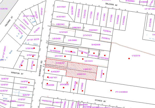
|
NOTIFICATION
PLAN
|
|
|
• PROPERTIES
NOTIFIED
|
X SUBMISSIONS
RECEIVED
|
PROPERTY SUBJECT OF DEVELOPMENT
|
|
|
|
|
|
Two submissions object to the development, generally on the
following grounds:
· Inadequate breaks
between buildings;
· Lack of architectural
merit;
· Non-compliance with
30m site width;
· Loss of privacy;
· Lack of solar access
to private open space;
· Lack of landscaping;
· Traffic generation and
waste collection;
· Sherbrook Road safety
hazard;
· Location of mail boxes
not shown;
· Boundary fencing
requires replacing; and
· Sewer requires
upgrading.
The merits of the matters raised in community submissions
have been addressed in the body of the report with the exception of the
following:
5.1.1 Mail Boxes
A condition is recommended for a mail box facility at the
frontage to complement the development and the streetscape.
5.2 Sewer Upgrading
The applicant is required to obtain the requirements of
Sydney Water pursuant to a Section 73 Certificate. Any necessary works would be
the responsibility of Sydney Water.
6. THE PUBLIC INTEREST
Section 79C(1)(e) of the Act
requires Council to consider “the public interest”.
The public interest is an overarching requirement, which
includes the consideration of the matters discussed in this report. Implicit
to the public interest is the achievement of future built outcomes adequately
responding to and respecting the future desired outcomes expressed in
environmental planning instruments and development control plans.
The application is considered to have satisfactorily
addressed Council’s and relevant agencies’ criteria and would provide a
development outcome that, on balance, would result in a positive impact for the
community by providing additional housing opportunities. Accordingly, it is
considered that the approval of the proposed multi-unit townhouse development
would be in the public interest.
7. POLICY
As Council is currently in caretaker mode prior to the 8
September 2012 election, this Report has been prepared having regard to the
requirements of Council’s Elections – Caretaker Period Policy. The recommended
decision is not a “major decision” within the context of Council’s Policy.
CONCLUSION
The proposed development is for the demolition of two
existing dwelling-houses and construction of a multi-unit townhouse development
comprising 20 dwellings, and strata title subdivision.
The proposed development is in accordance with Council’s
Housing Strategy and complies with HSLEP and the element objectives of the
Housing DCP in respect to density, setbacks, design, height, privacy, solar
access, open space, landscaping, drainage control, vehicle access &
parking, acoustics, fencing and waste minimisation & management. The
non-compliance with prescriptive measures for site width and private open space
are considered acceptable on merit.
The proposed development is consistent with the residential
character of the locality and would contribute to the desired future character
of the medium density housing precinct. It is considered the amenity of
residents of the proposed townhouses would not be adversely affected by the
operation of the adjoining school. The numerous trees on the adjoining lands
would not be affected by the proposal.
Two submissions were received in response to the proposal.
The application is recommended for approval.
|
Rod Pickles
Manager - Development
Assessment
Planning Division
|
James Farrington
Group Manager
Planning Division
|
Attachments:
|
1.View
|
Locality Map
|
|
|
|
2.View
|
Site Plan/Roof Plan
|
|
|
|
3.View
|
Floor Plan
|
|
|
|
4.View
|
Elevation Plan
|
|
|
|
5.View
|
Shadow Plans
|
|
|
|
6.View
|
Elevations
|
|
|
File Reference: DA/414/2012
Document Number: D01986198
SCHEDULE 1
GENERAL
CONDITIONS
The conditions of consent
within this notice of determination have been applied to ensure that the use of
the land and/or building is carried out in such a manner that is consistent
with the aims and objectives of the relevant legislation, planning instruments
and Council policies affecting the land and does not disrupt the amenity of the
neighbourhood or impact upon the environment.
Note: For
the purpose of this consent, the term ‘applicant’ means any person who has the
authority to act on or the benefit of the development consent.
Note: For
the purpose of this consent, any reference to an Act, Regulation, Australian
Standard or publication by a public authority shall be taken to mean the
gazetted Act or Regulation, or adopted Australian Standard or publication as in
force on the date that the application for a construction certificate is made.
1. Approved
Plans and Supporting Documentation
The development must be carried
out in accordance with the plans and documentation listed below and endorsed
with Council’s stamp, except where amended by Council and/or other conditions
of this consent:
|
Plan No.
|
Drawn by
|
Dated
|
|
000 B Site Analysis
|
Playoust Churcher Architects
|
30/04/12
|
|
100 B Site Plan
|
Playoust Churcher Architects
|
30/04/12
|
|
101 B Roof / Site Plan
|
Playoust Churcher Architects
|
30/04/12
|
|
200 B Townhouse Plans
|
Playoust Churcher Architects
|
30/04/12
|
|
300 B Colour Scheme
|
Playoust Churcher Architects
|
30/04/12
|
|
301 B Elevations
|
Playoust Churcher Architects
|
30/04/12
|
|
11/1636/DA1 D Landscape Site Plan
|
Paul Scrivener Landscape Architect
|
26.04.12
|
|
11/1636/DA1 D Planting Plan
|
Paul Scrivener Landscape Architect
|
26.04.12
|
|
11/1636/DA1 D Tree Protection
|
Paul Scrivener Landscape Architect
|
26.04.12
|
|
Document No.
|
Prepared by
|
Dated
|
|
D01918278 – Waste Management Plan
|
Playoust Churcher Architects
|
24/4/12
|
|
D01918284 – Basix Certificate
|
Playoust Churcher Architects
|
27 April 2012
|
|
D01918285 – Acoustic Report
|
Atkins Acoustics
|
30 April 2012
|
|
D01918286 – Tree Assessment Report
|
Earthscape Horticultural Services
|
November 2011
|
2. Removal
of Existing Trees
This development consent only
permits the removal of trees numbered 1, 3, 10, 12, 13 and 14 as identified on
Landscape Plan 11/1636/DA1 D prepared by Paul Scrivener Landscape Architect
dated 26.04.12. The removal of any other trees requires separate approval under
Council’s Tree Preservation Order.
3. Amendment of Plans
The approved plans are to be
amended as follows:
a. The development is
to include a letterbox facility at the frontage designed to compliment the
development and the streetscape.
REQUIREMENTS
PRIOR TO THE ISSUE OF A CONSTRUCTION CERTIFICATE
4. Building Code of Australia
All building work must be
carried out in accordance with the requirements of the Building Code of Australia.
5. Contract of Insurance (Residential Building Work)
In the case of residential
building work for which the Home Building Act, 1989 requires there to be
a contract of insurance in force in accordance with Part 6 of that Act, that
such a contract of insurance is in force before any building work authorised to
be carried out by the consent commences.
6. Notification of Home Building Act, 1989
Requirements
Residential building work within
the meaning of the Home Building Act, 1989 must not be
carried out unless the principal certifying authority for the development to
which the work relates (not being Council) has given Council written notice of
the following information:
a. In the case of work
for which a principal contractor is required to be appointed:
i. The name and
licence number of the principal contractor.
ii. The name of the
insurer by which the work is insured under Part 6 of that Act.
b. In the case of work
to be done by an owner-builder:
i. The name of the
owner-builder.
ii. If the
owner-builder is required to hold an owner-builder’s permit under that Act, the
number of the owner-builder’s permit.
Note: If arrangements for doing the
residential building work are changed while the work is in progress so that the
information notified becomes out of date, further work must not be carried out
unless the principal certifying authority for the development to which the work
relates (not being Council) has given Council written notification of the
updated information.
7. Water/Electricity Utility Services
The applicant must submit
written evidence of the following service provider requirements:
a. Energy Australia – a letter of consent demonstrating that satisfactory arrangements have been
made to service the proposed development.
b. Sydney Water
– the submission of a ‘Notice of Requirements’ under s73 of the Sydney Water
Act 1994.
Note: Sydney Water requires that s73 applications
are to be made through an authorised Sydney Water Servicing Coordinator. Refer
to www.sydneywater.com.au
or telephone 13 20 92 for assistance.
8. Dilapidation Report
A ‘Dilapidation Report’ is to be
prepared by a ‘chartered structural engineer’ detailing the structural
condition of property No. 154 Sherbrook Road, Asquith.
9. Easements
Over Downstream Lands
The proposed drainage easements
over the downstream lots must be registered with the NSW Department of Lands
prior to the issue of any Construction Certificate.
10. Bin
Storage Facility
a. The bin storage facility must be
designed in accordance with the Waste Minimisation and Management
Development Control Plan with regards to water/hose for cleansing, graded
floors with drainage to sewer, robust door(s), sealed/impervious surfaces,
adequate lighting and ventilation.
b. The door to the bin storage
facility at the front of the site must face the driveway.
REQUIREMENTS
PRIOR TO THE COMMENCEMENT OF ANY WORKS
11. Erection of Construction Sign
A sign must be erected in a
prominent position on any site on which building work, subdivision work or
demolition work is being carried out:
a. Showing the name,
address and telephone number of the principal certifying authority for the
work,
b. Showing the name of
the principal contractor (if any) for any demolition or building work and a
telephone number on which that person may be contacted outside working hours,
and
c. Stating that
unauthorised entry to the work site is prohibited.
Note: Any such sign
is to be maintained while the building work, subdivision work or demolition
work is being carried out, but must be removed when the work has been
completed.
12. Protection of Adjoining Areas
A temporary hoarding, fence or
awning must be erected between the work site and adjoining lands before the
works begin and must be kept in place until after the completion of the works
if the works:
a. Could cause a
danger, obstruction or inconvenience to pedestrian or vehicular traffic.
b. Could cause damage
to adjoining lands by falling objects.
c. Involve the
enclosure of a public place or part of a public place.
Note: Notwithstanding the above, Council’s
separate written approval is required prior to the
erection of any structure or other obstruction on public land.
13. Toilet Facilities
Toilet facilities must be
available or provided at the works site before works begin and must be
maintained until the works are completed at a ratio of one toilet for every 20
persons employed at the site. Each toilet must:
a. be a standard
flushing toilet connected to a public sewer; or
b. be a temporary
chemical closet approved under the Local Government Act, 1993; or
c. have an on-site
effluent disposal system approved under the Local Government Act, 1993
14. Tree
Protection Barriers
Tree protection fencing must be
erected around trees numbered 5,7,8,9,11,15,16,17,18 to be retained at a minimum
4 metre setback. The tree fencing must be constructed of 1.8 metre ‘cyclone
chainmesh fence’.
Where trees are located on
adjoining property the fencing will be placed at the relevant distance from the
tree on the development site side of the fence.
15. Erosion and Sediment Control
Erosion and sediment control
measures must be provided and maintained throughout the construction period in
accordance with the manual ‘Soils and Construction 2004 (Bluebook)’, the
approved plans, Council specifications and to the satisfaction of the principal
certifying authority. The erosion and sediment control devices must remain in
place until the site has been stabilised and revegetated.
Note: On the spot penalties up to $1,500
may be issued for any non-compliance with this requirement without any further
notification or warning.
REQUIREMENTS
DURING CONSTRUCTION
16. Construction Work Hours
All
work on site (including demolition and earth works) must only occur between 7am
and 5pm Monday to Saturday.
No
work is to be undertaken on Sundays or public holidays.
17. Demolition
All demolition work must be
carried out in accordance with Australian Standard 2601-2001 – The
Demolition of Structures and the following requirements:
a. Demolition material
is to be disposed of to an authorised recycling and/or waste disposal site
and/or in accordance with an approved waste management plan.
b. Demolition works,
where asbestos material is being removed, must be undertaken by a contractor
that holds an appropriate licence issued by WorkCover NSW in accordance
with Chapter 10 of the Occupational Health and Safety Regulation 2001
and Clause 29 of the Protection of the Environment Operations (Waste)
Regulation 2005.
c. On construction
sites where buildings contain asbestos material, a standard commercially
manufactured sign containing the words ‘DANGER ASBESTOS REMOVAL IN PROGRESS’
measuring not less than 400mm x 300mm must be erected in a prominent position
visible from the street.
18. Environmental Management
The site must be managed in
accordance with the publication ‘Managing Urban Stormwater – Landcom (March
2004) and the Protection of the Environment Operations Act 1997 by
way of implementing appropriate measures to prevent sediment run-off, excessive
dust, noise or odour emanating from the site during the construction of the
development.
19. Street Sweeping
Street
sweeping must be undertaken following sediment tracking from the site along Sherbrook Road during works and until the site is established.
20. Works
near Trees
All required tree protection
measures are to be maintained in good condition for the duration of the construction
period.
All works (including driveways
and retaining walls) within 5 metres of any trees required to be retained
(whether or not on the subject property, and pursuant to this consent or the Tree
Preservation Order), must be carried out under the supervision of an ‘AQF
Level 5 Arborist’ and a certificate submitted to the principal certifying
authority detailing the method(s) used to preserve the tree(s).
Note: Except as provided
above, the applicant is to ensure that no excavation, filling or stockpiling of
building materials, parking of vehicles or plant, disposal of cement slurry,
waste water or other contaminants is to occur within 4 metres of any tree to be
retained.
21. Waste
Management
Written records of the following items must
be maintained during the removal of any waste from the site and such
information submitted to the Principal Certifying Authority within fourteen
days of the date of completion of the works:
a. The identity of the person
removing the waste;
b. The waste carrier vehicle
registration;
c. A description of the waste (type
of waste and estimated quantity);
d. The site to which the waste is to
be taken;
e. The corresponding tip docket/receipt from the site to which
the waste was transferred (noting date and time of delivery, description (type
and quantity) of waste);
f. Whether the waste is expected to
be reused, recycled or go to landfill.
Note: In accordance with the Protection of
the Environment Operations Act 1997, the definition of waste includes any
unwanted substance, regardless of whether it is reused, recycled or disposed to
landfill.
REQUIREMENTS
PRIOR TO THE ISSUE OF AN OCCUPATION CERTIFICATE
Note: For
the purpose of this consent, a reference to ‘occupation certificate’ shall not
be taken to mean an ‘interim occupation certificate’ unless otherwise stated.
22. Fulfilment of BASIX Commitments
The applicant must demonstrate
the fulfilment of BASIX commitments pertaining to the development.
23. Sydney Water – s73 Certificate
A s73 Certificate must be
obtained from Sydney Water.
24. Stormwater Drainage
The stormwater drainage system
for the development must be designed and constructed and
a construction Certificate issued for these works. The stormwater drainage
system is to be designed in accordance with Council’s Civil Works – Design
and Construction Specification 2005 and the following requirements:
a. Connected to the
existing inter-allotment drainage system. All new pits are to be a minimum size
of 600mm x 600mm and the pits are to be cast in situ.
25. On Site Stormwater Detention
An on-site stormwater detention
system must be designed by a chartered civil engineer and constructed in
accordance with the following requirements:
a. Have a capacity of
not less than 31 cubic metres, and a maximum discharge (when full) of 91.1
litres per second.
b. Have a
surcharge/inspection grate located directly above the outlet.
c. Discharge from the
detention system to be controlled via 1 metre length of pipe, not less than 50
millimetres diameter or via a stainless plate with sharply drilled orifice
bolted over the face of the outlet discharging into a larger diameter pipe
capable of carrying the design flow to an approved Council system.
d. Not be constructed
in a location that would impact upon the visual or recreational amenity of
residents.
26. Internal Driveway/Vehicular Areas
The driveway and parking areas
on site must be designed in accordance with Australian Standards 2890.1,
2890.2, 3727 and the following requirements:
a. Design levels at
the front boundary be obtained from Council.
b. The driveway be a
rigid pavement.
c. The driveway grade
must not exceed 25 percent and changes in grade must not exceed 8 percent.
d. The pavement have a
kerb to one side and a one-way cross fall with a minimum gradient of 2 percent
and a lintel and pit provided at the low point.
27. Vehicular Crossing
A separate application under the
Local Government Act, 1993 and the Roads Act, 1993 must be
submitted to Council for the installation of a new vehicular crossing and the
removal of the redundant crossing. The vehicular crossing must be constructed
in accordance with Council’s Civil Works Design, 2005 and the following
requirements:
a. Any redundant
crossings to be replaced with integral kerb and gutter.
b. The footway area to
be restored by turfing.
c. Adjustment of services within the footpath area as required.
Note: An application for a vehicular
crossing can only be made to one of Council’s Authorised Vehicular Crossing
Contractors. You are advised to contact Council on 02 9847 6940 to obtain a
list of contractors.
28. Traffic
Control Plan
A Traffic Control Plan (TCP)
must be prepared by a qualified traffic controller in accordance with the Roads
& Traffic Authority’s Traffic Control at Worksites Manual 1998 and Australian
Standard 1742.3 for all work on a public road and be submitted to Council.
The TCP must detail the following where required:
a. Arrangements
for public notification of the works.
b. Temporary
construction signage.
c. Permanent
post-construction signage.
d. Vehicle
movement plans.
e. Traffic
management plans.
f. Pedestrian
and cyclist access/safety.
29. Damage
to Council Assets
Any damage caused to Council’s
assets as a result of the construction of the development must be rectified in
accordance with Council’s written requirements and at the sole cost of the
applicant.
30. Consolidation of Allotments
All lots subject to the
application are to be consolidated into one allotment prior to the issue of the
Occupation Certificate.
31. Creation
of Easements
The following matter(s) must be
nominated on the plan of subdivision under s88B of the Conveyancing Act 1919:
a. The creation of an
appropriate "Positive Covenant" and "Restriction as to
User" over the constructed on-site detention/retention systems and
outlet works, within the lots in favour of Council in accordance with Council’s
prescribed wording. The position of the on-site detention system is to be
clearly indicated on the title.
b. To register the OSD
easement, the restriction on the use of land “works-as-executed” details
of the on-site-detention system must be submitted verifying that the required
storage and discharge rates have been constructed in accordance with the design
requirements. The details must show the invert levels of the on site system
together with pipe sizes and grades. Any variations to the approved plans must
be shown in red on the “works-as-executed” plan and supported by
calculations.
Note: Council must
be nominated as the authority to release, vary or modify any easement,
restriction or covenant.
32. Works as Executed Plan
A
works-as-executed plan(s) must be prepared by a registered surveyor and
submitted to Council for completed road pavement, kerb & gutter, public
drainage systems, driveways and on-site detention system. The plan(s) must be
accompanied by a certificate from a registered surveyor certifying that all
pipelines and associated structures lie wholly within any relevant easements.
33. Waste Management
a. Each
dwelling/kitchen must be provided with an indoor waste/recycling cupboard for
the interim storage of a minimum one day’s waste/recycling generation with
separate containers for general waste and recyclable materials.
b. Space
must be provided for either individual compost containers for each dwelling or
a communal compost container; the siting of which will have regard for
potential amenity impacts.
c. There must be no steps along the bin carting route(s). Only
ramps between different levels are acceptable.
d. An area of at least 8 square metres near the bin collection
area is to be allocated for placement of bulky waste items awaiting removal.
This area need not be concreted or paved or a room – a grassed area is
acceptable. Bulky items must not be placed on the verge as this causes many
problems including illegal dumping.
34. Completion of Landscaping
A certificate must be provided
by a practicing landscape architect, horticulturalist or person with similar
qualifications and experience certifying that all required landscaping works
have been satisfactorily completed in accordance with the approved landscape
plans.
Note: Advice on
suitable species for landscaping can be obtained from Council’s planting guide
‘Indigenous Plants for the Bushland Shire’, available at www.hornsby.nsw.gov.au.
35. External Lighting
All external lighting must be
designed and installed in accordance with Australian Standard AS 4282 –
Control of the Obtrusive Effects of Outdoor Lighting. Certification of
compliance with the Standard must be obtained from a suitably qualified person.
36. Dwelling Numbering
The allocation of dwelling
numbering must be authorised by Council prior to the numbering of each dwelling
in the development.
37. Section 94 Infrastructure
Contributions
The
payment to Council of a contribution of $249,220 for 17 additional dwellings
towards the cost of infrastructure identified in Council’s Development
Contributions Plan 2007-2011 in accordance with the following table:
Note*:The value of
contribution is current as at 31 July 2012 and includes a credit for the 3
existing allotments. The contribution will be adjusted from this date in
accordance with the underlying consumer price index for subsequent financial
quarters.
It is recommended that you contact Council to confirm the value of the
contribution prior to payment.
38. Waste Management
A site caretaker must be
employed and be responsible for moving bins to and from the bin storage area(s)
and the waste collection point, washing bins and maintaining storage areas,
managing the communal composting area, arranging the prompt removal of dumped
rubbish, and ensuring all residents are informed of the waste management
system.
39. Noise
All
noise generated by the proposed development must be attenuated to prevent
levels of noise being emitted to adjacent premises which possess tonal, beating
and similar characteristics or which exceeds background noise levels by more
than 5dB(A).
- END OF CONDITIONS -
ADVISORY
NOTES
The following information is
provided for your assistance to ensure compliance with the Environmental
Planning and Assessment Act 1979, Environmental Planning and Assessment
Regulation 2000, other relevant legislation and Council’s policies and
specifications. This information does not form part of the conditions of
development consent pursuant to Section 80A of the Act.
Environmental Planning and Assessment Act, 1979
Requirements
· The Environmental Planning and Assessment Act, 1979
requires:
· The issue of a construction certificate prior to the
commencement of any works. Enquiries regarding the issue of a construction
certificate can be made to Council’s Customer Services Branch on 9847 6760.
· A principal certifying authority to be nominated and
Council notified of that appointment prior to the commencement of any works.
· Council to be given at least two days written notice
prior to the commencement of any works.
· Mandatory inspections of nominated stages of the
construction inspected.
· An occupation certificate to be issued before
occupying any building or commencing the use of the land.
Long Service Levy
In accordance with Section 34 of the Building and
Construction Industry Long Service Payments Act 1986, a ‘Long Service Levy’ must be paid to the Long Service
Payments Corporation or Hornsby Council.
Note: The rate of the Long Service Levy is
0.35% of the total cost of the work.
Note: Hornsby Council requires the payment
of the Long Service Levy prior to the issue of a construction certificate.
Tree Preservation Order
To ensure the maintenance and protection of the existing
natural environment, it is an offence to ringbark, cut down, top, lop, remove,
wilfully injure or destroy a tree outside 3 metres of the approved building
envelope without the prior written consent from Council.
Note: A tree is defined as a single or
multi-trunked wood perennial plant having a height of not less than three (3)
metres, and which develops many branches, usually from a distance of not less
than one (1) metre from the ground, but excluding any plant which, in its
particular location, is a noxious plant declared as such pursuant to the
Noxious Weeds Act 1993. This definition of ‘tree’ includes any and all types
of Palm trees.
All distances are determined under
Australian Standard AS4970-2009 ”Protection of Trees on Development Sites”.
Fines may be imposed for non-compliance with Council’s Tree
Preservation Order.
Disability Discrimination Act
The applicant’s attention is drawn to the existence of the Disability
Discrimination Act. A construction certificate is required to be obtained
for the proposed building/s, which will provide consideration under the Building
Code of Australia, however, the development may not comply with the
requirements of the Disability Discrimination Act. This is the sole
responsibility of the applicant.
Subdivision Certificate Requirements
A subdivision certificate application is required to be
lodged with Council containing the following information:
· A surveyor’s certificate certifying that all
structures within the subject land comply with the development consent in
regard to the setbacks from the new boundaries.
· A surveyor’s certificate certifying that all
services, drainage lines or access are located wholly within the property
boundaries. Where services encroach over the new boundaries, easements are to
be created.
· Certification that the requirements of relevant
utility authorities have been met.
· A surveyor’s certificate certifying finished ground
levels are in accordance with the approved plans.
Note: Council will not issue a subdivision
certificate until all conditions of the development consent have been
completed.
Dial Before You Dig
Prior to commencing any works, the applicant is encouraged
to contact Dial Before You Dig on 1100 or www.dialbeforeyoudig.com.au for
free information on potential underground pipes and cables within the vicinity
of the development site.
Asbestos Warning
Should asbestos or asbestos products be encountered during
demolition or construction works you are advised to seek advice and information
should be prior to disturbing the material. It is recommended that a contractor
holding an asbestos-handling permit (issued by WorkCover NSW)be engaged
to manage the proper handling of the material. Further information regarding
the safe handling and removal of asbestos can be found at:
www.environment.nsw.gov.au
www.nsw.gov.au/fibro
www.adfa.org.au
www.workcover.nsw.gov.au
Alternatively, telephone the WorkCover Asbestos and
Demolition Team on 8260 5885.
Deputy General
Manager's Report No. IR5/12
Infrastructure and
Recreation Division
Date of Meeting:
15/08/2012
9 REQUEST TO REMOVE TREE AT 33 HANNAH STREET, BEECROFT
EXECUTIVE SUMMARY
· In
January 2012, Council received an application from the owner of 33 Hannah Street, Beecroft to remove a Eucalyptus saligna (Sydney Blue Gum), on the
grounds that the tree is affected by bracket fungus and that the tree’s roots
are impacting upon the neighbour’s garage.
· The
tree is considered to form part of a surrounding, critically endangered Blue
Gum High Forest (BGHF) vegetation community.
· Inspections
undertaken by separate Council officers noted the presence of the bracket
fungus, however were unable to determine the extent of its growth or whether it
had caused significant decay.
· Advice
from a consulting Arborist commissioned by the applicant recommended additional
investigation of the tree by stem sounding and resistograph. To date, these
investigations have not been undertaken.
· The
application was refused by Council officers on the basis that insufficient
information had been provided regarding the bracket fungus.
· This
report recommends that Council refuse the application for consent to remove one
Eucalyptus saligna (Sydney Blue Gum) located in the rear yard of the
property at 33 Hannah Street, Beecroft (TA/47/2012).
· As Council is currently in
caretaker mode prior to the 8 September 2012 election, this Report has been
prepared having regard to the requirements of Council’s Elections – Caretaker
Period Policy. It is considered that the recommended decision is not a “major
decision” within the context of Council’s Policy.
|
RECOMMENDATION
THAT Council refuse
application TA/37/2012 to remove one Eucalyptus saligna (Sydney Blue
Gum) from the property at 33 Hannah Street, Beecroft.
|
PURPOSE
The purpose of this report is to provide Council with the
information required to consider an application by the owner of 33 Hannah St, Beecroft to remove one Eucalyptus saligna (Sydney Blue Gum), located at
the rear of the property.
BACKGROUND
In January 2012, Council
received an application from the owner of 33 Hannah Street, Beecroft to remove
a Eucalyptus saligna (Sydney Blue Gum), on the grounds that the tree is
affected by bracket fungus and that the tree’s roots are impacting upon the
neighbour’s garage. The tree is considered to be part of a surrounding Blue
Gum High Forest (BGHF) vegetation community. BGHF is listed as a critically
endangered ecological community under both the Environment Protection and
Biodiversity Conservation Act 1999 (Commonwealth) and the Threatened Species
Conservation Act 1995 (NSW).
A ground based, visual
inspection of the tree was conducted by a Council officer who whilst noting the
presence of the bracket fungus, was unable to determine the extent of its
growth or whether it has caused significant decay. The application to remove
the tree was refused on the grounds that insufficient information had been
provided regarding the bracket fungus.
In March 2012, the owner and
neighbour requested that the matter be reconsidered (Attachments 1 and 2). An
email from a consulting arborist was provided in support of the request which
recommended further inspection of the tree by stem sounding and resistograph to
determine the extent of decay caused by the bracket fungus.
In May 2012, a second inspection
was conducted by another of Council’s Tree Management Officers, who once again
concluded that insufficient information had been provided regarding the bracket
fungus. In particular the recommended additional testing had not been
undertaken. Accordingly the application was again refused.
Inspections have revealed that
recent pruning has been undertaken on the tree in excess of the approved 10%.
DISCUSSION
Tree details:
Species: Eucalyptus saligna
Common Name: Sydney Blue Gum
Height: 25 metres
Age Class: Mature
Photographs of the tree have
been included for Council’s consideration (Attachments 3 - 7).
Following receipt of the second
refusal letter, the owner has requested consideration of the matter at a
meeting of Council (Attachment 8). This request was supported by an additional
Arborist report that noted there were two viable options to improve the safety
and health of the tree - significant pruning (20-30% of the canopy area) or
complete removal of the tree. Pruning to this extent is not consistent with AS
4373-2007 Pruning of Amenity Trees and may in fact expose the tree to higher
wind loadings increasing the risk of future failure. It should also be noted
that neither of these recommendations were based upon the results of additional
testing undertaken by stem sounding or resistograph.
Although bracket fungus is noted
as being present within the central leader of the tree, the extent of its
growth or whether it has caused significant decay is yet to be determined. The
extent of decay within a tree cannot be assessed visually and therefore further
inspection of the tree such as stem sounding and resistograph should be
undertaken to determine the extent of decay caused by the bracket fungus.
Where only minor decay is identified that has not affected the structural
integrity of the tree, bracket fungus can be managed through physical removal
of the fruiting body thus limiting further decay to the tree.
The owner of 35 Hannah Street
has also written to Council in support of the applicants request for the tree
to be removed. A recent building inspection has been undertaken at 35 Hannah Street and a copy of the report provided to Council. The building inspection
noted that there is a leaning retaining wall along the boundary between 33 and 35 Hannah Street and that support framing to the carport (which is adjacent to the retaining
wall) is also leaning heavily. The report recommended that the retaining wall
and carport be monitored for further movement, which if evident would require
additional structural investigations/repairs. It is unclear to what extent, if
any, the tree is responsible for the issues associated with the retaining wall
and carport.
The tree is considered to be part of a BGHF vegetation
community and where possible, avenues to retain and manage trees within BGHF
communities should be explored. Where removal is being considered, full
justification should be provided.
1.
BUDGET
There are no budgetary implications associated with this Report.
POLICY
As Council is currently in caretaker mode prior to the 8 September
2012 election, this Report has been prepared having regard to the requirements
of Council’s Elections – Caretaker Period Policy. It is considered that the
recommended decision is not a “major decision” within the context of Council’s
Policy.
CONCLUSION
Visual inspections undertaken by Council officers have noted
the presence of bracket fungus within the tree however the extent of its growth
or whether it has caused significant decay is not clear. The removal of trees
within BGHF should not be taken lightly and it is recommended that Council seek
further information from the applicant regarding the internal trunk condition
of the tree to ascertain whether the decay associated with the bracket fungus
is sufficient to warrant removal of the tree.
RESPONSIBLE OFFICER
The officer responsible for the preparation of this Report
is the Manager, Parks and Recreation – Peter Kemp – who can be contacted on
9847 6792.
|
Robert Stephens
Deputy General Manager
Infrastructure and
Recreation Division
|
Peter Kemp
Manager - Parks and
Recreation
Infrastructure and
Recreation Division
|
Attachments:
|
1.View
|
Letter from Owner Requesting Tree Application Decision be Reviewed - 33 Hannah Street, Beecroft
|
|
|
|
2.View
|
Letter of Support from Neighbours - Review of Tree Application Decision
- 33 Hannah Street, Beecroft
|
|
|
|
3.View
|
Photo - February 2012 - 33 Hannah Street Beecroft
|
|
|
|
4.View
|
Photo 1 - June 2012 - 33 Hannah Street, Beecroft
|
|
|
|
5.View
|
Photo 2 - June 2012 - 33 Hannah Street, Beecroft
|
|
|
|
6.View
|
Photo 3 - June 2012 - 33 Hannah Street Beecroft
|
|
|
|
7.View
|
Photo 4 - June 2012 - 33 Hannah Street Beecorft
|
|
|
|
8.View
|
Letter Requesting Consideration at Council Meeting - 33 Hannah Street, Beecroft
|
|
|
File Reference: TA/47/2012
Document Number: D01951791
Deputy General
Manager's Report No. IR11/12
Infrastructure and
Recreation Division
Date of Meeting:
15/08/2012
10 REQUEST TO REMOVE TREE AT 23 MILLSTREAM GROVE DURAL
EXECUTIVE SUMMARY
· The
owner of the property 23 Millstream Grove, Dural has lodged an application to
remove a remnant, locally indigenous Angophora costata (Smooth-barked
Apple), located to the rear of the property on the grounds that the tree is
dropping branches and presents a safety risk.
· Inspections
of the tree following three applications submitted by the owner have not found
the tree to be dangerous and the owner has requested the matter be referred to
a Council meeting for a decision.
· The
application has not submitted evidence to support the claim that the tree is
dangerous, as requested by Council officers.
· An
inspection revealed that recent pruning was carried out without sufficient
expertise and that dead branches were left on the tree.
· Pruning
dead wood from the tree is considered sufficient to make the tree safe.
· A
claim that the tree renders the property dangerous for foster care is not
supported by the foster care agency involved.
· The
report recommends refusal of Tree Application TA/32/2012.
· As
Council is currently in caretaker mode prior to the 8 September 2012 election,
this Report has been prepared having regard to the requirements of Council’s
Elections – Caretaker Period Policy. It is considered that the recommended
decision is not a “major decision” within the context of Council’s Policy.
|
RECOMMENDATION
THAT
Council refuse application TA/32/2012
to remove one Angophora costata (Smooth-barked Apple) from the
property at 23 Millstream Grove, Dural.
|
PURPOSE
The purpose of this report is to provide Council with the
information required to consider an application by the owner of 23 Millstream
Grove, Dural to remove one Angophora costata (Smooth-barked Apple),
located at the rear of the property.
BACKGROUND
The property known as 23 Millstream Grove, Dural was
purchased by the applicant in April 2005. An application to remove the tree
was first lodged in April 2007 based on the applicant’s claim of damage from
falling branches. The application was refused on the grounds that a visual
inspection of the tree failed to find evidence to determine that it was
dangerous to retain – only minor deadwood was found to have fallen.
A second application in February 2009 was again refused as a
visual inspection could not determine that the tree was dangerous, and the
applicant had not supplied the suggested additional evidence such as an
arborist report recommending the tree’s removal.
A further tree application was lodged with Council in
January 2012 (TA/32/2012). The application was refused as the tree was found
to be in good health and condition. It was
recommended to the applicant that pruning, limited to minimal canopy
maintenance involving the pruning of the two damaged
(lopped) limbs and deadwood would be sufficient to manage any risk presented by
the tree.
In May 2012 a request was made by the applicant for a second
inspection (TA/32/2012/A). The applicant stated that the tree was in
reasonable health; however concerns were related not to the tree’s health, but
to what the applicant considered to be the ‘dangerous’ position it occupied
over their home and that of their neighbours. It was observed that the tree had
been poorly pruned, leaving deadwood in the canopy. It was noted that the
condition of the tree had not otherwise changed since the recent application in
January 2012 and that the tree was worthy of retention. Removal of the tree
was again refused.
DISCUSSION
The applicant has raised the following information in
support of the tree’s removal.
1. The root system was damaged by
cutting away the land around the tree to build retaining walls. The roots of
the tree now have nowhere to grow and are sitting on a rock-shelf
2. There was evidence of at least
one fairly large cavity in the tree in which birds fly in and out of
3. There was substantial deadwood
on the trees which is an indication that the tree is slowly losing its health.
When the property was purchased there was next to no deadwood on the tree
4. The tree does not receive enough
water as the land is sloped and all the water runs away from the tree.
5. There has already been damage to
the property below the tree with falling branches when there is a slight wind.
6. Live in a bushy area and there is no lack of trees in the
vicinity.
No evidence from a qualified
arborist was submitted or provided with the application. There was no physical
evidence that the structural roots of the tree had been damaged as a result of
the development of the site.
A ‘large cavity’ would indicate
that more than 50% of the tree’s holding wood has been compromised and there
would be visible signs such as a bulging of the trunk from reaction wood around
the wound. This would entail further investigation to determine the extent of
the cavity. It was noted at the time of assessment that there was evidence of
one small cavity at 8m near the first branch junction. No evidence has been
provided to Council from the applicant on the extent of the cavity or that the
tree is hazardous.
There did not appear to be
excessive deadwood within the canopy at the time of inspection. The tree was of
good health and vigour with fresh tip growth visible on the upper canopy.
Deadwood is considered a natural process and the applicant was advised that
deadwood may be removed without the need for consent. This advice included the removal of poorly attached epicormic growth, crossing or
rubbing branches and damaged or diseased branches. The applicant did not follow
this advice and proceeded to have large structural branches removed from the
tree well in excess of the 10% permitted under the Tree Preservation Order.
The above works contravened
Council’s Tree Preservation Order and the Australian Standard ‘Pruning of
Amenity Trees’ AS 4373-2007, and had been carried out by inexperienced and
unqualified persons. Deadwood was clearly visible within the upper canopy of
the tree and the two lowest, large structural (400-500mm diameter) primary
limbs had been lopped and 3 - 4m stubs with epicormic growth retained. No works
has been undertaken on the tree since this assessment. Further pruning to
remove the remaining deadwood would be sufficient to remove hazards from the
tree.
There was no evidence that the
tree was not receiving enough water. Roots of most plants, including large
trees, grow primarily in the top 800mm of soil. Roots are adventitious and follow the least obstructed path through the soil and
will extend laterally for considerable distances depending on the plant
and the soil conditions. In infertile soil inadequately supplied with moisture
roots are fewer in number but larger and able to grow greater distances from
the plant. Roots of trees grown in the open often extend two to three times
the radius of the crown (Perry, 1982).
In the latest application (TA/32/2012/A) the applicant
stated that the tree was of reasonable health, however concerns were related “not
so much to the tree’s health but the dangerous position it holds over not only
our home, also our neighbours”. While it is unusual for houses to be built
under the drip line of trees this is not sufficient to warrant the removal of a
tree.
A letter from the Burnside Foster Care Program was submitted
as part of the application. The letter informed Council that the Foster Care
Program has approved the applicants as long term carers and that their fears in
regard to the potential dangers of the tree in question are very real and
genuine. However the Burnside Foster Care Program has assessed the property,
including the tree, as being a safe environment for foster care.
No supporting evidence from a qualified arborist has been
submitted supporting the removal of the tree.
Tree Details
Species: Angophora costata
Common Name: Smooth-barked Apple
Height: 25m
Age: Mature
Photographs taken of the tree have been included for
Council’s information (Attachments 2 and 3).
The tree meets Council’s criteria for an Individually
Significant Tree and although being located in the rear yard of the property it
is prominent within the streetscape.
The tree is a remnant locally indigenous species protected
by Council’s newly adopted Tree Preservation Order (TPO). As stated on
Council’s Website, trees are of vital importance in improving the visual
quality of an area. The predominance of tree cover both in bushland and urban
areas forms an integral part of the character of Hornsby Shire.
BUDGET
There are no budgetary implications associated with this Report.
POLICY
As
Council is currently in caretaker mode prior to the 8 September 2012 election,
this Report has been prepared having regard to the requirements of Council’s
Elections – Caretaker Period Policy. It is considered that the recommended
decision is not a “major decision” within the context of Council’s Policy.
CONCLUSION
Three visual inspections by Council officers have
recommended the retention of the tree and have found the tree to be generally
healthy. The lack of additional supporting evidence in the form of an arborist
report or the like has led Council officers to again recommend that that
Council refuse the application for consent to remove one remnant, individually
significant Angophora costata (Smooth-barked Apple), a locally
indigenous tree located at the rear of 23 Millstream Grove, Dural. Further pruning to remove the remaining deadwood would be
sufficient to remove hazards from the tree.
RESPONSIBLE OFFICER
The officer responsible for the
preparation of this Report is the Manager, Parks and Recreation – Peter Kemp - who can be contacted on 9847 6792.
|
Peter Kemp
Manager - Parks &
Landscape
Infrastructure and
Recreation Division
|
Robert Stephens
Deputy General Manager
Infrastructure and
Recreation Division
|
Attachments:
|
1.View
|
Attachment 1- Letter Requesting Reconsideration of Tree Application
|
|
|
|
2.View
|
Attachment 2 - Photo 1 - 23 Millstream Grove Dural
|
|
|
|
3.View
|
Attachment 3 - Photo 2 - 23 Millstream Grove Dural
|
|
|
File Reference: TA/47/2012
Document Number: D01970633