Page 1
TABLE OF CONTENTS
AGENDA AND SUMMARY OF RECOMMENDATIONS
ITEMS PASSED BY EXCEPTION / CALL FOR SPEAKERS ON AGENDA ITEMS
GENERAL BUSINESS
General Manager's Division
Nil
Corporate Support Division
Item 1 CS16/12 Election of Deputy Mayor
Item 2 CS15/12 Councillor Representation on Committees, Working Parties and Other Relevant Groups - October 2012 to September 2013
Item 3 CS14/12 Outstanding Council Resolutions - Period Until 31 May 2012
Item 4 CS17/12 Local Government Association - 2012 Annual Conference - Determination of Voting and Non-Voting Delegates
Item 5 CS18/12 Schedule of Council Meetings and Order of Business to Apply at those Meetings - October 2012 to September 2013
Item 6 CS19/12 Delivery Program for 2011-2015 Including the Operational Plan (Budget) for 2011/12 - June 2012 Quarter Review
Item 7 CS20/12 Investments and Borrowings for 2012/13 - Status for Periods Ending 31 July and 31 August 2012
Item 8 CS21/12 General Purpose And Special Purpose Financial Reports - 2011/12 Financial Year
Item 9 CS22/12 Pecuniary Interest and Other Matters Returns - Disclosures by Councillors and Designated Persons
Environment and Human Services Division
Nil
Planning Division
Item 10 PL28/12 Cannan Close Cherrybrook Heritage Conservation Area Review
Item 11 PL24/12
Section 82A Review of Development Application - Demolition of a Tennis Court
and Subdivision of One Allotment Into Two Lots
17 Cannan Close Cherrybrook
Item 12 PL20/12
Development Application - Torrens Title Subdivision of an existing Strata Titled
Property Comprising Two Detached Dwellings
24 Jubilee Street, Wahroonga
Item 13 PL22/12 Development Application - Affordable Rental Housing Development Comprising 16 Residential Units 64 - 66 The Esplanade, Thornleigh
Item 14 PL23/12 Development Application - Industrial Development Comprising 12 Units, Car Parking and Strata Subdivision 6 - 10 Yatala Road, Mount Kuring-gai
Item 15 PL25/12 Development Application - Medium Density Development Comprising 14 townhouses 2 - 6 Kita Road & 148 Berowra Waters Road, Berowra Heights
Item 16 PL26/12
Development Application - Subdivision - One Allotment Into Two
25 Lyne Road, Cheltenham
Item 17 PL29/12 Development Application - Torrens Title Subdivision One Allotment IntoTwo 146 Galston Road, Hornsby Heights
Item 18 PL33/12 Development Application - Section 96(2) - Erection of an Eleven Storey Mixed Use Eevelopment - 135-137 Pacific Highway and Pound Road Reserve Hornsby
Infrastructure and Recreation Division
Item 19 IR13/12 Tender T17/2012: Concreting: Form and Finish
Item 20 IR15/12 Tender T14/2012 - Provision of Steel Fencing - Schedule of Rates Tender
Item 21 IR17/12 Tender T19/2012: Supply and Lay Asphaltic Concrete
Confidential Items
Item 22 PL31/12 Legal Advice - Development Consent for Affordable Housing Development at Nos. 7, 9 and 11 Hannah Street and Nos. 129 to 131 Copeland Road, Beecroft
PUBLIC FORUM – NON AGENDA ITEMS
Questions of Which Notice Has Been Given
Mayor's Notes
Item 23 MN10/12 Mayor's Notes from 1 to 31 July 2012
Mayoral Minutes
MATTERS OF URGENCY
SUPPLEMENTARY AGENDA
QUESTIONS WITHOUT NOTICE
AGENDA AND SUMMARY OF RECOMMENDATIONS
PRESENT
NATIONAL ANTHEM
OPENING PRAYER/S
Reverand John Reid of Thornleigh Community Baptist Church will open the meeting in Prayer
Acknowledgement of RELIGIOUS DIVERSITY
Statement by the Chairperson:
"We recognise our Shire's rich cultural and religious diversity and we acknowledge and pay respect to the beliefs of all members of our community, regardless of creed or faith."
ABORIGINAL RECOGNITION
Statement by the Chairperson:
"We acknowledge we are on the traditional lands of the Darug and Guringai Peoples. We pay our respects to elders past and present."
AUDIO RECORDING OF COUNCIL MEETING
Statement by the Chairperson:
"I advise all present that tonight's meeting is being audio recorded for the purposes of providing a record of public comment at the meeting, supporting the democratic process, broadening knowledge and participation in community affairs, and demonstrating Council’s commitment to openness and accountability. The recordings will be made available on Council’s website once the Minutes have been finalised. All speakers are requested to ensure their comments are relevant to the issue at hand and to refrain from making personal comments or criticisms."
OATH OF OFFICE
The Mayor to invite all Councillors to read the following Oath of Office:
“I_______________, having been elected as a Councillor of the Hornsby Shire Council, do hereby declare that I will duly and faithfully fulfil the duties of the office according to the law and to the best of my judgement and ability”.
APOLOGIES / LEAVE OF ABSENCE
political donations disclosure
Statement by the Chairperson:
“In accordance with Section 147 of the Environmental Planning and Assessment Act 1979, any person or organisation who has made a relevant planning application or a submission in respect of a relevant planning application which is on tonight’s agenda, and who has made a reportable political donation or gift to a Councillor or employee of the Council, must make a Political Donations Disclosure Statement.
If a Councillor or employee has received a reportable political donation or gift from a person or organisation who has made a relevant planning application or a submission in respect of a relevant planning application which is on tonight’s agenda, they must declare a non-pecuniary conflict of interests to the meeting, disclose the nature of the interest and manage the conflict of interests in accordance with Council’s Code of Conduct.”
presentations
Hornsby Shire Heritage Awards 2012
Category A is for projects involving the preservation, restoration and conservation of a listed Heritage item.
No award is being given this year. Mari Metzke will say a few words on the work Council has completed at Wallarobba Homestead.
Category B is for sensitively designed extensions or alterations to a Heritage Item, a building in the vicinity of a Heritage Item, or a building within a Heritage Conservation Area.
Winner – Property No. 2-4 Brigadoon Court, Epping - Adaptive re-use and provision of equitable access. Acceptance by: CEO – Anne Bryce (representing Achieve Australia)
Owen Nannelli Memorial Award is awarded to a group or individual who has made an outstanding contribution to the education and promotion of heritage.
Winner – Dr Ian Jack – Contribution to the Hornsby Shire Council Publishing Committee and providing advice for local history publications to help celebrate Hornsby Council’s Centenary Year. Acceptance by: Dr Ian Jack
Highly Commended – Elizabeth Roberts – contribution to the Great North Road Convict Trail Project. Acceptance by: Mrs Elizabeth Roberts
Highly Commended – Beecroft Cheltenham History Group - ongoing contribution to the promotion of the heritage and history of the Beecroft and Cheltenham area. Acceptance by: Rod Best (representing the Beecroft Cheltenham History Group)
declarations of interest
Clause 52 of Council’s Code of Meeting Practice (Section 451 of the Local Government Act, 1993) requires that a councillor or a member of a Council committee who has a pecuniary interest in a matter which is before the Council or committee and who is present at a meeting of the Council or committee at which the matter is being considered must disclose the nature of the interest to the meeting as soon as practicable. The disclosure is also to be submitted in writing (on the form titled “Declaration of Interest”).
The Councillor or member of a Council committee must not be present at, or in sight of, the meeting of the Council or committee:
(a) at any time during which the matter is being considered or discussed by the Council or committee.
(b) at any time during which the Council or committee is voting on any question in relation to the matter.
Clause 51A of Council’s Code of Meeting Practice provides that a Councillor, Council officer, or a member of a Council committee who has a non pecuniary interest in any matter with which the Council is concerned and who is present at a meeting of the Council or committee at which the matter is being considered must disclose the nature of the interest to the meeting as soon as practicable. The disclosure is also to be submitted in writing (on the form titled “Declaration of Interest”).
If the non-pecuniary interest is significant, the Councillor must:
a) remove the source of conflict, by relinquishing or divesting the interest that creates the conflict, or reallocating the conflicting duties to another Council official.
OR
b) have no involvement in the matter by absenting themself from and not taking part in any debate or voting on the issue as if the provisions of Section 451(2) of the Act apply.
If the non-pecuniary interest is less than significant, the Councillor must provide an explanation of why they consider that the interest does not require further action in the circumstances.
confirmation of minutes
THAT the Minutes of the General Meeting held on 15 August, 2012 be confirmed; a copy having been distributed to all Councillors.
Petitions
Rescission Motions
ITEMS PASSED BY EXCEPTION / CALL FOR SPEAKERS ON AGENDA ITEMS
Note:
Persons wishing to address Council on matters which are on the Agenda are permitted to speak, prior to the item being discussed, and their names will be recorded in the Minutes in respect of that particular item.
Persons wishing to address Council on non agenda matters, are permitted to speak after all items on the agenda in respect of which there is a speaker from the public have been finalised by Council. Their names will be recorded in the Minutes under the heading "Public Forum for Non Agenda Items".
GENERAL BUSINESS
· Items for which there is a Public Forum Speaker
· Public Forum for non agenda items
· Balance of General Business items
General Manager's Division
Nil
Corporate Support Division
Page Number
Item 1 CS16/12 Election of Deputy Mayor
RECOMMENDATION
THAT:
1. Council determine if it wishes to elect a Deputy Mayor.
2. If a Deputy Mayor is to be elected, Council:
a) Determine the period for which the Deputy Mayor is to be elected;
b) Determine if the election of the Deputy Mayor is to be by preferential ballot, ordinary ballot or open voting; and
c) Request the Returning Officer to conduct the election, using the election method determined in b) above.
3. If a Deputy Mayoral election is held, the ballot papers (if any) be destroyed following the declaration of the election.
Page Number
Item 2 CS15/12 Councillor Representation on Committees, Working Parties and Other Relevant Groups - October 2012 to September 2013
RECOMMENDATION
THAT Council review the list of Committees, Working Parties and other relevant groups included in the attachment to Deputy General Manager’s Report No. CS15/12 and determine Councillor representation as appropriate for the period October 2012 to September 2013.
Page Number
Item 3 CS14/12 Outstanding Council Resolutions - Period Until 31 May 2012
RECOMMENDATION
THAT the contents of Deputy General Manager’s Report No. CS14/12 be received and noted.
Page Number
Item 4 CS17/12 Local Government Association - 2012 Annual Conference - Determination of Voting and Non-Voting Delegates
RECOMMENDATION
THAT Council determine its voting and non-voting delegates for the 2012 Annual Conference of the Local Government Association Conference to be held in Dubbo from 28 October to 30 October 2012.
Page Number
Item 5 CS18/12 Schedule of Council Meetings and Order of Business to Apply at those Meetings - October 2012 to September 2013
RECOMMENDATION
THAT Council:
1. Adopt the schedule of ordinary Council meetings for the period October 2012 to September 2013 as set out in Attachment 1 of Deputy General Manager’s Report No. CS18/12.
2. Adopt the order of business for the ordinary Council meetings to be held in the period October 2012 to September 2013 as set out in Attachment 2 of Deputy General Manager’s Report No. CS18/12.
Page Number
Item 6 CS19/12 Delivery Program for 2011-2015 including the Operational Plan (Budget) for 2011/12 - June 2012 Quarter Review
RECOMMENDATION
THAT the June 2012 Quarter Review of the Delivery Program for 2011-2015, including the Operational Plan (Budget) for 2011/12, be received and noted.
Page Number
Item 7 CS20/12 Investments and Borrowings for 2012/13 - Status for Periods Ending 31 July and 31 August 2012
RECOMMENDATION
THAT the contents of Deputy General Manager’s Report No. CS20/12 be received and noted.
Page Number
Item 8 CS21/12 General Purpose And Special Purpose Financial Reports - 2011/12 Financial Year
RECOMMENDATION
THAT:
1. The 2011/12 General Purpose and Special Purpose Financial Reports be received and noted and referred for audit.
2. The Mayor and Deputy Mayor be authorised to sign the Statutory Statements in connection with the 2011/12 Financial Reports.
3. The 2011/12 Financial Reports be authorised for “presentation to the public” on receipt of the Auditor’s Report.
4. The General Manager be delegated authority to fix the date of the General Meeting at which the 2011/12 Financial Reports and Auditor’s Report are formally “presented to the public”.
Page Number
Item 9 CS22/12 Pecuniary Interest and Other Matters Returns - Disclosures by Councillors and Designated Persons
RECOMMENDATION
THAT Council note the Disclosure of Pecuniary Interests and Other Matters Returns recently lodged with the General Manager have been tabled as required by the Local Government Act.
Environment and Human Services Division
Nil
Planning Division
Page Number
Item 10 PL28/12 Cannan Close Cherrybrook Heritage Conservation Area Review
RECOMMENDATION
THAT:
1. Council note the recommendations of the heritage assessment report and not pursue the establishment of a Heritage Conservation Area for Cannan Close, Cherrybrook.
2. Submitters and residents of Cannan Close be advised of Council’s resolution.
Page Number
Item 11 PL24/12 Section
82A Review of Development Application - Demolition of a Tennis Court and
Subdivision of One Allotment into two lots -
17 Cannan Close Cherrybrook
RECOMMENDATION
THAT Council assume the concurrence of the Director-General of the Department of Planning and Infrastructure pursuant to State Environmental Planning Policy No. 1 and approve the section 82A review of Development Application No. DA/186/2012 for demolition of a tennis court and subdivision of one allotment into two lots at Lot 1035 DP 812942, No. 17 Cannan Close, Cherrybrook subject to the conditions of consent detailed in Schedule 1 of Group Manager’s Report No. PL24/12.
Page Number
Item 12 PL20/12 Development Application - Torrens Title Subdivision of an existing Strata titled property comprising two detached dwellings - 24 Jubilee Street, Wahroonga
RECOMMENDATION
THAT Council assume the concurrence of the Director-General of the Department of Planning and Infrastructure pursuant to State Environmental Planning Policy No. 1 – Development Standards and approve Development Application No. 748/2012 for Torrens title subdivision of an existing strata titled property comprising two detached dwellings at CP SP 35661, No. 24 Jubilee Street, Wahroonga subject to the conditions of consent detailed in Schedule 1 of Group Manager’s Report No. PL20/12.
Page Number
Item 13 PL22/12 Development Application - Affordable Rental Housing Development Comprising 16 Residential Units - 64 - 66 The Esplanade, Thornleigh
RECOMMENDATION
THAT Development Application No. 689/2012 for demolition of existing structures and construction of an affordable rental housing development comprising sixteen units at Lot 6 DP 547340, Nos. 64-66 The Esplanade be approved as a deferred commencement pursuant to Section 80(3) of the Environmental Planning and Assessment Act, 1979 subject to the conditions of consent detailed in Schedule 1 of Group Manager’s Report No. PL22/12.
Page Number
Item 14 PL23/12 Development Application - Industrial Development Comprising 12 Units, Car Parking and Strata Subdivision - 6 - 10 Yatala Road, Mount Kuring-Gai
RECOMMENDATION
THAT Development Application No. 24/2012 for a two storey industrial development comprising twelve units with car parking and strata subdivision at Lots 425, 426 and 926 DP 752053, Nos. 6-10 Yatala Road Mount Kuring-Gai be approved as a deferred commencement pursuant to Section 80(3) of the Environmental Planning and Assessment Act, 1979 subject to the conditions of consent detailed in Schedule 1 of Group Manager’s Report No. PL23/12.
Page Number
Item 15 PL25/12 Development Application - Medium Density development comprising 14 townhouses - 2 - 6 Kita Road & 148 Berowra Waters Road, Berowra Heights
RECOMMENDATION
THAT Development Application No. 599/2012 for demolition and construction of a medium density multi-unit housing development comprising 14 two storey townhouses with car parking and strata subdivision at Lot 1, 2, 3, 4 DP 232401, Nos. 2-6 Kita Road and No. 148 Berowra Waters Road, Berowra Heights be approved subject to the conditions of consent detailed in Schedule 1 of Group Manager’s Report No. PL25/12.
Page Number
Item 16 PL26/12 Development Application - Subdivision - One Allotment Into Two - 25 Lyne Road, Cheltenham
RECOMMENDATION
THAT Council assume the concurrence of the Director-General of the Department of Planning and Infrastructure pursuant to State Environmental Planning Policy No. 1 and approve Development Application No. 177/2012 for Torrens title subdivision of one lot into two lots at Lot 6 DP 26088, No. 25 Lyne Road, Cheltenham subject to the conditions of consent detailed in Schedule 1 of Group Manager’s Report No. PL26/12.
Page Number
Item 17 PL29/12 Development Application - Torrens Title Subdivision One Allotment Into Two - 146 Galston Road, Hornsby Heights
RECOMMENDATION
THAT Council assume the concurrence of the Director-General of the Department of Planning and Infrastructure pursuant to State Environmental Planning Policy No. 1 and approve Development Application No. 804/2012 for Torrens title subdivision of one allotment into two at Lot 101 DP 1149208, No. 146 Galston Road, Hornsby Heights subject to the conditions of consent detailed in Schedule 1 of Group Manager’s Report No. PL29 /12.
Page Number
Item 18 PL33/12 Development Application - Section 96(2) - Erection of an Eleven Storey Mixed Use Eevelopment - 135-137 Pacific Highway and Pound Road Reserve Hornsby
RECOMMENDATION
THAT Development Application No. DA/1586/2001/F be approved pursuant to Section 96(2) of the Environmental Planning and Assessment Act, 1979, to modify Development Consent No. 1586/2001 for a mixed use development comprising 144 residential units and one level of retail units with basement car parking at Lots 101 and 102 DP 1173944 Nos. 135 - 137 Pacific Highway and Pound Road Reserve, Hornsby be subject to conditions of consent in Schedule 1 of the independent town planning consultant’s report – ADW Johnson.
Infrastructure and Recreation Division
Page Number
Item 19 IR13/12 Tender T17/2012: Concreting: Form and Finish
RECOMMENDATION
THAT Council accept tenders for Tender No T17/2012: Concreting; Form and Finish, as follows:
|
Work category |
First preference |
Second preference |
|
Hand Placed Concrete: Concrete Paving |
Foster Civil Contracting Constructions Pty Ltd |
Devcon Civil Pty Ltd |
|
Hand Placed Concrete: Drainage Structures |
Devcon Civil Pty Ltd |
Foster Civil Contracting Constructions Pty Ltd |
|
Machine Placed Concrete: Kerb and Guttering and Laybacks |
South West Kerbing |
|
Page Number
Item 20 IR15/12 Tender T14/2012 - Provision of Steel Fencing - Schedule of Rates Tender
RECOMMENDATION
THAT Council accept the tenders from Northern Fencing Pty Ltd, Playsafe Fencing Pty Ltd, Jackson Fencing Pty Ltd and N & J White T/A Arctic Fencing for Tender T14/2012 - Provision of Steel Fencing.
Page Number
Item 21 IR17/12 Tender T19/2012: Supply and Lay Asphaltic Concrete
RECOMMENDATION
THAT Council accept the tender of Downer EDI Works Pty Ltd for all work under Tender No. T19/2012: Supply and Lay Asphaltic Concrete.
Confidential Items
Item 22 PL31/12 Legal Advice - Development Consent for Affordable Housing Development at - Nos. 7, 9 and 11 Hannah Street and Nos. 129 to 131 Copeland Road, Beecroft
This report should be dealt with in confidential session, under Section 10A (2) (g) of the Local Government Act, 1993. This report contains advice concerning litigation, or advice that would otherwise be privileged from production in legal proceedings on the ground of legal professional privilege.
PUBLIC FORUM – NON AGENDA ITEMS
Questions of Which Notice Has Been Given
Mayor's Notes
Page Number
Item 23 MN10/12 Mayor's Notes from 1 to 31 July 2012
Mayoral Minutes
Notices of Motion
SUPPLEMENTARY AGENDA
MATTERS OF URGENCY
QUESTIONS WITHOUT NOTICE
Deputy General Manager's Report No. CS16/12
Corporate Support Division
Date of Meeting: 17/10/2012
1 ELECTION OF DEPUTY MAYOR
EXECUTIVE SUMMARY
· In accordance with Section 231 of the Local Government Act, Councillors may elect a person from among their number to be the Deputy Mayor, with the term of such office being either equal to that of the Mayoral term or for a shorter period.
· This Report provides details about the role of a Deputy Mayor and the choices that Council has about the period and method of election to such office.
· If Council decides to elect a Deputy Mayor, it will need to determine the term for which the Deputy Mayor will serve and the method of voting to be used for electing the Deputy Mayor. It will also need to appoint the General Manager (or his delegate) to conduct the election.
|
THAT:
1. Council determine if it wishes to elect a Deputy Mayor.
2. If a Deputy Mayor is to be elected, Council:
a) Determine the period for which the Deputy Mayor is to be elected; b) Determine if the election of the Deputy Mayor is to be by preferential ballot, ordinary ballot or open voting; and c) Request the Returning Officer to conduct the election, using the election method determined in b) above.
3. If a Deputy Mayoral election is held, the ballot papers (if any) be destroyed following the declaration of the election. |
PURPOSE
The purpose of this Report is to provide Council with the opportunity to consider whether or not it wishes to elect a Deputy Mayor. The Report includes information about the role of the Deputy Mayor and the different methods of voting which can be used to elect a Deputy Mayor.
BACKGROUND
In accordance with Section 231 of the Local Government Act, Councillors may elect a person from among their number to be the Deputy Mayor, with such term of office being either equal to that of the Mayoral term or for a shorter period.
Prior to the March 2004 Local Government elections, Hornsby Council’s Mayor was elected annually by the Councillors. It was also the practice to elect a Deputy Mayor whose term of office was the same as for the Mayor. At the 2004 Local Government elections, the method of electing the Mayor for Hornsby Council changed to be by the residents/ratepayers across the Shire for the term of the elected Council, rather than by the elected Councillors on an annual basis.
Although Councillors no longer have the responsibility of electing the Mayor, it is still necessary for Council to decide whether or not to elect a Deputy Mayor and, if so, to determine the period of the term to be served by the Deputy Mayor.
DISCUSSION
The Role of Deputy Mayor
The Deputy Mayor may exercise any function of the Mayor, at the request of the Mayor, if the Mayor is prevented by illness, absence or otherwise from exercising the function, or if there is a casual vacancy in the office of Mayor. It should be noted that if there was to be a casual vacancy in the office of Mayor, a by-election for the position of Mayor would need to be conducted by the appointed Returning Officer in accordance with a timetable set by Section 292 of the Local Government Act i.e. on a Saturday that falls not later than three months after the vacancy occurs.
Period of Election of the Deputy Mayor
Under Section 231 of the Local Government Act, Councillors may elect a Deputy Mayor for the same period as the Mayoral term or for a shorter period. As Council’s Mayor is popularly elected, the current Mayoral term is until the next local government elections are held in September 2016. Council may, therefore, determine that a Deputy Mayor be elected for the period until September 2016 or for some shorter period e.g. six months, 12 months, etc.
Method of Election
If a Deputy Mayor is to be elected, the method of election is in accordance with Schedule 7 of the Local Government (General) Regulation 2005. A Councillor may be nominated without notice for election as Deputy Mayor provided the nomination is made in writing by two or more Councillors (one of whom may be the nominee) and the nominee consents to the nomination in writing. The nomination is to be delivered or sent to the Returning Officer. A nomination form for a Deputy Mayoral Election is included as an attachment to this Report.
If only one Councillor is nominated for election as Deputy Mayor, that Councillor is elected. If more than one Councillor is nominated, an election shall be held at which the General Manager (or his nominee) is the Returning Officer. The Council must resolve whether the election is to proceed by preferential ballot, by ordinary ballot or by open voting. To ensure probity of the election process, the counting of votes where necessary is undertaken in the presence of the Returning Officer and at least one other staff member.
It should be noted that any recommendation on the method of election (if any) is dependant to some extent on the number of candidates – see below.
Preferential Ballot
Preferential ballot would only normally be used if there are three or more candidates. Under this system, Councillors indicate their order of preference for all candidates. If a candidate receives more than half the first preference votes (i.e. an absolute majority), he or she is declared elected. If no candidate has an absolute majority, the candidate with the lowest number of votes is excluded and his or her preferences are allocated to the other candidates and so on, until one candidate has more than half the votes. A preference for each candidate standing for election must be indicated on a ballot paper, or the ballot paper will be declared invalid.
Ordinary Ballot
Ordinary ballot would normally apply where there are two or more candidates and Council decides to proceed by secret ballot. If there are only two candidates, the candidate with the higher number of votes is elected. If the two candidates are tied, the one elected is chosen by lot. If there are three or more candidates, the candidate with the lowest number of votes is excluded and a fresh vote is taken and so on, until there are only two candidates. A final vote between the two candidates is then taken and the candidate with the higher number of votes is declared elected. If at any stage during a count up until two candidates are remaining, there is a tie on the lowest number of votes, the one excluded is chosen by lot.
Open Voting
Open voting uses the same system as ordinary ballot, except that voting is by a show of hands or similar means and not by secret ballot.
Choosing by Lot
To choose a candidate by lot, the names of the candidates who have equal numbers of votes are written on similar slips of paper by the Returning Officer, folded, so as to prevent the names being seen, mixed and then drawn at random by the Returning Officer. The candidate whose name is on the drawn slip is chosen.
Appointment of Scrutineers and Inspection of Ballot Papers and Progress of Count
Following the Mayoral election held on 14 September, 2000 (which was conducted by preferential ballot) a number of Councillors sought permission to inspect the ballot papers and the progress of the count in respect of that election. Advice was sought from Abbott Tout Solicitors about the Councillors' requests and also about the ability of the candidates for election to appoint scrutineers. In summary, that advice was that the candidates were not entitled to appoint scrutineers; an inspection of the ballot papers should not be permitted; the progress of the count should not be revealed; and the ballot papers for the Mayoral and Deputy Mayoral election should be destroyed after the election has been declared.
BUDGET
There are no budgetary implications associated with this Report.
POLICY
There are no policy implications associated with this Report.
CONCLUSION
Council needs to consider the contents of this Report and determine whether or not it wishes to elect a Deputy Mayor. If it does decide to elect a Deputy Mayor, Council will also need to determine the term of office and method of voting to be used to elect the Deputy Mayor. It will also need to request the General Manager, or his nominee, to conduct the election.
RESPONSIBLE OFFICER
The officer responsible for the preparation of this Report is the Manager – Governance and Customer Service – Robyn Abicair, who can be contacted on 9847 6608.
|
Robyn Abicair Manager - Governance and Customer Service Corporate Support Division |
Gary Bensley Deputy General Manager Corporate Support Division |
|
1.View |
Deputy Mayor Nomination Form |
|
|
File Reference: F2004/07075
Document Number: D01998723
Deputy General Manager's Report No. CS15/12
Corporate Support Division
Date of Meeting: 17/10/2012
2 COUNCILLOR REPRESENTATION ON COMMITTEES, WORKING PARTIES AND OTHER RELEVANT GROUPS - OCTOBER 2012 TO SEPTEMBER 2013
EXECUTIVE SUMMARY
· Each year, Council reviews the need for Councillor representation on Committees, Working Parties and other relevant groups; and makes a determination about the appointment of Councillors for the ensuing 12 months.
· This Report provides up to date information about each of the 2011/12 Committees, Working Parties and other groups and seeks a Council determination in respect of the appointment of Councillors for the period October 2012 to September 2013.
|
THAT Council review the list of Committees, Working Parties and other relevant groups included in the attachment to Deputy General Manager’s Report No. CS15/12 and determine Councillor representation as appropriate for the period October 2012 to September 2013. |
PURPOSE
The purpose of this Report is to enable Council to review Councillor representation on Committees, Working Parties and other relevant groups and appoint Councillor representatives, as considered appropriate, for the period October 2012 to September 2013.
BACKGROUND
At the 21 September 2011 Ordinary Meeting, Council considered Executive Manager’s Report No. CC47/11 and appointed Councillor representatives to Committees, Working Parties and other relevant groups for the period October 2011 to September 2012. As that period of appointment has now expired and a new Council has been elected, Council needs to determine relevant Councillor representation for 2012/13.
DISCUSSION
The 2011/12 list of Committees, Working Parties and other groups has been reviewed by the relevant Division and is included as an attachment to this Report. Where appropriate, a comment about the operation of the Committee, Working Party or group and/or whether Councillor representation is still required has been provided by the Divisional Manager.
To assist Council in determining Councillor representation for the 2012/13 period, the 2011/12 Councillor representatives on each Committee, Working Party and group are included in the column titled “Councillor Representation 2011/12” and a blank column has been left in respect of “Councillor Representation for 2012/13”.
Northern Sydney Regional Organisation of Councils (NSROC)
Council is a member of NSROC and is entitled to two delegates. NSROC have written to Council and suggested that, where possible, continuity of some of the previous delegates would ensure a smooth transition and that alternate delegates could be appointed from newly elected Councillors, giving them the opportunity to attend meetings and become fully acquainted with NSROC.
The NSROC constitution states that:
i) A member Council will be represented on the Organisation as follows:
The Mayor and one other Councillor.
ii) A member Council shall, at its first ordinary meeting after the quadrennial election, appoint delegates from the Council membership to the Organisation, one of whom shall be the Mayor. Each such delegate shall hold office until the appointment of a successor.
iii) The office of delegate shall become vacant if the delegate:
a. ceases to hold the office as a Councillor;
b. resigns by letter addressed to the member Council; or
c. is absent from three (3) consecutive meetings of the Organisation without having obtained leave of absence from the Organisation;
d. is replaced by the member Council at any time.
iv) Where the office of a delegate becomes vacant, the member Council concerned, at the first convenient ordinary meeting held after such vacancy occurs, should appoint another delegate.
v) Where the Mayor of a Council, is unable to attend a meeting of the Organisation, the Council may only be represented by the Acting Mayor for the purpose of being an alternative delegate.
vi) Where any delegate, not being the Mayor, of a Council is unable to attend a meeting of the Organisation, the Council may be represented by another member of the Council duly appointed for the purpose of being an alternative delegate.’
In accordance with the NSROC Constitution, Councillor Russell will become Council’s Mayoral delegate to NSROC, and Council will need to determine one other Councillor as a delegate. Council may also decide to appoint alternate delegates if it so wishes. In this regard, it would be appropriate to appoint the Deputy Mayor as Councillor Russell’s alternate, and one or more alternates in respect of the other Councillor delegate.
BUDGET
If there are any budgetary implications, they are detailed n the comment column of the attachment to this Report.
POLICY
There are no policy implications associated with this Report.
CONCLUSION
Council’s consideration of this Report will allow it to determine Councillor representation on relevant Committees, Working Parties and other groups for the period October 2012 to September 2013.
RESPONSIBLE OFFICER
The officer responsible for the preparation of this Report is the Manager, Governance & Customer Service – Robyn Abicair, who can be contacted on 9847 6608.
|
Robyn Abicair Manager - Governance and Customer Service Corporate Support Division |
Gary Bensley Deputy General Manager Corporate Support Division |
|
1.View |
Councillor Representation on Committees - 2012 - 2013 |
|
|
File Reference: F2004/07056
Deputy General Manager's Report No. CS14/12
Corporate Support Division
Date of Meeting: 17/10/2012
3 OUTSTANDING COUNCIL RESOLUTIONS - PERIOD UNTIL 31 MAY 2012
EXECUTIVE SUMMARY
· Council’s Policy dealing with Council Resolutions requires that a quarterly report be prepared detailing resolutions which have not been substantially implemented within two months of being adopted, and the reason/s why they are not finalised.
· In accordance with the Policy, each Division has carried out a review of any resolutions adopted by Council up until the end of May 2012 which have not been substantially implemented.
· Council should consider the comments provided in the attachment to this Report in respect of each of the outstanding resolutions and determine if any further action is required.
|
THAT the contents of Deputy General Manager’s Report No. CS14/12 be received and noted. |
PURPOSE
The purpose of this Report is to comply with the Council Resolutions Policy and provide details in respect of resolutions adopted by Council up until the end of May 2012 which have not been substantially implemented.
BACKGROUND
Council’s Policy dealing with Council Resolutions requires that a quarterly report be prepared for Council’s consideration detailing resolutions which have not been substantially implemented within two months of being adopted, and the reason/s why they are not finalised. The reports are generally submitted for Council’s consideration at the General Meetings in March, June, September and December each year. Due to the recent Council elections, the report that would have been considered in September 2012 has been delayed until the 17 October 2012 General Meeting.
DISCUSSION
In accordance with the Council Resolutions Policy, each Division has carried out a review of any resolutions adopted by Council up until the end of May 2012 which have not been substantially implemented. This has resulted in the attached spreadsheet being prepared which shows a list of outstanding resolutions per Division. Details are provided about the:
· Report Number and Name
· Outstanding Resolution
· Latest Status
· Comment
In preparing Outstanding Council Resolutions reports, Divisional Managers give special consideration to any long outstanding resolutions and, where such resolutions exist, provide comments about whether further action may be unlikely or impractical. In these cases, Council may wish to determine whether or not the item should be removed from further reporting in the Outstanding Council Resolutions report.
BUDGET
Any budgetary implications are included in the relevant report or in the “Latest Status” column of the attached spreadsheet.
POLICY
The preparation of this Report meets the requirements of the Council Resolutions Policy.
CONCLUSION
Council should consider the comments provided in the attachment in respect of each of the outstanding resolutions and, if necessary, determine if any further action is required.
RESPONSIBLE OFFICER
The officer responsible for the preparation of this Report is the Manager Governance and Customer Service – Robyn Abicair, who can be contacted on 9847 6608.
|
Robyn Abicair Manager - Governance and Customer Service Corporate Support Division |
Gary Bensley Deputy General Manager Corporate Support Division |
|
1.View |
Outstanding Council Resolutions - Period to 31 May 2012 |
|
|
File Reference: F2005/00112
Document Number: D01987755
Deputy General Manager's Report No. CS17/12
Corporate Support Division
Date of Meeting: 17/10/2012
4 LOCAL GOVERNMENT ASSOCIATION - 2012 ANNUAL CONFERENCE - DETERMINATION OF VOTING AND NON-VOTING DELEGATES
EXECUTIVE SUMMARY
· The 2012 Annual Conference of the NSW Local Government Association (LGA) will be held in Dubbo from Sunday 28 October to Tuesday 30 October 2012.
· The Conference provides an opportunity for Council to submit motions for debate and decision by Conference delegates from member local governments across NSW.
· Under the rules of the LGA, Council is entitled to seven voting delegates at the Conference.
· This Report provides further information about the Conference and seeks determination of Council’s voting and non-voting delegates.
|
THAT Council determine its voting and non-voting delegates for the 2012 Annual Conference of the Local Government Association Conference to be held in Dubbo from 28 October to 30 October 2012. |
PURPOSE
The purpose of this Report is to provide an opportunity for Council to determine its voting and non-voting delegates for the 2012 LGA Annual Conference.
BACKGROUND
The LGA holds an Annual Conference at which delegates from member councils, as well as representatives of county councils and associate member councils, meet to discuss and set policy for the coming year and beyond. The 2012 Annual Conference will be held in Dubbo from 28 October to 30 October (see copy of brochure attached).
The Conference presents a range of keynote speakers and provides delegates with the opportunity to meet, network and engage with fellow councillors from across the State. The Conference also provides an opportunity for Council to submit motions for debate and decision by voting delegates.
At the 15 August 2012 General Meeting, the previous Council considered Deputy General Manager’s Report No. CS10/12 (copy attached) and adopted a motion for submission to the 2012 Conference. Due to the pending Council election on 8 September 2012, it was not possible at that time for Council to determine its voting and non-voting delegates for the Conference.
DISCUSSION
Voting delegate entitlements for each council at the LGA Annual Conference are determined by population of the council area using Australian Bureau of Statistics figures. As Hornsby Shire Council's population is greater than 150,000, it is entitled to seven voting delegates. Other Councillors may, however, attend as non-voting delegates or observers.
Although Council has already registered for seven Councillors to attend the Conference, the organisers of the Conference have been advised that the names of those Councillors attending and those who will be Council’s voting delegates will not be formally determined until the 17 October 2012 General Meeting.
BUDGET
Funds have been allocated in the 2012/13 budget for attendance at the LGA Annual Conference.
POLICY
Attendance at the LGA Annual Conference will be in accordance with the Councillors' Expenses and Facilities Policy.
CONCLUSION
Council should consider the contents of this Report and determine the voting and non-voting delegates who will attend the 2012 LGA Annual Conference in Dubbo.
RESPONSIBLE OFFICER
The officer responsible for the preparation of this Report is the Manager – Governance and Customer Service – Robyn Abicair - who can be contacted on 9847 6608.
|
Robyn Abicair Manager - Governance and Customer Service Corporate Support Division |
Gary Bensley Deputy General Manager Corporate Support Division |
|
1.View |
Deputy General Manager's Report CS10/12 |
|
|
|
2.View |
LGA Registration Guide |
|
|
File Reference: F2011/00735
Document Number: D02000556
Deputy General Manager's Report No. CS18/12
Corporate Support Division
Date of Meeting: 17/10/2012
5 SCHEDULE OF COUNCIL MEETINGS AND ORDER OF BUSINESS TO APPLY AT THOSE MEETINGS - OCTOBER 2012 TO SEPTEMBER 2013
EXECUTIVE SUMMARY
· In accordance with Clauses 5 and 15 of its Code of Meeting Practice, Council annually determines a schedule of meeting dates for the following year and the order of business to apply at those meetings. Such determinations occur in September each year, generally at the same meeting as when the Deputy Mayor is elected.
· It is proposed that the current meeting schedule of one General Meeting (held on the third Wednesday of each month, except January) and Workshop Meetings (held on other Wednesdays of the month, with appropriate notice, as required); and the current order of business at those Meetings be continued.
· In relation to the above, a draft schedule of meeting dates for the period October 2012 to September 2013, and the proposed order of business to apply at those meetings are attached and are recommended for adoption by Council.
|
THAT Council:
1. Adopt the schedule of ordinary Council meetings for the period October 2012 to September 2013 as set out in Attachment 1 of Deputy General Manager’s Report No. CS18/12.
2. Adopt the order of business for the ordinary Council meetings to be held in the period October 2012 to September 2013 as set out in Attachment 2 of Deputy General Manager’s Report No. CS18/12.
|
PURPOSE
The purpose of this Report is to recommend a proposed schedule of ordinary meeting dates, and the order of business to apply at those meetings, for the period October 2012 to September 2013.
BACKGROUND
Prior to April 2012, Council’s schedule of meetings provided for at least two formal Council meetings per month, one specifically to consider planning matters (known as a Planning Meeting) and another to consider items other than planning matters (known as an Ordinary Meeting).
At the 21 December 2011 Ordinary Meeting, Council considered Executive Manager’s Report No. CC74/11 and agreed to place on public exhibition (as part of the exhibition of a revised Code of Meeting Practice), proposed amendments to the schedule of meetings such that the consideration of all items of business would occur at one monthly meeting, to be referred to as a General Meeting.
Following the public exhibition period, Council, at the 21 March 2012 Ordinary Meeting, considered Executive Manager’s Report No. CC9/12 and decided that from April 2012 a General Meeting would be held on the third Wednesday of each month (except January) and Workshop Meetings would be held (as required) on the first, second, fourth an/or fifth Wednesdays of each month (except January).
(N.B. In making the decision, it was noted that an average of 6.8 items per month had been considered by Council at Planning Meetings over the 12 month period from April 2011 to March 2012)
The practice of holding one General Meeting per month has now been in place for five months. Some relevant statistics about those Meetings are shown below:
|
General Meeting |
No. of Items on Final Agenda |
No. of Items Withdrawn for Discussion |
Duration of Meeting |
|
|
|
Planning Items |
Total Items |
|
|
|
April 2012 |
3 |
19 |
12 |
2 hours |
|
May 2012 |
6 |
18 |
6 |
4 hours |
|
June 2012 |
4 |
21 |
6 |
4.25 hours |
|
July 2012 |
5 |
18 |
8 |
2.5 hours |
|
August 2012 |
4 |
13 |
4 |
2 hours |
These figures appear to support Council’s decision to move to one General Meeting per month. In this regard, it is noted that one less meeting per month provides administrative efficiencies, optimises the use of Councillors’ and staff time and resources, and reduces costs in catering for the pre-meeting dinners, etc.
DISCUSSION
In accordance with Clauses 5 and 15 of the Code of Meeting Practice, Council annually determines a schedule of ordinary meeting dates for the following year and the order of business to apply at those meetings. Such determinations generally occur in September of each year, at the same meeting at which the Deputy Mayor is elected.
Section 2(1) of Council’s current Code of Meeting Practice states the following in respect of ordinary meetings:
ordinary meetings are meetings of Council, other than extraordinary meetings, held during each year on such regular days and at such regular times as Council may appoint. They include:
General Meetings which are held at 6.30pm on the third Wednesday of each month (excluding January) to consider all relevant matters.
Workshop Meetings which are held at 6.30pm on the first, second, fourth and/or fifth Wednesdays of each month as required (excluding January) to consider all relevant matters, especially those where a presentation by Council staff or an external person or organisation is required.
It is noted that Informal Briefings of Councillors are also held as required, generally on Wednesdays where a General or Workshop Meeting has not been scheduled.
A proposed schedule of General Meeting and Workshop Meeting dates for the period from October 2012 to September 2013 has now been drafted and is attached to this Report. The draft schedule of Meetings maintains the existing structure of one General Meeting per month which considers both planning and other matters, as well as providing for Workshop meetings and informal Councillor briefings as required.
It should be noted that the NSW Local Government Association Conference will be held in Dubbo from 28 to 30 October 2012 and is expected to be attended by at least seven Councillors. Although the date of 31 October 2012 has been included in the Schedule of Meeting Dates as a potential Workshop Meeting, Council should bear in mind that Councillors will most probably be travelling back from the Conference on that day.
A proposed order of business to apply at General and Workshop Meetings, which is consistent with the order of business that worked successfully with the previous Council, is also attached.
BUDGET
There are no budgetary implications associated with this Report.
POLICY
This Report has been prepared in accordance with the requirements of Council's Code of Meeting Practice and the Local Government Act.
CONCLUSION
The monthly meeting schedule and order of business at those meetings have been in place since April 2012 under the previous Council and have worked successfully. It is proposed that no changes be implemented to either at this stage. Unless it decides to do so beforehand, Council will again have the opportunity to review the meeting schedule and order of business in September 2013.
RESPONSIBLE OFFICER
The officer responsible for the preparation of this Report is the Manager, Governance and Customer Service – Robyn Abicair, who can be contacted on 9847 6608.
|
Robyn Abicair Manager - Governance and Customer Service Corporate Support Division |
Gary Bensley Deputy General Manager Corporate Support Division |
|
1.View |
Schedule of Ordinary Council Meetings - October 2012 - September 2013 |
|
|
|
2.View |
Council Meeting Order of Business - October 2012 - September 2013 |
|
|
File Reference: F2004/07032
Document Number: D02006831
Deputy General Manager's Report No. CS19/12
Corporate Support Division
Date of Meeting: 17/10/2012
6 DELIVERY PROGRAM FOR 2011-2015 INCLUDING THE OPERATIONAL PLAN (BUDGET) FOR 2011/12 - JUNE 2012 QUARTER REVIEW
EXECUTIVE SUMMARY
· Accountable organisations like Council review their budget and operational performance at least each quarter. In this regard, the June 2012 Quarter Review of the Delivery Program 2011-2015, including the Operational Plan (Budget) for 2011/12 is attached.
· The 2011/12 Original Budget forecast a surplus at 30 June 2012 of $6K. No net budget changes were made at the September 2011, December 2011 and March 2012 Quarterly Reviews of the Budget. Based on inflows and outflows of funds, the actual result for 2011/12 is a surplus of $40K.
· While the June 2012 Budget Review recommends no net budget changes, a number of material changes and offsets were included in the final result and are detailed in this Report.
· Progress against the adopted Delivery Program 2011-2015 and the operational performance of the organisation has been in line with the service delivery standards adopted by Council.
|
THAT the June 2012 Quarter Review of the Delivery Program for 2011-2015, including the Operational Plan (Budget) for 2011/12, be received and noted. |
PURPOSE
The purpose of this Report is to present for Council’s consideration the June 2012 Quarter Review of the Delivery Program 2011-2015, including the Operational Plan (Budget) end of year position for 2011/12.
BACKGROUND
On 23 March 2011, Council adopted its 2011–2015 Delivery Program which included the 2011/12 Operational Plan and Fees and Charges. The Delivery Program and Operational Plan set out the manner in which Council intends to deliver services and measure performance.
In line with Division of Local Government requirements, a Quarterly Budget Review Statement must be submitted for Council’s consideration at the end of each quarter. The Statement must be based on key financial indicators and the estimate of income and expenditure set out in Council’s Operational Plan for the relevant year.
DISCUSSION
Attachment 1 to this Report provides comment on the operational performance of Council during 2011/12 whilst Attachment 2 provides the Council’s Quarterly Budget Review Statement.
Operational Comment
During 2011/12, Council underwent significant review and change. The outcome has been a more streamlined organisation and ongoing savings of over $2 million per annum. Service delivery standards have been maintained and 97% of projects in the 2011/12 Operational Plan have been delivered on time and within budget. The remaining 3% of projects have been rolled forward to 2012/13.
The highlights for 2011/12 included the:
· Commencement of the Hornsby Aquatic Centre redevelopment
· Holding of the Bushland Shire Festival in September 2011 - with over 7,000 people attending
· Inclusion of 761 volunteers in the Bushcare and Nursery program
· Completion of Stage 2 of the Hornsby Heritage Steps project
· Appointment of a new General Manager
· Launch of Council’s web site for mobile devices
· Completion of the internal and external services reviews – including the identification of savings and the implementation of outcomes
It is noted that Attachment 1 includes many more highlights and demonstrates satisfactory operational performance in 2011/12.
Budget Comment
The 2011/12 Original Budget forecast a surplus at 30 June 2012 of $6K. No net budget changes were made at the September 2011, December 2011 and March 2012 Quarterly Reviews of the Budget. Based on inflows and outflows of funds, the actual result for 2011/12 is a surplus of $40K.
While the June 2012 Budget Review also recommends no net budget changes, the following material changes and offsets were included in the final result:
· ($320,839) – Recoupment of Section 94 funds to general funds for capital works previously completed
· $500,000 – Transfer to Hornsby Aquatic Centre Restricted Asset Account
· $150,000 – Transfer to Council Office Fit-out Works Restricted Asset Account
The liquidity result is satisfactory in maintaining Council’s net financial position and combined with a write-up on the value of Council’s investments of $296K (pre-audit), will see the unrestricted current ratio and net available working funds being at acceptable levels.
The Domestic Waste Service operated by Council incurred considerable rises in waste disposal and contractor costs over the 2011/12 financial year. These increases resulted in an approximately $830K shortfall against the income received from the Domestic Waste Charge. This shortfall was covered by general funds in the short term and is to be recouped from Domestic Waste Charges over the next two financial years.
The Hornsby Aquatic Centre Redevelopment has commenced 12 months earlier than planned and has resulted in material changes to the original cash-flow developed for this project. It is intended that a revised cash-flow and updated Long Term Financial Plan will be provided to Councillors before the end of this year.
BUDGET
This Report provides the June 2012 Quarter Review of the 2011/12 Operational Plan (Budget).
POLICY
There are no specific policy implications associated with this Report.
CONCLUSION
Council’s consideration of this Report ensures that relevant statutory requirements have been met. The 2011/12 Budget result demonstrates that Council remains in a strong position to deliver local services and facilities in a financially responsible manner.
RESPONSIBLE OFFICER
The officers responsible for preparation of this Report are Julie Williams - Manager, Strategy and Communications and Glen Magus – Chief Financial Officer. They can be contacted on 9847-6790 and 9847-6635 respectively.
|
Gary Bensley Deputy General Manager Corporate Support Division |
Scott Phillips General Manager General Manager's Division |
|
1.View |
June 2012 Quarter Review of the Delivery Program 2011-2015 |
|
|
|
2.View |
Quarterly Budget Review Statement - June 2012 |
|
|
File Reference: F2010/00575
Document Number: D02011872
Deputy General Manager's Report No. CS20/12
Corporate Support Division
Date of Meeting: 17/10/2012
7 INVESTMENTS AND BORROWINGS FOR 2012/13 - STATUS FOR PERIODS ENDING 31 JULY AND 31 AUGUST 2012
EXECUTIVE SUMMARY
· Council may invest funds that are not, for the time being, required for any other purpose. The investments must be in accordance with relevant legislative requirements and Council’s policies. The Chief Financial Officer must report monthly on the details of funds invested.
· This Report provides details of Council’s investment performance for the periods ending 31 July and 31 August 2012. It indicates that for total investments, the annualised return for July 2012 was 4.84% and for August 2012 was 5.27%. This compares to the benchmarks of 3.92% and 4.01% respectively for those periods.
· On a financial year to date basis, the performance of the portfolio is 5.05% compared to the benchmark of 3.97%.
· In respect of Council’s borrowings, the weighted average interest rate payable on loans taken out from June 2002 to August 2012, based on the principal balances outstanding, is 6.96%.
|
THAT the contents of Deputy General Manager’s Report No. CS20/12 be received and noted. |
PURPOSE
The purpose of this Report is to advise Council of funds invested in accordance with Section 625 of the Local Government Act and to provide details as required by Clause 212(1) of the Local Government (General) Regulation 2005 and Council's Investment of Surplus Funds Policy.
BACKGROUND
Each month, a report is provided for Council’s consideration which details Council's investments and borrowings and highlights the monthly and year to date performance of the investments. Initial investments and reallocation of funds are made, where appropriate, after consultation with Council's financial investment adviser and fund managers.
DISCUSSION
Council may invest funds which are not, for the time being, required for any other purpose. Such investment must be in accordance with relevant legislative requirements and Council’s Policies, and the Chief Financial Officer must report monthly to Council on the details of the funds invested. Council’s investment performance for the periods ending 31 July and 31 August 2012 is detailed in the attached documents and summarised below:
· The At-Call and Term Deposits achieved an annualised return of 5.18% for July 2012 and 5.10% for August 2012. This compares to a benchmark of 3.50% for both periods.
· The NSW T-Corp Long Term Growth Facility achieved a marked to market, financial year to date annualised return of 22.84% for the period ending 31 August 2012, which compares to the benchmark for the period of 22.73%. Short term performance is expected to be volatile. It is noted that this investment was fully redeemed in early September 2012, to capitalise on the yield certainty.
· The Capital Guaranteed Notes achieved annualised return of 0% for both July and August 2012, which compares to benchmarks of 3.50% and 3.58% respectively for those periods. No interest will be accrued for the remaining life of the securities.
· For total investments, the annualised return for July 2012 was 4.84% and for August 2012 was 5.27%. This compares to the benchmarks of 3.92% and 4.01% respectively for those periods.
· On a financial year to date basis as at the end of August 2012, the performance of the portfolio is 5.05% compared to the benchmark of 3.97%.
In respect of Council borrowings, the weighted average interest rate payable on loans taken out from June 2002 to June 2012, based on the principal balances outstanding, is 6.96%. The Borrowings Schedules as at 31 July 2012 and 31 August 2012 are attached for Council’s information.
CONSULTATION
Appropriate consultation has occurred with Council's financial investment adviser and fund managers.
BUDGET
Total year to date investment income for the period ending 31 August 2012 was $338,000. The budgeted income for the period was $257,000. Approximately 29% of the total income relates to externally restricted funds and is required to be allocated to those funds.
POLICY
All investments have been made in accordance with the Local Government Act, the Local Government (General) Regulation 2005 and Council's Investment of Surplus Funds Policy.
CONCLUSION
The investment of Council funds for the periods ending 31 July 2012 and 31 August 2012 is detailed in the documents attached to this Report. Council’s consideration of the Report and its attachments ensures that the relevant legislative requirements and Council protocols have been met in respect of those investments.
RESPONSIBLE OFFICER
The officer responsible for the preparation of this Report is the Chief Financial Officer - Glen Magus - who can be contacted on 9847 6635.
|
Glen Magus Chief Financial Officer - Financial Services Corporate Support Division |
Gary Bensley Deputy General Manager Corporate Support Division |
|
1.View |
HSC Investment Portfolio as at 31 July 2012 |
|
|
|
2.View |
HSC Investment Portfolio as at 31 August 2012 |
|
|
|
3.View |
HSC Borrowings Schedule as at 31 July 2012 |
|
|
|
4.View |
HSC Borrowings Schedule as at 31 August 2012 |
|
|
File Reference: F2004/06987
Document Number: D02015909
Deputy General Manager's Report No. CS21/12
Corporate Support Division
Date of Meeting: 17/10/2012
8 GENERAL PURPOSE AND SPECIAL PURPOSE FINANCIAL REPORTS - 2011/12 FINANCIAL YEAR
EXECUTIVE SUMMARY
· Council’s General Purpose and Special Purpose Financial Reports for the year ended 30 June 2012 (the Financial Reports) have been completed by staff in accordance with the requirements of the Local Government Act, the Local Government Code of Accounting Practice and relevant Accounting Standards and it is recommended that they be referred for audit.
· Following receipt of the Auditor’s Reports, it is anticipated that the Financial Reports and Auditor’s Reports will be "presented to the public" at the 21 November 2012 General Meeting.
· Such action will ensure that the requirements of the Local Government Act have been met.
|
THAT:
1. The 2011/12 General Purpose and Special Purpose Financial Reports be received and noted and referred for audit.
2. The Mayor and Deputy Mayor be authorised to sign the Statutory Statements in connection with the 2011/12 Financial Reports.
3. The 2011/12 Financial Reports be authorised for “presentation to the public” on receipt of the Auditor’s Report.
4. The General Manager be delegated authority to fix the date of the General Meeting at which the 2011/12 Financial Reports and Auditor’s Report are formally “presented to the public”.
|
PURPOSE
The purpose of this Report is to recommend that Council’s 2011/12 Financial Reports be received and noted and referred for audit.
BACKGROUND
In accordance with Section 413 of the Local Government Act, Council must prepare a set of Financial Reports for each year, and must refer them for external audit as soon as practicable after the end of that year.
DISCUSSION
Council’s Financial Reports for 2011/12 have been completed by staff in accordance with the requirements of the Local Government Act, the Local Government Code of Accounting Practice and relevant Accounting Standards. It is recommended that they be referred to Council’s external auditors for review. The unaudited Financial Reports (a copy of which has been distributed to Councillors under separate cover) are not for distribution to the public at this stage. The audited Reports are those that will be made available to the public in accordance with Local Government Act requirements.
Council is required to give notice as to the Meeting at which the Financial Reports (including the Auditor's Reports) will be formally "presented to the public". The proposed date for this Meeting will be set as soon as possible after the Auditor's Reports have been received. At this stage, it is anticipated that the Reports will be "presented to the public" at the 21 November 2012 General Meeting. Council's external auditor, Mr Denis Banicevic of PricewaterhouseCoopers, is expected to be available to make a presentation on the Reports at that General Meeting.
Following presentation of the Reports to the public, any person may make a submission concerning the Reports within a period of seven days after the General Meeting.
BUDGET
There are no budgetary implications associated with this Report.
POLICY
The Financial Reports have been compiled in accordance with the Local Government Act, the Local Government (General) Regulation 2005 and the Local Government Code of Accounting Practice issued by the Division of Local Government.
CONCLUSION
Council’s referral of the 2011/12 Financial Reports for audit, and ultimately the presentation of the Financial and Auditor’s Report to the public at the 21 November 2012 General Meeting, will ensure that the requirements of the Local Government Act have been met.
RESPONSIBLE OFFICER
The officer responsible for the preparation of this Report is the Chief Financial Officer – Glen Magus - who can be contacted on 9847 6635.
|
Glen Magus Chief Financial Officer - Financial Services Corporate Support Division |
Gary Bensley Deputy General Manager Corporate Support Division |
There are no attachments for this report.
File Reference: F2012/00446
Document Number: D02020212
Deputy General Manager's Report No. CS22/12
Corporate Support Division
Date of Meeting: 17/10/2012
9 PECUNIARY INTEREST AND OTHER MATTERS RETURNS - DISCLOSURES BY COUNCILLORS AND DESIGNATED PERSONS
EXECUTIVE SUMMARY
· Section 449 of the Local Government Act (the Act) details the statutory requirements in respect of the lodgement of Disclosure of Pecuniary Interests and Other Matters Return/s by Councillors and Designated Persons.
· Section 450A(2) of the Act requires that Returns lodged under Section 449 are to be tabled at the next available Council meeting.
· In line with Section 450A(2), this Report seeks to table the Return/s recently lodged with the General Manager.
|
THAT Council note the Disclosure of Pecuniary Interests and Other Matters Returns recently lodged with the General Manager have been tabled as required by the Local Government Act. |
PURPOSE
The purpose of this Report is to table the Disclosure of Pecuniary Interests and Other Matters Returns lodged by Councillors/Designated Persons who have left, commenced with, or internally transferred to a relevant position within Council; and to table the Disclosure of Pecuniary Interests and Other Matters Returns of all Councillors and Designated Persons which were required to be lodged for the period ending June 2011.
BACKGROUND
Section 449(1) of the Act requires a Councillor or Designated Person to complete and lodge with the General Manager a Disclosure of Pecuniary Interests and Other Matters Return within three months after becoming a Councillor or a Designated Person. Section 449(3) requires a Councillor or Designated Person holding that position at 30 June in any year to complete and lodge with the General Manager a Return within three months after that date. Section 449(5) states that nothing prevents a Councillor or Designated Person from lodging more than one Return in any year.
Section 450A(2) of the Act requires that Returns lodged under Section 449 are to be tabled at a meeting of Council. Returns lodged under Sections 449(1) and 449(3) are to be tabled at the first meeting held after the last day for lodgement under those Sections; and Returns lodged for any other reason are to be tabled at the first meeting after their lodgement.
Council's procedures in respect of the disclosing of interests have been developed to cater for the election/appointment/employment/retirement/resignation/etc of Councillors or Designated Persons. These procedures:
· Require all Councillors and Designated Persons who hold that position at 30 June in any year to submit Returns to the General Manager by 30 September in that year (i.e. they are lodged under S449(3)). These Returns are tabled at Council’s October General Meeting for that year.
· Require newly elected Councillors or newly appointed Designated Persons to lodge Returns to the General Manager within three months of their election/appointment (i.e. they are lodged under S449(1)). These Returns are tabled at the next available General Meeting of Council.
· Require those Councillors or Designated Persons who are leaving Council (because of retirement, resignation, etc) to lodge Returns to the General Manager by their last day with Council. These Returns are tabled at the next available General Meeting of Council.
DISCUSSION
Returns Lodged in Accordance with Sections 449(1) and/or 449(5) of the Act and Council's Procedures
Council last considered the tabling of Disclosure of Pecuniary Interests and Other Matters Returns under these Sections of the Act at the General Meeting held on 15 August 2012 (see Deputy General Manager’s Report No. CS12/12). Since that time, one additional Return has been lodged with the General Manager and is now tabled as required by the Act.
|
Date Lodged |
Councillor/Designated Person (Position) |
Reason for Lodgement |
|
13 July 2012 |
Traffic Ranger |
New appointment |
Returns lodged in accordance with Section 449(3) of the Local Government Act
Council last considered the tabling of Disclosure of Pecuniary Interests and Other Matters Returns under Section 449(3) at the Ordinary Meeting held on 19 October 2011. In preparation for the tabling of this Report, Council’s intranet page dedicated to Pecuniary Interest Declarations was updated to reflect information and advice concerning collection of Pecuniary Interest Declarations for the period ending 30 June 2012. The page contains general information and simple instructions concerning the annual disclosure process together with links to the Pecuniary Interest Declaration form and the Division of Local Government’s Self Help Guide.
During July 2012, advice was sent to Designated Persons and Councillors alerting them to the Intranet page and the necessity for them to complete a form. During September 2012, a reminder was issued in order to retrieve those forms which had not yet been completed and returned. On 26 September 2012, a final reminder was issued by the Manager, Governance and Customer Service advising that the final day for lodgement of returns was 30 September 2012. At the time of writing this Report, 29 Disclosures of Pecuniary Interest and Other Matters Returns remain outstanding and have not been submitted to the Governance and Customer Service Branch in accordance with the above requirements. The Governance and Customer Service Branch has been, and will continue to, take appropriate steps to follow up all outstanding Returns.
All other Pecuniary Interest Declaration Returns lodged with the General Manager under Section 449(3) are now tabled as required by the Local Government Act. All Returns are held in a Register maintained by Council's Senior Access to Information Officer.
BUDGET
There are no budgetary implications associated with this Report.
POLICY
There are no policy implications associated with this Report.
CONCLUSION
Council’s consideration of this Report satisfies the requirements of the Act regarding the lodgement of Disclosure of Pecuniary Interests and Other Matters Return/s by Councillors and Designated Persons.
RESPONSIBLE OFFICER
The officer responsible for the preparation of this Report is the Manager, Governance and Customer Service – Ms Robyn Abicair - who can be contacted on 9847 6608.
|
Robyn Abicair Manager - Governance and Customer Service Corporate Support Division |
Gary Bensley Deputy General Manager Corporate Support Division |
There are no attachments for this report.
File Reference: F2012/00606
Document Number: D02024427
Group Manager's Report No. PL28/12
Planning Division
Date of Meeting: 17/10/2012
10 CANNAN CLOSE CHERRYBROOK HERITAGE CONSERVATION AREA REVIEW
EXECUTIVE SUMMARY
· At its meeting on 16 May 2012, Council resolved to convene a meeting between available Councillors and residents of Cannan Close to outline the process and implications of establishing a heritage conservation area (HCA) to protect Cannan Close, Cherrybrook.
· On 11 July 2012, a meeting was held with residents of Cannan Close. At the conclusion of the meeting, it was agreed that Council would commission a preliminary heritage review by a consultant and residents were invited to make submissions identifying their position in relation to establishing a HCA to protect Cannan Close.
· Council subsequently received 7 submissions, including a submission from the Cannan Close and Friends Residents Association supporting the establishment of a HCA and/or the commissioning of a comprehensive heritage assessment report for Cannan Close.
· A heritage assessment has been undertaken by Council’s heritage consultant who advises that, under NSW Heritage Assessment criteria, Cannan Close does not merit listing as a HCA.
|
THAT:
1. Council note the recommendations of the heritage assessment report and not pursue the establishment of a Heritage Conservation Area for Cannan Close, Cherrybrook.
2. Submitters and residents of Cannan Close be advised of Council’s resolution.
|
PURPOSE
The purpose of this report is to evaluate the merits of undertaking a comprehensive heritage review of properties within Cannan Close, Cherrybrook for the purpose of pursuing the establishment of a Heritage Conservation Area.
BACKGROUND
At its meeting on 16 May 2012, Council considered Executive Manager’s Report No.30/12 regarding a development application (DA/186/2012) for the subdivision of one allotment into two at No.17 Cannan Close, Cherrybrook. Council resolved to refuse the development application and undertake the following:
2. The Executive Manager, Planning convene a meeting between available Councillors, representatives from the Cannan Close and Friends Residents Association and residents of Cannan Close to outline the process and implications of establishing a heritage conservation area to protect the heritage and streetscape qualities of Cannan Close, Cherrybrook.
3. A report be prepared for Council’s consideration outlining the outcomes of the meeting.
In accordance with Council’s resolution, a meeting was held on 11 July 2012, with residents of Cannan Close regarding the process and implications of establishing a HCA to protect Cannan Close, Cherrybrook.
DISCUSSION
The outcomes of the meeting with residents to discuss the heritage and streetscape qualities of Cannan Close and subsequent submissions received from residents and Council’s heritage consultant are the subject of this report.
Cannan Close
Cannan Close comprises 21 allotments. Cannan Close is an example of a late Twentieth Century subdivision and residential development that was initially part of the Greenway Estate that was established and developed from 1978 onwards by Hooker Rex. All of the houses in Cannan Close were designed and built by the same company, Binet Homes, in the early 1990s, who continues to offer purpose designed homes in both modern and ‘traditional’ styles.
Meeting with Residents
The meeting on 11 July 2012, was attended by approximately 30 residents, Councillors Berman and Browne and former Councillors Chopra, Martin, McMurdo and Mills. A presentation (copy attached) on the process and implications of establishing a HCA was provided by Planning Division officers.
To provide context to what makes an area a HCA, it was advised that Council’s Heritage DCP states that:
“A HCA is a geographical area containing many different elements, which collectively have historical importance. They usually have a distinct visual unity and character which contributes to a “sense of place.” For example, the Beecroft/ Cheltenham Heritage Conservation Area has a distinct visual identify as a Federation garden suburb and is based on the boundaries of the Old Field of Mars Common.”
Further, the Heritage Act 1977 uses the term “heritage precinct” to mean:
“An area which contains one or more buildings, works, relics or places which are items of environmental heritage and which have a character which should be conserved.”
Council officers noted that should Council resolve to evaluate the establishment of a HCA for Cannan Close, a comprehensive heritage study would be required in accordance with the assessment criteria under the NSW Heritage Manual. It was also acknowledged that the listing of the area as a HCA would not prevent development. However, development would be required to respect the identified qualities of the area. Where development consent from Council is required for works, a heritage impact statement or heritage assessment would be required to be submitted with the application. Development applications may be referred to Council’s heritage consultant or the Heritage Advisory Committee as part of the development assessment process.
At the conclusion of the meeting, it was agreed that Council would write to all the residents of Cannan Close inviting any comments on pursuing the establishment of a HCA for Cannan Close be provided to Council within 1 month. It was also agreed that a copy of the presentation and various web links would be sent with the letter to assist residents in forming their views. Accordingly, Council sent a letter to residents inviting comment by 10 August 2012.
Residents were advised that a report outlining the outcomes of the meeting, comments received from residents and a preliminary assessment by Council's Heritage consultant would be presented to Council for its consideration at the next available meeting.
Submissions
Council subsequently received correspondence from 7 property owners advising that they support the establishment of a HCA and/or the commissioning of a comprehensive heritage assessment report for Cannan Close. One submission was received from a resident outside of the immediate area objecting to the establishment of the HCA. The map below illustrates the location of landowners who made a submission.
In addition, correspondence was received from the Cannan Close and Friends Residents Association advising that it wrote to each household asking them if they wished to support the establishment of a HCA. The Association advises that the majority of residents have confirmed their support to continue working with Council to pursue the establishment of a HCA for Cannan Close.
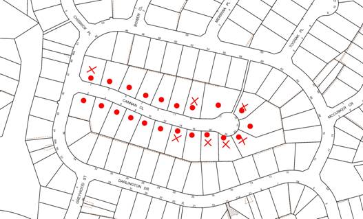
|
NOTIFICATION PLAN |
|
||
|
• PROPERTIES NOTIFIED |
X SUBMISSIONS RECEIVED |
1 SUBMISSION RECEIVED OUT OF MAP RANGE |
|
Heritage Assessment
In accordance with the undertaking provided at the meeting on 11 July 2012, Council sought a assessment on the likelihood of Cannan Close fulfilling the criteria for listing as a HCA. The assessment (copy attached) has been provided by Council’s heritage consultant, John Oultram Heritage & Design.
The assessment includes an analysis of the following:
· Historical Development – research into the development of Cannan Close, including information from the Lands Department and Council files;
· Physical Description – an inspection of the street and its environs;
· Discussion of Significance – an analysis of the historical significance, aesthetic significance, social significance, technical/scientific significance, and consideration of comparative developments;
· Assessment of Significance – an assessment of significance using the 7 criteria in the NSW Heritage Manual;
· Heritage Controls – consideration of existing statutory and non-statutory listings; and
· Conservation Area Assessment – consideration of the State Government’s guide to defining and establishing conservation areas.
The assessment of significance using the 7 criteria in the NSW Heritage Manual established by the NSW Heritage Office, is provided below:
|
Criteria |
Description |
Cannan Close Assessment |
|
Criterion (a) |
An item is important in the course, or pattern, of NSW's cultural or natural history (or the cultural or natural history of the local area) |
Cannan Close is an example of a late Twentieth Century subdivision and residential development that was developed from 1978 onwards. Does not meet the criterion
|
|
Criterion (b) |
An item has strong or special associations with the life or works of a person, or group of persons, of importance in NSW's cultural or natural history (or the cultural or natural history of the local area)
|
The place has no particular associations. Does not meet the criterion
|
|
Criterion (c) |
An item is important in demonstrating aesthetic characteristics and/or a high degree of creative or technical achievement in NSW (or the local area)
|
The area contains a selection of two storey houses in a hybrid Inter War and Federation style that do not demonstrate an important aesthetic movement. Does not meet the criterion |
|
Criterion (d) |
The item has strong or special association with a particular community or cultural group in NSW (or the local area) for social or spiritual reasons
|
The area has no special associations with any particular group. Does not meet the criterion
|
|
Criterion (e) |
An item has the potential to yield information that will contribute to an understanding of NSW's cultural or natural history (or the cultural or natural history of the local area)
|
The area has no archaeological potential. Does not meet the criterion
|
|
Criterion (f) |
An item possesses uncommon, rare or endangered aspects of NSW's cultural or natural history (or the cultural or natural history of the local area)
|
The area is a typical example of a post 1970’s residential development. Not Rare. Does not meet the criterion.
|
|
Criterion (g) |
An item is important in demonstrating the principal characteristics of a class of NSW's Cultural or natural places; or Cultural or natural environments |
The area represents a typical, outer Sydney, post 1970’s residential development. Does not meet the criterion at a State level.
|
|
(or a class of the local area's: Cultural or natural places; or Cultural or natural environments) |
The area represents a typical, outer Sydney, post 1970’s residential development. Does not meet the criterion at a local level. |
In summary, the assessment notes that the subdivision layout is typical of development in the area and does not demonstrate any particular advancement in planning terms. There is a general pattern to the houses in terms of scale, form, materials and detail and they are recognisable as being from the same stable of designs. The houses are larger and have greater articulation than many of the other houses in the area and are of a higher architectural quality. Though there are similar houses in the surrounding area and in other streets that have a similar development pattern.
The assessment comments that the buildings in Cannan Close are a hybrid form of the Inter War and Federations styles and do not mark a new or aesthetically important typology. The assessment notes that while the area has a consistent character due to the scale and stylistic uniformity of the houses, it has little aesthetic or historic qualities that would merit it being listed as a conservation area. The assessment concludes that, having regard to the heritage assessment criteria, Cannan Close does not merit listing as a HCA.
CONSULTATION
Preliminary discussions on the Cannan Close HCA were held with Department of Planning and Infrastructure (DP&I) officers during scheduled quarterly meetings as approval is required from the DP&I, in the form of a Gateway Determination, to proceed with the exhibition of a draft HCA listing.
DP&I officers advised that it a Heritage Assessment would be required demonstrating that the proposal satisfies the NSW Heritage Assessment Criteria, prior to issuing a Gateway Determination. Furthermore, if Cannan Close fulfilled at least one of the seven criteria for heritage listing, the heritage assessment should incorporate an analysis of comparative developments demonstrating that Cannan Close was the most appropriate example of its type to list as a HCA.
BUDGET
The assessment by Council’s heritage consultant cost $2,600.
POLICY
There are no policy implications associated with this report.
CONCLUSION
At its meeting on 16 May 2012, Council resolved to convene a meeting between available Councillors, representatives from the Cannan Close and Friends Residents Association and residents of Cannan Close to outline the process and implications of establishing a HCA to protect the heritage and streetscape qualities of Cannan Close, Cherrybrook. This meeting was held on 11 July 2012.
Although it is acknowledged that there is general support from the residents of Cannan Close for the establishment of a HCA, the area needs to fulfil NSW Heritage Assessment criteria to secure approval from the Department of Planning and Infrastructure (DP&I) in the form of a Gateway Determination to proceed.
In accordance with the undertaking provided at the meeting on 11 July 2012, Council sought a heritage assessment on the likelihood of Cannan Close, Cherrybrook fulfilling the criteria for listing as a HCA. This assessment concludes that, under NSW Heritage Assessment criteria, Cannan Close does not merit listing as a conservation area.
It is recommended that Council note the recommendations of the preliminary heritage assessment report and not pursue a HCA at Cannan Close, Cherrybrook.
RESPONSIBLE OFFICER
The officer responsible for the preparation of this report is the Acting Manager, Strategic Planning - Jason Rawlin - who can be contacted on 9847-6737.
|
James Farrington Group Manager Planning Division |
|
|
1.View |
Presentation to Meeting with Residents |
|
|
|
2.View |
Proposed Conservation Area at Cannan Close Cherrybrook. Heritage Assessment. John Oultram Heritage & Design. September 2012 |
|
|
File Reference: F2004/07641-03
Document Number: D02014470
Planning Report No. PL24/12
Planning Division
Date of Meeting: 17/10/2012
11 SECTION 82A REVIEW OF DEVELOPMENT APPLICATION - DEMOLITION OF A TENNIS COURT AND SUBDIVISION OF ONE ALLOTMENT INTO TWO LOTS
17 CANNAN CLOSE CHERRYBROOK
EXECUTIVE SUMMARY
|
DA No: |
DA/186/2012 |
|
Description: |
Demolition of a tennis court and subdivision of one allotment into two lots |
|
Property: |
Lot 1035, DP 812942, No. 17 Cannan Close, Cherrybrook |
|
Applicant: |
Mr Alex Du |
|
Owner: |
Mrs Suying Chen |
|
Estimated Value: |
$7,500 |
|
Ward: |
B |
· At its meeting on 16 May 2012, Council resolved to refuse Development Application No. DA/186/2012 for the demolition of a tennis court and subdivision of one allotment into two lots.
· Pursuant to Section 82A of the Environmental Planning and Assessment Act, 1979 (the Act), a request has been made for Council to review its determination.
· The existing dwelling on proposed Lot A would exceed the maximum 0.4:1 floor space ratio development standard of the Hornsby Shire Local Environmental Plan 1994. The applicant has made a submission pursuant to State Environmental Planning Policy No. 1 – Development Standards to vary the standard. The submission is considered well founded and is supported.
· 19 submissions have been received in respect of the application.
· It is recommended that Council change the determination and approve the application.
|
THAT Council assume the concurrence of the Director-General of the Department of Planning and Infrastructure pursuant to State Environmental Planning Policy No. 1 and approve the section 82A review of Development Application No. DA/186/2012 for demolition of a tennis court and subdivision of one allotment into two lots at Lot 1035 DP 812942, No. 17 Cannan Close, Cherrybrook subject to the conditions of consent detailed in Schedule 1 of Group Manager’s Report No. PL24/12. |
HISTORY OF THE APPLICATION
On 16 May 2012, Council considered Executive Manager’s Report PLN30/12 regarding the subject application and resolved that DA/186/2012 be refused for the following reasons:
1.1 Pursuant to Section 79C(1)(a)(i) of the Environmental Planning and Assessment Act 1979, the proposal is unsatisfactory as the State Environmental Planning Policy No. 1 objection relating to non-compliance with the applicable floor space ratio provision is not well founded.
1.2 The proposal is unsatisfactory in respect to Section 79C(1)(a)(iii) of the Environmental Planning and Assessment Act 1979, as the proposed subdivision layout is contrary to the objective of the Residential Subdivision DCP to enhance the established character of the area.
1.3 Pursuant to the provisions of Section 79C(1)(e) of the Environmental Planning and Assessment Act 1979, the proposed development would not be in the public interest.
1.4 Pursuant to Section 79C(1)(b) of the Environmental Planning and Assessment Act 1979, the proposed subdivision would result in a residual allotment in which the size and shape of private open space is insufficient having regard to the size of the dwelling on the land.
1.5 Pursuant to Section 79C(1)(b) of the Environmental Planning and Assessment Act 1979, the proposed subdivision would result in a dwelling that is inconsistent with the established streetscape.
On 25 May 2012, the applicant made application for a review of the determination under Section 82A of the Act.
At the meeting on 16 May 2012, Council also resolved to convene a meeting between available Councillors and residents of Cannan Close to outline the process and implications of establishing a heritage conservation area to protect the heritage and streetscape qualities of Cannan Close. That meeting was held in July 2012 and is the subject of a separate report to Council. Notwithstanding the discussion at the meeting, this current Section 82A application is required to be determined on its merits, in the context of the current applicable planning controls.
BACKGROUND
On 12 May 1989, Council approved DA/608/1988 for residential subdivision of Woodgrove Avenue, Castle Hill creating 41 residential lots, a public reserve dedication and a residue lot. This subdivision created the lots within Darlington Drive, Cannan Close, and Greywood Street.
On 20 June 1990, Council approved DA/74/1989 for subdivision creating 35 residential lots, 2 residue lots and construction of a section of the County Link Road.
The subject site comprises of Lot 108 (788m2) of DP 806547 (created under DA/608/1988) and approved Lot 1035 (812m2) created under DA/74/1989. The Subdivision Certificate subsequently sought consolidated Lot 108 with approved Lot 1035 at the request of the applicant to enhance allotment building platforms.
SITE
The site is located on the northern side of Cannan Close at the end of the cul-de-sac and experiences an average gradient of 7% from the front, south-eastern corner to the north-eastern corner.
The site is an irregular trapezoidal shaped allotment with curved front boundary of 40 metres and has an area of 1468.5m2
An existing two-storey brick dwelling-house is located on the eastern side of the site and a tennis court is located on the western side of the site. An easement to drain water exists at the north-western corner of the site.
The surrounding area is primarily low density residential with two storey dwelling-houses. The site is approximately 250 metres south of New Line Road.
PROPOSAL
The application proposes the demolition of an existing tennis court and the Torrens Title subdivision of one allotment into two lots.
Proposed Lot A is a trapezoidal-shaped lot with a curved frontage to Cannan Close, an area of 911.89m2 and an average gradient of 5.7% from the south-eastern corner to the north-western corner. An existing 466.51sqm two storey brick dwelling-house would be retained on the lot.
Proposed Lot B would be positioned in lieu of the existing tennis court to be demolished and have an area of 556.72m2, a 13.11 metre frontage to Cannan Close and an average gradient of 4.1% from the southern boundary to the northern boundary.
Six trees exempt under Council’s Tree Preservation Order would be removed to facilitate future development of the newly created allotment.
ASSESSMENT
The development application has been assessed having regard to the ‘Metropolitan Plan for Sydney 2036’, the ‘North Subregion (Draft) Subregional Strategy’ and the matters for consideration prescribed under Section 79C of the Environmental Planning and Assessment Act 1979 (the Act). The following issues have been identified for further consideration.
1. STRATEGIC CONTEXT
1.1 Metropolitan Plan for Sydney 2036 and (Draft) North Subregional Strategy
The Metropolitan Plan for Sydney 2036 is a broad framework to secure Sydney’s place in the global economy by promoting and managing growth. It outlines a vision for Sydney to 2036, the challenges faced, and the directions to follow to address these challenges and achieve the vision. The Draft North Subregional Strategy acts as a framework for Council in its preparation of the Comprehensive LEP by the end of 2012.
The Draft North Subregional Strategy sets the following targets for the Hornsby LGA by 2031:
· Employment capacity to increase by 9,000 jobs; and
· Housing stock to increase by 11,000 dwellings.
In the preparation of Council’s Housing Strategy, it was acknowledged that there is existing capacity to provide additional dwellings under Council’s existing controls, including through subdivision in low density residential zones. The development application would be consistent with Council’s Housing Strategy by providing additional housing opportunity to assist in achieving Council’s dwelling target under the Metropolitan Plan.
2. STATUTORY CONTROLS
Section 79C(1)(a) requires Council to consider “any relevant environmental planning instruments, draft environmental planning instruments, development control plans, planning agreements and regulations”.
2.1 Hornsby Shire Local Environmental Plan 1994
The subject land is zoned Residential A (Low Density) under the Hornsby Shire Local Environmental Plan 1994 (HSLEP). The objectives of the Residential A (Low Density) zone are:
(a) to provide for the housing needs of the population of the Hornsby area.
(b) to promote a variety of housing types and other land uses compatible with a low density residential environment.
(c) to provide for development that is within the environmental capacity of a low density residential environment.
The proposed development is defined as ‘subdivision’ and ‘demolition’ under the HSLEP and is permissible in the zone with Council’s consent.
Clause 14 of the HSLEP prescribes a minimum lot area of 500m2 for subdivision in the Residential A zone. The proposed subdivision complies with this requirement.
Clause 15 of the HSLEP prescribes that the maximum floor space ratio (FSR) of development within Residential A Zones is 0.4:1. The FSR of the existing dwelling-house on proposed Lot A of 0.51:1 is in non-compliance with the development standard. The applicant has made a submission to vary the development standard pursuant to State Environmental Planning Policy No. 1 – Development Standards. Refer to discussion in Section 2.3.
2.2 Draft Comprehensive Hornsby Local Environmental Plan
At its meeting on 7 March 2012, Council resolved to endorse the draft Hornsby Local Environmental Plan (DHLEP) for public exhibition. The draft plan was on exhibition from 5 June to 7 August 2012. Under the DHLEP, the subject land would be zoned R2 - Low Density Residential and subdivision and demolition would be permissible within the R2 - Low Density Residential zone with Council’s consent.
2.3 Section 82A - Environmental Planning and Assessment Act, 1979
The application for review of Council’s determination of DA/186/2012 is made pursuant to Section 82A of the Act. In accordance with the provisions under Section 82A, the applicant may make amendments to the development. Council is to notify the application and to take into consideration any submissions in carrying out the review. The notification and assessment of the application are in accordance with Section 82A.
The submitted plan is the same as previously submitted to Council. The application has been notified in accordance with Council’s Notification and Exhibition DCP.
The following provides a discussion of the reasons for refusal:
Pursuant to Section 79C(1)(a)(i) of the Environmental Planning and Assessment Act 1979, the proposal is unsatisfactory as the State Environmental Planning Policy No. 1 objection relating to non-compliance with the applicable floor space ratio provision is not well founded.
Comment: Clause 15 of the HSLEP prescribes that the maximum floor space ratio (FSR) of development within the Residential A Zones is 0.4:1.
Proposed Lot A has an area of 911.86sqm and the subject dwelling-house to be retained on that lot has a gross floor area of 466.51sqm. Therefore, the FSR on proposed Lot A is 0.51:1 which is a non-compliance with the development standard. The applicant has made a submission to vary the development standard pursuant to State Environmental Planning Policy No. 1 Development Standards. This Policy provides flexibility in the application of development standards in circumstances where strict compliance with those standards would, in any particular case, be unreasonable or unnecessary or tend to hinder the attainment of the objectives of the Act.
The Land and Environment Court has expressed the view that there are five different ways in which an objection may be well founded and that approval of the objection may be consistent with the aims of the Policy:
1. “the objectives of the standard are achieved notwithstanding non-compliance with the standards;
2. the underlying objective or purpose of the standard is not relevant to the development and therefore compliance is unnecessary;
3. the underlying object of purpose would be defeated or thwarted if compliance was required and therefore compliance is unreasonable;
4. the development standard has been virtually abandoned or destroyed by the Council’s own actions in granting consents departing from the standard and hence compliance with the standard is unnecessary and unreasonable;
5. the zoning of the particular land is unreasonable or inappropriate so that a development standard appropriate for that zoning is also unreasonable and unnecessary as it applies to the land and compliance with the standard would be unreasonable or unnecessary”.
The applicant has submitted a SEPP 1 objection to the floor space ratio (FSR) control, and contends that:
“Albeit the proposed retained dwelling-house’s non-compliance with the 0.4:1 FSR standard, the proposed development is planned and designed to perform favourably in relation to the objectives of the FSR standard.
The retained existing dwelling on proposed lots, which relates aptly in proportion to the neighbouring residential properties in the surrounding area of Cherrybrook Precinct, provides a compatible external appearance in height, visual bulk, landscaping, building setbacks, and external elements with the objective of this standard.
The proposed subdivision of the land ensures the retained existing dwelling as well as the future development on both allotments have no adverse overlooking to neighbouring residential properties and their private open space areas are adapted to the proposed development with appropriately designed building setbacks, floor plan layouts, subdivision layouts, orientation of the landscape areas, and the placement and sizing of the building envelope.
The proposed building envelope and sitting also ensures that good portions of northern solar access are maintained to No. 15 Cannan Close. Reasonable portions of solar access will be maintained to the window openings and rear outdoor open space area of the adjoining residential property at No. 15 Cannan Close in mid winter.
The proposed subdivision development is consistent with the stated zoning objectives under Clause 7 of Part 2 – Zoning Controls of the HSLEP 1994, in that the proposed retained existing dwelling house is compatible in design, bulk and scale with adjoining and nearby residential properties in the Cherrybrook Precinct and the proposed subdivision will provide for a compatible land use.
If Council insisted on strict compliance with the maximum floor space ratio development standard, such a decision would hinder the attainment of the objectives of the EP&A Act in that the promotion and co-ordination of the orderly and economic use and development of land would be discouraged as it would prevent the execution of a subdivision and future construction of a dwelling-house.
While the proposed subdivision does not comply with the maximum floor space ratio development standard contained in Clause 15 of the Hornsby Shire Local Environmental Plan 1994, it satisfies the stated and essential objectives of the development standard and the broader planning and zoning objectives for the locality.
Compliance with the development standard is as a result unnecessary and unreasonable in the circumstances of the case, and granting of the development application on this ground is warranted.”
Point 1 above provides grounds for the SEPP 1 objection.
As set out in the HSLEP 1994, the main objectives of the floor space ratio standard are as follows:
“To control the intensity and scale of development so that development will be in accordance with the land’s environmental capacity and zone objectives.”
The retention of the existing dwelling on proposed Lot A would not alter the site and the intensity of the development on the lot. The scale of the dwelling-house on proposed Lot A in regards to height and visual impact does not adversely impact upon the development in the area. The site is not constrained by land sensitivity factors and is capable of both the land use and the proposed FSR.
In addition, since the preparation of the HSLEP 1994, the State Government has introduced the NSW Housing Code where residents can often build larger dwelling houses than the HSLEP permits as complying development. The subject site could accommodate a dwelling of 430sqm under the provisions of the NSW Housing Code. To achieve technical compliance with the numerical floor space controls of the NSW Housing Code, floor space could be removed from the rear of the building which would have no impact on the existing character of the area or alter the existing impacts on neighbouring properties.
In addition, review of the Building Approvals for the adjacent dwelling houses in Cannan Close found that the neighbouring properties also do not comply with the HSLEP 0.4:1 FSR control, with FSRs ranging from 0.43:1 to 0.47:1.
Furthermore, as discussed within the Land and Environment Court Planning Principle regarding the relationship of density and residential character in Salanitro-Chafei v Ashfield Council [2005] NSWLEC 36,
“The upper level of density that is compatible with the character of typical single-dwelling areas is around 0.5:1. Higher densities tend to produce urban rather than suburban character. This is not to say that a building with a higher FSR than 0.5:1 is necessarily inappropriate in a suburban area; only that once 0.5:1 is exceeded, it requires high levels of design skill to make a building fit into its surroundings.”
The retention of the existing dwelling on proposed Lot A achieves an FSR in the order of 0.5:1 which is consistent with the Land and Environment Court’s Planning Principles, and is consistent with the zone objectives as it provides for a housing need, is compatible with the low density residential environment and is within the environmental capacity of the area.
In conclusion, strict compliance with the floor space ratio for proposed Lot A would not achieve any benefit in respect to the character of the locality. Accordingly, it would be unreasonable to insist on compliance with the numerical floor space provision in this instance.
The proposal is unsatisfactory in respect to Section 79C(1)(a)(iii) of the Environmental Planning and Assessment Act 1979, as the proposed subdivision layout is contrary to the objective of the Residential Subdivision DCP to enhance the established character of the area.
Comment: As discussed within the Land and Environment Court Planning Principle Stockland Development Pty Ltd v Manly Council [2004] NSWLEC 472, the provisions of a DCP must be consistent with the provisions of any relevant local environmental plan. In this regard, the Objectives of the Residential A (Low Density) Zone include to:
“promote a variety of housing types and other land uses compatible with a low density residential environment”
Therefore, the key test for Council to consider is whether the subdivision proposal would result in development that is compatible with the local context. Project Venture Developments Pty Ltd v Pittwater Council [2005] NSWLEC 191 provides a planning principle for the compatibility of a proposal with surrounding development.
“There are many dictionary definitions of compatible. The most apposite meaning in an urban design context is capable of existing together in harmony. Compatibility is thus different from sameness. It is generally accepted that buildings can exist together in harmony without having the same density, scale or appearance, though as the difference in these attributes increases, harmony is harder to achieve.”
Proposed Lots A and B would have a frontages of 27 metres and 13 metres to Cannan Close, respectively. A number of submissions raise concern that the frontage of Lot B is too narrow as the majority of lots in Cannan Close typically have a width of 20 metres at the building line. The Residential Subdivision DCP ‘Allotment Design’ element requires that lots be designed to be able to accommodate a building envelope with a minimum dimension of 10 metres and a side setback of 1 metre. The width of Lot B complies with the DCP’s prescriptive measures for allotment design that has an underlying objective of providing a usable lot with a pleasant streetscape.
The applicant has submitted indicative building envelopes for proposed Lot B. It is acknowledged that the submitted building envelopes would not restrict any future development to the built form indicated. However, the building envelopes submitted demonstrate that the proposed new allotment would be capable of accommodating a 2 storey dwelling-house of a bulk and scale commensurate with the bulk and scale of existing low density residential development in the Cherrybrook locality.
Pursuant to the provisions of Section 79C(1)(e) of the Environmental Planning and Assessment Act 1979, the proposed development would not be in the public interest.
Comment: The public interest as referenced in Section 79C of the Act is not confined to the residents of Cannan Close as suggested within a number of submissions. As discussed in Hooper v Port Stephens Council [2009] NSWLEC 234
“…the concept of public interest is multi-faceted. Whilst there is a public interest in the proper enforcement of public welfare statutes such as planning and environmental laws, there is also a public interest in the reliable and predictable administration of these laws from the perspective of the body tasked to discharge its regulatory functions in accordance with them.”
The approval of this application is in the public interest as it is consistent with the objectives of the existing planning controls, including the Residential Subdivision DCP. Furthermore, the proposal would provide additional housing opportunities with the Shire.
Pursuant to Section 79C(1)(b) of the Environmental Planning and Assessment Act 1979, the proposed subdivision would result in a residual allotment in which the size and shape of private open space is insufficient having regard to the size of the dwelling on the land.
Comment: The size and shape of private open space on both lots exceeds the requirements of the Residential Subdivision DCP and the complying development provisions of the NSW Housing Code, as summarised in the table below. There is no requirement prescribing that this area is to be hard and/or soft landscaping.
|
Private Open Space (rear) |
Proposed Minimum |
Residential Subdivision DCP Minimum |
NSW Housing Code Minimum |
|||
|
Dimension |
Area |
Dimension |
Area |
Dimension |
Area |
|
|
Lot A |
8-9m |
155sqm |
5m |
120sqm |
3m |
24sqm |
|
Lot B |
11-12m |
155sqm |
5m |
120sqm |
3m |
24sqm |
Pursuant to Section 79C(1)(b) of the Environmental Planning and Assessment Act 1979, the proposed subdivision would result in a dwelling that is inconsistent with the established streetscape.
Comment: As previously discussed under Reason for Refusal 2 achieving a development on Proposed Lot B that is compatible with the locality is different to sameness.
The Planning Principle in Project Venture Developments v Pittwater Council [2005] NSWLEC 191 notes that to test whether a proposal is compatible with its context, consideration should be given to the proposal’s physical impacts on surrounding development and whether the proposal’s appearance is in harmony with the buildings around it and the character of the street. The Principle also notes that reference to architectural style and materials is relevant to special areas such as heritage conservation areas. The locality is not a heritage conservation area and the application is to be determined on the basis of the current planning controls. Therefore, in the case of the subject DA, the focus should be on the important contributors to the streetscape which include height, setbacks and landscaped area.
It is acknowledged that the 556.7m2 lot size of proposed Lot B would be smaller than other allotments in Cannan Close. However, proposed Lot B would be a regular rectangular shaped allotment that is not burdened by topographical or environmental constraints. The width of the lot complies with the prescriptive measures for Allotment Design in the Residential Subdivision DCP. In this regard, a future dwelling-house could be designed and positioned on the newly created allotment that is compatible with the established built form in terms of height, setbacks, landscaping and private open space while retaining amenity to adjoining properties in respect to privacy and solar access.
2.4 State Environmental Planning Policy No. 1 – Development Standards
The application has been assessed against the requirements of State Environmental Planning Policy No. 1 – Development Standards (SEPP 1). See discussion under Reason for Refusal 1.
2.5 Sydney Regional Environmental Plan No. 20: Hawkesbury – Nepean Rivers
Sydney Regional Environmental Plan No. 20 aims to protect the environment of the Hawkesbury – Nepean Rivers system by ensuring that the impacts of future land uses are considered in a regional context.
The site is located within the catchment of the Hawkesbury – Nepean Rivers. Part 2 of Sydney Regional Environmental Plan No. 20 contains general planning considerations and strategies, and requires Council to consider the impact of any proposal on water quality, riverine scenic quality, aquaculture, recreation and tourism.
Given the location of the site, water quality is the only relevant issue for the assessment of the proposal. The proposed development would have negligible impacts on the water quality of the catchment area as the density and scale of the additional allotment and dwelling under construction would be consistent with the environmental capacity of the site.
2.6 Residential Subdivision DCP
The proposed development has been assessed having regard to the relevant performance and prescriptive design requirements within Council’s Residential Subdivision Development Control Plan (Residential Subdivision DCP). The following table sets out the proposal’s compliance with the prescriptive measures of the Plan:
|
Residential Subdivision Development Control Plan |
|||
|
Control |
Proposal |
Requirement |
Compliance |
|
Site Area |
1468.5m2 |
N/A |
N/A |
|
Density |
|||
|
FSR (Lot A) |
0.51:1 |
0.4:1 |
No |
|
Allotment Size Lot A Lot B |
911.86m2 556.72m2 |
500m2 500m2 |
Yes Yes |
|
Allotment Layout and Design |
|||
|
Average site gradient Lot A Lot B |
5.7% 4.1% |
20% 20% |
Yes Yes |
|
Lot orientation Lot A Lot B |
N50E N50E |
N20oW to N300E or E20oN to E30oS |
Yes Yes |
|
Existing Dwelling (Lot A) |
|||
|
Site cover |
39% |
40% |
Yes |
|
Private open space |
155m2 |
120m2 |
Yes |
|
Private Open Space – Minimum Dimension |
8m |
5m |
Yes |
|
Setbacks Front (Southern) Side (Eastern) Side (Western) Rear (Northern) |
9m 1m 3.8m 1m |
6-9m 1m 1m 3m |
Existing Existing Yes Existing |
|
Landscaping |
46% |
45% |
Yes |
|
Car Parking |
3 Spaces |
2 spaces |
Yes |
|
Building Envelope* (Lot B) |
|||
|
Building Envelope, with a minimum dimension of 10 metres |
212m2
|
200m2
|
Yes
|
|
Site cover |
38% |
40% |
Yes |
|
Private open space |
155m2 |
120m2 |
Yes |
|
Private Open Space – Minimum Dimension |
11m |
5m |
Yes |
|
Setbacks Front (Southern) Side (Eastern) Side (Western) Rear (Northern) |
11m 1m 1m 11m |
6-9m 1m 1m 3m |
Yes Yes Yes Yes |
|
Landscaping (est) |
52% |
45% |
Yes |
|
Car Parking (est) |
2 Spaces |
2 spaces |
Yes |
Note* Excluding the envelope area 7.5m wide adjacent to the southern boundary
As detailed in the above table, the following matters require further consideration.
2.6.1 Allotment Layout, Design and Setbacks
Lot A accommodates an existing dwelling-house. The retention of the dwelling-house on Lot A would comply with the prescriptive measures in the Residential Subdivision DCP for site coverage, private open space, landscaping and parking. The existing building setbacks to the southern, eastern and northern boundaries are unaltered. The building achieves a 3.8 metre setback to the new western boundary, l in excess of the minimum side setback provision.
Lot B would be a vacant allotment. The allotment design element in the Residential Subdivision DCP requires vacant lots to be able to accommodate a building envelope of 200m2 with a minimum dimension of 10 metres that complies with the setback provisions. The indicative building envelope illustrated on the DA plans has an envelope of 244m2. However, this incorporates an envelope area at the front of the site that does not comply with the minimum envelope dimension and building setbacks for Cherrybrook. Proposed Lot B could accommodate a 200m2 indicative building envelope that would be compliant with the prescriptive measures for site coverage, private open space, setbacks, landscaping and parking, as detailed in the above table. The proposed lot would facilitate development that is consistent with the capacity of the site and the low density residential zone. There would be an acceptable level of amenity provided in respect to privacy of a future dwelling-house on proposed Lot B and private open space for the future and existing dwelling-house.
In this regard, the proposal meets the objectives of the Allotment Layout, Allotment Design and Setback elements and is acceptable.
2.6.2 Density
The density element in the Residential Subdivision DCP requires lots to have a minimum area of 500m2, and proposed lots containing existing dwellings to have a maximum floor space ratio (FSR) of 0.4:1 and a maximum site coverage of 40%.
Proposed Lot A complies with the minimum lot area and maximum site coverage provisions. However, development on the lot would not comply with the maximum FSR. The non-compliance with the FSR control is discussed in detail under Reason for Refusal 1 of this report.
Proposed Lot B complies with the minimum lot area and is of sufficient size to allow for the sitting of a dwelling and include provisions for private open space, vehicle access and parking and respond to site constraints, as previously discussed at 2.6.1 above.
2.6.3 Solar Access
The north/south orientation of the allotments would allow the subject and adjoining properties to receive a minimum of 3 hours of sunlight for north facing windows and 4 hours of sunlight for private open space on 22 June (Winter Solstice) as prescribed by the Solar Access element.
2.6.4 Private Open Space
Submissions have been received raising concerns regarding insufficient private open space for the existing dwelling-house as a result of the proposed subdivision. As previously discussed under Reason for Refusal 4, the size and shape of private open space on both lots exceeds the requirements of the Residential Subdivision DCP and the complying development provisions of the NSW Housing Code.
2.6.5 Landscaping
Submissions have been received raising concerns that the open space for Lot A would be mostly hard surface area. The proportion of Lot A that would be built-upon and available for landscaping is summarised in the table below:
|
Site Coverage and Landscaping on Lot A |
||
|
Element |
Proposed |
Residential Subdivision DCP |
|
Site Coverage |
39.0% |
max 40% |
|
Landscaping |
|
|
|
Soft Landscaping |
29.3% |
|
|
Hard Landscaping |
16.6% |
|
|
Total Landscaping |
45.9% |
min 45% |
|
Driveway |
15.1% |
|
|
Total Site |
100% |
|
The Landscaping element in the Residential Subdivision DCP states that “a minimum of 45% of the site should be landscaped, exclusive of building or driveway areas.” Landscaping is undefined. Accordingly, the Residential Subdivision DCP includes both soft and hard landscaping within this calculation. It is not unusual in Cannan Close for properties to have a large proportion of hard landscaping, such as paved outdoor private open space areas. For example, other sites in the immediate vicinity of this property have soft landscaping in the order of 25-30% of the site area. Therefore, the percentage of soft landscaping proposed for Lot A would be consistent with other properties in the street.
In addition, some of the submissions raised concern that the private open space to the rear of Lot A would be fully paved with no green area. The subdivision plan proposes to incorporate part of the tennis court into Lot A. The recommended consent conditions require this area to be turfed. Therefore, the application would increase the total area of soft landscaping behind the front building line of the existing dwelling.
Concerns are also raised in submissions that the loss of trees in the front setback would have a detrimental impact on the streetscape. There are currently 14 trees in the front setback, of which 8 trees are indigenous and protected by the Council’s Tree Preservation Order. There is currently no approval sought for the construction of a new driveway or dwelling on Lot B. However, there is a 5 metre wide setback between the indigenous trees and the western side boundary of Lot B that could accommodate a new driveway. In addition, if a 9 metre front building line is provided in accordance with the Cherrybrook Precinct DCP, then a new dwelling could be sited more than 4 metres from the indigenous trees. Accordingly, the majority of the indigenous trees could be maintained. Notwithstanding this, Council’s tree assessment concludes that none of the 8 indigenous trees are significant and warrant retention.
2.6.6 Drainage Control
An inter-allotment drainage easement would be required to service the proposed development as the property slopes to the rear. The applicant has submitted title documents confirming that the subject allotment has the benefit of a drainage easement contained within DP 806547.
2.6.7 Section 94 Contributions
The applicant would be required to make a payment of a contribution for one additional lot towards the cost of transport and traffic management, library and community facilities, civic improvements, stormwater drainage, bushfire protection and Section 94 administration in accordance with Sections 94, 94B and 94C of the Environmental Planning and Assessment Act 1979 and Hornsby Shire Council’s Development Contributions Plan 2004-2010. This requirement is addressed as a condition of consent.
2.7 Cherrybrook Precinct Development Control Plan
The Cherrybrook Precinct DCP provides a detailed planning strategy and guidelines for development within the Cherrybrook Precinct. The Cherrybrook Masterplan aims to ensure that residential subdivision promotes the garden suburb character of the Cherrybrook Precinct while the Residential Strategy aims to protect residential amenity through setback, height and acoustic requirements.
Notwithstanding that the proposed subdivision would result in reduced lot sizes, the lot orientation and allotment shapes remain generally consistent with the subdivision pattern of the Cherrybrook Masterplan.
The objective of the Residential Strategy is:
“To provide for a variety of housing types and other compatible land uses and protection of residential amenity.”
The proposed subdivision would create an additional allotment to provide additional housing opportunities. The proposal is sympathetic to the amenity of future and existing residents in respect to privacy, solar access, and provision of private open space.
The Residential Strategy element prescribes that buildings on local roads should be setback 9 metres with a permitted encroachment to 6 metres for a distance equal to 1/3 of the width of the property measured at the building line. The existing dwelling-house on proposed Lot A complies with this setback control. Proposed Lot B could accommodate a dwelling-house that complies with these provisions and is compatible with the character of the locality.
3 ENVIRONMENTAL IMPACTS
Section 79C(1)(b) of the Act requires Council to consider “the likely impacts of that development, including environmental impacts on both the natural and built environments, and social and economic impacts in the locality”.
3.1 Natural Environment
There are 14 trees located at the front of proposed Lot B of which 6 are exempt from Council’s Tree Preservation Order. The removal of the remaining trees would have negligible impacts on the natural environmental as they do not form part of any Ecologically Endangered Community or critical habitat for native fauna.
3.2 Built Environment
The proposed subdivision is consistent with the pattern of infill development occurring within the surrounding low density residential area.
3.2.1 Future Development on Lot B
Concerns are raised in submissions that the future dwelling-house house on Lot B would not match the existing houses in the street in terms of building width, setback, design and quality.
As previously discussed under Reasons for Refusal 2 and 4, achieving a development on Proposed Lot B that is compatible with the locality is different to sameness. A future dwelling-house could be designed and positioned on the newly created allotment that is compatible with the established built form in terms of height, setbacks, landscaping and private open space while retaining amenity to adjoining properties in respect to privacy and solar access. The width of the lot complies with the prescriptive measures for Allotment Design in the Residential Subdivision DCP.
The recommended consent conditions clarify that the proposed building envelope on Lot B shown on the plan of subdivision is not approved. Any future application for a dwelling-house on Lot B made pursuant to the provisions of the NSW Housing Code would require a larger front and side setback than indicated on the proposed plans. Alternatively, a development application would need to be submitted to the Council for a merit assessment.
3.2.2 Privacy
Submissions have been received raising concerns regarding loss of privacy generated by the removal of trees on proposed Lot B and the erection of a future dwelling-house.
The first floor of the existing dwelling-house on proposed Lot A contains bedrooms and a study. There are no living areas that would overlook adjoining properties that would lead to loss of privacy.
The design of a dwelling-house on proposed Lot B would be required to have regard for the privacy of adjoining properties under a future development application or complying development proposal.
Notwithstanding that the existing trees would provide a level of screening from proposed Lot B to the opposite dwellings on Cannan Close, there is over 24 metres of separation from the front property boundary of the proposed Lot and the habitable areas of the nearest opposite dwelling on Cannan Close. In this regard, the loss of privacy for properties (opposite) as a result of a future dwelling-house would be negligible.
3.2.3 Increased traffic and removal of on-street parking
Concerns are raised in submissions that the development would result in increased traffic and reduce available on-street parking. The increase in traffic generated by an additional dwelling-house would be minor and is not grounds for refusal. On-site carparking would be required to be provided for any future dwelling on Lot B. Furthermore, the design of Lot B allows for the front setback area/driveway to be available for visitor parking.
3.3 Social Impacts
The proposal would not result in a social impact.
3.4 Economic Impacts
The proposal would have a minor positive impact on the local economy in conjunction with other new low density residential development in the locality by generating an increase in demand for local services.
4 SITE SUITABILITY
Section 79C(1)(c) of the Act requires Council to consider “the suitability of the site for the development”.
The subject site has not been identified as bushfire prone, flood prone or environmentally sensitive lands. The site is considered to be capable of accommodating the proposed development. The scale of the proposed development is consistent with the capability of the site and is considered acceptable.
5 PUBLIC PARTICIPATION
Section 79C(1)(d) of the Act requires Council to consider “any submissions made in accordance with this Act”.
5.1 Community Consultation
The Section 82A Review Application was placed on public exhibition and was notified to adjoining and nearby landowners between 28 May 2012 and 21 June 2012 in accordance with Council’s Notification and Exhibition Development Control Plan. During this period, Council received 19 submissions. The map below illustrates the location of those nearby landowners who made a submission that are in close proximity to the development site.
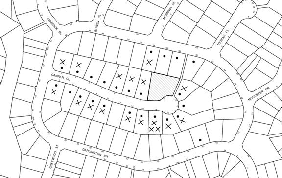
|
NOTIFICATION PLAN |
|
||
|
• PROPERTIES NOTIFIED
|
X SUBMISSIONS RECEIVED |
PROPERTY SUBJECT OF DEVELOPMENT |
|
|
1 SUBMISSION RECEIVED OUT OF MAP RANGE |
|||
19 submissions objected to the development, generally on the following grounds that the development would result in:
· Excessive scale and inadequate landscaping of the existing dwelling on Lot A;
· Detrimental impacts from a future dwelling-house on Lot B;
· Increased traffic and removal of on-street parking;
· A precedent for other subdivisions in Cannan Close; and
· Property devaluation.
The merits of the matters raised in community submissions have been addressed in the body of the report with the exception of the following:
5.1.1 Precedent
Concerns are raised that if the subdivision is approved, this would set a precedent for other properties to follow suit which would not be in keeping with the character of the street.
The subject site was originally approved to be developed as two lots, pursuant to development consents DA/608/1988 and DA/74/1989. As these two approved lots were subsequently consolidated, the site has a lot width of 40 metres which is double the typical lot width of 20 metres achieved in the rest of the street. No other site in the street has a lot size of greater than 1000sqm with a double frontage.
All applications for development, including subdivision are based on their merits, taking into account the applicable planning controls.
5.1.2 Devaluation of property
Concerns are raised that this development may devalue the homes in the street. The belief that a development may devalue a property is not within the scope of matters that can be considered in the assessment of a development application under Section 79C of the Act.
6 PUBLIC INTEREST
Section 79C(1)(e) of the Act requires Council to consider “the public interest”.
The public interest is an overarching requirement, which includes the consideration of the matters discussed in this report. Implicit to the public interest is the achievement of future built outcomes adequately responding to and respecting the future desired outcomes expressed in environmental planning instruments and development control plans.
The application is considered to have satisfactorily addressed Council’s and relevant agencies’ criteria and would provide a development outcome that, on balance, would result in a positive impact for the community by providing additional housing opportunities. Accordingly, it is considered that the approval of the proposed subdivision would be in the public interest.
CONCLUSION
The applicant has requested that Council review its decision to refuse DA/1861/2012 for the demolition of a tennis court and subdivision of one allotment into two lots. The application was not amended. The applicant’s response to the reasons for refusal included only excerpts from the Council report of 16 May 2012 that recommended approval of the proposal.
The existing dwelling on proposed Lot A does not comply with the 0.4:1 floor space ratio development standard of the HSLEP 1994. Consequently, the application has been supported by a submission under State Environmental Planning Policy No. 1 seeking approval of a variation to this development standard.
The proposal generally complies with the requirements of Council’s Residential Subdivision DCP other than the maximum floor space ratio which is acceptable with regard to the well founded SEPP 1 submission.
The development complies with the 500sqm development standard under Clause 14 of HSLEP 1994, meets the Residential A zone objectives and is consistent with the objectives of the Metropolitan Plan for Sydney 2036.
Twenty seven submissions were received in respect of the original application and nineteen submissions were received in respect of this Section 82A review.
It is recommended that Council change the determination and approve the application.
Note: At the time of the completion of this planning report, no persons have made a Political Donations Disclosure Statement pursuant to Section 147 of the Environmental Planning and Assessment Act 1979 in respect of the subject planning application.
|
James Farrington Group Manager Planning Division |
|
|
1.View |
Locality Plan |
|
|
|
2.View |
Survey Plan |
|
|
|
3.View |
Floor Plan |
|
|
|
4.View |
Site Analysis |
|
|
|
5.View |
Subdivision Plan |
|
|
|
6.View |
Landscape Plan |
|
|
File Reference: DA/186/2012
Document Number: D02000126
SCHEDULE 1
GENERAL CONDITIONS
The conditions of consent within this notice of determination have been applied to ensure that the use of the land and/or building is carried out in such a manner that is consistent with the aims and objectives of the relevant legislation, planning instruments and Council policies affecting the land and does not disrupt the amenity of the neighbourhood or impact upon the environment.
Note: For the purpose of this consent, the term ‘applicant’ means any person who has the authority to act on or the benefit of the development consent.
Note: For the purpose of this consent, any reference to an Act, Regulation, Australian Standard or publication by a public authority shall be taken to mean the gazetted Act or Regulation, or adopted Australian Standard or publication as in force on the date that the application for a construction certificate is made.
1. Approved Plans and Supporting Documentation
The development must be carried out in accordance with the plans and documentation listed below and endorsed with Council’s stamp, except where amended by Council and/or other conditions of this consent:
|
Plan No. |
Drawn by |
Dated |
|
A001-A006, A100-A102 |
Greg Pickworth |
21.02.2012 |
2. Removal of Existing Trees
This development consent only permits the removal of tree(s) numbered 1 to 6 inclusive Cupressus species (Cypress Pine) as identified in red on Plan No. A004 prepared by Greg Pickworth dated 21/2/2012. The removal of any other trees requires separate approval under Council’s Tree Preservation Order.
3. Amendment of Plans
The approved plans are to be amended as follows:
a. The proposed building envelope on Lot B as identified on Plan No. A100 prepared by Greg Pickworth dated 21/2/2012 is not approved.
REQUIREMENTS PRIOR TO THE ISSUE OF A CONSTRUCTION CERTIFICATE
4. Water/Electricity Utility Services
The applicant must submit written evidence of the following service provider requirements:
a. Energy Australia – a letter of consent demonstrating that satisfactory arrangements have been made to service the proposed development.
b. Sydney Water – the submission of a ‘Notice of Requirements’ under s73 of the Sydney Water Act 1994.
Note: Sydney Water requires that s73 applications are to be made through an authorised Sydney Water Servicing Coordinator. Refer to www.sydneywater.com.au or telephone 13 20 92 for assistance.
REQUIREMENTS PRIOR TO THE COMMENCEMENT OF ANY WORKS
5. Erection of Construction Sign
A sign must be erected in a prominent position on any site on which building work, subdivision work or demolition work is being carried out:
a. Showing the name, address and telephone number of the principal certifying authority for the work,
b. Showing the name of the principal contractor (if any) for any demolition or building work and a telephone number on which that person may be contacted outside working hours, and
c. Stating that unauthorised entry to the work site is prohibited.
Note: Any such sign is to be maintained while the building work, subdivision work or demolition work is being carried out, but must be removed when the work has been completed.
6. Erosion and Sediment Control
Erosion and sediment control measures must be provided and maintained throughout the construction period in accordance with the manual ‘Soils and Construction 2004 (Bluebook)’, the approved plans, Council specifications and to the satisfaction of the principal certifying authority. The erosion and sediment control devices must remain in place until the site has been stabilised and revegetated.
Note: On the spot penalties up to $1,500 may be issued for any non-compliance with this requirement without any further notification or warning.
REQUIREMENTS DURING CONSTRUCTION
7. Construction Work Hours
All work on site (including demolition and earth works) must only occur between 7am and 5pm Monday to Saturday.
No work is to be undertaken on Sundays or public holidays.
8. Demolition
All demolition work must be carried out in accordance with Australian Standard 2601-2001 – The Demolition of Structures and the following requirements:
a. Demolition material is to be disposed of to an authorised recycling and/or waste disposal site.
9. Works near Trees
All required tree protection measures are to be maintained in good condition for the duration of the construction period.
All works (including driveways and retaining walls) within 4 metres of any trees required to be retained (whether or not on the subject property, and pursuant to this consent or the Tree Preservation Order), must be carried out under the supervision of an ‘AQF Level 5 Arborist’ and a certificate submitted to the principal certifying authority detailing the method(s) used to preserve the tree(s).
Note: Except as provided above, the applicant is to ensure that no excavation, filling or stockpiling of building materials, parking of vehicles or plant, disposal of cement slurry, waste water or other contaminants is to occur within 4 metres of any tree to be retained.
10. Council Property
During construction works, no building materials, waste, machinery or related matter is to be stored on the road or footpath. The public reserve is to be kept in a clean, tidy and safe condition at all times.
REQUIREMENTS PRIOR TO THE ISSUE OF A SUBDIVISION CERTIFICATE
Note: For the purpose of this consent, a reference to ‘occupation certificate’ shall not be taken to mean an ‘interim occupation certificate’ unless otherwise stated.
11. Sydney Water – s73 Certificate
A s73 Certificate must be obtained from Sydney Water.
12. Stormwater Drainage
The stormwater drainage system for the development must be designed and constructed in accordance with Council’s Civil Works – Design and Construction Specification 2005 and the following requirements:
a. Connected directly to the existing interallotment drainage system that drains to Council’s piped drainage system in Darlington Drive.
b. An inter-allotment stormwater drainage system to service the proposed lots with pits being constructed in situ.
c. The roof and stormwater drainage system from the existing dwelling to be connected to the proposed inter-allotment drainage system.
Note: A construction certificate shall be obtained prior to the commencement of these works and are to be completed prior to the issue of a subdivision certificate.
13. Damage to Council Assets
Any damage caused to Council’s assets including the removal, damage, destruction, displacement or defacing of the existing survey marks as a result of the construction of the development must be rectified in accordance with Council’s written requirements and at the sole cost of the applicant.
14. Creation of Easements
The following matter(s) must be nominated on the plan of subdivision under s88B of the Conveyancing Act 1919:
a. An inter-allotment drainage easement(s) over each of the burdened lots.
Note: Council must be nominated as the authority to release, vary or modify any easement, restriction or covenant.
15. Works as Executed Plan
A works-as-executed plan(s) must be prepared by a registered surveyor and submitted to Council for completed interallotment stormwater drainage system works. The plan(s) must be accompanied by a certificate from a registered surveyor certifying that all pipelines and associated structures lie wholly within any relevant easements.
16. Demolition of Existing Tennis Court
The existing tennis court and any structure that traverses the proposed allotment boundary shall be demolished prior to the release of the subdivision certificate. All disturbed areas shall be reinstated with turf.
17. Boundary Fencing
Fencing must be erected along all property boundaries behind the front building alignment to a height of 1.8 metres.
Note: Alternative fencing may be erected subject to the written consent of the adjoining property owner(s).
18. s94 Infrastructure Contributions
The payment to Council of a contribution of $20,000 for 1 additional lot towards the cost of infrastructure identified in Council’s Development Contributions Plan 2007-2011.
Note: The value of contribution is capped at $20,000 per additional lot in accordance with Ministerial Direction (Section 94E of the Environmental Planning and Assessment Act 1979) issued on 16 September 2010. In the event that this Direction is repealed or amended, Council will apply the value of the contribution from the date of this consent, adjusted from this date in accordance with the underlying consumer price index for subsequent financial quarters.
It is recommended that you contact Council to confirm the value of the contribution prior to payment.
- END OF CONDITIONS -
ADVISORY NOTES
The following information is provided for your assistance to ensure compliance with the Environmental Planning and Assessment Act, 1979, Environmental Planning and Assessment Regulation 2000, other relevant legislation and Council’s policies and specifications. This information does not form part of the conditions of development consent pursuant to Section 80A of the Act.
Environmental Planning and Assessment Act, 1979 Requirements
· The issue of a construction certificate prior to the commencement of any works. Enquiries regarding the issue of a construction certificate can be made to Council’s Customer Services Branch on 9847 6760.
· A principal certifying authority to be nominated and Council notified of that appointment prior to the commencement of any works.
· Council to be given at least two days written notice prior to the commencement of any works.
· Mandatory inspections of nominated stages of the construction inspected.
· An occupation certificate to be issued before occupying any building or commencing the use of the land.
Subdivision Certificate Requirements
A subdivision certificate application is required to be lodged with Council containing the following information:
· A surveyor’s certificate certifying that all structures within the subject land comply with the development consent in regard to the setbacks from the new boundaries.
· A surveyor’s certificate certifying that all services, drainage lines or access are located wholly within the property boundaries. Where services encroach over the new boundaries, easements are to be created.
· Certification that the requirements of relevant utility authorities have been met.
· A surveyor’s certificate certifying finished ground levels are in accordance with the approved plans.
Note: Council will not issue a subdivision certificate until all conditions of the development consent have been completed.
Fees and Charges – Subdivision
All fees payable to Council as part of any construction, compliance or subdivision certificate or inspection associated with the development (including the registration of privately issued certificates) are required to be paid in full prior to the issue of the subdivision certificate. Any additional Council inspections beyond the scope of any compliance certificate required to verify compliance with the terms of this consent will be charged at the individual inspection rate nominated in Council's Fees and Charges Schedule.
Dial Before You Dig
Prior to commencing any works, the applicant is encouraged to contact Dial Before You Dig on 1100 or www.dialbeforeyoudig.com.au for free information on potential underground pipes and cables within the vicinity of the development site.
House Numbering
House numbering can only be authorised by Council. Before proceeding to number each premise in the development, the allocation of numbers is required to be obtained from Council's Planning Division. The authorised numbers are required to be displayed in a clear manner at or near the main entrance to each premise.
Tree Preservation Order
To ensure the maintenance and protection of the existing natural environment, it is an offence to ringbark, cut down, top, lop, remove, wilfully injure or destroy a tree outside 3 metres of the approved building envelope without the prior written consent from Council.
Note: A tree is defined as a single or multi-trunked wood perennial plant having a height of not less than three (3) metres, and which develops many branches, usually from a distance of not less than one (1) metre from the ground, but excluding any plant which, in its particular location, is a noxious plant declared as such pursuant to the Noxious Weeds Act 1993. This definition of ‘tree’ includes any and all types of Palm trees.
All distances are determined under Australian Standard AS4970-2009 ”Protection of Trees on Development Sites”.
Fines may be imposed for non-compliance with Council’s Tree Preservation Order.
Covenants
The land upon which the subject building is to be constructed may be affected by restrictive covenants. Council issues this approval without enquiry as to whether any restrictive covenant affecting the land would be breached by the construction of the building, the subject of this consent. Applicants must rely on their own enquiries as to whether or not the building breaches any such covenant.
Planning Report No. PL20/12
Planning Division
Date of Meeting: 17/10/2012
12 DEVELOPMENT APPLICATION - TORRENS TITLE SUBDIVISION OF AN EXISTING STRATA
TITLED PROPERTY COMPRISING TWO DETACHED DWELLINGS
24 JUBILEE STREET, WAHROONGA
EXECUTIVE SUMMARY
|
DA No: |
DA/748/2012 |
|
Description: |
Torrens title subdivision of an existing strata titled property comprising two detached dwellings. |
|
Property: |
CP SP 35661, No. 24 Jubilee Street, Wahroonga |
|
Applicant: |
Mrs Heather Christine Phillips |
|
Owner: |
Owners Corporation - SP 35661 |
|
Estimated Value: |
N/A |
|
Ward: |
A |
· The application proposes the Torrens title subdivision of an existing strata titled property comprising two detached dwellings.
· The proposal does not comply with the Hornsby Shire Local Environmental Plan 1994 with regard to Clause 14 (Density). The applicant has made a submission pursuant to SEPP No. 1 to vary the minimum 500m2 lot size development standard. The submission is considered well founded and is supported.
· The development does not comply with the ‘Setbacks’ element of the Residential Subdivision DCP. This is an existing non-compliance approved by Council and is not proposed to be altered as part of this application.
· No submissions have been received in respect of the application.
· It is recommended that the application be approved.
|
THAT Council assume the concurrence of the Director-General of the Department of Planning and Infrastructure pursuant to State Environmental Planning Policy No. 1 – Development Standards and approve Development Application No. 748/2012 for Torrens title subdivision of an existing strata titled property comprising two detached dwellings at CP SP 35661, No. 24 Jubilee Street, Wahroonga subject to the conditions of consent detailed in Schedule 1 of Group Manager’s Report No. PL20/12. |
BACKGROUND
On 20 September 1988, DA/313/1988 was approved for alterations and additions to an existing dwelling and erection of a second dwelling under Sydney Regional Environmental Plan No. 12 – Dual Occupancy (SREP 12).
On 21 September 1989, Strata Plan numbered 35661 was approved by Council, resulting in two strata titled allotments.
On 17 October 1991, DA/368/1991 was approved for alterations and additions to an existing dwelling approved under the provisions of SREP 12 within Lot 2 of SP 35661.
On 1 January 1992, Amendment No. 2 to State Environmental Planning Policy No 25-Residential Allotment Sizes and Dual Occupancy Subdivision (SEPP 25) was gazetted, permitting the subdivision of new and existing dual occupancy developments.
In July 1994, the Hornsby Shire Local Environmental Plan 1994 (HSLEP) was gazetted, permitting multi-unit housing at a rate of one dwelling per 350m2 of land area within the Residential A (Low Density) zone. In accordance with Clause 4(2) of the HSLEP, SEPP 25 and SREP 12 no longer applied to Hornsby Shire.
On 15 December 1995, Amendment No. 8 to the HSLEP was gazetted which aimed to preclude subdivision of multi-unit housing developments unless in accordance with the minimum 500m2 allotment size prescribed by the Residential A (Low Density) zone.
Although it was possible for the existing dual occupancy development on the site to be subdivided under Torrens title until 1995, the owners of the property did not seek approval for Torrens title subdivision until the lodgement of the current application.
SITE
The site is identified as No. 24 Jubilee Street, Wahroonga and is alternatively known as No. 1A Spurgin Street, Wahroonga. The site has a total area of 919m2 and is rectangular in shape, with a frontage of 18.29 metres to Jubilee Street and a secondary frontage of 50.2 metres to Spurgin Street. The site is bounded by Jubilee Street to the west, Spurgin Street to the south and low density residential development to the north and east. The site experiences a minor slope from Spurgin Street to the northern boundary with an average grade of 1%.
The site contains two single storey brick veneer dwellings approved under SREP 12 in 1988. The land was subsequently divided into two strata allotments in 1989.
Lot 1 has an area of 472m2 and has frontage to Jubilee Street and secondary frontage to Spurgin Street. The dwelling on Lot 1 comprises three bedrooms and has a gross floor area of 168m2. Vehicular access to Lot 1 is from Spurgin Street and parking for two vehicles is provided within a carport at the rear of the dwelling.
Lot 2 has an area of 447m2 and has frontage to Spurgin Street. The dwelling on Lot 2 comprises three bedrooms and has a gross floor area of 146m2. Vehicular access to the site is from Spurgin Street and parking for two vehicles is provided within a double garage.
PROPOSAL
The application proposes the Torrens title subdivision of an existing strata titled property comprising two detached dwellings.
The proposed lots would be 472m2 and 447m2, known as Lots 1 and 2 respectively. The proposed Torrens title subdivision is consistent with the land allocation for Lots 1 and 2 on Strata Plan 35661. No alterations to the existing dwellings or any other physical works are proposed as part of this application.
ASSESSMENT
The development application has been assessed having regard to the ‘Metropolitan Plan for Sydney 2036’, the ‘North Subregion (Draft) Subregional Strategy’ and the matters for consideration prescribed under Section 79C of the Environmental Planning and Assessment Act 1979 (the Act). The following issues have been identified for further consideration.
1. STRATEGIC CONTEXT
1.1 Metropolitan Plan for Sydney 2036 and (Draft) North Subregional Strategy
The Metropolitan Plan for Sydney 2036 is a broad framework to secure Sydney’s place in the global economy by promoting and managing growth. It outlines a vision for Sydney to 2036, the challenges faced, and the directions to follow to address these challenges and achieve the vision. The Draft North Subregional Strategy acts as a framework for Council in its preparation of the Comprehensive LEP by the end of 2012.
The Draft North Subregional Strategy sets the following targets for the Hornsby LGA by 2031:
· Employment capacity to increase by 9,000 jobs; and
· Housing stock to increase by 11,000 dwellings.
The proposed development would alter the type of subdivision of an existing residential development. Accordingly, the proposal is not inconsistent with the draft Strategy.
2. STATUTORY CONTROLS
Section 79C(1)(a) requires Council to consider “any relevant environmental planning instruments, draft environmental planning instruments, development control plans, planning agreements and regulations”.
2.1 Hornsby Shire Local Environmental Plan 1994
The subject land is zoned Residential A (Low Density) zone under the Hornsby Shire Local Environmental Plan 1994 (HSLEP). The objectives of the zone are:
(a) to provide for the housing needs of the population of the Hornsby area.
(b) to promote a variety of housing types and other land uses compatible with a low density residential environment.
(c) to provide for development that is within the environmental capacity of a low density residential environment.
The proposed development is defined as ‘subdivision’ under the HSLEP and is a permissible land use in the zone with Council’s consent.
2.1.1 Clause 14 - Density
Clause 14 of the HSLEP prescribes the minimum allotment size within the Residential A (Low Density) zone is 500m2. The proposed subdivision would result in allotment sizes that do not comply with the above requirements. Proposed Lot 1 would have an area of 472m2 resulting in a 5.6% variation to the minimum lot size requirement, whilst proposed Lot 2 would have an area of 447m2 resulting in a 10.6% variation to the minimum lot size requirement.
The application is supported by a submission pursuant to State Environmental Planning Policy No. 1 to vary the minimum 500m2 allotment size development standard and is discussed in Section 2.3 of this report.
2.1.2 Clause 15 - Floor Space Ratio
Clause 15 of the HSLEP prescribes the maximum permissible floor space ratio (FSR) for development within the Residential A (Low Density) zone is 0.4:1. The proposal would result in an FSR of 0.36:1 and 0.33:1 for Lot 1 and Lot 2 respectively. The proposal therefore complies with the maximum FSR requirements of the zone.
2.1.3 Clause 18 – Heritage
Clause 18 of the HSLEP sets out heritage conservation provisions for Hornsby Shire. The site does not include a heritage item and is not located in a Heritage Conservation Area. Therefore, no further assessment in this regard is necessary.
2.2 Draft Hornsby Local Environmental Plan
Council, at its meeting in March 2012, endorsed the draft Hornsby Local Environmental Plan (HLEP) for public exhibition. The relevant provisions of the draft HLEP that apply to the site are outlined below.
2.2.1 Zoning
The site would be zoned R2 – Low Density Residential pursuant to the Land Use Table of the draft HLEP. The proposed development is defined as ‘subdivision’ and would be permissible in the zone with Council’s consent.
2.2.2 Minimum Lot Size
Clause 4.1 of the draft HLEP provides that the size of any lot resulting from a subdivision of land must not be less than the minimum size shown on the Lot Size Map. In accordance with the Lot Size Map, the minimum allotment size is 500m2. As discussed, the proposal would not comply with minimum 500m2 lot size requirement and is supported by a submission pursuant to SEPP 1.
2.3 State Environmental Planning Policy No. 1 - Development Standards
The applicant has submitted an objection against Council’s adherence to the minimum 500m2 lot size development standard under Clause 14 of the HSLEP. The proposed lots are 472m2 and 447m2 for Lots 1 and 2 respectively.
The application has been assessed against the requirements of SEPP 1. This Policy provides flexibility in the application of development standards in circumstances where strict compliance with those standards would, in any particular case, be unreasonable or unnecessary or tend to hinder the attainment of the objectives specified section 5(a)(i) and (ii) of the Environmental Planning and Assessment Act.
The Land and Environment Court has expressed the view that there are five different ways in which an objection may be well founded and that approval of the objection may be consistent with the aims of the Policy:
1. The objectives of the standard are achieved notwithstanding non-compliance with the standards;
2. The underlying objective or purpose of the standard is not relevant to the development and therefore compliance is unnecessary;
3. The underlying object of purpose would be defeated or thwarted if compliance was required and therefore compliance is unreasonable;
4. The development standard has been virtually abandoned or destroyed by the Council’s own actions in granting consents departing from the standard and hence compliance with the standard is unnecessary and unreasonable;
5. The zoning of the particular land is unreasonable or inappropriate so that a development standard appropriate for that zoning is also unreasonable and unnecessary as it applies to the land and compliance with the standard would be unreasonable or unnecessary. That is, the particular parcel of land should not have been included in the particular zone.
In regard to whether the objection may be well founded, the applicant contends (in summary) that:
· “The conversion of strata title to Torrens title allotments would facilitate the orderly and economic development of the land. The existing lots comprise no common property. Each dwelling comprises separate private open space, separate vehicular access and parking provision. The existing strata title scheme places an unnecessary economic and social burden on the owners and it is considered that Torrens title is more suitable for the configuration of the existing development on the site.
· The dwellings on site were approved by Council and constructed more than 20 years ago. The density of the development was considered appropriate for the low density residential environment at the time of approval. As no physical works are proposed as part of this application, the development would maintain consistency with the low density residential area. The existing development is in harmony with the built environment.
· The conversion from strata to Torrens title is consistent with the objectives of the Residential A (Low Density) zone. The existing development is within the environmental capacity of the site and as no works are proposed as part of this application, the proposal would have no environmental impact. Furthermore, the proposal would have no impact on the streetscape or the amenity of the area.”
The matters listed above have been taken into consideration in assessing the merits of the SEPP 1 objection. The objective of Clause 14 (Density) of the HSLEP is ‘to provide for the development of land that is within the lands environmental capacity and zone objectives’. Approval of the application for Torrens title subdivision would not alter the intensity or scale of the existing development on the site. As no works are proposed as part of the application, the proposal would not have an environmental impact on the locality.
The development complies with the maximum floor space ratio development standard for the zone and Council's previous consent for the dwellings demonstrates Council’s acknowledgement that the overall density of the development is within the lands environmental capacity. The conversion from strata to Torrens title would not alter the impacts of the existing development on the surrounding low density residential environment or the objectives of the zone. In this regard, the objectives of the density standard are achieved notwithstanding non-compliance with the numerical controls within the standard.
Strict compliance with the development standard would be unreasonable or unnecessary and would tend to hinder the attainment of the objects specified in section 5(a)(i) and (ii) of the Act. These relevant objectives of the Act are:
"(a) to encourage:
(i) the proper- management, development and conservation of natural and artificial resources, including agricultural land, natural areas, forests, minerals, water, cities, towns and villages for the purpose of promoting the social and economic welfare of the community and a better environment,
(ii) the promotion and co-ordination of the orderly and economic use and development of land,"
The proposed Torrens title subdivision is consistent with the first objective given the two dwellings presently exist on the property no further development is proposed. The proposal accords with the second objective as the proposal would allow the existing dwellings to be on separate titles, thereby adding economic value and versatility to existing housing stock. In this regard, it is considered that a requirement for the development standard to be upheld by preventing Torrens title subdivision of the site would be unreasonable and unnecessary and would hinder the objectives of the Act.
Based on this assessment, it is considered that the applicant’s SEPP 1 submission is well founded and is supported.
2.4 State Environmental Planning Policy No. 55 – Remediation of Land
State Environmental Planning Policy No. 55 (SEPP 55) requires that Council must not consent to the carrying out of any development on land unless it has considered whether the land is contaminated or requires remediation for the proposed use.
No works are proposed as part of this application. The site has been used for residential purposes and is unlikely to be contaminated. No further assessment is considered necessary in this regard.
2.5 Sydney Regional Environmental Plan No. 20 – Hawkesbury Nepean River
The site is located within the catchment of the Hawkesbury – Nepean Rivers. Sydney Regional Environmental Plan No. 20 aims to protect the environment of the Hawkesbury – Nepean Rivers system by ensuring that the impacts of future land uses are considered in a regional context. Part 2 of the Plan contains general planning considerations and strategies, and requires Council to consider the impact of any proposal on water quality, riverine scenic quality, aquaculture, recreation and tourism.
No physical works are proposed as part of this application and as result, it is unlikely that the development would have any impact on the water quality of the catchment. The proposal is acceptable with respect to the objectives of the Plan.
2.6 Residential Subdivision Development Control Plan
The proposed development has been assessed having regard to the relevant performance and prescriptive design requirements within Council’s Residential Subdivision DCP. The following table sets out the proposal’s compliance with the prescriptive requirements of the Plan:
|
Residential Subdivision Development Control Plan |
|||
|
Control |
Proposal |
Requirement |
Compliance |
|
Lot size Lot 1 Lot 2 |
472m2 447m2 |
500m2 500m2 |
No No |
|
FSR Lot 1 Lot 2 |
0.36:1 0.33:1 |
0.4:1 0.4:1 |
Yes Yes |
|
Site Cover Lot 1 Lot 2 |
38% 40% |
40% 40% |
Yes Yes |
|
Private Open Space Lot 1 Lot 2 |
140m2 120m2 |
120m2 120m2 |
Yes Yes |
|
Landscaping Lot 1 Lot 2 |
45% 48% |
45% 45% |
Yes Yes |
|
Setbacks Lot 1 Front – Spurgin St Front – Jubilee St Side - north Rear - east
Lot 2 Front – Spurgin St Side - east Side - west Rear - north |
7.6m 1m 1.6m 1m
4.1m 3.3m 1m 0.9m |
6m 3m 1m 3m
6m 3m 1m 3m
|
Yes No Yes No
No Yes Yes No |
As detailed in the above table, the proposed development complies with the prescriptive requirements within Council’s Residential Subdivision DCP apart from the minimum lot size requirements and setbacks. The matters of non-compliance are detailed below, as well as a brief discussion on compliance with relevant performance requirements.
2.6.1 Lot Size
The proposal’s non-compliance with the minimum 500m2 lot size requirement has been addressed in Section 2.3 of this report. Although the proposal would not satisfy the minimum lot size requirement, the proposal would maintain a low density residential environment and would provide for lot sizes that satisfy user requirements. The proposal is consistent with the objective of the ‘Density’ element and is acceptable in this regard.
2.6.2 Setbacks
The existing dwellings do not comply with minimum setback requirements prescribed by the Residential Subdivision DCP. The non-compliance is a result of the approval of the dwelling houses under SREP No.12 in 1988 and a subsequent application approved for extensions to the dwelling on Lot 2 in 1991. The setbacks of the dwellings would not be altered by the proposed subdivision. The existing setback encroachments are in the form of low scale single storey development and do not have an unreasonable impact on the locality.
2.6.3 Private Open Space
The application does not propose any change to the approved areas of private open space (POS) for each dwelling. The primary area of POS for Lot 1 is located in the front yard of the site which is bounded by a 1.5 metre high lapped and capped timber fence. The Residential Subdivision DCP prescribes that POS is acceptable in the front yards of dwellings where a 1.8 metre high fence is in character with the streetscape. The area of POS and the 1.5 metre high boundary fence for Lot 1 were approved by Council in 1988. Although a 1.8 metre high fence is not provided, the existing 1.5 metre high fence is considered acceptable to provide a reasonable level of privacy for the open space to meet user requirements.
2.6.4 Accessway Design
The application does not propose any change to the existing vehicular access and parking arrangements for each dwelling. A paved vehicular crossing provides access from Spurgin Street to Lot 1. The existing vehicular crossing from Spurgin Street to Lot 2 is unsealed and does not conform to Council standards.
The applicant submits that a requirement for a concrete vehicular crossing to be constructed to Lot 2 would be costly, unsightly and would attract skateboarders. The applicant submits that the existing landscaped crossing is sufficient and a requirement for a concrete crossing would be unreasonable.
Consideration was given to vehicular access requirements as part of the original consent issued for the dwellings under DA/313/1988. Condition No. 4 of the consent was applied as follows:
‘In order to provide suitable means of entrance to and exit from the property it will be necessary to provide a concrete vehicular crossing to Council’s specifications’.
Given that a requirement was applied to the original consent for the construction of a vehicular crossing and this was not completed, it is considered reasonable that a requirement for the vehicular crossing to be upgraded be applied to the current consent. Subject to fulfilment of conditions, the proposed subdivision is acceptable with respect to the ‘Accessway Design’ element of the Residential Subdivision DCP.
2.7 Car Parking Development Control Plan
Two car spaces are required for each dwelling in accordance with the Car Parking DCP. Each dwelling provides two car spaces in accordance with Council’s requirements.
2.8 Section 94 Contributions
The payment of a contribution towards local infrastructure was not applied as a condition of consent for the approval of a second dwelling under SREP 12. The proposed conversion from strata to Torrens title subdivision would not intensify the existing approved development on the site and would not increase the demand for local services. In this regard, it is considered unwarranted that Section 94 contributions apply to the current proposal.
3. ENVIRONMENTAL IMPACTS
Section 79C(1)(b) of the Act requires Council to consider “the likely impacts of that development, including environmental impacts on both the natural and built environments, and social and economic impacts in the locality”.
3.1 Natural Environment
The proposal does not involve any physical works and therefore, would not have an adverse impact on the natural environment.
3.2 Built Environment
The proposed Torrens title subdivision would not alter the approved built form of the development. The density and scale of the development is within the environmental capacity of the site and is acceptable with respect to the built environment.
3.3 Social and Economic Impacts
The proposal would not have a significant social or economic impact. The proposed conversion of strata to Torrens title subdivision would provide for orderly economic development of the land.
4. SITE SUITABILITY
Section 79C(1)(c) of the Act requires Council to consider “the suitability of the site for the development”.
The site is not identified as flood prone land or subject to bushfire risk. No physical works are proposed as part of this application.
5. PUBLIC PARTICIPATION
Section 79C(1)(d) of the Act requires Council to consider “any submissions made in accordance with this Act”.
5.1 Community Consultation
The proposed development was placed on public exhibition and was notified to adjoining and nearby landowners between 9 August 2012 and 30 August 2012 in accordance with Council’s Notification and Exhibition Development Control Plan. During this period, Council received no submissions.
5.2 Public Agencies
The application was not required to be referred to any public agencies.
6. THE PUBLIC INTEREST
Section 79C(1)(e) of the Act requires Council to consider “the public interest”.
The public interest is an overarching requirement, which includes the consideration of the matters discussed in this report. Implicit to the public interest is the achievement of future built outcomes adequately responding to and respecting the future desired outcomes expressed in environmental planning instruments and development control plans.
The proposal requires variation of the minimum 500m2 lot size development standard. The applicant’s submitted objection to the standard is considered well founded and is supported. On balance, it is considered that the approval of the proposed subdivision would be in the public interest.
CONCLUSION
The application proposes the Torrens title subdivision of an existing strata titled property comprising two detached dwellings.
The proposal does not comply with the 500m2 minimum lot size development standard under the HSLEP. The applicant has made a submission pursuant to SEPP Policy No. 1 – Development Standards to vary the standard. The submission is considered well founded and is supported.
The development does not comply with the ‘Setbacks’ element of the Residential Subdivision DCP. This is an existing non compliance approved under REP12 and is not proposed to be altered as part of this application.
No submissions were received in respect of the application.
Having regard to the circumstances of the case, approval of the application is recommended.
Note: At the time of the completion of this planning report, no persons have made a Political Donations Disclosure Statement pursuant to Section 147 of the Environmental Planning and Assessment Act 1979 in respect of the subject planning application.
|
Rod Pickles Manager - Development Assessment Planning Division |
James Farrington Group Manager Planning Division |
|
1.View |
Locality Map |
|
|
|
2.View |
Site Plan |
|
|
File Reference: DA/748/2012
Document Number: D01997558
SCHEDULE 1
GENERAL CONDITIONS
The conditions of consent within this notice of determination have been applied to ensure that the use of the land and/or building is carried out in such a manner that is consistent with the aims and objectives of the relevant legislation, planning instruments and Council policies affecting the land and does not disrupt the amenity of the neighbourhood or impact upon the environment.
Note: For the purpose of this consent, the term ‘applicant’ means any person who has the authority to act on or the benefit of the development consent.
Note: For the purpose of this consent, any reference to an Act, Regulation, Australian Standard or publication by a public authority shall be taken to mean the gazetted Act or Regulation, or adopted Australian Standard or publication as in force on the date that the application for a construction certificate is made.
1. Approved Plans and Supporting Documentation
The development must be carried out in accordance with the plans and documentation listed below and endorsed with Council’s stamp, except where amended by Council and/or other conditions of this consent:
|
Plan No./Title |
Drawn by |
Dated |
|
Conversion from strata to Torrens title based on variation of lot size rule. |
Unknown |
24/07/2012 |
REQUIREMENTS PRIOR TO THE ISSUE OF A SUBDIVISION CERTIFICATE
Note: For the purpose of this consent, a reference to ‘occupation certificate’ shall not be taken to mean an ‘interim occupation certificate’ unless otherwise stated.
2. Sydney Water – s73 Certificate
A s73 Certificate must be obtained from Sydney Water.
3. Vehicular Crossing
A separate application under the Local Government Act, 1993 and the Roads Act, 1993 must be submitted to Council for the installation of a new vehicular crossing and the removal of the redundant crossing. The vehicular crossing must be constructed in accordance with Council’s Civil Works Design, 2005 and the following requirements:
a. Any redundant crossings to be replaced with integral kerb and gutter.
b. The footway area to be restored by turfing.
c. The driveway grade from the street gutter to the garage must not exceed 25 percent and changes in grade must not exceed 8 percent.
Note: An application for a vehicular crossing can only be made to one of Council’s Authorised Vehicular Crossing Contractors. You are advised to contact Council on 02 9847 6940 to obtain a list of contractors.
4. Creation of Easements
The following matter(s) must be nominated on the plan of subdivision under s88B of the Conveyancing Act 1919:
a. An inter-allotment drainage easement(s) over each of the burdened lots.
Note: Council must be nominated as the authority to release, vary or modify any easement, restriction or covenant.
ADVISORY NOTES
The following information is provided for your assistance to ensure compliance with the Environmental Planning and Assessment Act, 1979, Environmental Planning and Assessment Regulation 2000, other relevant legislation and Council’s policies and specifications. This information does not form part of the conditions of development consent pursuant to Section 80A of the Act.
Environmental Planning and Assessment Act, 1979 Requirements
· The Environmental Planning and Assessment Act, 1979 requires:
· The issue of a construction certificate prior to the commencement of any works. Enquiries regarding the issue of a construction certificate can be made to Council’s Customer Services Branch on 9847 6760.
· A principal certifying authority to be nominated and Council notified of that appointment prior to the commencement of any works.
· Council to be given at least two days written notice prior to the commencement of any works.
· Mandatory inspections of nominated stages of the construction inspected.
· An occupation certificate to be issued before occupying any building or commencing the use of the land.
Tree Preservation Order
To ensure the maintenance and protection of the existing natural environment, it is an offence to ringbark, cut down, top, lop, remove, wilfully injure or destroy a tree outside 3 metres of the approved building envelope without the prior written consent from Council.
Note: A tree is defined as a single or multi-trunked wood perennial plant having a height of not less than three (3) metres, and which develops many branches, usually from a distance of not less than one (1) metre from the ground, but excluding any plant which, in its particular location, is a noxious plant declared as such pursuant to the Noxious Weeds Act 1993. This definition of ‘tree’ includes any and all types of Palm trees.
All distances are determined under Australian Standard AS4970-2009 ”Protection of Trees on Development Sites”.
Fines may be imposed for non-compliance with Council’s Tree Preservation Order.
Subdivision Certificate Requirements
A subdivision certificate application is required to be lodged with Council containing the following information:
· A surveyor’s certificate certifying that all structures within the subject land comply with the development consent in regard to the setbacks from the new boundaries.
· A surveyor’s certificate certifying that all services, drainage lines or access are located wholly within the property boundaries. Where services encroach over the new boundaries, easements are to be created.
· Certification that the requirements of relevant utility authorities have been met.
· A surveyor’s certificate certifying finished ground levels are in accordance with the approved plans.
Note: Council will not issue a subdivision certificate until all conditions of the development consent have been completed.
Fees and Charges – Subdivision
All fees payable to Council as part of any construction, compliance or subdivision certificate or inspection associated with the development (including the registration of privately issued certificates) are required to be paid in full prior to the issue of the subdivision certificate. Any additional Council inspections beyond the scope of any compliance certificate required to verify compliance with the terms of this consent will be charged at the individual inspection rate nominated in Council's Fees and Charges Schedule.
Dial Before You Dig
Prior to commencing any works, the applicant is encouraged to contact Dial Before You Dig on 1100 or www.dialbeforeyoudig.com.au for free information on potential underground pipes and cables within the vicinity of the development site.
Planning Report No. PL22/12
Planning Division
Date of Meeting: 17/10/2012
13 DEVELOPMENT APPLICATION - AFFORDABLE RENTAL HOUSING DEVELOPMENT COMPRISING 16 RESIDENTIAL UNITS 64 - 66 THE ESPLANADE, THORNLEIGH
EXECUTIVE SUMMARY
|
DA No: |
DA/689/2012 |
|
Description: |
Demolition of the existing dwelling house and construction of an affordable rental housing development comprising sixteen units with associated car parking. |
|
Property: |
Lot 6 DP 547340, Nos. 64-66 The Esplanade, Thornleigh |
|
Applicant: |
Silicon Park Pty Ltd |
|
Owner: |
Silicon Park Pty Ltd |
|
Estimated Value: |
$ 2.7 million |
|
Ward: |
C |
· The application proposes the demolition of the existing dwelling-house and construction of an affordable rental housing development comprising sixteen residential units with associated car parking.
· The proposal complies with the development standards contained within State Environmental Housing Policy (Affordable Rental Housing) 2009.
· Two submissions have been received in respect of the application.
· It is recommended that the application be approved as a deferred commencement requiring the registration and creation of an easement to drain water from the site over No. 23 Janet Avenue prior to the consent being operative.
|
THAT Development Application No. 689/2012 for demolition of existing structures and construction of an affordable rental housing development comprising sixteen units at Lot 6 DP 547340, Nos. 64-66 The Esplanade be approved as a deferred commencement pursuant to Section 80(3) of the Environmental Planning and Assessment Act, 1979 subject to the conditions of consent detailed in Schedule 1 of Group Manager’s Report No. PL22/12. |
SITE
The site is located on the western side of The Esplanade and has an area of 2370 m2. The site falls towards the rear with a slope of 6.3% and accommodates a single storey dwelling-house and garage.
A number of trees are located within the property and along the side boundaries.
The site is located opposite Thornleigh Station commuter car park and is within 200 metres of the entrance to the station. The adjoining site on the northern side accommodates a medium density development comprising townhouses. The surrounding development to the south and west comprise low density residences. A Council reserve is located at the north-western corner of the site.
PROPOSAL
The application proposes the demolition of the existing structures and construction of an affordable rental housing development comprising 16 units.
The proposed development includes four blocks of townhouses. Each block would be two storeys in height and would comprise four attached units in two levels. A total of 14 x 2-bedroom units and 2 x 1-bedroom units are proposed. The size of the units would vary between 71 m2 and 78 m2.
The gross floor area of the complex would be 1206.47 m2.
All units would be oriented east-west with private open space areas extending from the living areas. The upper floor units would have access from the ground floor via separate stairs.
Access to the site would be provided from The Esplanade via a central driveway. An open car park is proposed between the front and rear blocks accommodating 17 car parking spaces. The front setback area of the site is proposed to be landscaped and would include four car spaces and a garbage enclosure. The communal open space and communal drying area are proposed to be located at the rear of the site.
ASSESSMENT
The development application has been assessed having regard to the ‘Metropolitan Plan for Sydney 2036’, the ‘North Subregion (Draft) Subregional Strategy’ and the matters for consideration prescribed under Section 79C of the Environmental Planning and Assessment Act 1979 (the Act). The following issues have been identified for further consideration.
1. STRATEGIC CONTEXT
1.1 Metropolitan Plan for Sydney 2036 and (Draft) North Subregional Strategy
The Metropolitan Plan for Sydney 2036 is a broad framework to secure Sydney’s place in the global economy by promoting and managing growth. It outlines a vision for Sydney to 2036; the challenges faced, and the directions to follow to address these challenges and achieve the vision. The Draft North Subregional Strategy acts as a framework for Council in its preparation of the Comprehensive LEP by the end of 2012.
The Draft North Subregional Strategy sets the following targets for the Hornsby LGA by 2031:
· Employment capacity to increase by 9,000 jobs; and
· Housing stock to increase by 11,000 dwellings.
The proposed development would be consistent with the draft Strategy by providing an additional sixteen dwellings, improving housing choice and contributing towards improved housing affordability in the locality.
2. STATUTORY CONTROLS
Section 79C(1)(a) requires Council to consider “any relevant environmental planning instruments, draft environmental planning instruments, development control plans, planning agreements and regulations”.
2.1 Hornsby Shire Local Environmental Plan 1994
The subject land is zoned Residential A (Low Density) under the Hornsby Local Environmental Plan 1994 (HSLEP). The objectives of the Residential A (Low Density) zone are:
(a) to provide for the housing needs of the population of the Hornsby area.
(b) to promote a variety of housing types and other land uses compatible with a low density residential environment.
(c) to provide for development that is within the environmental capacity of a low density residential environment.
The compliance of the development with the zone objectives must be read in the context of the aims of State Environmental Planning Policy (Affordable Rental Housing) 2009. An assessment of the application against the Policy is held at section 2.3 of this report.
The proposed development is defined as ‘multi-unit housing’ under the HSLEP and is permissible in the zone with Council’s consent.
Clause 15 of the HSLEP prescribes that the maximum floor space ratio (FSR) of development within the Residential A zone is 0.4:1. The proposal exceeds this requirement and relies on the provisions of State Environmental Planning Policy (Affordable Rental Housing) 2009 which permits a bonus floor space ratio of 0.64:1 for the proposed development. The issue is discussed further in Section 2.3.2 of this report.
Clause 18 of the HSLEP sets out heritage conservation provisions for Hornsby Shire. The site is not located in a heritage conservation area and does not accommodate a heritage listed item. No further assessment in this regard is necessary.
2.2 Draft Hornsby Local Environmental Plan
At its meeting on 7 March 2012, Council resolved to endorse the draft Hornsby Local Environmental Plan (DHLEP) for public exhibition. Under the DHLEP, the subject land would be zoned R2 - Low Density Residential. “Multi-dwelling housing” would be a prohibited use in the zone under the DHLEP. Therefore, the development in its current form would be prohibited in the zone after the gazettal of the DHLEP.
2.3.1 State Environmental Planning Policy (Affordable Rental Housing) 2009
The application has been assessed against the requirements of State Environmental Planning Policy (Affordable Rental Housing) 2009 (AHSEPP). This Policy provides State-wide planning controls for the delivery of affordable rental housing through planning incentives to increase rental housing close to business centres and transport nodes, and to expand the role of non-profit housing providers. A brief discussion on the compliance of the proposal with the various development controls and best practice standards within the AHSEPP is provided below.
2.3.1 Clause 10 – Development to which this division applies
Clause 10 states that:
(1) This Division applies to development for the purposes of dual occupancies, multi dwelling housing or residential flat buildings if:
(a) the development concerned is permitted with consent under another environmental planning instrument, and
(b) the development is on land that does not contain a heritage item that is identified in an environmental planning instrument, or an interim heritage order or on the State Heritage Register under the Heritage Act 1977.
(2) Despite subclause (1), this Division does not apply to development on land in the Sydney region unless all or part of the development is within an accessible area.
The proposed development is located in a zone which permits “multi-unit housing” developments. The site does not accommodate a heritage item listed in Schedule D of the HSLEP. Accordingly, the proposal is a permissible use in the Residential A – Low Density zone subject to Council’s consent.
The AHSEPP defines “accessible area” as follows:
“accessible area means land that is within:
(a) 800 metres walking distance of a public entrance to a railway station or a wharf from which a Sydney Ferries ferry service operates, or
(b) 400 metres walking distance of a public entrance to a light rail station or, in the case of a light rail station with no entrance, 400 metres walking distance of a platform of the light rail station, or
(c) 400 metres walking distance of a bus stop used by a regular bus service (within the meaning of the Passenger Transport Act 1990) that has at least one bus per hour servicing the bus stop between 06.00 and 21.00 each day from Monday to Friday (both days inclusive) and between 08.00 and 18.00 on each Saturday and Sunday.”
The site is located within 200 metres of the entrance to Thornleigh Railway Station and Bus Interchange. Accordingly, the site is categorised as an accessible area and therefore, this form of development is permissible on the site.
2.3.2 Clause 13 - Floor space ratios
Clause 13 states that:
(1) This clause applies to development to which this Division applies if the percentage of the gross floor area of the development that is to be used for the purposes of affordable housing is at least 20 per cent.
The development proposes 24% of the units as affordable rental housing. Therefore, Clause 13 applies.
(2) The maximum floor space ratio for the development to which this clause applies is the existing maximum floor space ratio for any form of residential accommodation permitted on the land on which the development is to occur, plus:
(a) if the existing maximum floor space ratio is 2.5:1 or less:
(i) 0.5:1—if the percentage of the gross floor area of the development that is used for affordable housing is 50 per cent or higher, or
(ii) Y:1—if the percentage of the gross floor area of the development that is used for affordable housing is less than 50 per cent, where:
AH is the percentage of the gross floor area of the development that is used for affordable housing.
Y = AH ÷ 100
Clause 12(2)(a)(ii) applies to the development as the permissible floor space ratio within the Residential A zone is 0.4:1 and the percentage of affordable housing proposed is less than 50%.
In accordance with this Clause, the permissible floor space ratio (FSR) for the proposed development is.64:1 (0.4:1 + 0.24:1 as the bonus FSR). The development proposes a floor space ratio of 0.5:1 and complies with this requirement.
2.3.3 Clause 14 – Standards that cannot be used to refuse consent
The following table sets out the compliance of the proposal with the development standards within Clause 14 of the AHSEPP:
|
Control |
Proposal |
Requirement |
Compliance |
|
Site Area |
3647m2 |
450m2 |
Yes |
|
Landscaped Area |
30% |
30% |
Yes |
|
Deep Soil |
15% |
15% |
Yes |
|
Min dimension of deep soil zone |
5m |
3m |
Yes |
|
Solar Access |
75% |
70% |
Yes |
|
Car parking |
17 spaces |
15 spaces |
Yes |
|
Dwelling Size 2 bd
1bd |
> 70m2
>70m2 |
Min 70m2
Min 50m2 |
Yes
Yes |
As indicated in the above table, the proposal complies with the requirements of the AHSEPP. The units include sufficiently sized private open space areas for outdoor recreation and also a communal open space area. The balconies and ground floor courtyards have been orientated to maximise solar access to the living areas of 75% of the dwellings.
The site layout provides one parking space per dwelling and one additional space for a visitor as there is no on-street parking availability in front of the site. The location of the parking spaces would not have any adverse amenity impacts on the residents or the surrounding properties.
2.3.4 Clause 15 – Design Requirements
The AHSEPP applies design criteria for low rise and high rise developments. For the subject site, the Seniors Living Policy: Urban Design Guidelines for Infill Development is to be taken into consideration. Below is a discussion on compliance with the design principles and best practice standards within the Urban Design Guidelines for Infill Development.
2.3.4.1 Responding to Context
The immediate locality is characterised by a mix of single and two storey residential developments, a medium density development and a multi-level commuter car park on the opposite side of the road. There is no strong architectural character prevalent in the locality.
The proposed development provides a contemporary architectural form and includes a mix of materials and finishes. The development maintains the existing building alignment along the eastern front of the site. The proposal introduces a new built form and style of housing but would maintain the existing pattern of buildings in the streetscape.
The development makes good use of internal and external spaces and incorporates sustainable building practices. Accordingly, it is considered that the development appropriately responds to the context.
2.3.4.2 Site Planning and Design
The objectives of the best practice standards are to provide a high level of amenity to the new dwellings and minimise impact on the neighbourhood character. The site is of uniform shape and is situated on the lower side of the street. It does not include any significant constraints to the development other than the proposed stormwater easement via a private property at the rear. The site planning incorporates the following:
· The proposed dwellings are orientated to maximise solar access to the private open space areas and living areas. The proposed dwelling design would achieve a high level of energy efficiency and amenity.
· The design of the development is contemporary, however incorporates a pitched roof form which is dominant in the locality. The side elevations have been articulated to avoid long walls without any break. The front elevations would include solid and void areas to achieve an articulated façade.
· A central accessway provides a shared pedestrian and vehicular access to the proposed blocks of units. The dwellings at the front would have independent pedestrian access from the driveway. The site plan does not indicate the entryway to Unit 5 located on the ground floor. A condition of consent is recommended to amend the site plan by incorporating a pedestrian pathway providing access to this unit.
· The private open spaces for the ground floor units would not front the street. The proposed landscaped setback would act as a screen between the development and the road.
· The site includes a large well designed communal open space area at the rear suitable to cater for future residents.
· The garbage enclosure at the front has been screened from the main driveway and the street by landscaping.
· The guidelines encourage provision of mid-block deep soil zones acting as communal open space. The shape of the site and the provision of open car parking would restrict the location of the deep soil zone at the centre of the site. The proposal incorporates a central driveway and dominant paved areas in the middle of the site. However, given that provision of the car spaces is a requirement of the AHSEPP and the proposal includes satisfactory car parking within the site, the outcome is considered reasonable for the site. Notwithstanding this, the site plan does achieve appropriate separation between the dwelling units that would maintain privacy of the living areas and provides a suitable communal open space area.
· The proposal adheres to the established streetscape pattern along The Esplanade, given the large setbacks, the orientation of the blocks of units and the pattern of placement of the buildings on the site, being similar to a conventional subdivision pattern.
2.3.4.3 Impacts on Streetscape
The Guidelines require the design of buildings to respond to Council’s local planning controls that specify the character or desired character of the area and to maintain the established front setback.
The proposed site layout includes a central driveway and is consistent with the layout of the desired pattern of development in the locality with separate blocks of two storey units, similar in appearance to a dwelling-house, separated from the street via landscaping.
The proposed buildings have a minimum front setback of 15m, being the same as the adjoining developments. The lower level patios are screened by louvers to provide privacy to the ground floor units fronting the street. Dense landscaping is proposed along the entire frontage to maintain the established streetscape character. The garbage enclosure would be located within the front setback, however separated from the internal driveway and the street by proposed planting. The enclosure would include a skillion roof to minimise its bulk and scale.
The first floor component of the two front buildings would present as the dominant element in the streetscape. Subject to implementation of the landscape plan, the proposal is considered acceptable in respect to impact on the existing streetscape.
2.3.4.4 Impacts on Neighbours
The proposed development is considered acceptable in respect to privacy and amenity to the adjoining developments at the rear and the sides subject to the construction of new boundary fencing. The proposed buildings would not overshadow neighbouring properties to the extent of any non-compliance with the Urban Design Guidelines For Infill Development.
The proposed rear blocks of units would incorporate a minimum setback of 6.7m from the rear boundary. The ground floor levels and the rear yards of the proposed dwellings at the rear would be 1m -1.5m above natural ground level at the rear boundary. Overlooking opportunities from the ground floor units would be minimised by the presence of the 1.8m high fence at the rear and the intermediate landscaped area. To minimise overlooking of adjoining properties from the balconies of the units on the upper floor, the proposal includes privacy screens 1.5m above the floor level.
A 6m wide deep soil landscaping area is proposed along the rear of the development in compliance with the Policy. The majority of the proposed deep soil zone at the rear of the site is proposed for lawn area.
The Urban Design Guidelines For Infill Development include controls for the rear 25% of the site to be single storey. However, the AHSEPP does not include this requirement which prevails to the extent of the inconsistency with the Guidelines.
The proposed design is considered to be a reasonable outcome with regard to its impact on the neighbouring properties.
2.3.4.5 Internal Site Amenity
The following design elements have been incorporated to achieve internal site amenity:
· The fin walls of the proposed buildings give separation and identity to individual dwellings within the development.
· Fences and landscaping provide suitable screening for proposed private open space areas. The first floor balconies do not front each other to avoid overlooking opportunities.
· The site planning incorporates a direct and safe access to all units via pedestrian paths.
· The site is in the vicinity of the rail corridor, located on the opposite side of the road. Rail Corp was notified of the development and recommends noise mitigation measures for the proposed development, which have been included as a recommended condition of consent.
2.3.5 Clause 16A – Compatibility with the Local Character of the Area
In accordance with the requirements of Clause 16A of the AHSEPP, the applicant has submitted a Local Character Statement which is summarised as follows:
· With this proposal it is considered that there is an appropriate relationship of built form with the surrounding development in terms of height, setbacks and landscaping.
· Whilst this proposal will generate change, that is to be expected noting the age and condition of the existing dwelling and the size of the allotment which allows a four lot subdivision and construction of 2 storey dwellings on each of these allotments.
· The proposal includes setbacks of 15m in line with the adjoining dwellings and 6m beyond the existing building alignment. This area of deep soil is to be landscaped so that the buildings can be appropriately framed by canopy trees.
The matters identified in the Local Character Statement have been assessed in detail in this report above and the following comments are provided:
· The proposal would have regard to the local character of the area via the setbacks, the site layout and the landscaped front and rear setbacks.
· The site would incorporate a higher density development, when compared to most of the low density developments adjoining the site. However, the character of the locality is varied due to the presence of the medium density townhouses to the north and the car park on the opposite side of the road. The proposal complies with the requirements of the AHSEPP with regard to the density provisions. Being adjacent to The Esplanade and in close proximity to the Thornleigh railway station, the proposed form of development is not inconsistent with the character of the local area.
· The development on the site has been proposed under the AHSEPP which allows a denser form of development in the locality. The proposal responds to the context of The Esplanade which does not have a specific character. The proposal incorporates façade articulation and appropriate separation of buildings which result in lowering the overall building bulk and providing a transition between the development and the existing low density residential developments.
2.3.6 Clause 17 – Affordable Housing
Clause 17 of the AHSEPP requires that the housing be used for affordable purposes for at least 10 years. A condition of consent is recommended to implement this requirement.
2.4 State Environmental Planning Policy No. 55 – Remediation of Land
State Environmental Planning Policy No. 55 requires that Council must not consent to the carrying out of any development on land unless it has considered whether the land is contaminated or requires remediation for the proposed use.
The site has a history of being used for residential purposes. Therefore, the land is unlikely to be contaminated and no further assessment in this regard is necessary.
2.5 State Environmental Planning Policy (Building Sustainability Index: BASIX) 2004
The application has been assessed with regard to State Environmental Planning Policy (Building Sustainability Index: BASIX) 2004. The BASIX Certificate complies with the minimum scores for thermal comfort and energy and is acceptable.
2.6 Sydney Regional Environmental Plan No. 20 – Hawkesbury Nepean River
The application has been assessed against the requirements of Sydney Regional Environmental Plan No. 20. This Policy provides general planning considerations and strategies requiring Council to consider the impacts of the proposal on water and scenic quality, aquaculture, recreation and tourism.
The proposed development would have minimal potential to impact on the water quality of the catchment, with the implementation of management measures for the construction and operational phases of the development. A condition is recommended with respect to installation of sediment and erosion control measures prior to, and during, construction.
The proposal also includes details of stormwater management of the site by providing an on-site detention system. Council’s engineering assessment of the proposal in this regard concludes that the development is satisfactory.
2.7 Waste Management and Minimisation Development Control Plan
The proposal includes a waste management plan with details of waste management during the demolition and construction phase of building works and is assessed as satisfactory.
With regard to the on-going waste management on the site, the application proposes a shared bin collection area within 6m of the entrance to the site. The residents would be required to store their garbage in the shared area. All dwellings are less than 75m from the bin storage area and therefore, the proposed waste collection is acceptable.
Due to traffic on The Esplanade and the “No Parking” zone at the front of the site, waste collection vehicles would reverse onto the site to service the bins and manoeuvre out in a forward direction. The driveway would be able to accommodate a heavy rigid garbage collection vehicle subject to appropriate conditions regarding construction standards. An easement is required to be created for a 11.5m long section of the driveway at the entrance to enable Council’s garbage truck to access the site and collect the waste. In this regard, appropriate conditions of consent are recommended.
2.8 Sustainable Water Development Control Plan
The proposal is required to comply with Council’s Sustainable Water Development Control Plan. Subject to sediment and erosion control measures being implemented on site during construction, the proposal would comply with the requirements contained within the Plan.
2.9 Section 94 Contributions Plan
Council’s Section 94 Plan applies to the development as it would result in fifteen additional dwellings. Accordingly, the requirement for a monetary Section 94 contribution is recommended as a condition of development consent.
3. ENVIRONMENTAL IMPACTS
Section 79C(1)(b) of the Act requires Council to consider “the likely impacts of that development, including environmental impacts on both the natural and built environments, and social and economic impacts in the locality”.
3.1 Natural Environment
3.1.1 Impact on trees
The site incorporates a number of trees at the centre and along the boundary. The proposed development would necessitate the removal of a number of trees to facilitate the development. However, the design retains most of the trees along the boundary and the front setback. Council’s assessment of the proposal included a detailed examination of the existing trees on the site and concludes that the proposed removal of the trees is acceptable.
It is noted that the development may result in adverse impact on 4 trees (16, 17, 23 and 24) located within the neighbours property to the south. These trees are species that are not indigenous to Hornsby Shire. Council consent is not required for the removal of these trees. However, the trees are not located within the site. Therefore, owner’s consent from the neighbouring property would be required prior to removal of these trees. The application does not include such owner’s consent. Given the absence of owner’s consent, conditions of consent are recommended regarding construction techniques required to retain these trees during, and post, construction of the development.
3.1.2 Stormwater Management
The site falls to the rear. Accordingly, the proposal would require a drainage easement through the adjoining western property (No. 23 Janet Avenue) to drain to the street at the rear via the proposed on-site detention system. The applicant however, has not obtained the necessary drainage easement.
The application includes a detailed Stormwater Management Plan and design of the on-site detention system. The proposed stormwater management solution is considered satisfactory and the development would not have any adverse impact on the existing street drainage system subject to granting of the easement through the rear allotment.
There are no environmental grounds for an easement not to be granted by the downstream property owner and accordingly, a deferred commencement consent condition is recommended to enable the applicant to negotiate an easement.
3.2 Built Environment
3.2.1 Visual Impact
The impact of the proposed development on the built environment of the locality with regard to streetscape presentation and overall visual impact have been discussed in detail in the previous sections of this report.
3.2.2 Traffic Generation
The site is located in close proximity to the Thornleigh Railway Station and Bus Interchange. Council’s traffic assessment of the proposal concludes that the development would result in an additional 8 peak hour vehicular trips. This would not have any significant impact on the existing level of service of the road.
The proposal includes parking facilities within the site in excess of the requirements of the AHSEPP. The application is assessed as satisfactory in this regard.
3.3 Social Impacts
The proposed development would result in a positive social impact in providing affordable rental accommodation, thus reducing social disadvantage and fostering inclusive and diverse communities in accordance with the NSW State Plan. The assessment recognises that affordable housing would be suitable for the site and that the development would have a net benefit to the community.
3.4 Economic Impacts
The proposal would have a minor positive impact on the local economy in conjunction with other residential development in the locality by generating an increase in demand for local services.
4. SITE SUITABILITY
Section 79C(1)(c) of the Act requires Council to consider “the suitability of the site for the development”.
There is no known hazard associated with the site with respect to landslip, subsidence, bushfire or flooding that would preclude development on the site. The proposal complies with the draft North Subregional Strategy which aims at improving housing choice in the locality and increasing housing affordability.
Given the above, the site is considered to be suitable for the development as it is currently proposed.
5. PUBLIC PARTICIPATION
Section 79C(1)(d) of the Act requires Council to consider “any submissions made in accordance with this Act”.
5.1 Community Consultation
The proposed development was placed on public exhibition and was notified to adjoining and nearby landowners between 26 July 2012 and 16 August 2012 in accordance with Council’s Notification and Exhibition Development Control Plan. During this period, Council received two submissions. The map below illustrates the location of those nearby landowners who made a submission.
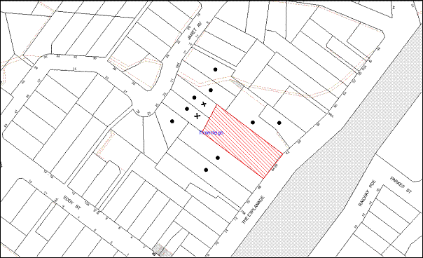
|
NOTIFICATION PLAN |
|
||
|
• PROPERTIES NOTIFIED
|
X SUBMISSIONS RECEIVED |
PROPERTY SUBJECT OF DEVELOPMENT |
|
The two submissions objecting to the development include an objection from the owner of the property through which the easement has been proposed. The objections are generally on the following grounds:
· The development and the proposed hard surface areas would have an adverse impact on the stormwater drainage of the downstream properties.
· The development may cause flooding of the downstream properties due to lack of maintenance of stormwater devices in the future.
· The rear boundary should include landscaped screening capable of attaining a height of 3m to mitigate adverse impacts on privacy of adjoining properties.
Additionally, the owner of No. 21 Janet Avenue indicates that no details of stormwater management have been provided with the application.
The merits of the matters raised in community submissions have been addressed in the body of the report with the exception of the following:
5.1.1 Details of stormwater management
The details of stormwater management on site have been provided with the application. Council has informed the owner of No. 21 Janet Avenue of the submission of the stormwater plans and provided 7 days for further comments. The objector has indicated that further pits should be provided adjoining the rear fence to capture stormwater.
As discussed in this report, Council’s engineering assessment of the stormwater plans concludes that the design of the system is satisfactory subject to conditions of consent. No further amendments to the stormwater plans are considered necessary.
5.1.2 Privacy
As indicated in this report, the proposed design takes into consideration the impact of the development on the privacy of the neighbouring properties. The upper floor balconies fronting the residential properties at the rear are provided with 1.5m high privacy screens which would prevent overlooking opportunities.
The fence at the rear is 1.8 metre high and would adjoin landscape screening capable of attaining a height of 2.2 metres. This is considered to be sufficient to screen the ground floor courtyards and is recommended as a condition of consent.
The application is assessed as satisfactory with regard to its impacts on the privacy of the neighbouring properties.
5.2 Public Agencies
The development application was referred to the following Public Agency for comments:
5.2.1 RailCorp
The site is not located within 25 metres of the rail corridor. Therefore, the application was not required to be notified to RailCorp under the provisions of State Environmental Planning Policy (Infrastructure) 2007. However, RailCorp was notified of the development as a nearby property owner. The comments from RailCorp required the proposal to comply with the Department of Planning and Infrastructure’s publication “Development near Rail Corridors and Busy Roads – Interim Guidelines” and the preparation of an Acoustic Report to demonstrate compliance with the document. Given that the site does not adjoin rail corridor, the following condition has been recommended based on RailCorp’s recommendation:
“The construction certificate plans must include design details to comply with “Development Near Rail Corridors and Busy Roads- Interim Guideline”, so that the following LAeq levels are not exceeded:
|
Internal space |
Time Period |
Maximum LAeq level |
|
Bedrooms/Sleeping areas |
10pm – 7am |
Equal to or <35dB(A) |
|
Living areas (expect kitchen, bathroom or hallway) |
Day and Night |
Equal to or 40dB(A) |
A “Certificate of Compliance” prepared by a suitably qualified consultant must be provided with the plans.”
RailCorp has also requested the preparation of an Electrolysis Risk Report which has been recommended as a condition of consent.
6. THE PUBLIC INTEREST
Section 79C(1)(e) of the Act requires Council to consider “the public interest”.
The public interest is an overarching requirement, which includes the consideration of the matters discussed in this report. Implicit to the public interest is the achievement of future built outcomes adequately responding to and respecting the future desired outcomes expressed in environmental planning instruments and development control plans.
The application is considered to have satisfactorily addressed Council’s and relevant agencies’ criteria and would provide a development outcome that, on balance, would result in a positive impact for the community. Accordingly, it is considered that the approval of the proposed affordable housing development would be in the public interest.
CONCLUSION
The proposed development is for the erection of an affordable rental housing development comprising 16 units located in four two-storey townhouses, and parking for 17 cars at Nos. 64-66, The Esplanade, Thornleigh.
The application has been assessed having regard to the provisions of Section 79C of the Environmental Planning and Assessment Act 1979 and the State Environmental Planning Policy (Affordable Rental Housing) 2009. The proposed affordable housing development is permissible on the site pursuant to the savings and transitional provision of the AHSEPP.
The development complies with the development standards prescribed under the AHSEPP in respect to floor space ratio, car parking, landscaping, deep soil zones, dwelling size and solar access. The impact of the proposal on the locality and the site planning and design comply with the best practice standards provided in the “Seniors Living: Urban Design Guidelines-Infill Developments.” The development satisfies the objectives of the AHSEPP and the design of the development would not have an unreasonable impact on the local character.
The proposal would require the owner’s consent of the downstream property granting an easement to drain water. This owner’s consent has not been obtained. Accordingly, approval of the proposal is recommended as a deferred commencement.
Note: At the time of the completion of this planning report, no persons have made a Political Donations Disclosure Statement pursuant to Section 147 of the Environmental Planning and Assessment Act 1979 in respect of the subject planning application.
|
Rod Pickles Manager - Development Assessment Planning Division |
James Farrington Group Manager Planning Division |
|
1.View |
Locality Map |
|
|
|
2.View |
Floor Plans |
|
|
|
3.View |
Landscape Plan |
|
|
|
4.View |
Elevations and Sections |
|
|
|
5.View |
Shadow Diagrams |
|
|
|
6.View |
Views |
|
|
File Reference: DA/689/2012
Document Number: D01997921
SCHEDULE 1
GENERAL CONDITIONS
The conditions of consent within this notice of determination have been applied to ensure that the use of the land and/or building is carried out in such a manner that is consistent with the aims and objectives of the relevant legislation, planning instruments and Council policies affecting the land and does not disrupt the amenity of the neighbourhood or impact upon the environment.
Note: For the purpose of this consent, the term ‘applicant’ means any person who has the authority to act on or the benefit of the development consent.
Note: For the purpose of this consent, any reference to an Act, Regulation, Australian Standard or publication by a public authority shall be taken to mean the gazetted Act or Regulation, or adopted Australian Standard or publication as in force on the date that the application for a construction certificate is made.
1. Deferred Commencement
Pursuant to Section 80(3) of the Environmental Planning and Assessment Act 1979, this consent does not operate until the following information is submitted to Council:
a. “The registration and creation of an easement to drain water minimum 1m wide from the site over No. 23 Janet Avenue Thornleigh (Lot 7 DP 547340).”
Such information shall be submitted within 12 months of the date of this notice.
Upon Council’s written satisfaction of the above information, the following conditions of development consent will apply:
2. Approved Plans and Supporting Documentation
The development must be carried out in accordance with the plans and documentation listed below and endorsed with Council’s stamp, except where amended by Council and/or other conditions of this consent:
|
Plan No. |
Drawn by |
Dated |
|
Survey Plan – 4986 DET1 |
Mepstead and Associates |
8/12/2011 |
|
Ground Floor Plan 02 – Rev J |
Mccullum Ashby Architects |
9/08/2012 |
|
First Floor Plan 03 – Rev J |
Mccullum Ashby Architects |
9/08/2012 |
|
Sections AA and BB 04 – Rev J |
Mccullum Ashby Architects |
9/08/2012 |
|
Elevations 05 – Rev J |
Mccullum Ashby Architects |
9/08/2012 |
|
Elevations (Front and rear) 06 – Rev I |
Mccullum Ashby Architects |
22/06/2012 |
|
Elevations (Internals) 07 – Rev J |
Mccullum Ashby Architects |
9/08/2012 |
|
Tree Demolition Plan and Colours 08 – Rev J |
Mccullum Ashby Architects |
9/08/2012 |
|
Waste management Plan 09- Rev I |
Mccullum Ashby Architects |
22/06/2012 |
|
Landscape Plan – LP01 A |
Site Design Studios |
28/05/2012 |
|
Document No. |
Prepared by |
Dated |
|
Street Views 14 – Rev J |
Mccullum Ashby Architects |
9/08/2012 |
|
Street Views 15 – Rev J |
Mccullum Ashby Architects |
9/08/2012 |
|
Street Views 16 – Rev J |
Mccullum Ashby Architects |
9/08/2012 |
|
Shadow Diagrams 10-Rev I |
Mccullum Ashby Architects |
22/06/2012 |
|
Shadow Diagrams 11-Rev I |
Mccullum Ashby Architects |
22/06/2012 |
|
Shadow Diagrams 12-Rev I |
Mccullum Ashby Architects |
22/06/2012 |
|
Stormwater Plan – G0120088- Rev 2 |
Accord Appleyard |
08/2012 |
|
Stormwater Management Plan - G0120088/C2 – Rev 1 |
Accord Appleyard |
06/2012 |
|
Stormwater Management Details - G0120088/C3 – Rev 1 |
Accord Appleyard |
06/2012 |
|
OSD Details - G0120088/C4 Rev 1 |
Accord Appleyard |
06/2012 |
|
OSD Details - G0120088/C5 – Rev 1 |
Accord Appleyard |
06/2012 |
|
Cover Letter and Stormwater details |
Accord Appleyard |
16/08/2012 |
|
Arboricultural Impact Report |
Landscape Matrix Pty Ltd |
15/06/2012 |
|
Statement of Environmental Effects |
Glendinning Minto and Associates` |
July 2012 |
|
Design Compliance Assessment Report |
BCA Vision |
26/04/2012 |
|
Performance Verification Report |
BCA Vision |
26/04/2012 |
|
BASIX Certificate – 426819M |
Archidoc Pty Ltd |
29/06/2012 |
3. Removal of Existing Trees
This development consent only permits the removal of trees numbered 1,2,3,4,5,7,8,9,10,11,12,13,14,15,18,19,20,21,22,25,27,31,32,33,34,40,41 and 42 as identified on Plan No. 4986-DET1 prepared by Mepstead and Associates dated 8/12/11. The removal of any other trees requires separate approval under Council’s Tree Preservation Order.
This development consent does not permit the removal of Tree Nos. 16, 17, 23 and 24 located within the neighbouring property.
4. Amendment of Plans
The approved Landscape Plan LP 01 A prepared by Site Design Studios dated 28/05/2012 is to be amended in following ways:
· Incorporate the site layout in the approved “Ground Floor Plan 02 – Rev J” prepared by Mccullum Ashby Architects dated 9/08/2012.
· Provide a continuous landscape screen capable of attaining a minimum height of 2.2m along the rear boundary of the site as marked in red.
· Provide a 1m wide pedestrian pathway linking the entrance Unit 5 to the central driveway.
REQUIREMENTS PRIOR TO THE ISSUE OF A CONSTRUCTION CERTIFICATE
5. Building Code of Australia
All building work must be carried out in accordance with the requirements of the Building Code of Australia.
6. Contract of Insurance (Residential Building Work)
In the case of residential building work for which the Home Building Act, 1989 requires there to be a contract of insurance in force in accordance with Part 6 of that Act, that such a contract of insurance is in force before any building work authorised to be carried out by the consent commences.
Note: This condition does not apply to the extent to which an exemption is in force under Clause 187 or 188 of the Act, subject to the terms of any condition or requirement referred to in Clause 187(6) or 188(4) of the Act, or to the erection of a temporary building.
7. Notification of Home Building Act, 1989 Requirements
Residential building work within the meaning of the Home Building Act, 1989 must not be carried out unless the principal certifying authority for the development to which the work relates (not being Council) has given Council written notice of the following information:
a. In the case of work for which a principal contractor is required to be appointed:
i. The name and licence number of the principal contractor.
ii. The name of the insurer by which the work is insured under Part 6 of that Act.
b. In the case of work to be done by an owner-builder:
i. The name of the owner-builder.
ii. If the owner-builder is required to hold an owner-builder’s permit under that Act, the number of the owner-builder’s permit.
Note: If arrangements for doing the residential building work are changed while the work is in progress so that the information notified becomes out of date, further work must not be carried out unless the principal certifying authority for the development to which the work relates (not being Council) has given Council written notification of the updated information.
8. Water/Electricity Utility Services
The applicant must submit written evidence of the following service provider requirements:
a. Energy Australia – a letter of consent demonstrating that satisfactory arrangements have been made to service the proposed development.
b. Sydney Water – the submission of a ‘Notice of Requirements’ under s73 of the Sydney Water Act 1994.
Note: Sydney Water requires that s73 applications are to be made through an authorised Sydney Water Servicing Coordinator. Refer to www.sydneywater.com.au or telephone 13 20 92 for assistance.
9. Noise – Rail Corridor
The construction certificate plans must include design details to comply with “Development Near Rail Corridors and Busy Roads- Interim Guideline”, so that the following LAeq levels are not exceeded:
|
Internal space |
Time Period |
Maximum LAeq level |
|
Bedrooms/Sleeping areas |
10pm – 7am |
Equal to or <35dB(A) |
|
Living areas (expect kitchen, bathroom or hallway) |
Day and Night |
Equal to or 40dB(A) |
A “Certificate of Compliance” prepared by a suitably qualified consultant must be provided with the plans.”
10. Electrolysis Report
A report is to be prepared by a qualified Electrolysis expert on the Electrolysis Risk of the development from stray currents and the measures to be incorporated to control that risk.
The recommendations of the report must be incorporated in the design of the development.
11. Registered Housing Provider
Evidence must be provided to the Principal Certifying Authority that at least four dwelling units would be managed by a registered community housing provider as defined in the Housing Act 2001.
12. Dilapidation Report
A ‘Dilapidation Report’ is to be prepared by a chartered engineer detailing the condition of adjoining properties and assets in the public road and submitted to Hornsby Shire Council.
13. Project Arborist
A Project Arborist must appointed in accordance with AS 4970-2009 (1.4.4) to provide monitoring and certification throughout the development process.
14. Preservation of Survey Infrastructure
A registered surveyor must identify all survey marks in the vicinity of the proposed development. Any survey marks required to be removed or displaced as a result of the proposed development are to be undertaken by a registered surveyor in accordance with Section 24 (1) of the Surveying and Spatial Information Act 2002 and following the Surveyor General’s Directions No.11 – "Preservation of Survey Infrastructure".
15. Car Parking
All car parking must be constructed in accordance with Australian Standard AS 2890.1 – 2004 – Off Street Car Parking and Australian Standard 2890.2 - 2002 – Off Street Commercial and the following requirement:
a. All parking areas and driveways are to be sealed to an all weather standard, line marked and signposted.
REQUIREMENTS PRIOR TO THE COMMENCEMENT OF ANY WORKS
16. Erection of Construction Sign
A sign must be erected in a prominent position on any site on which building work, subdivision work or demolition work is being carried out:
a. Showing the name, address and telephone number of the principal certifying authority for the work,
b. Showing the name of the principal contractor (if any) for any demolition or building work and a telephone number on which that person may be contacted outside working hours, and
c. Stating that unauthorised entry to the work site is prohibited.
Note: Any such sign is to be maintained while the building work, subdivision work or demolition work is being carried out, but must be removed when the work has been completed.
17. Erosion and Sediment Control
Erosion and sediment control measures must be provided and maintained throughout the construction period in accordance with the manual ‘Soils and Construction 2004 (Bluebook)’, the approved plans, Council specifications and to the satisfaction of the principal certifying authority. The erosion and sediment control devices must remain in place until the site has been stabilised and revegetated.
Note: On the spot penalties up to $1,500 may be issued for any non-compliance with this requirement without any further notification or warning.
18. Toilet Facilities
Toilet facilities must be available or provided at the works site before works begin and must be maintained until the works are completed at a ratio of one toilet for every 20 persons employed at the site. Each toilet must:
a. be a standard flushing toilet connected to a public sewer; or
b. be a temporary chemical closet approved under the Local Government Act, 1993; or
c. have an on-site effluent disposal system approved under the Local Government Act, 1993
19. Tree Protection Barriers
Tree protection fencing must be erected around trees numbered 37,38 and 39 to be retained at a 3 metre setback. The tree fencing must be constructed of 1.8 metre ‘cyclone chainmesh fence’.
REQUIREMENTS DURING CONSTRUCTION
20. Construction Work Hours
All work on site (including demolition and earth works) must only occur between 7am and 5pm Monday to Saturday.
No work is to be undertaken on Sundays or public holidays.
21. Construction Noise Management
The construction works must be undertaken in accordance with the “Interim Construction Noise Guidelines – 2009” published by DECCW.
22. Environmental Management
The site must be managed in accordance with the publication ‘Managing Urban Stormwater – Landcom (March 2004) and the Protection of the Environment Operations Act 1997 by way of implementing appropriate measures to prevent sediment run-off, excessive dust, noise or odour emanating from the site during the construction of the development.
23. Council Property
During construction works, no building materials, waste, machinery or related matter is to be stored on the road or footpath.
24. Disturbance of Existing Site
During construction works, the existing ground levels of open space areas and natural landscape features must not be altered unless otherwise nominated on the approved plans.
25. Works near Trees
a. All required tree protection measures are to be maintained in good condition for the duration of the construction period.
b. All works (including retaining walls and pathways) within the Tree Protection Zones of Tree Nos. 16, 17, 23 and 24 (as marked on the approved Plan No. 4986-DET1 prepared by Mepstead and Associates dated 8/12/11) are to be carried out in accordance with Australian Standard AS- 4970 - Protection of Trees on Development Sites under the supervision of an ‘AQF Level 5 Arborist’ and a certificate submitted to the principal certifying authority detailing the methods used to preserve the trees. The following requirements must be complied with:
· Any excavation required within 3 metres of the trees must be minimised;
· Construction works within 3 metres of the trees must consist of pier and beam construction;
· Hand excavation must be undertaken within 3 metres of the trees to reveal the presence of any roots;
· The severance of tree roots greater than 50mm in diameter must be avoided. Any tree roots between 10mm and 50mm diameter, revealed during excavation should be cut cleanly by a sharp hand saw by a qualified arborist.
· Hand excavation or tunnel boring must be carried out for the installation of any services.
· If tunnel boring is proposed it should be carried out at least 1 metre beneath natural ground surface and supervised by a AQF5 Arborist.
c. All works (including driveways and retaining walls) within 3 metres of any trees required to be retained (whether or not on the subject property, and pursuant to this consent or the Tree Preservation Order), must be carried out under the supervision of an ‘AQF Level 5 Arborist’ and a certificate submitted to the principal certifying authority detailing the method(s) used to preserve the tree(s).
Note: Except as provided above, the applicant is to ensure that no excavation, filling or stockpiling of building materials, parking of vehicles or plant, disposal of cement slurry, waste water or other contaminants is to occur within 4 metres of any tree to be retained.
26. Excavated Material
All excavated material removed from the site must be classified in accordance with the NSW Environment Protection Authority’s Environmental Guidelines – Assessment, Classification and Management of Liquid and Non-Liquid Wastes prior to disposal to an approved waste management facility and reported to the principal certifying authority.
27. Landfill
Landfill must be constructed in accordance with Council’s ‘Construction Specification 2005’ and the following requirements: -
a. All fill material imported to the site is to wholly consist of Virgin Excavated Natural Material (VENM) as defined in Schedule 1 of the Protection of the Environment Operations Act 1997 or a material approved under the Department of Environment and Climate Change’s general resource recovery exemption.
28. Survey Report – Finished Floor Level
Reports must be prepared by a registered surveyor and submitted to the principal certifying authority prior to the pouring of concrete at each level of the building certifying that:
a. The building, retaining walls and the like have been correctly positioned on the site.
b. The finished floor levels are in accordance with the approved plans.
29. Contamination during construction works
Should the presence of asbestos or soil contamination, not recognised during the application process be identified during demolition, the applicant must immediately notify the Principal Certifying Authority and Council.
30. Waste Management
Waste management during the construction phase of the development must be undertaken in accordance with the approved Waste Management Plan. Additionally written record of the following items must be maintained during the removal of any waste from the site and such information submitted to the Principal Certifying Authority within fourteen days of the date of completion of the works:
a. The identity of the person removing the waste.
b. The waste carrier vehicle registration.
c. Date and time of waste collection.
d. A description of the waste (type of waste and estimated quantity).
e. Details of the site to which the waste is to be taken.
f. The corresponding tip docket/receipt from the site to which the waste is transferred (noting date and time of delivery, description (type and quantity) of waste).
g. Whether the waste is expected to be reused, recycled or go to landfill.
Note: In accordance with the Protection of the Environment Operations Act 1997, the definition of waste includes any unwanted substance, regardless of whether it is reused, recycled or disposed to landfill.
REQUIREMENTS PRIOR TO THE ISSUE OF AN OCCUPATION CERTIFICATE
Note: For the purpose of this consent, a reference to ‘occupation certificate’ shall not be taken to mean an ‘interim occupation certificate’ unless otherwise stated.
31. Fulfilment of BASIX Commitments
The applicant must demonstrate the fulfilment of BASIX commitments pertaining to the development.
32. Sydney Water – s73 Certificate
A s73 Certificate must be obtained from Sydney Water.
33. Damage to Council Assets
Any damage caused to Council’s assets as a result of the construction of the development must be rectified in accordance with Council’s written requirements and at the sole cost of the applicant.
34. Vehicular Crossing
Separate applications under the Local Government Act 1993 and the Roads Act 1993 must be submitted to Council for the installation of a new vehicular crossing and the removal of the redundant crossing. The vehicular crossing must be constructed in accordance with Council’s Civil Works Design 2005 and the following requirements:
a. Any redundant crossings to be replaced with integral kerb and gutter.
Note: An application for a vehicular crossing can only be made to one of Council’s Authorised Vehicular Crossing Contractors. You are advised to contact Council on 02 9847 6940 to obtain a list of contractors.
Note: A construction certificate must be obtained for these works
35. Footpath
A concrete footpath must be constructed along the full frontage of the subject site in accordance Council’s Civil Works Design and Construction Specification, 2005 and the following requirements:
a. All details be provided with the Construction Certificate Plans.
b. The existing footpath being removed across the frontage of the site in The Esplanade is to be removed and reconstructed.
c. Any public utility adjustments to be carried out at the cost of the applicant and to the requirements of the relevant public authority.
Note : Prior to the issue of the Construction Certificate, a separate application under the Local Government Act, 1993 and the Roads Act, 1993 must be submitted to Council for the construction of footpaths within the road reserve.
36. Road Works
All road works approved under this consent must be constructed in accordance with Council’s Civil Works Design and Construction Specification, 2005 and the following requirements:
Road Works for The Esplanade
a. All details be provided with the Construction Certificate Plans.
b. The existing kerb and gutter is to be removed and reconstructed across the frontage of the site in The Esplanade.
c. A new kerb inlet pit with a 2.4m long lintel to be located downstream of the existing pit. The existing, which is locate within the proposed driveway, is to be converted to a grated inlet pit.
d. The existing road pavement to be saw cut a minimum of 300 mm from the existing edge of the bitumen and reconstructed.
Road Works for Janet Avenue
a. All details to be provided with the Construction Certificate Plans;
b. Construction of a minimum 375mm diameter RCP within Janet Avenue to service the proposed development;
c. The existing road pavement to be saw cut where required and reconstructed;
Note: Prior to the issue of the Construction Certificate, a separate application under the Local Government Act, 1993 and the Roads Act, 1993 must be submitted to Council for the construction of footpaths within the road reserve.
37. On Site Stormwater Detention
The on site detention system for the development must be designed and constructed in accordance with Council’s Civil Works – Design and Construction Specification 2005 and the following requirements:
a. All details be provided with the Construction Certificate Plans;
b. Have a capacity of not less than 25 cubic metres with a maximum site discharge of 54 litres per second. By pass flows are to be allowed for in the determination of the OSD outlet flows;
c. Have a surcharge/inspection grate located directly above the outlet;
d. Discharge from the detention system to be controlled via 1 metre length of pipe, not less than 50 mm diameter or via a stainless plate with sharply drilled orifice bolted over the face of the outlet discharging into a larger diameter pipe capable of carrying the design flow to an approved Council system;
e. The OSD system is to be designed with a surcharge pipe to be located at the top water level of the system. The downstream pipe work network to Janet Avenue is to be designed to cater for the un-detained 1 in 20 year ARI storm event;
f. Not be constructed in a location that would impact upon the visual or recreational amenity of residents.
38. Stormwater Drainage
The stormwater drainage system for the development must be designed and constructed in accordance with Council’s Civil Works – Design and Construction Specification 2005 and the following requirements:
a. All details be provided with the Construction Certificate Plans.
b. Connected directly to Council’s street drainage system in Janet Avenue.
c. An inter-allotment stormwater drainage system to service the proposed development with pits being constructed in situ.
Note: Inspection fees are to be paid to Council to demonstrate the satisfaction of this condition.
39. Traffic Control Plan
A Traffic Control Plan (TCP) must be prepared by a qualified traffic controller in accordance with the Roads & Traffic Authority’s Traffic Control at Worksites Manual 1998 and Australian Standard 1742.3 for all work on a public road and be submitted to Council. The TCP must detail the following:
a. Arrangements for public notification of the works.
b. Temporary construction signage.
c. Permanent post-construction signage.
d. Vehicle movement plans.
e. Traffic management plans.
f. Pedestrian and cyclist access/safety.
40. Internal Driveway/Vehicular Areas
The driveway and parking areas on site must be designed and construction in accordance with Australian Standards 2890.1, 2890.2, 3727 and the following requirements:
a. All details be provided with the Construction Certificate Plans.
b. Design levels at the front boundary are to be obtained from Council if a private accredited certifier is engaged to obtain a construction certificate for these works.
c. The driveway be a rigid pavement.
d. The driveway grade must not exceed 20 percent and changes in grade must not exceed 8 percent.
e. The driveway pavement be a minimum 5.5 metres wide at the kerb line of The Esplanade and this width shall extend to 6m inside the property boundary in accordance with AS 2890.1.
41. Creation of Easements
The following matter(s) must be nominated on the plan of subdivision under s88B of the Conveyancing Act 1919:
a. The creation of an appropriate "Positive Covenant" and "Restriction as to User" over the constructed on-site detention/retention systems and outlet works, within the lots in favour of Council in accordance with Council’s prescribed wording. The position of the on-site detention system is to be clearly indicated on the title.
b. To register the OSD easement, the restriction on the use of land “works-as-executed” details of the on-site-detention system must be submitted verifying that the required storage and discharge rates have been constructed in accordance with the design requirements. The details must show the invert levels of the on site system together with pipe sizes and grades. Any variations to the approved plans must be shown in red on the “works-as-executed” plan and supported by calculations.
c. For the purpose of waste collection, an easement entitling Council, its servants and agents and persons authorised by it to enter upon the subject land and to operate thereon, vehicles and other equipment for the purposes of garbage collection must be granted to Council by the owner of the land.
Note: The easement must be in a form prescribed by Council and must include covenants to the effect that parties will not be liable for any damage caused to the subject land or any part thereof or to any property located therein or thereon by reason of the operation thereon of any vehicle or other equipment used in connection with the collection of garbage and to the effect that the owner for the time being of the subject land shall indemnify the Council, its servants, agents and persons authorised by it to collect garbage against liability in respect of any such claims made by any person whomsoever.
Note: Council must be nominated as the authority to release, vary or modify any easement, restriction or covenant.
42. Completion of Landscaping
A certificate must be provided by a practicing landscape architect, horticulturalist or person with similar qualifications and experience certifying that all required landscaping works have been satisfactorily completed in accordance with the approved landscape plans and the following amendments/requirements:
a. Substitution of Rapanea varibilis (along the southern fenceline adjacent to Unit 8) by shade-tolerant screen species such as Murraya or Syzygium;
b. Substitution of Kunzea ambigua (along the northern fenceline) by shade-tolerant screen species such as Murraya or Syzygium;
Note: Plant numbers are to reflect a spacing of 750-900mm for row planting.
c. Installation of root barriers to an effective minimum depth of 300mm for plantings of the proposed clumping Bamboo species in any situation where these beds adjoin other soft landscape areas.
d. Three medium to large trees selected from Council’s booklet ‘Indigenous Plants for the Bushland Shire’ to be planted on the subject site in accordance with the recommendations of the Tree Assessment Report prepared by Arboreport dated 28/04/2011. The planting location must not be within 4 metres of the foundation walls of a dwelling. The pot size is to be a minimum 25 litres and the trees must be maintained until they reach the height of 3 metres. Trees must be native to Hornsby Shire and reach a mature height greater than 10 metres.
Note: Advice on suitable species for landscaping can be obtained from Council’s planting guide ‘Indigenous Plants for the Bushland Shire’, available at www.hornsby.nsw.gov.au.
43. Boundary Fencing
Fencing must be erected along all property boundaries behind the front building alignment to a height of 1.8 metres.
Note: Alternative fencing may be erected subject to the written consent of the adjoining property owners.
44. Works as Executed Plan
A works-as-executed plan must be prepared by a registered surveyor and submitted to Council for completed road pavement, kerb & gutter, public drainage systems, driveways and on-site detention system. The plan must be accompanied by a certificate from a registered surveyor certifying that all pipelines and associated structures lie wholly within any relevant easements.
45. Preservation of Survey Marks
A certificate by a Registered Surveyor must be submitted to the Principal Certifying Authority, certifying that there has been no removal, damage, destruction, displacement or defacing of the existing survey marks in the vicinity of the proposed development or otherwise the re-establishment of damaged, removed or displaced survey marks has been undertaken in accordance with the Surveyor General’s Direction No.11 – “Preservation of Survey Infrastructure”.
46. Waste Management Details
The following waste management requirements must be complied with:
Each townhouse must be provided with an indoor waste/recycling cupboard for the interim storage of a minimum one day’s waste generation with separate containers for general waste and recyclable materials.
a. The bin storage room must include water or a hose for cleaning, graded floors with drainage to sewer, a robust door, sealed and impervious surfaces, adequate lighting and ventilation.
b. Space must be provided for either individual compost containers for each unit or a communal compost container.
Note: The location of the compost containers should have regard for potential amenity impacts.
c. The bin carting route must be devoid of any steps and must be no less than 1000 mm wide.
Note: Ramps between different levels are acceptable.
47. External Lighting
All external lighting must be designed and installed in accordance with Australian Standard AS 4282 – Control of the Obtrusive Effects of Outdoor Lighting. Certification of compliance with the Standard must be obtained from a suitably qualified person.
48. Construction for a safe environment
The site must include the following elements to provide a safer environment for the residents:
a. An intercom system be installed at gate locations to ensure screening of persons entering dwellings.
b. The entryway to the site be illuminated in high luminance at all times.
c. Front and rear yard spaces of each dwelling be illuminated with high luminance by motion sensor lighting.
d. The common driveway and parking areas are to be illuminated with low luminance at all times.
e. The communal open space at the rear be illuminated with low luminance lighting at night.
f. Vandal proof locking mechanisms to be installed in all gates to individual units.
g. Robust materials which cannot be forced or breached with minimised maintenance requirements are to be used for construction work in the common areas.
49. Installation of Air Conditioner
To protect the amenity of adjacent properties, the condenser unit for any air conditioner must be sited a minimum of 3 metres from the property boundary of any adjoining residential premises unless a certificate has been prepared by a suitably qualified person confirming that the unit has been tested for heating and cooling on the highest settings and that the noise levels generated do not exceed 5 dB(A) above background noise levels when tested at the property boundary between 8 am and 10 pm. The noise should be inaudible between 10 pm and 8 am.
50. Restriction as to User – Affordable Rental Housing
To inform current and future owners that the townhouse development on the site is for affordable rental housing, a Restriction as to User must be created under Section 88B of the Conveyancing Act 1919 identifying the following:
a. The development is for affordable rental housing pursuant to State Environmental Planning Policy (Affordable Rental Housing) 2009 for a period of 10 years from the date of the issue of the occupation certificate.
b. Four dwelling units must be used for the purpose of affordable housing pursuant to Clause 6 of State Environmental Planning Policy (Affordable Rental Housing) 2009.
c. The four dwelling units identified in condition 46(b) must be managed by a registered community housing provider as defined in the Housing Act 2001.
Note: The wording of the Restriction as to User must be to Council’s satisfaction and Council must be nominated as the authority to release, vary or modify the Restriction.
51. s94 Infrastructure Contributions
The payment to Council of a contribution of $ 168,727.55 for fifteen additional dwelling units towards the cost of infrastructure identified in Council’s Development Contributions Plan 2007-2011.
Note: The value of contribution is current as at 1 September 2012. The contribution will be adjusted from this date in accordance with the underlying consumer price index for subsequent financial quarters. It is recommended that you contact Council to ascertain the indexed value of the contribution prior to payment.
OPERATIONAL CONDITIONS
52. Landscaping Maintenance
All of the approved landscaping for the development must be continually maintained to ensure screening for privacy and the presentation of the development.
53. Car Parking
a. Car parking, loading and manoeuvring areas to be used solely for nominated purposes.
b. All vehicular entry on to the site and egress from the site shall be made in a forward direction.
c. The internal accessway and manoeuvring areas are to be unobstructed at all times.
d. The parking of vehicles on site is prohibited other than in approved car parking spaces.
54. Site Caretaker
A site caretaker must be employed and be responsible for washing bins and maintaining waste storage areas, managing the communal composting area, arranging the prompt removal of dumped rubbish, and ensuring all residents are informed in the use of the waste management system.
55. Noise
The level of total continuous noise emanating from operation of the premises including all plant and air conditioning units (LAeq) (measured for at least 15 minutes) in or on the above premises, must not exceed the background level by more than 5dB(A) when measured at all property boundaries.
56. Fire Safety Statement - Annual
On at least one occasion in every 12 month period following the date of the first ‘Fire Safety Certificate’ issued for the property, the owner must provide Council with an annual ‘Fire Safety Certificate’ to each essential service installed in the building.
- END OF CONDITIONS –
ADVISORY NOTES
The following information is provided for your assistance to ensure compliance with the Environmental Planning and Assessment Act, 1979, Environmental Planning and Assessment Regulation 2000, other relevant legislation and Council’s policies and specifications. This information does not form part of the conditions of development consent pursuant to Section 80A of the Act.
Environmental Planning and Assessment Act 1979 Requirements
· The Environmental Planning and Assessment Act 1979 requires:
· The issue of a construction certificate prior to the commencement of any works. Enquiries regarding the issue of a construction certificate can be made to Council’s Customer Services Branch on 9847 6760.
· A principal certifying authority to be nominated and Council notified of that appointment prior to the commencement of any works.
· Council to be given at least two days written notice prior to the commencement of any works.
· Mandatory inspections of nominated stages of the construction inspected.
· An occupation certificate to be issued before occupying any building or commencing the use of the land.
Long Service Levy
In accordance with Section 34 of the Building and Construction Industry Long Service Payments Act 1986, a ‘Long Service Levy’ must be paid to the Long Service Payments Corporation or Hornsby Council.
Note: The rate of the Long Service Levy is 0.35% of the total cost of the work.
Note: Hornsby Council requires the payment of the Long Service Levy prior to the issue of a construction certificate.
Tree Preservation Order
To ensure the maintenance and protection of the existing natural environment, it is an offence to ringbark, cut down, top, lop, remove, wilfully injure or destroy a tree outside 3 metres of the approved building envelope without the prior written consent from Council.
Note: A tree is defined as a single or multi-trunked wood perennial plant having a height of not less than three (3) metres, and which develops many branches, usually from a distance of not less than one (1) metre from the ground, but excluding any plant which, in its particular location, is a noxious plant declared as such pursuant to the Noxious Weeds Act 1993. This definition of ‘tree’ includes any and all types of Palm trees.
All distances are determined under Australian Standard AS4970-2009 “Protection of Trees on Development Sites”.
Fines may be imposed for non-compliance with Council’s Tree Preservation Order.
Dial Before You Dig
Prior to commencing any works, the applicant is encouraged to contact Dial Before You Dig on 1100 or www.dialbeforeyoudig.com.au for free information on potential underground pipes and cables within the vicinity of the development site.
Covenants
The land upon which the subject building is to be constructed may be affected by restrictive covenants. Council issues this approval without enquiry as to whether any restrictive covenant affecting the land would be breached by the construction of the building, the subject of this consent. Applicants must rely on their own enquiries as to whether or not the building breaches any such covenant.
Rain Water Tank
It is recommended that water collected within any rainwater tank as part of the development be limited to non-potable uses. NSW Health recommends that the use of rainwater tanks for drinking purposes not occur where a reticulated potable water supply is available.
House Numbering
House numbering can only be authorised by Council. Before proceeding to number each premise in the development, the allocation of numbers is required to be obtained from Council's Planning Division. The authorised numbers are required to be displayed in a clear manner at or near the main entrance to each premise.
Asbestos
Should asbestos or asbestos products be encountered during demolition or construction works you are advised to seek advice and information should be prior to disturbing the material. It is recommended that a contractor holding an asbestos-handling permit (issued by WorkCover NSW) be engaged to manage the proper handling of the material. Further information regarding the safe handling and removal of asbestos can be found at:
Alternatively, telephone the WorkCover Asbestos and Demolition Team on 8260 5885.
Planning Report No. PL23/12
Planning Division
Date of Meeting: 17/10/2012
14 DEVELOPMENT APPLICATION - INDUSTRIAL DEVELOPMENT COMPRISING 12 UNITS, CAR PARKING AND STRATA SUBDIVISION 6 - 10 YATALA ROAD, MOUNT KURING-GAI
EXECUTIVE SUMMARY
|
DA No: |
DA/24/2012 |
|
Description: |
Proposed two storey industrial development comprising twelve units with car parking and strata subdivision |
|
Property: |
Lot 425 DP 752053, Lot 426 DP 752053, Lot 926 DP 752053, Nos. 6 - 10 Yatala Road, Mount Kuring-Gai |
|
Applicant: |
Industrial Parks of Australia Pty Ltd |
|
Owner: |
SDT Pty Ltd |
|
Estimated Value: |
$4.8 million |
|
Ward: |
A |
· The application proposes an industrial development comprising twelve units in two levels with associated driveway, car parking and strata subdivision.
· The proposal complies with the requirements of the Hornsby Shire Local Environmental Plan 1994. The proposal does not comply with Council’s Industrial Lands Development Control Plan with regard to the number of car spaces provided on the site.
· No submissions have been received in respect of the application.
· It is recommended that the application be approved as a deferred commencement to ensure appropriate management of the threatened species and significant vegetation on the site.
|
THAT Development Application No. 24/2012 for a two storey industrial development comprising twelve units with car parking and strata subdivision at Lots 425, 426 and 926 DP 752053, Nos. 6-10 Yatala Road Mount Kuring-Gai be approved as a deferred commencement pursuant to Section 80(3) of the Environmental Planning and Assessment Act, 1979 subject to the conditions of consent detailed in Schedule 1 of Group Manager’s Report No. PL23/12. |
BACKGROUND
Development applications for proposed industrial uses have been approved by Council for the site circa 1980s. However, these buildings have not been built.
Council records indicate that an unauthorised use (material recycling facility) commenced operation on the property in 1984.
On 26 July 2006, Council issued a Penalty Infringement Notice regarding the unauthorised use of the site and subsequent clean-up notices were issued regarding unauthorised landfill, known to contain asbestos that was deposited on the property. The applicant undertook a contamination assessment for the site, following Council’s orders. The site was cleaned up and an Asbestos Clearance Certificate was provided to Council in 2007.
Sydney Water occupied the vacant site for a period of 18 months when works relating to sewerage were being undertaken at Mount Kuring-Gai.
On 17 December 2007, Council wrote to the owners informing that the site was satisfactorily cleaned up and that the site has been vacated.
On 4 March 2009, the Office of Environment and Heritage (EPA) issued further clean-up notices in respect of ongoing unauthorised waste placement, stockpiling and associated water pollution. Council has not received the final remediation documentation in respect of these notices.
On 2 November 2011, Council informed the owners of the property that there were no notices or outstanding orders in respect of the site, except the order from the EPA.
SITE
The site is located on the southern side of Yatala Road and comprises three allotments. The total area of the site is 20, 476 m2 (2.4 ha).
The site is currently vacant. A natural vegetation corridor of variable width exists along the frontage of the site. The development area is a cleared section below this vegetation corridor and a natural rock drop off parallel to the Yatala Road frontage. The cleared area has been partly modified in association with a truck yard in the past, and has a slope of about 22%. A driveway provides access to the site from the eastern end.
To the south of the development area, the site slopes down steeply along a rock escarpment and accommodates undisturbed bushland. An electricity transmission easement runs diagonally across the rear of the site.
The site accommodates the vegetation community, Silvertop Ash-Scribbly Gum Woodland. The roadside nature strip comprises two threatened species Persoonia mollis spp. Maxima and Darwinia biflora amidst weeds and indigenous species.
The site forms part of the Mount Kuring-Gai Industrial estate and is surrounded by industrial developments to the south-east, west and north. No residential developments are present in the near vicinity of the site.
PROPOSAL
The application proposes earthworks and construction of an industrial development in two levels comprising twelve units. The building would primarily be located in the cleared section of the site with a setback from the frontage maintaining the vegetation corridor. Excavation works would be undertaken parallel to the road to accommodate the lower level of units and would follow the natural slope of the land.
The industrial units would be used as warehouse and distribution centres with associated offices at the mezzanine levels. Each unit would include a loading bay capable of accommodating one or two heavy rigid vehicles.
The sizes of the industrial units vary between 570 m2 – 1000 m2 including the office area. The gross floor area of the development is 8356.49 m2.
The building would be constructed of concrete panels, aluminium glazed windows and colourbond roof. The walls would be painted in three colours complimenting existing industrial buildings in the area.
Two ramps located at each end of the site, would provide access to the lower level of units. Separate driveways are proposed to access the upper level units directly from Yatala Road. A total of 53 car spaces would be located in two levels to cater for the development.
The development includes an advertising directory board within the front setback measuring 6.48 m2 and one wall sign for each unit measuring 2.5 m2.
The proposed maximum number of staff within the complex would be 27. The operating hours of the premises would be 7:00am to 6:00pm Monday to Friday and 7:00am to 4:00pm Saturday. No works are proposed to be undertaken on Sundays or public holidays.
Strata subdivision of the industrial units is proposed.
ASSESSMENT
The development application has been assessed having regard to the ‘Metropolitan Plan for Sydney 2036’, the ‘North Subregion (Draft) Subregional Strategy’ and the matters for consideration prescribed under Section 79C of the Environmental Planning and Assessment Act 1979 (the Act). The following issues have been identified for further consideration.
1. STRATEGIC CONTEXT
1.1 Metropolitan Plan for Sydney 2036 and (Draft) North Subregional Strategy
The Metropolitan Plan for Sydney 2036 is a broad framework to secure Sydney’s place in the global economy by promoting and managing growth. It outlines a vision for Sydney to 2036. The challenges faced, and the directions to follow to address these challenges and achieve the vision. The Draft North Subregional Strategy acts as a framework for Council in its preparation of the Comprehensive LEP by the end of 2012.
The Draft North Subregional Strategy sets the following targets for the Hornsby LGA by 2031:
· Employment capacity to increase by 9,000 jobs; and
· Housing stock to increase by 11,000 dwellings.
The proposed development would be consistent with the draft Strategy by providing 27 additional jobs in the locality.
2. STATUTORY CONTROLS
Section 79C(1)(a) requires Council to consider “any relevant environmental planning instruments, draft environmental planning instruments, development control plans, planning agreements and regulations”.
2.1 Hornsby Shire Local Environmental Plan 1994
The subject land is zoned Industrial B (Light) zone under the Hornsby Shire Local Environmental Plan 1994 (HSLEP). The objectives of the zone are:
a. to encourage economic growth and employment opportunities.
b. to allow a broad range of light industrial, warehousing and other compatible land uses to locate within the area.
c. To promote development that does not adversely impact upon the natural and built environment.
The proposed uses are defined as ‘Warehouse and distribution centres’ and ‘Subdivision’ under the HSLEP and are permissible in the zone with Council’s consent.
The proposed development would facilitate economic growth and employment opportunities, provide a compatible land use in the area and has been sited and designed to minimise further site disturbance to preserve the existing environment. Accordingly, the proposed development is consistent with the zone objectives.
Clause 15 of the HSLEP prescribes that the maximum floor space ratio (FSR) of development within the zone is 1:1. The proposed FSR of 0.41:1 complies with this requirement.
Clause 18 of the HSLEP sets out heritage conservation provisions for Hornsby Shire. The site is not identified as a heritage item and is not within a heritage conservation area. Accordingly, Clause 18 does not apply.
2.2 Draft Comprehensive Hornsby Local Environmental Plan
At its meeting on 7 March 2012, Council resolved to endorse the draft Hornsby Local Environmental Plan (DHLEP) for public exhibition. Under the DHLEP, the subject land would be zoned IN1 – General Industrial. The proposed use is defined as “warehouse and distribution centre” and is permitted within the zone with Council’s consent.
The DHLEP would allow a maximum floor space ratio of 1:1 on the site. The proposal would comply with this requirement.
The maximum permissible height within the zone pursuant to the DHLEP would be 14.5m. The proposed building height is 15m and would not comply with this requirement. Given that the HSLEP does not include any height control for industrial developments and the proposed complies with the 3 storey height limit under the Industrial Lands Development Control Plan, the height of development is acceptable.
2.3 State Environmental Planning Policy No. 55 – Remediation of Land (SEPP 55)
SEPP 55 requires that Council must not consent to the carrying out of any development on land unless it has considered whether the land is contaminated or requires remediation for the proposed use.
As discussed in the “Background” section of this report, the site has previous history of contaminated land uses. Fill containing asbestos was imported onto the site during 2006. The owner of the property had supplied Council with a “Non-Liquid Waste Assessment” and Classifications prepared by Sydney Environmental & Soil Laboratory in this regard. Clean up of the site was undertaken and an Asbestos Clearance Certificate was provided. Council was satisfied that the site was cleaned.
In November 2007, Council also received an environmental investigation report regarding soil contamination prepared by Golder Associates. The report found chemical concentrations of heavy metals and benzo(a)pyrene that exceed standards for off-site disposal existed on the site. However, the investigation report stated that the soil sampled is suitable for retention on-site for its intended use as a commercial/industrial property.
During 2007 – 2009, the Office of Environment and Heritage issued various clean-up notices for the site following illegal dumping of waste materials which caused pollution. Council has not received any final remediation documentation in respect of these notices. Accordingly, it is unclear whether the soil, as it currently exists, is contaminated.
Given that the site would be used for industrial purposes and that a major section of the developable area would be subject to excavation and soil disposal, the site would be suitable to redevelop subject to the following:
· Submission of a validation report prior to the commencement of any works, stating that the site has been remediated to suit the proposed use.
· Any soil removal from the site, as part of the remedial process, being classified in accordance with “Waste Classification Guidelines”.
These requirements are recommended as conditions of development consent.
2.4 State Environmental Planning Policy No. 44 – Koala Habitats
The provisions of State Environmental Planning Policy No. 44 apply to the development, as the total site area is greater than one hectare. The Policy requires an assessment of whether the site is a “potential koala habitat” which is defined as areas of native vegetation where at least 15% of the trees on site constitute koala feed trees.
The proposed building footprint would be located in a cleared area of the site and would not disturb any potential koala habitats. The application is assessed as satisfactory against the provisions of State Environmental Planning Policy No. 44.
2.5 State Environmental Planning Policy No. 64 (SEPP 64)
The application has been assessed against the requirements of SEPP 64. The proposed signs are categorized as “business identification signs”. In accordance with Clause 9 of the SEPP, the general advertising controls in the Policy do not apply to “business identification signs”. However, irrespective of the type of sign proposed, Clause 8 of SEPP 64 requires assessment of a proposal against Schedule 1 – Assessment Criteria. This is discussed below.
2.5.1 Character of the area
The advertising signs are located within an industrial zone adjoining buildings with similar types of signage. The proposed signs are consistent with the character of the area.
2.5.2 Special areas
Special areas constitute environmentally sensitive areas, heritage areas, natural or other conservation areas, open space, waterways, rural landscapes or residential areas.
The site is located within an industrial area and does not constitute part of any special area.
2.5.3 Views and vistas
The signage would not project beyond the building envelope of the proposed building. Accordingly, the proposed signs would not obscure or compromise important views, nor reduce the quality of vistas.
2.5.4 Streetscape, setting or landscape
The number and placement of the signs would reflect the role and function of the proposed building. Accordingly, the signs are considered compatible in regard to streetscape.
2.5.5 Site and building
The signs are to be affixed to the building and are proportionate to the size and scale of the building.
2.5.6 Associated devices and logos with advertising structures and Illumination
The proposed signs are non-illuminated and would not include any other advertising structures.
2.5.7 Safety
The proposed signs would not impede on pedestrian or vehicular travel paths. Accordingly, the signs do not raise concern in regard to public safety.
The proposed signs are assessed as satisfactory with regard to Schedule 1 of SEPP 64.
2.6 Sydney Regional Environmental Plan No. 20 – Hawkesbury – Nepean River
The application has been assessed against the requirements of Sydney Regional Environmental Plan No. 20. This Policy provides general planning considerations and strategies requiring Council to consider the impacts of the proposal on water and scenic quality, aquaculture, recreation and tourism. The relevant matters are discussed below.
2.6.1 Water Quality
The proposal does not involve a use that would have detrimental impact on the water quality of the site and the surrounding properties. Subject to conditions of consent requiring the installation of erosion and sediment control measures on the site during construction works, the development would not have an adverse impact on the water quality of the catchment.
2.6.2 Water Quantity
The proposed development includes an on-site detention system for stormwater management. Council’s engineering assessment concludes that the proposed stormwater management system is satisfactory.
The proposal would not result in a significant increase in stormwater runoff on site.
2.7 Industrial Lands Development Control Plan
The proposed development has been assessed having regard to the relevant performance and prescriptive design requirements within Council’s Industrial Lands Development Control Plan (Industrial lands DCP). The following table sets out the proposal’s compliance with the prescriptive requirements of the Plan:
|
Industrial Lands Development Control Plan |
|||
|
Control |
Proposal |
Requirement |
Compliance |
|
FSR |
0.4:1 |
1:1 |
Yes |
|
Height |
2 storeys |
3 storeys |
Yes |
|
Car parking |
53 spaces |
83 spaces |
No |
|
Site cover |
34.3% |
50% |
Yes |
|
Setbacks
Front Side (West) Side (South-east) Rear
|
14-19m 8m 8m 110m |
10m 10m 10m 0m |
Yes No No Yes |
|
Landscaping
|
>10 m2 |
Minimum 10 m2 and @1 m2/employee |
Yes |
|
Signs |
36.48 m2 |
71.7 m2 |
Yes |
As detailed in the above table, the proposed development does not comply with a number of prescriptive requirements within Council’s Industrial Lands DCP. The matters of non-compliance are detailed below, as well as a brief discussion on compliance with relevant performance requirements.
2.7.1 Site Cover
The proposed development complies with the site coverage requirements of the Industrial Lands DCP. The proposal is in keeping with the intensity of the surrounding industrial developments and is acceptable.
2.7.2 Design
The building design follows the natural slope of the land and proposes a lower ground floor which is stepped down the site reducing the overall bulk of the building when viewed from the street. The development would not dominate the existing streetscape in terms of its bulk and scale. The building includes an articulated façade treatment with a contemporary colour scheme and provides landscaping opportunities at the front.
The development would not result in overshadowing or have adverse amenity impacts on any future development on adjoining properties. Given this, the design and scale are considered satisfactory.
2.7.3 Setbacks
The proposed development does not provide a 10m landscaped setback to the side boundaries of the property. In this regard, it is noted that despite the site having a total area of 2ha, the developable area of the site is constrained due to the presence of significant bushland at the front and rear. Given that there is less opportunity to increase the building depth, the length of the building has been increased to optimise floor space. This has resulted in the numerical non-compliance with regard to the side setbacks. Further, the building is sited to minimise disturbance to bushland at the front. The vegetation clumps in the central area of the frontage have high retention value. Accordingly, the two corners of the site are considered to be most suitable for locating the ramps, thus excluding landscaping opportunities in these areas.
The adjoining industrial development on the south-eastern side includes a landscaped strip along the common boundary between developments, which contributes to the provision of an appropriate screen between the two developments. A narrow landscape strip also exists along the boundary of the adjoining site to the west. Given the existing landscaping and the site constraints, the non-compliance with regard to the side setbacks is acceptable.
2.7.4 Landscaping
The proposal retains natural vegetation at the front and the rear providing sufficient landscaped areas within the site.
The Industrial Lands DCP requires that an employee outdoor eating and seating area be provided at the rate of 1m2 per employee with a minimum total area of 10 m2. The site does not include any additional common area for employees’ recreation apart from the landscaped area at the front. The applicant submits that common employee recreation areas have been provided for similar developments in Mount Kuring-Gai and such areas are not being used in practice given the nature of the uses.
The development includes balconies adjoining the office areas for each unit which would be available for employee recreation in the future. The proposal is considered satisfactory in this regard as the balconies are directly accessible from the office components of the development and would be convenient for future users.
2.7.5 Car Parking
Council’s Industrial Lands DCP requires that car parking be provided at a rate of 1/100m2 of Gross Leasable Industrial Floor Area (GLFA) for a development with office space less than 20% of the industrial floor space. Based on this, 83 spaces should be provided on site. The development includes 53 car spaces, located in two levels fronting the industrial units, thus resulting in a deficiency of 30 car parking spaces on the site.
The application is supported by a Traffic and Parking Report which provides parking surveys of two industrial developments within the Mount Kuring-Gai industrial area at 9–15 Gundah Road and 22 Beaumont Road. Based on the survey results, the applicant submits that car parking for these developments was provided in accordance with Council’s requirements. However, the parking demand required for each development is significantly less. The surveys provided in the Traffic and Car Parking Report indicates that peak parking demand equates to one parking space/341.3m2 GLFA.
The applicant also submits that the proposed units would be predominantly used as ‘warehouse and distribution centres’. The height of the units, the sizes and the proportion of office spaces have been designed to suit this use. The Roads and Maritime Service (RMS) has conducted parking surveys for warehouses and concludes that the “the mean floor area per employee at the warehouses surveyed is 226m2” and that the “the mean and sample standard deviation figures were 338m2 and 280m2 respectively based on a sample of 10 sites”. Based on the above surveys, the RMS provides a parking requirement of 1.3 spaces per 100m2 gross floor area for factories and 1 space per 300m2 gross floor area for warehouses.
Council’s traffic assessment of the proposal concludes that given the use of the industrial units within the site would be predominantly “warehouse and distribution centres”, a parking rate of 1/300 m2 GLFA is acceptable. Therefore, 53 spaces would be suitable to cater for the development.
To avoid complying development applications pursuant to the State Environmental Planning Policy (Exempt and Complying Development Codes) 2008 for change of use of “warehouse and distributions centres” to “light industries” which may result in a parking shortfall within the site, conditions of consent are recommended requiring that the approved development be solely used as “warehouse and distribution centres” and that 53 car spaces be associated within this use. Any change of use would require further development consent from Council and assessment of the parking provisions on the site. Should the units be proposed to be used for higher traffic generating uses, additional car parking could be provided within the units, subject to internal alterations.
Due to the constraints of the site, a number of car spaces are located within the front setback. However, the car parking area would be screened by existing trees and proposed landscaping. This is not detrimental to the design of the development.
Loading bays are provided for individual units, being directly accessible from the driveway. Council’s engineering assessment of the proposal concludes that the design of the loading bays is satisfactory with regard to dimensions, truck turning areas, aisle widths and ramp gradients.
2.7.6 Acoustics
The proposed first uses of the industrial units are for warehouse and distribution centres. No heavy noise generating machinery would be installed in any of the units and therefore, the proposed uses would not generate unreasonable noise. The development is acceptable with regard to acoustics.
2.8 Car Parking Development Control Plan
The matter has been discussed in Section 2.7.5 of this report.
2.9 Access and Mobility Development Control Plan
The proposal has been assessed having regard to the relevant performance and prescriptive design requirements within Council’s Access and Mobility Development Control Plan.
The site includes barrier free access to all units and disabled car parking spaces. The proposal is assessed as satisfactory in this regard.
2.10 Outdoor Advertising Development Control Plan
The proposed signs have been assessed against the requirements of the Outdoor Advertising Development Control Plan. The development proposes four wall signs, each sign not exceeding 2.5m2 and complies with the requirements of the Plan. The signs have been designed and located to reflect the future role and function of the building and have been incorporated into the architectural style of the development.
2.11 Waste Minimisation and Management Development Control Plan
A waste management plan has been provided for the construction stage of the development and is to be implemented in accordance with recommended conditions consistent with the Waste Minimisation and Management Development Control Plan.
Each industrial unit would store bins within the unit. Although the Waste Management Plan states that bins would be placed along the road for servicing, the site has been designed for heavy rigid vehicle access. It is anticipated that waste collection vehicles would be able to service bins from the loading docks, should the selected bin size prohibit carting the bin to the kerbside (i.e bin size greater than 240 litres).
Accordingly, the application is assessed as satisfactory with regard to waste management and collection.
2.12 Sustainable Water Development Control Plan
The Sustainable Water DCP aims to achieve the implementation of sustainable water practices into the management of development in the Hornsby Shire. The development achieves this outcome, as discussed under the heading SREP No. 20.
2.13 Section 94 Contributions
The proposal would result in the addition of 12 industrial units on the site. In accordance with Council’s Section 94 contributions Plan, the use would accommodate 167 full time employees on the site (at a rate of 1 worker/50 m2 GFA).
The applicant has advised that a maximum of 27 staff members would be accommodated on site at any one time (1 worker/309m2). To support this non-compliance, examples of similar developments in the Mount Kuring-Gai Industrial Area have been provided in the table below.
|
Address |
No. of units |
Gross Floor area |
No. of employees |
Employee/GLA |
|
12-14 Beaumont Road |
17 |
4,200 m2 |
28 |
1/247 |
|
22-24 Beaumont Road |
15 |
20,000 m2 |
48 |
1/417 |
|
9-15 Gundah Road |
12 |
24,000 m2 |
51 |
1/471 |
|
Average |
|
|
|
1/379 |
Based on the average rate of employee/GLA, the maximum number of employees for 12 warehouses (GFA 8,356.49 m2) at Nos. 6 – 10 Yatala Road would be 22. Therefore, the applicant’s submission of 27 employees is generally consistent.
Council previously levied Section 94 Contributions for an industrial development at Nos. 22 – 24, Beaumont Road (DA/1690/2007) at the rate of 1 employee/333sq metres of the GFA. This followed a Class 1 Appeal at the Land and Environment Court. The applicant successfully argued that the Section 94 Contributions should be based on the actual number of staff to be employed within the premises. During the Court case, Council received legal advise from its solicitors. The Legal advice concurred with the applicant’s advice and Council agreed to reduce Section 94 contributions based on the actual staff numbers.
Given the history and the legal advice received by Council previously, Section 94 contributions for this development have been levied considering the staff numbers to be 27, the requirement being recommended as a condition of consent.
3. ENVIRONMENTAL IMPACTS
Section 79C(1)(b) of the Act requires Council to consider “the likely impacts of that development, including environmental impacts on both the natural and built environments, and social and economic impacts in the locality”.
3.1 Natural Environment
3.1.1 Ecological Impacts
The site comprises significant bushland consistent with the Silvertop Ash- Scribbly Gum Woodland vegetation community. The front section of the site parallel to Yatala Road includes clumps of significant native vegetation among weed species. Two types of threatened species Persoonia mollis spp. Maxima and Darwinia biflora are present in this section of the site. The roadside remnant vegetation is undergoing natural regeneration with many juvenile native trees including Allocasuarina littoralis, Acacia parramatensis, Corymbia gummifera and Eucalyptus sieberi and shrubs occurring in this corridor.
The proposal includes the retention of the significant undisturbed bushland covering almost 50% of the site at the rear. Additionally, the lower ground level of the proposed development is setback 6 metres from the frontage to avoid any excavation within the central section of the vegetation corridor. The native trees, threatened species and shrubs are proposed to be retained within the “Natural Regeneration Area” as marked on the Landscape Plan. Driveways and ramps are proposed at the two corners where the vegetation is not considered to be significant. The driveways to the upper floor would be suspended to avoid filling and adverse impact on the trees in the vicinity.
The proposed development would require widening of Yatala Road to provide a 13m wide carriageway. The associated kerb, guttering works and the construction of a footpath adjoining the site would result in filling of land within the road reserve adjoining the vegetation corridor. This would impact on a number of trees located along the frontage that are considered to be significant. However, given the necessity of infrastructure works to facilitate any industrial development within the zone, this is considered acceptable. Conditions of consent are recommended to ensure retention of the threatened species and significant natural vegetation occurring close to the road reserve where possible. Replacement planting is recommended to compensate the loss of significant trees in the Vegetation Management Plan.
Council’s assessment of the proposal with regard to its impact on the existing natural vegetation concludes that the proposal is satisfactory subject to the implementation of the Vegetation Management Plan. However, the application does not include appropriate level of details regarding management of the threatened species and the significant vegetation in the front section of the site (6m wide corridor). In order to ensure appropriate management of the vegetation and the threatened species, a deferred commencement condition is recommended requiring amendment to the Vegetation Management Plan and the “Site and Landscape Plan”. The plans would require approval from Council prior to the consent being operative.
3.1.2 Stormwater Management
The application includes details of soil and stormwater management for the proposed development. Council’s Engineering assessment concludes that the proposal is satisfactory subject to the implementation of conditions of consent. The proposed stormwater devices would not have any adverse impact on the bushland located at the rear of the site.
3.2 Built Environment
3.2.1 Streetscape
The proposal would be located fronting Yatala Road at a lower level. As discussed in Section 2.7 of this report, the development would present a well articulated built form to the streetscape and have a single storey appearance, when viewed from Yatala Road. The character of the building blends with the industrial character of the area and would have a positive impact on the built environment.
3.2.2 Views
The proposed development would not be visible from the Berowra Heights or Mount Colah residential areas. The development would not have a negative impact on the residential or other sensitive areas due to its location.
3.2.3 Traffic
The development would generate an acceptable level of traffic having regard to the road network and provides for off-street car spaces within the site. The non-compliance regarding provision of car spaces within the site has been discussed in Section 2.7 of this report. The submitted plans demonstrate compliance with the ramp grades in accordance with the relevant Australian Standards. Both the levels facilitate access by heavy rigid vehicles and include appropriate manoeuvring facilities.
3.3 Social and Economic Impacts
As the site is currently vacant, the land is not presently yielding any employment. The complex would provide employment opportunities and would have associated positive social and economic impacts on the locality.
4. SITE SUITABILITY
Section 79C(1)(c) of the Act requires Council to consider “the suitability of the site for the development”.
4.1 Bushfire Risk
The land is identified as being subject to bushfire risk. The application was referred to NSW Rural Fire Service for comments. No objections have been raised subject to the implementation of recommended conditions.
5. PUBLIC PARTICIPATION
Section 79C(1)(d) of the Act requires Council to consider “any submissions made in accordance with this Act”.
5.1 Community Consultation
The proposed development was placed on public exhibition and was notified to adjoining and nearby landowners between 26/01/2012 and 16/02/2012 in accordance with Council’s Notification and Exhibition Development Control Plan. During this period, Council received no submissions. The map below illustrates the location of the site and the notified properties.
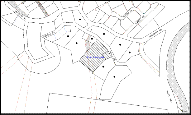
|
NOTIFICATION PLAN |
|
||
|
• PROPERTIES NOTIFIED
|
X SUBMISSIONS RECEIVED |
PROPERTY SUBJECT OF DEVELOPMENT |
|
5.2 Public Agencies
The development application is Integrated Development under the Act. Accordingly, the application was referred to the following Agencies for comment:
5.2.1 Rural Fire Service
NSW Rural Fire Service reviewed the application and raised no objections subject to the implementation of recommended conditions of consent.
5.2.2 Office of Environment and Heritage
The Office of Environment and Heritage was notified as an adjoining property owner as the site adjoins Berowra Valley Regional Park. No comments have been received from the Office.
6. THE PUBLIC INTEREST
Section 79C(1)(e) of the Act requires Council to consider “the public interest”.
The public interest is an overarching requirement, which includes the consideration of the matters discussed in this report. Implicit to the public interest is the achievement of future built outcomes adequately responding to and respecting the future desired outcomes expressed in environmental planning instruments and development control plans.
The application is considered to have satisfactorily addressed Council’s and relevant agencies’ criteria and would provide a development outcome that, on balance, would result in a positive impact for the community. Accordingly, it is considered that the approval of the proposed industrial development would be in the public interest.
CONCLUSION
The application proposes the erection of an industrial building comprising twelve units in two levels accessed from Yatala Road, 53 car spaces and strata subdivision.
This application has been assessed having regard to the matters for consideration under Section 79C(1) of the Act, Hornsby Shire Local Environmental Plan, relevant State Environmental Planning Policies, Sydney Regional Environmental Plan No. 20 and relevant Development Control Plans.
The proposed uses comply with the definition of ‘warehouse and distribution centres’ and would not have an unreasonable impact on the existing environment with regard to noise, air or water quality as no manufacturing is included. The proposed location of the building would retain significant natural vegetation at the front and rear of the site.
The proposal does not comply with Council’s Industrial Lands DCP with regard to the provision of car spaces on site. However, given the proposed use, the non-compliance is considered acceptable. The proposal complies with the objectives of the elements within the Industrial Lands DCP and would result in a positive social and economic impact on the locality.
The design provides for variable building setbacks to the front and side property boundaries, a well articulated building façade and the proposal is considered to provide a reasonable outcome for the subject site and surrounding land uses through consideration of height, design and landscaping provided.
Approval of the application is recommended as a deferred commencement.
Note: At the time of the completion of this planning report, no persons have made a Political Donations Disclosure Statement pursuant to Section 147 of the Environmental Planning and Assessment Act 1979 in respect of the subject planning application.
|
Rod Pickles Manager - Development Assessment Planning Division |
James Farrington Group Manager Planning Division |
|
1.View |
Locality Map |
|
|
|
2.View |
DA Plans |
|
|
|
3.View |
Floor Plans |
|
|
|
4.View |
Elevation and Section |
|
|
File Reference: DA/24/2012
Document Number: D01998843
SCHEDULE 1
1. Deferred Commencement
Pursuant to Section 80(3) of the Environmental Planning and Assessment Act 1979, this consent does not operate until the following information is submitted to Council:
a. The approved Site Plan and Landscape Plan – Dwg no. 9B prepared by Northco Construction and Landscape Designs Pty Ltd must be amended to include the following specifications and submitted to Council’s Natural Resources Unit and Tree Management Team for approval:
· Details of the location and retention of the threatened plant Darwinia biflora;
· Details of all trees to be retained within the vegetation corridor at the front (not 6 native trees as marked in the current Landscape Plan);
· A Tree Protection Plan identifying the location of Tree Protection Fencing within the approved vegetation corridor at the front and detailing any tree sensitive construction techniques proposed to minimise impacts on retained trees. The plan must be consistent with the Australian Standard AS 4970-2009 - Protection of Trees on Development Sites and the specified Tree Protection measures provided in the conditions of this development consent.
· Details of the fencing as required by Condition 12 of this development consent incorporated in the Tree Protection Plan. All other plans and documents required for demolition works, bulk earth works, construction works and landscape works must include the details of the tree protection fencing.
· A statement indicating that the planting, weed control and maintenance works shall be undertaken by a qualified and experienced bush regeneration company who would be implementing the requirements of the Vegetation Management Plan for the remainder of the site; and
· Deletion of any reference to a non indigenous species (e.g. Callistemon cultivar).
b. The Vegetation Management Plan (VMP) prepared by Gordon Limburg dated 7/07/2012 is to be amended and submitted to Council’s Natural Resources Unit for approval. The amended VMP must include the following information:
· Updated plan and map to include the area proposed for native bushland and retention for Persoonia mollis ssp. maxima plant and recently recorded Darwinia biflora at the road site frontage of the site.
· A map that describes the management zones for the VMP.
· Restoration advice and techniques for the regeneration of the soil seed bank and weed control at the road frontage.
· Revised monitoring/ reporting schedule that includes a reporting schedule to Council for compliance purposes.
· A map showing designated areas for management and threats to adjacent bushland from proposed infrastructure (e.g. stormwater and runoff drainage), weed management zones and location of threatened species and their habitat.
· Erosion, sediment and stormwater runoff controls including the management of impacts of run-off from all impervious surfaces including driveway and pavement areas.
· A statement indicating that all works shall be undertaken by a suitably qualified and experienced bush regeneration company (minimum Certificate 3 in Natural Area Restoration). This shall also be incorporated into the amended and forthcoming Landscape Plan.
Note 1: Refer to Council Guidelines for the preparation of Bushland Management and Restoration Plans (on Council’s website http://www.hornsby.nsw.gov.au/planning-and-building/planning-controls-and-studies/policies,-guides-and-best-practices) for industry standards required for the preparation of such documents.
Such information shall be submitted within 12 months of the date of this notice.
Upon Council’s written satisfaction of the above information, the following conditions of development consent will apply:
GENERAL CONDITIONS
The conditions of consent within this notice of determination have been applied to ensure that the use of the land and/or building is carried out in such a manner that is consistent with the aims and objectives of the relevant legislation, planning instruments and Council policies affecting the land and does not disrupt the amenity of the neighbourhood or impact upon the environment.
Note: For the purpose of this consent, the term ‘applicant’ means any person who has the authority to act on or the benefit of the development consent.
Note: For the purpose of this consent, any reference to an Act, Regulation, Australian Standard or publication by a public authority shall be taken to mean the gazetted Act or Regulation, or adopted Australian Standard or publication as in force on the date that the application for a construction certificate is made.
2. Approved Plans and Supporting Documentation
The development must be carried out in accordance with the plans and documentation listed below and endorsed with Council’s stamp, except where amended by Council and/or other conditions of this consent:
|
Plan No. |
Drawn by |
Dated |
|
Tree Plan – Issue C |
Survey Plus |
11/11/2011 |
|
Site Plan – 1B |
Nexus Design Pty Ltd |
June 2012 |
|
Level A Floor Plan – 2A |
Nexus Design Pty Ltd |
June 2012 |
|
Level A Floor Plan – 3A |
Nexus Design Pty Ltd |
June 2012 |
|
Level C Floor Plan – 4B |
Nexus Design Pty Ltd |
June 2012 |
|
Level C Floor Plan – 5A |
Nexus Design Pty Ltd |
June 2012 |
|
Roof Plan – 6A |
Nexus Design Pty Ltd |
June 2012 |
|
Elevations – 7B |
Nexus Design Pty Ltd |
June 2012 |
|
Sections – 8A |
Nexus Design Pty Ltd |
June 2012 |
|
Management Map for Vegetation Management Plan - 13 |
Nexus Design Pty Ltd |
July 2012 |
|
Soil and Water Management Details – 10 |
Nexus Design Pty Ltd |
November 2011 |
|
Soil and Water Management Plan - 11 |
Nexus Design Pty Ltd |
November 2011 |
|
Draft Strata Plan-12A |
Nexus Design Pty Ltd |
June 2012 |
|
Stormwater Management Plan- SW1A |
Civil Engineering Services Consulting Engineers |
12/06/2012 |
|
Level C Concept Stormwater Management Plan- SW2A |
Civil Engineering Services Consulting Engineers |
12/06/2012 |
|
Site Plan and Landscape Plan – 9B |
Northco Constructions and Landscape Designs |
-Received by Council on 18/07/2012 |
|
Document No. |
Prepared by |
Dated |
|
Bushfire Hazard Assessment Report - 120498 |
Building Code and Bushfire Hazard Solutions Pty Ltd |
21/012/2011 |
|
Traffic and Parking Report |
Ray Dowsett Traffic and Transport Planning Pty Ltd |
3/01/2012 |
|
Waste Management Plan |
Industrial Parks of Australia |
10/01/2012 |
|
Schedule of Finishes |
- |
- |
|
Flora and Fauna Assessment Report |
Cumberland Ecology |
May 2012 |
|
Vegetation Management Plan |
Gordon Limburg |
7/07/2012 |
3. Removal of Existing Trees
a. This development consent permits the removal of the following trees within and in the vicnity of the 6m wide vegetation corridor along the frontage of the site as marked on the Tree Plan prepared by Survey Plus dated 11/11/2011:
· 9 trees located within 1m setback of the southern edge of the vegetation corridor identified in the Site Plan and Landscape Plan – 9B prepared by Northco Constructions and Landscape Designs (as amended by Condition1 of this development consent);
· 6 trees located within the vegetation corridor in front of the property as identified in Site Plan and Landscape Plan – 9B prepared by Northco Constructions and Landscape Designs (as amended by Condition 1 of this development consent);
· Trees within 500mm of the entry and exit driveways.
b. All trees that are permitted to be removed are to be cut to ground only not effecting the root system.
c. T1150 marked on the approved “Site Plan and Landscape Plan – 9B prepared by Northco Constructions and Landscape Designs (as amended by Condition 1 of this development consent) is permitted to be removed in accordance with the following conditions:
· The work must be undertaken by a Tree surgeon with a minimum qualification AQF Level 3 (Tree Surgeon).
· The Tree Surgeon and any worker involved in landscaping, tree removal or related works within 10m of the vegetation corridor must provide evidence in writing to the certifier that they are aware of the identified threatened species onsite and the species locations prior to any works.
· The threatened species are to be physically identified and protected prior to any works.
· The tree 1150 is to be removed in sections so that the tree stump is retained at a minimum 3m height.
The removal of any other trees requires separate approval under Council’s Tree Preservation Order.
REQUIREMENTS PRIOR TO THE ISSUE OF A CONSTRUCTION CERTIFICATE
4. Building Code of Australia
All building work must be carried out in accordance with the requirements of the Building Code of Australia.
5. Water/Electricity Utility Services
The applicant must submit written evidence of the following service provider requirements:
a. Energy Australia – a letter of consent demonstrating that satisfactory arrangements have been made to service the proposed development.
b. Sydney Water – the submission of a ‘Notice of Requirements’ under s73 of the Sydney Water Act 1994.
Note: Sydney Water requires that s73 applications are to be made through an authorised Sydney Water Servicing Coordinator. Refer to www.sydneywater.com.au or telephone 13 20 92 for assistance.
6. Preservation of Survey Infrastructure
A registered surveyor must identify all survey marks in the vicinity of the proposed development. Any survey marks required to be removed or displaced as a result of the proposed development shall be undertaken by a registered surveyor in accordance with Section 24 (1) of the Surveying and Spatial Information Act 2002 and following the Surveyor General’s Directions No.11 – "Preservation of Survey Infrastructure".
REQUIREMENTS PRIOR TO THE COMMENCEMENT OF ANY WORKS
7. Site remediation verification
a. The applicant must provide documentation from a suitably qualified environmental consultant verifying that the site has been remediated in accordance with the NSW Environment Protection Authority’s Contaminated Sites – Guidelines for Consultants Reporting on Contaminated Sites, the Contaminated Sites- Sampling Design Guidelines Contaminated Sites – Guidelines for the NSW Site Auditor.
b. A validation report must be prepared by a suitably qualified environmental consultant in accordance with the NSW Environment Protection Authority’s Contaminated Sites – Guidelines for Consultants Reporting on Contaminated Sites and Contaminated Sites – Sampling Design Guidelines validating that the proposed development has been remediated and is suitable for its intended use.
8. Erection of Construction Sign
A sign must be erected in a prominent position on any site on which building work, subdivision work or demolition work is being carried out:
a. Showing the name, address and telephone number of the principal certifying authority for the work,
b. Showing the name of the principal contractor (if any) for any demolition or building work and a telephone number on which that person may be contacted outside working hours, and
c. Stating that unauthorised entry to the work site is prohibited.
Note: Any such sign is to be maintained while the building work, subdivision work or demolition work is being carried out, but must be removed when the work has been completed.
9. Protection of Adjoining Areas
A temporary hoarding, fence or awning must be erected between the work site and adjoining lands before the works begin and must be kept in place until after the completion of the works if the works:
a. Could cause a danger, obstruction or inconvenience to pedestrian or vehicular traffic.
b. Could cause damage to adjoining lands by falling objects.
c. Involve the enclosure of a public place or part of a public place.
Note: Notwithstanding the above, Council’s separate written approval is required prior to the erection of any structure or other obstruction on public land.
10. Toilet Facilities
Toilet facilities must be available or provided at the works site before works begin and must be maintained until the works are completed at a ratio of one toilet for every 20 persons employed at the site. Each toilet must:
a. be a standard flushing toilet connected to a public sewer; or
b. be a temporary chemical closet approved under the Local Government Act, 1993; or
c. have an on-site effluent disposal system approved under the Local Government Act, 1993
11. Erosion and Sediment Control
Erosion and sediment control measures must be provided and maintained throughout the demolition (if any), earthworks and construction period in accordance with the manual ‘Soils and Construction 2004 (Bluebook)’, the approved plans, Council specifications and to the satisfaction of the principal certifying authority. The erosion and sediment control devices must remain in place until the site has been stabilised and revegetated.
Note 1: On the spot penalties up to $1,500 may be issued for any non-compliance with this requirement without any further notification or warning.
Note 2: The erosion and sediment control measure ensure the protection of the adjacent bushland and the native fauna habitat.
12. Tree Protection Barriers
Tree Protection barriers must be installed as per the following requirements:
a. The tree fencing must be constructed of 1.8 metre ‘cyclone chainmesh fence’ or high visibility fencing.
b. The front property boundary and the location of the two (2) approved driveways and crossovers is to be clearly defined and marked prior to the commencement of works.
c. Tree Protection Fencing must encompass the central section of the vegetation corridor at the front of the property, identified by diagonal lines as “restricted development area” on the approved Site and Landscape Plan – 9B prepared by Northco Constructions and Landscape Designs and be located 1m outside the property boundary along Yatala Road frontage between the two (2) approved accesses, entry crossovers. The internal section of the fencing must be at a minimum distance of 6m from the front property boundary (7m from the above external fencing) and shall run parallel to the boundary between the two access, entry driveways. No works are permitted in this area unless otherwise specified by conditions of this development consent.
d. Tree Protection Fencing must encompass the “Natural regeneration and Planting area” identified on Site and Landscape Plan – 9B prepared by Northco Constructions and Landscape Designs located at the two corners in front of the site. No works are permitted in this area unless specified in the approved plans or conditions of this development consent.
e. A 1.8m high cyclone or high visibility fencing be erected to protect the “restricted development area” marked by diagonal lines in the “Management Map for Vegetation Management Plan – 13” prepared by Nexus Design Pty Ltd, located at the rear of the site.
f. The engaged bush regeneration contractor must determine the exact location of threatened plants prior to installation of the fencing around the plants in accordance with the approved VMP and the Site Plan and Landscape Plan - Dwg 9B (as amended by condition 1 of this development consent).
Note: A certificate from the site foreman is to be submitted to the Principal Certifying Authority stating that all tree protection measures are in accordance with the above prior to commencement of works.
REQUIREMENTS DURING CONSTRUCTION
13. Construction Work Hours
All work on site (including demolition and earth works) must only occur between 7am and 5pm Monday to Saturday.
No work is to be undertaken on Sundays or public holidays.
14. Street Sweeping
Street sweeping must be undertaken following sediment tracking from the site along Yatala Road during works and until the site is established.
15. Environmental Management
The site must be managed in accordance with the publication ‘Managing Urban Stormwater – Landcom (March 2004) and the Protection of the Environment Operations Act 1997 by way of implementing appropriate measures to prevent sediment run-off, excessive dust, noise or odour emanating from the site during the construction of the development.
16. Works near Trees
All required tree protection measures are to be maintained in good condition for the duration of the construction period to protect the adjoining trees and associated bushland from clearing and damage by equipment, vehicles or by stockpiling of materials.
All works (including cut or fill for driveways, road-works and retaining walls) within 3m of any trees required to be retained (whether or not on the subject property, and pursuant to this consent or the Tree Preservation Order), must be carried out under the supervision of an ‘AQF Level 5 Arborist’ and a certificate submitted to the principal certifying authority detailing the methods used to preserve the trees.
Note: Except as provided above, the applicant is to ensure that no excavation, filling or stockpiling of building materials, parking of vehicles or plant, disposal of cement slurry, waste water or other contaminants is to occur within four metres (4m) of any tree to be retained.
17. Council Property
During construction works, no building materials, waste, machinery or related matter is to be stored on the road or footpath. The public reserve is to be kept in a clean, tidy and safe condition at all times.
18. Disturbance of Existing Site
During construction works, the existing ground levels of open space areas and natural landscape features, (including natural rock-outcrops, vegetation, soil and watercourses) must not be altered unless otherwise nominated on the approved plans.
19. Landfill
Landfill must be constructed in accordance with Council’s ‘Construction Specification, 2005’ and the following requirements:
a. All fill material imported to the site is to wholly consist of Virgin Excavated Natural Material (VENM) as defined in Schedule 1 of the Protection of the Environment Operations Act 1997 or a material approved under the Department of Environment and Climate Change’s general resource recovery exemption.
20. Excavated Material
All excavated material removed from the site must be classified in accordance with the Department of Environment, Climate Change and Water NSW Waste Classification Guidelines prior to disposal to an approved waste management facility and reported to the principal certifying authority.
21. Contamination during construction works
Should the presence of asbestos or soil contamination, not recognised during the application process be identified during demolition, the applicant must immediately notify the Principal Certifying Authority and Council.
22. Waste Management
Waste management during the demolition and construction phase of the development must be undertaken in accordance with the approved Waste Management Plan. Additionally written record of the following items must be maintained during the removal of any waste from the site and such information submitted to the Principal Certifying Authority within fourteen days of the date of completion of the works:
a. The identity of the person removing the waste.
b. The waste carrier vehicle registration.
c. Date and time of waste collection.
d. A description of the waste (type of waste and estimated quantity).
e. Details of the site to which the waste is to be taken.
f. The corresponding tip docket/receipt from the site to which the waste is transferred (noting date and time of delivery, description (type and quantity) of waste).
g. Whether the waste is expected to be reused, recycled or go to landfill.
Note: In accordance with the Protection of the Environment Operations Act 1997, the definition of waste includes any unwanted substance, regardless of whether it is reused, recycled or disposed to landfill.
23. Bushland Protection During Construction
To ensure the protection of bushland during construction, the applicant must:
a. Clean machinery of soil and debris before entering the site to prevent the spread of weeds and fungal pathogens such as Phytophthora cinnamomi and Batrachochytrium dendrobatidis.
b. Only apply certified weed free mulch in landscaped areas identified by the bush regeneration contractor as having no native resilience and limited native regeneration potential.
c. Undertake no works within the “Restricted Development Areas” marked in the “Management Map for Vegetation Management Plan – 13” prepared by Nexus Design Pty Ltd unless specified by other conditions of this development consent.
Note 1: Mulch suppresses the existing soil seed bank. Therefore, no mulch is to be applied within areas that the bush regeneration contractor considers to have native regeneration potential – particularly near the threatened plants along the road frontage.
Note 2: The site contains Persoonia mollis ssp and Darwinia biflora which are listed as ‘Threatened Species’ under the ‘Threatened Species Conservation Act 1995’. The Act prohibits the disturbance to threatened species, endangered populations and endangered ecological communities, or their habitat, without the approval of the ‘Department of Environment and Climate Change’ where such activities are not authorised by a development consent under the ‘Environmental Planning and Assessment Act 1979’.
Actions such as tree removal, understorey slashing or mowing, removal of dead trees within this vegetation would likely impact upon the Threatened species. Such action would qualify as illegally picking or disturbing the habitat and could render any person who carried out such action as liable for prosecution.
REQUIREMENTS PRIOR TO THE ISSUE OF AN OCCUPATION CERTIFICATE
Note: For the purpose of this consent, a reference to ‘occupation certificate’ shall not be taken to mean an ‘interim occupation certificate’ unless otherwise stated.
24. Sydney Water – s73 Certificate
A s73 Certificate must be obtained from Sydney Water.
25. Stormwater Drainage
The stormwater drainage system for the development must be designed and constructed in accordance with Council’s Civil Works – Design and Construction Specification 2005 and the following requirements:
a. Details of all works must be submitted with the Construction Certificate Plans.
b. Run off dispersed at 5 year ARI predevelopment rate for up to 100 year ARI storms through an on site absorption or on-site-detention system.
i. The absorption trench located a minimum of 5 metres from any down stream property boundaries and 1 metre from the side boundaries.
ii. The trench laid on contour.
iii. The trench be a minimum of 0.5 metres wide, 0.5 metres deep.
a. Overland flow from the trench be spread evenly so as not to discharge water in a concentrated manner onto adjoining land.
b. All calculations in regards to absorption capacity of the ground, length of the absorption trench and weir flow are to be shown and meet the objective of disposal of stormwater at 5 year pre development rate.
26. Internal Driveway/Vehicular Areas
The driveway and parking areas on site must be designed in accordance with Australian Standards 2890.1, 2890.2, 3727 and the following requirements:
a. Details of all works must be provided on the Construction Certificate Plans.
b. Design levels at the front boundary be obtained from Council.
c. The driveway be a rigid pavement and built to commercial development crossings standard in accordance with Council’s Civil works Specifications of 2005.
d. Retaining walls required supporting the carriageway and the compaction of all fill batters to be in accordance with the requirements of a chartered structural engineer.
e. The provision of safety rails where there is a level difference more than 0.3 metres and a 1:4 batter can not be achieved.
27. Vehicular Crossing
A separate application under the Local Government Act, 1993 and the Roads Act, 1993 must be submitted to Council for the installation of a new vehicular crossing and the removal of the redundant crossing. The vehicular crossing must be constructed in accordance with Council’s Civil Works Design, 2005 and the following requirements:
a. Details of all works must be submitted with the Construction Certificate Plans.
b. Approval obtained from all relevant utility providers that all necessary conduits be provided and protected under the crossing.
Note: An application for a vehicular crossing can only be made to one of Council’s Authorised Vehicular Crossing Contractors. You are advised to contact Council on 02 9847 6940 to obtain a list of contractors.
28. Road Works
All road works approved under this consent must be constructed in accordance with Council’s Civil Works Design and Construction Specification, 2005 and the following requirements:
a. The carriageway of Yalata Road, in front of the development site is to be extended from the existing section to become 13m from kerb to kerb together with drainage and kerb and guttering.
b. The kerb and gutter alignment are be in line with the adjoining development on the eastern side. On the western side and at middle of the lot frontage, the alignment is to be set with 13m wide carriageway from the existing kerb associated with the driveway to property at Nos. 19-23 Beaumont Road.
c. The existing road pavement to be saw cut a minimum of 300mm from the existing edge of the bitumen and reconstructed.
d. The submission of a compaction certificate from a geotechnical engineer for any fill within road reserves, and all road sub-grade and road pavement materials.
e. A construction certificate application is to be submitted to Council for approval of construction plans of the road works and inspection (Council is the only authority who can approve works on Council roads).
29. Traffic Control Plan
A Traffic Control Plan (TCP) must be prepared by a qualified traffic controller in accordance with the Roads & Traffic Authority’s Traffic Control at Worksites Manual 1998 and Australian Standard 1742.3 for all work on a public road and be submitted to Council. The TCP must detail the following:
a. Arrangements for public notification of the works.
b. Temporary construction signage.
c. Permanent post-construction signage.
d. Vehicle movement plans.
e. Traffic management plans.
f. Pedestrian and cyclist access/safety.
30. Damage to Council Assets
Any damage caused to Council’s assets as a result of the construction of the development must be rectified in accordance with Council’s written requirements and at the sole cost of the applicant.
31. Restriction as to User – Protection of Land from Future Development
To inform current and future owners that the areas of native vegetation and habitat on the site is to be protected from future development, a Restriction-as-to-User must be created under Section 88B of the Conveyancing Act 1919 identifying that the area of the site identified by diagonal lines on the “Management Map for Vegetation Management Plan – 13” prepared by Nexus Design Pty Ltd and marked as ‘Restricted Development Area’ is restricted from future development or disturbance of any kind except where approved by conditions of this development consent.
Note 1: The wording of the Restriction-as-to-User must be to Council’s satisfaction and Council is to be nominated as the authority to release, vary or modify the Restriction.
Note 2: The intent of the Restriction-as-to-user is to preserve the remnant bushland, where no building work including paving, excavation or construction, no removal of native vegetation (trees, shrubs and groundcovers) except those trees identified in the conditions of consent, no stockpiles, no changes to soil aeration or hydrological capacity, no open cut trenching, no placement of temporary buildings, no parking or movement of machinery, no spillage/disposal of building waste, no agricultural uses are to occur except for access required for construction and maintenance of approved works. Any landform modification or clearing of bushland in this designated area requires written consent from Council.
Note 3: The “natural regeneration and planting areas” identified in the plan at the two corners in front are excluded from this restricted development area.
32. Creation of Easements
The following matters must be nominated on the plan of subdivision under s88B of the Conveyancing Act 1919:
a. The creation of an appropriate "Positive Covenant" and "Restriction-as-to-User" over the constructed on-site absorption/detention systems and outlet works, within the lot in favour of Council in accordance with Council’s prescribed wording for maintenance of the system. The position of the on-site absorption/detention system is to be clearly indicated on the title. The 5 year ARI pre development rate is to be nominated with storage volume (if OSD is constructed) in the covenant.
b. To register the on site absorption/detention system easement, the restriction on the use of land “works-as-executed” details of the system must be submitted verifying that the required absorption area/storage and discharge rates have been constructed in accordance with the design requirements. The details must show the invert levels of the system together with details of trenches/pipe sizes and grades. Any variations to the approved plans must be shown in red on the “works-as-executed” plan and supported by calculations.
c. Creation of an appropriate “Positive Covenant” and “Restriction-as-to-user” in the area marked by diagonal lines as identified as “Restricted development area” on the approved plan “Management Map for Vegetation Management Plan – 13” prepared by Nexus Design. The covenant must specify that the remaining bushland retained within the Restricted Development Area be managed in accordance with the approved Vegetation Management Plan (as amended by Condition 1 of this development consent) that applies to the subject site. The implementation of actions specified within the Vegetation Management Plan for the Restricted Development Area shall be the responsibility of the Community Association.
Note: Council must be nominated as the authority to release, vary or modify any easement, restriction or covenant.
33. Garbage Collection Easement
For the purpose of waste collection, an easement entitling Council, its servants and agents and persons authorised by it to enter upon the subject land and to operate thereon, vehicles and other equipment for the purposes of garbage collection must be granted to Council by the owner of the land.
Note: The easement must be in a form prescribed by Council and must include covenants to the effect that parties will not be liable for any damage caused to the subject land or any part thereof or to any property located therein or thereon by reason of the operation thereon of any vehicle or other equipment used in connection with the collection of garbage and to the effect that the owner for the time being of the subject land shall indemnify the Council, its servants, agents and persons authorised by it to collect garbage against liability in respect of any such claims made by any person whomsoever.
34. Waste Management Details
The following waste management requirements must be complied with:
a. A report must be prepared by an appropriately qualified person, certifying the following:
i. A comparison of the estimated quantities of each waste type against the actual quantities of each waste type.
Note: Explanations of any deviations to the approved Waste Management Plan is required to be included in this report
ii. That at least 60% of the waste generated during the demolition and construction phase of the development was reused or recycled.
Note: If the 60% diversion from landfill cannot be achieved in the Construction Stage, the Report is to include the reasons why this occurred and certify that appropriate work practices were employed to implement the approved Waste Management Plan. The Report must be based on documentary evidence such as tipping dockets/receipts from recycling depots, transfer stations and landfills, audits of procedures etc. which are to be attached to the report.
35. Works as Executed Plan
A works-as-executed plan must be prepared by a registered surveyor and submitted to Council for completed road works, kerb & gutter, drainage systems and driveways.
36. Certificate of Preservation of Survey Marks
A certificate by a Registered Surveyor shall be submitted to the Principal Certifying Authority, certifying that there has been no removal, damage, destruction, displacement or defacing of the existing survey marks in the vicinity of the proposed development or otherwise the re-establishment of damaged, removed or displaced survey marks has been undertaken in accordance with the Surveyor General’s Direction No.11 – “Preservation of Survey Infrastructure”.
37. Section 94 Infrastructure Contributions
The payment to Council of a contribution of $58064.35 for twenty-seven employees towards the cost of infrastructure identified in Council’s Development Contributions Plan 2007-2011.
Note: The value of contribution is based on a rate of $2150.60 per employee, and is current as at 1 September 2012. The contribution will be adjusted from this date in accordance with the underlying consumer price index for subsequent financial quarters. It is recommended that you contact Council to ascertain the indexed value of the contribution prior to payment.
38. Consolidation of Allotments
All allotments the subject of this consent must be consolidated into one allotment.
Note: The applicant is recommended to submit the plan of subdivision to consolidate allotments to the NSW Department of Lands at least 4-6 weeks prior to seeking an occupation certificate.
OPERATIONAL CONDITIONS
39. Advertising Signs
The advertising signage approved under this consent must not be illuminated, flash, move or display electronic images.
40. Car Parking and Deliveries
All car parking must be constructed and operated in accordance with Australian Standard AS 2890.1 – 2004 – Off Street Car Parking and Australian Standard 2890.2 - 2002 – Off Street Commercial and the following requirement:
a. A total of 53 car spaces must be provided on the site associated with the ‘warehouse and distribution centres’.
b. All parking areas and driveways are to be sealed to an all weather standard, line marked and signposted.
c. Car parking, loading and manoeuvring areas to be used solely for nominated purposes.
d. Vehicles awaiting loading, unloading or servicing shall be parked on site and not on adjacent or nearby public roads;
e. All vehicular entry on to the site and egress from the site shall be made in a forward direction.
41. Use of Premises
The development approved under this consent shall be used as follows:
a. All units must be solely used as “warehouse and distribution centres”
Any change to the proposed use would require further development consent from Council.
42. Hours of Operation
The hours of operation of the premise are restricted to those times listed below:
Monday to Friday 7 am to 6 pm
Saturday 7 am to 4 pm
Sunday & Public Holidays No work
43. Waste Records
All commercial tenants must keep written evidence on site of a valid contract with licensed waste contractors for the regular collection and disposal of the waste and recyclables that are generated on site.
44. Fire Safety Statement - Annual
On at least one occasion in every 12 month period following the date of the first ‘Fire Safety Certificate’ issued for the property, the owner must provide Council with an annual ‘Fire Safety Certificate’ to each essential service installed in the building.
45. Noise
All noise generated by the proposed development must be attenuated to prevent levels of noise being emitted to adjacent premises which possess tonal, beating and similar characteristics or which exceeds background noise levels by more than 5dB(A).
46. Trade Waste
Liquid trade waste generated on the site must be discharged in accordance with a trade waste agreement with Sydney Water and by a licensed liquid trade waste contractor.
47. Maintenance of Wastewater Device
All wastewater and stormwater treatment devices (including drainage systems, sumps and traps) must be regularly maintained in order to remain effective. All solid and liquid wastes collected from the device must be disposed of in accordance with the Protection of the Environment Operations Act 1997.
GENERAL TERMS OF APPROVAL – NSW RURAL FIRE SERVICE
The following conditions of consent are General Terms of Approval from the nominated State Agency pursuant to Section 91A of the Environmental Planning and Assessment Act 1979 and must be complied with to the satisfaction of that Agency.
48. Asset Protection Zones
Prior to the issue of the Occupation Certificate, the following matter must be nominated on the property title under s88B of the Conveyancing Act 1919:
The creation of a “Positive Covenant” over the consolidated allotment requiring that the property around the building up to a distance of 10 metres must be managed as an Inner Protection Area (IPA) as outlined within Section 4.1.3 and Appendix 5 of Planning for Bushfire Protection 2006 and the NSW Rural Fire Service’s document ‘Standards for asset protection zones’.
Note 1: The intent of this measure is to provide sufficient space and to maintain reduced fuel loads so that the radiant heat levels of the building are below critical limits and to avoid direct flame contact with the building.
Note 2: The provision of Asset Protection Zone does not permit removal of trees unless otherwise specified by conditions of this development consent.
49. Design and Construction
a. New construction on the southeast, southwest and northwest elevations must comply with section 9 (BAL-FZ) Australian Standard 3959-2009 ‘Construction of buildings in bushfire prone areas’. If any material, element of construction or system when tested to the method described in Australian Standard AS1530.8.2 ‘Methods for fire tests on building materials, components and structures’ Part 8.2: ‘Tests on elements of construction for buildings exposed to simulated bushfire attack—Large flaming sources’, it must comply with Clause 13.8 of the Standard except that flaming of the specimen is not permitted and there shall be no exposed timber.
b. Window assemblies on the southeast, southwest and northwest elevations must comply with any one of the following:
i) Clause 9.5.2 of AS 3959-2009 as modified in condition 49(a);
Or
ii) The following requirements:
· Completely protected by a non-combustible and non perforated shutter that complies with Section 3.7 of AS3959-2009 excluding parts (e) & (f);
· Window frames and hardware must be metallic;
· Glazing must be toughened glass minimum 6mm;
· Seals to stiles, head and sills or thresholds shall be manufactured from materials having a flammability index no greater than 5 or from silicone; and
· The openable portion of the window must be screened internally or externally with screens that comply with Clause 9.5.1A;
c. External Doors and door frames (not including garage doors) on the southeast, southwest and northwest elevations must comply with any one of the following:
i) Clause 9.5.3 or 9.5.4 of AS 3959-2009 as modified in Condition 49(a);
Or
ii) The following requirements:
· Completely protected by a non-combustible and non perforated shutter that complies with Section 3.7 of AS3959-2009 excluding parts (e) & (f);
· Doors must be constructed of non-combustible materials;
· Externally fitted hardware that supports the panel in its function of opening and closing and door frames must be metallic;
· Where doors incorporate glazing, the glazing must be made of toughened glass, minimum 6mm;
· Seals to stiles, head and sills or thresholds must be manufactured from materials having a flammability index no greater than 5 or from silicone;
· Doors must be tight fitted to the doorframe and to an abutting door if applicable; and
· Weather strips, draught excluders or draught seals must be installed at the base of side-hung external doors.
d. New construction on the northeast elevation must comply with section 8 (BAL 40) Australian Standard AS3959-2009 'Construction of buildings in bush fire-prone areas'.
e. Roofing must be gutterless or guttering and valleys are to be screened to prevent the build up of flammable material. Any materials used shall be non-combustible.
- END OF CONDITIONS -
ADVISORY NOTES
The following information is provided for your assistance to ensure compliance with the Environmental Planning and Assessment Act 1979, Environmental Planning and Assessment Regulation 2000, other relevant legislation and Council’s policies and specifications. This information does not form part of the conditions of development consent pursuant to Section 80A of the Act.
Environmental Planning and Assessment Act, 1979 Requirements
· The Environmental Planning and Assessment Act, 1979 requires:
· The issue of a construction certificate prior to the commencement of any works. Enquiries regarding the issue of a construction certificate can be made to Council’s Customer Services Branch on 9847 6760.
· A principal certifying authority to be nominated and Council notified of that appointment prior to the commencement of any works.
· Council to be given at least two days written notice prior to the commencement of any works.
· Mandatory inspections of nominated stages of the construction inspected.
· An occupation certificate to be issued before occupying any building or commencing the use of the land.
Long Service Levy
In accordance with Section 34 of the Building and Construction Industry Long Service Payments Act 1986, a ‘Long Service Levy’ must be paid to the Long Service Payments Corporation or Hornsby Council.
Note: The rate of the Long Service Levy is 0.35% of the total cost of the work.
Note: Hornsby Council requires the payment of the Long Service Levy prior to the issue of a construction certificate.
Tree Preservation Order
To ensure the maintenance and protection of the existing natural environment, it is an offence to ringbark, cut down, top, lop, remove, wilfully injure or destroy a tree outside 3 metres of the approved building envelope without the prior written consent from Council.
Note: A tree is defined as a single or multi-trunked wood perennial plant having a height of not less than three (3) metres, and which develops many branches, usually from a distance of not less than one (1) metre from the ground, but excluding any plant which, in its particular location, is a noxious plant declared as such pursuant to the Noxious Weeds Act 1993. This definition of ‘tree’ includes any and all types of Palm trees.
All distances are determined under Australian Standard AS4970-2009 ”Protection of Trees on Development Sites”.
Fines may be imposed for non-compliance with Council’s Tree Preservation Order.
Disability Discrimination Act
The applicant’s attention is drawn to the existence of the Disability Discrimination Act. A construction certificate is required to be obtained for the proposed building/s, which will provide consideration under the Building Code of Australia, however, the development may not comply with the requirements of the Disability Discrimination Act. This is the sole responsibility of the applicant.
Covenants
The land upon which the subject building is to be constructed may be affected by restrictive covenants. Council issues this approval without enquiry as to whether any restrictive covenant affecting the land would be breached by the construction of the building, the subject of this consent. Applicants must rely on their own enquiries as to whether or not the building breaches any such covenant.
Tenancy Fit-Out – Separate DA Required
This consent does not permit the fit-out of individual tenancies. A separate development application is required for the fit-out of individual tenancies prior to the occupation of the building.
Dial Before You Dig
Prior to commencing any works, the applicant is encouraged to contact Dial Before You Dig on 1100 or www.dialbeforeyoudig.com.au for free information on potential underground pipes and cables within the vicinity of the development site.
Planning Report No. PL25/12
Planning Division
Date of Meeting: 17/10/2012
15 DEVELOPMENT APPLICATION - MEDIUM DENSITY DEVELOPMENT COMPRISING 14 TOWNHOUSES 2 - 6 KITA ROAD & 148 BEROWRA WATERS ROAD, BEROWRA HEIGHTS
EXECUTIVE SUMMARY
|
DA No: |
DA/599/2012 |
|
Description: |
Demolition and construction of a medium density multi-unit housing development comprising 14 two storey townhouses with car parking and strata subdivision |
|
Property: |
Lot 1, 2, 3, 4 DP 232401, Nos. 2-6 Kita Road and 148 Berowra Waters Road, Berowra Heights |
|
Applicant: |
Kita Developments Pty Ltd |
|
Owner: |
Mr Peter Garrett, Pamm (NSW) Pty Ltd and Assure NSW Pty Ltd |
|
Estimated Value: |
$ 2.5 million |
|
Ward: |
A |
· The application proposes demolition and erection of a medium density multi-unit housing development comprising 14 two-storey townhouses, car parking and strata subdivision.
· The proposal generally complies with the provisions of the Hornsby Shire Local Environmental Plan 1994. The proposal does not comply with the provisions of the Turner Road Commercial Centre Masterplan.
· Four submissions have been received in respect of the application.
· It is recommended that the application be approved.
|
THAT Development Application No. 599/2012 for demolition and construction of a medium density multi-unit housing development comprising 14 two storey townhouses with car parking and strata subdivision at Lot 1, 2, 3, 4 DP 232401, Nos. 2-6 Kita Road and No. 148 Berowra Waters Road, Berowra Heights be approved subject to the conditions of consent detailed in Schedule 1 of Group Manager’s Report No. PL25/12. |
BACKGROUND
The site has a history of low density residential use.
On 18 December 2002, Council refused DA/1986/2002 for demolition of existing structures and erection of a multi-unit housing development comprising seventy four dwellings at Nos. 2 - 12 Kita Road, Berowra Heights.
On 6 April 2006, Council adopted the Turner Road Commercial Centre Masterplan. The subject site is within the area that is subject to the Masterplan. The Masterplan is contained with the Medium Density Multi-Unit Housing Development Control Plan and aims to guide development to ensure it is consistent with the desired future character of the business and residential precincts of the Turner Road Commercial Centre.
On 1 November 2007, the Land and Environment Court approved a medium density multi-unit housing development comprising ten two-storey townhouses and at-grade car parking at Nos. 3-5 Turner Road, which adjoins part of the northern boundary of the subject site. The approved development at Nos. 3-5 Turner Road incorporates a pedestrian pathway which could be connected to the site (subject to creation of rights-of-access).
On 6 July 2011, Council approved DA/1615/2010 for Nos. 4-12 Kita Road, Berowra Heights. The application includes No. 4 Kita Road in the property description for the purpose of a proposed right-of-way. The site layout approved under this application does not comply with the Turner Road Commercial Centre Masterplan with regard to the location of the accessway, pedestrian linkage within the precinct, amalgamation of sites and the provision of a communal open space.
The construction of a formal pedestrian pathway through the road reserve, linking the shopping centre and the public open space to Kita Road was approved under DA/1615/2010. This pathway has not been constructed to date.
SITE
The site comprises three allotments known as Nos. 2 - 4 Kita Road, and 148 Berowra Waters Road, Berowra Heights. The subject site is irregular in shape with a total area of 2728 m2. All allotments have separate access via driveways off Kita Road. The site slopes towards the street with an average gradient of 7%. No. 6 Kita Road has been included in the property description for the purposes of the right-of-way only. The property has not been included in the above total site area calculation.
No. 4 Kita Road is a battleaxe allotment forming the westernmost boundary of the site. Reciprocal rights-of-ways benefit the access handles for No. 4 Kita Road and the adjoining property at No. 6 Kita Road (Lot 4 DP 232401). The combined width of the driveway is 6 metres.
The current improvements on the site include one dwelling on each of the allotments and associated outbuildings. The allotments and the neighbouring properties accommodate a large number of trees including native and exotic species.
The site is surrounded by predominantly single and two-storey dwellings and one to two storey high commercial developments. The car park of the Berowra Village Shopping Centre adjoins the eastern boundary of the site and is located at a higher level at the common boundary on which a lapped and capped fence is erected. The Marketplace shopping centre is located in close proximity on the western side.
Kita Road ends as a cul-de-sac in front of the site. A road reserve is located between the end of the street and public open space located at the corner of Turner Road and Berowra Waters Road. A section of the site fronts this road reserve; the carriageway of Berowra Waters Road being located at a lower level on the opposite side of the reserve. Further east, the reserve land slopes up to be at the same level with the Berowra Shopping Village car park and then falls away gradually to Turner Road.
Currently an informal pedestrian trail exists within the reserve utilised by Kita Road residents for access to the shopping centre car park and Council maintained open space and recreational area (Crossroads reserve).
The site is located approximately 2.5 kilometres from the Berowra Railway Station and within 300 metres of a bus stop on Turner Road.
PROPOSAL
The proposal involves the following:
· Demolition of the existing dwellings and outbuildings on the site;
· Erection of a medium density multi-unit housing development comprising 14 two storey town houses located in 4 rows separated by driveways and private open space areas. The unit mix would comprise of 10 x 3-bedroom townhouses and 4 x 2-bedroom townhouses. The size of the units varies between 83 m2 - 117 m2;
· The gross floor area (GFA) of the development would be 1418.1 m2;
· Access to the site is proposed via Kita Road utilising the existing combined driveway over No. 4 Kita Road and the adjoining allotment at No. 6 Kita Road approved under DA/1615/2010. The width of this north-south orientated driveway is 6 metres. An approved truck turning area would be located at the end of this driveway in the future;
· East-west orientated internal driveways would branch out from the main driveway and provide access to the individual rows of townhouses;
· Townhouses 1-3 (the rearmost block) would be two-storey with garages located within a basement level due to the slope of the land. The remaining townhouses would include at-grade garages accommodating 1 – 2 car spaces. The typical floor plans include living areas on the ground floor and bedrooms on the upper floor;
· Each townhouse would include a courtyard located at its rear and some would include an additional landscaped area at the front. A number of townhouses would include balconies on the upper floor;
· Three visitors’ car spaces are proposed to be located parallel to the main driveway;
· Two common bin storage areas are proposed at the end of the internal driveways for waste collection purposes;
· A front fence is proposed including a combination of light-weight timber and solid materials; and
· Strata subdivision of the townhouses.
ASSESSMENT
The development application has been assessed having regard to the ‘Metropolitan Plan for Sydney 2036’, the ‘North Subregion (Draft) Subregional Strategy’ and the matters for consideration prescribed under Section 79C of the Environmental Planning and Assessment Act 1979 (the Act). The following issues have been identified for further consideration.
1. STRATEGIC CONTEXT
1.1 Metropolitan Plan for Sydney 2036 and (Draft) North Subregional Strategy
The Metropolitan Plan for Sydney 2036 is a broad framework to secure Sydney’s place in the global economy by promoting and managing growth. It outlines a vision for Sydney to 2036; the challenges faced, and the directions to follow to address these challenges and achieve the vision. The Draft North Subregional Strategy acts as a framework for Council in its preparation of the Comprehensive LEP by the end of 2012.
The Draft North Subregional Strategy sets the following targets for the Hornsby LGA by 2031:
· Employment capacity to increase by 9,000 jobs; and
· Housing stock to increase by 11,000 dwellings.
The proposed development would be consistent with the draft Strategy by providing 14 townhouses and would contribute towards housing choice in the locality.
2. STATUTORY CONTROLS
Section 79C(1)(a) requires Council to consider “any relevant environmental planning instruments, draft environmental planning instruments, development control plans, planning agreements and regulations”.
2.1 Hornsby Shire Local Environmental Plan 1994
The subject land is zoned Residential B (Medium Density) under the Hornsby Shire Local Environmental Plan 1994 (HSLEP). The objectives of the zone are:
(a) to provide for the housing needs of the population of the Hornsby area.
(b) to promote a variety of housing types and other land uses compatible with a medium density residential environment.
(c) to provide for development that is within the environmental capacity of a medium density residential environment.
The proposed development is defined as “multi-unit” housing under the HSLEP and is permissible in the zone with Council’s consent. The proposal would assist in catering for the housing needs of the Hornsby Shire, and would provide a variety of housing types that are within the environmental capacity of the medium density residential environment.
Clause 15 of the HSLEP prescribes that the maximum floor space ratio (FSR) of development within the Residential B zone is 0.6:1. The application satisfies this requirement by proposing a floor space ratio of 0.51:1.
Clause 18 of the HSLEP sets out heritage conservation provisions for Hornsby Shire. The site does not accommodate a heritage item nor is located in the vicinity of a heritage item. The subject property is not located in a heritage conservation area. Accordingly, no further assessment in this regard is required.
2.2 Draft Hornsby Local Environmental Plan
At its meeting on 7 March 2012, Council resolved to endorse the draft Hornsby Local Environmental Plan (DHLEP) for public exhibition. The draft Plan has subsequently been exhibited and submissions are currently being reviewed. Under the DHLEP, the subject land would be zoned R3 – Medium Density Residential. The proposed use is defined as “multi-dwelling housing” and is permitted within the zone with Council’s consent.
The DHLEP would allow a maximum building height of 10.5m for the site. The proposal would comply with this requirement.
2.3 State Environmental Planning Policy No. 55 - Remediation of Land
The application has been assessed against the requirements of State Environmental Planning Policy No. 55. This Policy provides State-wide planning controls for soil contamination and proposed remedies.
The site has a history of residential land uses which would not typically result in soil contamination. Accordingly, no further assessment in this regard is considered necessary.
2.4 State Environmental Planning Policy (Building Sustainability Index: BASIX) 2004
The application has been assessed against the requirements of State Environmental Planning Policy (Building Sustainability Index: BASIX) 2004. The proposal includes a BASIX Certificate for the proposed townhouses and is considered to be satisfactory.
2.5 Sydney Regional Environmental Plan No. 20 – Hawkesbury Nepean River
The application has been assessed against the requirements of Sydney Regional Environmental Plan No. 20 (SREP 20). This Policy provides controls to protect the environment of the Hawkesbury-Nepean River system, including its water quality. SREP 20 addresses matters related to water quality, significant vegetation habitats, extraction, environmental heritage and scenic quality, recreation and tourism, and agriculture.
The proposal is consistent with the environmental capacity of the site and includes a satisfactory Stormwater Management Plan. Subject to implementation of recommended conditions relating to sediment and erosion control, the development would not have an adverse impact on water quality. The development complies with SREP 20 in this regard.
2.6 Berowra Cowan Development Control Plan
The application has been assessed against the requirements of the Berowra Cowan Development Control Plan. The Plan aims to provide a detailed planning strategy and development guidelines to protect the natural and built environment of the Berowra Heights area. The compliance of the proposal with the relevant strategies within this DCP is discussed below:
2.6.1 Residential Strategy
The proposed development complies with the Residential Strategy element of the DCP as it would provide medium density housing in an area which is connected to a bus route and is located in close proximity to the commercial, retail and medical facilities of Berowra Heights.
2.7 Medium Density Multi-Unit Housing Development Control Plan
The proposed development has been assessed having regard to the relevant performance and prescriptive design requirements within Council’s Medium Density Multi-Unit Housing Development Control Plan (Medium Density DCP). The following table sets out the proposal’s compliance with the prescriptive requirements of the Plan:
|
Medium Density Multi-Unit Housing Development Control Plan |
|||
|
Control |
Proposal |
Requirement |
Compliance |
|
Density |
14 dwellings/2728 m2 |
14 dwellings/2760 m2 |
No |
|
Minimum frontage |
44m |
30m |
Yes |
|
Site Cover |
37.3% |
40% |
Yes |
|
Setbacks
Kita Road Western side Eastern side Rear |
3m – 8m 3m 0m 5m |
6m 0m 0m 0m |
No Yes Yes Yes |
|
Maximum building length |
33m |
30m |
No |
|
Maximum length of wall planes |
10m |
10m |
Yes |
|
Height to ceiling
|
7m |
7m |
Yes |
|
Height of basement |
0.4m (max) |
1m |
Yes |
|
Open Space
TH 1, 7 and 11 TH 2-6, 8-10, 12-14 |
>40m2 >60m2
|
40m2 60m2
|
Yes Yes
|
|
Car parking
TH 1 and 4 - 12
TH 2 - 3
TH 13 - 14 |
1 space/townhouse
2 spaces/ townhouse
1 space/ townhouse |
1 space/ townhouse (< 100 m2 GFA)
2 spaces/ townhouse (> 100 m2 GFA)
2 spaces/ townhouse (> 100 m2 GFA) |
Yes
Yes
No
|
|
Visitors’ Parking |
3 spaces |
3 spaces@ 1 space/5 townhouses |
Yes |
|
Dimension of single garage |
3m x 6m |
3m x 6m |
Yes |
|
Minimum headroom for car parking |
2.7m |
2.3m |
Yes |
|
Width of driveway |
6m |
6m |
Yes |
|
Solar Access |
13 units receive 3 hours solar access |
All units to receive 3 hours solar access |
No |
As detailed in the above table, the proposed development does not comply with a number of the prescriptive requirements within Council’s Medium Density DCP. The matters of non-compliance are detailed below, as well as a brief discussion on compliance with relevant performance requirements.
2.7.1 Density
The proposal involves medium density residential development with varying sized dwellings. Council’s Medium Density DCP requires a minimum allotment size of 150 m2 for medium sized dwellings (GFA 55 -84 m2) and 210 m2 for large dwelling (GFA 85-125 m2). As indicated in the table above, the proposal does not strictly comply with the density requirements outlined in the Medium Density DCP. The minor non-compliance arises as TH 12 has a GFA of 87 m2 and is considered to be a large dwelling. Given that the GFA is marginally over 85 m2, TH 12 could be considered a medium sized dwelling, in which case the overall density would comply with the requirements of the Medium Density DCP.
The proposal readily complies with Council’s FSR and site-coverage requirements. Accordingly, the minor numerical non-compliance with regard to the element “Density” is acceptable.
2.7.2 Privacy
The design of the development aims to maximise visual privacy of the proposed townhouses. The rear yards and balconies would not front each other wherever possible to retain privacy for future residents. The first floor balconies of TH 7-10 have the opportunity to overlook onto the rear yards of TH 4-6. Screen planting is proposed along the boundaries separating the private open space areas to avoid adverse impacts. Further, the balcony would adjoin the secondary living spaces and would be separated by a minimum distance of 10 metres. Given this, the location of the balconies is considered acceptable.
The development also takes into consideration the location of the townhouses at Nos. 4-12 Kita Road approved under DA/1615/2010. The proposed development would not have any adverse impact on the approved townhouses with regard to privacy.
2.7.3 Solar Access
The Medium Density DCP requires that all multi-unit housing developments should provide at least 3 hours of solar access to 50% of the private open spaces and to the north facing windows of the proposed and adjacent dwellings between 9 am and 3 pm during the winter solstice.
All townhouses except TH12 would achieve the 3 hours solar access to the private open space areas and north facing windows during winter solstice.
In this regard, it is noted that the Australian Model Code for Residential Development (AMCORD) requires two hours of solar access to the ground level private open space areas (for areas with temperate and cool climate). Given that all townhouses would receive at least 2 hours of solar access between 9am-3pm, during winter solstice and more than 92% of the townhouses would receive in excess of 3 hours of solar access during winter Solstice, the proposal is considered to be acceptable.
The living area windows for the townhouses have been orientated to the north wherever possible. The development would not overshadow any adjoining dwellings or communal open space areas and is assessed as satisfactory with regard to the solar access requirements of Council’s Medium Density DCP.
2.7.4 Open Space
The Medium Density DCP requires 60 m2 of private open space be provided for townhouses with a gross floor area of 85 to 125 m2 and 40 m2 of private open space be provided for townhouses with a gross floor area less than 85 m2. The private open space areas can be divided into two components.
The proposal generally complies with this requirement.
The private open space areas for TH 13 and 14 would be partially located within the front setback. However, this section of the site fronts the reserve adjoining Berowra Waters Road. The applicant proposes a 1.2m high partially transparent front fence and screen planting along the length of the frontage in this section of the site to maintain privacy of the courtyards for TH 13 and 14. Given that a privacy screen would be required in this portion due to its proximity to the carpark and the commercial use, the design of the private open space and the proposed screening are considered satisfactory.
2.7.5 Vehicle Access and Parking
The development incorporates at grade parking provisions in the form of attached garages. The proposal also includes three visitors’ spaces located at the entrance to the site.
The development includes one car space for each of the units TH13 and 14 which are greater than 100 m2 in floor area which does not comply with the requirements of the Medium Density DCP. The applicant suggests that these two townhouses exceed 100 m2 floor area to meet Council’s requirements and Australian Standards for adaptable townhouses. Therefore, one car space is considered to be suitable to cater for the townhouses. This is considered to be a satisfactory outcome subject to condition of consent that TH13 and 14 meet Australian Standards for adaptable dwellings.
The access driveway and the turning paths comply with Council’s requirement and with AS2890.1. The proposal is assessed as satisfactory with regard to vehicular access to the site.
2.7.6 Waste Management
The applicant proposes that the waste collection bins are to be stored in two common bin areas located at the end of the internal driveways. The size of the bin rooms is sufficient to house the required number of bins. Each townhouse would be located within 75 m of a bin room.
Council approved DA/1615/2010 with shared bins, weekly garbage collection, fortnightly recycling collection, and bins placed along Kita Road kerbside for servicing. The current application proposes a similar system and would utilise the shared driveway for transporting of the bins. The placement of 14 bins would extend into the cul-de-sac end of the road and is considered acceptable subject to no cars being parked on the road in this area. This is recommended as a condition of consent.
An area of approximately 10 sq metres is required to be allocated within 6 metres of the entrance to the site to store such items. This requirement is recommended as a condition of consent.
2.7.7 Fencing
The proposal includes a front fence varying in height from 1 – 1.2 metres. The eastern section of the fence (in front of TH 14) would comprise 0.8 metre high solid brick wall and 0.2 metres high transparent component. A variable height light weight partially transparent timber fence is proposed along the remaining frontage of the site. A solid 1.4 metre high wall adjoining the entrance driveway would accommodate the letter boxes. The proposed fencing would enhance the streetscape whilst maintaining the privacy of the front row of townhouses. It would also retain the opportunity for casual surveillance from the front courtyards.
2.7.8 Crime Prevention
Council’s Medium Density DCP requires development to be designed to provide or enhance opportunities for effective surveillance and preventing crime. The applicant has submitted a Crime Risk Assessment Statement (CRAS). The statement concludes that the internal site layout provides an open plan with limited areas for entrapment. The balconies on the upper floor provide an opportunity for casual surveillance of the driveways. TH 11-14 would front the street and include clear sight lines between public and private spaces. Lighting would be provided along the internal roads to minimise crime at night. The footpath and the informal pedestrian paths encourage a moderate amount of pedestrian traffic on the road and in the locality.
The CRAS recommends a number of crime preventing measures to be installed within the site. These requirements are recommended as conditions of consent. Subject to appropriate mechanisms installed, the proposed development is assessed as satisfactory with regard to crime prevention.
2.8 Turner Road Commercial Centre Masterplan
The Turner Road Commercial Centre Masterplan is contained in Council’s Medium Density DCP and provides planning principles, strategies and the specific development controls for the locality. Compliance of the proposal with the development controls within the Masterplan is discussed below.
2.8.1 Desired Future Character
The Masterplan envisages the continuation of residential uses within Area 2 of the Turner Road Commercial Centre and identifies the subject property to be suitable for two-storey town house development, with basement car parking, that maintains tree cover and retains existing mature trees. The Masterplan requires amalgamation of the adjoining sites in the southern section of Area 2 with a central access off Kita Road and continued pedestrian linkage to Turner Road via the adjoining northern properties at Nos. 3 – 5 Turner Road. It also requires the creation of a communal open space in this area.
The proposal involves two-storey townhouses on the site and maintains existing significant trees wherever possible. However, it does not comply with the Masterplan in the following ways:
· The site amalgamation does not include the western properties of the precinct resulting in the driveway being located further west of the location identified in the Masterplan.
· No access to a communal open space within the precinct.
· No pedestrian linkage has been provided to Turner Road via the adjoining northern properties.
Whilst sound in its planning intent, the implementation of the Masterplan provides considerable challenges having regard to the fragmented ownership of land, housing affordability and land costs as well as market acceptability for the plan’s intended outcomes.
The matters of non-compliance are discussed below:
2.8.1.1 Site Amalgamation
Council approved DA/1615/2010 which included properties at Nos. 6 – 12 Kita Road. The current development application proposes a development for the residual properties on the easternmost side of the precinct. Due to the previous approval in the precinct, no further amalgamation can be achieved.
The owner of No. 6 Kita Road has agreed to provide a combined accessway in lieu of such amalgamation, which would act as the central driveway for Area 2. This is considered to be a satisfactory outcome for the precinct and generally in conformation with the objectives of the Masterplan to allow orderly and economic development of the land.
2.8.1.2 Basement Carpark
The proposed development does not include a basement carpark in accordance with the requirements of the Masterplan. Due to the size and shape of the allotments, lack of site amalgamation, a combined basement carpark cannot be provided. DA/1615/2010 has been recently approved with at-grade car parking.
Consequently, the current form of development with at-grade parking is the only option for the remaining properties which constitute the site. The proposal would result in provision of landscaped and deep soil areas within the precinct and retain canopy cover in accordance with the objectives of the Masterplan.
2.8.1.3 Pedestrian Link to Turner Road
As discussed above, the Masterplan requires the site to provide pedestrian linkage to Turner Road via the properties located on the northern side.
In 2007, the Land and Environment Court approved DA/1007/2005 at Nos. 3 - 5 Turner Road (adjoining the site to the north) for a medium density development comprising ten two-storey townhouses. The design included a pathway which could potentially be connected to this and the adjoining site, when developed. At the hearing the Commissioner provided the view that the legal rights of access through this pathway by users of any other property was subject to negotiation in the future and that it was appropriate for the adjoining owners to either negotiate these easements or obtain them through various rights in either the Land & Environment Court or the Supreme Court. Therefore, at the time of the approval of DA/1007/2005, no conditions were imposed which required the establishment of legal rights-of-access for neighbouring properties over this pathway that would form the point of pedestrian connection for the current development.
Therefore, it is accepted that the provision of a pedestrian linkage to Turner Road from this site or from No. 6 Kita Road in accordance with the Masterplan would be dependent on a number of variables such as legal and monetary negotiations with the adjoining owner or multiple owners in the future. The provision of a direct pedestrian thoroughfare may also result in adverse impact on security of the premises in the future.
Given the constraints, DA/1615/2010 was approved on the properties at Nos. 6 -12 Kita Road without the provision of the pedestrian linkage shown in the Masterplan, though a strip of land was available on the common boundary between No. 6 and No. 4 Kita Road, which could potentially be connected to the adjoining northern site in the future.
In lieu of providing a pedestrian access via Nos. 3 - 5 Turner Road, DA/1615/2010 approved a pathway through the road reserve at the end of Kita Road to provide a permanent and easy access for the future residents of this site and within the precinct to the Berowra Village Shopping Centre.
Given the recent approval of the pathway, it is considered that a suitable alternate pedestrian connection to the shopping centre has already been proposed and accepted for the precinct. The current application incorporates this pathway. The pathway would be available to be utilised by the future occupiers of the subject site and would be generally consistent with the intent of the Masterplan. No further legal negotiations would be required for the future owners of this site to use the pathway as it would be provided within Council’s reserve.
A condition of consent is recommended requiring that the pathway be constructed prior to the issue of the occupation certificate.
2.8.1.4 Location of the access driveway
The access driveway provided for this site is not located in the exact location as identified in the Masterplan. The matter is discussed in Section 2.8.1.2 of this report.
2.8.1.5 Communal Open Space
The Masterplan requires that a central communal space be provided for the amalgamated sites to cater for the entire residential precinct. The communal open space should tentatively be located within Nos. 6-12 Kita Road. The proposal does not provide a direct access to a communal open space within precinct (Area 2) in accordance with the Masterplan.
DA/1615/2010 for townhouses at Nos. 6-12 Kita Road, was approved without the provision of a communal open space as its location had adverse impacts on significant trees within the precinct, would have resulted in non-compliances with regard to private open-space areas and solar access and there is an existing public open space located at the corner of Turner Road and Berowra Waters Road. This open space is for public use and is located within 500 metres of the precinct.
This design approach was considered to be reasonable as it did not result in duplicating open space areas in the precinct and also eliminated the likely protracted legal negotiations between all the owners regarding access and maintenance.
Given Council’s previous decision with regard to the deletion of the communal open space, direct access to an open space within the precinct cannot be provided. The future occupiers of the site would utilise the public open space located in close proximity to the site via the proposed pathway. The application is assessed as satisfactory in this regard.
2.8.2 Masterplan Principles
The Planning Principles under the Masterplan require that residential developments provide alternative housing stock for the area and improve the visual quality by creating a village character.
The proposed development would create housing choice in the locality and provide two-storey developments that are in character with the locality.
2.8.3 Precinct Qualities
The Masterplan provides design guidelines to achieve the desired precinct qualities for Area 2 in the plan. It requires retention of bushland views, provide a 6 metre setback to Kita Road for landscaping and provide a break in building lines. The compliance of the proposal with these guidelines is addressed below.
2.8.3.1 Bushland views
The townhouses have been designed in such a way to take advantage of the bushland views. The design is considered acceptable in this regard.
2.8.3.2 Setbacks
The Masterplan requires a 6 metre setback to Kita Road to maintain landscaped setbacks and a 1.2 – 1.8 metre high fence defining the boundary of the site.
The site layout for the proposed development maintains a 3m setback to the front boundary for the single storey component and a 6m setback to the front boundary for the upper floor. Minor encroachments of the upper floor for TH11 and the upper floor balcony of TH 14 occur within the 6m setback.
This is consistent with the approved setbacks for the townhouses within the adjoining townhouses at Nos. 6 – 12 Kita Road (DA/1615/2010). The proposed setbacks would maintain a landscaped street frontage with separate pedestrian entrances to the townhouses, would have an appealing visual impact on the streetscape as the front elevations do not contain garages. Notwithstanding the non-compliance with the Masterplan, the front setback complies with the prescriptive requirements within the element “Setbacks” of the Medium Density DCP and is acceptable. The minor encroachments would not have any additional obtrusive impact on the streetscape.
The Masterplan does not provide any requirements for side setbacks. It is noted that TH 3, 6, 10 and 14 would maintain a zero setback to the boundary adjoining the Berowra Village Shopping Centre carpark. The applicant has submitted a Building Compliance Report to support this application which includes details of fire separation measures. Details of construction of the walls on the separating boundary have also been proposed which indicate that the walls would have a separation of 300mm from the adjoining fence. Accordingly, the proposal is assessed as satisfactory in regards to setbacks.
2.8.3.3 Landscaping
The Masterplan does not include any requirement for landscaping in this precinct as it envisages the provision of a basement carpark. As the proposal does not incorporate a basement carpark, the development includes 35% landscaped area which is considered to be suitable for the site, given the site constraints.
2.8.3.4 Design
The development proposes the townhouses in four separate rows to provide breaks in building lines in accordance with the Masterplan. The building length of the front row has a minor non-compliance with the maximum length requirements. However, the floor plates would be appropriately articulated and the numerical non-compliance would not impact on the appearance of the buildings from the street.
2.8.4 Opportunities and Constraints
The Masterplan requires minimisation of access points to Kita Road, minimisation of driveways at the centre of the precinct, provision of pedestrian links and incorporation of noise reducing architectural treatments.
The matters have been discussed in Section 2.8.1 of this report with the exception of the following:
2.8.4.1 Acoustics
The application is supported by an Acoustic Assessment Report. To maintain acoustic privacy for future residents, the design of the development and the site layout incorporates the following acoustic attenuation measures:
· 1.8m high solid lapped and capped fence is proposed along the entire eastern boundary (intercepted by townhouses) separating the site from the shopping complex.
· The townhouses are setback 3 metres from the Kita Road frontage.
· The family areas primarily front the rear yard of the premises.
· Fencing is proposed to enclose the individual private open space areas.
· Noise attenuating construction techniques are proposed in the acoustic report with regard to glazing and roofing.
The above design elements would contribute towards maintaining acoustic privacy of the future occupants and are considered satisfactory.
2.8.5 Building Height and Design
The development would result in a two-storey development that is consistent with the desired future character for the precinct as identified in the Masterplan. The townhouses would not overshadow public areas. The design would result in a well defined streetscape at the end of Kita Road continuing into the reserve with opportunities for tree planting within the landscaped areas in front of the townhouses.
The development provides active street frontage with pedestrian access to the individual townhouses provided from the street. The roof form would comprise a combination of pitched and gabled rooflines. The proposed colours and materials would be face brickwork as preferred in the Masterplan. The front elevations of each of the townhouses would be articulated by incorporating porches at the lower level fronting the street. Fencing is proposed along the boundary to retain privacy of the townhouses adjoining the shopping centre.
The proposal is assessed as satisfactory with regard to building design.
2.9 Car Parking Development Control Plan
The application has been assessed against the requirements of Council’s Car Parking Development Control Plan. The application satisfies Council’s requirements with regard to car parking as discussed in section 2.7 of this report.
2.10 Access and Mobility Development Control Plan
The proposed development has been assessed having regard to the relevant performance and prescriptive design requirements within Council’s Access and Mobility Development Control Plan.
The development includes adaptable townhouses with single garages. Continuous barrier free access is provided to the entrances of each of the townhouses. Each of the townhouses would include a main bedroom and a toilet facility on the ground floor for disabled access in accordance with AS4299.
The applicant has submitted an Access Report to support the application. Subject to the implementation of the construction techniques and standards recommended in the Access Report, the development is considered acceptable with regard to disabled access.
2.11 Waste Management and Minimisation Development Control Plan
The proposal does not include a waste management plan for the demolition and construction stages of the development. It is recommended that this be provided prior to the issue of the Construction Certificate. Details of on-going waste management on site are assessed as satisfactory.
2.12 Sustainable Water Development Control Plan
Subject to sediment and erosion control measures being implemented on site during construction, the proposal would comply with the requirements contained within the Sustainable Water Development Control Plan.
2.13 Section 94 Contributions Plan
Council’s Section 94 Plan applies to the development as it would result in 11additional dwellings. The requirement for a monetary Section 94 contribution has been imposed as a recommended condition of development consent.
3. ENVIRONMENTAL IMPACTS
Section 79C(1)(b) of the Act requires Council to consider “the likely impacts of that development, including environmental impacts on both the natural and built environments, and social and economic impacts in the locality”.
3.1 Natural Environment
3.1.1 Trees
The site currently contains a number of trees of native and exotic species and the proposed development would require the removal of 18 trees. The proposal would retain 4 significant trees within the site and one street tree. The application is supported by an Arborist Report.
Council’s tree assessment of the proposal included a detailed examination of the existing trees on the site. The proposed methods of retention of the significant trees are assessed as satisfactory. A condition is recommended requiring replacement planting within the site to compensate the tree loss.
3.1.2 Water
The applicant proposes to drain the development to Council’s drainage system at Kita Road via a proposed on-site-detention system. Subject to compliance with the conditions regarding stormwater management on the site and appropriate sediment-erosion control measures being implemented, Council’s engineering assessment of the proposal concludes that application is considered satisfactory.
3.2 Built Environment
The matters in relation to the impact of the development on the built environment have been discussed in section 2 of this report except the following:
3.2.1 Traffic Generation
The development application includes a traffic assessment report. The report calculates the traffic generation for all components of the development in accordance with the NSW Roads and Maritime Services (RMS) guidelines and concludes that the development would result in an additional generation of 60 vehicles per day (7 to 9 vehicular trips per hour). Kita Road is a quiet road with a cul-de-sac end and has an environmental capacity of 1000-2000 vehicles per day. Council’s traffic assessment concludes that the traffic generation due to this development would have negligible impact on the road system in locality.
3.3 Social Impacts
The development would improve the housing choice in the locality by providing 14 townhouses that blend with the low-density character of the area. This is consistent with the North Subregion (Draft) Subregional Strategy.
3.4 Economic Impacts
The proposal would have a positive impact on the local economy by generating an increase in demand for local services and employment during construction works.
4. SITE SUITABILITY
Section 79C(1)(c) of the Act requires Council to consider “the suitability of the site for the development”.
4.1 Bushfire Risk
The land is identified as being subject to bushfire risk. The proposal was referred to New South Wales Rural Fire Service (RFS). The RFS raises no objections to the development subject to recommended conditions being imposed.
5. PUBLIC PARTICIPATION
Section 79C(1)(d) of the Act requires Council to consider “any submissions made in accordance with this Act”.
5.1 Community Consultation
The proposed development was placed on public exhibition and was notified to adjoining and nearby landowners between 5/07/2012 and 26/07/2012 in accordance with Council’s Notification and Exhibition Development Control Plan. During this period, Council received four submissions. The map below illustrates the location of those nearby landowners who made a submission that are in close proximity to the development site.
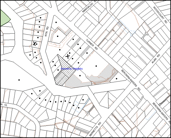
|
NOTIFICATION PLAN |
|
||
|
• PROPERTIES NOTIFIED
|
X SUBMISSIONS RECEIVED |
PROPERTY SUBJECT OF DEVELOPMENT |
|
|
1 submission received out of map range and 1 submission without property address |
|||
Four submissions object to the development, generally on the grounds that:
· The proposal is an overdevelopment for the site;
· The proposed development does not incorporate the pedestrian link in accordance with the Masterplan;
· The proposal does not comply with the element “density” of the Medium Density DCP;
· The upper floors of the front row of townhouses encroach within the 6m setback;
· The eastern boundary has a nil setback, therefore motion-sensor lighting cannot be installed in this section to prevent crime;
· TH13 and TH14 do not include sufficient private open space area and do not comply with the car parking requirements of the Medium Density DCP;
· No disabled visitor car parking space is provided for the development;
· The site area includes the right-of-way which should be excluded;
· The site does not have 40m frontage to Kita Road;
· The development would result in additional traffic in the locality and cause parking problems on Kita Road; and
· Kita Road would be unsafe due to traffic congestion.
Additionally one submission makes the following comments:
· A roundabout should be constructed at the corner of Kita Road, Turner Road and Cambewarra Crescent to control the additional traffic generated due to this development;
· No Parking signs should be posted on the eastern side of Kita Road; and
· Council should impose a condition of consent requiring that the applicant pay for a new boundary fence at the applicant’s cost.
One submission raises concerns that the residents were not appropriately notified of the development.
The merits of the matters raised in community submissions have been addressed in the body of the report with the exception of the following:
5.1.1. Site area calculations
The HSLEP does not require exclusion of rights-of-ways in calculating site area for properties within the Residential B zone. The site area for No. 6 Kita Road has not been included in the calculation for floor space ratio or site coverage for the development.
5.1.2 Notification
The application has been notified to the adjoining owners and in the local newspaper in accordance with Council’s Notification and Exhibition Development Control Plan. A yellow notice has also been erected on the fence. Council wrote to the objector requesting details of addresses of persons who they wished to be notified of the application. No reply has been received to date.
5.1.3 Disabled visitors space
Council’s Medium Density Multi-unit Housing DCP does not have a requirement for provision of a disabled visitor’s space. Likewise, there is no requirement under the Building Code of Australia or the Disability Discrimination Act for the provision of disabled visitors’ spaces for residential development.
5.2 Public Agencies
The development application is Integrated Development under the Act. Accordingly, the application was referred to the following Agency for comment:
5.2.1. Rural Fire Service
The matter has been discussed in Section 4.1 of this report.
6. THE PUBLIC INTEREST
Section 79C(1)(e) of the Act requires Council to consider “the public interest”.
The public interest is an overarching requirement, which includes the consideration of the matters discussed in this report. Implicit to the public interest is the achievement of future built outcomes adequately responding to and respecting the future desired outcomes expressed in environmental planning instruments and development control plans.
The application is considered to have satisfactorily addressed Council’s and relevant agencies’ criteria and would provide a development outcome that, on balance, would result in a positive impact for the community. Accordingly, it is considered that the approval of the proposed townhouse development would be in the public interest.
CONCLUSION
The proposal seeks approval for the erection of a medium density multi-unit housing development comprising fourteen, two-storey townhouses, car parking and strata subdivision on the subject property. It would incorporate a common driveway off Kita Road, part of which would be located on the adjoining western allotment.
The proposed development is to be located within a precinct subject to the Turner Road Commercial Centre Masterplan within Council’s Medium Density Multi-unit Housing Development Control Plan. The development does not comply with a number of aspects of the Masterplan such as the site layout, access to communal open space, pedestrian linkage to Turner Road through the site and provision of basement car parking. The applicant has demonstrated that the above aspects of the Masterplan cannot be complied with due to previous approvals given by Council and the Land and Environment Court on adjoining sites within the precinct. The proposal would result in a development which complies with the overall desired future character envisaged in the Masterplan and is within the environmental capacity of the site.
The proposal is generally consistent with Sydney Regional Environmental Plan No. 20, Hornsby Local Environmental Plan 1994, Council’s Medium Density Multi-unit Housing, Car Parking, Sustainable Water and Access and Mobility Development Control Plans.
Approval of the application is recommended.
Note: At the time of the completion of this planning report, no persons have made a Political Donations Disclosure Statement pursuant to Section 147 of the Environmental Planning and Assessment Act 1979 in respect of the subject planning application.
|
James Farrington Group Manager Planning Division |
|
|
1.View |
Locality Plan |
|
|
|
2.View |
Floor Plans |
|
|
|
3.View |
Elevations and Sections |
|
|
|
4.View |
Tree Location Plan |
|
|
|
5.View |
Site Analysis Plan showing location of approved pathway |
|
|
|
6.View |
Shadow Plans |
|
|
|
7.View |
Photomontage |
|
|
File Reference: DA/599/2012
Document Number: D02001208
SCHEDULE 1
GENERAL CONDITIONS
The conditions of consent within this notice of determination have been applied to ensure that the use of the land and/or building is carried out in such a manner that is consistent with the aims and objectives of the relevant legislation, planning instruments and Council policies affecting the land and does not disrupt the amenity of the neighbourhood or impact upon the environment.
Note: For the purpose of this consent, the term ‘applicant’ means any person who has the authority to act on or the benefit of the development consent.
Note: For the purpose of this consent, any reference to an Act, Regulation, Australian Standard or publication by a public authority shall be taken to mean the gazetted Act or Regulation, or adopted Australian Standard or publication as in force on the date that the application for a construction certificate is made.
1. Approved Plans and Supporting Documentation
The development must be carried out in accordance with the plans and documentation listed below and endorsed with Council’s stamp, except where amended by Council and/or other conditions of this consent:
|
Plan No. |
Rev |
Drawn by |
Dated |
|
Survey Plan 07-67 |
- |
Base Surveying |
24/08/2007 |
|
Ground floor and Level 1 plan – DA01 |
B |
Jack Taylor Architects Pty Ltd |
27/07/2012 |
|
Level 2 and Roof Plan – DA02 |
A |
Jack Taylor Architects Pty Ltd |
30/03/2012 |
|
Elevations 01 – DA03 |
B |
Jack Taylor Architects Pty Ltd |
27/07/2012 |
|
Elevations 02 _ DA04 |
B |
Jack Taylor Architects Pty Ltd |
27/07/2012 |
|
Sections – DA05 |
B |
Jack Taylor Architects Pty Ltd |
27/07/2012 |
|
Drainage Concept Plan 333511-1 |
A |
Taylor Consulting Civil and Structural Engineers |
14/08/2012 |
|
Stormwater Drainage Details 33511-2 |
- |
Taylor Consulting Civil and Structural Engineers |
2/12/2011 |
|
Soil, Erosion and Sediment Control Plan 33511-3 |
A |
Taylor Consulting Civil and Structural Engineers |
14/08/2012 |
|
Tree Location Plan T-01 |
D |
Arboreport |
13/08/2012 |
|
Draft Strata – Location Plan Sheet 1 of 4 |
- |
- |
Received by Council on 20/06/2012 |
|
Draft Strata – Ground Floor Plan Sheet 2 of 4 |
- |
- |
Received by Council on 20/06/2012 |
|
Draft Strata – Level 1 Floor Plan Sheet 3 of 4 |
- |
- |
Received by Council on 20/06/2012 |
|
Draft Strata – Level 2 Sheet 4 of 4 |
- |
- |
Received by Council on 20/06/2012 |
|
Landscape Plan L-01 |
E |
Eco Design |
5/04/2012 |
|
Landscape Plan L-02 |
E |
Eco Design |
5/04/2012 |
|
Hardworks Pan L-03 |
E |
Eco Design |
5/04/2012 |
|
Hardworks Pan L-04 |
E |
Eco Design |
5/04/2012 |
|
Document No. |
Prepared by |
Dated |
|
Solar Access Study ad shadow diagrams |
SLR Global Environmental Solutions |
30/03/2012 |
|
Site analysis plan showing location of pathway through Council’s reserve DA00A |
Jack Taylor Architects Pty Ltd |
30/03/2012 |
|
BASIX Certificate 404073M |
SLR Consulting Pty Ltd |
19/12/2011 |
|
Site Investigation Report |
SMEC Testing Services Pty Ltd |
17/11/2010 |
|
Thermal Comfort Assessment |
SLR Global Environmental Solutions |
19/12/2011 |
|
Building Code of Australia Report |
McKenzie Group Consulting |
4/04/2012 |
|
Photomontage |
- |
Received by Council on 20/06/2012 |
|
Arboricultural Impact Assessment |
Arboreport |
15/12/2011 |
|
Statement of Environmental Effects |
Kita Developments Pty Ltd |
April 2012 |
|
Bushfire Hazard Assessment Report |
Building Code and Bushfire Hazard Solutions Pty Ltd |
3/04/2012 |
|
Environmental Noise Assessment |
Acoustic Logic |
5/12/2011 |
|
Addendum to Acoustic Report |
Acoustic Logic |
07/08/2012 |
|
Access Report |
Mark Relf |
7/12/2011 |
|
Assessment of Traffic and Parking Implications |
Transport and Traffic Planning Associates |
December 2011 |
2. Removal of Existing Trees
This development consent only permits the removal of tree(s) numbered 1, 2, 3, 4, 5, 6, 8, 9, 10, 11, 14, 14a, 16, 17, 18 , 19, 20 & 21 as identified on the Tree Location Plan No. T-01 Rev D prepared by Arboreport dated 13/08/2012. The removal of any other trees requires separate approval under Council’s Tree Preservation Order.
3. Amendment of Plans
The approved Landscape Plans, L-01, L-02, L-03 and L-04 Rev E prepared by Eco Design dated 5/04/2012 is to be amended in the following ways:
a. Incorporate the layout of the approved Ground Floor and Level 1 Plan - DA01B prepared by Jack Taylor Architects Pty Ltd dated 27/07/2012.
b. Include six locally indigenous trees consistent with species that form part of the nearby mapped Narrow-leaved Scribbly Gum Woodland vegetation;
Note: Replacement trees must be selected from Council’s booklet ‘Indigenous Plants for the Bushland Shire’ (www.hornsby.nsw.gov.au/environment) and would comprise specimens such as Eucalyptus racemosa (Narrow-leaved Scribbly Gum), Eucalyptus piperita (Sydney Peppermint), Angophora costata (Smooth-barked Apple) or Corymbia eximia (Yellow Bloodwood).
REQUIREMENTS PRIOR TO THE ISSUE OF A CONSTRUCTION CERTIFICATE
4. Building Code of Australia
All building work must be carried out in accordance with the requirements of the Building Code of Australia.
5. Fire Safety
To ensure the protection of persons using the townhouses and to facilitate egress from the all townhouses in the event of a fire, the application for a construction certificate must demonstrate that the plans comply with the recommendations of the submitted Building Code of Australia Report prepared by McKenzie Consulting dated 4/04/2012 and Condition 4 of this development consent.
6. Contract of Insurance (Residential Building Work)
In the case of residential building work for which the Home Building Act, 1989 requires there to be a contract of insurance in force in accordance with Part 6 of that Act, that such a contract of insurance is in force before any building work authorised to be carried out by the consent commences.
Note: This condition does not apply to the extent to which an exemption is in force under Clause 187 or 188 of the Act, subject to the terms of any condition or requirement referred to in Clause 187(6) or 188(4) of the Act, or to the erection of a temporary building.
7. Notification of Home Building Act, 1989 Requirements
Residential building work within the meaning of the Home Building Act, 1989 must not be carried out unless the principal certifying authority for the development to which the work relates (not being Council) has given Council written notice of the following information:
a. In the case of work for which a principal contractor is required to be appointed:
i. The name and licence number of the principal contractor.
ii. The name of the insurer by which the work is insured under Part 6 of that Act.
b. In the case of work to be done by an owner-builder:
i. The name of the owner-builder.
ii. If the owner-builder is required to hold an owner-builder’s permit under that Act, the number of the owner-builder’s permit.
Note: If arrangements for doing the residential building work are changed while the work is in progress so that the information notified becomes out of date, further work must not be carried out unless the principal certifying authority for the development to which the work relates (not being Council) has given Council written notification of the updated information.
8. Water/Electricity Utility Services
The applicant must submit written evidence of the following service provider requirements:
a. Energy Australia – a letter of consent demonstrating that satisfactory arrangements have been made to service the proposed development.
b. Sydney Water – the submission of a ‘Notice of Requirements’ under s73 of the Sydney Water Act 1994.
Note: Sydney Water requires that s73 applications are to be made through an authorised Sydney Water Servicing Coordinator. Refer to www.sydneywater.com.au or telephone 13 20 92 for assistance.
9. Traffic Management Plan
A Traffic management Plan for the construction phase of the development must be prepared and submitted for approval by the Principle Certifying Authority.
10. Car Parking
All car parking must be designed, constructed and operated in accordance with Australian Standard AS 2890.1 – 2004 – Off Street Car Parking and the following requirements:
a. All parking areas and driveways are to be sealed to an all weather standard, line marked and signposted.
b. Car parking and manoeuvring areas to be used solely for nominated purposes.
c. All vehicular entry on to the site and egress from the site shall be made in a forward direction.
d. Adaptable parking spaces are to be provided and designed in accordance with AS/NZS 2890.6:2009 Parking facilities Part 6: Off-street parking for people with disabilities.
11. Acoustic Details
The Construction certificate plans must demonstrate compliance with the recommendations of the “Environmental Noise Assessment Report” prepared by Acoustic Logic dated 5/12/2011 including the following requirements:
a. The bedroom and living room windows of all townhouses must have 4 mm thickness glass as detailed in Section 4.4.1 of the report.
b. Roof insulation as per Section 4.4.3 of the report.
c. All mechanical plants must be acoustically treated by including screens/enclosures/ silencers and internal lining.
d. A 1.8m high lapped and capped fence along the eastern boundary to attenuate noise from the shopping centre car park as marked in red on the approved Ground Floor and Level 1 Plan - DA01B prepared by Jack Taylor Architects Pty Ltd dated 27/07/2012.
12. Preservation of Survey Marks
A registered surveyor must identify all survey marks in the vicinity of the proposed development. Any survey marks required to be removed or displaced as a result of the proposed development shall be undertaken by a registered surveyor in accordance with Section 24 (1) of the Surveying and Spatial Information Act 2002 and following the Surveyor General’s Directions No.11 – "Preservation of Survey Infrastructure".
13. Waste Management Plan
A Waste Management Plan for the Demolition Stage, Design Stage, Construction Stage and Use and On-going Management, as applicable, is required to be submitted in accordance with the Waste Minimisation and Management Development Control Plan.
REQUIREMENTS PRIOR TO THE COMMENCEMENT OF ANY WORKS
14. Project Arborist
A Project Arborist is to be appointed in accordance with AS 4970-2009 (1.4.4) to provide monitoring and certification throughout the development process.
15. Erection of Construction Sign
A sign must be erected in a prominent position on any site on which building work, subdivision work or demolition work is being carried out:
a. Showing the name, address and telephone number of the principal certifying authority for the work,
b. Showing the name of the principal contractor (if any) for any demolition or building work and a telephone number on which that person may be contacted outside working hours, and
c. Stating that unauthorised entry to the work site is prohibited.
Note: Any such sign is to be maintained while the building work, subdivision work or demolition work is being carried out, but must be removed when the work has been completed.
16. Protection of Adjoining Areas
A temporary hoarding, fence or awning must be erected between the work site and adjoining lands before the works begin and must be kept in place until after the completion of the works if the works:
a. Could cause a danger, obstruction or inconvenience to pedestrian or vehicular traffic.
b. Could cause damage to adjoining lands by falling objects.
c. Involve the enclosure of a public place or part of a public place.
Note: Notwithstanding the above, Council’s separate written approval is required prior to the erection of any structure or other obstruction on public land.
17. Toilet Facilities
Toilet facilities must be available or provided at the works site before works begin and must be maintained until the works are completed at a ratio of one toilet for every 20 persons employed at the site. Each toilet must:
a. be a standard flushing toilet connected to a public sewer; or
b. be a temporary chemical closet approved under the Local Government Act, 1993; or
c. have an on-site effluent disposal system approved under the Local Government Act, 1993
18. Erosion and Sediment Control
Erosion and sediment control measures must be provided and maintained throughout the construction period in accordance with the manual ‘Soils and Construction 2004 (Bluebook)’, the approved plans, Council specifications and to the satisfaction of the principal certifying authority. The erosion and sediment control devices must remain in place until the site has been stabilised and revegetated.
Note: On the spot penalties up to $1,500 may be issued for any non-compliance with this requirement without any further notification or warning.
19. Tree Protection Barriers
Tree Protection Zones (TPZ) of trees numbered 15, 13, 12 & 7 shall be fenced in accordance with the Tree Location Plan No. T-01 Rev D prepared by Arboreport dated 13/08/2012 and must be constructed of 1.8 metre ‘cyclone chainmesh fence’
A certificate from the project Arborist (AQF 5) is to be submitted to the Principal Certifying Authority stating that all tree protection measures are in accordance with the above table and AS 4970-2009 (Section 4) prior to commencement of works.
REQUIREMENTS DURING CONSTRUCTION
20. Construction Work Hours
All work on site (including demolition and earth works) must only occur between 7am and 5pm Monday to Saturday.
No work is to be undertaken on Sundays or public holidays.
21. Demolition
All demolition work must be carried out in accordance with Australian Standard 2601-2001 – The Demolition of Structures and the following requirements:
a. Demolition material is to be disposed of to an authorised recycling and/or waste disposal site and/or in accordance with an approved waste management plan.
b. Demolition works, where asbestos material is being removed, must be undertaken by a contractor that holds an appropriate licence issued by WorkCover NSW in accordance with Chapter 10 of the Occupational Health and Safety Regulation 2001 and Clause 29 of the Protection of the Environment Operations (Waste) Regulation 2005.
c. On construction sites where buildings contain asbestos material, a standard commercially manufactured sign containing the words ‘DANGER ASBESTOS REMOVAL IN PROGRESS’ measuring not less than 400mm x 300mm must be erected in a prominent position visible from the street.
22. Environmental Management
The site must be managed in accordance with the publication ‘Managing Urban Stormwater – Landcom (March 2004) and the Protection of the Environment Operations Act 1997 by way of implementing appropriate measures to prevent sediment run-off, excessive dust, noise or odour emanating from the site during the construction of the development.
23. Street Sweeping
Street sweeping must be undertaken following sediment tracking from the site along Turner Road and Kita Road during works and until the site is established.
24. Works near Trees
All required tree protection measures are to be maintained in accordance with AS 4373-2009 (Section.4) for the duration of the construction period.
All works within the Tree Protection Zones (TPZ) of trees T7, T12 & T13 must be carried out in accordance with the following requirements:
· Works must be carried out under the supervision of the Project Arborist.
· The work area within a TPZ must NOT exceed 20% of the TPZ, and an area equivalent to the encroachment area must be compensated for elsewhere and be contiguous with the TPZ for the duration of the construction period.
· The applicant is to ensure that no excavation, including sub-surface trenching for stormwater or other services, filling or stockpiling of building materials, parking of vehicles or plant, disposal of cement slurry, waste water or other contaminants is to occur within the nominated Tree Protection Zone of any tree to be retained.
Note: Except as provided above, the applicant is to ensure that no excavation, filling or stockpiling of building materials, parking of vehicles or plant, disposal of cement slurry, waste water or other contaminants is to occur within 4 metres of any tree to be retained.
25. Council Property
During construction works, no building materials, waste, machinery or related matter is to be stored on the road or footpath. The public reserve is to be kept in a clean, tidy and safe condition at all times.
26. Landfill
Landfill must be constructed in accordance with Council’s ‘Construction Specification, 2005’ and the following requirements:
a. All fill material imported to the site is to wholly consist of Virgin Excavated Natural Material (VENM) as defined in Schedule 1 of the Protection of the Environment Operations Act 1997 or a material approved under the Department of Environment and Climate Change’s general resource recovery exemption.
27. Excavated Material
All excavated material removed from the site must be classified in accordance with the NSW Environment Protection Authority’s Environmental Guidelines – Assessment, Classification and Management of Liquid and Non-Liquid Wastes prior to disposal to an approved waste management facility and reported to the principal certifying authority.
28. Soil Contamination
Should the presence of asbestos or soil contamination, not recognised during the application process be identified during demolition, the applicant must immediately notify the principal certifying authority and Council.
29. Waste Management
Waste management during the demolition and construction phase of the development must be undertaken in accordance with the approved Waste Management Plan as per condition 18 of this development consent. Additionally written record of the following items must be maintained during the removal of any waste from the site
a. The identity of the person removing the waste.
b. The waste carrier vehicle registration.
c. A description of the waste (type of waste and estimated quantity).
d. The site to which the waste is to be taken.
e. The corresponding tip docket/receipt from the site to which the waste is transferred.
f. Whether the waste is expected to be reused, recycled or go to landfill.
Note: In accordance with the Protection of the Environment Operations Act 1997, the definition of waste includes any unwanted substance, regardless of whether it is reused, recycled or disposed to landfill.
REQUIREMENTS PRIOR TO THE ISSUE OF AN OCCUPATION CERTIFICATE
Note: For the purpose of this consent, a reference to ‘occupation certificate’ shall not be taken to mean an ‘interim occupation certificate’ unless otherwise stated.
30. Fulfilment of BASIX Commitments
The applicant must demonstrate the fulfilment of BASIX commitments pertaining to the development.
31. Sydney Water – s73 Certificate
A s73 Certificate must be obtained from Sydney Water.
32. Stormwater Drainage
The stormwater drainage system for the development must be designed and constructed in accordance with Council’s Civil Works – Design and Construction Specification 2005:
a. Details be provided with the Construction Certificate Plans.
b. Connected directly to Council’s street drainage system.
c. The Council drainage system is to be piped in Kita Road with a 375mm RCP generally in accordance with Concept Drainage Plans prepared by Taylor Consulting Drawing No 33511-1/A. No works are to commence within the road reserve of Kita Road until such time as an approval under the Roads Act has been obtained from Hornsby Shire Council.
d. The pipeline is to be located under the existing kerb and the kerb and gutter are to be reconstructed.
e. A new kerb inlet pit is to be constructed in Kita Road.
33. On Site Stormwater Detention
An on-site stormwater detention system must be designed by a chartered civil engineer and constructed in accordance with Council’s Civil Works – Design and Construction Specification 2005 and the following requirements:
a. Details of all works be provided with the Construction Certificate Plans.
b. Have a capacity of not less than 47.5 cubic metres, and a maximum site discharge of 63 litres per second.
c. Have a surcharge/inspection grate located directly above the outlet.
d. Discharge from the detention system to be controlled via 1 metre length of pipe, not less than 50 mm diameter or via a stainless plate with sharply drilled orifice bolted over the face of the outlet discharging into a larger diameter pipe capable of carrying the design flow to an approved Council system.
e. Not be constructed in a location that would impact upon the visual or recreational amenity of residents.
34. Internal Driveway/Vehicular Areas
The driveway, turning bays and parking areas on site must be designed and constructed in accordance with Australian Standards 2890.1, 2890.2, 3727, Councils Civil Works Specification and the following requirements:
a. Details of works to be provided with the Construction Certificate Plans.
b. Design levels at the front boundary be obtained from Council;
c. The driveway and turning bays be a rigid pavement with a minimum thickness of 150mm and reinforced with F72;
35. Footpath
A concrete footpath must be constructed along the full frontage of the subject site in accordance Council’s Civil Works Design and Construction Specification, 2005 and the following requirements:
a. The existing footpath being removed.
b. The land adjoining the footpath to be fully turfed.
c. Any public utility adjustments to be carried out at the cost of the applicant and to the requirements of the relevant public authority.
Note: A separate construction certificate is required to be issued for these works. Prior to the issue of a construction certificate for these works a separate application under the Local Government Act, 1993 and the Roads Act, 1993 must be submitted to Council for the construction of footpaths within the road reserve.
36. Vehicular Crossing
A separate application under the Local Government Act, 1993 and the Roads Act, 1993 must be submitted to Council for the installation of a new vehicular crossing and the removal of the redundant crossing. The vehicular crossing must be constructed in accordance with Council’s Civil Works Design, 2005 and the following requirements:
a. Details of works be provided in the Construction Certificate Plans.
b. Any redundant crossings to be replaced with integral kerb and gutter.
c. The footway area to be restored by turfing.
Note: An application for a vehicular crossing can only be made to one of Council’s Authorised Vehicular Crossing Contractors. Applicants are advised to contact Council on 02 9847 6940 to obtain a list of contractors.
37. Road Works
All road works approved under this consent must be constructed in accordance with Council’s Civil Works Design and Construction Specification, 2005 and the following requirements:
a. Kerb and gutter is to be constructed across the frontage of the site in Kita Rd. All existing kerb and gutter is to be removed.
b. The existing road pavement to be saw cut a minimum of 300 mm from the existing edge of the bitumen and reconstructed.
Note: A construction certificate is required to be issued for these works. Prior to the issue of the Construction Certificate, a separate application under the Local Government Act, 1993 and the Roads Act, 1993 must be submitted to Council for all works within the road reserve.
38. Traffic Control Plan
A Traffic Control Plan (TCP) must be prepared by a qualified traffic controller in accordance with the Roads & Traffic Authority’s Traffic Control at Worksites Manual 1998 and Australian Standard 1742.3 for all work on a public road and be submitted to Council. The TCP must detail the following:
a. Arrangements for public notification of the works.
b. Temporary construction signage.
c. Permanent post-construction signage.
d. Vehicle movement plans.
e. Traffic management plans.
f. Pedestrian and cyclist access/safety.
39. Damage to Council Assets
Any damage caused to Council’s assets as a result of the construction of the development must be rectified in accordance with Council’s written requirements and at the sole cost of the applicant.
40. Creation of Easements
The following matters must be nominated on the plan of subdivision under s88B of the Conveyancing Act 1919:
a. A Right of Access and easement for services over the access corridor located within lots 3 and 4 DP 232401.
b. The creation of an appropriate "Positive Covenant" and "Restriction as to User" over the constructed on-site detention/retention systems and outlet works, within the property in favour of Council in accordance with Council’s prescribed wording. The position of the on-site detention system is to be clearly indicated on the title.
c. To register the OSD easement, the restriction on the use of land “works-as-executed” details of the on-site-detention system must be submitted verifying that the required storage and discharge rates have been constructed in accordance with the design requirements. The details must show the invert levels of the on site system together with pipe sizes and grades. Any variations to the approved plans must be shown in red on the “works-as-executed” plan and supported by calculations.
Note: Council must be nominated as the authority to release, vary or modify any easement, restriction or covenant.
41. Construction of the pathway
The construction of the 1.2m wide pathway through Crossroads Reserve approved under DA/1615/2010 (Condition 33f) must be completed and ready for use.
42. Completion of Landscaping
a. A certificate must be provided by a practicing landscape architect, horticulturalist or person with similar qualifications and experience certifying that all required landscaping works have been satisfactorily completed in accordance with the approved landscape plans as amended by Condition 3 of this development consent.
b. Following the final inspection and the completion of any remedial works, the project arborist must submit documentation stating that the completed works have been carried out in compliance with the approved plans and specifications for tree protection as specified in this development consent and AS 4970-2009.
Note 1: The project arborist must assess the condition of trees and their growing environment and make recommendations for, and if necessary carry out remedial actions.
Note 2: Advice on suitable species for landscaping can be obtained from Council’s planting guide ‘Indigenous Plants for the Bushland Shire’, available at www.hornsby.nsw.gov.au.
43. External Lighting
All external lighting must be designed and installed in accordance with Australian Standard AS 4282 – Control of the Obtrusive Effects of Outdoor Lighting. Certification of compliance with the Standard must be obtained from a suitably qualified person.
44. Works as Executed Plan
A works-as-executed plan must be prepared by a registered surveyor and submitted to Council for completed road pavement, kerb & gutter, public drainage systems, driveways and on-site detention system. The plan must be accompanied by a certificate from a registered surveyor certifying that all pipelines and associated structures lie wholly within any relevant easements.
45. Construction for a Safe Environment
The site must include the following elements in accordance with the recommendations of the Crime Risk Assessment Report submitted with this development application:
a. An intercom system be installed at gate locations to ensure screening of persons entering dwellings.
b. The entryway to the site be illuminated in high luminance at all times.
c. The Kita Road footpath be illuminated with high luminance by motion sensor lighting.
d. Front and rear yard spaces of each dwelling be illuminated with high luminance by motion sensor lighting.
e. The north-eastern corner of the site adjacent to the shopping complex building be illuminated in high luminance by motion-sensor lighting.
f. The common driveways and common landscaped areas are to be illuminated with low luminance at all times.
g. Anti-graffiti paint be used for the walls adjacent to Kita Road.
h. Vandal proof locking mechanisms to be installed in all gates to individual townhouses.
i. Robust materials which cannot be forced or breached with minimised maintenance requirements are to be used for construction work in the common areas.
46. Installation of Air Conditioner
To protect the amenity of adjacent properties, the condenser unit for the air conditioner must be sited a minimum of 3 metres from the property boundary of any adjoining residential premises unless a certificate has been prepared by a suitably qualified person confirming that the unit has been tested for heating and cooling on the highest settings and that the noise levels generated do not exceed 5 dB(A) above background noise levels when tested at the property boundary between 8 pm and 10 pm.
47. Boundary Fencing
Fencing
must be erected along all property boundaries in accordance with the approved
plans and as required by Condition 11d of this development consent.
Note: Alternative fencing may be erected subject to the written consent of the adjoining property owners
48. Consolidation of Allotments
The allotments at Nos. 2-4 Kita Road and No. 148 Berowra Waters Road are to be consolidated.
49. Waste Management Details
The following waste management requirements must be complied with:
a. The bin storage rooms must include water or a hose for cleaning, graded floors with drainage to sewer, a robust door, sealed and impervious surface, adequate lighting and ventilation.
b. An area of 10 sqm metres, located outside the verge and within 6 metres of the entrance to the site must be allocated for storing bulky items for the clean-up service.
Note: The above area is not required to be concreted, paved or covered. Bulky items must not be placed on the verge as this causes illegal storage problems.
c. A report must be prepared by an appropriately qualified person, certifying that at least 60% of the waste generated during the demolition and construction phase of the development was reused or recycled.
Note: If the 60% diversion from landfill cannot be achieved in the Construction Stage, the Report is to include the reasons why this occurred and certify that appropriate work practices were employed to implement the approved Waste Management Plan. The Report must be based on documentary evidence such as tipping dockets/receipts from recycling depots, transfer stations and landfills, audits of procedures etc. which are to be attached to the report.
d. Each dwelling must be provided with an indoor waste/recycling cupboard for the interim storage of a minimum one day’s waste generation with separate containers for general waste and recyclable materials.
e. Space must be provided for either individual compost containers for each dwelling or a communal compost container;
Note: The location of the compost containers should have regard for potential amenity impacts.
f. The bin carting route must be devoid of any steps.
Note: Ramps between different levels are acceptable
50. s94 Infrastructure Contributions
The payment to Council of a contribution of $140,494.25 for eleven additional three-bedroom and two bedroom townhouses towards the cost of infrastructure identified in Council’s Development Contributions Plan 2007-2011.
Note: The value of contribution is current as at 1 September 2012. The contribution will be adjusted from this date in accordance with the underlying consumer price index for subsequent financial quarters.
It is recommended that you contact Council to ascertain the indexed value of the contribution prior to payment.
51. No Parking Signs
“No Parking” signs are to be installed in the bulb of the Cul-de-sac of Kita Road at no cost to Council.
Note: The placement of the restrictions is subject to approval by the Hornsby Local Traffic Committee.
52. Adaptable Units
TH 13 and TH 14, as identified in the approved plans, must comply with the Australian dwelling houses.
OPERATIONAL CONDITIONS
53. On-going waste management
A site manager or caretaker must be employed and be responsible for moving bins from the bin storage area to the waste collection point, washing bins and maintaining storage areas, managing the communal composting area, arranging the prompt removal of dumped rubbish, and ensuring all residents are informed of the waste management system.
54. Maintenance of Wastewater Device
All wastewater and stormwater treatment devices (including drainage systems, sumps and traps) must be regularly maintained in order to remain effective. All solid and liquid wastes collected from the device must be disposed of in accordance with the Protection of the Environment Operations Act 1997.
55. Fire Safety Statement - Annual
On at least one occasion in every 12 month period following the date of the first ‘Fire Safety Certificate’ issued for the property, the owner must provide Council with an annual ‘Fire Safety Certificate’ to each essential service installed in the building.
56. Landscape Establishment
The landscape works must be maintained to ensure the establishment and successful growth of plant material including (but not be limited to) watering, weeding, replacement of failed plant material and promoting the growth of plants through standard industry practices.
GENERAL TERMS OF APPROVAL – NSW RURAL FIRE SERVICE
The following conditions of consent are General Terms of Approval from the nominated State Agency pursuant to Section 91A of the Environmental Planning and Assessment Act 1979 and must be complied with to the satisfaction of that Agency.
57. Asset Protection Zone
Prior to the issue of the Occupation Certificate, the following matter must be nominated on the property title under s88B of the Conveyancing Act 1919:
The creation of a “Positive Covenant” requiring that the entire property be managed as an Inner Protection Area (IPA) as outlined within Section 4.1.3 and Appendix 5 of Planning for Bushfire Protection 2006 and the NSW Rural Fire Service’s document ‘Standards for asset protection zones’.
Note 1: The intent of this measure is to provide sufficient space and maintain reduced fuel load so as to ensure the radiant heat levels of the buildings are below the critical limits and to prevent direct flame contact with the building.
Note 2: This condition does not provide permission to remove trees on the site unless permitted under other conditions of this development consent.
58. Design and Construction
a. Townhouse 1 - 6 must comply with Australian Standard AS3959-2009 'Construction of buildings in bush fire-prone areas' section 5 (BAL 12.5) and section A3.7 of Addendum Appendix 3 of ‘Planning for Bush Fire Protection 2006’.
b. Townhouse 7 on the southwest and northwest elevations must comply with Australian Standard AS3959-2009 'Construction of buildings in bush fire-prone areas' section 6 (BAL 19) and section A3.7 of Addendum Appendix 3 of ‘Planning for Bush Fire Protection 2006’.
c. Townhouse 7 on the northeast elevation must comply with Australian Standard AS3959-2009 'Construction of buildings in bush fire-prone areas' section 5 (BAL 12.5) and section A3.7 of Addendum Appendix 3 of ‘Planning for Bush Fire Protection 2006’.
d. Townhouse 8 on the southwest elevation shall comply with Australian Standard AS3959-2009 'Construction of buildings in bush fire-prone areas' section 6 (BAL 19) and section A3.7 of Addendum Appendix 3 of ‘Planning for Bush Fire Protection 2006’.
e. Townhouse 8 on the northeast elevations must comply with Australian Standard AS3959-2009 'Construction of buildings in bush fire-prone areas' section 5 (BAL 12.5) and section A3.7 of Addendum Appendix 3 of ‘Planning for Bush Fire Protection 2006’.
f. Townhouse 9 and 10 must comply with Australian Standard AS3959-2009 'Construction of buildings in bush fire-prone areas' section 5 (BAL 12.5) and section A3.7 of Addendum Appendix 3 of ‘Planning for Bush Fire Protection 2006’.
g. Townhouse 11 on the southwest and northwest elevations must comply with section 7 (BAL 29) Australian Standard AS3959-2009 'Construction of buildings in bush fire-prone areas'.
h. Townhouse 11 on the northeast elevation must comply with Australian Standard AS3959-2009 'Construction of buildings in bush fire-prone areas' section 6 (BAL 19) and section A3.7 of Addendum Appendix 3 of ‘Planning for Bush Fire Protection 2006’.
i. Townhouse 12 and 13 on the southwest elevations must comply with section 7 (BAL 29) Australian Standard AS3959-2009 'Construction of buildings in bush fire-prone areas'.
j. Townhouse 12 and 13 on the northeast elevations must comply with Australian Standard AS3959-2009 'Construction of buildings in bush fire-prone areas' section 6 (BAL 19) and section A3.7 of Addendum Appendix 3 of ‘Planning for Bush Fire Protection 2006’.
k. Townhouse 14 must comply with Australian Standard AS3959-2009 'Construction of buildings in bush fire-prone areas' section 6 (BAL 19) and section A3.7 of Addendum Appendix 3 of ‘Planning for Bush Fire Protection 2006’.
- END OF CONDITIONS -
ADVISORY NOTES
The following information is provided for your assistance to ensure compliance with the Environmental Planning and Assessment Act, 1979, Environmental Planning and Assessment Regulation 2000, other relevant legislation and Council’s policies and specifications. This information does not form part of the conditions of development consent pursuant to Section 80A of the Act.
Environmental Planning and Assessment Act, 1979 Requirements
· The Environmental Planning and Assessment Act, 1979 requires:
· The issue of a construction certificate prior to the commencement of any works. Enquiries regarding the issue of a construction certificate can be made to Council’s Customer Services Branch on 9847 6760.
· A principal certifying authority to be nominated and Council notified of that appointment prior to the commencement of any works.
· Council to be given at least two days written notice prior to the commencement of any works.
· Mandatory inspections of nominated stages of the construction inspected.
· An occupation certificate to be issued before occupying any building or commencing the use of the land.
Long Service Levy
In accordance with Section 34 of the Building and Construction Industry Long Service Payments Act 1986, a ‘Long Service Levy’ must be paid to the Long Service Payments Corporation or Hornsby Council.
Note: The rate of the Long Service Levy is 0.35% of the total cost of the work.
Note: Hornsby Council requires the payment of the Long Service Levy prior to the issue of a construction certificate.
Tree Preservation Order
To ensure the maintenance and protection of the existing natural environment, it is an offence to ringbark, cut down, top, lop, remove, wilfully injure or destroy a tree outside 3 metres of the approved building envelope without the prior written consent from Council.
Note: A tree is defined as a single or multi-trunked wood perennial plant having a height of not less than three (3) metres, and which develops many branches, usually from a distance of not less than one (1) metre from the ground, but excluding any plant which, in its particular location, is a noxious plant declared as such pursuant to the Noxious Weeds Act 1993. This definition of ‘tree’ includes any and all types of Palm trees.
All distances are determined under British Standard BS 5837: 2005, “Trees in Relation to Construction – Recommendations”.
Fines may be imposed for non-compliance with Council’s Tree Preservation Order.
Disability Discrimination Act
The applicant’s attention is drawn to the existence of the Disability Discrimination Act. A construction certificate is required to be obtained for the proposed building/s, which will provide consideration under the Building Code of Australia, however, the development may not comply with the requirements of the Disability Discrimination Act. This is the sole responsibility of the applicant.
Covenants
The land upon which the subject building is to be constructed may be affected by restrictive covenants. Council issues this approval without enquiry as to whether any restrictive covenant affecting the land would be breached by the construction of the building, the subject of this consent. Applicants must rely on their own enquiries as to whether or not the building breaches any such covenant.
Dial Before you Dig
Prior to commencing any works, the applicant is encouraged to contact Dial Before You Dig on 1100 or www.dialbeforeyoudig.com.au for free information on potential underground pipes and cables within the vicinity of the development site.
House Numbering
House numbering can only be authorised by Council. Before proceeding to number each premise in the development, the allocation of numbers is required to be obtained from Council's Planning Division. The authorised numbers are required to be displayed in a clear manner at or near the main entrance to each premise.
Rain Water Tank
It is recommended that water collected within any rainwater tank as part of the development be limited to non-potable uses. NSW Health recommends that the use of rainwater tanks for drinking purposes not occur where a reticulated potable water supply is available.
Asbestos Warning
Should asbestos or asbestos products be encountered during demolition or construction works you are advised to seek advice and information should be prior to disturbing the material. It is recommended that a contractor holding an asbestos-handling permit (issued by WorkCover NSW)be engaged to manage the proper handling of the material. Further information regarding the safe handling and removal of asbestos can be found at:
Alternatively, telephone the WorkCover Asbestos and Demolition Team on 8260 5885
NSW Rural Fire Service
Any new fencing shall comply with Development Control Services ‘Fast Facts 2/06’ for Fences and Gates in Bush Fire Prone Areas.
Roofing shall be gutterless or guttering and valleys are to be screened to prevent the build up of flammable material. Any materials used shall be non-combustible.
Planning Report No. PL26/12
Planning Division
Date of Meeting: 17/10/2012
16 DEVELOPMENT APPLICATION - SUBDIVISION - ONE ALLOTMENT INTO TWO
25 LYNE ROAD, CHELTENHAM
EXECUTIVE SUMMARY
|
DA No: |
DA/177/2012 |
|
Description: |
Torrens title subdivision of one allotment into two lots |
|
Property: |
Lot 6 DP 26088, No. 25 Lyne Road, Cheltenham |
|
Applicant: |
SDG Land Development Solutions |
|
Owner: |
Mr Kulwant Singh Dhillon & Mrs Sheila Kulwant Dhillon |
|
Estimated Value: |
Nil |
|
Ward: |
C |
· The application proposes the Torrens title subdivision of one allotment into two lots.
· The existing dwelling on proposed Lot 1 would exceed the maximum 0.4:1 floor space ratio development standard of the Hornsby Shire Local Environmental Plan 1994. The applicant has made a submission pursuant to State Environmental Planning Policy No. 1 - Development Standards to vary the standard. The submission is considered well founded and is supported.
· Two submissions have been received in respect of the application.
· It is recommended that the application be approved.
|
THAT Council assume the concurrence of the Director-General of the Department of Planning and Infrastructure pursuant to State Environmental Planning Policy No. 1 and approve Development Application No. 177/2012 for Torrens title subdivision of one lot into two lots at Lot 6 DP 26088, No. 25 Lyne Road, Cheltenham subject to the conditions of consent detailed in Schedule 1 of Group Manager’s Report No. PL26/12. |
BACKGROUND
On 16 June 2008, Council approved Development Application No. 389/2008 for alterations and additions to the existing dwelling-house on the site. The approved works have primarily been completed and result in an approved floor area of 380 square metres.
SITE
The site is a battle-axe allotment, with an area of 1733m2. Access is provided by an access handle located on the south-eastern side of Lyne Road at Cheltenham and experiences an average fall of 10% to its south-western side.
The site is currently occupied by a two storey dwelling-house sitting generally in the middle section of the site.
The site is located within the Beecroft Heritage Conservation Area listed under the provisions of Schedule E (Heritage Conservation Areas) of the Hornsby Shire Local Environmental Plan 1994 (HSLEP). The surrounding development consists of low scale, one or two storey dwelling-houses featuring well-established gardens and landscaped areas. In addition, the site is located in close proximity to a public reserve to the south, which is Council managed.
The site is located within a bushfire prone area.
PROPOSAL
The application proposes the subdivision of one allotment into two allotments and retention of the existing dwelling-house on the site. The proposed lot areas are as follows:
· Lot 1 667m2,
· Lot 2 612m2, and
· Access handle 454m2
Proposed Lot 2 would obtain its access via the prolongation of the existing right of carriageway over the north-western side boundary of Lot 1.
ASSESSMENT
1. STRATEGIC CONTEXT
Section 79C(1)(a) requires Council to consider any relevant environmental planning instruments, draft environmental planning instruments, development control plans, planning agreements and other prescribed matters.
1.1 Metropolitan Plan for Sydney 2036 and (Draft) North Subregional Strategy
The Metropolitan Plan for Sydney 2036 is a broad framework to secure Sydney’s place in the global economy by promoting and managing growth. It outlines a vision for Sydney to 2036; the challenges faced, and the directions to follow to address these challenges and achieve the vision. The Draft North Subregional Strategy acts as a framework for Council in its preparation of the Comprehensive LEP by the end of 2012.
The Draft North Subregional Strategy sets the following targets for the Hornsby LGA by 2031:
· Employment capacity to increase by 9,000 jobs; and
· Housing stock to increase by 11,000 dwellings.
In the preparation of Council’s Housing Strategy, it was acknowledged that there is existing capacity to provide additional dwellings under Council’s existing controls, including through subdivision in low density residential zones. The development application would be consistent with Council’s Housing Strategy by providing additional housing opportunity to assist in achieving the dwelling targets under the Metropolitan Plan.
2. STATUTORY CONTROLS
Section 79C(1)(a) requires Council to consider “any relevant environmental planning instruments, draft environmental planning instruments, development control plans, planning agreements and regulations”.
2.1 Hornsby Shire Local Environmental Plan 1994
The subject land is zoned Residential AS (Low Density - Sensitive Lands) under the HSLEP. The objectives of the Residential AS (Low Density - Sensitive Lands) zone are:
(a) to provide for the housing needs of the population of the Hornsby area.
(b) to promote a variety of housing types and other land uses compatible with a low density residential environment and sensitive to the land capability and established character of this environment.
(c) to provide for development that is within the environmental capacity of a sensitive low density residential environment.
The proposed development is defined as ‘Subdivision’ under the HSLEP and is permissible in the zone with Council’s consent.
Clause 15 of the HSLEP prescribes that the maximum floor space ratio (FSR) of development within the Residential AS Zone is 0.4:1. The proposed development has a FSR of 0.52:1, which is a non-compliance with this standard. To address this matter, the applicant has submitted an objection to the standard under State Environmental Planning Policy No. 1 - Development Standards (SEPP 1). Refer to discussion in Section 2.3.
Clause 18 of the HSLEP sets out heritage conservation provisions for Hornsby Shire. The site is located within the Beecroft-Cheltenham Heritage Conservation Area. However, it does not include a heritage item. There are two heritage items in the vicinity of the site including ‘the Edensor house and garden’ at No. 203 Beecroft Road and ‘the Ashby house’ at No. 94 The Crescent. It is considered that the proposed development would not detract from the heritage significance of these items. Refer to discussion in Section 2.10.
2.2 Draft Comprehensive Hornsby Local Environmental Plan
At its meeting on 7 March 2012, Council resolved to endorse the draft Hornsby Local Environmental Plan (DHLEP) for public exhibition. The draft Plan has subsequently been exhibited and submissions are currently being reviewed. Under the DHLEP, the subject land would be zoned R2 - Low Density Residential. The land use is defined as ‘Subdivision’ and is permissible in the zone with Council’s consent.
2.3 State Environmental Planning Policy No. 1 - Development Standards
The application has been assessed against the requirements of State Environmental Planning Policy No. 1 - Development Standards (SEPP 1). This Policy provides flexibility in the application of development standards in circumstances where strict compliance with those standards would be unreasonable or unnecessary or tend to hinder the attainment of the objectives of the Act.
The Land and Environment Court has expressed the view that there are five Principles on which an objection may be well founded and the approval of the objection may be consistent with the aims of the Policy as follows:
1. The objectives of the standard are achieved notwithstanding non-compliance with the standard;
2. The underlying objective or purpose of the standard is not relevant to the development and therefore compliance is unnecessary;
3. The underlying object of purpose would be defeated or thwarted if compliance was required and therefore compliance is unreasonable;
4. The development standard has been virtually abandoned or destroyed by the Council’s own actions in granting consents departing from the standard and hence compliance with the standard is unnecessary and unreasonable;
5. The zoning of the particular land is unreasonable or inappropriate so that a development standard appropriate for that zoning is also unreasonable and unnecessary, as it applies to the land and compliance with the standard would be unreasonable and unnecessary. That is, the particular parcel of land should not have been included in the particular zone.
In regard to whether the objection may be well founded, the applicant (in summary) submits that the underlying purpose of the floor space ratio standard is achieved because:
· This is an existing dwelling that is undergoing infill additions, which, while increasing the amount of floor space, make no changes to the site coverage. The lot still easily meets HSLEP regulations regarding site coverage (20.4% compared to the maximum allowable 40%).
· The amount of private open space also greatly exceeds Council’s standard.
· As the existing dwelling is located on a battle axe lot well behind the alignment of Lyne Road, no variation to the streetscape will be apparent.
· The proposal is more than compliant with Council’s proposed DCP 2012 which allows a floor area of up to 380m2 for lots between 600m2 and 899m2. There will be no effect on neighbours or the streetscape.
Point 1 above provides grounds for which the SEPP 1 objection may be considered well funded as addressed below.
As set out in the HSLEP, the main objective of the floor space ratio standard is as follows:
“To control the intensity and scale of development so that development will be in accordance with the land’s environmental capacity and zone objectives.”
The retention of the existing dwelling on proposed Lot 1 would not alter the site and the intensity of the development on the lot. The scale of the dwelling-house on proposed Lot 1 in regards to height and visual impact does not adversely impact upon the development in the area. The site is not constrained by land sensitivity factors and is capable of both the land use and the proposed FSR.
In addition, since the preparation of the HSLEP, the State Government has introduced the NSW Housing Code where residents can often build larger dwelling houses than the HSLEP permits as complying development. Although it is acknowledged that the site is located in a Heritage Conservation Area and therefore, the NSW Housing Code does not apply, similar sized allotments within the locality could accommodate a dwelling of 380m2 under the provisions of the NSW Housing Code. The existing dwelling on the site complies with the numerical floor space controls of the NSW Housing Code and would have no impact on the existing character of the area or impacts on neighbouring properties.
Furthermore, as discussed within the Land and Environment Court Planning Principle regarding the relationship of density and residential character in Salanitro-Chafei v Ashfield Council [2005] NSWLEC 36,
“The upper level of density that is compatible with the character of typical single-dwelling areas is around 0.5:1. Higher densities tend to produce urban rather than suburban character. This is not to say that a building with a higher FSR than 0.5:1 is necessarily inappropriate in a suburban area; only that once 0.5:1 is exceeded, it requires high levels of design skill to make a building fit into its surroundings.”
The retention of the existing dwelling-house on proposed Lot 1 achieves an FSR in the order of 0.52:1 which is generally consistent with the Land and Environment Court’s Planning Principles, and is consistent with the zone objectives as it provides for a housing need, is compatible with the low density residential environment and is within the environmental capacity of the area.
In conclusion, strict compliance with the floor space ratio for proposed Lot 1 would not achieve any benefit in respect to the character of the locality. Accordingly, it is unreasonable to insist on compliance with the numerical floor space provision in this instance.
2.4 State Environmental Planning Policy No. 55 - Contaminated Land
Clause 7 of State Environmental Planning Policy No. 55 - Remediation of Land (SEPP 55) requires Council to consider whether land is contaminated prior to granting consent to the carrying out of any development on that land.
Should the land be contaminated Council must be satisfied that the land is suitable in a contaminated state for the proposed use. If the land requires remediation to be undertaken to make the land suitable for the proposed use, Council must be satisfied that the land will be remediated before the land is used for that purpose.
A submission received raises concern that the previous owner of the site indicated that over the 30 years of his ownership of that land, he extracted most of the soil from that area and over time replaced it with a rubbish fill, covered by a thin layer of top soil only.
The site history and site and inspection indicate a history of residential development and it is not likely that the site has experienced any significant contamination. Accordingly, further assessment under SEPP 55 is not required.
2.5 Sydney Regional Environmental Plan (Sydney Harbour Catchment) 2005
The application has been assessed against the requirements of the Policy which includes planning principles applicable to the site within the upper part of the Sydney Harbour catchment. The principles incorporate measures to protect water quality, minimise urban runoff, to conserve water and to ensure the catchment watercourses, wetlands, riparian lands and remnant vegetation are protected.
Subject to the recommended conditions requiring the installation of sediment and erosion control measures, the proposed development would not have a detrimental impact upon the water quality of the catchment.
2.6 Residential Subdivision Development Control Plan
The proposed development has been assessed having regard to the relevant performance and prescriptive design requirements within Council’s Residential Subdivision Development Control Plan (Subdivision DCP). The following table sets out the proposal’s compliance with the prescriptive requirements of the Plan:
|
Residential Subdivision Development Control Plan |
|||
|
Control |
Proposal |
Requirement |
Compliance |
|
Site Area |
1733m2 |
N/A |
N/A |
|
Density |
|||
|
FSR (Lot 1) |
0.52:1 |
0.4:1 |
No |
|
Allotment Size Lot 1 (ex. accessway) Lot 2 Access handle |
667m2 612m2 454m2 |
600m2 600m2 N/A |
Yes Yes N/A |
|
Allotment Layout and Design |
|||
|
Average site gradient Lot 1 Lot 2 |
9% 10% |
20% 20% |
Yes Yes |
|
Lot orientation Lot 1 Lot 2 |
N300E N300E |
N20oW to N300E or E20oN to E30oS |
Yes Yes |
|
Existing Dwelling (Lot 1) |
|||
|
Site cover |
39% |
40% |
Yes |
|
Private open space - Minimum area - Minimum dimension |
322m2 15m |
120m2 5m |
Yes Yes |
|
Setbacks - Side (northwest) - Side (northeast) - Side (southwest) - Rear (southeast) |
4m 6m 21m 1.5-3m |
1m 1m 1m 3m |
Yes Yes Yes No |
|
Landscaping |
62% |
45% |
Yes |
|
Car Parking |
2 Spaces |
2 spaces |
Yes |
|
Building Envelope (Lot 2) |
|||
|
Building Envelope, with a minimum dimension of 10 metres |
200m2
|
200m2
|
Yes
|
|
Site cover |
32% |
40% |
Yes |
|
Private open space - Minimum area - Minimum dimension |
>120m2 8m |
120m2 5m |
Yes Yes |
|
Setbacks - Side (northwest) - Side (northeast) - Side (southwest) - Rear (southeast) |
6m 8.5m 2m 4m |
1m 1m 1m 3m |
Yes Yes Yes Yes |
|
Landscaping (est) |
>45% |
45% |
Yes |
|
Car Parking (est) |
2 Spaces |
2 spaces |
Yes |
As detailed in the above table, the proposed development does not comply with the prescriptive requirements for floor space ratio and rear setback for the existing dwelling as contained within Council’s Subdivision DCP. The matters of non-compliance are detailed below, as well as a brief discussion on compliance with relevant performance requirements.
2.6.1. Density
The proposed allotments comply with the minimum allotment sizes and site coverage and the non-compliance with floor space ratio for proposed Lot 1 is addressed in section 2.3 of this report. Accordingly, the proposed development is considered acceptable with regard to density.
2.6.2. Design
The proposed subdivided allotments would be mostly rectangular in shape. The applicant has demonstrated that the allotments are of sufficient size to accommodate the existing dwelling-house, the proposed building envelope and private open space areas. The proposal is assessed as satisfactory with regard to “Allotment Design” element of the Subdivision DCP.
2.6.3. Setbacks
The proposed allotments comply with Council’s controls with regard to setbacks with the exception of the rear setback requirement of the existing dwelling-house on proposed Lot 1.
The rear setback requirement aims to ensure the minimum dimensions of private open space are achieved, adequate area is provided for landscaping and solar access and privacy is maintained. The majority of the private open space for Lot 1 would be on the south-western side where a large grassed area adjacent to Lyne Road Reserve currently exists. The minor encroachment of the rear setback would not compromise the existing and future opportunity for landscaping, solar access and privacy. The reduced setback for a small portion of the existing dwelling would not have a detrimental impact on the amenity of the existing dwelling-house nor any future dwelling-house on the proposed rear allotment.
Furthermore, the location of any future dwelling-house on the land and the associated setbacks would be assessed under a separate application. Accordingly, the non-compliance with regard to the rear setback is acceptable in this instance.
2.6.4. Solar access
The allotments are east-west orientated. The private open space areas are generally orientated north and would receive sufficient solar access in future. Proposed Lot 2 is elevated above the existing dwelling-house and therefore, the existing dwelling would not have any adverse impact on the adjoining development with regard to overshadowing.
Any impact of overshadowing due to a future dwelling on proposed Lot 2 would be assessed under a separate application.
2.6.5. Private Open Space and Landscaping
Both the allotments comprise sufficient area for use as private open space. The existing dwelling would have satisfactory private open space in the side northern yard. The location of the private open space would not be impacted upon by the adjoining allotment.
The applicant has also demonstrated that suitable private open space areas are provided for Lot 1. The proposed location and suitability of the private open spaces and the landscaped areas are considered satisfactory.
2.6.6. Drainage Control
The application includes an inter-allotment stormwater drainage system to service the proposed lot which is to be connected to Council’s drainage system. The roof and stormwater drainage system from the existing dwelling is to be connected to the proposed inter-allotment drainage system.
Furthermore, a condition is recommended requiring the creation of a “Positive Covenant” over proposed Lot 2 requiring that any future development is to provide an on-site detention system.
2.6.7. Accessway Design
The proposed access and egress from the proposed allotments comply with the requirements of the Subdivision DCP and Council’s engineering assessment of the proposal with regard to vehicular access and parking raises no objection to the proposal.
2.7 Dwelling House Development Control Plan
The existing dwelling-house on proposed Lot 1 has been assessed having regard to the relevant performance and prescriptive design requirements of Council’s Dwelling House Development Control Plan. The proposal does not alter the height or design of the existing dwelling. The compliance of the dwelling-house with the relevant performance criteria such as FSR, site cover, setbacks, private open space, landscaping and car parking are discussed in Section 2.6 of this report.
2.8 Car Parking Development Control Plan
The compliance of the proposal with the relevant requirements of the Car Parking Development Control Plan (Car Parking DCP) has been discussed under section 2.6 of this report.
2.9 Sustainable Water Development Control Plan
Subject to a recommended condition regarding erosion and sediment control measures to be implemented on site during construction works, the proposal would comply with the Sustainable Water Development Control Plan.
2.10 Heritage Development Control Plan
The site is located within the Beecroft Heritage Conservation Area listed under the provisions of Schedule E (Heritage Conservation Areas) of the HSLEP. There are two heritage items located in the vicinity of the site including ‘the Edensor house and garden’ at No. 203 Beecroft Road and ‘the Ashby house’ at No. 94 The Crescent, listed under the provisions of Schedule D of the HSLEP.
It is considered that the proposed development would not detract from the heritage significance of these items due to site separation and that the site is a battle-axe allotment and is not visible from the street. Accordingly, the proposal complies with the elements contained within Council’s Heritage Development Control Plan and is acceptable in this regard.
2.11 Section 94 Contributions Plan
The applicant would be required to make a payment of a contribution for one additional allotment towards the cost of the local infrastructure and Section 94 administration in accordance with Sections 94, 94B and 94C of the Environmental Planning and Assessment Act 1979 and Hornsby Shire Council’s Development Contributions Plan 2004-2011 which would be levied as a condition of consent.
3. ENVIRONMENTAL IMPACTS
Section 79C(1)(b) of the Act requires Council to consider “the likely impacts of that development, including environmental impacts on both the natural and built environments, and social and economic impacts in the locality”.
3.1 Natural Environment
The site comprises a number of exotic, native planted trees and locally indigenous specimens. The proposed development would necessitate the removal of 1 tree from the site for the construction of the driveway. The tree to be removed is not identified as a ‘significant tree’ under Council’s Tree Preservation Policy as it is suffering from dieback of greater than 10%.
Subject to compliance with the recommended conditions in Schedule 1 pertaining to tree protection fencing and the erection of erosion and sediment control measures, the proposed development would not have a detrimental impact on the natural environment.
3.2 Built Environment
The site is located in close proximity to Cheltenham Railway Station and to Beecroft Road.
The proposed development would generate an additional 9 vehicular movements per day in accordance with the Roads and Maritime Service’s Traffic Generating Guidelines in respect to dwelling-houses. Lyne Road and the local road system can accommodate the traffic increase without reducing the level of service.
Council’s engineering assessment of the traffic impacts of the development raises no objection to the proposal and recommends conditions to be imposed in Schedule 1 for the construction of the accessway and turning head to ensure vehicles can enter and egress the site in a forward direction.
3.3 Social Impacts
The proposed development would not have a negative social impact upon the locality.
3.4 Economic Impacts
The proposal would have a minor positive impact on the local economy in conjunction with other new low density residential development in the locality by generating an increase in demand for local services.
4. SITE SUITABILITY
Section 79C(1)(c) of the Act requires Council to consider “the suitability of the site for the development”.
There is no known hazard or risk associated with the site with respect to landslip, subsidence and flooding. The site is identified as bushfire prone land and the NSW Rural Fire Service has issued a bushfire safety authority as required under Section 100B of the Rural Fires Act 1997. This matter is addressed in Section 5.2.1 of this report.
5. PUBLIC PARTICIPATION
Section 79C(1)(d) of the Act requires Council to consider “any submissions made in accordance with this Act”.
5.1 Community Consultation
The proposed development was placed on public exhibition and was notified to adjoining and nearby landowners between 7 March 2012 and 28 March 2012 in accordance with Council’s Notification and Exhibition Development Control Plan. During this period, Council received 2 submissions. The map below illustrates the location of those nearby landowners who made a submission.
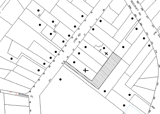
|
NOTIFICATION PLAN |
|
||
|
• PROPERTIES NOTIFIED
|
X SUBMISSIONS RECEIVED |
PROPERTY SUBJECT OF DEVELOPMENT |
|
|
NIL SUBMISSIONS RECEIVED OUT OF MAP RANGE |
|||
One submission objects to the development, generally on the grounds that the development would result in:
· Possible land contamination; and
· Privacy and noise impacts from future development on the site.
One submission was neutral to the development and made the following observations:
· Requests that Council ensure that every effort is made to negate any damage to the adjoining property as a result of excavation and construction vehicles utilising the driveway adjacent to the property boundary; and
· Request that Council impose a condition of consent requiring that the applicant pay for a new boundary fence at the applicant’s cost.
The merits of the matters raised in community submissions have been addressed in the body of the report with the exception of the following:
5.1.1. Privacy and Noise impacts from future development
A submission requests that any consent granted allow for single storey development on proposed Lot 2 or if a two storey residence is proposed, that no windows are located directly overlooking the objector’s property. The submission also requests that as a condition of this development, no noisy equipment (such as split level air conditioning systems) be located between the proposed dwelling and their house due to the small distance separating the two properties and the resulting impact on quality of life.
The proposed development is for subdivision only and the privacy and noise impacts of any future development on Lot 2 would be addressed in a future application.
5.1.2. Construction vehicles
Concerns are raised with regards to potential damage to the adjoining property as a result of excavation and construction vehicles utilising the driveway adjacent to the property boundary. Conditions are recommended in Schedule 1 to minimise any potential impacts and safe work practices should mitigate any impacts on adjoining properties.
5.1.3. Boundary fence
A submission requests that the existing boundary fencing be replaced to provide privacy to the site and adjoining properties. A condition in Schedule 1 recommends requiring fencing to be erected along all property boundaries behind the front building alignment to a height of 1.8 metres.
5.2 Public Agencies - NSW Rural Fire Service
The site is bushfire prone and as such, the development application constitutes integrated development for the purposes of the Rural Fires Act, 1997. The applicant provided a Bushfire Hazard Assessment Report prepared by Building Code and Bushfire Hazard Solutions Pty Ltd. The application was referred to the NSW Rural Fire Service seeking general terms of approval in accordance with Clause 66(1) of the Environmental Planning and Assessment Regulation 2000.
The Service reviewed the plans and associated documentation received for the proposal and provided a response, which is deemed to be a bushfire safety authority as required under Section 100B of the Rural Fires Act 1997, subject to conditions to be imposed on the development consent to ensure the following:
· Sufficient space and maintain reduced fuel loads so as to ensure radiant heat levels of buildings are below critical limits and to prevent direct flame contact with a building.
· Safe access to/from the public road system for fire fighters providing property protection during a bush fire and for occupants faced with evacuation; and
· Buildings are designed and constructed to withstand the potential impacts of bush fire attack.
6. THE PUBLIC INTEREST
Section 79C(1)(e) of the Act requires Council to consider “the public interest”.
The public interest is an overarching requirement, which includes the consideration of the matters discussed in this report. Implicit to the public interest is the achievement of future built outcomes adequately responding to and respecting the future desired outcomes expressed in environmental planning instruments and development control plans.
The application is considered to have satisfactorily addressed Council’s and relevant agencies’ criteria and would provide a development outcome that, on balance, would result in a positive impact for the community. Accordingly, it is considered that the approval of the proposed subdivision would be in the public interest.
CONCLUSION
The application proposes Torrens title subdivision of 1 allotment into 2 lots. The proposal is consistent with the pattern of subdivision in the locality and with the character of the surrounding area.
The application does not comply with the Hornsby Shire Local Environmental
Plan 1984 in respect to Clause 15 ‘Floor Space Ratio’. A State
Environmental Planning Policy No. 1 objection to the development standard
contained within clause 15 has been submitted. The proposal, when taking into
consideration the State Environmental Planning Policy No. 1 objection,
is considered to be acceptable.
Council received two submissions during the public notification period and appropriate controls and conditions are recommended to minimise disruption to the amenity of adjoining land uses.
Having regard to the circumstances of the case, approval of the application is recommended, pursuant to State Environmental Planning Policy No. 1.
Note: At the time of the completion of this planning report, no persons have made a Political Donations Disclosure Statement pursuant to Section 147 of the Environmental Planning and Assessment Act 1979 in respect of the subject planning application.
|
Rod Pickles Manager - Development Assessment Planning Division |
James Farrington Group Manager Planning Division |
|
1.View |
Locality Plan |
|
|
|
2.View |
Subdivision Plan |
|
|
File Reference: DA/177/2012
Document Number: D02004218
SCHEDULE 1
GENERAL CONDITIONS
The conditions of consent within this notice of determination have been applied to ensure that the use of the land and/or building is carried out in such a manner that is consistent with the aims and objectives of the relevant legislation, planning instruments and Council policies affecting the land and does not disrupt the amenity of the neighbourhood or impact upon the environment.
Note: For the purpose of this consent, the term ‘applicant’ means any person who has the authority to act on or the benefit of the development consent.
Note: For the purpose of this consent, any reference to an Act, Regulation, Australian Standard or publication by a public authority shall be taken to mean the gazetted Act or Regulation, or adopted Australian Standard or publication as in force on the date that the application for a construction certificate is made.
1. Approved Plans and Supporting Documentation
The development must be carried out in accordance with the plans and documentation listed below and endorsed with Council’s stamp, except where amended by Council and/or other conditions of this consent:
|
Plan No. |
Title |
Drawn by |
Dated |
|
5357 Issue C |
Plan of Proposed Subdivision |
SDG Land Development Solutions |
July 12 |
|
Document Title |
Prepared by |
Dated |
|
Statement of Environmental Effects Ref: 5357 |
SDG Land Development Solutions |
29 November 2011 |
|
Bushfire Hazard Assessment Report Ref No. 12083 0 |
Building Code and Bushfire Hazard Solutions Pty Ltd. |
27 April 2012 |
|
Tree Site Plan [D01901654] |
Amended by Hornsby Shire Council |
11 April 2012 |
2. Removal of Existing Trees
This development consent only permits the removal of tree numbered 1 as identified on the Tree Site Plan amended by Hornsby Shire Council dated 11 April 2012. The removal of any other trees requires separate approval under Council’s Tree Preservation Order.
REQUIREMENTS PRIOR TO THE ISSUE OF A CONSTRUCTION CERTIFICATE
3. Building Code of Australia
All building work must be carried out in accordance with the requirements of the Building Code of Australia.
4. Water/Electricity Utility Services
The applicant must submit written evidence of the following service provider requirements:
a. Energy Australia – a letter of consent demonstrating that satisfactory arrangements have been made to service the proposed development.
b. Sydney Water – the submission of a ‘Notice of Requirements’ under s73 of the Sydney Water Act 1994.
Note: Sydney Water requires that s73 applications are to be made through an authorised Sydney Water Servicing Coordinator. Refer to www.sydneywater.com.au or telephone 13 20 92 for assistance.
5. Stormwater Drainage
The stormwater drainage system for the development must be designed and constructed in accordance with Council’s Civil Works – Design and Construction Specification 2005 and the following requirements:
a. An inter-allotment stormwater drainage system to service the proposed lot with pits being constructed in situ.
b. The inter-allotment stormwater drainage system shall connect the dwellings with the Council controlled drainage system in the sag in the driveway drainage system.
c. The sag point of the driveway shall incorporate a concrete pipe or culvert and headwall drainage system to pass a 20 year design storm flow of 0.54m3/s under the driveway (pipe fully unblocked).
d. The driveway levels in the sag area at least shall be at or below existing ground levels to ensure the passing of rare storm flows over the driveway to reduce risk of flooding during rare events.
e. The roof and stormwater drainage system from the existing dwelling to be connected to the proposed inter-allotment drainage system.
6. Internal Driveway/Vehicular Areas
The driveway and parking areas on site must be designed in accordance with Australian Standards 2890.1, 2890.2, 3727 and the following requirements:
a. Design levels at the front Lyne Road alignment be obtained from Council.
b. The driveway be designed and constructed as a rigid pavement in the existing access handle and to the extent of the proposed Right of Access to service Lot 2.
c. A vehicle turning area in Lot 2 at the end of the Right Of Access shall be designed and constructed to permit all vehicles to enter and leave Lot 2 in a forward direction.
d. The driveway pavement be a minimum 3 metres wide, 0.15 metres thick reinforced concrete with SL72 steel reinforcing fabric and a 0.15 metre sub-base.
e. Driveway levels shall be constructed to ensure they are at or below existing ground levels in the sag area of the driveway handle, to allow the passing of rare overland flow storm events over the driveway. A longitudinal section of the proposed driveway, showing existing ground and design driveway levels shall be submitted with the construction plans.
f. The driveway design incorporates a sharp right-angle bend and must accommodate the swept out turning path of all vehicles that are reasonably expected to service the site for construction work and removals.
g. The minimum clear width of the Right of Access shall be 3.0 m. Infringing overhangs shall be removed where required and landscaping accommodated into the balance of available area. Details, modifications as required shall be indicated on construction plans.
h. The pavement shall have a kerb to one side and a one-way cross fall with a minimum gradient of 2 percent, with kerb inlet pits provided on grade and at low points. The driveway cross falls shall be designed to grade water away from the floor levels of the existing dwelling.
i. Conduit for utility services including electricity, water, gas and telephone be provided and shown on construction plans.
7. Vehicular Crossing
A separate application under the Local Government Act, 1993 and the Roads Act, 1993 must be submitted to Council for the installation of a new vehicular crossing and the removal of the redundant crossing. The vehicular crossing must be constructed in accordance with Council’s Civil Works Design, 2005 and the following requirements:
a. Any redundant crossings to be replaced with integral kerb and gutter.
b. The footway area to be restored by turfing.
Note: An application for a vehicular crossing can only be made to one of Council’s Authorised Vehicular Crossing Contractors. You are advised to contact Council on 02 9847 6940 to obtain a list of contractors.
8. Traffic Control Plan
A Traffic Control Plan (TCP) must be prepared by a qualified traffic controller in accordance with the Roads & Traffic Authority’s Traffic Control at Worksites Manual 1998 and Australian Standard 1742.3 for all work on a public road and be submitted to Council. The TCP must detail the following:
a. Arrangements for public notification of the works.
b. Temporary construction signage.
c. Vehicle movement plans.
d. Construction Traffic management plans.
REQUIREMENTS PRIOR TO THE COMMENCEMENT OF ANY WORKS
9. Erection of Construction Sign
A sign must be erected in a prominent position on any site on which building work, subdivision work or demolition work is being carried out:
a. Showing the name, address and telephone number of the principal certifying authority for the work,
b. Showing the name of the principal contractor (if any) for any demolition or building work and a telephone number on which that person may be contacted outside working hours, and
c. Stating that unauthorised entry to the work site is prohibited.
Note: Any such sign is to be maintained while the building work, subdivision work or demolition work is being carried out, but must be removed when the work has been completed.
10. Protection of Adjoining Areas
A temporary hoarding, fence or awning must be erected between the work site and adjoining lands before the works begin and must be kept in place until after the completion of the works if the works:
a. Could cause a danger, obstruction or inconvenience to pedestrian or vehicular traffic.
b. Could cause damage to adjoining lands by falling objects.
c. Involve the enclosure of a public place or part of a public place.
Note: Notwithstanding the above, Council’s separate written approval is required prior to the erection of any structure or other obstruction on public land.
11. Toilet Facilities
Toilet facilities must be available or provided at the works site before works begin and must be maintained until the works are completed at a ratio of one toilet for every 20 persons employed at the site. Each toilet must:
a. be a standard flushing toilet connected to a public sewer; or
b. be a temporary chemical closet approved under the Local Government Act, 1993; or
c. have an on-site effluent disposal system approved under the Local Government Act, 1993
12. Erosion and Sediment Control
Erosion and sediment control measures must be provided and maintained throughout the construction period in accordance with the manual ‘Soils and Construction 2004 (Bluebook)’, the approved plans, Council specifications and to the satisfaction of the principal certifying authority. The erosion and sediment control devices must remain in place until the site has been stabilised and revegetated.
Note: On the spot penalties up to $1,500 may be issued for any non-compliance with this requirement without any further notification or warning.
REQUIREMENTS DURING CONSTRUCTION
13. Construction Work Hours
All work on site (including demolition and earth works) must only occur between 7am and 5pm Monday to Saturday.
No work is to be undertaken on Sundays or public holidays.
14. Demolition
All demolition work must be carried out in accordance with Australian Standard 2601-2001 – The Demolition of Structures and the following requirements:
a. Demolition material is to be disposed of to an authorised recycling and/or waste disposal site and/or in accordance with an approved waste management plan.
b. Demolition works, where asbestos material is being removed, must be undertaken by a contractor that holds an appropriate licence issued by WorkCover NSW in accordance with Chapter 10 of the Occupational Health and Safety Regulation 2001 and Clause 29 of the Protection of the Environment Operations (Waste) Regulation 2005.
c. On construction sites where buildings contain asbestos material, a standard commercially manufactured sign containing the words ‘DANGER ASBESTOS REMOVAL IN PROGRESS’ measuring not less than 400mm x 300mm must be erected in a prominent position visible from the street.
15. Environmental Management
The site must be managed in accordance with the publication ‘Managing Urban Stormwater – Landcom (March 2004) and the Protection of the Environment Operations Act 1997 by way of implementing appropriate measures to prevent sediment run-off, excessive dust, noise or odour emanating from the site during the construction of the development.
16. Works near Trees
All required tree protection measures are to be maintained in good condition for the duration of the construction period.
All works (including driveways and retaining walls) within 4 metres of any trees required to be retained (whether or not on the subject property, and pursuant to this consent or the Tree Preservation Order), must be carried out under the supervision of an ‘AQF Level 5 Arborist’ and a certificate submitted to the principal certifying authority detailing the method(s) used to preserve the tree(s).
Note: Except as provided above, the applicant is to ensure that no excavation, filling or stockpiling of building materials, parking of vehicles or plant, disposal of cement slurry, waste water or other contaminants is to occur within 4 metres of any tree to be retained.
17. Council Property
During construction works, no building materials, waste, machinery or related matter is to be stored on the road or footpath. The public reserve is to be kept in a clean, tidy and safe condition at all times.
18. Disturbance of Existing Site
During construction works, the existing ground levels of open space areas and natural landscape features, (including natural rock-outcrops, vegetation, soil and watercourses) must not be altered unless otherwise nominated on the approved plans.
REQUIREMENTS PRIOR TO THE ISSUE OF A SUBDIVISION CERTIFICATE
Note: For the purpose of this consent, a reference to ‘occupation certificate’ shall not be taken to mean an ‘interim occupation certificate’ unless otherwise stated.
19. Sydney Water – s73 Certificate
A s73 Certificate must be obtained from Sydney Water.
20. Damage to Council Assets
Any damage caused to Council’s assets as a result of the construction of the development must be rectified in accordance with Council’s written requirements and at the sole cost of the applicant.
21. Creation of Easements
The following matter(s) must be nominated on the plan of subdivision under s88B of the Conveyancing Act 1919:
a. A right of access and easement for services over the access corridor.
b. An inter-allotment drainage easement(s) over each of the burdened lots.
c. The creation of a “Positive Covenant” over the proposed Lot 2 requiring that any future development is to provide an on-site detention system. The on-site detention system is to have a storage capacity of 5 cubic metres and a maximum discharge of 8 litres per second into Council’s drainage system in accordance with Council’s prescribed wording.
d. The creation of a “Positive Covenant” over proposed Lots 1 and 2 requiring the entire property, be managed as an Inner Protection Area (IPA) as outlined within Section 4.1.3 and Appendix 5 of ‘Planning for Bushfire Protection 2006’ and the NSW Rural Fire Service’s document ‘Standards for asset protection zones’.
Note: Council must be nominated as the authority to release, vary or modify any easement, restriction or covenant.
22. Works as Executed Plan
A works-as-executed plan(s) must be prepared by a registered surveyor and submitted to Council for completed road assets, internal pavements, kerb & gutter, drainage systems, driveways and service conduits.
23. Boundary Fencing
Fencing must be erected along all property boundaries behind the front building alignment to a height of 1.8 metres.
Note: Alternative fencing may be erected subject to the written consent of the adjoining property owner(s).
24. Maintain Canopy Cover
To maintain canopy cover, 2 medium to large trees selected from Council’s booklet ‘Indigenous Plants for the Bushland Shire’ are to be planted on the subject site. The planning location shall not be within 4 metres of the foundation walls of a dwelling or in-ground pool. The pot size is to be a minimum 25 litres and the tree(s) must be maintained until they reach the height of 3 metres. Trees must be native to Hornsby Shire and reach a mature height greater than 10 metres.
25. s94 Infrastructure Contributions
The payment to Council of a contribution of $20,000 for one additional lot towards the cost of infrastructure identified in Council’s Development Contributions Plan 2007-2011.
Note: The value of contribution is capped at $20,000 per additional lot in accordance with Ministerial Direction (Section 94E of the Environmental Planning and Assessment Act 1979) issued on 16 September 2010. In the event that this Direction is repealed or amended, Council will apply the value of the contribution from the date of this consent, adjusted from this date in accordance with the underlying consumer price index for subsequent financial quarters.
It is recommended that you contact Council to confirm the value of the contribution prior to payment.
GENERAL TERMS OF APPROVAL - NSW RURAL FIRE SERVICE
The following conditions of consent are General Terms of Approval from the nominated State Agency pursuant to Section 91A of the Environmental Planning and Assessment Act, 1979 and must be complied with to the satisfaction of that Agency.
26. Asset Protection Zones
At the issue of subdivision certificate and in perpetuity the entire property shall be managed as an inner protection area (IPA) as outlined within section 4.1.3 and Appendix 5 of ‘Planning for Bush Fire Protection 2006’ and the NSW Rural fire Service’s document ‘Standards for asset protection zones’.
Reason: The intent of measures is to provide sufficient space and maintain reduced fuel loads so as to ensure radiant heat levels of buildings are below critical limits and to prevent direct flame contact with a building.
27. Access
Property access roads shall comply with section 4.1.3(2) of ‘Planning for Bush Fire Protection 2006’.
Reason: The intent of measures for property access is to provide safe access to/from the public road system for fire fighters providing property protection during a bush fire and for occupants faced with evacuation.
28. Design and Construction
The existing building on proposed Lot 1 is required to be upgraded to improve ember protection. This is to be achieved by enclosing all openings (excluding roof tile spaces) or covering openings with a non-corrosive metal screen. Where applicable, this includes any sub floor area, openable windows, doors, vents weepholes and eaves.
Reason: The intent of measures is that buildings are designed and constructed to withstand the potential impacts of bush fire attack.
- END OF CONDITIONS –
ADVISORY NOTES
The following information is provided for your assistance to ensure compliance with the Environmental Planning and Assessment Act, 1979, Environmental Planning and Assessment Regulation 2000, other relevant legislation and Council’s policies and specifications. This information does not form part of the conditions of development consent pursuant to Section 80A of the Act.
Environmental Planning and Assessment Act, 1979 Requirements
The Environmental Planning and Assessment Act, 1979 requires:
· The issue of a construction certificate prior to the commencement of any works. Enquiries regarding the issue of a construction certificate can be made to Council’s Customer Services Branch on 9847 6760.
· A principal certifying authority to be nominated and Council notified of that appointment prior to the commencement of any works.
· Council to be given at least two days written notice prior to the commencement of any works.
· Mandatory inspections of nominated stages of the construction inspected.
· An occupation certificate to be issued before occupying any building or commencing the use of the land.
Tree Preservation Order
To ensure the maintenance and protection of the existing natural environment, it is an offence to ringbark, cut down, top, lop, remove, wilfully injure or destroy a tree outside 3 metres of the approved building envelope without the prior written consent from Council.
Note: A tree is defined as a single or multi-trunked wood perennial plant having a height of not less than three (3) metres, and which develops many branches, usually from a distance of not less than one (1) metre from the ground, but excluding any plant which, in its particular location, is a noxious plant declared as such pursuant to the Noxious Weeds Act 1993. This definition of ‘tree’ includes any and all types of Palm trees.
All distances are determined under Australian Standard AS4970-2009 ”Protection of Trees on Development Sites”.
Fines may be imposed for non-compliance with Council’s Tree Preservation Order.
Covenants
The land upon which the subject building is to be constructed may be affected by restrictive covenants. Council issues this approval without enquiry as to whether any restrictive covenant affecting the land would be breached by the construction of the building, the subject of this consent. Applicants must rely on their own enquiries as to whether or not the building breaches any such covenant.
Subdivision Certificate Requirements
A subdivision certificate application is required to be lodged with Council containing the following information:
· A surveyor’s certificate certifying that all structures within the subject land comply with the development consent in regard to the setbacks from the new boundaries.
· A surveyor’s certificate certifying that all services, drainage lines or access are located wholly within the property boundaries. Where services encroach over the new boundaries, easements are to be created.
· Certification that the requirements of relevant utility authorities have been met.
· A surveyor’s certificate certifying finished ground levels are in accordance with the approved plans.
Note: Council will not issue a subdivision certificate until all conditions of the development consent have been completed.
Fees and Charges – Subdivision
All fees payable to Council as part of any construction, compliance or subdivision certificate or inspection associated with the development (including the registration of privately issued certificates) are required to be paid in full prior to the issue of the subdivision certificate. Any additional Council inspections beyond the scope of any compliance certificate required to verify compliance with the terms of this consent will be charged at the individual inspection rate nominated in Council's Fees and Charges Schedule.
Dial Before You Dig
Prior to commencing any works, the applicant is encouraged to contact Dial Before You Dig on 1100 or www.dialbeforeyoudig.com.au for free information on potential underground pipes and cables within the vicinity of the development site.
Asbestos Warning
Should asbestos or asbestos products be encountered during demolition or construction works you are advised to seek advice and information should be prior to disturbing the material. It is recommended that a contractor holding an asbestos-handling permit (issued by WorkCover NSW)be engaged to manage the proper handling of the material. Further information regarding the safe handling and removal of asbestos can be found at:
Alternatively, telephone the WorkCover Asbestos and Demolition Team on 8260 5885.
House Numbering
House numbering can only be authorised by Council. Before proceeding to number each premise in the development, the allocation of numbers is required to be obtained from Council's Planning Division. The authorised numbers are required to be displayed in a clear manner at or near the main entrance to each premise.
Planning Report No. PL29/12
Planning Division
Date of Meeting: 17/10/2012
17 DEVELOPMENT APPLICATION - TORRENS TITLE SUBDIVISION ONE ALLOTMENT INTO TWO 146 GALSTON ROAD, HORNSBY HEIGHTS
EXECUTIVE SUMMARY
|
DA No: |
DA/804/2012 |
|
Description: |
Torrens title subdivision of one allotment into two |
|
Property: |
Lot 101 DP 1149208, No. 146 Galston Road, Hornsby Heights |
|
Applicant: |
Mr Ross Senior |
|
Owner: |
Mr R J P Senior and Mrs E A Senior |
|
Estimated Value: |
N/A |
|
Ward: |
A |
· The proposal is for the subdivision of one allotment into two to accommodate two approved semi-detached dwellings.
· The proposal does not comply with the 500m2 minimum lot size development standard under Hornsby Shire Local Environmental Plan 1994. The applicant has made a submission pursuant to State Environmental Planning Policy No. 1 – Development Standards to vary the standard. The submission is considered well founded and is supported.
· No submissions were received in response to notification of the proposal.
· The application is recommended for approval.
|
THAT Council assume the concurrence of the Director-General of the Department of Planning and Infrastructure pursuant to State Environmental Planning Policy No. 1 and approve Development Application No. 804/2012 for Torrens title subdivision of one allotment into two at Lot 101 DP 1149208, No. 146 Galston Road, Hornsby Heights subject to the conditions of consent detailed in Schedule 1 of Group Manager’s Report No. PL29 /12. |
BACKGROUND
On 12 June 2008, Council approved DA/452/2008 for subdivision of one allotment into two creating the subject site and an allotment fronting Robinson Close at the rear of the site.
On 13 February 2012, Council approved DA/1428/2011 for demolition of an existing dwelling and erection of two attached multi-unit dwellings on the subject site. At the time of writing this report the development had not commenced.
On 30 July 2012, Council approved a Section 96 modification to DA/1428/2011/A to increase the ground floor ceiling height of the multi-unit dwellings from 2.43m to 2.60m.
At the time of writing this report, Council has under consideration a Section 96 Application DA/1428/2011/A for modification of the consent to delete Condition No. 21 requiring footpath and kerb and gutter works.
SITE
The site is located on the eastern side of Galston Road and has an area of 710.8m2. The site is generally regular in shape other than at the frontage (18.19m) which is diagonal and parallel with Galston Road. The site includes an existing single storey dwelling-house and is relatively level with a slight fall to the rear. The site has the benefit of a stormwater drainage easement over the rear property in Robinson Close. The site does not contain any significant vegetation.
The surrounding area is low density residential. The Berowra Valley National Park is located 150m east of the site. The site is not bushfire prone.
The site is located 120m south east of the intersection of Galston Road and Somerville Road. The site is located within 60m of a bus stop on Route 596 (Shorelink) providing a regular bus service to Hornsby Railway Station.
PROPOSAL
The proposal is for the Torrens title subdivision of one allotment into two lots for the two approved semi-detached dwellings under DA/1428/2011.
The proposed lot for approved Dwelling A has an area of 374m2.
The proposed lot for approved Dwelling B has an area of 336m2.
Each of the approved semi-detached dwellings on the proposed lots has a gross floor area of 152.7m2. The proposed subdivision of the existing lot aligns with the dividing wall between the two approved semi-detached dwellings.
ASSESSMENT
1. STRATEGIC CONTEXT
1.1 Metropolitan Plan for Sydney 2036 and (Draft) North Subregional Strategy
The Metropolitan Plan for Sydney 2036 is a broad framework to secure Sydney’s place in the global economy by promoting and managing growth. It outlines a vision for Sydney to 2036; the challenges faced, and the directions to follow to address these challenges and achieve the vision. The Draft North Subregional Strategy acts as a framework for Council in its preparation of the Comprehensive LEP by the end of 2012.
The Draft North Subregional Strategy sets the following targets for the Hornsby LGA by 2031:
· Employment capacity to increase by 9,000 jobs; and
· Housing stock to increase by 11,000 dwellings.
The proposed development would be consistent with the draft Strategy.
2. STATUTORY CONTROLS
Section 79C(1)(a) requires Council to consider “any relevant environmental planning instruments, draft environmental planning instruments, development control plans, planning agreements and regulations”.
2.1 Hornsby Shire Local Environmental Plan 1994
The subject land is zoned Residential A (Low Density) under the Hornsby Local Environmental Plan 1994 (HSLEP). The objectives of the zone are:
(a) to provide for the housing needs of the population of the Hornsby area.
(b) to promote a variety of housing types and other land uses compatible with a low density residential environment.
(c) to provide for development that is within the environmental capacity of a low density residential environment.
The proposed development is defined as ‘subdivision’ under the HSLEP and is permissible in the zone with Council’s consent.
Clause 14 of the HSLEP prescribes a minimum area of 500m2 for an allotment within the Residential A Zone. The two proposed lots do not comply with this requirement. The non-compliance is the subject of submission seeking to vary the development standard pursuant to State Environmental Planning Policy No. 1 – Development Standards (SEPP 1).
Clause 15 of the HSLEP prescribes that the maximum floor space ratio (FSR) of development within the Residential A zone is 0.4:1. The approved Dwelling A has a gross floor area of 152m2 and a proposed floor space ratio of 0.41:1. The approved Dwelling B has a gross floor area of 152m2 and a proposed floor space ratio of 0.45:1 in non-compliance with the floor space ratio standard. The non-compliance is the subject of an objection to the development standard pursuant to SEPP 1.
Pursuant to Clause 15(4) of the HSLEP, in calculating floor space ratio, the area of any right-of-carriageway is not included in the floor space ratio calculation. A right-of-carriageway is proposed over the approved driveway and vehicle manoeuvring area at the frontage which is shared between the two approved dwellings. In this regard, the floor space ratio for Dwelling A is 0.46:1 and for Dwelling B is 0.50:1.
Clause 18 of HSLEP sets out heritage conservation provisions for Hornsby Shire. The site is not identified as an item of heritage and is not within a heritage conservation area or in the vicinity of a heritage item.
2.2 Draft Comprehensive Hornsby Local Environmental Plan
At its meeting on 7 March 2012, Council resolved to endorse the draft Hornsby Local Environmental Plan (DHLEP) for public exhibition. The draft plan was exhibited from 5 June to 7 August 2012. Under the DHLEP, the subject land would be zoned R2 Low Density Residential. The approved multi-unit housing development and the proposed subdivision would be prohibited within the R2 Low Density Residential Zone.
The subject application was lodged on 3 August 2012. The provisions under DHLEP are a matter for consideration in the assessment of the application pursuant to Section 79C(a)(ii) of the Environmental Planning and Assessment Act, 1979. In this regard the approval of the two semi-detached dwellings, subject of the application for subdivision, occurred prior to the exhibition of DHLEP and the proposed subdivision is subject to variation of the development standard pursuant to SEPP 1 (refer to discussion in Section 2.4).
2.3 State Environmental Planning Policy – Sydney Regional Environmental Plan No. 20 – Hawkesbury-Nepean River
The site is located within the catchment of the Hawkesbury Nepean River. Part 2 of the Plan contains general planning considerations and strategies requiring Council to consider the impacts of the proposal on water quality, scenic quality, aquaculture, recreation and tourism.
Subject to the implementation of sediment and erosion control measures and stormwater management to protect water quality, the proposal would comply with the requirements of the Policy.
2.4 State Environmental Planning Policy No. 1 – Development Standards
The applicant has submitted an objection against Council’s adherence to the minimum 500m2 lot size development standard under Clause 14 of the HSLEP and the maximum 0.4:1 floor space ratio under Clause 15 of the HSLEP. The two proposed lots are 374m2 and 336m2 respectively and the proposed floor space ratios subject of the objection are 0.41:1 and 0.45:1. The floor space ratio calculation increases to 0.46:1 for Dwelling A and 0.50:1 for Dwelling B, when for the proposed right-of-carriageway is excluded.
The application has been assessed against the requirements of SEPP 1. This Policy provides flexibility in the application of development standards in circumstances where strict compliance with those standards would, in any particular case, be unreasonable or unnecessary or tend to hinder the attainment of the objectives of the Act.
The proposed variation of the development standards would not raise any matter of significance for State and regional planning. The public benefit of maintaining the development standards is considered untenable given the approval of the two semi-detached dwellings under DA/1428/2011.
The Land and Environment Court has expressed the view that there are five different ways in which an objection may be well founded and that approval of the objection may be consistent with the aims of the Policy:
1. The objectives of the standard are achieved notwithstanding non-compliance with the standards;
2. The underlying objective or purpose of the standard is not relevant to the development and therefore compliance is unnecessary;
3. The underlying object of purpose would be defeated or thwarted if compliance was required and therefore compliance is unreasonable;
4. The development standard has been virtually abandoned or destroyed by the Council’s own actions in granting consents departing from the standard and hence compliance with the standard is unnecessary and unreasonable;
5. The zoning of the particular land is unreasonable or inappropriate so that a development standard appropriate for that zoning is also unreasonable and unnecessary as it applies to the land and compliance with the standard would be unreasonable or unnecessary. That is, the particular parcel of land should not have been included in the particular zone.
The applicant’s objection is made with regard to the above 5 point test and the objectives of the Residential A (Low Density) Zone and includes the following statement:
“Having regard to the environmental capacity of the site, as stated in the Statement of Environmental Effects, the site will contain two dwelling houses pursuant to the approval of the Council. The Council when assessing the development application formed the view that the proposed density of the built form was consistent with the environmental capacity of the site. There is to be no significant physical change to the proposed approved development on the site and consequently the existing density of development remains consistent with the environmental capacity of the site.
The proposed subdivision will not provide for any change to the proposed built form in the area. As such, the proposed subdivision achieves the objectives of the development standards notwithstanding the non-compliance and therefore compliance with the development standards is unreasonable or unnecessary.
The proposed subdivision will divide the proposed development on the site along the line shown in Development Application 1428/2011 separating the two dwelling houses. As such as far as the physical development of the site is concerned there will be no change from the approved development.”
The applicant’s objection to the 500m2 minimum lot size and the maximum 0.4:1 floor space ratio development standards is considered well founded and is supported for the following reasons: -
(a) The approved dwellings are in accordance with the objectives of the Residential A (Low Density) zone and the floor space ratio objective of the HSLEP;
(b) The proposed subdivision would not alter the physical relationship of the approved development with the surrounding low density residential environment;
(c) The approved development is in accordance with the current provisions of HSLEP which permit multi-unit housing at a density of 350m2 site area per dwelling notwithstanding the minimum allotment size of 500m2 for subdivision; and
(d) the proposal would not result in a precedent for similar developments given the provisions of DHLEP would repeal the permissibility of multi-unit housing in the zone.
The proposed variation is consistent with the decision of the Land and Environment Court in the appeal Stephen De Pasquale v Hornsby Shire Council. The Court upheld this appeal involving two proposed dwellings and subdivision into two lots subject to a SEPP 1 objection, as the development was within the environmental capacity of the site notwithstanding the proposed lots were less than 500m2 (DA/215/2006 – LEC 10648 of 2006).
The application is to be determined at a Council Meeting, in accordance with requirements of the Department of Planning and Infrastructure, as required under Planning Circular PS 11-018 as the proposal involves a development standard variation greater than 10%.
2.5 Residential Subdivision Development Control Plan
The proposed development has been assessed having regard to the relevant performance and prescriptive design requirements within Council’s Residential Subdivision Development Control Plan (Residential Subdivision DCP). The following table sets out the proposal’s compliance with the prescriptive requirements of the Plan:
|
Residential Subdivision Development Control Plan |
|||
|
Control |
Proposal |
Requirement |
Compliance |
|
Lot Area |
Dwelling A – 374m2 Dwelling B – 336m2 |
500m2 |
No |
|
Floor Space Ratio |
Dwelling A – 0.46:1 Dwelling B – 0.50:1 |
0.4:1 |
No |
|
Site Coverage |
Dwelling A – 29% Dwelling B – 32% |
40% |
Yes |
|
Car parking |
Dwelling A – 2 spaces Dwelling B – 2 spaces |
2 spaces |
Yes |
|
Private Open Space |
Dwelling A – 138.7m2 Dwelling B – 138.7m2 |
120m2 |
Yes |
|
Landscaping |
Dwelling A – 52% Dwelling B – 48% |
45% |
Yes |
As detailed in the above table, the proposed development complies with the relevant prescriptive requirements within Council’s Residential Subdivision DCP other than the density prescriptive measures for lot area and floor space ratio which are development standards under the HSLEP. The non-compliance with the development standards is addressed above in Section 2.4 in respect to the SEPP 1 objection submitted with the application.
The prescriptive measures of the Residential Subdivision DCP for allotment layout and design, setbacks, solar access, private open space, landscaping, drainage control and accessway design have been addressed in the assessment of the approved semi-detached dwellings. The proposed subdivision does not involve any change to the approved built form or any works.
To ensure the proposed subdivision provides for the approved development, a condition is recommended requiring an Occupation Certificate to be issued for the two approved semi-detached dwellings under DA/1428/2011, prior to the issue of a Subdivision Certificate.
2.6 Section 94 Development Contributions Plan 2007-2011
The proposed subdivision accommodates the approved semi-detached dwellings which are subject to a condition of development consent under DA/1428/2011 for the payment of a Section 94 Contribution. A development contribution is therefore, not required for the proposed subdivision.
3. ENVIRONMENTAL IMPACTS
Section 79C(1)(b) of the Act requires Council to consider “the likely impacts of that development, including environmental impacts on both the natural and built environments, and social and economic impacts in the locality”.
3.1 Natural Environment
The proposed subdivision does not involve any works or removal of any vegetation.
3.2 Built Environment
The proposed subdivision accommodates the two approved semi-detached dwellings. A condition is recommended for the dwellings to be constructed before title is created for the proposed lots.
3.3 Social Impacts
The proposal would not result in a social impact.
3.4 Economic Impacts
The proposal would not result in an economic impact.
4. SITE SUITABILITY
The site is approved for the two semi-detached dwellings subject of the proposed subdivision.
5. PUBLIC PARTICIPATION
Section 79c(1)(d) of the Act requires Council to consider “Any submissions made in accordance with this Act”.
5.1 Community Consultation
The proposed development was placed on public exhibition and was notified to adjoining and nearby landowners between 16 August and 6 September 2012 in accordance with Council’s Notification and Exhibition Development Control Plan. During this period Council received no submissions.
6. PUBLIC INTEREST
Section 79C(1)(e) of the Act requires Council to consider “the public interest”.
The public interest is an overarching requirement, which includes the consideration of the matters discussed in this report. Implicit to the public interest is the achievement of future built outcomes adequately responding to and respecting the future desired outcomes expressed in environmental planning instruments and development control plans.
The proposed subdivision accommodates the approved built form and is subject to condition for the two approved semi-detached dwellings to be constructed before the lots are created. The proposed subdivision would not create a precedent with regard to the provisions of DHLEP which would prohibit this form of development. Accordingly, it is considered that approval of the proposed subdivision, in accommodating the now approved built form, would not be in conflict with the public interest.
CONCLUSION
The proposed Torrens title subdivision of one allotment into two follows the approval of DA/1428/2011 for two semi-detached two storey dwellings on the subject site.
The proposed subdivision is in non-compliance with the minimum lot area of 500m2 development standard for subdivision in the Residential A (Low Density) Zone and the 0.4:1 floor space ratio for the approved dwellings on the respective proposed lots. The submitted SEPP 1 objection to the development standard is considered well founded with regard to the approved development and the Land and Environment Court’s 5 point test.
The proposed subdivision is satisfactory in respect to the Residential Subdivision DCP notwithstanding the SEPP 1 objection. The proposed subdivision accommodates the two approved semi-detached dwellings and does not involve any works or change to the approved built form under DA/1128/2011. A condition is recommended for the approved dwellings to be constructed prior to the creation of the proposed lots.
There were no submissions received in response to notification of the proposed subdivision.
The application is recommended for approval.
|
Rod Pickles Manager - Development Assessment Planning Division |
James Farrington Group Manager Planning Division |
|
1.View |
Locality Map |
|
|
|
2.View |
Plan for Subdivision |
|
|
|
3.View |
Plan Approved Dwellings |
|
|
|
4.View |
SEPP 1 Objection |
|
|
File Reference: DA/804/2012
Document Number: D02017112
SCHEDULE 1
GENERAL CONDITIONS
The conditions of consent within this notice of determination have been applied to ensure that the use of the land and/or building is carried out in such a manner that is consistent with the aims and objectives of the relevant legislation, planning instruments and Council policies affecting the land and does not disrupt the amenity of the neighbourhood or impact upon the environment.
Note: For the purpose of this consent, the term ‘applicant’ means any person who has the authority to act on or the benefit of the development consent.
Note: For the purpose of this consent, any reference to an Act, Regulation, Australian Standard or publication by a public authority shall be taken to mean the gazetted Act or Regulation, or adopted Australian Standard or publication as in force on the date that the application for a construction certificate is made.
1. Approved Plans and Supporting Documentation
The development must be carried out in accordance with the plans and documentation listed below and endorsed with Council’s stamp, except where amended by Council and/or other conditions of this consent:
|
Plan No. |
Drawn by |
Dated |
|
Senior 1 of 7 |
Absolute Architectural Pty Ltd |
06.07.12 |
2. Subdivision Certificate
A subdivision certificate shall not be issued until a final occupation certificate has been issued for DA 1428/2011 in accordance with Sections 109C and 109H of the Environmental Planning and Assessment Act, 1979.
3. Sydney Water – s73 Certificate
A s73 Certificate must be obtained from Sydney Water.
4. Creation of Easements
The following matter(s) must be nominated on the plan of subdivision under s88B of the Conveyancing Act 1919:
a. A right of access over the shared access driveway.
b. An inter-allotment drainage easement(s) over each of the burdened lots.
c. The creation of an appropriate "Positive Covenant" and "Restriction as to User" over the constructed on-site detention/retention systems and outlet works, within the lots in favour of Council in accordance with Council’s prescribed wording. The position of the on-site detention system is to be clearly indicated on the title.
d. To register the OSD easement, the restriction on the use of land “works-as-executed” details of the on-site-detention system must be submitted verifying that the required storage and discharge rates have been constructed in accordance with the design requirements. The details must show the invert levels of the on site system together with pipe sizes and grades. Any variations to the approved plans must be shown in red on the “works-as-executed” plan and supported by calculations.
Note: Council must be nominated as the authority to release, vary or modify any easement, restriction or covenant.
- END OF CONDITIONS -
ADVISORY NOTES
The following information is provided for your assistance to ensure compliance with the Environmental Planning and Assessment Act, 1979, Environmental Planning and Assessment Regulation 2000, other relevant legislation and Council’s policies and specifications. This information does not form part of the conditions of development consent pursuant to Section 80A of the Act.
Environmental Planning and Assessment Act, 1979 Requirements
· The Environmental Planning and Assessment Act, 1979 requires:
· The issue of a construction certificate prior to the commencement of any works. Enquiries regarding the issue of a construction certificate can be made to Council’s Customer Services Branch on 9847 6760.
· A principal certifying authority to be nominated and Council notified of that appointment prior to the commencement of any works.
· Council to be given at least two days written notice prior to the commencement of any works.
· Mandatory inspections of nominated stages of the construction inspected.
· An occupation certificate to be issued before occupying any building or commencing the use of the land.
Subdivision Certificate Requirements
A subdivision certificate application is required to be lodged with Council containing the following information:
· A surveyor’s certificate certifying that all structures within the subject land comply with the development consent in regard to the setbacks from the new boundaries.
· A surveyor’s certificate certifying that all services, drainage lines or access are located wholly within the property boundaries. Where services encroach over the new boundaries, easements are to be created.
· Certification that the requirements of relevant utility authorities have been met.
· A surveyor’s certificate certifying finished ground levels are in accordance with the approved plans.
Note: Council will not issue a subdivision certificate until all conditions of the development consent have been completed.
Fees and Charges – Subdivision
All fees payable to Council as part of any construction, compliance or subdivision certificate or inspection associated with the development (including the registration of privately issued certificates) are required to be paid in full prior to the issue of the subdivision certificate. Any additional Council inspections beyond the scope of any compliance certificate required to verify compliance with the terms of this consent will be charged at the individual inspection rate nominated in Council's Fees and Charges Schedule.
Planning Report No. PL33/12
Planning Division
Date of Meeting: 17/10/2012
18 DEVELOPMENT APPLICATION - SECTION 96(2) - ERECTION OF AN ELEVEN STOREY MIXED USE EEVELOPMENT - 135-137 PACIFIC HIGHWAY AND POUND ROAD RESERVE HORNSBY
EXECUTIVE SUMMARY
|
DA No: |
DA/1586/2001/F |
|
Description: |
Section 96(2) application to increase the number of residential units from 106 to 144 units and one level of retail units |
|
Property: |
Lots 101 and 102 DP 1173944 Nos. 135 - 137 Pacific Highway and Pound Road Reserve, Hornsby |
|
Applicant: |
Fal Developments Pty Ltd |
|
Owner: |
Fal Management Group Pty Ltd |
|
Estimated Value: |
$24,000,000 |
|
Ward: |
B |
· The application proposes modifications to an existing development consent for the construction of a mixed use development comprising 144 residential units and one level of retail units with basement car parking.
· In accordance with Council’s adopted Policy ‘PSA1 Proposed Council Developments’ and ‘Practice Note No. 7 Assessment Practice’ an independent assessment of the development application has been undertaken by ADW Johnson as the development site includes land previously owned by Council.
· Five submissions have been received in respect of the application.
· The report by ADW Johnson is attached to this report for Council’s consideration. The independent consultant’s report recommends approval of the application.
|
THAT Development Application No. DA/1586/2001/F be approved pursuant to Section 96(2) of the Environmental Planning and Assessment Act, 1979, to modify Development Consent No. 1586/2001 for a mixed use development comprising 144 residential units and one level of retail units with basement car parking at Lots 101 and 102 DP 1173944 Nos. 135 - 137 Pacific Highway and Pound Road Reserve, Hornsby be subject to conditions of consent in Schedule 1 of the independent town planning consultant’s report – ADW Johnson. |
ASSESSMENT
In accordance with Council’s adopted Policy PS41 Proposed Council Developments and Practice Note No. 7 – Assessment Practice, the assessment of the development application has been referred to an independent town planning consultant as part of the development site, namely Pound Road, was previously owned by Council. The report by ADW Johnson is held at Attachment 2 of this report.
CONCLUSION
The proposal is for amendment to a mixed use development resulting in a development comprising 144 residential units and one level of retail units with basement car parking.
Council has referred the application to an independent planning consultancy to carry out an assessment of the application. The assessment concludes that based on the planning merits of the case, the application should be approved in accordance with the recommendation in the report prepared by ADW Johnson and the conditions of consent held at Schedule 1 of this report.
Note: At the time of the completion of this planning report, no persons have made a Political Donations Disclosure Statement pursuant to Section 147 of the Environmental Planning and Assessment Act 1979 in respect of the subject planning application.
|
Rod Pickles Manager - Development Assessment Planning Division |
James Farrington Group Manager Planning Division |
|
1.View |
Locality Plan |
|
|
|
2.View |
Section 96 Assessment Report |
|
|
|
3.View |
Floor Plans |
|
|
|
4.View |
Elevations and Sections |
|
|
|
5.View |
Shadow Diagrams |
|
|
File Reference: DA/1586/2001/F
Document Number: D02024207
SCHEDULE 1
|
Date of 1st modification: |
3 June 2009
|
|
Details of 1st modification: |
Mixed use building comprising 70 residential units and three levels of commercial units - Section 96(2) Application |
|
|
|
|
Conditions Added: |
103 to 125
|
|
Conditions Deleted: |
1, 4, 10-14, 16, 18, 20, 36, 42-45, 53-60, 61-63, 69-71, 74-76 and 88-90. |
|
Conditions Modified: |
6, 17, 37, 64, 79, 80, 81, 91, 92, 93 and 99
|
|
Date of 2nd modification: |
3 March 2010
|
|
Details of 2nd modification: |
Section 96(1A) modification to amend condition Nos. 82, 91A, 91B, 82 and 102 |
|
|
|
|
Conditions Added: |
126-130
|
|
Conditions Deleted: |
101 and 102
|
|
Conditions Modified: |
82, 91A, 91B and 114
|
|
Date of 3rd modification: |
6 July 2011
|
|
Details of 3rd modification: |
Mixed use building comprising 106 residential units and one level of commercial and retail units - Section 96 (AB) Application
The description of the development should read as follows:
DEVELOPMENT: Erection of a building comprising 106 residential units, one ground level of commercial and retail tenancies and four levels of basement car parking.
|
|
|
|
|
Conditions Added: |
131-147 |
|
Conditions Deleted: |
91B |
|
Conditions Modified: |
6, 30, 91A, 125
|
|
Date of this modification: |
|
|
Details of this modification: |
Mixed use building comprising 144 residential units and one level of retail units
The description of the development should read as follows:
DEVELOPMENT: Erection of a building comprising 144 residential units, one ground level of retail tenancies and four levels of basement car parking.
|
|
|
|
|
Conditions Added: |
30A, 135A, 135B, 135C, 135D |
|
Conditions Deleted: |
|
|
Conditions Modified: |
91A, 92, 105, 106, 108, 120, 121, 125, 140 |
GENERAL CONDITIONS
The conditions of consent within this notice of determination have been applied to ensure that the use of the land and/or building is carried out in such a manner that is consistent with the aims and objectives of the relevant legislation, planning instruments and Council policies affecting the land and does not disrupt the amenity of the neighbourhood or impact upon the environment.
Note: For the purpose of this consent, the term ‘applicant’ means any person who has the authority to act on or the benefit of the development consent.
Note: For the purpose of this consent, any reference to an Act, Regulation, Australian Standard or publication by a public authority shall be taken to mean the gazetted Act or Regulation, or adopted Australian Standard or publication as in force on the date that the application for a construction certificate is made.
1. Deleted
Sediment & Erosion Control
2. Temporary sedimentation and erosion controls shall be constructed prior to commencement of any work to eliminate the discharge of sediment from the site. The controls are to be designed and installed in accordance with the requirements of the NSW Department of Conservation and Land Management's "Urban Erosion and Sediment Control" manual, Hornsby Shire Council’s “Sustainable Water Best Practices” manual and shall:-
· Be effectively maintained at all times during the course of construction and shall not be removed until the site has been stabilised or landscaped to the Principal Certifying Authority’s satisfaction.
· Include adequate measures to remove clay from vehicles leaving the site so as to maintain public roads in a clean condition.
· Ensure disturbed areas are rehabilitated with indigenous plant species, landscaped and treated by approved methods of erosion mitigation such as, mulching, and revegetation with native grasses or other suitable stabilising processes within fifteen days of the completion of works.
· No site works are to commence until the sediment control installation has been inspected and approved by the Principal Certifying Authority. At least 48 hours notice is to be given for the inspection of such works. A compliance certificate be submitted to Hornsby Shire Council with the notification for commencement of works.
Sydney Water
3. A Section 73 compliance certificate under the Sydney Water Act 1994 must be obtained. Application must be made through an authorised Water Servicing Coordinator. Please refer to “Your Business” section of Sydney Water’s web site at www.sydneywater.com.au then the “e-developer” icon or telephone 13 20 92.
Following application, a “Notice of Requirements” will detail water and sewer extensions to be built and charges to be paid. Please make early contact with the Coordinator, since building of water/sewer extensions can be time consuming and may impact on other services and building, driveway or landscape design.
The Notice must be submitted to the Principal Certifying Authority prior to the Construction Certificate being issued.
The Section 73 Certificate must be submitted to the Principal Certifying Authority prior to occupation of the development/release of the plan of subdivision.
4. Deleted
Use of Materials
5. If reflective glass is to be used externally in the construction of the building, the reflectivity index of the glass is to be not more than 20%.
6. The materials and colours to be used in the construction must be the same as those samples shown on plan prepared by Woodhead (Reference: DWG No. W4004, Issue B) dated 6 May 2011.
Car parking
7. The commercial car parking spaces shall be signposted and made available at all times during business hours.
8. The residential visitor parking spaces shall be signposted and made available at all times.
9. Parking, loading and manoeuvring areas are to be used solely for such purposes.
10. Deleted
11. Deleted
12. Deleted
13. Deleted
14. Deleted
Energy Efficiency and Services
15. A NatHERS assessment shall be submitted to the Principal Certifying Authority demonstrating that the building will achieve a minimum rating of 3.5 stars or greater.
16. Deleted
Access & Mobility
17. A minimum of 2 units within the development must be provided as adaptable units and shall comply with Australian Standard 1428 Parts 1 and 4 and the Building Code of Australia. Prior to occupation of the building, a compliance certificate certifying compliance with these requirements must be obtained and submitted to the Principal Certifying Authority.
18. Deleted
Lighting
19. All external lighting shall comply with Australian Standard 4282 – 1997 ‘Control of the obtrusive effects of outdoor lighting’.
20. Deleted
Notifying Council of Commencement of Works
21. It is a requirement of the Environmental Planning and Assessment Act (Section 81A(2)(c)) that you notify Hornsby Council at least two (2) days prior to the intention to commence works.
Where works are to be undertaken in a public place, such notice must be accompanied by evidence of the contractor's Public Liability and Workers’ Compensation Insurances. The public risk policy shall be such an amount as determined by Council (not being less than $10,000,000.00) and shall cover the owner and the Council against any injury, loss or damage sustained by any person, firm or company.
Environmental Management
22. The site must be managed in accordance with the publication ‘Managing Urban Stormwater – Landcom (March 2004) and the Protection of the Environment Operations Act 1997 by way of implementing appropriate measures to prevent sediment run-off, excessive dust, noise or odour emanating from the site during the construction of the development.
Inspections – Engineering
23. All engineering work required by this consent must be inspected and compliance certificates shall be issued prior to occupancy or issue of the subdivision certificate, whichever occurs first, certifying that the works comply with development consent, construction certificate and Hornsby Shire Council Civil Works - Design and Construction Specification for the following nominated stages:
· Implementation of erosion control
· Implementation of traffic control
· Replacement of redundant gutter crossing
· At completion of on-site detention system
· Driveways and accessways
· Pavement marking
· Final inspection
Access Way/Driveway
24. A separate application under the Local Government Act 1993 and Roads Act 1993 shall be submitted to Council for approval for the following:
(a) The installation of a vehicular footway crossing servicing the development, and the removal of any redundant crossings.
(b) The undertaking of work within a public road (this includes Laneways, Public Pathways, Footways).
25. Any redundant gutter and/or footway crossing must be replaced with integral kerb and gutter. The footway area must be restored by turfing. Works are to be completed prior to occupancy.
26. The vehicular crossing shall be designed and constructed in accordance with Council’s Civil Works - Design and Construction Specification 1999.
27. The concrete vehicular crossing shall be a minimum of 150mm in depth and reinforced with F72 steel reinforcing fabric.
28. The vehicular crossing shall have a minimum width of 6.0m at the property boundary alignment. The crossings shall be located no closer than 6m to the tangent point of the kerb return in Government Rd in accordance with AS 2890.1.
29. Any damage caused to Council's assets in the vicinity of the subject site as a result of construction works associated with the approved development is to be repaired by the applicant/developer prior to occupation.
Car Parking and Deliveries
30. All car parking must be constructed and operated in accordance with Australian Standard AS/NZS 2890.1:2004 – Off-street car parking, and Australian Standard 2890.2 - 2002 – Off-street commercial vehicle facilities and the following requirement:
(a) All parking areas and driveways are to be sealed to an all weather standard, line marked and signposted.
(b) Car parking, loading and manoeuvring areas to be used solely for nominated purposes.
(c) Vehicles awaiting loading, unloading or servicing shall be parked on site and not on adjacent or nearby public roads;
(d) All vehicular entry on to the site and egress from the site shall be made in a forward direction.
30A. A minimum of 144 residential parking spaces are to be provided, with each residential unit having access to at least one dedicated parking space. Joint use of residential visitor and retail/commercial spaces is considered acceptable.
Traffic Control Plan
31. A Traffic Control Plan (TCP), prepared by a qualified work site traffic controller, is to be submitted with any construction certificate for any works within the road reserve, demonstrating compliance with the Road & Traffic Authority’s Traffic Control At Worksites Manual, 1998, and detailing:-
(a) Public notification of proposed works.
(b) Long term signage arrangement.
(c) Short term (during actual works) signage.
(d) Vehicle Movement Plans, where applicable.
(e) Traffic Management Plans.
(f) Pedestrian and cyclist access/safety.
Drainage
32. The drainage system is to be designed and constructed with an on-site-detention system. Stormwater drainage from the site shall be designed to satisfactorily drain rainfall intensities for an average recurrence interval of 20 years. The maximum permitted site discharge is to be equal to the 1 in 5 year ARI pre development storm event. Full engineering hydraulic calculations verifying the storage and discharge rates are to be submitted with the construction certificate plans. The system shall be designed by a chartered professional civil engineer to the following requirements:
(a) A surcharge/inspection grate is to be located directly above the outlet.
(b) Stormwater discharge from the detention system is to be controlled via a one metre length of pipe not less than 50mm diameter discharging into a larger diameter pipe capable of carrying the design flow to Council's gutter/stormwater pit.
(c) Where the on-site detention system is proposed under the vehicular driveway, the engineer is to certify that the detention tank is structurally capable of withstanding the maximum anticipated traffic loads.
(d) The on-site detention systems within private or common courtyard areas must be designed so they do not impact on the amenity of the development or the use of such areas.
A compliance certificate is to be submitted to Council which includes work-as-executed details of the on-site-detention system prepared by a chartered professional engineer/registered surveyor verifying that the required storage and discharge volumes have been constructed in accordance with the design requirements. The details are to show the invert levels of the on system as well as the pipe sizes and grades. Any variations to approved plans must be shown in red and supported by calculations.
33. A certificate from a chartered professional civil engineer/registered surveyor must be obtained prior to release of construction certificate verifying that the on-site detention system will function hydraulically in accordance with the approved design plans.
34. The creation of an appropriate "Positive Covenant" and "Restriction as to User" over the constructed on-site detention/retention systems and outlet works, within the lots in favour of Council to ensure the continued maintenance and performance of the stormwater management system in accordance with Council’s standard wording. The position of the on-site detention system is to be clearly indicated on the title of the property.
Works as Executed
35. A works-as-executed plan prepared by a chartered professional engineer or a registered surveyor must be lodged with Hornsby Shire Council when the engineering works are complete, prior to the release of the subdivision certificate.
36. Deleted
Building Code of Australia
37. All building work must be carried out in accordance with the requirements of the Building Code of Australia.
Council Property
38. The land and adjoining areas are to be kept in a clean and tidy condition at all times. Litter and rubbish to be placed in containers and removed from the site. A waste storage container is to be provided at the commencement of the building work.
39. The cost of repairing any damage caused to Council's assets as a result of construction works associated with the approved development is to be met in full by the applicant/developer prior to the issue of a subdivision certificate.
Hours of Demolition Works
40. In order to maintain the amenity of adjoining properties, demolition works shall be restricted to between 7.00 am and 6.00 pm. No demolition works are to be undertaken on Saturdays, Sundays or Public Holidays. Plant, goods or materials shall not be delivered to the site outside the approved hours of site works unless written Council gives consent.
Demolition
41. All demolition work is to be carried out in accordance with the applicable provisions of Australian Standard 2601-2001 ‘The Demolition of Structures’.
Note: Applicants are reminded that WorkCover NSW requires all plant and equipment used in demolition work must comply with the relevant Australian Standards and manufacturer specifications.
42. Deleted
43. Deleted
44. Deleted
45. Deleted
Signs for Building and Demolition Sites
46. A sign must be erected in a prominent position on the premises, on which the erection or demolition of a building is being carried out, stating that unauthorised entry to the premises is prohibited and showing the name of the builder or other person in control of the premises and a telephone number at which the builder or other person may be contacted during and outside work hours.
The sign is to be removed when the erection or demolition of the building has been completed. This condition does not apply to building work carried out inside an existing building or building work carried out on premises, that is to be occupied continuously (both during and outside working hours) while the work is being carried out.
Hours of Construction
47. In order to maintain the amenity of adjoining properties, site works shall be restricted to between 7.00 am and 6.00 pm, Monday to Friday and 8.00 am to 1.00 pm Saturday. Site works may extend to 4.00 pm on Saturdays if inaudible on residential properties. No work shall be undertaken on Sundays or public holidays. Plant, goods or materials shall not be delivered to the site outside the approved hours of site works unless otherwise approved by Council.
Engineers Certifications – Building
48. A qualified practising chartered Structural engineer shall inspect the slab steel reinforcement prior to the pouring of any concrete and supply the Principal Certifying Authority and copy to Hornsby Shire Council with a certification of structural adequacy.
Excavation & Backfilling
49. All excavations must be properly guarded and protected to prevent them from being dangerous to life or property.
50. Retaining walls or other approved methods necessary to prevent the movement of excavated or filled ground, shall be constructed together with associated stormwater drainage measures prior to occupation of the development or before where site conditions require.
Support for Neighbouring Properties
51. If an excavation extends below the level of the base of the footings of a building on an adjoining allotment of land, the person causing the excavation to be made must:
· preserve and protect the building from damage;
· if necessary, underpin and support the building in an approved manner; and
· at least 7 days before excavating, give notice of intention to do so to the adjoining owner and furnish particulars to the owner of the proposed work.
52. A Dilapidation Report is to be prepared by a chartered professional structural engineer at the applicant’s expense, detailing the structural condition of adjoining properties, including Council’s property, and their ability to withstand the proposed excavation. This report must include any measures required to be incorporated to ensure that no damage will occur during the course of works. The report shall be submitted to the principal certifying authority prior to any excavation works taking place. Such works shall take place in accordance with the recommendations of the report.
53. Deleted
54. Deleted
55. Deleted
56. Deleted
57. Deleted
58. Deleted.
59. Deleted
60. Deleted
61. Deleted
62. Deleted
63. Deleted
Fire Safety Statement - Annual
64. On at least one occasion in every 12 month period following the date of the first ‘Fire Safety Certificate’ issued for the property, the owner must provide Council with an annual ‘Fire Safety Certificate’ to each essential service installed in the building.
Survey Reports
65. To ensure that the building and any associated structures are correctly positioned on the site, a report prepared by a registered surveyor is to be submitted to the principal certifying authority at each level of construction of the building (prior to the pouring of concrete) indicating that the finished floor level is in accordance with the approved plans.
Cooling Towers
66. All cooling towers are to be designed and installed in accordance with Australian/New Zealand Standard AS/NZS 3666.1:1995 Air-Handling & Water Systems of Buildings – Microbial Control, Part 1: Design, Installation & Commissioning and a compliance certificate certifying same is to be submitted to Council with the occupation certificate.
Toilet Facilities
67. Closet accommodation is to be provided at the work site at all times at the rate of one closet for every 20 persons and be constructed in accordance with the requirements of sub clause 3.1 of the BCA, and be located wholly within the boundaries of the property.
Unit Numbering
68. Unit numbering can only be authorised by Hornsby Shire Council. Before proceeding to number each lot/occupancy in your development, approval must be sought from Council’s Planning Division.
69. Deleted
70. Deleted
71. Deleted.
Contamination Assessment
72. The site shall be sampled by a suitably qualified/experienced consultant in accordance with NSW Environment Protection Authority’s Guidelines for Consultants Reporting on Contaminated Sites. This will take the form of a Stage 2 – Detailed Site Investigation. Each soil sample shall be assessed to determine whether or not it is carrying impurities and contaminants including:
(a) Heavy metal (Arsenic, Cadmiun, Lead, Copper, Mercury and Zinc).
(b) Organochlorins and Organophosphates.
(c) Polycylic Aromatic Hydrocarbons.
(d) Other recognised contaminants.
Sampling shall be carried out in accordance with NSW Environment Protection Authority’s Sampling Design Guidelines for Contaminated Sites. Upon sampling a contamination assessment of the site shall be submitted to the Principal Certifying Authority.
If the findings of the assessment conclude that there is contamination present and that the levels exceed the provisions of the contaminant criteria within the NSW Environment Protection Authority’s Guidelines for NSW Site Auditor Scheme, a site Remedial Action Plan (RAP) shall be prepared. This RAP shall be prepared by a suitably qualified/experienced consultant in accordance with NSW Environment Protection Authority’s Guidelines for Consultants Reporting on Contaminated Sites and be submitted to the Principal Certifying Authority.
Stormwater Treatment Device
73. A permanent stormwater treatment device(s) shall be designed to service the total site during the post development phase. The device shall screen and capture gross stormwater pollutants that will be generated during the post development phase.
Accordingly, engineering cross sectional plans and maintenance/management details shall be provided to the Principal Certifying Authority with the Soil and Water Management Plan, or the stormwater engineering plans.
The design criteria for the device shall include the following:
(a) Performance capture criteria in excess of 90% of gross stormwater pollutants (e.g. litter, floatable, organic debris, coarse/fine sediments, suspended solids, oils and road grit) during a 3-6 month/year ARI storm event.
(b) Stormwater pollutants captured shall not be resuspended.
(c) The device shall be non-blocking and not cause impact on drainage infrastructure.
(d) The device shall have access for inspection and maintenance and adequately accessible by a vehicle for cleaning, dewatering and removal of captured pollutants.
(e) Be fully installed and cleaned at the completion of the development.
(f) The device shall be non-accessible to the general public and aesthetically non-intrusive.
74. Deleted
75. Deleted
76. Deleted
Pedestrian Safety
77. Minimum sight lines for pedestrian safety at driveway exit shall be in accordance with AS 2890.1-1993.
Waste Management
78. The site is to be serviced by Council or its authorised Contractor. (Domestic Waste Only).
79A. The Commercial waste can be serviced by any authorised collection contractor, including Council.
79B. All commercial tenants must keep written evidence on site of a valid contract with a licensed waste contractor(s) for the regular collection and disposal of the waste and recyclables that are generated on site.
80. An easement entitling the Council, its servants and agents and persons authorised by it to enter upon the property and to operate equipment for the purpose of waste and recycling collection services. This easement must be granted in favour of Council prior to the occupation of the development and prior to registration of any plan of subdivision or strata subdivision of the land.
Note: An 88(b) instrument is an acceptable form of easement subject to the area affected by the easement not requiring renewal upon sale or transfer at any time.
81. The bin rooms, garbage chute and related devices must be designed and constructed in accordance with the provisions of Hornsby Shire Council’s Waste Minimisation and Management Development Control Plan.
Landscaping of Site
82. The Landscape Plan shall be prepared in accordance with the requirements of the High Density Multi-Unit Housing Development Control Plan and the Hornsby Shire Council Landscape Code for Development and Building Approval. The Applicant shall address all requirements of the code in the submission of a plan to the Principal Certifying Authority prior to the release of any Construction Certificate for any works other than excavations, test holes and piling works. The plan shall include the following: -
General design and plan information
· The scope of proposed construction works.
· Basic design levels for paving, pathways and soft landscape areas.
· Soft landscape
· Proposed finishes are to be clearly indicated, e.g. paving, lawn, garden beds, water, and gravel;
· Character or intent of the landscape design proposal, e.g. plant colour, spatial relationships, sizes;
· List of intended plant species with botanical and common names, mature heights and spacing, divided into three tiers - trees, shrubs, groundcovers and ferns;
· Screening of adjoining properties with tree and shrub plantings
· Numbers of plants and pot sizes,
· Adequate proportion of native tree and shrub species
· Suitable and appropriate species combinations and
· Planting densities.
· Hard landscape
· Basic design levels on paving, pathways and soft landscaping;
· Type and heights of any walling;
· All existing information: buildings - and structures and fences, underground services, boundary lines;
· Outline of adjoining buildings in close proximity.
Pacific Highway Streetscape
83. Council requires street tree plantings, on the kerbside of Eucalyptus maculata in minimum 75 Litre pot sizes.
84. Street tree/specimen tree planting shall be undertaken according to Council’s Urban Tree Planting specification and shall include the following requirements:
· proved soil backfill mix around the tree rootball;
· Structural soils to create an adequate lateral growing volume below the pavement; and
· Root control barriers.
85. Tree grates shall not be used for any trees in paved areas due to asset management and risk management issues and shall be substituted with proprietary tree surrounds such as TerrabondTM or equivalent. The tree surrounds shall comprise an approved resin bonded aggregate with feature granite setts to Council selection and in accordance with Council’s Tree Surrounds specification.
86. The existing street verge paving shall be removed and replaced with unit paving to match the adjoining development. The specification of the unit paving shall be Claypave ‘Monarch Tan’ 230x110x60mm laid in herringbone with headercourse to kerbing and banding at nominated spacings to match the adjoining paving layout and laid in accordance with Council’s Unit Paving specification.
87. The paving works adjacent to the top of the proposed and existing pram ramps shall include a double row of 300x300mm tactile indicator pavers with 30% luminance contrast to unit paver colour in accordance with AS 1428.
88. Deleted
89. Deleted
90. Deleted
Contributions/Fees
91A. The payment to Council of a contribution of $1,524,597.25 for 144 dwellings towards the cost of infrastructure identified in Council’s Development Contributions Plan 2007-2011.
The contribution must be paid prior to the issue of an Occupation Certificate for the dwellings.
Note: The value of contribution is current as at 26 September 2012. The contribution will be adjusted from this date in accordance with the underlying consumer price index for subsequent financial quarters.
It is recommended that you contact Council to ascertain the indexed value of the contribution prior to payment.
91B. Deleted
Dedication of Pound Road
92. Prior to the release of the occupation certificate, that stratum part of the land known as Lot 101 DP1173944 comprising the former Pound Road excluding the stratum required for the basement car parking must be landscaped in accordance with the requirements of conditions Nos. 4 and 88-90 and be identified as public open space and the land must be dedicated to Council, at no cost to Council
Roads and Maritime Service
93. No stopping restrictions shall be installed across both Pacific Highway and Government Road.
94. All deliveries to/from the site are not to be undertaken directly from the Pacific Highway frontage.
95. Suitable provision shall be made to retard stormwater run-off from the site onto the Pacific Highway.
96. All off-street parking, ramp grades and manoeuvring areas to Council’s satisfaction. Design of car parking area to conform to AS2890.1-1993 and AS2890.2-1989.
97. The commercial spaces must be clearly segregated and signposted away from the residential spaces.
98. The proposed disabled spaces should be located in close proximity to the elevators/lifts.
99. Noise protection must be provided in accordance with the Department of Planning’s Developments near Rail Corridors and Busy Roads Interim Guideline. The cost of any attenuation measures must be provided at no cost to the Roads and Traffic Authority.
100. All works/regulatory signposting associated with the development will be at no cost to the Roads and Traffic Authority.
101. Deleted
102. Deleted
Demolition
103. All demolition work must be carried out in accordance with Australian Standard 2601-2001 – The Demolition of Structures and the following requirements:
(a) Demolition material is to be disposed of to an authorised recycling and/or waste disposal site and/or in accordance with an approved waste management plan.
(b) Demolition works, where asbestos material is being removed, must be undertaken by a contractor that holds an appropriate licence issued by WorkCover NSW in accordance with Chapter 10 of the Occupational Health and Safety Regulation 2001 and Clause 29 of the Protection of the Environment Operations (Waste) Regulation 1996.
(c) On construction sites where buildings contain asbestos material, a standard commercially manufactured sign containing the words ‘DANGER ASBESTOS REMOVAL IN PROGRESS’ measuring not less than 400mm x 300mm must be erected in a prominent position visible from the street.
Protection of Adjoining Areas
104. A temporary hoarding, fence or awning must be erected between the work site and adjoining lands before the works begin and must be kept in place until after the completion of the works if the works:
(a) Could cause a danger, obstruction or inconvenience to pedestrian or vehicular traffic.
(b) Could cause damage to adjoining lands by falling objects.
(c) Involve the enclosure of a public place or part of a public place.
Note: Notwithstanding the above, Council’s separate written approval is required prior to the erection of any structure or other obstruction on public land.
Waste Management
105. The floor to ceiling height must be no less than 4.5 metres in all areas used to manoeuvre, park and load 10 metre long waste collection vehicles, including loading bays/service areas.
106. The manoeuvring path for 10 metre long waste collection vehicles must be clear of all structures.
107. To confirm compliance with the Waste Management Plans lodged with this Development Application, prior to issue of a Subdivision/Occupation Certificate, a report(s) must be prepared by an appropriately qualified person and submitted to the principal certifying authority prior to the issue of the Subdivision/Occupation Certificate, certifying that:
(a) Either
(i) The Waste Management Plan Section One – Demolition Stage and Section Three – Construction Stage were implemented and at least 60 % waste generated was reused or recycled; or
(ii) If the 60% diversion from landfill was not achieved in the Demolition Stage and/or Construction Stage, the Report is to include the reasons why this occurred and certify that appropriate work practices were employed in the demolition and construction stages to implement the Waste Management Plan.
(b) The Report(s) is based on documentary evidence (i.e. tipping dockets/receipts from recycling depots, transfer stations and landfills, audits of procedures etc) which have been attached to the Report.
108. A site caretaker must be employed and be responsible for moving bins where and when required, washing bins and maintaining storage areas, ensuring the chute system and related devices are maintained in effective and efficient working order, managing the communal composting area, arranging the prompt removal of dumped rubbish, and ensuring all residents and commercial tenants are informed of the waste management system.
109. Each bin room must be designed to comply with the Building Code of Australia with particular regard to fire prevention provisions.
110. Each dwelling must be provided with an indoor waste/recycling cupboard for the interim storage of a minimum one day’s garbage and recycling generation.
111. Space must be provided for a communal compost container; the siting of which will have regard for potential amenity impacts.
112. Site security measures implemented on the property, including electronic gates, must not prevent access to the bin room/collection point by waste removal services.
113. The residential component and non-residential component of the development must have separate and self-contained waste management systems, including separate waste/recycling storage rooms. Commercial tenants must be prevented (via signage and other means) from using the residential waste/recycling bins and vice versa.
Landscape Pedestrian Plaza
114. Submission to Hornsby Shire Council for approval the Pound Road landscape pedestrian plaza development plans, prior to the issue of any Construction Certificate for any works other than excavations, test holes and piling works. The plans shall demonstrate the scope of construction works, consistent with the requirements of the following conditions. Design requirements shall include:
(a) The park must be developed with clear open sight lines through the space from Government Road. Areas of shrub planting must not be included in the central areas. The majority of the area must be grassed.
(b) A central paved space must be provided which relates to the proposed commercial use of 1 Pound Road and the entry to the existing building at 4-10 Pound Road.
(c) Paths linking through the site must follow the main pedestrian movement corridors, in particular the diagonal movement across the plaza. Emergency exit points of adjacent building must be incorporated into the plan.
(d) Screen shrub planting to a height of 3-4 metres must be provided in front of any blank building walls.
115. The applicant must develop the landscape pedestrian plaza on Pound Road including paving, lighting, retaining walls, planting and furnishings to meet the following requirements:
Paving works to area
(a) All existing concrete and bitumen pavements must be demolished and removed from the site.
(b) Paving must be constructed to a standard equal to paving in public areas managed by Council and must include a clay brick paving surface finish, laid on sand and a concrete base course over a compacted subgrade.
(c) The new paving must provide a consistent paved pathway treatment through all pedestrian access areas;
(d) The concrete base course to paved areas must consist of a minimum 100mm thick 25 Mpa reinforced concrete with SL72 centrally placed;
(e) A central paved area must be provided for temporary tables should an appropriate tenant be established in the adjoining commercial leasing. Paved areas must be of minimum dimensions 15 x 15 metres.
(f) All new brick paving must be Claypave Regency Tan 230mm x 115mm x 50mm pavers supplied by Claypave Pty Ltd, Chum St Dinmore Queensland, phone 07 3282 1444 or approved equivalent.
Retaining walls and steps
(g) Retaining walls that may be utilised to define garden bed areas must have a maximum height of 900mm above the adjacent finished surface level and must be constructed from reinforced concrete blockwork with a coloured masonry finish and / or bagged and painted finish with an approved capping securely fixed to the wall.
(h) It is preferred that turf areas are set at a level nominal 150mm above adjacent paving level with finished block work.
Furniture Works and Lighting
(i) Landscape development works must include the construction of:
1. Four (4) new park benches;
2. 3.5 metre height pedestrian scale light poles with luminaires to meet the requirements of the relevant Australian Standards for pedestrian lighting.
(j) New park benches must be Bench Seat 12 Aluminium (1800mm x 1200mm x 450mm high) supplied by Botton and Gardiner Urban Furniture, 37/34-36 Ralph Street, Alexandria NSW, phone 02 9667 8100. Park benches must be installed in a paved area, extending a minimum of 200mm beyond the edges of the bench in all directions.
Landscaping
(k) Landscaping of all areas must be planted with shrubs, groundcovers or native grasses and provided with a minimum 400mm depth of topsoil and 100mm depth of mulch. Topsoil must be suitable for the successful development of native shrubs and meet the requirements of AS4419 or approved equivalent.
(l) Landscaping of areas where tree planting is proposed must include a minimum topsoil depth of 1.0 metre, and topsoil volume of 4.0 cubic metres. The top 400mm of this topsoil must meet the requirements of AS4419 or approved equivalent.
(m) All turf areas must be constructed with a minimum 150mm depth of topsoil that meets the requirements of AS4419 or approved equivalent. Turf shall be Buffalo ‘shade master’ or approved equivalent.
(n) Tree planting to the plaza areas must include mature palms with a minimum height of 5 metres. Butia Palm or approved equivalent is to be provided.
(o) Screen planting to eastern edge of plaza must be installed in a minimum pot size of 25 litres and be Syzigium species.
116. Following completion of construction, the landscape softworks must be maintained by the applicant for a minimum of 12 months to ensure the establishment and successful growth of plant material to meet the intent of the landscape design. Maintenance must include but not be limited to watering, weeding, replacement of plant material and promoting the growth of all plants through standard industry practices.
117. A defects liability period of 12 months shall apply to all hard landscape construction works.
118. Prior to the issuing of the Final Occupancy Certificate, the completed works must be inspected and certified by a Registered Landscape Architect as being completed in accordance with the requirements of the Development Consent.
Roads and Maritime
119. The swept path of the longest vehicle (including garbage trucks) entering and exiting the subject site, as well as manoeuvrability through the site, must be in accordance with AUSTROADS. In this regard, a plan must be submitted to Hornsby Shire Council for approval, which shows that the proposed development complies with this requirement.
120. The developer must submit detailed design drawings and geotechnical reports relating to the excavation of the site and support structures to the Roads and Maritime Service for assessment (prior to the issue of any Construction Certificate). The developer must meet full cost of the assessment by the Roads and Maritime Service. This report must address the following key issues:
(a) The impact of excavation/rock anchors on the stability of the Pacific Highway and detailing how the carriageway would be monitored for settlement.
(b) The impact of the excavation on the structural stability of the Pacific Highway.
(c) Any other issues that may need to be addressed to the satisfaction of the Roads and Maritime. (Contact Geotechnical Engineer Stanley Yuen on 8837 0246 or Graham Yip 8837 0245 for details).
121. The post development stormwater discharge from the site into the Roads and Maritime Service drainage system must not exceed the pre development discharge. Detailed design plans and hydraulic calculations of any changes to the stormwater drainage system must be submitted to the Roads and Maritime Service for approval, prior to the commencement of any works.
Details shall be forwarded to:
The Sydney Asset Management
PO Box 973
Parramatta CBD NSW 2124
A plan checking fee may be payable and a performance bond may be required before the Roads and Maritime Service’s approval is issued. With regard to the civil works requirements, please contact the Roads and Maritime Service’s Project External Works on ph: 8849 2114 or fax: 8849 2766.
122. Any proposed landscaping, fencing or signage must not impede the desired sight lines of all road users including pedestrians and cyclists.
123. All vehicles must be able to enter and exit the site in a forward direction.
124. All construction vehicles must be accommodated on site.
Approved Plans and Supporting Documentation
The development must be carried out in accordance with the plans and documentation listed below and endorsed with Council’s stamp, except where amended by Council and/or other conditions of this consent:
|
Architectural Plans prepared by Woodhead Architects |
|||
|
Plan No. |
Title |
Issue |
Dated |
|
W2000
|
Ground Floor Plan & Site Plan |
M |
11.07.2012 |
|
W2001 |
Level 1 Floor Plan |
M |
11.07.2012 |
|
W2002 |
Level 2-7 Floor Plan |
O |
11.07.2012 |
|
W2008 |
Level 8 Floor Plan |
N |
11.07.2012 |
|
W2009 |
Level 9 Floor Plan |
N |
11.07.2012 |
|
W2010 |
Level 10 Floor Plan |
N |
11.07.2012 |
|
W2011 |
Level 11 Floor Plan |
L |
11.07.2012 |
|
W2012 |
Roof Plan |
E |
11.07.2012 |
|
W2014 |
Plant Level Floor Plan |
F |
11.07.2012 |
|
W2015 |
Basement 1 Floor Plan |
M |
11.07.2012 |
|
W2016 |
Basement 2 Floor Plan |
J |
11.07.2012 |
|
W2017 |
Basement 3 Floor Plan |
J |
11.07.2012 |
|
W2018 |
Basement 4 Floor Plan |
J |
11.07.2012 |
|
W4001 |
East Elevation |
H |
11.07.2012 |
|
W4002 |
West Elevation |
I |
11.07.2012 |
|
W4003 |
South Elevation |
F |
11.07.2012 |
|
W4010 |
Sections |
E |
11.07.2012 |
|
W4011 |
Sections |
F |
11.07.2012 |
|
Supporting Documents |
Issue |
Prepared by |
Dated |
|
Statement of Environmental Effects |
- |
Wayne Siwak Urban Planning Consultant |
July 2012 |
|
Finishes (Reference Drawing No. W4004) |
D |
Woodhead |
11.07.2012 |
|
3D Perspectives Reference Drawing No. W6000) |
G |
Woodhead |
11.07.2012 |
|
Shadow Diagrams Winter Solstice (Reference Drawing No. W2020) |
D |
Woodhead |
11.07.2012 |
|
Shadow Diagrams Summer Solstice (Reference Drawing No. W2021) |
D |
Woodhead |
11.07.2012 |
|
Shadow Diagrams Autumn Equinox (Reference Drawing No. W2022) |
D |
Woodhead |
11.07.2012 |
|
Shadow Diagrams Spring Equinox (Reference Drawing No. W2023) |
D |
Woodhead |
11.07.2012 |
|
Daylight Access – June 21 |
D |
Woodhead |
11.07.2012 |
|
BASIX Certificate (Reference No. 435525M) |
- |
Damian O’Toole Town Planning Pty Ltd |
11 July 2012 |
|
ABSA Certificate (Reference No. 25382075)- |
- |
Damian O’Toole Town Planning Pty Ltd |
11.07.2012 |
|
Architectural Design Statement |
- |
Woodhead |
12 July 2012 |
|
Building Code of Australia Report |
- |
McKenzie Group Consulting (NSW) Pty Ltd |
November 2010 |
|
Traffic Report (Reference No. 08151) |
- |
Transport and Traffic Planning Associates |
July 2012 |
|
Access Review |
- |
Morris-Goding Accessibility Consulting |
16 November 2010 |
|
Building Services Statement (Project No. S10562) |
- |
Floth Sustainable Building Consultants |
16 November 2010 |
|
Civil Notes & Drawing Schedule (Reference Drawing No. C0) |
A |
Demlakian Engineers Pty Ltd |
November 2010 |
|
Sediment & Erosion Control Plan (Reference Drawing No. C1) |
A |
Demlakian Engineers Pty Ltd |
November 2010 |
|
Sediment & Erosion Control Details (Reference Drawing No. C2) |
A |
Demlakian Engineers Pty Ltd |
November 2010 |
|
Stormwater Notes & Drawing Schedule (Reference Drawing No. SW0) |
A |
Demlakian Engineers Pty Ltd |
November 2010 |
|
Basement 4 Stormwater Drainage Plan (Reference Drawing No. SW1) |
A |
Demlakian Engineers Pty Ltd |
November 2010 |
|
Typical Basement Stormwater Drainage Plan (Reference Drawing No. SW2) |
A |
Demlakian Engineers Pty Ltd |
November 2010 |
|
Basement 1 Stormwater Drainage Plan (Reference Drawing No. SW3) |
- |
Demlakian Engineers Pty Ltd |
November 2010 |
|
Stormwater Details (Reference Drawing No. SW4 |
A |
Demlakian Engineers Pty Ltd |
November 2010 |
Railcorp
126. Prior to the issuing of a Construction Certificate, the Applicant must provide a Geotechnical Engineering report to RailCorp. The report must demonstrate that the development has no negative impact on the rail corridor or the integrity of the infrastructure through its loading and ground deformation and must contain structural design detail/analysis for review by RailCorp.
127. An acoustic assessment must be submitted to Principal Certifying Authority prior to the issue of any Construction Certificate for any works other than excavations and test holes demonstrating how the proposed development will comply with the Department of Planning’s Road and Rail Guidelines. A Construction Certificate must not be issued until the measures recommended in the Acoustic Report have been incorporated into the design.
128. Prior to the issue of any Construction Certificate for any works other than excavations and test holes, the Applicant is to procure a report on the Electrolysis Risk to the development from stray currents, and the measures that will be taken to control that risk. The Applicant is advised to consult an Electolysis expert. A Construction Certificate for any works other than excavations and test holes must not be issued until the measures recommended in the Electrolysis report have been incorporated into the design.
129. The Applicant is required to submit to RailCorp for its endorsement a plan showing all carnage and other aerial operations for the development prior to the issue of any Construction Certificate for any works other than excavations and test holes. The Applicant is advised that no loads are to be carried over RailCorp’s land.
130. Where a condition of consent requires RailCorp’s endorsement the Principal Certifying Authority shall not issue a Construction Certificate or Occupancy Certificate, as a case may be, until written confirmation has been received from RailCorp that the particular condition has been complied with.
Security Gate
131. A security gate is to be provided to separate residential parking from residential visitor, retail and commercial parking.
Car Parking Spaces
132. Space numbers 28 and 46 on level B2, 31 and 49 on level B3 and space number 31 on level B4 is a small car space and is not considered adequate for residential parking. A replacement space is to be provided for residential parking.
133. Parking spaces are not to be used as storage bays.
134. Formulate a car park management plan that prevents long term parking by motorists not using the development.
135. Prior to occupation, car parking spaces are to be allocated to each unit in accordance with Hornsby Shire Council’s Car Parking DCP and a corresponding compliance certificate obtained.
135A. One (1) parking space for people with disabilities be provided and is to comply with AS/NZS 2890.6:2009
135B. Three (3) motorcycle parking spaces be provided, two of the spaces be provided in the residential parking area and one in the visitor/retail parking area. Motocycle parking must be constructed and operated in accordance with Australian Standard AS/NZS 2890.1:2004 – Off-street car parking.
135C. Forty three (43) bicycle parking spaces are to be provided, twenty nine (29) in the residential parking area and fourteen (14) in the retail/visitor parking area. Bicycle parking must be constructed and operated in accordance with Australian Standard AS/NZS 2890.3:1993 – Bicycle Parking Facilities.
135D. A convex mirror is to be provided opposite the entry/exit on Government Road at no cost to Council.
Vehicle Entrance and Exit
136. All vehicles must enter and exit the site in forward direction, 12.5m removalist vehicle excepted.
Vertical Clearance
137. Vertical clearance for MRV access is to be 4.5m in accordance with AS 2890.2-2002.
Deliveries
138. All deliveries shall be made within the site, under no circumstances are delivery vehicles to be loaded or unloaded upon the public road.
Waste Management
139. Prior to issue of the Construction Certificate, a Waste Management Plan Section One – Demolition Stage, Section Two – Design Stage, Section Three – Construction Stage and Section Four – Use and On-going Management as applicable, covering the scope of this project (as amended) is required to be submitted to the Principal Certifying Authority in accordance with the Waste Minimisation and Management Development Control Plan.
140. Waste management during the demolition and construction phase of the development must be undertaken in accordance with the approved Waste Management Plan. Additionally, written records of the following items must be maintained during the removal of any waste from the site and such information submitted to the Principal Certifying Authority within fourteen days of the date of completion of the works:
· The identity of the person removing the waste.
· The waste carrier vehicle registration.
· Date and time of waste collection.
· A description of the waste (type of waste and estimated quantity).
· Details of the site to which the waste is to be taken.
· Whether the waste is expected to be reused, recycled or go to landfill.
The corresponding tip docket/receipt from the site to which the waste is transferred (noting date and time of delivery, description (type and quantity) of waste).
Note: In accordance with the Protection of the Environment Operations Act 1997, the definition of waste includes any unwanted substance, regardless of whether it is reused, recycled or disposed to landfill.
141. Prior to issue of a Subdivision/Occupation Certificate a report(s) must be prepared by a registered surveyor and submitted to the principal certifying authority prior to the issue of the Subdivision/Occupation Certificate, certifying that:
(a) The finished road/access way (including vehicle turning area and site entry/exit) complies with Australian Standard AS2890.2-2002 Parking Facilities Part 2: Off-street Commercial Vehicle Facilities for heavy rigid vehicles with minimum design vehicle dimensions of 10.5 metres overall length, width of 2.5 metres, turning radius of 11.25 metres, and 4.5 metre clearance height; and
(b) The finished gradient(s), dimensions and geometry of the road/access way (including vehicle turning area) are in accordance with the approved plans.
142. Prior to issue of an Occupation Certificate, each kitchen/lunchroom of the commercial/retail areas must be provided with an indoor waste/recycling cupboard for the interim storage of a minimum one day’s garbage and recycling generation.
143. Prior to issue of an Occupation Certificate, a recycling bin must be provided on each residential level next to the garbage chute.
Fire Safety
144. To ensure the protection of persons using the building and to facilitate egress from the building in the event of a fire, the application for a Construction Certificate must demonstrate that it will comply with the following Category 1 fire safety provisions:
a. The building is to comply with Parts C, D, and E of the BCA except where an alternate solution is proposed
b. The Development is to comply with Part 9 of the EPA Regulation 2000
Electricity Utility Services
146. Prior to the issue of the Construction Certificate, the applicant must submit written evidence of the following service provider requirements:
a. Energy Australia – a letter of consent demonstrating that satisfactory arrangements have been made to service the proposed development.
Noise – Plant and Machinery
147. The level of total continuous noise emanating from operation of all the plant, including air conditioning units and processes in the building (LA10) (measured for at least 15 minutes) in or on the above premises, must not exceed the background level by more than 5dB(A) when measured at all property boundaries.
– END OF CONDITIONS –
ADVISORY NOTES
The following information is provided for your assistance to ensure compliance with the Environmental Planning and Assessment Act 1979, Environmental Planning and Assessment Regulation 2000, other relevant legislation and Council’s policies and specifications. This information does not form part of the conditions of development consent pursuant to Section 80A of the Act.
Environmental Planning and Assessment Act, 1979 Requirements
The Environmental Planning and Assessment Act, 1979 requires:
· The issue of a construction certificate prior to the commencement of any works. Enquiries regarding the issue of a construction certificate can be made to Council’s Customer Services Branch on 9847 6760.
· A principal certifying authority to be nominated and Council notified of that appointment prior to the commencement of any works.
· Council to be given at least two days written notice prior to the commencement of any works.
· Mandatory inspections of nominated stages of the construction inspected.
· An occupation certificate to be issued before occupying any building or commencing the use of the land.
Transfer of Pound Road
This consent does not commit the Council in any manner whatsoever, as owner of the land, to any agreement (other than which currently applies for the future transfer or use of the land. Any variation to the existing contracts/options will require further negotiation with the Property Branch of Council’s Works Division and will be subject to a formal resolution of Council in accordance with Section 377 of the Local Government Act 1993.
Covenants
The land upon which the subject building is to be constructed may be affected by restrictive covenants. Council issues this approval without enquiry as to whether any restrictive covenant affecting the land would be breached by the construction of the building, the subject of this consent. Applicants must rely on their own enquiries as to whether or not the building breaches any such covenant.
Disability Discrimination Act
The applicant’s attention is drawn to the existence of the Disability Discrimination Act. A construction certificate is required to be obtained for the proposed building/s, which will provide consideration under the Building Code of Australia, however, the development may not comply with the requirements of the Disability Discrimination Act. This is the sole responsibility of the applicant.
Tenancy Fit-Out – Separate DA Required
This consent does not permit the fit-out of individual tenancies. A separate development application is required for the fit-out of individual tenancies prior to the occupation of the building.
Dial Before You Dig
Prior to commencing any works, the applicant is encouraged to contact Dial Before You Dig on 1100 or www.dialbeforeyoudig.com.au for free information on potential underground pipes and cables within the vicinity of the development site.
Advertising Signage – Separate DA Required
This consent does not permit the erection or display of any advertising signs. Most advertising signs or structures require development consent. Applicants should make separate enquiries with Council prior to erecting or displaying any advertising signage.
Deputy General Manager's Report No. IR13/12
Infrastructure and Recreation Division
Date of Meeting: 17/10/2012
19 TENDER T17/2012: CONCRETING: FORM AND FINISH
EXECUTIVE SUMMARY
· The proposed concreting contract is required to service Council’s needs for the construction of concrete formwork, fixing of reinforcing steel, paving and finishing of concrete. Types of concreting include kerb and guttering (machine and hand placed), paving for footpaths, bike paths and vehicular crossings and construction of stormwater drainage structures.
· Council does not have the specialist personnel and equipment required for this work and therefore open tenders have recently been called in accordance with the Local Government Act.
· The proposed contract will be for 12 months duration with an option to extend the contract for a further 12 months period. Foster Civil Contracting Construction Pty Ltd, Devcon Civil Pty Ltd and South West Kerbing have been recommended for acceptance for this tender.
|
THAT Council accept tenders for Tender No T17/2012: Concreting; Form and Finish, as follows:
|
Hornsby Shire Council Report No. IR15/12 Page -5
PURPOSE
The purpose of this Report is to provide a recommendation for the acceptance of Tender No. T17/2012: Concreting: Form and Finish.
DISCUSSION (LEVEL ONE HEADING)
Tender No. T17/2012 is a Schedule of Rates tender. A summary of tenders, together with full evaluation details are in folder F2012/00646. Excepting this report, the summary and details of the tenders received are to be treated as confidential in accordance with the Local Government Act.
Eleven (11) tenders were received for Tender No. T17/2012 from the following companies:
· All Concrete SLD Pty Ltd
· CW Concrete
· Devcon Civil Pty Ltd
· Enwon Australia Pty Ltd
· Foster Civil Contracting Construction Pty Ltd
· Mansour Paving Pty Ltd
· MSA Civil and Communications Pty Ltd
· Nitro Civil Earthworks
· O’Neill Construction (Aust) Pty Ltd
· QMC Group
· South West Kerbing
The tenders were evaluated based on the stipulated criteria, namely:
· Cost of works
· Past performance and experience in similar types of works
· Plant and equipment resources
· Labour and sub-contract resources
· Work Health and Safety systems
· Sustainability
The tendered Schedule of Rates were evaluated for each tender by applying them to estimated annual quantities for the main items of work that would normally be expected for the proposed contract. The other criteria were assessed based on information submitted with each tender, information gained from the tenderers’ nominated referees and past performance with previous Hornsby Shire Council works where applicable.
The work under this contract can be grouped under two main categories, namely:
1. Hand Placed Concrete (concrete paving, drainage structures and hand placed kerb and gutter and laybacks)
2. Machine Placed Concrete (machine placed kerb and gutter and laybacks)
It is considered that the work available under this contract will require two contractors for hand placed concrete and one contractor for machine placed concrete to provide greater flexibility and efficiency for Council.
Based on the results of the tender evaluation, tenders from Foster Civil Contracting Constructions Pty Ltd, Devcon Civil Pty Ltd and South West Kerbing were found as the most advantageous to Council. The preferences of these three tenderers against the work categories are shown in the table in last paragraph (under Recommendation).
Confidential Memo dated 20 August 2012, which has been separately distributed, contains information regarding the evaluation of each tender. Full details of the tender evaluation are on file.
The total estimated cost of work under this contract is in the order of $350,000 per annum.
BUDGET
There are no budgetary implications associated with this Report.
POLICY
There are no policy implications associated with this Report.
RESPONSIBLE OFFICER
The officer responsible for the preparation of this Report is the Manager Design and Construction, Mr Rob Rajca – who can be contacted on 9847 6675.
|
Robert Stephens Deputy General Manager Infrastructure and Recreation Division |
|
|
Refer to Confidential Attachment to IR 13/12, located in the Confidential Section of Business Paper Confidential Memo dated 20 August 2012 - This attachment should be dealt with in confidential session, under Section 10A (2) (d) of the Local Government Act, 1993. This report contains commercial information of a confidential nature that would, if disclosed (i) prejudice the commercial position of the person who supplied it; or (ii) confer a commercial advantage on a competitor of the council; or (iii) reveal a trade secret. |
|
|
File Reference: F2012/00646
Document Number: D01998822
Deputy General Manager's Report No. IR15/12
Infrastructure and Recreation Division
Date of Meeting: 17/10/2012
20 TENDER T14/2012 - PROVISION OF STEEL FENCING - SCHEDULE OF RATES TENDER
EXECUTIVE SUMMARY
· The contract for the provision of steel fencing is required for the maintenance and installation of fencing.
· Council recently called open tenders in accordance with the Local Government Act and eleven tenders were received.
· The proposed contract will be for 24 months duration with an option to extend for a further 12 month period and is based on the schedule of rates. A panel of contractors has been recommended.
|
THAT Council accept the tenders from Northern Fencing Pty Ltd, Playsafe Fencing Pty Ltd, Jackson Fencing Pty Ltd and N & J White T/A Arctic Fencing for Tender T14/2012 - Provision of Steel Fencing. |
PURPOSE
The purpose of this Report is to provide a recommendation for the acceptance of Tender 14/2012 - Provision of Steel Fencing.
DISCUSSION
The tender is for a contract to provide steel fencing throughout the Hornsby Shire Council area. This includes post and rail fencing, tubular fencing, steel mesh fencing, chain wire fencing, and roadside pedestrian fencing. The tender includes both maintenance and new fencing, including steel gates. Council has a regular and ongoing need to maintain existing and provide new fencing due to vandalism, wear and tear as well as upgrade or the provision of new facilities. Council does not have the specialist personnel or equipment to provide this service.
Open tenders were called in accordance with the Local Government Act and Regulation. The proposed contract is for a 24 month period with an option for an extension of 12 months. It is best for Council to have a panel of contractors to enable use of best rates for various types of fencing and to ensure companies are available for urgent repairs when required.
Tender T14/2012 is a Schedule of Rates tender. A summary of tenders, together with full evaluation details, are on file (Trim Folder F2012/00645). Except this report, the summary and details of the tenders received are to be treated as confidential in accordance with the Local Government Act.
Eleven tenders were received from the following companies:
· N & J White T/A Arctic Fencing
· Hacjan Pty Ltd T/A Steel Fencing & Framing Services and Berowra Outdoor Centre Fencing Solutions NSW Pty Ltd
· David Johnson T/A Independent Landscape and Property Maintenance
· Jackson Fencing
· Northern Fencing Specialists Pty Ltd
· P & C Fencing Pty Ltd
· Playsafe Fencing Pty Ltd
· S R Constructions Pty Ltd
· Sudiro Construction Pty Ltd
· Amrod Pty Ltd T/A Summit Fencing
The tenders were evaluated based on the stipulated criteria namely:
· Past performance and experience
· Labour and subcontractor resources
· Material supply sources
· Quality Assurance
The tendered schedules of rates were evaluated for each tender by applying them to estimated quantities of work that would normally be expected in a 12 month period. The other criteria were assessed based on non price evaluation criteria which provided a rating from 0 - 10 based on information submitted with each tender.
The Confidential Memo dated 17 September 2012 which has been separately distributed, contains information regarding the evaluation of each tender. Full details of the tender evaluation are on file and are confidential.
Northern Fencing Pty Ltd, Playsafe Fencing Pty Ltd, Jackson Fencing Pty Ltd and N & J White T/A Arctic Fencing are considered to be most advantageous tenders for Council.
The total work estimated under this contract is in the order of $80,000 per annum.
BUDGET
There are no budgetary implications associated with this Report.
POLICY
There are no policy implications associated with this Report.
RESPONSIBLE OFFICER
The officer responsible for the preparation of this Report is the Manager, Parks and Recreation – Peter Kemp - who can be contacted on 9847 6792.
|
Peter Kemp Manager - Parks and Recreation Infrastructure and Recreation Division |
Robert Stephens Deputy General Manager Infrastructure and Recreation Division |
|
Attachment 1 - Confidential Memo - Tender T14/2012 - Schedule of Rates - This attachment should be dealt with in confidential session, under Section 10A (2) (d) of the Local Government Act, 1993. This report contains commercial information of a confidential nature that would, if disclosed (i) prejudice the commercial position of the person who supplied it; or (ii) confer a commercial advantage on a competitor of the council; or (iii) reveal a trade secret. |
|
|
File Reference: F2012/00645
Document Number: D02009442
Deputy General Manager's Report No. IR17/12
Infrastructure and Recreation Division
Date of Meeting: 17/10/2012
21 TENDER T19/2012: SUPPLY AND LAY ASPHALTIC CONCRETE
EXECUTIVE SUMMARY
· The proposed contract for the supply and laying of asphaltic concrete is required to service Council’s needs in carrying out road and car park construction and maintenance.
· Council does not have the specialist personnel and equipment required for this work and therefore open tenders have recently been called in accordance with the Local Government Act.
· The proposed contract will be for 12 months duration with an option to extend the contract for a further 12 months period. Downer EDI Works Pty Ltd has been recommended for acceptance for this tender.
|
THAT Council accept the tender of Downer EDI Works Pty Ltd for all work under Tender No. T19/2012: Supply and Lay Asphaltic Concrete.
|
PURPOSE
The purpose of this Report is to provide a recommendation for the acceptance of Tender No.T19/2012: Supply and Lay Asphaltic Concrete.
DISCUSSION (LEVEL ONE HEADING)
Tender No. T19/2012 is a Schedule of Rates tender. A summary of tenders, together with full evaluation details are in folder F2012/00662. Excepting this report, the summary and details of the tenders received are to be treated as confidential in accordance with the Local Government Act.
Six tenders were received for Tender No. T19/2012 from the following company:
· Bitupave Ltd. trading as Boral Asphalt
· Downer EDI Works Pty Ltd
· J & E Excavations and Plant Hire Pty Ltd
· J & G Excavations and Asphalting (NSW) Pty Ltd
· Ozpave (Aust) Pty Ltd
· SRS Roads Pty Ltd
The tenders were evaluated based on the stipulated criteria, namely:-
· Price
· Past performance and experience in similar types of works
· Plant and equipment resources
· Labour and sub-contract resources
· Material type and supply sources
· Traffic control systems
· Quality assurance systems
· Work Health and Safety systems
· Sustainability
The tendered Schedule of Rates were evaluated for each tender by applying them to estimated annual quantities for the main items of work that would normally be expected for the proposed contract. The other criteria were assessed based on information submitted with each tender, information gained from the tenderers’ nominated referees and past performance with previous Hornsby Shire Council works where applicable.
The results of the evaluation indicate that the most advantageous tender is from Downer EDI Works Pty Ltd.
The total estimated work under this contract is in the order of $2,000,000 per annum. The attached Confidential Memo WD D&C 27/2012 provides the evaluated value of each tender for a period of 12 months and a summary of the evaluation. Full details of the tender evaluation are on folder F2012/00662.
BUDGET
There are no budgetary implications associated with this Report.
POLICY
There are no policy implications associated with this Report.
RESPONSIBLE OFFICER
The officer responsible for the preparation of this Report is the Manager Design and Construction, Mr. Rob Rajca who can be contacted on 98476675.
|
Robert Stephens Deputy General Manager Infrastructure and Recreation Division |
|
|
Refer to Confidential Attachment to IR17/12, located in the Confidential Section of Business Paper Confidential Memo Dated 19 September 2012 (circulated separately to Councillors). - This attachment should be dealt with in confidential session, under Section 10A (2) (d) of the Local Government Act, 1993. This report contains commercial information of a confidential nature that would, if disclosed (i) prejudice the commercial position of the person who supplied it; or (ii) confer a commercial advantage on a competitor of the council; or (iii) reveal a trade secret. |
|
|
File Reference: F2012/00662
Document Number: D02020692
Mayor's Note No. MN10/12
Date of Meeting: 17/10/2012
23 MAYOR'S NOTES FROM 1 TO 31 JULY 2012
Wednesday 4 July 2012 - The Mayor was the Guest Speaker at the Salvation Army Monthly Meeting at Burdett Street, Hornsby
Saturday 7 July 2012 - The Mayor attended the Sri Lanka Association of NSW Inc 2012 Winter Ball.
Wednesday 11 July 2012 - The Mayor and Councillor Browne officiated at the Women of Hornsby Shire Book Launch at Hornsby Library.
Friday 13 July 2012 - The Mayor Officially Opened the Jumna Bija, Jumna Killi - We Here We Shine Aboriginal Art Exhibition at Wallarobba Arts and Cultural Centre.
Thursday 19 July 2012 - The Deputy Mayor, on the Mayor’s behalf, attended the Lions Club of Berowra Change Over Dinner.
Friday 20 July 2012 - The Mayor and Councillors Chopra and Browne attended the Rural Fire Service Annual Dinner at the Hornsby RSL Club.
Saturday 21 July 2012 - The Mayor attended the Diocese of Broken Bay Mass to celebrate the 50th Anniversary of Ordination to the Priesthood of Bishop David L Walker DD at Our Lady of the Rosary Cathedral, Waitara.
Saturday 21 July 2012 - The Mayor and Councillor Chopra attended the Oakhill College Gala Day.
Thursday 26 July 2012 - The Deputy Mayor, on behalf of the Mayor, attended the NSW Rural Fire Service 2012 Medal Presentation at Hornsby/Ku-ring-gai RFS Centre, Cowan.
Friday 27 July 2012 - The Mayor attended Hornsby South Public School National Tree Day Activities.
Friday 27 July 2012 - The Mayor attended Northholm Grammar School Information Morning Tea and update on the new Agriculture and Horticulture Trade Training Centre Building.
Saturday 28 July 2012 - The Mayor attended the Inala Ensemble DVD Launch.
Saturday 28 July 2012 - The Deputy Mayor, on behalf of the Mayor, attended the Cherrybrook Rural Fire Brigade 60th Anniversary Dinner at the Pennant Hills Bowling Club.
Saturday 28 July 2012 - The Mayor attended the Novus Foundation 2012 Gala Dinner at Terry Hills.
Saturday 28 July 2012 - The Mayor and Mrs Berman attended the Hornsby Rugby Club 50th Anniversary Ball at Hornsby RSL Club.
Note: These are the functions that the Mayor, or his representative, has attended in addition to the normal Council Meetings, Workshops, Mayoral Interviews and other Council Committee Meetings.
File Reference: F2004/07053
Document Number: D02001351
