Page 1
TABLE OF CONTENTS
AGENDA AND SUMMARY OF RECOMMENDATIONS
Rescission Motions
ITEMS PASSED BY EXCEPTION / CALL FOR SPEAKERS ON AGENDA ITEMS
GENERAL BUSINESS
General Manager's Division
Item 1 GM7/12 Code Of Conduct Complaints - Annual Report
Corporate Support Division
Item 2 CS23/12 Delivery Program for 2011-15 Including the Operational Plan (Budget) for 2012/13 - September 2012 Quarter Review
Item 3 CS24/12 Investments and Borrowings for 2012/13 - Status for Period Ending 30 September 2012
Item 4 CS26/12 2011/12 Audited Financial Statements - Presentation To The Public
Item 5 CS27/12 Pecuniary Interest and Other Matters Returns - Disclosures by Councillors and Designated Persons
Item 6 CS28/12 Hornsby Shire Council - Annual Report for 2011/12
Item 7 CS29/12 Financial Assistance Grant - 2012/13
Environment and Human Services Division
Item 8 EH9/12 2012/13 Community Donations Program
Planning Division
Item 9 PL19/12
Development Application - Seniors Living Development -
15 Eyles Avenue, Epping and 15 Anthony Street, Carlingford
Item 10 PL32/12 Development Application - Five Storey Residential Flat Building Comprising 29 Units - 70 & 72 Keeler Street, Carlingford
Item 11 PL30/12 Development Application - Five Storey Residential Flat Building comprising 30 units - 245 - 247 Carlingford Road, Carlingford
Item 12 PL36/12 Development Application - Five Storey Residential Flat Building Containing 29 Units - 66 - 68 Keeler Street, Carlingford
Item 13 PL40/12 Reporting Variations to Development Standards
Item 14 PL42/12 Further Report - Subdivision - One Allotment into Two - 25 Lyne Road Cheltenham
Item 15 PL43/12 Hornsby West Side Precinct Planning Proposal
Item 16 PL48/12 Local Nominations for the Joint Regional Planning Panel
Infrastructure and Recreation Division
Item 17 IR10/12 Northern District Hockey Association Licence - Part of Crown Reserve R45012 Pennant Hills Park, Pennant Hills
Item 18 IR14/12 Request to Remove Tree at 22 Milson Parade Normanhurst
Item 19 IR16/12 Tender T7/2012: The Servicing of Street and Park Litter Bins Within The Shire of Hornsby
Item 20 IR18/12 Tender T24/2012 - Sportsground Lighting - Dural, Oakleigh and Pennant Hills Parks
Item 21 IR19/12 Request to Remove Tree at 11 Nancy Place, Galston
PUBLIC FORUM – NON AGENDA ITEMS
Questions of Which Notice Has Been Given
Mayor's Notes
Mayoral Minutes
Item 22 MM7/12 General Manager - Delegation And Power Of Attorney
Notices of Motion
Item 23 NOM5/12 Community Forum Meetings in 2013
Item 24 NOM6/12 Epping to Thornleigh Third Track Project - Beecroft Railway Station
MATTERS OF URGENCY
SUPPLEMENTARY AGENDA
QUESTIONS WITHOUT NOTICE
Page 1
AGENDA AND SUMMARY OF RECOMMENDATIONS
PRESENT
NATIONAL ANTHEM
OPENING PRAYER/S
Acknowledgement of RELIGIOUS DIVERSITY
Statement by the Chairperson:
"We recognise our Shire's rich cultural and religious diversity and we acknowledge and pay respect to the beliefs of all members of our community, regardless of creed or faith."
ABORIGINAL RECOGNITION
Statement by the Chairperson:
"We acknowledge we are on the traditional lands of the Darug and Guringai Peoples. We pay our respects to elders past and present."
AUDIO RECORDING OF COUNCIL MEETING
Statement by the Chairperson:
"I advise all present that tonight's meeting is being audio recorded for the purposes of providing a record of public comment at the meeting, supporting the democratic process, broadening knowledge and participation in community affairs, and demonstrating Council’s commitment to openness and accountability. The recordings will be made available on Council’s website once the Minutes have been finalised. All speakers are requested to ensure their comments are relevant to the issue at hand and to refrain from making personal comments or criticisms."
APOLOGIES / LEAVE OF ABSENCE
political donations disclosure
Statement by the Chairperson:
“In accordance with Section 147 of the Environmental Planning and Assessment Act 1979, any person or organisation who has made a relevant planning application or a submission in respect of a relevant planning application which is on tonight’s agenda, and who has made a reportable political donation or gift to a Councillor or employee of the Council, must make a Political Donations Disclosure Statement.
If a Councillor or employee has received a reportable political donation or gift from a person or organisation who has made a relevant planning application or a submission in respect of a relevant planning application which is on tonight’s agenda, they must declare a non-pecuniary conflict of interests to the meeting, disclose the nature of the interest and manage the conflict of interests in accordance with Council’s Code of Conduct.”
presentations
Building Inclusive Communities Award - Highly Commended
This Building Inclusive Communities Awards are a joint initiative of the Ethnic Communities Council of NSW and Macquarie University. Council received a High Commendation for our inaugural Healthy Living Festival held throughout March and April this year.
The commendation recognises the promotion of harmony and inter cultural understanding.
Stormwater Industry Award – Excellence in Asset Management - Highly Commended
The commendation, received from the Stormwater Industry Association (SIA) for Asset Management and Infrastructure, was for the Epping Oval Stormwater Harvesting Project and recognised water reuse and stormwater harvesting as a cost effective and environmentally viable option to reducing potable water use in urban areas.
Stormwater Industry Award – Excellence in Infrastructure - Highly Commended
This award, also received from the Stormwater Industry Association (SIA) for Asset Management and Infrastructure, was received for Council’s work on a Bioretention Basin at Belinda Crescent, North Epping that treats the impacts of residential stormwater, improving water quality in Devlins Creek and correspondingly bushland in Lane Cove National Park.
The commendation recognised the significant benefits of using the latest advances in bioretention treatment technology to deliver outstanding environmental, social and financial outcomes.
declarations of interest
Clause 52 of Council’s Code of Meeting Practice (Section 451 of the Local Government Act, 1993) requires that a councillor or a member of a Council committee who has a pecuniary interest in a matter which is before the Council or committee and who is present at a meeting of the Council or committee at which the matter is being considered must disclose the nature of the interest to the meeting as soon as practicable. The disclosure is also to be submitted in writing (on the form titled “Declaration of Interest”).
The Councillor or member of a Council committee must not be present at, or in sight of, the meeting of the Council or committee:
(a) at any time during which the matter is being considered or discussed by the Council or committee.
(b) at any time during which the Council or committee is voting on any question in relation to the matter.
Clause 51A of Council’s Code of Meeting Practice provides that a Councillor, Council officer, or a member of a Council committee who has a non pecuniary interest in any matter with which the Council is concerned and who is present at a meeting of the Council or committee at which the matter is being considered must disclose the nature of the interest to the meeting as soon as practicable. The disclosure is also to be submitted in writing (on the form titled “Declaration of Interest”).
If the non-pecuniary interest is significant, the Councillor must:
a) remove the source of conflict, by relinquishing or divesting the interest that creates the conflict, or reallocating the conflicting duties to another Council official.
OR
b) have no involvement in the matter by absenting themself from and not taking part in any debate or voting on the issue as if the provisions of Section 451(2) of the Act apply.
If the non-pecuniary interest is less than significant, the Councillor must provide an explanation of why they consider that the interest does not require further action in the circumstances.
confirmation of minutes
THAT the Minutes of the General Meeting held on 17 October, 2012 be confirmed; a copy having been distributed to all Councillors.
Petitions
Rescission Motions
ITEMS PASSED BY EXCEPTION / CALL FOR SPEAKERS ON AGENDA ITEMS
Note:
Persons wishing to address Council on matters which are on the Agenda are permitted to speak, prior to the item being discussed, and their names will be recorded in the Minutes in respect of that particular item.
Persons wishing to address Council on non agenda matters, are permitted to speak after all items on the agenda in respect of which there is a speaker from the public have been finalised by Council. Their names will be recorded in the Minutes under the heading "Public Forum for Non Agenda Items".
GENERAL BUSINESS
· Items for which there is a Public Forum Speaker
· Public Forum for non agenda items
· Balance of General Business items
General Manager's Division
Page Number
Item 1 GM7/12 Code Of Conduct Complaints - Annual Report
RECOMMENDATION
THAT the contents of General Manager’s Report No. GM7/12 be received and noted.
Corporate Support Division
Page Number
Item 2 CS23/12 Delivery Program for 2011-15 Including the Operational Plan (Budget) for 2012/13 - September 2012 Quarter Review
RECOMMENDATION
THAT:
1. The September 2012 Quarter Review of the 2011-15 Delivery Program including the Operational Plan (Budget) for 2012/13, be received, noted and actioned.
2. Council approve the raising by June 2013 of a loan from external sources for an amount of $2 million to assist in funding the redevelopment of the Hornsby Aquatic Centre.
3. The General Manager be authorised to accept the best quote offered for the loan funds referred to in 2 above; to complete the necessary documentation relating to the loan; and to advise Councillors of the outcome.
4. If required, the Common Seal of Council be affixed to the loan documentation between Council and the successful Bank for the $2 million referred to in Deputy General Manager’s Report No. CS23/12.
Page Number
Item 3 CS24/12 Investments and Borrowings for 2012/13 - Status for Period Ending 30 September 2012
RECOMMENDATION
THAT the contents of Deputy General Manager’s Report No. CS24/12 be received and noted.
Page Number
Item 4 CS26/12 2011/12 Audited Financial Statements - Presentation To The Public
RECOMMENDATION
THAT the General Purpose and Special Purpose Financial Statements (including the Auditor's Report) for the year ended 30 June 2012, as presented to the public on 21 November 2012, be adopted.
Page Number
Item 5 CS27/12 Pecuniary Interest and Other Matters Returns - Disclosures by Councillors and Designated Persons
RECOMMENDATION
THAT Council note the Disclosure of Pecuniary Interests and Other Matters Returns recently lodged with the General Manager have been tabled as required by the Local Government Act.
Page Number
Item 6 CS28/12 Hornsby Shire Council - Annual Report for 2011/12
RECOMMENDATION
THAT:
1. Council receive and note the Hornsby Shire Council Annual Report 2011/12 attached to Deputy General Manager’s Report No. CS28/12.
2. A copy of the Annual Report be submitted to the Division of Local Government by 30 November 2012.
Page Number
Item 7 CS40/12 Financial Assistance Grant - 2012/13
RECOMMENDATION
THAT the contents of Deputy General Manager’s Report No. CS29/12 be received and noted.
Environment and Human Services Division
Page Number
Item 8 EH9/12 2012/13 Community Donations Program
RECOMMENDATION
THAT :
1. Council provide financial assistance to community organisations in accordance with the recommended amounts shown in Attachment 1 to Executive Managers Report No. EH9/12.
2. Council allocate $3,000 to the Mayors Youth Trust Fund.
3. Council allocate $5,000 to the Emergency Relief Fund.
4. Any further requests for financial assistance received in the 2012/13 financial year that meet the criteria of Council Policy POL00209 - Cash and Non Cash Donations and Grants, be referred to the Mayor, General Manager and Manager, Community Services Branch for consideration and determination.
Planning Division
Page Number
Item 9 PL19/12 Development Application - Seniors Living Development - 15 Eyles Avenue, Epping and 15 Anthony Street, Carlingford
RECOMMENDATION
THAT Development Application No. 627/2012 for construction of a Seniors Living development comprising 13 dwellings, flood mitigation works and restoration of a watercourse at Lot 12 DP 28247, Lot 4 DP be refused for the reasons detailed in Schedule 1 of Group Manager’s Report No. PL19/12.
Page Number
Item 10 PL32/12 Development Application - Five Storey Residential Flat Building Comprising 29 Units - 70 & 72 Keeler Street, Carlingford
RECOMMENDATION
THAT Development Application No. 677/2012 for construction of a five storey residential flat building comprising 29 units and strata subdivision at Lot 22 DP 32722, Lot 21 DP 32722, Nos. 70 & 72 Keeler Street, Carlingford be approved subject to the conditions of consent detailed in Schedule 1 of Group Manager’s Report No. PL32/12.
Page Number
Item 11 PL53/12 Development Application - Five Storey Residential Flat Building comprising 30 units - 245 - 247 Carlingford Road, Carlingford
RECOMMENDATION
THAT Development Application No. 569/2012 for the demolition of existing structures and the construction of a five storey residential flat building comprising 30 units, basement car parking and strata subdivision at Lot 16 DP 32722 & Lot 17 DP 32722, Nos. 245-247 Carlingford Road, Carlingford be approved subject to the conditions of consent detailed in Schedule 1 of Group Manager’s Planning Report No. PL30/12.
Page Number
Item 12 PL36/12 Development Application - Five Storey Residential Flat Building Containing 29 Units - 66 - 68 Keeler Street, Carlingford
RECOMMENDATION
THAT Development Application No. 676/2012 for construction of a five storey residential flat building comprising 29 units and strata subdivision at Lot 7 DP 31556, Lot 8 DP 31556, No 66 & No 68 Keeler Street, Carlingford be approved subject to the conditions of consent detailed in Schedule 1 of Group Manager’s Report No. PL36/12.
Page Number
Item 13 PL40/12 Reporting Variations to Development Standards
RECOMMENDATION
THAT the contents of Group Manager’s Report No. PL40/12 be received and noted.
Page Number
Item 14 PL42/12 Further Report - Subdivision - One allotment into two - 25 Lyne Road Cheltenham
RECOMMENDATION
THAT Council assume the concurrence of the Director-General of the Department of Planning and Infrastructure pursuant to State Environmental Planning Policy No. 1 and approve Development Application No. 177/2012 for Torrens title subdivision of one allotment into two lots at Lot 6 DP 26088, No. 25 Lyne Road, Cheltenham subject to the conditions of consent detailed in Schedule 1 of Group Manager’s Report No. PL42/12.
Page Number
Item 15 PL43/12 Hornsby West Side Precinct Planning Proposal
RECOMMENDATION
THAT Council endorse an amendment to the Hornsby West Side Precinct Planning Proposal to provide revised planning controls, including a requirement for a minimum floor space ratio of 1:1 employment generating development, and that the strategic planning studies be progressed on this basis.
Page Number
Item 16 PL54/12 Local Nominations for the Joint Regional Planning Panel
RECOMMENDATION
THAT:
1. Council undertake an expression of interest process to select suitable local members and alternative members of the Sydney West Joint Regional Planning Panel for a period of 3 years.
2. The outcome of the expression of interest process be reported to Council for its endorsement of new local members and alternative members of the Joint Regional Planning Panel.
3. Any ‘non-expert’ local members be paid a fee of $600 per meeting and any ‘expert’ local members be paid a fee of $1,400.
Infrastructure and Recreation Division
Page Number
Item 17 IR10/12 Northern District Hockey Association Licence - Part of Crown Reserve R45012 Pennant Hill s Park, Pennant Hills
RECOMMENDATION
THAT:
1. Council, as Reserve Trust Manager, support in principle the granting of a 20 year licence of the two hockey fields and the upper level of the hockey amenities building at Pennant Hills Park, Pennant Hills to the Northern District Hockey Association Inc. generally in accordance with the terms and conditions of the draft licence attached to this report.
2. The draft licence be submitted for the approval of the Minister for Primary Industries.
3. The General Manager be delegated authority for any further negotiations with the Northern District Hockey Association Inc. should changes to the draft licence be required.
Page Number
Item 18 IR14/12 Request to Remove Tree at 22 Milson Parade Normanhurst
RECOMMENDATION
THAT Council refuse application TA/96/2012 to remove one Eucalyptus saligna (Sydney Blue Gum) from the property at 22 Milson Parade, Normanhurst.
Page Number
Item 19 IR16/12 Tender T7/2012: The Servicing of Street and Park Litter Bins Within The Shire of Hornsby
RECOMMENDATION
THAT:
1. Council accept the tender from Viking Waste Pty Limited for tender T7/2012: The Servicing of Street and Park Litter Bins within the Shire of Hornsby in line with the terms and conditions set out in the tender document.
2. The price to be made public upon formal acceptance of the Tender.
Page Number
Item 20 IR18/12 Tender T24/2012 - Sportsground Lighting - Dural, Oakleigh and Pennant Hills Parks
RECOMMENDATION
THAT:
1. Council accept the Tender of SMADA Electrical Services Pty Ltd for T24/2012 sportsground lighting at Dural Park, Oakleigh Park and Pennant Hills Park Oval No.1.
2. Council accept the Tender of REES Electrical Pty Ltd for T24/2012 sportsground lighting at Pennant Hills Park Netball Courts Stage 2.
3. The price to be made public upon formal acceptance of the Tender.
Page Number
Item 21 IR19/12 Request to Remove Tree at 11 Nancy Place, Galston
RECOMMENDATION
THAT Council refuse application TA/1261/2010A to remove one Eucalyptus saligna (Sydney Blue Gum) located at 11 Nancy Pl Galston.
PUBLIC FORUM – NON AGENDA ITEMS
Questions of Which Notice Has Been Given
Mayor's Notes
Mayoral Minutes
Page Number
Item 22 MM7/12 General Manager - Delegation And Power Of Attorney
RECOMMENDATION
THAT:
A. the following Delegation of Authority be granted to the General Manager, Scott Phillips:
Delegation of Authority
Pursuant to the powers of delegation conferred on Council by Sections 377 and 381 of the Local Government Act 1993, HORNSBY SHIRE COUNCIL delegates to SCOTT FREDERICK PHILLIPS, General Manager of the Council, the power to exercise all the functions, powers, duties and authorities conferred upon Council pursuant to:-
1. The Local Government Act 1993; and
2. The Environmental Planning and Assessment Act 1979; and
3. All other Acts whatsoever under which Council has functions, powers, duties and authorities; and
4. All regulations, by-laws, rules and the like made by or under any of the Acts referred to in 1, 2 or 3 above; and
Subject To any resolution made from time to time by the said Council and provided always that such delegation of powers shall not and shall not be deemed to extend to:-
1. Any of the matters expressly reserved to the Council in Section 377 of the Local Government Act 1993;
2. The alteration of the meeting cycle of Council;
3. The overview and direction of business activities;
4. The role of the Mayor as provided for in and determined under Section 226 of the Local Government Act 1993;
5. Major unique items where no policy, practice or code of the Council exists;
6. Adoption of Local Environmental Plans, Development Control Plans and Section 94 Contribution Plans pursuant to the Environmental Planning and Assessment Act 1979;
7. Adoption of Council policies and codes;
8. Items in respect of which the Mayor or a Councillor has specifically requested the General Manager to place before Council for determination by Council;
and that subject to the provisions of the Local Government Act 1993 and the other Acts referred to above the functions, powers, duties and authorities hereby delegated by Council to the General Manager pursuant to this resolution be unlimited as to the period during which they may be exercised.
B. The following Power of Attorney be granted to the General Manager, Scott Phillips:
Power of Attorney
1. The Council appoints Scott Frederick Phillips, General Manager of the Council, to be its Attorney. Council’s Attorney may exercise authority conferred on him by Part 2 of the Powers of Attorney Act 2003 to do on Council’s behalf anything Council may lawfully authorise an Attorney to do. Council’s Attorney’s authority is subject to any additional powers and restrictions specified in Part 2 of this document.
2. This Power of Attorney operates immediately.
PART 2 – Additional powers and restrictions
3. This Power of Attorney is subject to the following conditions and limitations:
This Power of Attorney authorises the Attorney to execute documents, dealings and instruments relating to the matter detailed in the Schedule hereto and for the purpose of giving effect to resolutions of the Council where resolutions are required relating to the matters detailed in the Schedule hereto:
SCHEDULE
· The creation (whether by acquisition or other means), disposal or extinguishment of an interest in land;
· The creation, disposal or extinguishment of a right, obligation or interest other than in land;
· Contracts for works, services and supply of goods.
Notices of Motion
Page Number
Item 23 NOM5/12 Community Forum Meetings in 2013
COUNCILLOR Hutchence To Move:
THAT a report be prepared for Council's consideration which discusses opportunities for the holding of a Community Forum meeting in each Ward during 2013. The report is to provide options associated with the format of the Forums having regard to Council's previous experience in conducting Open Forums a number of years ago.
Page Number
Item 24 NOM6/12 Epping to Thornleigh Third Track Project - Beecroft Railway Station
COUNCILLOR Hutchence TO MOVE
THAT the General Manager write to the Minister for Transport, The Hon. Gladys Berejiklian, urging her to further consider the financial and other benefits to be gained by including the upgrade of Beecroft Railway Station in the Epping to Thornleigh Third Track Project.
Note From Councillor:
The Epping to Thornleigh Third Track Project will commence construction in 2013. The project does not include an upgrade of Beecroft Railway Station. The Station building urgently requires lifts, building improvements and upgraded commuter parking, including on street parking near Arden School. Including the Beecroft Station upgrade in the Epping to Thornleigh Third Track Project will allow the part of the Station upgrade costs and local disruption to businesses and traffic to be shared with the larger Third Track Project.
SUPPLEMENTARY AGENDA
MATTERS OF URGENCY
QUESTIONS WITHOUT NOTICE
General Manager's Report No. GM7/12
General Manager's Division
Date of Meeting: 21/11/2012
1 CODE OF CONDUCT COMPLAINTS - ANNUAL REPORT
EXECUTIVE SUMMARY
· Clause 15.34 of Council’s Code of Conduct requires the General Manager to report annually to Council on Code of Conduct complaints. This report covers the period 1 July 2011 to 8 September 2012, being the end of the previous term of Council.
· In this period, there were five Code of Conduct complaints received and all were finalised at the preliminary assessment stage with no formal investigations proceeding.
|
THAT the contents of General Manager’s Report No. GM7/12 be received and noted. |
PURPOSE
The purpose of this Report is to formally report on Code of Conduct complaints for the period June 2011 to September 2012 and advise of the outcomes.
BACKGROUND
Clause 15.34 of Council’s Code of Conduct requires the General Manager to report annually to Council on Code of Conduct complaints. Clause 15.34 of Council’s current Code of Conduct states:
“Reporting on complaints
15.34 The general manager must report annually to council on code of conduct complaints. This report should include, as a minimum, a summary of the:
a) number of complaints received,
b) nature of the issues raised by complainants, and
c) outcomes of complaints.”
DISCUSSION
The following table summarises the complaints received together with supplementary information to fulfil the reporting requirements of the Code of Conduct.
TABLE OF CODE OF CONDUCT COMPLAINTS – 1 JULY 2011 to 8 SEPTEMBER 2012
|
Date Rec’d |
Nature of Complaint |
Subject of Complaint |
Finalised Inadequate information |
Finalised after preliminary assessment |
Proceeded to investigation |
Finding of investigation |
Outcome of complaint |
|
7/2/12
|
Multiple complaints alleging breach of s6.2 of Code of Conduct in relation to sullage service between 1997 and 2003 |
Employee |
|
ü |
|
|
These complaints were assessed and finalised in June 2012 by the General Manager. It was determined, pursuant to Section 15.4 of the Code of Conduct, not to investigate complaints further. |
|
9/2/12 |
Multiple complaints alleging breach of s6.2 of Code of Conduct in relation to sullage service between 1997 and 2003 |
Employee |
|
ü |
|
|
These complaints were assessed and finalised in June 2012 by the General Manager. It was determined, pursuant to Section 15.4 of the Code of Conduct, not to investigate complaints further. |
|
Date Rec’d |
Nature of Complaint |
Subject of Complaint |
Finalised Inadequate information |
Finalised after preliminary assessment |
Proceeded to investigation |
Finding of investigation |
Outcome of complaint |
||||||||
|
14/2/12 |
Multiple complaints alleging breach of s6.2 of Code of Conduct in relation to sullage service between 1997 and 2003 |
Employee |
|
ü |
|
|
These complaints were assessed and finalised in June 2012 by the General Manager. It was determined, pursuant to Section 15.4 of the Code of Conduct, not to investigate complaints further. |
|
||||||||
|
22/2/12 |
Multiple complaints alleging breach of s6.2 of Code of Conduct in relation to sullage service between 1997 and 2003 |
Employee |
|
ü |
|
|
These complaints were assessed and finalised in June 2012 by the General Manager. It was determined, pursuant to Section 15.4 of the Code of Conduct, not to investigate complaints further. |
|
||||||||
|
20/3/12 |
Multiple complaints alleging breach of s6.2 of Code of Conduct in relation to sullage service between 1997 and 2003 |
Clr Berman |
|
ü |
|
|
These complaints were assessed and finalised in June 2012 by a Conduct Committee – Sole Reviewer. |
|
||||||||
BUDGET
An amount of $1,848 (incl. GST) was paid to Fraud Prevention & Governance Pty Ltd for independent review of the Preliminary Assessment of the four Code of Conduct complaints made against employees.
An amount of $4,785 (incl GST) was paid to Sinc Solutions to undertake the role of sole conduct reviewer for the Code of Conduct complaint made against the Mayor, Councillor Nick Berman.
POLICY
There are no policy implications associated with this Report.
CONCLUSION
As a result of the preliminary assessment of the five Code of Conduct complaints received in the period 1 July 2011 to 8 September 2012, it was determined not to undertake formal investigations into any of these complaints. There are no adverse findings made against any of the four employees or Councillor Nick Berman.
RESPONSIBLE OFFICER
The officer responsible for the preparation of this Report is the Risk and Audit Manager – Mr Scott Allen - who can be contacted on 9847-6609.
|
Scott Phillips General Manager General Manager's Division |
|
There are no attachments for this report.
File Reference: F2005/00156
Document Number: D01987404
Deputy General Manager's Report No. CS23/12
Corporate Support Division
Date of Meeting: 21/11/2012
2 DELIVERY PROGRAM FOR 2011-15 INCLUDING THE OPERATIONAL PLAN (BUDGET) FOR 2012/13 - SEPTEMBER 2012 QUARTER REVIEW
EXECUTIVE SUMMARY
· Accountable organisations like Council review their budget and operational performance at least each quarter. In this regard, the September 2012 Quarter Review of the Delivery Program including the Operational Plan (Budget) for 2012/13 is attached.
· The 2012/13 Original Budget forecast a surplus at 30 June 2013 of $405K. As a result of budget changes required to fund the Hornsby Aquatic Centre Redevelopment, an amended budget surplus of $233K is forecast at 30 June 2013.
· The total expenditure budget for the Hornsby Aquatic Centre Redevelopment over the next two financial years has been estimated at $26 million, with $16.3 million funding required in 2012/13 and $9.7 million in 2013/14. The variety of funding sources for 2012/13 and 2013/14 are outlined in this Report.
· In respect of loan funding, this Report seeks Council approval to borrow an amount of $2 million by 30 June 2013 to assist in funding the redevelopment of the Hornsby Aquatic Centre.
· Progress against the adopted Delivery Program 2011-2015 and the operational performance of the organisation has been in line with the service delivery standards adopted by Council.
|
THAT:
1. The September 2012 Quarter Review of the 2011-15 Delivery Program including the Operational Plan (Budget) for 2012/13, be received, noted and actioned.
2. Council approve the raising by June 2013 of a loan from external sources for an amount of $2 million to assist in funding the redevelopment of the Hornsby Aquatic Centre.
3. The General Manager be authorised to accept the best quote offered for the loan funds referred to in 2 above; to complete the necessary documentation relating to the loan; and to advise Councillors of the outcome.
4. If required, the Common Seal of Council be affixed to the loan documentation between Council and the successful Bank for the $2 million referred to in Deputy General Manager’s Report No. CS23/12. |
PURPOSE
The purpose of this Report is to present for Council’s consideration the September 2012 Quarter Review of the 2011-15 Delivery Program, including the Operational Plan (Budget) for 2012/13.
BACKGROUND
On 20 June 2012, Council adopted the Delivery Program including its 2012/13 Operational Plan (Budget) and Fees and Charges. The Delivery Program and Operational Plan set out the manner in which Council intends to deliver services and measure performance.
In line with Division of Local Government requirements, a Quarterly Budget Review Statement (QBRS) must be submitted for Council’s consideration at the end of each quarter. The QBRS must be based on key financial indicators and the estimate of income and expenditure set out in Council’s Operational Plan for the relevant year.
Attachment 1 to this Report provides comment on the operational performance of Council during the first quarter of 2012/13 whilst Attachment 2 provides the Council’s QBRS.
DISCUSSION
As local government elections were held during the first quarter of 2012/13, the Operational Plan (Budget) for 2012/13 was constructed under the guidance of the previous elected representatives and reflects the priorities determined at that time.
Operational comment
Operational performance for 2012/13 has been satisfactory. The highlights achieved during the quarter include:
· Hosting a successful Bushland Shire Festival with over 10,000 attendees
· Improving wetland water quality at One Tree Reach following restoration works
· Receiving a $135,000 grant for bushfire mitigation works
· Receiving a high commendation in the Stormwater Industry Awards for Excellence – for stormwater harvesting at Epping Oval and a Bio-retention Basin in North Epping
Other highlights are contained in Attachment 1 to this Report.
Budget comment
This Review includes the first quarter results for 2012/13, comparing actual expenditure and income for the first quarter against the budget for the first quarter. The Net Operating and Capital result after internal funding movements showed a positive variance of $508K or 1.16% as compared to the September 2012 Quarter Budget. This variance has largely been the result of the timing differences of project related works and the initial phasing of the 2012/13 Budget.
The 2012/13 Original Budget forecast a surplus at 30 June 2013 of $405K. However, at the 17 October 2012 General Meeting, it was noted in Deputy General Manager’s Report No. CS19/12 that “the Hornsby Aquatic Centre Redevelopment has commenced 12 months earlier than planned and has resulted in material changes to the original cash-flow developed for this project. It is intended that a revised cash-flow and updated Long Term Financial Plan will be provided to Councillors before the end of this year.”
In this regard, an informal briefing of Councillors was held on Wednesday 24 October 2012 to discuss direct and ancillary costs associated with the Hornsby Aquatic Centre Redevelopment and the funding sources required. As the proposed expenditure and funding needs to be formalised in the 2012/13 Budget, the table below has been prepared which outlines total expenditure requirements and funding sources over the 2012/13 and 2013/14 financial years.
|
|
Total ($) |
Comment |
|
Cash Outflows - Direct |
|
|
|
Aquatic Centre Construction |
20,236,000 |
Refer to report on Tender No. T13/2012 – considered by Council on 18 July 2012. |
|
Pool Filtration |
1,942,000 |
Refer to report on Tender No. T11/2012 – considered by Council on 18 July 2012. |
|
Cash Outflows - Ancillary |
|
|
|
Project Management, Contingency and Intersection Works |
2,482,000 |
Includes traffic works required to be undertaken as part of project. |
|
Improvements to Hornsby Park |
670,000 |
Includes conditions of DA consent and further improvements to Hornsby Park in front of Hornsby Aquatic Centre. |
|
Furniture Fittings and Equipment |
250,000 |
Includes the fit out of the new facility. |
|
Energy Saving Measures |
420,000 |
Includes energy efficient measures to reduce operational utility costs – offset by grant funds. |
|
|
26,000,000 |
|
|
Funding Sources |
|
|
|
Restricted Assets |
9,798,000 |
Includes the use of funds that have been set aside for the project in prior years. These funds are backed by Council’s investments portfolio. |
|
Grant |
420,000 |
To fund the energy saving measures in 2013/14. |
|
Loan Borrowing |
8,000,000 |
Includes $2 million to be borrowed in 2012/13 and $6 million to be borrowed in 2013/14. |
|
Asset Sales |
1,000,000 |
Property assets are currently being investigated such that a report can be submitted for Council’s consideration. |
|
Internal/External Review Savings |
4,710,000 |
Includes the use of the ongoing expenditure savings achieved from a review of the organisation’s services that will be applied to the project. |
|
2012/13 Budget Savings |
172,000 |
Funded from 2012/13 Original Budget surplus. |
|
One-off reduction in maintenance budget |
500,000 |
Includes a one-off reduction in maintenance budgets in 2013/14. |
|
One-off reduction in roads budget |
400,000 |
Includes a one-off reduction in the roads budget in 2012/13 – satisfies roads to recovery funding requirements. |
|
Special Rate Variation (SRV) |
1,000,000 |
Includes the allocation of $1 million from the SRV Open Space Assets budget towards the upgrading of Hornsby Park. |
|
|
26,000,000 |
|
Of the $26 million total expenditure budget over the next two financial years, it is estimated that $16.3 million will be required in 2012/13 and $9.7 million in 2013/14. It is noted that the original Business Plan contained in Council’s Long Term Financial Plan 2012-2021 had only stated a requirement of $3.3 million for the Hornsby Aquatic Centre Redevelopment in 2012/13, with further significant cash-outflows to occur in 2013/14 and 2014/15. Bringing forward the Hornsby Aquatic Centre redevelopment has resulted in the need to undertake external loan borrowings earlier than originally planned. It is proposed, therefore, that a loan of $2 million be drawn down by June 2013.
There is no requirement under the Local Government Act to call for tenders for the supply of loan finance. Council’s loan borrowings are undertaken in accordance with the Loan Borrowing Policy which states as its objective “To utilise, where appropriate, loan borrowings for capital projects or assets, bearing in mind Council’s financial aim to have balanced annual budgets, a considered long term plan and prudent levels of debt”.
If approved by Council, quotations will be sought from a minimum of three major financial institutions, to provide loan funds of $2 million. In the past, Council has normally borrowed at a fixed rate for a term of ten years. In the current economic environment, lending standards have been significantly tightened. Therefore, Council will need to be flexible when considering the appropriate rate and term in order to obtain the most favourable borrowing solution.
Having regard to the above, it is intended to commit Council to the loan on the day of receiving the quotes. It is, therefore, recommended that the General Manager be authorised to accept the best quote offered on the day. Drawdown of the funds will take place before 30 June 2012, after the necessary documentation has been executed.
In summary the following actions are required as a consequence of the amended cash flow requirements for the Hornsby Aquatic Centre project:
· The borrowing of $2 million in 2012/13 and $6 million in 2013/14.
· The sale of assets in 2013/14 totalling $1 million.
· An adjustment to the 2012/13 Budget to meet the cash-flow requirements stated. This will result in an amended budget surplus at 30 June 2013 of $233K.
· An update of the Long Term Financial Plan to demonstrate the cash-flow impact of bringing forward the Hornsby Aquatic Centre Redevelopment on key financial reports and indicators.
· The re-submission of the Hornsby Aquatic Centre Capital Expenditure Review to the Division of Local Government, taking into account direct cost increases to the pool filtration and centre construction activities.
As a consequence of adjusting the cash-flow to fund the Hornsby Aquatic Centre Redevelopment earlier than originally planned, the upgrades to the Hornsby Overhead Bridge and the extension to the Thornleigh Sports Stadium will be delayed. The Hornsby Overbridge project is now expected to commence towards the end 2014/15 and the extension of the Thornleigh Sports Stadium in 2015/16.
BUDGET
This Report provides the September 2012 Quarter Review of the 2013/13 Operational Plan (Budget) which, if adopted will include $2 million proceeds from loan borrowings.
POLICY
The proposed loan is in accordance with Council’s Loan Borrowings Policy.
CONCLUSION
Council’s consideration of this Report ensures that the 2012/13 Budget has been updated to include the expenditure/income required for the earlier than originally planned redevelopment of the Hornsby Aquatic Centre and that all statutory requirements in respect of loan borrowings, etc have been met. The September 2012 review demonstrates that Council remains in a strong position to deliver local services and facilities in a financially responsible manner.
RESPONSIBLE OFFICER
The officers responsible for preparation of this Report are Julie Williams - Manager, Strategy and Communications and Glen Magus – Chief Financial Officer. They can be contacted on 9847-6790 and 9847-6635 respectively.
|
Gary Bensley Deputy General Manager Corporate Support Division |
Scott Phillips General Manager General Manager's Division |
|
1.View |
1st Quarter Review - September 2012 |
|
|
|
2.View |
Quarterly Review Budget Statement - September 2012 |
|
|
File Reference: F2011/01357
Document Number: D02037405
Deputy General Manager's Report No. CS24/12
Corporate Support Division
Date of Meeting: 21/11/2012
3 INVESTMENTS AND BORROWINGS FOR 2012/13 - STATUS FOR PERIOD ENDING 30 SEPTEMBER 2012
EXECUTIVE SUMMARY
· Council may invest funds that are not, for the time being, required for any other purpose. The investments must be in accordance with relevant legislative requirements and Council’s policies. The Chief Financial Officer must report monthly on the details of funds invested.
· This Report provides details of Council’s investment performance for the period ending 30 September 2012. It indicates that for total investments, the annualised return for the month of September was 4.81% compared to the benchmark of 3.73%.
· On a financial year to date basis, the performance of the portfolio is 4.95% compared to the benchmark of 3.89%.
· In respect of Council’s borrowings, the weighted average interest rate payable on loans taken out from June 2002 to September 2012, based on the principal balances outstanding, is 6.96%.
|
THAT the contents of Deputy General Manager’s Report No. CS24/12 be received and noted. |
PURPOSE
The purpose of this Report is to advise Council of funds invested in accordance with Section 625 of the Local Government Act and to provide details as required by Clause 212(1) of the Local Government (General) Regulation 2005 and Council's Investment of Surplus Funds Policy.
BACKGROUND
Each month, a report is provided for Council’s consideration which details Council's investments and borrowings and highlights the monthly and year to date performance of the investments. Initial investments and reallocation of funds are made, where appropriate, after consultation with Council's financial investment adviser and fund managers.
DISCUSSION
Council may invest funds which are not, for the time being, required for any other purpose. Such investment must be in accordance with relevant legislative requirements and Council’s Policies, and the Chief Financial Officer must report monthly to Council on the details of the funds invested.
Council’s investment performance for the period ending 30 September 2012 is detailed in the attached documents and summarised below:
· The At-Call and Term Deposits achieved an annualised return of 5.07% for September 2012 compared to a benchmark of 3.50%.
· The NSW T-Corp Long Term Growth Facility was fully redeemed in early September 2012, to capitalise on the yield certainty.
· The Capital Guaranteed Notes achieved an annualised return of 0% for this period. No interest will be accrued for the remaining life of the securities.
· For total investments, the annualised return for September 2012 was 4.81% compared to the benchmark of 3.73%.
· On a financial year to date basis as at the end of September 2012, the performance of the portfolio is 4.95% compared to the benchmark of 3.89%.
In respect of Council borrowings, the weighted average interest rate payable on loans taken out from June 2002 to June 2012, based on the principal balances outstanding, is 6.96%. The Borrowings Schedule as at 30 September 2012 is attached for Council’s information.
CONSULTATION
Appropriate consultation has occurred with Council's financial investment adviser and fund managers.
BUDGET
Total year to date investment income for the period ending 30 September 2012 was $512,000. The budgeted income for the period was $385,000. Approximately 28% of the total income relates to externally restricted funds and is required to be allocated to those funds.
POLICY
All investments have been made in accordance with the Local Government Act, the Local Government (General) Regulation 2005 and Council's Investment of Surplus Funds Policy.
CONCLUSION
The investment of Council funds for the period ending 30 September 2012 is detailed in the documents attached to this Report. Council’s consideration of the Report and its attachments ensures that the relevant legislative requirements and Council protocols have been met in respect of those investments.
RESPONSIBLE OFFICER
The officer responsible for the preparation of this Report is the Chief Financial Officer – Glen Magus - who can be contacted on 9847 6635.
|
Glen Magus Chief Financial Officer - Financial Services Corporate Support Division |
Gary Bensley Deputy General Manager Corporate Support Division |
|
1.View |
HSC Investment Portfolio as at 30 September 2012 |
|
|
|
2.View |
HSC Borrowings Schedule as at 30 September 2012 |
|
|
File Reference: F2004/06987
Document Number: D02040059
Deputy General Manager's Report No. CS26/12
Corporate Support Division
Date of Meeting: 21/11/2012
4 2011/12 AUDITED FINANCIAL STATEMENTS - PRESENTATION TO THE PUBLIC
EXECUTIVE SUMMARY
· In accordance with Sections 413, 415, 416 and 417 of the Local Government Act, Council must prepare and have audited its General Purpose and Special Purpose Financial Statements within four months of the end of each financial year.
· At the 17 October 2012 General Meeting, Council received the 2011/12 Financial Statements and resolved to refer them for audit. Council also delegated authority to the General Manager to fix the date at which the Financial Statements and Auditor’s Report would be presented to the public. Following receipt of the Auditor’s Report, the General Manager determined that such presentation would occur at the 21 November 2012 General Meeting.
· Following formal presentation of the Financial Statements and Auditor's Reports to the public at the 21 November 2012 General Meeting, members of the public, in accordance with Section 420 of the Local Government Act, have seven days, i.e. until 28 November 2012, to make submissions about the Statements.
|
THAT the General Purpose and Special Purpose Financial Statements (including the Auditor's Report) for the year ended 30 June 2012, as presented to the public on 21 November 2012, be adopted. |
PURPOSE
The purpose of this Report is for Council's 2011/12 General Purpose and Special Purpose Financial Statements, including Auditor's Reports, to be presented to the public in accordance with Section 419(1) of the Local Government Act. Council's external auditor, Dennis Banicevic of PricewaterhouseCoopers, has indicated that he will be available to make a presentation on the Statements and Council's financial position at the Meeting.
BACKGROUND
At the 17 October 2012 General Meeting, Council considered Deputy General Manager’s Report No. CS21/12 and resolved that:
1. The 2011/12 General Purpose and Special Purpose Financial Reports be received and noted and referred for audit.
2. The Mayor and Deputy Mayor be authorised to sign the Statutory Statements in connection with the 2011/12 Financial Reports.
3. The 2011/12 Financial Reports be authorised for “presentation to the public” on receipt of the Auditor’s Report.
4. The General Manager be delegated authority to fix the date of the General Meeting at which the 2011/12 Financial Reports and Auditor’s Report are formally “presented to the public”.
DISCUSSION
Following the 17 October 2012 General Meeting, the 2011/12 General Purpose and Special Purpose Financial Statements were signed and referred to PricewaterhouseCoopers. PricewaterhouseCoopers have subsequently issued an Audit Report and identified no issues, other than minor presentation matters, which required changes to the Financial Statements.
Following receipt of the Auditor's Report, the General Manager authorised, in accordance with Council’s resolution of 17 October 2012, that presentation of the Statements to the public would occur at the 21 November 2012 General Meeting. As a result, public notices were placed in local newspapers and on Council's website in accordance with Section 418 of the Act.
Hard copies of the Financial Statements and Auditor's Report are available for viewing by members of the public at Council's Administration Centre and Branch Libraries. An electronic copy of the Financial Statements and Auditor's Reports has also been placed on Council's website.
Following formal presentation of the Financial Statements and Auditor's reports to the public at the 21 November 2012 General Meeting, members of the public, in accordance with Section 420 of the Local Government Act have seven days, i.e. until 28 November 2012, to make submissions about the Statements. Such submissions must be in writing and must be referred by Council to the Auditor.
CONSULTATION
In the preparation of this Report there was consultation with Council’s External Auditor.
BUDGET
There are no budgetary implications associated with this Report.
POLICY
There are no policy implications associated with this Report.
CONCLUSION
The presentation of the Financial and Auditor’s Report to the public at the 21 November 2012 General Meeting will ensure that the requirements of the Local Government Act have been met.
RESPONSIBLE OFFICER
The officer responsible for the preparation of this Report is the Chief Financial Officer, Financial Services - Mr Glen Magus who can be contacted on 9847 6635.
|
Glen Magus Chief Financial Officer - Financial Services Corporate Support Division |
Gary Bensley Deputy General Manager Corporate Support Division |
|
1.View |
2011/12 Audited Annual Financial Statements |
|
|
File Reference: F2012/00446
Document Number: D02042358
Deputy General Manager's Report No. CS27/12
Corporate Support Division
Date of Meeting: 21/11/2012
5 PECUNIARY INTEREST AND OTHER MATTERS RETURNS - DISCLOSURES BY COUNCILLORS AND DESIGNATED PERSONS
EXECUTIVE SUMMARY
· Section 449 of the Local Government Act (the Act) details the statutory requirements in respect of the lodgement of Disclosure of Pecuniary Interests and Other Matters Return/s by Councillors and Designated Persons.
· Section 450A(2) of the Act requires that Returns lodged under Section 449 are to be tabled at the next available Council meeting.
· In line with Section 450A(2), this Report seeks to table the Return/s recently lodged with the General Manager.
|
THAT Council note the Disclosure of Pecuniary Interests and Other Matters Returns recently lodged with the General Manager have been tabled as required by the Local Government Act. |
PURPOSE
The purpose of this Report is to table the Disclosure of Pecuniary Interests and Other Matters Returns lodged by Councillors/Designated Persons who have left, commenced with, or internally transferred to a relevant position within Council.
BACKGROUND
Section 449(1) of the Act requires a Councillor or Designated Person to complete and lodge with the General Manager a Disclosure of Pecuniary Interests and Other Matters Return within three months after becoming a Councillor or a Designated Person. Section 449(3) requires a Councillor or Designated Person holding that position at 30 June in any year to complete and lodge with the General Manager a Return within three months after that date. Section 449(5) states that nothing prevents a Councillor or Designated Person from lodging more than one Return in any year.
Section 450A(2) of the Act requires that Returns lodged under Section 449 are to be tabled at a meeting of Council. Returns lodged under Sections 449(1) and 449(3) are to be tabled at the first meeting held after the last day for lodgement under those Sections; and Returns lodged for any other reason are to be tabled at the first meeting after their lodgement.
Council's procedures in respect of the disclosing of interests have been developed to cater for the election/appointment/employment/retirement/resignation/etc of Councillors or Designated Persons. These procedures:
· Require all Councillors and Designated Persons who hold that position at 30 June in any year to submit Returns to the General Manager by 30 September in that year (i.e. they are lodged under S449(3)). These Returns are tabled at the October General Meeting of Council in that year.
· Require newly elected Councillors or newly appointed Designated Persons to lodge Returns to the General Manager within three months of their election/appointment (i.e. they are lodged under S449(1). These Returns are tabled at the next available General Meeting of Council.
· Require those Councillors or Designated Persons who are leaving Council (because of retirement, resignation, etc) to lodge Returns to the General Manager by their last day with Council. These Returns are tabled at the next available General Meeting of Council.
DISCUSSION
Returns Lodged in Accordance with Section 449(1) and/or 449(5) of the Local Government Act and Council's Procedures
Council last considered the tabling of Disclosure of Pecuniary Interests and Other Matters Returns under these Sections of the Act at the General Meeting held on 17 October 2012 (see Deputy General Manager’s Report No. CS22/12). Since that Report was prepared, two additional Returns have been lodged with the General Manager and are now tabled as required by the Act.
|
Date Lodged |
Councillor/Designated Person (Position) |
Reason for Lodgement |
|
28 Sept 2012 |
Nathan Tilbury |
Newly Elected Councillor |
|
18 Oct 2012 |
Bernadette Azizi |
Newly Elected Councillor |
BUDGET
There are no budgetary implications associated with this Report.
POLICY
There are no policy implications associated with this Report.
CONCLUSION
In line with the requirements of the Act, it is necessary that the two Returns lodged with the General Manager be tabled at this General Meeting.
RESPONSIBLE OFFICER
The officer responsible for the preparation of this Report is the Manager, Governance and Customer Service – Ms Robyn Abicair - who can be contacted on 9847 6608.
|
Robyn Abicair Manager - Governance & Customer Service Corporate Support Division |
Gary Bensley Deputy General Manager Corporate Support Division |
There are no attachments for this report.
File Reference: F2012/00606
Document Number: D02045285
Deputy General Manager's Report No. CS28/12
Corporate Support Division
Date of Meeting: 21/11/2012
6 HORNSBY SHIRE COUNCIL - ANNUAL REPORT FOR 2011/12
EXECUTIVE SUMMARY
· The Annual Report to the Minister for Local Government is one of the key points of accountability between Council and its community.
· The Report focuses on Council’s achievements in implementation of the Delivery Program and Operational Plan and is required to include Council’s audited financial statements. The Report includes information prescribed in the Local Government Act, the Local Government (General) Regulation and the Integrated Planning and Reporting Guidelines.
· The Annual Report is required to be submitted to the Division of Local Government by the end of November 2012.
|
THAT:
1. Council receive and note the Hornsby Shire Council Annual Report 2011/12 attached to Deputy General Manager’s Report No. CS28/12.
2. A copy of the Annual Report be submitted to the Division of Local Government by 30 November 2012. |
PURPOSE
The purpose of this report is to present Council with the Hornsby Shire Council Annual Report 2011/12.
BACKGROUND
The Local Government Act requires that Council must prepare an Annual Report within five months of the end of the financial year and submit it to the Division of Local Government.
DISCUSSION
The Hornsby Shire Council Annual Report 2011/12 (see attached document) has been prepared in accordance with the requirements of the Local Government Act, the Local Government (General) Regulation and the Integrated Planning and Reporting Guidelines. The Annual Report will be updated to include Council’s audited financial statements after consideration at the 21 November 2012 General Meeting of Deputy General Manager’s Report No. CS26/12.
Information has been included in the Annual Report to meet requirements imposed by other statutory bodies, including information on Voluntary Planning Agreements required by the Independent Commission Against Corruption and a report on implementation of recovery plans under the Threatened Species Conservation Act 1995.
A copy of the Annual Report will be provided to the Division of Local Government by 30 November 2012.
BUDGET
There are no budgetary implications associated with this Report.
POLICY
There are no policy implications associated with this Report.
CONCLUSION
Council’s consideration of this Report ensures that the Hornsby Shire Council Annual Report 2011/12 is submitted to the Division of Local Government in line with statutory requirements.
RESPONSIBLE OFFICER
The officer responsible for the preparation of this Report is the Manager, Strategy and Communications – Julie Williams - who can be contacted on 9847 6790.
|
Gary Bensley Deputy General Manager Corporate Support Division |
Scott Phillips General Manager General Manager's Division |
|
1.View |
Annual Report 2011-2012 |
|
|
File Reference: F2004/07317
Document Number: D02046095
Deputy General Manager's Report No. CS29/12
Corporate Support Division
Date of Meeting: 21/11/2012
7 FINANCIAL ASSISTANCE GRANT - 2012/13
EXECUTIVE SUMMARY
· Council has received a letter from the NSW Local Government Grants Commission which provides a detailed summary of the calculation of Council’s Financial Assistance Grant (FAG) for 2012/13.
· Hornsby is one of 23 councils, all in the Sydney metropolitan area, who will receive the minimum FAG entitlement for 2012/13. This is predominantly because the grant calculation process used by the Commission determines that Hornsby has a higher than average revenue raising capacity as its average value per property is higher than the average value per property across the State.
· It should be noted that the Commission has contacted Council and advised that it will be visiting Council on 12 December 2012 to explain the FAG calculation process. This is part of the Commission’s usual program of visiting all councils across the State once every four years.
· The visit to Council by the Commission will provide an opportunity for specific questions to be raised about Council’s FAG entitlement and the potential for that entitlement to be affected by a review of FAG’s being undertaken by the Commonwealth Government.
|
THAT the contents of Deputy General Manager’s Report No. CS29/12 be received and noted. |
PURPOSE
The purpose of this Report is to table information received from the NSW Local Government Grants Commission in respect of the calculation of Council’s FAG for 2012/13.
BACKGROUND
Council has received a letter from the Executive Officer of the Grants Commission which provides a detailed summary of the calculation of Council’s FAG for 2012/13. The Commission has requested that a copy of the document be tabled at a Council meeting. In accordance with that request, a copy of the letter, and a related document received earlier this year, are attached for Council’s information.
DISCUSSION
General
Local government FAG’s are general purpose grants that are paid to local councils under the provisions of the Commonwealth Local Government (Financial Assistance) Act 1995. The Act details how the total amount of grant funds is determined and how the funds are to be distributed between the States and Territories.
Each State and the Northern Territory must have a Local Government Grants Commission for it to receive funding. It is the responsibility of each Grants Commission to make recommendations on the allocations of grants to local governments in their State or Territory. In NSW, the Grants Commission makes recommendations to the NSW Minister for Local Government and, if accepted, the recommendations are referred to the Commonwealth Minister for Regional Australia, Regional Development and Local Government.
Although there are two separately identified components of FAG’s, the total funds are paid to councils as unconditional grants. Councils have complete autonomy in deciding how the funds should be spent. The two components of FAG’s are distributed on the basis of national principles under the provisions of the Commonwealth Act, and NSW principles which were developed in consultation with local government. The two components are:
· The general purpose component - which attempts to assess the extent of relative disadvantage between councils. The approach taken by the Commission considers the extent of cost disadvantage in the provision of services on the one hand (expenditure allowances) and an assessment of the relative capacity of councils to raise revenue on the other (revenue allowances). The national principles require that the method used to assess the grants should exclude, as far as practicable, councils’ policies and practices (the effort neutral principle). The Act also specifies that all councils are entitled to a minimum amount, which is the amount it would be allocated if 30% of the funds were distributed to all councils on a per capita basis - for the 2012/13 financial year this is $20.11 per capita.
· The local roads component - which is assessed on the basis of the council’s proportion of the State’s population and the lengths of local roads and bridges. The formula used to determine this component was originally developed by the NSW Roads and Traffic Authority (now Roads and Maritime Services).
The national allocation of FAG’s for 2012/13 is $2.192 billion which consists of the general purpose component ($1.518 billion) and the local roads component ($674 million).
The general purpose component is distributed to the States and Territories on the basis of their share of the national population. For 2012/13, NSW received $489.4 million or 32.24% of the national pool. The local roads component is distributed on the basis of an historical formula and for NSW for 2012/13 it amounts to $195.4 million, which is 29% of the national pool.
Hornsby Shire Council’s share of the general purpose component for 2012/13 is $3,316,741, which is the minimum entitlement of $20.11 per capita referred to above. Council’s share of the local roads component is $1,458,680.
(N.B. As part of the May 2012 Federal Budget, the Commonwealth announced that it would bring forward one-half of the estimate of the 2012/13 local government FAG allocation for payment to councils across Australia in the 2011/12 financial year. Although that portion of the grant was received by Council in 2011/12, it was restricted and applied as income in the 2012/13 Budget. There was also an adjustment to the 2012/13 FAG payment as a consequence of an overpayment to local government of the 2011/12 FAG. This overpayment occurred because the actual CPI and the NSW share of the national population varied from the Commonwealth’s estimates used to determine the 2011/12 FAG’s.)
Calculation of General Purpose Component of FAG Grant
Councils have some ability to influence the general purpose component of their grant by submitting to the Grants Commission details regarding cost disabilities which are inherent to the council area. The same opportunities do not currently apply in relation to the local roads component.
The general purpose component of the grant calculations is made up of the following three elements:
· expenditure element - which recognises the additional costs faced by councils in providing services because of inherent cost disabilities (N.B. Council policy decisions are not considered);
· revenue element - which attempts to assess the relative revenue raising capacity of councils;
· pensioner rebate element - which assesses the relative cost of mandatory rate rebates to pensioners.
In simple terms, and subject to the total amount of funding provided by the Commonwealth Government, a council’s general purpose component is calculated by the addition of the expenditure disability allowances, a discounted revenue allowance and a pensioner rebate allowance.
Expenditure Disability Allowances
Expenditure disability allowances are calculated by the Commission for 20 functions or areas of expenditure using the formula:
Allowance = No of Units x Statewide Standard x Council’s Cost Disability Factor
The allowances attempt to compensate councils for expected above average costs caused by factors beyond their control (inherent disabilities). Council policy decisions concerning the level of service provided, or the lack of a service at all, are not considered.
The cost disability factor for each council used in the calculation is determined firstly by identifying variables which are considered to be significant in influencing a council’s expenditure, e.g. the percentage of aged in the council area affects the amount spent on aged services, and secondly by analysing information about those variables which is either gained from sources such as the Australian Bureau of Statistics, Department of Social Security, etc or from the council itself through an annual return.
Revenue Allowances
The calculation of revenue allowances seeks to compensate or penalise councils for their relative revenue raising capacity.
Each council’s theoretical revenue raising capacity is determined by comparing their land value per property to a State standard and applying the State standard rate-in-the-dollar to the difference. Councils with average values per property less than the State standard are assessed as being disadvantaged and are brought up to the average (via positive allowances), while councils with average values per property greater than the State standard are assessed as being advantaged and are brought down to the average (via negative allowances).
When developing its methodology, the NSW Grants Commission was concerned that the revenue allowances were substantially more significant than the expenditure disability allowances. It raised the issue with the Commonwealth Government (who are required to approve the principles of distribution of the funds) and reached an agreement whereby revenue allowances are able to be discounted to give them the same weight as expenditure allowances.
The discounting helps to overcome the weighty nature of the revenue calculations, in particular the impact of Sydney metropolitan property values. The approach to discounting revenue allowances reduces the extreme positives and negatives calculated whilst maintaining the relativities established in the initial calculation.
Pensioner Rebate Allowances
The pensioner rebate allowance recognises that councils with a high proportion of eligible pensioner assessments have extra costs in providing the mandatory rebate of rates to pensioners. Positive allowances are calculated for councils with an above average number of eligible assessments as a proportion of residential assessments and negative allowances calculated for councils with a below average number of eligible assessments as a proportion of residential assessments.
Final Calculation
There are four major steps involved in the final calculation of a council’s general purpose component:
1. A notional general purpose component is determined for each council by adding together the expenditure disability allowances, the discounted revenue allowance and the pensioner rebate allowance.
2. An adjusted general purpose component is determined for each council by discounting the notional general purpose components for all councils on a pro-rata basis to ensure that the total of all councils’ adjusted general purpose components equals the total amount of funds available for NSW councils.
3. A check is carried out to see if any council’s adjusted general purpose component is below the minimum entitlement required by the legislation i.e. $20.11 per capita for the 2012/13 financial year.
4. A final adjusted general purpose component is determined for each council by:
· increasing the adjusted general purpose component for any council which is below the minimum entitlement, to the minimum entitlement; and
· decreasing all other council’s adjusted general purpose components on a pro-rata basis to ensure that the total of all councils’ final adjusted equalisation components equals the total amount of funds available for NSW councils.
Steps 3 and 4 are repeated if other councils are moved below the minimum entitlement when the final adjustment in Step 4 is carried out.
Impact on Hornsby
For 2012/13, Hornsby is one of 23 councils, all in the Sydney metropolitan area, who receive the minimum FAG entitlement of $20.11 per capita. The others are Botany Bay, Burwood, Canada Bay, The Hills, Hunters Hill, Hurstville, Kogarah, Ku-ring-gai, Lane Cove, Leichhardt, Manly, Mosman, North Sydney, Pittwater, Randwick, Rockdale, Ryde, Strathfield, Sutherland, Warringah, Willoughby and Woollahra.
Hornsby has been on the minimum FAG entitlement since the early 1990’s, predominantly because the revenue allowance calculation process determines that Council has a higher than average revenue raising capacity as its average value per property is higher than the average value per property across the State. In an exercise undertaken by Council officers in 2007/08 when the Grants Commission last visited Hornsby, it was determined that Council would need to identify at least $7.5 million of expenditure disability allowances that no other councils would be eligible to receive, and have them accepted by the Grants Commission, before there was any hope of Council moving above the minimum entitlement. As such, it would appear that the preparation of a submission at this stage would be of no benefit to the quantum of Council’s grant.
(N.B. The NSW Grants Commission will be visiting Council on 12 December 2012 to explain the FAG calculation process. This is part of the Commission’s usual program of visiting all councils across the State once every four years. During the visit, the Commission has advised that it will also update Council on a review of FAG’s being undertaken by the Commonwealth Government which has the potential to significantly affect Council’s FAG entitlement.)
CONSULTATION
In the preparation of this Report there was consultation with the Executive Officer of the Local Government Grants Commission.
BUDGET
An amount of $4.716 million was included in the original Budget as the estimate of Council’s FAG income for 2012/13. This amount will need to be adjusted in a quarterly budget review as a consequence of the 26 October 2012 advice from the Grants Commission.
POLICY
There are no policy implications associated with the preparation of this Report.
CONCLUSION
Council’s consideration of this Report meets the request by the Local Government Grants Commission to table its letter to Council dated 26 October 2012. The visit to Council by the Commission on 12 December 2012 will subsequently provide an opportunity for specific questions to be raised about Council’s FAG entitlement and the potential for that entitlement to be affected by a review of FAG’s being undertaken by the Commonwealth Government.
RESPONSIBLE OFFICER
The officer responsible for the preparation of this Report is the Deputy General Manager, Corporate Support Division – Mr Gary Bensley – who can be contacted on 9847 6605.
|
Gary Bensley Deputy General Manager Corporate Support Division |
|
|
1.View |
Letter from the Local Government Grants Commission dated 26 October 2012 - Summary of 2012/13 Grant Calculations for Hornsby Shire Council |
|
|
|
2.View |
Circular from Local Government Grants Commission dated 18 September 2012 - 2012/13 Financial Assistance Grants |
|
|
File Reference: F2004/07229
Document Number: D02057189
Group Manager's Report No. EH9/12
Environment and Human Services Division
Date of Meeting: 21/11/2012
8 2012/13 COMMUNITY DONATIONS PROGRAM
EXECUTIVE SUMMARY
· Council’s Community Donations Program provides financial assistance to local community groups or organisations to deliver projects that address identified needs and provide support to Hornsby Shire residents.
· A budget of $65,000 has been allocated for the Community Donations Program in 2012/13.
· Applications for funding were received from 42 community groups totalling $146,617.81.
· Funding of $39,692.55 is recommended for distribution to 27 community groups.
· $3,000 and $5,000 are recommended to be allocated to the Mayors Youth Trust Fund and Emergency Relief Fund respectively.
· Residual funding is recommended to be rolled over for consideration in funding ad hoc applications received up until the end of December 2012.
|
THAT : 1. Council provide financial assistance to community organisations in accordance with the recommended amounts shown in Attachment 1 to Executive Managers Report No. EH9/12.
2. Council allocate $3,000 to the Mayors Youth Trust Fund.
3. Council allocate $5,000 to the Emergency Relief Fund.
4. Any further requests for financial assistance received in the 2012/13 financial year that meet the criteria of Council Policy POL00209 - Cash and Non Cash Donations and Grants, be referred to the Mayor, General Manager and Manager, Community Services Branch for consideration and determination. |
PURPOSE
The purpose of this report is to provide Council with the information required to consider financial assistance requests made under the 2012/13 Community Donations Program.
DISCUSSION
Council’s Community Donations Program (the Donations Program) is designed to reflect Council’s commitment to its community development role and to encourage creative, relevant, community initiatives within the Shire that address the diverse needs identified in Council’s Social Plan.
It does this by providing financial assistance to local community groups or organizations in accordance with Council’s Donations and Grants – Council Cash and Non-Cash Policy (Attachment 2), to deliver projects that address identified needs and provide support to Hornsby Shire residents.
A budget of $65,000 has been allocated to the Donations Program in 2012/13, and applications for funding have been received from 42 community groups totalling $146,617.81.
In addition to the funding requests made by community groups, internal applications of $3,000 and $5,000 were made for the Mayor’s Youth Trust Fund and Council’s Emergency Relief Fund respectively, bringing total funding requests for the Donations Program to $154,617.81.
Assessment of Applications
The Program is aligned to Council’s Social Plan, Community Development Annual Service Plan and the socio-cultural section of the Community Strategic Plan. To ensure that Council funds a range of groups and services under the Program, applications are categorised into the following groupings:
· Support Healthy, Active Communities
· Create a Sense of Belonging
· Meet Our Diverse Community Needs
Community Services Branch staff with expertise in the relevant policy areas have assessed the applications for financial assistance in accordance with Council’s donations and grants policy. Staff recommendations for funding were distributed to Councillors and discussed at an informal briefing held on 7 November 2012. Through this process, Councillors were afforded an opportunity to provide comments and seek further information about the staff funding recommendations.
Summary
Having regard to the above comments, a total allocation of $39,692.55 is submitted for Council’s consideration for distribution to 27 community groups and organisations in round one of the Donations Program. Recommended individual allocations for each community group or organisation are included in Attachment 1 to this report.
In addition to the proposed community group funding allocations, $3,000 is recommended to be allocated the Mayor's Youth Trust Fund for distribution in accordance with Council’s Mayors Youth Trust Fund Policy. In line with established practice, a further $5,000 allocation is recommended to create an Emergency Relief Fund for international and domestic humanitarian aid projects.
Residual Funds
The Donations and Grants - Council Cash and Non Cash Policy provides for a second round of funding if funding remains available after the first round. In this instance, it is recommended that residual funds be allocated to any second round applications that may be received that meet the policy criteria during this period of time.
Other Council Donations to the Community
In 2006, Council resolved in respect of Report No. CC24/06, that:
“As part of its consideration of the annual donations program, Council be provided with relevant information regarding:
a) Foregone rental for community groups’ use of Council buildings.
b) Subsidies to sporting groups in respect of their use of sports grounds.
c) Any other financial assistance provided by Council to community groups.”
During the 2011/12 financial year, Council subsidies to community and sporting groups exceeded $2,700,000.
CONSULTATION
The 2012/13 Donations Program was advertised to the community during July and August in the following ways:
· Groups registered in Council’s Community Donations Database were invited to apply for funding.
· Advertisements were placed in the local media informing organisations of the Donations Program and inviting applications.
· Flyers with information about the Donations Program were distributed at the Hornsby Central Library, Council’s Administration Building and during interagency meetings.
BUDGET
An amount of $65,000 is allocated in the 2012/13 Community Donations Program budget. Funding of $47,692.55 is recommended for distribution, leaving $17,307.45 for use to fund second round applications that meet the policy criteria.
POLICY
The 2012/13 Donations Program has been conducted in accordance with Council’s Donations and Grants – Council Cash and Non Cash Policy.
CONCLUSION
Applications for financial assistance through Council’s 2012/13 Community Donations Program have from a total of 42 community groups. Council officers have conducted an assessment of each application and made a funding recommendation regarding each. These recommendations are presented for Council’s consideration and determination.
RESPONSIBLE OFFICER
The officer responsible for the preparation of this Report is the Manager, Community Services Branch – David Johnston - who can be contacted on 9847 6800.
|
David Johnston Manager - Community Services Environment and Human Services Division |
Stephen Fedorow Group Manager Environment and Human Services Division |
|
1.View |
2012/13 Community Donations Program - Staff Assessment Recommendations |
|
|
|
2.View |
Policy - Donations and Grants - Council Cash and Non-Cash |
|
|
File Reference: F2012/00684
Document Number: D02045081
Planning Report No. PL19/12
Planning Division
Date of Meeting: 21/11/2012
9 DEVELOPMENT APPLICATION - SENIORS LIVING DEVELOPMENT - 15 EYLES AVENUE, EPPING AND 15 ANTHONY STREET, CARLINGFORD
EXECUTIVE SUMMARY
|
DA No: |
DA/627/2012 (Lodged 22 June 2012) |
|
Description: |
Construction of a Seniors Living development comprising 13 dwellings, flood mitigation works and restoration of a watercourse |
|
Property: |
Lot 12 DP 28247, Lot 4 DP 201713, No. 15 Eyles Avenue, Epping and No. 15 Anthony Street, Carlingford |
|
Applicant: |
Australian Consulting Architects P/L |
|
Owner: |
Radray Constructions Pty Ltd |
|
Estimated Value: |
$2,500,000 |
|
Ward: |
C |
· The application proposes the demolition of existing structures, construction of a Seniors Living development comprising 13 dwellings, flood mitigation works and restoration of a watercourse.
· The site is subject to frequent flooding and is considered unsuitable for Seniors Living. The proposed development is constrained by the flood impacts, would not provide appropriate residential amenity and would increase flooding of adjoining properties.
· The site has been the subject of a number of previous applications for Seniors Living developments refused by Council and the Land and Environment Court.
· Seven submissions were received in response to the proposal.
· The application is recommended for refusal.
|
THAT Development Application No. 627/2012 for construction of a Seniors Living development comprising 13 dwellings, flood mitigation works and restoration of a watercourse at Lot 12 DP 28247, Lot 4 DP be refused for the reasons detailed in Schedule 1 of Group Manager’s Report No. PL19/12. |
BACKGROUND
The site includes a watercourse and has a history of flooding.
On 29 March 1995, Council refused DA/8/1995 for construction of a cluster housing development comprising eight dwellings and strata title subdivision.
On 16 May 2001, Council refused DA/1240/2000 for construction of Seniors Living development containing 16 dwellings.
On 6 Oct 2004, Council refused DA/443/2004 for construction of a Seniors Living development containing 18 dwellings and strata title subdivision. On 31 January 2007, the Land and Environment Court rejected the applicant’s appeal against Council’s refusal of the application.
On 19 November 2008, Council refused DA/942/2008 for construction of a Seniors Living development containing 17 dwellings. On 2 August 2010, the Land and Environment Court rejected the applicant’s appeal against Council’s refusal of the application.
The above applications were refused primarily on grounds that the subject site is unsuitable for increased development due to the flooding impacts. The applicant for the subject application is the same applicant as for the previous applications.
SITE
The site has an area of 3,787sqm and comprises two existing parcels of land including a battleaxe lot off the western side of Eyles Avenue accessed via an existing right of carriageway (No. 15 Eyles Avenue) and an adjoining lot fronting the northern side of Anthony Street (No. 15 Anthony Street). A watercourse flows through the central part of the site into a piped system on the northern boundary. The watercourse is a tributary of Devlins Creek. The site is subject to extensive flood inundation.
The site has an average fall of 5% to the watercourse. The site includes numerous large trees identified as Blue Gum High Forest, a critically endangered ecological community.
There are two existing dwellings on the site. The dwelling at No. 15 Anthony Street is a two storey timber dwelling with tiled roof. The dwelling is flood affected. The dwelling at No. 15 Eyles Avenue, a single storey timber/fibro dwelling with fibro roof, is fire damaged and derelict. A reciprocal right of way with Nos. 17-19 Eyles Avenue provides access to No. 15 Eyles Avenue via a part elevated concrete driveway.
The northern boundary of the site adjoins a townhouse development on a battleaxe site (Nos. 17-19 Eyles Avenue) comprising 7 dwellings. The eastern boundary adjoins the rear of dwelling-houses fronting Eyles Avenue (Nos. 5, 7, 9 and 11). The western boundary of the site adjoins the rear of dwelling houses fronting Paterson Street (Nos. 2, 4, 6 and 8). Dwelling houses adjoin the site at the Anthony Street frontage (No. 17 and No. 11 Anthony Street).
A Council drainage reserve (No. 17X Anthony Street) adjoins the site and includes an open concrete culvert and headwall at the rear of No. 17 Anthony Street. On the opposite side of the road, the drainage reserve (No. 16X Anthony Street) includes a large stormwater pollution control trap. The watercourse flows through a piped culvert under the roadway and No. 17 Anthony Street adjoining the eastern boundary of the site, to the drainage reserve culvert and the site.
During a 1 in 100 year flood event, Anthony Street is inundated to a width of 45m and is inaccessible. The frontage of the site is not trafficable for pedestrians.
The watercourse includes aquatic habitat and functions as a natural system through the site.
The site is located 470m north-east of Carlingford Commercial Centre. A bus stop on Dunrossil Avenue, 140m north of the site (Route 546) is serviced by Sydney Buses and provides transport connection to Carlingford Commercial Centre and Epping Railway Station.
PROPOSAL
The proposal is for the construction of a Seniors Living development comprising 13 self-care housing units with basement car parking. The proposal includes flood mitigation works and restoration of a watercourse.
The proposed development includes two buildings over a basement carpark. Building A at the Anthony Street frontage is two storey and includes 10 x two bedroom dwellings. Building B at the rear of the site is single storey and includes 3 x two bedroom dwellings. The basement carpark is accessed via the existing driveway and right of carriageway off Eyles Avenue. The basement includes a ramp between the two parking areas with 10 car parking spaces for Building A and 3 car parking spaces for Building B.
The proposed buildings are elevated above the 1 in 100 year flood contour. The proposed basement carpark is designed with regard to the 1 in 100 year flood contour. The proposal includes the construction of an elevated accessway off the existing driveway off Eyles Avenue. A flood free pedestrian access is proposed involving an elevated timber walkway for access to Eyles Avenue.
The proposal includes the construction of a floodway from the Anthony Street frontage of the site to the watercourse and the realignment and restoration of the watercourse. The floodway is at the front elevation and eastern elevation of proposed Building A.
The proposal includes a landscape plan and vegetation management plan for restoration of Blue Gum High Forest on the site.
The proposed development is designed with regard to flood modelling and flood design issues considered by the Land and Environment Court in previous appeals against Council’s refusal of development applications for housing for aged or differently abled persons on the site.
ASSESSMENT
1. STRATEGIC CONTEXT
The development application has been assessed having regard to the ‘Metropolitan Plan for Sydney 2036’, the ‘North Subregion (Draft) Subregional Strategy’ and the matters for consideration prescribed under Section 79C of the Environmental Planning and Assessment Act 1979 (the Act). The following issues have been identified for further consideration.
1.1 Metropolitan Plan for Sydney 2036 and (Draft) North Subregional Strategy
The Metropolitan Plan for Sydney 2036 is a broad framework to secure Sydney’s place in the global economy by promoting and managing growth. It outlines a vision for Sydney to 2036; the challenges faced, and the directions to follow to address these challenges and achieve the vision. The Draft North Subregional Strategy acts as a framework for Council in its preparation of its Comprehensive LEP.
The Draft North Subregional Strategy sets the following targets for the Hornsby LGA by 2031:
· Employment capacity to increase by 9,000 jobs; and
· Housing stock to increase by 11,000 dwellings.
The proposed development would be consistent with the draft Strategy by providing an additional 11 dwellings and would contribute to provision of housing for an increasing aged population.
2. STATUTORY CONTROLS
Section 79C(1)(a) requires Council to consider “any relevant environmental planning instruments, draft environmental planning instruments, development control plans, planning agreements and regulations”.
2.1 Hornsby Shire Local Environmental Plan 1994
The subject land is zoned Residential A (Low Density) under the Hornsby Local Environmental Plan 1994 (HSLEP). The objectives of the zone are:
(a) to provide for the housing needs of the population of the Hornsby area.
(b) to promote a variety of housing types and other land uses compatible with a low density residential development.
(c) to provide for development that is within the environmental capacity of a low density residential environment.
The proposed development is defined as ‘demolition’ and ‘housing for aged or differently abled persons’ under the HSLEP and is permissible in the zone with Council’s consent. The proposed development is made pursuant to State Environmental Planning Policy (Housing for Seniors or People with a Disability) 2004 which prevails to the extent of any inconsistency with the HSLEP.
Clause 9 of the HSLEP provides that development involving either filling or excavation that in the opinion of Council significantly affects the natural environment shall not be carried out without development consent.
Clause 15 of the HSLEP prescribes that the maximum floor space ratio (FSR) of development within the Residential A zone is 0.4:1. The proposed 0.3:1 FSR complies with this requirement.
Clause 18 of the HSLEP sets out heritage conservation provisions for Hornsby Shire. The site is not identified as a heritage item and is not located within a heritage conservation area or in the vicinity of a heritage item. The proposal would therefore not impact on the heritage of the Shire.
2.2 Draft Comprehensive Hornsby Local Environmental Plan
The draft Comprehensive Local Environmental Plan (HLEP) was placed on exhibition on 5 June 2012. The draft HLEP essentially reiterates the current land use zoning.
2.2.1 Zoning
The site would be zoned R2 Low Density Residential zone pursuant to the Land Use Table of the draft HLEP. The proposed development is defined as a ‘seniors housing’ and would be a prohibited use in the zone. The provisions of State Environmental Planning Policy (Housing for Seniors or People with a Disability) 2004 would however apply and prevail in respect to the HLEP.
2.2.2 Height of Building
Clause 4.3 of the draft HLEP provides that the height of a building on any land is not to exceed the maximum height shown for the land on the Height of Buildings Map. The maximum permissible height for the subject site is 8.5 metres. The proposed development complies with this provision.
2.3 Integrated Development
The proposed development is ‘integrated development’ pursuant to Section 91A of the Environmental Planning and Assessment Act 1979.
The proposed development includes flood mitigation works and restoration of a watercourse and is subject to approval of the NSW Office of Water for a Controlled Activity Approval under Section 91 (subsection 2) of the Water Management Act 2000.
The NSW Office of Water has granted General Terms of Approval for the proposed development subject to conditions.
2.4 State Environmental Planning Policy – Sydney Regional Environmental Plan (Sydney Harbour Catchment) 2005
The application has been assessed against the requirements of the Policy which includes planning principles applicable to the site within the upper part of the Harbour Catchment. The principles incorporate measures to protect water quality, minimise urban runoff, to conserve water and to ensure the catchment watercourses, wetlands, riparian lands and remnant vegetation are protected.
Subject to the implementation of the submitted stormwater and riparian management plans and the conditions of development consent of the NSW Office of Water, the proposed development would not adversely impact on the Catchment or water quality.
2.5 State Environmental Planning Policy No. 55 – Remediation of Land
State Environmental Planning Policy No. 55 (SEPP 55) requires that Council must not consent to the carrying out of any development on land unless it has considered whether the land is contaminated or requires remediation for the proposed use.
The site has been used for residential purposes and is unlikely to be contaminated. No further assessment is considered necessary in this regard.
2.6 State Environmental Planning Policy (Building Sustainability Index – BASIX) - 2004
The application has been assessed against the requirements of State Environmental Planning Policy (Building Sustainability Index: BASIX) 2004. The proposal includes a BASIX Certificate for the proposed Seniors Housing development and would satisfy the requirements of the SEPP subject to compliance with the Certificate.
2.7 State Environmental Planning Policy (Housing for Seniors or People with a Disability) 2004 (Seniors Living SEPP)
The Seniors Living SEPP is the prevailing planning instrument for the development of housing for aged and disabled people in NSW and provides for hostels, residential care facilities (nursing homes), self contained dwellings and multi-storey dwellings. The Policy is comprehensive in scope and includes land use planning provisions, design principles, design guidelines, development standards and standards specific to meet the housings needs of seniors and people with a disability. An assessment of the proposal against the requirements of the SEPP is outlined below.
2.7.1 Accessibility
The Seniors Living SEPP includes mandatory standards for accessibility and useability of self- contained dwellings to ensure wheelchair accessibility throughout the development and to a public road and to ensure circulation space and accessible fixtures and fittings within dwellings. Mandatory standards also apply for residents’ to access public transport, medical services and shops. The applicant has submitted a report prepared by an access consultant, Accessibility Solutions, which includes a detailed assessment of the subject site and the proposed development, concerning compliance with the mandatory standards. The report included the following statement:
Following a review of the plans and documentation it is my opinion that the proposed development complies with the accessibility and adaptability requirements of the State Environmental Planning Policy – Housing for Seniors or People with a Disability ( as amended to 2011 ) in the following manner:
· Provision of appropriate access to public transport to access an appropriate range of shops and services in accordance with clauses 26 and 38 of the SEPP;
· The development demonstrates compliance with the minimum requirements of visitability by virtue of 100% of the self contained dwellings that will have wheelchair accessible pathways from an adjoining road or internal road as required by schedule 3 clause 2(2);
· Accesibility of the self-contained dwellings (100%) and compliance with the design standards of schedule 3;
· Provision of communal amenities that will be wheelchair accessible and benefit the lifestyle of future residents also demonstrate compliance with AS1428 and clauses 38(b), schedule 3 clause 2(3);
· Provision of well designed parking for residents and visitors in accordance with schedule 3 clause 5, clause 50(h) and 38(b).
The report demonstrates that the proposed development is designed to address the mandatory access standards of the SEPP.
2.7.2 Development Standards
The Seniors Living SEPP includes non-discretionary development standards whereby compliance cannot be used to refuse development consent. The following table sets out the proposal’s compliance with these standards.
|
Seniors Living SEPP – Standards That Cannot Be Used To Refuse Consent |
|||
|
Control |
Proposal |
Requirement |
Compliance |
|
Building Height |
8m |
8m |
Yes |
|
Density |
0.3:1 |
0.5:1 |
Yes |
|
Landscaping |
50% |
30% |
Yes |
|
Deep Soil Zones |
44% |
15% |
Yes |
|
Private Open Space – Building A |
> 10m2 |
> 10m2 |
Yes |
|
Private Open Space – Building B |
> 26m2
|
> 15m2
|
Yes
|
|
Solar Access |
77% |
70% |
Yes |
|
Car Parking |
13 spaces |
13 spaces |
Yes |
|
Frontage |
24m |
20m |
Yes |
|
Site Size |
3,787m2 |
1,000m2 |
Yes |
As detailed in the above table, the proposed development complies with the non-discretionary development standards. The proposal also complies with the standard for the rear 25% of the site to comprise single storey development.
The merits of the proposal in meeting the Seniors Living SEPP design principles and the Seniors Living Policy Urban Design Guidelines for Infill Development are discussed below.
2.7.3 Neighbourhood Amenity and Streetscape
The proposed development comprises two buildings. Building A at the street frontage is two storey and Building B at the rear of the site is single storey. The proposed buildings are considered acceptable in respect to the streetscape. Proposed Building A would replace an existing two storey house and is considered generally acceptable with regard to neighbourhood amenity which is characterised by a mix of single and two storey dwelling houses.
The proposed development retains the majority of existing locally indigenous trees on the site.
Accordingly, the proposed development is considered satisfactory in respect to the design principle under this heading.
2.7.4 Visual and Acoustic Privacy
Proposed Building A and Building B are confined to the western part of the site, in close proximity to the western boundary and adjoining properties fronting Anthony Street and Paterson Street, by the watercourse and the proposed floodway.
The proposed buildings include appropriate screening and window placement and are designed with regard to maintaining privacy of adjoining neighbours and residents.
A flood free pedestrian access to Eyles Avenue is proposed via an elevated walkway along the eastern boundary of adjoining properties and the access handle. The proposed elevated walkway is 1.35m above the adjoining land at the eastern boundary. Residents on the walkway would overlook the private open space of residents of the adjoining dwellings fronting Eyles Avenue. It is considered the proposed landscape screening would not adequately address privacy impacts of the elevated walkway.
2.7.5 Solar Access and Design for Climate
The proposed development is satisfactory in respect to solar access to neighbouring residents. The extent of any overshadowing would be in compliance with Council’s requirement for 4 hours of sunshine to private open space areas of adjoining between 9am and 3pm 22 June.
The proposed Seniors Living dwellings comply with the SEPP controls for a minimum of 70% of dwellings to receive a minimum of 3 hours of sunlight between 9am and 3pm on 22 June.
2.7.6 Stormwater
The site is subject to flash flooding from the watercourse through the site. In a 1 in 5 year storm, the majority of the site is inundated within a relatively short period of time. The inundation is similar to the 1 in 20 year and 1 in 100 year flood events due to the damming effect of the accessway off Eyles Avenue. The proposed development is designed for floor levels to be above the 1 in 100 year flood and Probable Maximum Flood.
The proposed development follows two previous development proposals and has been subject to extensive flood modelling to determine the necessary building height above flood level. Notwithstanding the modelling expertise in determining flood levels, it is considered the frequency of flood events (1 in 5 years) and the negative impacts of flooding on residential amenity, render the site unsuitable for Seniors Living. The balconies of the units of proposed Building A are sited over the proposed floodway at the eastern elevation.
The proposed development would increase the flood impact on adjoining properties at No. 11 Anthony Street and No. 2 and No. 4 Paterson Street, in a Probable Maximum Flood (PMF). Refer also to comments in Section 4.1.
It is considered the proposed development is unacceptable due to the flooding impacts.
2.7.7 Crime Prevention
The site is relatively secluded behind the rear yards of dwelling houses with reduced opportunities for casual surveillance of entries to the site and the proposed dwellings. The proposed access route to the bus stop on Dunrossil Avenue involves a public pathway connection with reduced surveillance opportunities and could be perceived as at risk of crime.
Attention to lighting may address crime prevention issues.
2.7.8 Accessibility
The proposal includes the construction of an accessible pathway from the Eyles Street frontage of the site to the bus stop on Dunrossil Avenue.
The site is subject to flooding and the proposed pedestrian access is designed to provide flood free access. In this regard, the only flood free pedestrian access is via Eyles Avenue and the proposed elevated walkway. The proposed driveway ramp gradient of 1:4.5 would not comply with the required access gradient of no more than 1:8 for a distance of 1.5m, to enable resident access via the driveway.
The proposed elevated walkway extends from proposed Building B across the watercourse to the eastern boundary and then aligns with the boundary to extend along the fence line to Eyles Avenue. The walkway has a distance of 117m and would overlook neighbouring properties fronting Eyles Avenue.
The accessibility design principle is as follows:
The proposed development should:
(a) have obvious and safe pedestrian links from the site that provide access to public transport services or local facilities, and
(b) provide attractive, yet safe, environments for pedestrians and motorists with convenient access and parking for residents and visitors.
It is considered the design of the proposed elevated walkway would be obtrusive to neighbouring residents and would discourage Seniors Living residents from accessing the bus stop on Dunrossil Avenue. It is considered the proposed walkway would be inconsistent with the accessibility design principle.
2.7.9 Waste Management
The proposal includes garbage bin storage within the basements for the 13 proposed dwellings. A bin collection area is proposed at the Anthony Street frontage. A caretaker would be required to transfer the bins to the collection area.
The proposed bin collection area is within the flood affected area. Refer to comments in Section 4.1.
2.7.10 Landscaping and Deep Soil Zones
The proposed landscaping and deep soil zones comply with the prescriptive measures of the Seniors Living SEPP.
Refer also to comments in Section 3.1.
3. ENVIRONMENTAL IMPACTS
Section 79C(1)(b) of the Act requires Council to consider “the likely impacts of that development, including environmental impacts on both the natural and built environments, and social and economic impacts in the locality”.
3.1 Natural Environment
3.1.1 Tree Removal
The site contains large significant trees that form a substantial tree canopy, provide visual quality to the locality and form a remnant of Blue Gum High Forest.
The proposal would involve the removal of 27 of the 66 trees on the site. Eight of the trees to be removed are locally indigenous trees including trees Nos. 8, 9, 14, 22, 28, 59, 60 and 68. Two of the trees are Blue Gum High Forest species. The proposed tree removal is considered acceptable subject to the submitted Vegetation Management Plan and replacement tree planting.
3.1.2 Blue Gum High Forest
The ecological impact of a previously refused development proposal on the site (DA/942/2008 & LEC Proceedings No. 10468 of 2008) was subject to an Assessment of Significance (‘seven part test’) for Blue Gum High Forest within the Flora and Fauna Report prepared by Stephen Ambrose Ecological Services Pty Ltd (March 2008).
The current development proposal addresses ecological issues noted in the refusal of the previous application (LEC Proceedings No. 10468 of 2008).
A large proportion of the trees proposed for removal are introduced environmental and noxious weed species occurring along a highly degraded watercourse.
The development proposal includes the removal of two Blue Gum High Forest trees including a Sydney Blue Gum (Eucalyptus saligna – T22) and Rough Barked Apple (Angophora floribunda – T28). Contrary to previous proposals, no buildings are proposed on the western side of the watercourse.
It is considered unlikely that the proposal would have a significant impact upon threatened species, populations and endangered ecological communities listed under the Threatened Species Conservation Act 1995 subject to replacement planting of Blue Gum High Forest species.
3.1.3 Natural Watercourse
The watercourse supports aquatic habitat and riparian land. The proposal includes restoration of the watercourse as a naturally functioning system through the site.
The NSW Office of Water has granted General Terms of Approval for the proposed development and the restoration works subject to conditions.
3.2 Built Environment
3.2.1 Built Form
The Seniors Living SEPP prohibits development on land identified as flood prone under an environmental planning instrument. The subject site is not identified as flood prone under an environmental planning instrument.
The site is subject to flooding as identified on Council’s Draft Flood Maps 2010. Council’s development control plans require development to be sited clear of 1 in 100 year flood contour levels.
The proposed development involves the construction of a floodway to channel floodwaters around the site of proposed Building A. The proposed building is sited partly over the floodway. The site would be inundated during 1 in 5 year storm events which would detract from residential amenity.
The proposed buildings are designed with regard to the flood constraint. The ground floor private open space areas of Building A are confined to balconies above the floodway or restricted to a narrow area at the western elevation of Building B against the boundary, the elevated walkway is the only means for pedestrian access for Seniors, the elevated vehicle accessway and the confined basement car parking area restrict vehicle movement and access. It is considered the flood design constraints compromise residential amenity for Seniors and impede access and usability of the site by residents.
The proposed buildings within the 1 in 100 year contour level would increase the flood risk of adjoining properties.
It is considered the proposed development would create an unacceptable precedent for development of flood prone sites.
3.2.2 Traffic and Car Parking
The proposed access to the development site is from Eyles Avenue utilising the existing driveway that meanders through the handles of three battleaxe lots. Of the two lots that make up the development site, only No. 15 Eyles Avenue has a legal right to access the driveway via a right of carriageway. No. 15 Anthony Street does not have a right of access over the driveway.
The proposed increased in traffic movements associated with the proposed development would require that the access driveway to have passing bays every 30m in accordance with AS 2890.1. The existing driveway does not comply with the standard and the proposed development does not address the non-compliance.
The submitted traffic and parking report identifies that basement car parking spaces No. 11 and No. 13 would require a minimum of four manoeuvres to successfully exit the carpark in a forward direction. In this regard, it is considered that the proposed basement car park design does not comply with the AS 2890.1 – Parking Facilities – Off Street Car Parking.
The submitted traffic and parking report recommends the installation of flood gates to protect the development from flood affectation. The submitted flooding and drainage report does not recommend a flood gate.
The proposed vehicle access and car parking provision cannot be supported in respect to no legal right of access and non-compliance with design standards.
3.3 Social Impacts
The site is subject to flood hazard at an interval of 1 in 5 year storms. The proposed development would place elderly people and people with a disability at risk due to apprehension of the flood threat to life and property.
It is considered the flood hazard would result in a residential environment unacceptable for Seniors Living.
3.4 Economic Impacts
The proposal would have a minor positive impact on the local economy in conjunction with other new residential development in the locality by generating an increase in demand for local services.
4. SITE SUITABILITY
Section 79C(1)(c) of the Act requires Council to consider “the suitability of the site for the development”.
4.1 Flooding
It is estimated that approximately 75% of the site is flood affected in the 1 in 100 year ARI storm event. During a storm event, flows from the south overtop the culvert in Anthony St and spill over the road into No. 15 Anthony Street to connect to an open channel that passes through No. 15 Eyles Avenue. The dwelling at No. 15 Anthony Street is subject to inundation by flooding.
In support of the application, the applicant’s engineer, Martens Consulting Engineers, prepared a Flood Mitigation Strategy that identifies the flooding issues on the development site and recommends a strategy for flood mitigation. In summary, the proposed flood mitigation works include:
· Clearing of existing vegetation and obstructions and regular maintenance to ensure that vegetation does not grow back and block the flowpaths.
· Modification of site levels to improve flood storage and conveyance.
· Construction of a floodway at the front of building A consisting of a moat like ditch of up to 1.8m in depth within the front setback of building A which then connects to the open drain.
· Construction of 2 on-site detention tanks.
· Construction of raised footways (above the PMF flood level) through the site.
· Construction of vehicular access to the existing accessway off Eyles Avenue. The access would be constructed on piers to allow floodwaters to pass underneath.
The Martens Flood Mitigation Report identifies that during a 1 in 5 year storm event the culvert in Anthony Street overflows the road and floods into No. 15 Anthony Street. During a 1 in 100 year storm event, pedestrian access is impossible within Anthony Street due to excessive flows. The submitted flood extent plans demonstrate the proposed development would increase flood levels on No. 11 Anthony Street and No. 2 and No. 4 Paterson Street. Floodwaters would abut proposed Building A and flow under the balconies of the building.
The report does not to assess the amenity issues regarding stormwater flows though the property. It is noted that Anthony Street would be overtopped during all storms greater that the 1 in 5 year storm event.
5. PUBLIC PARTICIPATION
Section 79C(1)(d) of the Act requires Council to consider “any submissions made in accordance with this Act”.
5.1 Community Consultation
The proposed development was placed on public exhibition and was notified to adjoining and nearby landowners between 11 July and 1 August 2012 in accordance with Council’s Notification and Exhibition Development Control Plan. During this period, Council received seven submissions. The map below illustrates the location of those nearby landowners who made a submission that are in close proximity to the development site.
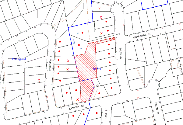
|
NOTIFICATION PLAN |
|
||
|
• PROPERTIES NOTIFIED
|
X SUBMISSIONS RECEIVED |
PROPERTY SUBJECT OF DEVELOPMENT |
|
Seven submissions objected to the development, generally on the following grounds:
· Unacceptable privacy and visual impacts;
· Unacceptable excavation in vicinity of boundaries and trees;
· Flooding frequency and impacts;
· Lack of visitor parking;
· Overdevelopment of environmentally sensitive site; and
· Loss of residential amenity.
The merits of the matters raised in community submissions have been addressed in the body of the report.
5.2 Public Agencies
The application is ‘integrated development’ required approval of the NSW Office of Water for the issue of a Controlled Activity Permit under the Water Management Act 2000 for works in the vicinity of the watercourse.
The NSW Office of Water has granted General Terms of Approval for the proposed development subject to conditions.
6. THE PUBLIC INTEREST
The public interest is an overarching requirement, which includes the consideration of the matters discussed in this report. Implicit to the public interest is the achievement of future built outcomes adequately responding to and respecting the future desired outcomes expressed in environmental planning instruments and development control plans.
The site is subject to frequent flooding. The proposed Seniors Living development is contrary to planning controls to prevent development on flood affected land and accordingly is contrary to the public interest.
CONCLUSION
The proposal is for the demolition of existing structures and construction of a Seniors Living development comprising 13 dwellings, flood mitigation works and restoration of a watercourse.
The site is subject to flooding. The site has been subject to previous applications for Seniors Living development refused by Council and the subsequent appeals rejected in the Land and Environment Court, primarily of grounds of flood impact.
The proposed development is a revision of previous proposals with regard to flood modelling and decisions of the Land and Environment Court. The proposal for a two storey building at the Anthony Street frontage and a single storey building at the rear is generally satisfactory in respect to the requirements of the Seniors Living SEPP for developments to have regard to the residential character of low density residential areas. The design of the proposed development however, is constrained by the flood impacts of the site and restricted to the western part of the site. The constraints detract from residential amenity and are unsatisfactory in respect to the design principles of the Seniors Living SEPP.
The NSW Office of Water has granted General Terms of Approval for the proposed restoration of the watercourse. The proposed Vegetation Management Plan is generally acceptable for the propose development and the remnant Blue Gum High Forest on the site.
The proposed flood mitigation works include the construction of a floodway from the Anthony Street frontage of the site to the watercourse. The site of the proposed development is subject to flood inundation for 1 in 5 year storms and greater. Notwithstanding the flood mitigation works the Anthony Street frontage is impassable in a 1 in 100 year storm. The proposed development would increase the flooding impacts on adjoining properties.
The proposed basement carpark and accessway off the existing driveway off Eyles Avenue are in non-compliance with AS 2890.1 – Off Street Car Parking. The part of the site comprising No. 15 Anthony Street does not have legal right of access over the driveway off Eyles Avenue.
Seven submissions were received in response to notification of the proposal.
The application is recommended for refusal.
|
Rod Pickles Manager - Development Assessment Planning Division |
James Farrington Group Manager Planning Division |
|
1.View |
Locality Plan |
|
|
|
2.View |
DA Plans |
|
|
|
3.View |
Tree Schedule |
|
|
File Reference: DA/627/2012
Document Number: D01993945
SCHEDULE 1
1. The proposed development is unsatisfactory in respect to Section 79C(1)(a)(i) of the Environmental Planning and Assessment Act 1979 as the proposal does not adequately address the design principles of State Environmental Planning Policy (Housing for Seniors or People with a Disability) 2004 in respect to the following matters:
a) The proposed elevated walkway does not have adequate regard to the privacy of neighbouring residents.
b) The proposed development would increase the flood risk for adjoining properties.
c) The proposed elevated walkway would not provide an appropriate environment for residents to access public transport and local facilities.
d) The proposed accessway and basement carparking area restrict vehicle movement and access.
2. The proposed development is unsatisfactory in respect to Section 79C(1)(b) of the Environmental Planning and Assessment Act 1979 as the proposed development of flood prone land would establish an unacceptable precedent and detract from the built environment.
3. The proposed development is unsatisfactory in respect to Section 79C(1)(b) of the Environmental Planning and Assessment Act 1979 as the proposed development of flood prone land would result in a residential environment unacceptable for Seniors Living.
4. The proposed development is unsatisfactory in respect to Section 79C(1)(c) of the Environmental Planning and Assessment Act 1979 as the subject site is unsuitable for the proposed development due to the frequent flooding of the site.
5. The proposed development is unsatisfactory in respect to Section 79C(1)(e) of the Environmental Planning and Assessment Act 1979 as the proposal to contrary to planning controls to restrict development of flood prone land and would not be in the public interest.
6. The consent of the owners of the land for the proposed accessway for the development (Nos. 17-19 Eyles Avenue, Epping) has not been obtained for a right of carriageway benefiting the area of the site within Lot 3 DP 20713, pursuant to Section 49 of the Environmental Planning and Assessment Regulation 2000.
- END OF REASONS FOR REFUSAL -
Planning Report No. PL32/12
Planning Division
Date of Meeting: 21/11/2012
10 DEVELOPMENT APPLICATION - FIVE STOREY RESIDENTIAL FLAT BUILDING COMPRISING 29 UNITS - 70 & 72 KEELER STREET, CARLINGFORD
EXECUTIVE SUMMARY
|
DA No: |
DA/677/2012 (Lodged 5 July 2012) |
|
Description: |
Construction of a five storey residential flat building comprising 29 units, basement car parking and strata title subdivision |
|
Property: |
Lot 22 DP 32722, Lot 21 DP 32722, Nos. 70 & 72 Keeler Street, Carlingford |
|
Applicant: |
D + C Consortium |
|
Owner: |
Mr S B Horwood, Mr T I Kang and Ms J K Suh |
|
Estimated Value: |
$7,750,000 |
|
Ward: |
C |
· The application proposes the demolition of existing structures and the construction of a five storey residential flat building comprising 29 units, basement car parking and strata subdivision.
· The proposal generally complies with the Hornsby Shire LEP 1994, State Environmental Planning Policy No. 65 – Design Quality Residential Flat Building and the Housing Strategy Development Control Plan.
· One submission has been received in respect of the application.
· It is recommended that the application be approved.
|
THAT Development Application No. 677/2012 for construction of a five storey residential flat building comprising 29 units and strata subdivision at Lot 22 DP 32722, Lot 21 DP 32722, Nos. 70 & 72 Keeler Street, Carlingford be approved subject to the conditions of consent detailed in Schedule 1 of Group Manager’s Report No. PL32/12. |
BACKGROUND
The site is within the ‘Carlingford Road, Carlingford Precinct’, rezoned for five storey residential flat development as part of Council’s Housing Strategy on 2 September 2011.
The site adjoins the site of a similar proposal for a five storey residential flat building at Nos. 66-68 Keeler Street (DA/676/2012).
THE SITE
The site has an area of 1,886.4m2 and is a regular shaped site with a frontage of 34.7m to the northern side of Keeler Street. The site includes two existing dwelling houses, an inground pool, carport, detached garage and several trees. The site has a north-easterly aspect and an average fall of 6% to the north-eastern corner of the site.
The site forms part of the ‘Carlingford Road, Carlingford’ precinct rezoned for medium-high density housing in accordance with Council’s Housing Strategy in September 2011. The precinct is bounded by Carlingford Road, Pennant Hills Road, Keeler Street and Hepburn Avenue. A number of sites within the precinct have been approved for residential flat development or are under assessment by Council.
The existing surrounding developments within the precinct mainly include dwelling houses on suburban lots. There is a mix of low density and medium density housing on the opposite side of Keeler Street within the Parramatta City Council area. Keeler Street forms the boundary between the Hornsby and Parramatta local government areas in this location at Carlingford.
The area on the western side of Pennant Hills Road, Carlingford, within The Hills Shire Council area is undergoing transition for high density housing developments.
The site is within walking distance (120m) of the Carlingford commercial centre on Pennant Hills Road and is located 800m north-east of Carlingford Railway Station.
PROPOSAL
The proposal is for the demolition of two existing dwelling houses and construction of a five storey building containing 29 units. The proposed units include 5 x 1 bedroom, 21 x 2 bedroom and 3 x 3 bedroom units. The proposed building includes three levels of basement car parking with 42 car parking spaces. The proposed ground floor is split level at the rear of the building.
The proposed development includes strata subdivision.
ASSESSMENT
The development application has been assessed having regard to the ‘Metropolitan Plan for Sydney 2036’, the ‘North Subregion (Draft) Subregional Strategy’ and the matters for consideration prescribed under Section 79C of the Environmental Planning and Assessment Act 1979 (the Act). The following issues have been identified for further consideration.
1. STRATEGIC CONTEXT
1.1 Metropolitan Plan for Sydney 2036 and (Draft) North Subregional Strategy
The Metropolitan Plan for Sydney 2036 is a broad framework to secure Sydney’s place in the global economy by promoting and managing growth. It outlines a vision for Sydney to 2036; the challenges faced, and the directions to follow to address these challenges and achieve the vision. The Draft North Subregional Strategy acts as a framework for Council in its preparation of the Comprehensive LEP by the end of 2012.
The Draft North Subregional Strategy sets the following targets for the Hornsby LGA by 2031:
· Employment capacity to increase by 9,000 jobs; and
· Housing stock to increase by 11,000 dwellings.
The proposed development would be consistent with the draft Strategy by providing an additional 27 dwellings and would contribute towards housing choice in the locality.
The proposed development would be consistent with the Metropolitan Plan for Sydney 2036.
2. STATUTORY CONTROLS
Section 79C(1)(a) requires Council to consider “any relevant environmental planning instruments, draft environmental planning instruments, development control plans, planning agreements and regulations”.
2.1 Hornsby Shire Local Environmental Plan 1994
The subject land is zoned Residential C (Medium/High Density) under the Hornsby Shire Local Environmental Plan 1994 (HSLEP). The objectives of the zone are:
(a) to provide for the housing needs of the population of the Hornsby area.
(b) to promote a variety of housing types and other land uses compatible with a medium to high density residential environment.
(c) to provide for development that is within the environmental capacity of a medium to high density residential environment.
The proposed development is defined as ‘multi-unit housing’ under the HSLEP and is permissible in the zone with Council’s consent. The land is identified within the area detailed on Diagram 8 under Schedule BB of the HSLEP. Clause 15A of the HSLEP prescribes that the maximum building height within the area detailed under Schedule BB is not to exceed 17.5 metres. The proposed building complies with this requirement.
Clause 18 of the HSLEP sets out heritage conservation provisions for Hornsby Shire. The site is not in the vicinity of a heritage item or conservation area and is not subject to consideration for heritage conservation.
2.2 Draft Comprehensive Hornsby Local Environmental Plan
The draft Comprehensive Local Environmental Plan (HLEP) was exhibited from 5 June 2012 to 7 August 2012. The draft HLEP essentially reiterates the current land use zoning and height control applicable to the site as outlined below:
2.2.1 Zoning
The site would be zoned R4 (High Density Residential) zone pursuant to the Land Use Table of the draft HLEP. The proposed development is defined as a ‘Residential Flat Building’ and would be a permissible use in the zone with Council’s consent.
2.2.2 Height of Building
Clause 4.3 of the draft HLEP provides that the height of a building on any land is not to exceed the maximum height shown for the land on the Height of Buildings Map. The maximum permissible height for the subject site is 17.5 metres. The proposal complies with this provision.
2.3 State Environmental Planning Policy No. 55 – Remediation of Land
State Environmental Planning Policy No. 55 (SEPP 55) requires that Council must not consent to the carrying out of any development on land unless it has considered whether the land is contaminated or requires remediation for the proposed use.
The site has been used for residential purposes and is unlikely to be contaminated. No further assessment is considered necessary in this regard. A condition is recommended should any contamination be found during construction.
2.4 State Environmental Planning Policy No. 65 – Design Quality Residential Flat Development
The Policy provides design principles to improve the design quality of residential flat development and consistent planning controls across the State.
The applicant has submitted a design verification statement prepared by a qualified designer stating how the proposed development achieves the design principles of SEPP 65. The design principles of SEPP 65 and the submitted design verification statement are noted addressed below:
2.4.1 Principle 1 - Context
Design Principle 1 is as follows:
Good design responds and contributes to its context. Context can be defined as the key natural and built features of an area.
Responding to context involves identifying the desirable elements of a location’s current character or, in the case of precincts undergoing a transition, the desired future character as stated in planning and design policies. New buildings will thereby contribute to the quality and identity of the area.
The applicant submits the Housing Strategy Development Control Plan sets the vision for the redevelopment of the ‘Carlingford Road, Carlingford precinct’ and that the proposed development is designed in accordance with the intended future character of the precinct.
The subject site is located within a precinct zoned for five storey residential flat buildings in close proximity to Pennant Hills Road and the Carlingford Court Shopping Centre. The desired future character of the area, as outlined in Council’s Housing Strategy Development Control Plan, is that of a high density residential precinct incorporating five storey developments in a landscape setting. It is considered that the proposed building would contribute to the identity and future character of the precinct.
2.4.2 Principle 2 - Scale
Design Principle 2 is as follows:
Good design provides an appropriate scale in terms of the bulk and height that suits the scale of the street and the surrounding buildings.
Establishing an appropriate scale requires a considered response to the scale of existing development. In precincts undergoing a transition, proposed bulk and height needs to achieve the scale identified for the desired future character of the area.
The applicant submits that the proposed development is designed in accordance with the setback, building height and articulation requirements for the precinct to achieve an appropriate bulk and scale. The scale of the development is consistent with the desired future character for the precinct of five storey residential flat buildings. Accordingly, the applicant’s submission is supported in respect of this Principle.
2.4.3 Principle 3 – Built Form
Design Principle 3 is as follows:
Good design achieves an appropriate built form for a site and the building’s purpose, in terms of building alignments, proportions, building type and the manipulation of building elements.
Appropriate built form defines the public domain, contributes to the character of streetscape and parks, including their views and vistas, and provides internal amenity and outlook.
The applicant submits that the proposed built form achieves quality indoor and external spaces, designed to provide sufficient private open space, day light and ventilation. The proposed building includes elements such as vertical blade walls, glazing and metal awnings which with articulation through setbacks and projections creates an interesting building appearance.
The applicant’s statement is supported in respect to this Principle.
2.4.4 Principle 4 – Density
Design Principle 4 is as follows:
Good design has a density appropriate for a site and its context, in terms of floor space yields (or number of units or residents).
Appropriate densities are sustainable and consistent with the existing density in an area or in precincts undergoing a transition, are consistent with the stated desired future density. Sustainable densities respond to the regional context, availability of infrastructure, public transport, community facilities and environmental quality.
The applicant submits the principle is achieved in meeting the density requirements of the Housing Strategy Development Control Plan. The applicant’s submission is supported in respect of this Principle.
2.4.5 Principle 5 – Resource, Energy and Water Efficiency
Design Principle 5 is as follows:
Good design makes efficient use of natural resources, energy and water throughout its full life cycle, including construction.
Sustainability is integral to the design process. Aspects include demolition of existing structures, recycling of materials, selection of appropriate and sustainable materials, adaptability and reuse of buildings, layouts and built form, passive solar design principles, efficient appliances and mechanical services, soil zones for vegetation and reuse of water.
The applicant has submitted BASIX Certificate No. 436235M for the proposed 29 units. In achieving the required BASIX targets for sustainable water use, thermal comfort and energy efficiency, the proposed development achieves the design criteria.
2.4.6 Principle 6 – Landscape
Design Principle 6 is as follows:
Good design recognises that together landscape and buildings operate as an integral and sustainable system, resulting in greater aesthetic quality and amenity for both occupants and the adjoining public domain.
Landscape design builds on the existing site’s natural and cultural features in responsible and creative ways. It enhances the development’s natural environmental performance by co-ordinating water and soil management, solar access, micro-climate, tree canopy and habitat values. It contributes to the positive image and contextual fit of development through respect for streetscape and neighbourhood character, or desired future character.
Landscape design should optimise useability, privacy and social opportunity, equitable access and respect for neighbour’s amenity, and provide for practical establishment and long term management.
The applicant submits that the proposed landscaping includes a range of low maintenance ground covers, shrubs, and medium and large trees, well located. The proposal includes landscaping along the street frontage, side and rear boundaries. The proposed landscaping would provide an appropriate landscape setting to the development and would contribute to the streetscape and the character of the locality. Accordingly, the applicant’s submission is supported in respect of this Principle.
2.4.7 Principle 7 – Amenity
Design Principle 7 is as follows:
Good design provides amenity through the physical, spatial and environmental quality of a development.
Optimising amenity requires appropriate room dimensions and shapes, access to sunlight, natural ventilation, visual and acoustic privacy, storage, indoor and outdoor space, efficient layouts and service areas, outlook and ease of access for all age groups and degrees of mobility.
The applicant submits that all units receive sufficient daylight and cross ventilation with spaces sufficiently large for better use of the occupants. The development includes adaptable units and units able to be modified when needed.
The proposed building is designed with regard to the spatial arrangement of adjoining approved and proposed buildings to provide appropriate amenity for future concepts of the proposed units. The units are of acceptable design for residential amenity. Accordingly, the applicant’s submission is supported in respect of this Principle.
2.4.8 Principle 8 – Safety and Security
Design Principle 8 is as follows:
Good design optimises safety and security, both internal to the development and for the public domain.
This is achieved by maximising overlooking of public and communal spaces while maintaining internal privacy, avoiding dark and non-visible areas, maximising activity on streets, providing clear, safe access points, providing quality public spaces that cater for desired recreational uses, providing lighting appropriate to the location and desired activities, and clear definition between public and private spaces.
The applicant submits that the development is designed for effective safety and security and notes visible entries, height of ground floor balustrades and fencing and lighting of common areas.
The NSW Police commented on the proposed development and recommend conditions for lighting, territorial re-enforcement, environmental maintenance and access control.
The applicant’s submitted statement is supported in respect of this Principle subject to appropriate conditions of consent.
2.4.9 Principle 9 – Social Dimensions and Housing Affordability
Design Principle 9 is as follows:
Good design responds to the social context and needs of the local community in terms of lifestyles, affordability, and access to social facilities.
New development should optimise the provision of housing to suit the social mix and needs in the neighbourhood or, in the case of precincts undergoing transition, provide for the desired future community.
New development should address housing affordability by optimising the provision of economic housing choices and providing a mix of housing types to cater for different budgets and housing needs.
The applicant submits that the proposal includes a mix of dwellings in accordance with the Housing Strategy Development Control Plan.
The proposed building includes a range of unit sizes and layouts for each floor and would provide for a range of households. Accordingly, the applicant’s submission is supported in respect of this Principle.
2.4.10 Principle 10 – Aesthetics
Design Principle 10 is as follows:
Quality aesthetics require the appropriate composition of building elements, textures, materials and colours and reflect the use, internal design and structure of the development. Aesthetics should respond to the environment and context, particularly to desirable elements of the existing streetscape or, in precincts undergoing transition, contribute to the desired future character of the area.
The applicant has made the following statement:
The proposal is designed to meet the aims of ‘The Housing Strategy DCP’ and to achieve quality designed built form, a building in a garden rather than a garden around the building. Quality landscaped area all around the building shall promote the visual quality and the streetscape.
The building is vertically and horizontally articulated. It is designed to have sufficient setbacks and projections, introduction of vertical and horizontal elements such as blade walls, balconies with soft and hard balustrade. Variety of materials, colours and textures are used to promote the visual quality. Rendered and painted masonry walls, glazed balconies, stone walls powder-coated metal awnings and shading devices used to promote aesthetic value.
The proposed building achieves the required articulated five storey built form in accordance with Council’s Housing Strategy DCP and would contribute to the desired future streetscape character. The applicant’s submitted statement is supported in respect to this Principle.
2.5 SEPP 65 - Residential Flat Design Code
SEPP 65 also requires consideration of the Residential Flat Design Code, NSW Planning Department 2002. The Code includes development controls and best practice benchmarks for achieving the design principles of the SEPP 65. The following table sets out the proposal’s compliance with the Code:
|
Residential Flat Design Code |
|||
|
Control |
Proposal |
Requirement |
Compliance |
|
Deep Soil Zone |
37% |
25% |
Yes |
|
Communal Open Space |
30% |
25-30% |
Yes |
|
Gnd Level Private Open Space |
25m2 + Min dimension 2.5m |
25m2 Min Dimension 4m2 |
Yes No |
|
Minimum Dwelling Size |
1 br – 70m2 2 br – 76m2 3 br – 116m2 |
1 br – 50m2 2 br – 70m2 3 br – 95m2 |
Yes Yes Yes |
|
Maximum Kitchen Distance |
8m |
8m |
Yes |
|
Minimum Balcony Depth |
2m |
2m |
Yes |
|
Dual Aspect & Cross Ventilation |
62% |
60% |
Yes |
|
Adaptable Housing |
30% |
10% |
Yes |
As detailed in the above table, the proposed development complies with the prescriptive measures within the Residential Flat Design Code other than the minimum dimension for ground level open space. Below is a brief discussion regarding the relevant development controls and best practice guidelines.
2.5.1 Apartment Layout
The proposed unit layouts are generally satisfactory in achieving functional, well proportioned spaces with access to natural light and open space. The unit layouts would provide for housing choice and a range of household types.
2.5.2 Ground Floor Apartments
The proposed ground floor apartments are in accordance with the requirements of the Code for larger open space areas, dual aspect design and configured to provide housing choice.
The proposal includes two lower ground floor units at the northern elevation with the stepping of the building (Unit G04 and Unit G05). The two units have a higher ceiling height of 4m. The residential standard is 2.7m. The applicant has acknowledged the higher ceiling height could provide useable space and a design feature. A condition is recommended for the higher ceiling space to be a feature in the interior design for the lower ground floor units to provide for storage space and additional light and ventilation to living areas.
The units would provide for accessible/adaptable housing subject to provision of a stair lift for access to the central lift.
The proposed ground floor includes Unit G02 and Unit G03 at the western elevation with access to private open space at ground level via stairs. The ground level areas would be substantially overlooked by the terrace area of the adjacent unit. The ground level open space areas would not contribute significantly to useable private open space and would obstruct access to landscaping along the western side of the building and potentially increase crime risk by creating disconnected space with the communal area. A condition is recommended for the stairs and ground level private open areas to be deleted and the area incorporated into landscaping and communal open space.
Proposed Unit G02 includes windows over the vehicle access ramp. The windows are more than 2.7m above the level of the ramp and would not be visually impacted by vehicles on the ramp. In this regard a condition is recommended for the Unit G02 terrace to be enclosed by a solid wall at the southern elevation. Refer also to Section 2.5.4.
The proposed ground floor Unit G06 at the eastern elevation includes a balcony which is opposite the ground floor terraces of units of a proposed adjoining building (DA/676/2012). A building separation of 8.75m is proposed. To ensure adequate privacy, a condition for a moveable louvered privacy screen is recommended for the balcony. A condition is recommended for deletion of the stairs off the balcony which are not required.
Proposed Unit G06 includes a terrace off bedroom 1 providing a combined 25m2 open space for the unit. The proposed terrace would have minimal use and aligns with an open access to the fire stairs. Conditions are recommended for the terrace and open access area to be deleted and replaced with landscaping and for the bedroom sliding door to be replaced with a window with screening for privacy.
At the eastern elevation, the proposed northern fire stair exit and the exit to communal open space open onto an unsecured internal enclave that adjoins the balcony of Unit G06. To ensure appropriate amenity and security a condition is recommended for a single exit to align with the external wall of the building.
The proposed ground floor terraces and balconies feature open balustrades. The terraces and balconies would interface with the pedestrian walkway around the building and at the frontage. A condition is recommended for the ground floor terraces and balconies to include solid opaque balustrades to prevent a line of sight into the units.
The ground floor terrace of Unit G05 would overlook the opposing Unit G04 of the adjoining proposed residential flat development (DA/676/2012). It is considered the proposed landscaping for screen planting along the boundary would provide for privacy.
Subject to recommended conditions, the proposed ground floor units are considered acceptable in respect to the Code’s best practice for ground floor units, notwithstanding the resulting non-compliance with the Code’s best practice for 25m2 of open space with a minimum dimension of 4m for ground floor apartments (Units G02, G03 and G06). The non-compliance is considered acceptable in providing housing choice for ground floor apartments with good amenity.
2.5.3 Internal Circulation
The proposed building includes three to seven units with lift access on the respective levels in accordance with the Code’s best practice guidelines for up to eight units per lift. The location of unit entries and articulation of internal passage ways would ensure appropriate amenity.
The proposed refuse chute is next to the entries to Unit G06, Unit 107 and Unit 207. To ensure appropriate amenity, a condition is recommended for the unit entries to be repositioned not less than 2m from the refuse chute.
The front entry includes an entry foyer. The entry to the building is clearly defined at the frontage. There is however, a fall of 0.9m from the front entry to the street footpath and a condition is recommended for the front access to include a ramp for people with a disability.
The ground floor includes access to communal open space areas from the frontage and at the northern elevation. The proposed ground floor includes stairs on the access between the lift and the northern entry. A condition is recommended for the access to comply with AS1428.1 – Design for Access and Mobility.
Subject to recommended conditions, the proposal is considered acceptable in respect to the Code’s requirements for internal circulation.
2.5.4 Acoustic Privacy
The units within the proposed building are configured for separation and acoustic privacy between units in accordance with the Code’s best practice guidelines. A condition is recommended for the windows of Unit G02 over the driveway to incorporate acoustic treatments necessary to address noise from the use of the driveway.
2.5.5 Storage
The proposed building includes 29 resident storage areas for all units within the building. The storage areas are located within Basement Levels 2 and 3.
A condition is recommended for the storage areas to be allocated in accordance with the size requirements of the Code for the respective units and proximity to unit car parking spaces.
In summary, the proposed residential flat building has been designed in accordance with the design principles of SEPP 65 and generally complies in respect to the Residential Flat Design Code subject to the imposition of appropriate conditions of consent. It is considered the proposal would achieve good residential amenity and contribute to the desired future residential character of the Carlingford Road Precinct.
2.6 State Environmental Planning Policy (Building Sustainability Index – BASIX) - 2004
The application has been assessed against the requirements of State Environmental Planning Policy (Building Sustainability Index: BASIX) 2004. The proposal includes a BASIX Certificate for the proposed units and is considered to be satisfactory.
2.7 State Environmental Planning Policy No. 32 - Urban Consolidation (Redevelopment of Urban Land) (SEPP 32)
The application has been assessed against the requirements of SEPP 32, which requires Council to implement the aims and objectives of this Policy to the fullest extent practicable when considering development applications relating to redevelopment of urban land. The application complies with the objectives of the Policy as it would promote social and economic welfare of the locality and would result in the orderly and economic use of under utilised land within the Shire.
2.8 Sydney Regional Environmental Plan (Sydney Harbour Catchment) 2005
The application has been assessed against the requirements of Sydney Regional Environmental Plan (Sydney Harbour Catchment) 2005. This Policy provides general planning considerations and strategies to ensure that the catchment, foreshores, waterways and islands of Sydney Harbour are recognised, protected, enhanced and maintained.
The proposal includes details of stormwater management of the site by providing an on-site detention system. Council’s assessment of the proposal in this regard concludes that the development is satisfactory. A condition is recommended with respect to installation of sediment and erosion control measures prior to, and during, construction.
The proposed development would have minimal potential to impact on the Sydney Harbour Catchment.
2.9 Housing Strategy Development Control Plan
The proposed development has been assessed having regard to the desired outcomes and prescriptive measures within Council’s Housing Strategy Development Control Plan (Housing Strategy DCP). The following table sets out the proposal’s compliance with the prescriptive measures of the Plan:
|
Housing Strategy Development Control Plan |
|||
|
Control |
Proposal |
Requirement |
Compliance |
|
Site Width |
34.7m |
30m |
Yes |
|
Height |
5 storeys – 17.5m |
5 storeys – 17.5m |
Yes |
|
Lowest Residential Floor Above Ground |
0.9m |
Max - 1.50m |
Yes |
|
Maximum Floorplate Dimension |
36.5m |
35m |
No |
|
Building Indentation |
4m |
4m |
Yes |
|
Front Setback |
10m 8m < 1/3rd frontage Balc. 7m < 1/3rd |
10m 8m < 1/3rd frontage Balc. 7m < 1/3rd |
Yes Yes Yes |
|
W Side Setback |
6m 4m < 1/3rd frontage |
6m 4m < 1/3rd frontage |
Yes Yes |
|
E Side Setback |
6m 4m < 1/3rd frontage |
6m 4m < 1/3rd frontage |
Yes Yes |
|
Rear Setback |
10m 8m < 1/3rd boundary 7m balc encr |
10m 8m < 1/3rd boundary 7m balc encr |
Yes Yes Yes |
|
Top Storey Setback From Ground Floor |
3m |
3m |
Yes |
|
Underground Parking Setback |
Front - 7m W Side - 4m E Side – 4m Rear – 7m |
7m 4m 4m 7m |
Yes Yes Yes Yes |
|
Basement Ramp Setback |
3.75m |
2m |
Yes |
|
Car Parking |
36 resident spaces 7 visitor spaces |
32 resident spaces 6 visitor spaces |
Yes Yes |
|
Landscaping |
Front & Rear – 7m W Side – 4m E Side – 4m |
7m 4m 4m |
Yes Yes Yes |
|
Private Open Space Min Width 2.5m |
1 br units - > 10m2 2 br units - > 12m2 3 br units - > 19m2 |
10m2 12m2 16m2 |
Yes Yes Yes |
|
Communal Open Space |
30% |
25% |
Yes |
|
Sunlight Access |
75% |
70% |
Yes |
|
Housing Choice |
1 br units – 17% 2 br units - 73% 3 br units – 10% |
10% 10% 10% |
Yes Yes Yes |
|
Adaptable Units |
30% |
30% |
Yes |
As detailed in the above table, the proposed development does not comply with the maximum floorplate prescriptive measure within Council’s Housing Strategy DCP. The matter of non-compliance is detailed below, as well as a brief discussion regarding the desired outcomes and the prescriptive measures.
2.9.1 Desired Future Character
Subject to recommended conditions discussed in Section 2.5, the proposed development meets the prescriptive measures for setbacks and landscaping and generally achieves the desired future character for well articulated five storey residential flat buildings in a landscaped setting.
2.9.2 Design Quality – SEPP 65
The proposed development is generally satisfactory in meeting the design principles of SEPP 65 (refer to discussion in Sections 2.4 and 2.5).
2.9.3 Site Requirements
The proposed development occupies a consolidated site and complies with the minimum 30m site width requirement.
The proposal would not result in an isolated site or compromise development in accordance with the Housing Strategy DCP.
2.9.4 Height
The proposed building includes a split ground floor level and complies with the 17.5m maximum height limit and is acceptable. The proposed height of the basement above ground level is exceeded to a minor extent at the change in floor level for the split level design, which is considered acceptable.
2.9.5 Setbacks
The proposal achieves the desired outcome for articulated built form and provision of landscaping.
The proposal complies with the prescriptive measures for front, side, top storey, basement car park and basement ramp setbacks.
2.9.6 Landscaping
There are no existing trees on the site having landscape significance.
The submitted landscape plan includes locally indigenous canopy trees, native shrubs and ground covers together with exotic species. The plan complies with the Housing Strategy DCP prescriptive measures. Conditions are recommended for planting of additional locally native trees and for planting of Callistemon viminalis (Weeping Bottlebrush) in the nature strip.
The submitted landscaping plan is considered satisfactory in establishing communal open space areas, screen planting, residential amenity and in landscape treatment of the building in the streetscape.
2.9.7 Floorplates and Separations
The proposed building floorplate has a maximum dimension of 36.5m. The proposed building however, complies with the required setbacks. The non-compliance involves an area of 3.7m2 which is relatively minor and is considered acceptable with regard to the area available for landscaping.
The proposed building includes 4m x 4m indentation at the eastern elevation of the building. At the western elevation the proposed building is progressively setback 4.0m and 6m. The proposed driveway increases the side setback to 6.75m for the ground floor. The proposed building does not include the necessary indentations or individual roofs required to form two separate building pavilions in accordance with the prescriptive measure. The non-compliance is considered acceptable with regard to the proposed articulation which breaks the massing of the building.
2.9.8 Articulation
The proposed building complies with the Housing Strategy DCP required elements for articulation including; wrap-around balconies, facades divided into vertical panels separated by indentations and projecting balconies, sheer vertical elements limited to 50% of façade, wide eaves and flat pitched roof without parapets, high proportion of windows at the top storey, panels of curtain wall windows, steel framed balconies, sunscreens and feature panels of light cladding and painted masonry.
The proposed building is essentially the same design as the adjoining proposed building under DA/676/2012. The applicant has submitted a photomontage of the two proposed buildings in the streetscape which demonstrates the different treatment of the two facades in the streetscape.
The proposed building articulation complies with the articulation prescriptive measures.
2.9.9 Open Space
The proposed units comply with the required minimum area for open space accessible off living areas. The proposal includes a communal open space area in accordance with the minimum requirement.
The proposal includes provision for active living with bicycle storage at Basement Level 1.
2.9.10 Privacy
The proposal is considered acceptable in providing for reasonable privacy for residents of the proposed and future adjoining developments. A condition is recommended for solid opaque ground floor balcony balustrades to prevent line of sight into the proposed units from the communal open space areas.
The proposal includes an 8m separation between the eastern elevation of proposed building and the adjoining proposed residential flat building at Nos. 66-68 Keeler Street. Conditions are recommended for privacy screening of the subject proposed ground floor units at the eastern elevation. The units on the floors above are configured with regard to the proposed units opposite to ensure opposing balconies have a separation of more than 12m which is considered acceptable in terms of privacy.
The proposed southern elevation includes balconies with views over Keeler Street and the villa housing development opposite the site. The proposal would not detract from amenity of the private open space areas of the villa development.
2.9.11 Sunlight and Ventilation
The applicant has submitted a sunlight access analysis demonstrating compliance with the Housing Strategy DCP prescriptive requirement for 70% of dwellings to receive 2 hours of sunlight between 9am and 3pm 22 June.
2.9.12 Housing Choice
The proposed development includes a range of housing types and provision for people with disabilities and for aging in place in accordance Housing Strategy DCP prescriptive measures.
A condition is recommended for three units to be accessible for people with a disability and for nine dwellings to be adaptable for disabled access.
2.9.13 Vehicle Access and Parking
The proposed development complies with the required car parking provision and bicycle provision for residents and visitors subject to recommended conditions.
The proposed storage areas comply with the requirements of the Residential Flat Design Code and are acceptable subject to a recommended condition.
To provide for site security a condition is recommended for the driveway ramp to be designed to prevent pedestrian access from the driveway to the western side of the building.
2.10 Waste Minimisation & Management Development Control Plan (WMMDCP)
The applicant has submitted a Waste Management Plan which is satisfactory in meeting criteria for recycling and reuse of materials in the proposed demolition of the two existing dwelling houses. The plan includes appropriate project management measures for waste minimisation in the construction of the building.
A dual function chute is proposed for recycling and garbage rather than provide a recycling bin on each level plus the garbage chute. The dual function proposal is acceptable subject to conditions for operation and management.
For 29 dwellings, the site would require 7 x 240L garbage bins serviced twice weekly plus 7 x 240 L recycling bins serviced weekly. The basement bin room is sufficient size to house the required number of bins. The proposed bin collection area at the frontage is of sufficient area for the number of bins required for the proposed dwellings.
The electrical meter room is accessed via the basement bin room. For safety reasons, meter readers (and any other unauthorised persons including residents) must not have access to the volume handling machinery (garbage compactor, carousel/linear). In this regard a condition is recommended a cage enclosure for the waste handling machinery.
The proposed development would require a waste collection vehicle to reverse onto the site and park on the driveway to service the bins then move forward out of the property. This is considered acceptable for the traffic conditions of Keeler Street. An easement is recommended covering all drive way/access way areas to be used by waste collection vehicles.
The proposal includes a collection area for bulky waste items awaiting removal. Council however, does not provide kerbside clean-up service to unit buildings over three storey. Accordingly, a condition is recommended for the facility to be deleted and the area incorporated into landscaping.
Subject to recommended conditions, the proposed development is satisfactory in respect to the WMMDCP.
2.11 Access and Mobility Development Control Plan
The proposed development includes nine adaptable housing units (Nos. G01, 101, 102, 105, 106, 201, 202, 205 and 206). The applicant has submitted an Access Report which demonstrates that the units are capable of being adapted for people with a disability in accordance with AS4299-1995 Adaptable housing. A condition is recommended for three of the units to be wheelchair accessible units in accordance with AS1428.1 – Design for Access and Mobility.
The proposed disabled car parking spaces within the basement levels are designed to comply with AS2890.6-2009 Parking facilities – Off street parking for people with disability.
The proposed building includes a split level ground floor and change in level between the front entry and the street. A condition is recommended for the proposed direct street access, the access to the community garden area and the letter box to be compliant with the design and technical specifications of AS1428.1-2009 Clause 10 Walkways, ramps and landings.
Subject to recommended conditions, the proposed development complies with the Access and Mobility Development Control Plan.
2.12 Car Parking Development Control Plan
The proposed development has been assessed having regard to the relevant performance and prescriptive design requirements contained within Council’s Car Parking Development Control Plan and is in compliance with Council’s car parking requirements. Refer also to discussion in Section 2.8.13.
2.13 Sustainable Water Development Control Plan
Subject to sediment and erosion control measures being implemented on site during construction, the proposal would comply with the requirements contained within the Sustainable Water Development Control Plan.
2.14 Section 94 Development Contributions Plan 2007-2012
Council’s Section 94 Plan applies to the development as it would result in an additional 29 residential units on the site. Accordingly, the requirement for a monetary Section 94 Contribution is recommended as a condition of development consent.
3. ENVIRONMENTAL IMPACTS
Section 79C(1)(b) of the Act requires Council to consider “the likely impacts of that development, including environmental impacts on both the natural and built environments, and social and economic impacts in the locality”.
3.1 Natural Environment
The site does not include any locally indigenous trees of significance.
The submitted landscaping plan is satisfactory in contributing to the establishment of locally indigenous canopy trees.
3.2 Built Environment
3.2.1 Carlingford Road Precinct
The proposed five storey building is consistent with the desired built form for five storey residential flat building within the Carlingford Road Precinct which is undergoing transition in built form.
3.2.2 Keeler Street – Southern Side
The site is opposite a single and two storey villa housing development fronting the southern side of Keeler Street. The proposed development would overshadow the frontage of dwellings in the streetscape mid afternoon on 22 June. The extent of overshadowing would be in compliance with development standards for a minimum of 3 hours of sunlight for north facing living area windows of dwellings within low density residential areas.
3.2.3 Traffic Generation and Car Parking
In the preparation of Council’s Housing Strategy transport modelling was undertaken to determine the traffic impacts of precincts to be rezoned as part of the Strategy.
Traffic modelling and assessment for the Carlingford Precinct established that additional traffic that would be generated in the Precinct would not have a significant impact on existing roadway conditions and intersection performance in the area. The most significant traffic increase is envisaged to occur on arterial routes such as Pennant Hills Road and Carlingford Road. These increases are mainly attributed to anticipated growth and developments in other regions and to a greater extent to the re-distribution effect arising from the growth in through traffic from other regions of Sydney.
The modelling also established that the existing performance of the intersection of Carlingford Road with Hepburn Avenue is unsatisfactory during the morning peak period. This is mainly due to peak hour traffic congestion in Carlingford Road which limits the number of vehicles that can turn right out Hepburn Avenue. Signalising this junction would facilitate and improve access for the Precinct. However, it is considered that this would encourage ‘rat runs’ from Marsden Road via Rickard Street and possibly into Pennant Parade and North Rocks Road, Murray Farm Road and Kirkham Street. Signalisation of the intersection of Carlingford Road with Hepburn Avenue is not supported at this stage due to envisaged adverse impact on the amenity of the area. Eastbound traffic that turns right out of Hepburn Avenue has an option of using other roads to exit the area via the traffic signals at the intersection of Carlingford Road with Midson Road. Notwithstanding, review and monitoring of traffic conditions will be required to determine if any traffic management strategies are required in the area after the precinct has been redeveloped. In this regard, Council on 18 July 2012 considered DA/236/2012 for a five storey residential flat building at Nos. 48-52 Keeler Street Carlingford and made the following resolution:
Council undertake further traffic and dwelling yield modelling of the Carlingford Housing Strategy Precinct to confirm the road and other improvements required to facilitate future development within the Precinct and specifically taking into consideration issues including yield of developments being proposed within the Precinct, impact of the North West Rail Link and identified traffic improvements at Epping.
In accordance with Council’s resolution, modelling of the traffic generation associated with the development of the precinct is currently being progressed by Council.
The applicant has submitted a Traffic and Parking Assessment Report which confirms the findings of Council’s traffic models that the development would not change the level of service of the nearby intersections. The proposed development would generate 12.9 vehicle trips in peak hour traffic which is considered acceptable regarding the capacity of the road network. In light of the existing magnitude of traffic on Pennant Hills Road, the proposed traffic generation is considered statistically insignificant and will not have unacceptable traffic implications in terms of road network capacity.
The proposed building includes three levels of basement car parking with 36 resident spaces and 7 visitor spaces. The proposed car parking exceeds the required 32 resident spaces and 6 visitor spaces in accordance with the Housing Strategy Development Control Plan and the Car Parking Development Control Plan.
3.2.4 Stormwater Drainage
The proposed stormwater drainage system includes the construction of an in-ground stormwater drainage detention system and stormwater drainage connection to the proposed relocated Council stormwater drainage line on the site of the proposed adjoining residential flat building (DA/676/2012).
Appropriate conditions are recommended for the stormwater drainage system to be constructed in accordance with Council’s Civil Works – Design and Construction Specification 2005 and for the creation of a new easement over the relocated drainage line.
3.3 Social Impacts
The proposed development provides for a range of household types and for aging in place and would be of positive social impact.
3.4 Economic Impacts
The proposal would have a minor positive impact on the local economy in conjunction with other new residential development in the locality by generating an increase in demand for local services.
4. SITE SUITABILITY
Section 79C(1)(c) of the Act requires Council to consider “the suitability of the site for the development”.
The site is not subject to constraints to residential development subject to the provision of stormwater drainage.
5. PUBLIC PARTICIPATION
Section 79C(1)(d) of the Act requires Council to consider “any submissions made in accordance with this Act”.
5.1 Community Consultation
The proposed development was placed on public exhibition and was notified to adjoining and nearby landowners between 18 July and 8 August 2012 in accordance with Council’s Notification and Exhibition Development Control Plan. During this period, Council received one submission. The map below illustrates the properties notified of the proposed development and the subject site.
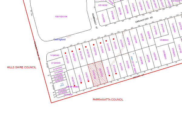
|
NOTIFICATION PLAN |
|
||
|
• PROPERTIES NOTIFIED
|
X SUBMISSIONS RECEIVED |
PROPERTY SUBJECT OF DEVELOPMENT |
|
|
ONE SUBMISSION RECEIVED OUTSIDE MAP RANGE |
|||
One submission has been received objecting to the development, generally on the following grounds:
· Increased traffic generation; and
· The proposal does not encompass sustainable development initiatives.
The merits of the matters raised in community submission have been addressed in the body of the report.
5.2 Public Agencies - NSW Police
NSW Police commented on the proposed residential flat building in respect to Crime Prevention Through Environmental Design principles and raised no objection to the proposal subject to recommended conditions.
6. THE PUBLIC INTEREST
Section 79C(1)(e) of the Act requires Council to consider “the public interest”.
The public interest is an overarching requirement, which includes the consideration of the matters discussed in this report. Implicit to the public interest is the achievement of future built outcomes adequately responding to and respecting the future desired outcomes expressed in environmental planning instruments and development control plans.
The application is considered to have satisfactorily addressed Council’s criteria and would provide a development outcome that, on balance, would result in a positive impact for the community. Accordingly, it is considered that the approval of the proposed residential flat building would be in the public interest.
CONCLUSION
The proposal is for the demolition of two existing dwelling houses and construction of a five storey residential flat building comprising 29 units and strata title subdivision.
The proposed development has been assessed with regard to a proposed residential flat building on the adjoining site at Nos. 66 - 68 Keeler Street.
The proposed development is generally satisfactory in respect to the design principles under SEPP 65 and the best practice guidelines of the SEPP 65 – Residential Flat Design Code, subject to recommended conditions.
The proposed development has regard to the requirements of the Housing Strategy DCP and is considered acceptable in respect to the desired future character of the Carlingford Road, Carlingford Precinct. The proposal complies with the site requirements, height, setbacks, landscaping, articulation, open space, privacy, sunlight and ventilation, housing choice and vehicle access and parking criteria subject to recommended conditions. The proposed non-compliance with the maximum floorplate dimension of 35m is considered acceptable on merit.
The proposed development complies with the requirements of the Waste Minimisation and Management DCP subject to recommended conditions. In this regard the proposed waste collection at the frontage of the site is considered acceptable with regard to the low traffic flow on Keeler Street.
One submission was received in response to the public notification of the proposed development.
The application is recommended for approval.
|
Rod Pickles Manager - Development Assessment Planning Division |
James Farrington Group Manager Planning Division |
|
1.View |
Locality Plan |
|
|
|
2.View |
Site Plan |
|
|
|
3.View |
Floor Plans |
|
|
|
4.View |
Basement Plans |
|
|
|
5.View |
Roof Plan |
|
|
|
6.View |
Elevations |
|
|
|
7.View |
Section |
|
|
|
8.View |
Landscape Plan |
|
|
|
9.View |
Photomontage |
|
|
File Reference: DA/676/2012
Document Number: D02024000
SCHEDULE 1
GENERAL CONDITIONS
The conditions of consent within this notice of determination have been applied to ensure that the use of the land and/or building is carried out in such a manner that is consistent with the aims and objectives of the relevant legislation, planning instruments and Council policies affecting the land and does not disrupt the amenity of the neighbourhood or impact upon the environment.
Note: For the purpose of this consent, the term ‘applicant’ means any person who has the authority to act on or the benefit of the development consent.
Note: For the purpose of this consent, any reference to an Act, Regulation, Australian Standard or publication by a public authority shall be taken to mean the gazetted Act or Regulation, or adopted Australian Standard or publication as in force on the date that the application for a construction certificate is made.
1. Approved Plans and Supporting Documentation
The development must be carried out in accordance with the plans and documentation listed below and endorsed with Council’s stamp, except where amended by Council and/or other conditions of this consent:
|
Plan No. |
Drawn by |
Dated |
|
DA-01 Issue 3 Site Plan |
D+C Consortium Pty Ltd |
12.06.2012 |
|
DA-02 Issue 3 Ground Floor Plan |
D+C Consortium Pty Ltd |
12.06.2012 |
|
DA-03 Issue 3 Ist and 2nd Floor Plans |
D+C Consortium Pty Ltd |
12.06.2012 |
|
DA-04 Issue 3 3rd Floor Plan |
D+C Consortium Pty Ltd |
12.06.2012 |
|
DA-05 Issue 3 4th Floor Plan |
D+C Consortium Pty Ltd |
12.06.2012 |
|
DA-06 Issue 3 Basement Plan Level 1 |
D+C Consortium Pty Ltd |
12.06.2012 |
|
DA-07 Issue 3 Basement Plan Level 2 |
D+C Consortium Pty Ltd |
12.06.2012 |
|
DA-08 Issue 3 Basement Plan 3 |
D+C Consortium Pty Ltd |
12.06.2012 |
|
DA-09 Issue 3 Elevations |
D+C Consortium Pty Ltd |
12.06.2012 |
|
DA-10 Issue 3 Elevations |
D+C Consortium Pty Ltd |
12.06.2012 |
|
DA-11 Issue 3 Section |
D+C Consortium Pty Ltd |
12.06.2012 |
|
DA-15 Issue 1 Roof Plan |
D+C Consortium Pty Ltd |
18.10.2012 |
|
0476.L.01 Issue B Landscape Plan |
Greenland Design Pty Ltd |
September 2012 |
|
0476.L.02 Issue B Landscape Details |
Greenland Design Pty Ltd |
September 2012 |
|
024032012 Site and ESCP |
ING Consulting Engineers Pty Ltd |
June 2012 |
|
024032012 Stormwater – Ground Floor Plan |
ING Consulting Engineers Pty Ltd |
June 2012 |
|
024i032012 Stormwater – Basement Plan |
ING Consulting Engineers Pty Ltd |
June 2012 |
|
Document No. |
Prepared by |
Dated |
|
D01964396 Schedule of External Finishes |
D+C Consortium Pty Ltd |
25.03.2012 |
|
D01964403 Arboricultural Assessment |
Earthscape Horticultural Services |
June 2012 |
|
D01964402 Access Review |
Morris-Goding Accessibility Consulting |
25 June 2012 |
|
D01964400 BASIX Certificate No. 436235M |
Energia Design Concepts |
3 July 2012 |
|
D01964392 Building Code of Australia Compliance Report No.12/180 |
Greenfield Certifiers Pty Ltd |
29 June 2012 |
2. Removal of Existing Trees
This development consent only permits the removal of tree(s) numbered T3, T4, T4a, T5, T7, T8, T9, T12 and T14 as identified D01964403 Arboricultural Assessment prepared by Earthscape Horticultural Services dated June 2012. The removal of any other trees requires separate approval under Council’s Tree Preservation Order.
3. Amendment of Plans
The approved plans are to be amended as follows:
a) The approved Ground Floor Plan DA-02 Issue 3 prepared by D + C Consortium is to be amended for Unit G04 and Unit G05 to be designed to maximize the available 4m high ceiling space with provision for additional storage and for natural light and ventilation to living areas.
b) The approved Site Plan DA-01 Issue 3 and Ground Floor Plan DA-02 Issue 3 prepared by D + C Consortium is to be amended for Unit G02 and Unit G03 ground level open space areas, stairs and fencing to be deleted and the areas replaced with communal landscaping.
c) The approved Ground Floor Plan DA-02 Issue 3 prepared by D + C Consortium is to be amended for the Unit G02 terrace southern elevation to be enclosed with masonry wall.
d) The approved Site Plan DA-01 Issue 3 and Ground Floor Plan DA-02 Issue 3 prepared by D + C Consortium is to be amended for the Unit G06 terrace off bedroom 1 to be deleted and the area replaced with landscaping and necessary stairs for the exit door.
e) The approved Ground Floor Plan DA-02 Issue 3 prepared by D + C Consortium is to be amended for the Unit G06 bedroom 1 sliding door to be deleted and replaced with a window screened by a fin wall from the exit door stairs.
f) The Unit G06 balcony is to include a movable louvered privacy screen and the balcony stairs detailed on the approved Elevation Plan DA-10 Issue 3 prepared by D + C Consortium is to be deleted.
g) The approved Ground Floor Plan DA-02 Issue 3 prepared by D + C Consortium is to be amended for the northern exit at the eastern elevation of the building to align with the external wall.
h) The approved Ground Floor Plan DA-02 Issue 3 and the 1st and 2nd Floor Plans DA-03 Issue 3 prepared by D + C Consortium are to be amended for the entries of Unit G06, Unit 107 and Unit 207 to be located not less than 2m from the refuse chute.
i) The approved Elevations Plans DA-09 Issue 3 and DA-10 Issue 3 prepared by D + C Consortium are to be amended for the balcony and terrace balustrades of Unit G01, Unit G02, Unit G03, Unit G04, Unit G05 and Unit G06 to be solid opaque balustrades for resident privacy.
j) The approved Site Plan DA-01 Issue 3 and Ground Flood Plan DA-02 Issue 3 prepared by D + c Consortium are to be amended for the bulk items store at the frontage to be deleted and the area replaced with landscaping.
REQUIREMENTS PRIOR TO THE ISSUE OF A CONSTRUCTION CERTIFICATE
4. Building Code of Australia
All building work must be carried out in accordance with the requirements of the Building Code of Australia.
5. Contract of Insurance (Residential Building Work)
In the case of residential building work for which the Home Building Act, 1989 requires there to be a contract of insurance in force in accordance with Part 6 of that Act, that such a contract of insurance is in force before any building work authorised to be carried out by the consent commences.
Note: This condition does not apply to the extent to which an exemption is in force under Clause 187 or 188 of the Act, subject to the terms of any condition or requirement referred to in Clause 187(6) or 188(4) of the Act, or to the erection of a temporary building.
6. Water/Electricity Utility Services
The applicant must submit written evidence of the following service provider requirements:
a) Energy Australia – a letter of consent demonstrating that satisfactory arrangements have been made to service the proposed development.
b) Sydney Water – the submission of a ‘Notice of Requirements’ under s73 of the Sydney Water Act 1994.
Note: Sydney Water requires that s73 applications are to be made through an authorised Sydney Water Servicing Coordinator. Refer to www.sydneywater.com.au or telephone 13 20 92 for assistance.
7. Accessible Units
a) The details of the adaptable units (G01, 101, 102, 105, 106, 201, 202, 205 and 206) must be provided with the Construction Certificate Plans.
b) Three of the adaptable units must be in compliance with AS1428.1 – Design for Access and Mobility.
8. Dilapidation Report
A ‘Dilapidation Report’ is to be prepared by a ‘chartered structural engineer’ detailing the structural condition of all adjoining properties.
9. Acoustic Report
An acoustic report prepared by a suitably qualified acoustic consultant is to identify noise mitigation measures necessary for the living rooms and bedrooms of Unit G02 to address noise form the use of the driveway. The necessary measures are to be implemented prior to the issue of the Construction Certificate.
10. Drainage Easements
To reduce nuisance flooding from runoff generated by the proposal, the subject site must drain via gravity directly to a Council-controlled drainage system. The proposal shall drain to the Council concrete pipe drainage system within Nos. 66 and 68 Keeler Street, Carlingford and an easement to drain water created over the interallotment drainage system. The Transfers Granting Easement over Nos. 66 and 68 Keeler Street, Carlingford shall be registered at the Office of Land and Property Information and a copy of the registered documents and plans submitted with the Construction Certificate.
11. Stormwater Drainage
The stormwater drainage system for the development must be designed and constructed in accordance with Council’s Civil Works – Design and Construction Specification 2005 and the following requirements:
a) Connected to a Council standard junction pit on the existing Council piped drainage system at 66 Keeler Street, Carlingford.
b) An inter-allotment stormwater drainage system to service the proposed lot with pits being constructed in-situ.
c) The roof and paved area stormwater drainage system from the proposal to be connected to the proposed interallotment drainage system.
12. On Site Stormwater Detention
An on-site stormwater detention system must be designed by a chartered civil engineer and constructed in accordance with the following requirements:-
a) Have a capacity of not less than 22 cubic metres, and a maximum discharge (when full) of 41 litres per second.
b) Have a 900 mm x 900 mm square surcharge/inspection grate located directly above the outlet.
c) Discharge from the detention system to be controlled via 1 metre length of pipe, not less than 50 millimetres diameter or via a stainless plate with sharply drilled orifice bolted over the face of the outlet discharging into a larger diameter pipe capable of carrying the design flow to an existing interallotment drainage system.
d) Not be constructed in a location that would impact upon the visual or recreational amenity of residents.
13. Internal Driveway/Vehicular Areas
The driveway and parking areas on site must be designed, constructed and a Construction Certificate issued in accordance with Australian Standards 2890.1, 2890.2, 3727, Councils Civil Works Specification and the following requirements:
a) Design levels at the front boundary be obtained from Council.
b) The driveway be a rigid pavement.
c) The driveway grade must not exceed 5 percent for the first 6m from the property boundary and shall have a minimum width of 5.5m.
14. Footpath
Prior to the issue of a Construction Certificate for these works a separate application under the Local Government Act, 1993 and the Roads Act, 1993 must be submitted to Council for the construction of footpaths within the road reserve. A concrete footpath must be constructed along the full frontage of the subject site in accordance Council’s Civil Works Design and Construction Specification, 2005 and the following requirements:
a) The existing footpath being removed and reconstructed.
b) Any public utility adjustments to be carried out at the cost of the applicant and to the requirements of the relevant public authority.
15. Vehicular Crossing
A separate application under the Local Government Act, 1993 and the Roads Act, 1993 must be submitted to Council for the installation of a new vehicular crossing and the removal of the redundant crossing. The vehicular crossing must be constructed in accordance with Council’s Civil Works Design, 2005 and the following requirements:
a) The footway area to be restored by turfing.
b) Provision for all relevant utility authorities’ necessary conduits, installed and protected under the crossing.
c) Adjustment of all regulatory signage and all services and street furniture made necessary by the proposed works.
Note: An application for a vehicular crossing can only be made to one of Council’s Authorised Vehicular Crossing Contractors. You are advised to contact Council on 02 9847 6940 to obtain a list of contractors.
16. Road Works
A separate application under the Local Government Act, 1993 and the Roads Act, 1993 must be submitted to Council for all works within the road reserve. All road works approved under this consent must be constructed in accordance with Council’s Civil Works Design and Construction Specification, 2005 and the following requirements:
a) The existing kerb and gutter is to be removed and reconstructed.
b) The existing road pavement to be saw cut a minimum of 300 mm from the existing lip of gutter and reconstructed.
c) Pursuant to Section 138 of the Roads Act 1993, these works shall be designed by a Chartered Civil Engineer with four copies of the plans submitted to Hornsby Council’s Planning Division for consideration and approval, prior to the release of the Construction Certificate. Once approved the work shall be inspected by Hornsby Council and accepted by Council in writing prior to the release of the Occupation Certificate. The Applicant shall pay all Council’s fees associated with provision of this assessment and compliance work.
17. Traffic Control Plan
A Traffic Control Plan (TCP) must be prepared by a qualified traffic controller in accordance with the Roads & Traffic Authority’s Traffic Control at Worksites Manual 1998 and Australian Standard 1742.3 for all work on a public road and be submitted to Council. The TCP must detail the following:
a) Arrangements for public notification of the works.
b) Temporary construction signage.
c) Permanent post-construction signage.
d) Construction vehicle movement plans.
e) Traffic management plans.
f) Pedestrian and cyclist access/safety.
REQUIREMENTS PRIOR TO THE COMMENCEMENT OF ANY WORKS
18. Erection of Construction Sign
A sign must be erected in a prominent position on any site on which building work, subdivision work or demolition work is being carried out:
a) Showing the name, address and telephone number of the principal certifying authority for the work,
b) Showing the name of the principal contractor (if any) for any demolition or building work and a telephone number on which that person may be contacted outside working hours, and
c) Stating that unauthorised entry to the work site is prohibited.
Note: Any such sign is to be maintained while the building work, subdivision work or demolition work is being carried out, but must be removed when the work has been completed.
19. Protection of Adjoining Areas
A temporary hoarding, fence or awning must be erected between the work site and adjoining lands before the works begin and must be kept in place until after the completion of the works if the works:
a) Could cause a danger, obstruction or inconvenience to pedestrian or vehicular traffic.
b) Could cause damage to adjoining lands by falling objects.
c) Involve the enclosure of a public place or part of a public place.
Note: Notwithstanding the above, Council’s separate written approval is required prior to the erection of any structure or other obstruction on public land.
20. Toilet Facilities
Toilet facilities must be available or provided at the works site before works begin and must be maintained until the works are completed at a ratio of one toilet for every 20 persons employed at the site. Each toilet must:
a) be a standard flushing toilet connected to a public sewer; or
b) be a temporary chemical closet approved under the Local Government Act, 1993; or
c) have an on-site effluent disposal system approved under the Local Government Act, 1993
21. Erosion and Sediment Control
Erosion and sediment control measures must be provided and maintained throughout the construction period in accordance with the manual ‘Soils and Construction 2004 (Bluebook)’, the approved plans, Council specifications and to the satisfaction of the principal certifying authority. The erosion and sediment control devices must remain in place until the site has been stabilised and revegetated.
Note: On the spot penalties up to $1,500 may be issued for any non-compliance with this requirement without any further notification or warning.
REQUIREMENTS DURING CONSTRUCTION
22. Construction Work Hours
All work on site (including demolition and earth works) must only occur between 7am and 5pm Monday to Saturday.
No work is to be undertaken on Sundays or public holidays.
23. Demolition
All demolition work must be carried out in accordance with Australian Standard 2601-2001 – The Demolition of Structures and the following requirements:
a) Demolition material is to be disposed of to an authorised recycling and/or waste disposal site and/or in accordance with an approved waste management plan.
b) Demolition works, where asbestos material is being removed, must be undertaken by a contractor that holds an appropriate licence issued by WorkCover NSW in accordance with Chapter 10 of the Occupational Health and Safety Regulation 2001 and Clause 29 of the Protection of the Environment Operations (Waste) Regulation 2005.
c) On construction sites where buildings contain asbestos material, a standard commercially manufactured sign containing the words ‘DANGER ASBESTOS REMOVAL IN PROGRESS’ measuring not less than 400mm x 300mm must be erected in a prominent position visible from the street.
24. Waste Management
Prior to commencement of works, a revised and detailed Waste Management Plan Section One – Demolition Stage, Section Two – Design Stage, and Section Three – Construction as applicable, covering the scope of this project is required to be submitted to Council in accordance with the Waste Minimisation and Management Development Control Plan.
25. Environmental Management
The site must be managed in accordance with the publication ‘Managing Urban Stormwater – Landcom (March 2004) and the Protection of the Environment Operations Act 1997 by way of implementing appropriate measures to prevent sediment run-off, excessive dust, noise or odour emanating from the site during the construction of the development.
26. Street Sweeping
Street sweeping must be undertaken following sediment tracking from the site along Keeler Street during works and until the site is established.
27. Spoil Route
To protect Council’s assets, all vehicular access to and from the site during all stages of the development is to be via the shortest route to the nearest State or Regional Road.
28. Council Property
During construction works, no building materials, waste, machinery or related matter is to be stored on the road or footpath.
29. Landfill
Landfill must be constructed in accordance with Council’s ‘Construction Specification, 2005’ and the following requirements:
a) All fill material imported to the site is to wholly consist of Virgin Excavated Natural Material (VENM) as defined in Schedule 1 of the Protection of the Environment Operations Act 1997 or a material approved under the Department of Environment and Climate Change’s general resource recovery exemption.
b) A compaction certificate is to be obtained from a geotechnical engineer verifying that the specified compaction requirements have been met.
30. Excavated Material
All excavated material removed from the site must be classified in accordance with the Department of Environment, Climate Change and Water NSW Waste Classification Guidelines prior to disposal to an approved waste management facility and reported to the principal certifying authority.
31. Survey Report – Finished Floor Level
A report(s) must be prepared by a registered surveyor and submitted to the principal certifying authority prior to the pouring of concrete at each level of the building certifying that:
a) The building, retaining walls and the like have been correctly positioned on the site.
b) The finished floor level(s) are in accordance with the approved plans.
32. Contamination during construction works
Should the presence of asbestos or soil contamination, not recognised during the application process be identified during demolition, the applicant must immediately notify the Principal Certifying Authority and Council.
33. Waste Management
Waste management during the demolition and construction phase of the development must be undertaken in accordance with the approved Waste Management Plan. Additionally written record of the following items must be maintained during the removal of any waste from the site and such information submitted to the Principal Certifying Authority within fourteen days of the date of completion of the works:
a) The identity of the person removing the waste.
b) The waste carrier vehicle registration.
c) Date and time of waste collection.
d) A description of the waste (type of waste and estimated quantity).
e) Details of the site to which the waste is to be taken.
f) The corresponding tip docket/receipt from the site to which the waste is transferred (noting date and time of delivery, description (type and quantity) of waste).
g) Whether the waste is expected to be reused, recycled or go to landfill.
Note: In accordance with the Protection of the Environment Operations Act 1997, the definition of waste includes any unwanted substance, regardless of whether it is reused, recycled or disposed to landfill.
REQUIREMENTS PRIOR TO THE ISSUE OF AN OCCUPATION CERTIFICATE
Note: For the purpose of this consent, a reference to ‘occupation certificate’ shall not be taken to mean an ‘interim occupation certificate’ unless otherwise stated.
34. Fulfilment of BASIX Commitments
The applicant must demonstrate the fulfilment of BASIX commitments pertaining to the development.
35. Sydney Water – s73 Certificate
A s73 Certificate must be obtained from Sydney Water.
36. Car Parking Allocation & Resident Storage
The basement resident storage areas are to be allocated in accordance with the size requirements of the SEPP 65 - Residential Flat Design Code for the respective units and proximity to the unit car parking space.
37. Damage to Council Assets
Any damage caused to Council’s assets as a result of the construction of the development must be rectified in accordance with Council’s written requirements and at the sole cost of the applicant.
38. Creation of Easements
The following matters must be nominated on the plan of subdivision or using s88E or s88B (as applicable) of the Conveyancing Act 1919:
a) Consolidation of the subject lots.
b) The creation of an appropriate "Positive Covenant" and "Restriction as to User" over the constructed on-site detention systems and outlet works, within the lots in favour of Council in accordance with Council’s prescribed wording. The position of the on-site detention system is to be clearly indicated on the title.
c) To register the OSD easement, the restriction on the use of land “works-as-executed” details of the on-site-detention system must be submitted verifying that the required storage and discharge rates have been constructed in accordance with the design requirements. The details must show the invert levels of the on site system together with pipe sizes and grades. Any variations to the approved plans must be shown in red on the “works-as-executed” plan and supported by calculations.
Note: Council must be nominated as the authority to release, vary or modify any easement, restriction or covenant.
39. Garbage Collection Easement
For the purpose of waste collection, an easement entitling Council, its servants and agents and persons authorised by it to enter upon the subject land and to operate thereon, vehicles and other equipment for the purposes of garbage collection must be granted to Council by the owner of the land.
Note: The easement must be in a form prescribed by Council and must include covenants to the effect that parties will not be liable for any damage caused to the subject land or any part thereof or to any property located therein or thereon by reason of the operation thereon of any vehicle or other equipment used in connection with the collection of garbage and to the effect that the owner for the time being of the subject land shall indemnify the Council, its servants, agents and persons authorised by it to collect garbage against liability in respect of any such claims made by any person whomsoever.
40. Additional Landscaping
a) On slab planter boxes must include waterproofing, subsoil drainage (proprietary drainage cell, 50mm sand and filter fabric) automatic irrigation, minimum 500mm planting soil for shrubs and minimum 1000mm planting soil for trees and palms and 75mm mulch to ensure sustainable landscape is achieved.
b) Planting to the front landscape setback areas
along Keeler Street must include four additional Tristaniopsis laurina
(Watergum). Trees shall be installed at minimum 45 litre pot size.
c) Screen planting to the on-grade landscape
setback areas adjacent to the boundary must include four additional Acmenia
Smithi (Lilly Pilly) in planter beds. Trees shall be installed at minimum
25 litre pot size.
d) Screen planting to the on-grade landscape setback areas adjacent to the boundary must include four additional Elaeocarpus reticulatus (Blueberry Ash) and four additional Acmenia smithii (Lilly Pilly) in planter beds. The trees shall be installed at minimum 25 litre pot size.
e) Planting to the rear landscape setback areas must include two additional Angophora costata (Sydney Red Gum). Trees shall be installed at minimum 45 litre pot size.
41. Completion of Landscaping
A certificate must be provided by a practicing landscape architect, horticulturalist or person with similar qualifications and experience certifying that all required landscaping works have been satisfactorily completed in accordance with the approved landscape plans.
Note: Advice on suitable species for landscaping can be obtained from Council’s planting guide ‘Indigenous Plants for the Bushland Shire’, available at www.hornsby.nsw.gov.au.
42. Retaining Walls
All required retaining walls must be constructed as part of the development.
43. Boundary Fencing
Fencing must be erected along all property boundaries behind the front building alignment to a height of 1.8 metres.
Note: Alternative fencing may be erected subject to the written consent of the adjoining property owner(s).
44. External Lighting
All external lighting must be designed and installed in accordance with Australian Standard AS 4282 – Control of the Obtrusive Effects of Outdoor Lighting. Certification of compliance with the Standard must be obtained from a suitably qualified person.
45. Unit Numbering
The allocation of unit numbering must be authorised by Council prior to the numbering of each unit in the development.
46. Section 94 Infrastructure Contributions
The payment to Council of a contribution of $316,865.00 for 27 additional dwellings towards the cost of infrastructure identified in Council’s Development Contributions Plan 2007-2011 in accordance with the following table:
Note: The value of contribution is current as at 31 October 2012. The contribution will be adjusted from this date in accordance with the underlying consumer price index for subsequent financial quarters. The contribution includes a credit for the two existing allotments.
It is recommended that you contact Council to confirm the value of the
contribution prior to payment.
47. Safety and Security
a) Fire exist doors to the development must be fitted with single cylinder locksets (Australia and New Zealand Standard – Lock Sets) to restrict unauthorized access to the development.
b) Ground floor windows must be fitted with window locks that can be locked with a key.
c) A graffiti management plan must be incorporated into the maintenance plan for the development for graffiti to be removed within a forty-eight hour period.
d) The basement car park entry must be secured by security gates/roller shutters and controlled by secure access located at the top of the driveway.
e) The driveway ramp must be designed to prevent persons accessing the western side setback of the building from the driveway.
48. Waste Management
a) The basement bin storage room must include water connection for cleaning, graded floors with drainage to sewer, a robust door, sealed and impervious surfaces, adequate lighting and ventilation.
b) Each dwelling/kitchen must be provided with an indoor waste/recycling cupboard for the interim storage of a minimum one day’s waste/recycling generation with separate containers for general waste and recyclable materials.
c) Space must be provided for either individual compost containers for each dwelling or a communal compost container.
Note: The location of the compost containers should have regard for potential amenity impacts.
d) The bin carting route(s) must be devoid of steps.
Note: Ramps between different levels are acceptable
e) Residents and any persons accessing the meter room must be prevented from having access to the waste volume handling equipment in the basement bin room.
f) There must be no compaction equipment on the recycling side of the chute system.
g) The bins placed at the bin collection point for servicing must be screened by landscaping from public view.
h) A report(s) must be prepared by the principal contractor and submitted to the principal certifying authority certifying that:
i) A comparison of the estimated quantities of each waste type against the actual quantities of each waste type has been made;
ii) Any deviations from the Waste Management Plan (including, but not limited to, types of waste, quantities of waste, destinations of waste, reuse and recycling achieved) have been explained;
iii) All waste was taken to site(s) that were lawfully permitted to accept that waste;
iv) Either
(i) The Waste Management Plan Section One – Demolition Stage and Section Three – Construction Stage were implemented and at least 60 % waste generated was reused or recycled; or
(ii) If the 60% diversion from landfill was not achieved in the Demolition Stage and/or Construction Stage, the Report is to include the reasons why this occurred and certify that appropriate work practices were employed in the demolition and construction stages to implement the Waste Management Plan.
v) The Report(s) is based on documentary evidence (i.e. tipping dockets/receipts from recycling depots, transfer stations and landfills, audits of procedures, Licence and/or development consent of site(s) receiving waste, etc) which have been attached to the Report.
vi) The author(s) of the report declared that the report is true in every particular and is not misleading.
49. Works as Executed Plan
A works-as-executed plan(s) must be prepared by a registered surveyor and submitted to Council for completed road pavement, kerb & gutter, public drainage systems, driveways and on-site detention system.
OPERATIONAL CONDITIONS
50. Landscape Establishment
The landscape works must be maintained into the future to ensure the establishment and successful growth of plant material to meet the intent of the landscape design. This must include but not be limited to watering, weeding, replacement of failed plant material and promoting the growth of plants through standard industry practices.
51. Visitor Access
Visitors are to have access to the parking area at all times. Visitors are to be able to access the basement car park by an audio/visual intercom system located at the top of the ramped driveway.
52. Noise
All noise generated by the proposed development must be attenuated to prevent levels of noise being emitted to adjacent premises which possess tonal, beating and similar characteristics or which exceeds background noise levels by more than 5dB(A).
53. Disabled Parking
All parking spaces for people with disabilities must be constructed and operated in accordance with Australian Standard AS/NZS 2890.6:2009 – Off-street parking for people with disabilities
54. Fire Safety Statement - Annual
On at least one occasion in every 12 month period following the date of the first ‘Fire Safety Certificate’ issued for the property, the owner must provide Council with an annual ‘Fire Safety Certificate’ to each essential service installed in the building.
55. Waste Management
a) A site caretaker must be employed and be responsible for moving bins to and from the bin storage room(s) and the waste collection point, washing bins and maintaining waste storage areas, ensuring the chute system and related devices are maintained in effective and efficient working order, managing the communal composting area, arranging the prompt removal of dumped rubbish, and ensuring all residents are informed and trained in the use of the waste management system.
b) Bins must be removed from the bin collection point each time after collection.
- END OF CONDITIONS -
ADVISORY NOTES
The following information is provided for your assistance to ensure compliance with the Environmental Planning and Assessment Act, 1979, Environmental Planning and Assessment Regulation 2000, other relevant legislation and Council’s policies and specifications. This information does not form part of the conditions of development consent pursuant to Section 80A of the Act.
Environmental Planning and Assessment Act, 1979 Requirements
· The Environmental Planning and Assessment Act, 1979 requires:
· The issue of a construction certificate prior to the commencement of any works. Enquiries regarding the issue of a construction certificate can be made to Council’s Customer Services Branch on 9847 6760.
· A principal certifying authority to be nominated and Council notified of that appointment prior to the commencement of any works.
· Council to be given at least two days written notice prior to the commencement of any works.
· Mandatory inspections of nominated stages of the construction inspected.
· An occupation certificate to be issued before occupying any building or commencing the use of the land.
Long Service Levy
In accordance with Section 34 of the Building and Construction Industry Long Service Payments Act 1986, a ‘Long Service Levy’ must be paid to the Long Service Payments Corporation or Hornsby Council.
Note: The rate of the Long Service Levy is 0.35% of the total cost of the work.
Note: Hornsby Council requires the payment of the Long Service Levy prior to the issue of a construction certificate.
Tree Preservation Order
To ensure the maintenance and protection of the existing natural environment, it is an offence to ringbark, cut down, top, lop, remove, wilfully injure or destroy a tree outside 3 metres of the approved building envelope without the prior written consent from Council.
Note: A tree is defined as a single or multi-trunked wood perennial plant having a height of not less than three (3) metres, and which develops many branches, usually from a distance of not less than one (1) metre from the ground, but excluding any plant which, in its particular location, is a noxious plant declared as such pursuant to the Noxious Weeds Act 1993. This definition of ‘tree’ includes any and all types of Palm trees.
All distances are determined under Australian Standard AS4970-2009 ”Protection of Trees on Development Sites”.
Fines may be imposed for non-compliance with Council’s Tree Preservation Order.
Disability Discrimination Act
The applicant’s attention is drawn to the existence of the Disability Discrimination Act. A construction certificate is required to be obtained for the proposed building/s, which will provide consideration under the Building Code of Australia, however, the development may not comply with the requirements of the Disability Discrimination Act. This is the sole responsibility of the applicant.
Dial Before You Dig
Prior to commencing any works, the applicant is encouraged to contact Dial Before You Dig on 1100 or www.dialbeforeyoudig.com.au for free information on potential underground pipes and cables within the vicinity of the development site.
Asbestos Warning
Should asbestos or asbestos products be encountered during demolition or construction works you are advised to seek advice and information should be prior to disturbing the material. It is recommended that a contractor holding an asbestos-handling permit (issued by WorkCover NSW)be engaged to manage the proper handling of the material. Further information regarding the safe handling and removal of asbestos can be found at:
Alternatively, telephone the WorkCover Asbestos and Demolition Team on 8260 5885.
House Numbering
House numbering can only be authorised by Council. Before proceeding to number each premise in the development, the allocation of numbers is required to be obtained from Council's Planning Division. The authorised numbers are required to be displayed in a clear manner at or near the main entrance to each premise.
Planning Report No. PL30/12
Planning Division
Date of Meeting: 21/11/2012
11 DEVELOPMENT APPLICATION - FIVE STOREY RESIDENTIAL FLAT BUILDING COMPRISING 30 UNITS - 245 - 247 CARLINGFORD ROAD, CARLINGFORD
EXECUTIVE SUMMARY
|
DA No: |
DA/569/2012 (Lodged 12 June 2012) |
|
Description: |
Demolition of existing structures and construction of a five storey residential flat building comprising 30 units, basement car parking and strata title subdivision |
|
Property: |
Lot 16 DP 32722 & Lot 17 DP 32722, Nos. 245-247 Carlingford Road, Carlingford |
|
Applicant: |
Giles Tribe Architects Pty Ltd |
|
Owner: |
Yong Feng Co Pty Ltd and Bright Mars Pty Limited |
|
Estimated Value: |
$8,717,587 |
|
Ward: |
C |
· The application proposes the demolition of existing structures and the construction of a five storey residential flat building comprising 30 units, basement car parking and strata subdivision.
· The proposal generally complies with the requirements of the Hornsby Shire LEP 1994, State Environmental Planning Policy No. 65 – Design Quality of Residential Flat Development and the Hornsby Shire Housing Strategy DCP.
· Two submissions have been received in respect of the application.
· It is recommended that the application be approved.
|
THAT Development Application No. 569/2012 for the demolition of existing structures and the construction of a five storey residential flat building comprising 30 units, basement car parking and strata subdivision at Lot 16 DP 32722 & Lot 17 DP 32722, Nos. 245-247 Carlingford Road, Carlingford be approved subject to the conditions of consent detailed in Schedule 1 of Group Manager’s Planning Report No. PL30/12. |
BACKGROUND
The subject land was rezoned from Residential A (Low Density) to Residential C (Medium-High Density) on 2 September 2011 as part of Council’s Housing Strategy.
THE SITE
The subject site comprises two allotments, Nos. 245 and 247 Carlingford Road located on the southern side of the road with a total area of 1874.7m². The site has an average slope of 6% towards the east.
The regular shaped site has a frontage of 34.75m to the southern side of Carlingford Road and has a depth of approximately 54m. The site includes two existing single storey dwelling houses with attached garages. A number of exotic, native planted trees and locally indigenous trees are located within the front and rear setbacks of both allotments.
The site forms part of the ‘Carlingford Road, Carlingford’ precinct rezoned for medium-high density housing in accordance with the Hornsby Shire Housing Strategy in September 2011. The precinct is bounded by Carlingford Road, Pennant Hills Road, Keeler Street and Hepburn Avenue.
The surrounding development within the rezoned precinct includes single and two storey residential dwellings to the east and southeast of the site.
Commercial businesses and restaurants within the Carlingford commercial centre on Pennant Hills Road exist to the west and southwest of the site. A shopping centre, Carlingford Court is located on the opposite side of Carlingford Road.
THE PROPOSAL
The proposal is for the demolition of two existing dwelling houses, construction of a five storey residential flat building comprising 30 dwellings and basement car parking and includes strata title subdivision. The details of the development are provided below:
Residential
The proposed dwellings include 30 residential units on 5 levels. The unit configuration comprises 3 x 1 bedroom units, 13 x 2 bedroom units and 14 x 3 bedroom units. The units include balconies fronting the street, rear and side setbacks.
Car parking and access
The development would be accessed from Carlingford Road via a driveway located on the eastern boundary of the site. A separate pedestrian entry is located on the western boundary of the site which would provide access to the lift lobby via an entrance courtyard. A total of 45 residential spaces and 6 visitor’s parking spaces are proposed in two basement levels including 10 accessible parking spaces.
Landscaping
The development would include landscaped areas along the front, rear and side setback areas. The communal open space area is proposed to be located at the rear of the site.
ASSESSMENT
The development application has been assessed having regard to the ‘Metropolitan Plan for Sydney 2036’, the ‘North Subregion (Draft) Subregional Strategy’ and the matters for consideration prescribed under Section 79C of the Environmental Planning and Assessment Act 1979 (the Act). The following issues have been identified for further consideration.
1. STRATEGIC CONTEXT
1.1 Metropolitan Plan for Sydney 2036 and (Draft) North Subregional Strategy
The Metropolitan Plan for Sydney 2036 is a broad framework to secure Sydney’s place in the global economy by promoting and managing growth. It outlines a vision for Sydney to 2036; the challenges faced, and the directions to follow to address these challenges and achieve the vision. The Draft North Subregional Strategy acts as a framework for Council in its preparation of the Comprehensive LEP by the end of 2012.
The Draft North Subregional Strategy sets the following targets for the Hornsby LGA by 2031:
· Employment capacity to increase by 9,000 jobs; and
· Housing stock to increase by 11,000 dwellings.
The proposed development would be consistent with the draft Strategy by providing an additional 28 dwellings and would contribute towards housing choice in the locality.
2. STATUTORY CONTROLS
Section 79C(1)(a) requires Council to consider “any relevant environmental planning instruments, draft environmental planning instruments, development control plans, planning agreements and regulations”.
2.1 Hornsby Shire Local Environmental Plan 1994
The subject land is zoned Residential C (Medium/High Density) under the Hornsby Shire Local Environmental Plan 1994 (HSLEP). The objectives of the Residential C zone are:
(a) to provide for the housing needs of the population of the Hornsby area.
(b) to promote a variety of housing types and other land uses compatible with a medium to high density residential environment.
(c) to provide for development that is within the environmental capacity of a medium to high density residential environment.
The proposed development is defined as “multi-unit housing” under the HSLEP and is permissible in the zone with Council’s consent.
Clause 15 of HSLEP prescribes that the maximum floor space ratio (FSR) of development within the Residential C zone. Subclause (5) of Clause 15 states that “This clause does not apply to land shown edged heavy black on diagrams 1-8 in Schedule BB.” The site is identified in Diagram 8 of Schedule BB of the HSLEP. Therefore, Clause 15 does not apply to the subject site.
Clause 15A of the HSLEP prescribes that the maximum building height within the area detailed under Schedule BB is not to exceed 17.5 metres. The proposed development complies with this requirement.
Clause 18 of the HSLEP sets out heritage conservation provisions forHornsby Shire. The subject site does not include a heritage item and is not located in a Heritage Conservation Area and is not subject to consideration for heritage conservation.
2.2 Draft Comprehensive Hornsby Local Environmental Plan
The draft Comprehensive Local Environmental Plan (HLEP) was placed on exhibition on 5 June 2012. The draft HLEP essentially reiterates the current land use zoning and height control applicable to the site as outlined below:
2.2.1 Zoning
The site would be zoned R4 (High Density Residential) zone pursuant to the Land Use Table of the draft HLEP. The proposed development is defined as a ‘Residential Flat Building’ and would be a permissible use in the zone with Council’s consent.
2.2.2 Height of Building
Clause 4.3 of the draft HLEP provides that the height of a building on any land is not to exceed the maximum height shown for the land on the Height of Buildings Map. The maximum permissible height for the subject site is 17.5 metres. The proposal complies with this provision.
2.3 State Environmental Planning Policy No. 55 – Remediation of Land
State Environmental Planning Policy No. 55 (SEPP 55) requires that Council must not consent to the carrying out of any development on land unless it has considered whether the land is contaminated or requires remediation for the proposed use.
The site has been used for residential purposes and is unlikely to be contaminated. No further assessment is considered necessary in this regard. A condition is recommended should any contamination be found during construction.
2.4 State Environmental Planning Policy No. 65 – Design Quality of Residential Flat Development
The Policy provides for design principles to improve the design quality of residential flat development and for consistency in planning controls across the State.
The applicant has submitted a design verification statement prepared by a qualified designer stating how the proposed development achieves the design principles of SEPP 65. The design principles of SEPP 65 and the submitted design verification statement are addressed below.
2.4.1 Principle 1 - Context
Design Principle 1 is as follows:
Good design responds and contributes to its context. Context can be defined as the key natural and built features of an area.
Responding to context involves identifying the desirable elements of a location’s current character or, in the case of precincts undergoing a transition, the desired future character as stated in planning and design policies. New buildings will thereby contribute to the quality and identity of the area.
The subject site adjoins the Carlingford commercial centre and is located within a precinct zoned for five storey residential flat buildings in close proximity to Pennant Hills Road and the Carlingford Court shopping centre. The desired future character of the area, as outlined in Council’s Housing Strategy Development Control Plan, is that of a high density residential precinct incorporating five storey developments in a landscape setting.
A statement in response to the SEPP 65 was submitted with this application that indicates the proposal responds to the desired future character of the precinct as envisaged by Council. Once the development of the precinct is completed, the proposal would integrate with the surrounding sites and would be in keeping with the desired urban morphology.
The submission addresses the guiding principles including neighbourhood and precinct areas, open space, views, topography and streetscape and is considered an acceptable response to the desired identity and future character of the area.
2.4.2 Principle 2 - Scale
Design Principle 2 is as follows:
Good design provides an appropriate scale in terms of the bulk and height that suits the scale of the street and the surrounding buildings.
Establishing an appropriate scale requires a considered response to the scale of existing development. In precincts undergoing a transition, proposed bulk and height needs to achieve the scale identified for the desired future character of the area.
The proposed building is in accordance with the required building height and setbacks for the precinct and provides an architectural composition which encloses itself within the setbacks, achieving the required pavilion built form to minimize bulk and scale. The proposal is considered acceptable in terms of scale.
2.4.3 Principle 3 – Built Form
Design Principle 3 is as follows:
Good design achieves an appropriate built form for a site and the building’s purpose, in terms of building alignments, proportions, building type and the manipulation of building elements.
Appropriate built form defines the public domain, contributes to the character of streetscape and parks, including their views and vistas, and provides internal amenity and outlook.
The proposed five storey building provides a number of landscaped areas including a grassed communal open space with a number of large trees enclosed by a 1.2m high palisade front fence to the frontage and a “stoneset” pedestrian path which complements the transition of the public domain to the building’s threshold. The building features neutral colour tones on face brickwork highlighted with wide eaves, well articulated facades and glass windows and balustrades which provide visual interest to the streetscape.
The proposed development presents a distinct architectural design which would set an appropriate precedent for the locality and is considered acceptable in terms of built form.
2.4.4 Principle 4 – Density
Design Principle 4 is as follows:
Good design has a density appropriate for a site and its context, in terms of floor space yields (or number of units or residents).
Appropriate densities are sustainable and consistent with the existing density in an area or in precincts undergoing a transition, are consistent with the stated desired future density. Sustainable densities respond to the regional context, availability of infrastructure, public transport, community facilities and environmental quality.
The HSLEP does not incorporate floor space ratio requirements for the site. The density of the development is governed by the height of the building and the required setbacks. The proposed density is considered to be sustainable as it responds to the regional context, availability of infrastructure, public transport, community facilities and environmental quality and is considered acceptable in terms of density.
2.4.5 Principle 5 – Resource, energy and water efficiency
Design Principle 5 is as follows:
Good design makes efficient use of natural resources, energy and water throughout its full life cycle, including construction.
Sustainability is integral to the design process. Aspects include demolition of existing structures, recycling of materials, selection of appropriate and sustainable materials, adaptability and reuse of buildings, layouts and built form, passive solar design principles, efficient appliances and mechanical services, soil zones for vegetation and reuse of water.
The applicant has submitted BASIX Certificate No. 429201M for the proposed 30 dwellings. In achieving the required BASIX targets for sustainable water use, thermal comfort and energy efficiency, the proposed development achieves the design criteria and is considered acceptable in this regard.
2.4.6 Principle 6 – Landscape
Design Principle 6 is as follows:
Good design recognises that together landscape and buildings operate as an integral and sustainable system, resulting in greater aesthetic quality and amenity for both occupants and the adjoining public domain.
Landscape design builds on the existing site’s natural and cultural features in responsible and creative ways. It enhances the development’s natural environmental performance by co-ordinating water and soil management, solar access, micro-climate, tree canopy and habitat values. It contributes to the positive image and contextual fit of development through respect for streetscape and neighbourhood character, or desired future character.
Landscape design should optimise useability, privacy and social opportunity, equitable access and respect for neighbour’s amenity, and provide for practical establishment and long term management.
The application includes a landscape concept plan providing landscaping along the street frontage and side and rear boundaries. Four large trees are proposed along the frontage which would soften the appearance of the development. Deep soil zones are provided around the building envelope which would enhance the development’s natural environmental performance. The proposed planting would provide an appropriate landscaped setting for the development. In this regard, the proposal is considered acceptable in terms of landscaping.
2.4.7 Principle 7 – Amenity
Design Principle 7 is as follows:
Good design provides amenity through the physical, spatial and environmental quality of a development.
Optimising amenity requires appropriate room dimensions and shapes, access to sunlight, natural ventilation, visual and acoustic privacy, storage, indoor and outdoor space, efficient layouts and service areas, outlook and ease of access for all age groups and degrees of mobility.
The proposal would provide amenity through the integrated physical, spatial and environmental quality of the development. The application has been assesses against the ‘Building Amenity’ criteria within the RDFC and is discussed in Section 2.9 of this report.
2.4.8 Principle 8 – Safety and security
Design Principle 8 is as follows:
Good design optimises safety and security, both internal to the development and for the public domain.
This is achieved by maximising overlooking of public and communal spaces while maintaining internal privacy, avoiding dark and non-visible areas, maximising activity on streets, providing clear, safe access points, providing quality public spaces that cater for desired recreational uses, providing lighting appropriate to the location and desired activities, and clear definition between public and private spaces.
The applicant submitted an analysis of the design of the proposed development with regard to Crime Prevention Through Environmental Design Principles (CPTED) including surveillance, access/egress control, territorial reinforcement and space management. The statement submitted by the applicant includes the following comment:
Surveillance: From the design stage, the proposed development has incorporated opportunities for natural surveillance by providing common outdoor areas that are easily monitored by residents. Sightlines along the boundaries are unhindered and enable casual observation of common circulation routes around the site from private spaces. The light of common outdoor areas will inhibit opportunities for unmonitored activities.
Access Control: Building entry would be controlled with an intercom and an access card system. Residents are permitted access to their unit level and basements. Restricted parking within the basement levels provides a secure channel for residents to travel to their units within the complex. Site entry is provided from Carlingford Road. The entry pavilion directs pedestrians to the landscaped western boundary of the site towards the central access point of the building
Territorial Reinforcement: The provision of BBQ facilities at the rear lawn area of the development provides an attractive venue for residents to gather and derive community ownership over the common area provisions. The private spaces adjacent to the common outdoor areas are screened by planting and landscape elements to provide adequate privacy and clearly delineate public and private territories
The proposed building entrance is centrally located on the western façade approximately 30m from Carlingford Road. Whilst the entrance is located within a 6m x 4m building indentation and is not visible area from the street, passive surveillance of the building entrance would occur from the ground floor balconies (units 103 & 104) which overlook the entrance. The development proposal is supported in respect to safety and security.
2.4.9 Principle 9 – Social dimensions and housing affordability
Design Principle 9 is as follows:
Good design responds to the social context and needs of the local community in terms of lifestyles, affordability, and access to social facilities.
New development should optimise the provision of housing to suit the social mix and needs in the neighbourhood or, in the case of precincts undergoing transition, provide for the desired future community.
New development should address housing affordability by optimising the provision of economic housing choices and providing a mix of housing types to cater for different budgets and housing needs.
The site adjoins the Carlingford commercial centre and is opposite Carlingford Court shopping centre which allows direct access to retail, educational, health and recreational facilities. The proposed development includes a mix of dwelling types and sizes which complies with the requirement within the RFDC to improve the housing choice in the locality. In this regard, the development is considered acceptable in terms of social dimensions.
2.4.10 Principle 10 – Aesthetics
Design Principle 10 is as follows:
Quality aesthetics require the appropriate composition of building elements, textures, materials and colours and reflect the use, internal design and structure of the development. Aesthetics should respond to the environment and context, particularly to desirable elements of the existing streetscape or, in precincts undergoing transition, contribute to the desired future character of the area.
The applicant submitted a statement which includes the following comment:
Materials and colours are selected to be compatible with the existing development surrounding the site. Colours are predominately light to mid tones, with grey roofs and grey windows, shutters, louvers, pergolas, balustrades and other trims. Light coloured soffits and tiling is envisaged. Lower portions of the facades are darker tones to provide a visual base for the building.
The architectural treatment of the building is general consistent with the design principles contained within the RFDC. It is considered that the aesthetic quality of the building contributes to the desired future character of the precinct. The details of the assessment of the built form and the aesthetics of the development are contained in Section 2.9 of this report.
2.5 SEPP 65 - Residential Flat Design Code
SEPP 65 also requires consideration of the Residential Flat Design Code, NSW Planning Department 2002. The Code includes development controls and best practice benchmarks for achieving the design principles of SEPP 65. The following table sets out the proposal’s compliance with the Code:
|
Residential Flat Design Code |
|||
|
Control |
Proposal |
Requirement |
Compliance |
|
Deep Soil Zone |
30% |
25% |
Yes |
|
Communal Open Space |
42% |
25-30% |
Yes |
|
Minimum Dwelling Size |
1 br – 59m2 2 br – 82m2 3 br – 116m2 |
1 br – 50m2 2 br – 70m2 3 br – 95m2 |
Yes Yes Yes |
|
Maximum Kitchen Distance |
6.65m |
8m |
Yes |
|
Minimum Balcony Depth |
2.5m |
2.0m |
Yes |
|
Dual Aspect & Cross Ventilation |
87% |
60% |
Yes |
|
Adaptable Housing |
30% |
10% |
Yes |
As detailed in the above table, the proposed development complies with the prescriptive measures within the Residential Flat Design Code (RFDC). Below is a brief discussion regarding the relevant development controls and best practice guidelines:
2.5.1 Apartment Layout
The layout of the proposed apartments includes a combination of single aspect units and dual aspect corner units. All units meet the Code’s requirements for internal privacy, access to sunlight, natural ventilation, acoustic and visual privacy. The main living spaces are oriented towards balconies. The kitchens are centrally located and at least 8m from a window. The habitable rooms have adequate sunlight access and natural ventilation, with a number of bedrooms incorporating Juliette balconies. The ceiling height would be a minimum of 2.7m.
The apartments include storage areas in accordance with the requirements of the RFDC. The storage areas are provided within the basement levels and additional storage areas are provided within the apartments.
The apartment layouts comply with the requirements of the RFDC.
2.5.2 Internal Circulation
The proposed building includes access to all floors via a lift. A majority of the apartments are dual aspect apartments. The ground floor lobbies and corridor connect to communal open space areas which would encourage interaction and recognition between residents to contribute to a sense of community.
2.5.3 Acoustic Privacy
The proposed apartment layout provides separation between different noise generating areas. Kitchens are centrally located in most apartments and separate from bedrooms, bathrooms adjoin ensuites and storage areas act as buffer zones between units, achieving design for acoustic privacy.
The applicant submitted an Acoustic Impact Assessment which includes recommendations and design advice for the external wall system, roof system, glazing and residential entry doors to achieve the required compliance with recommended design sound levels for internal spaces.
A condition is recommended for compliance with the Acoustic Impact Assessment.
The proposed residential flat building is designed in accordance with the design principles of SEPP 65 and complies in respect to the Residential Flat Design Code. It is considered the proposal would achieve good residential amenity and contribute to the desired future residential character of the ‘Carlingford Road, Carlingford’ precinct.
2.6 State Environmental Planning Policy (Building Sustainability Index – BASIX) - 2004
The application has been assessed against the requirements of State Environmental Planning Policy (Building Sustainability Index: BASIX) 2004. The proposal includes a BASIX Certificate for the proposed units and is considered to be satisfactory.
2.7 State Environmental Planning Policy No. 32 - Urban Consolidation (Redevelopment of Urban Land) (SEPP 32)
The application has been assessed against the requirements of SEPP 32, which requires Council to implement the aims and objectives of this Policy to the fullest extent practicable when considering development applications relating to redevelopment of urban land. The application complies with the objectives of the Policy as it would promote social and economic welfare of the locality and would result in the orderly and economic use of under utilised land within the Shire.
2.8 Sydney Regional Environmental Plan (Sydney Harbour Catchment) 2005
The application has been assessed against the requirements of Sydney Regional Environmental Plan (Sydney Harbour Catchment) 2005. This Policy provides general planning considerations and strategies to ensure that the catchment, foreshores, waterways and islands of Sydney Harbour are recognised, protected, enhanced and maintained.
The proposal includes details of stormwater management of the site by providing an on-site detention system. Council’s assessment of the proposal in this regard concludes that the development is satisfactory. A condition is recommended with respect to installation of sediment and erosion control measures prior to, and during, construction.
The proposed development would have minimal potential to impact on the Sydney Harbour Catchment.
2.9 Housing Strategy Development Control Plan
The proposed development has been assessed having regard to the relevant performance and prescriptive design requirements within Council’s Housing Strategy Development Control Plan (Housing Strategy DCP). The following table sets out the compliance of the proposal with the various elements of the Housing Strategy DCP:
|
Housing Strategy Development Control Plan |
|||
|
Control |
Proposal |
Requirement |
Compliance |
|
Site Width |
34.75m |
30m |
Yes |
|
Height |
5 storeys – 17.5m |
5 storeys – 17.5m |
Yes |
|
Lowest Residential Floor Above Ground |
Northwest + 0.7m Northeast – 0.8m Southwest – 0.5m Southeast + 1.95m |
Max + 1.5m Max + 1.5m Max + 1.5m Max + 1.5m |
Yes Yes Yes No
|
|
Maximum Floorplate Dimension |
37.8m |
35m |
No |
|
Building Indentation |
West – 6 x 4m (+ awning) East – 4m x 4m |
4m x 4m 4m x 4m |
Yes Yes |
|
Front Setback |
10.4m 8m (for 6.3m building length) |
10m 8m < 1/3 of building (max 8.3m length) |
Yes Yes |
|
Western Side Setback |
6.5m 4m (for 10.6m length) |
6m 4m < 1/3 of building length (max 11.6m length) |
Yes Yes |
|
Eastern Side Setback |
6m 4m (for 12.4m length) |
6m 4m < 1/3 of building length (max 11.6m length) |
Yes Yes |
|
Rear Setback |
10.5m 8.2m (for 6.3m length) |
10m 8m < 1/3 of building length (max 8.3m length) |
Yes Yes
|
|
Top Storey Setback From Ground Floor |
North <3m
South <3m
West 1.4m (Apt 503) 1.4m (Apt 504) |
3m
3m
3m
|
Yes
Yes
No
|
|
Underground Parking Setback |
7m front/rear 4m sides |
7m front/rear 4m side |
Yes Yes |
|
Balcony setback |
7m front/rear 4m sides |
7m front/rear 4m sides |
Yes Yes |
|
Basement Ramp Setback (6m wide) |
2m |
2m |
Yes |
|
Parking |
45 resident spaces 6 visitor spaces 6 resident bicycle spaces + 3 visitor bicycle spaces |
46 resident spaces 6 visitor spaces 6 bicycle spaces |
No Yes Yes |
|
Landscaped areas |
Front & Rear – 7m wide Sides – 4.1m wide |
7m wide 4m wide |
Yes Yes |
|
Deep Soil Landscaping |
Front/rear - 7m Rear - 7m Eastern side - 4m Western side - 2 m |
7m front 7m rear 4m side 4m side |
Yes Yes Yes No |
|
Private Open Space with Min Width 2.5m |
1 br units 12.6m2 (Apt 105) 2 br units 12.1m2(Apt 104, 204, 304, 404, 504) 3 br units 18.5m2(Apt 102) |
1 br units 10m2 (min) 1 br units 12m2 (min)
1 br units 16m2 (min) |
Yes Yes
Yes |
|
Communal Open Space with minimum dimension 2.5m |
42% |
25% |
Yes |
|
Solar Access |
73% |
70% |
Yes |
|
Housing Choice |
1 br unit - 10% 2 br unit - 43% 3 br unit - 47% |
10% of each type (min) 10% of each type (min) 10% of each type (min) |
Yes Yes Yes |
|
Adaptable Units |
30% (9 units) |
30% |
Yes |
As detailed in the above table, the proposed development does not comply with a number of prescriptive measures within Council’s Housing Strategy DCP. The matters of non-compliance are detailed below, as well as a brief discussion regarding the desired outcomes and the prescriptive measures.
2.9.1 Desired Future Character
The proposal does not comply with the principle which states that “roofs will be flat pitched without parapets to minimise the height of exterior walls, incorporating eaves which cast shadows across the top storey walls” as the predominately flat roof incorporates elements of low pitched roofs to the facades of the building. Notwithstanding, the proposal complies with the height requirement controls, is limited in bulk with a 1m high ridge and does not contain any parapets. The proposal is located within a transition of land-uses, with the adjoining western commercial development at No. 827 Pennant Hills Road incorporating a roof structure with parapets. Additionally, the proposed development meets all other key principles of the Housing Strategy DCP for five storey residential flat buildings such as development in garden settings with basement parking, and buildings in the form of pavilions. The varying architectural treatment of the roof would not detrimentally affect the overall desired future character of the area and is considered acceptable.
2.9.2 Design Quality – SEPP 65
The proposed development is designed in accordance with the design principles of SEPP 65. Refer to discussion in Section 2.3.
2.9.3 Site Requirements
The proposal has been considered with regard to the consolidated development pattern likely to occur with the Carlingford Road Housing Strategy Precinct. The proposal would not result in an isolated site.
2.9.4 Height
Whilst the proposal complies with the 17.5m maximum building height for five storey development, the height of the basement on the south eastern portion of the building is 1.95m above natural ground level which does not comply with the maximum 1m requirement. The topography of the site includes a moderate fall to the south east which constrains development, with the floor level of the lowest residential storey on the north western portion of the building being 0.7m above the natural ground level. The variation on the southeast only involves approximately 15% of the building footprint, is located at the rear of the development which is not visible from the street. In this regard, the non-compliance is considered acceptable.
2.9.5 Setbacks
The proposal achieves the desired outcome for articulated built form and provision of landscaping notwithstanding the non-compliance with the maximum encroachment of the top storey setbacks and pedestrian access setbacks.
The overall bulk of the top storey is reduced compared to the ground floor residential floor with minor encroachments to the western facade. On the western façade a 1.6m stepping of the top floor level for a distance of 4m is provided between the exterior wall of the ground floor and exterior wall of the level 5 (Apartment 503 and Apartment 504). This minor encroachment is considered to be negligible from the west as the property adjoins land that has been rezoned for mixed use development that requires a 16m – 22m rear setback for business podiums. Additionally, the minor encroachments are considered minimal when viewed from Carlingford Road.
The proposal otherwise complies with the prescriptive measures for front, rear, side, basement car park and basement ramp setbacks. The overall intent of the Setbacks element including the articulation of the building and reduced bulk on the top storey floor and incorporation of landscaping, open space and separation between buildings has been achieved. The non-compliances are considered acceptable in this regard.
2.9.6 Landscaping
The landscaped area adjoining the front setback complies with the requirements of the Housing Strategy DCP and has been designed to accommodate mature canopy trees.
The Housing Strategy DCP requires a 7m wide landscaped area at the rear and 4m wide area at the side of the property and requires a landscaped area to be “designed to accommodate canopy trees that will reach mature heights of at least 10m and 12m at the front and rear setback and trees that will reach a mature height of at least 6-7m in the side setbacks”.
A 1.1m wide pedestrian access path is located 1.4m from the western property boundary. This leads to the building’s main entrance and communal open space, including a BBQ area on the rear, south western corner of the site. Whilst the majority of the proposed landscaping along the western boundary would reach a mature height of 3m – 4m, there are a number of trees including Magnolia’s and Jelly Palm’s that would reach a mature height of 8m. The proposed path and the BBQ area are to be of a permeable material and are designed to “fit in” with the proposed landscaping and are therefore considered to be positive components to the landscape design.
The landscape area along the rear setback includes vegetation that would reach a mature height of 3m – 6m, with one tree proposed at the south east corner which would reach a mature height of 18m. This landscape plan is considered insufficient in regards to the provision of canopy trees along the rear setback and a condition is recommended that the rear landscape setback areas must include two additional Angophora Costata (Sydney Red Gum) which would grow to a mature height of 25m.
With conditions, the submitted landscaping plan is supported in complementing the proposed development, in providing a vegetative layer of trees, shrubs and ground covers and in providing for communal open space.
2.9.7 Floorplates and Separations
The proposed building has appropriate articulation in achieving the required pavilion built form, landscaping and common open space areas. The proposal complies with the design requirements of SEPP 65. It is considered that the proposed non-compliance with the maximum 35m floorplate dimension by 2.8m would not detract from the desired pattern of development in the streetscape.
The proposed non-compliance with the floorplate prescriptive measure is therefore considered acceptable.
2.9.8 Articulation
The bulk and scale of the proposed building is moderated by articulation including vertically stepping three times at the second, fourth and fifth levels across 50% of the width of the north and south facades and twice, at the second and fifth levels across 50% of the width of the east façade. The western façade has only been vertically stepped once at the fifth level and contains a sheer vertical rise of four storeys which does not comply with the requirement of the Housing Strategy DCP.
Notwithstanding, the Housing Strategy DCP allows no step for side elevations that would face an existing residential flat buildings. As the site is within a redevelopment precinct, it is reasonable to take into account the adjoining future mixed use zone which would include building podiums with residential flat buildings. Moreover, this western side façade is not visible from the street. In this regard, the non-compliance is considered acceptable.
Articulation of the building facades has also been achieved by the following:
· All facades have been divided into vertical panels, no wider than 8m. Such panels have been visually separated by indentations and projections across the alignment of the exterior walls, balconies and vergolas.
· Wrap around balconies have been provided at the building corners. The balustrades would incorporate a combination of face brick and glass materials.
· Facades are expressed as two distinct levels.
It is considered the proposed articulation achieves the desired outcome for bulk and scale to enhance the streetscape character.
2.9.9 Open Space
The proposed private open space and communal open space areas comply with the prescriptive area requirements and are designed for active living and to maximise useable space.
It is considered the proposed private and communal open space areas achieve the desired outcome for active recreation areas with privacy and access to sunlight.
2.9.10 Privacy
The proposed residential flat building does not comply with the prescriptive measures of the privacy element in regards to adjacent properties along the western and eastern sides. The proposed 6m setback for levels 1-4 and 9.5m setback for the fifth storey from the western neighbouring building at No. 821-825 Pennant Hills Road does not comply with the Housing Strategy DCP and RFDC which requires a 12m separation for up to four storeys and 18m separation required for a fifth storey. As this site is within a redevelopment precinct, it is reasonable to take into account the privacy conflicts that will occur if a complying scheme were approved on the neighbouring properties. Taking into account the Key Principles Diagram in the Housing Strategy DCP that envisages a substantial building setback for any mixed-use redevelopment on the adjacent Business zoned land, there are no significant concerns raised with potential privacy conflicts on the western elevation.
The proposed 4m setback for level 1-4 and 6m setback for the fifth storey from the eastern neighbouring building at No. 243 Carlingford Road does not comply with the RFDC as mentioned above. Notwithstanding, the proposal includes privacy provisions for level 1-4 including louvred privacy screens to balconies and 1.5m high sills on bedroom windows. Whilst level 5 does not achieve the required 9m setback, 1.5m high sills or solid balustrades have been provided for privacy screening of bedroom windows. Additionally, the balconies of Units 502 and 505 have the primary aspect facing the front and rear of the site.
The common open space area at the rear of the site is below the level of the rear facing units and would not detract from privacy of the units.
2.9.11 Sunlight and Ventilation
The prescriptive measure is for 70% of units to receive two or more hours of sunlight to at least half of a dwellings principle living room windows and the main area of private open space, on 22 June.
The proposal complies with this measure as 73% of proposed dwelling would receive at least 2 hours of solar access to living room windows and 80% of proposed dwellings would receive at least 2 hours of sunlight to balconies during midwinter.
The proposed communal open spaces would receive 3 hours of solar access.
2.9.12 Housing Choice
The proposed development includes a mix of one, two and three bedroom units and includes adaptable housing units (30%).
2.9.13 Vehicle Access and Parking
The proposed basement car park is over two levels and is accessed via a 6m wide driveway from Carlingford Road. The proposed car parking provision includes parking for residents, visitors and people with a disability and is deficient by 1 resident car parking space in accordance with the numerical requirements of the Housing Strategy DCP. Notwithstanding, the site is less than 800m radial distance from Carlingford Railway Station. The car parking rates within the draft HDCP requires 37 resident spaces whereas 45 resident spaces are provided. In this regard, the proposed deficiency of 1 resident space is considered acceptable.
The basement levels include ancillary storage for residents and provision for bicycle parking for residents and visitors.
A condition is recommended for intercom security access at the top of the driveway for visitors to access the building.
2.10 Waste Minimisation & Management Development Control Plan (WMMDCP)
The WMMDCP requires high density developments with 17 or more dwellings to provide a communal garbage and recycling room within the main building. The DCP also requires that adequate on-site access for collection vehicles be provided to waste storage and recycling facilities. Garbage truck access is required to the site from Carlingford Road. To facilitate servicing of the 5 storey Housing Strategy precincts, the draft HDCP proposes to change the design requirement for garbage trucks from a 9.7m long truck to a small rigid vehicle (SRV).
The proposed waste management for the development includes a bin storage room and a bulky item area within the upper basement car park. The adjoining driveway includes a sufficient truck turning area for a SRV garbage truck. There is a garbage chute and recycling bin provided on each floor. Volume handling equipment (carousel) has also been provided for the garbage chute.
A condition is recommended that a site caretaker must be employed and be responsible for moving bins to and from the bin storage room and the waste collection point, washing bins and maintaining waste storage areas, ensuring the chute system and related devices are maintained in effective and efficient working order, managing the communal composting area, arranging the prompt removal of dumped rubbish, and ensuring all residents are informed in the use of the waste management system.
The submitted Waste Management Plans for the demolition of the existing dwelling houses and for the construction of the proposed development are in compliance with best practice and the prescriptive measures of the WMMDCP for maximising reuse and recycling of materials. Subject to conditions, the proposal is considered acceptable in regards to waste minimisation and management.
2.11 Access and Mobility Development Control Plan
The proposed development has been assessed having regard to the relevant performance and prescriptive design requirements within Council’s Access and Mobility Development Control Plan.
The proposed disabled car parking spaces within the basement levels are designed to comply with AS2890.6-2009 Parking facilities – Off street parking for people with disability.
The proposed direct street access, walkways to the common areas and letter boxes are compliant with the design and technical specifications of AS1428.1-2009 Clause 10 Walkways, ramps and landings.
The proposed development complies with the Access and Mobility Development Control Plan.
2.12 Car Parking Development Control Plan
The proposed development has been assessed having regard to the relevant performance and prescriptive design requirements contained within Council’s Car Parking Development Control Plan and is generally in compliance with Council’s car parking requirements. Refer also to discussion in Section 2.9.13.
2.13 Sustainable Water Development Control Plan
Subject to sediment and erosion control measures being implemented on site during construction, the proposal would comply with the requirements contained within the Sustainable Water Development Control Plan.
2.14 Section 94 Contributions Plan
Council’s Section 94 Plan applies to the development as it would result in the addition of thirty residential units in lieu of the two existing residences. Accordingly, the requirement for a monetary Section 94 contribution is recommended as a condition of development consent.
3. ENVIRONMENTAL IMPACTS
Section 79C(1)(b) of the Act requires Council to consider “the likely impacts of that development, including environmental impacts on both the natural and built environments, and social and economic impacts in the locality”.
3.1 Natural Environment
The proposed development would necessitate the removal of a number of trees from the site. The application has been supported by an arborist report that assesses existing trees and has found that the majority of the trees on the site are either aging, dead, self seeded or of weed specification. The trees to be removed are not significant or locally indigenous trees and are exempt from Council’s Tree Preservation Order.
The proposed development is located in a precinct that would be converted to a dense urban area in the future. The construction of the building would not result in a negative impact on the natural environment subject to recommended conditions.
3.2 Built Environment
3.2.1 Built Form
The proposed building would be located within a precinct identified with a future character of five storey residential flat buildings in landscaped setting with underground car parking and adjoins a redevelopment precinct to the west which promotes a mixed use zone incorporating building podiums with residential flat buildings. The built form would be consistent with the desired future character of the precinct.
3.2.2 Traffic
The applicant submitted a Traffic and Parking Impact Report for the proposed development. The estimate of the traffic generated by the proposed development is 16 vehicle trips in peak hours. An Intersection Assessment was included in the report which assessed the intersections of Pennant Hills Road with Carlingford Road, Pennant Hills Road with Keeler Street, Carlingford Road with Hepburn Avenue during weekday peak hours. The assessment concludes that the proposed development would not affect the Level of Service (LoS) at all of these intersections.
Council’s engineering assessment of the traffic impacts of the development concludes that the proposal is satisfactory (refer to discussion on traffic matters in Section 5.1.1 of this report).
3.3.3 Stormwater Drainage
The proposed stormwater drainage system includes the construction of an in-ground stormwater drainage detention system and stormwater drainage connection to Council’s kerb line on Carlingford Road.
The proposed detention system would allow peak flow from upstream to pass before adding its own outflow, resulting in no additional gutter flow at the height of rare intense storms. Additionally, at the 20 year ARI, the peak of a 30 minute on-site detention system outflow adds only 3mm of water to the existing gutter flow which is considered small having negligible impact on traffic amenity and is considered to be acceptable.
Appropriate conditions are recommended for the stormwater drainage system to be constructed in accordance with Council’s Civil Works – Design and Construction Specification 2005.
3.3 Social Impacts
The residential development would improve housing choice in the locality by providing a range of household types. The location of the development is in close proximity to Carlingford Court Shopping Centre and Carlingford Commercial Centre, allowing equitable, direct access to retail, business, recreational, health and educational facilities for all ages.
3.4 Economic Impacts
The proposal would have a minor positive impact on the local economy in conjunction with other new low density residential development in the locality by generating an increase in demand for local services.
4. SITE SUITABILITY
Section 79C(1)(c) of the Act requires Council to consider “the suitability of the site for the development”.
There is no known hazard or risk associated with the site with respect to landslip, subsidence, flooding and bushfire that would preclude development of the site.
5. PUBLIC PARTICIPATION
Section 79C(1)(d) of the Act requires Council to consider “any submissions made in accordance with this Act”.
5.1 Community Consultation
The proposed development was placed on public exhibition and was notified to adjoining and nearby landowners between 27 June 2012 and 18 July 2012 in accordance with Council’s Notification and Exhibition Development Control Plan. During this period, Council received 2 submissions. Following the amendment of plans, the application was renotified between 20 August 2012 and 3 September 2012. During this period, Council received no submissions. The map below illustrates the location of those nearby landowners who made a submission that are in close proximity to the development site.
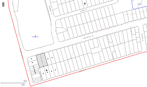
|
NOTIFICATION PLAN |
|
||
|
• PROPERTIES NOTIFIED
|
X SUBMISSIONS RECEIVED |
PROPERTY SUBJECT OF DEVELOPMENT |
|
Two submissions object to the development, generally on the following grounds:
· Traffic congestion, safety concerns at intersections and parking management.
· The development would exacerbate flooding issues caused by stormwater runoff across Carlingford Road and Darwin Street.
· Privacy impacts resulting from the development in regards to insufficient setbacks, south facing balconies, retention of mature trees at the rear of the property.
· Design concerns for the development in relation to articulation, materials chosen and construction viability.
· The development would increase the density in the area which would result in a negative social impact with local schools, medical centres and hospitals being incapable to meet the intake in numbers and provide an equitable level of service. Additionally, densification would exacerbate anti social behaviour in the area.
· Multiple bins resulting from the development would be detrimental to the community.
The merits of the maters raised in community submissions have been addressed in the body of the report other than the following:
5.1.1. Traffic matters
Council has undertaken an assessment of the overall traffic impact of the redeveloped precinct on the locality.
In the preparation of Council’s Housing Strategy transport modelling was undertaken to determine the traffic impact precincts to be rezoned as part of the Strategy. Traffic modelling and assessment for the Carlingford Precinct established that additional traffic that would be generated in the Precinct would not have a significant impact on existing roadway conditions and intersection performance in the area. The most significant traffic increase is envisaged to occur on arterial routes such as Pennant Hills Road and Carlingford Road. These increases are mainly attributed to anticipated growth and developments in other regions and to a greater extent to the re-distribution effect arising from the growth in through traffic from other regions of Sydney.
The modelling also established that the existing performance of the intersection of Carlingford Road with Hepburn Avenue is unsatisfactory during the morning peak period. This is mainly due to peak hour traffic congestion in Carlingford Road which limits the number of vehicles that can turn right out Hepburn Avenue. Signalising this junction would facilitate and improve access for the Precinct. However, it is considered that this would encourage ‘rat runs’ from Marsden Road via Rickard Street and possibly into Pennant Parade and North Rocks Road, Murray Farm Road and Kirkham Street. Signalisation of the intersection of Carlingford Road with Hepburn Avenue is not supported at this stage due to envisaged adverse impact on the amenity of the area. Eastbound traffic that turns right out of Hepburn Avenue has an option of using other roads to exit the area via the traffic signals at the intersection of Carlingford Road with Midson Road. Notwithstanding, review and monitoring of traffic conditions will be required to determine if any traffic management strategies are required in the area after the precinct has been redeveloped. In this regard, Council on 18 July 2012 considered DA/236/2012 for a five storey residential flat building at Nos. 48-52 Keeler Street Carlingford and made the following resolution:
Council undertake further traffic and dwelling yield modelling of the Carlingford Housing Strategy Precinct to confirm the road and other improvements required to facilitate future development within the Precinct and specifically taking into consideration issues including yield of developments being proposed within the Precinct, impact of the North West Rail Link and identified traffic improvements at Epping.
In accordance with Council’s resolution, modelling of the traffic generation associated with the development of the precinct is currently being progressed by Council.
The applicant submitted a traffic impact assessment report (as discussed in section 3.2.2 of this report), which confirms the findings of Council’s traffic modelling that the development would not change the Level of Service (LoS) of the nearby intersections.
5.1.2. Increase in Density
The proposed development is within the ‘Carlingford Road, Carlingford’ precinct rezoned for medium-high density housing in accordance with the Housing Strategy in September 2011. The concerns raised in the submission regarding detrimental social, health and educational impacts resulting from the development are addressed in the Housing Strategy.
The Housing Strategy included a detailed study on the identification of centres, selection of precincts and evaluation of precincts and consulted with various External Agencies including the Department of Planning (Regional Team), Department of Housing, Transport Infrastructure Development Corporation, NSW Police, Sydney Water, NSW Health, Department of Community Services and NSW Department of Education and Training.
5.2 Public Agencies
5.2.1 NSW Police
NSW Police commented on the proposed residential flat building in respect to Crime Prevention Through Environmental Design principles and raised no objection to the proposal.
5.2.1 NSW Rail Corporation
The NSW Rail Corporation commented on the proposed residential flat building in respect to the provisions of State Environmental Planning Policy (Infrastructure) 2007 - Schedule 3 and raised no objection to the proposal.
5.2.2 NSW Roads and Maritime Services
Roads and Maritime Service commented on the proposed residential flat building in respect to the provisions of State Environmental Planning Policy (Infrastructure) 2007 - Schedule 3 and raised no objection to the proposal subject to recommended conditions.
6. THE PUBLIC INTEREST
Section 79C(1)(e) of the Act requires Council to consider “the public interest”.
The public interest is an overarching requirement, which includes the consideration of the matters discussed in this report. Implicit to the public interest is the achievement of future built outcomes adequately responding to and respecting the future desired outcomes expressed in environmental planning instruments and development control plans.
The application is considered to have satisfactorily addressed Council’s and relevant agencies’ criteria and would provide a development outcome that, on balance, would result in a positive impact for the community. Accordingly, it is considered that the approval of the proposed residential flat building would be in the public interest.
CONCLUSION
The application seeks approval for the demolition of existing structures and the construction of a five storey residential flat building comprising 30 dwellings and basement car parking and includes strata title subdivision.
The proposed development is generally in accordance with the development controls for the ‘Carlingford Road, Carlingford’ precinct of the Housing Strategy DCP and would contribute to the residential character of the precinct. The minor non-compliance with prescriptive measures for floorplate, height of the basement above ground level, top storey setbacks, parking and deep soil landscaping, are considered acceptable. The proposal complies with the design principles of SEPP 65 and the Residential Flat Design Code.
The proposal would result in a development that would be in keeping with the desired future character of the precinct.
Note: At the time of the completion of this planning report, no persons have made a Political Donations Disclosure Statement pursuant to Section 147 of the Environmental Planning and Assessment Act 1979 in respect of the subject planning application.
|
Rod Pickles Manager - Development Assessment Planning Division |
James Farrington Group Manager Planning Division |
|
1.View |
Locality Map |
|
|
|
2.View |
Site Plan |
|
|
|
3.View |
Floor Plans |
|
|
|
4.View |
Elevations |
|
|
|
5.View |
Tree Plan |
|
|
|
6.View |
Landscape Plan |
|
|
|
7.View |
Amended Floor Plan |
|
|
|
8.View |
Amended Elevation Plans |
|
|
File Reference: DA/569/2012
Document Number: D02018009
SCHEDULE 1
GENERAL CONDITIONS
The conditions of consent within this notice of determination have been applied to ensure that the use of the land and/or building is carried out in such a manner that is consistent with the aims and objectives of the relevant legislation, planning instruments and Council policies affecting the land and does not disrupt the amenity of the neighbourhood or impact upon the environment.
Note: For the purpose of this consent, the term ‘applicant’ means any person who has the authority to act on or the benefit of the development consent.
Note: For the purpose of this consent, any reference to an Act, Regulation, Australian Standard or publication by a public authority shall be taken to mean the gazetted Act or Regulation, or adopted Australian Standard or publication as in force on the date that the application for a construction certificate is made.
1. Approved Plans and Supporting Documentation
The development must be carried out in accordance with the plans and documentation listed below and endorsed with Council’s stamp, except where amended by Council and/or other conditions of this consent:
|
Plan No. |
Rev |
Drawn by |
Dated |
|
DA01 Site and Roof Plan
|
D
|
Giles Tribe Architects |
6/10/2012 |
|
DA02 Lower Basement Carpark Floor Plan
|
D |
Giles Tribe Architects |
6/10/2012 |
|
DA03 Upper Basement Carpark Floor Plan |
D |
Giles Tribe Architects |
6/10/2012 |
|
DA04 Ground Floor Plan |
E |
Giles Tribe Architects |
12/11/2012 |
|
DA05 Typical Floor Plan Level 2-3 |
D |
Giles Tribe Architects |
6/10/2012 |
|
DA06 Typical Floor Plan Level 4 |
D |
Giles Tribe Architects |
6/10/2012 |
|
DA07 Level 5 Floor Plan |
D |
Giles Tribe Architects |
6/10/2012 |
|
DA08 Roof Plan |
D |
Giles Tribe Architects |
6/10/2012 |
|
DA09 Proposed Elevation (North Elevations) |
D |
Giles Tribe Architects |
6/10/2012 |
|
DA10 Proposed Elevation (West Elevation and South Elevation) |
E |
Giles Tribe Architects |
12/11/2012 |
|
DA11 Proposed Elevation and Section A-A (East Elevation) |
E |
Giles Tribe Architects |
12/11/2012 |
|
DA12 Section B-B |
D |
Giles Tribe Architects |
6/10/2012 |
|
DA19A Shadow Diagram |
A |
Giles Tribe Architects |
17/8/2012 |
|
H-DA-00 Ground Floor Stormwater Drainage |
G |
ITM Design Pty Ltd |
10/10/2012 |
|
H-DA-03 Ground Floor Stormwater Drainage |
C |
ITM Design Pty Ltd |
10/10/2012 |
|
L01 Tree Schedule (Removal Plan) |
A |
Susan Read Landscapes |
5/4/2012 |
|
L02 Landscape Planting Plan |
B |
Susan Read Landscapes |
10/8/2012 |
|
L03 Details and Plant Schedule |
B |
Susan Read Landscapes |
10/8/2012 |
|
Document Name/No. |
Prepared by |
Dated |
|
Tree Report |
Apex Tree and Garden Experts |
10/8/2012 |
|
Basix Certificate No. 429201M_02 |
NSW Department of Planning |
20/8/2012 |
|
ABSA Assessor Certificate No. 57530018 |
|
|
|
Statement of Environmental Effects |
Giles Tribe Architects |
August 2012 (revised) |
|
SEPP No. 65 Design Statement |
Giles Tribe Architects |
17/8/2012 (received) |
|
Geotechnical Investigation |
Geo Enviro Consultancy Pty Ltd |
May 2012 |
|
Road Traffic Noise Assessment |
Acoustic Dynamics Pty Ltd |
7/6/2012 |
|
Traffic and Parking Impact Report |
ML Traffic Engineers |
April 2012 |
|
Waste Management Plan |
Giles Tribe Architects |
28/5/2012 (received) |
|
Quantity Survey Report |
MMD Construction Consultants |
21/5/2012 |
|
A3-400 Materials and Finishes Schedule |
Giles Tribe Architects |
May 2012 |
2. Removal of Existing Trees
This development consent only permits the removal of tree(s) numbered 3,4,5,6,7,8,9,10,11 as identified on Plan No. LA02 revision B prepared by Susan Read Landscapes dated 10/8/2012. The removal of any other trees requires separate approval under Council’s Tree Preservation Order.
3. Amendment of Plans
The approved Ground Floor Stormwater Drainage Plan drawn by ITM Design Pty Ltd dated 10 October 2012 is to be amended to include a 900mm x 900mm full access cover and grate as marked in red on the approved plan.
REQUIREMENTS PRIOR TO THE ISSUE OF A CONSTRUCTION CERTIFICATE
4. Building Code of Australia
All building work must be carried out in accordance with the requirements of the Building Code of Australia.
5. Contract of Insurance (Residential Building Work)
In the case of residential building work for which the Home Building Act, 1989 requires there to be a contract of insurance in force in accordance with Part 6 of that Act, that such a contract of insurance is in force before any building work authorised to be carried out by the consent commences.
6. Water/Electricity Utility Services
The applicant must submit written evidence of the following service provider requirements:
a) Energy Australia – a letter of consent demonstrating that satisfactory arrangements have been made to service the proposed development.
b) Sydney Water – the submission of a ‘Notice of Requirements’ under s73 of the Sydney Water Act 1994.
Note: Sydney Water requires that s73 applications are to be made through an authorised Sydney Water Servicing Coordinator. Refer to www.sydneywater.com.au or telephone 13 20 92 for assistance.
7. Accessible units
The details of fit-outs of all accessible units (3 units) and details of adaptable units must be provided with the Construction Certificate Plans.
8. Dilapidation Report
A ‘Dilapidation Report’ is to be prepared by a ‘chartered structural engineer’ detailing the structural condition of all adjoining properties.
9. Stormwater Drainage
The stormwater drainage system for the development must be designed and constructed in accordance with Council’s Civil Works – Design and Construction Specification 2005 and the following requirements:
a) Connected via galvanised rectangular hollow sections, normally 125mm x 75mm x 3mm thick, to Council’s kerb line in Carlingford Road.
b) The roof and upstream paved areas of the proposal shall be connected to the proposed detention system.
10. On Site Stormwater Detention
An on-site stormwater detention system must be designed by a chartered civil engineer and constructed in accordance with the following requirements:-
a) Have a capacity of not less than 21 cubic metres, and a maximum discharge (when full) of 19 litres per second.
b) Have a 900 mm x 900 mm square access grates located directly above the on-site detention outlet and water harvesting access chamber. The supporting hydraulic plans of the consent must be altered to provide this requirement.
c) An additional tank overflow system designed to convey all high level flows from the tank to the grated pit adjacent the proposed crossing.
d) Discharge from the detention system to be controlled via 1 metre length of pipe, not less than 50 millimetres diameter or via a stainless plate with sharply drilled orifice bolted over the face of the outlet discharging into a larger diameter pipe capable of carrying the design flow to an existing interallotment drainage system.
11. Internal Driveway/Vehicular Areas
The driveway and parking areas on site must be designed generally in accordance with the approved plans, Australian Standards 2890.1, AS2890.2, AS2890.6, AS3727 and the following requirements:-
a) Design levels at the front boundary to be obtained from Council.
b) The driveway be a rigid pavement.
c) The driveway grade for the design waste vehicle must not exceed 15.4 percent and transitions for changes in grade must not exceed requirements of AS2890.2. Provision shall be made for a turning area for Council’s Waste Services design vehicle and permanently marked out in the basement.
d) Driveway structure, retaining walls required to support the carriageway as required and the protection of all drops as per the requirements of a chartered Structural Engineer.
e) Planting of landscaping strips to enhance the visual amenity of the driveway.
12. Footpath
Prior to the issue of a Construction Certificate for these works a separate application under the Local Government Act, 1993 and the Roads Act, 1993 must be submitted to Council for the construction of footpaths within the road reserve. A concrete footpath must be constructed along the full frontage of the subject site in accordance Council’s Civil Works Design and Construction Specification, 2005 and the following requirements:
a) The existing footpath being removed and reconstructed.
b) Any public utility adjustments to be carried out at the cost of the applicant and to the requirements of the relevant public authority.
13. Vehicular Crossing
A separate application under the Local Government Act, 1993 and the Roads Act, 1993 must be submitted to Council for the installation of a new vehicular crossing and the removal of the redundant crossing. The vehicular crossing must be constructed in accordance with Council’s Civil Works Design Specification 2005 and the following requirements:
a) Any redundant crossings to be replaced with integral kerb and gutter.
b) The footway area to be restored by turfing.
c) Provision for all relevant utility authorities’ necessary conduits, installed and protected under the crossing.
d) Adjustment of all regulatory signage and all services and street furniture made necessary by the proposed works.
Note: An application for a vehicular crossing can only be made to one of Council’s Authorised Vehicular Crossing Contractors. You are advised to contact Council on 02 9847 6760 to obtain a list of contractors.
14. Road Works
A separate application under the Local Government Act, 1993 and the Roads Act, 1993 must be submitted to Council for all works within the road reserve. All road works approved under this consent must be constructed in accordance with Council’s Civil Works Design and Construction Specification, 2005 and the following requirements:
a) The existing kerb and gutter is to be removed and reconstructed.
b) The existing road pavement to be saw cut a minimum of 300 mm from the existing lip of gutter and reconstructed.
c) Pursuant to Section 138 of the Roads Act 1993, these works shall be designed by a Chartered Civil Engineer with four copies of the plans submitted to Hornsby Council’s Planning Division for consideration and approval, prior to the release of the Construction Certificate. Once approved the work shall be inspected by Hornsby Council and accepted by Council in writing prior to the release of the Occupation Certificate. The Applicant shall pay all Council’s fees associated with provision of this assessment and compliance work.
15. Traffic Control Plan
A Traffic Control Plan (TCP) must be prepared by a qualified traffic controller in accordance with the Roads & Traffic Authority’s Traffic Control at Worksites Manual 1998 and Australian Standard 1742.3 for all work on a public road and be submitted to Council. The TCP must detail the following:
a) Arrangements for public notification of the works.
b) Temporary construction signage.
c) Permanent post-construction signage.
d) Vehicle movement plans.
e) Traffic management plans.
f) Pedestrian and cyclist access/safety.
g) Approval of the RMS where required.
REQUIREMENTS PRIOR TO THE COMMENCEMENT OF ANY WORKS
16. Erection of Construction Sign
A sign must be erected in a prominent position on any site on which building work, subdivision work or demolition work is being carried out:
a) Showing the name, address and telephone number of the principal certifying authority for the work,
b) Showing the name of the principal contractor (if any) for any demolition or building work and a telephone number on which that person may be contacted outside working hours, and
c) Stating that unauthorised entry to the work site is prohibited.
Note: Any such sign is to be maintained while the building work, subdivision work or demolition work is being carried out, but must be removed when the work has been completed.
17. Protection of Adjoining Areas
A temporary hoarding, fence or awning must be erected between the work site and adjoining lands before the works begin and must be kept in place until after the completion of the works if the works:
a) Could cause a danger, obstruction or inconvenience to pedestrian or vehicular traffic.
b) Could cause damage to adjoining lands by falling objects.
c) Involve the enclosure of a public place or part of a public place.
Note: Notwithstanding the above, Council’s separate written approval is required prior to the erection of any structure or other obstruction on public land.
18. Toilet Facilities
Toilet facilities must be available or provided at the works site before works begin and must be maintained until the works are completed at a ratio of one toilet for every 20 persons employed at the site. Each toilet must:
a) be a standard flushing toilet connected to a public sewer; or
b) be a temporary chemical closet approved under the Local Government Act, 1993; or
c) have an on-site effluent disposal system approved under the Local Government Act, 1993
19. Erosion and Sediment Control
Erosion and sediment control measures must be provided and maintained throughout the construction period in accordance with the manual ‘Soils and Construction 2004 (Bluebook)’, the approved plans, Council specifications and to the satisfaction of the principal certifying authority. The erosion and sediment control devices must remain in place until the site has been stabilised and revegetated.
Note: On the spot penalties up to $1,500 may be issued for any non-compliance with this requirement without any further notification or warning.
20. Tree Protection Barriers
Tree protection fencing must be erected around trees numbered 1,2,12,13,14 to be retained at a 5 metre setback. The tree fencing must be constructed of 1.8 metre ‘cyclone chainmesh fence’.
REQUIREMENTS DURING CONSTRUCTION
21. Construction Work Hours
All work on site (including demolition and earth works) must only occur between 7am and 5pm Monday to Saturday.
No work is to be undertaken on Sundays or public holidays.
22. Demolition
All demolition work must be carried out in accordance with Australian Standard 2601-2001 – The Demolition of Structures and the following requirements:
a) Demolition material is to be disposed of to an authorised recycling and/or waste disposal site and/or in accordance with an approved waste management plan.
b) Demolition works, where asbestos material is being removed, must be undertaken by a contractor that holds an appropriate licence issued by WorkCover NSW in accordance with Chapter 10 of the Occupational Health and Safety Regulation 2001 and Clause 29 of the Protection of the Environment Operations (Waste) Regulation 2005.
c) On construction sites where buildings contain asbestos material, a standard commercially manufactured sign containing the words ‘DANGER ASBESTOS REMOVAL IN PROGRESS’ measuring not less than 400mm x 300mm must be erected in a prominent position visible from the street.
23. Waste Management
Prior to commencement of works, a revised and detailed Waste Management Plan Section One – Demolition Stage, Section Two – Design Stage, and Section Three – Construction as applicable, covering the scope of this project is required to be submitted to Council in accordance with the Waste Minimisation and Management Development Control Plan.
24. Environmental Management
The site must be managed in accordance with the publication ‘Managing Urban Stormwater – Landcom (March 2004) and the Protection of the Environment Operations Act 1997 by way of implementing appropriate measures to prevent sediment run-off, excessive dust, noise or odour emanating from the site during the construction of the development.
25. Street Sweeping
Street sweeping must be undertaken following sediment tracking from the site along Keeler Street during works and until the site is established.
26. Spoil Route
To protect Council’s assets, all vehicular access to and from the site during all stages of the development is to be via the shortest route to the nearest State or Regional Road
27. Council Property
During construction works, no building materials, waste, machinery or related matter is to be stored on the road or footpath.
28. Landfill
Landfill must be constructed in accordance with Council’s ‘Construction Specification, 2005’ and the following requirements:
a) All fill material imported to the site is to wholly consist of Virgin Excavated Natural Material (VENM) as defined in Schedule 1 of the Protection of the Environment Operations Act 1997 or a material approved under the Department of Environment and Climate Change’s general resource recovery exemption.
b) A compaction certificate is to be obtained from a geotechnical engineer verifying that the specified compaction requirements have been met.
29. Excavated Material
All excavated material removed from the site must be classified in accordance with the Department of Environment, Climate Change and Water NSW Waste Classification Guidelines prior to disposal to an approved waste management facility and reported to the principal certifying authority.
30. Survey Report – Finished Floor Level
A report(s) must be prepared by a registered surveyor and submitted to the principal certifying authority prior to the pouring of concrete at each level of the building certifying that:
a) The building, retaining walls and the like have been correctly positioned on the site.
b) The finished floor level(s) are in accordance with the approved plans.
31. Contamination during construction works
Should the presence of asbestos or soil contamination, not recognised during the application process be identified during demolition, the applicant must immediately notify the Principal Certifying Authority and Council.
32. Waste Management
Waste management during the demolition and construction phase of the development must be undertaken in accordance with the approved Waste Management Plan. Additionally written record of the following items must be maintained during the removal of any waste from the site and such information submitted to the Principal Certifying Authority within fourteen days of the date of completion of the works:
a) The identity of the person removing the waste.
b) The waste carrier vehicle registration.
c) Date and time of waste collection.
d) A description of the waste (type of waste and estimated quantity).
e) Details of the site to which the waste is to be taken.
f) The corresponding tip docket/receipt from the site to which the waste is transferred (noting date and time of delivery, description (type and quantity) of waste).
g) Whether the waste is expected to be reused, recycled or go to landfill.
Note: In accordance with the Protection of the Environment Operations Act 1997, the definition of waste includes any unwanted substance, regardless of whether it is reused, recycled or disposed to landfill.
33. Works near Trees
All required tree protection measures are to be maintained in good condition for the duration of the construction period.
All works (including driveways and retaining walls) within 5 metres of any trees required to be retained (whether or not on the subject property, and pursuant to this consent or the Tree Preservation Order), must be carried out under the supervision of an ‘AQF Level 5 Arborist’ and a certificate submitted to the principal certifying authority detailing the method(s) used to preserve the tree(s).
Note: Except as provided above, the applicant is to ensure that no excavation, filling or stockpiling of building materials, parking of vehicles or plant, disposal of cement slurry, waste water or other contaminants is to occur within 4 metres of any tree to be retained
REQUIREMENTS PRIOR TO THE ISSUE OF AN OCCUPATION CERTIFICATE
Note: For the purpose of this consent, a reference to ‘occupation certificate’ shall not be taken to mean an ‘interim occupation certificate’ unless otherwise stated.
34. Fulfilment of BASIX Commitments
The applicant must demonstrate the fulfilment of BASIX commitments pertaining to the development.
35. Sydney Water – s73 Certificate
A s73 Certificate must be obtained from Sydney Water.
36. Car Parking Allocation & Resident Storage
The basement resident storage areas are to be allocated in accordance with the size requirements of the SEPP 65 - Residential Flat Design Code for the respective units and proximity to the unit car parking space.
37. Damage to Council Assets
Any damage caused to Council’s assets as a result of the construction of the development must be rectified in accordance with Council’s written requirements and at the sole cost of the applicant.
38. Creation of Easements
The following matters must be nominated on the title using s88E or s88B (as applicable) of the Conveyancing Act 1919:
a) Consolidation of the subject lots.
b) The creation of an appropriate "Positive Covenant" and "Restriction as to User" over the constructed on-site detention systems and outlet works, within the lots in favour of Council in accordance with Council’s prescribed wording. The position of the on-site detention system is to be clearly indicated on the title.
c) To register the OSD easement, the restriction on the use of land “works-as-executed” details of the on-site-detention system must be submitted verifying that the required storage and discharge rates have been constructed in accordance with the design requirements. The details must show the invert levels of the on site system together with pipe sizes and grades. Any variations to the approved plans must be shown in red on the “works-as-executed” plan and supported by calculations.
Note: Council must be nominated as the authority to release, vary or modify any easement, restriction or covenant.
39. Garbage Collection Easement
For the purpose of waste collection, an easement entitling Council, its servants and agents and persons authorised by it to enter upon the subject land and to operate thereon, vehicles and other equipment for the purposes of garbage collection must be granted to Council by the owner of the land.
Note: The easement must be in a form prescribed by Council and must include covenants to the effect that parties will not be liable for any damage caused to the subject land or any part thereof or to any property located therein or thereon by reason of the operation thereon of any vehicle or other equipment used in connection with the collection of garbage and to the effect that the owner for the time being of the subject land shall indemnify the Council, its servants, agents and persons authorised by it to collect garbage against liability in respect of any such claims made by any person whomsoever.
40. Maintain Canopy Cover Planter Boxes / On slab planting
On slab planter boxes must include waterproofing, subsoil drainage (proprietary drainage cell, 50mm sand and filter fabric) automatic irrigation, minimum 500mm planting soil for shrubs and minimum 1000mm planting soil for trees and palms and 75mm mulch to ensure sustainable landscape is achieved.
41. Boundary Planting (Southern Boundary)
Planting to the rear landscape setback areas must include:
a) Two additional Angophora Costata (Sydney Red Gum). Trees shall be installed at minimum 45 litre pot size.
42. Completion of landscaping
A certificate must be provided by a practicing landscape architect, horticulturalist or person with similar qualifications and experience certifying that all required landscaping works have been satisfactorily completed in accordance with the approved landscape plans.
43. Retaining Walls
All required retaining walls must be constructed as part of the development.
44. Boundary Fencing
Fencing must be erected along all property boundaries behind the front building alignment to a height of 1.8 metres.
Note: Alternative fencing may be erected subject to the written consent of the adjoining property owner(s).
45. External Lighting
All external lighting must be designed and installed in accordance with Australian Standard AS 4282 – Control of the Obtrusive Effects of Outdoor Lighting. Certification of compliance with the Standard must be obtained from a suitably qualified person.
46. Unit Numbering
The allocation of unit numbering must be authorised by Council prior to the numbering of each unit in the development.
47. Section 94 Infrastructure Contributions
The payment to Council of a contribution of $368,486.25 for 28 additional dwellings towards the cost of infrastructure identified in Council’s Development Contributions Plan 2007-2011.
Note: The value of contribution is current as at 31 October 2012. The contribution will be adjusted from this date in accordance with the underlying consumer price index for subsequent financial quarters. The contribution includes a credit for the two existing allotments.
It is recommended that you contact Council to confirm the value of the contribution prior to payment.
48. Safety and Security
The site must include the following elements:
a) An intercom system must be installed at gate locations to ensure screening of persons entering the units.
b) The entryway to the site must be illuminated in high luminance at all times
c) The communal open space at the rear of the site must be illuminated with high luminance by motion sensor lighting
d) The service areas of the ground floor and the garbage room at the basement must be illuminated with high luminance by motion sensor lighting
e) The driveway and the basement car park must be illuminated with low luminance at all times.
49. Waste Management
The following waste management requirements must be complied with:
a) The bin storage room at the basement level must include water or a hose for cleaning, graded floors with drainage to sewer, a robust door, sealed and impervious surface, adequate lighting and ventilation.
b) A report must be prepared by an appropriately qualified person, certifying the following:
i) A comparison of the estimated quantities of each waste type against the actual quantities of each waste type.
Note: Explanations of any deviations to the approved Waste Management Plan is required to be included in this report
ii) That at least 60% of the waste generated during the demolition and construction phase of the development was reused or recycled.
Note: If the 60% diversion from landfill cannot be achieved in the Construction Stage, the Report is to include the reasons why this occurred and certify that appropriate work practices were employed to implement the approved Waste Management Plan. The Report must be based on documentary evidence such as tipping dockets/receipts from recycling depots, transfer stations and landfills, audits of procedures etc. which are to be attached to the report.
c) Each unit must be provided with an indoor waste/recycling cupboard for the interim storage of a minimum one day’s waste generation with separate containers for general waste and recyclable materials.
d) Space must be provided for either individual compost containers for each unit or a communal compost container;
Note: The location of the compost containers should have regard for potential amenity impacts.
e) The bin carting route must be devoid of any steps.
Note: Ramps between different levels are acceptable
f) No parking signs must be erected to prohibit parking in the waste collection vehicle turning area/loading bay.
g) A report(s) must be prepared by a registered surveyor and submitted to the principal certifying authority prior to the issue of the Subdivision/Occupation Certificate, certifying that:
i) The finished access way (including ramp, vehicle turning area, loading bay and site entry/exit) to be used by waste collection vehicles, complies with Australian Standard AS 2890.2-2002 Parking Facilities Part 2: Off-street Commercial Vehicle Facilities for small rigid vehicles with minimum design vehicle dimensions of 6.4 metres overall length, width of 2.3 metres, and 3.5 metre clearance height; and
ii) The finished gradient(s), dimensions and geometry of the road/access way (including vehicle turning area) are in accordance with the approved plans.
h) The car park ventilation must not reduce the clearance height within the truck turning path.
50. Works as Executed Plan
A works-as-executed plan(s) must be prepared by a registered surveyor and submitted to Council for completed road pavement, kerb & gutter, public drainage systems, driveways and on-site detention system.
OPERATIONAL CONDITIONS
51. Landscape establishment
The landscape works must be maintained into the future to ensure the establishment and successful growth of plant material to meet the intent of the landscape design. This must include but not be limited to watering, weeding, replacement of failed plant material and promoting the growth of plants through standard industry practices.
52. Visitor Access
Visitors are to have access to the parking area at all times. Visitors are to be able to access the basement car park by an audio/visual intercom system located at the top of the ramped driveway.
53. Noise
All noise generated by the proposed development must be attenuated to prevent levels of noise being emitted to adjacent premises which possess tonal, beating and similar characteristics or which exceeds background noise levels by more than 5dB(A).
54. Disabled Parking
All parking spaces for people with disabilities must be constructed and operated in accordance with Australian Standard AS/NZS 2890.6:2009 – Off-street parking for people with disabilities
55. Fire Safety Statement - Annual
On at least one occasion in every 12 month period following the date of the first ‘Fire Safety Certificate’ issued for the property, the owner must provide Council with an annual ‘Fire Safety Certificate’ to each essential service installed in the building.
56. Waste Management
A site caretaker must be employed and be responsible for moving bins to and from the bin storage room(s) and the waste collection point, washing bins and maintaining waste storage areas, ensuring the chute system and related devices are maintained in effective and efficient working order, managing the communal composting area, arranging the prompt removal of dumped rubbish, and ensuring all residents are informed in the use of the waste management system.
CONDITIONS OF CONCURRENCE – NSW ROADS & MARITIME SERVICES
The following conditions of consent are from the nominated State Agency pursuant to Section 79B of the Environmental Planning and Assessment Act 1979 and must be complied with to the satisfaction of that Agency.
57. The proposed development was subjected to the acquisition of strip for the purpose of setting an easement for batter along the Carlingford Road frontage of the subject property. The development must ensure that access to the easement is not denied and the integrity of the easement is not compromised and all structures and works must be clear of the easement for batter and road reserve (unlimited in height or depth).
58. All vehicles shall be wholly contained on site before being required to stop.
59. If not already in place, full time “No Stopping” restrictions are to be implemented along the full length of the Carlingford Road frontage of the development site. The restriction should be implemented prior to the commencement of any demolition works relating to the proposed development. Prior to the installation of the parking restrictions the applicant is to contact the RMS’ Traffic Engineering Services on phone: (02) 88492294 for a works instruction.
60. All works/regulatory signage associated with the proposed development are to be at no cost to RMS.
- END OF CONDITIONS -
ADVISORY NOTES
The following information is provided for your assistance to ensure compliance with the Environmental Planning and Assessment Act, 1979, Environmental Planning and Assessment Regulation 2000, other relevant legislation and Council’s policies and specifications. This information does not form part of the conditions of development consent pursuant to Section 80A of the Act.
Environmental Planning and Assessment Act 1979 Requirements
· The Environmental Planning and Assessment Act 1979 requires:
· A construction certificate prior to the commencement of any works. Enquiries regarding the issue of a construction certificate can be made to Council’s Customer Services Branch on 9847 6760.
· A principal certifying authority to be nominated and Council notified of that appointment prior to the commencement of any works.
· Council to be given at least two days written notice prior to the commencement of any works.
· Mandatory inspections of nominated stages of the construction inspected.
· An occupation certificate issued before occupying any building or commencing the use of the land.
Long Service Levy
In accordance with Section 34 of the Building and Construction Industry Long Service Payments Act 1986, a ‘Long Service Levy’ must be paid to the Long Service Payments Corporation or Hornsby Council.
Note: The rate of the Long Service Levy is 0.35% of the total cost of the work.
Note: Hornsby Council requires the payment of the Long Service Levy prior to the issue of a construction certificate.
Tree Preservation Order
To ensure the maintenance and protection of the existing natural environment, it is an offence to ringbark, cut down, top, lop, remove, wilfully injure or destroy a tree outside three metres of the approved building envelope without prior written consent from Council. Fines may be imposed for non-compliance with Council’s Tree Preservation Order.
Note: A tree is defined as a single or multi-trunked wood perennial plant having a height of not less than three (3) metres, and which develops many branches, usually from a distance of not less than one (1) metre from the ground, but excluding any plant which, in its particular location, is a noxious plant declared as such pursuant to the Noxious Weeds Act 1993. This definition of ‘tree’ includes any and all types of Palm trees.
All distances are determined British Standard BS 5837: 2005, “Trees in Relation to Construction – Recommendations”.
Disability Discrimination Act
The applicant’s attention is drawn to the existence of the Disability Discrimination Act. A construction certificate is required to be obtained for the proposed building, which will provide consideration under the Building Code of Australia, however, the development may not comply with the requirements of the Disability Discrimination Act. This is the sole responsibility of the applicant.
Dial Before You Dig
Prior to commencing any works, the applicant is encouraged to contact Dial Before You Dig on 1100 or www.dialbeforeyoudig.com.au for free information on potential underground pipes and cables within the vicinity of the development site.
Asbestos Warning
Should asbestos or asbestos products be encountered during construction or demolition works you are advised to seek advice and information should be prior to disturbing the material. It is recommended that a contractor holding an asbestos-handling permit (issued by Work Cover NSW), be engaged to manage the proper disposal and handling of the material. Further information regarding the safe handling and removal of asbestos can be found at:
Alternatively, telephone the Work Cover Asbestos and Demolition Team on 8260 5885.
House Numbering
House numbering can only be authorised by Council. Before proceeding to number each premise in the development, the allocation of numbers is required to be obtained from Council's Planning Division. The authorised numbers are required to be displayed in a clear manner at or near the main entrance to each premise.
Planning Report No. PL36/12
Planning Division
Date of Meeting: 21/11/2012
12 DEVELOPMENT APPLICATION - FIVE STOREY RESIDENTIAL FLAT BUILDING CONTAINING 29 UNITS - 66 - 68 KEELER STREET, CARLINGFORD
EXECUTIVE SUMMARY
|
DA No: |
DA/676/2012 (Lodged 5 July 2012) |
|
Description: |
Construction of a five storey residential flat building containing 29 units, basement car parking and strata title subdivision |
|
Property: |
Lot 7 DP 31556, Lot 8 DP 31556, Nos. 66 – 68 Keeler Street, Carlingford |
|
Applicant: |
D & C Consortium |
|
Owner: |
Ms J Zhao, Mr W J Mo, Ms M Li, Ms L F Leung and Ms M Cheung |
|
Estimated Value: |
$7,600,000 |
|
Ward: |
C |
· The application proposes the demolition of existing structures and the construction of a five storey residential flat building comprising 29 units, basement car parking and strata subdivision.
· The proposal generally complies with the Hornsby Shire LEP 1994, State Environmental Planning Policy No. 65 – Design Quality Residential Flat Building and the Housing Strategy Development Control Plan.
· No submissions have been received in respect of the application.
· It is recommended that the application be approved.
|
THAT Development Application No. 676/2012 for construction of a five storey residential flat building comprising 29 units and strata subdivision at Lot 7 DP 31556, Lot 8 DP 31556, No 66 & No 68 Keeler Street, Carlingford be approved subject to the conditions of consent detailed in Schedule 1 of Group Manager’s Report No. PL36/12. |
BACKGROUND
The site is within the ‘Carlingford Road, Carlingford precinct’, rezoned for five storey residential flat development as part of Council’s Housing Strategy on 2 September 2011.
The site adjoins the site of a proposed five storey residential flat building under consideration by Council at Nos. 70 - 72 Keeler Street. The proposed building is essentially the same design as the subject proposal with different treatment in the street elevation (DA/677/2012).
The site adjoins the site of an approved five storey residential flat building at Nos. 62-64 Keeler Street, approved by Council on 18 July 2012 (DA/127/2012).
SITE
The site has an area of 1,762.8m2 with a frontage of 33.1m to the northern side of Keeler Street and is a regular shaped site. The site has a north-easterly aspect with an average fall of 5% to the north-eastern corner of the site. An existing stormwater drainage line and easement traverses the central part of the site. The site includes two existing dwelling houses, shed buildings and a swimming pool.
The site forms part of the ‘Carlingford Road, Carlingford’ precinct rezoned for medium-high density housing in accordance with the Hornsby Shire Council Housing Strategy in September 2011. The precinct is bounded by Carlingford Road, Pennant Hills Road, Keeler Street and Hepburn Avenue. A number of properties have been approved for residential flat development or are under assessment by Council.
The surrounding developments within the rezoned precinct mainly include dwelling houses on suburban lots. There is a mix of low density and medium density housing on the opposite side of Keeler Street within the Parramatta City Council area. Keeler Street forms the boundary between the Hornsby and Parramatta local government areas in this location at Carlingford.
The area on the western side of Pennant Hills Road, Carlingford, within The Hills Shire Council area is undergoing transition for higher density housing developments.
The site is within walking distance (120m) of the Carlingford commercial centre on Pennant Hills Road and is located 800m north-east of Carlingford Railway Station.
PROPOSAL
The proposal is for the demolition of two existing dwelling houses and construction of a five storey building containing 29 units. The proposed units include 5 x 1 bedroom, 21 x 2 bedroom and 3 x 3 bedroom units. The proposed building includes three levels of basement car parking with 42 car parking spaces. The proposed ground floor is split level at the rear of the building. The proposal includes the relocation of the existing stormwater drainage line and easement.
The proposed development includes strata subdivision.
ASSESSMENT
The development application has been assessed having regard to the ‘Metropolitan Plan for Sydney 2036’, the ‘North Subregion (Draft) Subregional Strategy’ and the matters for consideration prescribed under Section 79C of the Environmental Planning and Assessment Act 1979 (the Act). The following issues have been identified for further consideration.
1. STRATEGIC CONTEXT
1.1 Metropolitan Plan for Sydney 2036 and (Draft) North Subregional Strategy
The Metropolitan Plan for Sydney 2036 is a broad framework to secure Sydney’s place in the global economy by promoting and managing growth. It outlines a vision for Sydney to 2036; the challenges faced, and the directions to follow to address these challenges and achieve the vision. The Draft North Subregional Strategy acts as a framework for Council in its preparation of the Comprehensive LEP by the end of 2012.
The Draft North Subregional Strategy sets the following targets for the Hornsby LGA by 2031:
· Employment capacity to increase by 9,000 jobs; and
· Housing stock to increase by 11,000 dwellings.
The proposed development would be consistent with the draft Strategy by providing an additional 27 dwellings and would contribute towards housing choice in the locality.
The proposed development would be consistent with the Metropolitan Plan for Sydney 2036.
2. STATUTORY CONTROLS
Section 79C(1)(a) requires Council to consider “any relevant environmental planning instruments, draft environmental planning instruments, development control plans, planning agreements and regulations”.
2.1 Hornsby Shire Local Environmental Plan 1994
The subject land is zoned Residential C (Medium/High Density) under the Hornsby Shire Local Environmental Plan 1994 (HSLEP). The objectives of the zone are:
(a) to provide for the housing needs of the population of the Hornsby area.
(b) to promote a variety of housing types and other land uses compatible with a medium to high density residential environment.
(c) to provide for development that is within the environmental capacity of a medium to high density residential environment.
The proposed development is defined as ‘multi-unit housing’ and ‘subdivision’ under the HSLEP and is permissible in the zone with Council’s consent. The land is identified within the area detailed on Diagram 8 under Schedule BB of the HSLEP. Clause 15A of the HSLEP prescribes that the maximum building height within the area detailed under Schedule BB is not to exceed 17.5 metres. The proposed building complies with this requirement.
Clause 18 of the HSLEP sets out heritage conservation provisions for Hornsby Shire. The site is not in the vicinity of a heritage item or conservation area and is not subject to consideration for heritage conservation.
2.2 Draft Hornsby Local Environmental Plan
The Draft Hornsby Local Environmental Plan (Draft HLEP) was exhibited from 5 June 2012 to 7 August 2012. The Draft HLEP essentially reiterates the current land use zoning and height control applicable to the site as outlined below:
2.2.1 Zoning
The site would be zoned R4 (High Density Residential) zone pursuant to the Land Use Table of the Draft HLEP. The proposed development is defined as a ‘Residential Flat Building’ and would be a permissible use in the zone with Council’s consent.
2.2.2 Height of Building
Clause 4.3 of the draft HLEP provides that the height of a building on any land is not to exceed the maximum height shown for the land on the Height of Buildings Map. The maximum permissible height for the subject site is 17.5 metres. The proposal complies with this provision.
2.3 State Environmental Planning Policy No. 55 – Remediation of Land
State Environmental Planning Policy No. 55 (SEPP 55) requires that Council must not consent to the carrying out of any development on land unless it has considered whether the land is contaminated or requires remediation for the proposed use.
The site has been used for residential purposes and is unlikely to be contaminated. No further assessment is considered necessary in this regard. A condition is recommended should any contamination be found during construction.
2.4 State Environmental Planning Policy No. 65 – Design Quality Residential Flat Development
The Policy provides design principles to improve the design quality of residential flat development and consistent planning controls across the State.
The applicant has submitted a design verification statement prepared by a qualified designer stating how the proposed development achieves the design principles of SEPP 65. The design principles of SEPP 65 and the submitted design verification statement are addressed below.
2.4.1 Principle 1 - Context
Design Principle 1 is as follows:
Good design responds and contributes to its context. Context can be defined as the key natural and built features of an area.
Responding to context involves identifying the desirable elements of a location’s current character or, in the case of precincts undergoing a transition, the desired future character as stated in planning and design policies. New buildings will thereby contribute to the quality and identity of the area.
The applicant submits that the proposed development is designed according to the intentions of Council’s Housing Strategy DCP for the newly zoned area for high density development within the ‘Carlingford Road, Carlingford Precinct’ and that the proposed development would contribute to the future character of the area.
The subject site is located within a precinct zoned for five storey residential flat buildings in close proximity to Pennant Hills Road and the Carlingford Court Shopping Centre. The desired future character of the area, as outlined in Council’s Housing Strategy Development Control Plan, is that of a high density residential precinct incorporating five storey developments in a landscape setting. It is considered that the proposed building would contribute to the identity and future character of the precinct.
2.4.2 Principle 2 - Scale
Design Principle 2 is as follows:
Good design provides an appropriate scale in terms of the bulk and height that suits the scale of the street and the surrounding buildings.
Establishing an appropriate scale requires a considered response to the scale of existing development. In precincts undergoing a transition, proposed bulk and height needs to achieve the scale identified for the desired future character of the area.
The applicant’s submission includes the following statement:
The proposed development is designed to meet all the setback requirements, height limits and articulation to satisfy the requirements of the Housing Strategy DCP with appropriate bulk and scale.
The applicant’s statement is supported in respect to this Principle. Compliance with the applicable controls under Council’s Housing Strategy DCP is discussed in Section 2.9 of this report.
2.4.3 Principle 3 – Built Form
Design Principle 3 is as follows:
Good design achieves an appropriate built form for a site and the building’s purpose, in terms of building alignments, proportions, building type and the manipulation of building elements.
Appropriate built form defines the public domain, contributes to the character of streetscape and parks, including their views and vistas, and provides internal amenity and outlook.
The applicant submits that the built form is designed to suit the future vision of the ‘Carlingford Road Carlingford Precinct’ with articulation to create an interesting appearance with building elements such as vertical blade walls, balconies with glazed or non-glazed balustrades, contrasting finishes, colours and textures.
The applicant’s statement is supported in respect to this Principle.
2.4.4 Principle 4 – Density
Design Principle 4 is as follows:
Good design has a density appropriate for a site and its context, in terms of floor space yields (or number of units or residents).
Appropriate densities are sustainable and consistent with the existing density in an area or in precincts undergoing a transition, are consistent with the stated desired future density. Sustainable densities respond to the regional context, availability of infrastructure, public transport, community facilities and environmental quality.
The applicant submits that the proposed development is designed in accordance with the density requirements of the Housing Strategy DCP.
The applicant’s submission is supported in respect of this Principle.
2.4.5 Principle 5 – Resource, Energy and Water Efficiency
Design Principle 5 is as follows:
Good design makes efficient use of natural resources, energy and water throughout its full life cycle, including construction.
Sustainability is integral to the design process. Aspects include demolition of existing structures, recycling of materials, selection of appropriate and sustainable materials, adaptability and reuse of buildings, layouts and built form, passive solar design principles, efficient appliances and mechanical services, soil zones for vegetation and reuse of water.
The applicant has submitted BASIX Certificate No. 434952M for the proposed 29 dwellings. In achieving the required BASIX targets for sustainable water use, thermal comfort and energy efficiency, the proposed development achieves the design criteria. The applicant submits that the building design achieves an efficient use of natural resources, includes sustainable materials and passive solar design principles.
The applicant’s statement is supported in respect to this Principle.
2.4.6 Principle 6 – Landscape
Design Principle 6 is as follows:
Good design recognises that together landscape and buildings operate as an integral and sustainable system, resulting in greater aesthetic quality and amenity for both occupants and the adjoining public domain.
Landscape design builds on the existing site’s natural and cultural features in responsible and creative ways. It enhances the development’s natural environmental performance by co-ordinating water and soil management, solar access, micro-climate, tree canopy and habitat values. It contributes to the positive image and contextual fit of development through respect for streetscape and neighbourhood character, or desired future character.
Landscape design should optimise useability, privacy and social opportunity, equitable access and respect for neighbour’s amenity, and provide for practical establishment and long term management.
The applicant submits that the proposed landscaping includes trees, shrubs and ground covers that are low maintenance plants that are suitably located. Most of the existing shrubs and trees along the boundary of the site are retained. The proposal includes landscaping along the street frontage, side and rear boundaries, providing an appropriate landscape setting for the development. Accordingly, the applicant’s statement is supported in respect to this Principle.
2.4.7 Principle 7 – Amenity
Design Principle 7 is as follows:
Good design provides amenity through the physical, spatial and environmental quality of a development.
Optimising amenity requires appropriate room dimensions and shapes, access to sunlight, natural ventilation, visual and acoustic privacy, storage, indoor and outdoor space, efficient layouts and service areas, outlook and ease of access for all age groups and degrees of mobility.
The applicant submits that the proposed unit areas are designed for natural light, ventilation and are configured to promote good amenity. The proposed balconies and terraces are larger than required by the planning controls for open space. Accordingly, the applicant’s statement is generally supported in respect to this Principle.
2.4.8 Principle 8 – Safety and Security
Design Principle 8 is as follows:
Good design optimises safety and security, both internal to the development and for the public domain.
This is achieved by maximising overlooking of public and communal spaces while maintaining internal privacy, avoiding dark and non-visible areas, maximising activity on streets, providing clear, safe access points, providing quality public spaces that cater for desired recreational uses, providing lighting appropriate to the location and desired activities, and clear definition between public and private spaces.
The applicant submits that the development is designed for effective safety and security and notes visible entries, height of ground floor balustrades and fencing and lighting of common areas.
The NSW Police commented on the proposed development and recommend conditions for lighting, territorial re-enforcement, environmental maintenance and access control. Subject to appropriate conditions of consent, the applicant’s submitted statement is supported in respect to this Principle.
2.4.9 Principle 9 – Social Dimensions and Housing Affordability
Design Principle 9 is as follows:
Good design responds to the social context and needs of the local community in terms of lifestyles, affordability, and access to social facilities.
New development should optimise the provision of housing to suit the social mix and needs in the neighbourhood or, in the case of precincts undergoing transition, provide for the desired future community.
New development should address housing affordability by optimising the provision of economic housing choices and providing a mix of housing types to cater for different budgets and housing needs.
The applicant submits that the proposed development is in accordance with the requirements of the Housing Strategy DCP in respect to dwelling mix and adaptable housing; in meeting the housing needs of the community.
The applicant’s statement is supported in respect to this Principle.
2.4.10 Principle 10 – Aesthetics
Design Principle 10 is as follows:
Quality aesthetics require the appropriate composition of building elements, textures, materials and colours and reflect the use, internal design and structure of the development. Aesthetics should respond to the environment and context, particularly to desirable elements of the existing streetscape or, in precincts undergoing transition, contribute to the desired future character of the area.
The applicant states:
The proposal is designed to meet the aims of the Housing Strategy DCP and to achieve quality designed built form, a building in garden rather than garden around the building.
The building is vertically and horizontally articulated . It is designed to have sufficient setbacks and projections, introduction of vertical and horizontal elements such as blade walls, variety of materials, colours and textures to promote visual quality. Rendered and painted masonry walls, glazed balconies, awnings and shading devices, promote aesthetic value.
The proposed building achieves the required articulated five storey built form in accordance with Council’s Housing Strategy DCP and would contribute to the desired future streetscape character. The applicant’s submitted statement is supported in respect of this Principle.
2.5 SEPP 65 - Residential Flat Design Code
SEPP 65 also requires consideration of the Residential Flat Design Code, NSW Planning Department 2002. The Code includes development controls and best practice benchmarks for achieving the design principles of the SEPP 65. The following table sets out the proposal’s compliance with the Code:
|
Residential Flat Design Code |
|||
|
Control |
Proposal |
Requirement |
Compliance |
|
Deep Soil Zone |
30% |
25% |
Yes |
|
Communal Open Space |
36% |
25-30% |
Yes |
|
Gnd Level Private Open Space |
12.25m2 + Min dimension 2.5m |
25m2 Min Dimension 4m2 |
No No |
|
Minimum Dwelling Size |
1 br – 67m2 2 br – 84m2 3 br – 114m2 |
1 br – 50m2 2 br – 70m2 3 br – 95m2 |
Yes Yes Yes |
|
Maximum Kitchen Distance |
8m |
8m |
Yes |
|
Minimum Balcony Depth |
2m |
2m |
Yes |
|
Dual Aspect & Cross Ventilation |
62% |
60% |
Yes |
|
Adaptable Housing |
30% |
10% |
Yes |
As detailed in the above table, the proposed development complies with the prescriptive measures within the Residential Flat Design Code other than ground level open space areas. Below is a brief discussion regarding the relevant development controls and best practice guidelines:
2.5.1 Apartment Layout and Mix
The proposed apartment layouts are generally functional with well proportioned living spaces, the number of rooms with windows, the access to open space areas off living rooms, the proximity of kitchens to a window and the number of dual aspect units with cross ventilation.
The proposal includes a range in the size of dwellings with one bedroom + study, two bedroom, two bedroom + study and three bedroom units.
The design quality of the proposed units is considered acceptable in providing for housing choice within the precinct.
2.5.2 Ground Floor Apartments
The proposed ground floor apartments are in accordance with the requirements of the Code for larger open space areas, dual aspect design and are configured to provide choice in housing.
The proposal includes split floor level and two lower ground floor units G04 and G05 at the northern elevation. The two lower ground floor units have a higher ceiling height of 4m. The standard ceiling height is 2.7m. The applicant has agreed that the higher ceiling would provide design opportunity for increased natural light and ventilation and also for storage. A condition is recommended in this regard.
The proposed ground floor includes Unit G02 and Unit G03 at the western elevation with access to private open space at ground level via stairs. The ground level open space areas would be substantially overlooked by the terrace area of the adjoining unit. The ground level area would not contribute significantly to useable private open space. The proposed fencing of the open space areas would obstruct access to landscaping along the western side of the building and could potentially increase crime risk by creating disconnected space with the communal area. A condition is recommended for the stairs and ground level private open areas to be deleted and the area incorporated into general landscaping.
Proposed Unit G02 includes windows over the vehicle access ramp. The windows are more than 2.7m above the level of the ramp and would not be visually impacted by vehicles on the ramp. In this regard, a condition is recommended for the terrace of Unit G02 to be enclosed by a solid wall at the southern elevation.
The proposed ground floor Unit G06 at the eastern elevation includes a balcony which encroaches 0.5m into the 4m setback area. A condition is recommended for the encroachment to be deleted and for the balcony to be in accordance with the required 2.5m minimum width.
Proposed Unit G06 includes a terrace off bedroom 1 providing a combined 25m2 open space for the unit. The proposed terrace would have minimal use and aligns with an open access to the fire stairs. Conditions are recommended for the terrace and open access area to be deleted and replaced with landscaping and for the bedroom sliding door to be replaced with a window with screening for privacy.
At the eastern elevation, the proposed northern fire stair exit and the exit to communal open space open onto an unsecured internal enclave that adjoins the balcony of Unit G06. To ensure appropriate amenity and security a condition is recommended for a single exit to align with the external wall of the building.
Subject to recommended conditions the proposed ground floor units are considered acceptable in providing housing choice for ground floor units with good amenity, notwithstanding the resulting non-compliance with the Code’s best practice for 25m2 of open space for ground floor apartments (Units G02, G03 and G06). The non-compliance is considered acceptable in providing housing choice for ground floor apartments with good amenity.
2.5.3 Internal Circulation
The proposed building includes a central lift with three to seven units on the respective levels of the building accessing the lift. The Code’s best practice is for up to eight units per lift. The location of unit entries and articulation of internal passage ways would ensure appropriate circulation space and amenity.
The proposed building includes a waste management system involving a refuse chute on each level. The proposed chute is next to the entries of Unit G06, Unit 107 and Unit 207. To improve amenity a condition is recommended for the entries to be repositioned 2m from the refuse chute.
The front entry includes an appropriate foyer and the entry is clearly defined at the frontage with level access from the street.
The ground floor includes access to communal open space areas from the frontage and at the northern elevation. The ground floor includes stairs between the northern entry and the lift. A condition is recommended for the access to comply with AS1428.1 – Design for Access and Mobility.
Subject to recommended conditions, the proposal is considered acceptable in respect to the Code’s requirements for internal circulation.
2.5.4 Acoustic Privacy
The units within the proposed building are configured for separation and acoustic privacy between units in accordance with the Code’s best practice guidelines. A condition is recommended for the windows of Unit G02 over the driveway to incorporate acoustic treatments necessary to address noise from the use of the driveway.
2.5.5 Storage
The proposed building includes 29 resident storage areas for all units within the building. The storage areas are located within Basement Levels 2 and 3.
A condition is recommended for the storage areas to be allocated in accordance with the size requirements of the Code for the respective units and proximity to the unit car parking spaces.
In summary, the proposed residential flat building has been designed in accordance with the design principles of SEPP 65 and generally complies in respect to the Residential Flat Design Code subject to the imposition of appropriate conditions of consent. It is considered the proposal would achieve good residential amenity and contribute to the desired future residential character of the Carlingford Road Precinct.
2.6 State Environmental Planning Policy (Building Sustainability Index – BASIX) - 2004
The application has been assessed against the requirements of State Environmental Planning Policy (Building Sustainability Index: BASIX) 2004. The proposal includes a BASIX Certificate for the proposed units and is considered to be satisfactory.
2.7 State Environmental Planning Policy No. 32 - Urban Consolidation (Redevelopment of Urban Land) (SEPP 32)
The application has been assessed against the requirements of SEPP 32, which requires Council to implement the aims and objectives of this Policy to the fullest extent practicable when considering development applications relating to redevelopment of urban land. The application complies with the objectives of the Policy as it would promote social and economic welfare of the locality and would result in the orderly and economic use of under utilised land within the Shire.
2.8 Sydney Regional Environmental Plan (Sydney Harbour Catchment) 2005
The application has been assessed against the requirements of Sydney Regional Environmental Plan (Sydney Harbour Catchment) 2005. This Policy provides general planning considerations and strategies to ensure that the catchment, foreshores, waterways and islands of Sydney Harbour are recognised, protected, enhanced and maintained.
The proposal includes details of stormwater management of the site by providing an on-site detention system. Council’s assessment of the proposal in this regard concludes that the development is satisfactory. A condition is recommended with respect to installation of sediment and erosion control measures prior to, and during, construction.
The proposed development would have minimal potential to impact on the Sydney Harbour Catchment.
2.9 Housing Strategy Development Control Plan
The proposed development has been assessed having regard to the desired outcomes and prescriptive measures within Council’s Housing Strategy Development Control Plan (Housing Strategy DCP). The following table sets out the proposal’s compliance with the prescriptive measures of the Plan:
|
Housing Strategy Development Control Plan |
|||
|
Control |
Proposal |
Requirement |
Compliance |
|
Site Width |
32.9m |
30m |
Yes |
|
Height |
5 storeys – 17.5m |
5 storeys – 17.5m |
Yes |
|
Basement Projection Above Ground Level |
1.5m |
Max - 1.0m |
No |
|
Maximum Floorplate Dimension |
35.5m |
35m |
No |
|
Building Indentation |
1 x 4m x 4m |
2 x 4m x 4m |
No |
|
Front Setback |
10m 8m < 1/3rd frontage Balc. 7m < 1/3rd |
10m 8m < 1/3rd frontage Balc. 7m < 1/3rd |
Yes Yes Yes |
|
W Side Setback |
6m 4m < 1/3rd frontage |
6m 4m < 1/3rd frontage |
Yes Yes |
|
E Side Setback |
6m 3.5m-4m < 1/3rd frontage |
6m 4m < 1/3rd frontage |
Yes No |
|
Rear Setback |
10m 8m < 1/3rd boundary 7m balc encr |
10m 8m < 1/3rd boundary 7m balc encr |
Yes Yes Yes |
|
Top Storey Setback From Ground Floor |
3m |
3m |
Yes |
|
Underground Parking Setback |
Front - 7m W Side - 4m E Side – 4m Rear – 7m |
7m 4m 4m 7m |
Yes Yes Yes Yes |
|
Basement Ramp Setback |
3m |
2m |
Yes |
|
Car Parking |
36 resident spaces 7 visitor spaces |
32 resident spaces 6 visitor spaces |
Yes Yes |
|
Landscaping |
Front & Rear – 7m W Side – 4m E Side – 3.5m |
7m 4m 4m |
Yes Yes No |
|
Private Open Space Min Width 2.5m |
1 br units - > 10m2 2 br units - > 12m2 3 br units - > 19m2 |
10m2 12m2 16m2 |
Yes Yes Yes |
|
Communal Open Space |
36% |
25% |
Yes |
|
Sunlight Access |
75% |
70% |
Yes |
|
Housing Choice |
1 br units – 17% 2 br units - 73% 3 br units – 10% |
10% 10% 10% |
Yes Yes Yes |
|
Adaptable Units |
30% |
30% |
Yes |
As detailed in the above table, the proposed development does not comply with a number of prescriptive measures within Council’s Housing Strategy DCP. The matters of non-compliance are detailed below, as well as a brief discussion regarding the desired outcomes and the prescriptive measures.
2.9.1 Desired Future Character
Subject to recommended conditions discussed in Section 2.5, the proposed development meets the prescriptive measures for setbacks and landscaping and generally achieves the desired future character of the precinct for well articulated five storey residential flat buildings in a landscaped setting.
2.9.2 Design Quality – SEPP 65
The proposed development is considered generally satisfactory in meeting the design principles of SEPP 65 and the requirements of the Residential Flat Design Code subject to recommended conditions.
2.9.3 Site Requirements
The proposed site complies with the minimum 30m site width requirement and would not result in an isolated adjoining site.
2.9.4 Height
The proposed building includes a split ground floor level and complies with the 17.5m maximum height limit and is acceptable. The proposed height of the basement above ground level is exceeded to a minor extent at the split floor level change, which is considered acceptable.
2.9.5 Setbacks
The proposed building complies with the prescriptive measures for front, rear and side setbacks and the permitted encroachments for balconies, subject to recommended conditions. The proposal complies with the required setbacks for the driveway ramp, garbage storage and letter boxes.
It is considered the proposal achieves the Housing Strategy DCP setbacks desired outcome for:
Well articulated building forms that are set back to incorporate landscaping, open space and separation between buildings.
2.9.6 Landscaping
The proposed landscaping is satisfactory for the proposal subject to additional planting of Sydney Red Gum (Angophora costata), Weeping Lilly Pilly (Waterhousia floribunda) and Blueberry Ash (Elaeocarpus reticulates).
The proposed landscaping includes planting of canopy trees, shrubs and ground covers and provides for communal open space.
2.9.7 Floorplates and Separations
The proposed building floorplate has a maximum dimension of 35.5m. The non-compliance involves an area of 1.5m2. The non-compliance is considered acceptable with regard to the minor encroachment and the area available for landscaping.
The proposed building includes 4m x 4m indentation at the eastern elevation of the building. At the western elevation the proposed building is progressively setback 4.0m and 6m. The proposed driveway increases the side setback to 9.7m for the ground floor. The proposed building does not include the necessary indentations or individual roofs required to form two separate building pavilions in accordance with the prescriptive measure. The non-compliance is considered acceptable with regard to the proposed articulation which breaks the massing of the building.
2.9.8 Articulation
The proposed building complies with the Housing Strategy DCP required elements for articulation including: wrap-around balconies, facades divided into vertical panels separated by indentations and projecting balconies, sheer vertical elements limited to 50% of façade, wide eaves and flat pitched roof without parapets, high proportion of windows at the top storey, panels of curtain wall windows, steel framed balconies, sunscreens and feature panels of light cladding and painted masonry.
The proposed building is essentially the same design as the adjoining proposed building under DA/677/2012. The applicant has submitted a photomontage of the two proposed buildings in the streetscape which demonstrates the different treatment of the two facades in the streetscape.
The proposed building articulation complies with the articulation prescriptive measures.
2.9.9 Open Space
The proposed units comply with the required minimum area for open space accessible off living areas. The proposal includes a communal open space area in accordance with the minimum requirement.
The proposal includes provision for active living with bicycle storage at basement level 1.
2.9.10 Privacy
The proposal is considered acceptable in providing for reasonable privacy for residents of the proposed and future adjoining developments. A condition is recommended for solid opaque ground floor balcony balustrades to prevent line of sight into the proposed units from the communal open space areas.
The proposed southern elevation includes balconies with views over Keeler Street and the villa housing development opposite the site. The proposal would not detract from amenity of the private open space areas of the adjacent villa development.
2.9.11 Sunlight and Ventilation
The applicant has submitted a sunlight access analysis demonstrating compliance with the Housing Strategy DCP prescriptive requirement for 70% of dwellings to receive 2 hours of sunlight between 9am and 3pm 22 June.
2.9.12 Housing Choice
The proposed development includes a range of housing types and provision for people with disabilities and for aging in place in accordance Housing Strategy DCP prescriptive measures.
A condition is recommended for three units to be accessible for people with a disability and for nine dwellings to be adaptable for disabled access.
2.9.13 Vehicle Access and Parking
The proposed development complies with the required car parking provision and bicycle provision for residents and visitors subject to recommended conditions.
The proposed storage areas comply with the requirements of the Residential Flat Design Code and are acceptable subject to a recommended condition.
To provide for site security a condition is recommended for the driveway ramp to be designed to prevent pedestrian access from the driveway to the western side of the building.
2.10 Waste Minimisation & Management Development Control Plan (WMMDCP)
The applicant has submitted a Waste Management Plan which is satisfactory in meeting criteria for recycling and reuse of materials in the proposed demolition of the two existing dwelling houses. The plan includes appropriate project management measures for waste minimisation in the construction of the building.
A dual function chute is proposed for recycling and garbage rather than provide a recycling bin on each level plus the garbage chute. The dual function proposal is acceptable subject to conditions for operation and management.
The proposed 29 dwellings would require 7 x 240L garbage bins serviced twice weekly plus 7 x 240 L recycling bins serviced weekly. The basement bin room is of sufficient size to house the required number of bins. The proposed bin collection area at the frontage is of sufficient area for the number of bins required for the proposed dwellings.
The electrical meter room is accessed via the basement bin room. For safety reasons, meter readers (and any other unauthorised persons including residents) must not have access to the volume handling equipment (garbage compactor, carousel/linear). In this regard a condition is recommended for a cage enclosure for the waste handling machinery.
The proposed development would require a waste collection vehicle to reverse onto the site and park on the driveway to service the bins then move forward out of the property. This is considered acceptable for the traffic conditions of Keeler Street. An easement is recommended covering all drive way/access way areas to be used by waste collection vehicles.
The proposal includes a collection area for bulky waste items awaiting removal Council, however, does not provide kerbside clean-up service to unit buildings over three storey. Accordingly, a condition is recommended for the facility area to be deleted and the area incorporated into landscaping.
Subject to recommended conditions, the proposed development is satisfactory in respect to the WMMDCP.
2.11 Access and Mobility Development Control Plan
The proposed development includes nine adaptable housing units (Nos. G01, 101, 102, 105, 106, 201, 202, 205 and 206). The applicant has submitted an Access Report which demonstrates the units are capable of being adapted for people with a disability in accordance with AS4299-1995 Adaptable housing. A condition is recommended for three of the units to be wheelchair accessible units in accordance with AS1428.1 – Design for Access and Mobility.
The proposed disabled car parking spaces within the basement levels are designed to comply with AS2890.6-2009 Parking facilities – Off street parking for people with disability.
The proposed building includes a split level ground floor and change in level between the front entry and the street. A condition is recommended for the proposed direct street access, access to the community garden area and letter box to be compliant with the design and technical specifications of AS1428.1-2009 Clause 10 Walkways, ramps and landings.
Subject to recommended conditions, the proposed development complies with the Access and Mobility Development Control Plan.
2.12 Car Parking Development Control Plan
The proposed development has been assessed having regard to the relevant performance and prescriptive design requirements contained within Council’s Car Parking Development Control Plan and is in compliance with Council’s car parking requirements. Refer also to discussion in Section 2.8.13.
2.13 Sustainable Water Development Control Plan
Subject to sediment and erosion control measures being implemented on site during construction, the proposal would comply with the requirements contained within the Sustainable Water Development Control Plan.
2.14 Section 94 Development Contributions Plan 2007-2012
Council’s Section 94 Plan applies to the development as it would result in an additional 29 residential units on the site. Accordingly, the requirement for a monetary Section 94 Contribution is recommended as a condition of development consent.
3. ENVIRONMENTAL IMPACTS
Section 79C(1)(b) of the Act requires Council to consider “the likely impacts of that development, including environmental impacts on both the natural and built environments, and social and economic impacts in the locality”.
3.1 Natural Environment
The site does not include any locally indigenous trees of significance.
The submitted landscaping plan is satisfactory in contributing to the establishment of locally indigenous canopy trees.
3.2 Built Environment
3.2.1 Carlingford Road Precinct
The proposed five storey building is consistent with the desired built form for five storey residential flat building within the Carlingford Road Precinct which is undergoing transition in built form.
3.2.2 Keeler Street – Southern Side
The site is opposite a single and two storey villa housing development fronting the southern side of Keeler Street. The proposed development would overshadow the frontage of dwellings mid afternoon on 22 June. The proposed overshadowing would be compliant with development standards for a minimum of 3 hours of sunlight for north facing living area windows of dwellings within low density residential areas.
3.2.3 Traffic Generation and Car Parking
In the preparation of Council’s Housing Strategy transport modelling was undertaken to determine the traffic impacts of precincts to be rezoned as part of the Strategy.
Traffic modelling and assessment for the Carlingford Precinct established that additional traffic that would be generated in the Precinct would not have a significant impact on existing roadway conditions and intersection performance in the area. The most significant traffic increase is envisaged to occur on arterial routes such as Pennant Hills Road and Carlingford Road. These increases are mainly attributed to anticipated growth and developments in other regions and to a greater extent to the re-distribution effect arising from the growth in through traffic from other regions of Sydney.
The modelling also established that the existing performance of the intersection of Carlingford Road with Hepburn Avenue is unsatisfactory during the morning peak period. This is mainly due to peak hour traffic congestion in Carlingford Road which limits the number of vehicles that can turn right out Hepburn Avenue. Signalising this junction would facilitate and improve access for the Precinct. However, it is considered that this would encourage ‘rat runs’ from Marsden Road via Rickard Street and possibly into Pennant Parade and North Rocks Road, Murray Farm Road and Kirkham Street. Signalisation of the intersection of Carlingford Road with Hepburn Avenue is not supported at this stage due to envisaged adverse impact on the amenity of the area. Eastbound traffic that turns right out of Hepburn Avenue has an option of using other roads to exit the area via the traffic signals at the intersection of Carlingford Road with Midson Road. Notwithstanding, review and monitoring of traffic conditions will be required to determine if any traffic management strategies are required in the area after the precinct has been redeveloped. In this regard, Council on 18 July 2012 considered DA/236/2012 for a five storey residential flat building at Nos. 48-52 Keeler Street Carlingford and made the following resolution:
Council undertake further traffic and dwelling yield modelling of the Carlingford Housing Strategy Precinct to confirm the road and other improvements required to facilitate future development within the Precinct and specifically taking into consideration issues including yield of developments being proposed within the Precinct, impact of the North West Rail Link and identified traffic improvements at Epping.
In accordance with Council’s resolution, modelling of the traffic generation associated with the development of the precinct is currently being progressed by Council.
The applicant has submitted a Traffic and Parking Assessment Report which confirms the findings of Council’s traffic models that the development would not change the level of service of the nearby intersections. The proposed development would generate 12.9 vehicle trips in peak hour traffic which is considered acceptable regarding the capacity of the road network. In light of the existing magnitude of traffic on Pennant Hills Road, the proposed traffic generation is considered statistically insignificant and will not have any unacceptable traffic implications in terms of road network capacity.
The proposed building includes three levels of basement car parking with 36 resident spaces and 7 visitor spaces. The proposed car parking exceeds the required 32 resident spaces and 6 visitor spaces in accordance with the Housing Strategy Development Control Plan and the Car Parking Development Control Plan.
3.2.4 Stormwater Drainage
The proposed stormwater drainage system includes the on-site relocation of the existing Council drainage line and the construction of an in-ground stormwater drainage detention system. The proposed relocation of the stormwater drainage line allows for the siting of the proposed building.
Appropriate conditions are recommended for the stormwater drainage system to be constructed in accordance with Council’s Civil Works – Design and Construction Specification 2005 and for the creation of a new easement over the relocated drainage line.
3.3 Social Impacts
The proposed development provides for a range of household types and for aging in place and would be of positive social impact.
3.4 Economic Impacts
The proposal would have a minor positive impact on the local economy in conjunction with other new residential development in the locality by generating an increase in demand for local services.
4. SITE SUITABILITY
Section 79C(1)(c) of the Act requires Council to consider “the suitability of the site for the development”.
The site is not subject to constraints to residential development other than the location of the existing stormwater drainage line through the site. Subject to relocation of the drainage line the site is suitable for the proposed development.
5. PUBLIC PARTICIPATION
Section 79C(1)(d) of the Act requires Council to consider “any submissions made in accordance with this Act”.
5.1 Community Consultation
The proposed development was placed on public exhibition and was notified to adjoining and nearby landowners between 18 July and 8 August 2012 in accordance with Council’s Notification and Exhibition Development Control Plan. During this period, Council received no submissions.
5.2 Public Agencies - NSW Police
NSW Police commented on the proposed residential flat building in respect to Crime Prevention Through Environmental Design principles and raised no objection to the proposal subject to recommended conditions.
6. THE PUBLIC INTEREST
Section 79C(1)(e) of the Act requires Council to consider “the public interest”.
The public interest is an overarching requirement, which includes the consideration of the matters discussed in this report. Implicit to the public interest is the achievement of future built outcomes adequately responding to and respecting the future desired outcomes expressed in environmental planning instruments and development control plans.
The application is considered to have satisfactorily addressed Council’s criteria and would provide a development outcome that, on balance, would result in a positive impact for the community. Accordingly, it is considered that the approval of the proposed residential flat building would be in the public interest.
CONCLUSION
The proposal is for the demolition of two existing dwelling houses and construction of a five storey residential flat building comprising 29 units and strata title subdivision.
The proposed development has been assessed with regard to the proposed residential flat building on the adjoining site at Nos. 70-72 Keeler Street and the approved residential flat building for the site at 62-64 Keeler Street.
The proposed development is generally satisfactory in respect to the design principles under SEPP 65 and the best practice guidelines of the SEPP 65 – Residential Flat Design Code, subject to recommended conditions.
The proposed development has regard to the requirements of the Housing Strategy DCP and is considered acceptable in respect to the desired future character of the Carlingford Road Carlingford Precinct. The proposal complies with the site requirements, height, setbacks, landscaping, articulation, open space, privacy, sunlight and ventilation, housing choice and vehicle access and parking criteria subject to recommended conditions. The proposed non-compliance with the maximum floorplate dimension of 35m is considered acceptable on merit.
The proposed development complies with the requirements of the Waste Minimisation and Management DCP subject to recommended conditions. In this regard the proposed waste collection at the frontage of the site is considered acceptable with regard to the low traffic flow on Keeler Street.
There were no submissions in response to the public notification of the proposed development.
The application is recommended for approval.
|
Rod Pickles Manager - Development Assessment Planning Division |
James Farrington Group Manager Planning Division |
|
1.View |
Locality Plan |
|
|
|
2.View |
Site Plan |
|
|
|
3.View |
Floor Plans |
|
|
|
4.View |
Basement Plans |
|
|
|
5.View |
Roof Plan |
|
|
|
6.View |
Elevations |
|
|
|
7.View |
Section |
|
|
|
8.View |
Landscape Plan |
|
|
|
9.View |
Photomontage |
|
|
File Reference: DA/676/2012
Document Number: D02033692
SCHEDULE 1
GENERAL CONDITIONS
The conditions of consent within this notice of determination have been applied to ensure that the use of the land and/or building is carried out in such a manner that is consistent with the aims and objectives of the relevant legislation, planning instruments and Council policies affecting the land and does not disrupt the amenity of the neighbourhood or impact upon the environment.
Note: For the purpose of this consent, the term ‘applicant’ means any person who has the authority to act on or the benefit of the development consent.
Note: For the purpose of this consent, any reference to an Act, Regulation, Australian Standard or publication by a public authority shall be taken to mean the gazetted Act or Regulation, or adopted Australian Standard or publication as in force on the date that the application for a construction certificate is made.
1. Approved Plans and Supporting Documentation
The development must be carried out in accordance with the plans and documentation listed below and endorsed with Council’s stamp, except where amended by Council and/or other conditions of this consent:
|
Plan No. |
Drawn by |
Dated |
|
DA-01 Issue 4 Site Plan |
D+C Consortium Pty Ltd |
20.09.12 |
|
DA-02 Issue 4 Ground Floor Plan |
D+C Consortium Pty Ltd |
20.09.12 |
|
DA-03 Issue 4 1st & 2nd Floor Plans |
D+C Consortium Pty Ltd |
20.09.12 |
|
DA-04 Issue 4 3rd Floor Plan |
D+C Consortium Pty Ltd |
20.09.12 |
|
DA-05 Issue 4 4th Floor Plan |
D+C Consortium Pty Ltd |
20.09.12 |
|
DA-06 Issue 4 Basement Plan Level 1 |
D+C Consortium Pty Ltd |
20.09.12 |
|
DA-07 Issue 4 Basement Plan Level 2 |
D+C Consortium Pty Ltd |
20.09.12 |
|
DA-08 Issue 4 Basement Plan Level 3 |
D+C Consortium Pty Ltd |
20.09.12 |
|
DA-09 Issue 4 Elevations |
D+C Consortium Pty Ltd |
20.09.12 |
|
DA-10 Issue 4 Elevations |
D+C Consortium Pty Ltd |
20.09.12 |
|
DA-11 Issue 4 Section |
D+C Consortium Pty Ltd |
20.09.12 |
|
0475.L.01 Landscape Plan |
Greenland Design Pty Ltd |
September 2012 |
|
0475.L.02 Landscape Plan & Specification |
Green land Design Pty Ltd |
September 2012 |
|
024032012 Sheet 1 of 4 Issue B Site and ESCP |
ING Consulting Engineers Pty Ltd |
June 2012 |
|
024032012 Sheet 2 of 4 Issue B Stormwater Ground Floor Plan |
ING Consulting Engineers Pty Ltd |
June 2012 |
|
024032012 Sheet 3 of 4 Issue B Stormwater Basement Plan |
ING Consulting Engineers Pty Ltd |
June 2012 |
|
024032012 Sheet 4 of 4 Issue B Longitudinal Section |
ING Consulting Engineers Pty Ltd |
June 2012 |
|
Document No. |
Prepared by |
Dated |
|
D01964380 Schedule of External Finishes |
D+C Consortium Pty Ltd |
25.03.2012 |
|
D01964390 Arboricultural Assessment |
Earthscape Horticultural Services |
June 2012 |
|
D01964387 Access Review |
Morris-Goding Accessibility Consulting |
25 June 2012 |
|
D01964384 BASIX Certificate No. 434952M |
Energia Design Concepts |
3 July 2012 |
|
D01964376 Building Code of Australia Compliance Report No. 12/181 |
Greenfield Certifiers Pty Ltd |
29 June 2012 |
2. Removal of Existing Trees
This development consent only permits the removal of trees numbered 2, 6, 10, 11, 13, 14, 15, 19, 20 as identified in D01964390 Arboricultural Assessment prepared by Earthscape Horticultural Services dated June 2012. The removal of any other trees requires separate approval under Council’s Tree Preservation Order.
3. Amendment of Plans
The approved plans are to be amended as follows:
a) The approved Ground Floor Plan DA-02 Issue 4 prepared by D + C Consortium for Unit G04 and Unit G05 is to be amended for design to maximize the available 4m high ceiling space with provision for additional storage and for natural light and ventilation to living areas.
b) The approved Site Plan DA-01 Issue 4 and Ground Floor Plan DA-02 Issue 4 prepared by D + C Consortium for Unit G02 and Unit G03 are to be amended for ground level open space areas, stairs and fencing to be deleted and the areas replaced with communal landscaping.
c) The approved Ground Floor Plan DA-02 Issue 4 prepared by D + C Consortium is to be amended for the Unit G02 terrace southern elevation to be fully enclosed with masonry wall.
d) The approved Site Plan DA-01 Issue 4 and Ground Floor Plan DA-02 Issue 4 prepared by D + C Consortium are to be amended for the Unit G06 balcony off the living area to be setback 4.0m from the eastern side boundary and have a minimum width of 2.5m. The balcony stairs detailed on the approved Elevation Plan DA-10 Issue 4 prepared by D + Consortium are to be deleted.
e) The approved Site Plan DA-01 Issue 4 and Ground Floor Plan DA-02 Issue 4 prepared by D + C Consortium are to be amended for Unit G06 terrace off bedroom 1 must be deleted and the area replaced with landscaping and stairs for the exit door.
f) The approved Ground Floor Plan DA-02 Issue 4 prepared by D + C Consortium is to be amended for Unit G06 bedroom 1 sliding door to be deleted and replaced with a window screened by a fin wall from the exit door stairs.
g) The approved Ground Floor Plan DA-02 Issue 4 prepared by D + C Consortium is to be amended for the northern exit at the eastern elevation of the building to align with the external wall.
h) The approved Ground Floor Plan DA-02 Issue 4 and the 1st and 2nd Floor Plans DA-03 Issue 4 prepared by D + C Consortium are to be amended for the entries of Unit G06, Unit 107 and Unit 207 to be located not less than 2m from the refuse chute.
i) The approved Elevations Plans DA-09 Issue 4 and DA-10 Issue 4 prepared by D + C Consortium are to be amended for the balcony and terrace balustrades of Unit G01, Unit G02, Unit G03, Unit G04, Unit G05 and Unit G06 to be solid opaque balustrades for resident privacy.
j) The approved Site Plan DA-01 Issue 4 and Ground Flood Plan DA-02 Issue 4 prepared by D + C Consortium are to be amended for the bulk items store at the frontage to be deleted and the area replaced with landscaping.
REQUIREMENTS PRIOR TO THE ISSUE OF A CONSTRUCTION CERTIFICATE
4. Building Code of Australia
All building work must be carried out in accordance with the requirements of the Building Code of Australia.
5. Contract of Insurance (Residential Building Work)
In the case of residential building work for which the Home Building Act, 1989 requires there to be a contract of insurance in force in accordance with Part 6 of that Act, that such a contract of insurance is in force before any building work authorised to be carried out by the consent commences.
Note: This condition does not apply to the extent to which an exemption is in force under Clause 187 or 188 of the Act, subject to the terms of any condition or requirement referred to in Clause 187(6) or 188(4) of the Act, or to the erection of a temporary building.
6. Water/Electricity Utility Services
The applicant must submit written evidence of the following service provider requirements:
a) Energy Australia – a letter of consent demonstrating that satisfactory arrangements have been made to service the proposed development.
b) Sydney Water – the submission of a ‘Notice of Requirements’ under s73 of the Sydney Water Act 1994.
Note: Sydney Water requires that s73 applications are to be made through an authorised Sydney Water Servicing Coordinator. Refer to www.sydneywater.com.au or telephone 13 20 92 for assistance.
7. Accessible Units
a) The details of the adaptable units (G01, 101, 102, 105, 106, 201, 202, 205 and 206) must be provided with the Construction Certificate Plans.
b) Three of the adaptable units must be in compliance with AS1428.1 – Design for Access and Mobility.
8. Dilapidation Report
A ‘Dilapidation Report’ is to be prepared by a ‘chartered structural engineer’ detailing the structural condition of all adjoining properties.
9. Acoustic Report
An acoustic report prepared by a suitably qualified acoustic consultant is to identify noise mitigation measures necessary for the living rooms and bedrooms of Unit G02 to address noise form the use of the driveway. The necessary measures are to be implemented prior to the issue of the Construction Certificate.
10. Stormwater Drainage
The stormwater drainage system for the development must be designed and constructed and a construction Certificate issued for these works. The stormwater drainage system is to be designed in accordance with Council’s Civil Works – Design and Construction Specification 2005 and the following requirements:
a) Connected directly to Council’s drainage system within the property.
b) A separate approval will be required from Hornsby Shire Council to connect into the Council stormwater drainage system.
c) The existing public drainage pipeline is to be relocated generally in accordance with plans prepared by ING Consulting. Prior to any works commencing on the drainage works the written consent of Hornsby Shire Council is to be obtained. Furthermore compliance inspections by officers of Hornsby Shire Council are to be carried out in accordance with Councils Civil works Specification.
11. On Site Stormwater Detention
An on-site stormwater detention system must be designed by a chartered civil engineer and constructed in accordance with the following requirements:-
a) Have a capacity of not less than 22 cubic metres, and a maximum discharge (when full) of 41 litres per second.
b) Have a 900 mm x 900 mm square surcharge/inspection grate located directly above the outlet.
c) Discharge from the detention system to be controlled via 1 metre length of pipe, not less than 50 millimetres diameter or via a stainless plate with sharply drilled orifice bolted over the face of the outlet discharging into a larger diameter pipe capable of carrying the design flow to an existing interallotment drainage system.
d) Not be constructed in a location that would impact upon the visual or recreational amenity of residents.
12. Internal Driveway/Vehicular Areas
The driveway and parking areas on site must be designed, constructed and a Construction Certificate issued in accordance with Australian Standards 2890.1, 2890.2, 3727, Councils Civil Works Specification and the following requirements:
a) Design levels at the front boundary be obtained from Council.
b) The driveway be a rigid pavement.
c) The driveway grade must not exceed 5 percent for the first 6m from the property boundary and shall have a minimum width of 5.5m.
13. Footpath
Prior to the issue of a Construction Certificate for these works a separate application under the Local Government Act, 1993 and the Roads Act, 1993 must be submitted to Council for the construction of footpaths within the road reserve. A concrete footpath must be constructed along the full frontage of the subject site in accordance Council’s Civil Works Design and Construction Specification, 2005 and the following requirements:
a) The existing footpath being removed and reconstructed.
b) Any public utility adjustments to be carried out at the cost of the applicant and to the requirements of the relevant public authority.
14. Vehicular Crossing
A separate application under the Local Government Act, 1993 and the Roads Act, 1993 must be submitted to Council for the installation of a new vehicular crossing and the removal of the redundant crossing. The vehicular crossing must be constructed in accordance with Council’s Civil Works Design, 2005 and the following requirements:
a) The footway area to be restored by turfing.
b) Provision for all relevant utility authorities’ necessary conduits, installed and protected under the crossing.
c) Adjustment of all regulatory signage and all services and street furniture made necessary by the proposed works.
Note: An application for a vehicular crossing can only be made to one of Council’s Authorised Vehicular Crossing Contractors. You are advised to contact Council on 02 9847 6940 to obtain a list of contractors.
15. Road Works
Prior to the issue of a Construction Certificate for these works a separate application under the Local Government Act, 1993 and the Roads Act, 1993 must be submitted to Council for all works within the road reserve. All road works approved under this consent must be constructed in accordance with Council’s Civil Works Design and Construction Specification, 2005 and the following requirements:
a) The existing kerb and gutter is to be removed and reconstructed.
b) The existing road pavement to be saw cut a minimum of 300 mm from the existing lip of gutter and reconstructed.
c) Pursuant to Section 138 of the Roads Act 1993, these works shall be designed by a Chartered Civil Engineer with four copies of the plans submitted to Hornsby Council’s Planning Division for consideration and approval, prior to the release of the Construction Certificate. Once approved the work shall be inspected by Hornsby Council and accepted by Council in writing prior to the release of the Occupation Certificate. The Applicant shall pay all Council’s fees associated with provision of this assessment and compliance work.
16. Traffic Control Plan
A Traffic Control Plan (TCP) must be prepared by a qualified traffic controller in accordance with the Roads & Traffic Authority’s Traffic Control at Worksites Manual 1998 and Australian Standard 1742.3 for all work on a public road and be submitted to Council. The TCP must detail the following:
a) Arrangements for public notification of the works.
b) Temporary construction signage.
c) Permanent post-construction signage.
d) Vehicle movement plans.
e) Traffic management plans.
f) Pedestrian and cyclist access/safety.
REQUIREMENTS PRIOR TO THE COMMENCEMENT OF ANY WORKS
17. Erection of Construction Sign
A sign must be erected in a prominent position on any site on which building work, subdivision work or demolition work is being carried out:
a) Showing the name, address and telephone number of the principal certifying authority for the work,
b) Showing the name of the principal contractor (if any) for any demolition or building work and a telephone number on which that person may be contacted outside working hours, and
c) Stating that unauthorised entry to the work site is prohibited.
Note: Any such sign is to be maintained while the building work, subdivision work or demolition work is being carried out, but must be removed when the work has been completed.
18. Protection of Adjoining Areas
A temporary hoarding, fence or awning must be erected between the work site and adjoining lands before the works begin and must be kept in place until after the completion of the works if the works:
a) Could cause a danger, obstruction or inconvenience to pedestrian or vehicular traffic.
b) Could cause damage to adjoining lands by falling objects.
c) Involve the enclosure of a public place or part of a public place.
Note: Notwithstanding the above, Council’s separate written approval is required prior to the erection of any structure or other obstruction on public land.
19. Toilet Facilities
Toilet facilities must be available or provided at the works site before works begin and must be maintained until the works are completed at a ratio of one toilet for every 20 persons employed at the site. Each toilet must:
a) be a standard flushing toilet connected to a public sewer; or
b) be a temporary chemical closet approved under the Local Government Act, 1993; or
c) have an on-site effluent disposal system approved under the Local Government Act, 1993
20. Erosion and Sediment Control
Erosion and sediment control measures must be provided and maintained throughout the construction period in accordance with the manual ‘Soils and Construction 2004 (Bluebook)’, the approved plans, Council specifications and to the satisfaction of the principal certifying authority. The erosion and sediment control devices must remain in place until the site has been stabilised and revegetated.
Note: On the spot penalties up to $1,500 may be issued for any non-compliance with this requirement without any further notification or warning.
REQUIREMENTS DURING CONSTRUCTION
21. Construction Work Hours
All work on site (including demolition and earth works) must only occur between 7am and 5pm Monday to Saturday.
No work is to be undertaken on Sundays or public holidays.
22. Demolition
All demolition work must be carried out in accordance with Australian Standard 2601-2001 – The Demolition of Structures and the following requirements:
a) Demolition material is to be disposed of to an authorised recycling and/or waste disposal site and/or in accordance with an approved waste management plan.
b) Demolition works, where asbestos material is being removed, must be undertaken by a contractor that holds an appropriate licence issued by WorkCover NSW in accordance with Chapter 10 of the Occupational Health and Safety Regulation 2001 and Clause 29 of the Protection of the Environment Operations (Waste) Regulation 2005.
c) On construction sites where buildings contain asbestos material, a standard commercially manufactured sign containing the words ‘DANGER ASBESTOS REMOVAL IN PROGRESS’ measuring not less than 400mm x 300mm must be erected in a prominent position visible from the street.
23. Waste Management
Prior to commencement of works, a revised and detailed Waste Management Plan Section One – Demolition Stage, Section Two – Design Stage, and Section Three – Construction as applicable, covering the scope of this project is required to be submitted to Council in accordance with the Waste Minimisation and Management Development Control Plan.
24. Environmental Management
The site must be managed in accordance with the publication ‘Managing Urban Stormwater – Landcom (March 2004) and the Protection of the Environment Operations Act 1997 by way of implementing appropriate measures to prevent sediment run-off, excessive dust, noise or odour emanating from the site during the construction of the development.
25. Street Sweeping
Street sweeping must be undertaken following sediment tracking from the site along Keeler Street during works and until the site is established.
26. Spoil Route
To protect Council’s assets, all vehicular access to and from the site during all stages of the development is to be via the shortest route to the nearest State or Regional Road.
27. Council Property
During construction works, no building materials, waste, machinery or related matter is to be stored on the road or footpath.
28. Landfill
Landfill must be constructed in accordance with Council’s ‘Construction Specification, 2005’ and the following requirements:
a) All fill material imported to the site is to wholly consist of Virgin Excavated Natural Material (VENM) as defined in Schedule 1 of the Protection of the Environment Operations Act 1997 or a material approved under the Department of Environment and Climate Change’s general resource recovery exemption.
b) A compaction certificate is to be obtained from a geotechnical engineer verifying that the specified compaction requirements have been met.
29. Excavated Material
All excavated material removed from the site must be classified in accordance with the Department of Environment, Climate Change and Water NSW Waste Classification Guidelines prior to disposal to an approved waste management facility and reported to the principal certifying authority.
30. Survey Report – Finished Floor Level
A report(s) must be prepared by a registered surveyor and submitted to the principal certifying authority prior to the pouring of concrete at each level of the building certifying that:
a) The building, retaining walls and the like have been correctly positioned on the site.
b) The finished floor level(s) are in accordance with the approved plans.
31. Contamination during construction works
Should the presence of asbestos or soil contamination, not recognised during the application process be identified during demolition, the applicant must immediately notify the Principal Certifying Authority and Council.
32. Waste Management
Waste management during the demolition and construction phase of the development must be undertaken in accordance with the approved Waste Management Plan. Additionally written record of the following items must be maintained during the removal of any waste from the site and such information submitted to the Principal Certifying Authority within fourteen days of the date of completion of the works:
a) The identity of the person removing the waste.
b) The waste carrier vehicle registration.
c) Date and time of waste collection.
d) A description of the waste (type of waste and estimated quantity).
e) Details of the site to which the waste is to be taken.
f) The corresponding tip docket/receipt from the site to which the waste is transferred (noting date and time of delivery, description (type and quantity) of waste).
g) Whether the waste is expected to be reused, recycled or go to landfill.
Note: In accordance with the Protection of the Environment Operations Act 1997, the definition of waste includes any unwanted substance, regardless of whether it is reused, recycled or disposed to landfill.
REQUIREMENTS PRIOR TO THE ISSUE OF AN OCCUPATION CERTIFICATE
Note: For the purpose of this consent, a reference to ‘occupation certificate’ shall not be taken to mean an ‘interim occupation certificate’ unless otherwise stated.
33. Fulfilment of BASIX Commitments
The applicant must demonstrate the fulfilment of BASIX commitments pertaining to the development.
34. Sydney Water – s73 Certificate
A s73 Certificate must be obtained from Sydney Water.
35. Car Parking Allocation & Resident Storage
The basement resident storage areas are to be allocated in accordance with the size requirements of the SEPP 65 - Residential Flat Design Code for the respective units and proximity to the unit car parking space.
36. Damage to Council Assets
Any damage caused to Council’s assets as a result of the construction of the development must be rectified in accordance with Council’s written requirements and at the sole cost of the applicant.
37. Creation of Easements
The following matter(s) must be created on the title of the property under the Conveyancing Act 1919:
a) The creation of an appropriate "Positive Covenant" and "Restriction as to User" over the constructed on-site detention/retention systems and outlet works, within the lots in favour of Council in accordance with Council’s prescribed wording. The position of the on-site detention system is to be clearly indicated on the title.
b) To register the OSD easement, the restriction on the use of land “works-as-executed” details of the on-site-detention system must be submitted verifying that the required storage and discharge rates have been constructed in accordance with the design requirements. The details must show the invert levels of the on site system together with pipe sizes and grades. Any variations to the approved plans must be shown in red on the “works-as-executed” plan and supported by calculations.
c) A drainage easement 3 metres wide is to be created over the relocated drainage pipeline in favour of Council and in accordance with the terms set out in Memorandum B5341305V filed with the NSW Department of Lands.
Note: Council must be nominated as the authority to release, vary or modify any easement, restriction or covenant.
38. Garbage Collection Easement
For the purpose of waste collection, an easement entitling Council, its servants and agents and persons authorised by it to enter upon the subject land and to operate thereon, vehicles and other equipment for the purposes of garbage collection must be granted to Council by the owner of the land.
Note: The easement must be in a form prescribed by Council and must include covenants to the effect that parties will not be liable for any damage caused to the subject land or any part thereof or to any property located therein or thereon by reason of the operation thereon of any vehicle or other equipment used in connection with the collection of garbage and to the effect that the owner for the time being of the subject land shall indemnify the Council, its servants, agents and persons authorised by it to collect garbage against liability in respect of any such claims made by any person whomsoever.
39. Additional Landscaping
a) On slab planter boxes must include waterproofing, subsoil drainage (proprietary drainage cell, 50mm sand and filter fabric) automatic irrigation, minimum 500mm planting soil for shrubs and minimum 1000mm planting soil for trees and palms and 75mm mulch to ensure sustainable landscape is achieved.
b) Planting to the front landscape setback areas
along Keeler Street must include four additional Tristaniopsis laurina
(Watergum). Trees shall be installed at minimum 45 litre pot size.
c) Screen planting to the on-grade landscape setback
areas adjacent to the boundary must include four additional Waterhousia
floribunda (Weeping Lilly Pilly) in planter beds. Trees shall be installed
at minimum 25 litre pot size.
d) Screen planting to the on-grade landscape setback areas adjacent to the boundary must include four additional Elaeocarpus reticulatus (Blueberry Ash) and four additional Waterhousia floribunda in planter beds. The trees shall be installed at minimum 25 litre pot size.
e) Planting to the rear landscape setback areas must include two additional Angophora costata (Sydney Red Gum). Trees shall be installed at minimum 45 litre pot size.
40. Completion of Landscaping
A certificate must be provided by a practicing landscape architect, horticulturalist or person with similar qualifications and experience certifying that all required landscaping works have been satisfactorily completed in accordance with the approved landscape plans.
Note: Advice on suitable species for landscaping can be obtained from Council’s planting guide ‘Indigenous Plants for the Bushland Shire’, available at www.hornsby.nsw.gov.au.
41. Retaining Walls
All required retaining walls must be constructed as part of the development.
42. Boundary Fencing
Fencing must be erected along all property boundaries behind the front building alignment to a height of 1.8 metres.
Note: Alternative fencing may be erected subject to the written consent of the adjoining property owner(s).
43. External Lighting
All external lighting must be designed and installed in accordance with Australian Standard AS 4282 – Control of the Obtrusive Effects of Outdoor Lighting. Certification of compliance with the Standard must be obtained from a suitably qualified person.
44. Unit Numbering
The allocation of unit numbering must be authorised by Council prior to the numbering of each unit in the development.
45. Section 94 Infrastructure Contributions
The payment to Council of a contribution of $316,865.00 for 27 additional dwellings towards the cost of infrastructure identified in Council’s Development Contributions Plan 2007-2011 in accordance with the following table:
Note: The value of contribution is current as at 31 October 2012. The contribution will be adjusted from this date in accordance with the underlying consumer price index for subsequent financial quarters. The contribution includes a credit for the two existing allotments.
It is recommended that you contact Council to confirm the value of the contribution prior to payment.
46. Safety and Security
a) Fire exist doors to the development must be fitted with single cylinder locksets (Australia and New Zealand Standard – Lock Sets) to restrict unauthorized access to the development.
b) Ground floor windows must be fitted with window locks that can be locked with a key.
c) A graffiti management plan must be incorporated into the maintenance plan for the development for graffiti to be removed within a forty-eight hour period.
d) The basement car park entry must be secured by security gates/roller shutters and controlled by secure access located at the top of the driveway.
e) The driveway ramp must be designed to prevent persons accessing the western side setback of the building from the driveway.
47. Waste Management
a) The basement bin storage room must include water connection for cleaning, graded floors with drainage to sewer, a robust door, sealed and impervious surfaces, adequate lighting and ventilation.
b) Each dwelling/kitchen must be provided with an indoor waste/recycling cupboard for the interim storage of a minimum one day’s waste/recycling generation with separate containers for general waste and recyclable materials.
c) Space must be provided for either individual compost containers for each dwelling or a communal compost container.
Note: The location of the compost containers should have regard for potential amenity impacts.
d) The bin carting route(s) must be devoid of steps.
Note: Ramps between different levels are acceptable
e) Residents and any persons accessing the meter room must be prevented from having access to the waste volume handling equipment in the basement bin room.
f) There must be no compaction equipment on the recycling side of the chute system.
g) The bins placed at the bin collection point for servicing must be screened by landscaping from public view.
h) A report(s) must be prepared by the principal contractor and submitted to the principal certifying authority certifying that:
i) A comparison of the estimated quantities of each waste type against the actual quantities of each waste type has been made;
ii) Any deviations from the Waste Management Plan (including, but not limited to, types of waste, quantities of waste, destinations of waste, reuse and recycling achieved) have been explained;
iii) All waste was taken to site(s) that were lawfully permitted to accept that waste;
iv) Either
(i) The Waste Management Plan Section One – Demolition Stage and Section Three – Construction Stage were implemented and at least 60 % waste generated was reused or recycled; or
(ii) If the 60% diversion from landfill was not achieved in the Demolition Stage and/or Construction Stage, the Report is to include the reasons why this occurred and certify that appropriate work practices were employed in the demolition and construction stages to implement the Waste Management Plan.
v) The Report(s) is based on documentary evidence (i.e. tipping dockets/receipts from recycling depots, transfer stations and landfills, audits of procedures, Licence and/or development consent of site(s) receiving waste, etc) which have been attached to the Report.
vi) The author(s) of the report declared that the report is true in every particular and is not misleading.
48. Works as Executed Plan
A works-as-executed plan(s) must be prepared by a registered surveyor and submitted to Council for completed road pavement, kerb & gutter, public drainage systems, driveways and on-site detention system.
OPERATIONAL CONDITIONS
49. Landscape Establishment
The landscape works must be maintained into the future to ensure the establishment and successful growth of plant material to meet the intent of the landscape design. This must include but not be limited to watering, weeding, replacement of failed plant material and promoting the growth of plants through standard industry practices.
50. Visitor Access
Visitors are to have access to the parking area at all times. Visitors are to be able to access the basement car park by an audio/visual intercom system located at the top of the ramped driveway.
51. Noise
All noise generated by the proposed development must be attenuated to prevent levels of noise being emitted to adjacent premises which possess tonal, beating and similar characteristics or which exceeds background noise levels by more than 5dB(A).
52. Disabled Parking
All parking spaces for people with disabilities must be constructed and operated in accordance with Australian Standard AS/NZS 2890.6:2009 – Off-street parking for people with disabilities
53. Fire Safety Statement - Annual
On at least one occasion in every 12 month period following the date of the first ‘Fire Safety Certificate’ issued for the property, the owner must provide Council with an annual ‘Fire Safety Certificate’ to each essential service installed in the building.
54. Waste Management
a) A site caretaker must be employed and be responsible for moving bins to and from the bin storage room(s) and the waste collection point, washing bins and maintaining waste storage areas, ensuring the chute system and related devices are maintained in effective and efficient working order, managing the communal composting area, arranging the prompt removal of dumped rubbish, and ensuring all residents are informed and trained in the use of the waste management system.
b) Bins must be removed from the bin collection point each time after collection.
- END OF CONDITIONS -
ADVISORY NOTES
The following information is provided for your assistance to ensure compliance with the Environmental Planning and Assessment Act, 1979, Environmental Planning and Assessment Regulation 2000, other relevant legislation and Council’s policies and specifications. This information does not form part of the conditions of development consent pursuant to Section 80A of the Act.
Environmental Planning and Assessment Act, 1979 Requirements
· The Environmental Planning and Assessment Act, 1979 requires:
· The issue of a construction certificate prior to the commencement of any works. Enquiries regarding the issue of a construction certificate can be made to Council’s Customer Services Branch on 9847 6760.
· A principal certifying authority to be nominated and Council notified of that appointment prior to the commencement of any works.
· Council to be given at least two days written notice prior to the commencement of any works.
· Mandatory inspections of nominated stages of the construction inspected.
· An occupation certificate to be issued before occupying any building or commencing the use of the land.
Long Service Levy
In accordance with Section 34 of the Building and Construction Industry Long Service Payments Act 1986, a ‘Long Service Levy’ must be paid to the Long Service Payments Corporation or Hornsby Council.
Note: The rate of the Long Service Levy is 0.35% of the total cost of the work.
Note: Hornsby Council requires the payment of the Long Service Levy prior to the issue of a construction certificate.
Tree Preservation Order
To ensure the maintenance and protection of the existing natural environment, it is an offence to ringbark, cut down, top, lop, remove, wilfully injure or destroy a tree outside 3 metres of the approved building envelope without the prior written consent from Council.
Note: A tree is defined as a single or multi-trunked wood perennial plant having a height of not less than three (3) metres, and which develops many branches, usually from a distance of not less than one (1) metre from the ground, but excluding any plant which, in its particular location, is a noxious plant declared as such pursuant to the Noxious Weeds Act 1993. This definition of ‘tree’ includes any and all types of Palm trees.
All distances are determined under Australian Standard AS4970-2009 ”Protection of Trees on Development Sites”.
Fines may be imposed for non-compliance with Council’s Tree Preservation Order.
Disability Discrimination Act
The applicant’s attention is drawn to the existence of the Disability Discrimination Act. A construction certificate is required to be obtained for the proposed building/s, which will provide consideration under the Building Code of Australia, however, the development may not comply with the requirements of the Disability Discrimination Act. This is the sole responsibility of the applicant.
Dial Before You Dig
Prior to commencing any works, the applicant is encouraged to contact Dial Before You Dig on 1100 or www.dialbeforeyoudig.com.au for free information on potential underground pipes and cables within the vicinity of the development site.
Asbestos Warning
Should asbestos or asbestos products be encountered during demolition or construction works you are advised to seek advice and information should be prior to disturbing the material. It is recommended that a contractor holding an asbestos-handling permit (issued by WorkCover NSW)be engaged to manage the proper handling of the material. Further information regarding the safe handling and removal of asbestos can be found at:
Alternatively, telephone the WorkCover Asbestos and Demolition Team on 8260 5885.
House Numbering
House numbering can only be authorised by Council. Before proceeding to number each premise in the development, the allocation of numbers is required to be obtained from Council's Planning Division. The authorised numbers are required to be displayed in a clear manner at or near the main entrance to each premise.
Group Manager's Report No. PL40/12
Planning Division
Date of Meeting: 21/11/2012
13 REPORTING VARIATIONS TO DEVELOPMENT STANDARDS
EXECUTIVE SUMMARY
· In accordance with the Department of Planning and Infrastructure’s Planning Circular PS 08-14, Council is required to report variations to development standards for development applications approved under delegated authority, which relied upon State Environmental Planning Policy No. 1 - Development Standards (SEPP 1).
· Council’s consideration of this report ensures Council’s obligation to monitor variations to development standards are complied with.
|
THAT the contents of Group Manager’s Report No. PL40/12 be received and noted.
|
PURPOSE
The purpose of this report is to advise Council of determined development applications under delegated authority involving a SEPP 1 variation to a development standard for the period 1 July 2012 to 30 September 2012.
DISCUSSION
The Department of Planning and Infrastructure’s Circular B1, issued in March 1989, requested that council’s monitor the use of the Director-General’s assumed concurrence under SEPP 1 on a quarterly basis. This reporting requirement remains effective.
Monitoring of variations to development standards is important to provide the Department and councils with an overview of the manner in which established development standards are being varied and whether the assumed concurrence is being used as intended. This enables Council and the Department to determine whether development standards are appropriate, or whether changes are required.
The Department issued Circular PS 08–014 on 14 November 2008. The purpose of the Circular was to remind councils of their responsibilities to monitor the use of the Director-General’s assumed concurrence under SEPP 1. Councils were reminded of the need to keep accurate records of the use of SEPP 1 and to report on a quarterly basis.
The Circular also provides that councils are required to adopt the following four measures:
1. Establish a register of development applications determined with variations in standards under SEPP 1.
2. Require all development applications where there has been a variation greater than 10% in standards under SEPP 1 to be determined by full council (rather than general manager or nominated staff member).
3. Provide a report to each council meeting on the development applications determined where there had been a variation in standards under SEPP 1.
4. Make the register of development applications determined with variations in standards under SEPP 1 available to the public on the council’s website.
In accordance with Point 3 of the Department’s Circular, attached is a list of development applications determined under delegated authority involving a SEPP 1 variation to a development standard for the period 1 July 2012 to 30 September 2012.
A copy of the attachment to this report is also reproduced on Council’s website.
BUDGET
There are no budget implications.
POLICY
This report addresses Council’s reporting obligations on development applications determined where there has been a variation in standards under SEPP 1.
CONCLUSION
Council is required to monitor the manner in which development standards are being varied. This assists in determining whether changes are required to relevant standards. This report provides advice to Council on standards varied under delegated authority during the reporting period from 1 July to 30 September 2012.
RESPONSIBLE OFFICER
The officer responsible for the preparation of this report is the Group Manager – Planning Division – James Farrington, who can be contacted on 9847 6750.
|
James Farrington Group Manager Planning Division |
|
|
1.View |
SEPP 1 Return |
|
|
File Reference: F2004/07599
Document Number: D02039283
Planning Report No. PL42/12
Planning Division
Date of Meeting: 21/11/2012
14 FURTHER REPORT - SUBDIVISION - ONE ALLOTMENT INTO TWO - 25 LYNE ROAD CHELTENHAM
EXECUTIVE SUMMARY
|
DA No: |
DA/177/2012 (Lodged 24 February 2012) |
|
Description: |
Torrens title subdivision of one allotment into two lots |
|
Property: |
Lot 6 DP 26088, No. 25 Lyne Road, Cheltenham |
|
Applicant: |
SDG Land Development Solutions |
|
Owner: |
Mr Kulwant Singh Dhillon & Mrs Sheila Kulwant Dhillon |
|
Estimated Value: |
Nil |
|
Ward: |
C |
· The application proposes the Torrens title subdivision of one allotment into two lots.
· On 17 October 2012, Council considered Planning Report No. PLN26/12 evaluating the application and resolved to defer the matter to enable an onsite meeting with available Councillors, the applicant and adjoining property owners.
· An onsite meeting was held on 25 October 2012. At the conclusion of the meeting it was noted that the matter should be referred back to Council for determination subject to additional conditions addressing submitters concerns.
· The existing dwelling on proposed Lot 1 would exceed the maximum 0.4:1 floor space ratio development standard of the Hornsby Shire Local Environmental Plan 1994. The applicant has made a submission pursuant to State Environmental Planning Policy No. 1 - Development Standards to vary the standard. The submission is considered well founded and is supported.
· It is recommended that the application be approved.
|
THAT Council assume the concurrence of the Director-General of the Department of Planning and Infrastructure pursuant to State Environmental Planning Policy No. 1 and approve Development Application No. 177/2012 for Torrens title subdivision of one allotment into two lots at Lot 6 DP 26088, No. 25 Lyne Road, Cheltenham subject to the conditions of consent detailed in Schedule 1 of Group Manager’s Report No. PL42/12. |
BACKGROUND
On 17 October 2012, Council considered the subject application and resolved that:
1. Consideration of Group Manager’s Report No. PL26/12 be deferred to the 21 November 2012 General Meeting.
2. The Group Manager, Planning Division arrange an onsite meeting for interested Councillors prior to the 21 November 2012 General meeting.
In accordance with Council’s resolution, on 25 October 2012 an on-site meeting was held to discuss the application. The meeting was attended by the owner of the site, two adjoining property owners, Councillors Browne, Russell and Azizi, the Group Manager Planning Division and Manager Assessments.
DISCUSSION
At the on-site meeting, Council officers provided an outline of the application. The applicant was invited to comment on the merits of the applicant and the adjacent property owners outlined their issues should the proposal be progressed. In summary, the following matters were discussed at the meeting:
· The neighbour whose property adjoins the access handle raised concerns regarding possible damage to his property from trucks during construction. The applicant agreed to a condition requiring a dilapidation report to address his concerns.
· The neighbour to the rear raised concerns regarding a future dwelling on the rear lot and potential impacts on privacy. The neighbour was advised that these matters would be addressed in the assessment of any future development application for the proposed vacant allotment and adjacent property owners would be duly notified of the DA when submitted.
· The existing dwelling has a lower level awning that would overhang the right-of-way. The applicant agreed to demolish or remove part of the overhanging awning as a condition of consent. Concern was also raised on safety grounds regarding the doorway (west elevation) that opens directly onto the right-of-way. The owner agreed to either replace the door with a fixed window or close up the doorway.
At the conclusion of the site meeting, it was noted that Planning Report No. PLN26/12 (copy attached) assessing the matter should be referred back to Council for its consideration. The report concludes that based on the planning merits of the case, the application should be approved subject to recommended conditions of consent. Amended conditions of consent are held at Schedule 1 of this report addressing the additional issues raised at the site meeting.
CONCLUSION
The application proposes Torrens title subdivision of 1 allotment into 2 lots. The proposal is consistent with the pattern of subdivision in the locality and with the character of the surrounding area.
The application does not comply with the Hornsby Shire Local Environmental Plan 1984 in respect to Clause 15 ‘Floor Space Ratio’. A State Environmental Planning Policy No. 1 objection to the development standard contained within clause 15 has been submitted. The proposal, when taking into consideration the State Environmental Planning Policy No. 1 objection, is considered to be acceptable.
In response to the issues raised at an on-site meeting on 25 October 2012, additional conditions of consent are recommended to minimise disruption to the amenity of adjoining properties.
Having regard to the circumstances of the case, approval of the application is recommended, pursuant to State Environmental Planning Policy No. 1.
Note: At the time of the completion of this planning report, no persons have made a Political Donations Disclosure Statement pursuant to Section 147 of the Environmental Planning and Assessment Act 1979 in respect of the subject planning application.
|
Rod Pickles Manager - Development Assessment Planning Division |
James Farrington Group Manager Planning Division |
|
1.View |
Locality Plan |
|
|
|
2.View |
Subdivision Plan |
|
|
|
3.View |
Planning Report No. PL26/12 |
|
|
File Reference: DA/177/2012
Document Number: D02044054
SCHEDULE 1
GENERAL CONDITIONS
The conditions of consent within this notice of determination have been applied to ensure that the use of the land and/or building is carried out in such a manner that is consistent with the aims and objectives of the relevant legislation, planning instruments and Council policies affecting the land and does not disrupt the amenity of the neighbourhood or impact upon the environment.
Note: For the purpose of this consent, the term ‘applicant’ means any person who has the authority to act on or the benefit of the development consent.
Note: For the purpose of this consent, any reference to an Act, Regulation, Australian Standard or publication by a public authority shall be taken to mean the gazetted Act or Regulation, or adopted Australian Standard or publication as in force on the date that the application for a construction certificate is made.
1. Approved Plans and Supporting Documentation
The development must be carried out in accordance with the plans and documentation listed below and endorsed with Council’s stamp, except where amended by Council and/or other conditions of this consent:
|
Plan No. |
Title |
Drawn by |
Dated |
|
5357 Issue C |
Plan of Proposed Subdivision |
SDG Land Development Solutions |
July 12 |
|
Document Title |
Prepared by |
Dated |
|
Statement of Environmental Effects Ref: 5357 |
SDG Land Development Solutions |
29 November 2011 |
|
Bushfire Hazard Assessment Report Ref No. 120830 |
Building Code and Bushfire Hazard Solutions Pty Ltd. |
27 April 2012 |
|
Tree Site Plan [D01901654] |
Amended by Hornsby Shire Council |
11 April 2012 |
2. Removal of Existing Trees
This development consent only permits the removal of tree numbered 1 as identified on the Tree Site Plan amended by Hornsby Shire Council dated 11 April 2012. The removal of any other trees requires separate approval under Council’s Tree Preservation Order.
REQUIREMENTS PRIOR TO THE ISSUE OF A CONSTRUCTION CERTIFICATE
3. Building Code of Australia
All building work must be carried out in accordance with the requirements of the Building Code of Australia.
4. Water/Electricity Utility Services
The applicant must submit written evidence of the following service provider requirements:
a) Energy Australia – a letter of consent demonstrating that satisfactory arrangements have been made to service the proposed development.
b) Sydney Water – the submission of a ‘Notice of Requirements’ under s73 of the Sydney Water Act 1994.
Note: Sydney Water requires that s73 applications are to be made through an authorised Sydney Water Servicing Coordinator. Refer to www.sydneywater.com.au or telephone 13 20 92 for assistance.
5. Stormwater Drainage
The stormwater drainage system for the development must be designed and constructed in accordance with Council’s Civil Works – Design and Construction Specification 2005 and the following requirements:
a) An inter-allotment stormwater drainage system to service the proposed lot with pits being constructed in situ.
b) The inter-allotment stormwater drainage system shall connect the dwellings with the Council controlled drainage system in the sag in the driveway drainage system.
c) The sag point of the driveway shall incorporate a concrete pipe or culvert and headwall drainage system to pass a 20 year design storm flow of 0.54m3/s under the driveway (pipe fully unblocked).
d) The driveway levels in the sag area at least shall be at or below existing ground levels to ensure the passing of rare storm flows over the driveway to reduce risk of flooding during rare events.
e) The roof and stormwater drainage system from the existing dwelling to be connected to the proposed inter-allotment drainage system.
6. Internal Driveway/Vehicular Areas
The driveway and parking areas on site must be designed in accordance with Australian Standards 2890.1, 2890.2, 3727 and the following requirements:
a) Design levels at the front Lyne Road alignment be obtained from Council.
b) The driveway be designed and constructed as a rigid pavement in the existing access handle and to the extent of the proposed Right of Access to service Lot 2.
c) A vehicle turning area in Lot 2 at the end of the Right Of Access shall be designed and constructed to permit all vehicles to enter and leave Lot 2 in a forward direction.
d) The driveway pavement be a minimum 3 metres wide, 0.15 metres thick reinforced concrete with SL72 steel reinforcing fabric and a 0.15 metre sub-base.
e) Driveway levels shall be constructed to ensure they are at or below existing ground levels in the sag area of the driveway handle, to allow the passing of rare overland flow storm events over the driveway. A longitudinal section of the proposed driveway, showing existing ground and design driveway levels shall be submitted with the construction plans.
f) The driveway design incorporates a sharp right-angle bend and must accommodate the swept out turning path of all vehicles that are reasonably expected to service the site for construction work and removals.
g) The minimum clear width of the Right of Access shall be 3.0 m. Infringing overhangs shall be removed where required and landscaping accommodated into the balance of available area. Details, modifications as required shall be indicated on construction plans.
h) The pavement shall have a kerb to one side and a one-way cross fall with a minimum gradient of 2 percent, with kerb inlet pits provided on grade and at low points. The driveway cross falls shall be designed to grade water away from the floor levels of the existing dwelling.
i) Conduit for utility services including electricity, water, gas and telephone be provided and shown on construction plans.
7. Vehicular Crossing
A separate application under the Local Government Act, 1993 and the Roads Act, 1993 must be submitted to Council for the installation of a new vehicular crossing and the removal of the redundant crossing. The vehicular crossing must be constructed in accordance with Council’s Civil Works Design, 2005 and the following requirements:
a) Any redundant crossings to be replaced with integral kerb and gutter.
b) The footway area to be restored by turfing.
Note: An application for a vehicular crossing can only be made to one of Council’s Authorised Vehicular Crossing Contractors. You are advised to contact Council on 02 9847 6940 to obtain a list of contractors.
8. Traffic Control Plan
A Traffic Control Plan (TCP) must be prepared by a qualified traffic controller in accordance with the Roads & Traffic Authority’s Traffic Control at Worksites Manual 1998 and Australian Standard 1742.3 for all work on a public road and be submitted to Council. The TCP must detail the following:
a) Arrangements for public notification of the works.
b) Temporary construction signage.
c) Vehicle movement plans.
d) Construction Traffic management plans.
9. Dilapidation Report
A ‘Dilapidation Report’ is to be prepared by a ‘chartered structural engineer’ detailing the structural condition of Lot 5 DP 26088, No. 23 Lyne Road Cheltenham.
REQUIREMENTS PRIOR TO THE COMMENCEMENT OF ANY WORKS
10. Erection of Construction Sign
A sign must be erected in a prominent position on any site on which building work, subdivision work or demolition work is being carried out:
a) Showing the name, address and telephone number of the principal certifying authority for the work,
b) Showing the name of the principal contractor (if any) for any demolition or building work and a telephone number on which that person may be contacted outside working hours, and
c) Stating that unauthorised entry to the work site is prohibited.
Note: Any such sign is to be maintained while the building work, subdivision work or demolition work is being carried out, but must be removed when the work has been completed.
11. Protection of Adjoining Areas
A temporary hoarding, fence or awning must be erected between the work site and adjoining lands before the works begin and must be kept in place until after the completion of the works if the works:
a) Could cause a danger, obstruction or inconvenience to pedestrian or vehicular traffic.
b) Could cause damage to adjoining lands by falling objects.
c) Involve the enclosure of a public place or part of a public place.
Note: Notwithstanding the above, Council’s separate written approval is required prior to the erection of any structure or other obstruction on public land.
12. Toilet Facilities
Toilet facilities must be available or provided at the works site before works begin and must be maintained until the works are completed at a ratio of one toilet for every 20 persons employed at the site. Each toilet must:
a) be a standard flushing toilet connected to a public sewer; or
b) be a temporary chemical closet approved under the Local Government Act, 1993; or
c) have an on-site effluent disposal system approved under the Local Government Act, 1993
13. Erosion and Sediment Control
Erosion and sediment control measures must be provided and maintained throughout the construction period in accordance with the manual ‘Soils and Construction 2004 (Bluebook)’, the approved plans, Council specifications and to the satisfaction of the principal certifying authority. The erosion and sediment control devices must remain in place until the site has been stabilised and revegetated.
Note: On the spot penalties up to $1,500 may be issued for any non-compliance with this requirement without any further notification or warning.
REQUIREMENTS DURING CONSTRUCTION
14. Construction Work Hours
All work on site (including demolition and earth works) must only occur between 7am and 5pm Monday to Saturday.
No work is to be undertaken on Sundays or public holidays.
15. Demolition
All demolition work must be carried out in accordance with Australian Standard 2601-2001 – The Demolition of Structures and the following requirements:
a) Demolition material is to be disposed of to an authorised recycling and/or waste disposal site and/or in accordance with an approved waste management plan.
b) Demolition works, where asbestos material is being removed, must be undertaken by a contractor that holds an appropriate licence issued by WorkCover NSW in accordance with Chapter 10 of the Occupational Health and Safety Regulation 2001 and Clause 29 of the Protection of the Environment Operations (Waste) Regulation 2005.
c) On construction sites where buildings contain asbestos material, a standard commercially manufactured sign containing the words ‘DANGER ASBESTOS REMOVAL IN PROGRESS’ measuring not less than 400mm x 300mm must be erected in a prominent position visible from the street.
16. Environmental Management
The site must be managed in accordance with the publication ‘Managing Urban Stormwater - Landcom (March 2004) and the Protection of the Environment Operations Act 1997 by way of implementing appropriate measures to prevent sediment run-off, excessive dust, noise or odour emanating from the site during the construction of the development.
17. Works Near Trees
All required tree protection measures are to be maintained in good condition for the duration of the construction period.
All works (including driveways and retaining walls) within 4 metres of any trees required to be retained (whether or not on the subject property, and pursuant to this consent or the Tree Preservation Order), must be carried out under the supervision of an ‘AQF Level 5 Arborist’ and a certificate submitted to the principal certifying authority detailing the method(s) used to preserve the tree(s).
Note: Except as provided above, the applicant is to ensure that no excavation, filling or stockpiling of building materials, parking of vehicles or plant, disposal of cement slurry, waste water or other contaminants is to occur within 4 metres of any tree to be retained.
18. Council Property
During construction works, no building materials, waste, machinery or related matter is to be stored on the road or footpath. The public reserve is to be kept in a clean, tidy and safe condition at all times.
19. Disturbance of Existing Site
During construction works, the existing ground levels of open space areas and natural landscape features, (including natural rock-outcrops, vegetation, soil and watercourses) must not be altered unless otherwise nominated on the approved plans.
REQUIREMENTS PRIOR TO THE ISSUE OF A SUBDIVISION CERTIFICATE
Note: For the purpose of this consent, a reference to ‘occupation certificate’ shall not be taken to mean an ‘interim occupation certificate’ unless otherwise stated.
20. Sydney Water – s73 Certificate
A s73 Certificate must be obtained from Sydney Water.
21. Damage to Council Assets
Any damage caused to Council’s assets as a result of the construction of the development must be rectified in accordance with Council’s written requirements and at the sole cost of the applicant.
22. Creation of Easements
The following matter(s) must be nominated on the plan of subdivision under s88B of the Conveyancing Act 1919:
a) A right of access and easement for services over the access corridor.
b) An inter-allotment drainage easement(s) over each of the burdened lots.
c) The creation of a “Positive Covenant” over the proposed Lot 2 requiring that any future development is to provide an on-site detention system. The on-site detention system is to have a storage capacity of 5 cubic metres and a maximum discharge of 8 litres per second into Council’s drainage system in accordance with Council’s prescribed wording.
d) The creation of a “Positive Covenant” over proposed Lots 1 and 2 requiring the entire property, be managed as an Inner Protection Area (IPA) as outlined within Section 4.1.3 and Appendix 5 of ‘Planning for Bushfire Protection 2006’ and the NSW Rural Fire Service’s document ‘Standards for asset protection zones’.
Note: Council must be nominated as the authority to release, vary or modify any easement, restriction or covenant.
23. Works as Executed Plan
A works-as-executed plan(s) must be prepared by a registered surveyor and submitted to Council for completed road assets, internal pavements, kerb & gutter, drainage systems, driveways and service conduits.
24. Boundary Fencing
Fencing must be erected along all property boundaries behind the front building alignment to a height of 1.8 metres.
Note: Alternative fencing may be erected subject to the written consent of the adjoining property owner(s).
25. Maintain Canopy Cover
To maintain canopy cover, 2 medium to large trees selected from Council’s booklet ‘Indigenous Plants for the Bushland Shire’ are to be planted on the subject site. The planning location shall not be within 4 metres of the foundation walls of a dwelling or in-ground pool. The pot size is to be a minimum 25 litres and the tree(s) must be maintained until they reach the height of 3 metres. Trees must be native to Hornsby Shire and reach a mature height greater than 10 metres.
26. Deletion of Door on Western Elevation of Existing Dwelling
The existing door located on the western elevation of the existing dwelling at ground floor level is to be replaced with a fixed window or infilled to prevent egress from the dwelling onto the right-of-way.
27. Deletion of Awning on Western Elevation of Existing Dwelling
The existing awning located on the western elevation of the existing dwelling at ground floor level is to be demolished to ensure that there is no overhang/ encroachment within the right-of-way.
28. s94 Infrastructure Contributions
The payment to Council of a contribution of $20,000 for one additional lot towards the cost of infrastructure identified in Council’s Development Contributions Plan 2007-2011.
Note: The value of contribution is capped at $20,000 per additional lot in accordance with Ministerial Direction (Section 94E of the Environmental Planning and Assessment Act 1979) issued on 16 September 2010. In the event that this Direction is repealed or amended, Council will apply the value of the contribution from the date of this consent, adjusted from this date in accordance with the underlying consumer price index for subsequent financial quarters.
It is recommended that you contact Council to confirm the value of the contribution prior to payment.
GENERAL TERMS OF APPROVAL - NSW RURAL FIRE SERVICE
The following conditions of consent are General Terms of Approval from the nominated State Agency pursuant to Section 91A of the Environmental Planning and Assessment Act, 1979 and must be complied with to the satisfaction of that Agency.
29. Asset Protection Zones
At the issue of subdivision certificate and in perpetuity the entire property shall be managed as an inner protection area (IPA) as outlined within section 4.1.3 and Appendix 5 of ‘Planning for Bush Fire Protection 2006’ and the NSW Rural fire Service’s document ‘Standards for asset protection zones’.
Reason: The intent of measures is to provide sufficient space and maintain reduced fuel loads so as to ensure radiant heat levels of buildings are below critical limits and to prevent direct flame contact with a building.
30. Access
Property access roads shall comply with section 4.1.3(2) of ‘Planning for Bush Fire Protection 2006’.
Reason: The intent of measures for property access is to provide safe access to/from the public road system for fire fighters providing property protection during a bush fire and for occupants faced with evacuation.
31. Design and Construction
The existing building on proposed Lot 1 is required to be upgraded to improve ember protection. This is to be achieved by enclosing all openings (excluding roof tile spaces) or covering openings with a non-corrosive metal screen. Where applicable, this includes any sub floor area, openable windows, doors, vents weepholes and eaves.
Reason: The intent of measures is that buildings are designed and constructed to withstand the potential impacts of bush fire attack.
- END OF CONDITIONS –
ADVISORY NOTES
The following information is provided for your assistance to ensure compliance with the Environmental Planning and Assessment Act, 1979, Environmental Planning and Assessment Regulation 2000, other relevant legislation and Council’s policies and specifications. This information does not form part of the conditions of development consent pursuant to Section 80A of the Act.
Environmental Planning and Assessment Act, 1979 Requirements
The Environmental Planning and Assessment Act, 1979 requires:
· The issue of a construction certificate prior to the commencement of any works. Enquiries regarding the issue of a construction certificate can be made to Council’s Customer Services Branch on 9847 6760.
· A principal certifying authority to be nominated and Council notified of that appointment prior to the commencement of any works.
· Council to be given at least two days written notice prior to the commencement of any works.
· Mandatory inspections of nominated stages of the construction inspected.
· An occupation certificate to be issued before occupying any building or commencing the use of the land.
Tree Preservation Order
To ensure the maintenance and protection of the existing natural environment, it is an offence to ringbark, cut down, top, lop, remove, wilfully injure or destroy a tree outside 3 metres of the approved building envelope without the prior written consent from Council.
Note: A tree is defined as a single or multi-trunked wood perennial plant having a height of not less than three (3) metres, and which develops many branches, usually from a distance of not less than one (1) metre from the ground, but excluding any plant which, in its particular location, is a noxious plant declared as such pursuant to the Noxious Weeds Act 1993. This definition of ‘tree’ includes any and all types of Palm trees.
All distances are determined under Australian Standard AS4970-2009 ”Protection of Trees on Development Sites”.
Fines may be imposed for non-compliance with Council’s Tree Preservation Order.
Covenants
The land upon which the subject building is to be constructed may be affected by restrictive covenants. Council issues this approval without enquiry as to whether any restrictive covenant affecting the land would be breached by the construction of the building, the subject of this consent. Applicants must rely on their own enquiries as to whether or not the building breaches any such covenant.
Subdivision Certificate Requirements
A subdivision certificate application is required to be lodged with Council containing the following information:
· A surveyor’s certificate certifying that all structures within the subject land comply with the development consent in regard to the setbacks from the new boundaries.
· A surveyor’s certificate certifying that all services, drainage lines or access are located wholly within the property boundaries. Where services encroach over the new boundaries, easements are to be created.
· Certification that the requirements of relevant utility authorities have been met.
· A surveyor’s certificate certifying finished ground levels are in accordance with the approved plans.
Note: Council will not issue a subdivision certificate until all conditions of the development consent have been completed.
Fees and Charges - Subdivision
All fees payable to Council as part of any construction, compliance or subdivision certificate or inspection associated with the development (including the registration of privately issued certificates) are required to be paid in full prior to the issue of the subdivision certificate. Any additional Council inspections beyond the scope of any compliance certificate required to verify compliance with the terms of this consent will be charged at the individual inspection rate nominated in Council's Fees and Charges Schedule.
Dial Before You Dig
Prior to commencing any works, the applicant is encouraged to contact Dial Before You Dig on 1100 or www.dialbeforeyoudig.com.au for free information on potential underground pipes and cables within the vicinity of the development site.
Asbestos Warning
Should asbestos or asbestos products be encountered during demolition or construction works you are advised to seek advice and information should be prior to disturbing the material. It is recommended that a contractor holding an asbestos-handling permit (issued by WorkCover NSW) be engaged to manage the proper handling of the material. Further information regarding the safe handling and removal of asbestos can be found at:
Alternatively, telephone the WorkCover Asbestos and Demolition Team on 8260 5885.
House Numbering
House numbering can only be authorised by Council. Before proceeding to number each premise in the development, the allocation of numbers is required to be obtained from Council's Planning Division. The authorised numbers are required to be displayed in a clear manner at or near the main entrance to each premise.
Group Manager's Report No. PL43/12
Planning Division
Date of Meeting: 21/11/2012
15 HORNSBY WEST SIDE PRECINCT PLANNING PROPOSAL
EXECUTIVE SUMMARY
· On 6 April 2011, Council resolved to endorse the progression of a planning proposal for the West Precinct of the Hornsby Town Centre to provide revised planning controls for mixed use development with a minimum employment generating floor space ratio (FSR) of 2:1.
· A Planning Proposal was prepared and sent to the Department of Planning and Infrastructure (DP&I) with a request for a Gateway Determination. A Gateway Determination was received advising that the proposal should proceed subject to the preparation of a revised planning proposal after undertaking strategic planning studies in urban design, traffic and economic feasibility.
· Urban design, traffic and economic consultants have been engaged to assist with the necessary strategic studies. As a first step into the review of planning controls for the Hornsby West Side Precinct, the economic consultant has completed a Preliminary Feasibility Analysis.
· The Feasibility Analysis concludes that development with a 2:1 minimum employment generating FSR would not be feasible until building heights reach 16-20 storeys. Further, the Analysis has found that such a level of employment generating floor space would exceed demand, making amalgamation and redevelopment within the West Precinct difficult to encourage. The Analysis states that a lower minimum FSR for employment generating development would be more feasible.
|
THAT Council endorse an amendment to the Hornsby West Side Precinct Planning Proposal to provide revised planning controls, including a requirement for a minimum floor space ratio of 1:1 employment generating development, and that the strategic planning studies be progressed on this basis. |
PURPOSE
The purpose of this report is to provide a background to the preparation of the Hornsby West Side Precinct Planning Proposal, to update Council on the status of the project and to advise Council of the outcome of a Preliminary Feasibility Analysis.
BACKGROUND
At its meeting on 2 February 2011, Council considered Notice of Motion No. NOM2/11 and resolved to request a report concerning options for alternative planning controls for the Hornsby West Precinct consistent with the State Government’s draft North Subregional Strategy.
In accordance with Council’s resolution, a report was presented to Council at its meeting on 6 April 2011. The report (PLN36/11) outlined the existing controls for the West Precinct. Specifically, the report noted that the West Precinct is zoned Business F (Town Centre) under the Hornsby Shire Local Environmental Plan (HSLEP) 1994. Land uses permissible in the zone include bulky goods retail premises, business premises, car parks, child care centres, convenience stores, dwellings, entertainment facilities, hotels, medical centres, motels, multi-unit housing, office premises, recreation facilities, registered clubs, restaurants, service stations and shops. Development is permissible to a height of approximately 4 to 5 storeys.
The draft Hornsby Local Environmental Plan (HLEP) was exhibited between June and August 2012. The draft HLEP proposes to zone the West Precinct to a B4 Mixed Use zone. The land uses permissible under the B4 Mixed Use zone are similar to the existing Business F (Town Centre) zone. However, bulky goods premises, dwellings and residential accommodation (other than residential flat buildings as part of mixed use developments) would be prohibited. Development would be permissible to a height of approximately 4 to 5 storeys.
The report also discussed the opportunities and constraints to future development within the West Precinct and outlined the following options for a review of planning controls.
Option 1: Increase residential and employment development opportunities
Option 2: Increase employment development opportunities
Option 3: Retain the current controls
Council resolved to progress with Option 1 as follows:
1. Council endorse progression of a planning proposal for the Hornsby West Precinct to provide revised planning controls that facilitate development to contribute to the achievement of the revised housing and employment targets identified under the Metropolitan Plan for Sydney 2036.
2. Pursuant to Section 56(1) of the Environmental Planning and Assessment Act 1979, Council forward the planning proposal to the Minister for Planning and Infrastructure seeking “gateway determination” to progress the preparation of the planning proposal.
3. Should the Minister for Planning and Infrastructure support the progression of the planning proposal, Council consider the allocation of $100,000 in the 2011/12 Budget to the Town Planning Services Branch Annual Operating Plan for consultants to assist the preparation of the necessary studies to support the proposal.
4. A planning consultant be engaged to provide urban design input into a review of the Hornsby West Precinct.
5. A traffic consultant be engaged to undertake traffic modelling of the traffic management and parking issues associated with increased development opportunities within the Hornsby West Precinct.
6. An economic development consultant be engaged to undertake feasibility analysis associated with increased development opportunities within the Hornsby West Precinct.
7. The revised planning controls for Hornsby West Precinct include a requirement that the minimum floor space ratio of employment generating development within a residential/mixed use building be 2:1, which will create economic development opportunities and ensure the expansion of Hornsby commercial centre as a major centre.
In accordance with Council’s resolution, a Planning Proposal was prepared and sent to the DP&I on 23 June 2011.
DISCUSSION
The balance of this report discusses the status of the Hornsby West Side Precinct Planning Proposal and identifies the next steps in progressing same.
Planning Proposal and Gateway Determination
In accordance with Council’s resolution on 6 April 2011, a Planning Proposal (copy attached) was prepared and sent to the DP&I with a request for a Gateway Determination. A Gateway Determination was received on 31 August 2011 (copy attached) advising that the proposal should proceed subject to conditions including the preparation of revised Planning Proposal after undertaking strategic planning studies in urban design, traffic and economic feasibility.
On 11 April 2012, Council wrote to the DP&I requesting an extension to the timeframe contained within the Gateway Determination for preparation of the strategic studies. The letter advised that since the Gateway Determination was issued, Council has had insufficient resources to progress the preparation of the revised planning proposal and studies in the timeframe specified. Council’s strategic planning resources were focussed on the progression of the draft HLEP and Development Control Plan (DCP).
On 18 September 2012, Council again wrote to the DP&I seeking a response to the request for an extension of time. To date, a formal response has not been received. However, Council has continued to consult with and update the DP&I in regard to the progression of the studies.
Strategic Planning Studies
In accordance with the Gateway Determination issued by the DP&I, economic, urban design and traffic consultants have been engaged to prepare the necessary strategic planning studies. To date, a Preliminary Feasibility Analysis has been completed (see discussion below under Economic Feasibility). An inception meeting has been held with all three consultants to circulate supporting information, confirm key dates and milestones, discuss study objectives, determine roles and responsibilities and to share contact details.
Economic Feasibility
Council has engaged Hill PDA to provide economic development advice in two stages. Stage 1 includes a Preliminary Feasibility Analysis for the Hornsby West Side Precinct, which has been completed (copy attached). Stage 2 involves a Detailed Economic Assessment which, is currently underway.
The purpose of the Stage 1 Feasibility Analysis is to evaluate the economic feasibility of Council’s resolution that the revised planning controls for the Hornsby West Side Precinct include a minimum FSR for employment generating development of 2:1 within a residential/mixed use building.
The Feasibility Analysis concludes that development with a 2:1 minimum employment generating FSR with residential units above would not be feasible until building heights reach 16-20 storeys. Notwithstanding the height of development, the Analysis states that such a level of commercial floor space is expected to exceed demand and therefore, amalgamation and redevelopment would be difficult to encourage. The report concludes that lower minimum FSRs for employment generating development would be more feasible and that 1:1 could be sustainable subject to the overall building height controls.
It is important that any vision for the West Precinct ensure the preservation of employment land for the future. However, it should also promote economically feasible development. Accordingly, it is recommended that Council resolve to amend the Planning Proposal for the Hornsby West Side Precinct to provide revised planning controls, including a requirement for a minimum floor space ratio of 1:1 employment generating development. This minimum requirement is consistent with Council’s existing FSR controls under the HSLEP 1994 and the strategic studies should be progressed on this basis.
Hill PDA will work closely with Council officers and other consultants in preparing the Stage 2 Detailed Economic Assessment. The Assessment will include a commercial/retail demand assessment, a mixed use feasibility assessment and an infrastructure and public domain feasibility analysis.
Urban Design
Council has engaged JBA Planning to prepare an Urban Design Analysis for the Hornsby West Side Precinct. The Urban Design Analysis will include a site and context analysis (identifying key opportunities and constraints, key development sites, existing uses and heritage analysis), the preparation of a Structure Plan and Public Domain Plan and, once the Structure Plan has been finalised, revised planning controls for insertion into Council’s Local Environmental Plan and Development Control Plan. JBA Planning will work closely with Council officers and the other consultants in formulating the Structure Plan and Public Domain Plan.
Traffic and Car Parking
Council has engaged Bitzios Consulting to prepare a Traffic and Car Parking Study for the Hornsby West Side Precinct. The Traffic and Car Parking Study will include the evaluation of the existing road capacity within the study area, the identification of appropriate level of development within the existing street network and recommendations on required traffic improvements for proposed development. The report will also include recommendations for on-site car parking rates for development within the Precinct. Bitzios Consulting will work closely with Council officers and the other consultants in undertaking the Traffic and Car Parking Study.
Next Steps
The economic, urban design and traffic consultants are working together to complete the relevant studies and prepare a Structure Plan for the Hornsby West Side Precinct. It is anticipated that the draft Structure Plan will be presented to an Informal Briefing for Councillors in February 2013 prior to finalisation. Once the Structure Plan is finalised, planning controls and key principles diagrams will be prepared. It is anticipated that a revised Planning Proposal will be presented to Council for submission to the DP&I in April/May 2013. On receipt of an updated Gateway Determination from the D&PI, the revised planning controls and key principles diagrams will be publicly exhibited for at least 28 days. Should Council still be of a mind to progress revised planning controls (in their exhibited or an amended form) after the exhibition, Council would need to request the DP&I to make the Planning Proposal through the gazettal of an amending LEP. The entire plan making process within the DP&I can take up to 12 months.
STATUTORY CONSIDERATIONS
As discussed above, a Planning Proposal was prepared and sent to the DP&I with a request for a Gateway Determination. A Gateway Determination was received on 31 August 2011, advising that the proposal should proceed subject to conditions, including the preparation of a revised Planning Proposal after undertaking strategic planning studies in urban design, traffic and economic feasibility.
On 11 April 2012 and 18 September 2012, Council wrote to the DP&I requesting an extension to the timeframe contained within the Gateway Determination. To date, a formal response has not been received. However, Council has continued to consult with and update the DP&I in regard to the progression of the studies. Council wrote to the DP&I on 16 October 2012 to advise that consultants are currently progressing the strategic planning studies identified in the Gateway Determination.
The Gateway Determination requires consultation with the Office of Environment and Heritage, the NSW Rural Fire Service and the Roads and Maritime Services in completing the strategic planning studies. Accordingly, in September 2012, a copy of the Planning Proposal was sent to the three public authorities requesting that they advise Council of any matters they would like addressed in the preparation of the economic, urban design and traffic studies. To date, no responses have been received.
BUDGET
The cost (including GST) of consultant input into the review is as follows:
|
Urban design analysis |
$66,000 |
|
Traffic modelling |
$32,700 |
|
Economic analysis |
$34,400 |
|
Total |
$133,100 |
Stage 1 of the Economic Analysis has been completed at a cost of $6,600. The Stage 2 Detailed Economic Assessment is currently underway. Therefore, the total amount outstanding for consultant input into the review is $126,500.
Funds from the Strategic Planning Branch Annual Operating Budget have been used to fund Stage 1 of the Economic Analysis for the Hornsby West Side project and will contribute to cover the cost of consultant input into the project. However, the total funds required to complete the project will exceed the Strategic Planning Branch consultant budget. Accordingly, in accordance with Council’s April 2011 resolution, consideration of the allocation of the balance of the funds will be required in the next quarterly budget review.
CONCLUSION
This report provides an update on the status of the Hornsby West Side Precinct Planning Proposal. Economic, traffic and urban design consultants are currently progressing the strategic planning studies required by the Gateway Determination issued by the DP&I. The Preliminary Feasibility Report prepared by the economic consultant concludes that development with a 2:1 minimum employment generating FSR would not be feasible until building heights reach 16-20 storeys. Further, the Analysis states that such a level of employment generating floor space would exceed demand.
It is recommended that Council endorse an amendment to the Planning Proposal to provide revised planning controls, including a requirement for a minimum floor space ratio of 1:1 employment generating development.
RESPONSIBLE OFFICER
The officer responsible for the preparation of this Report is the Acting Manager, Strategic Planning Branch – Jason Rawlin - who can be contacted on 9847 6737.
|
Jason Rawlin Acting Manager - Strategic Planning Planning Division |
James Farrington Group Manager Planning Division |
|
1.View |
Planning Proposal - Hornsby West Side Precinct |
|
|
|
2.View |
Gateway Determination |
|
|
|
3.View |
Preliminary Feasibility Analysis |
|
|
File Reference: F2011/00441
Document Number: D02046393
Group Manager's Report No. PL48/12
Planning Division
Date of Meeting: 21/11/2012
16 LOCAL NOMINATIONS FOR THE JOINT REGIONAL PLANNING PANEL
EXECUTIVE SUMMARY
· Joint Regional Planning Panels (JRPPs) were established under State Government planning legislation to determine development proposals of regional significance.
· Panels comprise three State members appointed by the Minister for Planning and Infrastructure and two members appointed by Council. At least one Council nominee is required to have expertise in planning, architecture, heritage, the environment, urban design, land economics, traffic and transport, law, engineering and/or tourism.
· On 26 June 2012, the Minister wrote to all councils advising of the re-appointment of all State Members and alternates for a period of 12 months up to 2013 as an interim measure, pending the implementation of the NSW Planning review.
· The Minister also advised councils of the need to review and confirm local members of the JRPP. Current members were appointed for a period of 3 years and their membership is due to expire in November 2012.
· It is recommended that Council seek expressions of interest for the local member positions on the JRPP for a period of 3 years.
|
THAT:
1. Council undertake an expression of interest process to select suitable local members and alternative members of the Sydney West Joint Regional Planning Panel for a period of 3 years.
2. The outcome of the expression of interest process be reported to Council for its endorsement of new local members and alternative members of the Joint Regional Planning Panel.
3. Any ‘non-expert’ local members be paid a fee of $600 per meeting and any ‘expert’ local members be paid a fee of $1,400. |
PURPOSE
The purpose of this report is to seek Council endorsement to advertise for expressions of interest for the local member positions on the JRPP.
BACKGROUND
Joint Regional Planning Panels were introduced in NSW on 1 July 2009 to strengthen decision making on regionally significant development applications (DAs) and certain other planning matters.
The objective of the introduction of JRPPs is to create a panel of people with appropriate expertise to determine development proposals of regional significance providing stronger decision-making through greater expertise, independence and regional knowledge.
There are six regions covering metropolitan and regional areas of NSW. Hornsby local government area is located in the Sydney West Region.
DISCUSSION
This report discusses the functions of the JRPP, its membership and process for selecting local members to participate on the Panel.
Functions of JRPPs
The functions of the JRPPs are to:
1. Exercise certain consent authority functions for ‘regional development’; and
2. Where requested, advise the Minister for Planning and Infrastructure on planning or development matters or environmental planning instruments in respect to the JRPP’s region.
JRPPs determine ‘regionally significant’ development applications, including:
· Commercial, residential, mixed use, retail and tourism development with a capital investment value more than $20 million and less than $100 million;
· Community infrastructure and ecotourism developments more than $5 million both public and private, such as schools, community halls and child care facilities;
· Designated development;
· Development where the council is the proponent with a capital investment value of more than $5 million or has a potential conflict of interest; and
· Crown DAs that have been referred to the Regional Panel by the council or the applicant, after having not been determined by the council within the time prescribed in the Environmental Planning and Assessment Regulation 2000 (the EP&A Regulation).
JRPPs may also act as the relevant planning authority for the purpose of preparing a local environmental plan when appointed to do so by the Minister.
Council’s role in relation to matters under consideration by the JRPP
The assessment of applications to be determined by JRPPs is to be undertaken by the relevant council officers in which the proposed development is located. The council officers are to submit their assessment report and recommendation to the JRPP for determination.
Although the council is not the determining body for JRPP matters, the council does have the opportunity to provide its views about any matters that are to be considered by the Panel. The council’s view may be provided to a JRPP by way of a submission in the same way that any other submissions about the matter are provided to a JRPP for its consideration in determining a matter. The JRPP must consult the council prior to determining a matter which is likely to have significant financial implications for the council.
Membership of JRPPs
JRPPs consist of five members as follows:
State Members: Three State members appointed by the Minister, each having expertise in one or more of the following: planning, architecture, heritage, the environment, urban design, land economics, traffic and transport, law, engineering, tourism or government and public administration. One of the State members will be appointed as the Chairperson of the JRPP.
On 26 June 2012, the Minister advised Council that he has re-appointment all State Members and alternates for a period of 12 months up to 2013 as an interim measure, pending the implementation of the NSW Planning review. Accordingly, Mrs Mary-Lynne Taylor, Mr Paul Mitchell OAM and Bruce McDonald have been re-appointed as the State members to the Sydney West Panel. Mrs Taylor has been appointed as the Panel Chair.
Council Members: Two council members appointed by each council that is situated in a part of the state for which a JRPP is appointed. At least one council nominee is required to have expertise in one or more of the following: planning, architecture, heritage, the environment, urban design, land economics, traffic and transport, law, engineering or tourism.
The council nominees automatically become members of the JRPP for matters in the relevant council’s local government area. However, council members will not sit on a JRPP for matters that are within another local government area.
At its meeting on 7 October 2009, Council considered a report recommending the appointment of the Council members on the Sydney West Panel. Council resolved to nominate Ms Felicity Findlay and Ms Janelle McIntosh as Council’s local members and Mr Peter Fryar and Mr Robert Ball as alternative local members of the Panel. Mr Fryar subsequently resigned from the Panel in April 2010 due to a change in his employment circumstances. Current members were appointed for a period of 3 years and their membership is due to expire in November 2012.
The process of progressing the appointment of new members has been delayed as a consequence of the recent local Government elections. On 9 October 2012, Council advised the Panel Secretariat that a report would be presented to Council at its meeting on 21 November 2012 with a recommendation that the new Council advertise for expressions of interest for the Council nominated positions. It was also advised that Ms Felicity Findlay and Ms Janelle McIntosh would continue as the Council representatives until such time as Council has resolved to nominate new local members.
Selection and Nomination of Council members to the JRPP
In accordance with the Joint Regional Planning Panels Operational Procedures, councils are required to nominate two persons to become members of the relevant JRPP for the council’s area. Each council should also nominate an alternate member, who could replace a council nominee if unavailable.
It is a matter for each council to identify how the members are selected. In selecting members, however, councils should have regard to the conflict of duties that would be created for a person nominated to the Panel if they were in any way responsible for or involved in the assessment and recommendation of a matter to be determined by the Regional Panel.
When deciding nominees to the Regional Panel, a council is not restricted to people being from the council’s local area. Councils can appoint, terminate, and reappoint, members at anytime, and can determine how long it appoints its members for. Generally councils should consider appointing members for the maximum term of three years provided for under the Environmental Planning and Assessment Act 1979, to ensure the greatest degree of continuity of expertise for Regional Panels. However, councils should also reconsider whether their nominations to Regional Panels are appropriate within 12 months following a council election.
All JRPP members will be bound by a Code of Conduct, based on the local government Model Code of Conduct.
The selection criteria of local members include:
· Senior level experience in dealing with multiple stakeholders;
· high level communication skills;
· capability to drive high profile outcomes in a credible and authoritative manner;
· high level analytical skills; and
· knowledge of the assessment of complex developments and planning matters.
In addition, at least one of the two council nominees must have a high level of expertise in one or more of the following fields:
· Planning
· Architecture
· Heritage
· The environment
· Urban design
· Land economics
· Traffic and transport
· Law
· Engineering
· Tourism
Options for Local Members
Each council identifies how their members are selected. In selecting members, council’s should have regard to the conflict of duties that would be created for a person nominated to the Panel if they were in any way responsible or involved in the assessment and recommendation of a DA to be determined by the Panel. Having regard to the Code of Conduct and the selection criteria, Council has a number of options for the nomination of local members as outline below.
1. Senior Council officers
Council could nominate senior staff, whom it can demonstrate would not have any direct or indirect role in the negotiation or assessment of planning matters. Advantages of nominating a senior Council officer include; members who understand the culture of Council, have a good understanding of a broad spectrum of local issues and would perform the role at no additional cost to Council. However, as a Panel member, senior staff should not participate in the preparation of the officer’s assessment report on the application or assist Council in making representations on a DA.
2. Councillors
Council could nominate a Councillor or Councillors, subject to at least one nominated local member having demonstrated expertise as listed above. Should a Councillor or Councillors express an interest in being a local member of the Panel, they would need to be mindful of their role having regard to the JRPP Code of Conduct. In that regard, Councillor/s may have less opportunity to liaise with interested persons concerning relevant planning applications than they would otherwise have in their role as a Councillor as defined by the Local Government ‘Model Code’ issued by the Department of Local Government.
Advantages of nominating a Councillor/s are similar to that of nominating senior Council staff. That is, members who understand the culture of Council, have a good understanding of a broad spectrum of local issues and would perform the role at no additional cost to Council.
3. Technical experts
Council could nominate technical experts from its current list of approved consultants to serve as local members of the Panel. Advantages of technical experts include; members who have the relevant expertise and who would not have any conflict of interest in respect of the planning applications being considered by the Panel. Disadvantages of technical experts would be an additional cost to Council that is currently not funded.
4. Community representatives
Council could instigate an ‘expression of interest’ process inviting interested community members to serve as local members of the Panel. Suitable community representatives might include; retired councillors, retired senior staff, members of specific community interest groups and/or general members of the community. Criteria for the selection of community representatives would need to be established. However, it is envisaged that criteria would include; demonstrated expertise, understanding of local issues and service to the Hornsby community. As is the case for community representatives on existing Council committees, it is envisaged that Council would cover community members’ personal expenses, travel and hospitality.
Council’s current local members on the JRPP were selected following an expression of interest process. This process has enabled Council to nominate community representatives with appropriate local knowledge, understanding of local community views and values, and demonstrated expertise in the relevant fields. Accordingly, it is recommended that Council seek expressions of interest for the local member positions on the JRPP for a period of 3 years in accordance with Option 4 as outlined above.
BUDGET
The NSW Government has made a commitment to fund the employment costs of State Panel members and the general administration of the Panels. The employment costs of local members are the responsibility of each council. However, the Minister for Planning and Infrastructure has advised that the following should be considered when setting fees:
· Council staff members: No fees should be paid, as participation in the Regional Panel would form part of the employee’s regular duties, consistent with the Department of Premier and Cabinet Guidelines for NSW Board and Committee Members: Appointment and Remuneration on payment to Public Sector Employees.
· Elected councillors: As councillors already receive an annual fee set by the Local Government Remuneration Tribunal each ear for performing their councillor duties, an additional per meeting fee of no more than $600 appears reasonable, recognising that membership of the Regional Panel will bring additional responsibilities.
· Community members: Each council may determine an appropriate level of remuneration for that person, by arrangement with that member, but that a meeting fee not exceeding $1400 should be considered as a guide when determining appropriate remuneration rates. This is commensurate with the fee proposed for State appointed members.
· Alternates: Alternate members, when serving on the Regional Panel, should receive fees commensurate to those paid to comparable council-appointed members.”
Having regard to the Minister’s advice, it is recommended that any ‘non-expert’ local members be paid a fee of $600 per meeting, consistent with the fee that would be paid to a Councillor and that (non-staff) any ‘expert’ local members be paid a fee of $1,400, consistent with the fee that is being paid to State appointed members. These remuneration arrangements are consistent with the payment by Council to the current local members.
The annual estimated cost to Council for local members is approximately $3,000 to $5,000, which is allocated from the Planning Division consultancy budget.
CONCLUSION
The current term of existing local members on the JRPP is due to expire. As a consequence, Council is required to nominate two new local members to the JRPP.
Subject to meeting selection criteria, Council’s options for local members are; senior staff, Councillors, technical experts and interested community representatives. Having regard to the selection criteria and the Code of Conduct, it is recommended that Council undertake an expression of interest process to select suitable local members/alternative members for the local member representatives on the Panel for a period of three years.
RESPONSIBLE OFFICER
The officer responsible for the preparation of this Report is the Group Manager, Planning Division – James Farrington - who can be contacted on 9847 6750.
|
James Farrington Group Manager Planning Division |
|
There are no attachments for this report.
File Reference: F2004/06261-02
Document Number: D02058209
Deputy General Manager's Report No. IR10/12
Infrastructure and Recreation Division
Date of Meeting: 21/11/2012
17 NORTHERN DISTRICT HOCKEY ASSOCIATION LICENCE - PART OF CROWN RESERVE R45012 PENNANT HILLS PARK, PENNANT HILLS
EXECUTIVE SUMMARY
· Council is Reserve Trust Manager for Pennant Hills Park, a large park with several sportsgrounds including dual hockey fields.
· Northern District Hockey Association wishes to add to the existing synthetic surface hockey field by converting the remaining grass field to synthetic at no cost to Council under funding it has secured.
· A 20 year licence over both hockey fields and the upper floor of the associated amenities building is considered necessary for the tenure arrangements associated with the funding.
· A separate review of environmental factors will be submitted for approval to cover traffic and other issues.
· The report recommends submitting the draft licence for the Minister for Primary Industries approval.
|
THAT:
1. Council, as Reserve Trust Manager, support in principle the granting of a 20 year licence of the two hockey fields and the upper level of the hockey amenities building at Pennant Hills Park, Pennant Hills to the Northern District Hockey Association Inc. generally in accordance with the terms and conditions of the draft licence attached to this report. 2. The draft licence be submitted for the approval of the Minister for Primary Industries. 3. The General Manager be delegated authority for any further negotiations with the Northern District Hockey Association Inc. should changes to the draft licence be required. |
PURPOSE
The purpose of this Report is to provide for Council’s consideration, as Reserve Trust Manager of Pennant Hills Park, a proposed twenty year licence to the Northern District Hockey Association Inc. of the two hockey fields and the upper level of the amenities building at Pennant Hills Park, Pennant Hills and to seek a determination in respect of the draft licence.
BACKGROUND
At the 11 July 2001 Ordinary Meeting (Report EN37/01), Council, as Reserve Trust Manager, agreed to enter into a deed of Agreement to Licence and a Deed of Licence with the Northern District Hockey Association Incorporated (NDHA) with regards to their proposal to redevelop one of the two grass hockey fields located on Crown Reserve R45012 located in Pennant Hills Park, Pennant Hills as a synthetic hockey field. The term of the licence was to be 15 years.
The works were completed and NDHA commenced use of the new facility in December 2002. In accordance with the provision of the licence agreement, the Association was responsible to fund the replacement of the synthetic surface at the end of its designed life, which occurred in 2011.
At the 10 October 2007 Ordinary Meeting, Council resolved that:
1. Council, as Reserve Trust Manager, approve amendments to the licence with the Northern District Hockey Association Incorporated over part of Crown Reserve R450012 Pennant Hills Park, Pennant Hills containing a synthetic hockey field as follows:
a) The licence tenure be extended by an additional five years effective from the expiration date of the current 15 year licence.
b) The synthetic surface to be replaced by the Association no later than immediately after the expiration of the tenth year of the current licence term and also immediately prior to the expiration of the additional five year term i.e. the 20th year.
c) The Association to place as a minimum the following amounts within an interest bearing account held with a financial institution approved by the Lessor by way of security for the performance of the Lessee’s obligations to replace the synthetic surface under the Licence:
$5,000 per year (exclusive of GST) from 2003 to 2006; and
$10,000 per year (exclusive of GST) from 2007 to 2008; and
$15,000 per year (exclusive of GST) from 2009 to 2011; and
$20,000 per year (exclusive of GST) from 2012 to 2021.
d) The Association to be solely responsible for the provision of any shortfall of funding in the performance of recommendation b) above.
e) The Association to provide Council on an annual basis audited written evidence of the amount held within the interest bearing account.
2. The five year licence extension of the existing 15 year licence with the Northern District Hockey Association Incorporated be subject to the approval of the Minister administering the Crown Lands Act 1989.
Due to a number of circumstances, this licence was never executed, however Council’s solicitor believes that it is nevertheless binding on Council and NDHA.
NDHA approached Council in 2008 with the proposal to provide a second synthetic surface hockey ground at Pennant Hills Park. Because Pennant Hills Park is a large park with a very large number of visitors at times, there is existing associated traffic and parking congestion and the proposal has the potential to add to this. There was also the question of users of the existing ground proposed to be converted and other issues that must be considered in a review of environmental factors (REF).
As a result of these concerns, Council resolved in 2008:
THAT the Northern District Hockey Association be given Council's in-principle support for the proposal for the conversion of a turf hockey field to a synthetic surface and improvements to the amenities building at Pennant Hills Park, subject to the following:
a) No increase in traffic or parking on Saturdays during the winter season as a result of the proposal and any increase in traffic and parking outside these times to be proven by a traffic study to be within the capacity of the Park and adjoining streets
b) Non-exclusive use of the improved field and building
c) Investigation by the Hockey Association of methods of water conservation and the use of renewable resources for the synthetic surface
d) Discussions between the Hockey Association and other clubs using Pennant Hills Park to identify and resolve issues arising from the proposal, particularly for users of the existing turf field.
NDHA has since undertaken the necessary investigations and these will be incorporated into a Review of Environmental Factors to be separately submitted by NDHA for approval.
DISCUSSION
Pennant Hills Park contains two adjoining hockey fields. One is a synthetic field installed, maintained and recently renewed by NDHA and the other a natural grass field that is maintained by Council and shared by NDHA with cricket and soccer. The facility is shown in a photo map attached to the draft licence.
To promote hockey, NDHA wishes to convert this second field to a synthetic surface, which is now the accepted standard for community level hockey. NDHA proposes to completely fund the conversion of the second field to synthetic and to improve the amenities building. NDHA has secured the substantial funds required through a NSW Government grant and other funding and there is not expected to be a call upon Council’s finances.
Key Features of the Draft Licence
1. The unexecuted (2002) licence forms the basis of the new licence.
2. The new licence follows the NSW Government's standard document for licences of crown reserves.
3. The minimum rental shall be as set by the NSW government for crown reserves (currently $429/year).
4. The licence requires NDHA to make the facility available for hire by others.
5. Current users of the existing grass hockey field will have their existing usage incorporated into sub-letting arrangements with NDHA.
6. The licensed area will include the sportsground area and the upper storey portion of the amenities building (not the lower storey Council storage area, however that may still be made available to NDHA outside the licence).
7. NDHA will be responsible for all maintenance of the licensed area including maintenance of the upstairs portion of the building, its roof and verandah, floodlights, irrigation, water and electricity supply and fixtures.
8. NDHA will secure owner's consent from Crown Lands Division of Dept Primary Industries before lodging applications to construct new hockey field surfaces.
9. NDHA will fund the construction of these new surfaces.
10. NDHA will formulate and implement a maintenance plan to optimise the useful life of these pitch surfaces.
11. NDHA will make provision to fund the replacement of these synthetic pitch surfaces according to an agreed schedule.
12. NDHA will have rights to extend or redevelop the licensed/licensed building area, subject to Council concurrence with submitted plans and planning consents.
BUDGET
There are no budgetary implications associated with this Report.
POLICY
This report has been prepared with consideration of Council’s Licence/Licence of Council Land Policy, and the District 2 Generic Community Land and Crown Reserves Plan of Management.
CONSULTATION
NDHA were involved in negotiations leading to the final draft of the licence and have stated their acceptance of it.
CONCLUSION
NDHA has occupied an existing synthetic hockey field at the site since December 2002 and for several decades grass surfaces before that time. Since 2002 they have liaised well with Council and there have not been any major problems or issues. It is recommended that a fresh twenty year licence of the hockey facilities at Pennant Hills Park with the NDHA be supported.
RESPONSIBLE OFFICER
The officer responsible for the preparation of this Report is the Manager, Parks and Recreation – Peter Kemp - who can be contacted on 9847 6792.
|
Peter Kemp Manager - Parks and Recreation Infrastructure and Recreation Division |
Robert Stephens Deputy General Manager Infrastructure and Recreation Division |
|
1.View |
Attachment - Licence - Northern District Hockey Association |
|
|
File Reference: F2004/09465
Document Number: D01966637
Deputy General Manager's Report No. IR14/12
Infrastructure and Recreation Division
Date of Meeting: 21/11/2012
18 REQUEST TO REMOVE TREE AT 22 MILSON PARADE NORMANHURST
EXECUTIVE SUMMARY
· In February 2012, Council received an application from the owner of 22 Milson Parade, Normanhurst to remove a Eucalyptus saligna (Sydney Blue Gum) located at the rear of the property on the grounds that the tree was dropping branches and presented a safety risk to the neighbouring property at 1 Knox Place, Normanhurst.
· The tree is considered to form part of the surrounding critically endangered Sydney Blue Gum High Forest (BGHF) vegetation community.
· Inspections undertaken by separate Council officers noted that the tree was in good health and condition at the time of inspection. However, they were unable to determine the extent of decay caused by a bracket fungus located in the central leader of the tree.
· Advice from a consulting arborist commissioned by the applicant recommended that the tree be removed based on the discovery of the bracket fungus fruiting body.
· The application was refused by Council officers on the basis that insufficient information had been provided regarding the bracket fungus or whether it had caused significant decay.
· Council recommended additional investigation of the tree by stem sounding using Picus Tomographic Imaging and/or Resistograph Testing be undertaken to determine the level/extent of decay. To date these investigations have not been undertaken.
· This report recommends that Council refuse the application for consent to remove one Eucalyptus saligna (Sydney Blue Gum) located at the rear of the property at 22 Milson Parade, Normanhurst (TA/96/2012).
|
THAT Council refuse application TA/96/2012 to remove one Eucalyptus saligna (Sydney Blue Gum) from the property at 22 Milson Parade, Normanhurst. |
PURPOSE
The purpose of this report is to provide Council with the information required to consider an application by the owner of 22 Milson Parade, Normanhurst to remove one Eucalyptus saligna (Sydney Blue Gum), located at the rear of the property.
BACKGROUND
In February 2012, Council received an application from the owner of 22 Milson Parade, Normanhurst to remove a Sydney Blue Gum, on the grounds that the tree was dropping branches and presented a safety risk to the neighbouring property at 1 Knox Place, Normanhurst.
The subject tree, a Sydney Blue Gum, is a species that is indigenous to Hornsby Shire and forms part of the Blue Gum High Forest Critically Endangered Ecological Community listed under NSW Threatened Species Conservation Act 1995 and Commonwealth Environment Protection and Biodiversity Conservation Act 1999.
In February 2012 a ground based visual inspection of the tree was conducted by a Council officer who, whilst noting that the tree was healthy and stable at the time of inspection, also noted that excessive lower branch pruning of the tree had been undertaken. The application was refused on the grounds that a visual inspection of the tree failed to find evidence to determine that the tree was dangerous and that additional information such as an arborist report was required to establish a further case for removal.
In February 2012 correspondence was received by the resident at 1 Knox Place, Normanhurst concerned about the damage caused by the tree to her dwelling. A second inspection occurred in April 2012. The application was again refused as a visual assessment could not determine that the tree was dangerous. The applicant had not supplied additional evidence such as an arborist report as requested by Council’s officers.
In July 2012 the applicant submitted a field note statement from an arborist outlining that the tree contained bracket fungus and support for removal was scientifically sound. The applicant stated that she could not afford a full inspection and report due to the upcoming operation for her husband.
In July 2012 after reviewing the information provided from the applicant’s arborist the application was again refused to remove the Sydney Blue Gum. The applicant was advised that the supplied arborist statement did not indicate the level/extent of decay in the trunk of the tree caused by the bracket fungus which could be determined by Picus Tomographic Imaging and/or Resistograph Testing.
DISCUSSION
Tree Details:
Species: Eucalyptus saligna
Common Name: Sydney Blue Gum
Height: 25 metres
Age Class: Mature
Photographs of the tree have been included for Council’s consideration (Attachments 1 - 4).
Following receipt of the third refusal letter requesting additional information, the owner has requested consideration of the matter to be heard at a meeting of Council (Attachment 5). The consulting arborist’s field notes stated the tree displays a five year established bracket fungus and support for removal is scientifically sound. It should be noted that the recommendations were not based upon the results of additional testing undertaken by Picus Tomographic Imaging and/or Resistograph Testing.
Although bracket fungus is noted as being present within the central leader of the tree, the extent of its growth or whether it has caused significant decay is yet to be determined.
Some trees such as Sydney Blue Gums are susceptible to decay caused by bracket fungus. The decay occurs slowly and weakens parts of the tree possibly causing branches to fail. The decay is a slow process and does not cause the death of the tree but may make it dangerous if close to buildings or streets. In assessing how dangerous a fungus-affected tree may be, it is necessary to determine the extent of decayed wood and of the remaining sound wood.
The extent of decay within a tree cannot be assessed visually and therefore further investigations of the tree such as Picus Tomographic Imaging and/or Resistograph Testing is generally undertaken to determine the level/extent of decay caused by the bracket fungus. Where only minor decay is identified that has not affected the structural integrity of the tree, bracket fungus can be managed through physical removal of the fruiting body thus limiting further spread of the pathogen to other hosts.
The costs likely to be incurred for a report prepared by a consulting arborist detailing the result of a Resistograph Test are between $700 – $850 and approximately $600 – $1200 for a Picus Tomographic Image Test.
The owner of 1 Knox Place, Normanhurst has also written to Council in support of the applicant’s request for the tree to be removed. It is unclear to what extent, if any, the subject tree is responsible for the issues associated with the damage sustained to the resident’s dwelling as there are four other Sydney Blue Gum trees located in close proximity to the west of this dwelling.
The subject tree is located 3.75 metres from the dwelling of 1 Knox Place, Normanhurst and a distance of 9 metres from the applicant’s garage.
Sydney Blue Gum typically grows in groups in forest form (tall and tightly spaced) where a group of trees collectively provides mutually beneficial functions as a result of sheltering one and another against environment conditions. The subject tree provides inter-canopy connectivity to other remnants of BGHF in the locality.
The subject tree is considered to be part of a nearby BGHF vegetation community and where possible, avenues to retain and manage trees within BGHF communities are explored. Where removal is being considered, full justification should be provided.
BUDGET
There are no budgetary implications associated with this Report.
POLICY
The recommendation of the report is consistent with Council’s Tree Preservation Order that provides protection to trees that are indigenous to Hornsby Shire such as the Sydney Blue Gum.
CONCLUSION
Visual inspections undertaken by Council officers have noted the presence of bracket fungus within the tree however, the extent of its growth or whether it has caused significant decay is not clear. The removal of trees which are considered to be part of a nearby BGHF vegetation community is not taken lightly. It is recommended that Council seek further information from the applicant regarding the internal trunk condition of the tree to ascertain whether the decay associated with the bracket fungus is sufficient to warrant removal of the tree.
The lack of additional supporting evidence in the form of an arborist report containing the results of a Picus Tomographic Imaging Test and/or Resistograph Testing or the like has led Council officers to again recommend that Council refuse the application for consent to remove a Sydney Blue Gum, a locally indigenous tree located at the rear of 22 Milson Parade, Normanhurst.
RESPONSIBLE OFFICER
The officer responsible for the preparation of this Report is the Manager, Parks and Recreation – Peter Kemp - who can be contacted on 9847 6792
|
Peter Kemp Manager - Parks and Recreation Infrastructure and Recreation Division |
Robert Stephens Deputy General Manager Infrastructure and Recreation Division |
|
1.View |
Attachment 1 - Photo 1 - 22 Milson Parade Normanhurst |
|
|
|
2.View |
Attachment 2 - Photo 2 - 22 Milson Parade Normanhurst |
|
|
|
3.View |
Attachment 3 - Photo 3 - 22 Milson Parade Normanhurst |
|
|
|
4.View |
Attachment 4 - Photo 4 - 22 Milson Parade Normanhurst |
|
|
|
5.View |
Attachment 5 - Request Reconsideration at Council Meeting - 22 Milson Parade Normanhurst |
|
|
File Reference: TA/96/2012
Document Number: D02001075
Deputy General Manager's Report No. IR16/12
Infrastructure and Recreation Division
Date of Meeting: 21/11/2012
19 TENDER T7/2012: THE SERVICING OF STREET AND PARK LITTER BINS WITHIN THE SHIRE OF HORNSBY
EXECUTIVE SUMMARY
· Tender T7/2012 is for the daily servicing of approximately six hundred street and park litter bins for a period of five years.
· Council recently called open tenders in accordance with the Local Government Act and six tenders were received.
· Viking Waste Pty Limited has been assessed as providing the best overall outcome for Council.
|
THAT:
1. Council accept the tender from Viking Waste Pty Limited for tender T7/2012: The Servicing of Street and Park Litter Bins within the Shire of Hornsby in line with the terms and conditions set out in the tender document.
2. The price to be made public upon formal acceptance of the Tender. |
PURPOSE
The purpose of this Report is to provide a recommendation for the acceptance of Tender T7/2012: The Servicing of Street and Park Litter Bins within the Shire of Hornsby.
DISCUSSION
Tender No. T7/2012 is a tender that provides, with the exception of Christmas Day and Good Friday, daily servicing of approximately six hundred street and park litter bins. Excepting this report, the summary and details of the tenders received are to be treated as confidential in accordance with the Local Government Act. A summary of tenders, together with full evaluation details are in folder F2012/00339.
Tender No. T7/2012 is a Schedule of Rates tender. Tender documents were prepared and the tender called in line with Council’s adopted Tendering Policy.
A total of six conforming tenders were received from the following companies:-
· Australian Environmental Services Pty Ltd
· Transpacific Cleanaway Pty Ltd
· Doyle Bros Resource Recovery
· Fretus Waste Services Pty Ltd
· Staples Brothers (Nowra) Pty Ltd
· Viking Waste Pty Ltd.
The tenders were evaluated in accordance with the following criteria as provided in the tender document:-
· Price
· Operational experience
· References
· Demonstrated ability to provide a quality level of service
· Equipment and method of completing the required duties
· Financial capacity.
The tendered Schedule of Rates were evaluated for each tender by applying them to an estimated annual service level and services required for the main work that would normally be expected for the proposed tender. The other criteria were assessed based on information submitted with each tender, information gained from the tenderer’s referees and past performance.
The total estimated work under this contract is in the order of $275,000 per annum adjustable periodically by the rise and fall provisions provided in the tender document. The attached Confidential Memo provides the evaluated value of each tender for a period of 12 months and a summary of the evaluation.
The results of the evaluation indicate that the most advantageous tender is from Viking Waste Pty Ltd.
BUDGET
There are no budgetary implications associated with this Report.
POLICY
There are no policy implications associated with this Report.
RESPONSIBLE OFFICER
The officer responsible for the preparation of this Report is the Manager, Waste Management Services Branch, Rob Holliday who can be contacted on 9847 4816.
|
Robert Stephens Deputy General Manager Infrastructure and Recreation Division |
|
|
Refer to Confidential Attachment to IR16/12, located in the Confidential Section of Business Paper Confidential Memo dated 31 October 2012. - This attachment should be dealt with in confidential session, under Section 10A (2) (d) of the Local Government Act, 1993. This report contains commercial information of a confidential nature that would, if disclosed (i) prejudice the commercial position of the person who supplied it; or (ii) confer a commercial advantage on a competitor of the council; or (iii) reveal a trade secret. |
|
|
File Reference: F2012/00339
Document Number: D02020146
Deputy General Manager's Report No. IR18/12
Infrastructure and Recreation Division
Date of Meeting: 21/11/2012
20 TENDER T24/2012 - SPORTSGROUND LIGHTING - DURAL, OAKLEIGH AND PENNANT HILLS PARKS
EXECUTIVE SUMMARY
· The contract for sportsground lighting at Dural Park, Oakleigh Park, Pennant Hills Oval No.1 and Pennant Hills Park Netball Courts Stage 2 is required to ensure the lighting complies with current Australian Standards for safety and to enable increased use of facilities in the evenings.
· Council recently called open tenders in accordance with the Local Government Act and three tenders were received. The proposed contracts will be lump sum contracts.
|
THAT:
1. Council accept the Tender of SMADA Electrical Services Pty Ltd for T24/2012 sportsground lighting at Dural Park, Oakleigh P ark and Pennant Hills Park Oval No.1.
2. Council accept the Tender of REES Electrical Pty Ltd for T24/2012 sportsground lighting at Pennant Hills Park Netball Courts Stage 2.
3. The price to be made public upon formal acceptance of the Tender. |
PURPOSE
The purpose of this Report is to provide a recommendation for the acceptance of Tender 24/2012 – Sportsground Lighting at Dural, Oakleigh and Pennant Hills Parks.
DISCUSSION
The tender is for a contract to provide sportsground lighting to the following sites:
· Dural Park – two playing fields
· Oakleigh Park – one playing field
· Pennant Hills Park Oval No.1 – one playing field
· Pennant Hills Park Netball Courts Stage 2 – 12 outdoor courts.
The contract includes lighting poles and all associated electrical works.
Council has a commitment under the Plans of Management for Community Land and Crown Reserves to progressively upgrade sportsground lighting to achieve the relevant current Australian Standard to ensure the facilities are safe to use in the evening. The fields proposed for work require new lighting to ensure that this action is met.
The proposal for lighting at Pennant Hills Park Netball Courts is Stage 2 of works completed in the 2011/12 financial year. The work under this tender will provide lighting to nine courts that currently do not have any lights. This work will assist in making additional courts available for use in the evenings for both training and competition.
A Review of Environmental Factors in relation to the work, including consultation with the community and other stakeholders, was completed in accordance with requirements for approval under State Environmental Planning Policy (Infrastructure) 2007 prior to the calling of tenders.
Council does not have the specialist personnel or equipment to undertake this work and open tenders were called in accordance with the Local Government Act and Regulation. Council had the option in the Tender to award the work for each site to individual contractors or to award all the work to one contractor.
Tender T24/2012 is a lump sum tender. A summary of tenders, together with full evaluation details, are on file (Trim Folder F2012/00799). Except this report, the summary and details of the tenders received are to be treated as confidential in accordance with the Local Government Act.
Three tenders were received from the following companies:
· REES Electrical Pty Ltd
· SMADA Electrical Services Pty Ltd
· Kealec Pty Ltd T/A Sportz Lighting
The tenders were evaluated based on the stipulated criteria namely:
· Price / value for money
· Past performance and experience
· Skills, qualifications and licences of the proposed personnel including subcontractors
· Equipment, resources and supplier details
· Project program
· Quality Assurance Systems
· Work Health Safety
· Sustainability
· Financial capacity.
The tendered prices were evaluated for each tender. The other criteria were assessed based on non price evaluation criteria which provided a rating from 0 - 10 based on information submitted with each tender.
The Confidential Memo dated 26 October 2012 which has been separately distributed, contains information regarding the evaluation of each tender. Full details of the tender evaluation are on file and are confidential.
It is considered to be most advantageous for Council to award the work to SMADA Electrical Services Pty Ltd for Dural Park, Oakleigh Park and Pennant Hills Park Oval No.1 and REES Electrical Pty Ltd for Pennant Hills Park Netball Courts Stage 2.
BUDGET
All four sites have funds allocated in the 2012/13 Park’s capital works program. Additional funding is also being provided by Dural Rugby Club and Hills District Netball Association. There is sufficient funding available to complete the works.
POLICY
There are no policy implications associated with this Report.
RESPONSIBLE OFFICER
The officer responsible for the preparation of this Report is the Manager, Parks and Recreation – Peter Kemp - who can be contacted on 9847 6792.
|
Peter Kemp Manager - Parks and Recreation Infrastructure and Recreation Division |
Robert Stephens Deputy General Manager Infrastructure and Recreation Division |
|
Attachment - Confidential Memo - Tender T24/2012 - This attachment should be dealt with in confidential session, under Section 10A (2) (d) of the Local Government Act, 1993. This report contains commercial information of a confidential nature that would, if disclosed (i) prejudice the commercial position of the person who supplied it; or (ii) confer a commercial advantage on a competitor of the council; or (iii) reveal a trade secret. |
|
|
File Reference: F2012/00799
Document Number: D02040271
Deputy General Manager's Report No. IR19/12
Infrastructure and Recreation Division
Date of Meeting: 21/11/2012
21 REQUEST TO REMOVE TREE AT 11 NANCY PLACE, GALSTON
EXECUTIVE SUMMARY
· The owner of 11 Nancy Place, Galston has lodged an application to remove a significant Eucalyptus saligna (Sydney Blue Gum) located to the rear of the property.
· A neighbour of that property has also contacted Council with concerns about the tree and is seeking its removal.
· The tree is a locally indigenous, remnant tree located immediately adjacent to a mapped Sydney Turpentine Ironbark Forest, a Critically Endangered Ecological Community under the Threatened Species Conservation Act. The species is indicative of the vegetation that comprises this forest type.
· The initial Tree Application (TA/1261/2010), submitted in December 2010 was refused.
· An appeal against the refusal of TA/1261/2010 was lodged in December 2011 and the applicant included an arborist’s report on the tree’s condition (TA/1261/2010/A). This application was also refused.
· The applicant’s arborist report submitted with the appeal against the decision makes assumptions and unsupported claims about the tree’s condition. Council officers found the tree to be generally healthy.
· Pruning dead wood from the tree is considered sufficient to make the tree safe.
· The report recommends refusal of Tree Application TA/1261/2010A.
|
THAT Council refuse application TA/1261/2010A to remove one Eucalyptus saligna (Sydney Blue Gum) located at 11 Nancy Pl Galston. |
PURPOSE
The purpose of this report is to provide Council with the information required to consider an application by the owner of 11 Nancy Place, Galston to remove one Sydney Blue Gum, located in the rear yard of the property.
BACKGROUND
An application to remove a Sydney Blue Gum located at 11 Nancy Place, Galston was first lodged in December 2010. The tree is a locally indigenous, Individually Significant, tree located immediately adjacent to a mapped Sydney Turpentine Ironbark Forest (STIF) which is listed under the Threatened Species Conservation Act 2006 (TSCA) as a Critically Endangered Ecological Community (CEEC). Sydney Blue Gum is consistent with species that form part of the forest.
Tree Application TA/1261/2010) was refused as there was no evidence presented to Council with the application nor were there arboricultural reasons visible at the time of inspection to support the removal of the tree.
An application for a second inspection, (TA/1261/2010/A), which included a report undertaken by McArdle Arboricultural Consultancy Pty Ltd, dated 3 November 2011 (Attachment 1) on the tree’s condition, was received in December 2011. The arborist’s report contained inaccuracies and did not provide sufficient evidence to support its conclusions. There were no obvious outward/visible signs at the time of inspection which would indicate future failure within the tree or tree instability. Failure of this tree was considered no more likely than any similar healthy tree of this species and this application was refused
A request to have the application considered at a meeting of Council has been received from the applicant.
DISCUSSION
Tree Details
Species: Eucalyptus saligna
Common Name: Sydney Blue Gum
Height: 22m
Age: Mature
Photographs taken of the tree have been included for Council’s information (Attachments 2 to 7).
Concerns have been raised in the consulting arborist’s report regarding the condition of the tree and these concerns are addressed below:
1. Unbalanced form is of concern.
Response: Roots are adventitious and provide stability to the tree. There has been no evidence provided that the form of the upper crown of this tree reduces the tree’s structural integrity (Attachment 2).
2. The tree has a fungal infection.
Response: There has been no evidence provided, nor was there evidence visible at the inspection to indicate fungal infection or disease within the tree. Wound-wood within the tree was assessed as good, further supporting the decision to retain the tree (Attachment 3).
3. The site at Nancy Pl has a clay soil sub layer and drainage is not particularly well drained.
Response: The soil type is Wianamatta Group shale and these soils are indicative for the species and the adjacent mapped CEEC.
4. The tree has poor visual contribution to the locality due to the tree now considered to retain has several hazards associated.
Response: Although the tree is located in the backyard of the property it is clearly visible from the street and provides amenity to the streetscape (Attachment 4).
5. Considered to be a planted tree (not a remnant of the original forest).
Response: No evidence has been provided to support the claim that the tree has been planted. The species is consistent those species that form part of the adjacent STIF.
6. Thinning upper crown.
Response: The upper canopy is healthy with good foliage cover and fresh tip growth, supporting the recommendation to retain the tree (Attachment 5).
7. Large amount of the tree is infected with disease.
Response: The tree was inspected from the ground by both the consultant and Council’s Tree Management Officer. No testing has been undertaken to support the claim in the arborist’s report that a large part of the tree is infected by fungus.
8. Tree is not sound.
Response: The tree is structurally sound. The tree was tapped in several places on the lower trunk. There were no unexpected or indicative sounds which would indicate decay or a cavity within the tree.
Concerns raised by a neighbour, the owner of 15 Nancy Place Galston, are as follows along with Council officers responses:
1. Claims the root system has now surrounded the pool and is now beginning to damage the pool and the pool is leaking.
Response: No evidence has been provided that the tree’s roots are the reason for the water loss. There was no visible evidence at the time of inspection of any damage to the pool.
2. The fence is being pushed over by the tree.
Response: The fence was erected in close proximity to the tree. At the time of inspection there was no evidence to support the claim that the tree was causing substantial damage to the fence.
3. The retaining wall is now falling over.
Response: The ‘retaining wall’ is not a structural retaining wall. It is landscaping, i.e.: rocks that have been placed between the pool and the property boundary and cement poured between. Damage to a structure like this can be repaired without the need to remove a tree.
4. The neighbour claims to have been hit twice by falling deadwood and that it is unsafe to use the pool as a result.
Response: There was minor deadwood in the canopy at the time of inspection and maintenance of this would substantially reduce risk from the fall of this minor deadwood. Considerably less than 10% of the tree’s canopy overhangs the neighbouring property (Attachment 6).
5. Fears that if the tree comes down it will damage the house and the base of the tree will totally ‘uplift my pool’.
Response: There were no obvious outward/visible signs at the time of inspection which would indicate structural faults within the tree or tree instability. Failure of this tree was considered no more likely than any similarly healthy tree of this species, that is, unlikely. The predominant wind direction is from the south west away from the neighbouring property at 15 Nancy Place, further reducing the chance that the tree will be uprooted and fall onto the neighbouring property (Attachment 4).
The tree meets Council’s criteria for an “Individually Significant Tree” and although being located in the rear yard of the property it is prominent within the streetscape. The assessment of significance is attached (Attachment 8).
The tree is considered to be a remnant tree of a locally indigenous species that is protected by Council’s amended Tree Preservation Order 2011 (TPO). The predominance of tree cover both in bushland and urban areas forms an integral part of the character of Hornsby Shire.
BUDGET
There are no budgetary implications associated with this Report.
POLICY
The recommendation of the report is consistent with Council’s Tree Preservation Order that provides protection to trees that are indigenous to Hornsby Shire such as the Sydney Blue Gum.
CONCLUSION
Visual inspections undertaken by Council officers have found the tree to be generally healthy. The applicant’s arborist report provides insufficient evidence to warrant the removal of the tree and as a consequence it is recommended that Council refuse the application for consent to remove one remnant, individually significant Eucalyptus saligna (Sydney Blue Gum), a locally indigenous tree located at the rear of 11 Nancy Place, Galston. Removal of deadwood would be sufficient to remove hazards from the tree.
RESPONSIBLE OFFICER
The officer responsible for the preparation of this Report is the Manager, Parks and Recreation – Peter Kemp - who can be contacted on 9847 6792.
|
Peter Kemp Manager - Parks and Recreation Infrastructure and Recreation Division |
Robert Stephens Deputy General Manager Infrastructure and Recreation Division |
|
1.View |
Attachment 1 - Arborist Report - 11 Nancy Place Galston |
|
|
|
2.View |
Attachment 2 - Tree Photo - 11 Nancy Place Galston |
|
|
|
3.View |
Attachment 3 - Tree Photo - 11 Nancy Place Galston |
|
|
|
4.View |
Attachment 4 - Tree Photo - 11 Nancy Place Galston |
|
|
|
5.View |
Attachment 5 - Tree Photo - 11 Nancy Place Galston |
|
|
|
6.View |
Attachment 6 - Tree Photo - 11 Nancy Place Galston |
|
|
|
7.View |
Attachment 7 - Tree Photo - 11 Nancy Place Galston |
|
|
|
8.View |
Attachment 8 - 11 Nancy Place - Individual Significance Assessment |
|
|
File Reference: TA/1261/2010/A
Document Number: D02042553
Mayoral Minute No. MM7/12
Date of Meeting: 21/11/2012
22 GENERAL MANAGER - DELEGATION AND POWER OF ATTORNEY
At its meeting on 19 October 2011, Council resolved to grant a formal Delegation of Authority to the General Manager, Scott Phillips, and also appoint him to be Council’s attorney through a formal Power of Attorney instrument.
As a newly-elected Council has been appointed, Council is now required, pursuant to s380 of the Local Government Act 1993 (the Act), to review all of its delegations. It is also considered appropriate at this time to review the Power of Attorney previously granted to the General Manager.
A Council may, by resolution pursuant to s377 of the Act, delegate to the General Manager or any other person or body (not including another employee of the Council) any of the functions of the Council other than matters set out in s377 of the Act. Some of the functions which cannot be delegated to a General Manager under s377 of the Act include the making of rates, the fixing of charges, the setting of fees, the borrowing of money, and the adoption of annual financial statements.
The General Manager may, pursuant to s378 of the Act, delegate, or sub-delegate, any of the functions of a General Manager, other than this power of delegation, to any person or body, including another employee of the Council. The only exception to this power of delegation granted to the General Manager is that, pursuant to s379 of the Act, the General Manager can only delegate a regulatory function of a council to a committee of the Council (the members of which are all Councillors, or are either Councillors or employees of the council) or an employee of the council, and not to any other person or body.
The formal delegation of authority from Council to the General Manager, and from the General Manager to other designated staff, provides for efficient and effective decision making and delivery of Council services.
Council has also previously granted to the General Manager a Power of Attorney which is a legal authority to act in a certain capacity given by one person/entity to another. The power to act can be wide or limited depending on the instrument of appointment. A suggested form of Power of Attorney is contained within the recommendation. It should be noted that this Power of Attorney does not give the General Manager any more powers than the proposed Delegation of Authority provides. That is, those functions specifically prohibited by s377 of the Act from being delegated, still operate. For instance, if Council proposed to sell some land, Council would have to specifically resolve to do so. However, it would not be necessary for Council to resolve to affix the Seal to any of the documents relating to the transaction as those documents could be executed by the General Manager under the Power of Attorney.
The granting of a Power of Attorney to the General Manager has the following benefits:
1. Council would not have to specifically resolve to affix the Seal to documents which the General Manager or other Officers have the authority to execute, such as positive covenants, restrictions as to users, leases and licences.
2. It would not be necessary for the Mayor or a Councillor to have to be present to sign a document which otherwise requires the Seal of Council.
3. A Power of Attorney can be registered at the Land Titles Office and as such, is evidence in its own right of the necessary Council authorisation should a document signed by the attorney be presented for registration.
4. It greatly reduces administrative procedures required to execute documents.
5. It would reduce instances of delay for Council customers requiring dealings to be executed by Council.
Should Council agree with the approach to grant such Power of Attorney, the Power of Attorney document would then be executed under Council's Seal. From then on, documents executed pursuant to the Power of Attorney would not need to be sealed with Council's Seal, merely signed by the General Manager as the person appointed as Council's attorney. Of course, this would not prevent Council specifically resolving to affix its Seal to certain documents at any time in the future.
Having regard to the abovementioned information the matter is submitted to Council for consideration. The proposed wordings of the Delegation of Authority and Power of Attorney set out in the recommendation below have been reviewed by Council’s legal representative, Ian Woodward at Storey & Gough Lawyers.
|
THAT:
A. the following Delegation of Authority be granted to the General Manager, Scott Phillips:
Delegation of Authority
Pursuant to the powers of delegation conferred on Council by Sections 377 and 381 of the Local Government Act 1993, HORNSBY SHIRE COUNCIL delegates to SCOTT FREDERICK PHILLIPS, General Manager of the Council, the power to exercise all the functions, powers, duties and authorities conferred upon Council pursuant to:-
1. The Local Government Act 1993; and
2. The Environmental Planning and Assessment Act 1979; and
3. All other Acts whatsoever under which Council has functions, powers, duties and authorities; and
4. All regulations, by-laws, rules and the like made by or under any of the Acts referred to in 1, 2 or 3 above; and
Subject To any resolution made from time to time by the said Council and provided always that such delegation of powers shall not and shall not be deemed to extend to:-
1. Any of the matters expressly reserved to the Council in Section 377 of the Local Government Act 1993;
2. The alteration of the meeting cycle of Council;
3. The overview and direction of business activities;
4. The role of the Mayor as provided for in and determined under Section 226 of the Local Government Act 1993;
5. Major unique items where no policy, practice or code of the Council exists;
6. Adoption of Local Environmental Plans, Development Control Plans and Section 94 Contribution Plans pursuant to the Environmental Planning and Assessment Act 1979;
7. Adoption of Council policies and codes;
8. Items in respect of which the Mayor or a Councillor has specifically requested the General Manager to place before Council for determination by Council;
and that subject to the provisions of the Local Government Act 1993 and the other Acts referred to above the functions, powers, duties and authorities hereby delegated by Council to the General Manager pursuant to this resolution be unlimited as to the period during which they may be exercised.
B. The following Power of Attorney be granted to the General Manager, Scott Phillips:
Power of Attorney
1. The Council appoints Scott Frederick Phillips, General Manager of the Council, to be its Attorney. Council’s Attorney may exercise authority conferred on him by Part 2 of the Powers of Attorney Act 2003 to do on Council’s behalf anything Council may lawfully authorise an Attorney to do. Council’s Attorney’s authority is subject to any additional powers and restrictions specified in Part 2 of this document.
2. This Power of Attorney operates immediately.
PART 2 – Additional powers and restrictions
3. This Power of Attorney is subject to the following conditions and limitations:
This Power of Attorney authorises the Attorney to execute documents, dealings and instruments relating to the matter detailed in the Schedule hereto and for the purpose of giving effect to resolutions of the Council where resolutions are required relating to the matters detailed in the Schedule hereto:
SCHEDULE
· The creation (whether by acquisition or other means), disposal or extinguishment of an interest in land;
· The creation, disposal or extinguishment of a right, obligation or interest other than in land;
· Contracts for works, services and supply of goods.
|
STEVE RUSSELL
Mayor
There are no attachments for this report.
File Reference: F2004/09419-08
Document Number: D01987091
Notice of Motion No. NOM5/12
Date of Meeting: 21/11/2012
23 COMMUNITY FORUM MEETINGS IN 2013
|
THAT a report be prepared for Council's consideration which discusses opportunities for the holding of a Community Forum meeting in each Ward during 2013. The report is to provide options associated with the format of the Forums having regard to Council's previous experience in conducting Open Forums a number of years ago. |
There are no attachments for this report.
File Reference: F2006/00508
Document Number: D02057990
Notice of Motion No. NOM6/12
Date of Meeting: 21/11/2012
24 EPPING TO THORNLEIGH THIRD TRACK PROJECT - BEECROFT RAILWAY STATION
|
THAT the General Manager write to the Minister for Transport, The Hon. Gladys Berejiklian, urging her to further consider the financial and other benefits to be gained by including the upgrade of Beecroft Railway Station in the Epping to Thornleigh Third Track Project.
Note From Councillor: The Epping to Thornleigh Third Track Project will commence construction in 2013. The project does not include an upgrade of Beecroft Railway Station. The Station building urgently requires lifts, building improvements and upgraded commuter parking, including on street parking near Arden School. Including the Beecroft Station upgrade in the Epping to Thornleigh Third Track Project will allow the part of the Station upgrade costs and local disruption to businesses and traffic to be shared with the larger Third Track Project. |
There are no attachments for this report.
File Reference: F2006/00508
Document Number: D02058164