Page 1
TABLE OF CONTENTS
AGENDA AND SUMMARY OF RECOMMENDATIONS
ITEMS PASSED BY EXCEPTION / CALL FOR SPEAKERS ON AGENDA ITEMS
GENERAL BUSINESS
General Manager's Division
Item 1 GM1/13 Hornsby Shire Council Code of Conduct...................................... 1
Item 2 GM3/13 Review of Internal Audit Plan....................................................... 8
Corporate Support Division
Item 3 CS3/13 Community Forum Meetings...................................................... 12
Item 4 CS1/13 Pecuniary Interest and Other Matters Returns - Disclosures by Councillors and Designated Persons...................................................... 18
Item 5 CS2/13 Delivery Program for 2011-2015 including Operational Plan (Budget) for 2012/13 - December 2012 Quarter Review........................................ 21
Item 6 CS4/13 Investments and Borrowings for 2012/13 - Status for Periods Ending 30 November 2012 and 31 December 2012............................................ 25
Environment and Human Services Division
Nil
Planning Division
Item 7 PL13/13 Development Application - Two Storey Dwelling House - 8A New Line Road, West Pennant Hills............................................................... 28
Item 8 PL4/13 Development Application - Erection of a Garage - 43 Pomona Street, Pennant Hills........................................................................................ 53
Item 9 PL5/13 Development Application - Animal Boarding or Training Establishment - Change of Use - 21 Geelans Road, Arcadia.................... 62
Item 10 PL6/13 Development Application - Construction of a Mixed Use Development Comprising Nine Residential Units and One Commercial Unit - Nos. 1 - 3 Haldane Street, Asquith......................................................................... 88
Item 11 PL1/13 Reporting Variations to Development Standards......................... 123
Item 12 PL2/13 Development Application - Subdivision of an Existing Multi-Unit Housing Development - 5 Queens Road, Asquith................................... 126
Item 13 PL9/13 Development Application - Subdivision of One Allotment into Five Lots - 36-38 Laurence Street, Pennant Hills................................................. 139
Item 14 PL10/13 Development Application - Section 96(2) - Erection of a Seven Storey Mixed Use Development - 228-234 Pacific Highway Hornsby ...... 162
Infrastructure and Recreation Division
Item 15 IR3/13 Tender T27/2012: Construction of Stormwater Drainage, Kerb and Gutter, Shared Path and Associated Works, Brooklyn Road, Brooklyn.... 195
PUBLIC FORUM – NON AGENDA ITEMS
Questions of Which Notice Has Been Given
Mayor's Notes
Item 16 MN1/13 Mayor's Notes from 1 to 31 December 2012............................. 198
Item 17 MN2/13 Mayor's Notes from 1 to 31 January 2013................................. 200
Mayoral Minutes
Notices of Motion
Item 18 NOM1/13 Independent Local Government Review Panel - Forced Amalgamation Proposals..................................................................... 201
Item 19 RM1/13 Rescission Motion - 19 December 2012 General Meeting - Group Manager's Report No. PL34/12 - Development Application - Five Storey Residential Flat Building Comprising 45 Units – 223 - 227 Carlingford Road, Carlingford......................................................................................... 202
MATTERS OF URGENCY
SUPPLEMENTARY AGENDA
QUESTIONS WITHOUT NOTICE
Page 1
AGENDA AND SUMMARY OF RECOMMENDATIONS
PRESENT
NATIONAL ANTHEM
OPENING PRAYER/S
Reverend Glen Renton from Thornleigh-Hillcrest Uniting Church will open the meeting in prayer.
Acknowledgement of RELIGIOUS DIVERSITY
Statement by the Chairperson:
"We recognise our Shire's rich cultural and religious diversity and we acknowledge and pay respect to the beliefs of all members of our community, regardless of creed or faith."
ABORIGINAL RECOGNITION
Statement by the Chairperson:
"We acknowledge we are on the traditional lands of the Darug and Guringai Peoples. We pay our respects to elders past and present."
AUDIO RECORDING OF COUNCIL MEETING
Statement by the Chairperson:
"I advise all present that tonight's meeting is being audio recorded for the purposes of providing a record of public comment at the meeting, supporting the democratic process, broadening knowledge and participation in community affairs, and demonstrating Council’s commitment to openness and accountability. The recordings will be made available on Council’s website once the Minutes have been finalised. All speakers are requested to ensure their comments are relevant to the issue at hand and to refrain from making personal comments or criticisms."
APOLOGIES / LEAVE OF ABSENCE
political donations disclosure
Statement by the Chairperson:
“In accordance with Section 147 of the Environmental Planning and Assessment Act 1979, any person or organisation who has made a relevant planning application or a submission in respect of a relevant planning application which is on tonight’s agenda, and who has made a reportable political donation or gift to a Councillor or employee of the Council, must make a Political Donations Disclosure Statement.
If a Councillor or employee has received a reportable political donation or gift from a person or organisation who has made a relevant planning application or a submission in respect of a relevant planning application which is on tonight’s agenda, they must declare a non-pecuniary conflict of interests to the meeting, disclose the nature of the interest and manage the conflict of interests in accordance with Council’s Code of Conduct.”
presentations
declarations of interest
Clause 52 of Council’s Code of Meeting Practice (Section 451 of the Local Government Act, 1993) requires that a councillor or a member of a Council committee who has a pecuniary interest in a matter which is before the Council or committee and who is present at a meeting of the Council or committee at which the matter is being considered must disclose the nature of the interest to the meeting as soon as practicable. The disclosure is also to be submitted in writing (on the form titled “Declaration of Interest”).
The Councillor or member of a Council committee must not be present at, or in sight of, the meeting of the Council or committee:
(a) at any time during which the matter is being considered or discussed by the Council or committee.
(b) at any time during which the Council or committee is voting on any question in relation to the matter.
Clause 51A of Council’s Code of Meeting Practice provides that a Councillor, Council officer, or a member of a Council committee who has a non pecuniary interest in any matter with which the Council is concerned and who is present at a meeting of the Council or committee at which the matter is being considered must disclose the nature of the interest to the meeting as soon as practicable. The disclosure is also to be submitted in writing (on the form titled “Declaration of Interest”).
If the non-pecuniary interest is significant, the Councillor must:
a) remove the source of conflict, by relinquishing or divesting the interest that creates the conflict, or reallocating the conflicting duties to another Council official.
OR
b) have no involvement in the matter by absenting themself from and not taking part in any debate or voting on the issue as if the provisions of Section 451(2) of the Act apply.
If the non-pecuniary interest is less than significant, the Councillor must provide an explanation of why they consider that the interest does not require further action in the circumstances.
confirmation of minutes
THAT the Minutes of the General Meeting held on 19 December, 2012 be confirmed; a copy having been distributed to all Councillors.
Petitions
ITEMS PASSED BY EXCEPTION / CALL FOR SPEAKERS ON AGENDA ITEMS
Note:
Persons wishing to address Council on matters which are on the Agenda are permitted to speak, prior to the item being discussed, and their names will be recorded in the Minutes in respect of that particular item.
Persons wishing to address Council on non agenda matters, are permitted to speak after all items on the agenda in respect of which there is a speaker from the public have been finalised by Council. Their names will be recorded in the Minutes under the heading "Public Forum for Non Agenda Items".
GENERAL BUSINESS
· Items for which there is a Public Forum Speaker
· Public Forum for non agenda items
· Balance of General Business items
General Manager's Division
Page Number 1
Item 1 GM1/13 Hornsby Shire Council Code of Conduct
RECOMMENDATION
THAT:
1. The Model Code of Conduct and Procedures issued by the Division of Local Government, supplemented by the amendments outlined in General Manager’s Report No. GM1/13, be adopted as the Hornsby Shire Council Code of Conduct and Code of Conduct Procedures.
2. The Risk and Audit Manager and Manager, Governance and Customer Service be appointed as Council’s Code of Conduct Complaints Coordinator and alternate Complaints Coordinator respectively.
3. The following Council Policies and Codes be deleted on the basis that they have been superseded by the new Hornsby Shire Council Code of Conduct, or their wording, as amended, has now been incorporated into the Code of Conduct: Code of Conduct – Conflicts of Duties; Consultants Engaged by Council – Pecuniary Interest; Councillors and Staff – Memo of Understanding; Public Meetings – Staff Attendance; and Council’s Spokespersons for Media Enquiries.
4. In line with Clause 3.2 of the Code of Conduct Procedures, Council continue to share a panel of Code of Conduct reviewers with the Northern Sydney Regional Organisation of Councils, and participate as necessary in the appointment of such future panels.
Page Number 8
Item 2 GM3/13 Review of Internal Audit Plan
RECOMMENDATION
THAT:
1. The actions to adopt a new risk-based Internal Audit Plan be endorsed and status reports on the progress of work related to this Internal Audit Plan be submitted to Council on an annual basis with supplementary reports as required.
2. The revised Internal Audit Charter, as outlined General Manager’s Report No. GM3/13, be adopted.
Corporate Support Division
Page Number 12
Item 3 CS3/13 Community Forum Meetings
RECOMMENDATION
THAT:
1. The contents of Deputy General Manager’s Report No. CS3/13 be received and noted and be the subject of further discussion at the Councillors’ Strategic Planning Weekend in March 2013.
2. Upon receipt of a report about the outcomes of the March 2013 Strategic Planning Weekend, Council formalise a decision about the holding of Community Forum Meetings in 2013.
Page Number 18
Item 4 CS1/13 Pecuniary Interest and Other Matters Returns - Disclosures by Councillors and Designated Persons
RECOMMENDATION
THAT Council note the Disclosure of Pecuniary Interests and Other Matters Returns recently lodged with the General Manager have been tabled as required by the Local Government Act.
Page Number 21
Item 5 CS2/13 Delivery Program for 2011-2015 including Operational Plan (Budget) for 2012/13 - December 2012 Quarter Review
RECOMMENDATION
THAT the December 2012 Quarter Review of the 2011-15 Delivery Program, including the Operational Plan (Budget) for 2012/13, be received and noted.
Page Number 25
Item 6 CS4/13 Investments and Borrowings for 2012/13 - Status for Periods Ending 30 November 2012 and 31 December 2012
RECOMMENDATION
THAT the contents of Deputy General Manager’s Report No. CS4/13 be received and noted
Environment and Human Services Division
Nil
Planning Division
Page Number 28
Item 7 PL13/13 Development Application - Two Storey Dwelling House - 8A New Line Road, West Pennant Hills
RECOMMENDATION
THAT Development Application No. 720/2012 for a two-storey dwelling-house at Lot 502 DP 1165341, No. 8A New Line Road, West Pennant Hills be approved subject to the conditions of consent detailed in Schedule 1 of Group Manager’s Report No. PL13/13.
Page Number 53
Item 8 PL4/13 Development Application - Erection of a Garage - 43 Pomona Street, Pennant Hills
RECOMMENDATION
THAT Development Application No. DA/912/2012 for the erection of a garage at Lot E, DP 392440, No. 43 Pomona Street, Pennant Hills be refused for the reasons detailed in Schedule 1 of Group Manager’s Report No. PL4/13.
Page Number 62
Item 9 PL5/13 Development Application - Animal Boarding or Training Establishment - Change of Use - 21 Geelans Road, Arcadia
RECOMMENDATION
THAT Development Application No. DA/763/2012 for the use of the site as an animal boarding and training establishment and alterations and additions to the existing dressage arena at Lot 11 DP 217208, No. 21 Geelans Road, Arcadia be approved as a deferred commencement pursuant to Section 80(3) of the Environmental Planning and Assessment Act, 1979 subject to the conditions of consent detailed in Schedule 1 of Group Manager’s Report No. PL5/13.
Page Number 88
Item 10 PL6/13 Development Application - Construction of a mixed use development comprising nine residential units and one commercial unit - Nos. 1 - 3 Haldane Street, Asquith
RECOMMENDATION
THAT Council assume the concurrence of the Director-General of the Department of Planning and Infrastructure pursuant to State Environmental Planning Policy No. 1 and approve Development Application No. DA/1157/2012 for construction of a mixed use development comprising nine residential units and one commercial unit, basement car parking and strata subdivision at Lot 26 DP 8797 and Lot 25 DP 8797, Nos. 1 - 3 Haldane Street, Asquith subject to the conditions of consent detailed in Schedule 1 of Group Manager’s Report No. PL6/13.
Page Number 123
Item 11 PL1/13 Reporting Variations to Development Standards
RECOMMENDATION
THAT the contents of Group Manager’s Report No. PL1/13 be received and noted.
Page Number 126
Item 12 PL2/13 Development Application - Subdivision of an Existing Multi-Unit Housing Development - 5 Queens Road, Asquith
RECOMMENDATION
THAT Council assume the concurrence of the Director-General of the Department of Planning and Infrastructure pursuant to State Environmental Planning Policy No. 1 and approve Development Application No. DA/848/2012 for Torrens title subdivision of one allotment into two lots at Lot 2 DP 8494, No. 5 Queens Road, Asquith subject to the conditions of consent detailed in Schedule 1 of Group Manager’s Report No. PL2/13.
Page Number 139
Item 13 PL9/13 Development Application - Subdivision of One allotment into Five lots - 36-38 Laurence Street, Pennant Hills
RECOMMENDATION
THAT Development Application No. DA/1032/2012 for the Torrens Title subdivision of one allotment into five lots at lot 1 DP 1161715, Nos. 36-38 Laurence Street, Pennant Hills be approved subject to the conditions of consent detailed in Schedule 1 of Group Manager’s Report No. PL9/13.
Page Number 162
Item 14 PL10/13 Development Application - Section 96(2) - Erection of a Seven Storey mixed use development - 228-234 Pacific Highway Hornsby
RECOMMENDATION
THAT pursuant to Section 96(2) of the Environmental Planning and Assessment Act, 1979, Development Application No. DA/1564/2008/B for the erection of a seven storey mixed use development incorporating retail and commercial floor space and twenty eight residential units at Lot A and B DP 304557, No. 228 – 234 Pacific Highway, Hornsby be amended as detailed in Schedule 1 of Group Manager’s Report No. PL10/13.
Infrastructure and Recreation Division
Page Number 195
Item 15 IR3/13 Tender T27/2012: Construction of Stormwater Drainage, Kerb and Gutter, Shared Path and Associated Works, Brooklyn Road, Brooklyn.
RECOMMENDATION
THAT Council accept the tender of Celtic Civil Pty Ltd for Tender No. T27/2012: “Construction of Stormwater Drainage, Kerb and Gutter, Shared Path and Associated Works Between No.57 and No.87, Brooklyn Road, Brooklyn” for the lump sum price as stated in the Confidential Memo attached to Deputy General Manager’s Report No. IR3/13.
PUBLIC FORUM – NON AGENDA ITEMS
Questions of Which Notice Has Been Given
Mayor's Notes
Page Number 198
Item 16 MN1/13 Mayor's Notes from 1 to 31 December 2012
Page Number 200
Item 17 MN2/13 Mayor's Notes from 1 to 31 January 2013
Mayoral Minutes
Notices of Motion
Page Number 201
Item 18 NOM1/13 Independent Local Government Review Panel - Forced Amalgamation Proposals
COUNCILLOR Berman To Move
THAT:
1. Council oppose any forced amalgamation proposals until the community has the opportunity to vote on such proposals at the next election.
2. Council write to the Premier and Minister for Local Government requesting that any decisions and/or announcements on amalgamation proposals await the outcome of the independent review of local government that is currently being undertaken.
Page Number 202
Item 19 RM1/13 Rescission Motion - 19 December 2012 General Meeting - Group manager's Report No. PL34/12 - Development Application - Five Storey Residential Flat Building Comprising 45 Units – 223 - 227 Carlingford Road, Carlingford
COUNCILLOR Berman TO MOVE
THAT the resolution adopted at the General Meeting held on 19 December 2012 in respect of Item 11 – Group Manager’s Report No. PL34/12 - Development Application - Five Storey Residential Flat Building Comprising 45 Units – 223 - 227 Carlingford Road, Carlingford, namely:-
"THAT Development Application No. 719/2012 for construction of a five storey residential flat building containing 45 units and basement car park at Lot 5 DP 29798, Lot 6 DP 29798, Lot 7 DP 29798, Nos. 223-227 Carlingford Road, Carlingford be approved subject to the conditions of consent detailed in Schedule 1 of Group Manager’s Report No. PL34/12.”
be, and is hereby rescinded.
NOTE: The above Rescission Motion is supported by COUNCILLORS Azizi AND Gallagher
________________________________
NOTE: In the event of the proposed Rescission Motion being adopted, the following motion is proposed.
"THAT the matter be deferred to allow negotiations to continue with the relevant property owners in relation to amalgamation of respective properties.”
SUPPLEMENTARY AGENDA
MATTERS OF URGENCY
QUESTIONS WITHOUT NOTICE
General Manager's Report No. GM1/13
General Manager's Division
Date of Meeting: 20/02/2013
1 HORNSBY SHIRE COUNCIL CODE OF CONDUCT
EXECUTIVE SUMMARY
· On 7 December 2012, the Division of Local Government (DLG) formally gazetted the new Model Code of Conduct and Model Code Procedures for Local Councils in NSW, with such documents to come into effect on 1 March 2013 through an amendment to the Local Government Act and the Local Government (General) Regulation.
· Pursuant to Sections 440 and 440AA of the Act, all councils will be required to adopt a Code of Conduct and Procedures that incorporate the provisions of the Model Code and Model Code Procedures. Council may, however, supplement the Model Code and Procedures with specific Council provisions but they must be consistent with those prescribed by the Model Code and Procedures for them to have effect.
· It is recommended that the Model Code of Conduct and Model Code Procedures, with supplementary amendments specific to Council as detailed in this Report, be adopted as the Hornsby Shire Council Code of Conduct and Procedures; and that Council share a panel of Code of Conduct reviewers with the Northern Sydney Regional Organisation of Councils.
|
THAT:
1. The Model Code of Conduct and Procedures issued by the Division of Local Government, supplemented by the amendments outlined in General Manager’s Report No. GM1/13, be adopted as the Hornsby Shire Council Code of Conduct and Code of Conduct Procedures.
2. The Risk and Audit Manager and Manager, Governance and Customer Service be appointed as Council’s Code of Conduct Complaints Coordinator and alternate Complaints Coordinator respectively.
3. The following Council Policies and Codes be deleted on the basis that they have been superseded by the new Hornsby Shire Council Code of Conduct, or their wording, as amended, has now been incorporated into the Code of Conduct: Code of Conduct – Conflicts of Duties; Consultants Engaged by Council – Pecuniary Interest; Councillors and Staff – Memo of Understanding; Public Meetings – Staff Attendance; and Council’s Spokespersons for Media Enquiries.
4. In line with Clause 3.2 of the Code of Conduct Procedures, Council continue to share a panel of Code of Conduct reviewers with the Northern Sydney Regional Organisation of Councils, and participate as necessary in the appointment of such future panels. |
PURPOSE
The purpose of this Report is to allow Council to meet legislative requirements associated with its Code of Conduct.
BACKGROUND
On 7 December 2012, the DLG formally gazetted the new Model Code of Conduct and Model Code Procedures for Local Councils in NSW to come into effect on 1 March 2013.
Pursuant to Sections 440 and 440AA of the updated Act, and Section 193 of the Local Government (General) Regulation 2005, all councils are required to adopt a Code of Conduct and Procedures that incorporate the provisions of the Model Code and Model Procedures.
Council may, however, supplement the Model Code and Procedures with supplementary amendments which must be consistent with those prescribed by the Model Code and Procedures for them to have effect.
The Model Code and Procedures are attached. Proposed supplementary amendments are shown with track changes.
DISCUSSION
The key differences between the new Model Code of Conduct and Procedures, and the previous 2008 Model Code of Conduct include:
1. The new Model Code has been split into two parts, now comprising the Model Code and the Model Procedures. The new Model Code is, therefore, a shorter and more concise document as the administrative sections have been incorporated into the Model Procedures.
2. The primary conduct obligations between the old and new Model Codes are similar i.e.: set out under the major headings of “General Conduct Obligations”, “Conflicts of Interest”, “Personal Benefit”, “Relationship between Council Officials”, and “Access to Information and Council Resources”, however, the new Model Code includes a new Part under the heading of “Maintaining the Integrity of this Code”. In short, this new Part states that the Model Code cannot be used for an improper purpose and this includes trivial, frivolous, and vexatious purposes or not made in good faith. The Model Code must also not be used to intimidate or harass or damage another councillor’s reputation or to gain a political advantage. Breaches of this new Part of the Code are to be reported directly to the DLG.
3. Binding caucus voting is prohibited in relation to matters to be considered by a council or committee meeting. (This does not apply for the election of the Mayor or Deputy Mayor).
4. Councillors that have received or knowingly benefitted from a reportable political donation made by a major political donor in the previous four years, and this donor has a matter before council, must declare a non-pecuniary conflict of interest. (This does not prohibit a Councillor from participating in a decision to delegate council’s decision making role to council staff through the General Manager or appointing another person to or body to make the decision).
5. Where a majority of councillors are precluded from consideration of a matter due to conflicts of interest and council does not have a quorum, the council must now resolve to delegate the matter in question to another person. If this decision making function cannot be delegated under Section 377 of the Act, the councillors may apply in writing to the Chief Executive of the DLG to be exempted from complying with this requirement relating to the management of non-pecuniary conflicts of interest. Where the Chief Executive of the DLG exempts a councillor from complying with this requirement, the councillor must still disclose any interest they have in the matter.
6. Token gifts and benefits will now include prizes, and prohibited “cash-like gifts” will now include, but are not limited to, gift vouchers, credit cards, debit cards with credit on them, prepayments such as phone or internet credit, memberships or entitlements to discounts.
7. Gifts and benefits of more than token value that cannot be reasonably refused or returned must not only be disclosed in the Gifts and Benefits Register, but also surrendered to Council, unless the nature of the gift or benefit makes it impractical to do so.
8. Council’s external auditors or the Chair of Council’s audit committee may now request information from individual councillors so they can perform their official duties.
9. Council staff will now not be permitted to meet with DA objectors alone and outside office hours to discuss Development Applications or proposals.
10. Council resources, property or facilities will not be allowed to be used for assisting in election campaigns unless those facilities are available for use or hire by the public and any applicable fee is paid.
11. The new Model Code expressly states that detrimental action must not be taken against any person in reprisal for a complaint that has been made by way of the Model Code.
12. Under the new Procedures, complaints made against the Mayor and Councillors, or the General Manager, will now be managed from start to finish by an independent conduct reviewer at arms length from the council, or by the DLG itself, if they have not otherwise been informally resolved at the outset. As such, the General Manager is now required to appoint senior and suitably qualified members of staff to be the complaints coordinator and alternate complaints coordinators. The complaints coordinator is to coordinate the management of complaints, liaise with and provide administrative support to a conduct reviewer or conduct review committee, liaise with the DLG, and arrange the annual reporting of code of conduct complaint matters.
13. There will now be an increased focus on investigation of only the more serious misconduct allegations. Such allegations must now be made within three months of the alleged conduct or within three months of the complainant becoming aware of the alleged conduct (unless there are compelling grounds for a matter outside these timeframes to be investigated). Accordingly, there is now increased focus on informal resolution of less serious matters.
14. There will now be provision for the General Manager to request the DLG to enter into a special complaints management arrangement in relation to code of conduct complaints made by or about a person or persons. The DLG may enter into a special complaints management arrangement where it is satisfied that the number or nature of code of conduct complaints has imposed an undue and disproportionate cost burden on the council’s administration of its code of conduct, impeded or disrupted the effective administration by the council of its code of conduct or, impeded or disrupted the effective functioning of the council.
15. Code of conduct matters will now be dealt with confidentially under Section 10A(2) of the Act, however, where a conduct reviewer determines that a councillor has breached the Code and a sanction is imposed by the Council, this will be made public via the minutes of the meeting.
In addition to the specific changes set out above, the new Model Code and Procedures are supported by new provisions in the Act to more effectively deal with serious or repeated breaches of the Code. In particular, the DLG will now be able to directly conduct investigations of misconduct on their own initiative, and there are expanded and increased penalties to improve deterrence. As stated in DLG Circular No. 12-45 “This will enable more effective management of ongoing disruptive behaviour by individual councillors to enable councils to get on with the core business of serving their communities”.
As previously indicated, the Model Code and Model Procedures represent the minimum standards for councils in NSW, however, supplementary amendments may be considered provided they are consistent with the Model/s.
There are currently five stand-alone Policies and Codes which have been adopted by Council in previous years and which have a high degree of correlation with the Model Code of Conduct. These Policies and Codes are as follows:
· Code of Conduct – Conflicts of Duties
· Consultants Engaged by Council – Pecuniary Interest
· Councillors and Staff – Memo of Understanding
· Public Meetings – Staff Attendance
· Council’s Spokespersons for Media Enquiries
As these Policies and Codes substantially replicate the provisions of the Model Code or are now covered by internal procedures and practices, it is recommended they be repealed. By reducing the number of related Policies it will be easier to enforce the Code of Conduct and remove doubt as to which Policy applies in a particular circumstance. A copy of each of these Policies and Codes is attached.
The existing Hornsby Shire Council Code of Conduct also includes some additional wording over and above the wording of the previous Model Code. This additional wording has been reviewed and it is now proposed to incorporate some of this wording into the new Code of Conduct. These additions are summarised as follows:
1. Public comment – this section has been added to clarify that only certain staff have delegated authority to make formal public comment about Council matters and that staff need to be mindful when making public comments in a private capacity. This section also incorporates some wording from the Policy - Council’s Spokespersons for Media Enquiries which is proposed to be repealed, as outlined above.
2. Support for staff and councillors – this wording has been added as it reaffirms the organisation’s commitment to public expressions of support of staff and councillors where unfair allegations have been made against them.
3. Use of Council resources – this wording has been added to reiterate that council resources and equipment cannot be used in relation to a second job or lent to other people, and that staff cannot be requested to undertake private work during council time. Other wording from the existing Hornsby Shire Council Code of Conduct specifically related to private use of office equipment, motor vehicles and tools has not been transferred into the new Code of Conduct as it will now form part of any internal set of rules for staff to observe.
The sections related to Child Protection Legislation and Drugs and Alcohol from the existing Hornsby Shire Council Code of Conduct are not proposed to be transferred across to the new Code of Conduct. These areas are already regulated by other internal policies, procedures or State legislation so their inclusion in the Code of Conduct is not necessary to enable enforcement.
Three further amendments are also proposed to be incorporated into the new Code of Conduct and these are summarised as follows:
1. Bullying and aggressive conduct – at clause 3.6 of the Model Code there is a section on harassment and discrimination yet no reference to bullying and aggressive conduct. Although these issues are often related it is considered that the Hornsby Shire Council Code of Conduct would be strengthened by also adding a specific section on bullying and aggressive conduct as this type of conduct does not reflect the corporate values of the organisation.
2. Review of approval for other business or employment – clauses 4.30 and 4.31 of the Model Code deal with other business and employment. It is considered that the Hornsby Shire Council Code of Conduct would be strengthened by adding an additional note which allows the General Manager to review or revoke any approval to engage in outside employment or contract work which was previously granted to staff.
3. Gifts and benefits – clauses 5.1 to 5.7 of the Model Code deal with gifts and benefits. As gifts and benefits is a complex area, it is considered that the Hornsby Shire Council Code of Conduct would be strengthened by adding some additional notes which clarify the meaning of token gifts and benefits, and give guidance on what to do in certain situations when gifts and benefits are offered. The additional wording also outlines what process is to be followed when gifts and benefits have been surrendered to council.
Where amendments are proposed,
they are shown on the attached copy of the Model Code, with deletions shown by strikethrough
and additions shown by underlining. So that the clauses in the Hornsby
Shire Council Code of Conduct always align with the Model Code, all amendments
as outlined above have been added at the end of the relevant sections of the
document under the heading of “Additional clauses adopted by Council”.
In relation to the Model Procedures, only two amendments are recommended. These are shown as additional clauses at the end of clauses 5.18 and 5.23. The wording in clause 5.18 and 5.23 of the Model Procedures allows for both the General Manager or Mayor to resolve certain Code of Conduct complaints made against Councillors or the General Manager respectively, without referral to an independent conduct reviewer. Whilst it is important to have this capability and flexibility in the Procedures, it can also create problems if the General Manager or Mayor is perceived to be partial towards the subject of the complaint or the complainant. As such, the proposed amendments provide an opportunity for the General Manager or Mayor to seek independent advice from the DLG or a suitably qualified governance or probity advisor prior to making a determination not to investigate such a complaint.
Pursuant to clauses 3.1 and 3.2 of the Model Procedures, a council is required by resolution to establish a panel of conduct reviewers, and can by resolution enter into an arrangement with other councils to share this panel. The DLG has advised that councils have until 30 September 2013 to establish panels of conduct reviewers using the selection process prescribed under the new Procedures. At present, Council shares a panel of conduct reviewers through NSROC and it is recommended that this practice continues. NSROC is now in the process of developing an Expression of Interest and will soon be advertising for suitably qualified people to join a new regional panel. A further report will be submitted to Council when this panel has been selected and the existing panel will operate until this time.
BUDGET
There are no budgetary implications associated with this Report.
POLICY
As outlined in this Report, the following Policies and Codes are proposed to be repealed on the basis that they have been superseded by the Model Code, or their wording, as amended, has now been incorporated into the new Hornsby Shire Council Code of Conduct:
· Code – Statutory – Code of Conduct – Conflicts of Duties
· Consultants Engaged by Council – Pecuniary Interest
· Councillors and Staff – Memo of Understanding
· Public Meetings – Staff Attendance
· Council’s Spokespersons for Media Enquiries
CONCLUSION
Council’s consideration of this Report ensures that relevant legislative requirements have been met in respect of the Code of Conduct.
RESPONSIBLE OFFICER
The officer responsible for the preparation of this Report is the Risk and Audit Manager – Scott Allen - who can be contacted on 9847-6609.
|
Scott Phillips General Manager General Manager's Division |
|
|
1.View |
Model Code of Conduct - with amendments |
|
|
|
2.View |
Model Code of Conduct Procedures - with amendments |
|
|
|
3.View |
Policy - Code - Conflict of Duties |
|
|
|
4.View |
Policy - Consultants Engaged by Council - Pecuniary Interest |
|
|
|
5.View |
Policy - Councillors & Staff - Memo of Understanding |
|
|
|
6.View |
Policy - Public Meetings - Staff Attendance.pdf |
|
|
|
7.View |
Policy - Council's Spokespersons for Media Enquiries |
|
|
File Reference: F2005/00481
Document Number: D02087123
General Manager's Report No. GM3/13
General Manager's Division
Date of Meeting: 20/02/2013
2 REVIEW OF INTERNAL AUDIT PLAN
EXECUTIVE SUMMARY
· A new three year Internal Audit Plan has been developed by independent consultants and was endorsed by ExCo in December 2012. This Plan was developed using a risk-based methodology which is advocated in the Division of Local Government (DLG) Internal Audit Guidelines.
· The outstanding audits from the previous Internal Audit Plan are now complete/nearing completion and audit work has commenced on projects listed in the new Internal Audit Plan.
· As a result of the changes in the Internal Audit methodology for the organisation, changes are now proposed to the Hornsby Shire Council Internal Audit Charter.
|
THAT:
1. The actions to adopt a new risk-based Internal Audit Plan be endorsed and status reports on the progress of work related to this Internal Audit Plan be submitted to Council on an annual basis with supplementary reports as required.
2. The revised Internal Audit Charter, as outlined General Manager’s Report No. GM3/13, be adopted.
|
PURPOSE
The purpose of this Report is to review the progress made within the 2011/12 Internal Audit Plan and to report on the adoption of a new three year Internal Audit Plan and updated Internal Audit Charter.
BACKGROUND
Since the last progress report to Council on the Internal Audit (IA) Plan in February 2012, the Internal Auditor has retired and the responsibility for the Internal Audit function has been incorporated into the new role of Risk and Audit Manager.
The remaining audits from the 2011/2012 IA Plan are now complete/nearing completion and a new three year IA Plan has been adopted by ExCo in December 2012.
The new IA Plan was developed concurrently with an organisation-wide Enterprise Risk Management (ERM) Plan. These documents are key elements of Council’s governance framework and satisfy the requirements of the DLG as outlined in its Promoting Better Practice, and Internal Audit Guidelines.
DISCUSSION
An independent Quality Assessment of the Internal Audit function at Hornsby Shire Council was undertaken in March 2010. This Quality Assessment was performed in compliance with the attribute and performance standards set forth in the Institute of Internal Auditors “International Professional Practices Framework”. Although many of the internal audit practices at Council were found to fully comply with the relevant Standards, there were several areas where improvements were recommended.
In the Summary of Findings arising from this independent Quality Assessment, it was stated, in part, as follows:
“The Internal Audit Function does not fully conform with the International Standards for the Professional Practice of Internal Auditing. The focus on financial auditing is seen in the organisation as a priority, though this has meant less time is spent on operational auditing. Further development is required to address the standards in using a risk based approach and the utilisation of operational auditing.”
In September 2010, the DLG also issued “Internal Audit Guidelines” pursuant to section 23A of the Local Government Act 1993. It is strongly advocated in these Guidelines that councils establish an independent reporting structure for internal audit. In particular, these Guidelines state in Section 2.3 that “the internal audit activity must be free from interference in determining the scope of internal auditing, performing work, and communicating results.”
Noting the findings of the independent Quality Assessment and the section 23A Guidelines from the DLG it was considered that two key improvements should be made to strengthen the Internal Audit function at Council. These are outlined as follows:
1. Appoint an independent Internal Audit specialist to prepare the three year IA Plan – this establishes a stronger independent reporting structure by transferring the functional responsibility for the IA Plan to an independent entity rather than with the General Manager and Risk and Audit Manager.
2. Develop a risk-based Internal Audit Plan – this addresses a key recommendation from the independent Quality Assessment undertaken in 2010 and better aligns the Internal Audit Plan with the relevant Internal Audit Standards and Professional Practices Framework as set out in the section 23A Guidelines from the DLG.
In working towards this new Internal Audit function for the organisation, an independent consulting agency, Inconsult Pty Ltd, was engaged to develop the three year IA Plan for the period 1 July 2012 to 30 June 2015. At the time of this appointment, Inconsult Pty Ltd were also working on the development of the Enterprise Risk Management (ERM) Plan and were conducting risk workshops with key staff across all Branches of the organisation. As such, both projects were able to run concurrently enabling a high degree of correlation.
In respect of the 2011/2012 Audit Plan previously adopted by Council, the audit work proposed in this Plan is now complete/nearing completion. The status of this Plan is summarised as follows:
2011/2012 Plan – Adopted Audits
|
ACTIONS |
CURRENT STATUS |
|
Processing of the 2011 RTA Drives system compliance audit. |
Completed. |
|
Supervision of contract works. |
Completed. |
|
Audit of Council’s cash collection and petty cash procedures. |
Completed. |
|
Audit of Stores Controls |
Completed. |
|
Audit of Council’s Records Information System |
Audit work 90% complete. |
|
Audit of Council fuel distribution and usage |
Completed. |
In addition to the audit works outlined above, the 2012 RMS DRIVES system compliance audit which was required to be submitted to the RMS by 31 July 2012, was completed within this deadline.
The new three year IA Plan developed by Inconsult is attached. In addition to direct audit assignments, other accountability layers have been introduced, as follows:
1. Quarterly Risk and Control Review – as part of the ERM Plan, a Risk Register has been developed for every Division/Branch of the organisation. This Risk Register identifies 212 individual risks across the organisation and the numerous controls which are in place to manage these risks to an acceptable level. Each Branch Manager is currently required to report quarterly on a variety of performance measures and KPI’s for their respective Branch. As an extension of this management reporting, each Branch Manager is now required to review and update his/her Risk Registers. The objective of this process is to establish familiarity and accountability by the Branch Managers for the Risk Registers under their control.
2. Control Self-Assessment – in addition to the Quarterly Risk and Control Review, several higher risk areas of Council will be examined in more detail through an annual Control Self Assessment (CSA). The CSA is a specific report about the status of risk-based controls which is required to be completed by the relevant Branch Manager and submitted to the Risk and Audit Manager to review. The objective of this process is to ensure the Risk Registers related to the higher risk functions of Council, which are not otherwise included with direct audit assignments, have a higher level of analysis and scrutiny.
The development of this new Internal Audit function for the
organisation will necessitate changes to the Hornsby Shire Council Internal
Audit Charter. The key changes relate to the independent development of the IA
Plan using a risk-based methodology. A copy of the Internal Audit Charter –
April 2009 is attached. Where amendments are
proposed, deletions are shown by strikethrough and additions shown by underlining.
CONSULTATION
In the preparation of this Report there was consultation ExCo and Inconsult Pty Ltd.
BUDGET
The preparation of the new 3-year Internal Audit Plan by Inconsult Pty Ltd cost $9,200 (excluding GST).
POLICY
There are no policy implications associated with this Report.
CONCLUSION
The proposed changes to the Internal Audit function better align Council’s Internal Audit practices with the relevant Internal Audit Standards and Professional Practices Framework as set out in the section 23A Guidelines from the DLG.
RESPONSIBLE OFFICER
The officer responsible for the preparation of this Report is the Risk and Audit Manager – Scott Allen - who can be contacted on 9847-6609
|
Scott Phillips General Manager General Manager's Division |
|
|
1.View |
Proposed Internal Audit Plan - to 30 June 2015 |
|
|
|
2.View |
Draft Internal Audit Charter |
|
|
File Reference: F2004/06186-03
Document Number: D01967523
Deputy General Manager's Report No. CS3/13
Corporate Support Division
Date of Meeting: 20/02/2013
3 COMMUNITY FORUM MEETINGS
EXECUTIVE SUMMARY
· In November 2012, Council requested that a report be prepared for its consideration discussing opportunities for the holding of a Community Forum Meeting in each Ward during 2013. Community Forum Meetings can be a valuable opportunity for local residents to raise issues and gain feedback from their local Councillors. The Meetings are also valuable to Council because direct and personalised information on current and topical matters can be conveyed to attending residents face to face.
· Based on experiences and feedback received in respect of Open Forum Meetings run by past Councils, some options available to Council in respect of Community Forum Meetings are discussed. It is suggested that before making a final decision about Community Forum Meetings in 2013, it would be appropriate to achieve an agreed understanding among Councillors and staff of the primary reason for holding the Meetings and how the Meetings will be structured to achieve desired results.
· As the best time for holding Community Forum Meetings (based on previous experience) is in the August to October period, Council has sufficient time to further discuss this matter in a workshop environment prior to making a final decision. It is proposed, therefore, that the contents of this Report and any other issues associated with the holding of Community Forum Meetings be included as an agenda item for the Strategic Planning Weekend to be held in March 2013. In this way, when a report is submitted for Council’s consideration about the outcomes of the Strategic Weekend, Council can formalise a decision about Community Forum Meetings and staff can then subsequently make the necessary arrangements for those Meetings.
|
THAT:
1. The contents of Deputy General Manager’s Report No. CS3/13 be received and noted and be the subject of further discussion at the Councillors’ Strategic Planning Weekend in March 2013.
2. Upon receipt of a report about the outcomes of the March 2013 Strategic Planning Weekend, Council formalise a decision about the holding of Community Forum Meetings in 2013. |
PURPOSE
The purpose of this Report is to respond to Council’s resolution in respect of Notice of Motion No. NOM5/12 – Community Forum Meetings in 2013.
BACKGROUND
At its General Meeting held on 21 November 2012, Council considered Notice of Motion No. NOM5/12 and resolved that:
A report be prepared for Council's consideration which discusses opportunities for the holding of a Community Forum meeting in each Ward during 2013. The report is to provide options associated with the format of the Forums having regard to Council's previous experience in conducting Open Forums a number of years ago.
Community Forum Meetings, which were referred to as Open Forum Meetings by previous Councils, have generally been held in community centres or other Council venues. The most recent Meetings were held in May, June and July 2008 and were run as information sessions where attendees indicated their intention to attend and gave notice of their topic of interest (and questions they intended to ask) prior to the Meeting. The Meeting rooms were arranged theatre style, with Councillors and executive staff seated at the front of the room and facing the audience. Attendance at the Meetings ranged from 15 - 35 members of the public and survey results show that most were aged 54 years or over. Each Meeting required a budget of approximately $3,000 to $4,000 to cover the costs incurred, including those related to the use of an independent facilitator.
DISCUSSION
It is recognised that Community Forum Meetings can be a valuable opportunity for local residents to raise issues and gain feedback from their local Councillors. The Meetings are also valuable to Council because direct and personalised information on current and topical matters can be conveyed to attending residents face to face.
If Council is to offer Community Forum Meetings in 2013, it should ensure that there is an agreed understanding among Councillors and staff of what is the primary reason for holding the Meetings e.g. should they be information sharing forums (as per the 2008 Open Forum Meetings); should they be decision making forums about particular topics; or should they be deliberative forums for complex issues confronting Council; etc? Council’s view about the primary reason and desired outcome will ultimately influence the model or style of the Meetings that are held – noting that information sharing forums are best suited to theatre style settings whereas decision making or deliberative forums work more efficiently and effectively in café style settings. In all cases, the Meetings should be advertised extensively in local papers, on the web site and via social media. As part of such advertising, residents should be asked to contact Council if they are planning to attend a Meeting and to advise Council officers of matters they would like discussed and/or questions answered. This assists in developing an agenda for each Meeting and allows Councillors and staff to gather any background material appropriate to the agenda topics before the Meeting/s.
Some of the options related to the format of Community Forum Meetings are discussed below. Option A is based on the format of previous Open Forums, whilst Options B and C indicate two alternative approaches.
Option A – Traditional Format (Used for Public Forums in the past)
Under this Option, Councillors or Council staff would provide some background on matters of particular interest identified by members of the public when they registered for the Meeting, followed by an opportunity (led and moderated by a facilitator) for open discussion and follow up questions on selected matters. To be effective, each matter would need to be addressed separately and discussion on others would not commence until the discussion on the current matter had concluded. The Meeting room would be set up with Councillors (together with the General Manager and executive staff as required) sitting together at the front of the room facing the audience. The time dedicated to each matter and follow up questions would be the responsibility of the facilitator. Based on previous experience and feedback from attendees, the preference would be for the Mayor/Councillors in the first instance (rather than executive staff) to respond to questions raised.
Comment - This style of Meeting requires careful moderation to ensure proportionate amounts of time are allocated to each matter and/or question. It also provides an opportunity for all members of the public present to hear all comments about a particular matter and to contribute to discussion. Some members of the public may, however, perceive that Option A too closely resembles a formal Council Meeting and that open and participative discussion may not be encouraged.
Option B – Workshop Format - Specific Topic/s for each Table followed by Further Discussion of Selected Topics by Meeting
Under this Option, the Meeting room would be set up with a number of separate tables and attendees would be invited to take a seat at one of those tables as they arrived. Each table would be allocated discussion topic/s, which would have been determined based on any known local issues and/or advice received from attendees when they registered for the Meeting. Each of the groups would then, using a whiteboard or similar, share ideas in respect of the topic/s assigned to that table, noting areas where they thought Council was doing well, and conversely, areas where they believed changes were necessary. At least one Councillor and member of staff would be seated at each of the tables to answer questions and offer assistance. After approximately 45 minutes, a spokesperson from each table would report to the Meeting on the basis of their discussions and points raised. The Meeting would then move into a more Traditional Format in which the facilitator would assist the Meeting to recommend top priority actions to Council for the short and medium term.
Comment - This style of Meeting provides a good discussion group context. However, not all members of the public or all Councillors could be involved in discussions on each topic in the first instance as they would be limited to the topic/s of the table. Time constraints may also prevent discussions incorporating the comments/suggestions of all attendees. Facilitation of each table would be extremely important so that all relevant thoughts were recorded and presented back to the Meeting in a manner with which the participants were satisfied.
Option C – Workshop Format - General Discussion at each Table followed by Further Discussion of Selected Topics by Meeting
Under this Option, the Meeting room would set up with a number of separate tables and attendees would be invited to take a seat at one of those tables as they arrived. Each table would then be asked to discuss and respond to the following two questions - What is Council doing well? and What areas would you like to see Council focus on in the next 18 months? At least one Councillor and member of staff would be seated at each of the tables to answer questions and offer assistance. After approximately 30 minutes, a spokesperson from each table would report to the Meeting on the basis of their discussions and points raised. The Meeting would then move into a more Traditional Format in which the facilitator would assist the Meeting to recommend top priority actions to Council for the short and medium term.
Comment - This style of Meeting allows attendees to choose their topics of discussion, provides for some intimate group input and ultimately allows for each attendee to express their view on each topic. However, the time allowed for a Meeting in this format may need to be longer that the other Options. Facilitation of each table would be extremely important so that all relevant thoughts were recorded and presented back to the Meeting in a manner with which the participants were satisfied.
Chairing/Moderating the Meeting
In order to ensure Meetings run to time, that all members of the community who are present have an equal opportunity to speak and to ensure opportunity is given for a range of topics to be discussed, it is important to consider the most effective method of chairing or facilitating the meetings. In this regard, Council could nominate the Mayor, or a Councillor from the particular ward, to chair the Meetings although this is not a practice which has been followed in the past. The alternative, used by Council in 2008 and previously, is to engage a professional facilitator to chair the Meetings. Although this adds to the cost of hosting the Meetings, it would demonstrate impartiality and promote the Meetings as a genuine opportunity for the public to voice their opinions independent of the constraints of a regular Council meeting. Independent facilitation would also assist in ensuring the discussions remain focused, relevant and objective.
Attendance
Based on previous experience, it would appear appropriate that a minimum attendance number be determined so that each Meeting only proceeds if there is sufficient interest from the community. In the advertisement of the proposed Meetings, residents would be advised to respond to Council by a specific date to indicate their attendance at the Meeting. Advice would also be included in the advertisement that the Meeting would be cancelled if there was insufficient interest. It is recommended that a minimum attendance number of 15 would be appropriate.
Logistics
The main logistics to be considered in hosting Community Forum Meetings include a decision about the best location/s in each Ward for the Meetings; the capacity of the chosen venues; the adequacy of parking at those venues and/or their proximity to public transport; access for those with a disability; facilities and equipment available on site e.g. chairs, tables, power outlets, lighting, kitchen, catering utensils, etc; and the proposed timing of the Meetings i.e. day of week, length of meeting and time of year. A decision would also need to be made on what level of note taking is required – would it only be a record of the outcomes and recommended way forward (which is favoured) or would it be a record of everything that happened at the Meeting (which could have some immediate and ongoing resource requirements).
It is proposed that selections of venues, related logistical requirements and note taking requirements be made following Council’s decision on the type of Community Forum Meetings it would like to hold. In this regard, there are a number of suitable venues in each Ward including those that have been used for past Public Forums.
Review
If Council does decide to hold Community Forum Meetings in 2013, a review of the success of the Meetings is recommended to be undertaken at the end of the year. The review would include the provision of details about numbers attending the Meetings, topics covered and outcomes achieved. It would also include comments from attendees and members of the public about their views on the success/effectiveness of the Meetings.
BUDGET
The cost associated with each of the Open Forum Meetings held in 2006 and 2008 was estimated to be in the range of $3,500 to $4,000. Such estimate includes advertising, facilitation, the hire of venues (mostly community centres), modest catering and staff time for administrative coordination and note taking. Staff time in preparing for the meetings and venue preparation was not included. As costs (particularly advertising and independent facilitation) have increased over the past four to six years, it is estimated that Council would need to allow a budget of up to $5,000 per meeting if it decides to proceed and if it wishes to use an independent facilitator.
POLICY
There are no policy implications associated with this Report.
CONCLUSION
This Report provides some options that are available to Council if it chooses to hold Community Forum Meetings in 2013. Before making a decision on any option, however, it is considered appropriate to reach an agreed understanding among Councillors and staff of the primary reason for holding the Meetings and how the Meetings will be structured to achieve desired results. As the best time for holding Community Forum Meetings is in the August to October period, Council has sufficient time to further discuss this matter in a workshop environment prior to making a final decision.
It is proposed, therefore, that the contents of this Report and any other issues associated with the holding of Community Forum Meetings be included as an agenda item for the Strategic Planning Weekend to be held in March 2013. When a report is submitted for Council’s consideration in April 2013 about the outcomes of the Strategic Weekend, Council can formalise a decision about Community Forum Meetings and subsequently make the necessary arrangements for those Meetings.
RESPONSIBLE OFFICER
The officer responsible for the preparation of this Report is the Manager Strategy and Communications – Julie Williams - who can be contacted on 9847 6790.
|
Julie Williams Manager - Strategy and Communications Corporate Support Division |
Gary Bensley Deputy General Manager Corporate Support Division |
There are no attachments for this report.
File Reference: F2006/00508
Document Number: D02084056
Deputy General Manager's Report No. CS1/13
Corporate Support Division
Date of Meeting: 20/02/2013
4 PECUNIARY INTEREST AND OTHER MATTERS RETURNS - DISCLOSURES BY COUNCILLORS AND DESIGNATED PERSONS
EXECUTIVE SUMMARY
· Section 449 of the Local Government Act (the Act) details the statutory requirements in respect of the lodgement of Disclosure of Pecuniary Interests and Other Matters Return/s by Councillors and Designated Persons.
· Section 450A(2) of the Act requires that Returns lodged under Section 449 are to be tabled at the next available Council meeting.
· In line with Section 450A(2), this Report seeks to table the Return/s recently lodged with the General Manager.
|
THAT Council note the Disclosure of Pecuniary Interests and Other Matters Returns recently lodged with the General Manager have been tabled as required by the Local Government Act. |
PURPOSE
The purpose of this Report is to table the Disclosure of Pecuniary Interests and Other Matters Returns lodged by Councillors/Designated Persons who have left, commenced with, or internally transferred to a relevant position within Council.
BACKGROUND
Section 449(1) of the Act requires a Councillor or Designated Person to complete and lodge with the General Manager a Disclosure of Pecuniary Interests and Other Matters Return within three months after becoming a Councillor or a Designated Person. Section 449(3) requires a Councillor or Designated Person holding that position at 30 June in any year to complete and lodge with the General Manager a Return within three months after that date. Section 449(5) states that nothing prevents a Councillor or Designated Person from lodging more than one Return in any year.
Section 450A(2) of the Act requires that Returns lodged under Section 449 are to be tabled at a meeting of Council. Returns lodged under Sections 449(1) and 449(3) are to be tabled at the first meeting held after the last day for lodgement under those Sections; and Returns lodged for any other reason are to be tabled at the first meeting after their lodgement.
Council's procedures in respect of the disclosing of interests have been developed to cater for the election/appointment/employment/retirement/resignation/etc of Councillors or Designated Persons. These procedures:
· Require all Councillors and Designated Persons who hold that position at 30 June in any year to submit Returns to the General Manager by 30 September in that year (i.e. they are lodged under S449(3)). These Returns are tabled at the October General Meeting of Council in that year.
· Require newly elected Councillors or newly appointed Designated Persons to lodge Returns to the General Manager within three months of their election/appointment (i.e. they are lodged under S449(1). These Returns are tabled at the next available General Meeting of Council.
· Require those Councillors or Designated Persons who are leaving Council (because of retirement, resignation, etc) to lodge Returns to the General Manager by their last day with Council. These Returns are tabled at the next available General Meeting of Council.
DISCUSSION
Returns Lodged in Accordance with Section 449(1) and/or 449(5) of the Local Government Act and Council's Procedures
Council last considered the tabling of Disclosure of Pecuniary Interests and Other Matters Returns under these Sections of the Act at the General Meeting held on 19 December 2012 (see Deputy General Manager’s Report No. CS32/12). Since that Report was prepared, seven additional Returns have been lodged with the General Manager and are now tabled as required by the Act.
|
Date Lodged |
Councillor/Designated Person (Position) |
Reason for Lodgement |
|
14 Dec 2012 |
Community Development Officer |
New designated person |
|
9 Jan 2013 |
Compliance Officer, Road Reserve Assets |
New designated person |
|
24 Jan 2013 |
Companion Animals Officer |
New designated person |
|
24 Jan 2013 |
Companion Animals Officer |
New designated person |
|
24 Jan 2013 |
Asset Operations Traffic Facilities Officer |
New designated person |
|
25 Jan 2013 |
Administration Officer |
New designated person |
|
25 Jan 2013 |
Corporate Accountant |
New designated person |
BUDGET
There are no budgetary implications associated with this Report.
POLICY
There are no policy implications associated with this Report
CONCLUSION
In line with the requirements of the Act, it is necessary that the seven Returns lodged with the General Manager be tabled at this General Meeting.
RESPONSIBLE OFFICER
The officer responsible for the preparation of this Report is the Manager, Governance and Customer Service – Ms Robyn Abicair - who can be contacted on 9847 6608.
|
Robyn Abicair Manager - Governance and Customer Service Corporate Support Division |
Gary Bensley Deputy General Manager Corporate Support Division |
There are no attachments for this report.
File Reference: F2012/00606
Document Number: D02091776
Deputy General Manager's Report No. CS2/13
Corporate Support Division
Date of Meeting: 20/02/2013
5 DELIVERY PROGRAM FOR 2011-2015 INCLUDING OPERATIONAL PLAN (BUDGET) FOR 2012/13 - DECEMBER 2012 QUARTER REVIEW
EXECUTIVE SUMMARY
· Accountable organisations like Council review their budget and operational performance at least each quarter. In this regard, the December 2012 Quarter Review of the Delivery Program including the Operational Plan (Budget) for 2012/13 is attached for review by Council.
· The 2012/13 Original Budget forecast a surplus at 30 June 2013 of $405K. As a result of budget changes required to fund the Hornsby Aquatic Centre Redevelopment, an amended budget surplus of $233K was forecast as part of the September 2012 Quarter Review. There are no net budget changes recommended in the December 2012 Quarter Review.
· Progress against the adopted Delivery Program 2011-2015 and the operational performance of the organisation has been in line with the service delivery standards adopted by Council.
|
THAT the December 2012 Quarter Review of the 2011-15 Delivery Program, including the Operational Plan (Budget) for 2012/13, be received and noted. |
PURPOSE
The purpose of this Report is to present for Council’s consideration the December 2012 Quarter Review of the 2011-15 Delivery Program, including the Operational Plan (Budget) for 2012/13.
BACKGROUND
On 20 June 2012, Council adopted the Delivery Program including its 2012/13 Operational Plan (Budget) and Fees and Charges. The Delivery Program and Operational Plan set out the manner in which Council intends to deliver services and measure performance.
In line with Division of Local Government requirements, a Quarterly Budget Review Statement (QBRS) must be submitted for Council’s consideration at the end of each quarter. An operational performance statement must also be submitted each six months. The QBRS must be based on key financial indicators and the estimate of income and expenditure set out in Council’s Operational Plan for the relevant year.
Attachment 1 to this Report provides comment on the operational performance of Council during the first half of 2012/13 whilst Attachment 2 provides the Council’s QBRS at the end of the December 2012 Quarter.
DISCUSSION
As local government elections were held during the first quarter of 2012/13, the Operational Plan (Budget) for 2012/13 was constructed under the guidance of the previous elected representatives and reflects the priorities determined at that time.
Operational comment
Attachment 1 contains a measure of progress against Council’s Delivery Program. As the performance measures contained within the Delivery Program are annual measures, they will be reported to Council as part of the June 2013 Quarter Review.
Operational performance for 2012/13 has been satisfactory. The highlights achieved during the December 2012 Quarter include:
· The Wallarobba Arts and Cultural Centre being awarded the Local Government and Shires Association Cultural Award for 2012.
· The distribution of over 18,300 plants by 61 bush care volunteers.
· The Multicultural Integrated Community Support Group awarding grants valued at $10,830.
· Over 200 people celebrating International Day of People with Disability. The ‘Ride in My Wheels’ event was well attended and provided an opportunity to inform people of community activities and programs.
· Real time swimming maps, water quality report card and its companion technical report being made available on Council’s web site.
Other highlights are contained in Attachment 1 to this Report.
Budget comment
This Review includes the second quarter results for 2012/13, comparing actual expenditure and income for the second quarter against the budget for the second quarter. The Net Operating and Capital result after internal funding movements showed a positive variance of $4.366 million (or 16.09%) as compared to the December 2012 Quarter Budget. This variance has largely been the result of the timing differences of project related works and the initial phasing of the 2012/13 Budget.
The 2012/13 Original Budget forecast a surplus at 30 June 2013 of $405K. The September 2012 Review included changes that reduced the budget surplus to $233K, whilst the December Review recommends no net budget changes. The predicted budget result is satisfactory in maintaining Council’s existing liquidity levels.
The Hornsby Aquatic Centre is a significant capital project being undertaken over the 2012/13 and 2013/14 financial years. This project is currently within approved budget limits with no budget adjustments requested to date.
BUDGET
This Report provides the December 2012 Quarter Review of the 2012/13 Operational Plan (Budget), which, if adopted will maintain a forecast surplus at 30 June 2013 of $233K.
POLICY
There are no policy implications associated with this Report.
CONCLUSION
The December 2012 Quarter Review demonstrates that Council remains in a strong position to deliver local services and facilities in a financially responsible manner.
RESPONSIBLE OFFICER
The officers responsible for preparation of this Report are Julie Williams - Manager, Strategy and Communications and Glen Magus – Chief Financial Officer. They can be contacted on 9847-6790 and 9847-6635 respectively.
|
Gary Bensley Deputy General Manager Corporate Support Division |
Scott Phillips General Manager General Manager's Division |
|
1.View |
2nd Quarter Review - December 2012 |
|
|
|
2.View |
Quarterly Budget Review Statement - December 2012 |
|
|
File Reference: F2011/01357
Document Number: D02093249
Deputy General Manager's Report No. CS4/13
Corporate Support Division
Date of Meeting: 20/02/2013
6 INVESTMENTS AND BORROWINGS FOR 2012/13 - STATUS FOR PERIODS ENDING 30 NOVEMBER 2012 AND 31 DECEMBER 2012
EXECUTIVE SUMMARY
· Council may invest funds that are not, for the time being, required for any other purpose. The investments must be in accordance with relevant legislative requirements and Council’s policies. The Chief Financial Officer must report monthly to Council on the details of funds invested.
· This Report provides details of Council’s investment performance for the periods ending 30 November 2012 and 31 December 2012. It indicates that for total investments, the annualised return for November was 4.41% compared to the benchmark of 3.24%, whilst the annualised return for December was 4.32% compared to the benchmark of 3.03%.
· On a financial year to date basis as at 31 December 2012, the performance of the portfolio is 4.68% compared to the benchmark of 3.54%.
· In respect of Council’s borrowings, the weighted average interest rate payable on loans taken out from June 2003 to August 2012, based on the principal balances outstanding, is 6.05%.
· All investments have been made in accordance with the Local Government Act, the Local Government (General) Regulation and Council's Investment of Surplus Funds Policy and Investment Strategy.
|
THAT the contents of Deputy General Manager’s Report No. CS4/13 be received and noted |
PURPOSE
The purpose of this Report is to advise Council of funds invested in accordance with Section 625 of the Local Government Act; and to provide details as required by Clause 212(1) of the Local Government (General) Regulation and Council's Investment of Surplus Funds Policy.
BACKGROUND
Each month, a report is provided for Council’s consideration which details Council's investments and borrowings and highlights the monthly and year to date performance of the investments. Initial investments and reallocation of funds are made, where appropriate, after consultation with Council's financial investment adviser and fund managers.
DISCUSSION
Council may invest funds which are not, for the time being, required for any other purpose. Such investment must be in accordance with relevant legislative requirements and Council’s Policies, and the Chief Financial Officer must report monthly to Council on the details of the funds invested.
Council’s investment performances for the periods ending 30 November 2012 and 31 December 2012 are detailed in the attached documents and summarised below:
· The At-Call and Term Deposits achieved an annualised return of 4.81% for November 2012 and 4.64% for December 2012 compared to benchmarks of 3.25% and 3.00% respectively.
· The Capital Guaranteed Notes achieved an annualised return of 0% for this period. No interest will be accrued for the remaining life of the securities.
· For total investments, the annualised return for November 2012 was 4.41% compared to the benchmark of 3.24% whilst the annualised return for December 2012 was 4.32% compared to the benchmark of 3.03%.
· On a financial year to date basis as at 31 December 2012, the performance of the portfolio was 4.68% compared to the benchmark of 3.54%.
In respect of Council borrowings, the weighted average interest rate payable on loans taken out from June 2003 to August 2012, based on the principal balances outstanding, is 6.05%. The Borrowings Schedules as at 30 November 2012 and 31 December 2012 are attached for Council’s information.
CONSULTATION
Appropriate consultation has occurred with Council's financial investment adviser and fund managers.
BUDGET
Total year to date investment income for the period ending 30 November 2012 was $878,000 and the budgeted income for the period was $642,000. For the period ending 31 December 2012, investment income was $1,056,000 and the budgeted income for the period was $770.000. Approximately 23% of the total income relates to externally restricted funds and is required to be allocated to those funds.
POLICY
All investments have been made in accordance with the Local Government Act, the Local Government (General) Regulation and Council's Investment of Surplus Funds Policy and Investment Strategy.
Council’s Investment Strategy was reviewed by Council at the 19 December 2012 General Meeting and the new Strategy will become effective from 1 January 2013. The main change to the Strategy was to place greater emphasis on counterparty and credit quality targets and limits as a consequence of the removal of the Federal Government’s Deposit Guarantee Scheme on 1 February 2012 for invested amounts up to $1 million.
CONCLUSION
The investments of Council funds for the periods ending 30 November 2012 and 31 December 2012 are detailed in the documents attached to this Report. Council’s consideration of the Report and its attachments ensures that the relevant legislative requirements and Council protocols have been met in respect of those investments.
RESPONSIBLE OFFICER
The officer responsible for the preparation of this Report is the Chief Financial Officer – Glen Magus - who can be contacted on 9847 6635.
|
Glen Magus Chief Financial Officer - Financial Services Corporate Support Division |
Gary Bensley Deputy General Manager Corporate Support Division |
|
1.View |
HSC Investment Portfolio as at 30 November 2012 |
|
|
|
2.View |
HSC Investment Portfolio as at 31 December 2012 |
|
|
|
3.View |
HSC Borrowings Schedule as at 30 November 2012 |
|
|
|
4.View |
HSC Borrowings Schedule as at 31 December 2012 |
|
|
File Reference: F2004/06987
Document Number: D02095937
Group Manager’s Report No. PL13/13
Planning Division
Date of Meeting: 20/02/2013
7 DEVELOPMENT APPLICATION - TWO STOREY DWELLING HOUSE - 8A NEW LINE ROAD, WEST PENNANT HILLS
EXECUTIVE SUMMARY
|
DA No: |
DA/720/2012 (Lodged 16 July 2012) |
|
Description: |
Erection of a two storey dwelling-house with detached garage on a vacant lot |
|
Property: |
Lot 502 DP 1165341, No. 8A New Line Road, West Pennant Hills |
|
Applicant: |
Mr Darrin Salvador Giusti |
|
Owner: |
Mr Darrin Salvador Giusti and Mr Conrad Arnold Mudaliar |
|
Estimated Value: |
$ 400,000 |
|
Ward: |
C |
· The proposal involves the erection of a two storey dwelling-house with a detached garage on a vacant lot.
· The proposal generally complies with the Hornsby Shire Local Environmental Plan 1994 and Council’s Dwelling-house Development Control Plan.
· A Red Sticker has been placed on the application requiring that the application be determined at a Council meeting.
· Five submissions have been received in response to notification of the initial application. Four submissions have been received in response to notification of amended plans in September 2012. Three submissions have been received in response to notification of further amended plans in 7 January 2013.
· It is recommended that the application be approved.
|
THAT Development Application No. 720/2012 for a two-storey dwelling-house at Lot 502 DP 1165341, No. 8A New Line Road, West Pennant Hills be approved subject to the conditions of consent detailed in Schedule 1 of Group Manager’s Report No. PL13/13. |
BACKGROUND
On 31 July 2009, Council approved the subdivision of one allotment into two lots at No. 8 New Line Road (DA/499/2009). The subject site was created as a result of the subdivision.
SITE
The site is a vacant battleaxe allotment located on the eastern side of New Line Road and is irregular in shape. A 4.8m wide driveway provides access to the site from New Line Road and has an average slope of 8.8 %. The site has an average 14% downward slope across the width from west to east (2m across the width).
The property and the adjoining western allotment (Lot 501 DP 1165341) have reciprocal rights-of-way over the access handle which extends to the north-western corner of the site. A common turning area was approved within Lot 501 to enable vehicles accessing both lots 501 and 502 to enter and leave the properties in a forward direction onto New Line Road. The turning area has been constructed.
The area of the allotment is 695m2 excluding the right-of-way.
There are numerous trees located on the site and on both sides of the extended section of the driveway. The vegetation on the site comprises mapped Blue Gum High Forest Critically Endangered Ecological Community (BGHF) listed under the Threatened Species Conservation Act 1995. In the approved subdivision consent (DA/499/2009), a restriction-as-to-user was imposed on the north eastern corner of the site to protect the native vegetation (BGHF).
The allotment to the west accommodates a single storey dwelling-house which is elevated above the ground level. One and two storey residential developments are located on all other sides of the site. The dwelling-house to the south is elevated above the ground and overlooks the site.
PROPOSAL
The proposal involves the erection of a two storey dwelling-house with a detached garage located on the eastern boundary. The gross floor area of the dwelling-house would be 277.5m2.
The driveway is proposed to be extended to provide access to the detached garage which would accommodate two cars. The garage also includes a work bench and sink.
The ground floor would include an entertainment area with a wet bar, a study, a dining/living area, kitchen and pantry, a WC and a laundry. The upper floor includes five bedrooms, bathroom, linen cupboards and a balcony on the northern elevation.
ASSESSMENT
The development application has been assessed having regard to the ‘Metropolitan Plan for Sydney 2036’, the ‘North Subregion (Draft) Subregional Strategy’ and the matters for consideration prescribed under Section 79C of the Environmental Planning and Assessment Act 1979 (the Act). The following issues have been identified for further consideration.
1. STRATEGIC CONTEXT
1.1 Metropolitan Plan for Sydney 2036 and (Draft) North Subregional Strategy
The Metropolitan Plan for Sydney 2036 is a broad framework to secure Sydney’s place in the global economy by promoting and managing growth. It outlines a vision for Sydney to 2036; the challenges faced, and the directions to follow to address these challenges and achieve the vision. The Draft North Subregional Strategy acts as a framework for Council in its preparation of the Comprehensive LEP.
The Draft North Subregional Strategy sets the following targets for the Hornsby LGA by 2031:
· Employment capacity to increase by 9,000 jobs; and
· Housing stock to increase by 11,000 dwellings.
The proposed development would be consistent with the draft Strategy by providing an additional dwelling and would contribute towards housing choice in the locality.
2. STATUTORY CONTROLS
Section 79C(1)(a) requires Council to consider “any relevant environmental planning instruments, draft environmental planning instruments, development control plans, planning agreements and regulations”.
2.1 Hornsby Shire Local Environmental Plan 1994
The subject land is zoned Residential A (Low Density) under the Hornsby Shire Local Environmental Plan 1994 (HSLEP). The objectives of the Residential A (Low Density) zone are:
(a) to provide for the housing needs of the population of the Hornsby area.
(b) to promote a variety of housing types and other land uses compatible with a low density residential environment.
(c) to provide for development that is within the environmental capacity of a low density residential environment.
The proposed development is defined as “dwelling-house” under the HSLEP and is permissible in the zone with Council’s consent.
Clause 15 of the HSLEP prescribes that the maximum floor space ratio (FSR) of development within the Residential A zone is 0.4:1. The proposed development results in an FSR of 0.399:1, which complies with the above requirement.
Clause 18 of the HSLEP sets out heritage conservation provisions for Hornsby Shire. The site is not located in a heritage conservation area and does not accommodate a heritage listed item. No further assessment in this regard is necessary.
2.2 Draft Hornsby Local Environmental Plan
The draft Hornsby Local Environmental Plan (DHLEP) was endorsed by Council at its meeting on 19 December 2012 to be forwarded to the Minister for Planning and Infrastructure to be made. In accordance with Council’s resolution, the draft Plan has been submitted to the Department for finalisation.
The relevant provisions of the DHLEP that apply to the site are outlined below.
2.2.1 Zoning
Under the DHLEP, the subject land would be zoned R2 - Low Density Residential. “Dwelling-house” would be a permissible in the zone under the DHLEP.
2.2.2 Height of Building
Clause 4.3 of the DHLEP provides that the height of a building on any land is not to exceed the maximum height shown for the land on the Height of Buildings Map. The maximum permissible height for the subject site within the R2 zone is 8.5 metres. The proposal complies with this provision.
2.3 State Environmental Planning Policy (Building Sustainability Index – BASIX) - 2004
The application has been assessed against the requirements of State Environmental Planning Policy (Building Sustainability Index: BASIX) 2004. The proposal includes a BASIX Certificate for the proposed development and is considered to be satisfactory.
2.4 State Regional Environmental Plan No. 20 Hawkesbury-Nepean River
The application has been assessed against the requirements of Sydney Regional Environmental Plan No. 20 (SREP 20). This Policy provides controls to protect the environment of the Hawkesbury-Nepean system, including its water quality. The plan addresses matters related to water quality, significant vegetation habitats, extraction, environmental heritage and scenic quality, recreation and tourism, and agriculture.
Subject to implementation of recommended conditions regarding stormwater management and erosion and sediment control measures during construction works, the proposed development would be consistent with the objectives of the SREP 20.
2.5 Dwelling-House Development Control Plan
The proposed development has been assessed having regard to the relevant performance and prescriptive design requirements within Council’s Dwelling-house Development Control Plan (Dwelling-house DCP). The following table sets out the proposal’s compliance with the prescriptive requirements of the Plan:
|
Dwelling-house Development Control Plan |
|||
|
Control |
Proposal |
Requirement |
Complies |
|
Site Area |
695 m2 |
500m2 |
Yes |
|
Gross Floor Area |
277.5 m2 |
N/A |
N/A |
|
Floor space ratio |
0.399:1 |
0.4:1 |
Yes |
|
Site cover |
32% |
40% |
Yes |
|
Setbacks Dwelling Front (north) Rear (south) Side (east) Side (west) Garage Front (north) Side (east) |
23.5m 3m 4m 1m – 2.5m
10m 0m |
1m (battleaxe) 3m 1m 1m
1m (battleaxe) 1m |
Yes Yes Yes Yes
Yes No |
|
Height |
Two storey 7.7m (max) |
Single-storey |
No |
|
Unbroken Wall length |
9.8m |
10m |
Yes |
|
Building length |
14.27m (max) |
24m |
Yes |
|
Cut and fill |
0.7m (cut) 0.84m (fill) |
1m 1m |
Yes Yes |
|
Private Open Space |
165m² |
120m² |
Yes |
|
Landscaped area |
60% |
45% |
Yes |
|
Car Parking |
2 spaces |
2 spaces |
Yes |
|
Garage size |
7m x 5.5m (Double garage) |
6m x 6m (Double Garage) |
Yes |
As detailed in the above table, the proposed development does not comply with the side setback and height requirements within Council’s Dwelling-house DCP. The matters of non-compliance are detailed below, as well as a brief discussion on compliance with relevant performance requirements.
2.5.1 Scale and Design
The proposed development is located on a battleaxe allotment with the land being lower than the surrounding sites to the west, north and south. The proposed dwelling-house would be surrounded by existing single and two storey dwelling-houses which are elevated above the ground. The design of the dwelling-house follows the natural slope of the land and a two storey development has been incorporated in the redesign in contrast to a three storey development that was submitted in September 2012. The intensity and scale of the development is comparable to the surrounding developments. Being located on a battleaxe allotment, the dwelling-house would not be visible from New Line Road.
The design of the dwelling-house includes a skillion roof to reduce the overall bulk and scale of the development. The unbroken wall length, building lengths and cut and fill comply with the maximum requirements. The living areas and the majority of private open space would be north-facing to allow solar access during winter. Retaining walls are proposed on the eastern and southern sides to support the dwelling.
The site is constrained due to the presence of BGHF on the northern corner and two other significant trees at the centre. Therefore, the siting of the building is restricted to the current location, being consistent with the location of the building envelope approved under DA/499/2009. The provision of a separate detached garage along the eastern property boundary allows adequate turning areas and results in negligible adverse impacts on significant trees on the site.
The proposals complies with the FSR for the site. The site coverage also complies with Council’s requirements and the bulk and scale of the dwelling-house is considered acceptable given the allotment size and existing constraints.
2.5.2 Height and Privacy
Council’s Dwelling-house DCP requires that the height of dwelling-houses should be restricted to single storey on battleaxe allotments so that sunlight access to adjoining developments is not unreasonably restricted and privacy of adjoining dwellings is not compromised. The proposal is for a two storey dwelling-house which does not comply with this requirement.
It is noted that due to the slope of the site, the proposed dwelling-house would be sited at a lower level compared to surrounding developments to the south and west. Although the proposed development is two storeys, the ridge of the dwelling-house would be located at RL 179.815 which is lower than the adjoining southern dwelling-house (RL 198.89) and the western dwelling-house (RL 180.58). The development would not unreasonably overshadow the north-facing windows and private open space areas of the adjoining southern development. This is addressed under the heading ‘Solar Access’ below.
The design of the dwelling incorporates a retaining wall to the east of the property and a number of windows and full height doors that face the east, west and south. Due to the eastern slope of the site, the retaining wall would intensify the use of the entertainment room and would result in detrimental overlooking impacts to the private open space area of the adjoining eastern property at No. 17 Jadchalm Street. In this regard, the retaining wall should be supported. A condition of consent is recommended requiring the retaining wall be deleted from the design and a drop-edge beam incorporated to the eastern side of the dwelling to maintain the existing ground levels at the external walls of the building, thereby minimising overlooking impacts to adjoining properties.
The design of the dwelling incorporates living and entertaining areas on the ground floor level minimising privacy impacts. The first floor level incorporates bedrooms and bathrooms. A deck is proposed along the northern elevation with a width of 1.5m and accessible from the bedrooms which would limit its use for entertainment purposes. Furthermore, 1.8m high privacy screens are proposed at the eastern and western ends of the balcony minimising overlooking opportunities to the adjoining gardens.
The east and west facing windows serving bedrooms 4 and 5 are proposed to be 1.1m above finished floor level. Whilst these windows serve low intensity habitable rooms, they face directly onto the windows or private open space of adjoining properties. In this regard, a condition of consent is recommended requiring the minimum sill height for the windows to be 1.5m from the finished floor level. This would assist in minimising any privacy impacts on adjoining properties.
It is noted that the NSW Housing Code allows two-storey developments with a maximum height of 8.5m on battleaxe allotments subject to incorporation of appropriate privacy measures. The DHLEP also allows two storey dwelling-houses with a maximum height of 8.5m on battleaxe allotments. The proposal complies with these requirements and is consistent with the desired form of development in the locality.
Given the above, the non-compliance with regard to height is considered acceptable.
2.5.3 Solar Access
The living areas for the proposed dwelling are orientated to the north to maximise daylight access to the primary living areas. The development would not unreasonably overshadow the southern dwelling-house. In excess of 50% of the private open space area, the north-facing balcony and the living areas of the adjoining southern development would receive 3 hours of solar access during winter solstice.
The submitted shadow diagrams indicate that all other adjoining dwelling-houses and private open space areas would receive a minimum 3 hours of solar access during winter solstice. The application is assessed as satisfactory in this regard.
2.5.4 Private Open Space and Landscaping
The proposal complies with the 120m² minimum requirement for private open space for extra large dwellings (>150m²). The development would include 60% of the site area to be landscaped and the significant trees (Nos. 1 and 9) located on the northern and southern sides of the driveway would also be retained and integrated within the private open space areas on the site.
The BGHF located at the north of the site would also be retained however, it does not form part of the private open space for the development and conditions of consent are recommended to ensure that the bushland regeneration area must remain undisturbed and be protected in perpetuity .
The location, siting and area of the private open space and landscaping are considered acceptable.
2.5.5 Setbacks
The proposed detached garage is located on the eastern property boundary with a nil setback and does not comply with the 1m side setback requirement in Council’s Dwelling-house DCP. Notwithstanding, the non-compliance allows sufficient space for vehicles to ingress and egress the site in a forward direction whilst preserving significant tree No. 1 as indicated on Council’s Site Tree Location Plans dated 17 October 2012. The low scale single storey garage allows for off street car parking and landscaping and the 2.7m - 3m high garage would extend only 1.2m above the boundary fence height. Accordingly, the garage would not compromise the amenity of adjacent properties. In this regard, the non-compliance is considered satisfactory.
2.5.6 Vehicular Access and Parking
The development would be serviced by the turning area within Lot 501 as approved under DA/499/2009. The proposed location of the detached double garage would allow vehicles to ingress and egress the site in a forward direction. Council’s engineering assessment of the driveway gradient and the parking provision concludes that the proposal is satisfactory.
2.6 Car Parking Development Control Plan
The proposed development includes two car spaces and complies with the requirements of the Car Parking Development Control Plan.
2.7 Waste Management and Minimisation Development Control Plan
The application does not include a Waste Management Plan for the construction stage of the development. The submission of a plan is recommended as a condition of consent.
2.8 Sustainable Water Development Control Plan
Subject to sediment and erosion control measures being implemented on site during construction, the proposal would comply with the requirements contained within the Sustainable Water Development Control Plan.
3 ENVIRONMENTAL IMPACTS
Section 79C(1)(b) of the Act requires Council to consider “the likely impacts of that development, including environmental impacts on both the natural and built environments, and social and economic impacts in the locality”.
3.1 Natural Environment
3.1.1 Ecological Impact
The site contains mapped Blue Gum High Forest Critically Endangered Ecological Community (BGHF) listed under the Threatened Species Conservation Act 1995.
DA/499/2009 approved the location of the building envelope in a similar location as the current dwelling-house to retain the significant, remnant, locally indigenous trees, being part of the BGHF, located on the northern side of the driveway. Additionally two trees (marked as Tree Nos. 1 and 9 on the Site Tree Plan) were also considered to be significant and worthy of retention. The stormwater pipes and pits and the driveway were approved to avoid any disturbance to these trees.
The proposal is supported by an Arborist’s Report. The development would retain tree Nos. 1 and 9, Eucalyptus pilularis (Blackbutt) and Eucalyptus resinifera (Red Mahogany). However, works would be undertaken within the Tree Protection Zones (TPZ) of these trees for the construction of the driveway access.
An encroachment within the TPZ of tree Nos. 1 and 9 is considered acceptable subject to tree sensitive construction measures being undertaken including investigative excavation for pier and beam, construction at existing grade wherever possible, excavation by hand and compaction control. Construction of the driveway access can be achieved by using these measures within the TPZ which are recommended as conditions of consent.
The siting of the dwelling-house would result in the removal of six trees which are remnant to the BGHF and determined as significant under Hornsby Councils’ Assessment of a Significant Group of Trees. Given that the subdivision application approved the building envelope in the current location, the removal of the trees is supported subject to replacement tree planting being undertaken. This is address by a condition in Schedule 1 requiring the submission of an amended Landscape Plan prior to the issue of the Construction Certificate, including the provision for replacement planting within the bushland regeneration area.
Subject to the implementation of recommended conditions and replacement planting on the site, the proposed development would not have a negative impact on the natural environment of the locality.
3.1.2 Stormwater Management
Lot 502 is proposed to be connected to the Council controlled drainage system adjoining the eastern boundary of the allotment in accordance with the development approval for DA/499/2009. The stormwater pipes and pits have been constructed to enable drainage of Lots 501 and 502. The consent conditions for DA/499/2009 required the construction of an on-site-detention system (OSD) within Lot 502.
The application includes details of the OSD to be located on the south-eastern side of the proposed dwelling-house. The development would drain to the existing stormwater system via this OSD. Council’s engineering assessment concludes that the design and location of the OSD are satisfactory subject to the recommended conditions of consent.
3.2 Built Environment
As discussed in Section 2.6 of this report, the proposed development would be located on a battleaxe allotment and not be visible from New Line Road. Despite the non-compliance of the proposal with the height and side setback requirements of the Dwelling-house DCP, the scale and intensity of the development are assessed as satisfactory.
Accordingly, the proposed development would not have a negative impact on the built environment of the locality.
3.3 Social and Economic Impacts
The proposal would not have a negative social impact. It would have a minor positive impact on the local economy in conjunction with other new low density residential developments in the locality by generating an increase in demand for local services.
4 SITE SUITABILITY
Section 79C(1)(c) of the Act requires Council to consider “the suitability of the site for the development”.
The subject site has not been identified as bushfire prone or flood prone lands. The site is considered to be capable of accommodating the proposed development. The scale of the proposed development is consistent with the capability of the site and is considered acceptable.
5 PUBLIC PARTICIPATION
Section 79C(1)(d) of the Act requires Council to consider “any submissions made in accordance with this Act”.
5.1 Community Consultation
The proposed development was placed on public exhibition and was notified to adjoining and nearby landowners between 17 July 2012 and 31 July 2012 in accordance with Council’s Notification and Exhibition Development Control Plan. During this period, Council received 5 submissions. The proposal was subsequently amended and re-notified between 25 September 2012 and 9 October 2012. During this period, Council received 4 submissions. The proposal was further amended and re-notified between 7 January 2013 and 4 February 2013. During this period, Council received 3 submissions. The map below illustrates the location of those nearby landowners who made a submission.
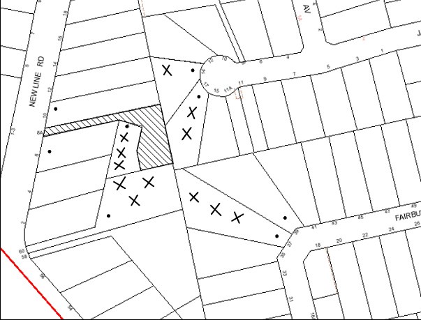
|
NOTIFICATION PLAN |
|
||
|
• PROPERTIES NOTIFIED
|
X SUBMISSIONS RECEIVED |
PROPERTY SUBJECT OF DEVELOPMENT |
|
The submissions object to the development, generally on grounds that development would result in:
· The use of the dwelling-house as a dual occupancy;
· Non-Compliance with Council’s FSR requirements, site coverage, private open space area, clothes drying area and landscaped area requirements;
· Unacceptable impact on the privacy of the adjoining properties due to the windows, decks, lack of landscaping and reduced side setbacks;
· Unacceptable overshadowing of adjoining properties, especially the private open space area and windows of the adjoining southern development;
· Excess stormwater runoff on to the neighbouring properties; and
· The removal of significant trees on the site.
Additionally, the objectors make the following observations:
· The plans are inaccurate as no contour levels, spot levels and relative heights have been provided;
· Details of fencing, location of windows on adjoining properties, location of private open space areas of adjoining properties have not been included in the plan;
· It is unclear whether the ground levels mentioned in the plans are the resultant level achieved after earthworks have been undertaken as a part of the subdivision;
· The site coverage calculations include the area of the access handle;
· A 0.5m landscape verge has not been provided on both sides of the driveway;
· The northern side of the dwelling-house would be dominated by a concrete driveway and garage;
· The submitted documentation does not include a detailed landscape plan and no landscaping provisions along the side setback; and
· The proximity of the driveway to the intersection of Castle Hill Road and New Line Road would result in traffic hazards; and
· The neighbours have not been provided access to the floor plans.
The merits of the matters raised in community submissions have been addressed in the body of the report with the exception of the following:
5.2 Dual Occupancy
The internal layout of the initial proposal was such that it could be converted to a dual occupancy in the future. The proposal has subsequently been amended with a revised internal layout. The current proposal is considered to be suitable as a single domicile.
5.3 Height and Contours
The proposal includes a survey plan for the site and the relevant levels of the dwelling-house with the stormwater management plans. It also includes floor levels of each floor and the natural ground floor levels with the elevations and sections which provide details of the height and the spot levels around the dwelling-house. The submitted plans are consistent with the survey plan of the vacant site under DA/499/2009.
No earthworks have been carried out in the proposed location of the dwelling-house during the subdivision. All earthworks related to construction of driveway and stormwater works did not alter the natural ground levels. Therefore, the levels provided on the plans are considered accurate.
5.4 Height Above Fence
The southern boundary of the site includes a 1.8m high timber fence which follows the natural slope of the land. The approved plans for the adjoining southern dwelling-house at No. 60 Castle Hill Road indicate that the floor levels would be at RL 193.3. The upper floor level of the proposed dwelling-house would be located at RL 175.2. Therefore, both the floors of the proposed dwelling-house would be located at a lower level than the adjoining dwelling-house. No further assessment in this regard is considered necessary.
5.5 Landscape Plan
The application includes a concept Landscape Plan. Given that the development would result in the loss of a number of trees on site, a condition of consent is recommended requiring the amendment of the landscape plan including replacement planting with BGHF canopy species. Due to existing drainage easements along the southern and eastern boundaries, large trees cannot be planted in close proximity to the boundaries.
The proposed dwelling-house includes privacy screens on the eastern and western ends of the first floor balcony and highlight windows to retain privacy of the rear yards and windows of the adjoining properties to the east and west.
5.6 Stormwater Management
The proposed development would be connected to the existing stormwater system approved under DA/499/2009. It would not impact on any other caveats or easements.
5.7 Proximity of Driveway to Intersection
The site is a battleaxe allotment with an existing driveway from New Line Road. No additional vehicular crossings are proposed as a part of the current application. 3m wide driveway pavement was approved under DA/499/2009. The driveway complies with Council’s specifications and is acceptable.
5.8 Notification to Neighbours
The proposed development was notified in accordance with Council’s Notification and Exhibition Development Control Plan. Access to floor plans is not provided to neighbours for any development application pursuant to the privacy policies of Government Information (Public Access Act) 2009.
5.9 Public Agencies
The development application was not referred to the any Public Agencies for comment.
6 PUBLIC INTEREST
Section 79C(1)(e) of the Act requires Council to consider “the public interest”.
The public interest is an overarching requirement, which includes the consideration of the matters discussed in this report. Implicit to the public interest is the achievement of future built outcomes adequately responding to and respecting the future desired outcomes expressed in environmental planning instruments and development control plans.
The application is considered to have satisfactorily addressed Council’s criteria and would provide a development outcome that, on balance, would result in a positive impact for the community. Accordingly, it is considered that the approval of the proposed dwelling-house would be in the public interest.
CONCLUSION
The proposal involves the erection of a two storey dwelling-house on a vacant battleaxe allotment. The dwelling-house includes a detached double garage.
The application has been assessed as satisfactory having regard to Section 79C of the Environmental Planning and Assessment Act 1979, the provisions within the Hornsby Shire Local Environmental Plan 1994 and the objectives of the development controls within Council’s Dwelling-house Development Control Plan.
The application is also assessed as satisfactory against the draft Hornsby Local Environmental Plan.
Approval of the proposal is recommended.
Note: At the time of the completion of this planning report, no persons have made a Political Donations Disclosure Statement pursuant to Section 147 of the Environmental Planning and Assessment Act 1979 in respect of the subject planning application.
|
Rod Pickles Manager - Development Assessment Planning Division |
James Farrington Group Manager Planning Division |
|
1.View |
Locality Plan |
|
|
|
2.View |
Site/Landscape Plan |
|
|
|
3.View |
Floor Plans |
|
|
|
4.View |
Elevations and Sections |
|
|
|
5.View |
Approved Plans for subdivision |
|
|
File Reference: DA/720/2012
Document Number: D02106169
SCHEDULE 1
GENERAL CONDITIONS
The conditions of consent within this notice of determination have been applied to ensure that the use of the land and/or building is carried out in such a manner that is consistent with the aims and objectives of the relevant legislation, planning instruments and Council policies affecting the land and does not disrupt the amenity of the neighbourhood or impact upon the environment.
Note: For the purpose of this consent, the term ‘applicant’ means any person who has the authority to act on or the benefit of the development consent.
Note: For the purpose of this consent, any reference to an Act, Regulation, Australian Standard or publication by a public authority shall be taken to mean the gazetted Act or Regulation, or adopted Australian Standard or publication as in force on the date that the application for a construction certificate is made.
1. Approved Plans and Supporting Documentation
The development must be carried out in accordance with the plans and documentation listed below and endorsed with Council’s stamp, except where amended by Council and/or other conditions of this consent:
|
Plan Title/ No. |
Drawn by |
Dated |
|
Landscape Concept Plan – Sheet 1 of 12 Issue C |
AJ Lewis Architectural Design |
20/12/2012 |
|
Site Management Plan – Sheet 2 of 12 Issue C |
AJ Lewis Architectural Design |
20/12/2012 |
|
Site Analysis Plan – Sheet 3 of 12 Issue C |
AJ Lewis Architectural Design |
20/12/2012 |
|
Ground Floor Plan – Sheet 4 of 12 Issue C |
AJ Lewis Architectural Design |
20/12/2012 |
|
First Floor Plan – Sheet 5 of 12 Issue C |
AJ Lewis Architectural Design |
20/12/2012 |
|
North Elevations – Sheet 6 of 12 Issue C |
AJ Lewis Architectural Design |
20/12/2012 |
|
East Elevations – Sheet 7 of 12 Issue C |
AJ Lewis Architectural Design |
20/12/2012 |
|
South Elevations – Sheet 8 of 12 Issue C |
AJ Lewis Architectural Design |
20/12/2012 |
|
West Elevations – Sheet 9 of 12 Issue C |
AJ Lewis Architectural Design |
20/12/2012 |
|
Section AA & Section BB – Sheet 10 of 12 Issue C |
AJ Lewis Architectural Design |
20/12/2012 |
|
Section Garage Floor Plan, Elevations and Section – Sheet 11 of 12 Issue C |
AJ Lewis Architectural Design |
20/12/2012 |
|
Basix Notes and Window Schedule – Sheet 12 of 12 Issue C |
AJ Lewis Architectural Design |
20/12/2012 |
|
Drainage Plan, Schedule, Notes, Legend - Sheet 1 of 4 |
Nastasi and Associates |
18/06/2012 |
|
OSD Details - Sheet 2 of 4 |
Nastasi and Associates |
18/06/2012 |
|
Nastasi and Associates |
18/06/2012 |
|
|
Rainwater Tank Details – Sheet 4 of 4 |
Nastasi and Associates |
18/06/2012 |
|
Document Title/ No. |
Prepared by |
Dated |
|
BASIX Certificate 431459S_03 |
AJ Lewis Architectural Design |
20/12/2012 |
|
Arborist Report |
AJ Lewis Architectural Design |
17/06/2012 |
2. Project Arborist
A Project Arborist is to be appointed in accordance with AS 4970-2009 (1.4.4) to provide monitoring and certification throughout the development process.
3. Removal of Existing Trees
This development consent only permits the removal of trees numbered 2, 3, 4, 5, 6, 7 and 8 as identified on Plan No. GM/30112011 Drawing 1 of 1 Revision A prepared by A J Lewis Architectural Design dated 8 July 2012. The removal of any other trees requires separate approval under Council’s Tree Preservation Order.
4. Amendment of Plans
a) The Landscape Concept Plan – sheet 1 of 1 Issue B prepared by A J Lewis Architectural Design dated 14/09/2012 is to be amended to include the following:
i) Details of the following replacement planting with Blue Gum High Forest (BGHF) Species to compensate the loss of trees within the area marked with red diagonal lines on the northern side of the driveway (bushland regeneration area):
· A minimum of 12 x BGHF canopy species
· A minimum of 24 mid-storey BGHF species
· A minimum of 50 ground cover BGHF species
ii) Details of retention of all planted BHGF specimens and regenerating plant material;
iii) A concise schedule of works table which indicates the responsibilities, actions and timeframes;
iv) Details of plant guards for trees to be retained; and
v) Details of screen planting capable of reaching a height of 1.8m along the eastern boundary (area shown clouded on the Landscape Plan).
Note: The plan must be prepared by a suitably qualified horticulturist.
b) The window sill level for bedrooms 4 and 5 (eastern and western elevations) located on the upper floor must be 1.5m above the finished floor level to maintain privacy of adjoining properties.
c) The retaining wall must be deleted from the design and instead, a dropped edge beam be incorporated to the eastern side of the dwelling to minimise overlooking impacts to adjoining properties
d) The following plans are to be amended to incorporate the details of the approved Site Plan – Sheet 2 of 10 Issue B prepared by A J Lewis Architectural Design dated 14/09/2012:
|
Plan Title/ No. |
Drawn by |
Dated |
|
Drainage Plan, Schedule, Notes, Legend - Sheet 1 of 4 |
Nastasi and Associates |
18/06/2012 |
|
Soil, Erosion and Sediment Control Details - Sheet 3 of 4 |
Nastasi and Associates |
18/06/2012 |
REQUIREMENTS PRIOR TO THE ISSUE OF A CONSTRUCTION CERTIFICATE
5. Building Code of Australia
All building work must be carried out in accordance with the requirements of the Building Code of Australia.
6. Contract of Insurance (Residential Building Work)
In the case of residential building work for which the Home Building Act, 1989 requires there to be a contract of insurance in force in accordance with Part 6 of that Act, that such a contract of insurance is in force before any building work authorised to be carried out by the consent commences.
7. Notification of Home Building Act, 1989 Requirements
Residential building work within the meaning of the Home Building Act, 1989 must not be carried out unless the principal certifying authority for the development to which the work relates (not being Council) has given Council written notice of the following information:
a) In the case of work for which a principal contractor is required to be appointed:
i) The name and licence number of the principal contractor.
ii) The name of the insurer by which the work is insured under Part 6 of that Act.
b) In the case of work to be done by an owner-builder:
i) The name of the owner-builder.
ii) If the owner-builder is required to hold an owner-builder’s permit under that Act, the number of the owner-builder’s permit.
Note: If arrangements for doing the residential building work are changed while the work is in progress so that the information notified becomes out of date, further work must not be carried out unless the principal certifying authority for the development to which the work relates (not being Council) has given Council written notification of the updated information.
8. Waste Management Plan
A Waste Management Plan for the construction stage of the development must be submitted in accordance with Council’s Waste Minimisation and Management Plan.
9. Sydney Water – Quick Check
The application must be submitted to a Sydney Water ‘Quick Check Agent’ or ‘Customer Centre’ for approval to determine whether the development will affect any Sydney Water infrastructure, and whether further requirements are to be met.
Note: Refer to www.sydneywater.com.au or telephone 13 20 92 for assistance.
10. Project Arborist
A Project Arborist is to be appointed in accordance with AS 4970-2009 (1.4.4) to provide monitoring and certification throughout the development process.
REQUIREMENTS PRIOR TO THE COMMENCEMENT OF ANY WORKS
11. Erection of Construction Sign
A sign must be erected in a prominent position on any site on which building work, subdivision work or demolition work is being carried out:
a) Showing the name, address and telephone number of the principal certifying authority for the work,
b) Showing the name of the principal contractor (if any) for any demolition or building work and a telephone number on which that person may be contacted outside working hours, and
c) Stating that unauthorised entry to the work site is prohibited.
Note: Any such sign is to be maintained while the building work, subdivision work or demolition work is being carried out, but must be removed when the work has been completed.
12. Toilet Facilities
Toilet facilities must be available or provided at the works site before works begin and must be maintained until the works are completed at a ratio of one toilet for every 20 persons employed at the site. Each toilet must:
a) be a standard flushing toilet connected to a public sewer; or
b) be a temporary chemical closet approved under the Local Government Act, 1993; or
c) have an on-site effluent disposal system approved under the Local Government Act, 1993
13. Erosion and Sediment Control
Erosion and sediment control measures must be provided and maintained throughout the construction period in accordance with the manual ‘Soils and Construction 2004 (Bluebook)’, the approved plans, Council specifications and to the satisfaction of the principal certifying authority. The erosion and sediment control devices must remain in place until the site has been stabilised and revegetated.
Note: On the spot penalties up to $1,500 may be issued for any non-compliance with this requirement without any further notification or warning.
14. Tree Protection Barriers
Tree Nos. 1 and 9 identified on Figure 11 (Showing location of Tree Nos. 1 – 9) within the Arborist Report prepared by Abacus Tree Services dated 17/06/2012 are to be retained with appropriate setbacks. Tree Protection Zones (TPZ) for these trees must be fenced with 1.8 metre ‘cyclone chainmesh fence in accordance with AS 4970-2009 (Section 4) at the following distances:
· Tree 1 must have a TPZ of 11.2m; and
· Tree 9 must have a TPZ of 9.1m
To avoid injury or damage, trees numbered 1 and 9 must have trunks protected by 2 metre lengths of 75mm x 25mm hardwood timbers spaced at 80mm secured with galvanised wire (not fixed or nailed to the tree in any way).
REQUIREMENTS DURING CONSTRUCTION
15. Construction Work Hours
All work on site (including demolition and earth works) must only occur between 7am and 5pm Monday to Saturday.
No work is to be undertaken on Sundays or public holidays.
16. Environmental Management
The site must be managed in accordance with the publication ‘Managing Urban Stormwater – Landcom (March 2004) and the Protection of the Environment Operations Act 1997 by way of implementing appropriate measures to prevent sediment run-off, excessive dust, noise or odour emanating from the site during the construction of the development.
17. Works Near Trees
a) All required tree protection measures are to be maintained in good condition for the duration of the construction period in accordance with the TPZ distances outlined in Condition No.13 of this development consent. Works within the TPZ of trees Nos. 1 and 9 are to be carried out in accordance with the following requirements:
· Fencing must be in placed at all times except when works within the TPZ of the trees 1 and 9 are being undertaken.
· No excavation works is to be undertaken within the Structural Root Zone (SRZ) of trees numbered 1 and 9.
Note: The SRZ for the trees would be in accordance with AS 4970-2009.
· The section of the driveway located within the TPZ of trees Nos. 1 and 9 is to be laid on, or above, the existing grade.
· Pier and beam must be used for construction of the driveway within the nominated TPZ (Condition 13) with piers being located no closer than 3 metres to the trunks of the trees.
· The excavation for the piers within the nominated TPZ must be hand dug to reveal the presence of any roots. A Project Arborist must be present on site overseeing the work to ensure no roots greater than 40mm in diameter are severed, and root damage is minimised.
b) All works (including driveways and retaining walls) within the tree protection zones of any trees required to be retained (whether or not on the subject property, and pursuant to this consent or the Tree Preservation Order), must be carried out under the supervision of an ‘AQF Level 5 Arborist’ and a certificate submitted to the principal certifying authority detailing the methods used to preserve the trees.
Note: Except as provided above, the applicant is to ensure that no excavation, filling or stockpiling of building materials, parking of vehicles or plant, disposal of cement slurry, waste water or other contaminants is to occur within the tree protection zone of any tree to be retained.
18. Protection From Soil Pathogens
To protect native flora and fauna from infection and infestation of pathogens and weeds all machinery shall be cleaned of soil and debris before entering the subject site to prevent the spread of weeds and fungal pathogens such as Cinnamon Fungus (Phytophthora cinnamomi) and Chytrid Fungus (Batrachochytrium dendrobatidis).
19. Disturbance of Existing Site
During construction works, the existing ground levels of open space areas and natural landscape features, (including natural rock-outcrops, vegetation, soil and watercourses) must not be altered unless otherwise nominated on the approved plans.
20. Landfill
Landfill must be constructed in accordance with Council’s ‘Construction Specification, 2005’ and the following requirements:
a) All fill material imported to the site is to wholly consist of Virgin Excavated Natural Material (VENM) as defined in Schedule 1 of the Protection of the Environment Operations Act 1997 or a material approved under the Department of Environment and Climate Change’s general resource recovery exemption.
21. Excavated Material
All excavated material removed from the site must be classified in accordance with the Department of Environment, Climate Change and Water NSW Waste Classification Guidelines prior to disposal to an approved waste management facility and reported to the principal certifying authority.
22. Survey Report – Finished Floor Level
A report must be prepared by a registered surveyor and submitted to the principal certifying authority prior to the pouring of concrete at each level of the building certifying that:
a) The building, retaining walls and the like have been correctly positioned on the site.
b) The finished floor levels are in accordance with the approved plans.
REQUIREMENTS PRIOR TO THE ISSUE OF AN OCCUPATION CERTIFICATE
Note: For the purpose of this consent, a reference to ‘occupation certificate’ shall not be taken to mean an ‘interim occupation certificate’ unless otherwise stated.
23. Fulfilment of BASIX Commitments
The applicant must demonstrate the fulfilment of BASIX commitments pertaining to the development.
24. Stormwater Drainage – Dwellings
The stormwater drainage system for the development must be designed and constructed for an average recurrence interval of 20 years and be gravity drained in accordance with the following requirements:
a) Connected to an existing inter-allotment drainage system; and
b) Details of the stormwater drainage system be provided with the Construction Certificate plans.
25. On Site Stormwater Detention
An on-site stormwater detention system must be designed by a Chartered Civil Engineer and constructed in accordance with the following requirements:
a) Details of the design be submitted with the Construction Certificate Plans;
b) Have a capacity of not less than 5 cubic metres, and a maximum discharge (when full) of 8 litres per second;
c) Have a surcharge/inspection grate located directly above the outlet;
d) Discharge from the detention system to be controlled via a 1 metre length of pipe, not less than 50 millimetres diameter or via a stainless plate with sharply drilled orifice bolted over the face of the outlet discharging into a larger diameter pipe capable of carrying the design flow to an approved Council system;
e) Where above ground and the average depth is greater than 0.3 metres, a ‘pool type’ safety fence and warning signs to be installed; and
f) Be constructed in a location in accordance with the approved plans.
26. Internal Driveway/Vehicular Areas
The driveway and parking areas on site must be designed in accordance with Australian Standards 2890.1, 2890.2, 3727 and the following requirements:
a) Details of the design be submitted with the Construction Certificate Plans;
b) The driveway grade must not exceed 25 percent and changes in grade must not exceed 8 percent.
27. Installation of Privacy Devices
The following device must be installed to maintain an element of privacy towards the adjoining property:
a) The sill heights of the windows for bedrooms 3, 4 and 5 (southern elevation only) be increased to a minimum height of 1.5 metres above the finished floor; and
c) All privacy screens indicated on the approved plans and elevations be installed in accordance with the plans.
28. Bushland Regeneration
The following works are required to be undertaken and completed by a qualified and experienced bush regeneration company in accordance with the Concept Landscape Plan (as amended by Condition 3 of this development consent) and the following requirements:
· All required replacement planting within the regeneration area;
· Retention of all planted BHGF specimens and regenerating plant material within this area;
· Removal and suppression of all weeds using best practice methods;
· Scraping back of the recently applied mulch, reinstating with suitable soil levels before planting and re-applying mulch around plantings;
· No turfing is to be provided in the area.
Note: Planted tube stocks are only to be of local genetic provenance from a recognised native nursery (List of nurseries available at Council)
Note: Advice on suitable species for landscaping can be obtained from Council’s planting guide ‘Indigenous Plants for the Bushland Shire’, available at www.hornsby.nsw.gov.au.
29. Certification of Landscaping Works
The Project Arborist must assess the condition of the retained and replanted trees and their growing environment and make recommendations regarding any necessary remedial actions.
Following the final inspection and completion of any remedial works the Project Arborist must certify (as appropriate) that the completed works have been carried out in compliance with the approved plans and specification for tree protection measures. Certification must include a statement on the condition of the retained trees, details of any deviations of the approved tree protection measures and their impacts on trees.
Note: Documentation regarding monitoring of conditions of trees are to be included I the final report.
30. Damage to Council Assets
Any damage caused to Council’s assets as a result of the construction of the development must be rectified in accordance with Council’s written requirements and at the sole cost of the applicant.
31. Creation of Easements
The following matters must be nominated on the plan of subdivision under s88B of the Conveyancing Act 1919:
a) The creation of an appropriate "Positive Covenant" and "Restriction as to User" over the constructed on-site detention/retention systems and outlet works, within the lots in favour of Council in accordance with Council’s prescribed wording. The position of the on-site detention system is to be clearly indicated on the title of the land.
b) To register the OSD easement, the restriction on the use of land “works-as-executed” details of the on-site-detention system must be submitted verifying that the required storage and discharge rates have been constructed in accordance with the design requirements. The details must show the invert levels of the on site system together with pipe sizes and grades. Any variations to the approved plans must be shown in red on the “works-as-executed” plan and supported by calculations.
Note: Council must be nominated as the authority to release, vary or modify any easement, restriction or covenant.
OPERATIONAL CONDITIONS
32. Ongoing Protection of Bushland Regeneration Area
The bushland regeneration area identified on the approved plans must remain undisturbed and be protected in perpetuity in accordance with the following requirements:
a) The area is not to be used as private open space for the future residents.
b) The area to be kept free of noxious weeds using recognised bush regeneration methods in accordance with ‘Recovering bushland on the Cumberland Plain: Best practice guidelines for the management and restoration of bushland – Department of Conservation 2005’.
c) Machinery and fertilizer must not be used in the bushland area for maintenance purposes.
d) All dead tube stock be replaced within a calendar month.
- END OF CONDITIONS -
ADVISORY NOTES
The following information is provided for your assistance to ensure compliance with the Environmental Planning and Assessment Act, 1979, Environmental Planning and Assessment Regulation 2000, other relevant legislation and Council’s policies and specifications. This information does not form part of the conditions of development consent pursuant to Section 80A of the Act.
Environmental Planning and Assessment Act, 1979 Requirements
The Environmental Planning and Assessment Act, 1979 requires:
· The issue of a construction certificate prior to the commencement of any works. Enquiries regarding the issue of a construction certificate can be made to Council’s Customer Services Branch on 9847 6760.
· A principal certifying authority to be nominated and Council notified of that appointment prior to the commencement of any works.
· Council to be given at least two days written notice prior to the commencement of any works.
· Mandatory inspections of nominated stages of the construction inspected.
· An occupation certificate to be issued before occupying any building or commencing the use of the land.
Long Service Levy
In accordance with Section 34 of the Building and Construction Industry Long Service Payments Act 1986, a ‘Long Service Levy’ must be paid to the Long Service Payments Corporation or Hornsby Council.
Note: The rate of the Long Service Levy is 0.35% of the total cost of the work.
Note: Hornsby Council requires the payment of the Long Service Levy prior to the issue of a construction certificate.
Tree Preservation Order
To ensure the maintenance and protection of the existing natural environment, it is an offence to ringbark, cut down, top, lop, remove, wilfully injure or destroy a tree outside 3 metres of the approved building envelope without the prior written consent from Council.
Note: A tree is defined as a single or multi-trunked wood perennial plant having a height of not less than three (3) metres, and which develops many branches, usually from a distance of not less than one (1) metre from the ground, but excluding any plant which, in its particular location, is a noxious plant declared as such pursuant to the Noxious Weeds Act 1993. This definition of ‘tree’ includes any and all types of Palm trees.
All distances are determined under Australian Standard AS4970-2009 ”Protection of Trees on Development Sites”.
Fines may be imposed for non-compliance with Council’s Tree Preservation Order.
Covenants
The land upon which the subject building is to be constructed may be affected by restrictive covenants. Council issues this approval without enquiry as to whether any restrictive covenant affecting the land would be breached by the construction of the building, the subject of this consent. Applicants must rely on their own enquiries as to whether or not the building breaches any such covenant.
Dial Before You Dig
Prior to commencing any works, the applicant is encouraged to contact Dial Before You Dig on 1100 or www.dialbeforeyoudig.com.au for free information on potential underground pipes and cables within the vicinity of the development site.
Rain Water Tank
It is recommended that water collected within any rainwater tank as part of the development be limited to non-potable uses. NSW Health recommends that the use of rainwater tanks for drinking purposes not occur where a reticulated potable water supply is available.
Group Manager’s Report No. PL4/13
Planning Division
Date of Meeting: 20/02/2013
8 DEVELOPMENT APPLICATION - ERECTION OF A GARAGE - 43 POMONA STREET, PENNANT HILLS
EXECUTIVE SUMMARY
|
DA No: |
DA/912/2012 (Lodged 5 September 2012) |
|
Description: |
Erection of a garage |
|
Property: |
Lot E, DP 392440, No. 43 Pomona Street, Pennant Hills |
|
Applicant: |
Mrs Christine Louise Chalker |
|
Owners: |
Mr B J and Mrs C L Chalker |
|
Estimated Value: |
$25,000 |
|
Ward: |
C |
· The application is for the erection of a garage for an existing dwelling-house.
· The proposal generally complies with the relevant provisions of the Hornsby Shire Local Environmental Plan 1994 and Dwelling House Development Control Plan. The development does not comply with the objectives of the Flora and Fauna Protection element of the Dwelling House DCP as it proposes the removal of 2 Turpentine trees (Syncarpia glomulifera) which have been identified as significant.
· A Red Sticker has been placed on the application requiring that the application be determined at a Council Meeting.
· One submission has been received in respect of the application.
· It is recommended that the application be refused.
|
THAT Development Application No. DA/912/2012 for the erection of a garage at Lot E, DP 392440, No. 43 Pomona Street, Pennant Hills be refused for the reasons detailed in Schedule 1 of Group Manager’s Report No. PL4/13. |
SITE
The rectangular, 708.2m² site is located on the northern side of Pomona Street Pennant Hills, on the corner of Orchard Street and contains a part 1 and 2 storey dwelling-house and a free-standing metal shed in the rear, north-west corner.
The site experiences a 4 metre fall from the front, south-west to the rear, north-east corner.
The single storey component of the dwelling-house adjacent to the western side boundary comprises a storeroom/rumpus room. Council’s records indicate that this component of the dwelling-house was approved as a garage.
The site is within a bushfire prone area and is located adjacent to No. 19 Orchard Street which is listed as a heritage item (“Baden Powell Scout Centre” - buildings, gate and grounds) under the provisions of Schedule D of the Hornsby Shire Local Environmental Plan 1994.
PROPOSAL
The application proposes the erection of a single space garage adjacent to the front, western side of the dwelling-house, erected in a style that would be in keeping in terms of material and design with the existing dwelling-house.
A replacement driveway would provide vehicular access to the Pomona Street boundary.
The application also proposes the removal of 2 Turpentine trees (Syncarpia Glomulifera) which are located on the subject property immediately adjacent to the common boundary with No. 41 Pomona Street.
ASSESSMENT
1. STRATEGIC CONTEXT
The development application has been assessed having regard to the ‘Metropolitan Plan for Sydney 2036’, the ‘North Subregion (Draft) Subregional Strategy’ and the matters for consideration prescribed under Section 79C of the Environmental Planning and Assessment Act 1979 (the Act). The following issues have been identified for further consideration.
1.1 Metropolitan Plan for Sydney 2036 and (Draft) North Subregional Strategy
The Metropolitan Plan for Sydney 2036 is a broad framework to secure Sydney’s place in the global economy by promoting and managing growth. It outlines a vision for Sydney to 2036; the challenges faced, and the directions to follow to address these challenges and achieve the vision. The Draft North Subregional Strategy acts as a framework for Council in its preparation of the Comprehensive LEP by the end of 2011.
The Draft North Subregional Strategy sets the following targets for the Hornsby LGA by 2031:
· Employment capacity to increase by 9,000 jobs; and
· Housing stock to increase by 11,000 dwellings.
The proposed development would be consistent with the Metropolitan Plan for Sydney 2036.
2. STATUTORY CONTROLS
Section 79C(1)(a) requires Council to consider “any relevant environmental planning instruments, draft environmental planning instruments, development control plans, planning agreements and regulations”.
2.1 Hornsby Shire Local Environmental Plan 1994
The subject land is zoned Residential A (Low Density) under the Hornsby Shire Local Environmental Plan 1994 (HSLEP). The objectives of the Residential A (Low Density) zone are:
a) to provide for the housing needs of the population of the Hornsby area;
b) to promote a variety of housing types and other land uses compatible with a low density residential zone;
c) to promote for development that is within the environmental capacity of a low density residential development.
The proposed development is defined as a ‘dwelling-house’ under the HSLEP and is permissible in the zone with Council’s consent.
2.2 Draft Hornsby Local Environmental Plan
The Draft Hornsby Local Environmental Plan (DHLEP) was endorsed by Council at its meeting on 19 December 2012 to be forwarded to the Minister for Planning and Infrastructure to be made. In accordance with Council’s resolution, the draft Plan has been submitted to the Department for finalisation. The relevant provisions of the DHLEP that apply to the site are outlined below.
2.2.1 Zoning
Under the DHLEP, the subject land would be zoned R2 - Low Density Residential. A “dwelling house” would be a permissible use in the zone under the DHLEP.
2.2.2 Height of Building
Clause 4.3 of the DHLEP provides that the height of a building on any land is not to exceed the maximum height shown for the land on the Height of Buildings Map. The maximum permissible height for the subject site within the R2 zone is 8.5 metres. The proposal complies with this provision.
2.3 State Regional Environmental Plan No. 20 – Hawkesbury Nepean River
The application has been assessed against the requirements of Sydney Regional Environmental Plan No. 20 (SREP 20). This Policy provides controls to protect the environment of the Hawkesbury-Nepean system, including its water quality. The Policy addresses matters related to water quality, significant vegetation habitats, extraction, environmental heritage and scenic quality, recreation and tourism and agriculture.
Subject to the installation of suitable and erosion and sediment control measures during construction works, the proposed development would be consistent with the objectives of SREP 20.
2.4 Dwelling House Development Control Plan
The development has been assessed having regard to the relevant performance and prescriptive design requirements within Council’s Dwelling House Development Control Plan (Dwelling House DCP). The following table sets out the proposal’s compliance with the prescriptive requirements of the Plan:
|
Dwelling House Development Control Plan |
|||
|
Control |
Proposal |
Requirement |
Complies |
|
Site Area |
708.2m2 |
500m2 |
Yes |
|
Gross Floor Area |
209.6m2 |
N/A |
N/A |
|
Floor space ratio |
0.3:1 |
0.4:1 |
Yes |
|
Site cover |
29% |
40% |
Yes |
|
Setbacks Front (south) Rear (north) Side (east) Side (west) |
7.3m N/A N/A 0.5m |
6m 3m 1m 1m |
Yes Yes Yes No |
|
Height |
Single-storey addition |
Max. two storey |
Yes |
|
Unbroken Wall length |
4.9m |
10m |
Yes |
|
Building length |
6.5m |
24m |
Yes |
|
Cut and fill |
0.3m fill |
1m |
Yes |
|
Private Open Space |
250m2 |
120m² |
Yes |
|
Landscaped area |
51% |
45% |
Yes |
|
Garage size |
6.5m x 4.9m |
3.0m x 5.4m |
Yes |
As detailed in the above table, the proposed development does not comply with the prescriptive measures of the setback element within Council’s Dwelling House DCP. This matter of non-compliance is addressed below, together with a brief discussion on compliance with the requirements of the Heritage element of the Dwelling House DCP.
2.4.1. Setbacks
The proposed 520 mm setback of a corner of the garage from the western side boundary does not comply with the prescriptive measures of the Setbacks element which states that “side boundary setbacks for dwelling-houses should generally be a minimum of 1 metre.”
No objections are raised to this variation to the prescriptive measure, given that the encroachment would be at one corner only and would be consistent with the side boundary setback of the nearby garage/storeroom.
The side boundary setback of the proposal would not create any adverse privacy or amenity impacts, meets the objectives of the Setbacks element and is considered acceptable.
2.4.2. Heritage
The site is located adjacent to premises No. 19 Orchard Street, which is listed as a heritage item (“Baden Powell Scout Centre” - buildings, gate and grounds) under the provisions of Schedule D of the Hornsby Shire Local Environmental Plan 1994.
The development would be located to the west of the property and as a consequence, would be effectively screened from view from the heritage listed site by the dwelling-house and the established trees and landscaping in the front yard of the subject property.
The proposal meets the objectives of the Heritage element and is considered acceptable.
3. ENVIRONMENTAL IMPACTS
Section 79C(1)(b) of the Act requires Council to consider “the likely impacts of that development, including environmental impacts on both the natural and built environments, and social and economic impacts in the locality”.
3.1 Natural Environment
The objectives of the Flora and Fauna Protection element are to encourage development “that is consistent with ecological sustainability principles and conserves biological diversity” and to conserve “bushland, significant flora habitats and wildlife corridors from the impacts of development”.
The application proposes the removal of 2 Turpentine trees located adjacent to the western boundary of the property. These trees have been classified as significant, both individually and as a group. These trees are also in close proximity to Blackbutt Gully Forest and are an indicative species to this vegetation community.
In seeking an alternative location that would minimise the impact of the development on the natural environment, Council gave consideration to the re-siting of the garage in the rear yard. However, two significant trees, namely a Blackbutt (Eucalyptus Polularis) and a Turpentine are located in the rear yard in a location that would be adversely impacted by the development.
The applicant was advised that an alternative development, namely a carport located in a similar location may be supported on the basis that a lightweight structure could be fixed to the existing concrete driveway and would not adversely affect the two Turpentine trees at the front of the property.
This alternative was not acceptable to the applicant however, on the basis that a carport would not provide the security afforded by an enclosed garage. As a consequence, the plans as submitted have been assessed on their merits.
The proposal does not meet the objectives of the Flora and Fauna element as it would require the removal of significant trees which contribute to the visual amenity of the area and streetscape.
3.2 Built Environment
The proposed garage would be consistent in terms of design and location with the established streetscape character of the surrounding low density residential area.
3.3 Social and Economic Impacts
There are no anticipated adverse social or economic impacts resulting from the proposed development.
4. SITE SUITABILITY
Section 79C(1)(c) of the Act requires Council to consider “the suitability of the site for the development”.
4.1 Bushfire Risk
The subject property is located within bushfire prone land. Council’s assessment has determined that BAL 12.5 bushfire construction methods would be required for the development.
5. PUBLIC PARTICIPATION
Section 79C(1)(d) of the Act requires Council to consider “any submissions made in accordance with this Act”.
5.1 Community Consultation
The proposed development was placed on public exhibition and was notified to adjoining and nearby landowners between 7 September 2012 and 21 September 2012 in accordance with Council’s Notification and Exhibition DCP. During this period, Council received one submission. The map below illustrates the location of the nearby landowner who made the submission.
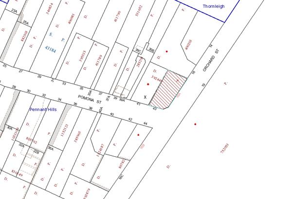
|
NOTIFICATION PLAN |
|
||
|
• PROPERTIES NOTIFIED
|
X SUBMISSION RECEIVED |
PROPERTY SUBJECT OF DEVELOPMENT |
|
One submission raised objections to the development on the grounds that it would require the removal of 2 significant trees. This objection has been addressed in the body of the report under the heading “Natural Environment”.
6. THE PUBLIC INTEREST
Section 79C(1)(e) of the Act requires Council to consider “the public interest”.
The public interest is an overarching requirement, which includes the consideration of the matters discussed in this report. Implicit to the public interest is the achievement of future built outcomes adequately responding to and respecting the future desired outcomes expressed in environmental planning instruments and development control plans.
The proposal would provide secure carparking for residents of the existing dwelling-house. However, the design of the garage would require the removal of two significant trees, which is contrary to planning controls to prevent the removal of significant trees and accordingly, is contrary to the public interest.
CONCLUSION
The application proposes the erection of a garage adjacent to the western side of the dwelling-house together with a driveway for vehicle access to Pomona Street. The construction of the garage would require the removal of 2 Turpentine trees to accommodate the garage. Both these trees have been classified as significant and objections have been raised to their removal.
In assessing the proposal and the existing development on the site, Council records confirm that the dwelling-house incorporates an enclosed garage structure which is served by a driveway from Pomona Street. This garage has been converted for use as a storeroom/rumpus room. There are no records of Council having granted consent for this conversion.
The application is recommended for refusal due to the impact of the proposed garage on significant trees.
Note: At the time of the completion of this planning report, no persons have made a Political Donations Disclosure Statement pursuant to Section 147 of the Environmental Planning and Assessment Act, 1979 in respect of the subject planning application.
|
James Farrington Group Manager Planning Division |
Rod Pickles Manager - Development Assessment Planning Division |
|
1.View |
Locality Plan |
|
|
|
2.View |
Site Plan |
|
|
|
3.View |
Elevations |
|
|
File Reference: DA/912/2012
Document Number: D02085874
SCHEDULE 1
1. The proposal is unsatisfactory in respect to Section 79C(1)(a)(iii) of the Environmental Planning and Assessment Act, 1979 as the development does not meet the objectives of the Flora and Fauna Protection element of the Dwelling House Development Control Plan. The location of the garage would require the removal of 2 Turpentine trees (Syncarpia glomulifera) which are considered to be significant trees both individually and as a group.
2. The proposal is unsatisfactory in respect to Section 79C(1)(b) of the Environmental Planning and Assessment Act, 1979 as the development would set an undesirable precedent for the removal of similar significant trees in the area and is not in the public interest.
- END OF REASONS FOR REFUSAL -
Group Manager’s Report No. PL5/13
Planning Division
Date of Meeting: 20/02/2013
9 DEVELOPMENT APPLICATION - ANIMAL BOARDING OR TRAINING ESTABLISHMENT - CHANGE OF USE - 21 GEELANS ROAD, ARCADIA
EXECUTIVE SUMMARY
|
DA No: |
DA/763/2012 (Lodged 25 July 2012) |
|
Description: |
Use of the site as an animal boarding or training establishment and alterations and additions to the existing dressage arena |
|
Property: |
Lot 11, DP 217208, No. 21 Geelans Road, Arcadia |
|
Applicant: |
Uniting Church in Australia Property Trust |
|
Owner: |
Uniting Church in Australia Property Trust |
|
Estimated Value: |
$100,000 |
|
Ward: |
A |
· The application proposes the use of the site as an animal boarding and training establishment and alterations and additions to the existing dressage arena.
· The proposal complies with the requirements of the Hornsby Shire Local Environmental Plan 1994 and the Rural Lands Development Control Plan.
· 26 submissions have been received from 22 residents/ groups in respect of the application.
· It is recommended that the application be approved.
|
THAT Development Application No. DA/763/2012 for the use of the site as an animal boarding and training establishment and alterations and additions to the existing dressage arena at Lot 11 DP 217208, No. 21 Geelans Road, Arcadia be approved as a deferred commencement pursuant to Section 80(3) of the Environmental Planning and Assessment Act, 1979 subject to the conditions of consent detailed in Schedule 1 of Group Manager’s Report No. PL5/13. |
BACKGROUND
On 26 February 1969, Council granted Certificate of Consent No. 38/1960 for a church-operated Youth and Adult Conference Centre. The approved development included the construction of a main conference centre building, two attached dormitory buildings, a caretaker’s residence, a swimming pool, an amphitheatre, several ball game courts and an artificial lake in the south-western corner of that site, accessed from Vision Valley Road. It also included the construction of a motel (with associated recreation building), a caravan park and sports oval towards the east and south-east of that site, with access from Geelans Road.
On 12 November 1970, Council granted Certificate of Consent No. 147/1970 for the same development as described above, following the expiry of the abovementioned 12-month consent.
On 9 March 1988, Development Application No. 529/87 was approved for erection of a second dwelling on Lot 11 Geelans Road, Arcadia. Condition No. 3 of the consent required that the building be used to accommodate staff employed as their principle occupation at the Vision Valley complex.
On 15 December 1988, Council issued a satisfactory inspection report in response to an application for inspection of animal boarding establishment and/or kennel for 13 horses at No. 21 Geelans Road, Arcadia. Council records also indicate that animal boarding establishment inspections were undertaken prior to this date and also at later dates with the address noted as ‘Vision Valley’ on the application form.
On 4 May 2011, Development Application No. 61/2011 was approved for alterations and additions to an existing horse boarding and training establishment.
On 3 August 2011, a Class 4 Appeal was lodged in the Land and Environment Court against Council’s determination of Development Application No. 61/2011.
On 8 August 2011, Development Application No. 61/2011/A was lodged to modify the approved extension to the dressage arena. This application is currently held in abeyance pending the outcome of the Class 4 appeal and the assessment of Development Application No. 763/2012
On 25 July 2011, Development Application No. 763/2012 was lodged for the use of the site as an animal boarding or training establishment and alterations and additions to the existing dressage arena. The application was lodged to address matters raised in the Class 4 appeal. This application is the subject of this report.
SITE
The site is one of five allotments, which make up the 30 hectare ‘Vision Valley Conference and Recreation Centre’ facility (hereafter ‘Vision Valley’). The Centre provides camps and retreats for organisations and school groups.
Vision Valley comprises a number of buildings and recreational facilities including:
· Four lodges accommodating a total of 224 beds.
· A conference centre containing a dining room and large auditorium and meeting rooms.
· A chapel with seating for up to 100 people including a kitchen, bathrooms and large open veranda overlooking the lake.
Outdoor facilities include a large playing field located at the eastern end of the site, two swimming pools, volleyball court, a ‘pirate ship’ playground and large amphitheatre. Existing recreational facilities on the site include a flying fox, giant swing, rock climbing, archery, horse riding and water activities.
The conference centre is located within a natural bushland setting and surrounded by steep embankments and sand stone rock outcrops. The site is located at the headwaters of Halls Creek (a tributary of Berowra Creek).
The proposed development is located on Lot 11 DP 217208 (the site), which is located on the northern side of Geelans Road and has access from Geelans Road, whilst the broader campus access is from Vision Valley Road. There is only restricted internal road connection from Vision Valley Road to the site on a gravel track for maintenance vehicles and further access is only via horse and walking track.
Existing development on the site comprises two cottages, a small dressage arena, an office and storage facilities/ tack room.
Surrounding development comprises rural residential dwellings to the west and east and across the road to the south. While the dwellings to the west and south are set well back from the property boundaries, the dwelling and agricultural shed to the east (No. 23 Geelans Road) is located approximately 1 metre from the side boundary.
PROPOSAL
The proposal seeks consent to use the land as an animal boarding and training establishment in conjunction with the Vision Valley Recreation Centre and to undertake alterations and additions to the existing horse arena/ dressage ring. The proposal is an attempt to address operational concerns raised by the adjacent property owner located to the east, being No. 23 Geelans Road.
The horse arena would be expanded to include a sand arena and its total area would be 2318m2. The proposal would enable the arena to be used for jumping purposes, thus allowing the existing jumping paddock to be utilised for agistment and minimising existing noise impacts on the adjoining property to the east. The extension to the arena would require filling of the land to a maximum depth of 1.7m to form a level area. The land has a fall of 6.5 metres towards the property to the east.
The Statement of Environmental Effects (SEE) submitted with the application states that the keeping of horses and use of the horses on the site is for trail rides and associated equestrian activities run by Vision Valley. The SEE (page 20) and Environmental Management Plan (EMP) state that the proposed hours of operation for the dressage arena and trail riding facilities are 8am - 6pm Eastern Standard Time and 8am - 8pm Daylight Saving Time and that the Horse Centre Team will be there earlier to prepare horses for the day and possibly later to put horses away.
The SEE then states that the proposed use is to operate 9am to 5pm Monday to Saturday and 9am to 1pm on Sundays (page 48). The applicant has subsequently advised that this is an error and that the proposed hours are 8am - 6pm Eastern Standard Time and 8am - 8pm Daylight Saving Time.
It is noted that the facilities are also used by the staff who reside on the site for their private use at times outside the usual working hours.
The application proposes the keeping of 20 horses on the site at any one time and there may be up to 3 additional horses which may on occasions be brought to the site for daily activities.
Following the relocation of the dressage ring, the previous training area would be used for grazing of two horses only. This area would be equally divided perpendicular to the boundary fence. A fence line is to be established to limit access to the horses within nine metres of the adjoining residence to the east, being No. 23 Geelans Road. Landscape planting is also proposed to visually screen the neighbour’s residence from the grazing area.
ASSESSMENT
The development application has been assessed having regard to the ‘Metropolitan Plan for Sydney 2036’, the ‘North Subregion (Draft) Subregional Strategy’ and the matters for consideration prescribed under Section 79C of the Environmental Planning and Assessment Act 1979 (the Act). The following issues have been identified for further consideration.
1. STRATEGIC CONTEXT
1.1 Metropolitan Plan for Sydney 2036 and (Draft) North Subregional Strategy
The Metropolitan Plan for Sydney 2036 is a broad framework to secure Sydney’s place in the global economy by promoting and managing growth. It outlines a vision for Sydney to 2036; the challenges faced, and the directions to follow to address these challenges and achieve the vision. The Draft North Subregional Strategy acts as a framework for Council in its preparation of the Comprehensive LEP.
The Draft North Subregional Strategy sets the following targets for the Hornsby LGA by 2031:
· Employment capacity to increase by 9,000 jobs; and
· Housing stock to increase by 11,000 dwellings.
The proposed development would be consistent with the Metropolitan Plan for Sydney 2036 by providing recreational facilities for a growing population.
2. STATUTORY CONTROLS
Section 79C(1)(a) requires Council to consider “any relevant environmental planning instruments, draft environmental planning instruments, development control plans, planning agreements and regulations”.
2.1 Hornsby Shire Local Environmental Plan 1994
The subject land is zoned Rural AA (Large Holdings - Agricultural Landscapes) under the Hornsby Shire Local Environmental Plan 1994 (HSLEP). The objectives of the Rural AA (Large Holdings - Agricultural Landscapes) zone are:
(a) to restrain population growth, maintain the rural character of the area and ensure that existing or potentially productive agricultural land is preserved in large land holdings.
(b) to promote agricultural use of land and provide for a range of compatible land uses which maintain the agricultural and rural environment of the area.
(c) to ensure development is carried out in a manner that improves the environmental qualities, and is within the servicing capacity, of the area.
The proposed development is defined as ‘animal boarding and training establishment’ under the HSLEP and is permissible in the zone with Council’s consent.
Clause 10 of the HSLEP requires the Council to be satisfied that adequate water and sewerage services are available to the development. The land is serviced by town water but not reticulated sewerage. Existing development on the site is connected to the sewage treatment plant located on No. 7 Vision Valley Road (the main campus) and the existing irrigation areas are to be fenced to ensure horses and people using the facility do not use enter the area.
Clause 15 of the HSLEP does not prescribe a maximum floor space ratio (FSR) for development within the Rural AA (Large Holdings - Agricultural Landscapes) zone.
Clause 18 of the HSLEP sets out heritage conservation provisions within Hornsby Shire. The site is not listed as a heritage item of local significance or located in the vicinity of an item. It is also not located within a heritage conservation area.
2.2 Draft Comprehensive Hornsby Local Environmental Plan
The draft Hornsby Local Environmental Plan (DHLEP) was endorsed by Council at its meeting on 19 December 2012 to be forwarded to the Minister for Planning and Infrastructure to be made. In accordance with Council’s resolution, the draft Plan has been submitted to the Department for finalisation.
Under the DHLEP, the subject land would be zoned RU1 Primary Production and ‘animal boarding and training establishment’ would be permissible within the RU1 Primary Production zone with Council’s consent.
2.3 State Environmental Planning Policy No. 44 Koala Habitat Protection
The Policy requires Council to consider whether development upon land with an area greater then 1 hectare would have an adverse impact upon potential koala habitat. The site does not represent a potential or core koala habitat and consequently, no further consideration of the Policy is required.
2.4 Sydney Regional Environmental Plan No. 20 Hawkesbury-Nepean River
The site is located within the catchment of the Hawkesbury-Nepean River. As such, the land is subject to the provisions of Sydney Regional Environmental Plan No. 20 Hawkesbury-Nepean River (SREP 20). The aim of SREP 20 is to protect the environment of the Hawkesbury-Nepean River system by ensuring that the impacts of the development are considered in the regional context. The Plan addresses matters related to water quality, significant vegetation habitats, extraction, environmental heritage and scenic quality, recreation and tourism and agriculture.
The proposed development would have the potential to impact on the water quality of the catchment of the Hawkesbury-Nepean River system during construction. In this regard, appropriate measures designed to prevent the escape of sediment laden waters from the site are required and have been recommended as a condition of approval. The applicant has also submitted an EMP for the ongoing management of the animal boarding and training establishment to ensure that the disposal of waste is undertaken in a manner that would not impact on the water quality of the catchment. Appropriate conditions of consent are included in Schedule 1 to address these matters.
2.5 Rural Lands Development Control Plan
The proposed development has been assessed having regard to the relevant performance and prescriptive design requirements within Council’s Rural Lands Development Control Plan (Rural Lands DCP). The following table sets out the proposal’s compliance with the prescriptive requirements of the Plan:
|
Rural Lands Development Control Plan |
|||
|
Control |
Proposal |
Requirement |
Compliance |
|
Site Area |
2.034 Ha |
2 Ha |
Yes |
|
Area of dressage ring |
2,318m2 |
N/A |
N/A |
|
Car parking Animal boarding & training establishment Existing dwellings |
9 spaces
unchanged |
Not specified
unchanged |
See discussion below
Yes |
|
Setbacks Front (Geelans Road) Rear (north) side (east) side (west) |
70m 573.45m 42m 91.85m |
15m 15m 15m 15m |
Yes Yes Yes Yes |
As detailed in the above table, the proposed development complies with the prescriptive requirements within Council’s Rural Lands DCP. A brief discussion on compliance with relevant performance requirements is provided below.
2.5.1 Land Uses: Keeping of Animals and Animal Boarding or Training Establishment
The objectives of Council’s Rural Lands DCP seek to ensure that the keeping of animals and their associated activities do not impact on surrounding residents or the environment.
The Rural Lands DCP states that noise from animals should not adversely impact upon adjoining residents, albeit acknowledging that a certain level of animal noise should be tolerated within a rural area. The proposed dressage ring would be located at a considerable distance from residences with the closest dwelling being approximately 42 metres away (to the east). This is an improvement on the existing circumstances which locates a jumping paddock adjacent to the common property boundary of No. 23 Geelans Road. It is considered that the dressage ring is unlikely to result in any uncharacteristic or unacceptable noise, as the proposal would:
· Be located at a considerable distance from adjoining residences, with the closest dwelling being 42 metres (to the east);
· Replace an existing dressage ring;
· Is ancillary to an existing land use;
· Be used relatively infrequently and for limited time periods during the day;
· Be supervised by trained staff; and
· Be unlikely to result in any additional traffic and thus, no additional vehicular noise.
It is noted that the existing jumping paddock would cease when the proposed dressage ring is operational. Once the proposed extension to the sand arena has taken place, the area known as the jumping paddock would be used for grazing of horses. The applicant has stated that a fence line would be installed at nine metres from the eastern boundary of the site to limit the number of horses grazing adjacent to the adjoining dwelling to the east, (No. 23 Geelans Road). As the plans do not indicate this fence line, it is recommended that a condition be imposed requiring the installation of this fence line.
Development Consent No. DA/61/2011 required that a dense screen of trees be planted 3 metres from the eastern side boundary to establish an appropriate level of privacy in relation to the adjoining residence. The NSW Rural Fire Service (RFS) has raised concerns with regards to this requirement which is addressed in Section 4 of this report. Notwithstanding, a submission on behalf of the adjoining property owner has indicated that they do not wish for the landscape screening to be located within the 9 metre buffer area. The plans do not indicate any landscaping/ screen planting on the eastern boundary and it is not proposed to require this as a condition of consent.
The application proposes the keeping of 20 horses on the site at any one time and there may be up to 3 additional horses which may on occasions be brought to the site for daily activities. As the horses would be predominantly hand fed and used for trail rides on the Vision Valley main campus or activities on the dressage (sand) arena, Council’s assessment concludes that the number of horses proposed would not have a detrimental impact on the environmental capabilities of the site and a condition of consent is recommended to be imposed limiting the site to the requested 20 horses with up to 3 additional horses brought to the site for daily activities.
Given the above assessment, the proposal would not generate adverse amenity impacts.
2.5.2 Car Parking
A number of submissions raise concern with the past use of the site for competitions and pony clubs on weekends which resulted in traffic impacts due to the volume of cars and horses bought to the site. Council sought clarification of the proposed use and the applicant advised that it would not be used for hire by outside groups and is to be used solely by Vision Valley for the keeping of horses for their trail rides and associated activities. Accordingly, a condition of consent regarding the use of the site is included in Schedule 1.
The proposal seeks to relocate an existing jumping paddock. The dressage ring caters for visitors in conjunction with the existing facilities at the Vision Valley Recreation Centre. It is not expected that the development would generate additional patronage and therefore, the proposed 9 car parking spaces would cater for any visitors to the site for agistment purposes.
Based on the information submitted, most users would be attending the main campus and would therefore not arrive via car to the site and all tour buses would attend the main campus via Vision Valley Road.
Accordingly, the recommended conditions in Schedule 1 would address the concerns raised with regards to traffic generation and car parking on the site.
2.5.3 Acoustics
The application proposes that the hours of operation for the dressage arena and trail riding facilities are 8am - 6pm Eastern Standard Time and 8am - 8pm Daylight Saving Time and that the Horse Centre Team will be there earlier to prepare horses for the day and possibly later to put horses away.
A number of submissions raise concerns with regards to the hours of operation, particularly the request to operate until 8pm during daylight savings. Accordingly, to maintain amenity of surrounding properties, it is proposed to restrict the hours of operation to 8 am to 6 pm, 7 days a week.
Schedule 1 also contains conditions restricting the hours of accessibility to the site for horse agisters/boarders for grooming / horse care to 6am to 6pm, Monday to Friday and 7am to 6pm, Saturday, Sunday and Public Holidays.
2.5.4 Air Quality
Submissions raise concerns with regards to dust and odour as a result of the proposed development. Subject to the recommended conditions in Schedule 1, requiring compliance with the submitted EMP, dust suppression measures and requirements for the storage and removal of manure from the site, the proposed development would not have a detrimental impact upon the air quality of the locality.
2.5.5 Drainage Control and Wastewater
Submissions raise concerns with regards to effluent disposal for the site. The existing dwellings and other buildings on the site are connected to the sewage treatment plant located on No. 7 Vision Valley Road (main campus) that services the entire Vision Valley holdings. The existing wash bay on site is connected to an absorption trench and will cater for any run-off wastewater. Council’s environmental assessment of the application raises no objections to the proposal in relation to drainage control and wastewater.
2.6 Code for the Keeping of Animals and Schedule 2 Local Government (General) Regulation 2005
The proposal has been assessed having regard to Council’s Code for the Keeping of Animals. The Code provides standards which may be considered by Council in the assessment of a development application for the keeping of animals.
Part 3 of the Code provides specific controls for the keeping of horses, including:
· Horses must not be kept within nine metres of a dwelling, and
· Horse yards must be enclosed so as to prevent the escape of horses and prevent them from coming within the distance prescribed (nine metres).
The Code has been drafted in Accordance with the provisions of Schedule 2 of the Local Government (General) Regulation 2005, which states:
1. Horses and cattle must not be kept within nine metres (or such greater distance as the council may determine in a particular case) of a dwelling, school shop, office, factory, workshop, church or other place of public worship, public hall or premises used for the manufacture, preparation or storage of food.
2. The floors of stables must be paved with concrete or mineral asphalt or other equally impervious material, and must be properly graded to drain.
3. Horse yards and cattle yards must be so enclosed as to prevent the escape of horses and cattle.
4. The standards in this clause apply to a person only if the council has served an order under section 124 of the Act to that effect on the person.
As suggested in the Regulation, the restriction on the ‘keeping of animals’ does not prevent the ‘grazing of animals’. In this context, the restriction relates to the stabling of horses, which should not be within nine metres of the adjoining dwelling. The relocation of the dressage ring away from the adjoining dwelling is consistent with the intention of the Regulation (and Code).
The applicant states that the existing jumping arena is to become grazing space for a maximum of two horses only. A fence line would be established to control horses accessing the paddock within nine metres of the adjoining residence. In addition, a row of trees would be planted within the nine metre separation zone which when mature, would provide a visual privacy screen to the adjoining residence.
Submissions state that airborne dust during windy weather, top soil loss during rainfall and horse manure may adversely impact adjacent bushland. In response to these issues, it is recommended that the arena be hosed on a daily basis as part of the maintenance procedure. A condition is recommended for the horse arena to be sited, constructed and drained so as to prevent manure and refuse being washed or deposited onto any adjoining property.
The proposed dressage ring is considered to be acceptable with respect to the requirements within Council’s Code for the Keeping of Animals and the Local Government (General) Regulation 2005.
3. ENVIRONMENTAL IMPACTS
Section 79C(1)(b) of the Act requires Council to consider “the likely impacts of that development, including environmental impacts on both the natural and built environments, and social and economic impacts in the locality”.
3.1 Natural Environment
Submissions received raised concerns that an Arboricultural Impact Assessment was not submitted with the application. The application was amended and additional information submitted to demonstrate that no works are proposed within undisturbed areas on the site, thereby not requiring the preparation of an Arboricultural Impact Assessment.
Council’s assessment of the proposal included a detailed examination of the existing trees on site and concluded that the proposed development would not necessitate the removal of any trees from the site and that subject to the recommended conditions in Schedule 1 which include tree protection fencing during the works, the proposed development would not have a detrimental impact upon the natural environment.
A submission also requested that landscape screening be provided around the dressage arena to address potential amenity impacts. Given the large setbacks of the dressage arena to the neighbouring properties to the east, west and south and the potential hazard that the vegetation could pose to horses and riders within the arena, Council’s assessment of the proposal concluded that additional landscaping in the vicinity of the dressage arena is not required.
3.2 Built Environment
Given the proposed siting of the dressage arena on the site and proposed tree planting, it is considered that the proposed development would not have any detrimental impacts upon the built environment.
Council’s engineering assessment of the traffic impacts of the development concludes that the proposed development has adequate car parking provision on site and that subject to the recommended conditions in Schedule 1, the proposal would not have a detrimental impact on the locality with regards to traffic generation and impacts.
3.3 Social Impacts
The proposed development would not have a detrimental social impact upon the locality.
3.4 Economic Impacts
Submissions raise concern regarding the potential adverse impacts upon the land values of adjoining properties. This is not a relevant matter for consideration under section 79C of the Environmental Planning and Assessment Act 1979. No evidence has been submitted to indicate that an adverse impact on land values would occur. It is considered that the proposal would not result in a negative economic impact on the locality.
4. SITE SUITABILITY
Section 79C(1)(c) of the Act requires Council to consider “the suitability of the site for the development”.
4.1 Bushfire Risk
There is no known hazard or risk associated with the site with respect to landslip, subsidence and flooding that would preclude the proposed development. The land is however identified as being bushfire prone and the proposal was referred to the NSW Rural Fire Service (RFS) in accordance with Section 79BA of the Environmental Planning and Assessment Act 1979.
The RFS reviewed the plans and raises concerns with regard to the proposed landscaping adjacent to the dwelling at No. 23 Geelans which could result in a possible bush fire risk to the dwelling on the neighbouring lot.
The applicant has submitted additional information which includes management practices to ensure that the screen planting shall be maintained and the fuel load reduced to a level where it does not pose risk to address the issues raised and the application was re-referred to the RFS. The RFS reviewed the submitted information and raises no objection to the proposed development subject to the recommended condition in Schedule 1 requiring an asset protection zone to prevent direct flame contact with a building on the neighbouring lot.
5. PUBLIC PARTICIPATION
Section 79C(1)(d) of the Act requires Council to consider “any submissions made in accordance with this Act”.
5.1 Community Consultation
The proposed development was placed on public exhibition and was notified to adjoining and nearby landowners between 7 August 2012 and 28 August 2012 in accordance with Council’s Notification and Exhibition Development Control Plan. Additional information was received and the application was re-notified between 5 December 2012 and 19 December 2012. Council received a total of 26 submissions from 21 properties and/or groups including a petition during both notification periods. The map below illustrates the location of those nearby landowners who made a submission that are in close proximity to the development site.
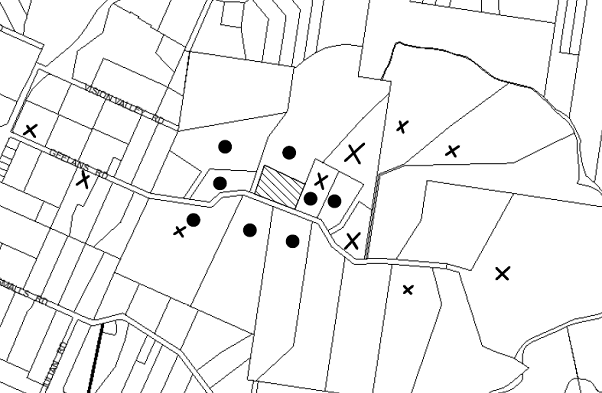
|
NOTIFICATION PLAN |
|
||
|
• PROPERTIES NOTIFIED
|
X SUBMISSIONS RECEIVED |
PROPERTY SUBJECT OF DEVELOPMENT |
|
|
11 SUBMISSIONS INCLUDING 1 PETITION RECEIVED OUT OF MAP RANGE |
|||
25 submissions including 1 petition object to the development, generally on the grounds that the development would result in:
· Existing use operating without consent
· Impact on land values
· Increased traffic and road safety issues
· No parking for tour buses
· Noise (acoustic report not provided)
· Dust
· Odour
· Lack of information submitted
· Impact upon character and amenity of the locality
· Environmental capacity of the site for the proposed use
· Hours of operation
· Impacts of existing and proposed security lighting
· ‘Best practice obligations’ have not been defined
· No indication of the size or number of animal waste bins have been provided
· Effluent disposal with particular reference to the wash bay area
· Insufficient toilet facilities on-site
· Does not comply with the 30m setback requirement for horses under the draft DCP
· No provision for capture of surface effluent on the site
· Arboricultural Impact Assessment not provided
· Insufficient information with regards to onsite sewage management system
· Proposed landscaping is inconsistent with ‘Planning for Bush Fire Protection 2006’
· Buffer zone is not shown on the plans
· Inadequate and misleading signage to delineate between the Vision Valley Conference Centre from the Vision Valley Horse Centre
· Proposed absorption trench is located on a rock shelf
· The applicant has not detailed the number of people attending the site at any one time
· Unclear as to which paddocks will be used for agistment and which ones will be used for jumping and riding lessons
· Approval of the development would take patronage away from local Clubs and Sporting Bodies that use The Rural Sports facility
· Easements are not shown on the plan and proposed works may be located over easements
· No dimensions of buildings and offices etc shown on plans
· Wastewater irrigation areas may affect the dam on a neighbouring property
· No mention is made with regard to hold Birthday Parties on the site and serving of food in close proximity to the keeping of animals.
One submission supports, or is neutral to the development. However, the submission sought clarification of a number of points raised above in the other submissions received.
The merits of the matters raised in community submissions have been addressed in the body of the report with the exception of the following:
5.1.1 Existing Use Operating Without Consent
Council records indicate that licences have been issued in the past for an animal boarding and training establishment at No. 21 Geelans Road. Furthermore, the application seeks to include the use as part of the proposal.
5.1.2 Lack of Information
A number of submissions raise concerns with regards to a lack of information submitted, including but not limited to the number of people attending the site, holding of birthday parties etc at the facility and buffer zones not shown on plans.
The applicant has stated that the facility is to be used to board the horses used in trail rides and associated activities at the Vision Valley Conference Centre. Accordingly, appropriate conditions of consent are recommended in Schedule 1 to address the use and operation of the site, so as to maintain the amenity of adjoining properties.
5.1.3 Does Not Comply with the 30m Setback Requirement for Horses Under the Draft DCP
Whilst it is acknowledged that the proposed development is inconsistent with the 30m setback requirement specified in Council’s draft DCP, the document is currently a draft and Council is not required to address the draft DCP under the Environmental Planning and Assessment Act 1979 as part of the assessment of this application. Notwithstanding, a 9 metre setback is proposed to minimise impacts on the adjacent dwelling.
5.1.4 Approval of the Development Would Take Patronage Away From Local Clubs and Sporting Bodies that use The Rural Sports Facility
The proposed dressage ring is to be used in conjunction with the activities associated with the Vision Valley Conference Centre. The site cannot be hired out to clubs and sporting bodies and therefore, should not take patronage away from those local clubs and sporting bodies that utilise The Rural Sports Facility.
5.1.5 Inadequate and Misleading Signage to Vision Valley
A submission raises concerns that there is inadequate and misleading signage to delineate between the Vision Valley Conference Centre from the Vision Valley Horse Centre resulting in additional traffic including tour buses on Geelans Road.
No signage is proposed as part of the existing application, however it is noted that a recent development application has been lodged (DA/3/2013) to upgrade the sign located at the intersection of Arcadia Road and Vision Valley Road.
5.1.6 Lighting
Submissions raise concerns with regards to lighting of the proposed development. Whilst the EMP indicates that some security lighting is proposed, the location and details on the plans have not been provided. Furthermore, as the proposed use would occur only in daylight hours, a condition in Schedule 1 is recommended stating that external flood lighting ancillary to, or used in conjunction with the approved use is not permitted. The condition also requires any security lighting to comply be designed and installed in accordance with Australian Standard AS 4282 – Control of the Obtrusive Effects of Outdoor Lighting. This would ensure that light spill would not impact on the amenity of adjoining properties.
5.1.7 Easements
Submissions raise concerns that existing private easements are not shown on the plan and proposed works may be located over these easements. A survey plan was submitted with the Construction Certificate application for DA/61/2011 (CC/39/2011) which indicates that there would be no adverse impact on the easement because of adequate distance available between the easement and the dressage ring. As the location of the dressage ring is not altered in this current application there would be no impact on the existing easements. Any subsequent concerns with regards to the private easement would be a civil matter.
5.2 Public Agencies
The development application is not Integrated Development under the Act. However, the development is sited on bushfire prone land and was referred to the RFS for comment as discussed previously in the report.
6. THE PUBLIC INTEREST
Section 79C(1)(e) of the Act requires Council to consider “the public interest”.
The public interest is an overarching requirement, which includes the consideration of the matters discussed in this report. Implicit to the public interest is the achievement of future built outcomes adequately responding to and respecting the future desired outcomes expressed in environmental planning instruments and development control plans.
The application is considered to have satisfactorily addressed Council’s and relevant agencies’ criteria and would provide a development outcome that, on balance, would result in a positive impact for the community. Accordingly, it is considered that the approval of the proposed development would be in the public interest as it would provide recreational facilities to cater for residents of Hornsby Shire and beyond.
CONCLUSION
The application proposes the use of the site as an animal boarding and training establishment and alterations and additions to the existing dressage arena. The use of the site as an animal boarding and training establishment is to operate in conjunction with the Vision Valley Recreation Centre.
The proposal satisfies the objectives of the Hornsby Shire Local Environmental Plan 1994 and Council’s Rural Lands Development Control Plan. The development improves existing impacts on an adjoining dwelling and provides an opportunity for Council to impose conditions that mitigate future impacts. It is considered unlikely the proposed development would result in any detrimental impacts upon the natural and/or built environments, or have any negative social or economic impacts.
Twenty-five submissions were received objecting to the proposed development. Subject to the recommended conditions of consent in Schedule 1, the proposal is assessed as suitable for the site and is recommended for approval.
Furthermore, as there is an existing consent for the construction of the sand arena and use of the site for an animal boarding and training establishments (DA/61/2011), which may result in conflict with this proposal, it is recommend that approval be granted as a deferred commencement subject to the surrender of Development Consent No. 61/2011.
Note: At the time of the completion of this planning report, no persons have made a Political Donations Disclosure Statement pursuant to Section 147 of the Environmental Planning and Assessment Act 1979 in respect of the subject planning application.
|
Rod Pickles Manager - Development Assessment Planning Division |
James Farrington Group Manager Planning Division |
|
1.View |
Locality Plans |
|
|
|
2.View |
Site Plan and Car Park Plan |
|
|
|
3.View |
Dressage Arena Plans |
|
|
File Reference: DA/763/2012
Document Number: D02087462
SCHEDULE 1
1. Deferred Commencement
Pursuant to Section 80(3) of the Environmental Planning and Assessment Act 1979, this consent does not operate until the following information is submitted to Council:
a) The surrender of Development Consent No. DA/61/2011 in accordance with the requirements of Clause 97 of the Environmental Planning and Assessment Regulation 2000.
A notice of voluntary surrender of a development consent, as referred to in section 104A of the Act, is to be given to the consent authority and is to include the following information:
i) the name and address of the person by whom the notice is given,
ii) the address, and formal particulars of title, of the land to which the consent relates,
iii) a description of the development consent to be surrendered,
iv) if the person giving the notice is not the owner of the land, a statement signed by the owner of the land to the effect that the owner consents to the surrender of the consent,
v) if development has commenced to be carried out in accordance with the consent—a statement setting out the circumstances that indicate:
· that so much of the development as has been carried out has been carried out in compliance with any condition of the consent, or any agreement with the consent authority relating to the consent, that is relevant to that part of the development, and
· that the surrender will not have an adverse impact on any third party or the locality.
Such information shall be submitted within 6 weeks of the date of this notice.
Upon Council’s written satisfaction of the above information, the following conditions of development consent will apply:
GENERAL CONDITIONS
The conditions of consent within this notice of determination have been applied to ensure that the use of the land and/or building is carried out in such a manner that is consistent with the aims and objectives of the relevant legislation, planning instruments and Council policies affecting the land and does not disrupt the amenity of the neighbourhood or impact upon the environment.
Note: For the purpose of this consent, the term ‘applicant’ means any person who has the authority to act on or the benefit of the development consent.
Note: For the purpose of this consent, any reference to an Act, Regulation, Australian Standard or publication by a public authority shall be taken to mean the gazetted Act or Regulation, or adopted Australian Standard or publication as in force on the date that the application for a construction certificate is made.
2. Approved Plans and Supporting Documentation
The development must be carried out in accordance with the plans and documentation listed below and endorsed with Council’s stamp, except where amended by Council and/or other conditions of this consent:
Architectural Plans prepared by Maitland and Butler Architects Pty Ltd
|
Plan No. |
Title |
Rev |
Dated |
|
WES38-D08 |
Irrigation Plan (Plan A) |
A |
29 November 2012 |
|
WES38-D10 |
Parking (Plan B) |
B |
27 November 2012 |
|
WES38-D09 |
(Drainage Plan (Plan C) |
B |
27 November 2012 |
|
WES38-D04 |
Section A |
A |
23 July 2012 |
|
WES38-D05 |
Detail Section - Detail 1 |
A |
23 July 2012 |
|
WES38-D06 |
Detail Section - Detail 2 |
A |
23 July 2012 |
|
WES38-D07 |
Detail Section - Detail 3 |
A |
23 July 2012 |
Supporting Documentation
|
Document Title |
Prepared by |
Dated |
|
Environmental Management Plan [D02075588] |
Mersonn Pty Ltd |
Undated/ received at Council 5 December 2012 |
3. Amendment of Environmental Management Plan
The submitted Environmental Management Plan (EMP) prepared by Mersonn Pty Ltd received at Council on 5 December 2012 is to be amended such that the 9 metre setback from Lot 12 DP 217208, No 23 Geelans Road is not to include landscaping other than grass or other suitable ground cover.
4. Use of Jumping Paddock
To maintain the reasonable amenity of adjoining residents, all jump structures shall be removed from ‘Paddock A’ (as indicated in red on the approved plan), adjacent to Lot 12 DP 217208, No. 23 Geelans Road and the paddock must cease to be used for jumping purposes within 6 months of the date of this consent or at the completion of the dressage arena extension, whichever occurs sooner.
REQUIREMENTS PRIOR TO THE ISSUE OF A CONSTRUCTION CERTIFICATE
5. Building Code of Australia
All building work must be carried out in accordance with the requirements of the Building Code of Australia.
REQUIREMENTS PRIOR TO THE COMMENCEMENT OF ANY WORKS
6. Erection of Construction Sign
A sign must be erected in a prominent position on any site on which building work, subdivision work or demolition work is being carried out:
a) Showing the name, address and telephone number of the principal certifying authority for the work,
b) Showing the name of the principal contractor (if any) for any demolition or building work and a telephone number on which that person may be contacted outside working hours, and
c) Stating that unauthorised entry to the work site is prohibited.
Note: Any such sign is to be maintained while the building work, subdivision work or demolition work is being carried out, but must be removed when the work has been completed.
7. Erosion and Sediment Control
Erosion and sediment control measures must be provided and maintained throughout the construction period in accordance with the manual ‘Soils and Construction 2004 (Bluebook)’, the approved plans, Council specifications and to the satisfaction of the principal certifying authority. The erosion and sediment control devices must remain in place until the site has been stabilised and revegetated.
Note: On the spot penalties up to $1,500 may be issued for any non-compliance with this requirement without any further notification or warning.
8. Tree Protection Barriers
To avoid injury or damage, the 2 Eucalyptus saligna (Sydney Blue Gum) trees located within the car park area must have their trunks protected by 2 metre lengths of 75mm x 25mm hardwood timbers spaced at 80mm secured with galvanised wire (not fixed or nailed to the tree in any way).
REQUIREMENTS DURING CONSTRUCTION
9. Construction Work Hours
All work on site (including demolition and earth works) must only occur between 7am and 5pm Monday to Saturday.
No work is to be undertaken on Sundays or public holidays.
10. Environmental Management
During the construction of the development, the site must be managed in accordance with the publication ‘Managing Urban Stormwater – Landcom (March 2004) and the Protection of the Environment Operations Act 1997 by way of implementing appropriate measures to prevent sediment run-off, excessive dust, noise or odour emanating from the site.
11. Works near Trees
All required tree protection measures are to be maintained in good condition for the duration of the construction period.
The applicant is to ensure that no excavation, including sub-surface trenching for stormwater or other services, filling or stockpiling of building materials, parking of vehicles or plant, the use of machinery other than hand held, disposal of cement slurry, waste water or other contaminants is to occur within the nominated Tree Protection Zone (TPZ) of any tree to be retained.
Nominated Tree Protection Zones (TPZ) Table
|
Tree No. |
Species |
Location |
TPZ |
|
1 |
Eucalyptus saligna |
Proposed car park |
9.6m |
|
2 |
Eucalyptus saligna |
Proposed car park |
9.6m |
|
3 |
Eucalyptus saligna |
West of proposed car park entry |
9.6m |
12. Council Property
During construction works, no building materials, waste, machinery or related matter is to be stored on the road reserve. The road reserve is to be kept in a clean, tidy and safe condition at all times.
13. Landfill
All fill material imported to the site required for the construction of the dressage arena is to wholly consist of Virgin Excavated Natural Material (VENM) as defined in Schedule 1 of the Protection of the Environment Operations Act 1997 or a material approved under the Department of Environment and Climate Change’s general resource recovery exemption.
14. Excavated Material
All excavated material removed from the site must be classified in accordance with the Department of Environment, Climate Change and Water NSW Waste Classification Guidelines prior to disposal to an approved waste management facility and reported to the principal certifying authority.
REQUIREMENTS PRIOR TO THE ISSUE OF A OCCUPATION CERTIFICATE
Note: For the purpose of this consent, a reference to ‘occupation certificate’ shall not be taken to mean an ‘interim occupation certificate’ unless otherwise stated.
15. Internal Driveway/ Vehicular Areas/ Parking Area
The driveway and parking areas on site must be designed in accordance with Australian Standards 2890.1, 2890.2, 3727 and the following requirements:
a) The driveway being constructed from road base.
b) The driveway is to be designed so that all vehicles can exit the site in a forward direction.
c) All signage as identified in the Environmental Management Plan prepared by Mersonn Pty Ltd and submitted to Council on 5 December 2012 is to be erected.
16. Vehicular Crossing
A separate application under the Local Government Act, 1993 and the Roads Act, 1993 must be submitted to Council for the reconstruction of the vehicular crossing. The vehicular crossing must be constructed in accordance with Council’s Civil Works Design, 2005.
Note: An application for a vehicular crossing can only be made to one of Council’s Authorised Vehicular Crossing Contractors. You are advised to contact Council on 02 9847 6940 to obtain a list of contractors.
17. Wastewater to Existing System
All wastewater generated within the approved development must be directed to the existing onsite sewage management system servicing the site.
OPERATIONAL CONDITIONS
18. Use of Premises
a) The development approved under this consent shall be used for an ‘animal boarding and training establishment’ in conjunction with Vision Valley and not for any other purpose without Council’s separate written consent.
b) No camping is permitted on the site.
19. Use of Dressage Ring
The dressage arena is not to be used for competition or hire.
20. Hours of Operation
a) The hours of operation of the animal boarding and training establishment are restricted to 8 am to 6 pm, 7 days a week.
b) Hours of accessibility to the site for horse agisters/boarders are restricted to those times listed below and shall be for grooming / horse care purposes only:
Monday to Friday 6 am to 6 pm
Saturday, Sunday & Public Holidays 7 am to 6 pm
c) The use of the horse arena by horse agisters/boarders outside the hours of use applicable to the animal boarding and training establishment is prohibited, other than by permanent residents of the property.
21. Number of Horses
a) To limit unreasonable impacts associated with overstocking of the site, a maximum of 20 horses may be kept on the site at any one time.
b) No more than 3 additional horses may be brought to the site for daily activities.
22. Keeping of Horses
A fence line must be constructed to prevent horses from grazing within 9 metres of the adjoining dwelling at Lot 12 DP 217208, No. 23 Geelans Road.
23. Manure Storage Bins
a) Refuse should be placed in a receptacle such as a large metal bin with a flanged-fitting metal lid which is water-proof, prevents access to flies and vermin and reduces the emission of noxious odours. When full, the bin should be emptied and disinfected and the waste removed from the site.
b) No spreading of manure is to occur in Paddock A.
c) The manure storage bins are not to be located within 80 metres of Lot 12 DP 217208, No. 23 Geelans Road.
24. Storage of Horse Floats
The storage of horse floats on-site for a commercial purpose is prohibited. Only horse floats registered/ owned by persons living permanently on the premises may be stored on the premises.
25. External Lighting
a) External flood lighting ancillary to, or used in conjunction with, the approved use is not permitted.
b) Any security lighting must be designed and installed in accordance with Australian Standard AS 4282 – Control of the Obtrusive Effects of Outdoor Lighting. Certification of compliance with the Standard must be obtained from a suitably qualified person.
26. Toilet Facilities
Toilet facilities including a minimum of 1 male and 1 female WC must be provided on site to cater for visitors and employees.
27. Ongoing Site Management
The site shall be managed in accordance with the Environmental Management Plan (EMP) prepared by Mersonn Pty Ltd received at Council on 5 December 2012 and the following requirements:
a) The operator of the riding school shall ensure the training area (and all ancillary areas associated with the use of the site as a horse riding school) are regularly cleaned and maintained.
b) Dust suppression measures shall be implemented in the dressage arena to minimise dust caused by horse usage (ie wetting down of the arena before activities and before harrowing occurs especially in the hotter part of the year).
c) Feed shall be stored in containers with close-fitting, hinged lids to prevent the entry of vermin. Materials used also shall be water-resistant or waterproof to prevent spoiling of feed. Metal shall be the preferred material of choice.
d) A programme of weed suppression must be developed by the Applicant to arrest the spread of weeds carried in horse manure.
28. No Staff/ Visitor Car Parking on Geelans Road
Visitors and staff utilising the facility must not park vehicles, including horse floats, on Geelans Road. All vehicles must use the car park.
CONDITIONS OF CONCURRENCE - NSW RURAL FIRE SERVICE
The following conditions of consent are from the nominated State Agency pursuant to Section 79B of the Environmental Planning and Assessment Act 1979 and must be complied with to the satisfaction of that Agency.
29. Asset Protection Zone
At the commencement of works and in perpetuity the landscaped area adjacent to the dwelling on No. 23 Geelans Road shall be managed to an Outer Protection Area (OPA) standard and shall not exceed 9m wide by 66m long.
The area to the north of the landscaped section shall be managed for 50m as an Inner Protection Area (IPA).This is to ensure discontinuity with the unmanaged vegetation is maintained. Requirements for an Inner and Outer Protection Areas are outlined within section 4.1.3 and appendix 5 of ‘Planning for Bush Fire Protection 2006’ (PBP) and the NSW Rural Fire Service's document ‘Standards for asset protection zones’.
Reason: The intent of measures is to provide sufficient space and maintain reduced fuel loads so as to ensure radiant heat levels of buildings are below critical limits and to prevent direct flame contact with a building.
Note: Further information concerning planning for bush fire protection can be found at: www.rfs.nsw.gov.au.
- END OF CONDITIONS -
ADVISORY NOTES
The following information is provided for your assistance to ensure compliance with the Environmental Planning and Assessment Act, 1979, Environmental Planning and Assessment Regulation 2000, other relevant legislation and Council’s policies and specifications. This information does not form part of the conditions of development consent pursuant to Section 80A of the Act.
Environmental Planning and Assessment Act, 1979 Requirements
The Environmental Planning and Assessment Act, 1979 requires:
· The issue of a construction certificate prior to the commencement of any works. Enquiries regarding the issue of a construction certificate can be made to Council’s Customer Services Branch on 9847 6760.
· A principal certifying authority to be nominated and Council notified of that appointment prior to the commencement of any works.
· Council to be given at least two days written notice prior to the commencement of any works.
· Mandatory inspections of nominated stages of the construction inspected.
· An occupation certificate to be issued before occupying any building or commencing the use of the land.
Long Service Levy
In accordance with Section 34 of the Building and Construction Industry Long Service Payments Act 1986, a ‘Long Service Levy’ must be paid to the Long Service Payments Corporation or Hornsby Council.
Note: The rate of the Long Service Levy is 0.35% of the total cost of the work.
Note: Hornsby Council requires the payment of the Long Service Levy prior to the issue of a construction certificate.
Tree Preservation Order
To ensure the maintenance and protection of the existing natural environment, it is an offence to ringbark, cut down, top, lop, remove, wilfully injure or destroy a tree outside 3 metres of the approved building envelope without the prior written consent from Council.
Note: A tree is defined as a single or multi-trunked wood perennial plant having a height of not less than three (3) metres, and which develops many branches, usually from a distance of not less than one (1) metre from the ground, but excluding any plant which, in its particular location, is a noxious plant declared as such pursuant to the Noxious Weeds Act 1993. This definition of ‘tree’ includes any and all types of Palm trees.
All distances are determined under Australian Standard AS4970-2009 ”Protection of Trees on Development Sites”.
Fines may be imposed for non-compliance with Council’s Tree Preservation Order.
Disability Discrimination Act
The applicant’s attention is drawn to the existence of the Disability Discrimination Act. A construction certificate is required to be obtained for the proposed building/s, which will provide consideration under the Building Code of Australia, however, the development may not comply with the requirements of the Disability Discrimination Act. This is the sole responsibility of the applicant.
Covenants
The land upon which the subject building is to be constructed may be affected by restrictive covenants. Council issues this approval without enquiry as to whether any restrictive covenant affecting the land would be breached by the construction of the building, the subject of this consent. Applicants must rely on their own enquiries as to whether or not the building breaches any such covenant.
Advertising Signage - Separate DA Required
This consent does not permit the erection or display of any advertising signs. Most advertising signs or structures require development consent. Applicants should make separate enquiries with Council prior to erecting or displaying any advertising signage.
Dial Before You Dig
Prior to commencing any works, the applicant is encouraged to contact Dial Before You Dig on 1100 or www.dialbeforeyoudig.com.au for free information on potential underground pipes and cables within the vicinity of the development site.
Telecommunications Act 1997 (Commonwealth)
If you are aware of any works or proposed works which may affect or impact on Telstra’s assets in any way, you are required to contact: Telstra’s Network Integrity Team on Phone Number 1800810443.
Asbestos Warning
Should asbestos or asbestos products be encountered during demolition or construction works you are advised to seek advice and information should be prior to disturbing the material. It is recommended that a contractor holding an asbestos-handling permit (issued by WorkCover NSW)be engaged to manage the proper handling of the material. Further information regarding the safe handling and removal of asbestos can be found at:
Alternatively, telephone the WorkCover Asbestos and Demolition Team on 8260 5885.
Rural Lands Incentive Program
The subject property may be eligible to participate in the Hornsby Shire Council Rural Lands Incentive Program, which provides assistance to landowners in the management conservation and restoration of remnant vegetation communities through the provision of technical advice and incentives. For further information, contact Council’s Bushland and Biodiversity Team on 9847 6832.
Rain Water Tank
It is recommended that water collected within any rainwater tank as part of the development be limited to non-potable uses. NSW Health recommends that the use of rainwater tanks for drinking purposes not occur where a reticulated potable water supply is available.
Group Manager’s Report No. PL6/13
Planning Division
Date of Meeting: 20/02/2013
10 DEVELOPMENT APPLICATION - CONSTRUCTION OF A MIXED USE DEVELOPMENT COMPRISING NINE RESIDENTIAL UNITS AND ONE COMMERCIAL UNIT - NOS. 1 - 3 HALDANE STREET, ASQUITH
EXECUTIVE SUMMARY
|
DA No: |
DA/1157/2012 (Lodged 2 November 2012) |
|
Description: |
Construction of a mixed use development comprising nine residential units and one commercial unit with basement car parking and strata subdivision. |
|
Property: |
Lots 25 and 26 DP 8797, Nos. 1 – 3 Haldane Street, Asquith |
|
Applicant: |
Gelders Architects |
|
Owner: |
Kahlefiedt Securities Pty Ltd |
|
Estimated Value: |
$1,980,000 |
|
Ward: |
A |
· The application proposes the construction of a mixed use development comprising nine residential units and one commercial unit and strata subdivision.
· The proposal exceeds the permitted floor space ratio under Clause 15 of the Hornsby Shire Local Environmental Plan 1994. The applicant has made a submission pursuant to State Environmental Planning Policy No. 1 - Development Standards to vary the development standard. The submission is considered well founded and is supported.
· The proposal generally complies with the Business Lands Development Control Plan and the Medium Density Multi-Unit Housing Development Control Plan with the exception of setback and private open space requirements for some dwellings and car parking space for the commercial component of the development.
· One submission has been received in respect of the application.
· It is recommended that the application be approved.
|
THAT Council assume the concurrence of the Director-General of the Department of Planning and Infrastructure pursuant to State Environmental Planning Policy No. 1 and approve Development Application No. DA/1157/2012 for construction of a mixed use development comprising nine residential units and one commercial unit, basement car parking and strata subdivision at Lot 26 DP 8797 and Lot 25 DP 8797, Nos. 1 - 3 Haldane Street, Asquith subject to the conditions of consent detailed in Schedule 1 of Group Manager’s Report No. PL6/13. |
BACKGROUND
On 6 October 2010, Council granted consent to Development Application No. 603/2010 for demolition of existing structures, construction of a part two and part three storey building comprising nine residential units and one commercial unit with basement car parking and strata subdivision at the subject property. The approved development has a FSR of 0.67:1.
Existing development on the site has been recently demolished in accordance with the approved development application.
The site was previously used as used as a neighbourhood shop, dance studio and residence.
SITE
The site is located at the south western intersection of Haldane Street and Sherbrook Road, Asquith and has an area of approximately 1400 square metres. The site has frontages of 45.33 metres to Haldane Street and 54.42 metres to Sherbrook Road and is located approximately 100 metres from Asquith Railway Station.
Development on the site comprised a weatherboard and fibrous cement building with galvanised iron roof with a corner shop, dance studio and residence on No. 1 Haldane Street and a brick dwelling with pressed metal roof known as ‘Lornama’ on No. 3 Haldane Street. These structures have been recently demolished in accordance with Development Consent No. 603/2010.
Immediately opposite the site to the north is St Patricks Catholic School and Church, with Asquith Uniting Church diagonally opposite to the north east. Surrounding development to the east, west and south comprises low and medium density residential development.
The site is located within the vicinity of Haldane Street (Trees, Asquith Station and nature strip), Corner of Sherbrook Road and Baldwin Avenue (Street tree) and properties No. 178 Sherbrook Road (House) and Nos. 1 Royston Parade (Grounds - St Patricks Church) which are listed as heritage items of local significance under the provisions of Schedule D (Heritage Items) of the HSLEP 1994.
PROPOSAL
The proposal involves the construction of a mixed use town house development comprising 9 x 2 bedroom, 2 storey townhouses with attic storage orientated to both street frontages, ground level private open space and a corner retail component above integrated basement car parking accessed via Haldane Street.
The design incorporates an awning over the footpath along the Haldane Street and Sherbrook Road frontages of the development adjacent to the commercial space.
ASSESSMENT
The development application has been assessed having regard to the ‘Metropolitan Plan for Sydney 2036’, the ‘North Subregion (Draft) Subregional Strategy’ and the matters for consideration prescribed under Section 79C of the Environmental Planning and Assessment Act 1979 (the Act). The following issues have been identified for further consideration.
1. STRATEGIC CONTEXT
1.1 Metropolitan Plan for Sydney 2036 and (Draft) North Subregional Strategy
The Metropolitan Plan for Sydney 2036 is a broad framework to secure Sydney’s place in the global economy by promoting and managing growth. It outlines a vision for Sydney to 2036; the challenges faced, and the directions to follow to address these challenges and achieve the vision. The Draft North Subregional Strategy acts as a framework for Council in its preparation of the Comprehensive LEP.
The Draft North Subregional Strategy sets the following targets for the Hornsby LGA by 2031:
· Employment capacity to increase by 9,000 jobs; and
· Housing stock to increase by 11,000 dwellings.
The proposed development would be consistent with the draft Strategy by providing an additional 7 dwellings and would contribute towards housing choice in the locality. The development also includes an employment generating component that would provide jobs in the locality.
2. STATUTORY CONTROLS
Section 79C(1)(a) requires Council to consider “any relevant environmental planning instruments, draft environmental planning instruments, development control plans, planning agreements and regulations”.
2.1 Hornsby Shire Local Environmental Plan 1994
The subject land is zoned Business C (Neighbourhood) under the Hornsby Shire Local Environmental Plan 1994 (HSLEP). The objectives of the Business C (Neighbourhood) zone are:
a) to encourage economic growth and employment opportunities.
b) to accommodate the retail, service and social needs of the community within the neighbourhood.
c) to encourage development that improves the health, vitality, cultural environment and social environment within neighbourhood business centres.
The proposed development is defined as ‘multi-unit housing’ and ‘shop’ under the HSLEP and is permissible in the zone with Council’s consent.
The proposed development involves medium density development in an area which is well serviced by retail and commercial uses. Therefore, the proposal would support, strengthen and improve the economy of the businesses in the locality. It would accommodate the social needs of the community and improve the health, vitality, cultural and social environment of this area. Given the above, the proposal complies with the zone objectives.
Clause 15 of the HSLEP prescribes that the maximum floor space ratio (FSR) of development within the Business C (Neighbourhood) zone is 0.5:1. The proposed development does not comply with this requirement and the applicant has made a submission pursuant to SEPP 1 to vary the development standard. The submission is discussed in Section 2.3 of this report.
Clause 18 of the HSLEP sets out heritage conservation provisions for Hornsby Shire. The site is located within the vicinity of Haldane Street (Trees, Asquith Station and nature strip), corner of Sherbrook Road and Baldwin Avenue (Street tree) and properties No. 178 Sherbrook Road (House) and No. 1 Royston Parade (Grounds - St Patricks Church) which are listed as heritage items of local significance under the provisions of Schedule D (Heritage Items) of the HSLEP.
Council’s heritage assessment concludes that the proposal would not have a detrimental impact on the heritage significance of the above listed items due to the nature of the development and site separation.
2.2 Draft Hornsby Local Environmental Plan
The draft Hornsby Local Environmental Plan (DHLEP) was endorsed by Council at its meeting on 19 December 2012 to be forwarded to the Minister for Planning and Infrastructure to be made. In accordance with Council’s resolution, the draft Plan has been submitted to the Department for finalisation.
Under the DHLEP, the subject land would be zoned B1 - Neighbourhood Centre and both ‘multi dwelling housing’ and ‘neighbourhood shops’ would be permissible within the zone with Council’s consent.
2.3 State Environmental Planning Policy No. 1 Development Standards
SEPP 1 provides flexibility in applying development standards and enables a consent authority to vary a standard where strict compliance would be unnecessary, unreasonable, or tend to hinder the objectives of the Act. Where there is a variation to a development standard, the application must be accompanied by a SEPP 1 objection.
The applicant has submitted an objection against Council’s adherence to the 0.5:1 FSR development standard under Clause 15 of the HSLEP. The proposed development has a FSR of 0.64:1 and exceeds the permitted floor space by 191.81m2.
The Land and Environment Court has expressed the view that there are five different ways in which an objection may be well founded and that approval of the objection may be consistent with the aims of the Policy:
1. The objectives of the standard are achieved notwithstanding non-compliance with the standards;
2. The underlying objective or purpose of the standard is not relevant to the development and therefore compliance is unnecessary;
3. The underlying object of purpose would be defeated or thwarted if compliance was required and therefore compliance is unreasonable;
4. The development standard has been virtually abandoned or destroyed by the Council’s own actions in granting consents departing from the standard and hence compliance with the standard is unnecessary and unreasonable;
5. The zoning of the particular land is unreasonable or inappropriate so that a development standard appropriate for that zoning is also unreasonable and unnecessary as it applies to the land and compliance with the standard would be unreasonable or unnecessary. That is, the particular parcel of land should not have been included in the particular zone.
The applicant submits that strict compliance with the density requirements is unreasonable and unnecessary for the following reasons:
· The application provides for a mixed use development the permissibility of which is not in contention.
· The final design outcome reflects a highly considered response to the constraints and opportunities identified through detailed site and contextual analysis and provides for a built form outcome compatible with development established in the adjacent residential zone.
· We have formed the considered opinion that the proposal is consistent with the zone objectives as it will maintain a strong corner retail presence whilst providing greater housing choice in an area identified as suitable for increased residential densities.
· Consistent with the conclusions reached by Senior Commissioner Roseth in the matter of Project Venture Developments v Pittwater Council (2005) NSW LEC 191 I have formed the considered opinion that most observers would not find the proposed development offensive, jarring or unsyumpathetic in a streetscape context. The proposal does not give rise to any unacceptable physical impacts on adjoining properties in terms of privacy, solar access, visual bulk or views. Accordingly it can be reasonably concluded that the proposal is compatible with its surroundings.
· The final design outcome reflects a highly considered response to the constraints and opportunities identified through detailed site and contextual analysis and provides for a built form outcome compatible with development established in the adjacent residential zone. In this regard development will be able to co-exist in harmony.
· The FSR has been appropriately distributed across the site with the height, bulk and scale of the development not giving rise to any adverse impacts on the amenity of the adjoining residential area in terms of view loss, privacy loss or overshadowing.
· An accepted urban design principles for prominent corner, vista or gateway sites suggest that consideration should be given to achieving a strong and robust architectural form. In this regard the subject site can appropriately and harmoniously accommodate the FSR proposed.
· Having regard to the matter of Veloshin v Randwick City Council [2007] NSWLEC 428 this is not a case where the difference between compliance and non-compliance is the difference between good and bad design.
The objection under SEPP 1 accords with the legislative requirements and it is considered that compliance with the development standard would be unreasonable and unnecessary in the circumstances of the case. Furthermore, the proposed FSR (0.64:1) represents a minor decrease in the FSR of the previous mixed use development approved on the site (0.67:1). Accordingly, the SEPP 1 objection is supported and it is considered the proposal meets the objective of Clause 15 of the HSLEP, that is, “To control the intensity and scale of development of land so that development will be in accordance with the land’s environmental capacity and zone objectives.”
2.4 State Environmental Planning Policy No. 55 - Remediation of Land
The Policy provides guidelines for the remediation of contaminated land for the purpose of reducing the risk of harm to human health or any other aspect of the environment.
SEPP 55 requires that Council must not consent to the carrying out of any development on land unless it has considered whether the land is contaminated or requires remediation for the proposed use.
The potential of the site to contain lead contaminants as a result from car fumes is considered minimal, and typical of any allotment fronting a local road. Given the site history indicates a history of commercial/ residential development, it is not likely that the site has experienced any significant contamination.
Notwithstanding, further investigation of the proposed development site is required following demolition of the existing structures and prior to the commencement of any construction works on the site and appropriate conditions of consent are recommended in Schedule 1.
2.5 State Environmental Planning Policy (Infrastructure) 2007
The application was referred to the Railcorp pursuant to Clause 85-87 of the Infrastructure SEPP in relation to development immediately adjacent to rail corridors; excavation in, above or adjacent to rail corridors; and impact of rail noise or vibration on non-rail development.
No objection is raised to the proposed development by Railcorp subject to the imposition of two conditions on any consent requiring an acoustic assessment to address the noise and vibration impacts of the rail line on the proposed residential development and an electrolysis risk assessment to address stray currents and electrolysis from rail operations.
These recommendations have been incorporated into the conditions in Schedule 1.
2.6 State Environmental Planning Policy (BASIX Building Sustainability Index) 2004
The application has been assessed against the requirements of State Environmental Planning Policy (BASIX) 2004 (BASIX SEPP) which seeks to encourage sustainable residential development.
The proposal includes a BASIX certificate in accordance with the requirements of the BASIX SEPP including the list of commitments to be complied with at the construction stage and during the use of the premises. The BASIX certificate achieves the required ‘scores’ for thermal comfort, water and energy. The proposal is acceptable in this regard.
2.7 State Environmental Planning Policy No. 32 - Urban Consolidation (Redevelopment of Urban Land)
The application has been assessed against the requirements of State Environmental Planning Policy No. 32 - Urban Consolidation (Redevelopment of Urban Land) (SEPP 32). SEPP 32 requires Council to implement the aims and objectives of this Policy to the fullest extent practicable when considering development applications relating to redevelopment of urban land. The objectives include promotion of the orderly and economic use of land and implementation of a policy of urban consolidation which would promote the social and economic welfare of the State. There are no prescriptive controls within this Policy.
The application complies with the objectives of the SEPP as it would promote social and economic welfare of the locality and would result in the orderly and economic use of under utilised land within the Asquith locality.
2.8 Sydney Regional Environmental Plan No. 20 - Hawkesbury - Nepean River
The site is located within the catchment of the Hawkesbury Nepean River. Part 2 of this Plan contains general planning considerations and strategies requiring Council to consider the impacts of development on water quality, aquaculture, recreation and tourism.
Water quality is the only relevant consideration in the assessment of this proposal. The installation and maintenance of sediment and erosion control devices would minimise affects on the water quality of the catchment. Recommended conditions of consent would ensure compliance with this Plan.
2.9 Business Lands Development Control Plan
The proposed development has been assessed having regard to the relevant performance and prescriptive design requirements within Council’s Business Lands Development Control Plan (Business Lands DCP). The following table sets out the proposal’s compliance with the prescriptive requirements of the Plan:
|
Business Land Development Control Plan |
|||
|
Control |
Proposal |
Requirement |
Compliance |
|
Density |
0.64:1 |
0.5:1 |
No |
|
Height |
2 storeys |
2 storeys |
Yes |
|
Car parking Retail Residential Visitor |
2 spaces 9 spaces 2 spaces |
4 spaces 9 spaces - |
No Yes |
|
Setbacks - Commercial Haldane Street Sherbrook Road
Setbacks - Residential Haldane Street Sherbrook Road Side (south) Side (west) |
0 metres 0 metres
3-6 metres 3 metres 3 metres 5 metres |
Conforms to existing Conforms to existing
Conforms to existing Conforms to existing Conforms to existing Conforms to existing |
Yes Yes
Yes Yes Yes Yes |
As detailed in the above table, the proposed development does not comply with the density and carparking requirements within Council’s Business Lands DCP. The matters of non-compliance are detailed below, as well as a brief discussion on compliance with relevant performance requirements.
2.9.1 Density
The proposed development does not comply with the FSR requirement contained within the Business Lands DCP. The proposed 0.64:1 floor space ratio exceeds the permitted floor space by 191.81m2. The non-compliance is considered acceptable with regard to the SEPP 1 objection submitted with the application and addressed in Section 2.3 above. Accordingly, the proposal is considered satisfactory with regard to density.
2.9.2 Design
The proposed architectural form and scale is compatible with the surrounding residential developments and is consistent with business zoning of the land. The design of the development includes two storey terrace dwellings at the interface with the adjoining residential development and contributes to the urban fabric through articulation of the built form.
2.9.3 Height
The proposed development complies with the maximum building height of two storeys prescribed by the Business Lands DCP. The proposal represents a decrease in height from the previous approval which incorporated a three storey component at the corner of the site and the overall height of the proposed townhouses is consistent with the previous approval.
2.9.4 Solar Access
A submission raises concerns with regarding potential overshadowing impacts of the proposed development.
The applicant has submitted shadow diagrams demonstrating the extent of shadows cast by the development between 9am and 3pm on June 22. At 9am shadows would be cast by the proposed development over the open space on the adjoining residential development at No. 5 Haldane Street. However, the applicant has demonstrated that the adjoining residential site, would receive at least 3 hours of sunshine to living areas and private open space between 9am and 3pm on 22 June, which exceeds the 2 hour requirement of the Business Lands DCP.
The proposal is acceptable with regard to solar access.
2.9.5 Vehicle Access and Car Parking
The design and access to the basement car park area has been located where it would have least impact on traffic movement on the road network and provides for vehicles to enter and leave in a forward direction. The deficiency in respect to the number of car parking spaces is discussed in Section 2.11 of this report.
2.9.6 Residential Development
The dwellings have been designed to promote a mix of housing within close proximity to transport, employment and services.
When the commercial floor area is removed from FSR calculations for the site, the density of the development is consistent with adjoining medium density multi-unit housing located within Haldane Street and the design of the development provides two storey developments at the interface of the adjoining residential zones.
A submission raises concern with regards to privacy impacts of the proposed development on adjoining properties to the south west.
To address privacy and overlooking impacts from the first floor windows of Dwellings 5, 6, 7, 8 and 9, a condition is recommended in Schedule 1 requiring that the first floor bedroom windows on the south western elevation of the townhouses to have a minimum sill height of 1.5m above the finished floor level.
2.9.7 Commercial Centres Hierarchy
To improve the function of the Sherbrook Road, Asquith Neighbourhood Centre, the development proposes to enlarge and retain the existing commercial premise (shop) on the site and provide for nine, two-bedroom dwellings which would provide better integration within the centre and improve the vitality and urban renewal of the locality.
The proposal ensures the role of the neighbourhood centre to serve the needs of local residents is maintained through the retention of the commercial premise in the development, without undermining the strength of surrounding commercial environments through the provision of numerous commercial premises.
The proposed development is consistent with, and reinforces, the identified role of the Neighbourhood Centre within the commercial centres hierarchy.
2.10 Medium Density Multi-Unit Housing Development Control Plan
The proposed development has been assessed having regard to the relevant performance and prescriptive design requirements within Council’s Medium Density Multi-Unit Housing Development Control Plan (Medium Density Multi-Unit Housing DCP). The following table sets out the proposal’s compliance with the prescriptive requirements of the Plan:
|
Medium Density Multi-Unit Housing Development Control Plan |
|||
|
Control |
Proposal |
Requirement |
Compliance |
|
Site Area |
1400m2 |
1890m2 |
No |
|
Floor Area Dwelling 1 Dwelling 2 Dwelling 3 Dwelling 4 Dwelling 5 Dwelling 6 Dwelling 7 Dwelling 8 Dwelling 9 Commercial unit TOTAL |
92.06m2 92.06m2 91.78m2 92.66m2 93.33m2 93.33m2 93.33m2 93.33m2 93.33m2 56.6m2 891.81m2 |
N/A |
N/A |
|
Site Coverage |
42% |
40% |
No |
|
Setbacks - Residential Haldane Street Sherbrook Road Side (south) Side (west) |
3-6 metres 3 metres 3 metres 3 metres |
6m 3m 3m 3m |
No Yes Yes Yes |
|
Site Width |
31m |
30m |
Yes |
|
Building Length |
30m |
30m |
Yes |
|
Unbroken Wall Length |
10m |
10m |
Yes |
|
Height |
7m |
7m |
Yes |
|
Car parking Resident Visitor |
9 spaces 2 spaces |
9 spaces 2 spaces |
Yes Yes |
|
Private Open Space Dwelling 1 Dwelling 2 Dwelling 3 Dwelling 4 Dwelling 5 Dwelling 6 Dwelling 7 Dwelling 8 Dwelling 9 |
88.05m2 43.42m2 50.56m2 68.8m2 51.55m2 85.21m2 75.54m2 58.4m2 74.03m2 |
60m2 60m2 60m2 60m2 60m2 60m2 60m2 60m2 60m2 |
Yes No No Yes No Yes Yes No Yes |
|
Landscaping |
50% |
50% |
Yes |
As detailed in the above table, the proposed development does not comply with a number of prescriptive requirements within Council’s Medium Density Multi-Unit Housing DCP. The matters of non-compliance are detailed below, as well as a brief discussion on compliance with relevant performance requirements.
2.10.1 Density
The proposed development has a site area of 1417m2 and the proposed townhouses would have floor areas ranging from 91m2 to 93m2. The Density control element of the Medium Density Multi-Unit Housing DCP requires a site density of 210m2 for each large unit (85-125m²). The plans of the proposed development indicate that there are 9 large units, which would require a site area of 1890m2 to meet the site density requirements of the DCP.
The density of the development is consistent with adjoining medium density multi-unit housing located within Haldane Street and the design of the development provides two storey developments at the interface of the adjoining residential zones. It is considered that the deficiency in area per unit would not result in any significant impacts to the amenity of the area or the occupants of the proposed development to warrant refusal of the application.
The proposed development provides for site coverage of 42.2% of the site. The minor non-compliance is supported in this instance as the development is consistent with that established on surrounding properties with deep soil landscape opportunities available adjacent to all property boundaries. Furthermore, the integrated site landscape regime proposed would soften and screen the building when viewed from the street and neighbouring residential properties.
Having regard to the stated objectives and performance requirements, the proposal provides for an appropriate mix and housing choice on a site located immediately adjacent to the Asquith commercial precinct, associated services and transport options and accordingly, the non-compliance with the density requirements is supported.
2.10.2 Setbacks
The proposed development does not comply with the setback provisions of the Medium Density Multi-Unit Housing DCP, in relation to the front setback requirements to Haldane Street. In this regard, the applicant provided the following justification:
“The application proposes a front setback to Haldane Street of between nil and 6 metres which is generally consistent with those established by the existing cottage and corner store and consistent with the setbacks established by other corner buildings located within proximity of the site. The Haldane street frontage is highly articulated with the presentation, setback and form not being perceived as inappropriate or jarring in a streetscape context.”
A compliant 3 metre front setback is maintained to the Sherbrook Road frontage with a highly articulated building form and integrated landscape regime providing an appropriate streetscape presentation.
The setbacks proposed are reasonable given the desire to reinforce and activate the retail component of the development consistent with the existing site. Furthermore, the proposed development would not have a detrimental impact upon the streetscape of either Haldane Street or Sherbrook Avenue.
The proposed development also has minor encroachments within the side/rear setback with regards to the basement stairs and exhaust riser that are located within the 3 metre setback requirement. Notwithstanding, the side boundary setbacks proposed would maintain appropriate residential amenity to adjoining properties in terms of privacy, solar access and visual bulk. In this regard, the proposed side setbacks complement the streetscape and allow for landscaping and open space and are considered to be acceptable.
2.10.3 Design
The proposed design does not demonstrate any significant degree of architectural variation with the units simply replicating one another. Building lengths are not in excess of 30m and there is no length of building exceeding 10m without the roof and wall design being broken to some degree. Although the design of the proposed development is limited in architectural variation and design, it generally meets the requirement of the control element.
2.10.4 Height
The proposed development is 2 storeys and meets the 7m height requirement to the ceiling of the topmost storey.
2.10.5 Privacy
Each townhouse has the living room and high use active spaces on the lower floor, with bedrooms, bathrooms and en-suite on the first floor and storage space in the loft/attic area.
To address privacy and overlooking impacts from the first floor windows of Dwellings 5, 6, 7, 8 and 9, a condition is recommended in Schedule 1 requiring that the first floor bedroom windows on the south western elevation of the townhouses are to have a minimum sill height of 1.5m above the finished floor level.
Subject to the recommended conditions, the layout and design of the development would have negligible detrimental privacy impacts on adjoining properties and is considered to be acceptable.
2.10.6 Solar Access
As stated in Section 2.9.4, a submission raises concerns with regards to potential overshadowing impacts of the proposed development.
The DCP states that dwellings should be designed to allow north facing windows to living areas of adjacent and proposed dwellings to receive 3 hours of sunshine between 9am and 3pm on 22 June over a portion of their surface.
The applicant has submitted shadow diagrams demonstrating the extent of shadows cast by the development between 9am and 3pm on June 22. At 9am shadows would be cast by the proposed development over the open space on the adjoining residential development at No. 5 Haldane Street. However, the applicant has demonstrated that the adjoining residential site, would receive at least 3 hours of sunshine to living areas and private open space between 9am and 3pm on 22 June in accordance with the requirements of the Medium Density Multi-Unit Housing DCP.
Solar access to the private open space areas at the rear of the proposed dwellings is considered acceptable. The orientation of the site ensures that at least 3 hours of solar access would be obtained to the ground floor living areas and adjacent private open space between 9am and 3pm in the mid-winter months in accordance with the requirements of the Medium Density Multi-Unit Housing DCP.
Accordingly, the proposed development would not cause unreasonable overshadowing of adjoining development to the southwest and the proposal is acceptable with regard to solar access.
2.10.7 Open Space
Whilst the private open space areas for four of the dwellings do not comply fully with the minimum area and dimension requirements contained within the Medium Density Multi-Unit Housing DCP, the private open space areas for all dwellings are directly accessible from all living areas and are suitable for the intended use.
2.10.8 Landscaping
A Landscape Plan has been provided with the development application which provides for an integrated landscape regime for the site. The proposed development meets the 50% landscape requirement of the Medium Density Multi-Unit Housing DCP and the development includes landscaping elements which reflect the scale of the development and would ensure the building sits within a landscape setting.
In this regard, the building will be softened and screened when viewed from both the Haldane Street and Sherbrook Road frontages with intervening landscape opportunities available adjacent to the side boundaries of the property.
2.10.9 Fencing
A 1.2 metre high fence is proposed along the Haldane Street and Sherbrook Road frontages constructed of a combination of rendered brick piers at entrances and for mail boxes with metal palisade and 1.8 metre high timber paling fences will be erected between each dwelling.
2.10.10 Housing Strategy - Precinct Masterplans
The site is one which the Council has designated for medium density redevelopment as part of its Housing Strategy. The proposed development accords with the Haldane Street masterplan which applies to the site and will provide a social benefit to locality by way of the provision of additional housing stock in the Asquith locality.
2.11 Car Parking Development Control Plan
The primary purpose of this DCP is to provide parking controls for the development.
Council’s Car Parking DCP has a parking requirement of one parking space per 17m2 GLFA for retail development in the Business C (Neighbourhood) zone, and one parking space per dwelling less than 100m2 with one visitor space per five dwellings. This equates to a parking requirement of nine parking spaces for the residential component, two visitor spaces, and four spaces for the retail component.
The proposed development has a deficit of two spaces for the commercial /retail component.
Council’s parking assessment considered that the deficit in two parking space for the commercial component of the development is acceptable, as the existing shop does not have on-site parking, there are three existing short stay car parking spaces provided adjacent to the shop on Baldwin Avenue and the development is located within easy walking distance of good public transport.
Council’s assessment of the traffic impacts of the development concludes that the development would be acceptable with regard to the level of traffic generated on the local road network.
A submission raises concerns with regards to the safety plan of the under ground car park and children each morning taking the school route. The single access point to the basement car park ensures that vehicles enter and exit the site in a forward direction and the buildings setbacks ensure that sight lines are provided to vehicles entering Haldane Street to maintain pedestrian safety.
2.12 Access and Mobility Development Control Plan
The proposed development has been assessed having regard to the relevant performance and prescriptive design requirements within Council’s Access and Mobility Development Control. In accordance with the requirements of the DCP, the proposed development includes provision for an adaptable unit that has level access from Haldane Street and includes a enlarged stairwell from the basement garage to permit the future installation of a stair lift. The development also includes a continuous path of travel to the commercial unit on the ground floor.
Given the above, the proposal is assessed as satisfactory with regard to access and mobility.
2.13 Sustainable Waters Development Control Plan
The DCP aims to achieve the implementation of sustainable water practices into the management of development in the Hornsby Shire.
Subject to sediment and erosion control measures being implemented on site during construction, the proposal would comply with the requirements contained within the Sustainable Water Development Control Plan.
2.14 Waste Minimisation and Management Development Control Plan
The proposal includes a waste management plan and details of on-going waste management on site. The design of the development incorporates a commercial bin storage area to be located at the ground level adjacent to the retail unit, whilst bin storage areas for each of the nine dwellings are proposed within the front courtyard screened by the front boundary fence and associated landscaping.
2.15 Section 94 Contributions Development Control Plan
Section 94 of the Environmental Planning and Assessment Act, 1979 enables Council to levy development contributions towards the cost of community facilities, public works, open space and recreational facilities.
In accordance with Council’s Section 94 Contributions Plan, this application requires a development contribution for the seven additional dwellings proposed. This is addressed by a condition of consent in Schedule 1. There is no net increase in the commercial floor area of the development and Section 94 contributions have not been levied on this component of the development.
3. ENVIRONMENTAL IMPACTS
Section 79C(1)(b) of the Act requires Council to consider “the likely impacts of that development, including environmental impacts on both the natural and built environments, and social and economic impacts in the locality”.
3.1 Natural Environment
The proposed development would necessitate the removal of 18 trees from the site. Council’s assessment of the proposal concludes that none of the trees to be removed are identified as ‘significant trees’. To compensate for the removal of existing trees, the application is supported by a landscape plan that identifies the planting of new trees and vegetation.
Subject to the implementation of recommended conditions during construction, the proposed development would not result in a negative impact on the natural environment.
3.2 Built Environment
The matters in relation to the impact of the development on the built environment have been addressed in sections 2.9 and 2.10 of this report.
Council’s assessment of the traffic impacts of the development concludes that the development would be acceptable with regard to the level of traffic generated on the local road network.
3.3 Social Impacts
The social impacts of the development on the local and broader community have been considered with specific reference to the potential employment generation within the complex. It is estimated that the development would potentially generate a number of equivalent full time positions post construction. The details of employment generation would be estimated during the assessment of future development applications for the first use of the commercial premise. This is consistent with the North Subregion (Draft) Subregional Strategy that provides a target of 9,000 jobs within the Hornsby LGA by 2031.
The residential component of the development would improve the housing choice in the locality by providing 7 additional units which is consistent with the North Subregion (Draft) Subregional Strategy.
3.4 Economic Impacts
The proposal would have a minor positive impact on the local economy in conjunction with other new residential development in the locality by generating an increase in demand for local services.
4. SITE SUITABILITY
Section 79C(1)(c) of the Act requires Council to consider “the suitability of the site for the development”.
The site is level, does not contain any significant vegetation or natural watercourses and is not subject to bushfire risk. The property, being located within an existing commercial centre, is considered appropriate in respect to the proposed land uses and is suitable for the development.
5. PUBLIC PARTICIPATION
Section 79C(1)(d) of the Act requires Council to consider “any submissions made in accordance with this Act”.
5.1 Community Consultation
The proposed development was placed on public exhibition and was notified to adjoining and nearby landowners between 22 November 2012 and 13 December 2012 in accordance with Council’s Notification and Exhibition Development Control Plan. During this period, Council received one submission from the landowner of the property shown on the map below.
NOTIFICATION PLAN
|
• PROPERTIES NOTIFIED
|
X SUBMISSION RECEIVED |
PROPERTY SUBJECT OF DEVELOPMENT |
|
One submission objects to the development, generally on the grounds that the development would result in:
· traffic and safety impacts associated with the basement car park;
· Overshadowing impacts; and
· Privacy impacts.
The merits of the matters raised in community submissions have been addressed in the body of the report.
5.2 Public Agencies
The development application is not Integrated Development under the Act. However, the site is adjacent to the Northern Rail Line and was referred to Railcorp for comment. No objection is raised to the proposed development by Railcorp subject to the imposition of two conditions on any consent requiring an acoustic assessment to address the noise and vibration impacts of the rail line on the proposed residential development and an electrolysis risk assessment to address stray currents and electrolysis from rail operations.
These recommendations have been incorporated into the conditions in Schedule 1.
6. THE PUBLIC INTEREST
Section 79C(1)(e) of the Act requires Council to consider “the public interest”.
The public interest is an overarching requirement, which includes the consideration of the matters discussed in this report. Implicit to the public interest is the achievement of future built outcomes adequately responding to and respecting the future desired outcomes expressed in environmental planning instruments and development control plans.
The application is considered to have satisfactorily addressed Council’s and relevant agencies’ criteria and would provide a development outcome that, on balance, would result in a positive impact for the community. Accordingly, it is considered that the approval of the proposed description of the proposal would be in the public interest.
CONCLUSION
The application proposes construction of a mixed use development comprising nine residential units and one commercial unit with basement car parking and strata subdivision.
The proposal exceeds the permitted floor space ratio under Clause 15 of the HSLEP. The submitted objection under State Environmental Planning Policy No. 1 - Development Standards, is supported in this regard.
The development complies with Section 79(c) of the Environmental Planning and Assessment Act 1979 and is generally consistent with the requirements of Council’s Business Lands Development Control Plan and Medium Density Multi-Unit Housing Development Control Plan.
Approval of the proposal is recommended.
Note: At the time of the completion of this planning report, no persons have made a Political Donations Disclosure Statement pursuant to Section 147 of the Environmental Planning and Assessment Act 1979 in respect of the subject planning application.
|
Rod Pickles Manager - Development Assessment Planning Division |
James Farrington Group Manager Planning Division |
|
1.View |
Locality Plan |
|
|
|
2.View |
Site Plan |
|
|
|
3.View |
Floor Plan |
|
|
|
4.View |
Elevations and Sections |
|
|
|
5.View |
Landscape Plan |
|
|
|
6.View |
Shadow Plans |
|
|
File Reference: DA/1157/2012
Document Number: D02087479
SCHEDULE 1
GENERAL CONDITIONS
The conditions of consent within this notice of determination have been applied to ensure that the use of the land and/or building is carried out in such a manner that is consistent with the aims and objectives of the relevant legislation, planning instruments and Council policies affecting the land and does not disrupt the amenity of the neighbourhood or impact upon the environment.
Note: For the purpose of this consent, the term ‘applicant’ means any person who has the authority to act on or the benefit of the development consent.
Note: For the purpose of this consent, any reference to an Act, Regulation, Australian Standard or publication by a public authority shall be taken to mean the gazetted Act or Regulation, or adopted Australian Standard or publication as in force on the date that the application for a construction certificate is made.
1. Approved Plans and Supporting Documentation
The development must be carried out in accordance with the plans and documentation listed below and endorsed with Council’s stamp, except where amended by Council and/or other conditions of this consent:
Architectural Plans prepared by Gelder Architects
|
Plan No. |
Title |
Rev |
Dated |
|
1470 DA01 |
Site Analysis Plan |
A |
31 October 2012 |
|
1470 DA02 |
Basement Plan |
A |
31 October 2012 |
|
1470 DA03 |
Ground Floor Plan |
A |
31 October 2012 |
|
1470 DA04 |
First and Attic Plan |
A |
31 October 2012 |
|
1470 DA05 |
Elevations |
A |
31 October 2012 |
|
1470 DA06 |
Elevations and Sections |
B |
25 January 2012 |
Landscape Plans prepared by Jane Britt Design
|
Plan No. |
Title |
Rev |
Dated |
|
L01B |
Plan and Planting Schedule |
B |
9 January 2013 |
|
L02 |
Specification, Details |
|
October 2012 |
|
L03 |
Areas and Plant Images |
|
October 2012 |
Hydraulic Details prepared by E2 Civil and Structural Desgin Pty Ltd
|
Plan No. |
Title |
Rev |
Dated |
|
12.474 SW1 |
Basement Drainage Plan and Details |
C |
14 January 2013 |
|
12.474 SW 2 |
Basement Drainage Plan and Details |
B |
14 January 2013 |
Supporting Documentation
|
Document Title |
Prepared by |
Dated |
|
Statement of Environmental Effects |
Boston Blythe Fleming Pty Ltd |
October 2012 |
|
BASIX Certificate No. 452623M |
Building Sustainability Assessments |
31 October 2012 |
|
ABSA Certificate No. 1004833016 |
Building Sustainability Assessments |
31 October 2012 |
|
Waste Management Plan Ref: 2-1470-C03-02-WMP |
Gelder Architects |
undated |
|
Schedule of Finishes Ref: 2-1470-E08-01 |
Gelder Architects |
undated |
2. Amendment of Plans
The approved plans are to be amended as follows:
a) Each dwelling must have a bin storage area of minimum dimensions 2 metres wide by 1 metre deep.
b) Any swing of the door between the commercial unit and the commercial bin storage area must not impinge on the commercial bin storage area. Details demonstrating compliance with this requirement must be submitted with the Construction Certificate.
c) The first floor bedroom windows on the south western elevation of Dwellings 5, 6, 7, 8 and 9 must have a minimum sill height of 1.5m above the finished floor level.
d) Provision of street tree planting on the Sherbrook Road frontage of the development site, including a minimum of four street trees in a minimum 50 litre pot size in one of the following species: Eucalyptus haemestoma, Gordonia axilaris, or Zelcova serrata.
e) The minimum clearance from the underside of the awning soffit to the footpath must be 3 metres.
f) The minimum setback of the awning from the face of kerb must be 300mm.
REQUIREMENTS PRIOR TO THE ISSUE OF A CONSTRUCTION CERTIFICATE
3. Building Code of Australia
All building work must be carried out in accordance with the requirements of the Building Code of Australia.
4. Contract of Insurance (Residential Building Work)
In the case of residential building work for which the Home Building Act, 1989 requires there to be a contract of insurance in force in accordance with Part 6 of that Act, that such a contract of insurance is in force before any building work authorised to be carried out by the consent commences.
5. Notification of Home Building Act, 1989 Requirements
Residential building work within the meaning of the Home Building Act, 1989 must not be carried out unless the principal certifying authority for the development to which the work relates (not being Council) has given Council written notice of the following information:
a) In the case of work for which a principal contractor is required to be appointed:
i) The name and licence number of the principal contractor.
ii) The name of the insurer by which the work is insured under Part 6 of that Act.
b) In the case of work to be done by an owner-builder:
i) The name of the owner-builder.
ii) If the owner-builder is required to hold an owner-builder’s permit under that Act, the number of the owner-builder’s permit.
Note: If arrangements for doing the residential building work are changed while the work is in progress so that the information notified becomes out of date, further work must not be carried out unless the principal certifying authority for the development to which the work relates (not being Council) has given Council written notification of the updated information.
6. Sydney Water – Quick Check
The application must be submitted to a Sydney Water ‘Quick Check Agent’ or ‘Customer Centre’ for approval to determine whether the development will affect any Sydney Water infrastructure, and whether further requirements are to be met.
Note: Refer to www.sydneywater.com.au or telephone 13 20 92 for assistance.
7. Water/Electricity Utility Services
The applicant must submit written evidence of the following service provider requirements:
a) Energy Australia – a letter of consent demonstrating that satisfactory arrangements have been made to service the proposed development.
b) Sydney Water – the submission of a ‘Notice of Requirements’ under s73 of the Sydney Water Act 1994.
Note: Sydney Water requires that s73 applications are to be made through an authorised Sydney Water Servicing Coordinator. Refer to www.sydneywater.com.au or telephone 13 20 92 for assistance.
8. Dilapidation Report
A ‘Dilapidation Report’ is to be prepared by a ‘chartered structural engineer’ detailing the structural condition of all adjoining properties.
9. Detailed Site Investigation
A detailed investigation of the proposed development site must be prepared by a suitably qualified environmental consultant. Such investigation must be undertaken in accordance with NSW Environment Protection Authority’s Contaminated Sites – Guidelines for Consultants Reporting on Contaminated Sites and Contaminated Sites – Sampling Design Guidelines.
10. Remedial Action Plan
A Remedial Action Plan (RAP) must be prepared by a suitably qualified environmental consultant and submitted to Council should the detailed investigation required reveal contamination exceeding criteria prescribed by the NSW Environment Protection Authority’s Contaminated Sites – Guidelines for the NSW Site Auditor Scheme.
11. Site Remediation Verification
The applicant must provide documentation from a suitably qualified environmental consultant verifying that the site has been remediated and is suitable for its intended use, in accordance with the NSW Environment Protection Authority’s Contaminated Sites - Guidelines for Consultants Reporting on Contaminated Sites, the Contaminated Sites- Sampling Design Guidelines Contaminated Sites – Guidelines for the NSW Site Auditor Scheme and the recommendations of the Remedial Action Plan prepared prior to issue of the Construction Certificate.
REQUIREMENTS PRIOR TO THE COMMENCEMENT OF ANY WORKS
12. Erection of Construction Sign
A sign must be erected in a prominent position on any site on which building work, subdivision work or demolition work is being carried out:
a) Showing the name, address and telephone number of the principal certifying authority for the work,
b) Showing the name of the principal contractor (if any) for any demolition or building work and a telephone number on which that person may be contacted outside working hours, and
c) Stating that unauthorised entry to the work site is prohibited.
Note: Any such sign is to be maintained while the building work, subdivision work or demolition work is being carried out, but must be removed when the work has been completed.
13. Protection of Adjoining Areas
A temporary hoarding, fence or awning must be erected between the work site and adjoining lands before the works begin and must be kept in place until after the completion of the works if the works:
a) Could cause a danger, obstruction or inconvenience to pedestrian or vehicular traffic.
b) Could cause damage to adjoining lands by falling objects.
c) Involve the enclosure of a public place or part of a public place.
Note: Notwithstanding the above, Council’s separate written approval is required prior to the erection of any structure or other obstruction on public land.
14. Toilet Facilities
Toilet facilities must be available or provided at the works site before works begin and must be maintained until the works are completed at a ratio of one toilet for every 20 persons employed at the site. Each toilet must:
a) be a standard flushing toilet connected to a public sewer; or
b) be a temporary chemical closet approved under the Local Government Act, 1993; or
c) have an on-site effluent disposal system approved under the Local Government Act, 1993.
15. Erosion and Sediment Control
Erosion and sediment control measures must be provided and maintained throughout the construction period in accordance with the manual ‘Soils and Construction 2004 (Bluebook)’, the approved plans, Council specifications and to the satisfaction of the principal certifying authority. The erosion and sediment control devices must remain in place until the site has been stabilised and revegetated.
Note: On the spot penalties up to $1,500 may be issued for any non-compliance with this requirement without any further notification or warning.
REQUIREMENTS DURING CONSTRUCTION
16. Construction Work Hours
All work on site (including demolition and earth works) must only occur between 7am and 5pm Monday to Saturday.
No work is to be undertaken on Sundays or public holidays.
17. Environmental Management
The site must be managed in accordance with the publication ‘Managing Urban Stormwater – Landcom (March 2004) and the Protection of the Environment Operations Act 1997 by way of implementing appropriate measures to prevent sediment run-off, excessive dust, noise or odour emanating from the site during the construction of the development.
18. Works near Trees
All works (including driveways and retaining walls) within 6 metres of any trees required to be retained (whether or not on the subject property, and pursuant to this consent or the Tree Preservation Order), must be carried out under the supervision of an ‘AQF Level 5 Arborist’ and a certificate submitted to the principal certifying authority detailing the method(s) used to preserve the tree(s).
Note: Except as provided above, the applicant is to ensure that no excavation, filling or stockpiling of building materials, parking of vehicles or plant, disposal of cement slurry, waste water or other contaminants is to occur within 4 metres of any tree to be retained.
19. Council Property
During construction works, no building materials, waste, machinery or related matter is to be stored on the road or footpath. The public reserve is to be kept in a clean, tidy and safe condition at all times.
Note: This consent does not give right of access to the site via Council’s park or reserve. Should such access be required, separate written approval is to be obtained from Council.
20. Disturbance of Existing Site
During construction works, the existing ground levels of open space areas and natural landscape features, (including natural rock-outcrops, vegetation, soil and watercourses) must not be altered unless otherwise nominated on the approved plans.
21. Excavated Material
All excavated material removed from the site must be classified in accordance with the Department of Environment, Climate Change and Water NSW Waste Classification Guidelines prior to disposal to an approved waste management facility and reported to the principal certifying authority.
22. Survey Report – Finished Floor Level
A report(s) must be prepared by a registered surveyor and submitted to the principal certifying authority prior to the pouring of concrete at each level of the building certifying that:
a) The building, retaining walls and the like have been correctly positioned on the site.
b) The finished floor level(s) are in accordance with the approved plans.
23. Waste Management
Waste management during the demolition and construction phase of the development must be undertaken in accordance with the approved Waste Management Plan. Additionally written records of the following items must be maintained during the removal of any waste from the site and such information submitted to the Principal Certifying Authority within fourteen days of the date of completion of the works:
a) The identity of the person removing the waste.
b) The waste carrier vehicle registration.
c) Date and time of waste collection.
d) A description of the waste (type of waste and estimated quantity).
e) Details of the site to which the waste is to be taken.
f) The corresponding tip docket/receipt from the site to which the waste is transferred (noting date and time of delivery, description (type and quantity) of waste).
g) Whether the waste is expected to be reused, recycled or go to landfill.
Note: In accordance with the Protection of the Environment Operations Act 1997, the definition of waste includes any unwanted substance, regardless of whether it is reused, recycled or disposed to landfill.
REQUIREMENTS PRIOR TO THE ISSUE OF AN OCCUPATION OR SUBDIVISION CERTIFICATE
Note: For the purpose of this consent, a reference to ‘occupation certificate’ shall not be taken to mean an ‘interim occupation certificate’ unless otherwise stated.
24. Fulfilment of BASIX Commitments
The applicant must demonstrate the fulfilment of BASIX commitments pertaining to the development.
25. Sydney Water - s73 Certificate
A s73 Certificate must be obtained from Sydney Water.
26. Stormwater Drainage
The stormwater drainage system for the development must be designed and constructed in accordance with Council’s Civil Works – Design and Construction Specification 2005, Australian Standards AS 3500.3 – Plumbing & Drainage Code and the following requirements:
a) Connected directly to Council’s street drainage system.
Note: A construction certificate shall be obtained prior to the commencement of these works and are to be completed prior to the issue of an occupation certificate.
27. On Site Stormwater Detention
An on-site stormwater detention system must be designed by a chartered civil engineer and constructed generally in accordance with approved plan No. Job 12.474 Drawing No. SW 1 Revision C & SW 2 Revision B, prepared by E2 Civil & Structural Design, dated 14 January 2013 and the following requirements:
a) Have a capacity of not less than 19.1 cubic metres, and a maximum discharge (when full) of 22.9 litres per second.
b) Have a surcharge/inspection grate located directly above the outlet.
c) Discharge from the detention system to be controlled via 1 metre length of pipe, not less than 50 millimetres diameter or via a stainless plate with sharply drilled orifice bolted over the face of the outlet discharging into a larger diameter pipe capable of carrying the design flow to an approved Council system.
d) Where above ground and the average depth is greater than 0.3 metres, a ‘pool type’ safety fence and warning signs to be installed.
e) Not be constructed in a location that would impact upon the visual or recreational amenity of residents.
f) All habitable floor levels adjacent the on-site detention system shall have a minimum 300 mm freeboard provided above the 1 in 100 year ARI emergency overflow top water level.
Note: A construction certificate shall be obtained prior to the commencement of these works and are to be completed prior to the issue of an occupation certificate.
28. Internal Driveway/Vehicular Areas
The driveway and parking areas on site must be designed in accordance with Australian Standards 2890.1, 2890.2, 3727 and the following requirements:
a) Design levels at the front boundary be obtained from Council.
b) The driveway be a rigid pavement.
c) The driveway grade must not exceed 25 percent and changes in grade must not exceed 8 percent.
d) Conduit for utility services including electricity, water, gas and telephone be provided.
Note: A construction certificate shall be obtained prior to the commencement of these works and are to be completed prior to the issue of an occupation certificate.
29. Traffic Control Plan
A Traffic Control Plan (TCP) must be prepared by a qualified traffic controller in accordance with the Roads & Traffic Authority’s Traffic Control at Worksites Manual 1998 and Australian Standard 1742.3 for all work on a public road and be submitted to Council. The TCP must detail the following:
a) Arrangements for public notification of the works.
b) Temporary construction signage.
c) Permanent post-construction signage.
d) Vehicle movement plans.
e) Traffic management plans.
f) Pedestrian and cyclist access/safety.
30. Vehicular Crossing
A separate application under the Local Government Act, 1993 and the Roads Act, 1993 must be submitted to Council for the installation of a new vehicular crossing and the removal of the redundant crossing. The vehicular crossing must be constructed in accordance with Council’s Civil Works Design, 2005 and the following requirements:
a) Any redundant crossings to be replaced with integral kerb and gutter.
b) The footway area to be restored by turfing.
c) Approval obtained from all relevant utility providers that all necessary conduits be provided and protected under the crossing.
Note: An application for a vehicular crossing can only be made to one of Council’s Authorised Vehicular Crossing Contractors. You are advised to contact Council on 02 9847 6940 to obtain a list of contractors.
31. Road Works
A separate application under the Local Government Act, 1993 and the Roads Act, 1993 must be submitted to Council for all works within the road reserve. All road works approved under this consent must be constructed in accordance with Council’s Civil Works Design and Construction Specification, 2005 and the following requirements:
a) The existing kerb and gutter along the frontage of the development site in Haldane Street shall be removed and reconstructed with integral kerb and gutter, together with footpath formation, necessary drainage and sealing of road pavement between the existing pavement and lip of the gutter.
b) The existing road pavement to be saw cut a minimum of 300 mm from the existing edge of the bitumen and reconstructed.
32. Damage to Council Assets
Any damage caused to Council’s assets including the removal, damage, destruction, displacement or defacing of the existing survey marks as a result of the construction of the development must be rectified in accordance with Council’s written requirements and at the sole cost of the applicant.
33. Creation of Easements
The following matter(s) must be nominated on the plan of subdivision under s88B or S88E of the Conveyancing Act 1919:
a) The creation of an appropriate "Positive Covenant" and "Restriction as to User" over the constructed on-site detention/retention systems and outlet works, within the lots in favour of Council in accordance with Council’s prescribed wording. The position of the on-site detention system is to be clearly indicated on the title.
b) To register the OSD easement, the restriction on the use of land “works-as-executed” details of the on-site-detention system must be submitted verifying that the required storage and discharge rates have been constructed in accordance with the design requirements. The details must show the invert levels of the on site system together with pipe sizes and grades. Any variations to the approved plans must be shown in red on the “works-as-executed” plan and supported by calculations.
Note: Council must be nominated as the authority to release, vary or modify any easement, restriction or covenant.
34. Works as Executed Plan
A works-as-executed plan(s) must be prepared by a registered surveyor and submitted to Council for completed road pavement, kerb & gutter, public drainage systems, driveways and on-site detention system. The plan(s) must be accompanied by a certificate from a registered surveyor certifying that all pipelines and associated structures lie wholly within any relevant easements.
35. Waste Management Reporting
The following waste management requirements must be complied with:
a) A report must be prepared by an appropriately qualified person, certifying the following:
i) A comparison of the estimated quantities of each waste type against the actual quantities of each waste type.
Note: Explanations of any deviations to the approved Waste Management Plan are required to be included in this report.
ii) That at least 60% of the waste generated during the demolition and construction phase of the development was reused or recycled.
Note: If the 60% diversion from landfill was not achieved in the Construction Stage, the Report is to include the reasons why this occurred and certify that appropriate work practices were employed to implement the approved Waste Management Plan. The Report must be based on documentary evidence such as tipping dockets/receipts from recycling depots, transfer stations and landfills, audits of procedures etc. which are to be attached to the report.
iii) All waste was taken to site(s) that were lawfully permitted to accept that waste.
b) Each unit must be provided with an indoor waste/recycling cupboard for the interim storage of a minimum one day’s waste generation with separate containers for general waste and recyclable materials.
c) Space must be provided for either individual compost containers for each dwelling unit or a communal compost container.
Note: The location of the compost containers should have regard for potential amenity impacts.
d) The bin carting routes must be devoid of any steps.
Note: Ramps between different levels are acceptable.
e) The bins placed in each bin storage area must be screened from public view.
36. Planter Boxes/ On-slab Planting
On slab planter boxes must include automatic irrigation, subsoil drainage (proprietary drainage cell, 50mm sand and filter fabric) waterproofing, minimum 500mm planting soil for shrubs and minimum 1000mm planting soil for trees and palms and 75mm mulch to ensure sustainable landscape is achieved
37. Completion of Landscaping
A certificate must be provided by a practicing landscape architect, horticulturalist or person with similar qualifications and experience certifying that all required landscaping works have been satisfactorily completed in accordance with the approved landscape plans.
Note: Advice on suitable species for landscaping can be obtained from Council’s planting guide ‘Indigenous Plants for the Bushland Shire’, available at www.hornsby.nsw.gov.au.
38. External Lighting
All external lighting must be designed and installed in accordance with Australian Standard AS 4282 – Control of the Obtrusive Effects of Outdoor Lighting. Certification of compliance with the Standard must be obtained from a suitably qualified person.
39. Dwelling/Unit/Allotment Numbering
The allocation of dwelling/unit numbering must be authorised by Council prior to the numbering of each dwelling/unit in the development.
40. Section 94 Infrastructure Contributions
The payment to Council of a contribution of $68,433.40 for seven additional dwellings towards the cost of infrastructure identified in Council’s Development Contributions Plan 2007-2011 in accordance with the following table:
Note: The value of contribution is current as at 25 January 2012. The contribution will be adjusted from this date in accordance with the underlying consumer price index for subsequent financial quarters.
It is recommended that you contact Council to confirm the value of the contribution prior to payment.
41. No Parking Signs
No parking signs must be erected to prohibit parking in the waste collection vehicle turning area in the Haldane Street cul de sac.
OPERATIONAL CONDITIONS
42. Car Parking and Deliveries
All car parking must be constructed and operated in accordance with Australian Standard AS 2890.1 – 2004 – Off Street Car Parking and Australian Standard 2890.2 - 2002 – Off Street Commercial and the following requirement:
a) All parking areas and driveways are to be sealed to an all weather standard, line marked and signposted.
b) Car parking, loading and maneuvering areas to be used solely for nominated purposes.
c) Vehicles awaiting loading, unloading or servicing shall be parked on site and not on adjacent or nearby public roads.
d) All vehicular entry on to the site and egress from the site shall be made in a forward direction.
43. Noise – Plant and Machinery
The level of total continuous noise emanating from operation of all the plant, including air conditioning units and processes in all buildings (LA10) (measured for at least 15 minutes) in or on the above premises, must not exceed the background level by more than 5dB(A) when measured at all property boundaries.
44. Fire Safety Statement - Annual
On at least one occasion in every 12 month period following the date of the first ‘Fire Safety Certificate’ issued for the property, the owner must provide Council with an annual ‘Fire Safety Certificate’ to each essential service installed in the building.
45. Landscape Establishment
The landscape works shall be maintained into the future to ensure the establishment and successful growth of plant material to meet the intent of the landscape design. This shall include but not be limited to watering, weeding, replacement of failed plant material and promoting the growth of plants through standard industry practices.
46. Waste Management Operations
Waste management operations on the site must be in accordance with the following requirements:
a) All commercial tenants must keep written evidence on site of a valid contract with a licensed waste contractor(s) for the regular collection and disposal of the waste and recyclables that are generated on site.
b) Due to the close proximity of residential dwellings, commercial waste collection services must only take place within the hours of 9 AM to 7 PM on Sundays and Public Holidays or within the hours of 7 AM to 7 PM on other days.
c) The site is to be serviced by Council or their authorised Contractor (Domestic Waste Only). The commercial waste can be serviced by any authorised collection contractor, including Council.
d) Every bin storage area must be screened from view in all directions.
CONDITIONS OF CONCURRENCE - RAILCORP
The following conditions of consent are from the nominated State Agency pursuant to Section 79B of the Environmental Planning and Assessment Act 1979 and must be complied with to the satisfaction of that Agency.
47. Noise and Vibration
An acoustic assessment is to be submitted to Council prior to the issue of a Construction Certificate demonstrating how the proposed development will comply with the Department of Planning’s document titled ‘Development Near Rail Corridors and Busy Roads - Interim Guidelines’.
Note: The Department of Planning’s document is available at www.planning.nsw.gov.au (development assessments).
48. Stray Currents and Electrolysis from Rail Operations
Prior to the issue of a Construction Certificate the Applicant is to engage an Electrolysis Expert to prepare a report on the Electrolysis Risk to the development from stray currents. The applicant must incorporate in the development all the measures recommended in the report to control that risk.
A copy of the report is to be provided to the Principal Certifying Authority with the application for a Construction Certificate.
- END OF CONDITIONS -
ADVISORY NOTES
The following information is provided for your assistance to ensure compliance with the Environmental Planning and Assessment Act, 1979, Environmental Planning and Assessment Regulation 2000, other relevant legislation and Council’s policies and specifications. This information does not form part of the conditions of development consent pursuant to Section 80A of the Act.
Environmental Planning and Assessment Act, 1979 Requirements
The Environmental Planning and Assessment Act, 1979 requires:
· The issue of a construction certificate prior to the commencement of any works. Enquiries regarding the issue of a construction certificate can be made to Council’s Customer Services Branch on 9847 6760.
· A principal certifying authority to be nominated and Council notified of that appointment prior to the commencement of any works.
· Council to be given at least two days written notice prior to the commencement of any works.
· Mandatory inspections of nominated stages of the construction inspected.
· An occupation certificate to be issued before occupying any building or commencing the use of the land.
Long Service Levy
In accordance with Section 34 of the Building and Construction Industry Long Service Payments Act 1986, a ‘Long Service Levy’ must be paid to the Long Service Payments Corporation or Hornsby Council.
Note: The rate of the Long Service Levy is 0.35% of the total cost of the work.
Note: Hornsby Council requires the payment of the Long Service Levy prior to the issue of a construction certificate.
Tree Preservation Order
To ensure the maintenance and protection of the existing natural environment, it is an offence to ringbark, cut down, top, lop, remove, wilfully injure or destroy a tree outside 3 metres of the approved building envelope without the prior written consent from Council.
Note: A tree is defined as a single or multi-trunked wood perennial plant having a height of not less than three (3) metres, and which develops many branches, usually from a distance of not less than one (1) metre from the ground, but excluding any plant which, in its particular location, is a noxious plant declared as such pursuant to the Noxious Weeds Act 1993. This definition of ‘tree’ includes any and all types of Palm trees.
All distances are determined under Australian Standard AS4970-2009 ”Protection of Trees on Development Sites”.
Fines may be imposed for non-compliance with Council’s Tree Preservation Order.
Disability Discrimination Act
The applicant’s attention is drawn to the existence of the Disability Discrimination Act. A construction certificate is required to be obtained for the proposed building/s, which will provide consideration under the Building Code of Australia, however, the development may not comply with the requirements of the Disability Discrimination Act. This is the sole responsibility of the applicant.
Covenants
The land upon which the subject building is to be constructed may be affected by restrictive covenants. Council issues this approval without enquiry as to whether any restrictive covenant affecting the land would be breached by the construction of the building, the subject of this consent. Applicants must rely on their own enquiries as to whether or not the building breaches any such covenant.
Tenancy Fit-Out – Separate DA Required
This consent does not permit the fit-out of individual tenancies. A separate development application is required for the fit-out of individual tenancies prior to the occupation of the building.
Use of Building – Separate DA Required
This consent does not permit the use of the premises for any purpose. Separate development consent is required for the use of the premises prior to the occupation of the building.
Advertising Signage – Separate DA Required
This consent does not permit the erection or display of any advertising signs. Most advertising signs or structures require development consent. Applicants should make separate enquiries with Council prior to erecting or displaying any advertising signage.
Dial Before You Dig
Prior to commencing any works, the applicant is encouraged to contact Dial Before You Dig on 1100 or www.dialbeforeyoudig.com.au for free information on potential underground pipes and cables within the vicinity of the development site.
Telecommunications Act 1997 (Commonwealth)
If you are aware of any works or proposed works which may affect or impact on Telstra’s assets in any way, you are required to contact: Telstra’s Network Integrity Team on Phone Number 1800810443.
Asbestos Warning
Should asbestos or asbestos products be encountered during demolition or construction works you are advised to seek advice and information should be prior to disturbing the material. It is recommended that a contractor holding an asbestos-handling permit (issued by WorkCover NSW)be engaged to manage the proper handling of the material. Further information regarding the safe handling and removal of asbestos can be found at:
Alternatively, telephone the WorkCover Asbestos and Demolition Team on 8260 5885.
House Numbering
House numbering can only be authorised by Council. Before proceeding to number each premise in the development, the allocation of numbers is required to be obtained from Council's Planning Division. The authorised numbers are required to be displayed in a clear manner at or near the main entrance to each premise.
Rain Water Tank
It is recommended that water collected within any rainwater tank as part of the development be limited to non-potable uses. NSW Health recommends that the use of rainwater tanks for drinking purposes not occur where a reticulated potable water supply is available.
Group Manager's Report No. PL1/13
Planning Division
Date of Meeting: 20/02/2013
11 REPORTING VARIATIONS TO DEVELOPMENT STANDARDS
EXECUTIVE SUMMARY
· In accordance with the Department of Planning and Infrastructure’s Planning Circular PS 08-14, Council is required to report variations to development standards for development applications approved under delegated authority, which relied upon State Environmental Planning Policy No. 1 - Development Standards (SEPP 1).
· Council’s consideration of this report ensures Council’s obligation to monitor variations to development standards are complied with.
|
THAT the contents of Group Manager’s Report No. PL1/13 be received and noted. |
PURPOSE
The purpose of this report is to advise Council of determined development applications under delegated authority involving a SEPP 1 variation to a development standard for the period 1 October 2012 to 31 December 2012.
DISCUSSION
The Department of Planning and Infrastructure’s Circular B1, issued in March 1989, requested that council’s monitor the use of the Director-General’s assumed concurrence under SEPP 1 on a quarterly basis. This reporting requirement remains effective.
Monitoring of variations to development standards is important to provide the Department and councils with an overview of the manner in which established development standards are being varied and whether the assumed concurrence is being used as intended. This enables Council and the Department to determine whether development standards are appropriate, or whether changes are required.
The Department issued Circular PS 08–014 on 14 November 2008. The purpose of the Circular was to remind councils of their responsibilities to monitor the use of the Director-General’s assumed concurrence under SEPP 1. Councils were reminded of the need to keep accurate records of the use of SEPP 1 and to report on a quarterly basis.
The Circular also provides that councils are required to adopt the following four measures:
1. Establish a register of development applications determined with variations in standards under SEPP 1.
2. Require all development applications where there has been a variation greater than 10% in standards under SEPP 1 to be determined by full council (rather than general manager or nominated staff member).
3. Provide a report to each council meeting on the development applications determined where there had been a variation in standards under SEPP 1.
4. Make the register of development applications determined with variations in standards under SEPP 1 available to the public on the council’s website.
In accordance with Point 3 of the Department’s Circular, attached is a list of development applications determined under delegated authority involving a SEPP 1 variation to a development standard for the period 1 October 2012 to 31 December 2012.
A copy of the attachment to this report is also reproduced on Council’s website.
BUDGET
There are no budget implications.
POLICY
This report addresses Council’s reporting obligations on development applications determined where there has been a variation in standards under SEPP 1.
CONCLUSION
Council is required to monitor the manner in which development standards are being varied. This assists in determining whether changes are required to relevant standards. This report provides advice to Council on standards varied under delegated authority during the reporting period from 1 October to 31 December 2012.
RESPONSIBLE OFFICER
The officer responsible for the preparation of this report is the Group Manager – Planning Division – James Farrington, who can be contacted on 9847 6750.
|
James Farrington Group Manager Planning Division |
|
|
1.View |
SEPP 1 Returns |
|
|
File Reference: F2004/07599
Document Number: D02092933
Group Manager’s Report No. PL2/13
Planning Division
Date of Meeting: 20/02/2013
12 DEVELOPMENT APPLICATION - SUBDIVISION OF AN EXISTING MULTI-UNIT HOUSING DEVELOPMENT - 5 QUEENS ROAD, ASQUITH
EXECUTIVE SUMMARY
|
DA No: |
DA/848/2012 |
|
Description: |
Torrens title subdivision of one allotment into two lots. |
|
Property: |
Lot 2, DP 8494, No. 5 Queens Road, Asquith |
|
Applicant: |
Mr Malachy Francis Ferris |
|
Owners: |
Ms Margaret Mary Ferris and Mr Malachy Francis Ferris |
|
Estimated Value: |
N/A |
|
Ward: |
A |
· The application is for the subdivision of one allotment into two lots to accommodate two existing attached multi-unit dwellings.
· The proposal does not comply with the maximum Floor Space Ratio development standard under the Hornsby Shire Local Environmental Plan 1994. The applicant has made a submission pursuant to State Environmental Planning Policy No. 1 – Development Standards to vary the standard. The submission is considered well founded and is supported.
· No submissions have been received in respect of the application.
· It is recommended that the application be approved.
|
THAT Council assume the concurrence of the Director-General of the Department of Planning and Infrastructure pursuant to State Environmental Planning Policy No. 1 and approve Development Application No. DA/848/2012 for Torrens title subdivision of one allotment into two lots at Lot 2 DP 8494, No. 5 Queens Road, Asquith subject to the conditions of consent detailed in Schedule 1 of Group Manager’s Report No. PL2/13. |
BACKGROUND
On 4 July 2008, Council approved DA/235/2008 for the demolition of an existing dwelling-house and construction of an attached multi-unit housing development comprising two dwellings. The approved development has been completed.
SITE
The site is rectangular in shape and has an area of 1,044m². The site is located on the northern side of Queens Road, Asquith and has a slight fall from the western boundary to the eastern boundary. The site has a frontage of 19.2m to Queens Road and eastern and western side boundaries of 54.27m.
Existing development on the site comprises an attached multi-unit housing development incorporating two dwellings. Access to the site is via a shared single driveway from Queens Road.
Asquith Golf Club adjoins the rear of the property and the remainder of the surrounding area is primarily low-density residential development.
PROPOSAL
The proposal is for the Torrens title subdivision of one allotment into two lots to accommodate the approved attached dwellings. The proposed allotment areas, including the right-of-carriageway are as follows:
· Proposed Lot 1 522.6m²
· Proposed Lot 2 520.6m²
Dwelling A on proposed Lot 1 has a gross floor area of 241.4m² and Dwelling B on proposed Lot 2 has a gross floor area of 238.7m². The proposed subdivision aligns with the dividing wall between the two dwellings. No works are required for the proposed subdivision.
ASSESSMENT
The development application has been assessed having regard to the ‘Metropolitan Plan for Sydney 2036’, the ‘North Subregion (Draft) Subregional Strategy’ and the matters for consideration prescribed under Section 79C of the Environmental Planning and Assessment Act 1979 (the Act). The following issues have been identified for further consideration.
1. STRATEGIC CONTEXT
1.1 Metropolitan Plan for Sydney 2036 and (Draft) North Subregional Strategy
The Metropolitan Plan for Sydney 2036 is a broad framework to secure Sydney’s place in the global economy by promoting and managing growth. It outlines a vision for Sydney to 2036; the challenges faced, and the directions to follow to address these challenges and achieve the vision. The Draft North Subregional Strategy acts as a framework for Council in its preparation of the Comprehensive LEP.
The Draft North Subregional Strategy sets the following targets for the Hornsby LGA by 2031:
· Employment capacity to increase by 9,000 jobs; and
· Housing stock to increase by 11,000 dwellings.
The proposed subdivision would be consistent with the Metropolitan Plan for Sydney 2036.
2. STATUTORY CONTROLS
Section 79C(1)(a) requires Council to consider “any relevant environmental planning instruments, draft environmental planning instruments, development control plans, planning agreements and regulations”.
2.1 Hornsby Shire Local Environmental Plan 1994
The subject land is zoned Residential A (Low Density) under the Hornsby Shire Local Environmental Plan 1994 (HSLEP). The objectives of the zone are:
(a) to provide for the housing needs of the population of the Hornsby area;
(b) to promote a variety of housing types and other land uses compatible with a low density residential environment; and
(c) to provide for development that is within the environmental capacity of a low density residential environment.
The proposed development is defined as ‘subdivision’ under the HSLEP and is permissible in the zone with Council’s consent.
Clause 14 of the HSLEP prescribes that the minimum allotment area in the Residential A (Low Density) Zone for the purpose of subdivision is 500m². The application indicates that proposed Lot 2 would have an area of 522.6m² (414.4m² excluding the right of carriageway). Notwithstanding, Clause 14 further states; ‘In calculating the area of a battle-axe or hatchet shaped allotment, the area of any accessway, right of carriageway or the like is to be excluded’. As a battle-axe arrangement is not proposed in this instance, this does not apply. Therefore, the proposal complies with Clause 14 of the HSLEP.
Clause 15 of the HSLEP prescribes that the maximum floor space ratio (FSR) of development within the Residential A zone is 0.4:1. Pursuant to Clause 15(4) of the HSLEP, in calculating the floor space ratio, the area of any right-of- carriageway is to be excluded from the site area. A right-of-carriageway is proposed over the existing driveway and vehicle turning area which is shared between the two approved dwellings. In this regard, the proposed floor space ratio for Dwelling A is 0.47:1 and 0.57:1 for Dwelling B.
The proposal is therefore non-compliant with Clause 15 of HSLEP. To addresses this non-compliance, the applicant has made a submission to vary the standard under State Environmental Planning Policy No. 1- Development Standard (SEPP 1).
Clause 18 of the HSLEP sets out heritage conservation provisions for Hornsby Shire. The site is not identified as an item of heritage and is not within a heritage conservation area nor is it in the vicinity of a heritage item.
2.2 Draft Comprehensive Hornsby Local Environmental Plan
The draft Hornsby Local Environmental Plan (DHLEP) was endorsed by Council at its meeting on 19 December 2012 to be forwarded to the Minister for Planning and Infrastructure to be made. In accordance with Councils resolution, the draft Plan has been submitted to the Department for finalisation.
Under the DHLEP, the subject land would be zoned R2 - Low Density Residential. The land-use is defined as ‘subdivision’ and would be permissible in the Zone.
2.3 Sydney Regional Environmental Plan No. 20 Hawkesbury-Nepean River
Hornsby Shire is located within the catchment of the Hawkesbury Nepean River. Part 2 of the Policy contains general planning considerations and strategies to be considered by Council as the consent authority as to the impacts of development on the scenic quality of the area, water quality, aquaculture, recreation and tourism.
No physical works are proposed as part of this application and as a result, it is unlikely that the development would have any impact on the water quality of the catchment. The proposal is acceptable with respect to the objectives of the Plan.
2.4 State Environmental Planning Policy No. 1 – Development Standards
The application has been assessed against the requirements of State Environmental Planning Policy No. 1 – Development Standards (SEPP 1). This Policy provides flexibility in the application of development standards in circumstances where strict compliance with those standards would, in any particular case, be unreasonable or unnecessary or tend to hinder the attainment of the objectives of the Act. The applicant has made a written submission in accordance with SEPP 1.
The Land and Environment Court has expressed the view that there are five different ways in which an objection may be well founded and the approval of the objection may be consistent with the aims of the Policy as follows:
1. “The objectives of the standard are achieved notwithstanding non-compliance with the standard;
2. The underlying objective or purpose of the standard is not relevant to the development and therefore compliance is unnecessary;
3. The underlying object of purpose would be defeated or thwarted if compliance was required and therefore compliance is unreasonable;
4. The development standard has been virtually abandoned or destroyed by the Council’s own actions in granting consents departing from the standard and hence compliance with the standard is unnecessary and unreasonable; and
5. The zoning of the particular land is unreasonable or inappropriate so that a development standard appropriate for that zoning is also unreasonable and unnecessary, as it applies to the land and compliance with the standard would be unreasonable and unnecessary. That is, the particular parcel of land should not have been included in the particular zone.”
The objective of Clause 15 is “to control intensity and scale of development of land so that development will be in accordance with the land’s environmental capacity and zone objectives”. The proposed subdivision would result in a FSR of 0.47:1 for Dwelling A on Lot 1 and 0.57:1 for Dwelling B on Lot 2 when the right of carriageway is excluded. In regard to whether the objection is considered well founded, the applicant (in summary) submits that the underlying purpose of the floor space ratio standard is achieved as follows:
· The proposed subdivision would not alter the approved built form of the multi-unit housing development;
· The resultant subdivision layout, which aligns with the dividing wall between the two approved attached dwellings, would not detract from the existing site layout;
· Without Clause 15(4), the resultant floor space ratios would be 0.46:1 for both proposed allotments which is considered a minor variation of the standard;
· The variation of the standard would not result in the development failing to achieve the objectives of HSLEP.
Principle 1 above provides grounds for which the SEPP 1 objection may be considered well founded and is discussed as follows:
As set out in the HSLEP, the main objective of the floor space ratio standard is as follows:
“To control the intensity and scale of development so that development will be in accordance with the land’s environmental capacity and zone objectives”
The proposed subdivision would not alter the physical relationship of the approved development with the surrounding low density residential environment. No works are proposed as part of the application. Accordingly, there would be no variation of the streetscape as a result of the proposed subdivision. The amount of private open space available to each dwelling is maintained and exceeds the requirement of 120m². The scale of development on site would not be altered as a result if the proposed subdivision. Furthermore, the proposal would not result in a precedent for similar developments given the provisions of DHLEP would repeal the permissibility of multi-housing in the zone.
The proposal is not inconsistent with the objectives contained within section 5(a)(i) and (ii) of the Environmental Planning and Assessment Act 1979. The proposed variation of the development standard would not raise any matter of significance for State and regional planning. The public benefit of maintaining the development standards is considered unsustainable given the approval of the two semi-detached dwellings under DA/235/2008.
In conclusion, strict compliance with the floor space ratio for proposed Lot 1 and Lot 2 would not achieve any benefit in respect to the character of the locality. Accordingly, the non-compliance with the numerical floor space provision is considered acceptable in this instance.
The application is required to be determined at a Council meeting in accordance with the requirements of the Department of Planning and Infrastructure (Planning Circular PS 11-018) as the proposal includes a development standard variation greater than 10%.
2.5 Residential Subdivision Development Control Plan
The proposed development has been assessed having regard to the relevant performance and prescriptive design requirements within Council’s Residential Subdivision Development Control Plan (Subdivision DCP). The following table sets out the proposal’s compliance with the prescriptive requirements of the Plan:
|
Residential Subdivision Development Control Plan |
|||
|
Control |
Proposal |
Requirements |
Complies |
|
Subdivision |
|||
|
Site Area |
1044.2m² |
N/A |
N/A |
|
Proposed allotment size (including area of carriageway) Proposed Lot 1 Proposed Lot 2 |
522.6m² 520.6m² |
500m 500m |
Yes Yes |
|
Lot orientation Proposed Lot 1 Proposed Lot 2 |
North-South North-South |
North-South or East-West |
Yes Yes |
|
Existing Multi-Unit Housing Development |
|||
|
Gross Floor Area Dwelling A – Lot 1 Dwelling B – Lot 2 |
241.4m² 238.7m² |
N/A N/A |
N/A N/A |
|
Floor space ratio Dwelling A – Lot 1 Dwelling B – Lot 2 |
0.47:1 0.57:1 |
0.4:1 0.4:1 |
No No |
|
Site coverage Proposed Lot 1 Proposed Lot 2 |
31% 31% |
40% 40% |
Yes Yes |
|
Private open space Proposed Lot 1 Proposed Lot 2 |
>120m² >120m² |
120m² 120m² |
Yes Yes |
|
Setbacks |
|||
|
Front Side (east) Side (west) Rear |
5.5m 0m 0m 19m |
6m 1m 1m 3m |
No No No Yes |
|
Landscaping Proposed Lot 1 Proposed Lot 2 |
52% 45% |
45% 45% |
Yes Yes |
|
Car parking Proposed Lot 1 Proposed Lot 2 |
2 spaces 2 spaces |
2 spaces 2 spaces |
Yes Yes |
As detailed in the above table, the proposed development does not comply with a number of prescriptive requirements within Council’s Subdivision DCP. The matters of non-compliance are detailed below, as well as a brief discussion on compliance with relevant performance requirements.
2.4.1 Density
The proposed allotments are of sufficient area to accommodate the existing dwellings including provision for private open space, vehicle access and parking. This element has been discussed in detail under Section 2.3 of this report.
2.4.2 Design
The proposed allotments are of appropriate configuration and dimension to accommodate the existing attached dwellings. Access to the property is via the existing shared driveway and Council’s engineering assessment of the proposal with regard to vehicular access and parking raises no objection to the proposal.
2.4.3 Setbacks
Setbacks of the existing buildings onsite have been assessed under DA/235/2008 and were found to be satisfactory. No changes to existing front, side or rear setbacks are proposed as part of this proposal.
As the dwellings currently exist on the site, there will be no change to the existing boundary setbacks. The proposed boundary line that will divide Lot 1 from Lot 2, separates the properties through an existing common wall, resulting in a nil setback in this portion of the site. This is acceptable in this instance as the duplex arrangement is existing onsite and maintains all other boundary setbacks as approved under DA/235/2008.
2.4.4 Drainage
The application complies with the prescriptive measures of the Residential Subdivision DCP in relation to drainage. Conditions of consent have recommended that “works-as-executed” details of the on-site-detention (OSD) system are to be submitted to Council in order to register the OSD easement. This is to be done in accordance with Condition No. 21 of DA/235/2008.
2.4.5 Accessway Design
The existing development includes two car parking spaces for each dwelling. Council’s engineering assessment raises no objection to the proposed vehicle access and turning area. A right of carriage way would provide access to proposed Lot 1 over proposed Lot 2. The application complies in respect to the vehicle access and parking requirements of Residential Subdivision DCP.
3. ENVIRONMENTAL IMPACTS
Section 79C(1)(b) of the Act requires Council to consider “the likely impacts of that development, including environmental impacts on both the natural and built environments, and social and economic impacts in the locality”.
3.1 Natural Environment
The proposed subdivision does not involve any works or removal of any vegetation.
3.2 Built Environment
The proposed subdivision would accommodate two approved and existing semi-detached dwellings.
3.3 Social Impacts
The proposal would not result in a social impact.
3.4 Economic Impacts
The proposal would not result in an economic impact.
4. SITE SUITABILITY
Section 79C(1)(c) of the Act requires Council to consider “the suitability of the site for the development”.
5. PUBLIC PARTICIPATION
Section 79C(1)(d) of the Act requires Council to consider “any submissions made in accordance with this Act”.
5.1 Community Consultation
The proposed development was placed on public exhibition and was notified to adjoining and nearby landowners between 06/09/2012 and 27/09/2012 in accordance with Council’s Notification and Exhibition Development Control Plan. During this period, Council did not receive any submissions.
6. THE PUBLIC INTEREST
Section 79C(1)(e) of the Act requires Council to consider “the public interest”.
The public interest is an overarching requirement, which includes the consideration of the matters discussed in this report. Implicit to the public interest is the achievement of future built outcomes adequately responding to and respecting the future desired outcomes expressed in environmental planning instruments and development control plans.
The application is considered to have satisfactorily addressed Council’s and relevant agencies’ criteria and would provide a development outcome that, on balance, would result in a positive impact for the community. Accordingly, it is considered that the approval of the proposed subdivision would be in the public interest.
CONCLUSION
The application proposes Torrens title subdivision of one allotment containing two semi-detached dwellings into two allotments. The subdivision is consistent with the pattern of subdivision in the locality and character of the surrounding area.
The application does not comply with the Hornsby Shire Council Local Environmental Plan 1994 in respect to Clause 15 ‘Floor Space Ratio’. The applicant submitted a State Environmental Planning Policy No. 1 objection to the floor space ratio development standard. The objection is considered well founded with regard to the existing semi-detached development and the principles established by the Land and Environment Court.
There were no submissions received in response to notification of the proposed subdivision.
Having regard to the circumstances of the case and consideration of the SEPP 1 objection, the application is recommended for approval.
Note: At the time of the completion of this planning report, no persons have made a Political Donations Disclosure Statement pursuant to Section 147 of the Environmental Planning and Assessment Act 1979 in respect of the subject planning application.
|
James Farrington Group Manager Planning Division |
Rod Pickles Manager - Development Assessment Planning Division |
|
1.View |
Locality Plan |
|
|
|
2.View |
Subdivision Plan |
|
|
File Reference: P2007/00709
Document Number: D02093336
SCHEDULE 1
GENERAL CONDITIONS
The conditions of consent within this notice of determination have been applied to ensure that the use of the land and/or building is carried out in such a manner that is consistent with the aims and objectives of the relevant legislation, planning instruments and Council policies affecting the land and does not disrupt the amenity of the neighbourhood or impact upon the environment.
Note: For the purpose of this consent, the term ‘applicant’ means any person who has the authority to act on or the benefit of the development consent.
Note: For the purpose of this consent, any reference to an Act, Regulation, Australian Standard or publication by a public authority shall be taken to mean the gazetted Act or Regulation, or adopted Australian Standard or publication as in force on the date that the application for a construction certificate is made.
1. Approved Plans and Supporting Documentation
The development must be carried out in accordance with the plans and documentation listed below and endorsed with Council’s stamp, except where amended by Council and/or other conditions of this consent:
|
Plan No. |
Surveyor |
Dated |
|
Plan of Subdivision |
Warren Alan Eldridge |
12th October 2011 |
|
Document No. |
Prepared by |
Dated |
|
Statement of Environmental Effects |
DevelopURplans |
11/12/2012 |
REQUIREMENTS PRIOR TO THE ISSUE OF A SUBDIVISION CERTIFICATE
Note: For the purpose of this consent, a reference to ‘occupation certificate’ shall not be taken to mean an ‘interim occupation certificate’ unless otherwise stated.
2. Sydney Water – s73 Certificate
A s73 Certificate must be obtained from Sydney Water.
3. Creation of Easements
The following matter(s) must be nominated on the plan of subdivision under s88B of the Conveyancing Act, 1919:
a) A right of access and easement for services over the access corridor;
b) An inter-allotment drainage easement over the burdened lot;
c) The creation of an appropriate "Positive Covenant" and "Restriction as to User" over the constructed on-site detention/retention systems and outlet works, within the lots in favour of Council in accordance with Council’s prescribed wording. The position of the on-site detention system is to be clearly indicated on the title;
d) The discharge rate and the storage volume of the on-site detention system must be in accordance with condition No 21 of DA/235/2008; and
e) To register the OSD easement, the restriction on the use of land “works-as-executed” details of the on-site-detention system must be submitted verifying that the required storage and discharge rates have been constructed in accordance with the design requirements. The details must show the invert levels of the on site system together with pipe sizes and grades. Any variations to the approved plans must be shown in red on the “works-as-executed” plan and supported by calculations.
- END OF CONDITIONS –
ADVISORY NOTES
The following information is provided for your assistance to ensure compliance with the Environmental Planning and Assessment Act, 1979, Environmental Planning and Assessment Regulation 2000, other relevant legislation and Council’s policies and specifications. This information does not form part of the conditions of development consent pursuant to Section 80A of the Act.
Environmental Planning and Assessment Act, 1979 Requirements
The Environmental Planning and Assessment Act, 1979 requires:
· The issue of a construction certificate prior to the commencement of any works. Enquiries regarding the issue of a construction certificate can be made to Council’s Customer Services Branch on 9847 6760;
· A principal certifying authority to be nominated and Council notified of that appointment prior to the commencement of any works;
· Council to be given at least two days written notice prior to the commencement of any works;
· Mandatory inspections of nominated stages of the construction inspected; and
· An occupation certificate to be issued before occupying any building or commencing the use of the land.
Subdivision Certificate Requirements
A subdivision certificate application is required to be lodged with Council containing the following information:
· A surveyor’s certificate certifying that all structures within the subject land comply with the development consent in regard to the setbacks from the new boundaries;
· A surveyor’s certificate certifying that all services, drainage lines or access are located wholly within the property boundaries. Where services encroach over the new boundaries, easements are to be created;
· Certification that the requirements of relevant utility authorities have been met; and
· A surveyor’s certificate certifying finished ground levels are in accordance with the approved plans.
Note: Council will not issue a subdivision certificate until all conditions of the development consent have been completed.
Fees and Charges – Subdivision
All fees payable to Council as part of any construction, compliance or subdivision certificate or inspection associated with the development (including the registration of privately issued certificates) are required to be paid in full prior to the issue of the subdivision certificate. Any additional Council inspections beyond the scope of any compliance certificate required to verify compliance with the terms of this consent will be charged at the individual inspection rate nominated in Council's Fees and Charges Schedule.
House Numbering
House numbering can only be authorised by Council. Before proceeding to number each premise in the development, the allocation of numbers is required to be obtained from Council's Planning Division. The authorised numbers are required to be displayed in a clear manner at or near the main entrance to each premise.
Group Manager’s Report No. PL9/13
Planning Division
Date of Meeting: 20/02/2013
13 DEVELOPMENT APPLICATION - SUBDIVISION OF ONE ALLOTMENT INTO FIVE LOTS - 36-38 LAURENCE STREET, PENNANT HILLS
EXECUTIVE SUMMARY
|
DA No: |
DA/1032/2012 (Lodged 8 October 2012) |
|
Description: |
Subdivision of one allotment into five lots |
|
Property: |
Lot 1 DP 1161715, Nos. 36-38 Laurence Street, Pennant Hills |
|
Applicant: |
Mr S R Bainy and Mrs S Bainy |
|
Owner: |
Mr S R and Mrs S Bainy |
|
Estimated Value: |
$15,000 |
|
Ward: |
C |
· The application proposes the Torrens Title subdivision of one allotment into five lots.
· The proposal generally complies with the provisions of the Hornsby Shire Local Environmental Plan 1994 and the Residential Subdivision DCP.
· 36 submissions have been received in respect of the application.
· It is recommended that the application be approved.
|
THAT Development Application No. DA/1032/2012 for the Torrens Title subdivision of one allotment into five lots at lot 1 DP 1161715, Nos. 36-38 Laurence Street, Pennant Hills be approved subject to the conditions of consent detailed in Schedule 1 of Group Manager’s Report No. PL9/13. |
BACKGROUND
On 6 January 2011, Council approved DA/1377/2010 for a boundary adjustment between Nos. 36-38 Laurence Street and No. 40 Laurence Street, creating the subject site.
On 6 August 2012, Council approved DA/9/2012 for demolition of the existing dwelling and construction of a new dwelling on the subject site. The consent has been acted upon with the commencement of demolition work during December 2012 and the removal of trees.
Following investigation of complaints regarding the demolition work and tree removal, Council issued a Notice of Proposed Order for compliance with the DA/9/2012 consent conditions for hours of operation, sediment and erosion control measures, repair of boundary fencing and erection of tree protection barriers.
SITE
The site is irregular in shape, has an area of 2,518m2 and is located on the northern side of Laurence Street. The site has an average fall of 5% to the street frontage. At the time of writing this report, demolition work had commenced to remove the existing dwelling, swimming pool, free standing garage and trees.
The site adjoins a public reserve on the corner of Briddon Close and Laurence Street which includes significant trees. The reserve has an area of 2,662m2. The public reserve is listed as a heritage item under the HSLEP 1994. The public reserve is owned by Council and is land zoned for open space. The Laurence Street road reserve is also a heritage item in respect to remnant trees. At the frontage of the site, the road reserve includes remnant trees. The trees are identified as Sydney Turpentine Ironbark Forest, an endangered ecological community.
The surrounding properties include single and two storey dwelling houses on relatively large suburban lots. Opposite the site on Laurence Street, the Pennant Hills High School frontage includes pedestrian and vehicular access to the school site, car parking areas and landscaped grounds.
The site is located in the vicinity of Berowra Valley National Park and is in a bush fire prone area.
PROPOSAL
The proposal is for the Torrens Title subdivision of one allotment into five lots with a right of carriageway (ROC) providing access to three of the proposed lots at the rear of the site. The existing dwelling on the site would be demolished for the proposal. The proposed lots are detailed as follows:
Lot 101 has an area of 517m2, is irregular in shape and has a frontage of 20.63m (16.43m excluding ROC) to Laurence Street. A 4m wide ROC is proposed along the western boundary of the lot for access to the proposed rear lots.
Lot 102 has an area of 500m2 and is an irregular shaped lot with a frontage of 18.5m to Laurence Street. The existing driveway is retained for the proposed lot. The lot adjoins the public reserve which includes trees identified as Sydney Turpentine Ironbark Forest.
Lot 103 at the rear, has an area of 500.1m2 and is an irregular shaped lot with access via the right of carriageway. The lot adjoins the public reserve which includes trees identified as Sydney Turpentine Ironbark Forest.
Lot 104 at the rear, has an area of 500.4m2 and is an irregular shaped lot. A 4m+ wide ROC is over the southern part of the lot.
Lot 105 at the rear, has an area of 500m2 and is an irregular shaped lot.
ASSESSMENT
The development application has been assessed having regard to the ‘Metropolitan Plan for Sydney 2036’, the ‘North Subregion (Draft) Subregional Strategy’ and the matters for consideration prescribed under Section 79C of the Environmental Planning and Assessment Act 1979 (the Act). The following issues have been identified for further consideration.
1. STRATEGIC CONTEXT
1.1 Metropolitan Plan for Sydney 2036 and (Draft) North Subregional Strategy
The Metropolitan Plan for Sydney 2036 is a broad framework to secure Sydney’s place in the global economy by promoting and managing growth. It outlines a vision for Sydney to 2036; the challenges faced, and the directions to follow to address these challenges and achieve the vision. The Draft North Subregional Strategy acts as a framework for Council in its preparation of the Comprehensive LEP.
The Draft North Subregional Strategy sets the following targets for the Hornsby LGA by 2031:
· Employment capacity to increase by 9,000 jobs; and
· Housing stock to increase by 11,000 dwellings.
The proposed development would be consistent with the draft Strategy by providing housing opportunities and would contribute towards housing choice in the locality.
The proposed development would be consistent with the Metropolitan Plan for Sydney 2036 by providing additional housing allotments.
2. STATUTORY CONTROLS
Section 79C(1)(a) requires Council to consider “any relevant environmental planning instruments, draft environmental planning instruments, development control plans, planning agreements and regulations”.
2.1 Hornsby Shire Local Environmental Plan 1994
The subject land is zoned Residential A (Low Density) under the Hornsby Shire Local Environmental Plan 1994 (HSLEP). The objectives of the zone are:
(a) to provide for the housing needs of the population of the Hornsby area.
(b) to promote a variety of housing types and other land uses compatible with a low density residential environment.
(c) to provide for development that is within the environmental capacity of a low density residential environment.
The proposed development is defined as ‘subdivision’ under the HSLEP and is permissible in the zone with Council’s consent.
Clause 14 of HSLEP prescribes a minimum area of 500m2 for an allotment within the Residential A zone and states that in calculating the area of a battle-axe or hatched shaped allotment, the area of any accessway, right of carriageway or the like is to be excluded. The proposed lots are not hatchet shaped or battleaxe shaped lots and accordingly, the provision does not exclude the right of carriageway from the proposed lot areas.
Clause 18 of the HSLEP sets out heritage conservation provisions for Hornsby Shire. The site adjoins a public reserve (No. 1X Briddon Close, Pennant Hills) identified as a heritage item of local significance in respect to remnant trees within the reserve. The Laurence Street road reserve is also identified as a heritage item in respect to remnant trees. The submitted Arboriculture Impact Assessment Report includes appropriate recommendations for the protection of remnant trees.
The adjoining public reserve is zoned Open Space A (Public Recreation – Local). The objectives of the zone are:
(a) to ensure there is provision of adequate open space to meet the needs of the community and to enhance the environmental quality of the Hornsby area.
(b) to encourage a diversity of recreational settings and facilities.
(c) to protect and preserve areas of bushland which are considered valuable in terms of their ecology.
In respect to the open space zoning of the adjoining public reserve, the proposed development is subject to the provisions of State Environmental Planning Policy No. 19 – Bushland in Urban Areas. Refer to discussion in Section 2.3.
2.2 Draft Hornsby Local Environmental Plan
The Draft Hornsby Local Environmental Plan (Draft HLEP) was endorsed by Council at its meeting on 19 December 2012 to be forwarded to the Minister for Planning and Infrastructure to be made. In accordance with Councils resolution, the draft plan has been submitted to the Department for finalisation. The Draft HLEP essentially reiterates the current land use zoning applicable to the site as outlined below:
2.2.1 Zoning
The site would be zoned R2 (Low Density Residential) zone pursuant to the Land Use Table of the Draft HLEP. Subdivision is permissible with Council’s consent within the zone subject to development standards within Part 4 of the Draft HELP. In this regard, a minimum 500m2 area is required for an allotment. For battleaxe lots or lots with an access handle, the area of the access handle is excluded from the lot area. The proposed subdivision would not comply with this requirement. However, the draft Plan includes a savings provision that any development application must be determined as if the Plan had been exhibited but has not commenced.
Refer also to discussion in Section 2.6.1.
2.2.2 Height of Building
Clause 4.3 of the draft HLEP provides that the height of a building on any land is not to exceed the maximum height shown for the land on the Height of Buildings Map. The maximum permissible height for the subject site is 8.5 metres. The proposal does not include any residential buildings as part of the development.
2.3 State Environmental Planning Policy No. 19 – Bushland in Urban Areas (SEPP 19)
The aim of the Policy is to protect and preserve bushland in urban areas for its natural heritage, aesthetic, recreational, educational and scientific values.
The public reserve adjoining the site is subject to the provisions of the Policy being land zoned Open Space A (Public Recreation – Local) under the HSLEP. Under the Policy, before granting consent to development, Council must consider the effect of the development on bushland and the protection and preservation of bushland.
The bushland within the public reserve is identified as Sydney Turpentine Ironbark Forest an endangered ecological community under the Threatened Species Conservation Act 1995. Subject to recommended conditions for future development to be setback from the boundary with the Reserve, the proposed development would not detract from the values of the adjoining bushland. Refer to discussion in Sections 2.6.2, 2.6.6, 3.1 and 4.1.
2.4 State Environmental Planning Policy – Sydney Regional Environmental Plan No. 20 – Hawkesbury-Nepean River
The site is located within the catchment of the Hawkesbury Nepean River. Part 2 of the Plan contains general planning considerations and strategies requiring Council to consider the impacts of the proposal on water quality, scenic quality, aquaculture, recreation and tourism.
Subject to the implementation of sediment and erosion control measures and stormwater management to protect water quality, the proposal would comply with the requirements of the Policy.
2.5 State Environmental Planning Policy No. 55 – Remediation of Land
State Environmental Planning Policy No. 55 (SEPP 55) requires that Council must not consent to the carrying out of any development on land unless it has considered whether the land is contaminated or requires remediation for the proposed use.
The site has been used for residential purposes and is unlikely to be contaminated. The applicant notified Council of the pending demolition of the dwelling on the site under DA/9/2012 which includes appropriate conditions for the demolition work. No further assessment is considered necessary in this regard.
2.6 Residential Subdivision Development Control Plan
The proposed development has been assessed having regard to the relevant performance and prescriptive design requirements within Council’s Residential Subdivision Development Control Plan (Residential Subdivision DCP). The following table sets out the proposal’s compliance with the prescriptive requirements of the Plan:
|
Residential Subdivision Development Control Plan |
|||
|
Control |
Proposal |
Requirement |
Compliance |
|
Lot Area |
Lot 101 – 517.7m2 Lot 102 – 500m2 Lot 103 – 500.1m2 Lot 104 – 500.4m2 Lot 105 – 500m2 |
500m2 |
Yes |
|
Accessway Width |
4m |
4m |
Yes |
As detailed in the above table, the proposed development complies with the prescriptive requirements within Council’s Residential Subdivision DCP.
2.6.1 Density
The Residential Subdivision DCP density element includes a prescriptive measure for the ROC to be excluded from the lot area for battle-axe and hatchet shaped allotments. The proposed lots have either direct frontage to Laurence Street or the proposed internal road. In this regard, the ROC is not required to be excluded from the allotment areas.
The proposed subdivision is considered acceptable having regard to the perspective measures for density contained within the Residential Subdivision DCP and the low density residential zone.
2.6.2 Allotment Layout and Design
The site of the proposed lots is of even slope and is not subject to development constraints that would limit the residential use of the land, other than remnant trees within the adjoining public reserve and the road reserve at the frontage of the site. The applicant has submitted a Tree Protection Plan which identifies the tree protection zones (TPZ) of significant trees. The plan was prepared in respect to the previous development application DA/9/2012.
Proposed lots 104 and 105 are satisfactory in accommodating a 200m2 indicative building envelope clear of setbacks to boundaries and trees to be retained.
The indicative building envelope on proposed Lot 101 is setback 6.0m-7.5m from the front boundary and has regard to the TPZ of Tree No. 5 (Angophora floribunda) within the road reserve.
The indicative building envelope on proposed Lot 103 is setback 4m from the eastern side boundary with regard to the TPZ of Tree No. 44 (Syncarpia glomulifera) within the adjoining reserve. The setback would encroach within 10% of the TPZ of Tree No. 26 (Angophora costata) on the eastern boundary of the proposed lot which is acceptable.
The indicative building envelope on proposed Lot 102 is setback 3m from the eastern side boundary. The setback is in accordance with the recommendations of the Arboricultural Impact Assessment prepared for the previous approved development application DA/9/2012, in respect to Tree No. 29 (Syncarpia glomulifera) and Tree No. 35 (Eucalyptus acmenoides) within the adjoining public reserve. The assessment included construction methods for the approved dwelling within the TPZ of these trees. To provide a greater level of certainty for protection of these trees and consistency with proposed Lot 103, a 4m setback is recommended from the eastern side boundary.
A condition is recommended for future development on proposed lots 102 and 103 to be setback 4m from the eastern side boundary to protect remnant trees. Refer to comments in Section 2.6.6 and Section 3.1.
Subject to recommended conditions, it is considered the proposed lots are satisfactory in meeting the allotment layout and allotment design performance criteria of the Residential Subdivision DCP.
2.6.3 Setbacks
The proposed indicative building envelopes at the street frontage are setback 6m in compliance with the Residential Subdivision DCP front setback prescriptive measures. The indicative front setbacks as proposed would not detract from the existing streetscape.
2.6.4 Solar Access
The configuration of the proposed lots would enable future dwellings to be designed to maximize solar access.
2.6.5 Private Open Space
The proposed lots include sufficient area for the provision of private open space in accordance with Councils Dwelling House DCP.
Proposed Lot 101 includes a proportion of private open space at the frontage. It is acknowledged that the building envelopes are indicative only. In this regard, the proposed frontage area is considered acceptable subject to a condition for Lot 101 vehicle access to be via the ROC to maximise landscaping within the front setback area.
2.6.6 Landscaping
The site includes locally indigenous trees within the road reserve at the frontage of proposed Lot 101 including Tree No. 1 (Angophora costata), Tree No. 2 (Syncarpia glomulifera), Tree No. 3 (Angophora floribunda) and Tree No. 5 (Angophora floribunda). Conditions are recommended for vehicle access to proposed Lot 101 to be via the ROC and for the proposed front setback to be reiterated under covenant on title, to protect the existing trees.
The remnant trees, including Tree No. 27 (Syncarpia glomulifera), Tree Nos. 29 (Syncarpia glomuliera), Tree No. 35 (Eucalyptus acemenoides) and Tree No. 44 (Syncarpia glomulifera), within the public reserve adjoining the eastern boundary of the site would be protected subject to a 4m setback for future development from the eastern side boundary. The setback is appropriate to protect Tree No. 26 (Angophora costata) on the eastern side boundary of proposed Lot 103 and is consistent with the requirements of the Residential Subdivision DCP for dwelling houses to be setback 4m from significant trees.
A number of trees at the frontage of the site have been removed as approved under DA/9/2012 including Trees Nos. 6, 7, 8, 9, 10, 11 and 12. Trees at the rear of the site (Trees Nos. 15, 16, 18, 19, 20, 21. 22, 23 and 24), have also been removed. The trees at the rear of the site are exempt under Council’s Tree Preservation Order other than Tree No. 16 (Acmena smithii), Tree No. 21 (Pittosporum undulatum) and Tree No. 24 (Angophora floribunda). No approval has been granted for the removal of these trees. The submitted Arboricultural Impact Assessment Report noted Tree No. 16 as having 80% deadwood and in decline, Tree No. 21 as damage to trunk and Tree No. 24 as having 90% deadwood and being in decline. Council’s tree assessment of the proposal has confirmed the findings of the submitted Tree Assessment.
Subject to recommended conditions to protect remaining trees, the proposal is considered satisfactory in respect to landscaping. Refer also to discussion in Section 3.1.
2.6.7 Drainage Control
The proposed stormwater drainage system and connection to Council’s drainage system in Laurence Street would meet Council’s design standards subject to recommended conditions. A condition is recommended for the stormwater detention for the proposed lots to be within the proposed accessway.
2.6.8 Accessway Design
The proposed ROC would provide access to four of the five proposed lots including proposed lot 101 at the frontage. The proposed 4m wide accessway complies with the accessway design prescriptive measures subject to recommended conditions. A condition is recommended for the subdivision plan to be amended for the accessway to include a common turning area within proposed lots 101, 104 and 105, to ensure vehicles enter and leave the site in a forward direction.
The traffic generated by the proposed development would not impact on the capacity of the local road network. A condition is recommended for the accessway to include a speed hump at the frontage. Subject to recommended conditions for a common turning area and a speed hump, the proposed subdivision is considered acceptable concerning traffic and pedestrian safety at the frontage of the site.
A condition is also recommended for vehicular access to lot 101 only via the ROC to protect existing trees at the frontage and maximise the area for landscaping and private open space at the frontage.
Subject to recommended conditions the proposal meets the Residential Subdivision DCP accessway design element objective.
2.6.9 Heritage
The adjoining public reserve and the Laurence Street road reserve are items of heritage of local significance in respect to remnant trees. The trees form a dominant element in the streetscape and contribute to the character of the area.
The submitted Arboriculture Impact Assessment Report includes appropriate recommendations to protect remnant trees. Conditions are recommended in this regard.
2.6.10 Crime Prevention
The proposed subdivision is considered satisfactory in respect to ‘Crime Prevention Through Environmental Design’ principles subject to condition for boundary fencing.
3. ENVIRONMENTAL IMPACTS
Section 79C(1)(b) of the Act requires Council to consider “the likely impacts of that development, including environmental impacts on both the natural and built environments, and social and economic impacts in the locality”.
3.1 Natural Environment
The site adjoins a public reserve with remnant trees identified as Sydney Turpentine Ironbark Forest, an endangered ecological community under the Threatened Species Conservation Act 1995, and includes a number of trees along the eastern boundary and within the road reserve at the frontage of proposed Lot 101, that are identified as Sydney Turpentine Ironbark species.
Subject to recommended conditions, the trees within the public reserve and the road reserve would be protected and preserved. The proposed development is considered acceptable in respect to the endangered ecological community subject to the recommended conditions.
3.2 Built Environment
The proposed subdivision is consistent with recent development in the locality and would retain existing remnant trees in the streetscape, subject to recommended conditions.
3.3 Social Impacts
The proposed subdivision would facilitate additional housing opportunities in the locality.
3.4 Economic Impacts
The proposal would have a minor positive impact on the local economy in conjunction with other new residential development in the locality by generating an increase in demand for local services.
4. SITE SUITABILITY
Section 79C(1)(c) of the Act requires Council to consider “the suitability of the site for the development”.
4.1 Endangered Ecological Community
The trees on the eastern boundary of the site and within the adjoining public reserve are identified as Sydney Turpentine Ironbark Forest, an endangered ecological community under the Threatened Species Conservation Act 1995. The remnant trees at the frontage are also tree species within this ecological community.
Subject to recommended conditions for the protection of the existing trees, the site is suitable for the proposed development.
4.2 Bushfire Risk
The site is within the vicinity of Berowra Valley National Park and is within a bush fire prone area.
The NSW Rural Fire Service granted General Terms of Approval for the issue of a Bushfire Safety Authority for the propose development subject to condition for the site to be managed as an Inner Protection Area in accordance with Planning For Bush Fire Protection 2006 guidelines. The recommended condition would not impact on trees within the adjoining reserves.
5. PUBLIC PARTICIPATION
Section 79C(1)(d) of the Act requires Council to consider “any submissions made in accordance with this Act”.
5.1 Community Consultation
The proposed development was placed on public exhibition and was notified to adjoining and nearby landowners between 30 October and 22 November 2012 in accordance with Council’s Notification and Exhibition Development Control Plan. During this period, Council received 36 submissions (including 30 pro-forma letters). The map below illustrates the properties notified of the proposed development and the subject site.
|
NOTIFICATION PLAN |
|
||
|
• PROPERTIES NOTIFIED
|
X SUBMISSIONS RECEIVED |
PROPERTY SUBJECT OF DEVELOPMENT |
|
|
19 SUBMISSIONS RECEIVED OUTSIDE MAP RANGE |
|||
36 submissions have been received objecting to the development, generally on the following grounds:
· Non compliance with 500m2 minimum lot size excluding ROC;
· Non compliance lot layout with regard to significant trees;
· Non compliance vehicle turning area;
· Proposed density would detract from residential amenity;
· Existing trees have heritage and wildlife values; and
· Existing dwelling contributes to area character.
The merits of the matters raised in community submission have been addressed in the body of the report.
5.2 Public Agencies – NSW Rural Fire Service
The site is within a bushfire prone area being in the vicinity of Berowra Valley National Park.
The NSW Rural Fire Service would grant General Terms of Approval for the issue of a Bush Fire Safety Authority for the proposed subdivision subject to recommended conditions.
6. THE PUBLIC INTEREST
Section 79C(1)(e) of the Act requires Council to consider “the public interest”.
The public interest is an overarching requirement, which includes the consideration of the matters discussed in this report. Implicit to the public interest is the achievement of future built outcomes adequately responding to and respecting the future desired outcomes expressed in environmental planning instruments and development control plans.
The application is considered to have satisfactorily addressed Council’s criteria and would provide a development outcome that, on balance, would result in a positive impact for the community. Accordingly, it is considered that the approval of the proposed subdivision would be in the public interest.
CONCLUSION
The proposal is for the subdivision of one allotment into five lots. The existing dwelling on the site would be demolished to facilitate the proposal.
The proposed subdivision is in accordance with the provisions of the HSLEP for a minimum lot area of 500m2. The proposal complies with the requirements of the Residential Subdivision DCP. Appropriate accessway design conditions are recommended in respect to road safety at the frontage which is opposite Pennant Hills High School.
The site adjoins a public reserve identified as a heritage item in respect to remnant trees. The Laurence Street road reserve at the frontage of the site is also a heritage item in respect to remnant trees. The trees are identified as Sydney Turpentine Ironbark Forest, an endangered ecological community. Subject to recommended conditions for building setbacks and tree protection measures it is considered the proposed subdivision would not detract from the heritage value or ecological value of the trees within the adjoining reserves.
The NSW Rural Fire Service recommends the site be maintained as an Inner Protection Zone for bushfire protection.
Thirty six submissions were received in response to the proposal.
The application is recommended for approval.
|
James Farrington Group Manager Planning Division |
Rod Pickles Manager - Development Assessment Planning Division |
|
1.View |
Locality Plan |
|
|
|
2.View |
Subdivision Plan |
|
|
|
3.View |
Concept Engineering Plan |
|
|
|
4.View |
Tree Plan |
|
|
|
5.View |
Tree Schedule |
|
|
File Reference: DA/1032/2012
Document Number: D02096634
SCHEDULE 1
GENERAL CONDITIONS
The conditions of consent within this notice of determination have been applied to ensure that the use of the land and/or building is carried out in such a manner that is consistent with the aims and objectives of the relevant legislation, planning instruments and Council policies affecting the land and does not disrupt the amenity of the neighbourhood or impact upon the environment.
Note: For the purpose of this consent, the term ‘applicant’ means any person who has the authority to act on or the benefit of the development consent.
Note: For the purpose of this consent, any reference to an Act, Regulation, Australian Standard or publication by a public authority shall be taken to mean the gazetted Act or Regulation, or adopted Australian Standard or publication as in force on the date that the application for a construction certificate is made.
1. Approved Plans and Supporting Documentation
The development must be carried out in accordance with the plans and documentation listed below and endorsed with Council’s stamp, except where amended by Council and/or other conditions of this consent:
|
Plan No. |
Drawn by |
Dated |
|
5038SUB – Plan of Proposed Subdivision |
Mepstead & Associates |
1.10.2012 |
|
5038ENG – Concept Engineering Plan |
Mepstead & Associates |
1.10.2012 |
|
Document No. |
Prepared by |
Dated |
|
D02034840 – Demolition Waste Management Plan |
Applicant |
Undated |
2. Amendment of Plans
The approved plans are to be amended as follows:
a) The accessway is to include a common turning area within Lot 101, Lot 104 and Lot 105 to enable vehicles to enter and leave the site in a forward direction. The turning area shall be included as part of the right of carriageway.
REQUIREMENTS PRIOR TO THE COMMENCEMENT OF ANY WORKS
3. Erection of Construction Sign
A sign must be erected in a prominent position on any site on which building work, subdivision work or demolition work is being carried out:
a) Showing the name, address and telephone number of the principal certifying authority for the work,
b) Showing the name of the principal contractor (if any) for any demolition or building work and a telephone number on which that person may be contacted outside working hours, and
c) Stating that unauthorised entry to the work site is prohibited.
Note: Any such sign is to be maintained while the building work, subdivision work or demolition work is being carried out, but must be removed when the work has been completed.
4. Toilet Facilities
Toilet facilities must be available or provided at the works site before works begin and must be maintained until the works are completed at a ratio of one toilet for every 20 persons employed at the site. Each toilet must:
a) be a standard flushing toilet connected to a public sewer; or
b) be a temporary chemical closet approved under the Local Government Act, 1993; or
c) have an on-site effluent disposal system approved under the Local Government Act, 1993
5. Erosion and Sediment Control
Erosion and sediment control measures must be provided and maintained throughout the construction period in accordance with the manual ‘Soils and Construction 2004 (Bluebook)’, the approved plans, Council specifications and to the satisfaction of the principal certifying authority. The erosion and sediment control devices must remain in place until the site has been stabilised and revegetated.
Note: On the spot penalties up to $1,500 may be issued for any non-compliance with this requirement without any further notification or warning.
REQUIREMENTS DURING CONSTRUCTION
6. Construction Work Hours
All work on site (including demolition and earth works) must only occur between 7am and 5pm Monday to Saturday.
No work is to be undertaken on Sundays or public holidays.
7. Demolition
All demolition work must be carried out in accordance with Australian Standard 2601-2001 – The Demolition of Structures and the following requirements:
a) Demolition material is to be disposed of to an authorised recycling and/or waste disposal site and/or in accordance with an approved waste management plan.
b) Demolition works, where asbestos material is being removed, must be undertaken by a contractor that holds an appropriate licence issued by WorkCover NSW in accordance with Chapter 10 of the Occupational Health and Safety Regulation 2001 and Clause 29 of the Protection of the Environment Operations (Waste) Regulation 2005.
c) On construction sites where buildings contain asbestos material, a standard commercially manufactured sign containing the words ‘DANGER ASBESTOS REMOVAL IN PROGRESS’ measuring not less than 400mm x 300mm must be erected in a prominent position visible from the street.
8. Environmental Management
The site must be managed in accordance with the publication ‘Managing Urban Stormwater – Landcom (March 2004) and the Protection of the Environment Operations Act 1997 by way of implementing appropriate measures to prevent sediment run-off, excessive dust, noise or odour emanating from the site during the construction of the development.
9. Street Sweeping
Street sweeping must be undertaken following sediment tracking from the site along Laurence Street during works and until the site is established.
10. Bushland Protection During Construction
To ensure the protection of bushland during construction, the applicant must:
a) install 1.2 metre high chain wire fencing (or similar) 4 metres from the eastern side boundary and significant bushland within the adjoining public reserve and Trees Nos. 1, 2, 3 and 5 within the Laurence Street road reserve;
b) clean machinery of soil and debris before entering the site to prevent the spread of weeds and fungal pathogens.
Note: The site contains Sydney Turpentine Ironbark Forest which is listed as an
‘Endangered Ecological Community’ under the ‘Threatened Species Conservation
Act 1995’. The Act prohibits the disturbance to threatened species, endangered
populations and endangered ecological communities, or their habitat, without
the approval of the ‘Department of Environment and Climate Change’ where such
activities are not authorised by a development consent under the ‘Environmental
Planning and Assessment Act 1979’.
Actions such as tree removal, understorey slashing or mowing, removal of dead
trees within this vegetation would likely impact upon this endangered ecological
community. Such action would qualify as illegally picking or disturbing the
habitat and could render any person who carried out such action as LIABLE FOR
PROSECUTION.
11. Works near Trees
All required tree protection measures are to be maintained in good condition for the duration of the construction period.
All works (including driveways and retaining walls) within 4 metres of any trees required to be retained (whether or not on the subject property, and pursuant to this consent or the Tree Preservation Order), must be carried out under the supervision of an ‘AQF Level 5 Arborist’ and a certificate submitted to the principal certifying authority detailing the method(s) used to preserve the tree(s).
Note: Except as provided above, the applicant is to ensure that no excavation, filling or stockpiling of building materials, parking of vehicles or plant, disposal of cement slurry, waste water or other contaminants is to occur within 4 metres of any tree to be retained.
12. Council Property
During construction works, no building materials, waste, machinery or related matter is to be stored on the road or footpath. The public reserve is to be kept in a clean, tidy and safe condition at all times.
Note: This consent does not give right of access to the site via Council’s park or reserve. Should such access be required, separate written approval is to be obtained from Council.
13. Landfill
Landfill must be constructed in accordance with Council’s ‘Construction Specification, 2005’ and the following requirements:
a) All fill material imported to the site is to wholly consist of Virgin Excavated Natural Material (VENM) as defined in Schedule 1 of the Protection of the Environment Operations Act 1997 or a material approved under the Department of Environment and Climate Change’s general resource recovery exemption.
b) A compaction certificate is to be obtained from a geotechnical engineer verifying that the specified compaction requirements have been met.
14. Excavated Material
All excavated material removed from the site must be classified in accordance with the Department of Environment, Climate Change and Water NSW Waste Classification Guidelines prior to disposal to an approved waste management facility and reported to the principal certifying authority.
REQUIREMENTS PRIOR TO THE ISSUE OF A SUBDIVISION CERTIFICATE
15. Sydney Water – s73 Certificate
A s73 Certificate must be obtained from Sydney Water.
16. Stormwater Drainage
The stormwater drainage system for the development must be designed and constructed and a construction Certificate issued for these works. The stormwater drainage system is to be designed in accordance with Council’s Civil Works – Design and Construction Specification 2005 and the following requirements:
a) Connected directly to Council’s street drainage system via the on site detention system.
b) An inter-allotment stormwater drainage system to service the proposed lot with pits being constructed in situ.
17. On Site Stormwater Detention
The on site detention system for the development must be designed and constructed and a construction Certificate issued for these works. The stormwater drainage system is to be designed in accordance with Council’s Civil Works – Design and Construction Specification 2005 and the following requirements:
a) Have a capacity of not less than 20m3 cubic metres, and a maximum discharge (when full) of 32 litres per second.
b) Have a surcharge/inspection grate located directly above the outlet.
c) Discharge from the detention system to be controlled via 1 metre length of pipe, not less than 50 millimetres diameter or via a stainless plate with sharply drilled orifice bolted over the face of the outlet discharging into a larger diameter pipe capable of carrying the design flow to an approved Council system.
d) The On Site Detention tank is to be located within the right of access and is to provide detention storage for Lots 101, 103, 104 and 105.
18. Internal Driveway/Vehicular Areas
The driveway and parking areas on site must be designed, constructed and a Construction Certificate issued in accordance with Australian Standards 2890.1, 2890.2, 3727 and the following requirements:
a) Design levels at the front boundary be obtained from Council.
b) The driveway be a rigid pavement.
c) The driveway grade must not exceed 25 percent and changes in grade must not exceed 8 percent.
d) The driveway pavement be a minimum 3 metres wide, 0.15 metres thick reinforced concrete with F72 steel reinforcing fabric and a 0.15 metre sub-base.
e) The pavement have a kerb to one side and a one-way cross fall with a minimum gradient of 2 percent and a lintel and pit provided at the low point.
f) Retaining walls required to support the carriageway and the compaction of all fill batters to be in accordance with the requirements of a chartered structural engineer.
g) Planting of landscaping strips 0.5 metres wide along both sides of the length of the driveway.
h) Conduit for utility services including electricity, water, gas and telephone be provided.
i) The existing footpath in Laurence St is to be adjusted to suit the new driveway levels.
19. Vehicular Crossing
Prior to the issue of a Construction Certificate for these works a separate application under the Local Government Act, 1993 and the Roads Act, 1993 must be submitted to Council for the installation of a new vehicular crossing and the removal of the redundant crossing. The vehicular crossing must be constructed in accordance with Council’s Civil Works Design, 2005.
Note: An application for a vehicular crossing can only be made to one of Council’s Authorised Vehicular Crossing Contractors. You are advised to contact Council on 02 9847 6940 to obtain a list of contractors.
20. Traffic Control Plan
A Traffic Control Plan (TCP) must be prepared by a qualified traffic controller in accordance with the Roads & Traffic Authority’s Traffic Control at Worksites Manual 1998 and Australian Standard 1742.3 for all work on a public road and be submitted to Council. The TCP must detail the following:
a) Arrangements for public notification of the works.
b) Temporary construction signage.
c) Permanent post-construction signage.
d) Vehicle movement plans.
e) Traffic management plans.
f) Pedestrian and cyclist access/safety.
21. Damage to Council Assets
Any damage caused to Council’s assets as a result of the construction of the development must be rectified in accordance with Council’s written requirements and at the sole cost of the applicant.
22. Creation of Easements
The following matter(s) must be nominated on the plan of subdivision under s88B of the Conveyancing Act 1919:
a) A right of access and easement for services over the access corridor.
b) An inter-allotment drainage easement(s) over each of the burdened lots.
c) The creation of an appropriate "Positive Covenant" and "Restriction as to User" over the constructed on-site detention/retention systems and outlet works, within the lots in favour of Council in accordance with Council’s prescribed wording. The position of the on-site detention system is to be clearly indicated on the title.
d) To register the OSD easement, the restriction on the use of land “works-as-executed” details of the on-site-detention system must be submitted verifying that the required storage and discharge rates have been constructed in accordance with the design requirements. The details must show the invert levels of the on site system together with pipe sizes and grades. Any variations to the approved plans must be shown in red on the “works-as-executed” plan and supported by calculations.
e) An easement for letterboxes shall be created over lot 101 benefiting lot(s) 103, 104 & 105. The 88b instrument shall be worded to reflect the obligations and responsibilities of the benefiting and burdening parties.
f) The creation of an appropriate “Positive Covenant” and “Restriction as to User” over Lot 102 and Lot 103 to require a building setback of 4m from the eastern side boundary to protect Sydney Turpentine Ironbark Forest Endangered Ecological Community within the adjoining public reserve identified as Lot 12 DP 216312 and Lot 13 DP 216312.
g) The creation of a “Positive Covent” over Lot 101 for vehicle access to that lot only via the right of carriageway, to protect remnant trees within the Laurence Street road reserve at the frontage of Lot 101.
h) The creation of an appropriate “Positive Covenant” and “Restriction as to User” over Lot 101 to require a building setback from the front boundary as detailed on the approved Plan of Proposed Subdivision dated 1.10.2012, to protect remnant trees within the Laurence Street road reserve at the frontage of Lot 101.
Note: Council must be nominated as the authority to release, vary or modify any easement, restriction or covenant.
23. Boundary Fencing
Fencing must be erected along all property boundaries of the site behind the front building alignment to a height of 1.8 metres.
Note: Alternative fencing may be erected subject to the written consent of the adjoining property owner(s).
24. Works as Executed Plan
A works-as-executed plan(s) must be prepared by a registered surveyor and submitted to Council for completed road pavement, kerb & gutter, public drainage systems, driveways and on-site detention system. The plan(s) must be accompanied by a certificate from a registered surveyor certifying that all pipelines and associated structures lie wholly within any relevant easements.
25. s94 Infrastructure Contributions
The payment to Council of a contribution of $80,000 for four additional lots towards the cost of infrastructure identified in Council’s Development Contributions Plan 2007-2011.
Note: The value of
contribution is capped at $20,000 per additional lot in accordance with
Ministerial Direction (Section 94E of the Environmental Planning and Assessment
Act 1979) issued on 16 September 2010. In the event that this Direction is
repealed or amended, Council will apply the value of the contribution from the
date of this consent, adjusted from this date in
accordance with the underlying consumer price index for subsequent financial
quarters.
It is recommended that you contact Council to confirm the value of the
contribution prior to payment.
GENERAL TERMS OF APPROVAL – NSW RURAL FIRE SERVICE
The following conditions of consent are General Terms of Approval from the nominated State Agency pursuant to Section 91A of the Environmental Planning and Assessment Act 1979 and must be complied with to the satisfaction of that Agency.
26. Asset Protection Zones
At the issue of subdivision certificate and in perpetuity the entire property shall be managed as an inner protection area (IPA) as outlined within section 4.1.3 and Appendix 5 of ‘Planning for Bush Fire Protection 2006’ and the NSW Rural Fire Service’s document ‘Standards for asset protection zones’.
Note: The intent of measures is to provide sufficient space and maintain reduced fuel loads so as to ensure radiant heat levels of buildings are below critical limits and to prevent direct flame contact with a building.
- END OF CONDITIONS -
ADVISORY NOTES
The following information is provided for your assistance to ensure compliance with the Environmental Planning and Assessment Act, 1979, Environmental Planning and Assessment Regulation 2000, other relevant legislation and Council’s policies and specifications. This information does not form part of the conditions of development consent pursuant to Section 80A of the Act.
Environmental Planning and Assessment Act, 1979 Requirements
The Environmental Planning and Assessment Act, 1979 requires:
· The issue of a construction certificate prior to the commencement of any works. Enquiries regarding the issue of a construction certificate can be made to Council’s Customer Services Branch on 9847 6760.
· A principal certifying authority to be nominated and Council notified of that appointment prior to the commencement of any works.
· Council to be given at least two days written notice prior to the commencement of any works.
· Mandatory inspections of nominated stages of the construction inspected.
· An occupation certificate to be issued before occupying any building or commencing the use of the land.
Long Service Levy
In accordance with Section 34 of the Building and Construction Industry Long Service Payments Act 1986, a ‘Long Service Levy’ must be paid to the Long Service Payments Corporation or Hornsby Council.
Note: The rate of the Long Service Levy is 0.35% of the total cost of the work.
Note: Hornsby Council requires the payment of the Long Service Levy prior to the issue of a construction certificate.
Subdivision Certificate Requirements
A subdivision certificate application is required to be lodged with Council containing the following information:
· A surveyor’s certificate certifying that all structures within the subject land comply with the development consent in regard to the setbacks from the new boundaries.
· A surveyor’s certificate certifying that all services, drainage lines or access are located wholly within the property boundaries. Where services encroach over the new boundaries, easements are to be created.
· Certification that the requirements of relevant utility authorities have been met.
Note: Council will not issue a subdivision certificate until all conditions of the development consent have been completed.
Fees and Charges – Subdivision
All fees payable to Council as part of any construction, compliance or subdivision certificate or inspection associated with the development (including the registration of privately issued certificates) are required to be paid in full prior to the issue of the subdivision certificate. Any additional Council inspections beyond the scope of any compliance certificate required to verify compliance with the terms of this consent will be charged at the individual inspection rate nominated in Council's Fees and Charges Schedule.
Dial Before You Dig
Prior to commencing any works, the applicant is encouraged to contact Dial Before You Dig on 1100 or www.dialbeforeyoudig.com.au for free information on potential underground pipes and cables within the vicinity of the development site.
Asbestos Warning
Should asbestos or asbestos products be encountered during demolition or construction works you are advised to seek advice and information should be prior to disturbing the material. It is recommended that a contractor holding an asbestos-handling permit (issued by WorkCover NSW)be engaged to manage the proper handling of the material. Further information regarding the safe handling and removal of asbestos can be found at:
Alternatively, telephone the WorkCover Asbestos and Demolition Team on 8260 5885.
House Numbering
House numbering can only be authorised by Council. Before proceeding to number each premise in the development, the allocation of numbers is required to be obtained from Council's Planning Division. The authorised numbers are required to be displayed in a clear manner at or near the main entrance to each premise.
Group Manager’s Report No. PL10/13
Planning Division
Date of Meeting: 20/02/2013
14 DEVELOPMENT APPLICATION - SECTION 96(2) - ERECTION OF A SEVEN STOREY MIXED USE DEVELOPMENT - 228-234 PACIFIC HIGHWAY HORNSBY
EXECUTIVE SUMMARY
|
DA No: |
DA/1564/2008/B (Lodged 27 July 2012) |
|
Description: |
Section 96(2) application to amend the approved plans by removing one basement level and deletion of the turntable from the ground floor level |
|
Property: |
Lot A and B DP 304557, The Walk, Nos. 228 – 234 Pacific Highway, Hornsby |
|
Applicant: |
The Walk Pty Ltd |
|
Owner: |
The Walk Pty Ltd |
|
Estimated Value: |
$10,449,810 |
|
Ward: |
B |
· The application proposes modifications to an approved seven storey mixed used development by removing one basement level and deletion of the turntable from the ground floor level.
· The proposal generally complies with the relevant provisions within the Hornsby Shire Local Environmental Plan 1994, State Environmental Planning Policy No. 65, the Hornsby Town Centre Development Control Plan and the Car Parking Development Control Plan.
· Two submissions have been received in respect of the application.
· It is recommended that the application be approved.
|
THAT pursuant to Section 96(2) of the Environmental Planning and Assessment Act, 1979, Development Application No. DA/1564/2008/B for the erection of a seven storey mixed use development incorporating retail and commercial floor space and twenty eight residential units at Lot A and B DP 304557, No. 228 – 234 Pacific Highway, Hornsby be amended as detailed in Schedule 1 of Group Manager’s Report No. PL10/13. |
BACKGROUND
On 3 June 2009, Council approved DA/1564/2008 for construction of a seven storey development comprising one level of retail on the ground floor, two floors of commercial and four floors of residential. The residential component would comprise a total of 32 units. The approved development includes the provision of four levels of basement car parking comprising a total of 108 car spaces.
On 2 December 2009, a Section 96(2) application was approved for the modification of Development Consent No. 1564/2008 by reducing the gross floor area, decreasing the number of residential units to 28, variation to the internal layout and driveway access, inclusion of a turntable in the loading dock and amendment to the external facade. The approved development includes a total of 95 car spaces.
SITE
The site is located on the south-eastern corner of the Pacific Highway and Edgeworth David Avenue and has an area of 1181.2 sq metres. It is an irregular shaped allotment with frontages of 19.68 metres to the Pacific Highway, 36.57 metres to Edgeworth David Avenue and 39 metres to the Northern Railway corridor. The site falls approximately 2 metres from the north-western corner to the south-eastern corner.
Access to the site is provided via a 3.05 metre wide driveway located along the eastern boundary of the site with vehicular access from Edgeworth David Avenue. This driveway also acts as the right of carriageway providing access to No. 10 Edgeworth David Avenue, adjoining the site to the east.
The current improvement on the site includes a two storey commercial building, known as “The Walk”, with at-grade parking provided at the rear. The commercial building includes shops at the ground level fronting Pacific Highway and Edgeworth David Avenue. Nine commercial suites are located on the first floor. The pedestrian access to the first floor level is provided off Edgeworth David Avenue. At the time of writing this report, the building is in the process of being demolished.
The site is located in the Hornsby town centre, being within 1 km of the Hornsby railway station and is surrounded by a mix of land uses including commercial, residential and educational establishments. The Westfield Shopping Centre is located to the north of the site on the opposite side of Edgeworth David Avenue. The adjoining building to the east includes a medical centre and retail premises. The development is located in close proximity to a number of high-density residential and mixed use developments. A ten storey high density residential development exists on the opposite side of the rail corridor to the south of the site.
PROPOSAL
The application proposes modifications to the approved seven storey mixed use development by removing one basement level and deletion of the turntable from the ground floor level. The turntable is to be removed on the basis that the design vehicle has been reduced to an 8.8 metre truck.
The garbage room has been redesigned and two separate garbage bin rooms have been provided for the commercial and residential waste. The stairs to the upper level have been relocated adjacent to the driveway.
The two approved retails units are proposed to be divided into 5 retail units. The floor space allocated for the proposed retail units is as follows:
Retail Area 1: 130.07m2
Retail Area 2: 81.28m2
Retail Area 3: 60.08m2
Retail Area 4: 50.01m2
Retail Area 5: 37.05m2
Total 358.49m2
The commercial floor space on levels 1 and 2 is to be divided into 8 commercial units on each level.
ASSESSMENT
The development application has been assessed having regard to the ‘Metropolitan Plan for Sydney 2036’, the ‘North Subregion (Draft) Subregional Strategy’ and the matters for consideration prescribed under Section 79C of the Environmental Planning and Assessment Act 1979 (the Act). The following issues have been identified for further consideration.
1. STRATEGIC CONTEXT
1.1 Metropolitan Plan for Sydney 2036 and (Draft) North Subregional Strategy
The Metropolitan Plan for Sydney 2036 is a broad framework to secure Sydney’s place in the global economy by promoting and managing growth. It outlines a vision for Sydney to 2036; the challenges faced, and the directions to follow to address these challenges and achieve the vision. The Draft North Subregional Strategy acts as a framework for Council in its preparation of the Comprehensive LEP.
The Draft North Subregional Strategy sets the following targets for the Hornsby LGA by 2031:
· Employment capacity to increase by 9,000 jobs; and
· Housing stock to increase by 11,000 dwellings.
The proposed development would be consistent with the draft Strategy by providing additional housing and employment opportunities with Hornsby Shire. The proposed modifications would not alter the retail, commercial or residential floorspace provided as part of the development.
2. STATUTORY CONTROLS
Section 79C(1)(a) requires Council to consider any relevant environmental planning instruments, draft environmental planning instruments, development control plans, planning agreements and other prescribed matters.
2.1 Environmental Planning and Assessment Act 1979 – Section 96(2)
Pursuant to Section 96(2) of the Environmental Planning and Assessment Act 1979, Council may consider an application to amend development consent provided that, inter alia:
“(a) it is satisfied that the development to which the consent as modified relates is substantially the same development, and
(b) it has consulted with the relevant Minister, public authority or approval body (within the meaning of Division 5) in respect of a condition imposed as a requirement of a concurrence to the consent or in accordance with the general terms of an approval proposed to be granted by the approval body and that Minister, authority or body has not, within 21 days after being consulted, objected to the modification of that consent, and
(c) it has notified the application in accordance with the regulations, and
(d) it has considered any submissions made concerning the proposed modification within the period prescribed by the regulations.”
With regard to Section 96(2)(a), it is considered that the proposal as amended is substantially the same as the development originally approved.
With regard to Section 96(2)(b), the original proposal was referred to State Rail, NSW Roads and Maritime Service and NSW Police Force for comment. The modified proposal was referred to RailCorp for comment. RailCorp raised no objections to the proposal.
In accordance with Section 96(2)(c) and (d) and Council’s Notification and Exhibition DCP, adjoining owners were notified of the application and two submissions have been received. The matters raised in submissions are discussed in Section 3 of this report.
2.2 Hornsby Local Environmental Plan 1994
The subject land is zoned Business F (Town Centre) under Hornsby Local Environmental Plan 1994 (HSLEP). The objectives of the zone are:
(a) to encourage economic growth and employment opportunities.
(b) to accommodate the retail, commercial, housing and social needs of the local and regional community.
(c) to encourage development that improves the health, vitality, cultural environment and social environment within the Hornsby Town Centre.
The proposed uses are defined as “business premises”, “office premises”, “shops” and “multi-unit housing” under the HSLEP and are permissible land uses in the zone with Council’s consent.
The proposed modification to the original consent would not alter the compliance of the development within the zone objectives.
The proposed development does not involve a change to the approved FSR for the development.
2.3 Draft Comprehensive Hornsby Local Environmental Plan
The draft Hornsby Local Environmental Plan (DHLEP) was endorsed by Council at its meeting on 19 December 2012 to be forwarded to the Minister for Planning and Infrastructure to be made. In accordance with Council’s resolution, the draft Plan has been submitted to the Department for finalization. Under the DHLEP, the subject land would be zoned B4 Mixed Use and the proposed development would be permissible within the zone with Council’s consent.
2.4 State Environmental Planning Policy No. 55 – Remediation of Land
State Environmental Planning Policy No. 55 (SEPP 55) requires that Council must not consent to the carrying out of any development on land unless it has considered whether the land is contaminated or requires remediation for the proposed use.
The matter was assessed in detail under DA/1564/2008. The proposed modifications would not alter the compliance of the development with SEPP 55.
2.5 State Environmental Planning Policy (Infrastructure) 2007
The modified application has been assessed against the requirements of State Environmental Planning Policy (Infrastructure) 2007. This Policy contains State-wide planning controls for developments adjoining rail-corridors and busy roads. The relevant clauses of the Policy are addressed below.
2.5.1 Development in Rail Corridors
The development is located immediately adjoining the Northern Rail Corridor and would require excavation within 25 metres (measured horizontally) of the corridor. Therefore, the original development required (and obtained) concurrence of RailCorp under Clause 85 and 86 of SEPP (Infrastructure). The modified proposal was also referred to RailCorp for comment. The following matters are considered in this regard:
2.5.1.1 Impact of Excavation
The development would involve a bulk excavation below the natural ground on land adjoining the Rail Corridor. RailCorp has reviewed the modified application in this regard and has raised no objection to the amended development as the proposal would reduce the depth of excavation.
2.5.2 Development with Frontage to a Classified Road
The modified proposal has been assessed against the requirements of Clause 101 of SEPP (Infrastructure) as it fronts the Pacific Highway. In accordance with the requirements of the Policy, the modified development does not propose any vehicular access from the Pacific Highway and complies with regard to proposed noise attenuation measures.
Council’s assessment of the proposal considers that the development is satisfactory subject to the implementation of recommended conditions.
2.5.3 Traffic Generating Development
The original development was classified as a Traffic Generating Development in accordance with Clause 104 of the SEPP (Infrastructure). The modified development has also been assessed with regard to this clause of the SEPP.
The development as modified would maintain the approved access from Edgeworth David Avenue via a common driveway for ingress and egress. However, the approved turntable located immediately adjoining the driveway to the west is to be removed.
Council’s waste management assessment concludes that the proposed relocation of the pylons would allow sufficient area for the truck to turn without needing the turntable.
The proposal as modified would not involve a change to the location of the driveway. Accordingly, the application was not referred to the RMS as the proposed modifications would not alter the intensity of development or the means of access or egress from the site.
2.6 State Environmental Planning Policy No. 65 – Design Quality of Residential Flat Development
The modified application has been assessed against the requirements of State Environmental Planning Policy No. 65 (SEPP 65). This Policy provides State-wide planning controls for establishing design criteria for the assessment of residential flat developments and for residential components of mixed use developments. The primary aim of SEPP 65 is to “improve the design quality of residential flat development in New South Wales”.
The following section of this report includes an assessment of the residential component of the proposed development against the ten principles provided in Part 2 of SEPP 65:
2.6.1 Principle 1: Context
This matter was assessed in detail under DA/1564/2008/A.
The modified development maintains retail, commercial and residential floor space within a distinctive, contemporary building form in the core area of the ‘Town Centre’ and is considered to respond suitably to the ‘context’ principle of SEPP 65.
2.6.2 Principle 2: Scale
The proposed modifications would not alter the compliance of the development with the “scale” component of SEPP 65 as opposed to the original development. Therefore, no further assessment in this regard is necessary.
2.6.3 Principle 3: Built Form
The proposed development, would not involve modification to the built form of the approved development.
2.6.4 Principle 4: Density
The modified development complies with the FSR requirement contained within the HSLEP and complies with the density principle of SEPP 65.
2.6.5 Principle 5: Resource, Energy and Water Efficiency
The proposed modifications would not alter the compliance of the development with the “resource, energy and water efficiency” component of SEPP 65 as opposed to the original development.
2.6.6 Principle 6: Landscape
The modified proposal does not alter the street level planting as previously approved.
Given the above, the application satisfies the intent of the ‘Landscaping’ principle of SEPP 65.
2.6.7 Principle 7: Amenity
The modified application has been assessed against the ‘Building Amenity’ criteria within the RFDC and is assessed as satisfactory against the ‘Amenity’ principle of SEPP 65.
2.6.8 Principle 8: Safety and Security
The modified proposal would not alter the compliance of the original proposal with regard to “safety and security”.
2.6.9 Principle 9: Social Dimensions
The modified proposal would not alter the compliance of the original proposal with regard to “social dimensions”.
2.6.10 Principle 10: Aesthetics
The modified proposal would not alter the compliance of the original proposal with regard to “aesthetics”.
2.6.11 The Residential Flat Design Code
Clause 30(2) of SEPP 65 requires consent authorities to consider the design quality of the residential flat development when evaluated in accordance with the design quality principles, and the Department of Planning’s Residential Flat Design Code (RFDC). The proposed modifications would not alter the compliance of the development with RFDC.
2.7 State Environmental Planning Policy (Building Sustainability Index – BASIX) - 2004
The application has been assessed against the requirements of State Environmental Planning Policy (BASIX) 2004 which seeks to encourage sustainable residential development.
The approved development includes a BASIX certificate in accordance with the requirements of the SEPP including the list of commitments to be complied with at the construction stage and during the use of the premises. The BASIX certificate achieves the minimum scores for thermal comfort, water and energy.
2.8 State Environmental Planning Policy No. 32 - Urban Consolidation (Redevelopment of Urban Land)
The original application was assessed against the requirements of SEPP 32. The modified proposal would not alter the compliance of the original development with the provisions of SEPP 32. No further assessment under this Policy is necessary.
2.9 Sydney Regional Environmental Plan No. 20: Hawkesbury Nepean River
The original application was assessed against the requirements of Sydney Regional Environmental Plan No. 20 (SREP 20). The modified proposal would not alter the compliance of the original proposal with the provisions of SREP 20. Therefore, no further assessment is necessary.
2.10 Hornsby Town Centre Development Control Plan
The modified proposal has been assessed having regard to the relevant performance and prescriptive design requirements contained within Council’s Hornsby Town Centre Development Control Plan (Hornsby Town Centre DCP). The proposed modifications would not alter the compliance of the development with the Hornsby Town Centre DCP.
2.11 High Density Multi Unit Housing Development Control Plan and Car Parking Development Control Plan
The proposed development has been assessed having regard to the car parking requirements of the Council’s High Density Multi Unit Housing Development Control Plan and Car parking Development Control Plan. The following table sets out the proposal’s compliance with the relevant prescriptive requirements of the Plans:
|
High Density Multi-Unit Housing Development Control Plan and Car Parking Development Control Plan |
|||
|
Control |
Proposal |
Requirement |
Compliance |
|
Car Parking
· Level 1 Basement
· Level 2 Basement
· Level 3 Basement
· Total |
27 spaces
27 spaces
30 + 2 Tandem spaces
86 spaces |
89 spaces |
No |
As indicated in the table above, the proposal does not comply with the car parking requirements within Council’s Car Parking and High Density Multi-Unit Housing DCPs. The matters of non-compliance are detailed below:
2.11.1 Car Parking
The proposed development fails to comply with the car parking requirements of Council’s Car Parking and High Density Multi-Unit Housing DCPs. With regard to the non-compliance, the applicant has provided the following justification:
“Commercial Space: The total floor space allocated for commercial purpose is illustrated in the table below (and accompanying amended plans). There are two floors dedicated to commercial purposes in the development comprising a total of 1650.91sqm.
|
Commercial space |
Area sqm |
Commercial Space |
Area sqm |
|
Comm 1/Level 1 |
108.81 |
Comm 1/Level 2 |
111.67 |
|
Comm 2/Level 1 |
102.09 |
Comm 2/Level 2 |
104.15 |
|
Comm 3/Level 1 |
129.74 |
Comm 3/Level 2 |
128.56 |
|
Comm 4/Level 1 |
92 |
Comm 4/Level 2 |
97.88 |
|
Comm 5/Level 1 |
97.46 |
Comm 5/Level 2 |
98.71 |
|
Comm 6/Level 1 |
104.44 |
Comm 6/Level 2 |
106.27 |
|
Comm 7/Level 1 |
99.5 |
Comm 7/Level 2 |
98.51 |
|
Comm 8/Level 1 |
86.42 |
Comm 8/Level 2 |
86.42 |
|
Total |
820.46 |
Total |
832.17 |
|
Total 1650.91sqm |
|||
Retail Space: The floor space allocated for retail purposes is as per the table below. A total of 358.9sqm is dedicated to retail floor space.
|
Retail Area 1 |
130.07 |
|
Retail Area 2 |
81.28 |
|
Retail Area 3 |
60.08 |
|
Retail Area 4 |
50.01 |
|
Retail Area 5 |
37.05 |
|
Total |
358.49 sqm |
Based on existing ratios as per Council planning regulations, the following car spaces would be required irrespective of the location of the development, a total of 89 spaces.
|
|
Ratios |
Number of units/Area |
Spaces required |
Spaces Proposed |
|
Residential 1 bed (small <55sqm) |
.5 per unit |
8 |
4 |
4 |
|
2 bed (medium <100sqm) |
1 per unit |
16 |
16 |
16 |
|
3 bed (large >100sqm) |
1.5 per unit |
4 |
6 |
6 |
|
Visitor |
.2 per unit |
Shared with commercial |
6 |
0 |
|
Commercial |
1 per 40m2 |
1652.63 |
41 |
41
|
|
Retail |
1 per 22.7m2 |
358.49 |
16 |
16 |
|
Spare spaces not allocated |
|
|
|
3 |
|
TOTAL |
|
|
89 |
86 |
At a meeting held with Council, it was discussed and agreed that the proposed visitor requirement of 6 spaces be shared with the commercial parking allocation. This is due to visitor parking being required largely on weekends and in the evenings when the commercial car spaces are not being utilised. The visitor parking would be vacated by resident visitors prior to work commencing on Monday mornings. These commercial car spaces would be clearly marked as visitor spaces available on weekends after 6pm and all day weekends.
The development “The Walk” is in close is on close proximity to and access of both the Hornsby Westfield Shopping Centre and the Hornsby railway station. This provides ample level of public transport options including rail, bus and taxi.
Despite the close proximity to the public transport options, The Walk has been able to accommodate 86 spaces within the development. The level of parking considered to be removed contains 24 parking spaces. However, by redesigning the basement level we have been able to fit 86 spaces into the proposed 3 levels of basement parking which meets requirements as specified in the new draft planning regulations for the town centre.
Planned Parking with new Car Parking Design
|
Basement 1 |
27 |
|
Basement 2 |
27 |
|
Basement 3 |
32 |
|
Car Total |
86 |
|
Bicycles |
10 |
RailCorp support the reduction of car parking spaces, in their response to the development by applying SEPP 66 in condition 14 relating to car spaces and the promotion of public transport (see below). It should be noted that the number of units was reduced from the original DA. This comment was received from RailCorp prior to the redesigning of basement area and increasing the car spaces to 86.
· The development proposes 78 car parking spaces for 30 dwellings to be built on this site. State Rail believed that this is a superfluous amount of car parking spaces for the number of bedrooms being provided, especially given its close proximity to a major transport node ie. Hornsby Station. State Rail encourages Council to consider a reduction of car parking spaces for this particular development in order to meet the objectives of draft SEPP 66.
The development has also been reduced to 28 units from 32 units since this ruling by State Rail. RailCorp also support the reduction in parking as it will cause less disruption to the rail corridor and also minimise the risk to the rail corridor by reducing the cut by 1 level.
By minimising the depth of the excavation, it will minimise the disruption to car parking access for the adjoining property using the ROW between the buildings for the car parking access for several occupants/tenants who use the rear parking rather than the parking provided under their building.
The proposed development involves a reduction of car parking on the site from 95 to 86 car spaces. The modified development proposal would be deficient in car parking by 3 spaces under Council’s current Car Parking DCP. However, the proposal would comply with the parking requirements under the Draft Hornsby DCP for sites within 800 metres of a railway station. The Draft Hornsby DCP would require the provision of 83 car spaces.
Council’s traffic engineering assessment of the application concludes that having regard to the proximity of the proposed development to Hornsby Railway Station, the proposed 86 car spaces, including the joint use of residential visitor and commercial spaces is considered acceptable. In addition, Council’s development engineer raises no objections to the proposed redesign of ground floor and basement levels.
2.11.2 Waste Management
The proposal involves modifications to the commercial and residential bin rooms and the deletion of the turntable. The proposed waste collection vehicle entry would be provided via the exit lane. However, the pylons have been relocated to allow sufficient area for the truck to turn without needing the turntable.
Council’s waste management assessment concludes that the commercial and residential bin rooms are sufficient to house the required number of bins, and there is some extra area in the residential bin room to place unwanted bulky items.
3. ENVIRONMENTAL IMPACTS
Section 79C(1)(b) of the Act requires Council to consider “the likely impacts of that development, including environmental impacts on both the natural and built environments, and social and economic impacts in the locality”.
3.1 Natural Environment
The matter was discussed in detail within the assessment of DA/1564/2008. The modified proposal does not change the impact of the development on the natural environment and no further assessment in this regard is necessary.
3.2 Built Environment
The modified development would retain the height and bulk of the approved development and therefore would not alter the impact on the locality with regard to built form.
3.3 Social Impacts
The matter has been assessed in detail within the assessment of DA/1564/2008. No further assessment is necessary.
3.4 Economic Impacts
The matter has been assessed in detail within the assessment of DA/1564/2008. No further assessment is necessary.
4 SITE SUITABILITY
Section 79C(1)(c) of the Act requires Council to consider “the suitability of the site for the development”.
The matter has been assessed in detail within the assessment of DA/1564/2008. No further assessment is necessary.
5 PUBLIC PARTICIPATION
Section 79C(1)(d) of the Act requires Council to consider “any submissions made in accordance with this Act”.
5.1 Community Consultation
The proposed development was placed on public exhibition and was notified to adjoining and nearby landowners between 9 August 2012 and 23 August 2012 in accordance with Council’s Notification and Exhibition Development Control Plan. During this period, Council received two submissions. The map below illustrates the location of those nearby landowners who made a submission that are in close proximity to the development site.
|
NOTIFICATION PLAN |
|
||
|
• PROPERTIES NOTIFIED
|
X SUBMISSIONS RECEIVED |
PROPERTY SUBJECT OF DEVELOPMENT |
|
|
Two submissions have been received from the same address |
|||
Two submissions object to the proposed modification to the development, generally on the following grounds:
· The development results in an unacceptable reduction of car parking on site.
· There is no agreement with the owners of adjoining property to utilise the right of way.
The merits of the matters raised in community submissions have been addressed in the body of the report with the exception of the following:
5.1.1 Right-of-Way of Neighbouring Property
This matter has been considered in detail as part of the original application. Conditions of consent have been imposed with respect to maintenance of the right-of-access for the adjoining property at No. 10 Edgeworth David Avenue during the construction works.
5.2 Public Agencies
The development application was referred to the following agencies for comment:
5.2.1 RailCorp
This matter has been discussed in detail in Section 2.4 of this report.
6 THE PUBLIC INTEREST
Section 79C(1)(e) of the Act requires Council to consider “the public interest”.
The public interest is an overarching requirement, which includes the consideration of the matters discussed in this report. Implicit to the public interest is the achievement of future built outcomes adequately responding to and respecting the future desired outcomes expressed in environmental planning instruments and development control plans.
The application is considered to have satisfactorily addressed Council’s and relevant agencies’ criteria and would provide a development outcome that, on balance, would result in a positive impact for the community. Accordingly, it is considered that the approval of the proposed modification to the development would be in the public interest.
CONCLUSION
The application proposes to amend the approved plans by removing one basement level and deletion of the turntable from the ground floor level.
The development generally meets Council’s planning controls and is satisfactory having regard to the matters for consideration pursuant to Section 79C of the Environmental Planning and Assessment Act, 1979.
Council received two submissions during the public notification period.
Having regard to the circumstances of the case, approval of the modification is recommended.
Note: At the time of the completion of this planning report, no persons have made a Political Donations Disclosure Statement pursuant to Section 147 of the Environmental Planning and Assessment Act 1979 in respect of the subject planning application.
|
Rod Pickles Manager - Development Assessment Planning Division |
James Farrington Group Manager Planning Division |
|
1.View |
Locality Plan |
|
|
|
2.View |
Amended basement and ground floor plans |
|
|
|
3.View |
Amended tenancy floor plans |
|
|
File Reference: DA/1564/2008/B
Document Number: D02100201
SCHEDULE 1
|
Date of 1st modification: |
2 December 2009
|
|
Details of 1ST modification: |
Reduce the gross floor area, reduce the number of residential units to twenty-eight, variation to the internal layout, driveway access, and inclusion of a turntable in the loading dock and modify external facade. |
|
|
|
|
Conditions Added: |
6A, 52
|
|
Conditions Deleted: |
36
|
|
Conditions Modified: |
1, 18, 29, 34, 35, 37
|
|
Date of this modification: |
|
|
Details of this modification: |
Section 96(2) application to amend the approved plans by removing one basement level and deletion of the turntable from the ground floor level. |
|
|
|
|
Conditions Added: |
18A and 6B
|
|
Conditions Deleted: |
Nil
|
|
Conditions Modified: |
1, 33, 37, 41
|
GENERAL CONDITIONS
The conditions of consent within this notice of determination have been applied to ensure that the use of the land and/or building is carried out in such a manner that is consistent with the aims and objectives of the relevant legislation, planning instruments and Council policies affecting the land and does not disrupt the amenity of the neighbourhood or impact upon the environment.
Note: For the purpose of this consent, any reference to an Act, Regulation, Australian Standard or publication by a public authority shall be taken to mean the gazetted Act or Regulation, or adopted Australian Standard or publication as in force on the date that the application for a construction certificate is made.
1. Approved Plans and Supporting Documentation
The development must be carried out in accordance with the plans and documentation listed below and endorsed with Council’s stamp, except where amended by Council and/or other conditions of this consent:
|
Plan Title and No. |
Drawn by |
Dated |
|
Basement Floor Plan 3, A-DA-100 Revision C |
PSEC Project Services |
28/11/2012 |
|
Basement Floor Plan 2, A-DA-101 Revision C |
PSEC Project Services |
28/11/2012 |
|
Basement Floor Plan 1, A-DA-102 Revision C |
PSEC Project Services |
28/11/2012 |
|
Ground Floor Plan, A-DA-103 Revision A |
PSEC Project Services |
28/11/2012 |
|
Level 1 Commercial Floor Plan, 1111 CC9.2 |
Antonio Caminiti Design Pty Ltd |
9/7/2012 Received by Council on 28/12/2012 |
|
Level 2 Commercial Floor Plan, 1111 CC9.3 |
Antonio Caminiti Design Pty Ltd |
9/7/2012 Received by Council on 28/12/2012 |
|
Level 3 Residential, DA107 - B |
Jackson Teece |
22/10/2009 |
|
Level 4 Residential, DA108-B |
Jackson Teece |
22/10/2009 |
|
Level 5 Residential, DA109-B |
Jackson Teece |
22/10/2009 |
|
Level 6 Residential, DA110-B |
Jackson Teece |
22/10/2009 |
|
Level 7 , DA111-B |
Jackson Teece |
22/10/2009 |
|
Roof Plan, DA112 - B |
Jackson Teece |
22/10/2009 |
|
North Elevation, DA301-B |
Jackson Teece |
22/10/2009 |
|
East Elevation, DA300 - B |
Jackson Teece |
22/10/2009 |
|
South Elevation, DA 303-B |
Jackson Teece |
22/10/2009 |
|
West Elevation, DA302-B |
Jackson Teece |
22/10/2009 |
|
Section AA DA310-B |
Jackson Teece |
22/10/2009 |
|
Landscape Plan Ground DA500-A |
Jackson Teece |
22/10/2009 |
|
Landscape Plan Residential DA501-A |
Jackson Teece |
22/10/2009 |
|
Landscape Plan Roof Terrace DA502-A |
Jackson Teece |
22/10/2009 |
|
Landscape Plant Schedule DA503-A |
Jackson Teece |
22/10/2009 |
|
Adaptable Unit 11 DA600-A |
Jackson Teece |
22/10/2009 |
|
Basement Stormwater Drainage Plan and details Rev – E |
Australian Consulting Engineers Pty Ltd |
9/11/2009 |
|
Ground Floor Stormwater Drainage Plan and details Rev – F |
Australian Consulting Engineers Pty Ltd |
9/11/2009 |
|
First Floor OSD Tank location Rev – F |
Australian Consulting Engineers Pty Ltd |
9/11/2009 |
|
Erosion and Sediment Control Plan and details –Issue D |
Australian Consulting Engineers |
09/11/2009 |
|
Document Title |
Prepared by |
Dated |
|
Schedule of Colours and Finishes |
Jackson Teece |
1/09/2009 |
|
BASIX Certificate No. 271237M |
- |
2/11/2009 |
|
Noise and Vibration Intrusion Report & RailCorp Acoustic Requirements |
Day Design Pty Ltd |
6/11/2008 & 23/02/2009 |
|
Geotechnical Review & Assessment of Geotechnical Affects on the RailCorp Corridor |
Douglas Partners |
28/10/2008 & 5/12/2008 |
|
Environmental Review of Site Contamination |
Douglas Partners |
5/11/2008 |
|
Traffic Report |
Traffix Traffic and Transport Planners |
7/11/2008 |
|
Access Compliance Report |
PSE Access Consulting |
20/10/2008 |
|
Construction Management Plan |
Jackson Teece |
26/10/2009 |
|
Design Verification Statement |
Jackson Teece |
1/09/2009 |
|
BCA Compliance Assessment & BCA Compliance Report |
Acro Cert |
4/11/2008 & 24/10/2008 |
|
Operations Management Plan |
API Property Services |
March 2009 |
|
Stormwater Drainage Summary Report Modelled on Drains |
Australian Consulting Engineers Pty Ltd |
October 2008 |
2. Retention of Existing Trees
This development consent only permits the removal of tree numbered T1 as identified on the Site Plan dwg # 8 – 39 Issue C prepared by Innovative Plans dated 26 February 2009. The removal of any other trees requires separate approval under Council’s Tree Preservation Order.
REQUIREMENTS PRIOR TO THE ISSUE OF A CONSTRUCTION CERTIFICATE
3. Building Code of Australia
All building work must be carried out in accordance with the requirements of the Building Code of Australia.
4. Contract of Insurance (Residential Building Work)
In the case of residential building work for which the Home Building Act 1989 requires there to be a contract of insurance in force in accordance with Part 6 of that Act, that such a contract of insurance is in force before any building work authorised to be carried out by the consent commences.
Note: This condition does not apply to the extent to which an exemption is in force under Clause 187 or 188 of the Act, subject to the terms of any condition or requirement referred to in Clause 187(6) or 188(4) of the Act, or to the erection of a temporary building.
5. Water/Electricity Utility Services
The applicant must submit written evidence of the following service provider requirements:
a) Energy Australia – a letter of consent demonstrating that satisfactory arrangements have been made to service the proposed development.
b) Sydney Water – the submission of a ‘Notice of Requirements’ under s73 of the Sydney Water Act 1994.
Note: Sydney Water requires that s73 applications are to be made through an authorised Sydney Water Servicing Coordinator. Refer to www.sydneywater.com.au or telephone 13 20 92 for assistance.
6. Dilapidation Report
A ‘Dilapidation Report’ is to be prepared by a ‘chartered structural engineer’ detailing the structural condition of all adjoining properties.
6.1 Traffic Management Plan
A Traffic Management Plan must be submitted to Council for review and approval including the following:
· Details of maintenance of rights-of-access for the adjoining property at No. 10 Edgeworth David Avenue
· Provision of parking for doctors and patients off site during the construction phase when the right-of-access if is to be blocked.
· Parking provisions for construction vehicles and the zones dedicated for loading and unloading during construction
Note: The parking for the doctors and the patients are to be provided in accordance with the details within the Construction Management Plan
6.2 Car Parking and Deliveries
All car parking must be constructed in accordance with Australian Standard AS 2890.1 – 2004 – Off Street Car Parking and Australian Standard 2890.2 - 2002 – Off Street Commercial, the submitted Delivery Management Plan and the following requirements:
a) All parking areas and driveways are to be sealed to an all weather standard, line marked and signposted.
b) All vehicular entry on to the site and egress from the site shall be made in a forward direction.
c) No Parking” / “No Stopping” restrictions are to be provided along the frontages of the site in consultation with the Roads and Maritime Services.
d) Vertical clearance for MRV access is to be 4.5m in accordance with AS 2890.2-2002.
e) Car parking spaces for people with disabilities to comply with AS/NZS 2890.6:2009.
REQUIREMENTS PRIOR TO THE COMMENCEMENT OF ANY WORKS
7. Erection of Construction Sign
A sign must be erected in a prominent position on any site on which building work, subdivision work or demolition work is being carried out:
a) Showing the name, address and telephone number of the principal certifying authority for the work.
b) Showing the name of the principal contractor (if any) for any demolition or building work and a telephone number on which that person may be contacted outside working hours.
c) Stating that unauthorised entry to the work site is prohibited.
Note: Any such sign is to be maintained while the building work, subdivision work or demolition work is being carried out, but must be removed when the work has been completed.
8. Protection of Adjoining Areas
A temporary hoarding, fence or awning must be erected between the work site and adjoining lands before the works begin and must be kept in place until after the completion of the works if the works:
a) Could cause a danger, obstruction or inconvenience to pedestrian or vehicular traffic.
b) Could cause damage to adjoining lands by falling objects.
c) Involve the enclosure of a public place or part of a public place.
Note: Notwithstanding the above, Council’s separate written approval is required prior to the erection of any structure or other obstruction on public land.
9. Toilet Facilities
Toilet facilities must be available or provided at the works site before works begin and must be maintained until the works are completed at a ratio of one toilet for every 20 persons employed at the site. Each toilet must:
a) be a standard flushing toilet connected to a public sewer; or
b) have an on-site effluent disposal system approved under the Local Government Act 1993; or
c) be a temporary chemical closet approved under the Local Government Act 1993.
10. Erosion and Sediment Control
Erosion and sediment control measures must be provided and maintained throughout the construction period in accordance with the manual ‘Soils and Construction 2004 (Bluebook)’, the approved plans, Council specifications and to the satisfaction of the principal certifying authority. The erosion and sediment control devices must remain in place until the site has been stabilised and revegetated.
Note: The spot penalties up to $1,500 may be issued for any on-compliance with this requirement without any further notification or warning.
REQUIREMENTS DURING CONSTRUCTION
11. Construction Work Hours
All work on site (including demolition and earth works) must only occur between the following hours:
Monday to Saturday 7 am to 5 pm
Sunday & Public Holidays No work
12. Demolition
All demolition work must be carried out in accordance with Australian Standard 2601-2001 – The Demolition of Structures and the following requirements:
a) Demolition material is to be disposed of to an authorised recycling and/or waste disposal site and/or in accordance with an approved waste management plan.
13. Environmental Management
The site must be managed in accordance with the publication ‘Managing Urban Stormwater – Landcom (March 2004) and the Protection of the Environment Operations Act 1997 by way of implementing appropriate measures to prevent sediment run-off, excessive dust, noise or odour emanating from the site during the construction of the development.
14. Council Property
During construction works, no building materials, waste, machinery or related matter is to be stored on the road or footpath.
15. Excavated Material
All excavated material removed from the site must be classified in accordance with the NSW Environment Protection Authority’s Environmental Guidelines – Assessment, Classification and Management of Liquid and Non-Liquid Wastes prior to disposal to an approved waste management facility and reported to the principal certifying authority.
16. Survey Report – Finished Floor Level
Reports must be prepared by a registered surveyor and submitted to the principal certifying authority prior to the pouring of concrete at each level of the building certifying that:
a) The building, retaining walls and the like have been correctly positioned on the site.
b) The finished floor levels are in accordance with the approved plans.
17. Pile Anchoring
Piles must not be anchored to the foundation or structure of the adjoining property at No. 10 Edgeworth David Avenue.
18. Right of Access
The right-of-access for the adjoining property at No. 10 Edgeworth David Avenue is to be maintained during the construction works. Details submitted under Condition 8 are to be implemented on the site during the times when the right-of-access would be blocked or unavailable to the users of the above property.
18A. Waste Management
Waste management during the demolition and construction phase of the development must be undertaken in accordance with the approved Waste Management Plan. Additionally written records of the following items must be maintained during the removal of any waste from the site and such information submitted to the Principal Certifying Authority within fourteen days of the date of completion of the works:
a) The identity of the person removing the waste.
b) The waste carrier vehicle registration.
c) Date and time of waste collection.
d) A description of the waste (type of waste and estimated quantity).
e) Details of the site to which the waste is to be taken.
f) The corresponding tip docket/receipt from the site to which the waste is transferred (noting date and time of delivery, description (type and quantity) of waste).
g) Whether the waste is expected to be reused, recycled or go to landfill.
Note: In accordance with the Protection of the Environment Operations Act 1997, the definition of waste includes any unwanted substance, regardless of whether it is reused, recycled or disposed to landfill.
REQUIREMENTS PRIOR TO THE ISSUE OF AN OCCUPATION CERTIFICATE
19. Fulfilment of BASIX Commitments
The applicant must demonstrate the fulfilment of BASIX commitments pertaining to the development.
20. Sydney Water – s73 Certificate
A s73 Certificate must be obtained from Sydney Water.
21. Stormwater Drainage
The stormwater drainage system for the development must be designed and constructed in accordance with Council’s Civil Works – Design and Construction Specification 2005 and the following requirements:
a) Connected directly to Council’s street drainage system in accordance with plans prepared by Australian Consulting Engineers Job No 08AH349 Rev E (as amended under condition 3).
Note: A certificate from a chartered civil engineer together with a works as executed design plan must be submitted to the principal certifying authority to demonstrate the satisfaction of this condition.
22. On Site Stormwater Detention
An on-site stormwater detention system must be designed by a chartered civil engineer and constructed in accordance with the following requirements:
a) Have a capacity of not less than 32.6 cubic metres, and a maximum discharge (when full) of 48 litres per second.
b) The total site discharge not exceeding 48 litres per second.
c) Have a surcharge/inspection grate located directly above the outlet.
d) Discharge from the detention system to be controlled via 1 metre length of pipe, not less than 50 millimetres diameter or via a stainless plate with sharply drilled orifice bolted over the face of the outlet discharging into a larger diameter pipe capable of carrying the design flow to an approved Council system.
23. Footpath
A concrete footpath must be constructed along the full frontage of the subject site in accordance Council’s Civil Works Design and Construction Specification, 2005 and the following requirements:
a) The existing footpath being removed.
b) The footpath be constructed with Claypave “Monarch Tan” pavers laid on 125mm thick 20mpa concrete along the full width of the footway over the full frontage to the site including the implementation of landscape plan.
c) Any public utility adjustments to be carried out at the cost of the applicant and to the requirements of the relevant public authority.
24. Road Works
All road works approved under this consent must be constructed in accordance with Council’s Civil Works Design and Construction Specification, 2005 and a separate application under the Local Government Act 1993 and the Roads Act 1993 must be submitted to Council. The engineering plans must address the following requirements:
a) The existing kerb and gutter be removed and a new kerb and gutter be constructed across the frontage of site in Edgeworth David Avenue and the Pacific Highway.
b) The works to include, where required, the construction of perambulator ramps, line marking, signage and road furnishings.
c) A new vehicular crossing be constructed.
d) The existing road pavement to be saw cut a minimum of 300 mm from the existing edge of the bitumen and reconstructed.
25. Damage to Council Assets
Any damage caused to Council’s assets as a result of the construction of the development must be rectified in accordance with Council’s written requirements and at the sole cost of the applicant.
26. Traffic Control Plan
A Traffic Control Plan (TCP) must be prepared by a qualified traffic controller in accordance with the Roads & Traffic Authority’s Traffic Control at Worksites Manual 1998 and Australian Standard 1742.3 for all work on a public road and be submitted to Council. The TCP must detail the following:
a) Arrangements for public notification of the works.
b) Temporary construction signage.
c) Permanent post-construction signage.
d) Vehicle movement plans.
e) Traffic management plans.
f) Pedestrian and cyclist access/safety.
g) Details of pedestrian and vehicular access to the property at No. 10 Edgeworth David Avenue, in accordance with the construction management plan.
27. Creation of Easements
The following matter(s) must be nominated on the plan of subdivision under s88B of the Conveyancing Act 1919:
a) A Right of Access to service No. 10 Edgeworth David Avenue.
b) The creation of an appropriate "Positive Covenant" and "Restriction as to User" over the constructed on-site detention/retention systems (OSD) and outlet works, within the lots in favour of Council in accordance with Council’s prescribed wording. The position of the on-site detention system is to be clearly indicated on the title.
c) To register the OSD easement, the restriction on the use of land “works-as-executed” details of the on-site-detention system and an engineers certificate must be submitted verifying that the required storage and discharge rates have been constructed in accordance with the design requirements. The details must show the invert levels of the on site system together with pipe sizes and grades. Any variations to the approved plans must be shown in red on the “works-as-executed” plan and supported by calculations.
Note: Council must be nominated as the authority to release, vary or modify any easement, restriction or covenant.
28. Works as Executed Plan
A works-as-executed plan must be prepared by a registered surveyor and submitted to Council for completed road pavement, kerb & gutter, public drainage systems, driveways and on-site detention system. The plan must be accompanied by a certificate from a registered surveyor certifying that all pipelines and associated structures lie wholly within any relevant easements.
29. Completion of Landscaping
A certificate must be provided by a practicing landscape architect, horticulturalist or person with similar qualifications and experience certifying that all required landscaping works have been satisfactorily completed in accordance with the approved landscape plans, the minimum construction standards identified in the Hornsby Shire Council Landscape Code for development applications and the following additional requirements for works on the street frontages:
a) The landscape planter verge be edged with bullnose brick header course raised to match level of the kerb.
b) The soil backfill mix around the rootball shall be an organic soil mix.
c) Street tree planting to include two (2) Leptospermum conferta (Brushbox) planted at a minimum pot size of 75 litres.
d) Planter box areas to include automatic drip irrigation, subsoil drainage (proprietary drainage cell, 50mm sand and filter fabric), and waterproofing.
e) 500 mm additional soil depths be provided for shrubs.
Note: Advice on suitable species for landscaping can be obtained from Council’s planting guide ‘Indigenous Plants for the Bushland Shire’, available at www.hornsby.nsw.gov.au.
30. External Lighting
All external lighting must be designed and installed in accordance with Australian Standard AS 4282 – Control of the Obtrusive Effects of Outdoor Lighting. Certification of compliance with the Standard must be obtained from a suitably qualified person.
31. Garbage Collection Easement
For the purpose of waste collection, an easement entitling Council, its servants and agents and persons authorised by it to enter upon the subject land and to operate thereon, vehicles and other equipment for the purposes of garbage collection must be granted to Council by the owner of the land.
Note: The easement must be in a form prescribed by Council and must include covenants to the effect that parties will not be liable for any damage caused to the subject land or any part thereof or to any property located therein or thereon by reason of the operation thereon of any vehicle or other equipment used in connection with the collection of garbage and to the effect that the owner for the time being of the subject land shall indemnify the Council, its servants, agents and persons authorised by it to collect garbage against liability in respect of any such claims made by any person whomsoever.
32. Cooling Towers
All cooling towers must be designed and installed in accordance with the Public Health Act 1991, the Public Health (Microbial Control) Regulation 2000 and Australian/New Zealand Standard AS/NZS 3666 – Air-Handling and Water Systems of Buildings. Certification of compliance with the Standard must be obtained from a suitably qualified person.
Note: Under clause 15 of the Public Health (Microbial Control) Regulation 2000 the occupier of the part of premises where a regulated system is installed must notify the Council of the following particulars:
Type of system.
The address of the premises on which the system is installed.
The name, and the residential and business addresses, of the owner of the premises.
If the operation area on the premises is occupied otherwise than by the owner, those particulars in relation to the occupier the telephone numbers at which, during business hours and after business hours, the person or persons referred to in the above point may be contacted.
33. Car Park Management Plan
A Car Park Management Plan must be submitted to Council for approval to ensure that long term parking by motorists, not occupying or using the development for any purpose, is prevented during operation of the site.
The Car Park Management Plan must also include provisions for preventing vehicles parking within the waste collection vehicle turning paths.
34. s94 Infrastructure Contributions
The payment to Council of a contribution of $113753.75* for 50 employees towards the cost of infrastructure identified in Council’s Development Contributions Plan 2007-2011.
Note: The value of contribution is based on a rate of $2,293.40 per employee, derived from a rate of one employee per 30sqm commercial floor area and is current as at 11 November 2009. The contribution will be adjusted from this date in accordance with the underlying consumer price index for subsequent financial-quarters.
It is recommended that you contact Council to ascertain the indexed value of the contribution prior to payment.
35. s94 Infrastructure Contributions
The payment to Council of a contribution of $314,116.50* for thirty two additional dwellings towards the cost of infrastructure identified in Council’s Development Contributions Plan 2007-2011.
Note: The value of contribution is current as at 11 November 2009. The contribution will be adjusted from this date in accordance with the underlying consumer price index for subsequent financial quarters.
It is recommended that you contact Council to ascertain the indexed value of the contribution prior to payment.
36. Deleted
OPERATIONAL CONDITIONS
37. Car Parking and Deliveries
All car parking must be operated in accordance with Australian Standard AS 2890.1 – 2004 – Off Street Car Parking and Australian Standard 2890.2 - 2002 – Off Street Commercial, the submitted Delivery Management Plan and the following requirements:
a) Car parking, loading and manoeuvring areas to be used solely for nominated purposes.
b) Vehicles awaiting loading, unloading or servicing must be parked on site and not on adjacent or nearby public roads;
c) All vehicular entry on to the site and egress from the site shall be made in a forward direction.
d) No Parking” / “No Stopping” restrictions are to be provided along the frontages of the site in consultation with the Roads and Maritime Services.
e) Parking spaces are not to be used as storage bays.
f) The two tandem car parking spaces located on basement level 3, are to be allocated to the commercial units.
38. Noise
All noise generated by the proposed development must be attenuated to prevent levels of noise being emitted to adjacent premises which possess tonal, beating and similar characteristics or which exceeds background noise levels by more than 5dB(A).
39. Fire Safety Statement - Annual
On at least one occasion in every 12 month period following the date of the first ‘Fire Safety Certificate’ issued for the property, the owner must provide Council with an annual ‘Fire Safety Certificate’ to each essential service installed in the building.
40. Dewatering
Following the expiry of the dewatering licence (12 month period) the owner of the site must either:
a) Dispose of all ground water and seepage by tanker to an approved liquid waste facility.
or
b) Enter into a Trade Waste Agreement with Sydney Water for the disposal of all groundwater.
Note: Permanent dewatering is not approved by the Department of Water and Energy or Hornsby Shire Council.
41. Waste Storage Area
The waste management on site must be in accordance with the following requirements:
a) All commercial and retail tenants to retain written evidence of a valid contract with a licensed waste contractor for the regular collection and disposal of the waste and recyclables.
b) Each dwelling be provided with an indoor waste/recycling cupboard for the interim storage of a minimum one day’s segregated garbage and recycling generation.
c) Site security measures must not prevent access to the waste storage rooms by waste removal services. However, Commercial tenants must be prevented (for example by signage, keyed locks and other means) from using the residential waste/recycling bins and vice versa.
d) No steps be located along any of the bin carting routes.
e) A site caretaker must be employed and be responsible for moving bins as required, washing bins and maintaining waste storage areas, ensuring the chute system and related devices are maintained in effective and efficient working order, managing the communal composting area, arranging the prompt removal of dumped rubbish, and ensuring all residents and commercial tenants are informed of the waste management system.
CONDITIONS OF CONCURRENCE – RAILCORP
The following conditions of consent are from the nominated State Agency pursuant to Section 79B of the Environmental Planning and Assessment Act 1979 and must be complied with to the satisfaction of that Agency.
42. Construction Certificate Plans
The following requirements must be complied with prior to the issue of a Construction Certificate:
a) A report be prepared by a qualified Electrolysis expert on the Electrolysis Risk of the development from stray currents and the measures to be incorporated to control that risk.
b) The recommended measures to control the electrolysis risks be included in the construction certificate plans.
c) Details of mechanisms that limit the opening of windows or provision of awning windows along the elevation fronting the southern boundary of the development (rail corridor) be provided in the construction certificate plans and be endorsed by RailCorp.
d) All methods to be followed for excavation and construction works be detailed in the construction certificate plans and specifications, in accordance with the methodology detailed in the approved Geotechnical Report prepared by Douglas Partners dated December 2002, Douglas Partners Geotechnical Review, dated 28 October 2008 and the Assessment of Geotechnical Affects on the RailCorp Corridor, dated 5 December 2008 and be endorsed by RailCorp.
Note: The principal certifying authority must not issue the Construction Certificate or Occupation Certificate prior to written confirmation from RailCorp, should a condition of consent require endorsement by RailCorp.
43. Additional Geotechnical Investigations
The results of the additional geotechnical investigations on site, to be conducted prior to commencing construction works and after demolition of the existing building, in accordance with item 5.9 of the Geotechnical Report prepared by Douglas Partners dated December 2002 must be provided to RailCorp for further review. Additional requirements by RailCorp as a result of such investigations must be complied with at the construction stage of the development.
44. Vibration Monitoring System
A vibration monitoring system must be installed on site to monitor the vibration levels on the adjoining rail corridor for the duration of works. The plan of the proposed method must be submitted to and be endorsed by RailCorp prior to commencement of works on site.
45. Hoarding
Owner’s consent must be obtained from RailCorp prior to installation of hoarding along the southern boundary of the site.
46. Reflective Materials
Prior to the installation of any light, sign or reflective material, whether temporary or permanent, in the proximity of the rail corridor, approval must be obtained from RailCorp.
47. Risk Assessment Plan
A Risk Assessment/Management Plan and detailed Safe Work Method Statement (SWMS) for the proposed demolition, excavation and construction works are to be submitted to RailCorp for endorsement prior to the commencement of works on site.
Note: RailCorp’s representatives may require further conditions to be complies with regard to the above and require the provision of on-site Safe Working supervision for certain aspects of the works.
48. Aerial Operations
Plans and documentation must be submitted to RailCorp incorporating details of all craneage and other aerial operations prior to works commencing on site.
Note: No loads are to be carried over RailCorp’s land.
CONDITIONS OF CONCURRENCE – ROADS AND MARITIME SERVICE
The following conditions of consent are from the nominated State Agency pursuant to Section 79B of the Environmental Planning and Assessment Act 1979 and must be complied with to the satisfaction of that Agency.
49. Driveway Layout
The layout of the access driveway to the site must be in accordance with AS 2890.1 – 2004 and AS 2890.2 – 2002 for heavy vehicle usage.
50. Road Design
Prior to commencement of any works, detailed design plans of the proposed gutter crossing on Edgeworth David Avenue, must be submitted to Council for approval.
Note: All works associated with the proposed development shall be at no cost to RMS.
51. Security Basement
Prior to the release of the Construction Certificate, details of the security gate for the residential parking on Basement Level 4 and the means of opening must be submitted to Council.
52. Stormwater discharge
The post development stormwater discharge must not exceed the pre-development stage.
- END OF CONDITIONS -
ADVISORY NOTES
The following information is provided for your assistance to ensure compliance with the Environmental Planning and Assessment Act 1979, Environmental Planning and Assessment Regulation 2000, other relevant legislation and Council’s policies and specifications. This information does not form part of the conditions of development consent pursuant to Section 80A of the Act.
Environmental Planning and Assessment Act 1979 Requirements
The Environmental Planning and Assessment Act 1979 requires:
· A construction certificate prior to the commencement of any works. Enquiries regarding the issue of a construction certificate can be made to Council’s Customer Services Branch on 9847 6760.
· A principal certifying authority to be nominated and Council notified of that appointment prior to the commencement of any works.
· Council to be given at least two days written notice prior to the commencement of any works.
· Mandatory inspections of nominated stages of the construction inspected.
· An occupation certificate issued before occupying any building or commencing the use of the land.
Long Service Levy
In accordance with Section 34 of the Building and Construction Industry Long Service Payments Act 1986, a ‘Long Service Levy’ must be paid to the Long Service Payments Corporation or Hornsby Council.
Note: The rate of the Long Service Levy is 0.35% of the total cost of the work.
Note: Hornsby Council requires the payment of the Long Service Levy prior to the issue of a construction certificate.
Tree Preservation Order
To ensure the maintenance and protection of the existing natural environment, it is an offence to ringbark, cut down, top, lop, remove, wilfully injure or destroy a tree outside three metres of the approved building envelope without prior written consent from Council. Fines may be imposed for non-compliance with Council’s Tree Preservation Order.
Note: A tree is defined as a single or multi-trunked wood perennial plant having a height of not less than three (3) metres, and which develops many branches, usually from a distance of not less than one (1) metre from the ground, but excluding any plant which, in its particular location, is a noxious plant declared as such pursuant to the Noxious Weeds Act 1993. This definition of ‘tree’ includes any and all types of Palm trees.
All distances are determined British Standard BS 5837: 2005, “Trees in Relation to Construction – Recommendations”.
Disability Discrimination Act
The applicant’s attention is drawn to the existence of the Disability Discrimination Act. A construction certificate is required to be obtained for the proposed building, which will provide consideration under the Building Code of Australia, however, the development may not comply with the requirements of the Disability Discrimination Act. This is the sole responsibility of the applicant.
Tenancy Fit-Out – Separate DA Required
This consent does not permit the fit-out of individual tenancies. A separate development application is required for the fit-out of individual tenancies prior to the occupation of the building.
Advertising Signage – Separate DA Required
This consent does not permit the erection or display of any advertising signs. Most advertising signs or structures require development consent. Applicants should make separate enquiries with Council prior to erecting or displaying any advertising signage.
Dial Before You Dig
Prior to commencing any works, the applicant is encouraged to contact Dial Before You Dig on 1100 or www.dialbeforeyoudig.com.au for free information on potential underground pipes and cables within the vicinity of the development site.
Asbestos Warning
Should asbestos or asbestos products be encountered during construction or demolition works you are advised to seek advice and information should be prior to disturbing the material. It is recommended that a contractor holding an asbestos-handling permit (issued by Work Cover NSW), be engaged to manage the proper disposal and handling of the material. Further information regarding the safe handling and removal of asbestos can be found at:
Alternatively, telephone the Work Cover Asbestos and Demolition Team on 8260 5885.
Deputy General Manager's Report No. IR3/13
Infrastructure and Recreation Division
Date of Meeting: 20/02/2013
15 TENDER T27/2012: CONSTRUCTION OF STORMWATER DRAINAGE, KERB AND GUTTER, SHARED PATH AND ASSOCIATED WORKS, BROOKLYN ROAD, BROOKLYN.
EXECUTIVE SUMMARY
· The proposed contract for “Construction of Stormwater Drainage, Kerb and Gutter, Shared Path and Associated Works between No. 57 and No. 87, Brooklyn Road, Brooklyn” is required to enhance the safety of pedestrians, cyclists and road users.
· Council does not have the resources required to carry out these works and therefore open tenders have recently been called in accordance with the Local Government Act.
· The construction of proposed contract is scheduled to commence in April-May 2013 and work is expected to be completed within sixteen weeks of Council giving possession of the work site. It is recommended that Council accept the tender from Celtic Civil Pty Ltd.
|
THAT Council accept the tender of Celtic Civil Pty Ltd for Tender No. T27/2012: “Construction of Stormwater Drainage, Kerb and Gutter, Shared Path and Associated Works Between No.57 and No.87, Brooklyn Road, Brooklyn” for the lump sum price as stated in the Confidential Memo attached to Deputy General Manager’s Report No. IR3/13. |
PURPOSE
The purpose of this Report is to provide a recommendation for the acceptance of Tender No.T27/2012: “Construction of Stormwater Drainage, Kerb and Gutter, Shared Path and Associated Works between No.57 and No.87, Brooklyn Road, Brooklyn”.
BACKGROUND
Council has previously considered a number of reports including WK50/07, WK66/10 and WK58/11 regarding pedestrian accessibility and provision for cyclists along Brooklyn Road.
Currently pedestrians are only separated from the traffic lane by a painted edgeline. The proposal is to provide kerb and gutter and a concrete shared pathway for both pedestrians and cyclists between the proposed kerb and the property boundaries on the north side of Brooklyn Road.
The road works also propose an extensive stormwater drainage system.
DISCUSSION
Tender No. T27/2012 is a lump sum tender and a summary of tenders, together with full evaluation details are in folder F2012/00858. Excepting this report, the summary and details of the tenders received are to be treated as confidential in accordance with the Local Government Act.
Four (4) tenders were received for Tender No. T27/2012 from the following companies.
· Celtic Civil Pty Ltd
· Civil Works (NSW) Pty Ltd
· North Shore Paving Co. Pty Ltd
· Scape Constructions Pty Ltd
The tenders were evaluated based on the stipulated criteria, namely:-
· Price
· Past performance and experience in similar types of work
· Plant and equipment resources
· Labour and sub-contract resources
· Project program and resource detailing
· Construction methodology
· Traffic control systems
· Quality assurance systems
· Work health and safety systems
· Sustainability
The priced bill of quantity rates were evaluated along with the lump sum price of each tender. Other criteria were assessed based on information submitted with each tender and information gained from the tenderers’ nominated referees.
The attached Confidential Memo provides the lump sum price of each tender and a summary of the evaluation. Full details of the tender evaluation are on file.
The results of the evaluation indicate that the most advantageous tender is from Celtic Civil Pty Ltd. Full details of the tender evaluation are on folder F2012/00858.
BUDGET
The total cost of project is expected to be approximately $1.4 million. Funding will be available from Road to Recovery, Local Road Improvement and Traffic improvement programs for the years 2012/2013 and 2013/2014.
POLICY
There are no policy implications associated with this project.
RESPONSIBLE OFFICER
The officer responsible for the preparation of this Report is the Manager Design and Construction, Mr. Rob Rajca who can be contacted on 9847 6675
|
Robert Stephens Deputy General Manager Infrastructure and Recreation Division |
|
|
Refer to Confidential Attachment to IR3/13, located in the Confidential Section of Business Paper Confidential Memo Dated 30 January 2013 (circulated separately to Councillors). - This attachment should be dealt with in confidential session, under Section 10A (2) (d) of the Local Government Act, 1993. This report contains commercial information of a confidential nature that would, if disclosed (i) prejudice the commercial position of the person who supplied it; or (ii) confer a commercial advantage on a competitor of the council; or (iii) reveal a trade secret. |
|
|
File Reference: F2012/00858
Document Number: D02104707
Mayor's Note No. MN1/13
Date of Meeting: 20/02/2013
16 MAYOR'S NOTES FROM 1 TO 31 DECEMBER 2012
Saturday 1 December 2012 - The Mayor attended and took part in Studio Artes Ride a Day in My Wheels Fundraising Event at Hornsby Mall.
Tuesday 4 December 2012 - The Mayor attended the Galston High School Annual Presentation Evening.
Wednesday 5 December 2012 - The Mayor attended the International Day of Volunteers Morning Tea at Council Chambers.
Friday 7 December 2012 - The Mayor attended the Hornsby Ku-ring-gai Parkinsons Support Group Christmas Lunch at Asquith Leagues Club.
Saturday 8 December 2102 - The Mayor and Councillors Browne, Berman and Azizi, attended the Hornsby War Memorial Rededication Ceremony at the Hornsby War Memorial Hall.
Saturday 8 December 2012 - The Mayor officiated at the Hornsby Shire Council Christmas Spectacular at Rofe Park.
Monday 10 December 2012 - The Mayor attended the PremierState End of Year Function in Sydney.
Tuesday 11 December 2012 - The Mayor attended the St George Maronite Church Day Centre Christmas Lunch at Thornleigh.
Tuesday 11 December 2012 - The Mayor attended the Lions Club of Hornsby Christmas Function at Event Cinema, Hornsby.
Wednesday 12 December 2012 - The Mayor and Councillors attended a Business Property Owners Breakfast Workshop at Council Chambers.
Thursday 13 December 2012 - The Mayor attended the Berowra Public School Presentation Day at Berowra Community Centre.
Thursday 13 December 2012 - The Mayor and Councillors hosted the Hornsby Shire Council Community Christmas Reception at Asquith Leagues Club.
Friday 14 December 2012 - The Mayor attended the Asquith Girls High School Annual Presentation Day at Hornsby RSL Club.
Friday 14 December 2012 - Councillor Tilbury, on the Mayor’s behalf, attended Wideview Public School’s Annual Presentation Assembly at Berowra.
Friday 14 December 2012 - The Mayor attended Ku-ring-gai Creative Arts High School Presentation Day in the School Hall.
Friday 14 December 2012 - Councillor Anisse, on the Mayor’s behalf, attend St Leo’s College ‘Year in Review’ Evening in Waitara.
Saturday 15 December 2012 - Councillor Singh, on the Mayor’s behalf, attended the Vishva Hindu Parishad of Australia International Day of People with a Disability Function at Pennant Hills Community Centre.
Monday 17 December 2012 - Councillor Tilbury, on the Mayor’s behalf, attended the Asquith Boys High School 52nd Annual Presentation.
Tuesday 18 December 2012 - The Mayor attended the Normanhurst Boys High School Annual Presentation at Hornsby RSL Club.
Tuesday 18 December 2012 - The Mayor attended the Hornsby Ku-ring-gai and Hills District Cricket Association’s Christmas Drinks at Hornsby RSL Club.
Note: These are the functions that the Mayor, or his representative, has attended in addition to the normal Council Meetings, Workshops, Mayoral Interviews and other Council Committee Meetings.
File Reference: F2004/07053
Document Number: D02110944
Mayor's Note No. MN2/13
Date of Meeting: 20/02/2013
17 MAYOR'S NOTES FROM 1 TO 31 JANUARY 2013
Friday 11 January 2013 - The Mayor and Deputy Mayor attended the Hornsby War Memorial Hall Committee Christmas in January function at Hornsby RSL Club.
Tuesday 22 January 2013 - The Deputy Mayor, on the Mayor’s behalf, attended the Rotary Club of Pennant Hills Australia Day Meeting and Dinner at Pennant Hills Golf Club.
Friday 25 January 2013 - The Mayor attended Mrs Ruth Palmer’s 100th Birthday Celebration at Thomas and Rosetta Age Care Service.
Saturday 26 January 2013 - The Mayor, Deputy Mayor and Councillors Anisse, Gallagher, Tilbury, Singh, Azizi and Cox attended the Hornsby Shire Council Australia Day Citizenship Ceremony at Hornsby RSL Club.
Saturday 26 January 2013 - The Mayor and Councillor Tilbury attended the Australia Day Flag Raising Ceremony at Dangar Island.
Tuesday 29 January 2013 - The Mayor attended the Mariners Football Club Training Session at Mills Park Oval, Asquith.
Note: These are the functions that the Mayor, or his representative, has attended in addition to the normal Council Meetings, Workshops, Mayoral Interviews and other Council Committee Meetings.
File Reference: F2004/07053
Document Number: D02111773
Notice of Motion No. NOM1/13
Date of Meeting: 20/02/2013
18 INDEPENDENT LOCAL GOVERNMENT REVIEW PANEL - FORCED AMALGAMATION PROPOSALS
|
THAT:
1. Council oppose any forced amalgamation proposals until the community has the opportunity to vote on such proposals at the next election.
2. Council write to the Premier and Minister for Local Government requesting that any decisions and/or announcements on amalgamation proposals await the outcome of the independent review of local government that is currently being undertaken. |
There are no attachments for this report.
File Reference: F2012/00002
Document Number: D02087064
Notice of Motion No. RM1/13
Date of Meeting: 20/02/2013
19 RESCISSION MOTION - 19 DECEMBER 2012 GENERAL MEETING - GROUP MANAGER'S REPORT NO. PL34/12 - DEVELOPMENT APPLICATION - FIVE STOREY RESIDENTIAL FLAT BUILDING COMPRISING 45 UNITS – 223 - 227 CARLINGFORD ROAD, CARLINGFORD
|
THAT the resolution adopted at the General Meeting held on 19 December 2012 in respect of Item 11 – Group Manager’s Report No. PL34/12 - Development Application - Five Storey Residential Flat Building Comprising 45 Units – 223 - 227 Carlingford Road, Carlingford, namely:-
"THAT Development Application No. 719/2012 for construction of a five storey residential flat building containing 45 units and basement car park at Lot 5 DP 29798, Lot 6 DP 29798, Lot 7 DP 29798, Nos. 223-227 Carlingford Road, Carlingford be approved subject to the conditions of consent detailed in Schedule 1 of Group Manager’s Report No. PL34/12.”
be, and is hereby rescinded.
NOTE: The above Rescission Motion is supported by COUNCILLORS Azizi AND Gallagher ________________________________
NOTE: In the event of the proposed Rescission Motion being adopted, the following motion is proposed.
"THAT the matter be deferred to allow negotiations to continue with the relevant property owners in relation to amalgamation of respective properties.” |
|
1.View |
Group Manager's Report No. PL34/12 - Development Application - Five Storey Residential Flat Building Comprising 45 Units - 223-227 Carlingford Road, Carlingford |
|
|
File Reference: F2012/00002
Document Number: D02087387