Page 1
TABLE OF CONTENTS
AGENDA AND SUMMARY OF RECOMMENDATIONS
Rescission Motions
ITEMS PASSED BY EXCEPTION / CALL FOR SPEAKERS ON AGENDA ITEMS
GENERAL BUSINESS
General Manager's Division
Nil
Corporate Support Division
Item 1 GM2/13 Review of Policies and Codes - General Manager's and Corporate Support Divisions 1
Item 2 CS7/13 Hills Hawkesbury and Riverlands Tourism Partnership Review............................ 13
Item 3 CS10/13 Investments and Borrowings for 2012/13 - Status for Period Ending 28 February 2013 18
Item 4 CS12/13 Draft Community Strategic Plan, Delivery Program, Operational Plan including Budget 2013-14 and Fees and Charges - Adoption of Documents for Public Exhibition........................ 21
Item 5 CS13/13 Pecuniary Interest and Other Matters Returns - Disclosures by Councillors and Designated Persons.................................................................................................................... 28
Environment and Human Services Division
Item 6 EH1/13 Donations Program Review............................................................................. 31
Item 7 EH3/13 Community Fire Education Strategy................................................................ 38
Planning Division
Item 8 PL24/13 Development Application - Alterations and Additions to Heritage Building, Change of Use for Restaurant and Signage - 185 Pacific Highway, Hornsby............................................... 42
Item 9 PL25/13 Development Application - Subdivision of One Lot into Two Lots - 16 Nalaura Close, Beecroft................................................................................................................................ 62
Item 10 PL27/13 Development Application - Dwelling House - 69 Wyanna Street, Berowra Heights 76
Item 11 PL29/13 Development Application - Subdivision of One Allotment into Two Lots - 18 Merriwa Place, Cherrybrook.............................................................................................................. 96
Item 12 PL30/13 Development Application - Secondary Dwelling - 10 St Helens Avenue, Mount Kuring- Gai 110
Item 13 PL20/13 North West Rail Link Corridor Strategy.......................................................... 120
Item 14 PL21/13 Epping Urban Activation Precinct.................................................................. 133
Item 15 PL28/13 Planning Proposal - Reclassification of Property No. 18X Water Street, Hornsby 149
Item 16 PL31/13 Review of Section 94 Development Contributions Plan.................................... 154
Item 17 PL32/13 Strategic Planning Program for 2013/14........................................................ 162
Infrastructure and Recreation Division
Item 18 IR5/13 Request to Remove Tree - 31 Boyd Avenue Pennant Hills.................................. 168
Item 19 IR9/13 Tender RFT4/2013 - Hire of Plant and Trucks.................................................... 172
PUBLIC FORUM – NON AGENDA ITEMS
Questions of Which Notice Has Been Given
Mayor's Notes
Mayoral Minutes
Notices of Motion
MATTERS OF URGENCY
SUPPLEMENTARY AGENDA
QUESTIONS WITHOUT NOTICE
Page 1
AGENDA AND SUMMARY OF RECOMMENDATIONS
PRESENT
NATIONAL ANTHEM
OPENING PRAYER/S
Acknowledgement of RELIGIOUS DIVERSITY
Statement by the Chairperson:
"We recognise our Shire's rich cultural and religious diversity and we acknowledge and pay respect to the beliefs of all members of our community, regardless of creed or faith."
ABORIGINAL RECOGNITION
Statement by the Chairperson:
"We acknowledge we are on the traditional lands of the Darug and Guringai Peoples. We pay our respects to elders past and present."
AUDIO RECORDING OF COUNCIL MEETING
Statement by the Chairperson:
"I advise all present that tonight's meeting is being audio recorded for the purposes of providing a record of public comment at the meeting, supporting the democratic process, broadening knowledge and participation in community affairs, and demonstrating Council’s commitment to openness and accountability. The recordings will be made available on Council’s website once the Minutes have been finalised. All speakers are requested to ensure their comments are relevant to the issue at hand and to refrain from making personal comments or criticisms."
APOLOGIES / LEAVE OF ABSENCE
political donations disclosure
Statement by the Chairperson:
“In accordance with Section 147 of the Environmental Planning and Assessment Act 1979, any person or organisation who has made a relevant planning application or a submission in respect of a relevant planning application which is on tonight’s agenda, and who has made a reportable political donation or gift to a Councillor or employee of the Council, must make a Political Donations Disclosure Statement.
If a Councillor or employee has received a reportable political donation or gift from a person or organisation who has made a relevant planning application or a submission in respect of a relevant planning application which is on tonight’s agenda, they must declare a non-pecuniary conflict of interests to the meeting, disclose the nature of the interest and manage the conflict of interests in accordance with Council’s Code of Conduct.”
presentations
declarations of interest
Clause 52 of Council’s Code of Meeting Practice (Section 451 of the Local Government Act, 1993) requires that a councillor or a member of a Council committee who has a pecuniary interest in a matter which is before the Council or committee and who is present at a meeting of the Council or committee at which the matter is being considered must disclose the nature of the interest to the meeting as soon as practicable. The disclosure is also to be submitted in writing (on the form titled “Declaration of Interest”).
The Councillor or member of a Council committee must not be present at, or in sight of, the meeting of the Council or committee:
(a) at any time during which the matter is being considered or discussed by the Council or committee.
(b) at any time during which the Council or committee is voting on any question in relation to the matter.
Clause 51A of Council’s Code of Meeting Practice provides that a Councillor, Council officer, or a member of a Council committee who has a non pecuniary interest in any matter with which the Council is concerned and who is present at a meeting of the Council or committee at which the matter is being considered must disclose the nature of the interest to the meeting as soon as practicable. The disclosure is also to be submitted in writing (on the form titled “Declaration of Interest”).
If the non-pecuniary interest is significant, the Councillor must:
a) remove the source of conflict, by relinquishing or divesting the interest that creates the conflict, or reallocating the conflicting duties to another Council official.
OR
b) have no involvement in the matter by absenting themself from and not taking part in any debate or voting on the issue as if the provisions of Section 451(2) of the Act apply.
If the non-pecuniary interest is less than significant, the Councillor must provide an explanation of why they consider that the interest does not require further action in the circumstances.
confirmation of minutes
THAT the Minutes of the General Meeting held on 20 March, 2013 be confirmed; a copy having been distributed to all Councillors.
Petitions
Rescission Motions
ITEMS PASSED BY EXCEPTION / CALL FOR SPEAKERS ON AGENDA ITEMS
Note:
Persons wishing to address Council on matters which are on the Agenda are permitted to speak, prior to the item being discussed, and their names will be recorded in the Minutes in respect of that particular item.
Persons wishing to address Council on non agenda matters, are permitted to speak after all items on the agenda in respect of which there is a speaker from the public have been finalised by Council. Their names will be recorded in the Minutes under the heading "Public Forum for Non Agenda Items".
GENERAL BUSINESS
· Items for which there is a Public Forum Speaker
· Public Forum for non agenda items
· Balance of General Business items
General Manager's Division
Nil
Corporate Support Division
Page Number 1
Item 1 GM2/13 Review of Policies and Codes - General Manager's and Corporate Support Divisions
RECOMMENDATION
THAT Council adopt the recommendations contained in the table in Deputy General Manager’s Report No. GM2/13 in respect of each of the current policies and codes under the jurisdiction of the General Manager’s and Corporate Support Divisions.
Page Number 13
Item 2 CS7/13 Hills Hawkesbury and Riverlands Tourism Partnership Review
RECOMMENDATION
THAT Council discontinue its membership of the Hills Hawkesbury and Riverlands Tourism (HHART) organisation and investigate ways to market Brooklyn and Berowra Waters as tourist destinations.
Page Number 18
Item 3 CS10/13 Investments and Borrowings for 2012/13 - Status for period ending 28 February 2013
RECOMMENDATION
THAT the contents of Deputy General Manager’s Report No. CS10/13 be received and noted.
Page Number 21
Item 4 CS12/13 Draft Community Strategic Plan, Delivery Program, Operational Plan including Budget 2013-14 and Fees and Charges - Adoption of Documents for Public Exhibition
RECOMMENDATION
THAT:
1. Council adopt for public exhibition and make available for public comment from 18 April to 17 May 2013, the draft Community Strategic Plan 2013-2023, the draft Delivery Program 2013-17 and the draft Operational Plan 2013/14 which includes the draft Budget, Fees and Charges and Rating Structure.
2. Council note that the rating information contained in the draft Operational Plan 2013/14 is in line with the Independent Pricing and Regulatory Tribunal’s approval for Council (i.e. a 3.9% increase for 2013/14).
3. Following the public exhibition period, and before 30 June 2013, a further report be prepared which provides details of any submissions received and recommends the adoption of a final Operational Plan 2013/14 which includes the Budget, Fees and Charges and Rating Structure for that year.
Page Number 28
Item 5 CS13/13 Pecuniary Interest and Other Matters Returns - Disclosures by Councillors and Designated Persons
RECOMMENDATION
THAT Council note the Disclosure of Pecuniary Interests and Other Matters Returns recently lodged with the General Manager have been tabled as required by the Local Government Act.
Environment and Human Services Division
Page Number 31
Item 6 EH1/13 Donations Program Review
RECOMMENDATION
THAT Council adopt the proposed changes to the Donations and Grants – Council Cash and Non-Cash Policy (POL00209) as outlined in Option 1 and included as Attachment 1 to Group Manager’s Report No. EH1/13.
Page Number 38
Item 7 EH3/13 Community Fire Education Strategy
RECOMMENDATION
THAT:-
1. Council endorse the Hornsby Ku-ring-gai Bush Fire Community Education Strategy prepared by the Hornsby Ku-ring-gai Bush Fire Risk Management Committee.
2. A copy of the Community Education Strategy and 2013/14 Community Fire Education Works plan is placed on Council’s website.
Planning Division
Page Number 42
Item 8 PL24/13 Development Application - Alterations and Additions to Heritage Building, Change of Use for Restaurant and Signage - 185 Pacific Highway, Hornsby
RECOMMENDATION
THAT Development Application No. 836/2012 for alterations and additions to an existing heritage building and change of use for restaurant and signage at Lot 1 Section 2 DP 1880, No 185 Pacific Highway, Hornsby be approved subject to the conditions of consent detailed in Schedule 1 of Group Manager’s Report No. PL24/13.
Page Number 62
Item 9 PL25/13 Development Application - Subdivision of One Lot into Two Lots - 16 Nalaura Close, Beecroft
RECOMMENDATION
THAT Development Application No. DA/1341/2012 for subdivision of one allotment into two lots at Lot 4 DP 12095, No. 16 Nalaura Close, Beecroft be refused for the reasons detailed in Schedule 1 of Group Manager’s Report No. PL25/13.
Page Number 76
Item 10 PL27/13 Development Application - Dwelling House - 69 Wyanna Street, Berowra Heights
RECOMMENDATION
THAT Council assume the concurrence of the Director-General of the Department of Planning and Infrastructure pursuant to State Environmental Planning Policy No. 1 and approve Development Application No. DA/59/2013 for the demolition of an existing dwelling-house and the erection of a dwelling-house and swimming pool at Lot 7, DP 244647, No. 69 Wyanna Street, Berowra Heights subject to the conditions of consent detailed in Schedule 1 of Group Manager’s Report PL27/13.
Page Number 96
Item 11 PL29/13 Development Application - Subdivision of One Allotment into Two Lots - 18 Merriwa Place, Cherrybrook
RECOMMENDATION
THAT Council assume the concurrence of the Director-General of the Department of Planning and Infrastructure pursuant to State Environmental Planning Policy No. 1 and approve Development Application No. DA/28/2013 for Torrens title subdivision of one allotment into two lots at Lot 36 DP 802262, 18 Merriwa Place, Cherrybrook subject to the conditions of consent detailed in Schedule 1 of Group Manager’s Report No. PL29/13.
Page Number 110
Item 12 PL30/13 Development Application - Secondary Dwelling - 10 St Helens Avenue, Mount Kuring- Gai
RECOMMENDATION
THAT Development Application No. DA/1384/2012 for the erection of a secondary dwelling at Lot 69 DP 6586, No. 10 St Helens Avenue, Mount Kuring-gai be refused for the reasons detailed in Schedule 1 of Group Manager’s Report No. PL30/13.
Page Number 120
Item 13 PL20/13 North West Rail Link Corridor Strategy
RECOMMENDATION
THAT: Council forward the submission attached to Group Manager’s Report No. PL20/13 to the Department of Planning and Infrastructure generally supporting the State Government’s draft North West Rail Link Corridor Strategy subject to concerns being addressed regarding funding and delivery of infrastructure necessary to support the proposed level of development.
Page Number 133
Item 14 PL21/13 Epping Urban Activation Precinct
RECOMMENDATION
THAT: Council forward the submission attached to Group Manager’s Report No. PL21/13 to the Department of Planning and Infrastructure generally supporting the State Government’s proposed State Environmental Planning Policy (Epping Town Centre Precinct) subject to addressing concerns regarding consistency with Council’s draft Hornsby LEP, timing of design details for recommended intersection upgrades and inclusion of a delayed commencement provision prior to finalising the SEPP.
Page Number 149
Item 15 PL28/13 Planning Proposal - Reclassification of property No. 18X Water Street, Hornsby
RECOMMENDATION
THAT:
1. Council endorse progression of the Planning Proposal attached to Group Manager’s Report No. PL28/13 to reclassify property No. 18X Water Street, Hornsby from Community to Operational Land and revoke its public reserve status.
2. Pursuant to Section 56(1) of the Environmental Planning and Assessment Act 1979, Council forward the Planning Proposal to the Minister for Planning and Infrastructure seeking a Gateway Determination to progress the Planning Proposal.
3. Should the Minister determine under Section 56(2) of the Environmental Planning and Assessment Act 1979 that the matter may proceed without significant amendment to the Proposal, Council publicly exhibit the Planning Proposal in accordance with the Gateway Determination.
4. A public hearing pursuant to Section 57(6) of the Environmental Planning and Assessment Act be held following the exhibition of the Planning Proposal.
5. An independent facilitator be retained to conduct the public hearing for the reclassification of the land.
6. Following the exhibition, a report on submissions received in response to the public exhibition and public hearing be presented to Council.
Page Number 154
Item 16 PL31/13 Review of Section 94 Development Contributions Plan
RECOMMENDATION
THAT:
1. Council exhibit the attached draft Section 94 Contributions Plan and draft Section 94A Contributions Plan for a period of 28 days.
2. Following the exhibition, a report on submissions be presented to Council.
Page Number 162
Item 17 PL32/13 Strategic Planning Program for 2013/14
RECOMMENDATION
THAT the 2013/2014 Strategic Planning Program attached to Group Manager’s Report No.PL32/13 be adopted.
Infrastructure and Recreation Division
Page Number 168
Item 18 IR5/13 Request to Remove Tree - 31 Boyd Avenue Pennant Hills
RECOMMENDATION
THAT Council refuse application TA/389/2012 to remove one Eucalyptus saligna (Sydney Blue Gum) from the property at 31 Boyd Ave West Pennant Hills.
Page Number 172
Item 19 IR9/13 Tender RFT4/2013 - Hire of Plant and Trucks
RECOMMENDATION
THAT Council accept the tenders from the following suppliers for Tender RFT4/2013 - Hire of Plant and Trucks:
AB11 Group Pty Ltd Acclaimed Excavations Pty Ltd
Allard's Plant Hire Pty Ltd AMS Excavations Pty Ltd
Coates Hire Operations Pty Ltd Conamara Excavations Pty Ltd
Country Improvements Pty Ltd DSA Contracting Pty Ltd
Dustmite Excavations Pty Ltd E + B Tipper Hire Pty Ltd
Earthcorp Pty Ltd GPP Excavation
Geoff Smith Bobcat Pty Ltd HA + WI Black Pty Ltd
Jason Tripousis Ken Coles Excavations Pty Ltd
Kenna Earthmoving Machinery Kennards Hire Pty Ltd
KG + PK Daly Excavations M Keel Earthmoving Pty Ltd
Mactipping Pty Ltd Mark Woodbury Contracting
MSW Plant Hire Pty Ltd Matthews Contracting Pty Ltd
Raygal Pty Ltd Sardino Pty Ltd
Sharpe Bros (Aust) Pty Ltd Sydney Mini Excavations Pty Ltd
Toronto Excavations Pty Ltd Viper Civil Pty Ltd
PUBLIC FORUM – NON AGENDA ITEMS
Questions of Which Notice Has Been Given
Mayor's Notes
Mayoral Minutes
Notices of Motion
SUPPLEMENTARY AGENDA
MATTERS OF URGENCY
QUESTIONS WITHOUT NOTICE
Deputy General Manager's Report No. GM2/13
Corporate Support Division
Date of Meeting: 17/04/2013
1 REVIEW OF POLICIES AND CODES - GENERAL MANAGER'S AND CORPORATE SUPPORT DIVISIONS
EXECUTIVE SUMMARY
· Council’s Policy – “Adoption, Alteration and Review of Policies and Codes” – states that each Division of Council has a two month period in the first and third year of each term of Council to review all policies and codes under their control and recommend any changes to Council.
· As this is the first review of policies and codes in this term of Council, it has also been opportune to review the definitions of policies, codes, determinations and procedures. The main aim was to ensure that policies, which are documents requiring the approval of Council, were deleted if they were simply restatements of legislation, standards, etc that Council is required to follow as a matter of course.
· The current policies and codes pertaining to the General Manager’s and the Corporate Support Divisions have now been reviewed and recommendations have been made for each policy/code based on current service needs and legislative changes.
|
THAT Council adopt the recommendations contained in the table in Deputy General Manager’s Report No. GM2/13 in respect of each of the current policies and codes under the jurisdiction of the General Manager’s and Corporate Support Divisions. |
PURPOSE
The purpose of this Report is to present to Council the outcomes of the review of policies and codes under the jurisdiction of the General Manager’s and Corporate Support Divisions, and to seek Council’s endorsement of the recommended actions in response to the review of those policies and codes.
BACKGROUND
Council’s Policy – “Adoption, Alteration and Review of Policies and Codes” – states that each Division of Council has a two month period in the first and third year of each term of Council to review all policies and codes under their control and recommend any changes to Council.
The policies and codes under the jurisdiction of the General Manager’s Division were last reviewed at the Ordinary Meeting of Council on 15 June 2011 via General Manager’s Report No. GM15/11; and the policies and codes under the jurisdiction of the Corporate Support Division were last reviewed by Council at the Ordinary Meeting on 20 April 2011, via Executive Manager’s Report No. CC10/11.
In preparation for this review, ExCo decided that current policies and codes should be combined into one category called policies, and that the following definitions should apply in respect of the terms Policy, Determination, Guideline and Procedure.
A “Policy” is a document which is:
1. required or allowed by legislation to be determined by resolution of Council;
2. a broad statement of objectives, protocols or principles in relation to specific activities/issues of Council, the merits of which require it to be determined by resolution of Council;
3. a collection of rules, regulations, codes and standards relating to a particular subject and designed to provide guidance to Council staff and external parties about how business is done with Council, the merits of which require it to be determined by resolution of Council.
A “Determination” is a document which has the same characteristics as a Policy but the merits of which do not require it to be determined by formal resolution of Council. A Determination is made effective by decision of the General Manager and/or ExCo.
A “Guideline” or “Procedure” is a document which provides more specific direction on how a Policy or Determination is to be implemented or applied, or which outlines specific work tasks within the organisation. A Guideline or Procedure can be made effective by decision of a Branch Manager, Divisional Manager, General Manager or ExCo.
DISCUSSION
General Manager’s Division Policies and Codes
A review of the current policies and codes under the
jurisdiction of the General Manager’s Division has been undertaken and a
listing, together with a summary of proposed amendments, is contained below.
The policies and codes, incorporating amendments where they are proposed, are
attached. Deletions are shown
in the attachments by strikethrough and additions by underlining
or italics.
|
Current Policy or Code Title |
Comment and Recommendation |
|
|
Code of Conduct POL00272 |
This is a Policy required under s440 of the Local Government Act defining the standard of conduct expected of Councillors, administrators, members of staff of council, independent conduct reviewers, members of council committees including the conduct review committee and delegates of the council in carrying out their functions as council officials. Following the recent introduction of the new Model Code and Procedures by the Division of Local Government, a new Hornsby Shire Council Code of Conduct was adopted by Council on 20 February 2013. However, in reviewing other policies of the Corporate Support Division it is considered appropriate to include an additional paragraph in Part 7 of the Code – Access to Information and Council Resources. The additional paragraph simply clarifies Hornsby Council specific processes for accessing Council information. No other amendments are proposed. As this is a lengthy policy document and it was recently reviewed by Council, only the Part containing the newly proposed amendments has been attached to this Report.
Recommendation – That this Policy be amended as outlined above and as shown in the copy attached to this Report.
|
|
|
Policy - Councillors and Staff – Legal Assistance POL00200
|
It is proposed to merge this Policy with the “Policy – Insurance Protection for Councillor, Staff and Volunteers”. Both policies are closely related in that they detail the financial protections which are in place for councillors, staff and volunteers. This Policy previously only extended to councillors and staff but it is now recommended to include volunteers. It is also recommended to increase the limit of Council’s financial obligation from $250,000 to $400,000. This limit has not been amended since 2006. There have been no requests for assistance under this Policy since its inception because Council’s insurance polices usually activate to extend protection to councillors, staff and volunteers. This Policy is designed to only activate where existing insurance policies may not provide indemnity.
Recommendation – That this Policy be deleted and incorporated in a new Policy titled Councillors, Employees and Volunteers – Legal Assistance and Insurance Protection as outlined above and as shown in the copy attached to this Report.
|
|
|
Policy - Insurance Protection for Councillors, Staff and Volunteers POL00220
|
As outlined above, this Policy is recommended to be merged with the “Policy - Councillors and Staff – Legal Assistance”. Some minor wording changes from the previous Policy have been made to provide a clearer definition of the insurance policy coverage.
Recommendation – That this Policy be deleted and incorporated in a new Policy titled Councillors, Employees and Volunteers – Legal Assistance and Insurance Protection as outlined above and as shown in the copy attached to this Report.
|
|
|
Policy - Councillors’ Questions and Requests POL00203
|
It is proposed that this Policy be deleted. The process by which Councillors can ask questions of staff and make requests is already managed effectively through internal work practices and procedures. The Code of Conduct and Code of Meeting Practice also operate to regulate this area.
Recommendation – That this Policy be deleted.
|
|
|
Policy - Elections – Caretaker Period POL00286
|
It is proposed that this Policy be retained at present, noting that it will be reviewed in the lead up to the next local government election in 2016. At that time, all requirements from the Division of Local Government will be known and will be able to be incorporated in the Policy.
Recommendation – That this Policy be retained as is.
|
|
|
Policy - Mayoral Interviews POL00230
|
It is proposed that this Policy be deleted. The process by which the Mayor conducts interviews is already managed effectively through internal work practices and procedures. The Code of Conduct also operates to regulate this area.
Recommendation – That this Policy be deleted.
|
|
|
Policy - Organisational Performance Review POL00232 |
It is proposed that this Policy be deleted. Section 333 of the Local Government Act 1993 already stipulates that a Council must review its Organisation Structure within 12 months of each term of office. The Council is also continually reviewing the efficiency and effectiveness of its operations through the development of the Operational and Delivery Plan on an annual basis.
Recommendation – That this Policy be deleted.
|
|
|
Policy - Policies and Codes – Review, Adoption, Alteration POL00234 |
The Policy requires minor amendment to update the Divisional names to reflect the new Organisation Structure. It is also recommended that the term “Code” be deleted and all documents now be referred to as a “Policy”. New definitions have also been provided for the terms “Determinations” and “Guidelines and Procedures”. The other significant change to this Policy is the removal of the option for a Policy to be adopted by way of a Memo from the General Manager to Councillors. It is now recommended that all Policies be adopted by way of Council resolution.
Recommendation – That this Policy be amended as outlined above and as shown in the copy attached to this Report.
|
|
|
Policy - Reporting of Corruption, Maladministration and Substantial Waste POL00245 |
The statement on Organisational Commitment in the Policy requires minor updating to reflect the election of the new Mayor. A significant number of additional clauses have also been added to ensure that the Policy aligns with model documents distributed by the NSW Ombudsman.
Recommendation – That this Policy be amended as outlined above and as shown in the copy attached to this Report.
|
|
|
Policy – Complaints Handling POL00097 |
Amendments are proposed to update current Council definitions and practices and to include an additional paragraph referring to responsibilities of Council’s Public Officer.
Recommendation – That this Policy be amended as outlined above and as shown in the copy attached to this report.
|
||
Corporate Support Division’s Policies and Codes
A review of the current policies and codes under the
jurisdiction of the Corporate Support Division has been undertaken and a
listing, together with a summary of proposed amendments, is contained below.
The policies and codes, incorporating amendments where they are proposed, are
attached. Deletions are shown
in the attachments by strikethrough and additions by italics.
|
Policy or Code |
Comment and Recommendation |
|
||
|
Financial Services Branch |
|
|||
|
Policy - Tenders POL00065 |
Tendering requirements for local government are covered by legislation and are supplemented by guidelines issued by the Division of Local Government. As such, it is proposed that the Policy be deleted and, if necessary, be rewritten as a Determination.
Recommendation – That this Policy be deleted and, if necessary, be rewritten as a Determination.
|
|
||
|
Policy – Restricted Asset Accounts – Internal POL00062 |
Minor amendments only are proposed to reflect changes in position titles following last year’s organisation restructure.
Recommendation – That this Policy be amended as outlined above and as shown in the copy attached to this Report.
|
|
||
|
Policy – Restricted Asset Account – Parks Development POL00061 |
This Policy is proposed to be reviewed as part of Council’s consideration of a review of operational and open space land planned for later this year.
Recommendation – That this Policy be retained at present, noting that it will be subject to review later this year.
|
|
||
|
Policy – Restricted Asset Account - Land Acquisition POL00060 |
This Policy is proposed to be reviewed as part of Council’s consideration of a review of operational and open space land planned for later this year.
Recommendation – That this Policy be retained at present, noting that it will be subject to review later this year.
|
|
||
|
Policy – Restricted Asset Account – Capital Projects – Debt Retirement POL00059 |
This Policy is proposed to be reviewed as part of Council’s consideration of a review of operational and open space land planned for later this year.
Recommendation – That this Policy be retained at present, noting that it will be subject to review later this year.
|
|
||
|
Policy – Rates Relief – Hardship POL00058 |
Minor amendments only are proposed to reflect changed practices in the Financial Services Branch.
Recommendation - That this Policy be amended as outlined above and as shown in the copy attached to this Report.
|
|
||
|
Policy – Sustainable Procurement POL00057 |
As the issues dealt with in this Policy are operational, it is proposed that the Policy be deleted and, if necessary, be rewritten as a Determination.
Recommendation – That this Policy be deleted and, if necessary, be rewritten as a Determination.
|
|
||
|
Policy – Loan Borrowings POL00054 |
Minor amendments are proposed to reflect changes in legislation and guidelines distributed by the Division of Local Government.
Recommendation - That this Policy be amended as outlined above and as shown in the copy attached to this Report.
|
|
||
|
Policy – Lease Financing POL00052
|
Recommendation - That this Policy be retained as is. |
|
||
|
Policy – Land Property Sales – Use of Funds POL00051
|
This Policy is proposed to be reviewed as part of Council’s consideration of a review of operational and open space land planned for later this year.
Recommendation – That this Policy be retained at present, noting that it will be subject to review later this year.
|
|
||
|
Policy – Investment of Surplus Funds POL00049
|
Recommendation - That this Policy be retained as is. |
|
||
|
Governance and Customer Service Branch |
|
|||
|
Policy – Access to Information held by Council – Hornsby Shire Council POL00296 |
Amendments are proposed to clarify processing guidelines for informal GIPA applications and to update terminology to reflect current advice from the Information and Privacy Commission. Council is bound by the GIPA legislation and this Policy simply reiterates those requirements in a manner designed to be more easily understood by customers, and provides extra detail about Council specific procedures.
Recommendation – That this Policy be amended as outlined above and as shown in the copy attached to this Report.
|
|
||
|
Statutory – Policy – Councillors – Expenses and Facilities POL00135 |
In accordance with s252 of the Local Government Act, an annual review of this Policy is to be completed by November each year. As such, it is proposed to submit a report to Council about this Policy in September 2013. This will be followed by a public exhibition of the Policy prior to formal adoption at the November 2013 General Meeting.
Recommendation – That this Policy be retained at present, noting that it will be subject to review later this year.
|
|
||
|
Statutory – Code – Privacy Management Plan POL00134 |
As the Division of Local Government has recently released a Model Privacy Management Plan, Council’s current Plan will be reviewed to take into account the requirements of the Model. This review will be the subject of a separate report to Council.
Recommendation – That this Policy be retained at present, noting that it will be subject to review later this year.
|
|
||
|
Statutory – Code – Code of Meeting Practice POL00133 |
In addition to some minor grammatical and administrative amendments, it is proposed that this Policy incorporate the contents of two other policies – Council Resolutions (POL00038) and Audio Recording of Council Meetings (POL00033). The content and intent of these Policies remain relevant and should be retained, however in order to streamline administrative functions and reduce the number of individual policies held by Council, it is proposed that their content be incorporated into Council’s Code of Meeting Practice. The content of the Council Resolutions Policy is now included as Clause 32A, and the Audio Recording of Council Meetings Policy has been incorporated in Clause 66.
Recommendation - That this Policy be amended as outlined above and as shown in the copy attached to this Report.
|
|
||
|
Policy – Customer Service POL00100 |
It is proposed that several paragraphs be deleted to avoid repeats of information already contained in Council’s Complaints Handling Policy. Additional minor amendments are proposed to provide clarification for staff.
Recommendation - That this Policy be amended as outlined above and as shown in the copy attached to this Report.
|
|
||
|
Policy – Council Resolutions POL00038
|
The content and intent of this Policy remains relevant and should be retained, however in order to streamline administrative functions and reduce the number of individual policies held by Council, it is proposed that its content be incorporated into Council’s Code of Meeting Practice, and the stand-alone policy be deleted. The content of this Policy has been included as Clause 32A of Council’s Code of Meeting Practice.
Recommendation - That this Policy be deleted, noting its incorporation into Council’s Code of Meeting Practice.
|
||
|
Policy – Audio Recording of Council Meetings POL00033
|
The content and intent of this Policy remains relevant and should be retained. However, in order to streamline administrative functions and reduce the number of individual policies held by Council, it is proposed that its content be incorporated into Council’s Code of Meeting Practice, and the stand-alone policy be deleted. The content of this Policy has been incorporated in Clause 66 of Council’s Code of Meeting Practice.
Recommendation - That this Policy be deleted, noting its incorporation into Council’s Code of Meeting Practice.
|
||
|
Human Resources Branch |
|||
|
Policy – Leave – Concessional POL00104 |
As the issues dealt with in this Policy are operational, it is proposed that the Policy be deleted and, if necessary, be rewritten as a Determination.
Recommendation – That this Policy be deleted and, if necessary, be rewritten as a Determination.
|
||
|
Policy – Industrial Agreement Severance Payments POL00103 |
As the issues dealt with in this Policy are operational, it is proposed that the Policy be deleted and, if necessary, be rewritten as a Determination.
Recommendation – That this Policy be deleted and, if necessary, be rewritten as a Determination.
|
||
|
Policy – Equal Employment Opportunity POL00102 |
As the issues dealt with in this Policy are operational, it is proposed that the Policy be deleted and, if necessary, be rewritten as a Determination.
Recommendation – That this Policy be deleted and, if necessary, be rewritten as a Determination.
|
||
|
Policy – Travel – Interstate and Overseas POL00066 |
As the issues dealt with in this Policy are operational, it is proposed that the Policy be deleted and, if necessary, be rewritten as a Determination.
Recommendation – That this Policy be deleted and, if necessary, be rewritten as a Determination.
|
||
|
Information Communications and Technology Branch |
|||
|
Policy – Information Systems Technology POL00047 |
Minor amendments only are proposed to reflect changes in the name of the Branch following last year’s organisation restructure.
Recommendation – That this Policy be amended as outlined above and as shown in the copy attached to this Report.
|
||
|
Land and Property Services Branch |
|||
|
Policy – Disposal of Land POL00128
|
This Policy is proposed to be reviewed as part of Council’s consideration of a review of operational and open space land planned for later this year.
Recommendation – That this Policy be retained at present, noting that it will be subject to review later this year.
|
||
|
Policy – Land – Lease/Licence by Council POL00050
|
Recommendation - That this Policy be retained as is. |
||
|
Strategy and Communication Branch |
|||
|
Policy – Grants POL00087 |
As the requirements of this Policy have now been incorporated in staff position descriptions, the Policy is no longer required.
Recommendation – That this Policy be deleted.
|
||
|
Policy – Community Representation POL00081 |
A minor amendment only is proposed to replace the wording local press with media. In this regard, the Policy was written before the popularity of social media as a valid source of information.
Recommendation – That this Policy be amended as outlined above and as shown in the copy attached to this Report.
|
||
|
Policy – Website and Social Media POL00358 |
The requirements of this Policy have been incorporated into an Electronic Security Determination approved by ExCo. As such, the Policy is no longer required.
Recommendation – That this Policy be deleted.
|
|
||
|
Policy – Sponsorship and In-Kind Support – Council’s Involvement POL00107
|
It is proposed that this Policy be retained at this stage on the basis that it will be the subject of a report to Council later this year.
Recommendation – That this Policy be retained at present, noting that it will be subject to review later this year.
|
|
||
|
Policy – Publications by Council – Visual Presentation POL00093 |
As this is essentially an operational matter, it is proposed to convert it into a Determination to ensure consistency and effectiveness in Council’s visual presentation and communication consistent with the Hornsby Shire Council Brand Manual.
Recommendation – That this Policy be deleted and rewritten as a Determination.
|
|
||
|
Policy – Public and Community Input POL00091 |
Amendments are proposed to replace the wording “advertisement shall be published in the local press” with “appropriate methods of publicity must be used”. The Policy was written in 1998 before the popularity of social media as a valid source of information. The issue of advertising development applications is included in the draft Hornsby Development Control Plan.
Recommendation – That this Policy be amended as outlined above and as shown in the copy attached to this Report. |
|
||
|
Policy – Council Logo and Corporate Colours POL00082 |
It is proposed that this Policy be deleted as it has been superseded by the Hornsby Shire Council Brand Manual.
Recommendation – That this Policy be deleted.
|
|
||
BUDGET
There are no budgetary implications associated with this Report.
POLICY
Details of the review that has been undertaken of each current Policy and Code within the two Divisions is summarised within this Report.
CONCLUSION
The review of policies and codes by the General Manager’s and Corporate Support Divisions is the first of a series of reports that Council will be asked to consider this year. Each of the other Divisions will submit their reports in the coming months. The major aims of the reviews have been to only retain documents as policies if they add value to Council’s operations and to ensure that policies are not simply a restatement of legislation, standards, etc that Council is otherwise expected to follow.
RESPONSIBLE OFFICER
The officers responsible for the preparation of this Report are the Risk & Audit Manager – Scott Allen - who can be contacted on 9847-6609; and the Branch Managers and Deputy General Manager of the Corporate Support Division – who can be contacted through Gary Bensley on 9847–6605.
|
Gary Bensley Deputy General Manager Corporate Support Division |
Scott Phillips General Manager General Manager's Division |
|
1.View |
General Manager's Division Policies |
|
|
|
2.View |
Corporate Support Division Policies |
|
|
File Reference: F2013/00006
Document Number: D02098080
Deputy General Manager's Report No. CS7/13
Corporate Support Division
Date of Meeting: 17/04/2013
2 HILLS HAWKESBURY AND RIVERLANDS TOURISM PARTNERSHIP REVIEW
EXECUTIVE SUMMARY
· At its 16 November 2011 Ordinary Meeting, Council decided to become a strategic partner member of Hills Hawkesbury and Riverlands Tourism (HHART) at a cost of $5,000 per annum, subject to an annual review of the partnership arrangement.
· HHART’s intent is to gain wider promotion of the Hawkesbury River and its surrounding areas, with an aim of increasing tourism and economic activity in the region. Membership of HHART enables businesses in the area to participate in business education and business development opportunities.
· Hornsby Council does not receive any direct benefit from its membership of HHART and businesses in Brooklyn appear to be reticent to join. Some businesses in Berowra Waters have paid for membership and in return enjoy considerable exposure on the HHART website and in hard copy brochures.
· This Report provides Council with the following three options regarding continuing membership of HHART for 2013/14: remain a member of HHART as per the current membership arrangement; assist small start-up businesses to join the HHART organisation; or discontinue membership of HHART and investigate ways to market Brooklyn and Berowra Waters as tourist destinations (the preferred option).
|
THAT Council discontinue its membership of the Hills Hawkesbury and Riverlands Tourism (HHART) organisation and investigate ways to market Brooklyn and Berowra Waters as tourist destinations. |
PURPOSE
The purpose of this Report is to provide options for Council’s consideration following a review of the benefits to Council of membership of the HHART alliance.
BACKGROUND
HHART was established in 2008 as an industry driven and industry led tourism promotion organisation. It is a joint initiative of local businesses, The Hills Shire Council and Destination NSW. The area represented by HHART ranges from Brooklyn in the east to Mt Tomah in the west and includes a portion of A Ward in the Hornsby local government area.
At its 16 November 2011 Ordinary Meeting, Council considered General Manager’s Report No. GM23/11 and resolved that:
1. Council become a strategic partner member of the Hills Hawkesbury and Riverlands Tourism (HHART) organisation, with an annual contribution of $5,000.
2. The partnership arrangement to be reviewed annually.
The strategic partner membership offered by HHART included the following:
· An opportunity to participate in co-operative marketing activities
· Access to www.hhart.com.au as a Platinum Member
· A link on all Consumer/Media Newsletters to nominated website as a “Strategic Partner”
· Three nominated people to receive the HHART E-Newsletter and HHART HOT NEWS items
· Access to all research / statistics that HHART have on
the tourism industry
HHART’s primary marketing and promotion activity occurs via:
· A Destination Guide (A4 size brochure) distributed in Sydney City and regional NSW
· A web site with functionality to book accommodation and provide information about possible visitor experiences
· An iphone app that has approximately 10 downloads per week
DISCUSSION
Council’s intent in becoming a member of HHART was twofold: firstly to gain wider promotion of the Hawkesbury River and its surrounding areas; and secondly to increase economic activity in the region.
Promotion of the Hawkesbury River and Surrounds
The Destination Guide is a professionally presented guide that describes various visitor experiences available in the Hills Hawkesbury area in an engaging and interesting manner. 100,000 copies were produced in October 2010 and have been distributed via accredited Visitor Information Centres in NSW, QLD, Victoria and ACT.
HHART also produces a seasonal Experience Magazine which is primarily a “while you are here” publication. The target market for this magazine is visitors already in the region, and the aim is to extend their experiences and expenditure while visiting.
In 2011/12, the HHART website received 18,500 visitors, and of that, 355 visitors searched for information about Brooklyn. Berowra Waters traditionally gets more web traffic due to its links with the State Tourism Database Warehouse, however web visitation numbers are not available.
Economic Contribution
The HHART organisation is an influencer and activity coordinator and its marketing relies on the involvement of local businesses. It is difficult to draw a direct correlation between HHART marketing and its impact on the local economy. Local businesses must also join the organisation via a membership fee ranging from $250 to $1,800 per annum in order to participate in any marketing activity. In return, business members receive:
· Access to and inclusion on www.hhart.com.au, including website address and company details for other industry users
· Offer of inclusion in ad-hoc promotional opportunities
· Offer of inclusion in co-operative marketing activities
· One nominated contact to receive the HHART E-Newsletter
· One nominated contact to receive HHART HOT NEWS items
· Member prices for tickets to any HHART industry event
· Public Relations assistance for any in-house events that the member has for the public
· Assistance with updating STDW/ATDW entry for exposure on www.australia.com, www.visitnsw.com.au, www.sydneyaustralia.com
· Access to all research/statistics that HHART have on the tourism industry
· Proof reading assistance of award submissions
· Access to HHART owned images for promotional use
As there has been very little interest or involvement with the businesses in Brooklyn, HHART has had minimal impact on the visitor economy of that area. HHART has a higher number of members in the Berowra Waters area and some of those members participate in HHART’s promotional and educative initiatives. Consequently, Berowra Waters has had higher activity (hits) on the HHART website than the Brooklyn area, however it is difficult to draw a direct correlation between website activity and economic impacts.
Return on Investment
The fee for Council’s strategic membership of HHART was $5,000 and was funded by the Economic Development budget. It is difficult to determine a direct return on investment because Council does not receive any direct benefits from membership. HHART covers a large geographic area stretching from to Mt Tomah to Brooklyn, the majority of which is in The Hills local government area. Whilst The Hills Shire Council is a major supporter of the HHART organisation, the Hornsby Shire local government area is a small part of HHART’s territory.
The Brooklyn business community does not appear to have embraced the HHART model. Brooklyn is under-represented and its local businesses seem to not have benefitted economically from Hornsby Council’s investment in HHART. Businesses in Berowra Waters appear to be more engaged with HHART and benefit from membership of the organisation, but this is unlikely to be as a result of Hornsby Council’s membership.
Options for 2013/14
Option 1
Council continue as a strategic partner member of HHART, recognising that it is unlikely to receive any direct benefit and that the businesses in Brooklyn may remain disengaged with the HHART organisation.
Option 2
If Council is of a mind to continue its association with HHART, it may be more appropriate to subsidise membership to that organisation for small start-up businesses in the Brooklyn and Berowra Waters areas to a total maximum value of $5,000 rather than be a strategic partner itself. Once those small start-up businesses become members of HHART, they could choose to participate in workshops and education activities if they wish. Administration of this option could be quite resource intensive for Council and there is no guarantee that local businesses will take up opportunities offered by HHART.
Option 3
Council could consider a more direct manner of promoting the businesses in Brooklyn and Berowra Waters, for example through a social media campaign. The major advantage of this approach would be that the majority of the campaign could be funded from within existing resources. This option would see Council discontinue its membership of HHART.
CONSULTATION
In the preparation of this Report, there was consultation with the Manager, Strategic Town Planning. HHART also provided information to Council regarding website visits and business engagement in Brooklyn and Berowra Waters.
BUDGET
The membership fee of HHART for 2011/12 was funded from the Strategic Town Planning budget. If Council decides to continue its membership, funding will need to be determined in a quarterly budget review.
POLICY
There are no policy implications associated with this Report.
CONCLUSION
HHART, as an influencer and activity coordinator for tourism and local economic development, relies on local businesses joining as members and then participating in education and other activities. Member businesses are required to pay an additional fee to attend some HHART seminars and business development workshops, however, membership is a prerequisite to accessing any business opportunities.
Hornsby Shire Council does not receive any direct benefit from its membership with HHART and businesses in Brooklyn appear to be reticent to join. Some businesses in Berowra Waters are members and enjoy considerable exposure on the HHART web site and hard copy brochures.
It is proposed, therefore, that Council cease its membership of HHART and instead investigate ways of undertaking a promotional campaign of the Brooklyn and Berowra Waters areas.
RESPONSIBLE OFFICER
The officer responsible for the preparation of this Report is the Manager, Strategy and Communications – Julie Williams - who can be contacted on 9847 6790.
|
Julie Williams Manager - Strategy and Communications Corporate Support Division |
Gary Bensley Deputy General Manager Corporate Support Division |
There are no attachments for this report.
File Reference: F2004/06532
Document Number: D02119919
Deputy General Manager's Report No. CS10/13
Corporate Support Division
Date of Meeting: 17/04/2013
3 INVESTMENTS AND BORROWINGS FOR 2012/13 - STATUS FOR PERIOD ENDING 28 FEBRUARY 2013
EXECUTIVE SUMMARY
· Council may invest funds that are not, for the time being, required for any other purpose. The investments must be in accordance with relevant legislative requirements and Council’s policies. The Chief Financial Officer must report monthly to Council on the details of funds invested.
· This Report provides details of Council’s investment performance for the period ending 28 February 2013. It indicates that for total investments, the annualised return for the month of February was 4.13% compared to the benchmark of 3.00%.
· On a financial year to date basis as at 28 February 2013, the performance of the portfolio is 4.56% compared to the benchmark of 3.41%.
· In respect of Council’s borrowings, the weighted average interest rate payable on loans taken out from June 2003 to August 2012, based on the principal balances outstanding, is 6.05%.
· All investments have been made in accordance with the Local Government Act, the Local Government (General) Regulation and Council's Investment of Surplus Funds Policy and Investment Strategy.
|
THAT the contents of Deputy General Manager’s Report No. CS10/13 be received and noted. |
PURPOSE
The purpose of this Report is to advise Council of funds invested in accordance with Section 625 of the Local Government Act; and to provide details as required by Clause 212(1) of the Local Government (General) Regulation and Council's Investment of Surplus Funds Policy.
BACKGROUND
Each month, a report is provided for Council’s consideration which details Council's investments and borrowings and highlights the monthly and year to date performance of the investments. Initial investments and reallocation of funds are made, where appropriate, after consultation with Council's financial investment adviser and fund managers.
DISCUSSION
Council may invest funds which are not, for the time being, required for any other purpose. Such investment must be in accordance with relevant legislative requirements and Council’s Policies, and the Chief Financial Officer must report monthly to Council on the details of the funds invested.
Council’s investment performance for the period ending 28 February 2013 is detailed in the attached documents and summarised below:
· The At-Call and Term Deposits achieved an annualised return of 4.44% for February 2013 compared to the benchmark of 3%.
· The Capital Guaranteed Notes achieved an annualised return of 0% for this period. No interest will be accrued for the remaining life of the securities.
· For total investments, the annualised return for February 2013 was 4.13% compared to the benchmark of 3%.
· On a financial year to date basis as at 28 February 2013, the performance of the portfolio was 4.56% compared to the benchmark of 3.41%.
In respect of Council borrowings, the weighted average interest rate payable on loans taken out from June 2003 to August 2012, based on the principal balances outstanding, is 6.05%. The Borrowings Schedule as at 28 February 2013 is attached for Council’s information.
CONSULTATION
Appropriate consultation has occurred with Council's financial investment adviser and fund managers.
BUDGET
Total year to date investment income for the period ending 28 February 2013 was $1,358,000 and the budgeted income for the period was $1,027,000. Approximately 23% of the total income relates to externally restricted funds and is required to be allocated to those funds.
POLICY
All investments have been made in accordance with the Local Government Act, the Local Government (General) Regulation and Council's Investment of Surplus Funds Policy and Investment Strategy.
Council’s Investment Strategy was reviewed and adopted by Council at the 19 December 2012 General Meeting. The main change to the Strategy was to place greater emphasis on counterparty and credit quality targets and limits as a consequence of the removal of the Federal Government’s Deposit Guarantee Scheme on 1 February 2012 for invested amounts up to $1 million.
CONCLUSION
The investment of Council funds for the period ending 28 February 2013 is detailed in the documents attached to this Report. Council’s consideration of the Report and its attachments ensures that the relevant legislative requirements and Council protocols have been met in respect of those investments.
RESPONSIBLE OFFICER
The officer responsible for the preparation of this Report is the Chief Financial Officer – Glen Magus - who can be contacted on 9847 6635.
|
Glen Magus Chief Financial Officer - Financial Services Corporate Support Division |
Gary Bensley Deputy General Manager Corporate Support Division |
|
1.View |
HSC Investment Portfolio as at 28 February 2013 |
|
|
|
2.View |
HSC Borrowings Schedule as at 28 February 2013 |
|
|
File Reference: F2004/06987
Document Number: D02134090
Deputy General Manager's Report No. CS12/13
Corporate Support Division
Date of Meeting: 17/04/2013
4 DRAFT COMMUNITY STRATEGIC PLAN, DELIVERY PROGRAM, OPERATIONAL PLAN INCLUDING BUDGET 2013-14 AND FEES AND CHARGES - ADOPTION OF DOCUMENTS FOR PUBLIC EXHIBITION
EXECUTIVE SUMMARY
· All councils are required to develop a 10 year community strategic plan, a four year delivery program and a one year operational plan. The purpose is to identify the main priorities and aspirations for the future of the area and the resources required to move to the preferred future.
· Hornsby Shire residents value the characteristics of the area and their positive quality of life and want to retain and enhance the positive aspects of living in Hornsby Shire. Council services directly contribute to these positive aspects and the community wants the services provided by Council to continue at the levels provided in the past.
· The attached documents are predicated on maintaining the current levels of service as well as capital expenditure of over $23 million in 2013/14, part of which is expenditure on the new Hornsby Aquatic Centre. The ten priorities identified by Councillors during a strategic planning process in March 2013 have also been included in the draft Delivery Program 2013-17.
· The rates payable by ratepayers and the fees for the domestic waste service in 2013/14 have been included in the draft Operational Plan 2013-14.
|
THAT: 1. Council adopt for public exhibition and make available for public comment from 18 April to 17 May 2013, the draft Community Strategic Plan 2013-2023, the draft Delivery Program 2013-17 and the draft Operational Plan 2013/14 which includes the draft Budget, Fees and Charges and Rating Structure. 2. Council note that the rating information contained in the draft Operational Plan 2013/14 is in line with the Independent Pricing and Regulatory Tribunal’s approval for Council (i.e. a 3.9% increase for 2013/14). 3. Following the public exhibition period, and before 30 June 2013, a further report be prepared which provides details of any submissions received and recommends the adoption of a final Operational Plan 2013/14 which includes the Budget, Fees and Charges and Rating Structure for that year. |
PURPOSE
The purpose of this Report is to present to Council for adoption, for the purpose of public exhibition from Thursday 18 April to Friday 17 May, the draft Community Strategic Plan 2013-2023, the draft Delivery Program 2013-17, and the draft Operational Plan 2013/14 incorporating the Budget and Fees and Charges for 2013/14.
BACKGROUND
By 30 June in the year following local government elections, all councils are required to develop a 10 year community strategic plan, a four year delivery program and a one year operational plan as well as a resourcing strategy aligned to an integrated planning framework. The purpose is to identify the main priorities and aspirations for the future of the area and the resources required to move to the preferred future.
The Division of Local Government has mandated an integrated planning framework which approaches business planning based on community aspirations and preferences. It requires that the community be presented with the key issues and challenges facing the Shire in order that the community can have deliberative input into how Council, other government agencies and the community will respond to those issues and challenges.
DISCUSSION
Following extensive engagement and consultation, the aspirations of the various communities that make up the Shire are contained in the 10 year Community Strategic Plan, which is known as the Your Community Plan 2013-2023. Council’s response is documented in the four year Delivery Program 2013-17 and the annual Operational Plan for 2013/14 which contains the Budget and financial detail.
Council’s Resourcing Strategy documents the approach Council will take to augment and maximise the use of resources available to the organisation. More detail on each of these documents is provided below.
The Draft Community Strategic Plan 2013-2023
The Your Community Plan 2013–2023 outlines the aspirations for the future and represents a strategy to achieve those aspirations. It is a community driven plan that becomes the highest level Councillor plan on behalf of the community when endorsed. It sets the direction for where the people of the Shire want to be in the coming decade.
Essentially, the people of Hornsby value the characteristics of the area and are keen to retain those characteristics in the longer term; namely the bushland, sense of space and sense of community. People describe their quality of life as very positive. Issues of importance to the community and where they want Council to focus effort are:
· Retaining the general feeling of bushland
· Preserving and improving the amenity of outdoor and indoor spaces
· Providing good local infrastructure such as footpaths
· Managing development and ensuring appropriate services are provided for additional population
Your Community Plan 2013–2023 also includes performance measures, many of which were determined by the community in 2009 and 2010, and which, over the longer term, should show progress towards achieving the community’s preferred future.
Draft Delivery Program 2013-17, including the Draft Operational Plan 2013-14
The draft Delivery Program 2013-17 is Council’s response to the aspirations in the Your Community Plan. The four-year Delivery Program describes Council’s commitment to the community during this term of office and outlines what Council intends to do towards achieving the community’s priorities. It contains the capital works program for the coming four years, the principal activities to be undertaken, the funding required, and the performance indicators to measure the success of those activities.
The Operational Plan for 2013/14 is a subset of the Delivery Program. It spells out the individual actions that will be undertaken in the year and includes Council’s detailed annual budget and the Statement of Council’s Revenue Policy which includes the proposed rates, fees and charges.
Research undertaken in the development of Your Community Plan 2013–2023 demonstrated a strong recognition of good quality of life which residents want to retain and enhance. In essence, Hornsby Shire is a community that has high expectations for the quality of life and services enjoyed by residents, businesses and visitors. These expectations can best be met by Council if it continues to provide services at the levels provided in the past, hence much of Your Community Plan 2013–2023 is focused on maintaining current services at current levels. This includes a strong focus on capital works.
Capital works items which are detailed in the Operational Plan 2013/14 total over $23 million and include:
· Major and minor drainage projects of $2.4 million
· Over $1.1 million allocated to catchments remediation rate capital projects
· $1.68 million to improve open space assets
· $2.7 million worth of improvements to local roads
· $8.65 million towards the Hornsby Aquatic Centre
The significant actions identified by Councillors at a weekend planning workshop in March 2013 are included in the draft Delivery Program 2013-17 and the Operational Plan for 2013/14 as detailed below:
· 4A.2 Progress the NSROC Waste Management Contract
· 9A.3 Progress concept designs of the Hornsby pedestrian bridge
· 9A.7 Prepare a recreation strategy
· 9A.7 Review operational lands and open space
· 10A.1 Conduct research into future recreation and leisure needs
· 10A.2 Develop a proposal for Hornsby Quarry landfill
· 11B.1 Progress planning for Hornsby West side
· 12A.3 Six monthly updates on the reform of local government
· 12B.1 Work towards financial sustainability
· 13A.2 Councillors to conduct ‘listening posts’
The Budget 2013/14
Council staff commenced preparation of the 2013/14 Budget in December 2012. To minimise some of the financial constraints and considerations impacting local government, and to avoid excessive demands which could not be met, the 2013/14 Budget parameters included:
· A nil increase to Divisional expenditure (net of direct labour) for material and contract expenditure. This was despite substantial price increases, particularly for construction materials. Any increase has been required to be offset by productivity improvements, service reductions or increased fees.
· The use of Council staff where possible to undertake Special Rate Variation, Section 94 Development Contributions projects and other funded projects.
· Any new projects to be subject to an appropriate merit evaluation.
· Direct salaries and wages to include the Local Government (State) Award increase of 3.25% for 2013/14, and be calculated on 50 pay weeks. The two week reduction represents organisational savings which occur as a result of the average delay in replacing staff members who retire/resign/etc and/or productivity improvements that are required.
· A rate increase of 3.9% for 2013/14 which is in line with the approval by the Independent Pricing and Regulatory Tribunal on 24 June 2011.
· Minimisation of the reliance on external loan borrowing and continuation of prudent financial management.
The draft Budget for 2013/14, within the applied parameters, initially achieved a cash-funding surplus of $3.355 million. This result was achieved by further productivity measures implemented throughout the organisation. It should be noted that this result was predicated on the need to borrow $6 million during the 2013/14 financial year to fund the Hornsby Aquatic Centre.
Consistent with Council’s goal to maintain prudent financial management of Council’s finances, Councillors have directed the $3 million cash-funding surplus towards reducing borrowing. This action will result in approximately $281K of reduced debt servicing on a 20 year loan in future year budgets. The forecast budget surplus for the 2013/14 financial year is now $355K.
The level of capital expenditure for the financial year 2013/14 totals $23.315 million. Details on capital projects are contained within the draft Delivery Program and draft Operational Plan documents.
Fees and Charges
Fees have been reviewed and increased by the CPI or by an amount which has regard to market conditions and the appropriate cost recovery level. Opportunities to recover administrative and overhead costs in respect of business activities have also been investigated and implemented where appropriate. Where applicable, the final price includes GST which does not contribute revenue to Council but is forwarded to the Federal Government.
Loans
Over the last several years the Budget included loan proceeds of $1 million. For each $1 million borrowed, Council is required to apply approximately $140,000 from future years’ budgets towards debt servicing. The estimated debt servicing requirement is based on Council taking out a loan for a 10 year period and making equal annual principal and interest repayments over the term of the loan.
A review of external services in 2011/12 has resulted in financial savings that have been applied to eliminating the level of external loan borrowing towards ‘recurrent’ capital works. The need to borrow for large one-off capital projects however still remains, with the Hornsby Aquatic Centre listed in Council report CC23/12 as a project that required significant external loan borrowing. The amount to be borrowed for the Hornsby Aquatic Centre during 2013/14 will be $3 million.
Phase Up Request
The budget has been based on the continuance of the current level of services. There has been no phase up requests and no increase to existing service provision.
Rating Structure
Council reviewed its rating structure at the April 2006 Ordinary Meeting when it considered Executive Manager’s Report No. CC20/06. That structure has applied in respect to the calculation of the rates since that time. It is recommended that the same rating structure continue in 2013/14.
Details of the rates types and yields, rating categories, base amounts, minimum rates for business properties, ad valorem amounts and other statutory rating information are set out in the draft Operational Plan document. The rating information is in line with the increase approved by the Independent Pricing and Regulatory Tribunal on 10 June 2011 (i.e. a 3.9% increase for 2013/14).
The base amount for ordinary, residential and farmland rates will increase from $463 in 2012/13 to $484 in 2013/14. The Valuer General supplied Council with new land values for properties across the Shire as at 1 July 2011. These values are being used for the three financial years 2012/13, 2013/14 and 2014/15.
The Resourcing Strategy
Council’s Resourcing Strategy addresses long term financial planning, workforce management and asset management, and must be reviewed each four years. It is one of the more challenging documents to prepare because the three components cannot be completed in isolation and must be developed after the Delivery Program and Operational Plan have been developed. Work is underway on reviewing and updating each of the three components that make up Council’s Resourcing Strategy. The Resourcing Strategy will be completed by the end of May 2013.
CONSULTATION
The page titled ‘Your Involvement’ outlines the lengthy consultations undertaken in the preparation of Your Community Plan 2013–2023.
The formal exhibition period is scheduled from Thursday 18 April to Friday 17 May 2013. Comments received during the formal exhibition period will be considered and reported to Council prior to adoption of the final documents.
A copy of the draft documents will be forwarded to various individuals, community groups, progress associations and Chambers of Commerce together with a letter inviting comment.
Council's Strategy and Communications Branch is available to make presentations about the documents to interested community groups.
BUDGET
The budget implications are discussed in the Discussion section of this Report under “Budget 2013/14”.
POLICY
Hornsby Shire’s Community Strategic Plan 2013–2023 describes community aspirations. The Delivery Program 2013-17 is Council’s principal instruction to the organisation.
CONCLUSION
The ten-year Community Strategic Plan, the four-year Delivery Program and the associated Operational Plan 2013/14 including Budget and Fees and Charges encompass the priorities and expected levels of service voiced by the community. Council will respond by providing services in a prudent and financially viable manner. Highlights include the completion of the Hornsby Aquatic Centre, the revitalisation of the west side of Hornsby CBD and maintaining and improving the many parks, recreational and community facilities throughout the Shire.
Public exhibition of these documents provides opportunity for the community to give feedback on any proposed action or activity for 2013/14. That feedback will be considered by Council prior to final adoption of the suite of documents in June 2013.
RESPONSIBLE OFFICER
The officers responsible for the preparation of this Report are the Chief Financial Officer – Glen Magus and the Manager Strategy - Julie Williams - who can be contacted on 9847 6635 and 9847 6790 respectively.
|
Gary Bensley Deputy General Manager Corporate Support Division |
Scott Phillips General Manager General Manager's Division |
|
1.View |
Draft Community Strategic Plan 2013-2023 |
|
|
|
2.View |
Draft Delivery Program 2013-17 |
|
|
|
3.View |
Draft Operational Plan 2013-14 |
|
|
|
4.View |
Draft Fees and Charges 2013-14 |
|
|
File Reference: F2012/00885
Document Number: D02139683
Deputy General Manager's Report No. CS13/13
Corporate Support Division
Date of Meeting: 17/04/2013
5 PECUNIARY INTEREST AND OTHER MATTERS RETURNS - DISCLOSURES BY COUNCILLORS AND DESIGNATED PERSONS
EXECUTIVE SUMMARY
· Section 449 of the Local Government Act (the Act) details the statutory requirements in respect of the lodgement of Disclosure of Pecuniary Interests and Other Matters Return/s by Councillors and Designated Persons.
· Section 450A(2) of the Act requires that Returns lodged under Section 449 are to be tabled at the next available Council meeting.
· In line with Section 450A(2), this Report seeks to table the Return/s recently lodged with the General Manager.
|
THAT Council note the Disclosure of Pecuniary Interests and Other Matters Returns recently lodged with the General Manager have been tabled as required by the Local Government Act. |
PURPOSE
The purpose of this Report is to table the Disclosure of Pecuniary Interests and Other Matters Returns lodged by Councillors/Designated Persons who have left, commenced with, or internally transferred to a relevant position within Council.
BACKGROUND
Section 449(1) of the Act requires a Councillor or Designated Person to complete and lodge with the General Manager a Disclosure of Pecuniary Interests and Other Matters Return within three months after becoming a Councillor or a Designated Person. Section 449(3) requires a Councillor or Designated Person holding that position at 30 June in any year to complete and lodge with the General Manager a Return within three months after that date. Section 449(5) states that nothing prevents a Councillor or Designated Person from lodging more than one Return in any year.
Section 450A(2) of the Act requires that Returns lodged under Section 449 are to be tabled at a meeting of Council. Returns lodged under Sections 449(1) and 449(3) are to be tabled at the first meeting held after the last day for lodgement under those Sections; and Returns lodged for any other reason are to be tabled at the first meeting after their lodgement.
Council's procedures in respect of the disclosing of interests have been developed to cater for the election/appointment/employment/retirement/resignation/etc of Councillors or Designated Persons. These procedures:
· Require all Councillors and Designated Persons who hold that position at 30 June in any year to submit Returns to the General Manager by 30 September in that year (i.e. they are lodged under S449(3)). These Returns are tabled at the October General Meeting of Council in that year.
· Require newly elected Councillors or newly appointed Designated Persons to lodge Returns to the General Manager within three months of their election/appointment (i.e. they are lodged under S449(1). These Returns are tabled at the next available General Meeting of Council.
· Require those Councillors or Designated Persons who are leaving Council (because of retirement, resignation, etc) to lodge Returns to the General Manager by their last day with Council. These Returns are tabled at the next available General Meeting of Council.
DISCUSSION
Returns Lodged in Accordance with Section 449(1) and/or 449(5) of the Local Government Act and Council's Procedures
Council last considered the tabling of Disclosure of Pecuniary Interests and Other Matters Returns under these Sections of the Act at the General Meeting held on 20 March 2013 (see Deputy General Manager’s Report No. CS8/13). Since that Report was prepared, three additional Returns have been lodged with the General Manager and are now tabled as required by the Act.
|
Date Lodged |
Councillor/Designated Person (Position) |
Reason for Lodgement |
|
19 Feb 2013 |
Community Development Officer |
New designated person |
|
22 Feb 2013 |
Traffic Ranger |
New designated person |
|
6 Mar 2013 |
Manager, Strategic Planning |
New appointment |
BUDGET
There are no budgetary implications associated with this Report.
POLICY
There are no policy implications associated with this Report.
CONCLUSION
In line with the requirements of the Act, it is necessary for the three Returns lodged with the General Manager to be tabled at this General Meeting.
RESPONSIBLE OFFICER
The officer responsible for the preparation of this Report is the Manager, Governance and Customer Service – Ms Robyn Abicair - who can be contacted on 9847 6608.
|
Robyn Abicair Manager - Governance and Customer Service Corporate Support Division |
Gary Bensley Deputy General Manager Corporate Support Division |
There are no attachments for this report.
File Reference: F2012/00606
Document Number: D02144561
Group Manager's Report No. EH1/13
Environment and Human Services Division
Date of Meeting: 17/04/2013
6 DONATIONS PROGRAM REVIEW
EXECUTIVE SUMMARY
· At its meeting of 21 November 2012, Council requested that the Donations and Grants – Council Cash and Non-Cash Policy (POL00209) be reviewed
· Recommended changes to the focus of the community donations program include:
o A preference for funded projects to be inclusive of the whole community
o A preference to support projects and activities that take place within one of Council’s major festival periods eg the Healthy Living Festival or Festival of the Arts
o A preference to fund non-capital items
o The establishment of a $5,000 fund within the Community Donations Program to respond to fee waiver requests
· Recommended changes to address practical and administrative issues associated with the operation of the community donations program include:
o Extending the period of time during which a grant may be expended from 12 months to 18 months
o Formal capping of contributions to $3,000 per application
o The introduction of formal policy frameworks governing the operation of the Mayors Youth Trust and Emergency Relief Fund
· Two options have been considered in the way that Council may call for submissions to its community donations program as follows:
o Option 1: Maintain the current approach of formally advertising and calling for submissions to the Community Donations Program within a prescribed window
o Option 2: Not to advertise and call for submissions to the Community Donations Program, rather respond to funding requests as they are received
· This Report recommends that Council endorse Option 1 and maintain its existing practice of formally advertising and calling for submissions to the Community Donations Program as it would provide the greatest opportunity for community participation and engagement
|
THAT Council adopt the proposed changes to the Donations and Grants – Council Cash and Non-Cash Policy (POL00209) as outlined in Option 1 and included as Attachment 1 to Group Manager’s Report No. EH1/13. |
PURPOSE
The purpose of this Report is to present Council with the results of a review of conducted of the Donations and Grants - Cash and Non-Cash Policy.
BACKGROUND
At its November 2012 General Meeting, Council considered Group Manager’s Report No. EH9/12 and resolved ‘THAT:
1. Council provide financial assistance to community organisations in accordance with the recommended amounts shown in Attachment 1 to Group Manager’s Report No. EH9/12.
2. Council allocate $3,000 to the Mayor’s Youth Trust Fund.
3. Council allocate $5,000 to the Emergency Relief Fund.
4. Council Policy POL00209 – Cash and Non Cash Donations and Grants be reviewed with a report detailing the results presented to Council prior to the 2013/14 Donations Program opening. Amongst other things, the review should consider non-Council sources whereby community groups may seek funding.
5. Until such time as the review has been completed, no further requests for financial assistance are to be accepted, except under exceptional situations such as disasters and the like.’
DISCUSSION
Council’s Donations and Grants – Council Cash and Non-Cash Policy (POL00209) is designed to encourage creative and relevant community driven initiatives within the Shire and guides the operation of Council’s Community Donations Program.
Grant funds are also distributed through the Mayor’s Youth Trust Fund and the Emergency Relief Fund. The Mayor’s Youth Trust Fund and the Emergency Relief Fund have had limited formal policy framework supporting their operation and have tended to operate based on historical precedent and “in principle” notions respectively.
Out of a total budget of $65,000, $57,000 is currently allocated to the Community Donations Program, $3,000 to the Mayor’s Youth Trust Fund and $5,000 to an Emergency Relief Fund.
Council also provides subsidies to the community across a range of areas including:
· Foregone rental at community centres and halls (i.e. fee waivers)
· Subsidised rental of Council owned facilities used by community preschool and kindergarten operators
· Subsidised rental of Council owned facilities used by non-profit societies
· Subsidised rental used by various clubs
· Sporting ground subsidies
During the 2011/12 financial year, it is estimated that overall Council subsidies to the community exceeded $2,700,000.
Current Approach to Donations
The Donations Program is currently aligned with the goals outlined in Council’s Community Strategic Plan, in particular the Society and Culture Section. These goals are to:
· Support healthy, active communities
· Create a sense of belonging
· Meet our diverse community needs
Groups seeking funding for programs that align with these goals are encouraged to apply for funds from Council’s Donations Program between 1 July and 30 August each year. A report to Council in October/November recommends funding allocations. Once Council has resolved to allocate funds, successful applicants are allocated funding that must be spent before 30 June the same year, resulting in groups effectively having 6 months to undertake their event/activity.
Non-Council Sources of Funding for Community Groups
In addition to Council’s community donations program, community groups have access to a range of other grant opportunities. Examples of such opportunities include:
|
Grant Name |
Granting Body |
Grant Purpose |
|
ClubGRANTS |
Registered Clubs |
Specific local community priorities such as community welfare and social services, community development, community health services and employment assistance activities. |
|
Community Building Partnership |
NSW Government |
Funds for Council’s and community groups to invest in community infrastructure |
In addition to the above grants, the NSW Government hosts a website www.communitybuilders.nsw.gov.au that provides a searchable database of grants available to community groups for a variety of social, economic and environmental issues. The www.ourcommunity.com.au/community website also provides tools and advice to community groups on ways to become financially sustainable, including grants, donations, memberships, events, sales and sponsorship.
Options for Policy Changes
In line with Council’s resolution, Council officers have reviewed the community donations program and identified two options for Council to consider should it wish to make changes to the program. These options are described in further detail below.
Option 1
Option 1 would maintain the key elements of the current donations program whilst addressing a number of practical items that have been identified with the program, establishment of a $5,000 fund within the community donations program to respond to fee waiver requests and a focussing of funding towards projects that are inclusive of the whole community and take place within one of Council’s major festival periods.
Proposed changes under option 1 are outlined below:
Changes to the focus of the program
· A preference for funded projects to be inclusive of the whole community rather than just supporting the functioning of a particular group. This change would support connections between community groups and ensure that the broader community becomes aware of all of the community groups that exist in the Shire.
· A preference to fund non-capital items. There are alternative funding sources available to community groups that are focussed on improving community infrastructure.
· A preference to support projects and activities that take place within one of Council’s major festival periods eg the Healthy Living Festival or Festival of the Arts. This change would support Council’s existing and future festival activity and also to gain best value for money from the grants as promotional costs for activities delivered within the context of a Council Festival are already funded by Council through a separate budget.
· The establishment of a $5,000 fund within the Community Donations Program to respond to fee waiver requests and introduction of a policy framework outlining the conditions under which a fee waiver request would be supported and the process used to determine that fee waiver. This would process augment Council’s Pricing Policy which is currently advertised in the Operational Plan.
Administrative and practical changes to the program
· Extending the period of time in which a grant may be expended to 18 months. This change would address an issue that had arisen where, due to the timeframes associated with administering the donations program, successful applicants had a period of approximately six months to undertake their event or activity. The change would allow projects that occur during all months of the year to be considered for funding.
· A formal capping of contributions to $3,000 per application. The previous policy made no such stipulations and often resulted in overly ambitious applications from the community which could not be funded.
· A restriction on the use of funds to new project based activities that lead to sustainable outcomes rather than for core/ongoing group operational costs.
· A shift in the timing of the Community Donations Program. The current program timing significantly overlaps with other local grant opportunities including ClubGRANTS and the NSW Government’s Community Builders and Community Partnership Grants. The reviewed time frames associated with the policy would allow groups to apply for alternate funding sources prior to applying for Council’s Donations Program.
· The introduction of an integrated policy framework to govern the operation of the Mayor’s Youth Trust Fund ($3,000). Historically, this fund has operated on the basis of an implied policy contained in the application form.
· The introduction of a policy framework for the administration of Council’s Emergency Relief Fund ($5,000). Whilst Council initially resolved to allocate a budget to the Emergency Relief Fund in 2005, no formal policy statement was developed to guide the funding allocation.
A draft policy document supportive of the changes
outlined in Option 1 is contained in Attachment 1 to this report. Deletions
are shown by strikethrough and additions shown by underlining.
Option 2
In common with Option 1, Option 2 would adopt the changes recommended to address the practical items identified with the program, establishment of a $5,000 fund within the community donations program to respond to fee waiver requests and a focussing of funding towards projects that are inclusive of the whole community and take place within one of Council's major festival periods.
The key difference between the two approaches would be that under Option 2, whilst maintaining the budget associated with the Community Donations Program, Council would not formally call for funding applications, rather respond to requests on an as-needs basis.
This would align the Community Donations Program with the operation of the Emergency Relief Fund, Mayors Youth Trust Fund and the proposed Fee Waiver Fund, whereby community groups would have the capacity to approach Council with funding requests throughout the year.
Funding requests would need to demonstrate that there is a genuine need for the project, that alternative sources of funding are not available, and that the proposed project or activity clearly meets the objectives and conditions of funding outlined in Council's Donations and Grants - Council Cash and Non-Cash Policy.
Each application would be assessed on its merits and a recommendation prepared for Council's consideration.
It should be noted that as applications may be received at any time throughout the year, there is the potential for this option to impose an increased administrative burden on Council. Whilst not entirely removing this risk, a way of limiting the potential would be for funding recommendations to be made to Council on a quarterly basis.
A draft policy document supportive of the changes
outlined in Option 2 is contained in Attachment 2 to this report. Deletions
are shown by strikethrough and additions shown by underlining.
CONSULTATION
In the preparation of this Report, an informal briefing session was held with Councillors.
BUDGET
This report proposes that a budget of $65,000 per annum continues to be allocated to the Community Donations Program.
Recommendations in the policy would allocate:-
· $3,000 to the Mayors Youth Trust Fund
· $5,000 to the Emergency Relief Fund
· $5,000 to fee waivers associated with Council owned community facilities
· $52,000 to project based activities/events in Council’s Community Donations Program
There are no net budgetary impacts associated with this policy review.
POLICY
The Donations and Grants - Council Cash and Non-Cash Policy (POL 00209) would be updated as a result of the recommendations associated with this Report.
CONCLUSION
In response to Council’s resolution, Council officers have reviewed the community donations program and suggested a number of changes to the Donations and Grants – Council Cash and Non-Cash Policy that are designed to:
· Prioritise projects that are inclusive of the whole community
· Prioritise projects and events that take place within one of Council’s major festival periods
· Provide greater flexibility for community groups in the delivery of funded activities through extended delivery timeframes
· Establish a fund and policy framework within the community donations program to respond to fee waiver requests.
In addition to the suggested changes above, two options have been identified in the way that Council may wish to call for submission to or advertise its community donations program. Option 1 would maintain the current approach whereby community groups are formally invited to submit funding applications to Council’s donations program within a prescribed window, whilst Option 2 would result in a change to the process such that community groups would approach Council on an as needs basis at any time throughout the year.
Historically, the community donations program has received applications from between 60 and 80 community organisations on an annual basis. It is considered that Option 1, whereby Council would continue to formally invite applications from community groups, would provide the greatest opportunity for community participation and engagement and is therefore recommended to Council as the preferred option.
RESPONSIBLE OFFICER
The officer responsible for the preparation of this Report is the Manager Community Services Branch – David Johnston - who can be contacted on 9847 6800
|
David Johnston Manager - Community Services Environment and Human Services Division |
Stephen Fedorow Group Manager Environment and Human Services Division |
|
1.View |
Option 1 - Policy - Donations and Grants - Council Cash and Non-Cash |
|
|
|
2.View |
Option 2 - Policy - Donations and Grants - Council Cash and Non-Cash |
|
|
File Reference: F2012/00684
Document Number: D02108026
Group Manager's Report No. EH3/13
Environment and Human Services Division
Date of Meeting: 17/04/2013
7 COMMUNITY FIRE EDUCATION STRATEGY
EXECUTIVE SUMMARY
· Council is a member of the Hornsby Ku-ring-gai Bush Fire Management Committee that has prepared the Hornsby Ku-ring-gai Bush Fire Risk Management Plan.
· The Hornsby Ku-ring-gai Bush Fire Risk Management Plan evaluates bush fire risks and plans treatments including hazard reduction burning, manual fuel reduction, maintenance of fire trails and community education programs.
· A Community Fire Education Strategy has been prepared by the Hornsby Ku-ring-gai Bush Fire Management Committee to coordinate the delivery of bush fire education by stakeholder agencies, including Council, to residents of Hornsby Shire.
· The Community Fire Education Strategy meets Council’s commitments under the Bush Fire Risk Management Plan
|
THAT:-
1. Council endorse the Hornsby Ku-ring-gai Bush Fire Community Education Strategy prepared by the Hornsby Ku-ring-gai Bush Fire Risk Management Committee. 2. A copy of the Community Education Strategy and 2013/14 Community Fire Education Works plan is placed on Council’s website. |
PURPOSE
The purpose of this Report is for Council to receive and note the Hornsby Ku-ring-gai Bush Fire Management Committee’s Community Fire Education Strategy.
BACKGROUND
The Hornsby Ku-ring-gai Bush Fire Management Committee (‘the Committee’) is formed under the Rural Fires Act 1997 and includes representatives from Hornsby and Ku-ring-gai Councils, the NSW Rural Fire Service, NSW Fire and Rescue, NSW National Parks and Wildlife Service, Department of Lands, NSW Police and the Nature Conservation Council.
The Committee is required to prepare and submit for authorisation, a Bush Fire Risk Management Plan (‘the Risk Management Plan’) to the State Bush Fire Coordinating Committee (“the BFCC”). In May 2010, following authorisation by the BFCC, the Risk Management Plan was also endorsed by Council.
The Risk Management Plan is a strategic document that identifies the level of bush fire risk for a district, strategies to manage the risk and the agencies that are responsible for implementing the strategies. This plan binds Council and other public land managers to fire management actions over 5 years as identified within its treatment register. The treatment actions in the Risk Plan include manual works, fire trails, hazard reduction burning and community education.
DISCUSSION
Consistent with the Risk Management Plan, a Community Fire Education Strategy (‘the Education Strategy’) containing nine strategic objectives has been developed by the Committee (Attachment 1). The Education Strategy is designed to facilitate behavioural change in individuals and the community by encouraging a commitment to action or behaviour(s) that reduces bush fire risk and increases community resilience to bushfire events.
The strategic objectives are listed as follows:
· Community education activities will be focused on higher priority locations as identified through committee considerations and strategies such as the BFRMP
· Community education activities incorporate and promote ‘key messages’
· Member agencies of the BFMC will promote and undertake activities that aim to maximise learning and behavioural change
· Community education activity outputs and outcomes are documented and evaluated
· Marketing strategies are used to maximise message reach, community participation and are appropriate to the target market
· Target appropriate existing networks and community groups to enhance the distribution of educational messages
· Community education activities include targeting vulnerable communities such as Special Fire Protection Purpose Facilities (SFPP) e.g. schools and aged care facilities
· Improve communication with local communities regarding bush fire related issues
· Known funding opportunities that support BFMC Education Action Plan are to be explored as opportunities arise
Specific educational actions planned to occur during 2013/14, including the responsible agency are outlined in Attachment 2 to this Report.
Council specific actions for 2013/14 revolve around delivering three additional community workshops on how to prepare for a bushfire in Hornsby, Hornsby Heights and Thornleigh. Topics covered during the workshops include:
· Bushfire behaviour
· The co-ordinated approach undertaken by land management and fire agencies in bushfire mitigation and planning
· Bushfire ecology
· Planning (Building controls and recommendations)
· Different forms of bushfire mitigation measures such as hazard reduction burns, manual works, fire trails and education
· The importance of a whole of community approach
· The significance and importance of personal responsibility
· Relocating early, stay and defend and personal bushfire survival plans
This program is currently being delivered in partnership with the Rural Fire Service, NSW Fire and Rescue, Ku-ring-gai Council and the Nature Conservation Council in Normanhurst, Thornleigh, Beecroft, Pennant Hills and Mt Colah.
Other complementary activities undertaken by Council include the fit out of a new Bush Fire Education Trailer with Ku-ring-gai Council to for use at education events made possible through grant funding, and the use of Council’s webpage and other media to deliver bush fire awareness messages during the bush fire danger season.
CONSULTATION
During the preparation of the Education Strategy, input was received from the following groups:
· NSW Rural Fire Service
· Hornsby Council
· Ku-ring-gai Council
· National Parks and Wildlife Service (part of the Office of Environment and Heritage)
· Department of Lands
· NSW Fire and Rescue
· NSW Police
· NSW Ambulance Service
· Energy Australia
· Nature Conservation Council
BUDGET
There are no budgetary implications associated with this Report as education is undertaken within recurrent budgets and grants received.
POLICY
The Strategy is consistent with those previously endorsed by Council contained within the Hornsby Ku-ring-gai Bush Fire Risk Management Plan and assists Council in meeting its obligations under the Rural Fires Act.
CONCLUSION
Bushfire risk in Hornsby Shire is generally rated as very high to extreme and there is a demand for Council to deliver effective community education. The Hornsby Ku-ring-gai Bush Fire Community Education Strategy is an effective document to guide the programming of education to the residents of Hornsby Shire and meet Council’s commitments under the Bush Fire Risk Management Plan.
RESPONSIBLE OFFICER
The officer responsible for the preparation of this Report is the Manager, Natural Resources Branch – Diane Campbell - who can be contacted on 9847 6903.
|
Diane Campbell Manager - Natural Resources Environment and Human Services Division |
Stephen Fedorow Group Manager Environment and Human Services Division |
|
1.View |
Community Fire Education Strategy 2012 to 2014 |
|
|
|
2.View |
2013/14 Community Fire Education Works Program |
|
|
File Reference: F2010/00503
Document Number: D02123907
Group Manager’s Report No. PL24/13
Planning Division
Date of Meeting: 17/04/2013
8 DEVELOPMENT APPLICATION - ALTERATIONS AND ADDITIONS TO HERITAGE BUILDING, CHANGE OF USE FOR RESTAURANT AND SIGNAGE - 185 PACIFIC HIGHWAY, HORNSBY
EXECUTIVE SUMMARY
|
DA No: |
DA/836/2012 (Lodged 14 August 2012) |
|
Description: |
Alterations and additions to an existing heritage building and change of use for a restaurant and signage. |
|
Property: |
Lot 1 Section 2 DP 1880, No 185 Pacific Highway, Hornsby |
|
Applicant: |
JNH Group Pty Ltd |
|
Owner: |
JNH Group |
|
Estimated Value: |
$45,000 |
|
Ward: |
B |
· The application proposes alterations and additions to an existing heritage building and change of use for restaurant and signage.
· The proposal does not comply with onsite carparking requirements in accordance with the Hornsby Town Centre Development Control Plan. The proposal would not detract from the heritage significance of the building or the Hornsby West Side Heritage Conservation Area.
· No submissions have been received in respect of the application.
· It is recommended that the application be approved.
|
THAT Development Application No. 836/2012 for alterations and additions to an existing heritage building and change of use for restaurant and signage at Lot 1 Section 2 DP 1880, No 185 Pacific Highway, Hornsby be approved subject to the conditions of consent detailed in Schedule 1 of Group Manager’s Report No. PL24/13. |
BACKGROUND
The existing building on the site was previously used for a bank C.1918. A second storey was added to the building in 1924. The use of the building as a bank continued until Westpac vacated the building in 1999. On 22 March 2005, Council approved DA/2199/2004 for alterations and additions to the building for 3 – 4 storey mixed residential and commercial use.
On 29 March 2012, Council approved DA/126/2012 for change of use of level 1 commercial premises to a 24 hour gymnasium and erection of two signs. The current use of level 1 of the building is in accordance with this consent.
SITE
The site has an area of 480.6m2 and is located on the corner of the Pacific Highway and Dural Street. The site has a frontage of 14.6m to the Pacific Highway and 35.4m to Dural Street. The site includes a three/four storey mixed use commercial and residential building. The existing building fronts directly onto the street and has zero setbacks from the side and rear boundaries. The commercial entry to the building is at the Pacific Highway frontage. The residential entry and vehicle entry is from Dural Street.
The building includes commercial space on the ground floor, first floor, second floor and residential use comprising two units on the third floor and a home office on the fourth floor. The fourth floor also includes a roof top private open space area. The ground floor includes a car park with four car parking spaces with access off Dural Street. A turntable and ramp provide vehicle access to the basement with five car parking spaces. A lift provides access to all floors of the building. The building includes 1,053m2 of commercial floor area and 408m2 of residential floor area.
The site is identified as a heritage item (bank) and is in the vicinity of a number of buildings also identified as heritage items (shops). The site is within the Peats Ferry Road Precinct Hornsby West Side Heritage Conservation Area.
The site is located within the West Precinct of Hornsby Town Centre which is characterized by a strip shopping centre with traditional shop fronts and includes a range of shops, commercial and administrative uses. A public car park (Dural Street Car Park) is located at the rear of the site.
PROPOSAL
The proposal is for alterations and additions and change of use for a restaurant over two levels of the building with kitchen facilities on each level. The proposed alterations and additions would reduce the Level 3 area of the Unit 1 dwelling to 119.78m2 and retain the caretakers dwelling Unit 2 (33.28m2).
The proposed alterations and additions and change of use for a restaurant include:
· Ground floor garbage bins storage areas for restaurant use.
· Conversion of part of the existing residential Unit 1 on Level 3 for an 80 seat restaurant use including a commercial bar and kitchen for formal dining having a net lettable area of 137m2.
· Installation of new entry door and a new galley style kitchen to the residential Unit 1 reduced in area to 119.78m2 (not including Level 4 roof top home office of 51.13m2).
· Conversion of the Level 4 rooftop terrace area to an 80 seat restaurant for alfresco dining having a net lettable area of 136m2.
· Replacing the circular vent at northern elevation lift tower with infill panel and capping to match existing parapet.
· Raising the parapet height at the northern elevation with decorative moulding.
· Installation of exhaust ventilation cowls at the rooftop western elevation.
· Installing a downpipe with traditional astragals at northern elevation.
· Replacing the existing ground floor doorway, decorative architrave and motif at the northern elevation with a larger opening.
· Installing louvre doors to the opening for access to the proposed fire hydrant pump.
· Installing a new entry door to the opening for access to the lift and the proposed restaurant.
· Alteration to the existing toilets on the first floor commercial level for restaurant patrons.
The restaurant would employ a total of six staff. The proposed operating hours are as follows:
· 7.30am to 9.30am Weekdays (Breakfast)
· 7.30am to 10.30am Weekends (Breakfast)
· 12.00noon to 3.00pm Weekends (Lunch)
· 6.00pm to 12.00am 7 Days (Dinner)
The proposed signage includes the following:
· Awning sign - 0.9m x 6.8m
· Blade sign – 0.6m x 2.0m
· Menu Display Panel – 1.03m x 2.45m
The proposal also includes the installation of 6 café umbrellas for the alfresco rooftop section of the restaurant on Level 4.
ASSESSMENT
The development application has been assessed having regard to the ‘Metropolitan Plan for Sydney 2036’, the ‘North Subregion (Draft) Subregional Strategy’ and the matters for consideration prescribed under Section 79C of the Environmental Planning and Assessment Act 1979 (the Act). The following issues have been identified for further consideration.
1. STRATEGIC CONTEXT
1.1 Metropolitan Plan for Sydney 2036 and (Draft) North Subregional Strategy
The Metropolitan Plan for Sydney 2036 is a broad framework to secure Sydney’s place in the global economy by promoting and managing growth. It outlines a vision for Sydney to 2036; the challenges faced, and the directions to follow to address these challenges and achieve the vision. The Draft North Subregional Strategy acts as a framework for Council in its preparation of the Comprehensive LEP.
The Draft North Subregional Strategy sets the following targets for the Hornsby LGA by 2031:
· Employment capacity to increase by 9,000 jobs; and
· Housing stock to increase by 11,000 dwellings.
The proposed development would be consistent with the draft Strategy by providing additional employment opportunities in the locality.
2. STATUTORY CONTROLS
Section 79C(1)(a) requires Council to consider any relevant environmental planning instruments, draft environmental planning instruments, development control plans, planning agreements and other prescribed matters.
2.1 Hornsby Shire Local Environmental Plan 1994
The subject land is zoned Business F (Town Centre) under the Hornsby Local Environmental Plan 1994 (HSLEP). The objectives of the zone are:
(a) to encourage economic growth and employment opportunities.
(b) to accommodate the retail, commercial, housing and social needs of the local and regional community.
(c) to encourage development that improves the health, vitality, cultural environment and social environment within the Hornsby Town Centre.
The proposed development is defined as a ‘restaurant’ and ‘advertisement’ under the HSLEP and is permissible in the zone with Council’s consent.
Clause 15 of the HSLEP prescribes that the maximum floor space ratio (FSR) of development within the Business F zone is 2:1 subject to variation in Schedule B. The proposed development does not result in an increase in the existing gross floor area.
Clause 18 of the HSLEP sets out heritage conservation provisions within the Hornsby Shire area. The subject building is identified as a heritage item of local significance. The proposed alterations and additions would not detract from the heritage significance of the building. Refer to comments in Section 2.5 of this report.
2.2 Draft Hornsby Local Environmental Plan
The Draft Hornsby Local Environmental Plan (Draft HLEP) was endorsed by Council at its meeting on 19 December 2012 to be forwarded to the Minister for Planning and Infrastructure to be made. In accordance with Councils resolution, the draft plan has been submitted to the Department for finalisation. The Draft HLEP essentially reiterates the current land use zoning applicable to the site as outlined below:
2.2.1 Zoning
The site would be zoned B4 Mixed Use pursuant to the Land Use Table of the Draft HLEP. The proposed development would be permissible in the zone with development consent.
2.2.2 Height of Building
Clause 4.3 of the draft HLEP provides that the height of a building on any land is not to exceed the maximum height shown for the land on the Height of Buildings Map. The maximum permissible height for the subject site is 16 metres. The proposed development does not alter the existing building height of 16 metres.
2.2.3 Floor Space Ratio
Clause 4.4 of the draft HELP provides that the maximum floor space ratio for a building on any land is not to exceed the floor space ratio on the Floor Space ratio Map. The maximum permissible floor space ratio for the subject site is 3:1. The existing floor space ratio is 3:1. The proposed development does not increase the existing floor area.
2.3 State Environmental Planning Policy No. 64 – Advertising and Signage
The application has been assessed against the requirements of SEPP 64. This Policy provides State-wide planning controls for advertising signs and prevails over other environmental planning instruments including the HSLEP and Council’s Outdoor Advertising Development Control Plan.
The proposed signs include:
· Awning sign - 0.9m x 6.8m (6.12m2)
· Blade sign – 0.6m x 2.0m (1.2m2)
· Menu Display Panel – 1.03m x 2.45m (2.5m2)
Under the Policy the proposed signs are ‘business identification signs’. In accordance with the assessment criteria under Schedule 1 of the Policy the proposed signage is considered acceptable as follows:
2.3.1 Character of the Area
The proposed signage complements the existing building and would not detract from the character of Hornsby Town Centre West Precinct.
2.3.2 Special Areas
The site is within the Peats Ferry Road Precinct Hornsby West Side Heritage Conservation Area. The proposed signage is of acceptable design in respect to the heritage conservation area and is consistent with existing signage on buildings within the conservation area.
2.3.3 Views and Vistas
The proposed signage is located at street level and would not obscure views or vistas.
2.3.4 Streetscape, Setting or Landscape
The proposed signage is of appropriate design, size and presentation with regard to the streetscape. The number and placement of the proposed signage is consistent with existing signage within the business precinct.
2.3.5 Site and Building
The placement and configuration of the proposed signage is appropriate in identifying the location and entry of the proposed restaurant and would complement the use of the building.
2.3.6 Associated Devices and Logos
The proposed signage does not include devices or logos.
2.3.7 Illumination
The illumination of the proposed 1.2m2 lightbox sign would not result in unacceptable amenity or visual impacts.
2.3.8 Safety
The proposed signage would not impede on pedestrian or vehicular travel paths. Accordingly, the signage would not reduce safety of the public road or pedestrian footpath.
2.4 Hornsby Town Centre Development Control Plan
The proposed development has been assessed having regard to the relevant performance and prescriptive design requirements within Council’s Hornsby Town Centre Development Control Plan (Hornsby Town Centre DCP) and the Specific Controls – West Precinct.
The proposed alterations and additions are largely internal. The proposed alterations to the external façade of the heritage building are addressed in Sections 2.4.1 and 2.5 of this report.
The provisions of the Hornsby Town Centre DCP relevant to the proposal are discussed as follows:
2.4.1 Building Design
The proposed alterations and additions maintain the heritage appearance of the existing building in the streetscape. The proposed alterations and the change of use for restaurant use would meet the building design element objectives to enhance the character of the Old Town Centre and contribute to the establishment of an entertainment and restaurant district.
2.4.2 Parking And Access
The existing building has approximately 990m2 of gross lettable commercial floor area (GLFA), requiring an equivalent of 25 car parking spaces, in accordance with Council’s Car Parking Development Control Plan. The two existing dwellings would require three car parking spaces. A total of 28 car parking spaces is the requirement for the existing floor space. Nine car parking spaces are provided within the existing building resulting in a shortfall of 19 car parking spaces. The building has remained largely unoccupied since completion of the alterations and additions approved in 2005, other than the residential component and recent gymnasium approved on Level 1.
The approved change of use for a 24 hour gym on Level 1 required a car parking requirement of 19 car parking spaces of which 3 spaces are provided on site and 16 spaces are available off-site within Council’s Dural Street car park. Parking is available within the public car park after business hours for the gymnasium which has a peak use time after 6pm.
A total of 4 car parking spaces are available for the building’s remaining vacant commercial space and 2 spaces for the residential units. There are no on-site carparking spaces available for the proposed restaurant use.
The Hornsby Town Centre DCP includes provision to encourage restaurant use whereby additional car parking is not required for change of use from a commercial or retail use to a restaurant. The proposed change of use however, is from a residential use and the existing building has a shortfall in required car parking provision.
The proposed restaurant component on Level 3 has a GLFA of 140m2 and the restaurant component on Level 4 a GLFA of 120m2. The restaurant has a total seating capacity for 160 people and would employ a total of 6 staff.
The proposed restaurant use would require 37 car parking spaces @ 1 space per 7m2 GLFA in accordance with the Car Parking Development Control Plan. The Draft Hornsby Development Control Plan (Draft DCP) would require 1 car parking space per 29m2 GLFA which equates to a requirement for 9 spaces.
The proposed hours of operation are as follows:
· 7.30am to 9.30am Weekdays (Breakfast)
· 7.30am to 10.30am Weekends (Breakfast)
· 12.00noon to 3.00pm Weekends (Lunch)
· 6.00pm to 12.00am 7 Days (Dinner)
The applicant has submitted a parking study based on a survey of 171 on-street and public car parking spaces in the vicinity of the site and the available parking for the proposed restaurant hours. The results of the study are noted as follows:
· 7.30am to 9.30am Weekdays - the number of vacant spaces reduced from 150 to 77 spaces.
· 7.30am to 10.30am Saturdays - the number of vacant spaces reduced from 150 to 53 spaces.
· 6.00pm to 10.00pm Thursday - the number of vacant spaces increased from 70 to 149 spaces.
· 6.00pm to 10.00pm Saturdays - the number of vacant spaces increased from 70 to 112 spaces.
The parking study is consistent with Council’s Town Centre Parking Survey undertaken on 6 September 2012 of the Dural Street and William Street car parks (refer attached).
The submitted parking study demonstrates that adequate parking is available for the operating hours of the proposed restaurants. It is considered the proposed restaurants would not diminish the capacity of Hornsby West Side parking areas to cater for the parking needs of the Hornsby Town Centre.
Subject to a condition of consent for the restaurant to operate in accordance with the proposed hours of use, the proposal is considered satisfactory in respect to the parking and access element objectives of the Hornsby Town Centre DCP.
2.4.3 Acoustics
The proposed roof top alfresco restaurant
is located within 45m of residential units fronting Dural Street.
The applicant has submitted an acoustic report which determines background noise levels at the nearest residential receiver of 41dB(A) from 6.00pm to 10.00pm. The acoustic report included the following statement:
The long term average speech noise levels from a speaker with normal and raised vocal efforts are 58dB(A) and 65dBA(A) at 1m respectively.
The noise predication assumes:
· A maximum number of 80 patrons present in the proposed alfresco restaurant with one in two patrons conversing at once (ie up to 40 patrons speaking at any time);
· 50% of the patrons conversing at normal vocal effort (ie up to 20 patrons speaking a normal vocal effort) at any time; and
· 50% of the patrons conversing at raised vocal effort (ie up to 20 patrons speaking at raised vocal effort) at any time.
The predictions took account of noise attenuation due to distance separation and shielding from the proposed 1m high parapet wall along the frontage of the alfresco restaurant. The prediction shows a noise level of 40dBA(A) at the nearest residential units to the west (Dural Street) and complies with the recommended noise assessment objective of 46dB(A).
The proposed restaurant Level 3 is adjacent to two residential units within the building, separated by fire stairs, hallway and lobby. It is considered acoustic treatment involving the installation of an air lock entry door to Unit 1, in compliance with Council’s requirement for noise level not to exceed 5dB(A) above background noise level, would provide an appropriate living environment for residents of the dwellings.
Subject to a condition for the proposed restaurant operation not to exceed 5dB(A) above background noise level at the nearest residential premises, the proposed development is considered acceptable in respect to the Hornsby Town Centre DCP acoustics performance criteria.
2.4.4 Waste Minimisation and Management
The proposed alterations and additions include storage areas for bins sufficient for the proposed restaurant, gymnasium and the residential units.
The submitted Waste Management Plans for the construction, use and on-going management of the restaurant are considered acceptable.
The proposal is considered satisfactory in respect to the waste minimisation and management element objectives of the Hornsby Town Centre DCP.
2.5 Heritage Development Control Plan
The property is listed as a heritage item (bank) of local significance under the provisions of Schedule D (Heritage Items) of the HSLEP 1994.
The property is located within the vicinity of Nos. 173, 175, 183-183A and 187 Pacific Highway, Hornsby, which are listed as heritage items (The Junction Stores), (shop), (shop) and (shop), of local significance under the provisions of Schedule D. The property is also located within the Peats Ferry Road Precinct within the Hornsby West Side HCA under the provisions of Schedule E (Heritage Conservation Areas) of the HSLEP 1994.
The proposal was considered by the Heritage Advisory Committee at its meeting on 4 December 2012 and 5 February 2013. At its meeting on 5 February 2013, the Committee resolved that no objections be raised on heritage grounds subject to submission of detailed architectural drawings and plans showing the construction details of the recessed Dural Street opening.
The revised architectural plans submitted to Council (drawing nos. DA01 – DA10, Amendment A, dated 10 March 2013) show in detail the proposed treatment to the recessed Dural Street opening indicative of the artist impressions previously considered and address the concerns raised by the Committee. Accordingly, the proposed alterations and additions would not detract from the significance of the subject heritage building or the significance of the Hornsby West Side Heritage Conservation Area.
2.6 Medium/High Density Multi-Unit Housing Development Control Plan (Housing DCP)
The Housing DCP provides a guide for the proposed conversion of Unit 1. The proposed alterations reduce the floor area of Unit 1 from 296.62m2 to 119.78m2. The floor area of Unit 2 remains the same (33.28m2).
Proposed Unit 1 retains accommodation on Level 4 and the rooftop verandah at the eastern elevation with 67m2 of private open space together with 35m2 balcony space Level 3. The caretakers dwelling Unit 2 would have access to 10m2 of open space. The open space areas comply with the requirements of the Housing DCP.
The existing car parking arrangement includes two car parking spaces for the two units. The proposal is considered acceptable in retaining the existing car parking provision.
2.7 Section 94 Development Contributions Plan (Section 94 Plan)
The Section 94 Plan provides a car parking contribution rate within Hornsby Town Centre for development proposals where the required on-site car parking is not provided. The applicant submitted a car parking study which demonstrates public car parking is available for the hours of operation of the proposed restaurants. A car parking contribution is therefore not recommended for the proposal.
2.8 Clause 94 - Environmental Planning and Assessment Regulation 2000
The proposed change of use from dwellings to a restaurant involves a change in the building classification from Class 2 to Class 6. In this regard, the applicant submitted a Fire Engineering Report and plan details for the upgrading of the building for fire fighting purposes in accordance with the Building Code of Australia.
Appropriate conditions are recommended for upgrading of the existing building for fire safety.
3. ENVIRONMENTAL IMPACTS
Section 79C(1)(b) of the Act requires Council to consider “the likely impacts of that development, including environmental impacts on both the natural and built environments, and social and economic impacts in the locality”.
3.1 Natural Environment
The proposal would not impact on the natural environment.
3.2 Built Environment
The proposed alterations and additions and signage complement the existing building and the streetscape.
Appropriate conditions are recommended in respect to food premises and the use of the building for a restaurant.
3.3 Social Impacts
The proposal would increase the range of food premises within the Town Centre to support the working and residential populations.
3.4 Economic Impacts
The proposal would contribute to Hornsby West Side as a restaurant and entertainment precinct.
4. SITE SUITABILITY
Section 79C(1)(c) of the Act requires Council to consider “the suitability of the site for the development”.
The existing building is considered suitable for the proposed restaurant.
5. PUBLIC PARTICIPATION
Section 79C(1)(d) of the Act requires Council to consider “any submissions made in accordance with this Act”.
5.1 Community Consultation
The proposed modification was placed on public exhibition and was notified to adjoining and nearby landowners and to previous submitters, between 30 August and 10 October 2012 in accordance with Council’s Notification and Exhibition Development Control Plan. The notification was extended to 10 October 2013 to include additional properties. Council received no submissions in response to the notification.
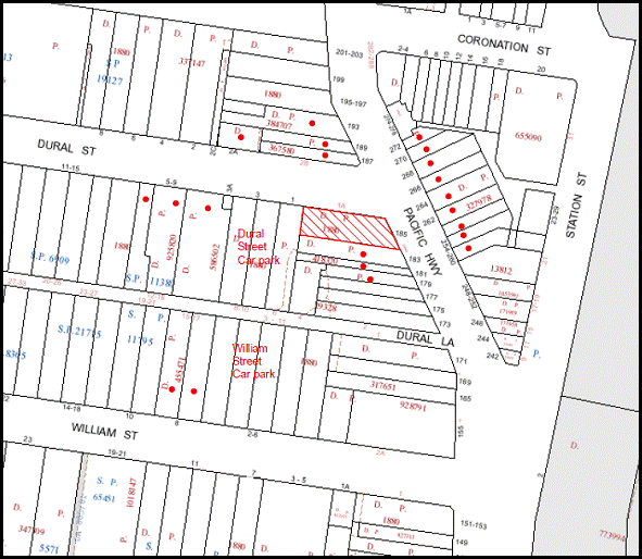
|
• PROPERTIES NOTIFIED
|
X SUBMISSIONS RECEIVED |
PROPERTY SUBJECT OF DEVELOPMENT |
|
6. THE PUBLIC INTEREST
The public interest is an overarching requirement, which includes the consideration of the matters discussed in this report. Implicit to the public interest is the achievement of future built outcomes adequately responding to and respecting the future desired outcomes expressed in environmental planning instruments and development control plans.
The application is considered to have satisfactorily addressed Council’s criteria and would provide a development outcome that, on balance, would result in a positive impact for the community. Accordingly, it is considered that the approval of the proposed alterations and additions, signage and change of use for restaurant would be in the public interest.
CONCLUSION
The proposal is for alterations and additions and change of use of an existing heritage building for a restaurant and signage.
The building has recently undergone extensive additions and includes commercial and residential floor space. One floor of the building is occupied by a 24 hour gym, the remaining commercial floor space is vacant. The existing building has a shortfall in on-site car parking.
The proposed alterations and change of use involve the conversion of part of the residential floor space for restaurant use and include a new opening in northern façade at ground level. The alterations and additions are acceptable in respect to the building design element objective of the Hornsby Town Centre DCP.
The proposed change of use for restaurant use does not include on-site car parking. The non-compliance is acceptable in respect to the Hornsby Town Centre DCP parking and access element objective with regard to the proposed hours of operation and available on-street parking and parking spaces within the Dural Street and William Street car parks.
The proposed signage is appropriate for the proposed use and complements the heritage building and the streetscape.
No submissions were received in response to the proposal.
The application is recommended for approval.
|
Rod Pickles Manager - Development Assessment Planning Division |
James Farrington Group Manager Planning Division |
|
1.View |
Locality Map |
|
|
|
2.View |
Floor Plans |
|
|
|
3.View |
Fitout Plans |
|
|
|
4.View |
Fire exit and Pump Room Plans |
|
|
|
5.View |
Signage Details |
|
|
|
6.View |
Artist's Impression |
|
|
|
7.View |
Parking Survey |
|
|
File Reference: DA/836/2012
Document Number: D02129990
SCHEDULE 1
GENERAL CONDITIONS
The conditions of consent within this notice of determination have been applied to ensure that the use of the land and/or building is carried out in such a manner that is consistent with the aims and objectives of the relevant legislation, planning instruments and Council policies affecting the land and does not disrupt the amenity of the neighbourhood or impact upon the environment.
Note: For the purpose of this consent, the term ‘applicant’ means any person who has the authority to act on or the benefit of the development consent.
Note: For the purpose of this consent, any reference to an Act, Regulation, Australian Standard or publication by a public authority shall be taken to mean the gazetted Act or Regulation, or adopted Australian Standard or publication as in force on the date that the application for a construction certificate is made.
1. Approved Plans and Supporting Documentation
The development must be carried out in accordance with the plans and documentation listed below and endorsed with Council’s stamp, except where amended by Council and/or other conditions of this consent:
|
Plan No. |
Drawn by |
Dated |
|
DA01 Basement Floor Plan |
ab3d design |
10 March 2013 |
|
DA02 Ground Floor Plan |
ab3d design |
10 March 2013 |
|
DA03 Level 1 Floor Plan |
ab3d design |
10 March 2013 |
|
DA04 Level 3 & Level 4 Floor Plan |
ab3d design |
10 March 2013 |
|
DA05 Level 3 Fitout Plan |
ab3d design |
10 March 2013 |
|
DA06 Level 4 Fitout Plan |
ab3d design |
10 March 2013 |
|
DA07 Ground Floor Level |
ab3d design |
10 March 2013 |
|
DA08 Fire Exit and Pump Room |
ab3d design |
10 March 2013 |
|
DA09 Signage Details |
ab3d design |
10 March 2013 |
|
DA10 Artists Impression |
ab3d design |
10 March 2013 |
|
Document No. |
Prepared by |
Dated |
|
D02062197 Statement of Environmental Effects |
Coastplan Consulting |
October 2012 |
|
D02062199 Noise Assessment |
Acoustic Consulting Engineers |
16 October 2012 |
|
D01997293 Fire Engineering Report |
AE & D FIRE |
4 July 2012 |
REQUIREMENTS PRIOR TO THE ISSUE OF A CONSTRUCTION CERTIFICATE
2. Building Code of Australia
All building work must be carried out in accordance with the requirements of the Building Code of Australia.
3. Fire Safety Upgrade
To ensure the protection of persons using the building and to facilitate egress from the building in the event of a fire, the application for a construction certificate must demonstrate that it will comply with the following Category 1 fire safety provisions:
a) The existing building be upgraded in accordance with Sections C, D, E, and Section J of the Building Code of Australia
b) A list of existing and proposed fire safety measures is to be submitted to the PCA with any Construction Certificate
c) Any alternate solution to comply with the BCA is to be submitted with the Construction Certificate.
REQUIREMENTS PRIOR TO THE COMMENCEMENT OF ANY WORKS
4. Erection of Construction Sign
A sign must be erected in a prominent position on any site on which building work, subdivision work or demolition work is being carried out:
a) Showing the name, address and telephone number of the principal certifying authority for the work,
b) Showing the name of the principal contractor (if any) for any demolition or building work and a telephone number on which that person may be contacted outside working hours, and
c) Stating that unauthorised entry to the work site is prohibited.
Note: Any such sign is to be maintained while the building work, subdivision work or demolition work is being carried out, but must be removed when the work has been completed.
5. Protection of Adjoining Areas
A temporary hoarding, fence or awning must be erected between the work site and adjoining lands before the works begin and must be kept in place until after the completion of the works if the works:
a) Could cause a danger, obstruction or inconvenience to pedestrian or vehicular traffic.
b) Could cause damage to adjoining lands by falling objects.
c) Involve the enclosure of a public place or part of a public place.
Note: Notwithstanding the above, Council’s separate written approval is required prior to the erection of any structure or other obstruction on public land.
6. Toilet Facilities
Toilet facilities must be available or provided at the works site before works begin and must be maintained until the works are completed at a ratio of one toilet for every 20 persons employed at the site. Each toilet must:
a) be a standard flushing toilet connected to a public sewer; or
b) be a temporary chemical closet approved under the Local Government Act, 1993; or
c) have an on-site effluent disposal system approved under the Local Government Act, 1993.
REQUIREMENTS DURING CONSTRUCTION
7. Construction Work Hours
All work on site (including demolition and earth works) must only occur between 7am and 5pm Monday to Saturday.
No work is to be undertaken on Sundays or public holidays.
8. Demolition
All demolition work must be carried out in accordance with Australian Standard 2601-2001 – The Demolition of Structures and the following requirements:
a) Demolition material is to be disposed of to an authorised recycling and/or waste disposal site and/or in accordance with an approved waste management plan.
b) Demolition works, where asbestos material is being removed, must be undertaken by a contractor that holds an appropriate licence issued by WorkCover NSW in accordance with Chapter 10 of the Occupational Health and Safety Regulation 2001 and Clause 29 of the Protection of the Environment Operations (Waste) Regulation 2005.
c) On construction sites where buildings contain asbestos material, a standard commercially manufactured sign containing the words ‘DANGER ASBESTOS REMOVAL IN PROGRESS’ measuring not less than 400mm x 300mm must be erected in a prominent position visible from the street.
9. Council Property
During construction works, no building materials, waste, machinery or related matter is to be stored on the road or footpath.
REQUIREMENTS PRIOR TO THE ISSUE OF AN OCCUPATION CERTIFICATE
Note: For the purpose of this consent, a reference to ‘occupation certificate’ shall not be taken to mean an ‘interim occupation certificate’ unless otherwise stated.
10. Food Premises
a) The fit out and operation of that part of the building to be used for the manufacture, preparation or storage of food for sale, must be in accordance with Australian Standard 4674-2004 – Design and fit out of food premises, the Food Act 2003, Food Regulation 2010 and the Food Standards Code developed by Food Standards Australia New Zealand. Food Standards 3.3.1, 3.2.2 and 3.2.3 are mandatory for all food businesses. Note: Walls are to be of solid construction.
b) Written permission must be obtained from Sydney Water before discharging trade wastewater to the sewer. Food outlets and food services are required to install and maintain an adequately sized grease trap. A dry basket arrestor or bucket trap is necessary if there are floor wastes in the food preparation and handling areas. Floor wastes must drain to the grease trap servicing the kitchen. Refer to the Sydney Water publication ‘Managing trade wastewater in the food service industry’. An application must be submitted to Sydney Water, refer to sydneywater.com.au or phone 13 20 92.
c) A kitchen exhaust system must be designed and installed to effectively prevent air pollution in accordance with the Protection of the Environment Operations Act 1997.
11. Waste Management
The residential component and non-residential component of the development must have separate and self-contained waste management systems, including separate bin storage rooms. Commercial tenants must be prevented (via signage and other means) from using the residential waste/recycling bins and vice versa.
12. Damage to Council Assets
Any damage caused to Council’s assets as a result of the construction of the development must be rectified in accordance with Council’s written requirements and at the sole cost of the applicant.
OPERATIONAL CONDITIONS
13. Waste Management
a) The domestic bins must be serviced by Council or their authorised Contractor. The commercial waste can be serviced by any authorised collection contractor, including Council.
b) All commercial tenants must keep written evidence on site of a valid contract with a licensed waste contractor(s) for the regular collection and disposal of the waste and recyclables that are generated on site.
c) If the sum of meat, seafood and poultry waste generated per day by the restaurant is at least 50 litres, then waste collections must take place daily.
d) Due to the close proximity of residential dwellings, commercial waste collection services must only take place within the hours of 9 am to 7 pm on Sundays and Public Holidays or within the hours of 7 am to 7 pm on other days.
14. Advertising Signs
The advertising signage approved under this consent must not flash, move or display electronic images.
15. Use of Premises
The development approved under this consent shall be used for ‘restaurant’ and ‘dwellings’ and not for any other purpose without Council’s separate written consent.
16. The restaurant must not be used for wedding receptions to ensure sufficient public carparking is maintained.
17. Hours of Operation
The hours of operation of the restaurants are restricted to those times listed below:
Weekdays (Breakfast) 7.30 am to 9.30 am
Weekends (Breakfast) 7.30 am to 10.30 am
Weekends (Lunch) 12.00 noon to 3.00 pm
Monday to Sunday (Dinner) 6.00 pm to 12.00 am
18. Noise
All noise generated by the proposed development must be attenuated to prevent levels of noise being emitted to adjacent residential premises which possess tonal, beating and similar characteristics or which exceeds background noise levels by more than 5dB(A).
19. Fire Safety Statement - Annual
On at least one occasion in every 12 month period following the date of the first ‘Fire Safety Certificate’ issued for the property, the owner must provide Council with an annual ‘Fire Safety Certificate’ to each essential service installed in the building.
- END OF CONDITIONS -
ADVISORY NOTES
The following information is provided for your assistance to ensure compliance with the Environmental Planning and Assessment Act, 1979, Environmental Planning and Assessment Regulation 2000, other relevant legislation and Council’s policies and specifications. This information does not form part of the conditions of development consent pursuant to Section 80A of the Act.
Environmental Planning and Assessment Act, 1979 Requirements
The Environmental Planning and Assessment Act, 1979 requires:
· The issue of a construction certificate prior to the commencement of any works. Enquiries regarding the issue of a construction certificate can be made to Council’s Customer Services Branch on 9847 6760.
· A principal certifying authority to be nominated and Council notified of that appointment prior to the commencement of any works.
· Council to be given at least two days written notice prior to the commencement of any works.
· Mandatory inspections of nominated stages of the construction inspected.
· An occupation certificate to be issued before occupying any building or commencing the use of the land.
Long Service Levy
In accordance with Section 34 of the Building and Construction Industry Long Service Payments Act 1986, a ‘Long Service Levy’ must be paid to the Long Service Payments Corporation or Hornsby Council.
Note: The rate of the Long Service Levy is 0.35% of the total cost of the work.
Note: Hornsby Council requires the payment of the Long Service Levy prior to the issue of a construction certificate.
Disability Discrimination Act
The applicant’s attention is drawn to the existence of the Disability Discrimination Act. A construction certificate is required to be obtained for the proposed building/s, which will provide consideration under the Building Code of Australia, however, the development may not comply with the requirements of the Disability Discrimination Act. This is the sole responsibility of the applicant.
Food Authority Notification
The NSW Food Authority requires businesses to electronically notify the Authority prior to the commencement of its operation.
Note: NSW Food Authority can be contacted at www.foodnotify.nsw.gov.au.
Council Notification – Food Premises
Prior to the commencement of the business, the operator is requested to contact Council’s Environmental Health Team to arrange an inspection for compliance against the relevant legislation and guidelines outlined in this approval.
Note: Council’s Environmental Health Officer can be contacted on 02 9847 6745.
Authorised Floor Waste Basket and Sink Strainer
An application must be submitted to Sydney Water for the installation of an authorised floor waste basket and sink strainer. Refer to the Sydney Water publication ‘Managing trade wastewater in the food service industry’ at sydneywater.com.au or phone 13 20 92.
Group Manager’s Report No. PL25/13
Planning Division
Date of Meeting: 17/04/2013
9 DEVELOPMENT APPLICATION - SUBDIVISION OF ONE LOT INTO TWO LOTS - 16 NALAURA CLOSE, BEECROFT
EXECUTIVE SUMMARY
|
DA No: |
DA/1341/2012 (Lodged 19 December 2012) |
|
Description: |
Subdivision of one allotment into two lots and demolition of a swimming pool |
|
Property: |
Lot 4 DP 12095, No. 16 Nalaura Close, Beecroft |
|
Applicant: |
P S Graham and Associates |
|
Owner: |
Mr Ian Noel McLennan and Mrs Mercy Mecenario McLennan |
|
Estimated Value: |
Nil |
|
Ward: |
C |
· The application proposes the Torrens Title subdivision of one allotment into two lots and the demolition of a swimming pool.
· The proposal does not comply with Clause 14 (Density) and Clause 15 (Floorspace Ratio) of the Hornsby Shire Local Environmental Plan 1994. The applicant has made a submission pursuant to State Environmental Planning Policy No. 1 (Development Standards) to vary the development standard.
· A Red Sticker has been placed on the application requiring that the application be determined at a Council Meeting.
· Council has received three submissions in respect of the application.
· It is recommended that the application be refused.
|
THAT Development Application No. DA/1341/2012 for subdivision of one allotment into two lots at Lot 4 DP 12095, No. 16 Nalaura Close, Beecroft be refused for the reasons detailed in Schedule 1 of Group Manager’s Report No. PL25/13. |
BACKGROUND
On 19 December 2012, the applicant submitted DA/1341/2012 for subdivision of one allotment into two lots.
On 5 March 2013, the applicant submitted amended plans to relocate the proposed subdivision boundary, amend the lot sizes and demolish the swimming pool.
SITE
The site is identified as Lot 4 in Deposited Plan 12095, known as No. 16 Nalaura Close, Beecroft. The rectangular-shaped site has an area of 1,103m² and is located on the southern side of Nalaura Close. The site also has a street frontage to Hannah Street to the south. The site experiences a gradual fall of 9% from the south-east to the north-west corner and contains a two storey dwelling-house, shed, swimming pool and numerous trees.
The site is within the vicinity of Nos. 51 and 86X Hannah Street which are listed as heritage items (‘Fearnley Park’ and ‘House’) under the provisions of Schedule D of the Hornsby Shire Local Environmental Plan (HSLEP) 1994.
The site is not burdened by any easements or restrictions under the 88b Instrument and is not located on bushfire prone land.
The surrounding development is characterised by one and two storey dwelling-houses. The adjoining lots at Nos. 70, 74, 74A Hannah Street and No. 18 Nalaura Close have lot sizes of 650.2m², 597.8m², 504.2m² and 452.4m² respectively.
PROPOSAL
The application proposes the subdivision of one allotment into two lots and the demolition of a swimming pool. The proposed allotments are outlined as follows:
Lot 41
Proposed Lot 41 would have an area of 551.5m² and would have a street frontage to Nalaura Close. The lot would contain the existing two storey dwelling-house and the proposed easement to drain water along the north-eastern boundary.
Lot 42
Proposed Lot 42 would have an area of 551.5m² and would have a street frontage to Hannah Street. The site would be benefitted by the proposed easement to drain water over Lot 41. A 200m² indicative building envelope has been indicated on the proposed plans.
The application includes the removal of 4 trees as part of the proposed development.
ASSESSMENT
The development application has been assessed having regard to the ‘Metropolitan Plan for Sydney 2036’, the ‘North Subregion (Draft) Subregional Strategy’ and the matters for consideration prescribed under Section 79C of the Environmental Planning and Assessment Act 1979 (the Act). The following issues have been identified for further consideration.
1. STRATEGIC CONTEXT
1.1 Metropolitan Plan for Sydney 2036 and (Draft) North Subregional Strategy
The Metropolitan Plan for Sydney 2036 is a broad framework to secure Sydney’s place in the global economy by promoting and managing growth. It outlines a vision for Sydney to 2036; the challenges faced, and the directions to follow to address these challenges and achieve the vision. The Draft North Subregional Strategy acts as a framework for Council in its preparation of the Comprehensive LEP.
The Draft North Subregional Strategy sets the following targets for the Hornsby LGA by 2031:
· Employment capacity to increase by 9,000 jobs; and
· Housing stock to increase by 11,000 dwellings.
The proposed development would be consistent with the draft Strategy by providing an additional allotment, facilitating the opportunity for the provision of additional housing within the Shire.
2. STATUTORY CONTROLS
Section 79C(1)(a) requires Council to consider “any relevant environmental planning instruments, draft environmental planning instruments, development control plans, planning agreements and regulations”.
2.1 Hornsby Shire Local Environmental Plan 1994
The subject land is zoned Residential AS (Low Density – Sensitive Lands) under the Hornsby Shire Local Environmental Plan 1994 (HSLEP). The objectives of the Residential AS (Low Density – Sensitive Lands) zone are:
(a) to provide for the housing needs of the population of the Hornsby area.
(b) to promote a variety of housing types and other land uses compatible with a low density residential environment and sensitive to the land capability and established character of this environment.
(c) to provide for development that is within the environmental capacity of a sensitive low density residential environment.
The proposed development is defined as ‘subdivision’ under the HSLEP and is permissible in the zone with Council’s consent.
Clause 14 of HSLEP prescribes a minimum area of 600m2 for an allotment within the Residential AS zone. Both of the proposed lot sizes do not comply with this development standard.
Clause 15 of HSLEP prescribes that the maximum floor space ratio (FSR) of development within the Residential AS (Low Density – Sensitive Lands) zone is 0.4:1. The proposed development would result in a floor space ratio of 0.45:1 for the existing dwelling-house based on the proposed new lot size.
Clause 18 of HSLEP sets out heritage conservation provisions within the Hornsby area. The site is within the vicinity of Nos. 51 and 86X Hannah Street which are listed as heritage items (‘Fearnley Park’ and ‘House’) under the provisions of Schedule D of the HSLEP. The heritage implications of the proposed are addressed under Section 2.7 of this report.
2.2 Sydney Regional Environmental Plan (Sydney Harbour Catchment) 2005
The application has been assessed against the requirements of Sydney Regional Environmental Plan (Sydney Harbour Catchment) 2005. This Policy provides general planning considerations and strategies to ensure that the catchment, foreshores, waterways and islands of Sydney Harbour are recognised, protected, enhanced and maintained.
Subject to conditions relating to sediment and erosion control, the development would have minimal potential to impact on the Sydney Harbour Catchment.
2.3 Draft Comprehensive Hornsby Local Environmental Plan
The Draft Hornsby Local Environmental Plan (DHLEP) was endorsed by Council at its meeting on 19 December 2012 to be forwarded to the Minister for Planning and Infrastructure to be made. In accordance with Council’s resolution, the draft Plan has been submitted to the Department for finalisation.
Under the DHLEP, the subject land would be zoned R2 (Low Density Residential) and subdivision is permissible with the consent of Council under the draft Plan. The site would have a minimum lot size of 600m² and the proposed lot sizes would not comply with this development standard.
2.4 State Environmental Planning Policy No. 1 – Development Standards
As stated above under Section 2.1, the proposal does not comply with Clauses 14 and 15 of the HSLEP. The application has been assessed against the requirements of State Environmental Planning Policy No. 1 – Development Standards (SEPP 1). This Policy provides flexibility in the application of development standards in circumstances where strict compliance with those standards would, in any particular case, be unreasonable or unnecessary or tend to hinder the attainment of the objectives of the Act.
The NSW Land and Environment Court in Wehbe v Pittwater Council [2007] NSWLEC 827 has expressed the view that there are 5 different ways in which an objection may be well founded and that approval of the objection may be consistent with the aims of the Policy as follows:
1. The objectives of the standard are achieved notwithstanding non-compliance with the standard;
2. The underlying objective or purpose of the standard is not relevant to the development and therefore compliance is unnecessary;
3. The underlying object or purpose would be defeated or thwarted if compliance was required and therefore compliance is unreasonable;
4. The development standard has been virtually abandoned or destroyed by the Council's own actions in granting consents departing from the standard and hence compliance with the standard is unnecessary and unreasonable; and
5. The zoning of the particular land is unreasonable or inappropriate so that a development standard appropriate for that zoning is also unreasonable and unnecessary as it applies to the land and compliance with the standard would be unreasonable or unnecessary. That is, the particular parcel of land should not have been included in the particular zone.
To address the non-compliance with the development standards within Clauses 14 and 15 of the HSLEP, the applicant contends as follows:
“The Subdivision Plan demonstrates compliance with Council’s Subdivision Development Control Plan requirements with respect to –
(a) Existing dwelling envelope size 171m² for lot 41 (2 storey) and 200m² for proposed lot 42.
(b) Offsets to boundaries to front, side and rear of the dwelling and proposed building envelope.
(c) Private open space areas.
(d) Carspace requirements.
Compliance with the standards will hinder the attainment of the objects specified in 5(a)(i) and (ii) of the Environmental Planning and Assessment Act 1979.
The adjoining land on the east is Lot 2 in Deposited Plan 844936 has a brick dwelling No. 18 Nalaura Close comprising 452m² that compliments the streetscape. The original dwelling No. 70 Hannah Street is on Lot 1. There is no change to the streetscape, the subdivision not being obvious from Hannah Street. The adjoining land on the west is Lot 31 in DP 844936 comprises the original dwelling No. 74 Hannah Street and is 504m². Lot 32 is a battleaxe lot being No. 74A comprising 482.2m² excluding access handle.
The adjacent subdivisions satisfy the zone objectives and demonstrate strict compliance with the Development Standards is unreasonable and unnecessary.”
The matters listed above have been taken into consideration in assessing the merits of the SEPP 1 objection.
Minimum Lot Sizes
Upon gazettal of the Hornsby Shire Local Environmental Plan (HSLEP) in July 1994, Hornsby Shire was exempted from the provisions of the now repealed State Government’s urban consolidation policies, namely Sydney Regional Environmental Plan (SREP) No. 12 – Dual Occupancy and State Environmental Planning Policy (SEPP) No. 25 – Residential Allotment Sizes. The exemption was granted as a result of the Hornsby Shire Housing Initiatives Strategy which presented an alternative solution to meet both local and State housing objectives. The Housing Initiatives Strategy allowed lower housing densities in the suburbs by providing higher density residential zones around transport and employment nodes, such as the Hornsby Town Centre.
On 19 May 1994, the then Minister for Urban Affairs and Planning repealed the right to separate titles on dual occupancy developments. However, despite the repeal of SREP No. 12 and SEPP No. 25, the subdivision of dual occupancies with reduced lot sizes was still possible under the HSLEP.
On 15 December 1995, to bring the HSLEP in accordance with State Government policies, HSLEP (Amendment No. 8) was gazetted to preclude the subdivision of multi-unit housing developments where proposed allotment sizes were less than the minimum allotment sizes under Clause 14 (Density).
In regards to the non-compliance of the proposed lot sizes with Clause 14 (Density) of the HSLEP, the SEPP 1 objection refers to allotments adjoining the subject site which have similar lot sizes to the subject application.
Development Application No. 811/1993 was lodged on 25 November 1993 for the erection of a dwelling-house and the Torrens title subdivision of No.70 Hannah Street to create Lots 1 and 2 of Deposited Plan 844935 (known as No. 70 Hannah Street and No. 18 Nalaura Close). As the application was lodged prior to the repeal of State Regional Environmental Plan (SREP) No. 12 – Dual Occupancy and the gazettal of the HSLEP, the application was approved on 2 August 1994 under the SREP.
Development Application No. 175/1995 for the erection of a dwelling-house and the Torrens title subdivision of No. 74 Hannah Street to create Lots 31 and 32 of Deposited Plan 876520 (known as Nos. 74 and 74A Hannah Street) was approved on 19 December 1995. As the application was lodged on 31 March 1995, prior to the gazettal of HSLEP Amendment No.8, consent was granted pursuant to Clause 14 (Density) of the HSLEP.
Notwithstanding the adjoining 597.8m², 504.2m² and 452.4m² lot sizes do not comply with the Clause 14 (Density) development standards of the HSLEP, these lots have been approved under previous policies and controls which have since been repealed or amended. Approval of the subject application would create an unacceptable precedent under the current controls for the subdivision of lots within the Residential AS (Low Density – Sensitive Lands) zone by allowing allotments significantly lower than the applicable development standard.
Floor Space Ratio
In regards to the non-compliance of the existing dwelling-house with Clause 15 (Floorspace Ratio) of the HSLEP, the appearance of the dwelling-house when viewed from the streetscape on Nalaura Close would be unchanged. The proposed increase in floor space ratio resulting from the subdivision would create negligible impacts to the surrounding area. However, the non-compliance with the floor space ratio development standard stems from the fact that the proposed lot size created would not comply with the minimum lot size development standard. On this basis, the non-compliance with Clause 15 is considered unacceptable.
The SEPP 1 objection submitted is not considered to be well founded as the proposed subdivision would set an undesirable precedent for minimum lot sizes within the Residential AS (Low Density – Sensitive Lands) zone.
2.5 Residential Subdivision Development Control Plan
The proposed development has been assessed having regard to the relevant performance and prescriptive design requirements within Council’s Residential Subdivision Development Control Plan (DCP). The following table sets out the proposal’s compliance with the prescriptive measures of the DCP:
|
Residential Subdivision DCP |
|||
|
Control |
Proposal |
Requirement |
Complies |
|
Density |
|||
|
Site Area |
1,103m² |
1,200m² |
No |
|
Proposed allotment sizes Lot 41 Lot 42 |
551.5m² 551.5m2 |
600m² 600m2 |
No No |
|
Allotment Layout and Design |
|||
|
Building Envelopes Lot 41 Lot 42 |
No change to existing 200m2 |
N/A 200m2 |
N/A Yes |
|
Existing Dwelling House |
|||
|
Floor space area |
246m² |
220.6m² |
No |
|
Floor space ratio |
0.45:1 |
0.4:1 |
No |
|
Site coverage |
34% |
40% |
Yes |
|
Private Open Space |
|||
|
Lot 41 Lot 42 |
127m² 185.5m2 |
120m² 120m2 |
Yes Yes |
|
Setbacks |
|||
|
Lot 41 Front Side Side Rear |
No change to existing No change to existing No change to existing 6.3m |
6m 1m 1m 3m |
N/A N/A N/A Yes |
|
Lot 42 Front Side Side Rear |
6.5m 1.5m 1.5m 9.2m |
6m 1m 1m 3m |
Yes Yes Yes Yes |
|
Landscaping |
|||
|
Landscaped area: Lot 41 Lot 42 |
58% 51% |
45% 45% |
Yes Yes |
|
Car Parking |
|||
|
No. of spaces Lot 41 Lot 42 |
2 spaces 2 spaces |
2 spaces 2 spaces |
Yes Yes |
|
Solar Access |
|||
|
Windows to north-facing living rooms on adjoining development Adjoining land |
>3 hours on 22 June |
3 hours on 22 June |
Yes |
|
Private open space on adjoining land |
>4 hours on 22 June |
4 hours on 22 June |
Yes |
As detailed in the above table, the proposed development does not comply with a number of prescriptive requirements within Council’s Subdivision DCP. The matters of non-compliance are detailed below, as well as a brief discussion on compliance with relevant performance requirements.
2.5.1 Density
The proposed lot sizes and the floor space ratio of the existing dwelling-house do not comply with the prescriptive measures of the Density element and Clauses 14 and 15 of the HSLEP. These matters have been addressed under Section 2.4 of this report.
2.5.2 Flora and Fauna Protection
The proposal would require the removal of 4 trees to allow adequate space for the indicative building envelope. These 4 trees are not considered significant and their removal would create negligible environmental impacts.
2.6 Dwelling House Development Control Plan
The existing dwelling-house would not comply with the floor space ratio prescriptive measure of the Scale element of the Dwelling House Development Control Plan. This non-compliance has been addressed under Section 2.4 of this report.
2.7 Heritage Development Control Plan
The site is within the vicinity of Nos. 51 and 86X Hannah Street which are listed as heritage items (‘Fearnley Park’ & ‘House’) under the provisions of Schedule D of the Hornsby Shire Local Environmental Plan (HSLEP) 1994. No works are proposed to the existing dwelling-house, besides the removal of the existing swimming pool to the rear. A dwelling-house erected on proposed Lot 42 would not be visible from the heritage items at Nos. 51 and 86X Hannah Street. On this basis, the proposal would not create any adverse impacts to the significance of the heritage items.
3. ENVIRONMENTAL IMPACTS
Section 79C(1)(b) of the Act requires Council to consider “the likely impacts of that development, including environmental impacts on both the natural and built environments, and social and economic impacts in the locality”.
3.1 Natural Environment
The proposed development would necessitate the removal of 4 trees from the site. The removal of these trees would create negligible environmental impacts.
3.2 Built Environment
The proposed lot sizes and floor space ratio of the existing dwelling-house would result in a density of development that is not consistent with the objectives of the Residential AS (Low Density – Sensitive Lands) zone. Notwithstanding that two of the adjoining properties have a similar lots sizes to that of the proposal, these developments have been approved under previous legislation and the proposal would set an undesirable precedent for further small lot subdivisions within the surrounding area.
3.3 Social Impacts
There are no anticipated adverse social impacts resulting from the proposed development.
3.4 Economic Impacts
The proposal would not have an adverse economic impact on the locality.
4. SITE SUITABILITY
Section 79C(1)(c) of the Act requires Council to consider “the suitability of the site for the development”.
The subject site is considered unsuitable for the proposed development as the site area is not sufficient to create two allotments.
5. PUBLIC PARTICIPATION
Section 79C(1)(d) of the Act requires Council to consider “any submissions made in accordance with this Act”.
5.1 Community Consultation
The proposed development was placed on public exhibition and was notified to adjoining and nearby landowners between 7 January 2013 and 19 February 2013 in accordance with Council’s Notification and Exhibition Development Control Plan. During this period, Council received three submissions. The map below illustrates the location of those nearby landowners who made a submission that are in close proximity to the development site.
NOTIFICATION PLAN
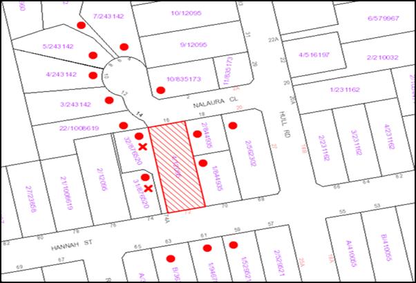
|
• PROPERTIES NOTIFIED
|
X SUBMISSIONS RECEIVED |
PROPERTY SUBJECT OF DEVELOPMENT |
|
|
One submission was received out of range of the notification map from the Beecroft/Cheltenham Civic Trust. |
|||
The submissions objecting to the proposed development are outlined as follows:
5.1.1 Lot Size
Two submissions have been received in regards to the lot sizes of the proposed subdivision and the impact it would have on the surrounding area. The matters relating to the lot sizes have been addressed in Section 2.4 of this report.
5.1.2 Height
A submission has been received in regards to the height of a potential dwelling-house on Lot 42. The subject application is for the subdivision of the allotment into two lots and the demolition of the existing swimming pool and does not include the erection of a dwelling-house. Matters relating to the height of a proposed dwelling-house would be assessed when an application for such development was lodged.
6. THE PUBLIC INTEREST
Section 79C(1)(e) of the Act requires Council to consider “the public interest”.
The public interest is an overarching requirement, which includes the consideration of the matters discussed in this report. Implicit to the public interest is the achievement of future built outcomes adequately responding to and respecting the future desired outcomes expressed in environmental planning instruments and development control plans.
The application is considered to have unsatisfactorily addressed Council’s criteria and would provide a development outcome that, on balance, would result in a negative impact for the community. Accordingly, it is considered that the refusal of the proposed subdivision of one allotment into two lots would be in the public interest.
CONCLUSION
The application proposes the subdivision of one allotment into two lots and the demolition of a swimming pool.
The development does not comply with the Clause 14 and 15 of the Hornsby Shire Local Environmental Plan 1994 and is not considered acceptable having regard to the matters for consideration pursuant to Section 79C of the Environmental Planning and Assessment Act, 1979.
Council received three submissions during the public notification period in regards to the design and density of the development. The issues raised have been addressed in the body of this report.
Having regard to the circumstances of the case, refusal of the application is recommended.
Note: At the time of the completion of this planning report, no persons have made a Political Donations Disclosure Statement pursuant to Section 147 of the Environmental Planning and Assessment Act, 1979 in respect of the subject planning application.
|
Rod Pickles Manager - Development Assessment Planning Division |
James Farrington Group Manager Planning Division |
|
1.View |
Locality Map |
|
|
File Reference: DA/1341/2012
Document Number: D02132332
SCHEDULE 1
1. The proposal is unsatisfactory in respect to Section 79C(1)(a)(i) of the Environmental Planning and Assessment Act, 1979 as the development does not comply with the development standards of Clauses 14 (Density) and 15 (Floorspace Ratio) of the Hornsby Shire Local Environmental Plan 1994.
2. The proposal is unsatisfactory in respect to Section 79C(1)(a)(iii) of the Environmental Planning and Assessment Act, 1979 as the development does not meet the objectives of the Density element of the Residential Subdivision Development Control Plan (DCP).
3. The proposal is unsatisfactory in respect to Section 79C(1)(e) of the Environmental Planning and Assessment Act, 1979 as the development would set an undesirable precedent for the minimum lot size within the Residential AS (Low Density – Sensitive Lands) zone and is not in the public interest.
- END OF REASONS FOR REFUSAL -
Group Manager’s Report No. PL27/13
Planning Division
Date of Meeting: 17/04/2013
10 DEVELOPMENT APPLICATION - DWELLING HOUSE - 69 WYANNA STREET, BEROWRA HEIGHTS
EXECUTIVE SUMMARY
|
DA No: |
DA/59/2013 (Lodged 31 January 2013) |
|
Description: |
Demolition of an existing dwelling-house and the erection of a dwelling-house and swimming pool |
|
Property: |
Lot 7, DP 244647, No. 69 Wyanna Street, Berowra Heights |
|
Applicant: |
Sharon Jones Architectural Design |
|
Owner: |
Ms Karina Ledger |
|
Estimated Value: |
$670,000 |
|
Ward: |
A |
· The application proposes the demolition of an existing dwelling-house and the erection of a dwelling-house and a swimming pool.
· The proposal does not comply with the Hornsby Shire Local Environmental Plan 1994 with regard to Clause 15 (Floor Space Ratio). The applicant has made a submission pursuant to State Environmental Planning Policy No. 1 (Development Standards) to vary the standard. The submission is considered well-founded and is supported.
· No public submissions have been received in respect of the application.
· It is recommended that the application be approved.
|
THAT Council assume the concurrence of the Director-General of the Department of Planning and Infrastructure pursuant to State Environmental Planning Policy No. 1 and approve Development Application No. DA/59/2013 for the demolition of an existing dwelling-house and the erection of a dwelling-house and swimming pool at Lot 7, DP 244647, No. 69 Wyanna Street, Berowra Heights subject to the conditions of consent detailed in Schedule 1 of Group Manager’s Report PL27/13. |
BACKGROUND
On 1 September 1999, consent was granted to DA/1530/1999 for alterations and additions to the existing dwelling-house.
SITE
The rectangular, 709.4m² site is located on the southern side of Wyanna Street, Berowra Heights and contains a part 1 and 2 storey dwelling-house. The site experiences an 11.5 metre fall from the front, north-east to the rear, south-west corner.
The site is within a bushfire prone area and adjoins the Berowra Valley National Park on the rear, south-western boundary.
The site is not located in a heritage conservation area and is not in the vicinity of a heritage listed item.
PROPOSAL
The application proposes demolition of the existing dwelling-house and retaining walls and erection of a split level, three storey dwelling-house and an in-ground swimming pool. The swimming pool would be located towards the rear, southern boundary of the property.
The lower ground floor level would comprise a rumpus room, store room, powder room, laundry and patio.
The ground floor level would comprise a double garage, study, powder room, store room, kitchen with walk-in-pantry, meals area and family room.
The first floor level would comprise 4 bedrooms, an ensuite, bathroom and a toilet.
The application also proposes the construction of retaining walls, driveway, vehicular crossing, air-conditioning unit, 5,000 litre above ground rainwater tank and the removal of 2 trees as part of the development.
ASSESSMENT
The development application has been assessed having regard to the ‘Metropolitan Plan for Sydney 2036’, the ‘North Subregion (Draft) Subregional Strategy’ and the matters for consideration prescribed under Section 79C of the Environmental Planning and Assessment Act 1979 (the Act). The following issues have been identified for further consideration.
1. STRATEGIC CONTEXT
1.1 Metropolitan Plan for Sydney 2036 and (Draft) North Subregional Strategy
The Metropolitan Plan for Sydney 2036 is a broad framework to secure Sydney’s place in the global economy by promoting and managing growth. It outlines a vision for Sydney to 2036; the challenges faced, and the directions to follow to address these challenges and achieve the vision.
The Draft North Subregional Strategy acts as a framework for Council in its preparation of the Comprehensive LEP.
The Draft North Subregional Strategy sets the following targets for the Hornsby LGA by 2031:
· Employment capacity to increase by 9,000 jobs; and
· Housing stock to increase by 11,000 dwellings.
The proposed development would be consistent with the Metropolitan Plan for Sydney 2036 by providing re-newed housing provision within the Shire.
2. STATUTORY CONTROLS
Section 79C(1)(a) requires Council to consider “any relevant environmental planning instruments, draft environmental planning instruments, development control plans, planning agreements and regulations”.
2.1 Hornsby Shire Local Environmental Plan 1994
The subject land is zoned Residential AS (Low Density – Sensitive Lands) under Hornsby Shire Local Environmental Plan 1994 (HSLEP). The objectives of the Residential AS zone are:
(a) to provide for the housing needs of the population of the Hornsby area.
(b) to promote a variety of housing types and other land uses compatible with a low density residential environment and sensitive to the land capability and established character of this environment.
(c) to provide for development that is within the environmental capacity of a sensitive low density residential environment.
The proposed development is defined as a ‘dwelling-house’ under the HSLEP and is permissible in the zone with Council’s consent.
2.2 Draft Hornsby Local Environmental Plan
The Draft Hornsby Local Environmental Plan (DHLEP) was endorsed by Council at its meeting on 19 December 2012 to be forwarded to the Minister for Planning and Infrastructure to be made. In accordance with Council’s resolution, the draft Plan has been submitted to the Department for finalisation. The relevant provisions of the DHLEP that apply to the site are outlined below.
2.2.1 Zoning
Under the DHLEP, the subject land would be zoned R2 (Low Density Residential). A “dwelling house” would be a permissible use in the zone under the DHLEP.
2.2.2 Height of Building
Clause 4.3 of the DHLEP provides that the height of a building on any land is not to exceed the maximum height shown for the land on the Height of Buildings Map. The maximum permissible height for the subject site within the R2 zone is 8.5 metres. The proposal complies with this provision.
2.3 Sydney Regional Environmental Plan No. 20 (SREP 20)
The application has been assessed against the requirements of Sydney Regional Environmental Plan No. 20 (SREP 20). This Policy provides controls to protect the environment of the Hawkesbury-Nepean River system, including its water quality. The Policy addresses matters related to water quality, significant vegetation habitats, extraction, environmental heritage and scenic quality, recreation and tourism and agriculture.
Subject to the installation of suitable erosion and sediment control measures during construction works, the proposed development would be consistent with the objectives of SREP 20.
2.4 State Environmental Planning Policy No. 1 – Development Standards
Clause 15 of the Hornsby Shire Local Environmental Plan 1994 prescribes that the maximum floor space ratio (FSR) of development in the Residential AS (Low Density – Sensitive Lands) zone is 0.4:1. The gross floor area of the development is 379.5m2 and would result in an FSR of 0.53:1, which does not comply with the development standard.
To address the variation to the 0.4:1 development standard, the applicant has submitted an objection under State Environmental Planning Policy No. 1 - Development Standards (SEPP 1).
The application has been assessed against the requirements of SEPP 1. This Policy provides flexibility in the application of development standards in circumstances where strict compliance with those standards would, in any particular case, be unreasonable or unnecessary, or tend to hinder the attainment of the objectives of the Act.
The NSW Land and Environment Court has expressed the view that there are five different ways in which an objection may be well founded and that approval of the objection may be consistent with the aims of the Policy:
1. The objectives of the standard are achieved notwithstanding non-compliance with the standard;
2. The underlying objective or purpose of the standard is not relevant to the development and therefore compliance is unnecessary;
3. The underlying object or purpose would be defeated or thwarted if compliance was required and therefore compliance is unreasonable;
4. The development standard has been virtually abandoned or destroyed by the Council's own actions in granting consents departing from the standard and hence compliance with the standard is unnecessary and unreasonable;
5. The zoning of the particular land is unreasonable or inappropriate so that a development standard appropriate for that zoning is also unreasonable and unnecessary as it applies to the land and compliance with the standard would be unreasonable or unnecessary. That is, the particular parcel of land should not have been included in the particular zone.
In regard to whether the objection may be well founded, the applicant contends that:
1. “Due to the orientation of the site and the location of the proposed dwelling, no significant overshadowing to neighbouring properties will occur. The impact of an increased floor space ratio is therefore considered to be minimal;
2. The proposed increase in floor space ratio will not impact on any adjoining properties in relation to loss of privacy or views. None of the adjoining properties rely on any views across the development footprint area and the increase in floor space does not affect views;
3. There are no significant trees or vegetation within the development footprint area of the site. No site environmental features are therefore affected by the development or as a result of the increase in floor space ratio;
4. The proposed development is considered to be a site responsive development that is compatible with existing housing development in the locality. The scale of the proposed development is not unreasonable and matches the existing housing development in the area. The height and bulk of the dwelling is considered to be satisfactory;
5. The impact of the development on the front, side and rear setback is considered to be in keeping with neighbouring setbacks. The development is also considered to be in keeping with the scale of neighbouring development; and
6. The larger floor space ratio for the development on landscaping provisions is considered not to be significant and is not compromised by the size of the dwelling.”
The matters listed above have been taken into consideration in assessing the merits of the SEPP 1 objection.
The proposal takes into consideration the environmental and topographical constraints of the site. The additional floor space would not adversely impact on the environmental and amenity aspects of the site and the underlying objectives of the zoning. The dwelling-house would provide accommodation that would not detract from the scale and variety of dwelling-houses in the low density areas of the Shire as the proposal is considered to meet the zone objectives outlined in the HSLEP.
In addition to the above, Council’s assessment had regard to the provisions of the NSW Housing Code, which provides that the maximum gross floor area for complying development within the low density residential zones of the Shire as being:
· 330m2, if the lot has an area of at least 450m2 but less than 600m2 ;
· 380m2, if the lot has an area of at least 600m2 but less than 900m2; and
· 430m2, if the lot has an area of at least 900m2.
Accordingly, if applicable, the development would satisfy the maximum floor area development standard under the NSW Housing Code.
Given that the recently introduced NSW Housing Code is now enacted in many parts of the Shire, it is anticipated that more developments would be approved under this Code, which will change the characteristics of dwelling-houses. Consequently, whilst Council has previously applied a maximum FSR of 0.4:1 for dwelling-houses in the low density residential zones within the Shire under the HSLEP, the introduction of the NSW Housing Code is changing the effect of this standard.
2.5 Dwelling House Development Control Plan
The development has been assessed having regard to the relevant performance and prescriptive design requirements within Council’s Dwelling House Development Control Plan (Dwelling House DCP). The following table sets out the proposal’s compliance with the prescriptive requirements of the Plan:
|
Dwelling House Development Control Plan |
|||
|
Control |
Proposal |
Requirement |
Complies |
|
Site Area |
709.4m2 |
500m2 |
Yes |
|
Gross Floor Area |
379.5m2 |
283.76m2 |
No |
|
Floor space ratio |
0.53:1 |
0.4:1 |
No |
|
Site cover |
31.5% |
40% |
Yes |
|
Dwelling-House Setbacks Front (north) Rear (south) Side (east) Side (west) |
7.97m 16.9m 1.5m 1.5m |
6m 3m 1m 1m |
Yes Yes Yes Yes |
|
Swimming Pool Setbacks Rear (south) Side (east) Side (west) |
2m 5.2m 1.2m |
N/A N/A N/A |
N/A N/A N/A |
|
Height |
Two-storey |
Max. two storey |
Yes |
|
Unbroken Wall length |
19m |
10m |
No |
|
Building length |
19m |
24m |
Yes |
|
Cut and fill |
0.9m fill |
1m |
Yes |
|
Private Open Space |
120m2 |
120m² |
Yes |
|
Landscaped area |
45% |
45% |
Yes |
|
Garage size |
6.3m x 5.8m |
3.0m x 5.4m |
Yes |
As detailed in the above table, the proposed development does not comply with the prescriptive measures of the design element within Council’s Dwelling House DCP. This matter of non-compliance is addressed below.
2.5.1 Scale
The proposed development does not comply with the 0.4:1 prescriptive measure of the Dwelling House DCP and 0.4:1 development standard of the HSLEP. This matter has been addressed under Section 2.4 of this report .
2.5.2 Design
The proposed 15.6 metre eastern, ground floor level elevation and 14.6 metre western, ground floor level elevation wall lengths do not comply with the prescriptive measure of the Design element which states that wall lengths should not exceed 10 metres without a physical “break”.
Notwithstanding this, a balance between solid walls and openings and variations of roof form has been incorporated into the elevations to avoid a monotonous or symmetrical design when viewed from the street or adjacent properties.
The proposal would have negligible adverse visual or amenity impacts to the adjoining properties. The proposed dwelling-house meets the objectives of the Design element of the Dwelling House DCP and is considered acceptable.
2.5.3 Acoustics
The application proposes the siting of an air-conditioning unit on the western elevation. To protect the amenity of the adjoining properties, a condition is recommended regulating the noise emissions from the unit.
Subject to the above condition, the proposal meets the objectives of the Acoustics element and is considered acceptable.
2.5.4 Flora and Fauna Protection
The application proposes the removal of two trees located on the subject site. These trees are located within 3 metres of the existing development. As a consequence, they are exempt under Council’s Tree Preservation Order and can be removed without further Council approval.
The proposal meets the objectives of the Flora and Fauna Protection element and is considered acceptable.
2.5.5 Drainage Control
The application proposes to drain all collected roof-water into a 5,000 litre rainwater tank, with the overflow to be piped into the bushland located at the rear of the subject site via the existing drainage system. Council’s engineering assessment concludes that the proposal meets the objectives of the Drainage Control element and is considered acceptable. Accordingly, no objections were raised to the proposal, subject to conditions.
2.5.6 Swimming Pool
The application proposes the erection of an in-ground swimming pool with associated paving to be located towards the rear, southern boundary of the property.
Due to the topography of the site, the southern side of the swimming pool would be suspended approximately 3 metres above natural ground level. Notwithstanding this, it is considered that the swimming pool would not create any adverse amenity or privacy impacts to adjoining properties as the subject property backs onto the Berowra Valley National Park.
Furthermore, the proposal includes landscape planting along the southern and eastern boundaries to provide screening in addition to the existing screen planting located along the western boundary.
3. ENVIRONMENTAL IMPACTS
Section 79C(1)(b) of the Act requires Council to consider “the likely impacts of that development, including environmental impacts on both the natural and built environments, and social and economic impacts in the locality”.
3.1 Natural Environment
As discussed under Section 2.5.4 of this report, the trees identified for removal on the site are not significant and their removal would have negligible environmental impacts.
The subject site is identified as being located on bushfire prone land. As a consequence, the application was referred to the NSW Rural Fire Service (RFS) for comment. The RFS raises no objections to the proposed development, subject to conditions.
Approval of the proposed development would create negligible environmental impacts and would not set an undesirable precedent.
3.2 Built Environment
The proposal would not be out of character with the established built form of residential development in the area and would be consistent with the form of development permitted in the locality.
Approval of this development would not detract from the established character of the area.
3.3 Social or Economic Impacts
There are no anticipated adverse social or economic impacts resulting from the proposed development.
4. SITE SUITABILITY
Section 79C(1)(c) of the Act requires Council to consider “the suitability of the site for the development”.
The site has the capacity to support the dwelling-house and the proposal would be consistent with the established residential character of the surrounding area. The site is considered suitable for the development.
5. PUBLIC PARTICIPATION
Section 79C(1)(d) of the Act requires Council to consider “any submissions made in accordance with this Act”.
The proposed development was placed on public exhibition and was notified to adjoining and nearby landowners (as shown in the Notification Map below) between 5 February 2013 and 19 February 2013 in accordance with Council’s Notification and Exhibition Development Control Plan. During this period, Council received no submissions.
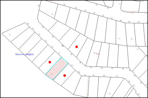
NOTIFICATION PLAN
|
• PROPERTIES NOTIFIED
|
X SUBMISSIONS RECEIVED |
PROPERTY SUBJECT OF DEVELOPMENT |
|
6. THE PUBLIC INTEREST
Section 79C(1)(e) of the Act requires Council to consider “the public interest”.
The public interest is an overarching requirement, which includes the consideration of the matters discussed in this report. Implicit to the public interest is the achievement of future built outcomes adequately responding to and respecting the future desired outcomes expressed in environmental planning instruments and development control plans.
The application is considered to have addressed Council’s criteria under the Dwelling House DCP and therefore, the development would be in the public interest.
CONCLUSION
The application proposes the demolition of the existing dwelling-house and the erection of a dwelling-house and a swimming pool.
The application does not comply with the Hornsby Shire Council Local Environmental Plan, 1994 in respect to Clause 15 ‘Floor Space Ratio’. The applicant submitted a State Environmental Planning Policy No. 1 objection to vary the floor space ratio development standard. The objection is considered well founded with regard to the existing development and the principles established by the Land and Environment Court.
There were no submissions received in response to notification of the proposed development.
Having regard to the circumstances of the case and consideration of the SEPP 1 objection, approval of the application is recommended.
Note: At the time of the completion of this planning report, no persons have made a Political Donations Disclosure Statement pursuant to Section 147 of the Environmental Planning and Assessment Act, 1979 in respect of the subject planning application.
|
James Farrington Group Manager Planning Division |
Rod Pickles Manager - Development Assessment Planning Division |
|
1.View |
Locality Map |
|
|
|
2.View |
Architectural Plans |
|
|
|
3.View |
Floor Plans |
|
|
|
4.View |
Statement of Environmental Effects including SEPP 1 Objection |
|
|
File Reference: DA/59/2013
Document Number: D02134134
SCHEDULE 1
GENERAL CONDITIONS
The conditions of consent within this notice of determination have been applied to ensure that the use of the land and/or building is carried out in such a manner that is consistent with the aims and objectives of the relevant legislation, planning instruments and Council policies affecting the land and does not disrupt the amenity of the neighbourhood or impact upon the environment.
Note: For the purpose of this consent, the term ‘applicant’ means any person who has the authority to act on or the benefit of the development consent.
Note: For the purpose of this consent, any reference to an Act, Regulation, Australian Standard or publication by a public authority shall be taken to mean the gazetted Act or Regulation, or adopted Australian Standard or publication as in force on the date that the application for a construction certificate is made.
1. Approved Plans and Supporting Documentation
The development must be carried out in accordance with the plans and documentation listed below and endorsed with Council’s stamp, except where amended by Council and/or other conditions of this consent:
|
Plan No. |
Drawn by |
Dated |
|
214 (Sheet 1 and Sheet 2) |
Sharon Jones Architectural Design |
February 2013 |
2. Removal of Existing Trees
This development consent only permits the removal of two trees numbered T1 and T2 as identified on Plan No. 214 (Sheet 2) prepared by Sharon Jones Architectural Design dated February 2013. The removal of any other trees requires separate approval under Council’s Tree Preservation Order.
REQUIREMENTS PRIOR TO THE ISSUE OF A CONSTRUCTION CERTIFICATE
3. Building Code of Australia
All building work must be carried out in accordance with the requirements of the Building Code of Australia.
4. Contract of Insurance (Residential Building Work)
In the case of residential building work for which the Home Building Act, 1989 requires there to be a contract of insurance in force in accordance with Part 6 of that Act, that such a contract of insurance is in force before any building work authorised to be carried out by the consent commences.
5. Notification of Home Building Act, 1989 Requirements
Residential building work within the meaning of the Home Building Act, 1989 must not be carried out unless the principal certifying authority for the development to which the work relates (not being Council) has given Council written notice of the following information:
a) In the case of work for which a principal contractor is required to be appointed:
i) The name and licence number of the principal contractor.
ii) The name of the insurer by which the work is insured under Part 6 of that Act.
b) In the case of work to be done by an owner-builder:
i) The name of the owner-builder.
ii) If the owner-builder is required to hold an owner-builder’s permit under that Act, the number of the owner-builder’s permit.
Note: If arrangements for doing the residential building work are changed while the work is in progress so that the information notified becomes out of date, further work must not be carried out unless the principal certifying authority for the development to which the work relates (not being Council) has given Council written notification of the updated information.
6. Sydney Water – Quick Check
The application must be submitted to a Sydney Water ‘Quick Check Agent’ or ‘Customer Centre’ for approval to determine whether the development will affect any Sydney Water infrastructure, and whether further requirements are to be met.
Note: Refer to www.sydneywater.com.au or telephone 13 20 92 for assistance.
7. Design and Construction - Bushfire Attack Category (South-East, South-West and North-West)
a) New construction on the south-east, south-west and north-west elevations must comply with the current Australian Standard AS3959 ‘Construction of buildings in bush fire-prone areas’ section 9 (BAL FZ). However, any material, element of construction of system when tested to the method described in Australian Standard AS1530.8.2 ‘Methods for fire tests on building materials, components and structures Part 8.2: Tests on elements of construction for buildings exposed to simulated bushfire attack – Large flaming sources’ must comply with Clause 13.8 of that standard except that flaming of the specimen is not permitted and there must be no exposed timber.
b) Window assemblies on the south-east, south-west and north-west elevations must comply with modified Section 9 of Australian Standard AS3959 ‘Construction of buildings in bush fire-prone areas,’ or the following:
i) Must have an FRL of 0/30/0, or;
ii) Must be completely protected by a non-combustible and non perforated bushfire shutter that complies with Section 3.7 of Australian Standard AS3959 excluding parts e and f;
iii) All window frames and hardware must be metal;
iv) Glazing must be toughened glass, minimum 6mm;
v) Seals to stiles, head and sills or thresholds must be manufactured from materials having a flammability index no greater than 5;
vi) The openable portion of the window must be screened internally or externally with a mesh with a maximum aperture of 2mm, made from corrosion resistant steel or bronze. The frame supporting the mesh must be metal.
c) External doors and door frames (not including garage doors) on the south-east, south-west and north-west elevations must comply with modified Section 9 of Australian Standard AS3959 ‘Construction of buildings in bush fire-prone areas’ or the following:
i) Must be completely protected by a non-combustible and non-perforated bushfire shutter that complies with Section 3.7 of Australian Standard AS 3959 excluding parts e and f;
ii) Doors must be non-combustible;
iii) Externally fitted hardware that supports the panel in its function of opening and closing must be metal;
iv) Where doors incorporating glazing, the glazing must be toughened glass a minimum of 6mm;
v) Seals to stiles, head and sills or thresholds must be manufactured from silicone;
vi) Door frames must be metal;
vii) Doors must be tight fitting to the door frame or an abutting door;
viii) Weather strips, draught excluders or draught seals must be installed if applicable.
8. Design and Construction - Bushfire Attack Category (North-East)
a) New construction on the south-east, south-west and north-west elevations must comply with the current Australian Standard AS3959 ‘Construction of buildings in bush fire-prone areas’ section 8 (BAL 40); and
b) Gutters and valleys are to be screened to prevent the build up of flammable material. Any materials used shall be non-combustible.
9. Water and Utilities - Bushfire Attack Category
To provide adequate services of water for the protection of buildings during and after the passage of a bush fire, and to locate gas and electricity so as not to contribute to the risk of fire to a building, the following conditions apply:
a) Water, electricity and gas services are to comply with section 4.1.3 of ‘Planning for Bush Fire Protection 2006’;
b) An 'SWS' marker must be obtained and positioned for ease of identification by brigade personnel and other users of the SWS. In this regard:
i) Markers must be fixed in a suitable location so as to be highly visible; and
ii) Markers should be positioned adjacent to the most appropriate access for the static water supply.
REQUIREMENTS PRIOR TO THE COMMENCEMENT OF ANY WORKS
10. Erection of Construction Sign
A sign must be erected in a prominent position on any site on which building work, subdivision work or demolition work is being carried out:
a) Showing the name, address and telephone number of the principal certifying authority for the work,
b) Showing the name of the principal contractor (if any) for any demolition or building work and a telephone number on which that person may be contacted outside working hours, and
c) Stating that unauthorised entry to the work site is prohibited.
Note: Any such sign is to be maintained while the building work, subdivision work or demolition work is being carried out, but must be removed when the work has been completed.
11. Toilet Facilities
Toilet facilities must be available or provided at the works site before works begin and must be maintained until the works are completed at a ratio of one toilet for every 20 persons employed at the site.
12. Erosion and Sediment Control
Erosion and sediment control measures must be provided and maintained throughout the construction period in accordance with the manual ‘Soils and Construction 2004 (Bluebook)’, the approved plans, Council specifications and to the satisfaction of the principal certifying authority. The erosion and sediment control devices must remain in place until the site has been stabilised and revegetated.
Note: On the spot penalties up to $1,500 may be issued for any non-compliance with this requirement without any further notification or warning.
13. Bushfire Management – Protection Zones
At the commencement of building works the entire property must be managed as an inner protection area (IPA) as outlined within section 4.1.3 and Appendix 5 of ‘Planning for Bush Fire Protection 2006’ and the NSW Rural Fire Service’s document ‘Standards for asset protection zones.’
Note: Further information concerning planning for bush fire protection can be found at: www.rfs.nsw.gov.au.
REQUIREMENTS DURING CONSTRUCTION
14. Construction Work Hours
All work on site (including demolition and earth works) must only occur between 7am and 5pm Monday to Saturday. No work is to be undertaken on Sundays or public holidays.
15. Demolition
All demolition work must be carried out in accordance with Australian Standard 2601-2001 – The Demolition of Structures and the following requirements:
a) Demolition material is to be disposed of to an authorised recycling and/or waste disposal site and/or in accordance with an approved waste management plan.
b) Demolition works, where asbestos material is being removed, must be undertaken by a contractor that holds an appropriate licence issued by WorkCover NSW in accordance with Chapter 10 of the Occupational Health and Safety Regulation 2001 and Clause 29 of the Protection of the Environment Operations (Waste) Regulation 2005.
c) On construction sites where buildings contain asbestos material, a standard commercially manufactured sign containing the words ‘DANGER ASBESTOS REMOVAL IN PROGRESS’ measuring not less than 400mm x 300mm must be erected in a prominent position visible from the street.
16. Council Property
During construction works, no building materials, waste, machinery or related matter is to be stored on the road or footpath. The public reserve is to be kept in a clean, tidy and safe condition at all times.
Note: This consent does not give right of access to the site via Council’s park or reserve. Should such access be required, separate written approval is to be obtained from Council.
17. Disturbance of Existing Site
During construction works, the existing ground levels of open space areas and natural landscape features, (including natural rock-outcrops, vegetation, soil and watercourses) must not be altered unless otherwise nominated on the approved plans.
18. Survey Report – Finished Floor Level
A report(s) must be prepared by a registered surveyor and submitted to the principal certifying authority prior to the pouring of concrete at each level of the building certifying that:
a) The building, retaining walls and the like have been correctly positioned on the site.
b) The finished floor level(s) are in accordance with the approved plans.
REQUIREMENTS PRIOR TO THE ISSUE OF AN OCCUPATION CERTIFICATE
Note: For the purpose of this consent, a reference to ‘occupation certificate’ shall not be taken to mean an ‘interim occupation certificate’ unless otherwise stated:
19. Fulfilment of BASIX Commitments
The applicant must demonstrate the fulfilment of BASIX commitments pertaining to the development.
20. Stormwater Drainage
The stormwater drainage system for the development must be designed and constructed for an average recurrence interval of 20 years and be connected to the existing internal drainage system.
21. Internal Driveway/Vehicular Areas
The driveway and parking areas on site must be designed in accordance with Australian Standards 2890.1, 2890.2, 3727. Design levels at the front boundary be obtained from Council.
22. Vehicular Crossing
A separate application under the Local Government Act, 1993 and the Roads Act, 1993 must be submitted to Council for the installation of a new vehicular crossing and the removal of the redundant crossing. The vehicular crossing must be constructed in accordance with Council’s Civil Works Design, 2005 and the following requirements:
a) Any redundant crossings must be replaced with an integral kerb and gutter; and
b) The footway area must be restored by turfing.
Note: An application for a vehicular crossing can only be made to one of Council’s Authorised Vehicular Crossing Contractors. You are advised to contact Council on 02 9847 6940 to obtain a list of contractors.
23. Damage to Council Assets
Any damage caused to Council’s assets as a result of the construction of the development must be rectified in accordance with Council’s written requirements and at the sole cost of the applicant.
24. Retaining Walls
All required retaining walls must be constructed as part of the development.
25. Installation of Air Conditioner
To protect the amenity of adjacent properties, the condenser unit for the air conditioner must be sited a minimum of 3 metres from the property boundary of any adjoining residential premises unless a certificate has been prepared by a suitably qualified person confirming that the unit has been tested for heating and cooling on the highest settings and that the noise levels generated do not exceed 5 dB(A) above background noise levels when tested at the property boundary between 8 pm and 10 pm.
OPERATIONAL CONDITIONS
26. Swimming Pool Requirements
The construction and operation of the swimming pool must comply with the provisions of the Swimming Pool Act 1992, the Swimming Pool Regulation, 1998, Australian Standards 1926.1-3 – Swimming Pool Safety and the following requirements:
a) All waste water from the pool’s filtration system must be piped to Sydney Water’s sewer system. In the event that Sydney Water’s sewer system is not provided, a filtration system that does not require backwashing must be provided.
b) The filtration motor and pump, or spa heater and blower unit must be housed in a soundproofed structure. Sound from the equipment must not exceed 5(dBA) above ambient noise levels at any residential property boundary.
c) The applicant must participate in the ‘Static Water Supply Project’ initiative of the NSW Fire Brigades and make available the water in the swimming pool for use as a static water supply for fire fighting purposes by the NSW Fire Brigades or the NSW Rural Fire Service.
Note: On completion of the swimming pool, the applicant is to contact the local NSW Fire Brigade Station or NSW Rural Fire Service Station to arrange the installation of a static water supply identification plate.
- END OF CONDITIONS -
ADVISORY NOTES
The following information is provided for your assistance to ensure compliance with the Environmental Planning and Assessment Act, 1979, Environmental Planning and Assessment Regulation 2000, other relevant legislation and Council’s policies and specifications. This information does not form part of the conditions of development consent pursuant to Section 80A of the Act.
Environmental Planning and Assessment Act, 1979 Requirements
The Environmental Planning and Assessment Act, 1979 requires:
· The issue of a construction certificate prior to the commencement of any works. Enquiries regarding the issue of a construction certificate can be made to Council’s Customer Services Branch on 9847 6760;
· a principal certifying authority to be nominated and Council notified of that appointment prior to the commencement of any works;
· Council to be given at least two days written notice prior to the commencement of any works;
· mandatory inspections of nominated stages of the construction inspected; and
· an occupation certificate to be issued before occupying any building or commencing the use of the land.
Long Service Levy
In accordance with Section 34 of the Building and Construction Industry Long Service Payments Act 1986, a ‘Long Service Levy’ must be paid to the Long Service Payments Corporation or Hornsby Council.
Note: The rate of the Long Service Levy is 0.35% of the total cost of the work.
Note: Hornsby Council requires the payment of the Long Service Levy prior to the issue of a construction certificate.
Tree Preservation Order
To ensure the maintenance and protection of the existing natural environment, it is an offence to ringbark, cut down, top, lop, remove, wilfully injure or destroy a tree outside 3 metres of the approved building envelope without the prior written consent from Council.
Note: A tree is defined a s a single or multi-trunked wood perennial plant having a height of not less than three (3) metres, and which develops many branches, usually form a distance of not less than one (1) metre from the ground, but excluding any plant which, in its particular location, is a noxious plant declared as such pursuant to the Noxious Weeds Act 1993. This definition of ‘tree’ includes any and all types of Palm trees.
All distances are determined under Australian Standard AS4970-2009 “Protection of Trees on Development Sites”.
Fines may be imposed for non-compliance with Council’s Tree Preservation Order.
Dial Before You Dig
Prior to commencing any works, the applicant is encouraged to contact Dial Before You Dig on 1100 or www.dialbeforeyoudig.com.au for free information on potential underground pipes and cables within the vicinity of the development site.
Asbestos Warning
Should asbestos or asbestos products be encountered during demolition or construction works you are advised to seek advice and information should be prior to disturbing the material. It is recommended that a contractor holding an asbestos-handling permit (issued by WorkCover NSW) be engaged to manage the proper handling of the material. Further information regarding the safe handling and removal of asbestos can be found at:
Alternatively, telephone the WorkCover Asbestos and Demolition Team on 8260 5885.
Group Manager’s Report No. PL29/13
Planning Division
Date of Meeting: 17/04/2013
11 DEVELOPMENT APPLICATION - SUBDIVISION OF ONE ALLOTMENT INTO TWO LOTS - 18 MERRIWA PLACE, CHERRYBROOK
EXECUTIVE SUMMARY
|
DA No: |
DA/28/2013 (Lodged 16 January 2013) |
|
Description: |
Torrens title subdivision of one allotment into two lots |
|
Property: |
Lot 36 DP 802262, 18 Merriwa Place, Cherrybrook. |
|
Applicant: |
P S Graham & Associates |
|
Owner: |
Mr Ganapathi Subramanian and Mrs Uma Subramanian |
|
Estimated Value: |
N/A |
|
Ward: |
B |
· The application is for the subdivision of one allotment into two lots to accommodate two existing attached multi-unit dwellings.
· The proposal does not comply with the minimum lot size and maximum floor space ratio development standards under the Hornsby Shire Local Environmental Plan 1994. The applicant has made a submission pursuant to State Environmental Planning Policy No. 1 – Development Standards to vary the standards. The submission is considered well founded and is supported.
· No submissions have been received in respect of the application.
· It is recommended that the application be approved.
|
THAT Council assume the concurrence of the Director-General of the Department of Planning and Infrastructure pursuant to State Environmental Planning Policy No. 1 and approve Development Application No. DA/28/2013 for Torrens title subdivision of one allotment into two lots at Lot 36 DP 802262, 18 Merriwa Place, Cherrybrook subject to the conditions of consent detailed in Schedule 1 of Group Manager’s Report No. PL29/13. |
BACKGROUND
On 11 October 1990, Council approved DA/341/1990 under Sydney Regional Environmental Plan No. 12 – Dual occupancy for the construction of an attached multi-unit housing development comprising two dwellings. The approved development has been completed. Subdivision of the site was possible at the time but was not pursued.
SITE
The site is generally rectangular in shape and has an area of 786.4m². The site is located at the end of a cul-de-sac at the northern end of Merriwa Place, Cherrybrook and has a gentle fall from the rear northern boundary to the front southern boundary. The site has a frontage of 12.4m to Merriwa Place and eastern and western side boundaries of approximately 51m and 33m respectively.
Existing development on the site comprises an attached multi-unit housing development incorporating two dwellings. Access to the site is via a shared single driveway from Merriwa Place.
A pathway connecting Merriwa Place to New Line Road adjoins the western side of the property and a right of carriageway for No. 12 and No. 14 Merriwa Place adjoins the eastern side of the property. The property is surrounded by low-density residential development and a number of attached multi-unit housing developments comprising two dwellings, some of which have been subdivided.
PROPOSAL
The proposal is for the Torrens title subdivision of one allotment into two lots to accommodate the approved attached dwellings. The proposed allotment areas, including the accessway are as follows:
· Proposed Lot 1 408.7m²
· Proposed Lot 2 377.7m²
Each of the approved attached dwellings on the proposed lots has a gross floor area of 182.1m². The proposed subdivision of the existing lot aligns with the dividing wall between the two approved attached dwellings. No works are required for the proposed subdivision.
ASSESSMENT
The development application has been assessed having regard to the ‘Metropolitan Plan for Sydney 2036’, the ‘North Subregion (Draft) Subregional Strategy’ and the matters for consideration prescribed under Section 79C of the Environmental Planning and Assessment Act 1979 (the Act). The following issues have been identified for further consideration.
1. STRATEGIC CONTEXT
1.1 Metropolitan Plan for Sydney 2036 and (Draft) North Subregional Strategy
The Metropolitan Plan for Sydney 2036 is a broad framework to secure Sydney’s place in the global economy by promoting and managing growth. It outlines a vision for Sydney to 2036; the challenges faced, and the directions to follow to address these challenges and achieve the vision. The Draft North Subregional Strategy acts as a framework for Council in its preparation of the Comprehensive LEP.
The Draft North Subregional Strategy sets the following targets for the Hornsby LGA by 2031:
· Employment capacity to increase by 9,000 jobs; and
· Housing stock to increase by 11,000 dwellings.
The proposed subdivision would be consistent with the Metropolitan Plan for Sydney 2036.
2. STATUTORY CONTROLS
Section 79C(1)(a) requires Council to consider “any relevant environmental planning instruments, draft environmental planning instruments, development control plans, planning agreements and regulations”.
2.1 Hornsby Shire Local Environmental Plan 1994
The subject land is zoned Residential A (Low Density) under the Hornsby Shire Local Environmental Plan 1994 (HSLEP). The objectives of the zone are:
(a) to provide for the housing needs of the population of the Hornsby area;
(b) to promote a variety of housing types and other land uses compatible with a low density residential environment; and
(c) to provide for development that is within the environmental capacity of a low density residential environment.
The proposed development is defined as ‘subdivision’ under the HSLEP and is permissible in the zone with Council’s consent.
Clause 14 of the HSLEP prescribes that the minimum allotment area in the Residential A (Low Density) Zone for the purpose of subdivision is 500m². The application indicates that proposed Lot 1 would have an area of 408.7m² (315.1m² excluding the accessway) and proposed Lot 2 would have an area of 377.7m² (342m² excluding the accessway). Notwithstanding, Clause 14 further states; ‘In calculating the area of a battle-axe or hatchet shaped allotment, the area of any accessway, right of carriageway or the like is to be excluded’. As a battle-axe arrangement is not proposed in this instance, this does not apply.
However, proposed Lot 1 and Lot 2 have an area less than 500m² and are therefore non-compliant with Clause 14 of the HSLEP. To address this non-compliance, the applicant has made a submission to vary the standard under State Environmental Planning Policy No. 1- Development Standard (SEPP 1).
Clause 15 of the HSLEP prescribes that the maximum floor space ratio (FSR) of development within the Residential A zone is 0.4:1. Pursuant to Clause 15(4) of the HSLEP, in calculating the floor space ratio, the area of any accessway is to be excluded from the site area. A reciprocal right of access is proposed over the existing driveway area which is shared between the two approved dwellings. In this regard, the proposed floor space ratio for No. 18A is 0.58:1 and 0.53:1 for No 18B.
The proposal is therefore non-compliant with Clause 15 of HSLEP. To address this non-compliance, the applicant has also made a submission to vary the standard under State Environmental Planning Policy No. 1- Development Standard (SEPP 1).
Clause 18 of the HSLEP sets out heritage conservation provisions for Hornsby Shire. The site is not identified as an item of heritage and is not within a heritage conservation area nor is it in the vicinity of a heritage item.
2.2 Draft Comprehensive Hornsby Local Environmental Plan
The draft Hornsby Local Environmental Plan (DHLEP) was endorsed by Council at its meeting on 19 December 2012 to be forwarded to the Minister for Planning and Infrastructure to be made. In accordance with Councils resolution, the draft Plan has been submitted to the Department for finalisation.
Under the DHLEP, the subject land would be zoned R2 (Low Density Residential). The land-use is defined as ‘subdivision’ and would be permissible in the zone.
2.3 Sydney Regional Environmental Plan No. 20 Hawkesbury-Nepean River
Hornsby Shire is located within the catchment of the Hawkesbury Nepean River. Part 2 of the Policy contains general planning considerations and strategies to be considered by Council as the consent authority as to the impacts of development on the scenic quality of the area, water quality, aquaculture, recreation and tourism.
No physical works are proposed other than drainage works to create separate stormwater systems for each dwelling.
Subject to the implementation of sediment and erosion control measures and stormwater management to protect water quality, the proposal would comply with the requirements of the Policy.
2.4 State Environmental Planning Policy No. 1 – Development Standards
The application has been assessed against the requirements of State Environmental Planning Policy No. 1 – Development Standards (SEPP 1). This Policy provides flexibility in the application of development standards in circumstances where strict compliance with those standards would, in any particular case, be unreasonable or unnecessary or tend to hinder the attainment of the objectives of the Act. The applicant has made a written submission in accordance with SEPP 1.
The Land and Environment Court has expressed the view that there are five different ways in which an objection may be well founded and the approval of the objection may be consistent with the aims of the Policy as follows:
1. “The objectives of the standard are achieved notwithstanding non-compliance with the standard;
2. The underlying objective or purpose of the standard is not relevant to the development and therefore compliance is unnecessary;
3. The underlying object or purpose would be defeated or thwarted if compliance was required and therefore compliance is unreasonable;
4. The development standard has been virtually abandoned or destroyed by the Council’s own actions in granting consents departing from the standard and hence compliance with the standard is unnecessary and unreasonable; and
5. The zoning of the particular land is unreasonable or inappropriate so that a development standard appropriate for that zoning is also unreasonable and unnecessary, as it applies to the land and compliance with the standard would be unreasonable and unnecessary. That is, the particular parcel of land should not have been included in the particular zone.”
The objective of Clause 14 is “to provide for the development of land at a density that is in accordance with the land’s environmental capacity and zone objectives”. The proposed subdivision would result in a lot area of 408.7m2 for Lot 1 and 377.7m2 for Lot 2.
The objective of Clause 15 is “to control intensity and scale of development of land so that development will be in accordance with the land’s environmental capacity and zone objectives”. The proposed subdivision would result in a FSR of 0.58:1 for Dwelling No. 18A on Lot 1 and 0.53:1 for Dwelling No. 18B on Lot 2 when the accessway is excluded.
In regard to whether the objections to the minimum lot size and floor space ratio are considered well founded, the applicant (in summary) submits that the underlying purpose of the density and floor space ratio standards is achieved as follows:
· The proposed subdivision would not alter the approved built form of the multi-unit housing development and therefore, not alter the streetscape;
· The proposed subdivision would create usable allotments which maximise energy efficiency and minimise environmental impacts. The dwellings have a north-south disposition with private open space areas enjoying direct northern sun;
· Subdivision of the building would not have any negative environmental significance;
· The variation of the standard would not result in the development failing to achieve the objectives of HSLEP.
Principle 1 above provides grounds for which the SEPP 1 objection may be considered well founded. The applicant’s objection to the 500m2 minimum lot size and the maximum 0.4:1 floor space ratio development standards are considered well founded and are supported for the following reasons:
a) The proposed subdivision would not alter the physical relationship of the approved development with the surrounding low density residential environment;
b) The approved development is in accordance with the current provisions of the HSLEP which permit multi-unit housing at a density of 350m2 site area per dwelling notwithstanding the minimum allotment size of 500m2 for subdivision; and
c) The proposal would not result in a precedent for similar developments given the provisions of the DHLEP would repeal the permissibility of multi-unit housing in the zone.
The proposed variation is consistent with the decision of the Land and Environment Court in the appeal Stephen De Pasquale v Hornsby Shire Council. The Court upheld this appeal involving two proposed dwellings and subdivision into two lots subject to a SEPP 1 objection, as the development was within the environmental capacity of the site notwithstanding the proposed lots were less than 500m2 (DA/215/2006 – LEC 10648 of 2006).
The proposal is also not inconsistent with the objectives contained within section 5(a)(i) and (ii) of the Environmental Planning and Assessment Act 1979. The proposed variation of the development standard would not raise any matter of significance for State and regional planning. The public benefit of maintaining the development standards is considered unsustainable given the approval of the two attached dwellings under DA/341/1990.
In conclusion, strict compliance with the floor space ratio for proposed Lot 1 and Lot 2 would not achieve a benefit in respect to the character of the locality. Accordingly, the non-compliance with the numerical density and floor space provision is considered acceptable in this instance.
2.5 Residential Subdivision Development Control Plan
The proposed development has been assessed having regard to the relevant performance and prescriptive design requirements within Council’s Residential Subdivision Development Control Plan (Subdivision DCP). The following table sets out the proposal’s compliance with the prescriptive requirements of the Plan:
|
Residential Subdivision Development Control Plan |
||||
|
Control |
Proposal |
Requirements |
Complies |
|
|
Subdivision |
||||
|
Site Area |
786.4m² |
N/A |
N/A |
|
|
Proposed allotment size (including area of accessway) Proposed Lot 1 Proposed Lot 2 |
408.7m² 377.7m² |
500m2 500m2 |
No No |
|
|
Existing Multi-Unit Housing Development |
||||
|
Gross Floor Area Dwelling No. 18A – Lot 1 Dwelling No. 18B – Lot 2 |
182.1m² 182.1m² |
N/A N/A |
N/A N/A |
|
|
Floor space ratio Dwelling A – Lot 1 Dwelling B – Lot 2 |
0.58:1 0.53:1 |
0.4:1 0.4:1 |
No No |
|
|
Site coverage Proposed Lot 1 Proposed Lot 2 |
33% 36% |
40% 40% |
Yes Yes |
|
|
Private open space Proposed Lot 1 Proposed Lot 2 |
94.5m² 86.1m² |
120m² 120m² |
No No |
|
|
Setbacks Front Side (east) Side (west) Rear |
9m 0m 0m 7.1m |
6m 1m 1m 3m |
Yes No No Yes |
|
|
Landscaping Proposed Lot 1 Proposed Lot 2 |
39% 43% |
45% 45% |
No No |
|
|
Car parking Proposed Lot 1 Proposed Lot 2 |
2 spaces 2 spaces |
2 spaces 2 spaces |
Yes Yes |
|
As detailed in the above table, the proposed development does not comply with a number of prescriptive requirements within Council’s Subdivision DCP. The matters of non-compliance are detailed below, as well as a brief discussion on compliance with relevant performance requirements.
2.5.1 Density
The proposed allotments have an area less than 500m² and are therefore, non-compliant with Clause 14 of the HSLEP. The proposed subdivision would result in a floor space ratio of more than 0.4:1 for both lots and is non-compliant with Clause 15 of the HSLEP. These elements have been discussed in detail under Section 2.4 of this report.
2.5.2 Setbacks
As the dwellings currently exist on the site, there will be no change to the existing boundary setbacks. The proposed boundary line that would divide Lot 1 from Lot 2 separates the properties through an existing common wall, resulting in a nil setback in this portion of the site. This is acceptable in this instance, as the duplex arrangement is existing onsite and maintains all other boundary setbacks as approved under DA/341/1990.
2.5.3 Private Open Space
The floor area of each of the dwellings requires a private open space area of 120m2 to be provided at the rear of each dwelling. The proposed development provides 94.5m2 of private open space area for Lot 1 and 86.1m2 for Lot 2 which does not comply with Council’s Low Density Multi-Unit Housing DCP. However, the proposed development would not alter the approved built form of the multi-unit housing development and does not alter the private open space currently provided on the site. Accordingly, non-compliance with the private open space provision is considered acceptable in this instance.
2.5.4 Landscaping
The proposed development would result in 39% of Lot 1 being available for landscaping and 43% of Lot 2. Proposed Lot 1 and Lot 2 do not comply with the 45% prescriptive measure of the Landscaping element. However, as discussed above, the proposed development would not alter the approved built form of the multi-unit housing development and does not alter the landscaping currently provided on the site. Accordingly, non-compliance with the landscaping provision is considered acceptable in this instance.
2.5.5 Drainage
The application complies with the prescriptive measures of the Residential Subdivision DCP in relation to drainage. Conditions of consent require a separate stormwater drainage system to be provided for each dwelling to be designed and constructed for an average recurrence interval of 20 years and be gravity drained and connected directly to Council’s street drainage system in accordance with Council’s Civil Works Design Specification and the relevant Australian Standards.
2.5.6 Accessway Design
The existing development provides a single garage and a single carport parking space for each dwelling. The property is proposed to be subdivided down the centre of the existing double carport, providing one carport parking space per dwelling. According to Council’s Low Density Multi-Unit Housing DCP, extra large dwellings with more than 150m2 of floor space are required to provide 2 spaces. Accordingly, the proposed development complies with the car parking provision.
Access to Lot 1 and Lot 2 would be via the existing concrete driveway. A reciprocal right of access would provide access to proposed Lot 2 over proposed Lot 1. The application complies in respect to the vehicle access and parking requirements of the Residential Subdivision DCP.
2.6 Section 94 Contributions
The payment of a contribution towards local infrastructure was not applied as a condition of consent for the approval of a second dwelling under SREP 12. The proposed Torrens title subdivision would not intensify the existing approved development on the site and would not increase the demand for local services. In this regard, it is considered unwarranted that Section 94 contributions apply to the current proposal.
3. ENVIRONMENTAL IMPACTS
Section 79C(1)(b) of the Act requires Council to consider “the likely impacts of that development, including environmental impacts on both the natural and built environments, and social and economic impacts in the locality”.
3.1 Natural Environment
The proposed subdivision does not involve any works or removal of any vegetation.
3.2 Built Environment
The proposed subdivision would accommodate two approved and existing attached dwellings.
3.3 Social Impacts
The proposal would not result in a social impact.
3.4 Economic Impacts
The proposal would not result in an economic impact.
4. SITE SUITABILITY
Section 79C(1)(c) of the Act requires Council to consider “the suitability of the site for the development”. The site is approved for the two attached dwellings subject of the proposed subdivision.
5. PUBLIC PARTICIPATION
Section 79C(1)(d) of the Act requires Council to consider “any submissions made in accordance with this Act”.
5.1 Community Consultation
The proposed development was placed on public exhibition and was notified to adjoining and nearby landowners between 7 February 2013 and 28 February 2013 in accordance with Council’s Notification and Exhibition Development Control Plan. The map below illustrates the location of those nearby landowners who were directly notified of the development application. During this period, Council did not receive any submissions.
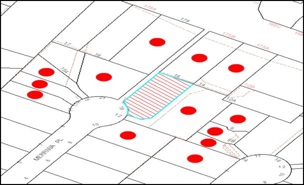
|
NOTIFICATION PLAN |
|
||
|
• PROPERTIES NOTIFIED
|
X SUBMISSIONS RECEIVED |
PROPERTY SUBJECT OF DEVELOPMENT |
|
6. THE PUBLIC INTEREST
Section 79C(1)(e) of the Act requires Council to consider “the public interest”.
The public interest is an overarching requirement, which includes the consideration of the matters discussed in this report. Implicit to the public interest is the achievement of future built outcomes adequately responding to and respecting the future desired outcomes expressed in environmental planning instruments and development control plans.
The application is considered to have satisfactorily addressed Council’s criteria and would provide a development outcome that, on balance, would result in a positive impact for the community. Accordingly, it is considered that the approval of the proposed subdivision would be in the public interest.
CONCLUSION
The application proposes Torrens title subdivision of one allotment containing two attached dwellings into two allotments. The subdivision is consistent with the pattern of subdivision in the locality and character of the surrounding area.
The application does not comply with the Hornsby Shire Council Local Environmental Plan 1994 in respect to Clause 14 ‘Density’ and Clause 15 ‘Floor Space Ratio’. The applicant submitted a State Environmental Planning Policy No. 1 objection to the minimum lot size and floor space ratio development standards. The objection is considered well founded with regard to the existing attached development and the principles established by the Land and Environment Court.
There were no submissions received in response to notification of the proposed subdivision.
Having regard to the circumstances of the case and consideration of the SEPP 1 objection, the application is recommended for approval.
Note: At the time of the completion of this planning report, no persons have made a Political Donations Disclosure Statement pursuant to Section 147 of the Environmental Planning and Assessment Act 1979 in respect of the subject planning application.
|
James Farrington Group Manager Planning Division |
Rod Pickles Manager - Development Assessment Planning Division |
|
1.View |
Locality Map |
|
|
|
2.View |
Subdivision Plan |
|
|
File Reference: DA/28/2013
Document Number: D02137795
SCHEDULE 1
GENERAL CONDITIONS
The conditions of consent within this notice of determination have been applied to ensure that the use of the land and/or building is carried out in such a manner that is consistent with the aims and objectives of the relevant legislation, planning instruments and Council policies affecting the land and does not disrupt the amenity of the neighbourhood or impact upon the environment.
Note: For the purpose of this consent, the term ‘applicant’ means any person who has the authority to act on or the benefit of the development consent.
Note: For the purpose of this consent, any reference to an Act, Regulation, Australian Standard or publication by a public authority shall be taken to mean the gazetted Act or Regulation, or adopted Australian Standard or publication as in force on the date that the application for a construction certificate is made.
1. Approved Plans and Supporting Documentation
The development must be carried out in accordance with the plans and documentation listed below and endorsed with Council’s stamp, except where amended by Council and/or other conditions of this consent:
|
Plan No. |
Drawn by |
Dated |
|
Plan of Proposed Subdivision – S.15057 |
P. S. Graham and Associates |
20 December 2012 |
REQUIREMENTS PRIOR TO THE ISSUE OF A CONSTRUCTION CERTIFICATE
2. Stormwater Drainage – Dwellings
1.1 The stormwater drainage system for the development must be designed and constructed for an average recurrence interval of 20 years and be gravity drained in accordance with the following requirements:
a) Designed and certified by a chartered professional engineer in accordance with Hornsby Council’s Civil Works Design Specification and Australian Standard AS 3500.3 – Plumbing and Drainage.
b) Connected directly to Council’s street drainage system.
Note: A construction certificate shall be obtained prior to the commencement of these works and are to be completed prior to the issue of a subdivision certificate.
REQUIREMENTS PRIOR TO THE COMMENCEMENT OF ANY WORKS
3. Erosion and Sediment Control
Erosion and sediment control measures must be provided and maintained throughout the construction period in accordance with the manual ‘Soils and Construction 2004 (Bluebook)’, the approved plans, Council specifications and to the satisfaction of the principal certifying authority. The erosion and sediment control devices must remain in place until the site has been stabilised and revegetated.
Note: On the spot penalties up to $1,500 may be issued for any non-compliance with this requirement without any further notification or warning.
REQUIREMENTS PRIOR TO THE ISSUE OF A SUBDIVISION CERTIFICATE
4. Sydney Water – s73 Certificate
A s73 Certificate must be obtained from Sydney Water.
5. Damage to Council Assets
Any damage caused to Council’s assets as a result of the construction of the development must be rectified in accordance with Council’s written requirements and at the sole cost of the applicant.
6. Creation of Easements
The following matter(s) must be nominated on the plan of subdivision under s88B of the Conveyancing Act 1919:
a) A right of access and easement for services.
b) An inter-allotment drainage easement(s) over each of the burdened lots.
Note: Council must be nominated as the authority to release, vary or modify any easement, restriction or covenant.
- END OF CONDITIONS -
ADVISORY NOTES
The following information is provided for your assistance to ensure compliance with the Environmental Planning and Assessment Act, 1979, Environmental Planning and Assessment Regulation 2000, other relevant legislation and Council’s policies and specifications. This information does not form part of the conditions of development consent pursuant to Section 80A of the Act.
Environmental Planning and Assessment Act, 1979 Requirements
The Environmental Planning and Assessment Act, 1979 requires:
· The issue of a construction certificate prior to the commencement of any works. Enquiries regarding the issue of a construction certificate can be made to Council’s Customer Services Branch on 9847 6760.
· A principal certifying authority to be nominated and Council notified of that appointment prior to the commencement of any works.
· Council to be given at least two days written notice prior to the commencement of any works.
· Mandatory inspections of nominated stages of the construction inspected.
· An occupation certificate to be issued before occupying any building or commencing the use of the land.
Subdivision Certificate Requirements
A subdivision certificate application is required to be lodged with Council containing the following information:
· A surveyor’s certificate certifying that all structures within the subject land comply with the development consent in regard to the setbacks from the new boundaries.
· A surveyor’s certificate certifying that all services, drainage lines or access are located wholly within the property boundaries. Where services encroach over the new boundaries, easements are to be created.
· Certification that the requirements of relevant utility authorities have been met.
· A surveyor’s certificate certifying finished ground levels are in accordance with the approved plans.
Note: Council will not issue a subdivision certificate until all conditions of the development consent have been completed.
Fees and Charges – Subdivision
All fees payable to Council as part of any construction, compliance or subdivision certificate or inspection associated with the development (including the registration of privately issued certificates) are required to be paid in full prior to the issue of the subdivision certificate. Any additional Council inspections beyond the scope of any compliance certificate required to verify compliance with the terms of this consent will be charged at the individual inspection rate nominated in Council's Fees and Charges Schedule.
Group Manager’s Report No. PL30/13
Planning Division
Date of Meeting: 17/04/2013
12 DEVELOPMENT APPLICATION - SECONDARY DWELLING - 10 ST HELENS AVENUE, MOUNT KURING- GAI
EXECUTIVE SUMMARY
|
DA No: |
DA/1384/2012 (Lodged 31 December 2012) |
|
Description: |
Erection of a secondary dwelling |
|
Property: |
Lot 69 DP 6586, 10 St Helens Avenue, Mount Kuring-gai |
|
Applicant: |
Mrs Alicia Taylor |
|
Owner: |
Mr Peter Smith and Mrs Alicia Taylor |
|
Estimated Value: |
$80,000 |
|
Ward: |
A |
· The application is for the erection of a secondary dwelling (granny flat) at the rear of the property.
· The proposed development requires the removal of an individually significant, locally indigenous, tree which is visible from neighbouring properties and street and contributes to the amenity of the streetscape.
· Alternative locations are available on the property to permit the secondary dwelling to be constructed that would enable retention of the tree and minimise impacts.
· A red sticker has been placed on the application requiring that the application be determined at a Council meeting.
· One submission has been received in respect of the application.
· It is recommended that the application be refused.
|
THAT Development Application No. DA/1384/2012 for the erection of a secondary dwelling at Lot 69 DP 6586, No. 10 St Helens Avenue, Mount Kuring-gai be refused for the reasons detailed in Schedule 1 of Group Manager’s Report No. PL30/13. |
BACKGROUND
On 18 July 2011, TA/722/2011 for the removal of a Swamp Mahogany (Eucalyptus robusta) in the rear of the property was lodged with Council. Council’s Tree Management Team assessed the tree as significant and in fair condition and recommended the tree be retained. Accordingly, on 1 August 2011, the tree application was refused.
On 16 August 2012, DA/846/2012 for the erection of a detached cabana in the rear of the property was lodged with Council. The proposed development required the removal of the 26 metre high Swamp Mahogany (Eucalyptus robusta), which was the subject of the refused tree application. Council’s tree assessment of the proposal noted that the tree is locally indigenous and individually significant. The tree is visible from neighbouring properties and street and contributes to the amenity value of the street. It was also noted that there is sufficient room on the property to permit the cabana to be constructed and for the tree to be retained. Subsequently, on 12 November 2012, the applicant withdrew the application.
SITE
The 923.2m2 site is located on the western side of St Helens Avenue, Mount Kuring-gai. The site has a gentle fall from the front, north-eastern corner to the rear south-western corner.
The front portion of the site is bush fire prone. The proposed secondary dwelling would be located at the rear which is not bush fire prone land. The site is not located within a heritage conservation area or near any heritage-listed items and is not flood prone. It is also not burdened by any easements.
The site contains a two storey brick dwelling with a double garage at the rear and carport on the side of the dwelling. The site is surrounded by low-density residential development.
PROPOSAL
The application proposes the erection of a secondary dwelling at the rear of the property. The secondary dwelling consists of a combined kitchen/living/bedroom area and a bathroom with a deck at the front. One large Swamp Mahogany (Eucalyptus robusta) is proposed to be removed to accommodate the secondary dwelling.
ASSESSMENT
The development application has been assessed having regard to the ‘Metropolitan Plan for Sydney 2036’, the ‘North Subregion (Draft) Subregional Strategy’ and the matters for consideration prescribed under Section 79C of the Environmental Planning and Assessment Act 1979 (the Act). The following issues have been identified for further consideration.
1. STRATEGIC CONTEXT
1.1 Metropolitan Plan for Sydney 2036 and (Draft) North Subregional Strategy
The Metropolitan Plan for Sydney 2036 is a broad framework to secure Sydney’s place in the global economy by promoting and managing growth. It outlines a vision for Sydney to 2036; the challenges faced, and the directions to follow to address these challenges and achieve the vision. The Draft North Subregional Strategy acts as a framework for Council in its preparation of the Comprehensive LEP.
The Draft North Subregional Strategy sets the following targets for the Hornsby LGA by 2031:
· Employment capacity to increase by 9,000 jobs; and
· Housing stock to increase by 11,000 dwellings.
The proposed development would be consistent with the Metropolitan Plan for Sydney 2036 by providing additional housing opportunities.
2. STATUTORY CONTROLS
Section 79C(1)(a) requires Council to consider “any relevant environmental planning instruments, draft environmental planning instruments, development control plans, planning agreements and regulations”.
2.1 Hornsby Shire Local Environmental Plan 1994
The subject land is zoned Residential A (Low Density) under the Hornsby Shire Local Environmental Plan 1994 (HSLEP). The objectives of the zone are:
(a) to provide for the housing needs of the population of the Hornsby area;
(b) to promote a variety of housing types and other land uses compatible with a low density residential environment; and
(c) to provide for development that is within the environmental capacity of a low density residential environment.
The proposed development does not satisfy objective (c) as it requires the removal of a locally indigenous, individually significant tree. Accordingly, the proposed development in its proposed location is not within the environmental capacity of the site.
The proposed development is defined as ‘multi-unit housing’ under the HSLEP and is permissible in the zone with Council’s consent.
Clause 18 of the HSLEP sets out heritage conservation provisions for Hornsby Shire. The site is not identified as an item of heritage and is not within a heritage conservation area nor is it in the vicinity of a heritage item.
2.2 Draft Comprehensive Hornsby Local Environmental Plan
The draft Hornsby Local Environmental Plan (DHLEP) was endorsed by Council at its meeting on 19 December 2012 to be forwarded to the Minister for Planning and Infrastructure to be made. In accordance with Councils resolution, the draft Plan has been submitted to the Department for finalisation.
Under the DHLEP, the subject land would be zoned R2 (Low Density Residential). The land-use is defined as ‘secondary dwellings’ and would be permissible in the zone.
2.3 State Environmental Planning Policy (Affordable Rental Housing) 2009
The application has been assessed against the requirements of SEPP (Affordable Rental Housing) 2009. This Policy provides State-wide planning controls for secondary dwellings that provide for affordable rental accommodation. The following table sets out the proposal’s compliance with the prescriptive standards of the Plan for development applications:
|
SEPP (Affordable Rental Housing) 2009 – Secondary Dwellings |
|||
|
Control |
Proposal |
Requirement |
Compliance |
|
Total Floor Space Ratio |
0.3:1 |
0.4:1 (per HSLEP) |
Yes |
|
Area of granny flat |
60sqm |
60sqm |
Yes |
|
Site Area |
923.2sqm |
450sqm |
Yes |
|
Parking |
Not provided |
No additional parking required |
Yes |
Whilst the proposal was not lodged as complying development, an assessment against the complying development standards for secondary dwellings has been undertaken as a guideline for the assessment of the proposal and to identify areas requiring detailed consideration.
|
SEPP (Affordable Rental Housing) 2009 – Secondary Dwellings Complying Development Standards |
|||
|
Control |
Proposal |
Requirement |
Compliance |
|
Lot width |
15.24m |
15m |
Yes |
|
Site Coverage |
29% |
50% |
Yes |
|
Area of granny flat |
60sqm |
60sqm |
Yes |
|
Total floor area |
280.7sqm |
430sqm |
Yes |
|
Building Height |
4.7m |
8.5m |
Yes |
|
Setback from side boundaries |
2m and 4.24m |
1.5m |
Yes |
|
Setback from rear boundary |
3m |
5m |
No |
|
Landscaped Area |
36% |
35% (min dimension 2.5m) |
Yes |
|
Principal Private Open Space for granny flat |
105sqm |
24sqm 4m wide |
Yes |
The assessment undertaken above indicates that the secondary dwelling cannot be complying development as the proposal does not comply with the rear setback criteria of the SEPP. This non-compliance and an evaluation against the other requirements of the SEPP, are discussed below:
2.3.1 Setbacks
The SEPP states that development for the purposes of a secondary dwelling must not result in a building having a setback from a rear boundary of less than 5 metres. The proposed secondary dwelling has a setback of 3 metres from the rear boundary which does not comply with the SEPP.
The reduced rear setback places the proposed secondary dwelling in a location that would result in adverse privacy impacts on the adjoining properties No. 18 St Helens Avenue and No. 6/17 Brisbane Avenue. This matter is discussed in detail in section 2.3.3.
2.3.2 Landscaping
The proposed development involves the removal of a 26 high metre Swamp Mahogany (Eucalyptus robusta) at the rear of the property. Council’s tree assessment concludes that the tree is locally indigenous and individually significant. The tree is visible from neighbouring properties and street and contributes to the amenity value of the streetscape. Given the size of the property and the location of the existing dwelling at the street frontage, opportunity is available to site the secondary dwelling to facilitate retention of the tree.
2.3.3 Privacy
The location of the proposed secondary dwelling at the rear of the property would result in adverse privacy impacts on the adjoining properties at No. 18 St Helens Avenue and No. 6/17 Brisbane Avenue. Given the topography, the subject property is located on higher ground than the adjacent properties and subsequently overlooks the backyards
The south and west elevations of the proposed secondary dwelling contain large windows of approximately 2m2 each. The windows are located in the main living area of the secondary dwelling and are orientated towards the side and rear boundaries. It is acknowledged that privacy impacts could be mitigated by requiring a minimum sill height of 1.5 metres for windows along the southern and western elevations of the secondary dwelling.
Given its location, the proposed development does not ensure reasonable privacy in the private open space of adjacent properties to the south and west for existing and future residents. Accordingly, the proposed development compromises the privacy and enjoyment of the adjacent property and is considered unacceptable in this regard.
2.3.4 Design
The design of the secondary dwelling is low scale and generally meets the requirements of the SEPP in terms of height, bulk and scale. However, the proposed development would require the removal of an individually significant locally indigenous tree which contributes to the amenity of the street and is visible from neighbouring properties and street. Therefore, the proposal is not sympathetic to natural features of the land.
Alternative locations are available on the property to permit the secondary dwelling to be constructed that would enable retention of the tree and minimise impacts. For example, converting the existing double garage into a secondary dwelling would allow the tree to be retained and with a greater rear setback, reduce overlooking of adjacent properties.
3. ENVIRONMENTAL IMPACTS
Section 79C(1)(b) of the Act requires Council to consider “the likely impacts of that development, including environmental impacts on both the natural and built environments, and social and economic impacts in the locality”.
3.1 Natural Environment
As discussed in section 2.3.2, the proposed development involves the removal of an individually significant tree that is visible from neighbouring properties and street and contributes to the amenity value of the streetscape. Accordingly, the proposed development would have a negative impact on the natural environment of the locality.
3.2 Built Environment
The proposed secondary dwelling would be located in the rear of the property and being single storey, would not be visible from the street. Notwithstanding the removal of the tree, the proposed development would not alter the streetscape or have a negative impact on the built environment of the locality.
3.3 Social Impacts
The State Environmental Planning Policy (Affordable Rental Housing) 2009 was introduced to increase the supply and diversity of affordable rental and social housing in NSW. The Policy facilitates the delivery of affordable rental housing, including secondary dwellings. Secondary dwellings provide housing for very low income households, low income households and moderate income households. Accordingly, the proposed development would have a positive social impact on the locality by providing additional housing choice in the locality.
3.4 Economic Impacts
The proposal would not result in an economic impact.
4. SITE SUITABILITY
Section 79C(1)(c) of the Act requires Council to consider “the suitability of the site for the development”. The location of the proposed secondary dwelling on the site is not suitable as it requires the removal of a significant tree and results in adverse privacy impacts. As discussed in section 2.3.4, alternative locations are available on the property to permit the secondary dwelling to be constructed that would enable retention of the tree and minimise impacts.
5. PUBLIC PARTICIPATION
Section 79C(1)(d) of the Act requires Council to consider “any submissions made in accordance with this Act”.
5.1 Community Consultation
The proposed development was placed on public exhibition and was notified to adjoining and nearby landowners between 24 January 2013 and 14 February 2013 in accordance with Council’s Notification and Exhibition Development Control Plan. During this period, Council received one submission. The map below illustrates the location of those landowners who were directly notified of the development application and who made a submission.
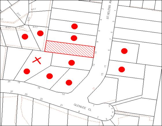
|
NOTIFICATION PLAN |
|
||
|
• PROPERTIES NOTIFIED
|
X SUBMISSIONS RECEIVED |
PROPERTY SUBJECT OF DEVELOPMENT |
|
The submission objects to the proposed erection of a secondary dwelling generally on the following grounds:
· The proposed development requires the removal of a significant tree which is a habitat for local wildlife.
· Two Illawarra Flame (Brachychiton acerifolius) trees may be damaged by any building work.
· Height, size and position of the proposed secondary dwelling.
· The proposed development would overlook the backyard of No. 18 St Helens Avenue and have adverse privacy impacts.
· Stormwater discharge would overflow into No. 18 St Helens Avenue and the proposed development would be built over existing sewerage pipes prohibiting future access.
· A fence of solid construction would be required to be erected on unstable land to block the development.
The merits of the matters raised in the community submission have been addressed in the body of the report with the exception of the following:
5.1.1 Damage to Illawarra Flame (Brachychiton Acerifolius) Trees
Illawarra Flame (Brachychiton acerifolius) trees are not indigenous to Hornsby Shire and are exempt under Council’s Tree Preservation Order.
5.1.2 Stormwater Drainage and Sewerage Pipes
Council’s engineering assessment of the proposal raises no objections subject to the stormwater drainage system for the development being designed and constructed for the average recurrence interval of 20 years and be gravity drained and connected directly to Council’s street drainage system.
5.1.3 Erection of a Fence
No fencing is proposed as part of the development and any proposal to replace the existing side boundary fence would be considered under the Dividing Fences Act 1991.
6. THE PUBLIC INTEREST
Section 79C(1)(e) of the Act requires Council to consider “the public interest”.
The public interest is an overarching requirement which includes the consideration of the matters discussed in this report. Implicit to the public interest is the achievement of future built outcomes adequately responding to and respecting the future desired outcomes expressed in environmental planning instruments and development control plans.
The proposed development would not be visible from the street and would not have a negative impact on the built environment. Provision of affordable housing would also have a positive social impact on the locality. However, the application would have a negative impact on the natural environment with the removal of a significant tree. Given the tree is visible from neighbouring properties and street and contributes to the amenity value of the streetscape, refusal of the proposed development would be in the public interest.
CONCLUSION
The application proposes the erection of a secondary dwelling (granny flat) in the rear of the property. The proposed development would result in the removal of a significant locally indigenous tree and adverse privacy impacts on adjoining properties. Alternative locations are available on the property to permit the secondary dwelling to be constructed that would enable retention of the tree.
The proposed development does not meet Council’s planning controls and is not satisfactory having regard to the matters for consideration pursuant to Section 79C of the Environmental Planning and Assessment Act, 1979.
Having regard to the circumstances of the case, refusal of the application is recommended.
Note: At the time of the completion of this planning report, no persons have made a Political Donations Disclosure Statement pursuant to Section 147 of the Environmental Planning and Assessment Act 1979 in respect of the subject planning application.
|
James Farrington Group Manager Planning Division |
Rod Pickles Manager - Development Assessment Planning Division |
|
1.View |
Locality Map |
|
|
|
2.View |
Architectural Plans |
|
|
|
3.View |
Stormwater Management Plans |
|
|
File Reference: DA/1384/2012
Document Number: D02137812
SCHEDULE 1
1. The proposal is unsatisfactory in respect to Section 79C(1)(b) of the Environmental Planning and Assessment Act 1979, as the proposal would result in adverse environmental impacts requiring the removal of a significant tree.
2. The proposal is unsatisfactory in respect to Section 79C(1)(b) of the Environmental Planning and Assessment Act 1979, as the proposal would result in adverse privacy impacts to adjoining properties.
3. The proposal is unsatisfactory in respect to Section 79C(1)(c) of the Environmental Planning and Assessment Act 1979, as the location of the proposed development is not suitable and alternative locations are available on the property to permit the secondary dwelling to be constructed that would enable retention of the tree and minimise impacts.
- END OF REASONS FOR REFUSAL -
Group Manager's Report No. PL20/13
Planning Division
Date of Meeting: 17/04/2013
13 NORTH WEST RAIL LINK CORRIDOR STRATEGY
EXECUTIVE SUMMARY
· The draft North West Rail (NWRL) Corridor Strategy was released by the Department of Planning and Infrastructure (DP&I) for public consultation on 16 March 2013. Submissions will be received until 30 April 2013.
· The NWRL is a priority railway transport infrastructure project for the NSW Government providing eight new stations and services over a 23 km rail line from Epping to Rouse Hill.
· The draft Strategy, including draft Structure Plans for each new station based on a walkable catchment, has been prepared to guide development within the corridor. An extra 27,400 homes and 49,500 jobs are predicted by the draft Strategy over the next 25 years.
· The draft Strategy does not propose the rezoning of land within the precincts, but aims to engage with the community and stakeholders to identify a future vision for precincts surrounding the stations and establish a framework for managing future land use change.
· A total of 1,800 additional dwellings and 50 additional jobs are predicted for the Cherrybrook Study Area. The draft Strategy envisages that over the long term, the future character of the Cherrybrook Study Area will comprise low to medium density residential dwellings, ranging in height from 2 – 3 storey town houses to 3 – 6 storey apartments with higher density developments located closest to the station.
|
THAT: Council forward the submission attached to Group Manager’s Report No. PL20/13 to the Department of Planning and Infrastructure generally supporting the State Government’s draft North West Rail Link Corridor Strategy subject to concerns being addressed regarding funding and delivery of infrastructure necessary to support the proposed level of development. |
PURPOSE
The purpose of this report is to advise Council of the Department’s NWRL Corridor Strategy and provide recommendations for a submission as attached to this report.
BACKGROUND
In 2011, the NSW State Government released details of its priority railway transport infrastructure project, the NWRL. The NWRL will be operated under a public private partnership offering a high-frequency, metro style, single deck train service between Rouse Hill and Epping. The existing Epping to Chatswood line will also be upgraded to cater for the different type of trains. The NWRL will be integrated with the CityRail network and include eight new stations and services over a 23 km rail line from Epping to Rouse Hill.
The approval of the first Environmental Impact Statement (EIS) was granted by the Minister for Planning and Infrastructure in 2012 and includes:
· two 15.5km rail tunnels between Epping and Bella Vista;
· excavation works for railway station construction, including the underground caverns; and
· above ground construction, including a 4km viaduct structure between Bella Vista and Rouse Hill.
The second EIS was exhibited in late 2012 for the design and operation of the rail link; commuter car parking; transport interchanges; and identification of immediate precincts around the eight new rail stations. To date, the Minister’s consent has not been granted for the works proposed under the second EIS.
In 2012, the Department of Planning and Infrastructure commenced investigations and structure planning for the areas surrounding the North West Rail Link station precincts. An inter-agency working group, comprising representatives from the Department of Planning and Infrastructure, Transport for NSW and Blacktown, The Hills and Hornsby Councils was established to consider station precincts and to provide feedback on the Department’s Strategic and Structure Planning Review of the stations and surrounding areas.
The NWRL Corridor Strategy, including draft Structure Plans for each Station Study Area, was released by the Department for public consultation on 16 March 2013. The closing date for submissions is 30 April 2013.
Although Epping Station is part of the NWRL, planning for the area around Epping Station is being progressed as part of the Department’s Epping Urban Activation Precinct Proposal. Group Manager’s Report No. 21/13 considers proposed State Environmental Planning Policy (Epping Town Centre Precinct) which proposes to rezone the Epping Town Centre as a Urban Activation Precinct for a mix of residential, retail and community uses. The proposed SEPP has also been released by the Department for public consultation until 30 April 2013.
DISCUSSION
This report outlines the draft NWRL Corridor Strategy and identifies its implications for Hornsby Shire, particularity in respect of the draft Cherrybrook Station Structure Plan. Given its proximity to Hornsby LGA, the report also includes consideration of the draft Castle Hill Station Structure Plan.
North West Rail Link
The NSW State Government anticipates that the NWRL will meet the challenge of future growth in the region by:
· Providing rail access between North West Sydney and Epping, Macquarie University, Macquarie Park, Chatswood, St Leonards, North Sydney and the Sydney Central Business District (CBD), including new rail services to existing centres in the Hills District;
· Reducing vehicle trips by making all modes of public transport an attractive and accessible alternative to the private motor vehicle; and
· Improving travel times from, to and within, the North West and delivering a reliable, dependable service.
The State Government submits that the construction of the NWRL provides the opportunity to plan for and build liveable centres around each of the proposed new stations through the creation of sustainable, well designed, higher density mixed use precincts connected by frequent rail and bus services. The NWRL will also provide opportunities to grow patronage and increase access to public transport to help communities access jobs and services closer to home.
The State Government also comments that the NWRL has the potential to be a transformative project, and provide a once in a generation opportunity to fully integrate land use, transport and infrastructure planning in North-West Sydney. The principle of transit growth oriented development will maximise the benefits of this major rail infrastructure investment, and provide the potential to assist deliver dwelling and employment growth for the area.
North West Rail Link Corridor Strategy
Future growth in the NWRL corridor will occur within the local government areas of Hornsby, The Hills and Blacktown Councils. The draft NWRL Corridor Strategy, including the draft Structure Plans for each Station Study Area, has been prepared to guide development within the corridor over the next 20 - 25 years.
The Study Area for each station precinct was formulated by the Department in consultation with a working group consisting of staff representatives from the 3 Councils. The boundary for each Study Area is based generally on a radius of approximately 800m from each station. This distance is generally considered to reflect a 10 minute walking trip.
The draft Strategy does not propose to rezone land within the Study Areas. However, the draft Strategy aims to engage with the community, land owners, state and local government agencies to identify a future vision for the precincts surrounding the NWRL stations and to establish a framework for managing future land use change. It is intended that the Department’s precinct planning process will serve to inform further strategic infrastructure planning within the NWRL corridor to ensure that long term housing and employment growth can be successfully delivered.
It is also intended that the draft Strategy will allow infrastructure agencies to identify, prioritise and co-ordinate the delivery of infrastructure upgrades in accordance with each precinct’s long term growth potential, providing increased transparency about the area’s growth infrastructure pipeline.
The draft NWRL Corridor Strategy and the draft Structure Plans are to be considered at the strategic planning level. The draft Structure Plans will inform, and ultimately need to be implemented through, appropriate zonings and amendments to built form controls to guide the assessment of major projects and development applications within the NWRL corridor.
In preparing the draft Structure Plans for each Study Area, the Department advises that consideration has been given to the following matters:
· Role of each Study Area in the NWRL corridor;
· Analysis of the physical characteristics;
· Analysis of the existing planning controls;
· Identification of Opportunities for Growth;
· Vision for the Study Area;
· Growth Projections; and
· Actions and Implementation.
The draft Strategy provides a description of the future vision, draft Structure Plans and growth projections for each new Station Study Area.
Projected Dwelling and Employment Growth
The draft Strategy predicts a total of 27,400 new dwellings and 49,500 jobs within the Station Study Areas by 2036 as detailed below:
|
Station Study Areas |
Potential new homes by 2036 |
Potential new jobs by 2036 |
|
Cudgegong Road (Rouse Hill) |
3,500 |
4,250 |
|
Rouse Hill |
950 |
3,500 |
|
Kellyville |
4,400 |
800 |
|
Bella Vista |
4,400 |
10,500 |
|
Norwest |
4,350 |
13,200 |
|
Showground |
3,600 |
7,700 |
|
Castle Hill |
4,400 |
9,500 |
|
Cherrybrook |
1,800 |
50 |
The total projected growth would result in an increase in dwellings in the Station Study Areas from 10,850 in 2012 to 38,250 in 2036. The projected growth in jobs to be delivered in the Study Areas is an additional 49,600 jobs. This would result in an increase in jobs from 43,100 in 2012 to 92,600 in 2036.
Jobs in the commercial sector are projected to increase by 38,450, representing 66% of the total employment within the corridor by 2036. Jobs in the retail sector are projected to increase by 8,150, representing 19% of the total employment. Jobs in the industrial sector are projected to increase by 4,000, representing 7% of the total employment. Jobs in the bulky goods sector are projected to decrease by 1,000, representing 8% of the total employment within the corridor by 2036.
Comment:
The aim of the draft Strategy to facilitate transit oriented development (TOD) around each of the new stations is supported. The draft Strategy has the potential to deliver more compact urban forms, a reduced reliance on private motor vehicles and associated greenhouse reductions. TODs can also promote economic growth and unlock potential for investment in land development and urban renewal. Under the draft Strategy, local communities will also have the potential to benefit from future places that provide a range of civic uses and community facilities, employment opportunities and improved recreational and leisure opportunities.
The aim of allocating dwelling and employment targets, identifying centres and corridors, and coordinating infrastructure investment is also consistent with the approach taken by Council in the formation of the Hornsby Shire Housing Strategy and the preparation of the Hornsby and Ku-ring-gai Subregional Employment Study. However, the obligation for Councils to respond to the housing and employment targets within each Study Area should be matched by the confirmation of State government agencies to deliver associated infrastructure and services, in addition to the delivery of the NWRL.
Whilst it is intended that the NWRL will promote changes in travel behavior and decrease the reliance on private motor vehicle, the success of this shift is dependent upon the delivery of the NWRL prior to significant redevelopment occurring. Significant residential development of the projected 27,400 additional dwellings and 49,500 jobs within the Corridor prior to completion of the NWRL will not reduce the current dependency on private vehicles.
It is sound planning practice for infrastructure and services to be provided prior to development. Timing of the delivery of development within each of the Station Study Areas is important. Significant intensification of development within the precincts consistent with the densities projected in the draft Strategy will result in motor vehicles dependence if dwellings and jobs are delivered prior to completion of the NWRL. This in turn will place considerable pressure on the road network, not only with the corridor, but the surrounding region.
Development which is dependent upon the road rather than the rail, even in the short term, would result in significant increases in traffic levels and has the potential to impact on local road networks and the operation of critical intersections within the three Council areas.
Concern is also raised regarding the ability of State agencies to deliver required infrastructure and services in a timely and coordinated manner to supplement the projected dwelling and job numbers. In progressing the rezoning of areas for increased residential densities, the State government should be satisfied that services and infrastructure will be provided to cater for increased demand. The need for new and upgraded infrastructure and services should be further investigated under the Strategy before the Councils consider the progression of rezoning within the Study Areas, including but not limited to:
· Required road and intersection upgrades;
· Improvements to bus networks, including the establishment of strategic bus corridors where required;
· Amplification of water and electricity services;
· Acquisition of additional open space for active recreation;
· Provision of additional education and health services;
· Public Domain Upgrades; and
· Stormwater and overland flow mitigation.
Recommendation
· The draft Strategy should clearly identify actions and timeframes for the delivery of key components on the NWRL to enable the Councils to consider options for the timing and progression of investigations for the rezoning within the Study Areas.
· An infrastructure plan should be prepared and included in the Strategy detailing required/suggested works within each of the Study Areas.
· The need for new and upgraded infrastructure and services should be further investigated under the Strategy before the Councils consider the progression of rezoning within the Study Areas, including the ability of State agencies to deliver required infrastructure and services to supplement the projected dwelling and job numbers.
Cherrybrook Station Study Area
The NWRL includes a new station at Cherrybrook. The station will be located within Hornsby Shire immediately north of Castle Hill Road, between Robert Road and Franklin Road. The Station will primarily serve as an ‘origin’ station for the surrounding residential population in the suburbs of Cherrybrook and West Pennant Hills.
The Cherrybrook Station Study Area is an established low density residential area that covers approximately 187 hectares, and encompasses lands within Hornsby Shire and The Hills Shire Local Government Areas. The Study Areas existing housing stock comprises 1-2 storey, mostly detached, houses set on large blocks, with strong landscaped settings and extensive vegetation.
The boundary of the Study Area is generally based on the nearest road boundary within a radius of 800m from Cherrybrook Station. The Study Area is bisected by Castle Hill Road, a major arterial road located on the top of a ridgeline that also separates the two Local Government Areas. The Study Area extends to Edward Bennett Drive to the east, Coonara Avenue (The Hills Council) to the south, Highs Road (The Hills Council) and County Drive to the west and John Road to the north.
Cherrybrook Station Draft Structure Plan
The introduction of the NWRL has the potential to transform the Cherrybrook Station Study Area by providing a new focal point for the community centred around the new station. The draft Strategy proposes that a mix of neighbourhood shops and services be provided within the immediate station area to provide for the daily needs of the local community. The NWRL will also provide opportunities to increase residential densities within walking distance of the station, involving a variety of housing types to ensure there is affordable and appropriate housing for all members of the community.
Drawing on the analysis and existing land uses within the Study Area, the draft Structure Plan is proposed to retain the residential character of the Area with some uplift north of Castle Hill Road, in close proximity to the station precinct. The Draft Structure Plan integrates this uplift with the surrounding built form through a graduation of height. The area north of Castle Hill Road is proposed to have two distinct sub-precincts.
The sub-precinct with direct access to the station is proposed to become medium density residential characterised by 3-6 storey apartments. The second sub-precinct is also proposed to become medium density residential, characterised by 2-3 storey townhouses. To the south of Castle Hill Road, the draft Structure Plan proposes to retain the existing low density residential character due to significant slope constraints and resultant disconnection from the station. Some new or improved pedestrian/cycle links are proposed within this area and their implementation would be subject to further investigation and consultation.
New links are recommended in the draft Structure Plan to increase connectivity between Edward Bennett Drive, Franklin Road and Robert Road. These links could be either pedestrian and/or vehicular connections. Recognising existing significant vegetation and parks within the area, a green link is proposed between Robert Park, an area of Blue Gum High Forest and the proposed station precinct. This link could become a pedestrian and cycle connection between Robert Road and the station. Castle Hill Road will remain the primary east-west thoroughfare within the Study Area, supported by Highs Road/County Drive and Coonara Avenue/Edward Bennett Drive links, which will remain significant in connecting the southern West Pennant Hills suburb with New Line Road.
The Coonara Avenue Business Park site within The Hills LGA and the Inala and Tangara Schools within Hornsby Shire LGA have been identified as significant sites and the potential for future land use nominated. The draft Structure Plan indicates that these sites will be subject to further consideration and collaboration with stakeholders, to determine their likely role in the future.
The draft Structure Plan notes that the redevelopment of sites within the Study Area, and the establishment of a new neighbourhood centre immediately adjacent the Station, will provide significant opportunities to improve the Study Area’s public domain.
The draft Structure Plan identifies the potential for 1,800 additional homes and 50 new jobs within the precinct by 2036. A demand analysis has been undertaken to ascertain the demand for potential development scenarios within the Study Area. Outcomes from the demand analysis show:
· Future demand for additional residential development in the Study Area is estimated to be 80 dwellings per year comprised of townhouses (19%) and 3-6 storey apartments (81%) in addition to the existing stock of housing diversity.
· Future demand for additional employment floor space is projected to remain constant in the Study Area through to 2036.
· Due to the high level of amenity and quality of life afforded within the Study Area at present and the added accessibility delivered by the NWRL, the take up rate is considered to be 100% for housing and 100% for employment.
Comment
The following discussion evaluates the consistency of the vision for Cherrybrook Station Study Area with Council’s planning frame work and comments on the timing for the delivery of housing and infrastructure requirements to support future development within the Study Area.
Housing Projections
Council has previously applied a take up rate of 80% in determining residential capacity under Council’s previous housing strategies and the Epping Town Centre Study. The draft Strategy assumes a take up rate of 100%, in projecting anticipated dwelling numbers within the Study Area by 2036. The 100% take up rate has not been applied to the whole Study Area but only to those areas that have been identified as being “opportunity sites” following the constraints and opportunity analysis undertaken as part of the draft Strategy. Sites which are currently and proposed to be used for special uses within the Study Area such as schools, the railway station and public utilities and which occupy a reasonable proportion of the Study Area, have not been identified as “opportunity sites” under the draft Strategy. Further, large areas of land within the Study Area which the draft Strategy has identified as likely being constrained as a result of the analysis, have also not been identified as “opportunity sites”, not withstanding that further more detailed investigation of those sites may determine that they have development potential, albeit reduced. Having regard to these factors, a take up rate of 100%, although unrealistic, is generally reasonable in this instance.
The draft Strategy anticipates that 400 townhouses could be delivered within the Low/Medium Density sub-precinct and 1,750 medium density dwellings could be delivered in the Medium Density sub-precinct. This equates to 17 dwellings per hectare within the Low/Medium Density sub-precinct and 100 dwellings per hectare within the Medium Density sub-precinct. Having regard to the dwelling numbers being achieved within Council’s Housing Strategy Precincts, these density projections are considered reasonable. To facilitate the projected development within the sub-precincts 300 existing detached dwellings would need to be demolished, resulting in a total of 1,800 additional dwellings within the Study Area.
Consistency with Council’s Planning Framework
It is acknowledged that the provision of housing within the Cherrybrook Station Study Area would assist Council meet its dwelling targets under the State Government’s Metropolitan Strategy and the draft North Subregional Strategy. The Hornsby Shire Housing Strategy was gazetted on 2 September 2011, providing opportunities for an additional 2,600 dwellings over the next 10 years. The Epping Urban Activation Precinct currently being exhibited by the DP&I provides opportunities for approximately 2,850 additional dwellings within Hornsby Shire by 2036 to meet part of the remaining 3,900 dwellings required to meet the balance of Council’s dwelling obligation of 11,000 dwellings by 2036.
However, the draft Metropolitan Strategy for Sydney recently released by the NSW Government makes provision for 545,000 new homes and 625,000 new jobs within Sydney by 2031, an increase on previous targets by 17% and 33% respectively. The detail of how this growth will translate into individual targets for each of the Local Government Areas of the new North Subregion is not contained in the draft Strategy and its impact on Council’s existing housing and jobs targets is unknown.
To deliver the draft Structure Plan’s projected growth, current zoning and planning controls for the study area will require detailed review by Council. Prior to a more detailed review by Council, the State Government should undertake more detailed investigations and planning within the Cherrybrook Study Area to inform future rezonings based on a more detailed understanding of constraints, local infrastructure requirements and the impact of the construction and operation of the station including:
· Biodiversity;
· Overland flow ;
· Drainage augmentation;
· Cycle way and pedestrian networks; and
· Local road upgrades.
Similarly, Development Control Plans and Section 94 Plans may need to be revised in light of the anticipated development and the local infrastructure needs. The draft Structure Plan also identifies the need to consult with the owners of major landholdings within the Study Area, in particular the existing private schools to determine the likely future use of the land until 2036.
Further, Council should not consider progressing rezoning within the Cherrybrook Study Area until after the release of the sub-regional plan to provide further guidance on updated dwelling targets for the North Subregion.
Delivery of Housing in the Short Term
Although the draft Cherrybrook Station Structure Plan provides an indication of the development opportunities within the precinct, this work would be required to be reviewed and more detailed investigations undertaken. Public exhibition of a detailed masterplan should also be undertaken to ensure the views of the community are included as part of the process.
A number of key steps would be required to be undertaken prior to housing being delivered as outlined in the following table:
|
Step |
Description |
Lead Responsibility |
|
Step 1: Detailed Rezoning Investigation |
Detailed local planning is undertaken leading to rezoning of area and development of an infrastructure contributions plan. |
DP&I, Council |
|
Step 2: Servicing |
If required key infrastructure is upgraded to accommodate new dwellings |
Infrastructure Agencies, Developers |
|
Step 3: Subdivision |
Approval of development application, construction of works and title registration. |
Council /Developers |
|
Step 4: Sale
|
Marketing of land to builders and home purchasers. |
Land Owner/Developers |
Previous experience in undertaking a more detailed review, masterplanning and the preparation of planning proposals has shown that this process would likely take a minimum of 3-4 years. Council and developers would then have the lead responsibility for the remaining steps in the process, including development application activity/construction and land/housing sale. Accordingly, following any release of the area, it is likely that housing would be provided within the precinct in 4-6 years.
Infrastructure and Service Requirements
The NSW State Government indicates that the NWRL will be in operation by 2020. As indicated previously, whilst it is intended that the NWRL will promote changes in travel behavior and decrease the reliance on private motor vehicle, the success of this shift is dependent upon the delivery of the NWRL. Although the second EIS has been exhibited, the works proposed under the second EIS have not yet been approved by the Minister. Development of the projected 1,800 additional dwellings within the Cherrybrook Study Area prior to the completion of, and in the absence of the NWRL, has the potential to result in high vehicle dependency due to low levels of access to public transport currently provided to the area. The increased vehicle movements would have significant impact on the current level of service within the adjoining road network and intersections.
Accordingly, prior to Council commencing detailed structure planning of the Study Area, further commitment should be obtained from key Government agencies concerning the scope and costs of any additional infrastructure works required to facilitate development of the precinct, in particular confirmation of the delivery of the NWRL. The final Strategy should clearly identify actions and timeframes, assign responsibility and allocate funding for the delivery of these actions.
The funding plan should also included details of works within each Study Area, with clear delineation between funding to be provided by future proponents and the commitment of funds by the State Government to address the balance of any costs. This will enable Council to identify any funding shortfalls prior to progressing rezoning of the land. This would include confirmation of the delivery of the community facility within the station “mixed use sub-precinct”, as recommended in the draft Structure Plan. Given the zoning uplift proposed for this sub-precinct, the delivery of the community facility should be provided as part of the future development of this mixed use precinct, with its delivery and funding detailed in any future agreement between the developer and the State Government, who currently owns the land.
Recommendation
· The delivery of the community facility should be a requirement of the contract to develop the Cherrybrook Station and not the responsibility of Council to fund under a Development Contributions Plan.
· The DP&I should prepare or fund Council to prepare the detailed environmental studies required to inform a planning proposal for the Cherrybrook Station Precinct.
Castle Hill Station Precinct
Castle Hill is identified as a Major Centre for the North West under the existing and draft Metropolitan Strategy. The Centre is an important retail and business centre for the region, containing community facilities and higher density residential development within 1km of the Centre. The NWRL includes a new underground station at Castle Hill. The new train station will be located beneath Arthur Whitling Park, near the existing bus interchange, in the centre of Castle Hill.
Castle Hill Draft Structure Plan
The introduction of the NWRL and a station at Castle Hill provides opportunity to reinforce Castle Hill as the Major Centre for Sydney’s North West. The new station will provide further impetus for Castle Hill to evolve as a vibrant and active Centre comprising offices, retailing, community facilities, recreation, cultural, education and housing to serve the 500,000 people of the North West by 2036.
The draft Structure Plan identifies the potential for 4,400 homes and 9,500 new jobs within the Castle Hill Study Area by 2036. The draft Structure Plan proposes an enlarged commercial core for Castle Hill to ensure the jobs targets for 2036 are achieved and that Castle Hill becomes the Major Centre for the North West. The existing retail and commercial premises have been included in a mixed use zone under the draft Structure Plan for the area north of Castle Street to provide flexibility to respond to market demands for a variety of uses over the short to medium term.
High density residential development opportunities of 7-20 storeys have been identified under the draft Plan surrounding the commercial/ retail core to benefit from direct access to the bus and rail transport interchange and the mix of uses and facilities in the core. Medium density living comprising of 3-6 storey apartments are proposed to be located within the residential areas on the periphery of the core within a 10 minute walk of the station. Beyond this, townhouses, duplexes and single-detached dwellings will deliver a diversity of housing accessible to the Centre.
Comment
The Castle Hill Station Study Area is located less than 300m from the boundary of Hornsby Shire. Access to the Study Area from the north and north east is proposed through Hornsby Shire along Castle Hill Road and Old Northern Road. Both roads currently experience significant delays during the morning and afternoon peaks, as well as moderate levels of congestion throughout the day.
As discussed previously, a reduced reliance on private motor vehicles will be dependent upon the delivery of the NWRL. Significant residential development of the projected 4,400 additional dwellings within the Castle Hill Station Study Area prior to completion of the NWRL has the potential to result in high vehicle dependency and a significant increase in vehicle movements within the existing road system.
In particular additional traffic within the Castle Hill Station Study Area has the potential to impact on the local road network and the operation of critical intersections within Hornsby Shire along Castle Hill Road, Old Northern Road and New Line Road. The draft Strategy should clearly identify actions and timeframes for the delivery of key components on the NWRL, this will enable the Councils to consider options for the timing and progression of investigations for the rezoning within the Study Areas.
Recommendation
· The DP&I should coordinate a regional traffic study for the corridor to identify and upgrade the regional road network to accommodate the intensification and growth of development around the NWRL as projected by the Corridor Strategy.
Summary
In summary, it is recommended that Council forward a submission to the DP&I indicating its general support for the draft NWRL Corridor Strategy and confirm that the Strategy’s aim to facilitate transit oriented development around each of the new stations is supported in principle. The submission should also request that concerns raised in this report in respect of the timing of the delivery of development within the corridor and the need for funding of infrastructure and further investigations within the precincts should be addressed in finalising the Strategy.
BUDGET
There are no budgetary implications associated with this Report.
POLICY
There are no policy implications associated with this Report.
CONCLUSION
The draft NWRL Corridor Strategy was released by the DP&I for public consultation on 16 March 2013. The draft Strategy has been prepared to guide development within the NWRL corridor. The draft Strategy aims to facilitate opportunities for an extra 27,400 homes and 49,500 jobs over the next 25 years.
The State Government should be commended for their endeavors to facilitate transit oriented development around each of the new stations. However, a number of issues should be addressed in finalising the draft Strategy that will assist in ensuring that the Strategy fulfils its stated aims.
It is recommended that Council forward a submission to the DP&I as attached requesting that the issues outlined in this report be addressed in finalising the Strategy.
RESPONSIBLE OFFICER
The officer responsible for the preparation of this Report is the Fletcher Rayner, Manager Strategic Planning who can be contacted on 9847 6744.
|
Fletcher Rayner Manager - Strategic Planning Planning Division |
James Farrington Group Manager Planning Division |
|
1.View |
Draft Submission to Department of Planning and Infrastructure |
|
|
File Reference: F2012/00597
Document Number: D02125015
Group Manager's Report No. PL21/13
Planning Division
Date of Meeting: 17/04/2013
14 EPPING URBAN ACTIVATION PRECINCT
EXECUTIVE SUMMARY
· The NSW Government has announced the identification of eight Urban Activation Precincts (UAP) across Sydney for renewal with up to 30,000 additional homes.
· The proposed SEPP seeks to rezone the Epping Town Centre for a mix of residential, commercial, retail and community uses. The proposal would amend Hornsby and Parramatta Local Environmental Plans (LEPs) by establishing land use zones, building heights, floor space ratio and heritage provisions.
· A draft Structure Plan and draft Development Control Plans (DCPs) for Hornsby and Parramatta Councils have also been prepared as part of the UAP Proposal to guide future development within the Centre, including recommendations for built form and the public domain.
· The UAP Proposal would facilitate 3,650 additional dwellings within the Centre, including opportunities for 2,850 additional dwellings within Hornsby Shire. This is less than the 4,200 additional dwellings projected under the Epping Town Centre Study (ETCS) 2011, which identified a maximum of 3,200 additional dwellings within Hornsby Shire.
|
THAT: Council forward the submission attached to Group Manager’s Report No. PL21/13 to the Department of Planning and Infrastructure generally supporting the State Government’s proposed State Environmental Planning Policy (Epping Town Centre Precinct) subject to addressing concerns regarding consistency with Council’s draft Hornsby LEP, timing of design details for recommended intersection upgrades and inclusion of a delayed commencement provision prior to finalising the SEPP. |
PURPOSE
The purpose of this report is to present the Department’s proposal for the Epping Town Centre Precinct UAP and seek endorsement of a submission as attached to this report.
BACKGROUND
At its meeting on 20 June 2012, Council resolved to endorse the recommendations of the Epping Town Centre Study (ETCS) 2011 subject to further review of specified matters and to forward a Planning Proposal to the Department to implement the recommendations. A Planning Proposal was subsequently forwarded to the Department in accordance with Council’s resolution. Council has not received Gateway Determination from the Department in respect of the Planning Proposal.
The UAP Support Scheme was announced in the 2012-2013 budget as part of the NSW State Government’s Building the State package. The Scheme is to provide financial support of $50 million to local councils for infrastructure upgrades required as a result of population growth within UAPs. UAPs are areas that the Minister for Planning and Infrastructure considers have a wider social, economic or environmental significance for the community or have redevelopment significance of a scale that is important to implementing the State’s planning objectives.
On 22 June 2012, the Department of Planning and Infrastructure (DP&I) sought nominations from Local Government for potential urban activation precincts.
In June 2012, the NSW State Government also announced funding of the road and intersection upgrades recommended under the ETCS 2011, as part of the Government’s Housing Acceleration Fund.
At its meeting on 15 August 2012, Council resolved to nominate the Epping Town Centre for consideration by the Department under the Urban Activation Precinct program as an alternative to a planning proposal. Council also resolved to advise that the nomination was on the basis that planning controls be progressed in accordance with the Epping Town Centre Study recommendations and the findings of specific matters raised in response to public submissions including Heritage Conservation Area (HCA) boundaries, potential heritage items, urban form in the Town Centre Core, residential precinct heights, property acquisition and North West Rail Link (NWRL) impacts.
In October 2012, the NSW Government endorsed the Epping Town Centre as an Urban Activation Precinct. The DP&I advised that the Epping Town Centre Precinct was endorsed as an UAP for its capacity to produce new housing growth close to existing and proposed transport infrastructure such as the NWRL. The Epping UAP adopted the same boundary as applied by the ETCS 2011 and includes both Hornsby and Parramatta Local Government Areas.
In December 2012, the DP&I commenced investigations and structure planning for the Epping Town Centre UAP. An inter-agency working group, comprising representatives from the Department, Roads and Maritime Services (RMS), as well as Hornsby and Parramatta Councils was established to provide feedback on the Department’s strategic and structure planning review of the Centre.
Councillor and staff representatives from Hornsby and Parramatta Councils also provided feedback to the Department during the UAP planning process through representation on the Epping Town Centre Steering Committee who met on two occasions on the 5 and 19 of February 2013.
On 16 March 2013, the NSW Government announced the identification of eight UAPs across Sydney for renewal, with up to 30,000 additional homes. The exhibition of proposed SEPPs for the rezoning of the Epping Town Centre and the North Ryde Station Precincts as UAPs and the commencement of planning work on the remaining precincts was also announced. Submissions on the UAP Proposal for the Epping Town Centre and North Ryde Station Precincts will be received until 30 April 2013.
The North Ryde Station Precinct Proposal seeks to rezone 13.99ha of land next to the North Ryde Railway Station to facilitate future development comprising a mix of residential, commercial, retail, community and recreational uses. The North Ryde Station Precinct Proposal estimates that a total gross floor area of 341,000m² of residential and commercial development could be provided across the Precinct in buildings up to 33 storeys.
DISCUSSION
The NSW State Government’s proposal seeks to rezone Epping Town Centre as an Urban Activation Precinct for a mix of residential, commercial, retail and community uses. Identifying redevelopment opportunities within the Precinct is considered important in responding to the housing pressures in Sydney by locating new homes in close proximity to public transport with excellent access to employment opportunities. The rezoning process will establish a site specific planning regime for the Precinct by amending the Hornsby and Parramatta local environmental plans. The amendment would establish land use zones, building heights, floor space ratio and heritage provisions. The process will also revise and strengthen the heritage conservation of large areas of traditional low scale residential development located in the precinct.
The Epping Town Centre Precinct Planning Report provides an overview of the Department’s UAP Proposal. A draft Structure Plan and draft DCPs have has also been prepared to guide future development including recommendations for built form and the public domain.
This report outlines the work undertaken by the Department in its review of the recommendations of the ETCS 2011 and considers the Epping Town Centre Precinct UAP Proposal, including its implications for the Hornsby Shire.
Epping Town Centre UAP Strategic Planning Review
The following work was undertaken by the Department in its consideration of the recommendations of the ETCS 2011, following declaration of Epping Town Centre as a UAP.
Urban Design Peer Review
The Department engaged an urban design consultant, Architectus, to undertake a peer review of the recommendations of the ETCS 2011, including built form and alternative urban design opportunities.
The Architectus review generally supports the key recommendations of the ETCS 2011 including concentrating residential growth close to the railway station and preference for tall, slim towers above street level podiums. The peer review recommendations contain some key differences from the ETCS 2011 including:
· potential for additional commercial floor space in buildings closest to the railway station;
· building heights up to 27 storeys for key sites in the town centre core to maximise growth potential while meeting solar access requirements;
· residential units above the two storey podium in Oxford Street to be set back a greater distance from the street to maintain the existing streetscape character; and
· a greater range of building options within the residential intensification areas including smaller residential flat buildings on single lots.
Comment
Further consideration of alternate urban form, including building heights and envelopes nominated in landowner submissions for properties within the Town Centre Core was previously identified by Council in its resolution on June 2012, as being a matter requiring further consideration in respect of the progression of the recommendations of the ETCS 2011. The completion of the peer review by Architectus on behalf of the Department, address matters previously identified by Council as requiring further investigation.
Heritage and Archaeology Review
The Department engaged Perumal Murphy Alessi to review the proposed Rosebank Avenue, East Epping and Essex Avenue HCAs. The review considered the extent of the conservation areas to be protected and appropriate planning controls for adjoining sites to protect the heritage qualities of those areas.
The review confirms the level of significance and appropriateness of the conservation areas proposed within the Hornsby LGA. Three proposed conservation areas have been identified for listing:
· East Epping Heritage Conservation Area
The review concludes that the proposed East Epping HCA contains a number of heritage and contributory items. It is recommended that this conservation area remain as previously proposed, with some minor changes to the boundary to reflect the location of contributory items.
· Essex Street Heritage Conservation Area
The review recommends that the proposed Essex Street HCA, should remain as previously proposed, with a minor boundary adjustment to the south to reflect the location of contributory items including two existing heritage items.
· Rosebank Avenue Heritage Conservation Area.
The extent of the Rosebank Avenue Conservation Area is endorsed in recognition of the number of contributory dwellings in the street. Recommendations are also provided to restrict development of properties to the west and south to minimise impact on the proposed conservation area.
The review also considers the heritage significance of 22 potential heritage items in the Hornsby LGA. The review concludes that all but one of the proposed items (property No. 10 Chester Street) are of heritage significance.
The areas and items recommends for inclusion in Council’s heritage schedule are incorporated into the draft Structure Plan. The review also provides recommendations with respect to transitional heights from the residential intensification areas to the proposed HCA and these are reflected in the draft Structure Plan and the proposed DCP.
The Department also engaged Archaeology and Heritage Consulting to undertake a review of an early colonial timber getting establishment in Oxford Street, in respect of its potential archaeological significance. The review recommends that the site and other lands within Oxford Street be identified as having archaeological significance under the proposed LEP.
Comment
Further review of proposed HCA boundaries, potential items of archeological significance, potential heritage items and the relationship of proposed HCA boundaries with proposed residential intensification areas, were previously identified by Council in its resolution on June 2012, as being a matter requiring further consideration in respect of the progression of the recommendations of the ETCS 2011.
The completion of the heritage review by Perumal Murphy Alessi and the archaeological review by Archaeology and Heritage Consulting address matters previously identified by Council as requiring further investigation.
Economic Feasibility Testing
The Department engaged Hill PDA to undertake an economic feasibility analysis of key sites within the Study Area. The aim of the analysis was to determine the controls needed to achieve economically feasible development within the Centre, to provide greater certainty that the planned growth would occur.
The report identifies minimum gross floor areas and associated floor space ratios needed to achieve economically feasible development on the key sites, based on various assumptions. These findings have been incorporated into the floor space controls in the draft Structure Plan.
Comment
The economic feasibility testing undertaken by Hill PDA supplements the earlier economic feasibility assessments prepared for the ETCS 2011. The testing confirms that the proposed controls would facilitate economically feasible development.
North West Rail Link
The approval of the first Environmental Impact Statement (EIS) was granted by the Minister for Planning and Infrastructure in 2012 and includes:
· two 15.5km rail tunnels between Epping and Bella Vista;
· excavation works for railway station construction, including the underground caverns; and
· above ground construction, including a 4km viaduct structure between Bella Vista and Rouse Hill.
The second EIS was exhibited in late 2012 for the design and operation of the rail link, commuter car parking, transport interchanges and identification of immediate precincts around the eight new rail stations. To date, the Minister’s consent has not been granted for the works proposed under the second EIS.
The two EIS confirm the extent of proposed works associated with the construction of the NWRL and the impact on the Epping Town Centre. In particular, both EIS outline works in association with the construction of the Epping Services Facility, a permanent facility on Beecroft Road within the Epping Town Centre. As a result of this work, the affected properties, located within the town centre core, will not be available for increased residential or commercial development under the Epping UAP proposal.
Comment
Exhibition of the first and second NWRL EIS have identified the likely impact of the NWRL on Epping Town Centre and provide further certainty regarding development opportunities within the Centre.
Epping Town Centre UAP Proposal
The Epping Town Centre Precinct Planning Report provides an overview of the Department’s UAP Proposal.
The UAP rezoning process seeks the establishment of a site specific planning regime for the Epping Town Centre by way of an amendment to the Parramatta LEP and the Hornsby Shire Local Environmental Plan (HSLEP). The proposed amendment has been prepared on the basis of the provisions of the State Government’s Standard Instrument. The planning process seeks to establish land use controls, building heights and floor space ratios to facilitate the redevelopment of parts of the precinct for a mix of residential, commercial, retail and community uses.
The draft Epping Town Centre Structure Plan contains a suite of site specific development controls that are recommended for adoption for each Council. These controls are documented in draft Development Control Plans for each Council. A Public Domain Concept Plan is also provided as part of the draft Structure Plan.
Details of the proposal are provided below:
Draft Epping Town Centre Structure Plan
The draft Epping Town Centre Structure Plan generally endorses the vision and key recommendations in the ETCS 2011 and the recent peer review by Architectus in 2012. The vision for the Centre is:
· a compact, high density town centre core;
· taller buildings above podium levels set back from key streets;
· a range of retail and commercial activities at lower levels fronting the street to serve the local population;
· increased residential densities adjoining the town centre core to allow for 2-6 storey apartment buildings in five new residential areas close to the town centre core;
· heritage conservation areas and heritage items not to be subject to increased dwelling density;
· revitalised and new public domain to create a lively centre;
· improved connections, especially for pedestrians and cyclists; and
· clearer, safer connections through blocks to the station.
The draft Structure Plan provides the following key elements in respect to the Hornsby Shire component of the Centre:
Town Centre Core
Within the Town Centre Core, there are several small areas to be to be zoned R4 (High Density Residential), with the vast majority of the core to be rezoned B2 (Local Centre) for mixed uses. The proposed built form includes:
· Two storey ‘podium’ built to the street containing retail and commercial uses to retain perception of a ‘human’ scale of development when walking along the street.
· Above the podium, an additional two storeys can be provided for residential uses, but with increased setbacks from the street and side boundaries. This acts as a transition to the upper residential levels, which will be tall, slim towers, well-spaced and set back from the street.
· An additional podium setback is proposed for Oxford Street to maintain the existing village character.
Outside Town Centre Core
Outside the Town Centre Core, the majority of the precinct is proposed to remain as R2 (Low Density Residential) with some new areas of R3 (Medium Density Residential) within the Hornsby LGA.
The draft Structure Plan identifies five residential intensification areas outside the Town Centre Core for increased density. These areas are all within walking distance of the station. The height of developments within these areas will be two to eight storeys.
Heights
Within the Town Centre Core, maximum building heights will range from five storeys up to a maximum of 22 storeys (72 metres). The taller buildings are located closer to the railway corridor and Beecroft Road (within Parramatta LGA) to reduce potential visual and overshadowing impacts.
Areas of new medium density residential development will range from three to eight storeys in height. Where new medium density areas adjoin proposed HCAs, reduced heights are recommended to provide a transitional built form to the HCAs.
Floor Space Ratio
The Planning Report advises that the maximum Floor Space Ratios (FSR) within the precinct have been selected after considering a range of issues including:
· maximum size or density of a building after consideration of design factors; and
· minimum amount of floor space required to allow feasible development to occur.
The proposed FSR allocated to the residential intensification areas ranges from 1.0:1 to 1.5:1 and the FSR allocated within the town centre core ranges from 4.5:1 to 6.0:1.
Density
The proposed Structure Plan predicts a total of 3,650 dwellings within The Epping Town Centre, comprised of 2,850 within Hornsby Shire LGA and 800 for Parramatta City LGA.
Heritage Items and Conservation Area
In accordance with the recommendations of the heritage review, three proposed conservation areas within the Hornsby LGA have been identified for listing:
· East Epping Heritage Conservation Area;
· Essex Street Heritage Conservation Area; and
· Rosebank Avenue Heritage Conservation Area.
Twenty one new items have been identified for listing within the Hornsby LGA, including the identification of an area of potential archaeological significance over Nos. 2-50 and 1-41 Oxford Street.
Comment
The draft Epping Town Centre Structure Plan generally endorses the vision and key recommendations in the ETCS 2011. The ETCS 2011 recommendations projected a total of 4,238 additional dwellings for the Epping Town Centre, including a maximum of 3,203 dwellings for Hornsby LGA. The UAP Proposal identifies fewer dwellings than projected under the ETCS 2011, being a total of 3,650 and 2,850 within Hornsby Shire LGA.
The draft Structure Plan allocates the highest FSRs in the precinct to the Town Centre Core, which is generally consistent with the FSR strategy contained in the ETCS 2011. The proposed ranges of heights within the Town Centre Core are also generally consistent with the range recommended under the ETCS 2011.
The range of heights within the residential intensification area is generally consistent with the height range recommended under the ETCS 2011. However, reduced heights are now recommended adjacent to the proposed HCAs to provide transitional built forms.
The R3 (Medium Density Residential) zone and the R4 (High Density Residential) zone is promoted under the draft Structure Plan for land which will facilitate 3, 5 and 8 storey residential flat buildings. The proposed zonings should be reviewed so that they clearly delineate a hierarchy of building heights and housing forms, as has been done under the draft Hornsby LEP.
The heights proposed in the height categories under the draft Structure Plan do not match the height of building categories under the draft Hornsby LEP. For example, under the draft Hornsby LEP, a 17.5m height of building limit (category P1) has been applied to land where 5 storey residential flat buildings are promoted. Under the draft Structure Plan, proposed category P permits a height limit of 18m and also relates to 5 storey residential flat buildings areas. Under the draft Hornsby LEP, a 26.5m height of building limit (category T1) has been applied to land where 8 storey residential flat buildings are promoted. Under the draft Structure Plan, proposed category T permits a 28m height limit and relates to 8 storey areas in the Structure Plan.
Application of the height categories that are proposed for Epping Town Centre would result in a convoluted hierarchy of planning controls in both the draft Hornsby LEP and draft Hornsby DCP that would be difficult to interpret and implement. Also, it is noted that there are two references in the height of building legend to category J and J2 but only one is referenced on the map.
The proposed floor space ratio strategy for the residential zones does not match the floor space ratio philosophy promoted under the Hornsby LEP for the rest of the Shire. There are no FSR controls contained in the draft Hornsby LEP for residential zones. Instead a suite of controls to manage bulk and scale, including site coverage, building heights, setbacks, landscaped area and outdoor living area is included in the draft Hornsby DCP.
Application of FSR controls that are proposed in the Epping Town Centre would result in a hierarchy of planning controls in both the draft Hornsby LEP and draft Hornsby DCP that would be difficult to interpret and implement. Also, it is noted that there are two references in the FSR legend, T and T1 but only one reference appears on the map.
Recommendation
The proposed SEPP maps should be amended to address the inconsistency between the draft Structure Plan LEP maps and the Zoning, FSR and Height strategy applied by Council under the draft Hornsby LEP.
Public Domain Concept Plan
The draft Public Domain Concept Plan identifies a range of options that could be implemented to upgrade the public domain and realise the principles in the concept plan.
The key principles of the draft Public Domain Concept Plan are:
· develop a centre-wide concept while maintaining elements of each council’s approach;
· improve the sense of place through improved streetscapes and pedestrian connectivity;
· improve traffic, pedestrian and cyclist facilities;
· create a variety of public spaces and amenities;
· encourage clear way finding signage;
· increase street tree planting for cooler streets; and
· provide better air quality and more attractive streets.
The Planning Report notes that a Precinct Support Scheme is available to fund some of these works although it is unlikely that all works could be funded in the short term. The Public Domain Concept Plan identifies a range of opportunities for public domain improvements within the Precinct. In particular, the Public Domain Concept Plan identifies opportunities for:
· coordinated public domain works with the two councils such as paving, way finding, signage, landscaping, street furniture, lighting and town centre branding;
· place making and intersection improvement; and
· redevelopment of Pembroke Street Town Square/ Epping Branch Library as a cultural hub an improved civic space and town square for the community along with a park.
The draft Public Domain Concept Plan also identifies broader public domain improvement opportunities outside the Precinct at West Epping Park. The Park is located north of Carlingford Road and Epping West Public School. Its location close to the LGA boundary means the Park effectively serves both Parramatta and Hornsby residents. The Park is currently used for a mix of sporting activities, including tennis, soccer, cricket and a YMCA facility. The draft Public Domain Plan notes that Council has recently purchased the adjoining recreation land, providing increased opportunities for development of the site as a local recreational hub at district level.
The Planning Report recommends that the full potential of this site be investigated and a Concept Plan for Epping West District Park be prepared. The Planning Report notes that the concept plan process for West Epping District Park will need to engage with and appreciate the needs and aspirations of the key sporting and local community stakeholders.
Comment
Investigation of the full potential of West Epping Park and preparation of a Concept Plan should be supported. Council has not been provided any certainty regarding the amount of money that will be allocated to Hornsby LGA under the Precinct Support Scheme. The process for allocating funding under the Precinct Support Scheme is not well documented and a more formalised process for allocating funding should be prepared by the Department to enable further investigation of public domain opportunities, such as West Epping Park.
Recommendation
Investigation of the full potential of West Epping Park and preparation of a Concept Plan should be supported. A more formalised process for allocating funding should be prepared by the Department to provide certainty and enable further investigation of public domain opportunities to support the Epping Town Centre Precinct, such as West Epping Park.
Public Open Space
Potential public domain improvements detailed in the draft Public Domain Plan are also supplemented by existing open space within the Epping Precinct at Forest Park. Forest Park and the northern adjoining property No. 725 Blaxland Road, Epping are shown as RE1 (Public Recreation) on the draft Land Zone Map in the draft Structure Plan. Property No. 725 Blaxland Road, Epping is the location of the former Epping Bowling Club and is currently in private ownership. Acquisition provisions under the Standard Instrument template provide for the acquisition by Council of privately owned land which is zoned RE1 (Public Recreation).
A rear access lane proposed under the draft Structure Plan to provide alternate access to property Nos. 4-18 Epping Road, Epping could also provide alternate access to property No. 725 Blaxland Road for open space purposes.
Comment
The proposed zoning of property No. 725 Blaxland Road, Epping is consistent with the Land Zone Map adopted by Council in respect of the draft Hornsby LEP and is a direct translation of the current open space zoning of the property under the HSLEP. The ETCS 2011 also recommends that the current acquisition provisions in respect of No. 725 Blaxland Road be maintained to support the future growth of Epping Town Centre. The acquisition of property No. 725 Blaxland Road, Epping was previously identified by Council in its resolution on June 2012, as being a matter requiring further consideration in respect of the progression of the recommendations of the ETCS 2011. The Department of Planning and Infrastructure has advised that issues regarding the future acquisition of property No. 725 Blaxland Road, Epping for open space is a local matter for consideration by Council.
Council’s recreational needs assessment of the proposal concludes that the Epping UAP Proposal will generate a significant increase in demand for open space within the locality. Whilst it is anticipated that the former West Epping Bowling Club land will provide additional space for active recreation, increased requirements for additional passive open space within Epping Town Centre would still need to be met.
Property No. 725 Blaxland Road would provide opportunities for additional passive recreation facilities adjacent the Town Centre Core, supplementing that currently provided within the adjacent Forest Park. The draft Structure Plan could include stronger linkages across the parts of Epping that are divided by Epping Road. Forest Park with the addition of the proposed open space acquisition at property No. 725 Blaxland Road would provide an open space area substantial in size but poorly linked because of railway and major road barriers that limit easy access.
Although the land directly adjoins Forest Park, only a portion of property No. 725 Blaxland Road is able to directly link into Forest Park due to substantial level changes. Property No. 725 Blaxland Road does however, provide a large flat area that is suitable for a range of recreation uses which may include:
· a skate park and related activities;
· a formalised leash free dog park where people and dogs can socialise; and
· a community building
The incorporation of an improved pedestrian bridge link is also a key element that should be included in the draft Structure Plan, to ensure that the new population has easy access to a large and attractive area of open space on the east side of the Town Centre. A footbridge crossing Epping Road should be provided to enable easy access into the planned open space parkland in this area, leading to more walking, running and cycling opportunities for the community.
The draft Hornsby LEP includes a Land Reservation Acquisition Map which includes reservations for local open space and road widening. Property No. 725 Blaxland Road, Epping is identified under the draft Land Acquisition Map. Accordingly, it is appropriate that a Land Acquisition Map be progressed as part of the suite of LEP maps for the Epping Town Centre under the proposed SEPP reflecting this.
The draft Structure Plan also identifies the provision of an access lane on property No. 725 Blaxland Road which is reserved for open space, to provide alternate access to property Nos. 4–18 Epping Road. As the lane is required to provide alternate access to private properties, it should be located on property Nos. 4–18 Epping Road. The location of the lane on land to be acquired by Council may present future difficulties if development of 4-18 Epping Road proceeds prior to acquisition of 725 Blaxland Road by Council.
Recommendation
· A footbridge crossing Epping Road should be provided to enable easy access into the planned open space parkland in this area, leading to more walking, running and cycling opportunities for the community.
· A Land Reservation Acquisition map be prepared to acknowledge any change to the existing land reservation and acquisition strategy contained in the draft Hornsby LEP.
· The draft Structure Plan be amended to relocate the access lane on No. 725 Blaxland Road to property Nos. 4-18 Epping Road.
Draft Hornsby Development Control Plan
To assist Council’s in the preparation and endorsement of DCP controls for Epping, the Department has prepared draft DCP controls for Parramatta and Hornsby Councils having regard to the format of each of the Council’s adopted DCPs. The draft Hornsby DCP has been considered in respect of the preparation of draft Epping DCP controls for Hornsby Shire. Accordingly, the layout and general requirements of the Epping Draft DCP for the Town Centre Core are generally consistent with those prepared in respect of other commercial centres and the draft controls for medium density development outside the core are generally consistent with those prepared for the Housing Strategy Precincts.
The car parking rates proposed by the Department in both Councils’ draft DCPs and also referenced in the Planning Report are less than those recently adopted by Council. The Department notes that the rates are appropriate given the proximity of future residential development to public transport routes, retail and other services provided in the Town Centre core. The Planning Report notes that if the parking rates were based solely on proximity to public transport and evidence from other similar transport node centres, there would be an argument for the rates being even lower. However, the Planning Report notes that the parking rate must also have regard to market demand for car parking spaces in new residential development. The Report also recommends that on street parking be time limited by the Councils to ensure that parking needs are being met for visitors to the Centre.
Comment:
Whilst the draft DCPs form part of the exhibition of the Epping UAP proposal, Part 3 of the Environmental Planning and Assessment Regulations requires that each Council adopt their own DCPs. The final format and content of DCP controls is dependent upon the timing of the gazettal of the proposed SEPP by the Department and the extent, if any, of changes to the UAP Proposal following the Department’s consideration of submissions.
Accordingly, a further report regarding the draft DCP would be prepared for Council’s consideration following finalisation of the SEPP. It is estimated that Council’s review, progression, exhibition and endorsement of draft DCP controls would take at minimum 4 months. Accordingly, it is appropriate that commencement of the proposed planning regime not become operational for at least 4 months from the gazettal of the SEPP.
Hornsby and Parramatta Councils currently have different rates for car parking within Epping Town Centre. A single set of parking controls for Epping Town Centre, which satisfies both Councils would ensure that the feasibility of development within the Centre is not unfairly impacted by different parking rates. Therefore, it is recommend that the car parking rates for Epping Town Centre be discussed with PCC, with a view to identifying opportunities for agreement on, and progression of a uniform set of car parking rates for adoption by both Councils. Progression of a DCP for Hornsby Council will also need to consider controls regarding those sites identified as having archaeological significance.
Recommendation
The proposed SEPP should not become operational for at least 4 months from the gazettal of the SEPP to enable Council to prepare, exhibit and adopt a DCP.
RMS Infrastructure Design and Traffic Modelling
The Planning Report confirms that growth identified by the draft Structure Plan for the Precinct is within the range contemplated by the analysis undertaken for the ETCS 2011. The Report also advises that the ETCS 2011 recommendations for short term road upgrades are being pursued by the NSW State Government. The report confirms that delivery of these intersection works is anticipated to occur over the next two to three years subject to Roads and Maritime Services completing detailed planning and design work.
Comment
In 2012, the NSW Government committed to providing funding through the Housing Acceleration Fund, to support additional growth in the Epping Precinct and to address short term regional traffic growth. Council has been advised that funding has been allocated from the 2012-13 Budget for road upgrades which could include:
· Epping Road/Essex Street intersection;
· Epping Road/Blaxland Road intersection;
· Carriageway widening – Epping Road;
· Carlingford Road/Beecroft Road intersection; and
· Pedestrian/cycle footbridges over the rail line.
Work on the upgrades is still being finalised by the RMS and will require consultation with Council for works on local roads. Progression of the proposed SEPP should not occur until such time as the design details of the proposed upgrades have been finalised and provided to Council for its consideration.
Part of the suite of road and intersection recommendations from the ETCS 2011, included the prohibition of right hand turns from the south bound lane in Langston Place. This recommendation is a local traffic matter and is not being progressed by the RMS. Progression of this recommendation by Council will require additional investigations by Council’s Traffic and Safety Branch, in parallel with the upgrade work being progressed by the RMS and should be identified on any future Section 94 Plan identified for the Precinct.
Recommendation
Progression of the proposed SEPP should not occur until such time as the design details of the proposed upgrades have been finalised and provided to Council for its consideration.
BUDGET
The UAP Program was announced in the 2012-2013 Budget as part of the NSW State Government’s Building the State package. The Precinct Support Scheme (PSS) will provide financial support to local councils valued at $50 million for infrastructure upgrades required as a result of population growth within UAPs.
Councils who partner with the NSW State Government in the UAP Program will be provided payments through the PSS to fund local infrastructure to address increased demand and create high quality urban environments. Local infrastructure projects could include open space, local roads, traffic calming measures and car parking requirements.
The Department’s Planning Report and the draft Public Domain Plan identifies a range of public domain opportunities within, and immediately adjacent to the Precinct. The Department is seeking feedback from the community about opportunities for funding of the delivery of public domain improvements.
Council will ultimately have responsibility for the delivery and management of these public domain improvements. Accordingly, Council has been working with the Department on the identification of appropriate public domain improvements to support the Precinct, as well as seeking appropriate levels of funding for these works.
POLICY
There are no policy implications associated with this Report.
CONCLUSION
The draft Epping Town Centre Precinct Proposal was released by the DP&I for public consultation on 16 March 2013. The UAP Proposal aims to establish land use controls, building heights and floor space ratios to facilitate the redevelopment of parts of the precinct for a mix of residential, commercial, retail and community uses to facilitate 3,650 additional dwellings within the Centre. The proposal would amend Hornsby and Parramatta Local Environmental Plans (LEPs) by establishing land use zones, building heights, floor space ratio and heritage provisions.
It is recommended that Council forward a submission to the DP&I identifying its general support for the proposed SEPP (Epping Town Centre Precinct) which seeks to facilitate transit oriented development around Epping Station. However, a number of issues should be addressed in finalising the draft SEPP and supporting documents that will assist in ensuring that the SEPP fulfills its aim.
It is recommended that Council forward a submission to the Department requesting that the issues outlined in this report be addressed in finalising the UAP Proposal.
Following finalisation of the SEPP, a further report will be presented to Council providing a review of the draft DCP controls, including consideration of car parking rates to be jointly negotiated with Parramatta Council.
RESPONSIBLE OFFICER
The officer responsible for the preparation of this Report is the Fletcher Rayner, Manager Strategic Planning - who can be contacted on 9847 6744.
|
Fletcher Rayner Manager - Strategic Planning Planning Division |
James Farrington Group Manager Planning Division |
|
1.View |
Draft submission to Department of Planning and Infrastructure |
|
|
File Reference: F2012/00866
Document Number: D02125024
Group Manager's Report No. PL28/13
Planning Division
Date of Meeting: 17/04/2013
15 PLANNING PROPOSAL - RECLASSIFICATION OF PROPERTY NO. 18X WATER STREET, HORNSBY
EXECUTIVE SUMMARY
· Property No. 18X Water Street, Hornsby, has an area of approximately 675m2 and is classified as Community Land. The site is considered surplus to Council’s open space needs.
· The Hornsby Shire Housing Strategy was gazetted in September 2011. The Strategy identified precincts throughout the Shire for multi-unit housing. Property No. 18X Water Street, Hornsby is located within the Belair Close Precinct.
· The Belair Close precinct is zoned Residential C (Medium/High Density) under the Hornsby Shire Local Environmental Plan 1994 (HSLEP) and R4 High Density Residential under the draft Hornsby Local Environmental Plan (HLEP) and permits multi-unit housing to a height of 5 storeys.
· Proponents have approached Council concerning development of the Belair Close Precinct and the opportunity to purchase and include property No. 18X Water Street as part of a development site.
|
THAT: 1. Council endorse progression of the Planning Proposal attached to Group Manager’s Report No. PL28/13 to reclassify property No. 18X Water Street, Hornsby from Community to Operational Land and revoke its public reserve status. 2. Pursuant to Section 56(1) of the Environmental Planning and Assessment Act 1979, Council forward the Planning Proposal to the Minister for Planning and Infrastructure seeking a Gateway Determination to progress the Planning Proposal. 3. Should the Minister determine under Section 56(2) of the Environmental Planning and Assessment Act 1979 that the matter may proceed without significant amendment to the Proposal, Council publicly exhibit the Planning Proposal in accordance with the Gateway Determination. 4. A public hearing pursuant to Section 57(6) of the Environmental Planning and Assessment Act be held following the exhibition of the Planning Proposal. 5. An independent facilitator be retained to conduct the public hearing for the reclassification of the land. 6. Following the exhibition, a report on submissions received in response to the public exhibition and public hearing be presented to Council. |
PURPOSE
The purpose of this report is to present a Planning Proposal to reclassify Lot 15 DP 204264 known as property No. 18X Water Street, Hornsby (Water Street Park) from community land to operational land and revoke its public reserve status.
BACKGROUND
Council prepared the Hornsby Shire Housing Strategy to identify areas for the provision of additional housing to assist meet Council’s housing obligations under the NSW State Government’s Metropolitan Strategy. The Housing Strategy identified precincts throughout the Shire for multi-unit housing, including a precinct in Belair Close, Hornsby. The Plan to implement the Housing Strategy was finalised by the State Government in September 2011.
The planning controls for the Belair Close Precinct have been amended to permit multi-unit housing to a height of 5 storeys. Property No. 18X Water Street, Hornsby sits within the Belair Close Precinct and is classified as Community Land.
In accordance with Clause 25 and 26 of the Local Government Act 1993 (LG Act 1993), all land within Council ownership is required to be classified as either Community or Operational land. The classification of these lands ultimately determines how Council manages the land.
Operational land may be sold or developed in accordance with the permitted use of the land having regard to any easements or restrictions as to user. However, Community land is generally reserved for public use with the following restrictions required by the LG Act 1993:
· cannot be sold;
· cannot be leased, licensed or any other estate granted over the land for more than 21 years; and
· must have a plan of management prepared for it.
SITE
Property No. 18X Water Street, Hornsby (known as the Water Street Park) was dedicated to Council in 1961 as a Public Reserve under Section 340A (Public garden and recreation spaces) of the Local Government Act 1919 as part of the subdivision of Belair Close. The property is zoned Residential C (Medium/High density) under the HSLEP and R4 (High Density Residential) under the draft HLEP. The allotment has an area of approximately 675m2and is located adjacent to the unformed section of Water Street. The site is predominately cleared and grassed, with mature vegetation along the northern boundary.
DISCUSSION
The Water Street Park is identified as Reserve No.328 in Council’s District 3 and 9 Community Land and Crown Reserves Generic Plan of Management and is classified as Community Land for a park. The Plan grades the existing level of service as ‘low’ and identifies the possible reclassification and rationalisation of the reserve following an assessment of open space needs and supply in the area.
As part of the preparation of the Housing Strategy, consideration was given to open space required to meet the recreational demand associated with the provision of additional housing. Council’s Leisure Strategic Plan was considered during this process. The Plan recommends the sale of relatively small and ‘low value’ open space sites with limited open space functions. The Plan states that there are a large number of small pocket parks throughout the Shire which have limited recreation value and are relatively expensive to maintain.
Although Water Street Park is defined as a public reserve, its suitability for recreational use is limited. Pocket parks typically range in size from 1000m2 to 5000m2 and contain facilities such as children’s playground equipment, seating, shade structures etc. The property is undersized for a pocket park and does not contain play equipment, seating or other facilities except for a trash rack and a concealed sewer line that runs through the reserve. The property is also adjacent to a stormwater outlet which is not physically separated from the reserve.
An existing pocket park to service the needs of local residents, known as Beatrice Thompson Park, is located in close proximity on the corner of Water Street and Albert North Street. The park is approximately 4000m2 and contains children’s playground equipment, seating and shade structures.
Given the sites zoning and location with respect to the Belair Close Precinct, Council has been approached concerning the opportunity to purchase and include 18X Water Street as part of a development site. To facilitate this outcome, a Planning Proposal is required to reclassify the property from Community to Operational. This would enable Council to consider the possibility of integrating the site within an adjoining development for multi-unit housing in accordance with its zoning and the Belair Close Precinct Key Principles Diagram (copy attached) contained in the Housing Strategy Development Control Plan.
The Key Principals diagram for Belair Close identifies the desired character and detailed controls for the development of 5 storey residential flat buildings, located within a landscape setting with associated underground car parking. The diagram identifies a building footprint that is inclusive of setbacks to provide for the orderly development of the precinct. The proposal to reclassify the subject property would provide for improved siting and design of a future development by providing a more regular shaped building footprint.
Accordingly, it is proposed to reclassify the site from Community to Operational land and discharge it from any trust in accordance with Section 27 of the LG Act 1993 by way of a Planning Proposal prepared under the Environmental Planning and Assessment Act 1979 as attached to this report. Should the proposal be supported, it is also recommended that Council revoke the public reserve status of the land Under Section 30 of the LG Act 1993 as part of the Planning Proposal.
Planning Proposals
The Planning Proposal to reclassify 18X Water Street, Hornsby outlines the objectives, intended outcomes and justification for the proposal and a consultation strategy for endorsement by the DP&I. It is recommended that Council facilitate the exhibition of the attached Planning Proposal by forwarding it to the DP&I for a Gateway Determination.
As part of the consideration of planning proposals, Council is required to consider the relevance of any State Environmental Planning Policy (SEPP) or Ministerial Direction under Section 117 of the Environmental Planning and Assessment Act, 1979. The proposal is not contrary to any SEPP or relevant Section 117 Directions. An assessment of relevant SEPPs and Section 117 Directions is contained in the Planning Proposal.
CONSULTATION
“A guide to preparing local environmental plans” has been prepared by the DOP&I (2009) to assist councils in preparing planning proposals and LEPs. In accordance with the Guidelines, the Planning Proposal is required to be exhibited for a period of 28 days. A consultation strategy relevant to the public exhibition of the draft LEP has been prepared as part of the Planning Proposal for endorsement by the DP&I.
The reclassification of land, in any instance, requires a public hearing to take place and conducted by an independent professional in accordance with Section 29 of the LG Act 1993. Within 21 days following the exhibition period, a public hearing must be held to ensure full community consultation. At the conclusion of the public hearing, a report will be prepared by the facilitator of the public hearing for Council’s consideration which details any submissions to the reclassification of land.
A report outlining the outcomes of the public agency consultation, submissions received during public exhibition and hearing would be presented to Council for its consideration at the conclusion of the exhibition period.
BUDGET
There are budgetary implications associated with the reclassification of the site. Council’s staff time and resources are required in the administration of the Planning Proposal and an independent person will need to be retained to conduct the necessary public hearing. The estimated minimum cost for obtaining a consultant to facilitate the public hearing and preparation of a report is approximately $2500. The monies for engagement of the consultant have been allocated from the Strategic Planning Branch’s Consultant budget.
Should the Planning Proposal result in the eventual sale of the property, proceeds could be reinvested into purchasing new open space or upgrading existing assets which are of greater benefit to the public. Disposal of the land would also enable Council to rationalise its current maintenance cost and redirect resources towards more functional reserves that currently meet the open space and recreation needs of the community.
POLICY
There are no policy implications associated with this Report.
CONCLUSION
The classification of public land determines how that land is operated and used by Council. The reclassification of property No. 18X Water Street from Community to Operational and revocation of the public reserve would facilitate the redevelopment of the site and surrounding properties for multi-unit housing in accordance with its zoning and the Belair Close precinct Key Principles Diagram contained in the Housing Strategy Development Control Plan. The property serves limited purpose as a public reserve due to its small size and proximity to a stormwater outlet.
It is recommended that Council endorse the Hornsby Quarry Planning Proposal for submission to the DP&I for Gateway Determination and exhibition.
RESPONSIBLE OFFICER
The officer responsible for the preparation of this Report is the Manager, Strategic Planning – Fletcher Rayner - who can be contacted on 9847 6744.
|
Fletcher Rayner Manager - Strategic Planning Planning Division |
James Farrington Group Manager Planning Division |
|
1.View |
Locality Plan |
|
|
|
2.View |
Key Principles diagram - Belair Close Precinct |
|
|
|
3.View |
Planning Proposal |
|
|
File Reference: F2004/07491-08
Document Number: D02137189
Group Manager's Report No. PL31/13
Planning Division
Date of Meeting: 17/04/2013
16 REVIEW OF SECTION 94 DEVELOPMENT CONTRIBUTIONS PLAN
EXECUTIVE SUMMARY
· Section 94 of the Environmental Planning and Assessment (EP&A) Act 1979 allows councils to require the payment of a monetary contribution for development which generates an increased demand on Council’s infrastructure, facilities and services.
· Section 94A of the EP&A Act allows councils to impose a levy based on a percentage of the proposed cost of carrying out development.
· A review of the existing Hornsby Section 94 Development Contributions Plan 2007-2011 and the gazettal of the Housing Strategy require an updated approach to fund infrastructure required to support future demand.
· The implementation of a Section 94A plan in addition to the update of the existing Contributions Plan will enable Council to collect monetary contributions to fund infrastructure in existing areas where there is little growth and the benefit of facilities to be provided is widely dispersed.
· New draft Section 94 and Section 94A Development Contributions Plans have been prepared to cater for the forecast increase in development and population between 2012 and 2021 (including development associated with the Housing Strategy).
· The new draft Section 94 Development Contributions Plan would repeal the existing Hornsby Section 94 Development Contributions Plan 2007-2011 and any unspent money held in restricted accounts would be used to complete the remaining projects associated with the Plan or be rolled over into the new draft Plans to be spent on the same or a similar project.
|
THAT:
1. Council exhibit the attached draft Section 94 Contributions Plan and draft Section 94A Contributions Plan for a period of 28 days.
2. Following the exhibition, a report on submissions be presented to Council. |
PURPOSE
The purpose of this report is to seek Council’s endorsement to exhibit new draft Section 94 and Section 94A Development Contributions Plans.
BACKGROUND
At its meeting on 5 August 2009, Council considered Report No. PLN59/09 concerning the existing Hornsby Section 94 Development Contributions Plan 2007-2011. The report noted that a review by an external consultant found a number of areas for improvement within the existing Plan. The review recommended that Council update the existing plan to address these matters. Further, the report noted that the adoption and gazettal of the Housing Strategy in 2011 would necessitate a new section 94 contributions plan to allow for new and embellished facilities catering for the growth anticipated by the Strategy.
Accordingly, Council resolved to invite expressions of interest from suitably qualified consultants to prepare a new section 94 contributions plan to replace the Hornsby Section 94 Development Contributions Plan 2007-2011.
DISCUSSION
In accordance with Council’s resolution, expressions of interest were sought from suitable consultants. Three submissions were received. After review and assessment of the submissions, Don Fox Planning was engaged to prepare new plans under section 94 and 94A of the EP&A Act. Draft Plans have been prepared and are discussed in this report.
Local infrastructure contributions under the EP&A Act 1979
Section 94
Section 94 of the EP&A Act allows councils to require the payment of a monetary contribution through conditions of consent for development which generates an increased demand on Council’s infrastructure, facilities and services. This ensures that new development contributes to the cost of providing new facilities and services or maintaining a level of service in the Shire and that existing ratepayers are not burdened with covering the costs of providing or upgrading roads, open space, libraries and community centres that are required to service the additional population. The contributions can only be authorised under a Contributions Plan which forecasts future development and outlines a schedule of works, including costings, for any upgrades or new work required.
Contributions Plans divide the costs of works generated by demand from future development between the new population and establishes contribution rates for various development types. The Environmental Planning and Assessment (EP&A) Regulation requires that a Contribution Plan identify the connection, or nexus, between the expected types of development and the demand for additional public amenities and services to meet that development.
Section 94 is one source of revenue that Council has available to fund capital works. The remaining capital works program is funded through other sources including grants, rates, general funds and asset rationalisation. During the period 2007 – 2011, funds from Section 94 contributions represented approximately 12% of Council’s total capital expenditure.
Section 94A
Section 94A of the EP&A Act allows councils to impose a levy based on a percentage of the proposed cost of carrying out development. Again, the contribution can only be authorised under a Contributions Plan. However, unlike a traditional Section 94 Plan, a Section 94A levy does not need to demonstrate a direct nexus between the works to be funded and the development to be levied. A Section 94A levy cannot be imposed if the same development is subject to a contribution under Section 94.
The EP&A Regulation sets out the maximum percentage levy that councils are able to apply based on development costs as follows:
|
Levy |
Cost of Development |
|
0% |
Under $100,000 |
|
0.5% |
$100,001 - $200,000 |
|
1% |
Over $200,000 |
The implementation of a Section 94A plan in tandem with a conventional Contributions Plan will enable Council to collect monetary contributions from areas where there is little growth and the benefit of facilities to be provided is widely dispersed. Whilst S94A plans provide for a lower contribution than conventional Contributions Plans, they provide greater flexibility in expenditure.
Previous Contributions Plans
Council has prepared and adopted four consecutive Contributions Plans under since 1993 and has collected and spent approximately $70 million. Council has not adopted a Section 94A Contributions Plan in the past.
The works program in the current Hornsby Section 94 Development Contributions Plan 2007 – 2011 is proposed to be replaced by new works schedules in the draft Section 94 and Section 94A Plans attached to this report. Items on the current works program which have not been completed have been reviewed to determine whether they remain consistent with current priorities and strategies, and whether there is a direct nexus which can be demonstrated between the need for the works and the demand generated by the forecast population since 2012. It is proposed that the following items from the current works schedule and any associated unspent restricted funds be rolled into the new draft Plans (either Section 94 or Section 94A):
· Multi-purpose community facilities (s94)
· Library buildings (s94)
· Hornsby Town Centre footpath widening/paving (s94)
· Signalisation of Sefton/Chilvers Road (s94A)
· Signalisation of Bridge and Hunter Street (s94)
· Florence Street and Hunter Lane Shareway (s94)
· Hastings Road roadworks (s94A)
· Cycleways (Bike Plan) (s94)
The remaining items have either been completed or will be completed using unspent money held in restricted Section 94 accounts. It is recommended that Council repeal the current Hornsby Section 94 Development Contributions Plan 2007 – 2011 when the new draft Plans come into effect and that any unspent money held in restricted accounts be used to complete remaining projects from the current works program or be rolled over into the new Plans to be spent on the same or a similar project.
New Draft Contributions Plans
Draft Section 94 Plan
The new draft Section 94 Plan will apply Shire wide and is based on growth from 2012 onwards. It has a 10 year planning period and will apply to new residential and commercial (retail and business) development.
The draft Plan is based on forecast development of 4,279 additional dwellings (and approximately 10,000 additional people) between 2012 and 2021. This includes 2,600 additional dwellings from the Housing Strategy. To cater for this forecast growth, an updated works program has been prepared and includes some uncompleted projects from the current Hornsby Section 94 Development Contributions Plan 2007 – 2011, along with other projects which are required to cater for existing residents as well as the forecast new population. Therefore, not all of the projects are able to be fully funded through Section 94 contributions.
The works program includes local road improvements, new and embellished open space and recreation facilities and the upgrading of local community facilities including libraries and community centres to a value of $146 million. Approximately $78 million can be directly attributed to the new population. The value of works attributable to the new population is summarised in works categories below:
|
Cost Attributable to new population |
|
|
Local Road Facilities |
$11,598,245 |
|
Local Open Space and Recreation Facilities |
$57,899,759 |
|
Local Community Facilities |
$8,114,688 |
|
Plan Preparation and Administration |
$265,500 |
|
TOTAL |
$77,878,192 |
The remaining value of the works program will be funded through rates, grants, unspent restricted funds from previous Section 94 plans, asset rationalisation, and the implementation of a Section 94A Plan (see below under heading Draft Section 94A Plan).
The draft Section 94 Plan divides the Shire into three catchments. The catchments proposed are as follows:
· North (suburbs north of Asquith and including most of the suburb of Dural);
· Central (the suburbs of Hornsby, Asquith and Waitara); and
· South (suburbs generally south of Waitara and Hornsby).
By dividing the forecast development in each catchment and the corresponding works item which can be attributed to the new population, contributions rates have been derived. Rates which would be applicable under the new plan are summarised below.
|
DEVELOPMENT TYPE |
BASE UNIT |
LOCALITY |
||
|
North |
Central |
South |
||
|
Dwelling House / New Lot |
Per dwelling |
$22,520.46 |
$23,836.04 |
$22,995.89 |
|
Attached, semi-detached dwellings, townhouses, granny flats/secondary dwellings |
Per dwelling |
$17,377.79 |
$18,693.37 |
$17,853.22 |
|
Residential Unit with 1 bedroom |
Per dwelling |
$9,372.19 |
$10,068.67 |
$9,623.89 |
|
Residential Unit with 2 bedrooms |
Per dwelling |
$14,984.97 |
$15,681.45 |
$15,236.67 |
|
Residential Unit with 3+ bedrooms |
Per dwelling |
$19,956.39 |
$20,846.34 |
$20,278.00 |
|
Seniors Housing |
Per dwelling |
$11,503.38 |
$11,735.54 |
$11,587.28 |
|
Retail Premises |
Per 100m2 GFA |
$6,936.26 |
$17,770.44 |
$10,851.59 |
|
Business Premises and Office Premises |
Per 100m2 GFA |
$2,032.68 |
$5,128.16 |
$3,151.34 |
|
Car Parking (Hornsby Town Centre) |
Per space |
- |
$26,847 |
- |
A Ministerial Direction sets a maximum $20,000 levy for residential development. This means that when a development consent is issued, a condition of development consent cannot require more than $20,000 per dwelling. Application of the cap will result in a shortfall of approximately $2.7 million (3.5%) over the 10 year plan period, meaning Council will have to fund approximately $270,000 per year to make up the shortfall from the cap.
The Plan has been drafted to show uncapped contribution rates in the event that the cap is increased or removed. The policy setting for Section 94 is currently under review by the NSW Government and the cap may change with the release of the White Paper and any subsequent new legislation to replace the EP&A Act.
The draft Section 94 Development Contributions Plan is attached to this report. The Plan contains four sections as follows:
· Section 1: Introduction - identifies the name of the Plan, the purpose, aims and objectives of the Plan, the land to which the Plan applies and the Plan’s relationship to other plans, reports and policies.
· Section 2: Administration and operation of the Plan - outlines the scope of the Plan, where the Plan applies, the infrastructure, services and facilities covered by the Plan, and describes how and when contributions are to be made.
· Section 3: Expected development and demand for community infrastructure - outlines the forecast future development and population (discussed above) and the basis for increased demand for facilities and services.
· Section 4: Community infrastructure and contributions - provides details of each category of community infrastructure in the Plan, including details of existing provision, nexus, apportionment and how contributions have been calculated.
The Appendices to the Plan include a Glossary which explains the meaning of words and terms used in the Plan, a detailed Works Schedule, maps showing the location of facilities, and pro-forma conditions for development consents and Complying Development Certificates.
Draft Section 94A Plan
This Plan proposes to introduce a fixed rate levy which will apply Shire wide to the following types of development:
· Additions and alterations to residential development;
· Alterations to commercial premises;
· Industrial development;
· Residential Care Facilities;
· Hostel/Boarding House/Group Home/Hospital/Educational Establishment;
· Tourist and Visitor Accommodation; and
· Any other development (other than new dwellings or additional commercial floor area which are levied under Section 94).
The works program under the Section 94A plan is made up of items which cannot be fully funded under the Section 94 plan, along with some additional traffic works and bushland improvements. The value of works which is anticipated to be funded through Section 94A, based on forecast development to 2021, is summarised by works category below:
|
Works Category |
Works anticipated to be funded under S94A |
|
Local Road Facilities |
$786,222 |
|
Local Open Space and Recreation Facilities |
$3,541,069 |
|
Local Community Facilities |
$2,739,285 |
|
TOTAL |
$7,066,576.00 |
To ensure that future commencement of the S94A Contributions Plan does not unfairly impact upon Development Applications lodged or under assessment prior to commencement of the Plan, savings provisions have been drafted to only require monetary contributions for Development Applications lodged after commencement of the plan.
The draft Section 94A Plan is attached to this report. The Plan contains two sections as follows:
· Section 1: Introduction - identifies the name of the Plan, the purpose and objectives of the Plan, the land and types of development to which the Plan applies and the Plan’s relationship to other plans, reports and policies (including the savings provision discussed above).
· Section 2: Administration and operation of the Plan - outlines the demand for community infrastructure, the types of community infrastructure addressed by the Plan, and describes how and when contributions are to be made.
The Appendices include a Glossary which explains the meaning of words and terms used in the Plan, a Works Schedule, a map showing the location of facilities, procedures for determining the cost of development, and pro-forma conditions for development consents and Complying Development Certificates.
CONSULTATION
A Working Group comprising the Deputy General Managers, Group Managers, Chief Financial Officer and facilities managers met on three occasions to prepare the works schedules and review the draft contributions plans prepared by the consultant.
The EP&A Act requires that Council must publicly exhibit a draft contributions plan for 28 days through public notice in a local newspaper. Should Council endorse the draft Plans attached to this report for exhibition, a notice will be placed in local newspapers setting out where the draft Plans can be viewed and the period during which submissions may be made. A notice will also be placed on Council’s website, along with electronic copies of the draft Plans. It is anticipated that the draft Plans will be placed on public exhibition in May 2013.
STATUTORY CONSIDERATIONS
The draft Section 94 and Section 94A Contributions Plans have been prepared in accordance with the requirements of the EP&A Act and the Development Contributions Practice Notes and Ministerial Directions issued by the Department of Planning and Infrastructure.
Council is not required to consult with the Department of Planning and Infrastructure concerning the preparation of the draft Plans. However, as discussed above the EP&A Act requires any draft Contributions Plans to be publicly exhibited.
BUDGET
The cost (including GST) of consultant input into the preparation of the new draft Contributions Plans is $50,000, which has been expended. This cost will be recouped through the Section 94 Contributions Plan.
CONCLUSION
This report presents a draft Section 94 Development Contributions Plan and draft Section 94A Development Contributions Plan which have been prepared by a consultant in accordance with the requirements of the EP&A Act, Ministerial Directions and Practice Notes issued by the Department of Planning and Infrastructure. The Plans are based on forecast development to 2021, including the Housing Strategy, and outlines works required to support predicted growth. It is recommended that Council endorse the attached draft Section 94 and Section 94A Plans for public exhibition.
RESPONSIBLE OFFICER
The officer responsible for the preparation of this Report is the Manager Strategic Planning - Fletcher Rayner - who can be contacted on 9847 6744.
|
Fletcher Rayner Manager - Strategic Planning Planning Division |
James Farrington Group Manager Planning Division |
|
1.View |
Draft Section 94 Development Contributions Plan |
|
|
|
2.View |
Draft Section 94A Development Contributions Plan |
|
|
File Reference: F2010/00015
Document Number: D02138716
Group Manager's Report No. PL32/13
Planning Division
Date of Meeting: 17/04/2013
17 STRATEGIC PLANNING PROGRAM FOR 2013/14
EXECUTIVE SUMMARY
· At its meeting on 18 April 2012, Council adopted the current Strategic Planning Program. The majority of projects scheduled to be completed under the Program by 2012 have been completed, or are nearing completion.
· An annual review of the Program is required to ensure it is consistent with Council’s strategic planning priorities. An amended Strategic Planning Program is attached for Council’s consideration.
|
THAT the 2013/2014 Strategic Planning Program attached to Group Manager’s Report No.PL32/13 be adopted. |
PURPOSE
The purpose of this report is to review the Strategic Planning Program and seek endorsement of a revised Program for 2013.
BACKGROUND
The Strategic Planning Branch within the Planning Division of Council is responsible for strategic planning initiatives in accordance with the Strategic Planning Program. The Program is adopted by Council and sets out the major projects of the Branch.
At its meeting on 18 April 2012, Council considered Executive Manager’s Report No. PLN29/12 on the Strategic Planning Program and resolved that the current Program be adopted. A summary of the projects under the Program is attached (Attachment 1).
This report enables Council to determine the priorities for strategic planning over the current Council term. The Program is reviewed annually to enable Council to reconsider priorities as issues evolve and to provide Council with an update on the achievements over the preceding year.
DISCUSSION
The remainder of this report considers the current Strategic Planning Program, other projects and a revised Program.
2012 Strategic Planning Program
The current Strategic Planning Program is divided into the following sections:
Planning Proposals: Four Planning Proposals were identified for completion in 2012 including the preparation of a Comprehensive LEP for Hornsby Shire.
Development Control Plans: Two DCP projects were identified for completion in 2012 including the preparation of a Comprehensive DCP for Hornsby Shire.
Studies: Three studies were identified for completion in 2012 including Heritage Review Stage 5 and the Local Development Contributions Plan review.
Management Plan Projects: The Program includes two Management Plan projects. The projects include progressing Hornsby Quarry Legal Actions and consideration of the Epping Town Centre Study.
Miscellaneous: The Program includes four miscellaneous projects. These projects include the Heritage Committee Review, Heritage Inventories and annual projects such as Heritage Events to coincide with the Bushland Festival and the Metropolitan Development Program.
The following projects under the current Program have been completed:
· Epping Town Centre Study
· Comprehensive LEP
· Comprehensive DCP, including
o Multi-Unit Housing Controls Review
o Heritage Controls Review
o River Settlements Controls Review
o Galston Village Masterplan Amendments
o Access and Mobility Controls Review
o Tree Preservation Controls Review
o Telecommunications Controls Review
o Cherrybrook Residential Masterplan Review
o Environmental Management Plan
o Sex Servcies Premises DCP Controls Review
o Wisemans Ferry Controls Review
The following projects have been exhibited, adopted for exhibition, or have been prepared for endorsement for exhibition:
· Epping Town Centre Planning Proposal
· Hornsby Town Centre Westside Planning Controls
· Kookaburra Road Planning Proposal
The other projects are in various states of preparation, exhibition or finalisation as summarised in Attachment 1.
Projects Outside the Strategic Planning Program
The Strategic Planning Branch has also undertaken a number of projects outside the Strategic Planning Program, including:
· Reporting on the State Government review of the NSW Planning System
· Reporting on the State Government review of the Metropolitan Planning Strategy
The Branch has also assisted other Divisions in progressing projects such as the Preliminary Impact Assessment for the Hornsby Quarry Land Filling Proposal.
Other Projects
A number of other projects have arisen as a result of Council resolutions, Councillor strategic planning workshops, consideration of development applications, State Government initiatives or recommendations of planning studies. These projects should be incorporated into the Strategic Planning Program and include:
· Draft Hornsby Local Environmental Plan Amendment No.1
· Draft Hornsby Development Control Plan Amendment No.1
· Hornsby Westside Planning Proposal
· Epping Urban Activation Precinct
· Review commercial Floor Space Ratio for Hornsby Town Centre East
· Heritage Review Stage 6
· North West Rail Link Structure Planning
· Review of Section 149 Planning Certificate to facilitate commencement of Draft Hornsby Local Environmental Plan
· Web based interactive Local Environmental Plan Map to assist customer enquires on the Draft Hornsby Local Environmental Plan
The timing of the above projects will be required to be determined having regard to the priority of other projects.
Revised Strategic Planning Program
A Revised Strategic Planning Program has been prepared on the basis of this report and is attached for Council’s consideration (Attachment 2).
The Program aims to prioritise the progression and timely delivery of Council’s Comprehensive LEP and DCP in accordance with the State Government’s Planning Reforms. Whilst the Draft LEP was issued to the Department of Planning and Infrastructure for finalisation in January of this year, a Legal Opinion from the Parliamentary Counsel’s Office must be issued prior to final Notification of the Plan. This process may involve a number of iterative steps prior to the issuing of a final Legal Opinion.
In addition, other major projects being progressed include consultation with the Department on the Epping Urban Activation Precinct, North West Rail Link Structure Plans, Planning Proposals for the Hornsby Westside and Hornsby Quarry, Heritage Review Stage 5 and the preparation of two new Development Contributions Plans.
The major amendments to the current Program include:
· incorporating the progression of Planning Proposals for the Hornsby Westside and Hornsby Quarry; and
· addition of various amendments to the Draft Hornsby Local Environmental Plan adopted by Council on 19 December 2012 to be progressed as a separate housekeeping amendment.
The timeline for each project provides an estimate of the time required to complete the project. It is not possible, nor appropriate, to pre-empt the findings of any study and the likely implications prior to its preparation, nor can Council always accurately predict the level of community interest in a project. Accordingly, the Program is dynamic as the timeline can be impacted upon by additional consultation, the project being expanded or competing priorities.
The progression of the Epping Town Centre Planning Proposal has been delayed indefinitely pending the outcome of the State Environmental Planning Policy amendment to Council’s Local Environmental Plan as part of the Urban Activation Precinct process. Pending the completion of this process, it is likely that the planning proposal for Epping will be discontinued.
Strategic Planning Branch Resources
The Strategic Planning Branch is comprised of a Manager, five Town Planners, a Cartographer, an Administrative Assistant and a Section 149 Certificate Coordinator. In addition to providing strategic planning services to Council, the Branch is also responsible for heritage conservation, production of 149 (zoning) certificates, cartography and some aspects of the geographic and land information systems.
BUDGET
The Strategic Planning Program requires financial resources for staff in the Strategic Planning Branch and for consultancy fees. The recommended Program has been designed in accordance with the typical Strategic Planning Branch budget allocation, including salaries and consultant expenditure. The Program is considered in the preparation of Annual Operating Plans and does not commit to expenditure over that typically provided in the budget. The financial implications of the individual projects are also reviewed and reported to Council as a component of the project.
There has been a reduction in the consultant budget for the Strategic Planning Branch from the current budget of $105,000 to $80,000 for the next financial year. The Operating Plan for the Strategic Planning Branch also includes $140,000 in Planning Reform Funds which have already been expended in the current year on consultancy fees for the Epping Town Centre Study ($50,000) and Comprehensive LEP ($90,000).
CONCLUSION
At its meeting on 18 April 2012, Council adopted the current Strategic Planning Program. The majority of projects scheduled to be completed under the Program by December 2012 have been completed or are nearing completion.
An annual review of the Program is required to ensure it is consistent with Council’s strategic planning priorities. An amended strategic planning Program is attached for Council’s consideration.
RESPONSIBLE OFFICER
The officer responsible for the preparation of this Report is the Fletcher Rayner, Manager Strategic Planning - who can be contacted on 9847 6744.
|
Fletcher Rayner Manager - Strategic Planning Planning Division |
James Farrington Group Manager Planning Division |
|
1.View |
Summary of Projects |
|
|
|
2.View |
Strategic Planning Program 2013-2014 |
|
|
File Reference: F2004/10086
Deputy General Manager's Report No. IR5/13
Infrastructure and Recreation Division
Date of Meeting: 17/04/2013
18 REQUEST TO REMOVE TREE - 31 BOYD AVENUE PENNANT HILLS
EXECUTIVE SUMMARY
· In May 2012, Council received an application from the owner of 31 Boyd Avenue, West Pennant Hills to remove a Eucalyptus saligna (Sydney Blue Gum) located at the front of the property, on the grounds that the tree is dangerous to the house and presents a safety risk to the neighbouring properties of 33 and 35 Boyd Avenue, West Pennant Hills.
· The tree is considered to form part of a nearby, critically endangered Sydney Blue Gum High Forest (BGHF) vegetation community.
· Advice from a consulting arborist commissioned by the applicant recommended that the tree be removed based on the tree’s current condition and that its health is unlikely to improve over time.
· The arborist’s report submitted with an appeal against the decision to refuse consent to remove the tree makes unsupported claims about the tree’s condition, which at the time of inspection was found to be in fair to good condition.
· This report recommends that Council refuse the application for consent to remove one Eucalyptus saligna (Sydney Blue Gum) located at the front of the property at 31 Boyd Ave, West Pennant Hills (TA/389/2012) and the approved crown maintenance be undertaken.
|
THAT Council refuse application TA/389/2012 to remove one Eucalyptus saligna (Sydney Blue Gum) from the property at 31 Boyd Ave West Pennant Hills. |
PURPOSE
The purpose of this report is to provide Council with the information required to consider an application by the owner of 31 Boyd Avenue, West Pennant Hills to remove one Eucalyptus saligna (Sydney Blue Gum), located at the front of the property.
BACKGROUND
In May 2012, Council received an application from the owner of 31 Boyd Avenue, West Pennant Hills to remove a Eucalyptus saligna (Sydney Blue Gum), on the grounds that the tree is dangerous to the house and presents a safety risk to the neighbouring properties of 33 and 35 Boyd Avenue, West Pennant Hills.
The subject tree is a locally indigenous individually significant Sydney Blue Gum. It forms part of the nearby Blue Gum High Forest which is a Critically Endangered Ecological Community listed under the NSW Threatened Species Conservation Act 1995 and Commonwealth Environment Protection and Biodiversity Conservation Act 1999.
The initial Tree Application (TA/389/2012) was refused as there were no arboricultural reasons visible at the time of inspection to support the removal of the tree.
The applicant subsequently supplied a report from Arboreport – Vegetation Management Consultants, dated 23 January 2013 (Attachment 1) on the tree’s condition. The report fails to provide evidence supporting any of its conclusions and is considered inadequate. There were no obvious outward/visible signs at the time of inspection which would indicate limb failure within the tree. Deadwood in the tree is common to this and other locally indigenous species and is a natural tree process.
The applicant has requested that the matter be considered at a meeting of Council.
DISCUSSION
Tree Details
Species: Eucalyptus saligna
Common Name: Sydney Blue Gum
Height: 29m
Age: Mature
Photographs taken of the tree have been included for Council’s information (Attachments 2 to 5).
Concerns have been raised in the consulting arborist’s report regarding the condition of the tree and these concerns are addressed below:
1. Crown dieback and deadwood.
Response: There was minor deadwood in the canopy at the time of inspection consisting mainly of epicormic shoot dieback which is part of the tree’s natural process. The pruning of deadwood will reduce the potential of property damage (Attachment 3 and 4).
2. State of advanced decline.
Response: The tree exhibits good tip growth, supporting the decision to retain the tree. No evidence has been provided or was visible at the time of inspection to support the statement that the tree is in a state of advanced decline (Attachment 5).
Concerns raised by the owner of 31 Boyd Avenue West Pennant Hills are as follows:
1. Canopy thinning.
Response: The upper canopy is healthy with good foliage cover and fresh tip growth, supporting the decision to retain the tree (Attachment 2).
2. Fears of fallen branches.
Response: There was no evidence, at the time of inspection, to support the claim of structural faults within the tree or tree instability. It was noted at the time of inspection that the only evidence of fallen branches was that of deadwood. The pruning of deadwood would address those fears.
3. Increased trunk diameter.
Response: This is a natural tree growth process.
The tree meets Council’s criteria for an Individually Significant Tree and being located in the front yard of the property it is prominent within the streetscape.
The tree is a locally indigenous species protected by Council’s 2011 Tree Preservation Order (TPO). As stated on Council’s website, trees are of vital importance in improving the visual quality of an area. The predominance of tree cover both in bushland and urban areas forms an integral part of the character of Hornsby Shire.
BUDGET
There are no budgetary implications associated with this Report.
POLICY
The recommendation of the report is consistent with Council’s Tree Preservation Order that provides protection to trees that are indigenous to Hornsby Shire such as the Sydney Blue Gum.
CONCLUSION
Visual inspections undertaken by Council officers have found the tree to be in fair to good condition. The subject tree exhibits good tip growth throughout the canopy and is therefore not senescent. This indicates that the tree is performing its regular function and is not in an advanced state of decline as suggested in the applicant’s arborist report. Insufficient evidence has been submitted to support the recommendation to remove the tree. It is recommended that Council refuse the application for consent to remove one remnant, individually significant Eucalyptus saligna (Sydney Blue Gum), a locally indigenous tree located at the front of 31 Boyd Avenue, West Pennant Hills.
RESPONSIBLE OFFICER
The officer responsible for the preparation of this Report is the Manager - Parks and Recreation – Peter Kemp - who can be contacted on 9847 6792.
|
Robert Stephens Deputy General Manager Infrastructure and Recreation Division |
|
|
1.View |
Attachment 1 - Arborist's Report - 31 Boyd Avenue West Pennant Hills |
|
|
|
2.View |
Attachment 2 - Photo 1 - 31 Boyd A venue West Pennant Hills |
|
|
|
3.View |
Attachment 3 - Photo 2 - 31 Boyd Avenue West Pennant Hills |
|
|
|
4.View |
Attachment 4 - Photo 3 - 31 Boyd Avenue West Pennant Hills |
|
|
|
5.View |
Attachment 5 - Photo 4 - 31 Boyd Avenue West Pennant Hills |
|
|
File Reference: TA/389/2012/A
Document Number: D02136558
Deputy General Manager's Report No. IR9/13
Infrastructure and Recreation Division
Date of Meeting: 17/04/2013
19 TENDER RFT4/2013 - HIRE OF PLANT AND TRUCKS
EXECUTIVE SUMMARY
· The proposed tender for the “Hire of Plant and Trucks” is required to supplement Council’s own heavy fleet.
· The plant and trucks are hired for Council works based on a ranking system evaluated by selection criteria including price, age of equipment, capacity of equipment, availability and experience of operator.
· It is not cost effective for Council to own and maintain the various items of heavy plant and fleet offered by the suppliers in this tender.
· It is recommended that Council accept tenders from 30 of the 33 that were submitted.
|
THAT Council accept the tenders from the following suppliers for Tender RFT4/2013 - Hire of Plant and Trucks:
AB11 Group Pty Ltd Acclaimed Excavations Pty Ltd Allard's Plant Hire Pty Ltd AMS Excavations Pty Ltd Coates Hire Operations Pty Ltd Conamara Excavations Pty Ltd Country Improvements Pty Ltd DSA Contracting Pty Ltd Dustmite Excavations Pty Ltd E + B Tipper Hire Pty Ltd Earthcorp Pty Ltd GPP Excavation Geoff Smith Bobcat Pty Ltd HA + WI Black Pty Ltd Jason Tripousis Ken Coles Excavations Pty Ltd Kenna Earthmoving Machinery Kennards Hire Pty Ltd KG + PK Daly Excavations M Keel Earthmoving Pty Ltd Mactipping Pty Ltd Mark Woodbury Contracting MSW Plant Hire Pty Ltd Matthews Contracting Pty Ltd Raygal Pty Ltd Sardino Pty Ltd Sharpe Bros (Aust) Pty Ltd Sydney Mini Excavations Pty Ltd Toronto Excavations Pty Ltd Viper Civil Pty Ltd |
PURPOSE
The purpose of this report is to provide a recommendation for the acceptance of nominated suppliers for the hire of various plant and trucks in accordance with Tender RFT4/2013 - Hire of Plant and Trucks.
BACKGROUND
Council supplements its own fleet of heavy plant and trucks from external suppliers. These suppliers provide hire rates for various plant and equipment for a 36 month period. The plant and trucks are hired for Council works through the Infrastructure and Recreation Division, and are selected based on a ranking system evaluated by selection criteria including price, age of equipment, capacity of equipment, availability and experience of operator. The Division determines the most appropriate tender for each request on the basis of suitability and price, and administers the hire of the plant and trucks with the selected tenderer.
DISCUSSION
Tender RFT4/2013 is a schedule of rates tender and a summary of tenders, together with full evaluation details are in folder F2013/00046. Excepting this report, details of tenderers are to be treated as confidential in accordance with the Local Government Act.
Thirty three (33) tenders were received for Tender RFT4/2013 - Hire of Plant and Trucks for the hire of the following items:
Skid Steer Loaders
Backhoes
Excavators
Graders
Loaders
Trucks
Combinations
The thirty three tenderers were:
AB11 Group Pty Ltd
Acclaimed Excavations Pty Ltd
Allard's Plant Hire Pty Ltd
AMS Excavations Pty Ltd
Aqua Assets Pty Ltd
Coates Hire Operations Pty Ltd
Conamara Excavations Pty Ltd
Country Improvements Pty Ltd
DSA Contracting Pty Ltd
Dustmite Excavations Pty Ltd
E + B Tipper Hire Pty Ltd
Earthcorp Pty Ltd
Economy Sweepers Pty Ltd
GPP Excavation
Geoff Smith Bobcat Pty Ltd
HA + WI Black Pty Ltd
Jason Tripousis
Ken Coles Excavations Pty Ltd
Kenna Earthmoving Machinery
Kennards Hire Pty Ltd
KG + PK Daly Excavations
M Keel Earthmoving Pty Ltd
Mactipping Pty Ltd
Mark Woodbury Contracting
MSW Plant Hire Pty Ltd
Matthews Contracting Pty Ltd
Raygal Pty Ltd
Sardino Pty Ltd
Sharpe Bros (Aust) Pty Ltd
Stabilised Pavements of Australia
Sydney Mini Excavations Pty Ltd
Toronto Excavations Pty Ltd
Viper Civil Pty Ltd
The tenders were evaluated and ranked on a preferred basis of hire according to the following selection criteria:
· Locality
· Age and capacity of plant and equipment
· Availability of plant and equipment
· Price
· Proven reliability of plant and equipment
· Experience of Company and operators
The companies listed below submitted tenders that were nonconforming and therefore excluded from assessment, leaving 30 conforming tenders.
Aqua Assets PTY LTD
Economy Sweepers Pty Ltd
Stabilised Pavements of Australia
CONCLUSION
The tender for the hire of plant and trucks is required to supplement Council’s own fleet of heavy plant and trucks. It is not cost effective for Council to own and maintain the various items of heavy plant and fleet offered by the suppliers in this tender.
BUDGET
There are no adverse budget implications with this report.
POLICY
There are no policy implications with this report.
RESPONSIBLE OFFICER
The officer responsible for the preparation of this Report is the Engineering Resources Coordinator – Frank Amato - who can be contacted on 9847 6380.
|
Robert Stephens Deputy General Manager Infrastructure and Recreation Division |
|
There are no attachments for this report.
File Reference: F2013/00046
Document Number: D02142766