Page 1
TABLE OF CONTENTS
AGENDA AND SUMMARY OF RECOMMENDATIONS
ITEMS PASSED BY EXCEPTION / CALL FOR SPEAKERS ON AGENDA ITEMS
GENERAL BUSINESS
General Manager's Division
Nil
Corporate Support Division
Item 1 CS15/13 Tender for Audit Services................................................................................ 1
Item 2 CS18/13 Investments and Borrowings for 2012/13 - Status for Period Ending 31 March 2013 4
Item 3 CS20/13 Pecuniary Interest and Other Matters Returns - Disclosures by Councillors and Designated Persons...................................................................................................................... 7
Item 4 CS21/13 Delivery Program for 2011-2015 including the Operational Plan (Budget) for 2012/13 - March 2013 Quarter Review.................................................................................................. 10
Environment and Human Services Division
Item 5 EH5/13 Review of Policies and Codes - Environment and Human Services Division.......... 15
Item 6 EH6/13 Catchments Remediation Rate (CRR) Program Expenditure Review - 31 December 2012 - Progress Report ....................................................................................................... 21
Planning Division
Item 7 PL12/13 Development Application - Animal Boarding or Training Establishment - 669 Old Northern Road, Dural............................................................................................................... 24
Item 8 PL35/13 Development Application - Construction of an Affordable Housing Development Comprising 24 units - 8A Northcote Road, Hornsby............................................................................ 40
Item 9 PL36/13 Development Application - Subdivision Three Allotments into Two Lots - 63 Arcadia Road, Galston..................................................................................................................... 57
Item 10 PL37/13 Development Application - Alterations and Additions - 18 Wycombe Street, Epping 73
Item 11 PL38/13 Development Application - Subdivision of Two Lots into Three and Demolition of an Existing Dwelling - 12 and 12B Surrey Street, Epping................................................................ 89
Item 12 PL23/13 Reporting Variations to Development Standards............................................. 123
Item 13 PL33/13 Heritage Review - Stage 5............................................................................ 126
Item 14 PL41/13 Awareness Program for Safety of Awnings Over Public Lands......................... 133
Item 15 PL42/13 Additional Traffic Modelling - Carlingford Precinct .......................................... 137
Item 16 PL48/13 Variation to Fees and Charges for 2013-2014 Budget..................................... 142
Infrastructure and Recreation Division
Item 17 IR8/13 Request to Remove Tree - 16 Northview Place, Mount Colah.............................. 144
Item 18 IR12/13 Tender T1/2013 - Grass Cutting of Parks and Reserves and Tender T2/2013 - General Grounds Maintenance of Parks and Reserves - Rural Areas, Brooklyn and Cowan ..................... 148
Confidential Items
Item 19 CS17/13 Proposed Grant of Multiple Easements - 218 Brooklyn Road, Brooklyn
Item 20 CS16/13 Proposed Road Closure - The Understructure - Hornsby Mall - Hunter Street Hornsby
PUBLIC FORUM – NON AGENDA ITEMS
Questions of Which Notice Has Been Given
Mayor's Notes
Mayoral Minutes
Item 21 MM7/13 Brooklyn - Parking in Lower McKell Park....................................................... 152
Notices of Motion
Item 22 NOM3/13 Independent Local Government Review Panel's Report - 'Future Directions for NSW Local Government - Twenty Essential Steps'....................................................................... 153
Item 23 NOM4/13 Extension to Existing Amenities Building at Warrina Street Oval, Berowra and Provision of New Amenities at Eastern Side of Park ..................................................................... 154
SUPPLEMENTARY AGENDA
MATTERS OF URGENCY
QUESTIONS WITHOUT NOTICE
Page 1
AGENDA AND SUMMARY OF RECOMMENDATIONS
PRESENT
NATIONAL ANTHEM
OPENING PRAYER/S
Reverend Ian Millican of St Mark’s Anglican Church, Berowra will be opening the meeting in prayer.
Acknowledgement of RELIGIOUS DIVERSITY
Statement by the Chairman:
"We recognise our Shire's rich cultural and religious diversity and we acknowledge and pay respect to the beliefs of all members of our community, regardless of creed or faith."
ABORIGINAL RECOGNITION
Statement by the Chairman:
"We acknowledge we are on the traditional lands of the Darug and Guringai Peoples. We pay our respects to elders past and present."
AUDIO RECORDING OF COUNCIL MEETING
Statement by the Chairman:
"I advise all present that tonight's meeting is being audio recorded for the purposes of providing a record of public comment at the meeting, supporting the democratic process, broadening knowledge and participation in community affairs, and demonstrating Council’s commitment to openness and accountability. The recordings will be made available on Council’s website once the Minutes have been finalised. All speakers are requested to ensure their comments are relevant to the issue at hand and to refrain from making personal comments or criticisms."
APOLOGIES / LEAVE OF ABSENCE
political donations disclosure
Statement by the Chairman:
“In accordance with Section 147 of the Environmental Planning and Assessment Act 1979, any person or organisation who has made a relevant planning application or a submission in respect of a relevant planning application which is on tonight’s agenda, and who has made a reportable political donation or gift to a Councillor or employee of the Council, must make a Political Donations Disclosure Statement.
If a Councillor or employee has received a reportable political donation or gift from a person or organisation who has made a relevant planning application or a submission in respect of a relevant planning application which is on tonight’s agenda, they must declare a non-pecuniary conflict of interests to the meeting, disclose the nature of the interest and manage the conflict of interests in accordance with Council’s Code of Conduct.”
presentations
declarations of interest
Clause 52 of Council’s Code of Meeting Practice (Section 451 of the Local Government Act, 1993) requires that a councillor or a member of a Council committee who has a pecuniary interest in a matter which is before the Council or committee and who is present at a meeting of the Council or committee at which the matter is being considered must disclose the nature of the interest to the meeting as soon as practicable. The disclosure is also to be submitted in writing (on the form titled “Declaration of Interest”).
The Councillor or member of a Council committee must not be present at, or in sight of, the meeting of the Council or committee:
(a) at any time during which the matter is being considered or discussed by the Council or committee.
(b) at any time during which the Council or committee is voting on any question in relation to the matter.
Clause 51A of Council’s Code of Meeting Practice provides that a Councillor, Council officer, or a member of a Council committee who has a non pecuniary interest in any matter with which the Council is concerned and who is present at a meeting of the Council or committee at which the matter is being considered must disclose the nature of the interest to the meeting as soon as practicable. The disclosure is also to be submitted in writing (on the form titled “Declaration of Interest”).
If the non-pecuniary interest is significant, the Councillor must:
a) remove the source of conflict, by relinquishing or divesting the interest that creates the conflict, or reallocating the conflicting duties to another Council official.
OR
b) have no involvement in the matter by absenting themself from and not taking part in any debate or voting on the issue as if the provisions of Section 451(2) of the Act apply.
If the non-pecuniary interest is less than significant, the Councillor must provide an explanation of why they consider that the interest does not require further action in the circumstances.
confirmation of minutes
THAT the Minutes of the General Meeting held on 17 April, 2013, the Minutes of the Workshop Meeting held on 1 May, 2013 and the Minutes of the Committee of the Whole held on 1 May, 2013 be confirmed, copies having been distributed to all Councillors.
Petitions
Rescission Motions
ITEMS PASSED BY EXCEPTION / CALL FOR SPEAKERS ON AGENDA ITEMS
Note:
Persons wishing to address Council on matters which are on the Agenda are permitted to speak, prior to the item being discussed, and their names will be recorded in the Minutes in respect of that particular item.
Persons wishing to address Council on non agenda matters, are permitted to speak after all items on the agenda in respect of which there is a speaker from the public have been finalised by Council. Their names will be recorded in the Minutes under the heading "Public Forum for Non Agenda Items".
GENERAL BUSINESS
· Items for which there is a Public Forum Speaker
· Public Forum for non agenda items
· Balance of General Business items
General Manager's Division
Nil
Corporate Support Division
Page Number 1
Item 1 CS15/13 Tender for Audit Services
RECOMMENDATION
THAT PricewaterhouseCoopers be reappointed as the Hornsby Shire Council’s external auditor for the next six years.
Page Number 4
Item 2 CS18/13 Investments and Borrowings for 2012/13 - Status for Period Ending 31 March 2013
RECOMMENDATION
THAT the contents of Deputy General Manager’s Report No. CS18/13 be received and noted.
Page Number 7
Item 3 CS20/13 Pecuniary Interest and Other Matters Returns - Disclosures by Councillors and Designated Persons
RECOMMENDATION
THAT Council note the Disclosure of Pecuniary Interests and Other Matters Returns recently lodged with the General Manager have been tabled as required by the Local Government Act.
Page Number 10
Item 4 CS21/13 Delivery Program for 2011-2015 including the Operational Plan (Budget) for 2012/13 - March 2013 Quarter Review
RECOMMENDATION
THAT the March 2013 Quarter Review of the 2011-15 Delivery Program, including the Operational Plan (Budget) for 2012/13, be received and noted.
Environment and Human Services Division
Page Number 15
Item 5 EH5/13 Review of Policies and Codes - Environment and Human Services Division
RECOMMENDATION
THAT Council adopt the recommendations contained in the table in Group Manager’s Report No. EH5/13 in respect of each of the current policies and codes under the jurisdiction of the Environment and Human Services Division.
Page Number 21
Item 6 EH6/13 Catchments Remediation Rate (CRR) Program Expenditure Review - 31 December 2012 - Progress Report
RECOMMENDATION
THAT the contents of Group Manager’s Report No. EH6/13 be received and noted.
Planning Division
Page Number 24
Item 7 PL12/13 Development Application - Animal Boarding or Training Establishment - 669 Old Northern Road, Dural
RECOMMENDATION
THAT Development Application No. DA/1173/2012 for the use of the site as an animal boarding and training establishment at Lot 1 DP 231126, No. 669 Old Northern Road, Dural be approved as a deferred commencement pursuant to Section 80(3) of the Environmental Planning and Assessment Act, 1979 subject to the conditions of consent detailed in Schedule 1 of Group Manager’s Report No. PL12/13.
Page Number 40
Item 8 PL35/13 Development Application - Construction of an Affordable Housing Development Comprising 24 units - 8A Northcote Road, Hornsby
RECOMMENDATION
THAT Development Application No. DA/1352/2012 for the construction of an affordable housing development comprising 24 units at Lot A DP 399538 No. 8A Northcote Road Hornsby be approved subject to the conditions of consent detailed in the independent town planning consultant’s report prepared by Nexus Environmental Planning Pty Ltd and held in Schedule 1 of this report.
Page Number 57
Item 9 PL36/13 Development Application - Subdivision Three Allotments into Two Lots - 63 Arcadia Road, Galston
RECOMMENDATION
THAT Council seek the concurrence of the Director-General of the Department of Planning and Infrastructure pursuant to State Environmental Planning Policy No. 1 and approve Development Application No. 1057/2011 for subdivision of three allotments into two lots at Lot 3 DP 225911, Lot 4 DP 225911 and Lot 1 DP 1177693, No. 63 Arcadia Road, Galston subject to the conditions of consent detailed in Schedule 1 of Group Manager’s Report No. PL36/13.
Page Number 73
Item 10 PL37/13 Development Application - Alterations and Additions - 18 Wycombe Street, Epping
RECOMMENDATION
THAT Council assume the concurrence of the Director-General of the Department of Planning and Infrastructure pursuant to State Environmental Planning Policy No. 1 and approve Development Application No. 127/2013 for alterations and additions to a dwelling-house at Lot 21, DP 864579, No. 18 Wycombe Street, Epping subject to the conditions of consent detailed in Schedule 1 of Group Manager’s Report No. PL37/13
Page Number 89
Item 11 PL38/13 Development Application - Subdivision of Two Lots into Three and Demolition of an Existing Dwelling - 12 and 12B Surrey Street, Epping
RECOMMENDATION
THAT Development Application No. 1398/2011 for the Torrens Title subdivision of two allotments into three lots and the demolition of a dwelling house Lot 1 DP 503987, Lot 2 DP 503987, Nos. 12 and 12B Surrey Street, Epping be approved as a deferred commencement pursuant to Section 80(3) of the Environmental Planning and Assessment Act, 1979 subject to the conditions of consent detailed in Schedule 1 of Group Manager’s Report No. PL38/13.
Page Number 123
Item 12 PL23/13 Reporting Variations to Development Standards
RECOMMENDATION
THAT the contents of Group Manager’s Report No. PL23/13 be received and noted.
Page Number 126
Item 13 PL33/13 Heritage Review - Stage 5
RECOMMENDATION
THAT:
1. Council endorse progression of the Planning Proposal attached to Group Manager’s Report No. PL28/13 to amend Schedule D (Heritage Items) of the Hornsby Shire Local Environmental Plan 1994 or Schedule 5 (Environmental Heritage) of the draft HELP.
2. Pursuant to Section 56(1) of the Environmental Planning and Assessment Act 1979, Council forward the Planning Proposal to the Minister for Planning and Infrastructure seeking a Gateway Determination to exhibit the Planning Proposal.
3. Following the exhibition, a report on submissions received in response to the public exhibition and consideration by the Heritage Advisory Committee be presented to Council.
4. Council endorse the Hornsby Heritage information brochure for distribution to the general public.
Page Number 133
Item 14 PL41/13 Awareness Program for Safety of Awnings Over Public Lands
RECOMMENDATION
THAT Council adopt the Awareness Program for Safety of Awnings Over Public Lands detailed in Group Manager’s Report No. PL41/13.
Page Number 137
Item 15 PL42/13 Additional Traffic Modelling - Carlingford Precinct
RECOMMENDATION
THAT:
1. The attached draft amendments to the Housing Strategy DCP and draft Hornsby DCP identifying the additional recommended traffic improvements to support development of the Carlingford precinct be exhibited.
2. Council write to the Minister for Planning and Infrastructure, Roads and Maritime Services and Infrastructure NSW seeking details of capacity improvements planned to support the additional housing required by the State Government and requesting that the Parramatta to Chatswood Rail Link be reinstated as a project in the NSW Transport Plan.
Page Number 142
Item 16 PL48/13 Variation to Fees and Charges for 2013-2014 Budget
RECOMMENDATION
THAT:
1. Council adopt for public exhibition a draft variation to the 2013/14 Fees and Charges relating to the cemeteries at Wisemans Ferry and Brooklyn, amending the fee for the engraving and installation of the niche plaque to $495.
2. Following the public exhibition period, a further report be prepared which provides details of any submissions received.
Infrastructure and Recreation Division
Page Number 144
Item 17 IR8/13 Request to Remove Tree - 16 Northview Place, Mount Colah
RECOMMENDATION
THAT Council refuse the application (TA/41/2013) for consent to remove one Angophora costata (Smooth-barked Apple) from the property located at 16 Northview Place, Mount Colah.
Page Number 148
Item 18 IR12/13 Tender T1/2013 - Grass Cutting of Parks and Reserves and Tender T2/2013 - General Grounds Maintenance of Parks and Reserves - Rural Areas, Brooklyn and Cowan
RECOMMENDATION
THAT Council accept the tenders for T1/2013 – Grass Cutting of Parks and Reserves and T2/2013 – General Grounds Maintenance of Parks and Reserves in the Rural, Brooklyn and Cowan areas for a period of two years with two one year options subject to satisfactory performance commencing 1 July 2013 as follows:
|
1. Tender T1/2013 |
Section A – Marsupial Landscape Management |
|
|
Section B – Envirolands Landscape Contractors |
|
|
Section C – Envirolands Landscape Contractors |
|
|
Section D – Envirolands Landscape Contractors |
|
|
Section E – Marsupial Landscape Management |
|
2. Tender T2/2013 |
Section A – Furnass Landscaping Pty Ltd |
|
|
Section B – Furnass Landscaping Pty Ltd |
Confidential Items
Item 19 CS17/13 Proposed Grant of Multiple Easements - 218 Brooklyn Road, Brooklyn
This report should be dealt with in confidential session, under Section 10A (2) (c) of the Local Government Act, 1993. This report contains information that would, if disclosed, confer a commercial advantage on a person with whom the council is conducting (or proposes to conduct) business.
Item 20 CS16/13 Proposed Road Closure - The Understructure - Hornsby Mall - Hunter Street Hornsby
This report should be dealt with in confidential session, under Section 10A (2) (g) of the Local Government Act, 1993. This report contains advice concerning litigation, or advice that would otherwise be privileged from production in legal proceedings on the ground of legal professional privilege.
PUBLIC FORUM – NON AGENDA ITEMS
Questions of Which Notice Has Been Given
Mayor's Notes
Mayoral Minutes
Page Number 152
Item 21 MM7/13 Brooklyn - Parking in Lower McKell Park
RECOMMENDATION
THAT Council authorise the Deputy General Manager Infrastructure and Recreation to consult with Brooklyn Village residents, river residents and local businesses regarding the need for more timed parking restrictions in Lower McKell Park and the results be reported to Council for consideration.
Notices of Motion
Page Number 153
Item 22 NOM3/13 Independent Local Government Review Panel's Report - 'Future Directions for NSW Local Government - Twenty Essential Steps'
COUNCILLOR Hutchence To Move
THAT the General Manager:
1. Write to adjoining councils in the metropolitan region and invite those councils to participate in preliminary discussions on opportunities to reform local councils consistent with the Panel's recommendations.
2. Commission independent research into the Hornsby Shire community's attitude and the attitude of communities in adjoining local government areas towards local government reform consistent with the Panel's recommendations.
3. Prepare a report to the June 2013 General Meeting outlining options for Council's response to the Panel's report.
Page Number 154
Item 23 NOM4/13 Extension to Existing Amenities Building at Warrina Street Oval, Berowra and Provision of New Amenities at Eastern Side of Park
COUNCILLOR Tilbury To Move
THAT:
1. Council give in-principle support to a proposal by the Berowra Wallabies RLFC to build an extension to the existing amenities building at Warrina St Oval, Berowra and to provide a new toilet facility at the eastern side of the park to service netball and soccer facilities.
2. The Deputy General Manager, Infrastructure and Recreation Division be authorised to work with the Wallabies to scope and facilitate construction of the project at minimal cost to Council.
SUPPLEMENTARY AGENDA
MATTERS OF URGENCY
QUESTIONS WITHOUT NOTICE
Deputy General Manager's Report No. CS15/13
Corporate Support Division
Date of Meeting: 15/05/2013
1 TENDER FOR AUDIT SERVICES
EXECUTIVE SUMMARY
· The Local Government Act requires that all councils appoint an external auditor for six years and that the appointment must result from the calling of tenders for audit services.
· Council commenced a tender process for audit services in March 2013 and at the conclusion of that process had received submissions from nine companies in NSW.
· The submissions were evaluated by a tender panel using relevant criteria and weighting. The process was overseen by Council’s Chief Financial Officer.
· The tender evaluation has resulted in Council’s existing auditor, PricewaterhouseCoopers, being recommended for reappointment for a further term of six years. It is noted that the company has had considerable experience with Council and is highly regarded in the local government field.
|
THAT PricewaterhouseCoopers be reappointed as the Hornsby Shire Council’s external auditor for the next six years. |
PURPOSE
The purpose of this Report is to advise council of the results of Tender No. RFT8/2013 which related to the appointment of the preferred provider of external audit services for the next six years.
BACKGROUND
Under Section 422 of the Local Government Act, all councils are required to appoint an external auditor. In line with Section 424, the Auditor is to hold office for six years unless there is an occurrence of an event set out in that Section. The appointment of the auditor must result from the calling of tenders for audit services. PricewaterhouseCoopers has been Council’s Auditor since 2000, having most recently being reappointed in 2007 following a tender process in that year.
DISCUSSION
As the six year term of PricewaterhouseCoopers’ appointment as Council’s external auditor was expiring, Council commenced a new tender process (Tender No. RFT8/2013) in March 2013. At the conclusion of the tender process, Council received submissions from the following nine companies in NSW:
· RSM Bird Cameron
· Crowe Horwath Auswild
· Ernst & Young
· Forsyths Business Services
· Hills Roger Spencer Steer
· Pitcher Partners
· PricewaterhouseCoopers
· Prosperity Audit Services
· UHY Haines Norton
All of the submissions were subsequently evaluated by a tender panel comprising Council’s Senior Financial Accountant, Revenue Team Leader and Tenders and Contacts Officer. The process was overseen by Council’s Chief Financial Officer. The panel used the following criteria and weighting to make their assessments of the tender bids and to assist in forming their recommendation for Council’s consideration:
· Performance and experience 15%
· Qualifications and experience of Audit Principals 30%
· Qualifications, experience and capacity of the Audit Team 10%
· Audit strategy 13%
· Timing and dates for the audit 7%
· Quality Assurance Systems 5%
· WHS Safety Systems 2%
· Ability to undertake operational audits 5%
· Availability of other services 8%
· References 2%
· Local Business and Industry 1%
· Other Information 2%
Following the panel’s evaluation, PricewaterhouseCoopers was ranked as the preferred tenderer with Hills Roger Spencer Steer in second place.
Apart from the above process, there are a number of other factors which support the recommendation for PricewaterhouseCoopers to be appointed as Council’s auditor for the next six years. These include the reputation and experience of the firm in the local government field; the experience and standing in local government circles of the senior staff; the proposed time to be spent by senior staff on the audit; the competitive fee based on the total proposed hours for the audit; and the firm’s knowledge and understanding of current issues affecting Hornsby Shire Council.
BUDGET
The 2012/13 Budget incorporates provision for the cost of external audit.
POLICY
There are no policy implications associated with this Report.
CONCLUSION
Council has undertaken a tender process for external audit services in accordance with the requirements of the Local Government Act. That process has resulted in Council’s existing auditor, PricewaterhouseCoopers, being recommended for reappointment for a further term of six years. The company has had considerable experience with Council and is highly regarded in the local government field.
RESPONSIBLE OFFICER
The officer responsible for the preparation of this Report is the Chief Financial Officer – Glen Magus - who can be contacted on 9847 6635.
|
Glen Magus Chief Financial Officer - Financial Services Corporate Support Division |
Gary Bensley Deputy General Manager Corporate Support Division |
There are no attachments for this report.
File Reference: F2013/00081
Document Number: D02153305
Deputy General Manager's Report No. CS18/13
Corporate Support Division
Date of Meeting: 15/05/2013
2 INVESTMENTS AND BORROWINGS FOR 2012/13 - STATUS FOR PERIOD ENDING 31 MARCH 2013
EXECUTIVE SUMMARY
· Council may invest funds that are not, for the time being, required for any other purpose. The investments must be in accordance with relevant legislative requirements and Council’s policies. The Chief Financial Officer must report monthly to Council on the details of funds invested.
· This Report provides details of Council’s investment performance for the period ending 31 March 2013. It indicates that for total investments, the annualised return for the month of March was 4.06% compared to the benchmark of 3.00%.
· On a financial year to date basis as at 31 March 2013, the performance of the portfolio is 4.50% compared to the benchmark of 3.36%.
· In respect of Council’s borrowings, the weighted average interest rate payable on loans taken out from June 2003 to August 2012, based on the principal balances outstanding, is 6.04%.
· All investments have been made in accordance with the Local Government Act, the Local Government (General) Regulation and Council's Investment of Surplus Funds Policy and Investment Strategy.
|
THAT the contents of Deputy General Manager’s Report No. CS18/13 be received and noted. |
PURPOSE
The purpose of this Report is to advise Council of funds invested in accordance with Section 625 of the Local Government Act; and to provide details as required by Clause 212(1) of the Local Government (General) Regulation and Council's Investment of Surplus Funds Policy.
BACKGROUND
Each month, a report is provided for Council’s consideration which details Council's investments and borrowings and highlights the monthly and year to date performance of the investments. Initial investments and reallocation of funds are made, where appropriate, after consultation with Council's financial investment adviser and fund managers.
DISCUSSION
Council may invest funds which are not, for the time being, required for any other purpose. Such investment must be in accordance with relevant legislative requirements and Council’s Policies, and the Chief Financial Officer must report monthly to Council on the details of the funds invested.
Council’s investment performance for the period ending 31 March 2013 is detailed in the attached documents and summarised below:
· The At-Call and Term Deposits achieved an annualised return of 4.35% for March 2013 compared to the benchmark of 3.00%.
· The Capital Guaranteed Notes achieved an annualised return of 0% for this period. No interest will be accrued for the remaining life of the securities.
· For total investments, the annualised return for March 2013 was 4.06% compared to the benchmark of 3.00%.
· On a financial year to date basis as at 31 March 2013, the performance of the portfolio was 4.50% compared to the benchmark of 3.36%.
In respect of Council borrowings, the weighted average interest rate payable on loans taken out from June 2003 to August 2012, based on the principal balances outstanding, is 6.04%. The Borrowings Schedule as at 31 March 2013 is attached for Council’s information.
CONSULTATION
Appropriate consultation has occurred with Council's financial investment adviser and fund managers.
BUDGET
Total year to date investment income for the period ending 31 March 2013 was $1,528,000 and the budgeted income for the period was $1,155,000. Approximately 23% of the total income relates to externally restricted funds and is required to be allocated to those funds.
POLICY
All investments have been made in accordance with the Local Government Act, the Local Government (General) Regulation and Council's Investment of Surplus Funds Policy and Investment Strategy.
Council’s Investment Strategy was reviewed and adopted by Council at the 19 December 2012 General Meeting. The main change to the Strategy at that time was to place greater emphasis on counterparty and credit quality targets and limits as a consequence of the removal of the Federal Government’s Deposit Guarantee Scheme on 1 February 2012 for invested amounts up to $1 million.
CONCLUSION
The investment of Council funds for the period ending 31 March 2013 is detailed in the documents attached to this Report. Council’s consideration of the Report and its attachments ensures that the relevant legislative requirements and Council protocols have been met in respect of those investments.
RESPONSIBLE OFFICER
The officer responsible for the preparation of this Report is the Chief Financial Officer – Glen Magus - who can be contacted on 9847 6635.
|
Glen Magus Chief Financial Officer - Financial Services Corporate Support Division |
Gary Bensley Deputy General Manager Corporate Support Division |
|
1.View |
HSC Investment Portfolio as at 31 March 2013 |
|
|
|
2.View |
HSC Borrowings Schedule as at 31 March 2013 |
|
|
File Reference: F2004/06987
Document Number: D02155612
Deputy General Manager's Report No. CS20/13
Corporate Support Division
Date of Meeting: 15/05/2013
3 PECUNIARY INTEREST AND OTHER MATTERS RETURNS - DISCLOSURES BY COUNCILLORS AND DESIGNATED PERSONS
EXECUTIVE SUMMARY
· Section 449 of the Local Government Act (the Act) details the statutory requirements in respect of the lodgement of Disclosure of Pecuniary Interests and Other Matters Return/s by Councillors and Designated Persons.
· Section 450A(2) of the Act requires that Returns lodged under Section 449 are to be tabled at the next available Council meeting.
· In line with Section 450A(2), this Report seeks to table the Return/s recently lodged with the General Manager.
|
THAT Council note the Disclosure of Pecuniary Interests and Other Matters Returns recently lodged with the General Manager have been tabled as required by the Local Government Act. |
PURPOSE
The purpose of this Report is to table the Disclosure of Pecuniary Interests and Other Matters Returns lodged by Councillors/Designated Persons who have left, commenced with, or internally transferred to a relevant position within Council.
BACKGROUND
Section 449(1) of the Act requires a Councillor or Designated Person to complete and lodge with the General Manager a Disclosure of Pecuniary Interests and Other Matters Return within three months after becoming a Councillor or a Designated Person. Section 449(3) requires a Councillor or Designated Person holding that position at 30 June in any year to complete and lodge with the General Manager a Return within three months after that date. Section 449(5) states that nothing prevents a Councillor or Designated Person from lodging more than one Return in any year.
Section 450A(2) of the Act requires that Returns lodged under Section 449 are to be tabled at a meeting of Council. Returns lodged under Sections 449(1) and 449(3) are to be tabled at the first meeting held after the last day for lodgement under those Sections; and Returns lodged for any other reason are to be tabled at the first meeting after their lodgement.
Council's procedures in respect of the disclosing of interests have been developed to cater for the election/appointment/employment/retirement/resignation/etc of Councillors or Designated Persons. These procedures:
· Require all Councillors and Designated Persons who hold that position at 30 June in any year to submit Returns to the General Manager by 30 September in that year (i.e. they are lodged under S449(3)). These Returns are tabled at the October General Meeting of Council in that year.
· Require newly elected Councillors or newly appointed Designated Persons to lodge Returns to the General Manager within three months of their election/appointment (i.e. they are lodged under S449(1). These Returns are tabled at the next available General Meeting of Council.
· Require those Councillors or Designated Persons who are leaving Council (because of retirement, resignation, etc) to lodge Returns to the General Manager by their last day with Council. These Returns are tabled at the next available General Meeting of Council.
DISCUSSION
Returns Lodged in Accordance with Section 449(1) and/or 449(5) of the Local Government Act and Council's Procedures
Council last considered the tabling of Disclosure of Pecuniary Interests and Other Matters Returns under these Sections of the Act at the General Meeting held on 17 April 2013 (see Deputy General Manager’s Report No. CS13/13). Since that Report was prepared, two additional Returns have been lodged with the General Manager and are now tabled as required by the Act.
|
Date Lodged |
Councillor/Designated Person (Position) |
Reason for Lodgement |
|
3 April 2013 |
Qualified Educator |
New designated person |
|
10 April 2013 |
Caretaker (Galston) |
New designated person |
BUDGET
There are no budgetary implications associated with this Report.
POLICY
There are no policy implications associated with this Report.
CONCLUSION
In line with the requirements of the Act, it is necessary for the two Returns lodged with the General Manager to be tabled at this General Meeting.
RESPONSIBLE OFFICER
The officer responsible for the preparation of this Report is the Manager, Governance and Customer Service – Ms Robyn Abicair - who can be contacted on 9847 6608.
|
Robyn Abicair Manager - Governance and Customer Service Corporate Support Division |
Gary Bensley Deputy General Manager Corporate Support Division |
There are no attachments for this report.
File Reference: F2012/00606
Document Number: D02165406
Deputy General Manager's Report No. CS21/13
Corporate Support Division
Date of Meeting: 15/05/2013
4 DELIVERY PROGRAM FOR 2011-2015 INCLUDING THE OPERATIONAL PLAN (BUDGET) FOR 2012/13 - MARCH 2013 QUARTER REVIEW
EXECUTIVE SUMMARY
· Accountable organisations like Council review their budget and operational performance at least each quarter. In this regard, the March 2013 Quarter Review of the Delivery Program including the Operational Plan (Budget) for 2012/13 is attached for review by Council.
· The 2012/13 Original Budget forecast a surplus at 30 June 2013 of $405K. The September 2012 Review included changes that reduced the budget surplus to $233K, whilst the December 2012 Review recommended no further changes. This March 2013 Review recommends budget changes listed in this Report. It is noted that those changes contra out and do not impact the budget result for the year.
· A major part of the contra changes recommended for 2012/13 is the placement of projected savings for 2012/13 into a Debt Retirement restricted asset which will be used to reduce the amount of external borrowing required during the 2013/14 financial year.
· Progress against the adopted Delivery Program 2011-2015 and the operational performance of the organisation has been in line with the service delivery standards adopted by Council.
|
THAT the March 2013 Quarter Review of the 2011-15 Delivery Program, including the Operational Plan (Budget) for 2012/13, be received and noted. |
PURPOSE
The purpose of this Report is to present for Council’s consideration the March 2013 Quarter Review of the 2011-2015 Delivery Program, including the Operational Plan (Budget) for 2012/13.
BACKGROUND
On 20 June 2012, Council adopted the Delivery Program including its 2012/13 Operational Plan (Budget) and Fees and Charges. The Delivery Program and Operational Plan set out the manner in which Council intends to deliver services and measure performance.
In line with Division of Local Government requirements, a Quarterly Budget Review Statement (QBRS) must be submitted for Council’s consideration at the end of each quarter. The QBRS must be based on key financial indicators and the estimate of income and expenditure set out in Council’s Operational Plan for the relevant year.
Attachment 1 to this Report provides comment on the operational performance of Council during the third quarter of 2012/13 whilst Attachment 2 provides the Council’s QBRS at the end of the March 2013 Quarter.
DISCUSSION
As local government elections were held during the first quarter of 2012/13, the Operational Plan (Budget) for 2012/13 was constructed under the guidance of the previous elected representatives and reflects the priorities determined at that time.
Operational comment
Operational performance for 2012/13 has been satisfactory. The highlights achieved during the March 2013 Quarter include:
· The development of an animated infographic “Who Lives Here?” which is based on ABS 2011 Census data developed and displayed on Council’s Youtube, Facebook and intranet pages. It has received overwhelming praise as an innovative way to provide demographic information.
· Council partnering with Skateboarding Australia to deliver Skateboarding clinics at Berowra, Galston and Thornleigh. Four clinics were held in February and March with 146 children participating. The clinics were part-funded by a state government grant.
· The holding of a Healthy Living Festival 2013 (over four weeks in March/April), with events ranging from seniors week to youth week. It included:
o 132 events run by Council and community groups
o Contributions to events by five Council Branches
o Participation by 41 organisations
o 1,142 views occurring on the Healthy Living Festival webpage.
Other highlights are contained in Attachment 1 to this Report.
Budget comment
This Review includes the third quarter results for 2012/13, comparing actual expenditure and income for the third quarter against the budget for the third quarter. The Net Operating and Capital result after internal funding movements showed a positive variance of $5.166 million as compared to the March 2013 Quarter Budget. This positive variance is predominately a result of the following:
$200K reduced insurance premiums
$700K higher investment income due to better than anticipated portfolio balance and interest rate achieved
$690K reduced employee leave entitlement payments as a result of reduced staff turnover, long service leave and superannuation costs lower than expected
$253K lower than forecast statutory levies
$80K reduced contract expenditure
$40K higher income from aquatic centres
$215K improved income and reduced expenses in respect to commercial waste operations
$301K permanent/casual salary wage vacancies
$176K other reduced operational expenses
_______
$2,655K
$2,511K the result of timing differences of project related works and initial budget phasing
_______
$5,166K
The savings identified above at $2,655K has been the result of a rigorous review as at 31 March 2013 by the Budget Group and is available for appropriation. The Budget Group also identified a number of financial matters requiring the allocation of financial resources including:
$75K to complete the main administration building layout
$150K for Stage 2 of the mountain bike stage 2 build
$500K to increase the Hornsby Aquatic Centre contingency budget
There is also an opportunity to reduce the amount required to be borrowed in the 2013/14 financial year.
The Budget Group has proposed a financially prudent approach to apply the savings to reducing future years’ debt and allocating financial resources to address the matters listed above. This will result in an allocation of the 2012/13 March Quarter surplus as follows:
$75K to a capital project to enable the main administration building works to be completed in 2012/13.
$150K to be allocated to a restricted asset for stage 2 of the mountain bike trail during the 2013/14 financial year
$500K to be allocated to the Hornsby Aquatic Centre restricted asset
$1,930K to be allocated to a Debt Retirement restricted asset to reduce the amount of external borrowing required during the 2013/14 financial year
In respect of the last point, the intention is to mitigate any risk in interest rates on borrowed funds by proceeding with borrowing this year’s budgeted requirements but to apply any 2012/13 surplus funds towards future year borrowing requirements when interest rates may rise.
The 2012/13 Original Budget forecast a surplus at 30 June 2013 of $405K. The September 2012 Review included changes that reduced the budget surplus to $233K, whilst there were no recommended changes in the December 2012 Review. The March 2013 Review recommends the budget changes listed above which contra out to a nil recommended change. The predicted budget result is satisfactory in maintaining Council’s existing liquidity levels.
The Hornsby Aquatic Centre is a significant capital project being undertaken over the 2012/13 and 2013/14 financial years. This project is currently within approved budget limits and is expected to be completed by early 2014.
CONSULTATION
In the preparation of this Report there was consultation with all Branch Managers via their reporting within the operational performance system.
BUDGET
This Report provides the March 2013 Quarter Review of the 2012/13 Operational Plan (Budget), which, if adopted will maintain a forecast surplus at 30 June 2013 of $233K.
POLICY
There are no policy implications associated with this Report.
CONCLUSION
The March 2013 Quarter Review demonstrates that Council remains in a strong position to deliver local services and facilities in a financially responsible manner.
RESPONSIBLE OFFICER
The officers responsible for preparation of this Report are Julie Williams - Manager, Strategy and Communications and Glen Magus – Chief Financial Officer. They can be contacted on 9847-6790 and 9847-6635 respectively.
|
Gary Bensley Deputy General Manager Corporate Support Division |
Scott Phillips General Manager General Manager's Division |
|
1.View |
3rd Quarter Review - March 2013 |
|
|
|
2.View |
Quarterly Budget Review Statement - March 2013 |
|
|
File Reference: F2011/01357
Document Number: D02170548
Group Manager's Report No. EH5/13
Environment and Human Services Division
Date of Meeting: 15/05/2013
5 REVIEW OF POLICIES AND CODES - ENVIRONMENT AND HUMAN SERVICES DIVISION
EXECUTIVE SUMMARY
· Council’s Policy – “Adoption, Alteration and Review of Policies and Codes” – states that each Division of Council has a two month period in the first and third year of each term of Council to review all policies and codes under their control and recommend any changes to Council.
· The policies and codes pertaining to the Environment and Human Services Division have now been reviewed and recommendations have been made for each Policy/Code based on current service needs and legislative changes.
|
THAT Council adopt the recommendations contained in the table in Group Manager’s Report No. EH5/13 in respect of each of the current policies and codes under the jurisdiction of the Environment and Human Services Division. |
PURPOSE
The purpose of this Report is to present to Council the outcomes of the review of policies and codes under the jurisdiction of the Environment and Human Services Division, and to seek Council’s endorsement of the recommended actions in response to the review of those policies and codes.
BACKGROUND
Council’s Policy – “Adoption, Alteration and Review of Policies and Codes” – states that each Division of Council has a two month period in the first and third year of each term of Council to review all policies and codes under their control and recommend any changes to Council.
The policies and codes now under the jurisdiction of the Environment and Human Services Division have not been reviewed for a period of two years or more.
ExCo decided at its 11 March 2013 meeting to combine current policies and codes into one category called policies, and that the following definitions should apply in respect of the terms Policy, Determination, Guideline and Procedure.
A “Policy” is a document which is:
1. Required or allowed by legislation to be determined by resolution of Council;
2. A broad statement of objectives, protocols or principles in relation to specific activities/issues of Council, the merits of which require it to be determined by resolution of Council;
3. A collection of rules, regulations, codes and standards relating to a particular subject and designed to provide guidance to Council staff and external parties about how business is done with Council, the merits of which require it to be determined by resolution of Council.
A “Determination is a document which has the same characteristics as a Policy but the merits of which do not require it to be determined by formal resolution of Council. A Determination is made effective by decision of the General Manager and/or ExCo.
A “Guideline” or “Procedure” is a document which provides more specific direction on how a Policy or Determination is to be implemented or applied, or which outlines specific work tasks within the organization. A Guideline or Procedure can be made effective by decision of a Branch Manager, Divisional Manager, General Manager or ExCo.
DISCUSSION
A review of the current policies and codes
under the jurisdiction of the Environment and Human Services Division has been
undertaken and a listing, together with a summary of proposed amendments, is
contained below. The policies and codes which are proposed to be amended are
attached. Where amendments are proposed, they are shown on the attached copy
of each document, with deletions shown by strikethrough and additions
shown by underlining.
|
Policy or Code |
Comment and Recommendation |
|
Community Services Branch |
|
|
Policy – Aboriginal Reconciliation Statement of Commitment POL00165 |
Recommendation – That this Policy be retained as is. |
|
Policy – Community Development Social Justice POL00352 |
As the issues dealt within this Policy are operational or are covered by legislation, it is proposed that the Policy be deleted and, if necessary, be rewritten as a Determination.
Recommendation – That this Policy be deleted and, if necessary, be rewritten as a Determination |
|
Services – Education and Care Centre Operations POL00255 |
As the issues dealt within this Policy are operational or are covered by legislation, it is proposed that the Policy be deleted and, if necessary, be rewritten as a Determination
Recommendation – That this Policy be deleted and, if necessary, be rewritten as a Determination |
|
Sustainable Events Management for Major Council-Operated Events (2011/2012) POL00355 |
As the issues dealt within this Policy are operational, it is proposed that the Policy be deleted and, if necessary, be rewritten as a Determination.
Recommendation – That this Policy be deleted and, if necessary, be rewritten as a Determination |
|
Special Event Policy POL00357 |
As the issues dealt within this Policy are operational, it is proposed that the Policy be deleted and, if necessary, be rewritten as a Determination.
Recommendation – That this Policy be deleted and, if necessary, be rewritten as a Determination |
|
Donation and Grants – Council Cash and Non-Cash POL00209 |
Recommendation – That this Policy be retained as is. |
|
Road Closures and Special Event Traffic Management POL00251 |
As the issues dealt within this Policy are operational or are covered by legislation, it is proposed that the Policy be deleted and, if necessary, be rewritten as a Determination.
Recommendation – That this Policy be deleted and, if necessary, be rewritten as a Determination
|
|
Hornsby Mall Code POL00171 |
As the issues dealt within this Policy are operational, it is proposed that the Policy be deleted and, if necessary, be rewritten as a Determination.
Recommendation – That this Policy be deleted and, if necessary, be rewritten as a Determination |
|
Hornsby Mall Outdoor Seating Code POL00172 |
As the issues dealt within this Policy are operational, it is proposed that the Policy be changed to a Determination.
Recommendation - That this Policy be deleted and be rewritten as a Determination. |
|
Outdoor Dining Code POL00284 |
As the issues dealt within this Policy are operational or are covered by legislation, it is proposed that the Policy be deleted and, if necessary, be rewritten as a Determination.
Recommendation – That this Policy be deleted and, if necessary, be rewritten as a Determination |
|
Code – Lease/Licence of Council Land and Buildings to Community Groups POL00174 |
This Policy is to be reviewed in the context of a revised Strategic Plan for Community Facilities planned for later this year.
Recommendation – That this Policy be retained at present, noting that it will be subject to review later this year. |
|
Policy - Council Buildings - Use by Kindergartens POL00197 |
This Policy is to be reviewed in the context of a revised Strategic Plan for Community Facilities planned for later this year.
Recommendation – That this Policy be retained at present, noting that it will be subject to review later this year. |
|
Library and Information Services Branch |
|
|
Library and Information Services Code POL00175 |
As the issues dealt within this Policy are operational, it is proposed that the Policy be deleted and, if necessary, be rewritten as a Determination.
Recommendation – That this Policy be deleted and, if necessary, be rewritten as a Determination |
|
Library and Information Services – Collection Development Code POL00177 |
As the issues dealt within this Policy are operational, it is proposed that the Policy be deleted and, if necessary, be rewritten as a Determination.
Recommendation – That this Policy be deleted and, if necessary, be rewritten as a Determination
|
|
Library & Information Services – Provision of Branches POL00227 |
As the issues dealt within this Policy are operational, it is proposed that the Policy be deleted and, if necessary, be rewritten as a Determination.
Recommendation – That this Policy be deleted and, if necessary, be rewritten as a Determination |
|
Natural Resources Branch |
|
|
Code – Bushcode POL00282 |
As the issues dealt within this Policy are operational or are covered by legislation, it is proposed that the Policy be deleted and, if necessary, be rewritten as a Determination.
Recommendation – That this Policy be deleted and, if necessary, be rewritten as a Determination |
|
Code – Green Offsets POL00169 |
The content and intent of this document remains relevant and should be retained, however minor amendments are required to clarify the trees covered by the Green Offset Code and to update the offset amount.
Recommendation - That this Policy be amended as outlined above and shown in the copy attached to this Report. |
|
Code – Sustainable Energy for New Council Assets POL00167 |
This Policy is proposed to be reviewed along with Council’s Sustainable Energy Strategy later this year.
Recommendation - That this Policy be retained at present, noting that it will be subject to review later this year. |
|
Code – Triple Bottom Line POL00179 |
Since this Policy was first adopted, the Integrated Planning and Reporting framework has been implemented which integrates Triple Bottom Line considerations into Council’s operations thus superseding a stand alone Triple Bottom Line Policy.
Recommendation - That this Policy be deleted. |
|
Policy – Water Conservation POL00270 |
The water reduction targets originally established in this Policy have been met by Council. It is recommended that this Policy be amended to set a new target of reducing Council’s potable water use by 10% (124,585kL) to be achieved by 2022, based on the average Council water consumption covering the years 2007-12.
Recommendation – That this Policy be amended as outlined above and shown in the copy attached to this Report. |
BUDGET
There are no budgetary implications associated with this Report.
POLICY
Details of the review that has been undertaken of each current Policy and Code are summarised within this Report.
CONCLUSION
The review of policies and codes under the jurisdiction of the Environment and Human Services Division has been undertaken with the view to only retain documents as policies if they add value to Council’s operations and to ensure that policies are not simply a restatement of legislation, standards, etc that Council is otherwise expected to follow.
RESPONSIBLE OFFICER
The officer responsible for the preparation of this Report is the Group Manager – Environment and Human Services Division – Steve Fedorow - who can be contacted on 9847 6541.
|
Stephen Fedorow Group Manager Environment and Human Services Division |
|
|
1.View |
Environment and Human Services Division Policies |
|
|
File Reference: F2013/00129
Document Number: D02149707
Group Manager's Report No. EH6/13
Environment and Human Services Division
Date of Meeting: 15/05/2013
6 CATCHMENTS REMEDIATION RATE (CRR) PROGRAM EXPENDITURE REVIEW - 31 DECEMBER 2012 - PROGRESS REPORT
EXECUTIVE SUMMARY
· Revenue received for the Catchments Remediation Rate (CRR) in 2012/13 will be $2,905,000 with the balance of funds at 31 December 2012 being $2,269,000. This was as a result of income generated, $2,905,000 plus $527,000 brought forward from 2011/12, less expenditure of $1,163,000.
· On 4 April 2013, the CRR Expenditure Review Panel (“the Panel”) went on a catchment inspection of recently constructed CRR projects. The Panel visited four sites located in Westleigh, Thornleigh, Pennant Hills and Cherrybrook.
· During the inspection the Panel discussed issues such as site selection, project objectives, construction methods, material selection, community perception and value for money. The Panel made a number of observations but in summary considered the works to be well designed and constructed, environmentally and aesthetically beneficial and represent good value for money.
· The Panel was provided with the financial reports as of 31 December 2012 and considered all reports acceptable and reasonable. A cost summary of expenditure for the first half of 2012/2013 and the CRR Expenditure Review Panel's report are provided in the attachments.
|
THAT the contents of Group Manager’s Report No. EH6/13 be received and noted. |
PURPOSE
The purpose of this Report is to inform Council about the expenditure of CRR funds for the first two quarters of 2012/13 financial year and to table the comments of the external CRR Expenditure Review Panel.
DISCUSSION
Catchments Remediation Program Capital Works
As of 31 December 2012, $446,000 was spent on capital works with four catchments remediation projects being constructed. The projects involved the completion of:
· One large end-of-pipe bioretention system in Westleigh
· One large bioretention/stormwater harvesting system in Thornleigh
· Creek stabilisation works in Hornsby Creek
· Two large gross pollutant devices (trash racks) in Cherrybrook.
In addition:
· Three projects on the 2013/14 works schedule had survey and design work done
Non-capital Expenditure
Non-capital expenditure during the first two quarters of 2012/2013 supported various Council operations that contributed to improving water quality Shire-wide including:
· Pro-active maintenance of all stormwater improvement devices
· Water quality research and monitoring
· Street sweeping
· Community education and project support, e.g. Streamwatch, Bushcare and various committees
· Emergency response to spills
· Riparian restoration works
· Salaries, wages, overheads and associated administrative costs for project management.
CRR Expenditure Review Panel
Council’s CRR Expenditure Review Panel was initially established in 1997 to provide public accountability and transparency to CRR expenditure and it continues to perform this function.
On 4 April 2013, the CRR Expenditure Review Panel went on a catchment inspection of recently constructed CRR projects, including two bioretention basins in Westleigh and Pennant Hills, a bioretention/stormwater harvesting system in Thornleigh and two large trash racks in Cherrybrook.
During the inspection the Panel discussed issues such as site selection, project objectives, construction methods, material selection, community perception and value for money. The Panel made a number of observations but in summary considered the works to be well designed and constructed, environmentally beneficial and represent good value for money.
The Panel’s report is included as Attachment 1.
BUDGET
The relevant budget and incurred expenditure for the CRR is shown in Attachments 2, 3 and 4.
POLICY
There are no policy implications arising as a result of this Report.
CONCLUSION
In the first two quarters of 2012/13, $1,163,000 in CRR funds were spent on a range of capital and non-capital projects designed to improve water quality across the Shire.
In line with its Charter, the CRR Expenditure Review Panel has sighted the financial details of the CRR expenditure as of 31 December 2013, and considers all reports to be acceptable and reasonable. Furthermore, through on-site inspections of capital works projects the Panel concluded that they were well designed and constructed, environmentally beneficial and represented good value for money.
RESPONSIBLE OFFICER
The officer responsible for the preparation of this Report is the Manager Natural Resources – Diane Campbell - who can be contacted on 9847 6903.
|
Diane Campbell Manager - Natural Resources Environment and Human Services Division |
Stephen Fedorow Group Manager Environment and Human Services Division |
|
1.View |
CRR Expenditure Review Panel Report |
|
|
|
2.View |
CRR Balance of Funds |
|
|
|
3.View |
CRR Non-Capital Expenditure |
|
|
|
4.View |
CRR Total Expenditure |
|
|
File Reference: F2005/00829-02
Document Number: D02153769
Group Manager’s Report No. PL12/13
Planning Division
Date of Meeting: 15/05/2013
7 DEVELOPMENT APPLICATION - ANIMAL BOARDING OR TRAINING ESTABLISHMENT - 669 OLD NORTHERN ROAD, DURAL
EXECUTIVE SUMMARY
|
DA No: |
DA/1173/2012 (Lodged 7 November 2012) |
|
Description: |
Use of the existing site as an animal boarding or training establishment. |
|
Property: |
Lot 1 DP 231126, No. 669 Old Northern Road. |
|
Applicant: |
Sydney Pet Resort |
|
Owner: |
Ms Maria Aiossa and Ms Rosanna Frasca |
|
Estimated Value: |
Nil |
|
Ward: |
A |
· The application proposes use of the existing premises as an animal boarding establishment.
· The proposal complies with the requirements of the Hornsby Shire Local Environmental Plan 1994 and generally complies with the Rural Lands Development Control Plan.
· Five submissions and a petition with 83 signatures have been received in respect of the application.
· It is recommended that the application be approved as a deferred commencement.
|
THAT Development Application No. DA/1173/2012 for the use of the site as an animal boarding and training establishment at Lot 1 DP 231126, No. 669 Old Northern Road, Dural be approved as a deferred commencement pursuant to Section 80(3) of the Environmental Planning and Assessment Act, 1979 subject to the conditions of consent detailed in Schedule 1 of Group Manager’s Report No. PL12/13. |
BACKGROUND
In 2012 Council received a complaint that the premise was being used for boarding kennels without consent.
On 3 July 2012, a Notice of Intention to serve an Order No. 1 to cease use of the unlawful operation was served on the facility operators.
On 15 August 2012, the order to cease the unlawful use of the operation was served on the facility operators. The proprietors were advised to lodge a development application.
On 7 November 2012, an application was lodged for an animal boarding establishment. The application is the subject of this report.
On 13 December 2012, a Penalty Infringement Notice was issued for development without development consent.
SITE
The subject site is located on the western side of Old Northern Road, Dural. The site has an area of approximately 20,234m² and a depth of approximately 200m. Access to the site is via an existing driveway from Old Northern Road. The site slopes to the rear.
Current improvements on-site include a single storey dwelling and garage. Vehicles currently park adjacent to the existing dwelling onsite.
There is an existing pre-school kindergarten to the rear of the site accessed via a separate driveway from Franlee Road. There is a separation distance of approximately 125m between the existing dwelling and the pre-school. This area is grassland and used as a grazing area for horses.
The site adjoins property Nos. 671- 673 Old Northern Road which is listed as a heritage item (house) of local significance under the provisions of Schedule D (Heritage Items) of the Hornsby Shire Local Environmental Plan 1994 (HSLEP).
The surrounding area comprises primarily rural residential properties to the north and west. The area to the east and south east known, as ‘Round Corner’ falls within The Hills Local Government Area. The land to the east and directly opposite the site is zoned RU 6 – Transitional Zone and the land to the south-east is zoned B2 – Local Centre.
THE PROPOSAL
The application proposes use of the existing premise for the purpose of an animal boarding establishment. The application proposes to keep a maximum of eight dogs on the property at any one time.
The dogs would be housed in three separate yards, during the daytime between 7.00am and 7.00pm. The dogs would then be kept in an indoor kennel area at night (between the hours of 7.00pm and 7.00am). The proposed hours of operation for the public to collect and drop-off their dogs are:
Monday-Friday 7.30am – 5.30pm
Saturday 7.30am – 5.00pm
Sunday 9.00–10.00am and 3.00–5.00pm
A 1.8m high fence is proposed around the perimeter of the yard areas to buffer any noise and ensure the dogs are confined to the exercise yards and kennel area.
There is no change proposed to the current parking arrangement onsite. The proposed maximum number of employees onsite at anytime would be three.
The applicant has stated that all dogs would be screened before boarding and any unsuitable (aggressive or noisy) dogs are not accepted into the establishment. The dogs would be accompanied and supervised on the premise at all times and contained within the designated yard areas. A staff member would be onsite 24hours a day to monitor the dogs and citronella collars would be used as a management mechanism for any persistent barking.
ASSESSMENT
The development application has been assessed having regard to the ‘Metropolitan Plan for Sydney’, the ‘North Subregion (Draft) Subregional Strategy’ and the matters for consideration prescribed under Section 79C of the Environmental Planning and Assessment Act 1979 (the Act). The following issues have been identified for further consideration.
1. STRATEGIC CONTEXT
1.1 (Draft) Metropolitan Strategy for Sydney 2031 and (Draft) North Subregional Strategy
The (Draft) Metropolitan Strategy for Sydney 2031 is a broad framework to provide for Sydney’s growth to help plan for housing, employment, transport, infrastructure, the environment and open space. It outlines a vision for Sydney to 2031; the challenges faced, and the directions to follow to address these challenges and achieve the vision.
The North Subregion comprises Hornsby, Kuring-gai, Manly, Warringah and Pittwater Local Government Areas. The Draft North Subregional Strategy acts as a framework for Council in its preparation of the Comprehensive LEP by the end of 2013.
Within the North Subregion, the Draft Metropolitan Strategy proposes:
· Population growth of 81,000 from the current 2011 baseline of 529,000
· Housing growth of 37,000 from the current 2011 baseline of 204,000
· Employment growth of 39,000 from the current 2011 baseline of 186,000
The proposed development would be consistent with the Metropolitan Strategy for Sydney 2031 by providing additional employment opportunities.
2. STATUTORY CONTROLS
Section 79C(1)(a) requires Council to consider “any relevant environmental planning instruments, draft environmental planning instruments, development control plans, planning agreements and regulations”.
2.1 Hornsby Shire Local Environmental Plan 1994
The subject land is zoned Rural BA (Agricultural Landscapes) Zone under the Hornsby Shire Local Environmental Plan 1994 (HSLEP). The objectives of the zone are:
(a) to restrain population growth, maintain the rural character of the area and ensure that existing or potentially productive agricultural land is preserved;
(b) to promote agricultural use of land and provide for a range of compatible land uses which maintain the agricultural and rural environment of the area;
(c) to ensure that development is carried out in a manner that improves the environmental qualities, and is within the servicing capacity of the area.
The proposed development is defined as ‘animal boarding and training establishment’ under the HSLEP and is permissible in the zone with Council’s consent.
Clause 15 of the HSLEP does not prescribe a maximum floor space ratio (FSR) for development within the Rural BA (Small Holdings - Agricultural Landscapes) zone.
Clause 18 of the HSLEP sets out heritage conservation provisions within Hornsby Shire. The site is in the vicinity of property No. 671- 673 Old Northern Road which is listed as a heritage item (house) of local significance under the provisions of Schedule D (Heritage Items) of the Hornsby Shire Local Environmental Plan 1994 (HSLEP). The inventory sheet states that the property represents:
“a good example of a symmetrical Inter-War house. Solid brick construction. A very suburban home, uncommon in this rural location”.
The application is for change of use of the existing premise to an animal boarding establishment and does not propose any external works with the exception of the erection of a fence. The fence would be erected on the perimeter of the site including the boundary of Nos. 671-673 Old Northern Road and 699 Old Northern Road. The fence is required to meet the acoustic measures set out in the accompanying noise assessment report.
The existing boundary fence is wire and not in keeping with the rural area. A condition of consent recommends that the proposed fence be “a lapped and capped paling fence”. The proposed fence would be in keeping with the character of the area and would not have a detrimental effect on the heritage property which is noted as being ‘uncommon in this rural location”. The application is assessed as acceptable in relation to Clause 18 of the HSLEP 1994.
2.2 Draft Comprehensive Hornsby Shire Local Environmental Plan
The draft Hornsby Local Environmental Plan (DHLEP) was endorsed by Council at its meeting on 19 December 2012 to be forwarded to the Minister for Planning and Infrastructure to be made. In accordance with Council’s resolution, the draft Plan has been submitted to the Department for finalisation.
Under the DHLEP, the subject land would be zoned RU2 (Rural Landscape) and an ‘animal boarding or training establishment’ would be permissible within the zone with Council’s consent.
2.3 Sydney Regional Environmental Plan No. 20 Hawkesbury-Nepean River
The site is located within the catchment of the Hawkesbury-Nepean River. As such, the land is subject to the SREP No. 20. The aim of the Plan is to protect the environment of the Hawkesbury-Nepean River system by ensuring that the impacts of development are considered in the regional context. The plan addresses matters related to water quality, significant vegetation habitats, extraction, environmental heritage and scenic quality, recreation and tourism, and agriculture.
The application does not propose any construction works with the exception of the fence. The proposal involves the boarding of eight dogs within the existing building and paddocks on-site. A waste management plan has been submitted as part of the application and addresses the appropriate disposal of animal excrement and ancillary waste. Animal waste would be collected three times a day and placed in sealed plastic bags in bins in the yards. The bins would be emptied daily. Animal waste would then be composted onsite using worms and other mulch to reduce it to landfill.
The proposal would not result in an adverse impact on the water quality of the Hawkesbury Nepean Catchment.
2.4 State Environmental Planning Policy No. 44 Koala Habitat Protection
The Policy requires Council to consider whether development upon land with an area greater then 1 hectare would have an adverse impact upon potential koala habitat. The site does not represent a potential or core koala habitat and consequently, no further consideration of the Policy is required
2.5 Clause 74BA Environmental Planning and Assessment Act, 1979 - Purpose and status of development control plans
On 1 March 2013 the Environmental Planning and Assessment Act, 1979 was amended so that a DCP provision will have no effect if it has the practical effect of “preventing or unreasonably restricting development” that is otherwise permitted and complies with the development standards set out in relevant Local Environmental Plans and State Environmental Planning Policies as follows:
(1) The principal purpose of a development control plan is to provide guidance on the following matters to the persons proposing to carry out development to which this Part applies and to the consent authority for any such development:
(a) giving effect to the aims of any environmental planning instrument that applies to the development,
(b) facilitating development that is permissible under any such instrument,
(c) achieving the objectives of land zones under any such instrument.
The provisions of a development control plan made for that purpose are not statutory requirements.
2.6 Rural Lands Development Control Plan
The proposed development has been assessed having regard to the relevant performance and prescriptive design requirements within Council’s Rural Lands Development Control Plan (Housing DCP). The following table sets out the proposal’s compliance with the prescriptive requirements of the Plan:
|
Rural Lands DCP |
|||
|
Control |
Proposal |
Requirement |
Complies |
|
Site area |
20,234m2 |
N/A |
Yes |
|
Setbacks – There are no construction works proposed as part of the application and therefore there is no change to the setbacks from the existing structures onsite. The dwelling located at Nos. 671 - 673 Old Northern Road is within the required 100m setback from animal accommodation. This non-compliance is discussed in Section 2.6.1 below. |
|||
|
Car Parking |
|||
|
Animal boarding establishment
Dwelling |
Drop off – Pick up area available via a circular driveway onsite. Unchanged |
N/A
Unchanged |
Yes – See discussion under Section 2.3.3 below Yes |
As detailed in the above table, the proposed development complies with the prescriptive requirements within Council’s Rural Lands DCP. A brief discussion on compliance with relevant performance requirements is provided below.
2.6.1 Land Uses: Keeping of Animals and Animal Boarding or Training Establishment
The objectives of Council’s Rural Lands DCP seek to ensure that the keeping of animals and their associated activities do not adversely impact on surrounding residents or the environment, while also acknowledging that a certain level of animal noise should be tolerated within a rural area.
The proposed boarding kennels and exercise yards do not meet the setback requirement of 100m from a dwelling. The dwelling at Nos. 671 - 673 Old Northern Road is approximately 35m from the proposed kennels. The dwelling at No. 667 Old Northern Road is approximately 71m from the proposed exercise area and the dwelling at No. 486 Old Northern Road is setback approximately 51 metres from the proposed yard area. The existing preschool to the rear of the dwelling, on the same lot (Lot 1, DP231126), is sufficiently setback in excess of 100m from the proposed kennels.
Notwithstanding, the application is supported by a Noise Assessment Report. Assessment of the proposal required an onsite acoustic study of the premise. This took place on the subject site from 17 December 2012 to 24 December 2012.
The report concludes that the noise levels emanating from the premise would meet the aims of the NSW Government’s Industrial Noise Policy 2000 and the Hornsby Shire Council Code for the Keeping of Animals providing the recommended mitigation measures are in place. These measures are recommended as Conditions of Consent in Schedule 1 of this report and include:
· The erection of a 1.8m fence around the perimeter of the property;
· Alterations to the kennel building to include a sealed ceiling of 6mm fibre cement or 10mm plasterboard and lining the cavity with acoustic absorption for sound proofing;
· Windows and doors of the kennel must remain closed at night. Accordingly, a condition of consent is recommended to ensure mechanical ventilation measures are in place in the building. This will include an acoustic baffle to buffer any noise; and
· The operation of the premises must be carried out in accordance with the Noise Assessment Report compiled by Noise and Sound Services.
The Rural Lands DCP states that noise from animals should not adversely impact on adjoining residents while also acknowledging that a certain level of animal noise should be tolerated in a rural area. Providing the implementation of the above measures, noise impacts an adjacent development would be minimised.
The applicant states that animal waste would be collected three times daily and deposited in plastic bags and then put in sealed bins in the yards. The bins would be emptied weekly. A condition of consent is recommended to minimise run-off effects and odour impacts on dwellings within the surrounding area.
Given these measures and the conclusion of the accompanying Noise Assessment Report, the existing setbacks are considered acceptable.
A number of submissions raise concerns in relation to the future expansion of the business and in turn, an increase in the number of dogs boarding at the establishment. The application proposes the keeping of 8 dogs on the site at any one time. The prescriptive measures of the Land Uses Element of the DCP indicates that ‘stocking rates should be in keeping with the land capability of the site’.
Council’s assessment concludes that the number of dogs proposed would not have a detrimental impact on the environmental capabilities of the site and a condition of consent is recommended to be imposed limiting the number of dogs that may be accommodated within the facility to a maximum of 8.
Given the above assessment, the proposal would not generate adverse amenity impacts on the surrounding rural area.
2.6.2 Car Parking
There are no requirements for vehicle parking in association with the use of the property as an animal boarding establishment in Council’s Car parking DCP. In this instance, there is an existing circular driveway on the property which would be utilized by customers coming to, and from, the property for drop off and collection of their dogs.
It is anticipated that customers would collect or drop their dogs off and there would be no demand for a long term parking arrangement for customers on the site. There is suitable area on the site for two parking spaces in association with the dwelling and a third space for the employee. All parking can be contained on the site. Carparking for the development is assessed as satisfactory.
2.6.3 Hornsby Shire Council Code for the Keeping of Animals
The proposal has been assessed having regard to Council’s Code for the Keeping of Animals.
Part 6 of the Code provides specific controls for the erection of boarding kennels for dogs in rural areas, including:
· Buildings used for the housing of dogs are to be soundly constructed and sound-proofed to prevent any noise nuisance from barking dogs;
· Dogs are to be limited in number according to the location of the proposed kennels;
· Dogs shall be kept within the confines of the kennels and exercise yards; and
· All excremental waste is to be disposed of appropriately and not buried or incinerated on the premise.
As discussed under Section 2.3.1 of this report, the proposal complies with the above requirements.
3. ENVIRONMENTAL IMPACTS
Section 79C(1)(b) of the Act requires Council to consider “the likely impacts of that development, including environmental impacts on both the natural and built environments, and social and economic impacts in the locality”.
3.1 Natural Environment
The application does not involve the removal of any trees from the site.
3.2 Built Environment
The proposal involves use of the existing garage as an indoor kennel area for dog boarding and will only involve the construction of a lapped paling wooden fence around the perimeter of the yard area. Given the boundaries of the site adjoining from Old Northern Road and Franlee Road are screened by vegetation, it is considered that the proposed development would not have a detrimental impact upon the built environment of the surrounding area.
3.3 Social Impacts
The proposed development would not have a detrimental social impact upon the locality.
3.4 Economic Impacts
Submissions raise concerns regarding the potential adverse impacts upon the land values of adjoining properties and potential rezoning of the land known as ‘South Dural’ or future urban expansion. This is not a relevant matter for consideration under section 79C of the Environmental Planning and Assessment Act 1979. No evidence has been submitted to indicate that an adverse impact on land values would occur. It is considered that the proposal would not result in a negative economic impact on the locality.
4. SITE SUITABILITY
Section 79C(1)(c) of the Act requires Council to consider “the suitability of the site for the development”.
4.1 Bushfire Risk
The north western corner of the property is bushfire prone land. There is no construction proposed as part of this application. This area would be utilized as an exercise yard for the dogs.
There is no known hazard or risk associated with the site with respect to landslide or flooding that would impact the proposed use.
5. PUBLIC PARTICIPATION
Section 79C(1)(d) of the Act requires Council to consider “any submissions made in accordance with this Act”.
5.1 Community Consultation
The proposed development was placed on public exhibition and was notified to adjoining and nearby landowners between 27 November 2012 and 21 January 2013 in accordance with Council’s Notification and Exhibition Development Control Plan. During this period, Council received 5 submissions, 2 of which were from the same property and a third which was out of map range and accompanied by a petition containing 83 signatures. The map below illustrates the location of those nearby landowners who made a submission that are in close proximity to the development site.
|
NOTIFICATION PLAN |
|
||
|
• PROPERTIES NOTIFIED
|
X SUBMISSIONS RECEIVED |
PROPERTY SUBJECT OF DEVELOPMENT |
|
|
2 SUBMISSIONS (including the petition) RECEIVED OUT OF MAP RANGE |
|||
5 submissions and a petition with 83 signatures were received objecting to the development, generally on the following grounds that the development would result in:
· Unacceptable noise from activities at the centre;
· A detrimental impact on the potential future rezoning of the land known as ‘South Dural’ for urban expansion;
· An unsightly fence with shade-cloth surrounding the property;
· The use is not in keeping with the amenity and lifestyle enjoyed by neighbouring properties;
· The use will lead to a diminution of amenity and financial attributes of neighbouring properties;
· Waste management issues with particular reference to effluent disposal;
· Odour;
· The use being in close proximity to the “Friends First Preschool” on Franlee Road;
· The existing use operating without consent;
· There will be more than eight dogs onsite if consent is granted resulting in groups of dogs on the property;
· The use causing a ‘health hazard’ to the Bupa Dural Aged Care Centre on the western side of Old Northern Road;
· Dogs barking at lights from adjoining properties at night.
The merits of the matters raised in community submissions have been addressed in the body of the report with the exception of the following:
Rezoning Proposal
One submission received accompanied by a petition, raised concerns relating to the potential rezoning of the lands known as ‘South Dural’ which includes the subject site.
The Department of Planning and Infrastructure has undertaken a review of nominated sites over 100 hectares in the Sydney Region as potential land release areas. The South Dural proposal has been considered as part of this process and has not been identified as a priority area.
The proposal is currently being considered as part of the Metropolitan Strategy for Sydney. There is no evidence to suggest that the proposed use would have a detrimental impact on the potential future rezoning of the ‘South Dural’ area.
Proximity to Age Care Centre
One submission (which was accompanied by the petition) raised concerns in relation to the proximity of the establishment to an aged care facility on the western side of Old Northern Road. The submission states that this may create a ‘health hazard’ in term of run-off and smells from the subject site.
The perimeter of the site adjoining Old Northern Road is heavily vegetated and a condition of consent is recommended to ensure that all vegetation is retained and that further planting takes place on the corner of Franlee Road and Old Northern Road to reinforce this natural boundary line.
To strengthen this boundary and provide a sound barrier, a 1.8m fence would be constructed between the site and the vegetation to mitigate any noise issues in accordance with the submitted Noise Assessment Report. Furthermore, the subject site is separated from the aged care centre (which is to the south-west of the subject site) by Old Northern Road. This is a State road and would provide a buffer between the two land uses.
The establishment would be limited to a maximum of eight dogs and compliance with the waste management plan would ensure that any adverse impact on the neighbouring aged care centre would be minimised.
Proximity to ‘Friends First Preschool”
The submission accompanied by the petition raises concerns regarding the proximity of the site to the approved preschool on the same property. The animal boarding establishment would be located in excess of 100m from the preschool. The dogs would be contained within the designated areas and these areas enclosed with a 1.8m fence. The application also states that the dogs would be supervised onsite at all times by a member of staff. As stated above, there would be a maximum of eight dogs onsite at any one time. Accordingly, it is considered that the proposal would not have a detrimental effect on the adjoining preschool.
Dogs Reacting to Lights on Neighbouring Properties
One submission states that dogs bark at the lights from neighbouring properties late at night. A condition of consent is recommended requiring the dogs be housed in the kennel area from the hours of 7pm to 7am. The kennel area would be sound proofed and reinforced with an acoustic ceiling of 6mm fibre cement or 10mm plasterboard lined with acoustic absorption”.
5.2 Public Agencies
The development application is not considered Integrated Development under the Act.
5.2.1 Roads and Traffic Authority
The site adjoins Old Northern Road which is a State road. The application did not require referral to the Roads and Maritime Services (RMS) as the use is not a traffic generating activity under Clause 104 (Traffic Generating Development) and Schedule 3 of the State Environmental Planning Policy (Infrastructure) 2007.
5.2.2 Rural Fire Service
The application was not required to be referred to the Rural Fire Service as it is not development of land for special fire protection purposes under the provisions of the Rural Fire Services Act 1997, Section 100B.
6. THE PUBLIC INTEREST
Section 79C(1)(e) of the Act requires Council to consider “the public interest”.
The public interest is an overarching requirement, which includes the consideration of the matters discussed in this report. Implicit to the public interest is the achievement of future built outcomes adequately responding to and respecting the future desired outcomes expressed in environmental planning instruments and development control plans.
It is considered that the approval of the proposed animal boarding establishment would be in the public interest.
CONCLUSION
The proposal involves use of the site for the purpose of an animal boarding establishment for eight dogs.
The application has been assessed as satisfactory having regard to Section 79C of the Environmental Planning and Assessment Act 1979, the provisions within the Hornsby Shire Local Environmental Plan 1994 and the objectives of the development controls within Council’s Rural Lands Development Control Plan.
The application is also assessed as satisfactory against the draft Hornsby Local Environmental Plan.
It is recommended that approval be granted as a deferred commencement subject to compliance with Condition 1 of Schedule 1 of this report.
Note: At the time of the completion of this planning report, no persons have made a Political Donations Disclosure Statement pursuant to Section 147 of the Environmental Planning and Assessment Act 1979 in respect of the subject planning application.
|
James Farrington Group Manager Planning Division |
Rod Pickles Manager - Development Assessment Planning Division |
|
1.View |
Locality Plan |
|
|
|
2.View |
Fence Plan |
|
|
|
3.View |
Noise Assessment - Sydney Pet Resort |
|
|
File Reference: DA/1173/2012
Document Number: D02101740
SCHEDULE 1
GENERAL CONDITIONS
The conditions of consent within this notice of determination have been applied to ensure that the use of the land and/or building is carried out in such a manner that is consistent with the aims and objectives of the relevant legislation, planning instruments and Council policies affecting the land and does not disrupt the amenity of the neighbourhood or impact upon the environment.
Note: For the purpose of this consent, the term ‘applicant’ means any person who has the authority to act on or the benefit of the development consent.
Note: For the purpose of this consent, any reference to an Act, Regulation, Australian Standard or publication by a public authority shall be taken to mean the gazetted Act or Regulation, or adopted Australian Standard or publication as in force on the date that the application for a construction certificate is made.
1. Deferred Commencement
Pursuant to Section 80(3) of the Environmental Planning and Assessment Act 1979, this consent does not operate until the following information is submitted to Council:
a. Plans of an appropriate lapped and capped paling fence, designed by an appropriately qualified acoustic consultant, for the boundary with No. 671-673 Old Northern Road must be submitted to Council.
Such information shall be submitted within 12 months of the date of this notice.
Upon Council’s written satisfaction of the above information, the following conditions of development consent will apply:
2. Approved Plans and Supporting Documentation
The development must be carried out in accordance with the plans and documentation listed below and endorsed with Council’s stamp, except where amended by Council and/or other conditions of this consent:
|
Plan No. |
Drawn by |
Dated |
|
Noise Assessment – Sydney Pet Resort Report No. nss21857 Rev C - Final |
Noise and Sound Services |
April 2013 |
|
Fencing Plan |
Sydney Pet Resort |
18/10/2012 |
|
Document No. |
Prepared by |
Dated |
|
Statement of Environmental Effects |
Sydney Pet Resort |
5 November 2012 |
a) The ceiling of the kennel building must be sealed with 6mm of fibre cement or 10mm plasterboard and the cavity lined with acoustic absorption (with a Noise Coefficient (NRC) of at least 0.65).
b) Any dogs left unaccompanied during the day must be housed in the kennel building.
c) No dog is to be outside the kennel building between 7:00pm and 7:00am.
d) Operation of the premise must be carried out in accordance with Noise Assessment – Sydney Pet Resort Report No. nss21857 Rev. C Final.
e) All vegetation is to be retained on the site boundary between Old Northern Road and Franlee Road.
f) Operation of the premise must be carried out in accordance with ‘No. 5 Waste Minimisation Management’ in the Statement of Environmental Effects dated 5/11/2012.
REQUIREMENTS PRIOR TO THE ISSUE OF A CONSTRUCTION CERTIFICATE
3. Building Code of Australia
All building work must be carried out in accordance with the requirements of the Building Code of Australia.
REQUIREMENTS PRIOR TO THE COMMENCEMENT OF ANY WORKS
4. Erosion and Sediment Control
Erosion and sediment control measures must be provided and maintained throughout the construction period in accordance with the manual ‘Soils and Construction 2004 (Bluebook)’, the approved plans, Council specifications and to the satisfaction of the principal certifying authority. The erosion and sediment control devices must remain in place until the site has been stabilised and revegetated.
Note: On the spot penalties up to $1,500 may be issued for any non-compliance with this requirement without any further notification or warning.
REQUIREMENTS DURING CONSTRUCTION
5. Environmental Management
The site must be managed in accordance with the publication ‘Managing Urban Stormwater – Landcom (March 2004) and the Protection of the Environment Operations Act 1997 by way of implementing appropriate measures to prevent sediment run-off, excessive dust, noise or odour emanating from the site during the construction of the development.
OPERATIONAL CONDITIONS
6. Noise
All noise generated by the proposed development must be attenuated to prevent levels of noise being emitted to adjacent premises which possess tonal, beating and similar characteristics or which exceeds background noise levels by more than 5dB(A)
The effluent disposal area is to be suitably identified with signage and protected so as to prevent human or animal contact, minimize health risk and avoid compaction of the soil.
7. Hours of Operation
The hours of operation for the public to collect and drop off dogs are restricted to those times listed below
Monday to Friday 7.30am to 5.30pm
Saturday 7.30am to 5.00pm
Sunday & Public Holidays 9.00 to 10.00am and 3.00 to 5.00pm
8. A maximum of eight dogs only are permitted onsite at any one time.
- END OF CONDITIONS -
ADVISORY NOTES
The following information is provided for your assistance to ensure compliance with the Environmental Planning and Assessment Act, 1979, Environmental Planning and Assessment Regulation 2000, other relevant legislation and Council’s policies and specifications. This information does not form part of the conditions of development consent pursuant to Section 80A of the Act.
Environmental Planning and Assessment Act, 1979 Requirements
The Environmental Planning and Assessment Act, 1979 requires:
· The issue of a construction certificate prior to the commencement of any works. Enquiries regarding the issue of a construction certificate can be made to Council’s Customer Services Branch on 9847 6760.
· A principal certifying authority to be nominated and Council notified of that appointment prior to the commencement of any works.
· Council to be given at least two days written notice prior to the commencement of any works.
· Mandatory inspections of nominated stages of the construction inspected.
· An occupation certificate to be issued before occupying any building or commencing the use of the land.
Group Manager’s Report No. PL35/13
Planning Division
Date of Meeting: 15/05/2013
8 DEVELOPMENT APPLICATION - CONSTRUCTION OF AN AFFORDABLE HOUSING DEVELOPMENT COMPRISING 24 UNITS - 8A NORTHCOTE ROAD, HORNSBY
|
DA No: |
DA/1352/2012 (Lodged 20 December 2012) |
|
Description: |
Construction of an affordable housing development comprising 24 units. |
|
Property: |
Lot 2 DP 1165114, No. 8A Northcote Road, Hornsby |
|
Applicant: |
Northcote Trust |
|
Owner: |
Arara Properties Pty Ltd |
|
Estimated Value: |
$4.3 million |
|
Ward: |
A |
EXECUTIVE SUMMARY
· The application proposes the construction of an affordable housing development comprising 24 units with basement car parking.
· The proposal is consistent with the provisions of the Hornsby Shire Local Environmental Plan 1994 and State Environmental Planning Policy (Affordable Rental Housing) 2009.
· Thirty eight submissions were received in respect of the application and an additional twenty five submissions were received in respect of the amended plans.
· The site has been the subject of a number of previous applications for Affordable Rental Housing which have been refused by Council. The previous development applications and a recent appeal, were assessed by Nexus Environmental Planning Pty Ltd an independent planning consultant. Due to the previous knowledge and involvement with the land and Environment Court appeal, an independent assessment of this development application has been undertaken by Nexus Environmental Planning Pty Ltd.
· It is recommended that the application be approved.
|
THAT Development Application No. DA/1352/2012 for the construction of an affordable housing development comprising 24 units at Lot A DP 399538 No. 8A Northcote Road Hornsby be approved subject to the conditions of consent detailed in the independent town planning consultant’s report prepared by Nexus Environmental Planning Pty Ltd and held in Schedule 1 of this report. |
ASSESSMENT
The site has been the subject of a number of previous applications for Affordable Rental Housing which have been refused by Council. On 3 August 2012, Council refused DA/334/2011 for construction of an affordable housing development comprising 33 units. On 29 November 2012, the Land and Environment Court rejected the applicant’s appeal against Council’s refusal of the application. The Commissioner determined that the proposed development is not compatible with the character of the local area, particularly in relation to height, bulk and scale.
The previous development applications and the recent appeal, were assessed by Nexus Environmental Planning Pty Ltd an independent planning consultant. Due to the previous knowledge and involvement with the land and Environment Court appeal, an independent assessment of this development application has been undertaken by Nexus Environmental Planning Pty Ltd.
The report by Nexus Environmental Planning is held at Attachment 2 of this report.
CONCLUSION
The proposal seeks to construct an affordable housing development comprising 24 units.
Thirty eight submissions were received in respect of the application and an additional twenty five submissions were received in respect of the amended plans.
Council has referred the application to an independent planning consultancy to carry out an assessment of the application and to consider public submissions. The assessment concludes that the application should be approved.
It is recommended that Council approve the application in accordance with the recommended conditions of consent prepared by Nexus Environmental Planning Pty Ltd and reproduced in Schedule 1 of this report.
Note: At the time of the completion of this planning report, no persons have made a Political Donations Disclosure Statement pursuant to Section 147 of the Environmental Planning and Assessment Act 1979 in respect of the subject planning application.
|
Rod Pickles Manager - Development Assessment Planning Division |
James Farrington Group Manager Planning Division |
|
1.View |
Locality Plan |
|
|
|
2.View |
Site Plans |
|
|
|
3.View |
Floor Plans |
|
|
|
4.View |
Elevations |
|
|
|
5.View |
Landscape Plans |
|
|
|
6.View |
Shadow Diagram |
|
|
|
7.View |
Consultant's Report |
|
|
File Reference: DA/1352/2012
Document Number: D02144641
SCHEDULE 1
GENERAL CONDITIONS
The conditions of consent within this notice of determination have been applied to ensure that the use of the land and/or building is carried out in such a manner that is consistent with the aims and objectives of the relevant legislation, planning instruments and Council policies affecting the land and does not disrupt the amenity of the neighbourhood or impact upon the environment.
Note: For the purpose of this consent, the term ‘applicant’ means any person who has the authority to act on or the benefit of the development consent.
Note: For the purpose of this consent, any reference to an Act, Regulation, Australian Standard or publication by a public authority shall be taken to mean the gazetted Act or Regulation, or adopted Australian Standard or publication as in force on the date that the application for a construction certificate is made.
1. Approved Plans and Supporting Documentation
The development must be carried out in accordance with the plans and documentation listed below and endorsed with Council’s stamp, except where amended by Council and/or other conditions of this consent:
Architectural Plans prepared by Plan Concepts Pty Ltd
|
Plan No. |
Plan title |
Dated |
|
3114.00 L2F |
Site Plan |
December 2012 |
|
3114.00 L1F |
Site Plan |
December 2012 |
|
3114.40 D |
L 0 Parking Floor Plan |
December 2012 |
|
3114.41 F |
Level 1 Ground Floor Plan |
December 2012 |
|
3114.42 F |
Level 2 First Floor Plan |
December 2012 |
|
3114.43 D |
Elevations |
December 2012 |
|
3114.44 D |
Elevations and Section |
December 2012 |
Stormwater Concept Plans prepared by Martens and Associates Pty Ltd
|
Plan No. |
Revision |
Plan title |
Dated |
|
D100 |
B |
Drainage Plan |
19/12/2012 |
|
D110 |
B |
Pre Development Local Area Catchments |
19/12/2012 |
|
D120 |
B |
Pre Development Site Catchments |
19/12/2012 |
|
D130 |
B |
Post Development Site Catchments |
19/12/2012 |
|
D140 |
B |
OSD and Pit Details |
19/12/2012 |
|
D150 |
B |
Drains Model Layout |
19/12/2012 |
|
D160 |
B |
Drains Model Layout – Inset Site |
19/12/2012 |
|
D170 |
B |
Drains Model – Developed Conditions Data Results |
19/12/2012 |
|
D180 |
B |
Drains Model Results Layout – Downstream Impact Assessment |
19/12/2012 |
|
D190 |
B |
Drains Model Results Layout – Site Details |
19/12/2012 |
|
D200 |
B |
Drains Model Results – Long Sections |
19/12/2012 |
Landscape Plans prepared by Art of Landscape
|
Plan title |
Plan No. |
Dated |
|
Landscape Plan |
- |
9 March 2013 |
|
Landscape Plan – Driveway |
- |
18 December 2012 |
Supporting Documents
|
Document Title |
Prepared by |
Dated |
|
Shadow Diagrams (Reference DWG No. 3114.SD 4D) |
Plan Concepts Pty Ltd |
undated |
|
Preliminary Contamination Report |
Charara Building Company Pty Ltd |
18 December 2012 |
|
Access Compliance Report |
BCA Vision |
11 February 2013 |
|
Noise Impact Assessment |
SLR Consulting Asutralia |
13 February 2013 |
|
Traffic and Car Parking Assessment |
gtk Consulting |
February 2013 |
|
BASIX Certificate (No. 462029M) |
Old for New |
19 December 2012 |
|
Waste Management Plan |
Northcote Trust |
14 February 2013 |
|
Schedule of Finishes |
|
Received by Council on 18 February 2013 |
2. Amendment of Plans
The approved landscape plan prepared by Art of Landscape must be amended as follows:
a) To be consistent with the approved Site Plan prepared by Plan Concepts Pty Ltd (dated December 2012 with Plan reference No 3114.00 L2F)
REQUIREMENTS PRIOR TO THE ISSUE OF A CONSTRUCTION CERTIFICATE
3. Building Code of Australia
All building work must be carried out in accordance with the requirements of the Building Code of Australia.
4. Contract of Insurance (Residential Building Work)
In the case of residential building work for which the Home Building Act, 1989 requires there to be a contract of insurance in force in accordance with Part 6 of that Act, that such a contract of insurance is in force before any building work authorised to be carried out by the consent commences.
5. Notification of Home Building Act, 1989 Requirements
Residential building work within the meaning of the Home Building Act, 1989 must not be carried out unless the principal certifying authority for the development to which the work relates (not being Council) has given Council written notice of the following information:
a) In the case of work for which a principal contractor is required to be appointed:
i. The name and licence number of the principal contractor.
ii. The name of the insurer by which the work is insured under Part 6 of that Act.
b) In the case of work to be done by an owner-builder:
i. The name of the owner-builder.
ii. If the owner-builder is required to hold an owner-builder’s permit under that Act, the number of the owner-builder’s permit.
Note: If arrangements for doing the residential building work are changed while the work is in progress so that the information notified becomes out of date, further work must not be carried out unless the principal certifying authority for the development to which the work relates (not being Council) has given Council written notification of the updated information.
6. Bin Room
The bin room must be designed and constructed in accordance with the Waste Minimisation and Management Development Control Plan with regards to water/hose for cleansing, graded floors with drainage to sewer, robust door(s), sealed/impervious surfaces, adequate lighting and ventilation.
7. Bulky Items
An area of no less than 8m2 must be allocated for the placement of unwanted bulky items awaiting removal.
8. Stormwater Drainage
The stormwater drainage system for the development must be designed and constructed and a construction Certificate issued for these works. The stormwater drainage system is to be designed in accordance with Council’s Civil Works – Design and Construction Specification 2005 and the following requirements:
a) Connected directly to Council’s street drainage system generally in accordance with the Engineering Plans prepared by Martens and Associates Project No P1203477
b) Approval under Sec 138 of the Roads is to be obtained for all drainage works within the road reserve of Northcote Road.
9. On Site Stormwater Detention
The on site detention system for the development must be designed and constructed and a construction Certificate issued for these works. The stormwater drainage system is to be designed in accordance with Council’s Civil Works – Design and Construction Specification 2005 and the following requirements:
a) The OSD detention system is to be designed to limit the 1 in 100 year ARI post development flows to the 1 in 5 ARI year pre development flows.
b) Have a surcharge/inspection grate located directly above the outlet.
c) Discharge from the detention system to be controlled via 1 metre length of pipe, not less than 50 millimetres diameter or via a stainless plate with sharply drilled orifice bolted over the face of the outlet discharging into a larger diameter pipe capable of carrying the design flow to an approved Council system.
d) Not be constructed in a location that would impact upon the visual or recreational amenity of residents.
10. Internal Driveway/Vehicular Areas
The driveway and parking areas on site must be designed in accordance with Australian Standards 2890.1, 2890.2, 3727 and the following requirements:
a) Design levels at the front boundary be obtained from Council.
b) The driveway be a rigid pavement.
c) The pavement have a kerb to one side and a one-way cross fall with a minimum gradient of 2 percent and a lintel and pit provided at the low point.
11. Vehicular Crossing
A separate application under the Local Government Act, 1993 and the Roads Act, 1993 must be submitted to Council for the installation of a new vehicular crossing and the removal of the redundant crossing. The vehicular crossing must be constructed in accordance with Council’s Civil Works Design, 2005.
Note: An application for a vehicular crossing can only be made to one of Council’s Authorised Vehicular Crossing Contractors. You are advised to contact Council on 02 9847 6940 to obtain a list of contractors.
12. Traffic Control Plan
A Traffic Control Plan (TCP) must be prepared by a qualified traffic controller in accordance with the Roads & Traffic Authority’s Traffic Control at Worksites Manual 1998 and Australian Standard 1742.3 for all work on a public road and be submitted to Council. The TCP must detail the following where required:
a) Arrangements for public notification of the works.
b) Temporary construction signage.
c) Permanent post-construction signage.
d) Vehicle movement plans.
e) Traffic management plans.
f) Pedestrian and cyclist access/safety.
13. Water/Electricity Utility Services
The applicant must submit written evidence of the following service provider requirements:
b) Energy Australia – a letter of consent demonstrating that satisfactory arrangements have been made to service the proposed development.
c) Sydney Water – the submission of a ‘Notice of Requirements’ under s73 of the Sydney Water Act 1994.
Note: Sydney Water requires that s73 applications are to be made through an authorised Sydney Water Servicing Coordinator. Refer to www.sydneywater.com.au or telephone 13 20 92 for assistance.
14. Dilapidation Report
A ‘Dilapidation Report’ is to be prepared by a ‘chartered structural engineer’ detailing the structural condition of all adjoining properties.
REQUIREMENTS PRIOR TO THE COMMENCEMENT OF ANY WORKS
15. Erection of Construction Sign
A sign must be erected in a prominent position on any site on which building work, subdivision work or demolition work is being carried out:
a) Showing the name, address and telephone number of the principal certifying authority for the work,
b) Showing the name of the principal contractor (if any) for any demolition or building work and a telephone number on which that person may be contacted outside working hours, and
c) Stating that unauthorised entry to the work site is prohibited.
Note: Any such sign is to be maintained while the building work, subdivision work or demolition work is being carried out, but must be removed when the work has been completed.
16. Protection of Adjoining Areas
A temporary hoarding, fence or awning must be erected between the work site and adjoining lands before the works begin and must be kept in place until after the completion of the works if the works:
a) Could cause a danger, obstruction or inconvenience to pedestrian or vehicular traffic.
b) Could cause damage to adjoining lands by falling objects.
c) Involve the enclosure of a public place or part of a public place.
Note: Notwithstanding the above, Council’s separate written approval is required prior to the erection of any structure or other obstruction on public land.
17. Toilet Facilities
Toilet facilities must be available or provided at the works site before works begin and must be maintained until the works are completed at a ratio of one toilet for every 20 persons employed at the site. Each toilet must:
a) be a standard flushing toilet connected to a public sewer; or
b) be a temporary chemical closet approved under the Local Government Act, 1993; or
c) have an on-site effluent disposal system approved under the Local Government Act, 1993
18. Erosion and Sediment Control
Erosion and sediment control measures must be provided and maintained throughout the construction period in accordance with the manual ‘Soils and Construction 2004 (Bluebook)’, the approved plans, Council specifications and to the satisfaction of the principal certifying authority. The erosion and sediment control devices must remain in place until the site has been stabilised and revegetated.
Note: On the spot penalties up to $1,500 may be issued for any non-compliance with this requirement without any further notification or warning.
REQUIREMENTS DURING CONSTRUCTION
19. Construction Work Hours
All work on site (including demolition and earth works) must only occur between 7am and 5pm Monday to Saturday.
No work is to be undertaken on Sundays or public holidays.
20. Environmental Management
The site must be managed in accordance with the publication ‘Managing Urban Stormwater – Landcom (March 2004) and the Protection of the Environment Operations Act 1997 by way of implementing appropriate measures to prevent sediment run-off, excessive dust, noise or odour emanating from the site during the construction of the development.
21. Council Property
During construction works, no building materials, waste, machinery or related matter is to be stored on the road or footpath. The public reserve is to be kept in a clean, tidy and safe condition at all times.
22. Disturbance of Existing Site
During construction works, the existing ground levels of open space areas and natural landscape features, (including natural rock-outcrops, vegetation, soil and watercourses) must not be altered unless otherwise nominated on the approved plans.
23. Landfill
Landfill must be constructed in accordance with Council’s ‘Construction Specification, 2005’ and the following requirements:
a) All fill material imported to the site is to wholly consist of Virgin Excavated Natural Material (VENM) as defined in Schedule 1 of the Protection of the Environment Operations Act 1997 or a material approved under the Department of Environment and Climate Change’s general resource recovery exemption.
b) A compaction certificate is to be obtained from a geotechnical engineer verifying that the specified compaction requirements have been met.
24. Excavated Material
All excavated material removed from the site must be classified in accordance with the Department of Environment, Climate Change and Water NSW Waste Classification Guidelines prior to disposal to an approved waste management facility and reported to the principal certifying authority.
25. Waste Management
Waste management during the demolition and construction phase of the development must be undertaken in accordance with the approved Waste Management Plan. Additionally written records of the following items must be maintained during the removal of any waste from the site and such information submitted to the Principal Certifying Authority within fourteen days of the date of completion of the works:
a) The identity of the person removing the waste.
b) The waste carrier vehicle registration.
c) Date and time of waste collection.
d) A description of the waste (type of waste and estimated quantity).
e) Details of the site to which the waste is to be taken.
f) The corresponding tip docket/receipt from the site to which the waste is transferred (noting date and time of delivery, description (type and quantity) of waste).
g) Whether the waste is expected to be reused, recycled or go to landfill.
Note: In accordance with the Protection of the Environment Operations Act 1997, the definition of waste includes any unwanted substance, regardless of whether it is reused, recycled or disposed to landfill.
REQUIREMENTS PRIOR TO THE ISSUE OF AN OCCUPATION CERTIFICATE
Note: For the purpose of this consent, a reference to ‘occupation certificate’ shall not be taken to mean an ‘interim occupation certificate’ unless otherwise stated.
26. Fulfilment of BASIX Commitments
The applicant must demonstrate the fulfilment of BASIX commitments pertaining to the development.
27. Sydney Water – s73 Certificate
An s73 Certificate must be obtained from Sydney Water.
28. Retaining Walls
All required retaining walls must be constructed as part of the development.
29. Damage to Council Assets
Any damage caused to Council’s assets as a result of the construction of the development must be rectified in accordance with Council’s written requirements and at the sole cost of the applicant.
30. Planter Boxes / On slab Planting
On slab planter boxes must include automatic irrigation, subsoil drainage (proprietary drainage cell, 50mm sand and filter fabric) waterproofing, minimum 500mm planting soil for shrubs and minimum 1000mm planting soil for trees and 75mm mulch to ensure sustainable landscape is achieved.
31. Tree Planting
Additional tree planting shall be provided to achieve landscape in scale with building and to replace trees removed as part of the development. Tree planting to the deep soil lawn areas shall include:
a) Two Angophora costatas. Trees shall be installed at minimum 25 litre pot size.
b) Three Corymbia eximia. Trees shall be installed at minimum 25 litre pot size.
32. Completion of Landscaping
A certificate must be provided by a practicing landscape architect, horticulturalist or person with similar qualifications and experience certifying that all required landscaping works have been satisfactorily completed in accordance with the approved landscape plans.
33. External Lighting
All external lighting must be designed and installed in accordance with Australian Standard AS 4282 – Control of the Obtrusive Effects of Outdoor Lighting. Certification of compliance with the Standard must be obtained from a suitably qualified person.
34. Section 94 Infrastructure Contributions
The payment to Council of a contribution of $258,264.70 for 24 additional dwellings towards the cost of infrastructure identified in Council’s Development Contributions Plan 2007-2011 in accordance with the following table:
Note: The value of contribution is current as at 30 April 2013 and includes a credit of $20,000 for the existing allotment. The contribution will be adjusted from this date in accordance with the underlying consumer price index for subsequent financial quarters.
It is recommended that you contact Council to confirm the value of the
contribution prior to payment.
35. State Environmental Planning Policy (Affordable Rental Housing) 2009
For ten (10) years from the date of the issue of the Occupation Certificate:-
(i) A total of 12 Units (50%) of the approved development shall be used for the purposes of “affordable housing” as defined and referred to in State Environmental Planning Policy (Affordable Rental Housing) 2009, and
(ii) All accommodation that is used for affordable housing will be managed by a registered community housing provider as defined in the Housing Act 2001, and
(iii) A restriction must be registered, before the date of the issue of the Occupation Certificate, against the title of the property on which development is to be carried out, in accordance with Section 88E of the Conveyancing Act 1919, to ensure that the requirements of paragraphs (i) and (ii) are met.
Note: The wording of the Restriction as to User must be to Council’s satisfaction and Council must be nominated as the authority to release, vary or modify the Restriction.
36. Creation of Easements
The following matter(s) must be nominated on the plan of subdivision under s88B of the Conveyancing Act 1919:
a) The creation of an appropriate “Positive Covenant” and “Restriction as to User” over the constructed on-site detention/retention systems and outlet works, within the lots in favour of Council in accordance with Council’s prescribed wording. The position of the on-site detention system is to be clearly indicated on the title.
b) To register the OSD easement, the restriction on the use of land “works-as-executed” details of the on-site-detention system must be submitted verifying that the required storage and discharge rates have been constructed in accordance with the design requirements. The details must show the invert levels of the on site system together with pipe sizes and grades. Any variations to the approved plans must be shown in red on the “works-as-executed” plan and supported by calculations.
Note: Council must be nominated as the authority to release, vary or modify any easement, restriction or covenant.
37. Garbage Collection Easement
For the purpose of waste collection, an easement entitling Council, its servants and agents and persons authorised by it to enter upon the subject land and to operate thereon, vehicles and other equipment for the purposes of garbage collection must be granted to Council by the owner of the land.
Note: The easement must be in a form prescribed by Council and must include covenants to the effect that parties will not be liable for any damage caused to the subject land or any part thereof or to any property located therein or thereon by reason of the operation thereon of any vehicle or other equipment used in connection with the collection of garbage and to the effect that the owner for the time being of the subject land shall indemnify the Council, its servants, agents and persons authorised by it to collect garbage against liability in respect of any such claims made by any person whomsoever.
38. Damage to Council Assets
Any damage caused to Council’s assets as a result of the construction of the development must be rectified in accordance with Council’s written requirements and at the sole cost of the applicant.
39. Works as Executed Plan
A works-as-executed plan(s) must be prepared by a registered surveyor and submitted to Council for completed road pavement, kerb & gutter, public drainage systems, driveways and on-site detention system.
40. Waste Management
The following waste management requirements must be complied with:
a) The bin storage room at the ground level must include water or a hose for cleaning, graded floors with drainage to sewer, a robust door, sealed and impervious surface, adequate lighting and ventilation.
b) A report must be prepared by an appropriately qualified person, certifying the following:
i) A comparison of the estimated quantities of each waste type against the actual quantities of each waste type.
Note: Explanations of any deviations to the approved Waste Management Plan is required to be included in this report
ii) That at least 60% of the waste generated during the demolition and construction phase of the development was reused or recycled.
Note: If the 60% diversion from landfill cannot be achieved in the Construction Stage, the Report is to include the reasons why this occurred and certify that appropriate work practices were employed to implement the approved Waste Management Plan. The Report must be based on documentary evidence such as tipping dockets/receipts from recycling depots, transfer stations and landfills, audits of procedures etc. which are to be attached to the report.
iii) All waste was taken to site(s) that were lawfully permitted to accept that waste.
c) Each unit must be provided with an indoor waste/recycling cupboard for the interim storage of a minimum one day’s waste generation with separate containers for general waste and recyclable materials.
d) Space must be provided for either individual compost containers for each unit or a communal compost container;
Note: The location of the compost containers should have regard for potential amenity impacts.
e) The bin carting routes must be devoid of any steps.
Note: Ramps between different levels are acceptable.
f) No parking” signs must be erected to prohibit parking in the waste collection vehicle turning area.
OPERATIONAL CONDITIONS
41. Landscape Establishment
The landscape works must be maintained into the future to ensure the establishment and successful growth of plant material to meet the intent of the landscape design. This must include but not be limited to watering, weeding, replacement of failed plant material and promoting the growth of plants through standard industry practices.
42. Visitor Access
Visitors are to have access to the parking area at all times. Visitors are to be able to access the basement car park by an audio/visual intercom system located at the top of the ramped driveway.
43. Noise – Plant and Machinery
The level of total continuous noise emanating from operation of all the plant, including air conditioning units and processes in all buildings (LA10) (measured for at least 15 minutes) in or on the above premises, must not exceed the background level by more than 5dB(A) when measured at all property boundaries.
44. Fire Safety Statement - Annual
On at least one occasion in every 12 month period following the date of the first ‘Fire Safety Certificate’ issued for the property, the owner must provide Council with an annual ‘Fire Safety Certificate’ to each essential service installed in the building.
45. Waste Management
The waste management on site must be in accordance with the following requirements:
a) Site security measures implemented on the property, including electronic gates, must not prevent access to the bin collection area by waste removal services.
b) A site caretaker must be employed and be responsible for moving bins if necessary, washing bins and maintaining storage areas, managing the communal composting area, arranging the prompt removal of dumped rubbish, and ensuring all residents are informed of the waste management system.
- END OF CONDITIONS -
ADVISORY NOTES
The following information is provided for your assistance to ensure compliance with the Environmental Planning and Assessment Act 1979, Environmental Planning and Assessment Regulation 2000, other relevant legislation and Council’s policies and specifications. This information does not form part of the conditions of development consent pursuant to Section 80A of the Act.
Environmental Planning and Assessment Act, 1979 Requirements
The Environmental Planning and Assessment Act, 1979 requires:
· The issue of a construction certificate prior to the commencement of any works. Enquiries regarding the issue of a construction certificate can be made to Council’s Customer Services Branch on 9847 6760.
· A principal certifying authority to be nominated and Council notified of that appointment prior to the commencement of any works.
· Council to be given at least two days written notice prior to the commencement of any works.
· Mandatory inspections of nominated stages of the construction inspected.
· An occupation certificate to be issued before occupying any building or commencing the use of the land.
Long Service Levy
In accordance with Section 34 of the Building and Construction Industry Long Service Payments Act 1986, a ‘Long Service Levy’ must be paid to the Long Service Payments Corporation or Hornsby Council.
Note: The rate of the Long Service Levy is 0.35% of the total cost of the work.
Note: Hornsby Council requires the payment of the Long Service Levy prior to the issue of a construction certificate.
Tree Preservation Order
To ensure the maintenance and protection of the existing natural environment, it is an offence to ringbark, cut down, top, lop, remove, wilfully injure or destroy a tree outside 3 metres of the approved building envelope without the prior written consent from Council.
Note: A tree is defined as a single or multi-trunked wood perennial plant having a height of not less than three (3) metres, and which develops many branches, usually from a distance of not less than one (1) metre from the ground, but excluding any plant which, in its particular location, is a noxious plant declared as such pursuant to the Noxious Weeds Act 1993. This definition of ‘tree’ includes any and all types of Palm trees.
All distances are determined under Australian Standard AS4970-2009 ”Protection of Trees on Development Sites”.
Fines may be imposed for non-compliance with Council’s Tree Preservation Order.
Disability Discrimination Act
The applicant’s attention is drawn to the existence of the Disability Discrimination Act. A construction certificate is required to be obtained for the proposed building/s, which will provide consideration under the Building Code of Australia, however, the development may not comply with the requirements of the Disability Discrimination Act. This is the sole responsibility of the applicant.
Dial Before You Dig
Prior to commencing any works, the applicant is encouraged to contact Dial Before You Dig on 1100 or www.dialbeforeyoudig.com.au for free information on potential underground pipes and cables within the vicinity of the development site.
House Numbering
House numbering can only be authorised by Council. Before proceeding to number each premise in the development, the allocation of numbers is required to be obtained from Council's Planning Division. The authorised numbers are required to be displayed in a clear manner at or near the main entrance to each premise.
Group Manager’s Report No. PL36/13
Planning Division
Date of Meeting: 15/05/2013
9 DEVELOPMENT APPLICATION - SUBDIVISION THREE ALLOTMENTS INTO TWO LOTS - 63 ARCADIA ROAD, GALSTON
EXECUTIVE SUMMARY
|
DA No: |
DA/1057/2011 (Lodged 7 October 2011) |
|
Description: |
Subdivision of three allotments into two lots |
|
Property: |
Lot 3 DP 225911, Lot 4 DP 225911 and Lot 1 DP 1177693, No. 63 Arcadia Road, Galston |
|
Applicant: |
Survey Plus Pty Ltd |
|
Owner: |
Mr W G Bathgate & Ms A L Bathgate |
|
Estimated Value: |
N/A |
|
Ward: |
A |
· The application proposes the subdivision of three allotments into two lots.
· The proposal does not comply with the two hectare minimum lot size development standard under the Hornsby Shire Local Environmental Plan 1994. The applicant has made a submission pursuant to State Environmental Planning Policy No. 1 – Development Standards to vary the standard. The submission is considered well founded and is supported.
· Two submissions have been received in respect of the application.
· It is recommended that the application be approved.
|
THAT Council seek the concurrence of the Director-General of the Department of Planning and Infrastructure pursuant to State Environmental Planning Policy No. 1 and approve Development Application No. 1057/2011 for subdivision of three allotments into two lots at Lot 3 DP 225911, Lot 4 DP 225911 and Lot 1 DP 1177693, No. 63 Arcadia Road, Galston subject to the conditions of consent detailed in Schedule 1 of Group Manager’s Report No. PL36/13. |
BACKGROUND
The site subject of this application (as originally submitted for subdivision of two lots into two) included a road reservation. The road reservation was subsequently closed to form a third lot and acquired by the applicant from the Department of Lands. The proposed subdivision was then amended for subdivision of three allotments into two lots.
The proposed subdivision is similar to the subdivision of the adjoining land at No. 65 Arcadia Road, Galston involving the same road reservation. The subdivision of the adjoining land was approved by Council on 8 March 2006 (DA/402/2005).
SITE
The site comprises a rural holding with an area of 2.27 hectares. The site has frontage to the western side of Arcadia Road and the southern side of Carters Road, Galston. The site includes an existing dwelling house with access off Carter Road. The site includes an intermittent watercourse which flows north-west through the site. The site is fenced and includes a number of horse paddocks.
The layout of the three existing allotments that comprise the site conform to the former road reservation which divided the site. The existing lots comprise the following areas:
Lot 3 DP 225911 - 19,850m2
Lot 4 DP 225911 - 350m2
Lot 1 DP 1177693 - 2,500m2 (former road reserve)
The site includes remnant bushland identified as ‘Sydney-Turpentine Ironbark Forest’ and ‘Shale-Sandstone Transition Forest’, endangered ecological communities which covers about 1/3rd of the site mainly in the western part. The western part of the site falls more steeply to the watercourse.
The site is opposite Fagan Park on Arcadia Road which is a regional open space recreation area identified as a heritage item of significance in respect to a period farm C.1850 and to remnant bushland. The main entrance to the park is situated 400m south east of the site.
The other surrounding land uses include horticultural, mixed grazing and other farming pursuits and rural residential use.
The site is located 1.3km north west of Galston Village Shopping Centre.
THE PROPOSAL
The proposal is for the subdivision of three lots into two lots. The proposed lots are detailed as follows:
· Lot 100 has an area of 1.136 hectares and is a uniform shaped parcel with a frontage of 105.92m to Thomas Road and a depth of 107.29m. The lot includes the existing dwelling house and the majority of remnant bushland on the site.
· Lot 101 has an area of 1.135 hectares and is an irregular shaped corner parcel with frontage of 118.8m to Arcadia Road and frontage of 126.9m to Thomas Road. The lot includes fenced paddocks, a farm dam and small shed. The lot includes vehicle access off Thomas Road. A proposed 550m2 building envelope is proposed in the northern part of the lot fronting Arcadia Road.
ASSESSMENT
The development application has been assessed having regard to the ‘Metropolitan Plan for Sydney 2036’, the ‘North Subregion (Draft) Subregional Strategy’ and the matters for consideration prescribed under Section 79C of the Environmental Planning and Assessment Act 1979 (the Act). The following issues have been identified for further consideration.
1. STRATEGIC CONTEXT
1.1 Metropolitan Plan for Sydney and (Draft) North Subregional Strategy
The (Draft) Metropolitan Strategy for Sydney 2031 is a broad framework to provide for Sydney’s growth to help plan for housing, employment, transport, infrastructure, the environment and open space. It outlines a vision for Sydney to 2031; the challenges faced, and the directions to follow to address these challenges and achieve the vision.
The North Subregion comprises Hornsby, Kuring-gai, Manly, Warringah and Pittwater Local Government Areas. The Draft North Subregional Strategy acts as a framework for Council in its preparation of the Comprehensive LEP by the end of 2013.
· Within the North Subregion, the Draft Metropolitan Strategy proposes:
· Population growth of 81,000 from the current 2011 baseline of 529,000
· Housing growth of 37,000 from the current 2011 baseline of 204,000
· Employment growth of 39,000 from the current 2011 baseline of 186,000
The proposed development would be consistent with the Metropolitan Plan for Sydney 2031.
2. STATUTORY CONTROLS
Section 79C(1)(a) requires Council to consider “any relevant environmental planning instruments, draft environmental planning instruments, development control plans, planning agreements and regulations”.
2.1 Hornsby Shire Local Environmental Plan 1994
The subject land is zoned Rural BR (Small Holdings – Rural Landscapes) under the Hornsby Shire Local Environmental Plan 1994 (HSLEP). The objectives of the zone are:
a) to restrain population growth and maintain the rural character of the area.
b) to provide for a range of compatible land uses, including agriculture, which maintain the rural environment of the area and support the urban populace.
c) to ensure development is carried out in a manner that improves the environmental qualities, and is within the servicing capacity, of the area.
The proposed development is defined as ‘subdivision’ under the HSLEP and is permissible in the zone with Council’s consent.
Clause 10 of the HSLEP requires Council to be satisfied adequate water and sewerage services are available to the development. In this regard, the site is connected to Sydney Water’s water reticulation service. The site includes sufficient suitable area for on-site waste water management systems.
Clause 14 of the HSLEP prescribes that a minimum area of 2 hectares is required for an allotment within the Rural BR zone. The proposed subdivision does not comply with this requirement. The proposal is subject to a submission to vary the minimum lot area development standard pursuant to State Environmental Planning Policy No. 1 – Development Standards. Refer to discussion in Section 2.3.
Clause 18 of the HSLEP sets out heritage conservation provisions for Hornsby Shire. The site is in the vicinity of Fagan Park identified as heritage item of significance in respect to a period farm C. 1850 and remnant bushland. The proposed subdivision would not detract from the heritage significance of Fagan Park.
2.2 Draft Hornsby Shire Local Environmental Plan
The draft Hornsby Local Environmental Plan (DHLEP) was endorsed by Council at its meeting on 19 December 2012 to be forwarded to the Minister for Planning and Infrastructure to be made. In accordance with Council’s resolution, the draft Plan has been submitted to the Department for finalisation.
Under the DHLEP, the subject land would be zoned RU4 Primary Production Small Lots which essentially reinforces the current rural zone and the 2 hectare minimum lot size. Pursuant to Clause 4.2 of the Draft LEP, land may be subdivided to less than 2 hectares for primary production subject to a lot not being the site of an existing dwelling or of a future dwelling. Pursuant to Clause 4.6 of the Draft LEP, consent must not be granted where the subdivision will result in two or more lots less than the minimum area or a lot less than 90% of the minimum area.
The provisions of the Draft LEP preclude the operation of State Environmental Planning Policy No. 1 – Development Standards and would prohibit the proposed subdivision. In this regard, the savings provision under Clause 1.8A is to be considered:
1.8A Savings provisions relating to development applications (local)
If a development application has been made before the commencement of this Plan in relation to land to which this Plan applies and the application has not been finally determined before that commencement, the application must be determined as if this Plan had been exhibited but had not commenced.
The provisions of the Draft LEP are a matter for consideration under Section 79C(1)(a)(ii) of the Environmental Planning and Assessment Act 1979. In this regard, the applicant’s submitted objection to the minimum lot area development standard is considered well founded and is supported as discussed below in Section 2.3.
Refusal of the application in respect to the provisions of the Draft LEP is considered unwarranted in the circumstances of this application.
2.3 State Environmental Planning Policy No. 1 – Development Standards
The application has been assessed against the requirements of State Environmental Planning Policy No. 1 – Development Standards (SEPP 1). This Policy provides State-wide planning controls for flexibility in the application of development standards in circumstances where strict compliance with those standards would, in any particular case, be unreasonable or unnecessary or tend to hinder the attainment of the objectives of the Act.
The applicant has submitted an objection against Council’s adherence to the minimum 2 hectare lot size development standard under Clause 14 of the HSLEP. The two proposed lots are 1.136 hectares and 1.135 hectares respectively.
The proposed variation of the development standard would not raise any matter of significance for State and regional planning. The public benefit of maintaining the development standards is considered untenable given the approved subdivision of the adjoining land including the road reserve into lots less than the minimum lot size.
The Land and Environment Court has expressed the view that there are five different ways in which an objection may be well founded and that approval of the objection may be consistent with the aims of the Policy:
1. The objectives of the standard are achieved notwithstanding non-compliance with the standards;
2. The underlying objective or purpose of the standard is not relevant to the development and therefore compliance is unnecessary;
3. The underlying object or purpose would be defeated or thwarted if compliance was required and therefore compliance is unreasonable;
4. The development standard has been virtually abandoned or destroyed by the Council’s own actions in granting consents departing from the standard and hence compliance with the standard is unnecessary and unreasonable;
5. The zoning of the particular land is unreasonable or inappropriate so that a development standard appropriate for that zoning is also unreasonable and unnecessary as it applies to the land and compliance with the standard would be unreasonable or unnecessary. That is, the particular parcel of land should not have been included in the particular zone.
The applicant’s objection is made with regard to the above five point test and the objectives of the Rural BR (Small Holdings – Rural Landscapes) Zone and includes the following statement:
To require strict compliance with the minimum site area requirement for allotments within the Rural BR Zone is considered both unreasonable and unnecessary for the following reasons:
· The proposal does not increase the total number of lots.
· The proposed subdivision is considered to be compatible with the existing surrounding subdivision pattern which contains lots of similar or smaller size, namely 65 arcadia Road which has an area of 1.234 hectares, 65A Arcadia Road which has an area of 1.109 hectares and 4 Thomas Road which has an area of 6500 square metres.
· The proposal will enhance the rural nature of the area by regularising the current lot layout and will not diminish the prospect of the landowners engaging in agriculture or other rural pursuits.
· Requiring the lots to comply strictly with the numerical requirements of this clause would serve no beneficial purpose to the development, surrounding properties or the character of the locality given that two undersized lots already exist on the site.
· The departure from the minimum allotment size requirement will not impact upon the density of this area and will not modify the existing streetscape or character of the locality.
The applicant’s objection to the two hectare minimum lot size development standard is considered well founded and is supported for the following reasons:
a) the proposal completes the pattern of development following the closure of the road reservation through adjoining land;
b) the proposal maintains the linear pattern of rural development along Arcadia Road and is consistent with the pattern of development along Thomas Road;
c) the proposal would not detract from the rural character of the area given the number of rural lots in the locality that are less than 2 hectares in size notwithstanding the Rural BR zoning; and
d) the proposal would not result in a precedent given the unique circumstances of the case involving existing undersized lots formed by a road reservation.
The approval of the Director-General of the Department of Planning and Infrastructure is required for the proposed rural subdivision in accordance with Planning Circular PS 08-003 concerning variation to development standards. In accordance with the Circular, approval of the Director-General is required as more than one allotment does not comply with the minimum allotment size and the variation sought is greater than 10%.
2.4 Sydney Regional Environmental Plan No. 20 – Hawkesbury – Nepean River
The site is located within the catchment of the Hawkesbury Nepean River. Part 2 of this Plan contains general planning considerations and strategies requiring Council to consider the impacts of development on water quality, aquaculture, recreation and tourism:
The proposed subdivision does not require any works and would maintain the rural use of the land. The proposal would therefore not adversely impact on the Hawkesbury Nepean River.
2.5 State Environmental Planning Policy No. 55 – Remediation of Land (SEPP 55)
The Policy provides for the remediation of contaminated land to reduce risks to human health and the environment and includes provision for identifying potentially contaminated land and standards for remediation.
The site has a low intensive agricultural use, includes bushland and an existing dwelling house. The site of a future dwelling on proposed Lot 101 would be subject to preliminary investigation for any land contamination.
2.6 Section 100B - Rural Fires Act 1997
The proposed subdivision is within a bushfire prone area and is ‘integrated development’ subject to approval of the NSW Rural Fire Service for the issue of a Bushfire Safety Authority.
The NSW Rural Fire Service has granted approval subject to conditions which include the provision of an Inner Protection Area for 23 metres around the existing dwelling and upgrading the dwelling for bushfire protection.
2.7 Clause 74BA Environmental Planning and Assessment Act, 1979 - Purpose and Status of Development Control Plans
On 1 March 2013, the Environmental Planning and Assessment Act, 1979 was amended so that a DCP provision will have no effect if it has the practical effect of “preventing or unreasonably restricting development” that is otherwise permitted and complies with the development standards set out in relevant Local Environmental Plans and State Environmental Planning Policies. The principal purpose of a development control plan is to provide guidance on the aims of any environmental planning instrument that applies to the development; facilitating development that is permissible under any such instrument; and achieving the objectives of land zones under any such instrument.
The provisions of a development control plan made for that purpose are not statutory requirements.
2.8 Rural Lands Development Control Plan
The proposed development has been assessed having regard to the relevant performance and prescriptive requirements within Council’s Rural Lands Development Control Plan (Rural Lands DCP). The following table sets out the proposal’s compliance with the prescriptive requirements of the Plan:
|
Rural Lands Development Control Plan |
|||
|
Control |
Proposal |
Requirement |
Compliance |
|
Density |
Lot 100 – 1.136 hectares Lot 101 – 1.136 hectares |
2 hectares |
No No |
|
Setback |
Existing dwelling – 16m |
15m |
Yes |
As detailed in the above table, the proposed development does not comply with the lot size prescriptive requirement within Council’s Rural Lands DCP. The matters of non-compliance are detailed below, as well as a brief discussion on compliance with relevant performance requirements.
2.8.1 Subdivision
The proposed lots are less than the minimum 2 hectare lot size. Notwithstanding the lots are consistent with other small lots in the locality including:
No. 60 Arcadia Road Galston 0.777 hectares
No. 69 Arcadia Road Galston 1.127 hectares
No. 4 Thomas Road Galston 0.650 hectares
No. 10 Thomas Road Galston 0.606 hectares
No. 18 Thomas Road Galston 1.012 hectares
No. 20 Thomas Road Galston 0.404 hectares
No. 22 Thomas Road Galston 0.405 hectares
In this regard, the proposed lot sizes would be compatible with the character of the surrounding area and retain the rural character.
Proposed Lot 100 includes the existing contemporary style dwelling house, lawns, house garden and bushland identified as Sydney Turpentine Ironbark Forest which occupies 50% of the lot. The existing dwelling is suitably located in respect to the proposed lot boundary (setback 16m). The lot would have minimal viability for agriculture. However, given the bushland conservation constraint, the lot would provide for rural-residential use and retain the existing rural landscape character. Refer also discussion in Section 2.7.4.
Proposed Lot 101 is vacant and includes a dam, horse paddocks and suitable areas for a future dwelling. The lot includes driveway access off Thomas Road maintaining the existing frontage to Arcadia Road opposite Fagan Park.
Notwithstanding non-compliance with the minimum lot size and limited viability for agriculture on proposed Lot 100, it is considered the proposed subdivision meets the Rural Lands DCP subdivision criteria, ie:
The density of allotments should retain the rural character of the area and avoid elements of an urban nature.
Lot sizes should be compatible with the character of the surrounding area.
2.8.2 Drainage Control
The proposed subdivision would drain to the existing intermittent watercourse through the site which forms part of Council’s stormwater drainage system. The watercourse receives stormwater flows from Arcadia Road and Thomas Road and Fagan Park.
The proposed subdivision does not involve any works and would not impact on the existing drainage system.
2.8.3 Effluent Disposal
The on-site waste water management system and treated waste water irrigation area for the existing dwelling house on proposed Lot 100 are contained within the proposed lot. The existing location of the irrigation area is satisfactory in respect to the endangered ecological community and the watercourse.
2.8.4 Flora and Fauna Protection
The site includes Sydney Turpentine Ironbark Forest (STIF), an endangered ecological community and an intermittent watercourse.
The applicant submitted a Flora & Fauna Assessment of Significance for the proposed subdivision. The assessment identified two endangered ecological communities including Sydney Turpentine Ironbark Forest and Shale-Sandstone Transition Forest. The site also contains a threatened plant Epacris purpurascens which is listed as vulnerable under the Threatened Species Conservation Act 1995. The assessment includes the following comment:
Under the Proposal, no native bushland will be cleared or otherwise directly or indirectly impacted. No native trees will be removed. No existing areas of native fauna habitat will be impacted, either directly or indirectly. The ephemeral drainage line which crosses through the grazing paddocks of proposed Lot 101 will be unaffected.
The proposal to subdivide the subject property and to construct a new residence in a cleared area used for grazing horses; being isolated and fragmented from the STIF in nearby Fagan Park is not expected to impact on the extant bushland or on existing habitat for native flora or fauna.
Accordingly, it is unlikely the proposed subdivision would have a significant impact on threatened species, populations and communities and their habitat as listed under the Threatened Species Conservation Act 1995 subject to recommended conditions for bushland restoration and setbacks from the environmental features of the site.
2.8.5 Visual Amenity
The proposed subdivision would not require any works, the removal of any trees or construction of vehicle crossings and would have minimum impact on views and vistas.
2.8.6 Heritage
The site of the proposed subdivision is in the vicinity of Fagan Park an item of environmental heritage of significance in respect to a period farm C. 1850 and remnant bushland. The proposed subdivision would not detract from the heritage significance of Fagan Park.
2.8.7 Fences and Gates
The existing fences and gates complement the rural character, are in good condition and are of a type and material suitable for rural use.
3. ENVIRONMENTAL IMPACTS
Section 79C(1)(b) of the Act requires Council to consider “the likely impacts of that development, including environmental impacts on both the natural and built environments, and social and economic impacts in the locality”.
3.1 Natural Environment
The requirement of the NSW Rural Fire Service for a 23m Asset Protection Zone around the existing dwelling house has been considered in the ecological assessment and is not in conflict with the recommended conditions for protection of the site’s endangered ecological communities (EEC) ‘Sydney Turpentine Ironbark Forest’ and ‘Shale-Sandstone Transition Forest’ and the threatened plant species Epacris purpurascens.
The proposed subdivision would not adversely impact on the natural environment subject to recommended conditions.
3.2 Built Environment
The proposed subdivision retains the existing dwelling and driveways off Thomas Road.
3.3 Social Impacts
The proposal would not result in a social impact.
3.4 Economic Impacts
The proposal would have a minor positive impact on the local economy by generating an increase in demand for local services.
4. SITE SUITABILITY
Section 79C(1)(c) of the Act requires Council to consider “the suitability of the site for the development”.
4.1 Flooding
The land includes am intermittent watercourse and would be subject to minor inundation during peak rainfall events. The existing dwelling house on proposed Lot 100 is not subject to flooding. Suitable flood free areas for a future dwelling house are available on proposed Lot 101.
4.2 Bushfire Risk
The land is identified as being subject to bushfire risk from bushland within the property, Fagan Park and neighbouring properties to the east and west.
The NSW Rural Fire Service would grant approval for the issue of a Bush Fire Safety Authority subject to recommended conditions.
5. PUBLIC PARTICIPATION
Section 79C(1)(d) of the Act requires Council to consider “any submissions made in accordance with this Act”.
5.1 Community Consultation
The proposed development was placed on public exhibition and was notified to adjoining and nearby landowners between 18 October and 8 November 2011 in accordance with Council’s Notification and Exhibition Development Control Plan. During this period, Council received two submissions. The map below illustrates the location of those nearby landowners who made a submission that are in close proximity to the development site.
|
NOTIFICATION PLAN |
|
||
|
• PROPERTIES NOTIFIED
|
X SUBMISSIONS RECEIVED |
PROPERTY SUBJECT OF DEVELOPMENT |
|
Two submissions objected to the development, generally on the following grounds that the development would result in:
· Unsuitable building envelope;
· Impact on protected vegetation;
· Bush fire risk;
· Additional runoff;
· Precedent for under size lots;
· Change in rural character.
The merits of the matters raised in community submissions have been addressed in the body of the report with the exception of the following:
5.1.1 Unsuitable Building Envelope
The submitted plan includes an indicative building envelope in the northern part of proposed Lot 101 with access off Thomas Road. The lot includes a number of suitable areas including a formed level area near the Thomas Road frontage.
The proposed access off Thomas Road for Lot 101 maintains the existing access and would be suitable for a future dwelling, subject to separate application.
5.1.2 Precedent For Under Size Lots
The site includes three existing under size lots. The HSLEP permits with development consent dwelling-houses which are defined as:
“dwelling-house” means a dwelling, other than a rural worker’s dwelling or an attached dwelling, that is the only dwelling on an allotment.
The existing lots could therefore, be subject to consideration for dwelling entitlement. The proposed subdivision removes the former road reserve and creates two uniform shaped allotments of similar size to rural lots in the locality.
5.2 Public Agencies
The development application is Integrated Development under the Act subject to approval of the NSW Rural Fire Service.
The NSW Rural Fire Service would grant approval subject to recommended conditions.
6. THE PUBLIC INTEREST
Section 79C(1)(e) of the Act requires Council to consider “the public interest”.
The public interest is an overarching requirement, which includes the consideration of the matters discussed in this report. Implicit to the public interest is the achievement of future built outcomes adequately responding to and respecting the future desired outcomes expressed in environmental planning instruments and development control plans.
The application is considered to have satisfactorily addressed Council’s and relevant agencies’ criteria and would provide a development outcome that, on balance, would result in a positive impact for the community. Accordingly, it is considered that the approval of the proposed development would be in the public interest.
CONCLUSION
The proposed development is for subdivision of three lots into two lots.
The proposed subdivision is considered satisfactory in maintaining the rural character of the locality, notwithstanding non-compliance with the minimum lot size applicable for the subject Rural BR zone. A number of allotments in the locality are less than the minimum two hectare development standard.
The applicant’s submitted SEPP 1 objection to the development standard is considered well founded with regard to the planning principles established by the Land and Environment Court.
The circumstances of the application are considered to be unique with the existing three under sized lots. The proposal would maintain the pattern of rural development following closure of the road reservation and in this regard would not establish an undesirable precedent for smaller rural lot subdivision.
The proposed subdivision is considered acceptable with regard the provisions of the relevant environmental planning instruments applicable to the rural site, the Rural Lands DCP and the requirements of the NSW Rural Fire Service.
The application is recommended for approval.
|
James Farrington Group Manager Planning Division |
Rod Pickles Manager - Development Assessment Planning Division |
|
1.View |
Locality Plan |
|
|
|
2.View |
Site Plan |
|
|
|
3.View |
EEC Vegatation Map |
|
|
|
4.View |
Subdivision Plan |
|
|
File Reference: DA/1057/2011
Document Number: D02152174
SCHEDULE 1
GENERAL CONDITIONS
The conditions of consent within this notice of determination have been applied to ensure that the use of the land and/or building is carried out in such a manner that is consistent with the aims and objectives of the relevant legislation, planning instruments and council policies affecting the land and does not disrupt the amenity of the neighbourhood or impact upon the environment.
Note: for the purpose of this consent, the term ‘applicant’ means any person who has the authority to act on or the benefit of the development consent.
Note: for the purpose of this consent, any reference to an act, regulation, Australian standard or publication by a public authority shall be taken to mean the gazetted act or regulation, or adopted Australian standard or publication as in force on the date that the application for a construction certificate is made.
1. Approved Plans and Supporting Documentation
The development must be carried out in accordance with the plans and documentation listed below and endorsed with Council’s stamp, except where amended by Council and/or other conditions of this consent:
|
Plan No. |
Plan Title |
Drawn by |
Dated |
|
11113 |
Plan Of Proposed Subdivision Of Lots 3 & 4 DP 225911 and Lot 1 DP 1177693 No. 63 Arcadia Road, Galston |
Survey Plus |
11.07.2011 |
|
Document Title |
Prepared by |
Dated |
|
Flora & Fauna Survey & Assessment Of Significance |
UBM Ecological Consultants Pty Ltd |
22 November 2011 |
REQUIREMENTS PRIOR TO THE ISSUE OF A SUBDIVISION CERTIFICATE
NOTE: For the purpose of this consent, a reference to ‘occupation certificate’ shall not be taken to mean an ‘interim occupation certificate’ unless otherwise stated.
2. Sydney Water – s73 Certificate
An s73 Certificate must be obtained from Sydney Water.
3. Damage to Council Assets
Any damage caused to Council’s assets as a result of the construction of the development must be rectified in accordance with Council’s written requirements and at the sole cost of the applicant.
OPERATIONAL CONDITIONS
4. Bushland Restoration
To ensure the regeneration of bushland and removal of weeds, the applicant must ensure the following:
a) implementation of the recommendation from Page 63 of the Flora and Fauna Assessment prepared by UBM Ecological Consultants Pty Ltd (dated 22 November 2011) regarding the careful removal of Agapanthus africanus which is a potential threat to local population of the threatened plant Epacris purpurascens var. purpurascens occurring on site.
b) All environmental and noxious weeds including the staged removal of Bridal Creeper, Privet and Lantana are to be removed and suppressed using recognised bush regeneration methods in accordance with ‘Recovering bushland on the Cumberland Plain: Best practice guidelines for the management and restoration of bushland – Department of Conservation 2005.
5. Restriction as to User – Protection of Land from Future Development
To inform current and future owners that the areas of endangered native vegetation (Sydney Turpentine Ironbark Forest, Shale-Sandstone Transition Forest and Epacris purpurascens var. purpurascens) is to be protected from future development, a Restriction as to User must be created under Section 88B of the Conveyancing Act 1919 identifying that the following building setbacks from environmental features on site shall apply:
· 20m minimum buffer from riparian zones and vegetation;
· 20m minimum buffer from Sydney Turpentine Ironbark Forest and Shale-Sandstone Transition Forest trees; and
· 30m minimum buffer from threatened Epacris purpurascens var. purpurascens population.
The location of the above listed environmental features are described within the approved Flora & Fauna Survey & Assessment of Significance prepared by UBM Ecological Consultants Pty Ltd (dated 22 November 2011).
Note: The wording of the Restriction as to User must be to Council’s satisfaction and Council must be nominated as the authority to release, vary or modify the Restriction.
Note: The site contains two Endangered Ecological Communities including Sydney Turpentine Ironbark Forest and Shale-Sandstone Transition Forest a threatened plant Epacris purpurascens var. purpurascens which is listed as Vulnerable under the TSC Act 1995. Any damage to this vegetation / plant may involve a formal investigation and potential prosecution by Council’s Compliance Team and the NSW Office of Environment and Heritage.
GENERAL TERMS OF APPROVAL
The following conditions of consent are General Terms of Approval from the nominated State Agency pursuant to Section 91A of the Environmental Planning and Assessment Act 1979 and must be complied with to the satisfaction of that Agency.
6. Asset Protection Zones
At the issue of subdivision certificate and in perpetuity, the land surrounding the existing dwelling(s) on proposed Lot 100, to a distance of 23 metres, shall be maintained as an inner protection area (IPA) as outlined within section 4.1.3 and Appendix 5 of ‘Planning for Bush Fire Protection 2006’ and the NSW Rural Fire Service’s document ‘Standards for asset protection zones’.
Note: The intent of measures is to provide sufficient space and maintain reduced fuel loads so as to ensure radiant heat levels of buildings are below critical limits and to prevent direct flame contact with a building.
7. Water and Utilities
Water, electricity and gas are to comply with section 4.1.3 of ‘Planning for Bush Fire Protection 2006’.
Note: The intent of measures is to provide adequate services of water for the protection of buildings during and after the passage of a bush fire, and to locate gas and electricity so as not to contribute to the risk of fire to a building.
8. Design and Construction
The existing building on proposed Lot 100 is required to be upgraded to improve ember protection. This is to be achieved by enclosing all openings (excluding roof tile spaces) or covering openings with a non-corrosive metal screen mesh with a maximum aperture of 2mm. Where applicable, this includes any sub floor areas, openable windows, vents weepholes and eaves. External doors are to be fitted with draft excluders.
Note: The intent of measures is that buildings are designed and constructed to withstand the potential impacts of bush fire attack.
- END OF CONDITIONS –
ADVISORY NOTES
The following information is provided for your assistance to ensure compliance with the Environmental Planning and Assessment Act, 1979, Environmental Planning and Assessment Regulation 2000, other relevant legislation and Council’s policies and specifications. This information does not form part of the conditions of development consent pursuant to Section 80a of the Act.
Rural Lands Incentive Program
The subject property may be eligible to participate in the Hornsby Shire Council Rural Lands Incentive Program, which provides assistance to landowners in the management conservation and restoration of remnant vegetation communities through the provision of technical advice and incentives. For further information, contact Council’s Bushland and Biodiversity Team on 9847 6832.
Group Manager'Report No. PL37/13
Planning Division
Date of Meeting: 15/05/2013
10 DEVELOPMENT APPLICATION - ALTERATIONS AND ADDITIONS - 18 WYCOMBE STREET, EPPING
EXECUTIVE SUMMARY
|
DA No: |
DA/127/2013 (Lodged 15 February 2013) |
|
Description: |
Alterations and additions to a dwelling-house |
|
Property: |
Lot 21, DP 864579, No. 18 Wycombe Street, Epping |
|
Applicant: |
Dereson Constructions Pty Ltd |
|
Owner: |
Mr & Mrs Padmanabhan |
|
Estimated Value: |
$70,000 |
|
Ward: |
C |
· The application proposes alterations and additions to a dwelling-house.
· The proposal does not comply with the Hornsby Shire Local Environmental Plan 1994 with regard to Clause 15 (Floor Space Ratio). The applicant has made a submission pursuant to State Environmental Planning Policy No. 1 (Development Standards) to vary the standard. The submission is considered well-founded and is supported.
· No public submissions have been received in respect of the application.
· It is recommended that the application be approved.
|
THAT Council assume the concurrence of the Director-General of the Department of Planning and Infrastructure pursuant to State Environmental Planning Policy No. 1 and approve Development Application No. 127/2013 for alterations and additions to a dwelling-house at Lot 21, DP 864579, No. 18 Wycombe Street, Epping subject to the conditions of consent detailed in Schedule 1 of Group Manager’s Report No. PL37/13 |
BACKGROUND
There is no history of the site that is relevant to this application.
SITE
The rectangular, 602.8m² (499.46m2 excluding the area of the right of carriageway) site is located on the northern side of Wycombe Street, Epping, is the front allotment of a Torrens title subdivision and contains a 2 storey brick and tiled roof dwelling-house and free-standing shed.
The site generally experiences an 8% fall from west to east, however has been altered significantly on the eastern and northern sides for the construction of a driveway for the rear allotment and associated retaining walls.
The site is within a bushfire prone area.
The site is burdened by an easement for services and a right-of-carriageway 3 metres wide and of variable widths running parallel to the eastern side boundary.
The site is not heritage listed, is not in a heritage conservation area and is not in the vicinity of a heritage listed item.
THE PROPOSAL
The application proposes the erection of a sunroom attached to the rear of the dwelling-house, enclosing part of the existing rear patio. The sunroom would be accessed from the dining area and would contain 3 windows and a sliding door.
The existing metal awning would be re-configured and relocated to form a new covered patio area over the existing rear paved area.
ASSESSMENT
The development application has been assessed having regard to the ‘Metropolitan Plan for Sydney 2036’, the ‘North Subregion (Draft) Subregional Strategy’ and the matters for consideration prescribed under Section 79C of the Environmental Planning and Assessment Act 1979 (the Act). The following issues have been identified for further consideration.
1. STRATEGIC CONTEXT
1.1 Metropolitan Plan for Sydney and (Draft) North Subregional Strategy
The (Draft) Metropolitan Strategy for Sydney 2031 is a broad framework to provide for Sydney’s growth to help plan for housing, employment, transport, infrastructure, the environment and open space. It outlines a vision for Sydney to 2031; the challenges faced, and the directions to follow to address these challenges and achieve the vision.
The North Subregion comprises Hornsby, Kuring-gai, Manly, Warringah and Pittwater Local Government Areas. The Draft North Subregional Strategy acts as a framework for Council in its preparation of the Comprehensive LEP by the end of 2013.
Within the North Subregion, the Draft Metropolitan Strategy proposes:
· Population growth of 81,000 from the current 2011 baseline of 529,000
· Housing growth of 37,000 from the current 2011 baseline of 204,000
· Employment growth of 39,000 from the current 2011 baseline of 186,000
The proposed development would be consistent with the Metropolitan Plan for Sydney 2031.
2. STATUTORY CONTROLS
Section 79C(1)(a) requires Council to consider “any relevant environmental planning instruments, draft environmental planning instruments, development control plans, planning agreements and regulations”.
2.1 Hornsby Shire Local Environmental Plan 1994
The subject land is zoned Residential A (Low Density) under the Hornsby Shire Local Environmental Plan 1994 (HSLEP). The objectives of the zone are:
a) to provide for the housing needs of the population of the Hornsby Shire;
b) to promote a variety of housing types and other land uses compatible with a low density residential environment; and
c) to provide for development that is within the environmental capacity of a low density residential environment.
The proposed development is defined as a ‘dwelling-house’ under the HSLEP and is permissible in the zone with Council’s consent.
2.2 Draft Hornsby Shire Local Environmental Plan
The draft Hornsby Local Environmental Plan (DHLEP) was endorsed by Council at its meeting on 19 December 2012 to be forwarded to the Minister for Planning and Infrastructure to be made. In accordance with Council’s resolution, the draft Plan has been submitted to the Department for finalisation. The relevant provisions of the DHLEP that apply to the site are outlined below.
2.2.1 Zoning
Under the DHLEP, the subject land would be zoned R2 (Low Density Residential). A “dwelling house” would be a permissible use in the zone under the DHLEP.
2.2.2 Height of Building
Clause 4.3 of the DHLEP states that the height of a building on any land is not to exceed the maximum height shown for the land on the Height of Buildings Map. The maximum permissible height for the subject site within the R2 zone is 8.5 metres. The proposal complies with this provision.
2.3 Sydney Regional Environmental Plan (Sydney Harbour Catchment) 2005
The application has been assessed against the requirements of Sydney Regional Environmental Plan (Sydney Harbour Catchment) 2005. This Policy provides controls to protect the catchment, foreshores, waterways and islands of the Sydney Harbour Catchment, including its water quality. The Policy addresses matters related to water quality, significant vegetation habitats, extraction, environmental heritage and scenic quality, recreation and tourism and agriculture.
Subject to the installation of suitable erosion and sediment control measures during construction works, the proposed development would be consistent with the objectives of the SREP.
2.4 State Environmental Planning Policy No. 1 – Development Standards
Clause 15 of the Hornsby Shire Local Environmental Plan 1994 prescribes that the maximum floor space ratio (FSR) of development in the Residential A (Low Density) zone is 0.4:1. The gross floor area of the development is 251.5m2 and would result in an FSR of 0.5:1, which does not comply with the development standard.
To address the variation to the 0.4:1 development standard, the applicant has submitted an objection under State Environmental Planning Policy No. 1 - Development Standards (SEPP 1).
The application has been assessed against the requirements of SEPP 1. This Policy provides flexibility in the application of development standards in circumstances where strict compliance with those standards would, in any particular case, be unreasonable or unnecessary, or tend to hinder the attainment of the objectives of the Act.
The NSW Land and Environment Court has expressed the view that there are five different ways in which an objection may be well founded and that approval of the objection may be consistent with the aims of the Policy:
1. The objectives of the standard are achieved notwithstanding non-compliance with the standard;
2. The underlying objective or purpose of the standard is not relevant to the development and therefore compliance is unnecessary;
3. The underlying object or purpose would be defeated or thwarted if compliance was required and therefore compliance is unreasonable;
4. The development standard has been virtually abandoned or destroyed by the Council's own actions in granting consents departing from the standard and hence compliance with the standard is unnecessary and unreasonable;
5. The zoning of the particular land is unreasonable or inappropriate so that a development standard appropriate for that zoning is also unreasonable and unnecessary as it applies to the land and compliance with the standard would be unreasonable or unnecessary. That is, the particular parcel of land should not have been included in the particular zone.
In regard to whether the objection may be well founded, the applicant contends that:
1. “Clause 15 indicates that within the Residential A Zone a maximum FSR of 0.4:1 (199.78m2) is allowable. The existing previously approved floor space ratio is 0.47:1 (237.1m2). A further increase of 0.03:1 (14.4m2) is proposed for the new minor addition. This will result in an overall ratio of 0.5:1 (251.5m2) of the subject lot. This equates to an increase of 51.72m2 to the allowable floor space ratio;
2. The objectives of this control is understood to be a measure to ensure the dwelling does not have an unreasonable impact on adjoining properties or the streetscape by way of overshadowing, overlooking or visual bulk;
3. The 3m wide carriageway which is not included in the calculations for determining the new floor space ratio represents 17% of the overall lot size and has a significant effect however it’s existence does assist to satisfy the objectives of the Act by creating space between neighbouring properties and reducing the impact of the proposed new works ;
4. The proposed additions comply with the maximum height, setback and site coverage controls within the DCP ensuring that they do not have any unreasonable impact by way of overshadowing or visual bulk. The proposed additions are single storey with a 3.88m side setback (including open space of carriageway) and 6.25m rear setback ensuring the level of solar access, privacy, noise, overshadowing and amenity to the adjoining properties is not effected by the proposed new works. In addition being located to the rear of the lot the proposed new single level works are not able to be viewed from Wycombe Street therefore having no impact at all and very minor if no impact to surrounding properties; and
5. As there is not perceived impact on the streetscape character of the area or the amenity of adjoining properties, the proposed new additions are considered to be able to meet the objectives of the floor space ratio controls despite the numerical non-compliance. It is recommended that the application be supported, despite the required variation as it will compliment and blend with the character of the area and is in keeping with the objectives of the zone.”
The matters listed above have been taken into consideration in assessing the merits of the SEPP 1 objection.
The proposal takes into consideration the environmental and size constraints of the site. The additional floor space would not adversely impact on the environmental and amenity aspects of the site and the underlying objectives of the zone. The dwelling-house would provide accommodation that would not detract from the scale and variety of dwelling-houses in the low density areas of the Shire as the proposal is considered to meet the zone objectives outlined in the HSLEP.
In addition to the above, the proposal has been considered in regard to the provisions of the NSW Housing Code, which provides that the maximum gross floor area for complying development within the low density residential zones of the Shire as being:
· 330m2, if the lot has an area of at least 450m2 but less than 600m2 ;
· 380m2, if the lot has an area of at least 600m2 but less than 900m2; and
· 430m2, if the lot has an area of at least 900m2.
Accordingly, if applicable, the development would satisfy the maximum floor area development standard under the NSW Housing Code.
Given that the recently introduced NSW Housing Code is now enacted in many parts of the Shire, it is anticipated that more developments would be approved under this Code, which will change the characteristics of dwelling-houses. Consequently, whilst Council has previously applied a maximum FSR of 0.4:1 for dwelling-houses in the low density residential zones within the Shire under the HSLEP, the introduction of the NSW Housing Code is changing the effect of this standard.
2.5 Clause 74BA Environmental Planning and Assessment Act, 1979 - Purpose and Status of Development Control Plans
On 1 March 2013, the Environmental Planning and Assessment Act, 1979 was amended so that a DCP provision will have no effect if it has the practical effect of “preventing or unreasonably restricting development” that is otherwise permitted and complies with the development standards set out in relevant Local Environmental Plans and State Environmental Planning Policies. The principal purpose of a development control plan is to provide guidance on the aims of any environmental planning instrument that applies to the development; facilitating development that is permissible under any such instrument; and achieving the objectives of land zones under any such instrument.
The provisions of a development control plan made for that purpose are not statutory requirements.
2.6 Dwelling House Development Control Plan
The development has been assessed having regard to the relevant performance and prescriptive design requirements within Council’s Dwelling House Development Control Plan (Dwelling House DCP). The following table sets out the proposal’s compliance with the prescriptive requirements of the Plan:
|
Dwelling House Development Control Plan |
|||
|
Control |
Proposal |
Requirement |
Complies |
|
Site Area |
602.8m2 (499.46m2 excluding carriage way) |
500m2 |
Yes |
|
Gross Floor Area |
251.5m2 |
199.7m2 |
No |
|
Floor space ratio |
0.5:1 |
0.4:1 |
No |
|
Site cover |
35% |
40% |
Yes |
|
Setbacks Front (south) Rear (north) Side (east) Side (west) |
Unchanged 4.8m 3.8m 6.2m |
6m 3m 1m 1m |
Yes Yes Yes Yes |
|
Height |
Two-storey |
Max. two storey |
Yes |
|
Unbroken Wall length |
12.4m |
10m |
No |
|
Building length |
17.5m |
24m |
Yes |
|
Cut and fill |
0m |
1m |
Yes |
|
Private Open Space |
95m2 |
120m² |
No |
|
Landscaped area |
40% |
45% |
No |
As detailed in the above table, the proposed development does not comply with the prescriptive measures of the scale, design, private open space and landscaping elements within Council’s Dwelling House DCP. These matters of non-compliance are addressed below.
2.6.1 Scale
The proposed development does not comply with the 0.4:1 prescriptive measure of the Dwelling House DCP and 0.4:1 development standard of the HSLEP. This matter has been addressed under Section 2.4 of this report .
2.6.2 Design
The proposed 12.4 metre eastern, ground floor level wall elevation does not comply with the prescriptive measure of the Design element which states that wall lengths should not exceed 10 metres without a physical “break”.
Notwithstanding this, a balance between solid walls and openings and variations of roof form has been incorporated into the elevations to avoid a monotonous or symmetrical design when viewed from the street or adjacent properties.
The proposal would have negligible adverse visual or amenity impacts to the adjoining properties, meets the objectives of the Design element and is considered acceptable.
2.6.3 Private Open Space
The application proposes 95m2 of private open space which does not comply with the 120m² requirement for large dwelling-houses.
The private open space is located at the rear of the dwelling-house, directly accessed from the dining area and proposed sun room. Due to the significant 14 metre front setback of the dwelling-house and constraints of the 3 metre wide easement, the size and location of the area is appropriate, providing adequate useable private open space to support residential outdoor activities.
The proposal meets the objectives of the Private Open Space element and is considered acceptable.
2.6.4 Landscaping
The proposed 40% of the site available for landscaping does not comply with the 45% prescriptive measure. However, the 5% variance is minor, the allotment is severely restricted with over 16% being dedicated carriage way and an additional 10% committed to driveway area. These hard surface areas and the area of the dwelling-house leave 40% available for landscaping.
In addition, the newly enacted NSW Housing Code, which allows alterations and additions to dwelling-houses to be carried out without the need to be assessed by Council, is used as a guide. Under this Code, a landscaped area of an allotment with an area of at least 600m2 to 900m2 is required to have a minimum 30% landscape area. The proposal complies with the Code in this regard.
Adequate landscaped area remains that would enhance the amenity of the dwelling-house and surrounding urban landscape. The proposal meets the objectives of the Landscaping element and is considered acceptable.
3. ENVIRONMENTAL IMPACTS
Section 79C(1)(b) of the Act requires Council to consider “the likely impacts of that development, including environmental impacts on both the natural and built environments, and social and economic impacts in the locality”.
3.1 Natural Environment
The proposed development would not require the removal of any trees from the site.
3.2 Built Environment
The proposal would not be out of character with the established built form of residential development in the area and would be consistent with the form of development permitted in the locality.
Approval of this development would not detract from the established character of the area.
3.3 Social and Economic Impacts
There are no anticipated adverse social or economic impacts resulting from the proposed development.
4. SITE SUITABILITY
Section 79C(1)(c) of the Act requires Council to consider “the suitability of the site for the development”.
The site has the capacity to support the dwelling-house and the proposal would be consistent with the established residential character of the surrounding area. The site is considered suitable for the development.
4.1 Bushfire Risk
The land is identified as being subject to bushfire risk. The development application was assessed in regards to potential bush fire attack and rated BAL-29. Appropriate conditions are recommended should the application be approved.
5. PUBLIC PARTICIPATION
Section 79C(1)(d) of the Act requires Council to consider “any submissions made in accordance with this Act”.
The proposed development was placed on public exhibition and was notified to adjoining and nearby landowners (as shown in the Notification Map below) between 18 February 2013 and 4 March 2013 in accordance with Council’s Notification and Exhibition Development Control Plan. During this period, Council received no submissions.
|
NOTIFICATION PLAN |
|
||
|
• PROPERTIES NOTIFIED
|
X SUBMISSIONS RECEIVED |
PROPERTY SUBJECT OF DEVELOPMENT |
|
6. THE PUBLIC INTEREST
Section 79C(1)(e) of the Act requires Council to consider “the public interest”.
The public interest is an overarching requirement, which includes the consideration of the matters discussed in this report. Implicit to the public interest is the achievement of future built outcomes adequately responding to and respecting the future desired outcomes expressed in environmental planning instruments and development control plans.
The application is considered to have addressed Council’s criteria under the Dwelling House DCP and therefore, the development would be in the public interest.
CONCLUSION
The application proposes alterations and additions to a dwelling-house.
The application does not comply with the Hornsby Shire Council Local Environmental Plan, 1994 in respect to Clause 15 ‘Floor Space Ratio’. The applicant submitted a State Environmental Planning Policy No. 1 objection to vary the floor space ratio development standard. The objection is considered well founded with regard to the existing development and the principles established by the Land and Environment Court.
There were no submissions received in response to notification of the proposed development.
Having regard to the circumstances of the case and consideration of the SEPP 1 objection, approval of the application is recommended.
Note: At the time of the completion of this planning report, no persons have made a Political Donations Disclosure Statement pursuant to Section 147 of the Environmental Planning and Assessment Act, 1979 in respect of the subject planning application.
|
James Farrington Group Manager Planning Division |
Rod Pickles Manager - Development Assessment Planning Division |
|
1.View |
Locality Map |
|
|
|
2.View |
DA Plans |
|
|
File Reference: DA/127/2013
Document Number: D02152625
SCHEDULE 1
GENERAL CONDITIONS
The conditions of consent within this notice of determination have been applied to ensure that the use of the land and/or building is carried out in such a manner that is consistent with the aims and objectives of the relevant legislation, planning instruments and council policies affecting the land and does not disrupt the amenity of the neighbourhood or impact upon the environment.
Note: For the purpose of this consent, the term ‘applicant’ means any person who has the authority to act on or the benefit of the development consent.
Note: For the purpose of this consent, any reference to an act, regulation, australian standard or publication by a public authority shall be taken to mean the gazetted act or regulation, or adopted australian standard or publication as in force on the date that the application for a construction certificate is made.
1. Approved Plans and Supporting Documentation
The development must be carried out in accordance with the plans and documentation listed below and endorsed with Council’s stamp, except where amended by Council and/or other conditions of this consent:
|
Plan No. |
Plan Title |
Drawn by |
Dated |
|
DER-02 DER-03 DER-04 DER-05 |
Site Plan, Floor Plan, Elevations & Section (4 pages). |
Dereson Constructions Pty Ltd |
15.03.13 03-03-13 |
REQUIREMENTS PRIOR TO THE ISSUE OF A CONSTRUCTION CERTIFICATE
2. Building Code of Australia
All building work must be carried out in accordance with the requirements of the Building Code of Australia.
3. Contract of Insurance (Residential Building Work)
In the case of residential building work for which the Home Building Act, 1989 requires there to be a contract of insurance in force in accordance with Part 6 of that Act, that such a contract of insurance is in force before any building work authorised to be carried out by the consent commences.
4. Notification of Home Building Act, 1989 Requirements
Residential building work within the meaning of the Home Building Act, 1989 must not be carried out unless the principal certifying authority for the development to which the work relates (not being Council) has given Council written notice of the following information:
a) In the case of work for which a principal contractor is required to be appointed:
i) The name and licence number of the principal contractor.
ii) The name of the insurer by which the work is insured under Part 6 of that Act.
b) In the case of work to be done by an owner-builder:
i) The name of the owner-builder.
ii) If the owner-builder is required to hold an owner-builder’s permit under that Act, the number of the owner-builder’s permit.
Note: If arrangements for doing the residential building work are changed while the work is in progress so that the information notified becomes out of date, further work must not be carried out unless the principal certifying authority for the development to which the work relates (not being Council) has given Council written notification of the updated information.
5. Sydney Water – Quick Check
The application must be submitted to a Sydney Water ‘Quick Check Agent’ or ‘Customer Centre’ for approval to determine whether the development will affect any Sydney Water infrastructure, and whether further requirements are to be met.
Note: Refer to www.sydneywater.com.au or telephone 13 20 92 for assistance.
6. Design and Construction - Bushfire Attack Category
New construction must comply with the current Australian Standard AS3959 ‘Construction of buildings in bush fire-prone areas’ section 3 and 7 (BAL 29) and section A3.7 Addendum Appendix 3 of Planning for Bushfire Protection.
REQUIREMENTS PRIOR TO THE COMMENCEMENT OF ANY WORKS
7. Erection of Construction Sign
A sign must be erected in a prominent position on any site on which building work, subdivision work or demolition work is being carried out:
a) Showing the name, address and telephone number of the principal certifying authority for the work,
b) Showing the name of the principal contractor (if any) for any demolition or building work and a telephone number on which that person may be contacted outside working hours, and
c) Stating that unauthorised entry to the work site is prohibited.
Note: Any such sign is to be maintained while the building work, subdivision work or demolition work is being carried out, but must be removed when the work has been completed.
8. Toilet Facilities
Toilet facilities must be available or provided at the works site before works begin and must be maintained until the works are completed at a ratio of one toilet for every 20 persons employed at the site.
9. Erosion and Sediment Control
Erosion and sediment control measures must be provided and maintained throughout the construction period in accordance with the manual ‘Soils and Construction 2004 (Bluebook)’, the approved plans, Council specifications and to the satisfaction of the principal certifying authority. The erosion and sediment control devices must remain in place until the site has been stabilised and revegetated.
Note: On the spot penalties up to $1,500 may be issued for any non-compliance with this requirement without any further notification or warning.
10. Bushfire Management – Protection Zones
At the commencement of building works the entire property must be managed as an inner protection area (IPA) as outlined within section 4.1.3 and Appendix 5 of ‘Planning for Bush Fire Protection 2006’ and the NSW Rural Fire Service’s document ‘Standards for asset protection zones.’
Note: Further information concerning planning for bush fire protection can be found at: www.rfs.nsw.gov.au.
REQUIREMENTS DURING CONSTRUCTION
11. Construction Work Hours
All work on site (including demolition and earth works) must only occur between 7am and 5pm Monday to Saturday. No work is to be undertaken on Sundays or public holidays.
12. Demolition
All demolition work must be carried out in accordance with Australian Standard 2601-2001 – The Demolition of Structures and the following requirements:
a) Demolition material is to be disposed of to an authorised recycling and/or waste disposal site and/or in accordance with an approved waste management plan.
b) Demolition works, where asbestos material is being removed, must be undertaken by a contractor that holds an appropriate licence issued by WorkCover NSW in accordance with Chapter 10 of the Occupational Health and Safety Regulation 2001 and Clause 29 of the Protection of the Environment Operations (Waste) Regulation 2005.
c) On construction sites where buildings contain asbestos material, a standard commercially manufactured sign containing the words ‘DANGER ASBESTOS REMOVAL IN PROGRESS’ measuring not less than 400mm x 300mm must be erected in a prominent position visible from the street.
13. Council Property
During construction works, no building materials, waste, machinery or related matter is to be stored on the road or footpath. The public reserve is to be kept in a clean, tidy and safe condition at all times.
Note: This consent does not give right of access to the site via Council’s park or reserve. Should such access be required, separate written approval is to be obtained from Council.
14. Disturbance of Existing Site
During construction works, the existing ground levels of open space areas and natural landscape features, (including natural rock-outcrops, vegetation, soil and watercourses) must not be altered unless otherwise nominated on the approved plans.
REQUIREMENTS PRIOR TO THE ISSUE OF AN OCCUPATION CERTIFICATE
NOTE: For the purpose of this consent, a reference to ‘occupation certificate’ shall not be taken to mean an ‘interim occupation certificate’ unless otherwise stated.
15. Fulfilment of BASIX Commitments
The applicant must demonstrate the fulfilment of BASIX commitments pertaining to the development.
16. Stormwater Drainage
The stormwater drainage system for the development must be designed and constructed for an average recurrence interval of 20 years and be connected to the existing internal drainage system.
17. Damage to Council Assets
Any damage caused to Council’s assets as a result of the construction of the development must be rectified in accordance with Council’s written requirements and at the sole cost of the applicant.
18. Smoke Alarms – Dwelling Additions
Smoke alarms must be installed in the existing building and the proposed additions in accordance with the requirements of the Building Code of Australia.
- END OF CONDITIONS -
ADVISORY NOTES
The following information is provided for your assistance to ensure compliance with the Environmental Planning and Assessment Act, 1979, Environmental Planning and Assessment Regulation 2000, other relevant legislation and Council’s policies and specifications. This information does not form part of the conditions of development consent pursuant to Section 80A of the Act.
Environmental Planning and Assessment Act, 1979 Requirements
The Environmental Planning and Assessment Act, 1979 requires:
· The issue of a construction certificate prior to the commencement of any works. Enquiries regarding the issue of a construction certificate can be made to Council’s Customer Services Branch on 9847 6760;
· a principal certifying authority to be nominated and Council notified of that appointment prior to the commencement of any works;
· Council to be given at least two days written notice prior to the commencement of any works;
· mandatory inspections of nominated stages of the construction inspected; and
· an occupation certificate to be issued before occupying any building or commencing the use of the land.
Long Service Levy
In accordance with Section 34 of the Building and Construction Industry Long Service Payments Act 1986, a ‘Long Service Levy’ must be paid to the Long Service Payments Corporation or Hornsby Council.
Note: The rate of the Long Service Levy is 0.35% of the total cost of the work.
Note: Hornsby Council requires the payment of the Long Service Levy prior to the issue of a construction certificate.
Tree Preservation Order
To ensure the maintenance and protection of the existing natural environment, it is an offence to ringbark, cut down, top, lop, remove, wilfully injure or destroy a tree outside 3 metres of the approved building envelope without the prior written consent from Council.
Note: A tree is defined a s a single or multi-trunked wood perennial plant having a height of not less than three (3) metres, and which develops many branches, usually form a distance of not less than one (1) metre from the ground, but excluding any plant which, in its particular location, is a noxious plant declared as such pursuant to the Noxious Weeds Act 1993. This definition of ‘tree’ includes any and all types of Palm trees.
All distances are determined under Australian Standard AS4970-2009 “Protection of Trees on Development Sites”.
Fines may be imposed for non-compliance with Council’s Tree Preservation Order.
Dial Before You Dig
Prior to commencing any works, the applicant is encouraged to contact Dial Before You Dig on 1100 or www.dialbeforeyoudig.com.au for free information on potential underground pipes and cables within the vicinity of the development site.
Asbestos Warning
Should asbestos or asbestos products be encountered during demolition or construction works you are advised to seek advice and information should be prior to disturbing the material. It is recommended that a contractor holding an asbestos-handling permit (issued by WorkCover NSW) be engaged to manage the proper handling of the material. Further information regarding the safe handling and removal of asbestos can be found at:
Alternatively, telephone the WorkCover Asbestos and Demolition Team on 8260 5885.
Group Manager’s Report No. PL38/13
Planning Division
Date of Meeting: 15/05/2013
11 DEVELOPMENT APPLICATION - SUBDIVISION OF TWO LOTS INTO THREE AND DEMOLITION OF AN EXISTING DWELLING - 12 AND 12B SURREY STREET, EPPING
EXECUTIVE SUMMARY
|
DA No: |
DA/1398/2011 (Lodged 20 December 2011) |
|
Description: |
Subdivision of two allotments into three and demolition of an existing dwelling |
|
Property: |
Lots 1 and Lot 2 DP 503987, Nos. 12 and 12B Surrey Street, Epping |
|
Applicant: |
Ms Julia Mary Wright |
|
Owner: |
Ms Julia Mary Wright |
|
Estimated Value: |
$100,000 |
|
Ward: |
C |
· The application proposes the Torrens Title subdivision of two allotments into three and the demolition of a dwelling house.
· The proposal generally complies with the Hornsby Shire Local Environmental Plan 1994 and the Residential Subdivision Development Control Plan.
· The application proposes the removal of a significant group of trees identified as Sydney Turpentine Ironbark Forest (STIF) and is the subject of an offer to enter into a Planning Agreement to offset the loss canopy area in accordance with Council’s Green Offset Code (2012).
· Fourteen submissions have been received to notification of the initial application. Four submissions have been received in response to notification of amended plans and 1 submission has been received in response to notification of the draft Voluntary Planning Agreement.
· It is recommended that the application be approved as a deferred commencement.
|
THAT Development Application No. 1398/2011 for the Torrens Title subdivision of two allotments into three lots and the demolition of a dwelling house Lot 1 DP 503987, Lot 2 DP 503987, Nos. 12 and 12B Surrey Street, Epping be approved as a deferred commencement pursuant to Section 80(3) of the Environmental Planning and Assessment Act, 1979 subject to the conditions of consent detailed in Schedule 1 of Group Manager’s Report No. PL38/13. |
THE SITE
The site is identified as Lots 1 and 2 in DP 503987, being Nos. 12 and 12B Surrey Street, Epping. The site is located on the southern side of Surrey Street between its intersections with Oxford Street (west) and Norfolk Road (east). The total area of the site is 2,176 square metres and is generally rectangular in shape apart from a minor intrusion in the south-eastern corner of the site. The site experiences a gradual fall from the front north-western corner to the rear south-western corner with an average grade of 4%.
Lot 1 has an area of 1,004 square metres, with a frontage of 18.9 metres to Surrey Street and a depth of 53.16 metres. Lot 1 is occupied by a single storey brick and tile dwelling-house located centrally upon the allotment. A detached double garage is located within the south-western corner of the allotment and is accessed by a single width driveway which runs parallel to the western side boundary. Lot 1 supports a mature exotic garden and established lawns around the existing residence.
Lot 2 is a battle-axe shaped allotment with an area of 1,172 square metres inclusive of the access handle. The access handle for Lot 2 is located adjacent to the eastern side boundary of Lot 1 and is 4.57 metres wide and 53.16 metres in length. Lot 2 has a width of between 20-22 metres and a depth of 41.6 metres (when measured from the southern boundary of Lot 1).
Lot 2 is vacant and is heavily wooded containing a stand of Turpentine trees with some exotic and non local-native tree species. The remnant trees on the site are identified as Sydney Turpentine Ironbark Forest (STIF) which is an Endangered Ecological Community under the Threatened Species Conservation Act 1995. The subdivision resulting in Lot 2 was registered in the 1960s. However, a dwelling has never been constructed on the allotment. A driveway and vehicular crossing have also not been constructed within the access handle.
The site adjoins low density residential development comprising one and two storey dwellings.
THE PROPOSAL
The application proposes the Torrens Title subdivision of two allotments into three lots and the demolition of an existing dwelling and garage on proposed Lot 1. The proposed allotments are outlined below.
Proposed Lot 1 would have an area of 537.48 square metres and would be located at the street frontage. Access to the allotment would be via the existing driveway and crossing located adjacent to the western side boundary.
Proposed Lot 2 would have an area of 719.65 square metres and would be the central allotment.
Proposed Lot 3, located to the south of proposed Lot 2, would have an area of 662.10 square metres. A driveway is proposed to be constructed within the existing access handle adjacent to the eastern side boundary to provide access to proposed Lots 2 and 3.
Construction of a driveway to access proposed Lots 2 and 3 would necessitate the removal of a number of significant STIF trees from the site. The application is accompanied by indicative dwelling designs to demonstrate that dwellings could be appropriately sited within proposed Lots 2 and 3 without having an unreasonable impact on the significant trees. A Voluntary Planning Agreement (VPA) is proposed to offset the loss of STIF vegetation on the site.
In support of the VPA and the removal of STIF, the applicant submits that a dwelling entitlement applies to existing Lot 2, which would necessitate the removal of significant trees. The applicant submits that the proposed subdivision of two lots into three, including the construction of the driveway and siting of building envelopes, would not have a greater impact on the significant trees than if a single dwelling and driveway were constructed on existing Lot 2.
The application proposes to create a drainage easement to benefit each of the three proposed allotments. The easement would be located over the rear of the eastern adjoining property, No. 12A Surrey Street which would connect to Council’s drainage easement located within No. 14 and 14A Surrey Street.
The proposed demolition works include the demolition of the dwelling-house and detached garage within proposed Lots 1 and 2.
ASSESSMENT
The development application has been assessed having regard to the ‘Metropolitan Plan for Sydney’, the ‘North Subregion (Draft) Subregional Strategy’ and the matters for consideration prescribed under Section 79C of the Environmental Planning and Assessment Act 1979 (the Act). The following issues have been identified for further consideration.
1. STRATEGIC CONTEXT
1.1 Metropolitan Strategy for Sydney 2031 and (Draft) North Subregional Strategy
The (Draft) Metropolitan Strategy for Sydney 2031 is a broad framework to provide for Sydney’s growth to help plan for housing, employment, transport, infrastructure, the environment and open space. It outlines a vision for Sydney to 2031; the challenges faced, and the directions to follow to address these challenges and achieve the vision.
The North Subregion comprises Hornsby, Kuring-gai, Manly, Warringah and Pittwater Local Government Areas. The Draft North Subregional Strategy acts as a framework for Council in its preparation of the Comprehensive LEP by the end of 2013.
Within the North Subregion, the Draft Metropolitan Strategy proposes:
· Population growth of 81,000 from the current 2011 baseline of 529,000
· Housing growth of 37,000 from the current 2011 baseline of 204,000
· Employment growth of 39,000 from the current 2011 baseline of 186,000
The proposed development would be consistent with the draft Strategy by providing an additional allotment facilitating improved housing opportunities in the locality.
2. STATUTORY CONTROLS
Section 79C(1)(a) requires Council to consider “any relevant environmental planning instruments, draft environmental planning instruments, development control plans, planning agreements and regulations”.
2.1 Hornsby Shire Local Environmental Plan 1994
The subject land is zoned Residential A (Low Density) zone under the Hornsby Shire Local Environmental Plan 1994 (HSLEP). The objectives of the zone are:
a) to provide for the housing needs of the population of the Hornsby area.
b) to promote a variety of housing types and other land uses compatible with a low density residential environment.
c) to provide for development that is within the environmental capacity of a low density residential environment.
The proposed development is defined as ‘subdivision’ and ‘demolition’ under the HSLEP and is permissible in the zone with Council’s consent.
Clause 14 of the HSLEP prescribes the minimum allotment size within the Residential A (Low Density) zone is 500m2. The proposed allotment sizes comply with this requirement.
Clause 15 of the HSLEP prescribes that the maximum floor space ratio (FSR) of development within the Residential A (Low Density) zone is 0.4:1. The application demonstrates that the proposed lots are capable of accommodating dwellings that comply with the 0.4:1 FSR requirement.
Clause 18 of the HSLEP sets out heritage conservation provisions for Hornsby Shire. The site is not a heritage item and is not within a heritage conservation area. Accordingly, no further consideration is required in this regard.
2.2 Draft Comprehensive Hornsby Local Environmental Plan
The draft Hornsby Local Environmental Plan (DHLEP) was endorsed by Council at its meeting on 19 December 2012 to be forwarded to the Minister for Planning and Infrastructure to be made. In accordance with Council’s resolution, the draft Plan has been submitted to the Department for finalisation.
Under the DHLEP, the subject land would be zoned R2 - Low Density Residential. The land use is defined as ‘subdivision’ and ‘dwelling-house’ and is permissible in the zone with Council’s consent.
2.3 Draft Plan - Epping Town Centre Urban Activation Precinct
On 16 March 2013, the NSW Premier announced the Urban Activation Precincts program as an important component of a package of wider housing delivery and jobs initiatives. The Epping Town Centre Precinct is part of this program.
The Planning report indicates that the subject site is within the draft East Epping Conservation Area. The report includes Appendix E, Epping Town Centre Heritage Review which indicates that there are a number of heritage items and large number of contributory items, including No. 12 Surrey Street within the draft Conservation Area.
Notwithstanding, No. 12 Surry Street is not proposed to have a statutory listing as a heritage item. Demolition of the existing dwelling would facilitate the retention of a larger number of trees on the site and more orderly development. Any future dwelling on the proposed allotments would be required to be designed to have consideration to any identified characteristics of the draft Heritage Conservation Area should it be made.
2.4 State Environmental Planning Policy – Sydney Regional Environmental Plan (Sydney Harbour Catchment) 2005
The application has been assessed against the requirements of the Policy which includes planning principles applicable to the site within the upper part of the harbour catchment. The principles incorporate measures to protect water quality, minimise urban runoff, to conserve water and to ensure the catchment watercourses, wetlands, riparian lands and remnant vegetation are protected.
Subject to the recommended conditions requiring the installation of sediment and erosion control measures, the proposed development would not have a detrimental impact upon the water quality of the catchment.
2.5 Threatened Species Conservation Act 1995
The site contains significant vegetation identified as STIF which is listed as an Endangered Ecological Community listed under the Threatened Species Conservation Act 1995.
The applicant has submitted a Flora and Fauna Report prepared by UBM Ecological Consultants Pty Ltd, who carried out an assessment of the site pursuant to Clause 5A of the Environmental Planning and Assessment Act, 1979. The report submits that the proposal would not result in a significant impact on the STIF ecological community in the locality. An assessment of the environmental impact of the development is held in section 3.1 of this report.
2.6 Green Offset Code (2012)
Council’s Green Offset Code (2012) was adopted on 20 June 2012. The purpose of the Code is to provide guidance on the approach to conducting offsets for the loss of healthy native trees and vegetation in Hornsby Shire, integrating the regulatory requirements of the environmental legislation and policies.
The Code applies to development that would impact on native vegetation and requires consideration of the following Principles:
· The Principle of Avoid, Minimise and Mitigate.
· The Precautionary Principle.
· The Principle of Net Gain.
· The Principle of Avoiding the Effects of Cumulative Impacts.
The Code provides for offset actions to protect, enhance, manage and create habitat on receiving land that is ecologically suitable and appropriate. Contributions made into this program will go towards restoration and revegetation works on Council managed land.
The application includes a VPA to offset the loss of STIF on the site. The VPA includes a monetary contribution of $63,384 to offset the loss of STIF and enable Council, through its Bushcare Program, to rehabilitate and regenerate bushland on an area of Council land. The monetary contribution offered to Council is in accordance with the formulas and rates outlined in the Code for the removal of 556 square metres of STIF canopy.
2.7 Section 93F Environmental Planning and Assessment Act, 1979
The proposed VPA has been submitted pursuant to Section 93F of the Environmental Planning and Assessment Act, 1979. Council has a Policy on Planning Agreements which embodies the legislative criteria and sets the framework governing the use of Planning Agreements within Hornsby Shire. The Policy includes the following ‘acceptability test’ of a proper planning purpose to ensure that Planning Agreements:
· Are directed towards proper or legitimate planning purposes, ordinarily ascertainable from the statutory planning controls and other adopted planning policies applying to development.
· Provide for public benefits that bear a relationship to development that are not wholly unrelated to the development.
· Produce outcomes that meet the general values and expectations of the public and protect the overall public interest
· Provide for a reasonable means of achieving the relevant purposes and outcomes and securing the benefits.
· Protect the community against harm.
The VPA would offset the loss of STIF from the site and facilitate bushland regeneration works on Council land. Under Council’s Policy on Planning Agreements, bushland regeneration works are listed as an appropriate planning benefit for a planning agreement. The VPA has been reviewed by Council’s Solicitor and is considered to be directed to a legitimate planning purpose and would facilitate an appropriate outcome through bushland regeneration. It is considered to be an appropriate environmental outcome for Council to enter into a VPA in this instance to balance the opportunity for sustainable development against the environmental attributes of the locality. The VPA is considered to satisfy the above acceptability test and is consistent with Council’s Policy on Planning Agreements.
A deferred commencement condition is recommended requiring the applicant to enter into a VPA with Hornsby Shire Council to offset the loss of STIF on the site. In accordance with Section 93G of the Environmental Planning and Assessment Act, 1979 the VPA was required to be publically notified and available for public inspection for a period of 28 days before being entered into. In this regard, the VPA was notified from 13 March 2013 to 10 April 2013.
2.8 Clause 74BA Environmental Planning and Assessment Act, 1979 - Purpose and Status of Development Control Plans
On 1 March 2013, the Environmental Planning and Assessment Act, 1979 was amended so that a DCP provision will have no effect if it has the practical effect of “preventing or unreasonably restricting development” that is otherwise permitted and complies with the development standards set out in relevant Local Environmental Plans and State Environmental Planning Policies. The principal purpose of a development control plan is to provide guidance on the aims of any environmental planning instrument that applies to the development; facilitating development that is permissible under any such instrument; and achieving the objectives of land zones under any such instrument.
The provisions of a development control plan made for that purpose are not statutory requirements.
2.9 Residential Subdivision Development Control Plan
The proposed development has been assessed having regard to the relevant performance and prescriptive design requirements within Council’s Residential Subdivision Development Control Plan (Subdivision DCP). The following table sets out the proposal’s compliance with the prescriptive requirements of the Plan:
|
Residential Subdivision DCP |
|||||
|
Control |
Proposal |
Requirement |
Complies |
||
|
Density |
|||||
|
Site Area |
2176m2 |
N/A |
N/A |
||
|
Proposed allotment size Lot 1 Lot 2 Lot 3 |
537.48m2 (549.69m2 incl. ROW) 719.65m2(842.48m2 incl. ROW) 662.10m2 (784.93m2 incl. ROW) |
500m2 500m2 500m2 |
Yes Yes Yes |
||
|
Lot 1 – Building Envelope/Indicative Dwelling Design |
|||||
|
Building Envelope Area |
200m2 – with min. dimension 13m |
200m2 - min. dimension 10m. |
Yes |
||
|
Floor Area (indicative floor plan) |
200m2 |
N/A |
N/A |
||
|
FSR |
0.37:1 |
0.4:1 |
Yes |
||
|
Private open space |
143m2 |
120m2 |
Yes |
||
|
Setbacks Side (North) Side (East) Side (West) Rear |
6.5m 7m 2.8m 7.6m |
6m 1m 1m 3m |
Yes Yes Yes Yes |
||
|
Landscaping |
62% |
45% |
Yes |
||
|
Car Parking |
2 spaces |
2 spaces |
Yes |
||
|
Lot 2 - Building Envelope/ Indicative Dwelling Design |
|||||
|
Building Envelope Area |
200m2 – with min. dimension 12m |
200m2 - min. dimension 10m. |
Yes |
||
|
Floor Area (indicative floor plan) |
200m2 |
N/A |
N/A |
||
|
FSR |
0.26:1 |
0.4:1 |
Yes |
||
|
Private open space |
25m2 |
120m2 |
No |
||
|
Setbacks Side (North) Side (East) Side (West) Rear |
1m 7m 1m 17m |
1m 1m 1m 3m |
Yes Yes Yes Yes |
||
|
Landscaping |
52% |
45% |
Yes |
||
|
Car Parking |
2 spaces |
2 spaces |
Yes |
||
|
Lot 3 - Building Envelope/ Indicative Dwelling Design |
|||||
|
Building Envelope Area |
181.9m2 – with min. dimension 7.5m |
200m2 - min. dimension 10m. |
No |
||
|
Floor Area |
181.9m2 |
N/A |
N/A |
||
|
FSR |
0.27:1 |
0.4:1 |
Yes |
||
|
Private open space |
25m2 |
120m2 |
No |
||
|
Setbacks Front Side (East) Side (West) Rear |
11.5m 1m 1m 3m |
1m 1m 1m 3m |
Yes Yes Yes Yes |
||
|
Landscaping |
45% |
45% |
Yes |
||
|
Car Parking |
2 spaces |
2 spaces |
Yes |
||
As detailed above, the proposal does not comply with some of the prescriptive requirements of Council’s Subdivision DCP. The matters of non compliance are detailed below, along with a brief discussion on the proposal’s compliance with the relevant element objectives and performance measures.
2.8.1 Allotment Design
The indicative building envelopes on the subdivision plans do not comply with the prescriptive measure of the ‘Allotment Design’ element that states that lots should be able to accommodate a building envelope of 200 square metres with a minimum dimension of 10 metres. The prescriptive measures also require that subdivision design should provide the opportunity for retention of significant trees.
The construction of a driveway to access proposed Lots 2 and 3 would necessitate the removal of a number of significant trees from the site. The application is accompanied by indicative dwelling designs for proposed Lots 2 and 3 to demonstrate that suitably sized dwellings could be sited generally within the existing cleared areas on the site to avoid having further impact on significant vegetation. An Arborist report has been submitted with the application that details specific design and construction techniques that should be applied as a restriction on the title to ensure future dwellings do not impact on trees identified to be retained. The non compliance with the prescriptive measure for building envelope area is considered acceptable given that a smaller dwelling footprint and recommended conditions for tree protection conditions would limit the environmental impact of future development whilst providing useable allotments.
Concerns are raised in community submissions regarding the proximity of the building envelope within Lot 3 to the dwellings on adjoining properties. The siting of a dwelling within the rear location of the site has been selected given that it is generally clear of significant vegetation. The indicative dwelling design for Lot 3 comprises a 3 metre rear boundary setback and a 1 metre side boundary setback which is consistent with setback requirements of the Subdivision DCP. It is considered that an appropriately designed dwelling could be located on the proposed allotment to minimise amenity and privacy impacts on adjoining properties. These matters would be addressed in an application for a future dwelling on the site. It is noted that the site would not be eligible for Complying Development under the NSW Housing Code as proposed Lots 2 and 3 contain an Endangered Ecological community. In this regard, the approval of future dwellings would be subject to a Development Application to Council.
2.8.2 Private Open Space
In accordance with the ‘Private Open Space’ element of the Subdivision DCP, 120 square metres of private open space is required for dwellings with a floor area greater than 150 square metres in gross floor area.
Proposed Lot 1:
The indicative private open space for the subdivision proposal provides for 143 square metres which complies with the required 120 square metres and is considered to be suitable for the site.
Proposed Lot 2 and 3:
The prescriptive measure of the ‘Private Open Space’ element prescribes that the subdivision plan should demonstrate that adequate private open space can be provided for future dwelling houses.
Proposed Lot 2 includes 380 square metres of open space and proposed lot 3 includes 120 square metres of open space. The open space area is recommended to be subject to a restriction to retain the STIF vegetation which limits the ability for this area to be used for active recreation. Whilst the restricted development areas do not provide for useable private open space, it is considered the protection of the STIF would contribute to the amenity of the site and provide for passive open space.
The subdivision plan and indicative dwelling designs have nominated 25 square metre areas of principal private open space for proposed Lots 2 and 3 in locations that are clear of significant trees and that would be adjacent to living areas. This is consistent with the private open space requirements of the NSW Housing Code and Council’s draft DCP that require 24 square metres of principal private open space to be provided.
Although the indicative private open space areas in the subdivision proposal do not provide for 120 square metres of useable private open space strictly in accordance with the Subdivision DCP, the proposal demonstrates that a 25 square metre principal area private open space plus extensive areas of passive open space could be achieved and would be acceptable to meet user requirements. Design for private open space is a matter to be addressed in an application for future dwelling houses on Lots 2 and 3.
2.8.3 Landscaping
The objective of the ‘Landscaping’ element is to preserve significant trees and to add to the environmental character of the area. Although the proposal would necessitate the removal of significant trees from the site, the recommended ‘Restricted Development Area’ would ensure that a 580 square metre area of the site comprising 24 STIF trees is protected from future development or disturbance. The STIF identified to be retained would continue to contribute to the environmental character and amenity of the site.
An assessment of the environmental impact of the development is held in section 3.1 of this report.
2.8.4 Drainage Control
The application proposes to create a drainage easement to benefit each of the three proposed allotments over the rear of Lot B DP 356265, No. 12A Surrey Street. The easement would be located along the rear boundary of No. 12A and would connect to Council’s drainage easement located within Nos. 14 and 14A Surrey Street.
A condition is recommended for a stormwater detention system to be constructed for proposed Lots 2 and 3 to control the discharge of water from the site. The interallotment drainage system and the required on-site detention systems would mitigate the impacts of stormwater runoff on down stream properties.
Owner’s consent for the creation of the easement over No. 12A Surrey Street is required. However, consent was not submitted with the application. A deferred commencement condition is recommended for the registration and creation of the easement through No. 12A Surrey Street. The drainage easement within 14A Surrey Street is in favour of Council and does not require the permission from the property owners.
The rear portion of No. 12A comprises a number of significant trees. The Arborist Report prepared by Earthscape Horticultural Services recommends specific design and construction methods for the drainage easement within No. 12A to ensure that trees within close proximity to the drainage easement would not be adversely affected. Council’s assessment of the proposal concurs with the Arborist’s recommendations and a condition is recommended for the drainage works to be completed in accordance with the Arborist Report.
Subject to owner’s consent being obtained for the creation of the drainage easement and further conditions for stormwater drainage, the proposal is consistent with the objectives of the ‘Drainage Control’ element and is acceptable.
2.9 Section 94 Contributions
Section 94 Contributions apply to the development as the proposed subdivision would result in one additional allotment. A contribution is recommended to be levied as condition of consent.
3. ENVIRONMENTAL IMPACTS
Section 79C(1)(b) of the Act requires Council to consider “the likely impacts of that development, including environmental impacts on both the natural and built environments, and social and economic impacts in the locality”.
3.1 Natural Environment
A total of 77 trees stand within the site and in close proximity to the boundaries on adjoining properties. The trees are a mix of locally indigenous, native and exotic species. Existing Lot 2 contains a grove of mature Syncarpia glomulifera (Sydney Turpentine) and some Pittosporum undulatum (Native Daphne). These species form part of the Sydney Turpentine Ironbark Forest, listed as an Endangered Ecological Community under the Threatened Species Act 1995.
A total of 30 trees would be removed as a result of the development. Of these, 13 are exempt under Council’s Tree Preservation Order, comprising one dead tree (T24) and 12 exotic species (T4, T5, T6, T22a, T23, T30, T31a, T32, T90, T91, T93, T94). Out of the 30 trees to be removed, 17 trees form part of the STIF ecological community (T24a, T25, T27, T28, T29, T33, T35, T36, T63, T65, T75, T77, T80, T82, & T83, T84, T85).
The significant trees to be removed are primarily located within the existing access handle and the eastern side of the site where a driveway is proposed to be constructed. The building envelope locations for proposed Lots 2 and 3 have been sited generally within existing cleared areas of the site to minimise the impact on significant trees. In particular, the building envelope for Lot 2 is sited 4.7m away from T39. The applicant submits that a dwelling entitlement applies to existing Lot 2, which would necessitate the removal of significant trees. The applicant submits that the proposed subdivision of two lots into three, including the construction of the driveway and construction of future dwellings, would have no greater impact on the significant trees than if a single dwelling and driveway were constructed on existing Lot 2.
The applicant has submitted a Flora and Fauna Report prepared by UBM Ecological Consultants Pty Ltd, who carried out an assessment of the site pursuant to Clause 5A of the Environmental Planning and Assessment Act, 1979. The report submits that the proposal would not result in a significant impact on the STIF ecological community in the locality. Council’s environmental assessment of the report concurs with the findings of the Flora and Fauna Report.
An Arborist Report prepared by Earthscape Horticultural Services has been provided with the application. The application proposes to retain 24 trees that form part of the STIF. A requirement for a ‘Restricted Development Area’ under Section 88B of the Act is recommended to ensure the future protection of these trees. The restricted development area would cover 580 square metres of the site comprising the southern half of proposed Lot 2 and the northern portion of proposed Lot 3, as nominated in red on the plans. A condition is recommended requiring that a Vegetation Management Plan for the protection of this area be submitted for approval by Council prior to the issue of a Construction Certificate.
The Arborist Report submitted with the proposal recommends specific design and construction methods for the driveway and storm water infrastructure to protect significant trees identified to be retained as part of the proposal. The report also recommends specific tree sensitive design and construction methods for the construction of future dwellings on proposed Lots 2 and 3. Such methods include requirements for a suspended floor and isolated piers, hand excavation for building foundations and height restrictions for dwellings under tree canopies. To ensure that future owners would be aware of these requirements, the application proposes that these construction requirements are applied as a restriction on the title. Conditions for the ‘Restricted Development Area’ and associated restrictions for tree protection would ensure that the construction of future dwellings would not necessitate the removal of any further trees on the site other than those approved for removal as part of the current subdivision application. Council’s environmental assessment of the proposal concurs with the Arborist’s assessment and recommended conditions.
Subject to the creation of the ‘Restricted Development Area’, submission of a Vegetation Management Plan and compliance with associated conditions for tree protection, it is accepted that the subdivision and construction of two dwellings on proposed Lots 2 and 3 is unlikely to have a greater impact than would the construction of a dwelling and driveway within existing Lot 2. Considering this, and having regard to the Voluntary Planning Agreement to offset the loss of STIF from the site, the proposal’s impact on significant vegetation does not warrant refusal of the application. It is considered to be an appropriate environmental outcome for Council to enter into a Green Offset agreement in this instance to balance the opportunity for sustainable development against the environmental attributes of the locality.
3.2 Built Environment
The proposed lots would provide opportunity for the construction of dwelling-houses consistent with the character of the area whilst retaining a large number of remnant trees on the site which contribute to the visual quality of the locality.
3.3 Social Impacts
The proposal would not result in any significant social impact.
3.4 Economic Impacts
The proposal would have a minor positive impact on the local economy in conjunction with other new low density residential development in the locality by generating an increase in demand for local services.
4. SITE SUITABILITY
Section 79C(1)(c) of the Act requires Council to consider “the suitability of the site for the development”.
The site is not identified as flood prone or bushfire prone land.
The site comprises STIF vegetation, a critically endangered ecological community under the Threatened Species Conservation Act 1995. Subject to the loss of the STIF area being offset in accordance with Council’s Green Offset Code(2012) and the protection of the residual STIF by the creation of a Restricted Development Area, the site is suitable for the proposed development.
5. PUBLIC PARTICIPATION
Section 79C(1)(d) of the Act requires Council to consider “any submissions made in accordance with this Act”.
5.1 Community Consultation
The proposed development was placed on public exhibition and was notified to adjoining and nearby landowners between 11 January 2012 and 1 February 2012 in accordance with Council’s Notification and Exhibition Development Control Plan. During this period, Council received fourteen submissions from seven nearby properties. Following the submission of additional information including indicative dwelling designs, the application was renotified to adjoining properties between 19 April 2012 and 3 May 2012. During this period, Council received three submissions. The proposal was further amended and re-notified between 6 March 2013 and 27 March 2013. During this period, Council received 4 submissions. A draft voluntary planning agreement was also notified between 6 March 2013 and 3 April 2013 in accordance with Section 93G of the Environmental Planning and Assessment Act, 1979. During this period, Council received 1 submission.
Fourteen of the submissions object to the development, generally on the following grounds:
· Removal of significant native vegetation and impact on fauna habitats.
· Impact on the environmental character of the area as a result of tree removal.
· Storm water drainage impacts on down stream properties.
· Privacy, amenity and overshadowing impacts as a result of construction of future dwellings on the proposed lots.
· Owners consent has not been provided for the drainage easement.
One submission received requests that appropriate restrictions be applied to the title to protect significant trees.
One submission received in response to the draft VPA argues that a far greater ‘offset’ should be imposed for the removal of 556m² of STIF as the VPA only takes into consideration the loss of canopy trees rather than the “interconnected system of soil, aspect, climate and micro-organisms and fauna that live in a specific habitat”.
The map below illustrates the location of those nearby landowners who made a submission that are in close proximity to the development site.
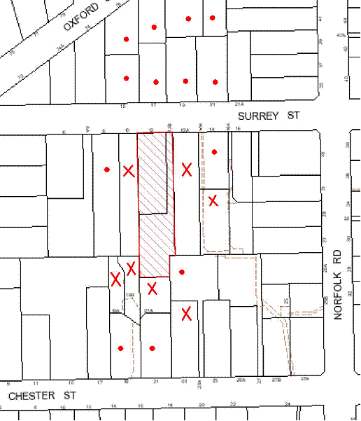
|
NOTIFICATION PLAN |
|
||
|
• PROPERTIES NOTIFIED
|
X SUBMISSIONS RECEIVED |
PROPERTY SUBJECT OF DEVELOPMENT |
|
The merits of the matters raised in community submissions have been addressed in the body of the report with the exception of the following:
5.1.1 Solar Access
Concerns are raised in community submissions that the construction of future dwellings on proposed Lots 2 and 3 within the indicative building envelopes would adversely impact on the solar access available to the existing dwelling on adjoining properties.
Based on the indicative dwelling design provided for Lot 3, there would be some overshadowing impact on adjoining properties. However, the impacts would not exceed the acceptable limits prescribed by Council’s Dwelling House DCP. The ‘Solar Access’ element of the Dwelling House DCP prescribes that dwelling-houses should be designed to allow at least 4 hours of sunshine to the private open space of adjoining properties and at least 3 hours of sunshine to north facing living room windows on June 22.
With respect to the overshadowing impact of the indicative dwelling design on Lot 3 it is noted that:
· The eastern elevation windows of No. 19B Chester Street would be overshadowed in the morning, however the overshadowing impact would maintain a minimum 4 hours solar access in accordance with Council’s DCP control.
· The dwelling within No. 21A Chester Street is setback 1 metre from the rear boundary adjoining proposed Lot 3. No. 21A is located directly south of proposed Lot 3. Whilst there would be overshadowing impacts on north facing windows, these rooms appear to be bedrooms and a bathroom and not living areas. Furthermore, the private open space for No. 21A Chester is located south of the dwelling and would not be affected.
· Some overshadowing may occur to the western elevation windows of the dwelling at No. 23 Chester Street. However, the north facing windows and private open space would not be adversely impacted upon.
With respect to Lot 2, a two storey development on Lot 2 is unlikely to result in an overshadowing impact that exceeds Council’s Dwelling House DCP controls given the orientation of the site.
Notwithstanding the above, the dwelling designs submitted as part of the application are indicative only and the impacts on solar access would need to be addressed in any application for future dwelling houses on Lots 2 and 3.
5.1.2 Privacy and Amenity
Concerns are raised in community submissions that future dwellings on proposed Lots 2 and 3 would have an adverse impact on the privacy and amenity impact on adjoining properties, particularly if two storey dwellings are proposed.
Consideration is given to the indicative dwelling designs provided and the prescriptive measure of the ‘Privacy’ element of the Dwelling House DCP, that requires where development is two storeys, living and entertaining areas should be located at ground level.
The indicative dwelling design for proposed Lot 3 comprises two storeys. The living areas have been primary located on the ground level and bedrooms on the first floor, apart from a retreat and balcony. Whilst the retreat and balcony are orientated to the north (being the open space of Lot 3) and do not comprise windows or openings that would overlook adjoining properties, it is considered that amenity impacts of the development would be improved if active use areas are located at ground level.
The indicative building envelope for proposed Lot 2 could accommodate a two storey development. Notwithstanding, the privacy and amenity impacts of dwellings on Lots 2 and 3 would need to be addressed in a future development application.
5.1.3 Sewerage
A concern has been raised in community submissions regarding the discharge of sewerage for the proposed subdivision. This issue is within the jurisdiction of Sydney Water. A condition has been imposed that requires that a Section 73 Certificate be obtained from Sydney Water prior to the issue of a Subdivision Certificate.
5.1.4 Drainage Control and Environmental Health Impacts
A concern has been raised in community submissions regarding drainage impacts resulting from the development and questions the use of absorption pits that “harbours mosquito colonies, thus causing health risks for surrounding residents”. A condition has been imposed requiring the stormwater drainage design which includes an OSD system, to be connected to the proposed inter-allotment drainage system. This would result in the stormwater being piped directly to the inter-allotment drainage system mitigating impacts to moisture in the ground.
5.1.5 Demolition of Dwelling on Lot 1
A concern has been raised in community submissions regarding the detrimental impacts to the streetscape and visual amenity by the demolition of the dwelling on Lot 1. The existing dwelling on Lot 1 is not a heritage listed item under Schedule D of the HSLEP. Whilst the site is within a draft East Epping Heritage Conservation Area under the Epping Town Centre Urban Activation Precinct, this proposal has not yet been adopted. The erection of a future dwelling house is subject to a new application which would involve assessment in regards to Design and consistency with the existing character and amenity of the streetscape and local area.
5.1.6 Draft Voluntary Planning Agreement
A concern has been raised in community submissions that the 556 square metres canopy coverage calculated under Council’s Green Offset Code is insufficient to compensate for the loss of the interconnected ecological system that surrounds the STIF community on the site. As addressed in Part 2.6 Green Offset Code (2012), the calculation and monetary contribution offered to Council is in accordance with the formulas and rates outlined in the Code and the VPA is considered to be suitable.
5.2 Public Agencies
Notification of public agencies was not a statutory requirement for the proposed development.
6. PUBLIC INTEREST
Section 79C(1)(e) of the Act requires Council to consider “the public interest”.
The public interest is an overarching requirement, which includes the consideration of the matters discussed in this report. Implicit to the public interest is the achievement of future built outcomes adequately responding to and respecting the future desired outcomes expressed in environmental planning instruments and development control plans.
The application is considered to have satisfactorily addressed Council’s criteria and would provide a development outcome that, on balance, would result in a positive impact for the community. Accordingly, it is considered that the approval of the proposed subdivision would be in the public interest.
CONCLUSION
The application proposes the Torrens Title subdivision of two allotments into three and demolition of an existing dwelling and garage.
The proposal includes the removal of a significant group of trees identified as Sydney Turpentine Ironbark Forest (STIF). The proposed tree removal is the subject of an offer to enter into a Planning Agreement to offset the loss of 556 square metres of STIF canopy area in accordance with Council’s Green Offset Code (2012). Conditions are recommended for the creation of a ‘Restricted Development Area’ within the site to protect a residual area of STIF.
The proposal generally complies with the Hornsby Shire Local Environmental Plan 1994 and is generally consistent with Council’s Residential Subdivision Development Control Plan. Minor matters of non compliance with respect to setbacks and private open space, along with the matters raised in the community submissions have been addressed in the body of this report.
Having regard to the assessment of the proposed development and the circumstances of the case, it is recommended that the application be approved as a deferred commencement consent.
Note: At the time of the completion of this planning report, no persons have made a Political Donations Disclosure Statement pursuant to Section 147 of the Environmental Planning and Assessment Act 1979 in respect of the subject planning application.
|
Rod Pickles Manager - Development Assessment Planning Division |
James Farrington Group Manager Planning Division |
|
1.View |
Locality Plan |
|
|
|
2.View |
Existing Site Plan |
|
|
|
3.View |
Subdivision Plan |
|
|
|
4.View |
Concept Dwelling Floor Plans |
|
|
|
5.View |
Tree Protection Plans |
|
|
|
6.View |
Addendum to Arborist Report |
|
|
|
7.View |
Voluntary Planning Agreement |
|
|
File Reference: DA/1398/2011
Document Number: D02154208
SCHEDULE 1
1. Deferred Commencement
Pursuant to Section 80(3) of the Environmental Planning and Assessment Act 1979, this consent does not operate until the following information is submitted to Council:
a) Drainage Easement
Evidence of the registration and creation of an easement to drain water from the site over Lot B DP 356265 (12A) Surrey Street in the location shown on plan titled Appendix 7, Tree Protection Plan, plan No. T 11_10142, Sheet 2, dated 20 November 2012.
b) Voluntary Planning Agreement
Pursuant to section 93F of the Environmental Planning and Assessment Act 1979, the applicant must prepare and enter into a Voluntary Planning Agreement (VPA) with Hornsby Shire Council to offset the loss of Sydney Turpentine Ironbark Forest (STIF) under Council’s Green Offset Code (2012).
The terms of the VPA must include but not be limited to the following:
i) The Applicant agrees to pay Council a monetary contribution of $63,384 towards the replacement of 556m2 of STIF lost from the site as result of the development.
ii) The applicant agrees to pay all costs (including Council’s costs) associated with the preparation, public notification, legal costs and administration costs of the VPA.
Such information shall be submitted within 12 months of the date of this notice.
Upon Council’s written satisfaction of the above information, the following conditions of development consent will apply:
GENERAL CONDITIONS
The conditions of consent within this notice of determination have been applied to ensure that the use of the land and/or building is carried out in such a manner that is consistent with the aims and objectives of the relevant legislation, planning instruments and Council policies affecting the land and does not disrupt the amenity of the neighbourhood or impact upon the environment.
Note: For the purpose of this consent, the term ‘applicant’ means any person who has the authority to act on or the benefit of the development consent.
Note: For the purpose of this consent, any reference to an Act, Regulation, Australian Standard or publication by a public authority shall be taken to mean the gazetted Act or Regulation, or adopted Australian Standard or publication as in force on the date that the application for a construction certificate is made.
2. Approved Plans and Supporting Documentation
The development must be carried out in accordance with the plans and documentation listed below and endorsed with Council’s stamp, except where amended by Council and/or other conditions of this consent:
Approved Plans:
|
Plan No./ Title |
Drawn by |
Dated |
|
T 11_10142, Sheet 1, Appendix 7, Tree Protection Plan |
Earthscape Horticultural Services |
20 November 2012 |
|
T 11_10142 Sheet 2, Appendix 7, Tree Protection Plan |
Earthscape Horticultural Services |
20 November 2012 |
|
T 11_10143, Appendix 8, Plan showing Exotic and STIF trees to be removed |
Earthscape Horticultural Services |
20 November 2012 |
|
G0110344/C2 – Issue 3, Civil Works Plan Sheet 1 |
ACOR Appleyard |
February 2013 |
|
G0110344/C3 – Issue 5, Civil Works Plan Sheet 2 |
ACOR Appleyard |
February 2013 |
|
G0110344/C6 – Issue 3, Subdivision Plan |
ACOR Appleyard |
January 2013 |
|
G0110344/C7 – Issue 2, Turning Bay Details and Driveway Cross Section |
ACOR Appleyard |
February 2013 |
Approved Supporting Documentation:
|
Document Title / No. |
Prepared by |
Dated |
|
Development Assessment Impact Report (Arborist Report) – 12 Surrey St Epping |
Earthscape Horticultural Services |
December 2011 |
|
Addendum to Arborist Report |
Earthscape Horticultural Services |
6 November 2012 |
|
Addendum to Arborist Report |
Earthscape Horticultural Services |
20 November 2012 |
|
Addendum to Arborist Report |
Earthscape Horticultural Services |
6 February 2013 |
3. Removal of Existing Trees
This development consent only permits the removal of trees identified in the following plans:
- Appendix 7, Tree Protection Plan, Plan No. T 11_10142, Sheets 1 & 2, prepared by Earthscape Horticultural Services, dated 20 November 2012.
- Appendix 8, Plan showing Exotic and STIF trees to be removed, Plan No. T 11_10142, prepared by Earthscape Horticultural Services, dated 20 November 2012.
The removal of any other trees requires separate approval under Council’s Tree Preservation Order.
4. Amendment of Plans
The approved site plan has been amended in red to nominate the ‘Restricted Development Area’ as prescribed by condition No. 31 of this consent.
REQUIREMENTS PRIOR TO THE ISSUE OF A CONSTRUCTION CERTIFICATE
5. Building Code of Australia
All building work must be carried out in accordance with the requirements of the Building Code of Australia.
6. Contract of Insurance (Residential Building Work)
In the case of residential building work for which the Home Building Act, 1989 requires there to be a contract of insurance in force in accordance with Part 6 of that Act, that such a contract of insurance is in force before any building work authorised to be carried out by the consent commences.
7. Notification of Home Building Act, 1989 Requirements
Residential building work within the meaning of the Home Building Act, 1989 must not be carried out unless the principal certifying authority for the development to which the work relates (not being Council) has given Council written notice of the following information:
a) In the case of work for which a principal contractor is required to be appointed:
i) The name and licence number of the principal contractor.
ii) The name of the insurer by which the work is insured under Part 6 of that Act.
b) In the case of work to be done by an owner-builder:
i) The name of the owner-builder.
ii) If the owner-builder is required to hold an owner-builder’s permit under that Act, the number of the owner-builder’s permit.
Note: If arrangements for doing the residential building work are changed while the work is in progress so that the information notified becomes out of date, further work must not be carried out unless the principal certifying authority for the development to which the work relates (not being Council) has given Council written notification of the updated information.
8. Water/Electricity Utility Services
The applicant must submit written evidence of the following service provider requirements:
a) Energy Australia – a letter of consent demonstrating that satisfactory arrangements have been made to service the proposed development.
b) Sydney Water – the submission of a ‘Notice of Requirements’ under s73 of the Sydney Water Act 1994.
Note: Sydney Water requires that s73 applications are to be made through an authorised Sydney Water Servicing Coordinator. Refer to www.sydneywater.com.au or telephone 13 20 92 for assistance.
9. Vegetation Management Plan
A Vegetation Management Plan(VMP) is to be submitted including the following:
· A planting schedule for future supplementary planting/ landscaping;
· A Schedule of Works that would be consistent with weed management stages (e.g. primary, secondary and weed maintenance weed control and planting etc) that includes activities, stakeholders and time frames consistent with future development timeframes (e.g. release of subdivision certificate, construction certificate, occupation certificate and post development);
· Cross reference to the plan titled Appendix 7, Tree Protection Plan, Plan No. T 11_10142, Sheet 2, dated 6/11/2012, prepared by Earthscape Horticultural Services;
· Account for potential usage by future residents specifying what activities are permissible in the Sydney Turpentine Ironbark Forest; and
· Confirmation that all works within the plan shall be undertaken by a suitably qualified and experienced bush regeneration company (minimum Certificate 3 in Natural Area Restoration)
The VMP is to be prepared to the written satisfaction of Council prior to the issue of a Construction Certificate.
Note: Please refer to Council Guidelines for the preparation of Bushland Management and Restoration Plans (on Council’s website http://www.hornsby.nsw.gov.au/planning-and-building/planning-controls-and-studies/policies,-guides-and-best-practices) for industry standards required for the preparation of such documents.
Council’s Bushland and Biodiversity Team can be contacted on 9847 6542.
10. Boundary Fencing
Fencing must be erected along all property boundaries behind the front building alignment to a height of 1.8 metres.
The boundary fencing between approved lots 2 and 3 within or adjoining the ‘Restricted Development Area’ is to be designed and constructed in accordance with the recommendations of the Addendum to Arborist Report, prepared by Earthscape Horticultural Services dated 6 November 2012. Details of the proposed fencing must be submitted for approval by Council prior the issue of a Construction Certificate.
Note: The fencing is to be erected prior to the issue of a Subdivision Certificate.
REQUIREMENTS PRIOR TO THE COMMENCEMENT OF ANY WORKS
11. Erection of Construction Sign
A sign must be erected in a prominent position on any site on which building work, subdivision work or demolition work is being carried out:
a) Showing the name, address and telephone number of the principal certifying authority for the work,
b) Showing the name of the principal contractor (if any) for any demolition or building work and a telephone number on which that person may be contacted outside working hours, and
c) Stating that unauthorised entry to the work site is prohibited.
Note: Any such sign is to be maintained while the building work, subdivision work or demolition work is being carried out, but must be removed when the work has been completed.
12. Tree Protection Barriers
Tree protection fencing must be erected around trees as shown in plan titled Appendix 7, Tree Protection Plan, Plan No. T 11_10142, Sheets 1 & 2, prepared by Earthscape Horticultural Services, dated 20 November 2012. The tree fencing must be constructed of 1.8 metre ‘cyclone chainmesh fence’ and be built and maintained in accordance with Section 12.2 of the Development Impact Assessment Report Prepared by Earthscape Horticultural Services dated December 2011.
13. Toilet Facilities
Toilet facilities must be available or provided at the works site before works begin and must be maintained until the works are completed at a ratio of one toilet for every 20 persons employed at the site. Each toilet must:
a) be a standard flushing toilet connected to a public sewer; or
b) be a temporary chemical closet approved under the Local Government Act, 1993; or
c) have an on-site effluent disposal system approved under the Local Government Act, 1993
14. Erosion and Sediment Control
Erosion and sediment control measures must be provided and maintained throughout the construction period in accordance with the manual ‘Soils and Construction 2004 (Bluebook)’, the approved plans, Council specifications and to the satisfaction of the principal certifying authority. The erosion and sediment control devices must remain in place until the site has been stabilised and revegetated.
Note: On the spot penalties up to $1,500 may be issued for any non-compliance with this requirement without any further notification or warning.
15. Bushland protection - Weed Prevention
To prevent the spread of weeds and fungal pathogens such as Cinnamon Fungus (Phytophthora cinnamomi) and Chytrid Fungus (Batrachochytrium dendrobatidis), all machinery shall be cleaned of soil and debris before entering the subject site for the installation of subdivision services.
REQUIREMENTS DURING CONSTRUCTION
16. Construction Work Hours
All work on site (including demolition and earth works) must only occur between 7am and 5pm Monday to Saturday.
No work is to be undertaken on Sundays or public holidays.
17. Demolition
All demolition work must be carried out in accordance with Australian Standard 2601-2001 – The Demolition of Structures and the following requirements:
a) Demolition material is to be disposed of to an authorised recycling and/or waste disposal site and/or in accordance with an approved waste management plan.
b) Demolition works, where asbestos material is being removed, must be undertaken by a contractor that holds an appropriate licence issued by WorkCover NSW in accordance with Chapter 10 of the Occupational Health and Safety Regulation 2001 and Clause 29 of the Protection of the Environment Operations (Waste) Regulation 2005.
c) On construction sites where buildings contain asbestos material, a standard commercially manufactured sign containing the words ‘DANGER ASBESTOS REMOVAL IN PROGRESS’ measuring not less than 400mm x 300mm must be erected in a prominent position visible from the street.
d) Buildings and structures to be demolished should be carried out in accordance with Section 12.6 of the Development Impact Assessment Report Prepared by Earthscape Horticultural Services dated December 2011.
18. Works near Trees
All required tree protection measures are to be maintained in good condition for the duration of the construction period.
All works (including stormwater pipes, underground services and driveway construction) within 2 metres of any trees required to be retained (whether or not on the subject property, and pursuant to this consent or the Tree Preservation Order), must be carried out under the supervision of an ‘AQF Level 5 Arborist’ and a certificate submitted to the principal certifying authority detailing the methods used to preserve the trees.
All works must be constructed in accordance with the recommendations in the Development Impact Assessment Report Prepared by Earthscape Horticultural Services dated December 2011, in particular Section 12.6 and 12.7.
The storm water drainage easement within Lot B DP 356265 (12A) Surrey Street must be constructed in accordance with the recommendations in the Addendum to Arborist Report prepared by Earthscape Horticultural Services dated 6 November 2012. The storm water easement must be constructed in the location nominated within plan titled Appendix 7, Tree Protection Plan, Plan No. T 11_10142, Sheet 2, prepared by Earthscape Horticultural Services, dated 20 November 2012.
Note: Except as provided above, the applicant is to ensure that no excavation, filling or stockpiling of building materials, parking of vehicles or plant, disposal of cement slurry, waste water or other contaminants is to occur within 4 metres of any tree to be retained. This is to ensure the protection of bushland and retained trees from the effects of building materials, sedimentation and erosion from development sites.
19. Environmental Management
The site must be managed in accordance with the publication ‘Managing Urban Stormwater – Landcom (March 2004) and the Protection of the Environment Operations Act 1997 by way of implementing appropriate measures to prevent sediment run-off, excessive dust, noise or odour emanating from the site during the construction of the development.
20. Council Property
During construction works, no building materials, waste, machinery or related matter is to be stored on the road or footpath. The public reserve is to be kept in a clean, tidy and safe condition at all times.
Note: This consent does not give right of access to the site via Council’s park or reserve. Should such access be required, separate written approval is to be obtained from Council.
21. Disturbance of Existing Site
During construction works, the existing ground levels of open space areas and natural landscape features, (including natural rock-outcrops, vegetation, soil and watercourses) must not be altered unless otherwise nominated on the approved plans.
22. Vehicular Crossing
A separate application under the Local Government Act, 1993 and the Roads Act, 1993 must be submitted to Council for the installation of a new vehicular crossing and the removal of the redundant crossing. The vehicular crossing must be constructed in accordance with Council’s Civil Works Design, 2005 and the following requirements:
a) Any redundant crossings to be replaced with integral kerb and gutter.
b) The footway area to be restored by turfing.
c) Approval obtained from all relevant utility providers that all necessary conduits be provided and protected under the crossing.
Note: An application for a vehicular crossing can only be made to one of Council’s Authorised Vehicular Crossing Contractors. You are advised to contact Council on 02 9847 6940 to obtain a list of contractors.
REQUIREMENTS PRIOR TO THE ISSUE OF A SUBDIVISION CERTIFICATE
23. Sydney Water – s73 Certificate
An s73 Certificate must be obtained from Sydney Water.
24. Stormwater Drainage
The stormwater drainage system for the development must be designed and constructed generally in accordance with Drawing No.G0110344/C2 Issue 1 dated November 2011 and G0110344/C3 Issue 3 dated November 2012 prepared by ACOR Appleyard Consultants Pty Ltd, Council’s Civil Works – Design and Construction Specification 2005 and the following requirements:
a) Connected to an existing Council piped drainage system.
b) An inter-allotment stormwater drainage system to service the proposed lot with pits being constructed in situ.
c) The roof and stormwater drainage system from the existing dwelling to be connected to the proposed inter-allotment drainage system.
d) The connection to Council’s pit shall be inspected by a Council Engineer in the Planning Division. Prior to the connection an application shall be made to Council and all fees paid. An inspection booking can be made by calling Council on 9847 6787.
Note: A construction certificate shall be obtained prior to the commencement of these works and are to be completed prior to the issue of a subdivision certificate.
The storm water drainage system must be constructed in accordance with the Development Impact Assessment Report dated December 2011.
The storm water drainage easement over Lot B DP 356265 (12A) Surrey Street is to be constructed in the location nominated in plan titled Appendix 7, Tree Protection Plan, plan No. T 11_10142, Sheet 2, dated 20 November 2012 and be constructed in accordance with the recommendations of the Addendum to Arborist Report, prepared by Earthscape Horticultural Services dated 6 November 2012.
25. Internal Driveway/Vehicular Areas
The driveway and parking areas on site must be designed in accordance with Australian Standards 2890.1, 2890.2, 3727 and the following requirements:
a) Design levels at the front boundary shall be obtained from Council if a private accredited certifier is engaged to obtain a construction certificate for these works.
b) The driveway be a rigid pavement.
c) The driveway grade must not exceed 25 percent and changes in grade must not exceed 8 percent per plan metre.
d) The driveway pavement be a minimum 3 metres wide, 0.15 metres thick reinforced concrete with F72 steel reinforcing fabric and a 0.15 metre sub-base.
e) The pavement have a kerb to one side and a one-way cross fall with a minimum gradient of 2 percent and a lintel and pit provided at the low point.
f) Planting of landscaping strips 0.5 metres wide along both sides of the length of the driveway.
g) Conduit for utility services including electricity, water, gas and telephone be provided.
Note: A construction certificate shall be obtained prior to the commencement of these works and are to be completed prior to the issue of a subdivision certificate.
To ensure the protection of trees identified to be retained, the driveway and parking areas on the site must be constructed in accordance with the Development Impact Assessment Report prepared by Earthscape Horticultural Services dated December 2011 and the Addendum to Arborist Report prepared by Earthscape Horticultural Services dated 20 November 2012.
26. Traffic Control Plan
A Traffic Control Plan (TCP) must be prepared by a qualified traffic controller in accordance with the Roads & Traffic Authority’s Traffic Control at Worksites Manual 1998 and Australian Standard 1742.3 for all work on a public road and be submitted to Council. The TCP must detail the following:
a) Arrangements for public notification of the works.
b) Temporary construction signage.
c) Permanent post-construction signage.
d) Vehicle movement plans.
e) Traffic management plans.
f) Pedestrian and cyclist access/safety.
27. Damage to Council Assets
Any damage caused to Council’s assets including the removal, damage, destruction, displacement or defacing of the existing survey marks as a result of the construction of the development must be rectified in accordance with Council’s written requirements and at the sole cost of the applicant.
28. Creation of Easements
The following matter(s) must be nominated on the plan of subdivision under s88B of the Conveyancing Act 1919:
a) A right of access and easement for services over the access corridor.
b) An inter-allotment drainage easement(s) over each of the burdened lots.
c) The creation of a “Positive Covenant” over proposed Lots 2 and 3 requiring that any future development is to provide an on-site detention system. The on-site detention system is to have a storage capacity of 5 cubic metres and a maximum discharge of 8 litres per second into Council’s drainage system in accordance with Council’s prescribed wording.
Note: Council must be nominated as the authority to release, vary or modify any easement, restriction or covenant.
29. Works as Executed Plan
A works-as-executed plan(s) must be prepared by a registered surveyor and submitted to Council for completed road pavement, kerb and gutter, public drainage systems, driveways and on-site detention system. The plan(s) must be accompanied by a certificate from a registered surveyor certifying that all pipelines and associated structures lie wholly within any relevant easements.
30. Bushland Protection – Removal of Noxious weeds
To ensure that plants identified as weed species are effectively removed and not allowed to proliferate or interfere with a quality landscaping outcome, all environmental weeds, noxious and invasive plants are to be removed and suppressed using an appropriate bush regeneration methods. All weed removal must be undertaken by a qualified bush regeneration company in accordance with the Vegetation Management Plan approved by Council’s bushland and biodiversity team (required by condition No. 9 of this consent).
31. Restriction As To User – Protection of Land from Future Development
To inform current and future owners that the areas of remnant Sydney Turpentine Ironbark Forest Endangered Ecological Community trees on the site is to be protected from future development, a Restriction as to User must be created under Section 88B of the Conveyancing Act 1919 identifying that the area of the site marked in red diagonal lines on the approved plans is restricted from development activities that would adversely affect trees identified to be retained as per Appendix 7, Tree Protection Plan, Plan No. T 11_10142, Sheet 2, dated 20 November 2012 and Appendix 8, Plan showing Exotic and STIF Trees to be Removed dated 20 November 2012 prepared by Earthscape Horticultural Services.
The restriction must specify:
a) All natural landscape features including natural rock outcrops, native vegetation (trees, shrubs and groundcovers), soil and watercourses are to remain undisturbed except only where affected by necessary works detailed on approved plans, or with Council’s written consent.
b) Any future construction works and landform modification are to be outside the restricted development area.
c) Hard stand or paved open space areas must be limited to land outside the ‘Restricted Development Area’.
d) No encroachment of the building envelope, including the fill batter, is permitted within the restricted development areas.
e) No machine or heavy vehicle is permitted within the “Restricted Development Areas”.
Note: The wording of the Restriction as to User must be to Council’s satisfaction and Council must be nominated as the authority to release, vary or modify the Restriction.
32. Placement of a Positive Covenant – Maintenance of Sydney Turpentine Ironbark Forest
A positive covenant must be created under Section 88B of The Conveyancying Act 1919 for the ‘Restricted Development Area’ as marked in red diagonal lines on the approved plans, requiring that all landscaping/vegetation management must be in accordance with a Vegetation Management Plan approved by Council (as required by condition No. 9 of this consent).
Note: The wording of the Positive Covenant must be to Council’s satisfaction and Council must be nominated as the authority to release, vary or modify the Covenant.
33. Positive Covenant – Construction of Future Dwellings and Tree Protection
To inform current and future owners that future dwellings on the site must be constructed to ensure the protection of significant trees, a Positive Covenant must be created under Section 88B of the Conveyancing Act 1919, requiring that future dwellings be designed and constructed to ensure the retention of all trees within the Restricted Development Area.
To ensure construction works does not adversely impact on the health and longevity of trees located adjacent to the indicative building envelope locations in the approved site plan, the Positive Covenant is to include the following terms:
a) In relation to Tree Nos. T38, T39, T40, T49, T76 and T79:-
Any future dwelling sited within five(5) metre radius of Tree Nos. T38, T39, T40, T49, T76 and T79 (Turpentines) shall be of pier and mean construction with an elevated floor to maintain the legal protection of these trees under Council’s Tree Preservation Order. Siting of piers shall be avoided within the Structural Root Zones of these trees. The beam (including the edge beam of any slab) shall be placed above grade with a minimum of 50mm clearance between the existing ground level and the lower edge of the beam to avoid excavations for any continuous strip of footing within the Tree Protection Zones. All excavations for pier footings within the TPZs of these trees shall be undertaken under the supervision of a qualified arborist (minimum Australian Qualification Framework Level 3).
Where any woody roots of greater than 40mm in diameter are encountered during excavations for the footings, the position of the pier shall be relocated slightly on site (as required) to avoid severance or damage to woody roots. Any roots encountered of less than 40mm in diameter shall be cleanly severed at the face of the excavation using a clean sharp hand saw or secateurs in accordance with AS 4373:2007. All such pruning shall be carried out by a qualified arborist (minimum Australian Qualification Framework Level 3).
b) In relation to Tree Nos. T38, T39, T40 and T49
Any future dwelling beneath the canopies of Tree Nos T38, T39, T40 and T49 (Turpentines) shall be limited to a single storey dwelling with roof height not exceeding RL 97.50 to minimise any required canopy pruning of these trees. Any canopy pruning essential to clear the building envelope shall be undertaken in accordance with AS4373:2007 by a qualified arborist (minimum Australian Qualification Framework Level 3). No branches exceeding 150mm in diameter shall be removed to clear the building envelope without Council approval.
Note: The wording of the Restriction as to User must be to Council’s satisfaction and Council must be nominated as the authority to release, vary or modify the Restriction.
34. s94 Infrastructure Contributions
The payment to Council of a contribution of $20 000 for one additional lot towards the cost of infrastructure identified in Council’s Development Contributions Plan 2007-2011.
Note: The value of contribution is capped at $20,000 per additional lot in accordance with Ministerial Direction (Section 94E of the Environmental Planning and Assessment Act 1979) issued on 16 September 2010. In the event that this Direction is repealed or amended, Council will apply the value of the contribution from the date of this consent, adjusted from this date in accordance with the underlying consumer price index for subsequent financial quarters.
It is recommended that you contact Council to confirm the value of the contribution prior to payment.
- END OF CONDITIONS -
ADVISORY NOTES
The following information is provided for your assistance to ensure compliance with the Environmental Planning and Assessment Act, 1979, Environmental Planning and Assessment Regulation 2000, other relevant legislation and Council’s policies and specifications. This information does not form part of the conditions of development consent pursuant to Section 80A of the Act.
Environmental Planning and Assessment Act, 1979 Requirements
· The Environmental Planning and Assessment Act, 1979 requires:
· The issue of a construction certificate prior to the commencement of any works. Enquiries regarding the issue of a construction certificate can be made to Council’s Customer Services Branch on 9847 6760.
· A principal certifying authority to be nominated and Council notified of that appointment prior to the commencement of any works.
· Council to be given at least two days written notice prior to the commencement of any works.
· Mandatory inspections of nominated stages of the construction inspected.
· An occupation certificate to be issued before occupying any building or commencing the use of the land.
Long Service Levy
In accordance with Section 34 of the Building and Construction Industry Long Service Payments Act 1986, a ‘Long Service Levy’ must be paid to the Long Service Payments Corporation or Hornsby Council.
Note: The rate of the Long Service Levy is 0.35% of the total cost of the work.
Note: Hornsby Council requires the payment of the Long Service Levy prior to the issue of a construction certificate.
Tree Preservation Order
To ensure the maintenance and protection of the existing natural environment, it is an offence to ringbark, cut down, top, lop, remove, wilfully injure or destroy a tree outside 3 metres of the approved building envelope without the prior written consent from Council.
Note: A tree is defined as a single or multi-trunked wood perennial plant having a height of not less than three (3) metres, and which develops many branches, usually from a distance of not less than one (1) metre from the ground, but excluding any plant which, in its particular location, is a noxious plant declared as such pursuant to the Noxious Weeds Act 1993. This definition of ‘tree’ includes any and all types of Palm trees.
All distances are determined under Australian Standard AS4970-2009 ”Protection of Trees on Development Sites”.
Fines may be imposed for non-compliance with Council’s Tree Preservation Order.
Note: The site contains Sydney Turpentine Ironbark Forest which is listed as an Endangered Ecological Community under the ‘Threatened Species Conservation Act 1995’. The Act prohibits the disturbance to threatened species, endangered populations and endangered ecological communities, or their habitat, without the approval of the ‘Department of Environment and Climate Change’ where such activities are not authorised by a development consent under the ‘Environmental Planning and Assessment Act 1979’.
Actions such as tree removal, understorey slashing or mowing, removal of dead trees within this vegetation would likely impact upon this endangered ecological community. Such action would qualify as illegally picking or disturbing the habitat and could render any person who carried out such action as LIABLE FOR PROSECUTION.
Subdivision Certificate Requirements
A subdivision certificate application is required to be lodged with Council containing the following information:
· A surveyor’s certificate certifying that all structures within the subject land comply with the development consent in regard to the setbacks from the new boundaries.
· A surveyor’s certificate certifying that all services, drainage lines or access are located wholly within the property boundaries. Where services encroach over the new boundaries, easements are to be created.
· Certification that the requirements of relevant utility authorities have been met.
· A surveyor’s certificate certifying finished ground levels are in accordance with the approved plans.
Note: Council will not issue a subdivision certificate until all conditions of the development consent have been completed.
Fees and Charges – Subdivision
All fees payable to Council as part of any construction, compliance or subdivision certificate or inspection associated with the development (including the registration of privately issued certificates) are required to be paid in full prior to the issue of the subdivision certificate. Any additional Council inspections beyond the scope of any compliance certificate required to verify compliance with the terms of this consent will be charged at the individual inspection rate nominated in Council's Fees and Charges Schedule.
Dial Before You Dig
Prior to commencing any works, the applicant is encouraged to contact Dial Before You Dig on 1100 or www.dialbeforeyoudig.com.au for free information on potential underground pipes and cables within the vicinity of the development site.
Asbestos Warning
Should asbestos or asbestos products be encountered during demolition or construction works you are advised to seek advice and information should be prior to disturbing the material. It is recommended that a contractor holding an asbestos-handling permit (issued by WorkCover NSW)be engaged to manage the proper handling of the material. Further information regarding the safe handling and removal of asbestos can be found at:
Alternatively, telephone the WorkCover Asbestos and Demolition Team on 8260 5885.
Group Manager's Report No. PL23/13
Planning Division
Date of Meeting: 15/05/2013
12 REPORTING VARIATIONS TO DEVELOPMENT STANDARDS
EXECUTIVE SUMMARY
· In accordance with the Department of Planning and Infrastructure’s Planning Circular PS 08-14, Council is required to report variations to development standards for development applications approved under delegated authority, which relied upon State Environmental Planning Policy No. 1 - Development Standards (SEPP 1).
· Council’s consideration of this report ensures Council’s obligation to monitor variations to development standards is complied with.
|
THAT the contents of Group Manager’s Report No. PL23/13 be received and noted. |
PURPOSE
The purpose of this report is to advise Council of determined development applications under delegated authority involving a SEPP 1 variation to a development standard for the period 1 January 2013 to 31 March 2013.
DISCUSSION
The Department of Planning and Infrastructure’s Circular B1, issued in March 1989, requested that councils monitor the use of the Director-General’s assumed concurrence under SEPP 1 on a quarterly basis. This reporting requirement remains effective.
Monitoring of variations to development standards is important to provide the Department and councils with an overview of the manner in which established development standards are being varied and whether the assumed concurrence is being used as intended. This enables Council and the Department to determine whether development standards are appropriate, or whether changes are required.
The Department issued Circular PS 08–014 on 14 November 2008. The purpose of the Circular was to remind councils of their responsibilities to monitor the use of the Director-General’s assumed concurrence under SEPP 1. Councils were reminded of the need to keep accurate records of the use of SEPP 1 and to report on a quarterly basis.
The Circular also provides that councils are required to adopt the following four measures:
1. Establish a register of development applications determined with variations in standards under SEPP 1.
2. Require all development applications where there has been a variation greater than 10% in standards under SEPP 1 to be determined by full council (rather than General Manager or nominated staff member).
3. Provide a report to Council on the development applications determined where there had been a variation in standards under SEPP 1.
4. Make the register of development applications determined with variations in standards under SEPP 1 available to the public on the council’s website.
In accordance with Point 3 of the Department’s Circular, attached is a list of development applications determined under delegated authority involving a SEPP 1 variation to a development standard for the period 1 January 2013 to 31 March 2013.
A copy of the attachment to this report is also reproduced on Council’s website.
BUDGET
There are no budget implications.
POLICY
This report addresses Council’s reporting obligations for development applications determined where there has been a variation in standards under SEPP 1.
CONCLUSION
Council is required to monitor the manner in which development standards are being varied. This assists in determining whether changes are required to relevant standards. This report provides advice to Council on standards varied under delegated authority during the reporting period from 1 January 2013 to 31 March 2013.
RESPONSIBLE OFFICER
The officer responsible for the preparation of this report is the Group Manager – Planning Division – James Farrington, who can be contacted on 9847 6750.
|
James Farrington Group Manager Planning Division |
|
|
1.View |
SEPP 1 Returns |
|
|
File Reference: F2004/07599
Document Number: D02129719
Group Manager's Report No. PL33/13
Planning Division
Date of Meeting: 15/05/2013
13 HERITAGE REVIEW - STAGE 5
EXECUTIVE SUMMARY
· In 2011, Council endorsed a review of heritage items and heritage listed privately owned gardens as part of Heritage Review Stage 5.
· In accordance with Council’s resolution, a heritage consultant was commissioned to undertake the Review, which included a review of 36 properties nominated for inclusion or removal from the schedule of heritage items and an analysis for retention or removal of 42 heritage listed privately owned gardens.
· It is recommended that Council endorse the recommendations of Heritage Review - Stage 5 to be progressed as a Planning Proposal attached to this report for submission to the Department of Planning and Infrastructure for Gateway determination and exhibition.
· Miscellaneous amendments for existing heritage items, such as property description and/or address corrections resulting from approved subdivisions, are also proposed to be progressed as part of the Planning Proposal.
|
THAT: 1. Council endorse progression of the Planning Proposal attached to Group Manager’s Report No. PL28/13 to amend Schedule D (Heritage Items) of the Hornsby Shire Local Environmental Plan 1994 or Schedule 5 (Environmental Heritage) of the draft HELP.
2. Pursuant to Section 56(1) of the Environmental Planning and Assessment Act 1979, Council forward the Planning Proposal to the Minister for Planning and Infrastructure seeking a Gateway Determination to exhibit the Planning Proposal.
3. Following the exhibition, a report on submissions received in response to the public exhibition and consideration by the Heritage Advisory Committee be presented to Council.
4. Council endorse the Hornsby Heritage information brochure for distribution to the general public. |
PURPOSE
The purpose of this report is to present the findings of Heritage Review Stage 5 (“the Review”) and seek endorsement of its recommendations to be progressed as a Planning Proposal for public exhibition.
BACKGROUND
The HSLEP 1994, gazetted in July 1994, includes heritage conservation provisions and lists over 800 heritage items and 6 heritage conservation areas. In response to requests for the deletion or inclusion of items in the heritage schedule, Council commenced a Heritage Review in 1995 which has been implemented over a number of stages as follows:
|
Stage 1 |
Aboriginal Heritage Study, Brooklyn Cemetery draft LEP, review of heritage items and correction of anomalies within existing listings. |
|
Stage 2 |
Review of the Beecroft-Cheltenham Heritage Conservation Area and Hornsby West Side Heritage Conservation Area, review of heritage items and correction of anomalies within existing listings. |
|
Stage 3 |
Review of heritage items and correction of anomalies within existing listings. |
|
Stage 4 |
Review of heritage items, heritage listed trees and correction of anomalies within existing listings. |
The Heritage Review is an important periodical project carried out by Council to reassess the statutory protection and identified heritage values of locally heritage listed items and heritage conservation areas within Hornsby Shire.
The objective of undertaking the Heritage Review in stages is to allow Council to respond in a reasonable time frame to identified changes that may have taken place and provide an ongoing opportunity to address issues raised by the community. Each stage is progressed with a limited budget, timeframe and scope of works to meet the intentions of the Strategic Planning Program. Historically, each review has taken approximately 2 years from the commencement of a review to the finalisation of any amendments to planning instruments to implement the review recommendations.
At its meeting on 2 November 2011, Council considered Executive Managers’ Report No. PLN74/11 and endorsed the content and direction of Heritage Review Stage 5 to include the following projects:
· Review of 36 built and landscape items for deletion, retention or inclusion; and
· Review of 42 privately owned heritage listed gardens.
In accordance with Council’s resolution, expressions of interest were sought from suitably qualified and experienced heritage consultants to undertake the project. Following an assessment of the submissions against selection criteria (including appreciation and compliance with the project brief, scope of works, methodology, consultation strategy, project team, experience, budget and timetable) Godden Mackay Logan in association with Chris Betteridge, Heritage Gardens and Landscape Specialist of MUSEcape Pty Ltd were appointed as the consultant for Heritage Review Stage 5.
The consultant has submitted a report entitled Hornsby Heritage Study Review Stage 5 dated March 2013. A copy of the report is available for viewing on Council’s website at: hornsby.nsw.gov.au/planning-and-building/heritage-review-5.
DISCUSSION
The purpose of the Heritage Review Stage 5 is to address the accuracy and completeness of Council’s list of heritage items. The Review has been prepared in accordance with the principles and guidelines set out in The Burra Charter: Australia ICOMOS Charter for Places of Cultural Significance (Burra Charter) and the NSW Heritage Manual (NSW Department of Urban Affairs and Planning and Heritage Council of NSW First Edition, 1996).
The assessment of heritage items included in the Review was guided by the NSW Heritage Council Office Standard Assessing Heritage Significance, 2001 including historical research through a wide range of documentary resources; field surveys assessing the physical evidence and current condition, integrity and context of each item; consultation with selected stakeholders; analysis of the information and preparation of a report articulating the Review findings and recommendations.
The outcomes of the Review include recommendations with respect to the:
· Deletion, retention or inclusion of 36 properties containing built and landscape items under Schedule D (Heritage Items) of the HSLEP 1994; and
· Deletion or retention of 42 privately owned heritage listed gardens under Schedule D (Heritage Items) of the HSLEP 1994.
In the case of garden and landscape items, the Review notes that a number of factors including, natural plant growth, introduction of new landscaping, the effects of prolonged drought, recent wet periods and the removal of some trees and other plantings have contributed to changes since the items were first assessed in the 1993 Heritage Study. Numerous properties inspected have lost large parts of their rear gardens as a result of subdivision and the lack of formative pruning of trees and hedges on a number of properties has resulted in the reduction of aesthetic value.
In the case of built items, the Review reports that almost all of the properties inspected have undergone a range of changes and alterations commensurate with modern lifestyle requirements. The changes often include rear alterations which, in most cases, have been undertaken sympathetically in accordance with the heritage provision of the HSLEP 1994 and development guidelines included in the Heritage Development Control Plan (DCP).
Recommendations
For each item, the Review provides an assessment of the significance, integrity and merit of each property and the information has been presented in a heritage inventory sheet format.
Of the 78 items reviewed, the Review recommends:
· 24 heritage items for deletion, comprising of 21 privately owned heritage listed gardens, 2 built items and 2 landscape items;
· 15 new heritage items for inclusion, comprising 14 built items, 1 landscape item and 4 privately owned heritage listed gardens;
· 23 items be retained with no amendments, comprising of 4 build items and 19 privately owned gardens;
· 8 items to be retained with amendments, comprising of 2 items to be listed as both ‘house and garden’ with built and landscape heritage values, 2 address corrections and 4 item name amendments;
· 5 items not to be progressed for heritage listing, comprising of 4 built items and 1 landscape item, as they do not meet the criteria for containing local heritage values; and
· 2 items to be nominated as potential heritage items subject to further investigation. In these cases, heritage listing is not been recommended. However, archival recording, historic research and conservation is encouraged.
The above recommendations have taken into account two situations where Council’s position on subject properties has changed since the commencement of the Review:
· Property Nos. 30-38 and 42 Oxford Street, Epping - Convict Relics (circa 1820 Saw Pit) is recommended for inclusion on Council’s heritage schedule in the Review. It is not recommended to be progressed as part of this report as it has been subject to further archaeological and heritage assessment as part of the Epping Town Centre Urban Activation Precinct. The listing of heritage items within the Epping Town Centre is being evaluated as part of the State Environmental Planning Policy for Epping that is the responsibility of the Department of Planning and Infrastructure.
· Property No. 1015 Pacific Highway – House was recommended for inclusion on Council’s heritage schedule in the Review. It is not recommended to be progressed as part of this report as it was subject to a house fire in August 2012 with no significant fabric remaining.
The above recommendations are included in Summary Tables within an attachment to this report (Attachment 1).
Further Investigation
The Review concludes that the following privately owned heritage listed gardens which have landscape heritage values warrant further investigation as the houses associated with the gardens have potential built heritage values:
· 2-4 Hillcrest Road, Berowra;
· 15 Yallambee Road, Berowra;
· 27A Chester Street, Epping; and
· 149 Copeland Road, Beecroft.
It is not proposed to progress this properties in the current review but to consider their significance as part of the next Heritage Review identified on the Strategic Planning Program to commence in 2014.
The review also identifies 9 properties for internal inspection and archival recording. Although some interior spaces, fixtures and fittings have been assessed to be significant, or have the potential to be significant, inspection and archival recording of the interiors of privately owned houses is costly and resource intense.
Existing practice is to encourage owners to carry out the recommended historical research and archival recordings as a condition of development consent with a copy submitted to Council, the local branch library or Historical Society. Accordingly, further investigation of the properties is not recommended at this stage.
Promotion and Education
The Review recommends that Council should produce a general information brochure to explain what it means to be heritage listed for existing and perspective owners in the Hornsby Shire. This type of brochure is provided by other Councils in the Sydney Metropolitan area and is highly effective in improving the understanding of local heritage and the meaning of heritage listing. The brochure would also provide advice on how to apply for a development application and how to find further information.
A draft heritage brochure has been prepared and is included as Attachment 4 to this report for endorsement by Council.
Miscellaneous Amendments
Council has recently prepared its Comprehensive LEP, which is a translation of the HSLEP 1994 in accordance with DP&I Standard Instrument. At its meeting on 19 December 2012, Council resolved to endorse the draft HLEP for forwarding to the Department of Planning and Infrastructure for its making.
During the preparation of the draft HLEP minor amendments were made to Council’s schedule of heritage items to correct anomalies within existing listings. Since this time, a number of heritage listed properties have been subdivided resulting in a change to their property description.
Accordingly, 5 further amendments are proposed to update existing heritage item listings to reflect the current property description (Lot and DP) and/or property address. Details for the proposed amendments are included in a summary table attached to the report (Attachment 2).
Statutory Considerations
A Planning Proposal has been prepared to progress the recommendations of Heritage Review Stage 5 for submission to the Department of Planning and Infrastructure for Gateway determination and exhibition.
The purpose of the Planning Proposal is to amend the HSLEP 1994 or the draft HLEP (depending on the timing of the progression of the Planning Proposal) generally in accordance with the recommendations of the Hornsby Heritage Study Review Stage 5. The Planning Proposal would amend Council’s LEP by:
· The removal of 24 heritage items that no longer warrant listing;
· The listing of 15 new items identified as having heritage significance;
· Updating 8 heritage item listings to reflect current significance;
· Updating 5 heritage items listings to reflect current property information; and
· Replacing the relevant map sheets of the Heritage Map for the Draft HLEP.
Statements of significance, in the form of inventory sheets, have been prepared for all new items.
The attached Planning Proposal (Attachment 3) sets out the proposed amendments in accordance with the Department’s ‘Guide to Preparing Planning Proposals’.
CONSULTATION
During the preparation of Heritage Review Stage 5, all owners were notified of the preparation of the review and were invited to participate in the review process. In some cases, the heritage consultant was able to meet with the owners of the properties for on-site consultation.
Further consultation with the wider community of Hornsby Shire would be undertaken should Council endorse the progression of the Heritage Review Stage 5 Planning Proposal. The proposed consultation strategy is included in the planning proposal.
During the exhibition period, the findings of Heritage Review Stage 5 and the recommendations of the Planning Proposal would be presented for consideration by the Heritage Advisory Committee. Further consultation would be undertaken with the Heritage Advisory Committee concerning any submissions received.
BUDGET
The budget for Heritage Review Stage 5 was $75,000 (excluding GST). A further $11,000 (excluding GST) was agreed upon as an extension to the brief. All funds have been expended and the consultant has satisfied all of the deliverables of the brief.
POLICY
There are no policy implications associated with this Report.
CONCLUSION
Heritage Review Stage 5 includes a review of heritage items and heritage listed privately owned gardens. A total of 76 properties were reviewed, including 36 built and landscape items for deletion, retention or inclusion and 42 privately owned heritage listed gardens.
It is recommended that Council endorse the findings of Heritage Review Stage 5 and progress a Planning Proposal to implement its recommendations for submission to the Department of Planning and Infrastructure for Gateway determination and exhibition.
It is also recommended that Council endorse a Hornsby Heritage information brochure.
RESPONSIBLE OFFICER
The officer responsible for the preparation of this Report is the Manger, Strategic Planning – Fletcher Rayner - who can be contacted on 9847 6744.
|
Fletcher Rayner Manager - Strategic Planning Planning Division |
James Farrington Group Manager Planning Division |
|
1.View |
Heritage Review Stage 5 - Recommendations |
|
|
|
2.View |
Heritage Review Stage 5 - Miscellaneous Amendments |
|
|
|
3.View |
Heritage Review Stage 5 - Planning Proposal |
|
|
|
4.View |
Hornsby Heritage Information Brochure |
|
|
File Reference: F2008/00501
Document Number: D02142108
Group Manager’s Report No. PL41/13
Planning Division
Date of Meeting: 15/05/2013
14 AWARENESS PROGRAM FOR SAFETY OF AWNINGS OVER PUBLIC LANDS
EXECUTIVE SUMMARY
· The NSW Department of Planning and Infrastructure has released a new Circular (BS13-001) to raise awareness of the recurring potential safety issues related to awnings over public lands such as footpaths and to seek councils’ cooperation to communicate with building owners to minimise future risks.
· The Department’s Circular was issued on 8 March 2013 in response to the recommendations of the Deputy State Coroner following a coronial inquest into a fatal accident at Balgowlah involving the collapse of an awning. The Deputy State Coroner made recommendations to address the issue of awning safety over public lands.
· It is recommended that Council adopt a program to raise awareness with building owners of their responsibilities to keep their awnings in good repair.
|
THAT Council adopt the Awareness Program for Safety of Awnings Over Public Lands detailed in Group Manager’s Report No. PL41/13. |
PURPOSE
The purpose of this report is to seek Council endorsement of a program to raise awareness of the reoccurring potential safety issues related to awnings over public lands (e.g. public footpaths).
BACKGROUND
On 8 March 2013, the NSW Department of Planning and Infrastructure issued Circular No. BS 13-001 - Safety of awnings over public lands (copy attached). The Circular was prepared in response to the recommendations of the Deputy State Coroner following a coronial inquest into a fatal accident at Balgowlah involving the collapse of an awning.
DISCUSSION
This report summaries the contents of the Circular concerning awnings and outlines an awareness program for Council’s consideration.
Awnings are part of the buildings to which they are attached and are the responsibility of the owner of the building, even when an awning is located over a public footpath.
Planning Circular No. BS 13-001 – Safety of Awnings Over Public Lands
The Department’s Circular No. BS 13-001 recommends that all local councils implement a program to raise awareness with its building owners of their responsibilities to ensure their awnings are inspected regularly by an appropriately qualified person. The Circular recommends that the components of a program to raise awareness of awnings should include:
1. Identify owners of buildings with awnings over public land (including councils).
2. Notify owners of their responsibilities to keep awnings in good order in all conditions, including during storms.
3. Advising owners to seek legal advice about liability for future or collapse of their awning.
4. Advising owners that awnings more than 10 years old are more susceptible to failure and should be inspected by a professional engineer for structural adequacy. Practice Note 18 ‘Inspection and Assessment of Existing Tied Awnings’ issued by the Association of Consulting Structural Engineers of NSW has been prepared to assist building owners.
5. Request owners to provide details of any inspections and works to Council.
Points 1 - 4 of the Department’s Circular are considered appropriate however, Point 5 viz “Request owners to provide details of any inspections and works to council” has not been included in Council’s Awning Awareness Program. It has been excluded on the basis that it would require Council implementing an awning monitoring and regulatory program rather than an awareness program. This would have considerable resource and cost implications, as well as the potential for increase public liability claims. Notwithstanding its exclusion, Council still has power under the Local Government Act to require building owners to upgrade their awning if it is found to be unsafe.
Awareness Program - Awnings
It is considered appropriate that Council implement a program to encourage land owners to have their awnings inspected to determine their structural soundness, in the interests of public safety.
Council’s awareness program should include the following:
1. Identify owners of buildings with awnings over public land (including Council owned buildings) within Council Business Zones.
2. Once every three years, notify the building owners in writing of their responsibilities to keep their awnings in good order in all conditions, including during storms.
3. Advise owners to seek legal advice about liability for future or collapse of their awning.
4. Advise owners that awnings more than 10 years old are more susceptible to failure and should be inspected by a professional engineer for structural adequacy.
In addition to the implementation of this Program, it would also be appropriate to include a notation on relevant Council Planning Certificates on all properties within Council’s Business Zones to the effect that the property may contain an awning and the property owner’s responsibility to ensure that the awning is structurally sound. (Section 149 Planning Certificates are usually obtained upon the sale of a property and contain information on how a property may be used and the restrictions on development).
CONSULTATION
The contents of this Report are based on Circular BS - 13-001 which has been issued by the NSW Department of Planning and Infrastructure. Council’s Solicitor - DL Piper Lawyers was also consulted and the proposed approach has been endorsed.
BUDGET
There are no budgetary implications associated with this Report.
CONCLUSION
This report proposes the introduction of a program of notifying building owners of their responsibilities with respect to awning over public land.
The Program would include notifying building owners once every three years of their responsibilities with respect to awnings.
RESPONSIBLE OFFICER
The officer responsible for the preparation of this Report is the Manager Compliance and Certifications Simon Evans - who can be contacted on 9847-6780.
|
Simon Evans Manager - Compliance and Certification Planning Division |
James Farrington Group Manager Planning Division |
|
1.View |
Planning Circular No. BS - 13-001. |
|
|
File Reference: F2011/00835
Document Number: D02157580
Group Manager's Report No. PL42/13
Planning Division
Date of Meeting: 15/05/2013
15 ADDITIONAL TRAFFIC MODELLING - CARLINGFORD PRECINCT
EXECUTIVE SUMMARY
· A review of recent development applications indicates strong demand for development of the Carlingford precinct and that, should current market conditions continue, actual dwelling completions may exceed dwelling yield estimates established in the Housing Strategy.
· At its meeting on 18 July 2012, Council resolved to undertake additional traffic modelling for the Carlingford Housing Strategy precinct to confirm road and other improvements required to facilitate future development within the precinct.
· Additional traffic modelling has been undertaken indicating that local road improvements are required based on existing approved and lodged Development Applications. The model confirms that the proposed improvements will be effective in maintaining the current level of service at key intersections under both existing and future conditions.
· The additional local road improvements have been included in the Works Schedule for the draft Section 94 Development Contributions Plan endorsed by Council for exhibition on 17 April 2013, and should be added to the Housing Strategy Development Control Plan (DCP) and draft Hornsby DCP.
· As the most significant traffic increase will occur on Pennant Hills Road and Carlingford Road due to regional traffic, Council should write to the Minister for Planning and Infrastructure, Roads and Maritime Services and Infrastructure NSW seeking capacity improvements for those roads and requesting that the Parramatta to Chatswood Rail Link be reinstated as a project in the NSW Transport Plan.
|
THAT: 1. The attached draft amendments to the Housing Strategy DCP and draft Hornsby DCP identifying the additional recommended traffic improvements to support development of the Carlingford precinct be exhibited.
2. Council write to the Minister for Planning and Infrastructure, Roads and Maritime Services and Infrastructure NSW seeking details of capacity improvements planned to support the additional housing required by the State Government and requesting that the Parramatta to Chatswood Rail Link be reinstated as a project in the NSW Transport Plan. |
PURPOSE
The purpose of this report is to present the results of additional traffic modelling undertaken for the Carlingford Road Precinct which forms part of Council’s Housing Strategy.
BACKGROUND
At its meeting on 18 July 2012, Council considered Report No. PL9/12 concerning a Development Application (DA/236/2012) for a five storey residential flat building at property Nos. 48-52 Keeler Street, Carlingford. Council resolved to approve the application and that “Council undertake further traffic and dwelling yield modelling of the Carlingford Housing Strategy Precinct to confirm the road and other improvements required to facilitate future development within the Precinct and specifically taking into consideration issues including the dwelling yield of developments being proposed within the Precinct, impact of the North West Rail Link and identified traffic improvements at Epping”.
DISCUSSION
In accordance with Council’s resolution, the Traffic and Road Safety Branch has undertaken updated traffic modelling for the Carlingford Road Precinct. The report on traffic modelling is provided in Attachment 1 and the outcomes are summarised in this report.
Hornsby Shire Housing Strategy
The amended Hornsby Shire Housing Strategy exhibited in March 2010 proposed that five precincts in Carlingford be rezoned to permit 5 storey residential development. However, a submission from the (then) Roads and Traffic Authority raised concern with the progression of all of the proposed precincts in Carlingford due to capacity constraints on Pennant Hills Road and Carlingford Road and the development occurring in the adjoining Hills Shire local government area. Accordingly, Council resolved to amend the Strategy to delete four of the precincts. The precinct bounded by Carlingford Road, Hepburn Avenue and Keeler Street was progressed for rezoning as part of the Housing Strategy.
Estimated dwelling yields were calculated as part of the progression of the Housing Strategy and endorsed by the (then) Department of Planning. The estimated dwelling yields were based on a number of factors including:
· Analysis of recent development outcomes within neighbouring local government areas;
· Review of historical yields and take up rates achieved through Council’s previous housing strategies;
· Economic feasibility testing; and
· An 80% take up rate.
Traffic modelling undertaken for the Carlingford precinct as part of the Housing Strategy established that, based on the estimated dwelling yields (306 dwellings), traffic generated by the Carlingford Road precinct was relatively low. Whilst existing intersections were modelled to be near capacity, no significant improvements to the road network were recommended for progression of the precinct, other than to prohibit left turn movements from Keeler Street into Pennant Hills Road. Signalisation of the intersection with Carlingford Road and Hepburn Avenue was considered but not recommended on the grounds that signals at this location would encourage “rat runs” from Marsden Road via Rickard Street.
The rezonings proposed in the Hornsby Shire Housing Strategy, including the Carlingford precinct, were gazetted in September 2011.
Development Applications
Since the gazettal of the Housing Strategy in September 2011, Council has received a number of development applications (DAs) for 5 storey development within the Carlingford precinct. At the date of this report, a total of 13 DAs have been submitted, 9 of which have been approved. The yield for the approved DAs is 285 dwellings and the total yield assuming approval of the remaining 4 DAs is 424 dwellings.
The development application activity and resulting dwelling numbers demonstrate strong demand in the area for 5 storey development. This indicates that the controls contained within the Housing Strategy DCP are promoting orderly and economic development and do not stifle design or feasibility.
Should existing conditions continue, the dwelling yields estimated in the Housing Strategy for the precinct may be exceeded. If the precinct were to be fully developed in the future (i.e. 100% take-up achieved), there is the potential for 757 medium density dwellings to be realised. Experience from previous Housing Strategies demonstrates that 100% full development of a precinct rarely occurs (even in the high density precincts). If all of the development applications to date were approved and constructed the precinct would achieve approximately 56% take-up. To assess the worst case scenario, dwelling completions based on 100% development (757 dwellings) have been modelled to identify infrastructure improvements required to facilitate that level of development should it eventuate.
Additional Traffic Modelling
The updated traffic model has established that traffic improvements will be required if the existing lodged and approved DAs are built. Whilst the existing DAs account for 56% of the total yield, the updated model has also tested the traffic impact of 100% take-up to assess the sensitivity of the model and effectiveness of the proposed works.
In summary, the updated traffic model concludes that the following mitigation measures will be effective in maintaining the current level of service under existing and future conditions:
· Signalisation of the intersection of Carlingford Road with Hepburn Avenue;
· Continue with the proposal in the Housing Strategy DCP to prohibit left turn movements from Keeler Street into Pennant Hills Road;
· Installation of traffic calming devices in Keeler Street; and
· Provision of an intersection treatment/roundabout on Keeler Street at Hepburn Avenue or Rickard Street.
Given that the most significant traffic increases will occur on the arterial routes of Pennant Hills Road and Carlingford Road due to regional traffic, local improvements will only result in a marginal improvement to local traffic conditions. The report on the updated model recommends that Council should write to the Minister for Planning and Infrastructure, Roads and Maritime Services and Infrastructure NSW seeking details of capacity improvements planned for Pennant Hills Road and Carlingford Road to support the additional housing required by the State Government.
Implementation of the Additional Traffic Modelling Recommendations
The implementation of additional traffic measures are discussed below in terms of both local and arterial roads.
Local Roads
The local road improvements identified through additional traffic modelling have been included in the draft Section 94 Development Contributions Plan which was adopted by Council for exhibition on 17 April 2013. The works should also be identified in the Housing Strategy DCP and draft Hornsby DCP.
Therefore, this report recommends that the attached draft amendment to the Housing Strategy DCP and draft Hornsby DCP identifying the additional local road improvements be exhibited.
Arterial Roads
Council raised concerns about the timing and provision of infrastructure required by state agencies to support growth through the preparation of the Housing Strategy. Prior to its gazettal, Council requested that the Minister for Planning and Infrastructure defer the Housing Strategy rezonings until the NSW Government agreed to deliver on all necessary infrastructure commitments. On 8 February 2012 the Minister for Planning wrote to Council advising that the Department of Planning and Infrastructure is working closely with government transport agencies to develop specific infrastructure plans to support new housing areas, and that the government would continue to work collaboratively with Hornsby Council to assist in the implementation of the Housing Strategy.
The additional traffic modelling for the Carlingford precinct identifies that the most significant traffic increase is envisaged to occur on arterial routes such as Pennant Hills Road and Carlingford Road. The report recommends that Council write to the Minister for Planning and Infrastructure, Roads and Maritime Services and Infrastructure NSW seeking details of capacity improvements planned for Pennant Hills Road and Carlingford Road to support the additional housing.
It is also recommended that Council request that the Parramatta to Chatswood Rail Link be reinstated as a project in NSW Transport Plan. The project was identified by the government in 1998 to fill a missing link and complete a circular rail line linking the centre of Sydney with its major suburbs but was subsequently abandoned. The reinstatement of this project would assist to mitigate background traffic growth in the Carlingford area and across the regional road network.
BUDGET
The cost of required local road improvements identified in additional traffic modelling for the Carlingford precinct is estimated to be $840,000. This amount has been included in the draft Hornsby Section 94 Development Contributions Plan (Facility Reference R-026 and R-038) which has been endorsed by Council for exhibition.
POLICY
The required local road improvements identified in additional traffic modelling for the Carlingford precinct have been included in the Works Schedule for the draft Section 94 Development Contributions Plan which was adopted by Council for exhibition on 17 April 2013. This report recommends they be added to the Housing Strategy Development Control Plan (DCP) and draft Hornsby DCP.
CONCLUSION
Traffic modelling undertaken for the Carlingford precinct as part of the Housing Strategy established that, based on the estimated dwelling yields, traffic generated by the Carlingford Road precinct was relatively low. Whilst existing intersections were modelled to be near capacity, no significant improvements to the road network were recommended for progression of the precinct.
A recent review of development applications has identified that potential dwelling completions in the precinct may be higher than the estimated dwelling yields identified in the preparation of the Housing Strategy. Additional traffic modelling has identified that local road improvements will be required to support the development of the precinct, and will be effective in maintaining the current level of service of the modelled intersections.
The additional local road improvements have been included in the Works Schedule for the draft Section 94 Development Contributions Plan adopted by Council for exhibition and should be added to the Housing Strategy Development Control Plan (DCP) and draft Hornsby DCP. Council should write to the Minister for Planning and Infrastructure, Roads and Maritime Services and Infrastructure NSW seeking capacity improvements for Pennant Hills Road and Carlingford Road and requesting that the Parramatta to Chatswood Rail Link be reinstated as a project in the NSW Transport Plan.
RESPONSIBLE OFFICER
The officer responsible for the preparation of this Report is Fletcher Rayner, Manager, Strategic Planning Branch who can be contacted on 9847 6744.
|
Fletcher Rayner Manager - Strategic Planning Planning Division |
James Farrington Group Manager Planning Division |
|
1.View |
Traffic Modelling Report - Carlingford Precinct |
|
|
|
2.View |
Draft DCP amendment |
|
|
File Reference: F2004/07491-08
Document Number: D02157847
Group Manager's Report No. PL48/13
Planning Division
Date of Meeting: 15/05/2013
16 VARIATION TO FEES AND CHARGES FOR 2013-2014 BUDGET
EXECUTIVE SUMMARY
· At the Council Meeting on 17 April 2013, Council adopted for public exhibition the draft Operational Plan 2013/14 which includes the draft Budget, Fees and Charges and Rating Structure.
· Subsequently, it has been identified that the fee for the engraving and installation of a niche plaque at the Wisemans Ferry and Brooklyn Cemeteries is incorrectly shown.
· This Report seeks Council endorsement to amend the fee for engraving and installation of cemetery plaques to $495.
|
THAT:
1. Council adopt for public exhibition a draft variation to the 2013/14 Fees and Charges relating to the cemeteries at Wisemans Ferry and Brooklyn, amending the fee for the engraving and installation of the niche plaque to $495. 2. Following the public exhibition period, a further report be prepared which provides details of any submissions received. |
PURPOSE
The purpose of this Report is to present to Council for adoption an amendment to Council’s Fees and Charges for 2013/14 in relation to engraving and installation of cemetery plaques.
BACKGROUND
At the Council Meeting on 17 April 2013, Council adopted for public exhibition the draft Operational Plan 2013/14 which includes the draft Budget, Fees and Charges and Rating Structure.
Subsequently, it has been identified that the fee for the engraving and installation of a niche plaque at the Wisemans Ferry and Brooklyn Cemeteries is incorrectly shown as $195 instead of $495.
DISCUSSION
The amended fee for the engraving and installation of a niche plaque at the Wisemans Ferry and Brooklyn Cemeteries would ensure that Council covers its administrative and overhead costs in respect to providing this service.
BUDGET
There are no budget implications associated with this report.
POLICY
There are no policy implications associated with this Report.
CONCLUSION
The public exhibition of this fee provides opportunity for the community to give feedback on the proposed fee variation. That feedback would be considered by Council prior to final adoption of the new fee.
RESPONSIBLE OFFICER
The officer responsible for the preparation of this Report is the Manager, Compliance and Certifications Simon Evans - who can be contacted on 9847-6780.
|
James Farrington Group Manager Planning Division |
Simon Evans Manager - Compliance and Certification Planning Division |
There are no attachments for this report.
File Reference: F2012/00885
Document Number: D02172696
Deputy General Manager's Report No. IR8/13
Infrastructure and Recreation Division
Date of Meeting: 15/05/2013
17 REQUEST TO REMOVE TREE - 16 NORTHVIEW PLACE, MOUNT COLAH
EXECUTIVE SUMMARY
· In January 2013, Council received an application from the owner of 16 Northview Place, Mount Colah to remove one (1) Angophora costata (Smooth-barked Apple) located in the front yard of the property on the grounds that the tree was in danger of falling and that it was a bushfire hazard.
· The property is adjacent to Northview Place Bushland which adjoins Berowra Valley National Park.
· The tree is a locally indigenous specimen consistent with those species located within the mapped Peppermint Angophora Forest that also exists within the National Park.
· No evidence has been provided that supports that this tree is structurally unsound or that it poses a bushfire risk.
· No evidence has been provided that supports the claim that the tree is displacing soil or that the tree is a threat to the embankment of the carriageway.
· The report recommends that Council refuse the application for consent to remove one Angophora costata (Smooth-barked Apple) located in the front, western yard of 16 Northview Place, Mount Colah (TA/41/2013).
|
THAT Council refuse the application (TA/41/2013) for consent to remove one Angophora costata (Smooth-barked Apple) from the property located at 16 Northview Place, Mount Colah. |
PURPOSE
The purpose of this report is to provide Council with the information required to consider an application by the owner of 16 Northview Place, Mount Colah to remove one Angophora costata (Smooth-barked Apple) located in the front yard of the property.
BACKGROUND
In January 2013, Council received an application from the owner of 16 Northview Place, Mount Colah to remove one Angophora costata (Smooth-barked Apple) located in the front, western yard of the property. The grounds for the application were that the tree was in danger of falling and that it was a bushfire hazard.
The initial Tree Application (TA/41/2013) was refused as there were no arboricultural reasons to support the removal of the tree.
A second application also failed to provide evidence that this tree was structurally unsound or unstable or that it was a significant bushfire hazard.
DISCUSSION
Tree Details
Species: Angophora costata
Common Name: Smooth-barked Apple
Height: 16m
Age: Mature
The tree is in good condition. There has been some previous pruning over the dwelling and there is evidence of good callousing at the wound, demonstrating good vigour within the tree. There is minor, small diameter deadwood over the access road which is a result of compaction of the roots. There are minor variations to the property steps and there is no evidence of structural instability or unnatural movement in the soil profile.
Photographs have been included for Council’s information (Attachments 1 and 2).
Concerns have been raised by the applicant regarding the tree and these are addressed below:
1. Danger of entire tree falling.
Response: There was no evidence of structural faults within the tree or tree instability. Whilst a portion of the trees root zone is covered by hard surfaces there has been no evidence provided to indicate that structural roots have been severed or that the tree is moving unnaturally within the soil profile. No root mapping has been undertaken demonstrating that the trees roots only grow in one direction or that the tree is unstable.
2. Bushfire Hazard.
Response: The Standard for Asset Protection Zones (NSW Rural Fire Service) states that isolated areas of vegetation are generally not a bushfire hazard, as they are not large enough to produce fire of an intensity that will threaten dwellings. This includes bushland areas of less that one hectare that are isolated from a large bushland area and narrow strips of vegetation along road and river corridors. Rows of trees and individual trees can provide a wind break to trap embers and flying debris that could otherwise reach a house or asset. The greatest hazard at this site is located down slope, away from the tree and east of the dwelling.
3. Fear of falling branches.
Response: There was no evidence at the time of inspection of live limb loss within the tree canopy. There is no recorded evidence, scientific papers or peer reviewed literature indicating that Angophora costata are ‘more prone’ to the loss of live limbs than any other species.
4. Carriageway being undermined.
Response: Poor construction techniques allowing water movement between the soil profile and the carriageway may have caused the undermining of the carriageway. As the applicant states the movement of water in the event of a major storm is the main cause of their concern.
5. The tree is becoming more damaging as it grows.
Response: There is no evidence to support this claim. No evidence has been provided that the tree is or is likely to damage anything.
The tree is a locally indigenous species protected by Council’s 2011 Tree Preservation Order (TPO). Trees are important contributors to improving the visual quality of an area. The predominance of tree cover both in bushland and urban areas forms an integral part of the character of Hornsby Shire.
BUDGET
There are no budgetary implications associated with this Report.
POLICY
There are no policy implications associated with this Report.
CONCLUSION
Visual inspections undertaken by Council officers have found the tree to be in good condition. There is no evidence that the tree is structurally unsound or unstable. The tree is located upslope west of the dwelling and in the event of a bushfire provides a windbreak to trap embers and flying debris that could otherwise reach the house. In the event of a major storm the movement of water under the carriageway is the most likely cause of damage to the carriageway. Insufficient evidence has been submitted to support the removal of the tree.
It is recommended that Council refuse the application for consent to remove one Angophora costata (Smooth-barked Apple), a locally indigenous tree located at 16 Northview Place, Mount Colah.
RESPONSIBLE OFFICER
The officer responsible for the preparation of this Report is the Manager – Parks and Recreation – Peter Kemp - who can be contacted on 9847 6792.
|
Robert Stephens Deputy General Manager Infrastructure and Recreation Division |
|
|
1.View |
Attachment 1 - Tree Photo 1 - 16 Northview Place Mount Colah |
Included under separate cover |
|
|
2.View |
Attachment 2 - Tree Photo 2 - 16 Northview Place Mount Colah |
Included under separate cover |
|
File Reference: TA/41/2013/A
Document Number: D02142613
Deputy General Manager's Report No. IR12/13
Infrastructure and Recreation Division
Date of Meeting: 15/05/2013
18 TENDER T1/2013 - GRASS CUTTING OF PARKS AND RESERVES AND TENDER T2/2013 - GENERAL GROUNDS MAINTENANCE OF PARKS AND RESERVES - RURAL AREAS, BROOKLYN AND COWAN
EXECUTIVE SUMMARY
· The contracts for T2/2008 – Grass Cutting of Parks and Reserves and T3/2008 – General Grounds Maintenance of Parks and Reserves in the Rural, Brooklyn and Cowan area expire on 30 June 2013.
· A total of nine tender submissions were received for T1/2013 – Grass Cutting of Parks and Reserves and seven tender submissions were received for T2/2013 – General Grounds Maintenance of Parks and Reserves – Rural Areas, Brooklyn and Cowan.
· The Evaluation Team has recommended that two contractors be appointed as suppliers of the service to T1/2013 and one contractor appointed to supply the service to T2/2013.
· It is proposed that the new contracts be for a period of two years, with two further options of one year each subject to satisfactory performance.
· Council’s Parks Service Unit has taken responsibility for the grass mowing and maintenance of Hayes Park, Galston Recreation Reserve and Dural Park currently maintained by contract. This work is to be carried out using existing staff, resulting in a saving to Council of approximately $30,000 per annum.
|
THAT Council accept the tenders for T1/2013 – Grass Cutting of Parks and Reserves and T2/2013 – General Grounds Maintenance of Parks and Reserves in the Rural, Brooklyn and Cowan areas for a period of two years with two one year options subject to satisfactory performance commencing 1 July 2013 as follows:
|
PURPOSE
The purpose of this Report is to provide information to Council in respect to Tenders T1/2013 – Grass Cutting of Parks and Reserves and T2/2013 – General Grounds Maintenance of Parks and Reserves in the rural, Brooklyn and Cowan areas, and to recommend the preferred suppliers of the service.
BACKGROUND
Tenders T1/2013 and T2/2013 are schedule of rates tenders. A summary of tenders, together with full evaluation details are in folder F2012/00004 for T1/2013 and F2012/00005 for T2/2013. Excepting this report, the summary and details of the tenders received are to be treated as confidential in accordance with the Local Government Act 1993.
Council is currently under contract for the provision of the services of grass cutting and maintenance in parks and reserves with the options for extensions exercised in both contracts. These contract extensions are due to expire on 30 June 2013.
DISCUSSION
Tenders were invited in February 2013 for the provision of grass cutting and maintenance services in parks and reserves under two tender documents with a closing date of 13 March 2013. These documents were T1/2013 – Grass Cutting of Parks and Reserves and T2/2013 – General Grounds Maintenance of Parks and Reserves in the Rural, Brooklyn and Cowan areas.
The scope of work for T1/2013 consists of grass mowing, edge trimming and removal of litter in parks and reserves. The scope of work for T2/2013 consists of grass mowing, edge trimming, removal of litter, barbecue and amenity cleaning and foliage removal.
The tenders provide for a variable mowing schedule with sites mown 16 times per year on a fortnightly schedule during October, November, December, January, February, March and once only in April, May, July and September.
The tenders have been divided into varying sections. Each section comprises a manageable group of parks and reserves within the Shire. These are:
1. T1/2013 – Grass Cutting of Parks and Reserves:
a) Section A – 38 parks and playgrounds within the southern area of the Shire
b) Section B – 40 parks and playgrounds within the western area of the Shire
c) Section C – 31 parks and playgrounds within the central area of the Shire
d) Section D – 37 parks and playgrounds within the northern area of the Shire
e) Section E – 9 community facility grounds within the Shire.
2. T2/2013 – General Grounds Maintenance of Parks and Reserves in the Rural, Brooklyn and Cowan areas:
a) Section A – 11 parks, reserves and community facilities in the rural area of the Shire
b) Section B – 12 parks, reserves and community facilities in Brooklyn and Cowan.
A total of nine tender bids were received for T1/2013 and seven tender bids for T2/2013 with tenderers submitting prices for some or all of the sections listed in each tender document. The tender documents have been structured so as to allow the awarding of sections to various contractors within T1/2013. One contractor may be awarded both sections in T2/2013 due to the significantly less sites requiring servicing. Previous experience has shown that awarding the entire contract to a single contractor can result in issues with their ability to maintain the level of service during unfavourable weather and periods of high grass growth. A summary of the submitted tender’s can be found in the attached confidential memo (Attachment 1).
Tender Evaluation
As part of the evaluation process weighted non-price and price selection criteria were developed and considered by the evaluation team. This was assessed based on the returnable schedules submitted by each tenderer, information gained from their nominated referees and past performance with Hornsby Shire Council where applicable.
The criteria included:
· Price
· Past Performance and Experience
· Current Contracts
· Local Business and Industry
· Quality Assurance Systems
· Any Other Information (provided by the tenderer)
· Tender WH&S Management Systems
· Proposed Program of the Works
· Equipment to be Utilised
As a consequence, the Evaluation Team has recommended that two contractors be appointed as suppliers of the service to T1/2013 and one contractor appointed to supply service to T2/2013.
CONSULTATION
In the preparation of this Report there was consultation with referees provided in the returnable schedules for short listed tenderers that have not previously worked for Council in this capacity.
BUDGET
The works to be completed in T1/2013 and T2/2013 has been estimated at $280,000 which has been allowed for in the draft 2013/2014 budget.
Council’s Parks Service Unit will take responsibility of the mowing and maintenance of Hayes Park, Galston Recreation Reserve and Dural Park from the current contractor after 30 June 2013.
Council’s Parks Service Unit will take responsibility of the mowing and maintenance of Hayes Park, Galston Recreation Reserve and Dural Park from the current contractor after 30 June 2013. This work is to be completed using existing staff and will result in a saving to Council of approximately $30,000 per annum. This work is considered to be the limit that could be absorbed back from contractors within the current staff and resource levels.
POLICY
The tender process has been undertaken in accordance with Council’s tendering policy.
CONCLUSION
The Evaluation Team has recommended that two contractors be appointed to T1 /2013 and one contractor be appointed to T2/2013.
RESPONSIBLE OFFICER
The officer responsible for the preparation of this Report is the Manager, Parks and Recreation – Peter Kemp - who can be contacted on 9847 6792.
|
Robert Stephens Deputy General Manager Infrastructure and Recreation Division |
|
|
Attachment 1 - Confidential Memo - T1/2013 and T2/2013 - This attachment should be dealt with in confidential session, under Section 10A (2) (d) of the Local Government Act, 1993. This report contains commercial information of a confidential nature that would, if disclosed (i) prejudice the commercial position of the person who supplied it; or (ii) confer a commercial advantage on a competitor of the council; or (iii) reveal a trade secret. |
|
|
File Reference: F2012/00004
Document Number: D02154908
Mayoral Minute No. MM7/13
Date of Meeting: 15/05/2013
21 BROOKLYN - PARKING IN LOWER MCKELL PARK
I have recently been approached concerning the need to impose more timed parking spaces in Lower McKell Park, specifically the area between the railway and marina, commonly referred to as the “Co-op car park”.
Timed parking restrictions were introduced into Lower McKell Park in 2007 following community consultation. The number of parking spaces and duration of parking restrictions was chosen to try and address the issues raised by Brooklyn village residents, river residents and businesses. It is appropriate, now the parking restrictions have been in place for six years, to review the parking at Lower McKell to determine whether further changes are required.
About 39 vehicles park in the “Co-op car park” without any time restriction. There are 22 4P parking spaces along the access road from Dangar Road to the marina development. The area to the east, between the marina and swim enclosure, has 81 all day, 6 4P and 2 disabled parking spaces.
|
THAT Council authorise the Deputy General Manager Infrastructure and Recreation to consult with Brooklyn Village residents, river residents and local businesses regarding the need for more timed parking restrictions in Lower McKell Park and the results be reported to Council for consideration. |
STEVE RUSSELL
Mayor
There are no attachments for this report.
File Reference: F2004/08721
Document Number: D02166180
Notice of Motion No. NOM3/13
Date of Meeting: 15/05/2013
22 INDEPENDENT LOCAL GOVERNMENT REVIEW PANEL'S REPORT - 'FUTURE DIRECTIONS FOR NSW LOCAL GOVERNMENT - TWENTY ESSENTIAL STEPS'
|
THAT the General Manager:
1. Write to adjoining councils in the metropolitan region and invite those councils to participate in preliminary discussions on opportunities to reform local councils consistent with the Panel's recommendations. 2. Commission independent research into the Hornsby Shire community's attitude and the attitude of communities in adjoining local government areas towards local government reform consistent with the Panel's recommendations. 3. Prepare a report to the June 2013 General Meeting outlining options for Council's response to the Panel's report. |
There are no attachments for this report.
File Reference: F2004/07217
Document Number: D02173545
Notice of Motion No. NOM4/13
Date of Meeting: 15/05/2013
23 EXTENSION TO EXISTING AMENITIES BUILDING AT WARRINA STREET OVAL, BEROWRA AND PROVISION OF NEW AMENITIES AT EASTERN SIDE OF PARK
|
THAT:
1. Council give in-principle support to a proposal by the Berowra Wallabies RLFC to build an extension to the existing amenities building at Warrina St Oval, Berowra and to provide a new toilet facility at the eastern side of the park to service netball and soccer facilities.
2. The Deputy General Manager, Infrastructure and Recreation Division be authorised to work with the Wallabies to scope and facilitate construction of the project at minimal cost to Council. |
There are no attachments for this report.
File Reference: F2004/10113
Document Number: D02174290