Page 2
TABLE OF CONTENTS
AGENDA AND SUMMARY OF RECOMMENDATIONS
ITEMS PASSED BY EXCEPTION / CALL FOR SPEAKERS ON AGENDA ITEMS
GENERAL BUSINESS
General Manager's Division
Nil
Corporate Support Division
Item 1 CS23/13 Local Government Acts Taskforce - Discussion Paper - A New Local Government Act for NSW.......................................................................................................................... 1
Item 2 CS24/13 Investments and Borrowings for 2012/13 - Status for Period Ending 30 April 2013 19
Item 3 CS25/13 Outstanding Council Resolutions - Period Until 28 February 2013..................... 22
Item 4 CS26/13 Adoption of Council's Community Strategic Plan 2013-2023, Delivery Program 2013-17, and Operational Plan including Budget, Rating Structure and Fees and Charges 2013-14....... 25
Item 5 CS27/13 Pecuniary Interest and Other Matters Returns - Disclosures by Councillors and Designated Persons.................................................................................................................... 36
Item 6 CS28/13 Debts To Be Written Off - 30 June 2013.......................................................... 39
Item 7 CS22/13 Independent Local Government Review Panel - Consultation Paper - Future Directions for NSW Local Government - Twenty Essential Steps........................................................ 42
Environment and Human Services Division
Item 8 EH7/13 T11/2013 - Cleaning and Repair of Stormwater Quality Improvement Devices (SQIDs) Within Hornsby Shire........................................................................................................... 58
Item 9 EH8/13 T12/2013 - Landscape Maintenance and Bush Regeneration of Stormwater Quality Improvement Devices (SQIDs) Within Hornsby Shire..................................................... 62
Item 10 EH9/13 T7/2013 Laboratory Analysis of Water Samples Collected by Hornsby Shire Council 66
Planning Division
Item 11 PL40/13 Development Application - Five Storey Residential Flat Building - 9, 11 and 15 Balmoral Street, Waitara ......................................................................................................... 70
Item 12 PL50/13 Development Application - Subdivision of One Allotment into Five Lots - 16 Nalya Road, Berowra Heights ..................................................................................................... 114
Item 13 PL51/13 Development Application - Dwelling House - 36 Millstream Grove, Dural........... 130
Item 14 PL53/13 Development Application - Dwelling-House - 49 Brooklyn Road, Brooklyn......... 145
Item 15 PL45/13 Further Report - Animal Boarding or Training Establishment - 21 Geelans Road, Arcadia 171
Item 16 PL59/13 Further Report - Subdivision of Two Lots into Three and Demolition of an Existing Dwelling - 12 and 12B Surrey Street, Epping.................................................................................. 200
Item 17 PL43/13 Hornsby Quarry Land Filling Assessment...................................................... 233
Item 18 PL39/13 Draft Metropolitan Strategy for Sydney to 2031.............................................. 244
Item 19 PL47/13 NSW Planning System Review - White Paper Reforms................................... 262
Item 20 PL56/13 Hornsby Shire Swimming Pool Barrier Inspection Program.............................. 283
Infrastructure and Recreation Division
Item 21 IR10/13 Tender T26/2012 - Bulk Landscaping Materials............................................... 289
Item 22 IR13/13 Review of 2011 Tree Preservation Order.......................................................... 293
Item 23 IR15/13 Hayes Oval, Galston Recreation Reserve - Licence for Club Meeting Room....... 297
Item 24 IR17/13 NSROC Regional Shared Services and Regional Waste Project....................... 300
Item 25 IR18/13 Tender T5/2013 - Demolition and Construction of Rural Fire Station on Dangar Island 305
Item 26 IR19/13 Tender T13/2013 - Supply and Deliver Precast Concrete Drainage Products...... 309
PUBLIC FORUM – NON AGENDA ITEMS
Questions of Which Notice Has Been Given
Mayor's Notes
Item 27 MN6/13 Mayor's Notes from 1 to 31 May 2013............................................................ 312
Mayoral Minutes
Item 28 MM8/13 Metropolitan Mayors' Association................................................................. 314
SUPPLEMENTARY AGENDA
MATTERS OF URGENCY
QUESTIONS WITHOUT NOTICE
Page 1
AGENDA AND SUMMARY OF RECOMMENDATIONS
PRESENT
NATIONAL ANTHEM
OPENING PRAYER/S
Pastor Karina Kreminski from Community Life Church, Cherrybrook, will open the meeting in prayer.
Acknowledgement of RELIGIOUS DIVERSITY
Statement by the Chairperson:
"We recognise our Shire's rich cultural and religious diversity and we acknowledge and pay respect to the beliefs of all members of our community, regardless of creed or faith."
ABORIGINAL RECOGNITION
Statement by the Chairperson:
"We acknowledge we are on the traditional lands of the Darug and Guringai Peoples. We pay our respects to elders past and present."
AUDIO RECORDING OF COUNCIL MEETING
Statement by the Chairperson:
"I advise all present that tonight's meeting is being audio recorded for the purposes of providing a record of public comment at the meeting, supporting the democratic process, broadening knowledge and participation in community affairs, and demonstrating Council’s commitment to openness and accountability. The recordings of the non-confidential parts of the meeting will be made available on Council’s website once the Minutes have been finalised. All speakers are requested to ensure their comments are relevant to the issue at hand and to refrain from making personal comments or criticisms."
APOLOGIES / LEAVE OF ABSENCE
political donations disclosure
Statement by the Chairperson:
“In accordance with Section 147 of the Environmental Planning and Assessment Act 1979, any person or organisation who has made a relevant planning application or a submission in respect of a relevant planning application which is on tonight’s agenda, and who has made a reportable political donation or gift to a Councillor or employee of the Council, must make a Political Donations Disclosure Statement.
If a Councillor or employee has received a reportable political donation or gift from a person or organisation who has made a relevant planning application or a submission in respect of a relevant planning application which is on tonight’s agenda, they must declare a non-pecuniary conflict of interests to the meeting, disclose the nature of the interest and manage the conflict of interests in accordance with Council’s Code of Conduct.”
declarations of interest
Clause 52 of Council’s Code of Meeting Practice (Section 451 of the Local Government Act, 1993) requires that a councillor or a member of a Council committee who has a pecuniary interest in a matter which is before the Council or committee and who is present at a meeting of the Council or committee at which the matter is being considered must disclose the nature of the interest to the meeting as soon as practicable. The disclosure is also to be submitted in writing (on the form titled “Declaration of Interest”).
The Councillor or member of a Council committee must not be present at, or in sight of, the meeting of the Council or committee:
(a) at any time during which the matter is being considered or discussed by the Council or committee.
(b) at any time during which the Council or committee is voting on any question in relation to the matter.
Clause 51A of Council’s Code of Meeting Practice provides that a Councillor, Council officer, or a member of a Council committee who has a non pecuniary interest in any matter with which the Council is concerned and who is present at a meeting of the Council or committee at which the matter is being considered must disclose the nature of the interest to the meeting as soon as practicable. The disclosure is also to be submitted in writing (on the form titled “Declaration of Interest”).
If the non-pecuniary interest is significant, the Councillor must:
a) remove the source of conflict, by relinquishing or divesting the interest that creates the conflict, or reallocating the conflicting duties to another Council official.
OR
b) have no involvement in the matter by absenting themself from and not taking part in any debate or voting on the issue as if the provisions of Section 451(2) of the Act apply.
If the non-pecuniary interest is less than significant, the Councillor must provide an explanation of why they consider that the interest does not require further action in the circumstances.
confirmation of minutes
THAT the Minutes of the General Meeting held on 15 May, 2013 be confirmed; a copy having been distributed to all Councillors.
Petitions
presentations
Rescission Motions
ITEMS PASSED BY EXCEPTION / CALL FOR SPEAKERS ON AGENDA ITEMS
Note:
Persons wishing to address Council on matters which are on the Agenda are permitted to speak, prior to the item being discussed, and their names will be recorded in the Minutes in respect of that particular item.
Persons wishing to address Council on non agenda matters, are permitted to speak after all items on the agenda in respect of which there is a speaker from the public have been finalised by Council. Their names will be recorded in the Minutes under the heading "Public Forum for Non Agenda Items".
GENERAL BUSINESS
· Items for which there is a Public Forum Speaker
· Public Forum for non agenda items
· Balance of General Business items
General Manager's Division
Nil
Corporate Support Division
Page Number 1
Item 1 CS23/13 Local Government Acts Taskforce - Discussion Paper - A New Local Government Act for NSW
RECOMMENDATION
THAT the responses to the Local Government Acts Taskforce’s proposals, as detailed in Deputy General Manager’s Report No. CS23/13, form the basis of a Council submission to the Taskforce.
Page Number 19
Item 2 CS24/13 Investments and Borrowings for 2012/13 - Status for Period Ending 30 April 2013
RECOMMENDATION
THAT the contents of Deputy General Manager’s Report No. CS24/13 be received and noted.
Page Number 22
Item 3 CS25/13 Outstanding Council Resolutions - Period Until 28 February 2013
RECOMMENDATION
THAT the contents of Deputy General Manager’s Report No. CS25/13 be received and noted.
Page Number 25
Item 4 CS26/13 Adoption of Council's Community Strategic Plan 2013-2023, Delivery Program 2013-17, and Operational Plan including Budget, Rating Structure and Fees and Charges 2013-14
RECOMMENDATION
THAT Council:
1 Adopt Your Community Plan 2013-2023, Delivery Program 2013-17, Operational Plan including the Budget, Rating Structure and Fees and Charges 2013-14, incorporating the amendments to the documents recommended in Deputy General Manager’s Report No. CS26/13.
2. Make and levy the Ordinary Rates for 2013-14 in accordance with the table shown in the Rates section of Deputy General Manager’s Report No. CS26/13.
3. Make and levy the Catchments Remediation Rate on all rateable land in the Shire, in accordance with the table shown in the Rates section of Deputy General Manager’s Report No. CS26/13.
4. Make and levy the Hornsby Quarry Loan Rate on all rateable land in the Shire, in accordance with the table shown in the Rates section of Deputy General Manager’s Report No. CS26/13.
5. Continue to provide eligible pensioners with a $10 concession in respect of the Hornsby Quarry Loan Rate, represented by a reduction in the Base amount.
6. Continue to provide eligible pensioners with an additional $20 concession in respect of the rate variation represented by a reduction in the Base amount.
Page Number 36
Item 5 CS27/13 Pecuniary Interest and Other Matters Returns - Disclosures by Councillors and Designated Persons
RECOMMENDATION
THAT Council note the Disclosure of Pecuniary Interests and Other Matters Returns recently lodged with the General Manager have been tabled as required by the Local Government Act.
Page Number 39
Item 6 CS28/13 Debts To Be Written Off - 30 June 2013
RECOMMENDATION
THAT for 2012/13, and in accordance with Clause 213 of the Local Government (General) Regulation, Council:
1. Write off debts considered bad totalling $75,430 (as detailed in Schedule A attached to Deputy General Manager’s Report No. CS28/13).
2. Note debts considered bad totalling $2,301 which will be written off under the General Manager’s delegated authority (as detailed in Schedule B attached to Deputy General Manager’s Report No. CS28/13).
Page Number 42
Item 7 CS22/13 Independent Local Government Review Panel - Consultation Paper - Future Directions for NSW Local Government - Twenty Essential Steps
RECOMMENDATION
THAT the responses to the Independent Local Government Review Panel’s Key Proposals and Options, as detailed in Deputy General Manager’s Report No. CS22/13, form the basis of a Council submission to the Panel.
Environment and Human Services Division
Page Number 58
Item 8 EH7/13 T11/2013 - Cleaning and Repair of Stormwater Quality Improvement Devices (SQIDs) Within Hornsby Shire
RECOMMENDATION
THAT Council accept the tender from Envirocivil Pty Ltd for Tender T11/2013 – Cleaning and Repair of Stormwater Quality Improvement Devices (SQIDs) within Hornsby Shire for a period of three years with a further option of one year subject to satisfactory performance commencing on 1 July 2013.
Page Number 62
Item 9 EH8/13 T12/2013 - Landscape Maintenance and Bush Regeneration of Stormwater Quality Improvement Devices (SQIDs) Within Hornsby Shire
RECOMMENDATION
THAT Council accept the tenders for Tender T12/2013 – Landscape Maintenance and Bush Regeneration of Stormwater Quality Improvement Devices (SQIDs) within Hornsby Shire for a period of two years with a further option of one year subject to satisfactory performance commencing 1 July 2013 as follows:
· Dragonfly Environmental Pty Ltd (Wetland Contract)
· Sydney Bush Regeneration Company Pty Ltd (Southern Sector)
· Toolijooa Pty Ltd (Northern Sector)
Page Number 66
Item 10 EH9/13 T7/2013 Laboratory Analysis of Water Samples Collected by Hornsby Shire Council
RECOMMENDATION
THAT Council accept the tender from Sydney Water for Tender T7/2013 – Laboratory Analysis of Water Samples Collected by Hornsby Shire Council for a period of three years commencing on 1 July 2013 with the option of a one year extension subject to satisfactory performance.
Planning Division
Page Number 70
Item 11 PL40/13 Development Application - Five Storey Residential Flat Building - 9, 11 and 15 Balmoral Street, Waitara
RECOMMENDATION
THAT Development Application No. 1369/2012 for demolition of existing structures and construction of two detached, five storey residential flat buildings comprising 60 units and basement car parking at Lot B DP 343526, Nos. 9, 11 and 15 Balmoral Street, Waitara be approved as a deferred commencement subject to the conditions of consent detailed in Schedule 1 of Group Manager’s Report No.PL40/13.
Page Number 114
Item 12 PL50/13 Development Application - Subdivision of One Allotment into Five Lots - 16 Nalya Road, Berowra Heights
RECOMMENDATION
THAT Development Application No. 902/2012 for subdivision of one allotment into five lots at Lot 102 DP 771576, No. 16 Nalya Road, Berowra Heights be refused for the reasons of refusal detailed in Schedule 1 of Group Manager’s Report No. PL50/13.
Page Number 130
Item 13 PL51/13 Development Application - Dwelling House - 36 Millstream Grove, Dural
RECOMMENDATION
THAT Council assume the concurrence of the Director-General of the Department of Planning and Infrastructure pursuant to State Environmental Planning Policy No. 1 and approve Development Application No. DA/356/2013 for the erection of a dwelling-house at Lot 4 DP 270704, No. 36 Millstream Grove, Dural, subject to the conditions of consent detailed in Schedule 1 of Group Manager’s Report PL51/13.
Page Number 145
Item 14 PL53/13 Development Application - Dwelling-House - 49 Brooklyn Road, Brooklyn
RECOMMENDATION
THAT Development Application No. 1318/2012 for demolition of the existing dwelling and construction of a new dwelling-house and swimming pool at Lot 4 Sec A DP 5527, No. 49 Brooklyn Road, Brooklyn be approved subject to the conditions of consent detailed in Schedule 1 of Group Manager’s Report No. PL53/13.
Page Number 171
Item 15 PL45/13 Further Report - Animal Boarding or Training Establishment - 21 Geelans Road, Arcadia
RECOMMENDATION
THAT Development Application No. DA/763/2012 for the use of the site as an animal boarding and training establishment and construction of a dressage arena at Lot 11 DP 217208, No. 21 Geelans Road, Arcadia be approved as a deferred commencement subject to the conditions of consent detailed in Schedule 1 of Group Manager’s Report No. PL45/13.
Page Number 200
Item 16 PL59/13 Further Report - Subdivision of Two Lots into Three and Demolition of an Existing Dwelling - 12 and 12B Surrey Street, Epping
RECOMMENDATION
THAT Development Application No. 1398/2011 for the Torrens Title subdivision of two allotments into three lots and the demolition of a dwelling house Lot 1 DP 503987, Lot 2 DP 503987, Nos. 12 and 12B Surrey Street, Epping be approved as a deferred commencement subject to the conditions of consent detailed in Schedule 1 of Group Manager’s Report No. PL38/13.
Page Number 233
Item 17 PL43/13 Hornsby Quarry Land Filling Assessment
RECOMMENDATION
THAT:
1. Council defer consideration of the proposal to fill Hornsby Quarry with off site Virgin Excavated Natural Material at this time.
2. Council investigate alternate options for the long term management and stabilisation of the Quarry including filling the Quarry with water.
Page Number 244
Item 18 PL39/13 Draft Metropolitan Strategy for Sydney to 2031
RECOMMENDATION
THAT a submission be forwarded to the Department of Planning and Infrastructure indicating Council’s general support for the draft Metropolitan Strategy subject to the Department addressing the major issues for Hornsby Shire identified in Group Manager’s Report No. PL39/13, including:
1. ensuring the potential long term provision of commercial development in the commercial core of Major Centres (including Hornsby) and Specialised Precincts;
2. clarifying whether “Strategic Investigation Sites” (including “South Dural”) will be incorporated into the revised Land Release Policy or the draft Metropolitan Strategy;
3. ensuring the number of new dwellings that the North Subregion will be required to contribute towards any revised target (expressed as a percentage) is not increased;
4. clarifying why the employment target for Hornsby Centre is being reduced having regard to its classification as a “Major Centre”;
5. mapping productive agricultural and resource lands parallel to preparing the new Land Release Policy;
6. supporting a North Subregion comprising Hornsby, Ku-ring-gai, Manly, Warringah, Pittwater, Hunters Hill, Lane Cove, North Sydney, Ryde, Willoughby and Mosman; and
7. supporting the priority transport and infrastructure improvements for the North Subregion.
Page Number 262
Item 19 PL47/13 NSW Planning System Review - White Paper Reforms
RECOMMENDATION
THAT a submission be forwarded to the Department of Planning and Infrastructure indicating Council’s general support for the White Paper Reforms subject to the Department addressing the issues for Hornsby Shire identified in Group Manager’s Report No. PL47/13 including:
1. Community Participation in relation to the preparation of Community Participation Plans and the delivery of the e-planning solution by councils and the State;
2. Strategic Planning Framework in relation to the funding and operation of Subregional Delivery Boards, the preparation of Subregional Delivery Plans by the Boards and the prescriptive versus performance based approach to Development Guides;
3. Development Assessment in relation to the complexity of Complying Development, status of Development Guides in Local Plans and the role of Strategic Compatibility Certificates;
4. Infrastructure in relation to the delivery of ‘basic community facilities’, deferral of payments, benchmarking and exemption thresholds; and
5. Building Certification in relation to occupation certification, damage to council infrastructure and certification of compliance regarding food premises, landscaping works and the like.
Page Number 283
Item 20 PL56/13 Hornsby Shire Swimming Pool Barrier Inspection Program
RECOMMENDATION
THAT:
1. Council endorse the draft Hornsby Shire Swimming Pool Barrier Inspection Program attached to Group Manager’s Report No. PL56/13 for public exhibition on Council’s website and in local newspapers for a period of 28 days.
2. A further report be presented to Council on submissions received in response to the exhibition of the draft Program.
3. To implement the Program, funding up to $150,000 be allocated to the Planning Division 2013/14 budget to cover the cost of employing additional staff as the need for resources arises.
4. Council write to the Minister for Local Government and Local Government NSW raising concern that the regulated swimming pool inspections fees results in unnecessary cost shifting onto local councils.
5. A Motion be prepared for consideration at the 2013 Local Government NSW Conference on the matter.
Infrastructure and Recreation Division
Page Number 289
Item 21 IR10/13 Tender T26/2012 - Bulk Landscaping Materials
RECOMMENDATION
THAT Council accept the tenders of Australian Native Landscapes, Benedict Sand and Gravel, SITA Organics and Thomson Landscape Supplies as Council’s preferred suppliers for Tender T26/2012 - Bulk Landscaping Materials for a period of two years with a further option of one year subject to satisfactory performance.
Page Number 293
Item 22 IR13/13 Review of 2011 Tree Preservation Order
RECOMMENDATION
THAT the list of tree species at Attachment 1 of Deputy General Manager’s Report No. IR13/13 be publicly exhibited for inclusion in an amended Tree Preservation Order and a further report be brought to Council reporting on the results of the public exhibition.
Page Number 297
Item 23 IR15/13 Hayes Oval, Galston Recreation Reserve - Licence for Club Meeting Room
RECOMMENDATION
THAT the draft lease attached to Deputy General Manager’s Report No. IR15/13 allowing the Hills Hawks Football Club Inc. access of a meeting room at Hayes Oval, Galston Recreation Reserve be forwarded for approval by the Minister for Regional Infrastructure and Services.
Page Number 300
Item 24 IR17/13 NSROC Regional Shared Services and Regional Waste Project
RECOMMENDATION
THAT Council agrees:
1. To participate in preparations to go to tender for the procurement of waste disposal/processing services for NSROC Councils for a contract commencing in 2014, noting that a further report on tender criteria will come to Council in July-August 2013 for a final agreement as to participation in the tender.
2. To be part of an application for authorisation (through revocation and substitution of 2003 authorisation) from the Australian Competition and Consumer Commission for group purchasing of waste disposal services.
3. To participate in formal participation arrangements with NSROC Councils as shown diagrammatically at Figure One of the attachment, and to contribute to the costs of establishing partnership arrangements for shared services procurement and management by NSROC Councils, on a case-by-case basis, commencing with the waste disposal tender.
4. To contribute to the governance structure establishment costs on an equal basis amongst all NSROC Councils, and the tender preparation costs, in line with volumes participation in the waste contract.
Page Number 305
Item 25 IR18/13 Tender T5/2013 - Demolition and Construction of Rural Fire Station on Dangar Island
RECOMMENDATION
THAT Council accept Castlereagh Construction Group Pty Ltd as preferred supplier for Tender T5/2013 - Demolition and Construction of a Rural Fire Station on Dangar Island.
Page Number 309
Item 26 IR19/13 Tender T13/2013 - Supply and Deliver Precast Concrete Drainage Products
RECOMMENDATION
THAT Council not accept any tender for all works under Tender No. T10/2013 - Supply and Delivery of Precast Concrete Drainage Products and invite fresh open tenders for these works.
PUBLIC FORUM – NON AGENDA ITEMS
Questions of Which Notice Has Been Given
Mayor's Notes
Page Number 312
Item 27 MN6/13 Mayor's Notes from 1 to 31 May 2013
Mayoral Minutes
Page Number 314
Item 28 MM8/13 Metropolitan Mayors' Association
RECOMMENDATION
THAT Council write to the President of NSROC advising that Council will not be joining the Metropolitan Mayors’ Association.
Notices of Motion
SUPPLEMENTARY AGENDA
MATTERS OF URGENCY
QUESTIONS WITHOUT NOTICE
Deputy General Manager's Report No. CS23/13
Corporate Support Division
Date of Meeting: 19/06/2013
1 LOCAL GOVERNMENT ACTS TASKFORCE - DISCUSSION PAPER - A NEW LOCAL GOVERNMENT ACT FOR NSW
EXECUTIVE SUMMARY
· The Local Government Acts Taskforce has released a discussion paper titled “A New Local Government Act for NSW”. The paper explores potential reforms to the Local Government Act and the City of Sydney Act in four main areas - the guiding principles for local government in NSW; a strategic framework for local government in NSW; Council operations; and Tribunals and Commissions.
· This Report provides background detail in respect of the local government reform process, known as Destination 2036, which has been progressing since 2011. It also summarises the Taskforce’s latest discussion paper, particularly as it impacts on Council.
· The Taskforce’s view is that the integrated planning and reporting process should form the central theme for the new Local Government Act. It believes that there are many areas where the integrated planning and reporting provisions can be utilised to remove much of the prescription in the current Act and reduce red tape. As such, it has proposed that integrated planning and reporting be elevated to form a central plank of the new Act as the primary strategic tool which enables councils to fulfil their leadership role and deliver infrastructure services and regulation based on community priorities which have been identified by working in partnership with the community, other councils and the State.
· The discussion paper seeks information and feedback from the public on a number of other specific areas which were raised during stage one of the Taskforce’s work. These include: updating and renaming the charter contained in the current Act; public land management; capital expenditure framework; appointment and management of staff; use of technology; and approvals, orders and enforcement.
· In terms of Council responding to the Taskforce’s discussion paper, a table is provided in the Report which details a summary of the Taskforce’s proposals together with a draft response to each which is based on feedback that has been received from the Councillors at informal briefings on the matter and comments from relevant managers/staff from across the organisation.
|
THAT the responses to the Local Government Acts Taskforce’s proposals, as detailed in Deputy General Manager’s Report No. CS23/13, form the basis of a Council submission to the Taskforce. |
PURPOSE
The purpose of this Report is to provide Council with details of the Local Government Acts Taskforce’s latest discussion paper titled “A New Local Government Act for NSW” and to develop a Council response to the key proposals made by the Taskforce in that paper.
BACKGROUND
In August 2011, the Mayors and General Managers of all 152 NSW councils and representatives of various local government industry groups met in Dubbo to discuss and plan the future of local government in NSW for the next 25 years.
Following the Dubbo conference, the Division of Local Government (DLG) released a Destination 2036 Outcomes Report and set out the proposed process and timeframe for consultation and preparation of a related Action Plan. This included the setting up of an Implementation Steering Committee (ISC) to oversee the process. When the ISC was set up, it comprised the Chief Executive of the DLG; the Presidents of the Local Government and Shires Associations (LGSA); and the President of the NSW Local Government Managers’ Australia (LGMA).
In December 2011, the ISC released a draft Destination 2036 Action Plan and sought comments from interested stakeholders up until 15 February 2012. Following the public exhibition period, minor changes were made by the ISC to the Action Plan and it was approved by the Minister for Local Government. The Plan also referenced the Minister’s establishment of an Independent Local Government Review Panel who would assume responsibility for some of the key actions.
The Destination 2036 key actions were grouped under the following initiatives:
· establish local government as an employer of choice;
· encourage and facilitate innovation;
· ensure the Local Government Act supports stronger local government;
· ensure strong and effective local governance;
· review the revenue system to ensure greater flexibility and self reliance;
· develop strategies that maximise opportunities to secure funding from other levels of government;
· establish a range of funding models to enable the long term maintenance, replacement and creation of different classes of assets;
· develop a number of different structural models of local government;
· more clearly define the functions, roles and responsibilities of local and State Government; align State and local government planning frameworks;
· negotiate a new inter-governmental agreement; and
· recognise local government as a legitimate and important sphere of government
Each of the key actions, which were grouped under the above initiatives, had an expected completion date and a coordinating agency responsible for their achievement. Those agencies included the DLG, LGMA, LGSA and the Independent Review Panel. Progress updates for each of the key actions are being reported quarterly on the DLG website.
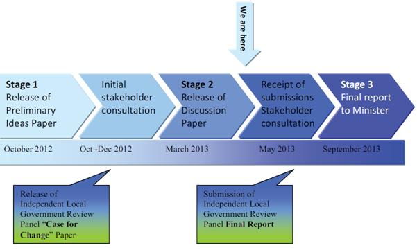
In August 2012, the Minister for Local Government also announced that the legislative framework for local government in NSW was to be rewritten and modernised. He appointed a Local Government Acts Taskforce to make recommendations in respect of this process. As a consequence, the Taskforce took on the key actions from Destination 2036 associated with the amendment of the Local Government Act and the City of Sydney Act. The Taskforce was charged with the task of ensuring that new legislation meets the current and future needs of local government; is streamlined and designed so as to strengthen local government so that it can deliver to its community in an efficient and effective manner; is modern and written in plain language, and while providing a comprehensive framework, unnecessary red tape is avoided; and recognises the diversity of local government in NSW. The Taskforce is due to report to the Minister in September 2013.
![]()
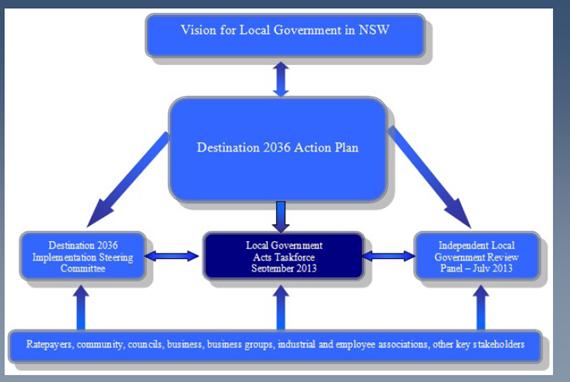
(N.B. The Independent Local Government Review Panel, which was launched in May 2012, was originally scheduled to present its final report to the State Government in July 2013 - see diagram above. That timeline has recently been extended until September 2013 which is in line with the reporting requirements of the Local Government Acts Taskforce.)
The Local Government Acts Taskforce is chaired by Mr John Turner who was a Councillor on Cessnock City Council between 1981 and 1987 prior to being elected to the NSW Legislative Assembly in 1988. He was chair of the Local Government Legislation Committee who oversaw the development of the 1993 Local Government Act. The other members of the Taskforce are Ms Gabrielle Kibble AO - who was a Chief Executive of the Department of Urban Affairs and Planning, an administrator of Liverpool and Wollongong Councils and is currently the chair of the NSW Planning Assessment Commission; Mr Stephen Blackadder – who was the General Manager of Rockdale and Warringah Councils and is now the Executive Director of Blackadder Associates (who in 2012 undertook a review of Hornsby Shire Council’s external services); and Dr Ian Tiley – who has had over 49 years’ experience in local government, including as a Shire Clerk for 15 years and as the Mayor of the former Maclean Shire Council prior to being the first Mayor of the Clarence Valley Council
In an initial round of workshops across NSW, the Taskforce heard from councillors and council officials who work within the framework of the Local Government and City of Sydney Acts on a regular basis. The workshops were held to allow the Taskforce to gather ideas about: what principles should underpin a new Local Government Act; what in the current Local Government Act works well and what needs to be changed or removed from the Act; and how new legislation could enable councils to better deliver services and infrastructure efficiently
Five questions were raised by the Taskforce in its “Preliminary Ideas Paper” and were designed to gather information and ideas that would assist the Taskforce to develop a framework for the new legislation, following which a more detailed examination of the content of the new legislation could occur. The questions were:
· What top five principles should underpin the content of the new Local Government Act?
· What is currently working well in the Local Government Act and why, and should be retained in the new Act?
· Are there areas in the Local Government Act that are working well but should be moved to another Act or into Regulations, Codes or Guidelines?
· What is not working well in the Local Government Act (barriers and weaknesses) and should either be modified or not carried forward to the new Act?
· Should the City of Sydney Act be retained and if so, how can it be improved?
Council provided its response to those questions through the attendance by the General Manager and Deputy General Manager, Corporate Support at a workshop held at Willoughby on 14 November 2012 – refer Deputy General Manager’s Report No. CS33/12 submitted for Council’s consideration at the 19 December 2012 General Meeting. Following on from its initial consultations, the Taskforce has now released a further discussion paper which is the subject of this Report. In this regard, the diagram below illustrates how the discussion paper is included in Stage 2 of the Taskforce’s brief.
DISCUSSION
Potential reforms to the Local Government Act and the City of Sydney Act have entered the second stage with the release of a discussion paper by the Local Government Acts Taskforce. The Taskforce has indicated that it has undertaken extensive consultation and engagement with the local government community over a number of months and with the information gained, submissions received and its own research and deliberations, has produced the discussion paper which is titled “A New Local Government Act for NSW”. The discussion paper (a copy of which is attached) explores four areas of reform - the guiding principles for local government in NSW; a strategic framework for local government in NSW; Council operations; and Tribunals and Commissions.
The Taskforce’s view is that the integrated planning and reporting process, as the primary strategic tool which supports councils delivering to their communities, should form the central theme for the new Local Government Act. The Taskforce notes that integrated planning and reporting was introduced into the Local Government Act in 2009 as a strategic tool to help councils to implement their leadership, advocacy and service roles in local communities.
The Taskforce believes that there are many areas where the integrated planning and reporting provisions can be utilised to remove much of the prescription in the current Act and reduce red tape. It has proposed that integrated planning and reporting be elevated to form a central plank of the new Act as the primary strategic tool which enables councils to fulfil their leadership role and deliver infrastructure services and regulation based on community priorities which have been identified by working in partnership with the community, other councils and the State.
The discussion paper seeks information and feedback from the public on a number of other specific areas which were raised during stage one of the Taskforce’s work. These include: updating and renaming the charter contained in the current Act; public land management; capital expenditure framework; appointment and management of staff; use of technology; and approvals, orders and enforcement.
As a means of developing a Council submission on the discussion paper, a table is provided below which details a summary of the Taskforce’s proposals (see pages 6 to 10 of the attached document) along with a draft response to each which is based on feedback that has been received from Councillors at informal briefings on the matter together with comments from relevant managers/staff from across the organisation. It is proposed that the Council responses form the basis of a submission to the Panel which is due to the Panel by 28 June 2013.
|
Local Government Acts’ Taskforce Proposal |
Council’s Response |
|
Approach and Principles for the Development of the New Act The Taskforce proposes: (i) A flexible, principles based legislative framework, avoiding excessive prescription, written in plain language and in a logical form. The new Act should be confined to setting out the principles of how councils are established and operate. When further detail or explanation is required as to how these principles are to be achieved then regulations, codes and guidelines will be used where appropriate. (ii) a more consistent approach be taken to the use and naming of the regulatory and other instruments, noting that there is inconsistent use of mandatory and discretionary codes, section 23A guidelines, practice notes, discretionary guidelines and the like. |
Supported.
Supported. |
|
Purposes of the Local Government Act (i) The Taskforce proposes the following draft Purposes of the Act “the purpose of this Act is to provide (1) a legal framework for the NSW system of local government in accordance with section 51 of the Constitution Act 1902 (NSW) (2) the nature and extent of the responsibilities and powers of local government (3) a system of local government that is accountable, effective, efficient and sustainable.” |
Supported.
Supported.
Supported. |
|
Role and Principles of Local Government (i) the Taskforce proposes the inclusion of a new Role of Local Government and a set of Principles for Local Government that will replace the charter in the new Act as follows: “Role of Local Government The role of local government is to lead local communities to achieve social, economic and environmental wellbeing through: i) utilising integrated strategic planning ii) working in partnership with the community, other councils, State and Commonwealth governments to achieve outcomes based on community priority as established through integrated Planning and Reporting iii) providing and procuring effective, efficient and economic infrastructure, services and regulation iv) exercising democratic local leadership and inclusive decision-making Principles of Local Government Principles to be observed by local government are to: i) provide community-based representative democracy with open, unbiased and accountable government ii) engage with and respond to the needs and interests of individuals and diverse community groups iii) facilitate sustainable, responsible management, development, protection and conservation of the natural and built environment; iv) diligently address risk and long-term sustainability; v) achieve and maintain best practice public governance and administration, and to act fairly, responsibly, ethically, and in the public interest, and vi) optimise technology, and foster innovation and flexibility.” |
Supported. Supported.
Supported.
Supported.
Supported.
Supported.
Supported.
Supported.
Supported.
Supported.
|
|
Integrated Planning and Reporting The Taskforce proposes that: (i) IPR be elevated to forma central ‘plank’ of the new Act as the primary strategic tool to enable councils to fulfil their leadership role and deliver infrastructure, services and regulation based on community priorities identified by working in partnership with the community, other councils and the State Government. (ii) other provisions of the Act be drafted so as to better support IPR including accountability to the community, financial sustainability and partnership with the State and others to deliver community outcomes. (iii) where possible relevant provisions from other sections of the Act be incorporated into IPR to reduce duplication. For example, capital planning and expenditure approval provisions could be moved to the IPR resourcing strategy provisions; and community consultation processes should reflect IPR community engagement principles and need not be repeated throughout the Act. (iv) the IPR provisions be simplified to increase flexibility for council to deliver IPR in a way that is locally appropriate. |
Supported.
Supported.
Supported.
Supported.
|
|
Community Consultation and Engagement The Taskforce proposes the following set of principles to guide councils regarding how consultation and engagement might occur: · commitment to ensuring fairness in the distribution of resources (equity); rights are recognised and promoted (rights); people have fairer access to the economic resources and services essential to meet their basic needs and to improve their quality of life (access); and people have better opportunities to get involved (participation) · ensuring that persons who may be affected by, or have an interest in, a decision or matter should be provided with access to relevant information concerning the purpose of the consultation and the scope of the decision(s) to be taken · ensuring that interested persons have adequate time and reasonable opportunity to present their view to the council in an appropriate manner and format · ensuring that the views presented to the council will be given due consideration · ensuring that council, in exercising its discretion as to how consultation will proceed in any particular circumstance, has regard to the reasonable expectations of the community, the nature and significance of the decision or matter, and the costs and benefits of the consultation process · arranging for special consultative procedures in particular instances. |
Supported, on the basis that there is consistency with the requirements of other Acts under which Council has to operate e.g. Environmental Planning and Assessment Act. Any amendments should also be consistent with any requirements for community consultation introduced as part of the NSW State Government’s review of the planning system as outlined in the White Paper.
|
|
Technology The Taskforce proposes that: (i) as a general principle the Act should support the optimal and innovative use of technology by councils to promote efficiency and enhance accessibility for the benefit of constituents. (ii) the Act allow each council to determine the most appropriate use of technology taking into account the principles for local government and community engagement through the IPR framework discussed above. |
Supported.
.
Supported.
|
|
Elections The Taskforce proposes: (i) use of postal voting at all council elections as a means of increasing efficiency and voter participation and reducing council election costs. (ii) the following possible improvements to electoral provisions: · the most appropriate voting system – exhaustive preferential; optional preferential; proportional, or first past the post · the option of utilising electronic voting in the future · mechanisms for removing the need for by-elections, when a vacancy occurs either in the first year following an ordinary election or up to 18 months prior to an ordinary election · half term elections for councillors, similar to Senate elections
· the ward system being abolished
· improving the adequacy of and access to candidate information prior to elections · the enrolment process and maintenance of the non-residential roll, particularly in the city of Sydney |
Supported.
Supported.
Supported.
Supported.
Not supported. This would place an increased cost on Council in respect of elections and may impact on the continuity of Council decision making. Not supported. This recommendation is contradictory to the Independent Local Government Review Panel’s recommendations regarding Governance (which Council supports). Supported.
Supported. . |
|
Meetings The Taskforce proposes: (i) the provisions relating to council meetings be: · reviewed, modernised and any unnecessary prescription and red tape removed, · designed to facilitate councils utilising current and emerging technologies in the conduct of meetings and facilitating public access; and · consolidated into a generic mandatory Code of Meeting Practice that may if necessary be supplemented to meet local requirements, provided the amendments are not inconsistent with the provisions of the Act and standard Code of Meeting Practice. |
Supported.
Supported.
Supported. |
|
Appointment and Management of Staff The Taskforce proposes: (i) the strategic responsibilities of the council be clearly separated from the operational responsibilities of the general manager in determining the council’s structure and be aligned with IPR by: · the general manager being responsible for determining the organisation structure and for recruiting appropriately qualified staff necessary to fulfil each role within the structure · the council being responsible for determining those services and priorities required and to provide the resources necessary to achieve the Council’s Delivery Program, and
· the general manager being responsible for the employment of all staff and there be no requirement for the general manager to consult with the council in relation to appointment and dismissal of senior staff.
(ii) all positions meeting the criteria as a senior staff position be treated as such, appointed under the prescribed standard contract for senior staff, identified as a senior staff position within the organisation structure, and the remuneration be reported in the council’s annual report.
(iii) in line with the principle of reducing prescription: · each council to determine how it deals with regulatory responsibilities that fall outside of the Local Government Act, rather than prescribe the appointment of a Public Officer, and · the EEO provisions be incorporated with the IPR processes and procedures (iv) the current prescription in the Act relating to the advertising of staff positions and staff appointments be transferred to regulation or to the relevant industrial award. |
Supported.
Supported on the basis that the term “resources” is clarified in the Act. In this regard, it may be clearer if the relevant section requires that council determine the financial resources (but not the human or material resources - which are more appropriately management's responsibility) that should be supplied and apportioned through approval of the budget in order to achieve the Delivery Program. It is recommended that this dot point proposal be amended to read "....provide the financial resources necessary...". Supported. Consideration should be given to legislatively enshrining the principles of natural justice in the termination provisions within the standard contact for general managers, especially where the general manager can be terminated without reason, e.g. under clauses 10.3.5 or 11.3. Supported. In respect of the determination of senior staff positions, this should not be solely based on remuneration of the position but should have regard to where the position is placed within the structure of the organisation. In this regard, it is proposed that in addition to general managers, all level 2 managers (i.e. director/divisional level reporting to the general manager) should be automatically senior staff regardless of the council size or the remuneration level. Level 3 managers (i.e. those reporting to level 2 managers) who meet the existing criteria could be senior staff, but that should be at the discretion of the general manager.
Supported
Supported
Support transfer to regulation but not to a relevant industrial award as these awards are subject to the risk of industrial negotiation every three years. |
|
Formation and Involvement in Corporations and Other Entities The Taskforce proposes to defer further consideration of this component of the legislation until the work of the Independent Panel is completed. |
Supported.
|
|
Code of Conduct The Taskforce is not proposing any changes to the conduct provisions of the Act. |
Supported. |
|
Pecuniary Interest The Taskforce proposes that: (i) the pecuniary interest provisions be reviewed to ensure they are rewritten in plain language, easily understood and any unnecessary red tape removed. (ii) consideration be given to utilising available technology to assist with the submission and maintenance of pecuniary interest disclosures and to facilitate appropriate access to this information. |
Supported.
Supported. |
|
Delegations The Taskforce proposes that the provisions in the Act relating to delegations be reviewed to ensure they are streamlined; written in plain language; and are reflective of the roles and responsibilities of the council and the general manager to facilitate the efficient, effective and accountable operation of local government. |
Supported. |
|
Financial Governance The Taskforce proposes: (i) there be greater scope for a focus on principles and the definition of financial systems/minimum standards within a new legislative framework and for assimilation with the mechanisms of IPR in line with frameworks proposed for other parts of the legislation. (ii) there be rebalancing of the regulatory focus of the legislative framework towards systems and risk management rather than process prescription. (iii) to await the Independent Panel work on many of the issues associated with fiscal responsibility including; rating issues; asset and financial planning; rates and charges; management of expenditure; and audit practices before recommending legislative positions on these matters. |
Supported.
Supported.
Supported. |
|
Procurement The Taskforce proposes: (i) the adoption of a more principles-based enabling approach to procurement combined with a medium level of regulation designed to ensure support of the principles of value for money, efficiency and effectiveness, probity and equity, and effective competition. (ii) in relation to the current tendering threshold of $150,000 rather than the legislation setting a dollar value threshold a more flexible principles-based approach be taken to councils setting the threshold based on risk assessment of the proposed procurement. (iii) the delegations section of the Act be reviewed to facilitate councils entering into collaborative procurement arrangements such as via ROCs and allowing councils to delegate procurement to general managers with a ‘report back’ mechanism. (iv) any regulation of council procurement support councils utilising available technologies that can assist with efficient, effective and economic procurement processes that are accessible to all relevant stakeholders and are fair, open and transparent. |
Supported.
Supported.
Supported.
Supported. |
|
Capital Expenditure Framework The Taskforce proposes: (i) that a capital expenditure and monitoring framework be developed to enable the appropriate management of risk by councils. This framework should be tailored to risk levels, including significance of the project (including materiality and whole of life costs) and not based on arbitrary monetary thresholds or procurement vehicles. |
The current capital expenditure guidelines provide a general overview of the capital expenditure review process but lack detailed explanation of appropriate economic and financial appraisal methodology. Many councils may not have the expertise in house to enable reviews to be completed with confidence and often employ consultants at additional cost. However, Council staff still need sufficient knowledge to understand the process so that they can review an external consultant’s appraisal in a confident manner. The NSW Treasury Policy and Guidelines Papers are general principles which agencies should apply to their particular situation and develop procedures for undertaking appraisals in their field of operation in consultation with Treasury. These principles are based on the utilisation of economic and financial appraisal techniques to ensure the efficient allocation of resources. A framework should be developed which is consistent with the Treasury Guidelines and makes it mandatory for all NSW councils to apply a consistent financial methodology to all significant capital projects. It may be appropriate that an independent level of review be obtained either from NSW Treasury, DLG or alternative external organisation that can confirm these financial assessments for high value projects. |
|
Public Private Partnerships The Taskforce proposes that PPP projects continue to be subject to regulation and aspects that could be streamlined or simplified be identified and mechanisms for ensuring PPPs be considered for inclusion in the IPR framework. |
Supported in principle subject to an evaluation of the details when available. |
|
Acquisition of Land The Taskforce proposes: (i) no change at this time to the acquisition of land provisions as they remain essential to council’s continued service and infrastructure deliver, are generally working well and there are no strong reasons to support change.
(ii) council plans for the acquisition of land be linked with the IPR processes, and in particular the expressed opinion of the community in the community strategic plan on the need for additional public land or the sale of public land, be included in Delivery Program provisions. |
Council believes that change is needed to address the risks associated with VG valuations. Decisions to acquire land should have reference to the 'value for money' principles and proper market value. Most procedures in government require two valuations, as valuations are not scientific (like engineering), but opinion based. In order to make informed decisions about acquisitions, the VG should have to provide a pre-acquisition "appraisal" and/or "valuation", depending on the circumstances, and should be accountable for the advice. The acquiring authority could then make an informed decision as to whether or not to proceed. There should also be a right for council to ask for second opinion of valuation. Currently the VG issues a valuation for compensation. Only the dispossessed owner has the right to object, which protects against an undervaluation. However, there is no protection for the acquiring authority for an over valuation. The only opportunity for the authority is opened up when the dispossessed owner objects, then the authority can seek a different valuation, however it comes at significant cost. Proceeding to the Land and Environment Court is costly, risky, time consuming and not socially ideal.
There is some risk if planned acquisitions (and particularly financials) are identified in the community strategic plan. It potentially precludes free market competitive processes and the opportunity for cost minimisation for Council. It is also noted that opportunities for strategic land acquisition do not always arise in a predictable manner. |
|
Public Land The Taskforce proposes: (i) the current processes for council land management, being complex and inconsistent with the Crown Lands regime, be simplified and complementary. (ii) the Local Government Act: · require councils to strategically manage council-owned public land as assets through the IPR framework · balance reasonable protections for public land use and disposal where the land is identified as having significant value or importance · end the classification regime of public land as either community or operational land and instead, require the council resolution at the time of acquiring or purchasing land to specify the proposed use or uses · provide that a proposed change in the use or disposal of public land, including consultation mechanisms, should be dealt with through the council’s asset management planning and delivery program · retain the requirement for a public hearing to be held by an independent person where it is proposed to change the use or dispose of public land identified as having significant value or importance. The results should be reported to and considered by the council before a decision is made and proposals should be addressed through council’s community engagement strategy · recognise the LEP zoning processes and restrictions applying to council owned public land · review the prescribed uses to which public land may be applied to accommodate other uses appropriate to the current and future needs of the community · cease the need for separate plans of management for public land to be prepared and maintained, and in lieu, utilise the asset management planning and delivery program · cease the need for a separate report to be obtained from the Department of Planning and Infrastructure where proposed leases and licences of public land are referred to the Minister for Local Government for consideration. |
Supported.
Supported.
Supported.
Support the end of the classification regime but not the requirement for council resolution at the time of acquiring land. Instead it is proposed that the resolution occur as part of the IPR process which is in line with central plank of the new Act as proposed by the Taskforce.
Supported.
Not supported. This matter is addressed through the community consultation charter for the Local Environmental Plan process and does not require a separately mandated public hearing process.
Supported.
Supported.
Supported.
Supported.
|
|
Approvals, Orders and Enforcement The Taskforce proposes: (i) regulatory provisions be reviewed to ensure that the Act provides guidance on regulatory principles but contains flexibility and less prescription in their implementation, with statutory minimum standards or thresholds the council must meet, and council’s discretionary ‘on-the-ground’ functions. (ii) within this framework, the prescriptive processes of approvals and orders be streamlined and, subject to risk assessment, be placed into regulations where possible, allowing the Act to focus on high priority areas and principles. (iii) certain approvals be repealed or transferred to other legislation, such as the installation of manufactured homes and the operation of caravan parks and camping grounds. Installation of domestic oil and solid fuel heating appliances should be transferred to the Environmental Planning and Assessment Act; approvals for filming activities on public land be deleted or transferred to other legislation; approvals for amusement devices be transferred to health and safety legislation; and approvals for engaging in activities on public roads be transferred to roads and transport legislation. (iv) given that maximum penalties have not increased since 1993, penalties for offences in the Act and Regulation be reviewed to ensure they are proportionate to the seriousness and nature of the offence, and act as a deterrent to re-offending. (v) to have regard to the findings and recommendations of the reports by IPART as they affect local government that are due mid-2013. The Taskforce invites comments as to whether there are currently activities requiring approval that are low-risk or redundant and therefore can be removed from the legislation. |
Supported.
Supported.
Supported.
Supported.
Supported.
|
|
Water Management The Taskforce will await the report and recommendations of the Independent panel on water management so that the regulation of water by local government in NSW can be further considered. This will involve the determination of appropriate governance structures for water and sewerage delivery in those areas currently serviced by LWUs and water county councils. It will also resolve whether the constitutional and regulatory arrangements for new structures should remain in the Act or relocated into a more appropriate integrated legislative framework. |
Supported in principle, however, it is noted that non metropolitan councils are in a better position to inform the Taskforce on this matter. |
|
Performance of Local Government The Taskforce will await the report and recommendations of the Independent Panel before considering any legislative provisions but invites submissions on whether the performance of local government and its constituent entities should be further monitored and reported. |
Supported. |
|
City of Sydney Act The Taskforce proposes that a separate Act for the City of Sydney be retained (pending the report and recommendations of the Independent Panel) noting that the Council is also subject to the provisions of the Local Government Act. |
Supported in principle, noting that Sydney City Council is in the best position to inform the Taskforce on this matter. |
CONSULTATION
This Report in part details the consultation that has occurred as a consequence of the local government reform process. As such, there have been ongoing discussions with the Local Government Acts Taskforce, the Independent Local Government Review Panel, industry bodies and representatives of other councils.
BUDGET
There are no budgetary implications associated with this Report.
POLICY
There are no policy implications associated with this Report.
CONCLUSION
The local government reform process is entering a critical stage in the lead up to the release of final reports to the State Government by the Independent Local Government Review Panel and the Local Government Acts Taskforce. The Taskforce’s latest discussion paper titled “A New Local Government Act for NSW” provides an opportunity for the local government industry to have a say about the Taskforce’s latest thinking prior to the release of its final report in September 2013. In terms of Council responding to the discussion paper, a table has been provided in this Report detailing a summary of the Taskforce’s proposals together with a draft response to each which is based on feedback that has been received from Councillors and relevant managers/staff from across the organisation. It is proposed that those responses form the basis of a submission to the Taskforce.
RESPONSIBLE OFFICER
The officer responsible for the preparation of this Report is the Deputy General Manager, Corporate Support Division – Gary Bensley- who can be contacted on 9847-6605.
|
Gary Bensley Deputy General Manager Corporate Support Division |
Scott Phillips General Manager General Manager's Division |
|
1.View |
Local Government Acts Taskforce - A New Local Government Act for NSW - Discussion Paper |
|
|
File Reference: F2009/00463
Document Number: D02175339
Deputy General Manager's Report No. CS24/13
Corporate Support Division
Date of Meeting: 19/06/2013
2 INVESTMENTS AND BORROWINGS FOR 2012/13 - STATUS FOR PERIOD ENDING 30 APRIL 2013
EXECUTIVE SUMMARY
· Council may invest funds that are not, for the time being, required for any other purpose. The investments must be in accordance with relevant legislative requirements and Council’s policies. The Chief Financial Officer must report monthly to Council on the details of funds invested.
· This Report provides details of Council’s investment performance for the period ending 30 April 2013. It indicates that for total investments, the annualised return for the month of April was 4.32% compared to the benchmark of 3.00%.
· On a financial year to date basis as at 30 April 2013, the performance of the portfolio is 4.45% compared to the benchmark of 3.33%.
· In respect of Council’s borrowings, the weighted average interest rate payable on loans taken out from June 2003 to August 2012, based on the principal balances outstanding, is 6.04%.
· All investments have been made in accordance with the Local Government Act, the Local Government (General) Regulation and Council's Investment of Surplus Funds Policy and Investment Strategy.
|
THAT the contents of Deputy General Manager’s Report No. CS24/13 be received and noted. |
PURPOSE
The purpose of this Report is to advise Council of funds invested in accordance with Section 625 of the Local Government Act; and to provide details as required by Clause 212(1) of the Local Government (General) Regulation and Council's Investment of Surplus Funds Policy.
BACKGROUND
Each month, a report is provided for Council’s consideration which details Council's investments and borrowings and highlights the monthly and year to date performance of the investments. Initial investments and reallocation of funds are made, where appropriate, after consultation with Council's financial investment adviser and fund managers.
DISCUSSION
Council may invest funds which are not, for the time being, required for any other purpose. Such investment must be in accordance with relevant legislative requirements and Council’s Policies, and the Chief Financial Officer must report monthly to Council on the details of the funds invested.
Council’s investment performance for the period ending 30 April 2013 is detailed in the attached documents and summarised below:
· The At-Call and Term Deposits achieved an annualised return of 4.32% for April 2013 compared to the benchmark of 3.00%.
· The Capital Guaranteed Notes achieved an annualised return of 0% for this period. No interest will be accrued for the remaining life of the securities.
· For total investments, the annualised return for April 2013 was 4.02% compared to the benchmark of 3.02%.
· On a financial year to date basis as at 30 April 2013, the performance of the portfolio was 4.45% compared to the benchmark of 3.33%.
In respect of Council borrowings, the weighted average interest rate payable on loans taken out from June 2003 to August 2012, based on the principal balances outstanding, is 6.04%. The Borrowings Schedule as at 30 April 2013 is attached for Council’s information.
CONSULTATION
Appropriate consultation has occurred with Council's financial investment adviser and fund managers.
BUDGET
Total year to date investment income for the period ending 30 April 2013 was $1,672,000 and the budgeted income for the period was $1,852,000. Approximately 27% of the total income relates to externally restricted funds and is required to be allocated to those funds. The general fund interest component of the investment portfolio is anticipated to be on budget by June year end.
POLICY
All investments have been made in accordance with the Local Government Act, the Local Government (General) Regulation and Council's Investment of Surplus Funds Policy and Investment Strategy.
Council’s Investment Strategy was reviewed and adopted by Council at the 19 December 2012 General Meeting. The main change to the Strategy at that time was to place greater emphasis on counterparty and credit quality targets and limits as a consequence of the removal of the Federal Government’s Deposit Guarantee Scheme on 1 February 2012 for invested amounts up to $1 million.
CONCLUSION
The investment of Council funds for the period ending 30 April 2013 is detailed in the documents attached to this Report. Council’s consideration of the Report and its attachments ensures that the relevant legislative requirements and Council protocols have been met in respect of those investments.
RESPONSIBLE OFFICER
The officer responsible for the preparation of this Report is the Chief Financial Officer – Glen Magus - who can be contacted on 9847 6635.
|
Glen Magus Chief Financial Officer - Financial Services Corporate Support Division |
Gary Bensley Deputy General Manager Corporate Support Division |
|
1.View |
HSC Borrowings Schedule as at 30 Apr 2013 |
|
|
|
2.View |
HSC Investment Portfolio as at 30 Apr 2013 |
|
|
File Reference: F2004/06987
Document Number: D02182037
Deputy General Manager's Report No. CS25/13
Corporate Support Division
Date of Meeting: 19/06/2013
3 OUTSTANDING COUNCIL RESOLUTIONS - PERIOD UNTIL 28 FEBRUARY 2013
EXECUTIVE SUMMARY
· Council’s Policy dealing with Council Resolutions requires that a quarterly report be prepared detailing resolutions which have not been substantially implemented within two months of being adopted, and the reason/s why they are not finalised.
· In accordance with the Policy, each Division has carried out a review of any resolutions adopted by Council up until the end of February 2013 which have not been substantially implemented.
· Council should consider the comments provided in the attachment to this Report in respect of each of the outstanding resolutions and determine if any further action is required.
|
THAT the contents of Deputy General Manager’s Report No. CS25/13 be received and noted. |
PURPOSE
The purpose of this Report is to comply with the Council Resolutions Policy and provide details in respect of resolutions adopted by Council up until the end of February 2013 which have not been substantially implemented.
BACKGROUND
Council’s Policy dealing with Council Resolutions requires that a quarterly report be prepared for Council’s consideration detailing resolutions which have not been substantially implemented within two months of being adopted, and the reason/s why they are not finalised. The reports are generally submitted for Council’s consideration at the General Meetings in March, June, September and December each year.
DISCUSSION
In accordance with the Council Resolutions Policy, each Division has carried out a review of any resolutions adopted by Council up until the end of February 2013 which have not been substantially implemented. This has resulted in the attached spreadsheet being prepared which shows a list of outstanding resolutions per Division. Details are provided about the:
· Report Number and Name
· Outstanding Resolution
· Latest Status
· Comment
In preparing Outstanding Council Resolutions reports, Divisional Managers give special consideration to any long outstanding resolutions and, where such resolutions exist, provide comments about whether further action may be unlikely or impractical. In these cases, Council may wish to determine whether or not the item should be removed from further reporting in the Outstanding Council Resolutions report.
BUDGET
Any budgetary implications are included in the relevant report or in the “Latest Status” column of the attached spreadsheet.
POLICY
The preparation of this Report meets the requirements of the Council Resolutions Policy.
CONCLUSION
Council should consider the comments provided in the attachment in respect of each of the outstanding resolutions and, if necessary, determine if any further action is required.
RESPONSIBLE OFFICER
The officer responsible for the preparation of this Report is the Manager Governance and Customer Service – Robyn Abicair, who can be contacted on 9847 6608.
|
Robyn Abicair Manager - Governance and Customer Service Corporate Support Division |
Gary Bensley Deputy General Manager Corporate Support Division |
|
1.View |
Outstanding Council Resolutions - As At 28 February 2013 |
|
|
File Reference: F2005/00112
Document Number: D02183391
Deputy General Manager's Report No. CS26/13
Corporate Support Division
Date of Meeting: 19/06/2013
4 ADOPTION OF COUNCIL'S COMMUNITY STRATEGIC PLAN 2013-2023, DELIVERY PROGRAM 2013-17, AND OPERATIONAL PLAN INCLUDING BUDGET, RATING STRUCTURE AND FEES AND CHARGES 2013-14
EXECUTIVE SUMMARY
· Council’s draft 10 year Community Strategic Plan (known as Your Community Plan 2013-2023), and its draft Delivery Program 2013-17 and draft Operational Plan 2013-14, were adopted for public exhibition by Council at its 17 April 2013 General Meeting. The draft Operational Plan includes the Budget, Rating Structure and Fees and Charges for 2013-14.
· The draft documents were publicly exhibited from 18 April until 17 May 2013 and submissions invited. Eleven submissions were received which are summarised in Table 1A of this Report. Table 1B contains a summary of administrative changes requested by internal Divisions of Council.
· Each submission has been reviewed by appropriate Council staff, and while some minor changes are supported, no material changes to the publicly exhibited documents are recommended.
· It is noted that Council received information from other levels of government during the exhibition period which have no material effect on the publicly exhibited documents.
|
THAT Council: 1 Adopt Your Community Plan 2013-2023, Delivery Program 2013-17, Operational Plan including the Budget, Rating Structure and Fees and Charges 2013-14, incorporating the amendments to the documents recommended in Deputy General Manager’s Report No. CS26/13. 2. Make and levy the Ordinary Rates for 2013-14 in accordance with the table shown in the Rates section of Deputy General Manager’s Report No. CS26/13. 3. Make and levy the Catchments Remediation Rate on all rateable land in the Shire, in accordance with the table shown in the Rates section of Deputy General Manager’s Report No. CS26/13. 4. Make and levy the Hornsby Quarry Loan Rate on all rateable land in the Shire, in accordance with the table shown in the Rates section of Deputy General Manager’s Report No. CS26/13. 5. Continue to provide eligible pensioners with a $10 concession in respect of the Hornsby Quarry Loan Rate, represented by a reduction in the Base amount. 6. Continue to provide eligible pensioners with an additional $20 concession in respect of the rate variation represented by a reduction in the Base amount. |
PURPOSE
The purpose of this Report is to provide Council with information and recommendations regarding the submissions received in respect of the public exhibition of Your Community Plan 2013-2023, Delivery Program 2013-17, and Operational Plan including Budget, Rating Structure and Fees and Charges 2013-14.
BACKGROUND
By 30 June in the year following local government elections, all councils are required to develop a 10 year community strategic plan, a four year delivery program and a one year operational plan as well as a resourcing strategy aligned to an integrated planning framework. The purpose is to identify the main priorities and aspirations for the future of the area and the resources required to move to the preferred future.
The Division of Local Government has mandated an integrated planning framework which approaches business planning based on community aspirations and preferences. It requires that the community be presented with the key issues and challenges facing the Shire in order that the community can have deliberative input into how Council, other government agencies and the community will respond to those issues and challenges.
At the General Meeting held on 17 April 2013, Council considered Deputy General Manager’s Report No. CS12/13 and resolved that:
1. Council adopt for public exhibition and make available for public comment from 18 April to 17 May 2013, the draft Community Strategic Plan 2013-2023, the draft Delivery Program 2013-17 and the draft Operational Plan 2013/14 which includes the draft Budget, Fees and Charges and Rating Structure.
2. Council note that the rating information contained in the draft Operational Plan 2013/14 is in line with the Independent Pricing and Regulatory Tribunal’s approval for Council (i.e. a 3.9% increase for 2013/14).
3. Following the public exhibition period, and before 30 June 2013, a further report be prepared which provides details of any submissions received and recommends the adoption of a final Operational Plan 2013/14 which includes the Budget, Fees and Charges and Rating Structure for that year.
DISCUSSION
Consultation on the Documents
During the exhibition period from 18 April 2013 to 17 May 2013, copies of Your Community Plan 2013-2023, the Delivery Program 2013-17, Operational Plan including Budget 2013-14, and Fees and Charges 2013-14 were on display at Council’s reception areas and five libraries and were available electronically on Council’s website. Advertisements advising of their availability were placed in the Shire’s three local newspapers and the newsletter distributed to 46,000 households with the April rates instalment notices.
Submissions
A total of 11 submissions were received during the formal exhibition period including one late submission. Council also received three notifications from other levels of government. None of these have any material impact on the budget.
Of the submissions:
· nine relate to the proposed fee increases at community centres
· one relates to the proposed increase in childcare fees
· one is a late submission giving positive feedback on the suite of documents and drawing attention to projects that impact residents of Dangar Island.
The submissions are summarised below, with staff recommendations in italics.
Table 1A
|
No. |
Centre |
Name |
Summary of Issues |
Staff recommendation |
|
1.
2. |
Asquith Community Centre |
· Linda Lazenby, ABC Playgroup · Clair Higgins, ABC Playgroup
|
· Proposed fee increase ($1 per hour increase for regular hirers). · Maintenance of centre. |
Supported § Recommend that the current fee structure for Asquith Community Centre hirers not be increased in 2013/14. Having regard to a major redevelopment proposed for the centre, maintenance is currently limited to essential works only. |
|
3.
4. |
Cherrybrook Community Centre |
· Gavin Poole, Pastor Cherrybrook Anglican Church · Thomas Lee, |
· Fee increase (Ironbark Room $4 per hour increase for regular hirers; Foyer storeroom $45 per month increase). · Minimum 3 hour booking. |
Partially Supported § Fees are recommended by Management Committee and are considered reasonable having regard to operational expenses and long term asset management considerations. § Recommend that minimum booking blocks be reduced to 2 hours to ensure consistency with other Council managed centres. |
|
5. |
Epping Community Centre |
· John Withers, Epping & District Scottish Society Inc |
· Fee increase |
Not Supported § Recommended fee increases are considered reasonable having regard to operational expenses and long term asset management considerations. |
|
6. 7. 8. |
Mount Colah Community Centre |
· Julie Spink · Gael Walker · Jenny Gadd |
· Fee increase ($1 per hour increase for regular hirers across all hireable spaces). · Hire charge for storage cupboards. · Minimum 2 hour booking. |
Not Supported § Recommended fee increases are considered reasonable having regard to operational expenses and long term asset management considerations. § 2 hour minimum booking requirement has not changed from 2012/13. |
|
9. |
Pennant Hills Community Centre |
· David Pullin, GymbaROO Pennant Hills |
· Fee increase · Maintenance of the centre – specifically an issue with leaks during heavy rain and associated damage to the hall floor. |
Not supported § Recommended fee increases are considered reasonable having regard to operational expenses and long term asset management considerations. § Routine maintenance undertaken regularly with major re-waterproofing of the roof scheduled to take place in 2015/16. |
|
10. |
Child Care |
· Laura Brownlee |
· Fee
increases – no discount for siblings. |
Not Supported § Recommended fees reflect the cost of delivering the service, including administrative and operating costs. |
|
11. |
|
· Peter Wolfe, Dangar Island League |
· Retention of Brooklyn Wharf in public ownership. |
Supported § There are no plans to privatise Brooklyn Wharf. |
|
· Ways to assist with health of waterways. |
Supported § Two key ways to assist is to promote responsible dog ownership to protect local and migratory birdlife especially on Bradleys Beach, and to promote responsible boating to protect seagrass beds and be mindful of the seagrass marker buoys. |
|||
|
· Heritage – tours and materials more accessible to visitors. |
Supported § Council pleased to obtain more information re types of heritage events and materials Dangar Island Historical Society wish to promote. Council currently looking to review heritage related material available on its website, where there could be an opportunity to incorporate a link to the Dangar Island Historical Society website. |
|||
|
· Consultation with League when developing Events Strategy. |
Supported § Arts and Culture – Council will continue to provide support for Australia Day events through promotion and advertising. Also happy to work with the Dangar Island residents to stage other events that can showcase the thriving arts and culture within the community. |
|||
|
· Disabled access to public wharves.
|
Partially supported § The League’s request to improve access to the wharves at Dangar Island and Brooklyn is supported. Plans are currently being developed for a new pontoon facility at Dangar Island that will improve disabled access. The situation is more difficult at Brooklyn, but it is Council’s intention to improve disabled access, once funds and a viable layout have been identified. § The Hawkesbury River wharf is a State Government facility. Representations will be made on behalf of the League to the relevant State agency. |
|||
|
· Reprioritising of toilet refurbishment in Dangar Island Community Centre. |
Partially supported § The request to reprioritise the refurbishment of the toilet facility at Dangar Island Community centre is noted. Officers of Council will shortly approach the League to discuss the proposal. |
|||
|
· Parking shortage at Brooklyn. |
Partially supported § Noted. Council has resolved to undertake a car parking survey in the vicinity of Lower McKell Park. This survey will be useful in determining demand for car parking and is scheduled to be undertaken later in the year. |
|||
|
· Broadband capacity - ensure Dangar Island enjoys parity with other areas as NBN rolls out. · Hawkesbury River Railway Station access difficult for disabled, ageing and those with young children. |
§ NBN rollout is Federal Government initiative. Refer to Senator The Hon Stephen Conroy’s office. § Railway Stations are State Government facilities. Refer to The Hon Gladys Berejiklian’s office. |
There were also administrative issues identified by staff during the exhibition period regarding changes to priorities, changes to wording for clarity and correction to an incorrectly advertised fee. These are summarised below.
Table 1B
|
No. |
Name |
Summary of Issues |
Commentary |
|
1b. |
Infrastructure and Recreation Division |
Forward Capital Works 2014/15 in the Delivery Program (p44) under Aquatic and Recreational Centres – “Brickpit Stadium Thornleigh – replacement of floors (subject to approval)” to be removed. Also reference to same in Operational Plan (p53) to be removed. |
§ Advice received from contractor when floors sanded in December 2012 that current flooring has further 10 year lifespan. § Inclusion of project in documents was a copying error.
|
|
2b. |
Clarification of wording for permanent and casual bookings at Thornleigh Brickpit Stadium. |
§ Wording around permanent and casual bookings and badminton confusing – amended for clarity. |
|
|
3b. |
GST incorrectly attributed to some learn-to-swim categories at Hornsby Aquatic Centre |
§ GST shown in error. Non holiday learn-to-swim classes do not attract GST. The proposed fee exhibited was ex-GST. |
|
|
4b. |
Forward Capital Works in the Delivery Program: · (p44) Open Space Assets 2014/15 o ‘Ern Holmes Oval – Floodlight replacement’ move to 2015/16 o (replace with) Mark Taylor Oval – ADD ‘replacement lighting’ · (p45) Open Space Assets 2015/16 o delete ‘Thornleigh Oval – Floodlight replacement’ o Ron Payne Park – new description ‘New floodlights’. |
§ Based on updated assessment of floodlight condition, and communication with user groups. |
|
|
5b. |
Environment and Human Services Division |
Hire charges for the Leisure and Learning Centres should be increased more in line with water/power and garbage removal costs. |
§ Council currently working on restructuring the fees and charges for all its community centres, working towards a more balanced schedule of fees based on the centre specifications and facilities within the building and grounds. Important that changes are introduced gradually to ensure regular hirers are not alienated or the centres are not priced out of the target market. |
|
6b. |
Additional 4 year projects in Delivery Program with linking 1 year Actions in Operational Plan covering sustainability |
§ Based on updated assessment of sustainability initiatives. |
|
|
7b. |
Planning Division |
Fees and Charges, Cemeteries (p9) ‘Niche plaque – engraved and installed’ fee for 2013/14 – typo resulted in fee being reduced to $195 in 2013/14 from $465 in 2012/13. 2013/14 fee should have read $495. |
§ Report to Council 15 May to re-exhibit correct fee ($495). Exhibition closes 13 June. At time of writing no submissions received and recommend Council adopt the correctly readvertised fee effective 1 July 2013. (More detail will be provided in a Late Items Memo) |
During the exhibition period, there were further minor changes suggested by Council staff to improve clarity of the information contained in the documents, and those changes will be incorporated in the final versions of the documents.
Information received from other levels of government
1. Supplementary valuations issued by Valuer General
The rates structure included in the draft Delivery Program 2013-17 was based on the general increase of 3.9% (including rate peg and carbon price adjustment of 0.1%) to apply to the Ordinary and Catchments Remediation Rates. The rate increase for the Hornsby Quarry Loan Rate was increased by the ‘rate peg’ determined by IPART for 2013/14 at 3.4%.
The Ordinary, Catchments Remediation and Hornsby Quarry Loan Rate tables (Tables 2, 3. and 4. in the ‘2013/14 Rates’ section below) have been updated after exhibition to take into account supplementary valuations issued by the Valuer General received after initial calculations. This has affected the ‘Rate in the $ (based on land value)’, ‘Yield $’ columns and the overall totals, increasing the total rates levied from $72,097,280 to $72,209,170. There was a comment in the Draft Operational Plan 2013-14 exhibited alluding to this recalculation due to operational needs. There were no submissions received regarding the proposed rates or rating structure.
2. GST on Fees and Charges
The Commonwealth Government has replaced the ‘Division 81 Determination listing’ approach to exempting certain government taxes, fees and charges from goods and services tax (GST) with a new self assessment ‘principles-based’ approach to providing the exemptions. This has therefore required each council to determine the GST status of items currently exempt under the previous ‘Division 81 Determination’ against their status under the new Division 81 self assessment principles.
Council has been part of an industry wide group (120 councils) that has commissioned a Chartered Accounting Firm to review the fees and charges across the sector and submit a class ruling to the Australian Taxation Office (ATO). These rulings are progressively being released and may affect the currently stated GST status in Council’s Fees and Charges document. This is likely to have a modest impact on Council’s Fees and Charges for 2013/14, but the full impact is not yet known.
A note has been added to the Fees and Charges 2013/14 document stating that while there may be small changes to the GST status due to the rulings received, in most cases the amount payable will remain as advertised.
In the draft Fees and Charges 2013-14 the GST Status for Learn to Swim group, private and school lessons at Hornsby Aquatic Centre was inadvertently indicated as ‘10%’. The GST Status has now been corrected to ‘Exempt’.
3. Advice on minor traffic facilities project submissions for Federal Government blackspot funding
The Federal Government announced its funding of the Blackspots Program. Council submitted two projects for consideration and one was successful. The successful project is Edgeworth David Avenue and Balmoral Street – traffic signals and median at Parks Avenue. The Wylds Road curve treatment project was unsuccessful.
Submissions have been made to Roads and Maritime Services (RMS) for 50% matching funding for four projects. Two were included in the exhibition document: Brooklyn cycleway – Stage 1B and Epping Town Centre 40km/h traffic calming. Two further projects have since been submitted: Review of the Hornsby Bike Plan and Upgrade of pedestrian crossing Pacific Highway, Asquith near Asquith Boys High School. Approval of funding is yet to be confirmed by the RMS. The Pacific Highway, Hornsby 40km/h traffic calming project (50% funded by RMS) will commence in 2012/13 for completion in 2013/14. Council’s Operational Plan will be updated to reflect these changes.
The Resourcing Strategy
Council’s Resourcing Strategy addresses long term financial planning, workforce management and asset management, and must be reviewed each four years. It is one of the more challenging documents to prepare because the three components cannot be completed in isolation and must be developed after the Delivery Program and Operational Plan have been developed. Work is underway on reviewing and updating each of the three components that make up Council’s Resourcing Strategy. The Resourcing Strategy 2013-2023 will be available on Council’s website as soon as completed.
2013/14 Rates
On 10 June 2011, the Independent Pricing and Regulatory Tribunal (IPART) approved Council’s application for a special rate variation over three years, with a 4% increase (including rate peg) applying to 2013/14.
In 2012/13, IPART granted a 0.4% carbon tax advance. In setting the rate peg for 2013/14, the 4% approved increase has been adjusted down to 3.9% to take into account a partial reduction of the carbon price advance. In 2014/15, the general rate increase set by IPART will be reduced by the remaining 0.3% of the carbon tax advance.
The rates structure included in the draft Delivery Program 2013-17 was based on the general increase of 3.9% (including rate peg and carbon price adjustment of 0.1%) to apply to the Ordinary and Catchments Remediation Rates. The rate increase for the Hornsby Quarry Loan Rate was increased by the ‘rate peg’ determined by IPART for 2013/14 at 3.4%.
The Ordinary, Catchments Remediation and Hornsby Quarry Loan Rate tables (Tables 2, 3 and 4 below) have been updated after exhibition to take into account supplementary valuations issued by the Valuer General received after initial calculations. This has affected the ‘Rate in the $ (based on land value)’, ‘Yield $’ columns and the overall totals, increasing the total rates levied from $72,097,280 to $72,209,170.
Table 2 - Ordinary Rates
|
Category |
Rate in the $ (based on land value) |
Minimum Rate $ |
Base Amount $ |
Base Amount % |
% of Total Rate |
Yield $ |
|
Residential |
0.00151367 |
|
484 |
46 |
87.5 |
57,520,660 |
|
Farmland |
0.00136317 |
|
484 |
28 |
0.8 |
525,901 |
|
Business |
0.00515695 |
513 |
|
|
6.8 |
4,470,169 |
|
Business - Hornsby CBD |
0.01167239 |
513 |
|
|
4.9 |
3,221,152 |
|
Total |
|
|
|
|
100 |
65,737,882 |
Table 3 - Catchments Remediation Rate
(N.B. There are no minimum or base amounts in respect of this rate)
|
Category |
Rate in the $ |
Yield $ |
|
Residential |
0.00013885 |
2,873,520 |
|
Farmland |
0.00009504 |
26,272 |
|
Business |
0.00027126 |
223,310 |
|
Business - Hornsby CBD |
0.00058524 |
160,916 |
|
Total |
3,284,018 |
|
Table 4 - Hornsby Quarry Loan Rate
|
Category |
Rate in the $ (based on land value) |
Base Amount $ |
Base Amount % |
Yield $ |
|
Residential |
0.00007461 |
23 |
45 |
2,788,870 |
|
Farmland |
0.00005213 |
36 |
43 |
25,499 |
|
Business |
0.00013245 |
52 |
50 |
216,729 |
|
Business - Hornsby CBD |
0.000317 |
134 |
44 |
156,172 |
|
Total |
3,187,270 |
|||
Total Rates Levied $72,209,170
CONSULTATION
Council engaged its community in discussing a preferred future for the Shire which resulted in Council’s first Community Strategic Plan being adopted in 2010. The pages titled ‘Your Involvement’, pp26-27, outline the lengthy consultations undertaken in the preparation of Your Community Plan 2013–2023.
Your Community Plan 2013-2023, Delivery Program 2013-17, Operational Plan including Budget and Fees and Charges 2013-14 have been prepared after detailed discussions with relevant staff, consideration by Council and public exhibition of draft proposals.
Councillors received a briefing on the contents of the draft documents on 27 March 2013.
Publicity included advertisements in the three local papers and the newsletter delivered to 46,000 households with the April rates instalment, as well as prominent signage at Council’s five libraries and Administration Centre reception areas.
All users of Council’s child care services, regular hirers of Council’s community centres and sporting associations were advised of the proposed fee increases for 2013-14.
BUDGET
The publicly displayed draft 2013/14 Annual Budget included an estimated surplus of $355K. This estimated surplus included a reduced level of borrowing for the Hornsby Aquatic Centre capital project of $3 million from earlier forecasts of $6 million.
This reduction in loan borrowing has been achieved by further productivity measures implemented throughout the organisation. This action will result in approximately $281K of reduced debt servicing on a 20 year loan in future year budgets.
Over the past five years, considerable savings have been made by not allowing any increase in non-salary related operating budgets, i.e. no increases in the costs associated with plant, materials, etc. Any increases in these areas have needed to be met by efficiency and other gains across Council in those years.
A review of the classification of costs was undertaken across a large part of the operating and capital budgets for 2013/14. This has resulted in identifying approximately $1.877 million listed as operating expense that when applied to generally accepted accounting principles should be classified as capital expenditure. This change in classification has been made to Council’s budget worksheets. This change does not amend Council’s bottom-line budget result.
Further changes to the budget while on public display include advice that $360K of capital contributions will be received by council towards capital expenditure to be spent on Rural Fire Service projects. A review of drainage and sealed road assets has recommended a small increase to the useful life resulting in a decrease to the non-cash expenditure of depreciation by $1.1 million. These changes have been made to Council’s budget worksheets and do not amend Council’s bottom-line budget result.
A review of Council’s current long term financial plan will commence in August 2013 to include the results from the tender on the management of Aquatic Centre Operations, Storey Park childcare and community centre facility options, Hornsby overhead bridge estimate, asset reviews and the new S94 Plan capital program and cashflow requirements. This document when completed will provide financial direction for the next 10 years.
POLICY
Hornsby Shire’s Community Strategic Plan 2013–2023 describes community aspirations. The Delivery Program 2013-17 is Council’s principal instruction to the organisation.
CONCLUSION
The 10 year Community Strategic Plan, four year Delivery Program and the associated Operational Plan 2013/14 including Budget and Fees and Charges encompass the priorities and expected levels of service voiced by the community. Council will respond by providing services in a prudent and financially viable manner.
Once adopted, the final Your Community Plan 2013-2023, Delivery Program 2013-17, Operational Plan including Budget 2013-14 and Fees and Charges 2013-14 will be distributed electronically and in hard copy to Councillors, staff and interested persons.
RESPONSIBLE OFFICER
The officers responsible for the preparation of this Report are the Chief Financial Officer – Glen Magus and the Manager Strategy - Julie Williams - who can be contacted on 9847-6635 and 9847‑6790 respectively.
|
Gary Bensley Deputy General Manager Corporate Support Division |
Scott Phillips General Manager General Manager's Division |
There are no attachments for this report.
File Reference: F2012/00885
Document Number: D02185093
Deputy General Manager's Report No. CS27/13
Corporate Support Division
Date of Meeting: 19/06/2013
5 PECUNIARY INTEREST AND OTHER MATTERS RETURNS - DISCLOSURES BY COUNCILLORS AND DESIGNATED PERSONS
EXECUTIVE SUMMARY
· Section 449 of the Local Government Act (the Act) details the statutory requirements in respect of the lodgement of Disclosure of Pecuniary Interests and Other Matters Return/s by Councillors and Designated Persons.
· Section 450A(2) of the Act requires that Returns lodged under Section 449 are to be tabled at the next available Council meeting.
· In line with Section 450A(2), this Report seeks to table the Return/s recently lodged with the General Manager.
|
THAT Council note the Disclosure of Pecuniary Interests and Other Matters Returns recently lodged with the General Manager have been tabled as required by the Local Government Act. |
PURPOSE
The purpose of this Report is to table the Disclosure of Pecuniary Interests and Other Matters Returns lodged by Councillors/Designated Persons who have left, commenced with, or internally transferred to a relevant position within Council.
BACKGROUND
Section 449(1) of the Act requires a Councillor or Designated Person to complete and lodge with the General Manager a Disclosure of Pecuniary Interests and Other Matters Return within three months after becoming a Councillor or a Designated Person. Section 449(3) requires a Councillor or Designated Person holding that position at 30 June in any year to complete and lodge with the General Manager a Return within three months after that date. Section 449(5) states that nothing prevents a Councillor or Designated Person from lodging more than one Return in any year.
Section 450A(2) of the Act requires that Returns lodged under Section 449 are to be tabled at a meeting of Council. Returns lodged under Sections 449(1) and 449(3) are to be tabled at the first meeting held after the last day for lodgement under those Sections; and Returns lodged for any other reason are to be tabled at the first meeting after their lodgement.
Council's procedures in respect of the disclosing of interests have been developed to cater for the election/appointment/employment/retirement/resignation/etc of Councillors or Designated Persons. These procedures:
· Require all Councillors and Designated Persons who hold that position at 30 June in any year to submit Returns to the General Manager by 30 September in that year (i.e. they are lodged under S449(3)). These Returns are tabled at the October General Meeting of Council in that year.
· Require newly elected Councillors or newly appointed Designated Persons to lodge Returns to the General Manager within three months of their election/appointment (i.e. they are lodged under S449(1). These Returns are tabled at the next available General Meeting of Council.
· Require those Councillors or Designated Persons who are leaving Council (because of retirement, resignation, etc) to lodge Returns to the General Manager by their last day with Council. These Returns are tabled at the next available General Meeting of Council.
DISCUSSION
Returns Lodged in Accordance with Section 449(1) and/or 449(5) of the Local Government Act and Council's Procedures
Council last considered the tabling of Disclosure of Pecuniary Interests and Other Matters Returns under these Sections of the Act at the General Meeting held on 15 May 2013 (see Deputy General Manager’s Report No. CS20/13). Since that Report was prepared, one additional Return has been lodged with the General Manager and is now tabled as required by the Act.
|
Date Lodged |
Councillor/Designated Person (Position) |
Reason for Lodgement |
|
24 April 2013 |
Early Childhood Educator Acting Program Director |
New designated person |
BUDGET
There are no budgetary implications associated with this Report.
POLICY
There are no policy implications associated with this Report.
CONCLUSION
In line with the requirements of the Act, it is necessary for the Return lodged with the General Manager to be tabled at this General Meeting.
RESPONSIBLE OFFICER
The officer responsible for the preparation of this Report is the Manager, Governance and Customer Service – Ms Robyn Abicair - who can be contacted on 9847 6608.
|
Robyn Abicair Manager - Governance and Customer Service Corporate Support Division |
Gary Bensley Deputy General Manager Corporate Support Division |
There are no attachments for this report.
File Reference: F2012/00606
Document Number: D02185111
Deputy General Manager's Report No. CS28/13
Corporate Support Division
Date of Meeting: 19/06/2013
6 DEBTS TO BE WRITTEN OFF - 30 JUNE 2013
EXECUTIVE SUMMARY
· The Financial Services Branch is responsible for assessing Council’s outstanding debtors on a regular basis to determine those debts which are bad, doubtful or recoverable.
· For 2012/13, it is recommended that Council write off debts considered bad totalling $75,430 (see Schedule A), and note debts considered bad totalling $2,301 (see Schedule B) which will be written off under the General Manager's delegated authority.
|
THAT for 2012/13, and in accordance with Clause 213 of the Local Government (General) Regulation, Council:
1. Write off debts considered bad totalling $75,430 (as detailed in Schedule A attached to Deputy General Manager’s Report No. CS28/13). 2. Note debts considered bad totalling $2,301 which will be written off under the General Manager’s delegated authority (as detailed in Schedule B attached to Deputy General Manager’s Report No. CS28/13). |
PURPOSE
The purpose of this Report is to seek Council approval, in accordance with Clause 213 of the Local Government (General) Regulation, to write off debts considered bad for the 2012/13 financial year.
BACKGROUND
Each year, the Financial Services Branch assesses the status of outstanding debtors to determine those debts which are bad, doubtful or recoverable. Debts considered bad are either recommended for write off by the General Manager under delegated authority or submitted to Council for approval to write off. (N.B. Doubtful debts are provided for in the financial records in contrast to bad debts which are written off)
DISCUSSION
The writing off of debts by Council is undertaken in accordance with Clause 213 of the Local Government (General) Regulation. At the Ordinary Meeting held on 10 July 1996, Council resolved that the General Manager be delegated authority to write off individual debts up to $1,000 which are considered irrecoverable. Debts over $1,000 may only be written off by resolution of Council. It is noted that, since 2007/08, the amount of bad debts written off by Council in accordance with Clause 213 of the Regulation is:
2007/08 $21,165
2008/09 $4,636
2009/10 $4,526
2010/11 $15,254
2011/12 $28,634
For 2012/13, it is recommended that Council write off debts considered bad totalling $75,430 (see details in Schedule A); and note debts considered bad totalling $2,301 which will be written off under the General Manager's delegated authority (see details in Schedule B). It should be noted that even if a debt is written off, Council is not prevented from taking future legal proceedings to recover the debt.
The level of debt to be written off in the 2012/13 financial year has increased when compared to prior years. This increase is predominately in the areas of Environmental Fines and Penalties (now totalling $19,568), Restoration Works (now totalling $17,947) and Rates (now totalling $37,269).
As a consequence of reviews undertaken within those areas, the process associated with the issue of an Environmental Order has now been amended such that any legal recovery process will be significantly improved. Similarly, with Restorations, advice has been received which will lead to improved documentation which again will assist the legal recovery process if necessary. The issue with the Rates related debt is that it is in respect of a Crown lease. In this regard the Crown, as the property owner, is not liable for any debt (in this case for rates and accrued interest) that was due and payable to Council by the lessee. For any other property owner, a rates debt would be able to be secured against the property.
CONSULTATION
This Report has been prepared in consultation with Council’s debt collection agency – Recoveries and Reconstruction (Australia) Pty Ltd; Council’s Operations Accountant and other relevant Council staff.
BUDGET
The 2012/13 budget for bad debts written off is $4,000. As the recommendation for write off exceeds that amount, net available working funds will decrease by the excess amount or will be required to be deducted from any available year end surplus.
POLICY
There are no policy implications associated with this Report.
CONCLUSION
The write-off of bad debts for the period ending 30 June 2013 is detailed in the documents attached to this Report. Council’s consideration of the Report and its attachments ensures that the relevant legislative requirements and Council protocols have been met in respect of those debts to be written off.
RESPONSIBLE OFFICER
The officer responsible for the preparation of this Report is the Chief Financial Officer – Glen Magus who can be contacted on 9847-6635.
|
Glen Magus Chief Financial Officer - Financial Services Corporate Support Division |
Gary Bensley Deputy General Manager Corporate Support Division |
|
1.View |
Impairment of Debtors 2012/13 |
|
|
File Reference: F2004/06978-02
Document Number: D02188064
Deputy General Manager's Report No. CS22/13
Corporate Support Division
Date of Meeting: 19/06/2013
7 INDEPENDENT LOCAL GOVERNMENT REVIEW PANEL - CONSULTATION PAPER - FUTURE DIRECTIONS FOR NSW LOCAL GOVERNMENT - TWENTY ESSENTIAL STEPS
EXECUTIVE SUMMARY
· The Independent Local Government Review Panel has released a third consultation paper titled “Future Directions for NSW Local Government – Twenty Essential Steps”. The paper sets out the Panel’s latest thinking as it enters the final three to four months of its work program. It builds on the “Case for Sustainable Change” document that the Panel released in November 2012. The Panel has indicated that its ideas are crystallising but are not set in concrete. A number of research projects are still under way and the Panel wants to discuss the options included in the paper with councils and communities before the release of its final report in September 2013.
· This Report provides background detail in respect of the local government reform process, known as Destination 2036, which has been progressing since 2011. It also summarises the Panel’s latest consultation paper, particularly as it impacts on Council. In this regard, the main recommendation affecting Council is that Hornsby amalgamate with Ku-ring-gai Council. If this proposal is not acceptable to the State Government because of its current policy position of no forced amalgamations, the Panel recommends that the two Councils combine under a strong County Council model. Under this model, the County Council would undertake a broad range of strategic functions to support both Hornsby and Ku-ring-gai Councils.
· Although Council does not as yet have a formal position in respect of the Panel’s proposals and recommendations, it did consider a Notice of Motion at the 5 May 2013 General Meeting and resolved that the General Manager write to adjoining councils in the metropolitan region and invite those councils to participate in preliminary discussions on opportunities to reform local councils consistent with the Panel's recommendations. It also resolved to commission independent research into the Hornsby Shire community's attitude and the attitude of communities in adjoining local government areas towards local government reform consistent with the Panel's recommendations. An update in respect of the actions taken on the Notice of Motion resolution is included in this Report.
· In terms of Council responding to the Panel’s consultation paper, a table is provided in the Report which details a summary of the Panel’s Key Proposals and Options together with a draft response to each which is based on feedback that has been received from the Councillors at informal briefings on the matter and comments from relevant managers/staff from across the organisation..
|
THAT the responses to the Independent Local Government Review Panel’s Key Proposals and Options, as detailed in Deputy General Manager’s Report No. CS22/13, form the basis of a Council submission to the Panel. |
PURPOSE
The purpose of this Report is to provide Council with details of the Local Government Independent Review Panel’s latest consultation paper titled “Future Directions for NSW Local Government – Twenty Essential Steps” and to develop a Council response to the key proposals made by the Panel in that paper.
BACKGROUND
In August 2011, the Mayors and General Managers of all 152 NSW councils and representatives of various local government industry groups met in Dubbo to discuss and plan the future of local government in NSW for the next 25 years. Following the Dubbo conference, the Division of Local Government (DLG) released a Destination 2036 Outcomes Report and set out the proposed process and timeframe for consultation and preparation of a related Action Plan. This included the setting up of an Implementation Steering Committee (ISC) to oversee the process. When the ISC was set up, it comprised the Chief Executive of the DLG; the Presidents of the Local Government and Shires Associations (LGSA); and the President of the NSW Local Government Managers’ Australia (LGMA).
In December 2011, the ISC released a draft Destination 2036 Action Plan and sought comments from interested stakeholders. Following the public exhibition period, minor changes were made by the ISC to the Action Plan and it was approved by the Minister for Local Government. The Plan also referenced the Minister’s establishment of an Independent Local Government Review Panel who would assume responsibility for some of the key actions.
The Destination 2036 key actions were grouped under the following initiatives: establish local government as an employer of choice; encourage and facilitate innovation; ensure the Local Government Act supports stronger local government; ensure strong and effective local governance; review the revenue system to ensure greater flexibility and self reliance; develop strategies that maximise opportunities to secure funding from other levels of government; establish a range of funding models to enable the long term maintenance, replacement and creation of different classes of assets; develop a number of different structural models of local government; more clearly define the functions, roles and responsibilities of local and State Government; align State and local government planning frameworks; negotiate a new inter-governmental agreement; and recognise local government as a legitimate and important sphere of government
Each of the key actions, which were grouped under the above initiatives, had an expected completion date and a coordinating agency responsible for their achievement. Those agencies included the DLG, LGMA, LGSA and the Independent Review Panel. Progress updates for each of the key actions are being reported quarterly on the DLG website. The Independent Review Panel, which has received the most press since that time, was allocated responsibility for the following actions:
· Develop options and models to enhance collaboration on a regional basis through Regional Organisations of Councils (ROCs)
· Undertake research into innovation and better practice in local government in NSW, Australia and internationally
· Examine the current local government revenue system to ensure the system is contemporary, including rating provisions and other revenue options
· Examine the pros and cons of alternative governance models
· Research and develop alternative structural models, identifying their key features and assessing their applicability to NSW
· Identify barriers and incentives to encourage the voluntary amalgamation or boundary adjustment of councils
· Identify those functions that are clearly State or local government responsibility, those that cannot be readily defined and those that have been legislated/regulated as core functions
In August 2012, the Minister for Local Government also announced that the legislative framework for local government in NSW was to be rewritten and modernised. He appointed a Local Government Acts Taskforce to make recommendations in respect of this process. As a consequence, the Taskforce took on the key actions associated with the amendment of the Local Government Act and the City of Sydney Act. The Taskforce is due to report to the Minister in September 2013.
![]()
The Independent Local Government Review Panel, which was launched in May 2012, was originally scheduled to present its final report to the State Government in July 2013 (see above diagram). That timeline has recently been extended until September 2013 which is in line with the reporting requirements of the Local Government Acts Taskforce. The Panel is chaired by Professor Graham Sansom who was a previous Director of the Australian Centre for Excellence in Local Government. The other members of the Panel are Ms Jude Munro (a former CEO of four metropolitan councils across three states – including Brisbane City Council); and Mr Glenn Inglis (who has extensive experience as a Council General Manager in rural and regional NSW).
Apart from considering several actions from the Destination 2036 Action Plan referred to above; the Panel has been examining possible future arrangements for local governance and service delivery in the far western districts of NSW; and proposals to combine the existing 104 council-owned water utilities across non-metropolitan NSW into 32 larger regional operations. The Panel is also following closely the Government’s reform of the land use planning system, and the review of local government compliance and enforcement activities by IPART.
The Panel released an initial Consultation Paper in July 2012 and then held 32 consultation sessions during a Listening Tour around the State. More than 200 submissions were subsequently received by the Panel (including one from Hornsby). As part of its deliberations, the Panel has also been reviewing a wide range of already published research and reports of inquiries into various aspects of local government in NSW, across Australia and internationally. It has released, in November 2012, a paper titled “Better Stronger Local Government – The Case for Sustainable Change”. That paper sets out the Panel’s thinking on some key aspects of local government and its relationship to the State that appears to be in most in need of fresh thinking and new ideas.
As part of “The Case for Sustainable Change” the Panel included “signposts for reform” under the headings of:
· The local government system and challenges faced – understanding the system and defining strategic capacity to deal with future challenges
· Fiscal responsibility and financial management – distribution of Financial Assistance Grants; rate pegging; etc
· Services and infrastructure – whole of government responses; tackling infrastructure backlogs; greater efficiencies; regional collaboration
· Structures and boundaries – shared services models; benefits and drawbacks of amalgamation; consolidation of councils in Sydney; how to support amalgamation process
· Good governance – role and stature of Mayors; working relationships with GM’s; expanded benchmarking and performance reporting
· A compact for change and improvement – arrangements between State and local government
The Panel has commissioned or has been informed by further studies including: an examination of the scope to enhance regional collaboration through ROC’s; a cluster factor analysis to identify types of communities that have similar characteristics and are facing similar challenges; a review of the processes and outcomes of the 2004 amalgamations in NSW; an analysis of a range of opinion polls and resident satisfaction surveys to assess community attitudes towards local government; an examination of the effectiveness of the NSW rating system; an analysis of the financial sustainability of all 152 councils by the NSW Treasury Corporation (TCorp); and an assessment of each council’s infrastructure backlog by the DLG.
In respect of the regional collaboration paper, two options were proposed by the Panel. The first was that if the current structure of local government is not changed much, there should be a strengthening of ROC’s and a greater commitment to collaboration between councils in the ROC’s. The second was that if there are extensive changes to the structure, there should be a Council of Mayors which would effectively be a streamlined County Council structure from which there would be a stronger requirement to engage in regional processes.
The main issues/themes that came out of the paper on previous amalgamations were: there needs to be clarity about what any boundary change aims to achieve; there needs to be a recognition about the importance of engaging and communicating with stakeholders at all stages of the process; there is a necessity for detailed planning; the successes of previous structural reforms have been as a result of the commitment of key people rather than the models of decision making at the time. They have been beneficial to communities but at a cost; and for amalgamation to be successful in the future, there needs to be:
· A partnering approach
· A fresh start
· Stakeholder involvement
· Sound planning and implementation
· Removal of barriers (and addition of incentives)
· Transitional arrangements for elected representation
· Independent monitoring and evaluation
The paper dealing with polls and surveys drew on a number of Statewide polls and 22 individual surveys undertaken by councils (one of which was for Hornsby in respect of its rate increase application a few years ago). The paper found that: NSW councils are good at running libraries, collecting waste and looking after parks and sportsgrounds; they are not so good at fixing roads and footpaths or processing development applications; ratepayers are probably willing to pay more rates if local services are maintained and local facilities are improved; local government rated much higher than Federal and State Governments in caring for the community, providing a voice for residents and an opportunity for involvement in decision making (N.B. Local government had a 70% satisfaction rating compared to a less than 16% satisfaction rating for other levels of government); and there has been general support in recent polls for consolidation of councils in the Sydney metropolitan area – but not on what the final or desired number of councils should be.
TCorp’s analysis of the financial sustainability of the 152 councils across NSW provided a Financial Sustainability Rating (FSR) and an Outlook Rating (OR) for each council. In respect of FSR’s, no councils were rated as very strong, two were rated as strong, 32 were rated as sound, 79 were rated as moderate, 34 were rated as weak and five were rated as very weak. For OR’s, five councils outlooks were positive, 74 were neutral and 73 were negative. Hornsby’s FSR rating was moderate and its OR was neutral. The seven key recommendations made by TCorp in respect of Hornsby Council were:
· Council should aim for at least breakeven operating positions each year
· Pricing paths are needed for the medium term
· Rate increases must meet underlying costs
· Asset management planning must be prioritised
· Councillor and management capacity must be developed
· There must be an improved use of restricted funds
· There should be an increased use of debt.
The Panel has now released a further consultation paper which is the subject of this Report. In this regard, the diagram below illustrates how the consultation paper finalises Stage 3 of the Review Panel’s brief.
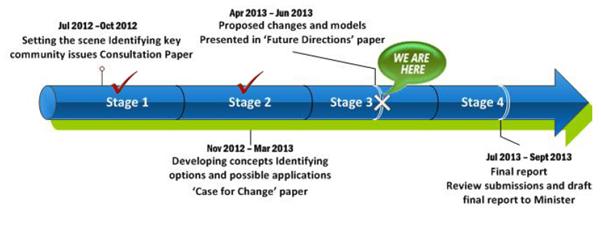
DISCUSSION
The Independent Local Government Review Panel has released a third consultation paper titled “Future Directions for NSW Local Government – Twenty Essential Steps”. The paper sets out the Panel’s latest thinking as it enters the final three to four months of its work program. It builds on the “Case for Sustainable Change” document released in November 2012, and should be read in conjunction with that document. Copies of both documents are attached to this Report.
The Media Statement that accompanied the release of the latest Consultation Paper details a summary of the Panel’s current thoughts. That summary, particularly as it is applicable to Hornsby, is provided below:
· We have prepared a package of Future Directions for NSW Local Government aimed at transforming its culture, structures, finances and operations, as well as its relations with the State Government. The paper gives councils and the community another opportunity to have their say and inform our ideas before we complete our final report in September. 40 years ago, the Barnett Committee recommended some similar changes for NSW local government, including a reduction in the total number of councils to less than 100. Some of those changes have been implemented but many have not, and new challenges now have to be faced. NSW cannot afford to wait another 40 years for vital improvements to the local government system.
· The Panel’s goal is for a more sustainable system of democratic local government that has added capacity to address the needs of local and regional communities, and to be a valued partner of State and Federal governments. NSW needs more effective local government to harness the skills and resources of local communities, improve quality of life and advance State development. Many councils are performing very well. However, on the whole our investigations and consultations have revealed a local government sector that is weighed down with too many out-of-date ideas, attitudes and relationships. There are many factors involved, but at the heart of the problem we still have too many councils chasing too little revenue.
· As revealed in a TCorp report about the matter, it is “time to act”. TCorp’s results paint a disturbing picture and confirm the Panel’s view that underlying weaknesses in the financial position of NSW local government have been allowed to build up for far too long. In three years time, 48% of councils could have a weak or worse financial sustainability rating. There is no point in seeking to apportion blame: what is needed now is a healthy dose of reality-testing and an acceptance that there are no easy answers. It is clear that the financial base of NSW local government is in urgent need of repair, with many councils facing very serious problems that threaten their sustainability and ability to provide adequate services and infrastructure for their local communities. Addressing the issues will be uncomfortable for all concerned: politicians, senior managers, staff and ratepayers. As TCorp makes clear, a concerted, medium-long term strategy is required.
· Stronger regional and metropolitan governance must be a central plank of local government reform to make better use of scarce resources and to facilitate more efficient and effective State-local relations especially in strategic planning, economic development, infrastructure provision and service delivery. To achieve this in regional NSW, the Panel has proposed the establishment of around 20 “new look”, multi-purpose County Councils. These have been focused on existing or potential major regional centres, which could also be strengthened by some amalgamations with adjoining councils. The paper also proposes extensive restructuring of local government in the Sydney Metropolitan Area, Lower Hunter and Central Coast. This includes in particular:
o A new “global city” of Sydney, encompassing the whole area from the CBD east to the coast and south to Botany Bay. The Panel sees this as vital to create a capital city that, like those of Brisbane, Auckland and many other competitors around the world, will match Sydney’s international status
o Reducing the unnecessary fragmentation of local government in Sydney’s southern suburbs and the inner west, on the north shore and along the northern beaches
o Greatly expanded cities of Parramatta and Liverpool that will have the scale and resources needed to support the regional centres envisaged in the draft Metropolitan Strategy
o A combined city of Newcastle-Lake Macquarie to drive development in the Lower Hunter
o A merger of Gosford and Wyong to provide stronger local government in the Central Coast.
· Opponents of amalgamations rely heavily on the argument that local identity will be lost in bigger local government units. However, the Panel can find no evidence that loss of local identity is an inevitable consequence of creating larger local government areas. To assist the transition for councils considering voluntary amalgamation, the Panel proposes a range of ways to ensure local voices are heard. These include place management approaches, use of wards, citizen’s panels and modern customer service systems. We also propose the option of “Local Boards” – a new type of elected, community-based local government unit with limited responsibilities delegated from a local council or County Council. These could be used to replace small rural and remote councils that will not have the resources to continue in their current form, as well as to assist the transition to larger local government areas in the Sydney metropolitan area.
· Amalgamations and boundary changes are not the panacea for local government’s problems. However, many out of date boundaries and structures remain in place today and our terms of reference require that we provide options to address those issues. We believe that amalgamations and boundary changes are an essential element of a wider package of reforms. In doing so, the Panel has kept in mind the Government’s commitment to “no forced amalgamations” and understands that change will require councils and communities to accept the benefits of mergers. Detailed planning and business cases will be needed and further consultation will be required under the provisions of the Local Government Act. The Panel’s report proposes a wide-ranging package of financial and other incentives for voluntary mergers. But in the end, arguments about amalgamations are essentially a distraction from the core issue we need to face, which is how the role and capacity of NSW local government can best be strengthened in the interests of the communities it is expected to represent. We are faced with challenges that demand a fresh look at the system of local government and its relationship with the State, and a willingness to explore new options with an open mind. That is what we will be doing for the remaining four months of the review.
· The Consultation Paper provides a detailed progress report on the Panel’s work to date and provides a basis for further consultation. The Panel’s ideas are crystallising but are not set in concrete. A number of important research projects are still under way and the Panel wants to discuss the options included in the paper with councils and communities. The paper fulfils the Panel’s commitment to ensure that all concerned can discuss the options being considered for its final report, which is now due in September 2013, to give the Panel time to consider the expected significant feedback from the Future Directions stage of the review.
· The Panel’s Future Directions consultation will include visits to 29 regional cities and towns and eight locations in the Sydney metropolitan area from 9 May until 14 June 2013. Councils Workshops will provide the opportunity for Mayors, Councillors and senior staff to discuss the paper and explore the options put forward for their region. Community Hearings will also be held to provide the opportunity for local people and organisations to express their views directly to the Panel and discuss the various ideas and proposals set out in the paper.
(N.B. In respect of the last dot point, Hornsby Council representatives have been invited to attend a Metropolitan Councils Workshop at Chatswood on 14 June 2013, and the General Manager and a number of Councillors have already attended a similar Workshop that was held at Parramatta on 15 May 2013)
Reshaping of Metropolitan Governance
Chapter 15 of the Panel’s “Future Directions for NSW Local Government – Twenty Essential Steps” deals with the reshaping of metropolitan governance and has the most relevance to Hornsby Shire Council at this time. In Chapter 15, the Panel says that for Sydney to remain Australasia’s pre-eminent global city, very substantial changes are needed to the way the region is governed at both local and State levels. The Panel believes that without changes to council boundaries there will be an increasingly severe imbalance in the structures of local government between eastern and western Sydney and that this would be inequitable and impede sound strategic planning and effective State-local collaboration.
The Panel has concluded that the number of local councils in the Sydney basin should be significantly reduced, especially in the inner and eastern suburbs, on the lower North Shore and around Parramatta and Liverpool. In this regard, the Panel’s objectives are to: create high capacity councils that can better represent and serve their local communities on metropolitan issues, and be true partners of State and federal agencies; establish a more equitable pattern of local government across the metropolitan area, taking into account planned development; underpin Sydney’s status as a global city; and support implementation of the Metropolitan Strategy. The Panel’s view is that on balance, looking ahead to the mid-21st Century when Sydney’s population will reach about 7 million, having about 15 councils is appropriate.
The Metropolitan Strategy places particular emphasis on the planning and development of a series of major centres. The Panel has considered the lessons to be learned from the history of efforts over the past 40 years to establish Parramatta as Sydney’s “second CBD”. One of those lessons is that a strong, well-resourced local council is an essential factor: there is little doubt that Parramatta’s development has been hindered by the limited scale and narrow boundaries of the current local government area. The Panel therefore considers that major centres need to be managed by suitably large and capable councils. This requires:
· A major expansion of the City of Parramatta to include Auburn, Holroyd, most or all of Ryde, and areas of Hornsby and The Hills south of the M2. This will create a city with a broad socio-economic mix and with the resources needed to develop a “second CBD”.
· Amalgamation of the local government areas of Liverpool, Fairfield and perhaps Bankstown to support the planned Liverpool “regional city”.
· Amalgamation of local government areas on the lower North Shore, in the inner west, and in the St George area. These amalgamations are also needed to reduce excessive fragmentation into small or relatively small units.
The Panel sees considerable benefits in sharing the wealth and revenue base of the Sydney CBD across a much wider area. The new city would have the capacity to undertake major sub-regional projects, such as light rail and cycleway networks, from its own resources. It may also be able to assume responsibility for some State-managed facilities, such as Centennial Park and the Botanic Gardens, freeing-up funds for allocation to projects in more needy local government areas.
The Panel has indicated that if there is little or no restructuring of existing boundaries in the metropolitan area, then as in the rest of NSW multi-purpose (but in this case sub-regional) County Councils should be established to undertake a wide range of functions on behalf of their members, thus ensuring effective and ongoing collaboration in shared services, strategic planning and advocacy, as well as a basis for partnership with State and federal agencies. If restructuring takes place as preferred by the Panel, sub-regional groupings of councils would be set up for joint strategic planning and implementation with State agencies of proposed Delivery Plans under the Metropolitan Strategy, as well as Regional Action Plans under the State Plan. Sub-regional boundaries have been indicated in the draft Metropolitan Strategy, but may require adjustments in light of the Panel’s proposals.
Direct Implications – Hornsby Shire Council
The specific recommendation in respect of Hornsby Shire Council as contained in Table 4 of the Consultation Paper is that Hornsby amalgamate with Ku-ring-gai Council. If this proposal is not acceptable to the State Government because of its current policy position of no forced amalgamations, the Panel recommends that the two Councils combine under a strong County Council model. Under this model, the County Council would undertake a broad range of strategic functions to support both Hornsby and Ku-ring-gai Councils. The County Council would replace the existing regional organisation (NSROC) with Hornsby and Ku-ring-gai remaining much as they are except that they would “own” and resource the County Council and refer some regional functions to the County Council. The Panel has also recommended, in line with its proposed expansion of the Parramatta City Council boundaries, that Hornsby’s current boundary with Parramatta and/or Ryde Councils be shifted north to the M2.
Although Hornsby Shire Council does not as yet have a position in respect of the Panel’s proposals and recommendations, it did consider Notice of Motion No. NOM3/13 - Independent Local Government Review Panel's Report – “Future Directions for NSW Local Government - Twenty Essential Steps” at the 5 May 2013 General Meeting and resolved that the General Manager:
1. Write to adjoining councils in the metropolitan region and invite those councils to participate in preliminary discussions on opportunities to reform local councils consistent with the Panel's recommendations.
2. Commission independent research into the Hornsby Shire community's attitude and the attitude of communities in adjoining local government areas towards local government reform consistent with the Panel's recommendations.
3. Prepare a report to the June 2013 General Meeting outlining options for Council's response to the Panel's report.
In respect to point 1 of the resolution, the General Manager has written to the General Managers of Ku-ring-gai, The Hills, Parramatta and Ryde Councils issuing an invitation to participate in discussions. A positive response has been received from each of those Councils and discussions are progressing.
In respect to point 2 of the resolution, quotations were sought from organisations who can undertake independent, scientifically robust and informative research that will assist Council in understanding community opinion about the local government reform process as it affects the community. Following an evaluation of the quotations received, Crosby Textor Research Strategies Results Pty Ltd have been contracted to undertake the research. A further report on this research will be submitted for Council’s consideration when the research is complete.
This Report has been prepared to respond to point 3 of the resolution. In this regard, a table is provided below which details a summary of the Key Proposals and Options on page 5 of the Panel’s Consultation Paper along with a draft response to each which is based on feedback that has been received from the Councillors at informal briefings on the matter together with comments from relevant managers/staff from across the organisation. It is proposed that the Council responses in the table form the basis of a submission to the Panel which is due to be submitted by 28 June 2013.
|
Local Government Review Panel Proposal |
Council Response |
|
Sustainability and Finance · Develop a standard set of sustainability benchmarks; require all councils to appoint a qualified Chief Financial Officer; strengthen the guidelines for councils’ 4-year Delivery Programs; and place local government audits under the oversight of the Auditor General · Improve the rating system and streamline rate-pegging to enable councils to generate essential additional revenue · Progressively re-distribute grant funding to provide greater assistance to rural-remote councils with limited rating potential
· Establish a State-wide Local Government Finance Agency to bring down interest costs and assist councils make better use of borrowings |
Supported. It is noted that following an organisation restructure in 2012, Council appointed an appropriately qualified Chief Financial Officer.
Supported.
As Council currently receives the minimum Financial Assistance Grant (FAG) entitlement, it would be significantly disadvantaged under this proposal. Council believes that the total pool of FAG funds provided by the Commonwealth Government should be increased, or other specific grant funding be provided to rural-remote councils who have limited rating potential. Alternatively, if the current rate capping restrictions were relaxed, Council would have an opportunity to recoup any lost FAG funding and continue to maintain its services and infrastructure. Supported. This may involve the restructure and resourcing of the Division of Local Government to provide a “one stop” agency to assist councils. |
|
Infrastructure · Maintain the Local Infrastructure Renewal Scheme (LIRS) for at least 5 years, with a focus on councils facing the most severe problems · Create a Strategic Projects Fund for roads and bridges to help reduce the infrastructure backlog · Investigate the Queensland model of Regional Roads Groups, as well as options for cost savings through strategic procurement initiatives · Require asset and financial management assessments of councils seeking special assistance |
Supported.
Supported.
Supported.
Supported in principle subject to the process not being onerous on councils. |
|
Productivity and Improvement · Introduce a requirement for regular ‘best value’ service reviews · Develop a consistent data collection and performance measurement system for NSW councils, and strengthen internal and performance audit processes
· Commission a review by IPART of the regulatory and compliance burden on NSW local government |
Supported in principle subject to the process not being onerous on councils. Council does not support the compulsory establishment of 'audit, risk and improvement' committees for all councils. The proposition that it should be mandatory for every council to have an unelected body overseeing the allocation of resources is overly bureaucratic and contradictory to the premise on which local government is founded, being a local democracy. Our view is that the responsibility for efficient and effective local government rests solely with the elected Councillors and professional senior management group. Given that a very large number of councils in NSW have been financially constrained for many decades, it is reasonable to assume that the majority of inefficiencies have already been dealt with. The issues confronting most councils are structural issues beyond the capacity of any 'audit, risk and improvement' committee to resolve. The cost of resources required by each Council to support and sustain a permanent 'audit, risk and improvement' committee structure is not likely to yield proportionate productivity gains year on year. We believe that a better approach to improving governance, risk management and continuous improvement is for the DLG to set aside funds to support the appointment of independent consultants who can be assigned to those councils in most need and provide periodic professional advice in the areas of financial management, corporate risk, good governance and continuous improvement. This would also complement any program undertaken by the Auditor General to conduct issue-based performance audits in key areas of local government activity. Supported. |
|
Better Governance · Mandate ongoing professional development for councillors · Strengthen the authority and responsibilities of mayors and require popular election of mayors in all councils with a population of 20,000 or more
· Provide additional governance options for larger councils, including a mix of ward and ‘at large’ councillors and a ‘civic cabinet’ model · Take steps to improve Council-Mayor-General Manager relations |
Supported.
Supported subject to the separation of powers not being eroded. It is noted that this dot point proposal is inconsistent with the Local Government Act Taskforce recommendations in respect of the Local Government Acts Review. Supported in principle.
Supported, although it is noted that such relationships at Hornsby Shire Council are strong and productive. |
|
Structural Reform · Establish a network of around 20 ‘new look’, multi-purpose County Councils to undertake regional-level functions outside the Sydney metropolitan area · Introduce the option of Local Boards to service small communities and to ensure local identify and representation in very large urban councils · Encourage voluntary amalgamations of smaller rural councils to improve their sustainability, and convert small (in population) councils (generally less than 5,000) to Local Boards · Promote a series of voluntary amalgamations in the Lower Hunter and Central Coast regions, including Newcastle-Lake Macquarie and Gosford-Wyong · Seek to reduce the number of councils in the Sydney basin to around 15, and create major new cities of Sydney, Parramatta and Liverpool, each with populations of 600-800,000
· Introduce a package of incentives for voluntary mergers that offers a higher level of support to ‘early movers’ |
Supported in principle, however, it is noted that non metropolitan councils are in a better position to inform the Panel on this matter.
Supported in principle, however, it is noted that non metropolitan councils are in a better position to inform the Panel on this matter.
Supported in principle, however, it is noted that non metropolitan councils are in a better position to inform the Panel on this matter.
Supported in principle, however, it is noted that non metropolitan councils are in a better position to inform the Panel on this matter.
Supported. The Independent Panel, together with work undertaken by T-Corp on the financial sustainability of local government, have made a strong case for boundary changes in the metropolitan area to strengthen the strategic capacity of councils. Council has taken a proactive stance to the reform debate and has not limited its consideration of the reforms to the recommendations contained in the Panel’s report. In evidence of this, at its 5 May 2013 General Meeting, Council resolved in part that the General Manager: 1. Write to adjoining councils in the metropolitan region and invite those councils to participate in preliminary discussions on opportunities to reform local councils consistent with the Panel's recommendations. 2. Commission independent research into the Hornsby Shire community's attitude and the attitude of communities in adjoining local government areas towards local government reform consistent with the Panel's recommendations. In respect to point 1 of the resolution, the General Manager has written to the General Managers of Ku-ring-gai, The Hills, Parramatta and Ryde Councils issuing an invitation to participate in discussions. A positive response has been received from each of those Councils and discussions are progressing. In respect to point 2 of the resolution, quotations were sought from organisations who can undertake independent, scientifically robust and informative research that will assist Council in understanding community opinion about the local government reform process as it affects the community. Following an evaluation of the quotations received, Crosby Textor Research Strategies Results Pty Ltd have been contracted to undertake the research. It is anticipated that the results of the community polling will be complete by mid July 2013, which will inform further discussion with neighbouring councils and allow Hornsby Council to further consider its position. The Panel’s recommendation is welcomed and supported. Based on experience in other jurisdictions, it is recognised that any council amalgamation would initially require additional resources and support to aid in the transition process. In the event that Council does move towards an amalgamation with one or more councils, Council would pursue this recommendation with the Government. |
|
Western NSW · Establish a Western Region Authority to provide a new governance and service delivery system for the far west of NSW, based on a partnership between local, State and Federal governments and Aboriginal communities |
Supported in principle, however, it is noted that Western Region councils are in a better position to inform the Panel on this matter. |
|
Implementation · Appoint a Local Government Development Board for a maximum period of 4 years with a brief to drive and support a concerted program of reform · Build on the new State-Local Government agreement to secure increased collaboration and joint planning between councils and State agencies · Strengthen recognition of elected local government in the NSW Constitution · Focus Local Government NSW (the new single association of councils) and the Division of Local Government on sector improvement. |
Supported.
Supported in principle.
Supported.
Supported. |
CONSULTATION
This Report in part details the consultation that has occurred as a consequence of the local government reform process. As such, there have been ongoing discussions with the Independent Local Government Review Panel, the Local Government Acts Taskforce, industry bodies and representatives of other councils.
BUDGET
There are no budgetary implications associated with this Report.
POLICY
There are no policy implications associated with this Report.
CONCLUSION
The local government reform process is entering a critical stage in the lead up to the release of final reports to the State Government by the Independent Local Government Review Panel and the Local Government Acts Taskforce. The Independent Panel’s latest consultation paper titled “Future Directions for NSW Local Government – Twenty Essential Steps” provides an opportunity for the local government industry to have a say about the Panel’s latest thinking prior to the release of its final report in September 2013. In terms of Council responding to the consultation paper, a table has been provided in this Report detailing a summary of the Panel’s Key Proposals and Options together with a draft response to each which is based on feedback that has been received from Councillors and relevant managers/staff from across the organisation. It is proposed that those responses form the basis of a submission to the Independent Panel.
RESPONSIBLE OFFICER
The officer responsible for the preparation of this Report is the Deputy General Manager, Corporate Support Division – Gary Bensley - who can be contacted on 9847 6605.
|
Gary Bensley Deputy General Manager Corporate Support Division |
Scott Phillips General Manager General Manager's Division |
|
1.View |
Future Directions for NSW Local Government – Twenty Essential Steps - April 2013 |
|
|
|
2.View |
Better, Stronger Local Government - The Case for Sustainable Change – November 2012 |
|
|
File Reference: F2004/07217
Document Number: D02175330
Group Manager's Report No. EH7/13
Environment and Human Services Division
Date of Meeting: 19/06/2013
8 T11/2013 - CLEANING AND REPAIR OF STORMWATER QUALITY IMPROVEMENT DEVICES (SQIDS) WITHIN HORNSBY SHIRE
EXECUTIVE SUMMARY
· There are limited resources available within Council to carry out the required cleaning and repair of Stormwater Quality Improvement Devices (SQIDs) that have been constructed as part of Council’s Catchment Remediation Rate program.
· The current contract for C7/2009 – Cleaning and Repair of Stormwater Quality Improvement Devices (SQIDs) within Hornsby Shire is held by Envirocivil Pty Ltd and is due to expire on 30 June 2013.
· Three tender submissions were received for T11/2013 - Cleaning and Repair of Stormwater Quality Improvement Devices (SQIDs) within Hornsby Shire.
· Following assessment, the tender evaluation panel has recommended that Council accept the tender from Envirocivil Pty Ltd as it is considered to provide the best value for money, skills and experience for Council.
· It is proposed that the new contract be for a period of three years, with a further option of one year subject to satisfactory performance.
|
THAT Council accept the tender from Envirocivil Pty Ltd for Tender T11/2013 – Cleaning and Repair of Stormwater Quality Improvement Devices (SQIDs) within Hornsby Shire for a period of three years with a further option of one year subject to satisfactory performance commencing on 1 July 2013. |
PURPOSE
The purpose of this Report is to provide information to Council in respect of Tender T11/2013 - Cleaning and Repair of Stormwater Quality Improvement Devices (SQIDs) within Hornsby Shire, and to recommend a preferred supplier for the service.
BACKGROUND
Funded by the Catchments Remediation Rate, Stormwater Quality Improvement Devices (SQIDs) improve the quality of stormwater before it enters the bushland and creeks of Hornsby Shire and the Hawkesbury and Lane Cove River by removing litter, organic matter, sediment, heavy metals and nutrients. To optimise the performance of each device it is necessary to remove accumulated debris after rainfall events. It is these activities that would be carried out by the successful contractor for Tender T11/2013.
The previous contract C7/2009 was for a period of three years with the option for an additional year based on contractor performance. This was awarded to Envirocivil Pty Ltd and commenced in July 2009 and will expire at the end of June 2013.
DISCUSSION
Tender T11/2013 is a schedule of rates tender. Excepting this Report, the attached tender evaluation report and details of the tenders received are to be treated as confidential in accordance with the Local Government Act.
Tenders were invited in April 2013 for the cleaning and repair of SQIDs as part of Council’s stormwater quality improvement program.
To ensure optimal functioning, the scope of works required under the tender includes the cleaning and repair of over 400 existing SQIDs including:
· Trash racks
· Litter baskets
· Pit inserts
· Net devices
· Ski-jumps
· Underground vaults
· Sediment basins
· Wetlands
· Bioretention devices and
· Rainwater tanks
A total of three submissions were received for Tender T11/2013 – Cleaning and Repair of Stormwater Quality Improvement Devices (SQIDs) within Hornsby Shire.
The three Tenderers were:
· Bell Environmental Pty Ltd
· Envirocivil Pty Ltd
· Total Drain Cleaning Pty Ltd
Tender Evaluation
As part of the tender evaluation process, weighted non-price and price selection criteria were developed by the tender evaluation panel. Tenders were then assessed based on the returnable schedules submitted by each tenderer.
The assessment criteria included:
· Price
· Staff experience and qualifications
· Similar sized projects undertaken
· Knowledge and technique in the field
· Experience working in sensitive bushland communities
· Past SQID experience with other organisations
Detailed information on the tender prices, the non-price evaluation criteria and the weightings of the criteria are contained in the attached confidential tender evaluation report (Attachment 1).
BUDGET
The works to be completed under T11/2013 have been estimated at approximately $200,000 p.a. and will continue to be funded through the Catchments Remediation Rate.
POLICY
The tender process has been undertaken in accordance with Council’s tendering policy.
CONCLUSION
There are limited resources available within Council to carry out the required cleaning and repair of Stormwater Quality Improvement Devices (SQIDs) that have been constructed as part of Council’s Catchment Remediation Rate program. Council has therefore called for tenders from external companies to conduct this work on its behalf.
Following evaluation, the tender panel have recommended that Envirocivil Pty Ltd be appointed to T11/2013 as they are considered to provide the best value for money, skills and experience for Council.
RESPONSIBLE OFFICER
The officer responsible for the preparation of this Report is the Manager Natural Resources – Diane Campbell - who can be contacted on 9847 6903.
|
Diane Campbell Manager - Natural Resources Environment and Human Services Division |
Stephen Fedorow Group Manager Environment and Human Services Division |
|
T11/2013 Tender Evaluation Report - This attachment should be dealt with in confidential session, under Section 10A (2) (d) of the Local Government Act, 1993. This report contains commercial information of a confidential nature that would, if disclosed (i) prejudice the commercial position of the person who supplied it; or (ii) confer a commercial advantage on a competitor of the council; or (iii) reveal a trade secret. (Tender submissions contain commercially sensitive pricing information that would, if disclosed prejudice the commercial position of the person who supplied it. ) |
|
|
File Reference: F2013/00127
Document Number: D02185020
Group Manager's Report No. EH8/13
Environment and Human Services Division
Date of Meeting: 19/06/2013
9 T12/2013 - LANDSCAPE MAINTENANCE AND BUSH REGENERATION OF STORMWATER QUALITY IMPROVEMENT DEVICES (SQIDS) WITHIN HORNSBY SHIRE
EXECUTIVE SUMMARY
· There are limited resources within Council to carry out landscaping and bush regeneration across the range of sites managed under the Catchments Remediation Rate program. It is therefore considered more advantageous to contract the bush regeneration work out to external companies.
· The current contracts for C8/2009 - Landscaping and Bush Regeneration of Stormwater Quality Improvement Devices are held by Sydney Bush Regeneration Company Pty Ltd and Dragonfly Environmental Pty Ltd and are due to expire on 30 June 2013.
· Nine tender submissions were received for T12/2013 – Landscape Maintenance and Bush Regeneration of Stormwater Quality Improvement Device (SQIDS).
· Following assessment, the tender evaluation panel has recommended that Council accept the tenders from Dragonfly Environmental Pty Ltd (Wetland Contract), Sydney Bush Regeneration Company Pty Ltd (Southern Sector) and Toolijooa Pty Ltd (Northern Sector) as they are considered to provide the best value for money and environmental performance for Council.
· It is proposed that the new contracts be for a period of two years, with a further option of one year subject to satisfactory performance.
|
THAT Council accept the tenders for Tender T12/2013 – Landscape Maintenance and Bush Regeneration of Stormwater Quality Improvement Devices (SQIDs) within Hornsby Shire for a period of two years with a further option of one year subject to satisfactory performance commencing 1 July 2013 as follows:
· Dragonfly Environmental Pty Ltd (Wetland Contract) · Sydney Bush Regeneration Company Pty Ltd (Southern Sector) · Toolijooa Pty Ltd (Northern Sector) |
PURPOSE
The purpose of this Report is to provide information to Council in respect of Tender T12/2013 - Landscape Maintenance and Bush Regeneration of Stormwater Quality Improvement Devices (SQIDs) within Hornsby Shire, and to recommend preferred suppliers of the service.
BACKGROUND
Funded by the Catchments Remediation Rate, Stormwater Quality Improvement Devices (SQIDs), improve the quality of stormwater before it enters the bushland and creeks and the Hawkesbury and Lane Cove River by removing litter, organic matter, sediment, heavy metals and nutrients. Due to these devices often being associated with elevated nutrient levels and other stormwater impacts they require bush regeneration to reduce weed proliferation and to encourage native regeneration. It is these activities that would be carried out by the contractors for Tender T12/2013.
The previous contract C8/2009 was for a period of three years with the option of an additional year based on contractor performance. This was awarded to Australian Bushland Restoration, Sydney Bush Regeneration Company Pty Ltd and Dragonfly Environmental Pty Ltd and commenced in July 2009 and will expire at the end of June 2013. The optional additional year however was not extended for Australian Bushland Restoration due to performance issues.
DISCUSSION
Tender T12/2013 is a schedule of rates tender. Excepting this Report, the attached tender evaluation report and details of the tenders received are to be treated as confidential in accordance with the Local Government Act.
Tenders were invited in April 2013 for the landscape maintenance and bush regeneration of selected stormwater quality improvement devices as part of Council’s stormwater quality improvement program.
The scope of work required under the tender includes the regular inspection, weeding, spraying, mulching and planting of 61 separate SQIDS, and the bush regeneration and aquatic weed management at 16 wetlands.
A total of nine submissions were received for Tender T12/2013 – Landscape Maintenance and Bush Regeneration of Stormwater Quality Improvement Devices (SQIDs) within Hornsby Shire.
The nine Tenderers were:
· Australian Bushland Restoration
· Australian Areas Management & Repair
· Dragonfly Environmental Pty Ltd
· Enhance Environmental
· Hills Bushcare
· National Trust of Australia (NSW)
· Sydney Bush Regeneration Company Pty Ltd
· Toolijooa Pty Ltd
· Total Earth Care Pty Ltd
Tender Evaluation
As part of the tender evaluation process, weighted non-price and price selection criteria were developed by the tender evaluation panel. Tenders were then assessed based on the returnable schedules submitted by each tenderer.
The assessment criteria included:
· Price
· Staff Experience and Qualifications
· Knowledge and techniques in the field
· Experience working in sensitive bushland communities
· Evidence of innovation and/or alternative techniques employed in degraded environments
· Past SQID experience with other organisations
Detailed information on the tender prices, the non-price evaluation criteria and the weightings of the criteria are contained in the attached confidential tender evaluation report (Attachment 1).
BUDGET
The works to be completed under T12/2013 have been estimated at approximately $150,000 p.a. and will continue to be funded through the Catchments Remediation Rate.
POLICY
The tender process has been undertaken in accordance with Council’s tendering policy.
CONCLUSION
There are limited resources within Council to carry out landscaping and bush regeneration required across the range of sites managed under the Catchments Remediation Rate program. Council has therefore called for tenders from external companies to conduct this work on its behalf.
Following evaluation, the tender panel have recommended that Dragonfly Environmental Pty Ltd (Wetland Contract), Sydney Bush Regeneration Company Pty Ltd (Southern Sector) and Toolijooa Pty Ltd (Northern Sector) be appointed to T12/2013 as they are considered to provide the best value for money and environmental performance for Council.
RESPONSIBLE OFFICER
The officer responsible for the preparation of this Report is the Manager Natural Resources – Diane Campbell - who can be contacted on 9847 6903.
|
Diane Campbell Manager - Natural Resources Environment and Human Services Division |
Stephen Fedorow Group Manager Environment and Human Services Division |
|
T12/2013 - Tender Evaluation Report - This attachment should be dealt with in confidential session, under Section 10A (2) (d) of the Local Government Act, 1993. This report contains commercial information of a confidential nature that would, if disclosed (i) prejudice the commercial position of the person who supplied it; or (ii) confer a commercial advantage on a competitor of the council; or (iii) reveal a trade secret. (Tender submissions contain commercially sensitive pricing information that would, if disclosed would prejudice the commercial position of the person who supplied it. ) |
|
|
File Reference: F2013/00128
Document Number: D02185032
Group Manager's Report No. EH9/13
Environment and Human Services Division
Date of Meeting: 19/06/2013
10 T7/2013 LABORATORY ANALYSIS OF WATER SAMPLES COLLECTED BY HORNSBY SHIRE COUNCIL
EXECUTIVE SUMMARY
· Council has conducted a water quality monitoring program since 1994 as a part of its commitment to the Statement of Joint Intent (SOJI) for Berowra Creek.
· The current contract C9/2009 for the laboratory analysis of water samples is held by Sydney Water and is due to expire on 30 June 2013.
· Four tender submissions for T7/2013 were received prior to the tender closing time. One tender was received after the closing time and was not considered.
· Following assessment, the tender evaluation panel has recommended that Council accept the tender from Sydney Water to provide laboratory analysis of water samples as it is considered to provide the best value for money and best quality water analysis for Council.
· It is proposed that the new contract be for a period of three years, with the option of a one year extension subject to satisfactory performance.
|
THAT Council accept the tender from Sydney Water for Tender T7/2013 – Laboratory Analysis of Water Samples Collected by Hornsby Shire Council for a period of three years commencing on 1 July 2013 with the option of a one year extension subject to satisfactory performance. |
PURPOSE
The purpose of this Report is to provide information to Council in respect of Tender T7/2013 – Laboratory Analysis of Water Samples Collected by Hornsby Shire Council, and to recommend a preferred supplier of the service.
BACKGROUND
Hornsby Shire Council has been monitoring water quality within the Shire’s waterways since October 1994 as part of its commitment to the SOJI community contract for Berowra Creek.
The objectives of the water quality monitoring program are to:
· Undertake long term monitoring of the catchments within Hornsby Shire to assess trends in water quality from both diffuse and point sources.
· Compare the observed water quality data with undisturbed catchments in nearby national parks and with the nationally accepted Guidelines for Fresh and Marine Water Quality (ANZECC 2000); specifically for the water quality values associated with the protection of aquatic ecosystems and recreational water users.
· Determine the effectiveness of catchment remediation assets in removing pollutants from waterways.
· Support water savings and water quality improvement programs.
· Use water quality data to calibrate and support catchment/pollutant modelling.
As Council does not have the internal capacity to undertake the required laboratory analysis of water quality samples associated with the water quality monitoring program, this work is contracted out to a commercial laboratory. Sydney Water holds the current contract which is due to expire on 30 June 2013.
DISCUSSION
Tender T7/2013 is a schedule of rates tender. Excepting this Report, the attached tender evaluation report and details of the tenders received are to be treated as confidential in accordance with the Local Government Act.
Tenders were invited in April 2013 for the laboratory analysis of water samples collected by Council over the next three years, as part of the Water Quality Monitoring Program.
The scope of work required under the tender involves the chemical and biological analysis of fresh and saline water samples that have been collected by Council.
A total of four tender submissions for T7/2013 were received prior to the tender closing time, and one tender was received late. The late tender was not considered.
Tender Evaluation
As part of the evaluation process, weighted non-price and price selection criteria were developed and considered by the evaluation panel. This was assessed based on the returnable schedules submitted by each tenderer.
The assessment criteria included:
· Price
· NATA Accreditation
· Quality Management Systems
· Laboratory capability and capacity
· Laboratory QA/QC procedures
· Past performance and experience
· Skills, qualifications and experience of the project team
· Local business and industry
· Environmental policies
· Quality of application
· Additional benefits
Detailed information on the tender prices, the non-price evaluation criteria and the weightings of the criteria are contained in the attached confidential tender evaluation report (Attachment 1).
BUDGET
The works to be completed under T7/2013 have been estimated at approximately $80,000 per annum and will continue to be funded through Catchment Remediation Rate income.
POLICY
The tender process has been undertaken in accordance with Council’s tendering policy.
CONCLUSION
Council does not have the internal capacity to undertake the required laboratory analysis of water samples collected as part of the Water Quality Monitoring Program and has called for tenders from commercial laboratories to conduct this work on its behalf.
Following evaluation, the tender panel have recommended that Sydney Water be appointed to T7/2013 as it is considered to provide the best value for money and best quality water analysis for Council.
RESPONSIBLE OFFICER
The officer responsible for the preparation of this Report is the Manager Natural Resources – Diane Campbell - who can be contacted on 9847 6903.
|
Diane Campbell Manager - Natural Resources Environment and Human Services Division |
Stephen Fedorow Group Manager Environment and Human Services Division |
|
T7/2013 - Tender Evaluation Report - This attachment should be dealt with in confidential session, under Section 10A (2) (d) of the Local Government Act, 1993. This report contains commercial information of a confidential nature that would, if disclosed (i) prejudice the commercial position of the person who supplied it; or (ii) confer a commercial advantage on a competitor of the council; or (iii) reveal a trade secret. (Tender submissions contain commercially sensitive pricing information that would, if disclosed prejudice the commercial position of the person who supplied it. ) |
|
|
File Reference: F2013/00145
Document Number: D02185063
Group Manager’s Report No. PL40/13
Planning Division
Date of Meeting: 19/06/2013
11 DEVELOPMENT APPLICATION - FIVE STOREY RESIDENTIAL FLAT BUILDING - 9, 11 AND 15 BALMORAL STREET, WAITARA
EXECUTIVE SUMMARY
|
DA No: |
DA/1369/2012 (Lodged 21 December 2012) |
|
Description: |
Demolition of existing structures and construction of two detached, five storey residential flat buildings comprising 60 units and basement car parking |
|
Property: |
Lot B DP 343526, Nos. 9, 11 and 15 Balmoral Street, Waitara |
|
Applicant: |
Balmoral Street Developments Pty Ltd |
|
Owner: |
Ian Alexander Groves Dong Yao Zheng and Yu Wu Farsad Safaie-Zadeh and Noushin Kebrit |
|
Estimated Value: |
$10,800,000 |
|
Ward: |
B |
· The application proposes the demolition of existing structures and construction of two detached, five storey residential flat buildings comprising 60 units and basement car parking.
· The proposal generally complies with the Hornsby Shire LEP 1994, State Environmental Planning Policy No. 65 – Design Quality of Residential Flat Development and the Hornsby Shire Housing Strategy DCP.
· Nineteen submissions have been received to notification of the initial application. Nine submissions have been received in response to notification of amended plans.
· It is recommended that the application be approved as a deferred commencement.
|
THAT Development Application No. 1369/2012 for demolition of existing structures and construction of two detached, five storey residential flat buildings comprising 60 units and basement car parking at Lot B DP 343526, Nos. 9, 11 and 15 Balmoral Street, Waitara be approved as a deferred commencement subject to the conditions of consent detailed in Schedule 1 of Group Manager’s Report No.PL40/13. |
BACKGROUND
The subject land was rezoned from Residential A (Low Density) to Residential C (Medium-High Density) on 2 September 2011 as part of Council’s Housing Strategy.
SITE
The site comprises Nos. 9, 11 and 15 Balmoral Street, Waitara. The site has an area of 3,367 square metres and is located on the western side of Balmoral Street. The site is rectangular in shape, with a frontage to Balmoral Street of 49.99 metres and a depth of 67.35 metres. The site has a cross fall towards the rear, north western corner of the site with an average grade of 4%.
Each allotment comprising the development contains a dwelling-house of brick and tile roof construction. A number of trees are located within the development site, each has not been identified as significant.
The site forms part of the Housing Strategy ‘Balmoral Street, Waitara precinct’ bounded by Balmoral Street, Alexandra Parade, Park Avenue and Edgeworth David Avenue.
The surrounding development within the rezoned precinct includes low density dwelling houses. The eastern side of Balmoral Street was not included in the Housing Strategy and remains as land zoned Residential A (Low Density).
The site is located approximately 240m east of Waitara Railway Station and approximately 700m from Hornsby Town Centre. A small shopping centre is located in Edgeworth David Avenue, approximately 400m north of the site.
PROPOSAL
The proposal is for the demolition of three existing dwelling-houses, construction of two detached, five storey residential flat buildings comprising 60 dwellings and basement car parking.
The unit configuration includes 6 x 1 bedroom units, 40 x 2 bedroom units and 14 x 3 bedroom units. The units include balconies fronting the street, rear and side setbacks.
The development would be accessed from Balmoral Street via a driveway located adjacent to the southern boundary of the site. A separate pedestrian entry to each building is located on the Balmoral Street frontage of the site. A total of 60 residential spaces and 12 visitor’s parking spaces are proposed in a single basement level.
ASSESSMENT
The development application has been assessed having regard to the ‘Metropolitan Plan for Sydney 2031’, the ‘North Subregion (Draft) Subregional Strategy’ and the matters for consideration prescribed under Section 79C of the Environmental Planning and Assessment Act 1979 (the Act). The following issues have been identified for further consideration.
1. STRATEGIC CONTEXT
1.1 Metropolitan Plan for Sydney 2031 and (Draft) North Subregional Strategy
The (Draft) Metropolitan Strategy for Sydney 2031 is a broad framework to provide for Sydney’s growth to help plan for housing, employment, transport, infrastructure, the environment and open space. It outlines a vision for Sydney to 2031; the challenges faced, and the directions to follow to address these challenges and achieve the vision.
The North Subregion comprises Hornsby, Kuring-gai, Manly, Warringah and Pittwater Local Government Areas. The Draft North Subregional Strategy acts as a framework for Council in its preparation of the Comprehensive LEP by the end of 2013.
Within the North Subregion, the Draft Metropolitan Strategy proposes:
· Population growth of 81,000 from the current 2011 baseline of 529,000
· Housing growth of 37,000 from the current 2011 baseline of 204,000
· Employment growth of 39,000 from the current 2011 baseline of 186,000
The proposed development would be consistent with the Metropolitan Plan for Sydney 2031 by providing an additional 57 dwellings and would contribute to housing choice in the locality.
2. STATUTORY CONTROLS
Section 79C(1)(a) requires Council to consider “any relevant environmental planning instruments, draft environmental planning instruments, development control plans, planning agreements and regulations”.
2.1 Hornsby Shire Local Environmental Plan 1994
The subject land is zoned Residential C (Medium/High Density) under the Hornsby Shire Local Environmental Plan 1994 (HSLEP). The objectives of the zone are:
(a) to provide for the housing needs of the population of the Hornsby area.
(b) to promote a variety of housing types and other land uses compatible with a medium to high density residential environment.
(c) to provide for development that is within the environmental capacity of a medium to high density residential environment.
The proposed development is defined as ‘multi-unit housing’ under the HSLEP and is permissible in the zone with Council’s consent.
Clause 15 of the HSLEP prescribes the maximum floor space ratio (FSR) of development within the Residential C zone. Subclause (5) of clause 15 states that “This clause does not apply to land shown edged heavy black on diagrams 1-8 in Schedule BB.” The site is identified in Diagram 4 of Schedule BB of the HSLEP. Therefore, clause 15 does not apply to the subject site.
Clause 15A of the HSLEP prescribes that the maximum building height within the area detailed under Schedule BB is not to exceed 17.5 metres. The proposed building complies with this requirement.
Clause 18 of the HSLEP sets out heritage conservation provisions for Hornsby Shire. The site is not in the vicinity of a heritage item or conservation area and is not subject to consideration for heritage conservation. Therefore, no further assessment in this regard is necessary.
2.2 Draft Hornsby Shire Local Environmental Plan
The draft Hornsby Local Environmental Plan (DHLEP) was endorsed by Council at its meeting on 19 December 2012 to be forwarded to the Minister for Planning and Infrastructure to be made. In accordance with Council’s resolution, the draft Plan has been submitted to the Department for finalisation. The draft HLEP essentially reiterates the current land use zoning and height control applicable to the site as outlined below:
2.2.1 Zoning
The site would be zoned R4 (High Density Residential) zone pursuant to the Land Use Table of the draft HLEP. The proposed development is defined as a ‘residential flat building’ and would be a permissible use in the zone with Council’s consent.
2.2.2 Height of Building
Clause 4.3 of the draft HLEP provides that the height of a building on any land is not to exceed the maximum height shown for the land on the Height of Buildings Map. The maximum permissible height for the subject site is 17.5 metres. The proposal complies with this provision.
2.3 State Environmental Planning Policy No. 55 – Remediation of Land
State Environmental Planning Policy No. 55 (SEPP 55) requires that Council must not consent to the carrying out of any development on land unless it has considered whether the land is contaminated or requires remediation for the proposed use.
The site has been used for residential purposes and is unlikely to be contaminated. No further assessment is considered necessary in this regard. A condition is recommended should any contamination be found during construction.
2.4 State Environmental Planning Policy No. 65 – Design Quality of Residential Flat Development
The Policy provides for design principles to improve the design quality of residential flat development and for consistency in planning controls across the State.
The applicant has submitted a design verification statement prepared by a qualified designer stating how the proposed development achieves the design principles of SEPP 65. The design principles of SEPP 65 and the submitted design verification statement are addressed below.
2.4.1 Principle 1 - Context
Design Principle 1 is as follows:
Good design responds and contributes to its context. Context can be defined as the key natural and built features of an area.
Responding to context involves identifying the desirable elements of a location’s current character or, in the case of precincts undergoing a transition, the desired future character as stated in planning and design policies. New buildings will thereby contribute to the quality and identity of the area.
The subject site is located within a precinct zoned for five storey residential flat buildings in close proximity to Edgeworth David Avenue and Hornsby Westfield Shopping Centre. The desired future character of the area, as outlined in Council’s Housing Strategy Development Control Plan, is that of a high density residential precinct incorporating five storey developments in garden settings with parking in basements.
A ‘Design Verification Statement’ in response to the SEPP 65 was submitted with this application that indicates the proposal responds to the desired future character of the precinct as envisaged by Council. Once the development of the precinct is completed, the proposal would integrate with the surrounding sites and would be in keeping with the desired urban form. It is considered that the proposed building would contribute to the identity and future character of the precinct.
2.4.2 Principle 2 - Scale
Design Principle 2 is as follows:
Good design provides an appropriate scale in terms of the bulk and height that suits the scale of the street and the surrounding buildings.
Establishing an appropriate scale requires a considered response to the scale of existing development. In precincts undergoing a transition, proposed bulk and height needs to achieve the scale identified for the desired future character of the area.
The scale of the development is in accordance with the required building height and setbacks for the precinct and provides an architectural composition that achieves the required pavilion built forms to minimize bulk and scale. The scale of the development is considered appropriate for the site and consistent with the desired future character of the precinct.
2.4.3 Principle 3 – Built Form
Design Principle 3 is as follows:
Good design achieves an appropriate built form for a site and the building’s purpose, in terms of building alignments, proportions, building type and the manipulation of building elements.
Appropriate built form defines the public domain, contributes to the character of streetscape and parks, including their views and vistas, and provides internal amenity and outlook.
The proposed five storey development would be the first of its kind on Balmoral Street within the precinct rezoned under Council’s Housing Strategy. The buildings are appropriately articulated to minimise the perceived scale and to add to the visual interest of the development. The proposed development presents a distinct architectural design which would set an appropriate precedent for the locality and is considered acceptable in terms of built form.
2.4.4 Principle 4 – Density
Design Principle 4 is as follows:
Good design has a density appropriate for a site and its context, in terms of floor space yields (or number of units or residents).
Appropriate densities are sustainable and consistent with the existing density in an area or in precincts undergoing a transition, are consistent with the stated desired future density. Sustainable densities respond to the regional context, availability of infrastructure, public transport, community facilities and environmental quality.
The HSLEP does not incorporate floor space ratio requirements for the site. The density of the development is governed by the height of the building and the required setbacks. The proposed density is considered to be sustainable as it responds to the regional context, availability of infrastructure, public transport, community facilities and environmental quality and is considered acceptable in terms of density.
2.4.5 Principle 5 – Resource, Energy and Water Efficiency
Design Principle 5 is as follows:
Good design makes efficient use of natural resources, energy and water throughout its full life cycle, including construction.
Sustainability is integral to the design process. Aspects include demolition of existing structures, recycling of materials, selection of appropriate and sustainable materials, adaptability and reuse of buildings, layouts and built form, passive solar design principles, efficient appliances and mechanical services, soil zones for vegetation and reuse of water.
The applicant has submitted a BASIX Certificate for the proposed development. In achieving the required BASIX targets for sustainable water use, thermal comfort and energy efficiency, the proposed development achieves the design criteria and is considered acceptable in this regard.
2.4.6 Principle 6 – Landscape
Design Principle 6 is as follows:
Good design recognises that together landscape and buildings operate as an integral and sustainable system, resulting in greater aesthetic quality and amenity for both occupants and the adjoining public domain.
Landscape design builds on the existing site’s natural and cultural features in responsible and creative ways. It enhances the development’s natural environmental performance by co-ordinating water and soil management, solar access, micro-climate, tree canopy and habitat values. It contributes to the positive image and contextual fit of development through respect for streetscape and neighbourhood character, or desired future character.
Landscape design should optimise useability, privacy and social opportunity, equitable access and respect for neighbour’s amenity, and provide for practical establishment and long term management.
The application includes a landscape concept plan providing landscaping along the street frontage and side and rear boundaries. Large trees proposed along the frontage would soften the appearance of the development when viewed from the street. Deep soil zones are provided around the building envelope which would enhance the development’s natural environmental performance and provide an appropriate landscaped setting.
2.4.7 Principle 7 – Amenity
Design Principle 7 is as follows:
Good design provides amenity through the physical, spatial and environmental quality of a development.
Optimising amenity requires appropriate room dimensions and shapes, access to sunlight, natural ventilation, visual and acoustic privacy, storage, indoor and outdoor space, efficient layouts and service areas, outlook and ease of access for all age groups and degrees of mobility.
The proposed units are designed to achieve natural ventilation, solar access and acoustic privacy. All units incorporate balconies accessible from living areas and privacy has been achieved through appropriate design or recommended conditions of consent. Appropriate storage areas have been provided within units and within the basement levels. The proposal would provide convenient and safe access via a central lift located in each building connecting the basement and all other levels. The application is considered acceptable in this regard.
2.4.8 Principle 8 – Safety and Security
Design Principle 8 is as follows:
Good design optimises safety and security, both internal to the development and for the public domain.
This is achieved by maximising overlooking of public and communal spaces while maintaining internal privacy, avoiding dark and non-visible areas, maximising activity on streets, providing clear, safe access points, providing quality public spaces that cater for desired recreational uses, providing lighting appropriate to the location and desired activities, and clear definition between public and private spaces.
A statement submitted by the Architect on 21 May 2013 incorporates recommended actions to promote safety and security within the development including design features such as controlled entry points; security gate access to basement car park; intercom access for pedestrians; security deadlocks to each apartment door; foyer door construction of safety glass; lighting for building foyer entries, pathways, driveways and common external spaces and on-going management of building repairs and landscaping.
The design orientates the balconies and windows of individual apartments towards the street and rear boundary, providing passive surveillance of the public domain and communal open space areas. Entry points are secured and visibly prominent from the respective streets.
The development proposal is supported in respect to safety and security.
2.4.9 Principle 9 – Social Dimensions and Housing Affordability
Design Principle 9 is as follows:
Good design responds to the social context and needs of the local community in terms of lifestyles, affordability, and access to social facilities.
New development should optimise the provision of housing to suit the social mix and needs in the neighbourhood or, in the case of precincts undergoing transition, provide for the desired future community.
New development should address housing affordability by optimising the provision of economic housing choices and providing a mix of housing types to cater for different budgets and housing needs.
The site is located approximately 240m east of Waitara Railway Station and approximately 700m from Hornsby Town Centre, which contains Westfield Shopping Centre. A small shopping centre is located on Edgeworth David Avenue, approximately 400m north of the site. The location of the site allows direct access to retail, educational, health and recreational facilities. The proposed development includes a mix of dwelling types and sizes which complies with the requirement within the RFDC to improve housing choice in the locality. In this regard, the development is considered acceptable in terms of social dimensions.
2.4.10 Principle 10 – Aesthetics
Design Principle 10 is as follows:
Quality aesthetics require the appropriate composition of building elements, textures, materials and colours and reflect the use, internal design and structure of the development. Aesthetics should respond to the environment and context, particularly to desirable elements of the existing streetscape or, in precincts undergoing transition, contribute to the desired future character of the area.
The applicant submitted a statement which includes the following comment:
Materials and colours are selected to be compatible with the existing development surrounding the site. Colours are predominately light to mid tones, with grey roofs and grey windows, shutters, louvers, pergolas, balustrades and other trims. Light coloured soffits and tiling is envisaged. Lower portions of the facades are darker tones to provide a visual base for the building.
The architectural treatment of the building is general consistent with the design principles contained within the RFDC. It is considered that the aesthetic quality of the building would contribute to the desired future character of the precinct. The details of the assessment of the built form and the aesthetics of the development are contained in Section 2.11 of this report.
2.5 SEPP 65 - Residential Flat Design Code
SEPP 65 also requires consideration of the Residential Flat Design Code, NSW Planning Department 2002. The Code includes development controls and best practice benchmarks for achieving the design principles of SEPP 65. The following table sets out the proposal’s compliance with the Code:
|
Residential Flat Design Code |
|||
|
Control |
Proposal |
Requirement |
Compliance |
|
Deep Soil Zone |
27% |
25% |
Yes |
|
Communal Open Space |
35% |
25-30% |
Yes |
|
Minimum Dwelling Size |
1 br – 55.1m2 2 br – 80.08m2 3 br –95.41m2 |
1 br – 50m2 2 br – 70m2 3 br – 95m2 |
Yes Yes Yes |
|
Maximum Kitchen Distance |
8.1m – 9.5m (Units 9, 10, 11, 16,17,18, 33, 39, 40, 41, 46, 47, 48)
|
8m |
No |
|
Minimum Balcony Depth |
>2.0m |
2.0m |
Yes |
|
Dual Aspect & Cross Ventilation |
66% |
60% |
Yes |
|
Adaptable Housing |
30% |
10% |
Yes |
|
Total Storage Areas |
Unit 24 (1 bed) – no storage provided in unit Unit 33 (2 bed) – no storage provided in unit Unit 53 (1 bed) – no storage provided in unit 326m³ (Basement) 323m³ (Upper Levels) |
6m³/1 bed x 6 = 36m³ 8m³/2 bed x 40 = 320m³ 10m³/3 bed x 14 = 140m³ Total Storage required = 496m³ with 50% of storage within apartments
|
No |
As detailed in the above table, the proposed development complies with the prescriptive measures within the Residential Flat Design Code (RFDC) other then maximum kitchen distance and internal storage areas for some units. Below is a brief discussion regarding the relevant development controls and best practice guidelines:
2.5.1 Apartment Layout
The layout of the proposed apartments includes a combination of single aspect units and dual aspect corner units. The unit layouts would provide for housing choice and a range of household types.
The RFDC requires that the back of a kitchen should be no greater than 8 metres from a window. Of the 60 units proposed, 13 units contain kitchens where the back wall is up to 9.5 metres from a window. These units offer an open layout with natural ventilation and accordingly, the minor non-compliance is acceptable with respect to residential amenity.
The proposed apartment layouts are functional and satisfy the RFDC requirements for internal privacy, access to sunlight, natural ventilation and acoustic privacy. It is considered that the apartment layout and mix achieve the intent of the best practice requirements of the RFDC and is acceptable in this regard.
2.5.2 Internal Circulation
The proposed development includes access to all floors via a lift in each building. The ground floor corridors connect to the communal open space at the rear of the site. The proposal is acceptable with respect to the requirements of the RFDC requirements for internal circulation.
2.5.3 Acoustic Privacy
The internal layout of the residential units is designed such that noise generating areas would mainly adjoin each other. Storage or circulation zones would act as a buffer between units. Bedrooms and service areas such as kitchens, bathrooms and laundries would be grouped together wherever possible. The proposal is consistent with the requirements within the RFDC for acoustic privacy.
2.5.4 Storage Areas
The RFDC requires that in addition to kitchen cupboards and bedroom wardrobes, accessible storage facilities should be provided at the following rates: one-bedroom apartments – 6m³; two-bedroom apartments – 8m³ and three plus bedroom apartments – 10m³. In addition, the RFDC requires at least 50% of the storage be provided within each apartment and accessible from either the hall or living area. Of the 60 units proposed, 3 units (units 24, 33 and 53) do not contain storage areas as required within the apartments. A total of 323m³ storage space is allocated in the upper levels and 326m³ is allocated in the basement level which complies with the total storage areas required for 60 units. To ensure that adequate storage areas are provided for each unit, a condition is recommended that a storage area which is accessible from either the hall or living area of at least 3m³ is provided in units 24 and 53 (one-bedroom apartments) and a storage area of at least 5m³ is provided in unit 33 (three-bedroom apartment). With conditions, the proposal is consistent with the requirements within the RFDC for unit storage.
2.5.5 Building Separation
The proposed development is on a large site of 3,367 square metres and contains two buildings separated by a 6m landscape area. The majority of the living areas of both buildings would be setback at least 6 metres from the side boundaries increasing to 9 metres at the top level, facilitating a future building separation of 12 - 18 metres with the adjoining sites in accordance with the RFDC. The principal balconies adjoining living areas would be setback 4 metres from the northern side boundary. The building separation and privacy matters are addressed in Section 2.10.10 of this report.
In summary, the proposed residential flat building has been designed in accordance with the design principles of SEPP 65 and generally complies in respect to the RFDC subject to the imposition of appropriate conditions of consent. It is considered the proposal would achieve good residential amenity and contribute to the desired future residential character of the Balmoral Street Precinct.
2.6 State Environmental Planning Policy (Building Sustainability Index – BASIX) - 2004
The application has been assessed against the requirements of State Environmental Planning Policy (Building Sustainability Index: BASIX) 2004. The proposal includes a BASIX Certificate for the proposed units and is considered to be satisfactory.
2.7 State Environmental Planning Policy No. 32 - Urban Consolidation (Redevelopment of Urban Land) (SEPP 32)
The application has been assessed against the requirements of SEPP 32, which requires Council to implement the aims and objectives of this Policy to the fullest extent practicable when considering development applications relating to redevelopment of urban land. The application complies with the objectives of the Policy as it would promote social and economic welfare of the locality and would result in the orderly and economic use of under utilised land within the Shire.
2.8 Sydney Regional Environmental Plan No. 20 – Hawkesbury-Nepean Rivers
The application has been assessed against the requirements of Sydney Regional Environmental Plan No. 20 – Hawkesbury-Nepean Rivers.
The Policy provides general planning considerations and strategies to ensure Council considers the impacts of this proposal on water quality, scenic quality, aquaculture, recreation and tourism.
The proposal includes details of stormwater management of the site by providing an on-site detention system. Council’s assessment of the proposal in this regard concludes that the development is satisfactory. A condition is recommended with respect to installation of sediment and erosion control measures prior to, and during, construction.
The proposed development would have minimal potential to impact on the Hawkesbury-Nepean Rivers Catchment subject to the implementation of recommended conditions.
2.9 Clause 74BA Environmental Planning and Assessment Act, 1979 - Purpose and Status of Development Control Plans
On 1 March 2013, the Environmental Planning and Assessment Act, 1979 was amended so that a DCP provision will have no effect if it has the practical effect of “preventing or unreasonably restricting development” that is otherwise permitted and complies with the development standards set out in relevant Local Environmental Plans and State Environmental Planning Policies. The principal purpose of a development control plan is to provide guidance on the aims of any environmental planning instrument that applies to the development; facilitating development that is permissible under any such instrument; and achieving the objectives of land zones under any such instrument.
The provisions of a development control plan made for that purpose are not statutory requirements.
2.10 Housing Strategy Development Control Plan
The proposed development has been assessed having regard to the relevant performance and prescriptive design requirements within Council’s Housing Strategy Development Control Plan (Housing Strategy DCP). The following table sets out the compliance of the proposal with the various elements of the Housing Strategy DCP:
|
Housing Strategy Development Control Plan |
|||
|
Control |
Proposal |
Requirement |
Compliance |
|
Site Width |
49.99m |
30m |
Yes |
|
Height |
5 storeys – 17.5m |
5 storeys – 17.5m |
Yes |
|
Lowest Residential Floor Above Ground |
Building A Northwest + 1.5m Northeast + 0.7m Southwest + 1m Southeast + 0.3m Building B Northwest + 1.7m Northeast – 0.86m Southwest – 0.68m Southeast + 0.3m |
Max + 1.5m Max + 1.5m Max + 1.5m Max + 1.5m
Max + 1.5m Max + 1.5m Max + 1.5m Max + 1.5m |
Yes Yes Yes Yes
No Yes Yes Yes |
|
Maximum Floorplate Dimension |
35.4m (Building A) |
35m |
No |
|
Building Indentation |
East – 7 x 4m (+ awning) West – 4m x 4m |
4m x 4m 4m x 4m |
Yes Yes |
|
Front Setback |
10.4m 9m (for 8.2m building length) 7m (balconies) |
10m 8m < 1/3 of building (max 12.5m length) 7m (balconies) |
Yes Yes
Yes |
|
Northern Side Setback |
6m 4m (balconies) |
6m 4m (balconies) |
Yes Yes |
|
Southern Side Setback |
9m 6.49m (balconies) |
6m 4m (balconies) |
Yes Yes |
|
Rear Setback |
10m 8.8m (for 8.5m length) |
10m 8m < 1/3 of building length (max 11.7m length) |
Yes Yes
|
|
Top Storey Setback From Ground Floor |
North - <3m South - 1.6m for a distance of 5m (Unit 60) East - 1.5m for a distance of 4.5m (Unit 28) West - <3m |
3m 3m
3m 3m |
Yes No
No Yes |
|
Underground Parking Setback |
7m front/rear 4m sides |
7m front/rear 4m side |
Yes Yes |
|
Balcony setback |
7m front/rear 4m sides |
7m front/rear 4m sides |
Yes Yes |
|
Basement Ramp Setback (6m wide) |
2m |
2m |
Yes |
|
Parking |
60 resident spaces 12 visitor spaces
|
60 resident spaces 12 visitor spaces
|
Yes Yes |
|
Landscaped areas |
Front and Rear – 7m wide Sides – 4m wide |
7m wide 4m wide |
Yes Yes |
|
Deep Soil Landscaping |
Front/rear - 7m Rear - 7m Eastern side - 4m Western side - 4 m |
7m front 7m rear 4m side 4m side |
Yes Yes Yes Yes |
|
Private Open Space with Min Width 2.5m |
1 br units - 10m2 2 br units - 12m2 3 br units - 16m² |
1 br units 10m2 (min) 2 br units 12m2 (min) 3 br units 16m2 (min) |
Yes Yes Yes |
|
Communal Open Space with minimum dimension 2.5m |
35% |
25% |
Yes |
|
Solar Access |
85% |
70% |
Yes |
|
Housing Choice |
1 br unit - 10% 2 br unit - 66% 3 br unit - 24% |
10% of each type (min) 10% of each type (min) 10% of each type (min) |
Yes Yes Yes |
|
Adaptable Units |
30% (18 units) |
30% |
Yes |
As detailed in the above table, the proposed development does not comply with a number of prescriptive measures within Council’s Housing Strategy DCP. The matters of non-compliance are detailed below, as well as a brief discussion regarding the desired outcomes and the prescriptive measures.
2.10.1 Desired Future Character
The proposal does not comply with the principle which states that “roofs will be flat pitched without parapets to minimise the height of exterior walls, incorporating eaves which cast shadows across the top storey walls” as the predominately flat roof incorporates wide overhang elements to the facades of the building. Notwithstanding, the proposal complies with the height requirement controls, is limited in bulk with less than 1m high ridges and does not contain any parapets. When viewed from street level, the variation to the roof structure would be negligible. Additionally, the proposed development meets all other key principles of the Housing Strategy DCP for five storey residential flat buildings such as development in garden settings with basement parking, and buildings in the form of pavilions. The varying architectural treatment of the roof would not detrimentally affect the overall desired future character of the area and is considered acceptable.
2.10.2 Design Quality – SEPP 65
The proposed development is designed in accordance with the design principles of SEPP 65. Refer to discussion in Section 2.4.
2.10.3 Site Requirements
The proposal has been considered with regard to the consolidated development pattern likely to occur with the Balmoral Street Housing Strategy Precinct. The proposal would not result in an isolated site.
2.10.4 Height
The proposal complies with the 17.5 metre maximum building height for five storey development. The height of the lowest residential floor above the natural ground level is proposed to be 1.7 metre in the north-western corner which exceeds the 1.5 metre requirement of the ‘Height’ element. The topography of the site includes a moderate fall to the rear, north western corner of the site which constrains development. The variation on the northwest only involves approximately 6% of the building footprint, is located at the rear of the development which is not visible from the street. In this regard, the minor non-compliance is considered acceptable.
2.10.5 Setbacks
The proposal achieves the desired outcome for articulated built form and provision of landscaping notwithstanding the non-compliance with the maximum encroachment of the top storey setbacks, pedestrian access and mailbox setbacks.
Minor sections of unit Nos. 28 and 60 (all upper floor units) do not comply with the prescriptive measure of the ‘Setbacks’ element that requires the exterior wall of the top most storey to be setback 3 metres from the exterior wall of the lowest storey. On the eastern façade, a 1.5 metre stepping of the top floor level for a distance of 4.5 metre is provided for unit 28 and on the southern side façade, a 1.6 metre stepping of 5 metres is provided for unit 60. The encroachments are considered to be negligible from the east and south as the proposed building provides the required separation from the adjoining properties. The majority of the development complies with this setback measure and the development provides for an articulated built form with reduced bulk on the top floor.
A 1m wide pedestrian access path is setback 300 millimetres from the southern side boundary. This leads to Building B’s main entrance and communal open space at the rear of the site. This is inconsistent with Council’s prescriptive measure requiring pedestrian access with deep soil verges at least 2 metres wide. Notwithstanding, the landscape concept plan submitted with the application indicates that the path would be constructed of concrete stepping stones and landscaping screening would be incorporated along the southern property boundary including plant species such as Acacia longifolla (Sydney Golden Wattle) and Elaeocarpus reticulates (Blue berry ash) which would grow to a mature height of 4 metres and 8 metres respectively.
The mailboxes are proposed along the front boundary adjacent to the entrance path to the building. This is inconsistent with Council’s prescriptive measure requiring mailboxes to be setback 2 metres and Council’s objective to ensure well articulated building forms are setback to incorporate landscaping and open space. To ensure compliance with Council’s objective, a condition is recommended that the mailboxes be relocated at least 2 metres from the street frontage and planting is to be provided to soften the appearance of mailbox area from the street.
The proposal otherwise complies with the prescriptive measures for front, rear, side, basement car park and basement ramp setbacks. The overall intent of the ‘Setbacks’ element is achieved given that the proposal includes a well articulated built form that is set back to achieve landscaping, open space and separation between dwellings. The non-compliances are considered acceptable in this regard.
2.10.6 Landscaping
The ‘Landscaping’ element of the Housing Strategy DCP prescribes that a 7 metre wide landscaped area is to be provided at the front and rear of the development and a 4 metre wide landscaped area is provided along the side boundaries.
A 7 metre wide landscaped area is achieved in the front setback. The front landscaped area includes turf areas as well as hard stand areas and a nominated location for an electricity substation at the north eastern corner of the site. The extent of hard stand areas proposed is considered to be minimal as reasonable provision has been made for deep soil areas to accommodate mature canopy trees and achieve a landscape setting.
A surface on site detention basin is proposed for the rear, north western landscape area of the site. A condition is recommended that this basin area should be outside of any planted areas.
A pedestrian access path is located along the southern property boundary. This leads to Building B’s main entrance and communal open space, including a BBQ area with picnic tables and benched seating at the rear of the site. The proposed path is to be constructed of concrete stepping stones and is designed to “fit in” with the proposed landscaping and is therefore considered to be complementary to the landscape design.
The landscape plan submitted with the application demonstrates that shrubs and trees would be established within the front, side and rear setbacks to achieve a landscape setting. The submitted landscape plan includes a range of plant species including Angophora floribunda (Rough barked apple), Eucalyptus pilularis (Blackbutt), Juniperus ‘Sky Rocket’ (Sky Rocket), Eucalyptus haemastome (Scribbly Gum), Magnolia Little Gem (Magnolia) and Elaeocarpus reticulates (Blue berry ash).
Subject to conditions and on-going maintenance of the landscaped areas, the development would achieve a landscape setting and that is generally consistent with the desired future character of the precinct. The proposal is assessed as acceptable with respect to the ‘Landscaping’ element.
2.10.7 Floorplates and Separations
The proposed building has appropriate articulation in achieving the required pavilion built form, landscaping and common open space areas. The proposal complies with the design requirements of SEPP 65. It is considered that the proposed minor non-compliance with the maximum 35 metre floorplate dimension by 0.4 metres for Building A would not detract from the desired pattern of development in the streetscape.
The proposal is on a large site and consists of two five storey buildings (Building A and Building B). A 6m separation is maintained between Building A and Building B as well as a 6m x 6m area of deep soil on the north which complies with the requirements of the Housing Strategy DCP.
The proposed minor non-compliance with the floorplate prescriptive measure is therefore considered acceptable.
2.10.8 Articulation
The articulation of the building facades has been achieved by two steps across 50% of the front façade and including vertical panels generally no greater than 8 metres wide. The proposal includes indentations on the front and side elevations of both buildings to create the appearance of separate building pavilions. The design includes the provision of wrap around balconies and a varied use of colours and materials to break up the built form. The proposed building complies with the Housing Strategy DCP articulation prescriptive measures and meets the key principles for built form within the Balmoral Street precinct.
2.10.9 Open Space
The proposed private open space and communal open space areas comply with the prescriptive area requirements and are designed for active living and to maximise useable space.
It is considered the proposed private and communal open space areas achieve the desired outcome for active recreation areas with privacy and access to sunlight.
2.10.10 Privacy
The majority of the living areas would be setback 6 metres from the side boundaries increasing to 9 metres at the top level, facilitating a future building separation of 12 - 18 metres with the adjoining sites in accordance with the RFDC and the ‘Privacy element’ of the Housing Strategy DCP.
Units on the ground level include balconies and living areas setback 4 metres from the northern side boundary and at least 7 metres from the southern side boundary. The ground floor units at the northern elevation are elevated to the adjoining site. These ground floor balconies are designed with solid 900mm high balustrades with fixed inward angled louvred blade privacy screens to minimise opportunity for overlooking onto the adjoining property.
The ground floor balconies of Building B (Units 35 and 36) are setback 6.49 metres from the southern property boundary and include 900 millimetres deep planter boxes to minimise the opportunity for overlooking onto the adjoining southern property. Windows on the southern elevation for both buildings are located at least 9 metres from the southern property boundary and serve bedrooms.
Levels 1 – 2 of the development include balconies that are located 4 metres from the northern side boundary and include 900 millimetres high solid balustrades and fixed inward angled louvred blade privacy screening. These balconies provide an open aspect to the north and achieve solar access and natural ventilation to living areas. Similar to the ground floor level, all windows on the northern elevation serve bedrooms and are at least 6 metres from the side boundary which would minimise privacy impacts for adjoining properties. All principal balconies are setback 6 metres from the southern side boundaries and living areas are setback 9 metres in accordance with the building separation requirements.
On level 3, two principal balconies are setback 5 metres from the northern boundary and the living room windows/doors are setback 8.5 metres from the side boundary. Unit 26 is unscreened with glass balustrades whilst Unit 51 has a single movable louvred privacy screen and glass balustrades. This does not achieve the required setbacks under the RFDC for unscreened balconies. In this regard, a condition is recommended that a 1.3 metre high solid balustrade is required for the principal balconies of Unit 26 and 51 to minimise overlooking impacts to adjoining properties. All principal balconies are setback 6 metres from the southern side boundaries and living areas are setback 9 metres in accordance with the building separation requirements.
On level 4, all principal balconies are unscreened and setback 7 metres from the northern boundary and living areas are setback 9.5 metres from the side boundary which does not comply with the required setbacks under the RFDC for unscreened balconies. In this regard, a condition is recommended that a 1.3 metre high solid balustrade is required for the principal balconies on the northern elevation. All principal balconies and living areas on the southern elevation are setback 9 metres from the side boundaries in accordance with the building separation requirements.
With appropriate conditions, the proposal has been designed to provide reasonable privacy to the adjacent properties and is assessed as satisfactory with respect to the ‘Privacy element’ of the Housing Strategy DCP.
2.10.11 Sunlight and Ventilation
The applicant has submitted solar access diagrams demonstrating compliance of individual units with solar access requirements. As the site is located within a redevelopment precinct, the solar access analysis has taken into account the overshadowing impacts of indicative five storey developments on adjoining sites. The applicant submits that 85% of the units would receive a minimum 2 hours solar access between 9am and 3pm on June 22nd. Based on Council’s assessment, the proposal would comply with the sunlight access requirements for units under the Housing Strategy DCP and is acceptable in this regard.
The solar access diagrams submitted with the application demonstrate the overshadowing impacts of the development to adjoining properties at 9am, 12pm and 3pm on June 22nd. The proposed building would overshadow a small portion of the western adjoining properties, No. 4 Park Avenue and No. 63 Alexandra Parade between 9am and 10am. The development would overshadow a portion of the southern adjoining property, No. 7 Balmoral Street, between 9am and 3pm however, north facing windows on the western half of the site would maintain solar access between 1pm and 3pm. The provisions for solar access and setbacks requirements for five storey developments are governed by the RFDC and Council’s Housing Strategy DCP. The potential five storey development on the southern side would require demonstration that the proposal would comply with the minimum 70% requirement of the units to receive a minimum 2 hours solar access between 9am and 3pn on June 22nd. This would be assessed in a future application.
The development would overshadow a small portion of the eastern adjoining property, No.s 6, 8 and 10 Balmoral Street after 2pm however, the north facing windows of this property would maintain solar access. The overshadowing that would result from the development is considered acceptable with regard to residential amenity and the Housing Strategy DCP prescriptive measures.
2.10.12 Housing Choice
The proposed development includes a mix of one, two and three bedroom units and includes adaptable housing units (30%).
2.10.13 Vehicle Access and Parking
The proposed basement car park is over one level and is accessed via a 6.19m wide driveway from Balmoral Street. The proposed car parking has a total of 72 spaces, including 60 resident spaces (inclusive of 9 spaces for people with a disability) and 12 visitor spaces (inclusive of 2 spaces for people with a disability). The parking provision is in accordance with the minimum number of car spaces prescribed by the Housing Strategy DCP. The driveway width, ramp gradients and aisle widths are assessed as satisfactory. The basement level includes storage for residents and a bicycle parking area.
The application was referred to the RMS in accordance with Section 138 of the Roads Act. No objections are raised to the proposal subject to conditions.
2.10.14 Balmoral Street, Waitara Precinct
The strategy for redevelopment of this precinct is to incorporate five storey residential flat buildings in garden settings with parking in basements. The development would provide for a landscaped setting and a built-form that is consistent with the desired outcome for the Balmoral Stre et, Waitara Precinct.
2.11 Waste Minimisation & Management Development Control Plan (WMMDCP)
The applicant has submitted a Waste Management Plan which is satisfactory in meeting criteria for recycling and reuse of materials in the proposed demolition of the three existing dwelling houses. The plan includes appropriate project management measures for waste minimisation in the construction of the building.
The proposed 60 dwellings would require 5 x 660 litre garbage bins serviced twice weekly plus 13 of 240 litre recycling bins serviced weekly. Each residential level has a waste facility including a garbage chute and a recycling bin. Each garbage chute is fitted with volume handling equipment (linear). A chute room is located on the basement level for each building which is 2.5 metres in depth.
The 660 litre bins required are 1360 millimetres so they would not be able to be removed from the linear without the doors being open. To ensure that the bins can be removed from the linear making use of the footpath outside the chute room to manoeuvre the bins, a condition is recommended that the doors to be replaced with roller shutter doors that are the full width of each chute room.
A site caretaker would be required to transfer the bins from the chute rooms to the ground level collection area located at the front south eastern corner of the building, using a bin hoist and transfer recycling bins from each floor to the collection area.
The bin collection area is shown having a bin blocking the fire hydrant door, which is not acceptable. To ensure sufficient space in the bin collection area for all the bins and allow for aisle space to access and manoeuvre them, a condition is recommended that the collection area be extended towards the front by 0.7 metres and the total length from bin hoist to front end be increased from 5.3 metres to 6.0 metres.
A small rigid waste collection vehicle would be able to reverse onto the site and park on the driveway while servicing the bins and then leave the site in a forward direction.
Subject to recommended conditions, the proposed development is satisfactory in respect to the WMMDCP.
2.12 Access and Mobility Development Control Plan
The proposed development has been assessed having regard to the relevant performance and prescriptive design requirements within Council’s Access and Mobility Development Control Plan.
The proposed disabled car parking spaces within the basement levels are designed to comply with AS2890.6-2009 Parking facilities – Off street parking for people with disability.
The proposed direct street access, walkways to the common areas and letter boxes are compliant with the design and technical specifications of AS1428.1-2009 Clause 10 Walkways, ramps and landings.
The proposed development complies with the Access and Mobility Development Control Plan.
2.13 Car Parking Development Control Plan
The proposed development has been assessed having regard to the relevant performance and prescriptive design requirements contained within Council’s Car Parking Development Control Plan and is generally in compliance with Council’s car parking requirements. Refer also to discussion in Section 2.10.13.
2.14 Sustainable Water Development Control Plan
Subject to sediment and erosion control measures being implemented on site during construction, the proposal would comply with the requirements contained within the Sustainable Water Development Control Plan.
2.15 Section 94 Contributions Plan
Council’s Section 94 Plan applies to the development as it would result in the addition of fifty seven residential units in lieu of the three existing residences. Accordingly, the requirement for a monetary Section 94 contribution is recommended as a condition of development consent.
3. ENVIRONMENTAL IMPACTS
Section 79C(1)(b) of the Act requires Council to consider “the likely impacts of that development, including environmental impacts on both the natural and built environments, and social and economic impacts in the locality”.
3.1 Natural Environment
The proposed five storey residential flat buildings would necessitate the removal of five locally indigenous trees from the site (trees No. 1,2,3,4 and 7) and the retention of two trees on the northern neighbouring property, No. 17 Balmoral Street (trees No. 5 and 6). Council’s Tree Assessment raises no objection to the trees proposed for removal.
The proposed location of the drainage easement may affect a number of protected trees at No. 2 Park Avenue. These trees are considered to be prominent streetscape features and are required to be retained under the Key Principles Diagram within the Balmoral Street, Waitara precinct under Council’s Housing Strategy DCP. In this regard, a condition is recommended that any excavation works associated with the drainage easement be carried out by hand excavation only. Hand excavation is to be carried out under the supervision of a Project Arborist in such a manner that is non-injurious to any roots revealed.
A landscape plan has been submitted with the application that includes a range of locally native plant species to achieve canopy trees, a shrub layer and ground covers. The landscaping of the site has been discussed in Section 2.10.6 of this report. Subject to conditions and on-going maintenance of the landscaped areas, the development would achieve a landscape setting and would be acceptable with respect to the natural environment.
3.2 Built Environment
3.2.1 Built Form
The buildings would be located within a precinct indentified with a future character of five storey residential flat buildings in landscaped setting with underground car parking. The built form of the proposal would be consistent with the desired future character of the precinct.
3.2.2 Traffic
Council has undertaken an assessment of the overall traffic impact of the redeveloped precinct on the locality.
In the preparation of Council’s Housing Strategy transport modelling was undertaken to determine the traffic impact precincts to be rezoned as part of the Strategy. Traffic modelling and assessment for the Waitara Precinct established that additional traffic that would be generated in the Precinct would not have a significant impact on existing roadway conditions and intersection performance in the area.
The most significant traffic increase is envisaged to occur on arterial routes such as Edgeworth David Avenue. These increases are mainly attributed to anticipated growth and developments in other regions and to a greater extent to the re-distribution effect arising from the growth in through traffic.
The modelling also established that the existing access to Balmoral Street via Edgeworth David Avenue is unsatisfactory during the morning peak period. A new median strip is planned to promote access from streets other than Edgeworth David Avenue.
A Traffic and Parking Impact Assessment has been submitted with the proposal. The report concludes that the Level of Service (LoS) for Edgeworth David Road and the nearby intersections would be negligibly affected by the traffic generated due to the proposed development (28 peak hour vehicular trips). Council’s engineering assessment of the traffic impacts of the development concludes that the proposal is satisfactory.
3.2.3 Stormwater Management
The application proposes two options to create a drainage easement to benefit the site. The first option proposes an easement over the southern property boundary of Nos. 2A and 4 Park Avenue and the second option proposes an easement over the rear of No. 63 Alexandra Parade and the northern boundary of No. 2 Park Avenue. The easement would be located along either the rear boundary of No. 63 Alexandra Parade and along the northern boundary of No. 2 Park Avenue or Nos. 2A and 4 Park Avenue and would connect to Council’s drainage system in Park Avenue.
Additionally, an above ground on-site detention (OSD) system is proposed to control the discharge of water from the site. The inter-allotment drainage system and the required on-site detention systems would mitigate the impacts of stormwater runoff on down stream properties. Council’s Engineering assessment concludes that the OSD system is satisfactory, subject to conditions.
Owner’s consent for the creation of the easement over either Nos. 2A and 4 Park Avenue or No. 63 Alexandra Parade and No. 2 Park Avenue is required. However, consent was not submitted with the application. A deferred commencement condition is recommended for the registration and creation of the easement through the neighbouring properties.
3.3 Social Impacts
The residential development would improve housing choice in the locality by providing a range of household types. The location of the development is in close proximity to Waitara Railway Station, a small shopping centre on the Edgeworth David Avenue and Hornsby Town Centre, which contains Westfield Shopping Centre allowing direct access to retail, business, recreational, health and educational facilities for future residents.
3.3 Economic Impacts
The proposal would have a minor positive impact on the local economy in conjunction with other new residential development in the locality by generating an increase in demand for local services.
4. SITE SUITABILITY
Section 79C(1)(c) of the Act requires Council to consider “the suitability of the site for the development”.
There is no known hazard or risk associated with the site with respect to landslip, subsidence, flooding and bushfire that would preclude development of the site.
5. PUBLIC PARTICIPATION
Section 79C(1)(d) of the Act requires Council to consider “any submissions made in accordance with this Act”.
5.1 Community Consultation
The proposed development was placed on public exhibition and was notified to adjoining and nearby landowners between 11 January 2013 and 14 February 2013 in accordance with Council’s Notification and Exhibition Development Control Plan. During this period, Council received nineteen submissions from twelve nearby properties. The proposal was subsequently amended and re-notified between 17 April 2013 and 1 May 2013. During this period, Council received nine submissions.
The submissions object to the development, generally on the following grounds:
· Dissatisfaction with Council’s Housing Strategy rezoning of low density to medium - high density;
· Development that is excessive in bulk and scale and is an overdevelopment of the site;
· Building separation is not compliant with Council’s Draft DCP which requires a 12m separation of buildings.
· Design that is unsympathetic to the visual amenity of the streetscape and character of the area;
· Unacceptable overshadowing of adjoining properties;
· Unacceptable side setbacks, apartment layout and building separation which result in detrimental privacy and noise impacts to the northern and southern neighbouring properties;
· Unacceptable noise and pollution at the construction stage;
· Unacceptable noise from the OSD and communal open space on the rear, western portion of the site;
· Insufficient setbacks for planting of trees as the amount of deep soil is not substantial to support large types of trees;
· Development does not present as being in a garden setting;
· Visual amenity impacts resulting from an above ground OSD;
Additionally, the submissions received made the following observations:
· Request that Council impose a condition of consent requiring that the applicant pay for a new boundary fence on the northern property boundary prior to construction of the development. The fence would be 1800mm high, with an extra 600mm of lattice on top.
· Request that Council impose conditions of consent requiring balcony walls to be made to 1.3m and constructed of a non-translucent material; laminated windows be provided to the townhouses on the northern adjoining property.
· Request that Council impose a condition of consent requiring soundproof windows to the townhouses on the northern adjoining property at the cost of the developer.
· Visitor parking design does not result in efficient entry to the basement parking and thus would encourage visitors to park on the street. Request that Council impose a condition of consent requiring the site not to have a controlled entry and therefore be readily accessed from Balmoral Street.
· Request that a traffic study be provided as there is current difficulty in accessing Alexandria Parade from Balmoral Street at peak times.
· Consideration of the ingress and egress of large vehicles.
· Questions the accuracy of the shadow diagrams submitted with the application.
· Strategies concerning trees, paths, nature strips during construction have not been addressed in the Dilapidation Report.
· Questions how garbage disposal would be managed.
· No yellow notice was erected on the site during the initial notification period.
· There is lack of detail in the plans for public exhibition i.e. no floor plans, site plan showing neighbouring properties and selection of finishes and materials.
· Lack of Community Consultation.
· Request that Council notify individual townhouses rather than just to the Strata Manager.
· Request that Council consider impacts in the increase in population to the overall surrounding road network, Waitara Public School and Waitara Station.
· Request that Council provide additional Public Open Space areas for the increased population density.
· Economic impacts to the values of surrounding properties.
|
NOTIFICATION PLAN |
|
||
|
• PROPERTIES NOTIFIED
|
X SUBMISSIONS RECEIVED |
PROPERTY SUBJECT OF DEVELOPMENT |
|
|
3 SUBMISSIONS RECEIVED OUT OF MAP RANGE |
|||
The merits of the matters raised in community submissions have been addressed in the body of the report with the exception of the following:
5.1.1 Dissatisfaction with Housing Strategy
Submissions have been received concerning the dissatisfaction with the implementation of Council’s Housing Strategy that was made in September 2011.
The Housing Strategy included a detailed study on the identification of centres, selection of precincts and evaluation of precincts and consulted with various External Agencies including the Department of Planning (Regional Team), Department of Housing, Transport infrastructure Development Corporation, NSW Police, Sydney Water, NSW Health, Department of Community Services and NSW Department of Education and Training.
Progression of the Housing Strategy was required to ensure that Council addressed its dwelling obligations under the State Government’s Metropolitan Strategy.
5.1.2 Visual Amenity of Streetscape and Local Area
Submissions have been received regarding the design being unsympathetic to the visual amenity of the streetscape and character of the area.
The development is the first five storey residential application proposed under the Housing Strategy for the Balmoral Street, Waitara precinct. The eastern side of Balmoral Street is not included in this precinct. It is acknowledged that the transformation from the previous low density residential zone to the medium – high density zone would be a gradual process. Notwithstanding, the proposed five storey residential development generally meets the key principles of the Housing Strategy DCP and is consistent with the overall desired future character of the area.
5.1.3 Development is Excessive in Bulk and Scale and an Overdevelopment of Site
Submissions were received regarding the excessive bulk and scale of the development and that the proposal is an overdevelopment of the site.
The proposal complies with the requirements of SEPP65 – RFDC and Council’s Housing Strategy DCP in terms of Height, Scale, Built Form, Density and Desired Future Character. In this regard, the proposal is not considered to be an overdevelopment of the site.
5.1.4 Boundary Fence
A submission was received requesting Council impose a condition of consent for the applicant to construct a 2.4m high boundary fence along the northern property boundary to maintain privacy.
It is considered to be a reasonable request that the applicant be required to construct the boundary fence with an additional 600 millimetres lattice on top of the boundary fence to maintain privacy. A recommended condition of consent has been included in Schedule 1.
5.1.5 Building Separation Compliance with Council’s draft DCP
Submissions were received questioning the compliance of Building Separation measures to Council’s draft DCP. The proposal complies with requirements of SEPP65 - RFDC and Council’s Housing Strategy DCP.
5.1.6 Overshadowing Impacts on Existing Low Density Properties
Submissions were received regarding excessive overshadowing impacts to adjoining properties on the southern side of the development and question the accuracy of the shadow diagrams.
Solar access diagrams were submitted with the application demonstrating overshadowing impacts to existing low density residential development and future five storey developments on adjoining sites. These diagrams were drawn by a registered Architect. The diagrams for existing and indicative future envelopes were overlayed on top of one another to determine the differential impacts on existing and future developments.
The proposal would overshadow the north facing windows and a portion of the private open space area on the southern adjoining property, No. 7 Balmoral Street, between 9 am and 3 pm. No. 7 Balmoral Street is within the Balmoral Street, Waitara Precinct which is envisaged as a future five storey development. Discussion of the compliance of five storey developments as governed by the RFDC and Council’s Housing Strategy DCP is addressed in Section 2.10.11 of this report.
5.1.7 Landscaping
Submissions were received regarding the inadequate landscaping and deep soil areas to the proposal.
Council’s Landscape Architect assessed the application to be satisfactory. A Landscape Concept Plan was submitted with the application that demonstrates that the proposal presents within a garden setting. With conditions, the proposal complies with SEPP 65 – RFDC and Council’s Housing Strategy DCP in terms of Setbacks and Deep Soil Landscaping.
5.1.8 Visual Amenity of Above-Ground OSD
A submission was received regarding the detrimental visual amenity impacts resulting from the design of the above ground on-site detention system.
Council’s Engineering assessment has deemed the above ground on-site detention system to be satisfactory. An underground OSD would require the ground levels at the rear boundary to be raised by approximately 1.1 metres to 1.5 metres (allowing for 1.2 metres clear height in tank, 0.2 metres for roof slab and 0.3 metres soil above the tank). This would result in detrimental overlooking impacts from the communal open space area to adjoining properties and visual amenity impacts resulting from a 1.8 metre high boundary fence. Alternative locations along the side setback are restricted due to the location of the sewer main which crosses the rear of the property and is offset approximately 13 metres from the rear boundary. In addition, the building footprint sits immediately above the basement, so any underground OSD tank would reduce deep soil planting for the development.
The above ground OSD proposed is incorporated into the landscaping of the design and the visual amenity impacts are considered to be minimal when compared to an underground OSD.
5.1.9 Privacy and Noise Impacts to Adjoining Properties
A submission was received requesting Council to impose privacy and noise conditions in favour of the northern adjoining property.
Conditions have been recommended requiring the balustrades on the northern elevation for levels 3-4 to be made to 1.3 metres in height and be of obscured glass material. The balustrades on levels G-2 are indicated as being of solid construction with fixed, louvred privacy screens which would minimise overlooking impacts to the northern adjoining property and mitigate potential overlooking impacts. In this regard, the request for laminated windows on the adjoining properties is deemed unnecessary.
With appropriate conditions, the proposal complies with the privacy and setbacks requirements of the RFDC and Council’s Housing Strategy DCP and the request for soundproof windows on the adjoining properties is deemed unnecessary.
5.1.10 Noise from Development
Submissions were received regarding detrimental noise impacts from the location of the OSD, Pump-Out Tank and communal open space area at the rear of the development and excessive noise generated from the construction of the development.
Conditions have been recommended requiring the all noise generated by the development to be attenuated to prevent levels of noise being emitted to adjacent premises which possess tonal, beating and similar characteristics or which exceeds background noise levels by more than 5dB(A) and that the construction hours (including demolition and earth works) must only occur between 7am and 5pm Monday to Saturday, in accordance with Interim Construction Noise Guidelines 2009 – NSW Department of Environment and Climate Change and no work is to be undertaken on Sundays or public holidays.
5.1.11 Yellow Notice during Notification Period
A submission was received claiming that a yellow notice was not placed on site during the initial notification period.
In accordance with adopted Council policy, applicants for development are required to place a notice on site which indicates the development proposed. A photo was submitted on 15 January 2013 showing that a yellow notice was erected on the site during the initial notification period.
5.1.12 Damage to Council Assets
A submission was received concerning damage to Council’s Assets e.g. paths, nature strips.
A condition of consent is recommended requiring that any damage caused to Council’s assets as a result of the construction of the development must be rectified in accordance with Council’s written requirements and at the sole cost of the applicant.
5.1.13 Lack of Detail in Notification Plans and Notification to Strata Units
A submission was received questioning the lack of detail of the notification plans and requested that all Strata Unit Owners receive individual notification plans.
The notification plans were exhibited in accordance with Council’s Notification and Exhibition DCP. Applications were notified to the Owners Corporation of strata title developments in accordance with the DCP. Floor plans were not included for exhibition as they are protected under privacy provisions within GIPA.
5.1.14 Traffic Network
A submission was received concerning access to Alexandra Parade from Balmoral Street.
Council’s Traffic assessment concludes that the traffic generated from the development is considered to be “statistically insignificant and would not have any unacceptable traffic implications in terms of road network capacity”.
5.1.15 Controlled Entry to Car Park
A submission was received requesting that Council impose a condition of consent requiring the site not to have a controlled entry and gate and therefore be readily accessed from Balmoral Street.
A controlled entry to the site is required for safety and security under SEPP 65 - RFDC as addressed in Section 2.4.8 of this report.
5.1.16 Ingress and Egress of Large Vehicles
A submission was received questioning the capability of the development to accommodate large vehicles.
The proposal has not been designed to accommodate large vehicles in the basement level. All waste collection and removal is designed to accommodate a small rigid waste collection vehicle to reverse onto the site and park on the driveway while servicing the bins and then leave the site in a forward direction.
5.1.17 Materials Use for Fencing
A submission was received questioning the type of materials used for fencing in the courtyards.
The fencing would be constructed of solid walls and inward angled metal louvers to minimise privacy impacts on adjoining properties.
5.1.18 Lack of Community Consultation
A submission was received concerning lack of community consultation by the developer regarding the development.
There is no clause under the Environmental Planning & Assessment Act, 1979 that requires a developer to consult with the community regarding the submission of development applications. The plans were notified in accordance with the Environmental Planning & Assessment Act, 1979 and Council’s Notification and Exhibition DCP.
5.1.19 Economic Impact to the Value of Surrounding Properties
A submission was received regarding the detrimental impacts to the economic value of the surrounding adjoining properties on Balmoral Street.
It is acknowledged that there may be an adjustment to the development value of adjoining properties as a result of Council’s Housing Strategy. Notwithstanding, under the current Freehold tenure system, landowners may redevelop land on the basis of own individual decisions. Under the Environmental Planning and Assessment Act, 1979, matters of consideration include the likely impacts of the development in regards to the natural environment, social and economic impacts.
5.1.20 Inadequacy of Services and Infrastructure such as Existing Public Open Space Areas for the Increase in Density
Submissions were received regarding the inadequacy of existing services and infrastructure such as public open space areas resulting from the increase in density attributed to the Balmoral Street Housing Strategy Precinct.
Whilst this is not a matter that requires consideration under the Environmental Planning and Assessment Act, 1979, for the specific application, a condition of consent is recommended requiring a Section 94 Contribution for the proposed development. Section 94 Contributions play a major part of providing public open spaces and recreational facilities.
5.1.21 Owner's Consent for the Proposed Drainage Easement Located Along the Adjoining Rear Property Boundaries is Denied by No. 4 Park Avenue.
The drainage easement and associated excavation issues related to trees protected at No. 2 Park Ave have already been addressed under the natural environmental impacts and built environmental/stormwater impacts section of the report.
5.2 Public Agencies
5.2.1 NSW Police
The application was referred to the NSW Police for comment in respect to Crime Prevention Through Environmental Design principles. No objections were raised to the proposal.
5.2.2 NSW Roads and Maritime Service
The application was referred to the NSW Roads and Maritime Service for comment. No objections were raised to the proposal.
6. THE PUBLIC INTEREST
Section 79C(1)(e) of the Act requires Council to consider “the public interest”.
The public interest is an overarching requirement, which includes the consideration of the matters discussed in this report. Implicit to the public interest is the achievement of future built outcomes adequately responding to and respecting the future desired outcomes expressed in environmental planning instruments and development control plans.
The application is considered to have satisfactorily addressed Council’s and relevant agencies’ criteria and would provide a development outcome that, on balance, would result in a positive impact for the community. Accordingly, it is considered that the approval of the proposed development would be in the public interest.
CONCLUSION
The application seeks approval for the demolition of existing structures and construction of two detached, five storey residential flat buildings comprising 60 units and basement car parking.
The proposed development is generally in accordance with the development controls for the ‘Balmoral Street, Waitara’ Precinct of the Housing Strategy DCP and would contribute to the future desired five storey residential character of the precinct. With conditions, the minor non-compliance with prescriptive measures for floorplate, height of the basement, unit storage, privacy and setbacks are considered acceptable. The proposal complies with the design principles of SEPP 65 and the Residential Flat Design Code.
The proposal would result in a development that would be in keeping with the desired future character of the precinct.
Note: At the time of the completion of this planning report, no persons have made a Political Donations Disclosure Statement pursuant to Section 147 of the Environmental Planning and Assessment Act 1979 in respect of the subject planning application.
|
Rod Pickles Manager - Development Assessment Planning Division |
James Farrington Group Manager Planning Division |
|
1.View |
Locality Map |
|
|
|
2.View |
Site Plan |
|
|
|
3.View |
Floor Plans |
|
|
|
4.View |
Elevations |
|
|
|
5.View |
Shadow Diagrams |
|
|
|
6.View |
Landscape Plan |
|
|
|
7.View |
Drainage Plans |
|
|
File Reference: DA/1369/2012
Document Number: D02155385
SCHEDULE 1
1. Deferred Commencement
Pursuant to Section 80(3) of the Environmental Planning and Assessment Act 1979, this consent does not operate until the following information is submitted to Council:
a) Inter-allotment Drainage Easement: The submission of a letter signed by all Registered Proprietors of affected downstream land indicating they do not object to the creation of an inter-allotment drainage easement favouring the subject lots.
b) Inter-allotment Drainage Plan: A Drainage Plan shall be prepared by a Chartered Hydraulic Engineer in accordance with Council’s Design and Construction Specification 2005 detailing the proposed inter-allotment drainage system through downstream land and the proposed connection with the Council-controlled drainage pipe in Park Avenue. The system shall show details how the proposed inter-allotment drainage connects to the proposed on-site detention and site drainage system.
c) Pursuant to Section 138 of the Roads Act 1993, an Application shall be made to Hornsby Shire Council for a Construction Certificate for the proposed connection to Council’s drainage system in Park Avenue. The Applicant shall submit four copies of the proposed drainage plan and pay Council’s fees for the Construction certificate and Compliance Inspections with the Application.
Such information shall be submitted within 12 months of the date of this notice.
Upon Council’s written satisfaction of the above information, the following conditions of development consent will apply:
GENERAL CONDITIONS
The conditions of consent within this notice of determination have been applied to ensure that the use of the land and/or building is carried out in such a manner that is consistent with the aims and objectives of the relevant legislation, planning instruments and Council policies affecting the land and does not disrupt the amenity of the neighbourhood or impact upon the environment.
Note: For the purpose of this consent, the term ‘applicant’ means any person who has the authority to act on or the benefit of the development consent.
Note: For the purpose of this consent, any reference to an Act, Regulation, Australian Standard or publication by a public authority shall be taken to mean the gazetted Act or Regulation, or adopted Australian Standard or publication as in force on the date that the application for a construction certificate is made.
2. Approved Plans and Supporting Documentation
The development must be carried out in accordance with the plans and documentation listed below and endorsed with Council’s stamp, except where amended by Council and/or other conditions of this consent:
|
Plan No. |
Rev |
Drawn by |
Dated |
|
8159 DA-B:01 Cover Page |
B |
Zhinar Architects |
March 2013 |
|
8159 DA-B:02 Urban Context Analysis |
B |
Zhinar Architects |
March 2013 |
|
8159 DA-B:03 Site Analysis |
B |
Zhinar Architects |
March 2013 |
|
8159 DA-B:04 Basement -1 Floorplan |
B |
Zhinar Architects |
March 2013 |
|
8159 DA-B:05 Ground Floor + Site Plan |
B |
Zhinar Architects |
March 2013 |
|
8159 DA-B:06 First Floor Plan |
B |
Zhinar Architects |
March 2013 |
|
8159 DA-B:07 Second Floor Plan |
B |
Zhinar Architects |
March 2013 |
|
8159 DA-B:08 Third Floor Plan |
B |
Zhinar Architects |
March 2013 |
|
8159 DA-B:09 Fourth Floor Plan |
B |
Zhinar Architects |
March 2013 |
|
8159 DA-B:10 Roof Plan |
B |
Zhinar Architects |
March 2013 |
|
8159 DA-B:11 East + North Elevations |
B |
Zhinar Architects |
March 2013 |
|
8159 DA-B:12 West + South Elevations |
B |
Zhinar Architects |
March 2013 |
|
8159 DA-B:13 Internal Elevation, Section A |
B |
Zhinar Architects |
March 2013 |
|
8159 DA-B:14 Street + Fence Details |
B |
Zhinar Architects |
March 2013 |
|
8159 DA-B:15 Shadow Diagrams |
B |
Zhinar Architects |
March 2013 |
|
8159 DA-B:16 Potential Neighbour Shadow 9-12pm |
B |
Zhinar Architects |
March 2013 |
|
8159 DA-B:17 Potential Neighbour Shadow 3pm |
B |
Zhinar Architects |
March 2013 |
|
1499_C DA01 Stormwater Drainage Layout Plan Basement Level |
A |
HKMA Engineers |
20 Feb 2013 |
|
1499_C DA02 Pump out tank and DCP Section Details and Various Other Details |
B |
HKMA Engineers |
20 Feb 2013 |
|
1499_C DA03 Stormwater Drainage Layout Plan Ground Level |
B |
HKMA Engineers |
20 Feb 2013 |
|
1499_C DR01 Stormwater Drainage Layout Drawing |
A |
HKMA Engineers |
20 Feb 2013 |
|
12210DA1 Landscape Concept Plan |
B |
Vision Dynamics |
10 April 2013 |
|
Document No. |
Prepared by |
Dated |
|
Basix Certificate No. 461713M_02 |
Designview Pty Ltd |
21 May 2012 |
|
ABSA Certificate No. 100495807 |
Designview Pty Ltd |
20 Dec 2012 |
|
Traffic and Parking Assessment Report |
Varga Traffic Planning Pty Ltd |
17 Dec 2012 |
|
Tree Assessment Report |
Redgum Horticultural |
19 Dec 2012 |
|
Statement of Environmental Effects |
Caladines Town Planning |
Dec 2012 |
|
Access Compliance Report |
Certified Building Specialist |
18 Dec 2012 |
|
Colour Schedule |
Zhinar Architects |
17 Dec 2012 |
|
Waste Management Plan |
Balmoral Street Developments Pty Ltd |
Received 21 Dec 2012 |
3. Removal of Existing Trees
This development consent only permits the removal of trees numbered 1,2,3,4,7,E1,E4-E12 as identified on Plan Appendix E- Site Plan A-Survey of Subject Trees prepared by Redgum Horticultural dated 2012. The removal of any other trees requires separate approval under Council’s Tree Preservation Order.
4. Amendment of Plans
The approved plans are to be amended as follows:
a) Storage areas which are accessible from either the hall or living area of at least 3m³ is to be provided for Units 24 and 53 and at least 5m³ for Unit 33.
b) Mailboxes are to be relocated 2m from the front property boundary.
REQUIREMENTS PRIOR TO THE ISSUE OF A CONSTRUCTION CERTIFICATE
5. Building Code of Australia
a) All building work must be carried out in accordance with the requirements of the Building Code of Australia.
6. Contract of Insurance (Residential Building Work)
a) In the case of residential building work for which the Home Building Act, 1989 requires there to be a contract of insurance in force in accordance with Part 6 of that Act, that such a contract of insurance is in force before any building work authorised to be carried out by the consent commences.
7. Water/Electricity Utility Services
a) The applicant must submit written evidence of the following service provider requirements:
b) Energy Australia – a letter of consent demonstrating that satisfactory arrangements have been made to service the proposed development.
c) Sydney Water – the submission of a ‘Notice of Requirements’ under s73 of the Sydney Water Act 1994.
Note: Sydney Water requires that s73 applications are to be made through an authorised Sydney Water Servicing Coordinator. Refer to www.sydneywater.com.au or telephone 13 20 92 for assistance.
8. Accessible Units
The details of fit-outs of all accessible units and details of adaptable units must be provided with the Construction Certificate Plans.
9. Dilapidation Report
A ‘Dilapidation Report’ is to be prepared by a ‘chartered structural engineer’ detailing the structural condition of all adjoining properties.
10. Interallotment Drainage Easement
The proposed interallotment drainage easements to connect the subject site to Council’s drainage system in Park Avenue shall be registered in the Land Titles Office. A copy of the registered document and plan shall be submitted to the Principal Certifying Authority.
11. Balmoral Street Drainage System
Any Council asset such as drainage kerb inlet pits in Balmoral Street that conflict with the driveway crossing shall be designed to be relocated at the Applicant’s cost to a Council approved location. Details shall be provided on the engineering drainage plans and submitted to Council for consideration and approval.
12. Stormwater Drainage
The stormwater drainage system for the development must be designed and constructed in accordance with Council’s Civil Works – Design and Construction Specification 2005 and the following requirements:
a) The roof and upstream paved areas of the proposal shall be connected to the proposed detention system and interallotment drainage system.
b) Above ground on-site detention systems shall have socked aggregate drainage lines connected to the on-site detention pit to drain soils in the area after rain events.
13. On-Site Stormwater Detention
An on-site stormwater detention system must be designed by a chartered civil engineer and constructed in accordance with the following requirements:-
a) Have a capacity of not less than 41 cubic metres, and a maximum discharge (when full) of 70 litres per second.
b) Have a 900 mm x 900 mm square access grate located directly above the on-site detention outlet in the control pit.
c) An additional overflow system designed to convey all high water level flows from the detention system basin to an overflow pit adjacent the control pit.
d) Discharge from the detention system to be controlled via 1 metre length of pipe, not less than 50 millimetres diameter or via a stainless plate with sharply drilled orifice bolted over the face of the outlet discharging into a larger diameter pipe capable of carrying the design flow to the proposed interallotment drainage system.
14. Internal Driveway/Vehicular Areas
The driveway and parking areas on site must be designed generally in accordance with the approved plans, Australian Standards 2890.1, AS2890.2, AS2890.6, AS3727 and the following requirements:-
a) Design levels at the front boundary to be obtained from Council.
b) The driveway be a rigid pavement.
c) The driveway grade for the design waste vehicle standing area must not exceed 15.4 percent and transitions for changes in grade must not exceed requirements of AS2890.2.
d) Driveway structure, retaining walls required to support the carriageway as required and the protection of all drops as per the requirements of a chartered Structural Engineer.
e) Planting of landscaping strips to enhance the visual amenity of the driveway.
15. Vehicular Crossing
A separate application under the Local Government Act, 1993 and the Roads Act, 1993 must be submitted to Council for the installation of a new vehicular crossing and the removal of the redundant crossing. The vehicular crossing must be constructed in accordance with Council’s Civil Works Design Specification 2005 and the following requirements:
a) Any redundant crossings to be replaced with integral kerb and gutter.
b) The footway area to be restored by turfing.
c) Provision for all relevant utility authorities’ necessary conduits, installed and protected under the crossing.
d) Adjustment of all regulatory signage and all services and street furniture made necessary by the proposed works.
Note: An application for a vehicular crossing can only be made to one of Council’s Authorised Vehicular Crossing Contractors. You are advised to contact Council on 02 9847 6760 to obtain a list of contractors.
16. Footpath
A separate application under the Local Government Act, 1993 and the Roads Act, 1993 must be submitted to Council for the construction of a footpath within the road reserve. The concrete footpath must be constructed along the full frontage of the subject site in accordance Council’s Civil Works Design and Construction Specification, 2005 and the following requirements:
a) The existing footpath being removed.
b) Pouring of the concrete footpath across full frontage of the subject site in Carlingford Road.
c) Any public utility adjustments to be carried out at the cost of the applicant and to the requirements of the relevant public authority.
Note: A Construction Certificate must be issued for these works.
17. Construction Management Plan
A Construction Management Plan detailing construction vehicle routes, number of trucks, hours of operation, access arrangements and traffic control should be submitted to Council.
18. Demolition and Construction Vehicles
All demolition and construction vehicles shall be contained wholly within the site as a work zone permit will not be approved for Balmoral Street.
19. Waste Management Details
The following waste management requirements must be complied with:
a) An area of no less than 8 m2 must be allocated for the placement of unwanted bulky items awaiting removal.
b) The doors to each chute room must be roller doors that are the full width of the room.
c) The waste collection area at ground level in front of the goods lift / bin hoist must be increased in area from 5.3m x 4.3 m to 6.0 m x 4.3 m.
20. Traffic Control Plan
a) A Traffic Control Plan (TCP) must be prepared by a qualified traffic controller in accordance with the Roads & Traffic Authority’s Traffic Control at Worksites Manual 1998 and Australian Standard 1742.3 for all work on a public road and be submitted to Council. The TCP must detail the following:
b) Arrangements for public notification of the works.
c) Temporary construction signage.
d) Permanent post-construction signage.
e) Vehicle movement plans.
f) Traffic management plans.
g) Pedestrian and cyclist access/safety.
REQUIREMENTS PRIOR TO THE COMMENCEMENT OF ANY WORKS
21. Erection of Construction Sign
a) A sign must be erected in a prominent position on any site on which building work, subdivision work or demolition work is being carried out:
b) Showing the name, address and telephone number of the principal certifying authority for the work,
c) Showing the name of the principal contractor (if any) for any demolition or building work and a telephone number on which that person may be contacted outside working hours, and
d) Stating that unauthorised entry to the work site is prohibited.
Note: Any such sign is to be maintained while the building work, subdivision work or demolition work is being carried out, but must be removed when the work has been completed.
22. Protection of Adjoining Areas
a) A temporary hoarding, fence or awning must be erected between the work site and adjoining lands before the works begin and must be kept in place until after the completion of the works if the works:
b) Could cause a danger, obstruction or inconvenience to pedestrian or vehicular traffic.
c) Could cause damage to adjoining lands by falling objects.
d) Involve the enclosure of a public place or part of a public place.
Note: Notwithstanding the above, Council’s separate written approval is required prior to the erection of any structure or other obstruction on public land.
23. Toilet Facilities
a) Toilet facilities must be available or provided at the works site before works begin and must be maintained until the works are completed at a ratio of one toilet for every 20 persons employed at the site. Each toilet must:
b) be a standard flushing toilet connected to a public sewer; or
c) be a temporary chemical closet approved under the Local Government Act, 1993; or
d) have an on-site effluent disposal system approved under the Local Government Act, 1993.
24. Erosion and Sediment Control
Erosion and sediment control measures must be provided and maintained throughout the construction period in accordance with the manual ‘Soils and Construction 2004 (Bluebook)’, the approved plans, Council specifications and to the satisfaction of the principal certifying authority. The erosion and sediment control devices must remain in place until the site has been stabilised and revegetated.
Note: On the spot penalties up to $1,500 may be issued for any non-compliance with this requirement without any further notification or warning.
REQUIREMENTS DURING CONSTRUCTION
25. Works Near Trees
All works (including driveways and retaining walls) within 6 metres of any trees required to be retained (whether or not on the subject property, and pursuant to this consent or the Tree Preservation Order), must be carried out under the supervision of an ‘AQF Level 5 Arborist’ and a certificate submitted to the principal certifying authority detailing the method(s) used to preserve the tree(s).
Note: Except as provided above, the applicant is to ensure that no excavation, filling or stockpiling of building materials, parking of vehicles or plant, disposal of cement slurry, waste water or other contaminants is to occur within 4 metres of any tree to be retained.
26. Works Near Protected Trees at No. 2 Park Avenue
All excavation works, including sub-surface, trenching for stormwater or other services associated with the drainage easement must be carried out by hand excavation only. Hand excavation is to be carried out under the supervision of an ‘‘AQF Level 5 Arborist’ in a manner that is non-injurious to any roots revealed.
27. Construction Work Hours
a) All work on site (including demolition and earth works) must only occur between 7am and 5pm Monday to Saturday, in accordance with Interim Construction Noise Guidelines 2009 – NSW Department of Environment and Climate Change.
b) No work is to be undertaken on Sundays or public holidays.
28. Waste Management
Waste management during the demolition and construction phase of the development must be undertaken in accordance with the approved Waste Management Plan. Additionally written records of the following items must be maintained during the removal of any waste from the site and such information submitted to the Principal Certifying Authority within fourteen days of the date of completion of the works:
a) The identity of the person removing the waste.
b) The waste carrier vehicle registration
c) Date and time of waste collection.
d) A description of the waste (type of waste and estimated quantity).
e) Details of the site to which the waste is to be taken.
f) The corresponding tip docket/receipt from the site to which the waste is transferred (noting date and time of delivery, description (type and quantity) of waste).
g) Whether the waste is expected to be reused, recycled or go to landfill.
Note: In accordance with the Protection of the Environment Operations Act 1997, the definition of waste includes any unwanted substance, regardless of whether it is reused, recycled or disposed to landfill.
29. Council Property
During construction works, no building materials, waste, machinery or related matter is to be stored on the road or footpath. The public reserve is to be kept in a clean, tidy and safe condition at all times.
30. Demolition
All demolition work must be carried out in accordance with Australian Standard 2601-2001 – The Demolition of Structures and the following requirements
a) Demolition material is to be disposed of to an authorised recycling and/or waste disposal site and/or in accordance with an approved waste management plan.
b) Demolition works, where asbestos material is being removed, must be undertaken by a contractor that holds an appropriate licence issued by WorkCover NSW in accordance with Chapter 10 of the Occupational Health and Safety Regulation 2001 and Clause 29 of the Protection of the Environment Operations (Waste) Regulation 2005.
c) On construction sites where buildings contain asbestos material, a standard commercially manufactured sign containing the words ‘DANGER ASBESTOS REMOVAL IN PROGRESS’ measuring not less than 400mm x 300mm must be erected in a prominent position visible from the street.
31. Landfill
a) Landfill must be constructed in accordance with Council’s ‘Construction Specification, 2005’ and the following requirements:
b) All fill material imported to the site is to wholly consist of Virgin Excavated Natural Material (VENM) as defined in Schedule 1 of the Protection of the Environment Operations Act 1997 or a material approved under the Department of Environment and Climate Change’s general resource recovery exemption.
c) A compaction certificate is to be obtained from a geotechnical engineer verifying that the specified compaction requirements have been met.
32. Excavated Material
All excavated material removed from the site must be classified in accordance with the Department of Environment, Climate Change and Water NSW Waste Classification Guidelines prior to disposal to an approved waste management facility and reported to the principal certifying authority.
33. Survey Report – Finished Floor Level
a) A report(s) must be prepared by a registered surveyor and submitted to the principal certifying authority prior to the pouring of concrete at each level of the building certifying that:
b) The building, retaining walls and the like have been correctly positioned on the site.
c) The finished floor level(s) are in accordance with the approved plans.
REQUIREMENTS PRIOR TO THE ISSUE OF AN OCCUPATION CERTIFICATE
Note: For the purpose of this consent, a reference to ‘occupation certificate’ shall not be taken to mean an ‘interim occupation certificate’ unless otherwise stated.
34. Fulfilment of BASIX Commitments
The applicant must demonstrate the fulfilment of BASIX commitments pertaining to the development.
35. Sydney Water – s73 Certificate
An s73 Certificate must be obtained from Sydney Water.
36. Waste Management Details
The following waste management requirements must be complied with:
a) The bin storage room at the basement level must include water or a hose for cleaning, graded floors with drainage to sewer, a robust door, sealed and impervious surface, adequate lighting and ventilation. The bin rooms at each residential level must include sealed and impervious surface, adequate lighting and ventilation.
b) A report must be prepared by an appropriately qualified person, certifying the following:
i) A comparison of the estimated quantities of each waste type against the actual quantities of each waste type.
Note: Explanations of any deviations to the approved Waste Management Plan is required to be included in this report
ii) That at least 60% of the waste generated during the demolition and construction phase of the development was reused or recycled.
Note: If the 60% diversion from landfill cannot be achieved in the Construction Stage, the Report is to include the reasons why this occurred and certify that appropriate work practices were employed to implement the approved Waste Management Plan. The Report must be based on documentary evidence such as tipping dockets/receipts from recycling depots, transfer stations and landfills, audits of procedures etc. which are to be attached to the report.
iii) All waste was taken to site(s) that were lawfully permitted to accept that waste.
c) Each unit must be provided with an indoor waste/recycling cupboard for the interim storage of a minimum one day’s waste generation with separate containers for general waste and recyclable materials.
d) Space must be provided for either individual compost containers for each unit or a communal compost container;
Note: The location of the compost containers should have regard for potential amenity impacts.
e) The bin carting routes must be devoid of any steps.
Note: Ramps between different levels are acceptable
37. Damage to Council Assets
Any damage caused to Council’s assets as a result of the construction of the development must be rectified in accordance with Council’s written requirements and at the sole cost of the applicant.
38. Creation of Easements
The following matters must be nominated on the title using s88E or s88B (as applicable) of the Conveyancing Act 1919:
a) Consolidation of the subject lots.
b) The creation of an appropriate "Positive Covenant" and "Restriction as to User" over the constructed on-site detention systems and outlet works, within the lots in favour of Council in accordance with Council’s prescribed wording. The position of the on-site detention system is to be clearly indicated on the title.
c) To register the OSD easement, the restriction on the use of land “works-as-executed” details of the on-site-detention system must be submitted verifying that the required storage and discharge rates have been constructed in accordance with the design requirements. The details must show the invert levels of the on site system together with pipe sizes and grades. Any variations to the approved plans must be shown in red on the “works-as-executed” plan and supported by calculations.
Note: Council must be nominated as the authority to release, vary or modify any easement, restriction or covenant.
39. Boundary Fencing
Fencing must be erected at the sole cost of the applicant, along the northern, southern and western property boundaries behind the front building alignment to a height of 1.8 metres. An additional 600mm lattice on top of the northern boundary fence is to be erected to maintain privacy for adjoining neighbours.
Note: Alternative fencing may be erected subject to the written consent of the adjoining property owner(s).
40. On-Site Detention Basin (Landscaping)
The design and construction of the surface on-site detention basin is to ensure that the boundary screen planting can be provided in a garden area a minimum 1 metre wide and that the basin is located outside of the planted area.
41. Planter boxes/On Slab Planting
On slab planter boxes must include waterproofing, subsoil drainage (proprietary drainage cell, 50mm sand and filter fabric) automatic irrigation, minimum 500mm planting soil for shrubs and minimum 1000mm planting soil for trees and palms and 75mm mulch to ensure sustainable landscape is achieved.
42. Privacy
The balustrades on north facing balconies on levels 3 and 4 are to be 1.3 metre in height and constructed of solid or obscured glass material.
43. Completion of Landscaping
A certificate must be provided by a practicing landscape architect, horticulturalist or person with similar qualifications and experience certifying that all required landscaping works have been satisfactorily completed in accordance with the approved landscape plans.
44. Section 94 Infrastructure Contributions
The payment to Council of a contribution of $ 777,766.60 for 57 additional dwellings towards the cost of infrastructure identified in Council’s Development Contributions Plan 2007-2011 in accordance with the following table:
Note: The value of contribution is current as at 24 November 2012. The contribution will be adjusted from this date in accordance with the underlying consumer price index for subsequent financial quarters.
It is recommended that you contact Council to confirm the value of the contribution prior to payment.
45. External Lighting
All external lighting must be designed and installed in accordance with Australian Standard AS 4282 – Control of the Obtrusive Effects of Outdoor Lighting. Certification of compliance with the Standard must be obtained from a suitably qualified person.
46. Unit Numbering
The allocation of unit numbering must be authorised by Council prior to the numbering of each unit in the development.
47. Safety and Security
The site must include the following elements:
a) An intercom system must be installed at gate locations to ensure screening of persons entering the units.
b) The entry doors to the pedestrian foyer is to be constructed of safety rated glass to enable residents a clear line of site before entering or exiting the residential apartments.
c) Lighting is to be provided to pathways, building foyer entries, driveways and common external spaces.
d) Security gate access is to be provided to the car parking area allowing residents-only access to private car spaces.
e) The communal open space at the rear of the site must be illuminated with high luminance by motion sensor lighting.
f) The driveway and basement car park must be illuminated with low luminance at all times.
g) Security deadlocks are to be provided to each apartment door.
h) Peep holes are to be provided to individual apartment doors to promote resident safety.
48. Works as Executed Plan
A works-as-executed plan(s) must be prepared by a registered surveyor and submitted to Council for completed road pavement, kerb & gutter, public drainage systems, driveways and on-site detention system.
OPERATIONAL CONDITIONS
49. Waste Storage and Waste Management
The waste management on site must be in accordance with the following requirement:
a) A site caretaker must be employed and be responsible for moving bins where and when necessary, washing bins and maintaining waste storage areas, ensuring the chute system and related devices are maintained in effective and efficient working order, managing the communal composting area, arranging the prompt removal of dumped rubbish, and ensuring all residents are informed of the use of the waste management system.
50. Car Parking
All car parking must be constructed and operated in accordance with Australian Standard AS/NZS 2890.1:2004 – Off-street car parking and Australian Standard AS 2890.2:2002 – Off-street commercial vehicle facilities.
a) All parking areas and driveways are to be sealed to an all weather standard, line marked and signposted;
b) Car parking, loading and manoeuvring areas to be used solely for nominated purposes;
c) Vehicles awaiting loading, unloading or servicing shall be parked on site and not on adjacent or nearby public roads;
d) All vehicular entry on to the site and egress from the site shall be made in a forward direction.
51. Visitor Access
Visitors are to have access to the parking area at all times. Visitors are to be able to access the basement car park by an audio/visual intercom system located at the top of the ramped driveway.
52. Disabled Parking
All parking spaces for people with disabilities must be constructed and operated in accordance with Australian Standard AS/NZS 2890.6:2009 – Off-street parking for people with disabilities
53. Provision for SRV to park on site
Provision is to be made for a SRV to park on site. For this case a reverse in or reverse out manoeuvre from the proposed development is acceptable.
54. Noise
All noise generated by the proposed development must be attenuated to prevent levels of noise being emitted to adjacent premises which possess tonal, beating and similar characteristics or which exceeds background noise levels by more than 5dB(A).
55. Fire Safety Statement - Annual
On at least one occasion in every 12 month period following the date of the first ‘Fire Safety Certificate’ issued for the property, the owner must provide Council with an annual ‘Fire Safety Certificate’ to each essential service installed in the building.
56. Landscape Establishment
The landscape works must be maintained into the future to ensure the establishment and successful growth of plant material to meet the intent of the landscape design. This must include but not be limited to watering, weeding, replacement of failed plant material and promoting the growth of plants through standard industry practices.
- END OF CONDITIONS -
ADVISORY NOTES
The following information is provided for your assistance to ensure compliance with the Environmental Planning and Assessment Act, 1979, Environmental Planning and Assessment Regulation 2000, other relevant legislation and Council’s policies and specifications. This information does not form part of the conditions of development consent pursuant to Section 80A of the Act.
Environmental Planning and Assessment Act, 1979 Requirements
The Environmental Planning and Assessment Act, 1979 requires:
· The issue of a construction certificate prior to the commencement of any works. Enquiries can be made to Council’s Customer Services Branch on 9847 6760.
· A principal certifying authority to be nominated and Council notified of that appointment prior to the commencement of any works.
· Council to be given at least two days written notice prior to the commencement of any works.
· Mandatory inspections of nominated stages of the construction inspected.
· An occupation certificate to be issued before occupying any building or commencing the use of the land.
Long Service Levy
In accordance with Section 34 of the Building and Construction Industry Long Service Payments Act 1986, a ‘Long Service Levy’ must be paid to the Long Service Payments Corporation or Hornsby Council.
Note: The rate of the Long Service Levy is 0.35% of the total cost of the work.
Note: Hornsby Council requires the payment of the Long Service Levy prior to the issue of a construction certificate.
Tree Preservation Order
To ensure the maintenance and protection of the existing natural environment, it is an offence to ringbark, cut down, top, lop, remove, wilfully injure or destroy a tree outside 3 metres of the approved building envelope without the prior written consent from Council.
Note: A tree is defined as a single or multi-trunked wood perennial plant having a height of not less than three (3) metres, and which develops many branches, usually from a distance of not less than one (1) metre from the ground, but excluding any plant which, in its particular location, is a noxious plant declared as such pursuant to the Noxious Weeds Act 1993. This definition of ‘tree’ includes any and all types of Palm trees.
All distances are determined under Australian Standard AS4970-2009 ”Protection of Trees on Development Sites”.
Fines may be imposed for non-compliance with Council’s Tree Preservation Order.
Disability Discrimination Act
The applicant’s attention is drawn to the existence of the Disability Discrimination Act. A construction certificate is required to be obtained for the proposed building/s, which will provide consideration under the Building Code of Australia, however, the development may not comply with the requirements of the Disability Discrimination Act. This is the sole responsibility of the applicant.
Dial Before You Dig
Prior to commencing any works, the applicant is encouraged to contact Dial Before You Dig on 1100 or www.dialbeforeyoudig.com.au for free information on potential underground pipes and cables within the vicinity of the development site.
Telecommunications Act 1997 (Commonwealth)
If you are aware of any works or proposed works which may affect or impact on Telstra’s assets in any way, you are required to contact: Telstra’s Network Integrity Team on Phone Number 1800810443.
Asbestos Warning
Should asbestos or asbestos products be encountered during demolition or construction works you are advised to seek advice and information should be prior to disturbing the material. It is recommended that a contractor holding an asbestos-handling permit (issued by WorkCover NSW)be engaged to manage the proper handling of the material. Further information regarding the safe handling and removal of asbestos can be found at:
Alternatively, telephone the WorkCover Asbestos and Demolition Team on 8260 5885.
House Numbering
House numbering can only be authorised by Council. Before proceeding to number each premise in the development, the allocation of numbers is required to be obtained from Council's Planning Division. The authorised numbers are required to be displayed in a clear manner at or near the main entrance to each premise.
Group Manager’s Report No. PL50/13
Planning Division
Date of Meeting: 19/06/2013
12 DEVELOPMENT APPLICATION - SUBDIVISION OF ONE ALLOTMENT INTO FIVE LOTS - 16 NALYA ROAD, BEROWRA HEIGHTS
EXECUTIVE SUMMARY
|
DA No: |
DA/902/2012 (Lodged 4 September 2012) |
|
Description: |
Subdivision of one allotment into five lots |
|
Property: |
Lot 102 DP 771576, No. 16 Nalya Road, Berowra Heights |
|
Applicant: |
Mrs Pamela Jean Wall |
|
Owner: |
Mrs P J Wall |
|
Estimated Value: |
$200,000 |
|
Ward: |
A |
· The application proposes subdivision of one allotment into five lots and demolition of the existing dwelling.
· The application does not comply with the Hornsby Shire Local Environmental Plan, the Residential Subdivision Development Control Plan, State Environmental Planning Policy No. 19 – Bushland in Urban Areas and Planning for Bush Fire Protection 2006 as the proposal would adversely impact on bushland within land zoned for public open space.
· The application is subject to an appeal in the Land and Environment Court against Council’s deemed refusal of the development application (Proceedings No. 10275 of 2013).
· There were no public submissions received in respect of the application.
· It is recommended that the application be refused.
|
THAT Development Application No. 902/2012 for subdivision of one allotment into five lots at Lot 102 DP 771576, No. 16 Nalya Road, Berowra Heights be refused for the reasons of refusal detailed in Schedule 1 of Group Manager’s Report No. PL50/13. |
BACKGROUND
A road reservation between Nalya Road and Turner Road forms part of the site subject of this application and is land zoned Open Space A (Public Recreation – Local).
On 25 August 2008 and 4 May 2011, Council refused requests to endorse an ‘Application for Closure of Road’ submitted to the Department of Lands by the applicant, for closure of the road reserve between Nalya Road and Turner Road, Berowra Heights.
On 4 September 2012, DA/902/2013 was lodged for subdivision of one allotment into five lots. Consideration of the proposal is the subject of this report.
On 17 April 2013, the applicant filed an appeal in the Land and Environment Court against Council’s deemed refusal of DA/902/2012 (Proceedings No. 10275 of 2013).
On 18 April 2013, Council advised the applicant that the subject development application cannot be supported due to impacts on land zoned Open Space. It was suggested that the application should be substantially amended or withdrawn.
SITE
The site is irregular in shape and has an area of 8,031m2. The site is located on the western edge of the Berowra Heights residential area and overlooks the Berowra Valley National Park. The site is within a bushfire prone area.
The site has an overall frontage of 51.39m to the northern side of Nalya Road and a frontage of 193.485m to the western side of a 20m wide road reservation between Nalya Road and Turner Road, Berowra Heights.
The southern part of the site has an average fall of 5% to the adjoining battleaxe lot off Nalya Road. The northern part of the site is steeper with an average fall of 26% to the western boundary.
The site includes an existing dwelling house with access off Nalya Road via a track through the adjoining bushland road reservation. An old wire fence is alongside the track approximately 15m inside the road reservation and for the extent of the frontage.
The road reservation is within a public recreation area and is zoned Open Space A (Public Recreation – Local). The site and the road reservation include bushland identified as ‘Narrow Leaved Scribbly Gum Woodland’.
The western boundary of the site adjoins steeply sloping land zoned Environmental Protection B (River Catchment). Part of the adjoining land is subject to an easement for bushfire protection for the proposed subdivision. The site and the adjoining land include bushland identified as ‘Peppermint -Angophora Forest’.
The Berowra Heights residential area includes single and two storey dwelling houses, many on steeply sloping sites with remnant trees.
The site is located 570m northwest of Berowra Heights Commercial Centre. The site is within 230m of a regular bus service connection with Berowra Railway Station.
THE PROPOSAL
The proposal is for subdivision of one lot into five allotment and demolition of the existing dwelling house.
The proposed lots are as follows:
Proposed Lot 1 is an irregular shaped lot with a 13.33m frontage to Nalya Road. The lot has an area of 917m2 and includes an existing metal shed. The lot has an average fall of 8% to the western side boundary. The lot includes 22 trees of which 7 trees would be removed for the proposed indicative dwelling.
Proposed Lot 2 is an irregular shaped lot with a 37.85m frontage to Nalya Road. The lot has an area of 971m2, is vacant and includes several rock outcrops. The lot has an average fall of 9% to the western side boundary. The lot includes 21 trees of which 15 trees would be removed for the proposed indicative dwelling.
Proposed Lot 3 is an irregular shaped lot with a 23.1m frontage to the road reservation. The lot has an area of 1,475m2 and includes an existing fibro garage and part of the southern elevation of the existing dwelling house. The lot has an average fall of 13% to the rear western boundary. The lot includes 11 trees of which 3 trees would be required to be removed.
Proposed Lot 4 is a regular shaped lot with a 22.8m frontage to the road reservation. The lot has an area of 1,319m2 and includes the existing dwelling house. The lot has an average fall of 13% to the rear western boundary. The lot includes 9 trees of which 2 trees would be required to be removed.
Proposed Lot 5 is an irregular shaped lot with a 90.3m frontage to the road reservation. The lot has an area of 3,346m2, is vacant and includes rock ledges across the central part of the lot. The lot has an average fall of 26% to the rear western boundary. The lot includes 31 trees of which 12 would be required to be removed. Access to the lot is proposed off Turner Road.
The proposal includes the establishment of a bushfire asset protection zone over a 2,440m2 area of land adjoining the western boundary identified as Lot 2 DP 545090, No. 222 Berowra Waters Road, Berowra Heights which is the subject of an existing easement for this purpose.
An 8m wide bushfire asset protection zone is proposed for the extent of the road reservation at the frontage of the proposed lots involving an area of approximately 1,350m2.
The proposal includes upgrading of the existing unformed access driveway within the road reservation for access to proposed lots 3 and 4.
ASSESSMENT
The development application has been assessed having regard to the ‘Metropolitan Plan for Sydney 2031’, the ‘North Subregion (Draft) Subregional Strategy’ and the matters for consideration prescribed under Section 79C of the Environmental Planning and Assessment Act 1979 (the Act). The following issues have been identified for further consideration.
1. STRATEGIC CONTEXT
1.1 Metropolitan Plan for Sydney 2031 and (Draft) North Subregional Strategy
The (Draft) Metropolitan Strategy for Sydney 2031 is a broad framework to provide for Sydney’s growth to help plan for housing, employment, transport, infrastructure, the environment and open space. It outlines a vision for Sydney to 2031; the challenges faced, and the directions to follow to address these challenges and achieve the vision.
The North Subregion comprises Hornsby, Kuring-gai, Manly, Warringah and Pittwater Local Government Areas. The Draft North Subregional Strategy acts as a framework for Council in its preparation of the Comprehensive LEP by the end of 2013.
Within the North Subregion, the Draft Metropolitan Strategy proposes:
· Population growth of 81,000 from the current 2011 baseline of 529,000
· Housing growth of 37,000 from the current 2011 baseline of 204,000
· Employment growth of 39,000 from the current 2011 baseline of 186,000
The proposed development would be consistent with the Metropolitan Plan for Sydney 2031 by providing additional housing allotments.
2. STATUTORY CONTROLS
Section 79C(1)(a) requires Council to consider any relevant environmental planning instruments, draft environmental planning instruments, development control plans, planning agreements and other prescribed matters.
2.1 Environmental Planning and Assessment Regulation 2000 – Clause 49
Pursuant to Clause 49 of the Regulations the consent of the owner of land subject to the application is required for the application to be made.
The proposed subdivision relies on the existing road reserve for access over the existing track which is proposed to be upgraded. The road reserve is Crown land under the jurisdiction of the Department of Lands and Hornsby Shire Council.
Council is the responsible authority for road works within the road reserve and can authorise road works to be carried out under the Roads Act 1993.
The proposed subdivision however, requires the creation of an easement over a section of the road reserve for bushfire protection measures for future dwelling houses on the proposed lots. Council has not granted consent for creation of an easement. Refer also to discussion in Section 2.11 and Section 2.12.
The development application therefore, has not been made in the prescribed form.
2.2 Environmental Planning and Assessment Act, 1979 – Section 91A
The proposed subdivision is ‘integrated development’ subject to approval of the NSW Rural Fire Service for the issue of a Bushfire Safety Authority under the Rural Fires Act 1997.
The approval of the NSW Rural Fire Service has not been obtained for the issue of a Bushfire Safety Authority.
Pursuant to the provisions of Section 91A, a consent authority must not grant consent unless the ‘General Terms of Approval’ have been obtained from the relevant authority.
2.3 Hornsby Local Environmental Plan 1994
The land subject to the proposed development is zoned Residential AS (Low Density – Sensitive Lands) and Open Space A (Public Recreation – Local) under the Hornsby Local Environmental Plan 1994 (HSLEP).
The objectives of the Residential AS (Low Density – Sensitive Lands) zone are:
(a) to provide for the housing needs of the population of the Hornsby area.
(b) to promote a variety of housing types and other land uses compatible with a low density residential environment and sensitive to the land capability and established character of this environment.
(c) to provide for development that is within the environmental capacity of a sensitive low density residential environment.
The proposed development is defined as ‘subdivision’ under the HSLEP and is permissible in the zone with Council’s consent.
The objectives of the Open Space A (Public Recreation – Local) zone are:
(a) to ensure there is provision of adequate open space to meet the needs of the community and to enhance the environmental quality of the Hornsby area.
(b) to encourage a diversity of recreational settings and facilities.
(c) to protect and preserve areas of urban bushland which are considered valuable in terms of their ecology.
The proposed development is defined as ‘subdivision’ under the HSLEP and is permissible in the zone with Council’s consent. Notwithstanding, residential development is prohibited in the zone. Further, the proposed subdivision would involve road works and bush fire protection measures. In this regard, the proposed development is contrary to objective (c) of the Open Space A zone.
Clause 14 of the HSLEP prescribes a minimum area of 600m2 for an allotment within the Residential AS zone. The proposed subdivision complies with this requirement.
Clause 18 of the HSLEP sets out heritage conservation provisions for Hornsby Shire. The site is not identified as a heritage item and is not within a heritage conservation area or in the vicinity of a heritage item.
2.4 Draft Comprehensive Hornsby Local Environmental Plan
The draft Hornsby Local Environmental Plan (DHLEP) was endorsed by Council at its meeting on 19 December 2012 to be forwarded to the Minister for Planning and Infrastructure to be made. In accordance with Council’s resolution, the draft Plan has been submitted to the Department for finalisation. The Draft HLEP essentially reiterates the current land use zoning applicable to the site as outlined below.
2.4.1 Zoning
The site would be zoned R2 Low Density Residential Use and RE1 Public Recreation pursuant to the Land Use Table of the Draft HLEP. The proposed development would be permissible in the R2 Low Density Residential zone with development consent.
2.4.2 Height of Building
Clause 4.3 of the draft HLEP provides that the height of a building on any land is not to exceed the maximum height shown for the land on the Height of Buildings Map. The maximum permissible height for the R2 zoned land is 8.5 metres. The construction of dwelling houses on the proposed allotments is not included as part of the application.
2.5 State Environmental Planning Policy No. 19 – Bushland in Urban Areas (SEPP 19)
The application has been assessed against the requirements of SEPP 19 which applies to local government areas within the Sydney metropolitan area. The aim of the Policy is to protect and preserve bushland in urban areas for its natural heritage, aesthetic, recreational, educational and scientific values.
The road reserve adjoining the site is subject to the provisions of the Policy pursuant to Clause 9, being land zoned Open Space A (Pubic Recreation – Local) under the HSLEP. Under the Policy, before granting consent to development, Council must consider the effect of the development on bushland and the protection and preservation of bushland.
The proposed development requires the implementation of bushfire protection measures with the creation of an Asset Protection Zone (APZ) over an 8m wide strip of the road reserve. The APZ would require removal of existing vegetation to reduce fuel loads in accordance with Planning For Bush Fire Protection (NSW Rural Fire Service 2006).
The proposed development includes upgrading of the existing unformed vehicular track within the road reserve, for access to the proposed lots. The proposed access would be required to be constructed to the standard of a public road. Council’s design standard is for a road pavement width of 7.5m and 22m diameter cul-de-sac turning head or tee-shaped turning head together with 3.5m wide graded footpath verge each side of the road.
The necessary APZ and public road would result in substantial clearing of bushland from the open space zoned land.
The proposed development would be contrary to the aim of the Policy to protect and preserve bushland in urban areas.
2.6 State Environmental Planning Policy – Sydney Regional Environmental Plan No. 20 – Hawkesbury-Nepean River
The site is located within the catchment of the Hawkesbury Nepean River. Part 2 of the Plan contains general planning considerations and strategies requiring Council to consider the impacts of the proposal on water quality, scenic quality, aquaculture, recreation and tourism.
Subject to the implementation of sediment and erosion control measures and stormwater management to protect water quality, the proposal would comply with the requirements of the Policy.
2.7 State Environmental Planning Policy No. 55 – Remediation of Land
State Environmental Planning Policy No. 55 (SEPP 55) requires that Council must not consent to the carrying out of any development on land unless it has considered whether the land is contaminated or requires remediation for the proposed use.
The site has been used for residential purposes and is unlikely to be contaminated. No further assessment is considered necessary in this regard.
2.8 Clause 74BA Environmental Planning and Assessment Act, 1979 - Purpose and Status of Development Control Plans
On 1 March 2013, the Environmental Planning and Assessment Act, 1979 was amended so that a DCP provision will have no effect if it has the practical effect of “preventing or unreasonably restricting development” that is otherwise permitted and complies with the development standards set out in relevant Local Environmental Plans and State Environmental Planning Policies. The principal purpose of a development control plan is to provide guidance on the aims of any environmental planning instrument that applies to the development; facilitating development that is permissible under any such instrument; and achieving the objectives of land zones under any such instrument.
The provisions of a development control plan made for that purpose are not statutory requirements.
2.9 Residential Subdivision Development Control Plan
The proposed development has been assessed having regard to the relevant performance and prescriptive design requirements within Council’s Residential Subdivision Development Control Plan (Residential Subdivision DCP). The following table sets out the proposal’s compliance with the prescriptive requirements of the Plan:
|
Residential Subdivision Development Control Plan |
|||
|
Control |
Proposal |
Requirement |
Compliance |
|
Lot Area |
Lot 1 – 917m2 Lot 2 – 971m2 Lot 3 – 1,475m2 Lot 4 – 1,319m2 Lot 5 – 3,346m2 |
600m2 |
Yes |
|
Accessway Width |
4m |
7.5m |
No |
As detailed in the above table, the proposed development does not comply with the prescriptive accessway width requirement within Council’s Residential Subdivision DCP. The matter of non-compliance is detailed below, as well as a brief discussion on compliance with relevant performance standards.
2.9.1 Density
The proposed subdivision includes a large APZ on-site contiguous with the proposed APZ over land adjoining the western boundary, for bush fire protection. The proposed APZ reduces the area of the site for construction of dwelling houses. An APZ is also proposed over the road reservation which is land zoned Open Space A (Public Recreation – Local).
The applicant has submitted indicative dwelling designs for the buildable areas of the proposed lots clear of the APZs. Proposed Lot 4 includes a 440m2 area available for dwelling house construction. Proposed Lot 5 includes a 572m2 area of which 407m2 is of dimension greater than 10m and suitable for dwelling house construction. Notwithstanding the developable areas clear of the APZs, the proposed APZ within the road reserve is contrary to Planning For Bushfire Protection 2006 requirements for APZs to be on-site and not to include land used for a public purpose.
The proposed subdivision therefore, does not include sufficient land to accommodate the 5 proposed lots and bush fire protection measures. Accordingly, the proposal does not meet the Residential Subdivision density performance criteria.
2.9.2 Allotment Layout & Allotment Design
The proposed subdivision includes the road reservation for provision of access to two of the proposed lots and also for an APZ for four of the five proposed lots. The road reservation is land zoned for Open Space – Public Recreation and includes bushland.
The road reservation is integral to the design and layout of the proposed subdivision. The road reservation is land required for a public open space. The proposed APZ over this land is contrary to the requirements of Planning For Bush Fire Protection 2006.
Council’s requirements for access within the road reservation, is for public road construction to Council standard. The necessary clearing of the open space land required for road construction is contrary to the objectives of the Open Space A zone.
The submitted plans include indicative building envelopes for the proposed lots. Proposed Lot 5 does not include sufficient area to accommodate a 200m2 indicative building envelope with a minimum dimension of 10m clear of setbacks to boundaries and the APZ, in accordance with the allotment design prescriptive measure of the Residential Subdivision DCP.
It is considered the proposed subdivision does not meet the allotment layout and design performance criteria of the Residential Subdivision DCP.
2.9.3 Setbacks
The proposed front setbacks of the indicative building envelopes on proposed Lot 3, Lot 4 and Lot 5 do not comply with the minimum 6m front setback prescriptive measure of the Residential Subdivision DCP.
The proposed front setbacks would encroach on the setting of the bushland reserve and are considered contrary to the setbacks element objective of the Residential Subdivision DCP.
2.9.4 Landscaping
The site includes significant groups of trees which would be impacted on by the proposed subdivision including trees which form part of the bushland open space reserve.
The impact of the removal of significant trees and groups of trees on the bushland within the open space reserve has not been adequately addressed in the application.
It is considered the proposed subdivision does not meet the Residential Subdivision DCP landscaping performance criteria.
2.9.5 Road Design
The proposed subdivision includes upgrading of the existing unformed access track through the road reservation to provide access to proposed Lot 3 and Lot 4. The track is noted in the Berowra / Cowan Development Control Plan to ‘retain existing access to property’ for the Turner Road Reserve.
The road reservation is a Council Public Road vested in the Crown as the road is unformed. The road would be vested in Council should the unformed access track be upgraded as proposed; pursuant to Section 38 of the Roads Act 1993. In this regard, as the road would become Council’s responsibility, the proposed access should be constructed to Council’s standard.
The proposed access way does not comply with Council’s design standard for a Cul-de-sac Road pavement width 7.5m and 22m diameter turning head or tee-shaped turning head together with 3.5m wide graded footpath verge each side of the road.
Notwithstanding the required road design for access to the proposed lots, the road reservation is land zoned Open Space A (Public Recreation – Local). The construction of a road to Council’s design standard would remove bushland and be contrary to the objective of the zoning.
Council officers met with the applicant during the assessment of the application and suggested that, give the size and layout of the site, options should be explored to locate the accessway for the subdivision within the site. Locating the accessway within the site would minimise the alienation of public lands and may reduce the loss of significant trees. However, this suggestion was not accepted by the applicant.
2.9.6 Waste Minimisation and Management
Council’s garbage truck would be required to service the proposed lots having frontage to a public road. The proposed accessway through the road reserve would need to be designed for a Heavy Rigid Vehicle in accordance with Council’s design standard as discussed in Section 2.9.5.
The proposed subdivision does not comply with the Residential Subdivision DCP waste minimisation and management performance criteria for developments to incorporate convenient access for waste collection.
2.9.7 Berowra / Cowan Development Control Plan
The open space zoned road reservation and the existing access to the subject property are identified in the Berowra / Cowan Development Control Plan Recreation Strategy. The Strategy recognises the existing access to the property. The Strategy does not promote the upgrading of the access to form a road to service development with the area.
The element objective of the recreation strategy is to promote the equitable provision and distribution of a wide range of recreational facilities. The development of an accessway to service residential development of adjacent properties is inconsistent with the objective.
2.10 Generic Plan of Management for Community Land and Crown Reserves. Planning District Five & Seven (Plan of Management)
The above Plan of Management applies to open space zoned land at Berowra Heights and includes environmental, recreational and social values of bushland open space and management issues for natural areas.
Section 9.2 of the Plan of Management makes provision for Council to grant licences and easements over Community Land in favour of private lands providing Council is satisfied there is no reasonable alternative and that appropriate benefits are obtained for the community land.
The applicant submitted a letter to Council suggesting the public benefit of the proposed access road and fire trail for fire fighting operations and hazard reduction works and also for provision of a walking/recreation track for surrounding residents.
In this regard, Council advised the applicant the submitted public benefit for fire fighting operations is unable to be supported as existing roads provide access to neighbouring properties and the land is required for open space public recreation purposes.
Notwithstanding the open space zoning of the road reservation, the status of the land as Community Land and the applicability of the Plan of Management is uncertain as Community Land generally does not include public roads; in accordance with Chapter 6 Division 2 of the Local Government Act 1993.
2.11 Planning For Bush Fire Protection - NSW Rural Fire Service 2006 (PBP)
The aim of PBP is to use the NSW development assessment system to provide for the protection of human life (including firefighters) and to minimise impacts on property from the threat of bush fire, while having due regard to development potential, on-site amenity and protection of the environment.
One of the general principles of PBP is for bush fire protection measures to be contained within the development site and not on adjoining lands, other than in exceptional circumstances. The proposed subdivision relies on a proposed easement over the open space zoned road reservation, for an Asset Protection Zone for bush fire protection. The exceptional circumstances provisions of PBP state that easements should not be considered where the adjoining land is used for a public purpose, where vegetation management is unlikely or cannot be legally granted. The adjoining open space zoned land is identified as urban bushland and is managed by Council for this purpose.
The proposed easement over the adjoining open space zoned land is contrary to the provisions of PBP as the land is required for a public purpose.
3. ENVIRONMENTAL IMPACTS
Section 79C(1)(b) of the Act requires Council to consider “the likely impacts of that development, including environmental impacts on both the natural and built environments, and social and economic impacts in the locality”.
3.1 Natural Environment
The applicant submitted a Flora and Fauna Survey and Ecological Assessment, pursuant to Section 5A of the Environmental Planning and Assessment Act, 1979. The assessment considered the impact of the proposed subdivision on the significance of the bushland on the site and the adjoining land, Lot 2 DP 545090 subject to the existing easement, with respect to the Threatened Species Conservation Act 1995.
The bushfire protection requirements for the proposed subdivision were considered in the assessment including the clearing and or modification of a 0.22 hectare area of bushland adjoining the western boundary of the site and within the existing easement for bushfire protection. The assessment also included the bushland within the site and the road reserve. The vegetation clearing/modification involved a 40m wide Inner Protection Area, a 20m wide Outer Protection Area and an 8m wide Inner Protection Area within the road reserve.
The assessment made the following conclusion:
The proposal is not expected to impact significantly on the Coastal Sandstone Ridgetop Forest which occupies the majority of the subject property. The bushland in the area proposed as the Outer Protection Area of the Asset Protection Zone below the escarpment will be modified in accordance with the Guidelines of Planning for Bushfire Protection published by the NSW Rural Fire Service (2006), but provided that measures are taken to retain slope stability and prevent soil erosion, it is considered that habitat for native flora and fauna will not be significantly impacted.
The assessment includes recommended bushland protection measures during construction of the proposed development.
Council’s requirement for road design to public road standard would require the clearing of bushland within the road reservation. The submitted assessment does not make reference to road construction or to consideration under State Environmental Planning Policy No. 19 – Bushland In Urban Areas and the requirements of Planning for Bushfire Protection 2006 concerning land reserved for a public purpose (refer to discussion in Section 2.5).
3.2 Built Environment
The proposed subdivision would require the clearing of urban bushland within a residential area of Berowra Heights.
The loss of urban bushland would detract from the recreational, ecological and aesthetic value of the residential area.
3.3 Social Impacts
The proposed subdivision would not result in a social impact.
3.4 Economic Impacts
The proposal would have a minor positive impact on the local economy in conjunction with other new low density residential development in the locality by generating an increase in demand for local services.
4.1 SITE SUITABILITY
Section 79C(1)(c) of the Act requires Council to consider “the suitability of the site for the development”.
The subject site includes bushland, is subject to high bushfire risk and adjoins a bushland reserve. The site is unsuitable for the proposed development as the development would adversely impact on bushland within land zoned Open Space A (Public Recreation – Local).
5. PUBLIC PARTICIPATION
Section 79C(1)(d) of the Act requires Council to consider “any submissions made in accordance with this Act”.
5.1 Community Consultation
The proposed development was placed on public exhibition and was notified to adjoining and nearby landowners between 20 September and 11 October 2012 in accordance with Council’s Notification and Exhibition Development Control Plan. During this period no submissions were received by Council. The map below illustrates the location of those nearby landowners who were notified of the proposal.
|
NOTIFICATION PLAN |
|
||
|
• PROPERTIES NOTIFIED
|
X SUBMISSIONS RECEIVED |
PROPERTY SUBJECT OF DEVELOPMENT |
|
5.2 Public Agencies – Rural Fire Service
The development application is Integrated Development under the Act requiring the approval of the NSW Rural Fire Service for the issue of a ‘Bush Fire Safety Authority’ under the Rural Fires Act 1997. Before granting consent to the application, Council must obtain General Terms of Approval from the RFS. Council is not required to obtain General Terms of Approval from the RFS if it determines to refuse the application.
The NSW Rural Fire Service has requested details of owners consent for the proposed easement over the unformed road reserve, for the issue of a Bush Fire Safety Authority. Council has responsibility for the road reservation and has not granted owner’s consent for an easement for the proposed 8m wide Asset Protection Zone within the open space zoned reserve. The Rural Fire Service would otherwise issue General Terms of Approval for the issue of a ‘Bushfire Safety Authority’ for the proposed subdivision.
Refer also to discussion in Section 2.1.
6. THE PUBLIC INTEREST
Section 79C(1)(e) of the Act requires Council to consider “the public interest”.
The public interest is an overarching requirement, which includes the consideration of the matters discussed in this report. Implicit to the public interest is the achievement of future built outcomes adequately responding to and respecting the future desired outcomes expressed in environmental planning instruments and development control plans.
The proposed subdivision is contrary to Council’s planning controls for subdivision, bushland conservation and public open space. Accordingly, it is considered that approval of the proposed development would not be in the public interest.
CONCLUSION
The application proposes subdivision of one allotment into five lots and demolition of an existing dwelling.
The application is subject to an appeal in the Land and Environment Court against Council’s deemed refusal of the application.
The proposed development relies on an adjoining road reservation for access and for bush fire protection measures. The road reservation is land zoned for public open space and includes bushland. The proposed accessway through the road reservation would be required to be constructed to Council’s public road standard. Council’s consent has not been granted for the creation of an easement over the road reservation.
The application is ‘integrated development’ subject to approval of the NSW Rural Fire Service. The Rural Fire Service has not granted approval for the proposal as Council’s consent as owner has not been obtained for an easement for bush fire protection measures.
The proposed subdivision is contrary to the HSLEP objectives for the Open Space A (Public Recreation – Local) Zone and does not comply with the requirements of the Residential Subdivision DCP. The proposal is unsatisfactory in respect to SEPP 19 – Bushland In Urban Areas. The proposal is inconsistent with the provisions of Planning For Bush Fire Protection 2006 for bush fire protection measures not to be considered on land required for a public purpose.
No submissions were received in response to notification of the application.
The application is recommended for refusal.
|
Rod Pickles Manager - Development Assessment Planning Division |
James Farrington Group Manager Planning Division |
|
1.View |
Locality Map |
|
|
|
2.View |
Survey Plan |
|
|
|
3.View |
Site Plan |
|
|
|
4.View |
Subdivision Plan |
|
|
|
5.View |
Zoning Map |
|
|
File Reference: DA/902/2012
Document Number: D02174533
SCHEDULE 1
1. The development application has not been made pursuant to the provisions of Clause 49 of the Environmental Planning and Assessment Regulation 2000 as owners consent has not been obtained for the proposed easement over the road reservation for bush fire protection.
2. The proposed development is unsatisfactory in respect to Section 79C(1)(a)(i) of the Environmental Planning and Assessment Act, 1979 as the proposal would result in modification and clearing of urban bushland and is unacceptable with respect to State Environmental Planning Policy No. 19 – Bushland in Urban Areas.
3. The proposed development is unsatisfactory in respect to Section 79C(1)(a)(i) of the Environmental Planning and Assessment Act, 1979 as the proposal is inconsistent with the objective of the Hornsby Shire Local Environmental Plan 1994 Open Space A (Public Recreation – Local) Zone objective to protect and preserve areas of urban bushland which are considered valuable in terms of their ecology.
4. The proposed development is unsatisfactory in respect to Section 79C(1)(a)(iii) of the Environmental Planning and Assessment Act, 1979 as the proposed subdivision does not comply with the requirements of Hornsby Shire Council Residential Subdivision Development Control Plan as follows:
(a) The proposed subdivision does not include sufficient land to accommodate the five proposed lots and the necessary bushfire protection measures. The proposal does not meet the density performance criteria.
(b) The Open Space A zoned road reservation is integral to the design and layout of the proposed subdivision for the provision of access and for bushfire protection measures. The proposed subdivision would adversely impact on urban bushland within the road reserve and does not meet the allotment layout and allotment design performance criteria.
(c) The proposed accessway does not provide for access for Council’s waste collection vehicle and is inconsistent with the waste minimization and management performance criteria.
5. The proposed development is unsatisfactory in respect to Section 79C(1)(a)(iii) of the Environmental Planning and Assessment Act, 1979 as the proposed subdivision is inconsistent with the requirement of Planning For Bush Fire Protection 2006 for easements for Asset Protection Zones not to be considered where the adjoining land is used for a public purpose (open space recreation).
6. The proposed development is unsatisfactory in respect to Section 79C(1)(b) of the Environmental Planning and Assessment Act, 1979 as the proposed subdivision would result in the removal of significant trees and groups of trees and would diminish the natural environment of the area.
7. The proposed development is unsatisfactory in respect to Section 79C(1)(e) of the Environmental Planning and Assessment Act, 1979 as the proposed subdivision is contrary to State and local planning controls and would not be in the public interest.
Group Manager’s Report No. PL51/13
Planning Division
Date of Meeting: 19/06/2013
13 DEVELOPMENT APPLICATION - DWELLING HOUSE - 36 MILLSTREAM GROVE, DURAL
EXECUTIVE SUMMARY
|
DA No: |
DA/356/2013 |
|
Description: |
Erection of a two storey dwelling-house on a vacant allotment. |
|
Property: |
Lot 4, DP 270704, No. 36 Millstream Grove, Dural |
|
Applicant: |
Rawson Homes Pty Ltd |
|
Owners: |
Mr Kevin Hua and Ms Jannet Maestro Sajo |
|
Estimated Value: |
$490,824 |
|
Ward: |
A |
· The application involves the erection of a two storey dwelling-house on a vacant allotment.
· The proposal does not comply with the Hornsby Shire Local Environmental Plan 1994 with regard to Clause 15 (Floor Space Ratio). The applicant has made a submission pursuant to State Environmental Planning Policy No. 1 (Development Standards) to vary the development standard. The submission is considered well founded and is supported.
· No public submissions have been received in respect of the application.
· It is recommended that the application be approved.
|
THAT Council assume the concurrence of the Director-General of the Department of Planning and Infrastructure pursuant to State Environmental Planning Policy No. 1 and approve Development Application No. DA/356/2013 for the erection of a dwelling-house at Lot 4 DP 270704, No. 36 Millstream Grove, Dural, subject to the conditions of consent detailed in Schedule 1 of Group Manager’s Report PL51/13. |
BACKGROUND
On 13 October 2008, the NSW Land and Environment Court granted consent to DA/1639/2006 for a community title subdivision of 2 lots into 12 residential lots, a community lot and a residual lot at Nos. 216 and 220 New Line Road, Dural. Millstream Grove was created as part of the approved subdivision.
SITE
The vacant, rectangular, 626.3m² site is located on the western side of Millstream Grove, Dural and experiences a 10% fall towards the front, south-east corner.
The site is located within a bushfire prone area and supports the growth of remnant trees within a mapped area of Blackbutt Gully Forest.
The site is burdened by an easement for drainage which runs along the rear, north-western boundary.
The site is not flood prone or located within a heritage conservation area, nor is it in the vicinity of a heritage listed item.
THE PROPOSAL
The application proposes the erection of a two storey dwelling-house and associated works. The ground floor level comprises a double garage, lounge room, powder room, family and dining area, kitchen with walk-in-pantry, laundry, rumpus/theatre room and an outdoor alfresco area.
The first floor level comprises 5 bedrooms, a walk-in-robe, ensuite, bathroom, powder room, leisure room and a deck.
The application also proposes the construction of a driveway, a vehicular crossing and retaining walls, the installation of an air-conditioning unit, a 3,500 litre above ground rainwater tank and the removal of one tree.
ASSESSMENT
The development application has been assessed having regard to the ‘Metropolitan Plan for Sydney 2031’, the ‘North Subregion (Draft) Subregional Strategy’ and the matters for consideration prescribed under Section 79C of the Environmental Planning and Assessment Act 1979 (the Act). The following issues have been identified for further consideration.
1. STRATEGIC CONTEXT
1.1 Metropolitan Plan for Sydney 2031 and (Draft) North Subregional Strategy
The (Draft) Metropolitan Strategy for Sydney 2031 is a broad framework to provide for Sydney’s growth to help plan for housing, employment, transport, infrastructure, the environment and open space. It outlines a vision for Sydney to 2031; the challenges faced, and the directions to follow to address these challenges and achieve the vision.
The North Subregion comprises Hornsby, Ku-ring-gai, Manly, Warringah and Pittwater Local Government Areas. The Draft North Subregional Strategy acts as a framework for Council in its preparation of the Comprehensive LEP by the end of 2013.
Within the North Subregion, the Draft Metropolitan Strategy proposes:
· Population growth of 81,000 from the current 2011 baseline of 529,000;
· Housing growth of 37,000 from the current 2011 baseline of 204,000; and
· Employment growth of 39,000 from the current 2011 baseline of 186,000.
The proposed development would be consistent with the Metropolitan Plan for Sydney 2031 as it would contribute to the achievement of the dwelling target for the Shire.
2. STATUTORY CONTROLS
Section 79C(1)(a) requires Council to consider “any relevant environmental planning instruments, draft environmental planning instruments, development control plans, planning agreements and regulations”.
2.1 Hornsby Shire Local Environmental Plan 1994
The subject land is zoned Residential A (Low Density) under the Hornsby Shire Local Environmental Plan 1994 (HSLEP). The objectives of the Residential A zone are:
(a) to provide for the housing needs of the population of the Hornsby area.
(b) to promote a variety of housing types and other land uses compatible with a low density residential environment.
(c) to provide for development that is within the environmental capacity of a low density residential environment.
The proposed development is defined as a ‘dwelling-house’ under the HSLEP and is permissible in the zone with Council’s consent.
2.2 Draft Hornsby Shire Local Environmental Plan
The draft Hornsby Local Environmental Plan (DHLEP) was endorsed by Council at its meeting on 19 December 2012 to be forwarded to the Minister for Planning and Infrastructure to be made. In accordance with Council’s resolution, the draft Plan has been submitted to the Department for finalisation. The relevant provisions of the DHLEP that apply to the site are outlined below.
2.3 Zoning
Under the DHLEP, the subject land would be zoned R2 (Low Density Residential). A “dwelling house” would be a permissible use in the zone under the DHLEP.
2.3.1 Height of Building
Clause 4.3 of the DHLEP provides that the height of a building on any land is not to exceed the maximum height shown for the land on the Height of Buildings Map. The maximum permissible height for the subject site within the R2 zone is 8.5 metres. The proposal complies with this provision.
2.4 Sydney Regional Environmental Plan No. 20 – Hawkesbury – Nepean River
The site is located within the catchment of the Hawkesbury Nepean River. Part 2 of this Plan contains general planning considerations and strategies requiring Council to consider the impacts of development on water quality, aquaculture, recreation and tourism.
Subject to the implementation of sediment and erosion control measures and stormwater management to protect water quality, the proposal would comply with the requirements of the Policy.
2.5 State Environmental Planning Policy No. 1 – Development Standards
Clause 15 of the Hornsby Shire Local Environmental Plan 1994 prescribes that the maximum floor space ratio (FSR) of development in the Residential A (Low Density) zone is 0.4:1. The gross floor area of the development is 322m2 resulting in an FSR of 0.51:1, which does not comply with the development standard.
To address the variation to the 0.4:1 development standard, the applicant has submitted an objection under State Environmental Planning Policy No. 1 - Development Standards (SEPP 1).
The application has been assessed against the requirements of SEPP 1. This Policy provides flexibility in the application of development standards in circumstances where strict compliance with those standards would, in any particular case, be unreasonable or unnecessary, or tend to hinder the attainment of the objectives of the Act.
The NSW Land and Environment Court has expressed the view that there are five different ways in which an objection may be well founded and that approval of the objection may be consistent with the aims of the Policy:
1. The objectives of the standard are achieved notwithstanding non-compliance with the standard;
2. The underlying objective or purpose of the standard is not relevant to the development and therefore compliance is unnecessary;
3. The underlying object or purpose would be defeated or thwarted if compliance was required and therefore compliance is unreasonable;
4. The development standard has been virtually abandoned or destroyed by the Council's own actions in granting consents departing from the standard and hence compliance with the standard is unnecessary and unreasonable;
5. The zoning of the particular land is unreasonable or inappropriate so that a development standard appropriate for that zoning is also unreasonable and unnecessary as it applies to the land and compliance with the standard would be unreasonable or unnecessary. That is, the particular parcel of land should not have been included in the particular zone.
In regard to whether the objection may be well founded, the applicant contends that:
1. “The proposed dwelling provides a suitable height, setbacks and site coverage ensuring that it does not have any unreasonable impact by way of visual bulk. The dwelling has varied roof lines and an articulated design proving to be of benefit to the streetscape;
2. The first floor of the dwelling predominantly comprises bedrooms and bathrooms which are considered to be low trafficable areas. The upper leisure area is orientated to the front of the site ensuring that there is minimal potential to overlook the adjoining properties;
3. As the dwelling is of a typical size for a contemporary residence and there is no perceived impact on the streetscape character of the area or the amenity of adjoining properties, the proposed dwelling is considered to be able to meet the objectives of the floor space ratio control. The extent of the numerical non-compliance would not be visually apparent once constructed. It is recommended that the application be supported, despite the required variation as it would compliment and blend with the character of the area and is in keeping with the objectives of the zone.”
The matters listed above have been taken into consideration in assessing the merits of the SEPP 1 objection. The proposal takes into consideration the environmental and topographical constraints of the site. The additional floor space would not adversely impact on the environmental and amenity aspects of the site and the underlying objectives of the zoning. The dwelling-house would provide accommodation that would not detract from the scale and variety of dwelling-houses in the low density areas of the Shire as the proposal is considered to meet the zone objectives outlined in the HSLEP.
In addition to the above, the provisions of the NSW Housing Code have been considered, which provide that the maximum gross floor area for complying development within the low density residential zones of the Shire as being:
· 330m2, if the lot has an area of at least 450m2 but less than 600m2 ;
· 380m2, if the lot has an area of at least 600m2 but less than 900m2; and
· 430m2, if the lot has an area of at least 900m2.
Accordingly, if applicable, the proposed 322m2 dwelling would satisfy the maximum floor area development standard under the NSW Housing Code.
Given that the recently introduced NSW Housing Code is now enacted in many parts of the Shire, it is anticipated that more developments would be approved under this Code, which will change the characteristics of dwelling-houses. Consequently, whilst Council has previously applied a maximum FSR of 0.4:1 for dwelling-houses in the low density residential zones within the Shire under the HSLEP, the introduction of the NSW Housing Code is changing the effect of this standard.
The SEPP1 objection is well founded and is considered acceptable.
2.6 Clause 74BA Environmental Planning and Assessment Act, 1979 - Purpose and Status of Development Control Plans
On 1 March 2013, the Environmental Planning and Assessment Act, 1979 was amended so that a DCP provision will have no effect if it has the practical effect of “preventing or unreasonably restricting development” that is otherwise permitted and complies with the development standards set out in relevant Local Environmental Plans and State Environmental Planning Policies. The principal purpose of a development control plan is to provide guidance on the aims of any environmental planning instrument that applies to the development; facilitating development that is permissible under any such instrument; and achieving the objectives of land zones under any such instrument.
The provisions of a development control plan made for that purpose are not statutory requirements.
2.7 Dwelling House Development Control Plan
The development has been assessed having regard to the relevant performance and prescriptive design requirements within Council’s Dwelling House Development Control Plan (Dwelling House DCP). The following table sets out the proposal’s compliance with the prescriptive requirements of the Plan:
|
Dwelling House Development Control Plan |
|||
|
Control |
Proposal |
Requirement |
Complies |
|
Floor space ratio |
0.51:1 |
0.4:1 |
No |
|
Site cover |
40% |
40% |
Yes |
|
Setbacks Front (south-east) Rear (north-west) Side (south-west) Side (north-east) |
6.4m 15m 1.5m 1.2m |
6m 3m 1m 1m |
Yes Yes Yes Yes |
|
Height |
7.8m |
< 9m |
Yes |
|
Unbroken Wall length |
8.5m |
10m |
Yes |
|
Building length |
21m |
24m |
Yes |
|
Cut and fill |
1m |
1m |
Yes |
|
Private Open Space |
120m2 |
120m² |
Yes |
|
Landscaped area |
45% |
45% |
Yes |
|
Car Parking |
2 spaces |
2 spaces |
Yes |
|
Garage size |
6.1m x 5.5m |
5.7 x 5.4m |
Yes |
As detailed in the above table, the proposal does not comply with the 0.4:1 prescriptive measure of the Scale element within the Dwelling House DCP. This issue of non-compliance is addressed below, together with a brief discussion on compliance with the objectives of the Acoustics and Flora and Fauna Protection and Privacy elements of the Dwelling House DCP.
2.7.1 Scale
The proposed development does not comply with the 0.4:1 prescriptive measure of the Dwelling House DCP and 0.4:1 development standard of the HSLEP. This matter has been addressed under Section 2.4 of this report.
2.7.2 Acoustics
The application proposes the siting of an air-conditioning unit adjacent to the south-western elevation of the dwelling-house. To protect the amenity of the adjoining property at No. 38 Millstream Grove, a condition is recommended regulating the noise emissions and hours of operation.
Subject to the above condition, the proposal meets the objectives of the Acoustics element and is considered acceptable.
2.7.3 Flora and Fauna Protection
The application proposes the removal of one tree located within 3 metres of the building envelope. This tree is not significant and its removal would have negligible environmental impacts.
The proposal meets the objectives of the Flora and Fauna Protection element and is considered acceptable.
2.7.4 Privacy
The application proposes the erection of a “leisure” room that would provide access to a “deck” at first floor level. This proposal does not comply with the prescriptive measures of the Privacy element which states that “living and entertaining areas should be located on the ground floor level”.
In this instance, there are no windows within the south-western elevation of the leisure room that would enable direct overlooking of the adjacent property at No. 38 Millstream Grove and the deck is orientated towards the street.
The remaining first floor level windows would serve bedrooms and bathrooms only, in accordance with the prescriptive measures of the Privacy element.
The proposal meets the objectives of the Privacy element and is considered acceptable.
3. ENVIRONMENTAL IMPACTS
Section 79C(1)(b) of the Act requires Council to consider “the likely impacts of that development, including environmental impacts on both the natural and built environments, and social and economic impacts in the locality”.
3.1 Natural Environment
As discussed under Section 2.5.3 of this report, the tree identified for removal from the site is not significant and its removal would have negligible environmental impacts.
The subject site is identified as being bushfire prone land. Council’s assessment has determined that BAL 29 bushfire construction techniques are applicable to the proposed development. Appropriate conditions are recommended in Schedule 1 of this report.
Approval of the proposed development would create negligible environmental impacts.
3.2 Built Environment
The proposal would not be out of character with the built form of residential development that has been established in the developed portion of Millstream Grove and would be consistent with the form of development permitted in the locality.
Approval of this development would not detract from the established character of the area.
3.3 Social or Economic Impacts
There are no anticipated adverse social or economic impacts resulting from the proposed development.
4. SITE SUITABILITY
Section 79C(1)(c) of the Act requires Council to consider “the suitability of the site for the development”.
The site has the capacity to support the dwelling-house and the proposal would be consistent with the established residential character of the residential area. The site is considered suitable for the development.
5. PUBLIC PARTICIPATION
Section 79C(1)(d) of the Act requires Council to consider “any submissions made in accordance with this Act”.
5.1 Community Consultation
The proposed development was placed on public exhibition and was notified to adjoining and nearby landowners between 17 April 2013 and 1 May 2013 in accordance with Council’s Notification and Exhibition Development Control Plan. During this period, Council received no submissions.
|
NOTIFICATION PLAN |
|
||
|
• PROPERTIES NOTIFIED |
X SUBMISSIONS RECEIVED |
PROPERTY SUBJECT OF DEVELOPMENT |
|
6. THE PUBLIC INTEREST
Section 79C(1)(e) of the Act requires Council to consider “the public interest”.
The public interest is an overarching requirement, which includes the consideration of the matters discussed in this report. Implicit to the public interest is the achievement of future built outcomes adequately responding to and respecting the future desired outcomes expressed in environmental planning instruments and development control plans.
The application is considered to have addressed Council’s criteria under the Dwelling House DCP and therefore, the development would be in the public interest.
CONCLUSION
The application proposes the erection of a dwelling-house and associated works on a vacant residential allotment.
The application does not comply with the Hornsby Shire Council Local Environmental Plan 1994 with regard to Clause 15 (Floor Space Ratio). The applicant has submitted a State Environmental Planning Policy No. 1 objection to vary the floor space ratio development standard. The objection is considered well founded with regard to the existing development and the principles established by the Land and Environment Court.
There were no submissions received in response to notification of the proposed development.
Having regard to the circumstances of the case and consideration of the SEPP 1 objection, approval of the application is recommended.
Note: At the time of the completion of this planning report, no persons have made a Political Donations Disclosure Statement pursuant to Section 147 of the Environmental Planning and Assessment Act, 1979 in respect of the subject planning application.
|
Rod Pickles Manager - Development Assessment Planning Division |
James Farrington Group Manager Planning Division |
|
1.View |
Locality Map |
|
|
|
2.View |
Architecutral Plans |
|
|
|
3.View |
Floor Plans |
|
|
|
4.View |
SEPP 1 Objection |
|
|
File Reference: DA/356/2013
Document Number: D02175439
SCHEDULE 1
GENERAL CONDITIONS
The conditions of consent within this notice of determination have been applied to ensure that the use of the land and/or building is carried out in such a manner that is consistent with the aims and objectives of the relevant legislation, planning instruments and Council policies affecting the land and does not disrupt the amenity of the neighbourhood or impact upon the environment.
Note: For the purpose of this consent, the term ‘applicant’ means any person who has the authority to act on or the benefit of the development consent.
Note: For the purpose of this consent, any reference to an Act, Regulation, Australian Standard or publication by a public authority shall be taken to mean the gazetted Act or Regulation, or adopted Australian Standard or publication as in force on the date that the application for a construction certificate is made.
1. Approved Plans and Supporting Documentation
The development must be carried out in accordance with the plans and documentation listed below and endorsed with Council’s stamp, except where amended by Council and/or other conditions of this consent:
|
Plan No. |
Drawn by |
Dated |
|
J002215 – Drawing 02, 03, 04, 05 & 06: (Issue E) |
Rawson Homes |
2 July 2012 |
|
J002215 – Drawing 07, 09, 11 & 12: (Issue E) |
Rawson Homes |
24 January 2012 |
|
J002215 – Drawing 13 & 14 |
Rawson Homes |
29 October 2012 |
2. Removal of Existing Trees
This development consent only permits the removal of the tree numbered T1 as identified on Plan No. J002215 – Drawing 02 prepared by Rawson Homes dated 2 July 2012. The removal of any other trees requires separate approval under Council’s Tree Preservation Order.
REQUIREMENTS PRIOR TO THE ISSUE OF A CONSTRUCTION CERTIFICATE
3. Building Code of Australia
All building work must be carried out in accordance with the relevant requirements of the Building Code of Australia.
4. Contract of Insurance (Residential Building Work)
In the case of residential building work for which the Home Building Act, 1989 requires there to be a contract of insurance in force in accordance with Part 6 of that Act, that such a contract of insurance is in force before any building work authorised to be carried out by the consent commences.
5. Notification of Home Building Act, 1989 Requirements
Residential building work within the meaning of the Home Building Act, 1989 must not be carried out unless the principal certifying authority for the development to which the work relates (not being Council) has given Council written notice of the following information:
a) In the case of work for which a principal contractor is required to be appointed:
i) The name and licence number of the principal contractor; and
ii) The name of the insurer by which the work is insured under Part 6 of that Act.
b) In the case of work to be done by an owner-builder:
i) The name of the owner-builder and;
ii) If the owner-builder is required to hold an owner-builder’s permit under that Act, the number of the owner-builder’s permit.
Note: If arrangements for doing the residential building work are changed while the work is in progress so that the information notified becomes out of date, further work must not be carried out unless the principal certifying authority for the development to which the work relates (not being Council) has given Council written notification of the updated information.
6. Sydney Water – Quick Check
This application must be submitted to a Sydney Water ‘Quick Check Agent’ or ‘Customer Centre’ for approval to determine whether the development would affect any Sydney Water infrastructure, and whether further requirements are to be met.
Note: Refer to www.sydneywater.com.au or telephone 13 20 92 for assistance.
7. Design and Construction - Bushfire Attack Category
New construction must comply with the current Australian Standard AS3959 ‘Construction of buildings in bush fire-prone areas’ sections 3 and 7 (BAL 29) and section A3.7 Addendum Appendix 3 of Planning for Bushfire Protection.
REQUIREMENTS PRIOR TO THE COMMENCEMENT OF ANY WORKS
8. Erection of Construction Sign
A sign must be erected in a prominent position on any site on which building work, subdivision work or demolition work is being carried out:
a) Showing the name, address and telephone number of the principal certifying authority for the work;
b) Showing the name of the principal contractor (if any) for any demolition or building work and a telephone number on which that person may be contacted outside working hours; and
c) Stating that unauthorised entry to the work site is prohibited.
Note: Any such sign is to be maintained while the building work, subdivision work or demolition work is being carried out, but must be removed when the work has been completed.
9. Toilet Facilities
Toilet facilities must be available or provided at the works site before works begin and must be maintained until the works are completed at a ratio of one toilet for every 20 persons employed at the site.
10. Erosion and Sediment Control
Erosion and sediment control measures must be provided and maintained throughout the construction period in accordance with the manual ‘Soils and Construction 2004 (Bluebook)’, the approved plans, Council specifications and to the satisfaction of the principal certifying authority. The erosion and sediment control devices must remain in place until the site has been stabilised and revegetated.
Note: On the spot penalties up to $1,500 may be issued for any non-compliance with this requirement without any further notification or warning.
11. Bushfire Management – Protection Zones
At the commencement of building works, the entire property must be managed as an Inner Protection Area (IPA) as outlined within section 4.1.3 and Appendix 5 of “Planning for Bush Fire Protection 2006” and the NSW Rural Fire Service’s document “Standards for asset protection zones.”
Note: Further information concerning planning for bush fire protection can be found at: www.rfs.nsw.gov.au.
REQUIREMENTS DURING CONSTRUCTION
12. Construction Work Hours
All work on site including earth works, must only occur between 7am and 5pm Monday to Saturday. No work is to be undertaken on Sundays or public holidays.
13. Council Property
During construction works, no building materials, waste, machinery or related matter is to be stored on the road or footpath. The public reserve must be kept in a clean, tidy and safe condition at all times.
14. Survey Report – Finished Floor Level
A report(s) must be prepared by a registered surveyor and submitted to the principal certifying authority prior to the pouring of concrete at each level of the building certifying that:
a) The building, retaining walls and the like have been correctly positioned on the site.
b) The finished floor level(s) are in accordance with the approved plans.
15. Disturbance of Existing Site
During construction works, the existing ground levels of open space areas and natural landscape features, (including natural rock-outcrops, vegetation, soil and watercourses) must not be altered unless otherwise nominated on the approved plans.
REQUIREMENTS PRIOR TO THE ISSUE OF AN OCCUPATION CERTIFICATE
Note: for the purpose of this consent, a reference to ‘occupation certificate’ shall not be taken to mean an ‘interim occupation certificate’ unless otherwise stated:
16. Fulfilment of BASIX Commitments
The applicant must demonstrate the fulfilment of BASIX commitments pertaining to the development.
17. Stormwater Drainage
The stormwater drainage system for the development must be designed and constructed for an average recurrence interval of 20 years in accordance with Plan No. J002215 – Drawing 12 prepared by Rawson Homes dated 24 January 2012.
18. Internal Driveway/Vehicular Areas
The driveway and parking areas on the site must be designed in accordance with Australian Standards 2890.1, 2890.2, 3727. Design levels at the front boundary must be obtained from Council.
19. Vehicular Crossing
A separate application under the Local Government Act, 1993 and the Roads Act, 1993 must be submitted to Council for the installation of a new vehicular crossing and the removal of the redundant crossing. The vehicular crossing must be constructed in accordance with Council’s Civil Works Design, 2005 and the following requirements:
a) Any redundant crossings must be replaced with integral kerb and gutter; and
b) The footway area must be restored by turfing.
Note: An application for a vehicular crossing can only be made to one of Council’s Authorised Vehicular Crossing Contractors. You are advised to contact Council on 02 9847 6940 to obtain a list of contractors.
20. Damage to Council Assets
Any damage caused to Council’s assets as a result of the construction of the development must be rectified in accordance with Council’s written requirements and at the sole cost of the applicant.
21. Retaining Walls
All required retaining walls must be constructed as part of the development.
22. Installation of Air Conditioner
To protect the amenity of adjacent premises No. 38 Millstream Grove, the condenser unit for the air conditioner must be sited a minimum of 3 metres from the property boundary of any adjoining residential premises unless a certificate has been prepared by a suitably qualified person confirming that the unit has been tested for heating and cooling on the highest settings and that the noise levels generated do not exceed 5 dB(A) above background noise levels when tested at the property boundary between 8 pm and 10 pm.
- END OF CONDITIONS –
ADVISORY NOTES
The following information is provided for your assistance to ensure compliance with the Environmental Planning and Assessment Act, 1979, Environmental Planning and Assessment Regulation 2000, other relevant legislation and Council’s policies and specifications. This information does not form part of the conditions of development consent pursuant to Section 80A of the Act.
Environmental Planning and Assessment Act, 1979 Requirements
· The Environmental Planning and Assessment Act, 1979 requires:
· The issue of a construction certificate prior to the commencement of any works. Enquiries can be made to Council’s Customer Services Branch on 9847 6760;
· a principal certifying authority to be nominated and Council notified of that appointment prior to the commencement of any works;
· Council to be given at least two days written notice prior to the commencement of any works;
· mandatory inspections of nominated stages of the construction inspected; and
· an occupation certificate to be issued before occupying any building or commencing the use of the land.
Long Service Levy
In accordance with Section 34 of the Building and Construction Industry Long Service Payments Act 1986, a ‘Long Service Levy’ must be paid to the Long Service Payments Corporation or Hornsby Council.
Note: The rate of the Long Service Levy is 0.35% of the total cost of the work.
Note: Hornsby Council requires the payment of the Long Service Levy prior to the issue of a construction certificate.
Tree Preservation Order
To ensure the maintenance and protection of the existing natural environment, it is an offence to ringbark, cut down, top, lop, remove, wilfully injure or destroy a tree outside 3 metres of the approved building envelope without the prior written consent from Council.
Note: A tree is defined a s a single or multi-trunked wood perennial plant having a height of not less than three (3) metres, and which develops many branches, usually form a distance of not less than one (1) metre from the ground, but excluding any plant which, in its particular location, is a noxious plant declared as such pursuant to the Noxious Weeds Act 1993. This definition of ‘tree’ includes any and all types of Palm trees.
All distances are determined under Australian Standard AS4970-2009 “Protection of Trees on Development Sites”.
Fines may be imposed for non-compliance with Council’s Tree Preservation Order.
Dial Before You Dig
Prior to commencing any works, the applicant is encouraged to contact Dial Before You Dig on 1100 or www.dialbeforeyoudig.com.au for free information on potential underground pipes and cables within the vicinity of the development site.
Asbestos Warning
Should asbestos or asbestos products be encountered during demolition or construction works, you are advised to seek advice and information prior to disturbing this material. It is recommended that a contractor holding an asbestos-handling permit (issued by WorkCover NSW) be engaged to manage the proper handling of this material. Further information regarding the safe handling and removal of asbestos can be found at:
Alternatively, telephone the WorkCover Asbestos and Demolition Team on 8260 5885.
Group Manager’s Report No. PL53/13
Planning Division
Date of Meeting: 19/06/2013
14 DEVELOPMENT APPLICATION - DWELLING-HOUSE - 49 BROOKLYN ROAD, BROOKLYN
EXECUTIVE SUMMARY
|
DA No: |
DA/1318/2012 (Lodged 14 December 2012) |
|
Description: |
Erection of a Dwelling-House |
|
Property: |
Lot 4 Sec A DP 5527, 49 Brooklyn Road, Brooklyn |
|
Applicant: |
G E Hunt Architect |
|
Owner: |
Mrs Mathilde Frances Kearny-Kibble |
|
Estimated Value: |
$1,500,000 |
|
Ward: |
A |
· The application proposes demolition of the existing dwelling and construction of a new part two and three storey dwelling-house and swimming pool.
· The proposal complies with Sydney Regional Environmental Plan No. 20 Hawkesbury Nepean River, Hornsby Shire Local Environmental Plan 1994 (HSLEP) and is generally consistent with the Brooklyn Development Control Plan. There is a non compliance with the ‘Height’ element of the Brooklyn Development Control Plan. However, the non compliance would not have a significant impact and the variation is supported.
· A Red Sticker has been placed on the application requiring that the application be determined at a Council meeting.
· One submission has been received in respect of the application.
· It is recommended that the application be approved.
|
THAT Development Application No. 1318/2012 for demolition of the existing dwelling and construction of a new dwelling-house and swimming pool at Lot 4 Sec A DP 5527, No. 49 Brooklyn Road, Brooklyn be approved subject to the conditions of consent detailed in Schedule 1 of Group Manager’s Report No. PL53/13. |
BACKGROUND
A pre-lodgement proposal for demolition of the existing single dwelling and construction of a new dwelling-house and swimming pool was considered by the Heritage Advisory Committee (The Committee) on 3 November 2008 (PL/67/2008). The site adjoins No. 51 Brooklyn Road which contains a heritage listed two storey weatherboard house of local significance under the provisions of Schedule D (Heritage Items) of HSLEP.
A second pre-lodgement proposal for demolition of the existing single dwelling and construction of a new dwelling and swimming pool was considered by the Committee on 6 June 2011 (PL/46/2011).
On 14 December 2012, DA/1318/2012 was lodged with Council and is the subject of this report.
SITE
The site is identified as Lot 4 Sec A DP 5527 which is known as No. 49 Brooklyn Road, Brooklyn. The site is located on the northern side of Brooklyn Road and fronts the Hawkesbury River to the rear.
The site has an area of 1061 square metres and a street frontage of approximately 36.58 metres to Brooklyn Road. The eastern and western boundaries have lengths of 45.45 metres and 66.70 metres respectively. The site slopes moderately from Brooklyn Road to the Hawkesbury River and experiences a fall of 8m to the river.
The site contains a single weatherboard and fibro clad dwelling which is located in the centre of the lot. There is an existing boathouse on the foreshore of the Hawkesbury River. Vehicular access to the property is via a driveway from Brooklyn Road which leads directly into a single garage. A shed is located to the rear of the garage.
The surrounding development generally comprises low density residential development and tourist accommodation. The site adjoins No. 51 Brooklyn Road which contains a heritage listed two storey weatherboard house of local significance under the provisions of Schedule D (Heritage Items) of HSLEP. Also within close proximity to the site is No. 53 Brooklyn Road which comprises a heritage listed boathouse. The adjoining property to the west contains a dwelling house.
PROPOSAL
The application proposes demolition of the existing dwelling and construction a new part two to three storey dwelling including an in-ground swimming pool.
The proposed lower ground floor consists of a family room and terrace leading to the swimming pool to the rear. Two store rooms would house 50,000 litre and 5,000 litre rainwater tanks.
The ground floor would comprise a bedroom, study, bathroom, kitchen/dining area and terrace area fronting the river. The first floor would comprise two bedrooms and adjoining ensuites with a terrace area also fronting the river.
A new driveway is proposed in the south eastern corner of the site to provide vehicular access from Brooklyn Road to an attached double garage. A turning area is proposed within the site to enable vehicles to enter and leave the site in a forward direction. The application also proposes to retain the existing driveway and single garage which is accessed directly from Brooklyn Road. A peer and slatted panel front fence with an automatic gate leading to the new garage is proposed along the front boundary adjacent to Brooklyn Road.
The application also proposes the rebuilding of the retaining sea-wall to the foreshore of the property.
ASSESSMENT
The development application has been assessed having regard to the ‘Metropolitan Plan for Sydney 2031’, the ‘North Subregion (Draft) Subregional Strategy’ and the matters for consideration prescribed under Section 79C of the Environmental Planning and Assessment Act 1979 (the Act). The following issues have been identified for further consideration.
1. STRATEGIC CONTEXT
1.1 Metropolitan Plan for Sydney 2031 and (Draft) North Subregional Strategy
The (Draft) Metropolitan Strategy for Sydney 2031 is a broad framework to provide for Sydney’s growth to help plan for housing, employment, transport, infrastructure, the environment and open space. It outlines a vision for Sydney to 2031; the challenges faced, and the directions to follow to address these challenges and achieve the vision.
The North Subregion comprises Hornsby, Kuring-gai, Manly, Warringah and Pittwater Local Government Areas. The Draft North Subregional Strategy acts as a framework for Council in its preparation of the Comprehensive LEP by the end of 2013.
Within the North Subregion, the Draft Metropolitan Strategy proposes:
· Population growth of 81,000 from the current 2011 baseline of 529,000
· Housing growth of 37,000 from the current 2011 baseline of 204,000
· Employment growth of 39,000 from the current 2011 baseline of 186,000
The proposed development would be consistent with the Metropolitan Plan for Sydney 2031 by providing renewed housing stock within the Shire.
2. STATUTORY CONTROLS
Section 79C(1)(a) requires Council to consider “any relevant environmental planning instruments, draft environmental planning instruments, development control plans, planning agreements and regulations”.
2.1 Hornsby Shire Local Environmental Plan 1994
The subject land is zoned Residential AT (Low Density Tourist Village) under the Hornsby Local Environmental Plan 1994 (HSLEP). The objectives of the zone are:
a) To provide for the housing needs of the population of the Hornsby area and expand the recreational opportunities for the wider community.
b) To promote a variety of housing types, tourist facilities and other land uses compatible with a low density residential environment.
c) To provide for residential and low key tourist development that is within the environmental capacity of a low density residential environment.
The proposed development is defined as a ‘dwelling-house’ under the HSLEP and is permissible in the zone with Council’s consent.
2.1.1 Clause 9: Landform Modification
The objective of this clause is to minimise soil erosion, sedimentation, tree loss and drainage impacts associated with landform modification. The proposed alterations and additions require excavation work to accommodate the lower level addition. Details of the proposed cut and fill are discussed under Section 2.6.3 of this report. An Erosion and Sediment Control Plan accompanied the application and designates appropriate areas for material stock piles and sediment control fences to minimise any impact on the river or foreshore area during construction. Conditions are recommended regarding suitable disposal of excavated material, implementation of sediment and erosion controls and methods for waste water disposal.
The application was also accompanied by a geotechnical report prepared by Crozier – Geotechnical Consultants which investigated the risk of landslide and an assessment of acid sulphate soils on site. The report indicates that excavation would not disturb acid sulphate soils on the site. The risk of landslide would not increase due to the proposal. The proposal is assessed as compliant in relation to Clause 9 of HSLEP.
2.1.2 Clause 15 – Floor Space Ratio
Clause 15 of the HSLEP prescribes that the maximum floor space ratio (FSR) of development within the Residential AT (Low Density Tourist Village) zone is 0.4:1. The application proposes an FSR of 0.38:1. The submission received raises concerns in relation to the calculation of the FSR. Council’s assessment of the application confirms the FSR to be 0.38:1 (excluding the storage areas for housing the rainwater tanks on the lower ground floor level). The proposal complies with Clause 15 of the HSLEP.
2.1.3 Clause 18 – Heritage
Clause 18 of the HSLEP sets out heritage conservation provisions for Hornsby Shire. The property is adjacent to No. 51 Brooklyn Road, Brooklyn which is a heritage listed item (House) of local significance under the provisions of Schedule D (Heritage Items) of the HSLEP.
The proposal was considered by Councils Heritage Advisory Committee on 3 November 2008 in the form of pre-lodgement advice and amended plans were reviewed on 6 June 2011. The Committee expressed concern regarding the manner in which the proposed development relates to the adjacent heritage item and existing foreshore development. The Committee suggested reduction in visual bulk and mass of the development and possible stepping the building back from the heritage item.
The development application was first considered by the Heritage Advisory Committee on 5 February 2013. The Committee agreed that; “the design, form, bulk and scale of the new dwelling are unsympathetic and would have an adverse impact on the character of the adjacent heritage item and the foreshore development in the area generally. The Committee felt that the original comments had not been addressed by the applicant”.
Following discussions with the applicant, the Committee reviewed amended plans on 2 April 2013. The Committee considered the modified plans and a revised heritage impact statement.
The amended plans increased the setback to the adjoining heritage listed property to 2.6 metres and reduced the height of the building. The amended plans showed the removal of the raised roof element comprising PV panels and in turn reduced the roof height by 1.05m. The proposed skillion roof form is now lower than the adjoining roof line. The amendment of this roof feature also removed the perceived form of a three storey dwelling from the streetscape. The dwelling now appears as a two storey dwelling from Brooklyn Road. The redesign also addresses the pitched roof form of the adjoining dwelling which has been echoed in the design of the roofs of the terraces on the middle and lower levels.
The revised statement also demonstrates that the proposal provides a clear delineation between colours and materials of the new dwelling and those of the heritage item in accordance with the recommendations of the Committee. The design does not seek to reproduce the heritage item rather provide a clear differentiation between the two dwellings. The proposal retains the existing garage to the south-western corner of the site and would retain this element of the streetscape as is in keeping with the adjoining heritage listed property.
The Committee agreed that; “the modifications have reduced the bulk and scale of the new dwelling and increased the side setback to be more sympathetic with the adjacent heritage item and existing foreshore development. The Committee noted that the previous concerns raised by the committee have been adequately met”.
Accordingly, no objections were raised to the proposal on heritage grounds.
The submission received raises concerns relating to the treatment of the design of the proposal in light of its location adjoining a heritage property. Given the review of the proposal by the Heritage Committee and the amendments made by the applicant, no further concerns are raised on heritage grounds.
2.1.4 Clause 20: Waterways
Pursuant to Clause 20 of the HSLEP, the site is subject to a 10 metre foreshore building line. The proposed dwelling is located 10 metres from the foreshore and complies with the foreshore setback requirement. The existing boatshed is located at the waterfront and is permissible subject to Clause 20 which permits a single storey boatshed not exceeding 30 square metres in the foreshore area.
2.1.5 Clause 20A: Acid Sulphate Soils
As stated under Clause 9 above, the application was accompanied by an Erosion and Sediment Control Plan and a geotechnical report. The report notes that the majority of the site is located on land grouped in Class 5 Acid Sulphate Soil whilst the rear north-west corner is Class 2 in accordance with HSLEP. On site testing concluded that the proposed works would not expose acid sulphate soils or result in any impact to the natural ground water table within Class 1 to 4 lands as per the requirements of the NSW Acid Sulphate Soil Management Advisory Committee (ASSMAC) – Acid Sulphate Manual.
Council’s environmental assessment of the application does not raise any objections to the proposal however, precautionary management procedures are recommended to be carried out during construction works. Subject to fulfilment of conditions, the proposal is acceptable with respect to Clause 20A.
2.2 Draft Comprehensive Hornsby Local Environmental Plan
The draft Hornsby Local Environmental Plan (DHLEP) was endorsed by Council at its meeting on 19 December 2012 to be forwarded to the Minister for Planning and Infrastructure to be made. In accordance with Council’s resolution, the draft Plan has been submitted to the Department for finalisation.
Under the DHLEP, the subject land would be zoned SP3 Tourist and a ‘dwelling-house’ would be permissible within the SP3 Tourist zone with Council’s consent.
2.3 State Environmental Planning Policy (Building Sustainability Index: BASIX) 2004
The proposal includes a BASIX Certificate for the proposed new dwelling. The dwelling is considered to achieve energy efficiency and is considered satisfactory. A condition is recommended for the development to be carried out in accordance with the BASIX certificate provided.
2.4 Sydney Regional Environmental Plan No. 20 – Hawkesbury Nepean River
The application has been assessed against the requirements of Sydney Regional Environmental Plan No. 20 Hawkesbury-Nepean River (SREP 20). The Plan contains general planning considerations and strategies requiring Council to consider the impacts of development on water quality, aquaculture, recreation and tourism. This matter is discussed in detail below:
2.4.1 Total Catchment Management
The Policy prescribes that consideration be given to environmental impact of development proposals on the catchment. The proposed dwelling would be setback 10m from the river and subject to the implementation of conditions for sediment control measures, the proposal would have a minimal impact on the catchment.
2.4.2 Environmentally Sensitive Areas
This Policy requires the quality of environmentally sensitive areas to be protected and adverse impacts on water quality to be minimised. The proposed development would maintain an extensive front setback from the foreshore which is cleared and does not contain any significant vegetation.
The proposal would require excavation work to accommodate the lower ground floor level. A geotechnical study submitted to Council did not reveal the presence of acid sulphate soils at the excavation depth. To ensure the protection of the environmentally sensitive areas, conditions are recommended regarding excavation and for sediment and erosion control measures to be implemented.
The proposal is consistent with the strategies of SREP No. 20 with respect to ‘Environmentally sensitive areas’, subject to conditions.
2.4.3 Water Quality
A condition is recommended for all wastewater generated by the dwelling to be connected to Sydney Water’s sewerage system. The proposal would have minimal impact on the water quality of the Hawkesbury Nepean Catchment.
2.4.4 Cultural Heritage
The site is located adjacent to a dwelling listed as an item of heritage significance under Schedule D of the HSLEP. As addressed in Section 2.1.3 of this report, the proposed additions would not have a significant impact on the heritage significance of the site.
There is no evidence to suggest the site contains any Aboriginal artefacts, relics or sites.
2.4.5 Flora and Fauna
The proposal would not necessitate the removal of any significant or locally indigenous trees on the site. The proposal would not have an impact on flora and fauna habitats.
2.4.6 Riverine Scenic Quality
The Policy requires that the scenic quality of the riverine corridor is protected. This should be achieved by ensuring areas of extensive, prominent or significant vegetation are maintained to protect the character of the river.
The development is a part two and three storey development and has been designed taking into consideration the topography of the site. The proposed development would not be inconsistent in scale and appearance with other residential development on the riverfront. The area to the fore of the existing dwelling is cleared and stepped from the river with planting along the boundary. There would be no change to the existing arrangement with the exception of the replacement of the existing seawalls with sandstone sea walls. The proposal also maintains 49% of the site as a landscaped area.
It is considered that the proposal would be compatible with the scale and appearance of other recent development along the riverfront and would be acceptable in terms of riverine scenic quality.
2.4.7 Agriculture/aquaculture and fishing
The proposed development would not have any impact on fish breeding grounds. The proposal is consistent with the provisions of SREP 20 and the proposal is considered acceptable in this regard.
2.5 Clause 74BA Environmental Planning and Assessment Act, 1979 - Purpose and Status of Development Control Plans
On 1 March 2013 the Environmental Planning and Assessment Act, 1979 was amended so that a DCP provision will have no effect if it has the practical effect of “preventing or unreasonably restricting development” that is otherwise permitted and complies with the development standards set out in relevant Local Environmental Plans and State Environmental Planning Policies as follows:
(1) The principal purpose of a development control plan is to provide guidance on the following matters to the persons proposing to carry out development to which this Part applies and to the consent authority for any such development:
(a) giving effect to the aims of any environmental planning instrument that applies to the development,
(b) facilitating development that is permissible under any such instrument,
(c) achieving the objectives of land zones under any such instrument.
The provisions of a development control plan made for that purpose are not statutory requirements.
2.6 Brooklyn Development Control Plan
The proposed development has been assessed having regard to the relevant performance and prescriptive design requirements within Council’s Brooklyn Development Control Plan (Brooklyn DCP). The following table sets out the proposal’s compliance with the prescriptive requirements of the Plan:
|
Brooklyn DCP |
|||
|
Control |
Proposal |
Requirement |
Complies |
|
Density |
|||
|
Site Area |
1061m2 |
N/A |
N/A |
|
Gross Floor Area |
408.12m2 |
N/A |
N/A |
|
Floor space ratio |
0.38:1 |
0.4:1 |
Yes |
|
Site cover |
35% |
40% |
Yes |
|
Setbacks |
|||
|
Front (fronting Brooklyn Road) |
8m |
3m |
Yes – See comment below |
|
Side (eastern) |
2.6m |
1m |
Yes |
|
Side (western) |
1.2m |
1m |
Yes |
|
Foreshore Building line |
10m |
10m |
Yes |
|
Design |
|||
|
Height |
7.8m |
9m |
Yes |
|
No. of storeys |
2 – 3 storeys |
2 storeys |
No- See discussion below |
|
Cut and fill |
3m |
1m |
No – See discussion below |
|
Private Open Space |
>120m² |
120m² |
Yes |
|
Landscaping |
65% |
45% |
Yes |
|
Solar Access |
|||
|
Windows to north-facing living rooms on adjoining development Adjoining land |
3 hours on 22 June |
3 hours on 22 June |
Yes |
|
Private open space on adjoining land |
4 hours on 22 June |
4 hours on 22 June |
Yes |
As detailed in the above table, the proposed development does not comply with a number of prescriptive requirements within Council’s Brooklyn DCP. The matters of non-compliance are detailed below, as well as a brief discussion on compliance with relevant performance requirements.
2.6.1 Setbacks
A submission received raises concerns relating to the proposed setbacks of the development. The existing garage is located on the boundary to Brooklyn Road which is in keeping with the streetscape of the adjoining properties. The proposed dwelling would be 8m from the boundary to Brooklyn Road at the nearest point which is in excess of the 3m setback requirement from Brooklyn Road in the ‘Setbacks’ Element of the Brooklyn DCP.
In response to concerns raised by the Heritage Advisory Committee the applicant amended plans to increase the setback to 2.6m from the eastern side boundary. The dwelling would be setback 1.2m from the western boundary. The proposal complies with the requirements of the Brooklyn DCP and is acceptable in this regard.
2.6.2 Car Parking
The application proposes retention of the existing single garage and construction of a new attached double garage and turning area. The double garage would be accessed through a new driveway and access point from Brooklyn Road to the east of the site. This would allow for three parking spaces on site. A submission objects to the ‘excessive’ amount of parking onsite. Council’s Car Parking DCP requires 2 spaces for a dwelling greater than 100m². The application complies with this requirement. Council’s engineering assessment of the application does not raise any objection to the proposal subject to recommended conditions of consent in Schedule 1 of this report. The proposal is acceptable in this regard.
2.6.3 Cut and Fill
The application proposes a cut of up to 3m. However, a portion of this cut already exists due to the existing dwelling. This exceeds the Brooklyn DCP requirement of 1m. The application is accompanied by a geotechnical report. The report determines that the required cut and fill poses a minimal threat of landslip during the construction phase.
The proposed cut also allows for appropriate stepping of the dwelling in keeping with the topography of the site which slopes towards the Hawkesbury River. Although the cut does not comply with Council’s prescriptive requirements, the proposed cut is considered acceptable given the gradient of the site and efforts to site the dwelling to reduce the perceived bulk and scale of the development.
2.6.4 Bulk, Scale and Height
The submission received objects to the proposal on the basis that the development would be excessive in height, bulk and scale. The submission states that the proposal would have a negative impact on the adjoining heritage item and the foreshore.
Bulk and Scale
The applicant has addressed this element in the Heritage Impact Statement in that; the upper levels of the dwelling have been stepped back from the River and are recessed further up the slope than the adjoining heritage listed dwelling to avoid impact on views from the water. Noting this, it is considered that the proposal would not have a detrimental impact on the views of the foreshore line from the Hawkesbury River.
The submission raises concerns relating to the overall wall length. The wall length is 22.8m from the external wall of the guest bedroom to the external wall of the kitchen/dining room on the ground floor. When viewed from the western elevation, the wall is articulated through the use of indentations, the balcony area and access stairs to the lower level. The area to the fore of the dining room is a 3.9m open sided balcony. It is considered that the design adopted for this proposal would not result in a dwelling of excessive bulk or scale.
Height
The proposal exceeds the height requirement of two storeys in the Brooklyn DCP. Notwithstanding, the proposed dwelling would be stepped to relate to the topography of the land and appears at a height of 7.8m from natural ground level at the highest point. The proposal therefore meets the 9m height requirement in the zone.
The plans submitted with the application show the roof ridge to be 4.66 metres above the kerb level at Brooklyn Road (ground level at the kerb being RL10.92 and the roof ridge height being RL15.58). The applicant has made a number of modifications to the roof design to minimise the bulk and scale of the development and to provide more articulation to satisfy heritage concerns. This included a reduction of the roof height by 1.05m. The dwelling therefore appears as two storey from the street in keeping with surrounding development.
The lower ground floor element of the dwelling is primarily used to house a 50,000 litre and 5,000 litre rainwater tank. If the lower level element was to be excluded, it would result in an unsightly under croft area housing two large water tanks. The development has been designed to relate to the topography of the site while providing for water storage. Furthermore, the lower floor level element is cut 3 metres into the ground (incorporating the existing cut) and would not be evident from the Brooklyn Road streetscape.
In accordance with the performance criteria of the ‘Height’ element of the DCP, the proposal conforms to the height of the dwellings on the adjoining properties and would not be out of character with the area. The proposal is consistent with the objectives of the Height element and is acceptable with respect to the built environment.
2.6.5 View
The submission received raises concerns in relation to view loss from the living area and balcony of the dwelling at No. 42 Brooklyn Road on the northern side of Brooklyn Road. The submission describes the loss of view as significant and notes that the main outlook to the water from the living room and the foreground view of the water would be adversely effected by the proposal.
The objectives of the ‘Privacy, Views and Solar Access’ element of the DCP are: ‘To ensure that new development does not unreasonably restrict or reduce views of the waterways’. The impact on views has been considered having regard to the Land and Environment Court’s Planning Principal for view sharing as well as the ‘‘Privacy, Views and Solar Access’ element of the Brooklyn DCP.
Land and Environment Court Planning Principle of View Sharing
The relevant Land and Environment Court planning principles of view sharing arose from the judgement of Tenancy Consulting v Warringah Council. The principal of view sharing involves a four step assessment to decide whether view sharing is reasonable.
The elevation of the proposal against the planning principals is addressed below:
· Assessment of views affected
§ Water views are valued more highly than land views.
The view from the dining area and balcony of No. 42 Brooklyn Road would be considered highly valuable incorporating views of Brooklyn Bridge, Long Island and the Hawkesbury River.
§ Iconic views (eg of the Opera House, the Harbour Bridge or North Head) are valued more highly than views without icons.
The views of Long Island and Brooklyn Bridge may constitute a highly valuable view and would remain unaffected by the proposal.
§ Whole
views are valued more highly than partial views, eg a water view in which the
interface between land and water is visible is more valuable than one in which
it is obscured.
The view from the dining room takes in Brooklyn Bridge, the roof of the heritage item at No. 51 Brooklyn Road and the streetscape and extensive views to the east and the Hawkesbury River to the background. With the exception of a section of the centre foreground of the water view and jetty area, this would remain unaffected. The view from the dining room is obscured to the east by planting and the existing living room wall of No. 42.
The whole view afforded from the balcony extending over 180 degrees would also remain unaffected with the exception of the jetty area extending from the foreshore to the Hawkesbury River in front of the existing dwellings on the southern side of Brooklyn Road. It is noted that part of this view is already partially obscured by the existing heritage item and planting at the front of No. 42 Brooklyn Road.
· Part of the property to which the views are obtained
§ The protection of views across side boundaries is more difficult than the protection of views from front and rear boundaries.
The dwelling currently appreciates views from the front of the property from the living and dining rooms which extend from the kitchen and from the balcony to the fore of the dwelling. The main living room appreciates partial views of the water area and streetscape of Brooklyn Road. This view is currently obstructed by the trees and vegetation planted on the property at No. 42 Brooklyn Road.
§ Sitting views are more difficult to protect than standing views.
Standing and sitting views from the dining room and balcony would be partially affected.
§ The expectation to retain side views and sitting views is often unrealistic.
The proposal maintains the majority of the view obtained from a sitting position with the exception of the direct view of the jetty area to the foreground of the proposed development. The view loss from the balcony is considered negligible as the development would only effect the same small area to the foreground of the proposed development where boats moor to the fore of the proposed development.
· The extent of the impact
§ The extent of the impact should be considered with respect to the whole of the property, not just for the view that is affected.
§ The impact on views from living areas is more significant than from bedrooms or service areas (though views from kitchens are highly valued because people spend so much time in them).
In considering the extent of view loss for the whole of No. 42 Brooklyn Road, the following is noted:
Ø The dwelling appreciates extensive views from the north facing balcony to the north, east and west. The balcony is sited on a hill and raised approximately 7m above the proposed dwelling which is also cut into the slope. Only a partial view loss would result from the development and this would consist of the water area where boats are moored to the fore of the proposed development.
Ø The dwelling affords partial views from the main living area which are currently obstructed by planting on the property.
Ø The dwelling is sited on a hill and cut into the slope. The kitchen is orientated to the rear and does not receive a view of the Hawkesbury River.
Ø The bedrooms are orientated to the sides and rear and would not receive views of the river. Partial views are afforded from the east and western elevations but are mainly obscured by planting on the boundaries.
Ø In considering the whole of the property, the view loss associated with the proposed development at No. 49 Brooklyn Road is considered to be minor.
· Reasonableness of the proposal that is causing the impact
§ A development that complies with all planning controls would be considered more reasonable than one that breaches them. Where an impact on views arises as a result of non-compliance with one or more planning controls, even a moderate impact may be considered unreasonable.
§ With a complying proposal, the question should be asked whether a more skilful design could provide the applicant with the same development potential and amenity and reduce the impact on the views of neighbours. If the answer to that question is no, then the view impact of a complying development would probably be considered acceptable and the view sharing reasonable.
The height requirement in the Brooklyn DCP is two storeys. The application proposes a part two and three storey dwelling. However, the application meets the maximum height requirement of the Dwelling House DCP of 9m. This has been discussed in detail under Section 2.6.4 of this report.
When viewed from Brooklyn Road, the proposal would appear as a two storey dwelling. The lower ground level is stepped into the slope and is essentially underground (incorporating a 3m cut) and would not be visible from the street. The proposed height is 7.8m above ground level. A development for a two storey dwelling sited in the same location on natural ground would result in the same outcome while achieving the required two storey element.
The application originally incorporated an additional roof form to create internal ceiling volume to maximise cross ventilation. The raised roof form also incorporated solar panels and maximised use of the roof angle. These elements have been removed by the applicant in response to Council concerns. In this instance, the building height has been reduced by 1.05m from the original proposal and proposed stepping and articulation of the building to minimise impact. The applicant submits that the adopted design and articulation of the building is to maximise sunlight and solar access to the property in accordance with sustainable design principles.
The view to the water at the foreshore is partially obstructed at present due to trees planted on No. 42 Brooklyn Road and vegetation on properties on the southern side of Brooklyn Road. The wider panoramic view of the Hawkesbury, Brooklyn Bridge and Long Island would not be restricted by the development. The view impacted by the proposal is to the immediate foreground water area of Sandbrook Inlet and is not considered to be significant. The proposal is not considered unreasonable in this instance.
The proposal is consistent with the requirements of the ‘Privacy, Views and Solar Access’ element of the DCP, in that the development would not unreasonably restrict or reduce the views of the waterways. The vast majority of the water views afforded to No. 42 Brooklyn Road remain unaffected. The articulated design and stepping of the proposal to match the topography of the site has reduced the apparent dwelling height. The proposed dwelling results in a reasonable development outcome and it is considered the view sharing resulting from the development is acceptable.
2.7 Heritage Development Control Plan
The subject site adjoins No. 51 Brooklyn Road, Brooklyn which is a heritage listed item (House) of local significance under the provisions of Schedule D (Heritage Items) of HSLEP. The proposal would not have an adverse impact on the adjoining heritage item and complies with the requirements of the Heritage DCP as per the discussion under Section 2.1.3 of this report.
3. ENVIRONMENTAL IMPACTS
Section 79C(1)(b) of the Act requires Council to consider “the likely impacts of that development, including environmental impacts on both the natural and built environments, and social and economic impacts in the locality”.
3.1 Natural Environment
The proposed development would not necessitate the removal of any trees on-site with the exception of the relocation of a Bangalow palm tree. This is not a significant tree and no objection is raised to the application in this regard.
The site is located on the foreshore of the Hawkesbury River and considerations such as water quality, sediment and erosion controls and scenic quality in environmentally sensitive areas have been discussed under Section 2.4 of this report. The application proposes three new sandstone retaining walls which step away from the Hawkesbury, in keeping with the topography of the site and dwelling design. The retaining walls will further reinforce the site against potential erosion due to its location adjoining the Hawkesbury while also seeking to reduce sediment runoff into the Hawkesbury.
The proposed measures to minimise any impact on the environment are acceptable subject to the implementation of the recommended conditions in Schedule 1 of this report.
3.2 Built Environment
The proposal would not have an adverse effect on the built environment of the surrounding tourist village zone. The proposed dwelling would be sufficiently setback from the foreshore, adjoining properties and the streetscape to Brooklyn Road would be maintained.
The proposed dwelling would be in keeping with the height of the neighbouring properties. The design responds to the sloping topography of the site through the stepping of the dwelling. This is further supported through the renovation of the existing stepped landscaping and seawalls to the fore of the property which would address the waterfront. The dwelling has also been designed to compliment the adjoining heritage listed property at No. 51 Brooklyn Road.
The proposal is considered acceptable with respect to the built environment as addressed in Section 2.6 of this report.
3.3 Social Impacts
There are no anticipated adverse social or economic impacts resulting from the proposed development.
4. SITE SUITABILITY
Section 79C(1)(c) of the Act requires Council to consider “the suitability of the site for the development”.
The subject site has been identified as bushfire prone land and this is further discussed below. The scale of the proposed development is consistent with the capability of the site and is considered acceptable.
4.1 Flooding
The site is not identified as flood prone and Council’s engineering assessment of the application does not raise any issues in relation to the proposal. The application is acceptable in this regard.
4.2 Bushfire Risk
The site is identified as bushfire prone land and the application is accompanied by a Bushfire Risk Assessment Report. The subject site is identified as having a Bushfire Attack Level (BAL) of 12.5. The assessment raises no objections to the proposal subject to recommended conditions relating to building materials, landscaping and an asset protection zone. A condition of consent included in Schedule 1 of this report recommends that all development must be carried out in accordance with the recommendations of the Bushfire report.
5. PUBLIC PARTICIPATION
Section 79C(1)(d) of the Act requires Council to consider “any submissions made in accordance with this Act”.
5.1 Community Consultation
The proposed development was placed on public exhibition and was notified to adjoining and nearby landowners between 7/1/2013 and 23/1/2013 and amended plans were notified between 3/4/2013 and 18/4/2013 in accordance with Council’s Notification and Exhibition Development Control Plan. During this period, Council received one submission. The map below illustrates the location of the nearby landowner who made a submission.
|
NOTIFICATION PLAN |
|
||
|
• PROPERTIES NOTIFIED
|
X SUBMISSION RECEIVED |
PROPERTY SUBJECT OF DEVELOPMENT |
|
One submission objects to the development, generally on the grounds that the development would result in:
· Loss of view;
· Inappropriate siting and response to the site constraints;
· Excessive bulk, scale and height;
· Adverse impact on the adjoining heritage item, streetscape impacts and inadequate response to concerns raised by Council;
· Inadequate setbacks;
· Inconsistency with the DCP provisions and standards;
· Incomplete and/or inadequate supporting information.
The merits of the matters raised in community submissions have been addressed in the body of the report with the exception of the following:
Inadequate Information
It is considered that the information submitted is sufficient and adequate for a full and comprehensive assessment of the application.
6. THE PUBLIC INTEREST
Section 79C(1)(e) of the Act requires Council to consider “the public interest”.
The public interest is an overarching requirement, which includes the consideration of the matters discussed in this report. Implicit to the public interest is the achievement of future built outcomes adequately responding to and respecting the future desired outcomes expressed in environmental planning instruments and development control plans.
The application is considered to have satisfactorily addressed Council’s criteria and would provide a development outcome that, on balance, would result in a positive impact for the community. Accordingly, it is considered that the approval of the proposed development would be in the public interest.
CONCLUSION
The application proposes the demolition of the existing dwelling-house and the erection of a dwelling-house and a swimming pool.
One submission was received in respect of the application and has been addressed within the body of the report.
The proposal is assessed as satisfactory against Section 79C of the Act, SREP 20 and is generally consistent with the HSLEP and the Brooklyn Development Control Plan. The proposal would not result in adverse social, environmental or economic impacts in the area and approval of the proposal is recommended.
Note: At the time of the completion of this planning report, no persons have made a Political Donations Disclosure Statement pursuant to Section 147 of the Environmental Planning and Assessment Act 1979 in respect of the subject planning application.
|
Rod Pickles Manager - Development Assessment Planning Division |
James Farrington Group Manager Planning Division |
|
1.View |
Locality Map |
|
|
|
2.View |
Site Plan/Section |
|
|
|
3.View |
Floor Plans |
|
|
|
4.View |
Elevations |
|
|
File Reference: DA/1318/2012
Document Number: D02176789
SCHEDULE 1
GENERAL CONDITIONS
The conditions of consent within this notice of determination have been applied to ensure that the use of the land and/or building is carried out in such a manner that is consistent with the aims and objectives of the relevant legislation, planning instruments and council policies affecting the land and does not disrupt the amenity of the neighbourhood or impact upon the environment.
Note: for the purpose of this consent, the term ‘applicant’ means any person who has the authority to act on or the benefit of the development consent.
Note: For the purpose of this consent, any reference to an Act, Regulation, Australian Standard or publication by a public authority shall be taken to mean the gazetted Act or Regulation, or adopted Australian Standard or publication as in force on the date that the application for a construction certificate is made.
1. Approved Plans and Supporting Documentation
The development must be carried out in accordance with the plans and documentation listed below and endorsed with Council’s stamp, except where amended by Council and/or other conditions of this consent:
|
Plan No. |
Drawn by |
Dated |
|
Site and Roof Plan – DA02E |
G.E. Hunt |
12/12/2012 |
|
Lower Ground Floor Plan – DA03E |
G.E. Hunt |
12/12/2012 |
|
Ground Floor Plan – DA04F |
G.E. Hunt |
13/5/2013 |
|
First Floor Plan – DA05F |
G.E. Hunt |
13/5/2013 |
|
North Elevation – DA06E |
G.E. Hunt |
12/12/2012 |
|
Street Elevation – DA07E |
G.E. Hunt |
12/12/2012 |
|
East and South Elevations – DA08F |
G.E. Hunt |
13/5/2013 |
|
West Elevations – DA09E |
G.E. Hunt |
12/12/2012 |
|
Sections DA10E |
G.E. Hunt |
12/12/2012 |
|
Driveway Crossing – 120713 – D1 |
Tall Ideas Pty Ltd |
25/2/2013 |
|
Driveway Crossing – 120713 – D2 |
Tall Ideas Pty Ltd |
25/2/2013 |
|
Landscape Front – DA12 D |
G.E. Hunt |
12/12/2012 |
|
Landscape Rear – DA13 D |
G.E. Hunt |
12/12/2012 |
|
Document No. |
Drawn by |
Dated |
|
Report on Geotechnical Investigation |
Crozier – Geotechnical Consultants |
October 2012 |
|
Bushfire Risk Assessment |
Bushfire Planning Services Pty. Ltd |
25 October 2012 |
|
Heritage Impact Statement |
G.E. Hunt |
18 March 2013 |
|
Erosion and Sediment Control Plan DA21A |
G.E. Hunt |
6 February 2013 |
|
BASIX Certificate No. 444845S |
Department of Planning and Infrastructure |
13 December 2012 |
|
Finishes – DA11 D |
G.E. Hunt |
12 December 2012 |
2. All works must be completed in accordance with the requirements of Bushfire Risk Assessment prepared by Bushfire Planning Services Pty. Ltd dated 25 October 2012.
REQUIREMENTS PRIOR TO THE ISSUE OF A CONSTRUCTION CERTIFICATE
3. Building Code of Australia
All building work must be carried out in accordance with the requirements of the Building Code of Australia.
4. Contract of Insurance (Residential Building Work)
In the case of residential building work for which the Home Building Act, 1989 requires there to be a contract of insurance in force in accordance with Part 6 of that Act, that such a contract of insurance is in force before any building work authorised to be carried out by the consent commences.
5. Notification of Home Building Act, 1989 Requirements
Residential building work within the meaning of the Home Building Act, 1989 must not be carried out unless the principal certifying authority for the development to which the work relates (not being Council) has given Council written notice of the following information:
In the case of work for which a principal contractor is required to be appointed:
a) The name and licence number of the principal contractor.
b) The name of the insurer by which the work is insured under Part 6 of that Act.
In the case of work to be done by an owner-builder:
a) The name of the owner-builder.
b) If the owner-builder is required to hold an owner-builder’s permit under that Act, the number of the owner-builder’s permit.
Note: If arrangements for doing the residential building work are changed while the work is in progress so that the information notified becomes out of date, further work must not be carried out unless the principal certifying authority for the development to which the work relates (not being Council) has given Council written notification of the updated information.
6. Sydney Water – Quick Check
The application must be submitted to a Sydney Water ‘Quick Check Agent’ or ‘Customer Centre’ for approval to determine whether the development will affect any Sydney Water infrastructure, and whether further requirements are to be met.
Note: Refer to www.sydneywater.com.au or telephone 13 20 92 for assistance.
REQUIREMENTS PRIOR TO THE COMMENCEMENT OF ANY WORKS
7. Erection of Construction Sign
A sign must be erected in a prominent position on any site on which building work, subdivision work or demolition work is being carried out:
a) Showing the name, address and telephone number of the principal certifying authority for the work,
b) Showing the name of the principal contractor (if any) for any demolition or building work and a telephone number on which that person may be contacted outside working hours, and
c) Stating that unauthorised entry to the work site is prohibited.
Note: Any such sign is to be maintained while the building work, subdivision work or demolition work is being carried out, but must be removed when the work has been completed.
8. Protection of Adjoining Areas
A temporary hoarding, fence or awning must be erected between the work site and adjoining lands before the works begin and must be kept in place until after the completion of the works if the works:
a) Could cause a danger, obstruction or inconvenience to pedestrian or vehicular traffic.
b) Could cause damage to adjoining lands by falling objects.
c) Involve the enclosure of a public place or part of a public place.
Note: Notwithstanding the above, Council’s separate written approval is required prior to the erection of any structure or other obstruction on public land.
9. Toilet Facilities
Toilet facilities must be available or provided at the works site before works begin and must be maintained until the works are completed at a ratio of one toilet for every 20 persons employed at the site. Each toilet must:
a) be a standard flushing toilet connected to a public sewer; or
b) be a temporary chemical closet approved under the Local Government Act, 1993; or
c) have an on-site effluent disposal system approved under the Local Government Act, 1993.
10. Erosion and Sediment Control
Erosion and sediment control measures must be provided and maintained throughout the construction period in accordance with the manual ‘Soils and Construction 2004 (Bluebook)’, the approved plans, Council specifications and to the satisfaction of the principal certifying authority. The erosion and sediment control devices must remain in place until the site has been stabilised and revegetated.
Note: On the spot penalties up to $1,500 may be issued for any non-compliance with this requirement without any further notification or warning.
REQUIREMENTS DURING CONSTRUCTION
11. Construction Work Hours
All work on site (including demolition and earth works) must only occur between 7am and 5pm Monday to Saturday.
No work is to be undertaken on Sundays or public holidays.
12. Council Property
During construction works, no building materials, waste, machinery or related matter is to be stored on the road or footpath. The public reserve is to be kept in a clean, tidy and safe condition at all times.
13. Demolition
All demolition work must be carried out in accordance with Australian Standard 2601-2001 – The Demolition of Structures and the following requirements:
a) Demolition material is to be disposed of to an authorised recycling and/or waste disposal site and/or in accordance with an approved waste management plan.
b) Demolition works, where asbestos material is being removed, must be undertaken by a contractor that holds an appropriate licence issued by WorkCover NSW in accordance with Chapter 10 of the Occupational Health and Safety Regulation 2001 and Clause 29 of the Protection of the Environment Operations (Waste) Regulation 2005.
c) On construction sites where buildings contain asbestos material, a standard commercially manufactured sign containing the words ‘DANGER ASBESTOS REMOVAL IN PROGRESS’ measuring not less than 400mm x 300mm must be erected in a prominent position visible from the street.
14. Environmental Management
The site must be managed in accordance with the publication ‘Managing Urban Stormwater – Landcom (March 2004) and the Protection of the Environment Operations Act 1997 by way of implementing appropriate measures to prevent sediment run-off, excessive dust, noise or odour emanating from the site during the construction of the development.
15. Street Sweeping
Street sweeping must be undertaken following sediment tracking from the site along Brooklyn Road, Brooklyn during works and until the site is established.
16. Disturbance of Existing Site
During construction works, the existing ground levels of open space areas and natural landscape features, (including natural rock-outcrops, vegetation, soil and watercourses) must not be altered unless otherwise nominated on the approved plans.
17. Landfill
Landfill must be constructed in accordance with Council’s ‘Construction Specification, 2005’ and the following requirements:
a) All fill material imported to the site is to wholly consist of Virgin Excavated Natural Material (VENM) as defined in Schedule 1 of the Protection of the Environment Operations Act 1997 or a material approved under the Department of Environment and Climate Change’s general resource recovery exemption.
b) A compaction certificate is to be obtained from a geotechnical engineer verifying that the specified compaction requirements have been met.
18. Excavated Material
All excavated material removed from the site must be classified in accordance with the Department of Environment, Climate Change and Water NSW Waste Classification Guidelines prior to disposal to an approved waste management facility and reported to the principal certifying authority.
19. Survey Report – Finished Floor Level
A report(s) must be prepared by a registered surveyor and submitted to the principal certifying authority prior to the pouring of concrete at each level of the building certifying that:
a) The building, retaining walls and the like have been correctly positioned on the site.
b) The finished floor level(s) are in accordance with the approved plans.
REQUIREMENTS PRIOR TO THE ISSUE OF AN OCCUPATION CERTIFICATE
Note: For the purpose of this consent, a reference to ‘occupation certificate’ shall not be taken to mean an ‘interim occupation certificate’ unless otherwise stated.
20. Fulfilment of BASIX Commitments
The applicant must demonstrate the fulfilment of BASIX commitments pertaining to the development.
21. Stormwater Drainage – Land Adjoining a Watercourse
In addition to other stormwater drainage requirements under this consent, all headwall outlets must incorporate flow velocity reduction controls (i.e. bedded boulders and small stones) to minimise erosive and scouring impacts to the watercourse. Energy dissipater controls must be landscaped to accommodate outlet sheet flow (forced jump). No engineering works are permitted within the bed of the watercourse.
22. Wastewater Connection to Sydney Water
All wastewater generated by the dwelling must be connected to Sydney Water’s sewerage system.
23. Internal Driveway/Vehicular Areas
The driveway and parking areas on site must be designed in accordance with Australian Standards 2890.1, 2890.2, 3727 and the following requirements:
a) Design levels at the front boundary be obtained from Council.
b) The driveway grade must not exceed 25 percent and changes in grade must not exceed 8 percent.
c) Retaining walls required to support the carriageway and the compaction of all fill batters to be in accordance with the requirements of a chartered structural engineer.
24. Vehicular Crossing
A separate application under the Local Government Act, 1993 and the Roads Act, 1993 must be submitted to Council for the installation of a new vehicular crossing and the removal of the redundant crossing. The vehicular crossing must be constructed in accordance with Council’s Civil Works Design, 2005 and the following requirements:
a) The vehicular crossing is to be generally in accordance with engineering plans prepared by Tall Ideas Pty Ltd plan No 120713 dated 25 Feb 2013.
b) The footway area to be restored by turfing.
Note: An application for a vehicular crossing can only be made to one of Council’s Authorised Vehicular Crossing Contractors. You are advised to contact Council on 02 9847 6940 to obtain a list of contractors.
25. Traffic Control Plan
A Traffic Control Plan (TCP) must be prepared by a qualified traffic controller in accordance with the Roads & Traffic Authority’s Traffic Control at Worksites Manual 1998 and Australian Standard 1742.3 for all work on a public road and be submitted to Council. The TCP must detail the following:
a) Arrangements for public notification of the works.
b) Temporary construction signage.
c) Permanent post-construction signage.
d) Vehicle movement plans.
e) Traffic management plans.
f) Pedestrian and cyclist access/safety.
26. Retaining Walls
All required retaining walls must be constructed as part of the development.
27. Damage to Council Assets
Any damage caused to Council’s assets as a result of the construction of the development must be rectified in accordance with Council’s written requirements and at the sole cost of the applicant.
OPERATIONAL CONDITIONS
28. Noise
All noise generated by the proposed development must be attenuated to prevent levels of noise being emitted to adjacent premises which possess tonal, beating and similar characteristics or which exceeds background noise levels by more than 5dB(A).
29. Swimming Pool Requirements
The construction and operation of the swimming pool must comply with the provisions of the Swimming Pool Act 1992, the Swimming Pool Regulation, 1998, Australian Standards 1926.1-3 – Swimming Pool Safety and the following requirements:
a) All waste water from the pool’s filtration system must be piped to Sydney Water’s sewer system. In the event that Sydney Water’s sewer system is not provided, a filtration system that does not require backwashing must be provided.
b) The filtration motor and pump, or spa heater and blower unit must be housed in a soundproofed structure. Sound from the equipment must not exceed 5(dBA) above ambient noise levels at any residential property boundary.
c) The swimming pool is to be located a minimum of 6 metres from any existing wastewater disposal area as outlined in the Environment & Health Protection Guidelines – Onsite Sewage Management for Single Households (1998).
d) The applicant must participate in the ‘Static Water Supply Project’ initiative of the NSW Fire Brigades and make available the water in the swimming pool for use as a static water supply for fire fighting purposes by the NSW Fire Brigades or the NSW Rural Fire Service.
Note: On completion of the swimming pool, the applicant is to contact the local NSW Fire Brigade Station or NSW Rural Fire Service Station to arrange the installation of a static water supply identification plate.
- END OF CONDITIONS –
ADVISORY NOTES
The following information is provided for your assistance to ensure compliance with the Environmental Planning and Assessment Act, 1979, Environmental Planning and Assessment Regulation 2000, other relevant legislation and Council’s policies and specifications. This information does not form part of the conditions of development consent pursuant to Section 80A of the Act.
Environmental Planning and Assessment Act, 1979 Requirements
The Environmental Planning and Assessment Act, 1979 requires:
· The issue of a construction certificate prior to the commencement of any works. Enquiries can be made to Council’s Customer Services Branch on 9847 6760.
· A principal certifying authority to be nominated and Council notified of that appointment prior to the commencement of any works.
· Council to be given at least two days written notice prior to the commencement of any works.
· Mandatory inspections of nominated stages of the construction inspected.
· An occupation certificate to be issued before occupying any building or commencing the use of the land.
Long Service Levy
In accordance with Section 34 of the Building and Construction Industry Long Service Payments Act 1986, a ‘Long Service Levy’ must be paid to the Long Service Payments Corporation or Hornsby Council.
Note: The rate of the Long Service Levy is 0.35% of the total cost of the work.
Note: Hornsby Council requires the payment of the Long Service Levy prior to the issue of a construction certificate.
Dial Before You Dig
Prior to commencing any works, the applicant is encouraged to contact Dial Before You Dig on 1100 or www.dialbeforeyoudig.com.au for free information on potential underground pipes and cables within the vicinity of the development site.
Telecommunications Act 1997 (Commonwealth)
If you are aware of any works or proposed works which may affect or impact on Telstra’s assets in any way, you are required to contact: Telstra’s Network Integrity Team on Phone Number 1800810443.
Asbestos Warning
Should asbestos or asbestos products be encountered during demolition or construction works you are advised to seek advice and information should be prior to disturbing the material. It is recommended that a contractor holding an asbestos-handling permit (issued by WorkCover NSW) be engaged to manage the proper handling of the material. Further information regarding the safe handling and removal of asbestos can be found at:
Alternatively, telephone the WorkCover Asbestos and Demolition Team on 8260 5885.
Rain Water Tank
It is recommended that water collected within any rainwater tank as part of the development be limited to non-potable uses. NSW Health recommends that the use of rainwater tanks for drinking purposes not occur where a reticulated potable water supply is available.
Group Manager’s Report No. PL45/13
Planning Division
Date of Meeting: 19/06/2013
15 FURTHER REPORT - ANIMAL BOARDING OR TRAINING ESTABLISHMENT - 21 GEELANS ROAD, ARCADIA
EXECUTIVE SUMMARY
|
DA No: |
DA/763/2012 (Lodged 25 July 2012) |
|
Description: |
Use of the site as an animal boarding or training establishment and construction of a dressage arena |
|
Property: |
Lot 11 DP 217208, No. 21 Geelans Road, Arcadia |
|
Applicant: |
Uniting Church in Australia Property Trust |
|
Owner: |
Uniting Church in Australia Property Trust |
|
Estimated Value: |
$100,000 |
|
Ward: |
A |
· The application proposes the use of the site as an animal boarding and training establishment and construction of a dressage arena.
· On 20 March 2013, Council considered Group Managers Report No. PLN22/13 evaluating the application and resolved to defer the matter to enable the applicant to submit amended plans showing the arena being moved 50% to the west.
· On 16 April 2013, amended plans were lodged, which are the subject of this report.
· The proposal complies with the requirements of the Hornsby Shire Local Environmental Plan 1994 and generally complies with the Rural Lands Development Control Plan.
· It is recommended that the application be approved as a deferred commencement.
|
THAT Development Application No. DA/763/2012 for the use of the site as an animal boarding and training establishment and construction of a dressage arena at Lot 11 DP 217208, No. 21 Geelans Road, Arcadia be approved as a deferred commencement subject to the conditions of consent detailed in Schedule 1 of Group Manager’s Report No. PL45/13. |
BACKGROUND
On 26 February 1969, Council granted Certificate of Consent No. 38/1960 for a church-operated Youth and Adult Conference Centre. The approved development included the construction of a main conference centre building, two attached dormitory buildings, a caretaker’s residence, a swimming pool, an amphitheatre, several ball game courts and an artificial lake in the south-western corner of that site, accessed from Vision Valley Road. It also included the construction of a motel (with associated recreation building), a caravan park and sports oval towards the east and south-east of that site, with access from Geelans Road.
On 12 November 1970, Council granted Certificate of Consent No. 147/1970 for the same development as described above, following the expiry of the abovementioned 12-month consent.
On 9 March 1988, Development Application No. 529/87 was approved for erection of a second dwelling on Lot 11 Geelans Road, Arcadia. Condition No. 3 of the consent required that the building be used to accommodate staff employed as their principle occupation at the Vision Valley complex.
On 15 December 1988, Council issued a satisfactory inspection report in response to an application for inspection of animal boarding establishment and/or kennel for 13 horses at No. 21 Geelans Road, Arcadia. Council records also indicate that animal boarding establishment inspections were undertaken prior to this date and also at later dates with the address noted as ‘Vision Valley’ on the application form.
On 4 May 2011, Development Application No. 61/2011 was approved for alterations and additions to an existing horse boarding and training establishment.
On 3 August 2011, a Class 4 Appeal was lodged in the Land and Environment Court against Council’s determination of Development Application No. 61/2011.
On 8 August 2011, Development Application No. 61/2011/A was lodged to modify the approved extension to the dressage arena. This application is currently held in abeyance pending the outcome of the Class 4 appeal and the assessment of Development Application No. 763/2012
On 25 July 2011, Development Application No. 763/2012 was lodged for the use of the site as an animal boarding or training establishment and construction of a dressage arena. The application was lodged to address matters raised in the Class 4 appeal. This application is the subject of this report.
On 20 February 2013, Council considered the subject application and resolved that:
Consideration of this matter be deferred to allow an on-site meeting between Councillors, the applicant and affected residents.
In accordance with Council’s resolution, on 4 March 2013 an on-site meeting was held to discuss the application. The meeting was attended by representatives of the owners of the site, approximately 20 adjoining property owners and persons who had made submissions on the application, available Councillors and Planning Division officers.
At the onsite meeting, the applicant provided an overview of the application and residents outlined their concerns. Discussion included consideration of the following:
· Relocation of the dressage arena to the west.
· Setbacks and separation from adjacent properties.
· License requirements for the septic system.
· The intensity of the use including the number of horses and visitors.
· Wash down facilities for the horses.
· Management of the facility.
· Onsite WC facilities.
· Landscaping of the arena.
· Hours of operation consistent with Council’s Rural Sports Facility.
On 20 March 2013, Council considered a further report on the subject application and resolved that:
Consideration of this matter be deferred to allow the applicant to submit amended plans showing the arena being moved 50% to the west.
On 16 April 2013, amended plans were lodged in response to Council’s resolution and re-notified for 14 days to adjoining property owners and those persons who made a submission to the original application.
SITE
The site is one of five allotments, which make up the 30 hectare ‘Vision Valley Conference and Recreation Centre’ facility (hereafter ‘Vision Valley’). The Centre provides camps and retreats for organisations and school groups.
Vision Valley comprises a number of buildings and recreational facilities including:
· Four lodges accommodating a total of 224 beds.
· A conference centre containing a dining room and large auditorium and meeting rooms.
· A chapel with seating for up to 100 people including a kitchen, bathrooms and large open verandah overlooking the lake.
Outdoor facilities include a large playing field located at the eastern end of the site, two swimming pools, volleyball court, a ‘pirate ship’ playground and large amphitheatre. Existing recreational facilities on the site include a flying fox, giant swing, rock climbing, archery, horse riding and water activities.
The conference centre is located within a natural bushland setting and surrounded by steep embankments and sand stone rock outcrops. The site is located at the headwaters of Halls Creek (a tributary of Berowra Creek).
The proposed development is located on Lot 11 DP 217208 (the site), which is located on the northern side of Geelans Road and has access from Geelans Road, whilst the broader campus access is from Vision Valley Road. There is only restricted internal road connection from Vision Valley Road to the site on a gravel track for maintenance vehicles and further access is only via horse and walking track.
Existing development on the site comprises two cottages, a small dressage arena, an office and storage facilities/ tack room.
Surrounding development comprises rural residential dwellings to the west and east and across the road to the south. While the dwellings to the west and south are set well back from the property boundaries, the dwelling and agricultural shed to the east (No. 23 Geelans Road) is located approximately 1 metre from the side boundary.
PROPOSAL
The proposal seeks consent to use the land as an animal boarding and training establishment in conjunction with the Vision Valley Recreation Centre and to construct a horse arena/ dressage ring. The proposal is an attempt to address operational concerns raised by the adjacent property owner located to the east, being No. 23 Geelans Road.
The horse arena would be 2318m2 in area and would be used for dressage and jumping of horses. Construction of the arena would require filling of the land to a maximum depth of 1.7m to form a level area. The land has a fall of 6.5 metres towards the property to the east.
The Statement of Environmental Effects (SEE) submitted with the application states that the keeping of horses and use of the horses on the site is for trail rides and associated equestrian activities run by Vision Valley. The proposed hours of operation for the dressage arena and trail riding facilities are 8am - 6pm Eastern Standard Time and 8am - 8pm Daylight Saving Time and that the Horse Centre Team will be there earlier to prepare horses for the day and possibly later to put horses away.
It is noted that the facilities are also used by the staff who reside on the site for their private use at times outside the usual working hours.
The application proposes the keeping of 20 horses on the site at any one time and there may be up to 3 additional horses which may on occasions be brought to the site for daily activities.
It is proposed to re-locate the area used for horse jumping to paddocks located on the western boundary during construction of the arena and the existing paddock located within the south-east corner of the site fronting Geelans Road which is currently used for jumping, would be equally divided perpendicular to the boundary fence and be utilised for the agistment of horses. A fence line is to be established to limit access to the horses within nine metres of the adjoining residence to the east, being No. 23 Geelans Road.
ASSESSMENT
The development application has been assessed having regard to the ‘Metropolitan Plan for Sydney 2031’, the ‘(Draft) North Subregional Strategy’ and the matters for consideration prescribed under Section 79C of the Environmental Planning and Assessment Act 1979 (the Act). The following issues have been identified for further consideration.
1. STRATEGIC CONTEXT
1.1 Metropolitan Plan for Sydney 2031 and (Draft) North Subregional Strategy
The (Draft) Metropolitan Strategy for Sydney 2031 is a broad framework to provide for Sydney’s growth to help plan for housing, employment, transport, infrastructure, the environment and open space. It outlines a vision for Sydney to 2031; the challenges faced, and the directions to follow to address these challenges and achieve the vision.
The North Subregion comprises Hornsby, Kuring-gai, Manly, Warringah and Pittwater Local Government Areas. The Draft North Subregional Strategy acts as a framework for Council in its preparation of the Comprehensive LEP by the end of 2013.
Within the North Subregion, the Draft Metropolitan Strategy proposes:
· Population growth of 81,000 from the current 2011 baseline of 529,000
· Housing growth of 37,000 from the current 2011 baseline of 204,000
· Employment growth of 39,000 from the current 2011 baseline of 186,000
The proposed development would be consistent with the draft Strategy by providing recreational facilities for a growing population.
2. STATUTORY CONTROLS
Section 79C(1)(a) requires Council to consider “any relevant environmental planning instruments, draft environmental planning instruments, development control plans, planning agreements and regulations”.
2.1 Hornsby Shire Local Environmental Plan 1994
The subject land is zoned Rural AA (Large Holdings - Agricultural Landscapes) under the Hornsby Shire Local Environmental Plan 1994 (HSLEP). The objectives of the Rural AA (Large Holdings - Agricultural Landscapes) zone are:
(a) to restrain population growth, maintain the rural character of the area and ensure that existing or potentially productive agricultural land is preserved in large land holdings.
(b) to promote agricultural use of land and provide for a range of compatible land uses which maintain the agricultural and rural environment of the area.
(c) to ensure development is carried out in a manner that improves the environmental qualities, and is within the servicing capacity, of the area.
The proposed development is defined as an ‘animal boarding and training establishment’ under the HSLEP and is permissible in the zone with Council’s consent.
Clause 23 of the HSLEP contains the following definition of ‘animal and boarding establishment’:
“animal boarding or training establishment” means a building or place used for the breeding, boarding, training or keeping of, or for caring for, non-livestock animals for commercial purposes where the majority of feed is not grown on the land on which the building or place is located, and includes a riding school.
Clause 10 of the HSLEP requires the Council to be satisfied that adequate water and sewerage services are available to the development. The land is serviced by town water but not reticulated sewerage. Existing development on the site is connected to the sewage treatment plant located on No. 7 Vision Valley Road (the main campus) and the existing irrigation areas are to be fenced to ensure horses and people using the facility do not enter the area.
Clause 15 of the HSLEP does not prescribe a maximum floor space ratio (FSR) for development within the Rural AA (Large Holdings - Agricultural Landscapes) zone.
Clause 18 of the HSLEP sets out heritage conservation provisions within Hornsby Shire. The site is not listed as a heritage item of local significance or located in the vicinity of an item. It is also not located within a heritage conservation area.
2.2 Draft Comprehensive Hornsby Local Environmental Plan
The draft Hornsby Local Environmental Plan (DHLEP) was endorsed by Council at its meeting on 19 December 2012 to be forwarded to the Minister for Planning and Infrastructure to be made. In accordance with Council’s resolution, the draft Plan has been submitted to the Department for finalisation.
Under the DHLEP, the subject land would be zoned RU1 Primary Production and ‘animal boarding and training establishment’ would be permissible within the RU1 Primary Production zone with Council’s consent.
2.3 State Environmental Planning Policy No. 44 Koala Habitat Protection
The Policy requires Council to consider whether development upon land with an area greater then 1 hectare would have an adverse impact upon potential koala habitat. The site does not represent a potential or core koala habitat and consequently, no further consideration of the Policy is required.
2.4 Sydney Regional Environmental Plan No. 20 Hawkesbury-Nepean River
The site is located within the catchment of the Hawkesbury-Nepean River. As such, the land is subject to the provisions of Sydney Regional Environmental Plan No. 20 Hawkesbury-Nepean River (SREP 20). The aim of SREP 20 is to protect the environment of the Hawkesbury-Nepean River system by ensuring that the impacts of the development are considered in the regional context. The Plan addresses matters related to water quality, significant vegetation habitats, extraction, environmental heritage and scenic quality, recreation and tourism and agriculture.
The proposed development would have the potential to impact on the water quality of the catchment of the Hawkesbury-Nepean River system during construction. In this regard, appropriate measures designed to prevent the escape of sediment laden waters from the site are required and have been recommended as a condition of approval. The applicant has also submitted an Environmental Management Plan (EMP) for the ongoing management of the animal boarding and training establishment to ensure that the disposal of waste is undertaken in a manner that would not impact on the water quality of the catchment. Appropriate conditions of consent are included in Schedule 1 to address these matters.
2.5 Clause 74BA Environmental Planning and Assessment Act, 1979 - Purpose and Status of Development Control Plans
On 1 March 2013, the Environmental Planning and Assessment Act, 1979 was amended so that a DCP provision will have no effect if it has the practical effect of “preventing or unreasonably restricting development” that is otherwise permitted and complies with the development standards set out in relevant Local Environmental Plans and State Environmental Planning Policies. The principal purpose of a development control plan is to provide guidance on the aims of any environmental planning instrument that applies to the development; facilitating development that is permissible under any such instrument; and achieving the objectives of land zones under any such instrument.
The provisions of a development control plan made for that purpose are not statutory requirements.
2.6 Rural Lands Development Control Plan
The proposed development has been assessed having regard to the relevant performance and prescriptive design requirements within Council’s Rural Lands Development Control Plan (Rural Lands DCP). The following table sets out the proposal’s compliance with the prescriptive requirements of the Plan:
|
Rural Lands Development Control Plan |
|||
|
Control |
Proposal |
Requirement |
Compliance |
|
Site Area |
2.034 Ha |
2 Ha |
Yes |
|
Area of dressage ring |
2,318m2 |
N/A |
N/A |
|
Car parking Animal boarding & training establishment Existing dwellings |
9 spaces
unchanged |
Not specified
unchanged |
See discussion below
Yes |
|
Setbacks Front (Geelans Road) Rear (north) Side (east) Side (west) |
70m 5m 60.5m 54.5m |
15m 15m 15m 15m |
Yes No Yes Yes |
As detailed in the above table, the proposed development does not comply with the setback requirements within Council’s Rural Lands DCP. The matter of non-compliance is detailed below, as well as a brief discussion on compliance with relevant performance requirements.
2.6.1 Land Uses: Keeping of Animals and Animal Boarding or Training Establishment
The objectives of Council’s Rural Lands DCP seek to ensure that the keeping of animals and their associated activities do not impact on surrounding residents or the environment.
The Rural Lands DCP states that noise from animals should not adversely impact upon adjoining residents, albeit acknowledging that a certain level of animal noise should be tolerated within a rural area. The proposed dressage arena would be located at a considerable distance from residences with the closest dwelling being approximately 61.5 metres away (to the east). It is considered that the dressage arena is unlikely to result in any uncharacteristic or unacceptable noise, as the proposal would be:
· Located at a considerable distance from adjoining residences, with the closest dwelling being 61.5 metres (to the east);
· Screened by recommended landscaping along the western and southern sides of the arena;
· Used relatively infrequently and for limited time periods during the day; and
· Supervised by trained staff.
It is noted that the existing jumping paddock would be relocated to paddocks adjacent the western boundary of the site until the dressage arena is constructed and operational. The area currently used as the jumping paddock would be used for grazing of horses. The applicant has stated that a fence line would be installed at nine metres from the eastern boundary of the site to limit the number of horses grazing adjacent to the adjoining dwelling to the east, (No. 23 Geelans Road). At the onsite meeting, it was agreed that the 9 metre fence line would extend from the front boundary to the start of the shed on the neighbouring property at No. 23 Geelans Road. The amended plans indicate the location of the proposed fence line. Notwithstanding, it is recommended that an operational condition be imposed requiring the installation of this fence line.
Development Consent No. DA/61/2011 required that a dense screen of trees be planted 3 metres from the eastern side boundary to establish an appropriate level of privacy in relation to the adjoining residence. The NSW Rural Fire Service (RFS) has raised concerns with regards to this requirement which is addressed in Section 4 of this report. Notwithstanding, a submission on behalf of the adjoining property owner has indicated that they do not wish for the landscape screening to be located within the 9 metre buffer area. The plans do not indicate any landscaping/ screen planting on the eastern boundary and it is not proposed to require this as a condition of consent.
The application proposes the keeping of 20 horses on the site at any one time and there may be up to 3 additional horses which may on occasions be brought to the site for daily activities. As the horses would be predominantly hand fed and used for trail rides on the Vision Valley main campus or activities on the dressage (sand) arena, Council’s assessment concludes that the number of horses proposed would not have a detrimental impact on the environmental capabilities of the site and a condition of consent is recommended to be imposed limiting the site to the requested 20 horses with up to 3 additional horses brought to the site for daily activities.
Given the above assessment, the proposal would not generate adverse amenity impacts.
2.6.2 Setbacks
The Rural Lands DCP requires a 15 metre setback to all property boundaries in the rural areas. The proposed dressage arena is located approximately 5 metres from the northern rear boundary. Whilst the siting of the dressage arena does not comply with the rear setback requirements of the DCP, the site abuts the main Vision Valley campus to the north and would not impact on the amenity of surrounding properties. Accordingly, no objection is raised to the non-compliance with the rear setback requirement.
2.6.3 Car Parking
A number of submissions raise concern with the past use of the site for competitions and pony clubs on weekends which resulted in traffic impacts due to the volume of cars and horses bought to the site. Council sought clarification of the proposed use and the applicant has advised that it would not be used for hire by outside groups and is to be used solely by Vision Valley for the keeping of horses for their trail rides and associated activities. Accordingly, a condition of consent regarding the use of the site is included in Schedule 1.
The dressage arena would cater for visitors in conjunction with the existing facilities at the Vision Valley Recreation Centre. It is not expected that the development would generate additional patronage and therefore, the proposed 9 car parking spaces would cater for any visitors to the site for agistment purposes.
Based on the information submitted, most users would be attending the main campus and would therefore not arrive via car to the site and all tour buses would attend the main campus via Vision Valley Road. Accordingly, the recommended conditions in Schedule 1 would address the concerns raised with regards to traffic generation and car parking on the site.
At the onsite meeting, concerns were raised regarding the traffic, noise and amenity impacts associated with buses arriving at the facility. To address this issue, a condition of consent is recommended limiting any buses delivering visitors to, or collecting visitors from, Vision Valley to the main entrance via Vision Valley Road.
2.6.4 Acoustics
The application proposes that the hours of operation for the dressage arena and trail riding facilities be 8am - 6pm Eastern Standard Time and 8am - 8pm Daylight Saving Time and that the Horse Centre Team would be there earlier to prepare horses for the day and possibly later to put horses away.
A number of submissions raise concerns with regards to the hours of operation, particularly the request to operate until 8pm during daylight savings. At the onsite meeting, it was also suggested that the hours of operation should be ‘in line’ with the operating hours of Council’s Rural Sports Facility (DA/53/2005). Accordingly, to maintain the amenity of surrounding properties, it is proposed to restrict the hours of operation to 8.30 am to 5 pm, 7 days a week.
Schedule 1 also contains conditions restricting the hours of accessibility to the site for horse agisters/ boarders for grooming/ horse care to 6am to 6pm, Monday to Friday and 7am to 6pm, Saturday, Sunday and Public Holidays. The extended hours of accessibility to agisters/ boarders are for grooming and general horse care purposes only. The use of the sand arena for riding and jumping by agisters/ boarders would be restricted to 8.30 am to 5 pm, 7 days a week as previously stated.
2.6.5 Air Quality
Submissions raise concerns with regards to dust and odour as a result of the proposed development. Subject to the recommended conditions in Schedule 1, requiring compliance with the submitted EMP, dust suppression measures and requirements for the storage and removal of manure from the site, the proposed development would not have a detrimental impact upon the air quality of the locality.
2.6.6 Drainage Control and Wastewater
Submissions raise concerns with regards to effluent disposal for the site. The existing dwellings and other buildings on the site are connected to the sewage treatment plant located on No. 7 Vision Valley Road (main campus) that services the entire Vision Valley holdings. Treated effluent from the sewage treatment system is irrigated onto the premises rather that discharging into Charleton’s Creek.
The existing wash bay on site is connected to an absorption trench and would cater for any run-off wastewater. The dressage arena has been designed with a spoon drain along the southern boundary to prevent run-off from the site entering the dressage arena. Council’s environmental assessment of the application raises no objections to the proposal in relation to drainage control and wastewater and all works would be designed and constructed in accordance with Council’s Civil Works Specification.
At the onsite meeting, the residents queried whether there is a licence for the waste water disposal system on the Vision Valley site. The Environment Protection Authority (EPA) notified Council that on 23 January 2013, the EPA issued a notice of surrender of environment protection licence 1584 for the sewage treatment plant at the Vision Valley Conference and Recreation Centre for the following reasons:
· The maximum permissible discharge volume of 160 kilolitres per day is significantly less than the processing capacity of 750 kilolitres per day prescribed in clause 36 of Schedule 1 to the Protection of the Environment Operations Act 1997 above which the sewage treatment system would require an environmental protection licence, and
· The statutory annual returns submitted by the licensee (Uniting Church in Australia Property Trust (NSW)) for at least the last 10 reporting periods indicate that there has been no discharge to receiving waters.
As a result of the notice and associated licence surrender, Council has become the appropriate regulatory authority for the system. In 2009, Council issued an ‘Approval to Operate to an Onsite Sewage Management System’, which is valid for 3 years. An ‘Approval to Operate an Onsite Sewage Management System’ was reissued to Vision Valley on 12 July 2012 and is valid for 3 years. Furthermore, an inspection of the existing system was undertaken by Council Officers on 20 March 2013, which concluded that the system is operating satisfactorily.
At the onsite meeting, concerns were also raised with regards to the size of the absorption trench that the wash bay area for the horses is connected to. As the existing structures on the site comprising two dwellings and the office are connected to the sewage treatment plant on the main campus, a condition is recommended in Schedule 1 that the horse wash bay be connected to the existing wastewater system (ie. the sewage treatment plant). The applicant has shown the wash bay to be connected to the existing wastewater system on the amended plans.
Furthermore, the EMP provides requirements for the cleaning of the wash bay including the removal of solids (eg, manure and hair), so that only wastewater would be directed to the wastewater disposal system.
2.7 Code for the Keeping of Animals and Schedule 2 Local Government (General) Regulation 2005
The proposal has been assessed having regard to Council’s Code for the Keeping of Animals. The Code provides standards which may be considered by Council in the assessment of a development application for the keeping of animals.
Part 3 of the Code provides specific controls for the keeping of horses, including:
· Horses must not be kept within nine metres of a dwelling, and
· Horse yards must be enclosed so as to prevent the escape of horses and prevent them from coming within the distance prescribed (nine metres).
The Code has been drafted in Accordance with the provisions of Schedule 2 of the Local Government (General) Regulation 2005, which states:
1. Horses and cattle must not be kept within nine metres (or such greater distance as the council may determine in a particular case) of a dwelling, school shop, office, factory, workshop, church or other place of public worship, public hall or premises used for the manufacture, preparation or storage of food.
2. The floors of stables must be paved with concrete or mineral asphalt or other equally impervious material, and must be properly graded to drain.
3. Horse yards and cattle yards must be so enclosed as to prevent the escape of horses and cattle.
4. The standards in this clause apply to a person only if the council has served an order under section 124 of the Act to that effect on the person.
As suggested in the Regulation, the restriction on the ‘keeping of animals’ does not prevent the ‘grazing of animals’. In this context, the restriction relates to the stabling of horses, which should not be within nine metres of the adjoining dwelling. The construction of the dressage arena away from the adjoining dwelling is consistent with the intention of the Regulation (and Code).
The applicant states that the existing jumping arena is to become grazing space for a maximum of two horses only. A fence line would be established to control horses accessing the paddock within nine metres of the adjoining residence. The fence line would extend from the Geelans Road frontage to the shed located on the adjoining property at No. 23 Geelans Road and has been indicated on the amended plans.
Submissions state that airborne dust during windy weather, top soil loss during rainfall and horse manure may adversely impact adjacent bushland. In response to these issues, it is recommended that the arena be hosed on a daily basis as part of the maintenance procedure. A condition is recommended for the horse arena to be sited, constructed and drained so as to prevent manure and refuse being washed or deposited onto any adjoining property.
The proposed dressage ring is considered to be acceptable with respect to the requirements within Council’s Code for the Keeping of Animals and the Local Government (General) Regulation 2005.
2.8 Primefact 932 Planning for Horse Establishments
Primefact 932 Planning for Horse Establishments (Primefact 932), prepared by the NSW Department of Primary Industries (DPI) identifies planning issues, planning principles and recommendations to consider when assessing proposals for horse establishments, particularly in rural locations. This document is part of a guideline series to minimise the risk of land use conflict and maintain sustainable primary industry development opportunities and production.
Primefact 932 contains a generic guide setting out desirable stocking rates for smaller scale horse establishments that are typically non-commercial and recommends that for larger establishments the sustainable carrying capacity should be calculated by comparing the productivity of pastures on the site with the feed intake needs of horses.
Primefact 932 acknowledges that for intensive horse establishments, yarding or stabling of horses allows higher stocking rates to be sustained. The application includes a combination of paddocks and yards to house the horses and the horses would be hand fed to minimise the risk of overgrazing pastures. Furthermore, the proposed development includes an Environmental Management Plan to ensure that environmental, amenity and land use conflicts are minimised on the site.
3. ENVIRONMENTAL IMPACTS
Section 79C(1)(b) of the Act requires Council to consider “the likely impacts of that development, including environmental impacts on both the natural and built environments, and social and economic impacts in the locality”.
3.1 Natural Environment
Submissions received raised concerns that an Arboricultural Impact Assessment was not submitted with the application. The application was amended and additional information submitted to demonstrate that no works are proposed within undisturbed areas on the site, thereby not requiring the preparation of an Arboricultural Impact Assessment.
Council’s assessment of the proposal included a detailed examination of the existing trees on site and concluded that the proposed development would not necessitate the removal of any trees from the site and that subject to the recommended conditions in Schedule 1 which include tree protection fencing during the works, the proposed development would not have a detrimental impact upon the natural environment.
Discussions at the onsite meeting, proposed that screen planting be provided around the dressage arena on the eastern and part of the southern boundaries to address visual amenity impacts on the adjoining property. The amended plans provide for landscaping in this location.
3.2 Built Environment
Given the proposed siting of the dressage arena on the site and proposed tree planting, it is considered that the development would not have any detrimental impacts upon the built environment.
Council’s engineering assessment of the traffic impacts of the development concludes that the proposed development has adequate car parking provision on site and that subject to the recommended conditions in Schedule 1, the proposal would not have a detrimental impact on the locality with regards to traffic generation and impacts.
3.3 Social Impacts
The proposed development would not have a detrimental social impact upon the locality.
3.4 Economic Impacts
Submissions raise concern regarding the potential adverse impacts upon the land values of adjoining properties. This is not a relevant matter for consideration under section 79C of the Environmental Planning and Assessment Act 1979. No evidence has been submitted to indicate that an adverse impact on land values would occur. It is considered that the proposal would not result in a negative economic impact on the locality.
4. SITE SUITABILITY
Section 79C(1)(c) of the Act requires Council to consider “the suitability of the site for the development”.
4.1 Bushfire Risk
There is no known hazard or risk associated with the site with respect to landslip, subsidence and flooding that would preclude the proposed development. The land is however identified as being bushfire prone and the proposal was referred to the NSW Rural Fire Service (RFS) in accordance with Section 79BA of the Environmental Planning and Assessment Act 1979.
The RFS reviewed the plans and raises concerns with regard to the proposed landscaping adjacent to the dwelling at No. 23 Geelans which could result in a possible bush fire risk to the dwelling on the neighbouring lot.
The applicant has submitted additional information which includes management practices to ensure that the screen planting shall be maintained and the fuel load reduced to a level where it does not pose risk to address the issues raised and the application was re-referred to the RFS. The RFS reviewed the submitted information and raises no objection to the proposed development subject to the recommended condition in Schedule 1 requiring an asset protection zone to prevent direct flame contact with a building on the neighbouring lot.
5. PUBLIC PARTICIPATION
Section 79C(1)(d) of the Act requires Council to consider “any submissions made in accordance with this Act”.
5.1 Community Consultation
The proposed development was placed on public exhibition and was notified to adjoining and nearby landowners between 7 August 2012 and 28 August 2012 in accordance with Council’s Notification and Exhibition Development Control Plan. Additional information was received and the application was re-notified between 5 December 2012 and 19 December 2012. Council received a total of 26 submissions from 21 properties and/or groups including a petition during both notification periods.
Amended plans were lodged in response to Council’s resolution and the application was re-notified between 16 April 2013 and 30 April 2013. Council received a total of 22 submissions from 15 properties and/or groups from this notification period.
The map below illustrates the location of those nearby landowners who made a submission to the current plans that are in close proximity to the development site.
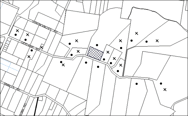
|
NOTIFICATION PLAN |
|||
|
• PROPERTIES NOTIFIED (8 out of range) |
X SUBMISSIONS RECEIVED |
PROPERTY SUBJECT OF DEVELOPMENT |
|
|
1 SUBMISSIONS RECEIVED OUT OF MAP RANGE |
|||
The submissions received from the first two notification periods objected to the development, generally on the grounds that the development would result in:
· Existing use operating without consent
· Impact on land values
· Increased traffic and road safety issues
· No parking for tour buses
· Noise (acoustic report not provided)
· Dust
· Odour
· Lack of information submitted
· Impact upon character and amenity of the locality
· Environmental capacity of the site for the proposed use
· Hours of operation
· Impacts of existing and proposed security lighting
· ‘Best practice obligations’ have not been defined
· No indication of the size or number of animal waste bins have been provided
· Effluent disposal with particular reference to the wash bay area
· Insufficient toilet facilities on-site
· Does not comply with the 30m setback requirement for horses under the draft DCP
· No provision for capture of surface effluent on the site
· Arboricultural Impact Assessment not provided
· Insufficient information with regards to onsite sewage management system
· Proposed landscaping is inconsistent with ‘Planning for Bush Fire Protection 2006’
· Buffer zone is not shown on the plans
· Inadequate and misleading signage to delineate between the Vision Valley Conference Centre from the Vision Valley Horse Centre
· Proposed absorption trench is located on a rock shelf
· The applicant has not detailed the number of people attending the site at any one time
· Unclear as to which paddocks will be used for agistment and which ones will be used for jumping and riding lessons
· Approval of the development would take patronage away from local Clubs and Sporting Bodies that use The Rural Sports facility
· Easements are not shown on the plan and proposed works may be located over easements
· No dimensions of buildings and offices etc shown on plans
· Wastewater irrigation areas may affect the dam on a neighbouring property
· No mention is made with regard to hold Birthday Parties on the site and serving of food in close proximity to the keeping of animals.
22 submissions received in response to the notification of the amended plans object to the development, on the following grounds:
· Siting of arena not in accordance with Council resolution
· Increased traffic and road safety issues
· Parking impacts
· Noise, dust and odour impacts
· Number of horses to be kept on site
· Hours of operation
· Hours for access to the site by agisters/ boarders
· Impact upon character and amenity of the locality including land values
· Environmental capacity of the site for the proposed use
· Proposed development inconsistent with Council justification for levying the Catchment Remediation Rate Levy (CRR)
· Effluent disposal and irrigation areas
· Non-compliance with the DCP setback requirements
The merits of the matters raised in community submissions have been addressed in the body of the report with the exception of the following:
5.1.1 Siting of the Arena
Submissions raise concern that the siting of the dressage arena is not in accordance with Council’s resolution that:
Consideration of this matter be deferred to allow the applicant to submit amended plans showing the arena being moved 50% to the west.
The application originally proposed a 37 metre extension to the dressage arena to the east to increase the width of the arena to 61 metres, resulting in the dressage arena being located 42 metres from the eastern property boundary.
The amended plans submitted in response to Council’s resolution propose that approximately 50% of the proposed 37 metre extension be provided on either side of the existing arena, so that the arena would be extended 19 metres to the east and 18 metres to the west, resulting in the arena being located 60.5 metres from the eastern boundary.
The siting of the arena and the proposed landscaping on the eastern and southern elevations would minimise any perceived amenity impacts of the proposed development on the adjoining dwelling to the east. The proposed location of the arena and the new accessway also ensure that the amenity of the existing rural workers dwelling for Vision Valley staff is also maintained.
5.1.2 Existing Use Operating Without Consent
Prior to 2011, there has been no development consent granted for the use of the property for animal boarding and training. However, Council records indicate that licences have been issued in the past for an animal boarding and training establishment at No. 21 Geelans Road. Furthermore, the application seeks to include the use as part of the proposal.
5.1.3 Lack of Information
A number of submissions raise concerns with regards to a lack of information submitted, including but not limited to the number of people attending the site, holding of birthday parties etc at the facility and buffer zones not shown on plans.
The applicant has stated that the facility is to be used to board the horses used in trail rides and associated activities at the Vision Valley Conference Centre. Accordingly, appropriate conditions of consent are recommended in Schedule 1 to address the use and operation of the site, so as to maintain the amenity of adjoining properties.
5.1.4 Does Not Comply with the 30m Setback Requirement for Horses Under the Draft DCP
Whilst it is acknowledged that the proposed development is inconsistent with the 30m setback requirement specified in Council’s draft DCP, the document is currently a draft and Council is not required to address the draft DCP under the Environmental Planning and Assessment Act 1979 as part of the assessment of this application. Notwithstanding, a 9 metre setback is proposed for the horse paddocks/ yards to minimise impacts on the adjacent dwelling to the east and the dressage arena has also been relocated to provide a 61.5 metre setback to the adjacent dwelling to the east.
5.1.5 Approval of the Development would take patronage away from local clubs and sporting bodies that use the Rural Sports Facility
The proposed dressage arena is to be used in conjunction with the activities associated with the Vision Valley Conference Centre. The site cannot be hired out to clubs and sporting bodies and therefore, should not take patronage away from those local clubs and sporting bodies that utilise the Rural Sports Facility.
5.1.6 Inadequate and Misleading Signage to Vision Valley
A submission raises concerns that there is inadequate and misleading signage to delineate between the Vision Valley Conference Centre from the Vision Valley Horse Centre resulting in additional traffic including tour buses on Geelans Road.
No signage is proposed as part of the existing application, however it is noted that on 20 February 2013, Council approved DA/3/2013 to upgrade the sign located at the intersection of Arcadia Road and Vision Valley Road.
5.1.7 Lighting
Submissions raise concerns with regards to lighting of the proposed development. Whilst the EMP indicates that some security lighting is proposed, the location and details on the plans have not been provided. Furthermore, as the proposed use would occur only in daylight hours, a condition in Schedule 1 is recommended stating that external flood lighting ancillary to, or used in conjunction with the approved use is not permitted. The condition also requires any security lighting to be designed and installed in accordance with Australian Standard AS 4282 – Control of the Obtrusive Effects of Outdoor Lighting. This would ensure that light spill would not impact on the amenity of adjoining properties.
5.1.8 Easements
Submissions raise concerns that existing private easements are not shown on the plan and proposed works may be located over these easements. A survey plan was submitted with the Construction Certificate application for DA/61/2011 (CC/39/2011) which indicates that there would be no adverse impact on the easement because of adequate distance available between the easement and the dressage arena. The location of the dressage arena would not impact on the existing easement. Any subsequent concerns with regards to the private easement would be a civil matter.
5.1.9 Catchment Remediation Rate Levy (CRR)
A submission raises concern that approval of the proposed development would be inconsistent with the intention of the Catchments Remediation Rate (CRR), as it would increase pollution within the catchment.
The CRR is a special rate that is used to fund projects which repair, beautify and protect the health of Hornsby Shire’s waterways and catchments. It was introduced in 1994, to enabled Council to install and maintain more than 400 stormwater quality improvement devices across the Shire’s four major catchment areas, Hawkesbury River, Berowra Creek, Cowan Creek and the Upper Lane Cove River.
The submission is of the view that the proposed development would increase the pollutant load within the Berowra Creek catchment and that the EPA licence confirmed the wastewater system polluted the catchment. As previously stated, the EPA issued a notice of surrender of environment protection licence 1584 for the sewage treatment plant at the Vision Valley Conference and Recreation Centre for reasons including that the statutory annual returns submitted by the licensee for at least the last 10 reporting periods indicate that there has been no discharge to receiving waters.
Furthermore, the applicant has prepared and EMP and appropriate conditions of consent have been imposed in Schedule 1 to address the environmental impacts of the proposed development.
5.2 Public Agencies
The development application is not Integrated Development under the Act. However, the development is sited on bushfire prone land and was referred to the RFS for comment as discussed previously in the report.
6. THE PUBLIC INTEREST
Section 79C(1)(e) of the Act requires Council to consider “the public interest”.
The public interest is an overarching requirement, which includes the consideration of the matters discussed in this report. Implicit to the public interest is the achievement of future built outcomes adequately responding to and respecting the future desired outcomes expressed in environmental planning instruments and development control plans.
The application is considered to have satisfactorily addressed Council’s and relevant agencies’ criteria and would provide a development outcome that, on balance, would result in a positive impact for the community. Accordingly, it is considered that the approval of the proposed development would be in the public interest as it would provide recreational facilities to cater for residents of Hornsby Shire and beyond.
CONCLUSION
The application proposes the use of the site as an animal boarding and training establishment and construction of a dressage arena. The use of the site as an animal boarding and training establishment is to operate in conjunction with the Vision Valley Recreation Centre.
The proposal satisfies the objectives of the Hornsby Shire Local Environmental Plan 1994 and Council’s Rural Lands Development Control Plan. The development improves existing impacts on an adjoining dwelling and provides an opportunity for Council to impose conditions that mitigate future impacts. It is considered unlikely the proposed development would result in any detrimental impacts upon the natural and/or built environments, or have any negative social or economic impacts.
Twenty-two submissions were received objecting to the amended development. Subject to the recommended conditions of consent in Schedule 1, the proposal is assessed as suitable for the site and is recommended for approval.
Furthermore, as there is an existing consent for the construction of the sand arena and use of the site for an animal boarding and training establishments (DA/61/2011), which may result in conflict with this proposal, it is recommend that approval be granted as a deferred commencement subject to the surrender of Development Consent No. 61/2011.
Note: At the time of the completion of this planning report, no persons have made a Political Donations Disclosure Statement pursuant to Section 147 of the Environmental Planning and Assessment Act 1979 in respect of the subject planning application.
|
Rod Pickles Manager - Development Assessment Planning Division |
James Farrington Group Manager Planning Division |
|
1.View |
Locality Plan |
|
|
|
2.View |
Site-CarPark-Drainage- Plans |
|
|
|
3.View |
Dressage Arena Plans |
|
|
File Reference: DA/763/2012
Document Number: D02165349
SCHEDULE 1
1. Deferred Commencement
Pursuant to Section 80(3) of the Environmental Planning and Assessment Act 1979, this consent does not operate until the following information is submitted to Council:
a) The surrender of Development Consent No. DA/61/2011 in accordance with the requirements of Clause 97 of the Environmental Planning and Assessment Regulation 2000.
A notice of voluntary surrender of a development consent, as referred to in section 104A of the Act, is to be given to the consent authority and is to include the following information:
i) the name and address of the person by whom the notice is given,
ii) the address, and formal particulars of title, of the land to which the consent relates,
iii) a description of the development consent to be surrendered,
iv) if the person giving the notice is not the owner of the land, a statement signed by the owner of the land to the effect that the owner consents to the surrender of the consent,
v) if development has commenced to be carried out in accordance with the consent—a statement setting out the circumstances that indicate:
· that so much of the development as has been carried out has been carried out in compliance with any condition of the consent, or any agreement with the consent authority relating to the consent, that is relevant to that part of the development, and
· that the surrender will not have an adverse impact on any third party or the locality.
Such information shall be submitted within 6 weeks of the date of this notice.
Upon Council’s written satisfaction of the above information, the following conditions of development consent will apply:
GENERAL CONDITIONS
The conditions of consent within this notice of determination have been applied to ensure that the use of the land and/or building is carried out in such a manner that is consistent with the aims and objectives of the relevant legislation, planning instruments and Council policies affecting the land and does not disrupt the amenity of the neighbourhood or impact upon the environment.
Note: For the purpose of this consent, the term ‘applicant’ means any person who has the authority to act on or the benefit of the development consent.
Note: For the purpose of this consent, any reference to an Act, Regulation, Australian Standard or publication by a public authority shall be taken to mean the gazetted Act or Regulation, or adopted Australian Standard or publication as in force on the date that the application for a construction certificate is made.
2. Approved Plans and Supporting Documentation
The development must be carried out in accordance with the plans and documentation listed below and endorsed with Council’s stamp, except where amended by Council and/or other conditions of this consent:
Architectural Plans prepared by Maitland and Butler Architects Pty Ltd
|
Plan No. |
Title |
Rev |
Dated |
|
WES38-D08 |
Irrigation Plan (Plan A) |
B |
5 April 2013 |
|
WES38-D10 |
Parking (Plan B) |
B |
27 November 2012 |
|
WES38-D09 |
(Drainage Plan (Plan C) |
C |
4 April 2013 |
|
WES38-D03 |
Dressage Arena Plan |
C |
5 April 2013 |
|
WES38-D04 |
Section A |
C |
5 April 2013 |
|
WES38-D05 |
Detail Section - Detail 1 |
C |
5 April 2013 |
|
WES38-D06 |
Detail Section - Detail 2 |
C |
5 April 2013 |
Supporting Documentation
|
Document Title |
Prepared by |
Dated |
|
Environmental Management Plan [D02075588] |
Mersonn Pty Ltd |
Undated/ received at Council 5 December 2012 |
3. Amendment of Environmental Management Plan
The submitted Environmental Management Plan (EMP) prepared by Mersonn Pty Ltd received at Council on 5 December 2012 is to be amended such that the 9 metre setback from Lot 12 DP 217208, No. 23 Geelans Road is not to include landscaping other than grass or other suitable ground cover.
4. Use of Jumping Paddock
To maintain the reasonable amenity of adjoining residents, all jump structures shall be removed from the paddock adjacent to Lot 12 DP 217208, No. 23 Geelans Road and the paddock must cease to be used for jumping purposes within 2 weeks of the date of this consent.
The jump structures are to be relocated to the area marked on Plan No. WES38-D03, Revision C, prepared by Maitland & Butler Pty Ltd, dated 5 April 2013 during construction of the arena after which they are to be relocated to within the dressage arena at the completion of the works.
REQUIREMENTS PRIOR TO THE ISSUE OF A CONSTRUCTION CERTIFICATE
5. Building Code of Australia
All building work must be carried out in accordance with the requirements of the Building Code of Australia.
REQUIREMENTS PRIOR TO THE COMMENCEMENT OF ANY WORKS
6. Erection of Construction Sign
A sign must be erected in a prominent position on any site on which building work, subdivision work or demolition work is being carried out:
a) Showing the name, address and telephone number of the principal certifying authority for the work,
b) Showing the name of the principal contractor (if any) for any demolition or building work and a telephone number on which that person may be contacted outside working hours, and
c) Stating that unauthorised entry to the work site is prohibited.
Note: Any such sign is to be maintained while the building work, subdivision work or demolition work is being carried out, but must be removed when the work has been completed.
7. Erosion and Sediment Control
Erosion and sediment control measures must be provided and maintained throughout the construction period in accordance with the manual ‘Soils and Construction 2004 (Bluebook)’, the approved plans, Council specifications and to the satisfaction of the principal certifying authority. The erosion and sediment control devices must remain in place until the site has been stabilised and revegetated.
Note: On the spot penalties up to $1,500 may be issued for any non-compliance with this requirement without any further notification or warning.
8. Tree Protection Barriers
To avoid injury or damage, the two Eucalyptus saligna (Sydney Blue Gum) trees located within the car park area must have their trunks protected by 2 metre lengths of 75mm x 25mm hardwood timbers spaced at 80mm secured with galvanised wire (not fixed or nailed to the tree in any way).
REQUIREMENTS DURING CONSTRUCTION
9. Construction Work Hours
All work on site (including demolition and earth works) must only occur between 7am and 5pm Monday to Saturday.
No work is to be undertaken on Sundays or public holidays.
10. Environmental Management
During the construction of the development, the site must be managed in accordance with the publication ‘Managing Urban Stormwater – Landcom (March 2004) and the Protection of the Environment Operations Act 1997 by way of implementing appropriate measures to prevent sediment run-off, excessive dust, noise or odour emanating from the site.
11. Works near Trees
All required tree protection measures are to be maintained in good condition for the duration of the construction period.
The applicant is to ensure that no excavation, including sub-surface trenching for stormwater or other services, filling or stockpiling of building materials, parking of vehicles or plant, the use of machinery other than hand held, disposal of cement slurry, waste water or other contaminants is to occur within the nominated Tree Protection Zone (TPZ) of any tree to be retained.
Nominated Tree Protection Zones (TPZ) Table
|
Tree No. |
Species |
Location |
TPZ |
|
1 |
Eucalyptus saligna |
Proposed car park |
9.6m |
|
2 |
Eucalyptus saligna |
Proposed car park |
9.6m |
|
3 |
Eucalyptus saligna |
West of proposed car park entry |
9.6m |
12. Council Property
During construction works, no building materials, waste, machinery or related matter is to be stored on the road reserve. The road reserve is to be kept in a clean, tidy and safe condition at all times.
13. Landfill
All fill material imported to the site required for the construction of the dressage arena is to wholly consist of Virgin Excavated Natural Material (VENM) as defined in Schedule 1 of the Protection of the Environment Operations Act 1997 or a material approved under the Department of Environment and Climate Change’s general resource recovery exemption.
14. Excavated Material
All excavated material removed from the site must be classified in accordance with the Department of Environment, Climate Change and Water NSW Waste Classification Guidelines prior to disposal to an approved waste management facility and reported to the principal certifying authority.
REQUIREMENTS PRIOR TO THE ISSUE OF AN OCCUPATION CERTIFICATE
Note: For the purpose of this consent, a reference to ‘occupation certificate’ shall not be taken to mean an ‘interim occupation certificate’ unless otherwise stated.
15. Internal Driveway/ Vehicular Areas/ Parking Area
The driveway and parking areas on site must be designed in accordance with Australian Standards 2890.1, 2890.2, 3727 and the following requirements:
a) The driveway being constructed from road base.
b) The driveway is to be designed so that all vehicles can exit the site in a forward direction
c) All signage as identified in the Environmental Management Plan prepared by Mersonn Pty Ltd and submitted to Council on 5 December 2012 is to be erected.
16. Vehicular Crossing
A separate application under the Local Government Act, 1993 and the Roads Act, 1993 must be submitted to Council for the reconstruction of the vehicular crossing. The vehicular crossing must be constructed in accordance with Council’s Civil Works Design, 2005.
Note: An application for a vehicular crossing can only be made to one of Council’s Authorised Vehicular Crossing Contractors. You are advised to contact Council on 02 9847 6940 to obtain a list of contractors.
17. Wastewater to Existing System
All wastewater generated within the approved development, including the dwellings, office and horse wash down bay must be directed to the existing onsite sewage management system servicing the site.
18. Screen Planting
A dense screen of trees or shrubs must be planted adjoining the southern and eastern sides of the dressage arena as indicated in Plan No. WES38-D03 Revision C, prepared by Maitland & Butler Pty Ltd, dated 5 April 2013, to screen the development from the adjoining dwelling at Lot 12 DP 217208, No. 23 Geelans Road. The trees must be of native species, indigenous to the area, having non-invasive root system and obtain a mature growth height of approximately 3 to 4 metres. The landscaping must comply with the principles of Appendix 5 of Planning for Bush Fire Protection 2006.
OPERATIONAL CONDITIONS
19. Use of Premises
a) The development approved under this consent shall be used for an ‘animal boarding and training establishment’ in conjunction with Vision Valley and not for any other use, or separate purpose without Council’s separate written consent.
b) No camping is permitted on the site.
20. Use of Dressage Ring
a) The dressage arena is not to be used for competition or hire.
b) All jumping associated with the use shall occur within the dressage arena.
21. Hours of Operation
a) The hours of operation of the animal boarding and training establishment are restricted to 8.30 am to 5 pm, 7 days a week.
b) Hours of accessibility to the site for horse agisters/boarders are restricted to those times listed below and shall be for grooming / horse care purposes only:
Monday to Friday 6 am to 6 pm
Saturday, Sunday & Public Holidays 7 am to 6 pm
c) The use of the horse arena by horse agisters/boarders outside the hours of use applicable to the animal boarding and training establishment is prohibited, other than by permanent residents of the property.
22. Number of Horses
a) To limit unreasonable impacts associated with overstocking of the site, a maximum of 20 horses may be kept on the site at any one time.
b) No more than 3 additional horses may be brought to the site for daily activities.
23. Fence Line
A post and rail fence must be constructed to prevent horses from grazing within 9 metres of the adjoining dwelling at Lot 12 DP 217208, No. 23 Geelans Road. The fence is to extend from the Geelans Road frontage to at least a point adjacent to the shed located on Lot 12 DP 217208, No. 23 Geelans Road.
24. Manure Storage Bins
a) Refuse should be placed in a receptacle such as a large metal bin with a flanged-fitting metal lid which is water-proof, prevents access to flies and vermin and reduces the emission of noxious odours. When full, the bin should be emptied and disinfected and the waste removed from the site.
b) No spreading of manure is to occur in Paddock A.
c) The manure storage bins are not to be located within 80 metres of Lot 12 DP 217208, No. 23 Geelans Road.
25. Storage of Horse Floats
The storage of horse floats on-site for a commercial purpose is prohibited. Only horse floats registered/ owned by persons living permanently on the premises may be stored on the premises.
26. External Lighting
a) External flood lighting ancillary to, or used in conjunction with, the approved use is not permitted.
b) Any security lighting must be designed and installed in accordance with Australian Standard AS 4282 - Control of the Obtrusive Effects of Outdoor Lighting. Certification of compliance with the Standard must be obtained from a suitably qualified person.
27. Toilet Facilities
Toilet facilities including a minimum of 1 male and 1 female WC must be provided on site to cater for visitors and employees.
28. Ongoing Site Management
The site shall be managed in accordance with the Environmental Management Plan (EMP) prepared by Mersonn Pty Ltd received at Council on 5 December 2012 and the following requirements:
a) The operator of the riding school shall ensure the training area (and all ancillary areas associated with the use of the site as a horse riding school) are regularly cleaned and maintained.
b) Dust suppression measures shall be implemented in the dressage arena to minimise dust caused by horse usage (ie wetting down of the arena before activities and before harrowing occurs especially in the hotter part of the year).
c) Feed shall be stored in containers with close-fitting, hinged lids to prevent the entry of vermin. Materials used also shall be water-resistant or waterproof to prevent spoiling of feed. Metal shall be the preferred material of choice.
d) A programme of weed suppression must be developed by the Applicant to arrest the spread of weeds carried in horse manure.
29. No Staff/ Visitor Car Parking on Geelans Road
Visitors and staff utilising the facility must not park vehicles, including horse floats, on Geelans Road. All vehicles must use the car park onsite.
30. No Bus Access/ Parking
No patrons to the facility are to arrive or leave by bus via Geelans Road. Any buses delivering patrons to, or collecting patrons from, the facility shall do so via the main entrance to the Vision Valley Conference and Recreation Centre on Vision Valley Road.
31. Landscape Establishment
The landscape works shall be maintained into the future to ensure the establishment and successful growth of plant material to meet the intent of the landscape design. This shall include but not be limited to watering, weeding, replacement of failed plant material and promoting the growth of plants through standard industry practices.
CONDITIONS OF CONCURRENCE - NSW RURAL FIRE SERVICE
The following conditions of consent are from the nominated State Agency pursuant to Section 79B of the Environmental Planning and Assessment Act 1979 and must be complied with to the satisfaction of that Agency.
32. Asset Protection Zone
At the commencement of works and in perpetuity the landscaped area adjacent to the dwelling on No. 23 Geelans Road shall be managed to an Outer Protection Area (OPA) standard and shall not exceed 9m wide by 66m long.
The area to the north of the landscaped section shall be managed for 50m as an Inner Protection Area (IPA).This is to ensure discontinuity with the unmanaged vegetation is maintained. Requirements for an Inner and Outer Protection Areas are outlined within section 4.1.3 and appendix 5 of ‘Planning for Bush Fire Protection 2006’ (PBP) and the NSW Rural Fire Service's document ‘Standards for asset protection zones’.
Reason: The intent of measures is to provide sufficient space and maintain reduced fuel loads so as to ensure radiant heat levels of buildings are below critical limits and to prevent direct flame contact with a building.
Note: Further information concerning planning for bush fire protection can be found at: www.rfs.nsw.gov.au.
- END OF CONDITIONS -
ADVISORY NOTES
The following information is provided for your assistance to ensure compliance with the Environmental Planning and Assessment Act, 1979, Environmental Planning and Assessment Regulation 2000, other relevant legislation and Council’s policies and specifications. This information does not form part of the conditions of development consent pursuant to Section 80A of the Act.
Environmental Planning and Assessment Act, 1979 Requirements
The Environmental Planning and Assessment Act, 1979 requires:
· The issue of a construction certificate prior to the commencement of any works. Enquiries can be made to Council’s Customer Services Branch on 9847 6760.
· A principal certifying authority to be nominated and Council notified of that appointment prior to the commencement of any works.
· Council to be given at least two days written notice prior to the commencement of any works.
· Mandatory inspections of nominated stages of the construction inspected.
· An occupation certificate to be issued before occupying any building or commencing the use of the land.
Long Service Levy
In accordance with Section 34 of the Building and Construction Industry Long Service Payments Act 1986, a ‘Long Service Levy’ must be paid to the Long Service Payments Corporation or Hornsby Council.
Note: The rate of the Long Service Levy is 0.35% of the total cost of the work.
Note: Hornsby Council requires the payment of the Long Service Levy prior to the issue of a construction certificate.
Tree Preservation Order
To ensure the maintenance and protection of the existing natural environment, it is an offence to ringbark, cut down, top, lop, remove, wilfully injure or destroy a tree outside 3 metres of the approved building envelope without the prior written consent from Council.
Note: A tree is defined as a single or multi-trunked wood perennial plant having a height of not less than three (3) metres, and which develops many branches, usually from a distance of not less than one (1) metre from the ground, but excluding any plant which, in its particular location, is a noxious plant declared as such pursuant to the Noxious Weeds Act 1993. This definition of ‘tree’ includes any and all types of Palm trees.
All distances are determined under Australian Standard AS4970-2009 ”Protection of Trees on Development Sites”.
Fines may be imposed for non-compliance with Council’s Tree Preservation Order.
Disability Discrimination Act
The applicant’s attention is drawn to the existence of the Disability Discrimination Act. A construction certificate is required to be obtained for the proposed building/s, which will provide consideration under the Building Code of Australia, however, the development may not comply with the requirements of the Disability Discrimination Act. This is the sole responsibility of the applicant.
Covenants
The land upon which the subject building is to be constructed may be affected by restrictive covenants. Council issues this approval without enquiry as to whether any restrictive covenant affecting the land would be breached by the construction of the building, the subject of this consent. Applicants must rely on their own enquiries as to whether or not the building breaches any such covenant.
Advertising Signage - Separate DA Required
This consent does not permit the erection or display of any advertising signs. Most advertising signs or structures require development consent. Applicants should make separate enquiries with Council prior to erecting or displaying any advertising signage.
Dial Before You Dig
Prior to commencing any works, the applicant is encouraged to contact Dial Before You Dig on 1100 or www.dialbeforeyoudig.com.au for free information on potential underground pipes and cables within the vicinity of the development site.
Telecommunications Act 1997 (Commonwealth)
If you are aware of any works or proposed works which may affect or impact on Telstra’s assets in any way, you are required to contact: Telstra’s Network Integrity Team on Phone Number 1800810443.
Asbestos Warning
Should asbestos or asbestos products be encountered during demolition or construction works you are advised to seek advice and information should be prior to disturbing the material. It is recommended that a contractor holding an asbestos-handling permit (issued by WorkCover NSW)be engaged to manage the proper handling of the material. Further information regarding the safe handling and removal of asbestos can be found at:
Alternatively, telephone the WorkCover Asbestos and Demolition Team on 8260 5885.
Rural Lands Incentive Program
The subject property may be eligible to participate in the Hornsby Shire Council Rural Lands Incentive Program, which provides assistance to landowners in the management conservation and restoration of remnant vegetation communities through the provision of technical advice and incentives. For further information, contact Council’s Bushland and Biodiversity Team on 9847 6832.
Rain Water Tank
It is recommended that water collected within any rainwater tank as part of the development be limited to non-potable uses. NSW Health recommends that the use of rainwater tanks for drinking purposes not occur where a reticulated potable water supply is available.
Code of Practice
The applicant’s attention is drawn to the existence of the NSW Animal Welfare Code of Practice No 3 - Horses in Riding Centres and Boarding Stables, prepared by NSW Department of Primary Industries - Agriculture.
Group Manager’s Report No. PL59/13
Planning Division
Date of Meeting: 19/06/2013
16 FURTHER REPORT - SUBDIVISION OF TWO LOTS INTO THREE AND DEMOLITION OF AN EXISTING DWELLING - 12 AND 12B SURREY STREET, EPPING
EXECUTIVE SUMMARY
|
DA No: |
DA/1398/2011 (Lodged 20 December 2011) |
|
Description: |
Subdivision of two allotments into three and demolition of an existing dwelling |
|
Property: |
Lots 1 and Lot 2 DP 503987, Nos. 12 and 12B Surrey Street, Epping |
|
Applicant: |
Ms Julia Mary Wright |
|
Owner: |
Ms Julia Mary Wright |
|
Estimated Value: |
$100,000 |
|
Ward: |
C |
· The application proposes the Torrens Title subdivision of two allotments into three and demolition of a dwelling house.
· On 15 May 2013, Council determined to defer the matter to enable an onsite meeting with available Councillors, the applicant and interested residents. An onsite meeting was held on 23 May 2013. At the conclusion of the meeting, it was noted that the matter would be referred back to Council for determination.
· The proposal generally complies with the Hornsby Shire Local Environmental Plan 1994 and the Residential Subdivision Development Control Plan. The application proposes the removal Sydney Turpentine Ironbark Forest (STIF) and is the subject of an offer to enter into a Planning Agreement to offset the loss of canopy area in accordance with Council’s Green Offset Code.
· Fourteen submissions were received in response to notification of the initial application. Four submissions have been received in response to notification of amended plans and 1 submission has been received in response to notification of the draft Voluntary Planning Agreement.
· It is recommended that the application be approved as a deferred commencement.
|
THAT Development Application No. 1398/2011 for the Torrens Title subdivision of two allotments into three lots and the demolition of a dwelling house Lot 1 DP 503987, Lot 2 DP 503987, Nos. 12 and 12B Surrey Street, Epping be approved as a deferred commencement subject to the conditions of consent detailed in Schedule 1 of Group Manager’s Report No. PL38/13. |
BACKGROUND
On 15 May 2013, Council considered the subject application and resolved that:
Consideration of this matter be deferred to allow an on-site meeting between Councillors, the applicant and interested residents.
In accordance with Council’s resolution, on 23 May 2013 an on-site meeting was held to discuss the application. The meeting was attended by the applicant, the owner of the site, approximately 14 adjoining property owners and persons who made submissions on the application, available Councillors and Planning Division officers.
At the onsite meeting, the applicant provided an overview of the application and residents outlined their concerns. Discussion included consideration of the following:
· Potential for further subdivision with the adjoining property owner at No. 12A Surrey Street, Epping.
· Relocation of the driveway to the western side of the site.
· Loss of Sydney Turpentine Ironbark Forest (STIF) community and applicability of Council’s Green Offset Code.
· Draft Heritage Conservation Areas identified in the Epping Town Centre Urban Activation Precinct.
At the conclusion of the meeting it was noted that the application would be reported back to Council at its meeting on 19 June 2013 for Council’s consideration.
Following the onsite meeting, the potential for further subdivision with the adjoining property owner at No. 12A Surrey Street, Epping was raised with the applicant who has advised that this is not an appropriate option for the following reasons:
· This is a civil matter and needs to be dealt with by the adjoining property owner and the applicant.
· The proposed relocation of the driveway and acquisition of land would require a further assessment under a new development application.
The matters raised at the onsite meeting have been addressed in this report.
THE SITE
The site is identified as Lots 1 and 2 in DP 503987, being Nos. 12 and 12B Surrey Street, Epping. The site is located on the southern side of Surrey Street between its intersections with Oxford Street (west) and Norfolk Road (east). The total area of the site is 2,176 square metres and is generally rectangular in shape apart from a minor intrusion in the south-eastern corner of the site. The site experiences a gradual fall from the front north-western corner to the rear south-western corner with an average grade of 4%.
Lot 1 has an area of 1,004 square metres, with a frontage of 18.9 metres to Surrey Street and a depth of 53.16 metres. Lot 1 is occupied by a single storey brick and tile dwelling-house located centrally upon the allotment. A detached double garage is located within the south-western corner of the allotment and is accessed by a single width driveway which runs parallel to the western side boundary. Lot 1 supports a mature exotic garden and established lawns around the existing residence.
Lot 2 is a battle-axe shaped allotment with an area of 1,172 square metres inclusive of the access handle. The access handle for Lot 2 is located adjacent to the eastern side boundary of Lot 1 and is 4.57 metres wide and 53.16 metres in length. Lot 2 has a width of between 20-22 metres and a depth of 41.6 metres (when measured from the southern boundary of Lot 1).
Lot 2 is vacant and is heavily wooded containing a stand of Turpentine trees with some exotic and non local-native tree species. The remnant trees on the site are identified as Sydney Turpentine Ironbark Forest (STIF) which is an Endangered Ecological Community under the Threatened Species Conservation Act 1995. The subdivision resulting in Lot 2 was registered in the 1960s. However, a dwelling has never been constructed on the allotment. A driveway and vehicular crossing have also not been constructed within the access handle.
The site adjoins low density residential development comprising one and two storey dwellings.
THE PROPOSAL
The application proposes the Torrens Title subdivision of two allotments into three lots and the demolition of an existing dwelling and garage on proposed Lot 1. The proposed allotments are outlined below.
Proposed Lot 1 would have an area of 537.48 square metres and would be located at the street frontage. Access to the allotment would be via the existing driveway and crossing located adjacent to the western side boundary.
Proposed Lot 2 would have an area of 719.65 square metres and would be the central allotment.
Proposed Lot 3, located to the south of proposed Lot 2, would have an area of 662.10 square metres. A driveway is proposed to be constructed within the existing access handle adjacent to the eastern side boundary to provide access to proposed Lots 2 and 3.
Construction of a driveway to access proposed Lots 2 and 3 would necessitate the removal of a number of significant STIF trees from the site. The application is accompanied by indicative dwelling designs to demonstrate that dwellings could be appropriately sited within proposed Lots 2 and 3 without having an unreasonable impact on the significant trees. A Voluntary Planning Agreement (VPA) is proposed to offset the loss of STIF vegetation on the site.
In support of the VPA and the removal of STIF, the applicant submits that a dwelling entitlement applies to existing Lot 2, which would necessitate the removal of significant trees. The applicant submits that the proposed subdivision of two lots into three, including the construction of the driveway and siting of building envelopes, would not have a greater impact on the significant trees than if a single dwelling and driveway were constructed on existing Lot 2.
The application proposes to create a drainage easement to benefit each of the three proposed allotments. The easement would be located over the rear of the eastern adjoining property, No. 12A Surrey Street which would connect to Council’s drainage easement located within No. 14 and 14A Surrey Street.
The proposed demolition works include the demolition of the dwelling-house and detached garage within proposed Lots 1 and 2.
ASSESSMENT
The development application has been assessed having regard to the ‘Metropolitan Plan for Sydney’, the ‘North Subregion (Draft) Subregional Strategy’ and the matters for consideration prescribed under Section 79C of the Environmental Planning and Assessment Act 1979 (the Act). The following issues have been identified for further consideration.
1. STRATEGIC CONTEXT
1.1 Metropolitan Strategy for Sydney 2031 and (Draft) North Subregional Strategy
The (Draft) Metropolitan Strategy for Sydney 2031 is a broad framework to provide for Sydney’s growth to help plan for housing, employment, transport, infrastructure, the environment and open space. It outlines a vision for Sydney to 2031; the challenges faced, and the directions to follow to address these challenges and achieve the vision.
The North Subregion comprises Hornsby, Kuring-gai, Manly, Warringah and Pittwater Local Government Areas. The Draft North Subregional Strategy acts as a framework for Council in its preparation of the Comprehensive LEP by the end of 2013.
Within the North Subregion, the Draft Metropolitan Strategy proposes:
· Population growth of 81,000 from the current 2011 baseline of 529,000
· Housing growth of 37,000 from the current 2011 baseline of 204,000
· Employment growth of 39,000 from the current 2011 baseline of 186,000
The proposed development would be consistent with the draft Strategy by providing an additional allotment facilitating improved housing opportunities in the locality.
2. STATUTORY CONTROLS
Section 79C(1)(a) requires Council to consider “any relevant environmental planning instruments, draft environmental planning instruments, development control plans, planning agreements and regulations”.
2.1 Hornsby Shire Local Environmental Plan 1994
The subject land is zoned Residential A (Low Density) zone under the Hornsby Shire Local Environmental Plan 1994 (HSLEP). The objectives of the zone are:
(a) to provide for the housing needs of the population of the Hornsby area.
(b) to promote a variety of housing types and other land uses compatible with a low density residential environment.
(c) to provide for development that is within the environmental capacity of a low density residential environment.
The proposed development is defined as ‘subdivision’ and ‘demolition’ under the HSLEP and is permissible in the zone with Council’s consent.
Clause 14 of the HSLEP prescribes the minimum allotment size within the Residential A (Low Density) zone is 500m2. The proposed allotment sizes comply with this requirement.
Clause 15 of the HSLEP prescribes that the maximum floor space ratio (FSR) of development within the Residential A (Low Density) zone is 0.4:1. The application demonstrates that the proposed lots are capable of accommodating dwellings that comply with the 0.4:1 FSR requirement.
Clause 18 of the HSLEP sets out heritage conservation provisions for Hornsby Shire. The site is not a heritage item and is not within a heritage conservation area. Accordingly, no further consideration is required in this regard.
2.2 Draft Comprehensive Hornsby Local Environmental Plan
The draft Hornsby Local Environmental Plan (DHLEP) was endorsed by Council at its meeting on 19 December 2012 to be forwarded to the Minister for Planning and Infrastructure to be made. In accordance with Council’s resolution, the draft Plan has been submitted to the Department for finalisation.
Under the DHLEP, the subject land would be zoned R2 - Low Density Residential. The land use is defined as ‘subdivision’ and ‘dwelling-house’ and is permissible in the zone with Council’s consent.
2.3 Draft Plan - Epping Town Centre Urban Activation Precinct
On 16 March 2013, the NSW Premier announced the Urban Activation Precincts program as an important component of a package of wider housing delivery and jobs initiatives. The Epping Town Centre Precinct is part of this program.
The Planning report indicates that the subject site is within the draft East Epping Conservation Area. The report includes Appendix E, Epping Town Centre Heritage Review which indicates that there are a number of heritage items and large number of contributory items, including No. 12 Surrey Street within the draft Conservation Area.
Notwithstanding, No. 12 Surry Street is not proposed to have a statutory listing as a heritage item. Demolition of the existing dwelling would facilitate the retention of a larger number of trees on the site and more orderly development. Any future dwelling on the proposed allotments would be required to be designed to have consideration to any identified characteristics of the draft Heritage Conservation Area should it be made.
2.4 State Environmental Planning Policy – Sydney Regional Environmental Plan (Sydney Harbour Catchment) 2005
The application has been assessed against the requirements of the Policy which includes planning principles applicable to the site within the upper part of the harbour catchment. The principles incorporate measures to protect water quality, minimise urban runoff, to conserve water and to ensure the catchment watercourses, wetlands, riparian lands and remnant vegetation are protected.
Subject to the recommended conditions requiring the installation of sediment and erosion control measures, the proposed development would not have a detrimental impact upon the water quality of the catchment.
2.5 Threatened Species Conservation Act 1995
The site contains significant vegetation identified as STIF which is listed as an Endangered Ecological Community listed under the Threatened Species Conservation Act 1995.
The applicant has submitted a Flora and Fauna Report prepared by UBM Ecological Consultants Pty Ltd, who carried out an assessment of the site pursuant to Clause 5A of the Environmental Planning and Assessment Act, 1979. The report submits that the proposal would not result in a significant impact on the STIF ecological community in the locality. An assessment of the environmental impact of the development is held in section 3.1 of this report.
2.6 Green Offset Code (2012)
Council’s Green Offset Code (2012) was adopted on 20 June 2012. The purpose of the Code is to provide guidance on the approach to conducting offsets for the loss of healthy native trees and vegetation in Hornsby Shire, integrating the regulatory requirements of the environmental legislation and policies.
The Code applies to development that would impact on native vegetation and requires consideration of the following Principles:
· The Principle of Avoid, Minimise and Mitigate.
· The Precautionary Principle.
· The Principle of Net Gain.
· The Principle of Avoiding the Effects of Cumulative Impacts.
The Code provides for offset actions to protect, enhance, manage and create habitat on receiving land that is ecologically suitable and appropriate. Contributions made into this program will go towards restoration and revegetation works on Council managed land.
The application includes a VPA to offset the loss of STIF on the site. The VPA includes a monetary contribution of $63,384 to offset the loss of STIF and enable Council, through its Bushcare Program, to rehabilitate and regenerate bushland on an area of Council land. The monetary contribution offered to Council is in accordance with the formulas and rates outlined in the Code for the removal of 556 square metres of STIF canopy.
2.7 Section 93F Environmental Planning and Assessment Act, 1979
The proposed VPA has been submitted pursuant to Section 93F of the Environmental Planning and Assessment Act, 1979. Council has a Policy on Planning Agreements which embodies the legislative criteria and sets the framework governing the use of Planning Agreements within Hornsby Shire. The Policy includes the following ‘acceptability test’ of a proper planning purpose to ensure that Planning Agreements:
· Are directed towards proper or legitimate planning purposes, ordinarily ascertainable from the statutory planning controls and other adopted planning policies applying to development.
· Provide for public benefits that bear a relationship to development that are not wholly unrelated to the development.
· Produce outcomes that meet the general values and expectations of the public and protect the overall public interest
· Provide for a reasonable means of achieving the relevant purposes and outcomes and securing the benefits.
· Protect the community against harm.
The VPA would offset the loss of STIF from the site and facilitate bushland regeneration works on Council land. Under Council’s Policy on Planning Agreements, bushland regeneration works are listed as an appropriate planning benefit for a planning agreement. The VPA has been reviewed by Council’s Solicitor and is considered to be directed to a legitimate planning purpose and would facilitate an appropriate outcome through bushland regeneration. It is considered to be an appropriate environmental outcome for Council to enter into a VPA in this instance to balance the opportunity for sustainable development against the environmental attributes of the locality. The VPA is considered to satisfy the above acceptability test and is consistent with Council’s Policy on Planning Agreements.
A deferred commencement condition is recommended requiring the applicant to enter into a VPA with Hornsby Shire Council to offset the loss of STIF on the site. In accordance with Section 93G of the Environmental Planning and Assessment Act, 1979 the VPA was required to be publically notified and available for public inspection for a period of 28 days before being entered into. In this regard, the VPA was notified from 13 March 2013 to 10 April 2013.
2.8 Clause 74BA Environmental Planning and Assessment Act, 1979 - Purpose and Status of Development Control Plans
On 1 March 2013, the Environmental Planning and Assessment Act, 1979 was amended so that a DCP provision will have no effect if it has the practical effect of “preventing or unreasonably restricting development” that is otherwise permitted and complies with the development standards set out in relevant Local Environmental Plans and State Environmental Planning Policies. The principal purpose of a development control plan is to provide guidance on the aims of any environmental planning instrument that applies to the development; facilitating development that is permissible under any such instrument; and achieving the objectives of land zones under any such instrument.
The provisions of a development control plan made for that purpose are not statutory requirements.
2.9 Residential Subdivision Development Control Plan
The proposed development has been assessed having regard to the relevant performance and prescriptive design requirements within Council’s Residential Subdivision Development Control Plan (Subdivision DCP). The following table sets out the proposal’s compliance with the prescriptive requirements of the Plan:
|
Residential Subdivision DCP |
|||||
|
Control |
Proposal |
Requirement |
Complies |
||
|
Density |
|||||
|
Site Area |
2176m2 |
N/A |
N/A |
||
|
Proposed allotment size Lot 1 Lot 2 Lot 3 |
537.48m2 (549.69m2 incl. ROW) 719.65m2(842.48m2 incl. ROW) 662.10m2 (784.93m2 incl. ROW) |
500m2 500m2 500m2 |
Yes Yes Yes |
||
|
Lot 1 – Building Envelope/Indicative Dwelling Design |
|||||
|
Building Envelope Area |
200m2 – with min. dimension 13m |
200m2 - min. dimension 10m. |
Yes |
||
|
Floor Area (indicative floor plan) |
200m2 |
N/A |
N/A |
||
|
FSR |
0.37:1 |
0.4:1 |
Yes |
||
|
Private open space |
143m2 |
120m2 |
Yes |
||
|
Setbacks Side (North) Side (East) Side (West) Rear |
6.5m 7m 2.8m 7.6m |
6m 1m 1m 3m |
Yes Yes Yes Yes |
||
|
Landscaping |
62% |
45% |
Yes |
||
|
Car Parking |
2 spaces |
2 spaces |
Yes |
||
|
Lot 2 - Building Envelope/ Indicative Dwelling Design |
|||||
|
Building Envelope Area |
200m2 – with min. dimension 12m |
200m2 - min. dimension 10m. |
Yes |
||
|
Floor Area (indicative floor plan) |
200m2 |
N/A |
N/A |
||
|
FSR |
0.26:1 |
0.4:1 |
Yes |
||
|
Private open space |
25m2 |
120m2 |
No |
||
|
Setbacks Side (North) Side (East) Side (West) Rear |
1m 7m 1m 17m |
1m 1m 1m 3m |
Yes Yes Yes Yes |
||
|
Landscaping |
52% |
45% |
Yes |
||
|
Car Parking |
2 spaces |
2 spaces |
Yes |
||
|
Lot 3 - Building Envelope/ Indicative Dwelling Design |
|||||
|
Building Envelope Area |
181.9m2 – with min. dimension 7.5m |
200m2 - min. dimension 10m. |
No |
||
|
Floor Area |
181.9m2 |
N/A |
N/A |
||
|
FSR |
0.27:1 |
0.4:1 |
Yes |
||
|
Private open space |
25m2 |
120m2 |
No |
||
|
Setbacks Front Side (East) Side (West) Rear |
11.5m 1m 1m 3m |
1m 1m 1m 3m |
Yes Yes Yes Yes |
||
|
Landscaping |
45% |
45% |
Yes |
||
|
Car Parking |
2 spaces |
2 spaces |
Yes |
||
As detailed above, the proposal does not comply with some of the prescriptive requirements of Council’s Subdivision DCP. The matters of non compliance are detailed below, along with a brief discussion on the proposal’s compliance with the relevant element objectives and performance measures.
2.9.1 Allotment Design
The indicative building envelopes on the subdivision plans do not comply with the prescriptive measure of the ‘Allotment Design’ element that states that lots should be able to accommodate a building envelope of 200 square metres with a minimum dimension of 10 metres. The prescriptive measures also require that subdivision design should provide the opportunity for retention of significant trees.
The construction of a driveway to access proposed Lots 2 and 3 would necessitate the removal of a number of significant trees from the site. The application is accompanied by indicative dwelling designs for proposed Lots 2 and 3 to demonstrate that suitably sized dwellings could be sited generally within the existing cleared areas on the site to avoid having further impact on significant vegetation. An Arborist report has been submitted with the application that details specific design and construction techniques that should be applied as a restriction on the title to ensure future dwellings do not impact on trees identified to be retained. The non compliance with the prescriptive measure for building envelope area is considered acceptable given that a smaller dwelling footprint and recommended conditions for tree protection conditions would limit the environmental impact of future development whilst providing useable allotments.
Concerns are raised in community submissions regarding the proximity of the building envelope within Lot 3 to the dwellings on adjoining properties. The siting of a dwelling within the rear location of the site has been selected given that it is generally clear of significant vegetation. The indicative dwelling design for Lot 3 comprises a 3 metre rear boundary setback and a 1 metre side boundary setback which is consistent with setback requirements of the Subdivision DCP. It is considered that an appropriately designed dwelling could be located on the proposed allotment to minimise amenity and privacy impacts on adjoining properties. These matters would be addressed in an application for a future dwelling on the site. It is noted that the site would not be eligible for Complying Development under the NSW Housing Code as proposed Lots 2 and 3 contain an Endangered Ecological community. In this regard, the approval of future dwellings would be subject to a Development Application to Council.
2.9.2 Private Open Space
In accordance with the ‘Private Open Space’ element of the Subdivision DCP, 120 square metres of private open space is required for dwellings with a floor area greater than 150 square metres in gross floor area.
Proposed Lot 1:
The indicative private open space for the subdivision proposal provides for 143 square metres which complies with the required 120 square metres and is considered to be suitable for the site.
Proposed Lot 2 and 3:
The prescriptive measure of the ‘Private Open Space’ element prescribes that the subdivision plan should demonstrate that adequate private open space can be provided for future dwelling houses.
Proposed Lot 2 includes 380 square metres of open space and proposed lot 3 includes 120 square metres of open space. The open space area is recommended to be subject to a restriction to retain the STIF vegetation which limits the ability for this area to be used for active recreation. Whilst the restricted development areas do not provide for useable private open space, it is considered the protection of the STIF would contribute to the amenity of the site and provide for passive open space.
The subdivision plan and indicative dwelling designs have nominated 25 square metre areas of principal private open space for proposed Lots 2 and 3 in locations that are clear of significant trees and that would be adjacent to living areas. This is consistent with the private open space requirements of the NSW Housing Code and Council’s draft DCP that require 24 square metres of principal private open space to be provided.
Although the indicative private open space areas in the subdivision proposal do not provide for 120 square metres of useable private open space strictly in accordance with the Subdivision DCP, the proposal demonstrates that a 25 square metre principal area private open space plus extensive areas of passive open space could be achieved and would be acceptable to meet user requirements. Design for private open space is a matter to be addressed in an application for future dwelling houses on Lots 2 and 3.
2.9.3 Landscaping
The objective of the ‘Landscaping’ element is to preserve significant trees and to add to the environmental character of the area. Although the proposal would necessitate the removal of significant trees from the site, the recommended ‘Restricted Development Area’ would ensure that a 580 square metre area of the site comprising 24 STIF trees is protected from future development or disturbance. The STIF identified to be retained would continue to contribute to the environmental character and amenity of the site.
An assessment of the environmental impact of the development is held in section 3.1 of this report.
2.9.4 Drainage Control
The application proposes to create a drainage easement to benefit each of the three proposed allotments over the rear of Lot B DP 356265, No. 12A Surrey Street. The easement would be located along the rear boundary of No. 12A and would connect to Council’s drainage easement located within Nos. 14 and 14A Surrey Street.
A condition is recommended for a stormwater detention system to be constructed for proposed Lots 2 and 3 to control the discharge of water from the site. The interallotment drainage system and the required on-site detention systems would mitigate the impacts of stormwater runoff on down stream properties.
Owner’s consent for the creation of the easement over No. 12A Surrey Street is required. However, consent was not submitted with the application. A deferred commencement condition is recommended for the registration and creation of the easement through No. 12A Surrey Street. The drainage easement within 14A Surrey Street is in favour of Council and does not require the permission from the property owners.
The rear portion of No. 12A comprises a number of significant trees. The Arborist Report prepared by Earthscape Horticultural Services recommends specific design and construction methods for the drainage easement within No. 12A to ensure that trees within close proximity to the drainage easement would not be adversely affected. Council’s assessment of the proposal concurs with the Arborist’s recommendations and a condition is recommended for the drainage works to be completed in accordance with the Arborist Report.
Subject to owner’s consent being obtained for the creation of the drainage easement and further conditions for stormwater drainage, the proposal is consistent with the objectives of the ‘Drainage Control’ element and is acceptable.
2.10 Section 94 Contributions
Section 94 Contributions apply to the development as the proposed subdivision would result in one additional allotment. A contribution is recommended to be levied as condition of consent.
3. ENVIRONMENTAL IMPACTS
Section 79C(1)(b) of the Act requires Council to consider “the likely impacts of that development, including environmental impacts on both the natural and built environments, and social and economic impacts in the locality”.
3.1 Natural Environment
A total of 77 trees stand within the site and in close proximity to the boundaries on adjoining properties. The trees are a mix of locally indigenous, native and exotic species. Existing Lot 2 contains a grove of mature Syncarpia glomulifera (Sydney Turpentine) and some Pittosporum undulatum (Native Daphne). These species form part of the Sydney Turpentine Ironbark Forest, listed as an Endangered Ecological Community under the Threatened Species Act 1995.
A total of 30 trees would be removed as a result of the development. Of these, 13 are exempt under Council’s Tree Preservation Order, comprising one dead tree (T24) and 12 exotic species (T4, T5, T6, T22a, T23, T30, T31a, T32, T90, T91, T93, T94). Out of the 30 trees to be removed, 17 trees form part of the STIF ecological community (T24a, T25, T27, T28, T29, T33, T35, T36, T63, T65, T75, T77, T80, T82, & T83, T84, T85).
The significant trees to be removed are primarily located within the existing access handle and the eastern side of the site where a driveway is proposed to be constructed. The building envelope locations for proposed Lots 2 and 3 have been sited generally within existing cleared areas of the site to minimise the impact on significant trees. In particular, the building envelope for Lot 2 is sited 4.7m away from T39. The applicant submits that a dwelling entitlement applies to existing Lot 2, which would necessitate the removal of significant trees. The applicant submits that the proposed subdivision of two lots into three, including the construction of the driveway and construction of future dwellings, would have no greater impact on the significant trees than if a single dwelling and driveway were constructed on existing Lot 2.
The applicant has submitted a Flora and Fauna Report prepared by UBM Ecological Consultants Pty Ltd, who carried out an assessment of the site pursuant to Clause 5A of the Environmental Planning and Assessment Act, 1979. The report submits that the proposal would not result in a significant impact on the STIF ecological community in the locality. Council’s environmental assessment of the report concurs with the findings of the Flora and Fauna Report.
An Arborist Report prepared by Earthscape Horticultural Services has been provided with the application. The application proposes to retain 24 trees that form part of the STIF. A requirement for a ‘Restricted Development Area’ under Section 88B of the Act is recommended to ensure the future protection of these trees. The restricted development area would cover 580 square metres of the site comprising the southern half of proposed Lot 2 and the northern portion of proposed Lot 3, as nominated in red on the plans. A condition is recommended requiring that a Vegetation Management Plan for the protection of this area be submitted for approval by Council prior to the issue of a Construction Certificate.
The Arborist Report submitted with the proposal recommends specific design and construction methods for the driveway and storm water infrastructure to protect significant trees identified to be retained as part of the proposal. The report also recommends specific tree sensitive design and construction methods for the construction of future dwellings on proposed Lots 2 and 3. Such methods include requirements for a suspended floor and isolated piers, hand excavation for building foundations and height restrictions for dwellings under tree canopies. To ensure that future owners would be aware of these requirements, the application proposes that these construction requirements are applied as a restriction on the title. Conditions for the ‘Restricted Development Area’ and associated restrictions for tree protection would ensure that the construction of future dwellings would not necessitate the removal of any further trees on the site other than those approved for removal as part of the current subdivision application. Council’s environmental assessment of the proposal concurs with the Arborist’s assessment and recommended conditions.
Subject to the creation of the ‘Restricted Development Area’, submission of a Vegetation Management Plan and compliance with associated conditions for tree protection, it is accepted that the subdivision and construction of two dwellings on proposed Lots 2 and 3 is unlikely to have a greater impact than would the construction of a dwelling and driveway within existing Lot 2. Considering this, and having regard to the Voluntary Planning Agreement to offset the loss of STIF from the site, the proposal’s impact on significant vegetation does not warrant refusal of the application. It is considered to be an appropriate environmental outcome for Council to enter into a Green Offset agreement in this instance to balance the opportunity for sustainable development against the environmental attributes of the locality.
3.2 Built Environment
The proposed lots would provide opportunity for the construction of dwelling-houses consistent with the character of the area whilst retaining a large number of remnant trees on the site which contribute to the visual quality of the locality.
3.3 Social Impacts
The proposal would not result in any significant social impact.
3.4 Economic Impacts
The proposal would have a minor positive impact on the local economy in conjunction with other new low density residential development in the locality by generating an increase in demand for local services.
4. SITE SUITABILITY
Section 79C(1)(c) of the Act requires Council to consider “the suitability of the site for the development”.
The site is not identified as flood prone or bushfire prone land.
The site comprises STIF vegetation, a critically endangered ecological community under the Threatened Species Conservation Act 1995. Subject to the loss of the STIF area being offset in accordance with Council’s Green Offset Code(2012) and the protection of the residual STIF by the creation of a Restricted Development Area, the site is suitable for the proposed development.
5. PUBLIC PARTICIPATION
Section 79C(1)(d) of the Act requires Council to consider “any submissions made in accordance with this Act”.
5.1 Community Consultation
The proposed development was placed on public exhibition and was notified to adjoining and nearby landowners between 11 January 2012 and 1 February 2012 in accordance with Council’s Notification and Exhibition Development Control Plan. During this period, Council received fourteen submissions from seven nearby properties. Following the submission of additional information including indicative dwelling designs, the application was renotified to adjoining properties between 19 April 2012 and 3 May 2012. During this period, Council received three submissions. The proposal was further amended and re-notified between 6 March 2013 and 27 March 2013. During this period, Council received 4 submissions. A draft voluntary planning agreement was also notified between 6 March 2013 and 3 April 2013 in accordance with Section 93G of the Environmental Planning and Assessment Act, 1979. During this period, Council received 1 submission.
Fourteen of the submissions object to the development, generally on the following grounds:
· Removal of significant native vegetation and impact on fauna habitats.
· Impact on the environmental character of the area as a result of tree removal.
· Storm water drainage impacts on down stream properties.
· Privacy, amenity and overshadowing impacts as a result of construction of future dwellings on the proposed lots.
· Owners consent has not been provided for the drainage easement.
One submission received requests that appropriate restrictions be applied to the title to protect significant trees.
One submission received in response to the draft VPA argues that a far greater ‘offset’ should be imposed for the removal of 556m² of STIF as the VPA only takes into consideration the loss of canopy trees rather than the “interconnected system of soil, aspect, climate and micro-organisms and fauna that live in a specific habitat”.
The map below illustrates the location of those nearby landowners who made a submission that are in close proximity to the development site.
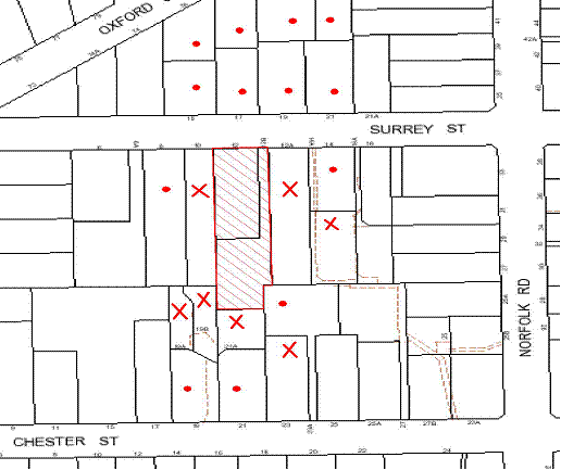
|
NOTIFICATION PLAN |
|
||
|
• PROPERTIES NOTIFIED |
X SUBMISSIONS RECEIVED |
PROPERTY SUBJECT OF DEVELOPMENT |
|
The merits of the matters raised in community submissions have been addressed in the body of the report with the exception of the following:
5.1.1 Solar Access
Concerns are raised in community submissions that the construction of future dwellings on proposed Lots 2 and 3 within the indicative building envelopes would adversely impact on the solar access available to the existing dwelling on adjoining properties.
Based on the indicative dwelling design provided for Lot 3, there would be some overshadowing impact on adjoining properties. However, the impacts would not exceed the acceptable limits prescribed by Council’s Dwelling House DCP. The ‘Solar Access’ element of the Dwelling House DCP prescribes that dwelling-houses should be designed to allow at least 4 hours of sunshine to the private open space of adjoining properties and at least 3 hours of sunshine to north facing living room windows on June 22.
With respect to the overshadowing impact of the indicative dwelling design on Lot 3 it is noted that:
· The eastern elevation windows of No. 19B Chester Street would be overshadowed in the morning, however the overshadowing impact would maintain a minimum 4 hours solar access in accordance with Council’s DCP control.
· The dwelling within No. 21A Chester Street is setback 1 metre from the rear boundary adjoining proposed Lot 3. No. 21A is located directly south of proposed Lot 3. Whilst there would be overshadowing impacts on north facing windows, these rooms appear to be bedrooms and a bathroom and not living areas. Furthermore, the private open space for No. 21A Chester is located south of the dwelling and would not be affected.
· Some overshadowing may occur to the western elevation windows of the dwelling at No. 23 Chester Street. However, the north facing windows and private open space would not be adversely impacted upon.
With respect to Lot 2, a two storey development on Lot 2 is unlikely to result in an overshadowing impact that exceeds Council’s Dwelling House DCP controls given the orientation of the site.
Notwithstanding the above, the dwelling designs submitted as part of the application are indicative only and the impacts on solar access would need to be addressed in any application for future dwelling houses on Lots 2 and 3.
5.1.2 Privacy and Amenity
Concerns are raised in community submissions that future dwellings on proposed Lots 2 and 3 would have an adverse impact on the privacy and amenity impact on adjoining properties, particularly if two storey dwellings are proposed.
Consideration is given to the indicative dwelling designs provided and the prescriptive measure of the ‘Privacy’ element of the Dwelling House DCP, that requires where development is two storeys, living and entertaining areas should be located at ground level.
The indicative dwelling design for proposed Lot 3 comprises two storeys. The living areas have been primary located on the ground level and bedrooms on the first floor, apart from a retreat and balcony. Whilst the retreat and balcony are orientated to the north (being the open space of Lot 3) and do not comprise windows or openings that would overlook adjoining properties, it is considered that amenity impacts of the development would be improved if active use areas are located at ground level.
The indicative building envelope for proposed Lot 2 could accommodate a two storey development. Notwithstanding, the privacy and amenity impacts of dwellings on Lots 2 and 3 would need to be addressed in a future development application.
5.1.3 Sewerage
A concern has been raised in community submissions regarding the discharge of sewerage for the proposed subdivision. This issue is within the jurisdiction of Sydney Water. A condition has been imposed that requires that a Section 73 Certificate be obtained from Sydney Water prior to the issue of a Subdivision Certificate.
5.1.4 Drainage Control and Environmental Health Impacts
A concern has been raised in community submissions regarding drainage impacts resulting from the development and questions the use of absorption pits that “harbours mosquito colonies, thus causing health risks for surrounding residents”. A condition has been imposed requiring the stormwater drainage design which includes an OSD system, to be connected to the proposed inter-allotment drainage system. This would result in the stormwater being piped directly to the inter-allotment drainage system mitigating impacts to moisture in the ground.
5.1.5 Demolition of Dwelling on Lot 1
A concern has been raised in community submissions regarding the detrimental impacts to the streetscape and visual amenity by the demolition of the dwelling on Lot 1. The existing dwelling on Lot 1 is not a heritage listed item under Schedule D of the HSLEP. Whilst the site is within a draft East Epping Heritage Conservation Area under the Epping Town Centre Urban Activation Precinct, this proposal has not yet been adopted. The erection of a future dwelling house is subject to a new application which would involve assessment in regards to Design and consistency with the existing character and amenity of the streetscape and local area.
5.1.6 Draft Voluntary Planning Agreement
A concern has been raised in community submissions that the 556 square metres canopy coverage calculated under Council’s Green Offset Code is insufficient to compensate for the loss of the interconnected ecological system that surrounds the STIF community on the site. As addressed in Part 2.6 Green Offset Code (2012), the calculation and monetary contribution offered to Council is in accordance with the formulas and rates outlined in the Code and the VPA is considered to be suitable.
5.2 Public Agencies
Notification of public agencies was not a statutory requirement for the proposed development.
6. PUBLIC INTEREST
Section 79C(1)(e) of the Act requires Council to consider “the public interest”.
The public interest is an overarching requirement, which includes the consideration of the matters discussed in this report. Implicit to the public interest is the achievement of future built outcomes adequately responding to and respecting the future desired outcomes expressed in environmental planning instruments and development control plans.
The application is considered to have satisfactorily addressed Council’s criteria and would provide a development outcome that, on balance, would result in a positive impact for the community. Accordingly, it is considered that the approval of the proposed subdivision would be in the public interest.
CONCLUSION
The application proposes the Torrens Title subdivision of two allotments into three and demolition of an existing dwelling and garage.
The proposal includes the removal of a significant group of trees identified as Sydney Turpentine Ironbark Forest (STIF). The proposed tree removal is the subject of an offer to enter into a Planning Agreement to offset the loss of 556 square metres of STIF canopy area in accordance with Council’s Green Offset Code (2012). Conditions are recommended for the creation of a ‘Restricted Development Area’ within the site to protect a residual area of STIF.
The proposal generally complies with the Hornsby Shire Local Environmental Plan 1994 and is generally consistent with Council’s Residential Subdivision Development Control Plan. Minor matters of non compliance with respect to setbacks and private open space, along with the matters raised in the community submissions have been addressed in the body of this report.
Having regard to the assessment of the proposed development and the circumstances of the case, it is recommended that the application be approved as a deferred commencement consent.
Note: At the time of the completion of this planning report, no persons have made a Political Donations Disclosure Statement pursuant to Section 147 of the Environmental Planning and Assessment Act 1979 in respect of the subject planning application.
|
Rod Pickles Manager - Development Assessment Planning Division |
James Farrington Group Manager Planning Division |
|
1.View |
Locality Plan |
|
|
|
2.View |
Existing Site Plan |
|
|
|
3.View |
Subdivision Plan |
|
|
|
4.View |
Concept Dwelling Floor Plans |
|
|
|
5.View |
Tree Protection Plans |
|
|
|
6.View |
Addendum to Arborist Report |
|
|
|
7.View |
Voluntary Planning Agreement |
|
|
File Reference: DA/1398/2011
Document Number: D02188533
SCHEDULE 1
1. Deferred Commencement
Pursuant to Section 80(3) of the Environmental Planning and Assessment Act 1979, this consent does not operate until the following information is submitted to Council:
a) Drainage Easement
Evidence of the registration and creation of an easement to drain water from the site over Lot B DP 356265 (12A) Surrey Street in the location shown on plan titled Appendix 7, Tree Protection Plan, plan No. T 11_10142, Sheet 2, dated 20 November 2012.
b) Voluntary Planning Agreement
Pursuant to section 93F of the Environmental Planning and Assessment Act 1979, the applicant must prepare and enter into a Voluntary Planning Agreement (VPA) with Hornsby Shire Council to offset the loss of Sydney Turpentine Ironbark Forest (STIF) under Council’s Green Offset Code (2012).
The terms of the VPA must include but not be limited to the following:
i) The Applicant agrees to pay Council a monetary contribution of $63,384 towards the replacement of 556m2 of STIF lost from the site as result of the development.
ii) The applicant agrees to pay all costs (including Council’s costs) associated with the preparation, public notification, legal costs and administration costs of the VPA.
Such information shall be submitted within 12 months of the date of this notice.
Upon Council’s written satisfaction of the above information, the following conditions of development consent will apply:
GENERAL CONDITIONS
The conditions of consent within this notice of determination have been applied to ensure that the use of the land and/or building is carried out in such a manner that is consistent with the aims and objectives of the relevant legislation, planning instruments and Council policies affecting the land and does not disrupt the amenity of the neighbourhood or impact upon the environment.
Note: For the purpose of this consent, the term ‘applicant’ means any person who has the authority to act on or the benefit of the development consent.
Note: For the purpose of this consent, any reference to an Act, Regulation, Australian Standard or publication by a public authority shall be taken to mean the gazetted Act or Regulation, or adopted Australian Standard or publication as in force on the date that the application for a construction certificate is made.
2. Approved Plans and Supporting Documentation
The development must be carried out in accordance with the plans and documentation listed below and endorsed with Council’s stamp, except where amended by Council and/or other conditions of this consent:
Approved Plans:
|
Plan No./ Title |
Drawn by |
Dated |
|
T 11_10142, Sheet 1, Appendix 7, Tree Protection Plan |
Earthscape Horticultural Services |
20 November 2012 |
|
T 11_10142 Sheet 2, Appendix 7, Tree Protection Plan |
Earthscape Horticultural Services |
20 November 2012 |
|
T 11_10143, Appendix 8, Plan showing Exotic and STIF trees to be removed |
Earthscape Horticultural Services |
20 November 2012 |
|
G0110344/C2 – Issue 3, Civil Works Plan Sheet 1 |
ACOR Appleyard |
February 2013 |
|
G0110344/C3 – Issue 5, Civil Works Plan Sheet 2 |
ACOR Appleyard |
February 2013 |
|
G0110344/C6 – Issue 3, Subdivision Plan |
ACOR Appleyard |
January 2013 |
|
G0110344/C7 – Issue 2, Turning Bay Details and Driveway Cross Section |
ACOR Appleyard |
February 2013 |
Approved Supporting Documentation:
|
Document Title / No. |
Prepared by |
Dated |
|
Development Assessment Impact Report (Arborist Report) – 12 Surrey St Epping |
Earthscape Horticultural Services |
December 2011 |
|
Addendum to Arborist Report |
Earthscape Horticultural Services |
6 November 2012 |
|
Addendum to Arborist Report |
Earthscape Horticultural Services |
20 November 2012 |
|
Addendum to Arborist Report |
Earthscape Horticultural Services |
6 February 2013 |
3. Removal of Existing Trees
This development consent only permits the removal of trees identified in the following plans:
· Appendix 7, Tree Protection Plan, Plan No. T 11_10142, Sheets 1 & 2, prepared by Earthscape Horticultural Services, dated 20 November 2012.
· Appendix 8, Plan showing Exotic and STIF trees to be removed, Plan No. T 11_10142, prepared by Earthscape Horticultural Services, dated 20 November 2012.
The removal of any other trees requires separate approval under Council’s Tree Preservation Order.
4. Amendment of Plans
The approved site plan has been amended in red to nominate the ‘Restricted Development Area’ as prescribed by condition No. 31 of this consent.
REQUIREMENTS PRIOR TO THE ISSUE OF A CONSTRUCTION CERTIFICATE
5. Building Code of Australia
All building work must be carried out in accordance with the requirements of the Building Code of Australia.
6. Contract of Insurance (Residential Building Work)
In the case of residential building work for which the Home Building Act, 1989 requires there to be a contract of insurance in force in accordance with Part 6 of that Act, that such a contract of insurance is in force before any building work authorised to be carried out by the consent commences.
7. Notification of Home Building Act, 1989 Requirements
Residential building work within the meaning of the Home Building Act, 1989 must not be carried out unless the principal certifying authority for the development to which the work relates (not being Council) has given Council written notice of the following information:
a) In the case of work for which a principal contractor is required to be appointed:
i) The name and licence number of the principal contractor.
ii) The name of the insurer by which the work is insured under Part 6 of that Act.
b) In the case of work to be done by an owner-builder:
i) The name of the owner-builder.
ii) If the owner-builder is required to hold an owner-builder’s permit under that Act, the number of the owner-builder’s permit.
Note: If arrangements for doing the residential building work are changed while the work is in progress so that the information notified becomes out of date, further work must not be carried out unless the principal certifying authority for the development to which the work relates (not being Council) has given Council written notification of the updated information.
8. Water/Electricity Utility Services
The applicant must submit written evidence of the following service provider requirements:
a) Energy Australia – a letter of consent demonstrating that satisfactory arrangements have been made to service the proposed development.
b) Sydney Water – the submission of a ‘Notice of Requirements’ under s73 of the Sydney Water Act 1994.
Note: Sydney Water requires that s73 applications are to be made through an authorised Sydney Water Servicing Coordinator. Refer to www.sydneywater.com.au or telephone 13 20 92 for assistance.
9. Vegetation Management Plan
A Vegetation Management Plan(VMP) is to be submitted including the following:
· A planting schedule for future supplementary planting/ landscaping;
· A Schedule of Works that would be consistent with weed management stages (e.g. primary, secondary and weed maintenance weed control and planting etc) that includes activities, stakeholders and time frames consistent with future development timeframes (e.g. release of subdivision certificate, construction certificate, occupation certificate and post development);
· Cross reference to the plan titled Appendix 7, Tree Protection Plan, Plan No. T 11_10142, Sheet 2, dated 6/11/2012, prepared by Earthscape Horticultural Services;
· Account for potential usage by future residents specifying what activities are permissible in the Sydney Turpentine Ironbark Forest; and
· Confirmation that all works within the plan shall be undertaken by a suitably qualified and experienced bush regeneration company (minimum Certificate 3 in Natural Area Restoration)
The VMP is to be prepared to the written satisfaction of Council prior to the issue of a Construction Certificate.
Note: Please refer to Council Guidelines for the preparation of Bushland Management and Restoration Plans (on Council’s website http://www.hornsby.nsw.gov.au/planning-and-building/planning-controls-and-studies/policies,-guides-and-best-practices) for industry standards required for the preparation of such documents.
Council’s Bushland and Biodiversity Team can be contacted on 9847 6542.
10. Boundary Fencing
Fencing must be erected along all property boundaries behind the front building alignment to a height of 1.8 metres.
The boundary fencing between approved lots 2 and 3 within or adjoining the ‘Restricted Development Area’ is to be designed and constructed in accordance with the recommendations of the Addendum to Arborist Report, prepared by Earthscape Horticultural Services dated 6 November 2012. Details of the proposed fencing must be submitted for approval by Council prior the issue of a Construction Certificate.
Note: The fencing is to be erected prior to the issue of a Subdivision Certificate.
REQUIREMENTS PRIOR TO THE COMMENCEMENT OF ANY WORKS
11. Erection of Construction Sign
A sign must be erected in a prominent position on any site on which building work, subdivision work or demolition work is being carried out:
a) Showing the name, address and telephone number of the principal certifying authority for the work,
b) Showing the name of the principal contractor (if any) for any demolition or building work and a telephone number on which that person may be contacted outside working hours, and
c) Stating that unauthorised entry to the work site is prohibited.
Note: Any such sign is to be maintained while the building work, subdivision work or demolition work is being carried out, but must be removed when the work has been completed.
12. Tree Protection Barriers
Tree protection fencing must be erected around trees as shown in plan titled Appendix 7, Tree Protection Plan, Plan No. T 11_10142, Sheets 1 & 2, prepared by Earthscape Horticultural Services, dated 20 November 2012. The tree fencing must be constructed of 1.8 metre ‘cyclone chainmesh fence’ and be built and maintained in accordance with Section 12.2 of the Development Impact Assessment Report Prepared by Earthscape Horticultural Services dated December 2011.
13. Toilet Facilities
Toilet facilities must be available or provided at the works site before works begin and must be maintained until the works are completed at a ratio of one toilet for every 20 persons employed at the site. Each toilet must:
a) be a standard flushing toilet connected to a public sewer; or
b) be a temporary chemical closet approved under the Local Government Act, 1993; or
c) have an on-site effluent disposal system approved under the Local Government Act, 1993
14. Erosion and Sediment Control
Erosion and sediment control measures must be provided and maintained throughout the construction period in accordance with the manual ‘Soils and Construction 2004 (Bluebook)’, the approved plans, Council specifications and to the satisfaction of the principal certifying authority. The erosion and sediment control devices must remain in place until the site has been stabilised and revegetated.
Note: On the spot penalties up to $1,500 may be issued for any non-compliance with this requirement without any further notification or warning.
15. Bushland protection - Weed Prevention
To prevent the spread of weeds and fungal pathogens such as Cinnamon Fungus (Phytophthora cinnamomi) and Chytrid Fungus (Batrachochytrium dendrobatidis), all machinery shall be cleaned of soil and debris before entering the subject site for the installation of subdivision services.
REQUIREMENTS DURING CONSTRUCTION
16. Construction Work Hours
All work on site (including demolition and earth works) must only occur between 7am and 5pm Monday to Saturday.
No work is to be undertaken on Sundays or public holidays.
17. Demolition
All demolition work must be carried out in accordance with Australian Standard 2601-2001 – The Demolition of Structures and the following requirements:
a) Demolition material is to be disposed of to an authorised recycling and/or waste disposal site and/or in accordance with an approved waste management plan.
b) Demolition works, where asbestos material is being removed, must be undertaken by a contractor that holds an appropriate licence issued by WorkCover NSW in accordance with Chapter 10 of the Occupational Health and Safety Regulation 2001 and Clause 29 of the Protection of the Environment Operations (Waste) Regulation 2005.
c) On construction sites where buildings contain asbestos material, a standard commercially manufactured sign containing the words ‘DANGER ASBESTOS REMOVAL IN PROGRESS’ measuring not less than 400mm x 300mm must be erected in a prominent position visible from the street.
d) Buildings and structures to be demolished should be carried out in accordance with Section 12.6 of the Development Impact Assessment Report Prepared by Earthscape Horticultural Services dated December 2011.
18. Works near Trees
All required tree protection measures are to be maintained in good condition for the duration of the construction period.
All works (including stormwater pipes, underground services and driveway construction) within 2 metres of any trees required to be retained (whether or not on the subject property, and pursuant to this consent or the Tree Preservation Order), must be carried out under the supervision of an ‘AQF Level 5 Arborist’ and a certificate submitted to the principal certifying authority detailing the methods used to preserve the trees.
All works must be constructed in accordance with the recommendations in the Development Impact Assessment Report Prepared by Earthscape Horticultural Services dated December 2011, in particular Section 12.6 and 12.7.
The storm water drainage easement within Lot B DP 356265 (12A) Surrey Street must be constructed in accordance with the recommendations in the Addendum to Arborist Report prepared by Earthscape Horticultural Services dated 6 November 2012. The storm water easement must be constructed in the location nominated within plan titled Appendix 7, Tree Protection Plan, Plan No. T 11_10142, Sheet 2, prepared by Earthscape Horticultural Services, dated 20 November 2012.
Note: Except as provided above, the applicant is to ensure that no excavation, filling or stockpiling of building materials, parking of vehicles or plant, disposal of cement slurry, waste water or other contaminants is to occur within 4 metres of any tree to be retained. This is to ensure the protection of bushland and retained trees from the effects of building materials, sedimentation and erosion from development sites.
19. Environmental Management
The site must be managed in accordance with the publication ‘Managing Urban Stormwater – Landcom (March 2004) and the Protection of the Environment Operations Act 1997 by way of implementing appropriate measures to prevent sediment run-off, excessive dust, noise or odour emanating from the site during the construction of the development.
20. Council Property
During construction works, no building materials, waste, machinery or related matter is to be stored on the road or footpath. The public reserve is to be kept in a clean, tidy and safe condition at all times.
Note: This consent does not give right of access to the site via Council’s park or reserve. Should such access be required, separate written approval is to be obtained from Council.
21. Disturbance of Existing Site
During construction works, the existing ground levels of open space areas and natural landscape features, (including natural rock-outcrops, vegetation, soil and watercourses) must not be altered unless otherwise nominated on the approved plans.
22. Vehicular Crossing
A separate application under the Local Government Act, 1993 and the Roads Act, 1993 must be submitted to Council for the installation of a new vehicular crossing and the removal of the redundant crossing. The vehicular crossing must be constructed in accordance with Council’s Civil Works Design, 2005 and the following requirements:
a) Any redundant crossings to be replaced with integral kerb and gutter.
b) The footway area to be restored by turfing.
c) Approval obtained from all relevant utility providers that all necessary conduits be provided and protected under the crossing.
Note: An application for a vehicular crossing can only be made to one of Council’s Authorised Vehicular Crossing Contractors. You are advised to contact Council on 02 9847 6940 to obtain a list of contractors.
REQUIREMENTS PRIOR TO THE ISSUE OF A SUBDIVISION CERTIFICATE
23. Sydney Water – s73 Certificate
An s73 Certificate must be obtained from Sydney Water.
24. Stormwater Drainage
The stormwater drainage system for the development must be designed and constructed generally in accordance with Drawing No.G0110344/C2 Issue 1 dated November 2011 and G0110344/C3 Issue 3 dated November 2012 prepared by ACOR Appleyard Consultants Pty Ltd, Council’s Civil Works – Design and Construction Specification 2005 and the following requirements:
a) Connected to an existing Council piped drainage system.
b) An inter-allotment stormwater drainage system to service the proposed lot with pits being constructed in situ.
c) The roof and stormwater drainage system from the existing dwelling to be connected to the proposed inter-allotment drainage system.
d) The connection to Council’s pit shall be inspected by a Council Engineer in the Planning Division. Prior to the connection an application shall be made to Council and all fees paid. An inspection booking can be made by calling Council on 9847 6787.
Note: A construction certificate shall be obtained prior to the commencement of these works and are to be completed prior to the issue of a subdivision certificate.
The storm water drainage system must be constructed in accordance with the Development Impact Assessment Report dated December 2011.
The storm water drainage easement over Lot B DP 356265 (12A) Surrey Street is to be constructed in the location nominated in plan titled Appendix 7, Tree Protection Plan, plan No. T 11_10142, Sheet 2, dated 20 November 2012 and be constructed in accordance with the recommendations of the Addendum to Arborist Report, prepared by Earthscape Horticultural Services dated 6 November 2012.
25. Internal Driveway/Vehicular Areas
The driveway and parking areas on site must be designed in accordance with Australian Standards 2890.1, 2890.2, 3727 and the following requirements:
a) Design levels at the front boundary shall be obtained from Council if a private accredited certifier is engaged to obtain a construction certificate for these works.
b) The driveway be a rigid pavement.
c) The driveway grade must not exceed 25 percent and changes in grade must not exceed 8 percent per plan metre.
d) The driveway pavement be a minimum 3 metres wide, 0.15 metres thick reinforced concrete with F72 steel reinforcing fabric and a 0.15 metre sub-base.
e) The pavement have a kerb to one side and a one-way cross fall with a minimum gradient of 2 percent and a lintel and pit provided at the low point.
f) Planting of landscaping strips 0.5 metres wide along both sides of the length of the driveway.
g) Conduit for utility services including electricity, water, gas and telephone be provided.
Note: A construction certificate shall be obtained prior to the commencement of these works and are to be completed prior to the issue of a subdivision certificate.
To ensure the protection of trees identified to be retained, the driveway and parking areas on the site must be constructed in accordance with the Development Impact Assessment Report prepared by Earthscape Horticultural Services dated December 2011 and the Addendum to Arborist Report prepared by Earthscape Horticultural Services dated 20 November 2012.
26. Traffic Control Plan
A Traffic Control Plan (TCP) must be prepared by a qualified traffic controller in accordance with the Roads & Traffic Authority’s Traffic Control at Worksites Manual 1998 and Australian Standard 1742.3 for all work on a public road and be submitted to Council. The TCP must detail the following:
a) Arrangements for public notification of the works.
b) Temporary construction signage.
c) Permanent post-construction signage.
d) Vehicle movement plans.
e) Traffic management plans.
f) Pedestrian and cyclist access/safety.
27. Damage to Council Assets
Any damage caused to Council’s assets including the removal, damage, destruction, displacement or defacing of the existing survey marks as a result of the construction of the development must be rectified in accordance with Council’s written requirements and at the sole cost of the applicant.
28. Creation of Easements
The following matter(s) must be nominated on the plan of subdivision under s88B of the Conveyancing Act 1919:
a) A right of access and easement for services over the access corridor.
b) An inter-allotment drainage easement(s) over each of the burdened lots.
c) The creation of a “Positive Covenant” over proposed Lots 2 and 3 requiring that any future development is to provide an on-site detention system. The on-site detention system is to have a storage capacity of 5 cubic metres and a maximum discharge of 8 litres per second into Council’s drainage system in accordance with Council’s prescribed wording.
Note: Council must be nominated as the authority to release, vary or modify any easement, restriction or covenant.
29. Works as Executed Plan
A works-as-executed plan(s) must be prepared by a registered surveyor and submitted to Council for completed road pavement, kerb and gutter, public drainage systems, driveways and on-site detention system. The plan(s) must be accompanied by a certificate from a registered surveyor certifying that all pipelines and associated structures lie wholly within any relevant easements.
30. Bushland Protection – Removal of Noxious weeds
To ensure that plants identified as weed species are effectively removed and not allowed to proliferate or interfere with a quality landscaping outcome, all environmental weeds, noxious and invasive plants are to be removed and suppressed using an appropriate bush regeneration methods. All weed removal must be undertaken by a qualified bush regeneration company in accordance with the Vegetation Management Plan approved by Council’s bushland and biodiversity team (required by condition No. 9 of this consent).
31. Restriction As To User – Protection of Land from Future Development
To inform current and future owners that the areas of remnant Sydney Turpentine Ironbark Forest Endangered Ecological Community trees on the site is to be protected from future development, a Restriction as to User must be created under Section 88B of the Conveyancing Act 1919 identifying that the area of the site marked in red diagonal lines on the approved plans is restricted from development activities that would adversely affect trees identified to be retained as per Appendix 7, Tree Protection Plan, Plan No. T 11_10142, Sheet 2, dated 20 November 2012 and Appendix 8, Plan showing Exotic and STIF Trees to be Removed dated 20 November 2012 prepared by Earthscape Horticultural Services.
The restriction must specify:
a) All natural landscape features including natural rock outcrops, native vegetation (trees, shrubs and groundcovers), soil and watercourses are to remain undisturbed except only where affected by necessary works detailed on approved plans, or with Council’s written consent.
b) Any future construction works and landform modification are to be outside the restricted development area.
c) Hard stand or paved open space areas must be limited to land outside the ‘Restricted Development Area’.
d) No encroachment of the building envelope, including the fill batter, is permitted within the restricted development areas.
e) No machine or heavy vehicle is permitted within the “Restricted Development Areas”.
Note: The wording of the Restriction as to User must be to Council’s satisfaction and Council must be nominated as the authority to release, vary or modify the Restriction.
32. Placement of a Positive Covenant – Maintenance of Sydney Turpentine Ironbark Forest
A positive covenant must be created under Section 88B of The Conveyancying Act 1919 for the ‘Restricted Development Area’ as marked in red diagonal lines on the approved plans, requiring that all landscaping/vegetation management must be in accordance with a Vegetation Management Plan approved by Council (as required by condition No. 9 of this consent).
Note: The wording of the Positive Covenant must be to Council’s satisfaction and Council must be nominated as the authority to release, vary or modify the Covenant.
33. Positive Covenant – Construction of Future Dwellings and Tree Protection
To inform current and future owners that future dwellings on the site must be constructed to ensure the protection of significant trees, a Positive Covenant must be created under Section 88B of the Conveyancing Act 1919, requiring that future dwellings be designed and constructed to ensure the retention of all trees within the Restricted Development Area.
To ensure construction works does not adversely impact on the health and longevity of trees located adjacent to the indicative building envelope locations in the approved site plan, the Positive Covenant is to include the following terms:
a) In relation to Tree Nos. T38, T39, T40, T49, T76 and T79:-
Any future dwelling sited within five(5) metre radius of Tree Nos. T38, T39, T40, T49, T76 and T79 (Turpentines) shall be of pier and mean construction with an elevated floor to maintain the legal protection of these trees under Council’s Tree Preservation Order. Siting of piers shall be avoided within the Structural Root Zones of these trees. The beam (including the edge beam of any slab) shall be placed above grade with a minimum of 50mm clearance between the existing ground level and the lower edge of the beam to avoid excavations for any continuous strip of footing within the Tree Protection Zones. All excavations for pier footings within the TPZs of these trees shall be undertaken under the supervision of a qualified arborist (minimum Australian Qualification Framework Level 3).
Where any woody roots of greater than 40mm in diameter are encountered during excavations for the footings, the position of the pier shall be relocated slightly on site (as required) to avoid severance or damage to woody roots. Any roots encountered of less than 40mm in diameter shall be cleanly severed at the face of the excavation using a clean sharp hand saw or secateurs in accordance with AS 4373:2007. All such pruning shall be carried out by a qualified arborist (minimum Australian Qualification Framework Level 3).
b) In relation to Tree Nos. T38, T39, T40 and T49
Any future dwelling beneath the canopies of Tree Nos T38, T39, T40 and T49 (Turpentines) shall be limited to a single storey dwelling with roof height not exceeding RL 97.50 to minimise any required canopy pruning of these trees. Any canopy pruning essential to clear the building envelope shall be undertaken in accordance with AS4373:2007 by a qualified arborist (minimum Australian Qualification Framework Level 3). No branches exceeding 150mm in diameter shall be removed to clear the building envelope without Council approval.
Note: The wording of the Restriction as to User must be to Council’s satisfaction and Council must be nominated as the authority to release, vary or modify the Restriction.
34. s94 Infrastructure Contributions
The payment to Council of a contribution of $20 000 for one additional lot towards the cost of infrastructure identified in Council’s Development Contributions Plan 2007-2011.
Note: The value of contribution is capped at $20,000 per additional lot in accordance with Ministerial Direction (Section 94E of the Environmental Planning and Assessment Act 1979) issued on 16 September 2010. In the event that this Direction is repealed or amended, Council will apply the value of the contribution from the date of this consent, adjusted from this date in accordance with the underlying consumer price index for subsequent financial quarters.
It is recommended that you contact Council to confirm the value of the contribution prior to payment.
- END OF CONDITIONS -
ADVISORY NOTES
The following information is provided for your assistance to ensure compliance with the Environmental Planning and Assessment Act, 1979, Environmental Planning and Assessment Regulation 2000, other relevant legislation and Council’s policies and specifications. This information does not form part of the conditions of development consent pursuant to Section 80A of the Act.
Environmental Planning and Assessment Act, 1979 Requirements
· The Environmental Planning and Assessment Act, 1979 requires:
· The issue of a construction certificate prior to the commencement of any works. Enquiries regarding the issue of a construction certificate can be made to Council’s Customer Services Branch on 9847 6760.
· A principal certifying authority to be nominated and Council notified of that appointment prior to the commencement of any works.
· Council to be given at least two days written notice prior to the commencement of any works.
· Mandatory inspections of nominated stages of the construction inspected.
· An occupation certificate to be issued before occupying any building or commencing the use of the land.
Long Service Levy
In accordance with Section 34 of the Building and Construction Industry Long Service Payments Act 1986, a ‘Long Service Levy’ must be paid to the Long Service Payments Corporation or Hornsby Council.
Note: The rate of the Long Service Levy is 0.35% of the total cost of the work.
Note: Hornsby Council requires the payment of the Long Service Levy prior to the issue of a construction certificate.
Tree Preservation Order
To ensure the maintenance and protection of the existing natural environment, it is an offence to ringbark, cut down, top, lop, remove, wilfully injure or destroy a tree outside 3 metres of the approved building envelope without the prior written consent from Council.
Note: A tree is defined as a single or multi-trunked wood perennial plant having a height of not less than three (3) metres, and which develops many branches, usually from a distance of not less than one (1) metre from the ground, but excluding any plant which, in its particular location, is a noxious plant declared as such pursuant to the Noxious Weeds Act 1993. This definition of ‘tree’ includes any and all types of Palm trees.
All distances are determined under Australian Standard AS4970-2009 ”Protection of Trees on Development Sites”.
Fines may be imposed for non-compliance with Council’s Tree Preservation Order.
Note: The site contains Sydney Turpentine Ironbark Forest which is listed as an Endangered Ecological Community under the ‘Threatened Species Conservation Act 1995’. The Act prohibits the disturbance to threatened species, endangered populations and endangered ecological communities, or their habitat, without the approval of the ‘Department of Environment and Climate Change’ where such activities are not authorised by a development consent under the ‘Environmental Planning and Assessment Act 1979’.
Actions such as tree removal, understorey slashing or mowing, removal of dead trees within this vegetation would likely impact upon this endangered ecological community. Such action would qualify as illegally picking or disturbing the habitat and could render any person who carried out such action as LIABLE FOR PROSECUTION.
Subdivision Certificate Requirements
A subdivision certificate application is required to be lodged with Council containing the following information:
· A surveyor’s certificate certifying that all structures within the subject land comply with the development consent in regard to the setbacks from the new boundaries.
· A surveyor’s certificate certifying that all services, drainage lines or access are located wholly within the property boundaries. Where services encroach over the new boundaries, easements are to be created.
· Certification that the requirements of relevant utility authorities have been met.
· A surveyor’s certificate certifying finished ground levels are in accordance with the approved plans.
Note: Council will not issue a subdivision certificate until all conditions of the development consent have been completed.
Fees and Charges – Subdivision
All fees payable to Council as part of any construction, compliance or subdivision certificate or inspection associated with the development (including the registration of privately issued certificates) are required to be paid in full prior to the issue of the subdivision certificate. Any additional Council inspections beyond the scope of any compliance certificate required to verify compliance with the terms of this consent will be charged at the individual inspection rate nominated in Council's Fees and Charges Schedule.
Dial Before You Dig
Prior to commencing any works, the applicant is encouraged to contact Dial Before You Dig on 1100 or www.dialbeforeyoudig.com.au for free information on potential underground pipes and cables within the vicinity of the development site.
Asbestos Warning
Should asbestos or asbestos products be encountered during demolition or construction works you are advised to seek advice and information should be prior to disturbing the material. It is recommended that a contractor holding an asbestos-handling permit (issued by WorkCover NSW)be engaged to manage the proper handling of the material. Further information regarding the safe handling and removal of asbestos can be found at:
Alternatively, telephone the WorkCover Asbestos and Demolition Team on 8260 5885.
Group Manager's Report No. PL43/13
Planning Division
Date of Meeting: 19/06/2013
17 HORNSBY QUARRY LAND FILLING ASSESSMENT
EXECUTIVE SUMMARY
· At its meeting on 12 August 2009, Council resolved to fill the Hornsby Quarry pit with Virgin Excavated Natural Material (VENM).
· In accordance with Council’s resolution, a consultant was engaged to seek the planning and environmental approvals to enable filling of the Quarry.
· A Preliminary Impact Assessment of the filling proposal has been prepared which considers the environmental, social and economic impacts.
· Methods of filling that rely on road access would result in significant traffic and noise impacts even after the implementation of costly mitigation measures.
· The selection of Access Option 1 (extension of Bridge Road) would, on balance, result in the least environmental and social impact. However, this option would still have significant local impacts and would be costly to construct.
· Economic analysis concludes that if VENM suppliers were willing to pay to dispose of the material, then it may be possible to undertake the filling of Hornsby Quarry with a cost neutral outcome. However, there is significant risk associated with this assumption.
· If all or most of the VENM received at the site needs to be purchased by Council, the total cost of filling the Quarry could be up to $200 million.
· It is recommended that Council defer consideration of filling the Quarry with off site VENM and commence investigation of other filling options such as water.
|
THAT: 1. Council defer consideration of the proposal to fill Hornsby Quarry with off site Virgin Excavated Natural Material at this time. 2. Council investigate alternate options for the long term management and stabilisation of the Quarry including filling the Quarry with water. |
PURPOSE
The purpose of this Report is to present the findings of the Hornsby Quarry Land Filling Preliminary Impact Assessment and to determine Council’s position concerning the progression of the planning proposal to fill the Quarry pit with Virgin Excavated Natural Material (VENM).
BACKGROUND
At its meeting on 12 August 2009, Council considered a report seeking direction concerning the progression of actions for the future use of Hornsby Quarry and adjoining lands within Old Mans Valley. The report presented preliminary investigations into the possibility of filling the Quarry pit and recommended that, should Council resolve to progress filling the pit, only VENM should be used. Council resolved to fill the pit with VENM and that movement of material to the pit, and in the immediate surrounds, be limited to that necessary for safety, operational reasons or where financially viable.
To progress Council’s resolution, Tenders were sought and Cardno (NSW) Pty Ltd was engaged in late May 2010 to seek the planning and environmental approvals to enable filling of the Quarry with VENM to a level to be determined as part of the process. In December 2010, the consultant submitted a Preliminary Justification Report to the Department of Planning and Infrastructure (DP&I) on behalf of Council seeking a determination from the Minister as to whether a proposal to fill the Quarry constitutes a major project under the then Section 75B(1)(b) of the Environmental Planning and Assessment Act 1979 (EP&A Act) allowing assessment under Part 3A of the Act. In April 2011, the Department advised that the Project would not be declared a Major Project.
At its meeting on 18 May 2011, Council considered Executive Manager’s Report No. WK30/11 regarding the Major Project request. The report noted the advice from the Department and recommended that rezoning and reclassification of the land would be required before a development application could be progressed for filling. Council resolved to progress with the Quarry Tender involving progression of a planning proposal.
At its meeting on 3 August 2011, Council resolved to prepare a planning proposal to permit the filling of the Quarry as permissible development. On 14 September 2011, Council received a Gateway Determination from the DP&I enabling the progression of the Planning Proposal, subject to a number of conditions, including the completion of various studies. The Gateway Determination required that the revised Planning Proposal be submitted to the Department for its consideration within 12 months. Since that time, Council has been working with the consultants on the preparation of a preliminary impact assessment regarding the filling of the Quarry.
On 30 May 2012, Council requested an extension from the Department to complete the complex studies required. The Department advised on 27 July 2012, that it would not grant an extension to the Gateway Determination on the grounds that a new Planning Proposal should be submitted in the future.
The consultant has submitted a final report entitled ‘Hornsby Quarry Land Filling Preliminary Impact Assessment’. The Assessment Report is available for viewing on Council’s website at hornsby.nsw.gov.au/planning-and-building/hornsby-quarry.
SITE
Hornsby Quarry is located to the west of Hornsby Central Business District. The Quarry is situated adjacent to residential properties to the north, Berowra Valley Regional Park to the west, Hornsby Park to the south and Old Mans Valley to the east. Existing vehicular access to the site is via Dural Street and Quarry Road to the south of the site.
Hornsby Quarry has an area of approximately 23 hectares and is zoned Open Space A (Public Recreation – Local) under the Hornsby Shire Local Environmental Plan (HSLEP) 1994. Under the draft Hornsby Local Environmental Plan (HLEP) the Quarry is zoned RE1 Recreation. The Quarry site and adjoining Old Mans Valley are classified as Community Land.
DISCUSSION
The purpose of the Hornsby Quarry Land Filling Preliminary Impact Assessment Report (‘the Assessment Report’) is to provide a preliminary evaluation of the environmental, social and economic impacts that could be expected if the proposal to fill the Quarry was to proceed. The Assessment Report was prepared in two parts. First, the consultant reviewed options for access to the site and then a preliminary impact assessment was undertaken on the preferred access options along with an economic analysis.
The Assessment Report is not intended to provide a comprehensive Environmental Impact Assessment for development application purposes. Rather, the Report is intended to assist Council with deciding the future of Hornsby Quarry and to support a further submission to the DP&I should Council wish to proceed with a planning proposal.
Access Options
The location of the Quarry and the local geography of the area, means any filling of the Quarry would require movement of fill material through major roads, business districts, open space and residential areas and would lead to some disruption for local residents and visitors to the area. To assist in minimising disruption, an access options assessment was undertaken to identify and evaluate the most appropriate access route to the Quarry to facilitate the transportation of fill. The outcome of the assessment identifies four potentially viable access routes as having the least impact on residents and being the most feasible:
· Access Option 1 – Extension of Bridge Road to facilitate direct entry and exit to the Quarry;
· Access Option 2 – One-way loop with entrance to the site via Quarry Road and exit from the site via Bridge Road;
· Access Option 3 – One-way loop with entrance to the site via Bridge Road and exit from the site via Quarry Road; and
· Access Option 4 – Entry and exit via Quarry Road/Frederick Street/William Street/Pacific Highway.
A preliminary impact assessment was undertaken on these preferred access options.
Preliminary Impact Assessment
The Assessment Report contains seven parts comprising an introduction, site location and context, project description, legislative and planning context, environmental impact assessment, economic analysis and conclusions.
The following preliminary environmental and social impact assessments were undertaken as part of the Report. The results have been summarised to simplify the findings of potential mitigation and residual risk impact.
|
Issue |
Implementation of Mitigation Measures |
Impact post mitigation |
|
Traffic and transport |
Impacts would only be partially mitigated. |
High |
|
Noise |
Impacts would be reduced. However, noise emissions would not comply with NSW assessment criteria. |
High |
|
Air quality |
Impacts reduced within guideline levels. |
Low |
|
Groundwater |
No significant groundwater impacts are expected as a result of the proposal. |
Low |
|
Topography and Geology |
Impacts managed by mitigation measures. |
Low |
|
Flora and Fauna |
Varying levels of vegetation clearing required with the different vehicle access options. |
Medium |
|
Heritage |
Impacts managed by mitigation measures. |
Low |
|
Social Impacts |
Traffic and noise impacts difficult to manage. |
Medium/High |
|
Visual Amenity |
Impacts managed by mitigation measures. |
Low |
As a result of the impact assessment, the above table demonstrates that risks associated with traffic and noise impacts would be difficult to mitigate and are likely to be cost prohibitive to the project. A summary of traffic and noise issues are outlined below.
Traffic
Traffic modelling was undertaken to evaluate the impacts that increased truck movements would have on the surrounding road network.
The analysis for the proposed filling works assessed the four access routes over an eight year fill period which was considered to be the worst case scenario. A fill time of eight years would result in twenty-three trucks per hour entering and leaving the Quarry during its hours of operation (7am-5pm Monday-Friday, 8am-12pm Saturday).
The analysis was compared to a base model that estimates traffic growth from 2010 to 2021 to assess the capacity of the road network. The model accounts for traffic from both Quarry and non Quarry uses such as the Hornsby Aquatic Centre and forecast population growth. The model does not include traffic that may be generated within the Hornsby West-Side Precinct should Council proceed with this project. Traffic impacts of the West-Side proposal have been addressed within a separate study.
The following traffic impacts associated with the four preferred vehicle access routes are identified:
|
Access Options |
Impact on road network |
|
1 |
Would not significantly impact on the overall road network. There is spare capacity along George Street and Bridge Road to accommodate additional truck movements during peak hours. |
|
2 |
Would not significantly impact on the overall road network. Pacific Highway northbound, between George Street and William Street, has adequate capacity to accommodate the trucks entering the Quarry. |
|
3 |
Would impact on southbound traffic on the Pacific Highway, with queuing extending back to Bridge Road. This option would also result in trucks queuing back along William Street, waiting to turn right onto Pacific Highway. |
|
4 |
Would result in queues extending back to Bridge Road for southbound traffic along the Pacific Highway. Similar to option 3, trucks would queue back along William Street due to insufficient capacity on Pacific Highway for vehicles to turn right. |
The assessment concludes that the road network has sufficient capacity to cater for an eight year fill period based on projected traffic growth to 2021. Access Option 1 (entry and exit via Bridge Road) and Access Option 2 (entry via Quarry Road, exit via Bridge Road) result in the least impact on the road network for the eight year Quarry fill operation.
Mitigation Measures
· The Assessment Report proposes the following mitigation measures for all options:
· Preparation of a Traffic Management Plan to manage potential traffic impacts and issues;
· The Quarry site only be accessed by designated routes;
· Traffic signals at intersections be coordinated with the concurrence of the Roads and Maritime Service to optimise the flow of vehicles;
· Motorist made aware of any changed traffic conditions and the provision of appropriate alternative routes if necessary;
· Identification of alternate parking areas for residents and businesses along affected routes;
· All equipment and machinery be contained within the site;
· Ongoing communication with impacted residents; and
· Roads maintained during and after completion of Quarry filling.
The report states that the mitigation measures outlined above would only partially manage the impacts associated with the increased number of trucks on the local roads surrounding the site. Notwithstanding that there is spare capacity in the road network, the large volumes of heavy vehicles in local streets may impact on pedestrian and local traffic safety, visual and residential amenity.
Noise Assessment
A noise impact assessment was undertaken to determine whether noise emissions associated with the proposed works (including truck movements) would comply with the relevant statutory noise requirements, and to identify appropriate mitigation measures.
The noise modelling considered onsite activity such as the operation of a Quarry plant, equipment and the delivery of VENM by trucks for an eight year filling period. The predicted noise levels from these activities were compared to relevant NSW noise policy criteria, to determine the expected level of compliance. The volume of vehicles accessing the site was determined from the traffic study.
To establish the existing noise conditions, noise monitoring was conducted in seven locations surrounding the Quarry in August 2012. The predicted noise levels were compared with existing noise conditions and relevant noise criteria set out within State guidelines, including NSW Road Noise Policy, Industrial Noise Policy for NSW and Australian Standard AS 2436:2010 – “Guide to noise and vibration control on construction, demolition and maintenance sites”. Predicted noise levels for onsite activity and site generated traffic were required to be predicted separately to address the separate assessment criteria.
Road Traffic Noise
The Assessment Report concludes that the noise levels from trucks arriving and leaving the Quarry site would exceed the NSW noise criteria for all four vehicle access options. The noise impact on properties adjoining the Pacific Highway would be significantly less than properties on local roads due to the high volume of traffic already present on the Pacific Highway. There would be a significant increase in the existing traffic noise on local roads including William Street, Dural Lane, Frederick Street and Bridge Street.
Of the four access options referred to in this report, Option 1 (Bridge Road) results in the least impact on noise for residents, due to fewer residences impacted when compared with the other options.
Onsite Quarry Noise
The Assessment Report concludes that onsite Quarry noise would progressively worsen as the Quarry pit is filled from RL10 to RL90 as onsite machinery moves closer to the surface. Noise levels for onsite plant and equipment are predicted to significantly exceed acceptable levels on Manor Road, Fern Tree Close, Dural Lane, Roper Lane, Bridge Road and the Pacific Highway.
Access Option 1 (Bridge Road) and Access Option 3 (entrance via Bridge Road) would result in slightly higher noise impacts due to the entry facilities being located in proximity to Bridge Road. It is predicted that residents on Manor Road would be the most affected.
Mitigation Measures
The Assessment Report identifies that the opportunity for mitigation measures is limited due to the extensive area impacted and topographic constraints. The following mitigation measures are proposed for all options:
· Minimise the number of plant items in use in the Quarry area and surrounds at any on time (which may cause significant delays in operations);
· Provide partial acoustic barriers at vehicle entry points;
· Provide acoustic property treatments to affected residential receivers;
· Limit Quarry filling to proposed hours of operation (7am to 5pm – Monday to Friday, 8am – 12pm Saturday); and
· Design access layout to minimise requirements for trucks to reverse.
The Assessment Report identifies that property purchase or providing financial compensation to affected property owners is not a viable mitigation measure due to the potential cost and issues of fairness and equity for the community.
Notwithstanding the above measures, the Assessment Report concludes that whilst the mitigation measures are likely to reduce noise emissions and improve amenity, it is unlikely they will result in compliance with the State noise assessment criteria.
All access options would result in noise being experienced by residents within the vicinity from both the on-site Quarry operation and trucks travelling to and from the site, at levels above acceptable criteria. Access from Bridge Road only (Access Option 1) would result in the least noise impact due to fewer residences, when compared to the other access options.
Economic Analysis
The Assessment Report includes an economic analysis that identifies the likely costs and revenue associated with filling the Quarry with VENM. The analysis also considers the cost of the mitigation measures for each access option as well as an analysis to determine the economic viability of filling the Quarry with VENM.
Similar to the traffic model, eight year and twenty year filling periods were applied. In reality, the project length may be greater based on uncertainty regarding the source and supply of VENM.
Costs (excluding VENM)
The total cost estimate for site establishment, infrastructure, operation and mitigation for all access options is approximately $26 to $62 million (based on 8-20 year filling scenarios). This includes common and ongoing costs associated with these items but excludes the cost of fill.
Section 88 Waste Contributions
The Protection of the Environment Operations Act 1997 requires licensed waste facilities in NSW to pay a levy in respect of each tonne of waste received for disposal. The current levy (2012-2013) for the Sydney Metropolitan Area is $95.20 per tonne of waste deposited. Under current government policy, a site that only receives VENM is not required to be licensed. Therefore, the Section 88 Waste Levy has not been included in the economic assessment.
Cost of VENM
The Assessment Report identifies that VENM is usually purchased at a cost anywhere between $5-$55/tonne. Due to the variable nature of the market, the report adopts a value of $15/tonne for the economic analysis.
Due to the variable nature and uncertainty of the price of VENM, three scenarios have been assessed as outlined below:
· Scenario 1: All VENM required to fill the Quarry is purchased by Council
Assuming the cost of VENM is purchased at $15/tonne, the cost to fill the Quarry would be approximately $137 million. When combined with establishment, infrastructure, operating and mitigation costs, the total cost for all access options is approximately $163 million to $199 million (based on 8-20 year filling scenarios).
· Scenario 2: Cost neutral analysis – Council charges suppliers to dispose of VENM in the Quarry
Assumes that suppliers will pay to dispose VENM. To achieve cost neutrality, Council would need to charge approximately $2 to $6 per tonne of VENM. This rate is competitive when compared to the prices being charged at existing landfill sites in the Sydney area. However, VENM is a valuable resource in many situations and there is no guarantee that holders of VENM would be prepared to pay for its disposal.
· Scenario 3: Combined approach – VENM is partly purchased, charged or free
If operation of the Quarry as a landfill site sets a precedent for purchasing VENM, the ability to charge for it may be lost. Therefore, this scenario assumes that VENM suppliers would pay Council to dispose of small tonnages of VENM, medium tonnages may be accepted by the Quarry at a zero cost and larger tonnages may be purchased by Council at a reasonable rate. It is assumed that:
· 30% of fill would attract revenue from the supplier;
· 30% of fill would be accepted at zero cost to the Quarry; and
· 40% of fill would be purchased at a cost of $15/tonne.
Based on these assumptions, Council would need to charge suppliers approximately $29-$40 per tonne (30% of the total VENM requirement) to achieve a cost neutral land fill proposal over an 8-20 year filling scenario.
The Assessment Report concludes that under current government policy, it is reasonable to assume that the filling of Hornsby Quarry could be undertaken on a cost neutral basis. However, there is significant risk associated with this assumption, as the outcome is strongly dependent on several factors including:
· A change in government policy would result in the disposal of VENM no longer being exempt from Section 88 Waste Contributions and would impact on the price charged to receive VENM at the site. This may result in the Cost Neutral Price no longer being competitive in the market and the suppliers of VENM may turn to other Sydney or regional facilities.
· VENM is a valuable resource. For a supplier to be willing to dispose of VENM, they would have to identify that they have no beneficial use for VENM at that time, have no means of stockpiling for future use and have not sourced a consumer for their VENM.
· Should the filling operation extend past twenty years, due to the availability of VENM or for other reasons, this may impact on the ability of the operation to be cost neutral.
The economic data provided in the assessment is indicative only. A more detailed economic evaluation would be required to assess the viability in greater detail should the proposal proceed.
Planning Proposal
Landfill is currently not a permissible use within the Open Space A (Public Recreation – Local) zone under the HSLEP 1994. However, landfill is a permissible land use with consent within all zones under Clause 6.6 Earthworks (local) of the draft HLEP.
The Assessment Report recommends access to the Quarry via Bridge Road. Should Council wish to proceed with the proposal and the recommended vehicle access route, a planning proposal would be required to be submitted to the DP&I to reclassify the Quarry site and part of the land within Old Mans Valley from community to operational land in accordance with the Local Government Act 1993.
The planning proposal would be progressed as part of the State Government’s “gateway plan-making process”. Community consultation forms part of this process. The proposal would be required to be exhibited for a minimum of 28 days. The reclassification of land, in any instance, requires a public hearing to take place and conducted by an independent professional.
Options
With respect to the proposal to fill Hornsby Quarry with VENM, the following options are proposed.
Option 1 – Not proceed with the proposal to fill the Quarry with VENM at this time
The Assessment Report has found that whilst it would be feasible to fill the Quarry over an 8-20 year period, the proposal is reliant on assumptions regarding the availability of fill and market price which are likely to change over time. In addition, the environmental impacts associated with noise from both traffic and Quarry operations would be difficult to mitigate even with the preferred access option via Bridge Road (option 1).
Should Council wish to proceed with this option an appropriate resolution would be:
1. Council defer consideration of the proposal to fill Hornsby Quarry with off site Virgin Excavated Natural Material at this time.
2. Council investigate alternate options for the long term management and stabilisation of the Quarry including filling the Quarry with water.
Option 2 – Progress with planning proposal to permit filling of Hornsby Quarry
Under this option, a revised planning proposal based on the Preliminary Impact Assessment attached to this report would need to be prepared and submitted to the DP&I for a Gateway Determination.
Should Council wish to proceed with this option an appropriate resolution would be:
1. A planning proposal be progressed to reclassify Hornsby Quarry and part of Old Mans Valley from community to operational land.
2. Council forward the planning proposal to the Minister for Planning and Infrastructure seeking “Gateway Determination” to exhibit the planning proposal.
3. A public hearing pursuant to Section 57(6) of the Environmental Planning and Assessment Act be held following the exhibition of the Planning Proposal.
4. An independent facilitator be retained to conduct the public hearing for the reclassification of the land.
5. Following the exhibition, a report on submissions received in response to the public exhibition and public hearing be presented to Council.
In summary, Council resolved to fill the pit with VENM and that movement of material to the pit, and in the immediate surrounds, be limited to that necessary for safety, operational reasons or where financially viable and that the filling operation be cost neutral to Council. The Assessment Report concludes that solutions that rely on road access to fill the Quarry with VENM would result in adverse impacts, particularly in regards to traffic and noise. Appropriate and feasible mitigation measures are limited and are unlikely to result in compliance with NSW assessment criteria. The Assessment Report also concludes that there would be significant economic risk to Council in achieving cost neutrality for the filling operation. Accordingly, option 1 to not proceed with filling the Quarry with VENM is recommended.
BUDGET
The original Tender budget included activities regarding the progression of a Planning Proposal. Due to minor amendments to the scope of works including consultation activities not being required, the Tender came in slightly under budget. The consultant has satisfied all of the deliverables of the Tender.
Should Council wish to proceed with the filling proposal, the Gateway Determination may require additional specialist studies to be undertaken which may require engagement of consultants. Council’s staff time and resources are required in the administration of the Planning Proposal and an independent person would need to be retained to conduct the necessary public hearing. The estimated minimum cost for obtaining a consultant to facilitate the public hearing and preparation of a report is approximately $2500 - $5000. Monies are available in the Strategic Planning Budget to cover cost of a facilitator.
POLICY
There are no policy implications associated with this Report.
CONCLUSION
The environmental, social and economic assessment has identified that the proposal to fill the Quarry with VENM would result in significant traffic and noise impacts even after the implementation costly mitigation measures. Notwithstanding the risk and impact of filling the Quarry, access Option 1 (extension of Bridge Road) would result in the least traffic and noise impact on the road network due to few residences impacted when compared with the other options.
The economic analysis of the proposed works found that, if VENM suppliers were willing to pay to dispose of the material, then it may be possible to undertake the filling of Hornsby Quarry with a cost neutral outcome. However, this is dependent on market conditions and government policy in relation to the waste levy during the quarry filling period. If all or most of the VENM received at the site needs to be purchased by Council, the total cost of filling the Quarry could be up to $200 million.
Therefore, it is recommended that Council defer consideration of the proposal to fill Hornsby Quarry with off site VENM at this time. Alternate filling options should be investigated with a future report to be presented.
RESPONSIBLE OFFICER
The officer responsible for the preparation of this Report is the Manager, Strategic Planning – Fletcher Rayner - who can be contacted on 9847 6744.
|
Fletcher Rayner Manager - Strategic Planning Planning Division |
James Farrington Group Manager Planning Division |
There are no attachments for this report.
File Reference: F2011/00979
Document Number: D02164015
Group Manager's Report No. PL39/13
Planning Division
Date of Meeting: 19/06/2013
18 DRAFT METROPOLITAN STRATEGY FOR SYDNEY TO 2031
EXECUTIVE SUMMARY
· In March 2013, the NSW Government placed on exhibition the draft Metropolitan Strategy for Sydney to 2031. Submissions are invited to be received until 28 June 2013.
· The draft Strategy establishes a framework to guide Sydney’s growth to 2031 and beyond.
· The draft Strategy includes objectives and actions relevant to the key planning outcomes of spatial form and structure, housing, employment and the economy, environmental and natural hazards, and infrastructure provision.
· The draft Strategy has a number of implications for Hornsby Shire associated with the North Subregion, housing and employment targets, and the priority transport and infrastructure improvements identified to support growth.
· It is recommended that Council forward a submission to the Department of Planning and Infrastructure.
|
THAT a submission be forwarded to the Department of Planning and Infrastructure indicating Council’s general support for the draft Metropolitan Strategy subject to the Department addressing the major issues for Hornsby Shire identified in Group Manager’s Report No. PL39/13, including: 1. ensuring the potential long term provision of commercial development in the commercial core of Major Centres (including Hornsby) and Specialised Precincts; 2. clarifying whether “Strategic Investigation Sites” (including “South Dural”) will be incorporated into the revised Land Release Policy or the draft Metropolitan Strategy; 3. ensuring the number of new dwellings that the North Subregion will be required to contribute towards any revised target (expressed as a percentage) is not increased; 4. clarifying why the employment target for Hornsby Centre is being reduced having regard to its classification as a “Major Centre”; 5. mapping productive agricultural and resource lands parallel to preparing the new Land Release Policy; 6. supporting a North Subregion comprising Hornsby, Ku-ring-gai, Manly, Warringah, Pittwater, Hunters Hill, Lane Cove, North Sydney, Ryde, Willoughby and Mosman; and 7. supporting the priority transport and infrastructure improvements for the North Subregion. |
PURPOSE
The purpose of this report is to advise Council of the State Government’s preparation of a new Metropolitan Strategy and its implications for Hornsby Shire.
BACKGROUND
In December 2005, the State Government released the Metropolitan Strategy entitled City of Cities: A Plan for Sydney’s Future to provide a broad framework to facilitate and manage the growth of Sydney over the proceeding 25 years. The 2005 Metropolitan Strategy divides Sydney into ten subregions. Hornsby Shire has been grouped with Ku-ring-gai Local Government Area to form the North Subregion.
In October 2007, the Department of Planning and Infrastructure (DP&I) released the draft North Subregional Strategy to translate the Metropolitan Strategy 2005 actions into local housing and employment objectives and capacity targets. The draft Strategy required that Council identify opportunities to provide an additional 11,000 dwellings and 9,000 jobs by 2031.
In 2010, the first scheduled review of the Metropolitan Strategy was undertaken by the State Government. In December 2010, the NSW Government released its Metropolitan Plan for Sydney 2036.
In May 2012, the State Government released the Discussion Paper - “Sydney Over the Next 20 Years” as the first step in the preparation of a new Metropolitan Strategy for Sydney. The Discussion Paper was placed on public exhibition until the end of June 2012. At its meeting on 20 June 2012, Council considered Executive Manager’s Report No. PLN40/12 advising Council of the Discussion Paper and its implications for Hornsby Shire. Council resolved to forward a submission to the DP&I indicating Council’s general support for the preparation of the new Metropolitan Strategy and requesting that the issues outlined in the report be addressed in the preparation of the Strategy. Council’s submission was subsequently forwarded.
In March 2013, the NSW Government placed the draft Metropolitan Strategy for Sydney to 2031 on public exhibition until 28 June 2013. The draft Strategy can be viewed on the DP&I website.
DISCUSSION
This report provides an overview of the draft Strategy, including the structure, key outcomes and subregional targets. The report also identifies the implications of the draft Strategy for Hornsby Shire.
A. INTRODUCTION TO THE STRATEGY
The draft Metropolitan Strategy sets the framework for Sydney’s growth to 2031 and beyond. The Strategy supports the key goals, targets and actions contained in NSW 2021, the NSW Government’s business plan to make NSW the number one state and has been prepared in conjunction with the NSW Long Term Transport Masterplan and the State Infrastructure Strategy. It has also been prepared having regard to the NSW Government’s White Paper – A New Planning System for NSW.
Council’s are required to consider the current Metropolitan Strategy when preparing a planning proposal under Section 117 Ministerial Direction 7.1 - Implementation of the Metropolitan Plan for Sydney 2036. The White Paper identifies that the draft Strategy will be the new “Regional Growth Plan” for Sydney and that Subregional Planning Boards and councils will be required to consider the Strategy when preparing their Subregional Delivery Plans and Local Plans under any new Planning Act.
The draft Strategy has been prepared having regard to community input received in response to the exhibition of the Discussion Paper - “Sydney Over the Next 20 Years”, including Council’s submission. The majority of issues identified in Council’s submission have been addressed in the draft Strategy. Issues not adequately addressed are identified in this report.
The draft Strategy has been prepared having regard to population projections developed from the 2006 ABS Census data. From these projections, it has been identified that Sydney’s population will grow by 1.3 million more people, taking Sydney’s population from 4.3 million to 5.6 million people. Greater Western Sydney will be home to more than half of the population of Sydney. The DP&I has advised that the draft Strategy will be updated prior to it being finalised having regard to revised population projections based on the 2011 ABS Census data which was not available when the document was drafted.
The draft Strategy has been prepared with a planning horizon of 20 years from 2011 to 2031. The draft Strategy identifies that to cater for the increase in population, it will be necessary to provide an additional 625,000 additional jobs and 545,000 additional homes by 2031. This equates to 27,250 new homes needed each year and is a significant planning challenge for Sydney as only 14,500 new homes have been built each year over the last five years.
The NSW Government identifies that the key message behind the draft Strategy is that NSW is open for business by promoting opportunities for housing and business development across Sydney where it is supported by infrastructure.
B. STRUCTURE OF THE STRATEGY
The White Paper indicates that the draft Metropolitan Strategy for Sydney 2031 will form a “Regional Growth Plan” under the proposed new planning system and therefore, has been drafted with a format and approach that will be used by all other Regional Growth Plans throughout the State.
The draft Strategy identifies a Vision for Sydney in 2031, which includes a spatial representation and key outcomes over the next 20 years as well as the high level objectives of achieving a “strong global city and liveable local city”.
The draft Strategy includes objectives, policies and actions relevant to the key planning outcomes of spatial form and structure, housing, employment and the economy, environmental and natural hazards, and infrastructure provision. The key planning outcomes have been addressed under the following chapters.
· Balanced growth;
· A liveable city;
· Productivity and prosperity;
· Healthy and resilient environment; and
· Accessibility and connectivity.
There are 29 objectives, 101 policies and 118 actions (including 9 city shapers with a total of 67 priorities) contained within these chapters. The delivery tools, timing and key responsibility for undertaking the actions is identified in the draft Strategy. In relation to timing, the Department has advised that short term timing is 3 - 5 years, medium term timing is 5 - 10 years and long term timing is 10 - 20 years.
The draft Strategy also breaks Sydney into subregions to assist in delivery of the planning outcomes. Each subregion includes population, housing and employment growth targets and a number of policies and actions to facilitate priorities for the metropolitan area, major centres, specialised precincts and city shapers located within the subregion.
The draft Strategy contains Delivery, Monitoring and Evaluation Plans. The Delivery Plan identifies tools to deliver the draft Strategy. The Monitoring and Evaluation Plans include measures and benchmarks to ensure delivery of the various actions contained in the Strategy.
C. KEY OUTCOMES OF THE STRATEGY
The key planning outcomes and the implications for Hornsby Shire are addressed below under the relevant chapters and objectives.
1. Balanced Growth
The draft Metropolitan Strategy provides the framework to create and support new opportunities for investment and encourage balanced growth throughout Sydney. The draft Strategy recognises two complementary areas that make up the metropolitan region, the “Metropolitan Urban Area” and the “Metropolitan Rural Area”. The draft Strategy identifies that the focus of housing and job growth will be in, and around, the many centres within the “Metropolitan Urban Area”. The draft Strategy identifies that the NSW Government will also actively pursue opportunities to expand Sydney’s “Metropolitan Urban Area” using a revised Land Release Policy to meet housing and job needs having regard to market demand and infrastructure provision.
The draft Strategy identifies that Sydney’s Strategic Centres and Specialised Precincts act as origins and destinations for trips and that planning for connections between them will stimulate balanced growth. The Strategy notes that the Long Term Transport Master Plan has been prepared on this basis and that future subregional and local planning should be aligned with the Plan. The draft Strategy also identifies nine “city shapers” that, because of their scale and the opportunities they present for change and investment, will shape how our city functions and are critical to Sydney’s balanced growth.
Specifically, the Metropolitan Strategy identifies the following four objectives for “Balanced Growth”.
· Develop a New Land Release Policy and make new areas available for housing and jobs;
· Strengthen and grow Sydney’s centres;
· Make Sydney connected; and
· Deliver strategic outcomes - Nine city shapers.
The relevant objectives with implications for Hornsby Shire are addressed below.
Objective 1 - Develop a New Land Release Policy and make new areas available for housing and jobs
The draft Metropolitan Strategy notes that a new Land Release Policy will be prepared to actively identify and facilitate opportunities for new green field land releases. The draft Strategy notes that opportunities will be explored to fast track rezoning for large scale housing proposals which demonstrate private sector readiness and local government endorsement where conditions are appropriate. The conditions include investor and market feasibility, commitments to supply, infrastructure availability either within government committed programs or at no cost to government and where there is no significant impact on productive agricultural land outside the “Metropolitan Urban Area”.
Comment: Rural zoned lands within Hornsby Shire constitute part of the “Metropolitan Rural Area” under the draft Metropolitan Strategy. Actions relating to the reform of the Land Release Policy and identifying new opportunities for the extension of the “Metropolitan Urban Area” are listed as short term actions. However, the action relating to the identification of productive agricultural and resource lands is listed as a medium term action. The timing appears to be counter to the stated objective for the new Land Release Policy to consider the impact on productive agricultural and resource lands outside the “Metropolitan Urban Area”. Proper consideration of whether lands contain such qualities will not be considered if the mapping has not been undertaken.
Recommendation: It is recommended that Council support the policy and actions to “Develop a New Land Release Policy and make new areas available for housing and jobs” subject to:
· Action 1.5 being made a short term action so that the identification and mapping of productive agricultural and resource lands is undertaken parallel to preparing the new Land Release Policy and prior to consideration of an extension to the “Metropolitan Urban Area”. This will ensure that the impact on productive agricultural and resource land outside the “Metropolitan Urban Area” is properly considered.
Objective 2 - Strengthen and grow Sydney’s centres
The draft Metropolitan Strategy identifies that it will take advantage of our current pattern of centres by strengthening and growing Sydney’s centres. The draft Strategy identifies that adopting a centres hierarchy is central to guiding and facilitating growth. The draft Strategy also identifies that major housing and employment growth will be focused in Strategic Centres, Specialised Precincts and the Global Economic Corridor to link investment in transport and infrastructure under the Long Term Transport Master Plan and State Infrastructure Strategy with land use.
Comment: The draft Metropolitan Strategy identifies that Hornsby Town Centre is a Strategic Centre (i.e. Major Centre) under the Centres Hierarchy. Major Centres are proposed as the main shopping and business centre for a subregion.
There is a potential conflict created by the following two policies within the draft Metropolitan Strategy having regard to the commercial core of the Hornsby Town Centre and the Centres Criteria Description for a Major Centre.
d) Mixed use development will be encouraged in all centres, including central commercial core areas where there is market demand and complementary land uses.
f) Plan commercial cores for Major Centres and Specialised Precincts where there is market demand and investment opportunities.
There is limited demand for the development of commercial premises in the Hornsby Town Centre in the short term due to the dominance of the nearby business parks in attracting the headquarters of large businesses. However, there is ongoing demand for residential development within the Centre. The commercial core for Hornsby Town Centre has been zoned for the long term future provision of commercial development given the potential for larger commercial premises to be located in close proximity to the railway station.
The zoning strategy for the Hornsby Town Centre also seeks to address the undersupply of commercial development to provide local employment opportunities and support the high levels of retail provision in the Centre. The Hornsby Town Centre Commercial Core, located on the eastern side of the rail line, is part zoned B3 Commercial Core under the draft Hornsby LEP. All forms of residential accommodation are prohibited to ensure adequate opportunity for future commercial development. Opportunity for shop top housing is provided in the surrounding B4 Mixed Use and B5 Business Development zoned land.
If the aforementioned policies are progressed under the draft Metropolitan Strategy, the zoning strategy for the Hornsby Town Centre Commercial Core may be challenged. The short term market demand for mixed use development will likely override the potential long term market demand for larger commercial premises. The loss of opportunity for commercial development in the commercial core may result in Hornsby not performing the role of a Major Centre.
Recommendation: It is recommended that Council support the policy and actions to “Strengthen and grow Sydney’s centres”, subject to:
· Policies (d) and (f) being modified to ensure that the potential long term future provision of commercial development in the commercial core of Major Centres (including Hornsby) and Specialised Precincts are protected against the short term demand for mixed use development.
Objective 4 - Deliver strategic outcomes - Nine city shapers
The draft Metropolitan Strategy identifies that the NSW Government will lead the development of nine “city shapers” to directly influence Sydney’s successful growth to 2031. These city shapers are Global Sydney, the Global Economic Corridor, Sydney Harbour, Parramatta and the Parramatta Road Corridor, the Anzac Parade Corridor, the North West Rail Link (NWRL) Corridor, Western Sydney Employment Area and the Metropolitan Rural Area. For each city shaper, the draft Strategy identifies how each place is unique to Metropolitan Sydney and how it will be transformed during the life of the Strategy.
Comment: The draft Metropolitan Strategy is silent on the provision of a second Sydney Airport for Sydney and instead focuses on improving connectivity between Sydney Airport, Port Botany, Strategic Centres and Specialised Precincts by upgrading the existing transit framework. Although not currently favoured, a second Sydney Airport has the capacity to be a significant City Shaper. Accordingly, the opportunity should be preserved through the NSW Government’s revised Land Release Policy and should be recognised in the draft Strategy as potentially being a longer term option for Sydney.
There are two city shapers that have implications for Hornsby Shire, namely:
· North West Rail Link Corridor: runs 23 kilometres between Epping and Rouse Hill in Sydney’s North West Growth Centre. The main priorities relevant to Hornsby Shire are to:
- Prepare structure plans to guide the growth around NWRL stations; and
- Facilitate the delivery of the Epping Urban Activation Precinct (UAP).
The two main issues relating to the NWRL Corridor relevant to Hornsby Shire are adequately addressed under the objective. However, it is noted that there is no reference to this city shaper in North Subregion chapter of the draft Strategy. Such a reference should be included.
· Sydney’s Metropolitan Rural Area: encircles the built up areas of the city and comprises non-urban land, areas of bush, rural towns and villages, small holdings and farms, national parks and waterways. The main priorities relevant to Hornsby Shire are to:
- Undertake a strategic review for the ongoing management of the Metropolitan Rural Area; and
- Manage and monitor land for possible future extension of the Metropolitan Urban Area having regard to the productivity of agricultural and resource lands and identification of high value conservation lands.
Lands zoned for rural purposes in Hornsby Shire, including the lands known as “South Dural”, are identified as “Metropolitan Rural Area” under the draft Strategy. The rural and environmental protection zoned lands located between Old Northern Road, New Line Road and Glenhaven Road and known as “South Dural” were evaluated as part of the DP&I’s Review of Potential Housing Sites for potential release of 3,000 dwellings. The purpose of the Review was to evaluate land owner nominated sites and identify which ones were in appropriate locations that could contribute to increase dwelling production in the short term at no additional cost to Government. In relation to South Dural, the Review identified the lands as a “Strategic Investigation Site” and noted that the release of the land for residential use will be further considered as part of the draft Strategy for public comment.
The draft Strategy does not contain any specific reference to “South Dural” or “Strategic Investigation Sites”. It is presumed that “Strategic Investigation Sites” will be considered as part of the Government’s revised Land Release Policy. Accordingly, clarification is required concerning whether the recommendations of the DP&I’s Review of Potential Housing Sites will be incorporated into the Government’s revised Land Release Policy or alternatively they should be recognised in the draft Strategy.
Recommendation: It is recommended that Council support the policy and actions to “Deliver Strategic Outcomes - Nine city shapers” subject to:
· The opportunity for establishment of a Second Sydney Airport being preserved through the NSW Government’s revised Land Release Policy and being recognised in the draft Strategy as potentially being a longer term option for Sydney;
· Reference to the NWRL being included in the North Subregion chapter under the draft Strategy; and
· Clarification being provided concerning whether the recommendations for “Strategic Investigation Sites” (including “South Dural”) in the DP&I’s Review of Potential Housing Sites will be incorporated into the Government’s revised Land Release Policy or alternatively they should be recognised in the draft Strategy.
2. A Liveable City
The draft Metropolitan Strategy sets a comprehensive strategic approach to ensure that the housing needs of Sydney will be delivered. The draft Strategy has set an ambitious target of at least 545,000 new houses across Sydney by 2031. This is a significant increase on the current Metropolitan Strategy housing target (i.e. 17%) and is required to address the record low levels of housing production over the last 10 years and meet the needs of a growing population. Minimum housing targets for both 2021 and 2031 have also been set for the subregions of Sydney. The draft Strategy identifies that local government housing targets are to be determined by Subregional Delivery Plans and that a greater mix of housing, including affordable housing, is promoted in areas supported by infrastructure.
The draft Metropolitan Strategy identifies the following five objectives for “A Liveable City”.
· Deliver new housing to meet Sydney’s growth;
· Deliver a mix of well-designed housing that meets the needs of Sydney’s population;
· Deliver well designed and active centres that attract investment and growth;
· Create socially inclusive places that promote social, cultural and recreational opportunities;
· Deliver accessible and adaptable recreation and open space.
The relevant objectives with implications for Hornsby Shire are addressed below.
Objective 5 - Deliver new housing to meet Sydney’s growth
To ensure new housing is provided across all of Sydney, minimum 10 and 20 year housing targets for each subregion have been identified in the draft Metropolitan Strategy and will be delivered through the new Subregional Delivery Plans. The draft Strategy identifies that 19,000 new homes will be required by 2021 and 37,000 new homes will be required by 2031 within the North Subregion.
Short term housing targets have not featured in previous Metropolitan Strategies. It is the first time that minimum 10 year housing targets have been set. Shorter term targets are intended to drive greater accountability of State and local government to support the growing housing needs of Sydney. The draft Strategy identifies that 10 year targets will closely align with current market trends to ensure that land is available in areas where there is demand.
The draft Strategy also identifies that the NSW Government will promote the release of additional housing through its Urban Activation Precinct Program and removing minimum lot size regulations that restrict production of more compact housing designs.
Comment: The 37,000 additional homes that are required in the North Subregion by 2031 represent an 18% increase on existing housing stock. This compares favourably with the Sydney average increase of 32% on existing housing stock. Notwithstanding, the number of new dwellings may change after the release of the Department’s revised population and housing requirements later this year. The number of new dwellings that the North Subregion will be required to contribute towards any revised Sydney target (expressed as a percentage) should not be increased.
Council’s Housing Strategy and Town House Planning Proposals were prepared and made in 2011 to provide 10 years of housing growth between the years of 2004 to 2014 to meet the requirements of the former Metropolitan Strategy. The draft Metropolitan Strategy identifies new housing from 2011 to 2031. Clarification is required concerning whether the last three years of Council’s existing Housing Strategy annual housing provision can be acknowledged or whether they have already been factored into the new housing targets. Clarification will assist Council in determining its minimum contribution to housing numbers in the North Subregion when any new Subregional Delivery Plan is prepared.
The proposal to remove minimum lot size regulations is of concern. In the past, Hornsby Shire Council has favoured a Housing Strategy that can be delivered in planned precincts versus ad hoc dispersed development with impacts that cannot be planned for and mitigated.
Recommendation: It is recommended that Council support the policy and actions to “Deliver housing to meet Sydney’s growth” subject to:
· The number of new dwellings that the North Subregion will be required to contribute towards any revised Sydney target (expressed as a percentage) not being increased after the release of the Department’s revised population and housing requirements later this year;
· Confirmation being provided that the last three years of Council’s existing Housing Strategy annual housing provision will be acknowledged in the new housing targets; and
· Lot size controls within future Local Plans being based on a local, rather than a regional, strategy to enable targeted infrastructure plans to support growth.
3. Productivity and Prosperity
The draft Metropolitan Strategy identifies that it proposes to build capacity for jobs growth right across Sydney and sets 10 year and 20 year job targets. The draft Strategy proposes to plan for a minimum of 625,000 additional jobs by 2031. This is a significant increase on the current Metropolitan Strategy jobs target (i.e. 33%) and also represents a 12% increase in job provision in comparison to the increase in housing provision under previous Metropolitan Strategies, which was generally matched one for one.
The draft Strategy identifies that Sydney’s economy is primarily built on sectors such as finance, business and property services that form clusters of economic activity. The draft Strategy seeks to set policies and actions to open up opportunities for business investment in these clusters to improve Sydney’s economic performance and global standing. The draft Strategy has set job targets for each subregion to improve the distribution of jobs in Sydney and limit the journey to work time for Sydney residents.
The draft Strategy identifies the following eight objectives for “Productivity and Prosperity”.
· Provide capacity for jobs growth and diversity across Sydney;
· Support the land use requirements of industries with high potential;
· Improve economic flows between Sydney and regional NSW;
· Provide a well located supply of industrial lands;
· Provide a good supply of office space;
· Provide a good supply of retail space;
· Achieve productivity outcomes through investment in critical and enabling infrastructure; and
· Balance the development of mineral resources and construction materials with the protection of other land uses.
The relevant objectives with implications for Hornsby Shire are addressed below.
Objective 10 - Provide capacity for jobs growth and diversity across Sydney
The draft Metropolitan Strategy focuses on providing the majority of the jobs within strategic centres and specialised employment precincts, particularly within the Global Economic Corridor (which is proposed to be extended to the Norwest Business Park and Parramatta) and the Western Sydney Employment Area so as to reduce the reliance on Global Sydney as the only place for employment in Sydney.
The draft Strategy proposes a target of 50% of the new jobs will be provided in Western Sydney in recognition that more than half of Sydney’s population will live in Western Sydney and will reduce journey to work distances which in turn will have positive social and environmental benefits for the community.
The draft Strategy identifies that the North Subregion will be required to provide a minimum of 22,000 new jobs by 2021 and a minimum of 39,000 jobs by 2031. The draft Metropolitan Strategy also identifies that the strategic centre of Hornsby will be required to provide a minimum of 1,000 of these additional jobs by 2021, with no further increase in jobs required by 2031.
Comment: The proposal to increase the provision by 39,000 additional jobs in the North Subregion by 2031 is supported as it will promote a more sustainable region with less employment leakages and reduced journey to work distances/times for residents. However, the proposed job target for Hornsby Town Centre under the draft Strategy is not supported.
The Hornsby Shire Local Environmental Plan 1994 (HSLEP) and draft Hornsby Local Environmental Plan (HLEP) provide commercial floor space potential in Hornsby Town Centre which would facilitate an additional 3,000 jobs, as required by 2036 under the former Metropolitan Strategy. A reduced job target for the Hornsby Town Centre of 1,000 additional jobs by 2031 under the draft Strategy would result in a loss of existing potential for additional commercial floor space and would be inconsistent with its Major Centre classification.
Recommendation: It is recommended that Council support the policy and actions to “Deliver housing to meet Sydney’s growth” subject to:
· The job target for Hornsby Town Centre identified by the former Metropolitan Strategy (2036) of 3,000 additional jobs and planned for under the draft HLEP being retained to ensure that the Centre operates consistent with its Major Centre classification.
Objective 13 - Provide a well located supply of industrial lands
The draft Metropolitan Strategy identifies that industrial lands close to rail, major roads, ports, airports and intermodal terminals have high strategic value, as do those within larger, regionally significant industrial precincts or that support existing or emerging industry clusters. The draft Strategy identifies that the NSW Government will ensure a supply of well located industrial land to provide local employment and meet industry needs for cost effective transport and operations by monitoring industrial land supply and demand.
The draft Strategy notes that manufacturing will remain an important industry in Sydney into the future and identifies that the NSW Government is investigating the expansion of the existing Western Sydney Employment Area. The draft Strategy will also retain existing industrial lands in established areas that are currently under pressure for rezoning but are likely to be required for industrial purposes in the future by providing an assessment checklist against which rezoning proposals are required to be assessed.
Comment: Major industrial lands are located within the suburbs of Hornsby/Asquith, Thornleigh, Dural and Mount Kuring-gai. Figure 20 - Metropolitan Priorities for the North Subregion of the draft Metropolitan Strategy identifies that the industrial lands within Hornsby/Asquith and Thornleigh are strategically important and should be retained. However, the draft Metropolitan Strategy provides no mention of the industrial lands of Dural and Mount Kuring-gai. These areas were recognised in the Hornsby and Ku-Ring-Gai Subregional Employment Study and the Dural Service Centre Review as providing an important function and employment opportunities for the local area. The Studies informed the preparation of the draft HLEP.
Both of these areas are under ongoing pressure to provide business and/or residential land use and failure to acknowledge their importance may result in the areas being interpreted as being superfluous to the Subregion’s needs.
Recommendation: It is recommended that Council support the policy and actions to “provide a well located supply of industrial lands” subject to:
· Figure 20 - Metropolitan Priorities for the North Subregion being amended to reference Dural and Mount Kuring-gai as important land that should be retained for industrial purposes.
Objective 14 - Provide a good supply of office space
The draft Metropolitan Strategy identifies that the NSW Government will ensure that good stocks of well located office space are available in strategic centres and business parks to assist grow national and international headquarters and meet the demands of wider commercial interests.
The draft Strategy notes that Global Sydney has long term capacity constraints and that alternative locations should be promoted, such as Parramatta and the expansion of existing and establishment of new business parks. The draft Strategy notes that providing large floor plate, campus style accommodation in a business park allows for competitively priced, premium grade office accommodation that could encourage global business to locate and expand in Sydney.
The draft Strategy also identifies that small scale office premises to meet the local service needs of the community and home based office businesses will also be supported by the NSW Government.
Comment: One of the policies of the objective states that “office based jobs in Parramatta, Liverpool, Penrith and other centres will increase”. Hornsby has been identified as a strategic centre (i.e. Major Centre) under the draft Strategy but appears not to follow the stated policy. The job target for Hornsby Town Centre has been reduced from an additional 3,000 jobs under the former Metropolitan Strategy (over 30 years between 2001 and 2031), to 2,000 additional jobs (over 30 years between 2006 and 2036), to 1,000 additional jobs under the draft Strategy (over 20 years between 2011 and 2031). Clarification is required concerning why the employment target for Hornsby Centre is being reduced.
The continued reduction in the employment target for Hornsby appears to suggest a downgraded role for the Centre in providing employment for the growing population of the region. This downgraded role potentially conflicts with its Major Centre classification, philosophy of promoting a sustainable subregion by minimising employment leakages and philosophy of reducing journey to work distances/times under the draft Strategy.
Hornsby services a large employment catchment in the northern areas of Sydney, including parts of the Central Coast. Hornsby is strategically located next to a major rail hub at the end of the North Shore Line and on the Main Northern Line. Hornsby also has significant retail space provision but needs office space provision to be increased to support the former. Based on these characteristics, the Major Centre classification is justified.
Recommendation: It is recommended that Council support the policy and actions to “provide a good supply of office space”, subject to:
· Clarification being provided concerning why the employment target for Hornsby Centre is being reduced which conflicts with classification of Hornsby as a Major Centre and policies promoting a good supply of office space under the draft Strategy.
Objective 17 - Balance the development of mineral resources and construction materials with the protection of other land uses
The draft Metropolitan Strategy identifies that the Sydney Basin contains valuable mineral resources and construction materials. The NSW Government has a new Strategic Regional Land Use Policy which introduces requirements at the exploration stage to ensure the impacts of mining and coal seam gas on water resources and agricultural activity are properly considered.
The draft Strategy also identifies that the future Strategic Review of the Metropolitan Rural Area, to be undertaken by the DP&I, will address land use conflicts between resource development and other uses (including urban areas and high value agricultural and environmental areas) and develop a strategy to evaluate and manage those conflicts.
Comment: The Extractive Industries Sydney Regional Plan identifies that there are important resource lands at Maroota and includes various matters for consideration to balance the extraction of resources against environmentally sensitive lands. The draft HLEP zones environmentally sensitive lands within the area E3 Environmental Conservation which does not permit extractive industries. Rather than being a matter of consideration, the prohibition of extractive industries from these areas would provide clear direction to proponents of extractive industries concerning lands that can be mined. Accordingly, the DP&I should be requested to consider the Environmental Conservation mapping and land use strategy promoted by Council for these lands when it develops the Strategy to evaluate and manage conflict between resource development and other land uses.
Recommendation: It is recommended that Council support the policy and actions to “balance the development of mineral resources and construction material with the protection of other land uses” subject to:
· The DP&I considering the Environmental Conservation mapping and land use strategy promoted by Council for lands in Maroota and currently subject of the Extractive Industries Sydney Regional Plan when it develops the Strategy to manage resource land development.
4. Healthy and Resilient Environment
The draft Metropolitan Strategy recognises that urbanisation impacts on Sydney’s air quality, its waterways and biodiversity. The draft Strategy also identifies that Sydney’s pattern of urbanisation has resulted in development in some areas that may be at risk from flooding, bushfire or landslip.
The draft Strategy seeks to ensure that Sydney develops appropriately to reduce our energy, water and resource consumption, avoid pollution, protect biodiversity, and assist manage exposure to natural hazards.
The draft Strategy identifies the following six objectives for a “Healthy and Resilient Environment”.
· Use energy, water and resources efficiently;
· Build resilience to natural hazards;
· Minimise impacts of climate change in local communities;
· Improve air quality;
· Achieve a healthy water environment; and
· Protect, enhance and rehabilitate our biodiversity.
The relevant objectives with implications for Hornsby Shire are addressed below.
Objective 20 - Minimise impacts of climate change in local communities
The draft Metropolitan Strategy will be supported by guidance on resilient neighbourhood and building design to better adapt to a changing climate.
Comment: The rescission of the NSW Sea Level Rise Benchmarks and associated Flooding and Coastal Erosion Guidelines has left a void in relation to local councils being given clear guidance on planning for climate change related sea level rise. The action to review the Towards a Resilient Sydney project should ensure planning guidelines are identified in the Subregional Delivery Plan to address sea level rise.
Recommendation: It is recommended that Council support the policy and actions to “minimise impacts of climate change in local communities” subject to:
· The Towards a Resilient Sydney project resulting in the preparation of planning guidelines for inclusion in Subregional Delivery Plans to address sea level rise.
5. Accessibility and Connectivity
The draft Metropolitan Strategy seeks to provide connections to facilitate economic opportunities, reduce congestion and connect people to a greater range of jobs, educational opportunities and services. The draft Strategy proposes to achieve this aim by:
· integrating new housing and jobs growth with transport actions and priorities such as encouraging growth in major employment hubs;
· unlocking capacity constraints in transport corridors to major employment hubs as a priority;
· making Sydney’s global gateways more accessible and the movement of freight more efficient by both increasing the proportion of freight utilising the rail network and encouraging freight movements outside commuter peak periods; and
· creating better transport connections with regional NSW through developing a hierarchy of transport corridors which will help prioritise investment.
The draft Strategy identifies the following six objectives for “Accessibility and Connectivity”.
· Plan and deliver transport and land use that are integrated and promote sustainable transport choices;
· Improve access to major employment hubs and global gateways;
· Improve accessibility and connectivity for centres and for new urban areas;
· Deliver efficient freight connections;
· Protect corridors and sites for our long term transport needs; and
· Improve transport connections with regional NSW.
The relevant objectives with implications for Hornsby Shire are addressed below.
Objective 26 - Improve accessibility and connectivity for centres and for new urban areas
The draft Metropolitan Strategy will promote development in cross city transport corridors through a number of city shapers (e.g. Parramatta Road Corridor), Urban Activation Precincts (eg. Epping Town Centre) and precinct planning around new rail stations along the North West Rail Link (e.g. Cherrybrook Station).
Comment: Council’s experience with the delivery of the Epping Town Centre UAP is that it has provided a legitimate alternative to the preparation of a planning proposal to fast track the amendment of a LEP and has secured funding for the upgrade of infrastructure required to support the planned growth in the Epping Town Centre. The UAP program will continue to provide value where Council has endorsed a vision and planning strategy for the redevelopment of an area, similar to Epping Town Centre. Accordingly, Council should support the DP&I’s continued use of UAPs to facilitate redevelopment in cross city transport corridors.
The draft Strategy identifies that both the DP&I and councils will be the lead agencies in planning and delivering liveable centres around the “planned stations” on the North West Rail Link and that delivery will be through Subregional Delivery Plans or Local Plans. Further detail is required to confirm whether Subregional Planning Boards or Councils will be tasked to rezone land around planned stations (including Cherrybrook) in accordance with the North West Corridor Strategy Structure Plans and that rezoning will be timed in accordance with the delivery schedule in a Growth Infrastructure Plan. Placing the responsibility on Council has potential cost, resource and timing implications.
Recommendation: It is recommended that Council support the policy and actions to “improve accessibility and connectivity for centres and new urban areas” subject to:
· Confirmation being provided that Councils will be tasked to rezone land around planned stations (including Cherrybrook) in accordance with the North West Corridor Strategy Structure Plans and that rezoning will be timed in accordance with the delivery schedule in a Growth Infrastructure Plan.
Objective 28 - Protect corridors and sites for our long term transport needs
One of the barriers to investment in transport infrastructure is the time and cost associated with identifying and acquiring land for new corridors. The draft Metropolitan Strategy and Long Term Transport Master Plan establish a program of corridors that will need to be investigated and protected for future transport investment having regard to the budgetary constraints for the Government. The draft Strategy seeks to protect corridors for new strategic connections, such as the NWRL, Outer Sydney Orbital, WestConnex Motorway and F3 to M2 Corridor through both statutory and non statutory plans.
Comment: The draft Strategy identifies that both the DP&I and councils will be lead agencies in using statutory plans to protect various corridors including the NWRL and that delivery will be through Subregional Delivery Plans or Local Plans. Confirmation is required that a Subregional Planning Board will reserve land to protect the NWRL Corridor as it is a regional project and responsibility should be with the Board rather than Council.
Recommendation: It is recommended that Council support the policy and actions to “protect corridors and sites for our long term transport needs” subject to:
· Confirmation being provided that Subregional Planning Boards will reserve land to protect the NWRL corridor.
Objective 29 - Improve transport connections with regional NSW
The draft Metropolitan Strategy identifies that transport connections between Sydney and regional NSW, including rail, road and air links, are important for both passenger and freight transport to promote economic growth and diversification in regional NSW. The draft Strategy also seeks to create better transport connections with regional NSW, particularly the Central Coast, Hunter and Illawarra, through developing a hierarchy of transport corridors to help prioritise investment and planning for a high speed rail project in collaboration with the Federal Government.
Comment: Preliminary concept plans identify that Hornsby Town Centre will figure heavily in the roll out of the High Speed Rail Project in the context of providing a major transport interchange. This will potentially have significant planning implications for the role and function of the Hornsby Town Centre such as the land requirements for an interchange and need for the provision of support services. Also, councils will have an ongoing responsibility to provide local information to assist in the planning process. Accordingly, councils should be identified as being another key partner in planning for a high speed rail corridor.
Recommendation: It is recommended that Council support the policy and actions to “improve transport connections with regional NSW” subject to:
· Councils being identified as another key partner in planning for a high speed rail corridor as the project will potentially have significant planning implications for the role and function of lands surrounding proposed transport interchanges (including Hornsby Town Centre).
D. DELIVERY
The draft Metropolitan Strategy breaks Sydney into six subregions, down from ten under the current Metropolitan Strategy, to assist in delivery of population, housing and employment growth targets. The draft Strategy also contains Delivery, Monitoring and Evaluation Plans.
Subregions
The six subregions have been determined based on the sharing of similar growth challenges and an assessment of population and economic catchments and vary from three to seventeen LGAs in size.
Each subregion includes population, housing and employment growth targets and a number of policies and actions to facilitate priorities for the metropolitan area, major centres, specialised precincts and city shapers located within the subregion. The Subregional Planning Boards will need to address the subregional targets, policies and actions in preparing their Subregional Delivery Plans and councils will subsequently need to address same in preparing their Local Plans.
The draft Metropolitan Strategy identifies that Hornsby is located within the North Subregion, along with the councils of Ku-Ring-Gai, Manly, Pittwater and Warringah. Hornsby was previously grouped with Ku-Ring-Gai to form the North Subregion and the balance of the councils previously grouped to form the North East Subregion under the current and former Metropolitan Strategies.
The draft Strategy establishes a minimum population target of 610,000 (81,000 increase), housing target of 241,000 (37,000 increase) and employment target of 225,000 (39,000 increase) for the year 2031 in the North Subregion. The draft Strategy also identifies the following as the main priorities for the North Subregion as they relate to Hornsby Shire.
· Enhance Hornsby Town Centre as a location for retail and office use by providing for at least 1,000 new jobs, supported by higher density housing near the Centre.
· Facilitate delivery of additional homes and jobs in the Epping Town Centre as part of the Urban Activation Precinct and provide for the redevelopment of a variety of housing densities around other centres along major transport corridors; and
· Link the Orbital Motorway Network to the F3 and improve the Main Northern Rail Line for both passengers and freight.
Subregional Groupings: As previously reported, Hornsby Shire and the other four LGAs fair relatively well under the North Subregion proposed by the draft Strategy in relation to required provision of additional housing and employment across the rest of Sydney. Accordingly, there are no objections to the proposed North Subregion on this basis.
However, this should not be the only basis for which the suitability of a subregion should be determined. The draft Metropolitan Strategy seeks to locate population, housing and employment growth within strategic centres and specialised precincts where supported by existing and planned transport and infrastructure networks. The draft Metropolitan Strategy also seeks to ensure that each subregion is at least supported by a Major Centre and/or Regional City so as to promote a more sustainable region with less employment leakages and reduced journey to work distances/times for residents.
The North Subregion is supported by the northern parts of the Main Northern, North Shore and Epping to Chatswood Railway Lines. The North Subregion is also supported by the northern parts of the Pacific Highway and Epping Road corridors. The North Subregion contains two Major Centres (i.e. Hornsby and Brookvale/Dee Why) but does not benefit from a Regional City or Centre of a higher status like other Subregions resulting in significant employment leakages to Global Sydney and other higher order centres outside the Subregion.
Having regard to matters such as governance, growth management, service delivery, infrastructure provision and community consultation, there is a sound argument for grouping all of the LGAs within the Northern Sydney Regional Organisation of Councils (NSROC) and Shore Regional Organisation of Councils (SHOROC) to form a North Subregion comprising 11 LGAs (i.e. Hornsby, Ku-Ring-Gai, Manly, Warringah, Pittwater, Hunters Hill, Lane Cove, North Sydney, Ryde, Willoughby and Mosman).
This grouping of LGAs would better facilitate the growth strategies contained in the draft Strategy as it is supported by the majority of railway lines and main roads within the Global Economic Corridor and that connect Global Sydney to the Major Centres north of the Harbour. The grouping of LGAs would also be serviced by the Major Centre of Chatswood, which operates more like Sydney’s Northern “Regional City”.
Council is currently managed by the Sydney West Region of the DP&I for the purposes of land use planning and the regional team also manages councils not proposed for inclusion in the draft North Subregion or the recommended North Subregion. To promote the integrated delivery of the transport and infrastructure projects for the subregions to support the population growth identified under the Metropolitan Strategy, the NSW Government should (at a minimum) align the DP&I's regional office structure with the subregions finally determined. Similarly, the NSW Government should also be requested to align all State Government agency regional offices responsible for the planning, co-ordination and provision of transport and infrastructure with the subregions finally determined under the Metropolitan Strategy.
North Subregion Priorities: The draft Strategy identifies the Epping to Parramatta Corridor as having the potential for expansion to the existing transit network and the provision of an increased variety of new housing types and densities. Despite this, delivery of the Epping to Parramatta Rail Link is not identified as a priority transport and infrastructure initiative for the North and West Central/North West Subregions or as a city shaper.
Epping Town Centre is marked for major redevelopment under the Epping UAP and would benefit from greater connections to Sydney’s second City, Parramatta, as originally envisaged in the Parramatta to Chatswood Rail Link proposal. The provision of the Rail Link proposal would also respond to Council’s previous request to the NSW Government as part of its Housing Strategy resolution to support the new housing precincts (including Carlingford) with the necessary transport and infrastructure improvements. Further, the provision of the Rail Link proposal would support additional commercial and housing development in Carlingford resulting from housing strategies in adjoining LGAs and the potential redevelopment of the Carlingford Court Centre, which was acknowledged by Council as a project that should be further considered when it resolved to endorse the draft HLEP for its making. Accordingly, Council should indicate its support for the Parramatta Rail Link being identified as a priority transport and infrastructure initiative or as a city shaper.
Recommendation: It is recommended that Council advise the DP&I that it supports the:
· Grouping of all the LGAs within the NSROC and SHOROC to form a North Subregion comprising 11 LGAs (i.e. Hornsby, Ku-Ring-Gai, Manly, Warringah, Pittwater, Hunters Hill, Lane Cove, North Sydney, Ryde, Willoughby and Mosman);
· Alignment of State Government agency regional offices responsible for planning, transport and infrastructure with the subregions finally determined under the Metropolitan Strategy;
· Orbital Motorway Network link to the F3 and improvements to the Main Northern Rail Line for both passengers and freight (including the Epping to Thornleigh Third Track Project and High Speed Rail Project); and
· Parramatta to Epping Rail Link as a priority transport and infrastructure initiative for the North and West Central/North West Subregions or as a city shaper.
Delivery Plan
The previous Metropolitan Strategies have articulated a sound vision and policies but State agencies have failed to deliver their actions so as to co-ordinate with the delivery of housing and employment by local councils. To address this failure, the draft Metropolitan Strategy contains Delivery, Monitoring and Evaluation Plans.
The Delivery Plan identifies a number of tools to deliver the Strategy such as Subregional Delivery Plans, Local Plans, Growth Infrastructure Plans and Urban Activation Precincts. The Monitoring and Evaluation Plans include measures and benchmarks to ensure delivery of the various actions contained in the draft Strategy. The draft Strategy notes that the status or achievement of the actions will be published in an Annual Progress Report.
Comment: One of Council’s issues associated with previous Metropolitan Strategies was that housing and employment targets were not matched by commitments by State Government agencies to deliver associated infrastructure and services. The structure of the draft Metropolitan Strategy and its link with the use of Growth Infrastructure Plans (which will integrate land use planning with infrastructure provision) will provide an improvement on previous Metropolitan Strategies. However, the delivery of actions in the Strategy would be better monitored by specifying a time frame measured in years. The DP&I has advised that short term timing is 3 - 5 years, medium term timing is 5 - 10 years and long term timing is 10 - 20 years but do not appear in the Strategy. These timeframes should be referenced in the Glossary of Terms for the draft Strategy.
Recommendation: It is recommended that Council advise that:
· The delivery of actions in the draft Strategy would be better monitored by specifying in the Glossary of Terms that short term timing is 3 - 5 years, medium term timing is 5 - 10 years and long term timing is 10 - 20 years.
POLICY
The draft Metropolitan Strategy will inform the preparation of Council’s planning controls and strategies.
CONCLUSION
In March 2013, the NSW Government placed the latest Strategy, the draft Metropolitan Strategy for Sydney to 2031, on public exhibition until 28 June 2013.
The draft Strategy includes objectives and actions relevant to the key planning outcomes of spatial form and structure, housing, employment and the economy, environmental and natural hazards, and infrastructure provision. The draft Strategy has a number of implications for Hornsby Shire associated with the North Subregion, the housing and employment targets, and the priority transport and infrastructure improvements identified to support growth.
It is recommended that Council forward a submission to the DP&I identifying its general support for the draft Strategy subject to addressing the major issues for Hornsby Shire identified in this report.
RESPONSIBLE OFFICER
The officer responsible for the preparation of this Report is the Manager, Strategic Planning – Fletcher Rayner - who can be contacted on 9847 6744.
.
Do not delete this line
|
FLETCHER RAYNER Manager - Strategic Planning Planning Division |
JAMES FARRINGTON Group Manager Planning Division |
There are no attachments for this report.
File Reference: F2010/00554
Document Number: D02155153
Group Manager's Report No. PL47/13
Planning Division
Date of Meeting: 19/06/2013
19 NSW PLANNING SYSTEM REVIEW - WHITE PAPER REFORMS
EXECUTIVE SUMMARY
· On 16 April 2013, the NSW State Government released “A New Planning System for NSW - White Paper” (White Paper) together with the draft Planning Bill and draft Planning Administration Bill, which as a package are known as the White Paper Reforms.
· The White Paper Reforms represent the final stage of the NSW Government’s review of the planning system, promising to promote economic growth and productivity; greater community input into the planning process; better decision making; less delay and less red tape.
· A key objective of the reforms is to streamline the development approval process by introducing Code Assessable development and requiring that 80% of all development applications be either Complying Development or Code Assessable within 5 years.
· The reforms will require Council to provide representation, participation and strategic decision making at a subregional level on a Subregional Delivery Board.
· It is recommended that Council forward a submission to the Department of Planning and Infrastructure (DP&I).
|
THAT a submission be forwarded to the Department of Planning and Infrastructure indicating Council’s general support for the White Paper Reforms subject to the Department addressing the issues for Hornsby Shire identified in Group Manager’s Report No. PL47/13 including: 1. Community Participation in relation to the preparation of Community Participation Plans and the delivery of the e-planning solution by councils and the State; 2. Strategic Planning Framework in relation to the funding and operation of Subregional Delivery Boards, the preparation of Subregional Delivery Plans by the Boards and the prescriptive versus performance based approach to Development Guides; 3. Development Assessment in relation to the complexity of Complying Development, status of Development Guides in Local Plans and the role of Strategic Compatibility Certificates; 4. Infrastructure in relation to the delivery of ‘basic community facilities’, deferral of payments, benchmarking and exemption thresholds; and 5. Building Certification in relation to occupation certification, damage to council infrastructure and certification of compliance regarding food premises, landscaping works and the like. |
PURPOSE
The purpose of this report is to outline the changes to the planning system proposed under the White Paper Reforms, identify implications for Hornsby Shire and provide recommendations for a submission to the DP&I.
BACKGROUND
The NSW Government commenced the review of the NSW Planning System in 2011 with the objective of making NSW’s planning system simple, user friendly and better suited to the needs of the community. The current legislation which provides the overarching framework for the planning system in NSW, is over thirty years old and has been amended more than 150 times. Given its age and to meet today’s needs and priorities, the Minister for Planning and Infrastructure announced the establishment of a Planning Review Panel (PRP) in July 2011 to oversee a review of the Environmental Planning and Assessment Act (EP&A Act). The purpose of the PRP was to provide independent advice to the NSW Government in drafting new planning legislation for the State.
The review of the EP&A Act is being conducted in four stages:
· Listening and Scoping Stage – identified the key outcomes and principles for a new planning system (ended in November 2011);
· Issues Paper – focused on questions concerning issues raised at community forums and stakeholder meetings. The community was invited to provide feedback on the questions raised (ended in February 2012);
· Green Paper – outlined options for the future planning system and the suggested legislative framework (ended in October 2012); and
· White Paper – sets out the Government’s new framework for the NSW Planning System, including the draft legislation (currently on exhibition).
As part of the listening and scoping stage, the PRP held community forums and meetings with key stakeholders throughout NSW and also invited written submissions. At its meeting on 2 November 2011, Council considered Executive Manager’s Report No. PLN75/11 concerning the review of the NSW Planning System. The report discussed the top 10 issues faced by Council in the implementation of the EP&A Act, including suggestions for the drafting of new legislation. Council resolved to forward a submission to the Department based on the implications for Hornsby Shire identified in the report. A submission was subsequently made to the Department dated 4 November 2011.
At its meeting on 1 February 2012, Council considered Executive Manager’s Report No. PLN18/12 reviewing the NSW Planning System Review Issues Paper, entitled “The Way Ahead for Planning in NSW?” The report confirmed all of the issues raised in Council’s submission to the PRP had been addressed within the Issues Paper. Council resolved to forward a submission to the PRP commending it on the consultation undertaken to date and advising that detailed comment on policy options and draft legislation would be provided by Council at the Green and White Paper stages. A submission was subsequently made to the Department dated 6 February 2012.
On 14 July 2012, the Minister released the PRP’s review, “The Way Ahead for Planning in NSW Volume 1 (Major Issues)” and “Volume 2 (Other Issues”), together with the Government's initial response to the review, “A New Planning System for NSW - Green Paper”. The release of these papers marked the end of the Independent Panel’s role in the process. Submissions on the Green Paper were sought from the Department until 5 October 2012.
Due to the caretaker period provisions associated with the Local Government elections, Council was not able to hold a meeting in September 2012. Council requested an extension to the exhibition period to enable a report on the Green Paper to be considered at its meeting on 10 October 2012. The Department did not agree to Council’s request. Accordingly, Council officers prepared a Green Paper - Discussion Paper largely based on the positions previously endorsed by Council. The Discussion Paper was circulated to Councillors and feedback sought. A submission was subsequently forwarded to the Department based on the Green Paper - Discussion Paper and feedback provided by Councillors.
On 16 April 2013, the State Government released the White Paper together with the draft Planning Bill and draft Planning Administration Bill, which as a package are known as the White Paper Reforms. The content of the White Paper and the exposure Bills will be open for public comment until 28 June 2013.
DISCUSSION
This report provides an overview of the White Paper Reforms and identifies the key implications for Hornsby Shire.
A. CONTEXT
The White Paper Reforms represent the final stage of the comprehensive review of the State’s planning system, initiated by the NSW Government in July 2011. The White Paper is accompanied by two exposure Bills which will form the basis of the new state planning legislation:
· The Planning Administration Bill 2013; and
· The Planning Bill 2013.
The Planning Administration Bill will set up all the “machinery” and the authorities required to operate the new planning system including the Director-General of the Department of Planning and Infrastructure, the Planning Assessment Commission, Regional Planning Panels and Sub Regional Planning Boards.
The Planning Bill will be the more commonly used piece of legislation. It will set out how the system operates generally, including how strategic planning is undertaken and how development is assessed and approved in NSW. It will be the piece of planning legislation most frequently used by councils, practitioners, developers and the public.
The White Paper provides a general explanation of policy, whereas the accompanying draft legislation will implement that policy. Despite the extent of information now available on the proposed reforms, key details on a number of important elements remain unavailable. Some of this detail will ultimately be contained in future regulations, or a new Standard Instrument. These additional documents do not need to be finalised until after the legislation is passed by the Parliament.
The White Paper Reforms build on five key focus areas, originally identified in the Green Paper as “major transformative changes”. They are:
· Changing the planning culture, referred to as the “delivery culture”;
· Community participation;
· Introducing a new strategic planning framework;
· Development assessment; and
· The provision of infrastructure.
Important complementary changes are also proposed be made to building regulation and certification to ensure better quality construction and fire protection over the life of buildings.
Comments on the reforms and changes to the building regulation and certification are provided below.
B. DELIVERY CULTURE
The White Paper recognises that a change in planning culture will be necessary to implement the new planning system. The culture envisaged in the White Paper Reforms seek to focus less on “statutory planning in isolation, repetitive processes and bureaucratic procedures” and more on “a system that promotes participation and which emphasises strategy, outcomes and innovation”. The White Paper Reforms seek to encourage “a can do attitude” at all levels of government on achieving state, regional and subregional targets and objectives. The White Paper acknowledges that the new planning culture will require a shift in skills and resources to strategic planning for not only the State Government, but also for the State’s councils.
The Department has proposed a number of measures to effect a change in the culture of planning administration in NSW, including the restructuring of the Department. These measures include:
· providing professional guidelines and best practice direction;
· monitoring and reporting on cultural change every two years; and
· monitoring and reporting of performance and progress.
Key Issues for Council:
The key issues for Council in relation to the proposed Planning Culture reforms include:
· Managing the “can do attitude” cultural shift emphasised by the State government’s reforms against the local community’s current expectations and perceptions of Council’s role in managing development in the Shire.
· The new Performance Monitoring Guide will expand the current practice of reporting against development approvals to now include strategic plans and delivery aspects such as housing and infrastructure provision.
· Training will be needed for professional development within the planning profession to assist in the transition to the new system.
· Local Government will equally need to restructure to achieve the cultural change envisaged by the White Paper.
Recommendations
1a The proposed restructure of the Department to support strategic planning, community participation and improved performance reporting be supported.
1b In recognition of the significant resource implications for local government, the NSW Government should ensure that sufficient funding is available in the Planning Reform Fund to support local councils in transitioning to the new planning system.
1c The NSW Government should provide clear guidance regarding what a “can do attitude” explicitly means for the prioritisation of outcomes for the State and local government.
C COMMUNITY PARTICIPATION
The new planning system proposes that community consultation be ramped up at the early strategic-planning phase, when communities and government will decide together how their local areas shall look and where they will achieve future growth. The reforms also propose that community participation at the development assessment stage be scaled back or removed with respect to development that complies with the strategic planning goals that the community has already endorsed for a particular area.
Consistent with the Green Paper, the Planning Bill establishes a statutory Community Participation Charter which sets out principles which will apply to strategic plan making, development assessment and environmental impact assessment. Each council, including relevant planning authorities, will be required to prepare Community Participation Plans consistent with these principles. The Community Participation Plan will provide guidance on how each authority will undertake community participation when exercising their planning functions.
Traditionally, community consultation on strategic planning generally consists of exhibition via a newspaper advertisement, notification via post and on a council website, as well as formal Council meetings. The White Paper proposes changing to more dynamic ‘community participation’ activities, to encompass more energetic and proactive forms of consultation, such as public workshops and broader consultation processes, the use of social media, ‘citizen juries’, focus groups, door to door surveys, and a number of other measures borrowed from other countries.
The White Paper also envisages a further move towards e-planning, which will be supported by the State Government to allow for improvements in access to information, community participation in strategic planning and development assessment. The online planning services will be customer focussed and provide the following key functions:
· A planning viewer service;
· An application lodgement service;
· An application tracking service;
· Guidance and performance information service;
· Discussion threads and news; and
· Customer support.
The online planning services will allow the online lodgement, tracking and processing of development applications, as well as the provision of easy to understand web-based information such as maps, regulations and State and local policies. The discussion threads and news will provide access to consultation forums and latest planning news initiatives. As well as hosting the site, the State Government will also provide access to support services to assist with interacting with the planning portal. The existing Electronic Housing Code which provides for the online lodgement, assessment and determination of Complying Development is the first example of this service.
Key Issues for Council:
The key issues for Council in relation to the proposed Community Participation reforms include:
· A shift in focus from consultation at the development application stage to community engagement at the strategic planning level.
· The communities’ willingness and ability to participate in strategic plan making activities at regional, subregional and local level will determine the success of the reform.
· The requirement to prepare a Community Participation Plan is not mandatory and may be addressed within existing Council’s Local Strategic Plan to be reviewed every four years.
· The education of the communities’ role in the new planning system is required to ensure they are prepared to engage on planning issues that extend from the subregional to local level.
· There is potential for duplication or inconsistency between planning authorities charged with the preparation of individual Community Participation Plans.
· Funding of consultation activities agreed to in Community Participation Plans will have ongoing resource implications for Council.
· To embrace the e-planning opportunities proposed by the reform, Council will need to resource activities to address the accuracy of property data and review whether or not the arrangement with Capgemini Australia Pty Ltd will facilitate Council’s integration with a State based platform.
Recommendation:
2a An expanded public education campaign should be undertaken at the State level to explain the new planning systems, priorities and educate local communities of their new role.
2b There should be a clear distinction between community consultation and notification activities under the Public Participation Charter.
2c The minimum public exhibition period of 28 days as required by the Planning Bill for Strategic Plans is too short and should be extend to 2 months.
2d The improved delivery of e-planning services to identify local planning controls, lodgement of plans and alternate consultation methods should be supported.
2e A State based platform for e-planning should be supported and the DP&I should continue to extend the types of development that can be lodged electronically.
2f The delivery of e-planning services by the State should have regard to individual council information technology contracts and the compatibility of the proposed platform with existing systems.
2g To maintain the current level of service, councils should retain responsibility for owning and maintaining property data and the digital cadastre under the e-planning framework to ensure the accuracy and timeliness of data is guaranteed unless adequate resources can be provided at the State level.
2h The cost to Council of facilitating an e-planning on-line service should be remunerated via the delivery model for the e-planning framework.
D. STRATEGIC PLANNING FRAMEWORK
The new planning system will introduce a Strategic Planning Framework designed to shift the emphasis away from development assessment towards an evidence based, whole of Government strategic planning framework. The Planning Bill establishes a hierarchy of strategic plans that are to be the centrepieces of the new NSW planning system. The legislation will require that each type of strategic plan give effect to the policies and principles of the strategic plans within the hierarchy.
The NSW Government has also committed to undertaking a review of the existing system of referrals, concurrence, and other planning related approvals within 4 months of the release of the White Paper. It is intended that the consideration and application of appropriate measures through comprehensive strategic planning will reduce or remove the need for many referrals, concurrences and other planning related approvals at the development stage. Where they can be removed, it is proposed that they will be replaced with less complex referrals and concurrences with development guides, web based assessment tools and mandated standard conditions. The Department proposes to operate a ‘one stop shop’ for all remaining referrals and concurrences that are not addressed through the plan making process.
The new strategic framework includes ten new principals focussed on outcomes and processes to be enshrined in the legislation. These principles are reflected in the new hierarchy of plans as discussed below.
NSW Planning Policies
NSW Planning Policies will be an integrated set of policies that will present the State’s broad planning objectives, priorities and policy directions. The high level Planning Policies will cover matters such as employment, housing supply, agricultural and rural resources, assessment targets and other matters and will inform the content of plans further down the hierarchy. These Policies would replace existing State Environmental Planning Policies (SEPPs) and Section 117 Directions currently in place.
Key Issues for Council:
The key issues for Council in relation to the proposed NSW Planning Policies include:
· The new framework will assist Council by simplifying and consolidating the existing suite of polices at State Level.
· The new Planning Policies will contain principles and policies in relation to planning for infrastructure, development assessment and other planning related matters.
· Development controls in existing state environmental planning policies will appear in Local Plans.
Recommendations:
3a The rationalisation of State level planning polices should be supported and should address all of the potential issues outlined in the White Paper.
3b Opportunity to comment on the new planning policies and associated guidelines should occur before the requirement to prepare subregional plans.
3c The current simplified approvals process for the provision of public facilities under SEPP Infrastructure should be maintained under the new strategic framework.
Regional Growth Plans
The objective of Regional Growth Plans is to set out the vision and growth strategy for significant regions in the State, including region wide housing, employment, environmental and conservation objectives. They will not directly zone land or contain controls for development but will inform the preparation of lower order plans.
Regional boundaries are to be based on population and economic catchments. Regional Growth Plans will be strategy documents and will not constitute a statutory instrument. The draft Sydney Metropolitan Strategy is the Regional Growth Plan for the Sydney region. These plans will be prepared by the Director General of the Department and will form the basis of strategic planning in a region.
Key Issues for Council:
Key issues for Council and recommendations in respect of the draft Metropolitan Strategy are discussed in Group Manager’s Report No. PL39/13.
Subregional Delivery Plans
Certain nominated areas, particularly high growth regional areas of the State like the Sydney Region, will also be covered by Subregional Delivery Plans. These plans will be prepared by a new body known as a Subregional Planning Board and will primarily identify how housing, employment and environmental targets identified in the Regional Growth Plan will be achieved.
Each council within the subregion will be asked to appoint a representative to the Board. There will be up to four State representatives appointed by the Minister and one independent chair. To obtain a whole of government approach, the Planning Bill applies a ‘duty to cooperate’ to the councils and state agencies involved in planning, infrastructure, resource management and service provision associated with Subregional Delivery Plans.
Subregional Delivery Plans will have a standard structure as summarised below:
· Vision for a subregion;
· Spatial form and structure;
· Housing;
· Employment and Economy;
· Environmental and Natural Resources;
· Major / Significant Sites;
· Infrastructure; and
· Delivery, Monitoring and Reporting.
If a Subregional Planning Board does not comply with a Ministerial Direction, the Minister for Planning and Infrastructure is able to appoint the Planning Assessment Commission to prepare the Subregional Delivery Plan in place of the Board. Ultimately, the Minister will have to sign-off on the plans prepared by a Subregional Delivery Board before they come into effect. As part of this process, the Minister will have the power to immediately and directly zone land in key ‘regionally significant’ precincts, based on the approved Subregional Delivery Plan.
Key Issues for Council:
The key issues for Council in relation to Subregional Delivery Plans include:
· The role of Council in strategic planning will change from a decision making authority at a local level to being a board member whose decisions are based on consensus across the subregion.
· Two year timeframe for completion of a Subregional Delivery Plan from commencement of new legislation.
· The partnership between the state and local government through the Subregional Planning Boards will require significant administrative and financial support which may beyond the DP&I’s capacity.
· Framework requires Council’s within the Subregion to reach agreement on the distribution of targets and prioritisation of regional infrastructure.
· Direct rezoning of major precincts to support delivery of housing and employment targets with the delivery of infrastructure.
· The findings of studies, such as economic assessment, prepared to assist Subregional Planning Boards may not be applicable within all of the Local Government Areas within a subregion.
· The requirement for studies to consider the costs and benefits of different development options may not appropriately weight environmental issues which are difficult to value.
· Development guides and the level of assessment, notification / consultation will be identified at the Subregional level for major precincts.
· Funding and resourcing of Subregional Delivery Plans will require the relocation of resources and additional upfront costs for councils in the first few years as the new system is implemented.
· The Minister may amend a Subregional Delivery Plan if targets are not being achieved.
· Council’s existing method of seeking biodiversity offset contributions via Voluntary Planning Agreement may be replaced by Subregional Development Plans which will identify the kinds of development for which biodiversity levies should be imposed.
Recommendations:
3d To ensure equity and uniformity across the subregions, a development guide to set the classes of development for exempt, complying and code assessed development within major / significant sites should be supported.
3e The monitoring, reporting and delivery components of the Subregional Delivery Plan should be supported.
3f Funding of Subregional Planning Boards and their functions should not be the responsibility of local councils. The State should ensure that the delivery of the State’s Subregional Delivery Plans is appropriately managed and resourced.
3g The terms of reference for Subregional Planning Boards should include obligations to consider delivery of housing and employment targets by Council that has already occurred under the existing framework.
3h The Minister should not be allowed to amend a Subregional Delivery Plan by declaring a site “a regional priority area” without undergoing consulting with Council and the local community.
3i The existing biodiversity certification scheme that operates within the Growth Centres, whereby certified land is exempt from undergoing a site-by-site assessment for threatened species, should be expanded to high growth areas within the Subregions and be funded by Biodiversity Offset Contributions.
3j Provision to retain biodiversity offsets provisions, such as Council’s Green Offset Code, should remain to provide certainty for areas not covered by certification.
3k The progression for delivering planning mechanisms at subregional level should ensure that there is only one model for identification of local government areas within subregions.
3l A priority list and schedule for delivery for subregional plans should be provided.
Local Plans
Each council will be required to prepare a Local Plan, which will need to be approved by the Minster. The Local Plan will be a single point of reference for planning and development within each Local Government Area. The Local Plan will fulfil the role of existing Local Environmental Plans (LEPs), Development Control Plans (DCP), Section 94 Plan and non-statutory plans and policies. Local Plans will be divided into four parts, being:
· Strategy – detailing the strategic context within which the plan has been developed.
· Planning Controls – setting out land use and zoning for land within a council area.
· Development Guidelines – providing more detailed standards for development that is permitted in a zone.
· Contributions – specifying the amount of local and regional infrastructure contributions payable in respect of particular kinds of development in the council area.
Local Plans will need to align with the provisions of the relevant Subregional Delivery Plans. In addition, there will be components within Local Plans that deal with matters that are currently included in SEPPs. Although targets for each development assessment track for specific council areas will be detailed under a Planning Policy, the development guides contained in the Local Plan will identify the assessment path for different types of exempt, code assessed and complying development at local level. Local Plans will cover a timeframe of 10 years, with a review every 4 years to align them with Community Strategic Plans under the NSW Local Government Integrated Planning and Reporting Framework.
Key Issues for Council:
The key issues for Council in relation to Local Plans include:
· The work already done on the Standard Instrument LEP to be rolled over into the new Local Plans.
· The Local Plan will only have 13 “indicative” zones instead of the current 35 Standard Instrument zones currently available.
· The form and scale of development allowed in each zone is to be shown visually in 3d, rather than through prescriptive standards such as floor space ratio.
· Council will identify suburban character areas and controls as an element of the zone to preserve character in consultation with the community.
· Council may adopt the model development guide prepared by the DP&I (except for significant areas identified under the Subregional Delivery Plan) or prepare its own guide for exempt, complying and code assessed development.
· The status of the Development Assessment Code and Development Guide provisions of a Local Plan, once the Planning Bill is enacted is unclear.
· Failure to achieve development targets established by State Government may result in the Minister imposing the model development guide.
· Should Council choose to prepare its own development guidelines, the economic feasibility of the development guidelines must be demonstrated prior to adoption.
· The move from prescriptive controls to a performance based approach may reduce the current level of certainty provided to developers and the community by the prescriptive based approach of the current planning system.
Recommendations:
3m The proposal to align Local Plans with Strategic Community Plans should be supported.
3n The removal of group terms under the new Standard Instrument should be supported.
3o The proposal to mandate fewer zones in Local Plans should be supported subject to Council’s having sufficient ability to address the intensity and location of inappropriate uses within the same zone.
3p Suburban Character Areas should not be limited to residential zones but also include commercial areas to accommodate town centres that may also benefit from limiting the range of land uses available.
3q Existing areas of environmental and heritage significance should be afforded the same level of protection under Local Plans as is currently available under the Standard Instrument and Exempt and Complying Codes.
3r The requirement to provide building envelopes in 3d for each block of land is unnecessary and would require significant investment in computerised 3d modelling. Detailed modelling of building envelopes should only apply to development precincts or town centres.
3s Development Guidelines should accommodate more detailed Public Domain Plans for public domain elements within high density areas and centres.
3t The relationship between Development Assessment Codes and Development Guides in the final Planning Bill should be clarified with respect to Code and Merit development.
3u Certainty should be provided to the community and developers through a prescriptive based approach to the preparation of Development Guidelines.
E. DEVELOPMENT ASSESSMENT
The new planning system will move to a performance based system. Development will be streamed into five “tracks” being exempt development, complying development, code assessment development merit assessment development and prohibited. The major change under the reforms is the State Government’s requirement that 80% of all development applications are Complying or Code Assessable within the next five years. The major transformative changes to the assessment system are detailed below:
Exempt and Complying Development
Existing exempt and complying provisions will generally be expanded under the new planning system. Complying development will be subject to a new reform that enables a Variation Certificate to be issued if a development does not comply with all of the standards or prescribed conditions. Council may issue a Variation Certificate if the non-compliance is not likely to cause any significant additional adverse impact on development on the surrounding land.
A consent authority is required to determine an application for complying development within 10 days, or if the application involves a part variation of the complying development controls, within 25 days.
Key Issues for Council:
The key issues for Council in relation to the Complying Development track include:
· No guidance is provided in the White Paper regarding the nature and extent of variations that councils might be expected to consider under Variation Certificate.
· Possibility that accredited planning professionals may be able to verify land based exclusions instead of obtaining a Planning Certificate from Council.
· If a variation certificate is not issued by Council within the prescriptive time, it can be taken by the applicant as having been issued.
· The complexity of the existing Code SEPP has limited take up by the building industry.
Recommendations:
4a Should the Variation Certificates be retained in the final legislation, the nature and extent of permissible variations should be identified by relevant guidelines or legislation and a register of determinations maintained.
4b The provision that allows a Variation Certificate to be taken as having been issued by Council if it is not determined within the prescribed time should not be supported.
4c Should the concept of Variation Certificates be retained in the final legislation, the type of public notice should be at the discretion of the Council with an appropriate timeframe provided for consultation.
4d Complexity of existing Complying Development Controls should be reviewed to simplify their translation into Local Plans.
4e New complying and code categories of development should consider amenity, environment and local character.
4f Planning Certificates issued by Council should continue to be the only method for confirming land based exclusions.
Code Assessable Development
Code Assessment was first introduced in Queensland in 1993 and now features within the ACT, Victorian and Queensland planning systems. In the 2010/2011 financial year, over 80% of all development applications made in high growth council areas (e.g. Brisbane, Gold Coast) were Code Assessable. Under the White Paper, the types of development that will follow the Code Assessment process will be defined in the Subregional Delivery Plan and be contained in the relevant council's Local Plan.
A Local Plan will identify the classes of development that are Code Assessable. Classes of development may be defined by reference to the type of development or by reference to a site or area. If development falls within a class, and meets all of the prescribed standards it will be assessed against the relevant development guides in the Local Plan.
An application for development that is Code Assessable can adopt the acceptable solutions prescribed for that aspect of the development or propose alternative solutions that meet the performance criteria for that aspect of the development. Code Assessable development that adopts the acceptable solutions or meets the performance criteria by other means cannot be refused by council on those grounds. Additionally, council cannot impose conditions that are more onerous than those standards.
Importantly, a development can be part Code and part Merit Assessable. Those parts of the development that comply with the Code can be determined and assessed under the Code Assessment track, and those parts which do not will be subject to merit assessment, which may include appropriate public consultation. Such applications will remain under the Code Assessment track and Council can not refuse that component which is compliant with the Code.
The reforms require that a consent authority determine an application for Code Assessable development where the proposal meets acceptable or alternative outcomes within 25 days. Where an alternate acceptable solution is proposed, consultation for submissions will be at the discretion of the consent authority to be confirmed within the Community Participation Plan with determination to be made within 50 days.
Key Issues for Council:
The key issues for Council in relation to the Code Assessment track include:
· To meet the target of 80%, the type of development classified as Code Assessable will broadly cover most development types.
· Compliant Code Assessable development cannot be refused if Development Guidelines are satisfied.
· If an aspect of Code Assessable development does not satisfy an acceptable solution or the performance criteria, the Council can assess that aspect of the development on merit.
· Council can not impose conditions on a Code determination that are more onerous than the acceptable standard provided for under the Code, even if the conditions are agreed to the applicant.
· The White Paper identifies that Development Guidelines must be adopted by Council within 18 months of the new legislation commencing.
· It is unclear what level of consideration the final legalisation will give to Development Guidelines.
Recommendations:
4g Development Guidelines should address external impacts by providing minimum standard conditions to address subregional issues (such as water quality and quantity to address local catchment issues).
4h Standard conditions for Code Assessable development should be provided that implement works identified within a Public Domain Plan.
4i Similar to Exempt and Complying Development, Code Assessable development should not occur on excluded land.
4j The timeframe for commencement of Development Guidelines should not be prior to commencement of Local Plans.
Merit Assessment
The Merit Assessment track will only be used when a development cannot be streamed into any of the other tracks. Development that is permitted under the Local Plan, but does not form part of the core uses identified in the zones is likely to have significant impact that cannot be fully addressed by Code standards, will be subject to merit assessment. Merit Assessable development will undergo consultation in accordance with a council’s Community Participation Plan.
Generally Merit Assessable development will be restricted to development that:
· requires a concurrence because the development is proposed on critical habitat or is likely to significantly affect threatened species, populations or ecological communities, or their habitats;
· requires specific approvals or authorisations under other Acts (such as approvals under the Heritage Act 1977) and is subject to one stop referral; or
· is accompanied by a Strategic Compatibility Certificate (discussed later in this report).
The acceptable solutions and performance criteria in a Local Plan will apply guidelines for merit assessed development. If the development meets the acceptable solutions, or a proposed alternative solution satisfies the performance criteria in the Local Plan, the consent authority cannot refuse the application in relation to that particular aspect of the development.
The reforms promote independent expert decision making with regard merit based assessment through the Planning Assessment Commission, Regional Planning Panels and Independent Hearing and Assessment Panels.
Key Issues for Council:
The key issues for Council in relation to the merit assessment reforms include:
· The role of independent expert decision making is promoted at the expense of Councillor representation in the development approval process;
· All references to the ‘precautionary principle’ to deal with risk and scientific uncertainty, as well as biodiversity and ecological integrity as a fundamental assessment consideration have been removed in the proposed Planning Bill.
· The ‘sustainable development’ term has been amended to also include consideration of economic and social values.
· Limit of 1 “stop the clock” notice allowed and notice required to be given to an applicant prior to refusal outlining how the application should be amended to enable council to support it.
· The practice of applying trial conditions of consent which have been found to be unlawful are proposed to be introduced via reviewable conditions of consent for matter such as extended operating hours or increased patrons/occupants.
· IHAPs may be imposed by the Minister is Council fails to meet assessment timeframes.
Recommendations:
4k The Planning Bill should confirm the commencement of work in respect of development approvals under Part 4.
4l Should the final legislation require the operation of IHAPs by councils, consideration should be given to allowing IHAPs to operate across a subregion, as the expansion of complying and code assessed development will reduce the total number of development applications that will need to be considered by each council.
4m The definition of ‘sustainable development’ should be amended consistent with the definition of Ecologically Sustainable Development (ESD) provided for within other similar jurisdictions such as Queensland and Victoria.
4n The new planning system should prioritise and implement ESD principles as part of the integrated decision-making system for making planning and development decisions.
Strategic Compatibility Certificate
The reforms indicate that new Subregional Delivery Plans may not be developed until two years after the new legislation commences. Application may be made to the Director–General for a Strategic Compatibility Certificate where a Local Plan has not yet been updated to reflect an approved Regional Growth Plan or Subregional Delivery Plan. The effect of a Strategic Compatibility Certificate is to make development, which is otherwise prohibited under the Local Plan, permissible with consent. The provisions will only apply during the transitional period where a Local Plan has not yet been updated to reflect an approved Regional Growth Plan or Subregional Delivery Plan.
A development application that is accompanied by a Strategic Compatibility Certificate must be assessed having regard to the terms and conditions of that Certificate and any consent granted must be consistent with the Certificate.
Key Issues for Council:
The key issues for Council in relation to Strategic Compatibility Certificate reforms include:
· It is unclear what opportunity will be given to Council to provide comments to the Department regarding Strategic Compatibility Certificates.
· The ability to issue a Strategic Compatibility Certificate is likely to exist for some time given Council’s recent experience with the delivery of the Standard Instrument.
Recommendations:
4o The provision to allow a Strategic Compatibility Certificate to make prohibited development permissible with consent should not be supported, as a Planning Proposal is the appropriate mechanism and includes appropriate community engagement.
4p Should the final legislation retain Strategic Compatibility Certificates, the following additional matters should be considered when determining a Strategic Compatibility Certificate:
- Justification and validity of current local issues and strategies reflected in the current Local Planning Controls;
- Identification of potential cumulative impacts;
- Assessment of consistency with the Subregional Delivery Plan; and
- Consistency with a draft Local Plan and elements relevant to the application.
4q The responsibility for determining a Strategic Compatibility Certificate should rest with an IHAP or the JRPP.
F. PROVISION OF INFRASTRUCTURE
Under the new infrastructure contributions system, Council will be responsible for collecting local contributions, as well as collecting regional contributions on behalf of the State Government. The State Government will be heavily involved in the setting of both regional and local contributions and there will be a greater role for the Independent Pricing and Regulatory Tribunal (IPART) in setting benchmarks and reviewing Local Infrastructure Plans.
There will be three types of contributions plans:
· Local infrastructure contributions - identified in Local Infrastructure Plans and comprising contributions towards local roads and traffic management, local drainage works, land for local open space and embellishment and land for community uses with ‘basic’ facilities;
· Regional infrastructure contributions – identified on a Subregional basis in Growth Infrastructure Plans and comprising contributions towards regional or state roads, land and works for transport infrastructure, embellishment of regional open space, land and works for education;
· Regional growth funds - identified on a Regional basis for acquisition of land for regional open space and stormwater drainage.
The existing $20,000 (infill) and $30,000 (Greenfield) caps are proposed to be removed. However, councils will need to comply with local infrastructure benchmarking undertaken by IPART in preparing contributions plans. The same ‘essential’ list of infrastructure will apply across the State for local contributions including:
· local roads and traffic management;
· local open space and embellishment;
· basic community facilities (land and capital); and
· capital costs of development.
Direct and Indirect Contributions will continue to be the basis of developer contributions and infrastructure funding at the local level under the reforms. These plans will be set by Council in accordance with principles that generally reflect the current approach to infrastructure planning.
Voluntary Planning Agreements have been maintained in the Planning Bill. However, there are further restrictions as to the manner in which they can be entered into. Planning Authorities must have regard to the principles of infrastructure contributions and monies collected or land dedicated through a planning agreement can only be used towards the provision of infrastructure that is identified in a local infrastructure plan or growth infrastructure plan.
Key Issues for Council:
The key issues for Council in relation to the proposed Infrastructure reforms include:
· Local infrastructure plans must be approved by the Minister following a review by the IPART.
· Council will be responsible for collecting local contribution and forwarding regional contributions to the State Government.
· Local infrastructure contributions must be spent within 3 years unless an exemption is agreed to by the Minister.
· Exemption of alterations and additions and other small scale development from infrastructure contributions.
· Review of all draft local contributions plans and benchmarking of local infrastructure costs by the IPART.
· The definition of ‘basic community facilities’ is yet to be defined with respect to whether or not it includes public domain works, community facilities, libraries and childcare centres.
· Restriction of local infrastructure that can be provided through planning agreements to those specified in a local infrastructure plan.
· Transferring of financial risk to Council by introducing the ability to defer payment of local infrastructure contributions closer to the point of sale rather than prior to construction certificate or subdivision certificate.
Recommendations:
5a The proposal to remove the current cap on developer contributions should be supported.
5b Deferral of contributions nearer to the point of sale should not be supported as the process transfers the financial risk from developer to Council and is likely to introduce additional administrative processes for Council to recoup unpaid contributions.
5c Should the final legislation allow for the deferral of the payment of development contributions, this should only be permitted to occur where legislation that protects councils from default is provided.
5d The requirement to spend contributions within 3 years is not reflective of the process to plan and deliver infrastructure and should be increased to a minimum of 5 years or to a period of 4 years to align with councils’ community delivery/operation plans.
5e Any requirement to spend infrastructure contributions within a required time should also equally apply to the spending of infrastructure funding by the State Government.
5f The final legislation should allow for the pooling of development contributions between facility categories.
5g Contributions plans that adopt IPART benchmark rates for works should not be required to undergo review by IPART.
5h The right of appeal against the reasonableness of contributions plans that have been reviewed and endorsed by IPART should be removed.
5i The system should allow the Minister to delegate minor amendments to approved plans to streamline the management of local infrastructure plans.
5j The definition of ‘basic community facilities’ should include but not be limited to public domain works, community halls, libraries and childcare centres.
5k The final legalisation should allow for long term management and maintenance of infrastructure by councils to be addressed in contributions plans.
5l The baseline embellishment of open space facilities should allow for artificial turf to provide greater intensity of use and offset the need to delivery additional open space facilities.
5m Retain the existing $100,000 exemption threshold for indirect contributions and allow contributions to be imposed on alterations and additions above this threshold.
5n Voluntary Planning Agreements provide an appropriate mechanism for councils to negotiate a range of development outcomes which provide a variety of community benefit and should not be restricted to the provision of infrastructure identified in local infrastructure plans.
G. BUILDING CERTIFICATION
Although not identified as a reform under the Green Paper, in preparing the proposed reforms outlined in the White Paper, the Department consulted with, and included input from, Building Professional Board, the Fire Protection Systems Working Party, and the NSW Building Regulation Working Party. Changes to building regulation and certification will provide a more robust, consistent and transparent building regulation system.
The changes to building certification have a four pronged approach:
· Improving building regulation;
· Pursing Construction compliance;
· Improving performance and compliance over the life cycle of the building; and
· Providing support systems and governance.
The current system of certificates will continue under the new Planning Act, being Construction Certificates, Occupation Certificates, Subdivision Certificates and Compliance Certificates. Certifiers will continue to be an integral part of the new planning system and recent reforms to certification and certifiers introduced into the EP&A Act will be brought into the new Planning Act.
Key Issues for Council:
The key issues for Council in relation to the proposed Building Certification reforms include:
· Occupations involved in building design such as designers, specialist engineers, fire protection system installers etc will need to be certified.
· There will be mandatory certification of specified building systems/elements.
· Increased levels of documentation will be required through the building life cycle, including the requirement for a ‘building manual’ setting out key information.
· Council to be responsible for maintaining the ‘building manual’ and facilitating ongoing access as required to the documentation.
· Increased support will be provided for certifiers on complex building matters through peer review and enhanced decision support.
· Regulation of certifiers will be increased through stronger disciplinary guidelines, auditing and obligations to report non compliant work.
· The proposed reforms fail to address concerns previously raised by Council regarding the tightening of the need for occupation certificates, requirements for the inspection/certification of food premises and providing councils with the ability to protect their infrastructure and assets through bonds or levies etc.
Recommendations:
6a Restrictions on the issue of occupation certificates should be expanded to prevent an occupation certificate being issued after the building has been occupied for more than 6 years. This would be in line with the proposed limitation on time when action for defective building work may be brought and would prevent property owners from extending their building warranty by a further 6 years simply by delaying their formal application to occupy a building until the limitation period is about to expire.
6b A provision should be included that provides the ability to protect council infrastructure (road verge, kerb and guttering) and assets from damage during construction activity. This could be achieved by imposing an environmental or development levy on all Development Applications, Code Assessment and Complying Development Certificates for the inspection of council's infrastructure prior to the commencement of work and again at the conclusion of the development.
6c With regard to mandatory certification of specified building elements, appropriate mandatory conditions of consent should be imposed on any complying development or code assessment development associated with the operation of food premises, requiring certification of compliance with the National Food Safety Standard prior to occupation.
6d Provisions requiring certification of appropriate professionals should include certification of qualified persons in respect of compliance with the appropriate National Food Safety Standard, as well compliance with relevant engineering, landscaping, arboreal and environmental standards.
Summary
In summary, it is recommended that Council forward a submission to the Department indicating Council’s general support for the White Paper Reforms. The submission should also request that concerns raised in this report be addressed prior to finalising the reforms, including issues relating to the following transformative areas:
a) Community Participation in relation to the preparation of Community Participation Plans and the delivery of the ‘e’planning solution by councils and the State;
b) Strategic Planning Framework in relation to the funding and operation of Subregional Delivery Boards, the preparation of Subregional Delivery Plans by the Boards and the prescriptive versus performance based approach to Development Guides;
c) Development Assessment in relation to the complexity of Complying Development, status of Development Guides in Local Plans and the role of Strategic Compatibility Certificates;
d) Infrastructure in relation to the delivery of ‘basic community facilities’, deferral of payments, benchmarking and exemption thresholds; and
e) Building Certification in relation to occupation certification, damage to Council infrastructure and certification of compliance regarding food premises, landscaping works and the like.
BUDGET
There are no budgetary implications associated with this Report.
POLICY
There are no policy implications associated with this Report.
CONCLUSION
The White Paper Reforms were released by the State Government for public consultation on 13 March 2013. This report describes the proposed reforms in each of the transformative areas and comments on the implications for Hornsby Shire.
It is recommended that Council forward a submission to the Department identifying its general support for the White Paper Reforms which seeks to provide greater strategic direction and economic outcomes that balances competing objectives and will facilitate certainty, confidence and community acceptance. However, a number of issues should be addressed in finalising the White Paper Reforms that that will assist in ensuring the delivery and success of the key elements of the reforms.
RESPONSIBLE OFFICER
The officer responsible for the preparation of this Report is the Manager, Strategic Planning – Fletcher Rayner - who can be contacted on 9847 6744.
|
Fletcher Rayner Manager - Strategic Planning Planning Division |
James Farrington Group Manager Planning Division |
There are no attachments for this report.
File Reference: F2004/07218-03
Document Number: D02171783
Group Manager’s Report No. PL56/13
Planning Division
Date of Meeting: 19/06/2013
20 HORNSBY SHIRE SWIMMING POOL BARRIER INSPECTION PROGRAM
EXECUTIVE SUMMARY
· Under recent NSW Government reforms, all NSW councils are required to develop and implement a swimming pool inspection program in consultation with their community, in accordance with the Swimming Pools Act 2012 (the Act) and Swimming Pools Regulation 2008 (the Regulation). The Act also requires councils to:
o Report annually on the number of pools inspected and the level of compliance with the requirements;
o Inspect pools associated with tourist and visitor accommodation and multi occupancy developments at three year intervals;
o Inspect pools prior to sale or lease;
o Issue compliance certificates for pool barriers compliant with the Regulations; and
o Inspect swimming pools where a complaint is made.
· It is appropriate that Council endorse a draft Program for Swimming Pool Barrier Inspection that makes provision for mandatory and random inspections for the purposes of community consultation.
· Implementation of the Program will require the employment of two additional building certifiers and an administration officer to implement and manage Council’s swimming pool barrier inspection program.
|
THAT: 1. Council endorse the draft Hornsby Shire Swimming Pool Barrier Inspection Program attached to Group Manager’s Report No. PL56/13 for public exhibition on Council’s website and in local newspapers for a period of 28 days. 2. A further report be presented to Council on submissions received in response to the exhibition of the draft Program. 3. To implement the Program, funding up to $150,000 be allocated to the Planning Division 2013/14 budget to cover the cost of employing additional staff as the need for resources arises. 4. Council write to the Minister for Local Government and Local Government NSW raising concern that the regulated swimming pool inspections fees results in unnecessary cost shifting onto local councils. 5. A Motion be prepared for consideration at the 2013 Local Government NSW Conference on the matter. |
PURPOSE
The purpose of this report is to present the draft Hornsby Shire Swimming Pool Barrier Inspection Program for endorsement for public exhibition.
BACKGROUND
In 1992, the Swimming Pools Act 1992 (the Act) was introduced in NSW. This legislation required the installation of four sided child resistant barriers, to a prescribed standard to surround private pools in NSW.
Research has shown that backyard pool drownings including children aged under five have steadily increased over the last 10 years causing increased media attention and public concern. Notably approximately 50% of all drownings occur in leased residential properties. It is in this context, that in 2008 a comprehensive review of the Act was commenced.
As a result of the review and to enhance the safety of children under the age of five years around private (‘backyard’) swimming pools in NSW, the Swimming Pools (Amendment) Act 2012 was gazetted on 29 October 2012.
discussion
The Swimming Pools Amendment Act 2012 makes a number of amendments to the previous Act. Information provided below summarises the impact of these legislative amendments for pool owners and Council.
Pool Owner
1. Swimming pool owners are required to register their swimming pools by 31 October 2013 on the NSW Division of Local Government’s online swimming pool register;
2. Swimming pool owners will be required to self-assess, and state in the register that, to the best of their knowledge, their swimming pool complies with the applicable standard when registering their pool. Appropriate check lists are provided on the website for this purpose;
3. Where pool owners are unable to certify that their pool barrier complies with the regulation they are encouraged to obtain advice from Council about upgrading their pool barrier;
4. Swimming pool owners will be required to provide a valid swimming pool certificate of compliance before being able to sell or lease a property with a pool.
Council
1. Council is required to:
a) develop a swimming pool barrier inspection program in consultation with the community;
b) report annually on the number of pool inspections undertaken and the level of compliance with the requirements;
c) inspect pools associated with tourist and visitor accommodation and multi-occupancy developments at three year intervals;
d) at the request of a pool owner, inspect pools prior to sale or lease;
e) issue certificates of compliance after an inspection which finds a pool barrier compliant with the requirements of the legislation; and
f) inspect any swimming pool that is the subject of a complaint. This investigation must commence within 3 days.
2. Council may charge a fee for each inspection undertaken (up to a maximum of $150 for the first inspection and $100 for one re-inspection resulting from the first inspection).
3. Upon receipt of a request for a swimming pool certificate of compliance, Council has 10 days in which to commence an investigation.
4. Manage court appeals in the event that a pool owner fails to comply with an Order to fence a swimming pool.
What are Council’s current requirements for inspecting child resistant barriers around swimming pools?
Hornsby Council does not have an ongoing monitoring program for ensuring swimming pool barriers are properly maintained and operated. Under the previous swimming pool legislation, there was no requirement for Council to implement a program for the inspection of swimming pool barriers.
How many pools and spas are there in the Hornsby Local Government Area?
There is currently no accurate record of the number of pools within Hornsby Shire. Using Council’s existing data, it is estimated that approximately 8,400 properties have swimming pools. The actual number of pools within the Shire will become evident with the introduction of the online register.
What costs can Council recover for the implementation and management of its pool safety program?
Under the Regulations, Council can charge a maximum fee of $150 for the initial pool barrier inspection and $100 for the second inspection. No inspection fee can be charged for any subsequent inspections.
Council can also charge $10 for registering a pool on an owner’s behalf.
What swimming pool barrier inspection models are being considered?
There are three strategies that could be implemented for the inspection of swimming pool barriers within the Hornsby Shire as follows:
Option 1 - Prescribed inspections only;
Option 2 - Prescribed and Random inspections;
Option 3 - Regular inspections of all pools over a 5 year period.
Option 1 - Inspections required by legislation only
This option would involve the inspection of swimming pool barriers in the following circumstances:
· At the request of a pool owner to facilitate registering a compliant swimming pool;
· Where the swimming pool is the subject of a complaint;
· At the request of a pool owner requiring a certificate of compliance;
· When the property is being sold or leased;
· Where a premises is subject to a building application;
· Where a property containing a pool is subject to a development or complying development application; and
· At three year intervals where the pool is associated with tourist, visitor accommodation and multi-unit housing developments.
It is estimated that approximately 500 pools would be inspected annually under this program.
Option 2 - Inspections required by legislation and random inspections
This option would involve the inspection of swimming pool barriers in the following circumstances:-
· The prescribed inspections as listed in Option - 1 above, and
· On a random basis when resources become available.
It is estimated that approximately 580 pools would be inspected annually under this program.
Option 3 - Regular inspections
This option would involve the inspection of swimming pool barriers in the following circumstances:-
· All pools inspected on a 5 year rotational plan.
It is estimated that approximately 1680 pools would be inspected annually under this program.
What is the preferred Swimming Pool Barrier Inspection Program?
The preferred swimming pool inspection program would be Option 2 - Inspections required by legislation and random inspections. This program satisfies all the requirements under the Act and Regulation, provides flexibility for additional inspections when resources become available and is fiscally responsible.
What is the cost of implementing the swimming pool barrier inspection program?
Under the Queensland swimming pool inspection model, which is similar to the model now introduced in NSW, the cost of a certificate of compliance based on the advertised fees of seven Queensland Councils averages at $500. Under the Queensland model councils can set the fee on a full cost recovery basis. However, under the NSW model, the fee for a certificate of compliance is capped at $250 ($150 for the first inspection and $100 for one re-inspection). Therefore, whichever option is adopted, there will be a significant cost to the community for managing and administering the Program.
To determine the number of officers required to implement and manage any Council Program, existing data was used. This data indicates that an average of 3 inspections is required before a swimming pool certificate of compliance could be issued.
Based on this data, the net cost of providing two building certifiers and an administration support officer including on costs, vehicles and accessories would be approximately $152,000 per annum.
The cost breakdown is as follows:
Two Building Certifiers $184,000 (includes on costs)
One Administration Officer $ 58,000 (includes on costs)
Two Vehicles $ 55,000 (initial purchase)
Total Expenditure $297,000
Inspection Income $145,000
Nett operating cost $152,000
CONSULTATION
Council’s Solicitor - DL Piper Lawyers, was consulted in evaluating options for a draft Inspection Program and the proposed approach was considered to be appropriate.
BUDGET
The implementation of the proposed Program would have a significant financial impact on the Planning Division budget.
In 2011, Council contributed to a cost shifting survey undertaken by the Independent Inquiry into the Financial Sustainability of NSW Local Government on behalf of Local Government NSW. The Survey identified that, the cost shifting ratio for the complete survey sample (83 councils) is 5.70% of total income before capital amounts. This ratio is consistent with ratios established for previous financial years (5.72% for 2009/10 and 2008/09; 5.92% for 2007/08 5.95% for 2006/07 and 5.84% for the financial year 2005/06). The regulation of swimming pool inspection fees represents further cost shifting from one level of government to another and should be included in the 2011/2012 survey.
Under the Regulations, the fee for Council to issue a certificate of compliance for a pool barrier is regulated at $150 for the initial inspection and $100 for one further inspection. Any further inspections must be undertaken without cost to the pool owner.
On a full cost recovery basis, the fee for providing a swimming pool barrier inspection service and to issue a certificate of compliance would be $480, which includes travel to the site, the preparation of a report that identifies what is required to make a pool barrier compliant, subsequent follow-up inspections, issuing the certificate of compliance and management of appeals.
To ensure that Council complies with its legal obligation under the Act, Council officers would issue approximately 580 certificates of compliance per year. On this basis, Council’s Program will require the employment of two additional accredited building certifiers and an administration officer.
Accordingly, the net cost of implementing the Hornsby Shire Swimming Pool Barrier Inspection Program would be approximately $152,000. The Planning Division budget does not include funds to cover this cost. Accordingly, the necessary monies will be required to be allocated from the 2013/14 budget surplus to implement the Program.
CONCLUSION
It is appropriate that Council adopt a proposed Hornsby Shire Swimming Pool Barrier Inspection Program and that adequate resources be provided to manage the Program.
It is also appropriate that Council express its concern to the Minister for Local Government and Local Government NSW that the regulated swimming pool inspection fees result in further cost shifting onto local government.
RESPONSIBLE OFFICER
The officer responsible for the preparation of this Report is the Manager, Compliance and Certifications Simon Evans - who can be contacted on 9847-6780.
|
James Farrington Group Manager Planning Division |
Simon Evans Manager - Compliance and Certification Planning Division |
|
1.View |
The Draft Swimming Pool Barrier Inspection Program |
|
|
File Reference: F2011/00835
Document Number: D02184125
Deputy General Manager's Report No. IR10/13
Infrastructure and Recreation Division
Date of Meeting: 19/06/2013
21 TENDER T26/2012 - BULK LANDSCAPING MATERIALS
EXECUTIVE SUMMARY
· The proposed contract for the supply of bulk landscaping materials is required to service the needs of Council in carrying out construction and maintenance of recreation assets.
· Council has previously been under contract with a panel of suppliers for the supply of bulk landscaping materials. This contract expired on 28 February 2013.
· A total of six tender submissions were received for Tender T26/2012 - Bulk Landscaping Materials. The evaluation panel has recommended that four companies be appointed to a panel of preferred suppliers. The recommended companies are the current suppliers to Council.
· The new contract will be for a period of two years with a one year option based on satisfactory performance.
|
THAT Council accept the tenders of Australian Native Landscapes, Benedict Sand and Gravel, SITA Organics and Thomson Landscape Supplies as Council’s preferred suppliers for Tender T26/2012 - Bulk Landscaping Materials for a period of two years with a further option of one year subject to satisfactory performance. |
PURPOSE
The purpose of this Report is to provide information to Council in respect to Tender T26/2012 Bulk Landscaping Materials and to recommend the preferred panel of suppliers.
BACKGROUND
Council has previously been under contract with a panel of suppliers for the supply of Bulk Landscaping Materials. The current suppliers are Australian Native Landscapes, Benedict Sand and Gravel, SITA Organics and Thomson Landscape Supplies and their contracts expired on 28 February 2013.
The proposed contract is required to service the needs of Council in carrying out construction and maintenance of recreation assets.
DISCUSSION
Tender T26/2012 is a schedule of rates tender. Excepting this report the summary and details of the tenders received are to be treated as confidential in accordance with the Local Government Act 1993.
The objective of the tender is to investigate options to purchase bulk landscaping materials from one or more suppliers that allow Council to receive value for money over the life of the contract based on commercial, quality, delivery and environmental criteria.
A public tender notice was advertised in the Sydney Morning Herald and the relevant local newspapers. The tender was issued in October 2012 with a closing date of 14 November 2012.
Responses were received from the following six companies:
· Australian Native Landscapes
· Benedict Sand and Gravel
· Berowra Outdoor Centre
· SITA Organics
· Thomson Landscape Supplies
· Vermont Sands
Tender Evaluation
As part of the evaluation process weighted and non-weighted supplier selection criteria were developed and scored by the evaluation team.
The criteria included:
· Commercial
· Past Performance and Experience
· References
· Local Business and Industry
· Quality Assurance Systems
· Any Other Information (provided by the tenderer)
· Delivery, Lead Times and Timeframes
· Warranties
· WH&S Management System
Detailed information on the tender prices, the non-price evaluation criteria and the weightings of the criteria are contained in the attached confidential documents.
The tendered schedules of rates were evaluated for each tender by applying them to estimated annual quantities for the main items of work that would normally be expected for the proposed contract.
The other information was assessed based on the returnable schedules submitted by each tenderer, information gained from their nominated referees and past performance with Hornsby Shire Council where applicable.
The evaluation team has recommended that a panel of four suppliers be appointed for the supply of Bulk Landscaping Materials. They are:
· Australian Native Landscapes
· Benedict Sand and Gravel
· SITA Organics
· Thomson Landscape Supplies
BUDGET
The 2013/2014 budget makes provision based on the schedule of rates provided.
POLICY
The tender process has been undertaken in accordance with Council’s tendering policy.
CONCLUSION
The evaluation team has recommended that four companies be appointed to a panel of preferred suppliers for the supply of Bulk Landscaping Materials. These companies are Australian Native Landscapes, Benedict Sand and Gravel, SITA Organics and Thomson Landscape Supplies. These companies provide the best value for money based commercial, quality, delivery and environmental criteria.
RESPONSIBLE OFFICER
The officer responsible for the preparation of this Report is the Manager – Parks and Recreation – Peter Kemp - who can be contacted on 9847 6792.
|
Robert Stephens Deputy General Manager Infrastructure and Recreation Division |
|
|
Attachment 1 - Confidential Memo - T26_2012 - Tender for Bulk Landscaping Materials - This attachment should be dealt with in confidential session, under Section 10A (2) (d) of the Local Government Act, 1993. This report contains commercial information of a confidential nature that would, if disclosed (i) prejudice the commercial position of the person who supplied it; or (ii) confer a commercial advantage on a competitor of the council; or (iii) reveal a trade secret. |
|
|
|
|
Attachment 2 - Tender Evaluation Report - Confidential - RFT26-2012 - Bulk Landscaping Materials - This attachment should be dealt with in confidential session, under Section 10A (2) (d) of the Local Government Act, 1993. This report contains commercial information of a confidential nature that would, if disclosed (i) prejudice the commercial position of the person who supplied it; or (ii) confer a commercial advantage on a competitor of the council; or (iii) reveal a trade secret. |
|
|
File Reference: F2012/00831
Document Number: D02145130
Deputy General Manager's Report No. IR13/13
Infrastructure and Recreation Division
Date of Meeting: 19/06/2013
22 REVIEW OF 2011 TREE PRESERVATION ORDER
EXECUTIVE SUMMARY
· This report identifies additional tree species that could be included in the current Tree Preservation Order (TPO) to mitigate the loss in tree canopy identified in Report IR1/13 on 20 March 2013.
· Council called for the identification of non-indigenous tree species worthy of protection for their cultural heritage and amenity values. Proposals for species to be considered were sought from Council staff familiar with tree management and from some community members.
· A list of 23 tree species at Attachment 1 has been compiled for Council’s consideration as being those most worthy of inclusion in the TPO for statutory protection. The list was derived from an evaluation of 67 species considered potentially worthy of statutory preservation against the following criteria:
o Species capable of attaining a large canopy area
o Species that are commonly grown in the gardens of Hornsby Shire
o Species not known for causing damage to property through invasive roots
o Species not known for brittle wood leading to frequent branch drop
o Species that are not noxious weeds or serious environmental weeds
o Species that are generally well suited to the soils and climate of Hornsby Shire and grow well with a form and life expectancy typical of the species.
· The list focuses on large canopy trees. Smaller trees have not been included as these generally do not raise issues with residents. The list at Attachment 1 is considered manageable. Any significant additions would cause public confusion about what species are protected or exempt and would warrant a reconsideration of the former TPO or a variant with an expanded exempt list.
· This report recommends that Council resolve that the tree list at Attachment 1 be publicly exhibited for possible inclusion in an amended TPO.
|
THAT the list of tree species at Attachment 1 of Deputy General Manager’s Report No. IR13/13 be publicly exhibited for inclusion in an amended Tree Preservation Order and a further report be brought to Council reporting on the results of the public exhibition. |
PURPOSE
The purpose of this Report is to respond to Council’s resolution of 20 March 2013 requiring the preparation of an amendment to the Tree Preservation Order and detail specific tree species considered worthy of protection because of their cultural heritage and amenity values.
BACKGROUND
At its General Meeting on 20 March 2013, Council considered Deputy General Manager’s Report No. IR1/13 and resolved in part as follows:
“THAT:
1. The contents of Deputy General Manager’s Report No. IR1/13 be received and noted.
2. Council authorise the Deputy General Manager, Infrastructure and Recreation to prepare an amendment to the former Tree Preservation Order that protected non-indigenous tree species that are worthy of protection because of their cultural and amenity values.”
This report responds to item 2 of the resolution of Council.
DISCUSSION
Report IR1/13 discussed the results of tree monitoring undertaken to study the effects of the change to the TPO in September 2011. The monitoring found that there was an average 56% increase in the rate of tree canopy loss in the year following the introduction of the new TPO, which relaxed protection of trees not indigenous to Hornsby Shire. Although the amount of tree canopy lost had significantly increased, the number of trees lost had not. This indicated that the larger trees with big canopy areas were being lost as an increased proportion of total trees lost.
Given that finding and the Council resolution, the following criteria were used to select species of trees not indigenous to Hornsby Shire that are worthy of protection because of their cultural and amenity values:
· Species capable of attaining a large canopy area
· Species that are commonly grown in the gardens of Hornsby Shire
· Species not known for causing damage to property through invasive roots
· Species not known for brittle wood leading to frequent branch drop
· Species that are not noxious weeds or serious environmental weeds
· Species that are generally well suited to the soils and climate of Hornsby Shire and grow well with a form and life expectancy typical of the species.
It was also a goal that the number of additional species not be too large for residents to comprehend how the TPO affects them. The list of species indigenous to Hornsby Shire is at 60, adding too many more would make public understanding of what is protected very difficult. A point would be reached where it would be simpler and better to revert to applying tree protection to all species with a list of 30 or so exempt species. This was the proposal in option 2 of the 2011 review of the TPO. Council has twice rejected this option in favour of option 1 that now operates.
Suggestions were sought from staff within the Parks and Recreation Branch and the Natural Resources Branch. Suggestions were also invited from individuals who are members of Beecroft and
Cheltenham Civic Trust and Transition Epping, and who have made submissions on the TPO in the period since 2011.
Approximately 67 tree varieties were evaluated against the above criteria and this resulted in 23 species or 32 tree varieties being recommended for inclusion in the new list of trees to be added to the TPO. Smaller trees (e.g. Liriodendron tulipifera, Pistacia chinensis and Acer buergerianum) were not included in the new list. Residents generally do not apply to Council to have these smaller trees removed.
Inclusion of these smaller growing tree species for protection would be unlikely to materially affect the increased rate of tree canopy loss that was the salient finding of the tree loss monitoring conducted for 2010-2012. The finding was clearly that the increased rate of canopy loss for the second of the two years was not matched by an increase in numbers of trees lost. The loss of large trees has increased as a proportion of all trees lost. Only by protecting large trees can this situation be improved.
There are some species of tree that are commonly found in Hornsby Shire gardens and capable of growing to a large size but they were not put forward for consideration. Chief among these are Camphor Laurel (Cinnamomum camphora) and Liquidamber (Liquidambar styraciflua). Both species have aggressive root systems that make them often unsuited for domestic gardens, and Camphor Laurel is a declared Noxious Weed in Hornsby Shire.
CONSULTATION
In the preparation of this Report there was consultation with selected community members who have expressed an interest in tree preservation.
BUDGET
There are no budgetary implications associated with this Report.
POLICY
The report responds to a Council resolution that seeks an amendment to tree preservation policy.
CONCLUSION
The list of tree species in Attachment 1 is recommended for public exhibition prior to Council’s confirmation of an amendment to the Tree Preservation Order. The list focuses on large canopy trees. Smaller trees have not been included as these generally do not raise issues with residents. The additional list is considered manageable. Any significant additions would cause public confusion about what species are protected or exempt and would warrant a reconsideration of the former TPO or a variant with an expanded exempt list.
RESPONSIBLE OFFICER
The officer responsible for the preparation of this Report is the Manager, Parks and Recreation – Peter Kemp - who can be contacted on 9847-6792.
|
Robert Stephens Deputy General Manager Infrastructure and Recreation Division |
|
|
1.View |
List of recommended tree species - review of 2011 Tree Protection Order |
|
|
File Reference: F2012/00449
Document Number: D02161396
Deputy General Manager's Report No. IR15/13
Infrastructure and Recreation Division
Date of Meeting: 19/06/2013
23 HAYES OVAL, GALSTON RECREATION RESERVE - LICENCE FOR CLUB MEETING ROOM
EXECUTIVE SUMMARY
· Council has completed a new amenities building on Hayes Oval, which is within a Crown reserve known as Galston Recreation Reserve. Council is the Reserve Trust Manager of the reserve.
· The building contains a meeting room built with a major financial contribution from the Hills Hawks Football Club Incorporated.
· A ten-year lease (with a further ten year option) is proposed in order to provide the Hills Hawks with security of tenure for their investment. The lease has been negotiated with the Hills Hawks and prepared by Council’s solicitor, and is presented for Council’s endorsement prior to seeking authorisation by the Minister for Regional Infrastructure and Services.
|
THAT the draft lease attached to Deputy General Manager’s Report No. IR15/13 allowing the Hills Hawks Football Club Inc. access of a meeting room at Hayes Oval, Galston Recreation Reserve be forwarded for approval by the Minister for Regional Infrastructure and Services. |
PURPOSE
The purpose of this Report is to obtain Council’s endorsement to seek Minister’s authorisation of a lease to allow the Hills Hawks Football Club to occupy a meeting room in the new amenities building.
BACKGROUND
In 2009, Council authorised the General Manager to negotiate terms with the Hills Hawks over an agreement on the co-funding of the amenities building at Hayes Oval, including arrangements to give the Hills Hawks security of tenure in consideration of the extent of their investment in the meeting room.
The exchange of letters that was subsequently conducted contained a provision that bound Council to provide a ten year lease over the meeting room. The building was completed in 2012 and the meeting room was occupied by the Hills Hawks under a temporary licence.
Council’s solicitor has drafted the attached lease (Attachment 1), on similar lines to a lease recently granted at Montview Oval Hornsby Heights, and the Hills Hawks has agreed in principle to the lease.
DISCUSSION
Several amenities buildings in parks that are owned or managed by Council contain meeting rooms used exclusively (or near-exclusively) by sports clubs. The proposed lease is similar to those operating at parks such as Montview Oval, Hornsby Heights and at Mark Taylor Oval, Waitara. These have operated for many years without serious problems arising.
Key features of the Lease
· There is a ten-year lease term proposed, with an option exercisable by the Hills Hawks for a further ten years.
· The meeting room may be used only to support the sporting activities of the Hills Hawks Football Club Incorporated, such as football, softball, netball and other team sports.
· The rent is the basic minimum rent for lease of Crown land of $431.00 per annum exclusive of GST.
· The lease sets out the respective building maintenance, cleaning and repair responsibilities for lessee and lessor.
· The lessee may not make building alterations without the lessor’s permission.
· The lessee must insure and indemnify the lessor.
CONSULTATION
In the preparation of this Report there was consultation with Hills Hawks Football Club.
BUDGET
There are no budgetary implications associated with this Report.
POLICY
There are no policy implications associated with this Report.
CONCLUSION
The current proposal is consistent with several amenities buildings in parks (Montview Oval, Hornsby Heights and at Mark Taylor Oval, Waitara), which are owned or managed by Council and contain meeting rooms used exclusively (or near-exclusively) by sports clubs. These have operated for many years without serious problems arising.
The draft lease is commended to Council for its support to go to the Minister for Lands.
RESPONSIBLE OFFICER
The officer responsible for the preparation of this Report is the Manager – Parks and Recreation – Peter Kemp - who can be contacted on 9847 6792.
|
Robert Stephens Deputy General Manager Infrastructure and Recreation Division |
|
|
1.View |
Attachment 1 - Draft Lease with Annexure - Hayes Oval |
|
|
File Reference: F2012/00430
Document Number: D02166418
Deputy General Manager's Report No. IR17/13
Infrastructure and Recreation Division
Date of Meeting: 19/06/2013
24 NSROC REGIONAL SHARED SERVICES AND REGIONAL WASTE PROJECT
EXECUTIVE SUMMARY
· NSROC Councils have been working together over the last 12 months examining whether a regional waste management approach can improve the availability of long term, cost-effective waste solutions for member Councils.
· The process has concentrated on waste disposal where there is evidence of increasing cost, limited number of viable service providers and a lack of long term security for the appropriate processing and disposal of the NSROC domestic waste.
· It is proposed that the first stage tender will be for disposal only with an option to consider proposals for waste processing to complement disposal solutions. In all likelihood a second stage tender will be called for waste processing solutions. Such an approach allows time for new firms to enter the market and the development of new or enhanced waste processing facilities.
· This report sets out the case supporting recommendations for:
o Collaboration between NSROC Councils in two stages of joint procurement for waste disposal over the next decade, and
o Entering into participation agreements between NSROC Councils to establish the governance arrangements for management of a single waste disposal contract, and other shared services procurement as new opportunities emerge and are evaluated.
|
THAT Council agrees: 1. To participate in preparations to go to tender for the procurement of waste disposal/processing services for NSROC Councils for a contract commencing in 2014, noting that a further report on tender criteria will come to Council in July-August 2013 for a final agreement as to participation in the tender. 2. To be part of an application for authorisation (through revocation and substitution of 2003 authorisation) from the Australian Competition and Consumer Commission for group purchasing of waste disposal services. 3. To participate in formal participation arrangements with NSROC Councils as shown diagrammatically at Figure One of the attachment, and to contribute to the costs of establishing partnership arrangements for shared services procurement and management by NSROC Councils, on a case-by-case basis, commencing with the waste disposal tender. 4. To contribute to the governance structure establishment costs on an equal basis amongst all NSROC Councils, and the tender preparation costs, in line with volumes participation in the waste contract. |
PURPOSE
The purpose of this Report is to provide an update on the NSROC Regional Waste Disposal Project and to seek Council endorsement to progress the project in line with the recommendations provided in this report.
BACKGROUND
In response to increasing cost of waste disposal, limited number of viable service providers and the lack of long term security for the appropriate processing and disposal of the NSROC waste generated from Councils’ domestic waste and other waste generation activities, NSROC Councils have been working together over the past twelve months to examine how a regional approach can improve the availability of long term, cost-effective waste solutions for member Councils.
DISCUSSION
This report sets out the case supporting recommendations for:
· Collaboration between NSROC Councils in waste management in two stages of joint procurement over the next decade, and
· Entering into participation agreements between NSROC Councils to establish the governance arrangements for management of a single waste disposal contract, and other shared services procurement as new opportunities emerge and are evaluated.
Commencing in 2014 a binding regional contract of four to five years for waste disposal is proposed as the first stage of a longer term plan. During the initial contract period a longer term market solution will be developed to secure long term waste processing facilities for the region to provide improved waste diversion from landfill and create sustainable marketable products from waste.
The 2014 contract will position NSROC Councils to engage with industry as an influential single customer, better able to demand better solutions for alternative waste treatment, including the possibility of energy from waste thermal treatment, under a second stage contract commencing after 2017. A budget estimate for the regional waste project has been developed for Councils to consider. The details can be found in the attached NSROC report.
Councils that decide to participate will then be part of a tender planned for release in October 2013, for commencement in the first half of 2014. A second report will be made to Councils in July-August 2013, prior to tender being issued. It is proposed that the first stage tender will be for disposal only with a standard schedule for alternative options to be considered. This will include proposals for waste processing to complement disposal. The need for this is due to the limited market currently available. The second stage tender will call for processing with minimal landfill providing new entries to the market or the development of new or enhanced facilities.
Greater regional collaboration and shared services is one of the acknowledged pathways under the NSW local government reform agenda. NSROC Councils have shared objectives for waste management including:
· Seeking better waste outcomes.
· Securing safe and environmentally sound disposal.
· Price improvement.
· Security of service provision, and
· The opportunity to innovate and the desire to work together to achieve greater efficiency.
NSROC has a twenty year history and sound relationships between Councils on which to base the next step in collaboration. Waste disposal services is a readily aggregated purchasing need across Councils, and its high value (up to $100 million over five years for the seven NSROC Councils) requires robust governance to mitigate business risk and maximise market advantage.
In November 2012 the NSROC Board considered the findings of the research phase, which were:
· Disposal of all waste streams is a significant and increasing cost centre, accounting for approximately $24 million in expenditure per annum across the region.
· The total annual residual waste (after recycling and current levels of processing) in NSROC in 2011-12 was in excess of 117,000 tonnes.
· NSROC Councils do not control any residential waste transfer, processing or disposal facilities and must purchase all services from the private sector, where two firms predominate.
· Policy and market failure over the last decade has led to inadequate investment in new infrastructure, consolidation of ownership and limited competition in the waste disposal service market.
· Industry consultation resulted in strong interest in higher volume and greater security in contract term as drivers of better pricing.
· New forms of waste disposal through treatment of putrescibles waste and greater separation and streaming require long term financial and/or culture change investments by the public and private sectors.
· Councils’ waste disposal contracts are in sufficient alignment to allow for a single contract across the region commencing in 2014 with 60% of total volume.
· Councils’ waste disposal contracts are aligned to the extent that all could migrate to a regional contract established between mid 2014 and the end of 2015. This opportunity to harmonise contracts will be difficult to recreate in the coming decade if for some reason this regional contract does not proceed.
The benefits of a single waste disposal contract for the region include:
· Demonstration to the market that the NSROC Councils are serious about an efficient approach to shared service procurement
· Better price outcomes in the immediate term through secure and high volume supply requirements
· Incentive for new investment in processing in the medium term to meet the need for higher diversion from landfill than is currently available for total regional waste volumes.
Implementing this single contract necessitates that prior to tendering, formal decision making arrangements between Councils are established to ensure that robust commercial market engagement is delivered under the contract and that advantages from consolidated buying are not compromised by high transaction costs and duplicated processes in the day to day management of the contract.
Expert advice on governance arrangements has been obtained from Maddocks Lawyers. The advice recommended that a participation agreement between Councils should be established to operate shared services through a committee structure managed by General Managers for the first stage, being a shared waste disposal contract.
Under this model, Councils would determine the overall policy, strategic direction and significant investment in shared services while a governance board comprised of General Managers would be responsible for implementing the strategic direction and overseeing management decisions.
A contract would be established spelling out the role of each level in the structure and business rules for its operation. This participation agreement would establish a strong legal relationship for the purpose of cooperative procurement of services and spell out the rules and procedures for the governance board and the committees responsible for individual services.
Maddocks also advised that an application be made to the Australian Competition and Consumer Commission (ACCC) for authorisation to approach the market as a group.
Maddocks also recommended the tender release and procurement management through Local Government Procurement would be the most effective approach for a single contract for multiple councils.
The NSW Environment and Protection Authority (EPA) has released new policies and programs designed to promote investment in new waste infrastructure and wider options for the regions waste disposal and processing are expected in the next three to five years. The EPA financial support will be pursued when more information is available.
Accepting the recommendations as provided in this report will trigger the following steps:
An application for authorisation to the ACCC;
1. Development of a tender strategy (technical specifications, terms of contract and option period);
2. Application to the EPA for funding support for the project management of the contract as part of the regional waste strategy;
3. Preparation of a draft tender and contract including engagement of consulting advice on legal and tender matters.
BUDGET
Costs associated with this proposal can be met from the Domestic Waste Management budget.
POLICY
There are no policy implications associated with this Report.
CONCLUSION
NSROC faces at least two significant problems with the disposal of residual waste.
1. There are no disposal sites in the NSROC region and Councils are totally reliant on the transfer stations and landfill sites controlled by only two service providers.
2. The current state policy framework (waste levies) and the duopoly has created a pricing regime for the disposal (estimated to be over $200 per tonne in 2013/14) of waste that is not sustainable in the longer term.
This proposal has the opportunity to address these issues in a staged manner and at the same time demonstrate the capacity of ROC’s to deliver regional services. The first stage tender will be for disposal only with an option to consider proposals for waste processing to complement disposal solutions. In all likelihood a second stage tender will be called for waste processing solutions. Such an approach allows time for new firms to enter the market and the development of new or enhanced waste processing facilities.
The contents of this report chart a course that will allow this project to proceed.
RESPONSIBLE OFFICER
The officer responsible for the preparation of this Report is the Manager, Waste Management Services Branch – Rob Holliday - who can be contacted on 9847 4816.
|
Robert Stephens Deputy General Manager Infrastructure and Recreation Division |
|
|
1.View |
Report to Councils -Final NSROC Waste Disposal Project |
|
|
File Reference: F2004/07191
Document Number: D02185174
Deputy General Manager's Report No. IR18/13
Infrastructure and Recreation Division
Date of Meeting: 19/06/2013
25 TENDER T5/2013 - DEMOLITION AND CONSTRUCTION OF RURAL FIRE STATION ON DANGAR ISLAND
EXECUTIVE SUMMARY
· This Report provides information in respect to Tender T5/2013 for the demolition and construction of a rural fire station on Dangar Island.
· Council issued development consent for the construction of a new fire station on Dangar Island in Dec 2012. The existing rural fire brigade station on Dangar Island has been programmed to be replaced with a more suitable facility that will also accommodate the new fire truck that has been purchased.
· A total of six tender submissions were received.
· The evaluation panel has recommended that the tender be awarded to Castlereagh Construction Group Pty Ltd. As it is considered to provide the best value for money, skills and experience to Council.
|
THAT Council accept Castlereagh Construction Group Pty Ltd as preferred supplier for Tender T5/2013 - Demolition and Construction of a Rural Fire Station on Dangar Island. |
PURPOSE
The purpose of this Report is to provide information to Council in respect to Tender T5/2013 – Demolition and Construction of a Rural Fire Station on Dangar Island and to recommend the preferred supplier.
BACKGROUND
Council issued development consent for the construction of a new fire station on Dangar Island in December 2012. DA/736/2012 involved the demolition and replacement of existing fire station, minor extensions and additions to adjacent works facility at Property Number 335405, Lot 99997 DP 42000, 17X Neotsfield Avenue, Dangar Island.
The new station will address current inadequacies in the existing structure and will also accommodate the new fire truck that has been purchased.
DISCUSSION
Tender 5/2013 is a lump sum tender for the above works. Excepting this report, the summary and details of the tenders received are to be treated as confidential in accordance with the Local Government Act 1993.
The objective of the tender is to determine a suitable supplier that will provide Council value for money for the demolition and construction of a new rural fire station on Dangar Island.
A public tender notice was advertised in the Sydney Morning Herald and the relevant local newspapers. The tender was issued in April 2013 with a closing date of 8 May 2013.
Responses were received from the following six companies:
· Castlereagh Construction Group Pty Ltd
· O’Neill Construction (Aust) Pty Ltd
· SGC Construction Pty Ltd
· Structor Pty Ltd
· Sydney Design & Construction Pty Ltd
· Construction By Design
Tender Evaluation
As part of the evaluation process weighted and non-weighted supplier selection criteria were developed and scored by the evaluation team.
The criteria included:
· Compliance
· Commercial
· Past Performance and Experience
· Skills, Qualifications & Experience of the Project Team
· References
· Local Business and Industry
· Quality Assurance Systems
· Any Other Information (provided by the tenderer)
· WH&S Management System
· Insurance Details
· Tenderers Contact Details
· Detailed Breakdown of Works
· Anti-collusion and non-pecuniary interest Statutory Declarations
Detailed information on the tender prices, the non-price evaluation criteria and the weightings of the criteria are contained in the attached confidential documents.
The tendered lump sum amounts were evaluated against the budget available for the project. Only tender submissions received within the available budget were further evaluated.
The other information was assessed based on the returnable schedules submitted by each tenderer, information gained from their nominated referees and past performance with Hornsby Shire Council where applicable.
The evaluation team recommends that a single supplier, Castlereagh Construction Group Pty Ltd., be appointed for the demolition and construction of a rural fire station on Dangar Island.
BUDGET
The 2013/2014 budget makes provision based on the lump sum provided.
POLICY
The tender process has been undertaken in accordance with Council’s tendering policy.
CONCLUSION
The evaluation panel has recommended that Castlereagh Construction Group Pty Ltd be appointed for the demolition and construction of a rural fire station on Dangar Island as it is considered to provide the best value for money, skills and experience to Council.
The new station will address current inadequacies in the existing structure and will also accommodate the new fire truck that has been purchased.
RESPONSIBLE OFFICER
The officer responsible for the preparation of this Report is the Manager, Asset Management and Maintenance Services – Peter Powell - who can be contacted on 9847 4803
|
Robert Stephens Deputy General Manager Infrastructure and Recreation Division |
|
|
Attachment 1 - Tender T5/2013 Dangar Island Rural Fire Station - Confidential Memo - This attachment should be dealt with in confidential session, under Section 10A (2) (c) (d) of the Local Government Act, 1993. This report contains information that would, if disclosed, confer a commercial advantage on a person with whom the council is conducting (or proposes to conduct) business; AND contains commercial information of a confidential nature that would, if disclosed (i) prejudice the commercial position of the person who supplied it; or (ii) confer a commercial advantage on a competitor of the council; or (iii) reveal a trade secret. |
|
|
|
|
Attachment 2 - Tender T5/2013 Evaulation Report - Confidential - This attachment should be dealt with in confidential session, under Section 10A (2) (c) (d) of the Local Government Act, 1993. This report contains information that would, if disclosed, confer a commercial advantage on a person with whom the council is conducting (or proposes to conduct) business; AND contains commercial information of a confidential nature that would, if disclosed (i) prejudice the commercial position of the person who supplied it; or (ii) confer a commercial advantage on a competitor of the council; or (iii) reveal a trade secret. |
|
|
File Reference: F2013/00202
Document Number: D02186776
Deputy General Manager's Report No. IR19/13
Infrastructure and Recreation Division
Date of Meeting: 19/06/2013
26 TENDER T13/2013 - SUPPLY AND DELIVER PRECAST CONCRETE DRAINAGE PRODUCTS
EXECUTIVE SUMMARY
· The proposed contract for the supply and delivery of precast concrete drainage products is required to service the needs of Council in carrying out construction and maintenance of stormwater drainage systems.
· Council does not have the specialist plant and resources available for the manufacture of these products. Therefore open tenders have recently been called in accordance with the Local Government Act.
· The proposed contract will be for 12 months duration with an option to extend the contract for a further 12 months period.
· Only one tender was received prior to closing time and that tenderer only priced approximately 10% of the work under the proposed contract. It is recommended that Council invite fresh open tenders.
|
THAT Council not accept any tender for all works under Tender No. T10/2013 - Supply and Delivery of Precast Concrete Drainage Products and invite fresh open tenders for these works. |
PURPOSE
This report provides a recommendation for the acceptance of Tender No.T10/2013: Supply and Delivery of Precast Concrete Drainage Products.
BACKGROUND
Contracts for the supply and delivery of precast concrete drainage products is required to service the needs of Council in carrying out construction and maintenance of stormwater drainage systems. Council does not have the specialist plant and resources available for the manufacture of these products.
DISCUSSION
Tender No. T10/2013 is a schedule of rates tender. Excepting this report, the summary and details of the tender received is to be treated as confidential in accordance with the Local Government Act.
One tender for Tender No. T10/2013 was received from Durham and Sons Pty Ltd.
The tender from Durham is the only tender received and they submitted prices only for kerb inlet units (lintels). The provision of lintels is a minor item in the Schedule of Rates and constitutes approximately 10% of the annual supplies anticipated under this contract.
Humes Holcim (Australia) Pty Ltd. submitted prices via email after closing of the tender and was deemed a late tender and nonconforming.
Enquiries were made from other leading pre-cast concrete drainage products manufacturers in the industry to find out reasons for not submitting tenders. Rocla Pty Ltd. advised that there was insufficient time for them to submit a tender before closing time. Rocla also indicated that they are willing to submit a tender if another opportunity is given.
It is recommended that Council not accept the tender received from Durham and Sons Pty. Ltd. and that fresh tenders are called.
BUDGET
There are no budgetary implications associated with this report.
POLICY
There are no policy implications associated with this report.
CONCLUSION
Insufficient interest was shown in this tender to allow Council to select contactor(s) for the supply of necessary precast concrete drainage products. As a consequence Council should call fresh tenders for the supply of these products. It appears that there is sufficient interest in the market if fresh tenders were called.
RESPONSIBLE OFFICER
The officer responsible for the preparation of this Report is the Manager Design and Construction, Mr. Rob Rajca who can be contacted on 9847-6675.
|
Robert Stephens Deputy General Manager Infrastructure and Recreation Division |
|
There are no attachments for this report.
File Reference: F2013/00126
Document Number: D02187574
Mayor's Note No. MN6/13
Date of Meeting: 19/06/2013
27 MAYOR'S NOTES FROM 1 TO 31 MAY 2013
Wednesday 1 May 2013 - The Mayor hosted an Afternoon Tea for members of the Berowra Lions Club to welcome Jenny Nickols to the Shire during her charity bike ride.
Monday 6 May 2013 - The Mayor attended the Rotary Club of Hornsby’s Pride of Workmanship Awards at Asquith Golf Club.
Friday 10 May 2013 - The Mayor attended the Northern Sydney Leaders Breakfast at North Ryde RSL Club.
Saturday 11 May 2013 - The Mayor attended the Cherrybrook Chinese Community Association Mother’s Day Concert at Cherrybrook High School.
Monday 13 May 2013 - The Deputy Mayor, on behalf of the Mayor, attended the Beecroft Cheltenham District Civic Trust Public Meeting at Cheltenham Recreation Club.
Wednesday 15 May 2013 - The Mayor attended the Ku-ring-gai Hornsby Volunteer Service Lunch at Roseville Golf Club.
Thursday 16 May 2013 - The Mayor attended the Official Opening of the newly re-furbished Waitara Family Centre.
Saturday 18 May 2013 - The Deputy Mayor, on the Mayor’s behalf, attended the James Park Upgrade Celebrations in Hornsby.
Tuesday 21 May 2013 - The Mayor attended a Tri-Levels of Government Breakfast Meeting at Epping.
Thursday 23 May 2013 - The Mayor attended A Portrait of Hornsby: Photography Works by Hornsby TAFE Students Exhibition at Wallarobba Arts & Cultural Centre.
Friday 24 May 2013 - The Mayor attended the Pacific Hills Christian School 2013 School Musical.
Saturday 25 May 2013 - The Mayor attended the Novus Foundation Annual Charity Dinner.
Tuesday 28 May 2013 - The Mayor hosted three Citizenship Ceremonies in the Council Chambers.
Thursday 30 May 2013 - Cr Berman, on the Mayor’s behalf, attended the NSW Police North West Metropolitan Zone Awards Ceremony at Asquith Golf Club.
Thursday 30 May 2013 - The Mayor official opened the Hornsby Shire Council Thank You Event in Hornsby Mall.
Friday 31 May 2013 - The Mayor officiated at the Children’s Voices for Reconciliation Event in Hornsby Mall.
Friday 31 May 2013 - The Mayor hosted the annual Thank You Dinner for SES Volunteers.
Note: These are functions that the Mayor, or his representative, has attended in addition to the normal Council Meetings, Workshops, Mayoral Interviews and other Council Committee Meetings.
File Reference: F2004/07053
Document Number: D02197242
Mayoral Minute No. MM8/13
Date of Meeting: 19/06/2013
28 METROPOLITAN MAYORS' ASSOCIATION
On 9 May 2013, I attended the NSROC Board meeting at Ku-ring-gai Council whereby the President presented a proposal for individual councils to join a proposed ‘Metropolitan Mayors Association’. The Board resolved that NSROC member Councils consider support for the formation and membership of the Metropolitan Mayors’ Association.
By way of background, on 10 April 2013, Mayors or delegates from 14 inner metropolitan councils met at a forum hosted by the City of Canterbury to discus the formation of a new peak body to represent the common interests of councils in the Sydney Metropolitan Area. The Forum expressed concern over what it saw as the effectiveness of Local Government Association NSW in its advocacy role and consultation with and on behalf of Sydney Metropolitan councils in a number of important areas, including Planning Reform, the Independent Review of Local Government, currently being conducted, the foreshadowed early intervention legislation and the Review of the Local Government Act.
The consensus of the forum was that Sydney Metropolitan Mayors should form an association that would focus on the Sydney metropolitan area and collaborate and consult with the Federal and NSW Governments to represent the common and emerging issues affecting councils in the Sydney metropolitan area on the future of this region.
Without discounting the concerns raised by participants at the Canterbury forum, there is little evidence to suggest that Local Government NSW is not an effective organisation and there is no evidence to suggest that a proposed Metropolitan Mayors’ Association would be more effective. The Canterbury forum proposal does not set out how the Association would be funded or staffed and it would appear that the proposed Association would simply duplicate the functions of Local Government NSW.
As an alternative to becoming a member of such an association, I encourage Hornsby Council to continue working with Local Government NSW and NSROC on State and regional issues of importance to Council. I do not believe that it would be in Council’s interest to become a member of the Metropolitan Mayors’ Association at this time.
|
THAT Council write to the President of NSROC advising that Council will not be joining the Metropolitan Mayors’ Association. |
STEVE RUSSELL
Mayor
There are no attachments for this report.
File Reference: F2004/07217
Document Number: D02189157