
Page 2
TABLE OF CONTENTS
AGENDA AND SUMMARY OF RECOMMENDATIONS
Rescission Motions
ITEMS PASSED BY EXCEPTION / CALL FOR SPEAKERS ON AGENDA ITEMS
GENERAL BUSINESS
General Manager's Division
Nil
Corporate Support Division
Item 1 CS29/13 Local Government NSW - Cost Shifting Survey 2011-12..................................... 1
Item 2 CS30/13 Investments and Borrowings for 2012-13 - Status for Period Ending 31 May 2013. 4
Item 3 CS31/13 Local Government New South Wales - 2013 Annual Conference - Submission of Motions 7
Item 4 CS32/13 Pecuniary Interest and Other Matters Returns - Disclosures by Councillors and Designated Persons.................................................................................................................... 13
Item 5 CS33/13 Local Government Remuneration Tribunal - 2013 Report and Determination - Mayor and Councillor Fees - 2013/14 Financial Year..................................................................... 16
Environment and Human Services Division
Item 6 EH10/13 Bushland Management Advisory Committee Membership................................ 20
Planning Division
Item 7 PL54/13 Development Application - Subdivision of One Allotment into Two Lots - 116 Cardinal Avenue, West Pennant Hills.................................................................................................... 24
Item 8 PL55/13 Development Application - Dwelling-House - 69 Parklands Road, Mount Colah... 38
Item 9 PL58/13 Development Application - Two Five Storey Residential Flat Buildings - 5-15 Belair Close, Hornsby.................................................................................................................... 54
Item 10 PL52/13 Development Application - Section 96(2) - Boundary Fence - 37 Ferndale Road, Normanhurst................................................................................................................................ 79
Item 11 PL62/13 Development Application - Alterations and Additions - 11 James Henty Drive, Dural 79
Item 12 PL66/13 Development Application - Subdvision of One Allotment into Three Lots - 142 Woodcourt Road, Berowra Heights............................................................................................... 79
Item 13 PL60/13 Hornsby West Side Precinct Planning Proposal.............................................. 79
Item 14 PL61/13 Vehicular Access to Properties in Nancy Place, Galston.................................. 79
Item 15 PL69/13 Review of Policies and Codes - Planning Division............................................. 79
Infrastructure and Recreation Division
Item 16 IR20/13 Hornsby Station Footbridge............................................................................ 79
PUBLIC FORUM – NON AGENDA ITEMS
Questions of Which Notice Has Been Given
Mayor's Notes
Item 17 MN7/13 Mayor's Notes from 1 to 30 June 2013............................................................. 79
Mayoral Minutes
Notices of Motion
Item 18 NOM5/13 Constitutional Recognition of Local Government............................................. 79
SUPPLEMENTARY AGENDA
MATTERS OF URGENCY
QUESTIONS WITHOUT NOTICE
Page 1
AGENDA AND SUMMARY OF RECOMMENDATIONS
PRESENT
NATIONAL ANTHEM
OPENING PRAYER/S
Reverend Glen Renton of Thornleigh-Hillcrest Uniting Church will open the meeting in prayer.
Acknowledgement of RELIGIOUS DIVERSITY
Statement by the Chairperson:
"We recognise our Shire's rich cultural and religious diversity and we acknowledge and pay respect to the beliefs of all members of our community, regardless of creed or faith."
ABORIGINAL RECOGNITION
Statement by the Chairperson:
"We acknowledge we are on the traditional lands of the Darug and Guringai Peoples. We pay our respects to elders past and present."
AUDIO RECORDING OF COUNCIL MEETING
Statement by the Chairperson:
"I advise all present that tonight's meeting is being audio recorded for the purposes of providing a record of public comment at the meeting, supporting the democratic process, broadening knowledge and participation in community affairs, and demonstrating Council’s commitment to openness and accountability. The recordings of the non-confidential parts of the meeting will be made available on Council’s website once the Minutes have been finalised. All speakers are requested to ensure their comments are relevant to the issue at hand and to refrain from making personal comments or criticisms."
APOLOGIES / LEAVE OF ABSENCE
political donations disclosure
Statement by the Chairperson:
“In accordance with Section 147 of the Environmental Planning and Assessment Act 1979, any person or organisation who has made a relevant planning application or a submission in respect of a relevant planning application which is on tonight’s agenda, and who has made a reportable political donation or gift to a Councillor or employee of the Council, must make a Political Donations Disclosure Statement.
If a Councillor or employee has received a reportable political donation or gift from a person or organisation who has made a relevant planning application or a submission in respect of a relevant planning application which is on tonight’s agenda, they must declare a non-pecuniary conflict of interests to the meeting, disclose the nature of the interest and manage the conflict of interests in accordance with Council’s Code of Conduct.”
declarations of interest
Clause 52 of Council’s Code of Meeting Practice (Section 451 of the Local Government Act, 1993) requires that a councillor or a member of a Council committee who has a pecuniary interest in a matter which is before the Council or committee and who is present at a meeting of the Council or committee at which the matter is being considered must disclose the nature of the interest to the meeting as soon as practicable. The disclosure is also to be submitted in writing (on the form titled “Declaration of Interest”).
The Councillor or member of a Council committee must not be present at, or in sight of, the meeting of the Council or committee:
(a) at any time during which the matter is being considered or discussed by the Council or committee.
(b) at any time during which the Council or committee is voting on any question in relation to the matter.
Clause 51A of Council’s Code of Meeting Practice provides that a Councillor, Council officer, or a member of a Council committee who has a non pecuniary interest in any matter with which the Council is concerned and who is present at a meeting of the Council or committee at which the matter is being considered must disclose the nature of the interest to the meeting as soon as practicable. The disclosure is also to be submitted in writing (on the form titled “Declaration of Interest”).
If the non-pecuniary interest is significant, the Councillor must:
a) remove the source of conflict, by relinquishing or divesting the interest that creates the conflict, or reallocating the conflicting duties to another Council official.
OR
b) have no involvement in the matter by absenting themself from and not taking part in any debate or voting on the issue as if the provisions of Section 451(2) of the Act apply.
If the non-pecuniary interest is less than significant, the Councillor must provide an explanation of why they consider that the interest does not require further action in the circumstances.
confirmation of minutes
THAT the Minutes of the General Meeting held on 19 June, 2013 be confirmed; a copy having been distributed to all Councillors.
THAT the Minutes of the Extraordinary Meeting held on 3 July, 2013 be confirmed; a copy having been distributed to all Councillors.
Petitions
presentations
Rescission Motions
ITEMS PASSED BY EXCEPTION / CALL FOR SPEAKERS ON AGENDA ITEMS
Note:
Persons wishing to address Council on matters which are on the Agenda are permitted to speak, prior to the item being discussed, and their names will be recorded in the Minutes in respect of that particular item.
Persons wishing to address Council on non agenda matters, are permitted to speak after all items on the agenda in respect of which there is a speaker from the public have been finalised by Council. Their names will be recorded in the Minutes under the heading "Public Forum for Non Agenda Items".
GENERAL BUSINESS
· Items for which there is a Public Forum Speaker
· Public Forum for non agenda items
· Balance of General Business items
General Manager's Division
Nil
Corporate Support Division
Page Number 1
Item 1 CS29/13 Local Government NSW - Cost Shifting Survey 2011-12
RECOMMENDATION
THAT the contents of Deputy General Manager’s Report CS29/13 be received and noted.
Page Number 4
Item 2 CS30/13 Investments and Borrowings for 2012-13 - Status for Period Ending 31 May 2013
RECOMMENDATION
THAT the contents of Deputy General Manager’s Report No. CS30/13 be received and noted.
Page Number 7
Item 3 CS31/13 Local Government New South Wales - 2013 Annual Conference - Submission of Motions
RECOMMENDATION
THAT the three issues, two with proposed motions, identified within Deputy General Manager’s Report No. CS31/13 be submitted for consideration at the 2013 Local Government NSW Conference.
Page Number 13
Item 4 CS32/13 Pecuniary Interest and Other Matters Returns - Disclosures by Councillors and Designated Persons
RECOMMENDATION
THAT Council note the Disclosure of Pecuniary Interests and Other Matters Returns recently lodged with the General Manager have been tabled as required by the Local Government Act.
Page Number 16
Item 5 CS33/13 Local Government Remuneration Tribunal - 2013 Report and Determination - Mayor and Councillor Fees - 2013/14 Financial Year
RECOMMENDATION
THAT:
1. As a consequence of the 2013 Report and Determination of the Local Government Remuneration Tribunal, Council remains in the Metropolitan Centre Category of NSW councils for the period 1 July 2013 to 30 June 2014.
2. In accordance with Section 248 of the Local Government Act, and having considered the 2013 Report and Determination of the Local Government Remuneration Tribunal, an annual fee of $22,240 be paid to each Councillor for the period 1 July 2013 to 30 June 2014.
3. In accordance with Section 249 of the Local Government Act, and having considered the 2013 Report and Determination of the Local Government Remuneration Tribunal, an additional annual fee of $59,100 be paid to the Mayor for the period 1 July 2013 to 30 June 2014.
Environment and Human Services Division
Page Number 20
Item 6 EH10/13 Bushland Management Advisory Committee Membership
RECOMMENDATION
THAT Council:
1. Adopt the amended Bushland Management Advisory Committee Charter included as Attachment 1 to Group Manager’s Report No. EH10/13.
2. Appoint Robin Buchanan, Ross Walker, Katie Devine and Alexandra Boyd as members of the Bushland Management Advisory Committee.
Planning Division
Page Number 24
Item 7 PL54/13 Development Application - Subdivision of One Allotment into Two Lots - 116 Cardinal Avenue, West Pennant Hills
RECOMMENDATION
THAT Council assume the concurrence of the Director-General of the Department of Planning and Infrastructure pursuant to State Environmental Planning Policy No. 1 and approve Development Application No. DA/283/2013 for subdivision of one allotment into two lots at SP 40121, No. 116 Cardinal Avenue, West Pennant Hills subject to the conditions of consent detailed in Schedule 1 of Group Manager’s Report No. PL54/13.
Page Number 38
Item 8 PL55/13 Development Application - Dwelling-House - 69 Parklands Road, Mount Colah
RECOMMENDATION
THAT Council assume the concurrence of the Director-General of the Department of Planning and Infrastructure pursuant to State Environmental Planning Policy No. 1 and approve Development Application No. DA/358/2013 for the demolition of an existing dwelling and erection of a 2 storey dwelling-house at Lot 58 DP 207557, No. 69 Parklands Road, Mount Colah subject to the conditions of consent detailed in Schedule 1 of Group Manager’s Report No. PL55/13.
Page Number 54
Item 9 PL58/13 Development Application - Two Five Storey Residential Flat Buildings - 5-15 Belair Close, Hornsby
RECOMMENDATION
THAT Development Application No. DA/4/2013 for construction of two, five storey residential flat buildings, basement car park and strata subdivision at Lot 3 DP 204624, Lot 4 DP 204624, Lot 5 DP 204624, Lot 1 DP 525010, Lot 7 DP 204624, Nos. 5-15 Belair Close, Hornsby be approved subject to the conditions of consent detailed in Schedule 1 of Group Manager’s Report No. PL58/13.
Page Number 79
Item 10 PL52/13 Development Application - Section 96(2) - Boundary Fence - 37 Ferndale Road, Normanhurst
RECOMMENDATION
THAT pursuant to Section 96(2) of the Environmental Planning and Assessment Act 1979, Development Application No. DA/123/2013/A for modification to the consent for the erection of a boundary fence at Lot 23, DP 206093, No. 37 Ferndale Road, Normanhurst be amended as detailed in Schedule 1 of Group Manager’s Report No. PL52/13.
Page Number 79
Item 11 PL62/13 Development Application - Alterations and Additions - 11 James Henty Drive, Dural
RECOMMENDATION
THAT Development Application No. DA/404/2013 for alterations and additions to a dwelling-house at Lot 19, DP 806180, No. 11 James Henty Drive, Dural be refused, for the reasons detailed in Schedule 1 of Group Manager’s Report No. PL62/13.
Page Number 79
Item 12 PL66/13 Development Application - Subdvision of One Allotment into Three Lots - 142 Woodcourt Road, Berowra Heights
RECOMMENDATION
THAT Development Application No. DA/1321/2012 for subdivision of one allotment into three lots and the demolition of a garage at Lot 11 DP 225742, No. 142 Woodcourt Road, Berowra Heights be approved subject to the conditions of consent detailed in Schedule 1 of Group Manager’s Report No. PL66/13.
Page Number 79
Item 13 PL60/13 Hornsby West Side Precinct Planning Proposal
RECOMMENDATION
THAT:
1. Council forward the revised Hornsby West Side Precinct Planning Proposal attached to Group Manager’s Report No. PL60/13 to the Department of Planning and Infrastructure seeking endorsement for exhibition.
2. Should endorsement be received, Council publicly exhibit the Planning Proposal for a period of two months in accordance with the consultation strategy outlined in the Planning Proposal (or as otherwise directed by the Minister).
3. The draft Development Control Plan amendments attached to Group Manager’s Report No. PL60/13 be exhibited concurrently with the Planning Proposal.
4. The General Manager be given delegated authority to endorse the exhibition material.
5. Following the exhibition, a report on submissions be presented to Council.
Page Number 79
Item 14 PL61/13 Vehicular Access to Properties in Nancy Place, Galston
RECOMMENDATION
THAT:
1. Council retain the existing controls in the Rural Lands Development Control Plan restricting direct access to Arcadia Road from properties on the western side of Nancy Place, Galston.
2. Landscape screening of rear fences within the road reserve on the eastern side of Arcadia Road, be extended between Galston Road and Gribbenmount Road.
Page Number 79
Item 15 PL69/13 Review of Policies and Codes - Planning Division
RECOMMENDATION
THAT Council adopt the recommendations contained in the table in Group Manager’s Report No. PL69/13 in respect of each of the current policies and codes under the jurisdiction of the Planning Division.
Infrastructure and Recreation Division
Page Number 79
Item 16 IR20/13 Hornsby Station Footbridge
RECOMMENDATION
THAT Council:
1. Note the findings of design investigations for a replacement footbridge at Hornsby Station contained in Deputy General Manager’s Report No. IR20/13.
2. Endorse commencement of community consultation for the development of a replacement footbridge over George Street, Hornsby, including:
a) the proposal to centrally align a freestanding bridge in Florence Street
b) the incorporation of stairs and a lift into the Florence Street portion of the bridge and a ramp on the Hornsby Station side of the bridge; and
c) the use of available photomontages to assist in discussing options for the visual character of the bridge.
3. Receive a report advising of the findings following the completion of the consultation.
4. Council authorise the General Manager and Deputy General Manager, Infrastructure and Recreation to commence discussions with relevant NSW Government agencies and the local member for Hornsby seeking to secure partial funding for a replacement pedestrian bridge over George Street, Hornsby.
PUBLIC FORUM – NON AGENDA ITEMS
Questions of Which Notice Has Been Given
Mayor's Notes
Page Number 79
Item 17 MN7/13 Mayor's Notes from 1 to 30 June 2013
Mayoral Minutes
Notices of Motion
Page Number 79
Item 18 NOM5/13 Constitutional Recognition of Local Government
COUNCILLOR Cox To Move
THAT Council write to Local Government NSW:
1. Advising that having regard to the stated position of the majority of state governments to not support a referendum seeking to change the Australian Constitution to recognise local government, the referendum has no practical chance of being successful and consequently, Council considers that it is not in the Hornsby community's interest to continue to contribute towards the campaign in support of the referendum.
2. Requesting that any unspent funds from Council's initial payment towards the campaign be refunded.
SUPPLEMENTARY AGENDA
MATTERS OF URGENCY
QUESTIONS WITHOUT NOTICE
Deputy General Manager's Report No. CS29/13
Corporate Support Division
Date of Meeting: 17/07/2013
1 LOCAL GOVERNMENT NSW - COST SHIFTING SURVEY 2011-12
EXECUTIVE SUMMARY
· Cost shifting occurs when State or Federal governments transfer responsibilities onto NSW local government without arranging for adequate funding to fulfil these responsibilities.
· Local Government NSW (LGNSW) has collected cost shifting data from councils since 2006, and has estimated the annual value of cost shifting on to NSW councils to be around 6% of total Council income per annum, before capital amounts.
· The estimated cost shift to Hornsby Shire Council for 2011-12 amounts to $9.9 million. This equates to 8.8% of Council’s total operating income, excluding capital activities.
· Cost shifting continues to affect Council’s financial position, and it must be recognised and addressed by the Federal and State Governments.
|
THAT the contents of Deputy General Manager’s Report CS29/13 be received and noted. |
PURPOSE
The purpose of this Report is to provide details of the estimated effect of cost shifting on Hornsby Shire Council in the 2011-12 year.
BACKGROUND
In 2006, the Independent Inquiry into the Financial Sustainability of NSW Local Government confirmed that the NSW State Government, and to a lesser degree the Federal Government, transfer responsibilities onto local government without arranging for adequate funding to fulfil these responsibilities. This is known as cost shifting. The Inquiry recognised that more hard data about cost shifting was needed to support any argument for the practice of cost shifting to end, and has commissioned an annual cost shifting survey since that time.
Results from subsequent similar annual surveys undertaken by LGNSW confirm that cost shifting continues to place a significant burden on councils’ financial situations and, despite the recognition of cost shifting and its adverse impacts on local government, remains at a high level. Indicative figures show that cost shifting to NSW local government amounts to around 6% of total income per annum before capital amounts.
The cost shift burden as a percentage of Hornsby Shire Council’s total income has generally been approximately 2% higher than the NSW average. The higher percentage may be attributed to numerous factors – these factors include the reduction in revenue from Crown Reserve land under the control of Council and the fact that Council is required to contribute to both the Rural Fire Service and the NSW Fire Brigade (which is not a requirement for all councils).
DISCUSSION
LGNSW is currently coordinating the Cost Shifting Survey for 2011-12 and is encouraging all NSW councils to participate. The results of the Survey will form the basis for a research report which will be publicly available. The Survey will support the argument for the practice of cost shifting to end and for the NSW Government to enter into an intergovernmental agreement with NSW local government to clarify roles and responsibilities of both levels of government. It will also assist in monitoring compliance with the national intergovernmental agreement as well as any potential intergovernmental agreement with the NSW Government.
The completion of the Survey shows that the total cost shift to Council for 2011-12 amounts to $9.9 million. Significant components of this amount include:
· Waste Levy – $2.19 million
· Contribution to the NSW Fire Brigade - $1.64 million
· Pensioner Rate Rebates - $0.78 million
· Street Lighting Subsidy (subsidy not keeping pace with expenditure) - $0.77 million
· Contribution to the NSW Rural Fire Service – $0.47 million
· Contribution to the NSW State Emergency Service - $0.17 million
Hornsby Shire Council has regularly participated in the research, and the table below summarises the findings over the past three years.
|
Year |
Estimated cost ‘shift’ amount |
|
2009-10 |
$9.2 million |
|
2010-11 |
$9.3 million |
|
2011-12 |
$9.6 million |
For the first time this year, Hornsby Shire Council included an amount for cost shifting relating to the provision of rent free accommodation and payment of all repairs and outgoings for four Baby Health Centres. This amounts to $165,000 and should be borne by NSW Health. Other cost shift increases this year relate to library operations, the waste levy and protection of the environment operations.
BUDGET
Council’s budget is impacted annually by cost shifting from other levels of government. For 2011-12, the estimated cost shifting value of $9.9 million equates to 8.8% of Council’s total operating income, excluding capital activities.
POLICY
There are no policy implications associated with this Report.
CONCLUSION
As cost shifting causes substantial hardship for NSW local government and impedes its ability to deliver services and maintain infrastructure, it is important that Council assists LGNSW by providing the data requested in the Survey. Cost shifting continues to affect Council’s financial sustainability and it must be recognised and addressed by the Federal and State Governments.
RESPONSIBLE OFFICER
The officer responsible for the preparation of this Report is the Manager Strategy and Communications, Julie Williams, who can be contacted on 9847-6790.
|
Julie Williams Manager - Strategy and Communications Corporate Support Division |
Gary Bensley Deputy General Manager Corporate Support Division |
There are no attachments for this report.
File Reference: F2010/00296
Document Number: D02199181
Deputy General Manager's Report No. CS30/13
Corporate Support Division
Date of Meeting: 17/07/2013
2 INVESTMENTS AND BORROWINGS FOR 2012-13 - STATUS FOR PERIOD ENDING 31 MAY 2013
EXECUTIVE SUMMARY
· Council may invest funds that are not, for the time being, required for any other purpose. The investments must be in accordance with relevant legislative requirements and Council’s policies. The Chief Financial Officer must report monthly to Council on the details of funds invested.
· This Report provides details of Council’s investment performance for the period ending 31 May 2013. It indicates that for total investments, the annualised return for the month of May was 3.89% compared to the benchmark of 2.77%.
· On a financial year to date basis as at 31 May 2013, the performance of the portfolio is 4.40% compared to the benchmark of 3.27%.
· All investments have been made in accordance with the Local Government Act, the Local Government (General) Regulation and Council's Investment of Surplus Funds Policy and Investment Strategy.
· In respect of Council borrowings, the weighted average interest rate payable on loans taken out from June 2003 to August 2012, based on the principal balances outstanding, is 6.04%. It is noted that Council’s investment portfolio is unable to be applied to reducing current outstanding loan balances, due in part to the estimated cash-flow requirements associated with the Hornsby Aquatic Centre during 2013-14. Also, opportunities to renegotiate Council’s existing loans to attain a lower interest rate are negated by the break costs which would apply.
|
THAT the contents of Deputy General Manager’s Report No. CS30/13 be received and noted. |
PURPOSE
The purpose of this Report is to advise Council of funds invested in accordance with Section 625 of the Local Government Act; and to provide details as required by Clause 212(1) of the Local Government (General) Regulation and Council's Investment of Surplus Funds Policy.
BACKGROUND
Each month, a report is provided for Council’s consideration which details Council's investments and borrowings and highlights the monthly and year to date performance of the investments. Initial investments and reallocation of funds are made, where appropriate, after consultation with Council's financial investment adviser and fund managers.
DISCUSSION
Council may invest funds which are not, for the time being, required for any other purpose. Such investment must be in accordance with relevant legislative requirements and Council’s Policies, and the Chief Financial Officer must report monthly to Council on the details of the funds invested.
Council’s investment performance for the period ending 31 May 2013 is detailed in the attached documents and summarised below:
· The At-Call and Term Deposits achieved an annualised return of 4.19% for May 2013 compared to the benchmark of 2.75%.
· The Capital Guaranteed Notes achieved an annualised return of 0% for this period. No interest will be accrued for the remaining life of the securities.*
· For total investments, the annualised return for May 2013 was 3.89% compared to the benchmark of 2.77%.
· On a financial year to date basis as at 31 May 2013, the performance of the portfolio was 4.40% compared to the benchmark of 3.27%.
(* A review of Council’s Capital Guaranteed Notes is undertaken on a regular basis to determine if the yield to maturity on the Notes could be improved. Due to low interest rates on term deposits and the short time until maturity of the Notes, the latest review indicates it would not be financially prudent to take any action currently.)
In respect of Council borrowings, the weighted average interest rate payable on loans taken out from June 2003 to August 2012, based on the principal balances outstanding, is 6.04%. It is noted that the opportunity to renegotiate Council’s existing loans to attain a lower interest rate is negated by the break costs which would apply. The investment portfolio balance at 31 May 2013 of $44 million is unable to be applied to reducing current outstanding loan balances due in part to the estimated cash-flow requirements associated with the Hornsby Aquatic Centre during 2013-14. The weighted average interest rate payable on loans at 6.04% indicates that Council’s cost of borrowing is low even when compared to present rates that could be obtained.
The Borrowings Schedule as at 31 May 2013 is attached for Council’s information.
CONSULTATION
Appropriate consultation has occurred with Council's financial investment adviser and fund managers.
BUDGET
Total year to date investment income for the period ending 31 May 2013 was $1,807,000 and the budgeted income for the period was $2,046,000. Approximately 25% of the total income relates to externally restricted funds and is required to be allocated to those funds. The general fund interest component of the investment portfolio is anticipated to be on budget by June year end.
POLICY
All investments have been made in accordance with the Local Government Act, the Local Government (General) Regulation and Council's Investment of Surplus Funds Policy and Investment Strategy.
Council’s Investment Strategy was reviewed and adopted by Council at the 19 December 2012 General Meeting. The main change to the Strategy at that time was to place greater emphasis on counterparty and credit quality targets and limits as a consequence of the removal of the Federal Government’s Deposit Guarantee Scheme on 1 February 2012 for invested amounts up to $1 million.
CONCLUSION
The investment of Council funds for the period ending 31 May 2013 is detailed in the documents attached to this Report. Council’s consideration of the Report and its attachments ensures that the relevant legislative requirements and Council protocols have been met in respect of those investments.
RESPONSIBLE OFFICER
The officer responsible for the preparation of this Report is the Chief Financial Officer – Glen Magus - who can be contacted on 9847 6635.
|
Glen Magus Chief Financial Officer - Financial Services Corporate Support Division |
Gary Bensley Deputy General Manager Corporate Support Division |
|
1.View |
HSC Investment Portfolio as at 31 May 2013 |
|
|
|
2.View |
HSC Borrowings Schedule as at 31 May 2013 |
|
|
File Reference: F2004/06987
Document Number: D02214464
Deputy General Manager's Report No. CS31/13
Corporate Support Division
Date of Meeting: 17/07/2013
3 LOCAL GOVERNMENT NEW SOUTH WALES - 2013 ANNUAL CONFERENCE - SUBMISSION OF MOTIONS
EXECUTIVE SUMMARY
· The 2013 Annual Conference of Local Government NSW (LGNSW) will be held at the Sydney Town Hall from 1 October to 3 October 2013.
· The Conference provides opportunity for councils across NSW to participate in networking and to raise and discuss matters affecting local government across NSW.
· This year, the Conference has sought submissions from councils regarding their top three to five issues of concern, and provides opportunity for motions or solutions in respect of the issues identified to be put forward at the Conference.
· In preparing draft issues and motions for Council’s consideration, regard has been given to resolutions made by Council over the past 12 months, discussions between Councillors and members of the Executive Committee (ExCo) and recommendations emanating from ExCo members in respect of matters for which their Divisions are responsible.
· The three issues (two with proposed motions) that are proposed to be submitted to the Conference by Council are Structural Reform – Metropolitan Sydney; Local Government Financing; and Improvement of Intergovernmental Relations.
|
THAT the three issues, two with proposed motions, identified within Deputy General Manager’s Report No. CS31/13 be submitted for consideration at the 2013 Local Government NSW Conference. |
PURPOSE
The purpose of this Report is to provide an opportunity for Council to submit matters for consideration and debate at the 2013 Annual Conference of LGNSW.
BACKGROUND
The 2013 Annual Conference of LGNSW is scheduled to be held at the Sydney Town Hall from 1 October to 3 October 2013. The Conference allows Council’s delegates to be involved in networking and discussions about matters affecting local government across NSW.
DISCUSSION
LGNSW has written to all councils seeking input which will assist in guiding the content of the business sessions at their 2013 Annual Conference. In this regard, Councils have been requested to identify the most important three to five issues which they believe are causing concern to the council and/or local community. Details of those issues are to be provided to LGNSW prior to Friday 19 July 2013. LGNSW will review all responses received and then identify the top three to five issues identified across the State. These issues will then be put to the Conference for debate and deliberation as part of the business sessions.
In addition to identifying issues, councils have been encouraged to suggest an appropriate solution by including either a motion which could be considered by the Conference or notes which might guide delegates to an agreed position. Issues identified by councils which fall outside the top overall three-five will be considered by the LGNSW Board prior to the Conference. Councils will be advised of the outcome of these deliberations as soon as possible before the Conference.
LGNSW has advised that any issues submitted by Council should be in the following format:
· Heading or Title
· Details of Issue
· Motion or Proposed Solution (if applicable)
Based on feedback received to date from Councillors and members of ExCo, it is proposed that the following issues be submitted by Council for discussion and consideration at the Conference.
Issue 1 Heading: Structural Reform – Metropolitan Sydney
Details of Issue:
Chapter 15 of the Independent Local Government Review Panel’s “Future Directions for NSW Local Government – Twenty Essential Steps” deals with the reshaping of metropolitan governance. The Panel states that for Sydney to remain Australasia’s pre-eminent global city, very substantial changes are needed to the way the region is governed at both local and State levels. The Panel believes that without changes to council boundaries there will be an increasingly severe imbalance in the structures of local government between eastern and western Sydney and that this would be inequitable and impede sound strategic planning and effective State-local collaboration.
The Panel has concluded that the number of local councils in the Sydney basin should be significantly reduced, especially in the inner and eastern suburbs, on the lower North Shore and around Parramatta and Liverpool. In this regard, the Panel’s objectives are to: create high capacity councils that can better represent and serve their local communities on metropolitan issues and be true partners of State and federal agencies; establish a more equitable pattern of local government across the metropolitan area, taking into account planned development; underpin Sydney’s status as a global city; and support implementation of the Metropolitan Strategy. The Panel’s view is that on balance, looking ahead to the mid-21st Century when Sydney’s population will reach about 7 million, a total of about 15 councils across Sydney would be appropriate.
The problem for metropolitan councils at this stage is that whilst the State Government appointed an Independent Panel to make recommendations about future directions and, as noted above, that Panel has recommended a reduction in the number of metropolitan councils to 15, the State Government’s policy position is that there will be no forced amalgamations of councils. Without compulsory amalgamations, it is doubtful that the target reduction will ever be realised or that any councils will voluntarily agree on merger arrangements. With such uncertainly regarding the future dimension of local government areas, it is extremely difficult for councils to plan with any certainty into the future.
As part of its review of the Panel’s recommendation, Hornsby Council has resolved in part that the General Manager:
1. Write to adjoining councils in the metropolitan region and invite those councils to participate in preliminary discussions on opportunities to reform local councils consistent with the Panel's recommendations.
2. Commission independent research into the Hornsby Shire community's attitude and the attitude of communities in adjoining local government areas towards local government reform consistent with the Panel's recommendations.
In respect to point 1 of the resolution, discussions are continuing with adjoining councils. In respect to point 2, Council’s objective is to undertake an independent, scientifically robust and informative research project that will assist Council in understanding community opinion about the local government reform process as it affects the community. Crosby Textor Research Strategies Results Pty Ltd have been contracted by Council to undertake such research and their report is due in the near future.
Other councils may be interested in reviewing Hornsby Council’s approach with a view to seeking out the opinions of their own communities. The results of such research may give some indication of a preferred direction for individual Councils in respect of potential amalgamations.
Motion or Proposed Solution:
THAT LGNSW request the NSW State Government to give urgent consideration to the final recommendations of the Independent Local Government Review Panel’s Report and communicate its policy position in specific reference to the Panel’s recommendations.
Issue 2 Heading: Local Government Financing
Details of Issue:
TCorp’s analysis of the financial sustainability of the 152 councils across NSW (undertaken as part of the Independent Local Government Review Panel’s research) provided a Financial Sustainability Rating (FSR) and an Outlook Rating (OR) for each council. In respect of FSR’s, no councils were rated as very strong, two were rated as strong, 32 were rated as sound, 79 were rated as moderate, 34 were rated as weak and five were rated as very weak. For OR’s, five councils outlooks were positive, 74 were neutral and 73 were negative.
The fact that 73 Council OR’s were negative (and 74 were neutral) indicates that, in the long term, many more council FSR’s will move to the weak or very weak ratings. Without some sort of action by councils or intervention or assistance by other levels of government, there is obviously the potential for many councils to become financially unsustainable in the longer term. Some of the factors that need to be addressed to arrest the movement of councils to the weak and very weak FSR’s are; the limitations that are placed on councils through the current ratepegging system; assistance to councils in tackling their infrastructure backlogs; and agreement from Federal/State Governments that costs will not continue to be shifted on to local government unless there is a consequent increase in identified funding.
Motion or Proposed Solution:
It is accepted that the issue of cost shifting is, overall, a matter for strategic consideration. However, two examples of how this issue might be affected at an operational level with relevant draft motions are provided below:
Swimming Pool Barrier Inspection Program
THAT LGNSW seek amendment to the Building Professionals Regulation to allow people who have completed Swimming Pool and Spa Association (SPASA) Courses 1926.1 – Safety Barriers for Swimming Pools and 1926.2 – Location of Safety Barriers for Swimming Pools to become accredited to inspect swimming pool barriers and operate as an independent inspection service similar to the private certification industry to reduce Council’s and ratepayers’ exposure to the cost associated with this program.
(Supporting Note: Under recent NSW Government reforms, all NSW councils are required to develop and implement a swimming pool inspection program in consultation with their community, in accordance with the Swimming Pools Act 2012 (the Act) and Swimming Pools Regulation 2008 (the Regulation). The implementation of an appropriate program will have significant financial and resource implications for councils in undertaking a swimming pool barrier inspection service, issuing certificates of compliance including travel to sites, preparation of a report that identifies what is required to make a pool barrier compliant, subsequent follow-up inspections, issuing certificates of compliance and management of appeals. Under the Queensland swimming pool inspection model, which is similar to the model now introduced in NSW, the cost of a certificate of compliance based on the advertised fees of seven Queensland Councils averages $500. Under the Queensland model, councils can set the fee on a full cost recovery basis. However, under the Regulations, the fee for Council to issue a certificate of compliance for a pool barrier is regulated at $150 for the initial inspection and $100 for one further inspection. Any further inspections must be undertaken without cost to the pool owner. Accordingly, the regulated swimming pool inspection fees result in further cost shifting onto local government.)
Waste Levy
THAT LGNSW request the NSW Government to remove the waste levy on asbestos material to encourage safe disposal of this hazardous waste and that a review of the wrapping of asbestos material be carried out with a view to substituting heavy black plastic wrap with a heavy duty clear plastic wrap which will allow for visual identification prior to the material being accepted over the weighbridge.
(Supporting Note: There is an escalation of illegal dumping occurring, which in large part, is driven by the high cost of landfill. The current waste levy makes up approximately $107 per tonne of the total cost. Asbestos is a hazardous waste that is being increasingly dumped due to the escalating and high cost involved. This cost is in many cases is much higher than normal landfill gate fees. Removal of the waste levy would effectively reduce the landfill charges by about $107 a tonne in 2013/14 and significantly reduce the incentive for illegal dumping of this hazardous waste. Concerns have been raised that unscrupulous operators will wrap all waste in black plastic and claim it as asbestos and obtain the lower price. This can be prevented by simply changing from the heavy black plastic wrap to a clear heavy duty plastic wrap. The effect of this will be that landfill operators can see exactly what is being presented and can make a judgment call as to the likelihood of it being asbestos. If material is wrapped in black plastic, the existing levy would apply.)
Issue 3 Heading: Improvement of Intergovernmental Relations
Details of Issue:
Chapter 18 of the Independent Panel’s “Future Directions for NSW Local Government – Twenty Essential Steps” indicates that the recent signing of a new State-Local Government agreement represents a further important step in the improving relationships that have developed over the past few years. The references to strategic partnerships and creating a framework for further cooperation are especially encouraging. Overall, the agreement flags moves to advance State-local cooperation similar to those that have been taken successfully in other jurisdictions.
Council agrees with the Panel’s view that State and local governments need to be seen as complementary elements of a broader NSW public sector. In the past there has been a sense that the two are competing for resources and recognition, rather than looking for ways to pool funds and skills in order to achieve agreed local, regional and state-wide objectives. Council also agrees with the Panel that negotiation is the best way to achieve lasting reform, but understands that this will require give-and-take from both sides.
BUDGET
There are no budgetary implications associated with this Report.
POLICY
Attendance at the LGNSW Annual Conference is in accordance with the Councillors' Expenses and Facilities Policy. LGNSW has not yet provided details of voting delegates for the Conference. Council will need, therefore, to elect its delegates to the Annual Conference at a future Meeting once advice is received from LGNSW.
CONCLUSION
Having regard to the requirements of LGNSW in its correspondence, three main issues (two with proposed motions) have been identified for submission for potential consideration and discussion at the LGNSW Conference. Whilst the Conference format is new and LGNSW is attempting to keep discussions at a strategic level, the three draft motions included in this Report are examples of how strategic concerns may be illustrated, and the strategic direction potentially influenced, from a specific and operational level. There is, therefore, opportunity for the motions, or at least their intent, to be included in the overall outcomes from the Conference.
RESPONSIBLE OFFICER
The officer responsible for the preparation of this Report is the Manager Governance and Customer Service – Robyn Abicair - who can be contacted on 9847 6608.
|
Robyn Abicair Manager - Governance and Customer Service Corporate Support Division |
Gary Bensley Deputy General Manager Corporate Support Division |
There are no attachments for this report.
File Reference: F2013/00230
Document Number: D02229831
Deputy General Manager's Report No. CS32/13
Corporate Support Division
Date of Meeting: 17/07/2013
4 PECUNIARY INTEREST AND OTHER MATTERS RETURNS - DISCLOSURES BY COUNCILLORS AND DESIGNATED PERSONS
EXECUTIVE SUMMARY
· Section 449 of the Local Government Act (the Act) details the statutory requirements in respect of the lodgement of Disclosure of Pecuniary Interests and Other Matters Return/s by Councillors and Designated Persons.
· Section 450A(2) of the Act requires that Returns lodged under Section 449 are to be tabled at the next available Council meeting.
· In line with Section 450A(2), this Report seeks to table the Return/s recently lodged with the General Manager.
|
THAT Council note the Disclosure of Pecuniary Interests and Other Matters Returns recently lodged with the General Manager have been tabled as required by the Local Government Act. |
PURPOSE
The purpose of this Report is to table the Disclosure of Pecuniary Interests and Other Matters Returns lodged by Councillors/Designated Persons who have left, commenced with, or internally transferred to a relevant position within Council.
BACKGROUND
Section 449(1) of the Act requires a Councillor or Designated Person to complete and lodge with the General Manager a Disclosure of Pecuniary Interests and Other Matters Return within three months after becoming a Councillor or a Designated Person. Section 449(3) requires a Councillor or Designated Person holding that position at 30 June in any year to complete and lodge with the General Manager a Return within three months after that date. Section 449(5) states that nothing prevents a Councillor or Designated Person from lodging more than one Return in any year.
Section 450A(2) of the Act requires that Returns lodged under Section 449 are to be tabled at a meeting of Council. Returns lodged under Sections 449(1) and 449(3) are to be tabled at the first meeting held after the last day for lodgement under those Sections; and Returns lodged for any other reason are to be tabled at the first meeting after their lodgement.
Council's procedures in respect of the disclosing of interests have been developed to cater for the election/appointment/employment/retirement/resignation/etc of Councillors or Designated Persons. These procedures:
· Require all Councillors and Designated Persons who hold that position at 30 June in any year to submit Returns to the General Manager by 30 September in that year (i.e. they are lodged under S449(3)). These Returns are tabled at the October General Meeting of Council in that year.
· Require newly elected Councillors or newly appointed Designated Persons to lodge Returns to the General Manager within three months of their election/appointment (i.e. they are lodged under S449(1). These Returns are tabled at the next available General Meeting of Council.
· Require those Councillors or Designated Persons who are leaving Council (because of retirement, resignation, etc) to lodge Returns to the General Manager by their last day with Council. These Returns are tabled at the next available General Meeting of Council.
DISCUSSION
Returns Lodged in Accordance with Section 449(1) and/or 449(5) of the Local Government Act and Council's Procedures
Council last considered the tabling of Disclosure of Pecuniary Interests and Other Matters Returns under these Sections of the Act at the General Meeting held on 19 June 2013 (see Deputy General Manager’s Report No. CS27/13). Since that Report was prepared, three additional Returns have been lodged with the General Manager and are now tabled as required by the Act.
|
Date Lodged |
Councillor/Designated Person (Position) |
Reason for Lodgement |
|
22 May 2013 |
Caretaker/Cleaner - Wisemans Ferry |
New designated person |
|
19 June 2013 |
Qualified Educator (Certified Supervisor) |
New designated person |
|
19 June 2013 |
Program Director (Certified Supervisor) |
New designated person |
BUDGET
There are no budgetary implications associated with this Report.
POLICY
There are no policy implications associated with this Report.
CONCLUSION
In line with the requirements of the Act, it is necessary for the Return lodged with the General Manager to be tabled at this General Meeting.
RESPONSIBLE OFFICER
The officer responsible for the preparation of this Report is the Manager, Governance and Customer Service – Ms Robyn Abicair - who can be contacted on 9847 6608.
|
Robyn Abicair Manager - Governance and Customer Service Corporate Support Division |
Gary Bensley Deputy General Manager Corporate Support Division |
There are no attachments for this report.
File Reference: F2012/00606
Document Number: D02235425
Deputy General Manager's Report No. CS33/13
Corporate Support Division
Date of Meeting: 17/07/2013
5 LOCAL GOVERNMENT REMUNERATION TRIBUNAL - 2013 REPORT AND DETERMINATION - MAYOR AND COUNCILLOR FEES - 2013/14 FINANCIAL YEAR
EXECUTIVE SUMMARY
· Sections 248(2) and 249(3) of the Local Government Act provide respectively for Council to fix the annual fee payable to Councillors and the additional annual fee payable to the Mayor.
· The annual fees must be fixed in accordance with the relevant annual determination of the Local Government Remuneration Tribunal.
· Based on the Tribunal’s 2013 Report and Determination, it is recommended that Council approve a 2.5% increase in Councillor and Mayoral fees.
· Acceptance of such recommendation would result in each Councillor receiving an annual fee of $22,240 and the Mayor receiving an additional annual fee of $59,100 for the 2013/14 financial year.
|
THAT: 1. As a consequence of the 2013 Report and Determination of the Local Government Remuneration Tribunal, Council remains in the Metropolitan Centre Category of NSW councils for the period 1 July 2013 to 30 June 2014. 2. In accordance with Section 248 of the Local Government Act, and having considered the 2013 Report and Determination of the Local Government Remuneration Tribunal, an annual fee of $22,240 be paid to each Councillor for the period 1 July 2013 to 30 June 2014. 3. In accordance with Section 249 of the Local Government Act, and having considered the 2013 Report and Determination of the Local Government Remuneration Tribunal, an additional annual fee of $59,100 be paid to the Mayor for the period 1 July 2013 to 30 June 2014. |
PURPOSE
The purpose of this Report is to provide Council with the 2013 Report and Determination of the Local Government Remuneration Tribunal such that it can determine the amount of the fee payable to each Councillor, and the additional fee payable to the Mayor, for the 2013/14 financial year.
BACKGROUND
The Tribunal is established under Chapter 9, Part 2, Division 4 of the Local Government Act. In this regard, Section 239 of the Act states:-
(1) The Remuneration Tribunal must, at least once every 3 years:
(a) determine categories for councils and mayoral offices, and
(b) place each council and mayoral office into one of the categories it has determined
(2) The determination of categories by the Remuneration Tribunal is for the purpose of enabling the Remuneration Tribunal to determine the maximum and minimum amounts of fees to be paid to mayors and councillors in each of the categories so determined.
Section 241 of the Act states:-
The Remuneration Tribunal must, not later than 1 May in each year, determine, in each of the categories determined under section 239, the maximum and minimum amounts of fees to be paid during the following year to councillors (other than mayors) and mayors.
Council is in receipt of Circular No. 13-27 from the Division of Local Government (DLG) which refers to the Tribunal’s 2013 Report and Determination in respect of fees payable to councillors and mayors for the 2013/14 financial year. A copy of the Circular and Report and Determination are attached.
DISCUSSION
The Tribunal’s 2013 Report advises that as it last undertook a fundamental review of the categories of councils in 2012, no evaluation of the categories was required to be undertaken as part of the Tribunal’s 2013 Review. As a consequence, Hornsby remains in the Metropolitan Centre category of NSW councils along with Bankstown, Campbelltown, Fairfield, Gosford, The Hills, Hurstville, Lake Macquarie, Liverpool, North Sydney, Randwick, Ryde, Sutherland, Warringah, Willoughby and Wyong Councils.
The Report also advises that the Tribunal’s 2013 review of the minimum and maximum fees applicable to councillors and mayors in each category of council has had regard to issues raised in submissions received from Local Government NSW and individual councils. Based on a number of key economic indicators including the Consumer Price Index and Wage Price Index, as well as the requirements of relevant legislation and the views of the Tribunal’s assessors, the Tribunal has determined that an increase of 2.5% in fees payable to councillors and mayors is appropriate for the 2013/14 financial year. The Tribunal has noted that such increase is the maximum increase that it was authorised to determine.
Impact on Council
The fees determined by the Tribunal as being applicable to the Metropolitan Centre category of councils are:
|
Councillor |
Mayor |
|
Annual Fee Minimum - Maximum |
Additional Fee Minimum - Maximum |
|
$11,910 - $22,240 |
$25,320 - $59,100 |
In June 2012, when Council determined the fees payable to Councillors and the Mayor for the 2012/13 financial year, it resolved to pay fees at the maximum level which applied to Metropolitan Centre councils.
BUDGET
Sufficient funds have been allocated in the 2013/14 Budget to cover a 2.5% increase in the fees payable to Councillors and the Mayor.
POLICY
There are no policy implications associated with this Report.
CONCLUSION
It is considered appropriate that the maximum fee for the Metropolitan Centre category continue to be paid to Hornsby Shire Councillors and Mayor for the period 1 July 2013 to 30 June 2014. This would result in each Councillor receiving an annual fee of $22,240 and the Mayor receiving an additional annual fee of $59,100 for the 2013/14 financial year.
RESPONSIBLE OFFICER
The officer responsible for the preparation of this Report is the Manager, Governance and Customer Service Branch - Mrs Robyn Abicair - who can be contacted on 9847-6608.
|
Robyn Abicair Manager - Governance and Customer Service Corporate Support Division |
Gary Bensley Deputy General Manager Corporate Support Division |
|
1.View |
DLG Circular 13-27 - Local Government Remuneration 2013 |
|
|
|
2.View |
Remuneration Tribunal Report 2013 |
|
|
File Reference: F2004/09552
Document Number: D02260336
Group Manager's Report No. EH10/13
Environment and Human Services Division
Date of Meeting: 17/07/2013
6 BUSHLAND MANAGEMENT ADVISORY COMMITTEE MEMBERSHIP
EXECUTIVE SUMMARY
· Council’s Bushland Management Advisory Committee (BMAC) is comprised of Councillors, community representatives and staff and provides feedback and advice to Council with respect to Bushland Management and Biodiversity programs.
· BMAC membership is aligned with Council electoral terms, and the charter permits existing community members to renominate for additional terms.
· Following the September 2012 Council elections, four community members have renominated, leaving three vacancies on the committee.
· Following advertisement for additional community members, four individuals applied to join the Committee.
· Following the selection process and consideration by BMAC, all four applicants showed merit and therefore are recommended to Council as suitable members.
· To facilitate the expanded membership, the BMAC Charter requires a minor amendment. Such an amendment would not have any financial impact upon Council.
|
THAT Council: 1. Adopt the amended Bushland Management Advisory Committee Charter included as Attachment 1 to Group Manager’s Report No. EH10/13. 2. Appoint Robin Buchanan, Ross Walker, Katie Devine and Alexandra Boyd as members of the Bushland Management Advisory Committee. |
PURPOSE
The purpose of this Report is to seek Council endorsement of new members of the Bushland Management Advisory Committee (BMAC) and make a minor alteration to the Committee Charter.
BACKGROUND
At the 17 October 2012 General Meeting, Council resolved that the following Councillors would be representatives on the Bushland Management Advisory Committee until September 2013:
· Councillor Robert Browne (Chair)
· Councillor Michael Hutchence
DISCUSSION
In addition to the Councillor representation on BMAC, resolved at the October General Meeting, the committee is also comprised of six community representatives as approved by Council and a representative from an organisation related to care or maintenance of bushland. The Charter states that membership of the Committee is in line with Council electoral terms with existing members given the option to renew their membership accordingly. As vacancies occur new members are appointed by Council. Recruitment for new members is undertaken by a selection panel consisting of the Branch Manager – Natural Resources and two community representatives on the Committee and requires the endorsement of the Committee prior to being approved by Council.
Existing Members of BMAC
Existing members were invited to renew their Committee membership in accordance with the Charter in November and December 2012. This was taken up by:
Community Representatives
· Mike Barrett
· Mick Marr
· Joanne Caldwell
Representatives from Organisations related to Care or Maintenance of Bushland
· Margery Street, Australian Native Plants Society (NSW)
This resulted in three vacant positions on the Committee.
Recruitment for Vacancies of BMAC
In response to advertisements placed in the local media in January and February 2013, four members of the community applied to join the Committee and were able to demonstrate:
· An interest and awareness of local issues that pertain to bushland and biodiversity management
· A willingness to contribute at a strategic level to decisions affecting bushland management
· The ability to network and liaise with relevant stakeholders in the community.
Applications were received from:
· Robin Buchanan
· Ross Walker
· Katie Devine
· Alexandra Boyd
The selection panel was joined by the Chair of BMAC to review the applications in March 2013. The range of skills offered by the four applicants included:
· significant contribution to the field of bush regeneration and education at a professional level,
· longstanding community contribution including Bushcare,
· previous environmental involvement in another Local Government Area, and
· an enthusiastic and energetic volunteer with professional and strong networking skills.
The selection panel considered all applicants to be suitable and that they would enhance the work of the Committee in furthering Council’s efforts in bushland management. At the BMAC meeting of 21 May 2013, the Committee endorsed the applicant selection as required by the Charter and recommended that Council appoint the nominees.
Amendment of BMAC Charter
The current Charter allows for six community representatives to be members of the Committee. In order for Council to consider BMAC’s recommendation to accept all four community members applying for positions on the Committee, Council would need to also consider making an amendment to the Charter. The value for Council in amending the Charter in response to a strong level of community interest, would be to have an additional volunteer community member with skills they offer to assist in promoting and advising on Council’s bushland management programs. The BMAC Committee has given its endorsement for Council to consider amending the Charter to include up to seven community representatives. A marked up draft amended Charter is attached to this report and replaces the words ‘six community representatives’ with ‘up to seven community representatives’.
CONSULTATION
In the preparation of this Report there was consultation with members of the Bushland Management Advisory Committee.
BUDGET
There are no budgetary implications associated with this Report.
POLICY
There are no policy implications associated with this Report.
CONCLUSION
The BMAC Committee is proposed to be comprised of seven community representatives, being three that renominated as existing members and four who responded to an advertisement, and a representative from an organisation related to the care or maintenance of bushland.
RESPONSIBLE OFFICER
The officer responsible for the preparation of this Report is the Manager Natural Resources – Diane Campbell - who can be contacted on 9847 6903.
|
Diane Campbell Manager - Natural Resources Environment and Human Services Division |
Stephen Fedorow Group Manager Environment and Human Services Division |
|
1.View |
Draft Amended BMAC Charter |
|
|
File Reference: F2004/05900
Document Number: D02189366
Group Manager’s Report No. PL54/13
Planning Division
Date of Meeting: 17/07/2013
7 DEVELOPMENT APPLICATION - SUBDIVISION OF ONE ALLOTMENT INTO TWO LOTS - 116 CARDINAL AVENUE, WEST PENNANT HILLS
EXECUTIVE SUMMARY
|
DA No: |
DA/283/2013 (Lodged 26 March 2013) |
|
Description: |
Torrens title subdivision of an existing strata titled property comprising two detached dwellings. |
|
Property: |
Lots 1 and 2 SP 40121, No. 116 Cardinal Avenue, West Pennant Hills |
|
Applicant: |
Mr Danny Kian Hong Tay |
|
Owner: |
Owners Corporation – SP 40121 |
|
Estimated Value: |
N/A |
|
Ward: |
C |
· The application proposes the Torrens title subdivision of an existing strata titled multi-unit housing development comprising two detached dwellings.
· The proposal does not comply with the Hornsby Shire Local Environmental Plan 1994 with regard to Clause 14 (Density). The applicant has made a submission pursuant to State Environmental Planning Policy No. 1 (Development Standards) to vary the minimum 500m2 lot size development standard. The submission is considered well founded and is supported.
· No public submissions have been received in respect of the application.
· It is recommended that the application be approved.
|
THAT Council assume the concurrence of the Director-General of the Department of Planning and Infrastructure pursuant to State Environmental Planning Policy No. 1 and approve Development Application No. DA/283/2013 for subdivision of one allotment into two lots at SP 40121, No. 116 Cardinal Avenue, West Pennant Hills subject to the conditions of consent detailed in Schedule 1 of Group Manager’s Report No. PL54/13. |
BACKGROUND
On 16 January 1991, DA/469/90 was approved for erection of a second dwelling on the subject site under Sydney Regional Environmental Plan No. 12 – Dual Occupancy (SREP 12) and strata subdivision.
On 1 January 1992, Amendment No. 2 to State Environmental Planning Policy No 25-Residential Allotment Sizes and Dual Occupancy Subdivision (SEPP 25) was gazetted, permitting the subdivision of new and existing dual occupancy developments.
In July 1994, the Hornsby Shire Local Environmental Plan 1994 (HSLEP) was gazetted, permitting multi-unit housing at a rate of one dwelling per 350m2 of land area within the Residential A (Low Density) zone. In accordance with Clause 4(2) of the HSLEP, SEPP 25 and SREP 12 no longer applied to Hornsby Shire.
On 15 December 1995, Amendment No. 8 to the HSLEP was gazetted which aimed to preclude subdivision of multi-unit housing developments unless in accordance with the minimum 500m2 allotment size prescribed by the Residential A (Low Density) zone.
Although it was possible for the existing dual occupancy development on the site to be subdivided under Torrens title until 1995, the owners of the property did not seek approval for Torrens title subdivision until the lodgement of the current application.
SITE
The 1001m2 site is located on the western side of Cardinal Avenue with frontage to both Cardinal Avenue and Dean Street. The site experiences an average fall of 7% to the western, side boundary of the site.
The site contains two single storey brick veneer dwellings approved under SREP 12 in 1991. The land is divided into two strata allotments.
Lot 1 has an area of 651m2 and has a 15.260m frontage to Cardinal Avenue. The dwelling on Lot 1 comprises three bedrooms and has a gross floor area of 168m2. Vehicular access to Lot 1 is from Dean Street and parking for two vehicles is provided within a carport at the rear of the dwelling.
Lot 2 has an area of 350m2 and has frontage to Dean Street. The dwelling on Lot 2 comprises three bedrooms and has a gross floor area of 146m2. Vehicular access to the site is from Dean Street and parking for two vehicles is provided within a double garage.
The site is not located in bushfire prone land, is not a heritage listed item, and is not in a heritage conservation area or in the vicinity of a heritage listed item.
THE PROPOSAL
The application proposes the Torrens title subdivision of an existing strata titled property comprising two detached dwellings.
The proposed lots would be 651m2 and 350m2, known as Lots 1 and 2 respectively. The proposed Torrens title subdivision is consistent with the land allocation for Lots 1 and 2 on Strata Plan 41021. No alterations to the existing dwellings or any other physical works are proposed as part of this application.
ASSESSMENT
The development application has been assessed having regard to the ‘Metropolitan Plan for Sydney 2031, the ‘North Subregion (Draft) Subregional Strategy’ and the matters for consideration prescribed under Section 79C of the Environmental Planning and Assessment Act 1979 (the Act). The following issues have been identified for further consideration.
1. STRATEGIC CONTEXT
1.1 Metropolitan Plan for Sydney 2031 and (Draft) North Subregional Strategy
The (Draft) Metropolitan Strategy for Sydney 2031 is a broad framework to provide for Sydney’s growth to help plan for housing, employment, transport, infrastructure, the environment and open space. It outlines a vision for Sydney to 2031; the challenges faced, and the directions to follow to address these challenges and achieve the vision.
The North Subregion comprises Hornsby, Ku-ring-gai, Manly, Warringah and Pittwater Local Government Areas. The Draft North Subregional Strategy acts as a framework for Council in its preparation of the Comprehensive LEP by the end of 2013.
Within the North Subregion, the Draft Metropolitan Strategy proposes:
· Population growth of 81,000 from the current 2011 baseline of 529,000;
· Housing growth of 37,000 from the current 2011 baseline of 204,000; and
· Employment growth of 39,000 from the current 2011 baseline of 186,000.
The proposed development would alter the type of subdivision of an existing residential development. Accordingly, the proposal is not inconsistent with the draft Strategy.
2. STATUTORY CONTROLS
Section 79C(1)(a) requires Council to consider “any relevant environmental planning instruments, draft environmental planning instruments, development control plans, planning agreements and regulations”.
2.1 Hornsby Shire Local Environmental Plan 1994
The subject land is zoned Residential A (Low Density) under the Hornsby Shire Local Environmental Plan 1994 (HSLEP). The objectives of the Residential A zone are:
a) To provide for the housing needs of the population of the Hornsby area.
b) To promote a variety of housing types and other land uses compatible with a low density residential environment.
c) To provide for development that is within the environmental capacity of a low density residential environment.
The proposed development is defined as subdivision under the HSLEP and is permissible in the zone with Council’s consent.
2.1.1 Clause 14 – Density
Clause 14 of the HSLEP prescribes the minimum allotment size within the Residential A (Low Density) zone is 500m2. The proposed subdivision would result in allotment sizes that do not comply with the above requirements. Proposed Lot 1 would have an area of 651m2 which complies the minimum lot size requirement, whilst proposed Lot 2 would have an area of 350m2 resulting in a 30% variation to the minimum lot size requirement.
The application is supported by a submission pursuant to State Environmental Planning Policy No. 1 to vary the minimum 500m2 allotment size development standard and is discussed in Section 2.3 of this report.
2.1.2 Clause 15 – Floor Space Ratio
Clause 15 of the HSLEP prescribes the maximum permissible floor space ratio (FSR) for development within the Residential A (Low Density) zone is 0.4:1. The proposal would result in an FSR of 0.27:1 and 0.36:1 for Lot 1 and Lot 2 respectively. The proposal therefore complies with the maximum FSR requirements of the zone.
2.1.3 Clause 18 – Heritage
Clause 18 of the HSLEP sets out heritage conservation provisions for Hornsby Shire. The site does not include a heritage item and is not located in a Heritage Conservation Area. Therefore, no further assessment in this regard is necessary.
2.2 Draft Hornsby Shire Local Environmental Plan
The draft Hornsby Local Environmental Plan (DHLEP) was endorsed by Council at its meeting on 19 December 2012 to be forwarded to the Minister for Planning and Infrastructure to be made. In accordance with Council’s resolution, the draft Plan has been submitted to the Department for finalisation. The relevant provisions of the DHLEP that apply to the site are outlined below.
2.2.1 Zoning
Under the DHLEP, the subject land would be zoned R2 (Low Density Residential). A “subdivision” is a permissible use with consent under Clause 2.6 of the DHLEP.
2.2.2 Minimum Lot Size
Clause 4.1 of the DHLEP states that the size of any lot resulting from a subdivision of land is not to be less than the minimum size shown on the Lot Size Map. The minimum lot size for the subject site within the R2 zone is 500m2. The proposal does not comply with this provision.
2.3 State Environmental Planning Policy No. 1 – Development Standards
The application has been assessed against the requirements of State Environmental Planning Policy No. 1 - Development Standards (SEPP 1). This Policy provides flexibility in the application of development standards in circumstances where strict compliance with those standards would be unreasonable or unnecessary or tend to hinder the attainment of the objectives of the Act.
The Land and Environment Court has expressed the view that there are five Principles on which an objection may be well founded and the approval of the objection may be consistent with the aims of the Policy as follows:
1. The objectives of the standard are achieved notwithstanding non-compliance with the standard;
2. The underlying objective or purpose of the standard is not relevant to the development and therefore compliance is unnecessary;
3. The underlying object or purpose would be defeated or thwarted if compliance was required and therefore compliance is unreasonable;
4. The development standard has been virtually abandoned or destroyed by the Council’s own actions in granting consents departing from the standard and hence compliance with the standard is unnecessary and unreasonable;
5. The zoning of the particular land is unreasonable or inappropriate so that a development standard appropriate for that zoning is also unreasonable and unnecessary, as it applies to the land and compliance with the standard would be unreasonable and unnecessary. That is, the particular parcel of land should not have been included in the particular zone.
The applicant has provided the following SEPP 1 objection with respect to the non-compliance with Clause 14 of the HSLEP:
1. The subdivision pattern is identical to that created under the Strata plan and merely seeks to provide separate titles for each dwelling;
2. A Torrens subdivision is practical and in keeping with the manner in which the development was designed;
3. Should the applicant have applied under SEPP 25 - Residential Allotment Sizes (Amendment No. 2-Dual Occupancy Subdivision) (prior to amendment 2 dated 11 October 1991) Torrens subdivision would have been permissible;
4. No environmental or planning implications would arise should the application be approved; and
5. The proposal does not provide any changes to the approved built form, and therefore, the proposal does not have any impact on the existing streetscape or the amenity of the adjoining properties.
6. In addition to the above, no precedent would be set with regards to Unit 2/116 Cardinal Avenue being 350spm. See a similar development at property 32 Hyacinth Street, Asquith with 5 lots ranging between 326spm to 378spm was granted approval for Torrens title by Hornsby Shire Council.
The matters listed above have been taken into consideration in assessing the merits of the SEPP 1 objection. The objective of Clause 14 (Density) of the HSLEP is ‘to provide for the development of land that is within the lands environmental capacity and zone objectives’. Approval of the application for Torrens title subdivision would not alter the intensity or scale of the existing development on the site. As no works are proposed as part of the application, the proposal would not have an environmental impact on the locality.
The development complies with the maximum floor space ratio development standard for the zone and Council's previous consent for the dwellings demonstrates Council’s acknowledgement that the overall density of the development is within the lands environmental capacity. The conversion from strata to Torrens title would not alter the impacts of the existing development on the surrounding low density residential environment or the objectives of the zone. In this regard, the objectives of the density standard are achieved notwithstanding non-compliance with the numerical controls within the standard.
Strict compliance with the development standard would be unreasonable or unnecessary and would tend to hinder the attainment of the objects specified in section 5(a)(i) and (ii) of the Act. These relevant objectives of the Act are:
"(a) to encourage:
(i) the proper- management, development and conservation of natural and artificial resources, including agricultural land, natural areas, forests, minerals, water, cities, towns and villages for the purpose of promoting the social and economic welfare of the community and a better environment,
(ii) the promotion and co-ordination of the orderly and economic use and development of land,"
The proposed Torrens title subdivision is consistent with the first objective given the two dwellings presently exist on the property and no further development is proposed. The proposal accords with the second objective as the proposal would allow the existing dwellings to be on separate titles, thereby adding economic value and versatility to existing housing stock. In this regard, it is considered that a requirement for the development standard to be upheld by preventing Torrens title subdivision of the site would be unreasonable and unnecessary and would hinder the objectives of the Act.
Based on this assessment, it is considered that the applicant’s SEPP 1 submission is well founded and is supported.
2.4 State Environmental Planning Policy No. 55 – Remediation of Land
Clause 7 of State Environmental Planning Policy No. 55 - Remediation of Land (SEPP 55) requires Council to consider whether land is contaminated prior to granting consent to the carrying out of any development on that land.
Should the land be contaminated, Council must be satisfied that the land is suitable in a contaminated state for the proposed use. If the land requires remediation to be undertaken to make the land suitable for the proposed use, Council must be satisfied that the land will be remediated before the land is used for that purpose.
The site history and site inspection indicate a history of residential development and it is not likely that the site has experienced any significant contamination. Accordingly, further assessment under SEPP 55 is not required.
2.5 Sydney Regional Environmental Plan No. 20 – Hawkesbury – Nepean River
The site is located within the catchment of the Hawkesbury Nepean River. Part 2 of this Plan contains general planning considerations and strategies requiring Council to consider the impacts of development on water quality, aquaculture, recreation and tourism. Subject to the implementation of sediment and erosion control measures and stormwater management to protect water quality, the proposal would comply with the requirements of the Policy.
2.6 Clause 74BA Environmental Planning and Assessment Act, 1979 – Purpose and Status of Development Control Plans
On 1 March 2013, the Environmental Planning and Assessment Act, 1979 was amended so that a DCP provision will have no effect if it has the practical effect of “preventing or unreasonably restricting development” that is otherwise permitted and complies with the development standards set out in relevant Local Environmental Plans and State Environmental Planning Policies. The principal purpose of a development control plan is to provide guidance on the aims of any environmental planning instrument that applies to the development; facilitating development that is permissible under any such instrument; and achieving the objectives of land zones under any such instrument.
The provisions of a development control plan made for that purpose are not statutory requirements.
2.7 Residential Subdivision Development Control Plan
The proposed development has been assessed having regard to the relevant performance and prescriptive requirements within Council’s Residential Subdivision Development Control Plan (Residential Subdivision DCP). The following table sets out the proposal’s compliance with the prescriptive requirements of the Plan:
|
Residential Subdivision DCP |
|||
|
Control |
Proposal |
Requirement |
Complies |
|
Allotment size Lot 1 Lot 2 |
651m2 350m2 |
500m2 500m2 |
Yes No |
|
Existing Dwelling (Lot 1) Floor space ratio Site cover Private open space |
0.27:1 37.4% 160m2 |
0.4:1 40% 120m2 |
Yes Yes Yes |
|
Setbacks Front (west) Secondary frontage (south) Side (north) Rear (east) |
10m 3.6m 1.4m 0m |
6m 3m 1m 3m |
Yes Yes Yes No |
|
Landscaped area |
45.4% |
45% |
Yes |
|
Existing Dwelling (Lot 2) Floor space ratio Site cover Private open space |
0.36:1 40% 68m2 |
0.4:1 40% 100m2 |
Yes Yes No |
|
Setbacks Front (south) Side (west) Side (east) Rear (north) |
3.66m 1m 4m 1.4m |
6m 1m 1m 3m |
No Yes Yes No |
|
Landscaped area |
59.1% |
45% |
Yes |
As detailed in the above table, the proposed development does not comply with a number of prescriptive requirements within Council’s Residential Subdivision DCP. The matters of non-compliance are detailed below, as well as a brief discussion on compliance with relevant performance requirements. The non-compliance with the allotment sizes has been discussed in Section 2.5.
2.7.1 Setbacks
As the buildings currently exist on the site, there would be no change to the existing boundary setbacks. The proposed common boundary would be adjacent to the eastern elevation of the garage on Lot 1 resulting in a nil setback in this section of the site. An easement in favour of Lot 1 for overhang would be established over Lot 2.
2.7.2 Private Open Space
The Residential Subdivision DCP prescribes that for a 128m2 dwelling, 100m2 of private open space with a minimum dimension of 5m should be provided.
The subdivision does not involve any change to the open space areas. Lot 2 provides 68m2 of private open space to the dwelling and in this circumstance, is considered acceptable.
2.7.3 Car Parking
The proposal would have no impact on transport, traffic, access and parking within the site. Lot 1 provides 2 car spaces, Lot 2 provides 1 car space. The proposed allotments would have individual driveways providing access to the properties. +
2.8 Section 94 Contributions
The original application for the erection of a second dwelling under SREP 12 did not require Section 94 contributions as part of the approval.
No new dwellings are proposed as part of the current subdivision application and Section 94 Contributions would not be applicable.
3. ENVIRONMENTAL IMPACTS
Section 79C(1)(b) of the Act requires Council to consider “the likely impacts of that development, including environmental impacts on both the natural and built environments, and social and economic impacts in the locality”.
3.1 Natural Environment
The proposal does not include any physical works and therefore, would not result in an adverse environmental impact.
3.2 Built Environment
The proposed Torrens title subdivision would not alter the approved built form of the development. The density and scale of the development is within the environmental capacity of the site and is acceptable with respect to the built environment.
3.3 Social and Economic Impacts
There are no anticipated adverse social or economic impacts resulting from the proposed development.
4. SITE SUITABILITY
Section 79C(1)(c) of the Act requires Council to consider “the suitability of the site for the development”.
The site is not identified as flood prone land, subject to bushfire risk, or affected by heritage controls. No physical work is proposed as part of this application.
5. PUBLIC PARTICIPATION
Section 79C(1)(d) of the Act requires Council to consider “any submissions made in accordance with this Act”.
5.1 Community Consultation
The proposed development was placed on public exhibition and was notified to adjoining and nearby landowners between 8 April 2013 and 2 May 2013 in accordance with Council’s Notification and Exhibition Development Control Plan. During this period, Council received no submissions. The map below illustrates the location of those nearby landowners in close proximity to the development site.
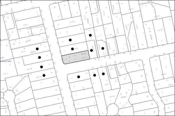
|
NOTIFICATION PLAN |
|
||
|
• PROPERTIES NOTIFIED
|
X SUBMISSIONS RECEIVED |
PROPERTY SUBJECT OF DEVELOPMENT |
|
6. THE PUBLIC INTEREST
Section 79C(1)(e) of the Act requires Council to consider “the public interest”.
The public interest is an overarching requirement, which includes the consideration of the matters discussed in this report. Implicit to the public interest is the achievement of future built outcomes adequately responding to and respecting the future desired outcomes expressed in environmental planning instruments and development control plans.
The application is considered to have addressed Council’s criteria under the Low Density Multi-Unit Housing Development Control Plan and the Residential Subdivision Development Control Plan and therefore, the development would be in the public interest.
CONCLUSION
The application proposes the Torrens title subdivision of an existing strata title property comprising two detached dwellings.
The application does not comply the Hornsby Shire Local Environmental Plan 1994 is respect to Clause 14 ‘Density’. The applicant submitted a State Environmental Planning Policy No. 1 objection to vary the minimum allotment size development standard. The objection is considered well founded with regard to the existing development and the principles established by the Land and Environment Court.
There were no submissions received in response to notification of the proposed development.
Having regard to the circumstances of the case and consideration of the SEPP 1 objection, approval of the application is recommended.
Note: At the time of the completion of this planning report, no persons have made a Political Donations Disclosure Statement pursuant to Section 147 of the Environmental Planning and Assessment Act 1979 in respect of the subject planning application.
|
Rod Pickles Manager - Development Assessment Planning Division |
James Farrington Group Manager Planning Division |
|
1.View |
Locality Plan |
|
|
|
2.View |
Subdivision Plan |
|
|
File Reference: DA/283/2013
Document Number: D02178502
SCHEDULE 1
GENERAL CONDITIONS
The conditions of consent within this notice of determination have been applied to ensure that the use of the land and/or building is carried out in such a manner that is consistent with the aims and objectives of the relevant legislation, planning instruments and council policies affecting the land and does not disrupt the amenity of the neighbourhood or impact upon the environment.
Note: For the purpose of this consent, the term ‘applicant’ means any person who has the authority to act on or the benefit of the development consent.
Note: For the purpose of this consent, any reference to an act, regulation, Australian standard or publication by a public authority shall be taken to mean the gazetted act or regulation, or adopted Australian standard or publication as in force on the date that the application for a construction certificate is made.
1. Approved Plans and Supporting Documentation
The development must be carried out in accordance with the plans and documentation listed below and endorsed with Council’s stamp, except where amended by Council and/or other conditions of this consent:
|
Plan No. |
Plan Title |
Drawn by |
Dated |
|
12284/002 Sheet 1 of 1 Revision A |
Plan showing proposed subdivision |
A.E. |
26 February 2013 |
|
Document Title |
Drawn by |
Dated |
|
Statement of Environmental Effects |
A.E. |
24 March 2013 |
|
Objection under SEPP No. 1 |
Not named |
March 2013 |
REQUIREMENTS PRIOR TO THE ISSUE OF A SUBDIVISION CERTIFICATE
Note: For the purpose of this consent, a reference to ‘occupation certificate’ shall not be taken to mean an ‘interim occupation certificate’ unless otherwise stated.
2. Sydney Water – s73 Certificate
An s73 Certificate must be obtained from Sydney Water.
3. Stormwater Drainage – Dwellings
The stormwater drainage systems from the proposed lots are to be connected to Council’s street gutter independently.
4. Creation of Easements
The following matter(s) must be nominated on the plan of subdivision under s88B of the Conveyancing Act 1919:
· An easement for an eave overhang over proposed lot 2 in favour of lot 1.
Note: Council must be nominated as the authority to release, vary or modify any easement, restriction or covenant.
- END OF CONDITIONS -
ADVISORY NOTES
The following information is provided for your assistance to ensure compliance with the Environmental Planning and Assessment Act, 1979, Environmental Planning and Assessment Regulation 2000, other relevant legislation and Council’s policies and specifications. This information does not form part of the conditions of development consent pursuant to Section 80a of the Act.
Environmental Planning and Assessment Act, 1979 Requirements
· The Environmental Planning and Assessment Act, 1979 requires:
· The issue of a construction certificate prior to the commencement of any works. Enquiries can be made to Council’s Customer Services Branch on 9847 6760.
· A principal certifying authority to be nominated and Council notified of that appointment prior to the commencement of any works.
· Council to be given at least two days written notice prior to the commencement of any works.
· Mandatory inspections of nominated stages of the construction inspected.
· An occupation certificate to be issued before occupying any building or commencing the use of the land.
Subdivision Certificate Requirements
A subdivision certificate application is required to be lodged with Council containing the following information:
· A surveyor’s certificate certifying that all structures within the subject land comply with the development consent in regard to the setbacks from the new boundaries.
· A surveyor’s certificate certifying that all services, drainage lines or access are located wholly within the property boundaries. Where services encroach over the new boundaries, easements are to be created.
· Certification that the requirements of relevant utility authorities have been met.
Note: Council will not issue a subdivision certificate until all conditions of the development consent have been completed.
Dial Before You Dig
Prior to commencing any works, the applicant is encouraged to contact Dial Before You Dig on 1100 or www.dialbeforeyoudig.com.au for free information on potential underground pipes and cables within the vicinity of the development site.
Fees and Charges – Subdivision
All fees payable to Council as part of any construction, compliance or subdivision certificate or inspection associated with the development (including the registration of privately issued certificates) are required to be paid in full prior to the issue of the subdivision certificate. Any additional Council inspections beyond the scope of any compliance certificate required to verify compliance with the terms of this consent will be charged at the individual inspection rate nominated in Council's Fees and Charges Schedule.
House Numbering
House numbering can only be authorised by Council. Before proceeding to number each premise in the development, the allocation of numbers is required to be obtained from Council's Planning Division. The authorised numbers are required to be displayed in a clear manner at or near the main entrance to each premise.
Group Manager’s Report No. PL55/13
Planning Division
Date of Meeting: 17/07/2013
8 DEVELOPMENT APPLICATION - DWELLING-HOUSE - 69 PARKLANDS ROAD, MOUNT COLAH
EXECUTIVE SUMMARY
|
DA No: |
DA/358/2013 (Lodged 11 April 2013) |
|
Description: |
Erection of a two storey dwelling-house |
|
Property: |
Lot 58, DP 207557, 69 Parklands Road, Mount Colah |
|
Applicant: |
Mr Andrew James Veldon |
|
Owner: |
Mr and Mrs Veldon |
|
Estimated Value: |
$350,000 |
|
Ward: |
A |
· The application proposes the demolition of an existing dwelling and erection of a new two storey dwelling-house.
· The proposal does not comply with the Hornsby Shire Local Environmental Plan 1994 with regard to Clause 15 (Floor Space Ratio). The applicant has made a submission pursuant to State Environmental Planning Policy No. 1 (Development Standards) to vary the development standard. The submission is considered well founded and is supported.
· No public submissions have been received in respect of the application.
· It is recommended that the application be approved.
|
THAT Council assume the concurrence of the Director-General of the Department of Planning and Infrastructure pursuant to State Environmental Planning Policy No. 1 and approve Development Application No. DA/358/2013 for the demolition of an existing dwelling and erection of a 2 storey dwelling-house at Lot 58 DP 207557, No. 69 Parklands Road, Mount Colah subject to the conditions of consent detailed in Schedule 1 of Group Manager’s Report No. PL55/13. |
BACKGROUND
There is no history of the site relevant to this application.
SITE
The site has an area of 567.2m2 and is located on the western side of Parklands Road, Mount Colah. The site contains a single storey, weatherboard and tile-roofed dwelling-house with an attached carport and two garden sheds located adjacent to the western, rear boundary.
The site experiences a fall of 3% to the eastern, front boundary.
The site is located within a bushfire prone area.
The site is not a heritage listed item and is not in a heritage conservation area or in the vicinity of a heritage listed item.
The site is not burdened by any easements or restrictions.
THE PROPOSAL
The application proposes the demolition of an existing dwelling-house and the erection of a 2 storey dwelling-house.
The ground floor would include a double garage, study, theatre, dining room, living room, kitchen, laundry, guest room with an ensuite, toilet and deck with access from the laundry and living rooms.
The first floor would include a master bedroom with an ensuite and walk-in-wardrobe, 3 bedrooms, a sitting room and a bathroom.
The proposal would result in the removal of 1 tree from the site.
ASSESSMENT
The development application has been assessed having regard to the ‘Metropolitan Plan for Sydney 2031’, the ‘North Subregion (Draft) Subregional Strategy’ and the matters for consideration prescribed under Section 79C of the Environmental Planning and Assessment Act 1979 (the Act). The following issues have been identified for further consideration.
1. STRATEGIC CONTEXT
1.1 Metropolitan Plan for Sydney 2036 and (Draft) North Subregional Strategy
The (Draft) Metropolitan Strategy for Sydney 2031 is a broad framework to provide for Sydney’s growth to help plan for housing, employment, transport, infrastructure, the environment and open space. It outlines a vision for Sydney to 2031; the challenges faced, and the directions to follow to address these challenges and achieve the vision.
The North Subregion comprises Hornsby, Kuring-gai, Manly, Warringah and Pittwater Local Government Areas. The Draft North Subregional Strategy acts as a framework for Council in its preparation of the Comprehensive LEP by the end of 2013.
Within the North Subregion, the Draft Metropolitan Strategy proposes:
· Population growth of 81,000 from the current 2011 baseline of 529,000
· Housing growth of 37,000 from the current 2011 baseline of 204,000
· Employment growth of 39,000 from the current 2011 baseline of 186,000
The proposed development would be consistent with the Metropolitan Plan for Sydney 2031 by providing renewed housing stock within the Shire.
2. STATUTORY CONTROLS
Section 79C(1)(a) requires Council to consider “any relevant environmental planning instruments, draft environmental planning instruments, development control plans, planning agreements and regulations”.
2.1 Hornsby Shire Local Environmental Plan 1994
The subject land is zoned Residential A (Low Density) under the Hornsby Shire Local Environmental Plan 1994 (HSLEP). The objectives of the Residential A zone are:
a) To provide for the housing needs of the population of the Hornsby area.
b) To promote a variety of housing types and other land uses compatible with a low density residential environment.
c) To provide for development that is within the environmental capacity of a low density residential environment.
The proposed development is defined as a ‘dwelling-house’ under the HSLEP and is permissible in the zone with Council’s consent.
Clause 15 of the HSLEP prescribes that the maximum floor space ratio (FSR) of development within the Residential A zone is 0.4:1. The proposed FSR of the dwelling-house is 0.45:1.
The applicant has submitted a State Environmental Planning Policy No. 1 (SEPP 1) objection to the development standard. Refer to Section 2.4 for consideration of the applicant’s objection to the standard.
2.2 Draft Hornsby Shire Local Environmental Plan
The Draft Hornsby Local Environmental Plan (DHLEP) was endorsed by Council at its meeting on 19 December 2012 to be forwarded to the Minister for Planning and Infrastructure to be made. In accordance with Council’s resolution, the draft Plan has been submitted to the Department for finalisation. The relevant provisions of the DHLEP that apply to the site are outlined below.
2.2.1 Zoning
Under the DHLEP, the subject land would be zoned R2 (Low Density Residential). A “dwelling house” would be a permissible use in the zone under the DHLEP.
2.2.2 Height of Building
Clause 4.3 of the DHLEP states that the height of a building on any land is not to exceed the maximum height shown for the land on the Height of Buildings Map. The maximum permissible height for the subject site within the R2 zone is 8.5 metres. The proposal complies with this provision.
2.3 Sydney Regional Environmental Plan No. 20 – Hawkesbury – Nepean River
The site is located within the catchment of the Hawkesbury Nepean River. Part 2 of this Plan contains general planning considerations and strategies requiring Council to consider the impacts of development on water quality, aquaculture, recreation and tourism. Subject to the implementation of sediment and erosion control measures and stormwater management to protect water quality, the proposal would comply with the requirements of the Policy.
2.4 State Environmental Planning Policy No. 1 - Development Standards
The proposed dwelling-house has a gross floor area of 257m2 resulting in a floor space ratio (FSR) of 0.45:1. The FSR exceeds the applicable 0.4:1 FSR development standard under the HSLEP 1994.To address the variation to the 0.4:1 development standard, the applicant has made a submission pursuant to State Environmental Planning Policy No. 1 – Development Standards (SEPP1).
The application has been assessed against the requirements of SEPP1. This Policy provides flexibility in the application of development standards in circumstances where strict compliance with those standards would, in any particular case, be unreasonable or unnecessary or tend to hinder the attainment of the objectives specified in section 5(a) (i) and (ii) of the Environmental Planning and Assessment Act which states:
‘The objectives of this Act are:
(a) to encourage:
(i) the proper management, development and conservation of natural and artificial resources, including agricultural land, natural areas, forests, minerals, water, cities, towns and villages for the purpose of promoting the social and economic welfare of the community and a better environment,
(ii) the promotion and co-ordination of the orderly and economic use and development of land,’
Where development could, but for any development standard, be carried out under the Act (either with or without the necessity for consent under the Act being obtained therefore) the person intending to carry out that development may make a development application in respect of that development, supported by a written objection that compliance with that development standard is unreasonable or unnecessary in the circumstances of the case, and specifying the grounds of that objection.
The Land and Environment Court has expressed the view that there are 5 different ways in which an objection may be well founded and that approval of the objection may be consistent with the aims of the policy:
1. The objectives of the standard are achieved notwithstanding non-compliance with the standard;
2. The underlying objective or purpose of the standard is not relevant to the development and therefore compliance is unnecessary;
3. The underlying object or purpose would be defeated or thwarted if compliance was required and therefore compliance is unreasonable;
4. The development standard has been virtually abandoned or destroyed by the Council's own actions in granting consents departing from the standard and hence compliance with the standard is unnecessary and unreasonable;
5. The zoning of the particular land is unreasonable or inappropriate so that a development standard appropriate for that zoning is also unreasonable and unnecessary as it applies to the land and compliance with the standard would be unreasonable or unnecessary. That is, the particular parcel of land should not have been included in the particular zone.
In regard to whether the objection may be well founded, the applicant contends that:
1. In accordance with the Hornsby Council Local Environment Plan 1994 Clause 15, the current floor space ratio is 0.4:1. The proposed floor space ratio is 0.45:1 would result in a minor variation to the maximum that is permitted by Council of 12%.
2. It is to be considered that strict compliance with the development standard is unreasonable and unnecessary as the proposed development meets the objective of the development standard despite the non compliance with the numerical value. The scale of the proposed development provides for the housing needs in today’s market whilst still providing adequate landscaping and open space.
3. There is no perceived impact on the streetscape and adjoining properties by the proposed development and it will compliment and blend with the character of the area whilst adhering to the objectives of the zone and the environment.
4. The proposed development complies with all other controls within the current Development Control Plan.
5. Hornsby Council is currently in the process of having a new Local Environment Plan 2012 and Development Control Plan 2012 gazetted within the 2013 calendar year. Under these revised planning instruments, the proposed development would be in compliance with the floor area standard of 330m2 with a lot size between 450m2 to 599m2. Given that this is the direction council is taking, consideration should be given to this proposed development.
6. The proposed development complies with the objectives set out in section 5 (a) (i) and (ii). The proposed development will be constructed on an existing allotment which is considered orderly and economic use of the land and proposed development which will not affect the social and economic welfare and environment of the area.
7. The objective of the development standard is to be a measure to ensure the dwelling does not have an unreasonable impact on the adjoining properties and streetscape with regards to overshadowing, privacy and visual bulk.
8. The proposed dwelling complies with all controls within the DCP with the exemption of FSR. Consideration has been given to overshadowing and visual bulk to ensure that there are no unreasonable impacts on adjoining properties. The second storey of the proposed dwelling comprises predominantly bedrooms and bathrooms which are considered low trafficable areas.
The matters listed above have been taken into consideration in assessing the merits of the SEPP 1 objection.
The proposal takes into consideration the environmental and size constraints of the site. The additional floor space would not adversely impact on the environmental and amenity aspects of the site and the underlying objectives of the zone. The dwelling-house would provide accommodation that would not detract from the scale and variety of dwelling-houses in the low density areas of the Shire as the proposal is considered to meet the zone objectives outlined in the HSLEP.
In addition to the above, the proposal has been considered in regard to the provisions of the NSW Housing Code, which provides that the maximum gross floor area for complying development within the low density residential zones of the Shire as being:
· 330m2, if the lot has an area of at least 450m2 but less than 600m2 ;
· 380m2, if the lot has an area of at least 600m2 but less than 900m2; and
· 430m2, if the lot has an area of at least 900m2.
Accordingly, if applicable, the development would satisfy the maximum floor area development standard under the NSW Housing Code.
In this instance, the proposed front setback of the dwelling-house would exclude it from being assessed under the Code which requires the setback to be the average of the neighbouring dwelling-houses. The average of the front setbacks of the adjoining dwelling-houses is approximately 8.5 metres. However, given that the recently introduced NSW Housing Code is now enacted in many parts of the Shire, it is anticipated that more developments would be approved under this Code, which will change the characteristics of dwelling-houses. Consequently, whilst Council has previously applied a maximum FSR of 0.4:1 for dwelling-houses in the low density residential zones within the Shire under the HSLEP, the introduction of the NSW Housing Code is changing the effect of this standard.
The SEPP1 objection is considered well founded and acceptable in this instance.
2.5 Clause 74BA Environmental Planning and Assessment Act, 1979 - Purpose and Status of Development Control Plans
On 1 March 2013, the Environmental Planning and Assessment Act, 1979 was amended so that a DCP provision will have no effect if it has the practical effect of “preventing or unreasonably restricting development” that is otherwise permitted and complies with the development standards set out in relevant Local Environmental Plans and State Environmental Planning Policies.
The principal purpose of a development control plan is to provide guidance on the aims of any environmental planning instrument that applies to the development; facilitating development that is permissible under any such instrument; and achieving the objectives of land zones under any such instrument. The provisions of a development control plan made for that purpose are not statutory requirements.
2.6 Dwelling-House Development Control Plan
The proposed development has been assessed having regard to the relevant performance and prescriptive requirements within Council’s Dwelling House Development Control Plan (Housing DCP). The following table sets out the proposal’s compliance with the prescriptive requirements of the Plan:
|
Dwelling House Development Control Plan |
|||
|
Control |
Proposal |
Requirement |
Complies |
|
Floor space ratio |
0.45:1 |
0.4:1 |
No |
|
Site cover |
39% |
40% |
Yes |
|
Setbacks Front (east) Side (north) Side (south) Rear (west) |
5.8 2.6m 1m 8.1m |
6m 1m 1m 3 m |
No Yes Yes Yes |
|
Height |
Two-storey |
Max. two storey |
Yes |
|
Unbroken Wall length |
13.35m |
10m |
No |
|
Building length |
18.04m |
24m |
Yes |
|
Cut and fill |
0m |
1m |
Yes |
|
Private Open Space |
151.9m2 |
120m² |
Yes |
|
Landscaped area |
52.2% |
45% |
Yes |
As detailed in the above table, the proposed development does not comply with a number of prescriptive requirements within Council’s Dwelling House DCP. The matters of non-compliance are detailed below, as well as a brief discussion on compliance with relevant performance requirements.
2.6.1 Floor Space Ratio
The objective of the Scale element is to encourage “development of a scale compatible with the low density residential environment”.
The proposed dwelling-house exceeds the maximum Floor Space Ratio allowable within the Residential A zone by 12.5%. The application was accompanied by a SEPP 1 objection and is supported.
The proposal meets the objective of the Scale element and is considered acceptable.
2.6.2 Setbacks
The objective of the Setbacks is to encourage “setbacks that complement the streetscape, provide for landscaping and protect the privacy of and sunlight to neighbouring properties”.
The garage wall of the dwelling-house would have a minor encroachment of 200mm into the front setback. The portion of the garage that is encroaching is minor and would not affect the character of the streetscape or the privacy of, or sunlight to, neighbouring properties.
The proposal meets the objective of the Setbacks element and is considered acceptable.
2.6.3 Design
The objective of the Design element is to encourage “building design that is consistent with and enhances the character and amenity of the local area, has regard for environmental characteristics and energy efficiency”.
The proposed 13.35m unbroken wall length of the northern elevation does not comply with the prescriptive measures of the Design element which requires that walls not exceed 10m without a physical “break”. A balance between solid walls and openings and variations of roof form has been incorporated into the elevation to avoid a monotonous or symmetrical design.
Accordingly, the proposal would have negligible adverse visual or amenity impacts on adjoining properties, meets the objectives of the Design element and is considered acceptable.
3. ENVIRONMENTAL IMPACTS
Section 79C(1)(b) of the Act requires Council to consider “the likely impacts of that development, including environmental impacts on both the natural and built environments, and social and economic impacts in the locality”.
3.1 Natural Environment
The proposed development would necessitate the removal of one tree from the site. The tree is not considered significant or worthy of retention.
3.2 Built Environment
The proposal involves the demolition of the existing dwelling-house on the site. The proposed dwelling-house would be positioned closer to the front boundary than surrounding properties. The proposal would not cause a detrimental impact to the streetscape of Parklands Road.
3.3 Social and Economic Impacts
There are no anticipated adverse social or economic impacts resulting from the proposed development.
4. SITE SUITABILITY
Section 79C(1)(c) of the Act requires Council to consider “the suitability of the site for the development”.
4.1 Bushfire Risk
The land is identified as being subject to bushfire risk. However, the proposed location of the dwelling-house would be outside the 100 metre bushfire buffer zone. As a result, no conditions requiring fire sensitive construction methods are recommended.
5. PUBLIC PARTICIPATION
Section 79C(1)(d) of the Act requires Council to consider “any submissions made in accordance with this Act”.
5.1 Community Consultation
The proposed development was placed on public exhibition and was notified to adjoining and nearby landowners between 17 April 2013 and 1 May 2013 in accordance with Council’s Notification and Exhibition Development Control Plan. During this period, Council received no submissions. The map below illustrates the location of those nearby landowners that are in close proximity to the development site and were notified of the application.
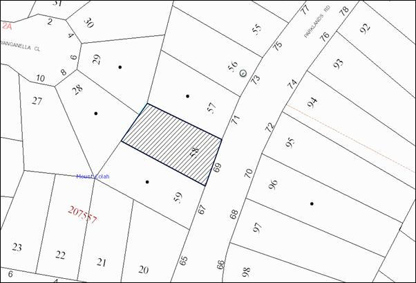
|
NOTIFICATION PLAN |
|
||
|
• PROPERTIES NOTIFIED
|
X SUBMISSIONS RECEIVED |
PROPERTY SUBJECT OF DEVELOPMENT |
|
6. THE PUBLIC INTEREST
Section 79C(1)(e) of the Act requires Council to consider “the public interest”.
The public interest is an overarching requirement, which includes the consideration of the matters discussed in this report. Implicit to the public interest is the achievement of future built outcomes adequately responding to and respecting the future desired outcomes expressed in environmental planning instruments and development control plans.
The application is considered to have addressed Council’s criteria under the Dwelling House DCP and therefore, the development would be in the public interest.
CONCLUSION
The application proposes the demolition of an existing dwelling-house and the erection of a 2 storey dwelling-house.
The application does not comply with the Hornsby Shire Council Local Environmental Plan 1994 in respect to Clause 15 ‘Floor Space Ratio’. The applicant has submitted a State Environmental Planning Policy No. 1 objection to vary the floor space ratio development standard. The objection is considered well founded with regard to the existing development and the principles established by the Land and Environment Court.
There were no submissions received in response to notification of the proposed development.
Having regard to the circumstances of the case and consideration of the SEPP 1 objection, approval of the application is recommended.
Note: At the time of the completion of this planning report, no persons have made a Political Donations Disclosure Statement pursuant to Section 147 of the Environmental Planning and Assessment Act, 1979 in respect of the subject planning application.
|
Rod Pickles Manager - Development Assessment Planning Division |
James Farrington Group Manager Planning Division |
|
1.View |
Locality Map |
|
|
|
2.View |
DA Plans |
|
|
|
3.View |
Floor Plans |
|
|
|
4.View |
Site Plan |
|
|
|
5.View |
Elevations |
|
|
|
6.View |
Shadow Diagram |
|
|
File Reference: DA/358/2013
Document Number: D02178503
SCHEDULE 1
GENERAL CONDITIONS
The conditions of consent within this notice of determination have been applied to ensure that the use of the land and/or building is carried out in such a manner that is consistent with the aims and objectives of the relevant legislation, planning instruments and council policies affecting the land and does not disrupt the amenity of the neighbourhood or impact upon the environment.
Note: for the purpose of this consent, the term ‘applicant’ means any person who has the authority to act on or the benefit of the development consent.
Note: for the purpose of this consent, any reference to an act, regulation, Australian standard or publication by a public authority shall be taken to mean the gazetted act or regulation, or adopted Australian standard or publication as in force on the date that the application for a construction certificate is made.
1. Approved Plans and Supporting Documentation
The development must be carried out in accordance with the plans and documentation listed below and endorsed with Council’s stamp, except where amended by Council and/or other conditions of this consent:
|
Plan No. |
Plan Title |
Drawn by |
Dated |
|
Project No 12029 Drawing No. WD03 Revision C |
Site Plan |
DTH |
05/04/2013 |
|
Project No 12029 Drawing No. WD05, WD06 Revision C |
Floor Plans |
DTH |
05/04/2013 |
|
Project No 12029 Drawing No. WD17, WD18. WD19. WD20 Revision C |
Section A Section B Section C Section D |
DTH |
05/04/2013 |
|
Project No 12029 Drawing No. WD21, WD 22 Revision C |
Elevations 1 and 2 of 2 |
DTH |
05/04/2013 |
|
Project No 12029 Drawing No. WD24 Revision C |
Shadow Diagrams |
DTH |
05/04/2013 |
|
Document Title |
Prepared by |
Dated |
|
Waste Management Plan TRIM No. D02158575 |
A. J. Veldon |
10/04/2013 |
REQUIREMENTS PRIOR TO THE ISSUE OF A CONSTRUCTION CERTIFICATE
2. Building Code of Australia
All building work must be carried out in accordance with the relevant requirements of the Building Code of Australia.
3. Contract of Insurance (Residential Building Work)
In the case of residential building work for which the Home Building Act, 1989 requires there to be a contract of insurance in force in accordance with Part 6 of that Act, that such a contract of insurance is in force before any building work authorised to be carried out by the consent commences.
4. Notification of Home Building Act, 1989 Requirements
Residential building work within the meaning of the Home Building Act, 1989 must not be carried out unless the principal certifying authority for the development to which the work relates (not being Council) has given Council written notice of the following information:
a) In the case of work for which a principal contractor is required to be appointed:
i) The name and licence number of the principal contractor; and
ii) The name of the insurer by which the work is insured under Part 6 of that Act.
b) In the case of work to be done by an owner-builder:
i) The name of the owner-builder and;
ii) If the owner-builder is required to hold an owner-builder’s permit under that Act, the number of the owner-builder’s permit.
Note: If arrangements for doing the residential building work are changed while the work is in progress so that the information notified becomes out of date, further work must not be carried out unless the principal certifying authority for the development to which the work relates (not being Council) has given Council written notification of the updated information.
5. Sydney Water – Quick Check
This application must be submitted to a Sydney Water ‘Quick Check Agent’ or ‘Customer Centre’ for approval to determine whether the development would affect any Sydney Water infrastructure, and whether further requirements are to be met.
Note: Refer to www.sydneywater.com.au or telephone 13 20 92 for assistance.
REQUIREMENTS PRIOR TO THE COMMENCEMENT OF ANY WORKS
6. Erection of Construction Sign
A sign must be erected in a prominent position on any site on which building work, subdivision work or demolition work is being carried out:
a) Showing the name, address and telephone number of the principal certifying authority for the work;
b) Showing the name of the principal contractor (if any) for any demolition or building work and a telephone number on which that person may be contacted outside working hours; and
c) Stating that unauthorised entry to the work site is prohibited.
Note: Any such sign is to be maintained while the building work, subdivision work or demolition work is being carried out, but must be removed when the work has been completed.
7. Toilet Facilities
Toilet facilities must be available or provided at the works site before works begin and must be maintained until the works are completed at a ratio of one toilet for every 20 persons employed at the site. Each toilet must:
a) Be a standard flushing toilet connected to a public sewer; or
b) Be a temporary chemical closet approved under the Local Government Act, 1993; or
c) Have an on-site effluent disposal system approved under the Local Government Act, 1993.
8. Erosion and Sediment Control
Erosion and sediment control measures must be provided and maintained throughout the construction period in accordance with the manual ‘Soils and Construction 2004 (Bluebook)’, the approved plans, Council specifications and to the satisfaction of the principal certifying authority. The erosion and sediment control devices must remain in place until the site has been stabilised and revegetated.
Note: On the spot penalties up to $1,500 may be issued for any non-compliance with this requirement without any further notification or warning.
REQUIREMENTS DURING CONSTRUCTION
9. Construction Work Hours
All work on site (including demolition and earth works) must only occur between 7am and 5pm Monday to Saturday. No work is to be undertaken on Sundays or public holidays.
10. Demolition
All demolition work must be carried out in accordance with “Australian Standard 2601-2001 – The Demolition of Structures” and the following requirements:
a) Demolition material must be disposed of to an authorised recycling and/or waste disposal site and/or in accordance with an approved waste management plan;
b) Demolition works, where asbestos material is being removed, must be undertaken by a contractor that holds an appropriate licence issued by WorkCover NSW in accordance with Chapter 10 of the Occupational Health and Safety Regulation 2001 and Clause 29 of the Protection of the Environment Operations (Waste) Regulation 2005; and
c) On construction sites where buildings contain asbestos material, a standard commercially manufactured sign containing the words ‘DANGER ASBESTOS REMOVAL IN PROGRESS’ measuring not less than 400mm x 300mm must be erected in a prominent position visible from the street.
11. Council Property
During construction works, no building materials, waste, machinery or related matter is to be stored on the road or footpath. The public reserve must be kept in a clean, tidy and safe condition at all times.
Note: This consent does not give right of access to the site via Council’s park or reserve. Should such access be required, separate written approval is to be obtained from Council.
12. Disturbance of Existing Site
During construction works, the existing ground levels of open space areas and natural landscape features, (including natural rock-outcrops, vegetation, soil and watercourses) must not be altered unless otherwise nominated on the approved plans.
13. Survey Report – Finished Floor Level
A report must be prepared by a registered surveyor and submitted to the principal certifying authority prior to the pouring of concrete at each level of the building certifying that:
a) The building, retaining walls and the like have been correctly positioned on the site.
b) The finished floor level(s) are in accordance with the approved plans.
REQUIREMENTS PRIOR TO THE ISSUE OF AN OCCUPATION CERTIFICATE
Note: For the purpose of this consent, a reference to ‘occupation certificate’ shall not be taken to mean an ‘interim occupation certificate’ unless otherwise stated:
14. Fulfilment of BASIX Commitments
The applicant must demonstrate the fulfilment of BASIX commitments pertaining to the development.
15. Stormwater Drainage – Dwellings
The stormwater drainage system for the development must be designed and constructed for an average recurrence interval of 20 years, be gravity and connected to an existing Council piped drainage system.
16. Internal Driveway/Vehicular Areas
The driveway and parking areas on site must be designed in accordance with Australian Standards 2890.1, 2890.2, and 3727.
17. Vehicular Crossing
A separate application under the Local Government Act, 1993 and the Roads Act, 1993 must be submitted to Council for the installation of a new vehicular crossing and the removal of the redundant crossing. The vehicular crossing must be constructed in accordance with Council’s Civil Works Design, 2005
Note: An application for a vehicular crossing can only be made to one of Council’s Authorised Vehicular Crossing Contractors. You are advised to contact Council on 02 9847 6940 to obtain a list of contractors.
18. Damage to Council Assets
Any damage caused to Council’s assets as a result of the construction of the development must be rectified in accordance with Council’s written requirements and at the sole cost of the applicant.
19. Installation of Air Conditioner
To protect the amenity of adjacent properties, the condenser unit for the air conditioner must be sited a minimum of 3 metres from the property boundary of any adjoining residential premises unless a certificate has been prepared by a suitably qualified person confirming that the unit has been tested for heating and cooling on the highest settings and that the noise levels generated do not exceed 5 dB(A) above background noise levels when tested at the property boundary between 8 pm and 10 pm.
- END OF CONDITIONS -
ADVISORY NOTES
The following information is provided for your assistance to ensure compliance with the Environmental Planning and Assessment Act, 1979, Environmental Planning and Assessment Regulation 2000, other relevant legislation and Council’s policies and specifications. This information does not form part of the conditions of development consent pursuant to Section 80A of the Act.
Environmental Planning and Assessment Act, 1979 Requirements
The Environmental Planning and Assessment Act, 1979 requires:
· The issue of a construction certificate prior to the commencement of any works. Enquiries can be made to Council’s Customer Services Branch on 9847 6760;
· a principal certifying authority to be nominated and Council notified of that appointment prior to the commencement of any works;
· Council to be given at least two days written notice prior to the commencement of any works;
· mandatory inspections of nominated stages of the construction inspected; and
· an occupation certificate to be issued before occupying any building or commencing the use of the land.
Long Service Levy
In accordance with Section 34 of the Building and Construction Industry Long Service Payments Act 1986, a ‘Long Service Levy’ must be paid to the Long Service Payments Corporation or Hornsby Council.
Note: The rate of the Long Service Levy is 0.35% of the total cost of the work.
Note: Hornsby Council requires the payment of the Long Service Levy prior to the issue of a construction certificate.
Tree Preservation Order
To ensure the maintenance and protection of the existing natural environment, it is an offence to ringbark, cut down, top, lop, remove, wilfully injure or destroy a tree outside 3 metres of the approved building envelope without the prior written consent from Council.
Note: A tree is defined a s a single or multi-trunked wood perennial plant having a height of not less than three (3) metres, and which develops many branches, usually form a distance of not less than one (1) metre from the ground, but excluding any plant which, in its particular location, is a noxious plant declared as such pursuant to the Noxious Weeds Act 1993. This definition of ‘tree’ includes any and all types of Palm trees.
All distances are determined under Australian Standard AS4970-2009 “Protection of Trees on Development Sites”.
Fines may be imposed for non-compliance with Council’s Tree Preservation Order.
Dial Before You Dig
Prior to commencing any works, the applicant is encouraged to contact Dial Before You Dig on 1100 or www.dialbeforeyoudig.com.au for free information on potential underground pipes and cables within the vicinity of the development site.
Asbestos Warning
Should asbestos or asbestos products be encountered during demolition or construction works, you are advised to seek advice and information prior to disturbing this material. It is recommended that a contractor holding an asbestos-handling permit (issued by WorkCover NSW) be engaged to manage the proper handling of this material. Further information regarding the safe handling and removal of asbestos can be found at:
Alternatively, telephone the WorkCover Asbestos and Demolition Team on 8260 5885.
Group Manager’s Report No. PL58/13
Planning Division
Date of Meeting: 17/07/2013
9 DEVELOPMENT APPLICATION - TWO FIVE STOREY RESIDENTIAL FLAT BUILDINGS - 5-15 BELAIR CLOSE, HORNSBY
EXECUTIVE SUMMARY
|
DA No: |
DA/4/2013 (Lodged 3 January 2013) |
|
Description: |
Construction of two, five storey residential flat buildings comprising 64 units and strata subdivision |
|
Property: |
Lot 3 DP 204624, Lot 4 DP 204624, Lot 5 DP 204624, Lot 1 DP 525010, Lot 7 DP 204624, Nos. 5-15 Belair Close, Hornsby |
|
Applicant: |
CBD Core Pty Ltd |
|
Owner: |
Mr Y C Deng and Ms H Wang, Mrs E Leyden, Mr R A Hodgins, Mrs M F Mercuri and Miss E A Mercuri, Mr R A Heaton and Mrs D C Heaton |
|
Estimated Value: |
$9,280,000 |
|
Ward: |
A |
· The application proposes the demolition of existing structures and construction of two, five storey residential flat buildings comprising 64 units and strata subdivision.
· The application complies with Hornsby Shire Local Environmental Plan 1994 and with State Environmental Planning Policy No. 65 – Design Quality Residential Flat Development. The proposal generally complies with the Housing Strategy Development Control Plan, subject to recommended conditions, other than the maximum five storey height limit, front setback and dwelling mix. The non-compliance are considered acceptable.
· A total of 75 submissions have been received in respect of the application.
· It is recommended that the application be approved.
|
THAT Development Application No. DA/4/2013 for construction of two, five storey residential flat buildings, basement car park and strata subdivision at Lot 3 DP 204624, Lot 4 DP 204624, Lot 5 DP 204624, Lot 1 DP 525010, Lot 7 DP 204624, Nos. 5-15 Belair Close, Hornsby be approved subject to the conditions of consent detailed in Schedule 1 of Group Manager’s Report No. PL58/13. |
BACKGROUND
Belair Close was previously zoned Residential A (Low Density) and formed a low density precinct bordered by residential flat development comprising mainly three storey buildings within a Residential C (Medium/High Density) Zone area. Belair Close was rezoned Residential C (Medium/High Density) for residential flat building to a height of 17.5m (five storey) as part of Council’s Housing Strategy on 2 September 2011.
SITE
The site has an area of 4,038m2 and has a frontage of approximately 78m to the southern side of Belair Close. The site has a north easterly aspect and an average gradient of 13% to the street frontage. The site is irregular in shape to the head of the cul-de-sac which forms the higher part of the street.
The site includes five existing dwelling houses on irregular shaped lots fronting Belair Close and a number of trees and shrubs.
The southern and western boundaries of the site adjoin medium to high density residential developments comprising townhouses and three storey residential flat buildings with basement car parks. Opposite the site, the existing dwelling houses fronting the northern side of Belair Close adjoin an unformed road reserve (Water Street) at the rear which includes remnant trees and stormwater drainage and pollution control infrastructure.
The site is located 750m north east of Hornsby Railway Station and is within 260m of a regular bus service connection to the station.
THE PROPOSAL
The proposal is for the demolition of existing dwellings and construction of two, five storey residential flat buildings comprising 64 units, basement car park and strata title subdivision.
Building A comprises 32 units including 3 x 1 bedroom, 28 x 2 bedroom and 1 x 3 bedroom units. The units include 4 adaptable units. The building has driveway access to the basement car park. The building includes a central lift.
Building B comprises 32 units including 2 x 1 bedroom, 22 x 2 bedroom and 7 x 3 bedroom units, and 1 x 4 bedroom - dual key unit. The units include 14 adaptable units. The building has driveway access to the basement car park. The building includes a central lift.
The two proposed five storey buildings are stepped to the topography of the site. The proposed buildings are of concrete construction, with facebrick, glazed and painted masonry finishes and metal deck roofing.
The proposed single level basement car park is designed to form upper and lower car parking areas with a series of connecting ramps and two driveway entries. The basement car park includes 81 car parking spaces including 13 visitor car parking spaces and 9 disabled car parking spaces. The basement includes resident storage facilities, bicycle storage and waste management facilities.
The proposal includes a landscaping concept plan. The landscaping of communal open space areas includes retaining walls for level lawns areas and perimeter gardens.
ASSESSMENT
The development application has been assessed having regard to the ‘Metropolitan Plan for Sydney 2031’, the ‘North Subregion (Draft) Subregional Strategy’ and the matters for consideration prescribed under Section 79C of the Environmental Planning and Assessment Act 1979 (the Act). The following issues have been identified for further consideration.
1. STRATEGIC CONTEXT
1.1 Metropolitan Plan for Sydney and (Draft) North Subregional Strategy
The (Draft) Metropolitan Strategy for Sydney 2031 is a broad framework to provide for Sydney’s growth to help plan for housing, employment, transport, infrastructure, the environment and open space. It outlines a vision for Sydney to 2031; the challenges faced, and the directions to follow to address these challenges and achieve the vision.
The North Subregion comprises Hornsby, Kuring-gai, Manly, Warringah and Pittwater Local Government Areas. The Draft North Subregional Strategy acts as a framework for Council in its preparation of the Comprehensive LEP by the end of 2013.
Within the North Subregion, the Draft Metropolitan Strategy proposes:
· Population growth of 81,000 from the current 2011 baseline of 529,000
· Housing growth of 37,000 from the current 2011 baseline of 204,000
· Employment growth of 39,000 from the current 2011 baseline of 186,000
The proposed development would be consistent with the Metropolitan Plan for Sydney 2031 by providing an additional 59 dwellings and would contribute to housing choice in the locality.
2. STATUTORY CONTROLS
Section 79C(1)(a) requires Council to consider “any relevant environmental planning instruments, draft environmental planning instruments, development control plans, planning agreements and regulations”.
2.1 Hornsby Shire Local Environmental Plan 1994
The subject land is zoned Residential C (Medium/High Density) under the Hornsby Shire Local Environmental Plan 1994 (HSLEP). The objectives of the zone are:
a) to provide for the housing needs of the population of the Hornsby area.
b) to promote a variety of housing types and other land uses compatible with a medium to high density residential environment.
c) to provide for development that is within the environmental capacity of a medium to high density residential environment.
The proposed development is defined as ‘multi-unit housing’ under the HSLEP and is permissible in the zone with Council’s consent.
Clause 15A of the HSLEP prescribes a maximum building height of 17.5m for development on the subject site. The proposed development complies with this requirement.
Clause 18 of the HSLEP sets out heritage conservation provisions for Hornsby Shire. The site is not identified as a heritage item and is not in the vicinity of an item or within a heritage conservation area.
2.2 Draft Hornsby Shire Local Environmental Plan
The draft Hornsby Local Environmental Plan (DHLEP) was endorsed by Council at its meeting on 19 December 2012 to be forwarded to the Minister for Planning and Infrastructure to be made. In accordance with Council’s resolution, the draft Plan has been submitted to the Department for finalisation.
2.2.1 Zoning
The site would be zoned R4 (High Density Residential) zone pursuant to the Land Use Table of the draft HLEP. The proposed development is defined as a ‘residential flat building’ and would be a permissible use in the zone with Council’s consent.
The land adjoining the Belair Close Precinct would also be zoned R4 (High Density Residential).
2.2.2 Height of Building
Clause 4.3 of the draft HLEP provides that the height of a building on any land is not to exceed the maximum height shown for the land on the Height of Buildings Map. The maximum permissible height for the subject site is 17.5 metres. The proposal complies with this provision.
The land adjoining the Belair Close, Hornsby Precinct would have a maximum height of 12m.
2.3 State Environmental Planning Policy No. 55 – Remediation of Land
State Environmental Planning Policy No. 55 (SEPP 55) requires that Council must not consent to the carrying out of any development on land unless it has considered whether the land is contaminated or requires remediation for the proposed use.
The site has been used for residential purposes and is unlikely to be contaminated. No further assessment is considered necessary in this regard.
2.4 State Environmental Planning Policy No. 65 – Design Quality Residential Flat Development
The Policy provides for design principles to improve the design quality of residential flat development and for consistency in planning controls across the State.
The applicant has submitted a design verification statement prepared by a qualified designer stating how the proposed development achieves the design principles of SEPP 65. The design principles of SEPP 65 and the submitted design verification statement are addressed below.
2.4.1 Principle 1 - Context
Design Principle 1 is as follows:
Good design responds and contributes to its context. Context can be defined as the key natural and built features of an area.
Responding to context involves identifying the desirable elements of a location’s current character or, in the case of precincts undergoing a transition, the desired future character as stated in planning and design policies. New buildings will thereby contribute to the quality and identity of the area.
The context of the site is defined by the Desired Future Character Statement of the Housing Strategy Development Control Plan (Housing Strategy DCP). The desired future character of the precinct is that of a high density residential precinct incorporating five storey developments in a landscaped setting. The applicant states the proposal is a contemporary interpretation of the Housing Strategy DCP taking into consideration modern aesthetics and amenity standards.
The submitted statement is supported in respect to this Principle.
2.4.2 Principle 2 - Scale
Design Principle 2 is as follows:
Good design provides an appropriate scale in terms of the bulk and height that suits the scale of the street and the surrounding buildings.
Establishing an appropriate scale requires a considered response to the scale of existing development. In precincts undergoing a transition, proposed bulk and height needs to achieve the scale identified for the desired future character of the area.
The precinct is undergoing transition. The scale of the future built environment is commensurate with Council’s planning controls which promote five storey residential flat buildings with a maximum height of 17.5 metres. The elevations achieve an appropriate aesthetic outcome and composition and create the appearance of separate pavilions. The scale of the proposed development is appropriate for the site and in accordance with the planning controls and desired future character of the precinct.
2.4.3 Principle 3 – Built Form
Design Principle 3 is as follows:
Good design achieves an appropriate built form for a site and the building’s purpose, in terms of building alignments, proportions, building type and the manipulation of building elements.
Appropriate built form defines the public domain, contributes to the character of streetscape and parks, including their views and vistas, and provides internal amenity and outlook.
The Housing Strategy DCP includes planning controls for height, setbacks, building footprints and articulation which prescribe the future built form of the precinct. The proposed building is appropriately modulated and articulated to reduce bulk and scale and express residential character. The proposed development presents a distinct architectural design which would set an appropriate precedent for development within the precinct and is considered acceptable in terms of built form.
The submitted statement is supported in respect to this Principle.
2.4.4 Principle 4 – Density
Design Principle 4 is as follows:
Good design has a density appropriate for a site and its context, in terms of floor space yields (or number of units or residents).
Appropriate densities are sustainable and consistent with the existing density in an area or in precincts undergoing a transition, are consistent with the stated desired future density. Sustainable densities respond to the regional context, availability of infrastructure, public transport, community facilities and environmental quality.
The site density is regulated by the statutory height control of 17.5m and the Housing Strategy DCP. The proposal is within the DCP prescriptive measures as addressed in Section 2.10 of this report.
2.4.5 Principle 5 – Resource, Energy and Water Efficiency
Design Principle 5 is as follows:
Good design makes efficient use of natural resources, energy and water throughout its full life cycle, including construction.
Sustainability is integral to the design process. Aspects include demolition of existing structures, recycling of materials, selection of appropriate and sustainable materials, adaptability and reuse of buildings, layouts and built form, passive solar design principles, efficient appliances and mechanical services, soil zones for vegetation and reuse of water.
The applicant has submitted BASIX Certificate No. 462119M-02 for the proposed 64 dwellings. In achieving the required BASIX targets for sustainable water use, thermal comfort and energy efficiency, the proposed development achieves the design criteria. The building design achieves an efficient use of natural resources, includes sustainable materials and passive solar design principles.
The submitted statement is supported in respect to this Principle.
2.4.6 Principle 6 – Landscape
Design Principle 6 is as follows:
Good design recognises that together landscape and buildings operate as an integral and sustainable system, resulting in greater aesthetic quality and amenity for both occupants and the adjoining public domain.
Landscape design builds on the existing site’s natural and cultural features in responsible and creative ways. It enhances the development’s natural environmental performance by co-ordinating water and soil management, solar access, micro-climate, tree canopy and habitat values. It contributes to the positive image and contextual fit of development through respect for streetscape and neighbourhood character, or desired future character.
Landscape design should optimise useability, privacy and social opportunity, equitable access and respect for neighbour’s amenity, and provide for practical establishment and long term management.
The application includes a landscape concept plan providing landscaping along the street frontage, side and rear boundaries. The planting would provide an appropriate landscape setting for the development. In this regard, the proposed development is in accordance with the Landscaping principle of SEPP 65 and the Housing strategy DCP objective for buildings within landscaped settings.
2.4.7 Principle 7 – Amenity
Design Principle 7 is as follows:
Good design provides amenity through the physical, spatial and environmental quality of a development.
Optimising amenity requires appropriate room dimensions and shapes, access to sunlight, natural ventilation, visual and acoustic privacy, storage, indoor and outdoor space, efficient layouts and service areas, outlook and ease of access for all age groups and degrees of mobility.
The amenity design principle is prescribed by the Residential Flat Design Code (refer to discussion in Section 2.5). The proposed development is in accordance with the requirements of the Residential Flat Design Code in respect to solar access, visual and acoustic privacy, apartment layouts, private open spaces and natural ventilation.
2.4.8 Principle 8 – Safety and Security
Design Principle 8 is as follows:
Good design optimises safety and security, both internal to the development and for the public domain.
This is achieved by maximising overlooking of public and communal spaces while maintaining internal privacy, avoiding dark and non-visible areas, maximising activity on streets, providing clear, safe access points, providing quality public spaces that cater for desired recreational uses, providing lighting appropriate to the location and desired activities, and clear definition between public and private spaces.
The applicant’s statement includes the following comment:
Proposed orientation of buildings, floor layouts and provision of balconies provide natural passive surveillance of public domain and common open space. Appropriate security arrangements are incorporated at pedestrian entry lobby and access to common open spaces. All pedestrian areas are designed to provide clear sight lines and minimise potential for “hiding” places for attacks. Storage cages will be of chain wire partitioning to allow visual sight lines.
The proposed development is considered satisfactory in respect to Crime Prevention Through Environmental Design principles (CPTED). The applicant’s statement is supported in respect to this Principle. Refer also to comments in Section 2.5.4.
2.4.9 Principle 9 – Social Dimensions and Housing Affordability
Design Principle 9 is as follows:
Good design responds to the social context and needs of the local community in terms of lifestyles, affordability, and access to social facilities.
New development should optimise the provision of housing to suit the social mix and needs in the neighbourhood or, in the case of precincts undergoing transition, provide for the desired future community.
New development should address housing affordability by optimising the provision of economic housing choices and providing a mix of housing types to cater for different budgets and housing needs.
The Housing Strategy DCP includes prescriptive measures for housing choice and for adaptable housing to provide for aging in place. The proposal provides a housing mix and adaptable housing and is supported in respect to this Principle.
2.4.10 Principle 10 – Aesthetics
Design Principle 10 is as follows:
Quality aesthetics require the appropriate composition of building elements, textures, materials and colours and reflect the use, internal design and structure of the development. Aesthetics should respond to the environment and context, particularly to desirable elements of the existing streetscape or, in precincts undergoing transition, contribute to the desired future character of the area.
The applicant’s statement includes the following comment:
An appropriate composition of building elements, material textures and colours has been utilised to reflect the building’s residential use character. The external appearance of the building reflects the “base, middle and top” typology encouraged by the SEPP 65 guidelines. The articulation of the building facades, the design’s massing composition seek to find balance with its surroundings. Selected materials also compliment required and desired materials as set out in the DCP.
The proposed building composition, colours, textures and materials would contribute to the quality of the residential environment of the ‘Belair Close, Hornsby precinct’. The applicant’s statement is supported in respect to this Principle.
2.5 SEPP 65 – Residential Flat Design Code
SEPP 65 also requires consideration of the Residential Flat Design Code, NSW Planning Department 2002. The Code includes development controls and best practice benchmarks for achieving the design principles of the SEPP 65. The following table sets out the proposal’s compliance with the Code:
|
Residential Flat Design Code |
|||
|
Control |
Proposal |
Requirement |
Compliance |
|
Deep Soil Zone |
30% |
25% |
Yes |
|
Communal Open Space |
25% |
25-30% |
Yes |
|
Gnd Level Private Open Space |
18m2+ Min Dimension 2m |
25m2 Min Dimension 4m2 |
No No |
|
Minimum Dwelling Size |
1 br – 59.5m2 2 br – 80.0m2 3 br – 95.2m2 |
1 br – 50m2 2 br – 70m2 3 br – 95m2 |
Yes Yes Yes |
|
Maximum Kitchen Distance |
8m |
8m |
Yes |
|
Minimum Balcony Depth |
2.0m |
2.0m |
Yes |
|
Dual Aspect & Cross Ventilation |
64% |
60% |
Yes |
|
Adaptable Housing |
31% |
10% |
Yes |
As detailed in the above table, the proposed development complies with the prescriptive measures within the Residential Flat Design Code other than the ground floor open space areas. Below is a brief discussion regarding the relevant development controls and best practice guidelines.
2.5.1 Apartment Layout and Mix
The two proposed buildings are designed in response to the topography and shape of the site. The proposal includes a range of apartment sizes and layouts appropriate to the configuration of the buildings.
Building A includes Units 1 to 32 and Building B, Units 33 to 64. The units range in size from 59.5m2 to 64.9m2 (1 bedroom units), 80m2 to 94.4m2 (2 bedroom units) and 95.2m2 to 102.8m2 (3 bedroom units). Unit 63 is a dual key unit which incorporates a studio unit. Of the 34 x 2 bedroom units, 13 units also include media/study areas. The proposed layouts are functional, well appointed spaces. The depth and width of the units ensures adequate natural light and ventilation. The majority of kitchen spaces either include a window, or are located within 8m of a window.
The proposal includes a range of smaller units providing for housing choice.
It is considered the proposed units meet the best practice requirements of the Code.
2.5.2 Ground Floor Apartments
The Code encourages separate entries for ground floor apartments and private gardens areas at ground level.
The proposed ground floor unit open space areas include courtyards and balconies contained within the building envelope. The unit open space areas are considered appropriate for the respective ground floor units in respect to dwelling size, aspect, unit configuration and amenity. The non-compliance with the best practice 25m2 open space area and 4m dimension is considered acceptable as the larger area would be lost to private use and not contribute to landscaping with regard to the Housing Strategy Development Control Plan key principle for five storey residential flat buildings in garden settings.
Eight of ground floor apartments are adaptable dwellings and benefit from convenient access to common outdoor open space areas.
It is considered the design of the proposed ground units is satisfactory in meeting the requirements of Code.
2.5.3 Internal Circulation
Each floor includes a large open foyer/corridor that includes the lift and forms part of the articulation of the building to form separate pavilions. The lifts are within ready access of the respective units. The lift corridors meet the Code’s requirements for the number units accessed (less than 8) and design for amenity.
The proposed internal circulation spaces would contribute to the communal space of the building and promote a resident community.
It is considered the proposed internal circulation spaces achieve the best practice requirements of the Code.
2.5.4 Safety and Visual Privacy
The proposed development is designed to enable casual surveillance of public access to the development and communal open space areas without compromising resident privacy.
Appropriate conditions for building and unit security and graffiti management, are recommended for the safety and security of residents of the proposed development.
2.5.5 Acoustic Privacy
The applicant has submitted an acoustic consultant’s report which includes recommendations for noise mitigation measures, including glazing thickness and acoustic seals, for the building to comply with Council’s Code of Practice for Sound Insulation of Residential Buildings. The recommendations have regard to the existing acoustic environment which is relatively quiet, the interface with the surrounding residential environment and the transition to a higher density environment.
The proposed floor plan layout ensures effective grouping and separation of noise generating kitchen, bathroom and laundry areas from the quieter bedroom areas of the units.
To minimise noise impacts on residential amenity during construction of the development, a condition is recommended for compliance with the Interim Construction Noise Guidelines 2009 – NSW Department of Environment and Climate Change.
Subject to recommended conditions for noise mitigation, the proposed development meets the Code’s best practice requirements for acoustic privacy.
2.5.6 Storage
The proposed units include built-in robes and linen cupboard storage. The basement includes caged storage areas for all 64 units. The proposal would comply with the Codes best practice storage areas requirements.
2.6 State Environmental Planning Policy (Building Sustainability Index – BASIX) - 2004
The application has been assessed against the requirements of State Environmental Planning Policy (Building Sustainability Index: BASIX) 2004. The proposal includes a BASIX Certificate for the proposed units and is considered to be satisfactory.
2.7 State Environmental Planning Policy No. 32 - Urban Consolidation (Redevelopment of Urban Land) (SEPP 32)
The application has been assessed against the requirements of SEPP 32, which requires Council to implement the aims and objectives of this Policy to the fullest extent practicable when considering development applications relating to redevelopment of urban land. The application complies with the objectives of the Policy as it would promote social and economic welfare of the locality and would result in the orderly and economic use of under utilised land within the Shire.
2.8 Sydney Regional Environmental Plan No. 20 – Hawkesbury – Nepean River
The site is located within the catchment of the Hawkesbury Nepean River. Part 2 of this Plan contains general planning considerations and strategies requiring Council to consider the impacts of development on water quality, aquaculture, recreation and tourism.
Subject to the implementation of sediment and erosion control measures and stormwater management to protect water quality, the proposal would comply with the requirements of the Policy.
2.9 Clause 74BA Environmental Planning and Assessment Act, 1979 - Purpose and Status of Development Control Plans
On 1 March 2013, the Environmental Planning and Assessment Act, 1979 was amended so that a DCP provision will have no effect if it has the practical effect of “preventing or unreasonably restricting development” that is otherwise permitted and complies with the development standards set out in relevant Local Environmental Plans and State Environmental Planning Policies.
The principal purpose of a development control plan is to provide guidance on the aims of any environmental planning instrument that applies to the development; facilitating development that is permissible under any such instrument; and achieving the objectives of land zones under any such instrument. The provisions of a development control plan made for that purpose are not statutory requirements.
2.10 Housing Strategy Development Control Plan
The proposed development has been assessed having regard to the desired outcomes and prescriptive measures within Council’s Housing Strategy Development Control Plan (Housing Strategy DCP). The following table sets out the proposal’s compliance with the prescriptive measures of the Plan:
|
Housing Strategy Development Control Plan |
|||
|
Control |
Proposal |
Requirement |
Compliance |
|
Site Width |
84.5m |
Min – 30m |
Yes |
|
Height |
Part 6 storeys – 17.5m |
5 storeys – 17.5m |
No |
|
Lowest Residential Floor Above Ground |
N/A |
Max - 1.50m |
N/A |
|
Maximum Floorplate Dimension |
35m |
35m |
Yes |
|
Building Indentation |
4m |
4m |
Yes |
|
Building A Front Setback (Regular) |
10.6m 8m < 1/3rd building Balc. 6m |
10m 8m < 1/3rd building Balc. 7m |
Yes Yes No |
|
Building B Front Setback (Bulb Curve) |
7m-13.5m 7m<2/3rd building Balc. 3m |
10m 8m<1/3rd building Balc. 7m |
No No No |
|
N Side Setback |
6+m Balc. 4m |
6m Balc. 4m |
Yes Yes |
|
W Side Setback |
6m Balc. 4m |
6m Balc. 4m |
Yes Yes |
|
E Side Setback |
6+m Balc. 4m
|
6m Balc. 4m
|
Yes Yes |
|
Rear Setback |
10+m Balc. 7.2m |
10m Balc 7m |
Yes Yes |
|
Top Storey Setback From Ground Floor |
3+m |
3m |
Yes |
|
Underground Parking Setback |
Front - > 3m W Side - 4m E Side – 4m Rear – 10m |
7m 4m 4m 7m |
No Yes Yes Yes |
|
Basement Ramp Setback |
2m |
2m |
Yes |
|
Separation Building A & Building B |
12m |
6m |
Yes |
|
Car Parking |
68 resident spaces 13 visitor spaces |
65 resident spaces 13 visitor spaces |
Yes Yes |
|
Landscaping |
Front – 3m-10m W Side – 4m E Side – 4m Rear – 10m |
7m 4m 4m 7m |
No Yes Yes Yes |
|
Private Open Space Min Width 2.5m |
1 br units - > 25m2 2 br units - > 12m2 3 br units - > 24m2 |
10m2 12m2 16m2 |
Yes Yes Yes |
|
Communal Open Space |
25% |
25% |
Yes |
|
Sunlight Access |
87.5% |
70% |
Yes |
|
Housing Choice |
1 br units – 8% 2 br units - 78% 3 br units – 14% |
10% 10% 10% |
No Yes Yes |
|
Adaptable Units |
31% |
30% |
Yes |
As detailed in the above table, the proposed development does not comply with a number of prescriptive measures within Council’s Housing Strategy DCP. These non-compliances are largely a result of the irregular shape of the site being located at the head of a cul-de-sac. The matters of non-compliance are detailed below, as well as a brief discussion regarding the desired outcomes and the prescriptive measures.
2.10.1 Desired Future Character
The proposed building is in accordance with required key principles for the future character of the Belair Close, Hornsby Precinct for well articulated five storey residential flat buildings in garden settings with basement car parking.
Refer also to comments in Section 2.4.
2.10.2 Design Quality – SEPP 65
The proposed development accords with the design principles of SEPP 65 as discussed in Sections 2.4 and 2.5 of this report.
2.10.3 Site Requirements
The site is a consolidated site and is in accordance with the site requirements of the Housing Strategy DCP.
A submission raises concern that the adjoining site at No. 3 Belair Close would become an isolated site. The adjoining site however, would potentially include No. 1 Belair Close which in combination with No. 3 Belair Close would be of sufficient dimension and area to accommodate development in accordance with the Housing Strategy DCP.
2.10.4 Height
The site topography is relatively steep with variation in levels and an average gradient of 13%. The proposed development involves a substantial amount of excavation to a maximum depth of 7m to provide for the floorplates and the stepping of the buildings on the site. The stepping of the development includes four distinct changes in levels.
The roof height of the proposed buildings is generally consistent with the height of the existing adjoining residential developments as detailed in the following table.
|
Building Roof Height |
Height RL |
|
Proposed Building A |
169.5m |
|
Proposed Building B |
175.1m |
|
Townhouses - 41 Sherbrook Rd |
160.7m to 166.8m |
|
Residential flat building – 23-27 Linda St |
168.4m to 174.6m |
|
Residential flat building – 8-10 Bellbrook Ave |
172.7m |
|
Residential flat building – 12-14 Bellbrook Ave |
169.6m |
Proposed Building A and Building B are stepped on the site and include a lower ground floor section and a six storey height element where the fifth floor overlaps the step in level. The overlap includes minimal floor space and does not substantially contribute to the overall height of the development. Building A occupies the lower level and Building B the upper level of the site. The stepping of the development on the site and the split level of the two buildings is considered an appropriate design response to the topography of the site. In this regard, the proposed non-compliant sixth floor element of the two buildings is considered acceptable.
The height of the two proposed buildings is in accordance with the Housing Strategy DCP maximum 17.5m building height. The proposed basement car park would project 2m above ground level at the eastern elevation of Building A where the building overlaps the step in level. The projection would not contribute to the height of the building in relation to the adjoining land or the streetscape due to the cut required for the siting of the building on the steeply sloping site. The non-compliance with the maximum basement level 1m above ground height limit is therefore considered acceptable.
Accordingly, the proposed development is considered satisfactory in respect to five storey built form.
2.10.5 Setbacks
The site is irregular in shape in relation to the site frontage to the head of the cul-de-sac. The site adjoins development within the Residential C (Medium/High Density) Zone that provides for three storey development (12m height limit).
The proposed front setback of Building A conforms to the regular frontage with a 10m setback and encroachment to 8m for 1/3rd of the building width. The balconies of Building A encroach to 6m in non-compliance with the permitted encroachment to 7m. The encroachment is considered appropriate with regard to the transition to the irregular street frontage and proposed Building B.
Proposed Building B encroaches on the 10m front setback to the extent of the head of the cul-de-sac. The 10m encroachment is for 2/3rds of the building frontage to the cul-de-sac including balconies. The balcony encroachment is to 3m and the building encroachment to 7m. The proposed encroachment to the cul-de-sac is integrated with the stepping and separation of the two buildings and is considered a satisfactory response to the irregular street frontage. The resulting scale, built form and presentation of the development to Belair Close would establish an appropriate pattern for future development on the opposite side of the cul-de-sac.
The proposed setback to the northern side boundary and the adjoining dwelling house within the Belair Close, Hornsby Precinct complies with the prescriptive measures of the Housing Strategy DCP and allows adequate separation for future development of the adjoining site.
The proposed setback to the western side boundary and the adjoining three storey residential flat building complies with the Housing Strategy DCP prescriptive measures. The proposed setback provides a 13.096m to 16.043m separation between buildings which is adequate for privacy and amenity in accordance with the DCP.
The proposed setback of Building A to the southern rear boundary and the adjoining townhouse development complies with the Housing Strategy DCP prescriptive measures. The setback provides a 15m to 17m separation which is adequate for privacy and amenity in accordance with the DCP.
The proposed setback of Building B to the southern rear boundary and the adjoining three storey residential flat building complies with the Housing Strategy DCP prescriptive measures. The setback provides a 12.5m to 15m separation between buildings which is adequate for privacy and amenity in accordance with the DCP.
The proposed setback to the eastern side boundary and the adjoining dwelling house within the Belair Close, Hornsby Precinct complies with the prescriptive measures of the Housing Strategy DCP and allows adequate separation for future development of the adjoining site.
2.10.6 Landscaping
The submitted landscaping plan provides suitable landscaped areas for the presentation of the building in the streetscape, active and passive open space areas and screen planting. A number of existing trees are retained.
A condition is recommended for the landscape plan to be amended to provide for the stepped retaining wall at the southern elevation of Building B to complement the common open space area. Conditions are also recommended for a wider landscaping planter between Building A and Building B and for alternate locally indigenous plant species.
The non-compliance of the landscaped frontage dimension with the Housing Strategy DCP prescriptive measure is considered acceptable with regard to the cul-de-sac frontage.
Subject to recommended conditions, the proposed landscaping complies with the landscaping prescriptive measures.
2.10.7 Floorplates and Separations
The floorplates of Building A and Building B comply with the prescriptive measures for 4m x 4m indentations for floorplates exceeding 25m dimension and for the maximum floorplate dimension of 35m.
The proposed 12m separation between the two buildings provides for appropriate landscaping and complies with the prescriptive measure.
2.10.8 Articulation
Proposed Building A occupies the lower part of the site and the regular street frontage. The building is stepped to the site and is well articulated with the façade treatment, size and placement of windows, protruding balconies, vertical panels and stepped levels of the building, minimising the bulk and scale of the building.
Proposed Building B occupies the upper part of the site is designed with regard to the irregular shaped street frontage and includes the same architectural treatment as Building A.
The two proposed buildings comply with the Housing Strategy DCP articulation prescriptive measures and meet the key principles for built form for development within the ‘Belair Close, Hornsby Precinct.
2.10.9 Open Space
The proposed unit open space areas comply with the prescriptive area requirements, include a range of space layouts with access off living areas and would provide for a range of outdoor activities.
The communal open space areas comply with the prescriptive area requirements and would provide for larger gatherings and family groups.
The proposed basement includes provision for bike storage comprising 13 resident bike racks and 7 visitor bike racks in accordance with the prescriptive measures.
It is considered the proposed open space provision would provide for a range of outdoor activities and encourage active living.
2.10.10 Privacy
The two proposed buildings adjoin existing residential flat buildings and a townhouse development at the southern and western elevations which currently overlook the site. A separation of more than 12m is proposed between the existing and proposed buildings in compliance with the privacy prescriptive measure of the Housing Strategy DCP.
The adjoining residential flat building at the southern elevation of Building B includes north facing balconies. The opposing balconies of proposed Building B are generally off bedroom accommodation limiting balcony use at the southern elevation and impacts on adjoining residents.
The proposed balconies are in painted masonry or coloured glass ‘Surfmist’ which would provide privacy for residents. The proposed units fronting the head of the cul-de-sac include recessed balconies and screens to provide privacy in proximity to the street frontage.
It is considered the proposed development meets the desired outcome of the Housing Strategy DCP to provide reasonable privacy for the proposed development and adjacent properties.
2.10.11 Sunlight and Ventilation
The existing residential developments adjoining the rear southern boundary of the site include north facing windows, balconies and private open space areas with full sun access. The proposed development would result in partial overshadowing of the adjoining open space areas at the March/September Equinox. The overshadowing would extend to the ground floors on June 22. The applicant has submitted a solar access analysis demonstrating all the adjoining dwellings would receive three hours of sunlight to north facing windows on 22 June. The proposed overshadowing would be in compliance with the provisions of the Medium/High Density Multi-Unit Housing Development Control Plan which applies to development of the adjoining sites. In this regard, the proposed overshadowing would be consistent with the medium/high density character of the area and is considered acceptable.
The proposed development would overshadow the eastern elevation of the existing residential flat building adjoining the western boundary in early morning on 22 June. The adjoining development would receive more than three hours of sunlight at the eastern elevation between 9:00am and 3:00pm.
Of the proposed dwellings, 87.5% would receive a minimum of two hours of sunlight to living room windows and private open space areas between 9am and 3pm, 22 June in accordance with the Housing Strategy DCP requirement for 70% of dwellings. The percentage of dwellings in compliance would reduce to an estimated 75% following future development of the site adjoining the eastern boundary.
The proposed active common open space areas at the southern elevation of the development would be substantially overshadowed on June 22 and would not comply with the Housing Strategy DCP requirement for two hours of sunlight during mid-winter. The overshadowing is considered acceptable with regard to the aspect of the site and the proposed unit layout for all adaptable units to receive a minimum of two hours of sunlight to living room windows and private open space June 22.
2.10.12 Housing Choice
The proposed buildings includes a mix of dwellings including; one bedroom, one bedroom + study, two bedroom, two bedroom + study, three bedroom and a three bedroom + studio/bedroom dwelling.
Of the proposed dwellings 8% are one bedroom, 78% two bedroom and 14% three bedroom + dwellings. The adaptable dwellings include 31% of dwellings. The proposed mix is in non-compliance with the Housing Strategy DCP requirement for at least 10% of each unit type and for 30% adaptable units.
The proposed housing mix is considered acceptable on merit with regard to the range of unit types proposed including units with separate studies.
2.10.13 Vehicle Access and Parking
The proposed vehicle access is via two 6.4m wide driveways for basement access to Building A and to Building B. The basement is shared between the two buildings and includes 81 car parking spaces comprising 68 resident spaces and 13 visitor spaces including disabled car parking. A minimum of 13 visitor and 65 residential parking spaces is required for the development.
The proposal includes bicycle parking and resident storage facilities in accordance with the Housing Strategy DCP prescriptive measures.
2.11 Waste Minimisation and Management Development Control Plan (WMMDCP)
The site will require 6 x 660 litre garbage bins serviced twice weekly plus 14 x 240 litre recycling bins serviced weekly. Each residential level has a waste facility – this is a garbage chute plus a recycling bin with the exception of the lower ground level, where three units are on the same level as Block A chute/bin room and will access it directly (each of these units are all less than 10 metres from the bin room).
The bin collection area is located next to the driveway for Building B. A service lift is used to bring the bins up from the basement. A small rigid waste collection vehicle would be able to reverse to the bin collection point and forward out. This is acceptable.
There are two areas allocated for storage of bulky items awaiting removal – within the Building A bin room and next to the bin hoist for Building B. Although these areas are not ideal, as Building A area has limited truck access for removal of items and items placed in the Building B area will hinder access to the bin hoist. However these areas can be functionally managed by the site caretaker.
A condition is recommended for the submitted Waste Management Plans for the demolition and construction stages to be revised for the estimated waste quantities prior to the issue of a Construction Certificate.
The proposed waste management system complies with the requirements of the WMMDCP subject to recommended conditions.
3. ENVIRONMENTAL IMPACTS
Section 79C(1)(b) of the Act requires Council to consider “the likely impacts of that development, including environmental impacts on both the natural and built environments, and social and economic impacts in the locality”.
3.1 Natural Environment
The proposed development would necessitate the removal of 20 trees from the site. None of the trees to be removed are considered significant trees. The application has been supported by an arborist report that assesses existing trees Nos. 1, 2, 3 and 6 as worthy of retention and recommends protection of the trees during construction of the proposed development.
The submitted landscape plan includes locally indigenous tree species including 20 Angophhora floribunda (Rough-barked Apple) trees. A condition is recommended for replacement with 20 Angophora costata (Sydney Red Gum) trees which are similarly indigenous and have a better landscape quality.
Subject to recommended conditions the proposed development would support locally indigenous trees and the natural environment.
3.2 Built Environment
3.2.1 Residential Character
The site is within a precinct undergoing transition to higher density housing. The proposed scale, built form and presentation of the development would establish an appropriate precedent for development within the precent. The proposed development is in accordance with the key principles of the Belair Close, Hornsby Precinct of the Housing Strategy DCP.
3.2.2 Traffic Generation
The applicant submitted a Traffic and Parking Statement for the proposed development which determined a traffic generation of 11 vehicle trips in the peak hours with regard to the proximity to Hornsby Town Centre and the Railway Interchange.
The increase in traffic generation is relatively minor and would not detract from the level of service of Belair Close or the surrounding road network.
3.2.3 Excavation
The geology of the site comprises sandstone formation which provides a stable foundation. The proposal involves excavation work to a depth of 7m. A condition is recommended for the foundation system and footings design to be certified by a structural engineer.
A condition is also recommended for a dilapidation report to be prepared for adjoining properties.
3.3 Social Impacts
The proposed development will increase the availability of housing in the locality including the provision of adaptable housing and be of positive social impact.
3.4 Economic Impacts
The proposal would have a minor positive impact on the local economy in conjunction with other new residential development in the locality by generating an increase in demand for local services.
4. SITE SUITABILITY
Section 79C(1)(c) of the Act requires Council to consider “the suitability of the site for the development”.
The subject site has not been identified as bushfire prone or flood prone land. The site is considered to be capable of accommodating the proposed development. The scale of the proposed development is consistent with the capability of the site and is considered acceptable.
5. PUBLIC PARTICIPATION
Section 79C(1)(d) of the Act requires Council to consider “any submissions made in accordance with this Act”.
5.1 Community Consultation
The proposed development was placed on public exhibition and was notified to adjoining and nearby landowners between 24 January and 14 February 2013 in accordance with Council’s Notification and Exhibition Development Control Plan. During this period, Council received 56 submissions. Amended plans were similarly notified between 15 May and 29 May 2013. During this period 17 submissions were received. The map below illustrates the location of those nearby landowners who made a submission.
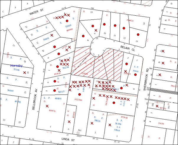
|
NOTIFICATION PLAN |
|
||
|
• PROPERTIES NOTIFIED
|
X SUBMISSIONS RECEIVED |
PROPERTY SUBJECT OF DEVELOPMENT |
|
|
SIX SUBMISSIONS RECEIVED OUT OF MAP RANGE |
|||
73 submissions objected to the development, generally on the following grounds that the development would result in:
· Unacceptable traffic on local streets;
· Unacceptable overshadowing of adjoining properties;
· Development that is excessive in bulk and scale;
· Loss of residential character;
· Loss of trees;
· Loss of privacy and views;
· Design contrary to SEPP 65 Principles;
· Adverse visual impact;
· Median strip in Sherbrook Road;
· Isolated site;
· Increase in vandalism;
· Lack of recreation space;
· Excessive excavation; and
· Unacceptable construction noise.
The merits of the matters raised in community submissions have been addressed in the body of the report with the exception of the following:
5.1.1 Loss of Views
The proposed development would result in loss of existing views over the site from the rear of adjoining medium/high density developments. The views are localised to the surrounding area and are not extensive.
It is considered view loss would have been anticipated with the rezoning of the Belair Close Precinct for residential flat building to a height of 17.5m. The views from the rear of adjoining developments as a result of the proposal would be consistent with the medium/high density residential area.
5.1.2 Lack of Recreation Space
The increase in residential density would be lacking recreation space.
There are a number of recreation facilities in the vicinity of the site including Holman Park children’s playground corner Sherbrook Road and Northcote Road and James Park sports field 480m east of the site on Palmerston Road. Furthermore, a condition of consent is recommended requiring a Section 94 Contribution towards the cost of providing additional facilities to assist meet the demand of future residents. Such facilities include open space and recreational facilities.
5.1.3 Median Strip In Sherbrook Road
Council’s traffic assessment concludes that a median strip is not required in Sherbrook Road for the proposed development but may be subject to future consideration in completion of redevelopment within the Belair Close Precinct.
5.2 Public Agencies
The development application was not referred to any Public Agencies for comment.
6. THE PUBLIC INTEREST
Section 79C(1)(e) of the Act requires Council to consider “the public interest”.
The public interest is an overarching requirement, which includes the consideration of the matters discussed in this report. Implicit to the public interest is the achievement of future built outcomes adequately responding to and respecting the future desired outcomes expressed in environmental planning instruments and development control plans.
The application is considered to have satisfactorily addressed Council’s and relevant agencies’ criteria and would provide a development outcome that, on balance, would result in a positive impact for the community. Accordingly, it is considered that the approval of the proposed development would be in the public interest.
CONCLUSION
The proposal is for the demolition of existing dwellings and construction of two, five storey residential flat buildings comprising 64 units, basement car park and strata title subdivision.
The proposed development is considered satisfactory in respect to achieving the Housing Strategy DCP desired future character of the Belair Close Housing Precinct together with the outcomes for design quality, site requirements, height, setbacks, landscaping, floorplates and separations, articulation, open space, privacy, sunlight and ventilation, housing choice and vehicle access and parking. The non-compliance with the prescriptive measures for five storey building height, front setback and housing mix are considered acceptable on merit.
The proposed development is in accordance with the SEPP 65 design principles and the best practice benchmarks of the Residential Flat Design Code. The scale, built form and presentation of the development to Belair Close would establish an appropriate pattern for future development within the Precinct.
The notification of the application received considerable public interest. The proposal has been amended to address concerns regarding solar access and is considered generally acceptable in respect to neighbourhood amenity and Council’s planning controls for a medium to high density residential environment.
The application is recommended for approval.
|
Rod Pickles Manager - Development Assessment Planning Division |
James Farrington Group Manager Planning Division |
|
1.View |
Locality Map |
|
|
|
2.View |
Site Analysis Plan |
|
|
|
3.View |
Floor Plans - Part 1 |
|
|
|
4.View |
Floor Plans - Part 2 |
|
|
|
5.View |
Elevations |
|
|
|
6.View |
Landscape Plan |
|
|
|
7.View |
Shadow Plans |
|
|
|
8.View |
Survey Plan |
|
|
|
9.View |
Photomontage |
|
|
File Reference: DA/4/2013
Document Number: D02187266
SCHEDULE 1
GENERAL CONDITIONS
The conditions of consent within this notice of determination have been applied to ensure that the use of the land and/or building is carried out in such a manner that is consistent with the aims and objectives of the relevant legislation, planning instruments and council policies affecting the land and does not disrupt the amenity of the neighbourhood or impact upon the environment.
Note: For the purpose of this consent, the term ‘applicant’ means any person who has the authority to act on or the benefit of the development consent.
Note: For the purpose of this consent, any reference to an act, regulation, Australian standard or publication by a public authority shall be taken to mean the gazetted act or regulation, or adopted Australian standard or publication as in force on the date that the application for a construction certificate is made.
1. Approved Plans and Supporting Documentation
The development must be carried out in accordance with the plans and documentation listed below and endorsed with Council’s stamp, except where amended by Council and/or other conditions of this consent:
|
Plan No. |
Plan Title |
Drawn by |
Dated |
|
8164 DA-D 00 |
Cover Page Basix Schedule |
Zhinar Architects |
Oct 2012 |
|
8164 DA-D 03 |
Overall Lower Ground Floor Plan |
Zhinar Architects |
Oct 2012 |
|
8164 DA-D 04 |
Overall Site Plan – Ground Floor |
Zhinar Architects |
Oct 2012 |
|
8164 DA-D 05.1 |
First Floor Plan |
Zhinar Architects |
Oct 2012 |
|
8164 DA-D 05.2 |
Second Floor Plan |
Zhinar Architects |
Oct 2012 |
|
8164 DA-D 05.3 |
Third Floor Plan |
Zhinar Architects |
Oct 2012 |
|
8164 DA-D 05.4 |
Fourth Floor Plan |
Zhinar Architects |
Oct 2012 |
|
8164 DA-D 05.5 |
Fifth Floor Plan |
Zhinar Architects |
Oct 2012 |
|
8164 DA-D 06 |
Basement – 1 Plan |
Zhinar Architects |
Oct 2012 |
|
8164 DA-D 07 |
Lower Ground Floor Plan |
Zhinar Architects |
Oct 2012 |
|
8164 DA-D 08 |
Ground Floor Plan |
Zhinar Architects |
Oct 2012 |
|
8164 DA-D 09 |
Block A+B First Floor |
Zhinar Architects |
Oct 2012 |
|
8164 DA-D 10 |
Block A+B Second Floor |
Zhinar Architects |
Oct 2012 |
|
8164 DA-D 11 |
Block A+B Third Floor |
Zhinar Architects |
Oct 2012 |
|
8164 DA-D 12 |
Block A Fourth Floor |
Zhinar Architects |
Oct 2012 |
|
8164 DA-D 13 |
Block B Fifth Floor + Roof Plan A |
Zhinar Architects |
Oct 2012 |
|
8164 DA-D 14 |
Roof Plan |
Zhinar Architects |
Oct 2012 |
|
8164 DA-D 15 |
Elevations + Basement Sections |
Zhinar Architects |
Oct 2012 |
|
8164 DA-D 16 |
Site Section A + B, Street Elevation |
Zhinar Architects |
Oct 2012 |
|
8164 Rev A |
Colour Schedule & Materials Legend |
Zhinar Architects |
Undated |
|
12203DA 1 B |
Landscape Concept Plan |
Vision Dynamics |
29.4.13 |
|
Document Title |
Prepared by |
Dated |
|
DA Acoustic Report |
Acoustic Logic |
19/12/2012 |
|
Access Compliance Assessment |
Certified Building Specialists |
18 December 2012 |
|
Arboricultural Impact Assessment |
Redgum Arboriculture & Horticulture Consultants |
29 November 2012 |
|
BASIX Certificate No. 462119M_02 |
Designview |
29 April 2013 |
2. Amendment of Plans
The approved plans are to be amended as follows:
a) The approved plans are to be amended to address Condition No. 36 concerning landscaping.
REQUIREMENTS PRIOR TO THE ISSUE OF A CONSTRUCTION CERTIFICATE
3. Building Code of Australia
All building work must be carried out in accordance with the requirements of the Building Code of Australia.
4. Contract of Insurance (Residential Building Work)
In the case of residential building work for which the Home Building Act, 1989 requires there to be a contract of insurance in force in accordance with Part 6 of that Act, that such a contract of insurance is in force before any building work authorised to be carried out by the consent commences.
5. Water/Electricity Utility Services
The applicant must submit written evidence of the following service provider requirements:
a) Energy Australia – a letter of consent demonstrating that satisfactory arrangements have been made to service the proposed development.
b) Sydney Water – the submission of a ‘Notice of Requirements’ under s73 of the Sydney Water Act 1994.
Note: Sydney Water requires that s73 applications are to be made through an authorised Sydney Water Servicing Coordinator. Refer to www.sydneywater.com.au or telephone 13 20 92 for assistance.
6. Adaptable Units
a) The details of the adaptable units Nos. 1, 2, 4, 5, 7, 11, 12, 25, 26, 33, 36, 40, 41, 43, 47, 48, 50, 53, 54, and 57 must be provided with the Construction Certificate Plans.
b) Six of the adaptable units must be in compliance with AS1428.1 – Design for Access and Mobility.
7. Dilapidation Report
A ‘Dilapidation Report’ is to be prepared by a ‘chartered structural engineer’ detailing the structural condition of all the adjoining properties.
8. Acoustic Measures
The development must be carried out in accordance with the recommendations contained within the acoustic report submitted with the development application, titled DA Acoustic Report, prepared by Acoustic Logic and dated 19/12/2012.
9. Stormwater Drainage
The stormwater drainage system for the development must be designed and constructed in accordance with Council’s Civil Works – Design and Construction Specification 2005 and the following requirements:
a) Connected via galvanised rectangular hollow sections, 125mm x 75mm x 3mm thick, to Council’s kerb line in Belair Close.
b) Roofed and upstream paved areas shall be connected to the proposed on-site detention system.
10. On Site Stormwater Detention
An on-site stormwater detention system must be designed by a chartered civil engineer and constructed in accordance with the following requirements:-
a) Have a capacity of not less than 63 cubic metres, and a maximum discharge (when full) of 60 litres per second;
b) Have a 900mm x 900mm square access grate located directly above the on-site detention tank outlet.
c) An additional tank overflow system designed to convey all high level flows from the tank to the Council-controlled drainage system in Belair Close.
d) Controlled discharges from the detention system to be controlled via 1 metre length of pipe, not less than 50 millimetres diameter or via a stainless plate with sharply drilled orifice bolted over the face of the outlet discharging into a larger diameter pipe capable of carrying the design flow to an approved Council system.
11. Excavation
The structural plans for basement and above ground areas must be prepared by a Chartered Structural Engineer and submitted with the Construction Certificate Application.
12. Road Works
All road works approved under this consent must be designed and constructed in accordance with Council’s Civil Works Design and Construction Specification, 2005 and the following requirements: -
a) Council’s standard 80 mm thick concrete footpath to be constructed within the road verge across the frontage of the properties and connecting with Council’s existing concrete footpath in Sherbrook Road. The remaining footpath verge area shall be turfed.
b) The existing kerb and gutter shall be removed and Council’s standard 150mm integral kerb and gutter and pavement shall be constructed in line with the adjoining properties, together with footpath formation, necessary drainage and sealing of road pavement between the existing pavement and lip of the gutter.
c) The existing road pavement to be saw cut a minimum of 1000 mm from the existing edge of the bitumen and reconstructed.
d) Pursuant to Section 138 of the Roads Act 1993, An application shall be made to Council for a Construction Certificate and Compliance Inspections for all works in the local road prior to the commencement of the works. The Applicant shall pay Council’s fees on lodgement for both these requirements.
e) The submission to Hornsby Shire Council of a compaction certificate from a geotechnical engineer for all fill within road reserves, and all road sub-grade and road pavement materials.
13. Internal Driveway/Vehicular Areas
The driveway and parking areas on site must be designed in accordance with Australian Standards 2890.1, 2890.2, 3727 and the following requirements: -
a) Design levels at the front boundary be obtained from Council.
b) The driveway be a rigid pavement.
c) Driveway grades for the design waste vehicle must not exceed 15.4% and transitions for changes of grade must not exceed requirements of AS2890.2. Provision shall be made for turning and manoeuvring of the waste services vehicle and standing area permanently marked out and restrictive signage provided.
d) Driveway structure, retaining walls and required to support the carriageway as required and the protection of all drops as per the requirements of a chartered Structural Engineer.
e) Planting of the driveway area to enhance the visual amenity of the driveway.
14. Vehicular Crossing
A separate application under the Local Government Act, 1993 and the Roads Act, 1993 must be submitted to Council for the installation of a new vehicular crossing and the removal of all redundant crossings. The vehicular crossing must be constructed in accordance with Council’s Civil Works Design, 2005 and the following requirements: -
a) Any redundant crossings to be replaced with integral kerb and gutter.
b) The footway area to be restored by turfing.
c) Adjustment of all regulatory signage and all services and street furniture made necessary by the proposed works.
Note: An application for a vehicular crossing can only be made to one of Council’s Authorised Vehicular Crossing Contractors. You are advised to contact Council on 02 9847 6940 to obtain a list of contractors.
15. Construction Management Plan
A Construction Management Plan detailing construction vehicle routes, number of trucks, hours operation, access arrangements and traffic control must be submitted to Council prior to the issue of a Construction certificate.
16. Waste Management Details
The following waste management requirements must be complied with:
a) A revised Waste Management Plan Section One – Demolition Stage and Section Three – Construction Stage, covering the scope of this project and including the following details, is required to be submitted to Council:
i) An estimate of the types and volumes of waste and recyclables to be generated;
ii) A site plan showing sorting and storage areas for demolition and construction waste and the vehicle access to these areas;
iii) How excavation, demolition and construction waste materials will be reused or recycled and where residual wastes will be disposed;
iv) The total percentage (by weight) of demolition and construction waste that will be reused or recycled.
REQUIREMENTS PRIOR TO THE COMMENCEMENT OF ANY WORKS
17. Erection of Construction Sign
A sign must be erected in a prominent position on any site on which building work, subdivision work or demolition work is being carried out:
a) Showing the name, address and telephone number of the principal certifying authority for the work,
b) Showing the name of the principal contractor (if any) for any demolition or building work and a telephone number on which that person may be contacted outside working hours, and
c) Stating that unauthorised entry to the work site is prohibited.
Note: Any such sign is to be maintained while the building work, subdivision work or demolition work is being carried out, but must be removed when the work has been completed.
18. Erosion and Sediment Control
Erosion and sediment control measures must be provided and maintained throughout the construction period in accordance with the manual ‘Soils and Construction 2004 (Bluebook)’, the approved plans, Council specifications and to the satisfaction of the principal certifying authority. The erosion and sediment control devices must remain in place until the site has been stabilised and revegetated.
Note: On the spot penalties up to $1,500 may be issued for any non-compliance with this requirement without any further notification or warning.
19. Protection of Adjoining Areas
A temporary hoarding, fence or awning must be erected between the work site and adjoining lands before the works begin and must be kept in place until after the completion of the works if the works:
a) Could cause a danger, obstruction or inconvenience to pedestrian or vehicular traffic.
b) Could cause damage to adjoining lands by falling objects.
c) Involve the enclosure of a public place or part of a public place.
Note: Notwithstanding the above, Council’s separate written approval is required prior to the erection of any structure or other obstruction on public land.
20. Toilet Facilities
Toilet facilities must be available or provided at the works site before works begin and must be maintained until the works are completed at a ratio of one toilet for every 20 persons employed at the site. Each toilet must:
a) Be a standard flushing toilet connected to a public sewer; or
b) Be a temporary chemical closet approved under the Local Government Act, 1993; or
c) Have an on-site effluent disposal system approved under the Local Government Act, 1993.
REQUIREMENTS DURING CONSTRUCTION
21. Construction Work Hours
All work on site (including demolition and earth works) must only occur between 7am and 5pm Monday to Saturday, in accordance with Interim Construction Noise Guidelines 2009 – NSW Department of Environment and Climate Change.
No work is to be undertaken on Sundays or public holidays.
22. Demolition
All demolition work must be carried out in accordance with Australian Standard 2601-2001 – The Demolition of Structures and the following requirements:
a) Demolition material is to be disposed of to an authorised recycling and/or waste disposal site and/or in accordance with an approved waste management plan.
b) Demolition works, where asbestos material is being removed, must be undertaken by a contractor that holds an appropriate licence issued by WorkCover NSW in accordance with Chapter 10 of the Occupational Health and Safety Regulation 2001 and Clause 29 of the Protection of the Environment Operations (Waste) Regulation 2005.
c) On construction sites where buildings contain asbestos material, a standard commercially manufactured sign containing the words ‘DANGER ASBESTOS REMOVAL IN PROGRESS’ measuring not less than 400mm x 300mm must be erected in a prominent position visible from the street.
d) All demolition and construction vehicles must be contained wholly within the site as a work zone permit will not be approved for Belair Close.
23. Waste Management
Waste management during the demolition and construction phase of the development must be undertaken in accordance with the approved Waste Management Plan. Additionally written records of the following items must be maintained during the removal of any waste from the site and such information submitted to the Principal Certifying Authority within fourteen days of the date of completion of the works:
a) The identity of the person removing the waste.
b) The waste carrier vehicle registration.
c) Date and time of waste collection.
d) A description of the waste (type of waste and estimated quantity).
e) Details of the site to which the waste is to be taken.
f) The corresponding tip docket/receipt from the site to which the waste is transferred (noting date and time of delivery, description (type and quantity) of waste).
g) Whether the waste is expected to be reused, recycled or go to landfill.
Note: In accordance with the Protection of the Environment Operations Act 1997, the definition of waste includes any unwanted substance, regardless of whether it is reused, recycled or disposed to landfill.
24. Environmental Management
The site must be managed in accordance with the publication ‘Managing Urban Stormwater – Landcom (March 2004) and the Protection of the Environment Operations Act 1997 by way of implementing appropriate measures to prevent sediment run-off, excessive dust, noise or odour emanating from the site during the construction of the development.
25. Works Near Trees
All required tree protection measures are to be maintained in good condition for the duration of the construction period.
All works (including driveways and retaining walls) within 4 metres of any trees required to be retained (whether or not on the subject property, and pursuant to this consent or the Tree Preservation Order), must be carried out under the supervision of an ‘AQF Level 5 Arborist’ and a certificate submitted to the principal certifying authority detailing the method(s) used to preserve the tree(s).
Note: Except as provided above, the applicant is to ensure that no excavation, filling or stockpiling of building materials, parking of vehicles or plant, disposal of cement slurry, waste water or other contaminants is to occur within 4 metres of any tree to be retained.
26. Street Sweeping
Street sweeping must be undertaken following sediment tracking from the site along Belair Close during works and until the site is established.
27. Landfill
Landfill must be constructed in accordance with Council’s ‘Construction Specification, 2005’ and the following requirements:
a) All fill material imported to the site is to wholly consist of Virgin Excavated Natural Material (VENM) as defined in Schedule 1 of the Protection of the Environment Operations Act 1997 or a material approved under the Department of Environment and Climate Change’s general resource recovery exemption.
b) A compaction certificate is to be obtained from a geotechnical engineer verifying that the specified compaction requirements have been met.
28. Excavated Material
All excavated material removed from the site must be classified in accordance with the Department of Environment, Climate Change and Water NSW Waste Classification Guidelines prior to disposal to an approved waste management facility and reported to the principal certifying authority.
29. Survey Report – Finished Floor Level
A report(s) must be prepared by a registered surveyor and submitted to the principal certifying authority prior to the pouring of concrete at each level of the building certifying that:
a) The building, retaining walls and the like have been correctly positioned on the site.
b) The finished floor level(s) are in accordance with the approved plans.
30. Council Property
During construction works, no building materials, waste, machinery or related matter is to be stored on the road or footpath. The public reserve is to be kept in a clean, tidy and safe condition at all times.
REQUIREMENTS PRIOR TO THE ISSUE OF AN OCCUPATION CERTIFICATE
Note: For the purpose of this consent, a reference to ‘occupation certificate’ shall not be taken to mean an ‘interim occupation certificate’ unless otherwise stated.
31. Fulfilment of BASIX Commitments
The applicant must demonstrate the fulfilment of BASIX commitments pertaining to the development.
32. Sydney Water – s73 Certificate
An s73 Certificate must be obtained from Sydney Water.
33. Damage to Council Assets
Any damage caused to Council’s assets as a result of the construction of the development must be rectified in accordance with Council’s written requirements and at the sole cost of the applicant.
34. Creation of Easements
The following matter(s) must be nominated on the plan of subdivision under s88 of the Conveyancing Act 1919:
a) Consolidation of the subject lots,
b) The creation of an appropriate "Positive Covenant" and "Restriction as to User" over the constructed on-site detention/retention systems and outlet works, within the lots in favour of Council in accordance with Council’s prescribed wording. The position of the on-site detention system is to be clearly indicated on the title.
c) To register the OSD easement, the restriction on the use of land “works-as-executed” details of the on-site-detention system must be submitted verifying that the required storage and discharge rates have been constructed in accordance with the design requirements. The details must show the invert levels of the on site system together with pipe sizes and grades. Any variations to the approved plans must be shown in red on the “works-as-executed” plan and supported by calculations.
Note: Council must be nominated as the authority to release, vary or modify any easement, restriction or covenant.
35. Garbage Collection Easement
For the purpose of waste collection, an easement entitling Council, its servants and agents and persons authorised by it to enter upon the subject land and to operate thereon, vehicles and other equipment for the purposes of garbage collection must be granted to Council by the owner of the land.
Note: The easement must be in a form prescribed by Council and must include covenants to the effect that parties will not be liable for any damage caused to the subject land or any part thereof or to any property located therein or thereon by reason of the operation thereon of any vehicle or other equipment used in connection with the collection of garbage and to the effect that the owner for the time being of the subject land shall indemnify the Council, its servants, agents and persons authorised by it to collect garbage against liability in respect of any such claims made by any person whomsoever.
36. Waste Management
The following waste management requirements must be complied with:
a) The bin storage room(s) at the lower ground level must include water or a hose for cleaning, graded floors with drainage to sewer, a robust door, sealed and impervious surface, adequate lighting and ventilation. The bin rooms at each residential level must include sealed and impervious surface, adequate lighting and ventilation.
b) A report must be prepared by an appropriately qualified person, certifying the following:
i. A comparison of the estimated quantities of each waste type against the actual quantities of each waste type.
Note: Explanations of any deviations to the approved Waste Management Plan is required to be included in this report
ii. That at least 60% of the waste generated during the demolition and construction phase of the development was reused or recycled.
Note: If the 60% diversion from landfill cannot be achieved in the Construction Stage, the Report is to include the reasons why this occurred and certify that appropriate work practices were employed to implement the approved Waste Management Plan. The Report must be based on documentary evidence such as tipping dockets/receipts from recycling depots, transfer stations and landfills, audits of procedures etc. which are to be attached to the report.
iii. All waste was taken to site(s) that were lawfully permitted to accept that waste.
c) Each unit must be provided with an indoor waste/recycling cupboard for the interim storage of a minimum one day’s waste generation with separate containers for general waste and recyclable materials.
d) Space must be provided for either individual compost containers for each unit or a communal compost container;
Note: The location of the compost containers should have regard for potential amenity impacts.
e) The bin carting routes must be devoid of any steps.
Note: Ramps between different levels are acceptable
37. Additional Landscaping
a) Terraced retaining walls maximum height of 1.5m and a minimum 1m wide, creating landscape planter areas, are to be provided to the south western corner of the site. These planter areas are to included an additional 25 x Trachelospermum jasminoides (Chinese start jasmine) groundcover plants.
b) The landscape planter area along the eastern edge of the central paved pathway between the buildings is to be increased in width by 0.5m. An Additional five (5) x Howea forsterania (Kentia palms) are to be located in this planter area.
c) 20 x Angophora floribunda tree species are to be replaced with Angophora costata (Sydney Red Gum)
d) Planting to the front verge must include Three Angophora costata (Sydney Red Gum). Trees shall be installed at minimum 45 litre pot size.
e) On slab planter boxes must include waterproofing, subsoil drainage (proprietary drainage cell, 50mm sand and filter fabric) automatic irrigation, minimum 500mm planting soil for shrubs and minimum 1000mm planting soil for trees and palms and 75mm mulch to ensure sustainable landscape is achieved.
38. Completion of Landscaping
A certificate must be provided by a practicing landscape architect, horticulturalist or person with similar qualifications and experience certifying that all required landscaping works have been satisfactorily completed in accordance with the approved landscape plans.
Note: Advice on suitable species for landscaping can be obtained from Council’s planting guide ‘Indigenous Plants for the Bushland Shire’, available at www.hornsby.nsw.gov.au.
39. Retaining Walls
All required retaining walls must be constructed as part of the development.
40. External Lighting
All external lighting must be designed and installed in accordance with Australian Standard AS 4282 – Control of the Obtrusive Effects of Outdoor Lighting. Certification of compliance with the Standard must be obtained from a suitably qualified person.
41. Safety and Security
a) Fire exist doors to the development must be fitted with single cylinder locksets (Australia and New Zealand Standard – Lock Sets) to restrict unauthorized access to the development.
b) Ground floor windows must be fitted with window locks that can be locked with a key.
c) A graffiti management plan must be incorporated into the maintenance plan for the development for graffiti to be removed within a forty-eight hour period.
d) The basement car park entries must be secured by security gates/roller shutters and controlled by secure access located at the top of the driveway.
42. Unit Numbering
The allocation of unit numbering must be authorised by Council prior to the numbering of each unit in the development.
43. Works as Executed Plan
A works-as-executed plan(s) must be prepared by a registered surveyor and submitted to Council for completed road pavement, kerb & gutter, public drainage systems, driveways and on-site detention system.
44. Section 94 Infrastructure Contributions
The payment to Council of a contribution of $716,319.45 for 64 dwellings towards the cost of infrastructure identified in Council’s Development Contributions Plan 2007-2011.
Note: The value of contribution is current as at 20 June 2013 and includes a credit for the 5 existing allotments. The contribution will be adjusted from this date in accordance with the underlying consumer price index for subsequent financial quarters.
It is recommended that you contact Council to confirm the value of the contribution prior to payment.
OPERATIONAL CONDITIONS
45. Noise
All noise generated by the proposed development must be attenuated to prevent levels of noise being emitted to adjacent premises which possess tonal, beating and similar characteristics or which exceeds background noise levels by more than 5dB(A).
46. Disabled Parking
All parking spaces for people with disabilities must be constructed and operated in accordance with Australian Standard AS/NZS 2890.6:2009 – Off-street parking for people with disabilities.
47. Fire Safety Statement - Annual
On at least one occasion in every 12 month period following the date of the first ‘Fire Safety Certificate’ issued for the property, the owner must provide Council with an annual ‘Fire Safety Certificate’ to each essential service installed in the building.
48. Landscape Establishment
The landscape works must be maintained into the future to ensure the establishment and successful growth of plant material to meet the intent of the landscape design. This must include but not be limited to watering, weeding, replacement of failed plant material and promoting the growth of plants through standard industry practices.
49. Waste Storage Area and Waste Management
The waste management on site must be in accordance with the following requirements:
a) A site caretaker must be employed and be responsible for moving bins where and when necessary, washing bins and maintaining waste storage areas, ensuring the chute system and related devices are maintained in effective and efficient working order, managing the communal composting area, managing the bulky item storage area, arranging the prompt removal of dumped rubbish, and ensuring all residents are informed of the use of the waste management system.
50. Car Parking and Deliveries
All car parking must be constructed and operated in accordance with Australian Standard AS 2890.1 – 2004 – Off Street Car Parking and Australian Standard 2890.2 - 2002 – Off Street Commercial and the following requirement:
a) All parking areas and driveways are to be sealed to an all weather standard, line marked and signposted.
b) Car parking, loading and manoeuvring areas to be used solely for nominated purposes.
c) Vehicles awaiting loading, unloading or servicing shall be parked on site and not on adjacent or nearby public roads;
d) All vehicular entry on to the site and egress from the site shall be made in a forward direction.
e) All bicycle parking spaces are to be provided in accordance with AS 2890.3-1993 Bicycle parking facilities
f) Visitors are to have access to the parking area at all times. Visitors are to be able to access the basement car park by an audio/visual intercom system located at the top of the ramped driveways.
- END OF CONDITIONS -
ADVISORY NOTES
The following information is provided for your assistance to ensure compliance with the Environmental Planning and Assessment Act, 1979, Environmental Planning and Assessment Regulation 2000, other relevant legislation and Council’s policies and specifications. This information does not form part of the conditions of development consent pursuant to Section 80a of the Act.
Environmental Planning and Assessment Act, 1979 Requirements
The Environmental Planning and Assessment Act, 1979 requires:
· The issue of a construction certificate prior to the commencement of any works. Enquiries regarding the issue of a construction certificate can be made to Council’s Customer Services Branch on 9847 6760.
· A principal certifying authority to be nominated and Council notified of that appointment prior to the commencement of any works.
· Council to be given at least two days written notice prior to the commencement of any works.
· Mandatory inspections of nominated stages of the construction inspected.
· An occupation certificate to be issued before occupying any building or commencing the use of the land.
Long Service Levy
In accordance with Section 34 of the Building and Construction Industry Long Service Payments Act 1986, a ‘Long Service Levy’ must be paid to the Long Service Payments Corporation or Hornsby Council.
Note: The rate of the Long Service Levy is 0.35% of the total cost of the work.
Note: Hornsby Council requires the payment of the Long Service Levy prior to the issue of a construction certificate.
Tree Preservation Order
To ensure the maintenance and protection of the existing natural environment, it is an offence to ringbark, cut down, top, lop, remove, wilfully injure or destroy a tree outside 3 metres of the approved building envelope without the prior written consent from Council.
Note: A tree is defined as a single or multi-trunked wood perennial plant having a height of not less than three (3) metres, and which develops many branches, usually from a distance of not less than one (1) metre from the ground, but excluding any plant which, in its particular location, is a noxious plant declared as such pursuant to the Noxious Weeds Act 1993. This definition of ‘tree’ includes any and all types of Palm trees.
All distances are determined under Australian Standard AS4970-2009 ”Protection of Trees on Development Sites”.
Fines may be imposed for non-compliance with Council’s Tree Preservation Order.
Disability Discrimination Act
The applicant’s attention is drawn to the existence of the Disability Discrimination Act. A construction certificate is required to be obtained for the proposed building/s, which will provide consideration under the Building Code of Australia, however, the development may not comply with the requirements of the Disability Discrimination Act. This is the sole responsibility of the applicant.
Dial Before You Dig
Prior to commencing any works, the applicant is encouraged to contact Dial Before You Dig on 1100 or www.dialbeforeyoudig.com.au for free information on potential underground pipes and cables within the vicinity of the development site.
Telecommunications Act 1997 (Commonwealth)
If you are aware of any works or proposed works which may affect or impact on Telstra’s assets in any way, you are required to contact: Telstra’s Network Integrity Team on Phone Number 1800810443.
Asbestos Warning
Should asbestos or asbestos products be encountered during demolition or construction works you are advised to seek advice and information should be prior to disturbing the material. It is recommended that a contractor holding an asbestos-handling permit (issued by WorkCover NSW)be engaged to manage the proper handling of the material. Further information regarding the safe handling and removal of asbestos can be found at:
Alternatively, telephone the WorkCover Asbestos and Demolition Team on 8260 5885.
House Numbering
House numbering can only be authorised by Council. Before proceeding to number each premise in the development, the allocation of numbers is required to be obtained from Council's Planning Division. The authorised numbers are required to be displayed in a clear manner at or near the main entrance to each premise.
Group Manager’s Report No. PL52/13
Planning Division
Date of Meeting: 17/07/2013
10 DEVELOPMENT APPLICATION - SECTION 96(2) - BOUNDARY FENCE - 37 FERNDALE ROAD, NORMANHURST
EXECUTIVE SUMMARY
|
DA No: |
DA/123/2013/A (Lodged 10 April 2013) |
|
Description: |
Section 96(2) application to amend the consent for the erection of a boundary fence |
|
Property: |
Lot 23, DP 206093, No. 37 Ferndale Road, Normanhurst |
|
Applicant: |
Mrs Janet Margaret Wright |
|
Owner: |
Mrs Janet Margaret Wright |
|
Estimated Value: |
$2,600 |
|
Ward: |
B |
· The Section 96 application proposes to amend the consent for the erection of a boundary fence by increasing the height of the fence.
· The proposal complies with the relevant provisions within the Hornsby Shire Local Environmental Plan 1994 and Dwelling Housing Development Control Plan.
· A Red Sticker has been placed on the application requiring that the application be determined at a Council meeting.
· Two submissions have been received in respect of the application.
· It is recommended that the application be approved.
|
THAT pursuant to Section 96(2) of the Environmental Planning and Assessment Act 1979, Development Application No. DA/123/2013/A for modification to the consent for the erection of a boundary fence at Lot 23, DP 206093, No. 37 Ferndale Road, Normanhurst be amended as detailed in Schedule 1 of Group Manager’s Report No. PL52/13. |
BACKGROUND
In September 2012, a complaint was received by Council concerning the erection of a boundary fence on the subject site without approval. A Council compliance officer inspected the site on 25 September 2012 and found that one panel of fencing had been erected. Subsequent to the inspection, the portion of fencing was removed and an application (DA/123/2013) was lodged with Council for the erection of a boundary fence.
On 14 March 2013, Development Application No. 123/2013 was approved for the erection of a Colour-bond boundary fence to a height of 1.6 metres along the rear and side boundaries of the property.
In response to a complaint, a site inspection on 25 March 2013 by Council’s compliance officer revealed that the fence has not been constructed in accordance with the development consent. The boundary fence has been erected to a height of 1.8 metres. Subsequently, the applicant lodged a Section 96 modification for the approval of the fence at the constructed height of1.8 metres.
The Section 96(2) modification is the subject of this report.
SITE
The site has an area of 784.1m² and is located on the eastern side of Ferndale Road, Normanhurst with the northern and eastern boundaries having street frontage to Nicholas Crescent. The site has an average fall of 12% from the western, front boundary to the eastern, rear boundary and contains a single storey dwelling-house with attached carport.
The site is identified as being located on bushfire prone land.
Surrounding development comprises single and two storey detached dwellings. The adjoining corner lot (No. 33 Ferndale Road) has a rear yard enclosed with a 1.8m high lapped and capped timber fence.
PROPOSAL
The proposal involves a Section 96 application to amend the consent for the erection of a boundary fence along the rear and side boundaries of the allotment as follows:
· increase the overall height of the fence from 1.6 metres to 1.8 metres; and
· remove the requirement for 0.2 metre lattice on top of the fence.
ASSESSMENT
The development application has been assessed having regard to the ‘Metropolitan Plan for Sydney 2031’, the ‘North Subregion (Draft) Subregional Strategy’ and the matters for consideration prescribed under Section 79C of the Environmental Planning and Assessment Act 1979 (the Act). The following issues have been identified for further consideration.
1. STRATEGIC CONTEXT
1.1 Metropolitan Plan for Sydney 2031 and (Draft) North Subregional Strategy
The (Draft) Metropolitan Strategy for Sydney 2031 is a broad framework to provide for Sydney’s growth to help plan for housing, employment, transport, infrastructure, the environment and open space. It outlines a vision for Sydney to 2031; the challenges faced, and the directions to follow to address these challenges and achieve the vision.
The North Subregion comprises Hornsby, Kuring-gai, Manly, Warringah and Pittwater Local Government Areas. The Draft North Subregional Strategy acts as a framework for Council in its preparation of the Comprehensive LEP by the end of 2013.
1. Within the North Subregion, the Draft Metropolitan Strategy proposes:
· Population growth of 81,000 from the current 2011 baseline of 529,000
· Housing growth of 37,000 from the current 2011 baseline of 204,000
· Employment growth of 39,000 from the current 2011 baseline of 186,000
The proposed development involves a Section 96 Modification for a boundary fence adjustment on residential land. Accordingly, the proposal is not inconsistent with the draft Strategy.
2. STATUTORY CONTROLS
Section 79C(1)(a) requires Council to consider “any relevant environmental planning instruments, draft environmental planning instruments, development control plans, planning agreements and regulations”.
2.1 Section 96(2) of the Environmental Planning and Assessment Act 1979
Pursuant to Section 96(2) of the Environmental Planning and Assessment Act 1979, Council may consider an application to amend development consent provided that, inter alia:
“a) it is satisfied that the development to which the consent as modified relates is substantially the same development, and
b) it has consulted with the relevant Minister, public authority or approval body (within the meaning of Division 5) in respect of a condition imposed as a requirement of a concurrence to the consent or in accordance with the general terms of an approval proposed to be granted by the approval body and that Minister, authority or body has not, within 21 days after being consulted, objected to the modification of that consent, and
c) it has notified the application in accordance with the regulations, and
d) it has considered any submissions made concerning the proposed modification within the period prescribed by the regulations.”
In respect to part (a) of Section 96(2), the proposal involves modifications to an approved boundary fence and is of minimal environmental impact. The proposal would result in a development that is substantially the same development as was previously approved. In respect to part (b), the original proposal was not subject to concurrence of another authority. With respect to (c) and (d), the application was notified in accordance with Council’s Notification and Exhibition Development Control Plan and two submissions were received. The matters raised in submissions are addressed in Section 5 of this report.
The application is acceptable in respect to Section 96(2) of the Environmental Planning and Assessment Act, 1979.
2.2 Hornsby Shire Local Environmental Plan 1994
The subject land is zoned Residential A (Low Density) under the Hornsby Shire Local Environmental Plan 1994 (HSLEP).
The objectives of the Residential A (Low Density) zone are:
a) to provide for the housing needs of the population of the Hornsby area.
b) to promote a variety of housing types and other land uses compatible with a low density residential environment.
c) to provide for development that is within the environmental capacity of a low density residential environment.
The proposed development is defined as ‘ancillary’ to a ‘dwelling-house’ under the HSLEP and is permissible in the zone with Council’s consent.
2.3 Draft Hornsby Shire Local Environmental Plan
The draft Hornsby Local Environmental Plan (DHLEP) was endorsed by Council at its meeting on 19 December 2012 to be forwarded to the Minister for Planning and Infrastructure to be made. In accordance with Council’s resolution, the draft Plan has been submitted to the Department for finalisation.
Under the DHLEP, the subject land would be zoned R2 Low Density Residential and “Dwelling-house” would be permissible within the zone with Council’s consent.
2.4 Sydney Regional Environmental Plan No. 20 – Hawkesbury – Nepean River
The Plan regulates impacts of future land uses on the River through implementation of planning policies and strategies for total catchment management, environmentally sensitive areas, water quality, water quantity, cultural heritage, flora and fauna, riverine scenic quality, agriculture/aquaculture and fishing, rural residential development, urban development, recreation and tourism. The proposed Section 96 modification would not adversely impact on the River or its catchment.
2.5 Clause 74BA Environmental Planning and Assessment Act, 1979 - Purpose and Status of Development Control Plans
On 1 March 2013, the Environmental Planning and Assessment Act, 1979 was amended so that a DCP provision will have no effect if it has the practical effect of “preventing or unreasonably restricting development” that is otherwise permitted and complies with the development standards set out in relevant Local Environmental Plans and State Environmental Planning Policies.
The principal purpose of a development control plan is to provide guidance on the aims of any environmental planning instrument that applies to the development; facilitating development that is permissible under any such instrument; and achieving the objectives of land zones under any such instrument. The provisions of a development control plan made for that purpose are not statutory requirements.
2.6 Dwelling House Development Control Plan
The proposed development has been assessed having regard to the relevant performance and prescriptive requirements within Council’s Dwelling House Development Control Plan (Housing DCP). The following table sets out the proposal’s compliance with the prescriptive requirements of the Plan:
|
Dwelling House Development Control Plan |
|||
|
Control |
Proposal |
Requirement |
Compliance |
|
Fence height |
1.8 m |
1.8 m |
Yes |
The proposed Section 96 modification complies with the prescriptive requirements within Council’s Dwelling House DCP. The compliance with the requirement of the DCP is discussed in more detail below.
2.6.1 Fencing
The height of the fence is consistent with the prescriptive measure of the Fencing element in the Dwelling-House DCP, which states that ‘Courtyard or private open space areas may be required to be enclosed by a 1.8m high fence to maximise privacy’.
The subject site has three street frontages with no enclosure of the private open space on the subject site from any of the three sides. The fence provides the residents with privacy and security to the rear yard. Furthermore, the height of the fence is consistent with the height of the boundary fence at the rear of the property on the opposite corner of Ferndale Road and Nicholas Crescent (No. 33 Ferndale Road).
The proposed fence does not comply with the prescriptive measure of the Fencing element in the DCP which states that “sheet metal, colour bond, wire mesh, or tubular fences should be avoided”. Given that the site is located in a bushfire prone zone, the colour-bond metal fence proposed by the applicant is acceptable.
In response to concerns raised in a submission that the fence has not been erected within the property boundaries, Council’s surveyors carried out a survey of the location of the fence in relation to the property boundary. The survey confirms that the fence erected along the rear of the property is located 0.85 metres inside the eastern property boundary and the fence along the side of the property is located on the northern property boundary. However, the north eastern corner of the fence is erected outside of the property boundary. Condition No.2 is recommended requiring the corner section of the fence be splayed and be erected on the property boundary.
To minimise impacts on the streetscape, a condition is also recommended requiring screen planting along the rear of the property boundary. This screen planting would reduce the visual impact of the fence.
3. ENVIRONMENTAL IMPACTS
Section 79C(1)(b) of the Act requires Council to consider “the likely impacts of that development, including environmental impacts on both the natural and built environments, and social and economic impacts in the locality”.
3.1 Natural Environment
The proposed Section 96 involves a proposal to increase the height of the fence from 1.6 metres to 1.8 metres. The modification would not require the removal of any additional vegetation. A condition of consent is recommended requiring screen planting to minimise the visual impact of the fence.
3.2 Built Environment
The height of the fence would be consistent with fencing on the opposite corner allotment at property No.33 Ferndale Road.
3.3 Social Impacts
The proposal includes a minor increase in the height of the approved fence (20cm). The proposal would maintain the residential character of the locality.
3.4 Economic Impacts
The proposal would not have an impact on the local economy.
4. SITE SUITABILITY
Section 79C(1)(c) of the Act requires Council to consider “the suitability of the site for the development”.
There is no known hazard/risk associated with the site with respect to flooding, landslip and subsidence that would preclude approval of the proposed development. However, the land is identified as being subject to bushfire risk.
5. PUBLIC PARTICIPATION
Section 79C(1)(d) of the Act requires Council to consider “any submissions made in accordance with this Act”.
5.1 Community Consultation
The proposed development was placed on public exhibition and was notified to adjoining and nearby landowners between 16 April 2013 and 30 April 2013 in accordance with Council’s Notification and Exhibition Development Control Plan. During this period, Council received two submissions. The map below illustrates the location of those nearby landowners who made a submission.
|
NOTIFICATION PLAN |
|
||
|
• PROPERTIES NOTIFIED
|
X SUBMISSIONS RECEIVED |
PROPERTY SUBJECT OF DEVELOPMENT |
|
Two submissions object to the development, generally on the following grounds:
· Unacceptable location of the fence in relation to the property boundary;
· Unacceptable height and appearance of the fence;
· Development without screen planting;
· Development without the lattice top;
· Traffic safety concerns.
The merits of the matters raised in community submissions have been addressed in the body of the report with the exception of the following:
5.1.1 Location of the Fence
Two submissions request that the boundary fence be erected within the subject property and setback from the boundary. The majority of the fence is within the property boundary, approximately 0.85 metres from the rear boundary. However, the north eastern corner of the fence is erected outside of the property boundary. Condition No.2 is recommended requiring the corner section of the fence to be splayed and be erected on the property boundary. Furthermore, adequate area is available within the property boundary for screen planting. Condition No. 16 is recommended requiring screen planting.
5.1.2 Lattice Top
Two submissions have been received in regards to the fence being erected without a lattice top. DA/123/2013 proposed a 0.2 metre lattice on the top of the 1.4 metre boundary fence. However, this Section 96 application amends the approved plan to remove the 0.2 metre lattice top and proposes 1.8 metre high colour-bond metal sheet panels only. Given the proposed increase in fence height, the proposal to remove the lattice top is considered acceptable.
5.1.3 Traffic Safety Concern
A submission raises traffic safety concerns that the fence obscures sight lines. There is existing vegetation screening which provides a similar obstruction of sight lines in Nicholas Crescent. Nicholas Crescent is a cul-de-sac which serves a limited number of dwellings and as a consequence, traffic movements would be minimal and at low speeds. Subject to the fence being constructed on the property boundary, the fence is considered acceptable.
6. THE PUBLIC INTEREST
Section 79C(1)(e) of the Act requires Council to consider “the public interest”.
The public interest is an overarching requirement, which includes the consideration of the matters discussed in this report. Implicit to the public interest is the achievement of future built outcomes adequately responding to and respecting the future desired outcomes expressed in environmental planning instruments and development control plans.
The application is considered to have satisfactorily addressed Council’s and relevant agencies’ criteria and would provide a development outcome that, on balance, would result in a positive impact for the community. Accordingly, it is considered that the approval of the proposed development would be in the public interest.
CONCLUSION
Consent is sought for a Section 96 modification to amend the consent for the erection of a boundary fence.
The proposed amendment is minor in nature and is considered to be satisfactory in maintaining the residential character of the locality, and with regards to the provisions of the relevant environmental planning instruments applicable to the residential site and the Dwelling-house DCP.
The Section 96 modification application is recommended for approval.
Note: At the time of the completion of this planning report, no persons have made a Political Donations Disclosure Statement pursuant to Section 147 of the Environmental Planning and Assessment Act 1979 in respect of the subject planning application.
|
Rod Pickles Manager - Development Assessment Planning Division |
James Farrington Group Manager Planning Division |
|
1.View |
Locality Plan |
|
|
|
2.View |
Site Plan |
|
|
File Reference: DA/123/2013/A
Document Number: D02175777
SCHEDULE 1
|
Date of this modification: |
27 June 2013 |
|
Details of this modification: |
Section 96 (2) modification to amend the consent for the erection of a boundary fence. |
|
Conditions Added: |
Nil |
|
Conditions Deleted: |
Nil |
|
Conditions Modified: |
1, 2 & 16 |
GENERAL CONDITIONS
The conditions of consent within this notice of determination have been applied to ensure that the use of the land and/or building is carried out in such a manner that is consistent with the aims and objectives of the relevant legislation, planning instruments and Council policies affecting the land and does not disrupt the amenity of the neighbourhood or impact upon the environment.
Note: For the purpose of this consent, the term ‘applicant’ means any person who has the authority to act on or the benefit of the development consent.
Note: For the purpose of this consent, any reference to an Act, Regulation, Australian Standard or publication by a public authority shall be taken to mean the gazetted Act or Regulation, or adopted Australian Standard or publication as in force on the date that the application for a construction certificate is made.
1. Approved Plans and Supporting Documentation
The development must be carried out in accordance with the plans and documentation listed below and endorsed with Council’s stamp, except where amended by Council and/or other conditions of this consent:
|
Plan No. |
Drawn by |
Dated |
|
Page 3 of 3 |
Unnamed |
Undated |
2. Amendment of Plans
The approved plans are to be amended with the north eastern section of the proposed fence to be splayed and located on the property boundary.
3. Removal of Existing Trees
This development consent does not permit the removal of any trees. The removal of any tree requires separate approval under Council’s Tree Preservation Order.
REQUIREMENTS PRIOR TO THE ISSUE OF A CONSTRUCTION CERTIFICATE
4. Building Code of Australia
All building work must be carried out in accordance with the requirements of the Building Code of Australia.
5. Notification of Home Building Act, 1989 Requirements
Residential building work within the meaning of the Home Building Act, 1989 must not be carried out unless the principal certifying authority for the development to which the work relates (not being Council) has given Council written notice of the following information:
In the case of work for which a principal contractor is required to be appointed:
a) The name and licence number of the principal contractor.
b) The name of the insurer by which the work is insured under Part 6 of that Act.
In the case of work to be done by an owner-builder:
a) The name of the owner-builder.
b) If the owner-builder is required to hold an owner-builder’s permit under that Act, the number of the owner-builder’s permit.
Note: If arrangements for doing the residential building work are changed while the work is in progress so that the information notified becomes out of date, further work must not be carried out unless the principal certifying authority for the development to which the work relates (not being Council) has given Council written notification of the updated information.
6. Sydney Water – Quick Check
The application must be submitted to a Sydney Water ‘Quick Check Agent’ or ‘Customer Centre’ for approval to determine whether the development will affect any Sydney Water infrastructure, and whether further requirements are to be met.
Note: Refer to www.sydneywater.com.au or telephone 13 20 92 for assistance.
7. Design and Construction - Bushfire Attack Category
New construction must comply with the current Australian Standard AS3959 ‘Construction of buildings in bush fire-prone areas’ section 6 (BAL 19) and section A3.7 Addendum Appendix 3 of Planning for Bushfire Protection.
REQUIREMENTS PRIOR TO THE COMMENCEMENT OF ANY WORKS
8. Erection of Construction Sign
A sign must be erected in a prominent position on any site on which building work, subdivision work or demolition work is being carried out:
a) Showing the name, address and telephone number of the principal certifying authority for the work,
b) Showing the name of the principal contractor (if any) for any demolition or building work and a telephone number on which that person may be contacted outside working hours, and
c) Stating that unauthorised entry to the work site is prohibited.
Note: Any such sign is to be maintained while the building work, subdivision work or demolition work is being carried out, but must be removed when the work has been completed.
9. Toilet Facilities
Toilet facilities must be available or provided at the works site before works begin and must be maintained until the works are completed at a ratio of one toilet for every 20 persons employed at the site.
10. Erosion and Sediment Control
Erosion and sediment control measures must be provided and maintained throughout the construction period in accordance with the manual ‘Soils and Construction 2004 (Bluebook)’, the approved plans, Council specifications and to the satisfaction of the principal certifying authority. The erosion and sediment control devices must remain in place until the site has been stabilised and revegetated.
Note: On the spot penalties up to $1,500 may be issued for any non-compliance with this requirement without any further notification or warning.
REQUIREMENTS DURING CONSTRUCTION
11. Construction Work Hours
All work on site (including demolition and earth works) must only occur between 7am and 5pm Monday to Saturday. No work is to be undertaken on Sundays or public holidays.
12. Council Property
During construction works, no building materials, waste, machinery or related matter is to be stored on the road or footpath. The public reserve is to be kept in a clean, tidy and safe condition at all times.
Note: This consent does not give right of access to the site via Council’s park or reserve. Should such access be required, separate written approval is to be obtained from Council.
13. Disturbance of Existing Site
During construction works, the existing ground levels of open space areas and natural landscape features, (including natural rock-outcrops, vegetation, soil and watercourses) must not be altered unless otherwise nominated on the approved plans.
14. Works Near Trees
All excavation works within 4 metres of any trees required to be retained (whether or not on the subject property, and pursuant to this consent or the Tree Preservation Order), must be hand dug to ensure the health and longevity of these trees. Tree roots between 10mm and 40mm diameter, revealed during excavation and located outside the trees Structural Root Zone (AS 4970-2009), must be cut cleanly by a sharp hand saw. The severance of tree roots greater than 40mm in diameter is strictly forbidden.
Note: Except as provided above, the applicant is to ensure that no excavation, filling or stockpiling of building materials, parking of vehicles or plant, disposal of cement slurry, waste water or other contaminants is to occur within 4 metres of any tree to be retained.
REQUIREMENTS PRIOR TO THE ISSUE OF AN OCCUPATION CERTIFICATE
Note: For the purpose of this consent, a reference to ‘occupation certificate’ shall not be taken to mean an ‘interim occupation certificate’ unless otherwise stated:
15. Damage to Council Assets
Any damage caused to Council’s assets as a result of the construction of the development must be rectified in accordance with Council’s written requirements and at the sole cost of the applicant.
16. Screen Planting
To minimise the visual impact of the fence, vegetation screen planting, such as Melaleuca Bracteata and Black Tea Tree is to be planted on the rear of the property boundary (minimum of 2 metres apart) along the eastern elevation of the boundary fence.
- END OF CONDITIONS –
ADVISORY NOTES
The following information is provided for your assistance to ensure compliance with the Environmental Planning and Assessment Act, 1979, Environmental Planning and Assessment Regulation 2000, other relevant legislation and Council’s policies and specifications. This information does not form part of the conditions of development consent pursuant to Section 80A of the Act.
Environmental Planning and Assessment Act, 1979 Requirements
The Environmental Planning and Assessment Act, 1979 requires:
· The issue of a construction certificate prior to the commencement of any works. Enquiries can be made to Council’s Customer Services Branch on 9847 6760;
· a principal certifying authority to be nominated and Council notified of that appointment prior to the commencement of any works;
· Council to be given at least two days written notice prior to the commencement of any works;
· mandatory inspections of nominated stages of the construction inspected; and
· an occupation certificate to be issued before occupying any building or commencing the use of the land.
Tree Preservation Order
To ensure the maintenance and protection of the existing natural environment, it is an offence to ringbark, cut down, top, lop, remove, wilfully injure or destroy a tree outside 3 metres of the approved building envelope without the prior written consent from Council.
Note: A tree is defined a s a single or multi-trunked wood perennial plant having a height of not less than three (3) metres, and which develops many branches, usually form a distance of not less than one (1) metre from the ground, but excluding any plant which, in its particular location, is a noxious plant declared as such pursuant to the Noxious Weeds Act 1993. This definition of ‘tree’ includes any and all types of Palm trees.
All distances are determined under Australian Standard AS4970-2009 “Protection of Trees on Development Sites”.
Fines may be imposed for non-compliance with Council’s Tree Preservation Order.
Dial Before You Dig
Prior to commencing any works, the applicant is encouraged to contact Dial Before You Dig on 1100 or www.dialbeforeyoudig.com.au for free information on potential underground pipes and cables within the vicinity of the development site.
Group Manager’s Report No. PL62/13
Planning Division
Date of Meeting: 17/07/2013
11 DEVELOPMENT APPLICATION - ALTERATIONS AND ADDITIONS - 11 JAMES HENTY DRIVE, DURAL
EXECUTIVE SUMMARY
|
DA No: |
DA/404/2013 (lodged 24 April 2013) |
|
Description: |
Alterations and additions to a dwelling-house |
|
Property: |
Lot 19, DP 806180, No. 11 James Henty Drive, Dural |
|
Applicants: |
Mr G J Evans and Mrs S J Evans |
|
Owners: |
Mr G J Evans and Mrs S J Evans |
|
Estimated Value: |
$336,025 |
|
Ward: |
B |
· The application proposes the alterations and additions to a dwelling-house.
· The proposal does not comply with the Hornsby Shire Local Environmental Plan 1994 with regard to Clause 15 (Floor Space Ratio). The applicant has made a submission pursuant to State Environmental Planning Policy No. 1 (Development Standards) to vary the standard.
· The proposal does not comply with the Dwelling-House Development Control Plan with regard to site cover or landscaped area.
· No public submissions have been received in respect of the application.
· It is recommended that the application be refused.
|
THAT Development Application No. DA/404/2013 for alterations and additions to a dwelling-house at Lot 19, DP 806180, No. 11 James Henty Drive, Dural be refused, for the reasons detailed in Schedule 1 of Group Manager’s Report No. PL62/13. |
BACKGROUND
On 2 September 1992, consent was granted to BA/1390/1992 for the erection of a dwelling-house on the subject site.
On 29 April 1993, consent was granted to BA/622/1993 for the erection of an in-ground swimming pool.
SITE
The 823.6m² site is located on the southern side of James Henty Drive, Dural and contains a two storey dwelling-house of brick and tile construction with an attached triple car garage at the front. An in-ground swimming pool and retaining walls are located in the rear yard.
The site experiences a 4 metre fall from the rear, southern boundary to the front, northern boundary.
The site is identified as being located within a bushfire prone area and adjoins Dural Nature Reserve to the front of the property.
The site is not located in a heritage conservation area and is not in the vicinity of a heritage listed item.
The surrounding residential development is characterised by two storey dwelling-houses within double garages of similar age and appearance, surrounded by well established trees and landscaped areas.
THE PROPOSAL
The application proposes alterations and additions to the two storey dwelling-house involving the demolition of a bay window to access a new pavilion in front of the kitchen within the rear, southern facade. A games room, study and bathroom are also proposed, two retaining walls and stairs would be demolished and replacement retaining walls and stairs erected.
Works have commenced in the rear yard comprising the demolition of two retaining walls and stairs and the construction of new retaining wall and stairs.
No trees would be removed or impacted by the development.
ASSESSMENT
The development application has been assessed having regard to the ‘Metropolitan Plan for Sydney 2031’, the ‘North Subregion (Draft) Subregional Strategy’ and the matters for consideration prescribed under Section 79C of the Environmental Planning and Assessment Act 1979 (the Act). The following issues have been identified for further consideration.
1. STRATEGIC CONTEXT
1.1 Metropolitan Plan for Sydney and (Draft) North Subregional Strategy
The (Draft) Metropolitan Strategy for Sydney 2031 is a broad framework to provide for Sydney’s growth to help plan for housing, employment, transport, infrastructure, the environment and open space. It outlines a vision for Sydney to 2031; the challenges faced, and the directions to follow to address these challenges and achieve the vision.
The North Subregion comprises Hornsby, Kuring-gai, Manly, Warringah and Pittwater Local Government Areas. The Draft North Subregional Strategy acts as a framework for Council in its preparation of the Comprehensive LEP by the end of 2013. Within the North Subregion, the Draft Metropolitan Strategy proposes:
· Population growth of 81,000 from the current 2011 baseline of 529,000;
· Housing growth of 37,000 from the current 2011 baseline of 204,000; and
· Employment growth of 39,000 from the current 2011 baseline of 186,000.
The proposed development would be consistent with the Metropolitan Plan for Sydney 2031.
2. STATUTORY CONTROLS
Section 79C(1)(a) requires Council to consider “any relevant environmental planning instruments, draft environmental planning instruments, development control plans, planning agreements and regulations”.
2.1 Hornsby Shire Local Environmental Plan 1994
The subject land is zoned Residential A (Low Density) under the Hornsby Shire Local Environmental Plan 1994 (HSLEP). The objectives of the zone are:
(a) to provide for the housing needs of the population of the Hornsby Shire;
(b) to promote a variety of housing types and other land uses compatible with a low density residential environment; and
(c) to provide for development that is within the environmental capacity of a low density residential environment.
The proposed development is defined as a ‘dwelling-house’ under the HSLEP and is permissible in the zone with Council’s consent.
2.2 Draft Hornsby Shire Local Environmental Plan
The draft Hornsby Local Environmental Plan (DHLEP) was endorsed by Council at its meeting on 19 December 2012. In accordance with Council’s resolution, the draft Plan has been submitted to the Department of Planning for finalisation. The relevant provisions of the DHLEP that apply to the site are outlined below.
2.2.1 Zoning
Under the DHLEP, the subject land would be zoned R2 (Low Density Residential). A “dwelling house” would be a permissible use in the zone under the DHLEP.
2.2.2 Height of Building
Clause 4.3 of the DHLEP states that the height of a building on any land is not to exceed the maximum height shown for the land on the Height of Buildings Map. The maximum permissible height for the subject site within the R2 zone is 8.5 metres. The proposal complies with this provision.
2.3 Sydney Regional Environmental Plan (Sydney Harbour Catchment) 2005
The application has been assessed against the requirements of Sydney Regional Environmental Plan (Sydney Harbour Catchment) 2005. This Policy provides controls to protect the catchment, foreshores, waterways and islands of the Sydney Harbour Catchment, including its water quality. The Policy addresses matters related to water quality, significant vegetation habitats, extraction, environmental heritage and scenic quality, recreation and tourism and agriculture.
Subject to the installation of suitable erosion and sediment control measures during construction works, the proposed development would be consistent with the objectives of the SREP.
2.4 State Environmental Planning Policy No. 1 – Development Standards
Clause 15 of the Hornsby Shire Local Environmental Plan 1994 prescribes that the maximum floor space ratio (FSR) of development in the Residential A (Low Density) zone is 0.4:1. The gross floor area of the development is 411m2 and would result in an FSR of 0.50:1, which does not comply with the development standard.
To address the variation to the 0.4:1 development standard, the applicant has submitted an objection pursuant to State Environmental Planning Policy No. 1 - Development Standards (SEPP 1). The application has been assessed against the requirements of SEPP 1. This Policy provides flexibility in the application of development standards in circumstances where strict compliance with those standards would, in any particular case, be unreasonable or unnecessary, or tend to hinder the attainment of the objectives of the Act.
The NSW Land and Environment Court has expressed the view that there are five different ways in which an objection may be well founded and that approval of the objection may be consistent with the aims of the Policy:
1. The objectives of the standard are achieved notwithstanding non-compliance with the standard;
2. The underlying objective or purpose of the standard is not relevant to the development and therefore compliance is unnecessary;
3. The underlying object or purpose would be defeated or thwarted if compliance was required and therefore compliance is unreasonable;
4. The development standard has been virtually abandoned or destroyed by the Council's own actions in granting consents departing from the standard and hence compliance with the standard is unnecessary and unreasonable;
5. The zoning of the particular land is unreasonable or inappropriate so that a development standard appropriate for that zoning is also unreasonable and unnecessary as it applies to the land and compliance with the standard would be unreasonable or unnecessary. That is, the particular parcel of land should not have been included in the particular zone.
In regard to whether the objection may be well founded, the applicant contends that:
1. “Although the proposal does not strictly comply with the relevant floor space ratio design standard it remains consistent with the objectives in that the additions and alterations result in a development that is compatible with the established low density residential character of the locality;
2. The proposed development increases the current floor space ratio of the dwelling from 0.46:1 to 0.52:1, which is considered to be a marginal increase in the overall floor area of the dwelling;
3. The development as proposed is consistent with the relevant zone objectives, particularly in maintaining the low density residential character of the site and locality;
4. The development as proposed would have no adverse impact on the amenity of surrounding properties or detrimentally impact on the established streetscape;
5. The extent of non compliance does not result in an over development of the site;
6. The floor space ratio encroachment does not adversely impact on views enjoyed from the public place;
7. Approval of the development application would not adversely impact on the amenity of the neighbouring properties or detrimentally impact on the character of the existing streetscape.”
In further support of the SEPP 1 objection, the applicant has submitted that:
1. The additions are designed to provide accommodation for the applicant’s mother at the ground floor level as she has difficulty with the stairs to bathroom facilities on the upper level. Furthermore, the additions would enable the mother to have her furniture and personal effects with her that are currently in storage.
2. The addition would provide a living area, bedroom and en-suite bathroom, to allow the mother privacy on the ground floor of the dwelling. A rear covered balcony would extend from the door of her living area. There would be no additional entrance to the dwelling. The kitchen and laundry would be shared, although a small refrigerator, sink and microwave space would be provided.
3. The neighbours are supportive of the addition which would be largely invisible from the adjacent properties. Should be application be rejected the applicant submits they would have to sell and move to somewhere suitable for the mother.
All of the matters listed above have been taken into consideration in assessing the merits of the SEPP 1 objection.
The proposed alterations and additions to the dwelling-house do not comply with the required floor space ratio for low density residential areas. The proposal does not comply with the performance criteria and prescriptive measures stipulated under Council’s Dwelling House Development Control Plan.
In addition to the above, the proposal has been considered in regard to the provisions of the NSW Housing Code, which provides that the maximum gross floor area for complying development within the low density residential zones of the Shire as being:
· 330m2, if the lot has an area of at least 450m2 but less than 600m2 ;
· 380m2, if the lot has an area of at least 600m2 but less than 900m2; and
· 430m2, if the lot has an area of at least 900m2.
Accordingly, if applicable, the development would provide a gross floor area of 411 m2 which does not satisfy the maximum floor area development standard of 380m2 as prescribed under the NSW Housing Code.
Given that the recently introduced NSW Housing Code is now enacted in many parts of the Shire, it is anticipated that more developments would be approved under this Code, which will change the characteristics of dwelling-houses. Consequently, whilst Council has previously applied a maximum FSR of 0.4:1 for dwelling-houses in the low density residential zones within the Shire under the HSLEP, the introduction of the NSW Housing Code is changing the effect of this standard.
It is acknowledged that the development would have minimal environmental and amenity impacts on the site and adjacent properties in terms of overshadowing and privacy. However, approval of the additional floor space does not comply with the underlying objectives of the zoning and would set an undesirable precedent for further development in excess of what is permitted under Council’s Planning Controls and the NSW Housing Code.
2.5 Clause 74BA Environmental Planning and Assessment Act, 1979 - Purpose and Status of Development Control Plans
On 1 March 2013, the Environmental Planning and Assessment Act, 1979 was amended so that a DCP provision will have no effect if it has the practical effect of “preventing or unreasonably restricting development” that is otherwise permitted and complies with the development standards set out in relevant Local Environmental Plans and State Environmental Planning Policies.
The principal purpose of a development control plan is to provide guidance on the aims of any environmental planning instrument that applies to the development; facilitating development that is permissible under any such instrument; and achieving the objectives of land zones under any such instrument.
The provisions of a development control plan made for that purpose are not statutory requirements.
2.6 Dwelling House Development Control Plan
The development has been assessed having regard to the relevant performance and prescriptive design requirements within Council’s Dwelling House Development Control Plan (Dwelling House DCP). The following table sets out the proposal’s compliance with the prescriptive requirements of the Plan:
|
Dwelling House Development Control Plan |
|||
|
Control |
Proposal |
Requirement |
Complies |
|
Site Area |
823.6m² |
500m2 |
Yes |
|
Gross Floor Area |
411m2 |
380m2 |
No |
|
Floor space ratio |
0.50:1 |
0.4:1 |
No |
|
Site cover |
51% |
40% |
No |
|
Setbacks Front (north) Rear (south) Side (east) Side (west) |
2Unchanged 6m 1.6m 1.3m |
6m 3m 1m 1m |
Yes Yes Yes Yes |
|
Height |
Two-storey |
Max. two storey |
Yes |
|
Unbroken Wall length |
10m |
10m |
Yes |
|
Building length |
22m |
24m |
Yes |
|
Cut and fill |
0m |
1m |
Yes |
|
Private Open Space |
130m2 |
120m² |
Yes |
|
Landscaped area |
38% |
45% |
No |
As detailed in the above table, the proposed development does not comply with a number of prescriptive measures within the Dwelling-House DCP. The matters of non-compliance are detailed below.
2.6.1 Scale
The proposed development does not comply with the 0.4:1 prescriptive measure of the DCP and 0.4:1 development standard of the HSLEP. This matter has been addressed under Section 2.4 of this report.
2.6.2 Site Coverage
The proposed development would result in a site coverage of 51%, which does not comply with the 40% prescriptive measure of the Scale element of the DCP. The scale of the proposed development would set an undesirable precedent for the bulk and scale of development within the low density residential zone.
2.6.3 Landscaped Areas
The proposal would result in a landscaped area of 38%, which does not comply with the 45% prescriptive measure of the Landscaping element of the DCP. The NSW Housing Code, which allows alterations and additions to dwelling-houses to be carried out without the need to be assessed by Council, includes landscaping requirements. Under the Code, an allotment with an area of at least 600m2 to 900m2 is required to have a minimum 30% landscaped area. The proposal complies with the Code in this regard.
This variation would have minimal environmental impacts and is considered acceptable.
3. ENVIRONMENTAL IMPACTS
Section 79C(1)(b) of the Act requires Council to consider “the likely impacts of that development, including environmental impacts on both the natural and built environments, and social and economic impacts in the locality”.
3.1 Natural Environment
The proposed development would not require the removal of any trees from the site.
3.2 Built Environment
Approval of this development would set an undesirable precedence for similar developments in the immediate neighbourhood in terms of the bulk and scale of the proposal, based on the prescriptive requirements of the Hornsby Shire Local Environmental Plan 1994 and the NSW Housing Code.
3.3 Social Impacts
There are no anticipated adverse social or economic impacts resulting from the proposed development.
4. SITE SUITABILITY
Section 79C(1)(c) of the Act requires Council to consider “the suitability of the site for the development”.
As demonstrated by the existing development onsite, the property is capable of accommodating a dwelling-house. However, the proposal would increase the intensity of development to an extent inconsistent with a low density residential environment. This is evident by the non-compliance with the prescriptive requirements of the Hornsby Shire Local Environmental Plan 1994 and the NSW Housing Code, with respect to maximum dwelling size.
4.1 Bushfire Risk
The subject site is identified as being located on bushfire prone land. As a consequence, the application was referred to the NSW Rural Fire Service (RFS) for comment. The RFS raised no objections to the proposal, subject to conditions.
5. PUBLIC PARTICIPATION
Section 79C(1)(d) of the Act requires Council to consider “any submissions made in accordance with this Act”.
5.1 Community Consultation
The proposed development was placed on public exhibition and was notified to adjoining and nearby landowners between 24 April 2013 and 8 May 2013 in accordance with Council’s Notification and Exhibition Development Control Plan. During this period, Council received no submissions.
|
NOTIFICATION PLAN |
|
||
|
• PROPERTIES NOTIFIED
|
X SUBMISSIONS RECEIVED |
PROPERTY SUBJECT OF DEVELOPMENT |
|
6. THE PUBLIC INTEREST
Section 79C(1)(e) of the Act requires Council to consider “the public interest”.
The public interest is an overarching requirement, which includes the consideration of the matters discussed in this report. Implicit to the public interest is the achievement of future built outcomes adequately responding to and respecting the future desired outcomes expressed in environmental planning instruments and development control plans.
The application is considered to have not satisfactorily addressed Council’s criteria and would provide a development outcome that, on balance, would result in a negative impact for the community in setting an undesirable precedent for the scale of dwelling-houses in low density residential areas. Accordingly, it is considered that the approval of the proposed development would not be in the public interest.
CONCLUSION
The application proposes alterations and additions to a dwelling-house in a style that would not be in keeping with the development in the surrounding low density residential zone in terms of bulk and scale.
The application does not comply with the Hornsby Shire Council Local Environmental Plan, 1994 in respect to Clause 15 ‘Floor Space Ratio’. The applicant has submitted a State Environmental Planning Policy No. 1 objection to vary the floor space ratio development standard.
In consideration of the objection and the views of the NSW Land and Environment Court as to how an objection may be well founded, the objection is considered inadequate to support the proposal against the principles established by the Court.
The additional floor area would increase the intensity of development of the site and would not be consistent with the objectives of the low density zone and the existing surrounding development. The development would exceed the development standards of the NSW Housing Code and would create an undesirable precedent for further inappropriate development in the low density zone.
Having regard to the assessment of the proposed development, circumstances of the case and consideration of the SEPP 1 objection, it is recommended that the application be refused.
Note: At the time of the completion of this planning report, no persons have made a Political Donations Disclosure Statement pursuant to Section 147 of the Environmental Planning and Assessment Act 1979 in respect of the subject planning application.
|
Rod Pickles Manager - Development Assessment Planning Division |
James Farrington Group Manager Planning Division |
|
1.View |
Locality Map |
|
|
|
2.View |
Architectural Plans |
|
|
|
3.View |
Floor Plans |
|
|
|
4.View |
SEPP 1 Objection |
|
|
File Reference: DA/404/2013
Document Number: D02197154
SCHEDULE 1
1. The proposal is unsatisfactory in respect to Section 79C(1)(a)(iii) of the Environmental Planning and Assessment Act, 1979 as it does not meet the objectives and prescriptive measures of the Scale and Landscaping elements of the Dwelling House Development Control Plan.
2. The proposal is unsatisfactory in respect to Clause 15 of the Hornsby Shire Local Environmental Plan, 1994 due to the bulk and scale of the development and the environmental capacity of the site.
3. The SEPP 1 Objection submitted with the proposal does not satisfactorily justify the non-compliance with standards applicable under the Hornsby Shire Local Environmental Plan 1994 for development in the Residential A (Low Density) Zone.
4. The proposal is unsatisfactory in respect to Section 79C(1)(b) of the Environmental Planning and Assessment Act, 1979 as it would set an undesirable precedent for further inappropriate development in the low density zone.
5. The proposal is unsatisfactory in respect to Section 79C of the Environmental Planning and Assessment Act, 1979 as it is considered to not be in the public interest.
- END OF REASONS FOR REFUSAL -
Group Manager’s Report No. PL66/13
Planning Division
Date of Meeting: 17/07/2013
12 DEVELOPMENT APPLICATION - SUBDVISION OF ONE ALLOTMENT INTO THREE LOTS - 142 WOODCOURT ROAD, BEROWRA HEIGHTS
EXECUTIVE SUMMARY
|
DA No: |
DA/1321/2012 (Lodged 14 December 2012) |
|
Description: |
Subdivision – Subdivision of one allotment into three lots |
|
Property: |
Lot 11 DP 225742, No. 142 Woodcourt Road, Berowra Heights |
|
Applicant: |
Mr Dudley Robert Collinson |
|
Owners: |
Mr Collinson and Ms McMahon |
|
Estimated Value: |
$215,000 |
|
Ward: |
A |
· The application proposes the Torrens Title subdivision of one allotment into three lots and the demolition of a garage.
· The proposal generally complies with the Hornsby Shire Local Environmental Plan 1994 and Council’s Residential Subdivision Development Control Plan.
· Nine submissions have been received in respect of the application.
· It is recommended that the application be approved.
|
THAT Development Application No. DA/1321/2012 for subdivision of one allotment into three lots and the demolition of a garage at Lot 11 DP 225742, No. 142 Woodcourt Road, Berowra Heights be approved subject to the conditions of consent detailed in Schedule 1 of Group Manager’s Report No. PL66/13. |
BACKGROUND
There is no history of the site that is relevant to this application.
SITE
The 2535m2 site is a hatchet shaped allotment located on the eastern side of Woodcourt Road and contains a single storey dwelling-house with detached garage. Vehicular access to the site is provided via a 3.66m wide access handle off Woodcourt Road. The site experiences an average fall of 7% to the northern boundary.
Surrounding properties include single dwelling-houses on large suburban lots.
The site includes an open drainage channel that bisects the property and flows to the north and passes through adjacent properties. The site is identified as flood prone land.
The site is located within bushfire prone land.
The site is not a heritage listed item and is not in a heritage conservation area or in the vicinity of a heritage listed item.
THE PROPOSAL
The application proposed the subdivision of one allotment into three lots, known as proposed Lot 1, proposed Lot 2 and proposed Lot 3. The existing dwelling-house is to be retained on proposed Lot 3 as part of the subdivision. Access to all lots is proposed via the access handle.
Proposed Lot 1 is irregular in shape of having an area of 571m2 and is located to north-eastern portion of the site with dimensions: western boundary 20.54, northern boundary 29.09m, southern boundary 35.34m, and eastern boundary 18.24m. Proposed Lot 1 does not have frontage to Woodcourt Road and would be accessed via a right of way created over proposed Lot 2 and Lot 3. Lot 1 would include a portion of the open drainage channel and experiences a slope of 3% to the northern, side boundary.
Proposed Lot 2 is mostly regular in shape having an area of 672m2 and is located in the south-eastern portion of the site with dimensions: western boundary 19.54m (uneven), northern boundary 35.34m, southern boundary 38.34m , eastern boundary 18.34m. Proposed Lot 2 does not have frontage to Woodcourt Road and would be accessed via a right of way created over proposed Lot 3. The lot would be burdened by a right of way in favour of Lot 1. Lot 2 would include a portion of the open drainage channel and experience a slope of 4% to the northern boundary.
Proposed Lot 3 is a ‘hatchet-shaped’ allotment having an area of 1292m2 (1005m2 excluding access handle) and has direct access to Woodcourt Road with dimensions (excluding access handle): western boundary 37m, northern boundary 36.27m, southern boundary 28.88m, and eastern boundary 40.18 (uneven). Proposed Lot 3 can be accessed directly off Woodcourt Road via a 48.77m long, 3.66m wide access handle. The lot experiences a fall of 5% in the direction of the drainage channel to the east.
The detached garage on proposed Lot 3 would be demolished as part of the application to extend the driveway to service Lot 1 and Lot 2.
ASSESSMENT
The development application has been assessed having regard to the ‘Metropolitan Plan for Sydney 2031’, the ‘North Subregion (Draft) Subregional Strategy’ and the matters for consideration prescribed under Section 79C of the Environmental Planning and Assessment Act 1979 (the Act). The following issues have been identified for further consideration.
1. STRATEGIC CONTEXT
1.1 Metropolitan Plan for Sydney and (Draft) North Subregional Strategy
The (Draft) Metropolitan Strategy for Sydney 2031 is a broad framework to provide for Sydney’s growth to help plan for housing, employment, transport, infrastructure, the environment and open space. It outlines a vision for Sydney to 2031; the challenges faced, and the directions to follow to address these challenges and achieve the vision.
The North Subregion comprises Hornsby, Kuring-gai, Manly, Warringah and Pittwater Local Government Areas. The Draft North Subregional Strategy acts as a framework for Council in its preparation of the Comprehensive LEP by the end of 2013.
Within the North Subregion, the Draft Metropolitan Strategy proposes:
· Population growth of 81,000 from the current 2011 baseline of 529,000
· Housing growth of 37,000 from the current 2011 baseline of 204,000
· Employment growth of 39,000 from the current 2011 baseline of 186,000
The proposed development would be consistent with the Metropolitan Plan for Sydney 2031, by providing additional housing allotments.
2. STATUTORY CONTROLS
Section 79C(1)(a) requires Council to consider “any relevant environmental planning instruments, draft environmental planning instruments, development control plans, planning agreements and regulations”.
2.1 Section 91 EP&A Act 1979 – Integrated Development
The proposed subdivision is within bushfire prone land and requires the approval of the NSW Rural Fire Service (RFS) for the issue of a Bush Fire Safety Authority. The RFS raised no objections and has issued General Terms of Approval for the proposal.
The proposed subdivision is within 40 metres of an identified natural watercourse and required the approval of the NSW Office of Water for a controlled activity approval. The NSW Office of Water advised that the development is exempt from the approval under Part 3, Division 2, Subdivision 4, Clause 39 of the Water Management (General) Regulation 2011 due to the work being “carried out on waterfront land relating to a river where the channel of the river is fully concrete lined or is a fully enclosed pipe channel” as stated in Schedule 5, Clause 26 of the Water Management (General) Regulation 2011.
2.2 Hornsby Shire Local Environmental Plan 1994
The subject land is zoned Residential A (Low Density) under the Hornsby Local Environmental Plan 1994 (HSLEP). The objectives of the Residential A zone are:
a) To provide for the housing needs of the population of the Hornsby area.
b) To provide a variety of housing types and other land uses compatible with a low density residential environment.
c) To provide for development that is within the environmental capacity of a low density residential environment.
The proposed development is defined as ‘subdivision’ under the HSLEP and is permissible in the zone with Council’s consent.
2.2.1 Clause 14 - Density
Clause 14 of the HSLEP prescribes a minimum area of 500m2 for allotments within the Residential A (Low Density) zone. The proposed allotment design complies with this requirement.
2.2.2 Clause 15 - Floor Space Ratio
Clause 15 of the HSLEP prescribes that the maximum floor space ratio (FSR) of development within the Residential A (Low Density) zone is 0.4:1. The proposed allotment design, with the retention of the existing dwelling-house, would result in an FSR on Lot 3 of 0.211. The proposal therefore complies with the maximum FSR requirements of the zone.
2.3 Draft Hornsby Shire Local Environmental Plan
The draft Hornsby Local Environmental Plan (DHLEP) was endorsed by Council at its meeting on 19 December 2012 to be forwarded to the Minister for Planning and Infrastructure to be made. In accordance with Council’s resolution, the draft Plan has been submitted to the Department for finalisation.
2.3.1 Zoning
Under the DHLEP, the subject land would be zoned R2 - Low Density Residential. A “subdivision” would be a permissible development in the zone under the DHLEP.
2.3.2 Minimum Lot Size
Clause 4.1 of the DHLEP provides that the size of any lot resulting from a subdivision of land must not be less than the minimum size show on the Lot Size Map. In accordance with the Lot Size Map, the minimum allotment size is 500m2. The proposal would comply with this requirement.
2.4 Sydney Regional Environmental Plan No. 20 - Hawkesbury-Nepean River (No. 2-1997)
The site is located within the catchment of the Hawkesbury-Nepean River. As such the land is subject to the SREP 20. The aim of the Plan is to protect the environment of the Hawkesbury-Nepean River system by ensuring that the impacts of development are considered in the regional context. The plan addresses matters related to water quality, significant vegetation habitats, extraction, environmental heritage and scenic quality, recreation and tourism, and agriculture.
Subject to recommended conditions requiring the installation of sediment and erosion control measures, the proposed development would not have a detrimental impact upon the water quality of the catchment.
2.5 State Environmental Planning Policy No. 55 - Remediation of Land
Clause 7 of State Environmental Planning Policy No. 55 - Remediation of Land (SEPP 55) requires Council to consider whether land is contaminated prior to granting consent to the carrying out of any development on that land.
Should the land be contaminated, Council must be satisfied that the land is suitable in a contaminated state for the proposed use. If the land requires remediation to be undertaken to make the land suitable for the proposed use, Council must be satisfied that the land will be remediated before the land is used for that purpose.
The site history and site inspection indicate a history of residential development and it is not likely that the site has experienced any significant contamination. Accordingly, further assessment under SEPP 55 is not required.
2.6 Clause 74BA Environmental Planning and Assessment Act, 1979 - Purpose and Status of Development Control Plans
On 1 March 2013, the Environmental Planning and Assessment Act, 1979 was amended so that a DCP provision will have no effect if it has the practical effect of “preventing or unreasonably restricting development” that is otherwise permitted and complies with the development standards set out in relevant Local Environmental Plans and State Environmental Planning Policies.
The principal purpose of a development control plan is to provide guidance on the aims of any environmental planning instrument that applies to the development; facilitating development that is permissible under any such instrument; and achieving the objectives of land zones under any such instrument. The provisions of a development control plan made for that purpose are not statutory requirements.
2.7 Residential Subdivision Development Control Plan
The proposed development has been assessed having regard to the relevant performance and prescriptive design requirements within Council’s Residential Subdivision Development Control Plan (Residential Subdivision DCP). The following table sets out the proposal’s compliance with the prescriptive requirements of the Plan:
|
Residential Subdivision DCP |
|||
|
Control |
Proposal |
Requirement |
Complies |
|
Proposed allotment size Lot 1 Lot 2 Lot 3 |
571m2 672m2 1292m2 |
500m2 |
Yes Yes Yes |
|
Building Envelope Lot 1 |
|||
|
Building Envelope Area |
200m2 |
200m2 |
Yes |
|
Private open space Minimum Dimension |
147m2 5m |
120m2 5m |
Yes Yes |
|
Setbacks Front (Western) Side (Northern) Side (Southern) Rear (Eastern) |
6.8m 5.1m 1m 3m |
6m 1m 3m 3m |
Yes Yes Yes Yes |
|
Landscaped area |
50.2% |
45% |
Yes |
|
Building Envelope Lot 2 |
|||
|
Building Envelope Area |
200m2 |
200m2 |
Yes |
|
Private open space Minimum Dimension |
185m2 5m |
120m2 5m |
Yes Yes |
|
Setbacks Front (Western) Side (Northern) Side (Southern) Rear (Eastern) |
10.5m 7.1m 1m 3m |
6m 1m 1m 3m |
Yes Yes Yes Yes |
|
Landscaped area |
51% |
45% |
Yes |
|
Existing Dwelling Lot 3 |
|||
|
Floor space ratio |
0.21:1 |
0.4:1 |
Yes |
|
Site cover |
16% |
40% |
Yes |
|
Private open space |
379m2 |
120m2 |
Yes |
|
Setbacks (Western) Side (Northern) Side (Southern) Rear (Eastern) |
1.8m 2.3m 15.4m 10m |
1m 1m 1m 3m |
Yes Yes Yes Yes |
|
Landscaped area |
55.6% |
45% |
Yes |
|
No. of spaces |
2 spaces |
2 spaces |
Yes |
As detailed in the above table, the proposed development complies with the prescriptive requirements within Council’s Residential Subdivision DCP. A brief discussion on compliance with relevant performance requirements is outlined below.
2.7.1 Density
Proposed Lot 1 and Lot 2 are of sufficient size to accommodate a 200m2 building envelope and provide for private open space and landscaping. It is considered the proposed subdivision meets the density performance criteria of the Residential Subdivision DCP.
2.7.2 Allotment Design and Layout
The proposed subdivision is generally consistent with the pattern of subdivision that exists in the area. The dwelling on the site would be retained as part of the subdivision.
Suitable building envelopes have been identified on proposed Lot 1 and Lot 2 for the erection of a future dwelling house. The indicative building envelopes and the proposed accessway would involve the removal of a number of trees. These trees are not considered to be significant.
The setbacks of the indicative building envelopes provide sufficient opportunity to ensure the privacy of occupants within existing and future dwellings.
It is considered that the proposed subdivision meets the allotment layout and design performance criteria.
2.7.3 Setbacks
A submission raises concerns that the setbacks of the building envelopes on proposed Lot 1 and Lot 2 are not sufficient. The building envelopes on proposed Lot 1 and Lot 2 are setback 3 metres from the rear boundary and with appropriate design at the dwelling-house stage, a future dwelling constructed on the proposed allotments would have minimal impact on the privacy and solar access to neighbouring properties.
It is considered that the proposed subdivision meets the setbacks performance criteria.
2.7.4 Landscaping
The proposed subdivision provides sufficient area to landscape the sites in accordance with the Residential Subdivision DCP.
Four submissions raise concerns that the subdivision and associated works would result in the removal of a number of trees from the site. The proposal would result in the removal of 24 trees from the site. None of the trees have been identified as significant in accordance with Council’s Tree Preservation Order or worthy of retention.
2.7.5 Drainage
Five submissions raise concerns that due to the site being flood prone, is unsuitable for the development and adequate drainage does not existing on site.
The site naturally drains towards the drainage channel that passes through the subject site. Conditions are recommended to ensure that any drainage work would be connected to the inter-allotment drainage system and be constructed in accordance with Council’s Civil Works - Design and Construction Specifications 2005. See comment in Section 4.1 for flooding and drainage details.
2.7.6 Sewer
A submission raises concerns with respect to the potential location of a dwelling and the sewerage line located near the rear boundary of the site. A condition is recommended to ensure that the applicant apply for a Section 73 Certificate from Sydney Water prior to the issue of a construction certificate.
2.7.7 Accessway Design
Five submissions raise concerns that the accessway would not be adequate for the development of the site.
The existing accessway has a width of 3.66m and length of 48.77m. The subdivision allows sufficient space for vehicles to turn and exit the site in a forward direction.
2.7.8 Constructing Over the Drainage Channel
The accessway for proposed Lot 1 and Lot 2 would be constructed over the drainage channel above the 1 in 100 Annual Rain Interval.
Council’s engineering assessment concludes that the proposed subdivision meets the accessway design performance criteria and is considered acceptable.
2.8 Section 94 Contribution
The proposed development would result in the creation of two additional lots, accordingly, a Section 94 Contribution is proposed to be levied prior to the issue of the Subdivision Certificate (refer to condition No. 21).
3. ENVIRONMENTAL IMPACTS
Section 79C(1)(b) of the Act requires Council to consider “the likely impacts of that development, including environmental impacts on both the natural and built environments, and social and economic impacts in the locality”.
3.1 Natural Environment
The proposed development would necessitate the removal of 24 trees from the site. None of the trees are protected under Council’s Tree Protection Order.
Conditions ensuring sensitive construction methods have been recommended to minimise any damage to trees to be retained.
3.2 Built Environment
The subject site is a hatchet-shaped allotment and as a result, the subdivision would not alter the existing streetscape.
The traffic generated by two additional lots would be minimal and would not impact on local traffic.
3.3 Social Impacts
The proposal would not result in a social impact.
3.4 Economic Impacts
The proposal would have a minor positive impact on the local economy in conjunction with other new low density residential development in the locality by generating an increase in demand for local services.
4. SITE SUITABILITY
Section 79C(1)(c) of the Act requires Council to consider “the suitability of the site for the development”.
4.1 Flooding
Part of the land the subject of the development is identified as being below the 1:100 year flood level. The application was accompanied by a Floor Report prepared by Craig & Rhodes Pty Ltd which identifies that the majority of the water during a 1 in 100 ARI is contained within the drainage channel located in the centre of the subject site.
The extent of the flooding that breaches the drainage channel is minimal and would not affect future development within the indicative building envelopes. Nevertheless, conditions are recommended that require for future dwellings, that any habitable room must be a minimum of 500mm and garage a minimum of 300mm, above the 100 year average recurrence interval storm level.
4.2 Bushfire Risk
The land is identified as being subject to bushfire risk. The application was forwarded to NSW Rural Fire Service and appropriate conditions of consent are recommended.
5. PUBLIC PARTICIPATION
Section 79C(1)(d) of the Act requires Council to consider “any submissions made in accordance with this Act”.
5.1 Community Consultation
The proposed development was placed on public exhibition and was notified to adjoining and nearby landowners between 7 January 2013 and 7 February 2013 in accordance with Council’s Notification and Exhibition Development Control Plan. During this period, Council received 9 submissions. Two submissions were received from a single address. The map below illustrates the location of those nearby landowners who made a submission.
|
NOTIFICATION PLAN |
|
||
|
• PROPERTIES NOTIFIED
|
X SUBMISSIONS RECEIVED |
PROPERTY SUBJECT OF DEVELOPMENT |
|
Eight submissions object to the development, generally on the following grounds:
· The proposed accessway is not adequate to service the two additional lots and allow for emergency access;
· The proposed building works would result in an unacceptable number of trees being removed;
· The subdivision is an overdevelopment of the site;
· The site is flood prone and not suitable for development; and
· The site is bushfire prone land and unsuitable for development.
One submission was neutral to the development, however requested that any future dwelling on the lots should be restricted to single storey.
The issues raised in submissions are addressed in this report.
5.2 Public Agencies
The development application is Integrated Development under the Act. Accordingly, the application was referred to the following Agencies for comment:
5.2.1 Rural Fire Service
The site is bushfire prone and as such, the development application constitutes integrated development for the purposes of the Rural Fires Act, 1997. The applicant provided a Bushfire Hazard Assessment Report prepared by Building Code and Bushfire Hazard Solutions Pty Ltd. The application was referred to the NSW Rural Fire Service seeking general terms of approval in accordance with Clause 66(1) of the Environmental Planning and Assessment Regulation 2000.
The Service reviewed the plans and associated documentation received for the proposal and provided a response, which is deemed to be a bushfire safety authority as required under Section 100B of the Rural Fires Act 1997, subject to conditions to be imposed on the development consent to ensure the following:
· The existing dwelling-house is to be upgraded to improve ember protection;
· Safe access to/from the public road system for fire fighters providing property protection during a bush fire and for occupants faced with evacuation;
· Water, electricity and gas connections are to be fire resistant; and
· An on-site water supply is to be provided for fire-fighting purposes.
5.2.2 NSW Office of Water
The application was forwarded to the NSW Office of Water for approval. The NSW Office of Water considers the development to be exempt from the general terms of approval.
6. THE PUBLIC INTEREST
Section 79C(1)(e) of the Act requires Council to consider “the public interest”.
The public interest is an overarching requirement, which includes the consideration of the matters discussed in this report. Implicit to the public interest is the achievement of future built outcomes adequately responding to and respecting the future desired outcomes expressed in environmental planning instruments and development control plans.
The application is considered to have satisfactorily addressed Council’s and relevant agencies’ criteria and would provide a development outcome that, on balance, would result in a positive impact for the community. Accordingly, it is considered that the approval of the proposed subdivision would be in the public interest.
CONCLUSION
The application proposes the subdivision of one allotment into three lots and the demolition of a garage.
The development generally meets Council’s planning controls and is satisfactory having regard to the matters for consideration pursuant to Section 79C of the Environmental Planning and Assessment Act 1979.
Council received 9 submissions during the notification period.
Appropriate conditions of consent are recommended to provide for the proposed development and minimise impacts to surrounding residential amenity.
Having regard to the circumstances of the case, approval of the application is recommended.
Note: At the time of the completion of this planning report, no persons have made a Political Donations Disclosure Statement pursuant to Section 147 of the Environmental Planning and Assessment Act 1979 in respect of the subject planning application.
|
Rod Pickles Manager - Development Assessment Planning Division |
James Farrington Group Manager Planning Division |
|
1.View |
Locality Map |
|
|
|
2.View |
Subdivision Plans |
|
|
File Reference: DA/1321/2012
Document Number: D02211107
SCHEDULE 1
GENERAL CONDITIONS
The conditions of consent within this notice of determination have been applied to ensure that the use of the land and/or building is carried out in such a manner that is consistent with the aims and objectives of the relevant legislation, planning instruments and council policies affecting the land and does not disrupt the amenity of the neighbourhood or impact upon the environment.
Note: For the purpose of this consent, the term ‘applicant’ means any person who has the authority to act on or the benefit of the development consent.
Note: For the purpose of this consent, any reference to an act, regulation, Australian standard or publication by a public authority shall be taken to mean the gazetted act or regulation, or adopted Australian standard or publication as in force on the date that the application for a construction certificate is made.
1. Approved Plans and Supporting Documentation
The development must be carried out in accordance with the plans and documentation listed below and endorsed with Council’s stamp, except where amended by Council and/or other conditions of this consent:
|
Plan No. |
Plan Title |
Drawn by |
Dated |
|
Dwg File Ref: 01712C E02 [01] - 01 01712C E02 [01] - 02 01712C E02 [01] - 03 01712C E02 [01] - 04 |
Plans for subdivision
|
C.G.H Craig & Rhodes Pty Ltd |
6 December 2012 |
|
Document Name |
Prepared by |
Dated |
|
Statement of Environmental Effects Ref: 17/2012 |
Craig & Rhodes Pty Ltd |
10 December 2012 |
|
Flood Study Ref: 17/2012 |
Craig & Rhodes Pty Ltd |
21 March 2012 |
|
Tree Assessment |
Stuart Pittendrigh |
November 2012 |
|
Survey Report Dwg File Ref: 01712T01 [00] - 001 |
N.F. Craig & Rhodes Pty Ltd |
24 February 2012 |
REQUIREMENTS PRIOR TO THE COMMENCEMENT OF ANY WORKS
2. Erection of Construction Sign
A sign must be erected in a prominent position on any site on which building work, subdivision work or demolition work is being carried out:
a) Showing the name, address and telephone number of the principal certifying authority for the work,
b) Showing the name of the principal contractor (if any) for any demolition or building work and a telephone number on which that person may be contacted outside working hours, and
c) Stating that unauthorised entry to the work site is prohibited.
Note: Any such sign is to be maintained while the building work, subdivision work or demolition work is being carried out, but must be removed when the work has been completed.
3. Protection of Adjoining Areas
A temporary hoarding, fence or awning must be erected between the work site and adjoining lands before the works begin and must be kept in place until after the completion of the works if the works:
a) Could cause a danger, obstruction or inconvenience to pedestrian or vehicular traffic.
b) Could cause damage to adjoining lands by falling objects.
c) Involve the enclosure of a public place or part of a public place.
Note: Notwithstanding the above, Council’s separate written approval is required prior to the erection of any structure or other obstruction on public land.
4. Toilet Facilities
Toilet facilities must be available or provided at the works site before works begin and must be maintained until the works are completed at a ratio of one toilet for every 20 persons employed at the site. Each toilet must:
a) be a standard flushing toilet connected to a public sewer; or
b) be a temporary chemical closet approved under the Local Government Act, 1993; or
c) have an on-site effluent disposal system approved under the Local Government Act, 1993.
5. Traffic Control Plan
A Traffic Control Plan (TCP) must be prepared by a qualified traffic controller in accordance with the Roads & Traffic Authority’s Traffic Control at Worksites Manual 1998 and Australian Standard 1742.3 for all work on a public road and be submitted to Council. The TCP must detail the following:
a) Arrangements for public notification of the works.
b) Temporary construction signage.
c) Permanent post-construction signage.
d) Vehicle movement plans.
e) Traffic management plans.
f) Pedestrian and cyclist access/safety.
6. Erosion and Sediment Control
Erosion and sediment control measures must be provided and maintained throughout the construction period in accordance with the manual ‘Soils and Construction 2004 (Bluebook)’, the approved plans, Council specifications and to the satisfaction of the principal certifying authority. The erosion and sediment control devices must remain in place until the site has been stabilised and revegetated.
Note: On the spot penalties up to $1,500 may be issued for any non-compliance with this requirement without any further notification or warning.
REQUIREMENTS DURING CONSTRUCTION
7. Construction Work Hours
All work on site (including demolition and earth works) must only occur between 7am and 5pm Monday to Saturday.
No work is to be undertaken on Sundays or public holidays.
8. Landfill
Landfill must be constructed in accordance with Council’s ‘Construction Specification, 2005’ and the following requirements:
a) All fill material imported to the site is to wholly consist of Virgin Excavated Natural Material (VENM) as defined in Schedule 1 of the Protection of the Environment Operations Act 1997 or a material approved under the Department of Environment and Climate Change’s general resource recovery exemption.
b) A compaction certificate is to be obtained from a geotechnical engineer verifying that the specified compaction requirements have been met.
9. Excavated Material
All excavated material removed from the site must be classified in accordance with the Department of Environment, Climate Change and Water NSW Waste Classification Guidelines prior to disposal to an approved waste management facility and reported to the principal certifying authority.
10. Works Near Trees
All works (including driveways and retaining walls) within 4m of any tree/s required to be retained (whether or not on the subject property, and pursuant to this consent or the Tree Preservation Order), must be carried out under the supervision of the Project Arborist / an ‘AQF Level 5 Arborist’ and a certificate submitted to the principal certifying authority detailing the method(s) used to preserve the tree(s).
The applicant is to ensure that no excavation, including sub-surface trenching for stormwater or other services or the Aerated Waste-water Treatment System (AWTS), filling or stockpiling of building materials, parking of vehicles or plant, the use of machinery other than hand held, disposal of cement slurry, waste water or other contaminants is to occur within the Tree Protection Zone as per the Australian Standard Protection of Trees on Development Sites (AS 4970-2009) of any tree to be retained.
11. Council Property
During construction works, no building materials, waste, machinery or related matter is to be stored on the road or footpath. The public reserve is to be kept in a clean, tidy and safe condition at all times.
Note: This consent does not give right of access to the site via Council’s park or reserve. Should such access be required, separate written approval is to be obtained from Council.
12. Disturbance of Existing Site
During construction works, the existing ground levels of open space areas and natural landscape features, (including natural rock-outcrops, vegetation, soil and watercourses) must not be altered unless otherwise nominated on the approved plans.
REQUIREMENTS PRIOR TO THE ISSUE OF A SUBDIVISION CERTIFICATE
Note: For the purpose of this consent, a reference to ‘occupation certificate’ shall not be taken to mean an ‘interim occupation certificate’ unless otherwise stated.
13. Building Code of Australia
All building work must be carried out in accordance with the requirements of the Building Code of Australia.
14. Internal Driveway/Vehicular Areas
The driveway and parking areas on site must be designed, constructed and a Construction Certificate issued in accordance with Australian Standards 2890.1, 2890.2, 3727 and the following requirements:
a) Design levels at the front boundary shall be obtained from Council if a private accredited certifier is engaged to obtain a construction certificate for these works.
b) The driveway be of rigid pavement.
c) The driveway grade must not exceed 25 percent and changes in grade must not exceed 8 percent.
d) The driveway pavement be a minimum 3 metres wide, 0.15 metres thick reinforced concrete with F72 steel reinforcing fabric and a 0.15 metre sub-base.
e) The pavement have a kerb to one side and a one-way cross fall with a minimum gradient of 2 percent and a lintel and pit provided at the low point.
f) Retaining walls required to support the carriageway and the compaction of all fill batters to be in accordance with the requirements of a chartered structural engineer.
g) The provision of safety rails where there is a level difference more than 0.3 metres and a 1:4 batter can not be achieved.
h) Planting of a landscaping strip 0.5 metres wide along the length of the driveway.
i) Any structure including eaves gutters encroaching over the access driveway and/or new boundary shall be removed.
j) In accordance with the approved plans, a minimum of 2 car spaces shall be provided for proposed Lot 91.
k) Conduit for utility services including electricity, water, gas and telephone be provided. All existing overhead assets including electricity and telecommunications cabling shall be relocated underground at no cost to Council. A certificate from an appropriately licensed contractor shall be submitted to the principal certifying authority certifying that the service conduits have been installed in accordance with the relevant utility provider and Australian Standards.
l) A common turning area to service the proposed subdivision in accordance with Australian Standards AS 2890.1 to ensure vehicles can enter and leave the site in a forward direction. A right of access shall be created over the turning area to ensure access is maintained at all times.
m) Property access roads shall comply with section 4.1.3 (2) of 'Planning for Bush Fire Protection 2006'
Note: A construction certificate shall be obtained prior to the commencement of these works and are to be completed prior to the issue of a subdivision certificate.
15. Vehicular Crossing
Prior to the issue of a Construction Certificate for these works a separate application under the Local Government Act, 1993 and the Roads Act, 1993 must be submitted to Council for the installation of a new vehicular crossing and the removal of the redundant crossing. The vehicular crossing must be constructed in accordance with Council’s Civil Works Design, 2005.
16. Stormwater Drainage
The stormwater drainage system for the development must be designed and constructed and a construction Certificate issued for these works. The stormwater drainage system is to be designed in accordance with Council’s Civil Works – Design and Construction Specification 2005 and the following requirements:
a) An inter-allotment stormwater drainage system to service the proposed lots with pits being constructed in situ.
b) The roof and stormwater drainage system from the existing dwelling to be connected to the proposed inter-allotment drainage system.
Note: A separate Construction Certificate is required to be submitted and approval obtained prior to the commencement of these works.
17. Design and Construction - Bushfire Attack Category
The existing building on proposed Lot 3 is required to be upgraded to improve ember protection. This is to be achieved by enclosing all openings (excluding roof tile spaces) or covering openings with a non-corrosive metal screen mesh with a maximum aperture of 2mm. Where applicable, this includes any sub floor areas, openable windows, vents, weepholes and eaves. External doors are to be fitted with draft excluders.
18. Water/Electricity Utility Services
a) Water, electricity and gas are to comply with section 4.1.3 of 'Planning for Bush Fire Protection 2006'.
b) Due to the rear or most distant part of the existing dwelling being >70 metres from the nearest accessible hydrant, an onsite 5000 litre water supply shall be provided for fire fighting purposes.
c) If an above ground tank is provided a 65mm Storz fitting and a ball or gate valve made of metal shall be installed on the tank.
19. Sydney Water – s73 Certificate
An s73 Certificate must be obtained from Sydney Water.
20. Damage to Council Assets
Any damage caused to Council’s assets as a result of the construction of the development must be rectified in accordance with Council’s written requirements and at the sole cost of the applicant.
21. Creation of Easements
The following matter(s) must be nominated on the plan of subdivision under s88B of the Conveyancing Act 1919:
a) A right of access and easement for services over the access corridor.
b) An inter-allotment drainage easement(s) over each of the burdened lots.
c) A drainage easement 6 metres wide over the existing concrete lined channel in favour of Council and in accordance with the terms set out in Memorandum B5341305V filed with the NSW Department of Lands.
d) A restriction over the pipeline and the flow path for a 100 year average recurrence interval storm. The "Restriction on the Use of Land" over the affected lots is to prohibit the alteration of the final floodway shape and the erection of any structures, including fencing, in the floodway without the written permission of Council. The terms of this restriction must be obtained from Council.
e) A "Restriction on the Use of Land" for any lot adjacent to the floodway, requiring the finished floor level of any habitable room to be not less than 500mm and the garage 300mm above the 100 year average recurrence interval storm level. The levels must be related to Australian Height Datum.
f) The creation of a “Positive Covenant” over the proposed Lots 1 and 2 requiring that any future development is to provide an on-site detention system. The on-site detention system is to have a storage capacity of 5m3 metres and a maximum discharge of 8 litres per second into Council’s drainage system in accordance with Council’s prescribed wording.
g) An easement for letterboxes shall be created over proposed lot 3 benefiting proposed lot(s) 1 and 2. The 88b instrument shall be worded to reflect the obligations and responsibilities of the benefiting and burdening parties.
Note: Council must be nominated as the authority to release, vary or modify any easement, restriction or covenant.
22. Works as Executed Plan
A works-as-executed plan(s) must be prepared by a registered surveyor and submitted to Council for completed road pavement, kerb & gutter, public drainage systems, driveways and on-site detention system. The plan(s) must be accompanied by a certificate from a registered surveyor certifying that all pipelines and associated structures lie wholly within any relevant easements.
23. s94 Infrastructure Contributions
The payment to Council of a contribution of $40,000 for 2 additional lots towards the cost of infrastructure identified in Council’s Development Contributions Plan 2007-2011.
Note: The value of contribution is capped at $20,000 per additional lot in accordance with Ministerial Direction (Section 94E of the Environmental Planning and Assessment Act 1979) issued on 16 September 2010. In the event that this Direction is repealed or amended, Council will apply the value of the contribution from the date of this consent, adjusted from this date in accordance with the underlying consumer price index for subsequent financial quarters.
It is recommended that you contact Council to confirm the value of the contribution prior to payment.
- END OF CONDITIONS -
ADVISORY NOTES
The following information is provided for your assistance to ensure compliance with the Environmental Planning and Assessment Act 1979, Environmental Planning and Assessment Regulation 2000, other relevant legislation and Council’s policies and specifications. This information does not form part of the conditions of development consent pursuant to Section 80A of the Act.
Environmental Planning and Assessment Act, 1979 Requirements
The Environmental Planning and Assessment Act, 1979 requires:
· The issue of a construction certificate prior to the commencement of any works. Enquiries regarding the issue of a construction certificate can be made to Council’s Customer Services Branch on 9847 6760.
· A principal certifying authority to be nominated and Council notified of that appointment prior to the commencement of any works.
· Council to be given at least two days written notice prior to the commencement of any works.
· Mandatory inspections of nominated stages of the construction inspected.
· An occupation certificate to be issued before occupying any building or commencing the use of the land.
Long Service Levy
In accordance with Section 34 of the Building and Construction Industry Long Service Payments Act 1986, a ‘Long Service Levy’ must be paid to the Long Service Payments Corporation or Hornsby Council.
Note: The rate of the Long Service Levy is 0.35% of the total cost of the work.
Note: Hornsby Council requires the payment of the Long Service Levy prior to the issue of a construction certificate.
Tree Preservation Order
To ensure the maintenance and protection of the existing natural environment, it is an offence to ringbark, cut down, top, lop, remove, wilfully injure or destroy a tree outside 3 metres of the approved building envelope without the prior written consent from Council.
Note: A tree is defined as a single or multi-trunked wood perennial plant having a height of not less than three (3) metres, and which develops many branches, usually from a distance of not less than one (1) metre from the ground, but excluding any plant which, in its particular location, is a noxious plant declared as such pursuant to the Noxious Weeds Act 1993. This definition of ‘tree’ includes any and all types of Palm trees.
All distances are determined under Australian Standard AS4970-2009 ”Protection of Trees on Development Sites”.
Fines may be imposed for non-compliance with Council’s Tree Preservation Order.
Subdivision Certificate Requirements
A subdivision certificate application is required to be lodged with Council containing the following information:
· A surveyor’s certificate certifying that all structures within the subject land comply with the development consent in regard to the setbacks from the new boundaries.
· A surveyor’s certificate certifying that all services, drainage lines or access are located wholly within the property boundaries. Where services encroach over the new boundaries, easements are to be created.
· Certification that the requirements of relevant utility authorities have been met.
· A surveyor’s certificate certifying finished ground levels are in accordance with the approved plans.
Note: Council will not issue a subdivision certificate until all conditions of the development consent have been completed.
Fees and Charges – Subdivision
All fees payable to Council as part of any construction, compliance or subdivision certificate or inspection associated with the development (including the registration of privately issued certificates) are required to be paid in full prior to the issue of the subdivision certificate. Any additional Council inspections beyond the scope of any compliance certificate required to verify compliance with the terms of this consent will be charged at the individual inspection rate nominated in Council's Fees and Charges Schedule.
Dial Before You Dig
Prior to commencing any works, the applicant is encouraged to contact Dial Before You Dig on 1100 or www.dialbeforeyoudig.com.au for free information on potential underground pipes and cables within the vicinity of the development site.
Telecommunications Act 1997 (Commonwealth)
If you are aware of any works or proposed works which may affect or impact on Telstra’s assets in any way, you are required to contact: Telstra’s Network Integrity Team on Phone Number 1800810443.
House Numbering
House numbering can only be authorised by Council. Before proceeding to number each premise in the development, the allocation of numbers is required to be obtained from Council's Planning Division. The authorised numbers are required to be displayed in a clear manner at or near the main entrance to each premise.
Group Manager's Report No. PL60/13
Planning Division
Date of Meeting: 17/07/2013
13 HORNSBY WEST SIDE PRECINCT PLANNING PROPOSAL
EXECUTIVE SUMMARY
· In November 2012, Council resolved that the Hornsby West Side Precinct Planning Proposal should include a minimum floor space ratio of 1:1 employment generating development and that strategic planning studies required to support the proposal be progressed on this basis.
· In December 2012, Council sought feedback from the community about the West Side.
· Strategic planning studies in urban design, economic feasibility, traffic and heritage have been undertaken to identify appropriate planning controls for the West Side precinct.
· The planning controls aim to rejuvenate the West Side through redevelopment and public domain improvements, to encourage people to live, shop and recreate in the West Side precinct and to reinforce the status of the Hornsby Town Centre as a Major Centre under the State Government’s Metropolitan Plan.
· Heights proposed range from 2 to 25 storeys with residential towers setback above commercial podiums of 2, 3 and 5 storeys, promoting opportunities for approximately 30,000m2 of employment floor space and 1,000 new dwellings.
· Changes to the road layout within the precinct are proposed to facilitate improved traffic flow, pedestrian links and amenity.
· It is recommended that Council endorse the draft Hornsby West Side Precinct Planning Proposal and draft Development Control Plan for public exhibition.
|
THAT: 1. Council forward the revised Hornsby West Side Precinct Planning Proposal attached to Group Manager’s Report No. PL60/13 to the Department of Planning and Infrastructure seeking endorsement for exhibition. 2. Should endorsement be received, Council publicly exhibit the Planning Proposal for a period of two months in accordance with the consultation strategy outlined in the Planning Proposal (or as otherwise directed by the Minister). 3. The draft Development Control Plan amendments attached to Group Manager’s Report No. PL60/13 be exhibited concurrently with the Planning Proposal. 4. The General Manager be given delegated authority to endorse the exhibition material. 5. Following the exhibition, a report on submissions be presented to Council. |
PURPOSE
The purpose of this report is to present a revised Hornsby West Precinct Planning Proposal and development controls to Council for endorsement for exhibition.
BACKGROUND
At its meeting on 6 April 2011, Council resolved to prepare revised planning controls for the Hornsby West Side precinct. The purpose of the revised controls was to transform the West Side precinct of the Hornsby Town Centre into a vibrant employment and residential hub of a scale befitting the Major Centre status of the Hornsby Town Centre.
In accordance with Council’s resolution, the Hornsby West Side Precinct Planning Proposal was sent to the Department of Planning and Infrastructure (DP&I) in June 2011 with a request for a Gateway Determination. On 31 August 2011, a Gateway Determination was received, advising that the project should proceed subject to conditions including the preparation of a revised planning proposal after undertaking the necessary strategic planning studies.
At its meeting on 21 November 2012, Council considered Report No. PL43/12 concerning the findings of a Preliminary Feasibility Analysis prepared for the Hornsby West Precinct. Council resolved to endorse an amendment to the Hornsby West Side Precinct Planning Proposal to include a requirement for a minimum floor space ratio of 1:1 employment generating development, and that the strategic planning studies required to be undertaken to support the Planning Proposal be progressed on this basis.
In accordance with Council’s resolution, urban design, traffic and further economic feasibility studies have been completed and an amended Planning Proposal has been prepared.
DISCUSSION
This report presents the results of the strategic planning studies and an amended Hornsby West Side Precinct Planning Proposal for submission to the Department of Planning and Infrastructure (DP&I) for endorsement for exhibition. Amendments to the draft Hornsby Development Control Plan (HDCP) have also been prepared which should be exhibited with the Planning Proposal.
Studies
In accordance with the Gateway Determination issued by the DP&I in August 2011, consultants were engaged to prepare urban design, traffic and economic studies for the Hornsby West Side precinct. A report on Heritage considerations was prepared by Council.
In light of the importance of gaining feedback before any planning controls or studies were completed, preliminary consultation was undertaken with the community and property owners to gain feedback. The consultation report informed the strategic planning studies. All of the study reports form Appendices to the Planning Proposal attached to this report, and are discussed below.
Consultation
In December 2012, Council sought feedback to understand what the community like and do not like about the West Side and what would be important in any revitalisation. The feedback was gathered through a workshop with property owners and a community survey.
There were 660 community survey responses gathered through a variety of communication methods such as online, hard copy, subscriber newsletter and Twitter. In summary, the survey responses indicate that there is support for redevelopment up to 5 or 8 storeys, if it includes more retail shops, improved pedestrian links, open space, landscaping and convenient access to shops.
The feedback has been used by the consultants in the preparation of the Urban Design Study. Heights proposed are higher than those indicated by the community. However, the heights are required to ensure the economic feasibility of development within the precinct. A significant increase in height limits is also required to fund necessary improvements to the public domain and to provide a substantial contribution to the achievement of Council’s dwelling and employment obligations under the Metropolitan Plan.
The Planning Proposal aims to address the communities’ other priorities in relation to improved pedestrian links, open space, landscaping and convenient access to shops. Survey responses also identified the heritage characteristics of the Hornsby West Side to be one of the key important aspects of the precinct. These included the Odeon Cinema, the village character and atmosphere and the heritage facades. Respondents also identified the current rundown appearance and poor physical condition of the buildings to be the key aspects of the area that should be changed.
Urban Design
JBA Planning was engaged to prepare an Urban Design Analysis. The Urban Design Analysis includes a site analysis and identifies opportunities and constraints within the West Side precinct. The investigations cover the context and character of the precinct, existing heights, heritage, façade analysis, land ownership, open space and landscaping.
The Urban Design Analysis concludes that the following points should form key elements of a Structure Plan for the West Side:
· The character of the precinct should be retained through significant façade retention and reuse;
· The Odeon Cinema is an important heritage item to the community;
· Changes to the road layout are required to improve the pedestrian experience and improve traffic flows;
· There is opportunity to emphasise where the precinct starts and finishes through heights of buildings; and
· There is opportunity to create an iconic site as pedestrians arrive from the station.
The Structure Plan has been prepared as the guiding document outlining the future built form and public domain for the West Side precinct. The Structure Plan is based on the following principles:
· Elevate the West Side precinct as the “Heart of Hornsby”;
· Rejuvenate the West Side precinct through redevelopment and public domain improvements;
· Provide a point of difference to the East Side of Hornsby by retaining the traditional high street experience;
· Develop high quality public places for public gatherings, cultural and seasonal events and everyday casual meetings;
· Transform the Pacific Highway from a highway to a High Street creating an improved pedestrian experience;
· Increase development potential to allow for appropriate and feasible mixed use development;
· Encourage a new residential population to live, shop and recreate in the West Side precinct; and
· Connect the major public open spaces with street trees and landscaping.
The Structure Plan identifies building heights, commercial podium setbacks, residential tower setbacks, active frontages, heritage and façade retention, a changed street network (discussed below under Traffic) and public domain improvements. The Structure Plan also outlines options for the future of Council’s car park sites at William Street and Dural Street. It is proposed that the Dural Street car park be sold for redevelopment and the William Street car park be retained to service the car parking needs of the precinct in a decked car parking station.
The building heights proposed for the West Side precinct range from 2 storeys to 25 storeys, with residential towers setback above commercial podiums of 2, 3 and 5 storeys. The heights are proposed to reinforce the status of Hornsby Town Centre as a Major Centre under the Metropolitan Plan and to be consistent with other significant Town Centres and Major Centres.
The urban design principle is to re-establish the West Side precinct as the heart of Hornsby through signature buildings and increased building heights. Higher buildings of 20 storeys are proposed at the “gateways” of the northern and southern approaches to the precinct. Heights of 15 storeys are proposed along the main street ridge and an icon site has been nominated as 25 storeys in height at the pedestrian arrival point from Hornsby Station. Lower heights of 12 storeys are proposed to interface with residential areas to the west of the precinct. The heights scale down to 2 storeys at the northern-most and western-most parts of the precinct which contain significant heritage items that should be retained. The Structure Plan estimates a yield of approximately 30,000m2 of employment generating floor space and 1,000 residential apartments.
Economic Feasibility
To assess the feasibility of development, a Detailed Economic Assessment was prepared, which includes a Commercial/Retail Demand Assessment and a Mixed Use Feasibility Assessment.
The Commercial/Retail Demand Assessment notes that there is some scope to accommodate additional retail floor space in the precinct, including a small scale supermarket to meet the needs of convenience/top-up shopping. However, there is limited scope to increase the commercial floor space provision beyond current levels. The report recommends a mix of uses within the precinct, allowing for new public spaces and establishing the precinct as a destination for residents and visitors.
The Mixed Use Feasibility Assessment tested density scenarios by comparing the mix of commercial and residential development required by the Planning Proposal and the heights of buildings proposed. The Assessment concludes that the requirement for a minimum amount of employment generating floor space in any proposed development affects feasibility. This leads to a requirement for higher buildings. However, the cost of construction increases with taller towers which also affects feasibility. Depending on the market, higher construction costs can be offset by higher sale prices of units on high floors with commanding views.
The Assessment analysed feasibility based on floor space ratio, and notes that development with a floor space ratio of at least 6:1 could be feasible. However, as a floor space ratio control is not recommended for the residential component of development, the floor space ratio has been converted to height. Despite the varying heights proposed across the precinct, the amount of floor space allocated to each site is similar. The feasibility threshold is met even though the floor space is delivered in varying heights depending on location and site characteristics.
The report also assesses the redevelopment of Council’s car park site at William Street as a mixed use development with retention of the existing parking spaces. The report states that development would not be feasible unless it incorporated 100% residential floor space or did not retain the existing car parking spaces. Alternatively, Council could offer the land for mixed use redevelopment in exchange for the provision of car parking spaces within the development. This would be subject to further investigation and expressions of interest should the Planning Proposal proceed.
The report recommends a flexible approach to defining the mix between residential and non-residential uses and the apportionment of residential floor space within buildings. In accordance with the findings of the Mixed Use Feasibility Assessment, a floor space ratio control for the residential component of development is not proposed. Instead, maximum height and building envelope controls are proposed subject to endorsement by the DP&I.
Traffic
To ensure the local road network can accommodate the proposed Structure Plan, a Traffic and Car Parking Study has been prepared to identify traffic management works required to facilitate future development.
To improve the pedestrian experience and traffic flows, the Structure Plan proposes the following changes to the local road layout:
· Closing the intersection of Station Street and the Pacific Highway;
· Allowing traffic to enter Station Street from Coronation Street to access properties and 90 degree parking for convenience shopping;
· Realigning the bus and taxi exit at the southern end of the station to operate as a four way signalised intersection with High Street and the Pacific Highway;
· Pedestrianise the eastern end of Dural Lane where it meets the Pacific Highway; and
· Formalise access lanes through Council car park sites to link Dural Street to Dural Lane and William Street to Dural Lane.
The Study tested the changes proposed to the road layout along with the future density of development proposed for the precinct through the preparation of a traffic model. The modelling indicates that the road layout and redevelopment is feasible subject to encouraging regional traffic to use the Arterial route of George Street. This outcome could be achieved by modifying signal phases and adjustments to the timing and coordination of traffic signals.
The Study concludes that the West Side precinct has limited free capacity to cater for additional trips beyond those identified in the Planning Proposal. Beyond the 2031 planning horizon, additional measures would need to be in place to ensure that the network continues to operate satisfactorily, particularly along George Street. The Study recommends that Council liaise with the Roads and Maritime Services (RMS) to ensure medium and long term solutions are planned for the George Street route to upgrade its capacity and reflect its role as the State Arterial Road. The RMS would be consulted during the exhibition of the Planning Proposal.
Heritage
The report on Heritage considerations outlines the history of the west side of Hornsby and its heritage significance and status. The Hornsby West Side Precinct Planning Proposal incorporates a number of heritage items and contributory items forming part of the Peats Ferry Road (Pacific Highway) Precinct within the Hornsby West Side Heritage Conservation Area. The report notes that the heritage values have been identified as a key public interest by the local community, along with the need for the current run-down appearance to be changed.
The precinct is of local historical significance for its association with the development of Hornsby as a railway town, its role within the old town centre and being one of the few surviving streetscapes of early commercial buildings in Hornsby Shire.
The Heritage considerations report acknowledges that the Urban Design Study includes principles to guide future redevelopment, and recommends that further prescriptive measures be incorporated into the Heritage chapter of the draft Hornsby Development Control Plan (DCP). The Heritage chapter of the draft HDCP provides planning controls for commercial heritage items. However, there are no specific guidelines for sympathetic development within the heritage listed commercial precinct. Accordingly, planning controls have been drafted to be added to the Heritage Chapter of the draft HDCP (see below under Draft Development Control Plan Amendments).
Planning Proposal
The Hornsby West Side Precinct Planning Proposal sets out the proposed changes to planning controls for the West Side. The Planning Proposal has been amended in accordance with Council’s resolution in November 2012 to reduce the minimum employment generating floor space ratio requirement to 1:1. The Planning Proposal has also been updated to outline the details of the proposed amendments to planning controls, based on the strategic studies discussed above.
Heights
As discussed above, the heights proposed for the precinct range from 2 to 25 storeys. The controls in the draft HLEP need to be measured in metres, which would translate to a height range of 8.5m to 77.5m. Part 2 (1) of the attached Planning Proposal aims to amend the Height of Buildings Map in the draft HLEP to permit these heights.
Floor Space Ratio
The existing floor space ratio under the draft HLEP for the West Side precinct is 3:1. The Planning Proposal aims to retain this, but allow a floor space ratio variation for development which combines retail or commercial development in a two to five storey podium with residential units above. The development would have to provide a floor space ratio of at least 1:1 employment generating development, and comply with height and building envelope controls. Part 2 (2) and (3) of the attached Planning Proposal aim to amend the Floor Space Ratio map in the draft HLEP and the corresponding floor space ratio clause to permit this.
Land Reservation Acquisition
The draft HLEP identifies road widening at the frontage of property Nos. 195 – 203 Pacific Highway, Hornsby. In accordance with a review by Council’s Engineers, Part 2 (4) of the attached Planning Proposal aims to amend the Land Reservation Acquisition Map to reduce the extent of road widening. The revised map identifies a 3m x 3m splay at the frontage of property No. 203 Pacific Highway to accommodate road works and traffic signal infrastructure for the Aquatic Centre access road.
Draft Development Control Plan Amendments
Draft development control plan amendments have been prepared to support the Planning Proposal. Chapter 4.5 of the draft HDCP contains the controls for the Hornsby Town Centre. Amendments are proposed to the controls as they relate to the West Side precinct, including the future character, scale, setbacks, open spaces, vehicle access and parking, public domain and traffic management and design detail elements.
Chapter 9 of the draft HDCP contains Heritage Controls. Amendments are proposed to the commercial heritage items and Hornsby West Side Heritage Conservation Areas elements, including changes to the character statement, statement of significance and prescriptive measures for the Peats Ferry Road (Pacific Highway) Precinct. The draft development controls are attached to this report. It is recommended that they be placed on public exhibition with the Planning Proposal.
The Structure Plan Poster attached to this report illustrates the outcomes of the strategic studies and the aims of the Planning Proposal. It identifies podium heights for the commercial component of development, tower heights and potential locations for the residential components, public domain improvements and the proposed changes to the road layout. It also highlights the facades which are considered important to be retained to protect the commercial heritage character and traditional streetscape experience of the precinct. The poster will be used to assist with the public consultation discussed below.
CONSULTATION
This report and the attached Planning Proposal and draft Development Control Plan amendments have been prepared based on preliminary consultation with the community and statutory authorities.
As discussed above, in December 2012, Council sought feedback to understand what the community like and do not like about the West Side and what would be important in any revitalisation. This feedback was used by the consultants to inform the preparation of the Planning Proposal and associated studies.
In accordance with the requirements of the Gateway Determination received from the DP&I, in October 2012 Council wrote to the Office of Environment and Heritage, the Roads and Maritime Services and the Rural Fire Service. Council advised that planning studies were about to be completed, and requested advice on any matters the authorities would like addressed in the preparation of the studies. The following responses were received:
· The Heritage Branch of the Office of Environment and Heritage requested that specific planning controls be established to ensure appropriate transitions in height and scale;
· The Road and Maritime Services verified the traffic modelling assumptions and confirmed that it supports the approach to traffic modelling; and
· The Rural Fire Service advised that the requirements of Planning for Bushfire Protection should be considered in the planning stages for high density development in relation to the capacity of the road network to support evacuation and availability of water supplies for fire fighting.
The same statutory authorities would be consulted further during the exhibition of the Planning Proposal and would be provided with copies of the completed studies and draft development controls. Consultation would also be required with the bus and taxi companies which utilise the Hornsby Transport Interchange concerning the proposed changes to the road layout.
Part 5 of the Planning Proposal contains the Consultation Strategy for public exhibition. The consultation strategy involves letters to affected and adjoining property owners, advertisements in local newspapers and on the Council website, displays at the Administration Building and libraries, an article in Council’s enewsletter and the preparation of a brochure and/or postcard. The Strategy and Communications Branch would assist with the preparation of exhibition material. It is recommended that the General Manager be delegated authority to endorse the exhibition material. Following the exhibition, a report on submissions would be presented to Council for its consideration.
BUDGET
Consultant costs associated with the preparation of strategic planning studies have been met with funds from the Strategic Planning Branch Annual Operating Budget. The costs of public exhibition of the Planning Proposal would be approximately $5,000 to $10,000 which can be met with funds from the 2013/2014 Advertising Budget.
Statutory Considerations
The Gateway Determination received from the Department of Planning and Infrastructure was issued with a number of conditions, including (in part):
· The preparation of strategic studies;
· A revised planning proposal based on the outcomes of the studies;
· Appropriate FSR, height of building and other relevant maps detailing the proposed amendments;
· Consultation with the Office of Environment and Heritage, NSW Rural Fire Service and Roads and Maritime Services; and
· Community consultation is not to commence until the Regional Director, Sydney Region West, has agreed to the content and form of the revised planning proposal.
The relevant studies and consultation have been undertaken and a revised Planning Proposal has been prepared. It is recommended that the Hornsby West Side Precinct Planning Proposal attached to this report be submitted to the DP&I seeking endorsement for public exhibition. Should endorsement be received, the draft Development Control Plan amendments attached to this report should be exhibited concurrently with the Planning Proposal.
Next Steps
Subject to endorsement by Council and the DP&I, it is anticipated that the exhibition of the Planning Proposal and development control plan amendments would occur in the later half of this year. Following the exhibition a report on submissions would be presented to Council.
Should Council be of a mind to progress the Planning Proposal and development control plan amendments (in their exhibited or an amended form) after exhibition, Council would need to request that the DP&I make the Planning Proposal. An amendment to the Section 94 Plan would be drafted and presented to Council for endorsement for exhibition, to fund the public domain and traffic improvement works associated with the Planning Proposal.
CONCLUSION
This report presents a revised Hornsby West Side Precinct Planning Proposal for submission to the DP&I. The revised Planning Proposal is based on preliminary community consultation, urban design, traffic, economic feasibility and heritage studies prepared by Council and consultants. The Planning Proposal outlines changes to the Height of Building, Floor Space Ratio and Land Reservation Acquisition Maps to permit mixed use commercial and retail development at varying heights, with residential towers above commercial podiums. Changes are also proposed to the road layout within the West Side precinct to facilitate improved pedestrian amenity and traffic flows. Draft Development Control Plan amendments have been prepared to support the Planning Proposal.
The planning controls aim to elevate the status of the West Side from the “old town centre” to the “Heart of Hornsby”, providing a point of difference to the East Side by retaining the streetscape character and historic heritage facades that the community values.
It is recommended that the Planning Proposal attached to this report be submitted to the Department of Planning and Infrastructure for endorsement for exhibition, and that the draft Development Control Plan amendments also attached to this report be exhibited concurrently with the Planning Proposal.
RESPONSIBLE OFFICER
The officer responsible for the preparation of this Report is the Manager, Strategic Planning – Fletcher Rayner - who can be contacted on 9847 6744.
|
Fletcher Rayner Manager - Strategic Planning Planning Division |
James Farrington Group Manager Planning Division |
|
1.View |
Revised Hornsby West Precinct Planning Proposal - June 2013 |
|
|
|
2.View |
Draft Development Control Plan Amendments |
|
|
|
3.View |
Structure Plan Poster - Urban Design - Hornsby West Side Planning Proposal |
|
|
File Reference: F2011/00441
Document Number: D02191382
Group Manager's Report No. PL61/13
Planning Division
Date of Meeting: 17/07/2013
14 VEHICULAR ACCESS TO PROPERTIES IN NANCY PLACE, GALSTON
EXECUTIVE SUMMARY
· Nancy Place is located within the Galston Village residential area to the north east of the Galston Commercial Centre.
· Council’s Rural Lands Development Control Plan contains controls which restricts vehicular access to Nancy Place only, for all properties with dual frontages to Nancy Place and Arcadia Road.
· The proposal by Sydney Water to sewer Galston by 2015, would facilitate the subdivision and development of allotments along the western side of Nancy Place.
· Property owners within Nancy Place, Galston have approached Council concerning the subdivision of their properties, and difficulty of complying with Council’s controls.
· If access was permitted to Arcadia Road, the streetscape may be improved through conventional street facing dwellings rather than rear facades and fences.
· Access to Nancy Place can currently be achieved in a variety of ways, including by battle-axe subdivision, right-of-carriageway, shared access way and partial demolition of dwellings.
· Should Council support an amendment to the existing controls, seventeen properties could potentially seek approval for vehicle access from Arcadia Road.
· It is recommended that Council maintain the existing policy of prohibiting direct access to Arcadia Road on the grounds that the benefit of private access to Arcadia Road is outweighed by the potential future impact on the safety and efficiency of Arcadia Road. It is also recommended that landscape screening of rear fences within the road reserve on the eastern side of Arcadia Road be implemented to improve the streetscape.
|
THAT: 1. Council retain the existing controls in the Rural Lands Development Control Plan restricting direct access to Arcadia Road from properties on the western side of Nancy Place, Galston. 2. Landscape screening of rear fences within the road reserve on the eastern side of Arcadia Road, be extended between Galston Road and Gribbenmount Road. |
PURPOSE
The purpose of this Report is to present options to Council concerning a review of Council controls relating to direct vehicular access from Arcadia Road for properties on the western side of Nancy Place, Galston.
BACKGROUND
The Galston area is comprised of approximately 2,364 hectares and is generally bound by Galston Road, Mid-Dural Road, Old Northern Road and Arcadia Road. Nancy Place is located within the Galston Village residential area to the north east of the Galston Commercial Centre. Subdivision of the properties along the western side of Nancy Place occurred in the 1970s. Access to Nancy Place is off Arcadia Road via Martin Road.
Nancy Place is characterised by detached single and two storey brick dwelling houses ranging from modest, post-war design to dwelling houses of a contemporary appearance, with relatively generous front setbacks set in landscaped surrounds.
Arcadia Road, which borders the eastern edge of the Galston Commercial Centre, is a Classified Regional Road. The NSW Road Management Arrangements defines a Regional Road as:
A route of secondary importance between State Roads and Local Roads which together with State Roads, provide the main connections to and between smaller towns and districts and perform a sub-arterial function in major urban areas.
Based on the NSW Road Management Arrangements, Regional Roads are the responsibility of Council's to fund, determine priority and carry out works.
In 1964, a road widening plan for Arcadia Road was registered. To preserve the future function of the road, a restriction as to user was placed on properties from the 1970s at the time of subdivision for lots with dual frontages to Arcadia Road and Nancy Place, Galston. The restriction (discussed below) imposes a setback from Arcadia Road and prohibits vehicular access to Arcadia Road.
Widening of the road reservation of Arcadia Road between Galston Road and Gribbenmount Road has been completed. The road corridor is capable of accommodating a six lane road, with a central median and footpaths on either side to cater for future development between Galston town centre and Berowra Waters.
According to the Roads and Maritime Services (RMS), Regional Roads are expected to carry up to 20,000 vehicles per day. Based on the most recent Council survey in 2010, average traffic movements were approximately 1,400 vehicles per day. By this measure, Arcadia Road functions more like a local or collector road and is unlikely to carry significantly more vehicles within the foreseeable future.
The current rural zones embodied in the Hornsby Shire Local Environmental Plan (HSLEP) 1994 and the Rural Lands Development Control Plan (DCP) which includes the Galston Village Masterplan and controls for subdivision and vehicular access for Nancy Place, came into force in 2001 and are based on the recommendations of the Rural Lands Study. The Study reviewed the environmental, social, economic and planning issues relevant to the rural areas of the Shire, including Galston and identified
that the character and identity of the Galston commercial area could be improved through the preparation of a Village concept or Masterplan.
DISCUSSION
Property owners within Nancy Place, Galston have approached Council concerning the provision of direct vehicular access to Arcadia Road as part of the subdivision of existing properties. This issue has arisen due to the difficulty that some landowners are experiencing with respect to designing an appropriate subdivision layout that does not require alterations to their existing dwelling.
Options for the review of controls regarding vehicle access from Arcadia Road were presented to Council at an informal briefing in May 2013. At the briefing it was agreed that the options should be presented within a Report to Council. Accordingly, this report outlines the existing planning framework that applies in the locality and considers the opportunities and constraints of permitting vehicle access from Arcadia Road as presented at the Councillor briefing.
Local Environmental Plan
Under HSLEP 1994, properties in Nancy Place are zoned Residential AR (Low Density) Rural Village. The HSLEP 1994 specifies a minimum allotment size for the Residential AR zone of 500sqm.
Council adopted the draft HLEP in December 2012 which is currently awaiting finalisation by the Department of Planning and Infrastructure. Under the draft HLEP the properties within Nancy Place are zoned R2 (Low Density Residential) which reflects the residential character of the area. The minimum allotment size for Residential R2 zone is maintained at 500sqm.
Development Controls
The Rural Lands DCP contains general controls for development on rural lands as well as Village Masterplans which aim to enhance the character of the Villages. The Galston Village Masterplan identifies that vehicular access on the eastern side of Arcadia Road should be from Nancy Place only.
Council adopted the draft Hornsby Development Control Plan (HDCP) in December 2012 that is to be read in conjunction with the Draft HLEP. The draft plan will come into effect once the draft HLEP is finalised.
The following setback and access controls are relevant to the existing Rural Lands DCP and draft HDCP.
Setbacks
The ‘Setback’ element of the Rural Lands DCP prescribes that a 30m setback applies to buildings and other structures fronting arterial roads in rural and residential zones.
A minimum setback of 30m should apply to buildings and other structures fronting arterial roads in Rural and Residential zones, namely Hastings Road, Old Northern Road, Mid-Dural Road, Galston Road, Arcadia Road, (from Galston Road to Bayfield Road and Blacks Road to Bay Road), Bayfield Road, Blacks Road (from Bayfield Road to Arcadia Road) and Bay Road.
At its meeting on 20 February 2002, Council considered the setback requirements to Arcadia Road within the Rural Lands DCP. This matter was considered in relation to a refused proposal for subdivision of property Nos. 14-16 Nancy Place under DA/438/2001 and subsequent Court appeal. Council resolved that:
The Manager, Town Planning Services prepare an amendment to the Setbacks Element of the Rural Lands Development Control Plan, which reduces the 30m setback to Arcadia Road within Galston Village to a setback of generally 15m which provides additional housing choices for the village, subject to additional controls pertaining to setback landscaping, restricted fencing and the presentation of dwellings to Arcadia Road.
In light of previous approvals for subdivision of properties in Nancy Place, and Council’s resolution, Council officers when assessing the setback of buildings and structures from Arcadia Road, now apply a lesser setback that is more compatible with lot sizes and character of the area.
With respect to the draft HDCP, setbacks from Arcadia Road have been reduced as part of the proposed controls, in recognition of the lots sizes and residential character of the area. The draft HDCP prescribes a 9m front boundary to main roads which includes Arcadia Road (from Galston Road to Bayfield Road and Blacks Road to Bay Road). The rear boundary setback for a 1 storey element is 3m and for a 2 storey element is 8m.
Access Provisions
The Galston Village Masterplan and Rural Lands DCP contain provisions which prohibit access to Arcadia Road for properties with dual frontages to Arcadia Road and Nancy Place. With respect to the draft HDCP, the Galston Village Masterplan has been included within Part 2 Rural, which includes the restriction of access from Arcadia Road. Part 6 Subdivision also includes a prescriptive measure which prohibits new direct vehicle access to Arcadia Road (between Arcadia Road and Nancy Place).
Recent changes to the Environmental Planning and Assessment Act 1979 have resulted in changes to the status and purpose of Development Control Plans (DCPs). Under the changes, the status of DCPs has been returned to their original purpose as a guideline document only. The amendments have reinforced that the provisions contained in a DCP are not statutory requirements, enabling Council to consider innovative solutions when assessing development approvals.
Restriction as to User
A Restriction as to User applies to the western boundary of all properties with dual frontage to Nancy Place and Arcadia Road. This restriction was placed on the titles in the 1970s and prohibits development within 15.24m of the Arcadia Road property boundary. The Restriction also prohibits vehicular access from these allotments to Arcadia Road.
The owners of these properties can submit a form from the NSW Office of Land & Property Information with Council requesting the removal of the restriction. However, if the restriction was included as a condition of consent as part of a development approval, the applicant would also need to submit a Section 96 Application to have the condition removed.
Roads and Maritime Services (RMS) Policy
The policy of the RMS is to limit the number of vehicle conflict points along the arterial road network to maintain network efficiency and road safety. This practice is reflected in Section 6.2.1 of the RMS publication ‘Guide to Traffic Generating Development’ which states “access across the boundary with a major road is to be avoided wherever possible”. Sites with dual frontages such as Arcadia Road and Nancy Place which have alternate vehicular access via a local road would not meet the RMS requirement for access.
In accordance with the Roads Act 1993, the RMS is the responsible Authority in relation to road works, traffic control facilities, connections to roads and other works to classified roads. The Act requires the concurrence of the RMA for any proposal that seeks direct access to Arcadia Road.
The RMS was consulted as part of the review of current vehicle access controls from Arcadia Road (see comments below under the heading ‘Consultation’).
Approved Development Applications
There are twenty-four lots which have dual frontages to Arcadia Road and Nancy Place. Of these properties, Council’s records indicate that there have been eleven development applications (covering twelve properties) approved for subdivision. According to Council records, the consent for one of the subdivision proposals has lapsed.
Out of the eleven development applications two have sought vehicular access from Martin Road and nine from Nancy Place. Access to Nancy Place was achieved in the following ways:
· 1 battle-axe subdivision;
· 1 right of carriageway over the front lot;
· 4 lots with a shared access way; and
· 6 lots with partial or whole demolition of the existing house or ancillary structures.
Council records also indicate that there have been four development applications for dwelling houses on newly created lots. To date, two of these dwellings have been constructed.
Potential Development
A desk top assessment of the remaining twelve sites on the western side of Nancy Place indicate they all meet the minimum lot requirements for subdivision. Access to Nancy Place could be achieved in the following ways:
· 6 lots may require alteration and/or partial demolition of existing dwellings;
· 5 lots that have sufficient setbacks to permit access (in a couple of cases with removal of a detached garage or carport); and
· 1 lot with insufficient side setbacks to allow for an access handle, could possibly share access with an adjoining site.
Streetscape
Appropriately designed streetscapes enhance the character of communities. Streets that have a good sense of visual continuity generally create better streetscapes. For example, streets that contain buildings with similar setbacks, siting, fence heights and landscaping typically appear more unified and contribute to creating a better streetscape.
The current streetscape of Arcadia Road, between Galston Road and School Road, consists of wide grassed verges with vegetation close to property boundaries. The rear façade of dwellings within Nancy Place face the eastern side of Arcadia road, which predominately contains a continuous line of lapped and capped, colorbond and wooden rear fences, partly screened by vegetation.
If access was permitted to Arcadia Road, the streetscape may be improved through having front facades of dwellings facing Arcadia Road rather than rear facades and fences. Establishment of front gardens and maintenance of the large grassed verges may also positively contribute to the streetscape.
However, considering that a number of subdivisions with access to Nancy Place have been approved, it is possible that permitting access to Arcadia Road, could result in a streetscape consisting of buildings with front and rear facades to Arcadia Road. This outcome would be inconsistent with good practice and would impact on the visual continuity of the streetscape.
Should Council retain the existing controls restricting direct access to Arcadia Road from properties on the western side of Nancy Place, the streetscape could be improved by extending existing landscaping screening of rear fences within the road reserve along this section of Arcadia Road.
Kerb and Guttering Requirements
For subdivision, applicants are required to provide kerb and guttering within Residential zones but not Rural zones. The majority of Arcadia Road, between Galston Road and Gribbenmount Road, does not currently contain kerb and guttering. Should Council resolve to progress permitting vehicle access from Arcadia Road for properties within Nancy Place, kerb and guttering would be desirable for this section of Arcadia Road.
Council can only require applicants, through conditions of consent, to undertake works that have a direct nexus to their proposal. Assuming access to Arcadia Road was permitted, Council would only be able to require applicants to undertake kerb and guttering to the frontage of their property.
Seven subdivision approvals with vehicle access to Nancy Place or Martin Road, have been registered with the office of Land and Property Information and two subdivision approvals have been issued with a Subdivision Certificate. Accordingly, these properties would not be required to provide kerb and guttering along Arcadia Road, unless a new Development Application was lodged to achieve direct access to Arcadia Road. Subdivision of the remaining twelve lots may occur over the longer term, if at all. Should Council support an amendment to the existing controls, there is potential for 17 properties to seek vehicle access from Arcadia Road.
Therefore, permitting access to Arcadia Road may result in missing sections of kerb and gutter that would be the responsibility of Council to complete. This outcome may result in future pressure from residents to advance works by Council at a cost of approximately $33,000 per lot.
Sewage Connection
In November 2011, the NSW Government announced that Sydney Water would provide a reticulated sewerage system to Galston and Glenorie Villages, under Sydney Water’s Priority Sewage Programme. Construction is programmed to commence by 2014, with connections to be progressively available within the serviced area by mid 2015. The project has been sized to serve the existing urban area that is zoned residential, including current and potential infill development. The proposed Galston Village service area includes Nancy Place and would accommodate existing lots and potential lots created via subdivision under existing controls. The system will not accommodate future growth beyond this provision.
The provision of a reticulated sewer system is likely to improve the feasibility of development and the demand for the subdivision of existing allotments is likely to increase.
Opportunities and Constraints
The table below summarises the opportunities and constraints for Council’s current policy of permitting vehicle access only from Nancy Place and for the possible scenario of permitting vehicle access from Arcadia Road.
|
Option |
Opportunities |
Constraints |
|
Vehicle access only from Nancy Place |
· Preserves current streetscape of Arcadia Road · Simpler assessment process – would not require referral to RMS for concurrence · Developers would not be required to undertake shoulder, kerbing and/or drainage works to Arcadia Road · Feasibility of redevelopment improved by Sydney Water servicing · No future cost for Council for kerb and guttering |
· Some lots do not have sufficient side setbacks from the existing dwelling to allow for vehicle access to the rear lot · May have physical or amenity impacts on existing dwelling · Marketability may be impacted by no direct road frontage for rear lots |
|
Vehicle access from Arcadia Road |
· Direct house and driveway access to Arcadia Road · Improved marketability as a traditional lot and dwelling · Does not impact on amenity of rear lot facing Nancy Place · Feasibility of redevelopment improved by Sydney Water servicing · Streetscape of Arcadia Road may be improved through the presentation of front rather than rear of dwellings to the road |
· May compromise the future efficiency and safety of Arcadia Road · Requires RMS concurrence for access · May result in higher construction costs for developers – access driveway, stormwater, kerb and guttering to Arcadia Road · Council may bear future cost of kerb and guttering |
Options
With respect to direct vehicular access to Arcadia Road associated with the subdivision of land on the western side of Nancy Place, Galston, the following options are proposed.
Option 1 – Retain Existing Controls in the Rural Lands DCP
This option retains the existing controls and restrictions for vehicular access from Arcadia Road. It is acknowledged that achieving vehicle access to the rear of some properties from Nancy Place is restricted due to setbacks. However, there are alternate options for lots which do not have sufficient side setbacks such as partial demolition/alteration to the existing dwellings or a shared access way with adjoining lots. Based on the assessment of opportunities and constraints outlined above, the private benefit of direct access to Arcadia Road is outweighed by the potential impact on road user safety of the Regional Road and existing streetscape. This option is also consistent with RMS policy in regards to vehicle access to Regional roads.
Accordingly, Option 1 to maintain the existing policy of prohibiting direct access to Arcadia Road is recommended.
Option 2 – Amend Existing Controls to Allow Direct Vehicular Access from Arcadia Road
This option would result in more traditional lots for properties along the western side of Nancy Place, with direct house and vehicle access to Arcadia Road, resulting in reduced amenity impacts for existing dwellings within Nancy Place. The Arcadia Road streetscape may be improved with the development of conventional street facing dwellings instead of the current rear facades and fences. The feasibility of development would also be improved by the provision of a reticulated sewage system by Sydney Water.
Under this option, amendments would be required to Council’s draft Hornsby Development Control Plan. If vehicle access was permitted from Arcadia Road it would be appropriate to consider measures to reduce possible vehicle access points to maximise pedestrian and vehicle safety. Consultation with the RMS would be required regarding any provisions for vehicle access.
Should Council wish to proceed with this option an appropriate resolution would be:
THAT:
1. The draft amendments to the draft Hornsby Development Control Plan attached to Group Manager’s Report No. PL61/13 to permit vehicle access to Arcadia Road be exhibited.
2. Following exhibition, a report on submissions be presented to Council for its consideration.
CONSULTATION
On 25 March 2013, Council Officers requested that the RMS comment on whether or not direct access to Arcadia Road would be supported. The RMS declined to comment without a specific development application or information on future projected growth within the area and advised it would be willing to assist Council in future strategic planning of the area.
Should Council wish to proceed with Option 2, the exhibition of amended controls would include letters to affected and adjoining property owners, an advertisement in the local newspaper and on the Council website and displays at the Administration Building and Galston Library. Following the exhibition, a report on submissions would be presented to Council for its consideration.
BUDGET
There may be budgetary implications associated with the progression of Option 2 to amend Council’s policy to allow direct access to Arcadia Road. The cost to Council to complete sections of kerb, gutter and drainage along Arcadia Road would be approximately $33,000 per lot subject to detailed design. As detailed within the report, potential exists for up to 17 of 24 lots to directly access Arcadia Road.
POLICY
Should Council resolve to progress Option 2, Council’s policy and development controls would need to be amended to permit vehicle access from Arcadia Road for properties within dual frontages to Nancy Place and Arcadia Road. As stated within this report, the draft HDCP will come into effect once the draft HLEP is finalised. The draft HLEP is currently with the DP&I awaiting finalisation. Accordingly, it would be appropriate to exhibit amendments to the draft HDCP as it is likely to come into effect in the near future.
CONCLUSION
The issue of permitting direct access to Arcadia Road from properties with dual access to Nancy Place relates primarily to the difficulty of achieving an access way without impacting on the existing dwelling. A survey of development applications issued by Council indicates that half of the lots with dual frontage have been approved with satisfactory access to Nancy Place. Of the remaining lots, only 6 appear to be constrained by the existing dwelling and would require alteration to achieve an appropriate access solution.
Given that only two dwellings have been constructed based on current approvals, a decision to relax the access restriction to Arcadia Road may result in submissions to modify existing approvals. Up to 17 properties could potentially seek approval for vehicle access from Arcadia Road. A substantial private benefit would be obtained by permitting conventional street facing dwellings to be constructed. This benefit, however, is outweighed by the likely impact on the safety and efficiency of the regional road network and streetscape impact of permitting an ad-hoc arrangement of front and rear fences long the length of Arcadia Road.
Accordingly, based on the existing practice of the RMS and Council to restrict direct access, it is recommended that Council support Option 1 and retain the existing controls in the Rural Lands DCP.
RESPONSIBLE OFFICER
The officer responsible for the preparation of this Report is the Manager, Strategic Planning – Fletcher Rayner - who can be contacted on 9847 6744.
|
Fletcher Rayner Manager - Strategic Planning Planning Division |
James Farrington Group Manager Planning Division |
|
1.View |
Locality Plan |
|
|
|
2.View |
Draft DCP Amendments |
|
|
File Reference: F2013/00231
Document Number: D02193465
Group Manager's Report No. PL69/13
Planning Division
Date of Meeting: 17/07/2013
15 REVIEW OF POLICIES AND CODES - PLANNING DIVISION
EXECUTIVE SUMMARY
· Council’s Policy – “Adoption, Alteration and Review of Policies and Codes” – states that each Division of Council has a two month period in the first and third year of each term of Council to review all policies and codes under its control and recommend any changes to Council.
· The policies and codes pertaining to the Planning Division have now been reviewed and recommendations have been made for each Policy/Code based on current service needs and legislative changes.
|
THAT Council adopt the recommendations contained in the table in Group Manager’s Report No. PL69/13 in respect of each of the current policies and codes under the jurisdiction of the Planning Division. |
PURPOSE
The purpose of this Report is to present to Council the outcomes of the review of policies and codes under the jurisdiction of the Planning Division and to seek Council’s endorsement of the recommended actions in response to the review of those policies and codes.
BACKGROUND
Council’s Policy – “Adoption, Alteration and Review of Policies and Codes” – states that each Division of Council has a two month period in the first and third year of each term of Council to review all policies and codes under its control and recommend any changes to Council.
The policies and codes now under the jurisdiction of the Planning Division have not been reviewed for a period of two years or more.
ExCo decided at its 11 March 2013 meeting to combine current policies and codes into one category called policies and that the following definitions should apply in respect of the terms Policy, Determination, Guideline and Procedure.
A “Policy” is a document which is:
1. Required or allowed by legislation to be determined by resolution of Council;
2. A broad statement of objectives, protocols or principles in relation to specific activities/issues of Council, the merits of which require it to be determined by resolution of Council;
3. A collection of rules, regulations, codes and standards relating to a particular subject and designed to provide guidance to Council staff and external parties about how business is done with Council, the merits of which require it to be determined by resolution of Council.
A “Determination is a document which has the same characteristics as a Policy but the merits of which do not require it to be determined by formal resolution of Council. A Determination is made effective by decision of the General Manager and/or ExCo.
A “Guideline” or “Procedure” is a document which provides more specific direction on how a Policy or Determination is to be implemented or applied, or which outlines specific work tasks within the organization. A Guideline or Procedure can be made effective by decision of a Branch Manager, Divisional Manager, General Manager or ExCo.
DISCUSSION
A review of
the current policies and codes under the jurisdiction of the Planning Division
has been undertaken and a listing, together with a summary of proposed
amendments, is contained below. The policies and codes which are proposed to
be amended are attached. Where amendments are proposed, they are shown on the
attached copy of each document, with deletions shown by strikethrough
and additions shown by underlining.
|
Policy or Code |
Comment and Recommendation |
|
Planning Division |
|
|
Policy – Property Numbering POL00365 |
The content and intent of this document remains relevant and should be retained.
Recommendation – That this Policy be retained without amendment. |
|
Policy – Feral Cat POL00352 |
The content and intent of this document remains relevant and should be retained.
Recommendation – That this Policy be retained without amendment. |
|
Policy – Proposed Council Developments POL00235 |
The content and intent of this Policy remains relevant and should be retained subject to the amendments.
Recommendation – That this Policy be retained subject to the inclusion of amendments as shown in the amended Policy. |
|
Policy – Smoke Free Environment POL00365 |
The content and intent of this Policy remains relevant and should be retained.
Recommendation – That this Policy be retained without amendment. |
|
Code - Compliance-Environment Division POL00163 |
As the issues dealt within this Code are operational, it is proposed that the Code be deleted and, if necessary, be rewritten as a Determination.
Recommendation – That this Code be deleted and, if necessary, be rewritten as a Determination. |
|
Code – Keeping of Animals POL00162 |
The content and intent of this document remains relevant and should be retained.
Recommendation – That this Code be retained without amendments. |
|
Code – Development Disputes - Facilitation and Mediation POL00168 |
As the issues dealt within this Code are operational, it is proposed that the Code be deleted and, if necessary, be rewritten as a Determination.
Recommendation – That this Code be deleted and, if necessary, be rewritten as a Determination. |
|
Code - Managing Contaminated Lands POL00280 |
As the issues dealt within this Code is information embodied in legislation and therefore, the Code is redundant.
Recommendation – That this Code be deleted. |
|
Code - Mount Kuring-Gai Sewerage Scheme Connection POL00176 |
This project has now been completed and any issues arising from Mount Kuring-Gai Sewerage Connection Scheme can be managed under Local Government Act. Therefore, the Code has no further work to do.
Recommendation – That this Code be deleted. |
|
Code - Brooklyn and Danger Island Sewerage Scheme Connection POL00176 |
This project has now been completed and any issues arising from Brooklyn and Danger Island Sewerage Connection Scheme can be managed under Local Government Act. Therefore, the Code has no further work to do.
Recommendation – That this Code be deleted. |
|
Code - Greywater Reuse POL00170 |
As the issues dealt within this Code is information embodied in legislation and therefore, the Code is redundant.
Recommendation – That this Code be deleted. |
BUDGET
There are no budgetary implications associated with this Report.
POLICY
Details of the review that has been undertaken of each current Policy and Code are summarised within this Report.
CONCLUSION
The review of policies and codes under the jurisdiction of the Planning Division has been undertaken with the view to only retain documents as policies if they add value to Council’s operations and to ensure that policies are not simply a restatement of legislation, standards, etc that Council is otherwise expected to follow.
RESPONSIBLE OFFICER
The officer responsible for the preparation of this Report is the Manager – Compliance & Certification, Planning Division – Simon Evans - who can be contacted on 9847 6780.
|
Simon Evans Manager - Compliance and Certification Planning Division |
James Farrington Group Manager Planning Division |
|
1.View |
Policy POL00365 - Property Numbering |
|
|
|
2.View |
Policy POL00290 - Feral Cat Policy |
|
|
|
3.View |
Policy POL00078 - Proposed Council Developments |
|
|
|
4.View |
Policy POL00291 - Smoke Free Environment |
|
|
|
5.View |
Policy POL00163 - Code - Compliance - Environment |
|
|
|
6.View |
Policy POL00162 - Code - Animals - Keeping |
|
|
|
7.View |
Policy POL00168- Code - Deelopment Disputes |
|
|
|
8.View |
Policy POL00280 - Managing Contamined Land |
|
|
|
9.View |
Policy POL00176- Code - Mount Kuring-gai Sewerage Scheme Connection |
|
|
|
10.View |
Policy POL00164 - Code - Brooklyn and Dangar Island Sewerage Scheme Connection |
|
|
|
11.View |
Policy POL 00170 - Code - Greywater Reuse |
|
|
File Reference: F2013/00250
Document Number: D02219566
Deputy General Manager's Report No. IR20/13
Infrastructure and Recreation Division
Date of Meeting: 17/07/2013
16 HORNSBY STATION FOOTBRIDGE
EXECUTIVE SUMMARY
· Council has identified the need to construct a replacement footbridge at George Street, Hornsby. The majority of people use the existing bridge to access the NSW Government’s transport interchange.
· Consultants have prepared a wide range of design options for a new pedestrian bridge, which has resulted in a preference for a single freestanding bridge aligned centrally in Florence Street. A lift and stair arrangement for the Florence Street end of the bridge and a ramp arrangement for the Hornsby Station side are favoured. It is also proposed to develop an extension to the existing Florence Street Mall to facilitate pedestrian access and enhance business activity at the western end of Florence Street.
· A number of photomontages demonstrating alternative bridge appearances, particularly for the eastern, Florence Street end of the bridge have been developed for community discussion. It is estimated that a new pedestrian bridge and mall extension will cost up to $7 million. It is proposed that one third of this cost be met by Council with the other two thirds met by the NSW Government. Representatives from Transport for NSW have indicated in-principle support for the proposed alignment and construction of a new pedestrian bridge.
|
THAT Council: 1. Note the findings of design investigations for a replacement footbridge at Hornsby Station contained in Deputy General Manager’s Report No. IR20/13. 2. Endorse commencement of community consultation for the development of a replacement footbridge over George Street, Hornsby, including: a) the proposal to centrally align a freestanding bridge in Florence Street b) the incorporation of stairs and a lift into the Florence Street portion of the bridge and a ramp on the Hornsby Station side of the bridge; and c) the use of available photomontages to assist in discussing options for the visual character of the bridge. 3. Receive a report advising of the findings following the completion of the consultation. 4. Council authorise the General Manager and Deputy General Manager, Infrastructure and Recreation to commence discussions with relevant NSW Government agencies and the local member for Hornsby seeking to secure partial funding for a replacement pedestrian bridge over George Street, Hornsby. |
PURPOSE
The purpose of this Report is to outline the scope of current design investigations and consultations for a replacement bridge over George Street, Hornsby and to seek endorsement to proceed to community consultation on the proposals.
BACKGROUND
In 2009 Council received a consultant report prepared by Parsons Brinkerhoff Australia stating that:
· An estimated that 14,720 persons cross the George Street every day and 93% are for people accessing the Hornsby Transport Interchange
· The bridge is highly congested at peak operating times
· The bridge does not meet the minimum standards for passing wheelchairs and accessible gradients for disabled access
· There is expected to be a growth in population and rail patronage of around 20% by 2031
· The population of Hornsby aged over 65 is higher than the Sydney average and is expected to increase to above 20% by 2031, therefore increasing the need for improved facilities for those with mobility impairments.
In addition it is known that the bridge does not meet Road and Maritime Services’ (RMS) requirements for minimum clearance over an arterial road.
Council set aside approximately $1 million dollars towards the development of a new pedestrian bridge in Hornsby following extensive community consultations that rated the replacement of the bridge as a high priority. The funding contributes towards a portion of the costs of the bridge redevelopment, with the balance of funds expected to be contributed by the NSW Government.
Council has consulted with representatives of Transport for NSW which includes RMS and Railcorp, with a view to ensuring the design solution is acceptable to the NSW Government and to ensure the outcome is appropriate for gaining its support for funding.
RMS has committed to contributing 50% of the cost of current design investigations and informal discussions with NSW Government representatives have indicated that they are supportive of the approach being taken with the bridge design.
DISCUSSION
In September 2012 Council engaged Cardno Pty Ltd to develop concept design options for a replacement bridge and to undertake community consultations.
Investigations have identified a range of issues and constraints associated with the design of the bridge within the context of the site.
Issues and Constraints – Site Context
From the outset it was clear that the project needed to consider its wider context. This includes:
· The redevelopment potential of adjoining properties in Florence Street, particularly the Council owned 12-14 George Street
· The visual, physical and commercial impacts of a new bridge on adjoining properties
· The opportunity to extend the pedestrian mall to George Street and the need to retain vehicle access
· The future expansion of Hornsby Station including the potential development of an additional Platform ‘0’ and rail line on the east side of the station and a possible future airspace development
· The operation of George Street as an arterial road.
Issues and Constraints - Design
To date a wide range of options have been investigated, focused on questions of:
· The alignment of the bridge in relation to existing roadway and adjoining properties
· The choice of incorporating lifts, escalators, ramps and stairs
· The visual impact of the new bridge and desired character
· The need to keep the bridge open 24 hours per day and ensuring users of the bridge are highly visible, in accordance with Safer by Design principles
· The constraints of existing services located within the area, including above ground powerlines, underground telecommunication, stormwater and sewer services and the RMS requirement for a 5.5 metre clearance to the underside of the bridge
· Construction constraints requiring a pedestrian bridge and service vehicle access to be maintained for the duration of the construction of a new bridge
· Operational constraints associated with mechanical plant such as lifts and escalators.
Bridge Alignment Options
A range of options for the bridge redevelopment has been identified. The options focus on alternative alignments of the bridge and how it will enter Florence Street.
Alignment options include:
· Bridge incorporated into the adjoining building redevelopment at 12-14 George Street
· Bridge aligned to north or south of Florence Street
· Bridge centrally aligned in Florence Street.
Consultations with Railcorp led to the identification of a single ramp solution for the connection of the bridge into the station. These options are further explored below.
Bridge Incorporated into the Adjoining Building Redevelopment at 12-14 George Street, Hornsby
In these options the bridge construction is incorporated into the redevelopment of the adjoining Council owned property at 12-14 George Street and potentially other adjoining properties on the north side of Florence Street. Alternatively they involve the complete removal of the building at 12-14 George Street and placement of a new bridge within a new expanded plaza space.
The advantages of this approach are that:
· The bridge has the potential to improve the commercial return in the redeveloped properties by taking an increased number of potential customers through the property
· The building redevelopment may cover some costs associated with the bridge construction and have a lower net cost to Council and the NSW Government.
The disadvantages are that:
· A significant portion of the Council owned property is given over to pedestrian circulation and will not return rent
· The overall cost of development will be significantly higher than a freestanding bridge and is likely to require more complex funding arrangements which can be expected to take time
· Council has received advice through specialist commercial feasibility consultants that the property at 12-14 George Street is not a commercially viable site for redevelopment in its own right. Larger scale redevelopment may be feasible but will require agreements with adjoining landowners. Although there have been calls to relax existing zoning controls to assist in encouraging redevelopment, these changes will require NSW State Government support and will take time to get approved
· It is not a desirable location to have an expanded plaza as it will be influenced by the busy George Street and will be a space that is largely in shade and not comfortable in winter. Redevelopment of adjoining properties to create active frontages would be required for success. The potential for commercial rental return or sale of the 12-14 George Street property is lost in the event that the space is turned into a plaza.
On balance this approach relies on either a developer coming forward with a redevelopment proposal incorporating a new bridge or effectively an additional funding contribution by Council. Such an approach can be expected to take time and any proposals will need careful consideration of the merits to establish if it is advantageous to Council.
Northern or Southern Alignment in Florence Street, Hornsby
In these options the bridge would be freestanding either aligned in a similar position to the existing bridge, or on the southern side of Florence Street adjacent to the commercial properties at 10A George Street and 2-6 Florence Street.
The northern alignment allows for a continuation of the current arrangement of the bridge with no changes required to the roadway. It would require all pedestrians to continue to cross the Florence Street roadway to enter the mall.
The southern alignment would require realignment of the Florence Street roadway meaning pedestrians would not need to cross any roads to enter the mall and the mall may be extended to provide easy pedestrian access to the bridge.
Both of these options can be expected to have a negative impact on the commercial viability of adjoining properties due to the close proximity of the bridge. These solutions are considered less favourable than an option to locate the new bridge in a central alignment in Florence Street as discussed below.
Central Alignment in Florence Street Hornsby
This option proposes a freestanding bridge aligned centrally in Florence Street with the road access into Florence Street realigned. Detailed design investigations have confirmed that the bridge is able to form a central focal point and the Florence Street roadway can be sited to the north.
The advantages of this approach are that:
· Pedestrians entering the mall will not be required to cross any roads and the bridge can form a part of an extended pedestrian mall, providing an appropriate setting for the bridge
· The bridge redevelopment can proceed quickly
· The bridge will provide a focal point to views west along Florence Street
· The properties on both sides of Florence Street have good visual access and can prosper commercially with minimal negative impact from the bridge development
· It is possible that links to adjoining properties on either side of Florence Street may be established from the upper level of the bridge, when redevelopment occurs
· The existing bridge can continue to be used during the construction period.
The disadvantages are that:
· The construction works will need to be carefully managed to ensure minimal interruption to pedestrian and vehicle access into Florence Street.
On balance the central alignment of the bridge has merit as a solution that can proceed quickly, at minimal cost and provides future options for connection into adjoining redevelopment.
Managing the Level Changes
A key consideration of the bridge design is managing the level changes for pedestrians crossing the bridge, particularly for people moving between the bridge deck level and Florence Street.
Options that have been considered for the level changes include ramps, a lift, escalators and stairs.
Ramps
The existing bridge is arranged with a non-compliant disabled access ramp that leads people down to the Florence Street level. The bridge does not provide adequate clearance over George Street and the ramp structure dominates views of the western end of Florence Street. As well as being detrimental to the streetscape, the structure blocks views of the adjacent 12-14 George Street building, undermining its commercial viability.
In considering the design of a new bridge, options for a compliant ramp on the Florence Street side of the bridge were considered, however it was found that it will be more visually obstructive than the existing ramp, because it will be longer and require more switch backs, reflecting negatively on adjoining properties and the visual character of Florence Street.
On balance it is considered that a ramp on the Florence Street side is not appropriate on urban design grounds. A ramp is however considered appropriate on the Hornsby Station side as it is compatible with adjacent land uses.
Lifts
A lift is a key mechanism for ensuring the bridge is able to meet Australian Standards for access, especially where a decision is made to not provide a compliant ramp. Lifts are used extensively in railway stations and pedestrian bridges to address level change requirements. Ramps are generally only used where space permits or where they are complementary to adjacent land uses.
Lifts have the advantage of occupying a small area and to contribute significantly to reducing the scale of the structure. Modern lifts can be designed as transparent attractive structures that can have capacity to shift a large number of wheelchairs, prams and people with limited mobility.
The disadvantages of lifts are their potential to be vandalised and the relatively high operating costs of maintaining and operating them. Where a lift is used an alternative method of access needs to be available in the event of the lift breaking down. In this case the alternative would be to direct pedestrians to use existing footpaths and cross at the traffic lights approximately 75 metres south of the bridge at the intersection of George Street and the Pacific Highway.
It is considered that it is appropriate to incorporate a lift on the Florence Street side as it will complement the adjacent land uses and contribute to minimise the bulk and form of the bridge.
Escalators
Escalators have the advantage of being able to move a large number of people quickly, particularly where there is a significant level change.
Escalators do not comply with any access standards for disabled people and are always complemented by alternative lift or ramp structures that meet Australian Standards for disabled access.
Escalators have a high maintenance and operating cost and are expensive to construct. They are commonly installed where it is easy for management to recover operating costs, where for example a body corporate is able to recover the costs of operation, or alternatively where there is a substantial level change that can not be easily dealt with via stairs, at say a deep underground railway station.
This means that escalators may be appropriate where the bridge is incorporated into a commercial redevelopment, but are not as clearly favourable where the bridge is freestanding in public land. Design studies have confirmed that it may be appropriate to include escalators in the stairs in the Florence Street side of the bridge; however it is considered that they should not be included in the initial construction due to high capital and operating costs and maintenance requirements.
It is possible that escalators could be installed at a later date after development of the bridge however it appears unlikely that the NSW Government will accept any responsibility for the operating costs of such a structure.
Stairs
Stairs are the simplest most robust method of assisting people to move between different levels and are used extensively at railway stations and in freestanding pedestrian bridges. They rely on the mobility of the pedestrian and are not suitable for mobility impaired people.
Stairs also have the advantage of being a structure that has less visual mass than a ramp, ensuring greater visual access to surrounding areas.
The level change in Florence Street is approximately 5.0 metres and is similar to the height encountered at many railway stations.
Given the commercial land uses on either side of Florence Street it is considered most appropriate to develop the bridge with stairs and a lift.
Bridge Structural Form
The project brief to the consultants called for the design of a bridge that is visually distinctive and contributes to providing a gateway marker in the town centre, while also being relatively low cost to build and maintain.
While aiming to achieve these goals, it has been recognised that this may be achieved in either:
· The central span
· The Florence Street stair
· The station ramp connection or
· Any combination of these.
Council’s consultant Cardno has advised that the most cost effective method of constructing the bridge is to utilise a truss system that effectively places the structure equally in the side walls, roof and floor. There are many variations to the design of truss bridges which can include curved space frames or square truss forms.
A curved space frame can be highly attractive but is significantly more expensive to construct. In contrast a simple square truss is highly economical but possibly not as distinctive.
In order to meet the goals of the brief, design investigations have found that adopting a square truss form for the main bridge span will achieve the cost control objectives. In adopting this approach it has been considered that the design can be enhanced with the use of colour in the structure and fixtures of the bridge.
It also leaves the possibility to discuss a range of options for the design of the Florence Street stairs and roof above.
Photomontages
A series of photomontages have been developed that demonstrate:
· Variations to the colour scheme
· Incorporation of advertising into the main elevations of the central structure
· Location of the stairs in Florence Street; and
· Options for alternative treatments to the bridge on the Florence Street side.
It is considered appropriate to utilise these images in community consultations, to assist in explaining the nature of the proposal, the options for development and in gaining community support for the development.
Community Consultation
A community consultation plan has been prepared that outlines key elements of a proposed consultation including:
· Conducting a specific landowners and tenants presentation directed towards tenants of George Street near Florence Street, tenants of the railway concourse and tenants of both sides of Florence Street between George Street and Hunter Lane
· Presentation to landowners in the broader vicinity as well as other interested stakeholders such as the Police and Railcorp
· Holding a community market stall for one day in Florence Street Mall with structured questions to enable easy collation of feedback
· Publicising the proposals through Council’s monthly newsletter, facebook and twitter pages
· Establishing and managing a ‘Have Your Say’ online discussion with structured questions similar to those developed for the market stall in the mall.
A report will be prepared documenting the findings of the consultation, collating the results of structured questions and making recommendations to Council on the outcome of the consultations.
CONSULTATION
Council has also consulted with Transport for NSW, which includes Roads and Maritime Services and Railcorp representatives, in the development of options for the bridge redevelopment.
BUDGET
Estimates indicate the cost of construction of a footbridge and associated ground works as currently proposed to be approximately $7.0 million, which includes approximately $5.5 million to construct a freestanding bridge and $1.5 million to undertake works in Florence Street for a mall extension.
It is not possible to identify the cost of works involving a new bridge in the redevelopment of the adjoining 12-14 George Street and potentially other adjoining commercial properties.
Council is able to identify funding to cover one third of the estimated cost of a freestanding bridge and mall extension.
Council is continuing to seek funding from the NSW State Government to cover the remaining two thirds of the works or $4.6 million.
POLICY
Council’s current Hornsby Town Centre Development Control Plan (DCP) promotes the idea that the pedestrian overpass should open views into the mall and promote extension of the Florence Street Mall to George Street as proposed in the current design studies for the pedestrian bridge.
The proposal to develop a freestanding pedestrian footbridge means that views into the mall are enhanced for pedestrians. The visual mass of the new bridge will be significantly less than the existing structure.
The DCP is also supportive of the incorporation of a pedestrian bridge into redevelopment of 12-14 George Street. The current proposals do not preclude such an option in the future.
There are no other policy implications associated with this Report.
CONCLUSION
The current pedestrian bridge over George Street is unattractive, highly congested at peak operating times and does not meet the minimum standards for passing wheelchairs and accessible gradients for disabled access.
A number of alternative locations have been evaluated for a replacement bridge with investigations concluding that a free standing bridge that aligns centrally in Florence Street offers the best solution. Such a solution retains vehicular access to existing businesses and does not rely on either a developer coming forward with a redevelopment proposal incorporating a new bridge or effectively an additional funding contribution by Council.
A freestanding bridge as proposed would allow for the extension of the existing mall towards George Street, which would enhance outdoor activities adjacent to existing businesses in Florence Street and improve pedestrian movement between Westfield and the new bridge.
RESPONSIBLE OFFICER
The officer responsible for the preparation of this Report is the Deputy General Manager, Infrastructure and Recreation – Robert Stephens - who can be contacted on 9847 6665.
|
Robert Stephens Deputy General Manager Infrastructure and Recreation Division |
|
|
1.View |
Attachment - Issue I - Design Evaluation Report |
|
|
File Reference: F2012/00817
Mayor's Note No. MN7/13
Date of Meeting: 17/07/2013
17 MAYOR'S NOTES FROM 1 TO 30 JUNE 2013
Saturday 1 June 2013 - The Mayor attended the Ferry Artists Art Exhibition at Wisemans Ferry.
Monday 3 June 2013 - The Mayor was Guest Speaker at Westleigh Tennis Association’s Annual General Meeting at Ruddock Park, Westleigh.
Friday 7 June 2013 - The Mayor opened the Return to Glory Recycled Art Exhibition at Wallarobba Arts & Cultural Centre.
Saturday 8 June 2013 - The Mayor attended Asquith Golf Club’s 75 Year Celebration Dinner at Asquith Golf Club.
Sunday 9 June 2013 - The Mayor attended the Community Awards Lunch at Dangar Island Bowling Club.
Thursday 13 June 2013 - The Mayor attended the Grand Opening of the new Mazda Dealership at Hornsby.
Friday 14 June 2013 - Cr Azizi, on the Mayor’s behalf, attended the Dedication and Opening of The Hammond Resource Centre at Arden Anglican School.
Saturday 15 June 2013 - The Mayor attended Scouts Australia Sydney North Region’s Annual General Meeting at Baden-Powell Scout Centre, Pennant Hills.
Sunday 16 June - Wednesday 19 June 2013 - The Mayor, Deputy Mayor, Cr Singh and the General Manager attended the National General Assembly of Local Government at the National Convention Centre, Canberra.
Thursday 20 June 2013 - Cr Anisse, on the Mayor’s behalf, attended Drug Action Week 2013 Activities in Hornsby Mall.
Friday 21 June 2013 - The Mayor attended the Northholm Grammar School Foundation Day Service and Opening of the Northholm Agricultural Trade Training Centre at the School in Arcadia.
Saturday 22 June 2013 - The Mayor attended Asquith Rugby League Football Club’s 60th Year Celebration Dinner and Reunion at Asquith Leagues Club.
Sunday 23 June 2013 - The Mayor attended Eastwood-Thornleigh District Tennis Association’s Foundation Day Presentations at Pennant Hills Park.
Sunday 23 June 2013 – The Deputy Mayor, on the Mayor’s behalf, attended the Golden Kangaroos Hornsby Concert Band’s Concert at the Epping Club.
Monday 24 June 2013 - The Deputy Mayor, on the Mayor’s behalf, attended The Grange Annual Fete at Waitara.
Monday 24 June 2013 – The Deputy Mayor, on the Mayor’s behalf, attended a meeting with Beecroft-Cheltenham Civic Trust regarding the Module development.
Tuesday 25 June 2013 - The Mayor hosted three Citizenship Ceremonies in the Council Chambers.
Friday 28 June 2013 - The Mayor attended Hornsby & District Lantern Club’s 40th Anniversary Luncheon at Asquith Golf Club.
Friday 28 June 2013 - The Mayor opened Hornsby Art Society Members’ Exhibition at Wallarobba Arts & Cultural Centre.
Saturday 29 June 2013 - The Mayor and Mr Matt Kean MP presented a Community Building Partnership Grant at Berowra Oval.
Sunday 30 June 2013 - The Mayor attended Brooklyn RSL Sub-Branch’s World War II History Presentation at Mooney Mooney Worker’s Club.
Note: These are functions that the Mayor, or his representative, has attended in addition to the normal Council Meetings, Workshops, Mayoral Interviews and other Council Committee Meetings.
File Reference: F2004/07053
Document Number: D02257609
Notice of Motion No. NOM5/13
Date of Meeting: 17/07/2013
18 CONSTITUTIONAL RECOGNITION OF LOCAL GOVERNMENT
|
THAT Council write to Local Government NSW: 1. Advising that having regard to the stated position of the majority of state governments to not support a referendum seeking to change the Australian Constitution to recognise local government, the referendum has no practical chance of being successful and consequently, Council considers that it is not in the Hornsby community's interest to continue to contribute towards the campaign in support of the referendum. 2. Requesting that any unspent funds from Council's initial payment towards the campaign be refunded. |
There are no attachments for this report.
File Reference: F2004/06308
Document Number: D02267732
