
Page 2
TABLE OF CONTENTS
AGENDA AND SUMMARY OF RECOMMENDATIONS
Rescission Motions
ITEMS PASSED BY EXCEPTION / CALL FOR SPEAKERS ON AGENDA ITEMS
GENERAL BUSINESS
General Manager's Division
Nil
Corporate Support Division
Item 1 CS36/13 Investments and Borrowings for 2012-13 - Status for Period Ending 30 June 2013 1
Item 2 CS37/13 Local Government Reform - Research Undertaken on Behalf of Council............... 4
Environment and Human Services Division
Item 3 EH12/13 Membership Recommendation to the Lower Hawkesbury Estuary Management Committee................................................................................................................................ 19
Item 4 EH13/13 Draft Plan of Management - One Tree Reach Wetland, Singleton Road, Laughtondale 22
Planning Division
Item 5 PL57/13 Development Application - Two Storey Dwelling-House - 77 Hannah Street, Beecroft 28
Item 6 PL74/13 Development Application - Subdivision of One Allotment into Three Lots and Construction of Two Attached Dwellings - 50 Hinemoa Avenue, Normanhurst......................................... 46
Item 7 PL76/13 Development Application - Subdivision Involving the Realignment of the Boundaries of Two Allotments - 4-6 Sallaway Road, Galston..................................................................... 80
Item 8 PL79/13 Development Application - Alterations and Additions - 112 Somerville Road, Hornsby Heights................................................................................................................................ 96
Item 9 PL75/13 Reporting Variations to Development Standards............................................. 112
Item 10 PL77/13 Section 94 and 94A Development Contributions Plans - After Exhibition........... 115
Infrastructure and Recreation Division
Item 11 IR21/13 Request to Remove Tree - 134 New Line Road, Cherrybrook............................ 120
Confidential Items
Item 12 CS35/13 Proposed Acquisition of Land for Road Purposes
PUBLIC FORUM – NON AGENDA ITEMS
Questions of Which Notice Has Been Given
Mayor's Notes
Item 13 MN8/13 Mayor's Notes from 1 to 31 July 2013............................................................ 124
Mayoral Minutes
Item 14 MM10/13 Proposed Lease of Council Property - 11 Coronation Street, Hornsby............. 125
Item 15 MM11/13 Northern Sydney Regional Organisation of Councils (NSROC) - Ongoing Membership 127
Notices of Motion
Item 16 NOM7/13 Opportunities for Villa/Townhouse Development in Hornsby Shire................... 129
Item 17 NOM9/13 Draft Hornsby Development Control Plan Amendment - Tree and Vegetation Preservation 130
SUPPLEMENTARY AGENDA
MATTERS OF URGENCY
QUESTIONS WITHOUT NOTICE
Page 1
AGENDA AND SUMMARY OF RECOMMENDATIONS
PRESENT
NATIONAL ANTHEM
OPENING PRAYER/S
Reverend Ann Hogan, from Hornsby Uniting Church, will open the meeting in prayer.
Acknowledgement of RELIGIOUS DIVERSITY
Statement by the Chairperson:
"We recognise our Shire's rich cultural and religious diversity and we acknowledge and pay respect to the beliefs of all members of our community, regardless of creed or faith."
ABORIGINAL RECOGNITION
Statement by the Chairperson:
"We acknowledge we are on the traditional lands of the Darug and Guringai Peoples. We pay our respects to elders past and present."
AUDIO RECORDING OF COUNCIL MEETING
Statement by the Chairperson:
"I advise all present that tonight's meeting is being audio recorded for the purposes of providing a record of public comment at the meeting, supporting the democratic process, broadening knowledge and participation in community affairs, and demonstrating Council’s commitment to openness and accountability. The recordings of the non-confidential parts of the meeting will be made available on Council’s website once the Minutes have been finalised. All speakers are requested to ensure their comments are relevant to the issue at hand and to refrain from making personal comments or criticisms."
APOLOGIES / LEAVE OF ABSENCE
political donations disclosure
Statement by the Chairperson:
“In accordance with Section 147 of the Environmental Planning and Assessment Act 1979, any person or organisation who has made a relevant planning application or a submission in respect of a relevant planning application which is on tonight’s agenda, and who has made a reportable political donation or gift to a Councillor or employee of the Council, must make a Political Donations Disclosure Statement.
If a Councillor or employee has received a reportable political donation or gift from a person or organisation who has made a relevant planning application or a submission in respect of a relevant planning application which is on tonight’s agenda, they must declare a non-pecuniary conflict of interests to the meeting, disclose the nature of the interest and manage the conflict of interests in accordance with Council’s Code of Conduct.”
declarations of interest
Clause 52 of Council’s Code of Meeting Practice (Section 451 of the Local Government Act, 1993) requires that a councillor or a member of a Council committee who has a pecuniary interest in a matter which is before the Council or committee and who is present at a meeting of the Council or committee at which the matter is being considered must disclose the nature of the interest to the meeting as soon as practicable. The disclosure is also to be submitted in writing (on the form titled “Declaration of Interest”).
The Councillor or member of a Council committee must not be present at, or in sight of, the meeting of the Council or committee:
(a) at any time during which the matter is being considered or discussed by the Council or committee.
(b) at any time during which the Council or committee is voting on any question in relation to the matter.
Clause 51A of Council’s Code of Meeting Practice provides that a Councillor, Council officer, or a member of a Council committee who has a non pecuniary interest in any matter with which the Council is concerned and who is present at a meeting of the Council or committee at which the matter is being considered must disclose the nature of the interest to the meeting as soon as practicable. The disclosure is also to be submitted in writing (on the form titled “Declaration of Interest”).
If the non-pecuniary interest is significant, the Councillor must:
a) remove the source of conflict, by relinquishing or divesting the interest that creates the conflict, or reallocating the conflicting duties to another Council official.
OR
b) have no involvement in the matter by absenting themself from and not taking part in any debate or voting on the issue as if the provisions of Section 451(2) of the Act apply.
If the non-pecuniary interest is less than significant, the Councillor must provide an explanation of why they consider that the interest does not require further action in the circumstances.
confirmation of minutes
THAT the Minutes of the General Meeting held on 17 July, 2013 be confirmed; a copy having been distributed to all Councillors.
Petitions
presentations
Cherrybrook Movies Under the Stars
Representatives from the 1st Cherrybrook Scout Group and John Purchase School will present a brief report on the funds raised at Cherrybrook Movies Under the Stars, held on 9 March 2013.
Rescission Motions
ITEMS PASSED BY EXCEPTION / CALL FOR SPEAKERS ON AGENDA ITEMS
Note:
Persons wishing to address Council on matters which are on the Agenda are permitted to speak, prior to the item being discussed, and their names will be recorded in the Minutes in respect of that particular item.
Persons wishing to address Council on non agenda matters, are permitted to speak after all items on the agenda in respect of which there is a speaker from the public have been finalised by Council. Their names will be recorded in the Minutes under the heading "Public Forum for Non Agenda Items".
GENERAL BUSINESS
· Items for which there is a Public Forum Speaker
· Public Forum for non agenda items
· Balance of General Business items
General Manager's Division
Nil
Corporate Support Division
Page Number 1
Item 1 CS36/13 Investments and Borrowings for 2012-13 - Status for Period Ending 30 June 2013
RECOMMENDATION
THAT the contents of Deputy General Manager’s Report No. CS36/13 be received and noted.
Page Number 4
Item 2 CS37/13 Local Government Reform - Research Undertaken on Behalf of Council
RECOMMENDATION
THAT:
1. The research undertaken for Council by Crosby Textor and PricewaterhouseCoopers be received and noted; and briefings on the Crosby Textor research continue to be offered to the Independent Local Government Review Panel and the Minister for Local Government.
2. Prior to formalising its position on local government reform, Council commission an independent, high level strategic and financial assessment of potential options for structural reform of local government in the northern Sydney area. Such assessment would be similar to assessments already undertaken by Randwick and Warringah Councils for the eastern suburbs and northern beaches areas respectively.
Environment and Human Services Division
Page Number 19
Item 3 EH12/13 Membership Recommendation to the Lower Hawkesbury Estuary Management Committee
RECOMMENDATION
THAT Council:
1. Adopt the amended Terms of Reference for the Lower Hawkesbury Estuary Management Committee included as Attachment 1 to Group Manager’s Report No. EH12/13.
2. Appoint the applicants listed in Attachment 2 to Group Manager’s Report No. EH12/13 as members of the Lower Hawkesbury Estuary Management Committee.
Page Number 22
Item 4 EH13/13 Draft Plan of Management - One Tree Reach Wetland, Singleton Road, Laughtondale
RECOMMENDATION
THAT Council endorse the Draft Plan of Management - One Tree Reach Wetland for the purpose of public exhibition.
Planning Division
Page Number 28
Item 5 PL57/13 Development Application - Two Storey Dwelling-House - 77 Hannah Street, Beecroft
RECOMMENDATION
THAT Council assume the concurrence of the Director-General Department of Planning and Infrastructure pursuant to State Environmental Planning Policy No. 1 and approve Development Application No. DA/403/2013 for the erection of a dwelling-house at Lot 1 DP 1171068, No. 77 Hannah Street, Beecroft subject to the conditions of consent detailed in Schedule 1 of Group Manager’s Report No PL57/13.
Page Number 46
Item 6 PL74/13 Development Application - Subdivision of One Allotment into Three Lots and Construction of Two Attached Dwellings - 50 Hinemoa Avenue, Normanhurst
RECOMMENDATION
THAT Development Application No. DA/1365/2012 for the staged Torrens title subdivision of one allotment into three lots and construction of two attached dwellings at Lot B DP 347185, No. 50 Hinemoa Avenue, Normanhurst be approved subject to the conditions of consent detailed in Schedule 1 of Group Manager’s Report No. PL74/13.
Page Number 80
Item 7 PL76/13 Development Application - Subdivision Involving the Realignment of the Boundaries of Two Allotments - 4-6 Sallaway Road, Galston
RECOMMENDATION
THAT Council seek the concurrence of the Director-General of the Department of Planning and Infrastructure pursuant to State Environmental Planning Policy No. 1 - Development Standards and approve Development Application No. DA/421/2013 for subdivision involving the realignment of the boundaries of two allotments at Lot B DP 441669 and Lot 1 DP 246539, Nos. 4-6 Sallaway Road, Galston subject to the conditions of consent detailed in Schedule 1 of Group Manager’s Report No. PL76/13.
Page Number 96
Item 8 PL79/13 Development Application - Alterations and Additions - 112 Somerville Road, Hornsby Heights
RECOMMENDATION
THAT Development Application No. DA/634/2013 for the demolition of a carport and alterations and additions to the dwelling-house at Lot 8, DP 211092, No. 112 Somerville Road Hornsby Heights is approved, subject to the conditions of consent detailed in Schedule 1 of Group Manager’s Report No. PL79/13.
Page Number 112
Item 9 PL75/13 Reporting Variations to Development Standards
RECOMMENDATION
THAT the contents of Group Manager’s Report No. PL75/13 be received and noted.
Page Number 115
Item 10 PL77/13 Section 94 and 94A Development Contributions Plans - After Exhibition
RECOMMENDATION
THAT Council adopt the Hornsby Shire Council Section 94 Development Contributions Plan 2012-2021 and the Hornsby Shire Council Section 94A Development Contributions Plan 2012-2021.
Infrastructure and Recreation Division
Page Number 120
Item 11 IR21/13 Request to Remove Tree - 134 New Line Road, Cherrybrook
RECOMMENDATION
THAT Council refuse the application (TA/376/2011) to remove one Eucalyptus saligna and one Eucalyptus pilularis and prune one Eucalyptus pilularis by one third of the crown.
Confidential Items
Item 12 CS35/13 Proposed Acquisition of Land for Road Purposes
This report should be dealt with in confidential session, under Section 10A (2) (c) of the Local Government Act, 1993. This report contains information that would, if disclosed, confer a commercial advantage on a person with whom the council is conducting (or proposes to conduct) business.
PUBLIC FORUM – NON AGENDA ITEMS
Questions of Which Notice Has Been Given
Mayor's Notes
Page Number 124
Item 13 MN8/13 Mayor's Notes from 1 to 31 July 2013
Mayoral Minutes
Page Number 125
Item 14 MM10/13 Proposed Lease of Council Property - 11 Coronation Street, Hornsby
RECOMMENDATION
THAT the General Manager be delegated authority to negotiate the detailed terms of a lease with Pro Guitar and Sound for its use of 11 Coronation Street, Hornsby, generally in accordance with the salient lease terms outlined in Mayoral Minute No. 10/13.
Page Number 127
Item 15 MM11/13 Northern Sydney Regional Organisation of Councils (NSROC) - Ongoing Membership
RECOMMENDATION
THAT:
1. The General Manager undertake a review of the merits of Hornsby Shire Council’s ongoing membership of NSROC and present a report to a future General Meeting setting out the findings of that review, including outlining options that place Council in the best position to play a leading role in promoting the interests of Hornsby Shire residents in the formulation of State and Commonwealth policies.
2. Until such time as Council has adopted a position on the report, Council not enter into any further significant, long term binding NSROC contracts or similar agreements.
Notices of Motion
Page Number 129
Item 16 NOM7/13 Opportunities for Villa/Townhouse Development in Hornsby Shire
COUNCILLOR BERMAN To Move
THAT:
1. Having regard to Council’s Housing Strategy which identifies the need for greater housing choice for older people wishing to down size and young families trying to enter the property market, the Group Manager, Planning prepare a report to Council outlining the opportunities to increase the land available for villa/townhouse development in Hornsby Shire.
2. The report include discussion concerning the consistency of providing additional housing opportunities with Council’s dwelling obligations under the State Government’s Draft Metropolitan Strategy for Sydney 2031 and the methodology and timing to resource implications associated with progressing any project.
Page Number 130
Item 17 NOM9/13 Draft Hornsby Development Control Plan Amendment - Tree and Vegetation Preservation
COUNCILLOR BROWNE To Move
THAT:
1. The Draft Hornsby Development Control Plan be amended by inserting a list of tree species considered to have cultural heritage value as identified in draft amendments to Council’s Tree Preservation Order as currently being progressed for public consultation.
2. Council exhibit amendments to the Draft Hornsby Development Control Plan concurrently with amendments to the Tree Preservation Order for a minimum period of 28 days.
3. A further report be presented to Council reporting on the results of the public exhibition.
Note From Councillor:
On 19 June 2013, Council considered Deputy General Manager’s Report No. IR13/13 in relation to the Review of the 2011 Tree Preservation Order (TPO). Council resolved to amend the TPO by inserting a list of tree species considered to have cultural heritage value for exhibition and that a further report be presented to Council reporting on the results of the public exhibition.
Council adopted the draft Hornsby Local Environmental Plan (LEP) and draft Development Control Plan (DCP) in December 2012. Under these plans, the Tree Preservation Order will instead be contained with the Development Control Plan. Timing for commencement of the draft LEP and DCP is likely in September 2013.
To ensure the DCP is also amended to reflect the endorsed any amendments to the Tree Preservation Order, it is proposed to exhibit amendments to the TPO and DCP concurrently. As the process for making amendments to a DCP is provided by the Environmental Planning and Assessment Regulation 2000, a resolution of Council is required.
SUPPLEMENTARY AGENDA
MATTERS OF URGENCY
QUESTIONS WITHOUT NOTICE
Deputy General Manager's Report No. CS36/13
Corporate Support Division
Date of Meeting: 21/08/2013
1 INVESTMENTS AND BORROWINGS FOR 2012-13 - STATUS FOR PERIOD ENDING 30 JUNE 2013
EXECUTIVE SUMMARY
· Council may invest funds that are not, for the time being, required for any other purpose. The investments must be in accordance with relevant legislative requirements and Council’s policies. The Chief Financial Officer must report monthly to Council on the details of funds invested.
· This Report provides details of Council’s investment performance for the period ending 30 June 2013. It indicates that for total investments, the annualised return for the month of June was 3.89% compared to the benchmark of 2.75%.
· On a financial year to date basis as at 30 June 2013, the performance of the portfolio is 4.36% compared to the benchmark of 3.23%.
· All investments have been made in accordance with the Local Government Act, the Local Government (General) Regulation and Council's Investment of Surplus Funds Policy and Investment Strategy.
· In respect of Council borrowings, the weighted average interest rate payable on loans taken out from June 2003 to June 2013, based on the principal balances outstanding, is 5.95%.
· Council’s investment portfolio is unable to be applied to reducing current outstanding loan balances, due in part to the estimated cash-flow requirements associated with the Hornsby Aquatic Centre during 2013-14. Also, opportunities to renegotiate Council’s existing loans to attain a lower interest rate are negated by the break costs which would apply.
|
THAT the contents of Deputy General Manager’s Report No. CS36/13 be received and noted. |
PURPOSE
The purpose of this Report is to advise Council of funds invested in accordance with Section 625 of the Local Government Act; and to provide details as required by Clause 212(1) of the Local Government (General) Regulation and Council's Investment of Surplus Funds Policy.
BACKGROUND
Each month, a report is provided for Council’s consideration which details Council's investments and borrowings and highlights the monthly and year to date performance of the investments. Initial investments and reallocation of funds are made, where appropriate, after consultation with Council's financial investment adviser and fund managers.
DISCUSSION
Council may invest funds which are not, for the time being, required for any other purpose. Such investment must be in accordance with relevant legislative requirements and Council’s Policies, and the Chief Financial Officer must report monthly to Council on the details of the funds invested.
Council’s investment performance for the period ending 30 June 2013 is detailed in the attached documents and summarised below:
· The At-Call and Term Deposits achieved an annualised return of 4.13% for June 2013 compared to the benchmark of 2.75%.
· The Capital Guaranteed Notes achieved an annualised return of 0% for this period. No interest will be accrued for the remaining life of the securities.*
· For total investments, the annualised return for June 2013 was 3.89% compared to the benchmark of 2.75%.
· On a financial year to date basis as at 30 June 2013, the performance of the portfolio was 4.36% compared to the benchmark of 3.23%.
(*The Capital Guaranteed Note ANZ Averon matured on 20 June 2013 and the principal of $1 million was fully redeemed. As at 30 June 2013, the fair value of the remaining Notes stands at $1,933,000. A review of Council’s Capital Guaranteed Notes is undertaken on a regular basis to determine if the yield to maturity on the Notes could be improved. Due to low interest rates on term deposits and the short time until maturity of the Notes, the latest review indicates it would not be financially prudent to take any action currently.)
In respect of Council borrowings, the weighted average interest rate payable on loans taken out from June 2003 to June 2013, based on the principal balances outstanding, is 5.95%. Council borrowed $2 million from Westpac Banking Corporation in June 2013 in line with the 2012/13 Budget. The loan was for a 10 year term at a fixed interest rate at 5.89% per annum. It is noted that the opportunity to renegotiate Council’s existing loans to attain a lower interest rate is negated by the break costs which would apply. The investment portfolio balance of $44 million at 30 June 2013 is unable to be applied to reducing current outstanding loan balances due in part to the estimated cash-flow requirements associated with the Hornsby Aquatic Centre during 2013-14. The weighted average interest rate payable on loans indicates that Council’s cost of borrowing is low even when compared to present rates that could be obtained. The Borrowings Schedule as at 30 June 2013 is attached for Council’s information.
CONSULTATION
Appropriate consultation has occurred with Council's financial investment adviser and fund managers.
BUDGET
Total year to date investment income for the period ending 30 June 2013 was $2,026,000 and the budgeted income for the period was $2,239,000. Approximately 24% of the total income relates to externally restricted funds and is required to be allocated to those funds.
POLICY
All investments have been made in accordance with the Local Government Act, the Local Government (General) Regulation and Council's Investment of Surplus Funds Policy and Investment Strategy. The Investment Strategy was reviewed and adopted by Council at the 19 December 2012 General Meeting – the main change was to place greater emphasis on counterparty and credit quality targets and limits as a consequence of the removal of the Federal Government’s Deposit Guarantee Scheme on 1 February 2012 for invested amounts up to $1 million.
CONCLUSION
The investment of Council funds for the period ending 30 June 2013 is detailed in the documents attached to this Report. Council’s consideration of the Report and its attachments ensures that the relevant legislative requirements and Council protocols have been met in respect of those investments.
RESPONSIBLE OFFICER
The officer responsible for the preparation of this Report is the Chief Financial Officer – Glen Magus - who can be contacted on 9847 6635.
|
Glen Magus Chief Financial Officer - Financial Services Corporate Support Division |
Gary Bensley Deputy General Manager Corporate Support Division |
|
1.View |
HSC Investment Portfolio as at 30 Jun 2013 ( Pre-Audit) |
|
|
|
2.View |
HSC Borrowings Schedule as at 30 Jun 2013 |
|
|
File Reference: F2004/06987
Document Number: D02319039
Deputy General Manager's Report No. CS37/13
Corporate Support Division
Date of Meeting: 21/08/2013
2 LOCAL GOVERNMENT REFORM - RESEARCH UNDERTAKEN ON BEHALF OF COUNCIL
EXECUTIVE SUMMARY
· This Report provides Council with the details of two pieces of research which have been undertaken by Crosby Textor and PricewaterhouseCoopers (PWC) to assist Council in determining its position on local government reform. The research complements the papers on reform that have been issued by the Independent Local Government Review Panel.
· Crosby Textor’s research provides insights into the community’s view about reforms proposed by the Independent Panel and in particular council amalgamations and/or shared services; whilst the PWC research details the potential issues, benefits and disadvantages associated with Hornsby amalgamating with its neighbouring councils. As the Crosby Textor Research is understood to be the only comprehensive independent community research of this nature to be undertaken at local or State Government level, Council has offered both the Panel and the Minister for Local Government briefings on the findings to assist them in their continuing deliberations on local government reform.
· With the final report of the Independent Panel expected to be released in October 2013, and a response to the report expected from the State Government soon thereafter, Council should decide whether it simply awaits the final report before formalising its view on reform or whether it requires further information to assist. If Council wishes to continue to take a lead position on local government reform in the metropolitan region, it may be that a project of the type recently commissioned by Randwick and Warringah Councils (for a high level strategic and financial assessment of opportunities for council amalgamation in the eastern suburbs and northern beaches areas respectively) is appropriate.
|
THAT: 1. The research undertaken for Council by Crosby Textor and PricewaterhouseCoopers be received and noted; and briefings on the Crosby Textor research continue to be offered to the Independent Local Government Review Panel and the Minister for Local Government. 2. Prior to formalising its position on local government reform, Council commission an independent, high level strategic and financial assessment of potential options for structural reform of local government in the northern Sydney area. Such assessment would be similar to assessments already undertaken by Randwick and Warringah Councils for the eastern suburbs and northern beaches areas respectively. |
PURPOSE
The purpose of this Report is to provide Council with:
· the results of the Community Polling Project conducted by Crosby Textor Research Pty Ltd in respect of community opinions about the recommendations of the Local Government Independent Review Panel’s Consultation Paper – Future Directions for NSW Local Government – Twenty Essential Steps.
· summary details of a project undertaken by PricewaterhouseCoopers in respect of the potential for Council to merge with its neighbouring councils
BACKGROUND
At the 15 May 2013 General Meeting, Council considered Notice of Motion No. NOM3/13 – Independent Local Government Review Panel’s Report – ‘Future Directions for NSW Local Government – Twenty Essential Steps’ and resolved:
THAT the General Manager:
1. Write to adjoining councils in the metropolitan region and invite those councils to participate in preliminary discussions on opportunities to reform local councils consistent with the Panel's recommendations.
2. Commission independent research into the Hornsby Shire community's attitude and the attitude of communities in adjoining local government areas towards local government reform consistent with the Panel's recommendations.
3. Prepare a report to the June 2013 General Meeting outlining options for Council's response to the Panel's report.
In respect of point 1, the General Manager has written to and spoken to the General Managers of Ku-ring-gai, The Hills, Parramatta and Ryde Councils in respect of the matter. A number of meetings have been held with the General Manager and other representatives of The Hills; a meeting was held with the General Manager and other representatives of Parramatta; and there has been ongoing discussion with the General Managers and other representatives of Ku-ring-gai and Ryde at Northern Sydney Regional Organisation of Councils (NSROC) and other meetings. It is noted that the General Managers of Hornsby and The Hills Councils jointly commissioned PWC to undertake a project to investigate potential mergers of Hornsby and The Hills with each other and/or with neighbouring councils – the outcomes of that research are summarised in this Report.
In respect of point 2, quotations were sought from organisations who could undertake independent, scientifically robust and informative research that would assist Council in understanding community opinion about the local government reform process as it affects the community. Following an evaluation of the quotations received, Crosby Textor Pty Ltd was contracted to undertake the research. This Report provides the outcomes of that research.
In respect of point 3, Council, at its 19 June 2013 General Meeting, considered Deputy General Manager’s Report No. CS22/13 – Independent Local Government Review Panel – Consultation Paper – Future Directions for Local Government – Twenty Essential Steps and resolved:
THAT the responses to the Independent Local Government Review Panel’s Key Proposals and Options, as detailed in Deputy General Manager’s Report No. CS22/13, form the basis of a Council submission to the Panel.
Council’s submission (copy attached) was subsequently forwarded to the Chairman of the Independent Local Government Review Panel on 27 June 2013.
DISCUSSION
Community Polling Project
Council engaged Crosby Textor Pty Ltd to undertake independent, impartial and scientifically robust polling of several local communities on attitudes towards local government reform. To maximise the robustness of the research, qualitative and quantitative polling was undertaken and involved statistically valid communities in Hornsby, The Hills, Ku-ring-gai, Parramatta and Ryde local government areas. To remove any perception that Hornsby Council may try to influence the direction of the polling, the Mayors and General Managers of The Hills and Ku-ring-gai Councils were invited to share Hornsby Council’s commissioning of the research.
It is understood that Hornsby Council is the only organisation (at local or State Government level) to undertake comprehensive independent community research of this nature. The work has been undertaken at Council’s expense and the results will potentially be of value to the Independent Panel and the Minister for Local Government as it will assist them in better understanding genuine community attitudes towards the reform proposals. Both the Panel and the Minister’s Office have been invited by Council to receive a briefing on the results of the research from representatives of Crosby Textor.
Qualitative Research
Four focus groups of 8-10 people each were convened on 11 June 2013 in the qualitative research phase of this Project. Participants in the groups were drawn from Hornsby (two groups – one from the urban area and one from the rural area), The Hills and Ku-ring-gai local government areas. The groups contained a representative mix of ages, sexes, occupations and suburbs. No members of political parties, activism groups, local government employees or media were included.
Qualitative research is primarily designed to construct hypotheses and discover and explore creative ideas. The focus of qualitative research is on how people think, as well as what they think. It is designed to provide a window into the thoughts of most people, most of the time. In each of the groups a moderator’s guide was used to elicit responses from attendees on topics of interest, including:
· Spontaneous issues of concern in the local area and wider areas
· Knowledge and opinion of local government, key players and its role
· Awareness of local government amalgamation and initial opinion
· Awareness and opinion of different reform models
o Hornsby Council to amalgamate with The Hills Council
o Hornsby Council to amalgamate with Ku-ring-gai Council
o Hornsby Council to amalgamate with The Hills and Ku-ring-gai Councils
o Expansion of current Hornsby borders, making current borders slightly bigger and defined by main arterial roads
o Shared services model across Hornsby, Ku-ring-gai and The Hills e.g. jointly planning, employing staff, undertaking management, business and/or regulatory activities, delivering and/or maintain infrastructure, or providing services to their communities.
· Assessment of potential risks and benefits of reform.
In respect of the last dot point, following the receipt of unprompted responses from members of the focus groups about the topics of interest, participants were provided with some details about “Reasons to Support” and “Reasons to Oppose” reform of local government.
The “Reasons to Support” reform were detailed as:
· More Local Government Say - a merged council may have greater ability to lobby other tiers of government and service providers for more funding and grants for things such as transport infrastructure in your local area.
· Transport Efficiency - linking cycle paths and walking paths to extend transport networks through the adjoining councils.
· Priority of Capital Works - prioritisation of economic development projects in the merged council to yield largest community/economic benefit.
· More Local Employment - leverage the opportunity to implement a clear business oriented identity for the newly merged council (local employment centre i.e. Hornsby CBD).
· More Core Community Services - residents of the merged council may have access to a wider range of community service centres such as libraries, sporting and aquatic centres and municipal services.
· Improved Staff and Officials - increase the pool of high calibre elected officials and management staff.
· More Revenue - spread costs over a larger revenue base.
· Greater Capacity - larger pool of resources available to undertake large scale projects.
· Cost Reductions - areas of services (e.g. savings in administrative overheads or waste management services).
· Centralised Systems - centralised development, delivery of significant projects, acquisition and disposals of the council’s property assets and building application processing.
· Maintenance and Infrastructure - land management, road, traffic and footpath management.
· Service Provision - existing facilities may be upgraded or renewed to enhance productivity, such as child care, libraries, community centres and waste management.
The “Reasons to Oppose” reform were detailed as:
· Prioritisation - there may be competing interests for resources and capital funding in a merge. This could result in the potential elimination of non-core or very localised community projects.
· Planning and Consultation - potential synergies or savings are reduced or lost where the merger process is flawed due to inadequate planning and consultation.
· Rate Changes - efficiencies may be achieved through various forms of consolidation of commercial operations but are unlikely to produce reductions in local rates and charges.
· Two Speed Local Economies - competing interest in the direct funds to projects. Some councils may have a faster, broader vision than others.
· Existing Arrangements - there may be a need to review existing state and federal financial assistance grant programmes and dissolve arrangements in place.
· Loss of Local Identity - large councils may pay less attention to specific needs of different suburbs and may fail to take steps to maintain their character.
· Duplication of Services - ratepayers may be confused when dealing with multiple points of service.
· Scale - difficulties in undertaking effective local management in larger councils due to increased bureaucracy.
· Prioritisation of Projects - competing priorities for newly pooled funds for planned projects and the substantial backlog of infrastructure maintenance and renewal.
· Staff - loss of key council staff.
· Service Provision - may result in the community having to travel further distances to get to services centres or facilities where there is a rationalisation of infrastructure for cost saving purposes.
· Service Provision smaller councils may be more effective in delivering specialised services.
· Constituency - reduced level of representation for ratepayers at a local level. Loss of councillor representation in your ward, etc.
Crosby Textor has reviewed the feedback that has emanated from the qualitative research. The feedback, which is summarised below, was then used to inform the development of the quantitative research:
· Local government reform is not top-of-mind for most people in Hornsby and its surrounding areas.
· The top-of-mind concerns for people largely revolve around the cost of living (especially power prices), the national economy, education standards, access to the health system and ability of overworked staff to provide health services, and immigration.
· The local issues of ‘parking’, ‘public transport’ and ‘traffic’, as well as ‘overdevelopment’ were mentioned in the wider context, without respondents being prompted for ‘local’ issues. These issues were especially salient for people from the more densely populated areas of Hornsby and Ku-ring-gai, but less salient for those from the more rural areas of Hornsby. People were concerned about a lack of parking in the town centre, as well as parking issues caused by rail commuters parking in suburban streets. Many drivers were frustrated at local congestion and a lack of consistency of road standards and signage from council area to council area. Many also believed there should be more public transport options, and access to stations should be easier (especially for frail people). Residents of The Hills are particularly concerned with the new railway that is being developed, as they believe it will increase traffic congestion and parking issues in the area.
· Overdevelopment in the local area was also a top-of-mind concern for some residents, especially those from Hornsby, who perceive a reduction in the ‘neighbourhood’ feel in many areas of Hornsby (particularly the more densely populated areas). Similarly, The Hills residents mentioned the Castle Hill development and community housing in Baulkham Hills as impacting upon neighbourhood feel.
· When prompted to mention other local issues of importance or concern, respondents sometimes mentioned specific local issues (e.g. Hornsby rail bridge and the North West railway in Hornsby and The Hills), but some emergent themes included: the ‘hole in the ground’ which was perceived as a waste of money for council, dog issues, crime, local school choice in rural areas, the new swimming pool, open spaces and the Hornsby Library, the provision of more footpaths (especially in more rural areas) and cycle ways.
· When prompted, some residents are aware of local government reform which, at present, is mainly being talked about in the context of ‘council amalgamation’.
· People value their local council and believe its role to be the ‘provision of local services’ which, in their view, revolves mainly around waste services, maintenance of local roads and infrastructure (like traffic lights) and local facilities like libraries and sporting centres/swimming pools. Councils are also seen as responsible for regulating laws in the area, planning local policies and approving development applications and housing renovations.
· People are largely unaware of the key Hornsby, The Hills and Ku-ring-gai Council figures and few can name the Mayor or Councillors.
· Rates themselves are not seen as particularly high, but people are much more critical of the various levies they pay in addition to their rates.
· Opinion of local government reform, and which model (if any) is best, varies from area to area. For example, Hornsby metropolitan residents are initially more supportive of council amalgamation because they assume Hornsby will be at the centre of a new amalgamated council. Conversely, people from the more rural parts of Hornsby and The Hills are initially less positive about amalgamation because they believe they would have less of a say in a larger council and would, therefore, be marginalised. Residents from Ku-ring-gai are initially less supportive of amalgamation, as they believe priorities will be shifted to Hornsby or The Hills area.
· There is a very strong feeling that ratepayers should have a say over whether reform goes ahead, and a referendum is seen as the obvious choice. However when they explore the option of a referendum, they can see the complexities that this could contain (e.g. question wording and lack of detailed information on the proposal/s), and would like an option that allows for broader views.
· The key reasons to support amalgamation or shared services include the potential for cost savings, greater negotiating power with other levels of government, more revenue from government, a harmonisation of policies (such as planning) and an increase in staff skill and expertise.
· The primary reason to support shared services over amalgamation is that councils might be able to retain their sense of identity while still gaining the cost benefits.
· The key reasons to oppose amalgamation or the sharing of services include potential mismanagement of large areas, the potential for disagreement in the sharing of services, the logistics of providing basic services across large areas, the cost to set up, the increased politicisation of councils and a potential loss of local identity and sense of community.
· Under amalgamation, it is assumed some councils would fare better than others because a council with a strong balance sheet might be merged with an indebted council. This concern is more prominent amongst Ku-ring-gai residents who believe their Council has a stronger local economy than the Hornsby Council.
· Though they are able to articulate, without prompting, a number of obvious benefits and risks to council amalgamation or a shared services model, the overwhelming view is that they do not yet have enough information to make up their minds on which of the various options (including maintaining the status quo) is best for them and their area.
· They require significantly more information about the various models and their potential risks and benefits to feel they are informed enough to make a clear decision.
Quantitative Research
The quantitative research occurred in the period 18-24 June 2013. The research was conducted as a telephone survey, using Computer Aided Telephone Interviewing (CATI) software, of 700 randomly selected adults according to the following:
· Hornsby Council local government area - A Ward – 100 people
· Hornsby Council local government area - B Ward – 100 people
· Hornsby Council local government area - C Ward – 100 people
· Ku-ring-gai Council local government area – 100 people
· The Hills Council local government area – 100 people
· Parramatta Council local government area – 100 people
· Ryde Council local government area – 100 people
To ensure accurate representation from each of the local government areas, minimum quotas and data weighting on area, sex and age were achieved. The result is that the sample is accurate to a maximum margin of error of +/-3.7% at the 95% confidence interval.
A structured 12 minute questionnaire was designed to identify local residents’ opinions on the following:
· Important, spontaneous and prompted issues of local concern in the local area
· Awareness of the Independent Local Government Review Panel proposals that may include boundary changes, amalgamation or sharing services
· The level of support for various reform proposals (i.e. amalgamation, shared services, expanded Parramatta Council and expanded Hornsby Council)
· Spontaneous support/opposition to each proposal
· Preferred proposed option
All interviews were conducted by a professional and independent market research fieldwork agency, holding Interviewer Quality Control (ICQA) accreditation and Australian Market Research Society (AMSRS) memberships. Data was coded, formatted and weighted in the industry standard SPSS statistics program, and then fully analysed in tables software. This produced cross tabulations that then underwent further checks including by the Association of Market Research Organisations (AMSRO) listed independent agency.
A copy of the full results of the quantitative research including a graphical analysis and comments from Crosby Textor for each question is available for Councillors on file. A selection of the comments is included below to indicate the general findings of the research:
Spontaneous and Prompted Issues
· The top-of-mind issues of concern in Hornsby are roads, followed by public transport.
· Roads are a major issue of concern for those living in Ryde, whilst those in The Hills are far more concerned with public transport in the area.
· When prompted with a series of local issues, traffic congestion and public transport are a priority in the local area. The reform of local government is a less important issue at the moment.
· C Ward residents are far more concerned with traffic congestion and public transport.
· Local car parking is more of a concern to Ryde residents, whilst those in Parramatta north mentioned affordable housing.
Local Government Reform Awareness
· Awareness of local government reform proposals is split at the moment, with more than one third affirming they are “definitely” aware. Residents in B Ward are less aware of proposals.
· Ryde north residents are more aware of proposed changes, but relatively few in The Hills.
Local Government Reform Opinion and Options
· The proposed option to amalgamate councils is fairly split at the moment, with stronger opposing views (nearly one quarter strongly oppose).
· Ryde residents have strong opposing views towards the proposed amalgamation, whilst those in Parramatta north are more likely to support.
· The main reasons to support proposed amalgamation are related to costs and efficiency; council will reduce costs, improve quality and access to services.
· Residents in The Hills and Ryde north are more likely to agree with amalgamation as an effective way to reduce costs.
· There is general concern, however, with the larger area that the new amalgamated council will need to cover. Residents in B Ward are particularly concerned with issues that will be overlooked.
· Residents in Ku-ring-gai believe that small governments are more personal and the proposed areas to be amalgamated are fairly different in terms of demographics and cultural background.
· Of the three amalgamation options, Hornsby residents are most supportive of a Hornsby and Ku-ring-gai merge, and this is particularly strong in A Ward.
· Ku-ring-gai residents are more likely to support the amalgamation of Hornsby and Ku-ring-gai Councils, while those from the southern part of The Hills prefer Hornsby and The Hills.
The Option in Detail: Shared Services
· The shared services model is the most popular option, with a majority supporting it. However, those in C Ward are more likely to oppose this model.
· Around the same proportion of people in areas surrounding Hornsby also support the shared services model.
· The reasons for support of the shared services model are mainly related to costs and access to a wider range of services.
· Residents in Ryde and Ku-ring-gai are more likely to agree with the shared services model reducing costs overall.
· The main reason to oppose the shared services model are related to stretching available services, lack of communication and smaller councils being overlooked.
The Option in Detail: Expanded Parramatta
· More than one quarter of local residents (all areas surveyed) support an expanded Parramatta, but more than two thirds of Hornsby residents oppose this option.
· Residents from Ryde north strongly oppose the option to expand the Parramatta Council.
· The main reasons to support an expended Parramatta are related to simplifying local government and efficiency – those reasons are consistent across all areas surveyed.
· Reasons to oppose an expended Parramatta Council are related to the size of the area and different needs – this is consistent across all areas surveyed.
The Option in Detail: Expanded Hornsby
· Nearly two thirds of local residents (all areas surveyed) oppose the proposal to expand Hornsby Council, and those are strong negative views.
· Ryde north residents are more likely to oppose the proposal to expand Hornsby Council.
· The main reason to support the expanded Hornsby Council are related to efficiency and reduced local government.
· The reasons to oppose the expanded Hornsby are large area to manage and different areas with different needs.
All Options or Keep the Same
· The shared services model is the most preferred option in all of the Hornsby Wards, whilst expansion of Parramatta and Hornsby are the least preferred options.
· Outside Hornsby, the shared services model is still the preferred option - Ku-ring-gai residents are also more likely to prefer amalgamation.
· When those that preferred no change were asked to choose an option ‘if they had to’, the shared services model is most appealing.
· Ku-ring-gai residents are more likely to choose the shared services model.
Crosby Textor’s Key Insights and Recommendations
Based on the research outcomes, Crosby Textor have indicated that the following key insights have been obtained:
· Local issues are low on the order of local residents’ issues. Issues concerning matters of State Government rank higher on the top-of-mind agenda for the local residents of Hornsby, The Hills, Parramatta and Ryde. These issues predominantly include the provision of better public and social infrastructure and traffic congestion.
· There is a low level of awareness of local council amalgamation. Total awareness of the current local government reform process sits around 53%.
· There is a high level of indecision – “soft” support/opposition for reform. The recommended option from the Review Panel to amalgamate councils has a ‘soft’ position of approximately 60% of surveyed people. This finding is particularly important because it shows that community members are neither genuinely in support or opposed to the proposed reforms.
· The shared services model is preferred over amalgamation. Total support for a shared services model sits at 73% with minimal ‘strong’ opposition at 9%. Of the reform options proposed, a shared services model was the most readily accepted. A reduction in council costs and improved service delivery were viewed as the primary reasons to support the model.
· There are disparate Hornsby Ward views about amalgamation. The results show that the views of residents in A, B and C wards are different. The geographical distances between these wards and the change of community landscape shows that there is not homogeneity in their views.
· Attitudes are consistent amongst residents from all surveyed councils. There appears to be relative levels of parity in the views expressed by community members surveyed in neighbouring council areas. The results showed that varying levels of awareness, opposition and support were only marginal if any at all.
· There is potential to convince those who are undecided on amalgamations by explaining the arguments which support:
o lower costs
o improved efficiencies.
Crosby Textor have recommended that the research be used strategically to build a bridge to the NSW Government as part of the reform process. They believe that sharing the research findings in a confidential manner with Government and other stakeholders of the local government reform process would achieve the following:
· Leadership positioning for Hornsby Council
· Greater understanding of where the reform process is likely heading
· Opportunity to advocate for assurances by the NSW Government about the key community risks identified in the research.
They also believe it is important for Council to develop key messages based on the research that can be used by all Hornsby Council personnel in their public engagement on the reform process. In this regard, the NSW Government has made it clear that it will not force local councils into formal mergers through legislation. It needs to be persuaded that local communities see mergers or shared services platforms as a means through which existing services can be delivered in a more economic and efficient manner and scarce working capital can be redistributed away from administrative overhead into new local services and infrastructure.
For reform to proceed, there needs to be community support and that support is best gained when both State and local government are mutually conveying and reinforcing the community’s views as demonstrated by the research i.e. supporting the shared services approach and reinforcing the perceived benefits of that approach in cost savings and better service delivery. Moreover, the message that needs to be delivered to NSW Government is that publicly encouraging local councils to either merge or enter into shared services agreements is an appropriate and responsible policy response to a diminishing revenue and capital base for the majority of local councils in NSW. Importantly shared services, either through mergers or formal service agreements, will allow all local communities to share in the delivery of efficient services and have access to local infrastructure like libraries and sporting fields, regardless of postcode.
To progress the matter, Crosby Textor have recommended that arrangements for a face to face meeting with the Minister for Local Government and/or his key staff be organised as soon as practicable to take him through the research. Integral to this process would be to provide the Review Panel with the findings of the research. This will help Hornsby Council to adopt a leadership position in the reform process exemplifying that the Council is in fact about “genuine” engagement and understanding of community views not simply adopting a self-serving position on council reform. A face to face meeting and briefing could also be requested with the State Member for Hornsby so that he is across the findings of the research and could respond if asked to publicly comment. The research should assist to dispel any of the rhetoric from other neighbouring councils that this is an ‘unpopular’ local policy among voters.
When Crosby Textor recently briefed Council on the research, the idea of Council initiating a workshop with senior officers of the Division of Local Government and potentially other relevant Departments like Planning and Infrastructure and Treasury as well as neighbouring local councils was discussed. Crosby Textor think that it remains a good idea and would allow Council to take a clear thought leadership position relative to its local government peers on the subject of shared services and mergers.
Crosby Textor have indicated that they are unaware to what extent, if any, work has been commissioned by Council on the economic benefits which could be delivered to the local community through either a shared services platform or a formal merger. To the extent that Council may at some point consider a campaign designed to move local public opinion on the subject, they consider it is critical that at the appropriate time suitable economic modelling be commissioned to accompany the narrative that can be built on the back of the research.
_______________________________
PricewaterhouseCoopers Research – Council Mergers
The General Managers and other staff representatives of Hornsby and The Hills Councils met with representatives of PWC in February/March 2013 to discuss the work of the Independent Local Government Review Panel. PWC’s extensive general knowledge of local government and the specific knowledge of the two Councils put them in a good position to assist both Councils in responding to the Panel’s options for governance models, structural arrangements and boundary changes for local government.
In the meetings, it was noted that the Panel had stated that it would be seeking further evidence on the benefits and drawbacks of amalgamation in different circumstances and that it would formulate proposals for boundary changes, new regional entities and shared services as appropriate throughout NSW. It was also noted that the Panel believed there was a case to consider significant consolidation of local government across the Sydney metropolitan area, in other major urban regions and some regional centres and that if boundary changes were to be pursued, especially on a voluntary basis, it supported a well-resourced and strongly proactive process.
As a result of the discussions, PWC was commissioned to assist in developing a body of work that anticipated the recommendations that may be made to the NSW Government by the Panel. In particular, they were asked to provide advice on a confidential basis about the following:
· the current individual financial sustainability of Hornsby and The Hills Councils.
· the advantages and disadvantages (real or perceived) of a merged Hornsby/The Hills Council.
· the projected financial sustainability of a merged Hornsby/The Hills Council; a merged The Hills/Hawkesbury Council; and a merged Hornsby/Ku-ring-gai Council.
· the cost savings that would potentially be achieved as a consequence of a merged Hornsby/The Hills Council; a merged The Hills/Hawkesbury Council; and a merged Hornsby/Ku-ring-gai Council.
· whether any or all of the three merged arrangements would play an expanded role in future planning and service delivery for their areas, and enjoy more productive relationships with State and Federal agencies.
The intent was that Hornsby and The Hills Councils would use the information garnered from the project to assist in their submissions to the Panel.
Whilst confidentiality of the PWC report has been maintained at this time, Councillors have been provided with a copy for their information. In summary, the main messages emanating from the report are:
· Strategic Capacity - access to a larger pool of financial and non-financial resources would enable a merged Hornsby/The Hills Council to undertake new functions and deliver new services.
· Lobbying - a larger Council would have greater weight in applying for State and Federal funding in addition to having a stronger negotiating position when discussing tenders and preferred supplier arrangements.
· Asset Utilisation and Rationalisation - there would be an increased ability to utilise assets by sharing resources and disposing of surplus or duplicated assets.
· Administrative Rationalisation - both Hornsby and The Hills operate through a similar organisational structure based on the configuration of functional expertise and the delivery of services. This would reduce the execution risk of removing duplicate functions.
· Increased Service Delivery – removing duplicate activities in multiple community centres, standardisation of services and increased scale of process would allow for more cost efficient delivery of services. Strategic location of newly developed infrastructure assets of newly merged council would benefit a larger population, reducing the need to duplicate investment in infrastructure.
· Investment in Future Capital Assets – realisation of surplus assets may provide additional funds to reinvest in future capital projects, reduce the need to borrow or allow for the redeployment of reserves for new projects.
· Upgrade Existing Infrastructure – an amalgamation would allow for some facilities to be closed, delivering maintenance savings and income from property sales. An evaluation of the infrastructure requiring remediation would need to be undertaken to identify overlap and identify areas of potential savings.
· Re-calibrate Capital Structure – the loan funding levels of Hornsby and The Hills Councils are relatively low, with debt service ratios not exceeding 5%. There is capacity to increase borrowings to fund capital budgets and reduce backlogs in costs to bring assets to a satisfactory condition. There would also be an ability to refinance or repay existing debt to reduce borrowing costs given the stronger balance sheet position of the merged council.
· Strategic Alignment – there is an alignment of a number of strategic goals of Hornsby and The Hills. This alignment indicates that there are potential synergies to be gained in achieving these goals from an amalgamation of the two Councils e.g.
o Ecology and environment strategies in relation to climate change, bushland and natural areas, environmental education, development and water.
o Economy and infrastructure strategies in relation to transport, economic development, recreation, employment, assets and business development.
o Community strategies in relation to community engagement, service provision, cultural engagement and crime.
o Government strategies in relation to reporting, internal policies, stakeholder management and risk management.
In respect of financial benefits:
· The rationalisation of corporate support functions like information technology, financial services, records, and human resources would lead to significant expense reductions
· Labour consolidation could also be applied to managerial staff administrative support staff, property sections and strategy and communication groups.
· A review of the information system requirements of a combined council may result in reasonable savings in lease payments.
· Rationalisation of assets that on review are surplus to needs may present opportunities to improve cash-flow and address infrastructure backlogs. Reduced maintenance budgets may also be a side benefit.
· Reduced operating expenses due to labour consolidation and asset rationalisation to address infrastructure backlogs would improve a Council’s strategic ability to manage reliance on rate pegging allowances.
CONSULTATION
In the preparation of this Report there was consultation with Crosby Textor Pty Ltd and PricewaterhouseCoopers as the authors of the work that has been undertaken.
BUDGET
Depending on Council’s resolution in respect of this Report, funding may need to be allocated in a future quarterly review of the 2013/14 Budget to fund research projects associated with local government reform.
POLICY
There are no policy implications associated with this Report.
CONCLUSION
Council is now in possession of two pieces of valuable research which will be of assistance in formulating a position about where to next in the local government reform process. The research undertaken by Crosby Textor provides insights into the community’s view about local government reform in general, and in particular amalgamations and shared services; whilst the PWC research details the issues, benefits and disadvantages associated with Council amalgamating with its neighbouring councils in the northern Sydney region.
If after considering that research, it is considered necessary to seek further information before formalising Council’s view on local government reform, it is expected that the information required would most likely be of the type that has been commissioned by Randwick and Warringah Councils in respect of eastern suburbs and northern beaches councils respectively. Randwick’s and Warringah’s projects were both undertaken by SGS Economics and Planning and looked at the options (and potential savings and efficiencies associated with each) in respect of the amalgamation of councils in those areas. With similar information at its disposal about options in northern Sydney, Council would be in a position where it could review the community’s responses in the Crosby Textor research having regard to an expert analysis of efficiencies that may be able to be achieved through amalgamation (or shared services) in the northern Sydney area.
If Council does not require any further information, it would be appropriate to await the final report of the Independent Local Government Review Panel (which is expected in October 2013) and the State Government’s response to such which it is hoped would occur soon after. In the meantime, Council could share its existing research with both the Panel and the Minister for Local Government if they take up the offers which have already been made to them both by the General Manager on behalf of Council.
RESPONSIBLE OFFICER
The officer responsible for the preparation of this Report is the Deputy General Manager, Corporate Support Division – Gary Bensley - who can be contacted on 9847-6605.
|
Gary Bensley Deputy General Manager Corporate Support Division |
Scott Phillips General Manager General Manager's Division |
|
1.View |
Independent Local Government Review Panel Consultation Paper – Future Directions for NSW Local Government – Twenty Essential Steps |
|
|
File Reference: F2013/00305
Document Number: D02337797
Group Manager's Report No. EH12/13
Environment and Human Services Division
Date of Meeting: 21/08/2013
3 MEMBERSHIP RECOMMENDATION TO THE LOWER HAWKESBURY ESTUARY MANAGEMENT COMMITTEE
EXECUTIVE SUMMARY
· Council’s Lower Hawkesbury Estuary Management Committee (LHEMC) oversees the management of the Hawkesbury Estuary from Wisemans Ferry to Broken Bay which includes the Hornsby and Gosford local government areas.
· This Committee consists of Councillors from Gosford and Hornsby Shire, industry and community representatives, and staff from local and state government agencies.
· Membership to the committee is offered on a three year term and has recently been readvertised.
· The terms of reference have been amended to include two membership categories “affiliate” and “full”. Other minor changes have been included to reflect name changes to government agencies since they were written in 2009.
· It is recommended that all industry and community representatives who applied be offered Committee membership
|
THAT Council: 1. Adopt the amended Terms of Reference for the Lower Hawkesbury Estuary Management Committee included as Attachment 1 to Group Manager’s Report No. EH12/13. 2. Appoint the applicants listed in Attachment 2 to Group Manager’s Report No. EH12/13 as members of the Lower Hawkesbury Estuary Management Committee. |
PURPOSE
The purpose of this Report is to seek Council endorsement of new members to the Lower Hawkesbury Estuary Management Committee (LHEMC) and to alter the Terms of Reference for the Committee.
BACKGROUND
At the 11 March 2009 Ordinary Meeting, Council considered Executive Manager’s Report No. EN7/09 and resolved that the Lower Hawkesbury Estuary Management Plan (LHEMP) be adopted. This plan was later also adopted by Gosford City Council to ensure a consistency of approach with respect to management of the Estuary and actions arising out of the plan.
Overseeing the plan’s implementation is the Lower Hawkesbury Estuary Management Committee. This Committee is renewed every three years with the proposed membership for 2013-2016 detailed in this report.
DISCUSSION
In addition to the Hornsby Councillor representation on the LHEMC, the committee consists of Councillors from Gosford City Council, industry representatives, community representatives and officers representing various state and local agencies.
Amendment to the LHEMC Terms of Reference
The Terms of Reference (Attachment 1) for the new committee have been reviewed with minor amendments being proposed (namely government name changes). The most notable change is the inclusion of two membership categories “Full” and “Affiliate”. Full members are appointed via report to Council whilst Affiliate members may be appointed with approval from the Committee Chairperson. Other differences between the memberships are outlined in the Table-1 below.
|
Membership Category |
Able to vote at meetings |
Meeting attendance |
Receives all correspondence |
|
Full |
Yes |
Requested |
Yes |
|
Affiliate |
No |
Discretionary |
Yes |
Table-1 LHEMC Membership Categories
Proposed Membership to the Lower Hawkesbury Estuary Management Committee
In response to correspondence with current members and advertisements placed in the local media during June 2013, a total of 19 individuals and 11 government representatives expressed an interest in serving on the LHEMC.
All applicants listed in Attachment 2 are considered to be suitable and would enhance the work of the Committee in managing the Lower Hawkesbury Estuary. Accordingly, for the 2013-2016 period it is proposed that the Committee consist of:
· Three commercial representatives (Broken Bay Oysters, Commercial Fishers, Marinas).
· Four community organisations (Dangar Island League, Brooklyn Community Association, Mooney Mooney Residents Association, Boat Owners Association).
· Twelve community members.
· Nine government representatives (NSW Fisheries, Sydney Water, National Parks and Wildlife Service, Hawkesbury Nepean Catchment Management Authority, Office of Environment and Heritage, Crown Lands, NSW Roads and Maritime Services and Ocean Watch).
· Four Councillors consisting of two Gosford City Council Councillors and two Hornsby Shire Councillors.
BUDGET
There are no budgetary implications associated with this Report.
POLICY
There are no policy implications associated with this Report.
CONCLUSION
The LHEMC is proposed to be comprised of three commercial representatives, four community organisations, twelve community members, nine government representatives and four Councillors consisting of two Gosford City Councillors and two Hornsby Shire Councillors.
All applicants are considered to be suitable and would enhance the work of the Committee in managing the Lower Hawkesbury Estuary.
RESPONSIBLE OFFICER
The officer responsible for the preparation of this Report is the Manager Natural Resources – Diane Campbell – who can be contacted on 9847 6903.
|
Diane Campbell Manager - Natural Resources Environment and Human Services Division |
Stephen Fedorow Group Manager Environment and Human Services Division |
|
1.View |
Terms of Reference |
|
|
|
2.View |
List of Proposed Committee Members |
|
|
File Reference: F2009/00394-02
Document Number: D02317337
Group Manager's Report No. EH13/13
Environment and Human Services Division
Date of Meeting: 21/08/2013
4 DRAFT PLAN OF MANAGEMENT - ONE TREE REACH WETLAND, SINGLETON ROAD, LAUGHTONDALE
EXECUTIVE SUMMARY
· A Draft Plan of Management has been prepared for One Tree Reach Wetland, Singleton Road, Laughtondale for the purpose of public exhibition and comment.
· The wetland has high conservation values and opportunities for passive public recreation, but requires remediation of the impacts of acid sulphate soils on the aquatic flora and fauna caused by previous land use activities.
· The southern portion of the wetland is Crown land under Council’s care, control and management that is covered by the generic Plan of Management for Crown and Community Land - District 6. The northern portion of the wetland was acquired several years ago through grant funds and currently has no plan of management.
· The draft Plan of Management would provide for holistic management of the wetland, guide its restoration, introduce passive public recreation through a boardwalk and forest walk, and allow for public input.
· The report seeks Council’s endorsement for the public exhibition of the draft Plan of Management inclusive of a public hearing.
· A final Plan of Management would be reported to Council for its adoption, following the statutory requirements of exhibition, comment and public hearing.
|
THAT Council endorse the Draft Plan of Management - One Tree Reach Wetland for the purpose of public exhibition. |
PURPOSE
The purpose of this Report is to seek Council’s approval for public exhibition of the Draft Plan of Management - One Tree Reach Wetland (the Draft PoM) which can be found at http://www.hornsby.nsw.gov.au/council/noticeboard/on-exhibition/draft-pom-for-one-tree-reach-wetland.
BACKGROUND
One Tree Reach Wetland (the ‘Wetland’) is comprised of two parcels of land; the southern parcel is Crown Reserve R45642 with Council as Reserve Trustees, the northern parcel is Council owned land. The northern parcel of land was purchased by Council in 2010 with the assistance of funding provided by the NSW Government. The acquisition of this land enabled the holistic management of the wetland by Council.
The Crown Reserve portion of the wetland is categorised as a natural area in District 6 – Community Land and Crown Reserves Generic Plan of Management (2006). The Council owned portion of the wetland has been classified as Community land (Executive Managers Report EN60/06) and in accordance with the Local Government Act 1993 is required to have a Plan of Management (PoM).
SITE
One Tree Reach Wetland is located at 901 Singleton Road, Laughtondale. The wetland is an off-stream wetland on the southern banks of the Hawkesbury River, approximately 74 kilometres north-west of Sydney and 9 kilometres south of Wiseman’s Ferry. The wetland is one of few intact natural wetlands found on the Hawkesbury River. It is predominantly a freshwater wetland with saltwater influence due to a small channel opening to the River. The wetland consists of two parcels of land:
|
Tenure |
Lot/D.P. |
Area |
|
Hornsby Shire Council |
1/616661 |
8.826 ha. |
|
Crown Reserve |
101/752029 R45642 (Council – trustees) |
Approx. 4.05 ha. |
The wetland does not contain any facilities or infrastructure. The main water body is currently not accessible by the general public.
Smith & Smith (2008, 2009) have identified several vegetation communities to be represented on the site. Swamp Mahogany Forest, Floodplain Paperbark Scrub, Forest Red Gum River Flat Forest and Floodplain Reedland occur on and adjacent to the site. These communities are forms of Swamp Sclerophyll Forest on Coastal Floodplains and are listed as Endangered Ecological Communities under the NSW Threatened Species Conservation Act 1995. The adjoining land to the south and north (private land) also contains Coastal Saltmarsh, an Endangered Ecological Community listed under the NSW Threatened Species Conservation Act 1995.
DISCUSSION
The Crown Reserve portion of One Tree Reach Wetland has been actively managed by Council since 2008. Grant funding has enabled Council to undertake various ecological studies into the health of the vegetation, soils and water of the wetland. The studies identified the presence of three Endangered Ecological Communities (historically supporting five Endangered Ecological Communities) and several threatened fauna species listed under the NSW Threatened Species Conservation Act 1995.
In addition the presence of acid sulphate soils has been identified within the wetland. The highly acidic soils and water have negatively impacted upon vegetation and water quality within the wetland which influence local fauna populations including fish and wetland birds.
A range of management actions have been included in the Draft PoM to ameliorate the effects of acid sulphate soils and to reduce the potential of the creation of further acid sulphate soils.
The Draft PoM has been developed as a single document that provides strategic direction for the development and implementation of actions for the short and long-term management of the wetland. The key issues the draft PoM describes are:
· The categories of Community land within the wetland
· Proposed management actions
· Proposed future uses
Categories of Community Land
Under Section 36 of the Local Government Act 1993, land that is classified as Community land must have a PoM prepared. The PoM must include certain elements, including the categorisation of land chosen in consideration of the core management objectives of each land use category.
The District 6 – Community Land and Crown Reserves Generic Plan of Management (2006) has categorised the Crown parcel of the wetland as Natural Area, with subcategory of Bushland.
The Draft PoM proposes to categorise the whole wetland as Natural Area with subcategories of Bushland and Wetland (see figure 5 Draft PoM). These categories have been determined based on the site conditions, proposed management actions and core management objectives.
The proposed re-categorisation of the wetland is consistent with the previous category and the proposed management actions and future uses of the site.
Proposed Management Actions
Council has previously commissioned ecological studies investigating the health of the vegetation, soils and water of the wetland. Recommended remedial actions arising from the ecological studies have been further developed into management actions in the Draft PoM. These include:
· Acid sulphate management
· Weir upgrade
· Ecological management
· Open space management
· Recreational facilities
· Historical context
· Community engagement, education and capacity building
· Funding and management
Further detail regarding each management area can be found in Chapters 8 and 9 and Appendix E of the Draft PoM.
Proposed Future Uses
The Draft PoM outlines proposals for future uses and low intensity development of the site. Proposed future uses are primarily passive, providing for bushwalking, interpretation and education. The wetland supports three Endangered Ecological Communities (historically supporting five EEC’s) and several threatened fauna species listed under the NSW Threatened Species Conservation Act 1995.
Currently the wetland has no public access to the water body or walking trails through the Swamp Mahogany Forest. It is proposed to construct a boardwalk and viewing platform out to the water body. This will link with a forest walking trail through the Swamp Mahogany Forest along Singleton Road.
Minimal supporting facilities are proposed to be provided including a small car park, picnic table and chairs.
The Hawkesbury-Nepean Catchment Management Authority (HNCMA) has provided Council with funding to assist in the development of the boardwalk. On completion of the boardwalk HNCMA plan to use this site as an education tool for other land managers.
These future uses have been supported by the local community who have identified low intensity access to the wetland as a preferred use of the site.
CONSULTATION
The Local Government Act 1993 requires that all Plans of Management covering community land are placed on public exhibition for a minimum period of 28 days, with a total period of 42 days in which to receive submissions. Where a draft Plan of Management seeks to categorise or re-categorise the land, a public hearing chaired by an independent person is also required by the Local Government Act 1993.
Upon agreement by Council the Draft PoM will be placed on public exhibition for the required timeframes. A public hearing would also be held at the Wisemans Ferry Community Centre.
A further report would be prepared for Council’s consideration following the public hearing and receipt of submissions.
BUDGET
Restoration of One Tree Reach Wetland is listed as a key initiative in Council’s 2013-2014 Operational Plan.
The Draft PoM contains a number of management actions that upon finalisation may require works to be undertaken at One Tree Reach Wetland in both the short and long-term. The majority of works undertaken to date at the wetland have been provided through various grants, and Council would seek to continue this approach of optimising funds through grants.
Following the public exhibition period, should Council resolve to adopt a final PoM for One Tree Reach Wetland, actions contained in the PoM would be implemented subject to identification of funding.
POLICY
The Draft PoM is a policy document that categorises community land at One Tree Reach Wetland as a Natural Area and subcategories of Bushland and Wetland. Its adoption would enable a scope of development for the wetland in accordance with the proposed land subcategories in accordance with the Local Government Act 1993. The proposed land category and subcategories reflect passive recreation, wetland restoration and bushland proposals as discussed in the Draft PoM.
The Draft PoM complies with the requirements of the Local Government Act 1993.
CONCLUSION
One Tree Reach Wetland is an off-stream freshwater wetland adjacent to the Hawkesbury River. The wetland has high conservation value and opportunities for community passive recreation, but requires remediation from the impacts acid sulphate soils that have negatively impacted on the flora and fauna within the wetland.
The Draft PoM provides a single document that categorises the lands within the wetland and provides suitable management actions to ameliorate the effects of the acid sulphate soils and to provide passive public recreation and access to the wetland.
RESPONSIBLE OFFICER
The officer responsible for the preparation of this report is Diane Campbell, Manager Natural Resources who can be contacted on 9847 6903.
|
Diane Campbell Manager - Natural Resources Environment and Human Services Division |
Stephen Fedorow Group Manager Environment and Human Services Division |
|
1.View |
Draft One Tree Reach Wetland Plan of Management – Document available on Council’s website at http://www.hornsby.nsw.gov.au/council/noticeboard/on-exhibition/draft-pom-for-one-tree-reach-wetland |
|
|
File Reference: F2008/00258
Document Number: D02323503
Group Manager’s Report No. PL57/13
Planning Division
Date of Meeting: 21/08/2013
5 DEVELOPMENT APPLICATION - TWO STOREY DWELLING-HOUSE - 77 HANNAH STREET, BEECROFT
EXECUTIVE SUMMARY
|
DA No: |
DA/403/2013 (lodged 24 April 2013) |
|
Description: |
Erection of a two storey dwelling-house on a vacant allotment |
|
Property: |
Lot 1 DP 1171068, No. 77 Hannah Street, Beecroft |
|
Applicant: |
Clarendon Homes (NSW) Pty Ltd |
|
Owner: |
Ms K A R Edwards and Ms R E Potter |
|
Estimated Value: |
$425,983 |
|
Ward: |
C |
· The proposal involves the erection of a two storey dwelling-house on a vacant allotment.
· The proposal does not comply with the Hornsby Shire Local Environmental Plan 1994 with regard to Clause 15 (Floor Space Ratio). The applicant has made a submission pursuant to State Environmental Planning Policy No. 1 (Development Standards) to vary the standard. The submission is considered well-founded and is supported.
· No submissions have been received in respect of the application.
· It is recommended that the application be approved.
|
THAT Council assume the concurrence of the Director-General Department of Planning and Infrastructure pursuant to State Environmental Planning Policy No. 1 and approve Development Application No. DA/403/2013 for the erection of a dwelling-house at Lot 1 DP 1171068, No. 77 Hannah Street, Beecroft subject to the conditions of consent detailed in Schedule 1 of Group Manager’s Report No PL57/13. |
BACKGROUND
On 2 December 2009, Council approved Development Application No. 897/2009 for the demolition of a dwelling-house and a garage and the Torrens title subdivision of one allotment into two lots. The subject site is vacant allotment created under the subdivision.
On 24 July 2013, the applicant submitted amended plans, relocating the dwelling-house to be setback 7.5 metres from the front boundary alignment, and an accompanying arborist report.
SITE
The site has an area of 600.4m² and is located on the southern side of Hannah Street, 120 metres east of Hull Road. The site has a frontage to Hannah Street of 19 metres, a rear boundary length of 12.5 metres and side boundary depths of 38.1 metres and 38.7 metres. The site experiences a fall of 12% from the west to the east.
The site is currently vacant and comprises a number of exotic, native planted trees and locally indigenous specimens with significant trees located adjacent to the Hannah Street road frontage.
The site is not located on bushfire prone or flood prone land and is not within a heritage conservation area. The site is within the vicinity of property no. 86X Hannah Street which is listed as a heritage item (“Fearnley Park”) of local significance under the provisions of Schedule D of the Hornsby Shire Local Environmental Plan 1994.
The site is benefitted by a 1 metre wide easement to drain water across the adjoining property at No. 75 Hannah Street to the rear by Devlins Creek.
PROPOSAL
The application proposes the erection of a two storey dwelling-house and associated works. The ground floor of the dwelling-house would comprise a porch, double garage, bedroom, walk-in-robe, ensuite, home theatre, study, powder room, family/meals room, kitchen, laundry, walk-in-pantry and a grand alfresco. The first floor level would comprise 5 bedrooms, bathroom, water closet, walk-in-robe, ensuite and a leisure room.
The application also includes the construction of a driveway and retaining wall, the removal of two trees and the installation of a 9,000 litre underground rainwater tank.
ASSESSMENT
The development application has been assessed having regard to the ‘Metropolitan Plan for Sydney 2031’, the ‘North Subregion (Draft) Subregional Strategy’ and the matters for consideration prescribed under Section 79C of the Environmental Planning and Assessment Act 1979 (the Act).
1. STRATEGIC CONTEXT
1.1 Metropolitan Plan for Sydney and (Draft) North Subregional Strategy
The (Draft) Metropolitan Strategy for Sydney 2031 is a broad framework to provide for Sydney’s growth to help plan for housing, employment, transport, infrastructure, the environment and open space. It outlines a vision for Sydney to 2031; the challenges faced, and the directions to follow to address these challenges and achieve the vision.
The North Subregion comprises Hornsby, Kuring-gai, Manly, Warringah and Pittwater Local Government Areas. The Draft North Subregional Strategy acts as a framework for Council in its preparation of the Comprehensive LEP by the end of 2013.
Within the North Subregion, the Draft Metropolitan Strategy proposes:
· Population growth of 81,000 from the current 2011 baseline of 529,000
· Housing growth of 37,000 from the current 2011 baseline of 204,000
· Employment growth of 39,000 from the current 2011 baseline of 186,000
The proposed development would be consistent with the Metropolitan Plan for Sydney 2031 as it would contribute to the achievement of the dwelling target for the Shire.
2. STATUTORY CONTROLS
Section 79C(1)(a) requires Council to consider “any relevant environmental planning instruments, draft environmental planning instruments, development control plans, planning agreements and regulations”.
2.1 Hornsby Shire Local Environmental Plan 1994
The subject land is zoned Residential AS (Low Density-Sensitive Lands) under the Hornsby Shire Local Environmental Plan 1994 (HSLEP). The objectives of the Residential AS zone are:
(a) to provide for the housing needs of the population of the Hornsby area.
(b) to promote a variety of housing types and other land uses compatible with a low density residential environment and sensitive to the land capability and established character of this environment.
(c) to provide for development that is within the environmental capacity of a low density residential environment.
The proposed development is defined as a dwelling-house and is permissible within the Residential AS zone with Council’s consent.
Clause 15 of the HSLEP prescribes that the maximum floor space ratio (FSR) for development within the Residential AS zone is 0.4:1. The proposed development would generate a FSR of 0.48:1 which does not comply with this development standard. To address this issue, the applicant has made a submission to vary the standard under State Environmental Planning Policy No. 1 - Development Standard which is assessed in Section 2.3 of this report.
2.2 Draft Hornsby Shire Local Environmental Plan
The draft Hornsby Local Environmental Plan (DHLEP) was endorsed by Council at its meeting on 19 December 2012 to be forwarded to the Minister for Planning and Infrastructure to be made. In accordance with Council’s resolution, the draft Plan has been submitted to the Department for finalisation.
Under the DHLEP, the subject land would be zoned R2 (Low Density Residential) and a “dwelling house” would be permissible within the zone with Council’s consent.
2.3 State Environmental Planning Policy No. 1 – Development Standards
The application has been assessed against the requirements of State Environmental Planning Policy No. 1 – Development Standards (SEPP 1). This Policy provides flexibility in the application of development standards in circumstances where strict compliance with those standards would, in any particular case, be unreasonable or unnecessary or tend to hinder the attainment of the objectives of the Act. The applicant has made a written submission in accordance with SEPP 1.
The NSW Land and Environment Court has expressed the view that there are 5 different ways in which an objection pursuant to SEPP 1 may be well founded and that approval of the objection may be consistent with the aims of the Policy as follows:
1. The objectives of the standard are achieved notwithstanding non-compliance with the standard;
2. The underlying objective or purpose of the standard is not relevant to the development and therefore compliance is unnecessary;
3. The underlying object or purpose would be defeated or thwarted if compliance was required and therefore compliance is unreasonable;
4. The development standard has been virtually abandoned or destroyed by the Council's own actions in granting consents departing from the standard and hence compliance with the standard is unnecessary and unreasonable; and
5. The zoning of the particular land is unreasonable or inappropriate so that a development standard appropriate for that zoning is also unreasonable and unnecessary as it applies to the land and compliance with the standard would be unreasonable or unnecessary. That is, the particular parcel of land should not have been included in the particular zone.
In regard to whether the objection may be well founded, the applicant contends that:
“Clause 15 (of the HSLEP) indicates that within the Residential AS Zone a maximum FSR of 0.4:1 is allowable. In this instance a ratio of 0.477:1 of the subject lot is proposed, requiring a variation of 19.25% to Council’s control.
The objective of this control is understood to be a measure to ensure the dwelling does not have an unreasonable impact on adjoining properties or the streetscape by way of overshadowing, overlooking or visual bulk.
The proposed dwelling complies with the maximum height, setback and site coverage controls within the DCP ensuring that it does not have any unreasonable impact by way of overshadowing or visual bulk. The dwelling has varied roof lines, an articulated design and ideal orientation to allow for a higher level of solar access to the adjoining properties.
The level of articulation within the building ensures that the visual bulk of the dwelling is not excessive when viewed from the street or surrounding properties.
The first floor of the dwelling predominantly comprises bedrooms and bathrooms which are considered to be low trafficable areas ensuring there is minimal potential to overlook the adjoining properties.
As there is no perceived impact on the streetscape character of the area or the amenity of adjoining properties, the proposed dwelling is considered to be able to meet the objectives of the floor space ratio controls despite the numerical non-compliance. It is recommended that the application be supported, despite the required variation as it will compliment and blend with the character of the area and is in keeping with the objectives of the zone.”
The matters listed above have been taken into consideration in assessing the merits of the SEPP1 objection.
The Land and Environment Court has established that, in areas comprising relatively small allotments, restricting the FSR to less than 0.5:1 may unreasonably limit potential to increase the size of existing dwelling-houses to cater for the level of residential amenity and changing social demand for housing which is now expected. This is seen as an obstacle to satisfying the objectives of the Environmental Planning and Assessment Act, 1979 which encourages the orderly and economic use of land.
With respect to the orderly and economic use of this land, the additional floor space would not impinge on the environmental and amenity aspects of the site and the underlying objectives of the zoning. In this regard, the objection under SEPP 1 is sustained. In addition, the Land and Environment Court and Council have approved other developments within the subdivision that are consistent in terms of bulk and scale to the proposal currently under consideration.
Furthermore, with the introduction of the NSW Housing Code under the State Environmental Planning Policy (Exempt and Complying Development Codes) 2008, applicants are able to gain approval for dwelling-houses and other ancillary development as complying development with floor space ratios which exceed Council’s development standards. Under the NSW Housing Code, the 600.4m² allotment would be eligible to construct a dwelling-house with a gross floor area of up to 380m².
Notwithstanding that the proposal would not comply with the height and setbacks development standards, the NSW Housing Code is now enacted in many parts of the Shire and it is anticipated that more developments will be approved under this Code, which will change the characteristics of dwelling-houses in the surrounding area. Accordingly, strict compliance with the 0.4:1 FSR development standard under Clause 15 of the HSLEP is not considered necessary in this instance.
The proposal takes into consideration the topographical constraints of the site and the additional floor space would not impinge on the environmental and amenity aspects of the site as well as the underlying objectives of the zoning. Accordingly, the SEPP 1 objection is well founded and is considered acceptable.
2.4 Sydney Regional Environmental Plan (Sydney Harbour Catchment) 2005
The Sydney Regional Environmental Plan (Sydney Harbour Catchment) 2005 aims to protect the environment of the Sydney Harbour Catchment by ensuring that the impacts of future land uses are considered in a regional context.
The proposed development would drain across the adjoining properties at Nos. 73A and 75 Hannah Close via an existing drainage easement to Devlins Creek, a tributary of the Lane Cove River within the Sydney Harbour Catchment.
Subject to the implementation of erosion and sediment control measures on the site, the proposed development would not have an adverse impact on the water quality of the catchment and is considered acceptable.
2.5 Clause 74BA Environmental Planning and Assessment Act, 1979 - Purpose and Status of Development Control Plans
On 1 March 2013, the Environmental Planning and Assessment Act, 1979 was amended so that a DCP provision will have no effect if it has the practical effect of “preventing or unreasonably restricting development” that is otherwise permitted and complies with the development standards set out in relevant Local Environmental Plans and State Environmental Planning Policies.
The principal purpose of a development control plan is to provide guidance on the aims of any environmental planning instrument that applies to the development; facilitating development that is permissible under any such instrument; and achieving the objectives of land zones under any such instrument. The provisions of a development control plan made for that purpose are not statutory requirements.
2.6 Dwelling House Development Control Plan
The proposed development has been assessed having regard to the relevant performance and prescriptive requirements within Council’s Dwelling House Development Control Plan (DCP). The following table sets out the proposal’s compliance with the prescriptive requirements of the Plan:
|
Dwelling House Development Control Plan |
|||
|
Control |
Proposal |
Requirement |
Complies |
|
Bulk and Scale |
|||
|
Site Area |
600.4m² |
600m² |
Yes |
|
Floor space ratio |
0.48:1 |
0.4:1 |
No |
|
Site cover |
37% |
40% |
Yes |
|
Setbacks |
|||
|
Front |
7.5m |
6m |
Yes |
|
Side (eastern) |
1.97m |
1m |
Yes |
|
Side (western) |
1m |
1m |
Yes |
|
Rear |
10.7m |
3m |
Yes |
|
Design |
|||
|
Height |
8.55m |
<9m |
Yes |
|
Unbroken Wall length |
11.96m |
10m |
No |
|
Building length |
19.91m |
24m |
Yes |
|
Cut and fill |
1.3m |
1m |
No |
|
Private Open Space |
143m² |
120m² |
Yes |
|
Landscaped area |
54% |
45% |
Yes |
|
Car Parking |
2 spaces |
2 spaces |
Yes |
|
Garage size |
Double 6.6m x 5.6m |
Double 5.7m x 5.4m |
Yes |
|
Solar Access |
|||
|
Windows to north-facing living rooms on adjoining development adjoining land |
>3 hours on 22 June |
>3 hours on 22 June |
Yes |
|
Private open space on adjoining land |
>4 hours on 22 June |
>4 hours on 22 June |
Yes |
As detailed in the above table, the proposed development does not comply with a number of prescriptive requirements within Council’s Housing DCP. The matters of non-compliance are detailed below, as well as a brief discussion on compliance with relevant performance requirements.
2.6.1 Scale
The proposal does not comply with the 0.4:1 floor space ratio prescriptive measure of the Scale element. This matter has been addressed under Section 2.3 of this report.
2.6.2 Design
The 11.96 metre southern, first floor level wall length does not comply with the prescriptive measure of Design element which states that external walls should not exceed 10 metres in length without a physical “break”. Notwithstanding this, the variation in roof lines and fenestration provide sufficient articulation and avoid a monotonous and symmetrical design.
The proposal meets the objectives of the Design element and is considered acceptable.
2.6.3 Acoustics
The proposed location of the air conditioning unit would be 600mm from the western, side boundary alignment. To ensure the air conditioning unit does not create an adverse acoustic impact to the adjoining property at No. 79 Hannah Street, a condition is recommended requiring the submission of a certificate prepared by a suitably qualified person, confirming that the unit has been tested for heating and cooling on the highest settings and that the noise levels generated do not exceed 5 dB(A) above background noise levels when tested at the property boundary between 8pm and 10pm.
Subject to this condition, the proposal meets the objectives of the Acoustics element and is considered acceptable.
2.6.4 Flora and Fauna Protection
The application proposes the removal of two trees as part of the proposed development. These trees are not considered to be significant and their removal would create negligible environmental impacts.
The proposed dwelling-house and driveway would be located within the tree protection zone (TPZ) of two significant trees located on the public reserve to the north of the site. The applicant has submitted an arborist report which details that the dwelling-house and adjacent retaining wall would have an encroachment into the TPZ of 8.1%, with the proposed driveway location encroaching into an additional 18.8% of the TPZ.
The driveway is proposed to be constructed above existing grades without excavation and with the provision of a permeable surface with 150mm diameter grated surface inlet drains or by the use of permeable concrete to facilitate water infiltration and gaseous exchange to the subsoil. A recommendation has also been made that the driveway be installed prior to the construction of the dwelling-house to provide protection to the roots during the construction process. This construction method would result in no root loss or additional impacts to the significant trees.
On this basis, the encroachment into the tree protection zone would be limited to 8.1% from the proposed dwelling-house and retaining wall which is considered to be a minor impact and should not impact on the health and longevity of the trees.
The arborist report also recommends that tree protection fencing be erected and the appointment of a project arborist to monitor construction works within the TPZ of trees required to be retained. These recommendations have been included in Schedule 1 of this report.
Subject to a condition requiring construction works be in accordance with the submitted arborist report, the proposal meets the objectives of the Flora and Fauna Protection element.
2.7 Heritage Development Control Plan
The site is within the vicinity of property No. 86X Hannah Street which is listed as a heritage item (“Fearnley Park”) of local significance under the provisions of Schedule D of the Hornsby Shire Local Environmental Plan 1994.
The subject site would not be directly visible from the heritage item and would not create an adverse impact on its significance.
The proposal meets the objectives of the Heritage Development Control Plan and is considered acceptable.
3. ENVIRONMENTAL IMPACTS
Section 79C(1)(b) of the Act requires Council to consider “the likely impacts of that development, including environmental impacts on both the natural and built environments, and social and economic impacts in the locality”.
3.1 Natural Environment
Subject to conditions discussed above under Section 2.6.4 “Flora and Fauna Protection”, the proposal would have a negligible impact to the natural environment.
3.2 Built Environment
The proposed development would be consistent with the low density residential character of the surrounding area and would not create any adverse impacts to the streetscape or built environment.
3.3 Social and Economic Impacts
There are no anticipated adverse social or economic impacts resulting from the proposed development.
4. SITE SUITABILITY
Section 79C(1)(c) of the Act requires Council to consider “the suitability of the site for the development”.
The subject site has not been identified as bushfire prone or flood prone land. The site is considered to be capable of accommodating the proposed development. The scale of the proposed development is consistent with the capability of the site and is considered acceptable.
5. PUBLIC PARTICIPATION
Section 79C(1)(d) of the Act requires Council to consider “any submissions made in accordance with this Act”.
5.1 Community Consultation
The proposed development was placed on public exhibition and was notified to adjoining and nearby landowners between 24 April 2013 and 8 May 2013 as well as between 24 July 2013 and 7 August in accordance with Council’s Notification and Exhibition Development Control Plan. During this period, Council did not receive any submissions. The map below illustrates the location of those nearby landowners who are in close proximity to the development site that were notified.
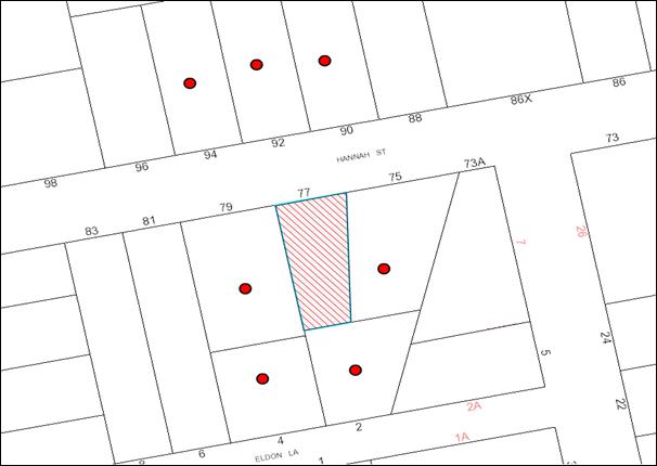
|
NOTIFICATION PLAN |
|
||
|
• PROPERTIES NOTIFIED
|
X SUBMISSIONS RECEIVED |
PROPERTY SUBJECT OF DEVELOPMENT |
|
6. THE PUBLIC INTEREST
Section 79C(1)(e) of the Act requires Council to consider “the public interest”.
The public interest is an overarching requirement, which includes the consideration of the matters discussed in this report. Implicit to the public interest is the achievement of future built outcomes adequately responding to and respecting the future desired outcomes expressed in environmental planning instruments and development control plans.
The application is considered to have satisfactorily addressed Council’s criteria and would provide a development outcome that, on balance, would result in a positive impact for the community. Accordingly, it is considered that the approval of the proposed development would be in the public interest.
CONCLUSION
The application proposes the erection of a two storey dwelling-house and associated works on a vacant allotment.
The application does not comply with the Hornsby Shire Council Local Environmental Plan 1994 in respect to Clause 15 ‘Floor Space Ratio’. The applicant submitted a State Environmental Planning Policy No. 1 objection to vary the floor space ratio development standard. The objection is considered well founded with regard to the existing development and the principles established by the Land and Environment Court.
There were no submissions received in response to notification of the proposed development.
Having regard to the circumstances of the case and consideration of the SEPP 1 objection, approval of the application is recommended.
Note: At the time of the completion of this planning report, no persons have made a Political Donations Disclosure Statement pursuant to Section 147 of the Environmental Planning and Assessment Act 1979 in respect of the subject planning application.
|
Rod Pickles Manager - Development Assessment Planning Division |
James Farrington Group Manager Planning Division |
|
1.View |
Locality Map |
|
|
|
2.View |
Site Plan |
|
|
|
3.View |
Floor Plans |
|
|
|
4.View |
Ground Floor Layout |
|
|
|
5.View |
Elevations |
|
|
|
6.View |
Stair Detail |
|
|
|
7.View |
Shadow Diagram |
|
|
|
8.View |
Soil and Water Management Plan |
|
|
File Reference: DA/403/2013
Document Number: D02186053
SCHEDULE 1
GENERAL CONDITIONS
The conditions of consent within this notice of determination have been applied to ensure that the use of the land and/or building is carried out in such a manner that is consistent with the aims and objectives of the relevant legislation, planning instruments and Council policies affecting the land and does not disrupt the amenity of the neighbourhood or impact upon the environment.
Note: For the purpose of this consent, the term ‘applicant’ means any person who has the authority to act on or the benefit of the development consent.
Note: For the purpose of this consent, any reference to an Act, Regulation, Australian Standard or publication by a public authority shall be taken to mean the gazetted Act or Regulation, or adopted Australian Standard or publication as in force on the date that the application for a construction certificate is made.
1. Approved Plans and Supporting Documentation
The development must be carried out in accordance with the plans and documentation listed below and endorsed with Council’s stamp, except where amended by Council and/or other conditions of this consent:
Approved Plans:
|
Plan No. |
Drawn by |
Dated |
|
Job No. 29908046 Sheet 2 Revision H |
Clarendon Homes |
06/09/2012 |
|
Job No. 29908046 Sheet 3 Revision H |
Clarendon Homes |
08/01/2013 |
|
Job No. 29908046 Sheet 4 Revision H |
Clarendon Homes |
08/01/2013 |
|
Job No. 29908046 Sheet 5 Revision H |
Clarendon Homes |
08/01/2013 |
|
Job No. 29908046 Sheet 6 Revision H |
Clarendon Homes |
08/01/2013 |
|
Job No. 29908046 Sheet 7 Revision H |
Clarendon Homes |
08/01/2013 |
|
Job No. 29908046 Sheet 2.2 Revision H |
Clarendon Homes |
09/04/2013 |
|
Job No. 29908046 Sheet 2.3 Revision H |
Clarendon Homes |
09/04/2013 |
|
Job No. C4205-08046 Sheet 1 of 2 Issue 1 |
Ibrahum Stormwater Consultants |
22/04/2013 |
|
Job No. C4205-08046 Sheet 2 of 2 Issue 1 |
Ibrahum Stormwater Consultants |
22/04/2013 |
Supporting Documentation:
|
Document No. |
Prepared by |
Dated |
|
Arboricultural Impact Assessment |
Arboreport |
22/07/2013 |
|
Statement of Environmental Effects |
Local Consultancy Services Pty Ltd |
April 2013 |
|
Objection pursuant to State Environmental Planning Policy No. 1 – Development Standards |
Local Consultancy Services Pty Ltd |
April 2013 |
|
BASIX Certificate Ref: 469800S |
Home Design Services |
08/04/2013 |
2. Removal of Existing Trees
This development consent only permits the removal of tree(s) numbered T1, T2, T3 and T4 as identified on Sheet 2 of Job No. 29908046 Revision H prepared by Clarendon Homes dated 05/09/2012. The removal of any other trees requires separate approval under Council’s Tree Preservation Order.
REQUIREMENTS PRIOR TO THE ISSUE OF A CONSTRUCTION CERTIFICATE
3. Building Code of Australia
All building work must be carried out in accordance with the relevant requirements of the Building Code of Australia.
4. Contract of Insurance (Residential Building Work)
In the case of residential building work for which the Home Building Act, 1989 requires there to be a contract of insurance in force in accordance with Part 6 of that Act, that such a contract of insurance is in force before any building work authorised to be carried out by the consent commences.
5. Notification of Home Building Act, 1989 Requirements
Residential building work within the meaning of the Home Building Act, 1989 must not be carried out unless the principal certifying authority for the development to which the work relates (not being Council) has given Council written notice of the following information:
a) In the case of work for which a principal contractor is required to be appointed:
i) The name and licence number of the principal contractor; and
ii) The name of the insurer by which the work is insured under Part 6 of that Act.
b) In the case of work to be done by an owner-builder:
i) The name of the owner-builder and;
ii) If the owner-builder is required to hold an owner-builder’s permit under that Act, the number of the owner-builder’s permit.
Note: If arrangements for doing the residential building work are changed while the work is in progress so that the information notified becomes out of date, further work must not be carried out unless the principal certifying authority for the development to which the work relates (not being Council) has given Council written notification of the updated information.
6. Sydney Water – Quick Check
This application must be submitted to a Sydney Water ‘Quick Check Agent’ or ‘Customer Centre’ for approval to determine whether the development would affect any Sydney Water infrastructure, and whether further requirements are to be met.
Note: Refer to www.sydneywater.com.au or telephone 13 20 92 for assistance.
REQUIREMENTS PRIOR TO THE COMMENCEMENT OF ANY WORKS
7. Erection of Construction Sign
A sign must be erected in a prominent position on any site on which building work, subdivision work or demolition work is being carried out:
a) Showing the name, address and telephone number of the principal certifying authority for the work;
b) Showing the name of the principal contractor (if any) for any demolition or building work and a telephone number on which that person may be contacted outside working hours; and
c) Stating that unauthorised entry to the work site is prohibited.
Note: Any such sign is to be maintained while the building work, subdivision work or demolition work is being carried out, but must be removed when the work has been completed.
8. Toilet Facilities
Toilet facilities must be available or provided at the works site before works begin and must be maintained until the works are completed at a ratio of one toilet for every 20 persons employed at the site. Each toilet must:
a) be a standard flushing toilet connected to a public sewer; or
b) be a temporary chemical closet approved under the Local Government Act, 1993.
9. Erosion and Sediment Control
Erosion and sediment control measures must be provided and maintained throughout the construction period in accordance with the manual ‘Soils and Construction 2004 (Bluebook)’, the approved plans, Council specifications and to the satisfaction of the principal certifying authority. The erosion and sediment control devices must remain in place until the site has been stabilised and revegetated.
Note: On the spot penalties up to $1,500 may be issued for any non-compliance with this requirement without any further notification or warning.
10. Project Arborist
A project arborist is to be appointed to oversee all works within the tree protection zone of all trees required to be retained on the subject site and adjoining properties and in accordance with the recommendations of the Arboricultural Impact Assessment prepared by Arboreport dated 22 July 2013.
REQUIREMENTS DURING CONSTRUCTION
11. Construction Work Hours
All work on site (including demolition and earth works) must only occur between 7am and 5pm Monday to Saturday. No work is to be undertaken on Sundays or public holidays.
12. Council Property
During construction works, no building materials, waste, machinery or related matter is to be stored on the road or footpath. The public reserve must be kept in a clean, tidy and safe condition at all times.
Note: This consent does not give right of access to the site via Council’s park or reserve. Should such access be required, separate written approval is to be obtained from Council.
13. Disturbance of Existing Site
During construction works, the existing ground levels of open space areas and natural landscape features, (including natural rock-outcrops, vegetation, soil and watercourses) must not be altered unless otherwise nominated on the approved plans.
14. Construction Methods
To ensure the health and longevity of trees required to be retained, all construction works within the tree protection zones of the significant trees on the public reserve are required to be carried out in accordance with the recommendations of the Arboricultural Impact Assessment prepared by Arboreport dated 22 July 2013.
15. Construction of Driveway
To provide a suitable access for the construction of the dwelling-house and to minimise adverse impacts to the significant trees located on the public reserve, the driveway must be constructed in accordance with the recommendations of the Arboricultural Impact Assessment prepared by Arboreport dated 22 July 2013 prior to the commencement of construction on the dwelling-house.
16. Survey Report – Finished Floor Level
A report(s) must be prepared by a registered surveyor and submitted to the principal certifying authority prior to the pouring of concrete at each level of the building certifying that:
a) The building, retaining walls and the like have been correctly positioned on the site; and
b) The finished floor level(s) are in accordance with the approved plans.
REQUIREMENTS PRIOR TO THE ISSUE OF AN OCCUPATION CERTIFICATE
Note: For the purpose of this consent, a reference to ‘occupation certificate’ shall not be taken to mean an ‘interim occupation certificate’ unless otherwise stated:
17. Fulfilment of BASIX Commitments
The applicant must demonstrate the fulfilment of BASIX commitments pertaining to the development.
18. Stormwater Drainage – Dwellings
An on-site stormwater detention system must be designed by a chartered civil engineer and constructed in accordance with the following requirements:
a) Have a capacity of not less than 5 cubic metres, and a maximum discharge (when full) of 8 litres per second.
b) Have a surcharge/inspection grate located directly above the outlet.
c) Discharge from the detention system to be controlled via 1 metre length of pipe, not less than 50 millimetres diameter or via a stainless plate with sharply drilled orifice bolted over the face of the outlet discharging into a larger diameter pipe capable of carrying the design flow to an approved Council system.
d) Not be constructed in a location that would impact upon the visual or recreational amenity of residents.
19. Vehicular Crossing
A separate application under the Local Government Act, 1993 and the Roads Act, 1993 must be submitted to Council for the installation of a new vehicular crossing and the removal of the redundant crossing. The vehicular crossing must be constructed in accordance with Council’s Civil Works Design, 2005.
Note: An application for a vehicular crossing can only be made to one of Council’s Authorised Vehicular Crossing Contractors. You are advised to contact Council on 02 9847 6940 to obtain a list of contractors.
20. Internal Driveway/Vehicular Areas
The driveway and parking areas on site must be designed in accordance with Australian Standards 2890.1, 2890.2, 3727 and the following requirements:
a) Design levels at the front boundary must be obtained from Council;
b) The driveway grade must not exceed 25 percent and changes in grade must not exceed 8 percent per plan metre;
c) To ensure the significant trees located on the public reserve are not adversely impacted upon by the construction of the driveway, the driveway is to be constructed above grade in accordance with the recommendations of the Arboricultural Impact Assessment prepared by Arboreport dated 22 July 2013.
21. Damage to Council Assets
Any damage caused to Council’s assets as a result of the construction of the development must be rectified in accordance with Council’s written requirements and at the sole cost of the applicant.
22. Retaining Walls
All required retaining walls must be constructed as part of the development.
23. Installation of Air Conditioner
To protect the amenity of adjacent properties, the condenser unit for the air conditioner must be sited a minimum of 3 metres from the property boundary of any adjoining residential premises unless a certificate has been prepared by a suitably qualified person confirming that the unit has been tested for heating and cooling on the highest settings and that the noise levels generated do not exceed 5 dB(A) above background noise levels when tested at the property boundary between 8 pm and 10 pm.
- END OF CONDITIONS -
ADVISORY NOTES
The following information is provided for your assistance to ensure compliance with the Environmental Planning and Assessment Act, 1979, Environmental Planning and Assessment Regulation 2000, other relevant legislation and Council’s policies and specifications. This information does not form part of the conditions of development consent pursuant to Section 80A of the Act.
Environmental Planning and Assessment Act, 1979 Requirements
The Environmental Planning and Assessment Act, 1979 requires:
· The issue of a construction certificate prior to the commencement of any works. Enquiries can be made to Council’s Customer Services Branch on 9847 6760;
· A principal certifying authority to be nominated and Council notified of that appointment prior to the commencement of any works;
· Council to be given at least two days written notice prior to the commencement of any works;
· Mandatory inspections of nominated stages of the construction inspected; and
· An occupation certificate to be issued before occupying any building or commencing the use of the land.
Long Service Levy
In accordance with Section 34 of the Building and Construction Industry Long Service Payments Act 1986, a ‘Long Service Levy’ must be paid to the Long Service Payments Corporation or Hornsby Council.
Note: The rate of the Long Service Levy is 0.35% of the total cost of the work.
Note: Hornsby Council requires the payment of the Long Service Levy prior to the issue of a construction certificate.
Tree Preservation Order
To ensure the maintenance and protection of the existing natural environment, it is an offence to ringbark, cut down, top, lop, remove, wilfully injure or destroy a tree outside 3 metres of the approved building envelope without the prior written consent from Council.
Note: A tree is defined a s a single or multi-trunked wood perennial plant having a height of not less than three (3) metres, and which develops many branches, usually form a distance of not less than one (1) metre from the ground, but excluding any plant which, in its particular location, is a noxious plant declared as such pursuant to the Noxious Weeds Act 1993. This definition of ‘tree’ includes any and all types of Palm trees.
All distances are determined under Australian Standard AS4970-2009 “Protection of Trees on Development Sites”.
Fines may be imposed for non-compliance with Council’s Tree Preservation Order.
Dial Before You Dig
Prior to commencing any works, the applicant is encouraged to contact Dial Before You Dig on 1100 or www.dialbeforeyoudig.com.au for free information on potential underground pipes and cables within the vicinity of the development site.
Asbestos Warning
Should asbestos or asbestos products be encountered during demolition or construction works, you are advised to seek advice and information prior to disturbing this material. It is recommended that a contractor holding an asbestos-handling permit (issued by WorkCover NSW) be engaged to manage the proper handling of this material. Further information regarding the safe handling and removal of asbestos can be found at:
Alternatively, telephone the WorkCover Asbestos and Demolition Team on 8260 5885.
Group Manager’s Report No. PL74/13
Planning Division
Date of Meeting: 21/08/2013
6 DEVELOPMENT APPLICATION - SUBDIVISION OF ONE ALLOTMENT INTO THREE LOTS AND CONSTRUCTION OF TWO ATTACHED DWELLINGS - 50 HINEMOA AVENUE, NORMANHURST
EXECUTIVE SUMMARY
|
DA No: |
DA/1365/2012 – (Lodged 21 December 2012) |
|
Description: |
Staged Torrens title subdivision of one allotment into three lots, retention of the existing dwelling-house and construction of a multi-unit housing development comprising two attached dwellings. |
|
Property: |
Lot B DP 347185, No. 50 Hinemoa Avenue, Normanhurst |
|
Applicant: |
Clarke Dowdle & Associates - Umina Beach |
|
Owner: |
Mr Peter Younes and Mrs Jacqueline Kim Younes |
|
Estimated Value: |
$500,000 |
|
Ward: |
B |
· The application proposes the staged Torrens title subdivision of one allotment into three, retention of the existing dwelling and construction of a multi-unit housing development comprising two attached dwellings.
· The proposal generally complies with the Hornsby Shire Local Environmental Plan 1994 and Council’s Residential Subdivision Development Control Plan and Low Density Multi-unit Housing Development Control Plan.
· Five submissions have been received in respect of the application.
· A Red Sticker has been placed on the application requiring that the application be determined at a Council meeting.
· It is recommended that the application be approved.
|
THAT Development Application No. DA/1365/2012 for the staged Torrens title subdivision of one allotment into three lots and construction of two attached dwellings at Lot B DP 347185, No. 50 Hinemoa Avenue, Normanhurst be approved subject to the conditions of consent detailed in Schedule 1 of Group Manager’s Report No. PL74/13. |
BACKGROUND
There is no history of the site that is relevant to this application.
SITE
The site is known as Lot B in Deposited Plan 347185, No. 50 Hinemoa Avenue, Normanhurst. The site has an area of 2,023m² and is located on the western side of Hinemoa Avenue. The site has a width of 15.24m to the street frontage, a depth of approximately 133.05m to the north and a depth of approximately 131.11m to the south. The site is accessed from Hinemoa Avenue.
The site falls to the rear with the front of the allotment having an average gradient of 8%. The site falls a creek that traverses across the rear of the property at an average gradient of 20%.
Existing improvements on the site include a brick and fibro cement single storey dwelling with ancillary garage.
The rear of the site is mapped as containing locally significant Blackbutt Gully Forest (Community L – Smith & Smith 2008). Locally native tree species recorded at the rear of the property that form part of this vegetation community include Sydney Turpentine (Syncarpia glomulifera).
PROPOSAL
The application proposes the staged Torrens title subdivision of one allotment into three and construction of a multi-unit housing development comprising two attached dwellings. The application is for a staged development as follows:
Stage 1
Stage 1 involves retention of the existing dwelling house and Torrens title subdivision of the existing allotment into two. Lot 1 would have an area of 669.5m² and Lot 2 would have an area of 1354m². Access to proposed Lot 2 would be via right of carriageway over Lot 1 from Hinemoa Avenue. Stage 1 would also include the construction of the driveway and ancillary works to the existing dwelling including the removal of eaves to accommodate the accessway.
Stage 2
Stage 2 would involve the Torrens title subdivision of the newly created rear allotment (Lot 2) into two allotments and construction of two attached dwellings. Lot 2 would have an area of 635m² and Lot 3 would have an area of 721.60m².
Proposed Dwelling A on Lot 3 would comprise a living/kitchen area, family/dining area with access to a deck to the rear, and laundry and bathroom on the ground floor. The first floor would comprise four bedrooms, an ensuite and bathroom. A detached carport is proposed to the fore of the dwelling with a clear sheeting colour bond roof.
Proposed Dwelling B on Lot 2 would comprise a living/dining area, a bathroom and a kitchen/family area with access to the outdoor deck area to the rear on the ground floor. The first floor would comprise four bedrooms, an ensuite and bathroom. Parking is provided in the form of an attached garage at the fore of the dwelling. Access to the dwelling is proposed via a side entrance towards the northern boundary.
A turning common area is provided to the fore of dwelling to enable vehicles to enter and leave the site in a forward direction.
ASSESSMENT
The development application has been assessed having regard to the draft ‘Metropolitan Plan for Sydney 2031’, the ‘North Subregion (Draft) Subregional Strategy’ and the matters for consideration prescribed under Section 79C of the Environmental Planning and Assessment Act 1979 (the Act). The following issues have been identified for further consideration.
1. STRATEGIC CONTEXT
1.1 Metropolitan Plan for Sydney and (Draft) North Subregional Strategy
The (Draft) Metropolitan Strategy for Sydney 2031 is a broad framework to provide for Sydney’s growth to help plan for housing, employment, transport, infrastructure, the environment and open space. It outlines a vision for Sydney to 2031; the challenges faced, and the directions to follow to address these challenges and achieve the vision.
The North Subregion comprises Hornsby, Kuring-gai, Manly, Warringah and Pittwater Local Government Areas. The Draft North Subregional Strategy acts as a framework for Council in its preparation of the Comprehensive LEP by the end of 2013.
Within the North Subregion, the Draft Metropolitan Strategy proposes:
· Population growth of 81,000 from the current 2011 baseline of 529,000
· Housing growth of 37,000 from the current 2011 baseline of 204,000
· Employment growth of 39,000 from the current 2011 baseline of 186,000
The proposed development would be consistent with the Metropolitan Plan for Sydney 2031 by providing an additional two dwellings.
2. STATUTORY CONTROLS
Section 79C(1)(a) requires Council to consider “any relevant environmental planning instruments, draft environmental planning instruments, development control plans, planning agreements and regulations”.
2.1 Section 91 EP&A Act 1979 – Integrated Development
The proposed subdivision is within 40 metres of an identified natural watercourse and requires approval of the NSW Office of Water for a controlled activity. The application was referred to the NSW Office of Water and following the submission of amended plans, the Office forwarded General Terms of Approval for the application. The Terms require control measures to be implemented to mitigate potential impacts on the creek. These Terms have been included as conditions in Schedule 1 of this report.
2.2 Hornsby Shire Local Environmental Plan 1994
The subject land is zoned Residential A (Low Density) under the Hornsby Shire Local Environmental Plan 1994 (HSLEP). The objectives of the Residential A zone are:
(a) to provide for the housing needs of the population of the Hornsby area.
(b) to promote a variety of housing types and other land uses compatible with a low density residential environment.
(c) to provide for development that is within the environmental capacity of a low density residential environment.
The proposed development is defined as ‘subdivision’ and ‘multi-unit housing’ under the HSLEP and is permissible in the zone with Council’s consent.
Clause 14 of the HSLEP prescribes that the minimum allotment area in the Residential A (Low Density) zone for the purpose of subdivision is 500m². The proposed lots sizes comply with this requirement.
Clause 15 of the HSLEP prescribes that the maximum floor space ratio (FSR) of development within the Residential A zone is 0.4:1. Clause 15 (4) of HSLEP states that;
‘the area of any accessway, right of carriageway or the like is to be excluded from the site area for the purposes of calculating the floor space ratio.’
In this regard, the proposed floor space ratio for the development complies with this requirement.
Clause 18 of the HSLEP sets out heritage conservation provisions for Hornsby Shire. The site is not identified as an item of heritage and is not within a heritage conservation area nor is it in the vicinity of a heritage item.
2.3 Draft Hornsby Shire Local Environmental Plan
The draft Hornsby Local Environmental Plan (DHLEP) was endorsed by Council at its meeting on 19 December 2012 to be forwarded to the Minister for Planning and Infrastructure to be made. In accordance with Council’s resolution, the draft Plan has been submitted to the Department for finalisation. The draft LEP essentially reiterates the current land use zoning applicable to the site as outlined below.
2.3.1 Zoning
Under the DHLEP, the subject land would be zoned R2 - Low Density Residential. “Subdivision” would be a permissible development in the zone under the DHLEP. ‘Multi-unit housing’ would not be a permissible use in the zone.
2.3.2 Minimum Lot Size
Clause 4.1 of the DHLEP provides that the size of any lot resulting from a subdivision of land must not be less than the minimum size show on the Lot Size Map. In accordance with the Lot Size Map, the minimum allotment size is 500m2. Proposed Lot 1 would not comply with this requirement when the Right of Carriageway is excluded.
In this regard, the savings provision under Clause 1.8A is to be considered:
1.8A Savings provision relating to development applications (local)
If a development application has been made before the commencement of the Plan in relation to land to which this Plan applies and the application has not been finally determined before that commencement, the application must be determined as if this Plan has been exhibited by not commenced.
The provisions of the DHLEP are a matter for consideration under Section 79C(1)(a)(ii) of the Environmental Planning and Assessment Act 1979. In accordance with Clause 1.8A of DHLEP, ‘multi-unit housing’ and the proposed allotment size and layout comply with the requirements of HSLEP, 1994 and are acceptable in this regard.
Refusal of the application in respect to the provisions of the DHLEP is considered unwarranted in the circumstances of this application.
2.4 Sydney Regional Environmental Plan (Sydney Harbour Catchment) 2005
The application has been assessed against the requirements of Sydney Regional Environmental Plan (Sydney Harbour Catchment) 2005. This Policy provides State-wide planning controls to consider the impacts of development on water quality, scenic quality, aquaculture, recreation and tourism.
The application was referred to the Office of Water as the development is within 40m of an identified natural watercourse. A 10m vegetated riparian corridor is required extending from the watercourse. Furthermore, the applicant must comply with the conditions provided by the Office of Water in Schedule 1 of this report and accordingly, apply for a Controlled Activity Approval after development consent is issued. These measures would ensure impacts by the proposal on the water quality of the watercourse are minimised.
Water quality is the only relevant issue to the assessment of the proposal. Subject to recommended conditions requiring the installation of an onsite detention system and sediment and erosion control measures, the proposed development would not have a detrimental impact upon the water quality of the catchment. The proposal complies with the requirements of the Policy.
2.5 State Environmental Planning Policy No. 55 – Remediation of Land
Clause 7 of State Environmental Planning Policy No. 55 - Remediation of Land (SEPP 55) requires Council to consider whether land is contaminated prior to granting consent to the carrying out of any development on that land.
Should the land be contaminated, Council must be satisfied that the land is suitable in a contaminated state for the proposed use. If the land requires remediation to be undertaken to make the land suitable for the proposed use, Council must be satisfied that the land will be remediated before the land is used for that purpose.
One objection raises concerns relating to asbestos removal and the treatment of vegetation with wholesale chemicals at the property. The site history and site inspections indicate a history of residential development and it is not likely that the site would be contaminated. The use of chemicals for weed control would not cause significant contamination of the property. The removal of asbestos from the property would be subject to compliance with the Conditions of Consent in Schedule 1 of this report. Accordingly, further assessment under SEPP 55 is not required.
2.6 State Environmental Planning Policy (Building Sustainability Index – BASIX) – 2004
The application has been assessed against the requirements of State Environmental Planning Policy (Building Sustainability Index: BASIX) 2004. One submission raises concerns relating to the provision of an appropriate BASIX certificate. The applicant has submitted BASIX Certificate Nos. 462782S_02 and 462787S_02 in conjunction with amended plans for proposed dwellings A and B and is considered to be satisfactory with respect to SEPP BASIX.
2.7 Section 94 Contribution
The proposed development would result in the creation of two additional allotments. Accordingly, a Section 94 Contribution is proposed to be levied prior to the issue of the Subdivision Certificate. A condition of Consent has been included in Schedule 1 of this report.
2.8 Clause 74BA Environmental Planning and Assessment Act, 1979 – Purpose and Status of Development Control Plans
On 1 March 2013, the Environmental Planning and Assessment Act, 1979 was amended so that a DCP provision will have no effect if it has the practical effect of “preventing or unreasonably restricting development” that is otherwise permitted and complies with the development standards set out in relevant Local Environmental Plans and State Environmental Planning Policies.
The principal purpose of a development control plan is to provide guidance on the aims of any environmental planning instrument that applies to the development; facilitating development that is permissible under any such instrument; and achieving the objectives of land zones under any such instrument. The provisions of a development control plan made for that purpose are not statutory requirements.
2.9 Residential Subdivision Development Control Plan and Low Density Multi Unit Housing Development Control Plan
The proposed development has been assessed having regard to the relevant performance and prescriptive design requirements within Council’s Residential Subdivision Development Control Plan (Residential Subdivision DCP) and Council’s Low Density Multi Unit Housing Development Control Plan (Multi Unit Housing DCP). The following table sets out the proposal’s compliance with the prescriptive requirements of the Plans:
|
Residential Subdivision DCP and Low Density Multi Unit Housing DCP |
|||
|
Control |
Proposal |
Requirement |
Complies |
|
Site area |
2023m² |
N/A |
N/A |
|
Proposed allotment size STAGE 1 Lot 1 Lot 2 STAGE 2 Lot 1 Lot 2 Lot 3 |
669.5m² 1354m²
669.5m2 635m2 721m2 |
500m² 500m²
500m² 500m² 500m² |
Yes Yes
Yes Yes Yes |
|
Proposed Floor Area STAGE 1 Existing Dwelling STAGE 2 Existing Dwelling (Lot 1) Dwelling A (Lot 3) Dwelling B (Lot 2) |
127.31m2
127.31m² 176.29m² 155.12m² |
N/A |
N/A |
|
Proposed Floor Space Ratio (FSR) STAGE 1 Existing Dwelling STAGE 2 Dwelling A (Lot 3) Dwelling B (Lot 2) |
0.25:1
0.25:1 0.27:1 |
0.4:1
0.4:1 0.4:1 |
Yes
Yes Yes |
|
Proposed Site Coverage – STAGE 2 Existing Dwelling (Lot 1) Dwelling A (Lot 3) Dwelling B (Lot 2) |
28% 18% 16% |
40% 40% 40% |
Yes Yes Yes |
|
STAGE 2 – Setbacks Lot 1 – Existing Dwelling Front (East) Side (North) Side (South) Rear (West)
Lot 2 - Dwellings B Front (East) Side (North) Side (South) Rear (West)
Lot 3 – Dwelling A Front (East) Side (North) Side (South) Rear (West) |
8m 3.5m 2.43m 15.4m
10.2m 0.9m 0m (attached) >30m
3.0m 0m (attached) 0.9m >30m |
6m 1m 1m 3m
6m 1m 1m 3m
6m 1m 1m 3m |
Yes Yes Yes Yes
Yes No No Yes
Yes No No Yes |
|
STAGE 2 – Height Dwelling A (Lot 3) Dwelling B (Lot 2) |
7.2m 7.2m |
9m 9m |
Yes Yes |
|
STAGE 2 – Unbroken wall length
Dwelling A and B (attached) |
8.4m |
10m |
Yes |
|
STAGE 2 – Total building length Dwelling A and B (attached) |
18.9m |
24m |
Yes |
|
Cut and fill Dwelling A Dwelling B |
1m 1.6m
|
1m 1m |
Yes No – See discussion below |
|
Landscaped area Existing Dwelling Dwelling A Dwelling B |
45% >60% >60% |
45% 45% 45% |
Yes Yes Yes |
|
Private Open Space Existing Dwelling Dwelling A (Lot 3) Dwelling B (Lot 2) |
140m² >120m² >120m² |
100m² 120m² 120m² |
Yes Yes Yes |
As detailed in the above table, the proposed development does not comply with a number of prescriptive requirements within Council’s Residential Subdivision and Low Density Multi-Unit Housing DCP. The matters of non-compliance are detailed below, as well as a brief discussion on compliance with relevant performance requirements.
2.9.1 Density
Two submissions object to the creation of an undersized allotment. Proposed Lot 1 would have an area of 669.8m² (485.84m² excluding the right of carriageway). Clause 14 of the HSLEP states; ‘In calculating the area of a battle-axe or hatchet shaped allotment, the area of any accessway, right of carriageway or the like is to be excluded’. As a battle-axe arrangement is not proposed in this instance, this does not apply. Therefore, the proposal complies with Clause 14 of the HSLEP and the density requirement of the Residential Subdivision DCP.
2.9.2 Setbacks
The Multi Unit Housing DCP requires a 1m setback from side boundaries; however a variance may be accepted with reference to the performance criteria. Two submissions object to the reduced setback of 0.9m from the northern boundary. There are no windows proposed on the first floor of this section of the reduced setback and accordingly, the minor non-compliance would not result in an adverse privacy effects. Furthermore, the setback is to the northern boundary and accordingly, no overshadowing would occur. The reduced setback is for 4.4m of the elevation. The setback increases to 1.38m to 2.68m for the remainder of the northern elevation. The reduction of 0.1m is acceptable in this instance.
The submissions also object to the carport of Unit A being setback 0.9m from the southern boundary. The carport has a flat roof and would be constructed of clear colour bond sheeting. The reduced setback is required to comply with AS 2890.1 to ensure vehicles leave the site in a forward motion. The reduced setback of 0.1m would not have an adverse effect and is acceptable in this instance.
2.9.3 Private Open Space
The existing dwelling would have a private open space area in excess of 120m². In relation to the proposed multi-unit dwellings, the application proposes alfresco areas to the side of both dwellings A and B. Direct access is provided to these areas from the living areas of the dwellings. Balconies have also been incorporated to the rear of the dwellings and are accessible from living areas. Furthermore, the area to the rear of the site would remain undeveloped and may be used as passive open space subject to compliance with the conditions of consent recommended in Schedule 1 of this report. The proposal complies with the requirements of the Private Open Space Element of the DCP.
2.9.4 Privacy
Four submissions raise concerns in relation to adverse privacy effects as a result of the proposed development. One submission raises concerns relating to potential overlooking from the upstairs bathroom of proposed Unit A. A condition of consent recommends a raised sill height of 1.5m to alleviate any overlooking concerns.
One submission raises concerns relating to the overlooking of the private open space and living areas of the property adjoining the southern boundary of dwelling A. The applicant has submitted amended plans minimising the number of windows on this boundary to avoid overlooking and to provide sunlight to the dwelling. Furthermore, dwelling A has been designed so that the window of bedroom 4 is setback 3.4m from the boundary. A condition of consent requires a raised sill height of 1.5m above finished floor level for this window to minimise any potential overlooking.
One submission objects to overlooking of the dwelling at No. 54A Hinemoa Avenue. The window of the existing dwelling house at the boundary of this property is a bathroom window and would be appropriately screened. A condition of consent is recommended to ensure a privacy screen is placed on the balcony of dwelling A to minimise any potential overlooking. Furthermore, the existing 1.8m boundary fence is to be continued as marked on approved plans to minimise any overlooking from the private open space of the proposed dwellings.
One submission objects to the proposed rear balcony of dwelling B and potential overlooking to the adjoining property to the north. A condition of consent recommends a privacy screen on the proposed balcony of dwelling B on northern boundary to ensure no direct overlooking of the neighbouring property. The submission also raises concerns relating to overlooking from the windows of dwelling B to the north. The boundary of Lot 2 adjoins the driveway of No. 48 Hinemoa Avenue and any overlooking would not be to private open space but to a driveway and parking area. The presence of the 1.8m fence would minimise any potential overlooking. The proposal would not have adverse privacy implications to the northern boundary.
Given the constraints of the site, the design adopted and the measures taken to reduce any adverse privacy effects, subject to the conditions of consent included in schedule 1 of this report, the application is acceptable in terms of the Privacy Element of the DCP.
2.9.5 Solar Access
Three submissions object to the proposal on the basis that it would cause excessive overshadowing of the adjoining properties. The applicant submitted amended plans to address the concerns raised. The carport to the fore of dwelling A has a flat roof and clear sheeting to minimise shadow impact on the adjoining property to the south. The applicant further amended plans to articulate the southern elevation to provide a 3.3m x 1.8m indent and also reduced the first floor building length by 1.2m.
These design changes have achieved compliance with the Multi Unit Housing DCP requirement of 4 hours sunshine to private open space of adjacent dwellings on 22 June.
The adjoining property is set down 1.4m from the subject site and has been designed with living areas orientated to the side boundary. The amendments to the proposal have afforded morning sunlight to a portion of the surface of the living room window of the adjoining dwelling. The remaining two windows would not achieve the required 3 hours of sunlight on 22 June when a 1.8m fence is erected on the boundary. A single storey dwelling would also overshadow these windows.
The dwelling to the south west of the proposed units would receive 3 hours of sunlight in accordance with the DCP. The existing dense vegetation on the site currently impedes sunlight to the property and this situation would not change. Similarly, the living areas are orientated to the side of the dwelling and are set down from the subject site.
In this instance, given the topography of the site and the design changes adopted by the applicant, the solar access requirement is considered acceptable in relation to the proposal.
2.9.6 Cut and Fill
The application proposes 1.9m fill to the rear of dwelling B. This is required due to the topography of the land. The site slopes significantly to the rear and is vegetated. The Privacy Element has been discussed in detail in Section 2.9.3 above. Dwelling B does not encroach on the trees to the rear and the minor area of fill is acceptable in this instance.
2.9.7 Vehicle Access and Parking
Proposed access to the property is via right of carriageway over Lot 1 leading to proposed Lot 2 to the rear at Stage 1 and proposed Lots 2 and 3 at Stage 2. A right of carriageway and turning area is also proposed over Lot 2 and 3 to provide a common turning area and access to the carport and garage.
The existing dwelling would encroach onto the proposed driveway and plans have been submitted demonstrating the removal of the eaves and ancillary works to enable retention of the dwelling and safe vehicular access. A condition of consent has also been included to ensure any structures encroaching on the accessway are removed and the area made good. Two submissions object to the proposed access arrangement.
The internal driveway would have a width of 4m reduced to a width of 3.5m for 10m adjoining the existing dwelling. The Residential Subdivision DCP requires:
“Accessways servicing up to 6 dwellings should have a width of 4.0m consisting of a carriageway of 3m, excluding kerbs, with landscape verge of 0.5m on each side.”
The proposal achieves a carriageway width of 3m for the entirety of the driveway. The driveway would also have adequate area for landscaping 0.5m on either side of the carriageway with the exception of the 10 metres adjoining the existing dwelling. It is noted that 0.5m is available for landscaping opposite the dwelling and the non-compliance refers to the inability to provide 0.5m landscaping on the southern side for 10m. Council’s draft DCP requires a carriageway of 3.5m for one to three lots. The proposal would comply with this requirement. Given the provision of landscaping for the majority of the accessway and compliance with Councils draft DCP, the proposal is considered acceptable in this instance. The subdivision allows sufficient space for vehicles to turn and exit the site in a forward direction.
A condition of consent recommends landscaping 0.5m wide along both sides of the driveway with the exception of the area on the southern side adjoining the existing dwelling for 10m.
A 1.2m fence is proposed adjoining the driveway and to the rear of the existing dwelling. This would screen the dwelling from the driveway particularly at the porch and entrance. It would also prevent direct access to the driveway from Lot 1.
2.9.8 Car Parking Development Control Plan
Two carparking spaces would be provided for each dwelling on proposed Lots 2 and 3. One submission objects to increased traffic and on street parking in conjunction with the proposal. There is sufficient parking incorporated into the dwelling design to provide for the proposed dwellings. The existing dwelling proposes an additional car space to the rear of the lot with access from the carriageway. No additional on street parking would be required as a result of the proposal. The proposal is acceptable with regards to the Car Parking DCP.
3. ENVIRONMENTAL IMPACTS
Section 79C(1)(b) of the Act requires Council to consider “the likely impacts of that development, including environmental impacts on both the natural and built environments, and social and economic impacts in the locality”.
3.1 Natural Environment
The proposed development would necessitate the removal of 18 trees from the site. Four submissions object to the removal of trees from the site. The submissions object to the removal of a Kafir Plum tree from the property. This is not identified as a significant tree under Council’s Tree Protection Order and accordingly, it would be removed to facilitate the development.
The rear of the site is mapped as containing locally significant Blackbutt Gully Forest (Community L – Smith & Smith 2008). Locally native tree species recorded at the rear of the property that form parts of this vegetation community include Sydney Turpentine (Syncarpia glomulifera).
One of the objections raises specific concerns relating to the impact of the proposal on the significant trees to the rear of the site. The original application proposed a building envelope which would have an adverse impact on the trees to the rear. The applicant submitted amended plans including a cantilevered balcony to alleviate any impact. Conditions of consent are recommended in Schedule 1 of this report including the requirement for a project arborist to be present on site during construction, hand excavation to ensure protection of the tree roots and specific construction techniques such as a raised slab, and pier and beam construction to protect the trees.
Furthermore, a Riparian Planting and Management Plan would be required prior to the issue of an Occupation Certificate. To ensure the regeneration of bushland and enhancement of the riparian corridor, the applicant would be required to provide a plan prepared by a qualified bushland restoration company (Certificate 3 in Natural Area Restoration (TAFE) or similar) in accordance with Council guidelines. A restricted development area would also be required to be demonstrated on title ensuring no construction in the nominated area.
One tree would also be removed from the nature strip to facilitate the driveway. A condition requiring replanting is recommended in Schedule 1 of this report.
It is considered that the removal of the trees is acceptable in the circumstances of the case due to topography of the site and the applicant’s retention of 852.76m² of bushland area to the rear of the site.
3.2 Built Environment
The proposal is for subdivision with development to the rear of the existing dwelling. There would be minimal impact on the existing streetscape. One submission raises concerns relating to the view of the proposed dwellings from the street. The site slopes significantly to the rear and the driveway would be landscaped as required. The view impact from the street would be minimal. Accordingly, the proposal would not have a negative impact on the existing streetscape.
3.3 Social Impacts
The proposal would not have a negative social impact on the locality.
3.4 Economic Impacts
The proposal would have a minor positive impact on the local economy in conjunction with other new low density residential development in the locality by generating an increase in demand for local services. Two submissions raise concerns in relation to the loss in value of the adjoining properties. This is not required to be considered under Section 79C of the Environmental Planning and Assessment Act 1979.
4. SITE SUITABILITY
Section 79C(1)(c) of the Act requires Council to consider “the suitability of the site for the development”.
The subject site has not been identified as bushfire prone land.
4.1 Flooding
The rear portion of the site is identified as being below the 1:100 year flood level. The application is accompanied by Flood Study prepared by RGH Consulting Group Pty. Ltd.
The flood study addresses stormwater generated by a catchment external to the site, along public roads and through the site from overland flows associated with the watercourse on the west of the site with reference to Australian Rainfall and Runoff (AR&R) and the NSW Floodplain Development Plan. This has shown that the subject watercourse can expect flows up to 6m³/s during the 1 in 100 year ARI rainfall event. A condition is recommended in Schedule 1 of this report requiring a restriction on the use of land for proposed Lot 2 to have a minimum floor level of 160.08m AHD. Subject to implementation of the condition the site is suitable for development in this regard.
5. PUBLIC PARTICIPATION
Section 79C(1)(d) of the Act requires Council to consider “any submissions made in accordance with this Act”.
5.1 Community Consultation
The proposed development was placed on public exhibition and was notified to adjoining and nearby landowners between 17 January to 7 February 2013 in accordance with Council’s Notification and Exhibition Development Control Plan. During this period, Council received five submissions. Amended plans were notified from 9 April to 23 April 2013 and five submissions were received. Amended plans were again notified from 2 July to 16 July 2013 and five submissions were received. The map below illustrates the location of those nearby landowners who made a submission.
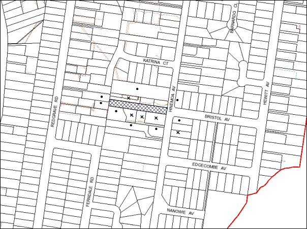
|
NOTIFICATION PLAN |
|
||
|
• PROPERTIES NOTIFIED
|
X SUBMISSIONS RECEIVED |
PROPERTY SUBJECT OF DEVELOPMENT |
|
Five submissions object to the development, generally on the grounds that the development would result in:
· Unacceptable overshadowing of adjoining properties;
· Unacceptable overlooking of adjoining properties;
· The removal of significant trees;
· Development that is excessive in height, bulk and scale;
· Inadequate and unsafe accessway to the rear allotment;
· Insufficient information and incorrect dimensions;
· Threats of a complying development proposal larger than that proposed;
· Loss in value of adjoining properties.
The merits of the matters raised in community submissions have been addressed in the body of the report.
5.2 Public Agencies
The development application is Integrated Development under the Act. Accordingly, the application was referred to the NSW Office of Water for comments.
5.2.1 NSW Office of Water
The application was referred to the NSW Office of Water in accordance with Section 91 (subsection 2) of the Water Management Act 2000 and Clause 66 of the Environmental Planning & Assessment Regulation, 2000. Following the submission of amended plans, the Office of Water has issued its General Terms of Approval for the application. These terms have been included as conditions in Schedule 1 of this report. A condition of consent requires plans to demonstrate a 10m fully vegetated riparian corridor as required by the Office of Water. This was shown on plans originally submitted however, is absent from the amended plans at Stage 1.
6. THE PUBLIC INTEREST
Section 79C(1)(e) of the Act requires Council to consider “the public interest”.
The public interest is an overarching requirement, which includes the consideration of the matters discussed in this report. Implicit to the public interest is the achievement of future built outcomes adequately responding to and respecting the future desired outcomes expressed in environmental planning instruments and development control plans.
The application is considered to have satisfactorily addressed Council’s and relevant agencies’ criteria and would provide a development outcome that, on balance, would result in a positive impact for the community. Accordingly, it is considered that the approval of the proposed development would be in the public interest.
CONCLUSION
The application proposes the staged subdivision of one allotment into three and construction of a multi-unit housing development comprising two attached dwellings.
The development generally meets Council’s planning controls and is satisfactory having regard to the matters for consideration pursuant to Section 79C of the Environmental Planning and Assessment Act 1979.
Five submissions were received in respect to the notified amended plans and these objections have been addressed within the body of the report.
Appropriate conditions of consent are recommended to provide for the proposed development and minimise impacts to surrounding residential amenity.
Having regard to the circumstances of the case, approval of the application is recommended.
Note: At the time of the completion of this planning report, no persons have made a Political Donations Disclosure Statement pursuant to Section 147 of the Environmental Planning and Assessment Act 1979 in respect of the subject planning application.
|
Rod Pickles Manager - Development Assessment Planning Division |
James Farrington Group Manager Planning Division |
|
1.View |
Locality Map |
|
|
|
2.View |
Site Plan |
|
|
|
3.View |
Landscape Plan |
|
|
|
4.View |
Floor Plans |
|
|
|
5.View |
Elevations |
|
|
File Reference: DA/1365/2012
Document Number: D02263564
SCHEDULE 1
GENERAL CONDITIONS
The conditions of consent within this notice of determination have been applied to ensure that the use of the land and/or building is carried out in such a manner that is consistent with the aims and objectives of the relevant legislation, planning instruments and council policies affecting the land and does not disrupt the amenity of the neighbourhood or impact upon the environment.
Note: For the purpose of this consent, the term ‘applicant’ means any person who has the authority to act on or the benefit of the development consent.
Note: For the purpose of this consent, any reference to an act, regulation, Australian standard or publication by a public authority shall be taken to mean the gazetted act or regulation, or adopted Australian standard or publication as in force on the date that the application for a construction certificate is made.
STAGE 1 – SUBDIVISION AND ASSOCIATED WORKS
1. Approved Plans and Supporting Documentation
The development must be carried out in accordance with the plans and documentation listed below and endorsed with Council’s stamp, except where amended by Council and/or other conditions of this consent:
|
Plan No. |
Sheet No. |
Drawn by |
Dated |
|
Stage 1 – Proposed Subdivision – DA Final |
2 of 6 |
Clarke Dowdle and Associates |
17/7/2013 |
|
Proposed Ground Floor Plan – “Existing” |
3 of 4 |
Leba-Louis Abdo |
Feb. 2013 |
|
Section A – A |
4 of 4 |
Leba-Louis Abdo |
Feb. 2013 |
|
Site Tree Location Plan |
|
Hornsby Shire Council |
9/5/2013 |
Supporting Documentation
|
Plan No. |
Drawn by |
Dated |
|
Flood Study |
RGH Consulting Group |
15/11/2012 |
2. Amendment of Plans
The approved plans are to be amended as follows:
a) Stage 1 – Subdivision
A 10m fully vegetated riparian corridor is required on a first order watercourse from the top of the bank. No infrastructure should be included in this area. Stage 1 – Proposed Subdivision – DA Final prepared by Clarke Dowdle and Associates dated 17 July 2013 is to be amended showing the proposed 10m riparian corridor in accordance with the Office of Water’s guidelines which are available at: www.water.nsw.gov.au > Water Licensing > Approvals > Controlled Activities.
3. Project Arborist
A Project Arborist is to be appointed prior to commencement of any works in accordance with the AS 4970-2009 (1.4.4) and to provide monitoring and certification throughout the development process.
4. Removal of Existing Trees
This development consent only permits the removal of tree numbered 1, 2, 3, 4, 5, 6, 7, 8, 9, 10, 11, 12, 13, 14, 15, 16, 20 and 21 as identified on Site Tree Location Plan dated 9 May 2013. The removal of any other trees requires separate approval under Council’s Tree Preservation Order.
The removal of tree 1 located on the nature strip shall be undertaken in accordance with the following:
a) A suitably qualified and experienced Arborist (Australian Qualification Level 3 or higher) shall be employed to undertake the works.
b) A copy of the Arborist’s (Tree Contractors) Public Liability Insurance Certificate and qualifications shall be provided to Council prior to the works date.
c) Notification of the date of works is to be provided one week in advance.
REQUIREMENTS PRIOR TO THE ISSUE OF A CONSTRUCTION CERTIFICATE
5. Building Code of Australia
All building work must be carried out in accordance with the requirements of the Building Code of Australia.
6. Contract of Insurance (Residential Building Work)
In the case of residential building work for which the Home Building Act, 1989 requires there to be a contract of insurance in force in accordance with Part 6 of that Act, that such a contract of insurance is in force before any building work authorised to be carried out by the consent commences.
7. Stormwater Drainage
The stormwater drainage system for the development must be designed and constructed in accordance with Council’s Civil Works – Design and Construction Specification 2005 and the following requirements:
a) Connected to the watercourse in accordance with the requirements of the Office of Water and Councils Sustainable Water DCP.
b) An inter-allotment stormwater drainage system to service the proposed lot with pits being constructed in situ.
c) The roof and stormwater drainage system from the existing dwelling to be connected to the proposed inter-allotment drainage system.
8. Internal Driveway/Vehicular Areas
The driveway and parking areas on site must be designed in accordance with Australian Standards 2890.1, 2890.2, 3727 and the following requirements:
a) Design levels at the front boundary be obtained from Council.
b) The driveway be a rigid pavement.
c) The driveway grade must not exceed 25 percent and changes in grade must not exceed 8 percent.
d) The driveway pavement be a minimum 3 metres wide, 0.15 metres thick reinforced concrete with F72 steel reinforcing fabric and a 0.15 metre sub-base.
e) The pavement have a kerb to one side and a one-way cross fall with a minimum gradient of 2 percent and a lintel and pit provided at the low point.
f) Retaining walls required to support the carriageway and the compaction of all fill batters to be in accordance with the requirements of a chartered structural engineer.
g) The provision of safety rails where there is a level difference more than 0.3 metres and a 1:4 batter can not be achieved.
h) Planting of landscaping strips 0.5 metres wide along both sides of the length of the driveway, with the exception of the area adjoining the driveway where the dwelling protrudes 0.5m for 10m on the southern side. 0.5m landscaping is to be provided for 10m on the northern side only in this area.
i) A common turning area to service the proposed subdivision in accordance with Australian Standards AS 2890.1 to ensure vehicles can enter and leave the site in a forward direction. A right of access shall be created over the turning area to ensure access is maintained at all time.
j) Conduit for utility services including electricity, water, gas, NBN and telephone be provided.
9. Vehicular Crossing
A separate application under the Local Government Act, 1993 and the Roads Act, 1993 must be submitted to Council for the installation of a new vehicular crossing and the removal of the redundant crossing. The vehicular crossing must be constructed in accordance with Council’s Civil Works Design, 2005 and the following requirements:
a) Any redundant crossings to be replaced with integral kerb and gutter.
b) The footway area to be restored by turfing.
Note: An application for a vehicular crossing can only be made to one of Council’s Authorised Vehicular Crossing Contractors. You are advised to contact Council on 02 9847 6940 to obtain a list of contractors.
10. Traffic Control Plan
A Traffic Control Plan (TCP) must be prepared by a qualified traffic controller in accordance with the Roads & Traffic Authority’s Traffic Control at Worksites Manual 1998 and Australian Standard 1742.3 for all work on a public road and be submitted to Council. The TCP must detail the following:
a) Arrangements for public notification of the works.
b) Temporary construction signage.
c) Permanent post-construction signage.
d) Vehicle movement plans.
e) Traffic management plans.
f) Pedestrian and cyclist access/safety.
REQUIREMENTS PRIOR TO THE COMMENCEMENT OF ANY WORKS
11. Erection of Construction Sign
A sign must be erected in a prominent position on any site on which building work, subdivision work or demolition work is being carried out:
a) Showing the name, address and telephone number of the principal certifying authority for the work,
b) Showing the name of the principal contractor (if any) for any demolition or building work and a telephone number on which that person may be contacted outside working hours, and
c) Stating that unauthorised entry to the work site is prohibited.
Note: Any such sign is to be maintained while the building work, subdivision work or demolition work is being carried out, but must be removed when the work has been completed.
12. Protection of Adjoining Areas
A temporary hoarding, fence or awning must be erected between the work site and adjoining lands before the works begin and must be kept in place until after the completion of the works if the works:
a) Could cause a danger, obstruction or inconvenience to pedestrian or vehicular traffic.
b) Could cause damage to adjoining lands by falling objects.
c) Involve the enclosure of a public place or part of a public place.
Note: Notwithstanding the above, Council’s separate written approval is required prior to the erection of any structure or other obstruction on public land.
13. Toilet Facilities
Toilet facilities must be available or provided at the works site before works begin and must be maintained until the works are completed at a ratio of one toilet for every 20 persons employed at the site. Each toilet must:
a) be a standard flushing toilet connected to a public sewer; or
b) be a temporary chemical closet approved under the Local Government Act, 1993; or
c) have an on-site effluent disposal system approved under the Local Government Act, 1993.
14. Erosion and Sediment Control
Erosion and sediment control measures must be provided and maintained throughout the construction period in accordance with the manual ‘Soils and Construction 2004 (Bluebook)’, the approved plans, Council specifications and to the satisfaction of the principal certifying authority. The erosion and sediment control devices must remain in place until the site has been stabilised and revegetated.
Note: On the spot penalties up to $1,500 may be issued for any non-compliance with this requirement without any further notification or warning.
15. Tree Protection Barriers
Tree protection fencing must be erected around trees numbered 17,18 and 19 to be retained at a 5 metre setback. The tree fencing must be constructed of 1.8 metre ‘cyclone chainmesh fence’
To avoid injury or damage, trees numbered 17, 18 and 19 must have trunks protected by 2 metre lengths of 75mm x 25mm hardwood timbers spaced at 80mm secured with galvanised wire (not fixed or nailed to the tree in any way
REQUIREMENTS DURING CONSTRUCTION
16. Construction Work Hours
All work on site (including demolition and earth works) must only occur between 7am and 5pm Monday to Saturday.
No work is to be undertaken on Sundays or public holidays.
17. Demolition
All demolition work must be carried out in accordance with Australian Standard 2601-2001 – The Demolition of Structures and the following requirements
a) Demolition material is to be disposed of to an authorised recycling and/or waste disposal site and/or in accordance with an approved waste management plan.
b) Demolition works, where asbestos material is being removed, must be undertaken by a contractor that holds an appropriate licence issued by WorkCover NSW in accordance with Chapter 10 of the Occupational Health and Safety Regulation 2001 and Clause 29 of the Protection of the Environment Operations (Waste) Regulation 2005.
c) On construction sites where buildings contain asbestos material, a standard commercially manufactured sign containing the words ‘DANGER ASBESTOS REMOVAL IN PROGRESS’ measuring not less than 400mm x 300mm must be erected in a prominent position visible from the street.
18. Environmental Management
The site must be managed in accordance with the publication ‘Managing Urban Stormwater – Landcom (March 2004) and the Protection of the Environment Operations Act 1997 by way of implementing appropriate measures to prevent sediment run-off, excessive dust, noise or odour emanating from the site during the construction of the development.
19. Works Near Trees
All required tree protection measures are to be maintained in good condition for the duration of the construction period.
All works (including driveways and retaining walls) within 5 metres of any trees required to be retained (whether or not on the subject property, and pursuant to this consent or the Tree Preservation Order), must be carried out under the supervision of an ‘AQF Level 5 Arborist’ and a certificate submitted to the principal certifying authority detailing the method(s) used to preserve the tree(s).
During the installation of services within the nominated restriction zone of any tree to be retained, tunnel boring shall be used at a minimum depth of 1.0 metres below natural ground level to reduce damage to the root system. A qualified and experienced arborist is to be on site overseeing the work to ensure that the roots are cut cleanly and that the works will not adversely affect the longevity of the tree.
Note: Except as provided above, the applicant is to ensure that no excavation, filling or stockpiling of building materials, parking of vehicles or plant, disposal of cement slurry, waste water or other contaminants is to occur within the TPZ of any tree to be retained.
20. Bushland Protection During Construction
The applicant will ensure that no filling of soil and stock piling of building materials is to occur within 4 metres of the adjacent bushland or retained indigenous trees for the duration of the on-site works.
REQUIREMENTS PRIOR TO THE ISSUE OF AN OCCUPATION OR SUBDIVISION CERTIFICATE
Note: For the purpose of this consent, a reference to ‘occupation certificate’ shall not be taken to mean an ‘interim occupation certificate’ unless otherwise stated.
21. Sydney Water – s73 Certificate
An s73 Certificate must be obtained from Sydney Water.
22. Damage to Council Assets
Any damage caused to Council’s assets as a result of the construction of the development must be rectified in accordance with Council’s written requirements and at the sole cost of the applicant.
23. Encroachment of Structures
In accordance with the approved plans all structures located within the proposed Right of Access are to be removed and the area made good. The extent of works required are to be shown on the construction plans.
24. Creation of Easements
The following matter(s) must be nominated on the plan of subdivision under s88B of the Conveyancing Act 1919:
a) A right of access and easement for services over the access corridor.
b) An inter-allotment drainage easement(s) over each of the burdened lots.
c) A restriction over the flow path for a 100 year average recurrence interval storm. The "Restriction on the Use of Land" over the affected lots is to prohibit the alteration of the final floodway shape and the erection of any structures, including fencing, in the floodway without the written permission of Council. The terms of this restriction must be obtained from Council.
d) A "Restriction on the Use of Land" for proposed lot 2 to have a minimum floor level of 160.08m AHD.
e) The creation of a “Positive Covenant” over the proposed Lot 2 requiring that any future development is to provide an on-site detention system for each new allotment. The on-site detention system for each allotment is to have a storage capacity of 5 m3 and a maximum discharge of 8 litres per second into Council’s drainage system in accordance with Council’s prescribed wording.
f) An easement for letterboxes shall be created over lot 1 benefiting lot(s) 2. The 88b instrument shall be worded to reflect the obligations and responsibilities of the benefiting and burdening parties.
Note: Council must be nominated as the authority to release, vary or modify any easement, restriction or covenant.
25. Restriction as to User – Protection of Land from Future Development
To inform current and future owners that the areas of native vegetation and habitat on the site is to be protected from future development, a Restriction as to User must be created under Section 88B of the Conveyancing Act 1919 identifying that the area of the site identified on the approved plans is restricted from future development or disturbance of any kind. This area is to primarily include the NSW Office of Water riparian zone setbacks and exclude areas required for the future private open space areas for future dwellings of Lots 2 and 3.
The proposed Restriction as to User area is to be provided to Council’s Natural Resources Unit for review prior to approval.
Note: The wording of the Restriction as to User must be to Council’s satisfaction and Council must be nominated as the authority to release, vary or modify the Restriction.
26. Vegetation Management
A positive covenant shall be created under Section 88E of The Conveyancing Act 1919 for Lots 2 and 3 where all landscaping/vegetation management shall be in accordance with the approved Riparian Planting and Management Plan within the Restricted Development Area (See Condition No. 27).
27. Riparian Planting and Management Plan within the Restricted Development Area
To ensure the regeneration of bushland and enhancement of the riparian corridor, the applicant must provide a plan prepared by a qualified bushland restoration company (Certificate 3 in Natural Area Restoration (TAFE) or similar) that ensures the following:
a) The Plan must be prepared in accordance with Council’s Guidelines for the preparation of Vegetation Management and Restoration Plans 2008;
b) Provide a Schedule of Works for all activities with the delivery dates for each action to complement the release of Subdivision Certificate (Stage 2), Construction Certificate and Occupation Certificate for the dual occupation buildings on Lots 2 and 3;
c) Provision of a map shows the retention of Blackbutt Gully Forest (Community L – Smith & Smith 2008) trees on the entire eastern and western side of the creek;
d) The planting of native trees/shrubs/ground covers. The plant species are to be chosen are to comprise of locally indigenous Blackbutt Gully Forest. The location of the plantings must take into account the required Tree Protection Zone of mature specimens of these trees and should be ideally placed in groups;
e) Plant a minimum of 50% of the trees, 50% of the shrubs and 50% of the groundcovers of the vegetation community to be emulated;
f) Planting density must not be less than 1 tree or 1 shrub per m2, alternately planted in approximately equal numbers, and in addition, groundcover plants at 4 per square metre;
g) All plants must be obtained from a local recognised native nursery and be of local provenance;
h) The Plan must last for a minimum of 2 years from the issue of the Subdivision Certificate. Specify qualifications of persons undertaking/ supervising the works (i.e. qualified and experienced bush regeneration personnel must undertake establishment works for the first 18 months of the Plan);
i) Details of the positive covenant and restriction-as-to-user requirements to inform future owners of the lots of the obligations for tree protection of retained and planted trees on the site and constraints for future dwelling construction;
j) The erection of a physical barrier (that extends a minimum 20mm below ground surface and 80mm above ground surface) along the edge of all turf areas to prevent the spread of exotic grasses or weeds into the Restricted Development Area;
k) Maintenance activity requirements (e.g. watering/ mulching);
l) All environmental and noxious weeds are to be removed and suppressed using recognised bush regeneration methods in accordance with ‘Recovering bushland on the Cumberland Plain: Best practice guidelines for the management and restoration of bushland – Department of Conservation 2005’;
m) Certification by an ecologist or similarly qualified and experienced person (including Council’s Natural Resources Unit) that the bushland has been adequately protected and regenerated in accordance with the requirements of this development consent;
n) Specify that all weed removal, preparation and planting works are to be undertaken by a qualified and experienced bushland restoration company to best practice standards.
28. Works as Executed Plan
A works-as-executed plan(s) must be prepared by a registered surveyor and submitted to Council for completed road pavement, kerb & gutter, public drainage systems, driveways and on-site detention system. The plan(s) must be accompanied by a certificate from a registered surveyor certifying that all pipelines and associated structures lie wholly within any relevant easements.
29. s94 Infrastructure Contributions
The payment to Council of a contribution of $20,000 for one additional lot, towards the cost of infrastructure identified in Council’s Development Contributions Plan 2007-2011.
Note: The value of contribution is capped at $20,000 per additional lot in accordance with Ministerial Direction (Section 94E of the Environmental Planning and Assessment Act 1979) issued on 16 September 2010. In the event that this Direction is repealed or amended, Council will apply the value of the contribution from the date of this consent, adjusted from this date in accordance with the underlying consumer price index for subsequent financial quarters.
It is recommended that you contact Council to confirm the value of the contribution prior to payment.
30. Maintain Canopy Cover
In addition to any future submitted Landscape Plan, or submitted Riparian Planting Management Plan, to maintain canopy cover within the streetscape one (1) medium tree selected from Council’s booklet ‘Indigenous Plants for the Bushland Shire’ such as Tristaniopsis laurina (Water Gum) or Allocasuarina littoralis (Black She-Oak) is to be re-planted on the nature strip. The tree shall be placed in a central location on the nature strip and the trunk shall be no closer than 300mm to the inner edge of the existing kerb. The pot size is to be a minimum 25 litres and the tree must be maintained until it reaches the height of 3 metres. The tree selected must be locally indigenous to Hornsby Shire and reach a mature height greater than 6 metres.
STAGE 2 – SUBDIVISION AND CONSTRUCTION
31. Approved Plans and Supporting Documentation
The development must be carried out in accordance with the plans and documentation listed below and endorsed with Council’s stamp, except where amended by Council and/or other conditions of this consent:
|
Plan No. |
Sheet No. |
Drawn by |
Dated |
|
Stage 2 – Landscaping Works – DA Final |
3 of 6 |
Clarke Dowdle and Associates |
17/7/2013 |
|
Stage 2 – Proposed Manoeuvring Diagram – DA Final |
4 of 6 |
Clarke Dowdle and Associates |
17/7/2013 |
|
Stage 2 – Site Plan – Proposed Subdivision – DA – Final |
5 of 6 |
Clarke Dowdle and Associates |
17/7/2013 |
|
Front and Rear Elevations – Ref. 16550 |
6 of 9 |
Clarke Dowdle and Associates |
17/12/2012 |
|
North / South Elevations – Ref. 16550 |
6 of 9 |
Clarke Dowdle and Associates |
17/12/2012 |
|
Ground Floor Plans |
6 of 9 |
Clarke Dowdle and Associates |
17/12/2012 |
|
First Floor Plans |
6 of 9 |
Clarke Dowdle and Associates |
17/12/2012 |
Supporting Documentation
|
Plan No. |
Drawn by |
Dated |
|
BASIX Certificate No. 462787S_02 |
CCS Design Pty. Ltd |
23/7/2013 |
|
BASIX Certificate No. 462782S_02 |
CCS Design Pty. Ltd |
23/7/2013 |
|
Flood Study |
RGH Consulting Group |
15/11/2012 |
32. Privacy
a) The bathroom window on the southern elevation of Dwelling A is to have a minimum sill height of 1.5m above finished floor level as marked in red on the approved First Floor Plans.
b) The window of Bedroom 4 in Dwelling A is to have a raised sill height of 1.5m above the finished floor level as marked in red on the approved First Floor Plans.
c) The existing 1.8m fence is to be continued as marked in red on the approved Site Plan – Stage 2, unless an agreement is reached with neighbours.
d) The balconies of Dwellings A and B are to have privacy screens to a height of 1.5m in the areas marked in red on the approved Ground Floor Plans.
33. Project Arborist
A Project Arborist is to be appointed prior to commencement of any works in accordance with the AS 4970-2009 (1.4.4) and to provide monitoring and certification throughout the development process.
REQUIREMENTS PRIOR TO THE ISSUE OF A CONSTRUCTION CERTIFICATE
34. Building Code of Australia
All building work must be carried out in accordance with the requirements of the Building Code of Australia.
35. Contract of Insurance (Residential Building Work)
In the case of residential building work for which the Home Building Act, 1989 requires there to be a contract of insurance in force in accordance with Part 6 of that Act, that such a contract of insurance is in force before any building work authorised to be carried out by the consent commences.
36. Notification of Home Building Act, 1989 Requirements
Residential building work within the meaning of the Home Building Act, 1989 must not be carried out unless the principal certifying authority for the development to which the work relates (not being Council) has given Council written notice of the following information:
a) In the case of work for which a principal contractor is required to be appointed:
i) The name and licence number of the principal contractor.
ii) The name of the insurer by which the work is insured under Part 6 of that Act.
b) In the case of work to be done by an owner-builder:
i) The name of the owner-builder.
ii) If the owner-builder is required to hold an owner-builder’s permit under that Act, the number of the owner-builder’s permit.
Note: If arrangements for doing the residential building work are changed while the work is in progress so that the information notified becomes out of date, further work must not be carried out unless the principal certifying authority for the development to which the work relates (not being Council) has given Council written notification of the updated information.
37. On Site Stormwater Detention
An on-site stormwater detention system must be designed by a chartered civil engineer and constructed in accordance with the following requirements:
a) Have a capacity of not less than 5 cubic metres, and a maximum discharge (when full) of 8 litres per second for each OSD.
b) Have a surcharge/inspection grate located directly above the outlet.
c) Discharge from the detention system to be controlled via 1 metre length of pipe, not less than 50 millimetres diameter or via a stainless plate with sharply drilled orifice bolted over the face of the outlet discharging into a larger diameter pipe capable of carrying the design flow to an approved Council system.
d) Not be constructed in a location that would impact upon the visual or recreational amenity of residents.
REQUIREMENTS PRIOR TO THE COMMENCEMENT OF ANY WORKS
38. Erection of Construction Sign
A sign must be erected in a prominent position on any site on which building work, subdivision work or demolition work is being carried out:
a) Showing the name, address and telephone number of the principal certifying authority for the work,
b) Showing the name of the principal contractor (if any) for any demolition or building work and a telephone number on which that person may be contacted outside working hours, and
c) Stating that unauthorised entry to the work site is prohibited.
Note: Any such sign is to be maintained while the building work, subdivision work or demolition work is being carried out, but must be removed when the work has been completed.
39. Protection of Adjoining Areas
A temporary hoarding, fence or awning must be erected between the work site and adjoining lands before the works begin and must be kept in place until after the completion of the works if the works:
a) Could cause a danger, obstruction or inconvenience to pedestrian or vehicular traffic.
b) Could cause damage to adjoining lands by falling objects.
c) Involve the enclosure of a public place or part of a public place.
Note: Notwithstanding the above, Council’s separate written approval is required prior to the erection of any structure or other obstruction on public land.
40. Toilet Facilities
Toilet facilities must be available or provided at the works site before works begin and must be maintained until the works are completed at a ratio of one toilet for every 20 persons employed at the site. Each toilet must:
a) be a standard flushing toilet connected to a public sewer; or
b) be a temporary chemical closet approved under the Local Government Act, 1993; or
c) have an on-site effluent disposal system approved under the Local Government Act, 1993.
41. Erosion and Sediment Control
Erosion and sediment control measures must be provided and maintained throughout the construction period in accordance with the manual ‘Soils and Construction 2004 (Bluebook)’, the approved plans, Council specifications and to the satisfaction of the principal certifying authority. The erosion and sediment control devices must remain in place until the site has been stabilised and revegetated.
Note: On the spot penalties up to $1,500 may be issued for any non-compliance with this requirement without any further notification or warning.
42. Tree Protection Barriers
Tree protection fencing must be erected around trees numbered 17,18 and 19 to be retained at a 5 metre setback. The tree fencing must be constructed of 1.8 metre ‘cyclone chainmesh fence’
To avoid injury or damage, trees numbered 17, 18 and 19 must have trunks protected by 2 metre lengths of 75mm x 25mm hardwood timbers spaced at 80mm secured with galvanised wire (not fixed or nailed to the tree in any way.
REQUIREMENTS DURING CONSTRUCTION
43. Construction Work Hours
All work on site (including demolition and earth works) must only occur between 7am and 5pm Monday to Saturday.
No work is to be undertaken on Sundays or public holidays.
44. Demolition
All demolition work must be carried out in accordance with Australian Standard 2601-2001 – The Demolition of Structures and the following requirements:
a) Demolition material is to be disposed of to an authorised recycling and/or waste disposal site and/or in accordance with an approved waste management plan.
b) Demolition works, where asbestos material is being removed, must be undertaken by a contractor that holds an appropriate licence issued by WorkCover NSW in accordance with Chapter 10 of the Occupational Health and Safety Regulation 2001 and Clause 29 of the Protection of the Environment Operations (Waste) Regulation 2005.
c) On construction sites where buildings contain asbestos material, a standard commercially manufactured sign containing the words ‘DANGER ASBESTOS REMOVAL IN PROGRESS’ measuring not less than 400mm x 300mm must be erected in a prominent position visible from the street.
45. Environmental Management
The site must be managed in accordance with the publication ‘Managing Urban Stormwater – Landcom (March 2004) and the Protection of the Environment Operations Act 1997 by way of implementing appropriate measures to prevent sediment run-off, excessive dust, noise or odour emanating from the site during the construction of the development.
46. Street Sweeping
Street sweeping must be undertaken following sediment tracking from the site along Hinemoa Avenue during works and until the site is established.
47. Works Near Trees
All required tree protection measures are to be maintained in good condition for the duration of the construction period.
All works (including driveways and retaining walls) within 5 metres of any trees required to be retained (whether or not on the subject property, and pursuant to this consent or the Tree Preservation Order), must be carried out under the supervision of an ‘AQF Level 5 Arborist’ and a certificate submitted to the principal certifying authority detailing the method(s) used to preserve the tree(s).
To ensure any work undertaken will not adversely affect the longevity of trees to be retained, sensitive construction methods such as pier and beam or suspended slab construction of the dwelling and balcony on proposed lot 3 within the nominated restriction zone shall be used with piers being located no closer than 3.5m metres to the trunks of trees numbered 17 and 18. The balcony edge shall be no closer than 1 metre to the edge of the trunk of the trees.
The excavation for the piers within the nominated restriction zone shall be hand dug to reveal the presence of any roots. A qualified and experienced arborist is to be on site overseeing the work to ensure no roots greater than 50mm in diameter are severed, and root damage is minimised.
During the installation of services within the nominated restriction zone of any tree to be retained, tunnel boring shall be used at a minimum depth of 1.0 metres below natural ground level to reduce damage to the root system. A qualified and experienced arborist is to be on site overseeing the work to ensure that the roots are cut cleanly and that the works will not adversely affect the longevity of the tree.
Note: Except as provided above, the applicant is to ensure that no excavation, filling or stockpiling of building materials, parking of vehicles or plant, disposal of cement slurry, waste water or other contaminants is to occur within the TPZ of any tree to be retained.
48. Bushland Protection During Construction
The applicant will ensure that no filling of soil and stock piling of building materials is to occur within 4 metres of the adjacent bushland or retained indigenous trees for the duration of the on-site works.
49. Disturbance of Existing Site
During construction works, the existing ground levels of open space areas and natural landscape features, (including natural rock-outcrops, vegetation, soil and watercourses) must not be altered unless otherwise nominated on the approved plans.
50. Survey Report – Finished Floor Level
A report(s) must be prepared by a registered surveyor and submitted to the principal certifying authority prior to the pouring of concrete at each level of the building certifying that:
a) The building, retaining walls and the like have been correctly positioned on the site.
b) The finished floor level(s) are in accordance with the approved plans.
REQUIREMENTS PRIOR TO THE ISSUE OF AN OCCUPATION OR SUBDIVISION CERTIFICATE
Note: For the purpose of this consent, a reference to ‘occupation certificate’ shall not be taken to mean an ‘interim occupation certificate’ unless otherwise stated.
51. Fulfilment of BASIX Commitments
The applicant must demonstrate the fulfilment of BASIX commitments pertaining to the development.
52. Sydney Water – s73 Certificate
An s73 Certificate must be obtained from Sydney Water.
53. Damage to Council Assets
Any damage caused to Council’s assets as a result of the construction of the development must be rectified in accordance with Council’s written requirements and at the sole cost of the applicant.
54. Creation of Easements
The following matter(s) must be nominated on the plan of subdivision under s88B of the Conveyancing Act 1919:
a) The creation of an appropriate "Positive Covenant" and "Restriction as to User" over the constructed on-site detention/retention systems and outlet works, within the lots in favour of Council in accordance with Council’s prescribed wording. The position of the on-site detention system is to be clearly indicated on the title.
b) To register the OSD easement, the restriction on the use of land “works-as-executed” details of the on-site-detention system must be submitted verifying that the required storage and discharge rates have been constructed in accordance with the design requirements. The details must show the invert levels of the on site system together with pipe sizes and grades. Any variations to the approved plans must be shown in red on the “works-as-executed” plan and supported by calculations.
Note: Council must be nominated as the authority to release, vary or modify any easement, restriction or covenant.
55. Revegetation Works
All primary and secondary weeding works and revegetation works as specified in the approved Riparian Planting and Management Plan within the Restricted Development Area are to be completed prior to the release of the Stage 2 Subdivision Certificate.
56. Works as Executed Plan
A works-as-executed plan(s) must be prepared by a registered surveyor and submitted to Council for completed road pavement, kerb & gutter, public drainage systems, driveways and on-site detention system. The plan(s) must be accompanied by a certificate from a registered surveyor certifying that all pipelines and associated structures lie wholly within any relevant easements.
57. s94 Infrastructure Contributions
The payment to Council of a contribution of $20,000 for one additional lot towards the cost of infrastructure identified in Council’s Development Contributions Plan 2007-2011.
Note: The value of contribution is capped at $20,000 per additional lot in accordance with Ministerial Direction (Section 94E of the Environmental Planning and Assessment Act 1979) issued on 16 September 2010. In the event that this Direction is repealed or amended, Council will apply the value of the contribution from the date of this consent, adjusted from this date in accordance with the underlying consumer price index for subsequent financial quarters.
It is recommended that you contact Council to confirm the value of the contribution prior to payment.
58. Maintain Canopy Cover
In addition to any future submitted Landscape Plan, or submitted Riparian Planting Management Plan, to maintain canopy cover within the streetscape one (1) medium tree selected from Council’s booklet ‘Indigenous Plants for the Bushland Shire’ such as Tristaniopsis laurina (Water Gum) or Allocasuarina littoralis (Black She-Oak) is to be re-planted on the nature strip. The tree shall be placed in a central location on the nature strip and the trunk shall be no closer than 300mm to the inner edge of the existing kerb. The pot size is to be a minimum 25 litres and the tree must be maintained until it reaches the height of 3 metres. The tree selected must be locally indigenous to Hornsby Shire and reach a mature height greater than 6 metres.
GENERAL TERMS OF APPROVAL – DEPARTMENT OF PRIMARY INDUSTRIES – OFFICE OF WATER – CONDITIONS APPLYING TO STAGES 1 AND 2
The following conditions of consent are General Terms of Approval from the nominated State Agency pursuant to Section 91A of the Environmental Planning and Assessment Act 1979 and must be complied with to the satisfaction of that Agency.
59. NSW OFFICE OF WATER – 1
These General Terms of Approval (GTA) only apply to the controlled activities described in the plans and associated documentation relating to DA2012/1365 and provided by Council:
a) Site Plan, may and/or surveys
Any amendments or modifications to the proposed controlled activities may render these GTA invalid. If the proposed controlled activities are amended or modified the NSW Office of Water must be notified to determine if any variations to these GTA will be required.
60. NSW OFFICE OF WATER – 2
Prior to the commencement of any controlled activity (works) on waterfront land, the consent holder must obtain a Controlled Activity Approval (CAA) under the Water Management Act from the NSW Office of Water. Waterfront land for the purposes of this DA is land and material in or within 40 metres of the top of the bank or shore of the river identified.
61. NSW OFFICE OF WATER – 3
The consent holder must prepare or commission the preparation of:
a) Erosion and Sediment Control Plan
b) Soil and Water Management Plan
c) Amendments to Plans – stormwater outlets must point downstream
62. NSW OFFICE OF WATER – 4
All plans must be prepared by a suitably qualified person and submitted to the NSW Office of Water for approval prior to any controlled activity commencing. The following plans must be prepared in accordance with the NSW Office of Waters guidelines located at www.water.nsw.gov.au/Water-Licensing/Approvals/default.aspx:
a) Outlet structures
63. NSW OFFICE OF WATER – 5
The consent holder must (i) carry out any controlled activity in accordance with approved plans and (ii) construct and/or implant any controlled activity by or under the direct supervision of a suitably qualified professional and (ii) when required, provide a certificate of completion to the NSW Office of Water.
64. NSW OFFICE OF WATER – 6
The consent holder must reinstate waterfront land affected by the carrying out of any controlled activity in accordance with a plan or design approved by the Office of Water.
65. NSW OFFICE OF WATER – 7
The consent holder must use a suitably qualified person to monitor the progress, completion, performance of works, rehabilitation and maintenance and report to the NSW Office of Water as required.
66. NSW OFFICE OF WATER – 8
The consent holder must ensure that no materials or cleared vegetation that may (i) obstruct flow, (ii) wash into the water body, or (iii) cause damage to river banks: are left on the waterfront land other than in accordance with a plan approved by the NSW Office of Water.
67. NSW OFFICE OF WATER – 9
The consent holder must stabilise drain discharge points to prevent erosion in accordance with a plan approved by the NSW Office of Water.
68. NSW OFFICE OF WATER – 10
The consent holder must establish all erosion and sediment control works and water diversion structures in accordance with a plan approved by the NSW Office of Water. These works and structures must be inspected and maintained throughout the working period and must not be removed until the site has been fully stabilised.
69. NSW OFFICE OF WATER – 11
The consent holder must ensure that no excavation is undertaken on waterfront land other than in accordance with a plan approved by the NSW Office of Water.
- END OF CONDITIONS -
ADVISORY NOTES
The following information is provided for your assistance to ensure compliance with the Environmental Planning and Assessment Act, 1979, Environmental Planning and Assessment Regulation 2000, other relevant legislation and Council’s policies and specifications. This information does not form part of the conditions of development consent pursuant to Section 80a of the Act.
Environmental Planning and Assessment Act, 1979 Requirements
The Environmental Planning and Assessment Act, 1979 requires:
· The issue of a construction certificate prior to the commencement of any works. Enquiries regarding the issue of a construction certificate can be made to Council’s Customer Services Branch on 9847 6760.
· A principal certifying authority to be nominated and Council notified of that appointment prior to the commencement of any works.
· Council to be given at least two days written notice prior to the commencement of any works.
· Mandatory inspections of nominated stages of the construction inspected.
· An occupation certificate to be issued before occupying any building or commencing the use of the land.
Subdivision Certificate Requirements
A subdivision certificate application is required to be lodged with Council containing the following information:
· A surveyor’s certificate certifying that all structures within the subject land comply with the development consent in regard to the setbacks from the new boundaries.
· A surveyor’s certificate certifying that all services, drainage lines or access are located wholly within the property boundaries. Where services encroach over the new boundaries, easements are to be created.
· Certification that the requirements of relevant utility authorities have been met.
· A surveyor’s certificate certifying finished ground levels are in accordance with the approved plans.
Note: Council will not issue a subdivision certificate until all conditions of the development consent have been completed.
Tree Preservation Order
To ensure the maintenance and protection of the existing natural environment, it is an offence to ringbark, cut down, top, lop, remove, wilfully injure or destroy a tree outside 3 metres of the approved building envelope without the prior written consent from Council.
Note: A tree is defined as a single or multi-trunked wood perennial plant having a height of not less than three (3) metres, and which develops many branches, usually from a distance of not less than one (1) metre from the ground, but excluding any plant which, in its particular location, is a noxious plant declared as such pursuant to the Noxious Weeds Act 1993. This definition of ‘tree’ includes any and all types of Palm trees.
All distances are determined under Australian Standard AS4970-2009 ”Protection of Trees on Development Sites”.
Fines may be imposed for non-compliance with Council’s Tree Preservation Order.
Fees and Charges – Subdivision
All fees payable to Council as part of any construction, compliance or subdivision certificate or inspection associated with the development (including the registration of privately issued certificates) are required to be paid in full prior to the issue of the subdivision certificate. Any additional Council inspections beyond the scope of any compliance certificate required to verify compliance with the terms of this consent will be charged at the individual inspection rate nominated in Council's Fees and Charges Schedule.
Dial Before You Dig
Prior to commencing any works, the applicant is encouraged to contact Dial Before You Dig on 1100 or www.dialbeforeyoudig.com.au for free information on potential underground pipes and cables within the vicinity of the development site.
Telecommunications Act 1997 (Commonwealth)
If you are aware of any works or proposed works which may affect or impact on Telstra’s assets in any way, you are required to contact: Telstra’s Network Integrity Team on Phone Number 1800810443.
House Numbering
House numbering can only be authorised by Council. Before proceeding to number each premise in the development, the allocation of numbers is required to be obtained from Council's Planning Division. The authorised numbers are required to be displayed in a clear manner at or near the main entrance to each premise.
Group Manager’s Report No. PL76/13
Planning Division
Date of Meeting: 21/08/2013
7 DEVELOPMENT APPLICATION - SUBDIVISION INVOLVING THE REALIGNMENT OF THE BOUNDARIES OF TWO ALLOTMENTS - 4-6 SALLAWAY ROAD, GALSTON
EXECUTIVE SUMMARY
|
DA No: |
DA/421/2013 (lodged 30 April 2013) |
|
Description: |
Subdivision involving the realignment of the boundaries of two allotments |
|
Property: |
Lot B DP 441669 and Lot 1 DP 246539 Nos. 4-6 Sallaway Road, Galston |
|
Applicant: |
Natalie Richter Planning |
|
Owner: |
Mr L C Grady |
|
Estimated Value: |
$0 |
|
Ward: |
A |
· The application proposes a subdivision involving the realignment of the boundaries of two allotments. No additional lots are proposed to be created.
· The proposal does not comply with the Hornsby Shire Local Environmental Plan 1994 with regard to Clause 14 (Density). The applicant has made a submission pursuant to SEPP No. 1 to vary the minimum 2 hectare lot size. The submission is considered well founded and is supported.
· One submission has been received in respect of the application.
· It is recommended that the application be approved.
|
THAT Council seek the concurrence of the Director-General of the Department of Planning and Infrastructure pursuant to State Environmental Planning Policy No. 1 - Development Standards and approve Development Application No. DA/421/2013 for subdivision involving the realignment of the boundaries of two allotments at Lot B DP 441669 and Lot 1 DP 246539, Nos. 4-6 Sallaway Road, Galston subject to the conditions of consent detailed in Schedule 1 of Group Manager’s Report No. PL76/13. |
BACKGROUND
The subject site includes a former road reservation that divided Lot B DP 441669 into two parcels. The road reservation was subsequently closed to form a second lot (Lot 1 DP 246539) and acquired by the applicant from the Department of Lands.
On 1 March 2001, Council refused Development Application No. 2450/2000 for the subdivision of two lots into two lots at the subject property, generally on grounds that:
· The proposal would create two undersized lots beyond the environmental capacity of the land.
· The subdivision did not consider the natural constraints of the site and any future dwelling on proposed Lot 13 would cause a detrimental impact to significant flora and fauna on site.
The current development application differs from DA/2450/2000 in that the proposed development would not result in a change to the established lot sizes. A dwelling-house, ancillary drainage and sewage works could be constructed on proposed Lot 1 without a detrimental impact to significant flora and fauna habitats, and it would create a lot unencumbered by an electricity easement.
As the existing site comprises two lots, the closed road reservation (Lot 1, DP 246539) would have building rights for a dwelling-house. However, construction of a dwelling would require the removal of significant trees. The proposed subdivision seeks to establish two more regularly shaped allotments.
SITE
The site comprises two lots identified as Lot B DP 441669 and Lot 1 DP 246539, Nos. 4-6 Sallaway Road, Galston. The site has a total area of 22,137m2 and is located on the northern side of Sallaway Road and contains a single storey brick dwelling-house with a detached brick and metal storage shed. The site has a second street frontage to Johnson Road.
Vehicular access to the site is via two entry points on Johnson Road and Sallaway Road.
The layout of the two allotments that comprise the site conform to the former road reservation which divided the site. The existing lots comprise the following areas:
Lot B DP 441669 18,842m2
Lot 1 DP 246539 3,289m2
The site includes remnant bushland identified as ‘Community F - Narrow-leaved Scribbly Gum Woodland’, which is not classified as an Endangered Ecological Community under the NSW Threatened Species Conservation Act 1995.
The site is in the vicinity of two heritage items of local significance listed under Schedule D of the Hornsby Shire Local Environmental Plan 1994, namely the Stone House at Nos. 3-5 Sallaway Road, Galston and “Linden” at No. 24 Johnson Road, Galston.
The land uses to the west of the site include rural residential lots and mixed grazing activities. The land uses to the east of the site comprise single dwellings on residential allotments.
The site is burdened by two electricity transmission easements 30.48 metres wide and 60.96 metres wide that traverse the site.
The site is located approximately 1km north-west of the Galston Village Shopping Centre.
PROPOSAL
The application proposes a boundary adjustment between two existing allotments to create two lots detailed as follows:
· Lot 1 has an area of 3,259m2 and is an irregular shaped allotment with the following dimensions: frontage of 95m to Sallaway Road; northern, rear boundary, 97m; and shared eastern, side boundary of 67m. The lot experiences an average fall of 11% to the northern rear boundary. An existing wire fence runs along the southern, front boundary and the northern, rear boundary of the site.
· Lot 2 has an area of 18,842m2 and is an irregular shaped allotment with dimensions: southern frontage to Sallaway Road, 155m; south-eastern boundary, 41m; eastern frontage to Johnson Road, 140m, northern, rear boundary 149m; and western, shared side boundary 67m. The lot includes the existing dwelling-house, a detached metal and brick shed and the majority of remnant bushland of site. The lot includes vehicle access off Sallaway Road and Johnson Road. The lot experiences an average fall of 15% to the northern, rear boundary of the site.
ASSESSMENT
The development application has been assessed having regard to the draft ‘Metropolitan Plan for Sydney 2031’, the ‘North Subregion (Draft) Subregional Strategy’ and the matters for consideration prescribed under Section 79C of the Environmental Planning and Assessment Act 1979 (the Act). Subsequently, the following issues have been identified for further consideration.
1. STRATEGIC CONTEXT
1.1 Metropolitan Plan for Sydney and (Draft) North Subregional Strategy
The (Draft) Metropolitan Strategy for Sydney 2031 is a broad framework to provide for Sydney’s growth to help plan for housing, employment, transport, infrastructure, the environment and open space. It outlines a vision for Sydney to 2031; the challenges faced, and the directions to follow to address these challenges and achieve the vision.
The North Subregion comprises Hornsby, Kuring-gai, Manly, Warringah and Pittwater Local Government Areas. The Draft North Subregional Strategy acts as a framework for Council in its preparation of the Comprehensive LEP by the end of 2013.
Within the North Subregion, the Draft Metropolitan Strategy proposes:
· Population growth of 81,000 from the current 2011 baseline of 529,000
· Housing growth of 37,000 from the current 2011 baseline of 204,000
· Employment growth of 39,000 from the current 2011 baseline of 186,000
The proposed development would be consistent with the Metropolitan Plan for Sydney 2031 by providing two regular shaped allotments capable of accommodating dwelling-houses.
2. STATUTORY CONTROLS
Section 79C(1)(a) requires Council to consider “any relevant environmental planning instruments, draft environmental planning instruments, development control plans, planning agreements and regulations”.
2.1 Hornsby Shire Local Environmental Plan 1994
The subject land is zoned Rural BR (Small Holdings - Rural Landscape) under the Hornsby Shire Local Environmental Plan 1994 (HSLEP). The objectives of the Rural BR zone are:
a) to retrain population growth and maintain the rural character of the area.
b) to provide a range of compatible land uses, including agriculture, which maintain the rural environment of the area and support the urban populace.
c) to ensure development is carried out in a manner that improves the environmental qualities, and is within the servicing capacity, of the area.
The proposed development is defined as ‘subdivision’ under the HSLEP and is permissible in the zone with Council’s consent.
Clause 10 of the HSLEP requires Council to be satisfied adequate water and sewage services are available to the development. In this regard, the site is connected to Sydney Water’s water reticulation service. Both of the proposed lots include sufficient area for on-site waste water management systems.
Clause 14 of the HSLEP prescribes that a minimum area of 2 hectares is required for an allotment within the Rural BR zone. The proposal subdivision does not comply with this requirement. The proposal is subject to a submission to vary the minimum lot area development standard pursuant to State Environmental Planning Policy No. 1 - Development Standards. Refer to discussion in Section 2.3.
Clause 18 of the HSLEP sets out heritage conservation provisions for Hornsby Shire. The site is in the vicinity of two heritage listed items of local significance, namely the Stone House at Nos. 3 - 5 Sallaway Road, Galston and “Linden” at No. 24 Johnson Road, Galston. The proposed subdivision would not involve any construction works. Any future dwelling on the proposed lots would be sufficiently screened by existing vegetation on both lots and would not cause a detrimental effect to any view corridors to, or from, the heritage listed items.
2.2 Draft Hornsby Shire Local Environmental Plan
The draft Hornsby Local Environmental Plan (DHLEP) was endorsed by Council at its meeting on 19 December 2012 to be forwarded to the Minister for Planning and Infrastructure to be made. In accordance with Council’s resolution, the draft Plan has been submitted to the Department for finalisation.
Under the DHLEP, the subject land would be zoned RU4 (Primary Production Small Lots) and reinforce the current rural zoning and the 2 hectare minimum lot size. Pursuant to Clause 4.2 of the DHLEP, land may be subdivided to less than 2 hectares for primary production subject to a lot not being the site of an existing dwelling or of a future dwelling. Pursuant to Clause 4.6 of the DHLEP, consent must not be granted where the subdivision will result in two or more lots less than the minimum area or a lot less than 90% of the minimum area.
The provisions of the DHLEP preclude the operation of State Environmental Planning Policy No. 1 - Development Standards and would prohibit the proposed subdivision. In this regard, the savings provision under Clause 1.8A is to be considered:
1.8A Savings provision relating to development applications (local)
If a development application has been made before the commencement of the Plan in relation to land to which this Plan applies and the application has not been finally determined before that commencement, the application must be determined as if this Plan has been exhibited by not commenced.
The provisions of the DHLEP are a matter for consideration under Section 79C(1)(a)(ii) of the Environmental Planning and Assessment Act 1979. In this regard, the applicant’s SEPP 1 objection to the minimum lot area standard is considered well founded and is supported as discussed below in Section 2.3.
Refusal of the application in respect to the provisions of the DHLEP is considered unwarranted in the circumstances of this application.
2.3 State Environmental Planning Policy No. 1 - Development Standards
The application has been assessed against the requirements of State Environmental Planning Policy No. 1 - Development Standards. This Policy provides State-wide planning controls for flexibility in the application of development standards in circumstances where strict compliance with those standards would, in any particular case, be unreasonable or unnecessary to tend to hinder the attainment of the objectives of the Act.
The applicant has submitted an objection against Council’s adherence to the minimum 2 hectare lot size development standard under Clause 14 of the HSLEP. The two proposed lots are 0.329 hectares and 1.884 hectares respectively.
The proposed variation of the development standard would not raise any matter of significance for State and regional planning. The public benefit of maintaining the development standards is considered untenable given the approved subdivision of the adjoining land including the road reserve into lots less than the minimum lot size.
The Land and Environment Court has expressed the view that there are five different ways in which an objection may be well founded and that approval of the objection may be consistent with the aims of the Policy:
1. The objectives of the standard are achieved notwithstanding non-compliance with the standards;
2. The underlying objective or purpose of the standard is not relevant to the development and therefore compliance is unnecessary;
3. The underlying object or purpose would be defeated or thwarted if compliance was required and therefore compliance is unreasonable;
4. The development standard has been virtually abandoned or destroyed by the Council’s own actions in granting consents departing from the standard and hence compliance with the standard is unnecessary and unreasonable;
5. The zoning of the particular land is unreasonable or inappropriate so that a development standard appropriate for that zoning is also unreasonable and unnecessary as it applies to the land and compliance with the standard would be unreasonable or unnecessary. That is, the particular parcel of land should not have been included in the particular zone.
The applicant’s objection is made with regard to the above five point test and the objectives of the Rural BR (Small Holdings – Rural Landscapes) Zone and includes the following statement:
· The proposal does not result in any new lots.
· The existing lots do not currently comply with the standard. The amendment makes a minor numeric change to the relative lot sizes and the extent of the breach is therefore not exacerbated. Strict compliance with the development standards is therefore unreasonable and unnecessary.
· The amended layout provides a better building alternative, providing a levelled clear area without requiring landform alteration or tree removal.
· The adjustment allows the retention of an existing agricultural shed and tall native trees and retains space for agricultural uses in accordance with the zoning.
· The new arrangement would allow more environmentally friendly and logical layout of a building and will protect trees, the landform and with better street access.
· The amended design would not result in any change to the availability of land for small holdings/agricultural purposes.
· There are numerous undersized lots in the area (including those on either side of the site) and the proposed adjustment and potential future dwelling will be consistent with the mixture of rural and residential uses and varied lots sizes.
· The site is located near an area of Galston which contains small residential properties of 500m2.
· The proposal provides for sustainable and affordable housing.
· The proposal provides for the orderly and economic development of land, protection of the environmental, replenishment of landscaping, responsible water management.
· The development is consistent with the objectives of SEPP 1 in providing flexibility in certain unusual circumstances, where merits can be demonstrated and a better planning outcome achieved.
The applicant’s objection to the two hectare minimum lot size development standard is considered well founded and is supported for the following reasons:
(a) the proposal would not alter the existing lot sizes or create any additional lots;
(b) the site has an existing entitlement for two dwellings;
(c) the proposed subdivision pattern is consistent with the pattern of development along Sallaway Road;
(d) the proposal would not detract from the rural character of the area given the number of rural lots in the locality that are less than 2 hectares in size notwithstanding the Rural BR zoning; and
(e) the proposal would not result in a precedent given the unique circumstances of the case involving existing undersized lots formed by a road reservation.
The approval of the Director-General of the Department of Planning and Infrastructure is required for the proposal rural subdivision in accordance with Planning Circular PS 08-003 concerning variation to development standards. In accordance with the Circular, approval of the Director-General is required as more than one allotment does not comply with the minimum allotment size and the variation sought is greater than 10%.
2.4 Sydney Regional Environmental Plan No. 20 – Hawkesbury – Nepean River
The site is located within the catchment of the Hawkesbury Nepean River. Part 2 of this Plan contains general planning considerations and strategies requiring Council to consider the impacts of development on water quality, aquaculture, recreation and tourism.
The proposed subdivision does not require any works and would maintain the rural use of the land. The proposal would therefore not adversely impact on the Hawkesbury Nepean River.
2.5 State Environmental Planning Policy No. 55 – Remediation of Land (SEPP 55)
The Policy provides for the remediation of contaminated land to reduce risks to human health and the environment and includes provision for identifying potentially contaminated land and standards for remediation.
The site largely comprises bushland and an existing dwelling-house. Given that the site is not used for intensive agriculture, no further assessment is required under this Policy.
2.6 Section 100B - Rural Fires Act 1997
The proposed subdivision is located within a bushfire prone area and is ‘integrated development’ subject to approval of the NSW Rural Fire Service for the issue of a Bushfire Safety Authority.
The NSW Rural Fire Service has granted approval subject to conditions which include the provision of an Inner Protection Area of 40 metres to the west and north of the existing dwelling-house and upgrading the dwelling-house for bushfire protection.
2.7 Development Contributions Plan
There would be no additional lots created as a result of the proposed development. A Section 94 Contribution would not be applicable in this instance.
2.8 Clause 74BA Environmental Planning and Assessment Act, 1979 - Purpose and Status of Development Control Plans
On 1 March 2013, the Environmental Planning and Assessment Act, 1979 was amended so that a DCP provision will have no effect if it has the practical effect of “preventing or unreasonably restricting development” that is otherwise permitted and complies with the development standards set out in relevant Local Environmental Plans and State Environmental Planning Policies.
The principal purpose of a development control plan is to provide guidance on the aims of any environmental planning instrument that applies to the development; facilitating development that is permissible under any such instrument; and achieving the objectives of land zones under any such instrument. The provisions of a development control plan made for that purpose are not statutory requirements.
2.9 Rural Lands Development Control Plan
The proposed development has been assessed having regard to the relevant performance and prescriptive requirements within Council’s Rural Lands Development Control Plan (Rural Lands DCP). The following table sets out the proposal’s compliance with the prescriptive requirements of the Plan:
|
Rural Lands DCP |
|||
|
Control |
Proposal |
Requirement |
Complies |
|
Density |
Lot 1 - 0.329 hectares Lot 2 - 1.884 hectares |
2 hectares |
No No |
|
Setbacks |
Existing dwelling - 15m |
15 metres |
Yes |
As detailed in the above table, the proposed development does not comply with the density requirement within Council’s Rural Lands DCP. The matter of non-compliance is detailed below, as well as a brief discussion on compliance with relevant performance requirements.
2.9.1 Subdivision
The objectives of the Subdivision Land Use Element are “to control the density of development in order to limit population growth and maintain the rural character of the area” and “to promote lots of sufficient size to conduct agricultural and other rural pursuits”.
The proposed lots are less than the minimum 2 hectare lot size. Notwithstanding, the proposed lots are consistent with other small lots in the locality including:
No. 10 Sallaway Road 0.4565 hectares
No. 38 Mid-Dural Road 1.373 hectares
No. 12 School Road 0.4035 hectares.
In this regard, the proposed lot sizes would be compatible with the character of the surrounding area and retain the existing rural character.
Proposed Lot 1 is vacant with a suitable area for a future dwelling. Approximately 20% of the lot is covered by Narrow-leaved Scribbly Gum Woodland. The site would have limited potential for agricultural use and would be more suitable for rural landscape use while retaining the existing rural landscape character.
Proposed Lot 2 includes the existing brick dwelling-house with a detached shed. A large portion of the lot is covered by Narrow-leaved Scribbly Gum Woodland which occupies 40% of the lot. The existing dwelling is suitability located in respect to the proposed lot boundary. Due to the slope of the land and the prevalence of significant vegetation, the lot would have minimal viability for agriculture. The lot would provide for rural use and retain the existing rural landscape character. Refer to comment in Section 2.8.4.
The application meets the objectives of the Subdivision Land Use Element and is considered acceptable.
2.9.2 Drainage Control
The objective of the Drainage Control Element is “to retard the flow of water, above natural volumes, into the natural drainage system and mitigate impacts from stormwater runoff”.
The proposed subdivision does not involve any works and would not impact on the existing drainage system.
Lot 1 provides sufficient area space to accommodate on-site detention and absorption systems.
The proposal meets the objective of the Drainage Control element and is considered acceptable.
2.9.3 Effluent Disposal
The objective of the Effluent Disposal Element is “to ensure that wastewater generated on the premises is disposed of in a manner that prevents negative impacts on the environment and public health”.
The on-site septic sewerage system for the existing dwelling-house on proposed Lot 2 is contained within the proposed lot. There is sufficient area on proposed Lot 1 for an on-site waste water management system with respect to the significant vegetation identified on site.
2.9.4 Flora and Fauna Protection
The site includes Narrow-leaved Scribbly Gum Woodland is not an endangered ecological community.
Council’s bushland assessment of the proposal is that the main ecological impacts likely to occur as a result of the development include:
1. The clearing of vegetation to allow for vehicular access to proposed Lot 1;
2. The clearing of vegetation for a future building envelope on proposed Lot 1;
3. The implementation of an Asset Protection Zone as recommended by the NSW Rural Fire Service and the Bushfire Hazard Assessment Report prepared by Building Code and Bushfire Hazard Solutions Pty Ltd dated 19 December 2012; and
4. The potential increase in nutrient loads as a result of future on-site waste water disposal systems and landscaping practices.
Council’s tree assessment of the site indicates that the vegetation on the Sallaway Road nature strip is of high ecological value, and that the trees on site and adjoining properties meet Council’s criteria for a Significant Group of Trees.
A condition is recommended to ensure that all future development on the site would meet the requirements of Australian Standard ‘Protection of Trees on Development Sites’ (AS 4970-2009) and any individual significant trees or trees that form a part of a significant group of trees be retained.
Subject to appropriate conditions of consent, the proposed subdivision would not have a significant impact upon threatened species, populations and endangered ecological communities listed under the Threatened Species Conservation Act 1995.
2.9.5 Visual Amenity
The objectives of the Visual Amenity element are “to preserve important views and vistas” and “to preserve and enhance significant visual landscapes in the rural lands”.
The proposed subdivision would not require any works, the removal of any trees or construction of vehicle crossings and would have minimal impact on views and vistas.
2.9.6 Heritage
The site is in the vicinity of two heritage listed items of local significance, namely the Stone House at Nos. 3-5 Sallaway Road, Galston and “Linden” at No. 24 Johnson Road, Galston. The proposed subdivision would not involve any construction works. The revised allotment layout would position proposed Lot 1 at a significant distance from both heritage listed items and any future development on the site would not detract from the heritage quality of the items.
3. ENVIRONMENTAL IMPACTS
Section 79C(1)(b) of the Act requires Council to consider “the likely impacts of that development, including environmental impacts on both the natural and built environments, and social and economic impacts in the locality”.
3.1 Natural Environment
The requirement of the NSW Rural Fire Service for a 40m Asset Protection Zone around the existing dwelling-house has been considered in the ecological assessment and is not in conflict with the recommended conditions for protection of the site’s significant trees.
The proposed subdivision would not adversely impact on the natural environment subject to recommended conditions.
3.2 Built Environment
The proposed subdivision retains the existing dwelling and driveways off Sallaway Road and Johnson Road.
3.3 Social Impacts
The proposal would not result in a social impact.
3.4 Economic Impacts
The proposal would have a minor positive impact on the local economy by generating an increase in demand for local services.
4. SITE SUITABILITY
Section 79C(1)(c) of the Act requires Council to consider “the suitability of the site for the development”.
4.1 Bushfire Risk
The land is identified as being subject to bushfire risk. The NSW Rural Fire Service has granted approval for the issue of a Bush Fire Safety Authority subject to recommended conditions.
5. PUBLIC PARTICIPATION
Section 79C(1)(d) of the Act requires Council to consider “any submissions made in accordance with this Act”.
5.1 Community Consultation
The proposed development was placed on public exhibition and was notified to adjoining and nearby landowners between 10 May 2013 and 4 June 2013 in accordance with Council’s Notification and Exhibition Development Control Plan. During this period, Council received one submission. The map below illustrates the location of the nearby landowners who made a submission.
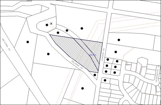
|
NOTIFICATION PLAN |
|
||
|
• PROPERTIES NOTIFIED
|
X SUBMISSIONS RECEIVED |
PROPERTY SUBJECT OF DEVELOPMENT |
|
The submission objects to the development, generally on the grounds that the development would result in:
· An increase in the density of dwellings in Sallaway Road on land that drains to an environmental protection zone.
The merits of the matters raised in the submission have been addressed in the body of this report.
5.2 Public Agencies
The development application is Integrated Development under the Act subject to approval of the NSW Rural Fire Service.
The NSW Rural Fire Service granted approval subject to recommended conditions.
6. THE PUBLIC INTEREST
Section 79C(1)(e) of the Act requires Council to consider “the public interest”.
The public interest is an overarching requirement, which includes the consideration of the matters discussed in this report. Implicit to the public interest is the achievement of future built outcomes adequately responding to and respecting the future desired outcomes expressed in environmental planning instruments and development control plans.
The application is considered to have satisfactorily addressed Council’s and relevant agencies’ criteria and would provide a development outcome that, on balance, would result in a positive impact for the community. Accordingly, it is considered that the approval of the proposed development would be in the public interest.
CONCLUSION
The proposed development involves the realignment of the boundaries of two allotments. No additional lots are proposed to be created.
The proposed subdivision is considered satisfactory in maintaining the rural character of the locality, notwithstanding non-compliance with the minimum lot size applicable to the Rural BR zone. A number of rural allotments in the locality are less than the minimum two hectare development standard and residential lots are located directly to the east of the site.
The applicant has submitted a SEPP 1 objection to the development standard. The submission is considered well founded with regard to planning principles established by the Land and Environment Court.
The circumstances of the application are considered unique with the existing two under sized lots. The proposal would not alter the size of the existing lots, instead realign the boundaries to better utilise the land. The proposal would maintain the existing pattern of rural development and would not establish an undesirable precedent for smaller rural lot subdivisions.
The proposed subdivision is considered acceptable with regard to the provisions of the relevant environmental planning instruments applicable to the site, the Rural Lands DCP and the requirements of the NSW Rural Fire Service.
Note: At the time of the completion of this planning report, no persons have made a Political Donations Disclosure Statement pursuant to Section 147 of the Environmental Planning and Assessment Act 1979 in respect of the subject planning application.
|
Rod Pickles Manager - Development Assessment Planning Division |
James Farrington Group Manager Planning Division |
|
1.View |
Locality Map |
|
|
|
2.View |
Subdivision Plan |
|
|
|
3.View |
Statement of Environmental Effects |
|
|
|
4.View |
SEPP 1 Objection |
|
|
File Reference: DA/421/2013
Document Number: D02284546
SCHEDULE 1
GENERAL CONDITIONS
The conditions of consent within this notice of determination have been applied to ensure that the use of the land and/or building is carried out in such a manner that is consistent with the aims and objectives of the relevant legislation, planning instruments and council policies affecting the land and does not disrupt the amenity of the neighbourhood or impact upon the environment.
Note: For the purpose of this consent, the term ‘applicant’ means any person who has the authority to act on or the benefit of the development consent.
Note: For the purpose of this consent, any reference to an act, regulation, Australian standard or publication by a public authority shall be taken to mean the gazetted act or regulation, or adopted Australian standard or publication as in force on the date that the application for a construction certificate is made.
1. Approved Plans and Supporting Documentation
The development must be carried out in accordance with the plans and documentation listed below and endorsed with Council’s stamp, except where amended by Council and/or other conditions of this consent:
|
Plan No. |
Plan Title |
Drawn by |
Dated |
|
Project No. 12844 Sheet 1 of 1 Issue B |
Plan of tentative subdivision including detail survey |
Gary Skow |
15 January 2013 |
|
Document Title |
Prepared by |
Dated |
|
Statement of Environmental Effects |
Natalie Richter Planning |
April 2013 |
|
SEPP 1 Objection |
Natalie Richter |
29 April 2013 |
|
Bushfire Hazard Assessment Report |
Building Code & Bushfire Hazard Solutions Pty Limited |
19 December 2013 |
2. Future Development
a) Future development of this lot must comply with the requirements of the Australian Standard ‘Protection of Trees on Development Sites’ (AS 4970-2009).
b) Individually significant trees or trees that form part of a significant group of trees must be retained as part of any future development application.
REQUIREMENTS PRIOR TO THE ISSUE OF A SUBDIVISION CERTIFICATE
Note: For the purpose of this consent, a reference to ‘occupation certificate’ shall not be taken to mean an ‘interim occupation certificate’ unless otherwise stated.
3. Sydney Water – s73 Certificate
An s73 Certificate must be obtained from Sydney Water.
4. Design and Construction - Bushfire Attack Category
The existing building on proposed Lot 2 is required to be upgraded to improve ember protection as follows:
· enclosing all openings (excluding roof tile spaces) or covering openings with a non-corrosive metal screen mesh with a maximum aperture of 2mm.
· Where applicable, this includes any sub floor areas, openable windows, vents, weepholes and eaves.
· External doors are to be fitted with draft excluders.
5. Asset Protection Zones
At the issue of subdivision certificate and in perpetuity, the land surrounding the existing dwelling on proposed Lot 2 must be retained as an inner protection area (IPA) to a distance of:
a) 40 metres on the western and northern elevations; and
b) the distance between the dwelling and southern and eastern property boundaries, shall be maintained as an inner protection area (IPA) as outlined within section 4.1.3 and Appendix 5 of 'Planning for Bush Fire Protection 2006' and the NSW Rural Fire Service's document 'Standards for asset protection zones'.
- END OF CONDITIONS -
ADVISORY NOTES
The following information is provided for your assistance to ensure compliance with the Environmental Planning and Assessment Act, 1979, Environmental Planning and Assessment Regulation 2000, other relevant legislation and Council’s policies and specifications. This information does not form part of the conditions of development consent pursuant to Section 80a of the Act.
Environmental Planning and Assessment Act, 1979 Requirements
The Environmental Planning and Assessment Act, 1979 requires:
· The issue of a construction certificate prior to the commencement of any works. Enquiries regarding the issue of a construction certificate can be made to Council’s Customer Services Branch on 9847 6760.
· A principal certifying authority to be nominated and Council notified of that appointment prior to the commencement of any works.
· Council to be given at least two days written notice prior to the commencement of any works.
· Mandatory inspections of nominated stages of the construction inspected.
· An occupation certificate to be issued before occupying any building or commencing the use of the land.
Tree Preservation Order
To ensure the maintenance and protection of the existing natural environment, it is an offence to ringbark, cut down, top, lop, remove, wilfully injure or destroy a tree outside 3 metres of the approved building envelope without the prior written consent from Council.
Note: A tree is defined as a single or multi-trunked wood perennial plant having a height of not less than three (3) metres, and which develops many branches, usually from a distance of not less than one (1) metre from the ground, but excluding any plant which, in its particular location, is a noxious plant declared as such pursuant to the Noxious Weeds Act 1993. This definition of ‘tree’ includes any and all types of Palm trees.
All distances are determined under Australian Standard AS4970-2009 ”Protection of Trees on Development Sites”.
Fines may be imposed for non-compliance with Council’s Tree Preservation Order.
Subdivision Certificate Requirements
A subdivision certificate application is required to be lodged with Council containing the following information:
· A surveyor’s certificate certifying that all structures within the subject land comply with the development consent in regard to the setbacks from the new boundaries.
· A surveyor’s certificate certifying that all services, drainage lines or access are located wholly within the property boundaries. Where services encroach over the new boundaries, easements are to be created.
· Certification that the requirements of relevant utility authorities have been met.
· A surveyor’s certificate certifying finished ground levels are in accordance with the approved plans.
Note: Council will not issue a subdivision certificate until all conditions of the development consent have been completed.
Fees and Charges – Subdivision
All fees payable to Council as part of any construction, compliance or subdivision certificate or inspection associated with the development (including the registration of privately issued certificates) are required to be paid in full prior to the issue of the subdivision certificate. Any additional Council inspections beyond the scope of any compliance certificate required to verify compliance with the terms of this consent will be charged at the individual inspection rate nominated in Council's Fees and Charges Schedule.
Group Manager’s Report No. PL79/13
Planning Division
Date of Meeting: 21/08/2013
8 DEVELOPMENT APPLICATION - ALTERATIONS AND ADDITIONS - 112 SOMERVILLE ROAD, HORNSBY HEIGHTS
EXECUTIVE SUMMARY
|
DA No: |
DA/634/2013 (Lodged 21 June 2013) |
|
Description: |
Alterations and additions to a dwelling-house |
|
Property: |
Lot 8, DP211092, No.112 Somerville Road, Hornsby Heights |
|
Applicant: |
Mr Daniel Street |
|
Owners: |
Mr Daniel Street and Ms Sarah Street |
|
Estimated Value: |
$157,000 |
|
Ward: |
A |
· The application involves the demolition of a carport and alterations and additions to a dwelling-house.
· The proposal complies with the Hornsby Shire Local Environmental Plan 1994 and is generally consistent with the Dwelling House Development Control Plan. There is a non compliance with the ‘Setbacks’ element of the Dwelling House Development Control Plan. However, the non compliance would not have a significant environmental impact and the variation is supported.
· One submission has been received in respect of the application.
· A Red Sticker has been placed on the application requiring that the application be determined at a Council Meeting.
· It is recommended that the application be approved.
|
THAT Development Application No. DA/634/2013 for the demolition of a carport and alterations and additions to the dwelling-house at Lot 8, DP 211092, No. 112 Somerville Road Hornsby Heights is approved, subject to the conditions of consent detailed in Schedule 1 of Group Manager’s Report No. PL79/13. |
BACKGROUND
There is no background/history relevant to determining this application.
SITE
The rectangular 758.8m2 site is located on the eastern side of Somerville Road, Hornsby Heights and contains a single storey dwelling-house with sub-floor space for storage and a detached metal carport.
The site experiences a 4 metre fall towards the rear, north eastern corner.
The site is not bush fire prone and is not flood prone land.
The site is not burdened by any easements or restrictions.
The site is not a heritage listed item and is not located in a heritage conservation area. The site is in the vicinity of a heritage item as listed in Schedule D of the Hornsby Shire Local Environmental Plan 1994 (HSLEP), namely, “street trees” on Somerville Road.
PROPOSAL
The application involves the demolition of a carport and alterations and additions to a dwelling-house comprising:
· garage, rumpus room, bathroom and laundry at the lower ground floor level;
· reconfiguration of the internal spaces for an open plan kitchen, meals, family, lounge, study, bedroom, powder room, L-shaped rear deck and front porch at ground floor level; and
· first floor addition consisting of 3 bedrooms, ensuite, bathroom, covered balcony and walk-in-robe.
Due to the slope of the site, a portion of the additions to the dwelling-house would be 3 storeys in height.
The dwelling-house would be re-clad in “Weathertex” timber cladding with a “Colorbond” roof.
The application also proposes a bitumen driveway, a 1.5 metre high front fence, minor landform levelling at the rear of the dwelling-house and the erection of retaining walls.
ASSESSMENT
The development application has been assessed having regard to the ‘Metropolitan Plan for Sydney 2036’, the ‘North Subregion (Draft) Subregional Strategy’ and the matters for consideration prescribed under Section 79C of the Environmental Planning and Assessment Act 1979 (the Act). The following issues have been identified for further consideration.
1. STRATEGIC CONTEXT
1.1 Metropolitan Plan for Sydney and (Draft) North Subregional Strategy
The (Draft) Metropolitan Strategy for Sydney 2031 is a broad framework to provide for Sydney’s growth to help plan for housing, employment, transport, infrastructure, the environment and open space. It outlines a vision for Sydney to 2031, the challenges faced and the directions to follow to address these challenges and achieve the vision.
The North Subregion comprises Hornsby, Kuring-gai, Manly, Warringah and Pittwater Local Government Areas. The Draft North Subregional Strategy acts as a framework for Council in its preparation of the Comprehensive LEP by the end of 2013.
Within the North Subregion, the Draft Metropolitan Strategy proposes:
· Population growth of 81,000 from the current 2011 baseline of 529,000;
· Housing growth of 37,000 from the current 2011 baseline of 204,000; and
· Employment growth of 39,000 from the current 2011 baseline of 186,000.
The proposed development would be consistent with the Metropolitan Plan for Sydney 2031 by providing renewed housing stock.
2. STATUTORY CONTROLS
Section 79C(1)(a) requires Council to consider “any relevant environmental planning instruments, draft environmental planning instruments, development control plans, planning agreements and regulations”.
2.1 Hornsby Shire Local Environmental Plan, 1994
The subject land is zoned Residential A (Low Density) under the Hornsby Shire Local Environmental Plan 1994 (HSLEP). The objectives of the Residential A zone are:
(a) to provide for the housing needs of the population of the Hornsby area;
(b) to promote a variety of housing types and other land uses compatible with a low density residential environment; and
(c) to provide for development that is within the environmental capacity of a low density residential environment.
The proposed development is defined as a ‘dwelling-house’ under the HSLEP and is permissible in the zone with Council’s consent.
2.2 Draft Hornsby Shire Local Environmental Plan
The draft Hornsby Local Environmental Plan (DHLEP) was endorsed by Council at its meeting on 19 December 2012 to be forwarded to the Minister for Planning and Infrastructure for endorsement. In accordance with Council’s resolution, the draft Plan has been submitted to the Department for finalisation. The relevant provisions of the DHLEP that apply to the site are outlined below.
2.3 Zoning
Under the DHLEP, the subject land would be zoned R2 (Low Density Residential). A “dwelling house” would be a permissible use in the zone under the DHLEP.
2.3.1 Height of Building
Clause 4.3 of the DHLEP provides that the height of a building on any land is not to exceed the maximum height shown for the land on the Height of Buildings Map. The maximum permissible height for the subject site within the R2 zone is 8.5 metres. The proposed 9 metre height of the dwelling-house does not comply with this provision.
The objective of this clause is to promote a height of buildings that is in accordance with site constraints, development potential and infrastructure capacity of the locality.
Due to the slope of the site, a portion of the dwelling-house would be 3 storeys in height. This height would be consistent with the height of nearby dwelling-houses in the local area and the loss of sunlight and privacy in relation to adjoining properties would be within reasonable limits. These impacts are discussed in more detail under the headings “Privacy” and “Solar Access” in section 2.6 below.
2.4 Sydney Regional Environmental Plan No. 20 – Hawkesbury – Nepean River
The site is located within the catchment of the Hawkesbury Nepean River. Part 2 of this Plan contains general planning considerations and strategies requiring Council to consider the impacts of development on water quality, aquaculture, recreation and tourism.
Subject to the implementation of sediment and erosion control measures and stormwater management to protect water quality, the proposal would comply with the requirements of the Policy.
2.5 Clause 74BA Environmental Planning and Assessment Act, 1979 - Purpose and Status of Development Control Plans
On 1 March 2013, the Environmental Planning and Assessment Act, 1979 was amended so that a DCP provision will have no effect if it has the practical effect of “preventing or unreasonably restricting development” that is otherwise permitted and complies with the development standards set out in relevant Local Environmental Plans and State Environmental Planning Policies.
The principal purpose of a development control plan is to provide guidance on the aims of any environmental planning instrument that applies to the development; facilitating development that is permissible under any such instrument; and achieving the objectives of land zones under any such instrument. The provisions of a development control plan made for that purpose are not statutory requirements.
2.6 Dwelling House Development Control Plan
The development has been assessed having regard to the relevant performance and prescriptive design requirements within Council’s Dwelling House Development Control Plan (Dwelling House DCP). The following table sets out the proposal’s compliance with the prescriptive requirements of the Plan:
|
Dwelling House Development Control Plan |
|||
|
Control |
Proposal |
Requirement |
Complies |
|
Floor space ratio |
0.4:1 |
0.4:1 |
Yes |
|
Site cover |
28.6% |
40% |
Yes |
|
Setbacks Front (west) Rear (east) Side (north) Side (south) |
7.6m 16m 4.2m 0.91m |
6m 3m 1m 1m |
Yes Yes Yes No |
|
Height |
9m |
< 9m |
Yes |
|
Unbroken Wall length |
8.5m |
10m |
Yes |
|
Building length |
19.5m |
24m |
Yes |
|
Cut and fill |
1m |
1m |
Yes |
|
Private Open Space |
250m2 |
120m² |
Yes |
|
Landscaped area |
65% |
45% |
Yes |
|
Car Parking |
2 spaces |
2 spaces |
Yes |
|
Garage size |
6.1m x 5.5m |
5.7 x 5.4m |
Yes |
As detailed in the above table, the proposed development generally complies with the prescriptive measures within the Dwelling House DCP other than in regards to the side setback. This matter of non-compliance is detailed below, as well as a brief discussion on compliance with relevant performance requirements and an objection that has raised concerns in terms of height, privacy, noise and the removal of trees.
2.6.1 Height
The application proposes alterations and additions to a dwelling-house to a maximum height of 9 metres. Whilst this complies with the 9 metre prescriptive measure of the Height element, the development would appear, in part, as a 3 storey structure when viewed from the northern (side) and eastern (rear) elevations.
The development takes advantage of the slope of the site, the existing excavations at the lower floor level and the minimum 2.4 metre ceiling height to incorporate these 3 levels in the design, resulting in a proposal that meets the 9 metre height requirement in the zone. The 3 storey component of the dwelling would comprise a 4.4m wide section in the middle of the dwelling incorporating a laundry, bathroom and rumpus room.
The dwelling-house would appear as a two storey structure when viewed from Somerville Road, which is consistent with the height of the dwelling-houses on the adjoining properties and would not be out of character with the area.
The proposal meets the objective of the Height element and is considered acceptable.
2.6.2 Setbacks
The proposed 910mm southern side boundary setback of the proposed development does not comply with the prescriptive measures of the Setbacks element which requires a minimum side setback of 1 metre.
The 90mm setback encroachment is considered to be a minor variation which would not impact on the amenity of the adjoining property at No. 110 Somerville Road in terms of solar access or privacy.
The proposal meets the objectives of the Setbacks element and is considered acceptable.
2.6.3 Solar Access
The objectives of the Solar Access element is to encourage development “that ensures reasonable solar access to the living areas within dwellings and to open space around dwellings”.
In support of this objective, the prescriptive measures state that “dwelling-houses should be designed to allow at least 4 hours of sunshine to the private open space required for adjacent and proposed dwellings between 9am and 3 pm on 22 June” and “dwelling-houses should be designed to allow north facing windows to living areas of adjacent and proposed dwellings to receive 3 hours of sunshine between 9am and 3 pm on 22 June over a portion of their surface”.
The shadow diagrams submitted for 22 June (the winter solstice) indicate that a portion of the private open space at the rear of the adjacent property No. 110 Somerville Road would be overshadowed by the development. Notwithstanding this overshadowing, there would still be at least 130m2 of this area that would receive 4 hours of sunshine, which complies with the prescriptive measures.
The diagrams also indicate that the north-facing windows of the adjacent dwelling at No. 110 Somerville Road would be overshadowed by the development. Four of these windows serve a toilet and 3 bedrooms respectively, and given that they are considered to be non-active rooms, the proposal complies with the prescriptive measures.
The fifth window, serves an active use sunroom which would also be overshadowed by the development. Only a portion of the window surface would be overshadowed, which complies with the prescriptive measures.
The proposal meets the objectives of the Solar Access element and is considered acceptable.
2.6.4 Privacy
An objection raises concerns that the development would have detrimental privacy impacts on the adjacent property No. 116 Somerville Road.
The objective of the Privacy element is to encourage development “that ensures reasonable privacy in the home and private open space for existing and future residents”.
In support of this objective, the prescriptive measures state that where “the proposed dwelling-house is two storeys in height, the living areas should be located on the ground floor”.
The application proposes an L-shaped deck, 43m2 in area, at the rear of the dwelling-house. It would be accessed via sliding doors from the meals room/kitchen at ground floor level and because of the topography of the area, would be up to 3 metres above the natural ground level of the sloping site. As a consequence, the deck may allow overlooking of 3 adjoining properties namely No.s 110. 114 and 116 Somerville Road.
To address the privacy impact of the proposal in relation to the private open space at the rear of No. 110 Somerville Road, the application proposes the erection of a 1.8 metre high privacy screen along the southern elevation of the deck.
No detrimental privacy impacts in relation to property No. 114 Somerville Road are anticipated, given the 18 metre setback of the deck from the common boundary alignment. Furthermore, any overlooking would be limited to the vehicle turning area (non principal private open space) only.
To address concerns about loss of privacy in relation to the adjacent property No. 116 Somerville Road, a condition is recommended requiring the planting of suitable screening trees along the northern side boundary fence.
The application also proposes a 10m2 balcony within the northern elevation at first floor level, accessed from Bedroom 1. Noting its anticipated limited use, its restricted area and that it is orientated towards the front yard of the adjacent property No. 116 Somerville Road, no detrimental privacy impacts are anticipated.
The proposal meets the objective of the Privacy element and is considered acceptable.
2.6.5 Flora and Fauna Protection
An objection raises concerns that the removal of trees from the site would have unacceptable privacy impacts.
The application proposes the removal of a peach tree and an orange tree. These trees are exempt from Council’s Tree Preservation Order and no objections are raised to their removal.
The concerns regarding loss of privacy have been addressed in Section 2.6.4 of this report.
2.6.6 Acoustics
An objection raises concerns that the development would have unacceptable noise impacts during the construction phase and subsequent vehicle movements into and from, the lower level garage.
To address concerns about noise during the construction phase, a condition is recommended restricting the hours of work on site to between 7am and 5pm Monday to Saturday, with no work permitted on Sundays or public holidays.
It should be noted that the existing carport immediately adjacent to the premises No. 116 Somerville Road is to be demolished and that the proposed 2 space garage would be incorporated within the dwelling-house at the lower floor level.
It is not anticipated that the use of this double garage would increase the noise levels generated by vehicle movements to and from the premises to levels in excess of existing noise levels.
The proposal meets the objectives of the Acoustics element and is considered acceptable.
2.6.7 Fencing
The application proposes the erection of a decorative metal fence supported by brick columns up to 1.5 metres in height along the front, western front boundary.
The design and height of the fence would be consistent with similar structures in Somerville Road and would contribute to the established streetscape character.
The proposal meets the objectives of the Fencing element and is considered acceptable.
2.6.8 Heritage
The site is in vicinity of a heritage item as listed in Schedule D of the HSLEP 1994, namely, “street trees” on Somerville Road.
The design, location and height of the proposed alterations and additions would have no impact on the heritage character of the Somerville Road streetscape.
The proposal meets the objectives of the Heritage element and is considered acceptable.
3. ENVIRONMENTAL IMPACTS
Section 79C(1)(b) of the Act requires Council to consider “the likely impacts of that development, including environmental impacts on both the natural and built environments, and social and economic impacts in the locality”.
3.1 Natural Environment
The proposed development would necessitate the removal of two trees from the site. The trees are not considered significant or worthy of retention.
3.2 Built Environment
The proposed development would be consistent in terms of architectural style, scale, bulk and materials with the surrounding residential area.
3.3 Social and Economic Impacts
There are no anticipated adverse social or economic impacts resulting from the proposed development.
4. SITE SUITABILITY
Section 79C(1)(c) of the Act requires Council to consider “the suitability of the site for the development”.
The subject site is not bushfire prone or flood prone land. The site is considered to be capable of accommodating the proposed development. The scale of the proposed development is consistent with the capability of the site and is considered acceptable.
5. PUBLIC PARTICIPATION
Section 79C(1)(d) of the Act requires Council to consider “any submissions made in accordance with this Act”.
5.1 Community Consultation
The proposed development was placed on public exhibition and was notified to adjoining and nearby landowners between 21 June 2013 and 1 July 2013 in accordance with Council’s Notification and Exhibition Development Control Plan. During this period, Council received 1 submission. The map below illustrates the location of the nearby landowner who made a submission.
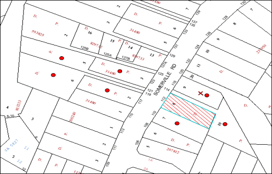
NOTIFICATION PLAN
|
• PROPERTIES NOTIFIED
|
X SUBMISSIONS RECEIVED |
PROPERTY SUBJECT OF DEVELOPMENT |
|
One submission objected to the proposal, generally on the grounds that the development would result in:
· A loss of privacy due to the proposed L-shaped deck, windows and glass sliding doors on the northern elevation;
· Unacceptable noise from cars entering and exiting the proposed garage;
· Unacceptable noise from the works during the construction phase;
· The hours of construction works; and
· The removal of trees acting as a privacy screen.
The merits of the matters raised in the submission have been addressed in the body of the report.
6. THE PUBLIC INTEREST
Section 79C(1)(e) of the Act requires Council to consider “the public interest”.
The public interest is an overarching requirement, which includes the consideration of the matters discussed in this report. Implicit to the public interest is the achievement of future built outcomes adequately responding to and respecting the future desired outcomes expressed in environmental planning instruments and development control plans.
The application is considered to have satisfactorily addressed Council’s and relevant agencies’ criteria and would provide a development outcome that, on balance, would result in a positive impact for the community. Accordingly, it is considered that the approval of the proposed development would be in the public interest.
CONCLUSION
The application proposes the demolition of a carport and alterations and additions to a dwelling-house in a style that would be in keeping with the surrounding area.
The development generally meets Council’s planning controls and is satisfactory having regard to the matters for consideration pursuant to Section 79C of the Environmental Planning and Assessment Act, 1979.
Council received 1 submission during the public notification period. The issues raised have been addressed in the body of the report.
Having regard to the circumstances of the case, approval of the application is recommended.
Note: At the time of the completion of this planning report, no persons have made a Political Donations Disclosure Statement pursuant to Section 147 of the Environmental Planning and Assessment Act, 1979 in respect of the subject planning application.
|
Rod Pickles Manager - Development Assessment Planning Division |
James Farrington Group Manager Planning Division |
|
1.View |
Locality Map |
|
|
|
2.View |
Site Plan |
|
|
|
3.View |
Floor Plans |
|
|
|
4.View |
Elevations |
|
|
|
5.View |
Shadow Diagram |
|
|
|
6.View |
Front Fence and Section |
|
|
File Reference: DA/634/2013
Document Number: D02320443
SCHEDULE 1
GENERAL CONDITIONS
The conditions of consent within this notice of determination have been applied to ensure that the use of the land and/or building is carried out in such a manner that is consistent with the aims and objectives of the relevant legislation, planning instruments and Council policies affecting the land and does not disrupt the amenity of the neighbourhood or impact upon the environment.
Note: For the purpose of this consent, the term ‘applicant’ means any person who has the authority to act on or the benefit of the development consent.
Note: For the purpose of this consent, any reference to an Act, Regulation, Australian Standard or publication by a public authority shall be taken to mean the gazetted Act or Regulation, or adopted Australian Standard or publication as in force on the date that the application for a construction certificate is made.
1. Approved Plans and Supporting Documentation
The development must be carried out in accordance with the plans and documentation listed below and endorsed with Council’s stamp, except where amended by Council and/or other conditions of this consent:
|
Plan No. |
Drawn by |
Dated |
|
1301-1 to 1301-5, 1301-6A to 1301-8A, & 1301-9: (9 sheets) |
Thorsette Pty Ltd |
January and July 2013 |
|
Document No. |
Prepared by |
Dated |
|
Waste Management Plan – 8 pages |
Daniel Street |
21.06.2013 |
2. Removal of Existing Trees
This development consent only permits the removal of trees numbered T1 and T2 as identified in red
On Site/Site Analysis Plan No. 1301-1 prepared by Thorsette Pty Ltd dated January 2013. The removal of any other trees requires separate approval under Council’s Tree Preservation Order.
REQUIREMENTS PRIOR TO THE ISSUE OF A CONSTRUCTION CERTIFICATE
3. Building Code of Australia
All building work must be carried out in accordance with the relevant requirements of the Building Code of Australia.
4. Contract of Insurance (Residential Building Work)
In the case of residential building work for which the Home Building Act, 1989 requires there to be a contract of insurance in force in accordance with Part 6 of that Act, that such a contract of insurance is in force before any building work authorised to be carried out by the consent commences.
5. Notification of Home Building Act, 1989 Requirements
Residential building work within the meaning of the Home Building Act, 1989 must not be carried out unless the principal certifying authority for the development to which the work relates (not being Council) has given Council written notice of the following information:
a) In the case of work for which a principal contractor is required to be appointed:
i) The name and licence number of the principal contractor; and
ii) The name of the insurer by which the work is insured under Part 6 of that Act.
b) In the case of work to be done by an owner-builder:
i) The name of the owner-builder and;
ii) If the owner-builder is required to hold an owner-builder’s permit under that Act, the number of the owner-builder’s permit.
Note: If arrangements for doing the residential building work are changed while the work is in progress so that the information notified becomes out of date, further work must not be carried out unless the principal certifying authority for the development to which the work relates (not being Council) has given Council written notification of the updated information.
6. Sydney Water – Quick Check
This application must be submitted to a Sydney Water ‘Quick Check Agent’ or ‘Customer Centre’ for approval to determine whether the development would affect any Sydney Water infrastructure, and whether further requirements are to be met.
Note: Refer to www.sydneywater.com.au or telephone 13 20 92 for assistance.
REQUIREMENTS PRIOR TO THE COMMENCEMENT OF ANY WORKS
7. Erection of Construction Sign
A sign must be erected in a prominent position on any site on which building work, subdivision work or demolition work is being carried out:
a) Showing the name, address and telephone number of the principal certifying authority for the work;
b) Showing the name of the principal contractor (if any) for any demolition or building work and a telephone number on which that person may be contacted outside working hours; and
c) Stating that unauthorised entry to the work site is prohibited.
Note: Any such sign is to be maintained while the building work, subdivision work or demolition work is being carried out, but must be removed when the work has been completed.
8. Toilet Facilities
Toilet facilities must be available or provided at the works site before works begin and must be maintained until the works are completed at a ratio of one toilet for every 20 persons employed at the site. Each toilet must:
a) be a standard flushing toilet connected to a public sewer; or
b) be a temporary chemical closet approved under the Local Government Act, 1993
9. Erosion and Sediment Control
Erosion and sediment control measures must be provided and maintained throughout the construction period in accordance with the manual ‘Soils and Construction 2004 (Bluebook)’, the approved plans, Council specifications and to the satisfaction of the principal certifying authority. The erosion and sediment control devices must remain in place until the site has been stabilised and revegetated.
Note: On the spot penalties up to $1,500 may be issued for any non-compliance with this requirement without any further notification or warning.
REQUIREMENTS DURING CONSTRUCTION
10. Construction Work Hours
All work on site (including demolition and earth works) must only occur between 7am and 5pm Monday to Saturday. No work is to be undertaken on Sundays or public holidays.
11. Demolition
All demolition work must be carried out in accordance with “Australian Standard 2601-2001 – The Demolition of Structures” and the following requirements:
a) Demolition material must be disposed of to an authorised recycling and/or waste disposal site and/or in accordance with an approved waste management plan;
b) Demolition works, where asbestos material is being removed, must be undertaken by a contractor that holds an appropriate licence issued by WorkCover NSW in accordance with Chapter 10 of the Occupational Health and Safety Regulation 2001 and Clause 29 of the Protection of the Environment Operations (Waste) Regulation 2005; and
c) On construction sites where buildings contain asbestos material, a standard commercially manufactured sign containing the words ‘DANGER ASBESTOS REMOVAL IN PROGRESS’ measuring not less than 400mm x 300mm must be erected in a prominent position visible from the street.
12. Council Property
During construction works, no building materials, waste, machinery or related matter is to be stored on the road or footpath. The public reserve must be kept in a clean, tidy and safe condition at all times.
13. Disturbance of Existing Site
During construction works, the existing ground levels of open space areas and natural landscape features, (including natural rock-outcrops, vegetation, soil and watercourses) must not be altered unless otherwise nominated on the approved plans.
REQUIREMENTS PRIOR TO THE ISSUE OF AN OCCUPATION CERTIFICATE
Note: For the purpose of this consent, a reference to ‘occupation certificate’ shall not be taken to mean an ‘interim occupation certificate’ unless otherwise stated.
14. Fulfilment of BASIX Commitments
The applicant must demonstrate the fulfilment of BASIX commitments pertaining to the development.
15. Stormwater Drainage
The stormwater drainage system for the development must be designed and constructed for an average recurrence interval of 20 years and be gravity drained and connected to the existing stormwater drainage system.
16. Internal Driveway/Vehicular Areas
The driveway and parking areas on site must be designed in accordance with Australian Standards 2890.1, 2890.2, 3727.
17. Damage to Council Assets
Any damage caused to Council’s assets as a result of the construction of the development must be rectified in accordance with Council’s written requirements and at the sole cost of the applicant.
18. Smoke Alarms
Smoke alarms must be installed in the existing building and the proposed additions in accordance with the requirements of the Building Code of Australia.
19. Retaining Walls
All required retaining walls must be constructed as part of the development.
20. Installation of Privacy Devices
To establish and maintain an acceptable level of privacy in relation to the adjacent property No. 116 Somerville Road, a minimum of 10 trees or shrubs (minimum mature growth height of 3 to 4 metres) selected from Syzygium australe (Brush Cherry), Syzygium oleosum (Blue Lillypilly) and Syzygium paniculatum (Magenta Lilly Pilly), with a minimum pot size of 25 litres must be planted adjacent to the northern side boundary in the location nominated in red on the approved plans.
- END OF CONDITIONS -
ADVISORY NOTES
The following information is provided for your assistance to ensure compliance with the Environmental Planning and Assessment Act, 1979, Environmental Planning and Assessment Regulation 2000, other relevant legislation and Council’s policies and specifications. This information does not form part of the conditions of development consent pursuant to Section 80A of the Act.
Environmental Planning and Assessment Act, 1979 Requirements
The Environmental Planning and Assessment Act, 1979 requires:
· The issue of a construction certificate prior to the commencement of any works. Enquiries can be made to Council’s Customer Services Branch on 9847 6760;
· a principal certifying authority to be nominated and Council notified of that appointment prior to the commencement of any works;
· Council to be given at least two days written notice prior to the commencement of any works;
· mandatory inspections of nominated stages of the construction inspected; and
· an occupation certificate to be issued before occupying any building or commencing the use of the land.
Long Service Levy
In accordance with Section 34 of the Building and Construction Industry Long Service Payments Act 1986, a ‘Long Service Levy’ must be paid to the Long Service Payments Corporation or Hornsby Council.
Note: The rate of the Long Service Levy is 0.35% of the total cost of the work.
Note: Hornsby Council requires the payment of the Long Service Levy prior to the issue of a construction certificate.
Tree Preservation Order
To ensure the maintenance and protection of the existing natural environment, it is an offence to ringbark, cut down, top, lop, remove, wilfully injure or destroy a tree outside 3 metres of the approved building envelope without the prior written consent from Council.
Note: A tree is defined a s a single or multi-trunked wood perennial plant having a height of not less than three (3) metres, and which develops many branches, usually form a distance of not less than one (1) metre from the ground, but excluding any plant which, in its particular location, is a noxious plant declared as such pursuant to the Noxious Weeds Act 1993. This definition of ‘tree’ includes any and all types of Palm trees.
All distances are determined under Australian Standard AS4970-2009 “Protection of Trees on Development Sites”.
Fines may be imposed for non-compliance with Council’s Tree Preservation Order.
Dial Before You Dig
Prior to commencing any works, the applicant is encouraged to contact Dial Before You Dig on 1100 or www.dialbeforeyoudig.com.au for free information on potential underground pipes and cables within the vicinity of the development site.
Asbestos Warning
Should asbestos or asbestos products be encountered during demolition or construction works, you are advised to seek advice and information prior to disturbing this material. It is recommended that a contractor holding an asbestos-handling permit (issued by WorkCover NSW) be engaged to manage the proper handling of this material. Further information regarding the safe handling and removal of asbestos can be found at:
Alternatively, telephone the WorkCover Asbestos and Demolition Team on 8260 5885.
Group Manager's Report No. PL75/13
Planning Division
Date of Meeting: 21/08/2013
9 REPORTING VARIATIONS TO DEVELOPMENT STANDARDS
EXECUTIVE SUMMARY
· In accordance with the Department of Planning and Infrastructure’s Planning Circular PS 08-14, Council is required to report variations to development standards for development applications approved under delegated authority, which relied upon State Environmental Planning Policy No. 1 - Development Standards (SEPP 1).
· Council’s consideration of this report ensures Council’s obligation to monitor variations to development standards is complied with.
|
THAT the contents of Group Manager’s Report No. PL75/13 be received and noted. |
PURPOSE
The purpose of this report is to advise Council of determined development applications under delegated authority involving a SEPP 1 variation to a development standard for the period 1 April 2013 to 30 June 2013.
DISCUSSION
The Department of Planning and Infrastructure’s Circular B1, issued in March 1989, requested that councils monitor the use of the Director-General’s assumed concurrence under SEPP 1 on a quarterly basis. This reporting requirement remains effective.
Monitoring of variations to development standards is important to provide the Department and councils with an overview of the manner in which established development standards are being varied and whether the assumed concurrence is being used as intended. This enables Council and the Department to determine whether development standards are appropriate, or whether changes are required.
The Department issued Circular PS 08–014 on 14 November 2008. The purpose of the Circular was to remind councils of their responsibilities to monitor the use of the Director-General’s assumed concurrence under SEPP 1. Councils were reminded of the need to keep accurate records of the use of SEPP 1 and to report on a quarterly basis.
The Circular also provides that councils are required to adopt the following four measures:
1. Establish a register of development applications determined with variations in standards under SEPP 1.
2. Require all development applications where there has been a variation greater than 10% in standards under SEPP 1 to be determined by full council (rather than General Manager or nominated staff member).
3. Provide a report to Council on the development applications determined where there had been a variation in standards under SEPP 1.
4. Make the register of development applications determined with variations in standards under SEPP 1 available to the public on the council’s website.
In accordance with Point 3 of the Department’s Circular, attached is a list of development applications determined under delegated authority involving a SEPP 1 variation to a development standard for the period 1 April 2013 to 30 June 2013.
A copy of the attachment to this report is also reproduced on Council’s website.
BUDGET
There are no budget implications.
POLICY
This report addresses Council’s reporting obligations for development applications determined where there has been a variation in standards under SEPP 1.
CONCLUSION
Council is required to monitor the manner in which development standards are being varied. This assists in determining whether changes are required to relevant standards. This report provides advice to Council on standards varied under delegated authority during the reporting period from 1 April 2013 to 30 June 2013.
RESPONSIBLE OFFICER
The officer responsible for the preparation of this report is the Group Manager – Planning Division – James Farrington, who can be contacted on 9847 6750.
|
James Farrington Group Manager Planning Division |
|
|
1.View |
SEPP 1 Returns |
|
|
File Reference: F2004/07599
Document Number: D02280352
Group Manager's Report No. PL77/13
Planning Division
Date of Meeting: 21/08/2013
10 SECTION 94 AND 94A DEVELOPMENT CONTRIBUTIONS PLANS - AFTER EXHIBITION
EXECUTIVE SUMMARY
· At its meeting on 17 April 2013, Council resolved to exhibit a draft Section 94 Development Contributions Plan and a draft Section 94A Development Contributions Plan.
· The draft Plans were exhibited from 9 May 2013 to 7 June 2013 with notification appearing in local newspapers and on Council’s website.
· No public submissions were received.
· Minor updates to the scope of some of the projects listed in the Works Schedules of both Plans and the priority of works are proposed.
· The amendments to the Works Schedule in the draft Section 94 Plan result in changes to the contributions rates. However, the changes are not significant and do not change the manner in which the contributions are set.
· The changes to the Works Schedule in the draft Section 94A Plan do not impact on the contributions levied under the Plan.
· It is recommended that Council adopt the Hornsby Shire Council Section 94 Development Contributions Plan 2012 – 2021 and the Hornsby Shire Council Section 94A Development Contributions Plan 2012 – 2021.
|
THAT Council adopt the Hornsby Shire Council Section 94 Development Contributions Plan 2012-2021 and the Hornsby Shire Council Section 94A Development Contributions Plan 2012-2021. |
PURPOSE
The purpose of this report is to present the outcome of the exhibition of the draft Section 94 and Section 94A Development Contributions Plans.
BACKGROUND
At its meeting on 17 April 2013, Council considered Group Manager’s Report No. PL31/13 presenting new draft Section 94 and Section 94A Development Contributions Plans. Council resolved to place the draft Plans, which aim to cater for the forecast increase in development and population over the next 10 years, on public exhibition.
The Section 94 Plan requires the payment of a monetary contribution through conditions of consent for development which generates an increased demand on Council’s infrastructure, facilities and services. It would apply to new residential and commercial (retail and business) development.
The Section 94A Plan imposes a levy based on a percentage of the proposed cost of carrying out development. The fixed rate levy would apply to the following types of development.
· Additions and alterations to residential development;
· Alterations to commercial premises;
· Industrial development;
· Residential Care Facilities;
· Hostel/Boarding House/Group Home/Hospital/Educational Establishment;
· Tourist and Visitor Accommodation; and
· Any other development (other than new dwellings or additional commercial floor area which are levied under Section 94).
A contribution under the Section 94A Plan would only apply where the cost of development exceeds $100,000.
DISCUSSION
In accordance with Council’s resolution, the draft Section 94 and Section 94A Plans were publicly exhibited for 28 days from 9 May 2013 to 7 June 2013 in accordance with the requirements of the Environmental Planning and Assessment (EP&A) Act. A notice was placed in the Hornsby Advocate and on Council’s website. Copies of the draft Plans were made available for inspection at Council’s Administration Building and Council libraries. Electronic copies were placed on Council’s website. No public submissions were received in response to the exhibition.
Adjustments to Works Schedules
During the exhibition period, Council’s Infrastructure and Recreation Division and Environment and Human Services Division identified minor adjustments required to the Works Schedules in the draft Plans. The adjustments are required to reflect changes in the priority of works and the scope of some of the projects listed in both the draft Section 94 and Section 94A Plans. The adjustments are discussed below.
Draft Section 94 Development Contributions Plan
An additional Local Road Facility project has been added to the Works Schedule for the draft Section 94 Plan. The project (R-039) involves the construction of a median on Sherbrook Road, Hornsby at the Belair Close intersection. Due to forecast traffic growth from the Belair Close Housing Strategy precinct, the facility is required to address intersection safety by preventing right turn movements into, and out, of Sherbrook Road.
An additional Local Open Space and Recreation Facility project has been added in three stages (OS-41, OS-42 and OS-43). The project involves upgrades to bushwalking circuits in the Galston complex to be completed over the next 10 years. The upgrades are required due to the additional forecast population, and demand for the ongoing provision of regional recreational walking tracks. The project was previously listed in the Works Schedule in the draft Section 94A Plan (s94A_036 and s94A_040). However, due to the revised scope, value and priority of the project it has been transferred to the Section 94 Plan.
The value of a number of Local Open Space and Recreation Facility projects has been amended to reflect changes to the scope of the projects. The projects (OS-022, OS-023, OS-026, OS-027, OS-029 and OS-037) all relate to bushland tracks and walking trails. The scope of each project has been adjusted to take account of grant funding or complementary works being undertaken through other Bushland Operations projects and the cost of the projects adjusted accordingly.
Draft Section 94A Development Contributions Plan
A Local Open Space and Recreation Facility project has been deleted from the Works Schedule in the draft Section 94A Plan. The project (s94A_043) involves the upgrade of a walking track in Terry’s Creek, Epping. Once the State Government’s Urban Activation Precinct in Epping is finalised, the additional forecast population would necessitate a larger upgrade and possibly new facilities within the Terry’s Creek walking track area. Therefore, this project has been deferred pending a future amendment to the Section 94 Plan to cater for the additional population forecast from development in Epping.
The value of a number of Local Open Space and Recreation Facility projects has been amended to reflect changes to the scope of the projects. The projects (s94A_035, s94A_037, s94A_038, s94A_039, s94A_041, s94A_042, s94A_044, s94A_045) all relate to bushland tracks and walking trails. The scope of each project has been widened and the cost of the projects adjusted accordingly.
Impact of Works Schedule Adjustments
The changes to the Works Schedule in the draft Section 94A Plan will not impact on the contribution rates levied under the Plan, as the rates are based on the cost of development rather than apportionment of the Works Schedule budget.
The changes to the Works Schedule in the draft Section 94 Plan will result in minor changes to the contributions rates for the Central Catchment as set out below for key development types:
|
Development Type |
Exhibited rate |
Revised rate |
Difference |
Percentage |
|
Dwelling house/new lot |
$23,836.00 |
$23,845.86 |
$9.86 |
Less than 0.5% |
|
Residential Unit with 2 bedrooms |
$15,681.43 |
$15,686.64 |
$5.21 |
Less than 0.5% |
|
Retail Premises |
$17,770.67 |
$17,852.12 |
$81.45 |
0.5% |
|
Business and Office Premises |
$5,128.54 |
$5,151.96 |
$23.42 |
0.5% |
Residential development rates will increase by between approximately $5 and $10 per dwelling, retail development rates will increase by approximately $80 per 100sqm gross floor area and business/office development rates will increase by approximately $20 per 100sqm gross floor area.
The changes to the contributions rates are minor and would not warrant re-exhibition of the draft Plans (see discussion below under Consultation). Therefore, it is recommended that Council approve the amended Plans which are available for viewing on Council’s website at hornsby.nsw.gov.au/property/planning-legislation/section-94-contributions.
CONSULTATION
The EP&A Regulation allows Council, after considering any submissions received concerning an exhibited draft Contributions Plan, to approve the plan with amendments. The Development Contributions Practice Notes issued by the Department of Planning and Infrastructure advises councils to consider the need for re-exhibition of a draft Contributions Plan where there are significant changes to the quantum of the contributions or the manner in which they are set. As discussed above, the amendments to the Works Schedule will result in changes to the quantum of contributions rates. However, the changes are not significant (representing a difference of less than 1%) and the amendments will not affect the manner in which contributions are set. Therefore, re-exhibition of the draft Plans is not warranted.
BUDGET
A Ministerial Direction sets a maximum $20,000 levy for residential development. Application of the cap will result in a shortfall of approximately $2.7 million (3.5%) over the 10 year plan period. Therefore, Council will have to fund approximately $270,000 per year to make up the shortfall from the cap through rates, grants or unspent restricted funds from previous Section 94 plans. The White Paper recently released by the Department of Planning and Infrastructure, outlining a new planning system for NSW, proposes to remove the cap. However, no indication has been provided as to when this may occur.
POLICY
As discussed above, the EP&A Regulation allows Council, after considering any submissions received concerning an exhibited draft contributions plan, to approve the plan with amendments. Notice of Council’s decision must be made in a local newspaper within 28 days after the decision is made.
Should Council approve the amended Section 94 and Section 94A Plans, a notice would be placed in local newspapers. The Plans would come into effect from the date the public notice appears. The Section 94 Plan would repeal the existing Hornsby Section 94 Development Contributions Plan 2007-2011 and would apply to all relevant new development applications as well as any relevant undetermined development applications, irrespective of whether they were lodged before the Plan came into force. The Section 94A Plan would apply to relevant new development applications but would not apply to any undetermined applications lodged before the Plan came into force.
CONCLUSION
Draft Section 94 and Section 94A Plans have been publicly exhibited in accordance with the requirements of the EP&A Act and Regulations. No public submissions were received. However, amendments have been made to the Works Schedules in both Plans which do not significantly impact on the contributions rates and do not change the manner in which the contributions are set. It is recommended that Council approve the Section 94 and Section 94A Plans, which are available for viewing on Council’s website at http://www.hornsby.nsw.gov.au/property/planning-legislation/section-94-contributions.
RESPONSIBLE OFFICER
The officer responsible for the preparation of this Report is the Manager, Strategic Planning – Fletcher Rayner - who can be contacted on 9847 6744.
|
Fletcher Rayner Manager - Strategic Planning Planning Division |
James Farrington Group Manager Planning Division |
|
1.View |
Hornsby Shire Council Section 94 and 94A Development Contributions Plan 2012-2021 - Documents available on Council's website at http://www.hornsby.nsw.gov.au/property/planning-legislation/section-94-contributions |
|
|
File Reference: F2010/00015
Document Number: D02298201
Deputy General Manager's Report No. IR21/13
Infrastructure and Recreation Division
Date of Meeting: 21/08/2013
11 REQUEST TO REMOVE TREE - 134 NEW LINE ROAD, CHERRYBROOK
EXECUTIVE SUMMARY
· In April 2011, Council received an application from the Uniting Church in Australia for its property at 130-134 New Line Road, Cherrybrook to remove one Eucalyptus saligna (Blue Gum) and one Eucalyptus pilularis (Blackbutt) and prune one Eucalyptus pilularis (Blackbutt) by one third of the crown on the grounds that the trees were dangerous.
· This application for the three locally indigenous species has been refused on two occasions on the basis that were no arboriculture reasons to support the removal and pruning.
· No evidence has been provided by the applicant in support of the claim that the trees are structurally unsound.
· The site has been mapped by Smith & Smith (2008) as containing Blue Gum Shale Forest (remnant trees), a Critically Endangered Ecological Community (CEEC) listed under both NSW Threatened Species Conservation Act 1995 and Commonwealth Environment Protection and Biodiversity Conservation Act 1999.
· This Report recommends that Council refuse the application to remove one Eucalyptus saligna and one Eucalyptus pilularis and prune one Eucalyptus pilularis by one third of the crown (TA/376/2011).
|
THAT Council refuse the application (TA/376/2011) to remove one Eucalyptus saligna and one Eucalyptus pilularis and prune one Eucalyptus pilularis by one third of the crown. |
PURPOSE
The purpose of this Report is to provide Council with the information required to consider an application by the owner of 130-134 New Line Road, Cherrybrook to remove one Eucalyptus saligna and one Eucalyptus pilularis and prune one Eucalyptus pilularis by one third of the crown.
BACKGROUND
In April 2011, Council received an application from the Uniting Church in Australia for the property at 130-134 New Line Road, Cherrybrook to remove one Eucalyptus saligna (Blue Gum) and one Eucalyptus pilularis (Blackbutt) and prune one Eucalyptus pilularis (Blackbutt) by one third of the crown, located at the rear of the property, on the grounds that the trees were dangerous.
The initial tree application was refused as there were no arboricultural reasons to support the removal and pruning of the trees. Further, no evidence was supplied at that time supporting claims that the trees were structurally unsound.
A second application also failed to supply evidence that the trees were structurally unsound. Reference was made to the claim that “Australian Eucalypts all shed branches as part of their natural development and existence” reported in “Growth Habits of the Eucalypts by MR Jacobs, published in 1955”.
The applicant stated that a large branch fell on a car and on another occasion a second vehicle was damaged.
DISCUSSION
Tree Details
Tree 1
Species: Eucalyptus saligna
Common Name: Blue Gum
Age: Mature
Height: 38m
Tree 2
Species: Eucalyptus pilularis
Common Name: Blackbutt
Age: Mature
Height: 36m
Tree 3
Species: Eucalyptus pilularis
Common Name: Blackbutt
Age: Mature
Height: 36m
Photographs taken of the tree have been included for Council’s information (Attachments 1 and 2).
The trees are located in a grassed lawn area at the rear of the building and are in good condition. They are positioned between four and six metres from the building. The lower limbs of all three trees have been removed over an extended period. Cars park within the drip zone (under the canopy) of the trees which has been mulched. The approved development application plans did not anticipate vehicles being parked in this area. Arboriculture guidelines discourage vehicles from parking within the drip zone of trees and Council currently recommends the installation of barriers and other devices to avoid such a possibility.
The site has been mapped by Smith & Smith (2008) as containing Blue Gum Shale Forest (remnant trees), a Critically Endangered Ecological Community (CEEC) listed under both NSW Threatened Species Conservation Act 1995 and Commonwealth Environment Protection and Biodiversity Conservation Act 1999. The NSW Scientific Committee listed this community due to the significant reduction in extent of this forest, with less than five per cent of its original extent still remaining.
The Scientific Committee has considered the existing remnants and identified key areas of concern for the long term future of this community. Significant impacts on this community are due to the expansion of urban development. This has resulted in the community becoming fragmented and often contains a significant reduction in species diversity. Actions undertaken by landowners have resulted in the reduced ability for the forest to naturally regenerate. Natural regeneration is often restricted due to regular lawn mowing and the placement of foreign materials over the natural soil. This not only affects the ability for the forest to regenerate but limits the ability for natural fauna to utilise the forest as a natural source of food, shelter and respite.
BUDGET
There are no budgetary implications associated with this Report.
POLICY
The recommendations of this Report are consistent with Council’s Tree Preservation Order that provides protection to trees that are indigenous to Hornsby Shire.
CONCLUSION
Visual inspections undertaken by Council officers have found the three trees to be in good condition. There is no evidence that the trees are structurally unsound or unstable, and no evidence has been supplied by the applicant to support removal/extensive pruning of the trees.
Installation of barriers or other similar devices to preclude vehicles from parking under the trees would reduce the likelihood of vehicles being damaged by falling branches/twigs. Such a course of action would be consistent with the approved development consent for the church.
It is recommended that Council refuse the application to remove one Eucalyptus saligna and one Eucalyptus pilularis and prune one Eucalyptus pilularis by one third of the crown.
RESPONSIBLE OFFICER
The officer responsible for the preparation of this Report is the Manager – Parks and Recreation – Peter Kemp - who can be contacted on 9847 6792.
|
Robert Stephens Deputy General Manager Infrastructure and Recreation Division |
|
|
1.View |
Attachment 1 - Photo 1 - 134 New Line Road Cherrybrook |
Included under separate cover |
|
|
2.View |
Attachment 2 - Photo 2 - 134 New Line Road Cherrybrook |
Included under separate cover |
|
File Reference: TA/376/2011
Document Number: D02219035
Mayor's Note No. MN8/13
Date of Meeting: 21/08/2013
13 MAYOR'S NOTES FROM 1 TO 31 JULY 2013
Monday 1 July 2013 - The Mayor attended the Rotary Club of Waitara’s Changeover Dinner at Hornsby RSL Club.
Tuesday 2 July 2013 - The Deputy Mayor, on the Mayor’s behalf, attended the funeral of Mr Peter Laverty at St James Anglican Church, Turramurra.
Friday 5 July 2013 - The Deputy Mayor, on the Mayor’s behalf, officially opened the Hornsby Ku-ring-gai Community College Annual Art Show in Hornsby.
Friday 5 July 2013 - The Deputy Mayor, on the Mayor’s behalf, attended the Hornsby Gang Show at Asquith Boys High School.
Tuesday 9 July 2013 - The Deputy Mayor, on the Mayor’s behalf, attended the NAIDOC Week Celebrations at Hornsby Library.
Friday 12 July 2013 - The Mayor and Deputy Mayor attended the Successful Completion Celebrations at Wahroonga Gardens.
Sunday 14 July 2013 - The Deputy Mayor, on the Mayor’s behalf, attended the Galston Equestrian Club’s Opening of a new storage shed celebrations.
Friday 19 July 2013 - The Mayor hosted the Rural Fire Service Annual Dinner at Hornsby RSL Club.
Tuesday 23 July 2013 - The Mayor attended the Hornsby Lions Club Changeover Dinner at Event Cinemas, Hornsby.
Thursday 25 July 2013 - The Mayor and Deputy Mayor attended Ezzy Architects Christmas in July Celebrations in Waitara.
Tuesday 30 July 2013 - The Mayor hosted three Citizenship Ceremonies in the Council Chambers.
Wednesday 31 July 2013 - The Mayor and Councillor Anisse attended the Hornsby Shire Council apprenticeship and Traineeship Expo at Hornsby War Memorial Hall.
Note: These are the functions that the Mayor, or his representative, has attended in addition to the normal Council Meetings, Workshops, Mayoral Interviews and other Council Committee Meetings.
Document Number: D02348622
Mayoral Minute No. MM10/13
Date of Meeting: 21/08/2013
14 PROPOSED LEASE OF COUNCIL PROPERTY - 11 CORONATION STREET, HORNSBY
Councillors may recall considering my Mayoral Minute No. MM3/13 at Council’s General Meeting on 20 March 2013 and resolving to delegate authority to the General Manager “to negotiate the detailed terms of a lease with Pro Guitar and Sound for its use of 11 Coronation Street, Hornsby, generally in accordance with the salient lease terms outlined in Mayoral Minute No. MM3/13 and Pro Guitar and Sound’s Expression of Interest”. I have recently been advised that it has not been possible to proceed with the lease in accordance with that resolution.
Following my request to the General Manager to further investigate the best outcome for this property, an ‘in principle’ agreement has been reached with Pro Guitar and Sound for a short term lease based on the following terms and conditions:
· Lease Term - one year plus a one year option - from 1 September 2013.
· Termination Clause - six months notice to terminate - exercisable by Council at any time after 31 August 2014.
· Rent - $18,000 per annum (plus GST) - paid six monthly in advance from lease commencement.
· Option Rent - same rent as above - paid six monthly in advance.
· Premises - Ground, Mezzanine and Basement levels of premises - First floor not included.
· Tenant to paint the entire external street facades of the building in a light stone colour, or as agreed with Council.
· Tenant to reimburse Council for electricity and water usage.
My decision to seek Council agreement with the above proposal is based on the General Manager advising me that it:
· Demonstrates prudent asset management in securing an income for the short term, whilst providing Council with future development options for the broader development site
· Improves retail activity and the local economy on the west side
· Improves the aesthetics of Coronation Street and the subject building.
I consider that this arrangement allows an opportunity to achieve a ’best value’ outcome from Council’s property asset in the short term.
|
THAT the General Manager be delegated authority to negotiate the detailed terms of a lease with Pro Guitar and Sound for its use of 11 Coronation Street, Hornsby, generally in accordance with the salient lease terms outlined in Mayoral Minute No. 10/13. |
STEVE RUSSELL
Mayor
There are no attachments for this report.
File Reference: F2004/09431
Document Number: D02368478
Mayoral Minute No. MM11/13
Date of Meeting: 21/08/2013
15 NORTHERN SYDNEY REGIONAL ORGANISATION OF COUNCILS (NSROC) - ONGOING MEMBERSHIP
Hornsby Shire Council has been a member of the Northern Sydney Regional Organisation of Councils, or NSROC for many years. Together with other member Councils Hunters Hill, Ku-ring-gai, Lane Cove, North Sydney, Ryde and Willoughby, NSROC has played an important role in strengthening the role of local government in regional affairs affecting northern Sydney, particularly where the region may be affected by Commonwealth or NSW Government policies.
NSROC is most effective when member Councils are in common agreement on the direction of policy which results in mutual benefits to the residents of each local government area. Whilst differences of opinion arise from time to time, I have become increasingly concerned about the direction of the debate within NSROC concerning local government reform in NSW. There appears to be a growing divide between the appropriate future structure of Councils and I do not wish to see Hornsby Shire Council locked into a NSROC position in a manner that prevents the opportunity for genuine local government reform.
As a part of the ongoing program of review, I believe that it is appropriate for Hornsby Shire Council to review the merits of its ongoing membership of NSROC having regard to the current local government reform agenda. Accordingly, I call for a report to be presented to Council outlining the benefits and disadvantages of future membership to NSROC.
|
THAT: 1. The General Manager undertake a review of the merits of Hornsby Shire Council’s ongoing membership of NSROC and present a report to a future General Meeting setting out the findings of that review, including outlining options that place Council in the best position to play a leading role in promoting the interests of Hornsby Shire residents in the formulation of State and Commonwealth policies. 2. Until such time as Council has adopted a position on the report, Council not enter into any further significant, long term binding NSROC contracts or similar agreements. |
STEVE RUSSELL
Mayor
There are no attachments for this report.
File Reference: F2004/07189
Document Number: D02377569
Notice of Motion No. NOM7/13
Date of Meeting: 21/08/2013
16 OPPORTUNITIES FOR VILLA/TOWNHOUSE DEVELOPMENT IN HORNSBY SHIRE
|
THAT: 1. Having regard to Council’s Housing Strategy which identifies the need for greater housing choice for older people wishing to down size and young families trying to enter the property market, the Group Manager, Planning prepare a report to Council outlining the opportunities to increase the land available for villa/townhouse development in Hornsby Shire. 2. The report include discussion concerning the consistency of providing additional housing opportunities with Council’s dwelling obligations under the State Government’s Draft Metropolitan Strategy for Sydney 2031 and the methodology and timing to resource implications associated with progressing any project. |
There are no attachments for this report.
File Reference: F2013/00295
Document Number: D02270473
Notice of Motion No. NOM9/13
Date of Meeting: 21/08/2013
17 DRAFT HORNSBY DEVELOPMENT CONTROL PLAN AMENDMENT - TREE AND VEGETATION PRESERVATION
|
THAT: 1. The Draft Hornsby Development Control Plan be amended by inserting a list of tree species considered to have cultural heritage value as identified in draft amendments to Council’s Tree Preservation Order as currently being progressed for public consultation. 2. Council exhibit amendments to the Draft Hornsby Development Control Plan concurrently with amendments to the Tree Preservation Order for a minimum period of 28 days. 3. A further report be presented to Council reporting on the results of the public exhibition. Note From Councillor: On 19 June 2013, Council considered Deputy General Manager’s Report No. IR13/13 in relation to the Review of the 2011 Tree Preservation Order (TPO). Council resolved to amend the TPO by inserting a list of tree species considered to have cultural heritage value for exhibition and that a further report be presented to Council reporting on the results of the public exhibition. Council adopted the draft Hornsby Local Environmental Plan (LEP) and draft Development Control Plan (DCP) in December 2012. Under these plans, the Tree Preservation Order will instead be contained with the Development Control Plan. Timing for commencement of the draft LEP and DCP is likely in September 2013. To ensure the DCP is also amended to reflect the endorsed any amendments to the Tree Preservation Order, it is proposed to exhibit amendments to the TPO and DCP concurrently. As the process for making amendments to a DCP is provided by the Environmental Planning and Assessment Regulation 2000, a resolution of Council is required. |
There are no attachments for this report.
File Reference: F2007/00707
Document Number: D02365203
