
Page 1
TABLE OF CONTENTS
AGENDA AND SUMMARY OF RECOMMENDATIONS
Rescission Motions
ITEMS PASSED BY EXCEPTION / CALL FOR SPEAKERS ON AGENDA ITEMS
GENERAL BUSINESS
General Manager's Division
Nil
Corporate Support Division
Item 1 CS48/13 Investments and Borrowings for 2013/14 - Status for Period Ending 31 August 2013 6
Item 2 CS51/13 Pecuniary Interest and Other Matters Returns - Disclosures by Councillors and Designated Persons...................................................................................................................... 6
Environment and Human Services Division
Item 3 EH14/13 Review of Community Buses .......................................................................... 6
Item 4 EH17/13 Proposed Amendments to Plans of Management to Allow Biobanking................ 6
Planning Division
Item 5 PL92/13 Development Application - Construction of Two, Five Storey Residential Flat Buildings - Nos. 25, 27 and 27A Wongala Crescent and No. 1A Chapman Avenue, Beecroft ..................... 6
Item 6 PL89/13 Development Application - Section 96 (2) - Construction of an Affordable Rental Housing Development Comprising 12 Units - 176-178 Ray Road, Epping....................................... 6
Item 7 PL91/13 Development Application - Five Storey Residential Flat Building Comprising 32 Units - 209-211A Carlingford Road, Carlingford................................................................................ 6
Item 8 PL98/13 Development Application - Rural Shed - 9 Uralla Road, Dural.............................. 6
Item 9 PL101/13 Development Application - Dwelling-House - 7 Woodridge Avenue, North Epping. 6
Item 10 PL102/13 Development Application - Section 96(2) - Dwelling-House - 42 Koloona Street, Berowra 6
Item 11 PL104/13 Development Application - Three Storey Residential Flat Building Comprising 9 Units - 12 May Street, Hornsby.................................................................................................... 6
Item 12 PL106/13 Development Application - Construction of Two, Five Storey Residential Flat Buildings - 2-8 Belair Close and 43 Sherbrook Road, Hornsby............................................................... 6
Item 13 PL97/13 Section 82A Review of Development Application - Animal Boarding or Training Establishment - 669 Old Northern Road, Dural....................................................................................... 6
Item 14 PL103/13 Hornsby Shire Swimming Pool Barrier Inspection Program............................... 6
Infrastructure and Recreation Division
Item 15 IR25/13 Pacific Highway - Proposed Change of Name to Peats Ferry Road....................... 6
Item 16 IR30/13 Hornsby Station Footbridge.............................................................................. 6
PUBLIC FORUM – NON AGENDA ITEMS
Questions of Which Notice Has Been Given
Mayor's Notes
Item 17 MN10/13 Mayor's Notes from 1 to 30 September 2013.................................................... 6
Mayoral Minutes
Item 18 MM15/13 Local Government Reform - Strategic Partnerships........................................... 6
Notices of Motion
SUPPLEMENTARY AGENDA
MATTERS OF URGENCY
QUESTIONS WITHOUT NOTICE
Page 1
AGENDA AND SUMMARY OF RECOMMENDATIONS
PRESENT
NATIONAL ANTHEM
OPENING PRAYER/S
Acknowledgement of RELIGIOUS DIVERSITY
Statement by the Chairperson:
"We recognise our Shire's rich cultural and religious diversity and we acknowledge and pay respect to the beliefs of all members of our community, regardless of creed or faith."
ABORIGINAL RECOGNITION
Statement by the Chairperson:
"We acknowledge we are on the traditional lands of the Darug and Guringai Peoples. We pay our respects to elders past and present."
AUDIO RECORDING OF COUNCIL MEETING
Statement by the Chairperson:
"I advise all present that tonight's meeting is being audio recorded for the purposes of providing a record of public comment at the meeting, supporting the democratic process, broadening knowledge and participation in community affairs, and demonstrating Council’s commitment to openness and accountability. The recordings of the non-confidential parts of the meeting will be made available on Council’s website once the Minutes have been finalised. All speakers are requested to ensure their comments are relevant to the issue at hand and to refrain from making personal comments or criticisms."
APOLOGIES / LEAVE OF ABSENCE
political donations disclosure
Statement by the Chairperson:
“In accordance with Section 147 of the Environmental Planning and Assessment Act 1979, any person or organisation who has made a relevant planning application or a submission in respect of a relevant planning application which is on tonight’s agenda, and who has made a reportable political donation or gift to a Councillor or employee of the Council, must make a Political Donations Disclosure Statement.
If a Councillor or employee has received a reportable political donation or gift from a person or organisation who has made a relevant planning application or a submission in respect of a relevant planning application which is on tonight’s agenda, they must declare a non-pecuniary conflict of interests to the meeting, disclose the nature of the interest and manage the conflict of interests in accordance with Council’s Code of Conduct.”
declarations of interest
Clause 52 of Council’s Code of Meeting Practice (Section 451 of the Local Government Act, 1993) requires that a councillor or a member of a Council committee who has a pecuniary interest in a matter which is before the Council or committee and who is present at a meeting of the Council or committee at which the matter is being considered must disclose the nature of the interest to the meeting as soon as practicable. The disclosure is also to be submitted in writing (on the form titled “Declaration of Interest”).
The Councillor or member of a Council committee must not be present at, or in sight of, the meeting of the Council or committee:
(a) at any time during which the matter is being considered or discussed by the Council or committee.
(b) at any time during which the Council or committee is voting on any question in relation to the matter.
Clause 51A of Council’s Code of Meeting Practice provides that a Councillor, Council officer, or a member of a Council committee who has a non pecuniary interest in any matter with which the Council is concerned and who is present at a meeting of the Council or committee at which the matter is being considered must disclose the nature of the interest to the meeting as soon as practicable. The disclosure is also to be submitted in writing (on the form titled “Declaration of Interest”).
If the non-pecuniary interest is significant, the Councillor must:
a) remove the source of conflict, by relinquishing or divesting the interest that creates the conflict, or reallocating the conflicting duties to another Council official.
OR
b) have no involvement in the matter by absenting themself from and not taking part in any debate or voting on the issue as if the provisions of Section 451(2) of the Act apply.
If the non-pecuniary interest is less than significant, the Councillor must provide an explanation of why they consider that the interest does not require further action in the circumstances.
confirmation of minutes
THAT the Minutes of the General Meeting held on 18 September 2013 be confirmed; a copy having been distributed to all Councillors.
Petitions
presentations
Hornsby Shire Heritage Awards 2013
Category A is for projects involving the preservation, restoration and conservation of a listed Heritage item.
WINNER – Restoration of an early Federation weatherboard cottage “Carmel” at 115 Beecroft Road, Beecroft – Wagstaff Enterprises Pty Ltd
Category B is for sensitively designed extensions or alterations to a Heritage Item, a building in the vicinity of a Heritage Item, or a building within a Heritage Conservation Area.
WINNER – Sympathetic new garden pavilion within the grounds of the heritage listed house “Lynwood” at 12 Malton Road, Beecroft – Stephen and Glenys Rowe
The project is a sensitively designed addition to the existing garden which is carefully detailed and reflects the architectural features of the existing heritage-listed house.
HIGHLY COMMENDED – Sympathetic alterations and additions to a contributory item within the Beecroft/Cheltenham Heritage Conservation Area at 56 Cheltenham Road, Cheltenham – Sean and Liz Gibbeson.
The project is a fine example sensitively designed alterations and rear pavilion addition which complements the scale and form of the existing dwelling and provides for modern family living with a minimal impact to the character of the streetscape.
Owen Nannelli Memorial Award is awarded to a group or individual who has made an outstanding contribution to the education and promotion of heritage.
WINNER – Berowra Living History Group
This award recognises the Berowra Living History Group’s innovative approach and outstanding contribution to the preserving and promoting the history of the Berowra region and its people.
HIGHLY COMMENDED – Adrian Mitchell for the publication of Plein Airs and Graces: The Life and Times of George Collingridge
The publication is a well presented scholarly book on the life the landscape painter and historian George Collingridge.
HIGHLY COMMENDED – Dr Joan Betty Webb
Dr Joan Betty Webb is being highly commended for her outstanding contribution to the education and promotion of and local history in Hornsby Shire.
Rescission Motions
ITEMS PASSED BY EXCEPTION / CALL FOR SPEAKERS ON AGENDA ITEMS
Note:
Persons wishing to address Council on matters which are on the Agenda are permitted to speak, prior to the item being discussed, and their names will be recorded in the Minutes in respect of that particular item.
Persons wishing to address Council on non agenda matters, are permitted to speak after all items on the agenda in respect of which there is a speaker from the public have been finalised by Council. Their names will be recorded in the Minutes under the heading "Public Forum for Non Agenda Items".
GENERAL BUSINESS
· Items for which there is a Public Forum Speaker
· Public Forum for non agenda items
· Balance of General Business items
General Manager's Division
Nil
Corporate Support Division
Page Number 6
Item 1 CS48/13 Investments and Borrowings for 2013/14 - Status for Period Ending 31 August 2013
RECOMMENDATION
THAT the contents of Deputy General Manager’s Report No. CS48/13 be received and noted.
Page Number 6
Item 2 CS51/13 Pecuniary Interest and Other Matters Returns - Disclosures by Councillors and Designated Persons
RECOMMENDATION
THAT Council note the Disclosure of Pecuniary Interests and Other Matters Returns recently lodged with the General Manager have been tabled as required by the Local Government Act.
Environment and Human Services Division
Page Number 6
Item 3 EH14/13 Review of Community Buses
RECOMMENDATION
THAT:
1. Council discontinue the direct provision of Community Transport Services.
2. Council sell the Cherrybrook Community Bus and the Community Access Bus.
3. Where possible the Cherrybrook Community Bus and Community Access Bus are sold to local community groups at a fair market value.
Page Number 6
Item 4 EH17/13 Proposed Amendments to Plans of Management to Allow Biobanking
RECOMMENDATION
THAT:
1. Council amend its Plans of Management for Community Land and Crown Reserves to include the establishment of Biobank sites as a permitted use.
2. Council publicly exhibit the amended Plans of Management for Community Land and Crown Reserves for public comment.
3. Council advertise the proposed Biobank sites associated with the ‘Linking Landscapes’ grant, North West Rail Link, Epping to Thornleigh Third Track project and the M2 Upgrade project as shown in Attachments 1-6 of Group Manager’s Report No. EH17/13.
4. A further Report be prepared for Council’s consideration once detailed investigations into the Biobank sites have been undertaken.
Planning Division
Page Number 6
Item 5 PL92/13 Development Application - Construction of Two, Five Storey Residential Flat Buildings - Nos. 25, 27 and 27A Wongala Crescent and No. 1A Chapman Avenue, Beecroft
RECOMMENDATION
THAT Development Application No.38/2013 for demolition of existing buildings and construction of two, five storey residential flat buildings containing 36 units and strata title subdivision at Lots 1 and 2 DP 133462, Lots 1, 2 and 3 DP 1008775, Nos. 25, 27 and 27A Wongala Crescent and No. 1A Chapman Avenue, Beecroft be approved subject to the conditions of consent detailed in Schedule 1 of Group Manager’s Report No. PL92/13.
Page Number 6
Item 6 PL89/13 Development Application - Section 96 (2) - Construction of an Affordable Rental Housing Development Comprising 12 Units - 176-178 Ray Road, Epping
RECOMMENDATION
THAT pursuant to Section 96(2) of the Environmental Planning and Assessment Act, 1979, Development Application No. DA/359/2011 for an affordable rental housing development comprising 12 units at Lot 1 DP 569934 Nos. 176-178 Ray Road, Epping be amended as detailed in Schedule 1 of Group Manager’s Report No. PL89/13.
Page Number 6
Item 7 PL91/13 Development Application - Five Storey Residential Flat Building Comprising 32 Units - 209-211A Carlingford Road, Carlingford
RECOMMENDATION
THAT Development Application No. DA/27/2013 for demolition of existing structures and construction of a five storey residential flat building comprising 32 units and basement car parking at Lot 5 DP 30015, Lots 31 and 32 DP 834653, Nos. 209-211A Carlingford Road, Carlingford be approved subject to the conditions of consent detailed in Schedule 1 of Group Manager’s Report No. PL91/13.
Page Number 6
Item 8 PL98/13 Development Application - Rural Shed - 9 Uralla Road, Dural
RECOMMENDATION
THAT Development Application No. 567/2013 for the erection of a rural shed at Lot 400, DP 1061664, No. 9 Uralla Road, Dural be refused on the grounds detailed in Schedule 1 of Group Manager’s Report No.PL98/13.
Page Number 6
Item 9 PL101/13 Development Application - Dwelling-House - 7 Woodridge Avenue, North Epping
RECOMMENDATION
THAT Development Application No. DA/538/2013 for the demolition of a dwelling-house and the erection of a dwelling-house at Lot 17 DP 30288, No. 7 Woodridge Avenue, North Epping be approved subject to the conditions of consent detailed in Schedule 1 of Group Manager’s Report No. PL101/13.
Page Number 6
Item 10 PL102/13 Development Application - Section 96(2) - Dwelling-House - 42 Koloona Street, Berowra
RECOMMENDATION
THAT pursuant to Section 96(2) of the Environmental Planning and Assessment Act, 1979, Development Application No. DA/625/2010/B for the construction of a dwelling-house at Lot 116, DP 878825, No. 42 Koloona Street, Berowra be amended as detailed in Schedule 1 of Group Manager’s Report No. PL102/13.
Page Number 6
Item 11 PL104/13 Development Application - Three Storey Residential Flat Building Comprising 9 Units - 12 May Street, Hornsby
RECOMMENDATION
THAT Development Application No. DA/469/2013 for demolition of an existing dwelling and construction of a residential flat building containing 9 units, basement parking and strata subdivision at Lot B DP 310432, 12 May Street, Hornsby be approved subject to the conditions of consent detailed in Schedule 1 of Group Manager’s Report No. PL104/13.
Page Number 6
Item 12 PL106/13 Development Application - Construction of Two, Five Storey Residential Flat Buildings - 2-8 Belair Close and 43 Sherbrook Road, Hornsby
RECOMMENDATION
THAT Development Application No. 547/2013 for demolition of existing structures and construction of two, five storey residential flat buildings comprising 73 units and basement car parking at Lots 10, 11, 12, 13 and 14 DP 204624, Nos. 2-8 Belair Close and No. 43 Sherbrook Road, Hornsby be approved subject to the conditions of consent detailed in Schedule 1 of Group Manager’s Report No. PL106/13.
Page Number 6
Item 13 PL97/13 Section 82A Review of Development Application - Animal Boarding or Training Establishment - 669 Old Northern Road, Dural
RECOMMENDATION
THAT the Section 82A review of Development Application No. DA/1173/2012 for an animal boarding and training establishment at Lot 1 DP 231126, No. 669 Old Northern Road, Dural be approved as a deferred commencement pursuant to Section 80(3) of the Environmental Planning and Assessment Act, 1979 subject to the conditions of consent detailed in Schedule 1 of Group Manager’s Report No. PL97/13.
Page Number 6
Item 14 PL103/13 Hornsby Shire Swimming Pool Barrier Inspection Program
RECOMMENDATION
THAT Council adopt the Hornsby Shire Council Swimming Pool Barrier Inspection Program.
Infrastructure and Recreation Division
Page Number 6
Item 15 IR25/13 Pacific Highway - Proposed Change of Name to Peats Ferry Road
RECOMMENDATION
THAT Council proceed with gazettal and advertise the name change for the section of Pacific Highway between George Street, Hornsby and Jersey Street North, Asquith to Peats Ferry Road.
Page Number 6
Item 16 IR30/13 Hornsby Station Footbridge
RECOMMENDATION
THAT Council:
1. Write to Transport for NSW to advise outcomes of the consultation and request confirmation and timing of its funding contribution for construction of the footbridge, including sharing equally the cost of investigation and documentation of those elements in point 2 of the recommendation.
2. Proceed to detailed design and documentation, seek any necessary planning approvals and prepare tender documentation for construction of the bridge in consultation with Transport for NSW. Design development shall include:
a) further investigation of access options on the Florence Street side of the footbridge.
b) detailed design of the footbridge and the Florence Street entry including the mall extension.
3. Call tenders for construction after receiving a funding commitment from Transport for NSW.
4. Authorise for any funding shortfalls for the development of detailed designs and tender documentation to be considered as part of the quarterly budget review process.
PUBLIC FORUM – NON AGENDA ITEMS
Questions of Which Notice Has Been Given
Mayor's Notes
Page Number 6
Item 17 MN10/13 Mayor's Notes from 1 to 30 September 2013
Mayoral Minutes
Page Number 6
Item 18 MM15/13 Local Government Reform - Strategic Partnerships
RECOMMENDATION
THAT Council:
1. Writes to the Minister for Local Government to express our ongoing support of its agenda to reform local government in partnership with local Councils.
2. Write to the Mayors of The Hills and Warringah Councils expressing Council's support to enter into a cooperative strategic alliance that identifies mutually beneficial opportunities to improve efficiencies in areas of procurement, policy development and resource allocation.
3. Receive a progress report from the General Manager within six months and sets out the framework for the strategic alliance with The Hills and Warringah Councils for Council's endorsement.
4. Note that the Mayor and General Manager will continue to be involved in discussions about closer cooperation and a potential merger of SHOROC and NSROC in the areas of advocacy and strategic planning.
Notices of Motion
SUPPLEMENTARY AGENDA
MATTERS OF URGENCY
QUESTIONS WITHOUT NOTICE
Deputy General Manager's Report No. CS48/13
Corporate Support Division
Date of Meeting: 16/10/2013
1 INVESTMENTS AND BORROWINGS FOR 2013/14 - STATUS FOR PERIOD ENDING 31 AUGUST 2013
EXECUTIVE SUMMARY
· Council may invest funds that are not, for the time being, required for any other purpose. The investments must be in accordance with relevant legislative requirements and Council’s policies. The Chief Financial Officer must report monthly to Council on the details of funds invested.
· This Report provides details of Council’s investment performance for the period ending 31 August 2013. It indicates that for total investments, the annualised return for the month of August was 3.82% compared to the benchmark of 2.51%.
· All investments have been made in accordance with the Local Government Act, the Local Government (General) Regulation and Council's Investment of Surplus Funds Policy and Investment Strategy.
· In respect of Council borrowings, the weighted average interest rate payable on loans taken out from June 2004 to August 2013, based on the principal balances outstanding, is 6.07%
· Council’s investment portfolio is unable to be applied to reducing current outstanding loan balances, due in part to the estimated cash-flow requirements associated with the Hornsby Aquatic Centre during 2013/14. Also, opportunities to renegotiate Council’s existing loans to attain a lower interest rate are negated by the break costs which would apply.
|
THAT the contents of Deputy General Manager’s Report No. CS48/13 be received and noted. |
PURPOSE
The purpose of this Report is to advise Council of funds invested in accordance with Section 625 of the Local Government Act; and to provide details as required by Clause 212(1) of the Local Government (General) Regulation and Council's Investment of Surplus Funds Policy.
BACKGROUND
A report is required to be submitted for Council’s consideration each month detailing Council's investments and borrowings. The report also highlights the monthly and year to date performance of the investments. Initial investments and reallocation of funds are made, where appropriate, after consultation with Council's financial investment adviser and fund managers.
DISCUSSION
Council may invest funds which are not, for the time being, required for any other purpose. Such investment must be in accordance with relevant legislative requirements and Council’s Policies, and the Chief Financial Officer must report monthly to Council on the details of the funds invested.
Council’s investment performance for the month ending 31 August 2013 is detailed in the attached documents and summarised below:
· The At-Call and Term Deposits achieved an annualised return of 4.01% for August 2013 compared to the benchmark of 2.50%.
· The Capital Guaranteed Notes achieved an annualised return of 0% for this period. No interest will be accrued for the remaining life of the securities.*
· For total investments, the annualised return for August 2013 was 3.82% compared to the benchmark of 2.51%. Year to date return was 3.87% compared to the benchmark of 2.64%.
(* At 30 June 2013, the fair value of the remaining Capital Guaranteed Notes is $1,933,000. A review of the Notes is undertaken on a regular basis to determine if the yield to maturity on the Notes could be improved. Due to low interest rates on term deposits and the short time until maturity of the Notes, the latest review indicates it would not be financially prudent to take any action currently.)
In respect of Council borrowings, the weighted average interest rate payable on loans taken out from June 2004 to August 2013, based on the principal balances outstanding, is 6.07%. It is noted that the opportunity to renegotiate Council’s existing loans to attain a lower interest rate is negated by the break costs which would apply.
The investment portfolio balance of $48 million at 31 August 2013 is unable to be applied to reducing current outstanding loan balances due in part to the estimated cash-flow requirements associated with the Hornsby Aquatic Centre during 2013/14. The weighted average interest rate payable on loans indicates that Council’s cost of borrowing is low even when compared to present rates that could be obtained. The Borrowings Schedule as at 31 August 2013 is attached for Council’s information.
CONSULTATION
Appropriate consultation has occurred with Council's financial investment adviser and fund managers.
BUDGET
Total investment income for the months of July and August 2013 was $284,000 and the budgeted income for the period was $220,000. Approximately 23% of the total income relates to externally restricted funds and is required to be allocated to those funds.
POLICY
All investments have been made in accordance with the Local Government Act, the Local Government (General) Regulation and Council's Investment of Surplus Funds Policy and Investment Strategy. The Investment Strategy was last reviewed and adopted by Council at the 19 December 2012 General Meeting – the main change was to place greater emphasis on counterparty and credit quality targets and limits as a consequence of the removal of the Federal Government’s Deposit Guarantee Scheme on 1 February 2012 for invested amounts up to $1 million.
CONCLUSION
The investment of Council funds for the period ending 31 August 2013 is detailed in the documents attached to this Report. Council’s consideration of the Report and its attachments ensures that the relevant legislative requirements and Council protocols have been met in respect of those investments.
RESPONSIBLE OFFICER
The officer responsible for the preparation of this Report is the Chief Financial Officer – Glen Magus - who can be contacted on 9847 6635.
|
Glen Magus Chief Financial Officer - Financial Services Corporate Support Division |
Gary Bensley Deputy General Manager Corporate Support Division |
|
1.View |
HSC Investment Portfolio as at 31 August 2013 |
|
|
|
2.View |
HSC Borrowings Schedule as at 31 August 2013 |
|
|
File Reference: F2004/06987
Document Number: D02459878
Deputy General Manager's Report No. CS51/13
Corporate Support Division
Date of Meeting: 16/10/2013
2 PECUNIARY INTEREST AND OTHER MATTERS RETURNS - DISCLOSURES BY COUNCILLORS AND DESIGNATED PERSONS
EXECUTIVE SUMMARY
· Section 449 of the Local Government Act (the Act) details the statutory requirements in respect of the lodgement of Disclosure of Pecuniary Interests and Other Matters Return/s by Councillors and Designated Persons.
· Section 450A(2) of the Act requires that Returns lodged under Section 449 are to be tabled at the next available Council meeting.
· In line with Section 450A(2), this Report seeks to table the Return/s recently lodged with the General Manager.
|
THAT Council note the Disclosure of Pecuniary Interests and Other Matters Returns recently lodged with the General Manager have been tabled as required by the Local Government Act. |
PURPOSE
The purpose of this Report is to table the Disclosure of Pecuniary Interests and Other Matters Returns lodged by Councillors/Designated Persons who have left, commenced with, or internally transferred to a relevant position within Council; and to table the Disclosure of Pecuniary Interests and Other Matters Returns of all Councillors and Designated Persons which were required to be lodged for the period ending June 2013.
BACKGROUND
Section 449(1) of the Act requires a Councillor or Designated Person to complete and lodge with the General Manager a Disclosure of Pecuniary Interests and Other Matters Return within three months after becoming a Councillor or a Designated Person. Section 449(3) requires a Councillor or Designated Person holding that position at 30 June in any year to complete and lodge with the General Manager a Return within three months after that date. Section 449(5) states that nothing prevents a Councillor or Designated Person from lodging more than one Return in any year.
Section 450A(2) of the Act requires that Returns lodged under Section 449 are to be tabled at a meeting of Council. Returns lodged under Sections 449(1) and 449(3) are to be tabled at the first meeting held after the last day for lodgement under those Sections; and Returns lodged for any other reason are to be tabled at the first meeting after their lodgement.
Council's procedures in respect of the disclosing of interests have been developed to cater for the election/appointment/employment/retirement/resignation/etc of Councillors or Designated Persons. These procedures:
· Require all Councillors and Designated Persons who hold that position at 30 June in any year to submit Returns to the General Manager by 30 September in that year (i.e. they are lodged under S449(3)). These Returns are tabled at Council’s October General Meeting for that year.
· Require newly elected Councillors or newly appointed Designated Persons to lodge Returns to the General Manager within three months of their election/appointment (i.e. they are lodged under S449(1)). These Returns are tabled at the next available General Meeting of Council.
· Require those Councillors or Designated Persons who are leaving Council (because of retirement, resignation, etc) to lodge Returns to the General Manager by their last day with Council. These Returns are tabled at the next available General Meeting of Council.
DISCUSSION
Returns Lodged in Accordance with Sections 449(1) and/or 449(5) of the Act and Council's Procedures
Council last considered the tabling of Disclosure of Pecuniary Interests and Other Matters Returns under Sections 449(1) and (5) of the Act at the General Meeting held on 18 September 2013 (see Deputy General Manager’s Report No. CS42/13). Since that time, one additional Return has been lodged with the General Manager and is now tabled as required by the Act.
|
Date Lodged |
Councillor/Designated Person (Position) |
Reason for Lodgement |
|
23 July 2013 |
Town Planner |
New appointment |
Returns Lodged in Accordance with Section 449(3) of the Local Government Act
Council last considered the tabling of Disclosure of Pecuniary Interests and Other Matters Returns under Section 449(3) of the Act at the General Meeting held on 17 October 2012.
In preparation for the tabling of this Report, Council’s intranet page dedicated to Pecuniary Interest Declarations was updated to reflect information and advice concerning collection of Pecuniary Interest Declarations for the period ending 30 June 2013. The page contains general information and simple instructions concerning the annual disclosure process together with links to the Pecuniary Interest Declaration form and the Division of Local Government’s Self Help Guide.
During July 2013, advice was sent to Designated Persons and Councillors alerting them to the Intranet page and the necessity for them to complete a form. Councillors were emailed directly with a Pecuniary Interest Declaration form and the Division of Local Government’s Self Help Guide. In mid-August, reminders were issued in order to retrieve those forms which had not yet been completed and returned. In late September 2013 final targeted reminders were issued advising that the final day for lodgement of returns was 30 September 2013. At the time of writing this Report, 24 Disclosure of Pecuniary Interest and Other Matters Returns remain outstanding. The Governance and Customer Service Branch has been, and will continue to, take appropriate steps to follow up all outstanding Returns.
All Pecuniary Interest Declaration Returns lodged with the General Manager under Section 449(3) are now tabled as required by the Local Government Act. All Returns are held in a Register maintained by Council's Senior Access to Information Officer.
BUDGET
There are no budgetary implications associated with this Report.
POLICY
There are no policy implications associated with this Report.
CONCLUSION
Council’s consideration of this Report satisfies the requirements of the Act regarding the lodgement of Disclosure of Pecuniary Interests and Other Matters Return/s by Councillors and Designated Persons.
RESPONSIBLE OFFICER
The officer responsible for the preparation of this Report is the Manager, Governance and Customer Service – Ms Robyn Abicair - who can be contacted on 9847 6608.
|
Robyn Abicair Manager - Governance and Customer Service Corporate Support Division |
Gary Bensley Deputy General Manager Corporate Support Division |
There are no attachments for this report.
File Reference: F2013/00386
Document Number: D02498436
Group Manager's Report No. EH14/13
Environment and Human Services Division
Date of Meeting: 16/10/2013
3 REVIEW OF COMMUNITY BUSES
EXECUTIVE SUMMARY
· Council has owned and operated two community buses since 2001/2002. These buses are known as the Community Access Bus and the Cherrybrook Youth Community Bus.
· Utilisation of both buses has been low with an average of less than one hirer per week for the Cherrybrook Youth Community Bus and 1.5 times per week for the Community Access Bus.
· The vehicles are at or nearing the end of their useful life and demand for the Council service is insufficient to make the service financially sustainable.
· In addition to providing a transport service, community bus services also have a function in promoting social participation.
· The Hornsby Kuring-gai Community Transport Service operates a fleet of five buses (three with wheelchair hoists), one van and two station wagons and provides a range of group and individual transport services.
· Council’s role in preventing social isolation should be in supporting local groups to develop and engage with their community such that social participation can take place. The ongoing provision of a bus service directly by Council is not considered to be essential to achieve this outcome.
· It is recommended that Council dispose of both buses. Where possible this should be to interested local community organisations at a fair market value.
|
THAT: 1. Council discontinue the direct provision of Community Transport Services. 2. Council sell the Cherrybrook Community Bus and the Community Access Bus. 3. Where possible the Cherrybrook Community Bus and Community Access Bus are sold to local community groups at a fair market value. |
PURPOSE
The purpose of this Report is to present information required to enable Council to determine its position in relation to the continued operation of its community buses.
Background
Community Access Bus
Council acquired the 12 seater Community Access Bus in 2001 via a competitive grant application process following the Paralympics in Sydney. Between 2001 and 2011 the service was overseen by a community advisory group and day to day management of the bus was undertaken by Meals on Wheels staff. During this period, Meals on Wheels operated out of Hornsby Hospital. When Hornsby Hospital ceased their auspice of the Meals on Wheels service in 2011, the operation of the bus was transferred to Council. The Community Access Bus has since operated out of Council’s Thornleigh Depot.
On average, the bus has been hired approximately 170 times per year in the past 10 years. Since 2011, the demand has reduced to 78 hires per year. The reduced utilisation can be attributed to the fact that Meals on Wheels are no longer a regular user of the bus to bring clients to centre based meals, relocation of the bus away from Hornsby Hospital and the associated marketing of the service to groups and services affiliated with the Hospital.
The bus is 12 years old, has travelled 147,000kms and is in need of disposal or replacement due to its age and the rigours of its use.
Cherrybrook Community Youth Bus
A 22 seater vehicle was purchased in 2002 using Section 94 (Developer Contribution) funding for the Cherrybrook area to address social isolation among the increasing number of younger residents in the area. Initial utilisation of the bus was poor and the hire rationale was twice expanded to include surrounding suburbs in order to boost utilisation. Hire of the bus is currently open to include any group with at least one resident based in the target communities of Cherrybrook, Galston, Dural and Glenorie.
There has been an average of less than one hirer per week, with the only regular hirer using the bus once per month.
The bus is 11 years old, has travelled 52,000kms, is in fair condition and needs replacing within the coming 18 months.
discussion
Demand for the Service
Council’s community buses are provided on a casual hire basis to individuals and community groups to enable them to conduct various outings and activities. The service provided by Council is similar to that provided by a commercial vehicle hire firm, albeit at reduced hire rates.
Despite the reduced hire rates, the level of demand for the service has declined to the point where the buses are hired on average 1.5 times per week for the Community Access Bus and less than one time per week for the Cherrybrook Community Youth Bus.
Regular hirers of the buses are predominantly groups providing social and shopping excursions for the elderly including seniors groups, nursing homes and funeral service providers. Such excursions can help to address issues of social isolation most often associated with our ageing community, as well as amongst new migrants.
2011 Census data shows that Hornsby has a higher proportion of people aged over 65 years when compared to Greater Sydney – 14.4% compared to 12.8%. It is important that, as a community, we plan for how we intend to combat social isolation which is often caused by a lack of mobility as people age.
The NSW Government is currently developing a Northern Sydney Ageing Strategy as part of its Regional Action Plan 2021 commitment. It is anticipated that the strategy will be completed in November 2013 and that actions associated with transport and social isolation will form part of this body of work.
Council’s role in preventing social isolation should be in supporting local groups to develop and engage with their community such that social participation can take place. The ongoing provision of a bus service is not considered to be essential to achieve this outcome.
Alternative Services
The State Government, through the Home and Community Care Program, funds services such as Hornsby Ku-ring-gai Community Transport that supports frail aged people, younger people with disabilities and carers. The Hornsby Kuring-gai Community Transport Service operates a fleet of five buses (three with wheelchair hoists), a van (with wheelchair hoist) and two station wagons.
This service offers low-cost outings to prevent social isolation, shopping trips and transport to medical appointments. This service has limitations and clients are assessed for eligibility that is determined according to Home and Community Care Guidelines.
In addition, Disabled Alternative Road Travel Services (DARTS) operate three buses and provide recreational, educational and social activities and day trips for adults from who have physical disabilities and use wheelchairs. This service receives financial assistance from the State and Federal Governments.
CONSULTATION
In the preparation of this Report, staff consulted with current users of the Community Access Bus and Cherrybrook Community Youth Bus. A key issue raised was the age and condition of the current buses; although feedback suggests that increased utilisation by existing hirers would be unlikely even if a new bus were to be purchased.
Having regard to the current low utilisation levels staff also spoke to key regular hirers regarding the potential cessation of the Council service and also advised them of alternative services. Hirers indicated that they would be disappointed to lose the Council service.
BUDGET
Current income from the hire of both buses is insufficient to cover the operating costs associated with provision of the service. In addition, the buses have either reached, or will reach the end of their useable life within the next 18 months.
Hornsby Community Access Bus
Whilst a total of $133,373 has been accumulated to replace the Community Access Bus since 2001 (predominantly during the period that the bus was based at Hornsby Hospital), an alternative service exists in the Hornsby Kuring-gai Community Transport Service.
Notwithstanding the accumulated funds, the current unsustainable level of demand for the Council service, allied with the availability of viable alternative services would suggest that this is a service that Council may wish to discontinue. If this were to be the case, the accumulated funds could be made available to meet organisational priorities.
Cherrybrook Community Youth Bus
There are no funds in reserve available to replace the Cherrybrook Community Youth Bus. With no funds set aside to replace the bus and low demand for the service, it is recommended that the bus be sold.
If possible, it is recommended that the bus be sold to a local community organisation at market value so that the asset remains in the local community.
POLICY
There are no policy implications associated with this Report.
CONCLUSION
The Hornsby Community Access Bus is at the end of its useful life and needs to be replaced or an alternative option considered. There are funds held in a restricted asset account that have been collected from the hire of the bus for the purpose of replacing it.
Given the current use of the bus and the fact that the operational model no longer appears to be self sustaining, along with the availability of alternative services it is recommended that Council discontinue this service and the bus be sold.
Whilst the Cherrybrook Youth Bus is considered suitable for purpose for a further 18 months before it reaches the end of its useable life, it has low levels of utilisation with an average of less than one community group per week over the last year.
Having regard to its low levels of use and the availability of alternative services, it is recommended that the bus be sold at this time to obtain best value to the community.
RESPONSIBLE OFFICER
The officer responsible for the preparation of this Report is the Manager, Community Services – David Johnston - who can be contacted on 9847 6800.
|
David Johnston Manager - Community Services Environment and Human Services Division |
Stephen Fedorow Group Manager Environment and Human Services Division |
There are no attachments for this report.
File Reference: F2004/06143
Document Number: D02339190
Group Manager's Report No. EH17/13
Environment and Human Services Division
Date of Meeting: 16/10/2013
4 PROPOSED AMENDMENTS TO PLANS OF MANAGEMENT TO ALLOW BIOBANKING
EXECUTIVE SUMMARY
· Biobanking is a NSW Government initiative that seeks to address the decline of biodiversity by giving it an economic value through the creation of biodiversity credits. Creation of a Biobanking agreement for land registered as a Biobank site provides on-going funds to help Council manage its bushland and threatened species.
· There are a number of Council’s bushland reserves that are being considered for Biobank sites under a grant opportunity and various biodiversity offset requirements associated with major infrastructure projects.
· Under a Biobanking agreement, credits generated at a site are sold to achieve conservation goals and offset the impacts of a development. The credit sales are paid into a Trust fund established under the management of TCorp, with the investment proceeds providing an annual funding stream for the landowner to undertake agreed management actions on the land
· The contribution to the Trust fund by the party seeking to purchase the biodiversity credits is determined in accordance with the Biobanking Guidelines established by the NSW Government.
· An amendment to Council’s current Plans of Management is required to allow the establishment of Biobank sites on its bushland.
· It is recommended that Council amend its Plans of Management for Community Land and Crown Reserves to include the establishment of Biobank sites as a permitted use.
|
THAT: 1. Council amend its Plans of Management for Community Land and Crown Reserves to include the establishment of Biobank sites as a permitted use. 2. Council publicly exhibit the amended Plans of Management for Community Land and Crown Reserves for public comment. 3. Council advertise the proposed Biobank sites associated with the ‘Linking Landscapes’ grant, North West Rail Link, Epping to Thornleigh Third Track project and the M2 Upgrade project as shown in Attachments 1-6 of Group Manager’s Report No. EH17/13. 4. A further Report be prepared for Council’s consideration once detailed investigations into the Biobank sites have been undertaken. |
PURPOSE
The purpose of this Report is to seek Council’s approval to amend its Plans of Management for Community Land and Crown Reserves to enable Biobanking agreements to be made for its bushland reserves and advertise specific proposals.
BACKGROUND
The Biobanking scheme has been established under the NSW Threatened Species Conservation Act 1995. Biobanking is a voluntary scheme that supports landowners to take care of their bushland forever by paying them to undertake management actions. It provides for Biobank sites to be established and the creation of biodiversity credits, which can be sold to offset loss of biodiversity from development sites. Biobanking seeks to address the decline of biodiversity and threatened plants and animals by giving them an economic value through the creation of biodiversity credits. Sale of credits are paid into a trust fund managed by TCorp that would provide an on-going, annual income to assist Council’s environmental management.
DISCUSSION
Council has sought to protect the natural values of its bushland throughout the Shire by classifying it as Community Land and further categorising it as Natural Areas in its Plans of Management for Community Land and Crown Reserves.
Council has recently been approached by state government agencies to consider establishing Biobanking agreements across a number of its bushland reserves. The Biobanking agreements are considered to be consistent with Council’s intention to protect these areas, and if entered into would provide an annual funding stream for Council to manage the bushland.
For Council to consider creating Biobank sites in the Hornsby Shire it is necessary to amend to the current Plans of Management for Community Land and Crown Reserves to specifically allow for the establishment of a Biobank sites on its bushland and advertise any specific proposals.
The proposed amendments would be worded as follows:
‘This Plan allows Council to enter into a conservation agreement, including a Biobanking agreement under the Threatened Species Conservation Act 1995 with the Minister administering the National Parks and Wildlife Act 1974 and Threatened Species Conservation Act 1995 to provide for the maintenance of biodiversity values in perpetuity.’
Potential Biobank Site - Linking Landscapes
Council has applied for a grant under the NSW Government ‘Linking Landscapes’ project that encourages public land managers to establish and manage Biobank sites on public land. The site being investigated is Galston Park Bushland, being land that was originally acquired by the NSW Government under the County of Cumberland Open Space Scheme. The eastern and northern parcels at 58X and 60X Crosslands Road are owned by Council, with the remainder at 18X Matthew Close are under the care, control and management of Council but currently owned by the Department of Planning and Infrastructure (DoPI). Council has recently received a commitment from DoPI that transfer of the remaining land parcels to Council’s ownership would be brought forward to enable Council to enter into a Biobanking agreement for the entire reserve.
By creating a Biobank site on the land a Trust Fund would be established under the scheme that would provide Council annual funding in perpetuity to allow for its ongoing management.
The proposal would investigate the establishment of a Biobank site at Galston Park Bushland at Matthew Close and Crosslands Road Galston - a location map is shown in Attachment 1.
Potential Biobank Sites – Transport for NSW
Council has been approached by Transport for NSW on behalf of the North West Rail Link and Epping to Thornleigh Third Track Project to consider the suitability of entering into Biobanking Agreements for several of its bushland reserves. Such agreements if made, would form part of the respective projects’ Biodiversity Offsets Packages required under their various approvals. The bushland reserves being considered for investigation include Upper Pyes Creek and Pyes Creek Bushland and New Farm Road Bushland as detailed in Attachments 2 and 3. The land is vegetated by Blue Gum High Forest, a Critically Endangered Ecological Community and occurs in narrow creeklines adjoining urban development.
Potential Biobank Sites - Roads and Maritime Services
Council, along with other parties, has been approached by Roads and Maritime Services on behalf of the M2 Upgrade Project. to consider entering into Biobanking Agreements for several of its bushland reserves. The bushland reserves being considered for investigation include Furber Park Bushland, Wisemans Ferry Lookout and Neverfail Bay Bushland as detailed in Attachments 4, 5 and 6. These reserves are characterised by being remote bushland with very steep topography and native vegetation in good condition.
Biobanking Mechanism
The establishment of a biobank site creates ‘biodiversity credits’. Usually these credits are sold to offset a development elsewhere. In the case of ‘Linking Landscapes’, the Office of Environment and Heritage is seeking to buy all of the credits from the site and ‘retire’ them so that they are not used to offset development elsewhere.
In the case of the rail projects, the credits generated would be sold to Transport for NSW (TFN). The credit sales are paid into the Biobanking Trust Fund and generate the annual payments to Council to manage the land.
CONSULTATION
In the preparation of this Report there has been consultation with the Bushland Management Advisory Committee, Transport for NSW, the Office of Environment and Heritage, the Department of Planning, and the Office of Strategic Lands.
BUDGET
Council’s rarely have sufficient funds to manage the natural areas they control to the level they would like. Progression of the Biobank proposals would result in Trust funds being established with the investment proceeds providing ongoing funding to manage the reserves’ bushland values. Each year Council would receive a payment to undertake a set of agreed management actions to improve the conservation value of the site.
POLICY
The current proposals are consistent with Council’s policies including the core objectives for Natural Areas in its Plans of Management for Community Land and Crown Reserves and Council’s Local Environmental Plan.
These Plans of Management would need to be amended to allow for establishment of the Biobank sites under consideration. Whilst there are no other proposals under current consideration, to facilitate other future biobanking opportunities it would be consistent to amend all of Council’s Plans of Management to specifically allow the establishment of Biobank sites on its bushland.
The proposals are consistent with Council’s Biodiversity Conservation Strategy and complement its Green Offsets Policy. Should the proposals proceed, the specific areas of land would need to be advertised in accordance with Section 47 of the Local Government Act as creating a Biobank site is considered to be granting an estate under that Act.
CONCLUSION
Amending its Plans of Management for Community Land and Crown Reserves to include the establishment of Biobank sites as a permitted use, would provide Council with the flexibility to consider a range of current Biobanking proposals as well as providing for future opportunities.
Biobanking proposals would result in long-term benefit to Council and the community by enabling Council to more effectively manage bushland, endangered ecological communities and threatened species on its land.
Accordingly, it is recommended that Council amend its Plans of Management for Community Land and Crown Reserves to include the establishment of Biobank sites as a permitted use.
RESPONSIBLE OFFICER
The officer responsible for the preparation of this Report is the Manager Natural Resources – Diane Campbell - who can be contacted on 9847 6903.
|
Diane Campbell Manager - Natural Resources Environment and Human Services Division |
Stephen Fedorow Group Manager Environment and Human Services Division |
|
1.View |
Map of Galston Park Bushland |
|
|
|
2.View |
Map of Upper Pyes Creek Bushland |
|
|
|
3.View |
Map of New Farm Road Bushland |
|
|
|
4.View |
Map of Wisemans Ferry Bushland |
|
|
|
5.View |
Map of Neverfail Bay Bushland |
|
|
|
6.View |
Map of Furber Park Bushland |
|
|
File Reference: F2004/09595
Document Number: D02407423
Group Manager’s Report No. PL92/13
Planning Division
Date of Meeting: 16/10/2013
5 DEVELOPMENT APPLICATION - CONSTRUCTION OF TWO, FIVE STOREY RESIDENTIAL FLAT BUILDINGS - NOS. 25, 27 AND 27A WONGALA CRESCENT AND NO. 1A CHAPMAN AVENUE, BEECROFT
EXECUTIVE SUMMARY
|
DA No: |
DA/38/2013 (Lodged 22 January 2013) |
|
Description: |
Construction of two, five storey residential flat buildings comprising 36 units and strata title subdivision |
|
Property: |
Lots 1 and 2 DP 133462, Lots 1, 2 and 3 DP 1008775, Nos. 25, 27 and 27A Wongala Crescent and No. 1A Chapman Avenue, Beecroft |
|
Applicant: |
Becerra Architects |
|
Owner: |
Airwish Pty Ltd, Timunda Pastoral Company P/L, Mr A E D Mobbs, Mr P S Laws |
|
Estimated Value: |
$9,603,160 |
|
Ward: |
C |
· The application proposes demolition of existing buildings and construction of two, five storey residential flat buildings containing 36 units and strata title subdivision.
· The application complies with Hornsby Shire Local Environmental Plan 1994 and State Environmental Planning Policy No. 64 – Design Quality Residential Flat Development. The proposal generally complies with the Housing Strategy Development Control Plan and Hornsby Development Control Plan 2013 subject to recommended conditions.
· Seventeen submissions have been received in respect of the application.
· It is recommended that the application be approved.
|
THAT Development Application No.38/2013 for demolition of existing buildings and construction of two, five storey residential flat buildings containing 36 units and strata title subdivision at Lots 1 and 2 DP 133462, Lots 1, 2 and 3 DP 1008775, Nos. 25, 27 and 27A Wongala Crescent and No. 1A Chapman Avenue, Beecroft be approved subject to the conditions of consent detailed in Schedule 1 of Group Manager’s Report No. PL92/13. |
BACKGROUND
On 2 September 2011, the site was rezoned Residential C (Medium/High Density) for residential flat buildings to a height of 17.5m (five storey) as part of Council’s Housing Strategy. The site is within the Beecroft Road Precinct (Residential Portion) of Council’s Housing Strategy Development Control Plan – Part 3 Heritage precinct development.
On 9 July 2013, the applicant submitted amended plans to address concerns raised by Council in respect to compliance with the provisions of the Housing Strategy Development Control Plan for development within the heritage precinct.
SITE
The corner site has a frontage of 73.73m to the southern side of Chapman Avenue and a frontage of 42.83m to the western side of Wongala Crescent. The site has an area of 2,750m2 and includes two existing dwelling houses and two semi-detached dwellings. The dwellings are used for commercial premises. The garden at No. 25 Wongala Crescent is identified as a heritage item.
The site is opposite the Northern Railway and is situated 150m north of Beecroft Railway Station. The adjacent developments to the south include a medical practice, a child care centre and the retail car park for the Beecroft Village Arcade. The adjacent properties to the west include existing dwelling houses within the Residential C zone.
The surrounding developments north of the site and on the opposite side of Chapman Avenue include dwelling houses within a low density residential area and the Arden Anglican Primary School.
The site is within the Beecroft-Cheltenham Heritage Conservation Area.
PROPOSAL
The proposal is for the demolition of existing dwellings and construction of two five storey residential flat buildings comprising 36 units. The proposed buildings are constructed over a basement car park with access off Wongala Crescent. The proposed development includes strata subdivision.
The proposed units include 5 x 1 bedroom, 26 x 2 bedroom, 1 x 2 bedroom + study and 4 x 3 bedroom units. The units include 11 adaptable housing units.
The proposed western building fronting Chapman Avenue includes 14 units and the eastern building fronting Wongala Crescent includes 22 units. Each building includes lift access. The eastern building is split level and includes a lower ground floor level comprising two units.
The proposed basement car park is over two levels and includes 17 spaces on the lower level and 30 spaces on the upper level including 7 visitor spaces.
ASSESSMENT
The development application has been assessed having regard to the ‘Metropolitan Plan for Sydney 2031’, the ‘North Subregion (Draft) Subregional Strategy’ and the matters for consideration prescribed under Section 79C of the Environmental Planning and Assessment Act 1979 (the Act). The following issues have been identified for further consideration.
1. STRATEGIC CONTEXT
1.1 Metropolitan Plan for Sydney and (Draft) North Subregional Strategy
The (Draft) Metropolitan Strategy for Sydney 2031 is a broad framework to provide for Sydney’s growth to help plan for housing, employment, transport, infrastructure, the environment and open space. It outlines a vision for Sydney to 2031; the challenges faced, and the directions to follow to address these challenges and achieve the vision.
The North Subregion comprises Hornsby, Kuring-gai, Manly, Warringah and Pittwater Local Government Areas. The Draft North Subregional Strategy acts as a framework for Council in its preparation of the Comprehensive LEP by the end of 2013.
Within the North Subregion, the Draft Metropolitan Strategy proposes:
· Population growth of 81,000 from the current 2011 baseline of 529,000
· Housing growth of 37,000 from the current 2011 baseline of 204,000
· Employment growth of 39,000 from the current 2011 baseline of 186,000
The proposed development increases the supply of housing in close proximity to public transport consistent with the Metropolitan Plan for Sydney 2031.
2. STATUTORY CONTROLS
Section 79C(1)(a) requires Council to consider “any relevant environmental planning instruments, draft environmental planning instruments, development control plans, planning agreements and regulations”.
2.1 Hornsby Shire Local Environmental Plan 1994
The subject land is zoned Residential C (Medium/High Density) under the Hornsby Shire Local Environmental Plan 1994 (HSLEP). The objectives of the zone are:
(a) to provide for the housing needs of the population of the Hornsby area.
(b) to promote a variety of housing types and other land uses compatible with a medium to high density residential environment.
(c) to provide for development that is within the environmental capacity of a medium to high density residential environment.
The proposed development is defined as ‘demolition’, ‘multi-unit housing’ and ‘subdivision’ under the HSLEP and is permissible in the zone with Council’s consent.
Clause 15A of the HSLEP prescribes a maximum building height of 17.5m for residential flat development on the subject site. The proposed development complies with this requirement.
Clause 18 of the HSLEP sets out heritage conservation provisions for the Hornsby Shire. The site includes an item of heritage, a ‘garden’ of local significance at No. 25 Wongala Crescent, Beecroft. The site is within the Beecroft Village Precinct of the Beecroft-Cheltenham Heritage Conservation Area. The applicant submitted a Heritage Impact Statement concerning the proposed development. Refer to discussion in Section 2.12.3.
2.2 Hornsby Local Environmental Plan 2013
The Hornsby Local Environmental Plan 2013 was made on 27 September 2013 and will come into effect on 11 October 2013. The HLEP includes a savings provision stating that if a development application is made and not finally determined before the commencement of the HLEP, the application must be determined as if the Plan had been exhibited but not commenced. The relevant provisions of the HLEP are addressed below.
2.2.1 Zoning
The site is zoned R4 (High Density Residential) pursuant to the Land Use Table of the HLEP. The proposed development is defined as a ‘residential flat building’ and is a permissible use in the zone with Council’s consent.
2.2.2 Height of Building
Clause 4.3 of the HLEP provides that the height of a building on any land is not to exceed the maximum height shown for the land on the Height of Buildings Map. The maximum permissible height for the subject site is 17.5 metres. The proposal complies with this provision.
2.3 State Environmental Planning Policy No. 55 – Remediation of Land
State Environmental Planning Policy No. 55 (SEPP 55) requires that Council must not consent to the carrying out of any development on land unless it has considered whether the land is contaminated or requires remediation for the proposed use.
The site has been used for residential purposes and office premises and is unlikely to be contaminated. No further assessment is considered necessary in this regard.
2.4 State Environmental Planning Policy (Infrastructure) 2007
Pursuant to Clause 87 of the Policy, Council must not grant consent to residential development on land adjacent to a rail corridor unless noise levels within the building do not exceed 35 dB(A) for a bedroom and 40 dB(A) for anywhere else within the building other than a garage, kitchen, bathroom or laundry.
The applicant submitted a Rail Noise Assessment for the proposed development which details noise impacts from the operation of the rail line and the acoustic mitigation measures necessary for the building to comply with the required noise levels. The assessment also included recommendations for noise testing following construction of the development to ensure compliance with the noise level criteria.
A condition is recommended for compliance with the recommendations of the Rail Noise Assessment.
2.5 State Environmental Planning Policy No. 65 – Design Quality Residential Flat Development
The Policy provides for design principles to improve the design quality of residential flat development and for consistency in planning controls across the State.
The applicant has submitted a design verification statement prepared by a qualified designer stating how the proposed development achieves the design principles of SEPP 65. The design principles of SEPP 65 and the submitted design verification statement are addressed below.
2.5.1 Principle 1 - Context
Design Principle 1 is as follows:
Good design responds and contributes to its context. Context can be defined as the key natural and built features of an area.
Responding to context involves identifying the desirable elements of a location’s current character or, in the case of precincts undergoing a transition, the desired future character as stated in planning and design policies. New buildings will thereby contribute to the quality and identity of the area.
The context of the site is defined by the Desired Future Character Statement of the Housing Strategy Development Control Plan (Housing Strategy DCP) for the Beecroft Road Precinct (Residential Portion). The desired future character of the precinct is for five storey residential flat buildings in landscape settings that maintain the setting of Beecroft Village.
On completion of the precinct, the development would integrate with the surrounding sites and would be in keeping with the desired urban form. Accordingly, the proposed development responds suitably to the “context” principle of SEPP 65, considering the desired future character of the area.
2.5.2 Principle 2 - Scale
Design Principle 2 is as follows:
Good design provides an appropriate scale in terms of the bulk and height that suits the scale of the street and the surrounding buildings.
Establishing an appropriate scale requires a considered response to the scale of existing development. In precincts undergoing a transition, proposed bulk and height needs to achieve the scale identified for the desired future character of the area.
The heritage precinct is undergoing transition. The scale of the future built environment is commensurate with Council’s planning controls which promote five storey residential flat buildings limited in depth and width to reduce mass and promote separate pavilions.
The proposed development comprises two buildings reducing the bulk and scale of the overall development. The proposal complies with the maximum height limit permitted in the precinct.
The proposed development is contained within a building envelope that is appropriate for the site and is in accordance with the planning controls and desired future character of the precinct and is considered satisfactory in respect to Principle 2.
2.5.3 Principle 3 – Built Form
Design Principle 3 is as follows:
Good design achieves an appropriate built form for a site and the building’s purpose, in terms of building alignments, proportions, building type and the manipulation of building elements.
Appropriate built form defines the public domain, contributes to the character of streetscape and parks, including their views and vistas, and provides internal amenity and outlook.
The Housing Strategy DCP includes planning controls for height, setbacks, building footprints and articulation, which prescribe the future built form of the heritage precinct. The proposed buildings as amended comply with the planning controls for built form for the precinct. Accordingly, the proposal is supported in respect to Principle 3.
2.5.4 Principle 4 – Density
Design Principle 4 is as follows:
Good design has a density appropriate for a site and its context, in terms of floor space yields (or number of units or residents).
Appropriate densities are sustainable and consistent with the existing density in an area or in precincts undergoing a transition, are consistent with the stated desired future density. Sustainable densities respond to the regional context, availability of infrastructure, public transport, community facilities and environmental quality.
The site density is regulated by the statutory height control of 17.5m and the Housing Strategy DCP prescriptive measures for setbacks and floorplate dimension. The proposal is within the DCP prescriptive measures as addressed in Section 2.12 of this report and is consistent with the desired future density of the precinct to accommodate 5 storey residential flat buildings.
The submitted statement is supported in respect to Principle 4.
2.5.5 Principle 5 – Resource, Energy and Water Efficiency
Design Principle 5 is as follows:
Good design makes efficient use of natural resources, energy and water throughout its full life cycle, including construction.
Sustainability is integral to the design process. Aspects include demolition of existing structures, recycling of materials, selection of appropriate and sustainable materials, adaptability and reuse of buildings, layouts and built form, passive solar design principles, efficient appliances and mechanical services, soil zones for vegetation and reuse of water.
The applicant has submitted BASIX Certificate No. 450054M for the proposed 36 dwellings. In achieving the required BASIX targets for sustainable water use, thermal comfort and energy efficiency, the proposed development achieves the design criteria. The building design achieves an efficient use of natural resources, includes sustainable materials and passive solar design principles.
The submitted statement is supported in respect to Principle 5.
2.5.6 Principle 6 – Landscape
Design Principle 6 is as follows:
Good design recognises that together landscape and buildings operate as an integral and sustainable system, resulting in greater aesthetic quality and amenity for both occupants and the adjoining public domain.
Landscape design builds on the existing site’s natural and cultural features in responsible and creative ways. It enhances the development’s natural environmental performance by co-ordinating water and soil management, solar access, micro-climate, tree canopy and habitat values. It contributes to the positive image and contextual fit of development through respect for streetscape and neighbourhood character, or desired future character.
Landscape design should optimise useability, privacy and social opportunity, equitable access and respect for neighbour’s amenity, and provide for practical establishment and long term management.
The application includes a landscape concept plan providing landscaping along the street frontage, side and rear boundaries. The planting would provide an appropriate landscape setting for the development. In this regard, the proposed development is in accordance with the Landscaping principle of SEPP 65 and the Housing strategy DCP objective for buildings within landscaped settings.
2.5.7 Principle 7 – Amenity
Design Principle 7 is as follows:
Good design provides amenity through the physical, spatial and environmental quality of a development.
Optimising amenity requires appropriate room dimensions and shapes, access to sunlight, natural ventilation, visual and acoustic privacy, storage, indoor and outdoor space, efficient layouts and service areas, outlook and ease of access for all age groups and degrees of mobility.
The amenity design principle is prescribed by the Residential Flat Design Code (refer to discussion in Section 2.6). The proposed development is in accordance with the requirements of the Residential Flat Design Code in respect to solar access, visual and acoustic privacy, apartment layouts and size, private open spaces and natural ventilation.
The submitted statement is supported in respect to Principle 7.
2.5.8 Principle 8 – Safety and Security
Design Principle 8 is as follows:
Good design optimises safety and security, both internal to the development and for the public domain.
This is achieved by maximising overlooking of public and communal spaces while maintaining internal privacy, avoiding dark and non-visible areas, maximising activity on streets, providing clear, safe access points, providing quality public spaces that cater for desired recreational uses, providing lighting appropriate to the location and desired activities, and clear definition between public and private spaces.
The proposed development is designed to enable casual surveillance of entry points to the buildings and the public domain and is considered satisfactory in respect to Crime Prevention Through Environmental Design principles (CPTED). A condition is recommended to address locks on fire exit doors and ground floor windows, graffiti management and entry to the basement.
The submitted statement is supported in respect to Principle 8.
2.5.9 Principle 9 – Social Dimensions and Housing Affordability
Design Principle 9 is as follows:
Good design responds to the social context and needs of the local community in terms of lifestyles, affordability, and access to social facilities.
New development should optimise the provision of housing to suit the social mix and needs in the neighbourhood or, in the case of precincts undergoing transition, provide for the desired future community.
New development should address housing affordability by optimising the provision of economic housing choices and providing a mix of housing types to cater for different budgets and housing needs.
The Housing Strategy DCP includes prescriptive measures for housing choice and for adaptable housing to provide for aging in place. The proposal provides a housing mix and adaptable housing and is supported in respect to Principle 9.
2.5.10 Principle 10 – Aesthetics
Design Principle 10 is as follows:
Quality aesthetics require the appropriate composition of building elements, textures, materials and colours and reflect the use, internal design and structure of the development. Aesthetics should respond to the environment and context, particularly to desirable elements of the existing streetscape or, in precincts undergoing transition, contribute to the desired future character of the area.
The proposed development is designed to address the two street frontages and is of contemporary design. The building articulation and design responds to the site aspect and creates functional use of space.
The proposed development, as amended to address the heritage precinct, is considered satisfactory in respect to Principle 10.
2.6 SEPP 65 – Residential Flat Design Code
SEPP 65 also requires consideration of the Residential Flat Design Code, NSW Planning Department 2002. The Code includes development controls and best practice benchmarks for achieving the design principles of SEPP 65. The following table sets out the proposal’s compliance with the Code:
|
Residential Flat Design Code |
|||
|
Control |
Proposal |
Requirement |
Compliance |
|
Deep Soil Zone |
37% |
25% |
Yes |
|
Communal Open Space |
27% |
25-30% |
Yes |
|
Gnd Level Private Open Space |
10m2+ Min Dimension 2.7m |
25m2 Min Dimension 4m2 |
No No |
|
Minimum Dwelling Size |
1 br – 50m2 2 br – 75m2 3 br – 103m2 |
1 br – 50m2 2 br – 70m2 3 br – 95m2 |
Yes Yes Yes |
|
Maximum Kitchen Distance |
8m |
8m |
Yes |
|
Minimum Balcony Depth |
2.26m |
2.0m |
Yes |
|
Dual Aspect & Cross Ventilation |
100% |
60% |
Yes |
|
Adaptable Housing |
30% |
10% |
Yes |
As detailed in the above table, the proposed development complies with the prescriptive measures within the Residential Flat Design Code other than the ground floor open space areas. Below is a brief discussion regarding the relevant development controls and best practice guidelines.
2.6.1 Ground Floor Apartments
The Code encourages separate entries for ground floor apartments and private gardens areas at ground level.
The proposed ground floor unit open space areas include recessed balconies and courtyards contained within the building envelope. The landscaped area surrounding the building is not allocated for private gardens for individual ground floor units, in accordance with the Housing Strategy DCP key principle for buildings to be in landscaped settings.
The non-compliance with the best practice 25m2 open space area and 4m dimension for ground floor private open space is therefore considered acceptable.
2.6.2 Internal Circulation
The proposed development includes pedestrian access off Chapman Avenue to the lobby of the western building and pedestrian access off Wongala Crescent to the lobby of the eastern building. The lift of the western building services two to three units on each floor. The lift of the eastern building services up to five units on each level of the building. The lift lobby/corridors meet the Code’s requirements for amenity and the number units accessed (less than 8).
The two buildings share the basement car park and are interconnected at the ground floor levels but are otherwise separate buildings. The eastern building includes two lower ground floor units at the southern elevation. The common open space area of the eastern building is primarily the landscaped south western area of the site. The common open space area for the western building is mainly at the Chapman Avenue frontage.
The proposed internal circulation spaces and open walkway between the two buildings would link with the communal space areas and promote a resident community for the two buildings.
It is considered the proposed internal circulation spaces achieve the best practice requirements of the Code.
2.6.3 Safety and Visual Privacy
The proposed development is designed to enable casual surveillance of public access to the development and communal open space areas.
The ground floor walkway between the two buildings would overlook the private open space of the lower ground floor unit and ground floor unit at the southern elevation of the eastern building. A condition is recommended for privacy screening of the open space areas.
Appropriate conditions for building and unit security and graffiti management, are recommended for the safety and security of residents of the proposed development.
2.6.4 Acoustic Privacy
The site is subject to noise impacts from the operation of the Northern Railway opposite the site.
The applicant has submitted a Rail Noise Assessment which includes recommendations for noise mitigation measures, including for walls, ceiling and roof, windows and doors and for mechanical ventilation; for the building to comply with Council’s Code of Practice for Sound Insulation of Residential Buildings. The report also includes a recommendation for acoustic evaluation following construction of the development.
The floor plan layout of the proposed units ensures effective grouping and separation of noise generating kitchen, bathroom and laundry areas from the quieter bedroom areas of the units.
To minimise noise impacts on neighbouring resident amenity during construction of the development, a condition is recommended for compliance with the Interim Construction Noise Guidelines 2009 – NSW Department of Environment and Climate Change.
Subject to recommended conditions for compliance with the Rail Noise Assessment, the proposed development meets the Code’s best practice requirements for acoustic privacy.
2.6.5 Storage
The proposed units include built-in robes and linen cupboard storage. The basement includes caged storage areas for all 36 units. The proposal would comply with the Codes best practice storage areas requirements.
2.7 State Environmental Planning Policy (Building Sustainability Index – BASIX) - 2004
The application has been assessed against the requirements of State Environmental Planning Policy (Building Sustainability Index: BASIX) 2004. The proposal includes a BASIX Certificate for the proposed units and is considered to be satisfactory.
2.8 State Environmental Planning Policy No. 32 - Urban Consolidation (Redevelopment of Urban Land) (SEPP 32)
The application has been assessed against the requirements of SEPP 32, which requires Council to implement the aims and objectives of this Policy to the fullest extent practicable when considering development applications relating to redevelopment of urban land. The application complies with the objectives of the Policy as it would promote social and economic welfare of the locality and would result in the orderly and economic use of under utilised land within the Shire.
2.9 Sydney Regional Environmental Plan (Sydney Harbour Catchment) 1995
The site is located within the catchment of the Lane Cove River, part of the Sydney Harbour Catchment. The aim of the plan is to protect and enhance the catchment, promote ecologically sustainable urban development, the protection of watercourses, riparian lands and remnant vegetation.
Subject to the implementation of sediment and erosion control measures and stormwater management to protect water quality, the proposed development would comply with the requirements of the Plan.
2.10 Clause 74BA Environmental Planning and Assessment Act, 1979 - Purpose and Status of Development Control Plans
On 1 March 2013, the Environmental Planning and Assessment Act, 1979 was amended so that a DCP provision will have no effect if it has the practical effect of “preventing or unreasonably restricting development” that is otherwise permitted and complies with the development standards set out in relevant Local Environmental Plans and State Environmental Planning Policies.
The principal purpose of a development control plan is to provide guidance on the aims of any environmental planning instrument that applies to the development; facilitating development that is permissible under any such instrument; and achieving the objectives of land zones under any such instrument. The provisions of a development control plan made for that purpose are not statutory requirements.
2.11 Hornsby Development Control Plan 2013
The Hornsby Development Control Plan (HDCP) 2013 applies to all land within Hornsby Shire and will replace Council’s existing DCPs, providing development controls to complement the HLEP 2013. The HDCP will come into effect on 11 October 2013.
The following sections of this report include a detailed assessment of the proposal against Council’s existing DCP controls. Although the HDCP was not in force at the date of finalising this report, the development proposal has been assessed against the Plan.
The HDCP is generally a transition of Council’s existing DCPs, into a consolidation Plan. Notwithstanding, it is noted that the proposed development would not comply with a number of requirements of the HDCP as discussed below:
2.11.1 Building Form and Separation
The required minimum separation between buildings on large sites is increased from 6m to 9m. The proposed building separation is 6m+ and reduces to 1.5m in part. The non-compliance with HDCP is considered acceptable in the circumstances given the merit of the design in achieving the desired outcome for built form and separation as discussed in Section 2.12.7.
2.11.2 Landscaping
The required landscaping between buildings is increased from 6m x 6m to 7m x 7m of deep soil landscaping under the new DCP. The proposed separation between the western building and the eastern building does not comply with this requirement. The non-compliance is considered acceptable with regard to the available area for deep soil landscaping (37% of site) and the proposed planting of 15 locally indigenous canopy trees.
2.11.3 Vehicle Access and Parking
The HDCP includes revised car parking provision with regard to proximity to a railway station and a new provision for motor cycle parking. In this regard, the proposed car parking would exceed the required 37 spaces for residents, 5 visitor spaces and would require 1 motor cycle space. A condition is recommended for 1 motor cycle space and a minimum of 42 car parking spaces including 5 visitor spaces, in accordance with the revised controls for transport and parking.
2.12 Housing Strategy Development Control Plan
The proposed development has been assessed having regard to the relevant performance and prescriptive requirements within Council’s Housing Strategy Development Control Plan (Housing Strategy DCP). The following table sets out the proposal’s compliance with the prescriptive requirements of the Plan:
|
Housing Strategy Development Control Plan |
|||
|
Control |
Proposal |
Requirement |
Compliance |
|
Site Width |
64.5m |
Min – 30m |
Yes |
|
Height |
5 storeys – 17.5m |
5 storeys – 17.5m |
Yes |
|
Lowest Residential Floor Above Ground |
N/A |
Max - 1.50m |
N/A |
|
Maximum Floorplate Dimension |
29.5m |
35m |
Yes |
|
Building Indentation |
4m x 4m |
4m x 4m |
Yes |
|
Eastern Building Front Setback |
12m 10m < 1/3rd building Balc. 9m |
12m 10m < 1/3rd building Balc. 9m |
Yes Yes Yes |
|
Chapman Avenue Setback |
Eastern Bldg – 10m Western Bldg – 10m |
10m 10m |
Yes Yes |
|
S Side Setback |
6m 0m < 1/3rd building Balc. 4m |
6m 4m < 1/3rd building Balc. 4m |
Yes Yes Yes |
|
W Side Setback |
6m 4m < 1/3rd building Balc. 4m |
6m 4m < 1/3rd building Balc. 4m |
Yes Yes Yes |
|
Top Storey Setback From Ground Floor |
3m |
3m |
Yes |
|
Underground Parking Setback |
Front - 9m Chapman Ave - 4m W Side – 4m S Side – 6m |
9m 10m 4m 4m |
Yes No Yes Yes |
|
Basement Ramp Setback |
2m |
2m |
Yes |
|
Building Separation |
>1.5m |
6m |
No |
|
Car Parking |
40 resident spaces 7 visitor spaces |
40 resident spaces 7 visitor spaces |
Yes Yes |
|
Landscaping |
Front – > 8.75m S Side – > 4.8m N Side – 10m Rear – >4m |
7m 4m 4m 7m |
Yes Yes Yes No |
|
Private Open Space Min Width 2.5m |
1 br units - > 10m2 2 br units - > 12m2 3 br units - > 17m2 |
10m2 12m2 16m2 |
Yes Yes Yes |
|
Communal Open Space |
27% |
25% |
Yes |
|
Sunlight Access |
88% |
70% |
Yes |
|
Housing Choice |
1 br units – 14% 2 br units - 75% 3 br units – 11% |
10% 10% 10% |
Yes Yes Yes |
|
Adaptable Units |
30% |
30% |
Yes |
As detailed in the above table, the proposed development does not comply with a number of prescriptive requirements within Council’s Housing DCP. The matters of non-compliance are detailed below, as well as a brief discussion on compliance with relevant performance requirements.
2.12.1 Desired Future Character
The proposed development is designed with regard to the orientation of the site and the Beecroft Village streetscape. The proposal demonstrates compatibility with the desired future character of the Beecroft Road Precinct (Residential Portion).
2.12.2 Design Quality – SEPP 65
The proposed development is satisfactory in respect to the design principles of SEPP 65 as discussed in Sections 2.5 and 2.6 of this report.
2.12.3 Heritage Conservation
The property No. 25 Wongala Crescent is listed as a heritage item (Garden) of local significance under the provisions of Schedule D (Heritage Items) of the Hornsby Shire Local Environment Plan (HSLEP) 1994. The subject site is located within the Beecroft/Cheltenham Heritage Conservation Area under provisions of Schedule E (Heritage Conservation Areas) of the HSLEP 1994.
Council’s Heritage Advisory Committee has considered the proposal and notes that the existing dwelling-house at No. 25 Wongala Crescent is a well articulated example of a 1910’s Federation cottage and together with its heritage listed garden is a contributory element to the distinctive early residential character of the Beecroft/Cheltenham Heritage Conservation Area.
The subject land was rezoned as part of Council’s Housing Strategy in 2011, which foreshadowed demolition of the house and garden at No. 25 Wongala Crescent. The Committee concluded the proposed demolition is therefore acceptable subject to a photographic and measured drawing record of the dwelling-house and heritage listed garden. A condition is recommended in this regard.
The proposed buildings are well articulated, include face brick finishes, recessed balconies and treatment that responds to the character of the Beecroft Village streetscape. The proposal complies with the heritage precinct prescriptive measures of the Housing Strategy DCP.
The landscaped area at the Chapman Avenue frontage reduces in depth from the frontage to the edge of the proposed buildings, over the basement car park. The proposed landscaping in this area comprises lawn areas, shrubs and raised planters. The applicant submitted documentation demonstrating the soil depth reduces to 1.5m which is considered acceptable for the establishment of the proposed landscaping.
The proposed landscaping is considered satisfactory in complimenting the proposed buildings and the heritage streetscape, subject to recommended conditions. Refer also to discussion in Section 2.12.13.
2.12.4 Site Requirements
The site is a consolidated site and is in accordance with the dimension requirements of the Housing Strategy DCP.
In respect to potential isolated sites and the adjoining properties at No. 23 Wongala Crescent (health consulting rooms) and No. 23A Wongala Crescent (child care centre), it is considered the adjoining properties could be consolidated with any future redevelopment of the Beecroft Village Arcade site.
2.12.5 Height
The proposed eastern building and the western building are five storey buildings. The buildings comply with the maximum building height of 17.5m.
The proposal however, exceeds the Housing Strategy DCP requirement for the basement car park not to project more than 1m above natural ground level, by approximately 0.5 metres. The basement projects more than 1m at the stepping of the proposed building to the lower ground floor due to the site gradient. The non-compliance is considered acceptable with regard to the design merit in the stepping of the building to the sloping site, the minor variation and compliance with the 17.5m height limit.
2.12.6 Setbacks
The proposed five storey buildings are well setback to the lower side of Chapman Avenue and to the corner frontage.
The proposed buildings comply with the setbacks prescriptive measures of the Housing Strategy DCP. In this regard, the proposal also complies with the required 10m setback to Chapman Avenue. Chapman Avenue would otherwise be a secondary street frontage and addressed as a side setback. Side setbacks are proposed for the site’s western boundary and the southern boundary, which is considered appropriate with regard to the siting of future development on the adjoining sites achieving a minimum 12m separation between buildings.
The proposed underground car parking is designed with regard to Chapman Avenue as a side setback. The non-compliance with the 10m setback requirement is considered acceptable with regard to the depth of landscaping over the basement car park to a minimum of 1.5m. The proposed landscaping contributes to the heritage streetscape. Refer also to comments in Section 2.12.13 and Section 2.12.14.
2.12.7 Floorplates and Separations
The proposed western building complies with the prescriptive measures for maximum floor plate dimension. The proposed eastern building has a maximum dimension of 26.8m and includes numerous breaks at the eastern elevation which achieve the intent of the required 4 x 4m indentation for buildings greater than 25m in dimension.
At the Chapman Avenue elevation, the western building and the eastern building are separated by a 6m+ x 18.5m area including a 6m x 6m area of deep soil landscaping. The proposed building separation achieves the key principle of the Housing Strategy DCP for well articulated pavilion form to complement the established pattern of detached dwellings in the streetscape.
The proposed building separation reduces to 1.5m in non-compliance with the Housing Strategy DCP. The eastern building is stepped to the site at the southern section of the building and extends to within 1.5m of the western building. The two proposed buildings otherwise comply with the required 6m building separation. The proposed non-compliance is considered acceptable with regard to merit of the design of the development in addressing the corner site and the site gradient, and the negligible impact on streetscape, privacy and residential amenity.
2.12.8 Articulation
The proposed development is well articulated to the Chapman Avenue and Wongala Crescent frontages. The proposed facades are substantially face brick and comply with the prescriptive measures for facades to be divided by two vertical steps, for some balconies to be set behind the alignment of exterior walls and for a minor proportion of balconies to have glazed balustrades.
The buildings feature a mix of materials and fenestration in balanced composition. The top storey features wide eaves and low pitch roof and contrast finishes to the lower levels which is considered acceptable.
It is considered the articulation of the propose buildings achieves the desired outcome of the Housing Strategy DCP.
2.12.9 Open Space
The proposed open space areas comply with the minimum area requirements and would function as ‘outdoor rooms’ off the unit living areas. The ground floor open space areas are generally contained within the building envelope, maximising the available area for landscaping.
The proposed communal open space areas include passive and active areas readily accessible from the units.
The proposed development would promote active living in design for pedestrians with wide graded pathways and in provision for cyclists.
2.12.10 Privacy
The proposed units are well oriented and designed for privacy with the inclusion of louvered metal screens to opposing balconies and for additional privacy at the street frontage.
A condition is recommended for glass balustrades to be in translucent glass. A condition is also recommended for privacy screens to the main balconies of Units 1 and 10.
Subject to recommended conditions, the proposed development complies with the Housing Strategy DCP prescriptive measures for privacy and security.
2.12.11 Sunlight and Ventilation
The proposed units are well designed for sunlight access and ventilation in compliance with the prescriptive measures of the Housing Strategy DCP.
The proposed development would allow more than 3 hours of sunlight to open space areas of the adjoining child care centre between 9am and 3pm 22 June.
2.12.12 Housing Choice
The proposed development complies with the Housing Strategy DCP housing choice requirement for a mix of one, two and three bedroom dwellings and for the provision of adaptable housing.
2.12.13 Landscaping
The majority of existing trees on the site are exotic species other than two Eucalyptus saligna (Sydney Blue Gum) at the corner frontage which would be retained (Tree Nos. 9 and 12).
The proposed landscaping includes 15 locally indigenous canopy trees including Angophora costata (Sydney Red Gum) and Eucalyptus haemastoma (Scribbly Gum) that are located to be visually prominent and contribute to the neighbourhood tree canopy.
The proposed landscaping provides more formal outdoor spaces at the street frontage to complement the heritage precinct and creates appropriate communal areas and amenity for residents.
The submitted landscaping plan includes notation for 1.2m high brick pier and metal infill fence to the front boundary. However, no elevations have been submitted. To address the heritage streetscape and the public domain, a condition is recommended for front boundary fencing to be subject to a future development application.
The proposed landscaping complies with the prescriptive measures of the Housing Strategy DCP subject to recommended conditions.
2.12.14 Vehicle Access and Parking
The site frontage experiences pedestrian traffic in relation to Beecroft Railway Station, Beecroft Village Shops and the Arden Anglican Primary School.
Vehicle access to the proposed development is off Wongala Crescent at the southern elevation of the building, which is adjacent to an existing child care centre and health consulting rooms. The width of the proposed accessway reduces to 3.8m wide and does not provide for two way traffic. The proposal includes traffic control lights for one-way traffic. A 2m setback is proposed to the southern side boundary in compliance with the Housing Strategy DCP.
The proposed accessway has been assessed by Council with regard to AS2890.1 and AS2890.2 and it is considered two-way access would be preferred for pedestrian and road safety. A condition is recommended for the plans to be amended for provision of a minimum 5.5m width accessway in accordance with AS2890.1. The resulting non-compliance of the driveway with the required 2m setback from the southern side boundary is considered acceptable.
The proposed accessway and basement car park would allow a small rigid waste collection vehicle to enter and leave the site in a forward direction.
The proposed basement car park includes provision for 40 resident car parking spaces and 7 visitor spaces, together with provision for bicycle storage and for resident storage facilities, in accordance with the Housing Strategy DCP prescriptive measures.
2.12.15 Key Development Principles
The proposed development is generally consistent with the form and layout of development envisaged for the Beecroft Road Precinct (Residential Portion) as detailed in the ‘Key Principle Diagram’ of the Housing Strategy DCP.
In this regard, the demolition of the heritage item on the site is considered acceptable as discussed in Section 2.12.3.
2.13 Waste Minimisation and Management Development Control Plan
The submitted demolition and construction waste management plans do not include details concerning waste disposal. A condition is recommended for this information to be provided at construction certificate stage.
The proposed development’s waste management includes a garbage chute and recycling bin on each floor. The two buildings include 14 and 22 dwellings per chute respectively, so provided that 660 L garbage bins are used, it is acceptable to have the site caretaker change the bins under the chute rather than require volume handling equipment.
The development will require 3 of 660 L garbage bins serviced twice weekly, plus 10 of 240 L recycling bins serviced weekly. The development will not require green waste bins.
The development can be serviced by a small rigid vehicle which drives onto the site and exits the site in a forward direction. Vehicle turning paths have been provided to demonstrate that access for the waste collection vehicle has been designed for small rigid vehicles in accordance with Australian Standard AS2890.2 – 2002 Parking Facilities Part 2: Off-street commercial vehicle facilities.
The bin room includes a bin under each chute, bin storage space, truck parking bay, and an area for residents to place bulky unwanted items awaiting removal.
The lift in the western building terminates on level 1 rather than continuing to the basement bin room. This would require the site caretaker to take the recycling bins from this tower to the level 1 car park and then either wheel them down the vehicular ramp (a safety concern) or wheel them across the car park to the lift for the eastern building to take the bins one level down to the bin room. Similarly, residents from the western building would face the same inconvenience when using the bulky item storage area. A condition is recommended for lift access to the bin room level to be provided for the western building.
The lift in the eastern building provides convenient accesses to the bin room.
Subject to recommended conditions, the proposed development is considered satisfactory in respect to the Waste Minimisation and Management Development Control Plan.
2.14 Heritage Development Control Plan
The requirements of the Heritage Development Control Plan in respect to the subject site have been incorporated into the Housing Strategy DCP and are addressed by the proposed development as discussed in Section 2.12.3.
3. ENVIRONMENTAL IMPACTS
Section 79C(1)(b) of the Act requires Council to consider “the likely impacts of that development, including environmental impacts on both the natural and built environments, and social and economic impacts in the locality”.
3.1 Natural Environment
The proposed development would necessitate the removal of 12 trees from the site. None of the trees to be removed are locally indigenous trees subject to Council’s Tree Preservation Order or identified as significant.
The application is supported by an arborist report which includes recommended tree protection measures for the trees to be retained including two Sydney Blue Gums (Tree Nos. 9 and 12).
The submitted landscape plans includes locally indigenous trees and shrubs that would contribute to the local tree canopy and the natural environment.
3.2 Built Environment
3.2.1 Residential Character
The site is within a precinct undergoing transition to higher density housing. The proposed scale, built form and presentation of the development would establish an appropriate precedent for development within the precinct. The proposed development is in accordance with the key principles for the Beecroft Road Precinct (Residential Portion) of the Housing Strategy DCP.
3.2.2 Traffic Generation
In the preparation of Council’s Housing Strategy, transport modelling was undertaken to determine the traffic impact of development within the precincts to be rezoned as part of the Strategy. Traffic modelling and assessment for the Beecroft Road Precinct established that additional traffic that would be generated in the Precinct would not have a significant impact on existing roadway conditions and intersection performance in the area.
Notwithstanding, the forecast development yields in the Beecroft Road Precinct may be exceeded if optimal market conditions continue and the precinct is fully developed. Further modelling is required to determine the cumulative traffic impacts of increased development yields and this is currently being progressed by Council.
Council’s traffic assessment of the proposal concludes that, the traffic generated by the proposed development would not have any unacceptable traffic implications in terms of the State Road Network capacity.
3.3 Social Impacts
The proposed development will increase the availability of housing in the locality including the provision of adaptable housing and be of positive social impact.
3.4 Economic Impacts
The proposal would have a minor positive impact on the local economy in conjunction with other new residential development in the locality by generating an increase in demand for local services.
4. SITE SUITABILITY
Section 79C(1)(c) of the Act requires Council to consider “the suitability of the site for the development”.
The subject site has not been identified as bushfire prone or flood prone land. The site is considered to be capable of accommodating the proposed development. The scale of the proposed development is consistent with the capability of the site and is considered acceptable.
5. PUBLIC PARTICIPATION
Section 79C(1)(d) of the Act requires Council to consider “any submissions made in accordance with this Act”.
5.1 Community Consultation
The proposed development was placed on public exhibition and was notified to adjoining and nearby landowners between 13 February and 6 March 2013 in accordance with Council’s then Notification and Exhibition Development Control Plan. During this period, Council received ten submissions. The amended proposal was notified between 24 July and 7 August 2013. During this period, Council received seven submissions. The map below illustrates the location of those nearby landowners who made a submission that are in close proximity to the development site.
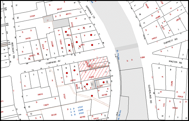
|
NOTIFICATION PLAN |
|
||
|
• PROPERTIES NOTIFIED
|
X SUBMISSIONS RECEIVED |
PROPERTY SUBJECT OF DEVELOPMENT |
|
|
5 SUBMISSIONS RECEIVED OUT OF MAP RANGE |
|||
The submissions received in response to the initial notification of the application object to the development, generally on the grounds that the development would result in:
· Non-compliance with Housing Strategy DCP :- rear setback, building height, Chapman Avenue setback, Wongala Crescent setback, privacy, isolated site, 6m x 6m deep soil, 6m building separation, communal open space, landscaping, housing choice and articulation;
· Unacceptable noise from railway;
· Unacceptable traffic and road safety;
· Unacceptable impact on heritage character; and
· Unacceptable loss of trees.
The amended plans submitted on 9 July 2013 addressed the majority of concerns raised in the submissions to the original proposal. Seven submissions object to the amended proposal, including four submissions from previous objectors, generally on grounds that the development would result in:
· Isolated site Wongala Crescent;
· Non compliant rear and side setbacks;
· Insufficient deep soil Chapman Avenue frontage; and
· Non-compliant 6m separation between buildings.
Two submissions were neutral to the development and made the following observations:
· The existing heritage garden and dwelling house should be recorded before demolition; and
· Construction impacts need to be minimised.
The merits of the matters raised in community submissions have been addressed in the body of the report.
5.2 Public Agencies
The development application was not referred to any Public Agencies for comment.
6. THE PUBLIC INTEREST
Section 79C(1)(e) of the Act requires Council to consider “the public interest”.
The public interest is an overarching requirement, which includes the consideration of the matters discussed in this report. Implicit to the public interest is the achievement of future built outcomes adequately responding to and respecting the future desired outcomes expressed in environmental planning instruments and development control plans.
The application is considered to have satisfactorily addressed Council’s and relevant agencies’ criteria and would provide a development outcome that, on balance, would result in a positive impact for the community. Accordingly, it is considered that the approval of the proposed development would be in the public interest.
CONCLUSION
The proposal is for the demolition of existing buildings and construction of two five storey residential flat buildings containing 36 units and strata title subdivision.
The proposed development is considered of satisfactory design in compliance with the requirements of the Housing Strategy DCP - Part 3 Heritage Precinct Development and Hornsby DCP 2013. The proposal complies with the requirements for the desired future character of the precinct and would compliment the heritage significance of the Beecroft-Cheltenham Heritage Conservation Area.
The proposed development is in accordance with the design principles of SEPP 65 – Design Quality Residential Flat Development and the best practice design requirements of the Residential Flat Design Code.
The proposed development complies with the requirements of the Housing Strategy DCP in respect to site requirements, height, articulation, open space, privacy, sunlight and ventilation, housing choice, landscaping and vehicle access and parking. The proposed non-compliance with the 6m separation between buildings and the 10m setback of the underground car park from Chapman Avenue is considered acceptable on merit with regard to the constraints of the corner site.
The recommended condition for the plans to be amended for the accessway width to allow two-way traffic is considered appropriate for traffic safety and acceptable with regard to non-compliance with the required 2m driveway setback.
A total of 17 submissions were received in response to the proposal.
The application is recommended for approval.
|
Rod Pickles Manager - Development Assessment Planning Division |
James Farrington Group Manager Planning Division |
|
1.View |
Locality Map |
|
|
|
2.View |
Site/Roof Plan |
|
|
|
3.View |
Landscape Plan |
|
|
|
4.View |
Floor Plans |
|
|
|
5.View |
Elevations |
|
|
|
6.View |
Sections |
|
|
|
7.View |
Shadow Plan |
|
|
|
8.View |
Photomontage |
|
|
File Reference: DA/38/2013
Document Number: D02441976
SCHEDULE 1
GENERAL CONDITIONS
The conditions of consent within this notice of determination have been applied to ensure that the use of the land and/or building is carried out in such a manner that is consistent with the aims and objectives of the relevant legislation, planning instruments and council policies affecting the land and does not disrupt the amenity of the neighbourhood or impact upon the environment.
Note: For the purpose of this consent, the term ‘applicant’ means any person who has the authority to act on or the benefit of the development consent.
Note: For the purpose of this consent, any reference to an Act, Regulation, Australian Standard or publication by a public authority shall be taken to mean the gazetted act or regulation, or adopted Australian Standard or publication as in force on the date that the application for a construction certificate is made.
1. Approved Plans and Supporting Documentation
The development must be carried out in accordance with the plans and documentation listed below and endorsed with Council’s stamp, except where amended by Council and/or other conditions of this consent:
|
Plan No. |
Plan Title |
Drawn by |
Dated |
|
A01 Rev C |
Site/roof plan |
Architects Becerra |
Aug 2012 |
|
A02 Rev F |
Basement Plan |
Architects Becerra |
Aug 2012 |
|
A03 Rev D |
Level 1 Floor Plan |
Architects Becerra |
Aug 2012 |
|
A04 Rev C |
Level 2 Floor Plan |
Architects Becerra |
Aug 2012 |
|
A05 Rev D |
Level 3 Floor Plan |
Architects Becerra |
Aug 2012 |
|
A06 Rev E |
Level 4 Floor Plan |
Architects Becerra |
Aug 2012 |
|
A07 Rev D |
Level 5 Floor Plan |
Architects Becerra |
Aug 2012 |
|
A08 Rev C |
Level 6 Floor Plan |
Architects Becerra |
Aug 2012 |
|
A09 Rev D |
Elevations |
Architects Becerra |
Sept 2012 |
|
A10 Rev D |
Elevations |
Architects Becerra |
Sept 2012 |
|
A11 Rev D |
Sections |
Architects Becerra |
Aug 2012 |
|
A12 Rev B |
Materials & Finishes |
Architects Becerra |
Sept 2012 |
|
A21 Rev A |
Chapman Avenue Landscape Section |
Architects Becerra |
Aug 2012 |
|
LPDA 13 - 107/1 |
Landscape Plan |
Conzept Landscape Architects |
Dec 2012 |
|
LPDA 13 – 107/2 |
Landscape Details |
Conzept Landscape Architects |
Oct 2012 |
|
Document Title |
Prepared By |
Dated |
|
Arboricultural Assessment Report |
Jacksons Nature Works |
11 Sept 2013 |
|
Rail Noise Assessment |
Acoustic Dynamics |
17 Jan 2013 |
|
Heritage Impact Assessment and Demolition Report |
Andrew Starr and Associates Heritage Consultants |
October 2012 |
|
Waste Management Plan |
Architects Becerra |
Undated |
|
BASIX Certificate No. 450054M |
Gradwell Consulting |
14 Dec 2012 |
2. Amendment of Plans
The approved plans are to be amended as follows:
a) The lift of the western building must continue to the lower basement level.
b) The accessway width must not be less than 5.5m.
c) The traffic lights are deleted.
d) The basement car park must include 1 motor cycle parking space and a minimum of 42 car parking spaces including 5 visitor spaces.
3. Removal of Existing Trees
This development consent only permits the removal of tree(s) numbered 6, 7, 10, 14, 16, 18, 20, 29, 30, 32, 33, 34 and 35 as identified on Plan No. LPDA 13 – 107/1 prepared by Conzept Landscape Architects dated Dec 2012. The removal of any other trees requires separate approval under Council’s Tree Preservation Order.
4. Construction Certificate
A Construction Certificate is required to be approved by Council or a Private Certifying Authority prior to the commencement of any works under this consent.
REQUIREMENTS PRIOR TO THE ISSUE OF A CONSTRUCTION CERTIFICATE
5. Building Code of Australia
All building work must be carried out in accordance with the relevant requirements of the Building Code of Australia.
6. Contract of Insurance (Residential Building Work)
In the case of residential building work for which the Home Building Act, 1989 requires there to be a contract of insurance in force in accordance with Part 6 of that Act, that such a contract of insurance is in force before any building work authorised to be carried out by the consent commences.
7. Notification of Home Building Act, 1989 Requirements
Residential building work within the meaning of the Home Building Act, 1989 must not be carried out unless the principal certifying authority for the development to which the work relates (not being Council) has given Council written notice of the following information:
a) In the case of work for which a principal contractor is required to be appointed:
i) The name and licence number of the principal contractor; and
ii) The name of the insurer by which the work is insured under Part 6 of that Act.
b) In the case of work to be done by an owner-builder:
i) The name of the owner-builder and;
ii) If the owner-builder is required to hold an owner-builder’s permit under that Act, the number of the owner-builder’s permit.
Note: If arrangements for doing the residential building work are changed while the work is in progress so that the information notified becomes out of date, further work must not be carried out unless the principal certifying authority for the development to which the work relates (not being Council) has given Council written notification of the updated information.
8. Water/Electricity Utility Services
The applicant must submit written evidence of the following service provider requirements:
a) Energy Australia – a letter of consent demonstrating that satisfactory arrangements have been made to service the proposed development.
b) Sydney Water – the submission of a ‘Notice of Requirements’ under s73 of the Sydney Water Act 1994.
Note: Sydney Water requires that s73 applications are to be made through an authorised Sydney Water Servicing Coordinator. Refer to www.sydneywater.com.au or telephone 13 20 92 for assistance.
9. Adaptable Units
a) The details of the adaptable units Nos. 1, 2, 9, 10, 17, 18, 25, 26 and 57 must be provided with the Construction Certificate Plans.
b) Units Nos. 6, 14, 22 and 30 must be in compliance with AS1428.1 – Design for Access and Mobility.
10. Dilapidation Report
A ‘Dilapidation Report’ is to be prepared by a ‘chartered structural engineer’ detailing the structural condition of all adjoining properties including:
No. 23 Wongala Crescent, Beecroft.
No. 23A Wongala Crescent, Beecroft.
No. 1 Chapman Avenue, Beecroft.
11. Noise – Rail Corridor
The development must be carried out in accordance with the recommendations contained within the acoustic report submitted with the development application, titled Rail Noise Assessment, prepared by Acoustic Dynamics and dated 17 January 2013 and the requirements of the Department of Planning’s Development Near Rail Corridors and Busy Roads – Interim Guideline and RailCorp’s Interim Guidelines for Applicants.
Note: The Department of Planning’s document is available at www.planning.nsw.gov.au (development assessments). The RailCorp document is available at www.railcorp.nsw.gov.au/publications.
12. Preservation of Survey Infrastructure
Prior to the issue of a construction certificate, a registered surveyor shall identify all survey marks in the vicinity of the proposed development. Any survey marks required to be removed or displaced as a result of the proposed development shall be undertaken by a registered surveyor in accordance with Section 24 (1) of the Surveying and Spatial Information Act 2002 and following the Surveyor General’s Directions No.11 – "Preservation of Survey Infrastructure".
13. Waste Management Details
The following waste management requirements must be complied with:
a) The lift in the western building must continue down to the basement level (bin storage room level).
b) A Waste Management Plan Section One – Demolition Stage and Section Three – Construction Stage, covering the scope of this project and including the following details, is required to be submitted to Council:
i) An estimate of the types and volumes of waste and recyclables to be generated;
ii) A site plan showing sorting and storage areas for demolition and construction waste and the vehicle access to these areas;
iii) How excavation, demolition and construction waste materials will be reused or recycled and where residual wastes will be disposed;
iv) The total percentage (by weight) of demolition and construction waste that will be reused or recycled.
REQUIREMENTS PRIOR TO THE COMMENCEMENT OF ANY WORKS
14. Erection of Construction Sign
A sign must be erected in a prominent position on any site on which building work, subdivision work or demolition work is being carried out:
a) Showing the name, address and telephone number of the principal certifying authority for the work;
b) Showing the name of the principal contractor (if any) for any demolition or building work and a telephone number on which that person may be contacted outside working hours; and
c) Stating that unauthorised entry to the work site is prohibited.
Note: Any such sign is to be maintained while the building work, subdivision work or demolition work is being carried out, but must be removed when the work has been completed.
15. Protection of Adjoining Areas
A temporary hoarding, fence or awning must be erected between the work site and adjoining lands before the works begin and must be kept in place until after the completion of the works if the works:
a) Could cause a danger, obstruction or inconvenience to pedestrian or vehicular traffic.
b) Could cause damage to adjoining lands by falling objects.
c) Involve the enclosure of a public place or part of a public place.
Note: Notwithstanding the above, Council’s separate written approval is required prior to the erection of any structure or other obstruction on public land.
16. Toilet Facilities
Toilet facilities must be available or provided at the works site before works begin and must be maintained until the works are completed at a ratio of one toilet for every 20 persons employed at the site. Each toilet must:
a) be a standard flushing toilet connected to a public sewer; or
b) be a temporary chemical closet approved under the Local Government Act, 1993; or
c) have an on-site effluent disposal system approved under the Local Government Act, 1993.
17. Erosion and Sediment Control
Erosion and sediment control measures must be provided and maintained throughout the construction period in accordance with the manual ‘Soils and Construction 2004 (Bluebook)’, the approved plans, Council specifications and to the satisfaction of the principal certifying authority. The erosion and sediment control devices must remain in place until the site has been stabilised and revegetated.
Note: On the spot penalties up to $1,500 may be issued for any non-compliance with this requirement without any further notification or warning.
18. Tree Protection Barriers
To avoid injury or damage, trees numbered 9, 11, 12, and 13 must have trunks protected by 2 metre lengths of 75mm x 25mm hardwood timbers spaced at 80mm secured with galvanised wire (not fixed or nailed to the tree in any way.
19. Heritage Conservation
A photographic and measured drawing record of the dwelling-house and heritage listed garden at No. 25 Wongala Crescent shall be taken by a suitable qualified professional prior to the demolition of any structures or garden features on the site. The photographic record should be undertaken in accordance with the Office of Environment and Heritage, Heritage Branch guidelines and two (2) complete copies submitted to Hornsby Council. The photographic and measured drawing record shall include (but not be limited to) an accurate record of the exterior and interior of the dwelling-house, all physical features that contribute to their cultural significance, original and significant elements of the garden, and the context of the site. Any boarding over window and door openings shall be removed for the duration of the archival recording to provide a clear recording of the built form and materials. Satisfaction of this condition shall be confirmed by written advice by Council’s Strategic Planning Branch.
REQUIREMENTS DURING CONSTRUCTION
20. Construction Work Hours
All work on site (including demolition and earth works) must only occur between 7am and 5pm Monday to Saturday, in accordance with Interim Construction Noise Guidelines 2009 – NSW Department of Environment and Climate Change.
No work is to be undertaken on Sundays or public holidays.
21. Demolition
All demolition work must be carried out in accordance with “Australian Standard 2601-2001 – The Demolition of Structures” and the following requirements:
a) Demolition material must be disposed of to an authorised recycling and/or waste disposal site and/or in accordance with an approved waste management plan;
b) Demolition works, where asbestos material is being removed, must be undertaken by a contractor that holds an appropriate licence issued by WorkCover NSW in accordance with Chapter 10 of the Occupational Health and Safety Regulation 2001 and Clause 29 of the Protection of the Environment Operations (Waste) Regulation 2005 and;
c) On construction sites where buildings contain asbestos material, a standard commercially manufactured sign containing the words ‘DANGER ASBESTOS REMOVAL IN PROGRESS’ measuring not less than 400mm x 300mm must be erected in a prominent position visible from the street.
22. Environmental Management
The site must be managed in accordance with the publication ‘Managing Urban Stormwater – Landcom (March 2004) and the Protection of the Environment Operations Act 1997 by way of implementing appropriate measures to prevent sediment run-off, excessive dust, noise or odour emanating from the site during the construction of the development.
23. Street Sweeping
Street sweeping must be undertaken following sediment tracking from the site along Wongala Crescent during works and until the site is established.
24. Works Near Trees
All required tree protection measures are to be maintained in good condition for the duration of the construction period.
All works (including driveways and retaining walls) within 5 metres of any trees required to be retained (whether or not on the subject property, and pursuant to this consent or the Tree Preservation Order), must be carried out under the supervision of an ‘AQF Level 5 Arborist’ and a certificate submitted to the principal certifying authority detailing the method(s) used to preserve the tree(s).
Note: Except as provided above, the applicant is to ensure that no excavation, filling or stockpiling of building materials, parking of vehicles or plant, disposal of cement slurry, waste water or other contaminants is to occur within 4 metres of any tree to be retained.
25. Council Property
During construction works, no building materials, waste, machinery or related matter is to be stored on the road or footpath. The public reserve must be kept in a clean, tidy and safe condition at all times.
26. Landfill
Landfill must be constructed in accordance with Council’s ‘Construction Specification, 2005’ and the following requirements:
a) All fill material imported to the site is to wholly consist of Virgin Excavated Natural Material (VENM) as defined in Schedule 1 of the Protection of the Environment Operations Act 1997 or a material approved under the Department of Environment and Climate Change’s general resource recovery exemption.
b) A compaction certificate is to be obtained from a geotechnical engineer verifying that the specified compaction requirements have been met.
27. Excavated Material
All excavated material removed from the site must be classified in accordance with the Department of Environment, Climate Change and Water NSW Waste Classification Guidelines prior to disposal to an approved waste management facility and reported to the principal certifying authority.
28. Waste Management Details
Waste management during the demolition and construction phase of the development must be undertaken in accordance with the approved Waste Management Plan. Additionally written records of the following items must be maintained during the removal of any waste from the site and such information submitted to the Principal Certifying Authority within fourteen days of the date of completion of the works:
a) The identity of the person removing the waste.
b) The waste carrier vehicle registration.
c) Date and time of waste collection.
d) A description of the waste (type of waste and estimated quantity).
e) Details of the site to which the waste is to be taken.
f) The corresponding tip docket/receipt from the site to which the waste is transferred (noting date and time of delivery, description (type and quantity) of waste).
g) Whether the waste is expected to be reused, recycled or go to landfill.
Note: In accordance with the Protection of the Environment Operations Act 1997, the definition of waste includes any unwanted substance, regardless of whether it is reused, recycled or disposed to landfill.
29. Survey Report – Finished Floor Level
A report(s) must be prepared by a registered surveyor and submitted to the principal certifying authority prior to the pouring of concrete at each level of the building certifying that:
a) The building, retaining walls and the like have been correctly positioned on the site and;
b) The finished floor level(s) are in accordance with the approved plans.
REQUIREMENTS PRIOR TO THE ISSUE OF AN OCCUPATION CERTIFICATE
Note: For the purpose of this consent, a reference to ‘occupation certificate’ shall not be taken to mean an ‘interim occupation certificate’ unless otherwise stated.
30. Fulfilment of BASIX Commitments
The applicant must demonstrate the fulfilment of BASIX commitments pertaining to the development.
31. Sydney Water – s73 Certificate
An s73 Certificate must be obtained from Sydney Water.
32. Stormwater Drainage – Dwellings
Stormwater from the site shall be connected to the Council’s piped system within Wongala Crescent via an on site detention system and shall be in accordance with Council’s Civil Works-Design and Construction Specifications 2005 and the following requirements:
a) Necessary pits and drainage lines are to be constructed to connect to the nearest Council pit.
b) The stormwater drainage plan is to indicate all the trees in the proximity of drainage lines and method of protection of the trees that are to be retained.
c) Obtain a construction certificate from Council to carry out drainage works within Council’s road reserve (Council is the only authority to approve works within is road reserves).
33. On-site Detention
An on-site stormwater detention system must be designed by a chartered civil engineer and constructed in accordance with the following requirements:
a) The drainage system to control all collected roof and surface stormwater shall be designed with an on-site-detention system (rain water tanks/above or below ground facility). Stormwater discharge from the development site shall be limited to 5 year pre development ARI discharge level. On site detention storage shall be provided for up to 50 year ARI storm events. Detail calculations are to be submitted with a construction certificate application.
b) Have a surcharge/inspection grate located directly above the outlet. An overland flowpath is to be constructed ensuring that stormwater flows to Wongala Crescent.
c) Discharge from the detention system to be controlled via 1 metre length of pipe, not less than 50 millimetres diameter or via a stainless plate with sharply drilled orifice bolted over the face of the outlet discharging into a larger diameter pipe capable of carrying the design flow to an approved Council system.
d) Where above ground and the average depth is greater than 0.3 metres, a ‘pool type’ safety fence and warning signs to be installed.
e) Not be constructed in a location that would impact upon the visual or recreational amenity of residents.
f) A construction certificate application is to be submitted and approval obtained prior to commencement of works.
34. Internal Driveway/Vehicular Areas
The driveway and parking areas on site must be designed in accordance with Australian Standards 2890.1, 2809.2 and 3727 and the following requirements:
a) Design levels at the front boundary be obtained from Council.
b) The driveway be a rigid pavement.
c) The driveway pavement be 0.15 metres thick reinforced concrete with F72 steel reinforcing fabric and a 0.15 metre sub-base
d) The driveway grade must not exceed 25 percent and changes in grade must not exceed 8 percent.
35. Footpath and Kerb and Gutter
The uneven sections of the nature strip along frontage of the development must be properly graded and turfed.
Damaged footpath and kerb and gutter must be replaced.
36. Vehicle Crossing
A separate application under the Local Government Act, 1993 and the Roads Act, 1993 must be submitted to Council for the installation of a new vehicular crossing and the removal of the redundant crossing. The vehicular crossing must be constructed in accordance with Council’s Civil Works Design, 2005 and the following requirements:
a) Any redundant crossings to be replaced with integral kerb and gutter.
b) The footway area to be restored by turfing.
c) Approval obtained from all relevant utility providers that all necessary conduits be provided and protected under the crossing.
Note: An application for a vehicular crossing can only be made to one of Council’s Authorised Vehicular Crossing Contractors. You are advised to contact Council on 02 9847 6940 to obtain a list of contractors.
37. Traffic Control Plan
A Traffic Control Plan (TCP) must be prepared by a qualified traffic controller in accordance with the Roads & Traffic Authority’s Traffic Control at Worksites Manual 1998 and Australian Standard 1742.3 for all work on a public road and be submitted to Council. The TCP must detail the following:
a) Arrangements for public notification of the works.
b) Temporary construction signage.
c) Permanent post-construction signage.
d) Vehicle movement plans.
e) Traffic management plans.
f) Pedestrian and cyclist access/safety.
38. Creation of Easements
The following matter(s) must be nominated on the plan of subdivision under s88B of the Conveyancing Act 1919:
a) The creation of an appropriate "Positive Covenant" and "Restriction as to User" over the constructed on-site detention/retention systems and outlet works, within the lots in favour of Council in accordance with Council’s prescribed wording. The position of the on-site detention system is to be clearly indicated on the title.
b) To register the OSD easement, the restriction on the use of land “works-as-executed” details of the on-site-detention system must be submitted verifying that the required storage and discharge rates have been constructed in accordance with the design requirements. The details must show the invert levels of the on site system together with pipe sizes and grades. Any variations to the approved plans must be shown in red on the “works-as-executed” plan and supported by calculations.
Note: Council must be nominated as the authority to release, vary or modify any easement, restriction or covenant.
39. Installation of Privacy Devices
The following device(s) must be installed to maintain an element of privacy.
a) Opposing balconies must be fitted with sliding stackable louvered metal screens extendable to the full width of the balconies;
b) The above metal louvered privacy screens are to be fitted to the main balcony open space areas of Unit 1 and Unit 10;
c) All glass balustrades must be translucent glass.
40. Retaining Walls
All required retaining walls must be constructed as part of the development.
41. Works As Executed Plan
A works-as-executed plan(s) must be prepared by a registered surveyor and submitted to Council for completed drainage system and on-site detention system.
42. Survey Infrastructure
A registered surveyor shall certify that there is no removal, damage, destruction, displacement or defacing of the existing survey marks in the vicinity of the proposed development and/or the re-establishment of damaged, removed or displaced survey marks has been undertaken in accordance with the Surveyor General’s Directions No.11 – "Preservation of Survey Infrastructure".
43. Completion of Landscaping
a) A certificate must be provided by a practicing landscape architect, horticulturalist or person with similar qualifications and experience certifying that all required landscaping works have been satisfactorily completed in accordance with the approved landscape plans.
b) The 1.2m high front boundary fence noted on the approved Landscape Plan is not approved under this consent. A development application must be submitted to Council for the proposed front boundary fencing of the site.
Note: Advice on suitable species for landscaping can be obtained from Council’s planting guide ‘Indigenous Plants for the Bushland Shire’, available at www.hornsby.nsw.gov.au.
44. External Lighting
All external lighting must be designed and installed in accordance with Australian Standard AS 4282 – Control of the Obtrusive Effects of Outdoor Lighting. Certification of compliance with the Standard must be obtained from a suitably qualified person.
45. Garbage Collection Easement
For the purpose of waste collection, an easement entitling Council, its servants and agents and persons authorised by it to enter upon the subject land and to operate thereon, vehicles and other equipment for the purposes of garbage collection must be granted to Council by the owner of the land.
Note The easement must be in a form prescribed by Council and must include covenants to the effect that parties will not be liable for any damage caused to the subject land or any part thereof or to any property located therein or thereon by reason of the operation thereon of any vehicle or other equipment used in connection with the collection of garbage and to the effect that the owner for the time being of the subject land shall indemnify the Council, its servants, agents and persons authorised by it to collect garbage against liability in respect of any such claims made by any person whomsoever.
46. Unit Numbering
The allocation of unit numbering must be authorised by Council prior to the numbering of each unit in the development.
47. Section 94 Development Contributions
a) In accordance with Section 80A(1) of the Environmental Planning and Assessment Act 1979 and the Hornsby Shire Council Section 94 Development Contributions Plan 2012-2021, the following monetary contributions shall be paid to Council to cater for the increased demand for community infrastructure resulting from the development:
|
Description |
Contribution (4) |
|
Roads |
$21,207.35 |
|
Open Space and Recreation |
$382,983.40 |
|
Community Facilities |
$53,712.05 |
|
Plan Preparation and Administration |
$1605.45 |
|
TOTAL |
$459,508.25 |
being for 5 x 1 bedroom units, 27 x 2 bedroom units and 4 x 3 bedroom units and including a credit for four existing allotments.
b) If the contributions are not paid within the financial quarter that this consent is granted, the contributions payable will be adjusted in accordance with the provisions of the Hornsby Shire Council Section 94 Development Contributions Plan and the amount payable will be calculated at the time of payment in the following manner:
$CPY = $CDC x CPIPY
CPIDC
Where:
$CPY is the amount of the contribution at the date of Payment
$CDC is the amount of the contribution as set out in this Development Consent
CPIPY is the latest release of the Consumer Price Index (Sydney – All Groups) at the date of Payment as published by the ABS.
CPIDC is the Consumer Price Index (Sydney – All Groups) for the financial quarter at the date of this Development Consent.
c) The monetary contributions shall be paid to Council:
i) prior to the issue of the Subdivision Certificate where the development is for subdivision; or
ii) prior to the issue of the first Construction Certificate where the development is for building work; or
iii) prior to issue of the Subdivision Certificate or first Construction Certificate, whichever occurs first, where the development involves both subdivision and building work; or
iv) prior to the works commencing where the development does not require a Construction Certificate or Subdivision Certificate.
It is the professional responsibility of the Principal Certifying Authority to ensure that the monetary contributions have been paid to Council in accordance with the above timeframes.
Council’s Development Contributions Plan may be viewed at www.hornsby.nsw.gov.au or a copy may be inspected at Council’s Administration Centre during normal business hours.
48. Waste Management Details
The following waste management requirements must be complied with:
a) The bin storage room at the basement level must include water or a hose for cleaning, graded floors with drainage to sewer, a robust door, sealed and impervious surface, adequate lighting and ventilation. The bin rooms at each residential level must include sealed and impervious surface, adequate lighting and ventilation.
b) A report must be prepared by an appropriately qualified person, certifying the following:
i) A comparison of the estimated quantities of each waste type against the actual quantities of each waste type.
Note: Explanations of any deviations to the approved Waste Management Plan is required to be included in this report
ii) That at least 60% of the waste generated during the demolition and construction phase of the development was reused or recycled.
Note: If the 60% diversion from landfill cannot be achieved in the Construction Stage, the Report is to include the reasons why this occurred and certify that appropriate work practices were employed to implement the approved Waste Management Plan. The Report must be based on documentary evidence such as tipping dockets/receipts from recycling depots, transfer stations and landfills, audits of procedures etc. which are to be attached to the report.
iii) All waste was taken to site(s) that were lawfully permitted to accept that waste.
c) Each unit must be provided with an indoor waste/recycling cupboard for the interim storage of a minimum one day’s waste generation with separate containers for general waste and recyclable materials.
d) Space must be provided for either individual compost containers for each unit or a communal compost container;
Note: The location of the compost containers should have regard for potential amenity impacts.
e) The bin carting routes must be devoid of any steps.
Note: Ramps between different levels are acceptable
f) “No parking” signs must be erected to prohibit parking in the waste collection vehicle turning area and loading area.
g) A report(s) must be prepared by a registered surveyor and submitted to the principal certifying authority prior to the issue of the Subdivision/Occupation Certificate, certifying that:
i) The finished access way (including ramp, vehicle turning area, loading bay and site entry/exit) to be used by waste collection vehicles, complies with Australian Standard AS2890.2-2002 Parking Facilities Part 2: Off-street Commercial Vehicle Facilities for small rigid vehicles with minimum design vehicle dimensions of 6.4 metres overall length, width of 2.3 metres, with maximum gradient of 1:6.5 and minimum 3.5 metre clearance height; and
ii) The finished gradient(s), dimensions and geometry of the road/access way (including vehicle turning area) are in accordance with the approved plans.
h) The 3.5 metre clearance height within the truck travel path must not be reduced by ducting, pipes or anything else.
49. Landscaping
a) On slab planter boxes must include waterproofing, subsoil drainage (proprietary drainage cell, 50mm sand and filter fabric) automatic irrigation, minimum 500mm planting soil for shrubs and minimum 1000mm planting soil for trees and palms and 75mm mulch to ensure sustainable landscape is achieved.
b) An additional one Jacaranda mimosifolia is to be planted in the landscape setback on the Wongala Crescent frontage. Trees shall be installed at minimum 100 litre pot size.
c) A certificate must be provided by a practicing landscape architect, horticulturalist or person with similar qualifications and experience certifying that all required landscaping works have been satisfactorily completed in accordance with the approved landscape plans.
50. Safety and Security
a) Fire exist doors to the development must be fitted with single cylinder locksets (Australia and New Zealand Standard – Lock Sets) to restrict unauthorized access to the development.
b) Ground floor windows must be fitted with window locks that can be locked with a key.
c) A graffiti management plan must be incorporated into the maintenance plan for the development for graffiti to be removed within a forty-eight hour period.
d) The basement car park entry must be secured by security gates/roller shutters and controlled by secure access located at the top of the driveway.
OPERATIONAL CONDITIONS
51. Noise
All noise generated by the proposed development must be attenuated to prevent levels of noise being emitted to adjacent premises which possess tonal, beating and similar characteristics or which exceeds background noise levels by more than 5dB(A).
52. Fire Safety Statement - Annual
On at least one occasion in every 12 month period following the date of the first ‘Fire Safety Certificate’ issued for the property, the owner must provide Council with an annual ‘Fire Safety Certificate’ to each essential service installed in the building.
53. Car Parking
All car parking must be constructed and operated in accordance with Australian Standard AS/NZS 2890.1:2004 – Off-street car parking and Australian Standard AS 2890.2:2002 – Off-street commercial vehicle facilities.
a) All parking areas and driveways are to be sealed to an all weather standard, line marked and signposted;
b) Car parking, loading and manoeuvring areas to be used solely for nominated purposes;
c) Vehicles awaiting loading, unloading or servicing shall be parked on site and not on adjacent or nearby public roads;
d) All vehicular entry on to the site and egress from the site shall be made in a forward direction.
54. Disabled Car Parking
All parking spaces for people with disabilities must be constructed and operated in accordance with Australian Standard AS/NZS 2890.6:2009 – Off-street parking for people with disabilities
55. Driveway Design
The driveway design must be in accordance with AS2890.1 and AS2890.2.
56. Waste Storage and Waste Management
The waste management on site must be in accordance with the following requirements:
a) Site security measures implemented on the property, including electronic gates, must not prevent access to the bin room/collection point by waste removal services.
b) A site caretaker must be employed and be responsible for moving bins where and when necessary, washing bins and maintaining waste storage areas, ensuring the chute system and related devices are maintained in effective and efficient working order, managing the communal composting area, managing the bulky item storage area (including, but not limited to, ensuring that items placed there do not block or hinder access to bins for bin collection services), arranging the prompt removal of dumped rubbish, ensuring the vehicle turning area and truck loading area is kept clear of parked cars, and ensuring all residents are informed of the use of the waste management system.
57. Landscape Establishment
The landscape works must be maintained into the future to ensure the establishment and successful growth of plant material to meet the intent of the landscape design. This must include but not be limited to watering, weeding, replacement of failed plant material and promoting the growth of plants through standard industry practices.
- END OF CONDITIONS -
ADVISORY NOTES
The following information is provided for your assistance to ensure compliance with the Environmental Planning and Assessment Act, 1979, Environmental Planning and Assessment Regulation 2000, other relevant legislation and Council’s policies and specifications. This information does not form part of the conditions of development consent pursuant to Section 80a of the Act.
Environmental Planning and Assessment Act, 1979 Requirements
The Environmental Planning and Assessment Act, 1979 requires:
· The issue of a construction certificate prior to the commencement of any works. Enquiries can be made to Council’s Customer Services Branch on 9847 6760.
· A principal certifying authority to be nominated and Council notified of that appointment prior to the commencement of any works.
· Council to be given at least two days written notice prior to the commencement of any works.
· Mandatory inspections of nominated stages of the construction inspected.
· An occupation certificate to be issued before occupying any building or commencing the use of the land.
Long Service Levy
In accordance with Section 34 of the Building and Construction Industry Long Service Payments Act 1986, a ‘Long Service Levy’ must be paid to the Long Service Payments Corporation or Hornsby Council.
Note: The rate of the Long Service Levy is 0.35% of the total cost of the work.
Note: Hornsby Council requires the payment of the Long Service Levy prior to the issue of a construction certificate.
Tree Preservation Order
To ensure the maintenance and protection of the existing natural environment, it is an offence to ringbark, cut down, top, lop, remove, wilfully injure or destroy a tree outside 3 metres of the approved building envelope without the prior written consent from Council.
Note: A tree is defined as a single or multi-trunked wood perennial plant having a height of not less than three (3) metres, and which develops many branches, usually from a distance of not less than one (1) metre from the ground, but excluding any plant which, in its particular location, is a noxious plant declared as such pursuant to the Noxious Weeds Act 1993. This definition of ‘tree’ includes any and all types of Palm trees.
All distances are determined under Australian Standard AS4970-2009 ”Protection of Trees on Development Sites”.
Fines may be imposed for non-compliance with Council’s Tree Preservation Order.
Disability Discrimination Act
The applicant’s attention is drawn to the existence of the Disability Discrimination Act. A construction certificate is required to be obtained for the proposed building/s, which will provide consideration under the Building Code of Australia, however, the development may not comply with the requirements of the Disability Discrimination Act. This is the sole responsibility of the applicant.
Subdivision Certificate Requirements
A subdivision certificate application is required to be lodged with Council containing the following information:
· A surveyor’s certificate certifying that all structures within the subject land comply with the development consent in regard to the setbacks from the new boundaries.
· A surveyor’s certificate certifying that all services, drainage lines or access are located wholly within the property boundaries. Where services encroach over the new boundaries, easements are to be created.
· Certification that the requirements of relevant utility authorities have been met.
· A surveyor’s certificate certifying finished ground levels are in accordance with the approved plans.
Note: Council will not issue a subdivision certificate until all conditions of the development consent have been completed.
Fees and Charges – Subdivision
All fees payable to Council as part of any construction, compliance or subdivision certificate or inspection associated with the development (including the registration of privately issued certificates) are required to be paid in full prior to the issue of the subdivision certificate. Any additional Council inspections beyond the scope of any compliance certificate required to verify compliance with the terms of this consent will be charged at the individual inspection rate nominated in Council's Fees and Charges Schedule.
Dial Before You Dig
Prior to commencing any works, the applicant is encouraged to contact Dial Before You Dig on 1100 or www.dialbeforeyoudig.com.au for free information on potential underground pipes and cables within the vicinity of the development site.
Telecommunications Act 1997 (Commonwealth)
If you are aware of any works or proposed works which may affect or impact on Telstra’s assets in any way, you are required to contact: Telstra’s Network Integrity Team on Phone Number 1800810443.
Asbestos Warning
Should asbestos or asbestos products be encountered during demolition or construction works, you are advised to seek advice and information prior to disturbing this material. It is recommended that a contractor holding an asbestos-handling permit (issued by WorkCover NSW)be engaged to manage the proper handling of this material. Further information regarding the safe handling and removal of asbestos can be found at:
Alternatively, telephone the WorkCover Asbestos and Demolition Team on 8260 5885.
Group Manager’s Report No. PL89/13
Planning Division
Date of Meeting: 16/10/2013
6 DEVELOPMENT APPLICATION - SECTION 96 (2) - CONSTRUCTION OF AN AFFORDABLE RENTAL HOUSING DEVELOPMENT COMPRISING 12 UNITS - 176-178 RAY ROAD, EPPING
EXECUTIVE SUMMARY
|
DA No: |
DA/359/2011/A (Lodged 23 May 2013) |
|
Description: |
Section 96(2) modification to an approved affordable housing development by altering the floor plans and the mix of units |
|
Property: |
Lot 1 DP 569934 Nos. 176 - 178 Ray Road Epping |
|
Applicant: |
Mr John Forrest c/- Glendinning Minto and Associates Pty Ltd |
|
Owner: |
Mr John Forrest |
|
Estimated Value: |
N/A |
|
Ward: |
C |
· The application proposes Section 96(2) modification to an approved affordable rental housing development by altering the floor plans and the mix of units.
· The proposal complies with Section 96(2) of the Environmental Planning and Assessment Act, 1979 and the provisions of State Environmental Housing Policy (Affordable Rental Housing) 2009.
· Five submissions have been received in respect of the application.
· It is recommended that the application be approved.
|
THAT pursuant to Section 96(2) of the Environmental Planning and Assessment Act, 1979, Development Application No. DA/359/2011 for an affordable rental housing development comprising 12 units at Lot 1 DP 569934 Nos. 176-178 Ray Road, Epping be amended as detailed in Schedule 1 of Group Manager’s Report No. PL89/13. |
BACKGROUND
On 5 October 2011, Council approved DA/359/2011 for the demolition of existing structures and the construction of an affordable rental housing development comprising twelve units.
SITE
The site comprises one allotment located on the northern side of Ray Road and is known as Nos. 176 and 178 Ray Road, Epping. The site is irregular in shape with a total area of 2361 sq metres. The site experiences a moderate fall from the east to the west with a 7% slope. There is a slight fall to the rear north western corner of the site.
There is an existing two storey brick dwelling with a tile roof located centrally on the site. A freestanding carport is located adjacent to the eastern boundary and an inground pool adjacent to the northern boundary. There are a number of outbuildings located in the north eastern and north western corners of the site.
The site contains established lawns and gardens with a number of mature trees. The majority of the trees are exotic species with some local native species. A 1.8 metre high brick wall with open metal infill panels is located along the front property boundary. The existing wall is screened by vegetation.
The surrounding developments along both sides of Ray Road include single and two storey dwelling houses with generous landscaped front setbacks.
APPROVED DEVELOPMENT
The approved development involves the demolition of all existing structures on the site and the construction of an affordable rental housing development comprising twelve units. The development comprises the following:
· Two separate two storey buildings fronting Ray Road (Units 1C – 4C) including a total of eight units. Each building contains two, one bedroom units on the ground floor level and a two, two bedroom units on the first floor level.
· The approved one and two bedroom units would utilise a floor plan which, if required, could be converted to a three bedroom unit at the expiration of the 10 year affordable rental housing period.
· Separate access is proposed to be provided to each unit.
· The ground floor units are provided with two courtyard areas while the first floor units have a 10m2 balcony on the northern elevation, facing the internal driveway.
· Units 5C, 6E, 7E and 8F comprise two separate north facing buildings at the rear of the site, both being two storeys in height.
· All of these units include the primary living areas on the ground floor and the secondary living spaces on the upper floor.
· Pedestrian access to these units would be provided via the internal driveway and the footpath located along the western boundary.
· The approved floor areas (GFA) are provided below:
|
Unit Numbers |
Bedrooms |
Gross Floor Area |
|
Unit 1C – Ground Floor |
1 |
52.7m2 |
|
Unit 1C – First Floor |
2 |
74m2 |
|
Unit 2C – Ground Floor |
1 |
52.7m2 |
|
Unit 2C – First Floor |
2 |
74m2 |
|
Unit 3C – Ground Floor |
1 |
52.7m2 |
|
Unit 3C – First Floor |
2 |
74m2 |
|
Unit 4C – Ground Floor |
1 |
52.7m2 |
|
Unit 4C – First Floor |
2 |
74m2 |
|
Unit 5B |
4 |
181.7m2 |
|
Unit 6E |
3 |
161.1m2 |
|
Unit 7E |
3 |
161.1m2 |
|
Unit 8F |
4 |
176.8m2 |
|
GFA |
|
1187.5m2 |
· Access to all the units is proposed via a common driveway located adjacent to the eastern boundary fronting Ray Road.
· The proposal includes car parking comprising sixteen spaces accessed via the common driveway. Units 5B, 6E, 7E and 8F would be provided with two car parking spaces. The upper level two bedroom dwellings (Units 1C-4C) would be allocated two (tandem) spaces.
· Unit Nos. 1C, 2C, 3C and 4C on the ground floor and Unit Nos. 1C, 2C, 3C and 4C on the first floor level are to be used for the purpose of affordable rental housing.
PROPOSED MODIFICATION
The proposed modifications are summarised below.
Alteration to the units fronting Ray Road as follows:
|
Approved Development |
Proposed Modification |
|
4 x 1-br and 4 x 2-br apartments |
4 x 2-br and 4 x 3-br apartments |
|
1-br apartments located on the ground floor and 2-br apartments located on the upper floor |
A mix of 2-br and 3-br apartments located on both floors |
|
Driveway located along the eastern boundary of the site |
A 5.5m wide driveway ramp along the western boundary of the site |
|
At grade parking |
Basement proposed under the buildings |
|
8 tandem car spaces catering for 8 units |
10 car spaces at the basement level catering for 8 units |
|
No lift provided |
Lift access provided from the basement |
The proposed floor unit areas (GFA) would be as follows:
|
Unit Numbers |
Bedrooms |
Gross Floor Area |
|
Unit 1 |
2 |
71.8m2 |
|
Unit 1A |
2 |
80.4m2 |
|
Unit 2 |
3 |
101.5m2 |
|
Unit 2A |
3 |
110m2 |
|
Unit 3 |
3 |
97m2 |
|
Unit 3A |
3 |
119m2 |
|
Unit 4 |
2 |
87.4m2 |
|
Unit 4A |
2 |
78.24m2 |
|
Unit 5 |
4 |
181.7m2 |
|
Unit 6 |
3 |
161.1m2 |
|
Unit 7 |
3 |
161.1m2 |
|
Unit 8 |
4 |
176.8m2 |
|
GFA |
|
1,426m2 |
· Associated external alterations are proposed complimenting the internal modifications.
· An amended schedule of external colours and finishes has been submitted.
· No modifications are proposed to the two storey units located at the rear of the site.
· The applicant proposes 4 units be used for the purpose of affordable rental housing.
ASSESSMENT
The development application has been assessed having regard to the ‘Metropolitan Plan for Sydney 2031’, the ‘North Subregion (Draft) Subregional Strategy’ and the matters for consideration prescribed under Section 79C of the Environmental Planning and Assessment Act 1979 (the Act). The following issues have been identified for further consideration.
1. STRATEGIC CONTEXT
1.1 Metropolitan Plan for Sydney and (Draft) North Subregional Strategy
The (Draft) Metropolitan Strategy for Sydney 2031 is a broad framework to provide for Sydney’s growth to help plan for housing, employment, transport, infrastructure, the environment and open space. It outlines a vision for Sydney to 2031; the challenges faced, and the directions to follow to address these challenges and achieve the vision.
The approved development is consistent with the Metropolitan Plan for Sydney 2031. The proposed modifications would not have any impact on the compliance of the original proposal with the Metropolitan Plan for Sydney 2031.
2. STATUTORY CONTROLS
Section 79C(1)(a) requires Council to consider “any relevant environmental planning instruments, draft environmental planning instruments, development control plans, planning agreements and regulations”.
2.1 Environmental Planning and Assessment Act 1979 – Section 96(2)
Pursuant to Section 96(2) of the Environmental Planning and Assessment Act 1979, Council may consider an application to amend development consent provided that, inter alia:
“a) it is satisfied that the development to which the consent as modified relates is substantially the same development, and
b) it has consulted with the relevant Minister, public authority or approval body (within the meaning of Division 5) in respect of a condition imposed as a requirement of a concurrence to the consent or in accordance with the general terms of an approval proposed to be granted by the approval body and that Minister, authority or body has not, within 21 days after being consulted, objected to the modification of that consent, and
c) it has notified the application in accordance with the regulations, and
d) it has considered any submissions made concerning the proposed modification within the period prescribed by the regulations.”
With regard to Section 96(2)(a), it is considered that the proposal as amended is substantially the same as the development originally approved.
With regard to Section 96(2)(b), the original proposal was not subject to the concurrence of another authority.
Pursuant to Section 96(2)(c) and (d) the application was notified in accordance with Council’s Notification and Exhibition Development Control Plan. The matters raised in the submissions received are discussed in Section 5 of this report.
2.2 Hornsby Shire Local Environmental Plan 1994
The subject land is zoned Residential A (Low Density) under the Hornsby Local Environmental Plan 1994 (HSLEP). The objectives of the Residential A (Low Density) zone are:
(a) to provide for the housing needs of the population of the Hornsby area.
(b) to promote a variety of housing types and other land uses compatible with a low density residential environment.
(c) to provide for development that is within the environmental capacity of a low density residential environment.
The compliance of the original proposal with the aims and objectives of the zone was assessed in the context of State Environmental Planning Policy (Affordable Rental Housing) 2009 (Affordable Housing SEPP). An assessment of the proposed modifications against the Policy is held at Section 2.4 of this report.
The proposed development is defined as ‘demolition’ and ‘multi-unit housing’ under the HSLEP and is permissible in the zone with Council’s consent.
Clause 15 of the HSLEP prescribes that the maximum floor space ratio (FSR) of development within the Residential A zone is 0.4:1. The proposal as modified exceeds this requirement and relies on the provisions of the Affordable Housing SEPP which permits a maximum floor space ratio of 0.75:1 and prevails over the HSLEP in the case of any inconsistency. The amended application satisfies the Affordable Housing SEPP requirement by proposing a floor space ratio of 0.6:1.
Clause 18 of the HSLEP sets out heritage conservation provisions for Hornsby Shire. The property is not listed as a heritage item in Schedule D of the HSLEP and is not within a conservation area. However, it is in the vicinity of heritage items at Nos. 166 and 184 Ray Road. The site is located at a considerable distance from both of these properties. Notwithstanding, the proposed modifications would not have a detrimental impact on the significance of the heritage items.
2.3 Hornsby Local Environmental Plan 2013
The Hornsby Local Environmental Plan 2013 was made on 27 September 2013 and will come into effect on 11 October 2013. The HLEP includes a savings provision stating that if a development application is made and not finally determined before the commencement of the HLEP, the application must be determined as if the Plan had been exhibited but not commenced. The relevant provisions of the HLEP are addressed below.
2.3.1 Zoning
The site is zoned R2 (Low Density Residential) pursuant to the Land Use Table of the HLEP. The approved development is currently permissible in accordance with provisions of State Environmental Planning Policy (Affordable Rental Housing) 2009 and the current zoning which permits multi-unit housing. However, the approved development is not permissible within the R2 (Low Density Residential) zone as dual occupancies and residential flat buildings are prohibited in the zone.
As indicated above, the Plan includes a savings provision that any development application lodged prior to the commencement of the Plan must be determined as if the Plan has not commenced. Therefore, the permissibility of the proposal under the HLEP should not be determined in the assessment of the amendment.
2.3.2 Height of Building
Clause 4.3 of the HLEP provides that the height of a building on any land is not to exceed the maximum height shown for the land on the Height of Buildings Map. The maximum permissible height for the subject site is 8.5 metres. The proposed development complies with this requirement.
2.4 State Environmental Planning Policy (Affordable Rental Housing) 2009
The application has been assessed against the requirements of the Affordable Rental Housing SEPP. This Policy provides State-wide planning controls for delivery of affordable rental housing through planning incentives to increase rental housing close to business centres and to expand the role of non-profit housing providers. The approved development complied with the various development controls within the Affordable Housing SEPP and was assessed as satisfactory. The proposed modifications are primarily internal with associated external changes.
A brief discussion on the compliance of the modified proposal against the relevant development controls and best practice standards within the Affordable Housing SEPP is provided below.
2.4.1 Standards That Cannot be Used to Refuse Consent (Clause 14)
The following table sets out the compliance of the modified proposal against the development standards within Clause 14 of the Affordable Housing SEPP:
|
SEPP - Affordable Rental Housing |
|||
|
Control |
Proposal |
Requirement |
Compliance |
|
Site Area |
2361m2 |
450m2 |
Yes |
|
Floor Space Ratio Approved Proposed |
0.54:1 0.6:1 |
0.75:1
|
Yes |
|
Approved number of Rental Units: Proposed minimum number of Rental Units: |
>50%
24% |
50% (min)
20% |
Yes
Yes |
|
Dwelling Size (3 and 4 bed) |
> 95m2 |
Min 95m2 |
Yes |
|
Dwelling Size (2 bed) |
> 70m2 |
Min 70m2 |
Yes |
|
Height |
8.5m |
8.5m |
Yes |
|
Car parking Approved: Proposed: |
16 spaces 18 spaces |
6 spaces (0.5 spaces per dwelling) 10 spaces (0.4 space per 1 bed), 0.5 space per 2 bed and 1 space per 3 bed) |
Yes Yes |
|
Solar Access |
100% |
70% |
Yes |
|
Total Deep Soil Zone Approved: Proposed: |
18.4% 18.3% |
15% 15% |
Yes Yes |
|
Deep soil zone at the rear |
278m2 (No change) |
274m2 |
Yes |
|
Minimum dimension of deep soil zone |
3m |
3m |
Yes |
|
Landscaped Area Approved: Proposed: |
36.67% 31% |
30% 30% |
Yes Yes |
As indicated in the above table, the modified development complies with the prescriptive standards within the Policy.
2.4.2 Design Requirements (Clause 15)
The Affordable Rental Housing SEPP (AHSEPP) applies design criteria for low rise and high rise developments. For the subject site, the Seniors Living Policy: Urban Design Guidelines for Infill Development is to be taken into consideration. The approved development was assessed as satisfactory against this Policy. Below is a brief discussion on compliance of the modified proposal with design principles and best practice standards within the Urban Design Guidelines for Infill Development.
2.4.2.1 Responding to Context
The immediate locality is characterised mainly by single to two storey older style detached dwellings with open landscaped frontages along the street and varying housing styles. Front building setbacks are variable with an average of at least 6 metres. Dwellings contain a mix of building materials and finishes.
The development as modified provides a contemporary architectural form with pitched roofs. The development includes a mix of materials and finishes. It would not have any impact on the existing building alignment on the northern side.
The proposed modifications are considered acceptable with regard to the context of Ray Road and the immediate locality.
2.4.2.2 Site Planning and Design
The modified development would result in a similar built form as approved with two storey buildings fronting Ray Road separated by a central pedestrian access way. The modifications would however, result in a driveway along the western boundary instead of the eastern boundary which is considered acceptable. The proposed basement would assist in maintaining a low rise built form on the site whilst providing the required amenities. The living and open space areas are primarily located on the northern elevation of the dwellings, to maximise solar access.
The modified development would maintain the significant vegetation and the front fence as originally approved. The proposal complies with the minimum landscaping and deep soil area requirements.
The modified development offers opportunities for housing choice and affordability to meet the broader needs of the community. The development is assessed as satisfactory in regard to site planning and design.
2.4.2.3 Impacts on Streetscape
The modified development would maintain the approved front setback of 6.7 to 7 metres.
The built form fronting Ray Road would be similar to that approved under the original consent. The first floor would present as a dominant element in the streetscape. However, the proposed and existing landscaping and front fence would provide effective screening of the development when viewed from the street.
The modified development would be similar to the approved development with regard to the impact on the streetscape and is assessed as satisfactory.
2.4.2.4 Impacts on Neighbours
The objectives of the Guidelines are to prevent impacts on the amenity and privacy of the neighbouring properties.
The proposed modifications would not alter the design of the buildings at the rear and therefore, would not result in additional impact on the neighbouring properties.
The modifications would result in Units 1 and 1A being located at a distance of 1 metre from the eastern boundary. The application proposes a 2 metre high privacy screen comprising 150mm thick Aluminium louvers at 45 degrees, along the eastern edge of the first floor balcony and the window on the eastern elevation, to mitigate any adverse privacy impact on the neighbours. The proposed privacy screen is considered acceptable.
The internal driveway would be screened by a 1.8 metre timber lapped and capped fence and landscaping and would therefore, not have a detrimental impact on the amenity of the neighbouring properties.
The shadow diagrams submitted demonstrate that the living rooms and private open spaces area of adjoining dwellings would continue to receive more than 3 hours of direct sunlight between 9am and 3pm in mid-winter.
The modified development is considered acceptable in respect to provision of adequate privacy and amenity to the adjoining properties.
2.4.2.5 Internal Site Amenity
Fences and landscaping would provide suitable screening for the proposed private open space areas of each unit. First floor balconies of the modified units would not directly overlook onto the living areas of the rear units.
The Seniors Living Guidelines specifies that each multi-unit dwelling should be provided with a minimum 35m2 for private open space and have a minimum dimension of 3 metres. The approved units (1C-4C) located on the ground floor complied with the minimum private open space requirements. The proposed modified units (1-4) located on the ground floor do not include the minimum 35m2 for private open space area, as required by the Guidelines. However, the Affordable Rental Housing SEPP does not include any requirements for private open space provision which prevails to the extent of the inconsistency with the Seniors Living Guidelines. Notwithstanding, the modified units include landscaped courtyards in addition to the rear courtyards, which are useable and appropriately screened by fencing and landscaping. The balconies for upper floor units comply with the 10m2 requirement for private open space and have minimum depth of 2 metres.
Privacy of future occupants of the units would be maintained by the proposed offsetting of windows and privacy screens.
All the modified units have distinct entry points from the driveway and pedestrian accessways. Casual surveillance of the access points is achieved within the development minimising opportunities for crime.
The provisions of the AHSEPP (applicable to the approved development) required 0.5 car parking spaces per dwelling. The AHSEPP required the provision of 6 car parking spaces. The approved development provided 16 car parking spaces. The amendments to the AHSEPP, detailed in the table in Section 2.4.1, included car parking provision according to the bedroom category of proposed dwellings. In accordance with the AHSEPP, a total of 10 car parking spaces are required for the entire development. The proposal provides a total of 18 car parking spaces and therefore complies with the requirements of the AHSEPP.
Stairs and a lift provide access from the basement to the ground floor. The car parking arrangements for the rear units would be as approved. The driveway gradients, parking dimensions, aisle widths and turning areas are assessed as satisfactory.
The applicant proposes that each unit would have its own set of three bins and residents would be responsible for placing their bins along the kerb side for collection by the waste collection vehicles. The proposed bin storage areas are considered to be suitable. There is sufficient space on the road frontage to accommodate the bins.
2.4.3 Car Parking
The modified development proposes eighteen car spaces with access being provided off Ray Road. The application is supported by a Traffic Report. As indicated in the table, the number of car spaces provided on site is in excess of the requirement of the Affordable Rental Housing SEPP and would not have a negative impact on the on-street parking in Ray Road. The aisle widths and manoeuvring areas are also considered satisfactory.
2.4.4 Compatibility with the Local Character of the Area
The Local Character Statement submitted in support of the original development was assessed as satisfactory. In accordance with the requirements of Clause 16A and Clause 54A of the amended Affordable Rental Housing SEPP, the applicant submitted the following Local Character Statement in support of the modified development:
“Under the Residential A zone, a range of land uses are permissible with the consent of the Council. The predominant land use and hence character of the local area is low density detached housing comprising of both one and two storey dwelling houses erected upon allotments of varying sizes.
In this regard, it is submitted that the subdivision of the subject site into four Torrens title allotments each having a minimum area of 500m2 would be permissible with the consent of the Council as would the erection of large two storey dwelling houses erected upon allotments of varying sizes.
It is considered that the proposal provides for an outcome which would be consistent with both the existing character of the local area as well as with the desired future character envisaged by the Council through its existing controls.
It is therefore submitted that on this basis that the proposal which seeks to now provide four detached built forms upon the site, each of which is consistent with the height, bulk and scale of a two storey dwelling house, represents development compatible with the character of the local area.
In addition, to the above it is also submitted that the design of the development is compatible with the character of the local area for the following reasons:
1. The proposal seeks to retain the existing front fence and importantly the vegetation which traverses the frontage of the property.
2. The proposal seeks to retain the two significant trees located in each of the rear corners of the site.
3. The proposal seeks to provide for building designs which via elements such as the provision of pitched roofs are compatible with surrounding dwellings.
4. The proposal is to incorporate colours and materials reflective of surrounding developments.
5. The proposal provides for significant replenishment vegetation in order to maintain the treed character of the locality.
For the reasons as detailed above it is my opinion that the revised proposed provides for an outcome whereby the design of the development is compatible with the character of the local area.
It is considered that the amended proposal would not have a detrimental impact on the streetscape of Ray Road due to reasons discussed in the previous sections of this report.
2.4.5 Percentage of Dwellings for Affordable Rental Housing (Clause 17)
Clause 17 of the SEPP provides that at least 50% of dwellings are to be used for affordable rental housing for a period of 10 years. The approved development nominated a total of 8 units (1C, 2C, 3C and 4C on the ground floor and 1C, 2C, 3C and 4C on the first floor) for affordable rental housing.
However, it is noted that a Planning Circular (PS-11-015) issued by the Department of Infrastructure and Planning dated 20 May 2011, states the following in relation to the SEPP (Affordable Housing):
“Incentives linked to percentage of gross floor area rather than number of dwellings
The affordable rental housing component of private infill developments must be at least 20% of the gross floor area of the proposed development. This provision applies to proposals currently under assessment and future development proposals.”
Based on the above, the applicant proposes that four units (1, 3, 4 and 4A) would be used for the purpose of affordable rental housing. The gross floor area of the four units would constitute 24% of the total GFA. The application is assessed as satisfactory in this regard.
2.5 State Environmental Planning Policy (Building Sustainability Index – BASIX) 2004
The amended application has been assessed against the requirements of State Environmental Planning Policy (Building Sustainability Index: BASIX) 2004. The application includes an amended BASIX Certificate for the proposed units and is considered to be satisfactory.
2.6 State Environmental Planning Policy No. 55 – Remediation of Land
Clause 7 of State Environmental Planning Policy No. 55 - Remediation of Land requires Council to consider whether land is contaminated prior to granting consent to the carrying out of any development on that land.
DA/359/2011 was assessed as satisfactory against the objectives of the above Policy. Given that the proposed modifications are regarding alterations to the floor plans only, no further assessment in this regard is considered necessary.
2.7 State Environmental Planning Policy – Sydney Regional Environmental Plan (Sydney Harbour Catchment) 2005
The original application has been assessed as satisfactory against the requirements of Sydney Regional Environmental Plan (Sydney Harbour Catchment) 2005. The proposed modifications would have minimal potential to impact on the Sydney Harbour Catchment.
Subject to the implementation of erosion control measures and stormwater detention, the proposed subdivision would not adversely impact on the catchment or water quality.
2.8 Clause 74BA Environmental Planning and Assessment Act, 1979 - Purpose and Status of Development Control Plans
On 1 March 2013, the Environmental Planning and Assessment Act, 1979 was amended so that a DCP provision will have no effect if it has the practical effect of “preventing or unreasonably restricting development” that is otherwise permitted and complies with the development standards set out in relevant Local Environmental Plans and State Environmental Planning Policies.
The principal purpose of a development control plan is to provide guidance on the aims of any environmental planning instrument that applies to the development; facilitating development that is permissible under any such instrument; and achieving the objectives of land zones under any such instrument. The provisions of a development control plan made for that purpose are not statutory requirements.
2.9 Hornsby Development Control Plan 2013
The Hornsby Development Control Plan (HDCP) 2013 applies to all land within Hornsby Shire and will replace Council’s existing DCPs, providing development controls to complement the HLEP 2013. The HDCP will come into effect on 11 October 2013. The amended proposal has been assessed against the Plan as follows:
2.9.1 Waste Management
The original proposal was assessed as satisfactory with regard to on-going waste management, which required that each unit to have its own set of three bins and the residents would be responsible for placing their bins along the kerb side for collection by the waste collection vehicles.
The modified proposal includes separate bin storage areas for units (1-4 and 1A-4A) and an area for placement of bulky items. The modified application is considered to be satisfactory.
2.9.2 Stormwater Management
The modified development complies with Stormwater Management Section of the HDCP subject to sediment and erosion control measures being implemented on site during construction.
2.10 Section 94 Contributions Plan
Council’s Section 94 Plan applies to the development as it would result in the addition of 11 dwellings. The proposed modifications would result in amendments to the Section 94 contributions levied under the original development. The relevant condition has been modified accordingly.
3. ENVIRONMENTAL IMPACTS
Section 79C(1)(b) of the Act requires Council to consider “the likely impacts of that development, including environmental impacts on both the natural and built environments, and social and economic impacts in the locality”.
3.1 Natural Environment
3.1.1 Impact on Trees
The proposal modifications would not require the removal of any significant trees on the site.
3.2 Built Environment
The details of the impact of the modified development on the built environment of the locality with regard to streetscape presentation and overall visual impact and have been discussed in detail in the previous sections of this report.
3.2.1 Traffic
Due to the increase of the number of bedrooms, the proposal would result in a minor increase in traffic flows. However, the modified development would not have detrimental impact on the current operation of Ray Road or the surrounding road network.
3.2.2 Stormwater Management
The application includes amended details of the on-site detention system and the stormwater management plan. As originally approved, the proposal would drain to Ray Road via an on-site detention system located below the internal driveway. The modified stormwater management plan is considered satisfactory subject to recommended conditions of consent.
3.3 Social Impacts
The modified development would be of positive social impact in providing affordable rental accommodation particularly for large families.
3.4 Economic Impacts
The modified development would have a minor positive impact on the local economy in conjunction with other residential development in the locality by generating an increase in demand for local services.
4. SITE SUITABILITY
Section 79C(1)(c) of the Act requires Council to consider “the suitability of the site for the development”.
At the time of assessment of the original proposal, the site was considered to be suitable for the development. No further assessment in this regard is necessary.
5. PUBLIC PARTICIPATION
Section 79C(1)(d) of the Act requires Council to consider “any submissions made in accordance with this Act”.
5.1 Community Consultation
The modified development was placed on public exhibition and was notified to adjoining and nearby landowners between 7 June 2013 and 19 June 2013 in accordance with Council’s then Notification and Exhibition Development Control Plan. During this period, Council received five submissions. The map below illustrates the location of those nearby landowners who made a submission that are in close proximity to the development site.
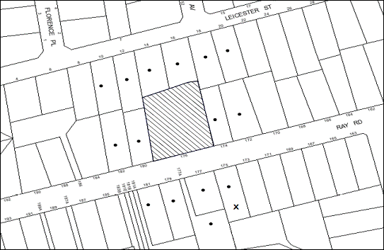
|
NOTIFICATION PLAN |
|
||
|
• PROPERTIES NOTIFIED |
X SUBMISSIONS RECEIVED |
PROPERTY SUBJECT OF DEVELOPMENT |
|
|
FOUR SUBMISSIONS RECEIVED OUT OF MAP RANGE |
|||
Five submissions objected to the development, generally on the grounds that the proposed modifications would result in:
· Unacceptable traffic impacts on local streets.
· Unacceptable overshadowing of adjoining properties.
· Development is excessive in bulk and scale.
· Unacceptable height of the development.
· Insufficient building setbacks.
· The development does not complement or enhance the character of the area.
· Overdevelopment of the site.
· Insufficient car parking when compared to the proposed number of bedrooms.
· Inadequate visitors parking on site.
The merits of the matters raised in community submissions have been addressed in the body of the report and by conditions of consent.
5.2 Public Agencies
The development application was not referred to any Public Agencies for comment.
6. THE PUBLIC INTEREST
Section 79C(1)(e) of the Act requires Council to consider “the public interest”.
The public interest is an overarching requirement, which includes the consideration of the matters discussed in this report. Implicit to the public interest is the achievement of future built outcomes adequately responding to and respecting the future desired outcomes expressed in environmental planning instruments and development control plans.
The modified proposal is considered to have satisfactorily addressed Council’s criteria and would provide a development outcome that, on balance, would result in a positive impact for the community. Accordingly, it is considered that the approval of the proposed modifications would be in the public interest.
CONCLUSION
The application proposes to modify an approved development for affordable rental housing comprising twelve units by altering the floor plans, modifying the mix of units and adding a basement to partially accommodate the required car parking spaces. The modifications also involve a marginal increase in the height of the buildings and external modifications to compliment the internal changes.
The proposed modifications comply with the development standards prescribed under the Affordable Rental Housing SEPP in respect to floor space ratio, car parking, landscaping, deep soil zones, solar access and dwelling size. The proposal would provide a mix of housing choice for future residents, as well as providing four units as affordable rental housing for 10 years. It is considered that the proposed modifications would not have any detrimental impact on the character of the locality or the amenities of the neighbours and the future occupants.
The proposed modifications are recommended for approval subject to recommended conditions.
Note: At the time of the completion of this planning report, no persons have made a Political Donations Disclosure Statement pursuant to Section 147 of the Environmental Planning and Assessment Act 1979 in respect of the subject planning application.
|
Rod Pickles Manager - Development Assessment Planning Division |
James Farrington Group Manager Planning Division |
|
1.View |
Locality Map |
|
|
|
2.View |
Site Plan |
|
|
|
3.View |
Floor Plans |
|
|
|
4.View |
Elevations |
|
|
|
5.View |
Landscape Plan |
|
|
|
6.View |
Shadow Diagrams |
|
|
File Reference: DA/359/2011/A
Document Number: D02405068
SCHEDULE 1
|
Date of this modification: |
16 October 2013 |
|
Details of this modification: |
Section 96(2) modification to amend the layout of eight units, modify the mix of units and include basement car park. |
|
Conditions Added: |
Nil |
|
Conditions Deleted: |
3,4 |
|
Conditions Modified: |
1, 31, 33(a), 34(a), 37(a), 40 |
GENERAL CONDITIONS
The conditions of consent within this notice of determination have been applied to ensure that the use of the land and/or building is carried out in such a manner that is consistent with the aims and objectives of the relevant legislation, planning instruments and Council policies affecting the land and does not disrupt the amenity of the neighbourhood or impact upon the environment.
Note: For the purpose of this consent, the term ‘applicant’ means any person who has the authority to act on or the benefit of the development consent.
Note: For the purpose of this consent, any reference to an Act, Regulation, Australian Standard or publication by a public authority shall be taken to mean the gazetted Act or Regulation, or adopted Australian Standard or publication as in force on the date that the application for a construction certificate is made.
1. Approved Plans and Supporting Documentation
The development must be carried out in accordance with the plans and documentation listed below and endorsed with Council’s stamp, except where amended by Council and/or other conditions of this consent:
Architectural Plans prepared by Jackson Architects
|
Plan No. |
Title |
Revision |
Dated |
|
DA01 |
Demolition Plan |
A |
11/04/2011 |
|
DA01 |
Site Pan |
D |
30/07/2013 |
|
DA02 |
Basement Floor Plan |
D |
30/07/2013 |
|
DA03 |
Ground Floor Plan |
D |
30/07/2013 |
|
DA04 |
First Floor Plan |
C |
19/07/2013 |
|
DA05 |
Site Roof Plan |
C |
19/07/2013 |
|
DA06 |
Site Elevations |
C |
19/07/2013 |
|
DA07 |
Site Elevations |
C |
19/07/2013 |
|
DA08 |
Sections |
C |
19/07/2013 |
Landscape Plan prepared by iScape Landscape Architecture
|
Plan No. |
Title |
Revision |
Dated |
|
50.13(11)/168’B’ |
S96 Landscape Plan |
- |
07/2013 |
Stormwater Plans prepared by ACOR Appleyard Consultants Pty Ltd
|
Plan No. |
Title |
Issue |
Dated |
|
GO110111/C1 |
Stormwater Management Plan – Cover Sheet and Notes |
7 |
04/2013 |
|
GO110111/C2 |
Stormwater Management Plan |
7 |
04/2013 |
|
GO110111/C3 |
Stormwater Management Plan Basement |
6 |
04/2013 |
|
GO110111/C4 |
Stormwater Management Details |
7 |
04/2013 |
|
GO110111/C8 |
Plan – Ray Road External Stormwater Drainage Works |
2 |
04/2013 |
Supporting Documents
|
Document No. and Title |
Prepared by |
Dated |
|
BASIX Certificate No. 369315M_03 |
Archidoc Pty Ltd |
19/04/2013 |
|
Photomontage |
Jackson Architects |
Received by Council 23/05/2013 |
|
Schedule of External Colours and Materials |
- |
18/07/2013 |
|
Arboricultural Assessment Report |
Earthscape Horticultural Services |
12/04/2011 |
|
Preliminary Tree Assessment Report |
Earthscape Horticultural Services |
01/2011 |
|
Waste Management Plan |
Jackson Architects |
28/03/2011 |
|
Addendum to Statement of Environmental Effects |
Glendinning Minto and Associates |
17/05/2013 |
|
Review of Vehicular Access and Carparking Arrangements |
Varga Traffic Planning Pty Ltd |
19/07/2013 |
|
Site Calculations (Reference Drawing No. DA09 Revision D) |
Jackson Architects |
30/07/2013 |
|
Shadow Diagrams 9-00am 22ND June (Reference Drawing No. DA10 Revision B) |
Jackson Architects |
07/04/2013 |
|
Shadow Diagrams 12-00 NOON 22ND June (Reference Drawing No. DA11 Revision B) |
Jackson Architects |
07/04/2013 |
|
Shadow Diagrams 3-00pm 22ND June (Reference Drawing No. DA12 Revision B) |
Jackson Architects |
07/04/2013 |
|
Erosion & Sediment Control Plan (Reference: Drawing No. GO110111/C5 Issue 6) |
ACOR Appleyard Consultants Pty Ltd |
04/2013 |
|
Erosion & Sediment Control Notes (Reference: Drawing No. GO110111/C6 Issue 6) |
ACOR Appleyard Consultants Pty Ltd |
04/2013 |
|
Erosion & Sediment Control Details (Reference: Drawing No. GO110111/C7 Issue 5) |
ACOR Appleyard Consultants Pty Ltd |
04/2013 |
2. Amendment of Plans
The approved plans are to be amended so as to minimise overlooking of the adjoining properties. This is to be achieved by increasing the sill heights of the following windows to a minimum height of 1.5 metres above the finished floor level:
a) The northernmost first floor windows located on the northern first floor elevation of each of the unit Nos. 5, 6, 7 and 8.
Alternatively fixed privacy screens comprising horizontal louvers are to be provided either adjacent to (but not attached) to the dividing fence or are to be attached to the rear elevation of the buildings adjacent to the windows identified above. A detail of the proposed screening treatment including a long section which includes the private open space of the adjoining properties and which demonstrates the effectiveness of the screening treatment is to be provided.
The following windows are to comprise of obscure glazing:
b) The first floor windows located on the eastern elevation of unit No. 8.
c) The first floor windows located on the western elevation of unit No. 5.
3. Delete
4. Delete
5. Removal of Existing Trees
This development consent only permits the removal of tree(s) numbered T1, T2, T2a, T5a, T6, T6a, T7 – T19, 20 – 23, 25 and 26 as identified on Plan No. Preliminary Tree Assessment Report prepared by Andrew Morton dated January 2011. The removal of any other trees requires separate approval under Council’s Tree Preservation Order.
REQUIREMENTS PRIOR TO THE ISSUE OF A CONSTRUCTION CERTIFICATE
6. Building Code of Australia
All building work must be carried out in accordance with the requirements of the Building Code of Australia.
7. Contract of Insurance (Residential Building Work)
In the case of residential building work for which the Home Building Act, 1989 requires there to be a contract of insurance in force in accordance with Part 6 of that Act, that such a contract of insurance is in force before any building work authorised to be carried out by the consent commences.
Note: This condition does not apply to the extent to which an exemption is in force under Clause 187 or 188 of the Act, subject to the terms of any condition or requirement referred to in Clause 187(6) or 188(4) of the Act, or to the erection of a temporary building.
8. Notification of Home Building Act, 1989 Requirements
Residential building work within the meaning of the Home Building Act, 1989 must not be carried out unless the principal certifying authority for the development to which the work relates (not being Council) has given Council written notice of the following information:
a) In the case of work for which a principal contractor is required to be appointed:
i) The name and licence number of the principal contractor.
ii) The name of the insurer by which the work is insured under Part 6 of that Act.
b) In the case of work to be done by an owner-builder:
i) The name of the owner-builder.
ii) If the owner-builder is required to hold an owner-builder’s permit under that Act, the number of the owner-builder’s permit.
Note: If arrangements for doing the residential building work are changed while the work is in progress so that the information notified becomes out of date, further work must not be carried out unless the principal certifying authority for the development to which the work relates (not being Council) has given Council written notification of the updated information.
9. Water/Electricity Utility Services
The applicant must submit written evidence of the following service provider requirements:
a) Energy Australia – a letter of consent demonstrating that satisfactory arrangements have been made to service the proposed development.
b) Sydney Water – the submission of a ‘Notice of Requirements’ under s73 of the Sydney Water Act 1994.
Note: Sydney Water requires that s73 applications are to be made through an authorised Sydney Water Servicing Coordinator. Refer to www.sydneywater.com.au or telephone 13 20 92 for assistance.
10. Sydney Water – Quick Check
The application must be submitted to a Sydney Water ‘Quick Check Agent’ or ‘Customer Centre’ for approval to determine whether the development will affect any Sydney Water infrastructure, and whether further requirements are to be met.
Note: Refer to www.sydneywater.com.au or telephone 13 20 92 for assistance.
11. Dilapidation Report
A ‘Dilapidation Report’ is to be prepared by a ‘chartered structural engineer’ detailing the structural condition of all adjoining properties.
12. Traffic Control Plan
A Traffic Control Plan (TCP) must be prepared by a qualified traffic controller in accordance with the Roads & Traffic Authority’s Traffic Control at Worksites Manual 1998 and Australian Standard 1742.3 for all work on a public road and be submitted to Council. The TCP must detail the following:
a) Arrangements for public notification of the works.
b) Temporary construction signage.
c) Permanent post-construction signage.
d) Vehicle movement plans.
e) Traffic management plans.
f) Pedestrian and cyclist access/safety.
REQUIREMENTS PRIOR TO THE COMMENCEMENT OF ANY WORKS
13. Erection of Construction Sign
A sign must be erected in a prominent position on any site on which building work, subdivision work or demolition work is being carried out:
a) Showing the name, address and telephone number of the principal certifying authority for the work,
b) Showing the name of the principal contractor (if any) for any demolition or building work and a telephone number on which that person may be contacted outside working hours, and
c) Stating that unauthorised entry to the work site is prohibited.
Note: Any such sign is to be maintained while the building work, subdivision work or demolition work is being carried out, but must be removed when the work has been completed.
14. Protection of Adjoining Areas
A temporary hoarding, fence or awning must be erected between the work site and adjoining lands before the works begin and must be kept in place until after the completion of the works if the works:
a) Could cause a danger, obstruction or inconvenience to pedestrian or vehicular traffic.
b) Could cause damage to adjoining lands by falling objects.
c) Involve the enclosure of a public place or part of a public place.
Note: Notwithstanding the above, Council’s separate written approval is required prior to the erection of any structure or other obstruction on public land.
15. Toilet Facilities
Toilet facilities must be available or provided at the works site before works begin and must be maintained until the works are completed at a ratio of one toilet for every 20 persons employed at the site. Each toilet must:
a) be a standard flushing toilet connected to a public sewer; or
b) be a temporary chemical closet approved under the Local Government Act, 1993; or
c) have an on-site effluent disposal system approved under the Local Government Act, 1993
16. Erosion and Sediment Control
Erosion and sediment control measures must be provided and maintained throughout the construction period in accordance with the manual ‘Soils and Construction 2004 (Bluebook)’, the approved plans, Council specifications and to the satisfaction of the principal certifying authority. The erosion and sediment control devices must remain in place until the site has been stabilised and revegetated.
Note: On the spot penalties up to $1,500 may be issued for any non-compliance with this requirement without any further notification or warning.
17. Tree Protection Barriers
Tree protection fencing must be erected around trees numbered T3 – T5, T24 and T27 to be retained at a 3 metre setback. The tree fencing must be constructed of 1.8 metre ‘cyclone chainmesh fence’ or star pickets spaced at 2 metre intervals, connected by a continuous high-visibility barrier/hazard mesh at a height of 1 metre.
REQUIREMENTS DURING CONSTRUCTION
18. Construction Work Hours
All work on site (including demolition and earth works) must only occur between 7am and 5pm Monday to Saturday.
No work is to be undertaken on Sundays or public holidays.
19. Demolition
All demolition work must be carried out in accordance with Australian Standard 2601-2001 – The Demolition of Structures and the following requirements:
a) Demolition material is to be disposed of to an authorised recycling and/or waste disposal site and/or in accordance with an approved waste management plan.
b) Demolition works, where asbestos material is being removed, must be undertaken by a contractor that holds an appropriate licence issued by WorkCover NSW in accordance with Chapter 10 of the Occupational Health and Safety Regulation 2001 and Clause 29 of the Protection of the Environment Operations (Waste) Regulation 2005.
c) On construction sites where buildings contain asbestos material, a standard commercially manufactured sign containing the words ‘DANGER ASBESTOS REMOVAL IN PROGRESS’ measuring not less than 400mm x 300mm must be erected in a prominent position visible from the street.
20. Environmental Management
The site must be managed in accordance with the publication ‘Managing Urban Stormwater – Landcom (March 2004) and the Protection of the Environment Operations Act 1997 by way of implementing appropriate measures to prevent sediment run-off, excessive dust, noise or odour emanating from the site during the construction of the development.
21. Works near Trees
All required tree protection measures are to be maintained in good condition for the duration of the construction period.
All works (including driveways and retaining walls) within 4 metres of any trees required to be retained (whether or not on the subject property, and pursuant to this consent or the Tree Preservation Order), must be carried out under the supervision of an ‘AQF Level 5 Arborist’ and a certificate submitted to the principal certifying authority detailing the method(s) used to preserve the tree(s).
Note: Except as provided above, the applicant is to ensure that no excavation, filling or stockpiling of building materials, parking of vehicles or plant, disposal of cement slurry, waste water or other contaminants is to occur within 4 metres of any tree to be retained.
22. Council Property
During construction works, no building materials, waste, machinery or related matter is to be stored on the road or footpath. The public reserve is to be kept in a clean, tidy and safe condition at all times.
23. Landfill
Landfill must be constructed in accordance with Council’s ‘Construction Specification, 2005’ and the following requirements:
a) All fill material imported to the site is to wholly consist of Virgin Excavated Natural Material (VENM) as defined in Schedule 1 of the Protection of the Environment Operations Act 1997 or a material approved under the Department of Environment and Climate Change’s general resource recovery exemption.
24. Excavated Material
All excavated material removed from the site must be classified in accordance with the NSW Environment Protection Authority’s Environmental Guidelines – Assessment, Classification and Management of Liquid and Non-Liquid Wastes prior to disposal to an approved waste management facility and reported to the principal certifying authority.
REQUIREMENTS PRIOR TO THE ISSUE OF AN OCCUPATION CERTIFICATE
Note: For the purpose of this consent, a reference to ‘occupation certificate’ shall not be taken to mean an ‘interim occupation certificate’ unless otherwise stated.
25. Fulfilment of BASIX Commitments
The applicant must demonstrate the fulfilment of BASIX commitments pertaining to the development.
26. Boundary Fencing
Fencing must be erected along all property boundaries behind the front building alignment to a height of 1.8 metres at nil cost to adjoining owners.
27. Maintain Canopy Cover
To maintain canopy cover, 4 medium to large trees selected from Council’s booklet ‘Indigenous Plants for the Bushland Shire’ are to be planted on the subject site. The planning location shall not be within 4 metres of the foundation walls of a dwelling. The pot size is to be a minimum 25 litres and the trees must be maintained until they reach the height of 3 metres. Trees must be native to Hornsby Shire and reach a mature height greater than 10 metres.
28. Damage to Council Assets
Any damage caused to Council’s assets as a result of the construction of the development must be rectified in accordance with Council’s written requirements and at the sole cost of the applicant.
29. Completion of Landscaping
A certificate must be provided by a practicing landscape architect, horticulturalist or person with similar qualifications and experience certifying that all required landscaping works have been satisfactorily completed in accordance with the approved landscape plans.
Note: Advice on suitable species for landscaping can be obtained from Council’s planting guide ‘Indigenous Plants for the Bushland Shire’, available at www.hornsby.nsw.gov.au.
30. Retaining Walls
All required retaining walls must be constructed as part of the development.
31. Restriction as to User – Affordable Rental Housing
To inform current and future owners that the multi-unit development on the site is for affordable rental housing, a Restriction as to User must be created under Section 88B of the Conveyancing Act 1919 identifying the following:
a) The development is for affordable rental housing pursuant to State Environmental Planning Policy (Affordable Rental Housing) 2009 for a period of 10 years from the date of the issue of the Occupation Certificate.
b) The dwellings identified as Unit Nos. 1, 3, 4 and 4A on the approved plans must be used for the purpose of affordable housing pursuant to Clause 6 of State Environmental Planning Policy (Affordable Rental Housing) 2009.
c) The dwellings identified as Unit Nos. 1, 3, 4 and 4A on the approved plans must be managed by a registered community housing provider as defined in the Housing Act 2001.
Note: The wording of the Restriction as to User must be to Council’s satisfaction and Council must be nominated as the authority to release, vary or modify the Restriction.
32. External Lighting
All external lighting must be designed and installed in accordance with Australian Standard AS 4282 – Control of the Obtrusive Effects of Outdoor Lighting. Certification of compliance with the Standard must be obtained from a suitably qualified person.
33. Stormwater Drainage – Dwellings
The stormwater drainage system for the development must be designed and constructed for an average recurrence interval of 20 years and be gravity drained in accordance with the following requirements:
a) Connected to the existing Council piped drainage system in Ray Road generally in accordance with Drawing No. G0110111/C8 Issue 2 dated 04/2013 by ACOR Appleyard Consultants Pty Ltd.
b) Be in accordance with Australian Standards AS 3500.3 and Hornsby Shire Council’s Civil Works Specification.
Note: A separate Construction Certificate is required to be submitted and approval obtained prior to the commencement of these works.
34. On Site Stormwater Detention
An on-site stormwater detention system must be designed by a chartered civil engineer and constructed in accordance with the following requirements:
a) Generally in accordance with Hornsby Councils Specification for On-Site Stormwater Detention Systems and Job No. G0110111 Issue 7 dated 04/2013 by ACOR Appleyard Consultants Pty Ltd.
b) Have a capacity of not less than 30 cubic metres, and a maximum discharge (when full) of 48 litres per second.
c) Have a surcharge/inspection grate located directly above the outlet.
d) Discharge from the detention system to be controlled via 1 metre length of pipe, not less than 50 millimetres diameter or via a stainless plate with sharply drilled orifice bolted over the face of the outlet discharging into a larger diameter pipe capable of carrying the design flow to an approved Council system.
e) Where above ground and the average depth is greater than 0.3 metres, a ‘pool type’ safety fence and warning signs to be installed.
f) Not be constructed in a location that would impact upon the visual or recreational amenity of residents.
Note: A separate Construction Certificate is required to be submitted and approval obtained prior to the commencement of these works.
35. Internal Driveway/Vehicular Areas
The driveway and parking areas on site must be designed in accordance with Australian Standards 2890.1, 2890.2, 3727 and the following requirements:
a) The driveway be a rigid pavement.
b) The driveway grade must not exceed 25 percent and changes in grade must not exceed 8 percent per plan metre.
c) The provision of a common turning area to enable vehicles to enter and leave the site in a forward direction at all times.
Note: A separate Construction Certificate is required to be submitted and approval obtained prior to the commencement of these works.
36. Vehicular Crossing
A separate application under the Local Government Act, 1993 and the Roads Act, 1993 must be submitted to Council for the installation of a new vehicular crossing and the removal of the redundant crossing. The vehicular crossing must be constructed in accordance with Council’s Civil Works Design, 2005 and the following requirements:
a) Any redundant crossings to be replaced with integral kerb and gutter.
b) The footway area to be restored by turfing.
c) Approval obtained from all relevant utility providers that all necessary conduits be provided and protected under the crossing.
Note: An application for a vehicular crossing can only be made to one of Council’s Authorised Vehicular Crossing Contractors. You are advised to contact Council on 02 9847 6940 to obtain a list of contractors.
37. Public Road and Drainage Works
A separate application under the Local Government Act, 1993 and the Roads Act, 1993 must be submitted to Council for all public road and drainage works approved under this consent and must be constructed in accordance with Council’s Civil Works Design and Construction Specification, 2005 and the following requirements:
a) The extension of Council’s existing piped drainage system in Ray Road generally in accordance with Drawing No. G0110111/C8 Issue 2 dated 04/2013 by ACOR Appleyard Consultants Pty Ltd. Detailed design engineering drawings for construction shall be submitted to Council for approval.
b) All restoration works required to Council’s assets shall be in accordance with Council’s Civil Works Design and Construction Specification, 2005. All cost shall be borne by the applicant.
c) A concrete footpath to be constructed along the full frontage of the development site within the road verge with the remaining area turfed.
d) Any public utility adjustments to be carried out at the cost of the applicant and to the requirements of the relevant public authority.
Note: A separate Construction Certificate is required to be submitted and approval obtained by Council prior to the commencement of these works.
38. Damage to Council Assets
Any damage caused to Council’s assets including the removal, damage, destruction, displacement or defacing of the existing survey marks as a result of the construction of the development must be rectified in accordance with Council’s written requirements and at the sole cost of the applicant.
39. Creation of Easements
The following matter(s) must be nominated on the plan of subdivision under s88B of the Conveyancing Act 1919:
a) The creation of an appropriate "Positive Covenant" and "Restriction as to User" over the constructed on-site detention/retention systems and outlet works, within the lots in favour of Council in accordance with Council’s prescribed wording. The position of the on-site detention system is to be clearly indicated on the title.
b) To register the OSD easement, the restriction on the use of land “works-as-executed” details of the on-site-detention system must be submitted verifying that the required storage and discharge rates have been constructed in accordance with the design requirements. The details must show the invert levels of the on site system together with pipe sizes and grades. Any variations to the approved plans must be shown in red on the “works-as-executed” plan and supported by calculations.
Note: Council must be nominated as the authority to release, vary or modify any easement, restriction or covenant.
40. Section 94 Development Contributions
In accordance with Section 80A(1) of the Environmental Planning and Assessment Act 1979 and the Hornsby Shire Council Section 94 Development Contributions Plan 2012-2021, the following monetary contributions shall be paid to Council to cater for the increased demand for community infrastructure resulting from the development:
|
Description |
Contribution (4) |
|
Roads |
$8,940.90 |
|
Open Space and Recreation |
$167,728.40 |
|
Community Facilities |
$23,503.65 |
|
Plan Preparation and Administration |
$773.55 |
|
TOTAL |
$200,946.50 |
being for eleven (11) additional dwellings.
a) If the contributions are not paid within the financial quarter that this consent is granted, the contributions payable will be adjusted in accordance with the provisions of the Hornsby Shire Council Section 94 Development Contributions Plan and the amount payable will be calculated at the time of payment in the following manner:
$CPY = $CDC x CPIPY
CPIDC
Where:
$CPY is the amount of the contribution at the date of Payment
$CDC is the amount of the contribution as set out in this Development Consent
CPIPY is the latest release of the Consumer Price Index (Sydney – All Groups) at the date of Payment as published by the ABS.
CPIDC is the Consumer Price Index (Sydney – All Groups) for the financial quarter at the date of this Development Consent.
b) The monetary contributions shall be paid to Council:
i) prior to the issue of the Subdivision Certificate where the development is for subdivision; or
ii) prior to the issue of the first Construction Certificate where the development is for building work; or
iii) prior to issue of the Subdivision Certificate or first Construction Certificate, whichever occurs first, where the development involves both subdivision and building work; or
iv) prior to the works commencing where the development does not require a Construction Certificate or Subdivision Certificate.
It is the professional responsibility of the Principal Certifying Authority to ensure that the monetary contributions have been paid to Council in accordance with the above timeframes.
Council’s Development Contributions Plan may be viewed at www.hornsby.nsw.gov.au or a copy may be inspected at Council’s Administration Centre during normal business hours.
OPERATIONAL CONDITIONS
41. Landscaping Maintenance
All of the approved landscaping for the development must be continually maintained to ensure screening for privacy and the presentation of the development.
42. Driveway Operation
The internal accessway and manoeuvring areas are to be unobstructed at all times.
- END OF CONDITIONS -
ADVISORY NOTES
The following information is provided for your assistance to ensure compliance with the Environmental Planning and Assessment Act 1979, Environmental Planning and Assessment Regulation 2000, other relevant legislation and Council’s policies and specifications. This information does not form part of the conditions of development consent pursuant to Section 80A of the Act.
Environmental Planning and Assessment Act, 1979 Requirements
· The Environmental Planning and Assessment Act, 1979 requires:
· The issue of a construction certificate prior to the commencement of any works. Enquiries regarding the issue of a construction certificate can be made to Council’s Customer Services Branch on 9847 6760.
· A principal certifying authority to be nominated and Council notified of that appointment prior to the commencement of any works.
· Council to be given at least two days written notice prior to the commencement of any works.
· Mandatory inspections of nominated stages of the construction inspected.
· An occupation certificate to be issued before occupying any building or commencing the use of the land.
Long Service Levy
In accordance with Section 34 of the Building and Construction Industry Long Service Payments Act 1986, a ‘Long Service Levy’ must be paid to the Long Service Payments Corporation or Hornsby Council.
Note: The rate of the Long Service Levy is 0.35% of the total cost of the work.
Note: Hornsby Council requires the payment of the Long Service Levy prior to the issue of a construction certificate.
Tree Preservation Order
To ensure the maintenance and protection of the existing natural environment, it is an offence to ringbark, cut down, top, lop, remove, wilfully injure or destroy a tree outside 3 metres of the approved building envelope without the prior written consent from Council.
Note: A tree is defined as a single or multi-trunked wood perennial plant having a height of not less than three (3) metres, and which develops many branches, usually from a distance of not less than one (1) metre from the ground, but excluding any plant which, in its particular location, is a noxious plant declared as such pursuant to the Noxious Weeds Act 1993. This definition of ‘tree’ includes any and all types of Palm trees.
All distances are determined under Australian Standard AS4970-2009 “Protection of Trees on Development Sites”.
Fines may be imposed for non-compliance with Council’s Tree Preservation Order.
Dial Before You Dig
Prior to commencing any works, the applicant is encouraged to contact Dial Before You Dig on 1100 or www.dialbeforeyoudig.com.au for free information on potential underground pipes and cables within the vicinity of the development site.
Asbestos
Should asbestos or asbestos products be encountered during demolition or construction works you are advised to seek advice and information should be prior to disturbing the material. It is recommended that a contractor holding an asbestos-handling permit (issued by WorkCover NSW) be engaged to manage the proper handling of the material. Further information regarding the safe handling and removal of asbestos can be found at:
Alternatively, telephone the WorkCover Asbestos and Demolition Team on 8260 5885.
House Numbering
House numbering can only be authorised by Council. Before proceeding to number each premise in the development, the allocation of numbers is required to be obtained from Council's Planning Division. The authorised numbers are required to be displayed in a clear manner at or near the main entrance to each premise.
Group Manager’s Report No. PL91/13
Planning Division
Date of Meeting: 16/10/2013
7 DEVELOPMENT APPLICATION - FIVE STOREY RESIDENTIAL FLAT BUILDING COMPRISING 32 UNITS - 209-211A CARLINGFORD ROAD, CARLINGFORD
EXECUTIVE SUMMARY
|
DA No: |
DA/27/2013 (Lodged 21 January 2013) |
|
Description: |
Demolition of existing structures and construction of a five storey residential flat buildings comprising 32 units and basement car parking |
|
Property: |
Lot 5 DP 30015, Lots 31 and 32 DP 834653, Nos. 209-211A Carlingford Road, Carlingford |
|
Applicant: |
Australian Consulting Architects Pty Ltd |
|
Owners: |
Ms W. S. Yang, Radray Construction Pty Ltd, Mr B. A. Yap and Mr H. M. Chan |
|
Estimated Value: |
$6.8 million |
|
Ward: |
C |
· The application proposes the demolition of existing structures and construction of a five storey residential flat buildings comprising 32 units and basement car parking.
· The proposal generally complies with the Hornsby Shire Local Environmental Plan 1994, State Environmental Planning Policy No. 65 - Design Quality of Residential Flat Development, the Hornsby Shire Housing Strategy Development Control Plan and the Hornsby Development Control Plan 2013.
· Two submissions have been received from the same property.
· It is recommended that the application be approved.
|
THAT Development Application No. DA/27/2013 for demolition of existing structures and construction of a five storey residential flat building comprising 32 units and basement car parking at Lot 5 DP 30015, Lots 31 and 32 DP 834653, Nos. 209-211A Carlingford Road, Carlingford be approved subject to the conditions of consent detailed in Schedule 1 of Group Manager’s Report No. PL91/13. |
BACKGROUND
The subject land was rezoned from Residential A (Low Density) to Residential C (Medium-High Density) on 2 September 2011 as part of Council’s Housing Strategy.
SITE
The site has an area of 1,741.6m2 and is located on the southern side of Carlingford Road. The site is regular in shape and has a frontage of 33.53m to Carlingford Road and a length of 52m. The site has an average fall of 5% to the north-eastern corner of the site.
The site includes three existing dwelling-houses. Access to the site is currently via two existing driveways fronting Carlingford Road.
The site forms part of the ‘Carlingford Road, Carlingford precinct’ rezoned for medium-high density housing in accordance with the Hornsby Shire Housing Strategy in September 2011. The precinct is bounded by Carlingford Road, Pennant Hills Road, Keeler Street and Hepburn Avenue. A number of properties within the precinct have been approved for residential flat development or are under assessment by Council.
The surrounding developments within the precinct mainly include dwelling-houses on suburban lots. There is a mix of low density and medium density housing on the opposite side of Carlingford Road.
The area on the western side of Pennant Hills Road, Carlingford, within The Hills Shire Council area is undergoing transition for higher density housing developments.
The site is within walking distance (120m) of the Carlingford Court commercial centre on Pennant Hills Road and is located 800m north-east of Carlingford Railway Station.
PROPOSAL
The proposal involves the demolition of all the existing structures and construction of a five storey residential flat building comprising 32 units with two levels of basement car parking.
The unit mix would comprise of 6 x 1-bedroom units, 18 x 2-bedroom units and 8 x 3-bedroom units.
The development would be accessed from Carlingford Road via a driveway located adjacent to the eastern boundary of the site. A separate pedestrian entry would provide access to the foyer and a lift for vertical circulation.
A total of 45 residential car parking spaces, including 7 visitor parking spaces are proposed in two basement levels. The basement levels include accessible car parking spaces.
ASSESSMENT
The development application has been assessed having regard to the ‘Metropolitan Plan for Sydney 2031’, the ‘North Subregion (Draft) Subregional Strategy’ and the matters for consideration prescribed under Section 79C of the Environmental Planning and Assessment Act 1979 (the Act). The following issues have been identified for further consideration.
1. STRATEGIC CONTEXT
1.1 Metropolitan Plan for Sydney and (Draft) North Subregional Strategy
The (Draft) Metropolitan Strategy for Sydney 2031 is a broad framework to provide for Sydney’s growth to help plan for housing, employment, transport, infrastructure, the environment and open space. It outlines a vision for Sydney to 2031; the challenges faced, and the directions to follow to address these challenges and achieve the vision.
The North Subregion comprises Hornsby, Kuring-gai, Manly, Warringah and Pittwater Local Government Areas. The Draft North Subregional Strategy acts as a framework for Council in its preparation of the Comprehensive LEP by the end of 2013.
Within the North Subregion, the Draft Metropolitan Strategy proposes:
· Population growth of 81,000 from the current 2011 baseline of 529,000
· Housing growth of 37,000 from the current 2011 baseline of 204,000
· Employment growth of 39,000 from the current 2011 baseline of 186,000
The proposed development would be consistent with the Metropolitan Plan for Sydney 2031 by providing an additional 29 dwellings and would contribute to housing choice in the locality.
2. STATUTORY CONTROLS
Section 79C(1)(a) requires Council to consider “any relevant environmental planning instruments, draft environmental planning instruments, development control plans, planning agreements and regulations”.
2.1 Hornsby Shire Local Environmental Plan 1994
The subject land is zoned Residential C (Medium/High Density) under the Hornsby Shire Local Environmental Plan 1994 (HSLEP). The objectives of the zone are:
a) to provide for the housing needs of the population of the Hornsby area.
b) to promote a variety of housing types and other land uses compatible with a medium to high density residential environment.
c) to provide for development that is within the environmental capacity of a medium to high density residential environment.
The proposed development is defined as ‘multi-unit housing’ under the HSLEP and is permissible in the zone with Council’s consent.
Clause 15 of the HSLEP prescribes the maximum floor space ratio (FSR) of development within the Residential C zone. Subclause (5) of clause 15 states that “This clause does not apply to land shown edged heavy black on diagrams 1-8 in Schedule BB.” The site is identified in Diagram 4 of Schedule BB of the HSLEP. Therefore, clause 15 does not apply to the subject site.
Clause 15A of the HSLEP prescribes that the maximum building height within the area detailed under Schedule BB is not to exceed 17.5m. The proposed building complies with this requirement.
Clause 18 of the HSLEP sets out heritage conservation provisions for Hornsby Shire. The site is not in the vicinity of a heritage item or conservation area and is not subject to consideration for heritage conservation. Therefore, no further assessment in this regard is necessary.
2.2 Hornsby Local Environmental Plan 2013
The Hornsby Local Environmental Plan 2013 was made on 27 September 2013 and will come into effect on 11 October 2013. The HLEP includes a savings provision stating that if a development application is made and not finally determined before the commencement of the HLEP, the application must be determined as if the Plan had been exhibited but not commenced. The relevant provisions of the HLEP are addressed below.
2.2.1 Zoning
The site is zoned R4 (High Density Residential) pursuant to the Land Use Table of the HLEP. The proposed development is defined as a ‘residential flat building’ and is a permissible use in the zone with Council’s consent.
2.2.2 Height of Building
Clause 4.3 of the HLEP provides that the height of a building on any land is not to exceed the maximum height shown for the land on the Height of Buildings Map. The maximum permissible height for the subject site is 17.5m. The proposal complies with this provision.
2.3 State Environmental Planning Policy No. 55 – Remediation of Land
State Environmental Planning Policy No. 55 (SEPP 55) requires that Council must not consent to the carrying out of any development on land unless it has considered whether the land is contaminated or requires remediation for the proposed use.
The site has been used for residential purposes and is unlikely to be contaminated. No further assessment is considered necessary in this regard. A condition is recommended should any contamination be found during construction.
2.4 State Environmental Planning Policy No. 65 – Design Quality of Residential Flat Development
The Policy provides for design principles to improve the design quality of residential flat development and for consistency in planning controls across the State.
The applicant has submitted a design verification statement prepared by a qualified designer stating how the proposed development achieves the design principles of SEPP 65. The design principles of SEPP 65 and the submitted design verification statement are addressed below.
2.4.1 Principle 1 - Context
Design Principle 1 is as follows:
Good design responds and contributes to its context. Context can be defined as the key natural and built features of an area.
Responding to context involves identifying the desirable elements of a location’s current character or, in the case of precincts undergoing a transition, the desired future character as stated in planning and design policies. New buildings will thereby contribute to the quality and identity of the area.
The site is located within a precinct zoned for five storey residential flat buildings in close proximity to Pennant Hills Road and Carlingford Court Shopping Centre. The desired future character of the area, as outlined in Council’s Housing Strategy DCP, is that of a high density residential precinct incorporating five storey developments in a landscape setting. It is considered that the proposed building would contribute to the identity and future character of the precinct.
2.4.2 Principle 2 - Scale
Design Principle 2 is as follows:
Good design provides an appropriate scale in terms of the bulk and height that suits the scale of the street and the surrounding buildings.
Establishing an appropriate scale requires a considered response to the scale of existing development. In precincts undergoing a transition, proposed bulk and height needs to achieve the scale identified for the desired future character of the area.
The scale of the development is in accordance with the required building height and setbacks for the precinct and provides an architectural composition that achieves the required pavilion built forms to minimize bulk and scale. The scale of the development is considered appropriate for the site and consistent with the desired future character of the precinct.
2.4.3 Principle 3 – Built Form
Design Principle 3 is as follows:
Good design achieves an appropriate built form for a site and the building’s purpose, in terms of building alignments, proportions, building type and the manipulation of building elements.
Appropriate built form defines the public domain, contributes to the character of streetscape and parks, including their views and vistas, and provides internal amenity and outlook.
The proposed built form is designed to be consistent with the requirements of the Residential Flat Design Code and Council’s Housing Strategy DCP in relation to the building alignment, setbacks and building type. The articulation of the proposed building has been achieved by the provision of horizontal and vertical architectural elements and by the use of contrasting finishes, colours and textures.
2.4.4 Principle 4 – Density
Design Principle 4 is as follows:
Good design has a density appropriate for a site and its context, in terms of floor space yields (or number of units or residents).
Appropriate densities are sustainable and consistent with the existing density in an area or in precincts undergoing a transition, are consistent with the stated desired future density. Sustainable densities respond to the regional context, availability of infrastructure, public transport, community facilities and environmental quality.
The density of development on the site is guided by the height of the building and the required setbacks from the boundaries. The matter has been discussed in detail in Sections 2.1 and 2.12 of this report.
It is considered that the proposed density is sustainable as it responds to the regional context, availability of infrastructure, public transport, community facilities and environmental quality. The proposal complies with the density principle of SEPP 65.
2.4.5 Principle 5 – Resource, Energy and Water Efficiency
Design Principle 5 is as follows:
Good design makes efficient use of natural resources, energy and water throughout its full life cycle, including construction.
Sustainability is integral to the design process. Aspects include demolition of existing structures, recycling of materials, selection of appropriate and sustainable materials, adaptability and reuse of buildings, layouts and built form, passive solar design principles, efficient appliances and mechanical services, soil zones for vegetation and reuse of water.
The applicant has submitted a BASIX Certificate for the proposed development. In achieving the required BASIX targets for sustainable water use, thermal comfort and energy efficiency, the proposed development achieves the design criteria and is considered acceptable in this regard.
2.4.6 Principle 6 – Landscape
Design Principle 6 is as follows:
Good design recognises that together landscape and buildings operate as an integral and sustainable system, resulting in greater aesthetic quality and amenity for both occupants and the adjoining public domain.
Landscape design builds on the existing site’s natural and cultural features in responsible and creative ways. It enhances the development’s natural environmental performance by co-ordinating water and soil management, solar access, micro-climate, tree canopy and habitat values. It contributes to the positive image and contextual fit of development through respect for streetscape and neighbourhood character, or desired future character.
Landscape design should optimise useability, privacy and social opportunity, equitable access and respect for neighbour’s amenity, and provide for practical establishment and long term management.
The application includes a landscape concept plan providing landscaping along the street frontage, side and rear boundaries. The planting would provide an appropriate landscape setting for the development. The proposed development is in accordance with the Landscaping principle of SEPP 65 and Housing Strategy DCP objective for buildings within landscaped settings.
2.4.7 Principle 7 – Amenity
Design Principle 7 is as follows:
Good design provides amenity through the physical, spatial and environmental quality of a development.
Optimising amenity requires appropriate room dimensions and shapes, access to sunlight, natural ventilation, visual and acoustic privacy, storage, indoor and outdoor space, efficient layouts and service areas, outlook and ease of access for all age groups and degrees of mobility.
The proposed units are designed to achieve natural ventilation, solar access and acoustic privacy. All units incorporate balconies accessible from living areas and privacy has been achieved through appropriate design. Appropriate storage areas have been provided within the units and within the basement levels. The proposal would provide convenient and safe access via a central lift which connects the basement and all other levels. The application is considered acceptable in this regard.
2.4.8 Principle 8 – Safety and Security
Design Principle 8 is as follows:
Good design optimises safety and security, both internal to the development and for the public domain.
This is achieved by maximising overlooking of public and communal spaces while maintaining internal privacy, avoiding dark and non-visible areas, maximising activity on streets, providing clear, safe access points, providing quality public spaces that cater for desired recreational uses, providing lighting appropriate to the location and desired activities, and clear definition between public and private spaces.
The proposal affords good casual surveillance of the street frontage through the visual interaction with the main entrance to the building on the ground floor. With regard to the car parking areas, security garage doors are to be installed with access being provided via an intercom system for visitors and residents to the building.
The RFDC requires the preparation of a formal Crime Assessment Report for development that comprises more than twenty residential units. The proposal includes a Crime Risk Assessment. The application was referred to the NSW Police. The NSW Police raises no objections to the proposal. Conditions are recommended for lighting, territorial re-enforcement, environmental maintenance and access control. Subject to the imposition of conditions of consent addressing the above matters, the proposal is supported in respect of safety and security.
2.4.9 Principle 9 - Social Dimensions and Housing Affordability
Design Principle 9 is as follows:
Good design responds to the social context and needs of the local community in terms of lifestyles, affordability, and access to social facilities.
New development should optimise the provision of housing to suit the social mix and needs in the neighbourhood or, in the case of precincts undergoing transition, provide for the desired future community.
New development should address housing affordability by optimising the provision of economic housing choices and providing a mix of housing types to cater for different budgets and housing needs.
The Housing Strategy DCP includes prescriptive measures for housing choice and for adaptable housing to provide for aging in place. The proposal meets the prescriptive measures and extends the range and diversity of residential accommodation available in the area.
2.4.10 Principle 10 – Aesthetics
Design Principle 10 is as follows:
Quality aesthetics require the appropriate composition of building elements, textures, materials and colours and reflect the use, internal design and structure of the development. Aesthetics should respond to the environment and context, particularly to desirable elements of the existing streetscape or, in precincts undergoing transition, contribute to the desired future character of the area.
The proposal is consistent with the design principles contained within the RFDC. It is considered that the aesthetic quality of the building contributes to the desired future character of the precinct. The details of the assessment of the built form and the aesthetics of the development are contained in Section 2.12 of this report.
2.5 State Environmental Planning Policy No. 65 - Residential Flat Design Code
SEPP 65 also requires consideration of the Residential Flat Design Code, NSW Planning Department 2002. The Code includes development controls and best practice benchmarks for achieving the design principles of SEPP 65. The following table sets out the proposal’s compliance with the Code:
|
Residential Flat Design Code |
|||
|
Control |
Proposal |
Requirement |
Compliance |
|
Deep Soil Zone |
38% |
25% |
Yes |
|
Communal Open Space |
25% |
25-30% |
Yes |
|
Ground Level Private Open Space |
12m2 + Min dimension 4m |
25m2 Min Dimension 4m |
No Yes |
|
Minimum Dwelling Size |
1 br – 50m2 2 br – 70m2 3 br – 95m2 |
1 br – 50m2 2 br – 70m2 3 br – 95m2 |
Yes Yes Yes |
|
Maximum Kitchen Distance |
9.4m (Units 1.5, 2.5 and 3.5)
|
8m |
No |
|
Minimum Balcony Depth |
2m |
2m |
Yes |
|
Ceiling heights - Residential floors |
2.7m |
2.7m (Min) |
Yes |
|
Dual Aspect & Cross Ventilation |
60% |
60% |
Yes |
|
Adaptable Housing |
30% |
10% |
Yes |
As detailed in the above table, the proposed development complies with the prescriptive measures within the Residential Flat Design Code (RFDC) other than minimum dimension for ground level open space and maximum kitchen distance. Below is a brief discussion regarding the relevant development controls and best practice guidelines:
2.5.1 Apartment Layout
The layout of the proposed apartments includes a combination of single aspect units and dual aspect corner units. The unit layouts would provide for housing choice and a range of household types.
The RFDC requires that the back of a kitchen should be no greater than 8m from a window. Of the 32 units proposed, 3 units contain kitchens where the back wall is up to 9.4m from a window. These units offer an open layout with natural ventilation and accordingly, the minor non-compliance is acceptable with respect to residential amenity.
The proposed apartment layouts are functional and satisfy the RFDC requirements for internal privacy, access to sunlight, natural ventilation and acoustic privacy. It is considered that the apartment layout and mix achieve the intent of the best practice requirements of the RFDC and is acceptable in this regard.
2.5.2 Ground Floor Apartments and Private Open Space
Of the 7 units located on the ground floor, 1 unit has been provided with greater than 25m2 of courtyard space and only one of the units meets the minimum 4m dimension. The proposed ground floor unit open space areas include recessed balconies and courtyards contained within the building envelope. The landscaped area surrounding the building is not allocated for private gardens for individual ground floor units, in accordance with the Housing Strategy DCP key principle for buildings to be in landscaped settings.
The provision of additional private courtyard area within the side and rear setbacks would compromise the pedestrian access to the building and communal open space provisions for the site.
Notwithstanding the above, the private open space areas for all units comply with the minimum area requirement of the Housing Strategy DCP. The proposed development includes sufficient landscaped communal open space areas to compensate for this non-compliance.
2.5.3 Internal Circulation
The proposed building includes 4 to 7 units with lift access on each respective level in accordance with the Code’s best practice guidelines for up to 8 units per lift. The location of unit entries and articulation of internal passage ways would ensure appropriate amenity.
The front entry includes an entry foyer on the western elevation of the proposed building. The ground floor includes access to communal open space areas from the frontage and rear. A condition is recommended for the access to comply with AS1428.1 – Design for Access and Mobility.
Subject to recommended conditions, the proposal is considered acceptable in respect to the Code’s requirements for internal circulation.
2.5.4 Acoustic Privacy
The proposed apartment layouts are designed such that noise generating areas would mainly adjoin each other. Storage or circulation zones would act as a buffer between units. Bedrooms and service areas such as kitchens, bathrooms and laundries would be grouped together wherever possible.
The proposal complies with the ‘Acoustic Privacy’ requirements within the RFDC and is assessed as satisfactory.
2.5.5 Storage
The proposed building includes resident storage areas for all units within the building and storage areas would be located within the basement levels. A condition is recommended for the storage areas to be allocated in accordance with the size requirements of the Code for the respective units.
In summary, the proposed residential flat building has been designed in accordance with the design principles of SEPP 65 and generally complies in respect to the Residential Flat Design Code subject to the imposition of appropriate conditions of consent. It is considered the proposal would achieve good residential amenity and contribute to the desired future residential character of the Carlingford Road Precinct.
2.6 State Environmental Planning Policy (Building Sustainability Index – BASIX) - 2004
The application has been assessed against the requirements of State Environmental Planning Policy (Building Sustainability Index: BASIX) 2004. The proposal includes a BASIX Certificate for the proposed units and is considered to be satisfactory.
2.7 State Environmental Planning Policy No. 32 - Urban Consolidation (Redevelopment of Urban Land) (SEPP 32)
The application has been assessed against the requirements of SEPP 32, which requires Council to implement the aims and objectives of this Policy to the fullest extent practicable when considering development applications relating to redevelopment of urban land. The application complies with the objectives of the Policy as it would promote social and economic welfare of the locality and would result in the orderly and economic use of under utilised land within the Shire.
2.8 State Environmental Planning Policy (Infrastructure) 2007
The application has been assessed against the requirements of State Environmental Planning Policy (Infrastructure) 2007. This Policy contains State-wide planning controls for developments adjoining busy roads. The development is located immediately adjoining a classified road corridor (Carlingford Road) and the following matters have been considered in this regard.
2.8.1 Development with Frontage to a Classified Road
The proposal has been assessed against the requirements of Clause 101 of SEPP (Infrastructure) as the site has frontage to Carlingford Road and proposes new vehicular access from the road.
Council’s assessment of the proposal concludes that the proposed driveway complies with AS/NZS 2890.1:2004 and the location of the driveway is satisfactory. The development application was referred to the NSW Roads and Maritime Services (RMS) for concurrence under Section 138 of the Roads Act 1993. No objections have been raised regarding the driveway location. RMS requires the provision of a 6m wide driveway facilitating two way vehicle flows from the entrance of the site to the basement level. The proposal complies with this requirement. Council’s engineering assessment in this regard concludes that the width of the proposed driveway is satisfactory.
RMS requires a central median to be installed on Carlingford Road and extended on both side of the driveway to enforce left-in and left-out movements. The applicant submitted amended plans showing a central median in front of the site along Carlingford Road. A condition has been recommended requiring the central median to be constructed in accordance with RMS requirements.
2.8.2 Impact of Noise
The application was referred to the RMS for comment. The RMS advises that the development should be designed to mitigate the traffic noise and vibration from Carlingford Road by using durable materials in accordance with Environmental Criteria for Road Traffic Noise, May 1999.
It is noted that Clause 102 of SEPP (Infrastructure) does not apply to the development as Carlingford Road is identified as a road with an annual average daily traffic volume of less than 40,000 vehicles (based on the traffic volume data published on the website of the RMS). Therefore, no further assessment with regard to impact of road noise on the development is required.
2.8.3 Traffic Generating Development
The development is not classified as a Traffic Generating Development in accordance with Clause 104 and Schedule 3 of SEPP (Infrastructure) as it would not result in more than 75 dwellings fronting a classified road. No objections have been raised by RMS with regard to traffic generation.
2.9 Sydney Regional Environmental Plan (Sydney Harbour Catchment) 2005
The application has been assessed against the requirements of Sydney Regional Environmental Plan (Sydney Harbour Catchment) 2005. This Policy provides general planning considerations and strategies to ensure that the catchment, foreshores, waterways and islands of Sydney Harbour are recognised, protected, enhanced and maintained.
The proposal includes details of stormwater management of the site by providing an on-site detention system. Council’s engineering assessment of the proposal in this regard concludes that the development is satisfactory. A condition is recommended with respect to installation of sediment and erosion control measures prior to, and during, construction.
The proposed development would have minimal potential to impact on the Sydney Harbour Catchment.
2.10 Clause 74BA Environmental Planning and Assessment Act, 1979 - Purpose and Status of Development Control Plans
On 1 March 2013, the Environmental Planning and Assessment Act, 1979 was amended so that a DCP provision will have no effect if it has the practical effect of “preventing or unreasonably restricting development” that is otherwise permitted and complies with the development standards set out in relevant Local Environmental Plans and State Environmental Planning Policies.
The principal purpose of a development control plan is to provide guidance on the aims of any environmental planning instrument that applies to the development; facilitating development that is permissible under any such instrument; and achieving the objectives of land zones under any such instrument. The provisions of a development control plan made for that purpose are not statutory requirements.
2.11 Hornsby Development Control Plan 2013
The Hornsby Development Control Plan (HDCP) 2013 applies to all land within Hornsby Shire and will replace Council’s existing DCPs, providing development controls to complement the HLEP. The HDCP will come into effect on 11 October 2013.
The following sections of this report include a detailed assessment of the proposal against Council’s existing DCP controls. Although the HDCP was not in force at the date of finalising this report, the development proposal has been assessed against the Plan.
The HDCP is generally a transition of Council’s existing DCPs, into a consolidation Plan. Notwithstanding, it is noted that the following controls are inconsistent with the existing DCP requirements and a brief discussion of the HDCP requirements is provided below:
2.11.1 Building Form and Separation
The eastern boundary of the site adjoins an undeveloped site resulting in the proposed development not complying with the HDCP requirement to provide half of the building separation required by the RFDC under SEPP 65 - Design Quality of Residential Flat Buildings.
The non-compliance with HDCP is considered acceptable in the circumstances given the merit of the design in achieving the desired outcome for built form and separation as discussed in Section 2.12.
2.11.2 Vehicle Access and Parking
The HDCP includes revised car parking requirements with regard to proximity to a railway station and a new provision for motor cycle parking. In this regard, the proposed car parking would exceed the required 35 spaces for residents, 5 visitor spaces and would require 1 motor cycle space. A condition is recommended for the provision of 1 motor cycle space in accordance with the revised controls for transport and parking.
2.12 Housing Strategy Development Control Plan
The proposed development has been assessed having regard to the desired outcomes and prescriptive measures within Council’s Housing Strategy Development Control Plan (Housing Strategy DCP). The following table sets out the proposal’s compliance with the prescriptive measures of the Plan:
|
Housing Strategy Development Control Plan |
|||
|
Control |
Proposal |
Requirement |
Compliance |
|
Site Width |
33.53m |
30m |
Yes |
|
Height |
5 storeys – 17.5m |
5 storeys – 17.5m |
Yes |
|
Lowest Residential Floor Above Ground |
1.01m |
Max - 1.50m |
Yes |
|
Maximum Floorplate Dimension |
35m |
35m |
Yes |
|
Building Indentation |
4m x 4m |
4m x 4m |
Yes |
|
Front Setback |
10m 8.13m (for 7m length) |
10m 8m < 1/3rd frontage
|
Yes Yes
|
|
W Side Setback |
6m 4m < 1/3rd frontage |
6m 4m < 1/3rd frontage |
Yes Yes |
|
E Side Setback |
6m 4m < 1/3rd frontage |
6m 4m < 1/3rd frontage |
Yes Yes |
|
Rear Setback |
10m 8m < 1/3rd boundary 7m |
10m 8m < 1/3rd boundary 7m balcony encroachment |
Yes Yes Yes |
|
Top Storey Setback From Ground Floor |
Front 3m East side 1m – 6m West side 2m – 5m Rear 2m – 5m |
3m 3m 3m 3m |
Yes No No No |
|
Underground Parking Setback |
Front - 7m W Side - 4m E Side – 4m Rear – 7m |
7m 4m 4m 7m |
Yes Yes Yes Yes |
|
Basement Ramp Setback |
2m |
2m |
Yes |
|
Car Parking |
37 resident spaces 7 visitor spaces 8 bicycle racks |
32 resident spaces 7 visitor spaces 11 bicycle racks |
Yes Yes No
|
|
Landscaping |
Front & Rear – 7m W Side – 4m E Side – 4m |
7m 4m 4m |
Yes Yes Yes |
|
Private Open Space Min Width 2.5m |
1 br units - > 10m2 2 br units - > 12m2 3 br units - 16m2 |
10m2 12m2 16m2 |
Yes Yes Yes |
|
Communal Open Space |
30% |
25% |
Yes |
|
Sunlight Access |
70% |
70% |
Yes |
|
Housing Choice |
1 br units – 30% 2 br units - 60% 3 br units – 10% |
10% 10% 10% |
Yes Yes Yes |
|
Adaptable Units |
30% |
30% |
Yes |
As detailed in the above table, the proposed development does not comply with the top storey setback measure and bicycle parking provisions within Council’s Housing Strategy DCP. The matters of non-compliance are detailed below, as well as a brief discussion of the proposal in regards to the various elements of the DCP.
2.12.1 Desired Future Character
The proposed building is in accordance with required key principles for the future character of the precinct for well articulated five storey residential flat buildings in garden settings with basement car parking.
2.12.2 Design Quality – SEPP 65
The proposed development is generally satisfactory in meeting the design principles of SEPP 65 (refer to discussion in Sections 2.4 and 2.5).
2.12.3 Site Requirements
The proposed development complies with the minimum 30m site width requirement. The proposal would not result in an isolated site or compromise development in accordance with the Housing Strategy DCP.
2.12.4 Height
The proposed building complies with the 17.5 metre maximum height limit. The proposed height of the basement above ground level complies with the Housing Strategy DCP.
2.12.5 Setbacks
The proposed five storey building is generally set back from the site boundaries in accordance with the prescriptive measures of the Housing Strategy DCP. The proposed top floor (4th storey) has a varied setback to the required 3m setback to the ground floor exterior wall. The non-compliance is considered acceptable with regard to the building articulation.
The proposal otherwise complies with the prescriptive measures for front, rear, side, basement car park and basement ramp setbacks. The overall intent of the Setbacks element including the articulation of the building and reduced bulk on the top storey floor and incorporation of landscaping, open space and separation between buildings has been achieved. The non-compliances are considered acceptable in this regard.
2.12.6 Landscaping
The landscaped areas within the front and side setbacks comply with the requirements of the Housing Strategy DCP and have been designed to accommodate mature canopy trees.
A 7 metre wide landscaped area is achieved in the front setback. The front landscaped area includes turf areas as well as hard stand areas and a nominated location for an electricity substation at the front of the site. The extent of hard stand areas proposed is considered to be minimal, as reasonable provision has been made for deep soil areas to accommodate mature canopy trees and achieve a landscape setting.
The on-site detention system (OSD) is proposed to be located within the building envelope to avoid encroachment within the deep soil area.
The rear, and part of the side, setbacks would be utilised as communal open space. The proposed landscaping is considered satisfactory.
2.12.7 Floorplates, Separation and Articulation
The proposed building complies with the floorplate length of 35m. The floorplate includes 4m x 4m indentations and the building achieves the appearance of two building pavilions in accordance with the prescriptive measures.
The façade treatment, size and placement of windows, protruding balconies, vertical panels and stepped levels of the building, minimises the bulk and scale and would contribute to the streetscape.
The proposed building complies with the Housing Strategy DCP articulation prescriptive measures and meets the key principles for built form within the ‘Carlingford Road, Carlingford Precinct’.
Accordingly, the design of the floorplate, the proposed indentations and the articulation of the facades has been assessed as satisfactory.
2.12.8 Open Space
The proposed units comply with the required minimum area for private open space accessible from main living areas. The proposal includes a communal open space area in accordance with the minimum requirement.
The proposed private and communal open space provision is in accordance with the prescriptive measures to provide for a range of outdoor activities and to encourage active living.
2.12.9 Privacy
The matters in relation to acoustic privacy of the units have been discussed in detail under “Residential Flat Design Code” in Section 2.5.4 of this report. The proposed design of the building achieves the ‘building separation’ requirements required by SEPP 65.
The living areas of the residential units have been positioned to face the front and the rear wherever possible. The ground floor balconies fronting the communal open space would be suitably screened by landscaping including planter boxes.
The proposal has been assessed as satisfactory in this regard and would not compromise the privacy of the future occupants.
2.12.10 Sunlight and Ventilation
The applicant has submitted detailed hourly solar access diagrams for elevations demonstrating compliance of individual units with solar access requirements. The applicant submits that 70% of the units would receive a minimum 2 hours solar access between 9am and 3 pm during Winter Solstice. Council’s assessment in this regard concludes that the units would comply with the above requirements.
The communal area would be orientated towards the northern, western and southern boundaries. The components of the communal open space located within the northern and western setbacks would receive 2 hours of solar access between 9am and 3pm during Winter Solstice.
The submitted solar access diagrams indicate that the proposal would not compromise the solar access provisions to the units and communal open space for the approved development on the adjoining site at Nos. 213-215 Carlingford Road or any future development on the eastern side of the site fronting Carlingford Road.
2.12.11 Housing Choice
The proposed building includes a mix of one, two and three bedroom dwellings together with provision for accessible housing for disabled persons and for adaptable housing for aging in place, in accordance with the prescriptive measures of the Housing Strategy DCP.
2.12.12 Vehicle Access and Parking
The proposed development complies with the required car parking provisions for residents and visitors subject to recommended conditions.
A total 11 bicycle parking spaces are required for the proposed development. Eight visitor bicycle spaces are shown in the shared zone for the disabled visitor parking spaces on Basement level 1. This is not an acceptable location for bicycle parking. A condition has been recommended requiring the car parking spaces be re-configured to provide 11 bicycle parking spaces, in accordance with AS 2890.3-1993.
The development proposes two levels of basement parking for residents and visitors with access via a 6.8 metre wide driveway from Carlingford Road. The driveway width, ramp gradients, aisle widths, location and number of car parking spaces have been assessed as satisfactory.
The development would allow Small Rigid Vehicle (SRV) access to the upper basement to facilitate garbage collection. The turning area at the upper basement level would allow the SRV to reverse and egress the site in a forward direction.
The proposed storage areas comply with the requirements of the Residential Flat Design Code and are acceptable subject to a recommended condition.
2.12.13 Carlingford Road, Carlingford Precinct
The strategy for redevelopment of this precinct is to predominantly incorporate five storey residential flat buildings in garden settings with parking in basements. The proposal complies with this strategy for the precinct.
2.13 Waste Minimisation and Management Development Control Plan
The proposal includes a waste management plan with details of waste management during the demolition phase and the construction phase of building works.
A garbage chute and recycling bins are to be provided on each level. For 32 dwellings, the site would require 8 x 240 L garbage bins (or 3 x 660 litre garbage bins) serviced twice weekly plus 7 x 240 litre recycling bins serviced weekly. The basement bin room is sufficient size to house the required number of bins. However, volume handling equipment arrangements are to be verified at Construction Certificate stage. The basement also includes a room for placement of unwanted bulky items awaiting collection.
The upper basement level has an area 6.17m wide by 7m deep for bin storage, volume handling equipment and parking for the waste collection vehicle. Access for small rigid waste collection vehicles has been provided to the basement and the truck is to park in the aisle next to the bin room. The aisle is two-way and has been assessed as acceptable.
Subject to recommended conditions, the proposed development is satisfactory in respect to the DCP.
2.14 Access and Mobility Development Control Plan
The proposed development has been assessed having regard to the relevant performance and prescriptive design requirements within Council’s Access and Mobility Development Control Plan.
The development proposes continuous barrier free access to all floors via a lift and complies with the requirements of the Housing Strategy DCP with regard to the provision of adaptable and accessible units subject to conditions.
The application is assessed as satisfactory with regard to the Access and Mobility DCP.
2.15 Car Parking Development Control Plan
The proposed development has been assessed having regard to the relevant performance and prescriptive design requirements contained within Council’s Car Parking Development Control Plan and is generally in compliance with Council’s car parking requirements. Refer also to discussion in Section 2.12.12.
2.16 Sustainable Water Development Control Plan
Subject to sediment and erosion control measures being implemented on site during construction, the proposal would comply with the requirements contained within the Sustainable Water Development Control Plan.
2.17 Section 94 Contributions Plan
Council’s Section 94 Plan applies to the development as it would result in the addition of 29 residential units in lieu of the three existing residences. Accordingly, the requirement for a monetary Section 94 contribution is recommended as a condition of development consent.
3. ENVIRONMENTAL IMPACTS
Section 79C (1)(b) of the Act requires Council to consider “the likely impacts of that development, including environmental impacts on both the natural and built environments, and social and economic impacts in the locality”.
3.1 Natural Environment
The site comprises a number of exotic and weed species. The proposed development would necessitate the removal of 16 trees from the site, 15 of which are exempt under Council’s Tree Preservation Order (TPO) and one of the trees (T1) is located on the adjoining property. The application is supported by an arborist report that assesses existing trees and provides recommendations. None of the trees to be removed are identified as significant and Council’s assessment of the application with regard to its impact on trees concludes that the proposal is satisfactory.
The submitted landscape plan includes a range of indigenous plant species including Angophora costata (Smooth Bark Apple) and Elaeocarpus reticulates (Blueberry Ash). Accordingly, the submitted landscape plan is considered acceptable with regard to the natural environment.
3.2 Built Environment
3.2.1 Built Form
The buildings would be located within a precinct indentified with a future character of five storey residential flat buildings in landscaped setting with underground car parking. The built form of the proposal would be consistent with the desired future character of the precinct.
3.2.2 Traffic
A concern was raised regarding inadequate infrastructure to support rezoning of five storey development and the objector requested Council conduct further traffic modelling on Carlingford Road.
At its meeting on 18 July 2012, Council resolved to undertake additional traffic modelling for the Carlingford Housing Strategy precinct to confirm road and other improvements required to facilitate future development within the precinct.
In summary, the updated traffic model concludes that the following mitigation measures will be effective in maintaining the current level of service under existing and future conditions:
· Signalisation of the intersection of Carlingford Road with Hepburn Avenue;
· Continue with the proposal in the Housing Strategy DCP to prohibit left turn movements from Keeler Street into Pennant Hills Road;
· Installation of traffic calming devices in Keeler Street; and
· Provision of an intersection treatment/roundabout on Keeler Street at Hepburn Avenue or Rickard Street.
Given that the most significant traffic increases will occur on the arterial routes of Pennant Hills Road and Carlingford Road due to regional traffic, local improvements will only result in a marginal improvement to local traffic conditions. The report on the updated model recommends that Council should write to the Minister for Planning and Infrastructure, Roads and Maritime Services and Infrastructure NSW seeking details of capacity improvements planned for Pennant Hills Road and Carlingford Road to support the additional housing required by the State Government.
Accordingly, at its meeting on 15 May 2013, Council resolved that draft amendments to the Housing Strategy DCP and draft Hornsby DCP identifying the additional recommended traffic improvements to support development of the Carlingford precinct be exhibited. In accordance with Council’s resolution, the draft DCP amendments have been exhibited. A report on submissions is currently being prepared to enable Council to determine its position concerning the recommended road improvements.
A Traffic and Parking Impact Assessment prepared by McClaren Traffic has been submitted with the proposal. The report concludes that the Level of Service (LoS) for Carlingford Road and the nearby intersections would be negligibly affected by the traffic generated due to the proposed development (16 peak hour vehicular trips). Council’s engineering assessment of the traffic impacts of the development concludes that the proposal is satisfactory.
In addition, the Roads and Maritime Service has reviewed the application and raises no objection to concurrence to the proposed development subject to recommended conditions.
The proposal is assessed as satisfactory in relation to the Housing Strategy Development Control Plan and the Car Parking Development Control Plan.
3.2.3 Stormwater Management
Stormwater from the proposed development would be connected to Council’s street drainage system via an on-side detention (OSD) system. The proposed method of stormwater drainage from the development is assessed as satisfactory subject to recommended conditions of consent.
3.3 Social Impacts
The residential development would improve housing choice in the locality by providing a range of household types. The location of the development is in close Proximity to Carlingford Court Shopping Centre and Carlingford Commercial Centre, allowing direct access to retail, business, recreational, health and educational facilities for future residents.
3.4 Economic Impacts
The proposal would have a minor positive impact on the local economy in conjunction with other new residential development in the locality by generating an increase in demand for local services.
4. SITE SUITABILITY
Section 79C(1)(c) of the Act requires Council to consider “the suitability of the site for the development”.
4.1 Flooding
The Hornsby Overland Flow Map identifies the site as being affected by overland flow during the 1 in 100 year ARI flood event. The applicant submitted a Flood Study. Council’s engineering assessment concludes that the proposed development is satisfactory subject to conditions.
5. PUBLIC PARTICIPATION
Section 79C(1)(d) of the Act requires Council to consider “any submissions made in accordance with this Act”.
5.1 Community Consultation
The proposed development was placed on public exhibition and was notified to adjoining and nearby landowners between 23 January 2013 and 27 February 2013 in accordance with Council’s then Notification and Exhibition Development Control Plan. During this period, Council received two submissions from the same property. The map below illustrates the location of those nearby landowner who made a submission that are in close proximity to the development site.

|
NOTIFICATION PLAN |
|
||
|
• PROPERTIES NOTIFIED
|
X SUBMISSIONS RECEIVED |
PROPERTY SUBJECT OF DEVELOPMENT |
|
Amended plans were received and were notified to the adjoining properties between 18 June 2013 and 3 July 2013. A submission was received from a property owner raising the same matters of concern as were outlined in the original submissions.
The submissions received object to the development, generally on the following grounds:
· Traffic congestion; and
· Lack of infrastructure to support the development.
The merits of the matters raised in community submission have been addressed in the body of the report.
5.2 Public Agencies
The development application is Integrated Development under the Act. Accordingly, the application was referred to the following Agencies for comment:
5.2.1 Roads and Traffic Authority
The application was referred to the Roads and Maritime Services (RMS) for comments under the provisions of Section 138 of the Roads Act 1993. The RMS has raised no objections subject to the implementation of recommended conditions of consent.
6. THE PUBLIC INTEREST
Section 79C(1)(e) of the Act requires Council to consider “the public interest”.
The public interest is an overarching requirement, which includes the consideration of the matters discussed in this report. Implicit to the public interest is the achievement of future built outcomes adequately responding to and respecting the future desired outcomes expressed in environmental planning instruments and development control plans.
The application is considered to have satisfactorily addressed Council’s and relevant agencies’ criteria and would provide a development outcome that, on balance, would result in a positive impact for the community. Accordingly, it is considered that the approval of the proposed development would be in the public interest.
CONCLUSION
The application seeks approval for the demolition of existing structures and the construction of a five storey residential flat building comprising 32 dwellings and basement car parking.
The application has been assessed having regard to Section 79C of the Environmental Planning and Assessment Act 1979, the design principles within SEPP 65 Design Quality Residential Flat Development, the standards within the Hornsby Shire Local Environmental Plan 1994 and the objectives of the development controls within Council’s Housing Strategy DCP and Hornsby Development Control Plan 2013.
The proposal would result in a development this is compatible with the desired future character of the Carlingford Road housing strategy precinct.
Approval of the application is recommended.
Note: At the time of the completion of this planning report, no persons have made a Political Donations Disclosure Statement pursuant to Section 147 of the Environmental Planning and Assessment Act 1979 in respect of the subject planning application.
|
Rod Pickles Manager - Development Assessment Planning Division |
James Farrington Group Manager Planning Division |
|
1.View |
Locality Map |
|
|
|
2.View |
Site Plan |
|
|
|
3.View |
Floor Plans |
|
|
|
4.View |
Elevations and Sections |
|
|
|
5.View |
Shadow Diagrams |
|
|
|
6.View |
Landscape Plans |
|
|
File Reference: DA/27/2013
Document Number: D02432912
SCHEDULE 1
GENERAL CONDITIONS
The conditions of consent within this notice of determination have been applied to ensure that the use of the land and/or building is carried out in such a manner that is consistent with the aims and objectives of the relevant legislation, planning instruments and council policies affecting the land and does not disrupt the amenity of the neighbourhood or impact upon the environment.
Note: For the purpose of this consent, the term ‘applicant’ means any person who has the authority to act on or the benefit of the development consent.
Note: For the purpose of this consent, any reference to an Act, Regulation, Australian Standard or publication by a public authority shall be taken to mean the gazetted act or regulation, or adopted Australian Standard or publication as in force on the date that the application for a construction certificate is made.
1. Approved Plans and Supporting Documentation
The development must be carried out in accordance with the plans and documentation listed below and endorsed with Council’s stamp, except where amended by Council and/or other conditions of this consent:
Architectural Plans prepared by Australian Consulting Architects
|
Plan No. |
Issue |
Plan Title |
Dated |
|
B 0.0 |
B |
Cover Page |
April 2013 |
|
B 1.0 |
B |
Site Plan |
April 2013 |
|
B 2.0 |
B |
Basement Plan 2 |
April 2013 |
|
B 2.1 |
B |
Basement Plan 1 |
April 2013 |
|
C 2.2 |
C |
Ground Floor Plan |
August 2013 |
|
B 2.3 |
B |
Level 1 Plan |
April 2013 |
|
B 2.4 |
B |
Level 2 Plan |
April 2013 |
|
B 2.5 |
B |
Level 3 Plan |
April 2013 |
|
B 2.6 |
B |
Level 4 Plan |
April 2013 |
|
B 2.7 |
B |
Roof Plan |
April 2013 |
|
B 3.0 |
B |
Elevations |
April 2013 |
|
B 3.1 |
B |
Elevations |
April 2013 |
|
B 4.0 |
B |
Section |
April 2013 |
|
A 6.0 |
A |
Accessible & Adaptable Units |
April 2013 |
|
A 6.1 |
A |
Accessible & Adaptable Units |
April 2013 |
|
A 6.2 |
A |
Accessible & Adaptable Units |
April 2013 |
Landscape Plans prepared by RFA Landscape Architects
|
Plan No. |
Issue |
Plan Title |
Dated |
|
L -01/2 |
B |
Landscape Plan |
28.05.2013 |
|
L -02/2 |
B |
Landscape Plan |
28.05.2013 |
Stormwater Plans prepared by Martens Consulting Engineers
|
Plan No. |
Issue |
Plan Title |
Dated |
|
SK002 |
A |
General Site Drainage Plan |
28/05/2013 |
|
SK003 |
A |
Basement B1 Drainage Plan |
28/05/2013 |
|
SK004 |
A |
Basement B2 Drainage Plan |
28/05/2013 |
|
Document Title |
Prepared by |
Date |
|
Design Verification Statement |
Australian Consulting Architects |
June 2013 |
|
Shadow Diagrams 21st June (Reference No: B 5.0 Issue B) |
Australian Consulting Architects |
April 2013 |
|
Shadow Diagrams 21st June (Reference No: B 5.0 Issue B) |
Australian Consulting Architects |
April 2013 |
|
Arboricultural Assessment Report |
Tree and Landscape Consultants |
4 April 2013 |
|
Crime Risk Assessment Report |
Planning Ingenuity |
4 June 2013 |
|
BASIX Certificate No. 461173M_03 |
BASIRIUS |
19 June 2013 |
|
NatHERS Certificate No. 14620012 |
Manual Basiri |
19/06/2013 |
|
Flood Study and Stormwater Management Plan |
Martens Consulting Engineers |
December 2012 |
|
Finishes Schedule (Reference No: B F.1 Issue B) |
Australian Consulting Architects |
August 2013 |
|
Traffic and Parking Impact Assessment |
McLaren Traffic Engineering |
January 2013 |
2. Removal of Existing Trees
This development consent only permits the removal of trees numbered 2, 3, 4, 5, 6, 7, 8, 9, 10, 11, 12, 13, 14, 15 and 16 as identified in the Arboricultural Assessment Report prepared by Tree and Landscape Consultants dated 4 April 2013. The removal of any other trees requires separate approval under Council’s Tree Preservation Order.
3. Construction Certificate
A Construction Certificate is required to be approved by Council or a Private Certifying Authority prior to the commencement of any works under this consent.
REQUIREMENTS PRIOR TO THE ISSUE OF A CONSTRUCTION CERTIFICATE
4. Building Code of Australia
All building work must be carried out in accordance with the requirements of the Building Code of Australia.
5. Contract of Insurance (Residential Building Work)
In the case of residential building work for which the Home Building Act, 1989 requires there to be a contract of insurance in force in accordance with Part 6 of that Act, that such a contract of insurance is in force before any building work authorised to be carried out by the consent commences.
6. Water/Electricity Utility Services
The applicant must submit written evidence of the following service provider requirements:
a) Energy Australia – a letter of consent demonstrating that satisfactory arrangements have been made to service the proposed development.
b) Sydney Water – the submission of a ‘Notice of Requirements’ under s73 of the Sydney Water Act 1994.
Note: Sydney Water requires that s73 applications are to be made through an authorised Sydney Water Servicing Coordinator. Refer to www.sydneywater.com.au or telephone 13 20 92 for assistance.
7. Accessible Units
a) The details of fit-outs of all accessible units (4 units) and details of adaptable units must be provided with the Construction Certificate Plans.
b) The adaptable units must be in compliance with AS1428.1 - Design for Access and Mobility.
8. Letterboxes
The details of letter boxes and meter enclosures must be provided with the Construction Certificate Plans. The letter boxes and meter enclosures must be provided with a minimum setback of 2 metres from all boundaries and must be suitably screened.
9. Dilapidation Report
A ‘Dilapidation Report’ is to be prepared by a ‘chartered structural engineer’ detailing the structural condition of all adjoining properties.
10. Public Authority Approvals
The proponent is to obtain all necessary operating approvals and/or permits from all relevant public authorities including RailCorp and Roads and Maritime Service, details of which are to be submitted to Council prior to the issue of a Construction Certificate.
11. Car Parking and Deliveries
All car parking must be constructed and operated in accordance with Australian Standard AS 2890.1 – 2004 – Off Street Car Parking and Australian Standard 2890.2 - 2002 – Off Street Commercial and the following requirement:
a) All parking areas and driveways are to be sealed to an all weather standard, line marked and signposted.
b) Car parking, loading and manoeuvring areas to be used solely for nominated purposes.
c) Vehicles awaiting loading, unloading or servicing shall be parked on site and not on adjacent or nearby public roads;
d) All vehicular entry on to the site and egress from the site shall be made in a forward direction.
12. Construction Traffic Management Plan
A Construction Traffic Management Plan detailing construction vehicle routes, number of trucks, hours of operation, access arrangements and traffic control arrangements is to be prepared and approved by the RMS. A copy of the approved Construction Traffic Management Plan is to be submitted to Hornsby Shire Council prior to the issue of the Construction Certificate.
13. Stormwater Drainage
The stormwater drainage system for the development must be designed and constructed in accordance with Council’s Civil Works – Design and Construction Specification 2005 and the following requirements:
a) Connected directly to Council’s street drainage system in accordance with the requirements of the RMS.
14. On Site Stormwater Detention
An on-site stormwater detention system must be designed by a chartered civil engineer and constructed in accordance with the following requirements:
a) Have a capacity of not less than 20 cubic metres, and a maximum discharge (when full) of 58 litres per second.
b) Have a surcharge/inspection grate located directly above the outlet.
c) Discharge from the detention system to be controlled via 1 metre length of pipe, not less than 50 millimetres diameter or via a stainless plate with sharply drilled orifice bolted over the face of the outlet discharging into a larger diameter pipe capable of carrying the design flow to an approved Council system.
d) Not be constructed in a location that would impact upon the visual or recreational amenity of residents.
15. Internal Driveway/Vehicular Areas
The driveway and parking areas on site must be designed in accordance with Australian Standards 2890.1, 2890.2, 3727 and the following requirements:
a) Design levels at the front boundary must be obtained from Council; and
b) The driveway must be constructed in accordance with the requirements of the RMS.
16. Vehicular Crossing
A separate application under the Local Government Act, 1993 and the Roads Act, 1993 must be submitted to Council for the installation of a new vehicular crossing and the removal of the redundant crossing. The vehicular crossing must be constructed in accordance with Council’s Civil Works Design, 2005, the requirements of the RMS and the following:
a) Any redundant crossings must be replaced with integral kerb and gutter; and
b) The footway area must be restored by turfing;
Note: An application for a vehicular crossing can only be made to one of Council’s Authorised Vehicular Crossing Contractors. You are advised to contact Council on 02 9847 6940 to obtain a list of contractors.
17. Traffic Control Plan
A Traffic Control Plan (TCP) must be prepared by a qualified traffic controller in accordance with the Roads & Traffic Authority’s Traffic Control at Worksites Manual 1998 and Australian Standard 1742.3 for all work on a public road and be submitted to Council. The TCP must detail the following where required:
a) Arrangements for public notification of the works.
b) Temporary construction signage.
c) Permanent post-construction signage.
d) Vehicle movement plans.
e) Traffic management plans.
f) Pedestrian and cyclist access/safety.
18. Waste Management Plan
Prior to issue of the Construction Certificate, a detailed Waste Management Plan Section One – Demolition Stage, Section Two – Design Stage, Section Three – Construction Stage and Section Four – Use and On-going Management as applicable, covering the scope of this project is required to be submitted to Council in accordance with the Waste Minimisation and Management Development Control Plan. The Waste Management Plan Section Four – Use and On-going Management must include the following requirements:
a) Volume handling equipment fitted to both garbage chutes;
b) Sufficient space to store the required number of bins (being 4 of 660 L garbage bins (or 11 of 240 L garbage bins) plus 10 of 240 L recycling bins) plus aisle space to manoeuvre the bins; and
c) An area of at least 8 m2 for placement of unwanted bulky items awaiting removal. This area must not be required for the storage or manoeuvring of bins.
19. Bicycle Parking
All bicycle parking spaces are to be designed in accordance with Australian Standard 2890.3-1993 – Bicycle parking facilities, RTA (2005) NSW Bicycle Guidelines, Austroads (2008) Guide to Traffic management – Part 11: Parking and relevant RMS supplement and the following requirement:
a) The car parking spaces are to be re-configured to provide 11 bicycle parking spaces.
20. Motorcycle Parking
2 motorcycle spaces are to be provided in the basement parking area and designed in accordance with AS2890.1-2004 Off Street Car Parking and the following requirements:
a) The car parking spaces are to be re-configured to provide 2 motorcycle parking spaces;
b) Each motor cycle parking space is to be designed and located so that parked motorcycles are not vulnerable to being struck by a manoeuvring vehicle.
21. Parking Spaces for People with Disabilities
All parking spaces for people with disabilities must be constructed and operated in accordance with Australian Standard AS/NZS 2890.6:2009 – Off-street parking for people with disabilities.
REQUIREMENTS PRIOR TO THE COMMENCEMENT OF ANY WORKS
22. Erection of Construction Sign
A sign must be erected in a prominent position on any site on which building work, subdivision work or demolition work is being carried out:
a) Showing the name, address and telephone number of the principal certifying authority for the work;
b) Showing the name of the principal contractor (if any) for any demolition or building work and a telephone number on which that person may be contacted outside working hours; and
c) Stating that unauthorised entry to the work site is prohibited.
Note: Any such sign is to be maintained while the building work, subdivision work or demolition work is being carried out, but must be removed when the work has been completed.
23. Protection of Adjoining Areas
A temporary hoarding, fence or awning must be erected between the work site and adjoining lands before the works begin and must be kept in place until after the completion of the works if the works:
a) Could cause a danger, obstruction or inconvenience to pedestrian or vehicular traffic.
b) Could cause damage to adjoining lands by falling objects.
c) Involve the enclosure of a public place or part of a public place.
Note: Notwithstanding the above, Council’s separate written approval is required prior to the erection of any structure or other obstruction on public land.
24. Toilet Facilities
Toilet facilities must be available or provided at the works site before works begin and must be maintained until the works are completed at a ratio of one toilet for every 20 persons employed at the site. Each toilet must:
a) be a standard flushing toilet connected to a public sewer; or
b) be a temporary chemical closet approved under the Local Government Act, 1993; or
c) have an on-site effluent disposal system approved under the Local Government Act, 1993.
25. Erosion and Sediment Control
Erosion and sediment control measures must be provided and maintained throughout the construction period in accordance with the manual ‘Soils and Construction 2004 (Bluebook)’, the approved plans, Council specifications and to the satisfaction of the principal certifying authority. The erosion and sediment control devices must remain in place until the site has been stabilised and revegetated.
Note: On the spot penalties up to $1,500 may be issued for any non-compliance with this requirement without any further notification or warning.
26. Tree Protection Barriers
Tree protection fencing must be erected around trees numbered 1 to be retained in accordance with the requirements of the Arboricultural Assessment Report prepared by Tree and Landscape Consultants dated 4 April 2013. The tree fencing must be constructed of 1.8 metre ‘cyclone chainmesh fence’ or star pickets spaced at 2 metre intervals, connected by a continuous high-visibility barrier/hazard mesh at a height of 1 metre.
REQUIREMENTS DURING CONSTRUCTION
27. Construction Work Hours
All work on site (including demolition and earth works) must only occur between 7am and 5pm Monday to Saturday. No work is to be undertaken on Sundays or public holidays.
28. Demolition
All demolition work must be carried out in accordance with “Australian Standard 2601-2001 – The Demolition of Structures” and the following requirements:
a) Demolition material must be disposed of to an authorised recycling and/or waste disposal site and/or in accordance with an approved waste management plan;
b) Demolition works, where asbestos material is being removed, must be undertaken by a contractor that holds an appropriate licence issued by WorkCover NSW in accordance with Chapter 10 of the Occupational Health and Safety Regulation 2001 and Clause 29 of the Protection of the Environment Operations (Waste) Regulation 2005 and;
c) On construction sites where buildings contain asbestos material, a standard commercially manufactured sign containing the words ‘DANGER ASBESTOS REMOVAL IN PROGRESS’ measuring not less than 400mm x 300mm must be erected in a prominent position visible from the street.
29. Environmental Management
The site must be managed in accordance with the publication ‘Managing Urban Stormwater – Landcom (March 2004) and the Protection of the Environment Operations Act 1997 by way of implementing appropriate measures to prevent sediment run-off, excessive dust, noise or odour emanating from the site during the construction of the development.
30. Street Sweeping
Street sweeping must be undertaken following sediment tracking from the site along Carlingford Road during works and until the site is established.
31. Council Property
During construction works, no building materials, waste, machinery or related matter is to be stored on the road or footpath. The public reserve must be kept in a clean, tidy and safe condition at all times.
32. Disturbance of Existing Site
During construction works, the existing ground levels of open space areas and natural landscape features, (including natural rock-outcrops, vegetation, soil and watercourses) must not be altered unless otherwise nominated on the approved plans.
33. Landfill
Landfill must be constructed in accordance with Council’s ‘Construction Specification, 2005’ and the following requirements:
a) All fill material imported to the site is to wholly consist of Virgin Excavated Natural Material (VENM) as defined in Schedule 1 of the Protection of the Environment Operations Act 1997 or a material approved under the Department of Environment and Climate Change’s general resource recovery exemption.
34. Excavated Material
All excavated material removed from the site must be classified in accordance with the Department of Environment, Climate Change and Water NSW Waste Classification Guidelines prior to disposal to an approved waste management facility and reported to the principal certifying authority.
35. Waste Management
Waste management during the demolition and construction phase of the development must be undertaken in accordance with the approved Waste Management Plan. Additionally written records of the following items must be maintained during the removal of any waste from the site and such information submitted to the Principal Certifying Authority within fourteen days of the date of completion of the works:
a) The identity of the person removing the waste.
b) The waste carrier vehicle registration.
c) Date and time of waste collection.
d) A description of the waste (type of waste and estimated quantity).
e) Details of the site to which the waste is to be taken.
f) The corresponding tip docket/receipt from the site to which the waste is transferred (noting date and time of delivery, description (type and quantity) of waste).
g) Whether the waste is expected to be reused, recycled or go to landfill.
Note: In accordance with the Protection of the Environment Operations Act 1997, the definition of waste includes any unwanted substance, regardless of whether it is reused, recycled or disposed to landfill.
36. Survey Report – Finished Floor Level
A report(s) must be prepared by a registered surveyor and submitted to the principal certifying authority prior to the pouring of concrete at each level of the building certifying that:
a) The building, retaining walls and the like have been correctly positioned on the site.
b) The finished floor level(s) are in accordance with the approved plans.
37. Construction Noise Management
The construction works must be undertaken in accordance with the “Interim Construction Noise Guidelines – 2009” published by DECCW.
REQUIREMENTS PRIOR TO THE ISSUE OF AN OCCUPATION CERTIFICATE
Note: For the purpose of this consent, a reference to ‘occupation certificate’ shall not be taken to mean an ‘interim occupation certificate’ unless otherwise stated.
38. Fulfilment of BASIX Commitments
The applicant must demonstrate the fulfilment of BASIX commitments pertaining to the development.
39. Sydney Water – s73 Certificate
An s73 Certificate must be obtained from Sydney Water.
40. Footpath
A concrete footpath must be constructed along the full frontage of the subject site in accordance Council’s Civil Works Design and Construction Specification, 2005 and the following requirements:
a) The existing footpath being removed.
b) The land adjoining the footpath to be fully turfed.
c) Prior to the commencement of any works within the road reserve of Carlingford Road the written approval of Hornsby Shire Council is to be obtained under the Roads Act.
d) Any public utility adjustments to be carried out at the cost of the applicant and to the requirements of the relevant public authority.
41. Road Works
All road works approved under this consent must be designed and constructed in accordance with Council’s Civil Works Design and Construction Specification, 2005 and the following requirements:
a) Construction of a central median in Carlingford Rd in accordance with the requirements of the RMS
42. Damage to Council Assets
Any damage caused to Council’s assets as a result of the construction of the development must be rectified in accordance with Council’s written requirements and at the sole cost of the applicant.
43. Creation of Easements
The following easements are to be created under the Conveyancing Act 1919:
a) The creation of an appropriate "Positive Covenant" and "Restriction as to User" over the constructed on-site detention/retention systems and outlet works, within the property in favour of Council in accordance with Council’s prescribed wording. The position of the on-site detention system is to be clearly indicated on the title.
b) To register the OSD easement, the restriction on the use of land “works-as-executed” details of the on-site-detention system must be submitted verifying that the required storage and discharge rates have been constructed in accordance with the design requirements. The details must show the invert levels of the on site system together with pipe sizes and grades. Any variations to the approved plans must be shown in red on the “works-as-executed” plan and supported by calculations.
Note: Council must be nominated as the authority to release, vary or modify any easement, restriction or covenant.
44. Works as Executed Plan
A works-as-executed plan(s) must be prepared by a registered surveyor and submitted to Council for completed road pavement, kerb & gutter, public drainage systems, footpaths, driveways and on-site detention system.
45. Preservation of Survey Marks
A certificate by a Registered Surveyor shall be submitted to the Principal Certifying Authority, certifying that there has been no removal, damage, destruction, displacement or defacing of the existing survey marks in the vicinity of the proposed development or otherwise the re-establishment of damaged, removed or displaced survey marks has been undertaken in accordance with the Surveyor General’s Direction No.11 – “Preservation of Survey Infrastructure”.
46. Planter Boxes/ On Slab Planting
On slab planter boxes must include waterproofing, subsoil drainage (proprietary drainage cell, 50mm sand and filter fabric) automatic irrigation, minimum 500mm planting soil for shrubs and minimum 1000mm planting soil for trees and palms and 75mm mulch to ensure sustainable landscape is achieved.
47. Completion of Landscaping
A certificate must be provided by a practicing landscape architect, horticulturalist or person with similar qualifications and experience certifying that all required landscaping works have been satisfactorily completed in accordance with the approved landscape plans.
Note: Advice on suitable species for landscaping can be obtained from Council’s planting guide ‘Indigenous Plants for the Bushland Shire’, available at www.hornsby.nsw.gov.au.
48. Retaining Walls
All required retaining walls must be constructed as part of the development.
49. Boundary Fencing
Fencing must be erected along all property boundaries behind the front building alignment to a height of 1.8 metres.
Note: Alternative fencing may be erected subject to the written consent of the adjoining property owner(s).
50. External Lighting
All external lighting must be designed and installed in accordance with Australian Standard AS 4282 – Control of the Obtrusive Effects of Outdoor Lighting. Certification of compliance with the Standard must be obtained from a suitably qualified person.
51. Garbage Collection Easement
For the purpose of waste collection, an easement entitling Council, its servants and agents and persons authorised by it to enter upon the subject land and to operate thereon, vehicles and other equipment for the purposes of garbage collection must be granted to Council by the owner of the land.
Note The easement must be in a form prescribed by Council and must include covenants to the effect that parties will not be liable for any damage caused to the subject land or any part thereof or to any property located therein or thereon by reason of the operation thereon of any vehicle or other equipment used in connection with the collection of garbage and to the effect that the owner for the time being of the subject land shall indemnify the Council, its servants, agents and persons authorised by it to collect garbage against liability in respect of any such claims made by any person whomsoever.
52. Unit Numbering
The allocation of unit numbering must be authorised by Council prior to the numbering of each unit in the development.
53. Resident Storage
The basement resident storage areas are to be allocated in accordance with the size requirements of the SEPP 65 - Residential Flat Design Code for the respective units and proximity to the unit car parking space.
54. Waste Management Details
The following waste management requirements must be complied with:
a) The bin storage room at the basement level must include water or a hose for cleaning, graded floors with drainage to sewer, a robust door, sealed and impervious surface, adequate lighting and ventilation. The bin rooms at each residential level must include sealed and impervious surface, adequate lighting and ventilation.
b) A report must be prepared by an appropriately qualified person, certifying the following:
i) A comparison of the estimated quantities of each waste type against the actual quantities of each waste type.
Note: Explanations of any deviations to the approved Waste Management Plan is required to be included in this report
ii) That at least 60% of the waste generated during the demolition and construction phase of the development was reused or recycled.
Note: If the 60% diversion from landfill cannot be achieved in the Construction Stage, the Report is to include the reasons why this occurred and certify that appropriate work practices were employed to implement the approved Waste Management Plan. The Report must be based on documentary evidence such as tipping dockets/receipts from recycling depots, transfer stations and landfills, audits of procedures etc. which are to be attached to the report.
iii) All waste was taken to site(s) that were lawfully permitted to accept that waste.
c) Each unit must be provided with an indoor waste/recycling cupboard for the interim storage of a minimum one day’s waste generation with separate containers for general waste and recyclable materials.
d) Space must be provided for either individual compost containers for each unit or a communal compost container;
Note: The location of the compost containers should have regard for potential amenity impacts.
e) The bin carting routes must be devoid of any steps.
Note: Ramps between different levels are acceptable.
f) A report(s) must be prepared by a registered surveyor and submitted to the principal certifying authority prior to the issue of the Subdivision/Occupation Certificate, certifying that:
i) The finished access way (including ramp, vehicle turning area, loading bay and site entry/exit) to be used by waste collection vehicles, complies with Australian Standard AS2890.2-2002 Parking Facilities Part 2: Off-street Commercial Vehicle Facilities for small rigid vehicles with minimum design vehicle dimensions of 6.4 metres overall length, width of 2.3 metres, and 3.5 metre clearance height; and
ii) The finished gradient(s), dimensions and geometry of the road/access way (including vehicle turning area) are in accordance with the approved plans.
g) The 3.5 metre clearance height within the truck travel path must not be reduced by ducting, pipes or anything else.
55. Accessibility Requirements
a) Tactile ground surface indicators are to be positioned at the top and bottom of the pedestrian entrance to the building;
b) Kitchen cupboards and equipments must not obstruct wheelchair access around doors;
c) The accessible units must include all necessary fit outs.
56. Construction for a Safe Environment
Prior to the issue of the Occupation Certificate, the site must include the following elements:
a) An intercom system be installed at gate locations to ensure screening of persons entering the units;
b) The entryway to the site be illuminated in high luminance at all times;
c) The communal open space at the rear of the site be illuminated with high luminance by motion sensor lighting;
d) The service areas of the ground floor and the garbage room at the basement be illuminated with high luminance by motion sensor lighting;
e) The driveway and the basement car park is to be illuminated with low luminance at all times;
f) Robust materials which cannot be forced or breached with minimised maintenance requirements are to be used for construction work in the common areas;
g) The lamps and lighting levels must comply with Australian and New Zealand Lighting Standard 1158.1;
h) Effective signage be provided to guide visitors to the main areas and parking areas;
i) A street sign be prominently displayed in front of the site in accordance with Order No. 8, Section 124 Local Government Act 1993;
j) The communal area must include a clear sign to restrict access for non-residents;
k) Units numbers, entry and exit signs must be legible and clear;
l) Fire exit doors to be fitted with single cylinder locksets (Australia New Zealand Standard-Locksets); and
m) Doors must include laminated glass to increase safety.
57. Section 94 Development Contributions
In accordance with Section 80A(1) of the Environmental Planning and Assessment Act 1979 and the Hornsby Shire Council Section 94 Development Contributions Plan 2012-2021, the following monetary contributions shall be paid to Council to cater for the increased demand for community infrastructure resulting from the development:
|
Description |
Contribution (4) |
|
Roads |
$23,725.50 |
|
Open Space and Recreation |
$409,141.85 |
|
Community Facilities |
$57,337.40 |
|
Plan Preparation and Administration |
$1,797.70 |
|
TOTAL |
$492,002.45 |
being for 29 additional dwellings.
a) If the contributions are not paid within the financial quarter that this consent is granted, the contributions payable will be adjusted in accordance with the provisions of the Hornsby Shire Council Section 94 Development Contributions Plan and the amount payable will be calculated at the time of payment in the following manner:
$CPY = $CDC x CPIPY
CPIDC
Where:
$CPY is the amount of the contribution at the date of Payment
$CDC is the amount of the contribution as set out in this Development Consent
CPIPY is the latest release of the Consumer Price Index (Sydney – All Groups) at the date of Payment as published by the ABS.
CPIDC is the Consumer Price Index (Sydney – All Groups) for the financial quarter at the date of this Development Consent.
b) The monetary contributions shall be paid to Council:
i) prior to the issue of the Subdivision Certificate where the development is for subdivision; or
ii) prior to the issue of the first Construction Certificate where the development is for building work; or
iii) prior to issue of the Subdivision Certificate or first Construction Certificate, whichever occurs first, where the development involves both subdivision and building work; or
iv) prior to the works commencing where the development does not require a Construction Certificate or Subdivision Certificate.
It is the professional responsibility of the Principal Certifying Authority to ensure that the monetary contributions have been paid to Council in accordance with the above timeframes.
Council’s Development Contributions Plan may be viewed at www.hornsby.nsw.gov.au or a copy may be inspected at Council’s Administration Centre during normal business hours.
OPERATIONAL CONDITIONS
58. Waste Storage Area and Waste Management
The waste management on site must be in accordance with the following requirements:
a) Site security measures implemented on the property, including electronic gates, must not prevent access to the bin room/collection point by waste removal services.
b) Site security measures be implemented to prevent access to the waste volume handling equipment by unauthorised persons including residents.
c) A site caretaker must be employed and be responsible for moving bins where and when necessary, washing bins and maintaining waste storage areas, ensuring the chute system and related devices are maintained in effective and efficient working order, managing the communal composting area, arranging the prompt removal of dumped rubbish, and ensuring all residents are informed of the use of the waste management system.
59. Landscape Establishment
The landscape works must be maintained into the future to ensure the establishment and successful growth of plant material to meet the intent of the landscape design. This must include but not be limited to watering, weeding, replacement of failed plant material and promoting the growth of plants through standard industry practices.
60. Visitor Access
Visitors are to have access to the parking area at all times. Visitors are to be able to access the basement car park by an audio/visual intercom system located at the top of the ramped driveway.
61. Driveway
The driveway is to be restricted to left in and left out.
62. Redundant Driveways
Any redundant driveways shall be removed with kerb and gutter reinstated to RMS requirements.
63. Noise
The level of total continuous noise emanating from operation of the premises including all the plant, including air conditioning units and processes in all buildings (LA10) (measured for at least 15 minutes) in or on the above premises, must not exceed the background level by more than 5dB(A) when measured at all property boundaries.
64. Fire Safety Statement - Annual
On at least one occasion in every 12 month period following the date of the first ‘Fire Safety Certificate’ issued for the property, the owner must provide Council with an annual ‘Fire Safety Certificate’ to each essential service installed in the building.
GENERAL TERMS OF APPROVAL – ROAD AND MARITIME SERVICES
The following conditions of consent are General Terms of Approval from the nominated State Agency pursuant to Section 91A of the Environmental Planning and Assessment Act 1979 and must be complied with to the satisfaction of that Agency.
65. Vehicular Crossing
The access driveway width is to be minimum of 5.5 metres for at least 6 metres from the property line as per AS2890.1:2004.
The design and construction of the vehicular crossing on Carlingford Road must be in accordance with RMS requirements. Details of these requirements should be obtained from RMS’s Project Services Manager, Traffic Projects Section, Parramatta (Telephone 8849-2496).
Detailed design plans of the proposed vehicular crossing are to be submitted to RMS for approval prior to the commencement of any road works.
A plan checking fee (amount to be advised) and lodgement of a performance bond may be required from the applicant prior to the release of the approved road design plans by RMS.
66. Central Median
As part of the development a central median is to be installed on Carlingford Road and extended on both side of the driveway to enforce a left-in and left-out movements.
The central median must be designed to meet RMS’s requirements, and endorsed by a suitably qualified partitioner. The design requirements must be in accordance with AUSTROADS and other Australian Codes of Practice. The certified copies of the civil deign plans must be submitted to RMS for consideration and approval prior to the release of the Construction Certificate by Council and commencement of road works.
The developer may be required to enter into a Works Authorisation Deed (WAD) for the abovementioned works. Please note that the Works Authorisation Deed (WAD) will need to be executed prior to RMS’s assessment of the detailed civil design plans.
RMS fees for administration, plan checking, civil works inspections and project management must be paid by the developer prior to the commencement of works.
67. Construction Activity
All construction activity associated with the proposed development is to be contained on site as no construction zones will be permitted on Carlingford Road in the vicinity of the site.
68. Road Occupancy License
A Road Occupancy License should be obtained from Transport Management Centre for any works that may impact on traffic flows on Carlingford Road during construction activities.
69. Construction Traffic Management Plan
A Construction Traffic Management Plan detailing construction vehicle routes, number of trucks, hours of operation, access arrangements and traffic control should be submitted to RMS for determination prior to the issue of a Construction Certificate.
70. Swept Path
The swept path of the longest vehicle (to service the site) entering and exiting the subject site, as well as manoeuvrability through the site, must be in accordance with AUSTROADS. In this regard, a plan must be submitted to Council for approval, which shows that the proposed development complies with this requirement, prior to issue of Construction Certificate.
71. Stormwater Discharge
Should the post storm water discharge from the subject site into the RMS system exceed the pre-development discharge, detailed design plans and hydraulic calculations of any charges are to be submitted to the RMS for approval, prior to the commencement of works.
Details should be forwarded to:
Sydney Asset Management
Roads and Maritime Services
PO BOX 973 Parramatta CBD 2124
72. Acoustics
The proposed development must be designed such that traffic noise from adjacent public roads is mitigated by durable materials and comply with requirements of Clause 102 (Impact of road noise or vibration on non-road development) of State Environmental Planning Policy.
73. Excavation and Support Structures
The developer is to submit design drawing and documents relating to the excavation of the site and support structures to RMS for assessment, in accordance with Technical Direction GTD2012/001.
The developer is to submit all documentation at least six (6) weeks prior to commencement of construction and is to meet the full cost of the assessment by RMS.
The report and any enquiries should be forwarded to:
Project Engineer, External Works
Sydney Asset Management
Roads and Maritime Services
PO BOX 973 Parramatta CBD 2124
Telephone 8848 2114
Fax 8849 2766
If it is necessary to excavate below the level of the base of the footings of the adjoining roadways, the person acting on the consent must ensure that the owner/s of the roadway is/are given at least 7 days notice of intention to excavate below the base of the footing. The notice must include complete details of the work.
74. Signposting
All works/regulatory signposting associated with the proposed development are to be at no cost to the RMS.
75. Landscaping
Any proposed landscaping and/or fencing must not restrict sight distance to pedestrians and cyclists travelling along the footpath.
76. Vehicles
All vehicles are to enter and leave the site in a forward direction.
- END OF CONDITIONS -
ADVISORY NOTES
The following information is provided for your assistance to ensure compliance with the Environmental Planning and Assessment Act, 1979, Environmental Planning and Assessment Regulation 2000, other relevant legislation and Council’s policies and specifications. This information does not form part of the conditions of development consent pursuant to Section 80a of the Act.
Environmental Planning and Assessment Act, 1979 Requirements
The Environmental Planning and Assessment Act, 1979 requires:
· The issue of a construction certificate prior to the commencement of any works. Enquiries can be made to Council’s Customer Services Branch on 9847 6760.
· A principal certifying authority to be nominated and Council notified of that appointment prior to the commencement of any works.
· Council to be given at least two days written notice prior to the commencement of any works.
· Mandatory inspections of nominated stages of the construction inspected.
· An occupation certificate to be issued before occupying any building or commencing the use of the land.
Long Service Levy
In accordance with Section 34 of the Building and Construction Industry Long Service Payments Act 1986, a ‘Long Service Levy’ must be paid to the Long Service Payments Corporation or Hornsby Council.
Note: The rate of the Long Service Levy is 0.35% of the total cost of the work.
Note: Hornsby Council requires the payment of the Long Service Levy prior to the issue of a construction certificate.
Tree Preservation Order
To ensure the maintenance and protection of the existing natural environment, it is an offence to ringbark, cut down, top, lop, remove, wilfully injure or destroy a tree outside 3 metres of the approved building envelope without the prior written consent from Council.
Note: A tree is defined as a single or multi-trunked wood perennial plant having a height of not less than 3 metres, and which develops many branches, usually from a distance of not less than 1 metre from the ground, but excluding any plant which, in its particular location, is a noxious plant declared as such pursuant to the Noxious Weeds Act 1993. This definition of ‘tree’ includes any and all types of Palm trees.
All distances are determined under Australian Standard AS4970-2009 ”Protection of Trees on Development Sites”.
Fines may be imposed for non-compliance with Council’s Tree Preservation Order.
Disability Discrimination Act
The applicant’s attention is drawn to the existence of the Disability Discrimination Act. A construction certificate is required to be obtained for the proposed building/s, which will provide consideration under the Building Code of Australia, however, the development may not comply with the requirements of the Disability Discrimination Act. This is the sole responsibility of the applicant.
Covenants
The land upon which the subject building is to be constructed may be affected by restrictive covenants. Council issues this approval without enquiry as to whether any restrictive covenant affecting the land would be breached by the construction of the building, the subject of this consent. Applicants must rely on their own enquiries as to whether or not the building breaches any such covenant.
Dial Before You Dig
Prior to commencing any works, the applicant is encouraged to contact Dial Before You Dig on 1100 or www.dialbeforeyoudig.com.au for free information on potential underground pipes and cables within the vicinity of the development site.
Telecommunications Act 1997 (Commonwealth)
If you are aware of any works or proposed works which may affect or impact on Telstra’s assets in any way, you are required to contact: Telstra’s Network Integrity Team on Phone Number 1800 810 443.
Rain Water Tank
It is recommended that water collected within any rainwater tank as part of the development be limited to non-potable uses. NSW Health recommends that the use of rainwater tanks for drinking purposes not occur where a reticulated potable water supply is available.
Group Manager’s Report No. PL98/13
Planning Division
Date of Meeting: 16/10/2013
8 DEVELOPMENT APPLICATION - RURAL SHED - 9 URALLA ROAD, DURAL
EXECUTIVE SUMMARY
|
DA No: |
DA/567/2013 (Lodged 5 June 2013) |
|
Description: |
Rural shed |
|
Property: |
Lot 400, DP 1061664, No. 9 Uralla Road, Dural |
|
Applicant: |
Mrs Helen Monica McNamee |
|
Owner: |
Mrs Helen Monica McNamee |
|
Estimated Value: |
$180,000 |
|
Ward: |
A |
· The proposal involves the erection of a rural shed.
· The proposal does not comply with the objectives of the Hornsby Shire Local Environmental Plan 1994, Rural Lands Development Control Plan and Hornsby Development Control Plan 2013.
· A Red Sticker has been placed on the application requiring that the proposal be determined at a Council meeting.
· No submissions have been received in respect of the application.
· It is recommended that the application be refused.
|
THAT Development Application No. 567/2013 for the erection of a rural shed at Lot 400, DP 1061664, No. 9 Uralla Road, Dural be refused on the grounds detailed in Schedule 1 of Group Manager’s Report No.PL98/13. |
BACKGROUND
There is no background relevant to the determination of this application.
SITE
The 1.85 hectare site is located on the north side of Uralla Road, Dural and contains a two storey dwelling-house of brick and tile construction with a free-standing pool room, stables, in-ground swimming pool, detached garage, carport, tennis court and a shed.
The site has a 4% fall from the north to the south.
The site is not bushfire or flood prone, is not located within a heritage conservation area nor is it in the vicinity of a heritage listed item.
Development in the immediate area is characterised by dwelling-houses, rural structures, extensive landscaping, agricultural land uses, outbuildings, fences and associated infrastructure on similarly sized sites that are in keeping with the character of the surrounding rural zone.
PROPOSAL
The application proposes the erection of a detached, part 3 storey building located in the vicinity of the front, southern corner of the site and behind the existing garage. The building would be constructed with bricks and terracotta roof tiles.
The lower ground floor level comprises a workshop and storage area. The lower ground floor would be accessed by a roll-a-door within the north-east elevation and an internal stairway.
The ground floor level would comprise a garage, accessed via 2 roll-a-doors within the south-west elevation, a sitting area and verandah overlooking the northern aspect of the site.
The first floor level, located within the steeply pitched roof, would comprise an art studio, an ensuite, a sink and a fridge. Light and ventilation would be provided to this attic space by 6 dormer windows within the north-east and south-west elevations and gable windows within the north-west and south-east elevations.
The application proposes to extend the existing driveway and to construct a footpath and a retaining wall.
Wastewater from the shower, toilet and sink would be treated by an on-site sewage management system, separately approved under the Local Government Act 1993.
One tree would be removed to accommodate the proposed shed.
ASSESSMENT
The development application has been assessed having regard to the ‘Metropolitan Plan for Sydney 2031’, the ‘North Subregion (Draft) Subregional Strategy’ and the matters for consideration prescribed under Section 79C of the Environmental Planning and Assessment Act 1979 (the Act). The following issues have been identified for further consideration.
1. STRATEGIC CONTEXT
1.1 Metropolitan Plan for Sydney and (Draft) North Subregional Strategy
The (Draft) Metropolitan Strategy for Sydney 2031 is a broad framework to provide for Sydney’s growth to help plan for housing, employment, transport, infrastructure, the environment and open space. It outlines a vision for Sydney to 2031, the challenges faced and the directions to follow to address these challenges and achieve the vision.
The North Subregion comprises Hornsby, Kuring-gai, Manly, Warringah and Pittwater Local Government Areas. The Draft North Subregional Strategy acts as a framework for Council in its preparation of the Comprehensive LEP by the end of 2013.
Within the North Subregion, the Draft Metropolitan Strategy proposes:
· Population growth of 81,000 from the current 2011 baseline of 529,000;
· Housing growth of 37,000 from the current 2011 baseline of 204,000; and
· Employment growth of 39,000 from the current 2011 baseline of 186,000.
The proposed development would not be inconsistent with the Metropolitan Plan for Sydney 2031.
2. STATUTORY CONTROLS
Section 79C(1)(a) requires Council to consider “any relevant environmental planning instruments, draft environmental planning instruments, development control plans, planning agreements and regulations”.
2.1 Hornsby Shire Local Environmental Plan 1994
The subject land is zoned Rural BA (Small Holdings – Agricultural Landscapes) under the Hornsby Shire Local Environmental Plan 1994 (HSLEP). The objectives of the Rural BA zone are:
a) to restrain population growth, maintain the rural character of the area and ensure that existing or potentially productive agricultural land is preserved;
b) to promote agricultural use of land and provide from a range of compatible land uses which maintain the agricultural and rural environment of the area; and
c) to ensure development is carried out in a manner that improves the environmental qualities and is within the servicing capacity of the area.
The HSLEP defines a “rural structure” as “any shed, barn, outbuilding or the like associated with a dwelling and used by the permanent residents of the dwelling for storage, hobbies, home occupations or the like”. Rural structures (including sheds) are permissible with the consent of Council in the Rural BA zone.
Although the application refers to the proposal as a “rural shed”, the development would incorporate an internal room layout and an exterior design featuring a ballustraded verandah, domestic style windows and glazed doors, timber lintels and sandstone features at ground floor level and 6 dormer windows within the roof. This design and appearance of the building is such that it is capable of being used as a dwelling. Accordingly, the proposal would more appropriately be defined as a “dwelling” under the HSLEP.
Multi-unit housing or secondary dwellings are currently a prohibited use in the zone.
The proposed upper floor level “art studio” component of the proposal would meet the definition of a “recreational facility” under the HSLEP which is:
“A building or place used for sporting activities, recreation or leisure activities, whether or not operated for the purpose of gain, but does not include a building or place elsewhere defined in this clause.”
However, apart from the “art studio” and workshop components, the remainder of the development is capable of being used as a separate residence, with a room layout and an overall design theme consistent with a dwelling-house.
On 19 June 2013, the applicant was advised that the design and appearance of the proposal was such that it was capable of being used as a second dwelling and that multi-unit housing is not permissible within the Rural BA zone.
In response, the applicant advised in the following terms:
1. The ground floor area is proposed as a garage and has 2 large double garage doors which is consistent with its intended use to store vintage and special cars.
2. The "tea making" area is a sitting and resting area that is reasonably required as part of the garage area.
3. The "visual appearance" of the shed should be considered in the context of all the other buildings on the site.
4. The intended use of the proposed building is for "hobbies" associated with the permanent residence and as such is allowable under the HSLEP.
At a subsequent site meeting on 12 September 2013, the applicant re-affirmed that the proposal was appropriately designed as submitted and should be assessed and determined on its merits.
2.2 Hornsby Local Environmental Plan 2013
The Hornsby Local Environmental Plan 2013 was made on 27 September 2013 and will come into effect on 11 October 2013. The HLEP includes a savings provision stating that if a development application is made and not finally determined before the commencement of the HLEP, the application must be determined as if the Plan had been exhibited but not commenced.
Under the HLEP, the subject land is zoned RU2 and a “farm building” is permissible within the zone with Council’s consent. A “farm building” is defined as “a structure the use of which is ancillary to an agricultural use of the landholding on which it is situated and includes a hay shed, stock holding yard, machinery shed, shearing shed, silo, storage tank, outbuilding or the like, but does not include a dwelling”.
The HLEP also permits the erection of a “secondary dwelling” on the site with the consent of Council. Pursuant to Clause 5.4(9) of the HLEP, a “secondary dwelling” is restricted to 60 square metres or 20% of the total floor area of the principal dwelling.
2.3 Sydney Regional Environmental Plan No. 20 – Hawkesbury – Nepean River
The site is located within the catchment of the Hawkesbury Nepean River. Part 2 of this Plan contains general planning considerations and strategies requiring Council to consider the impacts of development on water quality, aquaculture, recreation and tourism.
Subject to the implementation of sediment and erosion control measures, wastewater treatment and stormwater management to protect water quality, the proposal would comply with the requirements of the Policy.
2.4 Clause 74BA Environmental Planning and Assessment Act, 1979 - Purpose and Status of Development Control Plans
On 1 March 2013, the Environmental Planning and Assessment Act, 1979 was amended so that a DCP provision will have no effect if it has the practical effect of “preventing or unreasonably restricting development” that is otherwise permitted and complies with the development standards set out in relevant Local Environmental Plans and State Environmental Planning Policies.
The principal purpose of a development control plan is to provide guidance on the aims of any environmental planning instrument that applies to the development; facilitating development that is permissible under any such instrument; and achieving the objectives of land zones under any such instrument. The provisions of a development control plan made for that purpose are not statutory requirements.
2.5 Hornsby Development Control Plan 2013
The Hornsby Development Control Plan (HDCP) 2013 applies to all land within Hornsby Shire and replaces Council’s existing DCPs, providing development controls to complement the HLEP 2013. The HDCP will come into effect on 11 October 2013.
The following sections of this report include a detailed assessment of the proposal against Council’s existing DCP controls as contained in the Rural Lands DCP. Although the HDCP was not in force at the date of finalising this report, the development proposal has been assessed against the Plan.
The HDCP is generally a transition of Council’s existing DCPs into a consolidated Plan. Notwithstanding, the Rural Buildings Section of the HDCP states that rural outbuildings (including sheds) on lots greater than 4,000m2 “should have a maximum area of 250m2 and a total cumulative area of 500m2 unless demonstrated that they are required for an intensive rural activity”.
The proposed shed would have a site coverage of approximately 185m2 in compliance with the DCP. However, the combined area of outbuildings on the property (including stables, studio, fibro shed, carport, garage and proposed shed) would be approximately 550m2, which would not be in compliance with the HDCP.
2.6 Rural Lands Development Control Plan
The development has been assessed having regard to the objectives and prescriptive measures of the Rural Lands Development Control Plan (DCP), with the following matters requiring further attention.
2.6.1 Agricultural and Rural Structures
The Agricultural and Rural Structures element of the DCP states that “rural sheds should be designed to integrate with the streetscape and compliment the rural character of the area”. Furthermore, rural sheds should “be in keeping with the established rural character” and ”consistent of traditional materials that are consistent with the area or reflects local precedents”. The HDCP 2013 also states that building form should consist of simple forms and planes.
The proposal would have the appearance of a two and three storey dwelling-house. Apart from two “panel lift” garage doors within the south-west elevation and a subfloor level garage within the north-east elevation, the development would incorporate a covered verandah and ballustrades, domestic style windows and glazed doors, timber lintels, a sandstone feature at ground floor level and a steeply pitched roof, all contributing to the appearance of a dwelling-house.
It is acknowledged that the design of the proposed shed is consistent with the architectural style and design of the existing dwelling-house on the property. The materials, finishes, architectural treatment and proposed location of the shed are sympathetic and complementary to the existing dwelling. The applicant submits that the proposal represent on “upmarket shed” that compliments existing structures on the property. However, the design of the building would result in a structure with the appearance and functionality of a dwelling rather than a rural shed.
Although not separately defined under the HSLEP, the dictionary definition of a shed includes a simple roofed structure of light construction. This definition is reflected in the appearance of sheds in the locality.
In summary, although it is acknowledged the design of the shed is sympathetic to the style of the main residence, the proposed would result in a shed that has a residential rather than rural character and is capable of conversion to a dwelling-house given the internal room layout. The appearance of the proposal is not typical for the design of a “rural shed” and approval of the development in its current form would set an undesirable precedent for further development in the rural zone.
2.6.2 Setbacks
The proposed location of the rural shed, which is located 6 metres from the adjacent south-eastern side boundary, does not comply with the 15 metre prescriptive measure of the Setbacks element.
It should be noted that the 15 metre setback requirement generally relates to “large allotments” of at least 10 hectares in area only. In accordance with the HDCP 2013, a 10 metre setback is required from side boundaries. The subject lot is 1.85 hectares in area and the 6 metre setback would be consistent with the setback of the existing garage at the front of the site.
Furthermore, the location of the shed is consistent with the Agricultural and Rural Structures element of the DCP which states that “rural structures should be setback further from the street than the main residence and where there are multiple structures, these should be clustered together”.
2.6.3 Effluent Disposal
The site is located in a part of Hornsby Shire that does not have access to Sydney Water’s sewer.
Accordingly, all waste waters arising from the development would need to be directed to an onsite effluent treatment system.
Council’s engineering assessment of the proposal concludes that the proposed method of treatment of waste water from the development is appropriate.
The proposal meets the objectives of the Effluent Disposal element and is considered acceptable.
3. ENVIRONMENTAL IMPACTS
Section 79C(1)(b) of the Act requires Council to consider “the likely impacts of that development, including environmental impacts on both the natural and built environments, and social and economic impacts in the locality”.
3.1 Natural Environment
One tree would be within 3 metres of the structure and would be removed to accommodate the development. The tree is not significant and its removal would create negligible environmental impacts. Accordingly, no objections are raised to its removal.
3.2 Built Environment
It is acknowledged that Council’s new LEP permits secondary dwellings on rural properties albeit, with less floor space allowable than proposed to be accommodated with the proposed shed. Notwithstanding, the current proposal is for a shed with the appearance of a dwelling which would be contrary to the agricultural and rural structures element of the Rural Lands DCP and would set an undesirable precedent. Furthermore, the scale of the proposed shed is larger than the form of development for rural outbuildings promoted under the HDCP 2013.
3.3 Social Impacts
Approval of the development would have minimal social impacts.
3.4 Economic Impacts
The proposal would not have an adverse economic impact on the locality.
4. SITE SUITABILITY
Section 79C(1)(c) of the Act requires Council to consider “the suitability of the site for the development”.
The subject site is not identified as bushfire prone or flood prone land. The site is capable of accommodating a rural structure that complies with the HSLEP and relevant development controls.
5. PUBLIC PARTICIPATION
Section 79C(1)(d) of the Act requires Council to consider “any submissions made in accordance with this Act”.
5.1 COMMUNITY CONSULTATION
The proposed development was placed on public exhibition and was notified to adjoining and nearby landowners between 11 June 2013 and 25 June 2013 in accordance with Council’s then Notification and Exhibition Development Control Plan. During this period, Council did not receive any submissions. The map below illustrates the location of those nearby landowners who were notified of the proposal during the exhibition period.
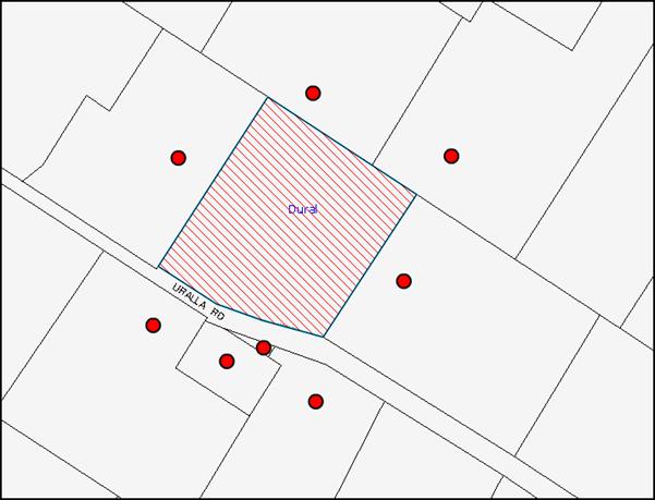
|
NOTIFICATION PLAN |
|
||
|
• PROPERTIES NOTIFIED |
X SUBMISSIONS RECEIVED |
PROPERTY SUBJECT OF DEVELOPMENT |
|
6. THE PUBLIC INTEREST
Section 79C(1)(e) of the Act requires Council to consider “the public interest”.
The public interest is an overarching requirement, which includes the consideration of the matters discussed in this report. Implicit to the public interest is the achievement of future built outcomes adequately responding to and respecting the future desired outcomes expressed in environmental planning instruments and development control plans.
The application is inconsistent with Council’s design criteria for a rural structure and would provide a development outcome that, on balance, would result in a negative impact for the community. Accordingly, it is considered that the approval of the proposed development in its current form would not be in the public interest.
CONCLUSION
The application proposes the erection of a “rural shed” which, as a result of the design and layout of the rooms and fittings, is capable of being used as a separate dwelling.
The development would result in a building that is capable of being used for a dwelling contrary to the provisions of the HSLEP and Rural Lands DCP. The design of the proposed shed is inconsistent with the Rural Lands Development Control Plan and Hornsby DCP 2013 as it would result in a development with a residential rather than rural character.
Council did not receive any submissions during the public notification period.
Having regard to the circumstances of the case, refusal of the application is recommended.
Note: At the time of the completion of this planning report, no persons have made a Political Donations Disclosure Statement pursuant to Section 147 of the Environmental Planning and Assessment Act 1979 in respect of the subject planning application.
|
Rod Pickles Manager - Development Assessment Planning Division |
James Farrington Group Manager Planning Division |
|
1.View |
Locality Map |
|
|
|
2.View |
Site Plan |
|
|
|
3.View |
Floor Plans |
|
|
|
4.View |
Elevations and Sections |
|
|
File Reference: DA/567/2013
Document Number: D02460336
SCHEDULE 1
REASONS FOR REFUSAL
1. Pursuant to Section 79C(1)(a)(iii) of the Environmental Planning and Assessment Act, 1979, the proposed ”rural shed” fails to comply with the Agricultural and Rural Structures element of the Rural Lands Development Control Plan.
2. Pursuant to Section 79C(1)(a)(i) of the EP&A Act, 1979, the structure has been designed in a manner which is capable of being adapted for use as a dwelling-house which would constitute multi-unit housing, and is a prohibited in the Rural BA (Small Holdings – Agricultural Landscapes) zone under the Hornsby Shire Local and Environmental Plan 1994.
3. Pursuant to Section 79(c)(i)(b) and (e) of the EP&A Act, 1979, approval of the structure would set an undesirable precedent for further inappropriate development and would not be in the public interest.
- END OF REASONS FOR REFUSAL -
Group Manager’s Report No. PL101/13
Planning Division
Date of Meeting: 16/10/2013
9 DEVELOPMENT APPLICATION - DWELLING-HOUSE - 7 WOODRIDGE AVENUE, NORTH EPPING
EXECUTIVE SUMMARY
|
DA No: |
DA/538/2013 (Lodged 30 May 2013) |
|
Description: |
Demolition of an existing dwelling-house and erection of a two storey dwelling-house |
|
Property: |
Lot 17, DP 30288, No. 7 Woodridge Avenue, North Epping |
|
Applicant: |
Mrs Mumtaz Bee Binti Abdul Rauf c/- Buildcraft Construction |
|
Owners : |
Mr M R B Hussin and Mrs M B B A Rauf |
|
Estimated Value: |
$675,722 |
|
Ward: |
C |
· The proposal involves the demolition of a dwelling-house and the erection of a two storey dwelling-house.
· The proposal does not comply with the Hornsby Shire Local Environmental Plan 1994 with regard to Clause 15 (Floor Space Ratio). The applicant has made a submission pursuant to State Environmental Planning Policy No. 1 (Development Standards) to vary the standard. The submission is considered well-founded and is supported.
· No submissions have been received in respect of the application.
· It is recommended that the application be approved.
|
THAT Development Application No. DA/538/2013 for the demolition of a dwelling-house and the erection of a dwelling-house at Lot 17 DP 30288, No. 7 Woodridge Avenue, North Epping be approved subject to the conditions of consent detailed in Schedule 1 of Group Manager’s Report No. PL101/13. |
BACKGROUND
On 2 August 2013, the applicant submitted a stormwater concept plan and a formal objection pursuant to State Environmental Planning Policy No. 1 – Development Standards as the floor space ratio of the proposed dwelling-house exceeds the development standard under Clause 15 of the Hornsby Shire Local Environmental Plan 1994.
On 6 August 2013, the applicant submitted a waste management plan, a demolition plan and a safe work method statement.
SITE
The site has an area of 758.8m² and is located on the north-eastern side of Woodridge Avenue, North Epping. The site has a street frontage to Woodridge Avenue of 16.76 metres, a rear boundary length of 16.76 metres and side boundaries each with measurements of 45.31 metres in length. The site contains a single storey dwelling-house and comprises a number of native and exotic planted tees.
The site is identified as being located on bushfire prone land as it adjoins the Lane Cove National Park to the rear.
The site is not mapped as being located on flood prone land, is not located within a heritage conservation area and is not within close proximity to any listed heritage items.
The site is not burdened by any easements or restrictions.
PROPOSAL
The application proposes the demolition of a dwelling-house and the erection of a two storey dwelling-house. The ground floor level would comprise a porch, foyer, living room, study, double garage, powder room, laundry, kitchen, shared dining/family room and an alfresco area at the rear. The first floor level would comprise four bedrooms, walk-in-robe, ensuite, bathroom and a media/library room.
The application proposes the removal of five trees, the installation of an air-conditioning unit, a 5,000 litre rainwater tank as per BASIX commitments and the construction of a driveway.
ASSESSMENT
The development application has been assessed having regard to the ‘Metropolitan Plan for Sydney 2031’, the ‘North Subregion (Draft) Subregional Strategy’ and the matters for consideration prescribed under Section 79C of the Environmental Planning and Assessment Act 1979 (the Act). The following issues have been identified for further consideration.
1. STRATEGIC CONTEXT
1.1 Metropolitan Plan for Sydney and (Draft) North Subregional Strategy
The (Draft) Metropolitan Strategy for Sydney 2031 is a broad framework to provide for Sydney’s growth to help plan for housing, employment, transport, infrastructure, the environment and open space. It outlines a vision for Sydney to 2031; the challenges faced, and the directions to follow to address these challenges and achieve the vision.
The North Subregion comprises Hornsby, Kuring-gai, Manly, Warringah and Pittwater Local Government Areas. The Draft North Subregional Strategy acts as a framework for Council in its preparation of the Comprehensive LEP by the end of 2013.
Within the North Subregion, the Draft Metropolitan Strategy proposes:
· Population growth of 81,000 from the current 2011 baseline of 529,000;
· Housing growth of 37,000 from the current 2011 baseline of 204,000; and
· Employment growth of 39,000 from the current 2011 baseline of 186,000.
The proposed development would be consistent with the Metropolitan Plan for Sydney 2031 as it would provide renewed housing stock to cater for the growing population.
2. STATUTORY CONTROLS
Section 79C(1)(a) requires Council to consider “any relevant environmental planning instruments, draft environmental planning instruments, development control plans, planning agreements and regulations”.
2.1 Hornsby Shire Local Environmental Plan 1994
The subject land is zoned Residential A (Low Density) under the Hornsby Shire Local Environmental Plan 1994 (HSLEP). The objectives of the Residential A (Low Density) zone are:
(a) to provide for the housing needs of the population of the Hornsby area.
(b) to promote a variety of housing types and other land uses compatible with a low density residential environment.
(c) to provide for development that is within the environmental capacity of a low density residential environment.
The proposed development is defined as a “dwelling-house” under the HSLEP and is permissible in the Residential A (Low Density) zone with Council’s consent.
Clause 15 of the HSLEP prescribes that the maximum floor space ratio (FSR) for development within the Residential A zone is 0.4:1. The proposed development would generate a FSR of 0.49:1 which does not comply with this development standard. To address this issue, the applicant has made a submission to vary the standard under State Environmental Planning Policy No. 1 - Development Standard which is assessed in Section 2.3 of this report.
2.2 Hornsby Shire Local Environmental Plan 2013
The Hornsby Local Environmental Plan 2013 was made on 27 September 2013 and will come into effect on 11 October 2013. The HLEP includes a savings provision stating that if a development application is made and not finally determined before the commencement of the HLEP, the application must be determined as if the Plan had been exhibited but not commenced. The relevant provisions of the HLEP are addressed below.
Under the HLEP, the subject land is zoned R2 (Low Density Residential) and a “dwelling-house” is permissible within the zone with Council’s consent.
2.3 State Environmental Planning Policy No. 1 – Development Standards
The application has been assessed against the requirements of State Environmental Planning Policy No. 1 – Development Standards (SEPP 1). This Policy provides flexibility in the application of development standards in circumstances where strict compliance with those standards would, in any particular case, be unreasonable or unnecessary or tend to hinder the attainment of the objectives of the Act. The applicant has made a written submission in accordance with SEPP 1.
The NSW Land and Environment Court has expressed the view that there are 5 different ways in which an objection pursuant to SEPP 1 may be well founded and that approval of the objection may be consistent with the aims of the Policy as follows:
1. The objectives of the standard are achieved notwithstanding non-compliance with the standard;
2. The underlying objective or purpose of the standard is not relevant to the development and therefore compliance is unnecessary;
3. The underlying object or purpose would be defeated or thwarted if compliance was required and therefore compliance is unreasonable;
4. The development standard has been virtually abandoned or destroyed by the Council's own actions in granting consents departing from the standard and hence compliance with the standard is unnecessary and unreasonable; and
5. The zoning of the particular land is unreasonable or inappropriate so that a development standard appropriate for that zoning is also unreasonable and unnecessary as it applies to the land and compliance with the standard would be unreasonable or unnecessary. That is, the particular parcel of land should not have been included in the particular zone.
In regard to whether the objection may be well founded, the applicant contends that:
“Strict compliance with the numeric FSR standard would not result in any reduced impact on loss of views from adjoining dwellings. The proposed FSR in this case is not considered unreasonable in that:
· The proposal complies with all the other objectives of Council’s LEP;
· The proposal complies with all the other objectives and controls of Council’s Dwelling House Development Control Plan (DCP), especially setbacks, height, site coverage and solar access;
· The building bulk, site coverage and proposed open space of the proposal are compatible with neighbouring developments;
· The orientation of the site has necessitated that the building footprint be designed to maximise access to natural light. This has resulted in a number of courtyards and the internal access past these courtyards has added additional floor area;
· The first floor has been designed to maximise views from bedrooms towards the natural bushland at the rear. By staggering bedrooms, the internal access required to reach these rooms has to be provided, resulting in additional floor area;
· The spatial needs of the family have resulted in additional requirements for storage space, car parking and zoned living areas;
· The site is wide and the proposed dwelling has been designed to contribute to a building massing that is responsive to the existing and desired spatial proportions along Woodridge Ave. As a result the central areas of the house need to be open in order to maximise solar access. This additional area required has contributed to the overall floor area;
· The proposal contributes to the energy efficiency of the dwelling by maximising access to daylight, sunlight and ventilation;
· Strict compliance with the numeric FSR standard would not result in any reduction in the bulk and scale of the proposal when viewed from the street and as such there would be no noticeable benefit in reducing the gross floor area of the proposal.”
The matters listed above have been taken into consideration in assessing the merits of the SEPP1 objection.
The Land and Environment Court has established that, in areas comprising relatively small allotments, restricting the FSR to less than 0.5:1 may unreasonably limit potential to increase the size of existing dwelling-houses to cater for the level of residential amenity and changing social demand for housing which is now expected. This is seen as an obstacle to satisfying the objectives of the Environmental Planning and Assessment Act, 1979 which encourages the orderly and economic use of land.
With respect to the orderly and economic use of this land, the additional floor space would not impinge on the environmental and amenity aspects of the site and the underlying objectives of the zoning. In this regard, the objection under SEPP 1 is sustained.
Furthermore, with the introduction of the NSW Housing Code under State Environmental Planning Policy (Exempt and Complying Development Codes) 2008, applicants are able to gain approval for dwelling-houses and other ancillary development as complying development with floor space ratios which exceed Council’s development standards. The proposed development would have a gross floor area of 370.15m². Under the NSW Housing Code, the 758.8m² allotment would be eligible to accommodate a dwelling-house with a gross floor area of up to 380m².
Notwithstanding that the proposal would not comply with the setbacks development standard, the NSW Housing Code is now enacted in many parts of the Shire and it is anticipated that more developments will be approved under this Code which will change the characteristics of dwelling-houses in the surrounding area. Accordingly, strict compliance with the 0.4:1 FSR development standard under Clause 15 of the HSLEP is not considered necessary in this instance.
The proposal takes into consideration the topographical constraints of the site and the additional floor space would not impinge on the environmental and amenity aspects of the site as well as the underlying objectives of the zoning. Accordingly, the SEPP 1 objection is well founded and is considered acceptable.
2.4 Sydney Regional Environmental Plan (Sydney Harbour Catchment) 2005
The site is located within the catchment of the Sydney Harbour Catchment. Sydney Regional Environmental Plan (Sydney Harbour Catchment) 2005 aims to protect the environment of the Sydney Harbour Catchment by ensuring that the impacts of future land uses are considered in a regional context.
Subject to the implementation of sediment and erosion control measures and stormwater management to protect water quality, the proposal would comply with the requirements of the Policy.
2.5 Clause 74BA Environmental Planning and Assessment Act, 1979 - Purpose and Status of Development Control Plans
On 1 March 2013, the Environmental Planning and Assessment Act, 1979 was amended so that a DCP provision will have no effect if it has the practical effect of “preventing or unreasonably restricting development” that is otherwise permitted and complies with the development standards set out in relevant Local Environmental Plans and State Environmental Planning Policies.
The principal purpose of a development control plan is to provide guidance on the aims of any environmental planning instrument that applies to the development; facilitating development that is permissible under any such instrument; and achieving the objectives of land zones under any such instrument. The provisions of a development control plan made for that purpose are not statutory requirements.
2.6 Hornsby Development Control Plan 2013
The Hornsby Development Control Plan (HDCP) 2013 applies to all land within Hornsby Shire and will replace Council’s existing DCPs, providing development controls to complement the HLEP 2013. The HDCP will come into effect on 11 October 2013.
The following sections of this report include a detailed assessment of the proposal against Council’s existing DCP controls. Although the HDCP was not in force at the date of finalising this report, the development proposal has been assessed against the Plan.
The HDCP is generally a transition of Council’s existing DCPs into a consolidated plan. When assessed against the HDCP, the proposed development would comply with all elements (including floor area) except for the side boundary setbacks and first floor level entertaining area.
The HDCP states that single storey elements of dwelling-houses should have a 900mm side boundary setback with two storey elements having a 1.5 metre side boundary setback. Notwithstanding, the proposed design includes a wing wall which protrudes from the front elevation towards the north-western boundary with a 700mm side boundary setback, the balance of the dwelling would comply with the prescriptive measures of the Setbacks element. The wing wall would create negligible impacts to the streetscape given it would have a maximum height of 2.1 metres above ground level.
The first floor level media/library room would not comply with the Privacy element of the HDCP which states that “living and entertaining areas of dwelling houses should be located on the ground floor and orientated towards the private open space of the dwelling house and not side boundaries”. Notwithstanding this, the media/living room would be orientated towards the street and would not have any windows on the side elevations. The ground floor level would have a family and dining room located to the rear of the dwelling which would have direct access to the private open space to the rear of the allotment.
The proposal meets the objectives of the HDCP and is considered acceptable.
2.7 Dwelling House Development Control Plan
The proposed development has been assessed having regard to the relevant performance and prescriptive requirements within Council’s Dwelling House Development Control Plan (DCP). The following table sets out the proposal’s compliance with the prescriptive requirements of the Plan:
|
Dwelling House DCP |
|||
|
Control |
Proposal |
Requirement |
Complies |
|
Floor space ratio |
0.49:1 |
0.4:1 |
No |
|
Site cover |
39% |
40% |
Yes |
|
Setbacks |
|||
|
Front |
8m |
6m |
Yes |
|
Side (north-western) |
700mm |
1m |
No |
|
Side (south-eastern) |
1.2m |
3m |
Yes |
|
Rear |
13.7m |
3m |
Yes |
|
Height |
7.7m |
<9m |
Yes |
|
Unbroken Wall length |
13.43m |
10m |
No |
|
Building length |
24.11m |
24m |
No |
|
Cut and fill |
600m |
1m |
Yes |
|
Private Open Space |
257m² |
120m² |
Yes |
|
Landscaped area |
58% |
45% |
Yes |
|
Car Parking |
|||
|
No. of spaces |
2 spaces |
2 spaces |
Yes |
|
Garage size |
6.0m x 6.0m |
5.7m x 5.4m |
Yes |
|
Solar Access |
|||
|
Windows to north-facing living rooms on adjoining land |
>3 hours on 22 June |
3 hours on 22 June |
Yes |
|
Private open space on adjoining land |
>4 hours on 22 June |
4 hours on 22 June |
Yes |
As detailed in the above table, the proposed development does not comply with a number of prescriptive requirements within Council’s Dwelling House DCP. The matters of non-compliance are detailed below, as well as a brief discussion on compliance with relevant performance requirements.
2.7.1 Scale
The proposed development would generate a floor space ratio of 0.49:1 which does not comply with the 0.4:1 prescriptive measure of the Scale element. The matters relating to floor space ratio have been discussed above under Section 2.3 of this report.
2.7.2 Setbacks
The proposed 700mm side boundary setback of the wing wall protruding from the front elevation towards the north-western boundary does not comply with the 1 metre prescriptive measure of the Setbacks element. Notwithstanding this, the encroachment is considered acceptable in this instance as the wing wall would only be for a height of 2.1 metres at the front elevation of the dwelling-house. The balance of the side setback of the external wall of the north-western elevation of the dwelling would have a minimum setback of a 1.65 metres.
The proposal meets the objectives of the Setbacks element and is considered acceptable.
2.7.3 Design
The proposed 13.43 metre wall length of the north-eastern (rear), first floor level elevation does not comply with the prescriptive measure of the Design element which states that wall lengths should not exceed 10 metres in length without a physical “break”. Notwithstanding this, the roof lines and fenestration provide sufficient articulation and avoid a monotonous and symmetrical design. The proposed design would not create an adverse impact when viewed from the streetscape or from adjoining properties.
The proposed 24.11 metre overall building length does not comply with the 24 metre prescriptive measure of the Design element. Notwithstanding this, it is a minor non-compliance and would not detract from the character of the streetscape or create any significant impacts to adjoining properties. Furthermore, the building includes indentations of 3.4m x 4.4m on the west elevation and 2.9m x 1.6m on the east elevation which reduce the perceived bulk and scale of the dwelling.
The proposal meets the objectives of the Design element and is considered acceptable.
2.7.4 Flora and Fauna Protection
The application includes the removal of five trees as part of the proposed development. These trees are not significant and are exempt from Council’s Tree Preservation Order.
The applicant has submitted an Arboricultural Impact Assessment Report with the application which includes recommended tree protection measures for trees required to be retained. These recommendations have been included in Schedule 1 of this report.
The proposal meets the objectives of the Flora and Fauna Protection element and is considered acceptable.
2.7.5 Privacy
The proposed first floor level media/library room does not comply with the prescriptive measure of the Privacy element which states that living and entertaining areas should be located on the ground floor level.
The media/library room would be orientated towards the street and would not have any windows facing the side boundaries. As a consequence, the first floor level media/library room would not create any additional privacy impacts.
The proposal meets the objectives of the Privacy element and is considered acceptable.
2.7.6 Drainage Control
The submitted stormwater concept plan proposes that the dwelling-house drain to the street drainage system. The plan has not been prepared by an engineer. As the topography of the site slopes away from the street towards the rear of the property, the drainage system would be required to be a charged system. As no details of the charged drainage system have been provided, conditions have been recommended that the stormwater from the proposed development be drained to absorption trenches to be located in the rear yard or, alternatively, to be designed by a suitably qualified engineer with details submitted with the construction certificate application.
Subject to conditions, the proposal meets the objectives of the Drainage Control element and is considered acceptable.
2.7.7 Solar Access
The Solar Access element states that dwelling-houses should be designed “to allow 3 hours of sunshine to the north-facing windows serving living rooms and 4 hours of sunshine to private open spaces between 9am and 3pm on 22 June (winter solstice)”.
The shadow diagrams submitted indicate that the shadows from the proposed development at 12 noon and 3pm on 22 June would be cast over the northern aspect of the adjoining property at No. 9 Woodridge Avenue.
The shadow cast at 12 noon would be over a carport and a portion of the northern elevation which does not have any north-facing windows. As a consequence, the proposal would comply with the prescriptive measures of the Solar Access element.
The proposal meets the objectives of the Solar Access element and is considered acceptable.
3. ENVIRONMENTAL IMPACTS
Section 79C(1)(b) of the Act requires Council to consider “the likely impacts of that development, including environmental impacts on both the natural and built environments, and social and economic impacts in the locality”.
3.1 Natural Environment
The proposed development includes the removal of five trees from the site. As discussed above under Section 2.6.3, these trees are exempt from Council’s Tree Preservation Order and therefore, their removal would create negligible environmental impacts. Conditions have been recommended to protect the trees required to be retained.
3.2 Built Environment
The design of the proposed dwelling-house would not create an adverse impact on the streetscape or built environment in the surrounding area. The proposal would result in a built form consistent with the character of development permissible in the locality.
3.3 Social Impacts
The proposed development would not create any adverse social impacts to the surrounding area.
3.4 Economic Impacts
The proposal would have a minor positive impact on the local economy in conjunction with other new low density residential development in the locality by generating an increase in demand for local services.
4. SITE SUITABILITY
Section 79C(1)(c) of the Act requires Council to consider “the suitability of the site for the development”.
4.1 Bushfire Risk
The site is identified as being located on bushfire prone land given its proximity to the Lane Cove National Park to the rear of the site. The application was referred to the NSW Rural Fire Service for comment to which no objections were raised subject to recommended conditions of consent which have been included in Schedule 1 of this report.
5. PUBLIC PARTICIPATION
Section 79C(1)(d) of the Act requires Council to consider “any submissions made in accordance with this Act”.
5.1 Community Consultation
The proposed development was placed on public exhibition and was notified to adjoining and nearby landowners between 7 June 2013 and 21 June 2013 in accordance with Council’s Notification and Exhibition Development Control Plan. During this period, Council did not receive any submissions. The map below illustrates the location of those nearby landowners who were notified during the exhibition period.
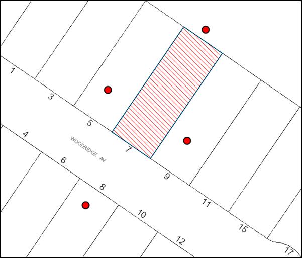
|
NOTIFICATION PLAN |
|||
|
• PROPERTIES NOTIFIED |
X SUBMISSIONS RECEIVED |
|
|
6. THE PUBLIC INTEREST
Section 79C(1)(e) of the Act requires Council to consider “the public interest”.
The public interest is an overarching requirement, which includes the consideration of the matters discussed in this report. Implicit to the public interest is the achievement of future built outcomes adequately responding to and respecting the future desired outcomes expressed in environmental planning instruments and development control plans.
The application is considered to have satisfactorily addressed Council’s and relevant agencies’ criteria and would provide a development outcome that, on balance, would result in a positive impact for the community. Accordingly, it is considered that the approval of the proposed development would be in the public interest.
CONCLUSION
The application proposes the demolition of a dwelling-house and the erection of a two storey dwelling-house and associated works.
The application does not comply with the Hornsby Shire Council Local Environmental Plan 1994 in respect to Clause 15 ‘Floor Space Ratio’. The applicant submitted a State Environmental Planning Policy No. 1 objection to vary the floor space ratio development standard. The objection is considered well founded with regard to the existing development and the principles established by the Land and Environment Court.
There were no submissions received in response to notification of the proposed development.
Having regard to the circumstances of the case and consideration of the SEPP 1 objection, approval of the application is recommended.
Note: At the time of the completion of this planning report, no persons have made a Political Donations Disclosure Statement pursuant to Section 147 of the Environmental Planning and Assessment Act 1979 in respect of the subject planning application.
|
Rod Pickles Manager - Development Assessment Planning Division |
James Farrington Group Manager Planning Division |
|
1.View |
Locality Map |
|
|
|
2.View |
Site Plan |
|
|
|
3.View |
Floor Plans |
|
|
|
4.View |
Roof Plan |
|
|
|
5.View |
Elevations |
|
|
|
6.View |
Section and Basix Commitments |
|
|
|
7.View |
Site Analysis |
|
|
|
8.View |
Concept Landscape Plan |
|
|
|
9.View |
Shadow Diagram |
|
|
File Reference: DA/538/2013
Document Number: D02465900
SCHEDULE 1
GENERAL CONDITIONS
The conditions of consent within this notice of determination have been applied to ensure that the use of the land and/or building is carried out in such a manner that is consistent with the aims and objectives of the relevant legislation, planning instruments and Council policies affecting the land and does not disrupt the amenity of the neighbourhood or impact upon the environment.
Note: For the purpose of this consent, the term ‘applicant’ means any person who has the authority to act on or the benefit of the development consent.
Note: For the purpose of this consent, any reference to an Act, Regulation, Australian Standard or publication by a public authority shall be taken to mean the gazetted Act or Regulation, or adopted Australian Standard or publication as in force on the date that the application for a construction certificate is made.
1. Approved Plans and Supporting Documentation
The development must be carried out in accordance with the plans and documentation listed below and endorsed with Council’s stamp, except where amended by Council and/or other conditions of this consent:
|
Plan No. |
Drawn by |
Dated |
|
02, 03, 04, 05, 06, 07, 08, 09, 10 and 11: Issue D |
Planmaster |
28/05/2013 |
|
Document No. |
Prepared by |
Dated |
|
Arboricultural Impact Assessment Report |
Glenyss Laws |
3 December 2012 |
|
SEPP 1 Objection – Floor Space Ratio |
Icon Consulting & Design |
22 July 2013 |
|
Statement of Environmental Effects |
Planmaster |
May 2013 |
|
Demolition and Waste Management Plan |
Democorp |
Undated |
2. Removal of Existing Trees
This development consent only permits the removal of 5 trees numbered 2, 3, 5, 6 and 7 as identified in the Arboricultural Impact Assessment Report prepared by Glenyss Laws dated 3 December 2012. The removal of any other trees requires separate approval under Council’s Tree Preservation Order.
REQUIREMENTS PRIOR TO THE ISSUE OF A CONSTRUCTION CERTIFICATE
3. Building Code of Australia
All building work must be carried out in accordance with the relevant requirements of the Building Code of Australia.
4. Contract of Insurance (Residential Building Work)
In the case of residential building work for which the Home Building Act, 1989 requires there to be a contract of insurance in force in accordance with Part 6 of that Act, that such a contract of insurance is in force before any building work authorised to be carried out by the consent commences.
5. Notification of Home Building Act, 1989 Requirements
Residential building work within the meaning of the Home Building Act, 1989 must not be carried out unless the principal certifying authority for the development to which the work relates (not being Council) has given Council written notice of the following information:
a) In the case of work for which a principal contractor is required to be appointed:
i) The name and licence number of the principal contractor; and
ii) The name of the insurer by which the work is insured under Part 6 of that Act.
b) In the case of work to be done by an owner-builder:
i) The name of the owner-builder and;
ii) If the owner-builder is required to hold an owner-builder’s permit under that Act, the number of the owner-builder’s permit.
Note: If arrangements for doing the residential building work are changed while the work is in progress so that the information notified becomes out of date, further work must not be carried out unless the principal certifying authority for the development to which the work relates (not being Council) has given Council written notification of the updated information.
6. Sydney Water – Quick Check
This application must be submitted to a Sydney Water ‘Quick Check Agent’ or ‘Customer Centre’ for approval to determine whether the development would affect any Sydney Water infrastructure, and whether further requirements are to be met.
Note: Refer to www.sydneywater.com.au or telephone 13 20 92 for assistance.
7. Design and Construction - Bushfire Attack Category
New construction must comply with the current Australian Standard AS3959 ‘Construction of buildings in bush fire-prone areas’ in accordance with the Bushfire Attack Level (BAL) and section A3.7 Addendum Appendix 3 of Planning for Bushfire Protection indicated below, together with conditions based on “Planning for Bush Fire Protection 2006”, as follows:-
a) New construction on the southern elevation must comply with sections 3 and 8 (BAL 40) Australian Standards AS3959-2009 “Construction of buildings in bush fire-prone areas” and section A3.7 Addendum Appendix 3 of “Planning for Bush Fire Protection 2006”.
b) New construction on the northern, eastern and western elevations must comply with sections 3 and 9 (BAL FZ) Australian Standards AS3959-2009 “Construction of buildings in bush fire-prone areas”. However, where any material, element of construction or system when tested to the method described in Australian Standard AS1530.8.2 ‘Methods for fire tests on building materials, components and structures’ Part 8.2: ‘Tests on elements of construction for buildings exposed to simulated bushfire attack—Large flaming sources’, it must comply with Clause 13.8 of the Standard except that flaming of the specimen is not permitted and there shall be no exposed timber.
c) New window assemblies on the northern, eastern and western elevations must comply with modified Sections 3 and 9 of AS3959 (as above) or the following:
i) They must be completely protected by a non-combustible and non-perforated bushfire shutter that complies with Section 3.7 of AS3959-2009 excluding parts (e) & (f); and
ii) They must comply with the following:
a. Window frames and hardware must be metal;
b. Glazing must be toughened glass, minimum 6mm
c. Seals to stiles, head and sills or thresholds must be manufactured from materials having a flammability index no greater than 5; and
d. The openable portion of the window must be screened internally or externally with a mesh with a maximum aperture of 2mm, made from corrosion resistant steel or bronze. The frame supporting the mesh must be metal.
e. New external doors and door frames (not including garage doors) on the northern, eastern and western elevations must comply with modified Sections 3 and 9 of AS3959 (as above) or the following:
iii) They must be completely protected by a non-combustible and non-perforated bushfire shutter that complies with Section 3.7 of AS3959 excluding parts (e) & (f); and
iv) They must comply with the following:
a. Doors must be non-combustible;
b. Externally fitted hardware that supports the panel in its function of opening and closing must be metal;
c. Where doors incorporate glazing, the glazing must be toughened glass, minimum 6mm;
d. Seals to stiles, head and sills or thresholds must be manufactured from silicone;
e. Door frames must be metal;
f. Doors must be tight fitting to the doorframe and to an abutting door; and
g. Weather strips, draught excluders or draught seals must be installed if applicable.
d) Water, electricity and gas are to comply with Section 4.1.3 of “Planning for Bush Fire Protection 2006”.
REQUIREMENTS PRIOR TO THE COMMENCEMENT OF ANY WORKS
8. Erection of Construction Sign
A sign must be erected in a prominent position on any site on which building work, subdivision work or demolition work is being carried out:
a) Showing the name, address and telephone number of the principal certifying authority for the work;
b) Showing the name of the principal contractor (if any) for any demolition or building work and a telephone number on which that person may be contacted outside working hours; and
c) Stating that unauthorised entry to the work site is prohibited.
Note: Any such sign is to be maintained while the building work, subdivision work or demolition work is being carried out, but must be removed when the work has been completed.
9. Toilet Facilities
Toilet facilities must be available or provided at the works site before works begin and must be maintained until the works are completed at a ratio of one toilet for every 20 persons employed at the site. Each toilet must:
a) be a standard flushing toilet connected to a public sewer; or
b) be a temporary chemical closet approved under the Local Government Act, 1993.
10. Tree Protection Measures
The tree protection measures recommended in the Arboricultural Impact Assessment Report prepared by Glenyss Laws dated 3 December 2012 must be complied with.
11. Erosion and Sediment Control
Erosion and sediment control measures must be provided and maintained throughout the construction period in accordance with the manual ‘Soils and Construction 2004 (Bluebook)’, the approved plans, Council specifications and to the satisfaction of the principal certifying authority. The erosion and sediment control devices must remain in place until the site has been stabilised and revegetated.
Note: On the spot penalties up to $1,500 may be issued for any non-compliance with this requirement without any further notification or warning.
12. Bushfire Management – Protection Zones
At the commencement of building works, the entire property must be managed as an Inner Protection Area (IPA) as outlined within section 4.1.3 and Appendix 5 of “Planning for Bush Fire Protection 2006” and the NSW Rural Fire Service’s document “Standards for asset protection zones”.
Note: Further information concerning planning for bush fire protection can be found at: www.rfs.nsw.gov.au.
REQUIREMENTS DURING CONSTRUCTION
13. Construction Work Hours
All work on site, including demolition and earth works must only occur between 7am and 5pm Monday to Saturday. No work is to be undertaken on Sundays or public holidays.
14. Demolition
All demolition work must be carried out in accordance with “Australian Standard 2601-2001 – The Demolition of Structures” and the following requirements:
a) Demolition material must be disposed of to an authorised recycling and/or waste disposal site and/or in accordance with an approved waste management plan;
b) Demolition works, where asbestos material is being removed, must be undertaken by a contractor that holds an appropriate licence issued by WorkCover NSW in accordance with Chapter 10 of the Occupational Health and Safety Regulation 2001 and Clause 29 of the Protection of the Environment Operations (Waste) Regulation 2005; and
c) On construction sites where buildings contain asbestos material, a standard commercially manufactured sign containing the words ‘DANGER ASBESTOS REMOVAL IN PROGRESS’ measuring not less than 400mm x 300mm must be erected in a prominent position visible from the street.
15. Council Property
During construction works, no building materials, waste, machinery or related matter is to be stored on the road or footpath. The public reserve must be kept in a clean, tidy and safe condition at all times.
16. Disturbance of Existing Site
During construction works, the existing ground levels of open space areas and natural landscape features, (including natural rock-outcrops, vegetation, soil and watercourses) must not be altered unless otherwise nominated on the approved plans.
17. Survey Report – Finished Floor Level
A report(s) must be prepared by a registered surveyor and submitted to the principal certifying authority prior to the pouring of concrete at each level of the building certifying that:
a) The building, retaining walls and the like have been correctly positioned on the site; and
b) The finished floor level(s) are in accordance with the approved plans.
REQUIREMENTS PRIOR TO THE ISSUE OF AN OCCUPATION CERTIFICATE
Note: For the purpose of this consent, a reference to ‘occupation certificate’ shall not be taken to mean an ‘interim occupation certificate’ unless otherwise stated.
18. Fulfilment of BASIX Commitments
The applicant must demonstrate the fulfilment of BASIX commitments pertaining to the development.
19. Stormwater Drainage
The stormwater drainage system for the development must be designed and constructed for an average recurrence interval of 20 years and be gravity drained in accordance with the following requirements:
a) The roof lines from the proposal shall be connected directly or charged to the proposed water harvesting system
b) The water harvesting tank to be relocated between the proposed dwelling and the rear boundary of the property
c) The overflow from the rainwater tank and collected surface water must be disposed of in accordance with Council’s design specification; “On Site Absorption System”, from Council’s Best Practices Handbook, and the following requirements:-
i) The trench located a minimum of 5 metres from any down stream properties and 1 metre from the side boundaries;
ii) The trench laid on contour;
iii) The trench be a minimum of 0.6 metres wide, 0.6 metres deep and 1 metre long for every 10 square metres of impervious area; and
iv) Overland flow from the trench be spread evenly over the site so as not to discharge water in a concentrated manner onto adjoining land.
or
v) Be designed by a qualified hydraulic engineer.
20. Vehicular Crossing
A separate application under the Local Government Act, 1993 and the Roads Act, 1993 must be submitted to Council for the installation of a new vehicular crossing and the removal of the redundant crossing. The vehicular crossing must be constructed in accordance with Council’s Civil Works Design, 2005 and the following requirements:
a) Any redundant crossings must be replaced with integral kerb and gutter.
b) The footway area must be restored by turfing;
Note: An application for a vehicular crossing can only be made to one of Council’s Authorised Vehicular Crossing Contractors. You are advised to contact Council on 02 9847 6940 to obtain a list of contractors.
21. Damage to Council Assets
Any damage caused to Council’s assets as a result of the construction of the development must be rectified in accordance with Council’s written requirements and at the sole cost of the applicant.
22. Retaining Walls
All required retaining walls must be constructed as part of the development.
23. Installation of Air Conditioner
To protect the amenity of adjacent properties, the condenser unit for the air conditioner must be sited a minimum of 3 metres from the property boundary of any adjoining residential premises unless a certificate has been prepared by a suitably qualified person confirming that the unit has been tested for heating and cooling on the highest settings and that the noise levels generated do not exceed 5 dB(A) above background noise levels when tested at the property boundary between 8.00pm and 10.00pm.
- END OF CONDITIONS -
ADVISORY NOTES
The following information is provided for your assistance to ensure compliance with the Environmental Planning and Assessment Act, 1979, Environmental Planning and Assessment Regulation 2000, other relevant legislation and Council’s policies and specifications. This information does not form part of the conditions of development consent pursuant to Section 80A of the Act.
Environmental Planning and Assessment Act, 1979 Requirements
The Environmental Planning and Assessment Act, 1979 requires:
· The issue of a construction certificate prior to the commencement of any works. Enquiries can be made to Council’s Customer Services Branch on 9847 6760;
· a principal certifying authority to be nominated and Council notified of that appointment prior to the commencement of any works;
· Council to be given at least two days written notice prior to the commencement of any works;
· mandatory inspections of nominated stages of the construction inspected; and
· an occupation certificate to be issued before occupying any building or commencing the use of the land.
Long Service Levy
In accordance with Section 34 of the Building and Construction Industry Long Service Payments Act 1986, a ‘Long Service Levy’ must be paid to the Long Service Payments Corporation or Hornsby Council.
Note: The rate of the Long Service Levy is 0.35% of the total cost of the work.
Note: Hornsby Council requires the payment of the Long Service Levy prior to the issue of a construction certificate.
Tree Preservation Order
To ensure the maintenance and protection of the existing natural environment, it is an offence to ringbark, cut down, top, lop, remove, wilfully injure or destroy a tree outside 3 metres of the approved building envelope without the prior written consent from Council.
Note: A tree is defined a s a single or multi-trunked wood perennial plant having a height of not less than three (3) metres, and which develops many branches, usually form a distance of not less than one (1) metre from the ground, but excluding any plant which, in its particular location, is a noxious plant declared as such pursuant to the Noxious Weeds Act 1993. This definition of ‘tree’ includes any and all types of Palm trees.
All distances are determined under Australian Standard AS4970-2009 “Protection of Trees on Development Sites”.
Fines may be imposed for non-compliance with Council’s Tree Preservation Order.
Dial Before You Dig
Prior to commencing any works, the applicant is encouraged to contact Dial Before You Dig on 1100 or www.dialbeforeyoudig.com.au for free information on potential underground pipes and cables within the vicinity of the development site.
Asbestos Warning
Should asbestos or asbestos products be encountered during demolition or construction works, you are advised to seek advice and information prior to disturbing this material. It is recommended that a contractor holding an asbestos-handling permit (issued by WorkCover NSW) be engaged to manage the proper handling of this material. Further information regarding the safe handling and removal of asbestos can be found at:
Alternatively, telephone the WorkCover Asbestos and Demolition Team on 8260 5885.
Group Manager’s Report No. PL102/13
Planning Division
Date of Meeting: 16/10/2013
10 DEVELOPMENT APPLICATION - SECTION 96(2) - DWELLING-HOUSE - 42 KOLOONA STREET, BEROWRA
EXECUTIVE SUMMARY
|
DA No: |
DA/625/2010/B (lodged 10 July 2013) |
|
Description: |
Section 96(2) modification to the design of an approved dwelling-house |
|
Property: |
Lot 116 DP 878825, No. 42 Koloona Street, Berowra |
|
Applicant: |
Mr Michael Robert Davenport |
|
Owner: |
Mr Michael Robert Davenport |
|
Estimated Value: |
$512,000 |
|
Ward: |
A |
· The proposal involves Section 96(2) modifications to the design of an approved dwelling-house.
· The proposal does not comply with the Hornsby Shire Local Environmental Plan 1994 with regard to Clause 15 (Floor Space Ratio). The applicant has provided justification for the non-compliance with the development standard which is considered to be well founded and is supported.
· No submissions have been received in respect of the amended application.
· It is recommended that the application be approved.
|
THAT pursuant to Section 96(2) of the Environmental Planning and Assessment Act, 1979, Development Application No. DA/625/2010/B for the construction of a dwelling-house at Lot 116, DP 878825, No. 42 Koloona Street, Berowra be amended as detailed in Schedule 1 of Group Manager’s Report No. PL102/13. |
BACKGROUND
On 5 August 2010, Council approved Development Application No. DA/625/2010 for the erection of a part one and two storey dwelling-house.
On 24 September 2010, Council approved a Section 96(2) application (DA/625/2010/A) to modify the approved plans in regards to minor internal and external amendments.
SITE
The site has an area of 696m² and is located on the western side of Koloona Street, Berowra. The site experiences an average fall of 41% from the western, rear boundary to the eastern, front boundary and is currently vacant land.
The site is identified as being located on bushfire prone land.
The site is not located on flood prone land, is not within a heritage conservation area and is not within close proximity to any listed heritage items.
The site is not burdened by any easements or restrictions.
The site is mapped as containing Silvertop Ash-Scribbly Gum Woodland. An inspection by Council has revealed that the site has been cleared in accordance the original approval for DA/625/2010.
APPROVED DEVELOPMENT
The approved development includes the erection of a part one and two storey dwelling-house and associated works. The ground floor level of the dwelling-house would comprise a double garage, entry, portico, rumpus room with bar, bedroom, bathroom and patio. The first floor level would comprise 3 bedrooms, walk-in-robe, bathroom, ensuite, laundry, study, living room, dining room, kitchen, family room, balcony and alfresco area.
The development also involves the construction of a driveway and terraced retaining walls, the installation of a 5,000 litre rainwater tank and the removal of twelve trees.
PROPOSED MODIFICATIONS
The Section 96(2) application proposes to amend the approved plans for the dwelling-house. The amended design would incorporate two storeys above a double garage and would occupy predominantly the same building envelope of the approved dwelling-house.
The lower ground floor would comprise a double garage with a workshop area. The ground floor level would comprise a porch, lounge room, dining room, kitchen, family room, theatre room, study, powder room and alfresco area. The first floor level would comprise four bedrooms, walk-in-robe, ensuite, bathroom, water closet, laundry, rumpus room and patio.
The proposed amendments would not necessitate the removal of any additional trees.
ASSESSMENT
The development application has been assessed having regard to the ‘Metropolitan Plan for Sydney 2031’, the ‘North Subregion (Draft) Subregional Strategy’ and the matters for consideration prescribed under Section 79C of the Environmental Planning and Assessment Act 1979 (the Act). The following issues have been identified for further consideration.
1. STRATEGIC CONTEXT
1.1 Metropolitan Plan for Sydney and (Draft) North Subregional Strategy
The (Draft) Metropolitan Strategy for Sydney 2031 is a broad framework to provide for Sydney’s growth to help plan for housing, employment, transport, infrastructure, the environment and open space. It outlines a vision for Sydney to 2031; the challenges faced, and the directions to follow to address these challenges and achieve the vision.
The North Subregion comprises Hornsby, Kuring-gai, Manly, Warringah and Pittwater Local Government Areas. The Draft North Subregional Strategy acts as a framework for Council in its preparation of the Comprehensive LEP by the end of 2013.
Within the North Subregion, the Draft Metropolitan Strategy proposes:
· Population growth of 81,000 from the current 2011 baseline of 529,000;
· Housing growth of 37,000 from the current 2011 baseline of 204,000; and
· Employment growth of 39,000 from the current 2011 baseline of 186,000.
The modified development would be consistent with the Metropolitan Plan for Sydney 2031 by providing housing stock within the Shire to cater for a growing population.
2. STATUTORY CONTROLS
Section 79C(1)(a) requires Council to consider “any relevant environmental planning instruments, draft environmental planning instruments, development control plans, planning agreements and regulations”.
2.1 Environmental Planning and Assessment Act 1979 – Section 96(2)
Pursuant to Section 96(2) of the Environmental Planning and Assessment Act 1979, Council may consider an application to amend development consent provided that, inter alia:
“a) it is satisfied that the development to which the consent as modified relates is substantially the same development, and
b) it has consulted with the relevant Minister, public authority or approval body (within the meaning of Division 5) in respect of a condition imposed as a requirement of a concurrence to the consent or in accordance with the general terms of an approval proposed to be granted by the approval body and that Minister, authority or body has not, within 21 days after being consulted, objected to the modification of that consent, and
c) it has notified the application in accordance with the regulations, and
d) it has considered any submissions made concerning the proposed modification within the period prescribed by the regulations.”
With regard to Section 96(2)(a), it is considered that the proposal as amended is substantially the same as the development originally approved.
With regard to Section 96(2)(b), the original proposal was not subject to concurrence of another authority.
Pursuant to Section 96(2)(c) and (d) the application was notified in accordance with Council’s Notification and Exhibition Development Control Plan. No submissions were received during the exhibition period.
2.2 Hornsby Shire Local Environmental Plan 1994
The subject land is zoned Residential A (Low Density) under the Hornsby Shire Local Environmental Plan 1994 (HSLEP). The objectives of the Residential A (Low Density) zone are:
(a) to provide for the housing needs of the population of the Hornsby area.
(b) to promote a variety of housing types and other land uses compatible with a low density residential environment.
(c) to provide for development that is within the environmental capacity of a low density residential environment.
The modified development is defined as a “dwelling-house” which is permissible in the zone under the HSLEP with Council’s consent.
Clause 15 of the HSLEP prescribes that the maximum floor space ratio (FSR) for development within the Residential AS zone is 0.4:1. Whilst the 0.34:1 FSR of the original development (DA/625/2010) complied with this development standard, the proposed modifications would generate a FSR of 0.49:1.
As the proposal is an application made under Section 96(2) of the Environmental Planning and Assessment Act (EP&A Act) 1979 an objection pursuant to State Environmental Planning Policy No. 1 – Development Standards is not required in this instance as this Policy only applies where a ‘development application’ is made. Instead, an assessment of the application is conducted in accordance with Section 96(3) of the EP&A Act which requires the matters listed under section 79C(1) of the EP&A Act to be taken into consideration.
In regards to the modified proposal’s non-compliance with the FSR development standard under Clause 15, the applicant contends that:
“The proposed dwelling has been designed to utilise the site considering the steep conditions and the owners intentions are to maintain the footprint of the dwelling keeping the site coverage within council requirements. The site would have considerable excavation regardless of where the garage and lower floor rooms are located. It is the intention of the owner to excavate a larger area of this lower level to improve the layout and give more living areas for their growing family. The additional living area has caused the floor space ratio to exceed the council requirements and we ask council to consider this for approval as the proposed dwelling would not create any adverse impact on adjoining properties or the environment. The proposed dwelling would be keeping with the bulk and scale of surrounding developments and would not have a detrimental impact on the streetscape of Koloona Street.”
The Land and Environment Court has established that, in areas comprising relatively small allotments, restricting the FSR to less than 0.5:1 may unreasonably limit potential to increase the size of existing dwelling-houses to cater for the level of residential amenity and changing social demand for housing which is now expected. This is seen as an obstacle to satisfying the objectives of the Environmental Planning and Assessment Act, 1979 which encourages the orderly and economic use of land.
With respect to the orderly and economic use of this land, the additional floor space would not impinge on the environmental and amenity aspects of the site and the underlying objectives of the zoning. In this regard, the justification to the non-compliance with the FSR development standard is sustained.
Furthermore, with the introduction of the NSW Housing Code under the State Environmental Planning Policy (Exempt and Complying Development Codes) 2008, applicants are able to gain approval for dwelling-houses and other ancillary development as complying development with floor space ratios which exceed Council’s development standards. When assessed in accordance with the definition of “floor area” under the NSW Housing Code, the modified development would have a gross floor area of 364.7m². Under the NSW Housing Code, the 696m² allotment would be eligible to construct a dwelling-house with a gross floor area of up to 380m².
Notwithstanding that the modified proposal would not comply with the height, setbacks or earthworks development standards, the NSW Housing Code is now enacted in many parts of the Shire and it is anticipated that more developments will be approved under this Code which will change the characteristics of dwelling-houses in the surrounding area. Accordingly, strict compliance with the 0.4:1 FSR development standard under Clause 15 of the HSLEP is not considered necessary in this instance.
The proposed modifications would create an additional 101.9m² of gross floor area and the maximum reduced level of the ridge line of 195.62 AHD would be 1.9 metres higher when compared to the approved development which had a maximum reduced level of 193.72 AHD. However, the amended proposal takes into consideration the topographical constraints of the site and the bulk and scale of the development would be consistent with the form of development permissible in the surrounding low density zone. Accordingly, the modified proposed development is considered acceptable.
2.3 Hornsby Local Environmental Plan 2013
The Hornsby Local Environmental Plan 2013 was made on 27 September 2013 and will come into effect on 11 October 2013. The HLEP includes a savings provision stating that if a development application is made and not finally determined before the commencement of the HELP, the application must be determined as if the Plan had been exhibited but not commenced. The relevant provisions of the HLEP are addressed below.
Under the HLEP, the subject land is zoned R2 (Low Density Residential) and “dwelling houses” are permissible within the zone with Council’s consent.
2.4 Sydney Regional Environmental Plan No. 20 – Hawkesbury – Nepean River
The site is located within the catchment of the Hawkesbury Nepean River. Part 2 of this Plan contains general planning considerations and strategies requiring Council to consider the impacts of development on water quality, aquaculture, recreation and tourism.
The proposed modifications would not result in any additional impacts to the catchment subject to the implementation of the conditions of consent from the original development application (DA/625/2010) concerning sediment and erosion control and stormwater management measures.
2.5 Clause 74BA Environmental Planning and Assessment Act, 1979 - Purpose and Status of Development Control Plans
On 1 March 2013, the Environmental Planning and Assessment Act, 1979 was amended so that a DCP provision will have no effect if it has the practical effect of “preventing or unreasonably restricting development” that is otherwise permitted and complies with the development standards set out in relevant Local Environmental Plans and State Environmental Planning Policies.
The principal purpose of a development control plan is to provide guidance on the aims of any environmental planning instrument that applies to the development; facilitating development that is permissible under any such instrument; and achieving the objectives of land zones under any such instrument. The provisions of a development control plan made for that purpose are not statutory requirements.
2.6 Hornsby Development Control Plan 2013
The Hornsby Development Control Plan (HDCP) 2013 applies to all land within Hornsby Shire and will replace Council’s existing DCPs, providing development controls to complement the HLEP 2013. The HDCP will come into effect on 11 October 2013.
The following sections of this report include a detailed assessment of the proposal against Council’s existing DCP controls. Although the HDCP was not in force at the date of finalising this report, the development proposal has been assessed against the Plan.
The HDCP is generally a transition of Council’s existing DCPs into a consolidated plan. When assessed against the HDCP, the amended design would comply with all of elements (including floor area) except the proposed 3.6 metre cut which does not comply with the 1 metre prescriptive measure of the Scale element. Notwithstanding this, the 1 metre prescriptive measure of the HDCP remains unchanged from the Dwelling House Development Control Plan and further discussion on this matter is discussed below under Section 2.7.2.
The amended design meets the objectives of the HDCP and is considered acceptable.
2.7 Dwelling House Development Control Plan
The modified development has been assessed having regard to the relevant performance and prescriptive requirements within Council’s Dwelling House Development Control Plan (DCP). The following table sets out the modified proposal’s compliance with the prescriptive requirements of the Plan:
|
Dwelling House DCP |
|||
|
Control |
Proposal |
Requirement |
Complies |
|
Floor Space Ratio |
0.49:1 |
0.4:1 |
No |
|
Site Cover |
32% |
40% |
Yes |
|
Setbacks |
|||
|
Front |
7m |
6m |
Yes |
|
Side (southern) |
1.5m |
1m |
Yes |
|
Side (northern) |
1.5m |
1m |
Yes |
|
Rear |
14.2m |
3m |
Yes |
|
Unbroken Wall length |
12.92m |
10m |
No |
|
Building Length |
15.2m |
24m |
Yes |
|
Cut and Fill |
3.6m |
1m |
No |
|
Height |
7.2m |
<9m |
Yes |
|
Private Open Space |
274.3m² |
120m² |
Yes |
|
Landscaped Area |
58% |
45% |
Yes |
|
Car Parking |
|||
|
No. of spaces |
2 spaces |
2 spaces |
Yes |
|
Garage size |
6.5m x 6.1m |
5.7m x 5.4m |
Yes |
|
Solar Access |
|||
|
Windows to north-facing living rooms on adjoining development Adjoining land |
See discussion |
3 hours on 22 June |
See discussion |
|
Private open space on adjoining land |
>4 hours on 22 June |
4 hours on 22 June |
Yes |
As detailed in the above table, the proposed development does not comply with a number of prescriptive requirements within Council’s Housing DCP. The matters of non-compliance are detailed below, as well as a brief discussion on compliance with relevant performance requirements.
2.7.1 Scale
The proposed modifications would include an additional 101.9m² of gross floor space when compared to the original development (DA/625/2010) and would generate a FSR of 0.49:1 which does not comply with the 0.4:1 prescriptive measure of the Scale element. Notwithstanding this numerical non-compliance, the modified proposal is considered to be in keeping with the objectives of the Scale element which are to achieve dwelling-house designs which are consistent with the bulk, scale and intensity of development in the surrounding area and to ensure that designs allow adequate areas for access, car parking, landscaping usable outdoor recreation and clothes drying.
As discussed above under section 2.2, given the size of dwelling-houses permissible under the NSW Housing Code, the non-compliance with numerical controls and development standards would not detract from the character of the surrounding area.
The proposal meets the objectives of the Scale element and is considered acceptable.
2.7.2 Design
The original approved development complied with the prescriptive measure of the Design element which states that wall lengths should not exceed 10 metres in length without a physical “break”. However, the proposed 12.92 metre wall length of the western, first floor level elevation of the modified proposal does not comply with this prescriptive measure. Notwithstanding this, the roof lines and fenestration provide sufficient articulation and avoid a monotonous and symmetrical design. The amended design would not create an adverse impact when viewed from the streetscape or from adjoining properties.
The proposed 3.6 metre excavation does not comply with the maximum 1 metre cut or fill prescriptive measure of the Design element. The approved development had a cut of 2.4 metres which also does not comply with the prescriptive measure. However, the steep topography of the site has an average gradient of 41% and the proposed cut is considered acceptable in this instance as it is necessary to accommodate a level subfloor area below the dwelling-house.
The proposal meets the objectives of the Design element and is considered acceptable.
2.7.3 Height
The amended design would have a maximum height of 7.2 metres above the natural ground level which complies with the 9 metre prescriptive measure of the Height element. When compared to the approved development, the height of the amended dwelling-house above natural ground level is reduced as the amended design has a greater cut and the first floor level is setback further from the eastern, front boundary than the ground floor level.
The proposal meets the objectives of the Height element and is considered acceptable.
2.7.4 Privacy
The proposed first floor level rumpus room of the amended proposal does not comply with the prescriptive measure of the Privacy element which states that living and entertaining areas should be located on the ground floor level. To address this issue, a condition is recommended that a 1.5 metre high privacy screen be erected along the southern elevation of the first floor level patio.
Due to the steep topography of the site, the finished floor level of the proposed alfresco area located over the garage would be elevated 2 metres above the natural ground level. Notwithstanding this, the alfresco area would be orientated towards the street and would not create any privacy impacts to adjoining properties.
Subject to the erection of a privacy screen along the southern elevation of the first floor level patio, the modified proposal would create negligible increase privacy impacts, meets the objectives of the Privacy element and is considered acceptable.
2.7.5 Solar Access
The submitted shadow diagrams indicate that the amended development would cast shadows over the north-facing elevation of the adjoining dwelling-house at No. 44 Koloona Street. Notwithstanding that the ridge level of the roof of the modified development would be 1.9 metres higher than the approved development at its highest point, the proposal would not cast any additional shadows over the adjoining north-facing windows of No. 44 Koloona Street as these windows would already be overshadowed by the roof over the verandah on the adjoining property.
The proposal meets the objectives of the Solar Access element and is considered acceptable.
3. ENVIRONMENTAL IMPACTS
Section 79C(1)(b) of the Act requires Council to consider “the likely impacts of that development, including environmental impacts on both the natural and built environments, and social and economic impacts in the locality”.
3.1 Natural Environment
The site is mapped as containing Silvertop Ash-Scribbly Gum Woodland. However, a site inspection revealed that the site has been cleared in accordance with the approved development (DA/625/2010). The proposed modifications to the approved plans would not necessitate the removal of any additional trees and is considered acceptable.
3.2 Built Environment
The modified development is considered to be in keeping with the character of the surrounding area, which comprises a variety of one and two storey dwelling-houses, and would not create a significant impact on existing traffic patterns.
3.3 Social Impacts
The modified development would not create any adverse social impacts to the surrounding area.
3.4 Economic Impacts
Similar to the approved development, the modified proposal would have a minor positive impact on the local economy in conjunction with other new low density residential development in the locality by generating an increase in demand for local services.
4. SITE SUITABILITY
Section 79C(1)(c) of the Act requires Council to consider “the suitability of the site for the development”.
4.1 Bushfire Risk
The subject site is identified as being located on bushfire prone land. The approved development application (DA/625/2010) was referred to the NSW Rural Fire Service (RFS) for comment. The RFS recommended that BAL 12.5 bushfire construction methods should apply in accordance with Australian Standard AS3959-2009. These recommendations were included in the conditions of consent for the approved development application.
Given that the modified proposal would occupy the same building envelope as the original development, these conditions would remain applicable to the modified development.
5. PUBLIC PARTICIPATION
Section 79C(1)(d) of the Act requires Council to consider “any submissions made in accordance with this Act”.
5.1 Community Consultation
The modified development was placed on public exhibition and was notified to adjoining and nearby landowners between 24 July 2013 and 7 August 2013 in accordance with Council’s Notification and Exhibition Development Control Plan. During this period, Council did not receive any submissions. The map below illustrates the location of those nearby landowners who were notified during the exhibition period.

|
NOTIFICATION PLAN |
|
||
|
• PROPERTIES NOTIFIED
|
X SUBMISSIONS RECEIVED |
PROPERTY SUBJECT OF DEVELOPMENT |
|
6. THE PUBLIC INTEREST
Section 79C(1)(e) of the Act requires Council to consider “the public interest”.
The public interest is an overarching requirement, which includes the consideration of the matters discussed in this report. Implicit to the public interest is the achievement of future built outcomes adequately responding to and respecting the future desired outcomes expressed in environmental planning instruments and development control plans.
The modified proposal is considered to have satisfactorily addressed Council’s and relevant agencies’ criteria and would provide a development outcome that, on balance, would result in a positive impact for the community. Accordingly, it is considered that the approval of the modified development would be in the public interest.
CONCLUSION
The application proposes to modify the approved plans for the erection of a dwelling-house and associated works.
The application does not comply with the Hornsby Shire Council Local Environmental Plan 1994 in respect to Clause 15 “Floor Space Ratio”. The applicant has provided a justification for the non-compliance with the development standard which is considered to be well founded and is supported.
There were no submissions received in response to notification of the modified development.
Having regard to the circumstances of the case, approval of the modifications to the approved development is recommended.
Note: At the time of the completion of this planning report, no persons have made a Political Donations Disclosure Statement pursuant to Section 147 of the Environmental Planning and Assessment Act 1979 in respect of the subject planning application.
|
Rod Pickles Manager - Development Assessment Planning Division |
James Farrington Group Manager Planning Division |
|
1.View |
Locality Plan |
|
|
|
2.View |
Site Plan |
|
|
|
3.View |
Floor plans |
|
|
|
4.View |
Elevations |
|
|
|
5.View |
Shadow Plans |
|
|
File Reference: DA/625/2010/B
Document Number: D02475931
SCHEDULE 1
|
Property: |
Lot 116 DP 878825 No. 42 Koloona Street, Berowra |
|
Original development: |
Construction of a one and two-storey dwelling-house and retaining walls |
|
Effective date of original determination: |
5 August 2010 |
|
Date of 1st modification: |
24 September 2010 |
|
Details of 1st modification: |
· Addition of a void at the rear bed 4 to facilitate construction of rear ground floor wall · Increase the excavation at the south western corner by 0.5m · Increase ridge height by 0.18m · Extension of bed 3 by 1.2m to the south with an increase in floor area · Extension of the bath, laundry, family and alfresco by 0.85 to the west with an increase in floor area · Extension of the Alfresco roof by 4.5m to the west with an increase in site cover · Reduction in the finished floor level of the kitchen, family, laundry, bath and bedrooms by 0.5m to match the remainder of the first floor · External cladding for first floor change from brick to weatherboard cladding · Roof material changed from tile to colorbond |
|
Conditions Added: |
Nil |
|
Conditions Deleted: |
Nil |
|
Conditions Modified: |
1 |
|
Date of this modification: |
16 October 2013 |
|
Details of this modification: |
Redesign of the dwelling-house |
|
Conditions Added: |
24A |
|
Conditions Deleted: |
Nil |
|
Conditions Modified: |
1 |
GENERAL CONDITIONS
The conditions of consent within this notice of determination have been applied to ensure that the use of the land and/or building is carried out in such a manner that is consistent with the aims and objectives of the relevant legislation, planning instruments and Council policies affecting the land and does not disrupt the amenity of the neighbourhood or impact upon the environment.
Note: For the purpose of this consent, the term ‘applicant’ means any person who has the authority to act on or the benefit of the development consent.
Note: For the purpose of this consent, any reference to an Act, Regulation, Australian Standard or publication by a public authority shall be taken to mean the gazetted Act or Regulation, or adopted Australian Standard or publication as in force on the date that the application for a construction certificate is made.
1. Approved Plans and Supporting Documentation
The development must be carried out in accordance with the plans and documentation listed below and endorsed with Council’s stamp, except where amended by Council and/or other conditions of this consent:
|
Plan No. |
Drawn by |
Dated |
|
Drawing Nos. 1, 2, 3, 4, 5, 6, 7 and 8 Revision: A |
BJD Design |
July 2013 |
2. Removal of Existing Trees
This development consent only permits the removal of tree(s) numbered 1, 2, 3, 4, 5, 6, 7, 11, 12, 13, 14 and 15 as identified on Plan No. LPDA 10 – 358/1 prepared by Conzept Landscape Architects dated May 2010. The removal of any other trees requires separate approval under Council’s Tree Preservation Order.
REQUIREMENTS PRIOR TO THE ISSUE OF A CONSTRUCTION CERTIFICATE
3. Building Code of Australia
All building work must be carried out in accordance with the requirements of the Building Code of Australia.
4. Contract of Insurance (Residential Building Work)
In the case of residential building work for which the Home Building Act, 1989 requires there to be a contract of insurance in force in accordance with Part 6 of that Act, that such a contract of insurance is in force before any building work authorised to be carried out by the consent commences.
Note: This condition does not apply to the extent to which an exemption is in force under Clause 187 or 188 of the Act, subject to the terms of any condition or requirement referred to in Clause 187(6) or 188(4) of the Act, or to the erection of a temporary building.
5. Notification of Home Building Act, 1989 Requirements
Residential building work within the meaning of the Home Building Act, 1989 must not be carried out unless the principal certifying authority for the development to which the work relates (not being Council) has given Council written notice of the following information:
a) In the case of work for which a principal contractor is required to be appointed:
i) The name and licence number of the principal contractor.
ii) The name of the insurer by which the work is insured under Part 6 of that Act.
b) In the case of work to be done by an owner-builder:
i) The name of the owner-builder.
ii) If the owner-builder is required to hold an owner-builder’s permit under that Act, the number of the owner-builder’s permit.
Note: If arrangements for doing the residential building work are changed while the work is in progress so that the information notified becomes out of date, further work must not be carried out unless the principal certifying authority for the development to which the work relates (not being Council) has given Council written notification of the updated information.
6. Sydney Water – Quick Check
The application must be submitted to a Sydney Water ‘Quick Check Agent’ or ‘Customer Centre’ for approval to determine whether the development will affect any Sydney Water infrastructure, and whether further requirements are to be met.
Note: Refer to www.sydneywater.com.au or telephone 13 20 92 for assistance.
7. Design and Construction - Bushfire Attack Category
New construction shall comply with Australian Standard AS3959-2009 ‘Construction of buildings in bush fire-prone areas’ BAL 12.5.
REQUIREMENTS PRIOR TO THE COMMENCEMENT OF ANY WORKS
8. Erection of Construction Sign
A sign must be erected in a prominent position on any site on which building work, subdivision work or demolition work is being carried out:
a) Showing the name, address and telephone number of the principal certifying authority for the work,
b) Showing the name of the principal contractor (if any) for any demolition or building work and a telephone number on which that person may be contacted outside working hours, and
c) Stating that unauthorised entry to the work site is prohibited.
Note: Any such sign is to be maintained while the building work, subdivision work or demolition work is being carried out, but must be removed when the work has been completed.
9. Toilet Facilities
Toilet facilities must be available or provided at the works site before works begin and must be maintained until the works are completed at a ratio of one toilet for every 20 persons employed at the site. Each toilet must:
a) be a standard flushing toilet connected to a public sewer; or
b) be a temporary chemical closet approved under the Local Government Act, 1993; or
c) have an on-site effluent disposal system approved under the Local Government Act, 1993.
10. Tree Protection Barriers
Tree protection fencing must be erected around trees numbered T10 to be retained at a four (4) metre setback.
Tree protection fencing must be erected around trees numbered T16 to be retained at a two (2) metre setback.
The tree fencing must be constructed of 1.8 metre ‘cyclone chainmesh fence’ or star pickets spaced at 2 metre intervals, connected by a continuous high-visibility barrier/hazard mesh at a height of 1 metre.
11. Erosion and Sediment Control
Erosion and sediment control measures must be provided and maintained throughout the construction period in accordance with the manual ‘Soils and Construction 2004 (Bluebook)’, the approved plans, Council specifications and to the satisfaction of the principal certifying authority. The erosion and sediment control devices must remain in place until the site has been stabilised and revegetated.
Note: On the spot penalties up to $1,500 may be issued for any non-compliance with this requirement without any further notification or warning.
REQUIREMENTS DURING CONSTRUCTION
12. Construction Work Hours
All work on site (including demolition and earth works) must only occur between 7am and 5pm Monday to Saturday.
No work is to be undertaken on Sundays or public holidays.
13. Impacts on Trees
All required tree protection measures are to be maintained in good condition for the duration of the construction period.
All works (including driveways and retaining walls) within four metres (4m) of any trees required to be retained (whether or not on the subject property, and pursuant to this content or the Tree Preservation Order), must be carried out under the supervision of an ‘AQF Level 5 Arborist’ and a certificate submitted to the principal certifying authority detailing the method(s) used to the preserve the tree(s).
Note: Except as provided above, the applicant is to ensure that no excavation, filing or stockpiling of building materials, parking of vehicles or plant, disposal of cement slurry, waste water or other contaminants is to occur within 4 metres of any tree to be retained.
14. Water and Utilities
Water, electricity and gas are to comply with section 4.1.3 of ‘Planning for Bush Fire Protection 2006’
15. Council Property
During construction works, no building materials, waste, machinery or related matter is to be stored on the road or footpath. The public reserve is to be kept in a clean, tidy and safe condition at all times.
Note: This consent does not give right of access to the site via Council’s park or reserve. Should such access be required, separate written approval is to be obtained from Council.
16. Disturbance of Existing Site
During construction works, the existing ground levels of open space areas and natural landscape features, (including natural rock-outcrops, vegetation, soil and watercourses) must not be altered unless otherwise nominated on the approved plans.
17. Survey Report – Finished Floor Level
A report(s) must be prepared by a registered surveyor and submitted to the principal certifying authority prior to the pouring of concrete at each level of the building certifying that:
a) The building, retaining walls and the like have been correctly positioned on the site.
b) The finished floor level(s) are in accordance with the approved plans.
REQUIREMENTS PRIOR TO THE ISSUE OF AN OCCUPATION CERTIFICATE
Note: For the purpose of this consent, any reference to ‘occupation certificate’ shall also be taken to mean ‘interim occupation certificate’ unless otherwise stated.
18. Fulfilment of BASIX Commitments
The applicant must demonstrate the fulfilment of BASIX commitments pertaining to the development.
19. Stormwater Drainage – Dwellings
The stormwater drainage system for the development must be designed and constructed for an average recurrence interval of 20 years and be gravity drained in accordance with the following requirements:
a) Connected directly to Council’s street drainage system.
20. Internal Driveway/Vehicular Areas
The driveway and parking areas on site must be designed in accordance with Australian Standards 2890.1, 2890.2, 3727 and the following requirements:
a) Design levels at the front boundary be obtained from Council.
b) The driveway be a rigid pavement.
c) The driveway grade must not exceed 25 percent and changes in grade must not exceed 8 percent.
21. Vehicular Crossing
A separate application under the Local Government Act, 1993 and the Roads Act, 1993 must be submitted to Council for the installation of a new vehicular crossing and the removal of the redundant crossing. The vehicular crossing must be constructed in accordance with Council’s Civil Works Design, 2005 and the following requirements:
a) An application for a vehicular crossing can only be made to one of Council’s Authorised Vehicular Crossing Contractors. You are advised to contact Council on 02 9847 6940 to obtain a list of contractors.
22. Damage to Council Assets
Any damage caused to Council’s assets as a result of the construction of the development must be rectified in accordance with Council’s written requirements and at the sole cost of the applicant.
23. Retaining Walls
All required retaining walls must be constructed as part of the development.
24. Installation of Air Conditioner
To protect the amenity of adjacent properties, the condenser unit for the air conditioner must be sited a minimum of 3 metres from the property boundary of any adjoining residential premises unless a certificate has been prepared by a suitably qualified person confirming that the unit has been tested for heating and cooling on the highest settings and that the noise levels generated do not exceed 5 dB(A) above background noise levels when tested at the property boundary between 8 pm and 10 pm.
25. Installation of Privacy Devices
To protect the privacy of the adjoining property at No. 44 Koloona Street, a 1.5 metre high close-form solid or louvered privacy screen must be erected along the southern elevation of the first floor level patio.
OPERATIONAL CONDITIONS
26. Asset Protection Zones
At the commencement of building works and in perpetuity the entire property shall be managed as an inner protection are (IPA) as outlined within section 4.1.3 and Appendix 5 of ‘Planning for Bush Fire Protection 2006’ and the NSW Rural Fire Service’s document ‘Standards for asset protection zones’.
27. Landscaping
Landscaping to the site is to comply with the principles of Appendix 5 of ‘Planning for Bush Fire Protection 2006’.
- END OF CONDITIONS -
ADVISORY NOTES
The following information is provided for your assistance to ensure compliance with the Environmental Planning and Assessment Act, 1979, Environmental Planning and Assessment Regulation 2000, other relevant legislation and Council’s policies and specifications. This information does not form part of the conditions of development consent pursuant to Section 80A of the Act.
Environmental Planning and Assessment Act, 1979 Requirements
· The Environmental Planning and Assessment Act, 1979 requires:
· The issue of a construction certificate prior to the commencement of any works. Enquiries can be made to Council’s Customer Services Branch on 9847 6760.
· A principal certifying authority to be nominated and Council notified of that appointment prior to the commencement of any works.
· Council to be given at least two days written notice prior to the commencement of any works.
· Mandatory inspections of nominated stages of the construction inspected.
· An occupation certificate to be issued before occupying any building or commencing the use of the land.
Long Service Levy
In accordance with Section 34 of the Building and Construction Industry Long Service Payments Act 1986, a ‘Long Service Levy’ must be paid to the Long Service Payments Corporation or Hornsby Council.
Note: The rate of the Long Service Levy is 0.35% of the total cost of the work.
Note: Hornsby Council requires the payment of the Long Service Levy prior to the issue of a construction certificate.
Tree Preservation Order
To ensure the maintenance and protection of the existing natural environment, it is an offence to ringbark, cut down, top, lop, remove, wilfully injure or destroy a tree outside 3 metres of the approved building envelope without the prior written consent from Council.
Note: A tree is defined as a single or multi-trunked wood perennial plant having a height of not less than three (3) metres, and which develops many branches, usually from a distance of not less than one (1) metre from the ground, but excluding any plant which, in its particular location, is a noxious plant declared as such pursuant to the Noxious Weeds Act 1993. This definition of ‘tree’ includes any and all types of Palm trees.
All distances are determined under British Standard BS 5837: 2005, “Trees in Relation to Construction – Recommendations”.
Fines may be imposed for non-compliance with Council’s Tree Preservation Order.
Dial Before You Dig
Prior to commencing any works, the applicant is encouraged to contact Dial Before You Dig on 1100 or www.dialbeforeyoudig.com.au for free information on potential underground pipes and cables within the vicinity of the development site.
Asbestos Warning
Should asbestos or asbestos products be encountered during demolition or construction works you are advised to seek advice and information should be prior to disturbing the material. It is recommended that a contractor holding an asbestos-handling permit (issued by WorkCover NSW)be engaged to manage the proper handling of the material. Further information regarding the safe handling and removal of asbestos can be found at:
Alternatively, telephone the WorkCover Asbestos and Demolition Team on 8260 5885.
Group Manager’s Report No. PL104/13
Planning Division
Date of Meeting: 16/10/2013
11 DEVELOPMENT APPLICATION - THREE STOREY RESIDENTIAL FLAT BUILDING COMPRISING 9 UNITS - 12 MAY STREET, HORNSBY
EXECUTIVE SUMMARY
|
DA No: |
DA/469/2013 (Lodged 10 May 2013) |
|
Description: |
Demolition of the existing dwelling-house, construction of a residential flat building containing nine units, basement car parking and strata subdivision |
|
Property: |
Lot B DP 310432, 12 May Street, Hornsby |
|
Applicant: |
Innovative Architects Pty Ltd |
|
Owner: |
Araluen Group Pty Ltd |
|
Estimated Value: |
$1.3m |
|
Ward: |
A |
· The application proposes demolition of an existing dwelling-house and construction of a residential flat building containing 9 units, basement parking and strata subdivision.
· The proposal involves the development of an isolated site. As a result, this proposal does not comply with Council’s Medium/High Density Multi-unit Housing Development Control Plan and Hornsby Development Control Plan 2013 with regard to height, setbacks, density and site coverage.
· One submission has been received in respect of the application.
· It is recommended that the application be approved.
|
THAT Development Application No. DA/469/2013 for demolition of an existing dwelling and construction of a residential flat building containing 9 units, basement parking and strata subdivision at Lot B DP 310432, 12 May Street, Hornsby be approved subject to the conditions of consent detailed in Schedule 1 of Group Manager’s Report No. PL104/13. |
BACKGROUND
There is no background relevant to the determination of this application.
SITE
The site is located on the southern side of May Street and is rectangular in shape with an area of 807.5m². The site has a frontage of 15.36m to May Street and a depth of approximately 53.07m. The site slopes gently from the front boundary to the south-eastern corner.
Existing improvements on site include a single dwelling-house, detached garage and driveway. The surrounding area comprises three storey residential flat buildings in a medium/high density residential zone.
PROPOSAL
The application involves demolition of the existing dwelling and construction of a three storey residential flat building comprising nine units and basement car parking.
The unit configuration would comprise 6 x 2 bedroom units and 3 x 3 bedroom units. The units would include balconies fronting the street, side and rear setbacks.
The development would be accessed from May Street via a driveway adjacent to the eastern boundary of the site. A separate pedestrian entry is located adjacent to the western boundary of the site which would provide access to the lift lobby. A total of 12 residential spaces and 2 visitor’s parking spaces are proposed in one basement level.
The development would include landscaped areas along the front, rear and side setback areas. Communal open space areas are proposed to be located at the front and rear of the site.
ASSESSMENT
The development application has been assessed having regard to the ‘Metropolitan Plan for Sydney 2031’, the ‘North Subregion (Draft) Subregional Strategy’ and the matters for consideration prescribed under Section 79C of the Environmental Planning and Assessment Act 1979 (the Act). The following issues have been identified for further consideration.
1. STRATEGIC CONTEXT
1.1 Metropolitan Plan for Sydney and (Draft) North Subregional Strategy
The (Draft) Metropolitan Strategy for Sydney 2031 is a broad framework to provide for Sydney’s growth to help plan for housing, employment, transport, infrastructure, the environment and open space. It outlines a vision for Sydney to 2031; the challenges faced, and the directions to follow to address these challenges and achieve the vision.
The North Subregion comprises Hornsby, Kuring-gai, Manly, Warringah and Pittwater Local Government Areas. The Draft North Subregional Strategy acts as a framework for Council in its preparation of the Comprehensive LEP by the end of 2013.
Within the North Subregion, the Draft Metropolitan Strategy proposes:
· Population growth of 81,000 from the current 2011 baseline of 529,000
· Housing growth of 37,000 from the current 2011 baseline of 204,000
· Employment growth of 39,000 from the current 2011 baseline of 186,000
The proposed development would be consistent with the Metropolitan Plan for Sydney 2031 by providing 8 additional dwellings.
2. STATUTORY CONTROLS
Section 79C(1)(a) requires Council to consider “any relevant environmental planning instruments, draft environmental planning instruments, development control plans, planning agreements and regulations”.
2.1 Hornsby Shire Local Environmental Plan 1994
The subject land is zoned Residential C (Medium/High Density) Zone under the Hornsby Local Environmental Plan 1994 (HSLEP). The objectives of the zone are:
(a) to provide for the housing needs of the population of the Hornsby area.
(b) to promote a variety of housing types and other land uses compatible with a medium to high density residential environment.
(c) to provide for development that is within the environmental capacity of a medium to high density residential environment.
The proposed development is defined as ‘multi-unit housing’ under the HSLEP and is permissible in the zone with Council’s consent.
Clause 15 of the HSLEP prescribes that the maximum floor space ratio (FSR) of development within the Residential C (Medium/High Density) Zone is 1.2:1. The proposal provides a floor space ratio of 1.2:1 and complies with Clause 15 of the HSLEP.
Clause 18 of the HSLEP sets out heritage conservation provisions for Hornsby Shire. The site is not in the vicinity of a heritage item or conservation area and is not subject to consideration for heritage conservation.
2.2 Hornsby Local Environmental Plan 2013
The Hornsby Local Environmental Plan 2013 was made on 27 September 2013 and will come into effect on 11 October 2013. The HLEP includes a savings provision stating that if a development application is made and not finally determined before the commencement of the HLEP, the application must be determined as if the Plan had been exhibited but not commenced,. The relevant provisions of the HLEP are addressed below.
2.2.1 Zoning
Under the DHLEP, the subject land is zoned R4 High Density Residential and ‘Residential Flat buildings’ are permissible within the R4 Zone with Council’s consent.
2.3 State Environmental Planning Policy (Building Sustainability Index – BASIX) – 2004
The application has been assessed against the requirements of State Environmental Planning Policy (Building Sustainability Index: BASIX) 2004. The proposal includes BASIX Certificate No. 476104M for the proposed units and is considered to be satisfactory.
2.4 State Environmental Planning Policy No. 55 – Remediation of Land
State Environmental Planning Policy No. 55 (SEPP 55) requires that Council must not consent to the carrying out of any development on land unless it has considered whether the land is contaminated or requires remediation for the proposed use.
The site has been used for residential purposes and is unlikely to be contaminated. No further assessment is considered necessary in this regard. A condition is recommended should any contamination be found during construction.
2.5 Sydney Regional Environmental Plan No. 20 – Hawkesbury – Nepean River
The site is located within the catchment of the Hawkesbury Nepean River. Part 2 of this Plan contains general planning considerations and strategies requiring Council to consider the impacts of development on water quality, aquaculture, recreation and tourism.
Subject to the implementation of sediment and erosion control measures and stormwater management to protect water quality, the proposal would comply with the requirements of the Policy.
2.6 State Environmental Planning Policy No. 65 - Design Quality of Residential Flat Development
The Policy provides for design principles to improve the design quality of residential flat development and for consistency in planning controls across the State.
The applicant has submitted a Design Verification Statement prepared by a qualified designer stating how the proposed development achieves the design principles of SEPP 65. The design principles of SEPP 65 and the submitted design verification statement are addressed below.
2.6.1 Principle 1 – Context
Design Principle 1 is as follows:
Good design responds and contributes to its context. Context can be defined as the key natural and built features of an area.
Responding to context involves identifying the desirable elements of a location’s current character or, in the case of precincts undergoing a transition, the desired future character as stated in planning and design policies. New buildings will thereby contribute to the quality and identity of the area.
The subject site is located within an area zoned for three storey residential flat buildings fronting May Street, in close proximity to the Hornsby Town Centre and Westfield shopping centre. The desired future character of the area is that of a medium/high density residential precinct incorporating three storey developments that contribute to the character of the surrounding area.
The site is the last remaining on May Street that has not been developed to three storeys. Once completed, the development would integrate with the surrounding sites and would be in keeping with the desired urban form. Accordingly, the development responds suitably to the ‘context’ principle of SEPP 65, considering the desired character of the area.
2.6.2 Principle 2 – Scale
Design Principle 2 is as follows:
Good design provides an appropriate scale in terms of the bulk and height that suits the scale of the street and the surrounding buildings.
Establishing an appropriate scale requires a considered response to the scale of existing development. In precincts undergoing a transition, proposed bulk and height needs to achieve the scale identified for the desired future character of the area.
The proposal addresses the topography of the site and is consistent with the scale of surrounding development. The scale of the development is generally consistent with the desired character of the precinct and is discussed in detail under Section 2.10 of this report.
2.6.3 Principle 3 – Built Form
Design Principle 3 is as follows:
Good design achieves an appropriate built form for a site and the building’s purpose, in terms of building alignments, proportions, building type and the manipulation of building elements.
Appropriate built form defines the public domain, contributes to the character of streetscape and parks, including their views and vistas, and provides internal amenity and outlook.
The proposed building is appropriately articulated to minimise the perceived scale and to add to the visual interest of the development. The proposed development presents a distinct architectural design which would compliment the character of the locality. The details of the elements of the built form are assessed in Section 2.10 of this report.
2.6.4 Principle 4 – Density
Design Principle 4 is as follows:
Good design has a density appropriate for a site and its context, in terms of floor space yields (or number of units or residents).
Appropriate densities are sustainable and consistent with the existing density in an area or in precincts undergoing a transition, are consistent with the stated desired future density. Sustainable densities respond to the regional context, availability of infrastructure, public transport, community facilities and environmental quality.
The proposal complies with the floor space ratio requirements of Clause 15 of HSLEP. The proposal is consistent with the existing streetscape and the surrounding medium/high density development. It is considered that the proposed density is sustainable as it responds to the regional context, availability of infrastructure, public transport, community facilities and environmental quality. The proposal complies with the density principle of SEPP 65.
2.6.5 Principle 5 – Resource, Energy and Water Efficiency
Design Principle 5 is as follows:
Good design makes efficient use of natural resources, energy and water throughout its full life cycle, including construction.
Sustainability is integral to the design process. Aspects include demolition of existing structures, recycling of materials, selection of appropriate and sustainable materials, adaptability and reuse of buildings, layouts and built form, passive solar design principles, efficient appliances and mechanical services, soil zones for vegetation and reuse of water.
The applicant has submitted BASIX Certificate No. 476104M for the proposed 9 dwellings. In achieving the required BASIX targets for sustainable water use, thermal comfort and energy efficiency, the proposed development achieves the design criteria and is considered acceptable in this regard.
2.6.6 Principle 6 – Landscape
Design Principle 6 is as follows:
Good design recognises that together landscape and buildings operate as an integral and sustainable system, resulting in greater aesthetic quality and amenity for both occupants and the adjoining public domain.
Landscape design builds on the existing site’s natural and cultural features in responsible and creative ways. It enhances the development’s natural environmental performance by co-ordinating water and soil management, solar access, micro-climate, tree canopy and habitat values. It contributes to the positive image and contextual fit of development through respect for streetscape and neighbourhood character, or desired future character.
Landscape design should optimise useability, privacy and social opportunity, equitable access and respect for neighbour’s amenity, and provide for practical establishment and long term management.
The application includes a landscape concept plan providing landscaping along the street frontage and the side boundaries. The landscaping to the rear and front of the site would integrate the built form into the topography. This planting would activate the street frontage and provide a landscaped setting for the proposed development.
2.6.7 Principle 7 – Amenity
Design Principle 7 is as follows:
Good design provides amenity through the physical, spatial and environmental quality of a development.
Optimising amenity requires appropriate room dimensions and shapes, access to sunlight, natural ventilation, visual and acoustic privacy, storage, indoor and outdoor space, efficient layouts and service areas, outlook and ease of access for all age groups and degrees of mobility.
The proposed units are designed to achieve natural ventilation, solar access and acoustic privacy. All units incorporate balconies accessible from living areas and privacy has been achieved through appropriate design. Adequate storage has been provided within units. The proposal would provide convenient and safe access to the development via a central lift connecting the basement and all other levels. The application has been assessed against the ‘Building Amenity’ criteria within the RFDC and is discussed in detail in Section 2.10 of this report.
2.6.8 Principle 8 – Safety and Security
Design Principle 8 is as follows:
Good design optimises safety and security, both internal to the development and for the public domain.
This is achieved by maximising overlooking of public and communal spaces while maintaining internal privacy, avoiding dark and non-visible areas, maximising activity on streets, providing clear, safe access points, providing quality public spaces that cater for desired recreational uses, providing lighting appropriate to the location and desired activities, and clear definition between public and private spaces.
The proposal affords good casual surveillance of the street frontage through visual interaction and casual surveillance from living areas, terraces and bedrooms. Car parking, lobby and common circulation areas would be well lit including garden and path lighting.
The RFDC requires the preparation of a formal Crime Assessment Report for development that comprises more than twenty residential units. The proposal comprises nine units and accordingly the assessment is not required. Notwithstanding, the proposed development is considered satisfactory in respect to Crime Prevention Through Environmental Design principles (CPTED). The applicant’s statement is supported in respect to safety and security.
2.6.9 Principle 9 – Social Dimensions and Housing Affordability
Design Principle 9 is as follows:
Good design responds to the social context and needs of the local community in terms of lifestyles, affordability, and access to social facilities.
New development should optimise the provision of housing to suit the social mix and needs in the neighbourhood or, in the case of precincts undergoing transition, provide for the desired future community.
New development should address housing affordability by optimising the provision of economic housing choices and providing a mix of housing types to cater for different budgets and housing needs.
The site is in close proximity to the Hornsby commercial centre which allows direct access to retail, educational, health and recreational facilities. The proposed development includes a mix of dwelling types to meet the needs of the community. The application is supported in respect to this Principle.
2.6.10 Principle 10 – Aesthetics
Design Principle 10 is as follows:
Quality aesthetics require the appropriate composition of building elements, textures, materials and colours and reflect the use, internal design and structure of the development. Aesthetics should respond to the environment and context, particularly to desirable elements of the existing streetscape or, in precincts undergoing transition, contribute to the desired future character of the area.
The proposed building facade is articulated to break into smaller elements. The combination of varied materials, colour selection and surface articulation provide for a contemporary design consistent with the design principles contained within the RFDC. The aesthetic quality of the building contributes to the desired future character of the precinct.
2.7 SEPP 65 – Residential Flat Design Code
SEPP 65 also requires consideration of the Residential Flat Design Code, NSW Planning Department 2002. The Code includes development controls and best practice benchmarks for achieving the design principles of SEPP 65. The following table sets out the proposal’s compliance with the Code:
|
Residential Flat Design Code |
|||
|
Control |
Proposal |
Requirement |
Compliance |
|
Deep Soil Zone |
14% |
25% |
No |
|
Communal Open Space |
20% |
25-30% |
No |
|
Minimum Dwelling Size |
2 br – 99m² 3 br – 124m² |
2 br – 70m2 3 br – 95m2 |
Yes Yes
|
|
Maximum Kitchen Distance |
0m – Window adjoining kitchen in each unit. |
8m |
Yes |
|
Minimum Balcony Depth |
1.0m |
2.0m |
No |
|
Dual Aspect & Cross Ventilation |
100% |
60% |
Yes |
|
Storage |
2 br - > 8m³ 3 br - > 10m³ |
8m³ (min) 10m³ (min) |
Yes Yes |
As detailed in the above table, the proposed development complies with the Residential Flat Design Code (RFDC) other than the deep soil zone, communal open space, and minimum balcony depth. Below is a brief discussion regarding the relevant development controls and best practice guidelines.
2.7.1 Apartment Layout
The proposed development includes a mix of two and three bedroom units. Some units would be provided with secondary balconies in addition to primary balconies and all ceiling heights would be a minimum of 2.7 metres. The proposed apartment layouts are functional, well appointed spaces.
The depth and width of the apartments ensure adequate natural light and ventilation. All units are dual aspect and three are triple aspect. All receive natural cross ventilation.
2.7.2 Internal Circulation
The proposal includes barrier free access to all floors via a lift. There are three units to one lift on each floor providing a high level of amenity to all occupants. The proposal meets the requirements of the RFDC in terms of internal circulation.
2.7.3 Acoustic Privacy
The units within the proposed building are configured for separation and acoustic privacy in accordance with the Code’s best practice guidelines. The proposed apartment layout provides separation between apartments and the unit floor plans separate noisier kitchen and bathroom areas from sleeping areas, achieving design for acoustic privacy.
Subject to recommended conditions for noise mitigation, the proposed development meets the Code’s best practice requirements for acoustic privacy.
2.7.4 Deep Soil Zone
The proposal does not comply with the guideline requirement for deep soil planting. The site is constrained by its width as it is the last remaining site on May Street that has not been developed for a three storeys residential flat building. The adjoining property to the west provides a landscape buffer to the site which would be enhanced by planter pots containing small tree species. The 2 metre wide landscaping strip on the eastern boundary would contain deep soil planting and would be enhanced with deep soil slab planting on the area above the balcony. The proposal also provides for storm water drainage and runoff and no objections have been raised through Council’s engineering assessment of the proposal. Given the constrained nature of the site, the proposed deep soil planting is considered acceptable.
2.7.5 Communal Open Space
The proposal provides common open space to the front of the property that would be screened with landscape planting and incorporate bench areas for occupant use. The space would be north facing and receive the maximum amount of sunlight. Common open space is also provided to the rear of the property. The site is narrow and surrounded by three storey flat buildings. The proposal provides additional balcony areas above the minimum requirements of the Medium/High Density DCP. This combined with the useable common open space provided would allow for accessible, useable open space areas for the future occupants of the residential flat building.
It is noted that the Hornsby DCP 2013 does not require the provision of communal open space for a residential flat building containing 9 units. In addition, the proposal complies with the private open space requirement of the Hornsby DCP 2013.
2.7.6 Balcony Depth
A minor non-compliance is proposed in respect to a balcony leading from a bedroom in units Nos. 2, 5, 8. The balconies measure 1.3m in depth and are a secondary open space area in addition to the main open space areas leading from living areas. The balconies provide additional private open space to occupants and contributes to the increased amenity of the units. The balcony areas provide for each residential unit are considered acceptable in this regard.
2.7.7 Storage
The proposed units include built-in robes and linen cupboard storage. The basement includes overhead and walk in storage areas. To ensure appropriate storage areas are allocated for each unit, a condition is recommended for compliance with the Code’s best practice storage area requirements for storage areas to be sized according to one, two and three bedroom units.
In summary, the proposed residential flat building has been designed in accordance with the design principles of SEPP 65 and generally complies in respect of the RFDC subject to the imposition of appropriate conditions of consent. It is considered the proposal would achieve good residential amenity and contribute to the desired residential character of the area.
2.8 Clause 74BA Environmental Planning and Assessment Act, 1979 - Purpose and Status of Development Control Plans
On 1 March 2013, the Environmental Planning and Assessment Act, 1979 was amended so that a DCP provision will have no effect if it has the practical effect of “preventing or unreasonably restricting development” that is otherwise permitted and complies with the development standards set out in relevant Local Environmental Plans and State Environmental Planning Policies.
The principal purpose of a development control plan is to provide guidance on the aims of any environmental planning instrument that applies to the development; facilitating development that is permissible under any such instrument; and achieving the objectives of land zones under any such instrument. The provisions of a development control plan made for that purpose are not statutory requirements.
2.9 Hornsby Development Control Plan 2013
The Hornsby Development Control Plan (HDCP) 2013 applies to all land within Hornsby Shire and will replace Council’s existing DCPs, providing development controls to complement the HLEP 2013. The HDCP will come into effect on 11 October 2013.
The following sections of this report include a detailed assessment of the proposal against Council’s existing DCP controls. Although the HDCP was not in force at the date of finalising this report, the development proposal has been assessed against the Plan.
The HDCP is generally a transition of Council’s existing DCPs, into a consolidation Plan. Accordingly, the assessment of the application against HDCP 2013 is reflective of the non-compliances demonstrated with the current Medium/High Density DCP including height, setbacks, building separation and landscaping. The assessment of the application against the provisions of the Medium/High Density DCP is discussed in detail under Section 2.10 below. Notwithstanding, a number of additional changes are noted in the HDCP 2013 including;
2.9.1 Site Requirements
The site has a street frontage and width of 15.36m and does not comply with the required minimum site width of 30m in HDCP 2013. The site is identified as an isolated site and is bounded by 3 storey residential flat buildings to the east and west. In this instance, compliance with the required frontage is not possible. Demolition of the existing dwelling and construction of a residential flat building would be in keeping with the objectives of the high density residential zone and compliment the existing streetscape.
2.9.2 Height
The prescriptive measures of HDCP 2013 allow for a height of 12m for 3 storey residential flat buildings in ‘Area M’ as applies to the subject site. However, the prescriptive measures differ in the method of calculating the height of the building. Under the Medium/High Density DCP the proposal has a height of 9.5m and a basement that protrudes to a maximum of 2.4m. As a result, the proposal exceeds the height requirement of 9m. When assessed using the prescriptive measures of HDCP 2013, the proposal has a height of 12.9m. In both instances, the proposal does not comply with the height requirement. This is discussed in detail under Section 2.10 below.
2.9.3 Building Form and Separation
Section 3.3.6 requires the floorplate dimension of the building be a maximum of 35m. The proposal includes a floorplate of 35.7m. The proposal provides suitable articulation and given the narrow nature of the site is acceptable in this regard.
2.10 Medium/High Density Multi-Unit Housing Development Control Plan
The proposed development has been assessed having regard to the relevant performance and prescriptive design requirements within Council’s Medium/High Density Multi-Unit Housing Development Control Plan (Housing DCP). The following table sets out the proposal’s compliance with the prescriptive requirements of the Plan:
|
Medium Density Multi-Unit Housing Development Control Plan |
|||
|
Control |
Proposal |
Requirement |
Compliance |
|
Density (Min. site area) |
807m² |
990 m² |
No |
|
Floor Space Ratio |
1.2:1 |
1.2:1 |
Yes |
|
Site cover |
70% |
40% |
No |
|
Height |
9.5m |
9m |
No |
|
Storeys |
3 storeys |
3 storeys |
Yes |
|
Basement Level above ground level |
1.5m – 2.4m |
1m above ground |
No |
|
Car parking |
12 residential spaces 2 visitor spaces |
1 space/ dwelling < 100m² 1 space / dwelling >100m² 1 space/ 5 dwellings |
Yes |
|
Setbacks
Front
Side (west)
Side (east)
Rear
|
7.7m for 1/3 of the boundary length
2m for ½ of the boundary length
1.5m for 4m and 2m for 26% of the boundary length
3m |
6m for 1/3 of boundary length
3m for 1/3 of the boundary length
3m for 1/3 of the boundary length
3m for 1/3 of boundary length |
Yes
No
No
No |
|
Building Length |
41.83m |
45m |
Yes |
|
Private Open Space |
14m² – 19m² |
12m2 |
Yes |
|
Landscaping |
39% |
50% |
No |
As detailed in the above table, the proposed development does not comply with a number of prescriptive requirements within Council’s Medium/High Density Multi-Unit Housing DCP. The matters of non-compliance are detailed below, as well as a brief discussion on compliance with relevant performance requirements.
2.10.1 Site Cover
The application proposes site coverage of 70% which is a numerical non-compliance with the DCP. One submission objects to the proposed site coverage. The building is well articulated and facades are stepped reducing the perceived bulk and scale of the development. Furthermore, the submitted landscaping plan provides appropriate screening of the units. Council’s engineering assessment of the proposal is satisfied that appropriate measures will be implemented to ensure efficient drainage of the site. The proposal is considered acceptable in relation to site coverage having regard to the site being a single isolated allotment.
2.10.2 Height
The application proposes a height of 9.5m from ground floor to the ceiling of topmost storey. This does not comply with the requirement of 9m in the DCP. Furthermore, the basement level protrudes from 1.5m to 2.4m above the existing natural ground level. Notwithstanding, the ridge of the roof of the adjoining site to the east, No. 14 May Street, achieves a height of RL178.85 and the ridge of the building on the adjoining site to the west, No. 6-10 May Street achieves a height of RL of 183.95. The roof of the proposed development would be RL181.17 and would form an appropriate transition between the adjacent developments.
The height of the proposed development would be in keeping with the adjoining residential developments in May Street. There is an existing sewer line to the rear of the property which restricts the ability to further excavate and lower the height of the building. Development immediately adjoining the site at Nos. 6-10 May Street and No. 14 May Street comprises three storeys with predominantly above ground basement car parking.
One submission objects to the height of the building and excessive overshadowing. The proposal is accompanied by shadow diagrams which indicate that the adjoining property would receive in excess of 3 hours of sunshine between 9am and 3pm on 22 June to north facing living areas over a portion of their surface. Private open space of adjacent dwellings would also receive in excess of 2 hours sunshine between 9am and 3pm on 22 June. The proposal is assessed as acceptable in this regard.
2.10.3 Setbacks
The proposal does not comply with the setback requirements of the DCP. One submission objects to the proposed setbacks. The application proposes a setback of 0.8m from the eastern boundary and a setback of 2m from the side boundary at basement level. Compliance with relevant Australian Standards for turning areas and off street parking has required an increased setback from both the eastern and western elevations.
The narrow nature of the site does not provide any other opportunity for parking. The applicant has submitted a landscape plan featuring potted planting and screen planting on the boundaries to ensure minimal impact on adjoining properties. The residential units incorporate highlight windows and have been designed to ensure direct overlooking is avoided. The design measures adopted ensure that the amenity of the adjoining properties is not comprised due to the reduced setbacks of the building.
2.10.4 Privacy
One submission objects to the proposal on the basis that it would result in overlooking to the property to the east. The proposal includes highlight windows, landscaped screening and the design layout provides for living areas that are not directly facing opposing living areas on adjoining properties. A condition of consent in Schedule 1 recommends the addition of a privacy screen on the balconies of unit Nos. 2, 5, and 8 to address overlooking issues. To further reduce any potential privacy concerns, plant species have been recommended to provide additional screening on the eastern boundary. The species recommended would reach a height of at least 4m. The design measures adopted are considered acceptable in relation to minimising any overlooking to adjoining properties.
2.10.5 Landscaping
The rear and front setbacks would be utilised as communal open space and complimented with landscaping. It is noted that HDCP 2013 does not require a communal open space area for 9 units.
The proposal does not comply with the landscape requirement. However, the applicant has provided amended plans reducing the basement setbacks and providing additional deep soil planting and screening on the side boundaries.
The landscape plan provides for on slab planter landscaping above the basement on the eastern boundary and also to the rear and the western elevation. However, a number of the tree species proposed do not perform well in on slab planter environments and a condition of consent recommends that they be replaced with more appropriate species.
Furthermore, to provide additional screening on the eastern boundary, the species Leptospermum laevigatum is to be replaced with Elaeocarpus reticulates which would reach a height of 8 – 10m and would also reduce the perceived building mass. A condition of consent also recommends additional planting on the nature strip on May Street. The proposed landscape plan is considered acceptable and the proposal is satisfactory in terms of the landscaping element of the DCP.
2.10.6 Design
One objection was received in relation to the bulk and scale of the proposal. The proposal complies with the density requirement of the DCP and provides articulation and stepping of the facades. The proposal provides a number of indentations in the building design and the proposed landscape planting would provide screening of the lower levels of the development. The application proposes a flat roof which is inconsistent with surrounding development. This design element has been incorporated to reduce the overall height of the building in keeping with the surrounding area while addressing the constraints of the site. This has been discussed in detail in Section 2.10.2 of this report. Furthermore, it is noted that HDCP 2013 includes a flat roof as an acceptable design element under Section 3.3.4.
The external finishes proposed include Boral brick, sandstone and materials in muted tones to compliment surrounding buildings. Tiles and granite cobbles would be used to define the access ways and provide transition within the streetscape. It should also be noted that there has been a significant time lapse since the approval of the surrounding buildings (1994/1995). These measures would ensure that the proposal integrates with, and compliments, the adjoining buildings.
2.11 Access and Mobility Development Control Plan
There are no requirements for the provision of adaptable residential units for medium/high density multi-unit housing development where less than 10 units are proposed within the development. There is no change in this requirement under the HDCP 2013. Therefore no further consideration is required under this DCP.
2.12 Waste Minimisation & Management Development Control Plan
The proposal includes a waste management plan with details of waste management during the demolition phase and the construction phase of building works.
The site would require 3 of 240 L garbage bins serviced twice weekly plus 3 of 240 L recycling bins serviced weekly to accommodate 9 dwellings. It is proposed that the residents transfer their waste and recycling to the bins in the basement bin room. The transfer distance is less than 75 metres for all dwellings and is acceptable. A lift located centrally from each level would provide easy access to the basement for waste disposal.
It is proposed that the bins be serviced directly from the basement bin room. The bin room is approximately 11 metres from the boundary. It is preferred that the distance from the bin room to the property boundary is no more than 6 metres and consequently, an easement will be required to allow the waste disposal truck to reverse up the drive.
An area of 8 m² is to be allocated on site for placement of unwanted bulky items awaiting removal. Subject to recommended conditions, the proposed development is satisfactory in respect to the Waste Minimisation and Management DCP.
2.13 Car Parking Development Control Plan
The application proposes 12 residential car parking spaces and 2 visitor parking spaces. The proposed development has been assessed having regard to the relevant performance and prescriptive design requirements contained within Council’s Car Parking Development Control Plan and is generally in compliance with Council’s car parking requirements.
The site provides a surplus in the number of parking spaces when assessed under HDCP 2013. The subject site is within 800m of Hornsby Railway Station and accordingly 11 residential, 2 visitor spaces and a motorcycle space are required for the development. The proposal provides one additional parking space which may be used as an additional visitor space or as a motorcycle space and is acceptable in this regard.
3. ENVIRONMENTAL IMPACTS
Section 79C(1)(b) of the Act requires Council to consider “the likely impacts of that development, including environmental impacts on both the natural and built environments, and social and economic impacts in the locality”.
3.1 Natural Environment
The proposed development would necessitate the removal of three trees from the site. Tree protection measures have been recommended in Schedule 1 of this report including the requirement for additional planting on the nature strip on May Street. None of the trees to be removed are identified as significant and Council’s assessment of the application with regard to its impact on trees concludes that the proposal is satisfactory. The proposal is accompanied by a landscape plan and this is assessed as satisfactory in relation to the site.
3.2 Built Environment
The built form responds to the existing streetscape. The proportions, alignments and articulation provide appropriate scale relationship between properties and create streetscape interest. The design adopts a balcony layout to the front of the building and access pathway similar to other development on the street. The proposed external finishes would match those of adjoining buildings. The height element is consistent with the streetscape and surrounding development pattern. The articulation of the building has minimised the bulk and scale of the proposal. The proposal is acceptable in terms of the exiting built environment.
3.3 Social Impacts
The residential development would improve the housing choice in the locality by providing an additional 8 units. This is consistent with the North Subregion (Draft) Subregional Strategy.
3.4 Economic Impacts
The proposal would have a minor positive impact on the local economy in conjunction with other new medium/high density residential development in the locality by generating an increase in demand for local services.
4. SITE SUITABILITY
Section 79C(1)(c) of the Act requires Council to consider “the suitability of the site for the development”. The land is not identified as being bushfire of flood prone land. The subject site has not been identified as bushfire prone or flood prone land. The site is considered to be capable of accommodating the proposed development. The scale of the proposed development is consistent with the capability of the site and is considered acceptable.
5. PUBLIC PARTICIPATION
Section 79C(1)(d) of the Act requires Council to consider “any submissions made in accordance with this Act”.
5.1 Community Consultation
The proposed development was placed on public exhibition and was notified to adjoining and nearby landowners between 30 May 2013 and 20 June 2013 in accordance with Council’s then Notification and Exhibition Development Control Plan. Council received one submission, during this period. The map below illustrates the location of those nearby landowners who made a submission that are in close proximity to the development site.
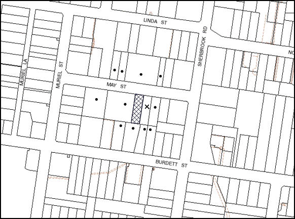
|
NOTIFICATION PLAN |
|
||
|
• PROPERTIES NOTIFIED
|
X SUBMISSIONS RECEIVED |
PROPERTY SUBJECT OF DEVELOPMENT |
|
One submission, from the Body Corporate, objects to the development on the following grounds:
· Unacceptable overshadowing of adjoining properties;
· Density;
· Development that is excessive in bulk and scale;
· Privacy; and
· Site coverage and landscaping.
The issues raised in the submission have been addressed within the body of the report and appropriate conditions have been included in Schedule 1.
5.2 Public Agencies
The development application is not considered Integrated Development under the Act.
6. THE PUBLIC INTEREST
Section 79C(1)(e) of the Act requires Council to consider “the public interest”.
The public interest is an overarching requirement, which includes the consideration of the matters discussed in this report. Implicit to the public interest is the achievement of future built outcomes adequately responding to and respecting the future desired outcomes expressed in environmental planning instruments and development control plans.
The application is considered to have satisfactorily addressed Council’s and relevant agencies’ criteria and would provide a development outcome that, on balance, would result in a positive impact for the community. Accordingly, it is considered that the approval of the proposed describe would be in the public interest.
CONCLUSION
The application proposes demolition of the existing single dwelling and construction of a residential flat building containing 9 units and basement parking and strata subdivision.
The proposed development is generally satisfactory in respect to the design principles under SEPP 65 and the best practice guidelines of the SEPP 65 - Residential Flat Design Code, subject to recommended conditions.
The proposed development has regard to the requirements of the Medium/High Density Multi unit Housing DCP and Hornsby DCP 2013.
The application is recommended for approval.
Note: At the time of the completion of this planning report, no persons have made a Political Donations Disclosure Statement pursuant to Section 147 of the Environmental Planning and Assessment Act 1979 in respect of the subject planning application.
|
Rod Pickles Manager - Development Assessment Planning Division |
James Farrington Group Manager Planning Division |
|
1.View |
Locality Map |
|
|
|
2.View |
Section and Elevations |
|
|
|
3.View |
Floor Plans |
|
|
|
4.View |
Roof Plan |
|
|
|
5.View |
Landscape Plan |
|
|
|
6.View |
Photomontage |
|
|
File Reference: DA/469/2013
Document Number: D02501505
SCHEDULE 1
GENERAL CONDITIONS
The conditions of consent within this notice of determination have been applied to ensure that the use of the land and/or building is carried out in such a manner that is consistent with the aims and objectives of the relevant legislation, planning instruments and council policies affecting the land and does not disrupt the amenity of the neighbourhood or impact upon the environment.
Note: For the purpose of this consent, the term ‘applicant’ means any person who has the authority to act on or the benefit of the development consent.
Note: For the purpose of this consent, any reference to an Act, Regulation, Australian Standard or publication by a public authority shall be taken to mean the gazetted act or regulation, or adopted Australian Standard or publication as in force on the date that the application for a construction certificate is made.
1. Approved Plans and Supporting Documentation
The development must be carried out in accordance with the plans and documentation listed below and endorsed with Council’s stamp, except where amended by Council and/or other conditions of this consent:
|
Plan No. |
Drawn by |
Dated |
|
Site/Roof Plan – C |
Innovative Architects |
21/8/2013 |
|
Basement Floor Plan – C |
Innovative Architects |
21/8/2013 |
|
Ground Floor Plan – C |
Innovative Architects |
21/8/2013 |
|
First Floor Plan – C |
Innovative Architects |
21/8/2013 |
|
Elevations – C |
Innovative Architects |
21/8/2013 |
|
Sections – C |
Innovative Architects |
21/8/2013 |
|
A3 |
Site and Design |
21/8/2013 |
|
Document No. |
Prepared by |
Dated |
|
BASIX Assessment |
Efficient Living |
16/4/2013 |
|
Waste Management Plan |
Innovative Architects |
10/5/2013 |
|
SEPP 65 Design Verification |
Innovative Architects |
- |
|
Schedule of Finishes and Photomontage |
Innovative Architects |
Received 23/7/2013 |
|
Stormwater Management Plan – Sheet 1 – 6 |
Storm Civil Engineering Solutions |
17/7/2013 |
2. Amendment of Plans
The approved plans are to be amended as follows:
a) The balconies of Unit Nos. 2, 5 and 8 on the eastern elevation are to be provided with a moveable privacy screen as marked in red on the approved Elevations Plan prepared by Innovative Architects, dated 21/8/2013.
3. Removal of Existing Trees
This development consent only permits the removal of tree(s) numbered 1, 2 and 3 as identified on Site Tree Location Plan. prepared by Hornsby shire Council. The removal of any other trees requires separate approval under Council’s Tree Preservation Order.
4. Construction Certificate
A Construction Certificate is required to be approved by Council or a Private Certifying Authority prior to the commencement of any works under this consent.
REQUIREMENTS PRIOR TO THE ISSUE OF A CONSTRUCTION CERTIFICATE
5. Building Code of Australia
All building work must be carried out in accordance with the requirements of the Building Code of Australia.
6. Contract of Insurance (Residential Building Work)
In the case of residential building work for which the Home Building Act, 1989 requires there to be a contract of insurance in force in accordance with Part 6 of that Act, that such a contract of insurance is in force before any building work authorised to be carried out by the consent commences.
7. Water/Electricity Utility Services
The applicant must submit written evidence of the following service provider requirements:
a) Energy Australia – a letter of consent demonstrating that satisfactory arrangements have been made to service the proposed development.
b) Sydney Water – the submission of a ‘Notice of Requirements’ under s73 of the Sydney Water Act 1994.
Note: Sydney Water requires that s73 applications are to be made through an authorised Sydney Water Servicing Coordinator. Refer to www.sydneywater.com.au or telephone 13 20 92 for assistance.
8. Letterboxes
The details of letter boxes and meter enclosures must be provided with the Construction Certificate Plans. The letter boxes and meter enclosures must be provided with a minimum setback of 2 metres from all boundaries and must be suitably screened.
9. Dilapidation Report
A ‘Dilapidation Report’ is to be prepared by a ‘chartered structural engineer’ detailing the structural condition of the immediate adjoining properties.
10. Public Authority Approvals
The proponent is to obtain all necessary operating approvals and/or permits from all relevant public authorities including RailCorp and Roads and Maritime Service, details of which are to be submitted to Council prior to the issue of a Construction Certificate.
11. Waste Management Details
The following waste management requirements must be complied with:
a) An area of no less than 8 m2 must be allocated for the placement of unwanted bulky items awaiting removal.
b) A Waste Management Plan Section One – Demolition Stage and Section Three – Construction Stage, covering the scope of this project and including the following details, is required to be submitted to Council:
i) A site plan showing sorting and storage areas for demolition and construction waste and the vehicle access to these areas;
ii) An estimate of the types and volumes of waste and recyclables to be generated;
iii) How excavation, demolition and construction waste materials will be reused or recycled and where residual wastes will be disposed;
iv) The total percentage (by weight) of demolition and construction waste that will be reused or recycled.
12. Extension of May Street Drainage System
Council’s piped drainage system shall be extended and designed and constructed in accordance with Council’s Design and Construction Specification 2005 and generally in accordance with Storm Civil Plan 108271-D3-Issue B and the following additional requirements:
a) The extended pipe alignment shall be consistent with the pipe and kerb line adjacent to Nos. 14 to 18 May Street. The existing kerb and gutter and road shoulder over the pipe alignment shall be removed and reconstructed to Council’s standard after pipe construction. Extended pit chambers for differential pipe alignments are not proposed.
b) Provision of Council’s standard cast in-situ concrete kerb inlet junction pits.
c) Pursuant to Section 59A of the Local Government Act 1993 and Section 138 of the Roads Act 1993, an Application shall be made to Hornsby Shire Council for consideration and approval of the proposed Council-controlled drainage extension works, prior to the release of any other Construction Certificate. Application requires payment of Council’s fee for assessment, approval and inspection of the drainage works.
d) Construction or adjustment of all other utilities and assets at the Applicant’s cost to make good all proposed drainage works.
13. Traffic Control Plan
A Traffic Control Plan (TCP) must be prepared by a qualified traffic controller in accordance with the Roads & Traffic Authority’s Traffic Control at Worksites Manual 1998 and Australian Standard 1742.3 for all work on a public road and be submitted to Council. The TCP must detail the following:
a) Arrangements for public notification of the works.
b) Temporary construction signage.
c) Permanent post-construction signage.
d) Vehicle movement plans.
e) Traffic management plans.
f) Pedestrian and cyclist access/safety.
14. Stormwater Drainage
The stormwater drainage system for the development must be designed and constructed in accordance with Council’s Civil Works – Design and Construction Specification 2005 and the following requirements:
a) Connected from the proposed on-site detention drainage system via internal drainage lines to a new extended kerb inlet pit constructed on the May Street kerb alignment, and the proposed extended drainage system.
b) Roofed and upstream paved and garden areas shall be connected to the proposed detention system.
15. On Site Stormwater Detention
An on-site stormwater detention system must be designed by a chartered civil engineer and constructed in accordance with the following requirements:
a) Have a capacity of not less than 13 cubic metres, and a maximum discharge (when full) of 11.5 litres per second;
b) Have a 900mm x 900mm square access grate located directly above the on-site detention tank outlet in an accessible area (outside the proposed building) in the northern end of the planter structure at proposed levels indicated in Storm Civil Plan 108271-D1-Issue B.
c) Provide for bolt down-sealed tank accessible inspection covers to the detention tank. An additional tank overflow system designed to convey all high level flows from the tank to the grated pit P3 adjacent the proposed driveway.
d) Discharge from the detention system to be controlled via 1 metre length of pipe, not less than 50 millimetres diameter or via a stainless plate with sharply drilled orifice bolted over the face of the outlet discharging into a larger diameter pipe capable of carrying the design flow to an approved Council system.
16. Internal Driveway/Vehicular Areas
The driveway and parking areas on site must be designed in accordance with Australian Standards 2890.1, 3727 and the following requirements: -
a) Design levels at the front boundary be obtained from Council.
b) The driveway be a rigid pavement.
c) Transitions for changes of grade must not exceed requirements of AS2890.2. A longitudinal section shall be prepared by a suitably qualified person and submitted with construction plans.
d) Driveway structure, retaining walls and required to support the carriageway as required and the protection of all drops as per the requirements of a chartered Structural Engineer.
17. Vehicular Crossing
A separate application under the Local Government Act, 1993 and the Roads Act, 1993 must be submitted to Council for the installation of a new vehicular crossing and the removal of the redundant crossing. The vehicular crossing must be constructed in accordance with Council’s Civil Works Design, 2005 and the following requirements:
a) Any redundant crossings to be replaced with integral kerb and gutter.
b) The footway area to be restored by turfing.
c) Adjustment of all regulatory signage and all services and street furniture made necessary by proposed works.
Note: An application for a vehicular crossing can only be made to one of Council’s Authorised Vehicular Crossing Contractors. You are advised to contact Council on 02 9847 6940 to obtain a list of contractors.
REQUIREMENTS PRIOR TO THE COMMENCEMENT OF ANY WORKS
18. Erection of Construction Sign
A sign must be erected in a prominent position on any site on which building work, subdivision work or demolition work is being carried out:
a) Showing the name, address and telephone number of the principal certifying authority for the work,
b) Showing the name of the principal contractor (if any) for any demolition or building work and a telephone number on which that person may be contacted outside working hours, and
c) Stating that unauthorised entry to the work site is prohibited.
Note: Any such sign is to be maintained while the building work, subdivision work or demolition work is being carried out, but must be removed when the work has been completed.
19. Protection of Adjoining Areas
A temporary hoarding, fence or awning must be erected between the work site and adjoining lands before the works begin and must be kept in place until after the completion of the works if the works:
a) Could cause a danger, obstruction or inconvenience to pedestrian or vehicular traffic.
b) Could cause damage to adjoining lands by falling objects.
c) Involve the enclosure of a public place or part of a public place.
Note: Notwithstanding the above, Council’s separate written approval is required prior to the erection of any structure or other obstruction on public land.
20. Toilet Facilities
Toilet facilities must be available or provided at the works site before works begin and must be maintained until the works are completed at a ratio of one toilet for every 20 persons employed at the site. Each toilet must:
a) be a standard flushing toilet connected to a public sewer; or
b) be a temporary chemical closet approved under the Local Government Act, 1993; or
c) have an on-site effluent disposal system approved under the Local Government Act, 1993.
21. Erosion and Sediment Control
Erosion and sediment control measures must be provided and maintained throughout the construction period in accordance with the manual ‘Soils and Construction 2004 (Bluebook)’, the approved plans, Council specifications and to the satisfaction of the principal certifying authority. The erosion and sediment control devices must remain in place until the site has been stabilised and revegetated.
Note: On the spot penalties up to $1,500 may be issued for any non-compliance with this requirement without any further notification or warning.
REQUIREMENTS DURING CONSTRUCTION
22. Construction Work Hours
All work on site (including demolition and earth works) must only occur between 7am and 5pm Monday to Saturday.
No work is to be undertaken on Sundays or public holidays.
23. Demolition
All demolition work must be carried out in accordance with Australian Standard 2601-2001 – The Demolition of Structures and the following requirements:
a) Demolition material is to be disposed of to an authorised recycling and/or waste disposal site and/or in accordance with an approved waste management plan.
b) Demolition works, where asbestos material is being removed, must be undertaken by a contractor that holds an appropriate licence issued by WorkCover NSW in accordance with Chapter 10 of the Occupational Health and Safety Regulation 2001 and Clause 29 of the Protection of the Environment Operations (Waste) Regulation 2005.
c) On construction sites where buildings contain asbestos material, a standard commercially manufactured sign containing the words ‘DANGER ASBESTOS REMOVAL IN PROGRESS’ measuring not less than 400mm x 300mm must be erected in a prominent position visible from the street.
24. Environmental Management
The site must be managed in accordance with the publication ‘Managing Urban Stormwater – Landcom (March 2004) and the Protection of the Environment Operations Act 1997 by way of implementing appropriate measures to prevent sediment run-off, excessive dust, noise or odour emanating from the site during the construction of the development.
25. Street Sweeping
Street sweeping must be undertaken following sediment tracking from the site along May Street during works and until the site is established.
26. Works Near Trees
All required tree protection measures are to be maintained in good condition for the duration of the construction period.
All works (including driveways and retaining walls) within 4 metres of any trees required to be retained (whether or not on the subject property, and pursuant to this consent or the Tree Preservation Order), must be carried out under the supervision of an ‘AQF Level 5 Arborist’ and a certificate submitted to the principal certifying authority detailing the method(s) used to preserve the tree(s).
Note: Except as provided above, the applicant is to ensure that no excavation, filling or stockpiling of building materials, parking of vehicles or plant, disposal of cement slurry, waste water or other contaminants is to occur within 4 metres of any tree to be retained.
27. Council Property
During construction works, no building materials, waste, machinery or related matter is to be stored on the road or footpath. The public reserve is to be kept in a clean, tidy and safe condition at all times.
28. Disturbance of Existing Site
During construction works, the existing ground levels of open space areas and natural landscape features, (including natural rock-outcrops, vegetation, soil and watercourses) must not be altered unless otherwise nominated on the approved plans.
29. Landfill
Landfill must be constructed in accordance with Council’s ‘Construction Specification, 2005’ and the following requirements:
a) All fill material imported to the site is to wholly consist of Virgin Excavated Natural Material (VENM) as defined in Schedule 1 of the Protection of the Environment Operations Act 1997 or a material approved under the Department of Environment and Climate Change’s general resource recovery exemption.
b) A compaction certificate is to be obtained from a geotechnical engineer verifying that the specified compaction requirements have been met.
30. Excavated Material
All excavated material removed from the site must be classified in accordance with the Department of Environment, Climate Change and Water NSW Waste Classification Guidelines prior to disposal to an approved waste management facility and reported to the principal certifying authority.
31. Survey Report – Finished Floor Level
A report(s) must be prepared by a registered surveyor and submitted to the principal certifying authority prior to the pouring of concrete at each level of the building certifying that:
a) The building, retaining walls and the like have been correctly positioned on the site and;
b) The finished floor level(s) are in accordance with the approved plans.
32. Contamination During Construction Works
Should the presence of asbestos or soil contamination, not recognised during the application process be identified during demolition, the applicant must immediately notify the Principal Certifying Authority and Council.
33. Construction Noise Management
The construction works must be undertaken in accordance with the “Interim Construction Noise Guidelines – 2009” published by DECCW.
34. Waste Management During Construction
Waste management during the demolition and construction phase of the development must be undertaken in accordance with the approved Waste Management Plan. Additionally written records of the following items must be maintained during the removal of any waste from the site and such information submitted to the Principal Certifying Authority within fourteen days of the date of completion of the works:
a) The identity of the person removing the waste.
b) The waste carrier vehicle registration.
c) Date and time of waste collection.
d) A description of the waste (type of waste and estimated quantity).
e) Details of the site to which the waste is to be taken.
f) The corresponding tip docket/receipt from the site to which the waste is transferred (noting date and time of delivery, description (type and quantity) of waste).
g) Whether the waste is expected to be reused, recycled or go to landfill.
Note: In accordance with the Protection of the Environment Operations Act 1997, the definition of waste includes any unwanted substance, regardless of whether it is reused, recycled or disposed to landfill.
REQUIREMENTS PRIOR TO THE ISSUE OF AN OCCUPATION OR SUBDIVISION CERTIFICATE
Note: For the purpose of this consent, a reference to ‘occupation certificate’ shall not be taken to mean an ‘interim occupation certificate’ unless otherwise stated.
35. Fulfilment of BASIX Commitments
The applicant must demonstrate the fulfilment of BASIX commitments pertaining to the development.
36. Sydney Water – s73 Certificate
An s73 Certificate must be obtained from Sydney Water.
37. Car Parking Allocation and Resident Storage
The basement resident storage areas are to be allocated in accordance with the size requirements of the SEPP 65 - Residential Flat Design Code for the respective units and proximity to the unit car parking space.
38. Damage to Council Assets
Any damage caused to Council’s assets as a result of the construction of the development must be rectified in accordance with Council’s written requirements and at the sole cost of the applicant.
39. Works as Executed Plan
A works-as-executed plan(s) must be prepared by a registered surveyor and submitted to Council for completed road pavement, kerb & gutter, public drainage systems, driveways and on-site detention system.
40. May Street Road Reserve Works
Hornsby Council as Roads Authority shall indicate in writing that all drainage and all works in the road and footpath verge are satisfactorily complete prior to release of Occupation Certificate.
41. Creation of Easements
The following matter(s) must be nominated on the plan of subdivision under s88B of the Conveyancing Act 1919:
a) The creation of an appropriate "Positive Covenant" and "Restriction as to User" over the constructed on-site detention/retention systems and outlet works, within the lots in favour of Council in accordance with Council’s prescribed wording. The position of the on-site detention system is to be clearly indicated on the title.
b) To register the OSD easement, the restriction on the use of land “works-as-executed” details of the on-site-detention system must be submitted verifying that the required storage and discharge rates have been constructed in accordance with the design requirements. The details must show the invert levels of the on site system together with pipe sizes and grades. Any variations to the approved plans must be shown in red on the “works-as-executed” plan and supported by calculations.
Note: Council must be nominated as the authority to release, vary or modify any easement, restriction or covenant.
42. Planter Pots / On slab planting
On slab planter boxes and pots must include waterproofing, subsoil drainage (proprietary drainage cell, 50mm sand and filter fabric) automatic irrigation, minimum 500mm planting soil for shrubs and minimum 1000mm planting soil for trees and palms and 75mm mulch to ensure sustainable landscape is achieved. Pots are to be minimum volume of 100 litres.
43. Plant Species Changes
To ensure height of screen planting on eastern boundary is adequate the following plant species change is to be made:
a) Leptospermum laevigatum species shall be replaced with Elaeocarpus reticulates.
b) To ensure success of plant species located in the on slab planter areas the following changes are to be made:
c) Banksia serrata tree species shall be replaced with Waterhousia floribunda,
d) Westringia mundi species shall be replaced with Syzigium australe.
e) To ensure success of plant species located in pots the following change is to be made:
f) Westringia in pots shall be replaced with Tristaniopsis ‘Luscious’.
g) All replacement species are to be the same number and size as those being replaced.
44. Street Tree Planting
The following shall be planted in the May Street landscape verge outside of the property:
a) Installation of 1 x Lophostemon confertus tree in a minimum 75 litre pot size
45. Completion of Landscaping
A certificate must be provided by a practicing landscape architect or person with similar qualifications and experience certifying that all required landscaping works have been satisfactorily completed in accordance with the approved landscape plans.
46. Garbage Collection Easement
For the purpose of waste collection, an easement entitling Council, its servants and agents and persons authorised by it to enter upon the subject land and to operate thereon, vehicles and other equipment for the purposes of garbage collection must be granted to Council by the owner of the land.
Note: The easement must be in a form prescribed by Council and must include covenants to the effect that parties will not be liable for any damage caused to the subject land or any part thereof or to any property located therein or thereon by reason of the operation thereon of any vehicle or other equipment used in connection with the collection of garbage and to the effect that the owner for the time being of the subject land shall indemnify the Council, its servants, agents and persons authorised by it to collect garbage against liability in respect of any such claims made by any person whomsoever.
47. Unit Numbering
The allocation of unit numbering must be authorised by Council prior to the numbering of each unit in the development.
48. Waste Management Details
The following waste management requirements must be complied with:
a) The bin storage room at the basement level must include water or a hose for cleaning, graded floors with drainage to sewer, a robust door, sealed and impervious surface, adequate lighting and ventilation.
b) A report must be prepared by an appropriately qualified person, certifying the following:
i) A comparison of the estimated quantities of each waste type against the actual quantities of each waste type.
Note: Explanations of any deviations to the approved Waste Management Plan is required to be included in this report
ii) That at least 60% of the waste generated during the demolition and construction phase of the development was reused or recycled.
Note: If the 60% diversion from landfill cannot be achieved in the Construction Stage, the Report is to include the reasons why this occurred and certify that appropriate work practices were employed to implement the approved Waste Management Plan. The Report must be based on documentary evidence such as tipping dockets/receipts from recycling depots, transfer stations and landfills, audits of procedures etc. which are to be attached to the report.
iii) All waste was taken to site(s) that were lawfully permitted to accept that waste.
c) Each unit must be provided with an indoor waste/recycling cupboard for the interim storage of a minimum one day’s waste generation with separate containers for general waste and recyclable materials.
d) Space must be provided for either individual compost containers for each unit or a communal compost container;
Note: The location of the compost containers should have regard for potential amenity impacts.
e) The bin carting route must be devoid of any steps.
Note: Ramps between different levels are acceptable.
49. Section 94 Development Contributions
In accordance with Section 80A(1) of the Environmental Planning and Assessment Act 1979 and the Hornsby Shire Council Section 94 Development Contributions Plan 2012-2021, the following monetary contributions shall be paid to Council to cater for the increased demand for community infrastructure resulting from the development:
|
Description |
Contribution (4) |
|
Roads |
$9,257.50 |
|
Open Space and Recreation |
$109,132.60 |
|
Community Facilities |
$15,611.95 |
|
Plan Preparation and Administration |
$430.35 |
|
TOTAL |
$134,432.40 |
being for; 6 x 2 bedroom and 3 x 3 bedroom units in lieu of 1 existing dwelling.
a) If the contributions are not paid within the financial quarter that this consent is granted, the contributions payable will be adjusted in accordance with the provisions of the Hornsby Shire Council Section 94 Development Contributions Plan and the amount payable will be calculated at the time of payment in the following manner:
$CPY = $CDC x CPIPY
CPIDC
Where:
$CPY is the amount of the contribution at the date of Payment
$CDC is the amount of the contribution as set out in this Development Consent
CPIPY is the latest release of the Consumer Price Index (Sydney – All Groups) at the date of Payment as published by the ABS.
CPIDC is the Consumer Price Index (Sydney – All Groups) for the financial quarter at the date of this Development Consent.
b) The monetary contributions shall be paid to Council:
i) prior to the issue of the Subdivision Certificate where the development is for subdivision; or
ii) prior to the issue of the first Construction Certificate where the development is for building work; or
iii) prior to issue of the Subdivision Certificate or first Construction Certificate, whichever occurs first, where the development involves both subdivision and building work; or
iv) prior to the works commencing where the development does not require a Construction Certificate or Subdivision Certificate.
It is the professional responsibility of the Principal Certifying Authority to ensure that the monetary contributions have been paid to Council in accordance with the above timeframes.
Council’s Development Contributions Plan may be viewed at www.hornsby.nsw.gov.au or a copy may be inspected at Council’s Administration Centre during normal business hours.
OPERATIONAL CONDITIONS
50. Landscape Establishment
The landscape works must be maintained into the future to ensure the establishment and successful growth of plant material to meet the intent of the landscape design. This must include but not be limited to watering, weeding, replacement of failed plant material and promoting the growth of plants through standard industry practices.
51. Waste Storage Area and Waste Management
The waste management on site must be in accordance with the following requirements:
a) Site security measures implemented on the property, including electronic gates, must not prevent access to the bin room/collection point by waste removal services.
b) A site caretaker must be employed and be responsible for moving bins where and when necessary, washing bins and maintaining waste storage areas, managing the communal composting area, arranging the prompt removal of dumped rubbish, and ensuring all residents are informed of the use of the waste management system.
52. Noise
The level of total continuous noise emanating from operation of the premises including all the plant, including air conditioning units and processes in all buildings (LA10) (measured for at least 15 minutes) in or on the above premises, must not exceed the background level by more than 5dB(A) when measured at all property boundaries.
53. Fire Safety Statement - Annual
On at least one occasion in every 12 month period following the date of the first ‘Fire Safety Certificate’ issued for the property, the owner must provide Council with an annual ‘Fire Safety Certificate’ to each essential service installed in the building.
- END OF CONDITIONS -
ADVISORY NOTES
The following information is provided for your assistance to ensure compliance with the Environmental Planning and Assessment Act, 1979, Environmental Planning and Assessment Regulation 2000, other relevant legislation and Council’s policies and specifications. This information does not form part of the conditions of development consent pursuant to Section 80a of the Act.
Environmental Planning and Assessment Act, 1979 Requirements
The Environmental Planning and Assessment Act, 1979 requires:
· The issue of a construction certificate prior to the commencement of any works. Enquiries regarding the issue of a construction certificate can be made to Council’s Customer Services Branch on 9847 6760.
· A principal certifying authority to be nominated and Council notified of that appointment prior to the commencement of any works.
· Council to be given at least two days written notice prior to the commencement of any works.
· Mandatory inspections of nominated stages of the construction inspected.
· An occupation certificate to be issued before occupying any building or commencing the use of the land.
Long Service Levy
In accordance with Section 34 of the Building and Construction Industry Long Service Payments Act 1986, a ‘Long Service Levy’ must be paid to the Long Service Payments Corporation or Hornsby Council.
Note: The rate of the Long Service Levy is 0.35% of the total cost of the work.
Note: Hornsby Council requires the payment of the Long Service Levy prior to the issue of a construction certificate.
Tree Preservation Order
To ensure the maintenance and protection of the existing natural environment, it is an offence to ringbark, cut down, top, lop, remove, wilfully injure or destroy a tree outside 3 metres of the approved building envelope without the prior written consent from Council.
Note: A tree is defined as a single or multi-trunked wood perennial plant having a height of not less than three (3) metres, and which develops many branches, usually from a distance of not less than one (1) metre from the ground, but excluding any plant which, in its particular location, is a noxious plant declared as such pursuant to the Noxious Weeds Act 1993. This definition of ‘tree’ includes any and all types of Palm trees.
All distances are determined under Australian Standard AS4970-2009 ”Protection of Trees on Development Sites”.
Fines may be imposed for non-compliance with Council’s Tree Preservation Order.
Asbestos Warning
Should asbestos or asbestos products be encountered during demolition or construction works you are advised to seek advice and information should be prior to disturbing the material. It is recommended that a contractor holding an asbestos-handling permit (issued by WorkCover NSW) be engaged to manage the proper handling of the material. Further information regarding the safe handling and removal of asbestos can be found at:
Alternatively, telephone the WorkCover Asbestos and Demolition Team on 8260 5885.
House Numbering
House numbering can only be authorised by Council. Before proceeding to number each premise in the development, the allocation of numbers is required to be obtained from Council's Planning Division. The authorised numbers are required to be displayed in a clear manner at or near the main entrance to each premise.
Group Manager’s Report No. PL106/13
Planning Division
Date of Meeting: 16/10/2013
12 DEVELOPMENT APPLICATION - CONSTRUCTION OF TWO, FIVE STOREY RESIDENTIAL FLAT BUILDINGS - 2-8 BELAIR CLOSE AND 43 SHERBROOK ROAD, HORNSBY
EXECUTIVE SUMMARY
|
DA No: |
DA/547/2013 (Lodged 31 May 2013) |
|
Description: |
Demolition of existing structures and construction of two, five storey residential flat buildings comprising 73 units and basement car parking |
|
Property: |
Lots 10, 11, 12 , 13 and 14 DP 204624, Nos. 2 - 8 Belair Close and No. 43 Sherbrook Road, Hornsby |
|
Applicant: |
Robert Jurukovski Architects |
|
Owner: |
Mr Hamid Hanna, Mrs Antoinette Hanna, Miss Margery Honglan Ji, Miss Ai Ling Tan, Mrs Oi Keen Hor, Mr John Lewis Spresser and Mrs Glenda Margaret Spresser |
|
Estimated Value: |
$13,400,000 |
|
Ward: |
A |
· The application proposes the demolition of existing structures and construction of two, five storey residential flat buildings comprising 73 units and basement car parking.
· The proposal generally complies with the Hornsby Shire Local Environmental Plan 1994, State Environmental Planning Policy No. 65 - Design Quality of Residential Flat Development, the Hornsby Shire Housing Strategy Development Control Plan and the Hornsby Development Control Plan 2013.
· Nineteen submissions have been received in respect of the application.
· It is recommended that the application be approved.
|
THAT Development Application No. 547/2013 for demolition of existing structures and construction of two, five storey residential flat buildings comprising 73 units and basement car parking at Lots 10, 11, 12, 13 and 14 DP 204624, Nos. 2-8 Belair Close and No. 43 Sherbrook Road, Hornsby be approved subject to the conditions of consent detailed in Schedule 1 of Group Manager’s Report No. PL106/13. |
BACKGROUND
Belair Close was previously zoned Residential A (Low Density) and formed a low density precinct bordered by residential flat development comprising mainly three storey buildings within a medium/high density residential area. Belair Close was rezoned Residential C (Medium/High Density) as part of Council’s Housing Strategy on 2 September 2011.
SITE
The site has an area of 3976.5m2 and a frontage of approximately 73m to the northern side of Belair Close and 49m to the western side Sherbrook Road, being located at the corner of the two roads. The site has a north-easterly aspect and an average gradient of 10% from the south-western corner to the north-eastern corner (Sherbrook Road frontage).
An overland flow path crosses the Sherbrook Road frontage of the site in a northerly direction prior to draining to a nearby open creek (Hornsby Creek) being a part of the Hawkesbury River Catchment area. This section of the site constitutes flood prone land (Nos. 2 Belair Close and 43 Sherbrook Road).
The site includes five existing dwelling houses on irregular shaped lots fronting Belair Close and Sherbrook Road. The dwelling houses, garages and carports are separated by a number of trees and shrubs.
The western boundary of the site adjoins single and two storey dwellings. The northern side of the site adjoins an unformed road reserve (Water Street) at the rear which includes remnant trees, and stormwater drainage and pollution control infrastructure.
The site forms a part of the Belair Close Housing Strategy Precinct. The western side of the precinct adjoins medium to high density residential developments comprising townhouses and three storey residential flat buildings with basement car parks. DA/4/2013 approved two, five storey buildings with basement car park and 64 units on the southern side of Belair Close, opposite the site.
The site is located 750m north-east of Hornsby Railway Station and is within 260m of a regular bus service connection to the station.
PROPOSAL
The proposal is for the demolition of existing dwellings and construction of two, five storey residential flat buildings comprising 73 units and basement car park.
Building A comprises 36 units including 5 x 1-bedroom, 26 x 2-bedroom and 5 x 3 bedroom units. All of the 1-bedroom units and majority of the 2-bedroom and 3-bedroom units include studies. The building accommodates 7 adaptable units. The 3-bedroom units on the uppermost floor are designed to include mezzanines with internal access via stairs. The building includes a central lift for vertical circulation.
Building B comprises 37 units including 4 x 1-bedroom, 30 x 2-bedroom and 3 x 3 bedroom units, of which a number of units include separate studies. Fifteen adaptable units are proposed within the building. The 2-bedroom units at the south-western corner of uppermost floor include mezzanines with internal access via stairs. The building includes a central lift for vertical circulation.
The two proposed five storey buildings are stepped to the topography of the site. The proposed buildings are of concrete construction, with glazed and painted masonry finishes and metal roofing. Two separate pedestrian entries are provided for the two buildings leading up to a foyer at the ground level.
The proposed car park is designed in two levels, lower ground and basement car parking areas with a ramp and driveway entry from Belair Close. The lower ground car park is located under Building B and adjoins the lower-ground level units within Building A. The car park stretches under the two buildings and includes 95 car parking spaces, 13 visitor car parking spaces, resident storage facilities, bicycle storage and waste management facilities.
Landscaped areas are proposed fronting the two roads and the rear. The primary communal open space area is proposed to be located in between the two buildings and includes retaining walls for level paved court yards and perimeter gardens.
ASSESSMENT
The development application has been assessed having regard to the ‘Metropolitan Plan for Sydney 2031’, the ‘North Subregion (Draft) Subregional Strategy’ and the matters for consideration prescribed under Section 79C of the Environmental Planning and Assessment Act 1979 (the Act). The following issues have been identified for further consideration.
1. STRATEGIC CONTEXT
1.1 Metropolitan Plan for Sydney and (Draft) North Subregional Strategy
The (Draft) Metropolitan Strategy for Sydney 2031 is a broad framework to provide for Sydney’s growth to help plan for housing, employment, transport, infrastructure, the environment and open space. It outlines a vision for Sydney to 2031; the challenges faced, and the directions to follow to address these challenges and achieve the vision.
The North Subregion comprises Hornsby, Kuring-gai, Manly, Warringah and Pittwater Local Government Areas. The Draft North Subregional Strategy acts as a framework for Council in its preparation of the Comprehensive LEP by the end of 2013.
Within the North Subregion, the Draft Metropolitan Strategy proposes:
· Population growth of 81,000 from the current 2011 baseline of 529,000
· Housing growth of 37,000 from the current 2011 baseline of 204,000
· Employment growth of 39,000 from the current 2011 baseline of 186,000
The proposed development would be consistent with the Metropolitan Plan for Sydney 2031 by providing an additional 68 dwellings and would contribute to housing choice in the locality.
2. STATUTORY CONTROLS
Section 79C(1)(a) requires Council to consider “any relevant environmental planning instruments, draft environmental planning instruments, development control plans, planning agreements and regulations”.
2.1 Hornsby Shire Local Environmental Plan 1994
The subject land is zoned Residential C (Medium/High Density) under the Hornsby Shire Local Environmental Plan 1994 (HSLEP). The objectives of the Residential C (Medium/High Density) zone are:
(a) to provide for the housing needs of the population of the Hornsby area.
(b) to promote a variety of housing types and other land uses compatible with a medium to high density residential environment.
(c) to provide for development that is within the environmental capacity of a medium to high density residential environment.
The proposed development is defined as ‘multi-unit housing’ under the HSLEP and is permissible in the zone with Council’s consent.
Clause 15A of the HSLEP prescribes a maximum building height of 17.5m for development on the subject site. The proposed development complies with this requirement.
Clause 18 of the HSLEP sets out heritage conservation provisions for Hornsby Shire. The site is not identified as a heritage item and is not in the vicinity of an item or within a heritage conservation area.
2.2 Hornsby Local Environmental Plan 2013
The Hornsby Local Environmental Plan 2013 was made on 27 September 2013 and will come into effect on 11 October 2013. The HLEP includes a savings provision stating that if a development application is made and not finally determined before the commencement of the HLEP, the application must be determined as if the Plan had been exhibited but not commenced. The relevant provisions of the HLEP are addressed below.
2.2.1 Zoning
The site is zoned R4 (High Density Residential) pursuant to the Land Use Table of the HLEP. The proposed development is defined as a ‘residential flat building’ and is a permissible use in the zone with Council’s consent.
The land adjoining the Belair Close Precinct is also zoned R4 (High Density Residential).
2.2.2 Height of Building
Clause 4.3 of the HLEP provides that the height of a building on any land is not to exceed the maximum height shown for the land on the Height of Buildings Map. The maximum permissible height for the subject site is 17.5m. The proposal complies with this provision.
The land adjoining the Belair Close, Hornsby Precinct has a maximum height of 12m.
2.3 State Environmental Planning Policy No. 55 - Remediation of Land
State Environmental Planning Policy No. 55 (SEPP 55) requires that Council must not consent to the carrying out of any development on land unless it has considered whether the land is contaminated or requires remediation for the proposed use.
The site has been used for residential purposes and is unlikely to be contaminated. No further assessment is considered necessary in this regard.
2.4 State Environmental Planning Policy No. 65 - Design Quality Residential Flat Development
The Policy provides for design principles to improve the design quality of residential flat development and for consistency in planning controls across the State.
The applicant has submitted a design verification statement prepared by a qualified designer stating how the proposed development achieves the design principles of SEPP 65. The design principles of SEPP 65 and the submitted design verification statement are addressed below.
2.4.1 Principle 1 - Context
The site is located within a precinct zoned for five storey residential flat buildings in close proximity to Hornsby commercial centre. The desired future character of the area, as outlined in Council’s Housing Strategy Development Control Plan, is that of a high density residential precinct incorporating five storey developments in a landscaped setting.
The submitted “Design Verification Statement” indicates that the proposal responds to the desired future character of the area visualised by Council. The building is appropriately stepped with sufficient setbacks. The site plan retains significant trees within the road reserve on the northern side. Once the precinct is redeveloped, the development would integrate with the surrounding sites, the existing medium-high density developments in close proximity on the western side and the approved buildings on the opposite side of the road.
The development responds appropriately to the ‘context’ principle of SEPP 65, and would contribute to the identity and future character of the precinct.
2.4.2 Principle 2 - Scale
The precinct is undergoing transition. The scale of the future built environment is commensurate with Council’s planning controls which promote five storey residential flat buildings with a maximum height of 17.5m. The proposed development complies with the maximum height limit permitted in the residential precinct and provides a building envelope which generally confines itself within the setbacks required by Council’s Housing Strategy Development Control Plan.
The elevations achieve an appropriate aesthetic outcome and composition and create the appearance of separate pavilions. The scale of the proposed development is appropriate for the site in accordance with the planning controls and desired future character of the precinct.
2.4.3 Principle 3 - Built Form
The proposed building is appropriately modulated and articulated to reduce bulk and scale and blend with the surrounding residential character. The details of the elements of the built form are assessed in Section 2.11 of this report.
2.4.4 Principle 4 - Density
The proposal achieves a dwelling density consistent with the requirements of the Housing Strategy Development Control Plan which establishes the desired future character for the “Belair Close, Hornsby” precinct. The proposal is within the DCP prescriptive measures as addressed in Section 2.11 of this report.
2.4.5 Principle 5 - Resource, Energy and Water Efficiency
The proposed development includes a BASIX Certificate and complies with the requirements with regard to water, thermal comfort and energy. The proposal also complies with the natural ventilation and solar access requirements within the Residential Flat Design Code (RFDC). The details of the above matters are discussed in Section 2.5 of this report.
2.4.6 Principle 6 - Landscape
The application includes a landscape concept plan providing landscaping to both the street frontages, especially along Sherbrook Road, to be used as a part of communal open space, and the side boundaries. This planting would activate the street frontages and provide a landscaped setting for the proposed development.
The proposed development incorporates deep soil planting wherever possible and common open space within the rear setback. The communal open space in between the two buildings would also be landscaped so that it is useable in the future. Given the above, the proposal satisfies the intent of the ‘Landscaping’ principle of SEPP 65.
2.4.7 Principle 7 - Amenity
The proposal would provide convenient and safe access to the development via a central lift connecting the basement and all other levels. The application has been assessed against the ‘Building Amenity’ criteria within the RFDC and is discussed in Section 2.5 of this report.
2.4.8 Principle 8 - Safety and Security
The proposed design has regard to ‘Crime Prevention through Environmental Design (CPTED)’ principles and does not include any obvious unobserved areas.
The RFDC requires the preparation of a formal Crime Assessment Report for development that comprises more than 20 residential units. The proposal includes an assessment of the development against crime prevention controls in the Statement of Environmental Effects. The applicant advises that the safety of the public domain is enhanced by providing apartment layouts that optimise occupant surveillance, well-lit entry lobbies, communal open spaces, garden paths and public areas, secured car-park entry and casual surveillance for all communal areas.
The application was referred to NSW Police Force who raises no objections to the proposal. The proposal is assessed as satisfactory with regard to safety and security, subject to a condition requiring lighting of the service areas of the lower- ground floor, the garbage room and the communal open space at the rear.
2.4.9 Principle 9 - Social Dimensions and Housing Affordability
The Housing Strategy DCP includes prescriptive measures for housing choice and for adaptable housing to provide for aging in place. The proposal provides a housing mix and adaptable housing and is supported in respect to this Principle.
2.4.10 Principle 10 - Aesthetics
The proposal is consistent with the design principles contained within the RFDC. It is considered that the aesthetic quality of the building contributes to the desired future character of the precinct. The details of the assessment of the built form and the aesthetics of the development are contained in Section 2.11 of this report.
2.5 SEPP 65 - Residential Flat Design Code
SEPP 65 requires consideration of the Residential Flat Design Code, NSW Planning Department 2002. The Code includes development controls and best practice benchmarks for achieving the design principles of SEPP 65. The following table sets out the proposal’s compliance with the Code.
|
Residential Flat Design Code |
|||
|
Control |
Proposal |
Requirement |
Compliance |
|
Deep Soil Zone |
31% |
25% |
Yes |
|
Communal Open Space |
25% |
25-30% |
Yes |
|
Ground Level Private Open Space |
< 25m2 Min Dimension 1.5m |
25m2 Min Dimension 4m |
No No |
|
Minimum Dwelling Size |
1 br – 56m2 2 br – 74m2 3 br – 95m2 |
1 br – 50m2 2 br – 70m2 3 br – 95m2 |
Yes Yes Yes |
|
Maximum Kitchen Distance |
8m |
8m |
Yes |
|
Minimum Balcony Depth |
2.0m |
2.0m |
Yes |
|
Ceiling Heights |
2.7m |
2.7m (Min) |
Yes |
|
Total Storage Area
|
1 br - > 6m3 2 br - > 8m3 3 br - > 10m3 > 50% accessible from the apartments |
1 br - 6m3 min 2 br - 8m3 min 3 br -10m3 min 50% accessible from the apartments |
Yes |
|
Dual Aspect & Cross Ventilation |
60.2% |
60% |
Yes |
|
Adaptable Housing |
30% |
10% |
Yes |
As detailed in the above table, the proposed development complies with the prescriptive measures within the Residential Flat Design Code other than the ground floor open space areas. Below is a brief discussion regarding the relevant development controls and best practice guidelines.
2.5.1 Building Depth and Separation
The proposed building depths and the design of the facades are in accordance with the requirements of Council’s Housing Strategy Development Control Plan and are discussed in Section 2.11.
The majority of the living areas and single aspect balconies would be orientated towards the street and the reserve at the rear. There are no single aspect balconies fronting the western side of the site. Notwithstanding, privacy louvers are proposed for the western side of the upper level balconies and are setback 4m from the boundary. The top level balconies on the western side of Building B would not comply with the 9 metre separation from the boundary. The matter is discussed in Section 2.11 of this report.
The proposal would not result in unreasonable compromise of natural ventilation and solar access to the proposed or adjoining future, developments subject to the implementation of conditions of consent.
2.5.2 Apartment Layout and Mix
The two proposed buildings are designed in response to the topography and shape of the site. The proposal includes a range of apartment sizes and layouts appropriate to the configuration of the buildings.
Two units on the uppermost floor of each of the buildings include mezzanines with internal access via stairs. The proposed layouts are functional, well appointed spaces. The depth and width of the units ensure adequate natural light and ventilation. The majority of kitchen spaces either include a window, or are located within 8m of a window.
The proposal includes a range of smaller units providing for housing choice. It is considered the proposed units meet the best practice requirements of the Code.
2.5.3 Ground Floor Apartments
The Code encourages separate entries for ground floor apartments and private gardens areas at ground level.
The proposed ground floor unit open space areas include courtyards and balconies contained within the building envelope. The unit open space areas are considered appropriate for the respective ground floor units in respect to dwelling size, aspect, unit configuration and amenity. A number of ground floor units would not include 25sqm courtyards adjoining the living areas. The non-compliance with the best practice 25sqm open space area and 4m dimension is considered acceptable as the larger area would be lost to private use and not contribute to landscaping with regard to the Housing Strategy Development Control Plan key principle for five storey residential flat buildings in garden settings. The units comply with the minimum requirements of the Housing Strategy Development Control Plan with regard to private open space areas. The proposal is assessed as satisfactory in this regard.
The adaptable dwellings benefit from convenient access via ramps and lifts to common outdoor open space areas. It is considered that the design of the proposed ground floor units is satisfactory in meeting the requirements of the Code.
2.5.4 Internal Circulation
Each floor includes an open foyer/corridor with the lift to provide internal circulation. The lifts are within ready access of the respective units. The lift corridors meet the Code’s requirements for the number of units accessed (less than 8) and design for amenity.
2.5.5 Acoustic Privacy
The internal layout of the residential units is designed such that noise generating areas would generally adjoin each other. Storage or circulation zones would act as a buffer between units. Bedrooms and service areas such as kitchens, bathrooms and laundries would be grouped together wherever possible. Measures to reduce noise transmission from common corridors have been provided within the unit layouts.
It is noted that two of the south facing units within Building A may be affected by the noise from the ramp to the basement car park. To mitigate any noise impact on these units, a condition is recommended requiring a privacy screen on the southern edge of these balconies.
Subject to recommended conditions for noise mitigation, the proposed development meets the Code’s best practice requirements for acoustic privacy.
2.5.6 Storage
The proposed units include built-in robes and linen cupboard storage. The basement includes caged storage areas for all 73 units. The proposal would comply with the Codes best practice storage areas requirement.
2.6 State Environmental Planning Policy No. 32 - Urban Consolidation (Redevelopment of Urban Land) (SEPP 32)
The application has been assessed against the requirements of SEPP 32, which requires Council to implement the aims and objectives of this Policy to the fullest extent practicable when considering development applications relating to redevelopment of urban land. The application complies with the objectives of the Policy as it would promote social and economic welfare of the locality and would result in the orderly and economic use of under utilised land within the Shire.
2.7 State Environmental Planning Policy (Building Sustainability Index - BASIX) - 2004
The application has been assessed against the requirements of State Environmental Planning Policy (Building Sustainability Index: BASIX) 2004. The proposal includes a BASIX Certificate for the proposed development and is considered to be satisfactory.
2.8 Sydney Regional Environmental Plan No. 20 - Hawkesbury - Nepean River
The site is located within the catchment of the Hawkesbury Nepean River. Part 2 of this Plan contains general planning considerations and strategies requiring Council to consider the impacts of development on water quality, aquaculture, recreation and tourism.
Subject to the implementation of sediment and erosion control measures and stormwater management to protect water quality, the proposal would comply with the requirements of the Policy.
2.9 Clause 74BA Environmental Planning and Assessment Act, 1979 - Purpose and Status of Development Control Plans
On 1 March 2013, the Environmental Planning and Assessment Act, 1979 was amended so that a DCP provision will have no effect if it has the practical effect of “preventing or unreasonably restricting development” that is otherwise permitted and complies with the development standards set out in relevant Local Environmental Plans and State Environmental Planning Policies.
The principal purpose of a development control plan is to provide guidance on the aims of any environmental planning instrument that applies to the development; facilitating development that is permissible under any such instrument; and achieving the objectives of land zones under any such instrument. The provisions of a development control plan made for that purpose are not statutory requirements.
2.10 Hornsby Development Control Plan 2013
The Hornsby Development Control Plan (HDCP) 2013 applies to all land within Hornsby Shire and will replace Council’s existing DCPs, providing development controls to complement the HLEP. The HDCP will come into effect on 11 October 2013.
The following sections of this report include a detailed assessment of the proposal against Council’s existing DCP controls. Although the HDCP was not in force at the date of finalising this report, the development proposal has been assessed against the Plan.
The HDCP is generally a transition of Council’s existing DCPs, into a consolidation Plan. Notwithstanding, it is noted that the following controls are inconsistent with the existing DCP requirements and a brief discussion of the HDCP requirements is provided below:
2.10.1 Setbacks
The proposed development includes balcony encroachments to within 4m of the northern side boundary for Building A and the western side boundary for Building B, which is inconsistent with the side boundary setback requirements of the HDCP.
The northern side of the site adjoins an unformed road reserve (Water Street) which includes remnant trees, and stormwater drainage and pollution control infrastructure. Accordingly, the non compliance would not impact on the achievement of daylight access, visual privacy, and acoustic privacy.
The western boundary of the site adjoins single and two storey dwellings, which would be the subject of a future development application for 5 storey residential flat building(s). Only dual aspect balconies front the western side with a setback of 4m and are provided with privacy louvers to comply with the privacy requirements of SEPP 65 and satisfy the intent of the prescriptive measures to not impact on the achievement of daylight access, visual privacy, and acoustic privacy.
Accordingly, the application is assessed as satisfactory with regard to the setback requirements of the HDCP.
2.10.2 Building Form and Separation
The required minimum separation between buildings on large sites is increased from 6m to 9m under the HDCP and the proposed development complies with this requirement.
The HDCP also requires that the minimum separation between residential buildings should comply with Table 3.4.6(a) which states:
|
Table 3.4.6(a): Minimum Separation Between Buildings |
|
|
5 Storey RFB Building |
Separation |
|
Up to 4 storeys/ 12m
|
12m between unscreened habitable rooms/ balconies/ principal private open space areas |
|
Up to 5 storeys/ over 12m
|
18m between unscreened habitable rooms/ balconies/ principal private open space areas |
|
Facing side or rear boundaries shared with an undeveloped site |
Half of the building separation required by the Residential Flat Design Code under SEPP 65 - Design Quality of Residential Flat Buildings |
The proposed development includes balcony encroachments to within 4m of the northern side boundary for Building A and the western side boundary for Building B, which is inconsistent with the minimum separation distances of 6m (up to 4 storeys) and 9m (for the 5th storey) noting that this is half the specified separation distance in the table, as development on the adjoining lot would provide the remainder.
The proposal has incorporated appropriate screening devices to ameliorate privacy impacts and the application is considered acceptable in the circumstances given the merit of the design in achieving the desired outcome for built form and separation as discussed in Section 2.11.
2.10.3 Landscaping
The landscaping area between buildings is increased from 6m x 6m to 7m x 7m of deep soil landscaping under the HDCP. The proposed separation between the two buildings generally complies with this requirement and there is sufficient area available for deep soil landscaping on the site including provision for the planting of locally indigenous canopy trees.
The application is assessed as satisfactory with regard to the landscaping requirements of the HDCP.
2.10.4 Vehicle Access and Parking
The proposed vehicle access to the common basement area is via a 6m wide driveway off Belair Close. The basement and lower-ground levels are shared between the two buildings and include 108 car parking spaces comprising 95 resident spaces and 13 visitor spaces including disabled car parking. A minimum of 11 visitor and 75 residential parking spaces is required for the development under the HDCP and the development complies with this requirement.
Provision has been made for bicycle parking in Basement level 01, however the number of bicycle spaces and layout of parking is not shown on the drawings. 22 bicycle spaces are required for the development under the HDCP and a condition is recommended in Schedule 1 to address this requirement.
The HDCP also requires that 2 motorcycle spaces be provided for the development. A condition is recommended to provide 2 motorcycle spaces.
Subject to the recommended conditions regarding bicycle and motorcycle parking spaces, the application is assessed as satisfactory with regard to vehicle access and parking requirements.
2.11 Housing Strategy Development Control Plan
The proposed development has been assessed having regard to the relevant performance and prescriptive requirements within Council’s Housing Strategy Development Control Plan (Housing Strategy DCP). The following table sets out the proposal’s compliance with the prescriptive requirements of the Plan.
|
Housing Strategy Development Control Plan |
|||
|
Control |
Proposal |
Requirement |
Compliance |
|
Site Width |
49m (Sherbrook Road) 78m (Belair Close) |
Min - 30m |
Yes |
|
Height |
5 storeys - 17.5m |
5 storeys - 17.5m |
Yes |
|
Lowest Residential Floor Above Ground |
1.5m |
Max - 1.5m |
Yes |
|
Maximum Floorplate Dimension |
36.5m (Building A) 32m (Building B) |
35m 35m |
No Yes |
|
Building Indentation |
4m x 4m |
4m x 4m |
Yes |
|
Building A Front Setback (Sherbrook) Building Line Balcony Basement Maximum building length between 8m – 10m |
10m 7m 7m 16m |
10m 7m 7m 12m < 1/3rd of 36.5m
|
Yes Yes Yes Yes |
|
Building A Front Setback (Belair Close) Building Line Balcony Basement Maximum building length between 8m – 10m |
10m 7m 7m 8m |
10m 7m 7m 8m< 1/3rd of 25m |
Yes Yes Yes Yes |
|
N Side Setback (Building A) Building Line Balcony Basement Maximum building length between 4m – 6m |
6m 4m 4m 6m |
6m 4m 4m 8m (1/3 of 25m) |
Yes Yes Yes Yes |
|
Building B Front Setback (Belair Close) Building Line Balcony Basement Max bldg length between 8m – 10m |
10m 7m 6m – 7m 12m |
10m 7m 7m 10.2m (1/3rd of 27m) |
Yes Yes No No |
|
Rear Setback (Building B – N Side) Building Line Balcony Basement Max bldg length between 8m – 10m |
10m 7m 7m 10m |
10m 7m 7m 10.2m (1/3rd of 27m) |
Yes Yes Yes Yes |
|
W Side Setback (Bldg B) Building line Balcony Basement Maximum building length between 4m-6m |
6m 4m 4m 9m (1/3 of 27m) |
6m 4m 4m 10m |
Yes Yes Yes No |
|
Additional top Storey Setback From Ground Floor Bldg A Bldg B |
3m <3m |
3m 3m |
Yes No |
|
Basement Ramp Setback |
2m |
2m |
Yes |
|
Separation Building A & Building B |
>9m |
6m |
Yes |
|
Car Parking |
95 resident spaces 13 visitor spaces |
77 resident spaces 15 visitor spaces |
Yes No |
|
Landscaping Belair Close W side Sherbrook Road Rear (N Side) |
5m-7m 4m 7m 4m-7m |
7m 4m 7m 7m |
No Yes Yes Yes |
|
Min Private Open Space (Min Width 2.5m) |
1 br units - 12m2 2 br units - 15m2 3 br units - 16m2 |
10m2 12m2 16m2 |
Yes Yes Yes |
|
Communal Open Space |
25% |
25% |
Yes |
|
Sunlight Access |
70% |
70% |
Yes |
|
Housing Choice |
1 br units – 10.9% 2 br units – 76.8% 3 br units – 12.3% |
10% 10% 10% |
Yes Yes Yes |
|
Adaptable Units |
30% |
30% |
Yes |
As detailed in the above table, the proposed development does not comply with a number of prescriptive requirements within Council’s Housing Strategy DCP. These non-compliances are largely a result of the irregular shape of the site and the corner element. The matters of non-compliance are detailed below, as well as a brief discussion on compliance with relevant performance requirements.
2.11.1 Desired Future Character
The proposed building is in accordance with required key principles for the future character of the Belair Close, Hornsby Precinct f or well articulated five storey residential flat buildings in garden settings with basement car parking. The design of the building would suit the desired future character of the locality.
2.11.2 Design Quality - SEPP 65
The proposed development accords with the design principles of SEPP 65 as discussed in Sections 2.4 and 2.5 of this report.
2.11.3 Site Requirements
The site is a consolidated site and is in accordance with the site requirements of the Housing Strategy DCP. The site selection would not cause isolation or land locking of any adjoining site.
2.11.4 Height
The site topography is relatively steep with variation in levels and an average gradient of 10%. The proposed development involves a substantial amount of excavation to a maximum depth of 10m at the highest point of Belair Close. The stepping of the development includes distinct changes in levels.
The roof heights of the proposed buildings (RL 171.5 - RL 170) are consistent with the height of the existing residential developments in the adjoining precincts and the approved development at Nos. 5-15 Belair Close (RL 175.1 - RL 169.5)
The height of the two proposed buildings is in accordance with the Housing Strategy DCP maximum 17.5m building height. The proposed lower ground level car park would project 1.5m above ground level at the northern elevation of Building B where the site falls steeply. The projection would not contribute to the height of the building in relation to the adjoining land or the streetscape due to the cut required for the siting of the building on the steeply sloping site. The non-compliance with the maximum basement level 1m above ground height limit is therefore considered acceptable.
Accordingly, the proposed development is considered satisfactory in respect to the five storey built form.
2.11.5 Setbacks
The site is irregular in shape in relation to the site frontage to Belair Close. The relevant matters regarding the setbacks are discussed below:
2.11.5.1 Front and Rear Setbacks
The proposed front setback of Building A to Sherbrook Road conforms to the requirements of the Housing Strategy DCP. Both of the buildings maintain a 10m setback to Belair Close. A transitional setback is proposed on the northern side varying from 4m – 7m which does not strictly comply with the setback requirements as this is the rear of the site. However, Building A is a corner building and larger setbacks are proposed from the two roads, thus reducing the setback at the rear (considered as a side setback for Building A). Given that the site adjoins an unformed road reserve at the rear, the non-compliance with setbacks on this side is considered acceptable. The larger setbacks on the sides fronting the two roads would result in an appropriate visual pattern and would provide sufficient privacy to the future residents.
2.11.5.2 Building Encroachments
More than 1/3rd of the building width encroachments are noted in various elevations, as identified in the above table. The encroachment widths are considered appropriate as the façades are well articulated with intercepting balconies and indents providing two pavilions. The numerical non-compliance would not have any detrimental visual impact on the buildings.
2.11.5.3 Basement Encroachment
The basement car park under building B encroaches slightly into the front setback reducing the landscaped area. Further, the driveway ramp is also located fronting Belair Close. Given the irregular frontage of the site and the steepness of the road with a cul-de-sac head, the location of the driveway is considered appropriate. The encroachment of the basement provides appropriate transition to the irregular street frontage and would not have a negative impact on the streetscape.
2.11.5.4 Western Boundary Setback
The proposed setback to the western side boundary for Building B complies with the Housing Strategy DCP prescriptive measures. The secondary living areas of the units encroach within the 6m setback. Only dual aspect balconies front the western side with a setback of 4m and are provided with privacy louvers to comply with the privacy requirements of SEPP 65 and Council’s Housing Strategy DCP.
2.11.5.5 Top Storey Setbacks
The upper storey of the buildings are provided with 3m additional setbacks to most of the facades except a small section of Building A fronting Belair Close. Given that no buildings would adjoin this boundary of the site, the non-compliance would not result in adverse impact on privacy of the future residents or the neighbours.
The top storey for Building B includes an additional 3m setback on the western, eastern and northern sides providing a separation of 18m (required by the RFDC) with any future development on the adjoining site.
The terraces of the uppermost level (fifth storey) on the western side are setback 4m from the boundary which would be the same as the ground level terraces. The proposed location of the terraces would not achieve the 18m separation required for visual and acoustic privacy of the future residents and the neighbours.
Accordingly, a condition of consent is recommended to align the terraces with the building line fronting the western boundary. This can be achieved by setting the balustrades back and deleting useable areas of terraces in certain sections of the building. Subject to the recommended condition, the location of the terraces would satisfy the objective of the Housing Strategy DCP and the RFDC with regard to privacy.
A minor section of Building B fronting Belair Close does not incorporate the additional 3m setback on the top storey. Given that this section would not directly adjoin any residential development, the numerical non-compliance is acceptable. The front elevation incorporates a distinct top, middle and base when viewed from the streetscape and is not negatively impacted upon due to this non-compliance.
The resulting scale, built form and presentation of the development to Belair Close and Sherbrook Road would integrate well with the approved development on the opposite side of the street and would also provide an appropriate pattern for future development within the precinct.
2.11.6 Floorplate and Separation
As discussed in the above table, the length of Building A in the north-south direction exceeds the maximum permitted length by 1.5m. This applies to only one section of the building floorplate. In all other areas the floorplate is less than 35m in length. Given that the site is large and the floorplate is well articulated both vertically and horizontally with the required indents of 4m x 4m, projecting balconies and built elements, the minor non-compliance with the floorplate dimension would not have a detrimental impact on the streetscape.
The floorplate of Building B complies with the prescriptive measures for 4m x 4m indentations for floorplates exceeding 25m dimension and for the maximum floorplate dimension of 35m.
The two buildings within the site would have appropriate separation exceeding the Housing Strategy DCP prescriptive measures. The area in between the two buildings would include a 6m x 6m deep indent at the rear with deep soil lawn area.
2.11.7 Landscaping
The submitted landscaping plan provides suitable landscaped areas for the presentation of the building in the streetscape, active and passive open space areas and screen planting. A number of existing trees along the Sherbrook road frontage and on the adjoining road reserve are retained.
A communal open space is proposed at the rear of the site and on the eastern side (fronting Sherbrook Road). The landscaped area fronting Belair Close is compromised to some extent due to the basement encroachment and the location of the driveway. However, as the site falls steeply, the landscaped area fronting Belair close would not be suitable as a communal open space. Further, the ground floor courtyards are placed at a lower level than Belair Close. Landscaped terraces with planter boxes stepping down from the front boundary would provide privacy to the courtyards. Pockets of flat lawn areas are proposed in between the terraces. The design of the landscaped area fronting Belair Close responds appropriately to the constraints of the site and the non-compliance of the landscaped frontage dimension with the Housing Strategy DCP prescriptive measure is considered acceptable.
Retaining walls are proposed within the deep soil area fronting Sherbrook Road and Belair Close. The design and location of the retaining walls are acceptable.
2.11.8 Articulation
Proposed Building A occupies the lower part of the site whereas Building B occupies the higher side of the site. Both the buildings are stepped in accordance with the topography of the site. Both buildings comply with the Housing Strategy DCP articulation prescriptive measures and meet the key principles for built form for development within the ‘Belair Close, Hornsby Precinct’. The articulation of the building facades has been achieved in the following ways:
· The buildings have been vertically stepped, two steps being provided across 50% of the width of each façade.
· Vertical solid planes have been provided intercepting the balconies on the front and rear façade up to the fourth floor.
· The facades have been divided into vertical ‘panels’, no wider than 8 metres. Such panels have been visually separated by indentations and projections across the alignment of the exterior walls, balconies and terraces to achieve the desired articulation.
· Wrap around balconies have been provided at the building corners. The balustrades of the balconies would incorporate light weight materials such as glass and steel.
· A flat roof has been provided without parapet.
· The top storey would incorp orate larger units with mezzanines and adjoining terraces with a large proportion of openings.
· The façades would display a varied pattern of solid to void.
· The buildings would incorporate contemporary colours in pastel shades.
The design of the floor plates, the proposed indentations and the articulation of the facades have been assessed as satisfactory.
2.11.9 Open Space
The proposed unit open space areas comply with the prescriptive area requirements, include a range of space layouts with access off living areas and would provide for a range of outdoor activities.
The communal open space areas comply with the prescriptive area requirements and would provide for larger gatherings and family groups. It is considered the proposed open space provision would encourage active living.
2.11.10 Privacy
The building separation and privacy provisions have been discussed in the previous sections of this report.
The primary living areas of the residential units have been positioned to face the front and the rear wherever possible. The ground floor balconies fronting the communal open space at the rear would be suitably screened by landscaping and privacy screens. Privacy louvers are proposed for balconies fronting each other within the site or for the balconies facing side boundaries which do not numerically achieve the separation requirements as per SEPP 65 or the Housing Strategy DCP. The proposal has been assessed as satisfactory in this regard and would not compromise the privacy of future occupants or adjoining neighbours subject to the recommended conditions of consent.
2.11.11 Sunlight Access
The site has a northerly aspect, has frontage to two roads and the rear adjoins an unformed road reserve. Only the western side would adjoin residential developments.
The submitted solar access diagrams demonstrate that the adjoining developments would receive more than three hours of sunlight between 9:00am and 3:00pm.
Of the proposed dwellings, 70% would receive a minimum of two hours of sunlight to living room windows and private open space areas between 9am and 3pm, 22 June in accordance with the Housing Strategy DCP and SEPP 65 requirements. Less than 10% of the units are south-facing single aspect units. The proposed active common open space areas are located on the northern and eastern sides of the development and would comply with the Housing Strategy DCP requirement for two hours of sunlight during mid-winter.
The majority of the units would have a dual aspect and are assessed as satisfactory with regard to cross-ventilation requirements.
2.11.12 Housing Choice
The proposed buildings includes a mix of dwellings including; one bedroom, one bedroom + study, two bedroom, two bedroom + study, three bedroom and three bedroom + study units.
The proposed mix complies with the Housing Strategy DCP requirement for at least 10% of each unit type and for 30% adaptable units. The proposal also includes details of accessible units.
The application is assessed as satisfactory with regard to housing choice and mix.
2.11.13 Vehicle Access and Parking
The proposed vehicle access to the common basement area is via a 6m wide driveway off Belair Close. The basement and lower-ground levels are shared between the two buildings and include 108 car parking spaces comprising 95 resident spaces and 13 visitor spaces including disabled car parking. A minimum of 15 visitor and 77 residential parking spaces is required for the development under the Housing Strategy DCP
As discussed in Section 2.10.4, the proposed development complies with the resident and visitor car parking requirements of the HDCP and subject to the recommended conditions regarding bicycle and motorcycle parking spaces, the application is assessed as satisfactory with regard to vehicle access and parking requirements.
2.12 Waste Minimisation and Management Development Control Plan
The development would require 6 x 660 litre garbage bins serviced twice weekly plus 15 x 240 litre recycling bins. Chutes are provided at each residential level for both the buildings, fitted with volume handling equipment for garbage collection. Two separate garbage storage areas with compactors are proposed under the two chutes. The bin collection area adjoins the driveway with a dimension of 4.5m x 3m. The waste collection vehicle would reverse onto the site to service the bins. A bin cart would be required to pull the bins up the ramp from the basement to the collection area.
An area of 10m2 for placing unwanted bulky items awaiting removal has been provided at the bottom of the vehicular entry ramp next to the stairs.
The proposed waste management system complies with the requirements of the Waste Minimisation and Management DCP subject to recommended conditions.
3. ENVIRONMENTAL IMPACTS
Section 79C(1)(b) of the Act requires Council to consider “the likely impacts of that development, including environmental impacts on both the natural and built environments, and social and economic impacts in the locality”.
3.1 Natural Environment
3.1.1 Trees
The proposed development would necessitate the removal of a number of trees along the Belair Close frontage and within the site of which two trees are native (Nos. 1 and 4). None of the trees to be removed are considered significant trees and no objections are raised regarding the removal of the trees. The application has been supported by an arborist report that assesses existing trees Nos. 2 and 3 on the northern side as worthy of retention and recommends protection of the trees during construction of the proposed development. Trees within the northern road reserve and the along the Sherbrook Road frontage are proposed to be retained.
The submitted landscape plan includes locally indigenous tree species and replacement planting to compensate the loss of vegetation. The application is assessed as satisfactory in this regard.
3.1.2 Stormwater Drainage
The development proposes to connect to Sherbrook Road drainage system via an on-site detention system located under the driveway. Council’s engineering assessment concludes that the proposal is satisfactory in regards to stormwater drainage.
3.2 Built Environment
3.2.1 Residential Character
The site is within a precinct undergoing transition to higher density housing. The proposed scale, built form and presentation of the development would integrate with the approved development on the opposite side of the road. The proposed development is in accordance with the key principles of the Belair Close, Hornsby Precinct of the Housing Strategy DCP.
3.2.2 Traffic Generation
The applicant submitted a Traffic and Parking Statement for the proposed development which determined a traffic generation of 17 vehicle trips during peak hours. It is noted that the approved development at Nos. 5 - 15 Belair Close would result in a traffic generation of 16 vehicle trips during peak hours. Given that the existing residences would generate a maximum of 7 vehicle trips already, the two developments would generate a maximum of 24 (17+16 – 7) vehicle trips during peak hours.
The increase in traffic generation is relatively minor and would not detract from the level of service of Belair Close or the surrounding road network.
3.2.3 Excavation
The geology of the site comprises sandstone formation which provides a stable foundation. The proposal involves excavation to a depth of 10m. A condition is recommended for the foundation system and footings design to be certified by a structural engineer.
A condition is also recommended for a dilapidation report to be prepared for adjoining properties.
3.3 Social Impacts
The proposed development will increase the availability of housing in the locality including the provision of adaptable housing and be of positive social impact.
3.4 Economic Impacts
The proposal would have a minor positive impact on the local economy in conjunction with other new residential development in the locality by generating an increase in demand for local services.
4. SITE SUITABILITY
Section 79C(1)(c) of the Act requires Council to consider “the suitability of the site for the development”.
The subject site has not been identified as bushfire prone land. The section of the site fronting Sherbrook Road is affected by an overland flow path and constitutes flood-prone land. The application includes a flood study which is assessed as satisfactory. The hydrological analysis and the relevant model shows that the design would not have any impact on flood levels, both upstream and downstream. Thus adjoining properties would remain unaffected. The report suggests that the courtyards of the ground floor units adjoining the overland flow paths should include a bund wall to eliminate any chance of flooding in the future. This is recommended as a condition of consent.
The site is considered to be capable of accommodating the proposed development. The scale of the proposed development is consistent with the capability of the site and is considered acceptable.
5. PUBLIC PARTICIPATION
Section 79C(1)(d) of the Act requires Council to consider “any submissions made in accordance with this Act”.
5.1 Community Consultation
The proposed development was placed on public exhibition and was notified to adjoining and nearby landowners between 13 June 2013 and 4 July 2013 in accordance with Council’s Notification and Exhibition Development Control Plan. During this period, Council received 19 submissions. The map below illustrates the location of those nearby landowners who made a submission that are in close proximity to the development site.
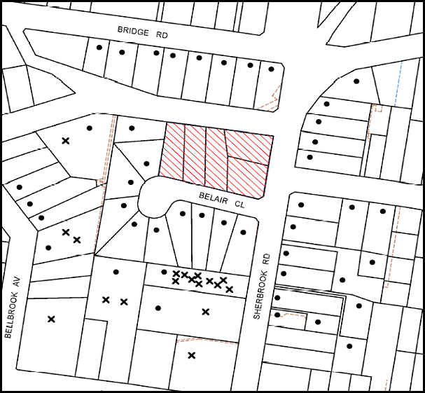
|
NOTIFICATION PLAN |
|
||
|
• PROPERTIES NOTIFIED |
X SUBMISSIONS RECEIVED |
PROPERTY SUBJECT OF DEVELOPMENT |
|
|
ONE SUBMISSIONS RECEIVED OF UNKNOWN ADDRESS |
|||
19 submissions object to the development, generally on the grounds that the development would result in:
· Unacceptable traffic on local streets;
· Unacceptable overshadowing of adjoining properties;
· Development that is excessive in bulk and scale;
· Development that is not compatible with the existing residential character;
· Loss of trees and bushland settings;
· Loss of privacy and views;
· Adverse visual impact;
· Increase in vandalism;
· Lack of recreation space; and
· Unacceptable road noise after development is complete.
The merits of the matters raised in community submissions have been addressed in the body of the report with the exception of the following:
5.1.1 View Loss
The proposed development would result in loss of existing views over the site from the rear of adjoining medium/high density developments. The views are localised to the surrounding area and are not extensive.
It is considered view loss was anticipated with the rezoning of the Belair Close Precinct for residential flat building to a height of 17.5m. The views from the rear of adjoining developments as a result of the proposal would be consistent with the medium/high density residential area.
5.2 Public Agencies
The proposal was referred to NSW Police Force for comments whereby no objections were raised.
6. THE PUBLIC INTEREST
Section 79C(1)(e) of the Act requires Council to consider “the public interest”.
The public interest is an overarching requirement, which includes the consideration of the matters discussed in this report. Implicit to the public interest is the achievement of future built outcomes adequately responding to and respecting the future desired outcomes expressed in environmental planning instruments and development control plans.
The application is considered to have satisfactorily addressed Council’s and relevant agencies’ criteria and would provide a development outcome that, on balance, would result in a positive impact for the community. Accordingly, it is considered that the approval of the proposed development would be in the public interest.
CONCLUSION
The proposal is for the demolition of existing dwellings and construction of two, five storey residential flat buildings with mezzanines on the uppermost floor, comprising 73 units and basement car park.
The proposed development is considered satisfactory in respect to achieving the Housing Strategy DCP desired future character of the Belair Close Housing Precinct together with the outcomes for design quality, site requirements, height, setbacks, landscaping, floorplates and separations, articulation, open space, privacy, sunlight and ventilation, housing choice and vehicle access and parking. The non-compliance with the prescriptive measures for setbacks is considered acceptable on merit.
The proposed development is in accordance with the SEPP 65 design principles and the best practice benchmarks of the Residential Flat Design Code. The scale, built form and presentation of the development to Belair Close and Sherbrook Road would establish an appropriate pattern with regard to the approved and future developments within the precinct.
The notification of the application received considerable public interest. The proposal is considered generally acceptable in respect to neighbourhood amenity and Council’s planning controls for a medium to high density residential environment.
The application is recommended for approval.
Note: At the time of the completion of this planning report, no persons have made a Political Donations Disclosure Statement pursuant to Section 147 of the Environmental Planning and Assessment Act 1979 in respect of the subject planning application.
|
Rod Pickles Manager - Development Assessment Planning Division |
James Farrington Group Manager Planning Division |
|
1.View |
Locality Map |
|
|
|
2.View |
Site Analysis Plan |
|
|
|
3.View |
Floor Plans |
|
|
|
4.View |
Elevations/Sections |
|
|
|
5.View |
Landscape Plan - 1 |
|
|
|
6.View |
Landscape Plan - 2 |
|
|
|
7.View |
Photomontage |
|
|
File Reference: DA/547/2013
Document Number: D02503006
SCHEDULE 1
GENERAL CONDITIONS
The conditions of consent within this notice of determination have been applied to ensure that the use of the land and/or building is carried out in such a manner that is consistent with the aims and objectives of the relevant legislation, planning instruments and council policies affecting the land and does not disrupt the amenity of the neighbourhood or impact upon the environment.
Note: For the purpose of this consent, the term ‘applicant’ means any person who has the authority to act on or the benefit of the development consent.
Note: For the purpose of this consent, any reference to an Act, Regulation, Australian Standard or publication by a public authority shall be taken to mean the gazetted act or regulation, or adopted Australian Standard or publication as in force on the date that the application for a construction certificate is made.
1. Approved Plans and Supporting Documentation
The development must be carried out in accordance with the plans and documentation listed below and endorsed with Council’s stamp, except where amended by Council and/or other conditions of this consent:
|
Plan No. |
Rev |
Plan Title |
Drawn by |
Dated |
|
1.02 |
A |
Site Plan/ Roof Plan |
Jiri Kure Architects & Robert Jurukovski Architects |
May 2013 |
|
2.01 |
B |
Level Basement 02 |
Jiri Kure Architects & Robert Jurukovski Architects |
Sept 2013 |
|
2.02 |
C |
Level Basement 01 & Lower Ground |
Jiri Kure Architects & Robert Jurukovski Architects |
Sept 2013 |
|
2.03 |
C |
Level Ground |
Jiri Kure Architects & Robert Jurukovski Architects |
Sept 2013 |
|
2.04 |
B |
Level 01 |
Jiri Kure Architects & Robert Jurukovski Architects |
Sept 2013 |
|
2.05 |
B |
Level 02 |
Jiri Kure Architects & Robert Jurukovski Architects |
Sept 2013 |
|
2.06 |
C |
Level 03 |
Jiri Kure Architects & Robert Jurukovski Architects |
Sept 2013 |
|
2.07 |
D |
Level 04 |
Jiri Kure Architects & Robert Jurukovski Architects |
Sept 2013 |
|
2.08 |
D |
Level Roof/ Mezzanine |
Jiri Kure Architects & Robert Jurukovski Architects |
Sept 2013 |
|
2.09 |
C |
Level Roof |
Jiri Kure Architects & Robert Jurukovski Architects |
Sept 2013 |
|
2.10 |
A |
Adaptable Units/ Post Adaptable Stage |
Jiri Kure Architects & Robert Jurukovski Architects |
May 2013 |
|
3.01 |
E |
Elevations South and East |
Jiri Kure Architects & Robert Jurukovski Architects |
Sept 2013 |
|
3.02 |
D |
Elevations West and North |
Jiri Kure Architects & Robert Jurukovski Architects |
Sept 2013 |
|
3.03 |
D |
Elevations East and West |
Jiri Kure Architects & Robert Jurukovski Architects |
Sept 2013 |
|
4.01 |
D |
Section AA |
Jiri Kure Architects & Robert Jurukovski Architects |
Sept 2013 |
|
4.02 |
B |
Section BB and CC |
Jiri Kure Architects & Robert Jurukovski Architects |
Sept 2013 |
|
LP.01 |
A |
Landscape Plan |
Black Beetle Pty Ltd |
24 May 2013 |
|
LP.02 |
A |
Planting Plan and details |
Black Beetle Pty Ltd |
24 May 2013 |
|
DA01 |
A |
Stormwater Drainage Layout Basement Level and Notes |
HKMA Engineers |
30 May 2013 |
|
DA02 |
A |
Stormwater Drainage Layout Lower Ground Level |
HKMA Engineers |
30 May 2013 |
|
DA03 |
A |
Stormwater Drainage Layout Upper Ground Level |
HKMA Engineers |
30 May 2013 |
|
DA04 |
A |
OSD and Pump Out Tank Plan and Section Details |
HKMA Engineers |
30 May 2013 |
|
Document Title |
Prepared by |
Dated |
|
Plan No. D 13012 Rev A - Survey Plan |
Chase Burke Harvey |
24 January 2013 |
|
Statement of Environmental Effects |
Caladines Town Planning Pty Ltd |
May 2013 |
|
Plan No. 3.04 Issue A - Material and Colour Schedule |
Jiri and Kure Architects / Robert Jurukovski Architects |
May 2013 |
|
Waste Management Plan |
Belair Developments Pty Ltd |
undated |
|
Waste Management Plan – Elephants Foot Recycling Solutions |
Robert Jurukovski Architects |
May 2013 |
|
Arboricultural Impact Assessment Ref: 8140 |
Redgum Arboriculture & Horticulture Consultants |
17 May 2013 |
|
Traffic and Parking Statement |
Traffic Solutions Pty Ltd |
31 May 2013 |
|
Flood Study Rev A |
HKMA Engineers |
May 2013 |
|
Access Compliance Assessment Report No. 2013-052SS |
Certified Building Specialists |
29 May 2013 |
|
SEPP 65 Design Verification Statement |
Robert Jurukovski Architects |
30 May 2013 |
|
BASIX Certificate No. 484160M_02 |
AGA Consultants |
24 September 2013 |
|
NatHERs Certificate No. 14750037 |
AGA Consultants |
23 September 2013 |
2. Amendment of Plans
The approved plans are to be amended as follows:
a) The approved plan “2.03 Issue C - Level Ground” prepared by Jiri Kure Architects & Robert Jurukovski Architects dated September 2013 must be amended so that the bin collection area adjoining the driveway has a minimum dimension of 4.5 metres (width) x 3.0 metres (depth).
b) The building line at Level 4 of Block B fronting the western boundary is to have a setback of 9m as marked in red on the approved plan 2.07 Issue D - Level 4 prepared by Jiri Kure Architects & Robert Jurukovski Architects dated September 2013. No part of the terrace is to protrude beyond the building line at this level.
c) 2 motorcycle spaces are to be provided in the basement parking area in accordance with AS2890.1-2004 Off Street Car Parking. Each motor cycle parking space is to be designated and located so that parked motorcycles are not vulnerable to being struck by a manoeuvring vehicle.
d) 22 bicycle spaces are to be provided in the basement parking area in accordance with AS2890.3-1993 Bicycle Parking Facilities. A minimum of 7 bicycle spaces must be available for use by visitors.
e) The following plans must be amended in accordance with the approved plan 2.01 Issue B - Level Basement 02 prepared by Jiri Kure Architects & Robert Jurukovski Architects dated September 2013, plan 2.02 Issue C - Level Basement 01 and Lower Ground prepared by Jiri Kure Architects & Robert Jurukovski Architects dated September 2013 and plan 2.03 Issue C - Level Ground, prepared by Jiri Kure Architects & Robert Jurukovski Architects dated September 2013:
|
Plan No. |
Rev |
Plan Title |
Drawn by |
Dated |
|
LP.01 |
A |
Landscape Plan |
Black Beetle Pty Ltd |
24 May 2013 |
|
LP.02 |
A |
Planting Plan and details |
Black Beetle Pty Ltd |
24 May 2013 |
|
DA01 |
A |
Stormwater Drainage Layout Basement Level and Notes |
HKMA Engineers |
30 May 2013 |
|
DA02 |
A |
Stormwater Drainage Layout Lower Ground Level |
HKMA Engineers |
30 May 2013 |
|
DA03 |
A |
Stormwater Drainage Layout Upper Ground Level |
HKMA Engineers |
30 May 2013 |
|
DA04 |
A |
OSD and Pump Out Tank Plan and Section Details |
HKMA Engineers |
30 May 2013 |
3. Removal of Existing Trees
This development consent only permits the removal of trees numbered 1 and 4 as identified in the Arboricultural Impact Assessment Ref 8140 prepared by Redgum Arboriculture & Horticulture Consultants dated 17 May 2013. The removal of any other trees requires separate approval under Council’s Tree Preservation Order.
4. Construction Certificate
A Construction Certificate is required to be approved by Council or a Private Certifying Authority prior to the commencement of any works under this consent.
REQUIREMENTS PRIOR TO THE ISSUE OF A CONSTRUCTION CERTIFICATE
5. Building Code of Australia
All building work must be carried out in accordance with the relevant requirements of the Building Code of Australia.
6. Contract of Insurance (Residential Building Work)
In the case of residential building work for which the Home Building Act, 1989 requires there to be a contract of insurance in force in accordance with Part 6 of that Act, that such a contract of insurance is in force before any building work authorised to be carried out by the consent commences.
7. Electricity Utility Services
The applicant must submit written evidence of the following service provider requirements:
a) Energy Australia – a letter of consent demonstrating that satisfactory arrangements have been made to service the proposed development.
8. Adaptable Units
The details of fit-outs of all accessible units and details of adaptable units must be provided with the Construction Certificate Plans.
9. Letter Boxes
The details of letter boxes and meter enclosures must be provided with the Construction Certificate Plans. The letter boxes and meter enclosures must be provided with a minimum setback of 2 metres from all boundaries and must be suitably screened.
10. Dilapidation Report
A ‘Dilapidation Report’ is to be prepared by a ‘chartered structural engineer’ detailing the structural condition of all adjoining properties.
11. Stormwater Drainage
The stormwater drainage system for the development must be designed and constructed for an average recurrence interval of 20 years and be gravity drained in accordance with the following requirements:
a) All details be provided with the Construction Certificate plans;
b) Connected to an existing Council piped drainage system via an on site detention system;
c) Be designed by a qualified Hydraulic Engineer.
Note: For connection to Council pit, a construction certificate application is to be submitted to Council (as council is the authority to approve a plan for connection to Council system).
12. On-Site Stormwater Detention
An on-site stormwater detention system must be designed and constructed for the development. An on-site stormwater detention system must be designed by a chartered civil engineer and constructed in accordance with the following requirements:
a) Details of the design and calculations be provided with the Construction Certificate plans;
b) Storage capacity to accommodate volume from up to 20 years ARI (average recurrence interval) and a maximum discharge (when full) limited to 5 years pre development rate.
c) Have a surcharge/inspection grate located directly above the outlet.
d) Discharge from the detention system to be controlled via 1 metre length of pipe, not less than 50 millimetres diameter or via a stainless plate with sharply drilled orifice bolted over the face of the outlet discharging into a larger diameter pipe capable of carrying the design flow to an approved Council system.
e) Where above ground and the average depth is greater than 0.3 metres, a ‘pool type’ safety fence and warning signs to be installed.
f) Not be constructed in a location that would impact upon the visual or recreational amenity of residents.
13. Excavation
The structural plans for basement and above ground areas must be prepared by a Chartered Structural Engineer and submitted with the Construction Certificate Application.
14. Flood - Overland Flow Path/ Flood Proofing/ Flood Level
The following details regarding flood mitigation are to be provided with the Construction Certificate Plan:
a) A 100 year ARI overland flowpath, based on the report from HKMA Engineers, Revision A, May 2013 is to be constructed to ensure uninterrupted flow through the property to the creek.
b) Any structural wall abutting the overland flowpath shall be flood proofed in accordance with Floodplain Development manual of New South Wales Government.
c) Floor levels of habitable rooms of the development abutting the 100 year ARI overland flowpath must be 0.5m above the 100 year ARI flood levels (at the corresponding point in the flood report by H K M A Engineers, Revision A, May 2013).
15. Internal Driveway/ Vehicular Areas
The driveway and parking areas on site must be designed in accordance with Australian Standards 2890.1, 2890.2, 3727 and the following requirements:
a) Details of the design be provided with the construction certificate plans;
b) Design levels at the front boundary must be obtained from Council;
c) The driveway must be a rigid pavement;
d) The driveway grade must not exceed 25 percent and changes in grade must not exceed 8 percent.
16. Vehicular Crossing
A separate application under the Local Government Act, 1993 and the Roads Act, 1993 must be submitted to Council for the installation of a new vehicular crossing and the removal of the redundant crossing. The vehicular crossing must be constructed in accordance with Council’s Civil Works Design, 2005 and the following requirements:
a) Any redundant crossings must be replaced with integral kerb and gutter;
b) The footway area must be restored by turfing;
c) Approval must be obtained from all relevant utility providers that all necessary conduits be provided and protected under the crossing.
Note 1: A separate construction certificate is required to be issued prior to the commencement of any work.
Note 2: An application for a vehicular crossing can only be made to one of Council’s Authorised Vehicular Crossing Contractors. You are advised to contact Council on 9847 6940 to obtain a list of contractors.
17. Road Works
All road works approved under this consent must be designed and constructed in accordance with Council’s Civil Works Design and Construction Specification, 2005 and the following requirements:
a) Concrete footpath to be constructed along both Sherbrook Road and Belair Close frontages of the development.
b) The existing kerb and gutter along Belair frontage is to be replaced. The existing road pavement to be saw cut a minimum of 300 mm from the existing edge of the bitumen and reconstructed.
Note 1: A separate construction certificate must to be submitted to Council for approval of all roadworks.
Note 2: Council is the only authority to approve works within Council roads.
18. Construction Management Plan
A Construction Management Plan detailing construction vehicle routes, number of trucks, hours of operation, access arrangements and traffic control should be submitted to Council prior to the issue of a construction certificate.
19. Preservation of Survey Infrastructure
Prior to the issue of a construction certificate, a registered surveyor shall identify all survey marks in the vicinity of the proposed development. Any survey marks required to be removed or displaced as a result of the proposed development shall be undertaken by a registered surveyor in accordance with Section 24 (1) of the Surveying and Spatial Information Act 2002 and following the Surveyor General’s Directions No.11 - "Preservation of Survey Infrastructure".
REQUIREMENTS PRIOR TO THE COMMENCEMENT OF ANY WORKS
20. Erection of Construction Sign
A sign must be erected in a prominent position on any site on which building work, subdivision work or demolition work is being carried out:
a) Showing the name, address and telephone number of the principal certifying authority for the work;
b) Showing the name of the principal contractor (if any) for any demolition or building work and a telephone number on which that person may be contacted outside working hours; and
c) Stating that unauthorised entry to the work site is prohibited.
Note: Any such sign is to be maintained while the building work, subdivision work or demolition work is being carried out, but must be removed when the work has been completed.
21. Protection of Adjoining Areas
A temporary hoarding, fence or awning must be erected between the work site and adjoining lands before the works begin and must be kept in place until after the completion of the works if the works:
a) Could cause a danger, obstruction or inconvenience to pedestrian or vehicular traffic.
b) Could cause damage to adjoining lands by falling objects.
c) Involve the enclosure of a public place or part of a public place.
Note: Notwithstanding the above, Council’s separate written approval is required prior to the erection of any structure or other obstruction on public land.
22. Toilet Facilities
Toilet facilities must be available or provided at the works site before works begin and must be maintained until the works are completed at a ratio of one toilet for every 20 persons employed at the site. Each toilet must:
a) be a standard flushing toilet connected to a public sewer; or
b) be a temporary chemical closet approved under the Local Government Act, 1993; or
c) have an on-site effluent disposal system approved under the Local Government Act, 1993.
23. Erosion and Sediment Control
Erosion and sediment control measures must be provided and maintained throughout the construction period in accordance with the manual ‘Soils and Construction 2004 (Bluebook)’, the approved plans, Council specifications and to the satisfaction of the principal certifying authority. The erosion and sediment control devices must remain in place until the site has been stabilised and revegetated.
Note: On the spot penalties up to $1,500 may be issued for any non-compliance with this requirement without any further notification or warning.
24. Tree Protection Barriers
Tree protection fencing must be erected around trees numbered 2 and 3 to be retained at a distance as set out under Section 5 of the Arboricultural Impact Assessment Ref. 8140 prepared by Redgum Arboriculture & Horticulture Consultants dated 17 May 2013. The tree fencing must be constructed of 1.8 metre ‘cyclone chainmesh fence’.
REQUIREMENTS DURING CONSTRUCTION
25. Construction Work Hours
All work on site (including demolition and earth works) must only occur between 7am and 5pm Monday to Saturday, in accordance with the Interim Construction Noise Guidelines 2009 - NSW Department of Environment and Climate Change.
No work is to be undertaken on Sundays or public holidays.
26. Demolition
All demolition work must be carried out in accordance with “Australian Standard 2601-2001 – The Demolition of Structures” and the following requirements:
a) Demolition material must be disposed of to an authorised recycling and/or waste disposal site and/or in accordance with an approved waste management plan;
b) Demolition works, where asbestos material is being removed, must be undertaken by a contractor that holds an appropriate licence issued by WorkCover NSW in accordance with Chapter 10 of the Occupational Health and Safety Regulation 2001 and Clause 29 of the Protection of the Environment Operations (Waste) Regulation 2005 and;
c) On construction sites where buildings contain asbestos material, a standard commercially manufactured sign containing the words ‘DANGER ASBESTOS REMOVAL IN PROGRESS’ measuring not less than 400mm x 300mm must be erected in a prominent position visible from the street.
27. Environmental Management
The site must be managed in accordance with the publication ‘Managing Urban Stormwater – Landcom (March 2004) and the Protection of the Environment Operations Act 1997 by way of implementing appropriate measures to prevent sediment run-off, excessive dust, noise or odour emanating from the site during the construction of the development.
28. Works Near Trees
All required tree protection measures are to be maintained in good condition for the duration of the construction period.
All works (including driveways and retaining walls) within the tree protection zones nominated in the Arboricultural Impact Assessment Ref 8140 prepared by Redgum Arboriculture & Horticulture Consultants dated 17 May 2013. of any trees required to be retained (whether or not on the subject property, and pursuant to this consent or the Tree Preservation Order), must be carried out under the supervision of an ‘AQF Level 5 Arborist’ and a certificate submitted to the principal certifying authority detailing the method(s) used to preserve the tree(s).
Note: Except as provided above, the applicant is to ensure that no excavation, filling or stockpiling of building materials, parking of vehicles or plant, disposal of cement slurry, waste water or other contaminants is to occur within 4 metres of any tree to be retained.
29. Street Sweeping
Street sweeping must be undertaken following sediment tracking from the site along Belair Close during works and until the site is established.
30. Waste Management
Waste management during the demolition and construction phase of the development must be undertaken in accordance with the approved Waste Management Plan. Additionally written records of the following items must be maintained during the removal of any waste from the site and such information submitted to the Principal Certifying Authority within fourteen days of the date of completion of the works:
a) The identity of the person removing the waste.
b) The waste carrier vehicle registration.
c) Date and time of waste collection.
d) A description of the waste (type of waste and estimated quantity).
e) Details of the site to which the waste is to be taken.
f) The corresponding tip docket/receipt from the site to which the waste is transferred (noting date and time of delivery, description (type and quantity) of waste).
g) Whether the waste is expected to be reused, recycled or go to landfill.
Note: In accordance with the Protection of the Environment Operations Act 1997, the definition of waste includes any unwanted substance, regardless of whether it is reused, recycled or disposed to landfill.
31. Council Property
During construction works, no building materials, waste, machinery or related matter is to be stored on the road or footpath. The public reserve must be kept in a clean, tidy and safe condition at all times.
32. Demolition and Construction Vehicles
All demolition and construction vehicles must be wholly parked within the site at all times.
33. Landfill
Landfill must be constructed in accordance with Council’s ‘Construction Specification, 2005’ and the following requirements:
a) All fill material imported to the site is to wholly consist of Virgin Excavated Natural Material (VENM) as defined in Schedule 1 of the Protection of the Environment Operations Act 1997 or a material approved under the Department of Environment and Climate Change’s general resource recovery exemption.
b) A compaction certificate is to be obtained from a geotechnical engineer verifying that the specified compaction requirements have been met.
34. Excavated Material
All excavated material removed from the site must be classified in accordance with the Department of Environment, Climate Change and Water NSW Waste Classification Guidelines prior to disposal to an approved waste management facility and reported to the principal certifying authority.
35. Survey Report – Finished Floor Level
A report(s) must be prepared by a registered surveyor and submitted to the principal certifying authority prior to the pouring of concrete at each level of the building certifying that:
a) The building, retaining walls and the like have been correctly positioned on the site and;
b) The finished floor level(s) are in accordance with the approved plans.
36. Contamination During Construction Works
Should the presence of asbestos or soil contamination, not recognised during the application process be identified during demolition, the applicant must immediately notify the Principal Certifying Authority and Council.
37. Construction Noise Management
The construction works must be undertaken in accordance with the “Interim Construction Noise Guidelines – 2009” published by DECCW.
38. Foundation of Structure within Council Stormwater Pipe Zone of Influence
a) Foundation of structure in the proximity of Council stormwater pipe must be carried out by a Chartered Structural Engineer of the Institution of Engineers, Australia ensuring that the Council pipes are not impacted.
b) After completion of works, a certificate from a Chartered Professional Structural Engineer of the Institution of Engineers, Australia confirming that works have been carried out in a manner that no impact has been created on Council drainage system, must be submitted.
REQUIREMENTS PRIOR TO THE ISSUE OF AN OCCUPATION CERTIFICATE
Note: For the purpose of this consent, a reference to ‘occupation certificate’ shall not be taken to mean an ‘interim occupation certificate’ unless otherwise stated.
39. Fulfilment of BASIX Commitments
The applicant must demonstrate the fulfilment of BASIX commitments pertaining to the development.
40. Sydney Water – s73 Certificate
An s73 Certificate must be obtained from Sydney Water.
Note: Sydney Water requires that s73 applications are to be made through an authorised Sydney Water Servicing Coordinator. Refer to www.sydneywater.com.au or telephone 13 20 92 for assistance.
41. Damage to Council Assets
Any damage caused to Council’s assets as a result of the construction of the development must be rectified in accordance with Council’s written requirements and at the sole cost of the applicant.
42. Car Parking Allocation and Resident Storage
The basement resident storage areas are to be allocated in accordance with the size requirements of the SEPP 65 - Residential Flat Design Code for the respective units and proximity to the unit car parking space.
43. Creation of Easements
The following matter(s) must be nominated on the plan of subdivision under s88B of the Conveyancing Act 1919:
a) Consolidation of the subject lots.
b) A restriction over the pipeline and the flow path for a 100 year average recurrence interval storm. The "Restriction on the Use of Land" over the affected lots is to prohibit the alteration of the final floodway shape and the erection of any structures, including fencing, in the floodway without the written permission of Council. The terms of this restriction must be obtained from Council.
c) The creation of an appropriate "Positive Covenant" and "Restriction as to User" over the constructed on-site detention/retention systems and outlet works, within the lots in favour of Council in accordance with Council’s prescribed wording. The position of the on-site detention system is to be clearly indicated on the title.
d) To register the OSD easement, the restriction on the use of land “works-as-executed” details of the on-site-detention system must be submitted verifying that the required storage and discharge rates have been constructed in accordance with the design requirements. The details must show the invert levels of the on site system together with pipe sizes and grades. Any variations to the approved plans must be shown in red on the “works-as-executed” plan and supported by calculations.
Note: Council must be nominated as the authority to release, vary or modify any easement, restriction or covenant.
44. Retaining Walls
All required retaining walls must be constructed as part of the development.
45. External Lighting
All external lighting must be designed and installed in accordance with Australian Standard AS 4282 – Control of the Obtrusive Effects of Outdoor Lighting. Certification of compliance with the Standard must be obtained from a suitably qualified person.
46. Installation of Privacy Devices
The following device(s) must be installed to maintain an element of privacy towards the two south facing units within Block A at the ground level:
a) A 1.5 metre high close-form louvre screen to be erected as indicated in red on the approved plan No. 2.03 Level Ground Issue B, prepared by dated Sept 2013.
47. Unit Numbering
The allocation of unit numbering must be authorised by Council prior to the numbering of each unit in the development.
48. Accessibility Requirements
a) Tactile ground surface indicators are to be positioned at the top and bottom of the pedestrian entrance to the building.
b) Kitchen cupboards and equipments must not obstruct wheelchair access around doors.
c) The accessible units must include all necessary fit outs.
49. Completion of Landscaping
A certificate must be provided by a practicing landscape architect, horticulturalist or person with similar qualifications and experience certifying that all required landscaping works have been satisfactorily completed in accordance with the approved Landscape plans, the minimum construction standards identified in the Hornsby Shire Council Landscape Code for development applications and the following additional requirements for works within the site:
a) The landscape verge on Belair Close and Sherbrook Road must include four Angophora costata (Sydney Red Gums). Trees must be installed at minimum 45 litre pot size.
b) The location of the trees must allow for footpath construction and not be located under overhead wires.
c) Northern Boundary - Three additional Tristaniopsis laurina (water gum) in the landscape planter areas at the lower ground level to be installed at minimum 25 litre pot size and Four additional Waterhoiusia floribunda (Waterhousia) be installed at minimum 25 litre pot size.
d) Eastern boundary (Sherbrook Road frontage) – Three additional Corymbia maculata (Spotted gum) to be installed at minimum 100 litre pot size.
e) On slab planter boxes to include automatic drip irrigation, subsoil drainage (proprietary drainage cell, 50mm sand and filter fabric), and waterproofing.
f) 500 mm soil depth and 75mm mulch be provided for shrubs.
g) 1000 mm soil depth and 75 mm mulch be provided for trees and palms.
Note: Any proposed landscaping or fencing must not obstruct the clear sightlines of drivers on driveways and pedestrians or cyclists travelling along the footpath of Belair Close or Sherbrook Road.
Note: Advice on suitable species for landscaping can be obtained from Council’s planting guide ‘Indigenous Plants for the Bushland Shire’, available at www.hornsby.nsw.gov.au.
50. Certificate of Preservation of Survey Marks
A certificate by a Registered Surveyor shall be submitted to the Principal Certifying Authority, certifying that there has been no removal, damage, destruction, displacement or defacing of the existing survey marks in the vicinity of the proposed development or otherwise the re-establishment of damaged, removed or displaced survey marks has been undertaken in accordance with the Surveyor General’s Direction No.11 – “Preservation of Survey Infrastructure”.
51. Works as Executed Plan
A works-as-executed plan(s) must be prepared by a registered surveyor and submitted to Council for completed road pavement, kerb & gutter, overland flowpath, drainage systems, driveways and on-site detention system.
52. Garbage Collection Easement
For the purpose of waste collection, an easement entitling Council, its servants and agents and persons authorised by it to enter upon the subject land and to operate thereon, vehicles and other equipment for the purposes of garbage collection must be granted to Council by the owner of the land.
Note: The easement must be in a form prescribed by Council and must include covenants to the effect that parties will not be liable for any damage caused to the subject land or any part thereof or to any property located therein or thereon by reason of the operation thereon of any vehicle or other equipment used in connection with the collection of garbage and to the effect that the owner for the time being of the subject land shall indemnify the Council, its servants, agents and persons authorised by it to collect garbage against liability in respect of any such claims made by any person whomsoever.
53. Waste Management
The following waste management requirements must be complied with:
a) The bin storage room at the lower ground level must include water or a hose for cleaning, graded floors with drainage to sewer, a robust door, sealed and impervious surface, adequate lighting and ventilation. The bin rooms at each residential level must include sealed and impervious surface, adequate lighting and ventilation.
b) A report must be prepared by an appropriately qualified person, certifying the following:
i) A comparison of the estimated quantities of each waste type against the actual quantities of each waste type.
Note: Explanations of any deviations to the approved Waste Management Plan is required to be included in this report
ii) That at least 60% of the waste generated during the demolition and construction phase of the development was reused or recycled.
Note: If the 60% diversion from landfill cannot be achieved in the Construction Stage, the Report is to include the reasons why this occurred and certify that appropriate work practices were employed to implement the approved Waste Management Plan. The Report must be based on documentary evidence such as tipping dockets/receipts from recycling depots, transfer stations and landfills, audits of procedures etc. which are to be attached to the report.
iii) All waste was taken to site(s) that were lawfully permitted to accept that waste.
c) Each unit must be provided with an indoor waste/recycling cupboard for the interim st orage of a minimum one day’s waste generation with separate containers for general waste and recyclable materials.
d) Space must be provided for either individual compost containers for each unit or a communal compost container;
Note: The location of the compost containers should have regard for potential amenity impacts.
e) The bin carting routes must be devoid of any steps.
Note: Ramps between different levels are accepted
54. Safety and Security
a) Fire exist doors to the development must be fitted with single cylinder locksets (Australia and New Zealand Standard – Lock Sets) to restrict unauthorized access to the development;
b) Ground floor and lower ground floor windows must be fitted with window locks that can be locked with a key;
c) The entryway to the site be illuminated in high luminance at all times;
d) The communal open space at the rear of the site be illuminated with high luminance by motion sensor lighting;
e) The service areas of the ground floor and the garbage room at the lower ground floor be illuminated with high luminance by motion sensor lighting;
f) The driveway and the basement carpark is to be illuminated with low luminance at all times;
g) Robust materials which cannot be forced or breached with minimised maintenance requirements are to be used for construction work in the common areas;
h) The lamps and lighting levels must comply with Australian and New Zealand Lighting Standard 1158.1;
i) Effective signage be provided to guide visitors to the main areas and parking areas;
j) A street sign be prominently displayed in front of the site in accordance with Order No. 8, Section 124 Local Government Act 1993;
k) The communal area must include a clear sign to restrict access for non-residents;
l) Units numbers, entry and exit signs must be legible and clear;
m) The basement car park entries must be secured by security gates/roller shutters and controlled by secure access located at the top of the driveway;
55. Section 94 Development Contributions
In accordance with Section 80A(1) of the Environmental Planning and Assessment Act 1979 and the Hornsby Shire Council Section 94 Development Contributions Plan 2012-2021, the following monetary contributions shall be paid to Council to cater for the increased demand for community infrastructure resulting from the development:
|
Description |
Contribution (4) |
|
Roads |
$7,6571.25 |
|
Open Space and Recreation |
$832,448.65 |
|
Community Facilities |
$117,515.80 |
|
Plan Preparation and Administration |
$3,414.85 |
|
TOTAL |
$1,029,950.55 |
being for 73 units comprising 9 x 1-bedroom units, 56 x 2-bedroom units and 8 x 3-bedroom units and 5 credits.
a) If the contributions are not paid within the financial quarter that this consent is granted, the contributions payable will be adjusted in accordance with the provisions of the Hornsby Shire Council Section 94 Development Contributions Plan and the amount payable will be calculated at the time of payment in the following manner:
$CPY = $CDC x CPIPY
CPIDC
Where:
$CPY is the amount of the contribution at the date of Payment
$CDC is the amount of the contribution as set out in this Development Consent
CPIPY is the latest release of the Consumer Price Index (Sydney – All Groups) at the date of Payment as published by the ABS.
CPIDC is the Consumer Price Index (Sydney – All Groups) for the financial quarter at the date of this Development Consent.
b) The monetary contributions shall be paid to Council:
i) prior to the issue of the Subdivision Certificate where the development is for subdivision; or
ii) prior to the issue of the first Construction Certificate where the development is for building work; or
iii) prior to issue of the Subdivision Certificate or first Construction Certificate, whichever occurs first, where the development involves both subdivision and building work; or
iv) prior to the works commencing where the development does not require a Construction Certificate or Subdivision Certificate.
It is the professional responsibility of the Principal Certifying Authority to ensure that the monetary contributions have been paid to Council in accordance with the above timeframes.
Council’s Development Contributions Plan may be viewed at www.hornsby.nsw.gov.au or a copy may be inspected at Council’s Administration Centre during normal business hours.
56. Disabled Parking
All parking spaces for people with disabilities must be constructed and operated in accordance with AS2890.6 - 2009 Off-street parking for people with disabilities.
OPERATIONAL CONDITIONS
57. Noise
The level of total continuous noise emanating from operation of all the plant, including air conditioning units and processes in all buildings (LA10) (measured for at least 15 minutes) in or on the above premises, must not exceed the background level by more than 5dB(A) when measured at all property boundaries.
58. Fire Safety Statement - Annual
On at least one occasion in every 12 month period following the date of the first ‘Fire Safety Certificate’ issued for the property, the owner must provide Council with an annual ‘Fire Safety Certificate’ to each essential service installed in the building.
59. Landscape Establishment
The landscape works must be maintained into the future to ensure the establishment and successful growth of plant material to meet the intent of the landscape design. This must include but not be limited to watering, weeding, replacement of failed plant material and promoting the growth of plants through standard industry practices.
60. Waste Storage Area and Waste Management
The waste management on site must be in accordance with the following requirements:
a) Each unit be provided with an indoor waste/recycling cupboard for the interim st orage of a minimum one day’s segregated garbage and recycling generation.
b) Site security measures be implemented to prevent access to the waste storage rooms by the residents.
c) A site manager or caretaker must be employed and be responsible for moving bins from the bin storage area/compactor to the waste collection point, washing bins and maintaining storage areas, arranging the prompt removal of dumped rubbish, and ensuring all residents are informed of the waste management system.
61. Car Parking and Deliveries
All car parking must be constructed and operated in accordance with AS2890.1-2004 Off Street Car Parking and AS2890.2-2002 Off Street Commercial and the following requirement:
a) All parking areas and driveways are to be sealed to an all weather standard, line marked and signposted.
b) Car parking, loading and manoeuvring areas to be used solely for nominated purposes.
c) Vehicles awaiting loading, unloading or servicing shall be parked on site and not on adjacent or nearby public roads;
d) All vehicular entry on to the site and egress from the site shall be made in a forward direction.
e) All bicycle parking spaces are to be provided in accordance with AS2890.3-1993 Bicycle Parking Facilities.
f) Visitors are to have access to the parking area at all times. Visitors are to be able to access the basement car park by an audio/visual intercom system located at the top of the ramped driveways.
- END OF CONDITIONS –
ADVISORY NOTES
The following information is provided for your assistance to ensure compliance with the Environmental Planning and Assessment Act, 1979, Environmental Planning and Assessment Regulation 2000, other relevant legislation and Council’s policies and specifications. This information does not form part of the conditions of development consent pursuant to Section 80A of the Act.
Environmental Planning and Assessment Act, 1979 Requirements
The Environmental Planning and Assessment Act, 1979 requires:
· The issue of a construction certificate prior to the commencement of any works. Enquiries can be made to Council’s Customer Services Branch on 9847 6760.
· A principal certifying authority to be nominated and Council notified of that appointment prior to the commencement of any works.
· Council to be given at least two days written notice prior to the commencement of any works.
· Mandatory inspections of nominated stages of the construction inspected.
· An occupation certificate to be issued before occupying any building or commencing the use of the land.
Long Service Levy
In accordance with Section 34 of the Building and Construction Industry Long Service Payments Act 1986, a ‘Long Service Levy’ must be paid to the Long Service Payments Corporation or Hornsby Council.
Note: The rate of the Long Service Levy is 0.35% of the total cost of the work.
Note: Hornsby Council requires the payment of the Long Service Levy prior to the issue of a construction certificate.
Tree Preservation Order
To ensure the maintenance and protection of the existing natural environment, it is an offence to ringbark, cut down, top, lop, remove, wilfully injure or destroy a tree outside 3 metres of the approved building envelope without the prior written consent from Council.
Note: A tree is defined as a single or multi-trunked wood perennial plant having a height of not less than three (3) metres, and which develops many branches, usually from a distance of not less than one (1) metre from the ground, but excluding any plant which, in its particular location, is a noxious plant declared as such pursuant to the Noxious Weeds Act 1993. This definition of ‘tree’ includes any and all types of Palm trees.
All distances are determined under Australian Standard AS4970-2009 “Protection of Trees on Development Sites”.
Fines may be imposed for non-compliance with Council’s Tree Preservation Order.
Disability Discrimination Act
The applicant’s attention is drawn to the existence of the Disability Discrimination Act. A construction certificate is required to be obtained for the proposed building/s, which will provide consideration under the Building Code of Australia, however, the development may not comply with the requirements of the Disability Discrimination Act. This is the sole responsibility of the applicant.
Covenants
The land upon which the subject building is to be constructed may be affected by restrictive covenants. Council issues this approval without enquiry as to whether any restrictive covenant affecting the land would be breached by the construction of the building, the subject of this consent. Applicants must rely on their own enquiries as to whether or not the building breaches any such covenant.
Dial Before You Dig
Prior to commencing any works, the applicant is encouraged to contact Dial Before You Dig on 1100 or www.dialbeforeyoudig.com.au for free information on potential underground pipes and cables within the vicinity of the development site.
Telecommunications Act 1997 (Commonwealth)
If you are aware of any works or proposed works which may affect or impact on Telstra’s assets in any way, you are required to contact: Telstra’s Network Integrity Team on Phone Number 1800810443.
Asbestos Warning
Should asbestos or asbestos products be encountered during demolition or construction works, you are advised to seek advice and information prior to disturbing this material. It is recommended that a contractor holding an asbestos-handling permit (issued by WorkCover NSW)be engaged to manage the proper handling of this material. Further information regarding the safe handling and removal of asbestos can be found at:
Alternatively, telephone the WorkCover Asbestos and Demolition Team on 8260 5885.
Telecommunications Act 1997 (Commonwealth)
If you are aware of any works or proposed works which may affect or impact on Telstra’s assets in any way, you are required to contact: Telstra’s Network Integrity Team on Phone Number 1800810443.
Group Manager’s Report No. PL97/13
Planning Division
Date of Meeting: 16/10/2013
13 SECTION 82A REVIEW OF DEVELOPMENT APPLICATION - ANIMAL BOARDING OR TRAINING ESTABLISHMENT - 669 OLD NORTHERN ROAD, DURAL
EXECUTIVE SUMMARY
|
DA No: |
DA/1173/2012 (82A Review Lodged 1 August 2013) |
|
Description: |
Use of the existing site as an animal boarding or training establishment |
|
Property: |
Lot 1 DP 231126, No. 669 Old Northern Road, Dural |
|
Applicant: |
Sydney Pet Resort |
|
Owner: |
Ms Maria Aiossa and Ms Rosanna Frasca |
|
Estimated Value: |
Nil |
|
Ward: |
A |
· At its meeting on 15 May 2013, Council resolved to refuse Development Application No. DA/1173/2012 for use of the existing premises as an animal boarding establishment.
· Pursuant to Section 82A of the Environmental Planning and Assessment Act, 1979 (the Act), a request has been made for Council to review its determination.
· The proposal complies with the requirements of the Hornsby Shire Local Environmental Plan 1994 and generally complies with the Rural Lands Development Control Plan and Hornsby Development Control Plan 2013.
· Five submissions have been received in respect of the application.
· It is recommended that Council change the determination and approve the application as a deferred commencement.
|
THAT the Section 82A review of Development Application No. DA/1173/2012 for an animal boarding and training establishment at Lot 1 DP 231126, No. 669 Old Northern Road, Dural be approved as a deferred commencement pursuant to Section 80(3) of the Environmental Planning and Assessment Act, 1979 subject to the conditions of consent detailed in Schedule 1 of Group Manager’s Report No. PL97/13. |
BACKGROUND
In 2012 Council received a complaint that the premise was being used for boarding kennels without consent.
On 3 July 2012, a Notice of Intention to serve an Order to cease use of the unlawful operation was served on the facility operators.
On 15 August 2012, the Order to cease the unlawful use of the operation was served on the facility operators. The proprietors were advised to lodge a development application.
On 7 November 2012, an application was lodged for an animal boarding establishment.
On 13 December 2012, a Penalty Infringement Notice was issued for development without consent.
On 15 May 2013, Council considered Executive Manager’s Report PLN12/13 and resolved that DA/1173/2012 be refused for the following reasons:
1. Pursuant to the provisions of Section 79C(1)(a)(iii) of the Environmental Planning and Assessment Act 1979, the proposal is unsatisfactory as it does not comply with the Rural Lands Development Control Plan (DCP) as follows:
a) The proposed use does not incorporate appropriate setbacks to minimise noise impacts and maintain the amenity of adjacent residential dwellings.
b) The animal accommodation and related structures are not designed to be sympathetic to the rural character of the area and would impact on the rural landscape.
c) The design of the proposed fence is contrary to the objectives of the ‘Fences and Gates’ Element of the DCP as the fence is not compatible with the visual character of the rural area.
2. Pursuant to the provisions of Section 79C(1)(c) of the Environmental Planning and Assessment Act 1979, the proposal is not suitable for the site as it would have an adverse impact on the amenity of the surrounding rural character of the locality.
3. Pursuant to the provisions of Section 79C(1)(e) of the Environmental Planning and Assessment Act 1979, the proposed development would not be in the public interest.
On 1 August 2013, the applicant made an application for review of the determination under Section 82A of the Act.
SITE
The subject site is located on the western side of Old Northern Road, Dural. The site has an area of approximately 20,234m² and a depth of approximately 200m. Access to the site is via an existing driveway from Old Northern Road. The site slopes to the rear.
Current improvements on-site include a single storey dwelling and garage. Vehicles currently park adjacent to the existing dwelling onsite.
There is an existing pre-school kindergarten to the rear of the site accessed via a separate driveway from Franlee Road. There is a separation distance of approximately 125m between the existing dwelling and the pre-school. This area is grassland and used as a grazing area for horses.
The site adjoins property Nos. 671- 673 Old Northern Road which is listed as a heritage item (house) of local significance under the provisions of Schedule D (Heritage Items) of the Hornsby Shire Local Environmental Plan 1994 (HSLEP).
The surrounding area comprises primarily rural residential properties to the north and west. The area to the east and south east known, as ‘Round Corner’ falls within the Hills Local Government Area. The land to the east and directly opposite the site is zoned RU 6 – Transitional Zone and the land to the south-east is zoned B2 – Local Centre. A rezoning proposal is being considered by the Hills Shire Council for the site directly opposite the subject site which would result in the land being rezoned Part B2 and Part R3 (medium density residential) if approved.
PROPOSAL
The application proposes use of the existing premises for the purpose of an animal boarding establishment. The application proposes to keep a maximum of eight dogs on the property at any one time.
The dogs would be housed in three separate yards, during the daytime between 7.00am and 7.00pm. The dogs would then be kept in an indoor kennel area at night between the hours of 7.00pm and 7.00am. The proposed hours of operation for the public to collect and drop-off their dogs are:
Monday-Friday 7.30am – 5.30pm
Saturday 7.30am – 5.00pm
Sunday 9.00–10.00am and 3.00–5.00pm
A 1.8m high fence is proposed around the perimeter of the yard areas to buffer any noise and ensure the dogs are confined to the exercise yards and kennel area.
There is no change proposed to the current parking arrangement onsite. The proposed maximum number of employees onsite at anytime would be three.
The applicant has stated that all dogs would be screened before boarding and any unsuitable (aggressive or noisy) dogs are not accepted into the establishment. The dogs would be accompanied and supervised on the premise at all times and contained within the designated yard areas. A staff member would be onsite 24 hours a day to monitor the dogs and citronella collars would be used as a management mechanism for any persistent barking.
ASSESSMENT
The development application has been assessed having regard to the ‘Metropolitan Plan for Sydney’, the ‘North Subregion (Draft) Subregional Strategy’ and the matters for consideration prescribed under Section 79C of the Environmental Planning and Assessment Act 1979 (the Act). The following issues have been identified for further consideration.
1. STRATEGIC CONTEXT
1.1 (Draft) Metropolitan Strategy for Sydney 2031 and (Draft) North Subregional Strategy
The (Draft) Metropolitan Strategy for Sydney 2031 is a broad framework to provide for Sydney’s growth to help plan for housing, employment, transport, infrastructure, the environment and open space. It outlines a vision for Sydney to 2031; the challenges faced, and the directions to follow to address these challenges and achieve the vision.
The North Subregion comprises Hornsby, Kuring-gai, Manly, Warringah and Pittwater Local Government Areas. The Draft North Subregional Strategy acts as a framework for Council in its preparation of the Comprehensive LEP by the end of 2013.
Within the North Subregion, the Draft Metropolitan Strategy proposes:
· Population growth of 81,000 from the current 2011 baseline of 529,000
· Housing growth of 37,000 from the current 2011 baseline of 204,000
· Employment growth of 39,000 from the current 2011 baseline of 186,000
The proposed development would be consistent with the Metropolitan Strategy for Sydney 2031 by providing additional employment opportunities.
2. STATUTORY CONTROLS
Section 79C(1)(a) requires Council to consider “any relevant environmental planning instruments, draft environmental planning instruments, development control plans, planning agreements and regulations”.
2.1 Hornsby Shire Local Environmental Plan 1994
The subject land is zoned Rural BA (Agricultural Landscapes) Zone under the Hornsby Shire Local Environmental Plan 1994 (HSLEP). The objectives of the zone are:
(a) to restrain population growth, maintain the rural character of the area and ensure that existing or potentially productive agricultural land is preserved;
(b) to promote agricultural use of land and provide for a range of compatible land uses which maintain the agricultural and rural environment of the area;
(c) to ensure that development is carried out in a manner that improves the environmental qualities, and is within the servicing capacity of the area.
The proposed development is defined as an ‘animal boarding and training establishment’ under the HSLEP and is permissible in the zone with Council’s consent.
Clause 15 of the HSLEP does not prescribe a maximum floor space ratio (FSR) for development within the Rural BA (Small Holdings - Agricultural Landscapes) zone.
Clause 18 of the HSLEP sets out heritage conservation provisions within Hornsby Shire. The site is in the vicinity of property Nos. 671- 673 Old Northern Road which is listed as a heritage item (house) of local significance under the provisions of Schedule D (Heritage Items) of the Hornsby Shire Local Environmental Plan 1994 (HSLEP). The inventory sheet states that the property represents:
“a good example of a symmetrical Inter-War house. Solid brick construction. A very suburban home, uncommon in this rural location”.
The application is for change of use of the existing premise to an animal boarding establishment and does not propose any external works with the exception of the erection of a fence. The fence would be erected on the perimeter of the site including the boundary of Nos. 671-673 Old Northern Road and No. 699 Old Northern Road. The fence is required to meet the acoustic measures set out in the accompanying noise assessment report.
The existing boundary fence is wire and not in keeping with the rural area. A condition of consent recommends that the proposed fence be “a lapped and capped paling fence”. The proposed fence would be in keeping with the character of the area and would not have a detrimental effect on the heritage property which is noted as being ‘uncommon in this rural location”. The application is assessed as acceptable in relation to Clause 18 of the HSLEP 1994.
2.2 Hornsby Shire Local Environmental Plan 2013
The Hornsby Local Environmental Plan 2013 was made on 27 September 2013 and will come into effect on 11 October 2013. The HLEP includes a savings provision stating that if a development application is made and not finally determined before the commencement of the HLEP, the application must be determined as if the Plan had been exhibited but not commenced,. The relevant provisions of the HLEP are addressed below.
Under the HLEP, the subject land is zoned RU2 (Rural Landscape) and an ‘animal boarding or training establishment’ is permissible within the zone with Council’s consent.
2.3 Section 82A Environmental Planning and Assessment Act 1979
The application for review of Council’s determination of DA/1173/2012 is made pursuant to Section 82A of the Act. In accordance with the provisions under Section 82A, the applicant may make amendments to the development. Council is to notify the application and to take into consideration any submissions in carrying out the review. The notification and assessment of the application are in accordance with Section 82A.
The submitted plan is the same as previously submitted to Council. The application has been notified in accordance with Council’s Notification and Exhibition DCP.
The applicant has submitted a statement addressing the reasons for refusal as addressed below:
Pursuant to the provisions of Section 79C(1)(a)(iii) of the Environmental Planning and Assessment Act 1979, the proposal is unsatisfactory as it does not comply with the Rural Lands Development Control Plan (DCP) as follows:
a) The proposed use does not incorporate appropriate setbacks to minimise noise impacts and maintain the amenity of adjacent residential dwellings.
The applicant submits that:
“An Acoustic Consultant has recommended suitable separations to sensitive land uses taking into account the intensity of the facility (number of animals), the building construction proposed, exercise run design and other noise attenuation measures”.
An Environmental Impact Statement has been submitted noting the measures to be taken to maintain the amenity of the adjacent residential buildings.
A condition of consent included in Schedule 1 of this report recommends compliance with the recommended measures of the acoustic report.
b) The animal accommodation and related structures are not designed to be sympathetic to the rural character of the area and would impact on the rural landscape.
The applicant submits that:
“The animal accommodation and related structures” are already existing. The applicant does not propose the construction of any new or additional animal accommodation. The applicant proposes to renovate the existing structures internally only to meet the recommended noise mitigation measures outlined in the Acoustic Consultant’s report”.
c) The design of the proposed fence is contrary to the objectives of the ‘Fences and Gates’ Element of the DCP as the fence is not compatible with the visual character of the rural area.
The applicant submits that:
“The proposed fencing would not be visible from the road or the adjoining neighbours due to the dense vegetation adjacent to the fencing and in the surrounding area and therefore it is compatible with the visual character of the rural area. Dense vegetation hides both the current 1.8m high wire fencing and would also hide the proposed 1.8m high lapped and capped timber fencing.
The proposed fencing is lapped and capped timber fencing and adorns the front boundaries of four immediate and adjacent neighbours and therefore it is compatible with the visual character of the rural area”.
Pursuant to the provisions of Section 79C(1)(c) of the Environmental Planning and Assessment Act 1979, the proposal is not suitable for the site as it would have an adverse impact on the amenity of the surrounding rural character of the locality.
The applicant submits that:
“The Conditions of Consent noted that providing the proposed noise attenuation measures are implemented the noise impacts on the adjacent neighbours would be minimised.”
Pursuant to the provisions of Section 79C(1)(e) of the Environmental Planning and Assessment Act 1979, the proposed development would not be in the public interest.
The applicant submits that:
“Pursuant to the provisions of the Rural Lands Development Control Plan section on Economic Strategy:
· The proposed development contributes to the local economy of the rural area.
· The proposed development provides a service to the community.
· The proposed development already undertakes fostering and re-homing of dogs from the pounds through the Australian Working Dog Rescue and this provides a valuable service to the community and helps relieve the burden and cost to taxpayers for sheltering, re-homing and in some cases euthanizing these animals.
Pursuant to the provisions of the Rural Lands Development Control Plan section on Rural Strategy:
· The proposed development is compatible with rural character and the visual landscape of the site.
· In addition to this, the proposed development carries out regular volunteer and charity work for the community including:
o Assisting the RSPCA during the recent fires on Wednesday 11 September, to evacuate over 150 dogs from the ‘Save Our Strays’ animal shelter in Londonderry in the line of the fire.
o Assisting in fundraising BBQs at Bunnings Dural to raise funds for the Australian Working Dog Rescue.
o Assisting in Rescue Dog Adoption Days at Petbarn Dural and will assist at an upcoming Adoption Day at Petstock Dural.”
In summary, the applicant concludes that the proposed development would be in the public interest.
2.4 Sydney Regional Environmental Plan No. 20 – Hawkesbury-Nepean River
The site is located within the catchment of the Hawkesbury-Nepean River. As such, the land is subject to the SREP No. 20. The aim of the Plan is to protect the environment of the Hawkesbury-Nepean River system by ensuring that the impacts of development are considered in the regional context. The plan addresses matters related to water quality, significant vegetation habitats, extraction, environmental heritage and scenic quality, recreation and tourism, and agriculture.
The application does not propose any construction works with the exception of the fence. The proposal involves the boarding of eight dogs within the existing building and paddocks on-site. A waste management plan has been submitted as part of the application and addresses the appropriate disposal of animal excrement and ancillary waste. Animal waste would be collected three times a day and placed in sealed plastic bags in bins in the yards. The bins would be emptied daily. Animal waste would then be composted onsite using worms and other mulch to reduce it to landfill.
The proposal would not result in an adverse impact on the water quality of the Hawkesbury Nepean Catchment.
2.5 State Environmental Planning Policy No. 44 Koala Habitat Protection
The Policy requires Council to consider whether development upon land with an area greater then 1 hectare would have an adverse impact upon potential koala habitat. The site does not represent a potential or core koala habitat and consequently, no further consideration of the Policy is required.
2.6 Clause 74BA Environmental Planning and Assessment Act, 1979 - Purpose and Status of Development Control Plans
On 1 March 2013, the Environmental Planning and Assessment Act, 1979 was amended so that a DCP provision will have no effect if it has the practical effect of “preventing or unreasonably restricting development” that is otherwise permitted and complies with the development standards set out in relevant Local Environmental Plans and State Environmental Planning Policies.
The principal purpose of a development control plan is to provide guidance on the aims of any environmental planning instrument that applies to the development; facilitating development that is permissible under any such instrument; and achieving the objectives of land zones under any such instrument. The provisions of a development control plan made for that purpose are not statutory requirements.
2.7 Hornsby Development Control Plan 2013
The Hornsby Development Control Plan (HDCP) 2013 applies to all land within Hornsby Shire and will replace Council’s existing DCPs, providing development controls to complement the HLEP 2013. The HDCP will come into effect on 11 October 2013.
The following sections of this report include a detailed assessment of the proposal against Council’s existing DCP controls. Although the HDCP was not in force at the date of finalising this report, the development proposal has been assessed against the Plan.
The HDCP is generally a transition of Council’s existing DCPs, into a consolidation Plan. Notwithstanding, the proposal has been assessed against the requirements of Part 2 - Rural of HDCP 2013. The prescriptive measures are transferrable from the existing Rural Lands DCP and the assessment of the proposal remains unchanged. The proposal generally complies with HDCP 2013.
2.8 Rural Lands Development Control Plan
The proposed development has been assessed having regard to the relevant performance and prescriptive design requirements within Council’s Rural Lands Development Control Plan (Housing DCP). The following table sets out the proposal’s compliance with the prescriptive requirements of the Plan:
|
Rural Lands DCP |
|||
|
Control |
Proposal |
Requirement |
Complies |
|
Site area |
20,234m2 |
N/A |
Yes |
|
Setbacks – There are no construction works proposed as part of the application and therefore there is no change to the setbacks from the existing structures onsite. The dwelling located at Nos. 671 - 673 Old Northern Road is within the required 100m setback from animal accommodation. This non-compliance is discussed in Section 2.7.1 below. |
|||
|
Car Parking |
|||
|
Animal boarding establishment
Dwelling |
Drop off – Pick up area available via a circular driveway onsite. Unchanged |
N/A
Unchanged |
Yes – See discussion under Section 2.3.3 below Yes |
As detailed in the above table, the proposed development complies with the prescriptive requirements within Council’s Rural Lands DCP. A brief discussion on compliance with relevant performance requirements is provided below.
2.8.1 Land Uses: Keeping of Animals and Animal Boarding or Training Establishment
The objectives of Council’s Rural Lands DCP seek to ensure that the keeping of animals and their associated activities do not adversely impact on surrounding residents or the environment, while also acknowledging that a certain level of animal noise should be tolerated within a rural area.
The proposed boarding kennels and exercise yards do not meet the setback requirement of 100m from a dwelling. The dwelling at Nos. 671 - 673 Old Northern Road is approximately 35m from the proposed kennels. The dwelling at No. 667 Old Northern Road is approximately 71m from the proposed exercise area and the dwelling at No. 486 Old Northern Road is setback approximately 51 metres from the proposed yard area. The existing preschool to the rear of the dwelling, on the same lot (Lot 1, DP231126), is sufficiently setback in excess of 100m from the proposed kennels.
Notwithstanding, the application is supported by a Noise Assessment Report. Assessment of the proposal required an onsite acoustic study of the boarding kennels. This took place on the subject site from 17 December 2012 to 24 December 2012.
One submission raises concerns regarding the information provided in the submitted Acoustic Report relating to the number of dogs onsite. The report refers to testing that was carried out off site and then uses this data to calculate and project the acoustic impact of eight dogs on the site.
The report concludes that the noise levels emanating from the boarding kennels would meet the aims of the NSW Government’s Industrial Noise Policy 2000 and the Hornsby Shire Council Code for the Keeping of Animals providing the recommended mitigation measures are in place. These measures are recommended as Conditions of Consent in Schedule 1 of this report and include:
· The erection of a 1.8m fence around the perimeter of the property;
· Alterations to the kennel building to include a sealed ceiling of 6mm fibre cement or 10mm plasterboard and lining the cavity with acoustic absorption for sound proofing;
· Windows and doors of the kennel must remain closed at night. Accordingly, a condition of consent is recommended to ensure mechanical ventilation measures are in place in the building. This will include an acoustic baffle to buffer any noise; and
· The operation of the premises must be carried out in accordance with the Noise Assessment Report compiled by Noise and Sound Services.
The Rural Lands DCP states that noise from animals should not adversely impact on adjoining residents while also acknowledging that a certain level of animal noise should be tolerated in a rural area. Providing the implementation of the above measures, noise impacts on adjacent development would be minimised.
The applicant states that animal waste would be collected three times daily and deposited in plastic bags and then put in sealed bins in the yards. The bins would be emptied weekly. A condition of consent is recommended to minimise run-off effects and odour impacts on dwellings within the surrounding area.
Given these measures and the conclusion of the accompanying Noise Assessment Report, the existing setbacks are considered acceptable.
A number of submissions raise concerns in relation to the future expansion of the business and in turn, an increase in the number of dogs boarding at the establishment. The application proposes the keeping of 8 dogs on the site at any one time. The prescriptive measures of the Land Uses Element of the DCP indicates that ‘stocking rates should be in keeping with the land capability of the site’.
Council’s assessment concludes that the number of dogs proposed would not have a detrimental impact on the environmental capabilities of the site and a condition of consent is recommended to be imposed limiting the number of dogs that may be accommodated within the facility to a maximum of 8.
Given the above assessment, the proposal would not generate adverse amenity impacts on the surrounding rural area.
2.8.2 Car Parking
There are no requirements for vehicle parking in association with the use of the property as an animal boarding establishment in Council’s Car parking DCP. In this instance, there is an existing circular driveway on the property which would be utilized by customers coming to, and from, the property for drop off and collection of their dogs.
It is anticipated that customers would collect or drop their dogs off and there would be no demand for a long term parking arrangement for customers on the site. There is suitable area on the site for two parking spaces in association with the dwelling and a third space for the employee. All parking can be contained on the site. Carparking for the development is assessed as satisfactory.
2.8.3 Hornsby Shire Council Code for the Keeping of Animals
The proposal has been assessed having regard to Council’s Code for the Keeping of Animals.
Part 6 of the Code provides specific controls for the erection of boarding kennels for dogs in rural areas, including:
· Building used for the housing of dogs is to be soundly constructed and sound-proofed to prevent any noise nuisance from barking dogs;
· Dogs are to be limited in number according to the location of the proposed kennels;
· Dogs shall be kept within the confines of the kennels and exercise yards; and
· All excremental waste is to be disposed of appropriately and not buried or incinerated on the premise.
As discussed under Section 2.7.1 of this report, the proposal complies with the above requirements.
3. ENVIRONMENTAL IMPACTS
Section 79C(1)(b) of the Act requires Council to consider “the likely impacts of that development, including environmental impacts on both the natural and built environments, and social and economic impacts in the locality”.
3.1 Natural Environment
The application does not involve the removal of any trees from the site.
3.2 Built Environment
The proposal involves use of the existing garage as an indoor kennel area for dog boarding and would only involve the construction of a lapped and capped wooden paling fence around the perimeter of the yard area and on the boundary adjoining Nos. 671 - 673 Old Northern Road. Given the boundaries of the site adjoining from Old Northern Road and Franlee Road are screened by vegetation, it is considered that the proposed development would not have a detrimental impact upon the built environment of the surrounding area.
3.3 Social Impacts
The proposed development would not have a detrimental social impact upon the locality.
3.4 Economic Impacts
Submissions raise concerns regarding the potential adverse impacts upon the land values of adjoining properties and potential rezoning of the land known as ‘South Dural’ or future urban expansion. This is not a relevant matter for consideration under section 79C of the Environmental Planning and Assessment Act 1979. No evidence has been submitted to indicate that an adverse impact on land values would occur. It is considered that the proposal would not result in a negative economic impact on the locality.
4. SITE SUITABILITY
Section 79C(1)(c) of the Act requires Council to consider “the suitability of the site for the development”.
4.1 Bushfire Risk
The north western corner of the property is bushfire prone land. There is no construction proposed as part of this application. This area would be utilized as an exercise yard for the dogs.
There is no known hazard or risk associated with the site with respect to landslide or flooding that would impact the proposed use.
5. PUBLIC PARTICIPATION
Section 79C(1)(d) of the Act requires Council to consider “any submissions made in accordance with this Act”.
5.1 Community Consultation
The proposed development was placed on public exhibition and was notified to adjoining and nearby landowners between 13 August 2013 and 10 September 2013 in accordance with Council’s Notification and Exhibition Development Control Plan. During this period, Council received five submissions, one of which was out of map range. The map below illustrates the location of those nearby landowners who made a submission that are in close proximity to the development site. Nos. 480, 482, 484, 486, 488-494 Old Northern Road in the adjoining Hills Shire Council were also notified of the proposal.
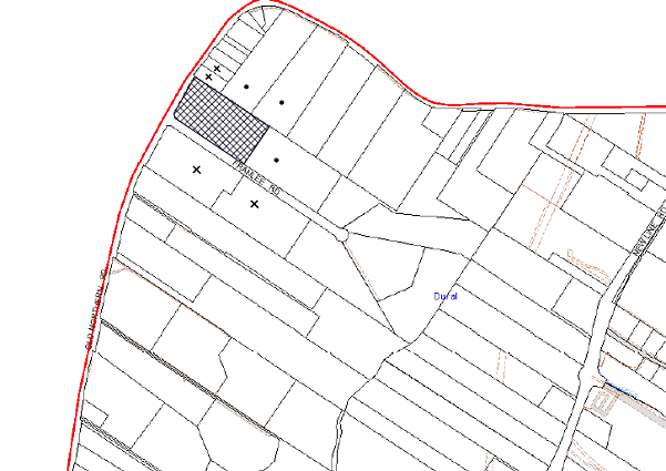
|
NOTIFICATION PLAN |
|
||
|
• PROPERTIES NOTIFIED
|
X SUBMISSIONS RECEIVED |
PROPERTY SUBJECT OF DEVELOPMENT |
|
One submission was received out of map range which included three separate written responses relating to the proposal.
The five submissions received object to the development, generally on the grounds that the development would result in:
· Unacceptable noise from activities at the centre;
· A detrimental impact on the potential future rezoning of the land known as ‘South Dural’ for urban expansion;
· An unsightly fence with shade-cloth surrounding the property;
· The use is not in keeping with the amenity enjoyed by neighbouring properties;
· Increased vehicular movements;
· Number of dwellings within the 100m setback;
· Waste management issues with particular reference to effluent disposal;
· Odour;
· The use being in close proximity to the “Friends First Preschool” on Franlee Road;
· The existing use operating without consent;
· There would be more than eight dogs onsite if consent is granted resulting in groups of dogs on the property;
· Insufficient information submitted with the proposal and incorrect acoustic report; and
· The 82A Review is a time delay tactic.
The merits of the matters raised in community submissions have been addressed in the body of the report with the exception of the following:
5.1.1 Rezoning Proposal
Three submissions raise concerns relating to the potential rezoning of the lands known as ‘South Dural’ which includes the subject site.
The Department of Planning and Infrastructure has undertaken a review of nominated sites over 100 hectares in the Sydney Region as potential land release areas. The South Dural proposal has been considered as part of this process and has not been identified as a priority area.
The proposal is currently being considered as part of the Metropolitan Strategy for Sydney. There is no evidence to suggest that the proposed use would have a detrimental impact on the potential future rezoning of the ‘South Dural’ area.
5.1.2 Proximity to ‘Friends First Preschool’
One submission raises concerns regarding the proximity of the site to the approved preschool on the same property. The submission also noted that two businesses on one allotment would detract from the character of the rural area. The animal boarding establishment would be located in excess of 100m from the preschool. The dogs would be contained within the designated areas and these areas enclosed with a 1.8m fence. The application also states that the dogs would be supervised onsite at all times by a member of staff. As stated above, there would be a maximum of eight dogs onsite at any one time. Accordingly, it is considered that the proposal would not have a detrimental effect on the adjoining preschool.
5.1.3 Insufficient Information
One submission notes that the application has not provided appropriate owner’s consent for the application. Council’s records indicate that owner’s consent has been provided. As addressed under Section 2.7.1 of this report the submission also raises concerns regarding the information provided in the submitted Acoustic Report. The submission also notes the information submitted as being the same as the original application. In this regard, the applicant has submitted a statement addressing the reasons for refusal which have been addressed in Section 2.3 of this report.
5.1.4 Submission of 82A Review
One submission states that the Section 82A review is ‘a time delay tactic’ for the applicant to cease use of the commercial activity. The Act states: ‘if the consent authority is a council, an applicant may request the council to review a determination of the applicant’s application’. In this regard the applicant has submitted an application for an 82A Review in accordance with the Act.
5.1.5 Wastewater
One submission objects to the proposal stating that a pipe delivers excess water from the sewerage system following the boundary of the adjoining property. The submitted Statement of Environmental Effects indicates that; ‘kennel areas are mopped to conserve water and outside areas would not develop any additional water or drainage runoff.’ The issue raised in the submission has been referred to Council’s Compliance Team for further investigation.
5.2 Public Agencies
The development application is not Integrated Development under the Act.
5.2.1 Roads and Maritime Services
The site adjoins Old Northern Road which is a State road. The application did not require referral to the Roads and Maritime Services (RMS) as the use is not a traffic generating activity under Clause 104 (Traffic Generating Development) and Schedule 3 of the State Environmental Planning Policy (Infrastructure) 2007.
5.2.2 Rural Fire Service
The application was not required to be referred to the Rural Fire Service as it is not development of land for special fire protection purposes under the provisions of the Rural Fire Services Act 1997, Section 100B.
6. THE PUBLIC INTEREST
Section 79C(1)(e) of the Act requires Council to consider “the public interest”.
The public interest is an overarching requirement, which includes the consideration of the matters discussed in this report. Implicit to the public interest is the achievement of future built outcomes adequately responding to and respecting the future desired outcomes expressed in environmental planning instruments and development control plans.
It is considered that the approval of the proposed animal boarding establishment would be in the public interest.
CONCLUSION
The proposal involves use of the site for the purpose of an animal boarding establishment for eight dogs.
The application has been assessed as satisfactory having regard to Section 79C of the Environmental Planning and Assessment Act 1979, the provisions within the Hornsby Shire Local Environmental Plan 1994 and the objectives of the development controls within Council’s Rural Lands Development Control Plan and Hornsby Development Control Plan 2013.
Five submissions have been received in respect of the application.
It is recommended that Council change the determination of the application and approval be granted as a deferred commencement subject to compliance with the conditions in Schedule 1 of this report.
Note: At the time of the completion of this planning report, no persons have made a Political Donations Disclosure Statement pursuant to Section 147 of the Environmental Planning and Assessment Act 1979 in respect of the subject planning application.
|
Rod Pickles Manager - Development Assessment Planning Division |
James Farrington Group Manager Planning Division |
|
1.View |
Locality Plan |
|
|
|
2.View |
Fence Plan |
|
|
|
3.View |
Noise Assessment - Sydney Pet Resort |
|
|
File Reference: DA/1173/2012
Document Number: D02459880
SCHEDULE 1
GENERAL CONDITIONS
The conditions of consent within this notice of determination have been applied to ensure that the use of the land and/or building is carried out in such a manner that is consistent with the aims and objectives of the relevant legislation, planning instruments and Council policies affecting the land and does not disrupt the amenity of the neighbourhood or impact upon the environment.
Note: For the purpose of this consent, the term ‘applicant’ means any person who has the authority to act on or the benefit of the development consent.
Note: For the purpose of this consent, any reference to an Act, Regulation, Australian Standard or publication by a public authority shall be taken to mean the gazetted Act or Regulation, or adopted Australian Standard or publication as in force on the date that the application for a construction certificate is made.
1. Deferred Commencement
Pursuant to Section 80(3) of the Environmental Planning and Assessment Act 1979, this consent does not operate until the following information is submitted to Council:
a) Plans of an appropriate lapped and capped paling fence, designed by an appropriately qualified acoustic consultant, for the boundary with No. 671-673 Old Northern Road must be submitted to Council.
Such information shall be submitted within 12 months of the date of this notice.
Upon Council’s written satisfaction of the above information, the following conditions of development consent will apply:
2. Approved Plans and Supporting Documentation
The development must be carried out in accordance with the plans and documentation listed below and endorsed with Council’s stamp, except where amended by Council and/or other conditions of this consent:
|
Plan No. |
Drawn by |
Dated |
|
Noise Assessment – Sydney Pet Resort Report No. nss21857 Rev C - Final |
Noise and Sound Services |
April 2013 |
|
Fencing Plan |
Sydney Pet Resort |
18/10/2012 |
|
Document No. |
Prepared by |
Dated |
|
Statement of Environmental Effects |
Sydney Pet Resort |
5 November 2012 |
a) The ceiling of the kennel building must be sealed with 6mm of fibre cement or 10mm plasterboard and the cavity lined with acoustic absorption (with a Noise Coefficient (NRC) of at least 0.65).
b) Any dogs left unaccompanied during the day must be housed in the kennel building.
c) No dog is to be outside the kennel building between 7:00pm and 7:00am.
d) Operation of the premise must be carried out in accordance with Noise Assessment – Sydney Pet Resort Report No. nss21857 Rev. C Final.
e) All vegetation is to be retained on the site boundary between Old Northern Road and Franlee Road.
f) Operation of the premise must be carried out in accordance with ‘No. 5 Waste Minimisation Management’ in the Statement of Environmental Effects dated 5/11/2012.
REQUIREMENTS PRIOR TO THE ISSUE OF A CONSTRUCTION CERTIFICATE
3. Building Code of Australia
All building work must be carried out in accordance with the requirements of the Building Code of Australia.
REQUIREMENTS PRIOR TO THE COMMENCEMENT OF ANY WORKS
4. Erosion and Sediment Control
Erosion and sediment control measures must be provided and maintained throughout the construction period in accordance with the manual ‘Soils and Construction 2004 (Bluebook)’, the approved plans, Council specifications and to the satisfaction of the principal certifying authority. The erosion and sediment control devices must remain in place until the site has been stabilised and revegetated.
Note: On the spot penalties up to $1,500 may be issued for any non-compliance with this requirement without any further notification or warning.
REQUIREMENTS DURING CONSTRUCTION
5. Environmental Management
The site must be managed in accordance with the publication ‘Managing Urban Stormwater – Landcom (March 2004) and the Protection of the Environment Operations Act 1997 by way of implementing appropriate measures to prevent sediment run-off, excessive dust, noise or odour emanating from the site during the construction of the development.
OPERATIONAL CONDITIONS
6. Noise
All noise generated by the proposed development must be attenuated to prevent levels of noise being emitted to adjacent premises which possess tonal, beating and similar characteristics or which exceeds background noise levels by more than 5dB(A).
7. Effluent Disposal
The effluent disposal area is to be suitably identified with signage and protected so as to prevent human or animal contact, minimize health risk and avoid compaction of the soil.
8. Hours of Operation
The hours of operation for the public to collect and drop off dogs are restricted to those times listed below
Monday to Friday 7.30am to 5.30pm
Saturday 7.30am to 5.00pm
Sunday & Public Holidays 9.00 to 10.00am and 3.00 to 5.00pm
9. A maximum of eight dogs only are permitted onsite at any one time.
- END OF CONDITIONS -
ADVISORY NOTES
The following information is provided for your assistance to ensure compliance with the Environmental Planning and Assessment Act, 1979, Environmental Planning and Assessment Regulation 2000, other relevant legislation and Council’s policies and specifications. This information does not form part of the conditions of development consent pursuant to Section 80A of the Act.
Environmental Planning and Assessment Act, 1979 Requirements
The Environmental Planning and Assessment Act, 1979 requires:
· The issue of a construction certificate prior to the commencement of any works. Enquiries regarding the issue of a construction certificate can be made to Council’s Customer Services Branch on 9847 6760.
· A principal certifying authority to be nominated and Council notified of that appointment prior to the commencement of any works.
· Council to be given at least two days written notice prior to the commencement of any works.
· Mandatory inspections of nominated stages of the construction inspected.
· An occupation certificate to be issued before occupying any building or commencing the use of the land.
Group Manager’s Report No. PL103/13
Planning Division
Date of Meeting: 16/10/2013
14 HORNSBY SHIRE SWIMMING POOL BARRIER INSPECTION PROGRAM
EXECUTIVE SUMMARY
· At its meeting on 19 June 2013, Council resolved to exhibit the draft Hornsby Shire Swimming Pool Barrier Inspection Program.
· The draft Program has been prepared in accordance with the Swimming Pools Act 2012 and Swimming Pools Regulation 2008 and includes provisions for both mandatory and random inspections of swimming pools and spas.
· The draft Program was exhibited from 1 August 2013 to 29 August 2013 with notification appearing in local newspapers and on Council’s website.
· No public submissions were received.
· It is recommended that Council adopt the Hornsby Shire Swimming Pool Barrier Inspection Program.
|
THAT Council adopt the Hornsby Shire Council Swimming Pool Barrier Inspection Program. |
PURPOSE
The purpose of this report is to present the outcome of the exhibition of the draft Hornsby Shire Swimming Pool Barrier Inspection Program.
BACKGROUND
As a result of the recent amendments to the Swimming Pools Act (the Act) all NSW councils are required to:
1. Develop a swimming pool barrier inspection program in consultation with the community by 31 October 2013;
2. Report annually on the number of pool inspections undertaken and the level of compliance with the requirements;
3. Inspect pools prior to sale or lease of a property;
4. Inspect any swimming pool that is the subject of a complaint;
5. Inspect pools associated with tourist and visitor accommodation and multi-occupancy developments at three year intervals;
6. Upon receipt of a request for a swimming pool certificate of compliance, Council has 10 days in which to commence an investigation; and
7. Manage court appeals in the event that a pool owner fails to comply with an Order to fence a swimming pool.
In accordance with the requirements of the Act, a draft Program was prepared for the purposes of community consultation. At its meeting on 19 June 2013, Council considered the draft Hornsby Shire Swimming Pool Barrier Inspection Program and resolved to place it on public exhibition for 28 days.
DISCUSSION
Council’s draft Swimming Pool Barrier Inspection Program includes both prescribed inspections as indentified in the Act and random inspections as follows:
· At the request of a pool owner to facilitate registering a compliant swimming pool;
· Where the swimming pool is the subject of a complaint;
· At the request of a pool owner requiring a certificate of compliance;
· When the property is being sold or leased;
· At the request of a property owner to provide advice;
· At three year intervals where the pool is associated with tourist, visitor accommodation and multi-unit housing developments;
· Where a premises is subject to a building certificate application;
· Where a property containing a swimming pool is visited by a Council officer during the course of his/her duties;
· Where a property containing a pool is subject to a development or complying development application;
· On a random basis when resources become available.
In accordance with Council’s resolution, the draft Program was publicly exhibited from 1 August 2013 to 29 August 2013. A notice was placed in the Hornsby Advocate and on Council’s website. Copies of the draft Program were made available for inspection at Council’s Administration Building. Electronic copies were placed on Council’s website.
No public submissions were received.
CONSULTATION
In response to Council’s consultative process, no submissions were received.
budget
The net cost of implementing the Program will be approximately $152,000. At its meeting on 19 June 2013, Council resolved that funding up to $150,000 be allocated to the Planning Division 2013/14 budget to cover the cost of employing additional staff as the need for resources arises.
CONCLUSION
The Hornsby Council Swimming Pool Barrier Inspection Program was prepared ensuring that it complies with the legislative requirements and is based on social justice principles of equity, access, participation and rights.
The draft Program has been publicly exhibited seeking community feedback. No public submissions were received.
RESPONSIBLE OFFICER
The officer responsible for the preparation of this Report is the Manager, Compliance and Certifications – Simon Evans - who can be contacted on 9847 6780.
|
Simon Evans Manager - Compliance and Certification Planning Division |
James Farrington Group Manager Planning Division |
|
1.View |
The Hornsby Council Draft Swimming Pool Barrier Inspection Program |
|
|
File Reference: F2011/00835
Document Number: D02487194
Deputy General Manager's Report No. IR25/13
Infrastructure and Recreation Division
Date of Meeting: 16/10/2013
15 PACIFIC HIGHWAY - PROPOSED CHANGE OF NAME TO PEATS FERRY ROAD
EXECUTIVE SUMMARY
· Following the reclassification of the Pacific Highway through Hornsby Westside, Council resolved to rename the section of the former highway between George Street, Hornsby and Jersey Street North, Asquith as Peats Ferry Road. The new name reflects the historical and heritage significance of the road.
· Public consultation on the proposed name change took place throughout October 2012. Property owners (334 properties) and government agencies, including Australia Post, Police, Fire Brigade and Ambulance, were notified of the proposed name change and invited to comment. Twenty Seven (27) responses were received.
· The results of the consultation indicate no strong desire within the community to change the name of the Pacific Highway, nor any strong objection to it.
· It has been estimated that it will cost Council about $50,000 to effect the name change, but much of this will be staff time which is already budgeted. In addition local businesses will bear costs to change address details in any advertising and stationery.
|
THAT Council proceed with gazettal and advertise the name change for the section of Pacific Highway between George Street, Hornsby and Jersey Street North, Asquith to Peats Ferry Road. |
PURPOSE
The purpose of this report is to advise Council of the results of the public consultation regarding the proposal to rename Pacific Highway between George Street, Hornsby and Jersey Street North, Asquith as Peats Ferry Road.
BACKGROUND
At the Ordinary Meeting of 12 June 2002, Council considered a report regarding the Road and Traffic Authority’s (now Roads and Maritime Services or RMS) proposal to change the road hierarchy around Hornsby CBD. In brief, the RMS proposed to down grade the Pacific Highway through Hornsby West side between George Street and Bridge Road to a local road and in return take over the management of George Street as the latter provides more traffic capacity and is better suited to service the state road network. The proposal was accepted and adopted by Council at the Ordinary Meeting of 12 June 2002 (WK41/02) however further negotiation resulted in the Pacific Highway between Galston Road and Jersey Road at Asquith shops also coming under Council control.
The New South Wales Government Gazette Number 39, dated 7 February 2003 contained a notice by the Minister for Roads declaring the new route for “State Highway No 10 Pacific Highway”. This declaration effectively meant the name Pacific Highway no longer applied to the road through Hornsby west side. A copy of the gazettal is attached to this report (Attachment 1). The adopted road hierarchy for the above respective roads is shown on the map attached to this report (Attachment 2).
At the Ordinary Meeting of 16 May 2012, Council considered report WK20/12 and resolved,
“THAT Council:
1. Adopt the proposal to rename Pacific Highway as Peats Ferry Road between George Street and Bridge Road, Hornsby as per previous resolution and extend the roadway to be renamed to include the section of the former highway between Bridge Road and Galston Road (MR161) and between Galston Road and Jersey Street North, Asquith (SR2103).
2. Advise RMS that the proposal to rename Pacific Highway as Peats Ferry Road includes a section of state highway (MR161) between Bridge Road and Galston Road.
3. Invite written submissions from the public about the proposed renaming of Pacific Highway between George Street and Bridge Road, Hornsby as Peats Ferry Road.”
The proposed new name reflects the historical and heritage significance of the road. A copy of WK20/12 is attached to this report (Attachment 3).
DISCUSSION
Road Renaming Process
Road naming is legislated under the Roads Act 1993. This Act empowers the road authority with the rights to name it. In the case of local roads, the relevant authority is Council. The relevant authority for State Highways is RMS.
When a road naming authority wishes to rename a road they are required to follow the process outlined in the Roads Regulation 2008. This regulation requires the authority to:
· Publish notice of its proposal in a local newspaper;
· Serve notice of its proposal on Australia Post;
· The Registrar General and Surveyor General (through the Land and Property Management Authority) and, in the case of a classified road, on the RMS.
This notice must state that written submissions on the proposed name may be made to Hornsby Shire Council and must specify the address to which, and the date by which, any such submissions should be made. If, after consideration of submissions, Council decides to proceed with the proposed name, it shall:
· Publish notice of the new name in the NSW Government Gazette and in a local newspaper;
· Inform Australia Post, the Registrar General, Surveyor General and, in the case of a classified section of the road, the RMS of the new name, giving sufficient particulars to enable the road to be identified.
It is important to note that Council may not proceed with a proposal to name or rename a road if Australia Post, the Registrar General and Surveyor General (through the Land and Property Management Authority) or RMS (in the case of a classified road) objects to the name. However, the Minister for Roads may overturn this objection.
To streamline the process, road naming authorities now only need to inform one contact within NSW Government (i.e. Team Leader Regional Cadastre Information Sourcing Land and Property Management Authority). This fulfils their requirements for notifying the Registrar General, Surveyor General and the Geographical Names Board.
Consultation Process
Notices inviting comment on the renaming proposal were run in the Hornsby Advocate on 4 October 2012 and 18 October 2012.
A notice was run on Council’s webpage between 12 October 2012 and 9 November 2012.
All property owners along the Pacific Highway between George Street and Jersey Road North (334 properties) were mailed letters inviting them to comment on the renaming proposal.
All businesses along the Pacific Highway in Hornsby CBD Westside were hand delivered notices in addition to the mail out.
Australia Post, the Registrar General, Surveyor General and RMS were notified of the proposal and invited to comment.
Response Summary
Following is a broad summary of the submissions:
· Written submissions received from the public 27
· Support proposal to rename Pacific Highway to Peats Ferry Road 7
· Support renaming but not Peats Ferry Road 6
· Object to renaming 11
RMS, Ausgrid, Australia Post and the Land and Property Management Authority raised no objections to the proposal.
Estimated Costs
Benefits
Potential benefits of the name change to Peats Ferry Road are that the new name will strengthen the perception that the function of the road has changed from that of a through route to a local road serving Hornsby Westside. Since the status of the Pacific Highway changed in 2003, Council has implemented a number of traffic and parking management projects to reinforce the local nature of the road, and improve pedestrian and visitor amenity. This has included encouragement of sidewalk dining including narrowing of the roadway at the south eastern corner of Coronation Street and Pacific Highway and increasing the number of parking spaces with angle parking in the Pacific Highway north of Coronation Street. In addition, an ‘S’ lane treatment through Hornsby Westside along with a 40km/h High Pedestrian Activity Area incorporating additional traffic calming was started in June 2013 and will be provided in stages.
The name change will complement physical works referred to above.
Disadvantages
Disadvantages of the name change were briefly canvassed when the decision was made to rename the section of the former Pacific Highway from Jersey Street North, Asquith through Hornsby Westside to the intersection at George Street in the vicinity of Westfield. No new disadvantages have been raised that warrant not proceeding with the name change. The renaming will cost Council at least $50,000 to modify records and data, but much of this cost is staff costs. Likewise affected businesses will also incur unknown costs in updating their stationary and promotional material. It can be anticipated that visitors to the area will be confused by the name change until all street directories, GPS and websites are updated and in general circulation. This will take some time before the community and businesses adapt to the name change.
CONSULTATION
All property owners and government agencies affected by the name change proposal were notified of the proposal.
BUDGET
At this stage the costs of a name change is estimated to exceed $50,000, but most of the cost involves staff time to amend data bases and property records. A precise cost is not available as Council has not attempted a road name change of this magnitude previously.
The RMS has confirmed that it will cover the cost of changing the details on the large directional signs, however advise that due to the scope of the work this may take six months to implement. Council will be responsible for the street name signs which is included in the $50,000 estimate referred to above.
POLICY
There are no policy implications associated with this Report.
CONCLUSION
The results of the consultation to rename the former Pacific Highway through Hornsby Westside show the community has no strong preference for a name change. Less than 10% of those businesses consulted responded to the public exhibition. Seven submissions supported the proposed name change; six supported a name change, but not the proposed name and eleven submissions objected to the name change. It has been estimated that it will cost Council about $50,000 to effect the name change, but much of this will be staff time which is already budgeted. In addition local businesses will bear costs to change address details in any advertising and stationery.
RESPONSIBLE OFFICER
This officer responsible for the preparation of this report is Lawrence Nagy, Manager Traffic and Road Safety, who can be contacted on 9847 6524
|
Robert Stephens Deputy General Manager Infrastructure and Recreation Division |
|
|
1.View |
RTA Gazettal 2003 |
|
|
|
2.View |
Peats Ferry Road Map |
|
|
|
3.View |
Report WK20/12 |
|
|
File Reference: F2012/00392
Document Number: D02442665
Deputy General Manager's Report No. IR30/13
Infrastructure and Recreation Division
Date of Meeting: 16/10/2013
16 HORNSBY STATION FOOTBRIDGE
EXECUTIVE SUMMARY
· In July 2013 Council received a report on the replacement of the Hornsby Station Footbridge and resolved to proceed to community consultation.
· There was strong support from the community for seeking State Government funding. The community also supported the design concepts for the bridge including developing an iconic entry to Florence Street and extending the mall. A small number of submissions requested additional options for access for the less able-bodied into Florence Street.
· It is estimated that $350,000 will be required for the development of detailed design proposals, planning approvals and tender documentation. It is proposed these fees be split equally between Council and Transport for NSW.
· It is recommended that Council write to Transport for NSW seeking confirmation and timing of its funding contribution for the project. It is also recommended that Council proceed to detailed design; gain any necessary planning approvals; and further investigate access options for the bridge along with its architectural design to respond to the comments received from the community.
|
THAT Council: 1. Write to Transport for NSW to advise outcomes of the consultation and request confirmation and timing of its funding contribution for construction of the footbridge, including sharing equally the cost of investigation and documentation of those elements in point 2 of the recommendation. 2. Proceed to detailed design and documentation, seek any necessary planning approvals and prepare tender documentation for construction of the bridge in consultation with Transport for NSW. Design development shall include: a) further investigation of access options on the Florence Street side of the footbridge. b) detailed design of the footbridge and the Florence Street entry including the mall extension. 3. Call tenders for construction after receiving a funding commitment from Transport for NSW. 4. Authorise for any funding shortfalls for the development of detailed designs and tender documentation to be considered as part of the quarterly budget review process. |
PURPOSE
The purpose of this Report is to advise on the findings of community consultations undertaken in August 2013 and seek endorsement to proceed to gain planning approval and prepare detailed designs for a complete replacement footbridge.
BACKGROUND
At the July 2013 Ordinary Meeting, Council considered Deputy General Manager’s Report No. IR20/13 and resolved in part,
“That Council:
5. Note the findings of design investigations for a replacement footbridge at Hornsby Station contained in Deputy General Manager’s Report No. IR20/13.
6. Endorse commencement of community consultation for the development of a replacement footbridge over George Street, Hornsby, including:
a) the proposal to centrally align a freestanding bridge in Florence Street.
b) the incorporation of stairs and a lift into the Florence Street portion of the bridge and a ramp on the Hornsby Station side of the bridge; and
c) the use of available photomontages to assist in discussing options for the visual character of the bridge.
7. Receive a report advising of the findings following the completion of the consultation.”
This report advises on the findings of community consultation undertaken in August.
DISCUSSION
Cardno (NSW/ACT) has prepared a report advising on the findings of the community consultation (see attachment).
The consultations included:
· Stakeholder meetings with local businesses.
· Advertising and promotion of the consultation in local papers, radio and via social media.
· Community information stalls in the mall and on the existing footbridge.
· Distribution of approximately 3000 flyers to the community, that appraised the issues and sought community input through a short questionnaire that could be returned to Council.
· The exhibition of material that included images and plans at the Hornsby Library and Council’s Administration Centre for the month of August.
· The establishment of a dedicated website that included a synopsis of the proposals, images and a library of useful background material. There was also the opportunity to complete an online survey or participate in an online forum.
Approximately 400 people responded to the online survey and 500 people submitted a response to the flyer survey. A small number of people participated in the online forum or wrote to Council about the proposals. More than 1,200 people visited the website.
The surveys found:
· Strong support for the project to proceed.
· Recognition that the bridge design will make a positive contribution to improving Hornsby's image and the vibrancy of the retail and business areas.
· Strong support for the State Government funding two thirds of the estimated total cost of the works.
· A strong preference for the Option 3 iconic entry statement.
The discussion in workshops, written comments on the flyers, the online forum and letters received indicated:
· Strong support for the proposal.
· Requests that the access arrangements are upgraded by incorporating escalators, travelators, ramps or multiple lifts.
· A small number of people who do not support advertising on the bridge, although it was understood that this would assist with the funding of the proposal.
· One business owner who objected strongly to the proposal and questioned whether it is Council’s intention to proceed. This respondent indicated that it was more appropriate to remove the bridge and return to the previous arrangement of a pedestrian traffic light crossing.
Next Steps
It is prudent, in light of the positive community response, to consider the next steps of the design and construction of the Hornsby Station footbridge.
These steps can be summarised as follows:
· Provide Transport for NSW with the consultant report advising of the findings of the community consultation.
· Seek confirmation and timing of Transport for NSW’s funding contribution for development of detailed designs, tender documentation and construction of the footbridge.
· Proceed to detailed design addressing in particular access options and the bridge architectural design to respond to the comments received from the community.
· Obtain any necessary planning approvals.
· Prepare the necessary tender documentation and seek fee proposals.
The above approach would continue to demonstrate Council’s commitment to delivering the project within the current term. The development of the detailed design for the footbridge would be carried out in consultation with Transport for NSW and would allow the department and Council to raise and resolve any issues in a timely manner. It is expected that the detailed design, approvals and tender documentation would be completed by mid 2014 allowing construction to commence in late 2014/ early 2015, subject to funding.
BUDGET
The total cost of the proposal has been estimated at $7 million, which includes the bridge construction as well as works to extend the Florence Street Mall to George Street. Council is seeking a minimum of two-thirds funding contribution or $4.6 million from Transport for NSW. Council’s contribution to one third funding of $2.4 million can be sourced from developer contributions and special rate variation funding sources.
It is estimated that the development of a detailed design for the footbridge along with any necessary approvals and preparation of tender documentation would cost in the order of $350,000. Only $100,000 has been set aside in the current budget leaving a shortfall of $250,000. It is expected that $175,000 will be secured from Transport for NSW, but at the time of preparing this report confirmation of this approach had not been received. The balance of Council’s contribution (an additional $75,000) would need to be identified as part of the Council’s quarterly budget review process.
POLICY
There are no policy implications associated with this Report.
CONCLUSION
Council exhibited plans for the replacement of the pedestrian bridge in August and found strong community interest in the proposals.
Key findings include support for the State Government funding two-thirds of the cost of the works and for the bridge to be designed in a way that provides an iconic entry to Florence Street Mall. A few comments received expressed a clear desire that Council consider upgrading the access arrangements to the footbridge by incorporating escalators, travelators, ramps or multiple lifts. These matters will be investigated further during the preparation of the detailed design.
The consultation found strong support for the proposal to proceed.
RESPONSIBLE OFFICER
The officer responsible for the preparation of this Report is the Landscape Coordinator – Kurt Henkel - who can be contacted on 9847 6887.
|
Robert Stephens Deputy General Manager Infrastructure and Recreation Division |
|
|
1.View |
Community and Stakeholder Consultation Summary |
|
|
File Reference: F2012/00817
Document Number: D02506555
Mayor's Note No. MN10/13
Date of Meeting: 16/10/2013
17 MAYOR'S NOTES FROM 1 TO 30 SEPTEMBER 2013
Monday 2 September 2013 - The Mayor attended the Hornsby Ku-ring-gai Community College Tech Savvy Launch.
Thursday 5 September 2013 - The Mayor assisted in the selling of Legacy Badges in Hornsby.
Monday 9 September 2013 - The Mayor attended the West Pennant Hills Sports Club Community Support Presentation Evening.
Thursday 12 September 2013 - The Mayor attended the Rotary Club of Beecroft’s Annual Seniors and Retirees Lunch at Pennant Hills Golf Club.
Thursday 12 September 2013 - The Deputy Mayor, on the Mayor’s behalf, attended the 44th AGM of the Pennant Hills Neighbour Aid Inc.
Friday 13 September 2013 - The Deputy Mayor, on the Mayor’s behalf, attended the Easy Care Gardening AGM and 25th Anniversary Lunch.
Saturday 14 September 2013 - Cr Tilbury, on the Mayor’s behalf, attended the Berowra Garden Club Annual Spring Show.
Saturday 14 September 2013 - Cr Tilbury, on the Mayor’s behalf, attended the Berowra Netball Club’s Presentation Evening at Berowra RSL Club.
Sunday 15 September 2013 - The Mayor and Councillors attended the Hornsby Shire Council Bushland Festival at Fagan Park.
Tuesday 17 September 2013 - The Deputy Mayor, on the Mayor’s behalf, attended the St Leo’s Catholic College Graduation Mass and Presentation.
Thursday 19 September 2013 - The Mayor attended the Pacific Hills Christian School Year 6 ‘Thank You’ Assembly.
Saturday 21 September 2013 - The Deputy Mayor, on the Mayor’s behalf, attended the Berowra Rural Fire Brigade’s 70th Celebration Dinner at Asquith Golf Club.
Tuesday 24 September 2013 - The Mayor hosted three Citizenship Ceremonies in the Council Chambers.
Monday 30 September 2013 - The Mayor took part in the Hornsby Relay for Life Fundraising Activities in Hornsby Mall.
Note: These are the functions that the Mayor, or his representative, has attended in addition to the normal Council Meetings, Workshops, Mayoral Interviews and other Council Committee Meetings.
File Reference: F2004/07053
Document Number: D02506628
Mayoral Minute No. MM15/13
Date of Meeting: 16/10/2013
18 LOCAL GOVERNMENT REFORM - STRATEGIC PARTNERSHIPS
INTRODUCTION/BACKGROUND
Since the NSW Government announced in 2011 its agenda for Local Government reform at Destination 2036 in Dubbo, there has been considerable effort by a number of councils to stymie debate. Whilst on the one hand, they have lobbied for more revenue and grants, they have also stated that structural reform of local government is not necessary and the current system is working.
In contrast to this, I am pleased to advise residents of our community that Hornsby Council is proactively participating in the local government reform debate. We do this to deliver better value to our ratepayers.
We have publicly released independent evidence suggesting that there would be financial benefits in reforming local government in a manner that preserves local identity and local representation. I believe that this Council should continue to lead this discussion for the benefit of all ratepayers. While the figures and the structures need to be debated, we cannot simply ignore them.
Following discussions in regards to possibly merging Northern Sydney Regional Organisation of Councils (NSROC) and Shore Regional Organisation of Councils (SHOROC), I am pleased to advise that the General Manager and I recently met with the Mayors and General Managers of The Hills and Warringah Councils to discuss the issue of local government reform. As Councillors would be aware, both The Hills and Warringah Councils have similar sized populations to Hornsby and we each recognise that our communities have many common aspirations.
It was interesting to note that both Mayors expressed to me their disappointment in the general tone of the debate on local government reform. Both Mayors advised me that they would prefer to see structural changes to councils that increase the strategic capacity of local government. However, we recognise that it may be some time before meaningful reform eventuates and a mature debate can be held in our communities.
Accordingly, we have each asked our respective General Managers to consider options to enable us to form a cooperative strategic alliance that identifies mutually beneficial opportunities to improve efficiencies within our existing Council structures. This would be an interim measure until such time as more meaningful reform can be implemented. As each Council presently has different Region of Council (ROC) arrangements, General Managers have been asked to consider whether an alliance could exist outside the traditional ROC framework. On initial analysis, it does appear very possible and, very positive.
Hornsby Council is part of the NSROC group and should benefit in terms of advocacy at a regional level on issues such as health and transport infrastructure. Council also makes a contribution to developing shared service and procurement arrangements on a case by case basis. In addition, Hornsby Council is party to a Memorandum of Understanding (MOU) with The Hills and Hawkesbury Councils that took effect in August 2010. The objects of the MOU are to develop a relationship to foster a cooperative working relationship on issues of mutual interest.
The creation of a new strategic alliance with The Hills and Warringah would mean greater savings for the residents of Hornsby through increased buying power that would be greater than under the current NSROC model. Council’s future position in respect of its ongoing membership of NSROC will be decided following receipt of a report to be prepared by the General Manager.
I commend Council to agree to enter into a strategic alliance with The Hills and Warringah Councils with the aim of achieving further efficiencies under the existing local government framework. Further I ask you to support me in requesting a report to Council in six months outlining the progress and any achievements made after entering into such an alliance with said Councils.
I understand funding for this can be found within existing operational budgets.
|
THAT Council: 1. Writes to the Minister for Local Government to express our ongoing support of its agenda to reform local government in partnership with local Councils. 2. Write to the Mayors of The Hills and Warringah Councils expressing Council's support to enter into a cooperative strategic alliance that identifies mutually beneficial opportunities to improve efficiencies in areas of procurement, policy development and resource allocation. 3. Receive a progress report from the General Manager within six months and sets out the framework for the strategic alliance with The Hills and Warringah Councils for Council's endorsement. 4. Note that the Mayor and General Manager will continue to be involved in discussions about closer cooperation and a potential merger of SHOROC and NSROC in the areas of advocacy and strategic planning. |
STEVE RUSSELL
Mayor
There are no attachments for this report.
File Reference: F2013/00305
Document Number: D02522902
