

Page 1
TABLE OF CONTENTS
AGENDA AND SUMMARY OF RECOMMENDATIONS
Rescission Motions
ITEMS PASSED BY EXCEPTION / CALL FOR SPEAKERS ON AGENDA ITEMS
GENERAL BUSINESS
General Manager's Division
Item 1 GM5/13 Code Of Conduct Complaints - Annual Report.................................................... 1
Corporate Support Division
Item 2 CS55/13 2012/13 Audited Financial Statements - Presentation to the Public.................... 4
Item 3 CS52/13 Investments and Borrowings for 2013/14 - Status for Period Ending 30 September 2013 7
Item 4 CS50/13 Tender No. RFT15/2013 - Printing Services..................................................... 10
Item 5 CS56/13 Tender No. RFT16/2013 - Printing of Rates Notices and Associated Mailing Services 14
Item 6 CS53/13 Delivery Program for 2013-17, Including the 2013/14 Operational Plan - September 2013 Quarter Review.......................................................................................................... 18
Item 7 CS54/13 Hornsby Shire Council - Annual Report 2012/13.............................................. 21
Item 8 CS49/13 Hornsby Mall North - Proposed Private Investment in Development and Two Proposed Consequential Leases................................................................................................ 24
Environment and Human Services Division
Item 9 EH20/13 Community Donations Program..................................................................... 29
Item 10 EH22/13 Tender No. T19/2013 - Stormwater Harvesting Facilities Preventative Maintenance 33
Item 11 EH23/13 Adoption of Categorisation of Community Land and the Plan of Management for One Tree Reach Wetland, Laughtondale.................................................................................... 37
Planning Division
Item 12 PL63/13 Development Application - Subdivision of One Allotment into Two and Erection of Two Detached Dwellings - 8 Flora Avenue, Mount Colah....................................................... 41
Item 13 PL81/13 Development Application - Dwelling-House - 1B Mary Street, Beecroft............... 67
Item 14 PL94/13 Development Application - Ten Storey Mixed Use Development Comprising 73 Residential Units - 258 and 262-264 Pennant Hills Road, Thornleigh................................................ 87
Item 15 PL107/13 Development Application - Five Storey Residential Flat Building Comprising 15 Units - 229 Carlingford Road, Carlingford..................................................................................... 134
Item 16 PL110/13 Development Application - Child Care Centre - 23 Bellamy Street, Pennant Hills 177
Item 17 PL112/13 Development Application - Subdivision of Two Allotments into Three Lots and Construction of a Dwelling-House - 24 and 26 Silvia Street, Hornsby.................................................... 211
Item 18 PL111/13 Community Facility - Child Care Centre - 8 Dudley Street, Asquith................ 237
Item 19 PL109/13 Reporting Variations to Development Standards........................................... 265
Item 20 PL108/13 Submissions Report - Heritage Review Stage 5 Planning Proposal................. 268
Item 21 PL100/13 Report on Submissions - Carlingford Precinct Traffic Improvements................ 276
Item 22 PL105/13 Report on Submissions - Reclassification of 18X Water Street, Hornsby......... 282
Infrastructure and Recreation Division
Item 23 IR32/13 Tender T21/2013: Sprayed Bituminous Surfacing............................................ 292
PUBLIC FORUM – NON AGENDA ITEMS
Questions of Which Notice Has Been Given
Mayor's Notes
Item 24 MN11/13 Mayor's Notes from 1 to 31 October 2013..................................................... 295
Mayoral Minutes
Notices of Motion
SUPPLEMENTARY AGENDA
MATTERS OF URGENCY
QUESTIONS WITHOUT NOTICE
Page 1
AGENDA AND SUMMARY OF RECOMMENDATIONS
PRESENT
NATIONAL ANTHEM
OPENING PRAYER/S
Reverend Jonathan Bradford, from Community Life Church, Cherrybrook, will open the meeting in prayer.
Acknowledgement of RELIGIOUS DIVERSITY
Statement by the Chairperson:
"We recognise our Shire's rich cultural and religious diversity and we acknowledge and pay respect to the beliefs of all members of our community, regardless of creed or faith."
ABORIGINAL RECOGNITION
Statement by the Chairperson:
"We acknowledge we are on the traditional lands of the Darug and Guringai Peoples. We pay our respects to elders past and present."
AUDIO RECORDING OF COUNCIL MEETING
Statement by the Chairperson:
"I advise all present that tonight's meeting is being audio recorded for the purposes of providing a record of public comment at the meeting, supporting the democratic process, broadening knowledge and participation in community affairs, and demonstrating Council’s commitment to openness and accountability. The recordings of the non-confidential parts of the meeting will be made available on Council’s website once the Minutes have been finalised. All speakers are requested to ensure their comments are relevant to the issue at hand and to refrain from making personal comments or criticisms."
APOLOGIES / LEAVE OF ABSENCE
political donations disclosure
Statement by the Chairperson:
“In accordance with Section 147 of the Environmental Planning and Assessment Act 1979, any person or organisation who has made a relevant planning application or a submission in respect of a relevant planning application which is on tonight’s agenda, and who has made a reportable political donation or gift to a Councillor or employee of the Council, must make a Political Donations Disclosure Statement.
If a Councillor or employee has received a reportable political donation or gift from a person or organisation who has made a relevant planning application or a submission in respect of a relevant planning application which is on tonight’s agenda, they must declare a non-pecuniary conflict of interests to the meeting, disclose the nature of the interest and manage the conflict of interests in accordance with Council’s Code of Conduct.”
declarations of interest
Clause 52 of Council’s Code of Meeting Practice (Section 451 of the Local Government Act, 1993) requires that a councillor or a member of a Council committee who has a pecuniary interest in a matter which is before the Council or committee and who is present at a meeting of the Council or committee at which the matter is being considered must disclose the nature of the interest to the meeting as soon as practicable. The disclosure is also to be submitted in writing (on the form titled “Declaration of Interest”).
The Councillor or member of a Council committee must not be present at, or in sight of, the meeting of the Council or committee:
(a) at any time during which the matter is being considered or discussed by the Council or committee.
(b) at any time during which the Council or committee is voting on any question in relation to the matter.
Clause 51A of Council’s Code of Meeting Practice provides that a Councillor, Council officer, or a member of a Council committee who has a non pecuniary interest in any matter with which the Council is concerned and who is present at a meeting of the Council or committee at which the matter is being considered must disclose the nature of the interest to the meeting as soon as practicable. The disclosure is also to be submitted in writing (on the form titled “Declaration of Interest”).
If the non-pecuniary interest is significant, the Councillor must:
a) remove the source of conflict, by relinquishing or divesting the interest that creates the conflict, or reallocating the conflicting duties to another Council official.
OR
b) have no involvement in the matter by absenting themself from and not taking part in any debate or voting on the issue as if the provisions of Section 451(2) of the Act apply.
If the non-pecuniary interest is less than significant, the Councillor must provide an explanation of why they consider that the interest does not require further action in the circumstances.
confirmation of minutes
THAT subject to the amendment shown below to the Minute for Item 17 - MN10/13 - Mayor's Notes from 1 to 30 September 2013, the Minutes of the General Meeting held on Wednesday 16 October 2013 be confirmed, a copy having been distributed to all Councillors:
replace "Saturday 21 September 2013 - The Deputy Mayor, on the Mayor's behalf, attended the Berowra Rural Fire Brigade's 70th Celebration Dinner at Asquith Golf Club." with "Saturday 21 September 2013 - Councillor Browne, on the Mayor's behalf, attended the Berowra Rural Fire Brigade's 70th Celebration Dinner at Asquith Golf Club."
Petitions
presentations
Rescission Motions
ITEMS PASSED BY EXCEPTION / CALL FOR SPEAKERS ON AGENDA ITEMS
Note:
Persons wishing to address Council on matters which are on the Agenda are permitted to speak, prior to the item being discussed, and their names will be recorded in the Minutes in respect of that particular item.
Persons wishing to address Council on non agenda matters, are permitted to speak after all items on the agenda in respect of which there is a speaker from the public have been finalised by Council. Their names will be recorded in the Minutes under the heading "Public Forum for Non Agenda Items".
GENERAL BUSINESS
· Items for which there is a Public Forum Speaker
· Public Forum for non agenda items
· Balance of General Business items
General Manager's Division
Page Number 1
Item 1 GM5/13 Code Of Conduct Complaints - Annual Report
RECOMMENDATION
THAT the contents of General Manager’s Report No. GM5/13 be received and noted.
Corporate Support Division
Page Number 4
Item 2 CS55/13 2012/13 Audited Financial Statements - Presentation to the Public
RECOMMENDATION
THAT the General Purpose and Special Purpose Financial Statements (including the Auditor's Report) for the year ended 30 June 2013, as presented to the public on 20 November 2013, be adopted.
Page Number 7
Item 3 CS52/13 Investments and Borrowings for 2013/14 - Status for Period Ending 30 September 2013
RECOMMENDATION
THAT the contents of Deputy General Manager’s Report No. CS52/13 be received and noted.
Page Number 10
Item 4 CS50/13 Tender No. RFT15/2013 - Printing Services
RECOMMENDATION
THAT Council appoint the following four firms to form a panel of preferred print suppliers for the period from 1 January 2014 to 31 December 2016:
· Bright Group
· EcoDesign EcoPrint Pty Ltd
· Gosford City Council
· Piro Design P.L. (trading as Snap Printing Waitara)
Page Number 14
Item 5 CS56/13 Tender No. RFT16/2013 - Printing of Rates Notices and Associated Mailing Services
RECOMMENDATION
THAT Council appoint SEMA Operations Pty Ltd as the preferred supplier for the period from 1 January 2014 to 31 December 2016 in respect of Tender No. RFT16/2013 - Printing of Rates Notices and Associated Mailing Services.
Page Number 18
Item 6 CS53/13 Delivery Program for 2013-17, Including the 2013/14 Operational Plan - September 2013 Quarter Review
RECOMMENDATION
THAT the September 2013 Quarter Review of the 2013-17 Delivery Program, including the 2013/14 Operational Plan and Budget, be received and noted.
Page Number 21
Item 7 CS54/13 Hornsby Shire Council - Annual Report 2012/13
RECOMMENDATION
THAT:
1. The Hornsby Shire Council Annual Report 2012/13, which has been made available on Council’s website, be received and noted.
2. The Annual Report be supplemented by Council’s 2012/13 audited Financial Statements once they are considered by Council at the 20 November 2013 General Meeting.
3. A copy of the final Annual Report 2012/13 be submitted to the Division of Local Government by 30 November 2013.
Page Number 24
Item 8 CS49/13 Hornsby Mall North - Proposed Private Investment in Development and Two Proposed Consequential Leases
RECOMMENDATION
THAT:
1. The General Manager be authorised to execute any documents in relation to this matter which are deemed appropriate by Council's legal advisers.
2. The General Manager be authorised to negotiate the detailed terms of each of the lease agreements generally in line with the terms outlined in Deputy General Manager’s Report No. CS49/13.
3. If required by the absence of the General Manager or by legal statute, Council authorise the use of Council’s seal on any lease, licence or other documents directly related to the subject two leases of the subject lands deemed appropriate by Council’s legal advisors, subject to review and authorisation by a Deputy General Manager.
Environment and Human Services Division
Page Number 29
Item 9 EH20/13 Community Donations Program
RECOMMENDATION
THAT Council:
1. Allocate $3,000 to the Mayors Youth Trust Fund.
2. Allocate $5,000 to the Emergency Relief Fund.
3. Allocate $5,000 to the Fee Waiver Requests Fund.
4. Not distribute financial assistance to applicant community organisations in the first quarter funding round.
Page Number 33
Item 10 EH22/13 Tender No. T19/2013 - Stormwater Harvesting Facilities Preventative Maintenance
RECOMMENDATION
THAT Council accept the tender from Jaddfe Pty Ltd for Tender T19/2013 – Stormwater Harvesting Facilities Preventative Maintenance within Hornsby Shire for a period of three years with a further option of one year subject to satisfactory performance commencing in January 2014.
Page Number 37
Item 11 EH23/13 Adoption of Categorisation of Community Land and the Plan of Management for One Tree Reach Wetland, Laughtondale
RECOMMENDATION
THAT Council:
1. Categorise the community land at One Tree Reach Wetland, Laughtondale according to the categorisations shown in Figure 5 of the Plan of Management for One Tree Reach Wetland dated October 2013.
2. Adopt the Plan of Management for One Tree Reach Wetland, Laughtondale dated October 2013.
Planning Division
Page Number 41
Item 12 PL63/13 Development Application - Subdivision of One Allotment into Two and Erection of Two Detached Dwellings - 8 Flora Avenue, Mount Colah
RECOMMENDATION
THAT Council assume the concurrence of the Director-General of the Department of Planning and Infrastructure pursuant to State Environmental Planning Policy No. 1 and approve Development Application No. DA/440/2013 for the staged subdivision of one allotment into two, demolition of the existing dwelling house and construction of two detached dwelling houses at Lot 777 DP 752053, No. 8 Flora Avenue, Mount Colah subject to the conditions of consent detailed in Schedule 1 of Group Manager’s Report No. PL63/13.
Page Number 67
Item 13 PL81/13 Development Application - Dwelling-House - 1B Mary Street, Beecroft
RECOMMENDATION
THAT Council assume the concurrence of the Director-General of the Department of Planning and Infrastructure pursuant to State Environmental Planning Policy No. 1 and approve Development Application No. DA/498/2013 for the erection of a dwelling-house at Lot 2 DP 1168541, No. 1B Mary Street, Beecroft subject to the conditions of consent detailed in Schedule 1 of Group Manager’s Report No. PL81/13.
Page Number 87
Item 14 PL94/13 Development Application - Ten Storey Mixed Use Development Comprising 73 Residential Units - 258 and 262-264 Pennant Hills Road, Thornleigh
RECOMMENDATION
THAT Development Application No. DA/691/2013 for the erection of a ten storey mixed use residential flat development comprising 73 residential units and 5 commercial units and demolition of existing structures at Lot 19 DP 836230, Lot 18 DP 836230, Nos. 258 and 262-264 Pennant Hills Road, Thornleigh be approved as a deferred commencement pursuant to Section 80(3) of the Environmental Planning and Assessment Act, 1979 subject to the conditions of consent detailed in Schedule 1 of Group Manager’s Report No. PL94/13.
Page Number 134
Item 15 PL107/13 Development Application - Five Storey Residential Flat Building Comprising 15 Units - 229 Carlingford Road, Carlingford
RECOMMENDATION
THAT Development Application No. DA/644/2013 for demolition of existing structures and erection of a five storey residential flat building comprising 15 units, basement car parking and strata title subdivision at Lot 8 DP 29798, No. 229 Carlingford Road, Carlingford be approved subject to the conditions of consent detailed in Schedule 1 of Group Manager’s Report No. PL107/13.
Page Number 177
Item 16 PL110/13 Development Application - Child Care Centre - 23 Bellamy Street, Pennant Hills
RECOMMENDATION
THAT Development Application No. DA/679/2012 for demolition of existing structures and construction of a purpose built 60 place child care centre at Lots 9 and 10, DP 17123, No. 23 Bellamy Street, Pennant Hills be approved subject to the conditions of consent detailed in Schedule 1 of Group Manager’s Report No. PL110/13.
Page Number 211
Item 17 PL112/13 Development Application - Subdivision of Two Allotments into Three Lots and Construction of a Dwelling-House - 24 and 26 Silvia Street, Hornsby
RECOMMENDATION
THAT Development Application No. DA/108/2013 for demolition of the existing carport and shed, Torrens title subdivision of two allotments into three lots and construction of a dwelling-house at Lot 3 DP 531090 and Lot 1 222949, Nos. 24 and 26 Silvia Street, Hornsby be approved subject to the conditions of consent detailed in Schedule 1 of Group Manager’s Report No. PL112/13.
Page Number 237
Item 18 PL111/13 Community Facility - Child Care Centre - 8 Dudley Street, Asquith
RECOMMENDATION
THAT Development Application No. DA/204/2013 for the demolition of existing structures and construction of a forty place child care centre at Lot 26 DP 9913, No. 8 Dudley Street, Asquith be approved subject to the conditions of consent detailed in Schedule 1 of Group Manager’s Report No. PL111/13.
Page Number 265
Item 19 PL109/13 Reporting Variations to Development Standards
RECOMMENDATION
THAT the contents of Group Manager’s Report No. PL109/13 be received and noted.
Page Number 268
Item 20 PL108/13 Submissions Report - Heritage Review Stage 5 Planning Proposal
RECOMMENDATION
THAT:
1. Council endorse the recommendations of Group Manager’s Report No. PL108/13 to adopt the Planning Proposal as amended to include, remove and amend items within Schedule 5 (Environmental Heritage) of Hornsby Local Environmental Plan 2013.
2. In accordance with the plan making powers delegated to Council, the General Manager exercise the functions of the Minister for Planning and Infrastructure and proceed to make the plan.
3. All persons who made submissions and affected property owners be advised of Council’s resolution.
Page Number 276
Item 21 PL100/13 Report on Submissions - Carlingford Precinct Traffic Improvements
RECOMMENDATION
THAT:
1. The amendment to the Hornsby Development Control Plan 2013 attached to Group Manager’s Report No. PL100/13 be adopted.
2. All persons who made a submission be advised of Council’s decision.
Page Number 282
Item 22 PL105/13 Report on Submissions - Reclassification of 18X Water Street, Hornsby
RECOMMENDATION
THAT:
1. Council forward the Planning Proposal attached to Group Manager’s Report No. PL105/13 to reclassify property No. 18X Water Street, Hornsby from Community Land to Operational Land to the Minister for Planning and Infrastructure for gazettal.
2. All persons who made submissions be advised of Council’s resolution.
Infrastructure and Recreation Division
Page Number 292
Item 23 IR32/13 Tender T21/2013: Sprayed Bituminous Surfacing
RECOMMENDATION
THAT Council accept the tender of SRS Roads Pty Ltd. for all works under Tender No. T21/2013: Sprayed Bituminous Surfacing.
PUBLIC FORUM – NON AGENDA ITEMS
Questions of Which Notice Has Been Given
Mayor's Notes
Page Number 295
Item 24 MN11/13 Mayor's Notes from 1 to 31 October 2013
Mayoral Minutes
Notices of Motion
SUPPLEMENTARY AGENDA
MATTERS OF URGENCY
QUESTIONS WITHOUT NOTICE
General Manager's Report No. GM5/13
General Manager's Division
Date of Meeting: 20/11/2013
1 CODE OF CONDUCT COMPLAINTS - ANNUAL REPORT
EXECUTIVE SUMMARY
· Clause 12.1 of Council’s Procedures for the Administration of the Code of Conduct requires the Complaints Coordinator to report annually (within three months of the end of September) to Council on Code of Conduct complaints made about Councillors and the General Manager.
· This report covers the period from 8 September 2012, being the election date of the current term of Council, to 30 September 2013.
· In this period, there were no Code of Conduct complaints about Councillors or the General Manager.
|
THAT the contents of General Manager’s Report No. GM5/13 be received and noted. |
PURPOSE
The purpose of this Report is to formally report on Code of Conduct complaints for the period 8 September 2012 to 30 September 2013 and advise of the outcomes, if any.
BACKGROUND
Clause 12.1 of Council’s Procedures for the Administration of the Code of Conduct states:
12.1 The Complaints Coordinator must arrange for the following statistics to be reported to the Council within 3 months of the end of September of each year:
a) the total number of code of conduct complaints made about Councillors and the General Manager under the code of conduct in the year to September,
b) the number of code of conduct complaints referred to a conduct reviewer,
c) the number of code of conduct complaints finalised by a conduct reviewer at the preliminary assessment stage and the outcome of those complaints,
d) the number of code of conduct complaints investigated by a conduct reviewer,
e) the number of code of conduct complaints investigated by a conduct review committee,
f) without identifying particular matters, the outcome of code of conduct complaints investigated by a conduct reviewer or conduct review committee under these procedures,
g) the number of matters reviewed by the Division and, without identifying particular matters, the outcome of the reviews, and
h) the total cost of dealing with code of conduct complaints made about Councillors and the General Manager in the year to September, including staff costs.
DISCUSSION
There were no Code of Conduct complaints made against the Councillors or the General Manager in the period from 8 September 2012 to 30 September 2013.
BUDGET
There are no budget implications associated with this Report.
POLICY
There are no policy implications associated with this Report.
CONCLUSION
There were no Code of Conduct complaints made against the Councillors or the General Manager in the period from 8 September 2012 to 30 September 2013. A report will now be forwarded to the Division of Local Government to advise of this result.
RESPONSIBLE OFFICER
The officer responsible for the preparation of this Report is the Risk and Audit Manager (and Complaints Coordinator) – Mr Scott Allen - who can be contacted on 9847-6609.
|
Scott Phillips General Manager General Manager's Division |
|
There are no attachments for this report.
File Reference: F2006/00554
Document Number: D02514260
Deputy General Manager's Report No. CS55/13
Corporate Support Division
Date of Meeting: 20/11/2013
2 2012/13 AUDITED FINANCIAL STATEMENTS - PRESENTATION TO THE PUBLIC
EXECUTIVE SUMMARY
· In accordance with Sections 413, 415, 416 and 417 of the Local Government Act, Council must prepare and have audited its General Purpose and Special Purpose Financial Statements within four months of the end of each financial year.
· At the 18 September 2013 General Meeting, Council received and noted the 2012/13 Financial Statements and resolved to refer them for audit. Council also delegated authority to the General Manager to fix the date at which the Financial Statements and Auditor’s Report would be presented to the public. Following receipt of the Auditor’s Report, the General Manager determined that such presentation would occur at the 20 November 2013 General Meeting.
· Following formal presentation of the Financial Statements and Auditor's Reports to the public at the 20 November 2013 General Meeting, members of the public, in accordance with Section 420 of the Local Government Act, have seven days, i.e. until 27 November 2013, to make submissions about the Statements.
|
THAT the General Purpose and Special Purpose Financial Statements (including the Auditor's Report) for the year ended 30 June 2013, as presented to the public on 20 November 2013, be adopted. |
PURPOSE
The purpose of this Report is for Council's 2012/13 General Purpose and Special Purpose Financial Statements, including Auditor's Reports, to be presented to the public in accordance with Section 419(1) of the Local Government Act. Council's external auditor, Dennis Banicevic of PricewaterhouseCoopers, has indicated that he will be available to make a presentation about the Statements and Council's financial position at the Meeting.
BACKGROUND
At the 18 September 2013 General Meeting, Council considered Deputy General Manager’s Report No. CS44/13 and resolved that:
1. The 2012/13 General Purpose and Special Purpose Financial Reports be received and noted and referred for audit.
2. The Mayor and Deputy Mayor be authorised to sign the Statutory Statements in connection with the 2012/13 Financial Reports.
3. The 2012/13 Financial Reports be authorised for “presentation to the public” on receipt of the Auditor’s Report.
4. The General Manager be delegated authority to fix the date of the General Meeting at which the 2012/13 Financial Reports and Auditor’s Report are formally “presented to the public”.
DISCUSSION
Following the 18 September 2013 General Meeting, the 2012/13 General Purpose and Special Purpose Financial Statements were signed and referred to PricewaterhouseCoopers for audit. PricewaterhouseCoopers have subsequently issued an Audit Report and identified no issues, other than minor presentation matters, which required changes to the Financial Statements.
Following receipt of the Auditor's Report, the General Manager authorised, in accordance with Council’s resolution of 18 September 2013, that presentation of the Statements to the public would occur at the 20 November 2013 General Meeting. As a result, public notices were placed in local newspapers and on Council's website in accordance with Section 418 of the Act.
Hard copies of the Financial Statements and Auditor's Report are available for viewing by members of the public at Council's Administration Centre and Branch Libraries. An electronic copy of the Financial Statements and Auditor's Reports has also been placed on Council's website.
Following formal presentation of the Financial Statements and Auditor's reports to the public at the 20 November 2013 General Meeting, members of the public, in accordance with Section 420 of the Local Government Act have seven days, i.e. until 27 November 2013, to make submissions about the Statements. Such submissions must be in writing and must be referred by Council to the Auditor.
CONSULTATION
In the preparation of this Report there was consultation with Council’s External Auditor.
BUDGET
There are no budgetary implications associated with this Report.
POLICY
There are no policy implications associated with this Report.
CONCLUSION
The presentation of the Financial Statements and Auditor’s Report to the public at the 20 November 2013 General Meeting will ensure that the requirements of the Local Government Act have been met and that the public have an opportunity to make any relevant submissions to Council about the Statements.
RESPONSIBLE OFFICER
The officer responsible for the preparation of this Report is the Chief Financial Officer – Mr Glen Magus - who can be contacted on 9847 6635.
|
Glen Magus Chief Financial Officer - Financial Services Corporate Support Division |
Gary Bensley Deputy General Manager Corporate Support Division |
|
1.View |
2012/13 Audited Annual Financial Statements |
|
|
File Reference: F2013/00243
Document Number: D02600075
Deputy General Manager's Report No. CS52/13
Corporate Support Division
Date of Meeting: 20/11/2013
3 INVESTMENTS AND BORROWINGS FOR 2013/14 - STATUS FOR PERIOD ENDING 30 SEPTEMBER 2013
· Council may invest funds that are not, for the time being, required for any other purpose. The investments must be in accordance with relevant legislative requirements and Council’s policies. The Chief Financial Officer must report monthly to Council on the details of funds invested.
· This Report provides details of Council’s investment performance for the period ending 30 September 2013. It indicates that for total investments, the annualised return for the month of September was 3.79% compared to the benchmark of 2.50%.
· All investments have been made in accordance with the Local Government Act, the Local Government (General) Regulation and Council's Investment of Surplus Funds Policy and Investment Strategy.
· In respect of Council borrowings, the weighted average interest rate payable on loans taken out from June 2004 to September 2013, based on the principal balances outstanding, is 6.04%.
· Council’s investment portfolio is unable to be applied to reducing current outstanding loan balances, due in part to the estimated cash-flow requirements associated with the Hornsby Aquatic Centre during 2013/14. Also, opportunities to renegotiate Council’s existing loans to attain a lower interest rate are negated by the break costs which would apply.
|
THAT the contents of Deputy General Manager’s Report No. CS52/13 be received and noted. |
PURPOSE
The purpose of this Report is to advise Council of funds invested in accordance with Section 625 of the Local Government Act; and to provide details as required by Clause 212(1) of the Local Government (General) Regulation and Council's Investment of Surplus Funds Policy.
BACKGROUND
A report is required to be submitted for Council’s consideration each month detailing Council's investments and borrowings and highlighting the monthly and year to date performance of the investments. Initial investments and reallocation of funds are made, where appropriate, after consultation with Council's financial investment adviser and fund managers.
DISCUSSION
Council may invest funds which are not, for the time being, required for any other purpose. Such investment must be in accordance with relevant legislative requirements and Council Policies, and the Chief Financial Officer must report monthly to Council on the details of the funds invested.
Council’s investment performance for the month ending 30 September 2013 is detailed in the attached documents and summarised below:
· The At-Call and Term Deposits achieved an annualised return of 3.95% for September 2013 compared to the benchmark of 2.50%.
· The Capital Guaranteed Notes achieved an annualised return of 0% for this period. No interest will be accrued for the remaining life of the securities.*
· For total investments, the annualised return for September 2013 was 3.79% compared to the benchmark of 2.50%. Year to date return was 3.84% compared to the benchmark of 2.59%.
(* At 30 September 2013, the fair value of the Capital Guaranteed Notes was $1,957,000, having increased from their 30 June 2013 value of $1,933,000. A review of the Notes is undertaken on a regular basis to determine if the yield to maturity on the Notes could be improved. Due to low interest rates on term deposits and the short time until maturity of the Notes, the latest review indicates it would not be financially prudent to take any action currently.)
In respect of Council borrowings, the weighted average interest rate payable on loans taken out from June 2004 to September 2013, based on the principal balances outstanding, is 6.04%. It is noted that the opportunity to renegotiate Council’s existing loans to attain a lower interest rate is negated by the break costs which would apply.
The investment portfolio balance of $50 million at 30 September 2013 is unable to be applied to reducing current outstanding loan balances due in part to the estimated cash-flow requirements associated with the Hornsby Aquatic Centre during 2013/14. The weighted average interest rate payable on loans indicates that Council’s cost of borrowing is low even when compared to present rates that could be obtained. The Borrowings Schedule as at 30 September 2013 is attached for Council’s information.
CONSULTATION
Appropriate consultation has occurred with Council's financial investment adviser and fund managers.
BUDGET
Total investment income for the quarter ended 30 September 2013 was $454,000 and this compares favourably to the budgeted income for the same period of $330,000. Approximately 22% of the total investment income received by Council relates to externally restricted funds and is required to be allocated to those funds.
POLICY
All investments have been made in accordance with the Local Government Act, the Local Government (General) Regulation and Council's Investment of Surplus Funds Policy and Investment Strategy. The Investment Strategy was last reviewed and adopted by Council at the 19 December 2012 General Meeting – the main change was to place greater emphasis on counterparty and credit quality targets and limits as a consequence of the removal of the Federal Government’s Deposit Guarantee Scheme on 1 February 2012 for invested amounts up to $1 million.
CONCLUSION
The investment of Council funds for the period ending 30 September 2013 is detailed in the documents attached to this Report. Council’s consideration of the Report and its attachments ensures that the relevant legislative requirements and Council protocols have been met in respect of those investments.
RESPONSIBLE OFFICER
The officer responsible for the preparation of this Report is the Chief Financial Officer – Glen Magus - who can be contacted on 9847 6635.
|
Glen Magus Chief Financial Officer - Financial Services Corporate Support Division |
Gary Bensley Deputy General Manager Corporate Support Division |
|
1.View |
HSC Investment Portfolio as at 30 September 2013 |
|
|
|
2.View |
HSC Borrowings Schedule as at 30 September 2013 |
|
|
File Reference: F2004/06987
Document Number: D02581616
Deputy General Manager's Report No. CS50/13
Corporate Support Division
Date of Meeting: 20/11/2013
4 TENDER NO. RFT15/2013 - PRINTING SERVICES
EXECUTIVE SUMMARY
· Printing continues to be an essential component of Council’s communications. To address its printing needs for the coming three years, Council advertised Tender No. RFT15/2013 - Printing Services on 6 August 2013 with responses required by 28 August 2013.
· Six firms responded to the tender. All were conforming tenders according to legislation and Council policies.
· The complexity, size and frequency of Council’s print jobs generally means that no one supplier can adequately fulfil all Council’s print requirements. A panel of preferred suppliers, each with different skills and abilities, offers the best delivery service option for Council.
· Evaluation of the tender submissions demonstrated that four print suppliers could provide value for money printing services, and that each was sufficiently different to ensure the wide range of Council’s print requirements would be met. Those suppliers are Bright Group; EcoDesign EcoPrint Pty Ltd; Gosford City Council; and Piro Design P.L.
· Once a supplier/s is appointed to a panel of Council’s preferred suppliers of print services, the supplier/s are expected to provide quotations to Council for some print jobs as and when requested.
· The print tender includes a quarterly review of service clause to ensure Council’s receives best value service over the life of the tender.
|
THAT Council appoint the following four firms to form a panel of preferred print suppliers for the period from 1 January 2014 to 31 December 2016: · Bright Group · EcoDesign EcoPrint Pty Ltd · Gosford City Council · Piro Design P.L. (trading as Snap Printing Waitara) |
PURPOSE
The purpose of this Report is to provide information about the evaluation of Tender No. RFT15/2013 – Printing Services and the consequent recommendation of preferred suppliers for the provision of printing services to Council for the period to 31 December 2016.
BACKGROUND
Council had a three year contract (which expired in October 2013) with a panel of suppliers in respect of the provision of general printing services. At the beginning of the contract in 2010, Council’s annual expenditure on general printing was approximately $385K. Over the past three years Council has worked hard to decrease its reliance on printed documents, evidenced by a large decrease in print expenditure. The print budget for 2012/13 is $128K.
Despite the decreasing expenditure, the estimated print costs over the next three years are above the threshold for tendering of a service (i.e. $150K). As a consequence, Tender No. RFT15/2013 - Printing Services was issued earlier this year. The tender opened on 6 August 2013 and closed on 28 August 2013.
DISCUSSION
Requests for responses to Tender No. RFT15/2013 were advertised in local newspapers, a metropolitan newspaper and on the New South Wales Government’s Tenderlink site. The objective of the tender was to determine suitable suppliers of printing services based on value for money, environmental considerations and reliability of service. Before the tender closed, Council hosted two public meetings for prospective tenderers to clarify Council’s requirements and to answer questions relating to the tender conditions.
Six tender responses were received from the following companies:
· Bright Group
· EcoDesign EcoPrint Pty Ltd
· Gosford City Council
· Kwik Kopy Bondi Junction
· Kwik Kopy Hornsby
· Piro Design P.L. (trading as Snap Printing Waitara)
All tenders conformed to the specifications outlined in the tender request.
Council’s four person tender evaluation panel consisted of two graphic designers (as high end users of the service), the Procurement Manager (to ensure adherence to Council’s internal controls including the Tendering Policy) and the Branch Manager with budgetary oversight for print services.
The tender responses were evaluated for value for money against the criteria of:
· Price
· Past performance and experience
· References
· Skills, qualifications and experience of project team
· Local business and industry knowledge
· Quality assurance systems
· Work health and safety systems
· Detailed breakdown of works including any innovations offered
The initial review of tender responses eliminated one firm based on uncompetitive pricing. Following that initial review of tender responses, site visits and reference checks were undertaken for five of the six companies that responded to the tender. The site visits were conducted to review the print equipment used and the work health and safety systems. All five were found to have adequate equipment, adequate staff and satisfactory working conditions. Reference checks were also satisfactory for the five companies.
Evaluation Outcome
The print tender panel met in mid-October 2013 to determine final recommendations based on evaluation criteria, site visits and reference checks for the remaining five tenderers.
The print requirements across Council range from large quantity (50,000+) four colour jobs, to small boxes of business cards, to black and white A4 sheets. There are very few “standard” print jobs, therefore, when a print firm is appointed to Council’s panel of preferred suppliers of print services, the firms are expected to provide quotations on large and small print jobs when requested. Print jobs are allocated amongst the preferred suppliers based on cost, timeliness and ability to undertake the work. This ensures Council receives the best value services over the period of the tender.
Cognisant of those differing requirements, and based on value for money and ability to meet Council’s print needs, the print tender panel recommend that four companies be appointed as preferred suppliers for print services for the next three years. Those companies are:
· Bright Group
· EcoDesign EcoPrint Pty Ltd
· Gosford City Council
· Piro Design P.L. (trading as Snap Printing Waitara)
(N.B. Both Kwik Kopy companies were eliminated based on pricing and the overall evaluation score)
Details of the tender evaluations are provided in the confidential attachment to this Report and are available on the relevant TRIM file. The evaluations include commercial-in-confidence information provided by the tenderers.
CONSULTATION
In the preparation of the print tender, there was consultation with staff across the organisation to determine print needs. Council also hosted two public pre-tender meetings for prospective tenderers.
BUDGET
There are no budgetary implications associated with this Report. Estimated printing expenditure is accommodated within existing resources.
POLICY
The tender process was conducted in accordance with Council’s Tendering Policy.
CONCLUSION
While Council has decreased its expenditure on printing over the past three years, printing still remains a major component of communications. A panel of printers optimises Council’s ability to achieve the best print outcome in various situations. Once appointed to a panel of preferred supplier of print services, firms will be expected to provide quotations on large and small print jobs when required. Quarterly reviews of service will ensure Council receives quality service over the life of the tender.
RESPONSIBLE OFFICER
The officer responsible for the preparation of this Report is the Manager Strategy and Communications - Julie Williams - who can be contacted on 9847 6790.
|
Julie Williams Manager - Strategy and Communications Corporate Support Division |
Gary Bensley Deputy General Manager Corporate Support Division |
|
Tender Evaluation T15/2013 Printing Services - This attachment should be dealt with in confidential session, under Section 10A (2) (d) of the Local Government Act, 1993. This report contains commercial information of a confidential nature that would, if disclosed (i) prejudice the commercial position of the person who supplied it; or (ii) confer a commercial advantage on a competitor of the council; or (iii) reveal a trade secret. |
|
|
File Reference: F2013/00387
Document Number: D02490951
Deputy General Manager's Report No. CS56/13
Corporate Support Division
Date of Meeting: 20/11/2013
5 TENDER NO. RFT16/2013 - PRINTING OF RATES NOTICES AND ASSOCIATED MAILING SERVICES
EXECUTIVE SUMMARY
· The printing and posting of rate notices is an essential element of Council’s operations. To address its requirements for the coming three years, Council advertised Tender No. RFT16/2013 - Printing of Rates Notices and Associated Mailing Services on 6 August 2013 with responses required by 28 August 2013.
· Six firms responded to the tender. All were conforming according to legislation and Council policies.
· Evaluation of the tender submissions demonstrated that a number of suppliers had sufficient knowledge of Council’s needs to be able to undertake the work. Based on further evaluation to ensure best value for money, the tender panel have recommended that SEMA Operations Pty Ltd be appointed as the preferred supplier.
· The tender includes a quarterly review of service clause to ensure Council’s receives best value service over the life of the tender.
|
THAT Council appoint SEMA Operations Pty Ltd as the preferred supplier for the period from 1 January 2014 to 31 December 2016 in respect of Tender No. RFT16/2013 - Printing of Rates Notices and Associated Mailing Services. |
PURPOSE
The purpose of this Report is to provide information about the evaluation of Tender No. RFT16/2013 - Printing of Rates Notices and Associated Mailing Services and the consequent recommendation of a preferred supplier in respect of the Tender for the period to 31 December 2016.
BACKGROUND
Council had a three year contract (which expired in October 2013) with SEMA Operations Pty Ltd in respect to the printing and posting of Council’s rates notices. The estimated cost of the provision of this service over a three year period is approximately $405K which is above the threshold for tendering of a service (i.e. $150K). As a consequence, Tender No. RFT16/2013 - Printing of Rates Notices and Associated Mailing Services was issued earlier this year. The tender opened on 6 August and closed on 28 August 2013.
DISCUSSION
Requests for responses to Tender No. RFT16/2013 were advertised in local newspapers, a metropolitan newspaper and on the New South Wales Government’s Tenderlink site. The objective of the tender was to determine suitable suppliers of printing services based on value for money, environmental considerations and reliability of service. Before the tender closed, Council hosted a public meeting for prospective tenderers to clarify Council’s requirements and answer questions relating to the tender conditions.
Six tender responses were received from the following companies;
· Forms Express
· Fuji Xerox Business Force Pty Ltd
· Lane Print Group
· Print Mail Logistics Limited
· SEMA Operations Pty Ltd
· DTS Communicate
All tenders conformed to the specifications outlined in the tender request.
Council’s three person tender evaluation panel consisted of the Team Leader Revenue (as the Manager responsible for Rates), the Procurement Manager (to ensure adherence to Council’s internal controls including the Tendering Policy) and the Senior Graphic Designer.
The tender responses were evaluated for value for money against the criteria of:
· Price
· Past performance and experience
· References
· Skills, qualifications and experience of project team
· Local business and industry knowledge
· Quality assurance systems
· Work health and safety systems
Following that initial review of tender responses and evaluation process, reference checks were undertaken for the top three companies that responded to the tender. Reference checks were satisfactory for all three companies.
Evaluation Outcome
The tender panel met in mid-October 2013 to determine final recommendations based on the evaluation criteria and reference checks.
The requirements of the tender are to produce and send approximately 57,000 rate notices in early July; approximately 47,000 instalment notices at the end of October, January and April; and approximately 8,000 instalment reminder notices at the end of September, December, March and June. Council data to allow this to occur is provided to the preferred supplier one month before the due date.
Cognisant of the tender requirements, and based on value for money and the ability to meet Council’s needs, the tender panel has recommended SEMA Operations Pty Ltd be appointed as the preferred supplier to provide rates printing and mailing services for next three years.
Details of the tender evaluations are provided in the confidential attachment to this Report and are available in the relevant TRIM file. The evaluations include commercial-in-confidence information provided by the tenderers.
CONSULTATION
In the preparation of the tender there was consultation with relevant staff. Council also hosted a public pre-tender meeting for prospective tenderers.
BUDGET
There are no budgetary implications associated with this Report. Estimated expenditure is accommodated within existing resources.
POLICY
The tender process was conducted in accordance with Council’s Tendering Policy.
CONCLUSION
Selecting a specialised printer optimises Council’s ability to achieve the best print outcome in printing and posting Council’s rates notices. Quarterly reviews of service will ensure Council receives quality service over the life of the tender.
RESPONSIBLE OFFICER
The officer responsible for the preparation of this Report is the Chief Financial Officer – Glen Magus - who can be contacted on 9847 6635
|
Glen Magus Chief Financial Officer - Financial Services Corporate Support Division |
Gary Bensley Deputy General Manager Corporate Support Division |
|
Tender Evaluation Report - RFT16-2013 - October 2013 - This attachment should be dealt with in confidential session, under Section 10A (2) (c) of the Local Government Act, 1993. This report contains information that would, if disclosed, confer a commercial advantage on a person with whom the council is conducting (or proposes to conduct) business. |
|
|
File Reference: F2013/00359
Document Number: D02608242
Deputy General Manager's Report No. CS53/13
Corporate Support Division
Date of Meeting: 20/11/2013
6 DELIVERY PROGRAM FOR 2013-17, INCLUDING THE 2013/14 OPERATIONAL PLAN - SEPTEMBER 2013 QUARTER REVIEW
EXECUTIVE SUMMARY
· Accountable organisations like Council review their budget and operational performance at least each quarter. In this regard, the September 2013 Quarter Review of the 2013-17 Delivery Program including the 2013/14 Operational Plan and Budget is attached.
· The 2013/14 Original Budget forecast a surplus at 30 June 2012 of $355K. As there are no net budget changes recommended in the September 2013 Quarter Review, the forecast surplus for 2013/14 has been maintained.
· In line with an ongoing financial strategy initiated by the Council and the General Manager to review costs and benchmark services, some savings identified during the September 2013 Quarter Review have been set aside in restricted asset accounts to fund future debt retirement and/or capital projects.
· Progress against the adopted Delivery Program 2013-17 and the operational performance of the organisation has been in line with the service delivery standards adopted by Council.
|
THAT the September 2013 Quarter Review of the 2013-17 Delivery Program, including the 2013/14 Operational Plan and Budget, be received and noted. |
PURPOSE
The purpose of this Report is to present for Council’s consideration the September 2013 Quarter Review of the Delivery Program 2013-17 including the 2013/14 Operational Plan.
BACKGROUND
On 19 June 2013, Council adopted its new four year Delivery Program 2013-17 which included the 2013/14 Operational Plan and the 2013/14 Fees and Charges. The Delivery Program and Operational Plan set out the manner in which Council intends to deliver services and measure performance.
In line with Division of Local Government requirements, a Quarterly Budget Review Statement (QBRS) must be submitted for Council’s consideration at the end of each quarter. The Statement must be based on key financial indicators and the estimate of income and expenditure set out in Council’s Operational Plan for the relevant year.
DISCUSSION
Attachment 1 to this Report provides comment on the operational performance of Council during the first quarter of 2013/14 whilst Attachment 2 provides the Council’s September 2013 QBRS.
Operational Comment
Operational performance for the first quarter of 2013/14 has been satisfactory. The highlights achieved during the quarter include:
· Completing a large bioretention basin at Appletree Drive, Cherrybrook
· Reaching a settlement in respect of the Hornsby Quarry legal action
· Finalising the tender for the operation of Council’s aquatic centres
· Consulting with the community on the proposed Hornsby Station footbridge. The consultations were well attended and the overwhelming majority of people support the project.
· Having 30 local businesses join the Sydney Water Business Partnership Program to improve water savings.
Other highlights are contained in Attachment 1.
Budget Comment
This Review includes the first quarter results for 2013/14, comparing actual expenditure and income for the first quarter against the budget. The Net Operating and Capital result after internal funding movements showed a positive variance of $806K as compared to the September 2013 Quarter Budget. This positive variance represents less than 2% of the forecast budget at September 2013 and is within reasonable tolerance levels. It is largely the result of timing differences associated with project related works and the initial phasing of the 2013/14 Budget.
The 2013/14 Original Budget forecast a surplus at 30 June 2014 of $355K. As this Review recommends no net budget changes, the forecast budget position at 30 June 2014 is not affected. In line with an ongoing financial strategy initiated by the Council and the General Manager to review costs and benchmark services, some savings identified during the September 2013 Quarter Review have been set aside in restricted asset accounts to fund future debt retirement and/or capital projects. These included:
· A review of childcare services yielding $191K
· A one-off capital saving of $505K achieved from implementing changes to the purchase and sale of vehicles
· An increase of $520K in estimated investment income due to an increased portfolio size and higher than anticipated interest rates.
The predicted budget result and transfers to internal restricted assets will improve Council’s existing liquidity levels. It is noted that the Hornsby Aquatic Centre Redevelopment is currently within budget and is progressing according to agreed timeframes.
BUDGET
This Report provides the September 2013 Quarter Review of the 2013/14 Operational Plan. If adopted, the Review will maintain a forecast surplus at 30 June 2014 of $355K.
POLICY
There are no policy implications associated with this Report.
CONCLUSION
Council’s consideration of this Report ensures that relevant statutory requirements have been met. The September 2013 Quarter Review demonstrates that Council remains in a strong position to deliver local services and facilities in a financially responsible manner.
RESPONSIBLE OFFICER
The officers responsible for preparation of this Report are Julie Williams - Manager, Strategy and Communications and Glen Magus – Chief Financial Officer. They can be contacted on 9847-6790 and 9847-6635 respectively.
|
Gary Bensley Deputy General Manager Corporate Support Division |
Scott Phillips General Manager General Manager's Division |
|
1.View |
September Quarter 2013 Review |
|
|
|
2.View |
Quarterly Review Budget Statement - September 2013 Quarter |
|
|
File Reference: F2012/00885
Document Number: D02596774
Deputy General Manager's Report No. CS54/13
Corporate Support Division
Date of Meeting: 20/11/2013
7 HORNSBY SHIRE COUNCIL - ANNUAL REPORT 2012/13
EXECUTIVE SUMMARY
· An annual report is one of the key points of accountability between a council and its community. In this regard, NSW councils are required to prepare an annual report within five months of the end of the financial year, place the report on its website and submit the report to the Division of Local Government (DLG).
· The Hornsby Shire Council Annual Report 2012/13 has been prepared in accordance with the requirements of the legislation (Local Government Act and Regulation) and the DLG. It also includes information which ensures that annual reporting requirements imposed on Council by other legislation or statutory bodies are met.
· The 2012/13 Annual Report focuses on Council’s achievements in implementation of its Delivery Program. Council’s 2012/13 audited Financial Statements are to form part of the Annual Report once they are considered by Council at the 20 November 2013 General Meeting.
|
THAT: 1. The Hornsby Shire Council Annual Report 2012/13, which has been made available on Council’s website, be received and noted. 2. The Annual Report be supplemented by Council’s 2012/13 audited Financial Statements once they are considered by Council at the 20 November 2013 General Meeting. 3. A copy of the final Annual Report 2012/13 be submitted to the Division of Local Government by 30 November 2013. |
PURPOSE
The purpose of this Report is to present the 2012/13 Annual Report for Council’s consideration.
BACKGROUND
Section 428 of the Local Government Act requires that a council prepare an annual report within five months of the end of the financial year. The council is required to place the report on its website and submit a copy to the DLG. The annual report must contain information required by the Act and the Local Government (General) Regulation as well as the integrated planning and reporting guidelines developed by the DLG in line with section 406 of the Act.
DISCUSSION
The Hornsby Shire Council Annual Report 2012/13 has been prepared in accordance with the requirements of the Local Government Act, the Local Government (General) Regulation and the DLG’s Integrated Planning and Reporting Guidelines. The Annual Report also includes information to meet requirements imposed by other legislation and statutory bodies, including information on Voluntary Planning Agreements required by the Independent Commission Against Corruption and a report on implementation of recovery plans required under the Threatened Species Conservation Act 1995. A copy of the Annual Report is available for viewing on Council’s website at hornsby.nsw.gov.au/council/about-council/corporate-documents-and-reports/annual-report.
The Annual Report will formally be supplemented by Council’s audited financial statements once Council has considered Deputy General Manager’s Report No. CS55/13 – 2012/13 Audited Financial Statements – Presentation to the Public (at the 20 November 2013 General Meeting). A copy of the final Annual Report for 2012/13, including the 2012/13 Financial Statements, will then be provided to the DLG by 30 November 2013.
BUDGET
There are no budgetary implications associated with this Report.
POLICY
There are no policy implications associated with this Report.
CONCLUSION
Council’s consideration of this Report will ensure that the Hornsby Shire Council Annual Report 2012/13 is submitted to the DLG in line with statutory requirements.
RESPONSIBLE OFFICER
The officer responsible for the preparation of this Report is the Manager, Strategy and Communications – Julie Williams - who can be contacted on 9847 6790.
|
Gary Bensley Deputy General Manager Corporate Support Division |
Scott Phillips General Manager General Manager's Division |
There are no attachments for this report.
File Reference: F2004/07317
Document Number: D02596926
Deputy General Manager's Report No. CS49/13
Corporate Support Division
Date of Meeting: 20/11/2013
8 HORNSBY MALL NORTH - PROPOSED PRIVATE INVESTMENT IN DEVELOPMENT AND TWO PROPOSED CONSEQUENTIAL LEASES
EXECUTIVE SUMMARY
· The major land owner and a major stakeholder in the Hornsby Town Centre, Westfield, are proposing to upgrade its restaurant precinct and an area of Council’s land within the northern section of the Hornsby Mall.
· The Council owned land is a semi-circular area comprising 101.9 square metres at the northern end of Hornsby Mall, and is located over the roof of the ground level health and beauty shop near the Hunter Street cul-de-sac. The area was originally designed to provide for outdoor dining, however, there is currently no demand for this use. Westfield proposes to construct a new public children’s playground to activate the space.
· Council has developed a partnership arrangement with Westfield which would result in a long term lease of Council’s land to Westfield and the securing of a co-dependant long term lease of the Westfield owned land at 17 Muriel Street, Hornsby which currently accommodates the Hornsby Youth and Family Centre.
· The proposed lease arrangements provide substantial financial, social and environmental benefits to the community.
· It is recommended that Council accept the salient lease terms outlined in this Report and delegate authority to the General Manager to execute any documents in relation to this matter which are deemed appropriate by Council’s legal advisors.
|
THAT: 1. The General Manager be authorised to execute any documents in relation to this matter which are deemed appropriate by Council's legal advisers. 2. The General Manager be authorised to negotiate the detailed terms of each of the lease agreements generally in line with the terms outlined in Deputy General Manager’s Report No. CS49/13. 3. If required by the absence of the General Manager or by legal statute, Council authorise the use of Council’s seal on any lease, licence or other documents directly related to the subject two leases of the subject lands deemed appropriate by Council’s legal advisors, subject to review and authorisation by a Deputy General Manager. |
PURPOSE
The purpose of this Report is to seek Council’s endorsement to enter into two separate lease agreements with Westfield arising from a partnering arrangement to develop and improve the northern section of the Hornsby Mall. The proposed leases and partnering arrangement are considered to provide substantial public benefit at minimal cost to Council.
DISCUSSION
Hornsby Westfield is a major stakeholder in the functioning and success of the Hornsby Mall with the Westfield property bordering approximately 50% of the Mall public space. As such, Council officers have been liaising with Westfield to consider how Westfield owned land interacts with the public space such that integrated and beneficial outcomes are achieved for both parties in any upgrades or development of the space.
Early this year, Westfield presented Council with a proposal to lodge a development application (“DA”), to improve the restaurant precinct located at the northern end of the Hornsby Mall, to the Hunter Street cul-de-sac. Part of the proposed upgrade works extend beyond Westfield’s property boundary and onto Council land. Concept plans for the area are shown in Attachment 1.
The design includes new planting along the north-eastern axis of the Mall on Council land and also the construction of a children’s “playground” area on an underutilised piece of land owned by Council which fronts the Westfield restaurant precinct (refer to Attachment 2). In addition to this work, Westfield proposes to also substantially renovate the areas of their land which accommodate the actual restaurants, with the architectural treatments extending over Council owned land.
It was generally considered to be in the public interest for Council to support this proposal “in principle”, as it would:
· provide for an improved visual environment and amenity
· provide for economic and social stimulus for the Hornsby Town Centre
· lead to an improved quality of life for the community.
Accordingly, Council provided Westfield with “owner’s consent”, as required by the legislation, to lodge the DA, subject to the condition that Westfield would be required to enter into a legal agreement with Council for the use of Council’s land (for the playground).
Partnering Arrangement
Proposed Playground Area
The Westfield DA proposes to develop a community playground on some of Council’s land on the presently disused semi-circular area at the northern end of the Mall. The “playground area” was originally intended for “outdoor dining” associated with the restaurants located adjacent to the land within the Westfield development and comprises two portions of land, totalling 101.9 square metres.
Hornsby Youth and Family Centre
The “Hornsby Youth and Family Centre” at 17 Muriel Street (also known as 20 Burdett Street) is owned by Westfield and had been leased to Council for 21 years from 1 February 1989 at $1 per annum rent. The building was constructed by Council using grant funds and operated as an Occasional Child Care Centre for the first 11 years of the lease and then continued as a Youth and Family Centre.
Council considered Executive Manager’s Report No. CC17/10 in March 2010 regarding the matter and resolved in part that:
2. The General Manager undertake lease negotiations with Westfield in regard to the rental that would be payable in respect of Council’s future use of the Hornsby Youth and Family Centre.
3. The Mayor make personal representations to Mr Frank Lowy of Westfield thanking him for the support provided by Westfield over the past 21 years through its requirement for a peppercorn rental in respect of Council’s use of the building now known as the Hornsby Youth and Family Centre; advising him of the valuable contribution that the Youth and Family Centre continues to make to the Hornsby community; and seek his support in encouraging relevant Westfield staff to maintain the existing peppercorn rental arrangements for the term of a new lease.
As the current Westfield proposal requires agreement to be reached between Council and Westfield over the use of Council’s land for the playground area, it was considered that there was an opportunity to revisit the unresolved tenancy issue from the above resolution regarding the property at 17 Muriel Street, Hornsby. Accordingly, Council officers have undertaken preliminary negotiations with Westfield seeking to achieve:
· security of tenure over the property at 17 Muriel Street Hornsby (Hornsby Youth and Family Centre), to enable much needed maintenance to be carried out and amortised over a reasonable period of time
· certainty of affordable rent
· a reduction in the cost of Land Tax.
Proposed Lease Negotiation
Council officers have negotiated with Westfield for both the use by Westfield of Council’s outdoor dining space and a new lease by Council of Westfield’s property at 17 Muriel Street, Hornsby. After examining a number of options, an arrangement has been agreed in-principle where Westfield would lease the subject property to Council for use as a community and cultural centre and Council would lease the playground area to Westfield at a “peppercorn” rental, for the same period of time.
This partnership approach reflects the value of the outdoor dining space and the community and cultural centre space, together with the public benefits that may be achievable from a social, environmental and economic perspective. Accordingly, the following salient lease terms have been agreed, subject to Council resolution and final approval of Westfield management.
Salient Lease Terms – “Playground Area” – Hornsby Mall
Lessor: Hornsby Council
Lessee: Perpetual Trustee WA Ltd (or as decided by Westfield)
Term: 10 years. (May be up to 20 years with options for renewal - term to be the same as, and linked to the Youth Centre lease)
Rent: $1 per annum, if demanded. (It is considered that the community benefit of the proposed new lease for the Youth Centre and the community playground, well exceeds the potential income that may be derived from the playground area, if Westfield were not to proceed.)
Permitted Use: Community playground, public space.
Maintenance and Other Outgoings: Westfield responsibility.
Salient Lease Terms – Hornsby Community Centre – 17 Muriel Street Hornsby
Lessor: Perpetual Trustee WA Ltd (or as decided by Westfield)
Lessee: Hornsby Council
Term: 10 years. (May be up to 20 years with options for renewal - term to be the same as, and linked to the “playground” lease)
Rent: $1 per annum, if demanded.
Permitted Use: General Community Facility.
Maintenance and Other Outgoings: Council responsibility.
Land Tax: Single Holding basis: (This effectively reduced Council’s Land Tax liability from many thousands of dollars per annum to a few hundred dollars per annum, by Council benefiting from the tax free threshold, rather than Westfield, as a multiple property owner.)
Ongoing Partnering Arrangement – Hornsby Council and Westfield
With a renewed focus by Council on the west side of Hornsby and the vibrancy of the Hornsby Town Centre in general, relationships with commercial stakeholders are paramount to achieving successful outcomes for the public spaces which border commercial property holdings. It is considered that enhancing the vibrancy of the Hornsby Mall is an important element in the economic development of the town centre, delivering opportunities for business, employment and improvement in the quality of life for the community.
It is intended to undertake discussions with Westfield with a view to reaching an agreement for Westfield to actively manage the spaces that are proposed to be renovated to ensure that the spaces do not become a hub for antisocial activity. In practice, such an agreement would enable Westfield security staff to approach anti-social groups and ask them to move on.
CONSULTATION
In the preparation of this Report, there has been consultation with Westfield as the applicant for the development proposal to improve the northern section of Hornsby Mall and as a key stakeholder in the future direction of the Hornsby Town Centre.
BUDGET
The proposed lease arrangements provide substantial financial, social and environmental benefits to the community. Attachment 3 provides some confidential information in respect of the partnering and financial considerations associated with the proposal.
POLICY
Council’s Policy – Land – Lease/Licence by Council (POL00223), adopted 17 April 2013, applies. It is considered that the fundamental principles and objectives of this Policy have been achieved throughout the consultation and negotiation processes. Whilst the Policy recommends that the maximum period of leases will generally be five years, it provides for longer periods of tenure in special circumstances. It is considered that the special circumstances of Westfield’s capital investment and the high level of public benefit satisfy the special circumstances that justify a longer term lease.
The Policy provides delegated authority to the General Manager to grant leases/licences of no more than five years. Therefore, a report to Council and resolution is required in respect of these longer term proposals, as provided for in the Policy. The Policy also provides for rentals to be negotiated with due regard to Council’s opinion of market rental, based on formal valuation advice, ultimately seeking to achieve best value for Council. It allows for situations where the circumstances suggest that the expense of a formal market valuation report is not considered necessary. In this situation, a formal market valuation is not considered necessary as the “peppercorn” rental negotiated for both leases meet the “best value” outcome for Council that delivers substantial public benefit.
CONCLUSION
The partnership arrangement developed with Westfield will provide the opportunity to realise improved development of the restaurant precinct in the northern section of Hornsby Mall, delivering benefits to all stakeholders.
Through the investment of private funds, the community will be able to see a currently underutilised section of the Hornsby Mall improved for the benefit of restaurants in the precinct, and the public who would retain free and unimpeded access to use the playground.
The co-dependent leasing arrangements that have been negotiated with Westfield will deliver a sustainable future for the public services delivered from the Hornsby Community Centre, at minimal cost to Council.
RESPONSIBLE OFFICER
The officers responsible for the preparation of this Report are the Manager Land and Property Services – Peter Thompson who can be contacted on 9847 6669, and the Manager Community Services – David Johnston who can be contacted on 9847 6800.
|
Stephen Fedorow Group Manager Environment and Human Services Division |
Gary Bensley Deputy General Manager Corporate Support Division |
|
1.View |
Redevelopment Concept Plans |
|
|
|
2.View |
Outdoor Dining/Playground Area Plans |
|
|
|
Financial Information Regarding Lease Arrangements - This attachment should be dealt with in confidential session, under Section 10A (2) (c) of the Local Government Act, 1993. This report contains information that would, if disclosed, confer a commercial advantage on a person with whom the council is conducting (or proposes to conduct) business. |
|
|
File Reference: F2013/00409
Document Number: D02489633
Group Manager's Report No. EH20/13
Environment and Human Services Division
Date of Meeting: 20/11/2013
9 COMMUNITY DONATIONS PROGRAM
EXECUTIVE SUMMARY
· Council’s Community Donations Program provides financial assistance to local community groups or organisations to deliver projects that address identified needs and provide support to Hornsby Shire residents.
· The Community Donations Program Policy was substantially revised in early 2013 prior to the opening of this funding round.
· A budget of $65,000 has been allocated for the Community Donations Program in 2013/14.
· Applications for funding in the first quarter were received from five community groups and totalled $11,100.
· $3,000, $5,000 and $5,000 are respectively recommended to be allocated to the internal applications of the Mayors Youth Trust Fund, the Emergency Relief Fund and the Fee Waiver Request Fund.
· No funding is recommended for distribution to community applicants in the first round of funding as the applications were not considered to adequately satisfy the new policy framework. Groups that are able to revise their applications to satisfy Council’s policy framework would be eligible to be considered in future rounds.
· Residual funding will be rolled over into the second quarter for consideration in funding applications received up until the end of December 2013 in accordance with the relevant Policy.
|
THAT Council: 1. Allocate $3,000 to the Mayors Youth Trust Fund. 2. Allocate $5,000 to the Emergency Relief Fund. 3. Allocate $5,000 to the Fee Waiver Requests Fund. 4. Not distribute financial assistance to applicant community organisations in the first quarter funding round. |
PURPOSE
The purpose of this Report is to provide Council with the information required to allocate funds from the 2013/14 Community Donations Program.
BACKGROUND
Council’s Community Donations Program (the Donations Program) is designed to reflect Council’s commitment to its community development role and to encourage participation in creative and relevant community driven events and activities within the Shire that address the diverse needs identified in Council’s Community Plan.
It does this by providing financial assistance to local community groups or organisations in accordance with Council’s Donations and Grants – Council Cash and Non-Cash Policy (Attachment 1).
A budget of $65,000 has been allocated to the Donations Program in 2013/14, and five applications for funding have been received for funding in the first quarter of the 2013/1014 financial year. Attachment 2 provides a brief overview of the community applications received during the first quarter of 2013/14.
In addition to the funding requests made by community groups, internal allocations/applications of $3,000, $5,000 and $5,000 were made for the Mayor’s Youth Trust Fund and Council’s Emergency Relief Fund and the Fee Waiver Request Fund respectively. These allocations are made in accordance with the relevant Policy and amount to $13,000 per annum, leaving a balance of $52,000.
DISCUSSION
Assessment of Applications
Council officers with expertise in the relevant policy areas have assessed the community applications for financial assistance in accordance with Council’s revised Donations and Grants – Council Cash and Non Cash Policy. Officer recommendations for funding were distributed to Councillors via internal communication mechanisms on Friday 25 October 2013 and Councillors were afforded an opportunity to discuss details of the applications with staff prior to this Report being finalised.
Reviewed Donations Program Policy
It is noted that this is the first year of operation of the Donations Program under a policy that was substantially reviewed in April 2013.
The new policy objectives are to:
· To create a vibrant culture within the Shire by supporting cultural and community based projects, events and activities occurring throughout the year. Priority will be given to groups that deliver an event within Council’s Healthy Living Festival and/or Festival of the Arts.
· To improve awareness and use of cultural and community services and resources within the Shire.
· To increase participation at local events and community development activities within the local community, building a sense of community and promoting social inclusion.
In addition to these new policy objectives, a more accountable process was embedded in the policy to ensure that public funds would be spent in a manner consistent with the policy objectives. The new policy also sought to focus the efforts of applicant groups on having an outwardly focused event or activity rather than the funded activity being inwardly focused for the participation of group members only.
A major outcome of implementing this new policy is that none of the applicants to the first quarter Donations Program are considered to have adequately satisfied the new criteria.
This is primarily due to the requirement of the new policy that the funded projects be outwardly focused for participation by the broader community rather than inwardly focused for the exclusive benefit of members of the applicant group.
Other applicants that did have an outward focus to their applications were not recommended for funding due to other reasons.
It is noted that the projects proposed by all applicants would likely have been recommended for funding under the former Donations Program Policy. It is considered that a period of transition is likely to be required in order to assist applicants in meeting the criteria of the new policy.
Other Council Donations to the Community
In 2006, Council resolved in respect of Report No. CC24/06, that:
“As part of its consideration of the annual donations program, Council be provided with relevant information regarding:
a) Foregone rental for community groups’ use of Council buildings.
b) Subsidies to sporting groups in respect of their use of sports grounds.
c) Any other financial assistance provided by Council to community groups.”
During the 2012/13 financial year, Council subsidies to community and sporting groups exceeded $2,800,000.
BUDGET
An amount of $65,000 is allocated in the 2012/13 Community Donations Program budget. Funding of $13,000 is recommended for distribution to internal applications with nil funding recommended for distribution to the five community applicants. The balance of funds ($52,000) is recommended to be made available for funding for the remaining three quarters of the financial year as per the relevant policy.
POLICY
The 2013/14 Donations Program has been conducted in accordance with Council’s Donations and Grants – Council Cash and Non Cash Policy.
CONCLUSION
Five first quarter applications for financial assistance were received from community groups through Council’s 2013/14 Community Donations Program.
Council officers have conducted an assessment of each application against the new donations program policy and recommend that none of the community applications be funded as the applications were not considered to adequately satisfy the new policy framework.
RESPONSIBLE OFFICER
The officer responsible for the preparation of this Report is the Manager Community Services Branch – David Johnston who can be contacted on 9847 6800
|
David Johnston Manager - Community Services Environment and Human Services Division |
Stephen Fedorow Group Manager Environment and Human Services Division |
|
1.View |
Attachment 1 - Donations and Grants - Council Cash and Non-Cash Policy |
|
|
|
2.View |
Attachment 2 - First Quarter 2013/14 - Community Donations Program Funding Recommendations |
|
|
File Reference: F2013/00283
Document Number: D02489778
Group Manager's Report No. EH22/13
Environment and Human Services Division
Date of Meeting: 20/11/2013
10 TENDER NO. T19/2013 - STORMWATER HARVESTING FACILITIES PREVENTATIVE MAINTENANCE
EXECUTIVE SUMMARY
· Stormwater harvesting facilities have been installed at Epping Oval, North Epping, Somerville Park, Greenway Park, Berowra Oval, Foxglove Oval, Council’s Community Nursery and Thornleigh Oval. Operational and maintenance plans, including risk assessments have been prepared for the facilities.
· The reliability and performance of the facilities are dependent on scheduled maintenance to prevent equipment deterioration, failures and to ensure systems are operating satisfactorily.
· The preventative maintenance contract has adopted a structured approached to asset management consistent with the principles of Council’s Asset Management Policy.
· A tender for the preventative maintenance contract of the stormwater harvesting facilities for a three year term was prepared. The maintenance schedule outlines biannual servicing.
· Four tender submissions were received for T19/2013 – Stormwater Harvesting Facilities Preventative Maintenance within the Hornsby Shire.
· Following assessment, the tender evaluation panel has recommended that Council accept the tender from Jaddfe Pty Ltd. The submission from Jaddfe Pty Ltd is considered the preferred option based on a combination of past performance, skills, experience, qualifications and costs.
· It is proposed that the new contract be for a period of three years, with a further option of an additional year subject to satisfactory performance.
|
THAT Council accept the tender from Jaddfe Pty Ltd for Tender T19/2013 – Stormwater Harvesting Facilities Preventative Maintenance within Hornsby Shire for a period of three years with a further option of one year subject to satisfactory performance commencing in January 2014. |
PURPOSE
The purpose of this Report is to provide information to Council in respect of Tender T19/2013 – Stormwater Harvesting Facilities Preventative Maintenance for the maintenance of the water stormwater harvesting facilities within Hornsby Shire and to recommend a preferred supplier for the service.
BACKGROUND
Council is seeking to implement a preventative maintenance program including scheduled servicing to seven stormwater harvesting facilities, a leachate treatment facility at Foxglove Oval and an aerator system located at Cherrybrook lakes with the aim of preventing system failures.
The preventative maintenance program adopts a structured approach consistent with the principles of Council’s Asset Management Policy. In this regard the preventative maintenance program provides performance, maintenance and operational standards including renewals, replacements and upgrades of Council assets.
The preventative maintenance program will mitigate the consequences of failure of the equipment through a planned maintenance schedule. Accordingly, the program will improve equipment reliability though inspection and replacement of worn components. Preventive maintenance activities will include partial or complete overhauls at specified periods in accordance with the maintenance schedule or as recommended by the manufacturer / contractor and in consultation with Hornsby Shire Council.
The contract is for a three year term with the option for an additional year based on satisfactory performance.
DISCUSSION
Tender T19/2013 is a schedule of rates tender. Except for this Report, the attached tender evaluation report and details of the tenders received are to be treated as confidential in accordance with the Local Government Act 1993.
Tenders were invited on 27 August 2013 for the maintenance of the stormwater harvesting facilities.
To ensure optimal functioning, the scope of works required under this tender includes the maintenance of seven stormwater harvesting facilities, a leachate treatment facility at Foxglove Oval and an aerator system located at Cherrybrook lakes.
The facilities are:
· Epping Oval Stormwater Harvesting Scheme: Norfolk Road, Epping
· North Epping Oval Stormwater Harvesting Scheme: Boundary Road, North Epping
· Somerville Park Stormwater Harvesting Scheme: Blaxland Road, Epping
· Greenway Park Stormwater Harvesting Scheme: Shepherds Drive, Cherrybrook
· Berowra Oval Stormwater Harvesting Scheme: Berowra Waters Road, Berowra
· Foxglove Oval Leachate Treatment and Re-Use Scheme: Foxglove Road, Mount Colah
· Council’s Community Nursery Stormwater Harvesting Scheme: 28 Britannia Street, Pennant Hills
· Thornleigh Oval Bioretention/Stormwater Harvesting Scheme: Dawson Avenue, Thornleigh
· Cherrybrook Lakes Aeration Scheme: Shepherds Drive, Cherrybrook
The main components that will require maintenance include, but are not limited to:
· Primary screening trash racks
· Raw water collection
· Storage tanks
· Sand filtration systems
· Tertiary treatment systems
· Electrical systems
· Plant room
· Header tank
A total of four submissions were received for Tender T19/2013 – Stormwater Harvesting Facilities Preventative Maintenance Contract for Hornsby Shire Council.
The four Tenderers were:
1. Jaddfe Pty Ltd
2. Optimal Stormwater Pty Ltd
3. Primewater Pty Ltd
4. SAS Water Solutions
Tender Evaluation
As part of the tender evaluation process, weighted non-price and price selection criteria were developed by the tender evaluation panel. Tenders were then assessed based on the returnable schedules submitted by each tenderer.
The assessment criteria included:
· Breakdown of costs
· Past performance and experience in maintaining stormwater harvesting and associated plants.
· Skills and qualifications in regards to installing and servicing stormwater harvesting systems.
· Knowledge in the field (specific questions).
· WHS management systems.
The tender evaluation panel carefully assessed all the tender submissions taking into consideration past performance, skills, qualifications and specific knowledge. The schedule of rates were closely scrutinised to ensure the breakdown of costs reflected a realistic cost rate based on past service history.
Detailed information on the tender evaluation criteria and the weightings of the criteria are contained in the attached confidential tender evaluation report (Attachment 1).
BUDGET
The works to be completed under T19/2013 have been estimated at $50,000 p.a. Sufficient funds are available within the budget to cover these costs.
POLICY
The tender process has been undertaken in accordance with Council’s tendering policy, water conservation policy and asset management policy.
CONCLUSION
Council is seeking to implement a preventative maintenance program to service nine facilities. Therefore, Council called for tenders from external companies to conduct this work on its behalf.
The preventative maintenance program will mitigate the consequences of failure of the equipment by inspecting and replacing suspect worn components at six and twelve month scheduled maintenance periods. The contract is for a three year term with the option of an additional year subject to satisfactory performance.
Following the evaluation, the tender panel have recommended that Jaddfe Pty Ltd be appointed to RFT19/2013 as the preferred applicant based on past performance, skills, experience, qualifications and cost.
RESPONSIBLE OFFICER
The officer responsible for the preparation of this Report is the Manager Natural Resources – Diane Campbell - who can be contacted on 9847 6903.
|
Diane Campbell Manager - Natural Resources Environment and Human Services Division |
Stephen Fedorow Group Manager Environment and Human Services Division |
|
Tender Evaluation Report - This attachment should be dealt with in confidential session, under Section 10A (2) (d) of the Local Government Act, 1993. This report contains commercial information of a confidential nature that would, if disclosed (i) prejudice the commercial position of the person who supplied it; or (ii) confer a commercial advantage on a competitor of the council; or (iii) reveal a trade secret. |
|
|
File Reference: F2013/00401
Document Number: D02577516
Group Manager's Report No. EH23/13
Environment and Human Services Division
Date of Meeting: 20/11/2013
11 ADOPTION OF CATEGORISATION OF COMMUNITY LAND AND THE PLAN OF MANAGEMENT FOR ONE TREE REACH WETLAND, LAUGHTONDALE
EXECUTIVE SUMMARY
· Council publically exhibited a draft Plan of Management for One Tree Reach Wetland, Laughtondale (‘draft PoM’) from 29 August to 1 October 2013 with a further 14 days for receipt of submissions.
· A public hearing was also held on 25 September 2013 as the draft PoM proposed categorisation of community land.
· No submissions regarding the draft PoM were received during the public exhibition period.
· Two residents attended the public hearing in respect of the draft PoM and indicated support for the proposed categorisation of the wetland.
· It is recommended that Council adopt the PoM including categorisation of the wetland as Natural Area: Bushland and Natural Area: Wetland.
|
THAT Council: 1. Categorise the community land at One Tree Reach Wetland, Laughtondale according to the categorisations shown in Figure 5 of the Plan of Management for One Tree Reach Wetland dated October 2013. 2. Adopt the Plan of Management for One Tree Reach Wetland, Laughtondale dated October 2013. |
PURPOSE
The purpose of this Report is to inform Council of submissions received as a result of the public exhibition of the draft PoM and to seek Council’s adoption of the final PoM, which can be viewed at http://www.hornsby.nsw.gov.au/__data/assets/pdf_file/0012/53022/One-Tree-Reach-Wetland-PoM-October-2013_Final-Report.pdf
BACKGROUND
At the 21 August 2013 General Meeting, Council considered Group Manager’s Report No. EH13/13 and resolved that:
1. Council endorse the Draft Plan of Management - One Tree Reach Wetland for the purpose of public exhibition.
The draft PoM was publically exhibited from 29 August to 1 October 2013, and a public hearing was held on 25 September 2013.
DISCUSSION
One Tree Reach Wetland is comprised of two parcels of land. The southern parcel of land is Crown Reserve R45642 and is described within District 6 – Community Land and Crown Reserves Generic Plan of Management (2006). The northern parcel of land is Council owned and has been classified as Community land under the Local Government Act 1993 and has not previously been described within a PoM.
A draft PoM was developed to provide holistic management of the wetland, guide its recommendation, introduce passive recreation through a boardwalk and forest walk, and allow for public input.
In accordance with the recommendations of Group Manager’s Report EH13/13 Council placed the draft PoM on public exhibition from 29 August – 1 October with a further 14 days for receipt of submissions. During this period no submissions were received.
As the draft PoM proposed categorisation of community land a Public Hearing was held on 25 September 2013. Two residents attended the public hearing and indicated their support for the proposed land categorisations.
It is proposed to make a minor inclusion to the draft PoM that has been exhibited. Table 17 – Costing and Priorities of the draft PoM did not have any indicative costs placed against each Action Item. It is proposed that indicative figures be placed against these items.
It is considered that these amendments are not substantial and in accordance with Section 40(2)(b) of the Local Government Act 1993 the PoM does not require further exhibition prior to adoption by Council.
CONSULTATION
The Local Government Act 1993 (‘the Act’) and regulations require that a draft PoM be placed on public exhibition for a period not less than 28 days, and include a minimum period for receiving public submissions of 42 days. The Act also provides that Council must hold a public hearing, chaired by an independent person, if a proposed PoM had the effect of categorising or re-categorising community land.
Following Council’s decision in August 2013 the draft PoM was placed on public exhibition from 29 August to 1 October 2013 with a further 14 days for receipt of submissions, satisfying the requirements of the Act.
During this period advertisements were placed in the Hills News, Hills Shire Times and Hornsby Advocate notifying of the exhibition periods and inviting submissions on the draft PoM. A copy of the draft PoM was placed on Council’s website and hardcopies were available at Council’s Administration Centre, Hornsby Library, Wisemans Ferry Bowling Club and Wisemans Ferry Artists Shop.
No written submissions were received during the public exhibition period.
On 25 September a public hearing was held at Wisemans Ferry Community Centre to discuss the proposed categorisation of the community land covered by the draft PoM. A total of two residents attended the public hearing.
Questions raised during the public hearing related to how the proposed land categorisations were mapped and would there be any difference in how the land was managed as a result of the proposed land categories. Based upon the responses provided to these questions the people who attended the public hearing were satisfied that the proposed categorisation of community land in One Tree Reach Wetland as Natural Area – Wetland and Natural Area – Bushland is appropriate.
A copy of the public hearing report can be viewed at:
BUDGET
Whilst the PoM itself does not present any budgetary implications for Council, it identifies a range of management actions that may be undertaken in the short, medium or long-term.
Funding for the majority of works undertaken to date at the wetland has been provided through various grants.
Alternate funding opportunities for actions have been highlighted within the PoM and actions will be progressed according to their prioritisation and as funding becomes available.
POLICY
The PoM is a policy document that identifies a preferred categorisation of community land at One Tree Reach Wetland and its adoption would enable a scope of development for the wetland in accordance with the proposed land categorisations.
The proposed land categorisations reflect passive recreation, wetland restoration and bushland proposals as discussed in the PoM.
The PoM contains policies for the management of natural areas as specified in the Local Government Act 1993.
CONCLUSION
One Tree Reach Wetland is an off-stream freshwater wetland adjacent to the Hawkesbury River at Laughtondale containing significant vegetation, including three Endangered Ecological Communities and provides habitat for threatened species of fauna.
One Tree Reach Wetland is comprised of two parcels of land. The southern parcel of land is Crown Reserve R45642 and is described within District 6 – Community Land and Crown Reserves Generic Plan of Management (2006). The northern parcel of land is Council owned and has been classified as Community land under the Local Government Act 1993 and has not previously been described within a PoM.
Adoption of the PoM would provide a single document that categorises the lands within the wetland, plans for its conservation and management, and provides for Council to allow passive public recreation and access to the wetland through a future boardwalk and forest walk.
The PoM complies with the requirements of the Local Government Act 1993 and the public has been consulted and indicated support for the contents of the PoM and land categorisations.
RESPONSIBLE OFFICER
The officer responsible for the preparation of this Report is Diane Campbell, Manager Natural Resources who can be contacted on 9847 6903.
|
Diane Campbell Manager - Natural Resources Environment and Human Services Division |
Stephen Fedorow Group Manager Environment and Human Services Division |
|
1.View |
One Tree Reach Wetland - Plan of Management located at http://www.hornsby.nsw.gov.au/__data/assets/pdf_file/0012/53022/One-Tree-Reach-Wetland-PoM-October-2013_Final-Report.pdf |
|
|
|
2.View |
One Tree Reach Wetland - Public Hearing Final Report located at http://www.hornsby.nsw.gov.au/__data/assets/pdf_file/0005/55364/One-Tree-Reach-Wetland-public-hearing-final-report-21-Oct-13.pdf |
|
|
File Reference: F2008/00258
Document Number: D02597667
Group Manager’s Report No. PL63/13
Planning Division
Date of Meeting: 20/11/2013
12 DEVELOPMENT APPLICATION - SUBDIVISION OF ONE ALLOTMENT INTO TWO AND ERECTION OF TWO DETACHED DWELLINGS - 8 FLORA AVENUE, MOUNT COLAH
EXECUTIVE SUMMARY
|
DA No: |
DA/440/2013 (Lodged 3 May 2013) |
|
Description: |
Staged Torrens Title subdivision of one allotment into two lots and construction of a detached dwelling house on each lot |
|
Property: |
Lot 777 DP 752053, 8 Flora Avenue, Mount Colah |
|
Applicant: |
Mr Jason John Guest, Mrs Natsuko Moriya Guest, Mr Brendan Robert Guest |
|
Owner: |
Mr Jason John Guest, Mrs Natsuko Moriya Guest, Mr Brendan Robert Guest |
|
Estimated Value: |
$500,000 |
|
Ward: |
A |
· The application proposes staged Torrens Title subdivision of one allotment into two lots and construction of a detached dwelling on each lot.
· The proposal does not comply with the Hornsby Shire Local Environmental Plan 1994 with regard to Clause 15 (Floor Space Ratio). The applicant has made a submission pursuant to State Environmental Planning Policy No. 1 (Development Standards) to vary the development standard. The submission is considered well founded and is supported.
· One submission has been received in respect of the application.
· It is recommended that the application be approved.
|
THAT Council assume the concurrence of the Director-General of the Department of Planning and Infrastructure pursuant to State Environmental Planning Policy No. 1 and approve Development Application No. DA/440/2013 for the staged subdivision of one allotment into two, demolition of the existing dwelling house and construction of two detached dwelling houses at Lot 777 DP 752053, No. 8 Flora Avenue, Mount Colah subject to the conditions of consent detailed in Schedule 1 of Group Manager’s Report No. PL63/13. |
BACKGROUND
On 3 May 2013, Council received the current application which is the subject of this report.
SITE
The subject site is located on the eastern side of Flora Avenue in Mt Colah. The site has an area of 1,150.3m² with a frontage of 21.75m to Flora Avenue extending to a width of 30.52m to the rear. The site has a depth of 44.84m at the northern boundary and extends to a depth of 47.30m at the southern boundary. The site has an average gradient of 22% and gently slopes to the east with a steep slope to the rear. A number of rock outcrops occur to the rear of the site.
Existing improvements onsite include a single storey weather board dwelling house. The surrounding area is predominantly low density residential development including one and two storey dwellings.
The site is not bushfire prone land, is not a heritage listed item, and is not in a heritage conservation area or in the vicinity of a heritage listed item.
PROPOSAL
The application proposes staged Torrens Title subdivision of one allotment into two, demolition of the existing dwelling and construction of two detached dwellings.
Stage 1 proposes Torrens Title subdivision of one allotment into two. The proposed allotment sizes are as follows:
Lot 1 – 600.30m²
Lot 2 – 550m²
Stage 2 proposes demolition of the existing single dwelling (when the subdivision has been registered with the NSW Department of Lands) and construction of a dwelling house on each allotment.
Proposed dwelling 8b on Lot 1 comprises: a rumpus room on the lower ground floor, a kitchen/dining room, lounge room, study, bathroom and laundry on the ground floor and three bedrooms, an ensuite and bathroom on the upper floor. A balcony is proposed leading from the master bedroom on the upper floor to the rear and an outdoor deck area is proposed leading from the dining area and lounge area on the ground floor.
Proposed dwelling 8a on Lot 2 comprises: a rumpus room on the lower ground floor, a kitchen/living area, bedroom/study, laundry and bathroom on the ground floor, three bedrooms, a walk in wardrobe, a bathroom and ensuite on the upper floor. A balcony is proposed on the upper floor leading from the master bedroom to the rear of the dwelling and a covered outdoor area is proposed leading from the living area.
A single attached garaged is proposed for both dwelling 8a and 8b to facilitate parking for the occupants.
Landscaping is provided addressing all boundaries of the proposed allotments.
ASSESSMENT
The development application has been assessed having regard to the ‘Metropolitan Plan for Sydney 2031’, the ‘North Subregion (Draft) Subregional Strategy’ and the matters for consideration prescribed under Section 79C of the Environmental Planning and Assessment Act 1979 (the Act). The following issues have been identified for further consideration.
1. STRATEGIC CONTEXT
1.1 Metropolitan Plan for Sydney and (Draft) North Subregional Strategy
The (Draft) Metropolitan Strategy for Sydney 2031 is a broad framework to provide for Sydney’s growth to help plan for housing, employment, transport, infrastructure, the environment and open space. It outlines a vision for Sydney to 2031; the challenges faced, and the directions to follow to address these challenges and achieve the vision.
The North Subregion comprises Hornsby, Kuring-gai, Manly, Warringah and Pittwater Local Government Areas. The Draft North Subregional Strategy provided a framework for Council in its preparation of the HLEP 2013.
Within the North Subregion, the Draft Metropolitan Strategy proposes:
· Population growth of 81,000 from the current 2011 baseline of 529,000
· Housing growth of 37,000 from the current 2011 baseline of 204,000
· Employment growth of 39,000 from the current 2011 baseline of 186,000
The proposed development would be consistent with the Metropolitan Plan for Sydney 2031 as it would contribute to the achievement of the dwelling target for the Shire by providing an additional dwelling.
2. STATUTORY CONTROLS
Section 79C(1)(a) requires Council to consider “any relevant environmental planning instruments, draft environmental planning instruments, development control plans, planning agreements and regulations”.
2.1 Hornsby Shire Local Environmental Plan 1994
The subject land is zoned Residential A (Low Density) under the Hornsby Shire Local Environmental Plan 1994 (HSLEP). The objectives of the Residential A zone are:
(a) to provide for the housing needs of the population of the Hornsby area.
(b) to promote a variety of housing types and other land uses compatible with a low density residential environment.
(c) to provide for development that is within the environmental capacity of a low density residential environment.
The proposed development is defined as ‘subdivision’ and ‘dwelling house’ under the HSLEP and is permissible in the zone with Council’s consent.
Clause 14 of the HSLEP prescribes that the minimum allotment area in the Residential A (Low Density) Zone for the purpose of subdivision is 500m². The proposed lots sizes comply with Clause 14 of the HSLEP.
Clause 15 of the HSLEP prescribes that the maximum floor space ratio (FSR) of development within the Residential A zone is 0.4:1. In this regard, the proposed floor space ratio for Dwelling 8a is 0.57:1 and the proposed floor space ratio for Dwelling 8b is 0.44:1.
The proposal is therefore non-compliant with Clause 15 of HSLEP. To addresses this non-compliance, the applicant has made a submission to vary the standard under State Environmental Planning Policy No. 1- Development Standard (SEPP 1) as is discussed in Section 2.3 of this report.
Clause 18 of the HSLEP sets out heritage conservation provisions for Hornsby Shire. The site is not identified as a heritage item nor is it within a heritage conservation area or in the vicinity of a heritage item.
2.2 Hornsby Shire Local Environmental Plan 2013
The Hornsby Local Environmental Plan 2013 was made on 27 September 2013 and came into effect on 11 October 2013. The HLEP includes a savings provision stating that if a development application is made and not finally determined before the commencement of the HLEP, the application must be determined as if the Plan had been exhibited but not commenced. The relevant provisions of the HLEP are addressed below.
2.2.1 Zoning
Under the HLEP, the subject land is zoned R2 (Low Density Residential) and ‘subdivision’ and ‘dwelling houses’ are permissible within the zone with Council’s consent.
2.2.2 Minimum Lot size
Clause 4.1 of the HLEP provides that the size of any lot resulting from a subdivision of land must not be less than the minimum size shown on the Lot Size Map. In accordance with the Lot Size Map, the minimum allotment size is 500m2. The proposal complies with this requirement.
2.2.3 Height
Clause 4.3 of the HLEP 2013 states that the height of a building on any land is not to exceed the maximum height shown for the land on the Height of Buildings Map. The maximum permissible height for the subject site within the R2 zone is 8.5 metres. The application does not comply with this requirement. The proposal complies with the requirements of the Dwelling House DCP and this is discussed in Section 2.10 below.
2.3 State Environmental Planning Policy No. 1 – Development Standards
The application has been assessed against the requirements of SEPP 1. This Policy provides flexibility in the application of development standards in circumstances where strict compliance with those standards would, in any particular case, be unreasonable or unnecessary, or tend to hinder the attainment of the objectives of the Act.
The NSW Land and Environment Court has expressed the view that there are five different ways in which an objection may be well founded and that approval of the objection may be consistent with the aims of the Policy:
1. The objectives of the standard are achieved notwithstanding non-compliance with the standard;
2. The underlying objective or purpose of the standard is not relevant to the development and therefore compliance is unnecessary;
3. The underlying object or purpose would be defeated or thwarted if compliance was required and therefore compliance is unreasonable;
4. The development standard has been virtually abandoned or destroyed by the Council's own actions in granting consents departing from the standard and hence compliance with the standard is unnecessary and unreasonable;
5. The zoning of the particular land is unreasonable or inappropriate so that a development standard appropriate for that zoning is also unreasonable and unnecessary as it applies to the land and compliance with the standard would be unreasonable or unnecessary. That is, the particular parcel of land should not have been included in the particular zone.
In regard to whether the objection may be well founded, the applicant contends (in relation to dwellings 8a and 8b) that:
· The dwellings would not create any adverse impacts to the adjoining properties relating to non-compliance with the FSR development standard,
· The proposal is in keeping with the existing bulk and scale of development on Flora Avenue,
· The proposal would not have a detrimental impact on the streetscape of Flora Avenue and accordingly, strict compliance with the FSR development standard is unreasonable on the basis of character,
· The additional FSR would not result in development incompatible with the surrounding area, rather it brings a variety in housing type required in the area,
· The size of the proposed dwelling only represents 33% site coverage,
· The proposal would comply with the FSR requirement of the Hornsby DCP 2013.
The matters listed above have been taken into consideration in assessing the merits of the SEPP 1 objection.
The Land and Environment Court has established that, in areas comprising relatively small allotments, restricting the FSR to less than 0.5:1 may unreasonably limit potential to increase the size of existing dwelling-houses to cater for the level of residential amenity and changing social demand for housing which is now expected. The site in this case is topographically constrained to the rear and is undevelopable due to steep gradient and rock outcrops. This is seen as an obstacle to satisfying the objectives of the Environmental Planning and Assessment Act, 1979 which encourages the orderly and economic use of land.
With respect to the orderly and economic use of this land, the additional floor space would not impinge on the environmental and amenity aspects of the site and the underlying objectives of the zoning. In this regard, the objection under SEPP 1 is sustained.
In addition to the above, the provisions of the NSW Housing Code have been considered, which provide that the maximum gross floor area for complying development within the low density residential zones of the Shire as being:
· 330m2, if the lot has an area of at least 450m2 but less than 600m2 ;
· 380m2, if the lot has an area of at least 600m2 but less than 900m2; and
· 430m2, if the lot has an area of at least 900m2.
Accordingly, if applicable, under the NSW Housing Code, the allotments could accommodate a dwelling-house with a gross floor area of up to 380m² and 330m2 respectively. This also applies to the floor area controls in Council’s DCP 2013.
Notwithstanding, that the proposal would not comply with the setbacks or height development standard, the NSW Housing Code is now enacted in many parts of the Shire and it is anticipated that more developments will be approved under this Code which will change the characteristics of dwelling houses in the surrounding area. Accordingly, strict compliance with the 0.4:1 FSR development standard under Clause 15 of the HSLEP is not considered necessary in this instance.
The proposal takes into consideration the environmental and topographical constraints of the site in that the rear portion of the site is undevelopable due to steep gradient and rock outcrops. The additional floor space would not adversely impact on the environmental and amenity aspects of the site and the underlying objectives of the zoning. The dwelling house would provide accommodation that would not detract from the scale and variety of dwelling houses in the low density areas of the Shire as the proposal is considered to meet the zone objectives outlined in the HSLEP. Therefore, the SEPP No. 1 objection is well founded and is considered acceptable.
2.4 Sydney Regional Environmental Plan No. 20 – Hawkesbury – Nepean River
The site is located within the catchment of the Hawkesbury Nepean River. Part 2 of this Plan contains general planning considerations and strategies requiring Council to consider the impacts of development on water quality, aquaculture, recreation and tourism.
Subject to the implementation of sediment and erosion control measures and stormwater management to protect water quality, the proposal would comply with the requirements of the Policy.
2.5 State Environmental Planning Policy No. 55 – Remediation of Land
Clause 7 of State Environmental Planning Policy No. 55 - Remediation of Land (SEPP 55) requires Council to consider whether land is contaminated prior to granting consent to the carrying out of any development on that land.
Should the land be contaminated, Council must be satisfied that the land is suitable in a contaminated state for the proposed use. If the land requires remediation to be undertaken to make the land suitable for the proposed use, Council must be satisfied that the land will be remediated before the land is used for that purpose.
The site history and site inspection indicate a history of residential development and it is not likely that the site has experienced any significant contamination. Accordingly, further assessment under SEPP 55 is not required.
2.6 State Environmental Planning Policy (Building Sustainability Index – BASIX) - 2004
The application has been assessed against the requirements of State Environmental Planning Policy (Building Sustainability Index: BASIX) 2004. The proposal includes BASIX Certificate Nos. 468631S and 468596S for proposed dwellings A and B and is considered to be satisfactory with respect to SEPP BASIX.
2.7 Section 94 Contribution
The proposed development would result in the creation of one additional allotment and two new dwelling houses. Accordingly, a Section 94 Contribution is proposed to be levied prior to the issue of the Subdivision Certificate. A condition of Consent has been included in Schedule 1 of this report.
2.8 Clause 74BA Environmental Planning and Assessment Act, 1979 - Purpose and Status of Development Control Plans
On 1 March 2013, the Environmental Planning and Assessment Act, 1979 was amended so that a DCP provision will have no effect if it has the practical effect of “preventing or unreasonably restricting development” that is otherwise permitted and complies with the development standards set out in relevant Local Environmental Plans and State Environmental Planning Policies.
The principal purpose of a development control plan is to provide guidance on the aims of any environmental planning instrument that applies to the development; facilitating development that is permissible under any such instrument; and achieving the objectives of land zones under any such instrument. The provisions of a development control plan made for that purpose are not statutory requirements.
2.9 Hornsby Development Control Plan 2013
The Hornsby Development Control Plan (HDCP) 2013 applies to all land within Hornsby Shire and replaces Council’s existing DCPs, providing development controls to complement the HLEP 2013. The HDCP came into effect on 11 October 2013.
The following sections of this report include a detailed assessment of the proposal against Council’s existing DCP controls. Although, the HDCP was not in force when the subject application was submitted, the development proposal has been assessed against the Plan.
The HDCP is generally a transition of Council’s existing DCPs, into a consolidation Plan. The proposal has been assessed against the requirements of Part 3 – Residential and Part 6 – Subdivision of HDCP 2013. The proposal generally complies with the requirements with the exception of the following matters.
The proposal includes the creation of a new allotment fronting Flora Avenue. Lot 1 would have a frontage of 12.33m to the street however, Lot 2 would have a frontage of approximately 9.5m. This does not comply with the requirement for a minimum allotment width of 12m in the HDCP. The Residential Subdivision DCP does not include a requirement in relation to frontage and given the site extends to a width of approximately 16m to the rear, the proposal is considered acceptable.
The proposed dwellings would have heights of 8.7m and 9.5m on Lots 1 and 2 respectively. This would not comply with the 8.5m requirement within Part 3 of the HDCP 2013. The proposal is accompanied by shadow diagrams which are assessed as compliant in relation to the Dwelling House DCP and HDCP 2013. Privacy screens are recommended to ensure no overlooking impacts. The proposal is acceptable in relation to the height requirement.
Proposed dwelling 8b does not comply with the required setback of 1.5m for a two storey dwelling-house from the side boundary. The proposal includes a setback of 1m from the northern boundary. The applicant has included planter boxes screening the decking and living areas and no living rooms face the boundary unscreened. Furthermore, the building is well articulated on this elevation and includes bay windows and stepping of the façade breaking up the perceived scale of the development. The proposal would not result in adverse amenity impacts on the adjoining property.
The proposal generally complies with HDCP 2013.
2.10 Residential Subdivision and Dwelling House Development Control Plan
The proposed development has been assessed having regard to the relevant performance and prescriptive requirements within Council’s Residential Subdivision and Dwelling House Development Control Plans. The following table sets out the proposal’s compliance with the prescriptive requirements of the Plan:
|
Residential Subdivision and Dwelling House Development Control Plan |
|||
|
Control |
Proposal |
Requirement |
Complies |
|
Site Area |
1150.30m² |
N/A |
N/A |
|
Proposed Allotment Size Lot 1 Lot 2 |
600.3m² 550m² |
500m² 500m² |
Yes Yes |
|
Site Cover Lot 1 Lot 2 |
33% 28% |
40% 40% |
Yes Yes |
|
Setbacks Lot 1 (Dwelling B ) Front Side (south-west) Side (north – east) Rear Lot 2 (Dwelling A) Front Side (south – west) Side (north – east) Rear |
6m – 7m 1.7m – 2.3m 1m 12.4m
11.4m 1.2m – 2.5m 1m 11.8m |
6m 1m 1m 3m
6m 1m 1m 3m |
Yes Yes Yes Yes
Yes Yes Yes Yes |
|
Height Lot 1 Lot 2 |
8.7m 9m |
< 9m < 9m |
Yes Yes |
|
Unbroken Wall Length Lot 1 Lot 2 |
9.3m 15.4m |
10m 10m |
Yes No |
|
Building Length Lot 1 Lot 2 |
21m 21m |
24m 24m |
Yes Yes |
|
Cut and Fill Lot 1 Lot 2 |
1.4m 1.3m |
1m 1m |
No No |
|
Private Open Space Lot 1 Lot 2 |
120m² 120m² |
120m² 120m² |
Yes Yes |
|
Landscaped Area Lot 1 Lot 2 |
>45% >45% |
45% 45% |
Yes Yes |
|
Car Parking Lot 1 Lot 2 |
2 spaces 2 spaces |
2 spaces 2 spaces |
Yes Yes |
As detailed in the above table, the proposed development does not comply with the ‘cut and fill’ and ‘wall length’ requirements of Council’s Dwelling Housing DCP. The matters of non-compliance are detailed below, as well as a brief discussion on compliance with relevant performance requirements.
2.10.1 Density
The objective of the Scale element is to encourage “development of a scale compatible with the low density residential environment”.
The proposed dwellings exceed the maximum floor space ratio allowable within the Residential A zone in accordance with the HSLEP 1994. However, the proposal complies with the requirements of the HDCP 2013. The application was accompanied by a SEPP 1 objection and is supported.
The proposal meets the objective of the Scale element and is considered acceptable.
2.10.2 Height
The application originally proposed a building height of 9.5m on Lot 2. The applicant subsequently submitted amended plans and has reduced the height to 9m in compliance with Council’s DCP. The proposed dwelling on Lot 2 incorporates a three storey element for a total building length of 3.6m. Despite this 3 storey element, the maximum building height is 9m due to the slope of the land. The proposed dwelling on Lot 1 also incorporates a three storey element for a building length 2.6m due to the topography of the land and has a height of 8.7m. Both dwellings would also appear as double storey at a height of 7m from the front streetscape. The lower ground floor element of the dwelling has been designed to relate to the topography of the site. Furthermore, the lower floor level elements are cut 1.3 metres and 1.4 metres respectively into the ground and would not be evident from the Flora Avenue streetscape.
The proposal is considered acceptable in this regard.
2.10.3 Design
The dwelling on proposed Lot 2 includes an unbroken wall length of 15.4m which does not comply with the required 10m maximum. Notwithstanding, the proposal includes a change in level and the upper level overhangs the lower which is a change in the facade. In addition, the wall incorporates window mullions that protrude from the main facade. The wall also includes a large glazed section and screen which breaks the perceived bulk of the building. It is also noted that there is no requirement in HDCP 2013 for an unbroken wall length. The proposal meets the design element of the Dwelling House DCP.
2.10.4 Solar Access
One submission objects to the proposal on the basis that the proposed dwelling on Lot 2 would result in adverse overshadowing effects on the adjoining property. The application is accompanied by shadow diagrams demonstrating that north facing windows to living areas of the adjoining dwelling-house would receive 3 hours of sunshine between 9 am and 3 pm on 22 June over a portion of their surface. The private open space of the dwelling house would receive at least 4 hours of sunlight as required. The shadow diagrams also indicate that the existing solar panels on the roof of the adjoining property would not be overshadowed by the dwelling on proposed Lot 2.
The shadow diagrams also provide analysis of the shadow impact of the dwelling on Lot 1 on the dwelling on Lot 2. The proposal is assessed as compliant in this regard.
2.10.5 Private Open Space
The application proposes private open space to the front of proposed dwellings 8a and 8b. The accompanying statement indicates that the area would be screened through a combination of planting and fencing. This arrangement is proposed to take advantage of the north facing aspect of the front garden area. The front garden areas would serve as secondary open space areas as the main open space areas have been provided in the form of decking accessible from the living areas of both dwelling houses. This complies with the prescriptive measures of the Private Open Space Element of the DCP.
Furthermore, the site drops steeply to the rear and has a number of rock outcrops. This area could not be considered as ‘useable open space’. The applicant has incorporated decking to the rear and sides of both dwellings to provide additional amenity for occupants. The proposed decks would incorporate screen planting on the boundary to provide privacy for future occupants. It is also noted that the HDCP 2013 requires an open space area of 24m². The proposal is in excess of this requirement.
In this case the arrangement of private open space provided to the front of the dwelling is acceptable given the site constraints and the design measures proposed by the applicant to provide amenity for the future occupants.
2.10.6 Privacy
The application proposes decking areas to the side boundaries of both proposed dwellings to afford the maximum amount of sunlight from the northern aspect. Proposed dwelling 8b on Lot 1 incorporates screen planting within an elevated planter box at the height of the deck, which would reach a height of 1m to provide privacy to future occupants.
Proposed dwelling 8a on Lot 2 would not overlook any living areas or private open spaces areas to the north. However, the proposed balcony leading from the master bedroom would be required to provide a privacy screen of 1.8m on the southern elevation to minimise any overlooking. The proposed deck leading from the living areas would also be required to provide a 1.8m privacy screen on the southern elevation (as marked in red on the attached plans). The application also proposes a large glazed wall area on the southern elevation to maximise light entry for the occupants. The glazed area has been appropriately screened and also incorporates opaque glazing for privacy.
Subject to compliance with the conditions included in Schedule 1 of this report, the proposal complies with Privacy Element of the DCP.
2.10.7 Cut and Fill
The application proposes a cut of 1.4m on proposed Lot 1 and a cut of 1.3m on proposed Lot 2. This is required in both instances due to the slope of the land to the rear of the property. As discussed in detail above, the proposal complies with the height requirement of the DCP. The cut and fill is considered acceptable in this instance as the proposal addresses the topography of the land.
2.11 Car Parking DCP
The application proposes a single garage for both proposed dwellings on Lots 1 and 2. The application states that adequate parking is available in the driveway for an additional vehicle. This is considered acceptable in this instance as both vehicles would be contained on site. Furthermore, the steep nature of the site provides design constraints for the provision of parking spaces to the side of the dwellings. Flora Avenue is a wide residential street and any additional car parking demand could also be accommodated on street if necessary.
3. ENVIRONMENTAL IMPACTS
Section 79C(1)(b) of the Act requires Council to consider “the likely impacts of that development, including environmental impacts on both the natural and built environments, and social and economic impacts in the locality”.
3.1 Natural Environment
The proposed development would necessitate the removal of two trees from the site. Council’s assessment of the proposal included a detailed examination of the existing trees on site. The trees to be removed include a Eucalyptus sieberi and Prunus spp and are identified as being poorly developed and storm damaged. Neither tree is identified as a ‘significant’ under Council’s Tree Protection Order. A condition of consent included in Schedule 1 of this report requires the additional planting of two medium to large trees selected from Council’s booklet ‘Indigenous Plants for the Bushland Shire’ to maintain canopy cover. The proposal is considered acceptable subject to compliance with the conditions in Schedule 1 of this report.
3.2 Built Environment
The design of the proposed dwelling-houses would not create an adverse impact on the streetscape or built environment in the surrounding area. The proposal would result in a built form consistent with the character of development permissible in the locality.
It is also noted that conditions of consent have been included in Schedule 1 of this report to provide for a charged drainage system to drain the proposed dwellings to Flora Avenue. Council’s engineering assessment of the proposal did not raise any objections, due to the constraints of the site in the form of rocky outcrops to the rear and the potential impact on downstream properties. The proposal is acceptable in this regard.
3.3 Social Impacts
There are no anticipated adverse social or economic impacts resulting from the proposed development.
3.4 Economic Impacts
The proposal would have a minor positive impact on the local economy in conjunction with other new low density residential development in the locality by generating an increase in demand for local services.
4. SITE SUITABILITY
Section 79C(1)(c) of the Act requires Council to consider “the suitability of the site for the development”.
The subject site has not been identified as bushfire prone or flood prone land. The site is considered to be capable of accommodating the proposed development. The scale of the proposed development is consistent with the capability of the site and is considered acceptable.
5. PUBLIC PARTICIPATION
Section 79C(1)(d) of the Act requires Council to consider “any submissions made in accordance with this Act”.
5.1 Community Consultation
The proposed development was placed on public exhibition and was notified to adjoining and nearby landowners between 23 May and 14 June 2013 in accordance with Council’s Notification and Exhibition Development Control Plan. During this period, Council received one submission. The map below illustrates the location of the nearby landowner who made a submission.
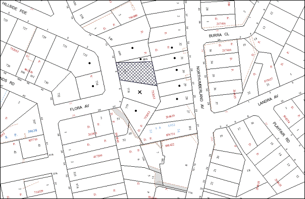
|
NOTIFICATION PLAN |
|
||
|
• PROPERTIES NOTIFIED
|
X SUBMISSIONS RECEIVED |
PROPERTY SUBJECT OF DEVELOPMENT |
|
One submission objected to the development and this has been addressed in the body of the report.
6. THE PUBLIC INTEREST
Section 79C(1)(e) of the Act requires Council to consider “the public interest”.
The public interest is an overarching requirement, which includes the consideration of the matters discussed in this report. Implicit to the public interest is the achievement of future built outcomes adequately responding to and respecting the future desired outcomes expressed in environmental planning instruments and development control plans.
The application is considered to have satisfactorily addressed Council’s and relevant agencies’ criteria and would provide a development outcome that, on balance, would result in a positive impact for the community. Accordingly, it is considered that the approval of the proposed development would be in the public interest.
CONCLUSION
The application proposes staged Torrens title subdivision of one allotment into two lots, demolition of the existing dwelling and construction of two detached dwelling houses.
The application does not comply with the Hornsby Shire Council Local Environmental Plan 1994 with regard to Clause 15 (Floor Space Ratio). The applicant has submitted a State Environmental Planning Policy No. 1 objection to vary the floor space ratio development standard. The objection is considered well founded with regard to the existing development and the principles established by the Land and Environment Court.
Council received one submission in response to notification of the proposed development and this has been addressed in the body of the report.
Having regard to the circumstances of the case and consideration of the SEPP 1 objection, approval of the application is recommended.
Note: At the time of the completion of this planning report, no persons have made a Political Donations Disclosure Statement pursuant to Section 147 of the Environmental Planning and Assessment Act 1979 in respect of the subject planning application.
|
Rod Pickles Manager - Development Assessment Planning Division |
James Farrington Group Manager Planning Division |
|
1.View |
Locality Map |
|
|
|
2.View |
Stage 1 Floor Plan |
|
|
|
3.View |
Floor Plans |
|
|
|
4.View |
Stage 1 Site Plan |
|
|
|
5.View |
Site Plans |
|
|
|
6.View |
Elevations Plans |
|
|
|
7.View |
Demolition Plan |
|
|
File Reference: DA/440/2013
Document Number: D02201944
SCHEDULE 1
GENERAL CONDITIONS
The conditions of consent within this notice of determination have been applied to ensure that the use of the land and/or building is carried out in such a manner that is consistent with the aims and objectives of the relevant legislation, planning instruments and council policies affecting the land and does not disrupt the amenity of the neighbourhood or impact upon the environment.
Note: For the purpose of this consent, the term ‘applicant’ means any person who has the authority to act on or the benefit of the development consent.
Note: For the purpose of this consent, any reference to an Act, regulation, Australian Standard or publication by a public authority shall be taken to mean the gazetted Act or regulation, or adopted Australian Standard or publication as in force on the date that the application for a construction certificate is made.
STAGE 1 – SUBDIVISION AND ASSOCIATED WORKS
1. Approved Plans and Supporting Documentation
The development must be carried out in accordance with the plans and documentation listed below and endorsed with Council’s stamp, except where amended by Council and/or other conditions of this consent:
|
Plan No. |
Drawn by |
Dated |
|
Site Plan – Issue C |
Tranter Enterprises |
30/8/2013 |
|
Site 1 – Existing Floor Plan – Issue A |
Tranter Enterprises |
7/10/2013 |
|
Site Tree Location Plan |
Hornsby Shire Council |
June 2013 |
2. Removal of Existing Trees
This development consent only permits the removal of trees Nos. 1 and 2 as identified on Site Tree Plan prepared by Hornsby Council dated June 2013. The removal of any other trees requires separate approval under Council’s Tree Preservation Order.
REQUIREMENTS PRIOR TO THE ISSUE OF A CONSTRUCTION CERTIFICATE
3. Building Code of Australia
All building work must be carried out in accordance with the relevant requirements of the Building Code of Australia.
4. Contract of Insurance (Residential Building Work)
In the case of residential building work for which the Home Building Act, 1989 requires there to be a contract of insurance in force in accordance with Part 6 of that Act, that such a contract of insurance is in force before any building work authorised to be carried out by the consent commences.
5. Water/Electricity Utility Services
The applicant must submit written evidence of the following service provider requirements:
a) Energy Australia – a letter of consent demonstrating that satisfactory arrangements have been made to service the proposed development.
6. Road Works
Prior to the issue of a Construction Certificate for these works a separate application under the Local Government Act, 1993 and the Roads Act, 1993 must be submitted to Council for all works within the road reserve. All road works approved under this consent must be constructed in accordance with Council’s Civil Works Design and Construction Specification, 2005 and the following requirements:
a) Concrete kerb and gutter and pavement shall be constructed along the full frontage of the development site, together with footpath formation, necessary drainage and sealing of road pavement between the existing pavement and lip of the gutter.
b) The kerb and gutter on the northern side of the development site shall be extended beyond the northern boundary up to the stormwater discharge point for the pipe outlet from proposed Lot 1
c) The existing road pavement to be saw cut a minimum of 300 mm from the existing edge of the bitumen and reconstructed.
Note: A construction certificate shall be obtained prior to the commencement of these works and are to be completed prior to the issue of a subdivision certificate.
REQUIREMENTS PRIOR TO THE COMMENCEMENT OF ANY WORKS
7. Erection of Construction Sign
A sign must be erected in a prominent position on any site on which building work, subdivision work or demolition work is being carried out:
a) Showing the name, address and telephone number of the principal certifying authority for the work;
b) Showing the name of the principal contractor (if any) for any demolition or building work and a telephone number on which that person may be contacted outside working hours; and
c) Stating that unauthorised entry to the work site is prohibited.
Note: Any such sign is to be maintained while the building work, subdivision work or demolition work is being carried out, but must be removed when the work has been completed.
8. Protection of Adjoining Areas
A temporary hoarding, fence or awning must be erected between the work site and adjoining lands before the works begin and must be kept in place until after the completion of the works if the works:
a) Could cause a danger, obstruction or inconvenience to pedestrian or vehicular traffic.
b) Could cause damage to adjoining lands by falling objects.
c) Involve the enclosure of a public place or part of a public place.
Note: Notwithstanding the above, Council’s separate written approval is required prior to the erection of any structure or other obstruction on public land.
9. Toilet Facilities
Toilet facilities must be available or provided at the works site before works begin and must be maintained until the works are completed at a ratio of one toilet for every 20 persons employed at the site. Each toilet must:
a) be a standard flushing toilet connected to a public sewer; or
b) be a temporary chemical closet approved under the Local Government Act, 1993; or
c) have an on-site effluent disposal system approved under the Local Government Act, 1993.
10. Erosion and Sediment Control
Erosion and sediment control measures must be provided and maintained throughout the construction period in accordance with the manual ‘Soils and Construction 2004 (Bluebook)’, the approved plans, Council specifications and to the satisfaction of the principal certifying authority. The erosion and sediment control devices must remain in place until the site has been stabilised and revegetated.
Note: On the spot penalties up to $1,500 may be issued for any non-compliance with this requirement without any further notification or warning.
11. Tree Protection Barriers
Tree protection fencing must be erected around tree numbered 3 to be retained at a four metre setback. The tree fencing must be constructed of 1.8 metre ‘cyclone chainmesh fence’.
12. Traffic Control Plan
A Traffic Control Plan (TCP) must be prepared by a qualified traffic controller in accordance with the Roads & Traffic Authority’s Traffic Control at Worksites Manual 1998 and Australian Standard 1742.3 for all work on a public road and be submitted to Council. The TCP must detail the following:
a) Arrangements for public notification of the works.
b) Temporary construction signage.
c) Permanent post-construction signage.
d) Vehicle movement plans.
e) Traffic management plans.
f) Pedestrian and cyclist access/safety.
REQUIREMENTS DURING CONSTRUCTION
13. Construction Work Hours
All work on site (including demolition and earth works) must only occur between 7am and 5pm Monday to Saturday. No work is to be undertaken on Sundays or public holidays.
14. Environmental Management
The site must be managed in accordance with the publication ‘Managing Urban Stormwater – Landcom (March 2004) and the Protection of the Environment Operations Act 1997 by way of implementing appropriate measures to prevent sediment run-off, excessive dust, noise or odour emanating from the site during the construction of the development.
15. Street Sweeping
Street sweeping must be undertaken following sediment tracking from the site along May Street during works and until the site is established.
16. Works Near Trees
All required tree protection measures are to be maintained in good condition for the duration of the construction period.
The applicant is to ensure that no excavation, filling or stockpiling of building materials, parking of vehicles or plant, disposal of cement slurry, waste water or other contaminants is to occur within 4 metres of any tree to be retained.
REQUIREMENTS PRIOR TO THE ISSUE OF A SUBDIVISION CERTIFICATE
Note: For the purpose of this consent, a reference to ‘occupation certificate’ shall not be taken to mean an ‘interim occupation certificate’ unless otherwise stated.
17. Sydney Water – s73 Certificate
An s73 Certificate must be obtained from Sydney Water.
18. Damage to Council Assets
Any damage caused to Council’s assets as a result of the construction of the development must be rectified in accordance with Council’s written requirements and at the sole cost of the applicant.
19. Works as Executed Plan
A works-as-executed plan(s) must be prepared by a registered surveyor and submitted to Council for completed road pavement, kerb & gutter, public drainage systems, driveways and on-site detention system. The plan(s) must be accompanied by a certificate from a registered surveyor certifying that all pipelines and associated structures lie wholly within any relevant easements.
20. Creation of Easements
The following matter must be nominated on the plan of subdivision under s88B of the Conveyancing Act 1919:
a) The creation of a “Positive Covenant” over proposed lots 1 and 2 requiring that any future development is to drain to Flora Avenue and provide an on-site detention system. The on-site detention system is to have a storage capacity of 5 cubic metres and a maximum discharge of 8 litres per second into Council’s drainage system in accordance with Council’s prescribed wording.
Note: Council must be nominated as the authority to release, vary or modify any easement, restriction or covenant.
21. Section 94 Development Contributions
In accordance with Section 80A(1) of the Environmental Planning and Assessment Act 1979 and the Hornsby Shire Council Section 94 Development Contributions Plan 2012-2021, the following monetary contributions shall be paid to Council to cater for the increased demand for community infrastructure resulting from the development:
|
Description |
Contribution (4) |
|
Roads |
$740.00 |
|
Open Space and Recreation |
$16,820.00 |
|
Community Facilities |
$2,360.00 |
|
Plan Preparation and Administration |
$80.00 |
|
TOTAL |
$20,000.00 |
being for one additional allotment and a detached dwelling-house on each allotment.
a) If the contributions are not paid within the financial quarter that this consent is granted, the contributions payable will be adjusted in accordance with the provisions of the Hornsby Shire Council Section 94 Development Contributions Plan and the amount payable will be calculated at the time of payment in the following manner:
$CPY = $CDC x CPIPY
CPIDC
Where:
$CPY is the amount of the contribution at the date of Payment.
$CDC is the amount of the contribution as set out in this Development Consent.
CPIPY is the latest release of the Consumer Price Index (Sydney – All Groups) at the date of Payment as published by the ABS.
CPIDC is the Consumer Price Index (Sydney – All Groups) for the financial quarter at the date of this Development Consent.
b) The monetary contributions shall be paid to Council:
i) prior to the issue of the Subdivision Certificate where the development is for subdivision; or
ii) prior to the issue of the first Construction Certificate where the development is for building work; or
iii) prior to issue of the Subdivision Certificate or first Construction Certificate, whichever occurs first, where the development involves both subdivision and building work; or
iv) prior to the works commencing where the development does not require a Construction Certificate or Subdivision Certificate.
It is the professional responsibility of the Principal Certifying Authority to ensure that the monetary contributions have been paid to Council in accordance with the above timeframes.
Council’s Development Contributions Plan may be viewed at www.hornsby.nsw.gov.au or a copy may be inspected at Council’s Administration Centre during normal business hours.
22. Maintain Canopy Cover
To maintain canopy cover, two medium to large trees selected from Council’s booklet ‘Indigenous Plants for the Bushland Shire’ are to be planted on the subject site. The planting location shall not be within 4 metres of the foundation walls of a dwelling or in-ground pool.
Trees must be native to Hornsby Shire and have the potential to reach a mature height greater than twelve metres (12m).
The pot size is to be a minimum 25 litres and the tree(s) must be maintained until they reach the height of three metres (3m).
Plantings that fail to survive or do not exhibit normal health and vigour growth characteristics for their species prior to reaching a height greater than three metres (3m), must be replaced at the expense of the property owner.
STAGE 2 – CONSTRUCTION OF TWO DETACHED DWELLINGS
23. Approved Plans and Supporting Documentation
The development must be carried out in accordance with the plans and documentation listed below and endorsed with Council’s stamp, except where amended by Council and/or other conditions of this consent:
|
Plan No. |
Drawn by |
Dated |
|
Demolition Plan |
Tranter Enterprises |
30/8/2013 |
|
Site 1 – Ground Floor Plan – Issue C |
Tranter Enterprises |
30/8/2013 |
|
Site 1 – Upper and Lower Floor Plan – Issue B |
Tranter Enterprises |
11/7/2013 |
|
Site 1 – Rear/North Elevations – Issue B |
Tranter Enterprises |
11/7/2013 |
|
Site 1 – Front/South Elevations – Issue A |
Tranter Enterprises |
18/2/2013 |
|
Site 1 – Section |
Tranter Enterprises |
18/2/2013 |
|
Site 1 – Landscape Plan – Issue C |
Tranter Enterprises |
30/08/2013 |
|
Site 1 – Roof Plan – Issue C |
Tranter Enterprises |
30/8/2013
|
|
Site 2 – Ground Floor Plan – Issue C |
Tranter Enterprises |
30/8/2013 |
|
Site 2 Upper and Lower Floor – Issue – B |
Tranter Enterprises |
18/8/2013 |
|
Screening Strategy – Issue A |
Tranter Enterprises |
17/8/2012 |
|
Site 2 – Front/South Elevations – Issue – B |
Tranter Enterprises |
18/8/2013 |
|
Site 2 - South/Rear Elevations – Issue – B |
Tranter Enterprises |
18/8/2013 |
|
Site 2 – Section |
Tranter Enterprises |
18/8/2013 |
|
Site 2 – Landscape Plan – Issue C |
Tranter Enterprises |
30/8/2013 |
|
Site 2 – Roof Plan – Issue C |
Tranter Enterprises |
30/8/2013 |
Supporting Documentation
|
Plan No. |
Drawn by |
Dated |
|
BASIX Certificate Nos. 468631S and 468596S |
Noa Tranter |
2/4/2013 |
|
Stormwater Management Plan – SWO1 – Issue D |
RPG Engineers |
February 2013 |
|
Stormwater Management Plan – SWO2 – Issue D |
RPG Engineers |
February 2013 |
24. Amendment of Plans
The approved plans are to be amended as follows:
a) Privacy screening to a height of 1.8m is to be provided on the proposed dwelling on Lot 2 as marked in red on the approved Ground Floor Plan and Upper and Lower Floor Plan.
REQUIREMENTS PRIOR TO THE ISSUE OF A CONSTRUCTION CERTIFICATE
25. Building Code of Australia
All building work must be carried out in accordance with the relevant requirements of the Building Code of Australia.
26. Contract of Insurance (Residential Building Work)
In the case of residential building work for which the Home Building Act, 1989 requires there to be a contract of insurance in force in accordance with Part 6 of that Act, that such a contract of insurance is in force before any building work authorised to be carried out by the consent commences.
27. Notification of Home Building Act, 1989 Requirements
Residential building work within the meaning of the Home Building Act, 1989 must not be carried out unless the principal certifying authority for the development to which the work relates (not being Council) has given Council written notice of the following information:
a) In the case of work for which a principal contractor is required to be appointed:
i) The name and licence number of the principal contractor; and
ii) The name of the insurer by which the work is insured under Part 6 of that Act.
b) In the case of work to be done by an owner-builder:
i) The name of the owner-builder and;
ii) If the owner-builder is required to hold an owner-builder’s permit under that Act, the number of the owner-builder’s permit.
Note: If arrangements for doing the residential building work are changed while the work is in progress so that the information notified becomes out of date, further work must not be carried out unless the principal certifying authority for the development to which the work relates (not being Council) has given Council written notification of the updated information.
28. Stormwater Drainage – Dwellings
The stormwater drainage system for the development must be designed and constructed for an average recurrence interval of 20 years and be gravity drained in accordance with the following requirements:
a) Be generally in accordance with Drawing No. SW01 and SW 02 Issue D by RPG Engineers for the respective lot.
b) Connected directly to Council’s street drainage system.
c) The surface runoff form the proposed driveway area for both lots shall be drained to the kerb and gutter in Flora Avenue.
Note: A construction certificate shall be obtained prior to the commencement of these works and are to be completed prior to the issue of an occupation certificate.
29. On Site Stormwater Detention
An on-site stormwater detention system must be designed by a chartered civil engineer and constructed in accordance with the following requirements:
a) Be generally in accordance with Drawing No. SW01 and SW 02 Issue D by RPG Engineers for their respective lot.
b) Have a capacity of not less than 5 cubic metres, and a maximum discharge (when full) of 8 litres per second.
c) Have a surcharge/inspection grate located directly above the outlet.
d) Discharge from the detention system to be controlled via 1 metre length of pipe, not less than 50 millimetres diameter or via a stainless plate with sharply drilled orifice bolted over the face of the outlet discharging into a larger diameter pipe capable of carrying the design flow to an approved Council system.
e) Where above ground and the average depth is greater than 0.3 metres, a ‘pool type’ safety fence and warning signs to be installed.
f) Not be constructed in a location that would impact upon the visual or recreational amenity of residents.
Note: A construction certificate shall be obtained prior to the commencement of these works and are to be completed prior to the issue of an occupation certificate.
30. Internal Driveway/Vehicular Areas
The driveway and parking areas on site must be designed in accordance with Australian Standards 2890.1, 2890.2, 3727 and the following requirements:
a) Design levels at the front boundary must be obtained from Council;
b) The driveway must be a rigid pavement;
c) The driveway grade must not exceed 25 percent and changes in grade must not exceed 8 percent per plan metre.
Note: A construction certificate shall be obtained prior to the commencement of these works and are to be completed prior to the issue of an occupation certificate.
REQUIREMENTS PRIOR TO THE COMMENCEMENT OF ANY WORKS
31. Erection of Construction Sign
A sign must be erected in a prominent position on any site on which building work, subdivision work or demolition work is being carried out:
a) Showing the name, address and telephone number of the principal certifying authority for the work;
b) Showing the name of the principal contractor (if any) for any demolition or building work and a telephone number on which that person may be contacted outside working hours; and
c) Stating that unauthorised entry to the work site is prohibited.
Note: Any such sign is to be maintained while the building work, subdivision work or demolition work is being carried out, but must be removed when the work has been completed.
32. Protection of Adjoining Areas
A temporary hoarding, fence or awning must be erected between the work site and adjoining lands before the works begin and must be kept in place until after the completion of the works if the works:
a) Could cause a danger, obstruction or inconvenience to pedestrian or vehicular traffic.
b) Could cause damage to adjoining lands by falling objects.
c) Involve the enclosure of a public place or part of a public place.
Note: Notwithstanding the above, Council’s separate written approval is required prior to the erection of any structure or other obstruction on public land.
33. Toilet Facilities
Toilet facilities must be available or provided at the works site before works begin and must be maintained until the works are completed at a ratio of one toilet for every 20 persons employed at the site. Each toilet must:
a) be a standard flushing toilet connected to a public sewer; or
b) be a temporary chemical closet approved under the Local Government Act, 1993; or
c) have an on-site effluent disposal system approved under the Local Government Act, 1993.
34. Erosion and Sediment Control
Erosion and sediment control measures must be provided and maintained throughout the construction period in accordance with the manual ‘Soils and Construction 2004 (Bluebook)’, the approved plans, Council specifications and to the satisfaction of the principal certifying authority. The erosion and sediment control devices must remain in place until the site has been stabilised and revegetated.
Note: On the spot penalties up to $1,500 may be issued for any non-compliance with this requirement without any further notification or warning.
35. Tree Protection Barriers
Tree protection fencing must be erected around tree numbered 3 to be retained at a four metre setback. The tree fencing must be constructed of 1.8 metre ‘cyclone chainmesh fence; and
REQUIREMENTS DURING CONSTRUCTION
36. Construction Work Hours
All work on site (including demolition and earth works) must only occur between 7am and 5pm Monday to Saturday. No work is to be undertaken on Sundays or public holidays.
37. Demolition
All demolition work must be carried out in accordance with “Australian Standard 2601-2001 – The Demolition of Structures” and the following requirements:
a) Demolition material must be disposed of to an authorised recycling and/or waste disposal site and/or in accordance with an approved waste management plan;
b) Demolition works, where asbestos material is being removed, must be undertaken by a contractor that holds an appropriate licence issued by WorkCover NSW in accordance with Chapter 10 of the Occupational Health and Safety Regulation 2001 and Clause 29 of the Protection of the Environment Operations (Waste) Regulation 2005; and
c) On construction sites where buildings contain asbestos material, a standard commercially manufactured sign containing the words ‘DANGER ASBESTOS REMOVAL IN PROGRESS’ measuring not less than 400mm x 300mm must be erected in a prominent position visible from the street.
38. Environmental Management
The site must be managed in accordance with the publication ‘Managing Urban Stormwater – Landcom (March 2004) and the Protection of the Environment Operations Act 1997 by way of implementing appropriate measures to prevent sediment run-off, excessive dust, noise or odour emanating from the site during the construction of the development.
39. Street Sweeping
Street sweeping must be undertaken following sediment tracking from the site along Flora Avenue during works and until the site is established.
40. Works Near Trees
All required tree protection measures are to be maintained in good condition for the duration of the construction period.
The applicant is to ensure that no excavation, filling or stockpiling of building materials, parking of vehicles or plant, disposal of cement slurry, waste water or other contaminants is to occur within 4 metres of any tree to be retained.
41. Council Property
During construction works, no building materials, waste, machinery or related matter is to be stored on the road or footpath. The public reserve must be kept in a clean, tidy and safe condition at all times.
42. Landfill
Landfill must be constructed in accordance with Council’s ‘Construction Specification, 2005’ and the following requirements:
a) All fill material imported to the site is to wholly consist of Virgin Excavated Natural Material (VENM) as defined in Schedule 1 of the Protection of the Environment Operations Act 1997 or a material approved under the Department of Environment and Climate Change’s general resource recovery exemption.
b) A compaction certificate is to be obtained from a geotechnical engineer verifying that the specified compaction requirements have been met.
43. Excavated Material
All excavated material removed from the site must be classified in accordance with the Department of Environment, Climate Change and Water NSW Waste Classification Guidelines prior to disposal to an approved waste management facility and reported to the principal certifying authority.
44. Survey Report – Finished Floor Level
A report(s) must be prepared by a registered surveyor and submitted to the principal certifying authority prior to the pouring of concrete at each level of the building certifying that:
a) The building, retaining walls and the like have been correctly positioned on the site; and
b) The finished floor level(s) are in accordance with the approved plans.
REQUIREMENTS PRIOR TO THE ISSUE OF AN OCCUPATION OR SUBDIVISION CERTIFICATE
Note: For the purpose of this consent, a reference to ‘occupation certificate’ shall not be taken to mean an ‘interim occupation certificate’ unless otherwise stated.
45. Fulfilment of BASIX Commitments
The applicant must demonstrate the fulfilment of BASIX commitments pertaining to the development.
46. Creation of Easements
The following matter(s) must be nominated on the plan of subdivision under s88B of the Conveyancing Act 1919:
a) The creation of an appropriate "Positive Covenant" and "Restriction as to User" over the constructed on-site detention/retention systems and outlet works, within the lots in favour of Council in accordance with Council’s prescribed wording. The position of the on-site detention system is to be clearly indicated on the title.
b) To register the OSD easement, the restriction on the use of land “works-as-executed” details of the on-site-detention system must be submitted verifying that the required storage and discharge rates have been constructed in accordance with the design requirements. The details must show the invert levels of the on site system together with pipe sizes and grades. Any variations to the approved plans must be shown in red on the “works-as-executed” plan and supported by calculations.
Note: Council must be nominated as the authority to release, vary or modify any easement, restriction or covenant.
- END OF CONDITIONS -
ADVISORY NOTES
The following information is provided for your assistance to ensure compliance with the Environmental Planning and Assessment Act, 1979, Environmental Planning and Assessment Regulation 2000, other relevant legislation and Council’s policies and specifications. This information does not form part of the conditions of development consent pursuant to Section 80a of the Act.
Environmental Planning and Assessment Act, 1979 Requirements
The Environmental Planning and Assessment Act, 1979 requires:
· The issue of a construction certificate prior to the commencement of any works. Enquiries can be made to Council’s Customer Services Branch on 9847 6760.
· A principal certifying authority to be nominated and Council notified of that appointment prior to the commencement of any works.
· Council to be given at least two days written notice prior to the commencement of any works.
· Mandatory inspections of nominated stages of the construction inspected.
· An occupation certificate to be issued before occupying any building or commencing the use of the land.
Long Service Levy
In accordance with Section 34 of the Building and Construction Industry Long Service Payments Act 1986, a ‘Long Service Levy’ must be paid to the Long Service Payments Corporation or Hornsby Council.
Note: The rate of the Long Service Levy is 0.35% of the total cost of the work.
Note: Hornsby Council requires the payment of the Long Service Levy prior to the issue of a construction certificate.
Tree Preservation Order
To ensure the maintenance and protection of the existing natural environment, it is an offence to ringbark, cut down, top, lop, remove, wilfully injure or destroy a tree outside 3 metres of the approved building envelope without the prior written consent from Council.
Note: A tree is defined as a single or multi-trunked wood perennial plant having a height of not less than three (3) metres, and which develops many branches, usually from a distance of not less than one (1) metre from the ground, but excluding any plant which, in its particular location, is a noxious plant declared as such pursuant to the Noxious Weeds Act 1993. This definition of ‘tree’ includes any and all types of Palm trees.
All distances are determined under Australian Standard AS4970-2009 ”Protection of Trees on Development Sites”.
Fines may be imposed for non-compliance with Council’s Tree Preservation Order.
Fees and Charges – Subdivision
All fees payable to Council as part of any construction, compliance or subdivision certificate or inspection associated with the development (including the registration of privately issued certificates) are required to be paid in full prior to the issue of the subdivision certificate. Any additional Council inspections beyond the scope of any compliance certificate required to verify compliance with the terms of this consent will be charged at the individual inspection rate nominated in Council's Fees and Charges Schedule.
Group Manager’s Report No. PL81/13
Planning Division
Date of Meeting: 20/11/2013
13 DEVELOPMENT APPLICATION - DWELLING-HOUSE - 1B MARY STREET, BEECROFT
EXECUTIVE SUMMARY
|
DA No: |
DA/498/2013 (Lodged 17 May 2013) |
|
Description: |
Erection of a two storey dwelling-house on a vacant allotment |
|
Property: |
Lot 2 DP 1168541, No. 1B Mary Street, Beecroft |
|
Applicant: |
Rawson Homes Pty Ltd – North Strathfield |
|
Owner: |
Mr Adam Robert Oslen, Mr Robert High Olsen and Mrs Margaret Amy Olsen |
|
Estimated Value: |
$401,690 |
|
Ward: |
C |
· The application proposes erection of two-storey dwelling-house on a vacant allotment.
· The proposed dwelling-house would exceed the maximum 0.4:1 floor space ratio development standard of the Hornsby Shire Local Environmental Plan 1994. The applicant has made a submission pursuant to State Environmental Planning Policy No. 1 (Development Standards) to vary the standard. The submission is considered well founded and is supported.
· Three submissions have been received in respect of the application.
· It is recommended that the application be approved.
|
THAT Council assume the concurrence of the Director-General of the Department of Planning and Infrastructure pursuant to State Environmental Planning Policy No. 1 and approve Development Application No. DA/498/2013 for the erection of a dwelling-house at Lot 2 DP 1168541, No. 1B Mary Street, Beecroft subject to the conditions of consent detailed in Schedule 1 of Group Manager’s Report No. PL81/13. |
BACKGROUND
On 10 December 1999, Council granted consent (DA/1173/1999) for subdivision of one allotment into two allotments at No. 100 Beecroft Road, Beecroft, resulting in a new vacant lot (namely 1B Mary Street).
On 17 May 2013, an application was lodged for the erection of a two-storey dwelling-house on the vacant lot. The application is subject of this report.
On 3 October 2013, the applicant submitted amended plans addressing heritage concerns raised by Council in relation to front setback, landscaping and size and width of the first floor verandah.
SITE
The site has an area of 601.1m2 and is located on the southern side of Mary Street, Beecroft. The site is currently vacant. The site is generally flat with a gentle fall towards the rear, south-western corner.
The site is located within the Beecroft/Cheltenham Heritage Conservation Area listed under the provisions of Schedule E (Heritage Conservation Areas) of the HSLEP 1994. The property forms part of the property description for a heritage item Vintage Cellars Building adjacent to the subject property at No. 100 Beecroft Road.
The property is also located in the immediate vicinity of the following heritage items of Local significance under the provisions of Schedule D (Heritage Items) of the HSLEP 1994:
· No. 104 Beecroft Road (Nakinda);
· No. 1 Mary Street (Presbyterian Church);
· No. 3 Mary Street (House and Garden); and
· No. 96 Beecroft Road (Beecroft Public School).
There is a sewer line that runs across the rear property boundary.
The surrounding area primarily consists of low density residential dwelling-house with a mix of both single and double storey developments. Beecroft Primary School is located on the opposite side of Mary Street. An aged care facility is located adjacent to the west of the subject site and a commercial facility (Vintage Cellars) is located adjacent to the east of the subject site.
The Beecroft railway station is location approximately 400 metres from the site and there are bus services that operate on Beecroft road.
PROPOSAL
The application proposes the erection of a two storey dwelling-house and associated works. The ground floor level would comprise a porch, entry foyer, lounge, family, dining, kitchen with walk in pantry, double garage, rumpus/theatre and a covered alfresco area. The first floor level would comprise four bedrooms, walk-in-wardrobe, ensuite, bathroom and a leisure room.
The application proposes the installation of an air-conditioning unit, a 3,500 litre rainwater tank, the construction of a driveway and landscape works. The proposal also involves a front boundary fence with a height of 1.5 metres constructed of sand stone cap with rock face edging, masonry brick pier and heritage metal panel colour to match the house.
ASSESSMENT
The development application has been assessed having regard to the ‘Metropolitan Plan for Sydney 2031’, the ‘North Subregion (Draft) Subregional Strategy’ and the matters for consideration prescribed under Section 79C of the Environmental Planning and Assessment Act 1979 (the Act). The following issues have been identified for further consideration.
1. STRATEGIC CONTEXT
1.1 Metropolitan Plan for Sydney and (Draft) North Subregional Strategy
The (Draft) Metropolitan Strategy for Sydney 2031 is a broad framework to provide for Sydney’s growth to help plan for housing, employment, transport, infrastructure, the environment and open space. It outlines a vision for Sydney to 2031; the challenges faced, and the directions to follow to address these challenges and achieve the vision.
The North Subregion comprises Hornsby, Kuring-gai, Manly, Warringah and Pittwater Local Government Areas. The Draft North Subregional Strategy provides a framework for Council in the preparation of the Hornsby LEP 2013.
Within the North Subregion, the Draft Metropolitan Strategy proposes:
· Population growth of 81,000 from the current 2011 baseline of 529,000
· Housing growth of 37,000 from the current 2011 baseline of 204,000
· Employment growth of 39,000 from the current 2011 baseline of 186,000
The proposed development would be consistent with the Metropolitan Plan for Sydney 2031 by providing an additional dwelling contributing to the achievement of Council’s dwelling target.
2. STATUTORY CONTROLS
Section 79C(1)(a) requires Council to consider “any relevant environmental planning instruments, draft environmental planning instruments, development control plans, planning agreements and regulations”.
2.1 Hornsby Shire Local Environmental Plan 1994
The subject land is zoned Residential AS (Low Density – Sensitive Lands) under the Hornsby Shire Local Environmental Plan 1994 (HSLEP). The objectives of the Residential AS zone are:
(a) to provide for the housing needs of the population of the Hornsby area.
(b) to promote a variety of housing types and other land uses compatible with a low density residential environment and sensitive to the land capability and established character of this environment.
(c) to provide for development that is within the environmental capacity of a sensitive low density residential environment.
The proposed development is defined as “dwelling-house” under the HSLEP and is permissible in the Residential AS (Low Density – Sensitive Lands) zone with Council’s consent.
Clause 15 of the HSLEP prescribes that the maximum floor space ratio (FSR) of development within the Residential AS zone is 0.4:1. The proposed development has a FSR of 0.46:1, which does not comply with this standard. To address this matter, the applicant has submitted an objection to the standard under State Environmental Planning Policy No. 1 - Development Standards (SEPP 1), which is assessed in Section 2.3.
2.2 Hornsby Shire Local Environmental Plan 2013
The Hornsby Local Environmental Plan 2013 was made on 27 September 2013 and came into effect on 11 October 2013. The HLEP includes a savings provision stating that if a development application is made and not finally determined before the commencement of the HLEP 2013, the application must be determined as if the Plan had been exhibited but not commenced. The relevant provisions of the HLEP are addressed below.
Under the HLEP, the subject land is zoned R2 (Low Density Residential) and a “dwelling-house” is permissible within the zone with Council’s consent. The HLEP also indicates a maximum building height control of 8.5m applicable to the site. The proposed dwelling-house complies with this control.
2.3 State Environmental Planning Policy No. 1 – Development Standards
The proposed dwelling-house has a gross floor area of 275.8m2 resulting in a floor space ratio (FSR) of 0.46:1. The FSR exceeds the maximum 0.4:1 FSR development standard under the HSLEP 1994.To address the variation to the 0.4:1 development standard, the applicant has made a submission pursuant to SEPP 1.
The application has been assessed against the requirements of SEPP1. This Policy provides flexibility in the application of development standards in circumstances where strict compliance with those standards would, in any particular case, be unreasonable or unnecessary or tend to hinder the attainment of the objectives specified in section 5(a) (i) and (ii) of the Environmental Planning and Assessment Act which states:
‘The objectives of this Act are:
(a) to encourage:
(i) the proper management, development and conservation of natural and artificial resources, including agricultural land, natural areas, forests, minerals, water, cities, towns and villages for the purpose of promoting the social and economic welfare of the community and a better environment,
(ii) the promotion and co-ordination of the orderly and economic use and development of land,’
Where development could, but for any development standard, be carried out under the Act (either with or without the necessity for consent under the Act being obtained therefore) the person intending to carry out that development may make a development application in respect of that development, supported by a written objection that compliance with that development standard is unreasonable or unnecessary in the circumstances of the case, and specifying the grounds of that objection.
The Land and Environment Court has expressed the view that there are 5 different ways in which an objection may be well founded and that approval of the objection may be consistent with the aims of the policy:
1. The objectives of the standard are achieved notwithstanding non-compliance with the standard;
2. The underlying objective or purpose of the standard is not relevant to the development and therefore compliance is unnecessary;
3. The underlying object of purpose would be defeated or thwarted if compliance was required and therefore compliance is unreasonable;
4. The development standard has been virtually abandoned or destroyed by the Council’s own actions in granting consents departing from the standard and hence compliance with the standard is unnecessary and unreasonable;
5. The zoning of the particular land is unreasonable or inappropriate so that a development standard appropriate for that zoning is also unreasonable and unnecessary, as it applies to the land and compliance with the standard would be unreasonable and unnecessary. That is, the particular parcel of land should not have been included in the particular zone.
In regard to whether the objection may be well founded, the applicant contends that:
· In accordance with the Hornsby Shire Local Environment Plan 1994 Clause 15, the current floor space ratio is 0.4:1. The proposed floor space ratio is 0.46:1 would result in a minor variation to the maximum that is permitted by Council of 15%.
· The proposal complies with all the other objectives of Council’s LEP.
· It is to be considered that strict compliance with the development standard is unreasonable and unnecessary as the proposed development meets the objective of the development standard despite the non compliance with the numerical value. The scale of the proposed development provides for the housing needs in today’s market whilst still providing adequate landscaping and open space.
· There is no perceived impact on the streetscape and adjoining properties by the proposed development and it will compliment and blend with the character of the area whilst adhering to the objectives of the zone and the environment.
· The proposed development generally complies with all other controls within the current Development Control Plan.
· Hornsby Council has a new Local Environment Plan 2013 and Development Control Plan 2013 gazetted on 27 September 2013 and came into effect on 11 October 2013. Under these revised planning instruments, the proposed development would be in compliance with the floor area standard of 330m2 with a lot size between 450m2 to 599m2. Given that this is the direction Council is taking, consideration should be given to this proposed development.
· The proposed development complies with the objectives set out in section 5 (a) (i) and (ii). The proposed development will be constructed on an existing allotment which is considered orderly and economic use of the land and proposed development which will not affect the social and economic welfare and environment of the area.
· The objective of the development standard is to be a measure to ensure the dwelling does not have an unreasonable impact on the adjoining properties and streetscape with regards to overshadowing, privacy and visual bulk.
· The proposed dwelling generally complies with all controls within the DCP. Consideration has been given to overshadowing and visual bulk to ensure that there are no unreasonable impacts on adjoining properties. The second storey of the proposed dwelling comprises predominantly bedrooms and bathrooms which are considered low trafficable areas.
The matters listed above have been taken into consideration in assessing the merits of the SEPP 1 objection.
The proposal takes into consideration the environmental and size constraints of the site. The additional floor space would not adversely impact on the environmental and amenity aspects of the site and the underlying objectives of the zone. The dwelling-house would provide accommodation that would not detract from the scale and variety of dwelling-houses in the low density areas of the Shire as the proposal is considered to meet the zone objectives outlined in the HSLEP.
In addition to the above, the proposal has been considered in regard to the provisions of the NSW Housing Code, which provides that the maximum gross floor area for complying development within the low density residential zones of the Shire as 380m2, if the lot has an area of at least 600m2 but less than 900m2. Accordingly, if applicable, the development (having a floor area of 275.8m2) would satisfy the maximum floor area development standard under the NSW Housing Code.
In the instance, the site is located in a Heritage Conservation Area and forms part of the property description for a heritage item Vintage Cellars Building adjacent to the subject property and therefore, the NSW Housing Code does not apply, similar sized allotments within the locality could accommodate a dwelling of 380m2 under the provisions of the NSW Housing Code. However, given that the recently introduced NSW Housing Code is now enacted in many parts of the Shire, it is anticipated that more developments would be approved under this Code, which will change the characteristics of dwelling-houses. Consequently, whilst Council has previously applied a maximum FSR of 0.4:1 for dwelling-houses in the low density residential zones within the Shire under the HSLEP, the introduction of the NSW Housing Code is changing the effect of this standard.
In summary, the additional floor space would not impact on the environmental or amenity aspects of the site or adjacent development. The scale of the development is also consistent with the bulk and scale of developments promoted as being appropriate in low density zones across the State.
Accordingly, the SEPP1 objection is considered well founded and acceptable in this instance.
2.4 Sydney Regional Environmental Plan (Sydney Harbour Catchment) 2005
The site is located within the catchment of the Sydney Harbour Catchment. Sydney Regional Environmental Plan (Sydney Harbour Catchment) 2005 aims to protect the environment of the Sydney Harbour Catchment by ensuring that the impacts of future land uses are considered in a regional context.
Subject to the implementation of sediment and erosion control measures and stormwater management to protect water quality, the proposal would comply with the requirements of the Policy.
2.5 State Environmental Planning Policy (Building Sustainability Index - BASIX) 2004
The application has been assessed against the requirements of State Environmental Planning Policy (Building Sustainability Index: BASIX) 2004. The proposal includes BASIX Certificate No. 482254S for the proposed units and is considered to be satisfactory.
2.6 Section 94 Contribution
A Section 94 contribution was levied when the subject lot was subdivided from No. 100 Beecroft Road under DA/1173/1999. Accordingly, a Section 94 contribution is not applicable to the new dwelling.
2.7 Clause 74BA Environmental Planning and Assessment Act, 1979 - Purpose and Status of Development Control Plans
On 1 March 2013, the Environmental Planning and Assessment Act, 1979 was amended so that a DCP provision will have no effect if it has the practical effect of “preventing or unreasonably restricting development” that is otherwise permitted and complies with the development standards set out in relevant Local Environmental Plans and State Environmental Planning Policies.
The principal purpose of a development control plan is to provide guidance on the aims of any environmental planning instrument that applies to the development; facilitating development that is permissible under any such instrument; and achieving the objectives of land zones under any such instrument. The provisions of a development control plan made for that purpose are not statutory requirements.
2.8 Hornsby Development Control Plan 2013
The Hornsby Development Control Plan (HDCP) 2013 applies to all land within Hornsby Shire and will replace Council’s existing DCPs, providing development controls to complement the HLEP 2013. The HDCP came into effect on 11 October 2013.
The following sections of this report include a detailed assessment of the proposal against Council’s existing DCP controls. Although the HDCP was not in force at the date of lodgement of this application, the development proposal has been assessed against the Plan.
The HDCP is generally a transition of Council’s existing DCPs into a consolidated plan. When assessed against the HDCP, the proposed development would comply with all elements (including floor area) except for the side and rear boundary setbacks and first floor level entertaining area.
The HDCP states that single storey elements of dwelling-houses should have a 900mm side boundary setback with two storey elements having a 1.5 metre side boundary setback. The proposed design includes a two storey element which protrudes from the side elevation towards the eastern boundary with a 950mm side boundary setback, the balance of the dwelling would comply with the prescriptive measures of the Setbacks element.
The first floor level leisure room would not comply with the Privacy element of the HDCP which states that “living and entertaining areas of dwelling houses should be located on the ground floor and orientated towards the private open space of the dwelling house and not side boundaries”. Notwithstanding this, the leisure room would be orientated towards the street and would not have any windows on the side elevations. The ground floor level would have a rumpus, family and dining room located to the rear of the dwelling which would have direct access to the private open space to the rear of the allotment.
The proposal meets the objectives of the HDCP and is considered acceptable.
2.9 Dwelling-House Development Control Plan
The proposed development has been assessed having regard to the relevant performance and prescriptive requirements within Council’s Dwelling House Development Control Plan (Housing DCP). The following table sets out the proposal’s compliance with the prescriptive requirements of the Plan:
|
Dwelling House DCP |
|||
|
Control |
Proposal |
Requirement |
Complies |
|
Floor Space Ratio |
0.46:1 |
0.4:1 |
No |
|
Site Cover |
34% |
40% |
Yes |
|
Setbacks |
|||
|
Front |
6m |
6m |
Yes |
|
Side (east) |
0.95m |
1m |
No |
|
Side (west) |
2.3m |
1m |
Yes |
|
Rear |
7.8m |
3m |
Yes |
|
Design |
|||
|
Height |
7.5m |
<9m |
Yes |
|
Unbroken Wall Length |
8.5m |
10m |
Yes |
|
Building Length |
21.8m |
24m |
Yes |
|
Cut and Fill |
<1m |
1m |
Yes |
|
Private Open Space |
>120m² |
120m² |
Yes |
|
Landscaped Area |
>45% |
45% |
Yes |
|
Car Parking |
|||
|
No. of spaces |
2 spaces |
2 spaces |
Yes |
|
Garage Size |
Double |
Single 3m x 6m Double 6m x 6m |
Yes |
|
Solar Access |
|||
|
Windows to north-facing living rooms on adjoining land |
>3 hours on 22 June |
3 hours on 22 June |
Yes |
|
Private open space on adjoining land |
>4 hours on 22 June |
4 hours on 22 June |
Yes |
As detailed in the above table, the proposed development does not comply with the floor space ratio and side setback prescriptive requirements within Council’s Dwelling Housing DCP. The matters of non-compliance are detailed below, as well as a brief discussion on compliance with relevant performance requirements.
2.9.1 Scale
The proposed development would generate a floor space ratio of 0.46:1 which does not comply with the 0.4:1 prescriptive measure of the Scale element. The matters relating to floor space ratio have been discussed above under Section 2.3 of this report.
2.9.2 Setbacks
The proposed 950mm side boundary setback on the eastern elevation does not comply with the 1 metre prescriptive measure of the Setback element. Notwithstanding this, the minor encroachment is considered acceptable in this instance as there would not be any privacy or overshadowing impacts.
The proposal meets the objectives of the Setbacks element and is considered acceptable.
2.9.3 Solar Access
The Solar Access element states that dwelling-houses should be designed “to allow 3 hours of sunshine to the north-facing windows serving living rooms and 4 hours of sunshine to private open spaces between 9am and 3pm on 22 June (winter solstice)”.
The shadow diagrams submitted indicate that the shadows from the proposed development at 9am on 22 June would be cast over the eastern aspect of the adjoining property at No. 1 Mary Street. The shadow cast at 12 noon would be contained within the subject site.
The shadow cast at 3pm would extend over a portion of the western aspect of the adjoining property at No. 100 Beecroft Road and over a portion of the northern aspect of the adjoining property at No. 102 Beecroft Road and No. 2 Welham Street. However, the proposal would comply with the prescriptive measures of the Solar Access element by maintaining a minimum of 3 hours of solar access to adjacent properties.
2.9.4 Privacy
The proposed first floor level leisure room does not comply with the prescriptive measure of the Privacy element which states that living and entertaining areas should be located on the ground floor level.
The leisure room would be orientated towards the street and would not have any windows facing the side boundaries. As a consequence, the first floor level leisure room would not create any additional privacy impact.
The proposal meets the objectives of the Privacy element and is considered acceptable.
2.9.5 Flora and Fauna Protection
The proposed dwelling-house would be located within the Tree Protection Zone of one significant tree located on the adjoining property at No. 1 Mary Street. The tree is located within 3 metres of an existing approved structure on No. 1 Mary Street and as a result is exempt from Council’s Tree Preservation Order. The applicant has submitted a written consent from the owners of 1 Mary Street stating that they have no objection to the removal of the tree.
2.10 Heritage Development Control Plan
The site is located within the Beecroft/Cheltenham Heritage Conservation Area listed under the provisions of Schedule E (Heritage Conservation Areas) of the HSLEP 1994. The property forms part of the property description for a heritage item Vintage Cellars Building adjacent to the subject property at No. 100 Beecroft Road.
The site is also located in the immediate vicinity of the following heritage items of Local significance under the provisions of Schedule D (Heritage Items) of the HSLEP 1994:
· No. 104 Beecroft Road (Nakinda);
· No. 1 Mary Street (Presbyterian Church);
· No. 3 Mary Street (House and Garden); and
· No. 96 Beecroft Road (Beecroft Public School).
On 3 October 2013, the applicant submitted amended plans addressing heritage concerns raised by Council, which included:
· front setback to be consistent with the existing streetscape;
· a landscape plan to be submitted;
· reduced size and width of the first floor verandah posts to reduce the vertical bulk and scale of the proposed development and introduce a break within the western façade.
The amended plans submitted address the heritage and design issues raised. Accordingly, Council’s heritage assessment of the proposal concludes that the dwelling has been appropriately designed to complement the bulk and scale of the existing development in the surrounding area and the landscape plan provides for a suitable front garden to be planted in character with the surrounding streetscape.
Accordingly, the proposed development would not create an adverse impact on the surrounding heritage items and the character of the heritage conservation area. The proposal meets the objectives of the Heritage Development Control Plan and is considered acceptable.
3. ENVIRONMENTAL IMPACTS
Section 79C(1)(b) of the Act requires Council to consider “the likely impacts of that development, including environmental impacts on both the natural and built environments, and social and economic impacts in the locality”.
3.1 Natural Environment
As discussed above under Section 2.7.5 “Flora and Fauna Protection”, the proposal would have a negligible impact on the natural environment.
3.2 Built Environment
The design of the proposed dwelling-house would not create an adverse impact on the streetscape or built environment in the surrounding area. The proposal would result in a built form consistent with the character of development permissible in the locality.
3.3 Social Impacts
The proposed development would not create any adverse social impacts to the surrounding area.
3.4 Economic Impacts
The proposal would have a minor positive impact on the local economy in conjunction with other new low density residential development in the locality by generating an increase in demand for local services.
4. SITE SUITABILITY
Section 79C(1)(c) of the Act requires Council to consider “the suitability of the site for the development”.
The site is considered to be capable of accommodating the proposed development. The scale of the proposed development is consistent with the capability of the site and is considered acceptable.
5. PUBLIC PARTICIPATION
Section 79C(1)(d) of the Act requires Council to consider “any submissions made in accordance with this Act”.
5.1 Community Consultation
The proposed development was placed on public exhibition and was notified to adjoining and nearby landowners between 23 May 2013 and 6 June 2013 in accordance with Council’s Notification and Exhibition Development Control Plan. During this period, Council received 3 submissions. The map below illustrates the location of those nearby landowners who made a submission that are in close proximity to the development site.
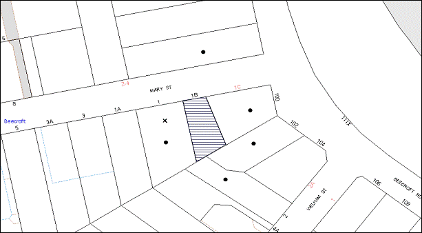
|
NOTIFICATION PLAN |
|
||
|
• PROPERTIES NOTIFIED
|
X SUBMISSIONS RECEIVED |
PROPERTY SUBJECT OF DEVELOPMENT |
|
|
2 SUBMISSIONS RECEIVED OUT OF MAP RANGE |
|||
Three submissions object to the development, generally on the grounds that the development would result in:
· Unacceptable overshadowing of adjoining properties;
· Unacceptable height of the proposed development;
· Design inconsistent with surrounding developments and heritage items; and
· Inaccurate Information.
The merits of the matters raised in community submissions have been addressed in the body of the report with the exception of the following:
5.1.1 Unacceptable Height of the Proposed Development
A submission raises concern about the height of the proposal, expressing the view that the development should be single storey in height.
The prescriptive measures of the Height element in the Dwelling-house DCP states that “two storey dwelling-houses should not exceed 9 metres in height”. The proposed development has a maximum height of 7.5 metres, which complies with this prescriptive measure.
The height of the proposed development is compatible with the surrounding developments, does not create solar access issues and/or any privacy impacts to any of the adjoining properties.
The proposal meets the objectives of the height element and is considered acceptable.
5.1.2 Design Inconsistent with Surrounding Developments and Heritage Items
One submission raises concern in regards to the design of the proposed development being inconsistent with the surrounding developments and heritage items.
The proposed design generally provides a palette of colours and materials sympathetic to the surrounding development. Although the use of painted cladding for the majority of a façade material is not encouraged for the Beecroft Conservation Area, the proposed development is surrounded by buildings of painted brickwork, and the use of painted cladding would not have an adverse impact. The front setback of the proposed development is in line with the existing development within the streetscape. The front façade is appropriately designed to complement the bulk and scale of the surrounding developments.
Furthermore, the applicant has submitted a landscape plan providing suitable landscaping and front garden to be planted in character with the surrounding development.
The proposal meets the objectives of the design element and is considered acceptable.
5.1.3 Inaccurate Information
One submission raises concern in regards to the ‘inaccuracy’ of the shadow diagrams submitted with the Development Application as they incorrectly reference the development at 1 Mary Street, Beecroft, as a ‘two-storey brick residence’ instead of an aged care facility.
The shadow diagrams are considered accurate in relation to providing solar access information. The inaccurate reference of the adjoining development at 1 Mary Street, dos not prevent Council to carry out a full and proper assessment of the proposal.
6. THE PUBLIC INTEREST
Section 79C(1)(e) of the Act requires Council to consider “the public interest”.
The public interest is an overarching requirement, which includes the consideration of the matters discussed in this report. Implicit to the public interest is the achievement of future built outcomes adequately responding to and respecting the future desired outcomes expressed in environmental planning instruments and development control plans.
The application is considered to have satisfactorily addressed Council’s and relevant agencies’ criteria and would provide a development outcome that, on balance, would result in a positive impact for the community. Accordingly, it is considered that the approval of the proposed development would be in the public interest.
CONCLUSION
The application proposes the erection of a two storey dwelling-house and associated works on a vacant allotment.
The application does not comply with the Hornsby Shire Council Local Environmental Plan 1994 in respect to clause 15 ‘Floor Space Ratio’. The applicant submitted a State Environmental Planning Policy No. 1 objection to vary the floor space ratio development standard. The objection is considered well founded with regard to the existing development and the principles established by the Land and Environment Court.
Council received three submissions in response to notification of the proposed development. The matters raised have been addressed in the body of the report.
Having regard to the circumstances of the case and consideration of the SEPP 1 objection, approval of the application is recommended.
Note: At the time of the completion of this planning report, no persons have made a Political Donations Disclosure Statement pursuant to Section 147 of the Environmental Planning and Assessment Act 1979 in respect of the subject planning application.
|
Rod Pickles Manager - Development Assessment Planning Division |
James Farrington Group Manager Planning Division |
|
1.View |
Locality Map |
|
|
|
2.View |
Site Plan |
|
|
|
3.View |
Floor Plans |
|
|
|
4.View |
Elevations and Sections |
|
|
|
5.View |
Sediment Control Plan |
|
|
|
6.View |
Shadow Diagram |
|
|
|
7.View |
Landscape Plans |
|
|
File Reference: DA/498/2013
Document Number: D02345649
SCHEDULE 1
GENERAL CONDITIONS
The conditions of consent within this notice of determination have been applied to ensure that the use of the land and/or building is carried out in such a manner that is consistent with the aims and objectives of the relevant legislation, planning instruments and Council policies affecting the land and does not disrupt the amenity of the neighbourhood or impact upon the environment.
Note: For the purpose of this consent, the term ‘applicant’ means any person who has the authority to act on or the benefit of the development consent.
Note: For the purpose of this consent, any reference to an Act, Regulation, Australian Standard or publication by a public authority shall be taken to mean the gazetted Act or Regulation, or adopted Australian Standard or publication as in force on the date that the application for a construction certificate is made.
1. Approved Plans And Supporting Documentation
The development must be carried out in accordance with the plans and documentation listed below and endorsed with Council’s stamp, except where amended by Council and/or other conditions of this consent:
|
Plan No. |
Drawn by |
Dated |
|
Site Plan DRWG No. 2 (Issue C) |
Rawson Homes |
22.03.12 |
|
Ground Floor Plan DRWG No. 3 (Issue C) |
Rawson Homes |
22.03.12 |
|
First Floor Plan DRWG No. 4 (Issue C) |
Rawson Homes |
22.03.12 |
|
Elevations 1-2 DRWG No. 5 (Issue C) |
Rawson Homes |
22.03.12 |
|
Elevations 3-4 DRWG No. 6 (Issue C) |
Rawson Homes |
22.03.12 |
|
Section DRWG No. 7 (Issue C) |
Rawson Homes |
18.04.13 |
|
Sediment Control Plan DRWG No. 10 (Issue C) |
Rawson Homes |
18.04.13 |
|
Shadow Diagram DRWG No. 11 (Issue C) |
Rawson Homes |
18.04.13 |
|
Landscape Plan (2 sheets) (Issue DA) |
Daniell, Dagger Design Landscapes |
Undated |
|
Document No. |
Prepared by |
Dated |
|
Statement of Environmental Effects |
Local Consultancy Services Pty Ltd |
May 2013 |
|
SEPP 1 Objection – Floor Space Ration |
Local Consultancy Services Pty Ltd |
May 2013 |
|
Waste Management Plan |
Rawson Homes |
09.05.13 |
|
BASIX Certificate – 482254S |
Energy Ratings Australia Pty Ltd |
10 May 2013 |
|
External Colour Selections |
Rawson Homes |
Undated |
REQUIREMENTS PRIOR TO THE ISSUE OF A CONSTRUCTION CERTIFICATE
2. Building Code of Australia
All building work must be carried out in accordance with the relevant requirements of the Building Code of Australia.
3. Contract of Insurance (Residential Building Work)
In the case of residential building work for which the Home Building Act, 1989 requires there to be a contract of insurance in force in accordance with Part 6 of that Act, that such a contract of insurance is in force before any building work authorised to be carried out by the consent commences.
4. Notification of Home Building Act, 1989 Requirements
Residential building work within the meaning of the Home Building Act, 1989 must not be carried out unless the principal certifying authority for the development to which the work relates (not being Council) has given Council written notice of the following information:
a) In the case of work for which a principal contractor is required to be appointed:
i) The name and licence number of the principal contractor; and
ii) The name of the insurer by which the work is insured under Part 6 of that Act.
b) In the case of work to be done by an owner-builder:
i) The name of the owner-builder; and
ii) If the owner-builder is required to hold an owner-builder’s permit under that Act, the number of the owner-builder’s permit.
Note: If arrangements for doing the residential building work are changed while the work is in progress so that the information notified becomes out of date, further work must not be carried out unless the principal certifying authority for the development to which the work relates (not being Council) has given Council written notification of the updated information.
5. Sydney Water – Quick Check
This application must be submitted to a Sydney Water ‘Quick Check Agent’ or ‘Customer Centre’ for approval to determine whether the development would affect any Sydney Water infrastructure, and whether further requirements are to be met.
Note: Refer to www.sydneywater.com.au or telephone 13 20 92 for assistance.
6. Stormwater Drainage – Dwellings
The stormwater drainage system for the development must be designed and constructed for an average recurrence interval of 20 years and be gravity drained in accordance with the following requirements:
a) Rooflines and above ground areas are to be connected to the proposed on-site detention and water harvesting system, and thereafter to the Council-controlled drainage system in Mary Street.
b) Ground level paved and landscaped areas are to be drained directly to the Council-controlled drainage system in Mary Street.
7. On Site Stormwater Detention
An on-site stormwater detention system must be designed by a chartered civil engineer and constructed in accordance with the following requirements:
a) Have a capacity of not less than 5 cubic metres, and a maximum discharge (when full) of 8 litres per second.
b) Have a surcharge/inspection grate located directly above the outlet.
c) Discharge from the detention system to be controlled via 1 metre length of pipe, not less than 50 millimetres diameter or via a stainless plate with sharply drilled orifice bolted over the face of the outlet discharging into a larger diameter pipe capable of carrying the design flow to an approved Council system.
d) Where designed and constructed above ground and the average depth is greater than 0.3 metres, a ‘pool type’ safety fence and warning signs to be installed.
e) Not be constructed in a location that would impact upon the visual or recreational amenity of residents.
REQUIREMENTS PRIOR TO THE COMMENCEMENT OF ANY WORKS
8. Erection of Construction Sign
A sign must be erected in a prominent position on any site on which building work, subdivision work or demolition work is being carried out:
a) Showing the name, address and telephone number of the principal certifying authority for the work;
b) Showing the name of the principal contractor (if any) for any demolition or building work and a telephone number on which that person may be contacted outside working hours; and
c) Stating that unauthorised entry to the work site is prohibited.
Note: Any such sign is to be maintained while the building work, subdivision work or demolition work is being carried out, but must be removed when the work has been completed.
9. Toilet Facilities
Toilet facilities must be available or provided at the works site before works begin and must be maintained until the works are completed at a ratio of one toilet for every 20 persons employed at the site. Each toilet must:
a) be a standard flushing toilet connected to a public sewer; or
b) be a temporary chemical closet approved under the Local Government Act, 1993; or
c) have an on-site effluent disposal system approved under the Local Government Act, 1993.
10. Erosion and Sediment Control
Erosion and sediment control measures must be provided and maintained throughout the construction period in accordance with the manual ‘Soils and Construction 2004 (Bluebook)’, the approved plans, Council specifications and to the satisfaction of the principal certifying authority. The erosion and sediment control devices must remain in place until the site has been stabilised and revegetated.
Note: On the spot penalties up to $1,500 may be issued for any non-compliance with this requirement without any further notification or warning.
REQUIREMENTS DURING CONSTRUCTION
11. Construction Work Hours
All work on site (including demolition and earth works) must only occur between 7am and 5pm Monday to Saturday. No work is to be undertaken on Sundays or public holidays.
12. Council Property
During construction works, no building materials, waste, machinery or related matter is to be stored on the road or footpath. The public reserve must be kept in a clean, tidy and safe condition at all times.
13. Disturbance of Existing Site
During construction works, the existing ground levels of open space areas and natural landscape features, (including natural rock-outcrops, vegetation, soil and watercourses) must not be altered unless otherwise nominated on the approved plans.
14. Survey Report – Finished Floor Level
A report(s) must be prepared by a registered surveyor and submitted to the principal certifying authority prior to the pouring of concrete at each level of the building certifying that:
a) The building, retaining walls and the like have been correctly positioned on the site; and
b) The finished floor level(s) are in accordance with the approved plans.
REQUIREMENTS PRIOR TO THE ISSUE OF AN OCCUPATION CERTIFICATE
Note: For the purpose of this consent, a reference to ‘occupation certificate’ shall not be taken to mean an ‘interim occupation certificate’ unless otherwise stated.
15. Fulfilment of BASIX Commitments
The applicant must demonstrate the fulfilment of BASIX commitments pertaining to the development.
16. Internal Driveway/Vehicular Areas
The driveway and parking areas on site must be designed in accordance with Australian Standards 2890.1, 2890.2, 3727.
17. Vehicular Crossing
A separate application under the Local Government Act, 1993 and the Roads Act, 1993 must be submitted to Council for the installation of a new vehicular crossing and the removal of the redundant crossing. The vehicular crossing must be constructed in accordance with Council’s Civil Works Design, 2005.
Note: An application for a vehicular crossing can only be made to one of Council’s Authorised Vehicular Crossing Contractors. You are advised to contact Council on 02 9847 6940 to obtain a list of contractors.
18. Damage to Council Assets
Any damage caused to Council’s assets as a result of the construction of the development must be rectified in accordance with Council’s written requirements and at the sole cost of the applicant.
19. Creation of Easements
The following matter(s) must be nominated on the plan of subdivision under s88 of the Conveyancing Act 1919:
a) The creation of an appropriate "Positive Covenant" and "Restriction as to User" over the constructed on-site detention/retention systems and outlet works, within the lots in favour of Council in accordance with Council’s prescribed wording. The position of the on-site detention system is to be clearly indicated on the title.
b) To register the OSD easement, the restriction on the use of land “works-as-executed” details of the on-site-detention system must be submitted verifying that the required storage and discharge rates have been constructed in accordance with the design requirements. The details must show the invert levels of the on site system together with pipe sizes and grades. Any variations to the approved plans must be shown in red on the “works-as-executed” plan and supported by calculations.
Note: Council must be nominated as the authority to release, vary or modify any easement, restriction or covenant.
20. Installation of Air Conditioner
To protect the amenity of adjacent properties, the condenser unit for the air conditioner must be sited a minimum of 3 metres from the property boundary of any adjoining residential premises unless a certificate has been prepared by a suitably qualified person confirming that the unit has been tested for heating and cooling on the highest settings and that the noise levels generated do not exceed 5 dB(A) above background noise levels when tested at the property boundary between 8 pm and 10 pm.
- END OF CONDITIONS -
ADVISORY NOTES
The following information is provided for your assistance to ensure compliance with the Environmental Planning and Assessment Act, 1979, Environmental Planning and Assessment Regulation 2000, other relevant legislation and Council’s policies and specifications. This information does not form part of the conditions of development consent pursuant to Section 80A of the Act.
Environmental Planning and Assessment Act, 1979 Requirements
The Environmental Planning and Assessment Act, 1979 requires:
· The issue of a construction certificate prior to the commencement of any works. Enquiries can be made to Council’s Customer Services Branch on 9847 6760;
· a principal certifying authority to be nominated and Council notified of that appointment prior to the commencement of any works;
· Council to be given at least two days written notice prior to the commencement of any works;
· mandatory inspections of nominated stages of the construction inspected; and
· an occupation certificate to be issued before occupying any building or commencing the use of the land.
Long Service Levy
In accordance with Section 34 of the Building and Construction Industry Long Service Payments Act 1986, a ‘Long Service Levy’ must be paid to the Long Service Payments Corporation or Hornsby Council.
Note: The rate of the Long Service Levy is 0.35% of the total cost of the work.
Note: Hornsby Council requires the payment of the Long Service Levy prior to the issue of a construction certificate.
Tree Preservation Order
To ensure the maintenance and protection of the existing natural environment, it is an offence to ringbark, cut down, top, lop, remove, wilfully injure or destroy a tree outside 3 metres of the approved building envelope without the prior written consent from Council.
Note: A tree is defined a s a single or multi-trunked wood perennial plant having a height of not less than three (3) metres, and which develops many branches, usually form a distance of not less than one (1) metre from the ground, but excluding any plant which, in its particular location, is a noxious plant declared as such pursuant to the Noxious Weeds Act 1993. This definition of ‘tree’ includes any and all types of Palm trees.
All distances are determined under Australian Standard AS4970-2009 “Protection of Trees on Development Sites”.
Fines may be imposed for non-compliance with Council’s Tree Preservation Order.
Dial Before You Dig
Prior to commencing any works, the applicant is encouraged to contact Dial Before You Dig on 1100 or www.dialbeforeyoudig.com.au for free information on potential underground pipes and cables within the vicinity of the development site.
Asbestos Warning
Should asbestos or asbestos products be encountered during demolition or construction works, you are advised to seek advice and information prior to disturbing this material. It is recommended that a contractor holding an asbestos-handling permit (issued by WorkCover NSW) be engaged to manage the proper handling of this material. Further information regarding the safe handling and removal of asbestos can be found at:
Alternatively, telephone the WorkCover Asbestos and Demolition Team on 8260 5885.
Group Manager’s Report No. PL94/13
Planning Division
Date of Meeting: 20/11/2013
14 DEVELOPMENT APPLICATION - TEN STOREY MIXED USE DEVELOPMENT COMPRISING 73 RESIDENTIAL UNITS - 258 AND 262-264 PENNANT HILLS ROAD, THORNLEIGH
EXECUTIVE SUMMARY
|
DA No: |
DA/691/2013 (Lodged 5 July 2013) |
|
Description: |
Ten storey mixed use residential flat development comprising 73 residential units and 5 commercial units and demolition of existing structures |
|
Property: |
Lot 19 DP 836230, Lot 18 DP 836230, Nos. 258 and 262-264 Pennant Hills Road, Thornleigh |
|
Applicant: |
Ezzy Architects Pty Ltd |
|
Owner: |
Darren Ching Bong Kwan and Angela Kam Mun Kwan |
|
Estimated Value: |
$19,984,000 |
|
Ward: |
C |
· The application proposes the erection of a ten storey mixed use residential flat development comprising 73 residential units and 5 commercial units and demolition of existing structures.
· The proposal complies with the Hornsby Shire Local Environmental Plan 1994, State Environmental Planning Policy No. 65 – Design Quality of Residential Flat Development and the Hornsby Shire Housing Strategy Development Control Plan.
· One submission has been received in respect of the application.
· It is recommended that the application be approved as a deferred commencement subject to the submission of a final geotechnical and structural report/drawing that meet RailCorp’s requirements.
|
THAT Development Application No. DA/691/2013 for the erection of a ten storey mixed use residential flat development comprising 73 residential units and 5 commercial units and demolition of existing structures at Lot 19 DP 836230, Lot 18 DP 836230, Nos. 258 and 262-264 Pennant Hills Road, Thornleigh be approved as a deferred commencement pursuant to Section 80(3) of the Environmental Planning and Assessment Act, 1979 subject to the conditions of consent detailed in Schedule 1 of Group Manager’s Report No. PL94/13. |
BACKGROUND
The subject land is within a Business A (General) zone and was included in the ‘Pennant Hills Road, Thornleigh precinct’ for 8-10 storey mixed used development on 15 September 2011 as part of Council’s Housing Strategy.
SITE
The site comprises Nos. 258 and 262–264 Pennant Hills Road, Thornleigh. The site has an area of 1,509.8 square metres and is located on the corner of Pennant Hills Road, Bellevue Street and Railway Parade. The site is irregular in shape, with a frontage to Pennant Hills Road of 31.31 metres, a frontage of 51.71 metres to Bellevue Street and a frontage of 29.71 metres to Railway Parade. The site has a cross fall towards the rear, north-western corner of the site towards Railway Parade with an average grade of 3.6%.
The allotments comprising the development site contain three, single storey brick commercial buildings, joined by a common covered walkway. There are no significant trees located on the site. The site forms part of the Housing Strategy ‘Pennant Hills Road, Thornleigh precinct’ bounded by Pennant Hills Road, Bellevue Street and Railway Parade.
Surrounding development within the precinct includes a mix of business premises, including retail shops and commercial offices. The site is located approximately 100m north-east of Thornleigh Railway Station and approximately 160m from Thornleigh Marketplace Shopping Centre which is located on the south-eastern side of Pennant Hills Road.
PROPOSAL
The proposal is for the demolition of existing commercial buildings on site and construction of a ten storey mixed use development comprising 73 residential units, 5 commercial units and 3 levels of basement car parking.
The development consists of a three storey podium with a seven storey tower above. The residential unit configuration includes 23 x 1 bedroom units, 11 x 1 bedroom + study units, 32 x 2 bedroom units and 7 x 3 bedroom units. The units include balconies fronting the street, rear and side setbacks. Five commercial units comprising 866 square metres of commercial gross floor area are proposed on the ground floor level.
The development would be accessed from Railway Parade via a driveway located adjacent to the substation on the south-western side of the site. Pedestrian entry to each commercial unit is via existing footpaths on Pennant Hills Road and Bellevue Street. Pedestrian entry to the internal entry forecourt and lobby to the residential units is centrally located via the existing footpath on Bellevue Street. A total of 75 residential parking spaces, 12 visitor parking spaces and 22 commercial parking spaces are proposed over 3 basement levels.
ASSESSMENT
The development application has been assessed having regard to the ‘Metropolitan Plan for Sydney 2031’, the ‘North Subregion (Draft) Subregional Strategy’ and the matters for consideration prescribed under Section 79C of the Environmental Planning and Assessment Act 1979 (the Act). The following issues have been identified for further consideration.
1. STRATEGIC CONTEXT
1.1 Metropolitan Plan for Sydney and (Draft) North Subregional Strategy
The (Draft) Metropolitan Strategy for Sydney 2031 is a broad framework to provide for Sydney’s growth to help plan for housing, employment, transport, infrastructure, the environment and open space. It outlines a vision for Sydney to 2031; the challenges faced, and the directions to follow to address these challenges and achieve the vision.
The North Subregion comprises Hornsby, Kuring-gai, Manly, Warringah and Pittwater Local Government Areas. The Draft North Subregional Strategy provided a framework for Council in its preparation of the HLEP 2013. Within the North Subregion, the Draft Metropolitan Strategy proposes:
· Population growth of 81,000 from the current 2011 baseline of 529,000
· Housing growth of 37,000 from the current 2011 baseline of 204,000
· Employment growth of 39,000 from the current 2011 baseline of 186,000
The proposed development would be consistent with the Metropolitan Plan for Sydney 2031 by providing an additional 73 dwellings towards Council’s dwelling target. The development would also provide commercial units, facilitating employment opportunities.
2. STATUTORY CONTROLS
Section 79C(1)(a) requires Council to consider “any relevant environmental planning instruments, draft environmental planning instruments, development control plans, planning agreements and regulations”.
2.1 Hornsby Shire Local Environmental Plan 1994
The subject land is zoned Business A (General) under the Hornsby Shire Local Environmental Plan 1994 (HSLEP). The objectives of the Business A (General) zone are:
(a) to encourage economic growth and employment opportunities.
(b) to accommodate the retail, commercial and social needs of the community.
(c) to encourage development that improves the health, vitality, cultural environment and social environment within the area.
The proposed development is defined as ‘multi-unit housing’, ‘office premises’ and ‘shops’ under the HSLEP and is permissible in the zone with Council’s consent.
Clause 15 of the HSLEP prescribes that the maximum floor space ratio (FSR) of development within the Business A (General) zone is 1:1. However, subclause (6) of clause 15 states that “This clause does not apply to land shown edged heavy black on diagrams 9-15 in Schedule BB if the development will include: (a) multi-unit housing, and (b) employment-generating development with a floor space ratio of at least 0.5:1”. The site is identified in Diagram 12 of Schedule BB of the HSLEP. The proposal includes 866 square metres of employment-generating development which results in an FSR of 0.57:1. Therefore, clause 15 does not apply to the proposed development.
Clause 15A of the HSLEP prescribes that the maximum building height within the area detailed under Schedule BB is not to exceed 32.5 metres. The proposed building complies with this requirement with the exception of an architectural roof feature comprising a metal portal frame on the eastern corner of the building at the roof level. Subclause (2) prescribes that “Development that includes an architectural roof feature that exceeds, or causes a building to exceed, the height limits set by subclause (1) may be carried out, but only with development consent” and Subclause (3) prescribes that (a) the architectural roof feature must not be granted consent unless the consent authority is satisfied that the roof feature (i) comprises a decorative element on the uppermost portion of a building, and (ii) is not an advertising structure, and (iii) does not include floor space area and is not reasonably capable of modification to include floor space area, and (iv) will cause minimal overshadowing and (b) any building identification signage or equipment for servicing the building (such as plant, lift motor rooms, fire stairs and the like) contained in or supported by the roof feature is fully integrated into the design of the roof feature.
The proposed architectural roof feature is a 3m high x 4m wide x 3m in depth metal portal frame that exceeds the maximum height restriction of 32.m by 3m with an additional pole that extends up to 6m from the maximum height restriction. The roof feature is an extension of a portal frame used to highlight the north eastern corner element of the building. The applicant has indicated that this portal frame may be used for the purposes of signage. The use of the architectural roof structure as advertising is prohibited and any building identification signage would be required to be integrated into the design of the roof future which has not been demonstrated in the proposal. In this regard, the decorative element of the metal portal frame is considered an unnecessary non-compliance with the maximum height restriction. In this regard, a condition is recommended that the metal portal frame be deleted from the roof and the additional pole be reduced to a height of 3m above the maximum height restriction.
Clause 18 of the HSLEP sets out heritage conservation provisions for Hornsby Shire. The site is not in the vicinity of a heritage item or conservation area and is not subject to consideration for heritage conservation. Therefore, no further assessment in this regard is necessary.
2.2 Hornsby Local Environmental Plan 2013
The Hornsby Local Environmental Plan (HLEP) was made on 27 September 2013 and came into effect on 11 October 2013. The HLEP includes a savings provision stating that if a development application is made and not finally determined before the commencement of the HLEP, the application must be determined as if the Plan had been exhibited but not commenced. The HLEP essentially reiterates the current land use zoning and height control applicable to the site as outlined below:
2.2.1 Zoning
The subject land is zoned B2 (Local Centre) pursuant to the Land Use Table of the HLEP. The proposed development is defined as a ‘residential flat building’ and ‘commercial premises’ and is permissible within the zone with Council’s consent.
2.2.2 Height of Building
Clause 4.3 of the draft HLEP provides that the height of a building on any land is not to exceed the maximum height shown for the land on the Height of Buildings Map. The maximum permissible height for the subject site is 32.5 metres. Apart from the architectural roof feature as discussed in Section 2.1, the proposal complies with this provision.
2.3 State Environmental Planning Policy No. 55 – Remediation of Land
State Environmental Planning Policy No. 55 (SEPP 55) requires that Council must not consent to the carrying out of any development on land unless it has considered whether the land is contaminated or requires remediation for the proposed use.
The site has been used for retail and commercial purposes and is unlikely to be contaminated. No further assessment is considered necessary in this regard.
2.4 State Environmental Planning Policy No. 65 – Design Quality of Residential Flat Development
The Policy provides for design principles to improve the design quality of residential flat development and for consistency in planning controls across the State.
The applicant has submitted a design verification statement prepared by a qualified designer stating how the proposed development achieves the design principles of SEPP 65. The design principles of SEPP 65 and the submitted design verification statement are addressed below.
2.4.1 Principle 1 - Context
Design Principle 1 is as follows:
Good design responds and contributes to its context. Context can be defined as the key natural and built features of an area.
Responding to context involves identifying the desirable elements of a location’s current character or, in the case of precincts undergoing a transition, the desired future character as stated in planning and design policies. New buildings will thereby contribute to the quality and identity of the area.
The subject site is located within a precinct zoned for up to ten storey mixed use development in close proximity to Thornleigh Station. The desired future character of the area, as outlined in Council’s Housing Strategy Development Control Plan, is that of a high density mixed use precinct incorporating ten storey mixed use developments with at grade parking for retail customers and parking in basements for employees and residents. Business uses are required to be located on the lower two storeys providing a broad podium for dwellings above to be setback from, creating a pedestrian friendly scale. Visible and active shops and street frontages with continuous awnings are promoted to enhance streetscape character.
The Design Verification Statement indicates the proposal responds to the desired future character of the precinct as envisaged by Council as it incorporates a podium, residential tower above and continuous awnings. Once the development of the precinct is completed, the proposal would integrate with the surrounding sites and would be in keeping with the desired urban form. It is considered that the proposed building would contribute to the identity and future character of the precinct.
2.4.2 Principle 2 - Scale
Design Principle 2 is as follows:
Good design provides an appropriate scale in terms of the bulk and height that suits the scale of the street and the surrounding buildings.
Establishing an appropriate scale requires a considered response to the scale of existing development. In precincts undergoing a transition, proposed bulk and height needs to achieve the scale identified for the desired future character of the area.
The scale of the development is in accordance with the required building height, apart from a minor architectural roof feature. This has been addressed in Section 2.1. The proposed height and setbacks provides an architectural composition that achieves the required podiums with active frontages and address the major street corners. The scale of the development is considered appropriate for the site and consistent with the desired future character of the precinct.
2.4.3 Principle 3 – Built Form
Design Principle 3 is as follows:
Good design achieves an appropriate built form for a site and the building’s purpose, in terms of building alignments, proportions, building type and the manipulation of building elements.
Appropriate built form defines the public domain, contributes to the character of streetscape and parks, including their views and vistas, and provides internal amenity and outlook.
The proposed ten storey development would be the first within the ‘Pennant Hills Road, Thornleigh’ precinct under Council’s Housing Strategy. The building is appropriately articulated to add to the visual interest of the development. The proposed development presents a distinct architectural design which would set an appropriate precedent for the locality and is considered acceptable in terms of built form.
2.4.4 Principle 4 – Density
Design Principle 4 is as follows:
Good design has a density appropriate for a site and its context, in terms of floor space yields (or number of units or residents).
Appropriate densities are sustainable and consistent with the existing density in an area or in precincts undergoing a transition, are consistent with the stated desired future density. Sustainable densities respond to the regional context, availability of infrastructure, public transport, community facilities and environmental quality.
The proposal achieves a dwelling density consistent with the requirements of the Housing Strategy Development Control Plan which establishes the desired future character for the Pennant Hills Road, Thornleigh precinct. The proposal is within the DCP prescriptive measures as addressed in Section 2.11 of this report.
2.4.5 Principle 5 – Resource, Energy and Water Efficiency
Design Principle 5 is as follows:
Good design makes efficient use of natural resources, energy and water throughout its full life cycle, including construction.
Sustainability is integral to the design process. Aspects include demolition of existing structures, recycling of materials, selection of appropriate and sustainable materials, adaptability and reuse of buildings, layouts and built form, passive solar design principles, efficient appliances and mechanical services, soil zones for vegetation and reuse of water.
The applicant has submitted a BASIX Certificate for the proposed development. In achieving the required BASIX targets for sustainable water use, thermal comfort and energy efficiency, the proposed development achieves the design criteria and is considered acceptable in this regard.
2.4.6 Principle 6 – Landscape
Design Principle 6 is as follows:
Good design recognises that together landscape and buildings operate as an integral and sustainable system, resulting in greater aesthetic quality and amenity for both occupants and the adjoining public domain.
Landscape design builds on the existing site’s natural and cultural features in responsible and creative ways. It enhances the development’s natural environmental performance by co-ordinating water and soil management, solar access, micro-climate, tree canopy and habitat values. It contributes to the positive image and contextual fit of development through respect for streetscape and neighbourhood character, or desired future character.
Landscape design should optimise useability, privacy and social opportunity, equitable access and respect for neighbour’s amenity, and provide for practical establishment and long term management.
The application includes a landscape concept plan providing landscaping along the street frontages of Pennant Hills Road, Bellevue Street and Railway Parade. Large trees proposed along the frontages of Pennant Hills Road, Bellevue Street and Railway Parade would soften the appearance of the development. However, due to safety concerns for vehicles and pedestrians on Pennant Hills Road highlighted by non-compliances with Austroads guidelines, the trees proposed along the major road are considered to be impractical and would not contribute to the contextual fit for the streetscape. A condition is recommended that these trees be deleted from the Landscape Plan. This is discussed further in Section 2.11 of this report.
A minimum of 25% of landscaping/communal open space is provided on top of the podium (level 3) around the building envelope which would provide an appropriate usable open space within a landscaped setting for future occupants of the development. With conditions, the application is considered acceptable in this regard.
2.4.7 Principle 7 – Amenity
Design Principle 7 is as follows:
Good design provides amenity through the physical, spatial and environmental quality of a development.
Optimising amenity requires appropriate room dimensions and shapes, access to sunlight, natural ventilation, visual and acoustic privacy, storage, indoor and outdoor space, efficient layouts and service areas, outlook and ease of access for all age groups and degrees of mobility.
The proposed units are designed to achieve natural ventilation, sunlight and acoustic privacy. All units incorporate balconies accessible from living areas and privacy has been achieved through appropriate design or recommended conditions of consent. Appropriate storage areas are proposed within units and basement levels. The proposal would provide convenient and safe access via two central lifts located within the building connecting the basement and all other levels. The application is considered acceptable in this regard.
2.4.8 Principle 8 – Safety and Security
Design Principle 8 is as follows:
Good design optimises safety and security, both internal to the development and for the public domain.
This is achieved by maximising overlooking of public and communal spaces while maintaining internal privacy, avoiding dark and non-visible areas, maximising activity on streets, providing clear, safe access points, providing quality public spaces that cater for desired recreational uses, providing lighting appropriate to the location and desired activities, and clear definition between public and private spaces.
The Statement of Environmental Effects submitted with the application includes an assessment against the four key strategies of Crime Prevention Through Environmental Design (CPTED). To ensure that adequate safety is maintained, a number of conditions are recommended including controlled entry points; security gate access to basement car park; intercom access for pedestrians; security deadlocks to each apartment door; foyer door construction of safety glass; lighting for building foyer entries, pathways, driveways and common external spaces and on-going management of building repairs and landscaping.
The design orientates the balconies and windows of individual apartments towards the street boundaries, providing passive surveillance of the public domain and communal open space areas. Entry points are secured and visibly prominent from the respective streets.
The development proposal is supported in respect to safety and security.
2.4.9 Principle 9 – Social Dimensions and Housing Affordability
Design Principle 9 is as follows:
Good design responds to the social context and needs of the local community in terms of lifestyles, affordability, and access to social facilities.
New development should optimise the provision of housing to suit the social mix and needs in the neighbourhood or, in the case of precincts undergoing transition, provide for the desired future community.
New development should address housing affordability by optimising the provision of economic housing choices and providing a mix of housing types to cater for different budgets and housing needs.
Surrounding development within the precinct includes a mix of business premises including retail shops, restaurants and commercial offices. The location of the site allows direct access to retail, health and recreational facilities. The proposed development includes a mix of dwelling types and sizes which complies with the requirement within the RFDC to improve housing choice in the locality. In this regard, the development is considered acceptable in terms of social dimensions.
2.4.10 Principle 10 – Aesthetics
Design Principle 10 is as follows:
Quality aesthetics require the appropriate composition of building elements, textures, materials and colours and reflect the use, internal design and structure of the development. Aesthetics should respond to the environment and context, particularly to desirable elements of the existing streetscape or, in precincts undergoing transition, contribute to the desired future character of the area.
The applicant submitted a statement which includes the following comment:
The architectural form is broken up with the combination of modulated facades which avoids a continuous wall alignment by introducing a stepped form with recesses and protruding balconies of varying depths. The building design also uses a variety of building materials (aluminium cladding, painted cement render, glazing, and landscaping treatments) to articulate each façade. At the podium level coloured cement rendered frames are used to break up the building’s bulk and emphasise the various commercial units and primary residential entrance at the street level.
The design incorporates a red portal frame feature on the corner of Pennant Hills Road and Bellevue Street which highlights bedrooms. The photomontage indicates that obscured glass would be used to mitigate privacy impacts to occupants of the units. To ensure a continuous design aesthetic and privacy for future occupants, a condition is recommended that the lower panes of the windows within the portal frame feature are to be obscured glass.
The architectural treatment of the building is generally consistent with the design principles contained within the RFDC. It is considered that the aesthetic quality of the building is an appropriate response to the corner site and would contribute to the desired future character of the precinct. The details of the assessment of the built form and the aesthetics of the development are contained in Section 2.11 of this report.
2.5 SEPP 65 - Residential Flat Design Code
SEPP 65 also requires consideration of the Residential Flat Design Code, NSW Planning Department 2002. The Code includes development controls and best practice benchmarks for achieving the design principles of SEPP 65. The following table sets out the proposal’s compliance with the Code:
|
Residential Flat Design Code |
|||
|
Control |
Proposal |
Requirement |
Compliance |
|
Deep Soil Zone |
0% |
25% |
No |
|
Communal Open Space |
27% |
25-30% |
Yes |
|
Minimum Dwelling Size |
1 br – 50m2 2 br – 74m2 3 br –95m2 |
1 br – 50m2 2 br – 70m2 3 br – 95m2 |
Yes Yes Yes |
|
Maximum Kitchen Distance |
<8m
|
8m |
Yes |
|
Minimum Balcony Depth |
>2.0m |
2.0m |
Yes |
|
Daylight Access & Cross Ventilation |
69% (min. 3 hours daylight access) 62% (cross ventilation) |
70%
60% |
No
Yes |
|
Adaptable Housing |
30% |
10% |
Yes |
|
Total Storage Areas |
240 m³ (Basement) 290 m³ (Upper Levels) |
6m³/1 bed x 34 = 204m³ 8m³/2 bed x 32 = 256m³ 10m³/3 bed x 7 = 70m³ Total Storage required = 530m³ with 50% of storage within apartments |
Yes |
As detailed in the above table, the proposed development complies with the prescriptive measures within the Residential Flat Design Code (RFDC) except for daylight access with a minor non-compliance of 1% (1 unit). Below is a brief discussion regarding the relevant development controls and best practice guidelines.
2.5.1 Apartment Layout
The layout of the proposed apartments includes a combination of single aspect units and dual aspect corner units. The unit layouts would provide for housing choice and a range of household types.
The proposed apartment layouts are functional and satisfy the RFDC requirements for internal privacy, natural ventilation and acoustic privacy. It is considered that the apartment layout and mix achieve the intent of the best practice requirements of the RFDC and is acceptable in this regard.
2.5.2 Daylight Access
The shadow diagrams submitted with the application indicate that 50 of the 73 apartments would achieve the minimum requirement of at 3 hours of solar access between 9am – 3pm during the winter solstice. This equates to 69 percent of apartments not complying with the RFDC minimum requirement of 70 percent with a shortfall of 1 apartment.
The applicant has submitted shadow diagrams that included a comparison of a strictly compliant scheme with the proposed development. The comparison indicates that the minor variations of building setbacks and height of roof structure would result in a negligible increase in overshadowing of the adjoining southern property at No. 266 Pennant Hills Road. The majority of overshadowing would be cast upon Pennant Hills Road.
The proposal is constrained by the site with the residential flat building being orientated to provide the long axis in a northwest – south easterly direction, with true north being located on the corner of Railway Parade and Bellevue Street. This orientation ensures that any residential flat building on site would overshadow itself on the southern façades during the afternoon period. The proposal takes advantage of the northerly aspect for living room areas on the northern facades. In this regard, the minor variation of 1percent (1 apartment) is considered acceptable.
2.5.3 Internal Circulation
The proposed development includes access to all floors via 2 lifts in the building. The third floor corridors connect to the communal open space at the front and rear of the site. The proposal is acceptable with respect to the requirements of the RFDC for internal circulation.
2.5.4 Deep Soil Zones
The RFDC requires that a minimum of 25 percent of the open space area of a site should be a deep soil zone. Whilst communal open space areas are proposed on the third level, this cannot be considered as deep soil zones as landscaping is restricted to planter boxes. Notwithstanding, the RFDC also prescribes that exceptions may be made in urban areas where sites are built out and there is no capacity for water infiltration. In these instances, stormwater treatment measures must be integrated with the design of the residential flat building.
The proposed development is within an existing urban commercial centre on Pennant Hills Road. The proposed stormwater drainage plan indicates that an on-site detention system and rainwater tanks are integrated with the design of the residential flat building. Additionally, the landscape plan submitted with the application indicates a number of additional street trees proposed to be planted including 4 x Tristaniopsis laurina along Bellevue Street. Accordingly, the proposal incorporates appropriate landscaping for the context of the site within a commercial centre.
2.5.5 Communal Open Space
The RFDC requires that the area of communal open space required should generally be at least 25 percent to 30 percent of the site area. The development proposes 27 percent of communal open space area at the front and rear of the building on the third level. The proposal is acceptable with respect to the requirements of the RFDC for Communal Open Space.
2.5.6 Acoustic Privacy
The internal layout of the residential units is designed such that noise generating areas would mainly adjoin each other. Storage or circulation zones would act as a buffer between units. Bedrooms and service areas such as kitchens, bathrooms and laundries would be grouped together wherever possible. The proposal is consistent with the requirements within the RFDC for acoustic privacy.
2.5.7 Storage Areas
The proposed development includes resident storage areas within the units and the basement in accordance with the minimum requirements prescribed by the RFDC.
2.5.8 Building Separation
The RFDC recommends a minimum of 12 metres separation between habitable room/balconies for up to four storeys, 18 metres separation between habitable room/balconies for five to eight storeys and 24 metres separation between habitable room/balconies for nine storeys and above.
The mixed use development includes five commercial suites on the ground level and mezzanine level and residential levels from levels 1-9. As the site is bounded by three roads, the only building separation concerns would be with the adjoining south-western property known as No. 266 Pennant Hills Road.
The living areas of the building on levels 1-3 would be setback at least 6 metres from the south western side boundary, with a balcony encroachment of 3 metres on level 3. However this encroachment would be screened by planting that would reach a mature height of 1.5m. Levels 4-7 would be setback between 6 metres to 7.1 metres which does not comply with the minimum 9m separation as required by the RFDC. Level 9 would be setback 9m which does not comply with the minimum 12m separation as required by the RFDC. However, these habitable room windows have high sill heights that are over 1.5m which would reduce overlooking impacts to adjoining development. The building separation and privacy matters are further discussed in Section 2.11 of this report.
In summary, the proposed residential flat building has been designed in accordance with the design principles of SEPP 65 and generally complies in respect to the objectives of the RFDC subject to the imposition of appropriate conditions of consent. The proposed variations to the recommended dimensions of the RFDC are considered to be acceptable. It is considered the proposal would achieve good residential amenity and contribute to the desired future residential character of the ‘Pennant Hills Road, Thornleigh’ precinct.
2.6 State Environmental Planning Policy (Building Sustainability Index – BASIX) - 2004
The application has been assessed against the requirements of State Environmental Planning Policy (Building Sustainability Index: BASIX) 2004. The proposal includes a BASIX Certificate for the proposed units and is considered to be satisfactory.
2.7 State Environmental Planning Policy No. 32 - Urban Consolidation (Redevelopment of Urban Land) (SEPP 32)
The application has been assessed against the requirements of SEPP 32, which requires Council to implement the aims and objectives of this Policy to the fullest extent practicable when considering development applications relating to redevelopment of urban land. The application complies with the objectives of the Policy as it would promote the social and economic welfare of the locality and would result in the orderly and economic use of under utilised land within the Shire.
2.8 Sydney Regional Environmental Plan No. 20 – Hawkesbury – Nepean River
The application has been assessed against the requirements of Sydney Regional Environmental Plan No. 20 – Hawkesbury-Nepean Rivers. The Policy provides general planning considerations and strategies to ensure Council considers the impacts of this proposal on water quality, scenic quality, aquaculture, recreation and tourism.
The proposal includes details of stormwater management of the site including an on-site detention system at the rear of the property adjacent to Railway Parade. Council’s assessment of the proposal in this regard concludes that the development is satisfactory. A condition is recommended with respect to installation of sediment and erosion control measures prior to, and during, construction.
The proposed development would have minimal potential to impact on the Hawkesbury-Nepean Rivers Catchment subject to the implementation of recommended conditions.
2.9 Clause 74BA Environmental Planning and Assessment Act, 1979 - Purpose and Status of Development Control Plans
On 1 March 2013, the Environmental Planning and Assessment Act, 1979 was amended so that a DCP provision will have no effect if it has the practical effect of “preventing or unreasonably restricting development” that is otherwise permitted and complies with the development standards set out in relevant Local Environmental Plans and State Environmental Planning Policies.
The principal purpose of a development control plan is to provide guidance on the aims of any environmental planning instrument that applies to the development; facilitating development that is permissible under any such instrument; and achieving the objectives of land zones under any such instrument. The provisions of a development control plan made for that purpose are not statutory requirements.
2.10 Hornsby Development Control Plan 2013
The Hornsby Development Control Plan (HDCP) 2013 applies to all land within Hornsby Shire and replaces Council’s existing DCPs, providing development controls to complement the HLEP. The HDCP came into effect on 11 October 2013. The following sections of this report include a detailed assessment of the proposal against Council’s existing DCP controls. Although the HDCP was not in force at the date of finalising this report, the development proposal has been assessed against the Plan.
The HDCP is generally a transition of Council’s existing DCPs, into a consolidation Plan. Notwithstanding, it is noted that the following controls are inconsistent with the existing DCP requirements and a brief discussion of the HDCP requirements is provided below.
2.10.1 Setbacks
The proposed development includes residential levels 1 and 2 within the podium which have a 3m building setback from Pennant Hills Road, 1.5m – 2.5m from Bellevue Street and 0m – 2.5m from Railway Parade which is inconsistent with the requirements of Part 4.4.5 of the HDCP which prescribes a 0m setback from all streets, laneways and side or rear boundaries for podiums within mixed use developments.
Notwithstanding, these variations in setbacks do not include the balconies and planter boxes which are setback 0m from the property boundary. Accordingly, the variations to the building setbacks allow for landscaping treatment and open space to achieve a well articulated architectural composition that distinguishes the residential use from the commercial component, with a “pedestrian friendly” scale that encourages business activity.
Whilst the south-western boundary of the site adjoins a 1 and 2 storey commercial development, Council’s desired future character for the ‘Pennant Hills Road, Thornleigh’ precinct, includes 10 storey mixed use developments. The proposed 0m setback does not comply with the required 6m setback from commercial podium façade. However, none of the apartments within the podium contain windows on the south western-elevation, apart from units 4 and 5 which include a 6m setback from the property boundary which is considered acceptable.
Levels 3 - 10 contain minor non-compliances for setbacks including balcony encroachments and variations to building separation distances between living room windows. However, overlooking impacts are mitigated by full height privacy louvers, landscape screening or high sill windows to comply with privacy requirements of SEPP 65.
2.10.2 Building Form and Separation
The HDCP requires that the minimum separation between mixed use residential buildings should comply with Table 4.4.6(a) which states:
|
Table 4.4.6(a): Minimum Separation Between Buildings |
|
|
10 Storey Mixed Use RFB Building |
Separation |
|
Up to 4 storeys/ 12m
|
12m between unscreened habitable rooms/ balconies/ principal private open space areas |
|
5 to 8 storeys/ up to 25m
|
18m between unscreened habitable rooms/ balconies/ principal private open space areas |
|
9 storeys and above/over 25m |
24m between unscreened habitable rooms/ balconies/ principal private open space areas |
|
Facing side or rear boundaries shared with an undeveloped site |
Half of the building separation required by the Residential Flat Design Code under SEPP 65 - Design Quality of Residential Flat Buildings |
The proposed development includes balcony encroachments to within 4m of the south-western side boundary on level 3 and variations to building separation distances between living room windows on levels 4-9. The proposal has incorporated appropriate screening devices to ameliorate privacy impacts and the application is considered acceptable in the circumstances given the merit of the design in achieving the desired outcome for built form and separation as discussed in Section 2.11.
2.10.3 Vehicle Access and Parking
The proposed vehicle access to the common basement area is via a 6m wide driveway off Railway Parade. The three basement levels include 112 car parking spaces comprising 22 commercial spaces, 75 resident spaces and 15 visitor spaces including disabled car parking. A minimum of 22 commercial spaces, 75 residential and 15 visitor parking spaces is required for the development under the HDCP and the development complies with this requirement.
Provision has been made for bicycle parking within the basement levels including 24 bicycle racks and 6 bike lockers. Twenty-five bicycle spaces are required for the development under the HDCP and the proposal complies with this requirement. Nine motorcycle spaces are provided for the development which complies with the 3 motorcycle spaces required for the development under the HDCP.
2.11 Housing Strategy Development Control Plan
The proposed development has been assessed having regard to the relevant performance and prescriptive requirements within Council’s Housing Strategy DCP. The following table sets out the proposal’s compliance with the prescriptive requirements of the Plan:
|
Housing Strategy Development Control Plan |
|||
|
Control |
Proposal |
Requirement |
Compliance |
|
Site Width |
31.3m (Pennant Hills Road) 51.5m (Bellevue Street) |
Min - 30m |
Yes |
|
Height |
10 storeys – 32.5m
|
10 storeys - 32.5m |
Yes, except architectural roof feature which is addressed in Section 2.1 |
|
Height of Business Levels
Height of Residential Levels |
Ground Floor to Mezzanine Floor
Level 1-9 |
Lower 2 storeys of podium
Above podium |
Yes
No |
|
Maximum Floorplate Dimension |
35m |
35m
|
Yes |
|
Business Podium Setbacks (Pennant Hills Road) |
0m (ground floor) 3m (level 1) 3m (level 2) |
0m (all streets, laneways and side or rear boundaries) |
Yes No No |
|
Business Podium Setbacks (Bellevue Street) |
0m (ground floor) 1.5m (level 1) 2.5m (level 2) |
0m (all streets, laneways and side or rear boundaries) |
Yes No No |
|
Business Podium Setbacks (Railway Parade) |
0m (ground floor) 0m – 1.5m (level 1) 2.5m (level 2) |
0m (all streets, laneways and side or rear boundaries) |
Yes No No |
|
Residential Setbacks (Pennant Hills Road) |
3m with 0m for planter/balconies(levels 1-2) 6m (level 3) 6m with 4m for balconies (level 4) 6m (level 5-8) 9m (level 9) |
6m from business podium facade
|
No Yes No
Yes Yes |
|
Residential Setbacks (Bellevue Street) |
3m with 0m for planter/balconies(levels 1-2) 3-6m (level 3) 3-4m (levels 4-8) 3-6m (level 9) |
6m from business podium facade |
No
No No No |
|
Residential Setbacks (Railway Parade)
|
0m (levels 1-2) 6m (level 3) 6m with 5.5m for balconies (levels 4-7) 6-9m (level 8) 8-9m (level 9) |
6m from business podium facade |
No Yes No
Yes Yes |
|
South Western Residential Setback from adjoining property
|
0m for units 2,3 & 6 (levels 1 and 2) 6m for units 4 & 5 (level 1 and 2) 6m for units 2,3,4 & 5 and 3m for balconies (level 3) 6m-7.1m (levels 4-7) 9m (level 8-9) |
Levels 1-3 (1/2 x RFDC requirement of 6m to boundary) = 3m Levels 4-8 (1/2 x RFDC requirement of 9m to boundary) = 4.5m Level 9 (1/2 x RFDC requirement of 12m to boundary) = 6m |
No
Yes
Yes
Yes Yes |
|
Top Storey Setback From Ground Floor
|
NE – 1m from unit 1 living room (within portal frame feature) SE – 2m from unit 1 living room (within portal frame feature) NW – <3m SW – <3m |
3m
3m
3m 3m |
No
No
Yes Yes |
|
Basement Ramp Setback |
5m |
2m |
Yes |
|
Car Parking |
75 resident spaces 15 visitor spaces 22 commercial spaces |
75 resident spaces 15 visitor spaces 22 commercial spaces (1 space/40m² GFA) |
Yes Yes Yes |
|
Min Private Open Space (Min Width 2.5m) |
1 br units - 10m2 2 br units - 12m2 3 br units - 16m2 |
10m2 12m2 16m2 |
Yes Yes Yes |
|
Communal Open Space |
27% |
25% |
Yes |
|
Sunlight Access |
69% |
70% |
No |
|
Housing Choice |
1 br units (including 1 br and study units) – 46.5% 2 br units – 44% 3 br units – 10% |
10% 10% 10% |
Yes Yes Yes |
|
Adaptable Units |
30% (22 units) |
30% |
Yes |
As detailed in the above table, the proposed development does not comply with a number of prescriptive requirements within Council’s Housing DCP. The matters of non-compliance are detailed below, as well as a brief discussion on compliance with relevant performance requirements.
2.11.1 Desired Future Character
The strategy for redevelopment of this precinct is business uses located on the lower two storeys to provide a broad podium for dwellings above, creating a pedestrian friendly scale.
The proposed development includes a three level podium including a commercial level (ground floor and mezzanine) and residential levels (levels 1 and 2) which results in a variation to the desired future built form. Notwithstanding, the provision of a continuous awning between the commercial use and residential uses, varying setbacks and landscaping would create a sufficient buffer between the different uses whilst facilitating a pedestrian friendly scale. Additionally, the plans and elevations submitted indicate that the height of the proposed podium would be 9.5m from ground level, allowing a floor to ceiling height of 3.5m for the ground floor commercial level and a height of 3m for residential levels.
The photomontage submitted indicates that the height of the three storey podium is equivalent to that of a two storey business podium without residential units. However, this may not necessarily be the case as the Building Code of Australia (BCA) only requires a minimum floor to ceiling height of 2.4m for commercial offices, retail premises and dwelling units.
Notwithstanding, the proposed development is on a corner site and a variation to the business podium height would create a transitional step which would be complementary to future mixed use developments adjoining the property. The proposal meets all other key principles of the Housing Strategy DCP for ten storey mixed use development including expansion of the existing public domain to encourage pedestrian activity plus a variety of new business opportunities.
In this regard, the variation to the desired built form is considered acceptable.
2.11.2 Design Quality - SEPP 65
The proposed development is designed in accordance with the design principles of SEPP 65. Refer to discussion in Section 2.5.
2.11.3 Site Requirements
The proposal has been considered with regard to the consolidated development pattern likely to occur with the ‘Pennant Hills Road, Thornleigh Housing Strategy’ Precinct. The proposal would not result in an isolated site.
2.11.4 Height
Apart from the architectural roof feature which is discussed in Section 2.1 of this report, the proposed ten storey mixed use development complies with the 32.5m height restriction of the Housing Strategy DCP. The HSDCP states that “dwellings may be located on level two within the podium and at ground level facing a side street or lane provided that they would not interrupt in the desired continuity of commercial activity”. The proposal includes residential levels 1 and 2 which are located within the podium. A 2m wide entrance to the residential lobby is located discretely on Bellevue Street and does not interrupt the desired continuity of commercial activity. An awning extends above the commercial levels and planter boxes, balconies and further setbacks are incorporated to residential levels 1 and 2 on Pennant Hills Road which allows distinction and privacy between the different uses. In this regard, the proposal complies with the desired outcome of the height element of the Housing Strategy DCP.
2.11.5 Setbacks
The Housing Strategy DCP requires business podiums to have a minimum 0m building setback to all streets and side or rear boundaries. The proposed ground floor of the business podium has a 0m setback from all streets and side boundaries but variations are proposed on the residential levels 1 and 2. The setbacks would provide an architectural composition that distinguishes the residential use from the commercial component, achieving a well-articulated building form.
The Housing Strategy DCP requires all streets to have a minimum residential building setback of 6m from the business podium façade. The proposed development does not comply with this measure for all street boundaries. From the Pennant Hills Road business podium facade, levels 3 to 9 have a compliant setback of 6m from the business podium façade whilst level 4 has a minor non-compliance with a balcony encroachment (unit 4) of 4m from the business podium façade. From the Bellevue Street business podium façade, the building is setback between 3m – 6m on Levels 3 to 8. Level 9 has a minor variation of 3m from a balcony on the north-eastern corner unit of the building (unit 1).
From the Railway Parade business podium façade, minor variations occur on levels 4 and 5 with balconies being setback 5.5m from the business podium façade. However, all other levels comply with the prescriptive measure. Notwithstanding these variations to the prescriptive measures, the proposal provides a sufficient buffer between the residential and commercial uses and adequate landscaping and open space.
The proposed top storey setback generally complies with the 3m requirement between exterior walls of the lowest residential storey and exterior walls of the top two storeys except for the north-eastern and south-eastern setbacks from the portal frame design feature located on the corner of Pennant Hills Road and Bellevue Street. This variation is considered to be minor in nature and would have a negligible effect on the overall articulation of the building.
2.11.6 Landscaping
The development would necessitate the removal of one locally indigenous street tree from the site to allow for car parking access and replace a locally indigenous street tree on Bellevue Street. The Landscape Concept Plan includes the retention of 2 existing street trees and the planting of 3 x Callistemon viminalis (Weeping Bottlebrushes) along Railway Parade which is considered to be satisfactory compensatory planting. Additionally, the Landscape Plan proposes the planting of 3 x Tristanispsis laurina (Water Gums) which would reach a mature height of 5m along Pennant Hills Road. However, awning structures are proposed above the commercial suites that would extend within 600mm of the road. In this regard, the trees proposed on Pennant Hills Road would be impractical as they would pose safety concerns for vehicles and pedestrians. Accordingly, a condition is recommended that the trees be deleted from the landscape plans.
Four x Tristanispsis laurina (Water Gums) are proposed to be planted along Bellevue Street and an existing street tree would be retained on the north-eastern corner of the site. These Water Gums would reach a mature height of 5m which does not comply with the Housing Strategy DCP which requires the planting of street trees that would achieve mature heights of 8 metres. The proposed awning along Bellevue Street is setback a sufficient distance from the road to allow for the growth of trees up to 10 metres in height. Accordingly, a condition is recommended that the Water Gums be replaced with 4 x 100 Litre Ulmus glabra (Lutesecens’) trees.
The communal open space area on top of the podium complies with the requirements of the Housing Strategy DCP. Whilst this communal open space area is landscaped, the landscaping is not considered as a deep soil zone. However, suitable planting could be achieved within planter boxes. Subject to conditions of consent, the proposal complies with the requirements of the Housing Strategy DCP in terms of Landscaping.
2.11.7 Floorplates and Separations
The proposed development has a maximum dimension of 32.5 metres, measured parallel to Bellevue Street which could be considered the primary retail frontage. This complies with the maximum dimension of 35 metres under the HSDCP. The proposal allows for visible and active shops and street frontages with dwellings above which comply with the desired outcome of the HSDCP with regard to floorplates and separations.
2.11.8 Articulation
The articulation of the building facades has been achieved by two steps between the podium façade and upper residential storeys across 50% of the front façades of Pennant Hills Road, Bellevue Street and Railway Parade. At the Pennant Hills Road and Bellevue Street level, commercial office windows and building entrances occupy over 90% of frontages and on Railway Parade, office windows and entrances occupy 30% of the façade which complies with the requirements of the Housing Strategy DCP.
The podium façade incorporates contrasting materials of panels of concrete render, full height double glazed windows commercial offices, aluminium louvers and glass balustrades which creates appropriate articulation.
Articulation of residential facades is achieved by dividing facades into vertical “panels” that are no wider than 8m and are visually separated by balconies, pergolas and eaves that are project forward of exterior walls.
The design includes the provision of wrap around balconies and a varied use of colours and materials to break up the built form. The proposed building complies with the Housing Strategy DCP articulation prescriptive measures and meets the key principles for built form within the Pennant Hills Road, Thornleigh precinct.
2.11.9 Open Space
The proposed private open space and communal open space areas comply with the prescriptive area requirements and are designed for active living and to maximise useable space.
It is considered the proposed private and communal open space areas achieve the desired outcome for active recreation areas with privacy and access to sunlight.
2.11.10 Privacy
The proposed development is located on an urban, commercial site at the corners of Pennant Hills Road, Bellevue Street and Railway Parade. The mixed use residential flat development includes five commercial suites on the ground level and mezzanine level and residential levels from levels 1-9. As the site is bounded by three roads, the only building separation concerns are with the adjoining south western property known as No. 266 Pennant Hills Road.
For the commercial levels (ground to mezzanine), a 0m setback is proposed to the south-western property boundary. For residential levels 1-2, no windows are proposed for the northern and southern units (units 2, 3 and 6) and there is a 6m setback for units 4 and 5 which complies with the RFDC. Residential level 3 allocates a 6m setback from living room windows to the south-western property boundary with a 3m encroachment for balconies in units 2, 3, 4 and 5 which does not comply with the RFDC. Notwithstanding, units 3 and 4 include full height privacy louvres on the south-western façade of each balcony and the balconies of units 2 and 5 are located behind large planter boxes that include Archontophoenix sp. (Bangalow Palms) which grow to a mature height of 6m. These provisions would mitigate privacy impacts to future adjoining properties.
Residential levels 4 to 7 (fifth to eighth storeys) include a number of living and bedroom windows that are setback from 6m to 7.1m to the south-western property boundary which does not comply with the RFDC. However, these windows are high level windows with sill heights 1.545m from finished floor level. Additionally, the living room windows are screened by 600mm deep planter boxes which would contain Chamaedorea elegans (Parlour Palms) that grow to a mature height of 1.5m. This would mitigate privacy impacts to adjoining development. Residential level 8 includes a 9m setback from the south-western property boundary which complies with the RFDC. Residential level 9 (tenth storey) includes a 9m setback from the south-western property boundary which does not comply with the RFDC requirement of at least 12m from the property boundary. However, these windows are all 1.525m high level windows and serve kitchens and bathrooms.
In this regard, the variations to the required building separation and privacy setbacks are mitigated with the provision of high sill windows or landscape screens and are considered to be acceptable.
2.11.11 Sunlight and Ventilation
The shadow diagrams submitted with the application indicates that 50 of the 73 apartments would achieve the minimum requirement of 2 hours of solar access between 9am – 3pm during the Winter Solstice. This equates to 69 percent of apartments. The proposal takes advantage of the northerly aspect for living room areas on the northern facades. In this regard, the minor variation of 1 percent (1 apartment) from the required 70 percent is considered acceptable.
2.11.12 Housing Choice
The proposed buildings comprise a mix of dwellings including; one bedroom, two bedroom and three bedroom units.
The proposed unit mix complies with the Housing Strategy DCP requirement for at least 10 percent of each unit type and for 30 percent adaptable units. The proposal also includes details of accessible units.
The application is assessed as satisfactory with regard to housing choice and mix.
2.11.13 Vehicle Access and Parking
The proposed basement car park is over three levels and is accessed via a 6 metre wide driveway from Railway Parade. The proposed car parking has a total of 112 spaces, including 75 resident spaces (inclusive of 21 spaces for people with a disability), 15 visitor spaces (inclusive of 1 space for people with a disability) and 12 commercial spaces. The parking provision is in accordance with the minimum number of car spaces prescribed by the Housing Strategy DCP. The driveway width, ramp gradients and aisle widths are assessed as satisfactory. The basement level includes storage for residents and a bicycle parking area.
The application was referred to the RMS in accordance with Section 138 of the Roads Act. No objections are raised to the proposal subject to conditions.
2.11.14 Pennant Hills Road, Thornleigh Precinct
The strategy for redevelopment of this precinct is to incorporate up to ten storey mixed use residential flats, offices, business or retail premises and expand the existing public domain to encourage high levels of pedestrian activity plus a variety of new business opportunities. The proposed development is consistent with the desired outcome for the Pennant Hills Road, Thornleigh Precinct.
2.12 Waste Minimisation and Management Development Control Plan (WMMDCP)
The applicant has submitted a Waste Management Plan which lacks detail regarding specific destinations the waste/recyclables are to be taken for the proposed demolition of the existing commercial buildings. A condition is recommended that these details are to be provided prior to the issue of a construction certificate.
The plan includes appropriate project management measures for waste minimisation in the construction of the building but does not address the following concerns:
2.12.1 Truck Access
The Traffic Report shows access by medium rigid vehicles reversing in from Railway Parade to a ground level loading dock with 4.5 m clearance. The Traffic Report does not address use of the loading dock. Council’s traffic assessment acknowledges that service vehicles would have to reverse into the loading dock area. In this regard, a condition is recommended that, except for service vehicles that would have to reverse into the loading dock area, all vehicles are to access and exit the site in a forward direction.
The WMP states that Building Management (site caretaker) would transfer the bins from the bin room to the loading dock for servicing and return the bins afterwards. A condition is recommended that a site caretaker must be employed who is responsible for moving bins, washing bins, maintaining waste storage areas and ensuring the chute system and related devices are maintained in effective and efficient working order.
2.12.2 Residential Waste Management
The proposal includes 2 garbage chutes. There is a small garbage room on each residential level, housing the garbage chute and two 50 litre crates for recycling. A condition is recommended that the bin rooms be designed to allow access for persons with a disability on levels with accessible and/or adaptable dwellings.
The WMP indicates that each garbage chute would be fitted with a 5 x 240 L bin carousel. Whilst this would adequately house waste generation for 2 days, given the size of the development, 4 x larger 660L bins are recommended to ensure space and time efficiency. For recycling, the residential component would require 18 x 240 L recycling bins.
The main bin storage room on the ground level is 3.8 m wide by 23 m in length, which would be sufficient to house the required number of bins (both commercial and residential). A condition is recommended that the commercial and residential bins be separated by caging or similar lockable separation. No area (minimum 8 m2) has been nominated for residents to place unwanted bulky items awaiting removal. In this regard, a condition is recommended requiring an area of at least 8 m2 allocated for residents to place unwanted bulky items awaiting removal.
2.12.3 Commercial Waste Management System
It is proposed that there be 13 x 240 L garbage bins and 5 x 660 L recycling bins. To ensure efficiency of time and space, 5 x 660L garbage bins are recommended. It is noted that this would require 1 x 660L garbage bin and 1 x 660L recycling bin per commercial unit, which means that they would not necessarily have to share bins, but could each engage their own service provider. This is required to be reviewed upon the submission of waste management details prior to the issue of a construction certificate.
Subject to recommended conditions, the proposed development is satisfactory in respect to the WMMDCP.
2.13 Access and Mobility Development Control Plan
The proposed development has been assessed having regard to the relevant performance and prescriptive design requirements within Council’s Access and Mobility Development Control Plan.
The proposed disabled car parking spaces within the basement levels are designed to comply with AS2890.6-2009 Parking facilities – Off street parking for people with disability.
The proposed direct street access, walkways to the common areas and letter boxes are compliant with the design and technical specifications of AS1428.1-2009 Clause 10 Walkways, ramps and landings.
The proposed development complies with the Access and Mobility Development Control Plan.
2.14 Car Parking Development Control Plan
The proposed development has been assessed having regard to the relevant performance and prescriptive design requirements contained within Council’s Car Parking Development Control Plan and is generally in compliance with Council’s car parking requirements. Refer also to discussion in Section 2.11.
2.15 Sustainable Water Development Control Plan
Subject to sediment and erosion control measures being implemented on site during construction, the proposal would comply with the requirements contained within the Sustainable Water Development Control Plan.
2.16 Section 94 Contributions Plan
Council’s Section 94 Plan applies to the development as it would result in the addition of seventy three residential units and five commercial units with a gross floor area of 866m², which is an addition of 16m² from the existing commercial development of 850m². Accordingly, the requirement for a monetary Section 94 contribution is recommended as a condition of development consent.
3. ENVIRONMENTAL IMPACTS
Section 79C(1)(b) of the Act requires Council to consider “the likely impacts of that development, including environmental impacts on both the natural and built environments, and social and economic impacts in the locality”.
3.1 Natural Environment
Existing trees on the site include 2 x locally indigenous trees on Bellevue Street and 3 x locally indigenous trees on Railway Parade. These trees are not considered to be significant. The proposed development would necessitate the removal of one locally indigenous street tree on Railway Parade to allow for car parking access.
A landscape plan has been submitted with the application that includes a range of locally native plant species to achieve canopy trees, a shrub layer and ground covers. The landscaping of the site has been discussed in Section 2.11 of this report. Subject to conditions and on-going maintenance of the landscaped areas, the development would achieve a landscape setting and would be acceptable with respect to the natural environment.
3.2 Built Environment
3.2.1 Built Form
The buildings would be located within a precinct identified with a future character of ten storey mixed use buildings with underground car parking. The built form of the proposal is generally consistent with the desired future character of the precinct.
3.2.2 Traffic
The applicant submitted a Traffic and Parking Report for the proposed development which forecasts a traffic generation of 19 vehicle trips during peak hours. The increase in traffic generation is relatively minor and would not detract from the level of service of Pennant Hills Road or the surrounding road network and is considered to be satisfactory.
3.2.3 Stormwater Management
The application proposes a 26.10m³ below ground on site detention (OSD) system along the rear of the property boundary to control the discharge of water from the site. Stormwater drainage would be connected directly to Council’s piped street drainage system in Bellevue Street via this OSD system. Additionally, 3 x rainwater tanks are proposed on the level 1 floor plan to collect rainwater which would reduce stormwater runoff to Bellevue Street.
Council’s engineering assessment concludes that the OSD system is satisfactory, subject to conditions.
3.3 Social Impacts
The residential component of the development would improve housing choice in the locality by providing a range of household types. The location of the development is in close proximity to Thornleigh Railway Station, Thornleigh commercial centre and Thornleigh Marketplace Shopping Centre allowing direct access to retail, business, recreational, health and educational facilities for future residents.
3.4 Economic Impacts
The residential component of the development proposal would have a minor positive impact on the local economy in conjunction with other new residential development in the locality by generating an increase in demand for local services.
The commercial component of the proposed development would result in 866 square metres of retail space being converted to commercial office floor space which would encourage new businesses and local employment opportunities in the area.
4. SITE SUITABILITY
Section 79C(1)(c) of the Act requires Council to consider “the suitability of the site for the development”.
There is no known hazard or risk associated with the site with respect to landslip, subsidence, flooding and bushfire that would preclude development of the site.
5. PUBLIC PARTICIPATION
Section 79C(1)(d) of the Act requires Council to consider “any submissions made in accordance with this Act”.
5.1 Community Consultation
The proposed development was placed on public exhibition and was notified to adjoining and nearby landowners between 18 July 2013 and 8 August 2013 in accordance with Council’s Notification and Exhibition Development Control Plan. During this period, Council received one submission. The map below illustrates the location of the nearby landowner who made a submission.
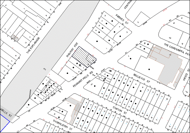
|
NOTIFICATION PLAN |
|
||
|
• PROPERTIES NOTIFIED
|
X SUBMISSIONS RECEIVED |
PROPERTY SUBJECT OF DEVELOPMENT |
|
One submission objects to the development, generally on the grounds that the development would result in:
· Potential structural damage to the adjoining property at No. 266 Pennant Hills Road, Thornleigh;
· Safety concerns for pedestrians on adjoining development;
· Damage to the existing sewerage under the pathway running along the common boundary from Railway Parade to Pennant Hills Road at No. 266 Pennant Hills Road, Thornleigh; and
· Excessive noise and dust during construction.
The merits of the matters raised in community submissions have been addressed in the body of the report with the exception of the following:
5.1.1 Potential Structural Damage and Safety Concerns for Pedestrians to the Adjoining Property at No. 266 Pennant Hills Road, Thornleigh
A condition is recommended requiring a dilapidation report prepared by a structural engineer detailing the structural condition of No. 22 Pennant Hills Road. Additionally other conditions are recommended for the protection of adjoining areas including a temporary hoarding, fence or awning to be erected between the work site and adjoining lands before the works begin.
5.1.2 Damage to the Existing Sewerage Under the Pathway Running Along the Common Boundary from Railway Parade to Pennant Hills Road at No. 266 Pennant Hills Road, Thornleigh
Engaged contractors would require appropriate liability insurance for all construction works. As mentioned above, standard conditions are recommended requiring protection of adjoining areas.
5.1.3 Excessive Noise and Dust During Construction
Conditions are recommended restricting construction hours (including demolition and earth works) to between 7am and 5pm Monday to Saturday, in accordance with Interim Construction Noise Guidelines 2009 – NSW Department of Environment and Climate Change and no work is to be undertaken on Sundays or public holidays.
Conditions are recommended requiring that all demolition work must be carried out in accordance with “Australian Standard 2601-2001 – The Demolition of Structures” and the requirement that erosion and sediment control measures be provided and maintained throughout the construction period in accordance with the manual ‘Soils and Construction 2004 (Bluebook)’, the approved plans, Council specifications and to the satisfaction of the principal certifying authority.
5.2 Public Agencies
The development application is Integrated Development under the Act. Accordingly, the application was referred to the following Agencies for comment:
5.2.1 NSW Police
The application was referred to the NSW Police for comment in respect to Crime Prevention Through Environmental Design principles. No objections were raised to the proposal.
5.2.2 NSW Roads and Maritime Services
The application was referred to the NSW Roads and Maritime Service for comment. No objections were raised to the proposal subject to conditions.
5.2.3 NSW RailCorp
The application was referred to NSW RailCorp under Clause 86(4) of the SEPP (Infrastructure) 2007 to consider the potential effects of the development on the safety or structural integrity of existing or proposed rail infrastructure facilities in the rail corridor, and the safe and effective operation of existing or proposed rail infrastructure facilities in the rail corridor and what measures are proposed, or could reasonably be taken, to avoid or minimise those potential effects.
NSW RailCorp granted concurrence to the proposed development subject to deferred commencement and operational conditions. The deferred commencement condition requires the submission of a final geotechnical and structural report/drawing that meet RailCorp’s requirements.
5.2.4 Ausgrid
The application was referred to Ausgrid for comment. No objections were raised to the proposal, subject to conditions.
6. THE PUBLIC INTEREST
Section 79C(1)(e) of the Act requires Council to consider “the public interest”.
The public interest is an overarching requirement, which includes the consideration of the matters discussed in this report. Implicit to the public interest is the achievement of future built outcomes adequately responding to and respecting the future desired outcomes expressed in environmental planning instruments and development control plans.
The application is considered to have satisfactorily addressed Council’s and relevant agencies’ criteria and would provide a development outcome that, on balance, would result in a positive impact for the community. Accordingly, it is considered that the approval of the proposed development would be in the public interest.
CONCLUSION
The application seeks approval for the demolition of existing structures and construction of a ten storey mixed used development comprising 73 residential units, 5 commercial units and basement car parking.
The proposed development is generally in accordance with the development controls for the ‘Pennant Hills Road, Thornleigh’ Precinct of the Housing Strategy DCP and would contribute to the future desired ten storey mixed use character of the precinct. With conditions, minor non-compliance with prescriptive measures for height of architectural roof structure, height of residential levels located within the business podium, solar access, housing choice, setbacks, privacy and landscaping are considered acceptable. The proposal complies with the design principles of SEPP 65 and the Residential Flat Design Code.
Note: At the time of the completion of this planning report, no persons have made a Political Donations Disclosure Statement pursuant to Section 147 of the Environmental Planning and Assessment Act 1979 in respect of the subject planning application.
|
Rod Pickles Manager - Development Assessment Planning Division |
James Farrington Group Manager Planning Division |
|
1.View |
Locality Map |
|
|
|
2.View |
Site Plan |
|
|
|
3.View |
Landscape Plans |
|
|
|
4.View |
Floor Plans - Part 1 |
|
|
|
5.View |
Floor Plans - Part 2 |
|
|
|
6.View |
Elevations |
|
|
|
7.View |
Shadow Diagrams |
|
|
|
8.View |
Photomontage |
|
|
File Reference: DA/691/2013
Document Number: D02450895
SCHEDULE 1
GENERAL CONDITIONS
The conditions of consent within this notice of determination have been applied to ensure that the use of the land and/or building is carried out in such a manner that is consistent with the aims and objectives of the relevant legislation, planning instruments and council policies affecting the land and does not disrupt the amenity of the neighbourhood or impact upon the environment.
Note: For the purpose of this consent, the term ‘applicant’ means any person who has the authority to act on or the benefit of the development consent.
Note: For the purpose of this consent, any reference to an act, regulation, Australian standard or publication by a public authority shall be taken to mean the gazetted act or regulation, or adopted Australian standard or publication as in force on the date that the application for a construction certificate is made.
1. Deferred Commencement
Pursuant to Section 80(3) of the Environmental Planning and Assessment Act 1979, this consent does not operate until the following information is submitted to Council:
The Applicant shall prepare and provide to RailCorp for approval/certification the following items:
a) Final Geotechnical and Structural report/drawings that meet RailCorp’s requirements. The Geotechnical Report must be based on actual borehole testing conducting on the site closest to the rail corridor.
b) Final Construction methodology with construction details pertaining to structural support during excavation.
c) Final cross sectional drawings showing ground surface, rail tracks, sub soil profile, proposed basement excavation and structural design of sub ground support adjacent to the Rail Corridor. All measurements are to be verified by a Registered Surveyor.
d) Detailed Survey Plan showing the relationship of the proposed developed with respect to RailCorp’s land and infrastructure.
e) If required by RailCorp, an FE analysis which assesses the different stages of loading-unloading of the site and its effect on the rock mass surrounding the corridor.
Such information shall be submitted within 12 months of the date of this notice.
Upon Council’s written satisfaction of the above information, the following conditions of development consent will apply:
2. Approved Plans and Supporting Documentation
The development must be carried out in accordance with the plans and documentation listed below and endorsed with Council’s stamp, except where amended by Council and/or other conditions of this consent:
|
Plan No. |
Plan Title |
Drawn by |
Dated |
|
DA-100 (A) |
Cover Sheet |
Moderinn Group P/L |
June 2013 |
|
DA-101 (A) |
Site Analysis (Existing Site Conditions) |
Moderinn Group P/L |
June 2013 |
|
DA-102 (A) |
Site Analysis (Solar Access) |
Moderinn Group P/L |
June 2013 |
|
DA-103 (A) |
Site Analysis (Cross Ventilation) |
Moderinn Group P/L |
June 2013 |
|
DA-104 (A) |
Site Analysis (Mixed Use Development) |
Moderinn Group P/L |
June 2013 |
|
DA-105 (A) |
Site Analysis (Site Context) |
Moderinn Group P/L |
June 2013 |
|
DA-106 (A) |
Site Analysis (Adjoining Building) |
Moderinn Group P/L |
June 2013 |
|
DA-1000 (A) |
Site Plan |
Moderinn Group P/L |
May 2013 |
|
DA-1001(A) |
Basement Level 3 Plan |
Moderinn Group P/L |
June 2013 |
|
DA-1002 (A) |
Basement Level 2 Plan |
Moderinn Group P/L |
June 2013 |
|
DA-1003 (A) |
Basement Level 1 Plan |
Moderinn Group P/L |
June 2013 |
|
DA-1004 (A) |
Ground Level Plan |
Moderinn Group P/L |
June 2013 |
|
DA-1005 (A) |
Mezzanine Level Plan |
Moderinn Group P/L |
June 2013 |
|
DA-1006 (A) |
First Level Plan |
Moderinn Group P/L |
June 2013 |
|
DA-1007 (A) |
Second Level Plan |
Moderinn Group P/L |
June 2013 |
|
DA-1008 (A) |
Third Level Plan |
Moderinn Group P/L |
June 2013 |
|
DA-1009 (A) |
Fourth Level Plan |
Moderinn Group P/L |
June 2013 |
|
DA-1010 (A) |
Typical L5 to L7 |
Moderinn Group P/L |
June 2013 |
|
DA-1011 (A) |
Eighth Level Plan |
Moderinn Group P/L |
June 2013 |
|
DA-1012 (A) |
Ninth Level Plan |
Moderinn Group P/L |
June 2013 |
|
DA-1013 (A) |
Roof Plan |
Moderinn Group P/L |
June 2013 |
|
DA-1014 (A) |
North East Elevation |
Moderinn Group P/L |
June 2013 |
|
DA-1015 (A) |
South East Elevation |
Moderinn Group P/L |
June 2013 |
|
DA-1016 (A) |
North West Elevation |
Moderinn Group P/L |
June 2013 |
|
DA-1017 (A) |
South West Elevation |
Moderinn Group P/L |
June 2013 |
|
DA-1018 (A) |
Section A-A |
Moderinn Group P/L |
June 2013 |
|
DA-1019 (A) |
Section B-B |
Moderinn Group P/L |
June 2013 |
|
DA-1020 (A) |
Section C-C |
Moderinn Group P/L |
June 2013 |
|
DA-1022 (A) |
Storage Schedule |
Moderinn Group P/L |
June 2013 |
|
DA-1023 (A) |
Finishes Schedule |
Moderinn Group P/L |
June 2013 |
|
DA-1024 (A) |
Demolition Plan |
Moderinn Group P/L |
June 2013 |
|
DA-1025 (A) |
Shadow Analysis (7 sheets) |
Moderinn Group P/L |
June 2013 |
|
DA-1026 (A) |
Shadow Analysis (Proposed Development) |
Moderinn Group P/L |
June 2013 |
|
DA-1027 (A) |
Shadow Analysis (Complying Development) |
Moderinn Group P/L |
June 2013 |
|
13-2685LO1 |
Landscape Plan – Ground Floor |
Zenith Landscape Designs |
27 May 2013 |
|
13-2685LO2 |
Landscape Plan – Level 1 & 2 |
Zenith Landscape Designs |
27 May 2013 |
|
13-2685LO3 |
Landscape Plan – Level 3 |
Zenith Landscape Designs |
27 May 2013 |
|
13-2685LO4 |
Landscape Plan – Level 4-7 |
Zenith Landscape Designs |
27 May 2013 |
|
13-2685LO5 |
Landscape Plan – Level 8-9 |
Zenith Landscape Designs |
27 May 2013 |
|
SW305-1 |
Stormwater Plans – Construction Notes and Standard Details |
Wehbe Consulting |
29 May 2013 |
|
SW305-2 |
Stormwater Plans – Roof Layout |
Wehbe Consulting |
29 May 2013 |
|
SW305-3 |
Stormwater Plans – Stormwater Site Layout |
Wehbe Consulting |
29 May 2013 |
|
SW305-4 |
Stormwater Plans – Basement Level 1 Layout |
Wehbe Consulting |
29 May 2013 |
|
SW305-5 |
Stormwater Plans – Basement Level 2 Layout |
Wehbe Consulting |
29 May 2013 |
|
SW305-6 |
Stormwater Plans – Basement Level 3 Layout |
Wehbe Consulting |
29 May 2013 |
|
Document Title |
Prepared by |
Dated |
|
Statement of Environmental Effects |
Don Fox Planning P/L |
July 2013 |
|
Preliminary Geotechnical Report |
JK Geotechnics |
24 May 2013 |
|
Stormwater Calculations Report |
Wehbe Consulting P/L |
28 April 2013 |
|
SEPP 65 Design Verification Statement |
Moderinn Group P/L |
5 July 2013 |
|
Road & Rail Noise Intrusion Report |
Pacific Environment Ltd |
24 June 2013 |
|
Air Quality Report |
Pacific Environment Ltd |
24 June 2013 |
|
BASIX Certificate No. 481605M |
SLR Consulting P/L |
4 July 2013 |
|
Access Report |
Accessible Building Solutions |
24 June 2013 |
|
Waste Management Plan |
Moderinn Group P/L |
June 2013 |
|
Traffic Report |
Varga Traffic Planning P/L |
4 July 2013 |
3. Amendment of Plans
The approved plans are to be amended as follows:
a) The architectural portal frame roof feature shall be deleted from the plan as marked in red on the approved plans.
b) The approved plan “Landscape Plan – Ground Floor” drawn by Zenith Landscape Designs dated 27 May 2013 must be amended to delete the trees on Pennant Hills Road.
c) The lower pane of the bedroom windows within the red portal frame feature element on the corner of Pennant Hills Road and Bellevue Street is to be installed with obscured glass.
4. Construction Certificate
A Construction Certificate is required to be approved by Council or a Private Certifying Authority prior to the commencement of any works under this consent.
REQUIREMENTS PRIOR TO THE ISSUE OF A CONSTRUCTION CERTIFICATE
5. Building Code of Australia
All building work must be carried out in accordance with the relevant requirements of the Building Code of Australia.
6. Contract of Insurance (Residential Building Work)
In the case of residential building work for which the Home Building Act, 1989 requires there to be a contract of insurance in force in accordance with Part 6 of that Act, that such a contract of insurance is in force before any building work authorised to be carried out by the consent commences.
7. Water/Electricity Utility Services
The applicant must submit written evidence of the following service provider requirements:
a) Ausgrid (formerly Energy Australia) – a letter of consent demonstrating that satisfactory arrangements have been made to service the proposed development.
b) Sydney Water – the submission of a ‘Notice of Requirements’ under s73 of the Sydney Water Act 1994.
Note: Sydney Water requires that s73 applications are to be made through an authorised Sydney Water Servicing Coordinator. Refer to www.sydneywater.com.au or telephone 13 20 92 for assistance.
8. Adaptable Units
The details of fit-outs of all accessible units and details of adaptable units must be provided with the Construction Certificate Plans.
9. Letter Boxes
The details of letter boxes must be provided with the Construction Certificate Plans.
10. Dilapidation Report
A ‘Dilapidation Report’ is to be prepared by a ‘chartered structural engineer’ detailing the structural condition of the adjoining property at No. 266 Pennant Hills Road, Thornleigh.
11. Waste Management Details
The following waste management requirements must be complied with:
a) The facility on each residential level must include:
i) A garbage chute plus a 240L bin for recycling; and
ii) Access for persons with a disability on levels with accessible and/or adaptable dwellings.
b) There must be an area of at least 8m² allocated for residents to place unwanted bulky items awaiting removal in the bin room on the ground floor.
c) A Waste Management Plan Section One – Demolition Stage and Section Three – Construction Stage, covering the scope of this project and including the following details, is required to be submitted to Council:
i) An estimate of the types and volumes of waste and recyclables to be generated;
ii) A site plan showing sorting and storage areas for demolition and construction waste and the vehicle access to these areas;
iii) How excavation, demolition and construction waste materials will be reused or recycled and where residual wastes will be disposed; and
iv) The total percentage (by weight) of demolition and construction waste that will be reused or recycled.
12. Excavation
The structural plans for basement and above ground areas must be prepared by a Chartered Structural Engineer and submitted with the Construction Certificate Application.
REQUIREMENTS PRIOR TO THE COMMENCEMENT OF ANY WORKS
13. Erection of Construction Sign
A sign must be erected in a prominent position on any site on which building work, subdivision work or demolition work is being carried out:
a) Showing the name, address and telephone number of the principal certifying authority for the work;
b) Showing the name of the principal contractor (if any) for any demolition or building work and a telephone number on which that person may be contacted outside working hours; and
c) Stating that unauthorised entry to the work site is prohibited.
Note: Any such sign is to be maintained while the building work, subdivision work or demolition work is being carried out, but must be removed when the work has been completed.
14. Protection of Adjoining Areas
A temporary hoarding, fence or awning must be erected between the work site and adjoining lands before the works begin and must be kept in place until after the completion of the works if the works:
a) Could cause a danger, obstruction or inconvenience to pedestrian or vehicular traffic.
b) Could cause damage to adjoining lands by falling objects.
c) Involve the enclosure of a public place or part of a public place.
Note: Notwithstanding the above, Council’s separate written approval is required prior to the erection of any structure or other obstruction on public land.
15. Toilet Facilities
Toilet facilities must be available or provided at the works site before works begin and must be maintained until the works are completed at a ratio of one toilet for every 20 persons employed at the site. Each toilet must:
a) be a standard flushing toilet connected to a public sewer; or
b) be a temporary chemical closet approved under the Local Government Act, 1993; or
c) have an on-site effluent disposal system approved under the Local Government Act, 1993.
16. Erosion and Sediment Control
Erosion and sediment control measures must be provided and maintained throughout the construction period in accordance with the manual ‘Soils and Construction 2004 (Bluebook)’, the approved plans, Council specifications and to the satisfaction of the principal certifying authority. The erosion and sediment control devices must remain in place until the site has been stabilised and revegetated.
Note: On the spot penalties up to $1,500 may be issued for any non-compliance with this requirement without any further notification or warning.
REQUIREMENTS DURING CONSTRUCTION
17. Construction Work Hours
All work on site (including demolition and earth works) must only occur between 7am and 5pm Monday to Saturday. No work is to be undertaken on Sundays or public holidays.
18. Demolition
All demolition work must be carried out in accordance with “Australian Standard 2601-2001 – The Demolition of Structures” and the following requirements:
a) Demolition material must be disposed of to an authorised recycling and/or waste disposal site and/or in accordance with an approved waste management plan;
b) Demolition works, where asbestos material is being removed, must be undertaken by a contractor that holds an appropriate licence issued by WorkCover NSW in accordance with Chapter 10 of the Occupational Health and Safety Regulation 2001 and Clause 29 of the Protection of the Environment Operations (Waste) Regulation 2005; and
c) On construction sites where buildings contain asbestos material, a standard commercially manufactured sign containing the words ‘DANGER ASBESTOS REMOVAL IN PROGRESS’ measuring not less than 400mm x 300mm must be erected in a prominent position visible from the street.
19. Environmental Management
The site must be managed in accordance with the publication ‘Managing Urban Stormwater – Landcom (March 2004) and the Protection of the Environment Operations Act 1997 by way of implementing appropriate measures to prevent sediment run-off, excessive dust, noise or odour emanating from the site during the construction of the development.
20. Street Sweeping
Street sweeping must be undertaken following sediment tracking from the site along Pennant Hills Road, Bellevue Street and Railway Parade during works and until the site is established.
21. Waste Management
Waste management during the demolition and construction phase of the development must be undertaken in accordance with the approved Waste Management Plan. Additionally written records of the following items must be maintained during the removal of any waste from the site and such information submitted to the Principal Certifying Authority within fourteen days of the date of completion of the works:
a) The identity of the person removing the waste.
b) The waste carrier vehicle registration.
c) Date and time of waste collection.
d) A description of the waste (type of waste and estimated quantity).
e) Details of the site to which the waste is to be taken.
f) The corresponding tip docket/receipt from the site to which the waste is transferred (noting date and time of delivery, description (type and quantity) of waste).
g) Whether the waste is expected to be reused, recycled or go to landfill.
Note: In accordance with the Protection of the Environment Operations Act 1997, the definition of waste includes any unwanted substance, regardless of whether is it reused, recycled or disposed to landfill.
22. Council Property
During construction works, no building materials, waste, machinery or related matter is to be stored on the road or footpath. The public reserve must be kept in a clean, tidy and safe condition at all times.
23. Demolition and Construction Vehicles
All demolition and construction vehicles must be wholly parked within the site at all times.
24. Excavated Material
All excavated material removed from the site must be classified in accordance with the Department of Environment, Climate Change and Water NSW Waste Classification Guidelines prior to disposal to an approved waste management facility and reported to the principal certifying authority.
25. Survey Report – Finished Floor Level
A report(s) must be prepared by a registered surveyor and submitted to the principal certifying authority prior to the pouring of concrete at each level of the building certifying that:
a) The building, retaining walls and the like have been correctly positioned on the site and;
b) The finished floor level(s) are in accordance with the approved plans.
26. Contamination During Construction Works
Should the presence of asbestos or soil contamination, not recognised during the application process by identified during demolition, the applicant must immediately notify the Principal Certifying Authority and Council.
27. Construction Noise Management
The construction works must be undertaken in accordance with the “Interim Construction Noise Guidelines – 2009” published by DECCW.
REQUIREMENTS PRIOR TO THE ISSUE OF AN OCCUPATION CERTIFICATE
Note: For the purpose of this consent, a reference to ‘occupation certificate’ shall not be taken to mean an ‘interim occupation certificate’ unless otherwise stated.
28. Stormwater Drainage
The stormwater drainage system for the development must be designed and constructed in accordance with Council’s Civil Works – Design and Construction Specification 2005 and the following requirements:
a) Connected directly to Council’s piped street drainage system in Bellevue St via the on site detention tank.
b) The approval of Hornsby Shire Council is required under the Roads Act for any works within Bellevue St.
29. On Site Stormwater Detention
An on-site stormwater detention system must be designed by a chartered civil engineer and constructed in accordance with the following requirements:
a) Have a capacity of not less than 26.1 cubic metres, and a maximum discharge (when full) of 55 litres per second.
b) Have a surcharge/inspection grate located directly above the outlet.
c) Discharge from the detention system to be controlled via 1 metre length of pipe, not less than 50 millimetres diameter or via a stainless plate with sharply drilled orifice bolted over the face of the outlet discharging into a larger diameter pipe capable of carrying the design flow to an approved Council system.
30. Internal Driveway/Vehicular Areas
The driveway and parking areas on site must be designed in accordance with Australian Standards 2890.1, 2890.2, 3727 and the following requirements:
a) Design levels at the front boundary be obtained from Council.
b) The driveway be a rigid pavement.
c) The basement carpark driveway grade must not exceed 5 percent grade for the first 6m past the property boundary and have a minimum width of 5.5m.
d) The driveway and parking area for the loading dock is to be designed and constructed in accordance with AS 2890.2.
31. Footpath
A concrete footpath must be constructed along the full frontage of the subject site in accordance Council’s Civil Works Design and Construction Specification, 2005 and the following requirements:
a) The existing footpath being removed.
b) Segmental block paving to be constructed along the full width of the footway over the full frontage to the site, including the planting of street trees in suitable grates or bays in the footway area. Claypave Monarch Tan pavers are to be laid in accordance with Councils requirements.
c) Any public utility adjustments to be carried out at the cost of the applicant and to the requirements of the relevant public authority.
d) Approval under the Roads Act is to be obtained from Hornsby Shire Council before the commencement of any works within the road reserve in accordance with the Roads Act.
32. Road Works
All road works approved under this consent must be constructed in accordance with Council’s Civil Works Design and Construction Specification, 2005 and the following requirements:
a) The existing kerb and gutter fronting the site in Pennant Hills Rd, Bellevue St and Railway Parade is to be removed and reconstructed.
b) The existing road pavement to be saw cut a minimum of 300 mm from the existing edge of the bitumen and reconstructed.
c) The submission of a compaction certificate from a geotechnical engineer for any fill within road reserves, and all road sub-grade and road pavement materials.
d) Be in accordance with the requirements of the RMS.
33. Traffic Control Plan
A Traffic Control Plan (TCP) must be prepared by a qualified traffic controller in accordance with the Roads & Traffic Authority’s Traffic Control at Worksites Manual 1998 and Australian Standard 1742.3 for all work on a public road and be submitted to Council. The TCP must detail the following where required:
a) Arrangements for public notification of the works.
b) Temporary construction signage.
c) Permanent post-construction signage.
d) Vehicle movement plans.
e) Traffic management plans.
f) Pedestrian and cyclist access/safety.
g) Be in accordance with the requirements of the RMS.
34. Damage to Council Assets
Any damage caused to Council’s assets as a result of the construction of the development must be rectified in accordance with Council’s written requirements and at the sole cost of the applicant.
35. Creation of Easements
The following matter(s) must be nominated on the plan of subdivision under s88B of the Conveyancing Act 1919:
a) The creation of an appropriate "Positive Covenant" and "Restriction as to User" over the constructed on-site detention/retention systems and outlet works, within the lots in favour of Council in accordance with Council’s prescribed wording. The position of the on-site detention system is to be clearly indicated on the title.
b) To register the OSD easement, the restriction on the use of land “works-as-executed” details of the on-site-detention system must be submitted verifying that the required storage and discharge rates have been constructed in accordance with the design requirements. The details must show the invert levels of the on site system together with pipe sizes and grades. Any variations to the approved plans must be shown in red on the “works-as-executed” plan and supported by calculations.
Note: Council must be nominated as the authority to release, vary or modify any easement, restriction or covenant.
36. Works as Executed Plan
A works-as-executed plan(s) must be prepared by a registered surveyor and submitted to Council for completed road pavement, kerb & gutter, public drainage systems, driveways and on-site detention system.
37. Waste Management Details
The following waste management requirements must be complied with:
a) The bin storage at the ground level must include water or a hose for cleaning, graded floors with drainage to sewer, a robust door, sealed and impervious surface, adequate lighting and ventilation. The waste facility at each residential level must include sealed and impervious surface, adequate lighting and ventilation.
b) A report must be prepared by an appropriately qualified person, certifying the following:
i) A comparison of the estimated quantities of each waste type against the actual quantities of each waste type.
Note: Explanations of any deviations to the approved Waste Management Plan is required to be included in this report.
ii) That at least 60% of the waste generated during the demolition and construction phase of the development was reused or recycled.
Note: If the 60% diversion from landfill cannot be achieved in the Construction Stage, the Report is to include the reasons why this occurred and certify that appropriate work practices were employed to implement the approved Waste Management Plan. The Report must be based on documentary evidence such as tipping dockets/receipts from recycling depts., transfer stations and landfills, audits of procedures etc. which are to be attached to the report.
iii) All waste was taken to site(s) that were lawfully permitted to accept that waste.
c) Each unit must be provided with an indoor waste/recycling cupboard for the interim storage of a minimum one day’s waste generation with separate containers for general waste and recyclable materials.
d) Space must be provided for either individual compost containers for each unit or a communal compost container.
Note: The location of the compost containers should have regard for potential amenity impacts.
e) The bin carting routes must be devoid of any steps.
Note: Ramps between different levels are acceptable.
f) Access to the volume handling equipment by unauthorised persons (including residents, commercial tenants etc) must be prevented.
Note: Caging of the volume handling equipment is acceptable.
g) The means must be in place to prevent Commercial tenants from using the residential bins and prevent residents from using the commercial bins.
Note: Separate lockable cages or roller door cupboards for the residential and commercial bins within the bin storage room are acceptable. At least a 1.5m wide aisle/through access way needs to be maintained outside the separate lockable areas.
38. Streetscape Landscape Works
Streetscape Planting and pavement works should be provided within the Pennant Hills Road, Bellevue Street and Railway Parade road verges:
a) Installation of 4 x 100 Litre Ulmus glabra (Lutesecens) trees on Bellevue Street;
b) Installation of 3 x 75 Litre Callistemon viminalis trees on Railway Parade; and
c) Structural soils to create an adequate lateral growing volume below the pavement. Minimum volume of structural soils shall be 5m² per tree.
39. Planter Boxes/On Slab Planting
On slab planter boxes must include waterproofing, subsoil drainage (proprietary drainage cell, 50mm sand and filter fabric) automatic irrigation, minimum 500mm planting soil for shrubs and minimum 1000mm planting soil for trees and palms and 75mm mulch to ensure sustainable landscape is achieved.
40. Completion of Landscaping
A certificate must be provided by a practicing landscape architect, horticulturalist or person with similar qualifications and experience certifying that all required landscaping works have been satisfactorily completed in accordance with the approved landscape plans.
Note: Advice on suitable species for landscaping can be obtained from Council’s planting guide ‘Indigenous Plants for the Bushland Shire’, available at www.hornsby.nsw.gov.au.
41. Garbage Collection Easement
For the purpose of waste collection, an easement entitling Council, its servants and agents and persons authorised by it to enter upon the subject land and to operate thereon, vehicles and other equipment for the purposes of garbage collection must be granted to Council by the owner of the land.
Note: The easement must be in a form prescribed by Council and must include covenants to the effect that parties will not be liable for any damage caused to the subject land or any part thereof or to any property located therein or thereon by reason of the operation thereon of any vehicle or other equipment used in connection with the collection of garbage and to the effect that the owner for the time being of the subject land shall indemnify the Council, its servants, agents and persons authorised by it to collect garbage against liability in respect of any such claims made by any person whomsoever.
42. Fulfilment of BASIX Commitments
The applicant must demonstrate the fulfilment of BASIX commitments pertaining to the development.
43. Sydney Water – s73 Certificate
An s73 Certificate must be obtained from Sydney Water.
44. Car Parking Allocation and Resident Storage
The basement resident storage areas are to be allocated in accordance with the size requirements of the SEPP 65 – Residential Flat Design Code for the respective units and proximity to the unit car parking space.
45. External Lighting
All external lighting must be designed and installed in accordance with Australian Standard AS 4282 – Control of the Obtrusive Effects of Outdoor Lighting. Certification of compliance with the Standard must be obtained from a suitably qualified person.
46. Unit/Suite Numbering
The allocation of unit/commercial suite numbering must be authorised by Council prior to the numbering of each unit in the development.
47. Accessibility Requirements
a) Tactile ground surface indicators are to be positioned at the top and bottom of the pedestrian entrance to the building.
b) Kitchen cupboards and equipment must not obstruct wheelchair access around doors.
c) The accessible units must include all necessary fit outs.
48. Safety and Security
a) Fire exit doors to the development must be fitted with single cylinder locksets (Australia and New Zealand Standard – Lock Sets) to restrict unauthorised access to the development;
b) The entryway to the residential lobby area must be illuminated in high luminance at all times;
c) The communal open space on top of the podium on the third floor of the site is to be illuminated with high luminance by motion sensor lighting;
d) The service areas within the mezzanine levels, basement levels, garbage room at the ground floor must be illuminated with high luminance by motion sensor lighting;
e) The driveway and basement carparking levels must be illuminated with low luminance at all times;
f) Robust materials which cannot be forced or breached with minimised maintenance requirements are to be used for construction work in the common areas;
g) The lamps and lighting levels must comply with Australian and New Zealand Lighting Standard 1158.1;
h) Effective signage must be provided to guide visitors to the main areas and parking areas;
i) A street sign must be prominently displayed in front of the site in accordance with Order No. 8, Section 124 Local Government Act 1993;
j) Unit and Suite numbers, entry and exit signs must be legible and clear;
k) The basement car park entries must be secured by security gates/roller shutters and controlled by secure access located at the top of the driveway.
49. Section 94 Development Contributions
In accordance with Section 80A(1) of the Environmental Planning and Assessment Act 1979 and the Hornsby Shire Council Section 94 Development Contributions Plan 2012-2021, the following monetary contributions shall be paid to Council to cater for the increased demand for community infrastructure resulting from the development:
|
Description |
Contribution (4) |
|
Roads |
$52,539.60 |
|
Open Space and Recreation |
$788,806.75 |
|
Community Facilities |
$110,548.10 |
|
Plan Preparation and Administration |
$3,392.90 |
|
TOTAL |
$955,287.35 |
being for 16 square metres of additional gross floor area of commercial space and 73 residential units comprising 23 x 1 bedroom units, 11 x 1 bedroom and study units, 32 x 2 bedroom units and 7 x 3 bedroom units.
a) If the contributions are not paid within the financial quarter that this consent is granted, the contributions payable will be adjusted in accordance with the provisions of the Hornsby Shire Council Section 94 Development Contributions Plan and the amount payable will be calculated at the time of payment in the following manner:
$CPY = $CDC x CPIPY
CPIDC
Where:
$CPY is the amount of the contribution at the date of Payment.
$CDC is the amount of the contribution as set out in this Development Consent.
CPIPY is the latest release of the Consumer Price Index (Sydney – All Groups) at the date of Payment as published by the ABS.
CPIDC is the Consumer Price Index (Sydney – All Groups) for the financial quarter at the date of this Development Consent.
b) The monetary contributions shall be paid to Council:
i) prior to the issue of the Subdivision Certificate where the development is for subdivision; or
ii) prior to the issue of the first Construction Certificate where the development is for building work; or
iii) prior to issue of the Subdivision Certificate or first Construction Certificate, whichever occurs first, where the development involves both subdivision and building work; or
iv) prior to the works commencing where the development does not require a Construction Certificate or Subdivision Certificate.
It is the professional responsibility of the Principal Certifying Authority to ensure that the monetary contributions have been paid to Council in accordance with the above timeframes.
Council’s Development Contributions Plan may be viewed at www.hornsby.nsw.gov.au or a copy may be inspected at Council’s Administration Centre during normal business hours.
OPERATIONAL CONDITIONS
50. Landscape Establishment
The landscape works must be maintained into the future to ensure the establishment and successful growth of plant material to meet the intent of the landscape design. This must include but not be limited to watering, wedding, replacement of failed plant material and promoting the growth of plants through standard industry practices.
51. Waste Storage Area and Waste Management
The waste management on site must be in accordance with the following requirements:
a) Site security measures implemented on the property, including electronic gates, must not prevent access to the bin room/collection point by waste removal services.
b) A site caretaker must be employed and be responsible for moving bins where and when necessary, washing bins and maintaining waste storage areas, ensuring the chute system and related devices are maintained in effective and efficient working order, managing the communal composting area, managing the bulky item storage area (including, but not limited to, ensuring that items placed there do not block or hinder access to bins for bin collection services), arranging the prompt removal of dumped rubbish, ensuring the commercial waste and recycling is kept separate from the residential waste and recycling (and vice versa), ensuring all residents and commercial tenants are informed of the use of the waste management system, and managing the loading dock to ensure that it is sufficiently available for all necessary waste collection services to take place.
52. Car Parking
All car parking must be constructed and operated in accordance with Australian Standard AS/NZS 2890.1:2004 – Off-street Car Parking and Australian Standard AS 2890.2:2002 – Off-street Commercial Vehicle Facilities.
a) All parking areas and driveways are to be sealed to an all weather standard, line marked and signposted;
b) Car parking, loading and manoeuvring areas to be used solely for nominated purposes;
c) Vehicles awaiting loading, unloading or servicing shall be parked on site and not on adjacent or nearby public roads;
d) Except for garbage vehicles for waste collection, all vehicular entry on to the site and egress from the site shall be made in a forward direction.
53. Disabled Parking
All parking spaces for people with disabilities must be constructed and operated in accordance with Australian Standard AS/NZS 2890.6:2009 – Off-street parking for people with disabilities.
54. Bicycle Parking
All bicycle parking spaces are to be designed in accordance with Australian Standard 2890.3-1993 – Bicycle parking facilities.
55. Lift Access from Basement Levels
Lift access is to be provided from basement level 1 car park to the commercial ground floor level to enable disability access between the levels.
56. Sight Distances
Sight triangles in accordance with AS/NZS 2890.1:2004 are to be provided for driveways at the boundary line.
57. Motorcycle Parking
a) Three motorcycle parking spaces are to be provided.
b) All motorcycle parking spaces are to be designed in accordance with AS 2890.5-1993.
58. Noise
All noise generated by the proposed development must be attenuated to prevent levels of noise being emitted to adjacent premises which possess tonal, beating and similar characteristics or which exceeds background noise levels by more than 5dB(A).
59. Fire Safety Statement - Annual
On at least one occasion in every 12 month period following the date of the first ‘Fire Safety Certificate’ issued for the property, the owner must provide Council with an annual ‘Fire Safety Certificate’ to each essential service installed in the building.
CONDITIONS OF CONCURRENCE – NSW RMS
The following conditions of consent are from the nominated State Agency pursuant to Section 79B of the Environmental Planning and Assessment Act, 1979 and must be complied with to the satisfaction of that Agency.
60. All construction activity associated with the proposed development is to be contained on site as no construction zones will be permitted on Pennant Hills Road in the vicinity of the site.
61. A Road Occupancy License should be obtained from TMC for any works that may impact on traffic flows on Pennant Hills Road during construction activities.
62. A Construction Traffic Management Plan detailing construction vehicle routes, number of trucks, hours of operation, access arrangements and traffic control should be submitted to RMS for determination prior to the issue of a construction certificate.
63. The layout of the proposed car parking areas associated with the subject development (including driveways, grades, turn paths, sight distance requirements, aisle widths, aisle lengths, and parking bay dimensions) should be in accordance with AS 2890.1-2004.
64. All works/regulatory signposting associated with the proposed development are to be at no cost to the RMS.
65. Any proposed landscaping and/or fencing must not restrict sight distance to pedestrians and cyclists travelling along the footpath.
66. Except for the Garbage Vehicles for waste collection, all vehicles are to enter and leave the site in a forward direction.
CONDITIONS OF CONCURRENCE – RAILCORP
The following conditions of consent are from the nominated State Agency pursuant to Section 79B of the Environmental Planning and Assessment Act, 1979 and must be complied with to the satisfaction of that Agency.
67. Dilapidation Report
If required by RailCorp, prior to the commencement of works and prior to the issue of the Occupation Certificate, a joint inspection of the rail infrastructure and property in the vicinity of the project is to be carried out by representative from RailCorp and the Applicant. These dilapidation surveys will establish the extent of any existing damage and enable any deterioration during construction to be observed. The submission of a detailed dilapidation report will be required unless otherwise notified by RailCorp.
68. Acoustic Assessment
An acoustic assessment is to be submitted to Council prior to the issue of a construction certificate demonstrating how the proposed development will comply with the Department of Planning’s document titled “Development Near Rail Corridors and Busy Roads – Interim Guidelines”.
69. Electrolysis Risk Assessment
Prior to the issue of a Construction Certificate, the Applicant is to engage an Electrolysis Expert to prepare a report on the Electrolysis Risk to the development from stray currents. The Applicant must incorporate in the development all the measures recommended in the report to control that risk. A copy of the report is to be provided to the Principal Certifying Authority with the application for a Construction Certificate.
70. Refraction of Light from Development
The design, installation and use of lights, signs and reflective materials, whether permanent or temporary, which are (or from which reflected light might be) visible from the rail corridor must limit glare and reflectivity to the satisfaction of RailCorp.
The Principal Certifying Authority is not to issue the Construction Certificate until written confirmation has been received from RailCorp confirming that this condition has been satisfied.
71. Risk Assessment/Management Plan
If required by RailCorp, prior to the issue of a Construction Certificate, a Risk Assessment/Management Plan and detailed Safe Work Method Statements (SWMS) for the proposed works are to be submitted to RailCorp for review and comment on the impacts on rail corridor. The Principal Certifying Authority is not to issue the Construction Certificate until written confirmation has been received from RailCorp confirming that this condition has been satisfied.
72. Aerial Operations
Prior to issuing of a Construction Certificate, the Applicant is to submit to RailCorp a plan showing all craneage and other aerial operations for the development and must comply with all RailCorp requirements. The Principal Certifying Authority is not to issue the Construction Certificate until written confirmation has been received from the RailCorp confirming that this condition has been satisfied.
73. Track Monitoring Plan
If required by RailCorp, a track monitoring plan (including instrumentation and the monitoring regime during excavation and construction phases) is to be submitted to RailCorp for review and endorsement prior to the issuing of a Construction Certificate. The Principal Certifying Authority is not to issue a Construction Certificate until written confirmation has been received from RailCorp advising of the need to undertake the track monitoring plan, and if required that it has been endorsed.
CONDITIONS OF CONCURRENCE – AUSGRID
The following conditions of consent are from the nominated State Agency pursuant to Section 79B of the Environmental Planning and Assessment Act, 1979 and must be complied with to the satisfaction of that Agency.
74. The developer is to submit full electrical load details and other relevant information via a Connection Application Form NECF – 03 to datanorth@ausgrid.com.au which is available on the Ausgrid website www.ausgrid.com.au
75. An electrical substation on the property will be required to supply this development at the sole cost of the developer.
- END OF CONDITIONS -
ADVISORY NOTES
The following information is provided for your assistance to ensure compliance with the Environmental Planning and Assessment Act, 1979, Environmental Planning and Assessment Regulation 2000, other relevant legislation and Council’s policies and specifications. This information does not form part of the conditions of development consent pursuant to Section 80a of the Act.
Environmental Planning and Assessment Act, 1979 Requirements
The Environmental Planning and Assessment Act, 1979 requires:
· The issue of a construction certificate prior to the commencement of any works. Enquiries can be made to Council’s Customer Services Branch on 9847 6760.
· A principal certifying authority to be nominated and Council notified of that appointment prior to the commencement of any works.
· Council to be given at least two days written notice prior to the commencement of any works.
· Mandatory inspections of nominated stages of the construction inspected.
· An occupation certificate to be issued before occupying any building or commencing the use of the land.
Long Service Levy
In accordance with Section 34 of the Building and Construction Industry Long Service Payments Act 1986, a ‘Long Service Levy’ must be paid to the Long Service Payments Corporation or Hornsby Council.
Note: The rate of the Long Service Levy is 0.35% of the total cost of the work.
Note: Hornsby Council requires the payment of the Long Service Levy prior to the issue of a construction certificate.
Disability Discrimination Act
The applicant’s attention is drawn to the existence of the Disability Discrimination Act. A construction certificate is required to be obtained for the proposed building/s, which will provide consideration under the Building Code of Australia, however, the development may not comply with the requirements of the Disability Discrimination Act. This is the sole responsibility of the applicant.
Covenants
The land upon which the subject building is to be constructed may be affected by restrictive covenants. Council issues this approval without enquiry as to whether any restrictive covenant affecting the land would be breached by the construction of the building, the subject of this consent. Applicants must rely on their own enquiries as to whether or not the building breaches any such covenant.
Dial Before You Dig
Prior to commencing any works, the applicant is encouraged to contact Dial Before You Dig on 1100 or www.dialbeforeyoudig.com.au for free information on potential underground pipes and cables within the vicinity of the development site.
Telecommunications Act 1997 (Commonwealth)
If you are aware of any works or proposed works which may affect or impact on Telstra’s assets in any way, you are required to contact: Telstra’s Network Integrity Team on Phone Number 1800810443.
Asbestos Warning
Should asbestos or asbestos products be encountered during demolition or construction works, you are advised to seek advice and information prior to disturbing this material. It is recommended that a contractor holding an asbestos-handling permit (issued by WorkCover NSW)be engaged to manage the proper handling of this material. Further information regarding the safe handling and removal of asbestos can be found at:
Alternatively, telephone the WorkCover Asbestos and Demolition Team on 8260 5885.
Group Manager’s Report No. PL107/13
Planning Division
Date of Meeting: 20/11/2013
15 DEVELOPMENT APPLICATION - FIVE STOREY RESIDENTIAL FLAT BUILDING COMPRISING 15 UNITS - 229 CARLINGFORD ROAD, CARLINGFORD
EXECUTIVE SUMMARY
|
DA No: |
DA/644/2013 (Lodged 25 June 2013) |
|
Description: |
Demolition of existing structures and erection of a five storey residential flat building comprising 15 units, basement car parking and strata title subdivision |
|
Property: |
Lot 8 DP 29798, No. 229 Carlingford Road, Carlingford |
|
Applicant: |
Zhinar Architects |
|
Owner: |
Hai Lu Zheng and Ping Cao |
|
Estimated Value: |
$2,100,000 |
|
Ward: |
C |
· The application proposes demolition of existing structures and construction of a five storey residential flat building comprising 15 units, basement car parking and strata subdivision.
· The proposal generally complies with Hornsby Shire LEP 1994 and State Environmental Planning Policy No. 65 – Design Quality Residential Flat Development. The proposal includes the development of an isolated site. As a result, the proposal does not comply with Council’s Housing Strategy Development Control Plan with regard to minimum site widths, setbacks, privacy, landscaping and building indentation.
· No submissions have been received in respect of the application.
· It is recommended that the application be approved.
|
THAT Development Application No. DA/644/2013 for demolition of existing structures and erection of a five storey residential flat building comprising 15 units, basement car parking and strata title subdivision at Lot 8 DP 29798, No. 229 Carlingford Road, Carlingford be approved subject to the conditions of consent detailed in Schedule 1 of Group Manager’s Report No. PL107/13. |
BACKGROUND
The subject land was rezoned from Residential A (Low Density) to Residential C (Medium-High Density) on 2 September 2011 as part of Council’s Housing Strategy.
The subject isolated site was formed as a result of consent No. 719/2012 for the construction of a five storey residential flat building containing 45 units and basement car park at Nos. 223-237 Carlingford Road, Carlingford which was approved by Council on 19 December 2012. The assessment of the application concluded that there was sufficient documentary evidence that a genuine and reasonable attempt had been made to purchase the subject site based on a fair market value. These offers were rejected by the owner of the subject site. The applicant also demonstrated that the development potential of the subject site would not be necessarily thwarted by the proposed development. The proposed five storey development on this isolated site is the subject of this application.
SITE
The site comprises No. 229 Carlingford Road, Carlingford. The site has an area of 912.57 square metres and is located on the southern side of Carlingford Road. The site is rectangular in shape, with a 17.1 metres frontage to Carlingford Road and a depth of 53.5 metres.
The site has a cross fall towards Carlingford Road in a northern direction with an average grade of 5%. A Council drainage easement traverses the northern western corner of the site. The site is identified as flood prone land.
The single allotment comprising the development site contains a part one and part two storey dwelling-house of brick and tile roof construction. A number of trees are located within the development site, none of which are identified as significant.
The site forms part of the ‘Carlingford Road, Carlingford’ precinct rezoned for medium-high density housing in accordance with the Hornsby Shire Housing Strategy in September 2011. The precinct is bounded by Carlingford Road, Pennant Hills Road, Keeler Street and Hepburn Avenue.
All adjoining neighbouring properties (north eastern, south western and south eastern) have been approved for the construction of five storey residential flat buildings.
The site is located within close proximity to Carlingford Court shopping centre located on the northern side of Carlingford Road.
PROPOSAL
The proposal is for the demolition of an existing dwelling-house, construction of a five storey residential flat building comprising 15 dwellings with basement car parking and strata title subdivision.
The unit configuration includes 2 x 1 bedroom units, 10 x 2 bedroom units and 3 x 3 bedroom units. The units include balconies fronting the street, rear and side setbacks.
The development would be accessed from Carlingford Road via a driveway located adjacent to the eastern boundary of the site. A separate pedestrian entry is located from Carlingford Road adjacent to the western side boundary. A total of 15 residential spaces and 3 visitor’s parking spaces are proposed in a single basement level.
ASSESSMENT
The development application has been assessed having regard to the ‘Metropolitan Plan for Sydney 2031’, the ‘North Subregion (Draft) Subregional Strategy’ and the matters for consideration prescribed under Section 79C of the Environmental Planning and Assessment Act 1979 (the Act). The following issues have been identified for further consideration.
1. STRATEGIC CONTEXT
1.1 Metropolitan Plan for Sydney and (Draft) North Subregional Strategy
The (Draft) Metropolitan Strategy for Sydney 2031 is a broad framework to provide for Sydney’s growth to help plan for housing, employment, transport, infrastructure, the environment and open space. It outlines a vision for Sydney to 2031; the challenges faced, and the directions to follow to address these challenges and achieve the vision.
The North Subregion comprises Hornsby, Kuring-gai, Manly, Warringah and Pittwater Local Government Areas. The Draft North Subregional Strategy provided a framework for Council in its preparation of the HLEP 2013. Within the North Subregion, the Draft Metropolitan Strategy proposes:
· Population growth of 81,000 from the current 2011 baseline of 529,000
· Housing growth of 37,000 from the current 2011 baseline of 204,000
· Employment growth of 39,000 from the current 2011 baseline of 186,000
The proposed development would be consistent with the Metropolitan Plan for Sydney 2031 by providing 14 additional dwellings and would contribute to housing choice in the locality.
2. STATUTORY CONTROLS
Section 79C(1)(a) requires Council to consider “any relevant environmental planning instruments, draft environmental planning instruments, development control plans, planning agreements and regulations”.
2.1 Hornsby Shire Local Environmental Plan 1994
The subject land is zoned Residential C (Medium/High Density) under the Hornsby Shire Local Environmental Plan 1994 (HSLEP). The objectives of the zone are:
(a) to provide for the housing needs of the population of the Hornsby area.
(b) to promote a variety of housing types and other land uses compatible with a medium to high density residential environment.
(c) to provide for development that is within the environmental capacity of a medium to high density residential environment.
The proposed development is defined as ‘demolition’ and ‘multi-unit housing’ under the HSLEP and is permissible in the zone with Council’s consent.
Clause 15 of the HSLEP prescribes that the maximum floor space ratio (FSR) of development within the Residential C zone. Subclause (5) of clause 15 states that “This clause does not apply to land shown edged heavy black on diagrams 1-8 in Schedule BB.” The site is identified in Diagram 8 of Schedule BB of the HSLEP. Therefore, clause 15 does not apply to the subject site.
Clause 15A of the HSLEP prescribes that the maximum building height within the area detailed under Schedule BB is not to exceed 17.5 metres. The proposed building complies with this requirement.
Clause 18 of the HSLEP sets out heritage conservation provisions for Hornsby Shire. The site is not in the vicinity of a heritage item or conservation area and is not subject to consideration for heritage conservation. Therefore, no further assessment in this regard is necessary.
2.2 Hornsby Local Environmental Plan 2013
The Hornsby Local Environmental Plan 2013 (HLEP) was gazetted by the Minister of Planning on 11 October 2013. The HLEP essentially reiterates the current land use zoning and height control applicable to the site as outlined below:
2.2.1 Zoning
Under the HLEP, the subject land is zoned R4 (High Density Residential). The proposed development is defined as a ‘residential flat building’ and would be permissible within the zone with Council’s consent.
2.2.2 Height of Building
Clause 4.3 of the HLEP provides that the height of a building on any land is not to exceed the maximum height shown for the land on the Height of Buildings Map. The maximum permissible height for the subject site is 17.5 metres. The proposal complies with this provision.
2.3 State Environmental Planning Policy No. 55 – Remediation of Land
State Environmental Planning Policy No. 55 (SEPP 55) requires that Council must not consent to the carrying out of any development on land unless it has considered whether the land is contaminated or requires remediation for the proposed use.
The site has been used for residential purposes and is unlikely to be contaminated. No further assessment is considered necessary in this regard. A condition is recommended should any contamination be found during construction.
2.4 State Environmental Planning Policy No. 65 – Design Quality Residential Flat Development
The Policy provides for design principles to improve the design quality of residential flat development and for consistency in planning controls across the State.
The applicant has submitted a design verification statement prepared by a qualified designer stating how the proposed development achieves the design principles of SEPP 65. The design principles of SEPP 65 and the submitted design verification statement are addressed below.
2.4.1 Principle 1 - Context
Design Principle 1 is as follows:
Good design responds and contributes to its context. Context can be defined as the key natural and built features of an area.
Responding to context involves identifying the desirable elements of a location’s current character or, in the case of precincts undergoing a transition, the desired future character as stated in planning and design policies. New buildings will thereby contribute to the quality and identity of the area.
The subject site is located within a precinct zoned for five storey residential flat buildings in close proximity to Pennant Hills Road and the Carlingford Court shopping centre. The desired future character of the area, as outlined in Council’s Housing Strategy Development Control Plan, is that of a high density residential precinct incorporating five storey developments in a landscape setting.
The ‘Design Verification Statement’ submitted with the application states that the proposal “reflects the shape of the isolated site and demonstrates some compatibility with the prescriptive measures to achieve the desired future character of the precinct” as envisaged by Council. Once the precinct is redeveloped, the development would integrate with the surrounding sites and would be in keeping with the desired urban form. It is considered that the proposed building would contribute to the identity and future character of the precinct.
2.4.2 Principle 2 - Scale
Design Principle 2 is as follows:
Good design provides an appropriate scale in terms of the bulk and height that suits the scale of the street and the surrounding buildings.
Establishing an appropriate scale requires a considered response to the scale of existing development. In precincts undergoing a transition, proposed bulk and height needs to achieve the scale identified for the desired future character of the area.
The scale of the development is in keeping with the objectives of Council’s planning controls in terms of building height, width and building envelope. The scale of the development is considered appropriate for the site and consistent with the desired future character of the precinct.
2.4.3 Principle 3 – Built Form
Design Principle 3 is as follows:
Good design achieves an appropriate built form for a site and the building’s purpose, in terms of building alignments, proportions, building type and the manipulation of building elements.
Appropriate built form defines the public domain, contributes to the character of streetscape and parks, including their views and vistas, and provides internal amenity and outlook.
The proposed building is appropriately articulated to minimise the perceived scale and to add to the visual interest of the development. The proposed development presents a distinct architectural design which would set an appropriate precedent for the locality and is considered acceptable in terms of built form.
2.4.4 Principle 5 – Resource, Energy and Water Efficiency
Design Principle 5 is as follows:
Good design makes efficient use of natural resources, energy and water throughout its full life cycle, including construction.
Sustainability is integral to the design process. Aspects include demolition of existing structures, recycling of materials, selection of appropriate and sustainable materials, adaptability and reuse of buildings, layouts and built form, passive solar design principles, efficient appliances and mechanical services, soil zones for vegetation and reuse of water.
The applicant has submitted a BASIX Certificate for the proposed development. In achieving the required BASIX targets for sustainable water use, thermal comfort and energy efficiency, the proposed development achieves the design criteria.
2.4.5 Principle 6 – Landscape
Design Principle 6 is as follows:
Good design recognises that together landscape and buildings operate as an integral and sustainable system, resulting in greater aesthetic quality and amenity for both occupants and the adjoining public domain.
Landscape design builds on the existing site’s natural and cultural features in responsible and creative ways. It enhances the development’s natural environmental performance by co-ordinating water and soil management, solar access, micro-climate, tree canopy and habitat values. It contributes to the positive image and contextual fit of development through respect for streetscape and neighbourhood character, or desired future character.
Landscape design should optimise useability, privacy and social opportunity, equitable access and respect for neighbour’s amenity, and provide for practical establishment and long term management.
The application includes a landscape plan providing landscaping along the front, side and rear boundaries. Planting proposed along the front, side and rear boundaries include a number of small to medium sized trees which would grow to a mature height of 8m. To ensure sufficient canopy cover and improve amenity of the building, conditions have been recommended requiring the planting of 5 x medium to large trees on the site. This is addressed under Section 2.5.1 of this report. With conditions, the proposal would enhance the development’s natural environmental performance and provide an appropriate landscaped setting.
2.4.6 Principle 7 – Amenity
Design Principle 7 is as follows:
Good design provides amenity through the physical, spatial and environmental quality of a development.
Optimising amenity requires appropriate room dimensions and shapes, access to sunlight, natural ventilation, visual and acoustic privacy, storage, indoor and outdoor space, efficient layouts and service areas, outlook and ease of access for all age groups and degrees of mobility.
The proposed units are designed to achieve natural ventilation, solar access and acoustic privacy. All units incorporate balconies accessible from living areas and privacy has been achieved through appropriate design. Adequate storage has been provided within units and within the basement level. The proposal would provide convenient and safe access to the development via a central lift connecting the basement and all other levels. The application is supported with respect to this Principal.
2.4.7 Principle 8 – Safety and Security
Design Principle 8 is as follows:
Good design optimises safety and security, both internal to the development and for the public domain.
This is achieved by maximising overlooking of public and communal spaces while maintaining internal privacy, avoiding dark and non-visible areas, maximising activity on streets, providing clear, safe access points, providing quality public spaces that cater for desired recreational uses, providing lighting appropriate to the location and desired activities, and clear definition between public and private spaces.
Crime Prevention through Environmental Design (CPTED) measures have been implemented into the proposal to optimise safety and security. Apartment layouts optimize occupant surveillance by orienting habitable spaces and rooms with outlook over the street and communal areas. Safety and security measures proposed to be implemented in the design include well lit access ways, an intercom system and security controlled doors. With conditions, the application is supported with respect to this Principal.
2.4.8 Principle 9 – Social Dimensions and Housing Affordability
Design Principle 9 is as follows:
Good design responds to the social context and needs of the local community in terms of lifestyles, affordability, and access to social facilities.
New development should optimise the provision of housing to suit the social mix and needs in the neighbourhood or, in the case of precincts undergoing transition, provide for the desired future community.
New development should address housing affordability by optimising the provision of economic housing choices and providing a mix of housing types to cater for different budgets and housing needs.
The site is within close proximity to Carlingford commercial centre and Carlingford Court shopping centre which allows direct access to retail, educational, health and recreational facilities. The proposed development includes a mix of dwelling types and adaptable housing to meet the needs of the community. The application is supported in respect to this Principle.
2.4.9 Principle 10 – Aesthetics
Design Principle 10 is as follows:
Quality aesthetics require the appropriate composition of building elements, textures, materials and colours and reflect the use, internal design and structure of the development. Aesthetics should respond to the environment and context, particularly to desirable elements of the existing streetscape or, in precincts undergoing transition, contribute to the desired future character of the area.
The proposed building facade is articulated to break into smaller elements. The combination of varied materials, colour selection and surface articulation provide for contemporary design consistent with the design principles contained within the RFDC. The aesthetic quality of the building contributes to the desired future character of the precinct.
2.5 SEPP 65 – Residential Flat Design Code
SEPP 65 also requires consideration of the Residential Flat Design Code, NSW Planning Department 2002. The Code includes development controls and best practice benchmarks for achieving the design principles of SEPP 65. The following table sets out the proposal’s compliance with the Code:
|
Residential Flat Design Code |
|||
|
Control |
Proposal |
Requirement |
Compliance |
|
Deep Soil Zone |
28% |
25% |
Yes |
|
Communal Open Space |
30% |
25-30% |
Yes |
|
Minimum Dwelling Size |
1 br – 60.86m2 2 br –80.06m2 3 br – 99.64m2 |
1 br – 50m2 2 br – 70m2 3 br – 95m2 |
Yes Yes Yes |
|
Maximum Kitchen Distance |
< 8m |
< 8m |
Yes |
|
Minimum Balcony Depth |
2.5m |
2m |
Yes |
|
Cross Ventilation |
100% |
60% |
Yes |
|
Adaptable Housing |
13% |
10% |
Yes |
|
Ceiling Heights Residential Floors |
2.7m
|
2.7m (Min)
|
Yes
|
|
Total Storage Area
|
1 br – 6.69 m3 2 br - 8m3 3 br – 10.6m3 |
6m3 (Min) 8m3 (Min) 10 m3 (Min) |
Yes Yes Yes |
As detailed in the above table, the proposed development complies with the Residential Flat Design Code (RFDC). Below is a brief discussion regarding the relevant development controls and best practice guidelines:
2.5.1 Deep Soil Zones
Whilst the RFDC recommends that medium trees (8m canopy diameter at maturity) have a minimum soil depth of 1m and an approximate soil area of 6m x 6m and large trees (canopy diameter of up to 16m at maturity) have a minimum soil depth of 1.3m and a minimum soil area of 10m x 10m, the Code prescribes there is no minimum standard that can be applied to all situations as the requirements vary with the size of plants and trees at maturity.
The proposal includes building encroachments to 3m of side boundaries and 6m of the rear boundary and the basement encroaches to the rear and eastern and western side property boundaries. The basement encroachment would allow a minimum soil depth of approximately 800mm. The Landscape Concept Plan only includes small to medium sized trees, with the majority of trees proposed at 4m in height with the exception of three trees along the western side boundary and five trees along the eastern boundary that would reach a mature height of 8m. This would not comply with the objective for Deep Soil Zones in the RFDC which is to improve the amenity of developments through the retention and/or planting of large and medium sized trees.
To maintain canopy cover and improve the amenity of the development, Council’s Landscape assessment concludes that five medium to large trees be planted on the site. Whilst these trees may not conform to the numerical recommendations of the RFDC for soil depth and area, these trees would be planted in the ground which would enable the tree roots to find stability in adjoining areas. For this reason, the deep soil zones have been calculated as 28% of the total site area which complies with the recommendations of the RFDC. With conditions the proposal is considered to be acceptable.
2.5.2 Apartment Layout
The layout of the proposed apartments consists of dual aspect corner units. The unit layouts would provide for housing choice and a range of household types.
The proposed apartment layouts are functional and satisfy the RFDC requirements for internal privacy, access to sunlight, natural ventilation and acoustic privacy. It is considered that the apartment layout and mix achieve the intent of the best practice requirements of the RFDC and is acceptable in this regard.
2.5.3 Internal Circulation
The proposal includes access to all floors via a lift which is centrally located. The ground floor corridors connect to the foyer which adjoins a footpath on the western side boundary that leads to the communal open space area at the rear of the site. The proposal is acceptable with respect to the requirements of the RFDC requirements for internal circulation.
2.5.4 Acoustic Privacy
The internal layout of the residential units is designed such that circulation zones would act as a buffer between units. Bedrooms and service areas such as kitchens, bathrooms and laundries would be grouped together wherever possible, with living areas oriented to the street or rear property boundary. The proposal is consistent with the requirements within the RFDC for acoustic privacy.
2.5.5 Storage
The proposed development includes resident storage areas within the units and the basement in accordance with the minimum requirements prescribed by the RFDC.
2.5.6 Building Separation
Whilst the majority of the living areas would be setback 3 metres from the eastern and western side boundaries, none of these habitable rooms contain windows. The principal balconies adjoining living areas face either the street frontage or the rear southern property boundary. The rear facing balconies on the ground level to level 3 are at least 6 metres from the rear boundary and the balcony on level 4 increases to 11m facilitating a future building separation of at least 12-18 metres with the rear adjoining property in accordance with the RFDC. The building separation and privacy matters are addressed in Section 2.12 of this report.
In summary, the proposed residential flat building has been designed in accordance with the design principles of SEPP 65 and generally complies in respect to the RFDC subject to the imposition of appropriate conditions of consent. It is considered the proposal would achieve good residential amenity and contribute to the desired future residential character of the Carlingford Road Precinct.
2.6 State Environmental Planning Policy No. 32 - Urban Consolidation (Redevelopment of Urban Land) (SEPP 32)
The application has been assessed against the requirements of SEPP 32, which requires Council to implement the aims and objectives of this Policy to the fullest extent practicable when considering development applications relating to redevelopment of urban land. The application complies with the objectives of the Policy as it would promote social and economic welfare of the locality and would result in the orderly and economic use of under utilised land within the Shire
2.7 State Environmental Planning Policy (Building Sustainability Index – BASIX) - 2004
The application has been assessed against the requirements of State Environmental Planning Policy (Building Sustainability Index: BASIX) 2004. The applicant has submitted a BASIX Certificate for the proposed units and is considered to be satisfactory.
2.8 State Environmental Planning Policy (Infrastructure) 2007
The application has been assessed against the requirements of State Environmental Planning Policy (Infrastructure) 2007. This Policy contains State-wide planning controls for developments adjoining busy roads.
Clause 101 of the Policy applies to the proposed development as the site has frontage to a classified road (Carlingford Road). The Clause prescribes that the consent authority, before granting consent to an application, must be satisfied that safety, efficiency and ongoing operation of the classified road would not be adversely affected by the development. The NSW Roads and Maritime Services (RMS) considered the proposal and requested that the design be amended to include a concrete median island on Carlingford Road directly in front of the subject property, to enforce left-in and left-out vehicular movements. The applicant submitted amended plans demonstrating compliance to this requirement. In response, the RMS provided the following comment:
“RMS has no objection to the median island on Carlingford Road along the frontage of the above subject development. The island on the driveway should be removed now that a median island has been provided on Carlingford Road.”
Council’s traffic assessment of the proposal concludes that the proposed vehicular access arrangements are acceptable. This matter is further addressed in Sections 2.11.5 and 3.2.2 of this report.
2.9 Sydney Regional Environmental Plan (Sydney Harbour Catchment) 2005
The application has been assessed against the requirements of Sydney Regional Environmental Plan (Sydney Harbour Catchment) 2005. This Plan provides general planning considerations and strategies to ensure that the catchment, foreshores, waterways and islands of Sydney Harbour are recognised, protected, enhanced and maintained.
The proposal includes details of stormwater management of the site by providing an on-site detention system. Council’s assessment of the proposal in this regard concludes that the development is satisfactory. A condition is recommended with respect to installation of sediment and erosion control measures prior to, and during, construction.
The proposed development would have minimal potential to impact on the Sydney Harbour Catchment subject to implementation of recommended conditions.
2.10 Clause 74BA Environmental Planning and Assessment Act, 1979 - Purpose and Status of Development Control Plans
On 1 March 2013, the Environmental Planning and Assessment Act, 1979 was amended so that a DCP provision will have no effect if it has the practical effect of “preventing or unreasonably restricting development” that is otherwise permitted and complies with the development standards set out in relevant Local Environmental Plans and State Environmental Planning Policies.
The principal purpose of a development control plan is to provide guidance on the aims of any environmental planning instrument that applies to the development; facilitating development that is permissible under any such instrument; and achieving the objectives of land zones under any such instrument. The provisions of a development control plan made for that purpose are not statutory requirements.
2.11 Hornsby Development Control Plan 2013
The Hornsby Development Control Plan (HDCP) 2013 applies to all land within Hornsby Shire and replaces Council’s existing DCPs, providing development controls to complement the HLEP. The HDCP came into effect on 11 October 2013. Notwithstanding, the HLEP includes a savings provision that a development application made and not finally determined before the commencement of the HLEP would be determined under HSLEP 1994. As a result, the following sections of this report include a detailed assessment of the proposal against Council’s existing DCP controls.
Although the savings provision applies, the development proposal has been assessed against the HDCP. The HDCP is generally a transition of Council’s existing DCPs, into a consolidation Plan. Notwithstanding, it is noted that the following controls are inconsistent with the existing DCP requirements and a brief discussion of the HDCP requirements is provided below:
2.11.1 Site Requirements
The proposed development has a site width of 17.07m as a result of approved 5 storey residential flat buildings on adjoining allotments. The site is an isolated allotment and given the adjacent development approvals, no opportunity exists for amalgamation of the site to achieve the minimum site width requirement. Refusal of this application would result in the retention of a part one and part two storey dwelling house which is not in keeping with the desired future character of the area, as outlined in Part 3.4.14 Key Development Principles of the HDCP. This is further discussed under Section 2.12 of this report.
2.11.2 Setbacks
The proposed development includes building and balcony encroachments to within 4m of the eastern side boundary and the western side boundary and within 7m of the front and rear property boundaries, which is inconsistent with the setback requirements of the HDCP.
Due to the isolated site, the site width is 17.07m and the building width would be 10.6m, allowing 3m side setbacks to the eastern and western side boundary. Compliance with the prescriptive 4m side setback requirement would result in a building width of 8.6m which would limit the potential of residential space and design for a five storey residential flat building.
The northern front boundary of the site fronts Carlingford Road. The front 9.3m setback from the building line does not comply with the 10m setback requirement of the HDCP. However, the building line is generally aligned to the front building line of the approved 5 storey residential flat developments on the eastern and western properties and the minor variation allows for adequate deep soil landscape and is therefore, considered satisfactory.
The southern rear boundary of the site adjoins a single level multi-unit housing development, which would be the subject of a future development application for 5 storey residential flat building(s). The rear setback is 8.5m from the building line and 6m from the balconies which does not comply with the setback requirements of the HDCP. The rear balconies have an area of 13.56m², are 2.5m in width and serve a 1 bedroom unit (Unit 04) and 2 bedroom unit (Unit 03) which would meet the minimum requirements of minimum private open space areas of the HDCP. Increasing the rear setback of the balconies to the required 7m prescriptive measure would result in non-compliances with the minimum private open space areas and balcony widths.
Whilst the building line does not comply with the 10m prescriptive measure, the building is aligned with the rear setbacks of the adjoining developments at Nos. 223-227 Carlingford Road and Nos. 231-233 Carlingford Road and would satisfy the intent of the prescriptive measures to not impact on the achievement of daylight access, visual privacy, and acoustic privacy.
The non compliance with the setback controls would not impact on the achievement of daylight access, landscaping, visual privacy, and acoustic privacy. Accordingly, the application is assessed as satisfactory with regard to the setback requirements of the HDCP.
2.11.3 Building Form and Separation
The HDCP requires that the minimum separation between residential buildings should comply with Table 3.4.6(a) which states:
|
Table 3.4.6(a): Minimum Separation Between Buildings |
|
|
5 Storey RFB Building |
Separation |
|
Up to 4 storeys/ 12m
|
12m between unscreened habitable rooms/ balconies/ principal private open space areas |
|
Up to 5 storeys/ over 12m
|
18m between unscreened habitable rooms/ balconies/ principal private open space areas |
|
Facing side or rear boundaries shared with an undeveloped site |
Half of the building separation required by the Residential Flat Design Code under SEPP 65 - Design Quality of Residential Flat Buildings |
The proposed development includes habitable rooms/balconies within 4m of the eastern and western side boundaries and 6m of the rear property boundary, which is inconsistent with the minimum separation distances of 6m (up to 4 storeys) and 9m (for the 5th storey) noting that this is half the specified separation distance in the table, as development on the adjoining lot would provide the remainder.
The proposal has ensured that the majority of windows of habitable rooms face the street or rear property boundaries and that east and west facing windows serving the living/dining areas on the north western corner units on levels 1 – 4 do not directly face other living areas approved on adjoining 5 storey residential developments. The application is considered acceptable in the circumstances given the merit of the design in achieving the desired outcome for built form and separation as discussed in Section 2.12.
2.11.4 Landscaping
The required landscaping area setbacks are 4m for side boundaries and 7m for rear boundaries. As discussed above, the proposed development is for an isolated site that consists of a 17.07m site width. The submitted landscape plan includes a range of plant species including Elaeocarpus reticulates (Blue berry ash) and Syzygkum ausrala resillence (Lilly pilly). These trees would only reach a mature height of 4m - 8m which would not comply with the requirement that canopy trees are to reach mature heights of at least 10m to 12m in the front and rear setbacks. This is addressed in Section 2.5.1 of this report. To maintain canopy cover, a condition is recommended for the planting of 5 x medium to large locally indigenous trees on site such as Angophora floribunda which would reach a mature height of 10m – 15m. As the trees are planted in the ground, they would thrive within the proposed landscaped areas, even given the encroachment of the basement level. Subject to conditions and on-going maintenance of the landscaped areas, the development would achieve a landscape setting and that is generally consistent with the desired future character of the precinct.
2.11.5 Vehicle Access and Parking
The proposed vehicle access to the common basement area is via a 4m - 8m wide driveway off Carlingford Road. The basement level includes 18 car parking spaces comprising 15 resident spaces and 3 visitor spaces including disabled car parking. A minimum of 3 visitor and 15 residential parking spaces is required for the development under the HDCP and the development complies with this requirement.
Provision has been made for bicycle parking in the basement level however, the number of bicycle spaces and layout of parking is not shown on the drawings. Four bicycle spaces are required for the development under the HDCP and a condition is recommended in Schedule 1 to address this requirement.
2.12 Housing Strategy Development Control Plan
The proposed development has been assessed having regard to the relevant performance and prescriptive requirements within Council’s Housing Strategy Development Control Plan. The following table sets out the proposal’s compliance with the prescriptive requirements of the Plan:
|
Housing Strategy Development Control Plan |
|||
|
Control |
Proposal |
Requirement |
Compliance |
|
Site Width |
17.07m |
Min - 30m |
No |
|
Height |
5 storeys - 17.5m |
5 storeys - 17.5m |
Yes |
|
Lowest Residential Floor Above Ground |
1.4m |
Max - 1.5m |
Yes |
|
Maximum Floorplate Dimension |
35m |
35m |
Yes |
|
Building Indentation |
2m x 1m |
4m x 4m |
No |
|
Front Setback Building Line Balcony Basement Maximum building length between 8m – 10m |
9.3m 7m 7m 10.6m |
10m 7m 7m 3.5m < 1/3rd of 10.6m
|
No Yes Yes No |
|
E Side Setback Building Line Balcony Basement Maximum building length between 4m – 6m |
3m 3m 0m 35m |
6m 4m 4m 11.7m (1/3 of 35m) |
No No No No |
|
W Side Setback Building Line Balcony Basement Max bldg length between 8m – 10m |
2-3m 3m 0m – 2.57m 35m |
6m 7m 7m 11.7m (1/3rd of 35m) |
No No No No |
|
Rear Setback Building Line Balcony Basement Max bldg length between 8m – 10m |
8.5m 6m 0m 10.6m |
10m 7m 7m 3.5m (1/3rd of 10.6m) |
No No No No |
|
Top Storey Setback From Ground Floor |
1.5m – 2.5m for a length of 15m within eastern façade 1.5m for a length of 7.5m within western facades |
3m |
No |
|
Basement Ramp Setback |
1-2m |
2m |
No |
|
Car Parking |
15 resident spaces 3 visitor spaces |
15 resident spaces 3 visitor spaces |
Yes Yes |
|
Landscaping Front W side E side Rear (S Side) |
7m 3m 3m 6m |
7m 4m 4m 7m |
Yes No No No |
|
Min Private Open Space (Min Width 2.5m) |
1 br units - 13m2 2 br units - 12.3m2 3 br units - 19.2m2 |
10m2 12m2 16m2 |
Yes Yes Yes |
|
Communal Open Space |
30% |
25% |
Yes |
|
Sunlight Access |
70% |
70% |
Yes |
|
Housing Choice |
1 br units – 13.3% 2 br units – 66.7% 3 br units – 20% |
10% 10% 10% |
Yes Yes Yes |
|
Adaptable Units |
30% |
30% |
Yes |
As detailed in the above table, the proposed development does not comply with a number of prescriptive requirements within Council’s Housing DCP. The matters of non-compliance are detailed below, as well as a brief discussion on compliance with relevant performance requirements.
2.12.1 Site Requirements – Site Width
As a result of the approval of 5 storey residential flat developments on adjoining sites, the site is an isolated site and is restricted to a street frontage of 17.07m which does not comply with the minimum 30m site width requirement. However, the design of the residential flat building is considered to be an acceptable fit within the context of the ‘Carlingford Road, Carlingford’ precinct.
2.12.2 Setbacks
As a result of the dimensions of the site, development on the site for a residential flat building would result in non-compliance with the setback controls. The relevant matters regarding the setbacks are discussed below:
2.12.2.1 Front and Rear Setbacks
The northern front boundary of the site fronts Carlingford Road. The front 9.3m setback from the building line does not comply with the 10m setback requirement of the Housing Strategy DCP. However, the building line is generally aligned to the front building line of the approved 5 storey residential flat developments on the eastern and western properties which would result in an appropriate visual pattern.
The rear setback is 8.5m from the building line and 6m from the balconies which does not comply with the setback requirements of the Housing Strategy DCP. However, the proposed building is aligned with the rear building line of adjoining development to the east and west. Increasing the rear setback of the balconies to the required 7m prescriptive measure would result in non-compliances with the minimum private open space areas and balcony widths for units 03 and 04. The variation to the control would have minimal daylight access, visual privacy and acoustic privacy impacts to adjoining properties.
2.12.2.2 Side Setbacks
Compliance with the prescriptive 4m side setback requirement would require a building width of 8.6m which would limit the potential residential space and design for a five storey residential flat building. The non compliance would not impact on the achievement of daylight access, landscaping, visual privacy, and acoustic privacy.
2.12.2.3 Building Encroachments
As the setbacks are less than required in accordance with the Housing Strategy DCP, the proposal would also result in a non compliance with the maximum permitted encroachment for more than 1/3rd of the building width as identified in the above table. The encroachment widths are considered appropriate as the façades are well articulated with the stepping of the building and 2m x 1m indentations.
2.12.2.4 Basement Encroachment
The proposal includes a 0m rear basement setback, 0m eastern side setback, 0m – 2.57m western side setback and a portion of the basement ramp is within 2m of the eastern property boundary which does not comply with the Housing Strategy DCP. Given the site width constraints of the site, the location of the driveway is considered appropriate. The design of the basement provides appropriate transition to the street frontage and allows for deep soil landscaping within the northern and western setbacks.
2.12.2.5 Letter Boxes Encroachment
The proposal includes a wall along the front property boundary that contains letter boxes. This does not comply with the requirement that letter boxes are to be located at least 2m from the front boundary and screened by plantings. Additionally, the wall is located within the overland flow path which has the potential to exacerbate existing flooding issues. In this regard, a condition is recommended that the wall be deleted from the overland flow path and the letter boxes be relocated at least 2m from the front property boundary.
2.12.2.6 Top Storey Setback
The upper storey of the building is provided with 3m additional setbacks to most of the facades except for sections within the eastern and western elevations. The non-compliance would not result in adverse impacts on privacy of the future residents and adjoining properties.
The resulting scale, built form and presentation of the development to Carlingford Road would integrate well with the approved development on the eastern and western adjoining properties and is consistent with approved development within the precinct.
2.12.3 Landscaping
With the inclusion of five canopy trees that would reach mature heights of 10m -12m within the front and rear setbacks, the landscape design would provide suitable landscaped areas for the presentation of the building in the streetscape, active and passive open space areas and screen planting. This has been addressed in Sections 2.5.1 and 2.11.4 of this report.
A communal open space is proposed at the rear of the site and on the northern side (fronting Carlingford Road). Landscaped terraces with planter boxes stepping down from the front and rear balconies would provide privacy to the open space areas. Subject to conditions, the design of the landscaped area within the rear and side setbacks responds appropriately to the constraints of the site and the non-compliance of the landscaped setback dimensions with the Housing Strategy DCP prescriptive measure is considered acceptable.
2.12.4 Floorplates and Separations – Building Indentation
The proposal complies with the 35m maximum floorplate dimension however, does not provide 4m x 4m indentations. The proposal includes two 2m x 1m indentations on both side elevations and a stepping of the front third of the building. Given the site width constraints, the articulation of the building is considered appropriate.
2.12.5 Articulation
The proposed residential flat building complies with the Housing Strategy DCP articulation prescriptive measures and meets the key principles for built form for development within the ‘Carlingford Road, Carlingford’ precinct. The articulation of the building facades has been achieved in the following ways:
· The building has been vertically stepped, two steps being provided across 50% of the width of each façade.
· Vertical and horizontal solid planes have been provided intercepting the balconies on the front and rear façade up to the fourth floor.
· The facades have been divided into vertical ‘panels’, no wider than 8m. Such panels have been visually separated by indentations and projections across the alignment of the exterior walls, balconies and terraces to achieve the desired articulation.
· A flat roof has been provided without a parapet.
· The top storey would incorp orate a penthouse with front and rear balconies with a large proportion of openings on all elevations.
· The façades would display a varied pattern of solid to void.
· The buildings would incorporate contemporary colours in neutral tones.
The design of the floor plates, the proposed indentations and the articulation of the facades have been assessed as satisfactory.
2.12.6 Open Space
The proposed unit open space areas comply with the prescriptive area requirements, include a range of space layouts with access off living areas and would provide for a range of outdoor activities.
The communal open space areas comply with the prescriptive area requirements and would provide for useable open space areas for future residents. It is considered the proposed open space provision would encourage active living.
2.12.7 Privacy
The building separation and privacy provisions have been discussed in the previous sections of this report.
The primary living areas of the residential units have been positioned to face the front and the rear wherever possible. Whilst front facing balconies are dual aspect, fixed full height privacy louvers are proposed on the eastern side of the balconies and full height privacy louvers or solid walls are proposed on the western side to mitigate any overlooking concerns to the adjoining property. The rear facing balconies include full height solid walls on the eastern and western sides to mitigate detrimental privacy impacts on adjoining neighbours.
The west facing windows serving the north western corner units overlook bedrooms and bathrooms with a building separation of 15m. The east facing window serving the living area in the penthouse would have a building separation of 17m as it is located directly opposite a 4m x 4m building indentation on the approved adjoining eastern property at Nos. 223-227 Carlingford Road.
The ground floor balconies fronting the communal open space at the rear would be adequately screened by landscaping. The proposal has been assessed as satisfactory in this regard and would not compromise the privacy of future occupants or adjoining neighbours subject to the recommended conditions of consent.
2.12.8 Sunlight and Ventilation
The site has a northerly aspect, has frontage to Carlingford and would adjoin residential developments to the east, west and south.
The submitted solar access diagrams demonstrate that the adjoining developments would receive more than three hours of sunlight between 9:00am and 3:00pm.
Of the proposed dwellings, 70% would receive a minimum of two hours of sunlight to living room windows and private open space areas between 9am and 3pm, 22 June in accordance with the Housing Strategy DCP and SEPP 65 requirements. The proposed active common open space areas are located on the northern and southern sides of the development and would comply with the Housing Strategy DCP requirement for two hours of sunlight during mid-winter.
The majority of the units would have a dual aspect and are assessed as satisfactory with regard to cross-ventilation requirements.
2.12.9 Housing Choice
The proposed building includes a mix of dwellings including; one bedroom, two bedroom and three bedroom units.
The proposed unit mix complies with the Housing Strategy DCP requirement for at least 10% of each unit type and for 30% adaptable units. The proposal also indicates that 13% of units are accessible which complies with the minimum 10% requirement. A condition is recommended that the details of fit-outs of all accessible units and details of adaptable units must be provided with the Construction Certificate Plans.
The application is assessed as satisfactory with regard to housing choice and mix.
2.12.10 Vehicle Access and Parking
The proposed vehicle access to the common basement area is via a 4m – 8m wide driveway off Carlingford Road. The basement level includes 18 car parking spaces comprising 15 resident spaces and 3 visitor spaces including disabled car parking. A minimum of 3 visitor and 15 residential parking spaces is required for the development under the Housing Strategy DCP.
As discussed in Section 2.11.5, the proposed development complies with the resident and visitor car parking requirements of the HDCP and subject to the recommended conditions regarding bicycle spaces, the application is assessed as satisfactory with regard to vehicle access and parking requirements.
2.12.11 Key Development Principles
The strategy for redevelopment of this precinct is to incorporate five storey residential flat buildings in garden settings with parking in basements. The development would provide for a landscaped setting and a built-form that is consistent with the desired outcome for the Carlingford Road, Carlingford Precinct.
2.13 Waste Minimisation and Management Development Control Plan (WMMDCP)
The proposed waste management for the development includes a bin storage room on each floor to house a garbage chute and one recycling bin. A condition has been recommended that on each level that includes an adaptable or accessible unit, the bin room would require door and room widths suitable for accessibility by persons with a disability.
The proposed driveway and basement has not been designed to enable a Small Rigid Vehicle for garbage collection to enter and leave the basement in a forward direction and comply with Australian Standard AS 2890.2-2002 Parking Facilities Part 2: Off-street Commercial Vehicle Facilities in that the gradient of the entry ramp must be no steeper than 1:6.5 (15.4%). The plans dated 28/8/2013 show the ramp slope at 17.5% (1:5.7).
A condition is recommended that a report(s) must be prepared by a registered surveyor and submitted to the principal certifying authority prior to the issue of the Subdivision/Occupation Certificate, certifying that the finished access way complies with the Australian Standard AS2890.2-2002 Parking Facilities Part 2: Off-street Commercial Vehicle Facilities for small rigid vehicles.
The submitted Waste Management Plans for the demolition of the existing dwelling-houses and for the construction of the proposed development are in compliance with best practice and the prescriptive measures of the WMMDCP for maximising reuse and recycling of materials. Subject to conditions, the proposal is considered acceptable in regards to waste minimisation and management.
2.14 Access and Mobility Development Control Plan
The proposed development has been assessed having regard to the relevant performance and prescriptive design requirements within Council’s Access and Mobility Development Control Plan.
The development proposes continuous barrier free access to all floors via a lift and complies with the requirements of the Housing Strategy DCP with regard to the provision of adaptable and accessible units. The disabled car spaces within the basement levels are designed to comply with AS2890.6 -2009 Parking facilities – Off street parking for people with a disability.
The application is assessed as satisfactory with regard to the Access and Mobility Development Control Plan.
2.15 Car Parking Development Control Plan
The proposed development has been assessed having regard to the relevant performance and prescriptive design requirements contained within Council’s Car Parking Development Control Plan. The matter has been discussed in Sections 2.11.5 and 2.12.10 of this report.
2.16 Sustainable Water Development Control Plan
Subject to sediment and erosion control measures being implemented on site during construction, the proposal would comply with the requirements contained within the Sustainable Water Development Control Plan.
2.17 Hornsby Shire Council Section 94 Development Contributions Plan 2012-2021
Council’s Section 94 Plan applies to the development as it would result in 14 additional residential units. Accordingly, the requirement for a monetary Section 94 contribution is recommended as a condition of development consent.
3. ENVIRONMENTAL IMPACTS
Section 79C(1)(b) of the Act requires Council to consider “the likely impacts of that development, including environmental impacts on both the natural and built environments, and social and economic impacts in the locality”.
3.1 Natural Environment
3.1.1 Trees
The proposed development would not necessitate the removal of any significant trees. The application has been supported by an arborist report that assesses existing tree No. 1 located on the eastern property side as worthy of retention and recommends protection of the tree during construction.
The submitted landscape plan would include locally indigenous tree species. In addition, the recommended condition requiring the planting of 5 x medium to large trees would maintain canopy cover and enhance the visual amenity of the site. The application is assessed as satisfactory in this regard.
3.1.2 Stormwater Drainage
A Council drainage easement traverses the northern western corner of the site and constitutes flood-prone land. The proposal includes a 0.43mm -1m high masonry wall containing mailboxes on the front property boundary and a wall along the western property boundary which is located within the proposal overland flow path. These structures would exacerbate existing flooding issues and are to be deleted from the design. Conditions have been recommended that no walls are to be built across the overland flow path and the finished ground levels are to be in accordance with drawing No. 1577-C-DA04_B, and the plan and section details of Proposed Overland Flows drawn by HKMA Engineers dated 28 August 2013.
The development proposes to connect to Carlingford Road drainage system via an on-site detention system located along the western side boundary. Council’s engineering assessment concludes that the proposal is satisfactory in regards to stormwater drainage.
3.2 Built Environment
3.2.1 Residential Character
The site is within a precinct undergoing transition to higher density housing. The proposed scale, built form and presentation of the development would integrate with the approved five storey residential development on adjoining sites. The proposed development is in accordance with the key principles of the ‘Carlingford Road, Carlingford’ Precinct of the Housing Strategy DCP.
3.2.2 Traffic Generation
Council has undertaken an assessment of the overall traffic impact of the redeveloped precinct on the locality.
At its meeting on 18 July 2012, Council resolved to undertake additional traffic modelling for the Carlingford Housing Strategy precinct to confirm road and other improvements required to facilitate future development within the precinct.
In summary, the updated traffic model concludes that the following mitigation measures will be effective in maintaining the current level of service under existing and future conditions:
· Signalisation of the intersection of Carlingford Road with Hepburn Avenue;
· Continue with the proposal in the Housing Strategy DCP to prohibit left turn movements from Keeler Street into Pennant Hills Road;
· Installation of traffic calming devices in Keeler Street; and
· Provision of an intersection treatment/roundabout on Keeler Street at Hepburn Avenue or Rickard Street.
Given that the most significant traffic increases will occur on the arterial routes of Pennant Hills Road and Carlingford Road due to regional traffic, local improvements would only result in a marginal improvement to local traffic conditions. The report on the updated model recommends that Council should write to the Minister for Planning and Infrastructure, Roads and Maritime Services and Infrastructure NSW seeking details of capacity improvements planned for Pennant Hills Road and Carlingford Road to support the additional housing required by the State Government.
Accordingly, at its meeting on 15 May 2013, Council resolved that draft amendments to the Housing Strategy DCP and draft Hornsby DCP identifying the additional recommended traffic improvements to support development of the Carlingford precinct be exhibited. In accordance with Council’s resolution, the draft DCP amendments have been exhibited. A report on submissions has been prepared for consideration by Council at its 20 November 2013 meeting to enable Council to determine its position concerning the recommended road improvements.
A Traffic and Parking Impact Assessment prepared by Varga Traffic Pty Ltd has been submitted with the proposal. The report concludes that the Level of Service (LoS) for Carlingford Road and the nearby intersections would be negligibly affected by the traffic generated due to the proposed development (8 peak hour vehicular trips). Council’s engineering assessment of the traffic impacts of the development concludes that the proposal is satisfactory.
In addition, the Roads and Maritime Service has reviewed the application and provided its concurrence to the proposed development subject to recommended conditions.
The proposal is assessed as satisfactory in relation to the Housing Strategy Development Control Plan and the Car Parking Development Control Plan.
3.3 Social Impacts
The proposed development will increase the availability of housing in the locality including the provision of adaptable housing and be of positive social impact.
3.4 Economic Impacts
The proposal would have a minor positive impact on the local economy in conjunction with other new residential development in the locality by generating an increase in demand for local services
4. SITE SUITABILITY
Section 79C(1)(c) of the Act requires Council to consider “the suitability of the site for the development”.
The subject site has not been identified as bushfire prone land. The section of the site fronting Carlingford Road is affected by an overland flow path and constitutes flood-prone land. The application includes an updated hydrological analysis dated 28 August 2013 which concludes that the design would not have any impact on flood levels, both upstream and downstream. Notwithstanding, the proposal includes structures i.e. walls along the front and western side property boundaries that are located within the overland flow path. A condition of consent is recommended to delete the walls within the overland flow path. Subject to conditions, adjoining properties would remain unaffected.
The site is considered to be capable of accommodating the proposed development. The scale of the proposed development is consistent with the capability of the site and is considered acceptable.
5. PUBLIC PARTICIPATION
Section 79C(1)(d) of the Act requires Council to consider “any submissions made in accordance with this Act”.
5.1 Community Consultation
The proposed development was placed on public exhibition and was notified to adjoining and nearby landowners between 10 July 2013 and 31 July in accordance with Council’s Notification and Exhibition Development Control Plan. During this period, Council did not receive any submissions.
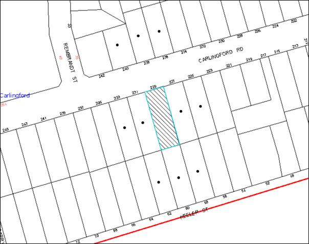
|
NOTIFICATION PLAN |
|
||
|
• PROPERTIES NOTIFIED
|
X SUBMISSIONS RECEIVED |
PROPERTY SUBJECT OF DEVELOPMENT |
|
5.2 Public Agencies
5.2.1 NSW Roads and Maritime Services
The application was referred to the Roads and Maritime Services (RMS) for comments under the provisions of Section 138 of the Roads Act 1993. The RMS has raised no objections subject to the implementation of recommended conditions of consent.
5.2.2 NSW Police
The proposal was referred to NSW Police Force for comments whereby no objections were raised.
6. THE PUBLIC INTEREST
Section 79C(1)(e) of the Act requires Council to consider “the public interest”.
The public interest is an overarching requirement, which includes the consideration of the matters discussed in this report. Implicit to the public interest is the achievement of future built outcomes adequately responding to and respecting the future desired outcomes expressed in environmental planning instruments and development control plans.
The application is considered to have satisfactorily addressed Council’s and relevant agencies’ criteria and would provide a development outcome that, on balance, would result in a positive impact for the community. Accordingly, it is considered that the approval of the proposed development would be in the public interest.
CONCLUSION
The application seeks approval for the demolition of existing structures and the construction of a five storey residential flat building comprising 15 dwellings, basement car parking and strata title subdivision.
The application has been assessed having regard to Section 79C of the Environmental Planning and Assessment Act 1979, the design principles within SEPP 65 Design Quality Residential Flat Development, the standards within the Hornsby Shire Local Environmental Plan 1994 and the objectives of the development controls within Council’s Housing Strategy DCP.
The proposal would result in a development this is compatible with the desired future character of the Carlingford Road housing strategy precinct.
Approval of the application is recommended.
Note: At the time of the completion of this planning report, no persons have made a Political Donations Disclosure Statement pursuant to Section 147 of the Environmental Planning and Assessment Act 1979 in respect of the subject planning application.
|
Rod Pickles Manager - Development Assessment Planning Division |
James Farrington Group Manager Planning Division |
|
1.View |
Locality Map |
|
|
|
2.View |
Site Plan |
|
|
|
3.View |
Landscape Plan |
|
|
|
4.View |
Floor Plans |
|
|
|
5.View |
Elevation Plans |
|
|
|
6.View |
Shadow Diagrams |
|
|
File Reference: DA/644/2013
Document Number: D02509319
SCHEDULE 1
GENERAL CONDITIONS
The conditions of consent within this notice of determination have been applied to ensure that the use of the land and/or building is carried out in such a manner that is consistent with the aims and objectives of the relevant legislation, planning instruments and council policies affecting the land and does not disrupt the amenity of the neighbourhood or impact upon the environment.
Note: For the purpose of this consent, the term ‘applicant’ means any person who has the authority to act on or the benefit of the development consent.
Note: For the purpose of this consent, any reference to an Act, regulation, Australian Standard or publication by a public authority shall be taken to mean the gazetted act or regulation, or adopted Australian Standard or publication as in force on the date that the application for a construction certificate is made.
1. Approved Plans and Supporting Documentation
The development must be carried out in accordance with the plans and documentation listed below and endorsed with Council’s stamp, except where amended by Council and/or other conditions of this consent:
|
Plan No. |
Plan Title |
Drawn by |
Dated |
|
8230 DA-A:00_A |
Cover Page |
Zhinar Architects |
21/6/2013 |
|
8230 DA-A:01_A |
Site Analysis |
Zhinar Architects |
7/6/2013 |
|
8230 DA-A:02_A |
Urban Context Analysis |
Zhinar Architects |
7/6/2013 |
|
8230 DA-A:03_C |
Basement Plan |
Zhinar Architects |
28/8/2013 |
|
8230 DA-A:04_C |
Ground Floor |
Zhinar Architects |
28/8/2013 |
|
8230 DA-A:05_C |
First Floor Plan |
Zhinar Architects |
28/8/2013 |
|
8230 DA-A:06_C |
Second and Third Floor Plan |
Zhinar Architects |
28/8/2013 |
|
8230 DA-A:07_C |
Fourth and Roof Plan |
Zhinar Architects |
28/8/2013 |
|
8230 DA-A:08_C |
North and South Elevations |
Zhinar Architects |
28/8/2013 |
|
8230 DA-A:09_C |
East and West Elevations |
Zhinar Architects |
28/8/2013 |
|
8230 DA-A:10_C |
Sections |
Zhinar Architects |
28/8/2013 |
|
13075DA1 |
Landscape Concept Plan |
Vision Dynamics Pty Ltd |
30/05/2013 |
|
1577-C-DA01_B |
Stormwater Layout Basement Level |
HKMA Engineers |
28/8/2013 |
|
1577-C-DA02_B |
Stormwater Layout Ground Level |
HKMA Engineers |
28/8/2013 |
|
1577-C-DA03_B |
OSD Tank Plan and Section Details and Notes |
HKMA Engineers |
28/8/2013 |
|
1577-C-DA04_B |
Plan and Section Details of Proposed Overland Flows |
HKMA Engineers |
28/8/2013 |
|
Job No.8230_A |
Colour Schedule |
Zhinar Architects |
29/5/2013 |
|
Document Name |
Drawn by |
Dated |
|
Arboricultural Impact Assessment |
Redgum Arboricultural and Horticultural Consultants Horticultural Consultants |
June 2013 |
|
Acoustic Report |
Acoustic Logic |
6/6/2013 |
|
Statement of Environmental Effects |
Caladines Town Planning |
June 2013 |
|
Traffic and Parking Report |
Varga Traffic Planning |
21/6/2013 |
|
Access Report |
Certified Building Specialists |
29/5/2013 |
|
SEPP 65 Design Verification Statement |
Zhinar Architects |
June 2013 |
|
Basix Certificate No. 484761M |
Designview |
30/5/2013 |
|
ABSA Assessor Energy Certificate and Plans No. 1005366792 |
Albert Bechara (Assessor) |
27/5/2013 |
|
Waste Management Plan |
Zhinar Architects |
Undated |
2. Amendment of Plans
The approved plans are to be amended as follows:
a) To maintain canopy cover, 5 x medium to large trees selected from Council’s booklet ‘Indigenous Plants for the Bushland Shire’ such as Angophora floribunda are to be planted on the subject site. This is required to be indicated on the Landscape Concept Plan.
b) Delete the traffic island from the driveway design.
c) Include a central median in Carlingford Road as required by RMS on the approved plans.
d) 5 x bicycle parking spaces are to be included in the Basement Level Car Park.
e) All built structures i.e. walls are to be deleted from the overland flow path.
f) Letter boxes are to be relocated at least 2m from the front property boundary and not within the overland flow path.
g) The Landscaping within the overland flow path (the north western part of the proposed development) is to be revised to ensure the finished ground levels are in accordance with drawing No. 1577-C-DA04_B, titled Plan and Plan and Section Details of Proposed Overland Flows drawn by HKMA Engineers dated 28 August 2013.
3. Construction Certificate
A Construction Certificate is required to be approved by Council or a Private Certifying Authority prior to the commencement of any works under this consent.
REQUIREMENTS PRIOR TO THE ISSUE OF A CONSTRUCTION CERTIFICATE
4. Building Code of Australia
All building work must be carried out in accordance with the relevant requirements of the Building Code of Australia.
5. Contract of Insurance (Residential Building Work)
In the case of residential building work for which the Home Building Act, 1989 requires there to be a contract of insurance in force in accordance with Part 6 of that Act, that such a contract of insurance is in force before any building work authorised to be carried out by the consent commences.
6. Water/Electricity Utility Services
The applicant must submit written evidence of the following service provider requirements:
a) Ausgrid (formerly Energy Australia) – a letter of consent demonstrating that satisfactory arrangements have been made to service the proposed development.
b) Sydney Water – the submission of a ‘Notice of Requirements’ under s73 of the Sydney Water Act 1994.
Note: Sydney Water requires that s73 applications are to be made through an authorised Sydney Water Servicing Coordinator. Refer to www.sydneywater.com.au or telephone 13 20 92 for assistance.
7. Adaptable Units
The details of fit-outs of all accessible units and details of adaptable units must be provided with the Construction Certificate Plans.
8. Letter Boxes
The details of letter boxes must be provided with the Construction Certificate Plans. The letter boxes must be provided with a minimum setback of 2m from the front property boundary and not located within the overland flow path.
9. Waste Management Details
The following waste management requirements must be complied with:
a) On each level that includes an adaptable or accessible dwelling, the waste facility (the garbage chute and recycling bin) needs to be accessible by persons with a disability.
b) The access way (including ramp to the basement car park, vehicle turning area, loading bay and site entry/exit) to be used by waste collection vehicles, must comply with Australian Standard AS2890.2-2002 Parking Facilities Part 2: Off-street Commercial Vehicles Facilities for small rigid vehicles with minimum design vehicle dimensions of 6.4m overall length, width of 2.3m, with maximum gradient of 1:6.5 and minimum 3.5m clearance height.
REQUIREMENTS PRIOR TO THE COMMENCEMENT OF ANY WORKS
10. Erection of Construction Sign
A sign must be erected in a prominent position on any site on which building work, subdivision work or demolition work is being carried out:
a) Showing the name, address and telephone number of the principal certifying authority for the work;
b) Showing the name of the principal contractor (if any) for any demolition or building work and a telephone number on which that person may be contacted outside working hours; and
c) Stating that unauthorised entry to the work site is prohibited.
Note: Any such sign is to be maintained while the building work, subdivision work or demolition work is being carried out, but must be removed when the work has been completed.
11. Protection of Adjoining Areas
A temporary hoarding, fence or awning must be erected between the work site and adjoining lands before the works begin and must be kept in place until after the completion of the works if the works:
a) Could cause a danger, obstruction or inconvenience to pedestrian or vehicular traffic.
b) Could cause damage to adjoining lands by falling objects.
c) Involve the enclosure of a public place or part of a public place.
Note: Notwithstanding the above, Council’s separate written approval is required prior to the erection of any structure or other obstruction on public land.
12. Toilet Facilities
Toilet facilities must be available or provided at the works site before works begin and must be maintained until the works are completed at a ratio of one toilet for every 20 persons employed at the site. Each toilet must:
a) be a standard flushing toilet connected to a public sewer; or
b) be a temporary chemical closet approved under the Local Government Act, 1993; or
c) have an on-site effluent disposal system approved under the Local Government Act, 1993.
13. Erosion and Sediment Control
Erosion and sediment control measures must be provided and maintained throughout the construction period in accordance with the manual ‘Soils and Construction 2004 (Bluebook)’, the approved plans, Council specifications and to the satisfaction of the principal certifying authority. The erosion and sediment control devices must remain in place until the site has been stabilised and revegetated.
Note: On the spot penalties up to $1,500 may be issued for any non-compliance with this requirement without any further notification or warning.
14. Tree Protection Barriers
Tree protection fencing must be erected around trees numbered 1 at a distance as set out under Section 7 of the as indicated in the Arboricultural Impact Assessment prepared by Redgum Horticultural Consultants date June 2013. The tree fencing must be constructed of 1.8m ‘cyclone chainmesh fence’.
REQUIREMENTS DURING CONSTRUCTION
15. Construction Work Hours
All work on site (including demolition and earth works) must only occur between 7am and 5pm Monday to Saturday. No work is to be undertaken on Sundays or public holidays.
16. Demolition
All demolition work must be carried out in accordance with “Australian Standard 2601-2001 – The Demolition of Structures” and the following requirements:
a) Demolition material must be disposed of to an authorised recycling and/or waste disposal site and/or in accordance with an approved waste management plan;
b) Demolition works, where asbestos material is being removed, must be undertaken by a contractor that holds an appropriate licence issued by WorkCover NSW in accordance with Chapter 10 of the Occupational Health and Safety Regulation 2001 and Clause 29 of the Protection of the Environment Operations (Waste) Regulation 2005; and
c) On construction sites where buildings contain asbestos material, a standard commercially manufactured sign containing the words ‘DANGER ASBESTOS REMOVAL IN PROGRESS’ measuring not less than 400mm x 300mm must be erected in a prominent position visible from the street.
17. Environmental Management
The site must be managed in accordance with the publication ‘Managing Urban Stormwater – Landcom (March 2004) and the Protection of the Environment Operations Act 1997 by way of implementing appropriate measures to prevent sediment run-off, excessive dust, noise or odour emanating from the site during the construction of the development.
18. Works Near Trees
All required tree protection measures are to be maintained in good condition for the duration of the construction period.
All works (including driveways and retaining walls) within the tree protection zones nominated in the Arboricultural Impact Assessment prepared by Redgum Arboricultural and Horticultural Consultants of any trees required to be retained (whether or not on the subject property, and pursuant to this consent or the Tree Preservation Order), must be carried out under the supervision of an ‘AQF Level 5 Arborist’ and a certificate submitted to the principal certifying authority detailing the method(s) used to preserve the tree(s).
Note: Except as provided above, the applicant is to ensure that no excavation, filling or stockpiling of building materials, parking of vehicles or plant, disposal of cement slurry, waste water or other contaminants is to occur within 4 metres of any tree to be retained.
19. Street Sweeping
Street sweeping must be undertaken following sediment tracking from the site along Carlingford Road during works and until the site is established.
20. Council Property
During construction works, no building materials, waste, machinery or related matter is to be stored on the road or footpath. The public reserve must be kept in a clean, tidy and safe condition at all times.
21. Disturbance of Existing Site
During construction works, the existing ground levels of open space areas and natural landscape features, (including natural rock-outcrops, vegetation, soil and watercourses) must not be altered unless otherwise nominated on the approved plans.
22. Demolition and Construction Vehicles
All demolition and construction vehicles must be wholly parked within the site at all times.
23. Landfill
Landfill must be constructed in accordance with Council’s ‘Construction Specification, 2005’ and the following requirements:
a) All fill material imported to the site is to wholly consist of Virgin Excavated Natural Material (VENM) as defined in Schedule 1 of the Protection of the Environment Operations Act 1997 or a material approved under the Department of Environment and Climate Change’s general resource recovery exemption.
b) A compaction certificate is to be obtained from a geotechnical engineer verifying that the specified compaction requirements have been met.
24. Excavated Material
All excavated material removed from the site must be classified in accordance with the Department of Environment, Climate Change and Water NSW Waste Classification Guidelines prior to disposal to an approved waste management facility and reported to the principal certifying authority.
25. Survey Report – Finished Floor Level
A report(s) must be prepared by a registered surveyor and submitted to the principal certifying authority prior to the pouring of concrete at each level of the building certifying that:
a) The building, retaining walls and the like have been correctly positioned on the site; and
b) The finished floor level(s) are in accordance with the approved plans.
26. Contamination During Construction Works
Should the presence of asbestos or soil contamination, not recognised during the application process be identified during demolition, the applicant must immediately notify the Principal Certifying Authority and Council.
27. Construction Noise Management
The construction works must be undertaken in accordance with the “Interim Construction Noise Guidelines – 2009” published by DECCW.
28. Waste Management Details
Waste management during the demolition and construction phase of the development must be undertaken in accordance with the approved Waste Management Plan. Additionally written records of the following items must be maintained during the removal of any waste from the site and such information submitted to the Principal Certifying Authority within fourteen days of the date of completion of the works:
a) The identity of the person removing the waste.
b) The waste carrier vehicle registration.
c) Date and time of waste collection.
d) A description of the waste (type of waste and estimated quantity).
e) Details of the site to which the waste is to be taken.
f) The corresponding tip docket/receipt from the site to which the waste is transferred (noting date and time of delivery, description (type and quantity) of waste).
g) Whether the waste is expected to be reused, recycled or go to landfill.
Note: In accordance with the Protection of the Environment Operations Act 1997, the definition of waste includes any unwanted substance, regardless of whether it is reused, recycled or disposed to landfill.
REQUIREMENTS PRIOR TO THE ISSUE OF AN OCCUPATION CERTIFICATE
Note: For the purpose of this consent, a reference to ‘occupation certificate’ shall not be taken to mean an ‘interim occupation certificate’ unless otherwise stated.
29. Stormwater Drainage – Dwellings
The stormwater drainage system for the development must be designed and constructed for an average recurrence interval of 20 years and be gravity drained in accordance with the following requirements:
a) Connected to an existing Council piped drainage system via an on-site detention system.
b) For connection to Council pit, a construction certificate application is to be submitted to Council (as Council is the authority to approve a plan for connection to a Council system).
c) Be designed by a qualified hydraulic engineer.
30. On Site Stormwater Detention
An on-site stormwater detention system must be designed by a chartered civil engineer and constructed in accordance with the following requirements:
a) Storage capacity to accommodate volume from up to 20 years ARI (average recurrence interval) and a maximum discharge (when full) limited to 5 years pre development rate.
b) Have a surcharge/inspection grate located directly above the outlet.
c) Discharge from the detention system to be controlled via 1 metre length of pipe, not less than 50 millimetres diameter or via a stainless plate with sharply drilled orifice bolted over the face of the outlet discharging into a larger diameter pipe capable of carrying the design flow to an approved Council system.
d) Where above ground and the average depth is greater than 0.3 metres, a ‘pool type’ safety fence and warning signs to be installed.
e) Not be constructed in a location that would impact upon the visual or recreational amenity of residents.
f) Detail calculations are to be shown in construction certificate plan.
31. Overland Flow Path, Landscaping and Flood Proofing
a) A 100 year ARI overland flowpath, based on the report Drawing No 1755-C, DA04, Revision A drawn by HKMA Engineers is to be constructed (the landscaping of the overland flow area, as proposed by drawing No 13075DA 1, Revision A, drawn by Vision Dynamics is to be altered to have finished ground levels as shown in the drawing by HKMA Engineers).
b) No walls above finished ground level across the flow path are to be erected to ensure uninterrupted overland flow through the development site.
c) Any structural wall abutting the overland flowpath shall be flood proofed in accordance with Floodplain Development manual of New South Wales Government.
d) Floor levels of habitable rooms of the development abutting the 100 year ARI overland flowpath shall be 0.5m above the 100 year ARI flood levels (at the corresponding point as shown in the Drawing No 1755-C, DA04 , Revision A drawn by HKMA Engineers).
e) A works as executed plan is to be submitted to Council.
32. Vehicular Crossing
A separate application under the Local Government Act, 1993 and the Roads Act, 1993 must be submitted to Council for the installation of a new vehicular crossing and the removal of the redundant crossing. The vehicular crossing must be constructed in accordance with Council’s Civil Works Design, 2005 and the following requirements:
a) Any redundant crossings must be replaced with integral kerb and gutter;
b) The footway area must be restored by turfing;
c) Approval must be obtained from all relevant utility providers that all necessary conduits be provided and protected under the crossing.
Note: An application for a vehicular crossing can only be made to one of Council’s Authorised Vehicular Crossing Contractors. You are advised to contact Council on 02 9847 6940 to obtain a list of contractors.
33. Internal Driveway/Vehicular Areas
The driveway and parking areas on site must be designed in accordance with Australian Standards 2890.1, 2890.2, 3727 and the following requirements:
a) Design levels at the front boundary must be obtained from Council;
b) The driveway must be a rigid pavement;
c) All parking spaces for cars, waste and delivery vehicle are to be line marked and posted.
34. Road Works - Footpath
All road works approved under this consent must be constructed in accordance with Council’s Civil Works Design and Construction Specification, 2005 and the following requirements:
a) Existing footpath along the frontage of the development shall be removed and reconstructed.
b) Nature strip on both sides of the footpath is to be top soiled and turfed.
c) A construction certificate is to be submitted to Council for approval.
Note: Council is the only authority to approve works within Council roads.
35. Traffic Control Plan
A Traffic Control Plan (TCP) must be prepared by a qualified traffic controller in accordance with the Roads & Traffic Authority’s Traffic Control at Worksites Manual 1998 and Australian Standard 1742.3 for all work on a public road and be submitted to Council. The TCP must detail the following:
a) Arrangements for public notification of the works.
b) Temporary construction signage.
c) Permanent post-construction signage.
d) Vehicle movement plans.
e) Traffic management plans.
f) Pedestrian and cyclist access/safety.
36. Works as Executed Plan
A works-as-executed plan(s) must be prepared by a registered surveyor and submitted to Council for completed road pavement, kerb & gutter, overland flow path, drainage systems, driveways and on-site detentions system.
37. Foundation of Structure within Council Stormwater Pipe Zone of Influence
Foundation of structure in the proximity of Council stormwater pipe shall be carried out by a Chartered Structural Engineer of the Institution of Engineers, Australia ensuring that the Council pipes are not impacted.
After completion of works, a certificate from a Chartered Professional Structural Engineer of the Institution of Engineers, Australia confirming that works have been carried out in a manner that no impact has been created on Council drainage system.
38. Creation of Easements
The following matter(s) must be nominated on the plan of subdivision under s88B of the Conveyancing Act 1919:
a) A restriction over the pipeline and the flow path for a 100 year average recurrence interval storm. The "Restriction on the Use of Land" over the affected lots is to prohibit the alteration of the final floodway shape and the erection of any structures, including fencing, in the floodway without the written permission of Council. The terms of this restriction must be obtained from Council.
b) The creation of an appropriate "Positive Covenant" and "Restriction as to User" over the constructed on-site detention/retention systems and outlet works, within the lots in favour of Council in accordance with Council’s prescribed wording. The position of the on-site detention system is to be clearly indicated on the title.
c) To register the OSD easement, the restriction on the use of land “works-as-executed” details of the on-site-detention system must be submitted verifying that the required storage and discharge rates have been constructed in accordance with the design requirements. The details must show the invert levels of the on site system together with pipe sizes and grades. Any variations to the approved plans must be shown in red on the “works-as-executed” plan and supported by calculations.
Note: Council must be nominated as the authority to release, vary or modify any easement, restriction or covenant.
39. Maintain Canopy Cover
To maintain canopy cover, 5 medium to large trees selected from Council’s booklet ‘Indigenous Plants for the Bushland Shire’ such as Angophora floribunda are to be planted on the subject site. The planning location shall not be within 4 metres of the foundation walls of a dwelling or in-ground pool. The pot size is to be a minimum 25 litres and the tree(s) must be maintained until they reach the height of 3 metres. Trees must be native to Hornsby Shire and reach a mature height greater than 15 metres.
40. Fulfilment of BASIX Commitments
The applicant must demonstrate the fulfilment of BASIX commitments pertaining to the development.
41. Sydney Water – s73 Certificate
An s73 Certificate must be obtained from Sydney Water.
42. Damage to Council Assets
Any damage caused to Council’s assets as a result of the construction of the development must be rectified in accordance with Council’s written requirements and at the sole cost of the applicant.
43. Car Parking Allocation and Resident Storage
The basement resident storage areas are to be allocated in accordance with the size requirements of the SEPP – 65 Residential Flat Design Code for the respective units and proximity to the unit car parking space.
44. Retaining Walls
All required retaining walls must be constructed as part of the development.
45. External Lighting
All external lighting must be designed and installed in accordance with Australian Standard AS 4282 – Control of the Obtrusive Effects of Outdoor Lighting. Certification of compliance with the Standard must be obtained from a suitably qualified person.
46. Unit Numbering
The allocation of unit numbering must be authorised by Council prior to the numbering of each unit in the development.
47. Completion of Landscaping
A certificate must be provided by a practicing landscape architect, horticulturalist or person with similar qualifications and experience certifying that all required landscaping works have been satisfactorily completed in accordance with the approved landscape plans.
Note: Advice on suitable species for landscaping can be obtained from Council’s planting guide ‘Indigenous Plants for the Bushland Shire’, available at www.hornsby.nsw.gov.au.
48. Garbage Collection Easement
For the purpose of waste collection, an easement entitling Council, its servants and agents and persons authorised by it to enter upon the subject land and to operate thereon, vehicles and other equipment for the purposes of garbage collection must be granted to Council by the owner of the land.
Note: The easement must be in a form prescribed by Council and must include covenants to the effect that parties will not be liable for any damage caused to the subject land or any part thereof or to any property located therein or thereon by reason of the operation thereon of any vehicle or other equipment used in connection with the collection of garbage and to the effect that the owner for the time being of the subject land shall indemnify the Council, its servants, agents and persons authorised by it to collect garbage against liability in respect of any such claims made by any person whomsoever.
49. Waste Management Details
The following waste management requirements must be complied with:
a) The bin storage room at the basement level must include water or a hose for cleaning, graded floors with drainage to sewer, a robust door, sealed and impervious surface, adequate lighting and ventilation. The bin rooms at each residential level must include sealed and impervious surface, adequate lighting and ventilation.
b) A report must be prepared by an appropriately qualified person, certifying the following:
i) A comparison of the estimated quantities of each waste type against the actual quantities of each waste type.
Note: Explanations of any deviations to the approved Waste Management Plan is required to be included in this report.
ii) That at least 60% of the waste generated during the demolition and construction phase of the development was reused or recycled.
Note: If the 60% diversion from landfill cannot be achieved in the Construction Stage, the Report is to include the reasons why this occurred and certify that appropriate work practices were employed to implement the approved Waste Management Plan. The Report must be based on documentary evidence such as tipping dockets/receipts from recycling depots, transfer stations and landfills, audits of procedures etc. which are to be attached to the report.
iii) All waste was taken to site(s) that were lawfully permitted to accept that waste.
c) Each unit must be provided with an indoor waste/recycling cupboard for the interim st orage of a minimum one day’s waste generation with separate containers for general waste and recyclable materials.
d) Space must be provided for either individual compost containers for each unit or a communal compost container.
Note: The location of the compost containers should have regard for potential amenity impacts.
e) The bin carting routes must be devoid of any steps.
Note: Ramps between different levels are accepted.
f) “No parking” signs must be erected to prohibit parking in the waste collection vehicle turning area and loading area.
g) A report(s) must be prepared by a registered surveyor and submitted to the principle certifying authority prior to the issue of the Subdivision/Occupation Certificate, certifying that: The finished access way (including ramp, vehicle turning area, loading bay and site entry/exit) to be used by waste collection vehicles, complies with Australian Standard AS2890.2-2002 Parking Facilities Part 2: Off-street Commercial Vehicle Facilities for small rigid vehicles with minimum design vehicle dimensions of 6.4m overall length, width of 2.3m, with maximum gradient of 1:6.5 and minimum 3.5m clearance height.
h) The 3.5m clearance height within the waste collection vehicle travel path must not be reduced by ducting, pipes or anything else.
50. Section 94 Development Contributions
In accordance with Section 80A(1) of the Environmental Planning and Assessment Act 1979 and the Hornsby Shire Council Section 94 Development Contributions Plan 2012-2021, the following monetary contributions shall be paid to Council to cater for the increased demand for community infrastructure resulting from the development:
|
Description |
Contribution (4) |
|
Roads |
$9,842.75 |
|
Open Space and Recreation |
$176,295.70 |
|
Community Facilities |
$24,716.10 |
|
Plan Preparation and Administration |
$759.45 |
|
TOTAL |
$211,614.00 |
being for 15 units comprising 2 x 1 bedroom units, 10 x 2 bedroom units and 3 x 3 bedroom units and 1 credit.
a) If the contributions are not paid within the financial quarter that this consent is granted, the contributions payable will be adjusted in accordance with the provisions of the Hornsby Shire Council Section 94 Development Contributions Plan and the amount payable will be calculated at the time of payment in the following manner:
$CPY = $CDC x CPIPY
CPIDC
Where:
$CPY is the amount of the contribution at the date of Payment.
$CDC is the amount of the contribution as set out in this Development Consent.
CPIPY is the latest release of the Consumer Price Index (Sydney – All Groups) at the date of Payment as published by the ABS.
CPIDC is the Consumer Price Index (Sydney – All Groups) for the financial quarter at the date of this Development Consent.
b) The monetary contributions shall be paid to Council:
i) prior to the issue of the Subdivision Certificate where the development is for subdivision; or
ii) prior to the issue of the first Construction Certificate where the development is for building work; or
iii) prior to issue of the Subdivision Certificate or first Construction Certificate, whichever occurs first, where the development involves both subdivision and building work; or
iv) prior to the works commencing where the development does not require a Construction Certificate or Subdivision Certificate.
It is the professional responsibility of the Principal Certifying Authority to ensure that the monetary contributions have been paid to Council in accordance with the above timeframes.
Council’s Development Contributions Plan may be viewed at www.hornsby.nsw.gov.au or a copy may be inspected at Council’s Administration Centre during normal business hours.
OPERATIONAL CONDITIONS
51. Car Parking
All car parking must be constructed and operated in accordance with AS2890.1-2004 Off Street Car Parking and AS2890.2-2002 Off Street Commercial and the following requirement:
a) All parking areas and driveways are to be sealed to an all weather standard, line marked and signposted.
b) Car parking, loading and manoeuvring areas to be used solely for nominated purposes.
c) Vehicles awaiting loading, unloading or servicing shall be parked on site and not on adjacent or nearby public roads.
d) All vehicular entry on to the site and egress from the site shall be made in a forward direction.
e) Visitors are to have access to the parking area at all times. Visitors are to be able to access the basement car park by an audio/visual intercom system located at the top of the ramped driveway.
f) All bicycle parking spaces are to be provided in accordance with AS2890.3-1993 Bicycle Parking Facilities.
52. Disabled Parking
All parking spaces for people with disabilities must be constructed and operated in accordance with AS2890.6 - 2009 Off-street parking for people with disabilities.
53. Headroom Clearance
Headroom clearance of 3.5m is to be maintained at change of grade to the basement level.
54. Sight Lines for Pedestrian Safety
Minimum sight lines for pedestrian safety are to be provided at the driveway.
55. Noise
All noise generated by the proposed development must be attenuated to prevent levels of noise being emitted to adjacent premises which possess tonal, beating and similar characteristics or which exceeds background noise levels by more than 5dB(A).
56. Fire Safety Statement - Annual
On at least one occasion in every 12 month period following the date of the first ‘Fire Safety Certificate’ issued for the property, the owner must provide Council with an annual ‘Fire Safety Certificate’ to each essential service installed in the building.
57. Landscape Establishment
The landscape works must be maintained into the future to ensure the establishment and successful growth of plant material to meet the intent of the landscape design. This must include but not be limited to watering, weeding, replacement of failed plant material and promoting the growth of plants through standard industry practices.
58. Waste Management
The waste management on site must be in accordance with the following requirements:
a) A site manager or caretaker must be employed and be responsible for moving bins where and when necessary, washing bins and maintaining waste storage areas, ensuring the chute system and related devices are maintained in effective and efficient working order, managing the communal composting areas, managing the bulky item storage area, arranging the prompt removal of dumped rubbish, ensuring the vehicle turning area and truck loading area is kept clear of parked cars, and ensuring all residents are informed of the use of the waste management system.
b) Site security measures be implemented on the property, including electronic gates, must not prevent access to the bin room/collection point by waste removal services.
CONDITIONS OF CONCURRENCE – NSW RMS
The following conditions of consent are from the nominated State Agency pursuant to Section 79B of the Environmental Planning and Assessment Act 1979 and must be complied with to the satisfaction of that Agency.
59. Access Driveway
The access driveway width is to be a minimum of 5.5m for at least 6m from the property line as per AS2890.1:2004.
The design and construction of the vehicular crossing on Carlingford Road shall be in accordance with RMS requirements. Details of these requirements should be obtained from RMS Project Services Manager, Traffic Projects Section, Parramatta (Telephone 8849 2496).
Detailed design plans of the proposed vehicular crossing are to be submitted to RMS for approval prior to the commencement of any road works. A plan checking fee (amount to be advised) and lodgement of a performance bond may be required from the applicant prior to the release of the approved road design plans by RMS.
60. Installation of the Central Median
As part of the development, a central median is to be installed on Carlingford Road and extended on both sides of the driveway to enforce left-in and left-out movements.
The central median shall be designed to meet RMS requirements, and endorsed by a suitably qualified practitioner. The design requirements shall be in accordance with AUSTROADS and other Australian Codes of Practice. The certified copies of the civil design plans shall be submitted to RMS for consideration and approval prior to the release of the Construction Certificate by Council and commencement of road works.
The developer may be required to enter into a Works Authorisation Deed (WAD) for the above mentioned works. Please note that the WAD will need to be executed prior to RMS assessment of the detailed civil design plans.
RMS fees for administration, plan checking, civil works inspections and project management shall be paid by the developer prior to the commencement of works.
61. Construction Activity
All construction activity associated with the proposed development is to be contained on site as no construction zones will be permitted on Carlingford Road in the vicinity of the site.
62. Road Occupancy License
A Road Occupancy License should be obtained from TMC for any works that my impact on traffic flows on Carlingford Road during construction activities.
63. Construction Traffic Management Plan
A Construction Traffic Management Plan detailing construction vehicle routes, number of trucks, hours of operation, access arrangements and traffic control should be submitted to RMS for determination prior to the issue of a construction certificate.
64. Swept Path
The swept path of the longest vehicle (to service the site) entering and exiting the subject site, as well as manoeuvrability through the site, shall be in accordance with AUSTROADS. In this regard, a plan shall be submitted to Council for approval, which shows that the proposed development complies with this requirement.
65. Layout of Car Parking Area
The layout of the proposed car parking areas associated with the subject development (including driveways, grades, turn paths, sight distance requirements, aisle widths, aisle lengths, and parking bay dimensions) should be in accordance with AS2890.1-2004.
66. Signposting
All works/regulatory signposting associated with the proposed development are to be at no cost to the RMS.
67. Sight Distance to Pedestrians and Cyclists
Any proposed landscaping and/or fencing must not restrict sight distance to pedestrians and cyclists travelling along the footpath.
68. Vehicular Entry
All vehicles are to entre and leave the site in a forward direction.
CONDITIONS OF CONCURRENCE – NSW POLICE
69. CCTV
CCTV should be installed in all access ways, particularly around the foyer area and entry and exit points. If possible CCTV should be installed around communal mail boxes as mail theft is an increasing crime within the metropolitan area.
70. Lighting
Areas around the entrance, basement car parking area and communal areas are to be well lit and designed in accordance with Australian and New Zealand lighting standards.
71. Signage
a) A street sign should be prominently displayed at the front of the development to comply with Local Government Act, 1993, Section 124, Order No. 8.
b) Signage also needs to be provided at entry/exit points and throughout the development to assist users and warn intruders they will be prosecuted.
c) Signage also needs to be provided on the fire exit doors warning users that the doors are to be used for emergency purposes only.
d) Signage is required to indicate entries and exits to both the building and car parking areas. Signs should be clear, legible and useful. Number of units should be clearly marked and the front of the building should have clear signage in regards to street numbers so that emergency services are able to clearly read the numbers of the unit block.
e) If boundary fences are erected at the front of the property, they should not be erected in such a way that they do not prohibit the natural surveillance inside the property.
72. Environmental Maintenance
a) A maintenance policy needs to be established for this development.
b) A graffiti management plan needs to be incorporated into the maintenance plan for the development.
73. Access Control
a) All areas should be fitted with doors that comply with Australian Design Standards.
b) The locks fitted to the doors should be of a high quality and meet the Australian design standards.
c) Glass within these doors should be laminated to enhance the physical security of the doors.
d) Access control should be set in place to exclude unauthorised access to restricted areas.
e) Windows, particularly on the ground floor should be fitted with good quality window locks that can be locked with a key.
f) All mail boxes should be of a high quality with good quality locks allowing access by the resident only.
74. Space/Activity Management
The security system and cameras are to be installed in the building at the time of construction and not after. If left to be determined by a body corporate, it is highly likely that the security system would not be adopted.
- END OF CONDITIONS -
ADVISORY NOTES
The following information is provided for your assistance to ensure compliance with the Environmental Planning and Assessment Act, 1979, Environmental Planning and Assessment Regulation 2000, other relevant legislation and Council’s policies and specifications. This information does not form part of the conditions of development consent pursuant to Section 80a of the Act.
Environmental Planning and Assessment Act, 1979 Requirements
The Environmental Planning and Assessment Act, 1979 requires:
· The issue of a construction certificate prior to the commencement of any works. Enquiries can be made to Council’s Customer Services Branch on 9847 6760.
· A principal certifying authority to be nominated and Council notified of that appointment prior to the commencement of any works.
· Council to be given at least two days written notice prior to the commencement of any works.
· Mandatory inspections of nominated stages of the construction inspected.
· An occupation certificate to be issued before occupying any building or commencing the use of the land.
Long Service Levy
In accordance with Section 34 of the Building and Construction Industry Long Service Payments Act 1986, a ‘Long Service Levy’ must be paid to the Long Service Payments Corporation or Hornsby Council.
Note: The rate of the Long Service Levy is 0.35% of the total cost of the work.
Note: Hornsby Council requires the payment of the Long Service Levy prior to the issue of a construction certificate.
Tree Preservation Order
To ensure the maintenance and protection of the existing natural environment, it is an offence to ringbark, cut down, top, lop, remove, wilfully injure or destroy a tree outside 3 metres of the approved building envelope without the prior written consent from Council.
Note: A tree is defined as a single or multi-trunked wood perennial plant having a height of not less than three (3) metres, and which develops many branches, usually from a distance of not less than one (1) metre from the ground, but excluding any plant which, in its particular location, is a noxious plant declared as such pursuant to the Noxious Weeds Act 1993. This definition of ‘tree’ includes any and all types of Palm trees.
All distances are determined under Australian Standard AS4970-2009 ”Protection of Trees on Development Sites”.
Fines may be imposed for non-compliance with Council’s Tree Preservation Order.
Disability Discrimination Act
The applicant’s attention is drawn to the existence of the Disability Discrimination Act. A construction certificate is required to be obtained for the proposed building/s, which will provide consideration under the Building Code of Australia, however, the development may not comply with the requirements of the Disability Discrimination Act. This is the sole responsibility of the applicant.
Covenants
The land upon which the subject building is to be constructed may be affected by restrictive covenants. Council issues this approval without enquiry as to whether any restrictive covenant affecting the land would be breached by the construction of the building, the subject of this consent. Applicants must rely on their own enquiries as to whether or not the building breaches any such covenant.
Dial Before You Dig
Prior to commencing any works, the applicant is encouraged to contact Dial Before You Dig on 1100 or www.dialbeforeyoudig.com.au for free information on potential underground pipes and cables within the vicinity of the development site.
Telecommunications Act 1997 (Commonwealth)
If you are aware of any works or proposed works which may affect or impact on Telstra’s assets in any way, you are required to contact: Telstra’s Network Integrity Team on Phone Number 1800810443.
Asbestos Warning
Should asbestos or asbestos products be encountered during demolition or construction works, you are advised to seek advice and information prior to disturbing this material. It is recommended that a contractor holding an asbestos-handling permit (issued by WorkCover NSW)be engaged to manage the proper handling of this material. Further information regarding the safe handling and removal of asbestos can be found at:
Alternatively, telephone the WorkCover Asbestos and Demolition Team on 8260 5885.
Group Manager’s Report No. PL110/13
Planning Division
Date of Meeting: 20/11/2013
16 DEVELOPMENT APPLICATION - CHILD CARE CENTRE - 23 BELLAMY STREET, PENNANT HILLS
EXECUTIVE SUMMARY
|
DA No: |
DA/679/2012 (Lodged 5 July 2012) |
|
Description: |
Demolition of existing structures and construction of a new purpose built 60 place child care centre |
|
Property: |
Lots 9 and 10, DP 17123, No. 23 Bellamy Street, Pennant Hills |
|
Applicant: |
Shayne Lysaght |
|
Owner: |
Shayne Lysaght |
|
Estimated Value: |
$750,000 |
|
Ward: |
C |
· The application proposes demolition of existing structures and construction of a new purpose built 60 place child care centre.
· The proposal complies with the objectives of the Hornsby Shire Local Environmental Plan 1994. The proposal generally complies with the requirements of Council’s Community Uses Development Control Plan with the exception of the number of children and the provision of landscaping.
· A Red Sticker has been placed on the application requiring that the proposal be determined at a Council Meeting.
· 53 submissions and 1 petition with 63 signatures have been received in respect of the application.
· It is recommended that the application be approved.
|
THAT Development Application No. DA/679/2012 for demolition of existing structures and construction of a purpose built 60 place child care centre at Lots 9 and 10, DP 17123, No. 23 Bellamy Street, Pennant Hills be approved subject to the conditions of consent detailed in Schedule 1 of Group Manager’s Report No. PL110/13. |
BACKGROUND
The site is currently used for residential purposes.
SITE
The site comprises 2 lots, has an area of 1653.66m2 and is located on the north-western side of Bellamy Street approximately 60m south of the intersection with Laurence Street. The site adjoins the Lilian Fraser Garden which is listed as a heritage item (local) in Schedule D of the Hornsby Shire Local Environmental Plan 1994.
There is a single storey dwelling positioned towards the centre of the site and located over the boundary of Lots 9 and 10. The site has a right of carriageway 3.5m wide extending along the south western boundary which provides access for the dwelling at the rear of the site on Lot E DP 380042, No. 21A Bellamy Street. The site is traversed by a watercourse along the south-west corner.
The site contains a number of exotic trees. It is noted that there are no trees protected by Council’s Tree Preservation Order, which would be impacted upon by this proposal. The site is surrounded by one and two storey residential dwellings.
The site is located in close proximity to Pennant Hills High School.
PROPOSAL
The proposal is for the construction of a new 2 storey child care centre. The proposed works include:
· Demolition of the existing dwelling-house and associated outbuildings;
· Removal of existing concrete driveway;
· Clearing and removal of existing landscaping (tree removal has been undertaken already);
· Removal of existing front and northern side boundary fencing;
· Construction of a new split-level childcare centre;
· New covered outdoor learning area;
· New gazebo/sandpit in the north-western corner of site;
· New car-parking area within the front boundary of the site;
· New additional driveway entry and configuration of the car-park;
· New pathway parallel to the northern side boundary; and
· New fencing parallel to the existing watercourse which transects the rear of the site.
The centre would cater for 60 children and the proposed hours of operation would be 7.30am to 6.00pm Monday to Friday.
ASSESSMENT
The development application has been assessed having regard to the ‘Metropolitan Plan for Sydney 2031’, the ‘North Subregion (Draft) Subregional Strategy’ and the matters for consideration prescribed under Section 79C of the Environmental Planning and Assessment Act 1979 (the Act). The following issues have been identified for further consideration.
1. STRATEGIC CONTEXT
1.1 Metropolitan Plan for Sydney and (Draft) North Subregional Strategy
The (Draft) Metropolitan Strategy for Sydney 2031 is a broad framework to provide for Sydney’s growth to help plan for housing, employment, transport, infrastructure, the environment and open space. It outlines a vision for Sydney to 2031; the challenges faced, and the directions to follow to address these challenges and achieve the vision.
The North Subregion comprises Hornsby, Kuring-gai, Manly, Warringah and Pittwater Local Government Areas. The Draft North Subregional Strategy provided a framework for Council in its preparation of the Hornsby Local Environmental Plan 2013.
Within the North Subregion, the Draft Metropolitan Strategy proposes:
· Population growth of 81,000 from the current 2011 baseline of 529,000
· Housing growth of 37,000 from the current 2011 baseline of 204,000
· Employment growth of 39,000 from the current 2011 baseline of 186,000
The proposed development would be consistent with the Metropolitan Plan for Sydney 2031 by providing child care facilities to support a growing population.
2. STATUTORY CONTROLS
Section 79C(1)(a) requires Council to consider “any relevant environmental planning instruments, draft environmental planning instruments, development control plans, planning agreements and regulations”.
2.1 Hornsby Shire Local Environmental Plan 1994
The subject land is zoned Residential A (Low Density) under the Hornsby Shire Local Environmental Plan 1994 (HSLEP). The objectives of the Residential A zone are:
(a) to provide for the housing needs of the population of the Hornsby area.
(b) to promote a variety of housing types and other land uses compatible with a low density residential environment.
(c) to provide for development that is within the environmental capacity of a low density residential environment.
The proposed development is defined as ‘demolition’ and ‘child care centre’ under the HSLEP and is permissible in the zone with Council’s consent.
Clause 15 of the HSLEP prescribes that the maximum floor space ratio (FSR) of development within the Residential A (Low Density) zone is 0.4:1. The proposed development has a FSR of 0.35:1 which complies with this requirement.
Clause 18 of the HSLEP sets out heritage conservation provisions for Hornsby Shire. The property is located adjacent to property No. 1 Laurence Street, Pennant Hills which is listed as a heritage item (Lilian Fraser Garden - Landscape Item) of local significance under the provisions of Schedule D (Heritage Items) of the HSLEP.
The inventory sheet for the property provides the following statement of significance and description for the item:
“Garden, commemorating Lilian Fraser, plant biologist horticulturist and gardener of 60 years, displaying an almost rural, rambling character evolving over period from c1915 to 1970s and becoming a rarity. The garden includes a number of rare species and is a mecca for native birds. Of high local significance.”
“The garden has evolved into a fine, rambling, almost rural, woodland garden densely planted under mature trees with a wide array of shrubbery and low planting. Trees include an old Camphorlaurel (with Monsteria from c1900's) Dawn Redwood to 22m, Oak, Jacaranda, Firewheel, N.Z. Christmas, Gnarled Banksia, Magnolias, Dogwoods, Crab-apple, flowering Cherries, Pocket-Hanker chief, Fringe tree, and shrubbery including Camellias, Azaleas, Plumbago, Hydrangeas, Rose bushes, Abutilions, bulbs and perennials. The garden has been and remains a mecca for bird life (36 native species are listed as visiting the garden)”.
During the assessment of the application, the owner removed a number of trees from the site which are exempt under Council’s Tree Preservation Order and erected a 1.8m high paling fence on the boundary shared with the Lilian Fraser Garden.
Accordingly, Council’s Heritage assessment raises no objection to the proposal subject to suitable landscape planting at the interface, including trailing plants over the fence consistent with the species in the Lilian Fraser Garden.
2.2 Hornsby Local Environmental Plan 2013
The Hornsby Local Environmental Plan 2013 (HLEP) was made on 27 September 2013 and came into effect on 11 October 2013. The HLEP includes a savings provision stating that if a development application is made and not finally determined before the commencement of the HLEP, the application must be determined as if the Plan had been exhibited but not commenced. The relevant provisions of the HLEP are addressed below.
2.2.1 Zoning
The site is zoned R2 (Low Density Residential) pursuant to the Land Use Table of the HLEP. The proposed development is defined as a ‘child care centre’ and is a permissible use in the zone with Council’s consent.
2.2.2 Height of Building
Clause 4.3 of the HLEP provides that the height of a building on any land is not to exceed the maximum height shown for the land on the Height of Buildings Map. The maximum permissible height for the subject site is 8.5m.
The proposal generally complies with this provision as the bulk of the building is at or below 8.5m in height with the exception of a small component of the building in the centre of the site that is 9m due to the topography of the site and the design of the roof. Notwithstanding, the development presents as single storey to Bellamy Street and is consistent with the surrounding residential development.
2.3 State Environmental Planning Policy No. 55 Remediation of Land
The application has been assessed against the requirements of State Environmental Planning Policy No. 55. This Policy provides State-wide planning controls to promote the remediation of contaminated land to reduce the risk of harm to human health and the environment.
The site contamination report submitted with the application states that based on the historical review, site inspection and laboratory analysis of the soil samples, the site is suitable for the proposed child care centre.
Council’s environmental review of the report concludes that the information submitted is adequate. No further investigation is required in this instance and the proposal is satisfactory in respect to the requirements of SEPP 55.
2.4 Sydney Regional Environmental Plan No. 20 Hawkesbury-Nepean River
The site is located within the catchment of the Hawkesbury Nepean River. Part 2 of this Plan contains general planning considerations and strategies requiring Council to consider the impacts of development on water quality, aquaculture, recreation and tourism.
Subject to the implementation of sediment and erosion control measures and stormwater management to protect water quality, the proposal would comply with the requirements of the Policy.
2.5 Children (Education and Care Services) Supplementary Provisions Regulation 2012
Compliance with the Regulation is required for the licensing of child care centres by the NSW Department of Community Services.
The applicant has submitted a Statement of Compliance from the building designer that the proposed development has the potential to comply with the facilities and equipment requirements of the Regulation. The proposed development is in accordance with the Regulation with respect to Clause 28 Space requirements for the provision of indoor and outdoor play areas, administration/meeting room and staff room and includes a separate room that is used only for sleeping for children under 2 years of age.
In this regard, subject to conditions, the proposal complies with the Children (Education and Care Services) Supplementary Provisions Regulations 2012.
2.6 Clause 74BA Environmental Planning and Assessment Act, 1979 - Purpose and Status of Development Control Plans
On 1 March 2013, the Environmental Planning and Assessment Act, 1979 was amended so that a DCP provision will have no effect if it has the practical effect of “preventing or unreasonably restricting development” that is otherwise permitted and complies with the development standards set out in relevant Local Environmental Plans and State Environmental Planning Policies.
The principal purpose of a development control plan is to provide guidance on the aims of any environmental planning instrument that applies to the development; facilitating development that is permissible under any such instrument; and achieving the objectives of land zones under any such instrument. The provisions of a development control plan made for that purpose are not statutory requirements.
2.7 Hornsby Development Control Plan 2013
The Hornsby Development Control Plan (HDCP) 2013 applies to all land within Hornsby Shire and will replace Council’s existing DCPs, providing development controls to complement the HLEP. The HDCP came into effect on 11 October 2013.
The following sections of this report include a detailed assessment of the proposal against Council’s existing DCP controls that applied at the time the application was lodged. Although the HDCP was not in force at the date of lodgement of the application, the development proposal has been assessed against the Plan.
The HDCP is generally a transition of Council’s existing DCPs, into a consolidation Plan. Notwithstanding, it is noted that the following controls are inconsistent with the existing DCP requirements and a brief discussion of the HDCP requirements is provided below:
2.7.1 Scale
The proposed development has a minor non-compliance with the maximum building height of 8.5m which has been discussed in Section 2.2.2 above. The development satisfies the provisions to permit 60 children as 22 places will be available to 0-2 year old (36%) which exceeds the minimum 33% requirement and other children’s services will be integrated into the development.
The development has a floor area of 511.4m2 which does not comply with the maximum floor area of 430m2 for lot sizes 900m2 or larger. Notwithstanding, the development is located over 2 lots and if it were designed as 2 buildings, the total floor area of both centres could be a maximum of 760m2 (380m2) for each lot. As the bulk and scale of the building is consistent with the surrounding residential development, the application is assessed as satisfactory with regard to the scale requirements of the HDCP.
2.8 Community Uses Development Control Plan
The proposed development has been assessed having regard to the relevant performance and prescriptive requirements within Council’s Community Uses Development Control Plan (Community Uses DCP). The following table sets out the proposal’s compliance with the prescriptive requirements of the Plan:
|
Community Uses Development Control Plan |
|||
|
Control |
Proposal |
Requirement |
Compliance |
|
Site Area |
1653.66m2 |
N/A |
N/A |
|
Density - Floor Area - FSR - Site Coverage |
581.1m2 0.35:1 37% |
Max. 661.5m2 0.4:1 40% |
Yes Yes Yes |
|
Number of Children - 0-2 age group - Total number of children |
22 60 |
33% of total =. 20 40 |
Yes No |
|
Height |
2 storeys |
Max. 2 storeys |
Yes |
|
Recreation Space - Child care: Outdoor (7m2 per child) - Child care: Indoor (3.25m2 per child) |
490m2 214m2 |
420m2 195m2 |
Yes Yes |
|
Landscaping |
27% |
45% |
No |
|
Car Parking |
15 spaces |
15 spaces |
Yes |
|
Setbacks Building - Bellamy Street - Rear (north-west) - Side (north-east) - Side (south-west) Gazebo/Sandpit - Rear (north-west) - Side (north-east) |
18.3m 12m 2m 4m
2m 4m |
6m 3m 2m 2m
3m 2m |
Yes Yes Yes Yes
No Yes |
As detailed in the above table, the proposed development does not comply with a number of prescriptive requirements within Council’s Community Uses DCP. The matters of non-compliance are detailed below, as well as a brief discussion on compliance with relevant performance requirements.
2.8.1 Density
The ‘density element’ of the Community Uses DCP states that child care centres on land zoned residential should be limited to 40 children. However, a maximum of 60 places may be permitted where all other DCP requirements are met, a minimum of 33% of places are provided for 0-2 year olds; and
· The child care centre involves the conservation of a heritage item or a building of contributory value in a heritage conservation area in the case of a dwelling-house conversion; and/or
· A minimum of 4.5m2 of unencumbered indoor play space and a minimum of 15m2 of unencumbered outdoor play space is provided per child in accordance with best practice; and/or
· Where other children’s services are integrated into the development.
The development proposes to provide 22 places for the 0-2 year old (36%) which exceeds the minimum 33% requirement and to provide other children’s services integrated into the development to justify the increase in number of children from 40 to 60 places.
The applicant has advised that the ‘other children’s services’ integrated into the development include partnerships with community groups, community meeting space, early childhood professional and health services, early intervention and support programs for children with additional needs, brokerage services for back up child care for emergencies and sick children.
The ‘Density’ element also requires the maximum footprint of any building in a child care centre should be 350m² (for centres meeting minimum space provision standards) or 400m2 (for centres meeting the ECA best practice space provision standards). The proposal’s building footprint is 429.3m² which does not comply with this requirement.
The objective of the above prescriptive measures is to maintain the character of residential areas and minimise the impact of noise on adjacent properties.
Submissions raise concern in respect of the potential impact on the amenity of the immediate area through the use of the site as a child care facility in a residential area. However, the scale of the development is in keeping with the low density scale of the surrounding residential development and is a permissible use in the zone.
Furthermore, the development is located over 2 lots and if it were designed as 2 separate buildings, the total floor area of both centres could be a maximum of 700m2 and the 2 centres could have a combined total of 80 children.
As the bulk and scale of the building is consistent with the surrounding residential development, the application is assessed as satisfactory with regard to the density requirements of the Community Uses DCP.
2.8.2 Site Selection
The ‘Site Selection’ element of the Community Uses DCP aims to provide site selection criteria that would encourage the location of special use developments on sites with the lowest potential social and environmental impacts.
The site is well served by train and bus services and is large enough to provide extensive recreation areas and adequate car parking for the proposed child care centre. Council’s traffic assessment of the proposal concludes that the development has been designed to provide sufficient car parking spaces and allows for adequate vehicular turning areas.
The DCP states that child care centres should have safe vehicular access and where possible, not be located on a main road. The site is located on Bellamy Street which is considered to be an unclassified regional road which is not defined as a Main Road, Secondary Road or Tourist Road under the Roads Act 1993. Therefore, it is considered that the site has safe vehicular access.
The site is within a low density residential area which would therefore be close to populations with a large proportion in the 0-4 age group. The site is not adjacent to transmission lines and a preliminary contamination assessment was submitted with the application which concludes that the land is not contaminated. The site is not situated on steep land or within a bushfire prone area.
Accordingly, the site’s attributes are considered conducive to the proposed development.
2.8.3 Setbacks
The ‘Setbacks’ element of the Community Uses DCP aims to provide for landscaping and to protect the privacy and visual amenity of adjacent dwellings.
The proposed building setbacks are considered to be appropriate on the basis that adequate area is provided to screen the building and the car parking area from the street.
A gazebo/ sandpit is proposed to be located at the rear of the property and set back 2m from the property boundary, which represents a variation of 1m from the requirement of the Community Uses DCP. The variation is considered to be acceptable for the following reasons:
· The structure is lightweight construction and is single storey.
· The structure would not be intrusive to the adjoining properties.
The applicant has generally demonstrated that sufficient setbacks would be provided to the adjacent development and that acoustic measures would be implemented to mitigate potential noise generated by the operation of the centre. The proposed setbacks comply with the element objective for ‘Setbacks’ of the Community Uses DCP.
2.8.4 Traffic, Parking and Access
The nearest train station is Pennant Hills Railway Station, which is located approximately 790m away and connecting train services to Hornsby and nearby suburbs is provided from this facility.
There is public transport in the form of bus stops located near the site. However, it is considered that the majority of trips to, and from, the site would occur mainly via private motor vehicle.
All of the submissions raise concerns with respect to the traffic impacts the development would have on the local traffic network and parking. In particular, concern is raised with respect to increased traffic congestion; accuracy of the submitted report, right turn would cause delays to through traffic; delays in exit from centre; danger if parents and children try to cross Bellamy Street to access centre; poor sight distance at driveway; potential traffic calming measures that would limit access to other residents is not appropriate and pedestrian safety.
The applicant submitted a Traffic and Parking Assessment Report (TPAR) prepared by Terraffic Pty Ltd dated 24 June 2011 to support the proposed development. Council’s Traffic and Road Safety assessment is detailed below.
2.8.4.1 Traffic Generation
The TPAR states that PM traffic counts were carried out between 3:30pm and 4:30pm on Wednesday 16 February 2011. However, the data provided in Appendix A shows the PM counts were carried out between 3:30pm and 6:30pm, with the peak hour being 5.00pm to 6.00pm.
Additional traffic volume counts were carried out by Terraffic Pty Ltd on Tuesday 18 September 2012 at the intersection of Bellamy Street and Boundary Road. Comparison of traffic volumes in the section of Bellamy Street between Boundary Road and Laurence Street show a decrease in traffic between February 2011 and September 2012.
Using RTA data for traffic generation, there would be 48 vehicle trips per hour (vtph) in the AM peak and 42 vtph in the PM peak. The TPAR has assumed that the 10 staff would arrive by car as driver. To be consistent with the parking provision this should be reduced to 8, thus giving 28 inbound and 20 outbound trips in the AM peak and 17 inbound and 25 outbound trips in the PM peak.
Traffic counts were carried out on one day, as is normal traffic analysis practice.
The results of the SIDRA analysis conclude that traffic generated by the proposed development is relatively negligible and would not have a noticeable impact on the operating performance of intersections serving the development. Accordingly, traffic generation is not considered to be an issue with the proposed development.
2.8.4.2 Access
The proposed development has separate entry and exit driveways, allowing a one way system through the development. INTANAL analysis provided in the TPAR shows that vehicles turning right into the development would be delayed by an average of 5.2 seconds in the AM and PM peak periods. Observation of the site shows that during peak periods traffic can queue across the proposed entry and exit driveways. The delay for right turn vehicles does not take into account vehicles queuing across the access and thus delaying the right turn in.
Sight distance at driveways is considered to be adequate. Sight line to pedestrians is to be in accordance with AS/NZS 2890.1:2004.
To ameliorate access issues, it is proposed that a right turn bay should be constructed for south bound access. Parking is to be retained on the east side of Bellamy Street and the centre line relocated to the west to retain the parking lane and traffic lane on the east side. Exit traffic is to be limited to left out only.
To prevent parents parking on the east side of Bellamy Street to drop off and pick up children “NO STOPPING, 7AM – 9AM, 2:30PM – 6PM, MON to FRI” restrictions are to installed between the power pole at 28 Bellamy Street and power pole at the boundary of 24 and 22A Bellamy Street, subject to approval by the Hornsby Local Traffic Committee.
2.8.4.3 Parking
Council’s Community Uses DCP and Car Parking DCP specify a parking requirement of 1 space per 4 children, giving a parking requirement of 15 spaces for the proposed child care centre with a capacity for 60 children.
The pick up/set down parking spaces are adjacent to the building so that parents and children do not have to walk onto the internal access road.
The number of parking spaces proposed is in accordance with the DCP requirements.
2.8.5 Recreation Space
The proposed child care centre complies with Clause 30 of the Children (Education and Care Services) Supplementary Provisions Regulation 2012, in respect to spatial and functional requirements. The proposed outdoor play area complies with the regulatory area requirement and meets the Community Uses DCP site selection requirements for extensive play areas. The proposed floor plan layout includes sufficient suitable areas for activities and services ancillary to the operation of the child care centre.
2.8.6 Landscaping
The Community Uses DCP requires 45% of the total site area to be landscaped. The application includes a concept landscape plan prepared by Tessa Rose Playspace and Landscape Design and the submitted plans indicate that 27% of the total site area is to be reserved for landscaping which does not comply with the prescriptive measure. Notwithstanding, the submitted architectural plans indicate that the site would have 49% landscape area through the use of pervious paving to the car parking spaces.
The landscape design includes planting several trees which would soften the view of the building from the front boundary and in conjunction with planting to the side and rear boundaries would be consistent with the residential amenity of the area. Whilst the proposal does not comply with the prescriptive measures, the proposed landscaping is capable of reinforcing the residential function of the street and enhances the amenity of the child care centre building.
To enhance the interface of the development with the adjoining heritage garden, a condition in Schedule 1 requiring additional landscaping with trailing plants over the boundary fence is recommended.
In this regard, the variation to the prescriptive measure is considered to be acceptable.
2.8.7 Acoustics
Concerns are raised with respect to the noise impact the development would have to adjoining properties.
An Acoustic Assessment Report for the proposed child care centre was submitted with the application, and subject to compliance with the recommendations of the acoustic report and conditions contained in Schedule 1 requiring the erection of an acoustic fence on the property boundaries, the proposal is considered satisfactory with respect to potential acoustic impacts.
2.8.8 Crime Prevention
The element objective for ‘Crime Prevention’, as per Council’s Community Uses DCP, is ‘to reduce crime risk and minimise opportunities for crime’.
The main entry point to the site is located on the south-eastern elevation. It is considered that the proposal provides a distinctive entry point, which would control access to the centre.
The play area is located at the rear of the building and would feature a 1.8 metre high acoustic fence, which would restrict the vision of the neighbours to the play area. The north-western facing windows of the indoor play areas and sliding doors would allow effective surveillance to the outdoor play ground areas.
Accordingly, the proposed development does not raise any issues with respect to safety, security and crime.
The application may be subject to additional safety and security requirements in accordance with the Children and Young Persons (Care and Protection) Act 1998 and the Children (Education and Care Services) Supplementary Provisions Regulation 2012. All such requirements are to be satisfied in the design specification for the child care centre, prior to the issue of a Construction Certificate. A condition is recommended to ensure that the above mentioned requirement is accomplished should development consent be granted.
2.8.9 Fence
The provision of fencing is necessary to ensure that adequate visual and acoustic privacy arrangements are maintained in accordance with the requirements of Clause 45 ‘Fencing’ of the Children (Education and Care Services) Supplementary Provisions Regulation 2012.
New fencing is proposed to be erected along the north-east and north-west property boundaries and on the south-west elevation to separate the watercourse from the play area to the rear. The proposed fencing is required to meet the acoustic recommendations for the proposal being a noise background level not exceeding 5 dB(A).
The application is considered to be acceptable in respect to this matter.
2.9 Car Parking Uses Development Control Plan
The primary purpose of this DCP is to provide parking controls for the development. This matter is discussed in detailed in Section 2.8.4 of this report.
2.10 Access and Mobility Development Control Plan
The objective of this DCP is to ensure that new development is accessible and usable by all people in Hornsby Shire, including those people with disabilities. The applicant submitted an Access Report. The application proposes a continuous path of travel and incorporates accessible toilets and an accessible car parking space within the development.
2.11 Waste Minimisation and Management Development Control Plan
The primary purpose of this Development Control Plan is to provide planning strategies and controls to promote waste minimisation and management. The applicant has submitted a waste management plan which in conjunction with the recommended conditions in Schedule 1 ensures the development would be in accordance with the requirements of the DCP.
2.12 Sustainable Water Development Control Plan
The objective of this DCP is to ensure the sustainability of water as a renewable resource and adopt the principles of Ecologically Sustainable Development to achieve this goal. The development site is located in close proximity to an existing creek. Recommended conditions of consent address erosion and sediment control and stormwater management.
3. ENVIRONMENTAL IMPACTS
Section 79C(1)(b) of the Act requires Council to consider “the likely impacts of that development, including environmental impacts on both the natural and built environments, and social and economic impacts in the locality”.
3.1 Natural Environment
All trees on the site are exempt from Council’s Tree Preservation Order and a number of trees within the development footprint have been removed from the site already. Notwithstanding, subject to conditions and landscaping of the site in accordance with the submitted plans, the proposed development would not have a detrimental impact upon the natural environment.
3.2 Built Environment
3.2.1 Building Design
The proposed development is for a two storey child care centre with an internal and outdoor play area at the rear of the site which is of sufficient size in accordance with the Children (Education and Care Services) Supplementary Provisions Regulation 2012.
The front of the building is shown on the plans as being setback 18m from Bellamy Street. It is considered that the design approach is sympathetic to the character and amenity of the area.
In scale and appearance, it is considered that the proposed child care centre would be consistent with existing development in the locality.
The applicant submitted a schedule of finishes for the proposal. The colours and proposed textures of the finishes are considered compatible with the surrounding built form and would contribute to the visual amenity of the adjoining properties.
3.2.2 Traffic
A Traffic and Parking Assessment Report (TPAR) prepared by Terraffic Pty Ltd dated 24 June 2011 was submitted with the application. The traffic, access and parking issue are discussed in Section 2.8.4 of this report. Council’s traffic assessment that traffic generation is not considered an issue with the proposed development.
It is considered that the proposal would have minimal impacts to the existing local road network and is considered to be acceptable in this regard.
3.3 Social Impacts
The proposed child care centre would provide an extra 60 child care spaces in a locality that currently has reported shortages in vacancies. The development would make a positive social contribution to the local community by providing additional child care options particularly in the 0-2 year age group.
3.4 Economic Impacts
The proposal would have a minor positive impact on the local economy by generating an increase in demand for local services.
4. SITE SUITABILITY
Section 79C(1)(c) of the Act requires Council to consider “the suitability of the site for the development”.
4.1 Flooding
Part of the land the subject of the development is identified as being below the 1:100 year flood level.
At present there is a 825mm diameter stormwater pipe running from a stormwater pit in Bellamy Street at the front boundary of Lot D DP 380042 (No. 21 Bellamy Street) to an existing headwall located on the common boundary between Nos. 21 and 23 Bellamy Street, approximately 33m from the front boundary. The pipe is contained within a 1.83m wide drainage easement. The easement flows through the adjacent property Lot D (No. 21) then across Lot 9 (No. 23), which contains an open channel downstream of the headwall. The open channel continues through the rear property Lot D DP 380042 (No. 21A Bellamy Street). The drainage line forms part of Council’s stormwater system. The proposal includes works to relocate and pipe part of the drainage line.
The application was accompanied by a Drainage Report prepared by GJ McDonald Consulting Engineers Ltd which addresses flood levels in a 1 in 100 ARI, the containment of the overland flow path and the potential flooding impacts of the proposal on existing development. The report concluded that:
· The outdoor play area would be dry in the 1 in 100 year ARI;
· The covered area on the lower ground floor would be above the 1 in 100 year ARI;
· The threshold of the fire stairs on the south-west elevation would be above the 1 in 100 year ARI;
· The window sills (glass blocks) on the south-west elevation would be above the 1 in 100 year ARI; and
· The post-development flood regime (level and extent of the 1 in 100 year ARI) for Lot D DP 380042, No. 21A Bellamy Street is the same as the pre-development flood regime.
Council’s engineering assessment of the proposal concludes that the development is satisfactory in respect to a 1 in 100 year storm event.
5. PUBLIC PARTICIPATION
Section 79C(1)(d) of the Act requires Council to consider “any submissions made in accordance with this Act”.
5.1 Community Consultation
The proposed development was placed on public exhibition and was notified to adjoining and nearby landowners between 17 July 2012 and 9 August 2012 in accordance with Council’s Notification and Exhibition Development Control Plan. During this period, Council received 53 submissions and 1 petition with 63 signatures. The map below illustrates the location of those nearby landowners who made a submission that are in close proximity to the development site.
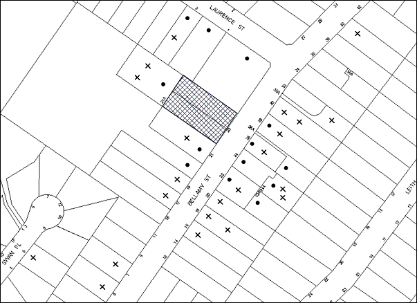
|
NOTIFICATION PLAN |
|
||
|
• PROPERTIES NOTIFIED
|
X SUBMISSIONS RECEIVED |
PROPERTY SUBJECT OF DEVELOPMENT |
|
|
31 SUBMISSIONS RECEIVED OUT OF MAP RANGE |
|||
53 submissions and 1 petition with 63 signatures objected to the development, generally on the grounds that the development would result in:
· Unacceptable traffic parking and safety impacts;
· Unacceptable impact on the adjoining heritage item, Lilian Fraser Garden;
· Removal of trees from the site;
· Development that is excessive in bulk and scale;
· Noise, visual and privacy impacts;
· Setbacks;
· Number of children in the facility;
· Drainage impacts; and
· Number of child care centres in locality.
The merits of the matters raised in community submissions have been addressed in the body of the report.
5.2 Public Agencies
The development application is Integrated Development under the Act. Accordingly, the application was referred to the following Agency for comment:
5.2.1 NSW Office of Water
The site is traversed by a tributary of Tedbury Creek. The development includes piping of part of the watercourse located under the right of carriageway to access No. 21A Bellamy Street. Accordingly, the proposed development is a controlled activity under the Water Management Act 2000 and requires the approval of the Office of Water (OW). In this regard, the application is ‘integrated development’ and was referred to the OW for assessment.
The OW has granted ‘General Terms of Approval’ for the proposed development which are included in Schedule 1.
6. THE PUBLIC INTEREST
Section 79C(1)(e) of the Act requires Council to consider “the public interest”.
The public interest is an overarching requirement, which includes the consideration of the matters discussed in this report. Implicit to the public interest is the achievement of future built outcomes adequately responding to and respecting the future desired outcomes expressed in environmental planning instruments and development control plans.
The application is considered to have satisfactorily addressed Council’s and relevant agencies’ criteria and would provide a development outcome that, on balance, would result in a positive impact for the community. Accordingly, it is considered that the approval of the proposed development would be in the public interest.
CONCLUSION
The proposal involves the demolition of an existing dwelling-house and associated structures and the construction of a purposed built child care centre 60 children. 53 public submissions and 1 petition with 63 signatures were received objecting to the proposal on grounds including traffic, parking and design and environmental grounds. The issues raised in the submissions are addressed in the report and by relevant conditions to ensure any potential impacts are mitigated.
The proposal generally complies with the relevant provisions of the Hornsby Shire Local Environmental Plan 1994, Community Uses Development Control Plan, Access and Mobility Development Control Plan and Waste Minimisation and Management Development Control Plan. The application is permissible in the zone and is considered to be within the environmental capacity of the site.
On balance, and having regard to the community benefit of the proposal, it is considered that the development is worthy of Council’s consent. Accordingly, the proposed development is recommended for approval.
Note: At the time of the completion of this planning report, no persons have made a Political Donations Disclosure Statement pursuant to Section 147 of the Environmental Planning and Assessment Act 1979 in respect of the subject planning application.
|
Rod Pickles Manager - Development Assessment Planning Division |
James Farrington Group Manager Planning Division |
|
1.View |
Locality Map |
|
|
|
2.View |
Site Plans and Demolition Plan |
|
|
|
3.View |
Floor Plans |
|
|
|
4.View |
Elevations and Sections |
|
|
|
5.View |
Landscape Plan |
|
|
|
6.View |
Shadow Diagram |
|
|
File Reference: DA/679/2012
Document Number: D02554161
SCHEDULE 1
GENERAL CONDITIONS
The conditions of consent within this notice of determination have been applied to ensure that the use of the land and/or building is carried out in such a manner that is consistent with the aims and objectives of the relevant legislation, planning instruments and council policies affecting the land and does not disrupt the amenity of the neighbourhood or impact upon the environment.
Note: For the purpose of this consent, the term ‘applicant’ means any person who has the authority to act on or the benefit of the development consent.
Note: For the purpose of this consent, any reference to an Act, regulation, Australian Standard or publication by a public authority shall be taken to mean the gazetted act or regulation, or adopted Australian Standard or publication as in force on the date that the application for a construction certificate is made.
1. Approved Plans and Supporting Documentation
The development must be carried out in accordance with the plans and documentation listed below and endorsed with Council’s stamp, except where amended by Council and/or other conditions of this consent:
Architectural Plans prepared by Project Works
|
Plan No. |
Plan Title |
Rev |
Dated |
|
DA01 |
Site Plan |
C |
12.12.12 |
|
DA02 |
Site Analysis Plan (Demolition) |
A |
12.12.12 |
|
DA03 |
Site Management Plan |
A |
12.12.12 |
|
DA04 |
Lower Level Plan |
C |
12.12.12 |
|
DA05 |
Ground Floor Plan |
C |
12.12.12 |
|
DA06 |
Level 1 Plan |
C |
12.12.12 |
|
DA07 |
Elevations |
C |
12.12.12 |
|
DA08 |
Sections |
C |
12.12.12 |
Landscape Plans prepared by Tessa Rose Playspace and Landscape Design
|
Plan No. |
Plan Title |
Rev |
Dated |
|
1 |
Landscape Plan |
|
7 June 2012 |
Supporting Documents
|
Document Title |
Prepared by |
Dated |
|
Statement of Environmental Effects Ref No. 10228 |
Project Works Design |
20 May 2012 |
|
Traffic and Parking Assessment Report Ref: 11010 |
Terraffic Pty Ltd |
24 June 2011 |
|
Assessment of Environmental Noise – Report No. EN-CCC -070910AJ |
Pollution Control Consultancy and Design |
July 2012 |
|
Asbestos Audit – G10072PH-R01F |
Geo-Environmental Engineering Pty Ltd |
29 October 2010 |
|
Landscape Sample Board/ Specification Notes |
Tessa Rose Playspace and Landscape Design |
June 2012 |
|
Site Tree Location Plan |
HSC |
23 January 2013 |
|
Drainage Report Ref: 11082 |
GJ McDonald Consulting Engineers |
March 2012 |
|
Addendum Drainage Report Ref: 12085 |
GJ McDonald Consulting Engineers |
May 2013 |
|
Plan No. 11020C Sheets 1 and 2 (Engineering Concept Plans) |
GJ McDonald Consulting Engineers |
22 March 2013 |
|
Assessment and Design of proposed works for CAA Ref: 782ww |
Harris Environmental Consulting |
10 October 2012 |
|
Disability Access Report Ref: 1133 |
Lindsay Perry Access + Architecture |
9 May 2012 |
|
External Materials and Colour Schedule |
unknown |
undated |
|
Adventures Preschool & Long Day Care Letter re: ‘integrated children’s services’ |
Nerrilee Lysaght |
18 April 2013 |
|
General Terms of Approval |
NSW Office of Water |
20 June 2013 |
2. Amendment of Plans
The approved plans are to be amended as follows:
a) Plan No. 1 Landscape Plan, prepared by Tessa Rose Playspace and Landscape Design, dated 7 June 2012 is to be amended to incorporate the landscaping indicated on Plan No. DA01 Site Plan Rev C, prepared by Project Works, dated 12 December 2012.
b) Plan No. 1 Landscape Plan, prepared by Tessa Rose Playspace and Landscape Design, dated 7 June 2012 is to be amended to incorporate additional trailing plant species along the north-east boundary to screen the boundary fence and to enhance the visual landscape setting of the adjoining property of Lilian Fraser Gardens.
Note: Advice on suitable species for landscaping can be obtained from Council’s planting guide ‘Indigenous Plants for the Bushland Shire’, available at www.hornsby.nsw.gov.au.
3. Project Arborist
A Project Arborist is to be appointed in accordance with AS 4970-2009 (1.4.4) to provide monitoring and certification throughout the development process.
4. Construction Certificate
A Construction Certificate is required to be approved by Council or a Private Certifying Authority prior to the commencement of any works under this consent.
5. Acoustic Report Compliance
The proposed development must be designed and constructed in accordance with the recommendations of the Assessment of Environmental Noise - Report No. EN-CCC -070910AJ prepared by Pollution Control Consultancy and Design, dated July 2012.
REQUIREMENTS PRIOR TO THE ISSUE OF A CONSTRUCTION CERTIFICATE
6. Licences
A Controlled Activity Approval (CAA) under the Water Management Act 2000 from the NSW Office of Water must be obtained prior to the issued of a Construction Certificate.
7. Children (Education and Care Services) Supplementary Provisions Regulation 2004
Documentation prepared by a registered architect is to be submitted with the Construction Certificate to certify that the proposed development is in accordance with the requirements of the Children and Young Persons (Care & Protection) Act 1998 and the Children’s Services Regulation 2012.
8. Building Code of Australia
All building work must be carried out in accordance with the relevant requirements of the Building Code of Australia.
9. Sydney Water – Quick Check
This application must be submitted to a Sydney Water ‘Quick Check Agent’ or ‘Customer Centre’ for approval to determine whether the development would affect any Sydney Water infrastructure, and whether further requirements are to be met.
Note: Refer to www.sydneywater.com.au or telephone 13 20 92 for assistance.
10. Internal Parking/ Service Areas
The driveway and parking areas on site must be designed in accordance with Australian Standard AS 2890.1-2004 - Off Street Car Parking and Australian Standard 2890.2-2002 - Off Street Commercial (for anticipated service vehicles) and Australian Standard 2890.6-2009 - Off Street Parking for individuals with a disability and the following requirements:
a) Design levels at the front boundary crossing thresholds must be obtained from Council;
b) The driveway and parking modules must be a rigid pavement or sealed to an all weather standard, and designed by a Civil or Structural Engineer with plans submitted with the Construction Certificate;
c) The driveway grade must not exceed 25 percent and transitions changes in grade must not exceed 8 percent per plan metre;
d) The pavements must have a kerb to at least one side and a one-way cross fall with a minimum gradient of 2 percent and a kerb inlets and pits provided on grade and at low points;
e) Retaining walls required to support the carriageway and the compaction of all fill batters must be in accordance with the requirements of a chartered structural engineer; and
f) Safety rails must be provided where there is a level difference more than 0.3 metres and a 1:4 batter can not be achieved;
11. Driveway Servicing No. 21A Bellamy Street
To adequately control overland flows in the driveway in accordance with GJ McDonald Consulting Engineers’ Drainage Report (the Drainage Report) Dated March 2012, the driveway to Lot E DP 380042, No. 21A Bellamy Street must be removed, designed and reconstructed in accordance with Australian Standards 2890.1, 3727 and the following requirements:
a) Design levels at the front boundary must be obtained from Council;
b) The driveway must be a rigid pavement;
c) The driveway grade must not exceed 25 percent and transitions changes in grade must not exceed 8 percent per plan metre;
d) The driveway pavement must be a minimum 3 metres wide, 0.15 metres thick reinforced concrete with SL72 steel reinforcing fabric and a 0.15 metre sub-base;
e) The pavement must have a kerb to one side and a one-way cross fall with a minimum gradient of 2 percent and a 2.4m kerb inlet and pit provided over the Council piped drainage junction pit;
f) The driveway shall be graded downstream of the Council junction pit in order to shed the design storm flow in to the natural watercourse system as per the Drainage Report design;
g) Safety fencing must be provided where there is a level difference more than 0.3 metres and a 1:4 batter can not be achieved;
h) Where required by Council, landscaping strips must be planted 0.5 metres wide along both sides of the length of the driveway; and
i) Conduit for utility services including electricity, water, gas and telephone must be provided in accordance with the relevant utilities current standard.
12. Stormwater and Trunk Drainage General
The stormwater drainage system for the development must be designed and constructed in accordance with Council’s Civil Works – Design and Construction Specification 2005 and the following requirements:
a) Rooflines and paved area drainage system for the carparking and upstream courtyard areas and shall be connected directly to the proposed on-site detention (OSD) system;
b) The OSD system permissible site discharge and overflows from the OSD system shall be connected directly to the proposed piped drainage system or natural watercourse;
c) The existing natural watercourse from the proposed driveway pavement to the rear boundary of the subject site shall be constructed to contain the 100 year Average Recurrence Interval (ARI) storm event generally as per the requirements of G J McDonald Consulting Engineers’ Drainage Report (the Drainage Report) dated March 2012 (while not designing habitable levels in accordance with the proposed minimum floor levels discussed therein);
d) Council’s piped drainage system shall be designed and constructed as modified by Council requirements and in accordance with the Drainage Report. The 825 mm diameter pipe under the driveway pavement to Lot E DP 380042, No. 21A Bellamy Street shall be removed and a Council’s standard junction pit with grated kerb inlet pit top and 900 mm diameter reinforced concrete pipe and headwall shall be constructed downstream of the proposed building’s rear wall alignment;
e) Pier and beam method construction adjacent to easements to the depth of the invert of proposed and existing pipes running adjacent the proposed building.
Note: A certificate from a chartered civil engineer together with a works as executed design plan must be submitted to the principal certifying authority to demonstrate the satisfaction of this condition.
13. Overland Flow Path
The stormwater drainage system for the development must be designed and constructed in accordance with the Drainage Report and the following requirements:
a) Ground levels at the rear of the proposal must be shallow filled to the proposed level on the approved plans up the proposed line of acoustic fencing;
b) The minimum floor level and step threshold on the southern side of the proposed building shall be as proposed on the approved plans and protected from rain inundation;
c) The sill level of the southern side hallway glass block window shall be at least RL 162.94. There must be no southern side wall vents lower than the 100 year ARI design storm flow level;
d) The natural watercourse between the proposed and acoustic fence shall be designed and constructed in accordance with the Drainage Report and revegetated using endemic riparian species. Details of engineering long-sections, cross-sections and plantings to be provided on the construction plans.
14. Council Shall Approve Council Drainage Works
In accordance with Section 59A and Section 68 of the Local Government Act 1993, construction for the civil works and Council-controlled drainage conditions above cannot be approved by the Principal Certifying Authority before Council thus approves. An Application shall be made to Hornsby Shire Council for the works and the Applicant shall pay Hornsby Shire Council the scheduled fees for the assessment and required compliance inspections for those works.
15. On Site Stormwater Detention
An on-site stormwater detention system must be designed by a chartered civil engineer and constructed in accordance with the following requirements:
a) Have a capacity of not less than 24 cubic metres, and a maximum discharge (when full) of 20 litres per second.
b) Have a surcharge/inspection grate located directly above the outlet.
c) Discharge from the detention system to be controlled via 1 metre length of pipe, not less than 50 millimetres diameter or via a stainless plate with sharply drilled orifice bolted over the face of the outlet discharging into a larger diameter pipe capable of carrying the design flow to an approved Council system.
d) Where above ground and the average depth is greater than 0.3 metres, a ‘pool type’ safety fence and warning signs to be installed.
e) Not be constructed in a location that would impact upon the visual or recreational amenity of residents.
16. Waste Management Plan
Prior to issue of the Construction Certificate, A Waste Management Plan Section One - Demolition Stage, Section Two - Design Stage, Section Three - Construction Stage and Section Four - Use and On-going Management as applicable, covering the scope of this project is required to be submitted to Council in accordance with the Waste Minimisation and Management Development Control Plan.
REQUIREMENTS PRIOR TO THE COMMENCEMENT OF ANY WORKS
17. Erection of Construction Sign
A sign must be erected in a prominent position on any site on which building work, subdivision work or demolition work is being carried out:
a) Showing the name, address and telephone number of the principal certifying authority for the work;
b) Showing the name of the principal contractor (if any) for any demolition or building work and a telephone number on which that person may be contacted outside working hours; and
c) Stating that unauthorised entry to the work site is prohibited.
Note: Any such sign is to be maintained while the building work, subdivision work or demolition work is being carried out, but must be removed when the work has been completed.
18. Protection of Adjoining Areas
A temporary hoarding, fence or awning must be erected between the work site and adjoining lands before the works begin and must be kept in place until after the completion of the works if the works:
a) Could cause a danger, obstruction or inconvenience to pedestrian or vehicular traffic.
b) Could cause damage to adjoining lands by falling objects.
c) Involve the enclosure of a public place or part of a public place.
Note: Notwithstanding the above, Council’s separate written approval is required prior to the erection of any structure or other obstruction on public land.
19. Toilet Facilities
Toilet facilities must be available or provided at the works site before works begin and must be maintained until the works are completed at a ratio of one toilet for every 20 persons employed at the site. Each toilet must:
a) be a standard flushing toilet connected to a public sewer; or
b) be a temporary chemical closet approved under the Local Government Act, 1993; or
c) have an on-site effluent disposal system approved under the Local Government Act, 1993.
20. Tree Protection Barriers
Tree protection fencing must be erected around trees to be retained at a minimum 4 metre setback. The tree fencing must be constructed of 1.8 metre ‘cyclone chainmesh fence’.
A certificate from a Project Arborist must be supplied to the certifier before the commencement of construction in accordance with the above and the AS 4970-2009 (Section 4) – Protection of Trees on Development Sites.
21. Erosion and Sediment Control
Erosion and sediment control measures must be provided and maintained throughout the construction period in accordance with the manual ‘Soils and Construction 2004 (Bluebook)’, the approved plans, Council specifications and to the satisfaction of the principal certifying authority. The erosion and sediment control devices must remain in place until the site has been stabilised and revegetated.
Note: On the spot penalties up to $1,500 may be issued for any non-compliance with this requirement without any further notification or warning.
22. Return of Domestic Waste Bins
Arrangements must be made with Hornsby Shire Council Waste Management Services to return the domestic waste bins to Council.
REQUIREMENTS DURING CONSTRUCTION
23. Construction Work Hours
All work on site (including demolition and earth works) must only occur between 7am and 5pm Monday to Saturday. No work is to be undertaken on Sundays or public holidays.
24. Demolition
All demolition work must be carried out in accordance with “Australian Standard 2601-2001 – The Demolition of Structures” and the following requirements:
a) Demolition material must be disposed of to an authorised recycling and/or waste disposal site and/or in accordance with an approved waste management plan;
b) Demolition works, where asbestos material is being removed, must be undertaken by a contractor that holds an appropriate licence issued by WorkCover NSW in accordance with Chapter 10 of the Occupational Health and Safety Regulation 2001 and Clause 29 of the Protection of the Environment Operations (Waste) Regulation 2005 ;and
c) On construction sites where buildings contain asbestos material, a standard commercially manufactured sign containing the words ‘DANGER ASBESTOS REMOVAL IN PROGRESS’ measuring not less than 400mm x 300mm must be erected in a prominent position visible from the street.
25. Asbestos or Soil Contamination
Should the presence of asbestos or soil contamination, not recognised during the application process be identified during demolition, the applicant must immediately notify the principal certifying authority and Council.
26. Environmental Management
The site must be managed in accordance with the publication ‘Managing Urban Stormwater – Landcom (March 2004) and the Protection of the Environment Operations Act 1997 by way of implementing appropriate measures to prevent sediment run-off, excessive dust, noise or odour emanating from the site during the construction of the development.
27. Works Near Trees
All required tree protection measures are to be maintained in good condition for the duration of the construction period.
No trenching is to occur within the Tree Protection Zone (TPZ) of tree numbered 19 located on the neighbouring property.
Tree sensitive construction techniques will be required to undertake works within the TPZ’s of trees 8 and 19 to minimise potential impacts on the roots of trees to be retained.
Should the excavation of any underground services (i.e. drainage/sewer/stormwater) be approved within the TPZ of tree numbered 19 and any trees required to be retained on the subject property or neighbouring property, excavation by hand ONLY shall be undertaken.
Consent is granted to undertake works within the TPZ of trees 8 for the construction of the driveway only, provided the following conditions are met:
a) To ensure any work for the construction of the driveway on the southern side of the property will not adversely affect the longevity of the tree, pier and beam construction of the driveway within the TPZ shall be used with piers being located no closer than 3 metres to the trunks of the trees. The driveway edge shall be no closer than 1 metre to the edge of the trunk. The excavation for the piers within the TPZ shall be hand dug to reveal the presence of any roots.
b) Works must be carried out under the supervision of the Project Arborist and is to be on site overseeing the work to ensure no roots greater than 50mm in diameter are severed, and root damage is minimised.
c) All works (including driveways and retaining walls) within 4 metres of any trees required to be retained (whether or not on the subject property, and pursuant to this consent or the Tree Preservation Order), must be carried out under the supervision of an ‘AQF Level 5 Arborist’ and a certificate submitted to the principal certifying authority detailing the method(s) used to preserve the tree(s).
Note: Except as provided above, the applicant is to ensure that no excavation, filling or stockpiling of building materials, parking of vehicles or plant, disposal of cement slurry, waste water or other contaminants is to occur within the TPZ of any tree to be retained.
28. Disturbance of Existing Site
During construction works, the existing ground levels of open space areas and natural landscape features, (including natural rock-outcrops, vegetation, soil and watercourses) must not be altered unless otherwise nominated on the approved plans.
29. Landfill
Landfill must be constructed in accordance with Council’s ‘Construction Specification, 2005’ and all fill material imported to the site is to wholly consist of Virgin Excavated Natural Material (VENM) as defined in Schedule 1 of the Protection of the Environment Operations Act 1997 or a material approved under the Department of Environment and Climate Change’s general resource recovery exemption.
30. Excavated Material
All excavated material removed from the site must be classified in accordance with the Department of Environment, Climate Change and Water NSW Waste Classification Guidelines prior to disposal to an approved waste management facility and reported to the principal certifying authority.
31. Survey Report – Finished Floor Level
A report(s) must be prepared by a registered surveyor and submitted to the principal certifying authority prior to the pouring of concrete at each level of the building certifying that:
a) The building, retaining walls and the like have been correctly positioned on the site and;
b) The finished floor level(s) are in accordance with the approved plans.
32. Council Property
During construction works, no building materials, waste, machinery or related matter is to be stored on the road or footpath. The public reserve must be kept in a clean, tidy and safe condition at all times.
33. Vehicular Crossings
A separate application under the Local Government Act, 1993 and the Roads Act, 1993 must be submitted to Council for the installation of two new vehicular crossings and the removal of any redundant crossing. The vehicular crossings must be constructed in accordance with Council’s Civil Works Design, 2005 and the following requirements:
a) Any redundant crossings must be replaced with integral kerb and gutter;
b) The footway area must be restored by turfing;
c) Street trees, signage and utility services that are impacted by such works shall be adjusted in accordance with the relevant specification at the Applicant’s cost.
Note: An application for a vehicular crossing can only be made to one of Council’s Authorised Vehicular Crossing Contractors, or be the subject of a Construction Certificate applied for at Council. You are advised to contact Council on 02 9847 6940 to obtain a list of contractors.
34. Traffic Control Plan
A Traffic Control Plan (TCP) must be prepared by a qualified traffic controller in accordance with the Roads & Traffic Authority’s Traffic Control at Worksites Manual 1998 and Australian Standard 1742.3 for all work on a public road and be submitted to Council. The TCP must detail the following:
a) Arrangements for public notification of the works.
b) Temporary construction signage.
c) Permanent post-construction signage.
d) Vehicle movement plans.
e) Traffic management plans.
f) Pedestrian and cyclist access/safety.
35. Waste Management During Works
Waste management during the demolition and construction phase of the development must be undertaken in accordance with the approved Waste Management Plan. Additionally written records of the following items must be maintained during the removal of any waste from the site and such information submitted to the Principal Certifying Authority within fourteen days of the date of completion of the works:
a) The identity of the person removing the waste.
b) The waste carrier vehicle registration.
c) Date and time of waste collection.
d) A description of the waste (type of waste and estimated quantity).
e) Details of the site to which the waste is to be taken.
f) The corresponding tip docket/receipt from the site to which the waste is transferred (noting date and time of delivery, description (type and quantity) of waste).
g) Whether the waste is expected to be reused, recycled or go to landfill.
Note: In accordance with the Protection of the Environment Operations Act 1997, the definition of waste includes any unwanted substance, regardless of whether it is reused, recycled or disposed to landfill.
REQUIREMENTS PRIOR TO THE ISSUE OF AN OCCUPATION CERTIFICATE
Note: For the purpose of this consent, a reference to ‘occupation certificate’ shall not be taken to mean an ‘interim occupation certificate’ unless otherwise stated.
36. Sydney Water – s73 Certificate
An s73 Certificate must be obtained from Sydney Water.
Note: Sydney Water requires that s73 applications are to be made through an authorised Sydney Water Servicing Coordinator. Refer to www.sydneywater.com.au or telephone 13 20 92 for assistance.
37. Stormwater Drainage – Land Adjoining a Watercourse
In addition to other stormwater drainage requirements under this consent, all headwall outlets must incorporate flow velocity reduction controls (i.e. bedded boulders and small stones) to minimise erosive and scouring impacts to the watercourse. Energy dissipater controls must be landscaped to accommodate outlet sheet flow (forced jump). No engineering works are permitted within the bed of the watercourse.
38. Damage to Council Assets
Any damage caused to Council’s assets as a result of the construction of the development must be rectified in accordance with Council’s written requirements and at the sole cost of the applicant. Where concrete footpath has been cracked, all affected panels shall be removed and reconstructed to Council’s standard. Damaged road seal shall be profiled out and reconstructed as Council’s standard asphaltic concrete seal.
39. Creation of Easements
The following matter(s) must be nominated on the plan of subdivision under s88 of the Conveyancing Act 1919:
a) A right of access and easement for services over the proposed driveway.
b) A Council drainage easement 3 metres wide over the burdened lot in favour of Council and in accordance with the terms set out in Memorandum B5341305V filed with the NSW Department of Lands.
c) A restriction over the pipeline and the flow path for a 100 year average recurrence interval storm. The "Restriction on the Use of Land" over the affected lots is to prohibit the alteration of the final floodway shape and the erection of any structures, including fencing, in the floodway without the written permission of Council. The terms of this restriction must be obtained from Council.
d) A "Restriction on the Use of Land" for the lot adjacent the floodway, requiring the finished floor level of any habitable room to be not less than 500mm and the garage 300mm above the 100 year average recurrence interval storm level. The levels must be related to Australian Height Datum.
e) The creation of an appropriate "Positive Covenant" and "Restriction as to User" over the constructed on-site detention/retention systems and outlet works, within the lots in favour of Council in accordance with Council’s prescribed wording. The position of the on-site detention system is to be clearly indicated on the title.
f) To register the OSD easement, the restriction on the use of land “works-as-executed” details of the on-site-detention system must be submitted verifying that the required storage and discharge rates have been constructed in accordance with the design requirements. The details must show the invert levels of the on site system together with pipe sizes and grades. Any variations to the approved plans must be shown in red on the “works-as-executed” plan and supported by calculations.
Note: Council must be nominated as the authority to release, vary or modify any easement, restriction or covenant.
40. Works as Executed Plan
A works-as-executed plan(s) must be prepared by a registered surveyor and submitted to Council for completed pavement, kerb & gutter, public drainage systems, driveways and on-site detention system. The plan(s) must be accompanied by a certificate from a registered surveyor certifying that all pipelines and associated structures lie wholly within any relevant easements.
41. External Lighting
All external lighting must be designed and installed in accordance with Australian Standard AS 4282 – Control of the Obtrusive Effects of Outdoor Lighting. Certification of compliance with the Standard must be obtained from a suitably qualified person.
42. Retaining Walls
All required retaining walls must be constructed as part of the development.
43. Food Premises
The fit out and operation of that part of the building to be used for the manufacture, preparation or storage of food for sale, must be in accordance with Australian Standard 4674-2004 – Design and fit out of food premises, the Food Act 2003, and the Food Regulation 20010 and the Food Standards Code developed by Food Standards Australia New Zealand. Food Standards 3.3.1. 3.2.2 and 3.2.3 are mandatory for all food businesses.
Note: Walls are to be of solid construction.
44. Final Arborist Certification
The Project Arborist should assess the condition of the trees and their growing environment, and make recommendations for any necessary remedial actions.
Following the final inspection and the completion of any remedial works, the project arborist must certify (as appropriate) that the completed works have been carried out in compliance with the approved plans and specification for tree protection. Certification must include a statement on the condition of the retained trees, details of any deviations from the approved tree protection measures and their impacts on trees. Copies of monitoring documentation may be required.
OPERATIONAL CONDITIONS
45. Use of Premises
The development approved under this consent shall be used for ‘child care centre’ and not for any other purpose without Council’s separate written consent.
46. Number of Children
The centre shall accommodate a maximum of 60 children, being a minimum of 22 children under the age of 2 and a maximum of 38 children at or above the age of 2.
47. Hours of Operation
The hours of operation of the premise are restricted to those times listed below:
Monday to Friday 7.00am to 6.00pm
Saturday, Sunday & Public Holidays No work
48. Noise
All noise generated by the proposed development must be attenuated to prevent levels of noise being emitted to adjacent premises which possess tonal, beating and similar characteristics or which exceeds background noise levels by more than 5dB(A).
49. Fire Safety Statement - Annual
On at least one occasion in every 12 month period following the date of the first ‘Fire Safety Certificate’ issued for the property, the owner must provide Council with an annual ‘Fire Safety Certificate’ to each essential service installed in the building.
50. Waste Contract Details
All commercial tenants must keep written evidence on site of a valid contract with a licensed waste contractor(s) for the regular collection and disposal of the waste and recyclables that are generated on site.
GENERAL TERMS OF APPROVAL - NSW OFFICE OF WATER
The following conditions of consent are General Terms of Approval from the nominated State Agency pursuant to Section 91A of the Environmental Planning and Assessment Act, 1979 and must be complied with to the satisfaction of that Agency.
51. GTA 1
These General Terms of Approval (GTA) only apply to the controlled activities described in the plans and associated documentation relating to DA2012/679 and provided by Council:
a) Site plan, map and/or surveys
Any amendments or modifications to the proposed controlled activities may render these GTA invalid. If the proposed controlled activities are amended or modified the NSW Office of Water must be notified to determine if any variations to these GTA will be required.
52. GTA 2
Prior to the commencement of any controlled activity (works) on waterfront land, the consent holder must obtain a Controlled Activity Approval (CAA) under the Water Management Act from the NSW Office of Water. Waterfront land for the purposes of this DA is land and material in or within 40 metres of the top of the bank or shore of the river identified.
53. GTA 3
The consent holder must prepare or commission the preparation of:
a) Vegetation Management Plan
b) Erosion and Sediment Control Plan
c) Soil and Water Management Plan
d) In-stream works with scour protection, energy dissipater
54. GTA 4
All plans must be prepared by a suitably qualified person and submitted to the NSW Office of Water for approval prior to any controlled activity commencing. The following plans must be prepared in accordance with the NSW Office of Water’s guideline located at www.water.nsw.gov.au/Water-Licensign/Approvals/default.aspx:
a) Vegetation Management Plans
b) Riparian Corridors
c) In-stream works
d) Outlet structures
55. GTA 5
The consent holder must:
a) Carry out any controlled activity in accordance with approved plans and
b) Construct and/or implement any controlled activity by or under direct supervision of a suitably qualified professional and
c) When required, provide a certificate of completion to the NSW Office of Water.
56. GTA 6
The consent holder must carry out a maintenance period of 2 years after practical completion of all controlled activities, rehabilitation and vegetation management in accordance with a plan approved by the NSW Office of Water.
57. GTA 7
The consent holder must reinstate waterfront land affected by the carrying out of any controlled activity in accordance with a plan or design approved by the NSW Office of Water.
58. GTA 8
The consent holder must use a suitably qualified person to monitor progress, completion, performance works, rehabilitation and maintenance and report to the NSW Office of Water as required.
59. GTA 9
The consent holder must provide a security deposit (bank guarantee or cash bond) - equal to the sum of the cost of complying with the obligations under any approval - to the NSW Office of Water as and when required.
60. GTA 11
The consent holder must not locate ramps, stairs, access ways, cycle paths, pedestrian paths or any other non-vehicular form of access way in a riparian corridor other than in accordance with a plan approved by the NSW Office of Water.
61. GTA 12
The consent holder must ensure that the construction of any bridge, causeway, culvert of crossing does not result in erosion, obstruction of flow, destabilisation or damage to the bed or banks of the river or waterfront land, other then in accordance with a plan approved by the NSW Office of Water.
62. GTA 13
The consent holder must ensure that any bridge, causeway, culvert or crossing does not obstruct water flow and direction, is the same width as the river or sufficiently wide to maintain water circulation, with no significant water level difference either side of the structure other then in accordance with a plan approved by the NSW Office of Water.
63. GTA 14
The consent holder must ensure that no materials or cleared vegetation that may:
a) Obstruct flow,
b) Wash into the water body, or
c) Cause damage to river banks,
are left on waterfront land other than in accordance with a plan approved by the NSW Office of Water.
64. GTA 15
The consent holder is to ensure that all drainage works:
a) Capture and convey runoffs, discharges and flood flows to low flow water level in accordance with a plan approved by the NSW Office of Water; and
b) Do not obstruct the flow of water other than in accordance with a plan approved by the NSW Office of Water.
65. GTA 16
The consent holder must stabilise drain discharge points to prevent erosion in accordance with a plan approved by the NSW Office of Water.
66. GTA 17
The consent holder must establish all erosion and sediment control works and water diversion structures in accordance with a plan approved by the NSW Office of Water. These works and structures must be inspected and maintained throughout the working period and must not be removed until the site has been full stabilised.
67. GTA 18
The consent holder must ensure that no excavation is undertaken on waterfront land other than in accordance with a plan approved by the NSW Office of Water.
68. GTA 19
The consent holder must ensure that any excavation does not result in:
a) Diversion of any river,
b) Bed or bank instability, or
c) Damage to native vegetation within the area where a controlled activity has been authorised,
other than in accordance with a plan approved by the NSW Office of Water.
69. GTA 20
The consent holder must ensure that:
a) River diversion, realignment or alteration does not result from any controlled activity work, and
b) Bank control or protection works maintain the existing river hydraulic and geomorphic functions, and
c) Bed control structures do not result in river degradation,
other than in accordance with a plan approved by the NSW Office of Water.
70. GTA 23
The consent holder must establish a riparian corridor along the tributary of Tedbury Creek in accordance with a plan approved by the NSW Office of Water.
- END OF CONDITIONS -
ADVISORY NOTES
The following information is provided for your assistance to ensure compliance with the Environmental Planning and Assessment Act, 1979, Environmental Planning and Assessment Regulation 2000, other relevant legislation and Council’s policies and specifications. This information does not form part of the conditions of development consent pursuant to Section 80A of the Act.
Environmental Planning and Assessment Act, 1979 Requirements
The Environmental Planning and Assessment Act, 1979 requires:
· The issue of a construction certificate prior to the commencement of any works. Enquiries can be made to Council’s Customer Services Branch on 9847 6760.
· A principal certifying authority to be nominated and Council notified of that appointment prior to the commencement of any works.
· Council to be given at least two days written notice prior to the commencement of any works.
· Mandatory inspections of nominated stages of the construction inspected.
· An occupation certificate to be issued before occupying any building or commencing the use of the land.
Long Service Levy
In accordance with Section 34 of the Building and Construction Industry Long Service Payments Act 1986, a ‘Long Service Levy’ must be paid to the Long Service Payments Corporation or Hornsby Council.
Note: The rate of the Long Service Levy is 0.35% of the total cost of the work.
Note: Hornsby Council requires the payment of the Long Service Levy prior to the issue of a construction certificate.
Tree Preservation Order
To ensure the maintenance and protection of the existing natural environment, it is an offence to ringbark, cut down, top, lop, remove, wilfully injure or destroy a tree outside 3 metres of the approved building envelope without the prior written consent from Council.
Note: A tree is defined as a single or multi-trunked wood perennial plant having a height of not less than three (3) metres, and which develops many branches, usually from a distance of not less than one (1) metre from the ground, but excluding any plant which, in its particular location, is a noxious plant declared as such pursuant to the Noxious Weeds Act 1993. This definition of ‘tree’ includes any and all types of Palm trees.
All distances are determined under Australian Standard AS4970-2009 ”Protection of Trees on Development Sites”.
Fines may be imposed for non-compliance with Council’s Tree Preservation Order.
Disability Discrimination Act
The applicant’s attention is drawn to the existence of the Disability Discrimination Act. A construction certificate is required to be obtained for the proposed building/s, which will provide consideration under the Building Code of Australia, however, the development may not comply with the requirements of the Disability Discrimination Act. This is the sole responsibility of the applicant.
Covenants
The land upon which the subject building is to be constructed may be affected by restrictive covenants. Council issues this approval without enquiry as to whether any restrictive covenant affecting the land would be breached by the construction of the building, the subject of this consent. Applicants must rely on their own enquiries as to whether or not the building breaches any such covenant.
Advertising Signage – Separate DA Required
This consent does not permit the erection or display of any advertising signs. Most advertising signs or structures require development consent. Applicants should make separate enquiries with Council prior to erecting or displaying any advertising signage.
Dial Before You Dig
Prior to commencing any works, the applicant is encouraged to contact Dial Before You Dig on 1100 or www.dialbeforeyoudig.com.au for free information on potential underground pipes and cables within the vicinity of the development site.
Telecommunications Act 1997 (Commonwealth)
If you are aware of any works or proposed works which may affect or impact on Telstra’s assets in any way, you are required to contact: Telstra’s Network Integrity Team on Phone Number 1800810443.
Asbestos Warning
Should asbestos or asbestos products be encountered during demolition or construction works, you are advised to seek advice and information prior to disturbing this material. It is recommended that a contractor holding an asbestos-handling permit (issued by WorkCover NSW)be engaged to manage the proper handling of this material. Further information regarding the safe handling and removal of asbestos can be found at:
Alternatively, telephone the WorkCover Asbestos and Demolition Team on 8260 5885.
Food Authority Notification
The NSW Food Authority requires businesses to electronically notify the Authority prior to the commencement of its operation.
Note: NSW Food Authority can be contacted at www.foodnotify.nsw.gov.au.
Council Notification - Food Premises
Prior to the commencement of the business, the operator is requested to contact Council’s Environmental Health Team to arrange an inspection for compliance against the relevant legislation and guidelines outlined in this approval.
Note: Council’s Environmental Health Officer can be contacted on 02 9847 6745.
Group Manager’s Report No. PL112/13
Planning Division
Date of Meeting: 20/11/2013
17 DEVELOPMENT APPLICATION - SUBDIVISION OF TWO ALLOTMENTS INTO THREE LOTS AND CONSTRUCTION OF A DWELLING-HOUSE - 24 AND 26 SILVIA STREET, HORNSBY
EXECUTIVE SUMMARY
|
DA No: |
DA/108/2013 (Lodged 11 February 2013) |
|
Description: |
Torrens title subdivision of two allotments into three lots and construction of a dwelling house on the additional lot |
|
Property: |
Lot 3 DP 531090 and Lot 1 222949, Nos. 24 and 26 Silvia Street, Hornsby |
|
Applicant: |
B & G Surveying Pty Ltd |
|
Owner: |
Mr Alan Lionel Sturdy, Ms Margaret Roslyn Prince, Mrs Jessie May Cheyne |
|
Estimated Value: |
$300,000 |
|
Ward: |
A |
· The application proposes demolition of an existing carport and shed, Torrens title subdivision of two allotments into three lots and construction of a dwelling-house on the additional lot.
· The proposal generally complies with the Hornsby Shire Local Environmental Plan 1994, the Residential Subdivision Development Control Plan and the Dwelling House DCP.
· Six submissions were received in respect to the original notification of the application and four submissions have been received in respect to amended plans.
· It is recommended that the application be approved.
|
THAT Development Application No. DA/108/2013 for demolition of the existing carport and shed, Torrens title subdivision of two allotments into three lots and construction of a dwelling-house at Lot 3 DP 531090 and Lot 1 222949, Nos. 24 and 26 Silvia Street, Hornsby be approved subject to the conditions of consent detailed in Schedule 1 of Group Manager’s Report No. PL112/13. |
BACKGROUND
Council received Development Application No. 108/2013 on 11 February 2013. The application proposed subdivision of two allotments into three lots. Amended plans were subsequently submitted to include the construction of a dwelling house on the proposed additional allotment. The application was renotified to adjoining properties. The amended proposal is the subject of this report.
SITE
The subject site has an area of 2020.2m² and is known as Lot 3 DP 531090 and Lot 1 DP 222949, Nos. 24 and 26 Silvia Street Hornsby. Property No. 24 Silvia Street has a frontage of 20.83m to Silvia Street and a depth of 52.78m. Property No. 26 has a frontage of 20.59m to Silvia Street and a secondary frontage of 47m to Watson Avenue. The site slopes to the rear and has an average gradient of 18.9%.
Existing improvements on No. 24 include a timber cottage with tile roof and attached single garage. Existing improvement on No. 26 comprise a clad cottage with tile roof with a double carport to the rear and a single carport to the front of the dwelling. Property No. 26 gains access via a driveway from Silvia Street. Property No. 24 gains access via two separate driveways from Watson Avenue.
The site is identified as bushfire prone land.
The site is surrounded by single and two storey dwelling houses consistent with the low density residential zone. There are a number of Eucalyptus and Turpentine trees on the subject property adjoining the nature strip and on adjoining properties.
PROPOSAL
The application proposes demolition of the existing carport and shed, Torrens title subdivision of two allotments into three lots and construction of a part one and part two storey dwelling house on the newly created allotment.
The proposed demolition includes removal of the existing carport and shed on proposed Lot 3 and removal of a section of the existing decking on proposed Lot 1.
The proposed lot sizes are as follows:
Lot 1 – 657.5m² - containing the existing dwelling house at No. 26 Silvia Street.
Lot 2 – 659.8m² - containing the existing dwelling house at No. 24 Silvia Street.
Lot 3 – 702.9m² – containing the proposed dwelling house.
Proposed Lot 3 would accommodate a dwelling-house comprising a living room, family room, kitchen, three bedrooms, a study, a bathroom and ensuite. The lower ground floor would comprise a bedroom, ensuite and rumpus room. Parking would be provided in an attached double garage.
Parking for Lot 1 is provided in an existing attached single garage and remains unchanged. Parking for Lot 2 is provided in an existing detached single carport. A double carport is also proposed at the rear of Lot 2 with access from Watson Avenue.
ASSESSMENT
The development application has been assessed having regard to the ‘Metropolitan Plan for Sydney 2031’, the ‘North Subregion (Draft) Subregional Strategy’ and the matters for consideration prescribed under Section 79C of the Environmental Planning and Assessment Act 1979 (the Act). The following issues have been identified for further consideration.
1. STRATEGIC CONTEXT
1.1 Metropolitan Plan for Sydney and (Draft) North Subregional Strategy
The (Draft) Metropolitan Strategy for Sydney 2031 is a broad framework to provide for Sydney’s growth to help plan for housing, employment, transport, infrastructure, the environment and open space. It outlines a vision for Sydney to 2031; the challenges faced, and the directions to follow to address these challenges and achieve the vision.
The North Subregion comprises Hornsby, Kuring-gai, Manly, Warringah and Pittwater Local Government Areas. The Draft North Subregional Strategy provided a framework for Council in its preparation of the HLEP 2013.
Within the North Subregion, the Draft Metropolitan Strategy proposes:
· Population growth of 81,000 from the current 2011 baseline of 529,000
· Housing growth of 37,000 from the current 2011 baseline of 204,000
· Employment growth of 39,000 from the current 2011 baseline of 186,000
The proposed development would be consistent with the Metropolitan Plan for Sydney 2031 as it would provide an additional dwelling which would contribute to the achievement of Council’s dwelling target.
2. STATUTORY CONTROLS
Section 79C(1)(a) requires Council to consider “any relevant environmental planning instruments, draft environmental planning instruments, development control plans, planning agreements and regulations”.
2.1 Hornsby Shire Local Environmental Plan 1994
The subject land is zoned Residential A Low Density Zone under the Hornsby Shire Local Environmental Plan 1994 (HSLEP). The objectives of the Residential A zone are:
(a) to provide for the housing needs of the population of the Hornsby area.
(b) to promote a variety of housing types and other land uses compatible with a low density residential environment.
(c) to provide for development that is within the environmental capacity of a low density residential environment.
The proposed development is defined as ‘demolition’, ‘subdivision’ and ‘dwelling house’ under the HSLEP and is permissible in the zone with Council’s consent.
Clause 14 of the HSLEP prescribes a minimum lot area of 500m2 for subdivision within the Residential A (Low Density) Zone. The proposal complies with this requirement.
Clause 15 of the HSLEP prescribes that the maximum floor space ratio (FSR) of development within the Residential A zone is 0.4:1. The proposal complies with this requirement.
Clause 18 of the HSLEP sets out heritage conservation provisions for Hornsby Shire. The site is not listed as a heritage item, in the vicinity of a heritage item or heritage conservation area and is not subject to consideration for heritage conservation.
2.2 Hornsby Shire Local Environmental Plan 2013
The Hornsby Local Environmental Plan 2013 was made on 27 September 2013 and came into effect on 11 October 2013. The HLEP includes a savings provision stating that if a development application is made and not finally determined before the commencement of the HLEP, the application must be determined as if the Plan had been exhibited but not commenced. The relevant provisions of the HLEP are addressed below.
2.2.1 Zoning
Under the HLEP, the subject land is zoned R2 (Low Density Residential) and ‘subdivision’ and ‘dwelling-houses’ are permissible within the zone with Council’s consent.
2.2.2 Height of Building
Clause 4.3 of the HLEP 2013 states that the height of a building on any land is not to exceed the maximum height shown for the land on the Height of Buildings Map. The maximum permissible height for the subject site within the R2 zone is 8.5 metres. The application proposes a building height of 7.35 metres and complies with the requirement.
2.2.3 Lot Size
Clause 4.1 of the HLEP 2013 states that the size of any lot resulting from subdivision of land, to which this clause applies, is not to be less than the minimum size shown on the Lot Size Map. The minimum allotment size for the subject site is 500m². The proposal provides three allotments in excess of this requirement.
2.3 Sydney Regional Environmental Plan No. 20 – Hawkesbury – Nepean River
The site is located within the catchment of the Hawkesbury Nepean River. Part 2 of this Plan contains general planning considerations and strategies requiring Council to consider the impacts of development on water quality, aquaculture, recreation and tourism.
Subject to the implementation of sediment and erosion control measures and stormwater management to protect water quality, the proposal would comply with the requirements of the Policy.
2.4 State Environmental Planning Policy No. 55 – Remediation of Land
Clause 7 of State Environmental Planning Policy No. 55 – Remediation of Land (SEPP 55) requires Council to consider whether land is contaminated prior to granting consent to the carrying out of any development on that land.
Should the land be contaminated, Council must be satisfied that the land is suitable in a contaminated state for the proposed use. If the land requires remediation to be undertaken to make the land suitable for the proposed use, Council must be satisfied that the land will be remediated before the land is used for that purpose.
The site history and site inspection indicate a history of residential development and it is not likely that the site has experienced contamination. Accordingly, further assessment under SEPP 55 is not required.
2.5 State Environmental Planning Policy (Building Sustainability Index – BASIX) – 2004
The application has been assessed against the requirements of State Environmental Planning Policy (Building Sustainability Index: BASIX) 2004. The proposal includes BASIX Certificate No. 495865S for the proposed dwelling and is considered to be satisfactory with respect to SEPP BASIX.
2.6 State Environmental Planning Policy (Exempt and Complying Development Codes) 2008 – NSW Housing Code
The application has been assessed against the requirements of State Environmental Planning Policy (Exempt and Complying Development Codes) 2008 – NSW Housing Code. The policy provides exempt and complying development codes that have State-wide application, identifying, in the General Exempt Development Code, types of development that are of minimal environmental impact that may be carried out without the need for development consent; and, in the General Housing Code, types of complying development that may be carried out in accordance with a complying development certificate as defined in the Environmental Planning and Assessment Act 1979.
Proposed Lot 3 would facilitate construction of a part one part two storey dwelling house. The following table sets out the proposal’s compliance with the requirements of the NSW Housing Code.
|
NSW Housing Code |
|||
|
Control |
Proposal |
Requirement |
Compliance |
|
Frontage (Excl access) |
12.8m |
12m |
Yes |
|
Site Coverage Lots 450m2 – 600m2 |
36% |
50% |
Yes |
|
Maximum Floor Area |
318.42m2 |
330m2 |
Yes |
|
Front Setback |
11m |
4.5m |
Yes |
|
Side Setback (East) |
1m |
0.9m + 1/4 height above 4.5m 0.9m for the ground floor component, 1.2m for the first storey component |
Yes |
|
Side Setback (South - West) |
2m |
0.9m + 1/4 height above 4.5m 0.9m for the ground floor component, 0.96m for the first storey component |
Yes |
|
Rear Setback |
4.6 – 6m |
3m setback for up to 4.5m height, and 8m for 4.5m height and above |
No |
|
Landscaping |
>45% |
20% |
Yes |
As addressed above, the proposed dwelling on Lot 3 complies with the requirements of the NSW Housing Code except for the rear setback requirement.
Notwithstanding, the application complies with the Dwelling House DCP and is acceptable in this respect.
2.7 Section 100B – Rural Fires Act 1997
The proposed subdivision is located within a bushfire prone area and is ‘integrated development’ subject to approval of the NSW Rural Fire Service for the issue of a Bushfire Safety Authority.
The NSW Rural Fire Service has granted approval subject to conditions which include the provision of an Inner Protection Area for the entire property and construction of the dwelling house to withstand potential impacts of bushfire attack.
2.8 Section 94 Contribution
The proposed development would result in the creation of one additional allotment and a dwelling-house. Accordingly, a Section 94 Contribution is recommended as a condition of consent in Schedule 1 of this report.
2.9 Clause 74BA Environmental Planning and Assessment Act, 1979 – Purpose and Status of Development Control Plans
On 1 March 2013, the Environmental Planning and Assessment Act, 1979 was amended so that a DCP provision will have no effect if it has the practical effect of “preventing or unreasonably restricting development” that is otherwise permitted and complies with the development standards set out in relevant Local Environmental Plans and State Environmental Planning Policies.
The principal purpose of a development control plan is to provide guidance on the aims of any environmental planning instrument that applies to the development; facilitating development that is permissible under any such instrument; and achieving the objectives of land zones under any such instrument. The provisions of a development control plan made for that purpose are not statutory requirements.
2.10 Hornsby Development Control Plan 2013
The Hornsby Development Control Plan (HDCP) 2013 applies to all land within Hornsby Shire and replace Council’s existing DCPs, providing development controls to complement the HLEP 2013. The HDCP came into effect on 11 October 2013.
The following sections of this report include a detailed assessment of the proposal against Council’s existing DCP controls which were in force when the application was submitted.
The HDCP is generally a transition of Council’s existing DCPs, into a consolidation Plan. Notwithstanding, the proposal has been assessed against the requirements of Part 3 – Residential and Part 6 – Subdivision of HDCP 2013.
The proposal generally complies with the DCP requirements with the exception of the setback requirement to the rear boundary. HLEP 2013 requires a setback of 8m from the rear boundary for the second storey element of a dwelling house. The proposal provides a staggered setback of 4.8m to 7.4m from the boundary. The rear elevation is north facing and would not create any adverse overlooking or over shadowing issues. The proposal is acceptable in this regard. Further assessment of the solar access, privacy and built form impacts of the proposal are included in Section 2.11 of this report.
2.11 Residential Subdivision and Dwelling House Development Control Plans
The proposed development has been assessed having regard to the relevant performance and prescriptive requirements within Council’s Residential Subdivision and Dwelling House Development Control Plans. The following table sets out the proposal’s compliance with the prescriptive requirements of the Plan:
|
Residential Subdivision and Dwelling House DCP |
|||
|
Control |
Proposal |
Requirement |
Complies |
|
Density |
|||
|
Site Area - Existing Lot 1 and 2 |
2020.2m² |
N/A |
N/A |
|
Proposed allotment size Lot 1 Lot 2 Lot 3 |
657.5m² 659.8m² 702.9m2 |
500m² 500m² 500m2 |
Yes Yes Yes |
|
Gross Floor Area Lot 1 – Existing No. 26 Lot 2 – Existing No. 24 Lot 3 – Proposed Dwelling |
191.22m² 128.52m² 275.10m2 |
N/A N/A N/A |
N/A N/A N/A |
|
Floor space ratio Lot 1– Existing No. 26 Lot 2 – Existing No. 24 Lot 3 – Proposed Dwelling |
0.29:1 0.19:1 0.38:1 |
0.4:1 0.4:1 0.4:1 |
Yes Yes Yes |
|
Site cover Lot 1– Existing No. 26 Lot 2 – Existing No. 24 Lot 3 – Proposed Dwelling |
35.5% 27.2% 36% |
40% 40% 40% |
Yes Yes Yes |
|
Setbacks |
|||
|
Lot 1 – This includes the existing dwelling house at No. 26 Silvia Street. The setbacks remain unchanged with the exception of the rear setback which would be 6.8m from the boundary. Similarly, Lot 2 remains unchanged with the exception of the rear setback. The existing dwelling house at property No. 24 would be 10.9m from the rear boundary. |
|||
|
Lot 3 – Proposed Dwelling |
|||
|
Front |
12m |
6m |
Yes |
|
Side – east |
1m |
1m |
Yes |
|
Side – west |
2m – 6m |
1m |
Yes |
|
Rear |
4.6m – 6m |
5m |
Yes |
|
Height Lot 3 – Proposed Dwelling |
7.35m |
9m |
Yes |
|
Unbroken wall length Lot 3 – Proposed Dwelling |
7.98m |
10m |
Yes |
|
Building Length Lot 3 – Proposed Dwelling |
25m |
24m |
No |
|
Cut and Fill Lot 3 – Proposed Dwelling |
1.7m |
1m |
No |
|
Private open space Lot 1– Existing No. 26 Lot 2 – Existing No. 24 Lot 3 – Proposed Dwelling |
>150m² >200m² >120m2 |
120m² 120m² 120m2 |
Yes Yes Yes |
|
Landscaped area |
|||
|
Lot 1– Existing No. 26 Lot 2 – Existing No. 24 Lot 3 – Proposed Dwelling |
>45% >45% >45% |
>45% >45% >45% |
Yes Yes Yes |
|
Car Parking |
|||
|
Lot 1– Existing No. 26 Lot 2 – Existing No. 24 Lot 3 – Proposed Dwelling |
1 spaces 3 spaces 2 spaces |
2 spaces 2 spaces 2 spaces |
No Yes Yes |
|
Solar Access |
|||
|
Windows to north-facing living rooms on adjoining development Adjoining land |
3 hours on 22 June |
3 hours on 22 June |
Yes |
|
Private open space on adjoining land |
4 hours on 22 June |
4 hours on 22 June |
Yes |
As detailed in the above table, the proposed development does not comply with a number of prescriptive requirements within Council’s Dwelling House and Residential Subdivision DCPs. The matters of non-compliance are detailed below, as well as a brief discussion on compliance with relevant performance requirements.
2.11.1 Design
The Dwelling House DCP requires a maximum building length of 24m. The proposed dwelling on Lot 3 has a total building length of 25m. The building is designed to address the topography of the site and is appropriately articulated. The dwelling house would be setback 11m from Watson Avenue and accordingly would not have a detrimental impact on the streetscape in terms of bulk and scale. The proposal meets the performance criteria of the element providing north facing living areas and open space and is sympathetic to the topographical constraints of the site. The proposal is considered acceptable in regards to design.
The proposed subdivision design provides allotment sizes in excess of the requirements of the Residential Subdivision DCP and HLEP 2013. The proposed allotment design allows dwelling houses with appropriate setbacks from neighbouring properties, adequate open space and provides for solar access to existing and future dwellings. The proposal complies with the allotment design element of the DCP.
2.11.2 Solar Access
One submission objects to the proposal in relation to excessive overshadowing of the adjoining property. The applicant has submitted solar access diagrams which demonstrate compliance with the requirements of the Dwelling House DCP providing at least 4 hours sunlight to the private open space of adjoining properties between 9am and 3pm on 22 June. The proposal would also allow for 3 hours of sunshine to north facing windows between 9am and 3pm in compliance with the DCP. Furthermore, the proposal provides a setback of 2m from the boundary adjoining No. 2 Watson Avenue which is in excess of the required 1m setback. The proposal is acceptable in relation to solar access.
2.11.3 Privacy
One objection raises concerns in relation to overlooking from the proposed dwelling house. The proposal does not have any windows to living areas that would overlook the adjoining property at No. 2 Watson Avenue. The proposed windows on the southern elevation are to bedrooms only.
Furthermore, all living areas are orientated to the north and rear of the dwelling which is appropriately setback from the boundary. There are a number of large trees on adjoining properties and on the subject site that would offer further screening of the dwelling house. The landscaped plan to be submitted to Council in accordance with the conditions of consent in Schedule 1 requires additional screen planting on this boundary. The proposal meets the requirements of the Privacy Element of the Dwelling House DCP.
2.11.4 Cut and Fill
The proposal requires a cut of 1.7m on the western elevation. This does not comply with the 1m prescriptive measure in the Dwelling House DCP. This is due to the stepped nature of the site and is contained to the western elevation. It does not result in the proposal exceeding the height requirement nor would it impact on the amenity of any adjoining properties. The proposal is considered acceptable in this respect.
2.11.5 Car Parking
Proposed Lot 1 accommodates an existing dwelling with a gross floor area in excess of 100m² and accordingly, two spaces are required. There is an existing attached single garage and adequate space for a vehicle to park on the driveway, wholly contained onsite. Furthermore, the HDCP 2013 requires 1 space per 0 – 2 bedroom dwelling house. Lot 1 complies with this requirement.
The application proposes to demolish the existing carport to the rear of Lot 2. The existing dwelling house has a floor area in excess of 100m² and accordingly two spaces are required. A double carport is proposed to the rear of Lot 2 to accommodate parking needs on site in compliance with the DCP. Conditions of consent have been recommended in Schedule 1 to facilitate an appropriate cross over and kerb and guttering in conjunction with the proposed carport. The proposal is considered acceptable in relation to the Car Parking DCP.
3. ENVIRONMENTAL IMPACTS
Section 79C(1)(b) of the Act requires Council to consider “the likely impacts of that development, including environmental impacts on both the natural and built environments, and social and economic impacts in the locality”.
3.1 Natural Environment
The proposed development would necessitate the removal of nine trees from the site. None of the trees to be removed are identified as significant. Council’s Tree assessment notes that the trees are in poor condition and under developed. Four trees to be removed are identified under Council’s Tree Protection Order (TPO). These trees are a Eucalyptus saligna, a Eucalyptus piperita, and two Angphora costata. Two submissions object to the removal of trees. Council’s assessment of the proposal included a detailed examination of the existing trees on site and does not raise objections to the proposal subject to the implementation of recommended conditions of consent included in Schedule 1 of this report. This includes the submission of a detailed landscape plan including details of the location and type of replacement planting proposed.
It is considered that the removal of the trees is acceptable in the circumstances of the case subject to the submission and implementation of a landscape plan as per the conditions in Schedule 1 of this report.
3.2 Built Environment
The proposal would have a very minor impact on the streetscape as the proposed dwelling house would be set back 12m from Watson Avenue. The stepped design would minimise visual impact by addressing the topography of the land, providing for a one and two storey dwelling house. The proposal is consistent with the surrounding built environment in the low density zone.
3.3 Social Impacts
The proposal would not result in a social impact.
3.4 Economic Impacts
The proposal would have a minor positive impact on the local economy in conjunction with other new low density residential development in the locality by generating an increase in demand for local services. One submission raises concerns in relation to the loss in value of the adjoining properties.
The proposal meets the relevant controls as discussed under Section 2.10 and would generally result in an appropriate outcome for the subject site. The applicant has submitted solar access diagrams and increased setbacks to neighbouring properties to alleviate any impact on neighbours. In addition, this is not required to be considered under Section 79C of the Environmental Planning and Assessment Act 1979.
4. SITE SUITABILITY
Section 79C(1)(c) of the Act requires Council to consider “the suitability of the site for the development”.
4.1 Bushfire Risk
The land is identified as being subject to bushfire risk. The NSW Rural Fire Service has granted approval for the issue of a Bush Fire Safety Authority subject to recommended conditions included in Schedule 1 of this report.
5. PUBLIC PARTICIPATION
Section 79C(1)(d) of the Act requires Council to consider “any submissions made in accordance with this Act”.
5.1 Community Consultation
The proposed development was placed on public exhibition and was notified to adjoining and nearby landowners between 28 February 2013 and 28 March 2013 and amended plans were renotified from 23 August 2013 to 9 September 2013 in accordance with Council’s Notification and Exhibition Development Control Plan. Council received six submissions when first notified and four submissions to amended plans. The map below illustrates the location of those nearby landowners who made a submission that are in close proximity to the development site.
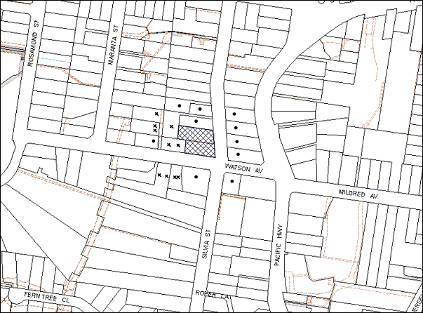
|
NOTIFICATION PLAN |
|
||
|
• PROPERTIES NOTIFIED
|
X SUBMISSIONS RECEIVED |
PROPERTY SUBJECT OF DEVELOPMENT |
|
Six submissions objected to the development and four submissions were received in relation to amended plans. The objections were generally on the grounds stating that the development would result in:
· Unacceptable traffic on local streets;
· Unacceptable overshadowing of adjoining properties;
· Unacceptable noise from the dwelling;
· The removal of trees in bushland setting;
· Proposed drainage method is not sufficient to drain the new allotment;
· Existing drainage and road condition of Watson Avenue;
· Development that is excessive in bulk and scale;
· Loss of parking;
· Impact on stone retaining wall;
· The built form is not sympathetic to the character of the area; and
· Devaluation of property values.
The merits of the matters raised in community submissions have been addressed in the body of the report with the exception of the following:
Drainage
Five submissions object to the drainage proposal for the development. Council’s engineering assessment notes that additional run off that would be generated from the dwelling on proposed Lot 3 can be discharged to Watson Avenue via an onsite detention system. A drainage easement through property No. 20 would not be necessary. The impact on downstream properties would be insignificant as the discharge from the new lot would be restricted to 8 litres per second to the Watson Avenue drain, which has adequate capacity. A condition of consent is recommended in this regard. The proposal is considered acceptable in relation to the appropriate drainage of the dwelling house and additional allotment.
Allotment Size and Scale of Development
Two submissions object to the bulk and scale of the proposed dwelling stating it is too large. The submissions also object to the proposed density stating it is out of character with surrounding allotments. The proposal includes an additional allotment of 702m². This is in excess of the 500m² requirement in Residential A (Low Density Zone) in accordance with HSLEP 1994 and HLEP 2013. The proposal also complies with the FSR and floor area requirement of the HSLEP 1994 and HDCP 2013. The proposal is acceptable in regard to density and FSR.
Traffic
A number of objections raised concerns in relation to increased traffic on the road and impact on existing parking arrangements. The proposed dwelling house on Lot 3 includes an attached double garage providing for parking onsite. The subdivision creates one additional lot. Lots 1 and 2 have houses with driveways and garages or carports to accommodate all parking onsite. The existing access to the proposed lot 3 from Watson Avenue would be utilised. The road network has adequate capacity to handle the additional traffic load from the development. A condition has been recommended to upgrade Watson Avenue from the intersection with Silvia Street to the access point of the proposed lot 3 that would improve the traffic movement in Watson Avenue.
Noise
One submission objects to the proposal stating there would be excessive noise from an additional dwelling. The proposal incorporates all living areas to the rear of the dwelling and they are setback a minimum of 4.8m from the rear boundary. Furthermore, the proposed dwelling house is setback a minimum of 2m from the dwelling at No. Watson Avenue. The design of the dwelling also incorporates living areas on the ground floor. The proposal is for one additional dwelling house and is consistent with the requirements of the Low Density Residential Zone. No further concerns are raised in relation to acoustics.
Retaining Wall
One submission raises concerns relating to the condition of the retaining wall on the adjoining property. A condition of consent has been included in Schedule 1 of this report to ensure that a dilapidation report is submitted prior to the issue of a construction certificate.
5.2 Public Agencies
The development application is Integrated Development under the Act. Accordingly, the application was referred to the following Agencies for comment:
5.2.1 Rural Fire Service
The NSW Rural Fire Service has granted a ‘Bush Fire Safety Authority’ for the proposed subdivision and dwelling construction subject to recommended conditions included in Schedule 1 of this report.
6. THE PUBLIC INTEREST
Section 79C(1)(e) of the Act requires Council to consider “the public interest”.
The public interest is an overarching requirement, which includes the consideration of the matters discussed in this report. Implicit to the public interest is the achievement of future built outcomes adequately responding to and respecting the future desired outcomes expressed in environmental planning instruments and development control plans.
The application is considered to have satisfactorily addressed Council’s and relevant agencies’ criteria and would provide a development outcome that, on balance, would result in a positive impact for the community. Accordingly, it is considered that the approval of the proposed development would be in the public interest.
CONCLUSION
The application proposes demolition of a shed and carport, Torrens title subdivision of two allotments into three lots and construction of a dwelling-house on the newly created allotment.
The proposal generally complies with the requirements of Council’s Residential Subdivision DCP and Dwelling House DCP.
The development complies with the 500m2 development standard under Clause 14 of the HSLEP 1994, meets the Residential A zone objectives and is consistent with the objectives of the Metropolitan Plan for Sydney 2031.
Six submissions have been received in respect of the application and four additional submissions have been received in respect to amended plans.
Appropriate conditions of consent are recommended to provide for the proposed development and minimise impacts to surrounding residential amenity.
Having regard to the circumstances of the case, approval of the application is recommended.
Note: At the time of the completion of this planning report, no persons have made a Political Donations Disclosure Statement pursuant to Section 147 of the Environmental Planning and Assessment Act 1979 in respect of the subject planning application.
|
Rod Pickles Manager - Development Assessment Planning Division |
James Farrington Group Manager Planning Division |
|
1.View |
Locality Map |
|
|
|
2.View |
Floor Plans |
|
|
|
3.View |
Site Plans |
|
|
|
4.View |
Cross Sectional Detail |
|
|
|
5.View |
Elevation Plans |
|
|
File Reference: DA/108/2013
Document Number: D02570171
SCHEDULE 1
GENERAL CONDITIONS
The conditions of consent within this notice of determination have been applied to ensure that the use of the land and/or building is carried out in such a manner that is consistent with the aims and objectives of the relevant legislation, planning instruments and council policies affecting the land and does not disrupt the amenity of the neighbourhood or impact upon the environment.
Note: For the purpose of this consent, the term ‘applicant’ means any person who has the authority to act on or the benefit of the development consent.
Note: For the purpose of this consent, any reference to an Act, regulation, Australian Standard or publication by a public authority shall be taken to mean the gazetted act or regulation, or adopted Australian Standard or publication as in force on the date that the application for a construction certificate is made.
1. Approved Plans and Supporting Documentation
The development must be carried out in accordance with the plans and documentation listed below and endorsed with Council’s stamp, except where amended by Council and/or other conditions of this consent:
|
Plan No. |
Drawn by |
Dated |
|
Site Plan |
B and G Surveyors |
10/01/2013 |
|
Proposed Dwelling Detail Survey Plan |
Unknown |
10/01/2013 |
|
Proposed Demolition Plan |
Unknown |
10/01/2013 |
|
Ground Floor Plan |
Unknown |
July 2012 |
|
Lower Ground Floor Plan |
Unknown |
July 2012 |
|
Cross Sectional Detail |
Unknown |
July 2012 |
|
Western Elevation |
Unknown |
July 2012 |
|
Eastern Elevation |
Unknown |
July 2012 |
|
Northern and Southern Elevations |
Unknown |
July 2012 |
|
Site Tree Location Plan – 1 |
Hornsby Shire Council |
19/9/2013 |
|
Site Tree Location Plan – 2 |
Hornsby Shire Council |
19/9/2013 |
|
Plan No. |
Drawn by |
Dated |
|
BASIX Certificate No. 495865S |
Dakeba Pty. Ltd. |
29 July 2013 |
|
Bushfire Hazard assessment Report |
Building Code & Bushfire Hazard Solutions Pty. Ltd. |
5 April 2013 |
2. Removal of Existing Trees
This development consent only permits the removal of tree Nos. 6, 6a, 8, 9, 10, 10a, 10b, 14 and 15a as identified on Site Tree Location Plans 1 and 2 prepared by Hornsby Shire Council dated 19/9/13. The removal of any other trees requires separate approval under Council’s Tree Preservation Order.
REQUIREMENTS PRIOR TO THE ISSUE OF A CONSTRUCTION CERTIFICATE
3. Building Code of Australia
All building work must be carried out in accordance with the relevant requirements of the Building Code of Australia.
4. Contract of Insurance (Residential Building Work)
In the case of residential building work for which the Home Building Act, 1989 requires there to be a contract of insurance in force in accordance with Part 6 of that Act, that such a contract of insurance is in force before any building work authorised to be carried out by the consent commences.
5. Notification of Home Building Act, 1989 Requirements
Residential building work within the meaning of the Home Building Act, 1989 must not be carried out unless the principal certifying authority for the development to which the work relates (not being Council) has given Council written notice of the following information:
a) In the case of work for which a principal contractor is required to be appointed:
i) The name and licence number of the principal contractor; and
ii) The name of the insurer by which the work is insured under Part 6 of that Act.
b) In the case of work to be done by an owner-builder:
i) The name of the owner-builder; and
ii) If the owner-builder is required to hold an owner-builder’s permit under that Act, the number of the owner-builder’s permit.
Note: If arrangements for doing the residential building work are changed while the work is in progress so that the information notified becomes out of date, further work must not be carried out unless the principal certifying authority for the development to which the work relates (not being Council) has given Council written notification of the updated information.
6. Dilapidation Report
A ‘Dilapidation Report’ is to be prepared by a ‘chartered structural engineer’ detailing the structural condition of the retaining wall on the adjoining property at No. 2 Watson Avenue.
7. Landscape Plan
The applicant shall provide a Landscape Plan that shows the location, species and number of native plantings to provide an offset for the loss of vegetation for the proposed development in accordance with the following:
a) provide a concise compensatory Schedule of Works including location and number of replanted native plants including three (3) canopy species provided on a plan,
b) the location of the plantings shall take into account the required Tree Protection Zone of mature specimens of these trees,
c) Location of plantings shall be ideally placed in groups,
d) preparation works required,
e) specific qualifications of people undertaking/supervising the works (i.e. qualified and experienced horticulturalists),
f) replacement requirements for dead stock and monitoring,
g) the landscape plan should also provide appropriate privacy screening on the southern boundaries.
The Landscape Plan must be submitted to Council’s Tree Management Team for review and approval.
REQUIREMENTS PRIOR TO THE COMMENCEMENT OF ANY WORKS
8. Erection of Construction Sign
A sign must be erected in a prominent position on any site on which building work, subdivision work or demolition work is being carried out:
a) Showing the name, address and telephone number of the principal certifying authority for the work;
b) Showing the name of the principal contractor (if any) for any demolition or building work and a telephone number on which that person may be contacted outside working hours; and
c) Stating that unauthorised entry to the work site is prohibited.
Note: Any such sign is to be maintained while the building work, subdivision work or demolition work is being carried out, but must be removed when the work has been completed.
9. Protection of Adjoining Areas
A temporary hoarding, fence or awning must be erected between the work site and adjoining lands before the works begin and must be kept in place until after the completion of the works if the works:
a) Could cause a danger, obstruction or inconvenience to pedestrian or vehicular traffic.
b) Could cause damage to adjoining lands by falling objects.
c) Involve the enclosure of a public place or part of a public place.
Note: Notwithstanding the above, Council’s separate written approval is required prior to the erection of any structure or other obstruction on public land.
10. Toilet Facilities
Toilet facilities must be available or provided at the works site before works begin and must be maintained until the works are completed at a ratio of one toilet for every 20 persons employed at the site. Each toilet must:
a) be a standard flushing toilet connected to a public sewer; or
b) be a temporary chemical closet approved under the Local Government Act, 1993; or
c) have an on-site effluent disposal system approved under the Local Government Act, 1993.
11. Erosion and Sediment Control
Erosion and sediment control measures must be provided and maintained throughout the construction period in accordance with the manual ‘Soils and Construction 2004 (Bluebook)’, the approved plans, Council specifications and to the satisfaction of the principal certifying authority. The erosion and sediment control devices must remain in place until the site has been stabilised and revegetated.
Note: On the spot penalties up to $1,500 may be issued for any non-compliance with this requirement without any further notification or warning.
12. Tree Protection Barriers
Tree protection fencing must be erected around trees numbered 11, 12 and 13 to be retained at the measured Tree Protection Zone (TPZ) as outlined in Table 1. The tree fencing must be constructed of 1.8 metre ‘cyclone chainmesh fence’.
Once erected, tree protection fencing must not be removed or altered without approval by the project arborist.
13. Project Arborist
A Project Arborist is to be appointed prior to commencement of any works in accordance with the AS 4970-2009 (1.4.4) and to provide monitoring and certification throughout the development process.
REQUIREMENTS DURING CONSTRUCTION
14. Construction Work Hours
All work on site (including demolition and earth works) must only occur between 7am and 5pm Monday to Saturday. No work is to be undertaken on Sundays or public holidays.
15. Demolition
All demolition work must be carried out in accordance with “Australian Standard 2601-2001 – The Demolition of Structures” and the following requirements:
a) Demolition material must be disposed of to an authorised recycling and/or waste disposal site and/or in accordance with an approved waste management plan;
b) Demolition works, where asbestos material is being removed, must be undertaken by a contractor that holds an appropriate licence issued by WorkCover NSW in accordance with Chapter 10 of the Occupational Health and Safety Regulation 2001 and Clause 29 of the Protection of the Environment Operations (Waste) Regulation 2005; and
c) On construction sites where buildings contain asbestos material, a standard commercially manufactured sign containing the words ‘DANGER ASBESTOS REMOVAL IN PROGRESS’ measuring not less than 400mm x 300mm must be erected in a prominent position visible from the street.
16. Environmental Management
The site must be managed in accordance with the publication ‘Managing Urban Stormwater – Landcom (March 2004) and the Protection of the Environment Operations Act 1997 by way of implementing appropriate measures to prevent sediment run-off, excessive dust, noise or odour emanating from the site during the construction of the development.
17. Works Near Trees
All required tree protection measures are to be maintained in good condition for the duration of the construction period.
All works (including driveways and retaining walls) within the measured TPZ of any trees required to be retained (whether or not on the subject property, and pursuant to this consent or the Tree Preservation Order), must be carried out under the supervision of an ‘AQF Level 5 Arborist’ and a certificate submitted to the principal certifying authority detailing the method(s) used to preserve the trees.
The applicant shall ensure that all underground services (i.e. water, drainage, gas, and sewer) shall not be laid beneath the canopy of any tree located on the property protected under Council’s Tree Preservation Order unless approved by Council’s Parks and Recreation Team.
Should the excavation of any underground services (i.e. drainage/sewer/stormwater) be approved within tree protection setbacks, excavation by hand ONLY shall be undertaken.
No tree roots of 25 mm or greater in diameter located within the measured TPZ shall be severed or injured in the process of any site works during the construction period without prior assessment by an arborist. Tree roots between 10mm and 25mm diameter, severed during excavation, shall be cut cleanly by hand by an experienced arborist/horticulturalist with a minimum qualification of the Horticulture Certificate or Tree Surgery Certificate.
The prescribed Tree Protection Zones are identified in the table below:
Table 1:
|
TREE NUMBER |
TPZ (M) |
|
11 |
6 |
|
12 |
5 |
|
13 |
7 |
|
16 |
6 |
Authority stating that all tree protection measures are in accordance with the above table and AS 4970-2009 ‘Protection of Trees on Development Sites’ (Section 4) prior to commencement of works.
Note: Except as provided above, the applicant is to ensure that no excavation, filling or stockpiling of building materials, parking of vehicles or plant, disposal of cement slurry, waste water or other contaminants is to occur within 4 metres of any tree to be retained.
18. Council Property
During construction works, no building materials, waste, machinery or related matter is to be stored on the road or footpath. The public reserve must be kept in a clean, tidy and safe condition at all times.
19. Disturbance of Existing Site
During construction works, the existing ground levels of open space areas and natural landscape features, (including natural rock-outcrops, vegetation, soil and watercourses) must not be altered unless otherwise nominated on the approved plans.
REQUIREMENTS PRIOR TO THE ISSUE OF AN OCCUPATION OR SUBDIVISION CERTIFICATE
Note: For the purpose of this consent, a reference to ‘occupation certificate’ shall not be taken to mean an ‘interim occupation certificate’ unless otherwise stated.
20. Fulfilment of BASIX Commitments
The applicant must demonstrate the fulfilment of BASIX commitments pertaining to the development.
21. Water/Electricity Utility Services
The applicant must submit written evidence of the following service provider requirements:
a) Ausgrid (formerly Energy Australia) – a letter of consent demonstrating that satisfactory arrangements have been made to service the proposed development.
b) A S73 Certificate must be obtained from Sydney Water.
Note: Sydney Water requires that s73 applications are to be made through an authorised Sydney Water Servicing Coordinator. Refer to www.sydneywater.com.au or telephone 13 20 92 for assistance.
22. Stormwater Drainage
The stormwater drainage system for the development must be designed and constructed in accordance with Council’s Civil Works – Design and Construction Specification 2005 and the following requirements:
a) An inter-allotment stormwater drainage system to service the proposed Lot 1 through Lot 3 with pits being constructed in situ.
b) The stormwater drainage system from the lot 3 must be designed and constructed for an average recurrence interval for 20 years and be gravity drained via an on site detention system.
23. On Site Stormwater Detention
An on-site stormwater detention system must be designed by a chartered civil engineer and constructed in accordance with the following requirements:
a) Have a capacity of not less than 5 cubic metres, and a maximum discharge (when full) of 8 litres per second.
b) Have a surcharge/inspection grate located directly above the outlet.
c) Discharge from the detention system to be controlled via 1 metre length of pipe, not less than 50 millimetres diameter or via a stainless plate with sharply drilled orifice bolted over the face of the outlet discharging into a larger diameter pipe capable of carrying the design flow to an approved Council system.
d) Where above ground and the average depth is greater than 0.3 metres, a ‘pool type’ safety fence and warning signs to be installed.
e) Not be constructed in a location that would impact upon the visual or recreational amenity of residents.
Note: A certificate from a chartered civil engineer together with a works as executed design plan must be submitted to the principal certifying authority to demonstrate the satisfaction of this condition ( if this work is carried out under supervision of private certifier.
24. Internal Driveway/Vehicular Areas
The driveway and parking areas on site must be designed in accordance with Australian Standards 2890.1, 3727 and the following requirements:
a) Design levels at the front boundary must be obtained from Council;
b) The driveway must be paved; and
c) The driveway grade must not exceed 25 percent and changes in grade must not exceed 8 percent.
25. Vehicular Crossing
A separate application under the Local Government Act, 1993 and the Roads Act, 1993 must be submitted to Council for the installation of a new vehicular crossing for the new carport on proposed Lot 2. The vehicular crossing must be constructed in accordance with Council’s Civil Works Design, 2005 and the following requirements:
a) The footway area must be restored by turfing; and
b) Approval must be obtained from all relevant utility providers that all necessary conduits be provided and protected under the crossing.
Note: An application for a vehicular crossing can only be made to one of Council’s Authorised Vehicular Crossing Contractors. You are advised to contact Council on 02 9847 6940 to obtain a list of contractors.
26. Road Works
All road works approved under this consent must be constructed in accordance with Council’s Civil Works Design and Construction Specification, 2005 and the following requirements:
All road works approved under this consent must be constructed in accordance with Council’s Civil Works Design and Construction Specification, 2005 and the following requirements:
a) The kerb and gutter is to be extended along the frontage of the subdivision from the existing section at the intersection of Silvia Street and Watson Avenue to the vehicular access point to the proposed lot 3, together with footpath formation, necessary drainage and sealing of road pavement between the existing pavement and lip of the gutter.
b) The existing road pavement to be saw cut a minimum of 300 mm from the existing edge of the bitumen and reconstructed to have a cross fall of a minimum 2%. Necessary filling/excavation to be carried out to match the existing concrete driveway.
c) The submission of a compaction certificate from a geotechnical engineer for any fill within road reserves, and all road sub-grade and road pavement materials.
d) A construction certificate application is to be submitted to Council.
Note: Council is the only authority to approve works within Council’s road reserve.
27. Creation of Easements
The following matter(s) must be nominated on the plan of subdivision under s88B of the Conveyancing Act 1919:
a) An inter-allotment drainage easement(s) over each of the burdened lots.
b) The creation of an appropriate "Positive Covenant" and "Restriction as to User" over the constructed on-site detention/retention systems and outlet works, within the lots in favour of Council in accordance with Council’s prescribed wording. The position of the on-site detention system is to be clearly indicated on the title.
Note: Council must be nominated as the authority to release, vary or modify any easement, restriction or covenant.
28. Retaining Walls
All required retaining walls must be constructed as part of the development.
29. Works as Executed Plan
A works-as-executed plan(s) must be prepared by a registered surveyor and submitted to Council for completed road pavement, kerb & gutter, public drainage systems, driveways and on-site detention system. The plan(s) must be accompanied by a certificate from a registered surveyor certifying that all pipelines and associated structures lie wholly within any relevant easements.
30. Section 94 Development Contributions
In accordance with Section 80A(1) of the Environmental Planning and Assessment Act 1979 and the Hornsby Shire Council Section 94 Development Contributions Plan 2012-2021, the following monetary contributions shall be paid to Council to cater for the increased demand for community infrastructure resulting from the development:
|
Description |
Contribution (4) |
|
Roads |
$1,814.00 |
|
Open Space and Recreation |
$15,890.00 |
|
Community Facilities |
$2,226.00 |
|
Plan Preparation and Administration |
$70.00 |
|
TOTAL |
$20,000.00 |
being for one additional allotment and construction of a dwelling house with two allotments to credit.
a) If the contributions are not paid within the financial quarter that this consent is granted, the contributions payable will be adjusted in accordance with the provisions of the Hornsby Shire Council Section 94 Development Contributions Plan and the amount payable will be calculated at the time of payment in the following manner:
$CPY = $CDC x CPIPY
CPIDC
Where:
$CPY is the amount of the contribution at the date of Payment.
$CDC is the amount of the contribution as set out in this Development Consent.
CPIPY is the latest release of the Consumer Price Index (Sydney – All Groups) at the date of Payment as published by the ABS.
CPIDC is the Consumer Price Index (Sydney – All Groups) for the financial quarter at the date of this Development Consent.
b) The monetary contributions shall be paid to Council:
i) prior to the issue of the Subdivision Certificate where the development is for subdivision; or
ii) prior to the issue of the first Construction Certificate where the development is for building work; or
iii) prior to issue of the Subdivision Certificate or first Construction Certificate, whichever occurs first, where the development involves both subdivision and building work; or
iv) prior to the works commencing where the development does not require a Construction Certificate or Subdivision Certificate.
It is the professional responsibility of the Principal Certifying Authority to ensure that the monetary contributions have been paid to Council in accordance with the above timeframes.
Council’s Development Contributions Plan may be viewed at www.hornsby.nsw.gov.au or a copy may be inspected at Council’s Administration Centre during normal business hours.
31. Maintain Canopy Cover
The applicant shall complete all landscaping, replanting and comply with any recommendations noted on the submitted Landscape Plan in accordance with Condition No. 7.
GENERAL TERMS OF APPROVAL – NSW RURAL FIRE SERVICE
The following conditions of consent are General Terms of Approval from the nominated State Agency pursuant to Section 91A of the Environmental Planning and Assessment Act 1979 and must be complied with to the satisfaction of that Agency.
32. Asset Protection Zones
At the issues of subdivision certificate and in the perpetuity the entire property shall be managed as an inner protection area (IPA) as outlined within Section 4.1.3 and Appendix 5 of ‘Planning for Bushfire Protection 2006’ and the NSW Rural Fire Service’s document ‘Standards for asset protection zones’.
33. Water and Utilities
Water, electricity and gas are to comply with Section 4.1.3 of Planning for Bush Fire Protection 2006’.
34. Design and Construction – Western Elevation
Construction on the western elevation of the new dwelling shall comply with Section 3 and 6 (BAL 19) Australian Standard AS3959-2009 ‘Construction of buildings in bush fire prone areas’ and Section A3.7 Addendum Appendix 3 of ‘Planning for Bushfire Protection.
35. Design and Construction
Construction on the northern, southern and eastern elevations of the new dwelling shall comply with Sections 3 and 7 (BAL 29) Australian Standard AS 3959 – 2009 ‘Construction of buildings in bushfire prone areas’ and Section A3.7 Addendum Appendix 3 of ‘Planning for Bush Fire Protection’.
- END OF CONDITIONS -
ADVISORY NOTES
The following information is provided for your assistance to ensure compliance with the Environmental Planning and Assessment Act, 1979, Environmental Planning and Assessment Regulation 2000, other relevant legislation and Council’s policies and specifications. This information does not form part of the conditions of development consent pursuant to Section 80a of the Act.
Environmental Planning and Assessment Act, 1979 Requirements
The Environmental Planning and Assessment Act, 1979 requires:
· The issue of a construction certificate prior to the commencement of any works. Enquiries can be made to Council’s Customer Services Branch on 9847 6760.
· A principal certifying authority to be nominated and Council notified of that appointment prior to the commencement of any works.
· Council to be given at least two days written notice prior to the commencement of any works.
· Mandatory inspections of nominated stages of the construction inspected.
· An occupation certificate to be issued before occupying any building or commencing the use of the land.
Long Service Levy
In accordance with Section 34 of the Building and Construction Industry Long Service Payments Act 1986, a ‘Long Service Levy’ must be paid to the Long Service Payments Corporation or Hornsby Council.
Note: The rate of the Long Service Levy is 0.35% of the total cost of the work.
Note: Hornsby Council requires the payment of the Long Service Levy prior to the issue of a construction certificate.
Tree Preservation Order
To ensure the maintenance and protection of the existing natural environment, it is an offence to ringbark, cut down, top, lop, remove, wilfully injure or destroy a tree outside 3 metres of the approved building envelope without the prior written consent from Council.
Note: A tree is defined a s a single or multi-trunked wood perennial plant having a height of not less than three (3) metres, and which develops many branches, usually form a distance of not less than one (1) metre from the ground, but excluding any plant which, in its particular location, is a noxious plant declared as such pursuant to the Noxious Weeds Act 1993. This definition of ‘tree’ includes any and all types of Palm trees.
All distances are determined under Australian Standard AS4970-2009 “Protection of Trees on Development Sites”.
Fines may be imposed for non-compliance with Council’s Tree Preservation Order.
Subdivision Certificate Requirements
A subdivision certificate application is required to be lodged with Council containing the following information:
· A surveyor’s certificate certifying that all structures within the subject land comply with the development consent in regard to the setbacks from the new boundaries.
· A surveyor’s certificate certifying that all services, drainage lines or access are located wholly within the property boundaries. Where services encroach over the new boundaries, easements are to be created.
· Certification that the requirements of relevant utility authorities have been met.
· A surveyor’s certificate certifying finished ground levels are in accordance with the approved plans.
Note: Council will not issue a subdivision certificate until all conditions of the development consent have been completed.
Fees and Charges – Subdivision
All fees payable to Council as part of any construction, compliance or subdivision certificate or inspection associated with the development (including the registration of privately issued certificates) are required to be paid in full prior to the issue of the subdivision certificate. Any additional Council inspections beyond the scope of any compliance certificate required to verify compliance with the terms of this consent will be charged at the individual inspection rate nominated in Council's Fees and Charges Schedule.
Dial Before You Dig
Prior to commencing any works, the applicant is encouraged to contact Dial Before You Dig on 1100 or www.dialbeforeyoudig.com.au for free information on potential underground pipes and cables within the vicinity of the development site.
Telecommunications Act 1997 (Commonwealth)
If you are aware of any works or proposed works which may affect or impact on Telstra’s assets in any way, you are required to contact: Telstra’s Network Integrity Team on Phone Number 1800810443.
House Numbering
House numbering can only be authorised by Council. Before proceeding to number each premise in the development, the allocation of numbers is required to be obtained from Council's Planning Division. The authorised numbers are required to be displayed in a clear manner at or near the main entrance to each premise.
Asbestos Warning
Should asbestos or asbestos products be encountered during demolition or construction works, you are advised to seek advice and information prior to disturbing this material. It is recommended that a contractor holding an asbestos-handling permit (issued by WorkCover NSW)be engaged to manage the proper handling of this material. Further information regarding the safe handling and removal of asbestos can be found at:
Alternatively, telephone the WorkCover Asbestos and Demolition Team on 8260 5885.
Group Manager’s Report No. PL111/13
Planning Division
Date of Meeting: 20/11/2013
18 COMMUNITY FACILITY - CHILD CARE CENTRE - 8 DUDLEY STREET, ASQUITH
EXECUTIVE SUMMARY
|
DA No.: |
DA/204/2013 (Lodged 6 March 2013) |
|
Description: |
Demolition of existing structures and construction of a child care centre with a capacity for forty children |
|
Property: |
Lot 26 DP 9913, No. 8 Dudley Street, Asquith |
|
Applicant: |
Inner Living Pty Ltd |
|
Owner: |
Mr H Zhao and Ms S A Chen |
|
Estimated Value: |
$650,000 |
|
Ward: |
A |
· The application proposes demolition of existing structures and construction of a child care centre for forty children.
· The proposal complies with the objectives of the Hornsby Shire Local Environmental Plan 1994. The proposal generally complies with the requirements of Council’s Community Uses Development Control Plan with the exception of the provisions for setbacks and landscaping.
· Fourteen public submissions have been received in respect of the application.
· It is recommended that the application be approved.
|
THAT Development Application No. DA/204/2013 for the demolition of existing structures and construction of a forty place child care centre at Lot 26 DP 9913, No. 8 Dudley Street, Asquith be approved subject to the conditions of consent detailed in Schedule 1 of Group Manager’s Report No. PL111/13. |
BACKGROUND
The site is currently used for residential purposes.
SITE
The site has an area of 809.8 square metres and is situated on the south-eastern corner of Dudley and Victory Streets at Asquith. The site has dimensions of 14.305 metres to Dudley Street and 43.18 metres to Victory Street and the corner is splayed, which matches the street corner. The development site has a fall of approximately 10% to its north-eastern boundary.
There is a single storey brick dwelling positioned towards the northern section of the property. Access to the existing dwelling is gained via a driveway from Victory Street.
The site contains a number of exotic trees. It is noted that there are no trees protected by Council’s Tree Preservation Order, which would be impacted upon by this proposal. The site is surrounded by one and two storey residential dwellings.
PROPOSAL
The proposal is for the demolition of the existing dwelling-house and construction of a two storey child care centre. The centre would cater for forty children, comprising the following age groups:
· Eight children in the 0-2 age category;
· Twelve children in the 2-3 age category; and
· Twenty children in the 3-6 age category.
The child care centre consists of an internal class room, play room, reception, staff area, storage and amenities, with ancillary off-street parking for eleven vehicles accessed from Victory Street. The proposed hours of operation of the child care centre would be 7:00 am to 6:00 pm Monday to Friday.
The site is located across the road from Asquith Public School and in close proximity to Asquith Girls High School.
ASSESSMENT
The development application has been assessed having regard to the ‘Metropolitan Plan for Sydney 2031’, the ‘North Subregion (Draft) Subregional Strategy’ and the matters for consideration prescribed under Section 79C of the Environmental Planning and Assessment Act 1979 (the Act). The following issues have been identified for further consideration.
1. STRATEGIC CONTEXT
1.1 Metropolitan Plan for Sydney and (Draft) North Subregional Strategy
The (Draft) Metropolitan Strategy for Sydney 2031 is a broad framework to provide for Sydney’s growth to help plan for housing, employment, transport, infrastructure, the environment and open space. It outlines a vision for Sydney to 2031; the challenges faced, and the directions to follow to address these challenges and achieve the vision.
The North Subregion comprises Hornsby, Kuring-gai, Manly, Warringah and Pittwater Local Government Areas. The Draft North Subregional Strategy provided a framework for Council in its preparation of the HLEP 2013.
Within the North Subregion, the Draft Metropolitan Strategy proposes:
· Population growth of 81,000 from the current 2011 baseline of 529,000
· Housing growth of 37,000 from the current 2011 baseline of 204,000
· Employment growth of 39,000 from the current 2011 baseline of 186,000
The proposed development would be consistent with the Metropolitan Plan for Sydney 2031 by providing child care facilities to support a growing population.
2. STATUTORY CONTROLS
Section 79C(1)(a) requires Council to consider “any relevant environmental planning instruments, draft environmental planning instruments, development control plans, planning agreements and regulations”.
2.1 Hornsby Shire Local Environmental Plan 1994
The subject land is zoned Residential A (Low Density) under the Hornsby Shire Local Environmental Plan 1994 (HSLEP). The objectives of the Residential A (Low Density) zone are:
(a) to provide for the housing needs of the population of the Hornsby area.
(b) to promote a variety of housing types and other land uses compatible with a low density residential environment.
(c) to provide for development that is within the environmental capacity of a low density residential environment.
The proposed development is defined as ‘demolition’ and ‘child care centre’ under the HSLEP and is permissible in the zone with Council’s consent. The HSLEP defines a ‘child care centre’ as:
“child care centre” means a building or place which is used (whether or not profit) for the purpose of educating, minding or caring for children (whether or not any of the children are related to the owner or operator), but only if the following conditions are satisfied:
(a) the children number 6 or more, are under six years of age, and do not attend a government school, or a registered non-government school, within the meaning of the Education Reform Act 1990;
(b) the building or place does not provide residential care for any of the children (other than those related to the owner or operator).’
The proposed development is consistent with this definition.
Clause 15 of the HSLEP prescribes that the maximum floor space ratio (FSR) of development within the Residential A (Low Density) zone is 0.4:1. The proposed development would have a FSR of 0.38:1, which complies with this requirement.
Clause 18 of the HSLEP sets out heritage conservation provisions for Hornsby Shire. This site is not identified as a heritage item nor is it within a heritage conservation area or in the vicinity of a heritage item. Accordingly, no further assessment of the proposal in regards to heritage is necessary.
2.2 Hornsby Local Environmental Plan 2013
The Hornsby Local Environmental Plan 2013 (HLEP) was gazetted by the Minister for Planning and Infrastructure on 27 September 2013 and came into force on 11 October 2013. The HLEP includes a savings provision that a development application made and not finally determined before the commencement of the Plan, must be determined as if the Plan had been exhibited but not commenced. The relevant provisions of the HLEP are addressed below.
2.2.1 Zoning
Under the HLEP, the subject land is zoned R2 (Low Density Residential) and a ‘child care centre’ is permissible within the zone with Council’s consent.
2.2.2 Height of Building
Clause 4.3 of the HLEP provides that the height of a building on any land is not to exceed the maximum height shown for the land on the Height of Buildings Map. The maximum permissible height for the subject site is 8.5 metres.
The proposal complies with this provision as the proposed building is 75 metres in height. It is considered that the bulk and scale of the development would be consistent with the surrounding residential development.
2.3 State Environmental Planning Policy No. 55 - Remediation of Land
This Policy aims to promote the remediation of contaminated land for the purpose of reducing the risk of harm to human health or any other aspects of the environment. Before granting consent for development, a consent authority must be satisfied that:
‘7(1) (a) ….
(b) if the land is contaminated, it is satisfied that the land is suitable in its contaminated state (or will be suitable, after remediation) for the purpose for which the development is proposed to be carried out, and
(c) if the land requires remediation to be made suitable for the purpose for which the development is proposed to be carried out, it is satisfied that the land will be remediated before the land is used for that purpose.’
The applicant has submitted a Preliminary Contamination Report and a Hazardous Materials Survey prepared by SESL Australia. The report concludes that:
“The use of the site for residential and home-based office purposes (based on the occupations of former owners and historical aerial photographs) demonstrate a low potential for soil contamination to exist. The potential uncontrolled land filling activity to level the lawn and potential weathering of asbestos containing material within building infrastructures create a concern for potential contamination to be present. However, based on the current land use and the proposed demolition and development as a child care centre, no development involving soil excavation is proposed. SESL recommends that any potential risk can be managed during construction by limiting access to soil in the final design.”
Based on this phase 1 PSI, SESL considers the site suitable for the proposed demolition of the existing residential building and construction of a child care centre without further contamination assessment. The site must be inspected following the demolition of the site, prior to the construction of the child care centre to validate the condition remains suitable for the proposed land use.”
Council’s environmental assessment of the proposal and submitted report confirms the conclusions of the report. No further investigation is required in this instance and the proposal is satisfactory in respect to the requirements of SEPP 55.
2.4 Sydney Regional Environmental Plan No. 20 Hawkesbury-Nepean River
The site is located within the catchment of the Hawkesbury – Nepean Rivers. Part 2 of this Plan contains general planning considerations and strategies requiring Council to consider the impacts of development on water quality, scenic quality, aquaculture, recreation and tourism.
Water quality is the only relevant issue in the assessment of this proposal. The installation and maintenance of sediment and erosion control devices would minimise affects on water quality. The provision of an on-site detention system would ensure that the rate of stormwater run-off is not higher than that of the pre-development stage.
2.5 Children (Education and Care Services) Supplementary Provisions Regulation 2012
Compliance with the Regulation is required for the licensing of child care centres by the NSW Department of Community Services.
The proposed development has been designed for the proposed number of children in accordance with the space requirements of the Regulation with respect to the provision of indoor and outdoor play areas, cot room and staff room. There would be six staff members operating the facility, which is in accordance with the Regulation as shown in the table below:
|
Staff ratio 1 per 5 children |
= 2 |
|
|
12 places 2 – 3 years |
Staff ratio 1 per 8 children |
= 2 |
|
20 places 3 – 6 years |
Staff ratio 1 per 10 children |
= 2 |
|
Proposed 40 places |
= 6 (staff members) |
|
Accordingly, the proposal complies with the Regulations.
2.6 Clause 74BA Environmental Planning and Assessment Act, 1979 - Purpose and Status of Development Control Plans
On 1 March 2013, the Environmental Planning and Assessment Act, 1979 was amended so that a DCP provision will have no effect if it has the practical effect of “preventing or unreasonably restricting development” that is otherwise permitted and complies with the development standards set out in relevant Local Environmental Plans and State Environmental Planning Policies.
The principal purpose of a development control plan is to provide guidance on the aims of any environmental planning instrument that applies to the development; facilitating development that is permissible under any such instrument; and achieving the objectives of land zones under any such instrument. The provisions of a development control plan made for that purpose are not statutory requirements.
2.7 Hornsby Development Control Plan 2013
The Hornsby Development Control Plan (HDCP) 2013 applies to all land within Hornsby Shire and replaces Council’s existing DCPs, providing development controls to complement the HLEP. The HDCP came into effect on 11 October 2013.
The following sections of this report include a detailed assessment of the proposal against Council’s existing DCP controls. Although the HDCP was not in force at the date of lodgement of the application, the development proposal has been assessed against the Plan.
The HDCP is generally a transition of Council’s existing DCPs, into a consolidation Plan. Apart from Landscaping requirements, the proposal is compliant with the HDCP in terms of Site Requirements, Scale, Setbacks, Open Space, Privacy, Security and Sunlight, Vehicle Access and Parking and Design Details. A brief discussion of the non-compliance with the Landscaping element requirement is provided below.
2.7.1 Landscaping
The HDCP requires that “where parking in the front setback is compatible with the streetscape, car parking forward of the front building line should be setback a minimum of 2 metres from all property boundaries and the setback area landscaped.”
The proposed childcare centre provides a car park at the southern end of the property facing Victory Street. The car park is setback 1 metre from the south and eastern side property boundaries, which does not comply with the minimum 2 metre requirement. The intent of the measure is to ensure visual amenity and mitigate privacy impacts to adjoining properties. The proposal includes a landscape plan, which indicates that a number of trees and shrubs would be planted adjacent to the boundaries. In addition, a condition is recommended that a 1.8 metre high acoustic fence be erected along all side and rear property boundaries to mitigate visual amenity and privacy impacts to adjoining properties.
In this regard, the application is assessed as satisfactory with regard to the landscaping requirements of the new HDCP.
2.8 Community Uses Development Control Plan
The proposed development has been assessed having regard to the relevant performance and prescriptive design requirements within Council’s Community Uses Development Control Plan. The following table sets out the proposal’s compliance with the prescriptive requirements of the Plan:
|
Community Uses Development Control Plan |
|||
|
Control |
Proposal |
Requirement |
Compliance |
|
Site Area |
809.8 m2 |
N/A |
N/A |
|
Density Floor Area Floor Space Ratio
Site Coverage |
308.95 m2 0.38:1
27% |
N/A 0.4:1
40% |
N/A Yes
Yes |
|
Height |
2 storeys (7.8 metres) |
Max. 2 storeys |
Yes |
|
Number of Children |
40 |
Max. 40 |
Yes |
|
Recreation Space Outdoor (7 m2 per child) Indoor (3.25 m2 per child) |
280 m2 142.8 m2 |
280 m2 130 m2 |
Yes Yes |
|
Landscaping |
35% |
45% |
No |
|
Car Parking |
10 spaces (including 1 space for mobility impaired persons) |
10 spaces |
Yes |
|
Setbacks Dudley Street (front setback) Victory Street Side (east) Rear (south) |
> 6.6 m 1.5 m 2.05 m 20.2 m |
6 m 3 m 2 m 2 m |
Yes No Yes Yes |
As detailed in the above table, the proposed development does not comply with a number of prescriptive requirements within Council’s Community Uses DCP. The matters of non-compliance are detailed below, as well as a brief discussion on compliance with relevant performance requirements.
2.8.1 Density
The proposed development involves the demolition of the existing dwelling-house and construction of a purpose built child care facility which maintains a similar foot print to that of the existing building. The proposed building would be two storeys in height.
The proposed development complies with the provisions of Council’s Community Uses DCP with respect to floor space ratio and site coverage. The majority of existing dwelling-houses in the street are two storeys. In addition, the site is in close proximity to Asquith Public School, Asquith Girls High School, Asquith Anglican Church and the Asquith Uniting Church, which consist of buildings up to two storeys in height. The new development would be consistent with the bulk, scale and density of existing development in the streetscape.
The proposed child care centre would accommodate forty children as follows:
|
Age |
Number of Children |
|
0-2 years |
8 children |
|
2-3 years |
12 children |
|
3-6 years |
20 children |
The prescriptive measure with respect to the number of children states:
“The density of the development is to be in keeping with the bulk, scale and intensity of the surrounding area. …purpose built child care centres should be designed to accommodate a maximum of 40 child care places.”
Submissions raise concern in respect of the potential impact on the amenity of the immediate area through the use of the site as a child care facility in a residential area. However, it is considered that the scale of the development is in keeping with the low density scale of the surrounding residential development and is a permissible use in the zone.
The development proposal satisfies the element objective for ‘Density’ as stated under Council’s Community Uses Development Control Plan. The development is appropriate in providing facilities for child development at a scale that is commensurate with a low density residential environment.
2.8.2 Site Selection
The ‘Site Selection’ element of the Community Uses DCP aims to provide site selection criteria to encourage the location of special use developments on sites with the lowest potential social and environmental impacts. The proposed development is compliant as follows:
· The site is a corner allotment, minimising exposure to neighbouring dwellings;
· The site is well served by train and bus services and is large enough to provide recreation areas and adequate car parking for the proposed child care centre;
· The site is located on the south-eastern corner of Dudley and Victory Streets, which are nominated as local roads under the Roads Act 1993. Therefore, it is considered that the site has safe vehicular access;
· The site is within a low density residential area and in close proximity of schools, which would therefore be close to populations with a large proportion in the 0-4 age group;
· The site is not adjacent to transmission lines and a preliminary contamination assessment was submitted with the application which concludes that the land is not contaminated;
· The site is not situated on steep land or within a bushfire prone area that would constraint development.
Accordingly, the site’s attributes are considered conducive to the proposed development.
2.8.3 Setbacks
The ‘Setbacks’ element of the Community Uses DCP aims to provide for landscaping and to protect the privacy and visual amenity of adjacent dwellings.
The site is located on the south-eastern corner of the intersection of Victory and Dudley Streets. A veranda is proposed to be positioned at the Victory Street elevation for a length of 10.3 metres. A set back of 1.5 metres from the property boundary is proposed, which represents a variation of 1.5 metres from the Community Uses DCP for transitional setbacks. The variation is considered to be acceptable in this instance for the following reasons:
· The structure is single storey in height.
· The structure would not be intrusive to the adjoining properties.
The proposed building setbacks are considered to be appropriate on the basis that adequate area is provided to screen the building and the car parking area from the street.
Sufficient setbacks would be provided to adjacent development to accommodate screen planting and acoustic measures would be implemented to mitigate potential noise generated by the operation of the centre. The proposal seeks approval for a 1 metre landscape verge along the southern boundary of the property (rear). The setback provides a physical buffer to the adjoining residence with respect to the car parking for the facility.
The proposed setbacks comply with the element objective for ‘Setbacks’ under the Community Uses DCP.
2.8.4 Traffic, Parking and Access
The nearest train station is Asquith Railway Station, which is located 760 metres away and connecting train services to Hornsby and nearby suburbs is provided from this facility.
There is public transport in the form of bus stops located near the site. However, it is considered that the majority of trips to, and from, the site would occur mainly via private motor vehicle.
Traffic
The majority of submissions raise concerns with respect to the traffic impacts of the development on the area. In particular, concern is raised with respect to the number of car parking spaces provided, traffic generation and traffic flows on Dudley and Victory Streets.
The applicant submitted a Traffic Impact Statement prepared by Development Engineering Solutions Pty Ltd which concludes that the development is considered supportable due to:
“Traffic generated from the proposed development creates negligible impacts on the existing road network.
a. The car parking design has incorporated provisions e.g. designated pedestrian path to minimise potential conflicts between users of the car-park, accordingly the proposed car parking layout and driveway access are considered satisfactory and in accordance with the AS 2890.1-2004 and Council’s Development Control Plan.
b. It more than complies with Council’s and Australian Standards when compare with the eleven recently approved child care centres in the Hornsby Shire LGA.”
Council’s traffic and road safety assessment of the proposal notes that an additional traffic survey and intersection modelling provided by the applicant shows that the intersection of Dudley Street and Victory Street would continue to operate at an acceptable level of service. Traffic associated with a child care centre is limited to a small morning peak and the afternoon peak associated with parents dropping of or collecting their children. For the bulk of the day, the centre would generate little traffic movement. The application is considered acceptable regarding traffic.
Access
Vehicular access to the subject development is proposed via the provision of a 4 metre wide combined ingress / egress driveway off Victory Street located approximately 24 metres south of its junction with Dudley Street.
Pedestrian access is provided via a 2 metre wide pedestrian access off Victory Street, which provides connectivity with the public footpath and the entry porch at the western elevation of the proposed child care facility.
To minimise vehicle and pedestrian conflict, the plans include a 1 metre wide pathway connecting the car park to the building entry. This would reduce the need for parents to use the car park as a means of pedestrian access to the building when dropping or collecting their children at the centre.
The access is considered suitable and functional for the intended land use.
Parking
Submissions raise concerns in regard to the proposed parking arrangements associated with the development. Concerns were raised indicating that Victory Street has no kerb or guttering so carers tend to park on the nature strip damaging the grass. A condition of consent is recommended requiring the construction of kerb, gutter and road shoulder along the Victor Street frontage of the site.
Car parking would be provided at the southern side of the property and would be screened by landscaping within the setbacks to the adjoining residential properties and Victory Street.
Council’s Community Uses DCP and Car Parking DCP stipulate that parking should be provided on the basis of one space per four children. The proposed child care centre is to serve forty children. The application provides ten car parking spaces on-site for the proposed use and accordingly, adequate and sufficient car parking arrangements are provided to support the operation of the centre.
The application is consistent with the element objectives of Council’s Car Parking DCP and is considered acceptable.
2.8.5 Recreation Space
The proposed child care centre complies with Clause 30 of the Children (Education and Care Services) Supplementary Provisions Regulation 2012, in respect to spatial and functional requirements. The proposed outdoor play area complies with the regulatory area requirement and meets the Community Uses DCP site selection requirements for extensive play areas. The proposed floor plan layout includes sufficient suitable areas for activities and services ancillary to the operation of the child care centre.
2.8.6 Landscaping
The proposal does not fulfil the prescriptive measure for ‘Landscaping’ in accordance with Council’s Community Uses DCP, as only the 35% of the total site area has been designated for landscaping purposes. The applicant has submitted a Landscape Plan prepared by Conzept Landscape Architects.
Although the proposal does not comply with the prescriptive measure of 45% of the total site area for landscaping purposes, the areas provided for landscaping would reinforce the streetscape and enhance the amenity of the building while preserving some of the existing vegetation. It is considered that the non-compliance with landscaping area (82.91 square metres) does not warrant refusal of the application.
Council’s DCP requires a landscape buffer of at least 2 metres around the site to soften and screen the development from adjoining properties. Notwithstanding, the proposed 1 metre buffer is considered adequate to accommodate planting to enhance the amenity of the proposed development. In addition, a 1.8 metre high acoustic fence is required to be erected along all side and rear property boundaries to mitigate visual amenity and privacy impacts to adjoining properties. Therefore, the variation is considered acceptable in this instance.
The proposal is considered acceptable regarding landscaping.
2.8.7 Acoustics
Concerns have been raised with respect to the noise impact the development would have to adjoining properties.
An Acoustic Assessment Report prepared by Marshall Day Acoustics for the proposed child care centre was submitted with the application. The report concludes that:
“Outdoor play and peak car park use would not occur at the same time, therefore the noise effects would not be cumulative and it would be inappropriate to add the levels together.
The levels presented in Table 5 and Table 6 [of the Acoustic Report] show the predicted noise levels comply with the noise criteria for the site.
Noise emissions from the proposed mechanical services plant should be reviewed when the mechanical services design is completed to assess whether compliance with the noise criteria can be achieved.’
Council’s environmental assessment recommends a condition requiring that the background noise level not exceed 5 dB(A) when measured at any premises and the erection of suitable fencing along the southern and eastern property boundaries in accordance with the acoustic consultant’s recommendations.
2.8.8 Solar Access
The proposal is accompanied by shadow diagrams, which indicates that adequate solar access would be maintained to adjoining properties. The majority of the shadows would cast to the southern section of the site onto the development’s car parking facility and public Street.
The orientation of the site is such that any redevelopment would also cast a shadow onto the adjoining property to the east. However, plans of the proposed development indicate that at least 3 hours of sunshine would be received over the open space of the adjoining development on 21 June.
With regard to the proposed development, the outdoor recreation areas would receive more than the required solar access due to their main open space having an open aspect and northerly orientation.
Accordingly, the proposal complies with the element objective for ‘Solar Access’ as stated under Council’s Community Uses DCP.
2.8.9 Crime Prevention
The element objective for ‘Crime Prevention’, as per Council’s Community Uses DCP, is ‘to reduce crime risk and minimise opportunities for crime’.
The northern play area features screen planting and a 1.5 metre high rendered reinforced concrete block wall at the boundary to Dudley and Victory Streets. The devices would provide a barrier to restrict access and visibility of the general public into the premises. The north and west facing windows would allow effective surveillance to the outdoor play areas of the complex.
The main entry point to the site is located on the western elevation. It is considered that the proposal provides a distinctive entry point, which would control access to the centre.
The play area along the eastern side of the complex would feature a 1.8 metre high acoustic fence, which would restrict the vision of the neighbours to the play area. The eastern facing windows of the indoor play areas and sliding doors would allow effective surveillance to the outdoor play ground areas.
Accordingly, the proposed development does not raise any issues with respect to safety, security and crime.
The application may be subject to additional safety and security requirements in accordance with the Children and Young Persons (Care and Protection) Act 1998 and the Children (Education and Care Services) Supplementary Provisions Regulation 2012. All such requirements are to be satisfied in the design specification for the child care centre, prior to the issue of a Construction Certificate. A condition is recommended to ensure that the above mentioned requirement is accomplished should development consent be granted.
2.8.10 Fence
The provision of fencing is necessary to ensure that adequate visual and acoustic privacy arrangements are maintained in accordance with the requirements of Clause 45 ‘Fencing’ of the Children (Education and Care Services) Supplementary Provisions Regulation 2012.
A 1.5 metre high brick and steel fence would enclose the outdoor recreation area facing Dudley Street. A 1.8 metre fence is proposed to be erected along the eastern and southern property boundaries. The proposed fencing is required to meet the acoustic recommendations for the proposal being a noise background level not exceeding 5 dB(A).
The application is considered to be acceptable in respect to this matter.
2.9 Car Parking Development Control Plan
The primary purpose of this DCP is to provide parking controls for the development. This matter is discussed in detailed in Section 2.8.4 of this report.
2.10 Access and Mobility Development Control Plan
The objective of this DCP is to ensure that new development is accessible and usable by all people in Hornsby Shire, including those people with disabilities. The applicant submitted a detailed Access Report and BCA Compliance Assessment prepared by BCA Vision Pty Ltd.
For Class 9(b) buildings, the Building Code of Australia requires 1 space per 100 car parking spaces to be provided for people with disabilities. In accordance with this requirement, the proposal provides one accessible car parking space near the main entry of the building.
The building is two storeys high and includes a lift next to the main entry to improve accessibility to the building. It is considered that accessible and continuous paths of travel have been provided to the proposed building from the public road. A condition is recommended if consent is granted, to ensure that the proposal is consistent with the provisions of Council’s Access and Mobility DCP and the Building Code of Australia.
2.11 Waste Minimisation and Management Development Control Plan
The primary purpose of this DCP is to provide planning strategies and controls to promote waste minimisation and management. The plans show a bin storage facility at the southern side of the building to allow ease of access to Victory Street. Concerns have been raised regarding nappy disposal. The applicant has stated that a licensed nappy disposal company would remove sealed bins at regular intervals to maintain cleanness standards within the site.
Victory and Dudley Streets are currently serviced by Council in respect to waste disposal, accordingly the proposal is considered acceptable in respect to this matter.
The applicant submitted a Waste Management Plan for the demolition and construction stages in accordance with Council’s Waste Minimisation and Management DCP.
2.12 State Environmental Planning Policy (Exempt and Complying Development Codes) 2008 (SEPP)
A shade structure is proposed to be located at the corner of the site within the Dudley and Victory Street setback and one at the south-eastern corner of the centre. The first structure is set back 0.8 metres from the property boundary, which represents a variation of 0.1 metres from Subdivision 36 – Clause 2.72(e) of the SEPP. The variation is considered to be acceptable for the following reasons:
· The structure is lightweight construction and is not a fixed structure to the site.
· The structure has a height of approximately 3 metres and is single level construction.
· The structure would not be intrusive to the local streetscape.
Shade structures have been proposed taking into account the expected usage patterns of the recreational outdoor area. The proposed shade structures would be erected as per the Cancer Council’s Shade Handbook and would comply with the element objective for ‘Recreation Space’ of the DCP. The proposal is considered acceptable in this regard.
3. ENVIRONMENTAL IMPACTS
Section 79C(1)(b) of the Act requires Council to consider “the likely impacts of that development, including environmental impacts on both the natural and built environments, and social and economic impacts in the locality”.
3.1 Natural Environment
There are no trees on-site that are significant species and Council’s Tree Preservation Order Policy is not relevant to the subject development application.
3.2 Built Environment
The proposal is for a two storey child care centre with three internal play areas and one outdoor area. The front of the building is shown on the plans as being setback greater than 6.6 metres from Dudley Street. It is considered that the design approach is sympathetic to the character and amenity of the area.
In scale and appearance, it is considered that the proposed child care centre would be consistent with the development in the locality.
The applicant has submitted a schedule of finishes for the proposal. The colours and proposed textures of the finishes are considered compatible with the surrounding built form and would contribute to the visual amenity of the adjoining properties.
As previously mentioned, additional traffic survey and intersection modelling provided by the applicant shows that the intersection of Dudley and Victory Streets would continue to operate at good level of service. Council’s assessment of the traffic impacts of the development concludes that the proposal would be satisfactory.
The proposal would include the construction of an on-site detention system connected directly to Council’s piped drainage system and appropriate conditions of consent have been included in Schedule 1 of this report to manage on-site stormwater.
3.3 Social Impacts
The proposed child care centre would provide an extra 40 child care spaces in a locality that currently has reported shortages in child care vacancies.
3.4 Economic Impacts
The proposal would have a minor positive impact on the local economy by generating an increase in demand for local services.
4. SITE SUITABILITY
Section 79C(1)(c) of the Act requires Council to consider “the suitability of the site for the development”.
There is no known hazard/risk associated with the site with respect to landslip, subsidence, flooding and bushfire that would preclude approval of the proposed development.
5. PUBLIC PARTICIPATION
Section 79C(1)(d) of the Act requires Council to consider “any submissions made in accordance with this Act”.
5.1 Community Consultation
The proposed development was placed on public exhibition and was notified to adjoining and nearby landowners between 21 March 2013 and 11 April 2013 in accordance with Council’s Notification and Exhibition Development Control Plan. During this period, Council received fourteen public submissions. The map below illustrates the location of those nearby landowners who made a submission that are in close proximity to the development site.
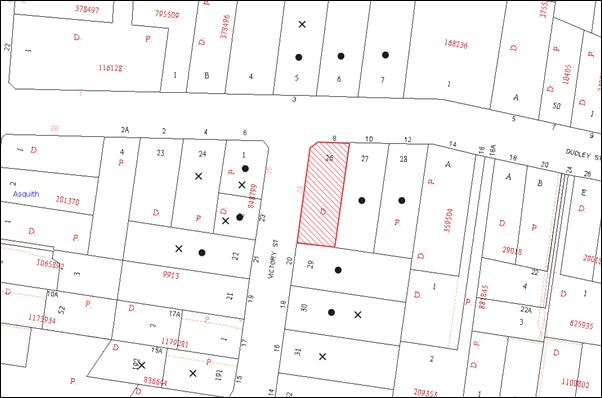
|
NOTIFICATION PLAN |
|
||
|
• PROPERTIES NOTIFIED
|
X SUBMISSIONS RECEIVED |
PROPERTY SUBJECT OF DEVELOPMENT |
|
|
FIVE SUBMISSIONS RECEIVED OUT OF MAP RANGE |
|||
Fourteen submissions objected to the development proposal, generally on the grounds that the development would result in:
· Unacceptable traffic on local streets, particularly at peak time in combination with the Asquith Public School;
· Access and parking impact on Victory Street;
· Victory Street has no kerb or guttering so carers tend to park on the nature strip damaging the grass;
· Unacceptable noise from activities at the centre; and
· Disposal of nappies.
The merits of the matters raised in community submissions have been addressed in the body of the report.
6. THE PUBLIC INTEREST
Section 79C(1)(e) of the Act requires Council to consider “the public interest”.
The public interest is an overarching requirement, which includes the consideration of the matters discussed in this report. Implicit to the public interest is the achievement of future built outcomes adequately responding to and respecting the future desired outcomes expressed in environmental planning instruments and development control plans.
The application is considered to have satisfactorily addressed Council’s and relevant agencies’ criteria and would provide a development outcome that, on balance, would result in a positive impact for the community. Accordingly, it is considered that the approval of the proposed development would be in the public interest.
CONCLUSION
The proposal involves the demolition of an existing dwelling-house and associated structures for the construction of a childcare centre accommodating forty children. Fourteen public submissions have been received objecting to the proposal on grounds including traffic, parking and noise. The issues raised in submissions are addressed in the report and by relevant conditions to ensure any potential impacts are mitigated.
The proposal generally complies with the relevant provisions of the Hornsby Shire Local Environmental Plan 1994, Community Uses Development Control Plan, Access and Mobility Development Control Plan and Waste Minimisation and Management Development Control Plan. The application is permissible in the zone and is considered to be within the environmental capacity of the site and the locality.
On balance, and having regard to the community benefit of the proposal, it is considered that the development is worthy of Council’s consent. Accordingly, the proposed development is recommended for approval.
Note: At the time of the completion of this planning report, no persons have made a Political Donations Disclosure Statement pursuant to Section 147 of the Environmental Planning and Assessment Act 1979 in respect of the subject planning application.
|
Rod Pickles Manager - Development Assessment Planning Division |
James Farrington Group Manager Planning Division |
|
1.View |
Locality Plan |
|
|
|
2.View |
Ground Floor Plan |
|
|
|
3.View |
First Floor Plan |
|
|
|
4.View |
North Elevation, East Elevation, West Elevation |
|
|
|
5.View |
South Elevation, Dudley Street Elevation (fence), Victory Street Elevation (fence), section X-X |
|
|
|
6.View |
Site Plan |
|
|
|
7.View |
Shadow Diagrams |
|
|
|
8.View |
Survey |
|
|
|
9.View |
Topographical Survey of Lot 26 DP 9913 |
|
|
|
10.View |
Stormwater Drainage Plan |
|
|
|
11.View |
Landscape Plan |
|
|
|
12.View |
Landscape Detail Plan |
|
|
|
13.View |
Pick up and Set Down Area from Traffic Report |
|
|
File Reference: DA/204/2013
Document Number: D02560266
SCHEDULE 1
GENERAL CONDITIONS
The conditions of consent within this notice of determination have been applied to ensure that the use of the land and/or building is carried out in such a manner that is consistent with the aims and objectives of the relevant legislation, planning instruments and council policies affecting the land and does not disrupt the amenity of the neighbourhood or impact upon the environment.
Note: For the purpose of this consent, the term ‘applicant’ means any person who has the authority to act on or the benefit of the development consent.
Note: For the purpose of this consent, any reference to an act, regulation, Australian Standard or publication by a public authority shall be taken to mean the gazetted act or regulation, or adopted Australian Standard or publication as in force on the date that the application for a construction certificate is made.
1. Approved Plans and Supporting Documentation
The development must be carried out in accordance with the plans and documentation listed below and endorsed with Council’s stamp, except where amended by Council and/or other conditions of this consent:
Approved Plans
|
Plan No. |
Plan Title |
Drawn by |
Dated |
|
AELC1112 – Issue ‘A’ – Sheet 1 of 8 |
Ground Floor Plan |
Inner Living Pty Ltd |
November 2012 |
|
AELC1112 – Issue ‘A’ – Sheet 2 of 8 |
First Floor Plan |
Inner Living Pty Ltd |
November 2012 |
|
AELC1112 – Issue ‘A’ – Sheet 3 of 8 |
First Floor Plan |
Inner Living Pty Ltd |
November 2012 |
|
AELC1112 – Issue ‘A’ – Sheet 4 of 8 |
East Elevation, North Elevation and West Elevation |
Inner Living Pty Ltd |
November 2012 |
|
AELC1112 – Issue ‘A’ – Sheet 5 of 8 |
South Elevation, Dudley Street Elevation (fence), Victory Street Elevation (fence) and Section X-X |
Inner Living Pty Ltd |
November 2012 |
|
AELC1112 – Issue ‘A’ – Sheet 6 of 8 |
Site Plan |
Inner Living Pty Ltd |
November 2012 |
|
AELC1112 – Issue ‘A’ – Sheet 7 of 8 |
Shadow Diagrams |
Inner Living Pty Ltd |
November 2012 |
|
AELC1112 – Issue ‘A’ – Sheet 8 of 8 |
Survey |
Inner Living Pty Ltd |
November 2012 |
|
12-47 |
Topographical survey of Lot 26 DP 9913 |
McKittrick Fry & O’Hagan |
3-05-2012 |
|
C01 |
Stormwater Drainage Plan |
Development Engineering Solutions |
15.12.12 |
|
LPDA 13-214/1D |
Landscape Plan |
Conzept Landscape Architects |
January 2013 |
|
C7386.Q3281.B26148 FA Asquith ESCP docx |
Erosion and Sediment Control Plan |
Sydney Environmental and Soil Laboratory (SESL) Pty Ltd |
9 May 2013 |
Supporting Documentation
|
Document No. |
Prepared by |
Dated |
|
BCA Compliance Assessment |
BCA Vision Pty Ltd |
21 November 2102 |
|
Access Compliance Report |
BCA Vision Pty Ltd |
21 November 2012 |
|
Traffic and Access Impact Report |
Development Engineering Solutions Pty Ltd |
29 May 2013 |
|
Traffic and Parking Report – Revision A |
Development Engineering Solutions Pty Ltd |
1 August 2013 |
|
Hazardous Materials Survey |
SESL Australia |
May 2013 |
|
Phase 1 Preliminary Site Investigation with Sampling |
SESL Australia |
May 2013 |
|
Environmental Noise Impact Report |
Marshall Day Acoustics |
20 February 2013 |
|
Waste Management Plan |
Inner Living Pty Ltd |
4/3/2013 |
|
Statement of Environmental Effects and Site Analysis |
Red Gum Town Planning Services |
05/03/2013 |
|
Schedule of Finishes and Colours |
- |
10 October 2013 |
2. Amendment of Plans
The approved plans are to be amended as follows:
a) The car parking layout is to be amended as per ‘The pick up/set down area’ Diagram of the Traffic and Access Report prepared by Development Engineering Solutions P/L (Revision A) and dated 1 August 2013.
3. Construction Certificate
A Construction Certificate is required to be approved by Council or a Private Certifying Authority prior to the commencement of any works under this consent.
4. Acoustic Report Compliance
The proposed development must be designed and constructed in accordance with the recommendations of the Environmental Noise Impact Report – Report No. 001 R02 2012467SY prepared by Marshal Day Acoustics.
REQUIREMENTS PRIOR TO THE ISSUE OF A CONSTRUCTION CERTIFICATE
5. Building Code of Australia
All building work must be carried out in accordance with the requirements of the Building Code of Australia.
6. Sydney Water – Quick Check
The application must be submitted to a Sydney Water ‘Quick Check Agent’ or ‘Customer Centre’ for approval to determine whether the development will affect any Sydney Water infrastructure, and whether further requirements are to be met.
Note: Refer to www.sydneywater.com.au or telephone 13 20 92 for assistance.
7. Stormwater Drainage
The stormwater drainage system for the development must be designed and constructed and a construction Certificate issued for these works. The stormwater drainage system is to be designed in accordance with Council’s Civil Works – Design and Construction Specification 2005 and the following requirements:
a) Connected directly to Council’s street drainage system.
Note: A separate Construction Certificate is required to be submitted and approval obtained prior to the commencement of these works.
8. On Site Stormwater Detention
The on site detention system for the development must be designed and constructed and a construction Certificate issued for these works. The stormwater drainage system is to be designed in accordance with Council’s Civil Works – Design and Construction Specification 2005 and the following requirements:
a) Have a capacity of not less than 9 cubic metres, and a maximum discharge (when full) of 15 litres per second.
b) Have a surcharge/inspection grate located directly above the outlet.
c) Discharge from the detention system to be controlled via 1 metre length of pipe, not less than 50 millimetres diameter or via a stainless plate with sharply drilled orifice bolted over the face of the outlet discharging into a larger diameter pipe capable of carrying the design flow to an approved Council system.
d) Where above ground and the average depth is greater than 0.3 metres, a ‘pool type’ safety fence and warning signs to be installed.
e) Not be constructed in a location that would impact upon the visual or recreational amenity of residents.
Note: A separate Construction Certificate is required to be submitted and approval obtained prior to the commencement of these works.
9. Internal Driveway/Vehicular Areas
The driveway and parking areas on site must be designed, constructed and a Construction Certificate issued in accordance with Australian Standards 2890.1, 2890.2, 3727 and the following requirements:
a) Design levels at the front boundary shall be obtained from Council if a private accredited certifier is engaged to obtain a construction certificate for these works.
Note: A construction certificate shall be obtained prior to the commencement of these works and are to be completed prior to the issue of a subdivision certificate.
10. Road Works
Prior to the issue of a Construction Certificate for these works a separate application under the Local Government Act, 1993 and the Roads Act, 1993 must be submitted to Council for all works within the road reserve. All road works approved under this consent must be constructed in accordance with Council’s Civil Works Design and Construction Specification, 2005 and the following requirements:
a) Kerb, gutter and road shoulder is to be constructed across the frontage of the site in Victory St along with Council’s kerb inlet drainage systems of the kerb return.
b) The existing road pavement to be saw cut a minimum of 300 mm from the existing edge of the bitumen and reconstructed.
c) The submission of a compaction certificate from a geotechnical engineer for any fill within road reserves, and all road sub-grade and road pavement materials.
Note: A separate Construction Certificate is required to be submitted and approval obtained by Hornsby Shire Council prior to the commencement of these works.
11. Preservation of Survey Marks
Prior to the issue of a construction certificate, a registered surveyor shall identify all survey marks in the vicinity of the proposed development. Any survey marks required to be removed or displaced as a result of the proposed development shall be undertaken by a registered surveyor in accordance with Section 24 (1) of the Surveying and Spatial Information Act 2002 and following the Surveyor General’s Directions No.11 – "Preservation of Survey Infrastructure".
12. Traffic Control Plans
A Traffic Control Plan (TCP) must be prepared by a qualified traffic controller in accordance with the Roads & Traffic Authority’s Traffic Control at Worksites Manual 1998 and Australian Standard 1742.3 for all work on a public road and be submitted to Council. The TCP must detail the following where required:
a) Arrangements for public notification of the works.
b) Temporary construction signage.
c) Permanent post-construction signage.
d) Vehicle movement plans.
e) Traffic management plans.
f) Pedestrian and cyclist access/safety.
13. Children (Education and Care Services) Supplementary Provisions Regulation 2004
Documentation prepared by a registered architect is to be submitted to Council to certify the proposed development in accordance with the requirements of the Children and Young Persons (Care & Protection) Act 1998 and the Children’s Services Regulation 2012.
REQUIREMENTS PRIOR TO THE COMMENCEMENT OF ANY WORKS
14. Erection of Construction Sign
A sign must be erected in a prominent position on any site on which building work, subdivision work or demolition work is being carried out:
a) Showing the name, address and telephone number of the principal certifying authority for the work,
b) Showing the name of the principal contractor (if any) for any demolition or building work and a telephone number on which that person may be contacted outside working hours, and
c) Stating that unauthorised entry to the work site is prohibited.
Note: Any such sign is to be maintained while the building work, subdivision work or demolition work is being carried out, but must be removed when the work has been completed.
15. Protection of Adjoining Areas
A temporary hoarding, fence or awning must be erected between the work site and adjoining lands before the works begin and must be kept in place until after the completion of the works if the works:
a) Could cause a danger, obstruction or inconvenience to pedestrian or vehicular traffic.
b) Could cause damage to adjoining lands by falling objects.
c) Involve the enclosure of a public place or part of a public place.
Note: Notwithstanding the above, Council’s separate written approval is required prior to the erection of any structure or other obstruction on public land.
16. Toilet Facilities
Toilet facilities must be available or provided at the works site before works begin and must be maintained until the works are completed at a ratio of one toilet for every 20 persons employed at the site. Each toilet must:
a) be a standard flushing toilet connected to a public sewer; or
b) be a temporary chemical closet approved under the Local Government Act, 1993; or
c) have an on-site effluent disposal system approved under the Local Government Act, 1993.
17. Erosion and Sediment Control
Erosion and sediment control measures must be provided and maintained throughout the construction period in accordance with the manual ‘Soils and Construction 2004 (Bluebook)’, the approved plans, Council specifications and to the satisfaction of the principal certifying authority. The erosion and sediment control devices must remain in place until the site has been stabilised and revegetated.
Note: On the spot penalties up to $1,500 may be issued for any non-compliance with this requirement without any further notification or warning.
REQUIREMENTS DURING CONSTRUCTION
18. Construction Work Hours
All work on site (including demolition and earth works) must only occur between 7 am and 5 pm Monday to Saturday.
No work is to be undertaken on Sundays or public holidays.
19. Demolition
All demolition work must be carried out in accordance with Australian Standard 2601-2001 – The Demolition of Structures and the following requirements:
a) Demolition material is to be disposed of to an authorised recycling and/or waste disposal site and/or in accordance with an approved waste management plan.
b) Demolition works, where asbestos material is being removed, must be undertaken by a contractor that holds an appropriate licence issued by WorkCover NSW in accordance with Chapter 10 of the Occupational Health and Safety Regulation 2001 and Clause 29 of the Protection of the Environment Operations (Waste) Regulation 2005.
c) On construction sites where buildings contain asbestos material, a standard commercially manufactured sign containing the words ‘DANGER ASBESTOS REMOVAL IN PROGRESS’ measuring not less than 400mm x 300mm must be erected in a prominent position visible from the street.
20. Environmental Management
The site must be managed in accordance with the publication ‘Managing Urban Stormwater – Landcom (March 2004) and the Protection of the Environment Operations Act 1997 by way of implementing appropriate measures to prevent sediment run-off, excessive dust, noise or odour emanating from the site during the construction of the development.
21. Street Sweeping
Street sweeping must be undertaken following sediment tracking from the site along Dudley and Victory Streets, Asquith during works and until the site is established.
22. Council Property
During construction works, no building materials, waste, machinery or related matter is to be stored on the road or footpath. The public reserve is to be kept in a clean, tidy and safe condition at all times.
23. Disturbance of Existing Site
During construction works, the existing ground levels of open space areas and natural landscape features, (including natural rock-outcrops, vegetation, soil and watercourses) must not be altered unless otherwise nominated on the approved plans.
24. Landfill
Landfill must be constructed in accordance with Council’s ‘Construction Specification, 2005’ and the following requirements:
a) All fill material imported to the site is to wholly consist of Virgin Excavated Natural Material (VENM) as defined in Schedule 1 of the Protection of the Environment Operations Act 1997 or a material approved under the Department of Environment and Climate Change’s general resource recovery exemption.
25. Excavated Material
All excavated material removed from the site must be classified in accordance with the Department of Environment, Climate Change and Water NSW Waste Classification Guidelines prior to disposal to an approved waste management facility and reported to the principal certifying authority.
26. Survey Report – Finished Floor Level
A report(s) must be prepared by a registered surveyor and submitted to the principal certifying authority prior to the pouring of concrete at each level of the building certifying that:
a) The building, retaining walls and the like have been correctly positioned on the site.
b) The finished floor level(s) are in accordance with the approved plans.
REQUIREMENTS PRIOR TO THE ISSUE OF AN OCCUPATION CERTIFICATE
Note: For the purpose of this consent, a reference to ‘occupation certificate’ shall not be taken to mean an ‘interim occupation certificate’ unless otherwise stated.
27. Damage to Council Assets
Any damage caused to Council’s assets as a result of the construction of the development must be rectified in accordance with Council’s written requirements and at the sole cost of the applicant.
28. Completion of Landscaping
A certificate must be provided by a practicing landscape architect, horticulturalist or person with similar qualifications and experience certifying that all required landscaping works have been satisfactorily completed in accordance with the approved landscape plans.
Note: Advice on suitable species for landscaping can be obtained from Council’s planting guide ‘Indigenous Plants for the Bushland Shire’, available at www.hornsby.nsw.gov.au.
29. Retaining Walls
All required retaining walls must be constructed as part of the development.
30. External Lighting
All external lighting must be designed and installed in accordance with Australian Standard AS 4282 – Control of the Obtrusive Effects of Outdoor Lighting. Certification of compliance with the Standard must be obtained from a suitably qualified person.
31. Site Remediation Verification
The applicant must provide documentation from a suitably qualified environmental consultant verifying that the site has been remediated in accordance with the NSW Environment Protection Authority’s Contaminated Sites – Guidelines for Consultants Reporting on Contaminated Sites, the Contaminated Sites- Sampling Design Guidelines Contaminated Sites – Guidelines for the NSW Site Auditor Scheme and the recommendations of the Remedial Action Plan.
32. Food Premises
The fit out and operation of that part of the building to be used for the manufacture, preparation or storage of food for sale, must be in accordance with Australian Standard 4674-2004 – Design and fit out of food premises, the Food Act 2003, and the Food Regulation 2004.
Note: Reference should also be made to the Food Safety Standards and the ‘Safe Food Australia - A guide to the Food Safety Standards 2nd Edition January 2001’.
33. Works as Executed Plan
A works-as-executed plan(s) must be prepared by a registered surveyor and submitted to Council for completed road pavement, kerb & gutter, public drainage systems, driveways and on-site detention system. The plan(s) must be accompanied by a certificate from a registered surveyor certifying that all pipelines and associated structures lie wholly within any relevant easements.
OPERATIONAL CONDITIONS
34. Use of Premises
The development approved under this consent shall be used for ‘child care centre’ and not for any other purpose without Council’s separate written consent.
35. Number of Children
The centre shall accommodate a maximum of 40 children, being 8 children under the age of 2 and 32 children at, or above, the age of 2.
36. Hours of Operation
The hours of operation of the premise are restricted to those times listed below:
Monday to Friday 7 am to 6 pm
Saturday, Sunday and Public Holidays No work.
37. Noise
All noise generated by the proposed development must be attenuated to prevent levels of noise being emitted to adjacent premises which possess tonal, beating and similar characteristics or which exceeds background noise levels by more than 5 dB(A).
38. Fire Safety Statement - Annual
On at least one occasion in every 12 month period following the date of the first ‘Fire Safety Certificate’ issued for the property, the owner must provide Council with an annual ‘Fire Safety Certificate’ to each essential service installed in the building.
- END OF CONDITIONS -
ADVISORY NOTES
The following information is provided for your assistance to ensure compliance with the Environmental Planning and Assessment Act 1979, Environmental Planning and Assessment Regulation 2000, other relevant legislation and Council’s policies and specifications. This information does not form part of the conditions of development consent pursuant to Section 80A of the Act.
Environmental Planning and Assessment Act, 1979 Requirements
· The issue of a construction certificate prior to the commencement of any works. Enquiries regarding the issue of a construction certificate can be made to Council’s Customer Services Branch on 9847 6760.
· A principal certifying authority to be nominated and Council notified of that appointment prior to the commencement of any works.
· Council to be given at least two days written notice prior to the commencement of any works.
· Mandatory inspections of nominated stages of the construction inspected.
· An occupation certificate to be issued before occupying any building or commencing the use of the land.
Long Service Levy
In accordance with Section 34 of the Building and Construction Industry Long Service Payments Act 1986, a ‘Long Service Levy’ must be paid to the Long Service Payments Corporation or Hornsby Council.
Note: The rate of the Long Service Levy is 0.35% of the total cost of the work.
Note: Hornsby Council requires the payment of the Long Service Levy prior to the issue of a construction certificate.
Tree Preservation Order
To ensure the maintenance and protection of the existing natural environment, it is an offence to ringbark, cut down, top, lop, remove, wilfully injure or destroy a tree outside 3 metres of the approved building envelope without the prior written consent from Council.
Note: A tree is defined as a single or multi-trunked wood perennial plant having a height of not less than three (3) metres, and which develops many branches, usually from a distance of not less than one (1) metre from the ground, but excluding any plant which, in its particular location, is a noxious plant declared as such pursuant to the Noxious Weeds Act 1993. This definition of ‘tree’ includes any and all types of Palm trees.
All distances are determined under Australian Standard AS4970-2009 “Protection of Trees on Development Sites”.
Fines may be imposed for non-compliance with Council’s Tree Preservation Order.
Disability Discrimination Act
The applicant’s attention is drawn to the existence of the Disability Discrimination Act. A construction certificate is required to be obtained for the proposed building/s, which will provide consideration under the Building Code of Australia, however, the development may not comply with the requirements of the Disability Discrimination Act. This is the sole responsibility of the applicant.
Covenants
The land upon which the subject building is to be constructed may be affected by restrictive covenants. Council issues this approval without enquiry as to whether any restrictive covenant affecting the land would be breached by the construction of the building, the subject of this consent. Applicants must rely on their own enquiries as to whether or not the building breaches any such covenant.
Advertising Signage – Separate DA Required
This consent does not permit the erection or display of any advertising signs. Most advertising signs or structures require development consent. Applicants should make separate enquiries with Council prior to erecting or displaying any advertising signage.
Dial Before You Dig
Prior to commencing any works, the applicant is encouraged to contact Dial Before You Dig on 1100 or www.dialbeforeyoudig.com.au for free information on potential underground pipes and cables within the vicinity of the development site.
Telecommunications Act 1997 (Commonwealth)
If you are aware of any works or proposed works which may affect or impact on Telstra’s assets in any way, you are required to contact: Telstra’s Network Integrity Team on Phone Number 1800 810 443.
Asbestos Warning
Should asbestos or asbestos products be encountered during demolition or construction works you are advised to seek advice and information should be prior to disturbing the material. It is recommended that a contractor holding an asbestos-handling permit (issued by WorkCover NSW)be engaged to manage the proper handling of the material. Further information regarding the safe handling and removal of asbestos can be found at:
Alternatively, telephone the WorkCover Asbestos and Demolition Team on 8260 5885.
Rain Water Tank
It is recommended that water collected within any rainwater tank as part of the development be limited to non-potable uses. NSW Health recommends that the use of rainwater tanks for drinking purposes not occur where a reticulated potable water supply is available.
Food Authority Notification
The NSW Food Authority requires businesses to electronically notify the Authority prior to the commencement of its operation.
Note: NSW Food Authority can be contacted at www.foodnotify.nsw.gov.au.
Council Notification – Food Premises
Prior to the commencement of the business, the operator is requested to contact Council’s Environmental Health Team to arrange an inspection for compliance against the relevant legislation and guidelines outlined in this approval.
Note: Council’s Environmental Health Officer can be contacted on 02 9847 6745.
Group Manager's Report No. PL109/13
Planning Division
Date of Meeting: 20/11/2013
19 REPORTING VARIATIONS TO DEVELOPMENT STANDARDS
EXECUTIVE SUMMARY
· In accordance with the Department of Planning and Infrastructure’s Planning Circular PS 08-14, Council is required to report variations to development standards for development applications approved under delegated authority, which relied upon State Environmental Planning Policy No. 1 - Development Standards (SEPP 1).
· Council’s consideration of this report ensures Council’s obligation to monitor variations to development standards is complied with.
|
THAT the contents of Group Manager’s Report No. PL109/13 be received and noted. |
PURPOSE
The purpose of this report is to advise Council of determined development applications under delegated authority involving a SEPP 1 variation to a development standard for the period 1 July 2013 to 30 September 2013.
DISCUSSION
The Department of Planning and Infrastructure’s Circular B1, issued in March 1989, requested that councils monitor the use of the Director-General’s assumed concurrence under SEPP 1 on a quarterly basis. This reporting requirement remains effective.
Monitoring of variations to development standards is important to provide the Department and councils with an overview of the manner in which established development standards are being varied and whether the assumed concurrence is being used as intended. This enables Council and the Department to determine whether development standards are appropriate, or whether changes are required.
The Department issued Circular PS 08–014 on 14 November 2008. The purpose of the Circular was to remind councils of their responsibilities to monitor the use of the Director-General’s assumed concurrence under SEPP 1. Councils were reminded of the need to keep accurate records of the use of SEPP 1 and to report on a quarterly basis.
The Circular also provides that councils are required to adopt the following four measures:
1. Establish a register of development applications determined with variations in standards under SEPP 1.
2. Require all development applications where there has been a variation greater than 10% in standards under SEPP 1 to be determined by full council (rather than General Manager or nominated staff member).
3. Provide a report to Council on the development applications determined where there had been a variation in standards under SEPP 1.
4. Make the register of development applications determined with variations in standards under SEPP 1 available to the public on the council’s website.
In accordance with Point 3 of the Department’s Circular, attached is a list of development applications determined under delegated authority involving a SEPP 1 variation to a development standard for the period 1 July 2013 to 30 September 2013.
A copy of the attachment to this report is also reproduced on Council’s website.
BUDGET
There are no budget implications.
POLICY
This report addresses Council’s reporting obligations for development applications determined where there has been a variation in standards under SEPP 1.
CONCLUSION
Council is required to monitor the manner in which development standards are being varied. This assists in determining whether changes are required to relevant standards. This report provides advice to Council on standards varied under delegated authority during the reporting period from 1 July 2013 to 30 September 2013.
RESPONSIBLE OFFICER
The officer responsible for the preparation of this report is the Group Manager – Planning Division – James Farrington, who can be contacted on 9847 6750.
|
James Farrington Group Manager Planning Division |
|
|
1.View |
SEPP 1 Returns |
|
|
File Reference: F2004/07599
Document Number: D02539360
Group Manager's Report No. PL108/13
Planning Division
Date of Meeting: 20/11/2013
20 SUBMISSIONS REPORT - HERITAGE REVIEW STAGE 5 PLANNING PROPOSAL
EXECUTIVE SUMMARY
· This report reviews submissions received in response to the exhibition of the Heritage Review Stage 5 Planning Proposal, which relates to a review of existing heritage listed privately owned gardens and items proposed for inclusion, amendment or deletion from Schedule 5 (Environmental Heritage) of Hornsby Local Environmental Plan 2013.
· At its meeting on 15 May 2013, Council resolved to forward the Planning Proposal to the Minister for Planning and Infrastructure, seeking a Gateway Determination to progress the amendments to the Hornsby Local Environment Plan 2013 (HLEP) in accordance with Section 56(1) of the Environment and Planning Assessment Act 1979 (“the Act”).
· Council received the Gateway Determination on 26 June 2013 which included plan making powers delegated under Section 23 of the Act.
· The Planning Proposal was exhibited from 7 August 2013 to 6 September 2013. Thirteen (13) submissions concerning 10 items and 2 general concerns have been received.
· The submissions and Planning Proposal recommendations have been reviewed by Council’s Heritage Advisory Committee and the issues raised in submissions are addressed in this report.
· It is recommended that Council adopt the Planning Proposal as amended to include, remove and amend items within Schedule 5 (Environmental Heritage) of the HLEP 2013 and proceed with the making of the plan.
|
THAT: 1. Council endorse the recommendations of Group Manager’s Report No. PL108/13 to adopt the Planning Proposal as amended to include, remove and amend items within Schedule 5 (Environmental Heritage) of Hornsby Local Environmental Plan 2013. 2. In accordance with the plan making powers delegated to Council, the General Manager exercise the functions of the Minister for Planning and Infrastructure and proceed to make the plan. 3. All persons who made submissions and affected property owners be advised of Council’s resolution. |
PURPOSE
The purpose of this Report is to review submissions received in response to the exhibition of the Heritage Review Stage 5 Planning Proposal and to recommend that Council proceed with the making of the plan with amendments as detailed within this report.
BACKGROUND
The HLEP 2013, gazetted in October 2013, includes heritage conservation provisions and lists over 800 heritage items and 6 heritage conservation areas. In response to requests for the deletion or inclusion of items in the heritage schedule, Council conducts a periodical Heritage Review to reassess the statutory protection and identified heritage values of locally heritage listed items and heritage conservation areas within Hornsby Shire.
At its meeting on 2 November 2011, Council considered Executive Managers’ Report No. PLN74/11 and endorsed the content and direction of Heritage Review Stage 5 to include the following projects:
· Review of 36 built and landscape items for deletion, retention or inclusion; and
· Review of 42 privately owned heritage listed gardens.
Council at its meeting on 15 May 2013, considered Group Manager’s Report No. PL33/13 concerning Heritage Review Stage 5 and resolved that:
1. Council endorse progression of the Planning Proposal attached to Group Manager’s Report No. PL28/13 to amend Schedule D (Heritage Items) of the Hornsby Shire Local Environmental Plan 1994 or Schedule 5 (Environmental Heritage) of the draft HLEP.
2. Pursuant to Section 56(1) of the Act, Council forward the Planning Proposal to the Minister for Planning and Infrastructure seeking a Gateway Determination to exhibit the Planning Proposal.
3. Following the exhibition, a report on submissions received in response to the public exhibition and consideration by the Heritage Advisory Committee is to be presented to Council.
In accordance with the Council’s resolution, Gateway Authorisation to proceed with the Planning Proposal was issued by the Department of Planning and Infrastructure (DP&I) on 26 June 2013.
As part of the Gateway Authorisation, Council was granted delegated authority to request the making of the LEP amendment. Section 23 of the Act allows the Minister and the Director-General to delegate functions to a council and/or an officer or employee of a council. Under Section 59 of the Act, the Minister has delegated the plan making powers with respect to the Planning Proposal to Council.
At its meeting on 12 December 2012, Council resolved to formally accept the plan making delegations and delegate the plan making functions to the General Manager. Acknowledgement of Council’s resolution was received from the DP&I on 3 March 2013.
Should Council resolve to adopt the Planning Proposal, the next step involves the forwarding of all relevant documentation, including a copy of Council’s assessment report (i.e. details of community consultation, responses to submissions, maps, a copy of the Opinion from Parliamentary Counsel Office, any other relevant material, and the completed delegation reporting template) to the Department.
The Department will then arrange for the Plan to be notified on the NSW Government legislation website.
DISCUSSION
This report discusses the exhibition of the Heritage Review Stage 5 Planning Proposal and submissions received during the exhibition period.
Heritage Review Stage 5 Planning Proposal
The Heritage Review Stage 5 Planning Proposal is a result of the Hornsby Heritage Study Review Stage 5 (Review) undertaken by Godden Mackay Logan (GML) in 2012 and a number of further amendments proposed to update existing heritage item listings. The Planning Proposal includes recommendations for the:
· listing of 15 new heritage items identified as having heritage significance;
· removal of 23 heritage items that no longer warrant listing;
· updating of 8 heritage item listings to reflect current significance;
· updating of 5 heritage item listings to reflect current property descriptions and/or property addresses; and
· removal of 1 heritage item which was destroyed in a house fire.
Exhibition and Review of Submissions
In accordance with the Consultation Strategy outlined in the Planning Proposal, the documents were exhibited from 7 August 2013 to 6 September 2013. Advertisements were placed in local newspapers and on Council’s website. Letters were sent to affected property owners and relevant local community groups. The Planning Proposal was also displayed at the Council Administration Centre and local branch libraries.
Thirteen (13) submissions concerning 10 items and 2 general concerns were received. The issues raised in submissions fall into the following categories:
· 3 submissions supporting the removal of heritage listing
· 2 submissions supporting the heritage listing of their property
· 6 submissions opposing the heritage listing of their property
· 1 submission regarding omission of the proposed East Epping, Rosebank Avenue and Essex Street conservation areas
· 1 Public Authority submission
In accordance with Council’s resolution, the Heritage Advisory Committee considered the recommendations of the Planning Proposal and issues raised in submissions at its meeting on 8 October 2013. The comments and recommendations provided below are inclusive of the Committee’s consideration.
A response to the concerns raised is summarised below with a full description provided in Attachment 1.
Public Authority Submission
The Heritage Division of the NSW Office of Environment and Heritage supports the inclusion and/or removal of the proposed items from Council’s heritage list where they have been subject to the appropriate heritage assessment to satisfy the criteria for demonstrating heritage significance.
The Heritage Division has commented that Council’s Tree Preservation Order (TPO) does not provide a satisfactory level of statutory protection to landscape heritage items and such items should be retained on Council’s heritage schedule.
Comment: The landscape items proposed to be removed were all subject to a heritage assessment by a suitably qualified heritage consultant in accordance with the principles and guidelines of the Heritage Council’s criteria for establishing heritage significance. The outcome of the Review concluded that the 21 gardens proposed to be removed no longer satisfied the criteria for heritage significance. Therefore, the retention of the heritage listings as a mechanism for tree protection is not appropriate in this instance.
Recommendation: No amendment to the exhibited Planning Proposal as the 21 gardens no longer demonstrate heritage significance.
Public Submissions
The following discussion outlines the submissions from property owners who object to the proposal to retain or include their house or garden on Council’s heritage list or where the Heritage Advisory Committee has raised concern:
a) 454 Galston Road, Dural: Objection to the retention of the heritage listing of the garden on the grounds that a consultation process was not followed and the item was not accurately assessed in accordance with the Heritage Office guidelines.
Comment: Review of the Planning Proposal by the Heritage Advisory Committee has found that heritage listing of the garden is inconsistent with the findings of the Heritage Review. The Heritage Review identifies that the condition of the garden and quality of plantings have significantly declined and many trees and shrubs have been lost. Further, a representative example of an intact large rural garden on the neighbouring property, No. 452 Galston Road is to be retained on the heritage list.
Recommendation: The Planning Proposal be amended to remove the heritage listing of the garden at No. 454 Galston Road, Dural.
b) 2A Waratah Road, Berowra: A submission was received from the land owner in support of the Planning Proposal which proposed to remove the heritage listing. However, the Heritage Advisory Committee has requested that the heritage listing of the garden should not be removed until appropriate alternative protection is provided for the remaining Camphor Laurel trees.
Comment: Retention of the heritage listing or alternative protection of the garden is not recommended as the Heritage Review identifies the Camphor Laurel trees to be in a seriously poor condition and no longer satisfy the criteria for demonstrating heritage significance.
Recommendation: No amendment to the exhibited Planning Proposal.
c) 20 Cheltenham Road, Cheltenham: Objection to the proposed heritage listing of the house on the basis that heritage listing would cause a negative economic effect on the value of the property.
Comment: The Heritage Advisory Committee has identified that the period and architectural styling of the house has not been accurately assessed by the Heritage Review. Accordingly, the heritage listing should not be progressed as it is not representative of the acclaimed Art Deco style.
Recommendation: The Planning Proposal be amended to remove the proposed listing of the house at No. 20 Cheltenham Road, Cheltenham.
d) 311 Malton Road, North Epping: Objection to the proposed heritage listing of the house as the matter was previously considered and not preceded in 1998. The house has undergone extensive modifications and heritage listing would impact on the feasibility of future modifications and costs to restore or replace the existing slate roof.
Comment: The heritage significance of the house is clearly demonstrated in the Planning Proposal and satisfies the criteria for establishing heritage significance. The house was assessed during Council’s initial Heritage Study in 1992 and during the subsequent Heritage Review (Stage 1) in 1997, where it was recommended for inclusion on both occasions.
Listing did not progress on the grounds that the property address was found to be incorrect under HSLEP 1994 and again in 1998 to advise the owner on the implications of the heritage listing. The matter appears to have been omitted from the subsequent Heritage Reviews, Stage 2, 3 and 4 for reasons unknown.
On the basis that the property has been identified to be of heritage significance on three independent occasions heritage listing of the property should be progressed.
Future modifications to the building could be assessed upon submission of a development application and a reasonable solution obtained. The costs and longevity of a replacement slate roof in comparison to other forms of roofing materials may provide economic value rather than a negative impact.
Recommendation: No amendment to the exhibited Planning Proposal.
e) 10 Harold Avenue, Pennant Hills: Objection to the proposed heritage listing of the house on the grounds that it would reduce development opportunity and prohibit development otherwise permissible under the Exempt and Complying Development Codes SEPP 2008.
Comment: Whilst the Heritage Review identifies the house to have local historical, associative and representative significance, the Heritage Advisory Committee considers that the setting and curtilage of the house has been compromised by the recent subdivision and construction of a second dwelling to the rear. Council currently includes 8 other heritage listed representative examples of Inter-war style bungalows with their curtilage and residential garden setting intact. Based on the compromised setting and recent modifications to the property, the Committee has commented that heritage listing of the property should not be progressed.
Recommendation: The Planning Proposal be amended to remove the heritage listing of the house at No.10 Harold Avenue, Pennant Hills.
f) 48 Bundarra Avenue, Wahroonga: Objection to retaining the heritage listing of the garden and proposed listing of the house “Landskrona” as they do not contain any values of heritage significance. The garden design is the result of their own efforts and maintenance, which has dramatically altered the garden over time.
Comment: The Heritage Advisory Committee considers that the aesthetical and historical significance of the house has been clearly demonstrated in the Heritage Review and satisfies the criteria for establishing heritage significance. The objection does not provide sufficient evidence to counter the stated heritage significance of the house.
However, the Heritage Review does not adequately demonstrate the significance of the garden as an individual item to satisfy the criteria for heritage listing.
Recommendation: The Planning Proposal be amended to remove the existing listing of the garden and retain the proposed listing of the house “Landskrona”.
Protection of Significant Trees
Where a property contains an identified significant tree, the Heritage Advisory Committee has requested that heritage listing of the relevant garden be retained until an appropriate alternative protection for the tree is provided such as a Significant Tree Register or amendment to Council’s Tree Preservation Order (TPO).
The Heritage Review recommends removal of 21 privately owned gardens which no longer satisfy the criteria for heritage significance. Fourteen (14) of these items included large mature trees recommended for inclusion on a Significant Tree Register as an alternative to the TPO which only relates to indigenous tree species.
Council at its meeting on 20 March 2013, endorsed an amendment to the Hornsby Development Control Plan and TPO to protect an additional list of significant tree species that are worthy of protection because of their cultural and amenity landscape values. As Council’s Hornsby Local Environmental Plan 2013 commenced on the 11 October 2013, the TPO has been replaced by the Tree and Vegetation Preservation (Part 1 General) provisions of the Hornsby Development Control Plan 2013. An amendment to the DCP to reflect Council’s resolution will occur shortly.
Amendment to the Tree and Vegetation Preservation provisions of the DCP provides the appropriate mechanism to address the Heritage Advisory Committee’s concerns for the protection of significant tree species where the heritage listing of that property is removed. It is not appropriate to maintain a heritage listing of trees to protect their longevity where it has been demonstrated that the item does not satisfy the criteria for heritage listing.
Commencement of the Hornsby Local Environmental Plan 2013
The Hornsby Local Environmental Plan (HLEP) 2013 commenced on 11 October 2013, replacing the former Hornsby Shire Local Environmental Plan (HSLEP) 1994, to become Council’s principal governing environmental planning instrument.
Accordingly, references to HSLEP 1994 and draft HLEP have been removed from the Planning Proposal. HLEP 2013 also provided for the amendment of the following items which form part of the Planning Proposal:
· amendment to 6 Parker Close, Beecroft to reflect the current property address;
· amendment to 3-5 Pembroke Street, Epping to reflect the current property address;
· removal of 406 pacific Highway, Hornsby which was destroyed in a house fire in August 2012; and
· removal of 1015 Pacific Highway, Berowra which was destroyed in a house fire in August 2012.
As these items are now correctly referenced in HLEP 2013, they have been removed from the Planning Proposal.
Summary of Recommendations
On the basis of the submissions received, consideration of the objections raised and commencement of the HLEP 2013, it is proposed to amend the Planning Proposal to:
· remove 2 proposed new heritage items;
· remove 1 heritage listed item proposed to be retained;
· remove 1 amendments to existing items which reflect current significance; and
· not proceed with amendments to the 4 items addressed by the commencement of HLEP 2013.
As a result, the amended Planning Proposal is for the:
· listing of 13 new heritage items identified as having heritage significance;
· removal of 23 heritage items that no longer warrant listing;
· updating 6 heritage item listings to reflect current significance; and
· updating 4 heritage item listings to reflect current property descriptions and/or property addresses.
The amended Planning Proposal is provided in Attachment 2.
CONSULTATION
In accordance with the Gateway Determination, the Planning Proposal was exhibited for a minimum period of 28 days in accordance with the consultation strategy outlined in the Planning Proposal. The Consultation Strategy included letters to property owners, local historical societies and the NSW Office of Environment and Heritage advertising of the exhibition. The exhibition also involved advertisements in local newspapers, Council’s website and displays at Council’s Administration Centre and local branch libraries.
Council’s Heritage Advisory Committee was also consulted in respect to the items to be investigated as part of the findings of the Study and a review of submissions.
BUDGET
There are no budgetary implications associated with this Report.
POLICY
There are no policy implications associated with this Report.
CONCLUSION
Heritage Review Stage 5 includes a review of heritage items and heritage listed privately owned gardens. A total of 78 properties were reviewed, including 36 built and landscape items for deletion, retention or inclusion and 42 privately owned heritage listed gardens.
In accordance with the instrument of delegations under Section 59 of the EP&A Act, it is recommended that Council adopt the exhibited Planning Proposal as amended and proceed with the making of the plan.
RESPONSIBLE OFFICER
The officer responsible for the preparation of this Report is the Manger, Strategic Planning – Fletcher Rayner - who can be contacted on 9847 6744.
|
Fletcher Rayner Manager - Strategic Planning Planning Division |
James Farrington Group Manager Planning Division |
|
1.View |
Attachment 1 - Review of Submissions |
|
|
|
2.View |
Attachment 2 - Heritage Review Stage 5 - Planning Proposal (amended) |
|
|
File Reference: F2013/00225
Document Number: D02530141
Group Manager's Report No. PL100/13
Planning Division
Date of Meeting: 20/11/2013
21 REPORT ON SUBMISSIONS - CARLINGFORD PRECINCT TRAFFIC IMPROVEMENTS
EXECUTIVE SUMMARY
· Draft development control plan (DCP) amendments identifying additional local traffic improvements to support the development of the Carlingford precinct were exhibited in June and July 2013.
· Three submissions were received in response to the exhibition, including two from public authorities (Roads and Maritime Services (RMS) and Parramatta City Council).
· The issues raised in submissions are summarised in this report and include objections to the left turn ban from Keeler Street onto Pennant Hills Road and concerns about the safety of school children.
· The left turn ban from Keeler Street onto Pennant Hills Road is already identified in Council’s adopted Hornsby Development Control Plan 2013 and Section 94 Development Contributions Plan 2012-2021. It is recommended that the turning restriction remain. Consultation concerning the detailed design of the traffic improvements will be undertaken prior to construction and the Local Traffic Committee will make a recommendation concerning how to proceed.
· Advice was sought from the Minister for Planning and Infrastructure, Infrastructure NSW and Roads and Maritime Services concerning the planned capacity improvements on Pennant Hills Road and Carlingford Road and requesting that the Parramatta to Chatswood Rail Link be reinstated as a project in the NSW Transport Plan.
· Responses indicate that the Parramatta to Chatswood Rail Link is not identified in the NSW Long Term Transport Masterplan, but that Pennant Hills Road is identified to be investigated for congestion management measures from North Parramatta to Wahroonga.
· It is recommended that the amendment to the Hornsby Development Control Plan 2013 attached to Group Manager’s Report No. PL100/13 be adopted.
|
THAT: 1. The amendment to the Hornsby Development Control Plan 2013 attached to Group Manager’s Report No. PL100/13 be adopted. 2. All persons who made a submission be advised of Council’s decision. |
PURPOSE
The purpose of this report is to present the outcome of the exhibition of draft amendments to the Hornsby Development Control Plan (HDCP) 2013 which identify additional recommended traffic improvements for the Carlingford Housing Strategy precinct.
BACKGROUND
At its meeting on 15 May 2013, Council considered Group Manager’s Report No. PL42/13 concerning additional traffic modelling undertaken for the Carlingford Housing Strategy precinct. The report identified additional local road improvements included in the Works Schedule for the new Hornsby Shire Council Section 94 Development Contributions Plan. Council resolved that:
1. Draft amendments to the Housing Strategy DCP and draft Hornsby DCP identifying the additional recommended traffic improvements to support development of the Carlingford precinct be exhibited; and
2. Council write to the Minister for Planning and Infrastructure, Roads and Maritime Services and Infrastructure NSW seeking details of capacity improvements planned to support the additional housing required by the State Government and requesting that the Parramatta to Chatswood Rail Link be reinstated as a project in the NSW Transport Plan.
In accordance with Council’s resolution, the draft DCP amendments were placed on public exhibition and letters were sent to the relevant state agencies concerning capacity improvements.
DISCUSSION
This report outlines the details of the public exhibition and responses received from the State agencies.
Exhibition and Review of Submissions
The draft DCP amendments were publicly exhibited from 13 June 2013 to 12 July 2013 in accordance with the requirements of the Environmental Planning and Assessment (EP&A) Act. A notice was placed in the Hornsby Advocate, the Northern District Times and on Council’s website. Copies of the draft DCP amendments were made available for inspection at Council’s Administration Building and Council libraries. Electronic copies were placed on Council’s website.
In summary, the DCP amendments include the following proposed traffic improvements:
· signalisation of the intersection of Carlingford Road with Hepburn Avenue;
· installation of traffic calming devices in Keeler Street;
· provision of an intersection treatment/roundabout on Keeler Street at Hepburn Avenue or Rickard Street; and
· continue with the proposal already identified in the DCP to prohibit left turn movements from Keeler Street into Pennant Hills Road.
Three submissions were received in response to the exhibition, including two from government agencies (RMS and Parramatta City Council). Major issues raised are discussed below. A map is attached to this report to assist understanding the street network and the issues raised in submissions.
Extent of Traffic Modelling
The submission from the RMS raises concern that the area identified for the additional traffic modelling is too small.
Comment: The area modelled is adequate for determining the localised traffic impact of developing the Carlingford Road precinct. The transport model area is bounded by Rickard Street, Marsden Road, Pennant Hills Road, Carlingford Road, Pennant Parade, Keeler Street and includes all the critical junctions in the vicinity of the Carlingford Road precinct that are likely to be affected by the new dwellings.
The additional traffic modelling builds on the modelling already completed by Council as part of the Hornsby Shire Housing Strategy. Council has recently engaged a consultant to consolidate various transport modelling projects and allow them to be updated progressively into the future.
Recommendation: No amendments be made to the proposed traffic improvements as a result of the submission concerning the area modelled.
Alternative Options
The submission from the RMS states that it would favourably consider signalisation of the intersection of Carlingford Road and Pennant Parade rather than the signalisation of the intersection of Carlingford Road and Hepburn Avenue. It also states that Council should consider restricting traffic movements at the intersection of Carlingford Road and Hepburn Avenue to left-in and left-out only.
Comment: Under the current traffic arrangement, only left turn movements are permitted into and out of Pennant Parade. This arrangement is required to prevent rat runs in the area and should remain as is. Restricting traffic to left in and left out of Hepburn Avenue as suggested by the RMS is also undesirable as it would force traffic from the Carlingford Road precinct to use local roads. Officers from Parramatta City Council have advised that they do not support the suggestion by the RMS.
Recommendation: No amendments be made to the proposed traffic improvements as a result of the submission suggesting alternative options.
Objection to the Restriction of the Left Turn into Pennant Hills Road from Keeler Street
The submission from Parramatta City Council indicates that the restriction on left turns out of Keeler Street onto Pennant Hills Road is not supported due to the impact on local access and possible increases in traffic in Rickard Street. A public submission raises concern with the restriction on left turns out of Keeler Street onto Pennant Hills Road as it would necessitate “U turns” in Rickard Street by parents after dropping children at Carlingford Public School or force parents out onto Pennant Hills Road via Carlingford Road.
Comment: The left turn restriction is already identified in Council’s adopted HDCP 2013 and should remain. Keeler Street currently acts as a detour for about 360 vehicles per hour in the afternoons which try to avoid the congestion on the State road network at the intersection of Carlingford Road and Pennant Hills Road. This non local traffic would conflict with the residential traffic generated by the new dwellings in the precinct. It is also dangerous for vehicles that use the left hand turn out of Keeler Street to cross lanes of traffic to travel southwest and rejoin the Cumberland Highway.
Concerns have been raised that the left turn restriction will encourage non local traffic to redirect to Rickard Street past Carlingford Public School. Such a rat run via Rickard Street is less likely as this route is circuitous and involves an unsignalised right turn into Marsden Road which is also subject to extensive queuing during the afternoon peak. The left turn ban in Keeler Street at Pennant Hills Road is likely to significantly reduce rat running overall and will force vehicles to remain on the state road network at the intersection of Carlingford Road and Pennant Hills Road when travelling southwest to rejoin the Cumberland Highway. The draft DCP amendments include an intersection treatment (such as a roundabout) on Keeler Street at the intersection of Rickard Street or Hepburn Avenue so that “U turns” in Rickard Street would not be necessary.
It is recommended that the left turn restriction remain in the DCP. There would still be a number of steps required to be undertaken before the restriction could be implemented, as follows:
1. Liaise with Parramatta Council concerning how the turn ban would be managed;
2. Submit a Traffic Management Plan to the RMS for endorsement;
3. Refer the Traffic Management Plan (if endorsed by the RMS) to community and stakeholders for comment; and
4. Refer the results of the consultation and detailed design to the Local Traffic Committee for a recommendation.
Recommendation: No amendments be made to the proposed traffic improvements as a result of the submissions opposed to the left turn restriction.
Safety of School Children
The public submission and the submission from Parramatta City Council raise concerns about the safety of children walking to Carlingford Public School. The public submission states that roundabouts in Keeler Street would be dangerous to children and that education on roundabout use is not proposed for the children at the school.
Comment: An intersection treatment such as a roundabout is required to manage speeds along Keeler Street. Most Councils have road safety programs or, where such Council involvement is not available, RMS can provide information and advice to schools regarding pedestrian safety generally and safer routes to schools.
Regarding the suitability of a roundabout at this location, there are a number of steps which would be required to be undertaken before any intersection treatment is implemented as follows:
1. Liaise with Parramatta Council concerning the roundabout or intersection treatment location;
2. Consult with community and stakeholders; and
3. Refer the results of the consultation and detailed design to the Local Traffic Committee for a recommendation.
Recommendation: No amendments be made to the proposed traffic improvements as a result of the submissions concerning the safety of school children.
Width of Keeler Street
The submission from Parramatta City Council raises concern that Keeler Street is approximately 9m wide and too narrow for two way traffic when cars are parked on both sides of the street. The submission recommends that Council’s Section 94 plan include road widening for Keeler Street.
Comment: The left turn restriction from Keeler Street onto Pennant Hills Road will reduce two way traffic flow on Keeler Street between Pennant Hills Road and Rickard Street. It will also significantly reduce the amount of non-local traffic using Keeler Street which will assist to address the issue raised by Parramatta City Council.
Recommendation: No amendments be made to the proposed traffic improvements as a result of the submission concerning the width of Keeler Street. However, if the left turn restriction is not endorsed by the RMS and the Local Traffic Committee, Council should consider road widening in Keeler Street to cater for through traffic.
Letter to State Agencies
In accordance with Council’s resolution on 15 May 2013, letters were sent to Infrastructure NSW, the Minister for Planning and Infrastructure and Roads and Maritime Services. The letter (copy attached) sought details concerning the specific infrastructure plan for the Carlingford area, particularly as it relates to road capacity improvements on Pennant Hills Road and Carlingford Road. The letter also requested that the Parramatta to Chatswood Rail Link be reinstated as a project in the NSW Transport Plan to mitigate background traffic growth in the Carlingford area and across the regional road network. Responses were received (copy attached) from Transport for NSW (on behalf of the RMS) and the Minister for Planning and Infrastructure and are summarised below. No response has been received from Infrastructure NSW.
Transport for NSW
The response from Transport for NSW comments that the Carlingford Road precinct is serviced by the Metrobus M54 service and that other bus services stop at Carlingford Court Shopping Centre. It advises that Transport for NSW and the RMS will continue to identify and alleviate hot spots as they emerge in line with growth in demand. The letter states that one of the future corridors identified in the Long Term Transport Masterplan to be investigated for congestion management measures includes Pennant Hills Road from North Parramatta to Wahroonga. Transport NSW reiterates that the Parramatta to Chatswood Rail Link is not included in the NSW Long Term Transport Masterplan.
Minister for Planning and Infrastructure
The Minister for Planning and Infrastructure advises that he has instructed the Department of Planning and Infrastructure to work closely with Transport NSW to address infrastructure issues to support new housing in Carlingford. The Minister confirms that the State Government will continue to work collaboratively with Hornsby Shire Council to assist in the implementation of the Housing Strategy and other planning initiatives.
BUDGET
The cost of required local road improvements identified to support the new housing in the Carlingford precinct is estimated to be $840,000 which has been included in Council’s adopted Section 94 Development Contributions Plan 2012-2021.
POLICY
At the time of exhibition, the draft DCP amendments were prepared to replace the Carlingford precinct key principles diagram in the Housing Strategy DCP and the (then) draft Hornsby DCP. However, on 11 October 2013, the Hornsby Local Environmental Plan 2013 and Hornsby DCP came into force and Council’s existing DCPs were repealed. This report recommends that the amended key principles diagram replace the diagram in the adopted Hornsby DCP. The required local road improvements have been included in the Works Schedule in Council’s adopted Section 94 Development Contributions Plan 2012-2021.
CONCLUSION
DCP amendments identifying additional recommended traffic improvements to support the development of the Carlingford precinct were exhibited from 20 June 2013 to 19 July 2013. Three submissions were received in response to the exhibition. No changes to the DCP amendments are recommended based on submissions.
Consultation concerning the detailed design of the traffic improvements will be undertaken prior to construction and the Local Traffic Committee will make a recommendation concerning how to proceed. The key principles diagram for the Carlingford precinct contained within the Hornsby DCP should be replaced with the key principles diagram attached to this report.
The responses from Transport NSW and the Minster for Planning and Infrastructure indicate that the State Government is aware of the congestion on Pennant Hills Road and has a plan to investigate congestion management measures and assist Council in the implementation of the Housing Strategy.
RESPONSIBLE OFFICER
The officer responsible for the preparation of this Report is the Manager, Strategic Planning Branch - Fletcher Rayner - who can be contacted on 9847 6744.
|
Fletcher Rayner Manager - Strategic Planning Planning Division |
James Farrington Group Manager Planning Division |
|
1.View |
HDCP 2013 Amendment |
|
|
|
2.View |
Map of Precinct and Street Network |
|
|
|
3.View |
Letter to State Agencies |
|
|
|
4.View |
Response from Transport NSW |
|
|
|
5.View |
Response from Minister for Planning and Infrastructure |
|
|
File Reference: F2004/07491-08
Document Number: D02463518
Group Manager's Report No. PL105/13
Planning Division
Date of Meeting: 20/11/2013
22 REPORT ON SUBMISSIONS - RECLASSIFICATION OF 18X WATER STREET, HORNSBY
EXECUTIVE SUMMARY
· At its meeting on 17 April 2013, Council considered a report concerning a Planning Proposal to reclassify property No. 18X Water Street, Hornsby from Community Land to Operational Land and revoke its public reserve status.
· Council resolved to forward the Planning Proposal to the Department of Planning and Infrastructure (DP&I) requesting authorisation for public exhibition.
· A Gateway Determination was received indicating that the Planning Proposal could be exhibited. Accordingly, the Proposal was placed on public exhibition from 27 June 2013 to 26 July 2013.
· Twenty-two submissions were received in response to the exhibition of the Planning Proposal.
· In accordance with the Local Government Act (LGA) 1993 a Public Hearing was independently chaired by Parkland Planners on 22 August 2013.
· Key issues raised in submissions relate to the provision of open space, use of developer contributions, future redevelopment of the site and exhibition process. Submissions received are addressed in this report.
· It is recommended that Council forward the Planning Proposal (Attachment 1) to the DP&I for finalisation.
|
THAT: 1. Council forward the Planning Proposal attached to Group Manager’s Report No. PL105/13 to reclassify property No. 18X Water Street, Hornsby from Community Land to Operational Land to the Minister for Planning and Infrastructure for gazettal. 2. All persons who made submissions be advised of Council’s resolution. |
PURPOSE
The purpose of this report is to review submissions received in response to the exhibition of the Planning Proposal and the public hearing held concerning the reclassification of property No. 18X Water Street, Hornsby from Community Land to Operational Land.
BACKGROUND
At its meeting on 17 April 2013, Council considered Group Manager’s Report No. PL28/13 concerning a Planning Proposal to reclassify Lot 15 DP 204264 (known as property No. 18X Water Street, Hornsby) from Community Land to Operational Land and revoke its public reserve status. Council resolved that:
1. Council endorse the progression of the Planning Proposal attached to Group Manager’s Report No. PL28/13 to reclassify property No. 18X Water Street, Hornsby from Community to Operational Land and revoke its public reserve status.
2. Pursuant to Section 56(1) of the Environmental Planning and Assessment Act 1979, Council forward the Planning Proposal to the Minister for Planning and Infrastructure seeking a Gateway Determination to progress the Planning Proposal.
3. Should the Minister determine under Section 56(2) of the Environmental Planning and Assessment Act 1979 that the matter may proceed without significant amendment to the Proposal, Council publicly exhibit the Planning Proposal in accordance with the Gateway Determination.
4. A public hearing pursuant to Section 57(6) of the Environmental Planning and Assessment Act be held following the exhibition of the Planning Proposal.
5. An independent facilitator be retained to conduct the public hearing for the reclassification of the land.
6. Following the exhibition, a report on submissions received in response to the public exhibition and public hearing be presented to Council.
In accordance with Council’s resolution, on 17 April 2013 the Planning Proposal was forwarded to the DP&I seeking a Gateway Determination. A Gateway Determination was received on 22 May 2013, indicating that the Planning Proposal could be exhibited for 28 days.
Part 3 of the EP&A Act 1979 provides for the making of certain Local Environmental Plans (LEP) by councils. An authorisation is issued as part of the Gateway Determination that gives local councils responsibility for the making of LEPs of local significance. Delegation for the making of the LEP to reclassify property No. 18X Water Street, Hornsby was not provided to Council, as the proposal involves the discharge of all interests in the public land under Section 30 of the LGA 1993.
PROPOSAL
Property No. 18X Water Street, Hornsby was dedicated to Council in 1961 as a Public Reserve under Section 340A (Public garden and recreation spaces) of the LGA 1919 as part of the subdivision of Belair Close. The property is zoned R4 (High Density Residential) under the Hornsby Local Environmental Plan (HLEP) 2013 and is classified as Community Land. Property No. 18X Water Street is located within the Belair Close Precinct which permits multi-unit housing to a height of 5 storeys.
The Planning Proposal seeks to reclassify property No. 18X Water Street from Community to Operational Land and revoke the public reserve status to facilitate the redevelopment of the site and surrounding properties for multi-unit housing in accordance with its zoning and the Belair Close precinct Key Principles Diagram contained in the Hornsby Development Control Plan (HDCP) 2013.
DISCUSSION
This report outlines the details of the public exhibition and the submissions received. The reclassification of land, in any instance, requires a public hearing conducted by an independent professional to take place in accordance with the LGA 1993. This report outlines the issues raised at the public hearing, as summarised within the consultants Public Hearing Report.
Exhibition and Review of Submissions
The Planning Proposal was publicly exhibited from 27 June 2013 to 26 July 2013. The consultation met the statutory requirements of the Gateway determination including a requirement the Proposal be exhibited for 28 days. The Planning Proposal was displayed at Council’s Administration Building, Hornsby Library and on Council’s website. Letters were sent to adjoining property owners. An advertisement was placed in the Hornsby Advocate on two occasions.
Twenty-two submissions (including four received after the exhibition period) were received and all raise objections to the Planning Proposal. Key issues raised in submissions include:
· insufficient provision open space;
· inappropriate use of developer contributions;
· future use of the site;
· remnant vegetation; and
· exhibition process.
A summary of submissions is provided in Attachment 2 with key issues addressed below.
a) Provision of Open Space
There is concern that the provision of open space in the high density residential areas of Hornsby and Waitara is insufficient to meet the increasing density and population. The loss of 18X Water Street and development of the Belair Close Precinct would increase the demand on existing parks and open space, including Beatrice Thomson Park (property Nos. 2-6 Water Street).
Submissions comment that the removal of the reserve would disadvantage the local community (especially the aged and disabled) by increasing the walking distance to access local open space. Access to open space is important for physical and mental health and well being and provides opportunity for social interaction and play for young children. It is suggested that the site could be used as an educational resource and a quiet space for students to complete their homework.
Comment: Property No. 18X Water Street was zoned Residential A (Low Density) under the Hornsby Shire Local Environmental Plan 1994 and was rezoned to permit 5 storey residential flat buildings as part of Council’s Housing Strategy.
Council’s website provides details of over 130 parks and playgrounds available to the community throughout the Shire. Property No. 18X Water Street is not identified in this list and is not recognised by Council to be a park or playground. The site is currently fenced and not accessible to the public. The property does not contain playground equipment or any other infrastructure such as seating, shading etc.
Accessible public open space of superior size, shape and location exists a short distance away (approximately 190m) at Beatrice Thomson Park (property Nos. 2-6 Water Street) on the corner of Water Street and Albert North Street and contains play ground equipment, barbeques, seating, shade etc.
The Hornsby Shire Council Delivery Program 2013-2017 sets out a program of projects and actions Council will undertake in the short term to achieve community priorities identified in the Community Plan 2013-2023. The delivery program includes an action to undertake a review of Council’s current and future open space and recreational needs in 2013 / 2014.
Recommendation: No amendments be made to the proposed reclassification as a result of the submissions concerning the provision of open space in a high density residential area.
b) Section 94 Development Contributions Funds
Submissions raise concern regarding the collection of development contributions from development in Hornsby and expenditure on open space elsewhere within the Shire. An example is given in relation to the provision of a Rural Sports Facility in Galston using Section 94 funds where the majority of developer contributions were collected within Hornsby. On this basis, residents feel that there is no guarantee that additional open space or embellishment of existing open space would occur for the residents within Hornsby and Waitara.
Comment: The Hornsby Shire Section 94 Development Contributions Plan 2012-2021 has been prepared to cater for the forecast increase in development and population between 2012 and 2021 (including development associated with the Housing Strategy). Accordingly, the Plan will levy future development for the cost of additional open space land acquisition and embellishment of new open space and existing facilities.
Funds may only be expended on works identified in the Contributions Plan which include the following projects within Hornsby and Waitara:
· Hornsby Aquatic Centre;
· specialty Park and sportsground at Old Mans Valley, Hornsby;
· sports Facility within the Waitara locality;
· Hornsby Park local park improvement;
· improved park connections within Waitara;
· a new local park in Waitara;
· bushland walking track extension and upgrade throughout Florence Cotton Reserve, Hornsby;
· construction of heritage steps and walking trail within Hornsby Park and Old mans Valley;
· embellishment of pedestrian and interpretive links for the Endangered Vegetation area within Reddy Park Hornsby;
· new bushwalking track facility within Rofe Park Bushland Hornsby; and
· upgrade of the bushland walking track facility at Rosemead and Manor Roads, Hornsby.
Accordingly, Council can only collect and expend funds on local works in accordance with the above list. Should Council propose a variation to the works list, this process would require a formal amendment process with opportunity for public comment.
Recommendation: No amendments be made to the proposed reclassification as a result of the submissions concerning the use of Section 94 Development Contribution funds.
c) Future Use of Site
There is concern that the future sale of the site to a private developer may result in direct vehicular access to Water Street. If this outcome were to occur, residents in Water Street would experience increased traffic, noise, overshadowing, parking and stormwater runoff.
Residents are concerned that residential flat buildings do not provide sufficient on site open space or setbacks. Council should require developers to provide for increased open space and community facilities.
Comment: Property No. 18X Water Street is part of the Belair Close Precinct rezoned in September 2011 to facilitate opportunities for 5 storey residential development as part of Council’s Housing Strategy.
Part 3.4 Residential Flat Buildings (5 Storeys) of the HDCP 2013 provides guidelines for the development of the Belair Close precinct, including a Key Principles Diagram. The diagram provides for access from Belair Close. If for some reason access is not available to a development from Belair Close, consideration can be given to allowing access from Sherbrook Road.
Guidelines for communal open space, landscaping and parking are also addressed by Council’s HDCP 2013. Issues concerning the redevelopment of the site are not a relevant consideration for the Planning Proposal and would be addressed upon the lodgement of a Development Application.
Recommendation: No amendments be made to the proposed reclassification as a result of the submissions concerning the future use of the site.
d) Remnant Vegetation
The site contains significant remnant vegetation which aesthetically complements the adjacent tributary creek. There is concern that the remnant vegetation would be impacted upon and removed as part of future development of the site.
The site provides a leafy outlook for surrounding residences and improves the privacy and amenity of the residents. Submissions comment that the loss of vegetation on the land would result in higher greenhouse emissions and surface temperatures.
Comment: The majority of remnant vegetation in proximity to the site is contained within the unformed portion of Water Street which is not the subject of the Planning Proposal and is not located within the Belair Close Precinct. The Key Principles Diagram for Belair Close Precinct within Council's HDCP 2013 identifies and encourages the conservation of bushland remnants along the creek as part of the redevelopment of the precinct.
Recommendation: No amendments be made to the proposed reclassification as a result of the submissions concerning the value of the remnant vegetation to the community.
e) Opportunity for Increased Use of the Park
Submissions state that No. 18X Water Street is large enough for increased recreational use as a quiet urban park. There is concern that Council has purposely discouraged the public from using the site by fencing it and not providing facilities such as seating, picnic table, barbeque and toilets. Accessibility would be improved if the chain wire fence was removed and park furniture provided.
Comment: The Plan of Management for the site identifies the existing level of service as ‘low’ and notes the possible reclassification and rationalisation of the reserve following an assessment of the open space needs and supply in the area. As part of the preparation of the Housing Strategy, consideration was given to open space required to meet the recreational demand associated with the provision of additional housing. Council’s Leisure Strategic Plan was considered as part of this process. The Plan recommends the sale of relatively small and ‘low value’ open space sites with limited open space functions. The property was identified as providing limited recreational opportunities and included within the Belair Close Precinct as part of the Housing Strategy.
Recommendation: No amendments be made to the proposed reclassification as a result of the submissions concerning the underutilised potential of the site.
f) Stormwater Outlet
There is concern that Council has down graded the utility of the park because it is adjacent to a stormwater outlet. Concerns are raised as to how Council would be able to access the stormwater drain for cleaning if the site was sold.
Comment: Property No. 18X Water Street and the adjacent stormwater outlet are currently fenced from the street.
The stormwater pollution trap is located on the unformed road which adjoins the subject site to the north. The unformed road is not the subject of this Planning Proposal. Access to the pollution trap is from the cul-de-sac head of Water Street. Accordingly, the proposal would not impact Council’s access to the trap for cleaning.
Recommendation: No amendments be made to the proposed reclassification as a result of the submissions concerning the adjacent stormwater outlet.
g) IPART Submission
Concerns are raised in relation to Council’s submission to the Independent Pricing and Regulatory Tribunal (IPART) for the rate variation granted in 2011. Council’s submission refers to 20 small parks which could generate income if sold for residential development. Concerns are raised that the site is being sold even though the variation has been approved.
Comment: The Long Term Financial Plan submitted as part of the IPART Submission states that there are currently some small parks (about 20 that could generate about $5m if sold for residential purposes) that due to their location and size are under utilised. This does not mean that they are surplus to requirements. The Plan also states that a prudent approach would be to sell these parcels and use the funds to augment/provide open space in the nominated growth areas, which include Hornsby and Waitara.
Recommendation: No amendments be made to the proposed reclassification as a result of the submissions concerning Council’s submission to the IPART.
h) Exhibition Process
Concerns are raised regarding notification of the Planning Proposal and the information exhibited. The concerns are summarised as follows:
· occupiers were not notified of the proposal;
· incorrect reference to Hornsby Quarry in Council’s planning report dated 17 April 2013;
· language used in exhibition material could not be understood by non-English speaking residents;
· maps do not correctly represent the cul-de-sac in Water Street;
· the notification process does not comply with the LGA 1993 requirements.
A submission was received from the NSW Environmental Defender’s (EDO) Office representing the Association for Berowra Creek. Concerns were raised regarding the notification of the public hearing. The EDO has identified that approximately 13.4% of Hornsby residents do not have access to the internet and people may have missed the public hearing advertisement within the paper. Concerns were also raised that the public notice for the public hearing within the paper did not comply with Section 34 of the LGA 1993. The submission requests that a further public hearing be held and seeks a response as to how an effective community consultation process for proposals to reclassify land in the future will be undertaken.
Comment: The consultation met the statutory requirements of the Gateway determination and was conducted in accordance with the consultation strategy endorsed by Council at its meeting on 17 April 2013. The Planning Proposal was displayed at Council’s Administration Building, Hornsby Library and on Council’s website. Letters were sent to 7 surrounding property owners (including 3 owners corporations).
An advertisement was placed in the Hornsby Advocate on 27 June 2013 and 18 July 2013. The advertisement placed in the Hornsby Advocate on 18 July 2013 also notified the community of the public hearing. The notice included the terms of Council’s resolution and description of the land, to reclassify property No. 18X Water Street, Hornsby from Community to Operational Land and revoke its public reserve status. The advertisement provided the address of the public land concerned and noted that the site is within the Belair Close Housing Strategy Precinct.
Each person who made a submission during the exhibition period was notified in writing regarding the public hearing and was given more than 21 days notice of the Public Hearing date.
The error within Group Managers Report No. PL28/13 related only to the conclusion and did not impact on the recommendation or associated Planning Proposal. The maps attached to the report and contained within the Planning Proposal correctly identify the property boundaries, legal description of the land and road reservation boundaries. This includes the unformed section of the Water Street road reserve which runs from the existing cul-de-sac within Water Street to Sherbrook Road.
Council provides a free interpreter service to community members where English may be their second language.
Recommendation: No amendments be made to the proposed reclassification as a result of the submissions concerning the exhibition process.
Public Hearing Report
In accordance with Section 29 of the LGA 1993, a public hearing in relation to the reclassification of Council owned land was held at the Council Chambers on 22 August 2013. The public hearing was independently chaired by Parkland Planners. Nineteen community members and two Councillors attended the public hearing. A copy of the Public Hearing Report (Attachment 3) was subsequently provided to all attendees of the public hearing and everyone who made a submission. The Report was also available on Council’s website and at Council’s Administration Building and Hornsby Library.
All verbal submissions received at the hearing objected to the reclassification of property No. 18X Water Street. The issues raised were consistent with the written submissions received and are documented in the Public Hearing Report. The Report recommends that should Council proceed with the proposed reclassification it should consider the following recommendations to address resident concerns.
Table 1 - Recommendations Regarding Proposed Reclassification
|
Public Hearing Recommendation |
Comment |
|
Implement the open space and recreation projects in Hornsby and Waitara listed in the Hornsby Shire Section 94 Development Contributions Plan 2012-2021. |
The recommendation is noted. |
|
Review the provision of open space and needs for recreation and leisure in the Water Street area. |
The Hornsby Shire Council Delivery Program 2013-2017 includes actions to undertake a review of Council’s current and future open space and recreational needs in the 2013 / 2014 financial year. The open and recreational needs of the Water Street area may be considered as part of this review. |
|
Make recommendations for acquisition of land for open space in Hornsby-Waitara, and for embellishment of existing and future open space. |
The works schedule within the Hornsby Shire Section 94 Development Contributions Plan 2012-2021 contains additional open space land acquisition and embellishment of new open space and existing facilities within Hornsby and Waitara. This plan is reviewed on a regular basis and may be updated from time to time to account for changes to Council policy. |
|
Continue to require communal open space in residential flat building developments as set out in Council’s Development Control Plan. |
The HDCP 2013 applies to the site. Part 3 Residential of the HDCP 2013 contains controls for communal open space for residential flat buildings 3 storeys and above. |
|
Review pedestrian access to and within Beatrice Thomson Park and Holman Street Park, and improve such access if necessary. |
A review of pedestrian access to and within Beatrice Thomson Park and Holman Street Park may be undertaken as part of the a review of Council’s current and future open space and recreational needs in the 2013 / 2014 financial year. |
|
Conserve remnant bushland on the land according to Council’s planning controls and conditions of consent. |
The Key Principles Diagram for Belair Close Precinct within Council's HDCP 2013 identifies and encourages the conservation of bushland remnants along the creek as part of the redevelopment of the precinct. The assessment of any development application for the site is would have regard to this requirement. |
Table 2 - Recommendations Regarding Procedural Matters and Reporting
|
Public Hearing Recommendation |
Comment |
|
Review resident notification procedures. |
Council’s property information system is used for the notification of the exhibition of Planning Proposals. The system is set up to provide mailing address details for owners of individual properties and owners corporations for strata titled residential flat buildings. This procedure is consistent with the notification for development applications. |
|
Continue to give more than 21 days’ notice about public hearings by a range of means including on Council’s website, in local newspapers, and in individually addressed letters to adjoining residents. |
Council will continue to undertake notification of public hearings in accordance with the relevant legislation. |
|
Recognise that an error in the description of the land in the Manager’s Report on the DP&I website occurred. |
The error in Group Manager’s Report PL28/13 is noted. |
In accordance with the above recommendations and responses, Council may progress the proposed reclassification amendment. Concerns regarding open space require a strategic response that are more appropriately addressed within a Shire wide assessment. Notwithstanding, the current proposal provides an opportunity for Council to consider incorporating the site within the adjoining development site in accordance with the R4 (High Density Residential) zoning and the development outcomes provided by the Key Principles Diagram for Belair Close Precinct.
BUDGET
There are no budgetary implications associated with this Report.
POLICY
There are no policy implications associated with this Report.
CONCLUSION
The Planning Proposal has been exhibited in accordance with the Gateway Determination issued by the DP&I. Twenty-two submissions were received that all object to the proposal. A public hearing was independently chaired by Parkland Planners on 22 August 2013, in relation to the reclassification of the land. Nineteen members of the public attended and discussed the relevant issues. Submissions received are addressed in this report.
The classification of public land determines how that land is operated and used by Council. The reclassification of property No. 18X Water Street from Community to Operational and revocation of the public reserve would facilitate the redevelopment of the site and surrounding properties for multi-unit housing in accordance with its zoning and the Belair Close precinct Key Principles Diagram contained in the Housing Strategy Development Control Plan. The property provides limited opportunities for recreational uses due to its small size and proximity to a stormwater outlet.
It is recommended that Council adopt the Planning Proposal to reclassify property No. 18X Water Street, Hornsby from Community Land to Operational Land and forward the Proposal to the DP&I for finalisation.
RESPONSIBLE OFFICER
The officer responsible for the preparation of this Report is the Manager, Strategic Planning – Fletcher Rayner - who can be contacted on 9847 6744.
|
Fletcher Rayner Manager - Strategic Planning Planning Division |
James Farrington Group Manager Planning Division |
|
1.View |
Planning Proposal - Reclassification of Property No. 18X Water Street, Hornsby - v2 |
|
|
|
2.View |
Public Exhibition - Summary of Submissions |
|
|
|
3.View |
Public Hearing Report - Reclassification - No. 18X Water Street - Parkland Planners |
|
|
File Reference: F2013/00157
Document Number: D02502722
Deputy General Manager's Report No. IR32/13
Infrastructure and Recreation Division
Date of Meeting: 20/11/2013
23 TENDER T21/2013: SPRAYED BITUMINOUS SURFACING
EXECUTIVE SUMMARY
· The proposed contract for “Sprayed Bituminous Surfacing” is required to service Council’s needs in carrying out road and car park construction and maintenance.
· Council does not have the specialist personnel and equipment required to supply these items and therefore open tenders have recently been called in accordance with the Local Government Act.
· The proposed contract will be for 12 months duration with an option to extend the contract for a further 12 months period. SRS Roads Pty Ltd. has been recommended for acceptance of this tender.
|
THAT Council accept the tender of SRS Roads Pty Ltd. for all works under Tender No. T21/2013: Sprayed Bituminous Surfacing. |
PURPOSE
The purpose of this Report is to provide a recommendation for the acceptance of Tender No. T21/2013: Sprayed Bituminous Surfacing.
BACKGROUND
Sprayed Bituminous Surfacing is a specialised service and currently the works are being carried out by a contractor. The term of the current contract expires soon and the purpose of this tender is to renew the contract through public tender process.
DISCUSSION
Tender No. T21/2013 is a schedule of rates tender. A summary, together with full evaluation details are attached to this Report. Excepting this Report, the summary and details of the tender received are to be treated as confidential in accordance with the Local Government Act.
The objective of the tender is to determine a suitable supplier that will provide Council value for money for bituminous surfacing work.
A public tender notice was advertised in the Sydney Morning Herald, relevant local newspapers together with Tenderlink. The tender was issued in September with a closing date of 16 October 2013.
One (1) tender was received for Tender No. T21/2013 from SRS Roads Pty Ltd.
Tender Evaluation
As part of the evaluation process weighted and non-weighted evaluation criteria were developed and scored by the evaluation panel.
The criteria included:
· Cost of the Works
· Past performance and experience in similar types of works
· Plant and equipment resources
· Labour and subcontractor resources
· Material and supply sources
· Traffic control
· Quality Assurance Systems
· Work Health and Safety Systems
· Sustainability
The tendered schedule of rates was evaluated by applying them to estimated annual quantities for the main items of work that would normally be expected for the proposed contract. The other criteria were assessed based on information submitted with the tender, information gained from the tenderer’s nominated referees and past performance with Hornsby Shire Council where applicable.
The results of the evaluation indicate that the tender from SRS Roads Pty Ltd. is satisfactory.
The total estimated work under this contract is in the order of $500,000 per annum. The attached Confidential Memo provides the evaluated value for a period of 12 months and a summary of the evaluation. Full details of the tender evaluation are on folder F2013/00467.
BUDGET
There are no budgetary implications associated with this Report.
POLICY
There are no policy implications associated with this Report.
CONCLUSION
One tender submission was received for sprayed bituminous surfacing. The tender from SRS Roads Pty Ltd. was found satisfactory and the evaluation panel has recommended that the tender from SRS Roads Pty Ltd. be accepted.
RESPONSIBLE OFFICER
The officer responsible for the preparation of this Report is the Manager Design and Construction, Mr. Rob Rajca who can be contacted on 9847 6675.
|
Robert Stephens Deputy General Manager Infrastructure and Recreation Division |
|
|
Confidential Memo - Tender T21/2013 - Sprayed Bituminous Surfacing (D02625414) - This attachment should be dealt with in confidential session, under Section 10A (2) (d) of the Local Government Act, 1993. This report contains commercial information of a confidential nature that would, if disclosed (i) prejudice the commercial position of the person who supplied it; or (ii) confer a commercial advantage on a competitor of the council; or (iii) reveal a trade secret. |
|
|
|
|
Tender evaluation - Tender T21/2013 - Sprayed Bituminous Surfacing (D02597701) - This attachment should be dealt with in confidential session, under Section 10A (2) (d) of the Local Government Act, 1993. This report contains commercial information of a confidential nature that would, if disclosed (i) prejudice the commercial position of the person who supplied it; or (ii) confer a commercial advantage on a competitor of the council; or (iii) reveal a trade secret. |
|
|
File Reference: F2013/00467
Document Number: D02604662
Mayor's Note No. MN11/13
Date of Meeting: 20/11/2013
24 MAYOR'S NOTES FROM 1 TO 31 OCTOBER 2013
Tuesday 1 - Thursday 3 October 2013 - The Mayor and Councillors attended the Local Government NSW 2013 Annual Conference in Sydney.
Monday 21 October 2013 - The Mayor attended the Northholm Grammar School Cadet Graduation Ceremony.
Wednesday 23 October 2013 - The Mayor visited volunteers at the Community Nursery, Pennant Hills.
Wednesday 23 October 2013 - The Mayor was guest speaker at the Dural Chamber of Commerce Meeting.
Thursday 24 October 2013 - The Mayor attended the Friends of Redfield get-together at Redfield College.
Thursday 24 October 2013 - The Mayor attended the Hornsby Musical Society Production of Follies at Hornsby RSL Club.
Friday 25 October 2013 - The Mayor attended the Fabrikus Exhibition at Wallarobba Art and Cultural Centre.
Friday 25 October 2013 - The Deputy Mayor, on behalf of the Mayor, attended The Aust. Textile Arts & Surface Design Association’s Pop Up shop at 5 Coronation Street, Hornsby.
Friday 25 October 2013 - The Deputy Mayor, on behalf of the Mayor, officially opened St Patrick’s Catholic Primary School’s Inaugural Art Show.
Saturday 26 October 2013 - The Mayor opened the Bowden Brae Retirement Village Annual Fete in Normanhurst.
Saturday 26 October 2013 - The Deputy Mayor, on behalf of the Mayor, attended the Berowra Christian School Biannual Pet Show.
Saturday 26 October 2013 - The Mayor attended the Cherrybrook Chinese Community Association’s Cherrybrook Lantern Night at Greenway Oval, Cherrybrook.
Sunday 27 October 2013 - The Mayor attended the Cheltenham Recreation Club 100 Year Celebration.
Monday 28 October 2013 - The Mayor attended Studio Artes Pink Ribbon Morning Tea.
Tuesday 29 October 2013 - The Mayor hosted three Citizenship Ceremonies in the Council Chambers.
Note: These are the functions that the Mayor, or his representative, has attended in addition to the normal Council Meetings, Workshops, Mayoral Interviews and other Council Committee Meetings.
Document Number: D02640900
